Final - Environmental Assessment for the Proposed Ten Mile ...
260
-
Upload
khangminh22 -
Category
Documents
-
view
0 -
download
0
Transcript of Final - Environmental Assessment for the Proposed Ten Mile ...


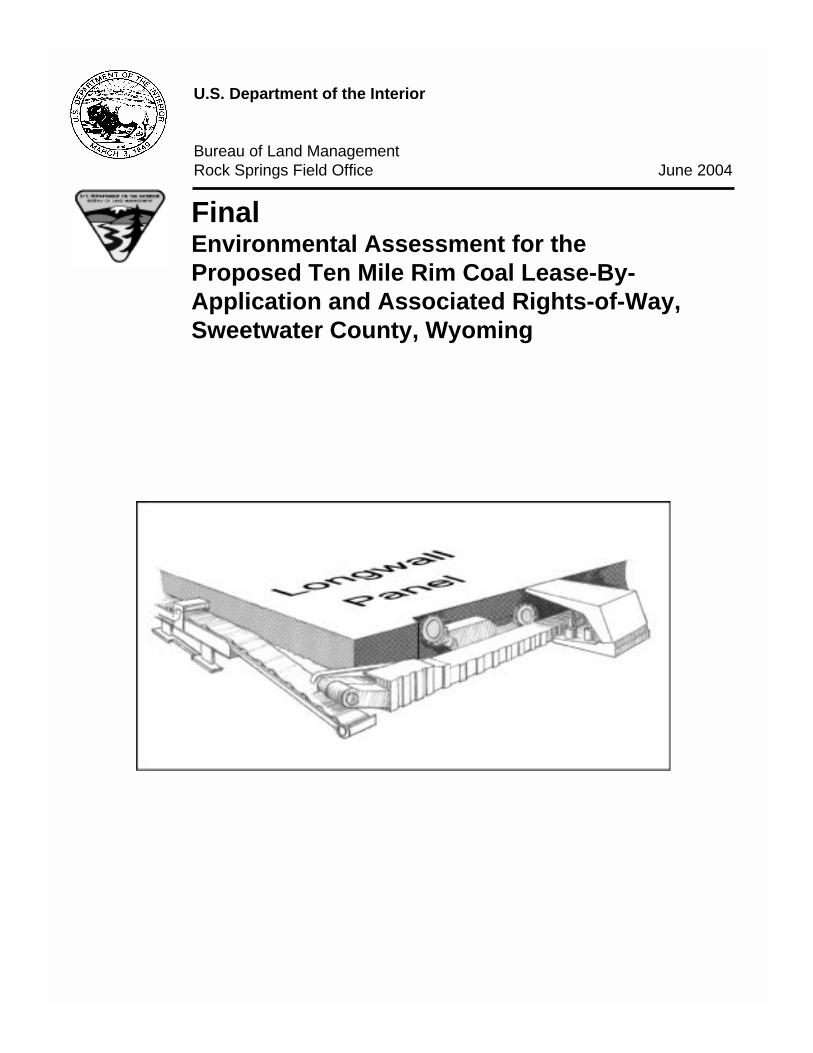
U.S. Department of the Interior
Bureau of Land ManagementRock Springs Field Office June 2004
FinalEnvironmental Assessment for theProposed Ten Mile Rim Coal Lease-By-Application and Associated Rights-of-Way,Sweetwater County, Wyoming

MISSION STATEMENT
It is the mission of the Bureau of Land Management to sustain the health, diversity, andproductivity of the public lands for the use and enjoyment of present and futuregenerations.
BLM/WY/PL-04/018+1320

FINALENVIRONMENTAL ASSESSMENT
FOR THE PROPOSED TEN MILE RIM COALLEASE-BY-APPLICATION AND ASSOCIATED RIGHTS-OF-WAY,
SWEETWATER COUNTY, WYOMING
WY-040-EA04-060
As Applied for by Bridger Coal Company(Federal Coal Lease Application WYW-154595)
Prepared for
Bureau of Land ManagementRock Springs Field OfficeRock Springs, Wyoming
In Cooperation with
Office of Surface Mining Reclamation and EnforcementWestern Regional Coordinating Center
Denver, Colorado
This Environmental Assessment was prepared by TRC MariahAssociates Inc., an environmental consulting firm, with guidance,participation, and independent evaluation of the Bureau of LandManagement (BLM). The BLM, in accordance with Title 40 Codeof Federal Regulations, Part 1506(a) and (b), is in agreement withthe findings of the analysis and approves and takes responsibilityfor the scope and content of this document.
June 2004

Final EA for Ten Mile Rim Coal Lease i
TABLE OF CONTENTS
Page
1.0 INTRODUCTION................................................................................................................ 11.1 BACKGROUND...................................................................................................... 11.2 PURPOSE AND NEED ........................................................................................... 51.3 CONFORMANCE WITH LAND USE PLANS AND RELATIONSHIP TO
STATUTES, REGULATIONS, AND OTHER PLANS .................................... 61.3.1 BLM Resource Management Plan ............................................................ 61.3.2 Existing NEPA Documents....................................................................... 81.3.3 Review of Select Permits, Approvals, and Authorizations ....................... 9
1.3.3.1 OSM Requirements .................................................................... 91.3.3.2 Department of Justice Consultation ........................................... 101.3.3.3 WDEQ Requirements................................................................. 101.3.3.4 Wyoming State Engineer's Office (WSEO) Requirements........ 111.3.3.5 Wyoming Office of State Lands and Investment (WOSLI)
Requirements............................................................................... 111.3.3.6 Sweetwater County Requirements ............................................. 11
1.3.4 Public Involvement ................................................................................... 12
2.0 THE PROPOSED ACTION AND ALTERNATIVES........................................................ 132.1 PROPOSED ACTION ............................................................................................. 13
2.1.1 Overview ................................................................................................... 132.1.2 Mine Permit and Other Required Permits/Approvals ............................... 152.1.3 Resource Recovery and Protection Plan ................................................... 162.1.4 Description of the TMRT Area ................................................................. 162.1.5 Mine Plan .................................................................................................. 17
2.1.5.1 Location and Description of Additional Mine Facilities ........... 182.1.5.2 Mine Equipment......................................................................... 252.1.5.3 Nature of Coal and Coal Reserves ............................................. 282.1.5.4 Mining Methods ......................................................................... 292.1.5.5 Mine-Water Discharge and Treatment....................................... 342.1.5.6 Water Requirements................................................................... 342.1.5.7 Control of Toxic, Hazardous, and Solid Waste Materials ......... 352.1.5.8 Subsidence and Associated Reclamation .................................. 372.1.5.9 Reclamation of Mine Facilities .................................................. 382.1.5.10 Avoidance of Public Nuisance and Endangerment .................. 392.1.5.11 Employment ............................................................................. 412.1.5.12 Cultural Resource Protection ................................................... 422.1.5.13 General Environmental Protection........................................... 43
2.2 NO ACTION ALTERNATIVE ............................................................................... 43
ii Final EA for Ten Mile Rim Coal Lease
TABLE OF CONTENTS (CONTINUED)
Page
2.3 ALTERNATIVES CONSIDERED BUT ELIMINATED FROM DETAILEDSTUDY................................................................................................................ 442.3.1 Hold a Competitive Sale of Federal Coal Lands that Would
Maximize the Potential for a New Stand-alone Mine............................. 452.3.2 Smaller Sale Area...................................................................................... 462.3.3 Larger Sale Area (Originally Applied-for LBA Tract) ............................. 472.3.4 Postpone Competitive Lease Sales............................................................ 482.3.5 Hold a Competitive Sale of Federal Coal Lands as a Continuation of
Existing Surface Coal Mining Operations .............................................. 49
3.0 AFFECTED ENVIRONMENT ........................................................................................... 513.1 LOCATION, SETTING, AND HISTORICAL USE............................................... 513.2 CRITICAL ELEMENTS.......................................................................................... 523.3 AFFECTED RESOURCES...................................................................................... 55
3.3.1 Air Quality and Noise ............................................................................... 553.3.1.1 Air Quality ................................................................................. 553.3.1.2 Noise .......................................................................................... 58
3.3.2 Cultural Resources .................................................................................... 603.3.3 Geology and Geologic Hazards ................................................................ 623.3.4 Health and Safety (Transportation)........................................................... 653.3.5 Land Resources and Use ........................................................................... 653.3.6 Minerals (Solid and Fluid) ........................................................................ 66
3.3.6.1 Leasable Solid Minerals (Coal).................................................. 663.3.6.2 Leasable Fluid Minerals (Oil, Gas, and Coalbed Methane)....... 683.3.6.3 Locatable Minerals..................................................................... 703.3.6.4 Salable Minerals......................................................................... 70
3.3.7 Native American Religious Concerns....................................................... 703.3.8 Paleontological Resources ........................................................................ 713.3.9 Rangeland and Livestock Grazing ............................................................ 723.3.10 Recreation ............................................................................................... 723.3.11 Socioeconomics....................................................................................... 763.3.12 Soil Resources ......................................................................................... 783.3.13 TEC&P and BLM-sensitive Species....................................................... 78
3.3.13.1 Introduction .............................................................................. 783.3.13.2 Federally Listed Animal and Plant Species ............................. 803.3.13.3 BLM-sensitive Animal and Plant Species................................ 86
3.3.14 Vegetation (Including Invasive Species) ................................................ 863.3.15 Wastes (Hazardous and Solid) ................................................................ 90

Final EA for Ten Mile Rim Coal Lease iii
TABLE OF CONTENTS (CONTINUED)
Page
3.3.16 Water Resources...................................................................................... 913.3.16.1 Surface Water Resources ......................................................... 913.3.16.2 Groundwater Resources ........................................................... 93
3.3.17 Wetlands/Riparian Areas ........................................................................ 943.3.18 Wild Horses............................................................................................. 953.3.19 Wildlife.................................................................................................... 99
3.3.19.1 Big Game.................................................................................. 993.3.19.2 Other Mammals........................................................................ 1083.3.19.3 Raptors ..................................................................................... 1083.3.19.4 Upland Game Birds.................................................................. 1093.3.19.5 Other Birds ............................................................................... 1123.3.19.6 Amphibians, Reptiles, and Fish ............................................... 114
4.0 ENVIRONMENTAL CONSEQUENCES........................................................................... 1154.1 AIR QUALITY AND NOISE.................................................................................. 116
4.1.1 Air Quality ................................................................................................ 1164.1.1.1 Proposed Action ......................................................................... 1164.1.1.2 No Action Alternative ................................................................ 1204.1.1.3 Residual Impacts ........................................................................ 1204.1.1.4 Cumulative Impacts.................................................................... 120
4.1.2 Noise ......................................................................................................... 1224.1.2.1 Proposed Action ......................................................................... 1224.1.2.2 No Action Alternative ................................................................ 1234.1.2.3 Residual Impacts ........................................................................ 1234.1.2.4 Cumulative Impacts.................................................................... 123
4.2 CULTURAL RESOURCES .................................................................................... 1244.2.1 Proposed Action ........................................................................................ 1244.2.2 No Action Alternative ............................................................................... 1254.2.3 Residual Impacts ....................................................................................... 1264.2.4 Cumulative Impacts................................................................................... 126
4.3 GEOLOGY AND GEOLOGIC HAZARDS............................................................ 1274.3.1 Proposed Action ........................................................................................ 1274.3.2 No Action Alternative ............................................................................... 1304.3.3 Residual Impacts ....................................................................................... 1304.3.4 Cumulative Impacts................................................................................... 130
4.4 HEALTH AND SAFETY (TRANSPORTATION)................................................. 1314.4.1 Proposed Action ........................................................................................ 1314.4.2 No Action Alternative ............................................................................... 1334.4.3 Residual Impacts ....................................................................................... 1334.4.4 Cumulative Impacts................................................................................... 133

iv Final EA for Ten Mile Rim Coal Lease
TABLE OF CONTENTS (CONTINUED)
Page
4.5 LAND RESOURCES AND USE............................................................................. 1344.5.1 Proposed Action ........................................................................................ 1344.5.2 No Action Alternative ............................................................................... 1344.5.3 Residual Impacts ....................................................................................... 1344.5.4 Cumulative Impacts................................................................................... 135
4.6 MINERALS (SOLID AND FLUID)........................................................................ 1354.6.1 Proposed Action ........................................................................................ 1354.6.2 No Action Alternative ............................................................................... 1374.6.3 Residual Impacts ....................................................................................... 1374.6.4 Cumulative Impacts................................................................................... 138
4.7 NATIVE AMERICAN RELIGIOUS CONCERNS ................................................ 1384.7.1 Proposed Action ........................................................................................ 1384.7.2 No Action Alternative ............................................................................... 1384.7.3 Residual Impacts ....................................................................................... 1394.7.4 Cumulative Impacts................................................................................... 139
4.8 PALEONTOLOGICAL RESOURCES ................................................................... 1394.8.1 Proposed Action ........................................................................................ 1394.8.2 No Action Alternative ............................................................................... 1404.8.3 Residual Impacts ....................................................................................... 1404.8.4 Cumulative Impacts................................................................................... 140
4.9 RANGELAND AND LIVESTOCK GRAZING ..................................................... 1414.9.1 Proposed Action ........................................................................................ 1414.9.2 No Action Alternative ............................................................................... 1424.9.3 Residual Impacts ....................................................................................... 1424.9.4 Cumulative Impacts................................................................................... 142
4.10 RECREATION....................................................................................................... 1444.10.1 Proposed Action ...................................................................................... 1444.10.2 No Action Alternative ............................................................................. 1464.10.3 Residual Impacts ..................................................................................... 1474.10.4 Cumulative Impacts................................................................................. 147
4.11 SOCIOECONOMICS ............................................................................................ 1474.11.1 Proposed Action ...................................................................................... 1474.11.2 No Action Alternative ............................................................................. 1494.11.3 Residual Impacts ..................................................................................... 1514.11.4 Cumulative Impacts................................................................................. 151
4.12 SOIL RESOURCES............................................................................................... 1524.12.1 Proposed Action ...................................................................................... 1524.12.2 No Action Alternative ............................................................................. 153

Final EA for Ten Mile Rim Coal Lease v
TABLE OF CONTENTS (CONTINUED)
Page
4.12.3 Residual Impacts ..................................................................................... 1534.12.4 Cumulative Impacts................................................................................. 153
4.13 THREATENED, ENDANGERED, CANDIDATE, PROPOSED, ANDSENSITIVE SPECIES ........................................................................................ 1544.13.1 Proposed Action ...................................................................................... 154
4.13.1.1 Black-footed Ferrets................................................................. 1544.13.1.2 Bald Eagle ................................................................................ 1554.13.1.3 BLM-sensitive Species............................................................. 155
4.13.2 No Action Alternative ............................................................................. 1564.13.3 Residual Impacts ..................................................................................... 1564.13.4 Cumulative Impacts................................................................................. 157
4.14 VEGETATION (INCLUDING INVASIVE SPECIES) ........................................ 1574.14.1 Proposed Action ...................................................................................... 1574.14.2 No Action Alternative ............................................................................. 1604.14.3 Residual Impacts ..................................................................................... 1604.14.4 Cumulative Impacts................................................................................. 160
4.15 WASTES (HAZARDOUS AND SOLID) ............................................................. 1614.15.1 Proposed Action ...................................................................................... 1614.15.2 No Action Alternative ............................................................................. 1624.15.3 Residual Impacts ..................................................................................... 1624.15.4 Cumulative Impacts................................................................................. 163
4.16 WATER RESOURCES.......................................................................................... 1634.16.1 Surface Water Resources ........................................................................ 163
4.16.1.1 Proposed Action ....................................................................... 1634.16.1 2 No Action Alternative .............................................................. 1644.16.1.3 Residual Impacts ...................................................................... 1654.16.1.4 Cumulative Impacts.................................................................. 165
4.16.2 Groundwater Resources .......................................................................... 1664.16.2.1 Proposed Action ....................................................................... 1664.16.2.2 No Action Alternative .............................................................. 1704.16.2.3 Residual Impacts ...................................................................... 1704.16.2.4 Cumulative Impacts.................................................................. 170
4.17 WETLANDS AREAS............................................................................................ 1724.17.1 Proposed Action ...................................................................................... 1724.17.2 No Action Alternative ............................................................................. 1734.17.3 Residual Impacts ..................................................................................... 1734.17.4 Cumulative Impacts................................................................................. 173
4.18 WILD HORSES ..................................................................................................... 1744.18.1 Proposed Action ...................................................................................... 1744.18.2 No Action Alternative ............................................................................. 174

vi Final EA for Ten Mile Rim Coal Lease
TABLE OF CONTENTS (CONTINUED)
Page
4.18.3 Residual Impacts ..................................................................................... 1754.18.4 Cumulative Impacts................................................................................. 175
4.19 WILDLIFE............................................................................................................. 1764.19.1 Proposed Action ...................................................................................... 176
4.19.1.1 Big Game.................................................................................. 1764.19.1.2 Other Mammals........................................................................ 1784.19.1.3 Raptors ..................................................................................... 1784.19.1.4 Upland Game Birds.................................................................. 1804.19.1.5 Other Birds ............................................................................... 1824.19.1.6 Amphibians, Reptiles, and Fish ............................................... 183
4.19.2 No Action Alternative ............................................................................. 1834.19.3 Residual Impacts ..................................................................................... 1834.19.4 Cumulative Impacts................................................................................. 184
4.20 MITIGATION MEASURES.................................................................................. 1924.21 IRREVERSIBLE AND IRRETRIEVABLE COMMITMENT OF
RESOURCES...................................................................................................... 1994.22 SHORT-TERM USE OF THE ENVIRONMENT VERSUS LONG-TERM
PRODUCTIVITY ............................................................................................... 199
5.0 RECORD OF PERSONS, GROUPS, AND GOVERNMENTAL AGENCIESCONTACTED................................................................................................................. 201
6.0 REFERENCES..................................................................................................................... 203
APPENDIX A: STANDARD COAL LEASE FORM AND SPECIAL LEASESTIPULATIONS
APPENDIX B: COMMENTS AND RESPONSES ON THE DRAFTENVIRONMENTAL ASSESSMENT
APPENDIX C: BLM DETERMINATION LETTER TO USFWS

Final EA for Ten Mile Rim Coal Lease vii
LIST OF FIGURES
Page
Figure 1.1 General Project Location..................................................................................... 2
Figure 2.1 Mineral Ownership Within the TMRT ............................................................... 14
Figure 2.2 Typical Surface Support Facilities Layout.......................................................... 20
Figure 2.3 Major Transportation Systems ............................................................................ 21
Figure 2.4 Powerline System................................................................................................ 23
Figure 2.5 Proposed Mine Access Roads ............................................................................. 26
Figure 2.6 Typical Continuous Mining Equipment.............................................................. 29
Figure 2.7 Typical Longwall Panel with Main Entry and Submain Entry ........................... 30
Figure 2.8 Typical Longwall Mining System....................................................................... 32
Figure 2.9 Close-up of Major Components of Longwall Mining System............................ 33
Figure 2.10 Typical Trough Subsidence Due to Longwall Mining........................................ 33
Figure 3.1 Air Quality CIAA................................................................................................ 59
Figure 3.2 Location of the Point of Rocks to South Pass Wagon Road ............................... 63
Figure 3.3 Surface Landownership in the TMRT Area and Vicinity................................... 67
Figure 3.4 Oil and Gas Potential Within the TMRT and Vicinity ....................................... 69
Figure 3.5 Livestock Grazing Allotment Within the TMRT Area and CIAA ..................... 73
Figure 3.6 Location of CDNST ............................................................................................ 75
Figure 3.7 Soil Map Units Within the TMRT and CIAA..................................................... 79
Figure 3.8 Major Vegetation Communities Within the TMRT and CIAA (as ofJanuary 2000) ...................................................................................................... 89
Figure 3.9 Surface Water Drainages and Features Located Within the TMRT andCIAA ................................................................................................................... 92
Figure 3.10 Production Water Wells ...................................................................................... 96

viii Final EA for Ten Mile Rim Coal Lease
LIST OF FIGURES (CONTINUED)
Page
Figure 3.11 Potential Wetlands Located Within the TMRT and CIAA (as of 1983)............. 97
Figure 3.12 Great Divide Basin Wild Horse Herd Management Area................................... 98
Figure 3.13 Pronghorn Antelope Range Within the TMRT................................................... 100
Figure 3.14 Pronghorn Antelope Range Within the TMRT................................................... 102
Figure 3.15 Mule Deer Range Within the TMRT and Vicinity ............................................. 103
Figure 3.16 Mule Deer Range Within the CIAA.................................................................... 104
Figure 3.17 Elk Range Within the TMRT and Vicinity ......................................................... 106
Figure 3.18 Elk Range Within the CIAA ............................................................................... 107
Figure 3.19 Raptor Nests Within the TMRT and Vicinity ..................................................... 110
Figure 3.20 Greater Sage-grouse Leks Within the TMRT ..................................................... 111
Figure 3.21 Greater Sage-grouse Leks Within the CIAA ...................................................... 113
LIST OF TABLES
Page
Table 2.1 Description of TMRT.......................................................................................... 17
Table 2.2 Acres Affected by the Proposed Action.............................................................. 18
Table 2.3 Typical Major Equipment ................................................................................... 27
Table 3.1 Critical Elements of the Human Environment .................................................... 53
Table 3.2 Selected National and Wyoming Air Quality Standards..................................... 56
Table 3.3 Comparison of Measured Noise Levels with Commonly Heard Sounds,TMRT and CIAA, 2003 ...................................................................................... 61
Table 3.4 Federal Threatened, Endangered, Proposed, and Candidate Species andTheir Potential Occurrence Within the Proposed Project Area, 2003 ................ 81

Final EA for Ten Mile Rim Coal Lease ix
LIST OF TABLES (CONTINUED)
Page
Table 3.5 Wyoming BLM Sensitive Species and Habitat Preference, TMRT andCIAA, 2003 ......................................................................................................... 87
Table 3.6 Major Vegetation Communities Within the TMRT and CIAA .......................... 90
Table 4.1 Acres of Disturbance by CIAA for Big Game Species....................................... 185
Table 5.1 Record of Persons, Groups, and Governmental Agencies Contacted................. 201
Table 5.2 List of Preparers .................................................................................................. 202
Table 5.3 List of Contributors and Reviewers .................................................................... 202

x Final EA for Ten Mile Rim Coal Lease
LIST OF ABBREVIATIONS AND ACRONYMS
APLIC Avian Power Line Interaction CommitteeAQD Air Quality DivisionAUM Animal unit monthBCC Bridger Coal CompanyBLM Bureau of Land ManagementBTU British Thermal UnitCD/GWII Continental Divide/Greater Wamsutter IICDNST Continental Divide National Scenic TrailCERCLA Comprehensive Environmental Response, Compensation, and Liability
Act of 1980CFR Code of Federal RegulationsCIAA Cumulative impact analysis areaCO Carbon monoxidedBA A-weighted decibelsDFP Desolation Flats natural gas field development projectEA Environmental assessmentEIS Environmental impact statementEPA U.S. Environmental Protection AgencyFEMA Federal Emergency Management AgencyFLPMA Federal Land Policy and Management Act of 1976GDBWHMA Great Divide Basin Wild Horse Herd Management AreakV KilovoltLBA Lease-by-applicationLOM Life-of-mineLQD Land Quality DivisionMER Maximum economic recoveryMLA Mineral Leasing Act of 1920MSDS Material Safety Data SheetsMSHA Mining Safety and Health AdministrationMW MegawattNAAQS National Ambient Air Quality StandardsNEPA National Environmental Policy ActNMHCs Nonmethane hydrocarbonsNO2 Nitrogen dioxideNOX Nitrogen oxideNPDES National Pollutant Discharge Elimination SystemNRCS Natural Resources Conservation ServiceNRHP National Register of Historic PlacesOSM Office of Surface Mining Reclamation and EnforcementP.M. Principal MeridianPM2.5 Particulate matter less than 2.5 microns in diameter

Final EA for Ten Mile Rim Coal Lease xi
LIST OF ABBREVIATIONS AND ACRONYMS (CONTINUED)
PM10 Particulate matter less than 10 microns in diameterppm Parts per millionPSD Prevention of Significant DeteriorationR2P2 Resource Recovery and Protection PlanRMP Resource Management PlanROD Record of DecisionROW Right-of-waySARA Superfund Amendments and Reauthorization Act of 1976SCS Soil Conservation ServiceSHWD Solid and Hazardous Waste DivisionSMCRA Surface Mining Control and Reclamation Act of 1977SO2 Sulfur dioxideSPCCP Spill Prevention, Control, and Countermeasure PlanTDS Total dissolved solidsTEC&P Threatened, endangered, candidate, and proposedTMRT Ten Mile Rim TractTSS Total suspended solidsU.S.C. United States CodeUSDOC U.S. Department of CommerceUSFWS U.S. Fish and Wildlife ServiceVOC Volatile organic compoundsWAAQS Wyoming Ambient Air Quality StandardsWAQS&R Wyoming Air Quality Standards and RegulationsWDEA Wyoming Division of Economic AnalysisWDEQ Wyoming Department of Environmental QualityWGFD Wyoming Game and Fish DepartmentWNDD Wyoming Natural Diversity DatabaseWOGCC Wyoming Oil and Gas Conservation CommissionWOSLI Wyoming Office of State Lands and InvestmentWQD Water Quality DivisionW.S. Wyoming StatuteWSEO Wyoming State Engineer's Office

xii Final EA for Ten Mile Rim Coal Lease
(This page is intentionally left blank.)

Final EA for Ten Mile Rim Coal Lease
1.0 INTRODUCTION
1.1 BACKGROUND
On September 28, 2001, Bridger Coal Com pany (BCC) filed an application with the Bureau of
Land Management (BLM) for federal coal reserves located adjacent to the existing Jim Bridger
Mine in north-central Sweetwater County, Wyoming. On February 11, 2003, BCC filed a
modified application with the BLM at the W yoming State Office in Cheyenne for a reduced
lease area (refer to Figure 1.1). The application and m odification were m ade pursuant to
provisions of the lease-by-application (LBA) regulations found in Title 43 Code of Federal
Regulations (CFR) 3425.1. The tract applied for, known as the Ten Mile Rim Tract (TMRT),
contains federal-, state-, and private-owned coal reserves. The BLM assigned the federal lease
area case number WYW-154595. In addition to the federal LBA action, the project would also
require BLM to issue a right-of-way (ROW ) associated with the LBA for a portion of a new
powerline required for the project. The ROW applications would be m ade pursuant to Title 43
CFR, Part 2800, that govern the federal approval and issuance of ROW applications.
The TMRT area and the associated ROW would be located north of Interstate 80, approxim ately
10 mi north of Point of Rocks, approxim ately 25 m i east of Rock Springs, and approxim ately
70 mi west of Rawlins, W yoming (refer to Figur e 1.1). The TMRT area is located in the area
administered by the BLM Rock Springs Field Office.
BCC proposes to lease federal coal for a new underground m ine located adjacent to the existing
Jim Bridger Mine, a surface coal m ine operation. According to LBA docum ents submitted by
BCC, the coal would be required to provide fuel to the nearby Jim Bridger Power Plant for an
additional 15 to 20 years. The surface ownership pattern within the TMRT area is checkerboard,
where even-numbered sections are owned by the federal government, odd-numbered sections are
privately owned, and select even-numbered sections are owned by the State of W yoming.
(Section 2.0 further describes surface and mineral ownership.) The Jim Bridger Mine has an
approved m ine and reclam ation plan and perm it (No. 338-T5) issued by the W yoming
Department of Environmental Quality/Land Quality Division (WDEQ/LQD) and other pertinent

2 Final EA for Ten Mile Rim Coal Lease
Figure 1.1 General Project Location.

Final EA for Ten Mile Rim Coal Lease 3
permits and approvals issued by other federal, state, and local regulatory agencies. As part of the
federal coal leasing process, BLM will evaluate the tract configuration and m ay add or subtract
federal coal to avoid bypassing federal coal or to otherwise achieve m aximum econom ic
recovery. BLM will also evaluate the application to define the characteristics of the federal coal
reserves and to evaluate the fair market value of the tract. No vertical shafts or inclines would be
required to access the coal reserves. According to BCC, underground access to the coal reserves
within the TMRT area would be gained through access from the existing highwall area at Ram p
14 of the existing surface m ine. Under the Proposed Action, no new m ine facilities (such as
ventilation shafts or support equipm ent) would be required within the TMRT area. Associated
mine support facilities (e.g., buildings, roads, overland conveyor, powerlines, etc.) would be
located on lands that the applicant currently has legal access rights to or where legal access
would be secured. These facilities are described in m ore detail in Chapter 2.0 of this
environmental assessment (EA).
The federal governm ent maintains a policy to en courage private industry to develop and m ine
domestic energy reserves in an economically and environmentally sound manner. The Secretary
of the Interior has the responsibility to carry out this policy. Since the passage of the Mineral
Leasing Act of 1920 (MLA), as am ended, the U.S. Departm ent of the Interior, through its
implementing agency, the BLM, has been charged with administrating a leasing program that
would allow the private sector to mine federally owned coal reserves. Therefore, pursuant to the
MLA, "it is the continuing policy of the federal governm ent in the national interest to foster and
encourage private enterprises in 1) the deve lopment of economically sound and stable dom estic
mining, minerals . . . industries, 2) the orderly and econom ic development of dom estic mineral
resources, reserves . . . to help assure satisfaction of industrial, security, and environm ental
needs" (BLM 2001a:4). This policy is reaffirm ed in the BLM' s 2001 plan for the
implementation of the national energy policy (BLM 2001a).
In addition, the Proposed Action would include the approval of one associated ROW for a
segment of a new powerline. This associated facility would be located outside of and near to the
TMRT, and this ROW would be necessary for im plementation of the Proposed Action. The
Federal Land Policy and Management Act of 1976 (FLPMA), as am ended (43 United States

4 Final EA for Ten Mile Rim Coal Lease
Code [U.S.C.] §1701 et seq.), and prom ulgating regulations found in Title 43 CFR, Part 2800,
govern the federal approval and issuance of ROW applications for facilities such as the proposed
powerline.
Before the federal governm ent m ay hold a com petitive coal lease sale or issue the associated
ROW grant, the BLM m ust analyze the potential environm ental im pacts of issuing a lease or
ROW grant in accordance with the National Environmental Policy Act (NEPA). To assess
potential im pacts of the Proposed Action, BLM conducted internal BLM and public scoping.
Public scoping was initiated on Novem ber 15, 2001, and concluded on Decem ber 31, 2001. A
public scoping meeting was held on December 12, 2001, at the BLM Rock Springs Field Office.
Based on public and BLM internal scoping com ments, BLM decided to prepare an EA for the
Proposed Action. BLM also determ ined that no additional public scoping was necessary or
required as a result of the applicant' s 2003 revised application and reduction in the size of the
TMRT LBA area. The draft EA was releas ed to the public on January 22, 2004, and written
comments were received until March 4, 2004. A public hearing was held on March 9, 2004, at
the BLM Rock Springs Field Office in Rock Springs, W yoming. No oral com ments were
received. W ritten com ments have been addressed, and the EA has been revised accordingly.
This EA is prepared pursuant to NEPA, as am ended (42 U.S.C. 4321 et seq.), its im plementing
regulations found in Title 40 CFR Part 1500–1508, BLM's National Environmental Policy Act
Handbook (H-1790-1) (BLM 1988), BLM' s desktop reference Overview of BLM's NEPA
Process (BLM 1996a), and Considering Cumulative Impacts Under the National Environmental
Policy Act (Council on Environmental Quality [CEQ] 1997).
This EA assesses the environmental impacts of the Proposed Action and appropriate alternatives,
including the No Action Alternative. The Proposed Action is strictly defined as the leasing and
mining of the federal coal reserves located w ithin the TMRT and the granting of one ROW for
the construction of a segm ent of powerline (required for the Proposed Action) that would cross
federal lands. This EA assesses the potential environm ental impacts of these actions on federal
lands but also includes the potential environm ental impacts associated with the construction and
mining activities that would occur on privately owned lands. W hile some of these associated

Final EA for Ten Mile Rim Coal Lease 5
activities would occur on privately owned lands, they are described as connected actions under
NEPA regulations and analyzed in this EA.
The BLM will use this analysis to make a decision whether or not to hold a com petitive, sealed-
bid lease sale and to issue a coal lease for the fe deral coal within the TMRT area. If a lease sale
is held, a lease will be issued to the highest bidde r, if a federal sale panel determ ines that the
highest bidder m eets or exceeds the fair m arket value as determ ined by BLM' s econom ic
evaluation and if the U.S. Departm ent of Justice determines that there are no antitrust violations
if the lease is issued to the highest bidder.
The Office of Surface Mining Reclam ation and Enforcement (OSM) is a cooperating agency on
the EA and will use this analysis to make decisions related to mining federal coal in this tract.
The Proposed Action would com ply with all relevant federal, state, and local laws and
regulations. In addition, the Proposed Action would be operated in accordance with federal
Mine Safety and Health Adm inistration (MSHA) and W yoming Departm ent of Em ployment,
Division of Mine Inspections and Safety rules and regulations.
1.2 PURPOSE AND NEED
Coal production at the Jim Bridger Mine is slowing because existing privately and federally
leased coal reserves are becom ing too deep and uneconom ical to be recovered utilizing
conventional surface m ining m ethods (i.e., draglines). As a result, additional m ineable coal
reserves are needed to m eet production requirem ents. Representatives of BCC plan to
supplement the decreasing supply of surface-m ined coal with the addition of adjacent
underground mining operations. The development of underground mining operations next to the
existing surface m ine would allow BCC to utili ze many of the existing support system s at the
Jim Bridger Mine (e.g., roads, overland conveyor, adm inistrative and m aintenance facilities),
thereby minimizing costs and disturbance to the environment.
6 Final EA for Ten Mile Rim Coal Lease
The Proposed Action is needed to allow the leasing and subsequent mining of federal coal within
the TMRT, and the approval of the associated federal ROW is necessary to facilitate said coal
mining for the nearby Jim Bridger Power Plant for the generation of electricity.
The Jim Bridger Mine started operations in 1971 and annually m ines approxim ately 5 to 6
million tons with approxim ately 350 em ployees. Since startup, m ore than 150 m illion tons of
coal have been m ined at the Jim Bridger Mine (W yoming State Geological Survey 1998). The
Jim Bridger Mine has been the prim ary supplier of coal to the nearby Jim Bridger Power Plant.
Depending on num erous factors such as electric load requirem ents, the power plant burns
approximately 9 m illion tons of coal per year (W yoming State Geological Survey 1998). The
Jim Bridger Power Plant currently obtains the rem ainder of its required coal from other sources.
BCC indicates that the additional coal reserves w ithin the TMRT area will be needed within the
next 2 years in order for the company to meet fuel supply requirements for the power plant.
1.3 CONFORMANCE WITH LAND USE PLANS AND RELATIONSHIP TOSTATUTES, REGULATIONS, AND OTHER PLANS
1.3.1 BLM Resource Management Plan
The Green River Resource Managem ent Plan (RMP) and Record of Decision (ROD) (BLM
1997a) allows for coal leasing and developm ent. The Green River RMP provides land use
guidance for coal leasing within the project area. The exploration and developm ent of solid
leasable minerals (i.e., coal) is subject to the appropriate level of environm ental analysis. The
BLM Green River RMP and ROD (1997a:13) states:
The objective for management of the federal coal resources in the planning area isto provide for both short- and long-range developm ent of federal coal, in anorderly and tim ely m anner, consistent with the policies of the federal coalmanagement program, environmental integrity, national energy needs, and relateddemands.
With appropriate lim itations and m itigation requirem ents for the protection of other resource
values, all BLM-adm inistered public lands and federal coal lands in the Green River planning
Final EA for Ten Mile Rim Coal Lease 7
area, except for those identified as closed, are open to coal resource inventory and exploration to
help identify coal resources and their development potential.
Federal coal lands within the Coal Occurrence and Development Potential area (that include the
TMRA area) are open to further consideration for coal leasing and developm ent (i.e., new
competitive leasing, em ergency leasing, lease m odification, and exchange proposals, under the
Federal Coal Management Program) with appropriate and necessary conditions and requirements
for protection of other land and resource values and uses. In addition, the LBA process would
conform with BLM coal developm ent objectiv es within the Green River-Ham s Fork Coal
Region.
The relevant management action from the Green River RMP and ROD (BLM 1997a:137) states
in part:
Federal coal lands within the Coal Occurrence and Developm ent Potential area(about 422,000 acres) are open to further consideration for coal leasing anddevelopment (i.e., new com petitive leasing, em ergency leasing, leasemodifications, and exchange proposal, under the Federal Coal Managem entProgram) with appropriate and necessary conditions and requirem ents forprotection of other land and resource values and uses.
The Coal Occurrence and Developm ent Potential area is subject to continued field
investigations, studies, and evaluations to determine if certain methods of coal mining may occur
without having a significant long-te rm impact on wildlife, cultural, and watershed resources, in
general, and on threatened and endangered plant and anim al species and their essential habitats,
in particular. Such investigations, studies, and evaluations may be conducted on an as-needed or
case-by-case basis in reviewing individual coal leasing or developm ent proposals (e.g., m ine
plans) or, if opportunities or needs arise, area-wide studies m ay be conducted. These studies
include keeping resource databases current (e.g., where existing raptor nests becom e abandoned
or where new raptor nests become established, etc.), analysis of effects to wildlife and threatened
and endangered species habitats and populations, and the cum ulative effects of m ining
operations and other activities in the area. Consu ltation with other agencies (e.g., U.S. Fish and

8 Final EA for Ten Mile Rim Coal Lease
Wildlife Service [USFWS], Wyoming Game and Fish Department [WGFD], etc.) with interested
parties, and with industry has occurred as needed or required.
A portion of the proposed powerline would require the issuance and approval of a ROW grant
from the BLM and would be in conform ance with the Green River Resource Area RMP and
ROD. The relevant m anagement objective from the Green River Resource Area RMP (BLM
1997a:128) states:
The objective for the m anagement of the lands and realty program are to:1) manage the public lands to support the goals and objectives of other resourceprograms; 2) respond to public demand for land use authorizations; and 3) acquireadministrative and public access where necessary.
The Green River RMP also states, "Public lands will be m ade available throughout the planning
area for rights-of-way perm its and leases (for utility and transportation system s)" (BLM
1997a:86).
1.3.2 Existing NEPA Documents
Existing NEPA documents that may be related to the proposed project includes the following:
• the BLM Green River RMP and environm ental im pact statem ent (EIS) (BLM
1992, 1996b),
• the BLM Green River RMP and ROD (1997a),
• air quality analysis from the BLM Continental Divide/W amsutter II natural gas
project EIS (BLM 1999a, 1999b),
• air quality analysis from the Desolation Flats natural gas field developm ent
project (DFP) draft EIS (BLM 2003a),
• the BLM coal exploration drilling project EA of the TMRT (2001b),
• the BLM Jim Bridger Power Plant flue gas de-sulfurization pond expansion
project EA (2002a), and
• the BLM final EIS for the regional and site specific coal developm ent for
southwest Wyoming (BLM 1979b).

Final EA for Ten Mile Rim Coal Lease 9
The BLM Green River RMP and ROD, referenced in Section 1.3.1 above, presents the
management plan currently being adm inistered in this RMP. This EA is tiered to the BLM
Green River RMP (BLM 1992, 1996b, 1997a). The Green River RMP provides planning and
objectives for the m anagement of public lands in the BLM Rock Springs Field Office Area,
including the leasing of solid minerals and issuance of ROW grants.
1.3.3 Review of Select Permits, Approvals, and Authorizations
Described below are a few of the m ajor perm its, approvals, and authorizations that would be
required of BCC prior to the initiation of underground m ining operations within the TMRT area.
These descriptions do not address every regulatory or adm inistrative requirem ent and provide
only a brief overview of som e of the perm its, approvals, and authorizations required for the
Proposed Action. All perm its, approvals, and authorizations would have to be addressed by the
appropriate regulatory agencies.
1.3.3.1 OSM Requirements
The Surface Mining Control and Reclamation Act of 1977 (SMCRA), as am ended, gives the
OSM primary responsibility to administer programs that regulate surface coal m ining operations
and the surface effects of underground coal m ining operations in the U.S. Pursuant to
Section 503 of SMCRA, the W DEQ/LQD developed and the Secretary of the Interior approved
WDEQ/LQD's perm anent regulatory program . This approval authorizes W DEQ/LQD to
regulate surface coal m ining operations and the surface effects of underground coal m ining on
private and state lands within the State of Wyoming.
Pursuant to the cooperative agreem ent, federal coal lease holders in W yoming m ust subm it a
permit application to OSM and WDEQ/LQD for all proposed mining and reclamation operations
on federal lands in the state. W DEQ/LQD reviews the permit application package to ensure that
it complies with the approved W yoming state perm anent program and other state statutes. If it
complies, W DEQ/LQD issues the applicant a perm it to conduct coal m ining operations (i.e.,

10 Final EA for Ten Mile Rim Coal Lease
permit to mine coal). OSM and other federal ag encies review the permit application package to
ensure that it contains the necessary inform ation for com pliance with the coal lease, the MLA,
NEPA, and other applicable federal laws and their attendant regulations. OSM recommends one
of the following to the Assistant Secretary of the Interior, Land and Minerals Managem ent:
(1) approval of the MLA m ining plan, (2) approval of the MLA m ining plan with conditions, or
(3) disapproval of the MLA m ining plan. Before m aking a recom mendation regarding the
mining plan, OSM obtains input from certain other federal agencies, including the appropriate
federal surface management agency.
WDEQ/LQD enforces the environmental performance standards and permit requirements during
the m ine's operation and has prim ary authority in environm ental em ergencies. OSM retains
oversight responsibilities for this enforcement. The surface management agency (i.e., BLM) has
authority in em ergency situations in which W DEQ/LQD or OSM inspectors cannot act before
environmental harm or damage occurs.
1.3.3.2 Department of Justice Consultation
If a competitive coal lease sale is held, but prior to the issuance of the lease, the BLM will solicit
the opinion of the Departm ent of Justice as to whether the planned lease issuance creates a
situation inconsistent with federal antitrust laws . The Departm ent of Justice is allowed 30 days
to make this determination. If the Department of Justice has not responded in writing within the
30-day period, the BLM can proceed with issuance of the lease.
1.3.3.3 WDEQ Requirements
As discussed above, the W DEQ/LQD adm inisters and regulates surface coal m ining and
reclamation operations and the surface effects of underground coal m ining operation in
accordance with SMCRA and the Wyoming Environmental Quality Act. The W DEQ/LQD
reviews and approves all proposed m ining and reclam ation plans under its jurisdiction. In
addition, other W DEQ divisions (i.e., W ater Quality Division [W QD] and Air Quality Division

Final EA for Ten Mile Rim Coal Lease 11
[AQD]) would review specific portions of the proposed m ine and reclam ation plan, and, if the
plans conform to and com ply with applicable rules and regulations, specific environm ental
permits would be issued by the appropriate agency.
1.3.3.4 Wyoming State Engineer's Office (WSEO) Requirements
The W SEO is responsible for adm inistering and regulating water resources within W yoming,
including issuing permits and appropriations for all surface- and groundwater resources and the
adjudication of water rights issues and disputes. The W SEO would review specific applications
filed by BCC for the appropriation of surface water and groundwater that would be utilized for
the Proposed Action. The WSEO would issue permits and appropriations in accordance with the
applicant's needs and available water resources.
1.3.3.5 Wyoming Office of State Lands and Investment (WOSLI) Requirements
The WOSLI is responsible for the adm inistration and leasing of all subsurface m inerals on State
of Wyoming lands. As of March 1, 2001, BCC had applied for and received a lease (State Lease
#0-040779) for state-owned coal located in Section 36, T22N, R101W . In addition to securing
the state lease, BCC has also secured a lease from the owner of the private coal reserves within
the TMRT.
1.3.3.6 Sweetwater County Requirements
Sweetwater County administers land use within the county in accordance with the approved land
use plan, issues road encroachm ent authorizations, special use perm its for roads, and issues
permits for septic systems. BCC would apply for all necessary permits, land use changes, and/or
authorizations from the appropriate Sweetwater County agency or departm ent for the specific
program to be undertaken.

12 Final EA for Ten Mile Rim Coal Lease
1.3.4 Public Involvement
On Novem ber 9, 2001, pursuant to NEPA regulations, BLM released a scoping notice to the
public. In addition, a Scoping Notice was published in the Federal Register on Decem ber 21,
2001. Ten com ment letters were received in re sponse to the scoping notice. In addition to
releasing the scoping notice, BLM held a pub lic meeting on December 12, 2001. As a result of
BLM, OSM, and public input, the following issues and agency concerns have been identified:
• subsidence;
• existing oil and gas leases that overlap the LBA area and potential for concurrent
development;
• wildlife considerations including potential affects to fossorial wildlife (e.g.,
white-tailed prairie dogs, burrowing owls) and greater sage-grouse;
• listed species and species proposed for listing, candidate species, m igratory birds,
and wetland or riparian areas;
• protection of ephemeral drainages;
• socioeconomic impacts including workforce and housing requirements;
• possible impact to Point of Rocks water source;
• possible effects of construction activity and blasting on residences and businesses
located in Point of Rocks; and
• maintaining public access to public lands around the mine and power plant.
The Draft EA was released for public com ment on January 22, 2004 and written com ments were
received until March 9, 2004. A Notice of Public Hearing/Notice of Availability was published
in the Federal Register on February 3, 2004 (Volum e 69, Num ber 22, pages 5181-5182). On
March 9, 2004, at 2 p.m . a public hearing was held at BLM’s Rock Springs Field Office, Rock
Springs W yoming to obtain verbal and written com ments from the public on the Draft EA.
Approximately 20 individuals were present; how ever, no verbal com ments were presented and
no additional written comments were received during the public hearing. Eight com ment letters
were received by the BLM on the Draft EA. These letters along with BLM response to each
letter is presented in Appendix B.

Final EA for Ten Mile Rim Coal Lease 13
2.0 THE PROPOSED ACTION AND ALTERNATIVES
2.1 PROPOSED ACTION
2.1.1 Overview
As discussed in Chapter 1, BCC has m odified their original LBA area to reduce the am ount of
federal coal acreage based on exploratory core drill results. The following Proposed Action
reflects these changes. Under the Proposed Action, coal on federal lands within the TMRT
would be offered for lease at a com petitive sale, subject to standard and special BLM coal lease
stipulations (refer to Appendix A). An estim ated 44 million tons of in-place coal reserves exist
within the federal lands in the TMRT area, and an estim ated 121.5 million tons of in-place coal
reserves exist within the entire TMRT area (including federal, state, and private m ineral rights)
that would be m ined over an approxim ate 15- to 20-year period. Because the TMRT is located
within an area of checkerboard coal ownership (a pattern of alternating sections of federal, state,
and private mineral rights), the use of federal land is needed for optimal mine development (refer
to Figure 2.1). Under the Proposed Action, all coal within the TMRT would be m ined utilizing
underground longwall m ining technologies, and a m inimal am ount of surface-disturbing
activities would occur. A majority of the additional surface-disturbing activities for mine-related
facilities (i.e., surface support facilities, powerline, overland conveyor, and access road) would
occur within areas that have already been disturbed within the existing Jim Bridger Mine lease
and m ine perm it area. An exception would be for a separate electric powerline required for
underground mining equipment and surface support facilities. These areas are discussed in m ore
detail later in this chapter.
Underground mining operations would begin at the highwall near Ram p 14 where continuous
mining machines would be utilized to establish the m ain entry and working room for longwall
mining equipment. Once adequate working room has been established, underground longwall
mining equipm ent would be assem bled and put into service. Under the Proposed Action,

14 Final EA for Ten Mile Rim Coal Lease
Figure 2.1 Mineral Ownership Within the TMRT.

Final EA for Ten Mile Rim Coal Lease 15
longwall mining would account for a m ajority of the coal m ined from the TMRT. Estim ated
production from the underground m ine could range from 4.5 to 5.5 m illion tons per year at full
production for the next 15-20 years. Once the coal is mined, it would be loaded on to an electric
conveyor system and transported directly to the Jim Bridger Power Plant, located approxim ately
4-5 mi south of the TMRT.
2.1.2 Mine Permit and Other Required Permits/Approvals
Under the Proposed Action, BCC (if the successful bidder) would collect and analyze detailed
baseline environmental information for the TMRT and associated ROW area. The m ine permit
amendment application would then be prepared in accordance with W DEQ/LQD rules,
regulations, and guidelines. W hereas Chapters 3.0 and 4.0 of this EA presents generalized
environmental baseline information for the TMRT area, the m ine permit amendment application
would include detailed site-specific baseline in formation collected during field surveys for
cultural resources, soils, vegetation, wildlife, hydrology, etc., including a m ine and reclam ation
plan. The application would also include site-specific m onitoring and m itigation measures, as
well as detailed calculations for the reclam ation perform ance bond. The am ount of the
reclamation performance bond would be reviewed and, if appropriate, approved by W DEQ/LQD
to ensure that the m ine operator (i.e., BCC) com plies with all the requirem ents of the Wyoming
Environmental Quality Act and the W DEQ/LQD perm it and that reclam ation requirem ents
would be met.
Under W DEQ/LQD perm itting regulations, the public would be provided with several
opportunities to comment on the m ine and reclamation permit amendment application prior to a
final decision on the permit application by WDEQ/LQD.
BCC (if the successful bidder) would also prepare all necessary inform ation and would apply for
any required perm its/approvals. Mining operations would not begin within the TMRT until all
required permits/approvals are obtained from the appropriate regulatory agencies.

16 Final EA for Ten Mile Rim Coal Lease
2.1.3 Resource Recovery and Protection Plan
As part of the Proposed Action, BCC (if the successful bidder) would prepare a detailed
Resource Recovery and Protection Plan (R2P2) for BLM. The R2P2 would describe how the
proposed operation would m eet MLA requirem ents for due diligent developm ent, production,
resource recovery and protection (i.e., efficient recovery of the federal coal reserves), continued
operation, maximum economic recovery, and the rules prom ulgated in Title 43 CFR Part 3480
for the life-of-mine (LOM). MLA requires that, before conducting any federal coal development
or mining operations on federal coal lease, the operator must submit an R2P2 within 3 years of
the effective date of the lease. The lessee is obligated to m ine the lease according to the
approved R2P2, respective lease terms, and appropriate rules and regulations.
2.1.4 Description of the TMRT Area
The TMRT area is located in portions of T21N, R100W ; T22N, R100W ; T21N, R101W ; and
T22N, R101W ; 6th Principal Meridian (P.M.) in Sweetwater County, W yoming. The TMRT
includes approxim ately 5,916 acres, of which 2,242 acres of coal reserves are owned by the
federal government and administered by the BLM, 640 acres of coal reserves are owned by the
State of W yoming and adm inistered by the W OSLI, and 3,034 acres of coal reserves are
privately owned (refer to Figure 2.1). A detailed description of m ineral and surface ownership
for the TMRT is presented in Table 2.1. A com bined estimated 121.5 m illion tons of federal-,
state-, and private-owned in-place coal reserves are located within the entire TMRT. A m ore
accurate estimate of federal coal reserves would be included in the tract sale notice, if this EA is
approved and if a com petitive sale is held. The Proposed Action assum es that the applicant
(BCC) would be the successful bidder if a com petitive sale is held. This EA has been prepared
on the basis of the mining operations proposed by BCC.

Final EA for Ten Mile Rim Coal Lease 17
Table 2.1 Description of TMRT.1
Legal Location Acres Mineral Owner Surface OwnerT21N, R100WSection 6: Lots 8-14, S2NE, SENW, E2SW, SE 649.88 BLM BLMT22N, R100WSection 30: Lots 5-8, E2W2, E2 633.56 BLM BLMSection 31: Lots 1-4, E2W2, E2 633.36 UPLRC RSGAT21N, R101WSection 1: Lots 1-4, S2N2, S2 640.16 UPLRC UPLRCSection 3: Lots 1 and 2, S2NE 160.03 UPLRC UPLRCT22N, R101WSection 25: All 640.00 UPLRC UPLRCSection 26: Lots 1-16 639.22 BLM BLMSection 27: E2 320.00 UPLRC UPLRCSection 34: Lots 1, 2, 6, 7, 8, and 13, NESE,SWSE
319.52 BLM BLM
Section 35: All 640.00 UPLRC UPLRCSection 36: All 640.00 State BLMTotal Combined Acreage 5,915.73
Mineral Lease Acreage by Owner 640.00 State2,242.18 BLM --3,033.55 UPLRC --
Total 5,915.73
1 BLM = federal, Bureau of Land Managem ent; RSGA = private, Rock Springs Gr azing Association; State =State of Wyoming; UPLRC = private, Union Pacific Land Resources Corporation (succeeded in interest byAnadarko Land Corporation).
2.1.5 Mine Plan
The mine plan includes inform ation about the proposed m ine facilities (including the associated
facilities necessary to m ine the coal); m ine equipment; background inform ation about the coal
reserves; information about the m ining methods; and associated activities such as treatm ent of
mine-water; water requirem ents; control of toxic, hazardous, and solid wastes m aterial;
subsidence and associated reclam ation; reclam ation of m ine facilities; avoidance of public
nuisance and endangerm ent; em ployment; and general environm ental protection requirem ents.
As with most underground coal m ines, surface disturbance would be lim ited to the construction
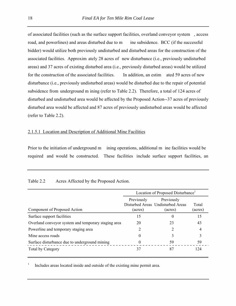
18 Final EA for Ten Mile Rim Coal Lease
of associated facilities (such as the surface support facilities, overland conveyor system , access
road, and powerlines) and areas disturbed due to m ine subsidence. BCC (if the successful
bidder) would utilize both previously undisturbed and disturbed areas for the construction of the
associated facilities. Approxim ately 28 acres of new disturbance (i.e., previously undisturbed
areas) and 37 acres of existing disturbed area (i.e., previously disturbed areas) would be utilized
for the construction of the associated facilities. In addition, an estim ated 59 acres of new
disturbance (i.e., previously undisturbed areas) would be disturbed due to the repair of potential
subsidence from underground m ining (refer to Table 2.2). Therefore, a total of 124 acres of
disturbed and undisturbed area would be affected by the Proposed Action--37 acres of previously
disturbed area would be affected and 87 acres of previously undisturbed areas would be affected
(refer to Table 2.2).
2.1.5.1 Location and Description of Additional Mine Facilities
Prior to the initiation of underground m ining operations, additional m ine facilities would be
required and would be constructed. These facilities include surface support facilities, an
Table 2.2 Acres Affected by the Proposed Action.
Location of Proposed Disturbance1
Component of Proposed Action
PreviouslyDisturbed Areas
(acres)
PreviouslyUndisturbed Areas
(acres)Total
(acres)Surface support facilities 15 0 15Overland conveyor system and temporary staging area 20 23 43Powerline and temporary staging area 2 2 4Mine access roads 0 3 3Surface disturbance due to underground mining 0 59 59Total by Category 37 87 124
1 Includes areas located inside and outside of the existing mine permit area.

Final EA for Ten Mile Rim Coal Lease 19
overland conveyor, a powerline, and access roads. All of the associated facilities would be
constructed within the existing BCC m ine permit boundary, except for 6 acres required for a
segment of the powerline that requires an ROW application and is discussed later in this section.
Surface Support Facilities. The proposed surface support facilities would be located within the
previously disturbed area of the Jim Bridger Mine, so there would be no new disturbance as a
result of these facilities. An appropriately sized area (approxim ately 15 acres) would be graded
and leveled on the nearby spoil pile (generated as a result of surface m ining operations) to allow
the construction of the required surface support facilities. The surface facilities that would be
located on the north side of Ram p 14 and would include an office, a warehouse, an em ployee
bathhouse, a lighted parking area, a m aterial storage area, associated structures such as water
storage and treatm ent equipment, an electric substation, a diesel fuel tank, and a septic system
with septic tanks and absorption field for the treatm ent of waste water from the bathhouse and
office. A conceptual layout of the underground m ine surface support facilities is presented in
Figure 2.2 and would be located as illustrated on Figure 2.3.
Overland Conveyor System. A covered electric overland conveyor system would be utilized to
transport the coal from the underground operations to the Jim Bridger Power Plant.
Approximately 17,000 ft of the new overland conveyor (60- or 72-inch wide) would be
constructed from the m ine portal at Ram p 14 to the existing Truck Dum p Station #2 (refer to
Figure 2.3). From Truck Dum p Station #2, the existing overland conveyor system would
transport the coal the rem aining 20,000 ft to th e Jim Bridger Power Plant. Installation of the
proposed overland conveyor system would be com pletely within the existing Jim Bridger Mine
lease and permit area; therefore, no additional ROW grants from the BLM or other parties would
be required for construction of the proposed overland conveyor system.
Assuming the full 100-ft wide construction area would be disturbed by construction activities,
approximately 7,000 ft (or 16 acres) of the ne w 17,000-ft overland conveyor system would be
located on previously disturbed lands and approxim ately 10,000 linear ft (or 23 acres) of new
conveyor system would be located on previously undisturbed land.

20 Final EA for Ten Mile Rim Coal Lease
Figure 2.2 Typical Surface Support Facilities Layout.

Final EA for Ten Mile Rim Coal Lease 21
Figure 2.3 Major Transportation Systems.

22 Final EA for Ten Mile Rim Coal Lease
The new overland conveyor system would be si milar to the existing overland conveyor system
utilized at the Jim Bridger Mine. Use of th e overland conveyor system would greatly reduce
particulate em issions (i.e., dust) typically generated during the transportation of coal by haul
trucks. The coal would also be sprayed with a light coating of water and/or water-based dust
suppressant agent, and the use of semicircular metal covers on the overland conveyor and the use
of enclosed transfer points would further reduce coal dust emissions from the operation.
Construction activities would be conducted utilizing standard construction techniques and
equipment. Construction of the new overland conveyor system would involve the following:
• salvaging available topsoil from areas that have been previously undisturbed by
other mining or mining-related activities,
• construction of a road-type surface for placement of the conveyor components,
• excavations for concrete footings for conveyor transfer points and anchors, and
• installation of major conveyor components (attached to the side of the conveyor)
and the installation of the electrical and control system.
In addition, a temporary construction staging area, located near Ram p 14, would be required for
a single (4-acre) material staging area. The temporary material staging area would be located on
a previously disturbed area and would not result in any new disturbance.
Powerline. Approxim ately 38,500 ft (7.3 m i) of new and upgraded 34.5-kilovolt (kV)
distribution powerline would be required for the Proposed Action to feed surface support
facilities and underground m ining equipm ent. The approxim ate location of the new and
upgraded 34.5-kV distribution powerline is illustrated on Figure 2.4. Starting at the existing Jim
Bridger Substation located southwest of the Jim Bridger Power Plant, approxim ately 7,000 ft of
existing Bridger to Superior 34.5-kV powerline would be upgraded with new phase and neutral
conductors. At a power pole structure loca tion near the SE1/4 of Section 35, T21N, R101W , a
new direct-feed electrical tap would be constructed from the existing Bridger to Superior
transmission powerline. From the new tap, approxim ately 31,500 ft of new 34.5-kV

Final EA for Ten Mile Rim Coal Lease 23
Figure 2.4 Powerline System.

24 Final EA for Ten Mile Rim Coal Lease
powerline would be constructed to the proposed Surface Support Facilities area located in
Ramp 14. An electric substation would also be installed at the Surface Support Facilities area
located at Ramp 14.
Approximately 4,900 ft of the new powerline would cross BLM-administered land in Section 36,
T21N, R101W. This portion of the proposed powerline would be located outside of the BCC
WDEQ/LQD m ine perm it boundary or existing federal lease area and would require a ROW
from the BLM (refer to Figure 2.5). Assum ing a 50 ft-wide ROW , this segm ent of new
powerline would require a ROW grant for approximately 6 acres from the BLM. The remaining
26,600 ft of the new distribution powerline between the new segm ent and Ram p 14 would be
located within the existing federal coal lease and m ine perm it area, and no additional ROW
grants from the BLM would be required. BCC would obtain any necessary easem ents from the
appropriate nonfederal landowners for all powerline segm ents not located on BLM-administered
land.
The proposed electrical service equipm ent would be sim ilar in design to the existing 34.5-kV
system located at the Jim Bridger Mine. The proposed distribution powerline and hardware
would be designed, constructed, operated, and m aintained in conform ance with the National
Electrical Safety Code and other applicable codes and standards, Mitigating Bird Collisions with
Power Lines: The State of the Art in 1994 (APLIC 1994), and Suggested Practices for Raptor
Protection on Power Lines: The State of the Art in 1996 (Avian Power Line Interaction
Committee [APLIC] 1996).
Construction of the proposed powerline and m odification of the existing powerline would be
conducted utilizing standard electrical construction techniques and equipm ent, would only
involve use of wheeled vehicles driving along the ROW , and would not involve any topsoil
salvaging operations. The only area to be physically disturbed by the proposed powerline would
be located where individual power pole structures and anchors would be installed. The new
powerline would result in approxim ately 2 acres of total new disturbance. Modifications to the
Final EA for Ten Mile Rim Coal Lease 25
Jim Bridger substation would occur within th e existing fenced substation area and would not
result in any new or additional disturbance.
In addition, a temporary construction area, located near the Jim Bridger Mine office and shop
complex, would be required for a single (2-acre) m aterial staging area. The tem porary material
staging area would be located on a previously disturbed area and would not result in any new
disturbance.
Mine Access Roads. Access to the surface support facility would be prim arily from existing
public and private roads. From Point of Rocks, construction workers and m iners would travel
north approxim ately 8 m i on W yoming State Highway 377 and then transition on to County
Road 15 for approximately 1 mi. At this point, BCC would construct a new 0.4-mi long segment
of road that would tie into BCC's existing m ine road system (refer to Figure 2.5). The new
access road segm ent would reduce traffic congestion and im prove safety around BCC's office
and shop com plex. BCC would obtain a special use perm it from the Sweetwater County Road
and Bridge Departm ent, and the road would m eet all appropriate road design standards.
Assuming the road disturbance would be approxim ately 50 ft wide, the new access road would
result in approximately 3 acres of new disturbance.
Construction workers and m iners would then enter the BCC m ine property through an access
control point and travel north approxim ately 4.2 m i on the existing m ine road to the proposed
surface support facilities located at Ram p 14 (refer to Figure 2.3). In order to im prove public
safety, the general public would not be allowed to enter the operational portion of the Jim
Bridger Mine.
2.1.5.2 Mine Equipment
Table 2.3 lists the typical types of equipm ent that would be used under the Proposed Action
during construction, exploration, m ine operations, and reclam ation. The specific num ber and

26 Final EA for Ten Mile Rim Coal Lease
Figure 2.5 Proposed Mine Access Roads.

Final EA for Ten Mile Rim Coal Lease 27
Table 2.3 Typical Major Equipment.
Continuous Mining Equipment Longwall Mining System General Mining Equipment
continuous miners face conveyor diesel tow vehicles
shuttle cars shearer compressors
roof bolters shield supports transformers
feeder breakers stage loader/crusher 60-inch wide conveyors
rock dusters lump breaker 60-inch wide drives
power centers transformer 72-inch wide conveyors
scoops scoop forklift 72-inch wide drives
belt takeup petito mule welders
shield haulers mantrips
shield carrier motor grader
shearer carrier tracked dozer
mobile tailpiece water trailer
stage crusher gravel trailer
lighting/communications material trailer
rock duster battery section scoop
electrics/power center
belt takeup
load-haul-dump (LHD)equipment
forklift
bobcat-type front end loader
communications equipment
power distribution equipment
coal analyzer
rock dusters
water pumps
ventilation fan and motor

28 Final EA for Ten Mile Rim Coal Lease
equipment manufacturers and models would be determined as the project schedule is developed.
Construction equipment (e.g., motor graders, cranes, backhoes, flatbed trucks, forklifts, pickups,
etc.) and construction personnel would only be on-site during construction of the specific
facilities or equipment (e.g., the longwall mining system).
2.1.5.3 Nature of Coal and Coal Reserves
Existing data on coal resources within the TMRT have been developed from numerous surface
exploration drill holes. The data indicate a good-quality coal resource with approxim ately
121.5 million tons of in-place underground-m inable coal. Up to seven coal seam s are present
within the proposed TMRT area; however, only the D-41 coal seam of the Fort Union Formation
is econom ically recoverable using underground m ining m ethods. The D-41 coal seam has a
thickness that would allow a m ining height ra nging from 7 to 11 ft and a heat content of
approximately 9,000 to 9,500 British Therm al Units (BTUs) per pound. W ithin the TMRT, the
minable coal is approxim ately 200 to 1,000 ft below ground surface. Sulfur content is
approximately 0.6% (1.2 pounds sulfur dioxide [SO2] per million BTU) and, with blending at the
Jim Bridger Power Plant, it would be com patible with SO2 requirements specified in the federal
Clean Air Act, as amended (42 U.S.C. §7401 et seq.) (Wyoming State Geological Survey 1998).
Should the lease be issued, additional exploration drilling may be completed within the TMRT to
further delineate the volum e and quality of coal to be m ined. Exploration drilling would be
conducted in accordance with BLM standard environm ental stipulations. If exploration drilling
is required prior to the approval of the W DEQ/LQD mine permit amendment, BCC would apply
for a coal exploration permit and would conduct drilling in accordance with applicable BLM and
WDEQ/LQD rules and regulations. All drill holes would be abandoned and reclaim ed in
accordance with applicable BLM and W DEQ/LQD rules and regulations. Based on the existing
exploration drill hole data, BCC proposes to start underground m ining at the highwall area of
Ramp 14 within the existing BCC surface mining operation.

Final EA for Ten Mile Rim Coal Lease 29
2.1.5.4 Mining Methods
During the first 2 years of underground m ine development, most of the effort would be devoted
to the establishment of the main mine entry and gateroads (a gateroad is a roadway that provides
access to the working panel). The main entry will be started at the highwall located at Ram p 14.
The m ain entry and gateroads would be cut into the highwall utilizing continuous m ining
machines equipped with rotating drum s with bits that cut coal directly from the exposed coal
face (refer to Figure 2.6) and then load it onto a conveyor or into shuttle cars that haul it to a
electric conveyor. The continuous mining equipment could then cut around individual blocks of
coal, referred to as longwall panels (refer to Figure 2.7). In addition to the establishm ent of
longwall
Figure 2.6 Typical Continuous Mining Equipment.

30 Final EA for Ten Mile Rim Coal Lease
Figu
re 2
.7Ty
pica
l Lon
gwal
l Pan
el w
ith M
ain
Entry
and
Sub
mai
n En
try.

Final EA for Ten Mile Rim Coal Lease 31
panels, the continuous m ining equipment is utilized to establish gateroads with pillars for roof
support and entryways to the panels for equipment access and air ventilation. Each panel would
be approximately 750 to 850 ft wide and ra nge from 10,000 to 15,000 ft long. Once the initial
panels have been developed, a longwall mining system would be installed.
While the continuous m ining equipment continues to develop gateroads, entries, and longwall
panels, the longwall m ining system would m ine the exposed coal face of each panel. The
longwall mining system would be equipped with a shearer that has two rotating drums for cutting
the coal, a self-advancing hydraulic roof support system , and a conveyor to transport the coal
(refer to Figures 2.8 and 2.9). The rotating drum would move down and up along the coal face,
cutting approximately 24-36 inches of coal with each pass. BCC expects to rem ove a minimum
height of 7 ft to a m aximum of 11 ft of coal from the D-41 coal seam . The hydraulic roof
support system would automatically move towards the receding coal face, and the roof would be
allowed to cave into the mined-out areas (refer to Figure 2.10).
Cut coal would fall onto an armored face conveyor to be transported to a headgate belt conveyor
and out to the surface via the m ain entry, where it would be autom atically transferred onto
another electric covered conveyor system that would transport the coal to the power plant
stockpile (refer to Figure 2.9). At the end of each pass, the drum would continue in the opposite
direction for another pass.
The underground mine would be ventilated with a blowing fan system located at the mine portal,
and BCC does not anticipate the need for any vertical ventilation shafts to the surface of the
TMRT area.
Estimated production for the underground m ine may range from 4.5 to 5.5 m illion tons per year
at full production for the next 15 to 20 years, depending upon geologic and econom ic conditions
from the underground operation. Total production from surface and underground m ining
operations at BCC is expected to rem ain at approxim ately 6.2 m illion tons per year but would
depend on coal supply requirements of the Jim Bridger Power Plant.

32 Final EA for Ten Mile Rim Coal Lease
Figure 2.8 Typical Longwall Mining System.

Final EA for Ten Mile Rim Coal Lease 33
Figure 2.9 Close-up of Major Components of Longwall Mining System.
Figure 2.10 Typical Trough Subsidence Due to Longwall Mining.

34 Final EA for Ten Mile Rim Coal Lease
2.1.5.5 Mine-Water Discharge and Treatment
Excess mine water not needed for dust suppression and not used at the surface support facilities
would be pum ped into an existing W DEQ-approved holding pond where the water would be
monitored and discharged into the Deadm an W ash drainage channel if it m eets approved
National Pollutant Discharge Elim ination System (NPDES) discharge standards. This activity
would be conducted as part of ongoing mine dewatering operations conducted at the Jim Bridger
Mine and in accordance with BCC's existing NPDES discharge permit issued by WDEQ/WQD.
2.1.5.6 Water Requirements
Depending on the level of coal production, approxim ately 100,000 to 500,000 gallons of water
per day (70 to 350 gallons per m inute) would be utilized for dust suppression, equipm ent
washdown associated with underground mining equipment and the washdown of surface support
facilities, and for fire suppression. W ater would be supplied from two sources. Initially most of
the required water would be supplied from a new water well (Bridger No. 1 well) that would be
drilled in NE ¼ of Section 12, T21N, R101W . This well would be com pleted into the Ericson
Formation that is located below the Fort Union Form ation (the formation that would be affected
by the Proposed Action). The well, access road, and power supply would be located within the
existing BCC m ine perm it area and no additional federal approvals would be required. BCC
would also secure all required water rights perm its from the SW EO. The Bridger No. 1 well
would be approxim ately 3,010 ft deep and would be cased with ten-inch diam eter casing from
ground level to 1,200 ft below ground level, six-inch diam eter casing would be installed from
1,200 to 2,410 ft below ground level, and five-inch diam eter screen would be installed from
2,410 to 3,010 ft below ground level. An electric turbine or subm ersible pump would be used to
pump the water to the surface where it would be pum ped to the appropriate locations. The well
is expected to produce an average of 200 gallon per minute.
The second source of water would be genera ted from underground m ine dewatering operations
associated with the Proposed Action. Dewatering operations are an integral part of the Proposed
Final EA for Ten Mile Rim Coal Lease 35
Action and water generated from the coal seam would be pum ped to appropriate locations for
subsequent use. W ater would be supplied from each source as it becom es available and is
required. It is anticipated that the Bridger No.1 well would be the prim ary source of water
during the initial 5 years of operations as longwall mining operations are established. As mining
operations transition into full production, water from the coal seam would likely becom e the
primary source of water. Even after underg round mining operations are in full production, the
Bridger No. 1 well would still serve as a backup or secondary source of water for dust
suppression, equipment washdown, and fire suppression.
2.1.5.7 Control of Toxic, Hazardous, and Solid Waste Materials
Acid-Forming/Toxic Materials. Acid-forming or toxic materials are not expected to be created
or encountered during mining operations.
Hazardous Materials and Waste. BCC has reviewed the U.S. Environmental Protection Agency's
(EPA's) Consolidated List of Chem icals subject to Reporting Under Title III of the Superfund
Amendments and Reauthorization Act of 1976 (SARA) (as am ended) and EPA' s List of
Extremely Hazardous Substances as defined in Title 40 CFR Part 355 for hazardous substances
proposed for use in this project. BCC m aintains a f ile containing Material Safety Data Sheets
(MSDS) for all chemicals, compounds, and/or substances that are or would be used during m ine
development, mining, and reclamation. Hazardous m aterials anticipated to be used or produced
during the implementation of the Proposed Action fall into the following categories:
• fuels - gasoline (potentially containing benzene, toluene, xylene, methyl tert-butyl
ether, and tetraethyl lead) and diesel fuel;
• combustion em issions - nitrogen dioxide (NO 2), carbon m onoxide (CO), and
nonmethane hydrocarbons (NMHCs);
• coolants/antifreezes;
• lubricants - grease (potentially containing com plex hydrocarbons and lithium
compounds) and motor oil;
• paints;

36 Final EA for Ten Mile Rim Coal Lease
• solvents;
• powerline emissions - ozone and NO2; and
• wood preservation for powerline poles.
BCC and its contractors would com ply with all applicable federal laws and regulations. BCC
and its contractors would handle and store all hazardous substances in an appropriate m anner to
prevent contamination of soil and water resources. Any release of hazardous substances (leaks,
spills, etc.) in excess of reportable quantities, established in Title 40 CFR Part 117, would be
reported as required by the Comprehensive Environmental Response, Compensation, and
Liability Act of 1980 (CERCLA), as am ended. If a releas e of a reportable quantity of any
hazardous substances occurs, a report would be furnished to W DEQ and all other appropriate
federal and state agencies. Prior to construction of any facilities associated with the Proposed
Action, inventories of hazardous chem ical categories pursuant to Section 312 of the SARA, as
amended, would be updated.
Unanticipated release events (such as spills or leaks) are always possible; however, BCC is
committed to all planning and em ergency procedures regarding spill prevention, reporting, and
cleanup standards required by local, state, and federal laws and regulations should an incident
occur.
Fuel Storage. During the construction phase of the Proposed Action, fuel storage would be
provided from the existing Jim Bridger Mine facilities. Upon com pletion of construction
activities, a perm anent fuel storage facility w ould be provided at the Surface Support Facilities
(refer to Figure 2.2). In addition, m obile fuel tr ucks would be used to service and fuel m ine
equipment. All fuel storage facilities and e quipment would be constructed and operated in
accordance with all applicable state and federal regulations. Prior to the im plementation of the
Proposed Action, BCC would update the m ine's existing Spill Prevention, Control, and
Countermeasure Plan (SPCCP), as necessary, in accordance with Title 40 CFR Part 112.

Final EA for Ten Mile Rim Coal Lease 37
Disposal of Nonhazardous Materials (Solid and Nonsolid). Portable toilets would be provided
for workers on-site during construction and at the proposed change house located at Ram p 14,
and the waste would be properly disposed of thr ough the septic system or at an approved waste
disposal facility on an as-needed basis. Solid waste such as garbage and other discarded solid
materials would be collected at a designated collection site and disposed of at an approved solid
waste management facility. Solid waste would not be im ported or disposed of within the TMRT
area. Spills of petroleum products m ay occur during m ining due to periodic equipm ent
maintenance and/or accidents. Petroleum -contaminated soils would be disposed of at an
approved facility capable of accepting such waste. All nonhazardous material would be disposed
of in accordance with appropriate local, state, and federal regulations.
2.1.5.8 Subsidence and Associated Reclamation
As each coal panel is m ined out, the longwall system , including the roof support equipm ent,
would advance toward the receding coal face, and the roof located above the m ined-out coal
panel area would be allowed to cave into th e m ined-out area (refer to Figure 2.10). The
collapsed material provides considerable support for the overlying strata, but the strata would
eventually settle, leading to subsidence on th e surface. Although inevitable, trough subsidence
caused by longwall m ining is generally uniform and m ore predictable than subsidence due to
room-and-pillar mining (U.S. Department of Energy 1995).
As part of the WDEQ/LQD permit to mine, BCC would be responsible for the developm ent of a
mine subsidence plan that would include detailed calculations concerning the am ount of
anticipated subsidence, m easures to be taken to prevent or m inimize the im pacts of subsidence,
measures to be taken to prevent, lessen, or m itigate material damage or loss of value of physical
property in the area, and a subsidence monitoring and mitigation plan.
In accordance with W DEQ/LQD rules and regulations, the surface areas located above
underground-mined areas would be m onitored annually and for a m inimum of 5 years after the
completion of underground m ining operations. This would allow BCC and W DEQ/LQD to

38 Final EA for Ten Mile Rim Coal Lease
assess subsidence and the adequacy or need for reclam ation effort. BCC would be responsible
for the repair of areas of surface subsidence for a period of 5 years following com pletion of
mining operations as directed by W DEQ/LQD (W DEQ/LQD Rules and Regulations, 2002,
Chapter 7, Section 2. [a][iv]). Reclam ation of areas of subsidence that require corrective action
would be initiated after the subsidence has occurre d and it has been determ ined that corrective
actions are required. Areas of subsidence and erosional features would be m onitored and
appropriate corrective actions (i.e., reclam ation and revegetation efforts) instituted if conditions
warrant. Additional erosion control features would also be em ployed as needed. All m itigation
and corrective actions would be conducted in accordance with the approved W DEQ/LQD mine
permit and as directed by WDEQ/LQD.
2.1.5.9 Reclamation of Mine Facilities
The postm ining land use would continue to be livestock grazing and wildlife habitat.
Reclamation of mine facilities (i.e., surface support facility, powerlines, overland conveyor, etc.)
would begin when underground m ining operations have been com pleted. All support facilities
associated with the Proposed Action would be dismantled and removed and the land reclaimed in
accordance with the approved mine and reclamation permit issued by WDEQ/LQD.
Permanent reclamation procedures for areas located within the existing Jim Bridger Mine would
typically include disassem bly and relocation of underground m ining equipm ent, rem oval and
demolition of mine facilities (buildings, conveyors, powerlines, etc.), backfilling and grading of
overburden, topsoil replacem ent, and revegetation operations (e.g., seeding and m ulching
operations). WDEQ/LQD would approve permanent reclamation seed mixtures and seeding and
mulching rates. W DEQ/LQD is responsible for reviewing and approving all m ine and
reclamation plans prior to the initiation of actual m ining operations. BCC would utilize only
weed-free reclamation materials (e.g., seed, mulch).
BCC would be required to post a reclam ation perform ance bond for all areas physically
disturbed by m ining operations (including areas of repaired subsidence) with the State of
Final EA for Ten Mile Rim Coal Lease 39
Wyoming to ensure that it com plies with all the reclam ation requirements of the W DEQ/LQD
permit and that reclamation requirements are met. Once mining and reclamation operations have
been com pleted, BCC would follow reclam ation bond release procedures specified by
WDEQ/LQD. Reclamation bond release procedures for an underground coal m ine are identical
to surface coal m ines, including the 10-year bond release period after the com pletion of
permanent reclamation operations, and they require that a stable land form exists on disturbed
areas and that revegetation standards have been m et. W DEQ/LQD would release the full
reclamation performance bond after strict reclam ation standards have been m et and the public
has been provided an opportunity to comment.
2.1.5.10 Avoidance of Public Nuisance and Endangerment
Nearby Dwellings. As specified under Wyoming Statute (W.S.) 35-11-406 (m)(viii), the director
of the W DEQ can deny a perm it to m ine if the a ffected lands lie within 300 ft of any existing
occupied dwelling, hom e, pub lic building, school, church, com munity or institutional building,
park or cemetery, unless the landowner' s consent is obtained. There are no occupied dwellings,
homes, public buildings, schools, churches or institutional buildings, parks, cem eteries, or
community centers within 300 ft of the proposed TMRT area. The nearest occupied dwellings,
homes, public buildings, schools, churches or institutional buildings, parks, cem eteries, or
community centers are located approxim ately 8 mi west of the TMRT in the com munity of
Superior.
Normal Operating Hours. Mine operations within the TMRT would be identical to the existing
Jim Bridger Mine: 24 hours per day, 7 days per week, 52 weeks per year except for designated
holidays. Holidays would generally be excluded from the operations schedule. Additionally, the
mine would be scheduled for 2 weeks per year idle tim e for annual vacations. Maintenance
activities would still continue during mine idle times.
Entrance Sign. An entrance identification sign would be posted and m aintained at all m ajor
entrances into the existing Jim Bridger Mine and the TMRT area. The sign would contain the

40 Final EA for Ten Mile Rim Coal Lease
name, address, and telephone number of the operator, the name of the local authorized agent, and
the WDEQ/LQD permit number of the operation.
Blasting Plan. Limited blasting would be required with underground mining operations. Blasting
operations would also continue as needed for the existing surface m ining operations in
accordance with applicable WDEQ/LQD and federal Bureau of Alcohol Tobacco, Firearm s, and
Explosives regulations. Blasting operations conducted in association with the Proposed Action
would be m uch smaller in size than those currently associated with the existing surface m ining
operation.
Fire Control. BCC m aintains a fire engine, water trucks, and dozers that m ay be utilized in the
event of an equipment fire or wildfire. BCC also has established procedures to respond to and to
combat fires. All em ployees are trained in the use of hand-held fire extinguishers, and
appropriate personnel are trained in the specific use of other firefighting equipm ent. W ater
produced from the Bridger No. 1 well would be utilized in case of underground or equipm ent
fires.
Weed Control. Designated or prohibited noxious weeds on lands within the TMRT area would
be controlled. In general, the following procedures would be instituted.
• Land disturbance would be kept to a minimum during the mining process.
• BCC will utilize only certified weed-free m ulch and seed during reclam ation
operations.
• Chemical herbicides m ay be used to control noxious or prohibited weeds. The
local weed and pest agency would be contacted, and the problem would be
addressed in com pliance with appropriate regulations. If required, a Pesticide
Use Plan would be prepared and approved by W DEQ/LQD and BLM prior to
application of pesticides.
Prevention of Endangerm ent. Mining operations would be conducted in a m anner intended to
prevent or minimize endangerment to the public safety and hum an and animal life. The TMRT
area would continue to be utilized for livesto ck grazing; therefore, public access to the TMRT

Final EA for Ten Mile Rim Coal Lease 41
and the m ine highwall portion of the lease area ca nnot be com pletely restricted or elim inated.
However, in accordance with the Wyoming Environmental Quality Act and OSM regulations,
mine entrance signs would be posted on all m ajor roads leading on to the TMRT area, and m ine
employees would be instructed to watch for unauthorized personnel and to notify m ine
management if unauthorized personnel are observed within the TMRT.
Since the TMRT would be incorporated into an existing W DEQ/LQD permit area, speed lim its
would be established for the TMRT area to prom ote safe conditions for the public and to
decrease potential encounters with grazing animals and wildlife. Currently, speed within the Jim
Bridger Mine is lim ited to 45 m i per hour due to the conditions in the area. All construction
workers, contract haulers, and miners would be advised of the speed limit.
2.1.5.11 Employment
Under the Proposed Action, approxim ately 10-75 tem porary construction workers would be
required to construct the powerline, the covered conveyor, and support m ine facilities and to
assemble mining equipment. Construction operations may start in mid-2005 and would continue
through the end of 2006; however, precise dates would depend upon the overall project schedule,
weather conditions, and the approval of all required regulatory permits and authorizations.
Current surface-mining operations at the Jim Bridger Mine utilize approximately 350 employees.
Under the Proposed Action, there would be a transition of som e employees between jobs while
operations are conducted at both the surface and underground m ining operations. After the
initial startup of underground m ining operations (including developm ent of m ain entries,
gateroads, and initial longwall production), the projected number of underground employees may
range from 180 to 250. However, the total number of employees would depend upon production
levels from both the surface and underground mining operations. The total number of employees
may range between 250 and 400 employees. Therefore, under the Proposed Action it is assumed
that there could be a net increase of approximately 50 employees at the BCC.

42 Final EA for Ten Mile Rim Coal Lease
2.1.5.12 Cultural Resource Protection
Under the Proposed Action, BCC (if the successful bidder) would enter into a cultural resource
programmatic agreem ent with BLM, OSM, W DEQ/LQD, and W yoming State Historic
Preservation Office. This agreem ent would specify survey, testing, protection, and m itigation
measures that would be im plemented by BCC to address and protect National Register of
Historic Places (NRHP)-eligible historic and prehistoric sites within the TMRT area. The
programmatic agreem ent would dem onstrate com pliance with all applicable cultural resource
laws and regulations.
In addition, BLM Class III surveys would be conducted on those areas that are located outside of
the TMRT, have not been previously surveyed, and would be physically disturbed by the
construction activities. All historic and prehistoric resources that are potentially eligible for the
NHRP that could be adversely affected by the Proposed Action would be protected from
disturbance or would be appropriately m itigated if the site could not be avoided. W here
necessary and appropriate, site-specific m itigation m easures would be developed and
implemented in accordance with the current cultural resource protection plan contained in BCC's
approved WDEQ/LQD permit. The site-specific m itigation measures would also be developed
and implemented with the concurrence of the BLM, OSM, WDEQ/LDQ, and the Wyoming State
Historic Preservation Office.
BCC would also com mit to the following: if any cultural resources are discovered during
construction or reclamation operation, work in the area of the discovery would be halted, and the
appropriate regulatory agency would be notified and appropriate treatm ent plans would be
implemented. BCC em ployees would be instructed that they would be working on both private
and public land and not to search for, scavenge, or rem ove any cultural resources found while
working on the project.
Final EA for Ten Mile Rim Coal Lease 43
2.1.5.13 General Environmental Protection
Existing federal and state rules and regulations that require extensive m onitoring and mitigation
for all underground coal m ines in W yoming would be applied to this project to m itigate the
environmental consequences associated with coal m ine development and operations. Under the
Proposed Action, BCC would be required to conduct detailed environm ental studies in
accordance with W DEQ/LQD rules and regulations prior to perm it issuance and would be
required to conduct environmental monitoring and mitigation if the permit would to be approved.
In addition, the public would have several opportunities to com ment on the permit application if
the Proposed Action would be approved. Therefore, for the purpose of th is EA, it is assum ed
that BCC would adhere to applicable sections of Chapters 4 and 7 of W DEQ/LQD's Coal Rules
and Regulations (W DEQ/LQD 2002) and BLM' s mitigation guidelines described in the Green
River RMP for surface-disturbing activities (BLM 1997a). In addition, this analysis assum es
standard and special coal lease stipulations would apply (refer to Appendix A).
In addition to specifying perm it requirem ents, W DEQ/LQD rules and regulations also outline
general and specific environm ental protection perform ance standards for underground coal
mining operations. These applicable rules and regulations would be adhered to on
BLM-administered lands, private lands, and state-owned lands.
2.2 NO ACTION ALTERNATIVE
Under the No Action Alternative, the TMRT coal lease application would be rejected and the
area contained in the application would not be offered for com petitive coal sale at this tim e.
However, rejection of the application would not affect the already leased and perm itted surface
mining activity at the Jim Bridger Mine. For the purpose of this analysis, the No Action
Alternative assum es that the TMRT would not be m ined in the im mediate future. This
assumption is highly speculative since private minerals within the project area (refer to
Figure 2.1) may be developed without the developm ent of the federal m inerals. The purpose of
44 Final EA for Ten Mile Rim Coal Lease
the No Action Alternative is to allow a com parison of the econom ic and environm ental
consequences of m ining these lands versus not m ining them . Not leasing this land in a
configuration associated with the existing Jim Bridger surface coal m ine at this tim e may result
in a bypass of federal coal, which m ay not be in the general public' s best financial interest.
However, selection of the No Action Alternative would not preclude the possibility of
subsequent leasing for these lands as a stand-alone underground m ine as described in Section
2.3.1.
Under the No Action Alternative, the Proposed Action would not be selected and BLM would
not offer the federal coal within the TMRT lease area for sale. As a result, BCC' s ability to
sustain historic coal production levels would be lim ited to the rem aining coal reserves located
within the existing lease area that would be econom ically recoverable using existing surface
mining operations and highwall mining methods. Undoubtedly, there would be a decrease in the
amount of coal m ined at the Jim Bridger Coal Mine with a corresponding reduction in the
number of m iners em ployed at BCC. BCC would continue to produce coal at som e reduced
level as long as the costs were com petitive with m arket alternatives for the Jim Bridger Power
Plant.
In addition, representatives for the adjacent Ji m Bridger Power Plant would need to secure
alternative coal supplies from non-BCC sources for the power plant. These coal supplies would
likely be transported by rail to the plant on the existing railroad spur line from Union Pacific
Railroad Company's main line located near Point of Rocks, Wyoming.
2.3 ALTERNATIVES CONSIDERED BUT ELIMINATED FROM DETAILED STUDY
Several alternatives were identified and reviewed during the preparation of this EA. At the
conclusion of the review, the EA team screened out the following alternatives as not feasible and
not warranting further analysis in this EA.
Final EA for Ten Mile Rim Coal Lease 45
2.3.1 Hold a Competitive Sale of Federal Coal Lands that Would Maximize the Potentialfor a New Stand-alone Mine
This alternative assumes that the BLM would award the TMRT lease to a successful bidder but
not the current applicant. Since there are no adjacent m ines that could incorporate the coal
reserves into an existing lease, the successful bidder (assum ing it would not be the current
applicant) would be required to establish a new stand-alone mine. Due to the depth of the coal
(200-1,000 ft below the surface) within the TMRT, it is assumed that the tract would be too deep
for surface mining and would, therefore, have to be mined utilizing underground technologies.
A new stand-alone underground m ine would require considerable initial capital expenses,
including the construction of new external transportation facilities (e.g., rail loop or paved access
road), surface facilities (e.g., coal-processing facilities, coal-loadout facilities), internal
transportation facilities (e.g., conveyors or haulroads), utilities and com munication facilities
(e.g., powerline, transformers, water wells, telephone lines), and support buildings (e.g., offices,
shop, change house, and warehouse). In addition to the above item s, vertical shafts or inclined
ramps would be necessary to provide access to the targeted coal seam s because a stand-alone
operation would not be able to access the highwall portal located within the Jim Bridger Mine.
In addition, the increased recovery of the rem aining coal resource on the existing Bridger coal
lease (accessible only from the TMRT area) would not be accom plished because these coal
reserves have already been leased to BCC and could only be econom ically recovered by
underground mining methods. However, if the federal coal reserves within the TMRT area were
to be leased to another bidder (not the current applicant), the underground reserves located
within the existing Jim Bridger lease area and near the TMRT area would not likely be
recovered. This would result in a total potential loss of reserves of m ore than 5 m illion tons of
federal, state, and private coal reserves, with the subsequent loss of revenue to the federal and
state governments.
A new stand-alone mine would also require extensive environmental baseline data collection and
permitting efforts that would take 2 to 4 y ears to com plete. The new underground coal m ine

46 Final EA for Ten Mile Rim Coal Lease
would also have to com pete for custom ers with established m ining operations in the im mediate
area (e.g., Bridger Mine, Leucite Hills Mine, and Black Butte Mine) and the region (e.g.,
Wyoming Powder River Basin). No other com panies have expressed an interest to the BLM in
coal exploration or development activity in the TMRT. As a result of these constraints, it would
be difficult to anticipate exactly how another co mpany would physically m ine and transport the
coal to market.
In order to help offset the considerable initial capital expenses of a new m ine and to attract the
serious attention of another bidder, the BLM would likely have to consider enlarging the TMRT.
The enlarged tract would be offered for com petitive sale, subject to standard and special lease
stipulations. A successful bidder for the enlarged tract would still face the sam e initial facility
development costs and m arket considerations discussed above. Furtherm ore, enlarging the tract
enough to make it attractive for a new m ine start may lower the fair market value of the coal per
ton and would likely result in a lower bonus bid per ton paid to the federal governm ent. For
these reasons, it is unlikely that the TMRT or an enlarged TMRT would attract additional
bidders interested in starting a new m ine. Therefore, this alternative was elim inated from
consideration and is not analyzed in detail in this EA.
In the event that the successful bidder for the fede ral coal reserves within the TMRT area is not
the current applicant, the successful bidder would be required to subm it detailed m ine
development inform ation to the BLM, including m ine and transportation plans and m ine and
support facility requirem ents. The BLM would then utilize this inform ation to undertake
additional environmental analysis in compliance with NEPA because any new mine facilities not
associated with the Proposed Action have not been addressed in the current EA.
2.3.2 Smaller Sale Area
Under this alternative, the BLM would lease only approxim ately one-half of the identified
federal coal reserves within the TMRT. Sp ecifically, the E½ of Section 34, T22N, R101W , and
all of Section 6, T21N, R100W , would be the only federally owned coal lands included in this

Final EA for Ten Mile Rim Coal Lease 47
alternative. This alternative would also include Sections 35 (privately owned coal lands) and
36 (state-owned coal lands), T22N, R101W, and Section 31 (privately owned coal lands), T22N,
R100W. Leasing of only one-half of the proposed tract m ay have the effect of m aking the
project, as a whole, uneconom ic because of the extensive capital investm ents necessary to start
an underground mine of the same capacity and with only one-half the coal reserves anticipated in
the Proposed Action. In addition, the applicant m ay feel that the risk of leasing one-half of the
tract would be too high, due to a lack of fl exibility in the mine plan when mine plan
modifications become necessary. Mine plans are evolving docum ents, and there is no way of
knowing precisely the nature of the deposit until the initiation of actual mining operations.
Therefore, this alternative is determ ined not econom ically feasible, was elim inated from
consideration, and is not analyzed in detail in this EA.
2.3.3 Larger Sale Area (Originally-Applied-for LBA Tract)
Under this alternative, the BLM would lease approxim ately three times as much of federal coal
as identified in the current TMRT LBA, area and the size would be sim ilar to the originally-
applied-for LBA Tract. The larger TMRT LBA area was identified during the initial public
scoping of this EA that was released to the public in Novem ber 2001. However, results of
additional exploration drilling conducted with in a larger TMRT LBA area by the current
applicant during 2001 to 2003 indicated that the quantity and quality of coal within the larger
TMRT LBA area was unacceptable and would not justify proceeding with the leasing process for
the larger LBA area at this tim e. It is possible that the successful bidder of the lease sale m ay
apply for a subsequent lease or lease modification if the proposed LBA were leased and mined.
Therefore, this alternative is determ ined not econom ically feasible, was elim inated from
consideration, and is not analyzed in detail in this EA. The elim ination of this alternative from
the detailed analysis in this EA would not result in the perm anent bypass of any federal coal
reserves.

48 Final EA for Ten Mile Rim Coal Lease
2.3.4 Postpone Competitive Lease Sales
Under this alternative, the sale of the federal coal reserves within the TMRT would be postponed
more than 5 years on the assum ption that coal prices would rise in the future, thus increasing the
fair market value of the tract and resulting in a higher bonus bid when the coal is sold.
There are two sources of revenue to federal and state governm ents from the leasing and m ining
of federal coal: a bonus bid paid at the tim e the coal is leased and a royalty paym ent (based on
8% of the gross value of the coal) is collected when the coal is sold. The royalty paym ent is the
larger of the two incom e sources, and since it is collected when the coal is sold, a m echanism is
already in place for government revenues to increase if prices rise.
Although postponing the lease sale until prices rise m ay conceivably result in a higher bonus bid
paid for the tract, it would not necessarily result in higher royalty paym ents. It typically takes
several years to lease and perm it a coal tract, a nd coal prices would not necessarily rem ain high
until the coal is actually mined if a sale is postponed until the prices increase.
There is also the econom ic concept of net pres ent value of m oney; that m eans that future
economic values m ust be financially discounted due to the effect of inflation and that m oney
earned today is more valuable than undetermined revenues earned in the future because it can be
invested at a known rate. Therefore, unless coal pr ices are expected to increase and stay at these
higher levels, it is in the governm ent's best financial interest to lease the coal tract today instead
of waiting an unspecified period of time in hopes that the price of coal will increase in the future.
Current surface m ining operations at BCC are nearing their econom ic limits and will likely be
completed within approxim ately 5 years. At that tim e, permanent reclamation operations will
proceed within the entire mine area, including the area in and around Ramp 14 and highwall area
where the potential surface support facilities would be located. If there are no definitive plans or
prospects to leave the Ram p 14 area and associated highwall area open, BCC would be required
by W DEQ/LQD to perm anently reclaim this area. If these areas are perm anently reclaim ed

Final EA for Ten Mile Rim Coal Lease 49
before underground m ining operations are conducted in the TMRT LBA area, the cost of
reinitiating underground m ining operations would likely be m uch higher than those anticipated
under the Proposed Action. This situation would then be sim ilar to the stand-alone m ine
alternative discussed above and m ay actually result in a m ajor impact on the econom ic viability
of the entire project.
Therefore, this alternative was elim inated from consideration and not analyzed in detail in this
EA because the potential econom ic benefits are not com pletely predictable and because the
impacts of mining coal at a later time would likely be similar to stand-alone alternative discussed
above.
2.3.5 Hold a Competitive Sale of Federal Coal Lands as a Continuation of Existing SurfaceCoal Mining Operations
Under this alternative, the current lease applicant would mine the federal coal reserves within the
TMRT area as a continuation of existing surf ace coal-mining operations. Underground m ining
operations would not be im plemented as described in the Proposed Action. Strip ratios (i.e., the
thickness of overburden compared to the thickness of coal) in the TMRT are much higher than in
the existing coal lease and perm it area. W hile surface m ining operations m ay be utilized to
extract the coal, it would be m uch more difficult and costly to surface m ine the high-strip-ratio
coal found in the TMRT. In addition, surf ace m ining of the TMRT would also result in
increased disturbance, environmental impacts, and costs compared to the Proposed Action. This
alternative would not be econom ically feasible given the alternative sources of coal available in
the im mediate area and region and the availability of other m ining technologies (i.e.,
underground longwall m ining). Therefore, this alternative was found to be unreasonable and
was eliminated from consideration and is not analyzed in detail in this EA.

50 Final EA for Ten Mile Rim Coal Lease
(This page is intentionally left blank.)

Final EA for Ten Mile Rim Coal Lease 51
3.0 AFFECTED ENVIRONMENT
3.1 LOCATION, SETTING, AND HISTORICAL USE
The proposed project area is located in north-central Sweetwater County north of Interstate 80,
approximately 10 m i north of Point of Rocks, approxim ately 25 m i east of Rock Springs, and
approximately 70 m i west of Rawlins, W yoming (refer to Figure 1.1). Topography within the
proposed project area ranges from flat to rolling, dissected by sm all ephem eral drainage
channels. Elevations within the proposed project area range from a low of approxim ately 6,800
ft above mean sea level along the southwestern boundary of the property to approxim ately 7,080
ft above mean sea level along the Continental Divide near the center of the property.
The TMRT area lies on the eastern flank of the Rock Springs uplift within the Great Divide
Basin physiographic province (Knight 1994). The proposed project area also straddles the
Continental Divide, with the southern portion of the TMRT area draining into the Green River
drainage basin and the northern portion of the TMRT draining into the closed Great Divide
Basin drainage system (Blackstone 1988).
Climate in the project area is typical of high deserts of the interm ountain west (Knight 1994).
Record high and low tem peratures at the Bitter Creek weather station (approxim ately 17 m i
south of the TMRT area) are 103ºF and -46ºF, re spectively, with an average of approxim ately 5
days per year above 90ºF. Sum mer temperatures range widely, typically with warm sunny days
and cool nights. During winter nights, tem peratures fall to 0ºF or below an average of about
30 days per year. The area has approxim ately 200 days per year with m inimum temperatures at
or below 32ºF, and there are an average of approxim ately 100 frost-free days a year in the north-
central Sweetwater County. The proposed project area receives approxim ately 6 to 8 inches of
precipitation per year, and the prevailing winds are from the southwest with an average annual
wind speed of approximately 12 mi per hour (Martner 1986).

52 Final EA for Ten Mile Rim Coal Lease
The proposed project area has historically been utilized for livestock grazing, wildlife habitat,
and recreational hunting. This area provides lim ited winter grazing for cattle, sheep, and horses.
However, stocking rates are low prim arily due to sparse vegetation (Soil Conservation Service
[SCS] 1988).
3.2 CRITICAL ELEMENTS
Critical elem ents of the hum an environm ent as defined by the BLM (1988 and 1999c), their
status in the proposed project area, and their pot ential to be affected by the Proposed Action or
No Action alternative is presented in Table 3.1. BLM resource specialists have determ ined that
six of the 14 critical elem ents of the hum an environm ent are not present in the area, are not
affected by the Proposed Action or alternatives of this EA, and are not discussed further. Seven
critical elem ents (air quality; cultural resources; Native Am erican religious concerns; TEC&P
species; invasive species; wastes [hazardous and solid]; water quality; and wetlands/riparian
areas) are present in the proposed project area, m ay be affected by the Proposed Action or
alternative, and are discussed in detail in this EA.
Based on com ments received from the public during a BLM-sponsored open house for the
Proposed Action on January 17, 2002, and additional existing inform ation concerning the
proposed project area, BLM resource specialists have determ ined that this EA will also analyze
potential im pacts of the Proposed Action and alternatives on geology and geologic hazards,
minerals (solid and fluid), health and safety (transportation), land resources and use, noise,
rangeland and livestock grazing, recreation, socioeconom ics, soil resources, special status flora
and fauna, vegetation, wild horses, and wildlife. Other resources (e.g., forested area/products,
visual resources, water rights, etc.) have been determ ined not to be affected by the proposed
project and are therefore not analyzed in detail in this EA.
Based on the discussion presented above and in accordance with BLM NEPA regulations and
policies, the following resource area/topics will be addressed in this EA: air quality and noise;

Final EA for Ten Mile Rim Coal Lease 53
Table 3.1 Critical Elements of the Human Environment.1
Element StatusAnalyzed in Detail
in This EAAir quality Potentially affected YesAreas of critical environmental concern Not present NoCultural resources Potentially affected YesEnvironmental justice related issues Not present NoFarmlands (prime or unique) Not present NoFloodplains Not present NoInvasive, nonnative species (noxious weeds) Potentially affected YesNative American religious concerns Potentially affected YesTEC&P species Potentially affected YesWastes (hazardous and solid) Potentially affected YesWater quality Potentially affected YesWetlands/riparian areas Potentially affected YesWild and scenic rivers Not present NoWilderness (wilderness study areas andwilderness areas)
Not present No
1 Adapted from the BLM NEPA Handbook H-1790-1 (BLM 1988).
cultural resources; geology and geologic hazards; health and safety (transportation); land
resources and use; minerals (solid and fluid); Native American religious concerns; paleontology;
rangeland and livestock grazing; recreation; socioeconom ics; soil resources; TEC&P and BLM-
sensitive species; vegetation (including invasive species); wastes (hazardous and solid); water
resources; wetlands/riparian areas; wild horses; and wildlife.
The primary purpose of Chapter 3.0 of this EA is to provide a description of the affected area for
those resource areas or topics to be addressed. Descriptions focus on those portions of the
environment that would be affected by the Proposed Action and alternative.
54 Final EA for Ten Mile Rim Coal Lease
The purpose of an EA is not only to discuss the environm ental consequences of the Proposed
Action and the No Action Alternative on the environm ental resources or topics within the actual
boundary of the proposed project area but also to discuss the cum ulative impacts relative to past,
present, and reasonably foreseeable future action within an identified cum ulative im pact
analysis area (CIAA) (Council on Environm ental Quality 1997). The boundaries of each CIAA
were defined based on the specific resource that was evaluated and the potential for im pacts
beyond the CIAA. Each CIAA is described later in Chapter 3 under the specific resource being
evaluated.
In addition, disturbances due to existing activities and reasonably foreseeable future actions have
been quantified using data input into a com puterized geographic inform ation system. Existing
disturbance has been quantified and is discussed, while disturbance due to reasonably
foreseeable future actions has been quantified and is discussed in Chapter 4. Categories of
existing disturbance include m ajor industrial facilities (e.g., Jim Bridger Power Plant, Jim
Bridger surface coal m ine, Leucite Hills surface coal m ine, Black Butte Mine); m inor industrial
facilities (e.g., communication sites, electric substations, ranches, small quarry sites); roads (e.g.,
interstate highways, state highways, county roads, unpaved roads, two-track roads); railroad
tracks; oil and gas wells and associated pad, road, and pipeline facilities; and cities (e.g.,
Superior, Point of Rocks, Rock Springs, Green River).
Numerous projects previously authorized by the BLM and currently under review by the BLM
were evaluated to determ ine if they would re sult in disturbance within any of the specific
CIAAs. Future disturbance from those projects that would or could reasonably be expected to
occur within the specific CIAAs were included in cum ulative im pact analysis. Reasonably
foreseeable future actions include the Proposed Action, the rem aining disturbance associated
with the Continental Divide/W amsutter II Natu ral Gas Project, Cooper Ridge Shallow Natural
Gas Project, and the Verm illion Basin Natural Gas Exploration and Production Project. In
addition, disturbances related to projects currently under review by the BLM, including the DFP,
the Pacific Rim Shallow Gas Project, and the Bitter Creek Shallow Gas Project, were also
evaluated in the cumulative impact analysis.

Final EA for Ten Mile Rim Coal Lease 55
3.3 AFFECTED RESOURCES
3.3.1 Air Quality and Noise
3.3.1.1 Air Quality
The WDEQ/AQD has been authorized to enforce national am bient air quality standards set forth
in the federal Clean Air Act, as am ended (42 U.S.C. §7401 et seq.) through Article 2 of the
Wyoming Environmental Quality Act (W .S. 35-11-201 et seq.) and the W yoming State
Implementation Plan, which has been approved by the EPA. The W yoming and National
Ambient Air Quality Standards (WAAQS and NAAQS) set upper limits for specific air pollutant
concentrations at all locations where the public has access, expressed in m icrograms per cubic
meter ( µg/m3). The W AAQS and NAAQS are shown in Table 3.2. W yoming Air Quality
Standards and Regulations (W AQS&R) define am bient air as "that portion of the atm osphere,
external to buildings, to which the general public has access" (W DEQ/LQD 2000b:8) Lands
within an approved mine permit boundary are not usually accessible to the general public and are
not subject to the state air quality standard s; rather, they are governed by federal MSHA
respirable dust standards and regulations designed to protect worker safety (Title 30 CFR Parts
70, 72, 74, and 75 et seq.).
Ambient air concentration data collected at m onitoring sites in the region provide an indication
of existing air quality in the region. Criteria po llutant m onitoring has been perform ed in the
region for particulate matter less than 10 microns in diameter (PM10) at sites both displaced from
and predom inantly upwind of the project area. Both displaced and local upwind sites are
considered "background" m onitoring sites for this analysis, although local upwind m onitoring
sites may be impacted by local industrial operations under certain meteorological conditions. By
considering local upwind sites as background sites, a conservative range of PM 10 concentrations
are reported to reflect existing air quality in the region. These conservative m onitoring results
indicate that PM10 concentrations in the study area are below applicable W AAQS and NAAQS.

56 Final EA for Ten Mile Rim Coal Lease
Table 3.2 Selected National and Wyoming Air Quality Standards.
Incremental Increase AboveLegal Baseline
Air PollutantAveraging
Time Period
Local and RegionalBackground Concentration
(ºg/m3) 1NAAQS(ºg/m3)2
WAAQS(ºg/m3)3 PSD Class I PSD Class II
Particulate matter<10 microns indiameter (PM10)
24-hour 18-35 150 150 8 30
AAM4 8-10 50 50 4 17
Particulate matter<2.5 microns indiameter (PM2.5 )
24-hour nd5 65 65 ns6 ns
AAM nd 15 15 ns ns
Ozone 1-hour 144 235 235 ns ns
8-hour 139 157 na ns ns
Nitrogen dioxide (NO2) AAM 4 100 100 2.5 25
Sulfur dioxide (SO2) 3-hour 132 1,3007 1,300 25 512
24-hour 43 365 260 5 91
AAM 9 80 60 2 20
Carbon monoxide (CO) 1-hour 3,481 40,000 40,000 ns ns
8-hour 1,489 10,000 10,000 ns ns
1 Source of data: PM10 - data collected at Bridger Power Plant, Site 901 from Jan. 1999 to Dec. 2000; Black Butte Mine, Site863, from Jan. 1999 to Dec. 2000 (WDE Q/AQD 2000a); and Seedskadee National Wildlife Refuge, 1989-2001 (personalcommunication, April 4, 2002, with Ken Rairigh and Bob Schick, WDEQ/AQD, Chey enne, Wy oming). Ozone - datacollected near Pinedale, Wyoming, from 1997 to 1999 (EPA 2002). NO X - Green River Visibility Study, period of record1996-1999 (personal communication, April 4, 2002, with Ken Rairigh, WDEQ/AQD, Chey enne, Wy oming). SO 2 - datacollected at LaBarge Study Area, Northwest Pipeline Craven Creek Site (personal communication, April 4, 2002, with KenRairigh, WDEQ/AQD, Cheyenne, Wyoming). CO (BLM 1983).
2 NAAQS = National Ambient Air Quality Standards (adapted from 40 CFR 50.5-50.12). Primary standard unless otherwisenoted. National Prim ary Standards establish the level of ai r quality necessary to protect public health from any known oranticipated effects of a pollutant, allowing a margin of safety to protect sensitive members of the population.
3 WAAQS = Wyoming Ambient Air Quality Standard (adapted from WDEQ/AQD [2000a]).4 AAM = annual arithmetic mean.5 nd = no data.6 ns = no standard.7 Secondary standard. National Secondary Standards establish the level of air quality to protect the public welfare by
preventing injury to agricultural crops and livestock deterioration of materials and property and adverse impacts to theenvironment.

Final EA for Ten Mile Rim Coal Lease 57
Ambient standards for particulate m atter less than 2.5 m icrons in diam eter (PM 2.5) have been
defined in the WAQS&R; however, these standards would not be enforced at the state level until
EPA has com pleted an ongoing review and has determ ined to retain and enforce these
regulations. Regional m onitoring-based background values for other criteria pollutants (carbon
monoxide [CO], nitrogen dioxide [NO2], ozone, and sulfur dioxide [SO2]) have been collected at
monitoring sites in Sweetwater County, W yoming, and in northwest Colorado and are well
below applicable W AAQS and NAAQS. Am bient air quality data for all pollutants are
summarized in Table 3.2.
There are no site-specific air quality m onitors located within the TMRT area; however,
numerous air quality m onitors are located with in the CIAA and region. Based on calculated
emission, the dominant air pollutants emitted in the CIAA area are particulates (i.e., PM 10), SO2,
and NOX The largest contributors to PM 10 emissions in the CIAA area are associated with the
three industrial operations in the area, including the Jim Bridger Mine and Leucite Hills Mine
and the Jim Bridger Power Plant. Local traffic on unpaved roads also contributes to total PM 10
concentrations, as does wind erosion of exposed surfaces. Am bient concentrations of gaseous
criteria pollutants (CO, NO 2, and SO2) occur primarily from mobile sources (vehicles) and from
the Jim Bridger Power Plant.
Table 3.2 shows the m aximum increase of PM 10 that is allowed by the federal Clean Air Act
under the Prevention of Significant Deterioration (PSD) regulations and adopted in Chapter 6 of
the WAQS&R. These regulations are designed to prevent significant deterioration of existing air
quality in regions cleaner than the NAAQS. Under these regulations, the am bient levels of
pollutants would be allowed to rise by specified increm ents. Prior to obtaining a perm it to
construct through the W DEQ/AQD, an em issions source m ust dem onstrate that am bient
concentrations from the proposed source plus selected regional sources are less than applicable
Class I and Class II increments.
The CIAA for air quality resources is the sam e area utilized in the Continental Divide/Greater
Wamsutter II CD/GWII (EIS), completed in 1998 (BLM 1999a, 1999b), and the DFP draft EIS,

58 Final EA for Ten Mile Rim Coal Lease
completed in April 2003 (BLM 2003a). These studies were utilized to analyze cum ulative
impacts at Class I and Class II areas from emissions sources in southwest W yoming, northeast
Utah, northwest Colorado and a lim ited portion of southeast Idaho (refer to Figure 3.1). The
CD/GWII and DFP EIS analyses predicted the impacts on ambient concentrations in PSD Class I
and Class II areas, the im pacts of acid deposition of sensitive lakes, and the im pacts to regional
visibility.
Class I areas, which are allowed the sm allest increment, include national parks and wilderness
areas. The nearest Class I area to the CIAA is approxim ately 52 mi north of the project area at
the Bridger Wilderness Area. All portions of Wyoming outside of Class I areas are designated as
Class II areas. The CIAA is a Class II area and is not designated a nonattainm ent area for any
pollutant by WDEQ/AQD. Class I and Class II PSD Increm ents are shown in Table 3.2, which
indicates that all am bient concentrations (all m onitored in Class II areas) are below Class II
increments.
Chapter 6 of the WAQS&R requires WDEQ/AQD to review all plans for the construction of any
new or m odified em issions source prior to the issuance of a construction perm it. In order to
obtain a construction perm it, an em issions source m ust demonstrate compliance with em issions
standards, NAAQS, W AAQS, PSD Increm ents, and other applicable air quality regulatory
requirements. If required by W DEQ/AQD, the dem onstration m ust include air pollutant
emissions from other nearby existing em issions sources to ensure that overall air quality is
quantified as part of the permitting process.
3.3.1.2 Noise
No site-specific noise level data are available for the proposed project area; however, noise in
the area is probably in the range reported for "Grand Canyon (North Rim )" (wilderness) and
"Farm in Valley" sites (W yle Laboratories 1971). The A-weighted sound pressure level, or A-
scale, is used extensively in the U.S. to m easure community and transportation noise and is a
measure of

Final EA for Ten Mile Rim Coal Lease 59
Figure 3.1 Air Quality CIAA.

60 Final EA for Ten Mile Rim Coal Lease
noise in A-weighted decibels (dBA), which is directly correlated with some commonly heard
sounds. Table 3.3 presents a list of com monly heard sounds with the corresponding noise level
(Rau and Wooten 1980).
Median noise levels for the proposed project area likely range from 20 to 40 dBA in the morning
and evening and from 50 to 60 dBA in the afternoon when wind speeds are typically greatest.
These levels correspond to noise levels of a soft whisper (30 dBA), a library (40 dBA), a quiet
office (50 dBA), a sm all town (40-50 dBA), and norm al conversation (60 dBA). Traffic along
an interstate typically averages noise levels greater than 70 dBA (W yle Laboratories 1971).
Typical ambient noise levels at an operati ng surface quarry are in the 40- to 60-dBA range for a
24-hour period, and within 50 ft of the operation the m aximum noise level m ay reach or exceed
85 to 95 dBA (BLM 1997b). Mining operations at the Jim Bridger Mine, livestock grazing
operations, and wind are presently the prim ary sources of noise in the proposed project area.
Major industrial noise sources within 4 m i of the TMRT area include the Jim Bridger Power
Plant, Jim Bridger Mine, Leucite Hills Mine, and vehicular traffic. Noise-sensitive areas in
Wyoming include private residences, occupied raptor nests, and greater sage-grouse leks during
the breeding and nesting season.
Noise levels within the working m ine area are governed by federal MSHA occupational noise
standards and regulations designed to protect worker safety (Title 30 CFR Parts 62 et seq.).
3.3.2 Cultural Resources
Cultural resources are the nonrenewable physical rem ains of past hum an activity and are
protected under Section 106 of the National Historic Preservation Act of 1966 (as amended) and
the Archaeological Resources Protection Action of 1979 (as am ended). Archaeological
investigations in the Great Divide Basin indicate that hum an activity has occurred across the
landscape over the past 10,000 years, beginning during the Paleoindian period and continuing up
to the present. Throughout the prehistoric past, the area was used by highly m obile hunters and
gathers who exploited a wide variety of natural resources (Frison 1991).

Final EA for Ten Mile Rim Coal Lease 61
Table 3.3 Comparison of Measured Noise Levels with Com monly Heard Sounds, TMRTand CIAA, 2003.1
Source dBA DescriptionNormal breathing 10 Barely audibleRustling leaves 20Soft whisper (at 16 ft) 30 Very quietLibrary 40Quiet office 50 QuietNormal conversation (at 3 ft) 60Busy traffic 70 NoisyNoisy office with machines; factory 80Heavy truck traffic (at 49 ft) 90 Constant exposure endangers
hearing
1 Source: Rau and Wooten (1980).
A BLM Class I cultural resource inventory (i.e., file search) was conducted for the proposed
TMRT area, and the file search indicates th at 39 cultural resource inventories have been
conducted within the proposed TMRT area. These projects include well pad/access road
projects, exploratory core holes projects, and block surveys for the Jim Bridger Mine. Linear
surveys include power transm ission line projects, access roads, and an inventory of the Point of
Rocks to South Pass W agon Road. Approxim ately 2,474 acres or 42% of the TMRT area have
previously been inventoried for cultural resources; however, 640 of those acres were not
surveyed to current technical standards.
Twenty-five cultural resource sites have been recorded within proposed TMRT area, including
22 prehistoric sites and three historic sites. Three of the prehistoric sites have been
recommended eligible for inclusion on the National Register of Historic Places (NRHP),
13 prehistoric sites are recommended not eligible for the NRHP, and the NRHP eligibility of the
remaining six prehistoric sites has not been determ ined. One historic site, the Point of Rocks to
South Pass W agon Road, which occurs in several sections of the TMRT area, has been
determined eligible for inclusion on the NRHP (refer to Figure 3.2); however, the eligibility of

62 Final EA for Ten Mile Rim Coal Lease
the individual segments of the route within the TMRT has not been determ ined. The rem aining
two historic sites have been recommended not eligible for the NRHP.
The CIAA for cultural resources includes the TMRT area and 5-m i buffer. Num erous cultural
resource inventories have been conducted within the CIAA due to the presence of the Jim
Bridger Mine, a portion of the Leucite Hills Mine, and num erous linear and block projects in the
general area. W DEQ/LQD required the BLM Class I and III cultural resource surveys be
completed for the entire Jim Bridger and Leucite Hills mine permit areas. As a result, there may
be a com parable number of prehistoric and histor ic sites within the unsurveyed portions of the
CIAA.
3.3.3 Geology and Geologic Hazards
The proposed TMRT is located on the eastern fl ank of the Rock Springs uplift that is an
anticlinal structure that trends north/south through the center of the Greater Green River Basin.
The uplift is asym metric to the west, so its western flank is steeper than the eastern flank. The
eastern flank of the uplift is m arine Cretaceous and non-marine Paleocene sandstones and shales
that dip eastward 5 to 10 degrees into the Great Divide Basin (Lageson and Spearing 1988; Love
and Christiansen 1985). Coal that would be mined under the Proposed Action is described as the
coal seam of the Fort Union Form ation and has a thickness of approxim ately 7-11 ft and a heat
content of approxim ately 9,000 to 9,500 BTUs per pound. Under the Proposed Action,
approximately 121.5 m illion tons of coal would be m ined over the life of the project (BCC
2003).
Surface geology within the TMRT includes four m ajor classification units, including aeolian
mixed with scattered deposits of residuum , alluvium , and slopewash; bedrock and glaciated
bedrock including volcanic necks m ixed with scattered shallow deposits of aeolian, grus,
slopewash, colluvium residuum , and alluvium ; residuum m ixed with alluvium , aeolian,

Final EA for Ten Mile Rim Coal Lease 63
Figure 3.2 Location of the Point of Rocks to South Pass Wagon Road.

64 Final EA for Ten Mile Rim Coal Lease
slopewash, grus, and/or bedrock outcrops; and playa deposits m ixed with scattered deposits of
alluvium and aeolian soils (Case et al. 1998).
The CIAA for geology and geological hazards includes the TMRT area and 4.3-m i buffer.
Surface geology of the CIAA is sim ilar to that of the TMRT and includes predominantly aeolian
mixed with scattered deposits of residuum , alluvium, and slopewash and bedrock and glaciated
bedrock including volcanic necks m ixed with scattered shallow deposits of aeolian, grus,
slopewash, colluvium residuum, and alluvium (Case et al. 1998).
The potential for seism ic activity in the TMRT area is low to m oderate. There have been no
recorded earthquakes within the TMRT; however, there have been four recorded earthquakes
within the northern portion of the CIAA over the past 20 years. Two occurred in 1975, one in
1985, and one in 1986. All of these nondam aging earthquakes ranged in magnitude between 3.3
and 3.7 on the Richter scale and would have been barely noticeable by hum an beings in the area
(Case 2000; personal com munication, March 19, 2002, with Jam es Case, W yoming Geological
Survey). The Richter scale is a quantitative measure of the m agnitude (i.e., the relative
amplitude of ground m otion caused by seism ic waves) of an earthquake, with a lower num ber
representing lower magnitude and a higher num ber representing a higher m agnitude. There are
no known or suspected active faults in the TMRT area or the CIAA (BLM 1996b), and there are
no active or historic underground m ines within the TMRT or CIAA. The nearest historic
underground m ines are located in Superior, approxim ately 8 m i southwest of the TMRT area
(outside of the CIAA) (refer to Figure 1.1). Subsidence due to underground coal m ining at
Superior has been lim ited to the area im mediately surrounding the m ines (Case 2000; personal
communication, March 19, 2002, with Jam es Case, W yoming Geological Survey). Therefore,
there is little potential for subsidence due to the historic m ining in Superior within the TMRT
area or the CIAA.
There are also no other geologic hazards (e.g., landslide areas, hydrogen sulfide-producing wells,
or wind-blown sand areas) known within the TMRT or the CIAA (BLM 1996b). There are also

Final EA for Ten Mile Rim Coal Lease 65
no known Special Flood Managem ent Areas designated by Federal Em ergency Managem ent
Agency (FEMA) within the TMRT or CIAA.
3.3.4 Health and Safety (Transportation)
The prim ary health and safety risks for people living, working, and traveling in the general
proposed project area are related to vehicle traffic. Surface transportation into and out of the
TMRT area would be provided by a network of prim ary and secondary roads (refer to
Figure 1.1). Specifically, prim ary public access to the TMRT is provided on Interstate 80 from
the east and west to Point of Rocks and Wyoming State Highway 377 and County Road 15 to the
Jim Bridger Mine where the public road term inates and the private road starts. From the Jim
Bridger Mine entrance, traffic is controlle d and restricted by BCC, and only authorized
personnel are allowed to enter the m ine permit area. However, the Jim Bridger Mine cannot
legally and does not restrict access to inactive portions of the m ine property where livestock
grazing occurs. W orkers accessing the underground working within the TMRT area would
travel on improved roads and haul roads to Ramp 14 where the only access to the underground
mine would be located.
According to 2000 data from the Wyoming Department of Transportation (2001), average daily
traffic for Interstate 80 between Point of Rocks exit and the Superior exit was recorded at 12,500
over a 24-hour period, and, of that total, 6,800 were recorded as all types of trucks (e.g., pickups,
semis, flatbeds, stock trucks, etc.). For W yoming State Highway 377 north of Point of Rocks,
the average daily traffic was recorded at 1,200 vehicles over a 24-hour period, and, of the total,
180 vehicles were recorded as all types of trucks (e.g., pickups, sem is, flatbeds, stock trucks,
etc.).
3.3.5 Land Resources and Use
The surface ownership pattern within and adjacent to the TMRT is checkerboard, typicallywhere even-numbered sections are owned by the federal government, odd-numbered sections are

66 Final EA for Ten Mile Rim Coal Lease
privately owned, and select even-numbered sections are owned by the State of Wyoming. Majorland uses in the TMRT area include livestock grazing, wildlife habitat, and recreation. Inaddition, some activities associated with the adjacent Jim Bridger Mine are also located withinthe TMRT area. These activities include coal exploration activity, vegetation study exclosures,access roads, and a distribution powerline. BCC has obtained ROW s and/or special use perm itsfor all mine-related activities located on BLM-administered land that are located off of thefederal lease area. No other ROWs or special use permits are known to have been issued withinthe TMRT by BLM (BCC 2003). In addition, there are no ROW s exclusion areas within theTMRT area (BLM 1996b).
The TMRT includes 5,916 acres, of which 2,242 acres of coal reserves (38%) are owned by thefederal government and adm inistered by the BLM, 640 acres of coal reserves (11%) are ownedby the State of W yoming and adm inistered by the W OSLI, and 3,034 acres of coal reserves(51%) are privately owned (refer to Figure 3.2). A detailed description of m ineral and surfaceownership for the TMRT is presented in Table 2.1.
The CIAA for land resources and use is defined as the TMRT area and a 4.3-m i buffer areaaround the TMRT area and includes a total of approxim ately 78,200 acres. W ithin the CIAAthere is a total of 6,308 acres of existing distur bance. Major industrial facilities account for4,661 acres of disturbance, roads count for 385 acres of disturbance, and m inor industrialfacilities account for 1,262 acres of disturbance.
3.3.6 Minerals (Solid and Fluid)
3.3.6.1 Leasable Solid Minerals (Coal)
Coal reserves in the TMRT are contained in the Fort Union Form ation, and there are anestimated 121.5 m illion tons of in-place underground-m inable low-sulfur subbitum inous coalwithin the D-41 seam of the TMRT. The D-41 seam ranges from 7 to 11 ft in thickness. Thereare other coal seams within the TMRT area, including Deadm an #5 and #6 beds; however, thesebeds are m uch thinner, ranging from 2 to 5 ft in thickness, and would not be m ined under theProposed Action.

Final EA for Ten Mile Rim Coal Lease 67
Figure 3.3 Surface Landownership in the TMRT Area and Vicinity.

68 Final EA for Ten Mile Rim Coal Lease
The CIAA for m ineral resources includes the TMRT area and a 4.3-m i buffer area. W ithin the
CIAA, coal continues to be surface-mined at the Jim Bridger Mine, which mines coal from all of
the seams discussed above. The Jim Bridger Mine rem oved approximately 5.8 m illion tons of
coal in 2002 from the entire mine area (i.e., not just from the CIAA).
3.3.6.2 Leasable Fluid Minerals (Oil, Gas, and Coalbed Methane)
There is a m oderate potential for oil and gas developm ent within the TMRT area; however,
historically, there has been little interest in conventional oil and gas exploration in the TMTA
(refer to Figure 3.4) (Anderson et al. 1990; BLM 2003b; PacifiCorp 2003). W hile there are
numerous federal oil and gas leases within the TMRT area, there are no producing wells. There
are three plugged and perm anently abandoned drill holes within the TMRT area, indicating that
the tract has been explored for potential oil and gas reserves (W yoming Oil and Gas
Conservation Commission [WOGCC] 2003).
The CIAA also has a m oderate potential for oil and gas developm ent (Anderson et al. 1990)
(refer to Figure 3.4). W OGCC well records for the CIAA encom passing the TMRT area
indicates that only 17 wells have been drilled, that none of these wells have reported any
production, and that there are currently no producing wells within the CIAA (refer to Figure 3.4)
(BLM 2003b; W OGCC 2003). The nearest producing well is located approxim ately 10 m i
southeast of the TMRT, outside of the CIAA.
BLM reports indicate that there is a high potential for tertiary and upper cretaceous coalbed
methane within coal seam s found in both the TMRT area and the CIAA; however, there are no
producing wells in either of these areas (BLM 1996b, 2003b). During coal exploration drilling,
BCC tested four of its exploration drill holes for the presence of coalbed m ethane. These wells
were 1,000+ ft deep and were drilled into the Deadm an coal zone of the Fort Union Form ation
(the same coal zone that would be mined under the Proposed Action). Results indicate that there
was no evidence of econom ic reserves of coalbed m ethane in any of these drill holes and the
samples were essentially devoid of methane in the coal (BLM 2003b; PacifiCorp 2003). In

Final EA for Ten Mile Rim Coal Lease 69
Figure 3.4 Oil and Gas Potential Within the TMRT and Vicinity.

70 Final EA for Ten Mile Rim Coal Lease
addition, as of January 29, 2003, the W OGCC had not issued any Applications for a Perm it to
Drill coalbed m ethane wells within the TMRT or the CIAA (BLM 2003b; PacifiCorp 2003).
Based on results of coal sam ples collected from the TMRT area, coalbed m ethane content is
insufficient to support economic gas development in the Deadman coal zone (BLM 2003b). The
nearest coalbed methane project is located approxim ately 11 mi northwest of the TMRT but has
only produced small amounts of gas, has been tem porarily shut-in, and is not producing any gas
(BLM 2003b).
3.3.6.3 Locatable Minerals
There are no active locatable m ineral (e.g., precious m etals, bentonite, etc.) m ines or
economically recoverable deposits of locatable m inerals known within the TMRT or the CIAA,
and there are no leases or claim s for locatable m inerals within the TMRT or CIAA (BLM
1996b).
3.3.6.4 Salable Minerals
There are no active construction aggregate quarries within the TMRT or the CIAA; however,
the BLM has identified several sand and gravel deposits along the western boundary of the
CIAA (BLM 1996b).
3.3.7 Native American Religious Concerns
In accordance with the American Indian Religious Freedom Act and BLM Manual 8160-1
Handbook (BLM 1979a), num erous Native American groups including but not lim ited to Crow,
Shoshone, Com anche, Arapaho, Cheyenne, and Sioux have utilized the proposed project area
(BLM 1996b). Native Am erican tribes were consulted during the scoping period for this EA.
Tribes and/or individuals were sent certified letters requesting their com ments concerning any
religious or cultural areas within or near the TMRT area. The CIAA for Native Am erican

Final EA for Ten Mile Rim Coal Lease 71
religious concerns in the TMRT area and a 5-m i buffer area. To date, no sites or areas of
traditional cultural interest have been identified within the TMRT or the CIAA.
3.3.8 Paleontological Resources
Paleontological resources in the Great Divide Basin span the tim e from the late Cretaceous to
early Tertiary, and include rem ains of dinosaurs, m ammals, turtles, crocodiles, other reptiles,
fish, snails, and plants. Geologic units within the project area include the Fort Union Form ation,
which contains the target coal seam , and the overlying W asatch Form ation. The Fort Union
Formation is Paleocene in age, approxim ately 64 to 55 m illion years old. The W asatch
Formation in the general area is subdivided into several layers, and the area around the project
area is classed as the Main Body, which represents deposits from 55 to approximately 50 million
years ago. These Formations are primarily terrestrial in origin, and were laid down in low-lying
areas of open woodlands and stream s. Fossils known from these two Form ations are similar in
type, including small mammals, turtles, crocodiles, snails, petrified wood, and leaves. BLM has
determined that all vertebrate fossils, which in clude bones, teeth, turtle shells, and tracks, are
scientifically significant. In rare cases, fossil plant rem ains, petrified wood, and invertebrate
fossils can also be designated as significant, but that does not apply in the project area.
There are 8 recorded fossil localities within a few miles of the project area, but none are believed
to be within the boundaries of the TMRT area. However, because of the high potential, it is
probable that fossils do occur within the project area but have not been recorded. Finding fossils
depends on being able to see bare exposures of the bedrock, or nearly so. Soil developm ent or
vegetation can obscure fossils, and m ay prevent locating them in all instances. Surveys
performed in advance of surface-disturbing activities m ay identify previously unknown fossil
occurrences, but fossils could still be found during construction activities as they are uncovered
by ground disturbing activities. Most of the significant fossils are small, and difficult to see.
Much of the inform ation important to scientif ic research includes the surrounding rock, called
matrix, that contains fossils. This m atrix helps to explain the environm ent that the anim al or
72 Final EA for Ten Mile Rim Coal Lease
plant lived in when alive, the m ode of depos ition, the age of the fossils, and correlations with
other areas. Therefore, it is im portant to know exactly where the fossil cam e from, and in some
cases, the exact position of each fossil and relationship to nearby fossils.
3.3.9 Rangeland and Livestock Grazing
The TMRT is located within the Rock Springs grazing allotm ent. Grazing privileges (including
federal and state grazing allotm ents) within the proposed project area are perm itted to private
individuals. Stocking rates for livestock within the proposed project area are approximately 12.5
acres per anim al unit m onth (AUM) (personal com munication, October 15, 2003, with Kevin
Lloyd, Range/Horse Specialist, BLM, Rock Springs Field Office, W yoming). Therefore, the
entire TMRT area would potentially contain approximately 473 AUMs.
The CIAA for livestock grazing is the entire Rock Springs grazing allotment which encompasses
2,135,539 acres (refer to Figure 3.5). Approxim ately 2.0% of the CIAA (43,363 acres) is
currently disturbed by roads, m ajor industrial facilities, cities, m inor industrial facilities, and
wells and associated facilities. Approximately 92% of the allotment is utilized from December 1
to May 15 by cattle and sheep, while the rem aining 8% of the allotm ent is perm itted for spring
and fall grazing. Of the 180,000 AUMs available within the Rock Springs grazing allotm ent,
usage is approxim ately 90,000 AUMs (50% of th e available AUMs) (personal com munication,
October 15, 2003, with Kevin Lloyd, Range/Horse Specialist, BLM, Rock Springs Field Office,
Wyoming).
3.3.10 Recreation
Lands within the TMRT offer som e big game hunting opportunities for antelope, mule deer, elk,
and greater sage-grouse. Secondary recreational activities within the TMRT include cam ping,
off-road use, rock hunting, and hiking. However, given the checkerboard landownership pattern,
the controlled nature of the TMRT property, the remoteness of the TMRT, and the availability of
other m ore potentially appealing areas in the general area, these secondary recreational

Final EA for Ten Mile Rim Coal Lease 73
Figure 3.5 Livestock Grazing Allotment Within the TMRT Area and CIAA.

74 Final EA for Ten Mile Rim Coal Lease
opportunities appear to receive lim ited use in the TMRT. There are no developed recreation
areas within the TMRT.
The Continental Divide National Scenic Tra il (CDNST) was established by Congress in 1978
and covers approximately 3,100 mi from Canada to Mexico, with approxim ately 600 mi located
within Wyoming. In accordance with the 1985 U.S. Forest Service Comprehensive Management
Plan, the on-the-ground route of the CDNST attem pts to stay within 50 m i either side of the
Continental Divide. In establishing officially designated segm ents of the CDNST, the BLM
attempted to locate the trail on existing prim itive two-track roads or, as necessary, im proved
roads (i.e., paved roads) and to m inimize on-the-ground segm ents that are located on privately
owned land. The BLM has entered into cooperative agreem ents with private landowners to
provide the public with legal access to those trail segments that are located on private land.
As illustrated on Figure 3.6, the Continental Divide separates approxim ately 30 m i north of the
TMRT area near a geographic feature called Oregon Buttes. The northern branch of the
Continental Divide heads east from Oregon Buttes, crosses U.S. Highway 287 toward the Ferris
Mountains, turns south, and continues past Rawlins, W yoming. The southern branch of the
Continental Divide heads south from Oregon Buttes, turns east near Superior, W yoming, crosses
through the TMRT LBA area, and then proceeds east-southeast to a point south of Rawlins
Wyoming, where the two branches m erge back into a single geographic feature. The area
located between the two branches of the Contin ental Divide is designated as the Great Divide
hydrologic basin (Knight 1994). This is a 3,865-mi2 area where water does not flow to either the
Atlantic Ocean or the Pacific Oceans (i.e., surface water will not flow out of this area) and is the
largest internally controlled drainage basin along the Continental Divide within the US.
The only BLM-designated segm ents of the CDNST in W yoming are located along the northern
branch of the Continental Divide in central W yoming. In June 2000, the BLM Lander, Rock
Springs, and Rawlins Field Offices com pleted the official designation and signing of the 165-m i
segment between Wyoming State Highway 28 near South Pass City,Wyoming, and the Medicine

Final EA for Ten Mile Rim Coal Lease 75
Figure 3.6 Location of the CDNST.

76 Final EA for Ten Mile Rim Coal Lease
Bow/Routt National Forest south of Rawlins, W yoming (refer to Figure 3.6). The CDNST
segment generally follows the Continental Divide but deviates along a 40-m i segment north of
Rawlins, Wyoming. This trail segm ent crosses land owned by private individuals, the State of
Wyoming, and the federal government (administered by the BLM).
At this time, there are no BLM officially desi gnated segments of the CDNST along the southern
branch of the Continental Divide. However, there is a possibility of the future establishm ent of
an official trail along the southern branch of the Continental Divide (personal com munication,
November 12, 2003, with Jo Foster, BLM-recreation planner, Rock Springs, W yoming). Any
new route or on-the-ground segment of the CDNST that would follow the southern branch of the
Continental Divide within the TMRT LBA area would only be approximately 0.5 to 1.0 mi away
from the proposed location of the surface support facilities for underground m ining operation
and the active highwall m ining area of the exis ting surface coal m ining operations at the Jim
Bridger Mine.
3.3.11 Socioeconomics
For the purpose of this section, the CIAA is assumed to include all of Sweetwater County.
The TMRT is located in Sweetwater County. Based on the 2000 census, Sweetwater County' s
population is estimated at 37,613, a 3.1% decrease in population from 1990 (U.S. Department of
Commerce [USDOC] 2000). Total full-tim e and part-tim e employment in Sweetwater County
was 25,246 in 1998, which was composed of 25,043 nonfarm workers and 203 farm workers. In
1998, m ining accounted for 3,966 jobs, with approxim ately 4,636 workers em ployed in retail
trade, 4,203 workers em ployed by government and government enterprises, and 12,238 workers
employed in the service industry (USDOC 2000).
Annual per capita personal incom e in Sw eetwater County was $16,810 in 1990 com pared to
$25,345 in 1998--a 50.8% increase (USDOC 2000). The adjusted annual average unemployment
rate in Sweetwater County in 2002 was 4.7% (Wyoming Department of Employment 2003). The

Final EA for Ten Mile Rim Coal Lease 77
cost of living index for Sweetwater County was 97 during the second quarter of 2002, com pared
to a statewide average for W yoming of 100 (W yoming Division of Econom ic Analysis 2003).
According to the 1990 census, the percent of all persons living below the poverty level in
Sweetwater County was 8.5%. There were 1,816 vacant housing units or a rate of 11.4% in
Sweetwater County in 2000, com pared to the statewide average vacant housing rate of 13.5%
(USDOC 2000). In 1999, the average annual wage for coal m iners in W yoming (not including
benefits) was approximately $58,100 (Borden et al. 1994).
Rock Springs is the closest city to the project area. Most of the workforce would reside in Rock
Springs or Green River, thereby benefiting the local economy and Sweetwater County.
As discussed earlier in this EA, coal m ined at the Jim Bridger Mine is utilized to generate
electricity at the nearby Jim Bridger Power Plant. The power plant is capable of generating
1,120 megawatts (MW) of electricity and is the largest coal-fired power plant in PacifiCorp' s or
Idaho Power’s system . In addition, the Jim Bridger Power Plant is connected to the western
power grid through a series of transmission lines. The western power grid provides electricity to
13 western states, the provinces of British Colum bia and Alberta, and a portion of northern
Mexico.
The coal mined at the Jim Bridger Mine includes m inimal transportation costs because the m ine
is less than 10 m i away from the power plant. Once m ined, the coal is hauled directly to the
power plant by truck or via an overland conveyor system . This type of m ine-mouth operation
helps minimize the cost of electricity for com mercial and residential customers. Coal purchased
by the power plant from other suppliers would have to be transported to the power plant by rail
and would include increased transportation costs that are not currently incurred for coal that is
produced at the Jim Bridger Mine.

78 Final EA for Ten Mile Rim Coal Lease
3.3.12 Soil Resources
The Natural Resources Conservation Service (NRCS) has not published a detailed soil survey
report for the TMRT. However, the College of Agriculture at the University of W yoming has
prepared digital soil maps (at 1:100,000 scale) for southwest Wyoming including the TMRT area
and CIAA (Munn and Arneson 1998). The CIAA includes th e TMRT area and a 4.3-m i buffer.
The TMRT is prim arily com posed of typical Torriothents, loam y m ixed, m ixed (calcareous),
frigid, shallow-Typic Haplocalcids (76%, soil m ap unit SW09). The remainder of the TMRT is
composed of 15% dune land - Typic Torripsam ments, m ixed, frigid - Typical Torriorthents,
coarse-loamy, m ixed (calcareous), shallow (soil m ap unit SW 02) and 9% Typic Haplosalids,
fine, m ixed, frigid and Typic Haplocam bids, fine-silty, m ixed, frigid (soil m ap unit SW 08)
(refer to Figure 3.7). The soils in the areas of support facilities (e.g., conveyor and powerline)
are prim arily com posed of typical Torriothents, loam y m ixed, m ixed (calcareous), frigid,
shallow-Typical Haplocalcids (SW09) and Ustic Torriorthents, coarse-loam y, mixed, frigid, and
Typic Torrifluvents, loam y-skeletal, frigid (SW 12). In addition to the soil types described
above, the CIAA also includes Typic Torrifluvents, fine-silty and fine, mixed (calcareous), frigid
(SW01); Ustic Haplargids, fine-loam y, m ixed, frigid-Ustic Haplocam bids, find-loam y, m ixed,
frigid, and Typic Natrargids, fine-loam y, m ixed frigid (SW 11); and Ustic Torriorthents,
coarse-loamy, m ixed, frigid, and Typic Torrifluents, loam y-skeletal, frigid (SW 12). Soil
information presented in this section does not include areas that have been disturbed or
developed by industrial or mine-related activities.
3.3.13 TEC&P and BLM-sensitive Species
3.3.13.1 Introduction
The federal Endangered Species Act (16 U.S.C. 1531-1543) protects listed threatened and
endangered plant and anim al species and their critical habitats. A list of federally listed
threatened, endangered, candidate, and proposed (TEC&P) species that potentially occur in the
vicinity of the proposed project was com piled from information provided by the W yoming State

Final EA for Ten Mile Rim Coal Lease 79
Figure 3.7 Soil Map Units Within the TMRT and CIAA.
80 Final EA for Ten Mile Rim Coal Lease
Office of the USFWS (2001) and the Wyoming Natural Diversity Database (WNDD) (2003) and
is presented in Table 3.4.
TEC&P species are those that have been specifically designated as such by the USFW S.
Endangered species are those that are in danger of extinction throughout all or a significant
portion of their range. Threatened species are those that are likely to becom e endangered in the
foreseeable future throughout all or a significant portion of their range. Proposed species are
those for which the USFW S has published proposed rules in the Federal Register for listing of
the species but for which a final rule has not been adopted. Candidate species are those for
which the USFWS has sufficient data to list as threatened or endangered but for which proposed
rules have not yet been issued. BLM-sensitiv e species are those that m ay warrant future
designation as candidate species but available da ta are not sufficient for USFW S to make such a
designation decision; however, these species have been designated as a BLM-sensitive species
by the BLM.
3.3.13.2 Federally Listed Animal and Plant Species
Federal threatened and endangered anim al species that m ay occur in the vicinity of the TMRTinclude black-footed ferret and bald eagle (Table 3.4). The yellow-billed cuckoo is a candidatefor listing. The threatened Ute ladies' -tresses is the only federally listed plant species with thepotential to occur within or in the vicinity of the TMRT. Several species of endangered fish(bonytail, Colorado pikem innor, humpback chub, and razorback sucker) are found in the lowerreaches of the Upper Colorado River drainage basin and are affected by water depletions.
The USFW S is currently evaluating petitions for the possible listing of the pygm y rabbit andgreater sage-grouse under the federal Endangered Species Act. In addition, the decision by theUSFWS in 2003 to not list the mountain plover is currently under review. However, at this time,these species are not protected under the federal Endangered Species Act.
Black-footed Ferret. The black-footed ferret, a federally endangered species, was oncedistributed throughout the high plains of the Rocky Mountain and western Great Plains regions
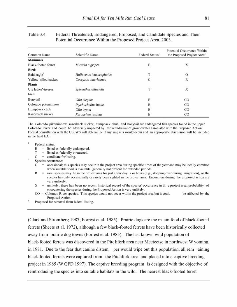
Final EA for Ten Mile Rim Coal Lease 81
Table 3.4 Federal Threatened, Endangered, Proposed, and Candidate Species and TheirPotential Occurrence Within the Proposed Project Area, 2003.
Common Name Scientific Name Federal Status1Potential Occurrence Withinthe Proposed Project Area2
MammalsBlack-footed ferret Mustela nigripes E XBirdsBald eagle3 Haliaeetus leucocephalus T OYellow-billed cuckoo Coccyzus americanus C RPlantsUte ladies'-tresses Spiranthes diluvialis T XFishBonytail Gila elegans E COColorado pikeminnow Ptychocheilus lucius E COHumpback chub Gila cypha E CORazorback sucker Xyrauchen texanus E CO
The Colorado pikeminnow, razorback sucker, humpback chub, and bonytail are endangered fish species found in the upperColorado River and could be adversely impacted by the withdrawal of groundwater associated with the Proposed Action.Formal consultation with the USFWS will determ ine if any impacts would occur and an appropriate discussion will be includedin the final EA.
1 Federal status:E = listed as federally endangered.T = listed as federally threatened.C = candidate for listing.
2 Species occurrence:O = occasional; this species may occur in the project area during specific times of the year and may be locally common
when suitable food is available; generally not present for extended periods.R = rare; species may be in the project area for just a few day s or hours (e.g., stopping over during migration), or the
species has only occasionally or rarely been sighted in the project area. Encounters during the proposed action arevery unlikely.
X = unlikely; there has been no recent historical record of the species' occurrence in th e project area; probability ofencountering the species during the Proposed Action is very unlikely.
CO = Colorado River species. This species would not occur within the project area but it could be affected by theProposed Action.
3 Proposed for removal from federal listing.
(Clark and Stromberg 1987; Forrest et al. 1985). Prairie dogs are the m ain food of black-footedferrets (Sheets et al. 1972), although a few black-footed ferrets have been historically collectedaway from prairie dog towns (Forrest et al. 1985). The last known wild population ofblack-footed ferrets was discovered in the Pitc hfork area near Meeteetse in northwest W yoming,in 1981. Due to the fear that canine distem per would wipe out this population, all rem ainingblack-footed ferrets were captured from the Pitchfork area and placed into a captive breedingproject in 1985 (W GFD 1997). The captive breeding program is designed with the objective ofreintroducing the species into suitable habitats in the wild. The nearest black-footed ferret

82 Final EA for Ten Mile Rim Coal Lease
reintroduction area is located approxim ately 65 m i south of the TMRT in the Little SnakeBlack-footed Ferret Management Area, Moffat County, Colorado.
The Black-footed Ferret Survey Guidelines for Compliance with the Endangered Species Act (USFWS 1989) defines potential black-footed ferret habitat as any white-tailed prairiedog towns or com plexes greater than 200 acres in size with a burrow density of greater than20 burrows per hectare (8 burrows per acre). Prairie dogs are known to occur within theTMRT; however, prairie dog towns have not been delineated nor densities calculated.Therefore, potential black-footed ferret habitat m ay occur within the TMRT. No recent black-footed ferret observations have been recorded in the vicinity of the TMRT (WNDD 2003).
In a consultation letter to the USFW S, the BLM has m ade a “no effect” determ ination for thisspecies or their habitat as a result of the Proposed Action (USFWS 2004) (refer to Appendix C).
Bald Eagle. The bald eagle is a federal thr eatened species (down-listed from endangered andnow proposed for rem oval from federal listing) th at requires cliffs, large trees, or shelteredcanyons associated with concentrated food sources (e.g., fisheries or waterfowl concentrationareas) for nesting and/or roosting areas (Edwards 1969; Snow 1973; Call 1978; Steenhof 1978;Peterson 1986). Bald eagles forage over wide areas during the nonnesting season (i.e., fall andwinter) and scavenge on animal carcasses such as pronghorn, deer, and elk.
No bald eagle nests or winter roosts are known to occur in the TMRT; the lack of suitablenesting or winter roosting habitats within the TMRT likely precludes its use for such activitiesby bald eagles. The Green River, Flam ing Gorge Reservoir, Big Sandy Reservoir, andSeedskadee National W ildlife Refuge provide the nearest favorable nesting, roosting, andforaging habitat for bald eagles. The nearest of these areas is the Green River, approxim ately 40mi west of the TMRT. Searches of the W NDD revealed no records of bald eagles in the vicinityof the TMRT, including the Jim Bridger Reservoir (W NDD 2003); however, it is likely thatindividual bald eagles occasionally forage in or fly through the area.
In a consultation letter to the USFW S, the BLM has m ade a “no effect” determ ination for thisspecies or their habitat as a result of the Proposed Action (USFWS 2004) (refer to Appendix C).

Final EA for Ten Mile Rim Coal Lease 83
Yellow-billed cuckoo. The yellow-billed cuckoo is a federal candidate and BLM-sensitivespecies. In W yoming, the yellow-billed cuckoo is a rare sum mer breeder that arrives fromwintering grounds in South Am erica late May and departs Septem ber to October. Theyellow-billed cuckoo is prim arily found in open stream side deciduous woodland with low,scrubby vegetation under growth bordering the Bighorn, Powder, North Platte, Henry's Fork, andBlack's Fork Rivers. Cottonwood stands and willow thickets are preferred for nesting andforaging (WNDD 2003). The yellow-billed cuckoo has been identified as potentially occurringin the riparian areas west of the Continental Divide; however, it is highly unlikely that theyellow-billed cuckoo occurs in the TMRT, since no riparian habitat is present and noobservations have been recorded in the vicinity (W NDD 2003). The nearest potential yellow-billed cuckoo habitat is likely located along the Green River located approxim ately 40 mi to thewest of the TMRT. The likelihood of yellow-billed cuckoo presence in the project area isextremely low; therefore, the yellow-billed cuckoo is not expected to be im pacted by theProposed Action and is not discussed further in this EA.
In a consultation letter to the USFW S, the BLM has made a “no effect” determ ination for thisspecies or their habitat as a result of the Proposed Action (USFWS 2004) (refer to Appendix C).
Ute ladies' -tresses. Ute ladies' -tresses, a federal threatened species, is a perennial plant and amember of the orchid fam ily that inhabits m oist stream banks, wet m eadows, and abandonedstream channels at elevations of 4,500-6,800 ft (Fertig 1994; Spackm an et al. 1997). W here itoccurs in ephem eral drainages, groundwater is typically shallow (i.e., within approxim ately18 inches of the ground surface) (personal communication, March 16, 2000, with Pat Deibert,USFWS; personal communication, March 22, 2000, with Walt Fertig, WNDD). No suitable Uteladies'-tresses habitat occurs within the TMRT, and no known occurrences have been recorded inthe vicinity of the TMRT (W NDD 2003). The likelihood of Ute ladies'-tresses being present inthe project area is extremely low; therefore, the Ute ladies'-tresses is not expected to be impactedby the Proposed Action and is not discussed further in this EA.
In a consultation letter to the USFW S, the BLM has made a “no effect” determ ination for thisspecies or their habitat as a result of the Proposed Action (USFWS 2004) (refer to Appendix C).

84 Final EA for Ten Mile Rim Coal Lease
Colorado River W ater Depletion. The Recovery and Im plementation Program for Endangered
Species in the Upper Colorado River Basin was initiated in January 1988 as a reasonable and
prudent approach for projects to avoid jeopardiz ing the continued existence of endangered fish
(i.e., bonytail, Colorado pikem innor, humpback chub, and razorback sucker) within the Upper
Colorado River. Under the aforem entioned program, any depletions of water from tributaries
within the Colorado River drainage system (including a portion of the TMRT area) are
considered by the USFW S as jeopardizing the continued existence of these species. Depletions
can be the result of the withdrawal or rem oval of surface water resources. Depletions can also
result from impacts on an outcropping aquifer eith er by effecting existing surface expressions of
groundwater (i.e., seeps or springs) or effects on the recharge of an aquifer by surface water
resources.
Under the Proposed Action, no surface water from the TMRT area would be directly removed or
depleted from the Upper Colorado River Basin. Sedimentation from surface water runoff from
all areas disturbed associated with the Proposed Action would be controlled by the
implementation of alternate sedim ent control measures required by W DEQ/LQD and described
in the mine plan portion of the Proposed Action. Alternative sedim ent control measures remove
sediment without interfering or preventing the water from reaching its natural ephem eral
receiving streams. Therefore, based on the im plementation of the alternative sedim ent control
measures, there would be no tem porary or perm anent impact or depletion of any surface water
resources, including those that provide water into the upper Colorado River drainage.
Under the Proposed Action, underground m ining operations would rem ove water from the
Deadman coal zone, the Lance Formation, and the Fort Union Formation overburden. However,
there are no surface expressions of groundwater from these aquifers in the im mediate area that
contribute water to the Colorado River drainage. In addition, there are no recharge areas for
these aquifers that would affect any tributary of the Colorado River drainage system.
Under the Proposed Action, the 3,000-ft deep Bridger No.1 production water well would rem ove
water from the Ericson Form ation for dust suppression, equipm ent washdown, and em ergency
Final EA for Ten Mile Rim Coal Lease 85
fire suppression. In this area, the Ericson Form ation generally dips from southwest to northeast
and under lays the TMRT project area. The top of the Ericson Form ation is approxim ately
2,400 ft below the surface within the TMRT project area and outcrops near Point of Rocks
approximately 9 m i south of the TRMT project area. There are no known seeps or springs
associated with the Ericson Form ation near the project area that contribute surface water to the
Colorado River (via Bitter Creek and the Green River).
Bitter Creek (a tributary of Colorado River) is in contact with a portion of the outcropping
Ericson Formation (via the Bitter Creek alluvium ) near Point of Rocks. However, drawdown
analysis for this project determ ined that the m aximum drawdown from the operation of the
Bridger No.1 well would extend approxim ately 5-6 m iles from the location of the well. The
areal limit of this maximum potential drawdown would still be approximately 3-4 miles north of
the Ericson Formation outcrop at Point of Rocks. As a result, there would be no im pacts on the
practical recharge rate for the Ericson Form ation at this location and there would be no
drawdown in the Bitter Creek alluvium or Bitter Creek surface water. Therefore, there would be
no hydrologic connection between the effected portion of the Ericson Form ation and the Bitter
Creek alluvial and surface water system s and there would be no depletion of surface water from
Bitter Creek or the Colorado River drainage system (personal com munication, April 16, 2004,
with George Hoffm an, professional engineer and hydrologist, Hydro-Engineering LLC, Casper,
Wyoming). Consequently, the Proposed Action would have no adverse affect on endangered
fish species in the Upper Colorado River Basin.
Water production associated with the Proposed Action would not result in any depletions from
the Colorado River and water depletions from the Colorado River are not discussed further in
this EA.
In a consultation letter to the USFW S, the BLM has m ade a “no effect” determ ination for this
species or their habitat as a result of the Proposed Action (USFWS 2004) (refer to Appendix C).

86 Final EA for Ten Mile Rim Coal Lease
3.3.13.3 BLM-sensitive Animal and Plant Species
Based on habitat preference and geographic location, num erous BLM-sensitive species areknown to occur or potentially to occur within the TMRT. Table 3.5 presents a list ofBLM-sensitive species identified by the BLM Rock Springs Field Office. BLM-sensitive animalor plant species observed in or in the vicinity of the TMRT include white-tailed prairie dog,pygmy rabbit, white-faced ibis, ferruginous hawk, greater sage-grouse, long-billed curlew,burrowing owl; sage thrasher, Brewer' s sparrow, northern leopard frog, Great Basin spadefoot,mystery wormwood, and Nelson's milkvetch (WNDD 2002).
3.3.14 Vegetation (Including Invasive Species)
Based upon 1:100,000 scale mapping, Wyoming big sagebrush is the dominant plant communitywithin the TMRT, along the proposed access road, along the proposed overland conveyor, andadjacent to County Road 15 (U.S. Geological Survey 1996). W yoming big sagebrush is thedominant plant community along a portion of the proposed overland conveyor and the proposedpowerline (refer to Figure 3.8). Dom inant species in big sagebrush plant com munity includeWyoming big sagebrush, black greasewood, shadscale, broom snakeweed, fringed sage, Hood' sphlox, prairie Junegrass, needle-and-thread, green needlegrass, blue gram a, bluebunchwheatgrass, alkali sacaton, western wheatgrass, and threadleaf sedge.
The CIAA for vegetation includes the two fifth-level watersheds that drain the TMRT--Middle
Black Rock Creek and Upper Deadman Wash. Together, they have a combined drainage area of
67,815 acres (refer to Figure 3.8). Vegetation in the CIAA is com posed primarily of Wyoming
big sagebrush, greasewood fans and flats, and shrub-dom inated riparian vegetation communities
(refer to Table 3.6 and Figure 3.8). The greasewood fans and flats com munity type is generally
found along streams on fine-textured, saline upland areas and on basin fans and flats with black
greasewood comprising more than 75% of the total shrub cover. The shrub-dom inated riparian
type occurs along drainages where shrubs com prise more than 25% of the vegetative cover and
are generally comprised of black greasewood and various sagebrush species (Merrill et al. 1996).

Final EA for Ten Mile Rim Coal Lease 87
Table 3.5 Wyoming BLM-sensitive Species and Habitat Preference, TMRT and CIAA,2003.
SpeciesCommon Name Scientific Name Habitat Likely1
MammalsLong-eared Myotis Myotis evotis Conifer and deciduous forests, caves and minesFringed Myotis Myotis thysanodes Conifer forests, woodland-chaparral, caves and mineSpotted Bat Euderma maculatum Cliffs over perennial water, basin-prairie shrubTownsend's Big-eared Bat Corynorhinus townsendii Forests, basin-prairie shrub, caves and minesPygmy Rabbit Brachylagus idahoensis Basin-prairie and riparian shrub XWhite-tailed Prairie Dog Cynomys leucurus Basin-prairie shrub, grasslands XWyoming Pocket Gopher Thomomys clusius Meadows with loose soilIdaho Pocket Gopher Thomomys idahoensis Shallow stony soilsSwift Fox Vulpes velox Grasslands
BirdsWhite-faced Ibis Plegadis chihi Marshes, wet meadows XTrumpeter Swan Cygnus buccinator Lakes, ponds, riversNorthern Goshawk Accipter gentilis Conifer and deciduous forestsFerruginous Hawk Buteo regalis Basin-prairie shrub, grassland, rock outcrops XGreater Sage-grouse Centrocercus urophasianus Basin-prairie shrub, mountain-foothill shrub XLong-billed Curlew Numenius americanus Grasslands, plains, foothills, wet meadows XYellow-billed Cuckoo Coccyzus americanus Open woodlands, streamside willow and alder grovesBurrowing Owl Athene cunicularia Grasslands, basin-prairie shrub XSage Thrasher Oreoscoptes montanus Basin-prairie shrub, mountain-foothill shrub XLoggerhead Shrike Lanius ludovicianus Basin-prairie shrub, mountain-foothill shrub XBrewer's Sparrow Spizella breweri Basin-prairie shrub XMountain Plover Charadrius montanus Shortgrass, great basin-foothills grassland, and
sagebrush-grasslandsX
FishRoundtail Chub Gila robusta Colorado River drainage, mostly large rivers, also
streams and lakesLeatherside Chub Gila copei Bear, Snake and Green drainages, clear, cool streams
and poolsBluehead Sucker Catostomus discobolus Bear, Snake and Green drainages, all watersFlannelmouth Sucker Catostomus latipinnis Colorado River drainage, large rivers, streams and
lakesColorado River CutthroatTrout
Oncorhynchus clarki pleuriticus Colorado River drainage, clear mountain streams
ReptilesMidget Faded Rattlesnake Crotalus viridis concolor Mountain foothills shrub, rock outcrop
AmphibiansNorthern Leopard Frog Rana pipiens Beaver ponds, permanent water in plains and
foothillsX
Great Basin Spadefoot Spea intermontana Spring seeps, permanent and temporary waters X

88 Final EA for Ten Mile Rim Coal Lease
Table 3.5 (Continued)
SpeciesCommon Name Scientific Name Habitat Likely1
Boreal (Northern RockyMountain population) Toad
Bufo boreas boreas Pond margins, wet meadows, riparian areas
Spotted Frog Ranus pretiosa (lutieventris) Ponds, sloughs, small streams
PlantsMeadow Pussytoes Antennaria arcuata Moist, hummocky meadows, seeps or springs
surrounded by sage/grasslands 4,950-7,900 ftSmall Rock Cress Arabis pusilla Cracks/Crevices in sparsely vegetated
granite/pegmatite outcrops w/in sage/grasslands8,000-8,100 ft
Mystery Wormwood Artemisia biennisvar. diffusa
Clay flats and playas 6,500 ft X
Nelson's Milkvetch Astragalus nelsonianus -or-Astragalus pectinatusvar. platyphyllus
Alkaline clay flats, shale bluffs and gullies, pebblyslopes, and volcanic cinders in sparsely vegetatedsagebrush, juniper, and cushion plant communities at5,200-7,600 ft
X
Precocious Milkvetch Astragalus proimanthus Cushion plant communities on rocky, clay soilsmixed with shale on summits and slopes of whiteshale hills 6,800-7,200 ft
Cedar Rim Thistle Cirsium aridum Barren, chalky hills, gravelly slopes, and finetextured, sandy-shaley draws 6,700-7,200 ft
Ownbey's Thistle Cirsium ownbeyi Sparsely vegetated shaley slopes in sage and junipercommunities 6,440-8,400 ft
Wyoming Tansymustard Descurainia torulosa Sparsely vegetated sandy slopes at base of cliffs ofvolcanic breccia or sandstone 8,300-10,000 ft
Large-fruited Bladderpod Lesquerella macrocarpa Gypsum-clay hills and benches, clay flats, and barrenhills 7,200-7,700 ft
Stemless Beardtongue Penstemon acaulis var. acaulis Cushion plant or Black sage grassland communitieson semi-barren rocky ridges, knolls, and slopes at5,900-8,200 ft
Beaver Rim Phlox Phlox pungens Sparsely vegetated slopes on sandstone, siltstone, orlimestone substrates 6,000-7,400 ft
Tufted Twinpod Physaria condensata Sparsely vegetated shale slopes and ridges6,500-7,000 ft
Green River Greenthread Thelesperma caespitosum White shale slopes and ridges of Green RiverFormation 6,300 ft
Uinta Greenthread Thelesperma pubescens Sparsely vegetated benches and ridges on coarse,cobbly soils of Bishop Conglomerate 8,200-8,900 ft
Cedar Mountain Easter Daisy Townsendia microcephala Rocky slopes of Bishop Conglomerate 8,500 ft
1 Likely to occur in or in the vicinity of the TMRT based on habitat and WNDD data (2003).

Final EA for Ten Mile Rim Coal Lease 89
Figure 3.8 Major Vegetation Com munities W ithin the TMRT and CIAA (as of January2000).

90 Final EA for Ten Mile Rim Coal Lease
Table 3.6 Major Vegetation Communities Within the TMRT and CIAA.
Vegetation Community Approx. % Within TMRT Approx. % Within CIAAGreasewood fans and flats -- 1Open water -- 2Shrub-dominated riparian -- 3Surface mine operations -- 10Wyoming big sagebrush 100 84
Approximately 9.6% of the CIAA (6,511 acres) has been disturbed by m ajor industrial facilities,
minor industrial facilities, wells and associated facilities, and roads.
Invasive species (i.e., noxious weeds) known to exist in the vicinity of the TMRT include
perennial pepperweed ( Lepidium latifolium), hoary cress ( Cardaria spp.), Canada thistle
(Cirsium arvense), and dalm ation toadflax ( Linaria dalmatica) (personal com munication,
October 27, 2003, with Jim Cotterm an, Sweetwate r County W eed and Pest Control, Farson,
Wyoming).
3.3.15 Wastes (Hazardous and Solid)
There are no known hazardous or solid wastes present with the TMRT. Hazardous and solid
wastes generated within the vicinity of the TMRT area include those generated and produced in
association with surface coal m ining, oil and natural gas exploration, developm ent, and
production, and activities conducted at the Jim Bridger Power Plant. Under Resource
Conservation and Recovery Act regulations, the Jim Bridger Mine and the Jim Bridger Power
Plant are both registered as a sm all-quantity generators. There are also two perm itted and active
solid waste disposal sites within the vicin ity of the TMRT area, one operated by BCC and one
operated by the Jim Bridger Power Plant (personal com munication, April 18, 2002, with Kathy
Brown, WDEQ, Solid and Hazardous Waste Division (SHWD), Lander, Wyoming).

Final EA for Ten Mile Rim Coal Lease 91
3.3.16 Water Resources
3.3.16.1 Surface Water Resources
The TMRT straddles the Continental Divide, with approxim ately 56% of the TMRT located
within the Great Divide Basin (this is a clos ed basin that does not flow out of W yoming) and
44% of the TMRT within the Upper Green Rive r drainage basin, a tributary of the Colorado
River (refer to Figure 3.9). There are no perennial or interm ittent streams or springs within the
proposed TMRT. The TMRT is prim arily drained by two ephem eral drainages--Middle Black
Rock Creek, located north and east of the TMRT, and Upper Deadm an Wash, located south of
the Continental Divide. Middle Black Rock Creek drains into the Great Divide Basin, while
Upper Deadman Wash drains into Bitter Creek at Point of Rocks, W yoming, and is located
within the Upper Green River Basin (refer to Figure 3.9).
The surface water that flows within Deadm an Wash is highly variable in quality depending on
the nature of the runoff. Runoff from snowmelt usually generates lower concentrations of total
dissolved solids (TDS) and total suspended solid s (TSS) than runoff from rainfall storm events.
The average water quality of Deadm an Wash meets WDEQ/WQD standards for livestock class
of use (Class III) (BCC 2003). The TDS level averages about 3,300 parts per m illion (ppm), pH
averages approximately 7.9, and bicarbonate averages approximately 290 ppm.
While no data are available for Black Rock Creek, water quality is expected to be sim ilar to that
of Deadman Wash.
All the ephem eral channels within the project area have been designated as having Class 4
surface water quality by W DEQ/WQD. The Class 4 designation in Chapter 1 of the
WDEQ/WQD regulations means waters that cannot support fish (WDEQ/WQD 1990).

92 Final EA for Ten Mile Rim Coal Lease
Figure 3.9 Surface Water Drainages and Features Located Within the TMRT and CIAA.
Final EA for Ten Mile Rim Coal Lease 93
The CIAA for surface water resources are the tw o fifth-level watersheds that drain the
TMRT--Middle Black Rock Creek and Upper Dead man Wash. Together, they have a com bined
drainage area of 67,815 acres (refer to Figure 3.9). The CIAA includes approxim ately 93 mi of
ephemeral stream s and one large playa (512 acres). Approxim ately 9.6% of the CIAA
(6,511 acres), has been disturbed by m ajor industrial facilities, m inor industrial facilities, well
and associated facilities, and roads.
3.3.16.2 Groundwater Resources
Groundwater within the TMRT and vicinity is contained in several aquifers. Alluvial aquifers
are found in som e of the surface drainage channels and aquifers of the Fort Union Form ation
overburden, Deadman Formation coal zone, and Lance Form ation. The Fort Union Form ation
overburden is the only aquifer that is capable of a sustainable yield of approximately 1 gallon per
minute. The upper Lance Formation, located below the Fort Union Formation, is classified as an
aquitard (i.e., a leaky confining bed that transm its water at a very slow rate to or from an
adjacent aquifer), even though it is a water-bearing form ation. In som e areas, the Continental
Divide appears to affect the piezom etric surf ace of these aquifers; however, in general the
regional groundwater flow is in a northeasterly direction (BCC 2003).
The proposed underground m ine would likely intercept groundwater contained in the Deadm an
coal zone of the Fort Union Form ation. The Fort Union Form ation is approxim ately 1,500 ft
thick in the area of the TMRT. Except for wa ter used by BCC for exploration drilling, there are
no known groundwater appropriations (i.e., wate r rights) issued by the W SEO for use of
groundwater from the Deadm an coal zone aquifer within the vicinity of the TMRT. BCC has
appropriations for groundwater rights for portions of the Deadm an coal zone aquifer located
within the existing surface mining operation (BCC 2003).
The groundwater quality from wells within the BCC mine area within the Deadm an coal zone
aquifer indicates an average TDS of 1,711 ppm , bicarbonate of 664 ppm, and sulfur of 656 ppm.
The pH of the groundwater average approximately 8.0. Average water quality of the Fort Union

94 Final EA for Ten Mile Rim Coal Lease
aquifer meets WDEQ/WQD standards for agricultural use (Class II) (W DEQ/WQD 1993; BCC
2003).
The closest surface expression of groundwater to the TMRT is at Radar Springs, approxim ately
1 mi northwest of the tract.
The Ericson Formation (that would serve as one of the water sources for the Proposed Action) is
located approximately 2,400 ft below the surface of the TMRT area. The Ericson Form ation is a
member of the Mesaverde group and is com posed primarily of sandstone with some shale lenses
and is approximately 600 ft thick in the general area. The Ericson Form ation dips approximately
3 to 4 degrees to the northeast. It is estim ated that the Ericson Form ation in this area has a
transmissivity of 14,000 gallons/day/ft and a storage coefficient of 8 X 10 -4. (personal
communication March 30, 2004, with George Hoffm an, hydrologist, Hydro-Engineering, LLC,
Casper, Wyoming).
The Town of Superior has drilled, com pleted, and operates two water wells in the Ericson
Formation updip of the TMRT area and the Bri dger No. 1 well (refer to Figure 3.10). Both of
these wells are located in NE ¼ of Section 26, T 21N, R101W , approximately 15,000 ft south of
the TMRT area. These wells are the prim ary (but not sole) source of drinking water for the
community. Superior No. 17 well is approxim ately 1,070 ft deep and has a pum ping capacity of
150 gallon and Superior No. 18 well is approxim ately 1,700 ft deep and has a pum ping capacity
of 350 gallons per m inute. A third well (Superior No. 19) at the sam e location has been drilled
and com pleted into the Alm ond Form ation (located above the Ericson Form ation). This well
should not be im pacted by either m ine dewatering operations or by the operation of the Bridger
No. 1 well; therefore, no further discussion on this well is included in this analysis.
3.3.17 Wetlands/Riparian Areas
A jurisdicational wetland inventory of the TMRT area was com pleted in 2002 and determ ined
that there are no jurisdictional wetlands within the TMRT area (Interm ountain Resources 2002).

Final EA for Ten Mile Rim Coal Lease 95
While the inventory has been com pleted, it has not been form ally submitted to the U.S. Arm y
Corps of Engineers for a formal review and determination.
The CIAA for wetland resources are the two fifth-level watersheds that drain the TMRT--Middle
Black Rock Creek and Upper Deadman Wash. Together, they have a combined drainage area of
67,815 acres (refer to Figure 3.11). The CIAA includes approxim ately 100 acres of potential
wetlands that are com posed of palustrine tem porarily flooded (USW FS wetland classification
PUSA), lacustrine/limnetic (USFWS wetland classification L1) and lacustrine/littoral (USFW S
wetland classification L2). In addition, there is a total of 34 m i of ephemeral streams (USFWS
wetland classification R4SB) and adjacent wetlands (USFW S wetland classification PEM, PSS,
and PUS) (USFWS 1997) (refer to Figure 3.10). Approximately 9.6% of the CIAA (6,511 acres)
has been disturbed by m ajor industrial facilities, m inor industrial facilities, wells and associated
facilities, and roads.
3.3.18 Wild Horses
The TMRT is located within the Great Divide Basin W ild Horse Herd Managem ent Area
(GDBWHMA) (refer to Figure 3.12). The GDBW HMA encompasses 778,915 acres, of which
73% is public land. The GDBW HMA is located from the Rawlins-Rock Springs District
boundary west to the Continental Divide. The "herd-appropriate m anagement level" for the
Great Divide Basin herd is between 415 to 600 wild horses, and the herd is currently estimated to
have approxim ately 500 wild horses (personal com munication, October 30, 2003, with Kevin
Lloyd, Range Conservationist/W ild Horse Specialist, BLM, Rock Springs Field Office,
Wyoming).
The CIAA for wild horses is the GDBW HMA. Approxim ately 2.4% or 18,360 acres of the
CIAA has been disturbed. Approximately 10,674 acres within the CIAA have been disturbed by
major industrial facilities, 3,672 acres by m inor industrial facilities, 3,404 acres by roads, and
610 acres by wells and associated facilities.

96 Final EA for Ten Mile Rim Coal Lease
Figure 3.10 Production Water Wells.
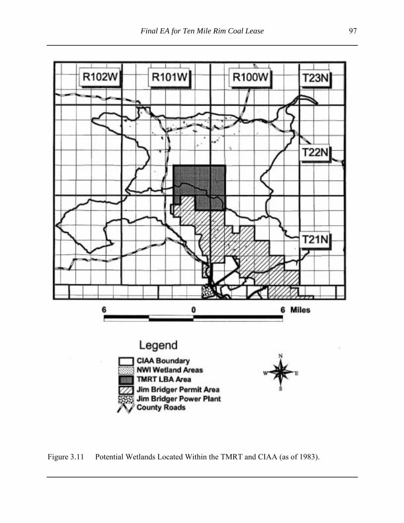
Final EA for Ten Mile Rim Coal Lease 97
Figure 3.11 Potential Wetlands Located Within the TMRT and CIAA (as of 1983).

98 Final EA for Ten Mile Rim Coal Lease
Figure 3.12 Great Divide Basin Wild Horse Herd Management Area.

Final EA for Ten Mile Rim Coal Lease 99
3.3.19 Wildlife
Wildlife surveys (such as aerial big gam e surveys, driving surveys, greater sage-grouse lek
surveys, raptor nest surveys, etc.) have been conducted for more that 20 years at the Jim Bridger
Mine. Results of the baseline and annual m onitoring surveys are reported in perm it documents
and annual reports subm itted to WDEQ/LQD. Some of the surveys were also conducted within
a 2-m i buffer surrounding BCC's current perm it boundary that overlaps with portions of the
TMRT. Additional com plete surveys of the TMRT were conducted by BCC in 2001 during the
exploratory drilling of the TMRT. Wildlife species composition within the TMRT is anticipated
to be generally com parable to those found on the adjacent Jim Bridger Mine, except that no
water fowl and shorebirds are expected in the TMRT.
3.3.19.1 Big Game
Three big gam e species--pronghorn antelope, m ule deer, and elk--occur within or im mediately
adjacent to the TMRT. The population estim ates for big gam e herds provided below are based
upon W GFD m odels presented in the m ost r ecent annual big gam e herd unit report (W GFD
2003).
Pronghorn Antelope. Pronghorn antelope in the proposed project area belong to the Red Desert
Pronghorn Antelope Herd (herd unit 615). The Red Desert Pronghorn Antelope Herd had a 2002
postseason population estim ate of 14,000 antelope, approxim ately 93% of the population
objective of 15,000 anim als (W GFD 2003). The 5-year (1997-2001) population average was
14,890 animals (99% of objective) (WGFD 2003).
Approximately 1,726 acres or 29% of the TMRT is habitat the W GFD has designated as crucial
winter/yearlong antelope range (W GFD 2003), and the rem aining 71% is designated as
winter/yearlong habitat (refer to Figure 3.13). The proposed new access road would be
constructed in winter/yearlong habitat, whereas the conveyor and powerline would be
constructed in crucial antelope winter range.

100 Final EA for Ten Mile Rim Coal Lease
Figure 3.13 Pronghorn Antelope Range Within the TMRT.

Final EA for Ten Mile Rim Coal Lease 101
The CIAA for pronghorn antelope is the entire Red Desert herd unit which encom passes
approximately 2,167,479 acres (refer to Figure 3.14). Approxim ately, 85% of the CIAA is
located in winter/yearlong range, 13% is located in crucial winter/yearlong range, and 2% is
located in spring/sum mer/fall range (refer to Figure 3.14). Approxim ately 1.52% of the CIAA
(32,983 acres) has been disturbed by m ajor industrial facilities, minor industrial facilities, roads,
and well and associated facilities. W ithin the range designated as crucial winter/yearlong range,
approximately 14,101 acres have been disturbed by m ajor industrial facilities, m inor industrial
facilities, roads, and wells and associated facilities. This represents approxim ately 5.17% of all
crucial winter/yearlong range within the CIAA.
Mule Deer. Mule deer within the TMRT belong to Steam boat Mule Deer herd unit (herd
unit 430). The core of this population inhabits the canyons and mesas associated with Steamboat
Mountain and Oregon Butte north of the TMRT. Another segment of the population inhabits the
Green River riparian zone west of the TM RT. The Steam boat Mule Deer Herd had a 2002
posthunting season population estim ate of 3,100 m ule deer, approxim ately 78% the population
objective of 4,000 anim als (W GFD 2003) The 5-year (1997-2001) population average was
3,120 animals (78% of objective) (WGFD 2003).
All of the TMRT and project-related support facilities (access road, powerline, and conveyor)
would be located in habitat the W GFD has designated as winter/yearlong m ule deer range
(WGFD 2003). No m ule deer crucial winter range occurs within the TMRT (refer to
Figure 3.14) (WGFD 2003).
The CIAA for m ule deer is the entire Steam boat herd unit, which encom passes approximately
2,553,133 acres (refer to Figure 3.15). Approxim ately, 25% of the CIAA is located in
winter/yearlong range, 8% is located in crucial winter/yearlong range, and 4% is located in
spring/summer/fall range (refer to Figure 3.15). The rem aining 62% of the CIAA does not
contain enough anim als to be im portant habitat or the habitats are of lim ited importance to this
species and is designated by the W GFD as "out" (refer to Figure 3.16). Approxim ately 1.7% of

102 Final EA for Ten Mile Rim Coal Lease
Figure 3.14 Pronghorn Antelope Range Within the CIAA.

Final EA for Ten Mile Rim Coal Lease 103
Figure 3.15 Mule Deer Range Within the TMRT and Vicinity.

104 Final EA for Ten Mile Rim Coal Lease
Figure 3.16 Mule Deer Range Within the CIAA.
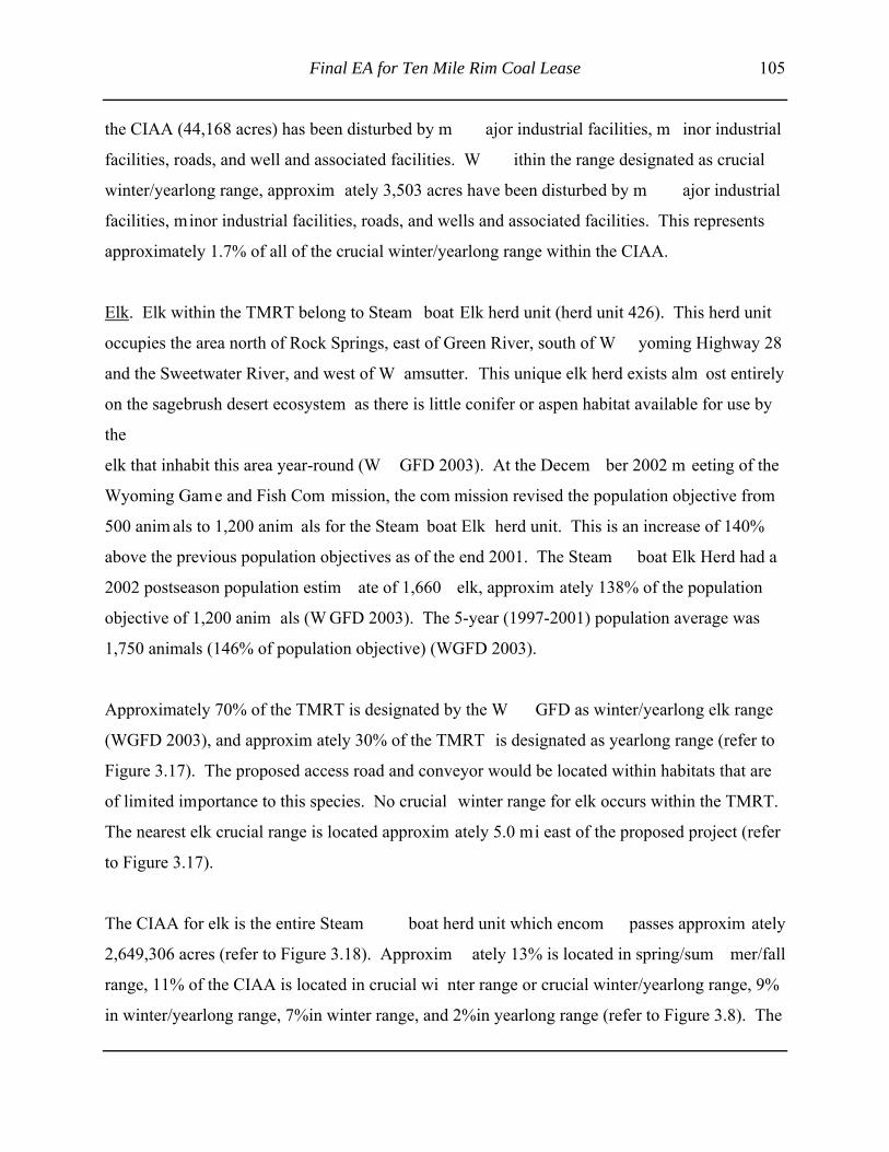
Final EA for Ten Mile Rim Coal Lease 105
the CIAA (44,168 acres) has been disturbed by m ajor industrial facilities, m inor industrial
facilities, roads, and well and associated facilities. W ithin the range designated as crucial
winter/yearlong range, approxim ately 3,503 acres have been disturbed by m ajor industrial
facilities, minor industrial facilities, roads, and wells and associated facilities. This represents
approximately 1.7% of all of the crucial winter/yearlong range within the CIAA.
Elk. Elk within the TMRT belong to Steam boat Elk herd unit (herd unit 426). This herd unit
occupies the area north of Rock Springs, east of Green River, south of W yoming Highway 28
and the Sweetwater River, and west of W amsutter. This unique elk herd exists alm ost entirely
on the sagebrush desert ecosystem as there is little conifer or aspen habitat available for use by
the
elk that inhabit this area year-round (W GFD 2003). At the Decem ber 2002 m eeting of the
Wyoming Game and Fish Com mission, the com mission revised the population objective from
500 anim als to 1,200 anim als for the Steam boat Elk herd unit. This is an increase of 140%
above the previous population objectives as of the end 2001. The Steam boat Elk Herd had a
2002 postseason population estim ate of 1,660 elk, approxim ately 138% of the population
objective of 1,200 anim als (W GFD 2003). The 5-year (1997-2001) population average was
1,750 animals (146% of population objective) (WGFD 2003).
Approximately 70% of the TMRT is designated by the W GFD as winter/yearlong elk range
(WGFD 2003), and approxim ately 30% of the TMRT is designated as yearlong range (refer to
Figure 3.17). The proposed access road and conveyor would be located within habitats that are
of limited importance to this species. No crucial winter range for elk occurs within the TMRT.
The nearest elk crucial range is located approxim ately 5.0 mi east of the proposed project (refer
to Figure 3.17).
The CIAA for elk is the entire Steam boat herd unit which encom passes approxim ately
2,649,306 acres (refer to Figure 3.18). Approxim ately 13% is located in spring/sum mer/fall
range, 11% of the CIAA is located in crucial wi nter range or crucial winter/yearlong range, 9%
in winter/yearlong range, 7%in winter range, and 2%in yearlong range (refer to Figure 3.8). The

106 Final EA for Ten Mile Rim Coal Lease
Figure 3.17 Elk Range Within the TMRT and Vicinity.

Final EA for Ten Mile Rim Coal Lease 107
Figure 3.18 Elk Range Within the CIAA.

108 Final EA for Ten Mile Rim Coal Lease
remaining 58% of the CIAA does not contain enough anim als to be im portant habitat or the
habitats are of limited importance to this species and is designated by the W GFD as "out" (refer
to Figure 3.18). Approxim ately 1.6% of the CIAA (43,356 acres) has been disturbed by m ajor
industrial facilities, m inor industrial facilities, ro ads, and well and associated facilities. W ithin
the range designated as crucial winter range or crucial winter/yearlong range, approxim ately
1,873 acres have been disturbed by m ajor industrial facilities, m inor industrial facilities, roads,
and wells and associated facilities. This represents approxim ately 0.6% of all crucial winter and
crucial winter/yearlong range within the CIAA.
3.3.19.2 Other Mammals
Predators known to occur or to potentially occu r in the TMRT and CIAA are coyote, red fox,
raccoon, erm ine, long-tailed weasel, badger, western spotted skunk, striped skunk, m ountain
lion, and bobcat. Lagom orph species include desert cottontail, m ountain (Nuttall' s) cottontail,
and white-tailed jackrabbit. Squirrels known to occur or to potentially occur include least
chipmunk, Wyoming ground squirrel, golden-mantled ground squirrel, and thirteen-lined ground
squirrel. Other rodents include four species of pocket gopher (northern, plains, Merriam 's, and
Great Basin), two species of pocket m ouse (olive-backed and northern), Ord's kangaroo rat, deer
mouse, northern grasshopper mouse, bushy-tailed woodrat, six species of vole (western, heather,
meadow, long-tailed, prairie, and sagebrush), and western jum ping m ouse. Bats (western
small-footed, long-eared, fringed, long-legged, little brown, and silver-haired) m ay also occur
(WGFD 1999).
3.3.19.3 Raptors
Raptor species known to occur or potentially to occur within the TMRT and CIAA include bald
eagle (addressed in Section 3.3.12.2), peregrine falcon, golden eagle, prairie falcon, Am erican
kestrel, merlin, Swainson's hawk, ferruginous hawk, red-tailed hawk (winter resident), northern
harrier, rough-legged hawk, great horned owl, burrowing owl, and short-eared owl (W GFD
1999; BCC 2003; BLM 2002b).

Final EA for Ten Mile Rim Coal Lease 109
Historically, portions of the TMRT have been included in the annual raptor m onitoring surveys
conducted for BCC's current surface coal m ine operation. Raptor surveys were also conducted
in 2003 within the entire TMRT or adjacent to the TMRT to determ ine the occupancy and
productivity of individual raptor nests. Nine raptor nests are located within the TMRT; seven of
these nests were identified as ferruginous hawk nests and two were identified as red-tailed hawk
nests (refer to Figure 3.19) (BCC 2003). Only one of the nests (a red-tailed hawk) within the
TMRT was active in 2003 (BCC 2003).
The CIAA for raptors includes the TMRT area and a 2-m i buffer (30,366 acres). There are
approximately 31 raptor nest sites within the CIAA, and m any of these sites have been or are
currently being m onitored annually for occupancy and productivity by personnel from BCC for
the Jim Bridger Mine and Black Butte Coal Com pany for the Leucite Hills Mine (refer to
Figure 3.19). Of the 31 known raptor nests in the CI AA, five were determ ined to be active in
2003 (BCC 2003). W ithin the CIAA for raptors, there is approxim ately 3,536 acres of existing
disturbance; 2,667 acres of disturbance due to m ajor industrial facilities, 707 acres due to m inor
industrial facilities, and 162 acres due to roads. This represents 11.6% of the total area of the
CIAA.
3.3.19.4 Upland Game Birds
The proposed project area is located within W GFD upland gam e bird m anagement areanumber 7. Mourning dove is the only upland gam e bird species other than greater sage-grouselikely to occur on and adjacent to the proposed project area (BCC 2003).
Two greater sage-grouse leks are known to occur with the TMRT (Figure 3.20), of which one
was found to be occupied by grouse in 2003 (BCC 2003; WGFD 2003).
The CIAA for upland bird species encom passes 946,912 acres and includes portions of Upland
Game Managem ent Area 7 (W GFD 2003) and Lower Green River Basin Sage Grouse
Conservation Planning area (WGFD2003) north of Interstate 80, east of Wyoming Highway 191,

110 Final EA for Ten Mile Rim Coal Lease
Figure 3.19 Raptor Nests Within the TMRT and Vicinity.

Final EA for Ten Mile Rim Coal Lease 111
Figure 3.20 Greater Sage-grouse Leks Within the TMRT.

112 Final EA for Ten Mile Rim Coal Lease
and south of Wyoming Highway 28 (refer to Figure 3.21). The CIAA contains 43 known greatersage-grouse leks (WGFD 2003). Thirty-six of the leks in the CIAA were monitored in 2003, and16 (44%) were found to contain birds (W GFD Green River District n.d.). Approxim ately 2.2%of the CIAA (20,899 acres) has been disturbed by m ajor industrial facilities, m inor industrialfacilities, cities, roads, and wells and associated facilities.
3.3.19.5 Other Birds
Bird species potentially occurring within the TMRT, based upon range and habitat preference,include com mon nighthawk, Say' s phoebe, western kingbird, horned lark, swallows(e.g., violet-green, barn, cliff), black-billed m agpie, common raven, Am erican crow, rock wren,mountain bluebird, loggerhead shrike, Brewer' s sparrow, vesper sparrow, savannah sparrow,sage sparrow, lark bunting, McCown' s longspur, red-winged blackbird, western m eadowlark,Brewer's blackbird, com mon grackle, green-tailed towhee, and brown-headed cowbird (W GFD1999).
Since there are no perm anent surface water bodi es within the TMRT, it is unlikely thatwaterfowl and shorebirds would nest in the TMRT area; however, several species of waterfowland wading/shore birds m ay seasonally utilize the playa located within the TMRT area, the fluegas-desulfurization or evaporation ponds located south of the TMRT. The nearest potentialwaterfowl and shorebird nesting habitat is likely located along the Deadm an Wash and lakesand ponds associated with the Jim Bridger Power Plant south of the TMRT.
The CIAA for other birds encom passes the TMRT area and a 4.3-m i buffer area around theTMRT area and includes a total of approxim ately 78,200 acres. W aterfowl species likely tooccur in the CIAA include common loon, pied-billed grebe, horned grebe, western grebe, Clark'sgrebe, eared grebe, white pelican, double-breasted corm orant, Am erican coot, Canada goose,mallard, green-winged teal, northern pintail, blue-winged teal, cinnam on teal, northern shoveler,redhead, ring-necked duck, goodwill, American wigeon, and common merganser (WGFD 1999).Within the CIAA, there is a total of 6,308 acres of existing disturbance. Major industrialfacilities account for 4,661 acres of disturbance, ro ads account for 385 acres of disturbance, andminor industrial facilities account for 1,262 acres of disturbance.
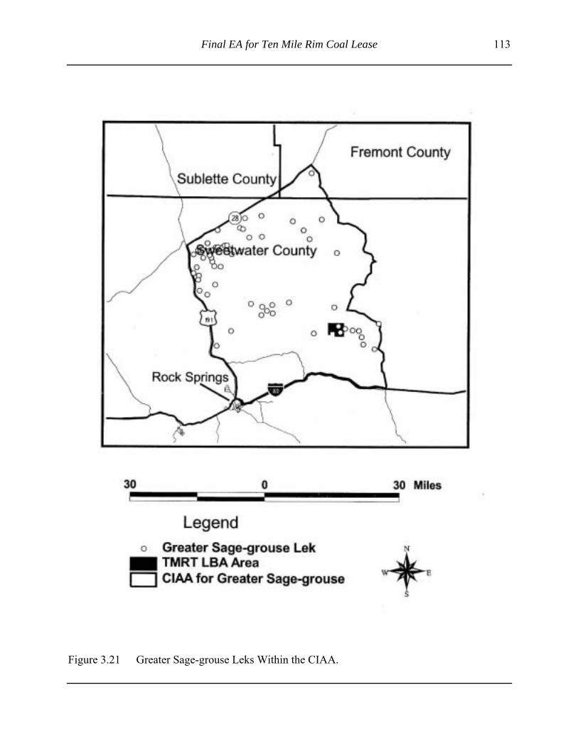
Final EA for Ten Mile Rim Coal Lease 113
Figure 3.21 Greater Sage-grouse Leks Within the CIAA.

114 Final EA for Ten Mile Rim Coal Lease
3.3.19.6 Amphibians, Reptiles, and Fish
Based on range and habitat preference, few if any amphibians or reptiles would be found withinthe TMRT. Due to the lack of perm anent water bodies or perennial stream s, the TMRT wouldnot support any fish populations.
The CIAA for am phibians, reptiles, and fish encom passes the TMRT area and a 4.3-m i bufferarea around the TMRT area and includes a total of approxim ately 78,200 acres. Severalamphibian and reptile species are known to or m ay occur within the Deadm an W ash locatedsouth of the TMRT area. Am phibians include tiger salam ander, western toad, striped chorusfrog, northern leopard frog, and Great Basin spadefoot, all of which m ay occur primarily in andadjacent to aquatic habitats within the lower portions of the Deadman Wash below of the TMRT.Reptile species include eastern short-horned lizard, racer, northern sagebrush lizard, prairierattlesnake, Great Basin gopher snake, western rattlesnake, and valley garter snake (BCC 2003;WGFD 1999). None of the stream s, draws, and washes within the CIAA are known to supportany permanent fish populations (WGFD 1991). Within the CIAA, there is a total of 6,308 acresof existing disturbance. Major industrial facilities account for 4,661 acres of disturbance, roadscount for 385 acres of disturbance, and m inor industrial facilities account for 1,262 acres ofdisturbance.
Final EA for Ten Mile Rim Coal Lease 115
4.0 ENVIRONMENTAL CONSEQUENCES
In accordance with 40 CFR 1502.16, this chapter of the EA includes a discussion of the potential
environmental consequences of the Proposed Action and the No Action Alternative on each of
the affected resources. An environmental impact is defined as a change in the quality or quantity
of a given resource due to a m odification in the existing environm ent resulting from project-
related activities. Im pacts m ay be beneficial or adverse, m ay be a prim ary result (direct) or
secondary result (indirect) of an action, and m ay be permanent and long-term or temporary and
of a short duration. Im pacts may vary in degree from a slightly discernible change to a total
change in the environm ent. This im pact assessm ent assum es that all applicant-com mitted
measures described in the Proposed Action would be successfully im plemented. If such
measures were not implemented, additional adverse impacts may occur.
Residual impacts are impacts resulting from the Proposed Action after application of appropriate
mitigation m easures (BLM 1988). These im pacts would rem ain for som e period of tim e but
would eventually subside or would be am eliorated by natural conditions and would not be
permanent. For exam ple, increased surface water erosion would eventually be reduced after
disturbed soils are stabilized, native vegetation is planted and becom es re-established, and
stream channels are naturally stabilized. Residual im pacts are different from irreversible and
irretrievable impacts. Residual im pacts will eventually subside and would no longer result in
adverse conditions, while irreversible and irretrievable im pacts are perm anent conditions that
cannot be altered after they have occurred (e.g., the m ining and burning of the federal coal
within the TMRT area).
Cumulative impacts result from the incremental impacts of an action added to other past, present,
and reasonably foreseeable future actions, regardless of who is responsible for such actions.
Cumulative im pacts m ay result from individually m inor, but collectively significant, actions
occurring over a period of tim e (40 CFR 1508.7). The boundary of individual CIAA areas for
this EA are based on the specific resource being discussed and evaluated.

116 Final EA for Ten Mile Rim Coal Lease
Irreversible and irretrievable commitments are discussed in Sections 4.19, and short-term use of
the environment versus long-term productivity is discussed in Section 4.20.
4.1 AIR QUALITY AND NOISE
4.1.1 Air Quality
4.1.1.1 Proposed Action
Air pollutant em issions would occur from construction of the m ine facilities and from selected
mine and reclam ation operations associated with the Proposed Action. Air em issions and air
pollutant im pacts are lim ited by state and federal regulations, standards, and im plementation
plans established under the Clean Air Act and are adm inistered within W yoming by
WDEQ/AQD. Chapter 6 of the W AQS&R requires all proposed air pollutant em ission sources,
including coal m ining operations, to undergo a perm itting review and, if necessary, to obtain a
construction permit prior to construction or operation of the source. Chapter 3 of the WAQS&R
specifies general em issions standards for new and existing sources, and Chapter 2 of the
WAQS&R addresses am bient air quality standards. Additional state and federal program s may
apply to a proposed source if certain em issions and other thresholds are m et or exceeded. One
such program is the PSD perm it program (als o adm inistered by W DEQ/AQD) that requires
major sources to perform additional analyses, including Best Available Control Technology and
Air Quality-Related Values analyses for federal Class I Areas. The Proposed Action, in
combination with existing Jim Bridger Mine operations, would be classified as a m inor source
and therefore would not be subject to the PSD permit program. The Proposed Action would be
subject to W DEQ/AQD construction and operating perm it requirements and would be required
to operate in compliance with emission standards and ambient air quality standards.
In order to assess potential im pacts of the Proposed Action, em issions have been estim ated
below.

Final EA for Ten Mile Rim Coal Lease 117
Construction Activities. Air pollutant em issions from construction of the Proposed Action
would be tem porary in nature and would result prim arily due to surface disturbance, travel on
unpaved roads, and diesel engine com bustion from m obile equipm ent. The prim ary air
pollutants emitted would be PM10, SO2, NOX, CO, and volatile organic compounds (VOCs).
New surface disturbance from construction activities associated with the Proposed Action would
total 28 acres: construction of overland conveyor (23 acres), powerline power pole installation
(2 acres), and mine access road (3 acres).
PM10 emissions from wind erosion of these disturbed areas are calculated using EPA' s AP-42
emission factor (EPA 1995) for industrial wind erosion and based on a full year of regional
meteorological data. PM 10 emissions are estimated to be approxim ately 1 ton per year from the
25-acre construction area for 1-2 years.
Construction traffic would travel to the m ine site on an existing paved road outside of the BCC
mine area (W yoming State Highway 377) and on chem ically treated existing access roads once
inside the BCC m ine area (approxim ately 5.3 m i in length). The construction workers would
make an estim ated 75 round-trips on this route per day for the duration of construction
operations. PM10 emissions from construction travel are estim ated at 0.3 tons per day (110 tons
per year) using EPA' s AP-42 emission factor for unpaved roads and a control efficiency of 50%
for watering. Emissions of NOX, SO2, CO, and VOCs would also occur from gasoline and diesel
combustion in passenger vehicles and diesel com bustion from larger trucks traveling unpaved
roads during construction of the Proposed Action.
Mine Operations. Upon commencement of mine operations, employees would travel to work via
Wyoming State Highway 377 and existing unpaved access roads (5.3 m i). Em ployees would
make approxim ately 250 round-trips on this route per day. PM 10 em issions from em ployee
travel to and from the mine are estimated to be 0.41 tons per day (150 tons per year) calculated
using EPA' s AP-42 em ission factor for unpaved roads and a control efficiency of 80% for
chemical dust suppression. PM 10, NOX, SO2, CO, and VOC em issions would also occur from

118 Final EA for Ten Mile Rim Coal Lease
other gasoline and diesel com bustion engines in vehicles traveling to and from the Project Area.
These m obile source em issions are not subject to state or federal air quality perm itting
requirements and are generally regulated under WAQS&R Chapter 13, Mobile Sources.
Various diesel- and gasoline-powered equipm ent would operate at the proposed underground
mine. Air pollutant em issions associated with these m obile sources include PM 10, NO X, SO 2,
CO, and VOCs from diesel com bustion in underground m ining equipm ent. Am ounts of
emissions would depend on fleet com position, m aintenance, and operating conditions. In the
mine itself, m uch of the equipm ent would be operated by electricity. Vehicles operated
underground would be diesel-powered. Fugitive dust em issions would be limited by the natural
moisture content of the underground traveled surface, supplem ented by water application as
necessary. The underground mine would intake and exhaust air from the mine portal.
Under the Proposed Action, a m aximum of 5.5 m illion tons per year of coal would be loaded to
an overland conveyor that originates from the underground mine. The overland conveyor would
be 17,000 ft in length and would transport coal to the existing Truck Dum p Station #2 for further
transport to the Jim Bridger Power Plant via the existing overland conveyor system . The coal
would be sprayed with water or a dust suppressant to reduce potential dust em issions. No
additional air em issions, beyond those currently perm itted, would occur from the existing
overland conveyor due to the Proposed Action. The new overland conveyor system would be
enclosed at both the transfer points and along the entire length of the conveyor. W DEQ/AQD
permits typically do not quantify em issions from covered and controlled coal conveyor
emissions and instead limit visible emissions from coal transfer operations to a 20% opacity limit
in accordance with PM 10 emission limits set forth in Chapter 3 of the W AQS&R (WDEQ/AQD
2000b). In other words, technically there would be no em issions from the overland conveyor
system.
As discussed previously, fugitive dust from vehicle travel on unpaved roads and disturbed areas
would be controlled by treatm ent with water and chem ical dust suppressants on a regular
schedule, as required by W AQS&R Section 3 (W DEQ/AQD 2000). Fugitive dust control and

Final EA for Ten Mile Rim Coal Lease 119
emission lim its would be outlined in the W DEQ/AQD construction perm it required for the
Proposed Action prior to construction and com mencement of operations. These control
requirements and lim its would becom e part of the facility' s operating perm it, supplemented by
reporting requirements to demonstrate that compliance with the requirements is maintained.
Mobile fuel trucks and the stationary fuel tank would be used to fuel diesel-powered equipm ent
during operations. Equipm ent fueling would result in VOC and HAP em issions from
volatilization of diesel fuel. Em issions from di esel storage and transfer are typically below
permitting and reporting thresholds at coal m ines, in part due to the inherent low volatility of
diesel fuel.
Reclamation. The prim ary source of em issions during reclam ation and revegetation operations
would be associated with the repair of surface cracks due to subsidence. For the purpose of this
EA, it is estimated that 1% of subsidence area within the TMRT area, or 59 acres, would require
surface-disturbing activities for reclam ation. PM 10 emissions for 59 acres of disturbed topsoil
over an estim ated 20-year period (2.95 acres per year) of operation were estim ated to be
approximately 1.1 tons per year, using EPA' s AP-42 em ission factor for heavy construction
operations (EPA 1995). As surface m ining operations and areas are reclaim ed and revegetated,
PM10 emissions would be expected to decrease.
Ambient Impacts. No exceedances of am bient air quality standards or Class II PSD Increm ents
are expected to occur as a result of the P roposed Action. The Proposed Action, operating in
conjunction with existing em issions sources at the Bridger Mine, would be required to com ply
with NAAQS, W AAQS, and Class II PSD Increm ents for all regulated air pollutants em itted.
The prim ary air pollutant em itted in th is coal m ining operation would be PM 10. Com pliance
with the established 24-hour and annual average PM 10 standards and increments shown in Table
3.2 would be demonstrated based on dispersion m odeling performed as part of the W DEQ/AQD
permit process.
Ambient PM10 data collected near the m ine would also serve as a dem onstration of com pliance
with these am bient standards. The m ine currently conducts am bient PM 10 m onitoring that
120 Final EA for Ten Mile Rim Coal Lease
measures 24-hour PM 10 concentrations in the vicinity of the m ine. This am bient m onitoring
program would be continued under the Proposed Action. Additional m onitors also collect
ambient PM10 concentrations at the nearby Jim Bridger Power Plant and Leucite Hills Mine.
Based on the discussion presented above, no violations of applicable federal or state air quality
regulations would occur.
4.1.1.2 No Action Alternative
Under the No Action Alternative, the coal lease sale would not occur, no underground m ining
operations would be conducted within the TMRT, there would be no additional developm ent in
the proposed project area, and impacts to air quality resources would remain at existing levels.
4.1.1.3 Residual Impacts
Under the Proposed Action, approximately 111 tons per year of PM10 would be generated during
construction operations and approxim ately 151.1 tons per year of PM 10 would generated during
mining and reclamation operations. As a result, there would be som e short-term deterioration to
air quality in the vicinity of the proposed m ine portal and surface support facility. However,
implementation of appropriate air quality control methods (e.g., watering and chemical treatment
of access, watering or chem ical treatm ent of coal on the overland conveyor, etc.) would
minimize and m itigate impacts to air quality resources. In addition, im pacts would be within
state-permitted air quality levels, would be localized and temporary, and would be quickly
dispersed by the wind.
4.1.1.4 Cumulative Impacts
The Continental Divide/Greater W amsutter II (CD/GWII) EIS, completed in 1998, and the DFP
draft EIS, com pleted in April 2003, analyzed cu mulative impacts at Class I and Class II areas
from em issions sources in southwest W yoming. The analyses used a "reasonable but

Final EA for Ten Mile Rim Coal Lease 121
conservative" approach that included the m odeling of regional sources at perm itted em ission
rates. The regional em issions inventory and CALPUFF m odeling analysis included industrial
development prior to June 30, 1995, by adding background am bient monitoring data collected
for that period to m odeled concentrations. Industrial developm ent after 1995 was explicitly
modeled in the analysis for perm itted sources in southwest W yoming, northwest Colorado, and
northeast Utah. Em issions from operation of th e Jim Bridger Mine, as it existed prior to 1995,
are assum ed to be included in the m onitored background value for that analysis. A perm it
modification approved by WDEQ/AQD in 2001 allowed increased PM 10 emissions from the Jim
Bridger Mine of 157.7 tons per year. This change represents 4% of the total perm itted PM 10
emissions at the m ine. Em issions from the three perm itted em issions sources in the Bridger
cumulative study area, the Jim Bridger Power Plant, the Jim Bridger Mine, and the Leucite Hills
Mine were also included in the CD/GW II cum ulative m odeling study as part of the am bient
background collected in 1995.
The CD/GWII and DFP EIS analyses predicted the im pacts on am bient concentrations in PSD
Class I and Class II areas, the im pacts of acid deposition of sensitive lakes, and the im pacts to
regional visibility. The study found no exceedances of PSD Class I increments in federal Class I
areas and no exceedances of PSD Class II increm ents in Class II areas located between those
project areas and distant Class I areas. Potential impacts to sensitive lakes were found to be well
below applicable thresholds. One of m odeled 24-hour periods at Rawah W ilderness Area PSD
Class I Area was found to exhibit a "just-noticeable change" in visibility in the CD/GW II EIS
study area, and no days were found to exhibit visibility degradation that surpass the threshold in
the DFP EIS study area.
In addition, construction-related air quality em issions associated with the expansion of the flue
gas de-sulfurization pond com pleted in the sum mer of 2003 and resulted in no significant short-
or long-term air quality impacts to the CIAA (BLM 2002a).
Therefore, cumulative impacts to air quality res ources would not be im portant because there are
no past, present, or reasonable foreseeable future actions that, when com bined with the Proposed

122 Final EA for Ten Mile Rim Coal Lease
Action, would result in im pacts beyond those that already exist or have already been identified
and discussed in Chapter 4.0 of this EA.
4.1.2 Noise
4.1.2.1 Proposed Action
There are no federal or state regulations governi ng environmental noise levels related to m ining
or industrial activities. However, MSHA rules regarding noise in the workplace would protect
construction workers and m iners, and BCC would com ply with all applicable noise control,
mitigation, and m onitoring requirements. All m achines utilized for the Proposed Action would
be equipped with manufacturer's recommended mufflers or other noise control devices.
Under the Proposed Action, hum an-related noise would increase above existing background
levels; however, a majority of the mining activities would occur between 200 and 1,000 ft below
the ground level and therefore would not be audible to the casual observer located within the
TMRT. The highest level of noise associated with the Proposed Action would likely occur at or
near the mine portal (with the blowing fan system ) and surface support facility at Ram p 14. In
addition, ongoing surface mining and reclamation operation, and the accompanying noise, would
continue at the Jim Bridger Mine. As a result, m ost of the noise from the Proposed Action
would be located below the existing m ine highwall, would likely be less than surface m ining
operations, and would not be distinguishable from the existing level of background noise in the
area. In addition, there are no residences, schools, or noise-sensitive hum an receptors within the
TMRT or the CIAA. The nearest residence to th e TMRT would be m ore than 8 m i west in the
town of Superior. It is unlikely that underground m ining operations would be audible or would
adversely affect residents in Superior.
Noise effects on local wildlife populations are addressed separately in the wildlife portion
(Section 4.18) of this EA.

Final EA for Ten Mile Rim Coal Lease 123
4.1.2.2 No Action Alternative
Under the No Action Alternative, the coal lease sale would not occur, no underground m ining
operations would be conducted within the TMRT, there would be no additional developm ent in
the proposed project area, and impacts to noise levels would remain at existing levels.
4.1.2.3 Residual Impacts
As a result of the Proposed Action, there woul d be increased noise underground within the
TMRT. The highest noise levels would generally be limited to activity near the m ine portal and
surface support facilities; however, noise levels would be com parable to or less than the existing
noise levels associated with the existing surf ace mine. BCC would com ply with all applicable
noise control, m itigation, and m onitoring requirem ents as specified by MSHA. All m achines
utilized for the Proposed Action would be equipped with m anufacturer's recommended mufflers
or other noise-control devices Noise levels would be short-term and would generally be
dispersed by the wind, and noise levels would also return to background levels when m ining
operations are not being conducted.
4.1.2.4 Cumulative Impacts
Existing land uses within the CIAA contribute to noise levels, but wind is generally the prim ary
noise source. Mining within the TMRT would not greatly increase the num ber of
noise-producing facilities within the CIAA. Noise from underground coal m ining operations,
associated surface support facilities, and road traffic would generally be m asked by the wind and
noise from the existing surface m ining operations at BCC at short distances, so cum ulative
overlap of noise impacts would not be likely.

124 Final EA for Ten Mile Rim Coal Lease
In addition, construction-related noise associated with the expansion of the flue gas
de-sulfurization pond is expected to be com pleted by the sum mer of 2003 and would result in
minimal short- or long-term noise impacts to the CIAA.
Recreational users and grazing lessees within th e CIAA would likely not be able to identify
noise generated from the Proposed Action. Existing noise sources within the CIAA (e.g., the Jim
Bridger Mine) would generally contribute more noise than the Proposed Action.
Therefore, cumulative impacts due to noise would not be im portant because there are no past,
present, or reasonable foreseeable future actions that, when com bined with the Proposed Action,
would result in im pacts beyond those that alrea dy exist or have already been identified and
discussed in Chapter 4.0 of this EA.
4.2 CULTURAL RESOURCES
4.2.1 Proposed Action
Under the Proposed Action, 59 acres within the TMRT may be physically disturbed as a result of
the repair of surface cracks due to subsidence. An additional 28 acres located away from the
TMRT area would be disturbed due to the c onstruction of associated support facilities (e.g.,
overland conveyor system , powerline, access road). In order to protect and m itigate potential
impacts to NRHP-eligible sites (including the Point of Rocks to South Pass wagon road) within
the TMRT area, BCC would enter into a cultural resource program matic agreement with BLM,
OSM, WDEQ/LQD, and W yoming State Historic Preservation Office. This agreem ent would
identify specific survey, testing, protection, and mitigation m easures that would be im plemented
by BCC to address and protect NRHP-eligible historic and prehistoric sites within the TMRT
area. The program matic agreement would dem onstrate compliance with all applicable cultural
resource laws and regulations.

Final EA for Ten Mile Rim Coal Lease 125
Under the Proposed Action, BLM Class III surveys would be conducted on those areas that are
located outside of the TMRT, have not been previously surveyed, and would be physically
disturbed by the construction activities. All historic and prehistoric resources that are potentially
eligible for the NHRP that could be adversely affected by the Proposed Action would be
protected from disturbance or would be appropriately m itigated if the site could not be avoided.
Where necessary and appropriate, site-specific m itigation m easures would be developed and
implemented in accordance with the current cultural resource protection plan contained in BCC's
approved WDEQ/LQD permit. The site-specific m itigation measures would also be developed
and implemented with the concurrence of the BLM, OSM, WDEQ/LDQ, and the Wyoming State
Historic Preservation Office.
The Proposed Action, am ong other things, includes a com mitment that if any cultural resources
are discovered during construction or reclam ation operations, work in the area of the discovery
would be halted and the appropriate regulatory agency would be notified and appropriate
treatment plans im plemented. BCC em ployees would also be instructed that they would be
working on both private and public land and not to search for, scavenge, or rem ove any cultural
resources found while working on the project.
Therefore, docum ented and undocum ented cultural resources would be protected during
construction, operations, and maintenance operations, and no unm itigated cultural resources that
are eligible for listing on the NRHP would be impacted by the Proposed Action.
4.2.2 No Action Alternative
Under the No Action Alternative, the coal lease sale would not occur, no underground m ining
operations would be conducted within the TMRT, there would be no additional developm ent in
the proposed project area (beyond the existing m ining and other industrial development), and no
additional impacts to cultural resources would occur.

126 Final EA for Ten Mile Rim Coal Lease
4.2.3 Residual Impacts
The Proposed Action would not result in any residual im pacts to identified cultural resources.
However, some loss of unidentified cultural resources sites or artifacts may occur. However, if it
becomes necessary to disturb an area within the TMRT to rem ediate subsidence-related
reclamation problems and previously unidentified cultural resources are located, activity in the
area would be halted, the proper regulatory authority would be contacted, and appropriate
treatment of the resource undertaken to avoid impacts to NRHP-eligible cultural resource sites.
4.2.4 Cumulative Impacts
With the presence of the Jim Bridger and Leucite Hills Mines, a large area within the CIAA has
been inventoried for cultural resources, and historic and prehistoric sites have been identified.
Many of the sites have been determ ined to be eligible for the NRHP. Eligible sites within the
mine properties that would be disturbed have been treated, and other eligible sites would be
avoided. Em ployees at Jim Bridger and Leucite H ills Mines are instructed that they are not to
disturb or vandalize any cultural resource site. However, property outside of the m ines'
boundaries do not have any such protection; they m ay be accessed and potentially vandalized by
the general public.
Based on the identified reasonably foreseeable future actions, there would be no proposed
disturbance within the CIAA to cultural resources except for that associated with the Proposed
Action.
Therefore, cumulative impacts to cultural resources would not be im portant because there are no
past, present, or reasonably foreseeable future action that, when com bined with the Proposed
Action, would result in im pacts beyond those that already exist or have already been identified
and discussed in Chapter 4.0 of this EA.

Final EA for Ten Mile Rim Coal Lease 127
4.3 GEOLOGY AND GEOLOGIC HAZARDS
4.3.1 Proposed Action
The primary impact of the Proposed Action on geology would be the rem oval of approximately
44 m illion tons of in-place federal coal reserves included in the total of approxim ately
121.5 million tons of in-place federal, private, and state coal reserves from the TMRT area. A
more detailed discussion of impacts to mineral resources is presented in Section 4.6 of this EA.
Under the Proposed Action, there would be a slight lowering (6.0 to 9.5 ft) of elevation within a
majority of the TMRT. Based on the subsidence discussion presented in Chapter 2 of the EA
(refer to Section 2.1.5.8), BCC estim ates that the Proposed Action m ay result in the perm anent
lowering of surface elevation within the TMRT of between approxim ately 6.0 and 9.5 ft.
Subsidence would not occur over the m ain and submain entries because they would be designed
to last beyond the life of the project. Theref ore, m aterial overlying the m ains would rem ain
intact at the original elevation as the rem aining mined longwall panel areas settle. In an area
with a flat topographic surface, trough subsidence would result in a series of ridges and basin.
However, since the prem ining topographic surf ace within the TMRT is naturally undulating,
there would likely be no identifiable surface expression of any ridges or basins within the TMRT
area. After mining operations have been completed in an area, the surface would gradually settle
over the longwall coal panel areas during an approximate 2-year period.
Studies at sim ilar longwall underground coal m ines in Utah indicate that the effects of
subsidence typically do not extend more than 50 ft beyond the limits of the longwall panels (U.S.
Department of Energy 1995). Therefore, subsidence would not be expected m uch past the
underground limits of the longwall panels.
As part of the W DEQ/LQD m ine perm it application required for the Proposed Action, BCC
would be responsible for developing a subsidence plan that would include a subsidence
128 Final EA for Ten Mile Rim Coal Lease
monitoring and m itigation plan. Subsidence from the underground m ine would have the
following effects and would be mitigated as follows.
The am ount of subsidence that reaches the surf ace depends on such factors as tim e, depth of
mining, thickness of the coalbed extracted, thickness and strength of the overlying rock, and any
previous mining of overlying coalbeds (U.S. Department of Energy 1995). BCC anticipates that
85% of the m ined-out coal area m ay eventually be evident at the surface by a slight lowering
(6.0-9.5 ft) of elevation. Based on the corporate m ining experience from other underground
operations (i.e., Deer Creek Mine and Trail Mountain Mine in Utah) being conducted by BCC
(PacifiCorp), BCC expects that it would take approxim ately 3-4 weeks for subsidence caused by
the longwall m ining of the TMRT to initially reach the surface. In addition, BCC expects
subsidence activities to be substantially com plete within 2 years of the com pletion of m ining
operations at any particular location.
Material overlying the m ains would generally rem ain intact at the original elevation, while the
remaining mined longwall panel areas would settle. The surface would gradually settle over the
longwall coal panel area following the com pletion of mining operations. While the area located
above the longwall coal panels would subsid e, the settling would cause little or no surface
disturbance (e.g., surface cracks, channel displacement, etc.) that would require corrective action
(i.e., reclamation and revegetation) by BCC. This assessm ent is based on other longwall m ining
operations conducted in W yoming (personal com munication, April 19, 2002, with Bill Hogg,
WDEQ/LQD; April 23, 2002, with Am y Boil, W DEQ/LQD; and April 17, 2002, with Jeff
Clawson, BLM Mine Engineer). Therefore, for the purpose of this EA, it will be assum ed at 1%
(or 59 acres) of the surface area within the TMRT would be im pacted by subsidence over the
LOM to a point that would require corrective action (i.e., repair and revegetation of surface
cracks). The 1% value is likely m uch higher than would likely occur but is a reasonable
assumption for this analysis.
If the project area were com pletely flat, th e final topographic surface would be com posed of
ridges and basins. However, com bined with the natural undulations of the topographic surface,

Final EA for Ten Mile Rim Coal Lease 129
the subsidence within the TMRT would generally not be noticeable to the causal observer
(personal communication, April 19, 2002, with Bill Hogg, W DEQ/LQD; April 23, 2002, with
Amy Boil, WDEQ/LQD; and April 17, 2002, with Jeff Clawson, BLM Mine Engineer).
Local surface water drainage patterns within th e TMRT would be disrupted by the basins and
ridges created by subsidence. Therefore, besides the 59 acres of estimated subsidence that would
need to be reclaim ed, BCC would be responsible for repairing and revegetating any drainage
channel affected by subsidence-related disturbance within the TMRT in accordance with
WDEQ/LQD rules and regulations.
There m ay be slightly increased soil erosion from ridges into basins. Soil loss would occur
primarily due to wind and water erosion. W ind and water erosion would eventually reduce the
relief between ridges and basins. Soils would be locally affected if cracks develop at the surface.
BCC would be responsible for repairing and revegetation any area affected by subsidence-related
disturbance within the TMRT in accordance with WDEQ/LQD rules and regulations.
Vegetation would not be directly disturbed unless subsidence cracks form ; however, BCC would
repair and revegetate any area affected by subsidence-related disturbances within the TMRT in
accordance with W DEQ/LQD rules and regulations. Indirect im pacts would occur because the
basin and ridge topography would alter local soil m oisture regimes, which may eventually affect
species distribution within the TMRT. The basin and ridge topography m ay also alter snow
distribution and thus m oisture accum ulation patterns, which m ay eventually cause gradual
permanent changes to vegetation communities.
Some wildlife would be affected due to changes in vegetation, but the changes would be lim ited
to the affected areas within TMRT and thus would not likely cause any noticeable im pacts to
wildlife populations. The low ridges m ay alter sm all-scale movement patterns of wildlife but
would not affect regional patterns.

130 Final EA for Ten Mile Rim Coal Lease
There is a potential for wildlife, livestock, and individuals walking or moving through the area to
trip over or becom e injured in surface cracks; however, BCC would m onitor and prom ptly
repair and reclaim this type of surface disturbance.
Earthquake and landslide potential in the TMRT and CIAA is relatively low, so im pacts from
earthquakes and landslides would be unlikely.
4.3.2 No Action Alternative
Under the No Action Alternative, the coal lease sale would not occur, no underground m ining
operations would be conducted within the TMRT, there would be no additional developm ent in
the proposed project area (beyond the existing m ining and other industrial developm ent), and
there would be limited impacts to geology and geologic hazards.
4.3.3 Residual Impacts
Residual impacts to geology and geologic hazards would be sim ilar to those discussed under the
Proposed Action and will not be repeated here. The major impact would be the lowering of the
topography due to subsidence within the TMRT area.
4.3.4 Cumulative Impacts
Surface and underground coal mining operations would be the only industrial activity that would
occur within the CIAA and, cum ulatively, approximately 5 to 6 m illion tons of coal per year
would be mined and utilized at the Jim Bridger Power Plant. This am ount of coal would not be
expected to change as a result of the Proposed Action, and leasing of coal within the TMRT
would continue the long-term trend within the CIAA of developm ent of public- and
private-sector coal reserves. Surface geology within the existing surface m ine area would
change slightly due to the surface m ining methods being em ployed; however, surface geology
within the TMRT would rem ain essentially unaltered, with the topography lowered by

Final EA for Ten Mile Rim Coal Lease 131
approximately 6.0 to 9.5 ft due to anticipated subsidence. This risk of geologic hazards (e.g.,
earthquakes, landslides, floodplains, and floods ) occurring within the CIAA would rem ain
unaltered as a result of the Proposed Action.
Therefore, cumulative impacts to geology and geologic hazards would not be im portant because
there are no past, present, or reasonable foreseeable future actions that, when com bined with the
Proposed Action, would result in im pacts beyond those that already exist or have already been
identified and discussed in Chapter 4.0 of this EA.
4.4 HEALTH AND SAFETY (TRANSPORTATION)
4.4.1 Proposed Action
Under the Proposed Action, approxim ately 10-75 tem porary construction workers would be
employed from approximately mid-2005 through the end of 2007, and an additional 50 m iners
may eventually be employed at the Jim Bridger Mine. Both tem porary and full-time employees
would travel to the m ine site either in indivi dual vehicles, vans, or buses. Based on the average
daily trips num bers from the W yoming Departm ent of Transportation, an average of 12,500
vehicles per 24-hour period utilize Interstate 80 between Superior and Point of Rocks and 1,200
vehicles per 24-hour period utilize W yoming State Highway 377 north of Point of Rocks
(Wyoming Departm ent of Transportation 2001). If it is assum ed that the num ber of vehicles
would increase on a one-person to one-vehicle basis, the m aximum num ber of vehicles on
Interstate 80 would increase from an average of 12,500 to 12,650 over a 24-hour period (two
one-way trips per 24-hour period), and the num ber of vehicles on W yoming State Highway 377
would increase from an average 1,200 to 1,350 per 24-hour period. As a result, the num ber of
individual vehicles, vans, and buses would not greatly increase from the existing num bers of
vehicles that currently utilize Interstate 80 or Wyoming State Highway 377. It is also follows
that there would not be a large increase in the number of traffic accidents on both roads.

132 Final EA for Ten Mile Rim Coal Lease
In addition, construction workers and new m iners would travel on access roads controlled and
maintained by BCC, and drivers would be required to com ply with posted speed lim its. The
public would not have access to the working portions of the m ine and these access roads. The
existing m ine access roads would be m aintained according to appropriate transportation
standards in order to handle the estim ated 180 to 250 m iners that would eventually work at and
travel to the proposed underground mine. The actual number of vehicles that would utilize these
roads at any one time cannot be accurately estimated but would be based on the average num ber
of workers per vehicle and the number of employees that would be working in any specific work
shift (the mine would generally be operated 24 hours per day 7 days per week).
Due to the rem ote location of the project area, there are a series of im proved and unim proved
(dirt or two-track) roads that access the surface of the TMRT area. Underground m ining
operations would be conducted in a m anner intended to prevent and m inimize endangerment to
the public safety and hum an and animal life. The TMRT area would continue to be utilized for
livestock grazing; therefore, public access to the TMRT and the m ine highwall area cannot be
completely restricted or elim inated. However (in accordance with the Wyoming Environmental
Quality Act and OSM regulations), m ine entrance signs would be posted on all m ajor roads
leading on to the TMRT area, and m ine em ployees would be instructed to watch for
unauthorized personnel and to notify m ine management if unauthorized personnel are observed
within the TMRT.
Since the TMRT would be incorporated into an existing W DEQ/LQD permit area, speed lim its
would be established for the TMRT area to prom ote safe conditions for the public and to
decrease potential encounters with grazing animals and wildlife. Currently, speed within the Jim
Bridger Mine varies but is generally lim ited to 35 mi per hour due to the conditions in the area.
All employees would be advised of the posted speed limits.

Final EA for Ten Mile Rim Coal Lease 133
4.4.2 No Action Alternative
Under the No Action Alternative, the coal lease sale would not occur, no m ining would be
conducted, there would be no additional developm ent in the proposed project area (beyond the
existing m ining and other industrial developm ent), and im pacts to health and safety
(transportation) issues would remain at their current levels.
4.4.3 Residual Impacts
There would be a lim ited increase in the volum e of traffic and in the rate of traffic accidents on
Interstate 80, W yoming State Highway 377, and County Road 15 due to the Proposed Action.
Properly designed and maintained roads, increased signage on these roads, proper licensing, and
safety awareness training for em ployees by the BCC would m itigate and minimize the increased
risk to the public and mine employees.
4.4.4 Cumulative Impacts
There would be an increase in the traffic on some public roads in the immediate project area (i.e.,
Interstate 80, W yoming State Highway 377, and County Road 15) due to the Proposed Action.
However, the estimated increase in traffic would not likely create any major traffic congestion or
accident problems. Properly designed and m aintained roads, increased signage on both roads,
proper licensing, and safety awareness training for em ployees by the BCC would m itigate and
minimize the increased risk to the public and the m ine em ployees. Therefore, cum ulative
impacts to health and safety (i.e., transportation) would not be im portant because there are no
past, present, or reasonably foreseeable future actions that, when com bined with the Proposed
Action, would result in im pacts beyond those that already exist or have already been identified
and discussed in Chapter 4.0 of this EA.
134 Final EA for Ten Mile Rim Coal Lease
4.5 LAND RESOURCES AND USE
4.5.1 Proposed Action
Under the Proposed Action, landownership and m ineral ownership would not change. Other
current land uses within the TMRT (i.e., livestock grazing, wildlife habitat, and dispersed
recreation) would continue at their current rates, unaltered and unaffected by the Proposed
Action. However, current land uses in the approxim ate 28 acres that would be disturbed by the
proposed construction of the m ine facilities (e .g., overland conveyor, powerline, etc.) would be
temporarily unavailable for livestock grazing, wildlife habitat, and/or recreational use. However,
once m ining operations have been com pleted, facilities rem oved, and the disturbed area
reclaimed, previous land uses would be available.
4.5.2 No Action Alternative
Under the No Action Alternative, the coal lease sale would not occur, no underground m ining
operations would be conducted within the TMRT, there would be no additional developm ent in
the proposed project area (beyond the existing m ining and other industrial developm ent), and
there would be no impacts to land resources or use.
4.5.3 Residual Impacts
There would be lim ited residual im pacts to la nd resources or use due to the Proposed Action
within the TMRT; however, there would be a te mporary hiatus in non-m ining-related land use
within the approxim ately 28 acres that would disturbed for the construction of m ine support
facilities. The Proposed Action would result in lim ited short-term impact to range vegetation
and the temporary displacement of livestock grazing, wildlife habitat, and recreational use from
the ROW areas. However, once m ining and reclamation operations are com pleted, reclamation
efforts would re-establish the vegetative habitat and would m itigate any long-term im pacts to
livestock grazing, wildlife habitat, and recreational use.

Final EA for Ten Mile Rim Coal Lease 135
4.5.4 Cumulative Impacts
Based on the disturbance calculations presented in Chapter 3, approxim ately 6,308 acres are
currently disturbed within the CIAA. This represents 8.07% of the total area within the CIAA.
reasonably foreseeable future actions (including the Proposed Action) within the CIAA would
result in an additional 109 acres of disturbance (6,417 acres of total disturbance due to existing
activities, the Proposed Action, and reasonably foreseeable future actions). This represents
0.14% of the total area within the CIAA (78,200 acres) or 8.21% based on the total disturbance
due to existing activities and reasonably foreseeable future actions.
Once reclam ation operations are com plete on existing surface-m ined lands, they would
eventually be capable of supporting predisturbance uses. Disturbance from the Jim Bridger
Power Plant ponds, roads, powerlines, and pipelines are part of the long-term econom ic
development within the CIAA. None of the cu rrent land uses within the CIAA lim its the area' s
ability to support grazing, wildlife habitat, and recreation.
Therefore, cumulative impacts to land resources and use would not be im portant because there
are no past, present, or reasonably foreseeable future actions that, when com bined with the
Proposed Action, would result in im pacts beyond those that already exist or have already been
identified and discussed in Chapter 4.0 of this EA.
4.6 MINERALS (SOLID AND FLUID)
4.6.1 Proposed Action
The primary purpose of the Proposed Action would be the m ining and removal of approximately
44 millions tons of in-place federal coal reserv es and a total of approximately 121.5 million tons
of in-place federal, private, and state coal reserv es from the entire TMRT area. All of the m ined
coal would be utilized at the nearby Jim Bridger Power Plant. Once rem oved, coal from the
D-41 coal seam within the TMRT would no longer be available.

136 Final EA for Ten Mile Rim Coal Lease
There are no known producing oil, gas, or coalbed m ethane wells or fields within the TMRT or
the CIAA. Therefore, the Proposed Action would have no im pacts on existing oil, gas or
coalbed m ethane wells within the TMRT or the CIAA. The BLM would expect lessees to
resolve any developm ent conflicts if existing oil or gas leases within the TMRT were to be
developed while mining operations are being conducted and development conflicts arise.
As adm inistrators of public land, including som e of those within the TMRT, the BLM has
prepared Instruction Mem orandum No. 2000-081 that indicates BLM would work to achieve
three principal goals in resolving mineral development conflicts. The three goals are:
• to protect the rights of each lessee under the terms of it lease, the MLA and the
implementing regulations, including those concerning conservation of natural
resources;
• to optimize the recovery of multiple resources; and
• to optim ize the return to the public while protecting public safety and the
environment and minimizing impacts on local communities.
The BLM prefers that these goals be achieved through agreem ent among the lessees, but BLM
would use it authority to m anage m ineral developm ent on public lands when it is necessary.
Therefore, the Proposed Action would have few, if any, im pacts on existing oil or gas leases
within the TMRT.
In addition, since there are no producing oil or gas wells and no proven oil or gas reserves within
the TMRT area and the potential for near-term oil and gas developm ent within the TMRT is
moderate, few, if any, future leases would likely be applied for in the TMRT area.
Correspondingly, there would be no im pacts on oil or gas resources due to the Proposed Action.
Any future oil and gas leases that m ight be issued would be subject to BLM’s coincidental
development stipulations.
Coalbed m ethane testing conducted by BCC within the TMRT area indicates that there is no
evidence of economic reserves of coalbed m ethane in any of the four holes that were drilled by
BCC (BLM 2003b; PacifiCorp 2003). Given the lack of existing coalbed m ethane development
within the TMRT and the lack of any proven reserves within the TMRT or even the CIAA, there
Final EA for Ten Mile Rim Coal Lease 137
would be no loss of proven reserves of coalbed m ethane within the LBA area and no im pacts to
this resource.
In addition, there are no active locatable m ineral (e.g., precious metals, bentonite, etc.) mines or
economically recoverable deposits of locatable m inerals within the TMRT or the CIAA, and
there are no claim s for locatable m inerals within the TMRT or CIAA (BLM 1996b). There are
also no construction aggregate quarries (a saleable m ineral) within the TMRT or the CIAA;
however, the BLM has identified several sand and gravel deposits along the western boundary of
the CIAA (BLM 1996b). Due to the lim ited size and remoteness of these deposits outside of the
TMRT area, it is unlikely that these deposits would be developed in the near-term and therefore
would be unaffected by the Proposed Action.
Exploration, including seism ic testing, for and developm ent of oil, gas, coalbed m ethane,
locatable minerals, and salable m inerals would continue to be perm itted by the BLM within the
TMRT in accordance with applicable regulations and as long as exploration activities would not
interfere with ongoing coal mine development and operations.
4.6.2 No Action Alternative
Under the No Action Alternative, the coal lease sale would not occur, no underground m ining
operations would be conducted within the TMRT, and there would be no additional development
in the TMRT area (beyond the existing mining and other industrial development). Other mineral
developments, including coal and/or oil and gas, may be proposed in the future.
4.6.3 Residual Impacts
There would be no residual im pacts to mineral resources; however, the removal of coal with the
D-41 coal seam within the TMRT, as described within the Proposed Action, would constitute an
unavoidable impact.

138 Final EA for Ten Mile Rim Coal Lease
4.6.4 Cumulative Impacts
Cumulative im pacts to m ineral resources would in clude large-scale rem oval of coal from the
TMRT. Access to oil, gas, and coalbed m ethane reserves m ay be tem porarily hindered due to
underground coal mine development, and the BLM would provide direction and clarification on
resolving mineral development conflicts in the unlikely event they arise. However, to date, there
have been no m ineral developm ent conflicts within the TMRT. Exploration for and
development of locatable and salable m inerals would continue to be perm itted by the BLM
within the TMRT in accordance with applicable regulations and as long as exploration would not
interfere with ongoing coal mine development and operations.
Therefore, cum ulative im pacts to solid and fluid m ineral resources would not be im portant
because there are no past, present, or reasonably foreseeable future actions that, when com bined
with the Proposed Action, would result in im pacts beyond those that already exist or have
already been identified and discussed in Chapter 4.0 of this EA.
4.7 NATIVE AMERICAN RELIGIOUS CONCERNS
4.7.1 Proposed Action
No sites of Native Am erican religious concern are known to occur within the TMRT; if such
sites or localities are identified at a later date, they would be taken into consideration by the
BLM and would be addressed in accordance with applicable rules, regulations, and policies.
4.7.2 No Action Alternative
Under the No Action Alternative, the coal lease sale would not occur, no underground m ining
operations would be conducted within the TMRT, there would be no additional developm ent in
the proposed project area (beyond the existing m ining and other industrial developm ent), and
there would be no impacts to Native American religious concerns.

Final EA for Ten Mile Rim Coal Lease 139
4.7.3 Residual Impacts
No residual im pacts to Native Am erican concerns are expected from im plementation of the
Proposed Action.
4.7.4 Cumulative Impacts
Cumulative im pacts to Native Am erican religious concerns would not be im portant because
there are no past, present, or reasonably foreseeable future actions that, when com bined with the
Proposed Action, would result in any impacts to Native American religious concerns.
4.8 PALEONTOLOGICAL RESOURCES
4.8.1 Proposed Action
Under the Proposed Action, 28 acres would be disturbed due to the construction of support
facilities for the mine. It is estim ated that an additional 59 acres m ay be physically disturbed as
a result of repair of surface cracks due to subs idence. Although the subsidence would probably
not destroy any fossils, the context of their preservation may be altered.
To protect and m itigate potential im pacts to significant paleontological resources, an on-the-
ground survey of im pacted areas would need to be perform ed by a qualified paleontologist
holding a BLM Paleontological Resources Use Permit prior to approval of any surface disturbing
activities. If significant fossils are discovered during the survey, BLM m ay require the
proponent to alter the construction plan to avoid the locality, collect a sam pling of the fossil
material, or com plete full excavation of the lo cality. Because of the nature of the expected
fossils in this area, this survey would probably require less than two days to complete. The BLM
may require, based on the paleontologist’s recom mendation, that construction activities be
monitored during surface disturbances for the presence of previously unknown significant
fossils.

140 Final EA for Ten Mile Rim Coal Lease
If new fossils are discovered during surface disturbance, work must cease until the fossil find can
be evaluated and appropriate m itigation performed, which may include recording the discovery,
recovering a sample of the fossil m aterial, or delaying continued construction until full recovery
can be completed. Details of required mitigation stipulation is presented in Appendix A.
4.8.2 No Action Alternative
Under the No Action Alternative, no surface disturbing activities would occur. This would result
in no adverse actions to the paleontological resources within the TMRT area. However, survey
efforts resulting from mitigation work for surface disturbing activities would not take place, and
unknown fossil resources may not be discovered.
4.8.3 Residual Impacts
It is possible that significant fossils would not be discovered, properly recorded, and recovered
during the course of surface disturbing activities, especially since m ost of the significant fossils
are quite sm all. This would represent an irretrievable com mitment of resources, but it is
expected that this would not be an important or frequent occurrence.
4.8.4 Cumulative Impacts
Paleontological survey and mitigation efforts were not performed during development of the Jim
Bridger Mine or the nearby Leucite Hill Mine. Known significant paleontological resources
were lost as part of the developm ent of these mines (public comment from Gus Winterfeld), and
it is suspected that additional unknown resources were also perm anently lost. Survey and
mitigation efforts as part of this proposal would minimize any additional adverse impacts.

Final EA for Ten Mile Rim Coal Lease 141
4.9 RANGELAND AND LIVESTOCK GRAZING
4.9.1 Proposed Action
It is difficult to accurately predict if reclam ation operations would be necessary to repair surface
cracks due to subsidence or to estim ate how m any acres would be disturbed by reclam ation
operations. However, reclam ation operations associated with underground longwall m ining
operations typically disturbed only a lim ited num ber of acres within the entire m ining area
(personal com munication, March 15, 2001, with John W agner, W DEQ/LQD Cheyenne,
Wyoming). Under the Proposed Action, it is assum ed that only 59 acres (1%) within the TMRT
could be disturbed as a result of the repair of surface cracks due to subsidence. Livestock
grazing would continue to be perm itted within the TMRT and would continue uninterrupted by
underground m ining operations. Approxim ately 5 AUMs m ay potentially be tem porarily
displaced by reclam ation operations associated with the repair of the surface cracks due to
subsidence. This would account for less than 0.006% of the utilized AUMs within the Rock
Springs grazing allotm ent. This displacem ent would be short-term (i.e., less than 10-20 years
after reclam ation operations have been com pleted) and would be m itigated by tim ely
implementation of reclam ation operations. Reclam ation and revegetation operations would be
conducted in accordance with and approved by W DEQ/LQD. There would be no perm anent
displacement of livestock as a result of th e Proposed Action. Noise from the underground
mining operation would be minimal, and noise from the mine portal and surface support facilities
would be similar to the existing noise being generated at the Jim Bridger Mine; therefore, there
would be no displacement of livestock from the project area due to increased noise.
In addition, approxim ately 28 acres of native rangeland would be disturbed during the
construction of the m ine facilities. This would potentially result in the tem porary displacement
of livestock grazing from the affected area. This would account for only approximately 3 AUMs
of the 90,000 AUMs (<0.003%) currently utilized within the Rock Springs grazing allotm ent.
Since m ost of these areas are located within the current Jim Bridger Mine, it is unlikely that
many of the permitted AUMs are regularly utilized.

142 Final EA for Ten Mile Rim Coal Lease
Once stabilization and reclamation operations for subsidence repair and support facility rem oval
operations are com pleted, revegetation efforts would re-establish the vegetative habitat and
would mitigate any long-term impacts to range vegetation and livestock grazing. Other direct
impacts to livestock grazing would include an increased risk of accidents between livestock and
vehicles owned by BCC. Should such accidents occur, the party responsible for the accident
would be liable to provide appropriate compensation to the livestock owner.
4.9.2 No Action Alternative
Under the No Action Alternative, the coal lease sale would not occur, no underground m ining
operations would be conducted within the TMRT, there would be no additional developm ent in
the proposed project area (beyond the existing m ining and other industrial developm ent), and
impacts vegetation resources and livestock grazing operations would continue to occur at current
rates.
4.9.3 Residual Impacts
The Proposed Action would result in the tem porary disturbance of an estim ated 59 acres within
the TMRT and 28 acres associated with the m ine support facilities and the tem porary
displacement of approxim ately 8 AUMs. However, once m ine operations are com pleted,
reclamation efforts would re-establish the vegetative habitat and would m itigate any long-term
impacts to vegetation and livestock grazing. It could take 10-20 years after reclam ation
operations have been com pleted for som e of the reclaim ed areas to have shrub conditions and
vegetation diversity comparable to predisturbance conditions.
4.9.4 Cumulative Impacts
Approximately 43,364 acres (or 2.03%) of the entire CIAA for livestock grazing is currently
disturbed. This includes approxim ately 11,256 acres of disturbance due to unim proved roads
(i.e., dirt and two-track roads), 10,736 acres due to m ajor industrial facilities, 9,246 acres due to

Final EA for Ten Mile Rim Coal Lease 143
cities (i.e., Rock Springs, Green River, and Superior), 8,673 acres due to m inor industrial
facilities, 2,910 acres due to wells and associated facilities, and 543 acres due to Interstate 80,
state highways, and paved county roads. Total proposed disturbance due to the Proposed Action
would account for an additional 87 acres (0.004% of the total CIAA), and reasonably foreseeable
future actions would account for an additional 2,803 acres (0.13% of the total CIAA).
Approximately 2,225 acres of disturbance would be associated with wells and related facilities
and 578 acres would be associated with m inor industrial facilities. Total existing, Proposed
Action, and reasonably foreseeable future actions disturbance within the CIAA would be
approximately 46,253 acres (or 2.17% of the total CIAA).
Disturbance from the m ajor industrial facilitie s (e.g., Jim Bridger Power Plant, Jim Bridger
Mine, Leucite Hills Mine, Black Butte Mine) and wells and associated facilities are part of the
long-term econom ic developm ent within the CIAA and would not be available for livestock
grazing until the specific facility is rem oved and the land revegetated. In addition, disturbance
from cities and Interstate 80, state highways, paved county roads, and m ost dirt or two-track
roads are also part of the econom ic infrastructure of southwest W yoming and would not be
removed in the foreseeable future. None of the current land uses within the CIAA appear to
limit the area's ability to support livestock grazing. In addition, only 50% of the available AUMs
in the CIAA are currently being utilized.
Therefore, cum ulative im pacts to rangeland and livestock grazing would not be im portant
because there are no past, present, or reasonable foreseeable future actions that, when com bined
with the Proposed Action, would result in im pacts beyond those that already exist or have
already been identified and discussed in Chapter 4.0 of this EA.

144 Final EA for Ten Mile Rim Coal Lease
4.10 RECREATION
4.10.1 Proposed Action
Recreational activities (including activities such as big gam e hunting) within the TMRT would
be discouraged by BCC because of the potential safety hazard to the public due to ongoing
surface mining operations and the potential hazards to m ine workers that could be affected by
big game hunting. However, BCC would not be able to prohibit or restrict public access to the
TMRT area due to the lack of controlled access points and authorized ongoing activities such as
livestock grazing. As a result, BCC would not be able to prevent the public from entering the
TMRT area from the north, east, or west sides of the area. Access from the southern portion of
TMRT area would be restricted by the controlled entry points leading into the BCC m ine
facilities. However, in accordance with W DEQ/LQD regulations, signs would be posted on
main two-track roads leading into the TMRT area to inform the public that they are entering a
mine area and that authorized personnel are only allowed on the property.
Under the Proposed Action, recreation opportunities within the TMRT would be discouraged but
would not be restricted. Hunting and other dispersed recreational activities that currently occur
within the TMRT project area would likely continue and would not be altered or impacted by the
Proposed Action.
The Continental Divide dissects the TMRT LBA area; however, no segm ents or routes of the
CDNST have been designated by the BLM along the southern branch around the Great Divide
hydrologic drainage basin. However, the BLM may designate an official route in this area in the
future (refer to Figure 3.6). If an official segment of the CDNST is developed in the TMRT area,
the BLM would have to secure legal access for th e public to cross private lands along the route
including those portions of the CDNST located within the TMRT LBA area.
Underground coal mining operations conducted under the Proposed Action would have no affect
on the public' s ability to travel along the Continental Divide. In addition, no new surface

Final EA for Ten Mile Rim Coal Lease 145
facilities would be located within the TMRT LBA area. W ith longwall m ining operations
specified under the Proposed Action, trough-type subsidence would occur above the area where
the coal has been m ined or rem oved (refer to Figure 2.11). Trough-type subsidence would not
pose a safety concern to persons travelling along the Continental Divide. Subsidence activities
would occur gradually and would not be observed or perceived by the public.
Any new route or segm ent of the CDNST that would follow the Continental Divide within the
TMRT LBA would only be approxim ately 0.5 to 1.0 m i away from the location of the proposed
surface support facilities for underground m ining operation and the active highwall m ining area
of the existing surface coal m ining operations at the Jim Bridger Mine. Persons travelling on
any proposed segment of the CDNST that follows the Continental Divide within the TMRT LBA
may become endangered if they were to leave the trail and go sightseeing to the highwall area to
view m ining or reclam ation operations. Highwall areas can be dangerous to the public for
numerous reasons including the presence of unstable, loose, and/or sloughing m aterials. In
accordance with MSHA regulations (30 CFR Part 77.1006), only authorized personnel are
allowed access to highwall areas.
Therefore, regardless of whether the Proposed Action is approved or not or if the current
applicant is the successful bidder for the fede ral coal reserves, BCC would likely request that
BLM temporarily locate any proposed route or segm ent of the CDNST several m iles away from
the existing surface m ining operations, including the TMRT LBA area. The tem porary
relocation of the route or segm ent of the CDNST located near the TMRT LBA area or the
existing surface coal m ining operations away from the Continental Divide would m inimize the
physical dangers to the public travelling on the trail. In addition, the temporary relocation would
also m inimize visual intrusion that the su rface m ining operations would have on the trail
viewshed and the accompanying trail experience. The temporary trail relocation would conform
with typical BLM siting criteria for the CDNST. The trail segm ent or route m ay eventually be
relocated back to the Continental Divide afte r all m ining and reclam ation operations have been
completed at the Jim Bridger Mine.

146 Final EA for Ten Mile Rim Coal Lease
4.10.2 No Action Alternative
Under the No Action Alternative, the coal lease sale would not occur, no underground m ining
operations would be conducted within the TMRT, there would be no additional developm ent in
the proposed project area (beyond the existing m ining and other industrial developm ent), and
recreational opportunities within the TMRT project area would continue at current rates.
As discussed above, any new route or segm ent of the CDNST that would follow the Continental
Divide would only be approximately 0.5 to 1.0 mi away from the active highwall mining area of
the existing surface coal m ining operations at th e Jim Bridger Mine. Persons travelling on any
proposed segment of the CDNST that follows the Continental Divide near the active m ine area
may become endangered if they were to leave the trail and go sightseeing to the highwall area to
view m ining or reclam ation operations. Highwall areas can be dangerous to the public for
numerous reasons including the presence of unstable, loose, and/or sloughing m aterials. In
accordance with MSHA regulations (30 CFR Part 77.1006), only authorized personnel are
allowed access to highwall areas.
Therefore, even if the Proposed Action is not approved, BCC would likely request that BLM
temporarily locate any proposed route or segm ent of the CDNST several m iles away from the
existing surface m ining operations. The tem porary relocation of the route or segm ent of the
CDNST located near the existing surface coal m ining operations away from the Continental
Divide would minimize the physical dangers to the public travelling on the trail. In addition, the
temporary relocation would also m inimize visual intrusion that the surface m ining operations
would have on the trail viewshed and the accom panying trail experience. The tem porary trail
relocation would conform with typical BLM siting criteria for the CDNST. The trail segm ent or
route m ay eventually be relocated back to the Continental Divide after all m ining and
reclamation operations have been completed at the Jim Bridger Mine.
Final EA for Ten Mile Rim Coal Lease 147
4.10.3 Residual Impacts
There are no developed recreational facilities, w ilderness areas, etc., in the TMRT project area,
and the majority of the land is seldom used by the public except for lim ited dispersed recreation
(e.g., hunting). Therefore, no residual im pacts to recreational opportunities would occur as a
result of the Proposed Action.
4.10.4 Cumulative Impacts
There are no developed recreational areas, wilderness areas, etc., in the vicinity of the TMRT,
and the m ajority of the land is seldom used by the public for recreation except for hunting and
other dispersed recreational activities. Surface disturbances in the vicinity of the TMRT area
include the Jim Bridger Mine, Leucite Hills Mine, Jim Bridger Power Plant, several county and
numerous two-track roads, wells and associated facilities, powerlines, and pipelines.
Disturbance from these activities are part of the ongoing econom ic developm ent of the
Sweetwater County. None of the current land uses within the vicinity of the TMRT lim its the
area's ability to support recreational activities including travel on the CDNST.
Therefore, cum ulative im pacts to recreational opportunities would not be im portant because
there are no past, present, or reasonable foreseeable future actions that, when com bined with the
Proposed Action, would result in im pacts beyond those that already exist or have already been
identified and discussed in Chapter 4.0 of this EA.
4.11 SOCIOECONOMICS
4.11.1 Proposed Action
Under the Proposed Action, approxim ately 10-75 temporary construction workers and possibly
approximately 50 m iners in addition to those employed at the existing surface m ine would be
employed at the proposed underground m ine. Construction operations would start in

148 Final EA for Ten Mile Rim Coal Lease
approximately mid-2005 and would continue through the end of 2007; however, precise dates
would depend upon the overall project schedule, weather conditions, and the approval of all
required regulatory perm its and authorizations. The additional m iners would begin work after
construction operations have been com pleted and the m iners needed to m eet production
requirements would probably be required over the 15- to 20-year life of the operation.
It is likely that most of the specialized temporary construction workers would come from outside
of the Sweetwater County area. However, with underground longwall-type m ining operations
currently being conducted at the trona mines located west of Green River, it is possible that some
of the additional miners may be hired from within the existing workforce.
For the purpose of this analysis, it is assum ed that 25 (or 50%) of the m iners would be hired
from the existing Sweetwater County workforce and the rem aining 25 (or 50%) of the m iners
would come from outside of existing Sweetwater County workforce.
Based on the most current housing data available from the U.S. Census Bureau of the year 2000,
there are 15,921 housing units in Sweetwater County and 1,816 (11.4%) of these units were
vacant. In Rock Springs and Green River, there is a total of 13,524 housing units and 1,301
(9.6%) of these units were vacant. The hom e ownership rate is 75.1% in Sweetwater County
(U.S. Census Bureau 2003). Housing units in Ro ck Springs and Green River are a m ix of new
and historic m ulti- and single-fam ily units and there is a wide variety of m ulti-family units
(including town-hom es, condom iniums, duplexes, and apartm ent com plexes) available to
accommodate the housing needs of singles and fam ilies (Sweetwater County Econom ic
Development 2003). In addition, there are 30 hotels/m otels and 11 private cam pgrounds/mobile
home parks in Rock Springs and Green River. Based on this inform ation, there would likely be
no shortage of housing units for the 10-75 tem porary construction works or the 25 m iners that
might relocate to the Sweetwater County area. The 25 m iners that might relocate from existing
operations would not require new housing units since they are already living in the area.

Final EA for Ten Mile Rim Coal Lease 149
Existing infrastructure in Sweetwater County (e.g., utilities, schools, hospitals, etc.) would be
adequate to accom modate the lim ited additional tem porary construction and perm anent mining
jobs created by Proposed Action.
In 1999, the average annual wage for coal m iners in W yoming (not including benefits) was
approximately $58,100. As a result, the 50 additional m iners would generate approxim ately
$2,905,000.00 in total annual wages. Assum ing a 3.0 m ultiplier (secondary em ployment to
primary employment), it is estimated that approximately 150 jobs (full-time equivalents) may be
potentially created in the area of secondary em ployment associated, with possibly 50 additional
miners that would be em ployed under the Proposed Action (Borden et al. 1994). These jobs
would be in the areas of wholesale and retail trade, local governm ent, services, and other
business and would have an estim ated average annual wage of between $13,000 to $25,000
(Borden et al. 1994).
Assuming a 70% recovery of in-place coal reserves from underground longwall m ining
operations, approxim ately 30.8 m illion tons of federal coal would be rem oved and a total of
approximately 85 million tons of federal, state, and private coal from the entire TMRT area over
the LOM. Projected revenue to the State of W yoming is estimated at $93.5 million from mining
the entire TMRT area, of which $33.9 m illion would be generated from mining of the federal
coal, based on $1.10 per ton of coal sold and including income from severance tax, property and
production taxes, sales and use taxes, and W yoming's share of federal royalty paym ent (Borden
et al. 1994). Locally, m ining of coal from the TMRT area would help stabilize m unicipal,
county, and state economies.
4.11.2 No Action Alternative
Under the No Action Alternative, the coal lease sale would not occur, no underground m ining
operations would be conducted within the TMRT, and there would be no additional development
in the proposed project area (beyond the existing mining and other industrial development). As a
result, BCC would have to identify, lease, and perm it other coal reserves in order stay

150 Final EA for Ten Mile Rim Coal Lease
competitive and to m eet coal supply requirem ents. In addition, none of the financial or
employment benefits identified under the Proposed Action would be realized.
If the No Action Alternative were selected, BCC would likely not be able to sustain historic coal
production levels because the rem aining coal reserves located within the existing lease area
would becom e uneconom ical to m ine using only surface m ining operations. Therefore, it is
likely that BCC would have to use a com bination of limited surface mining methods along with
highwall m ining m ethods to produce coal at som e reduced level of production. BCC would
continue to produce coal for the Jim Bridger Power Plant as long as the production costs for coal
from the Jim Bridger Mine were com petitive with m arket alternatives. Undoubtedly, there
would be a decrease in the am ount of coal m ined at the Jim Bridger Coal Mine with a
corresponding reduction in the num ber of m iners em ployed at BCC. However, BCC has not
completed a detailed analysis of this scenar io and does not have specific inform ation on how
long surface and highwall m ining operations could continue or how m any workers would be
required for ongoing mining and reclamation operations under the No Action Alternative.
The coal mined at the Jim Bridger Mine includes m inimal transportation costs because the m ine
is less than 10 m i away from the power plant, and, once it is m ined, the coal is transported
directly to the power plant via an overland conveyor system . This type of mine-mouth operation
helps m inimize coal transportation cost to the Jim Bridger Power Plant, thus benefiting the
customers of PacifiCorp and Idaho Power Com pany (PacifiCorp owns two-thirds interest and
Idaho Power Company owns one-third interest in the Jim Bridger Power Plant). Coal purchased
by the power plant from other suppliers would likely have to be transported to the power plant
by rail and would include increased transportation costs that are not currently incurred on the
coal that is produced at the Jim Bridger Mine.
The Jim Bridger Power Plant is capable of gene rating 2,120 MW of electricity and is the largest
coal-fired power plant in the joint owner' s pow er generation system s. In addition, the Jim
Bridger Power Plant is connected to the wester n power grid through a series of transm ission
lines. The western power grid provides electricity to 13 western states, the provinces of British

Final EA for Ten Mile Rim Coal Lease 151
Columbia and Alberta, and a portion of northern Mexico. If the No Action Alternative were
selected, representatives for the Jim Bridger Power Plant would need to secure additional
supplies of suitable coal from other mines in the region so that the power plant could continue to
operate. There would likely be no disruption of service or decrease in output from the Jim
Bridger Power Plant.
4.11.3 Residual Impacts
The Proposed Action would provide continuing em ployment for em ployees of BCC and would
generate millions of dollars over the life of the proposed project in wages for em ployees and tax
revenue for federal and state governm ents. There would also be no negative im pact on the local
infrastructure in Rock Springs, Green River, or the Sweetwater County area. Therefore, there
would be no unavoidable adverse im pacts to socioeconomic condition from either the Proposed
Action. The Proposed Action would provide num erous econom ic benefits to Rock Springs,
Green River, Sweetwater County, and Wyoming economies.
4.11.4 Cumulative Impacts
The Proposed Action would create 10-75 tem porary construction-related jobs and (possibly)
approximately 50 additional m ining jobs. The Proposed Action would be one additional source
of jobs in southwestern W yoming, especially Sweetwater County, and another source of tax
revenues for the federal, state, county, and m unicipal governments, both of which are desirable
outcomes from an economic development perspective. The Proposed Action would also provide
increased economic stability for Rock Springs, Green River, Sweetwater County, and the state of
Wyoming. The current infrastructure within Sweetwater County would be capable of
accommodating the additional prim ary and secondary em ployment created by the Proposed
Action without having any adverse socioeconomic impacts.
Therefore, cum ulative adverse im pacts to so cioeconomic resources would not be im portant
because there are no past, present, or reasonable foreseeable future actions that, when com bined

152 Final EA for Ten Mile Rim Coal Lease
with the Proposed Action, would result in im pacts beyond those that already exist or have
already been identified and discussed in Chapter 4.0 of this EA.
4.12 SOIL RESOURCES
4.12.1 Proposed Action
The Proposed Action would result in approxim ately 28 acres of initial disturbance from the
construction of m ine support facilities. In addition, an estim ated 59 acres, associated with
reclamation effort to repair surface cracks due to subsidence (i.e., 1% of the TMRT), would be
disturbed over the life of the m ine. Direct im pacts to soils would include the rem oval of
vegetation, exposure of the soil, m ixing of soil horizons, loss of topsoil productivity, soil
compaction, and increased susceptibility to wind and water erosion. These im pacts may, in turn,
result in increased runoff, erosion, and sedim entation to the any receiving water system .
Short-term control of surface runoff and sedim entation would be accom plished by
implementation of alternate sedim ent control m easures required by the W DEQ/LQD and
described in the mine plan portion of the Proposed Action.
In addition, long-term control of surf ace runoff would be accom plished by successful
implementation of the reclam ation plan described in the Proposed Action. Reclam ation and
revegetation procedures would be designed to reduce the susceptibility of disturbed areas to soil
erosion in both the short-term and for the life of the project. Im plementation of the
WDEQ/LQD-approved m ine and reclam ation plan described in the Proposed Action includes
specific m easures to protect soil resources. These m itigation m easures include proper
construction of topsoil stockpiles (including installation of toe ditches and tem porary
reclamation), im plementation of alternate sedim ent control m easures, and the successful
implementation of the reclamation plan for the facilities construction areas and subsidence repair
areas within the TMRT.

Final EA for Ten Mile Rim Coal Lease 153
4.12.2 No Action Alternative
Under the No Action Alternative, the coal lease sale would not occur, no underground m ining
operations would be conducted within the TMRT, there would be no additional developm ent in
the proposed project area (beyond the existing m ining and other industrial developm ent), and
existing impacts to soil resources in the proposed project area would continue to occur at current
rates.
4.12.3 Residual Impacts
The Proposed Action would result in some increased and unavoidable soil loss through wind and
water erosion. Productivity of som e disturbed soils would be reduced due to the tem porary
removal of vegetation, exposure of the soils, mixing of soil horizons, and increased susceptibility
to wind and water erosion. However, these im pacts would be m itigated by im plementation of
specific operational and reclamation procedures discussed under the Proposed Action.
4.12.4 Cumulative Impacts
Within the CIAA, a total of 6,511 acres have been disturbed; the Jim Bridger Mine and Jim
Bridger Power Plant have disturbed approxim ately 4,828 acres, other hum an-related disturbance
within the CIAA (e.g., roads and wells) has disturbed an additional estim ated 381 acres, and
minor industrial facilities have disturbed 1,302 acres. Under the Proposed Action,
approximately 87 acres would be disturbed by m ine facilities and reclam ation operations from
the repair of surface cracks due to subsidence. Based on these acreages, approximately 9.60% of
the CIAA is currently disturbed and approxim ately 9.76% of the CIAA would be cum ulatively
disturbed by the Proposed Action and reasonably foreseeable future actions.
Disturbed surface- and underground-m ined lands would eventually (10-20 years) be capable of
supporting predisturbance uses once reclamation operations are completed. Soil resources would

154 Final EA for Ten Mile Rim Coal Lease
be protected from long-term impacts by implementation of erosion control measures including in
the Proposed Action.
Therefore, cum ulative im pacts to soil resources would not be im portant because there are nopast, present, or reasonable foreseeable future actions that, when com bined with the ProposedAction, would result in im pacts beyond those that already exist or have already been identifiedand discussed in Chapter 4.0 of this EA.
4.13 THREATENED, ENDANGERED, CANDIDATE, PROPOSED, AND SENSITIVESPECIES
4.13.1 Proposed Action
Federally listed TEC&P species with the poten tial to occur in the project area are black-footedferret and bald eagle. Im pacts to federally listed TEC&P species due to the Proposed Actionlikely would occur in direct proportion to the amount of their habitat disturbed.
4.13.1.1 Black-footed Ferrets
The TMRT contains white-tailed prairie dog--the prim ary food source for black-footed ferrets.Therefore, any impacts to prairie dogs may result in an adverse affect to black-footed ferrets. Inorder to assess the potential habitat for black -footed ferrets within the TMRT, BCC wouldinventory and m ap all white-tailed prairie dog towns within 0.5 m i of the TMRT and wouldidentify any prairie dog towns within the TMRT. Prior to any physical disturbance to the white-tailed prairie dog town within the TMRT, BCC would consult with the BLM and wouldundertake clearance surveys for black-footed ferrets as directed by the BLM in accordance withUSFWS (1989) guidelines. Results of all prairie dog town inventories and black-footed ferretsurveys would be subm itted to the BLM and USFW S for review and approval prior to theinitiation of ground-disturbing activities. If black-footed ferrets or signs of black-footed ferretsare found, BCC would consult with BLM and USFW S and would undertake appropriatemeasures as directed by the USFW S that would m itigate any potential im pacts to black-footedferrets.
Final EA for Ten Mile Rim Coal Lease 155
4.13.1.2 Bald Eagle
Underground m ining operations would not conflict with norm al bald eagle foraging or travelbehavior; however, direct impacts to bald eagles may include mortality due to electrocutions andcollisions with project-related powerline structures. As described in the Proposed Action, thepowerline would be designed, constructed, operated, and m aintained in conform ance with theNational Electrical Safety Code and other applicable codes and standards, as well as SuggestedPractices for Raptor Protection on Powerlines: The State of the Art in 1996 (APLIC 1996) andMitigating Bird Collisions with Powerlines: The State of the Art in 1994 (APLIC 1994).Implementation of these standards would reduce the risk of raptor electrocutions and collisionswith powerline structures.
4.13.1.3 BLM-sensitive Species
All BLM-sensitive species likely to occur within the TMRT and vicinity have been identified in
Table 3.5 of this EA. BLM-sensitive species docum ented in or in the vicinity of the TMRT
include white-tailed prairie dog, pygm y rabbit, white-faced ibis, ferruginous hawk, greater sage-
grouse, long-billed curlew, burrowing owl, sage thrasher, loggerhead shrike, Brewer' s sparrow,
mountain plover, northern leopard frog, Great Basin spadefoot, Nelson' s milkvetch, and mystery
wormwood (WNDD 2003). Most of the BLM-sensitive species likely to occur within the TMRT
are mobile enough that they would likely not be affected by the Proposed Action. However, it is
also possible that som e individuals of BLM-sensitive species m ay occur and m ay be adversely
affected by the Proposed Action. However, due to the lim ited amount and dispersed nature of
the area that would be disturbed (approxim ately 87 acres), the im pacts would be isolated to the
specific areas that would be disturbed, and the im pacts would be im portant to the specific
populations that might occur in the project area.
Several of the BLM-sensitive species likely to o ccur in or in the vicinity of the TMRT are
fossorial in nature (i.e., they live in burrows or underground) (such as white-tailed prairie dogs)
or they utilize burrows for a portion of their breed ing period (such as burrowing owls). As such,

156 Final EA for Ten Mile Rim Coal Lease
some individuals that m ight occur in the TMRT m ay be adversely im pacted by the Proposed
Action. Potential adverse im pacts to white-taile d prairie dogs or burrowing owls that occur in
the area directly affected by subsidence include direct m ortality, loss of suitable nesting or
burrowing habitat, or displacem ent from the burrow or nesting areas. W hile it may be possible
that individual white-tailed prairie dogs or burrowing owls that live in areas directly affected by
mine-related subsidence m ay be adversely affected by the Proposed Action, the im pacts would
be limited to few individuals and would not have an adverse im pact on their populations. In
addition, the Proposed Action would not contribute to the need to list the species under the
provisions of the federal Endangered Species Act.
A discussion regarding potential impacts to greater sage-grouse is presented in Section 4.19.1.4.
As a result of new direction provided by the BLM W yoming State Office (dated February 27,
2004), an additional special stipulation regarding threatened and endangered species would be
incorporated into any coal lease that m ay be issued as a result of this EA (refer to stipulation (d)
found on page A-6 of Appendix A).
4.13.2 No Action Alternative
Under the No Action Alternative, the coal lease sale would not occur, no underground m ining
operations would be conducted within the TMRT, there would be no additional developm ent in
the proposed project area (beyond the existing m ining and other industrial developm ent), and
impacts on TEC&P and BLM-sensitive species populations would continue at present levels,
with fluctuations due primarily to weather, disease, and other natural causes.
4.13.3 Residual Impacts
It is possible that individual bald eagles, bl ack-footed ferrets, and m ountain plovers and other
individual BLM-sensitive species may be impacted by the Proposed Action; however, there have
been no sightings of any bald eagles or black-footed ferrets within the TMRT project area and
Final EA for Ten Mile Rim Coal Lease 157
appropriate surveys and/or m itigation measures would be im plemented. All required species-
specific surveys and mitigation measures would also be implemented.
4.13.4 Cumulative Impacts
Cumulative im pacts to TEC&P and BLM-sensitive species would likely occur in direct
proportion to the am ount of physical im pacts that occur to habitat of the specific species.
Potential im pacts to TEC&P species due to the Proposed Action would be m inimized by
conducting species-specific surveys and the im plementation of species-specific m itigation
measures if the species are found. In addition, im pacts to individual BLM-sensitive species due
to the Proposed Action would be isolated to the specific areas that would be disturbed and the
impacts would not be detrimental to the specific populations that might occur in the project area.
There is also no information that there are or have been any important cumulative impacts to any
TEC&P and BLM-sensitive species within the vicinity of the TMRT area.
Therefore, cum ulative im pacts to TEC&P and BLM-sensitive species would not be im portant
because there are no past, present, or reasonably foreseeable future actions that, when com bined
with the Proposed Action, would result in im pacts beyond those that already exist or have
already been identified and discussed in Chapter 4.0 of this EA.
4.14 VEGETATION (INCLUDING INVASIVE SPECIES)
4.14.1 Proposed Action
The Proposed Action would result in approxim ately 28 acres of new disturbance from the
construction of m ine facilities and an estim ated 59 acres of disturbance associated with
reclamation effort to repair surface cracks due to subsidence (i.e., 1% of the TMRT). Direct
impacts to vegetation due to the Proposed Action include the rem oval of existing vegetation
community from disturbed area. In turn, vegetation rem oval would result in increased runoff,
erosion, and sedim entation to the any receiving water system s. Short-term control of surface

158 Final EA for Ten Mile Rim Coal Lease
runoff would be accom plished by im plementation of alternate sedim ent control m easures
required by the W DEQ/LQD and described in the m ine and reclam ation plan of the Proposed
Action. In addition, long-term control of surface runoff would be accom plished by successful
implementation of the reclam ation plan described in the Proposed Action. Reclam ation and
revegetation procedures would be designed to vegetate the disturbed area to a condition
comparable to pre-disturbance conditions a nd to m eet post-m ining reclam ation bond release
standards.
Indirect impacts to plant species would occur as a result of the subsidence of the underground
mine; however, projected subsidence is expected to be m inimal (approximately 6.0 to 9.5 ft in
height), and areas that require reclamation are expected to be limited to approximately 1% of the
total TMRT area (59 acres). Vegetation is not likely to be directly disturbed unless surface
cracks form, and if such cracks form , BCC would revegetate such disturbances as directed by
WDEQ/LQD. Indirect im pacts would occur because basin and ridge topography would alter
local soil m oisture regim es, which m ay gradually affect species distribution. Spots that are
lowered may receive m ore moisture, which would enhance shrub growth, or they m ay receive
too much moisture, thus stunting or precluding shrub growth, but prom oting more herbaceous
growth. The final postm ining topography m ay also alter snow distribution and thus m oisture
accumulation patterns, which m ay also cause gradual perm anent changes to vegetation and
wildlife distribution. These im pacts would be m inor and limited to the area directly affected by
the subsidence.
As part of the W DEQ/LQD permit to m ine, BCC would be responsible for the developm ent of
mine subsidence and reclam ation plan that would include detailed inform ation concerning the
amount of anticipated subsidence, m itigation m easures to prevent or m inimize the im pacts of
subsidence, mitigation measures to prevent, lessen, or m itigate material damage or loss of value
of physical property in the area, a subsidence m onitoring and mitigation plan, and a reclam ation
plan to address reclam ation and revegetation requirem ents on affected areas. Following the
completion of reclamation operations, the revegetated areas would be monitored at least annually
for five years by BCC and W DEQ/LQD to assess the subsidence and the adequacy or need for

Final EA for Ten Mile Rim Coal Lease 159
additional reclam ation and revegetation efforts. Subsidence and erosional features would be
monitored and appropriate corrective actions instituted if conditions warrant. Additional erosion
control features would be em ployed as needed and as directed by W DEQ/LQD. All m itigation
and corrective actions would be conducted in accordance with the approved W DEQ/LQD mine
permit.
Invasive species (i.e., weed) control measures would also remain in place during all phases of the
mining and reclam ation process. Designated or prohibited noxious weeds on disturbed lands
within the TMRT area would be controlled. In general, the following procedures would be
instituted.
• Land disturbance would be kept to a m inimum, wherever possible, during the
mining process.
• BCC would utilize only certified weed-free m ulch and seed during reclam ation
operations.
• Chemical herbicides m ay be used to control noxious or prohibited weeds. The
local weed and pest agency would be contacted, and the problem would be
addressed in com pliance with appropriate regulations. If required, a Pesticide
Use Plan would be prepared and approved by W DEQ/LQD and BLM prior to
application of pesticides.
BCC would also be required to post a reclam ation performance bond with the State of W yoming
to ensure that they com ply with all the requirem ents of the W DEQ/LQD perm it and that
reclamation goals and objectives are m et. Once m ining and reclam ation operations have been
completed, BCC would follow reclam ation bond release procedures specified by W DEQ/LQD.
Reclamation bond release procedures for an underg round coal mine are identical to surface coal
mines, including the 10-year bond release period after the com pletion of permanent reclamation
operation, and require that a stable land form exists and that revegetation standards have been
met. W DEQ/LQD would release the full reclam ation perform ance bond only after strict
reclamation standards have been m et and the public has been provided an opportunity to
comment.

160 Final EA for Ten Mile Rim Coal Lease
4.14.2 No Action Alternative
Under the No Action Alternative, the coal lease sale would not occur, no underground m ining
operations would be conducted within the TMRT, there would be no additional developm ent in
the TMRT area by BCC (beyond the existing m ining and other industrial developm ent), and
existing impacts to vegetation resources in the proposed project area would continue to occur at
current rates.
4.14.3 Residual Impacts
The Proposed Action would result in the tem porary rem oval of vegetation from an estim ated
87 acres associated with the m ine facilities and areas associated with repair of m ine-related
subsidence. However, once m ine operations are com pleted, reclam ation efforts would
re-establish the vegetative community that would be similar to pre-mining conditions and would
mitigate any long-term im pacts to vegetation resources. It could take 10-20 years after
reclamation operations have been com pleted for some of the reclaim ed areas to have shrub
conditions and vegetation diversity comparable to predisturbance conditions.
4.14.4 Cumulative Impacts
Based on the disturbance calculations presented in Chapter 3, approxim ately 6,511 acres are
currently disturbed within the CIAA. This represents approxim ately 9.6% of the total area
within the CIAA. Reasonably foreseeable future actions (including the Proposed Action) within
the CIAA would result in an additional 109 acres of disturbance (which am ounts to 6,620 acres
of total disturbance due to existing activities, the Proposed Action, and reasonably foreseeable
future actions). This represents 0.16% of the total area within the CIAA or 9.76% based on the
total disturbance due to existing activities, the Proposed Action, and reasonably foreseeable
future actions.

Final EA for Ten Mile Rim Coal Lease 161
Vegetation resources would be protected from long-term im pacts by im plementation of
reclamation operation included in the Proposed Action, and the vegetation would eventually be
capable of supporting pre-disturbance land uses once reclamation operations have and vegetation
has become reestablished. The Jim Bridger Power Plant, m inor industrial facilities, wells and
associated facilities, and roads are part of long-term econom ic developm ent in Sweetwater
County and would not likely be rem oved or reclaim ed in the foreseeable future. Therefore,
cumulative impacts to vegetation resources would not be im portant because there are no past,
present, or reasonably foreseeable future actions that, when com bined with the Proposed Action,
would result in im pacts beyond those that alrea dy exist or have already been identified and
discussed in Chapter 4.0 of this EA.
4.15 WASTES (HAZARDOUS AND SOLID)
4.15.1 Proposed Action
Based on the Proposed Action, BCC does not anticipate that any hazardous waste would be
generated during mining or reclamation operations. However, any hazardous substances that are
released (leaks, spills, etc.), whether at the surface support facilities or within the underground
mining workings, that m ay no longer be used for its original purpose would be treated as a
hazardous waste in accordance with state and federal regulations. Any release of hazardous
substances in excess of reportable quantities, established in Title 40 CFR Part 117, would be
reported as required by CERCLA, as am ended. If a release of a reportable quantity of any
hazardous substances occurs, a report would be furnished to W DEQ and all other appropriate
federal and state agencies. Prior to construction of any facilities associated with the Proposed
Action, inventories of hazardous chem ical categories pursuant to Section 312 of the SARA, as
amended, would be updated.
Toilets would be provided for workers on-site and at the proposed change house located at
Ramp 14, and the waste would be properly disposed of through the septic system or at an
approved waste disposal facility on an as-needed basis or it would be handled through a septic

162 Final EA for Ten Mile Rim Coal Lease
system located near the proposed change house. Solid waste such as garbage and other
discarded solid materials would be collected at a designated collection site and disposed of at an
approved solid waste m anagement facility. Solid waste would not be im ported or disposed of
within the TMRT area. Spills of petroleum products m ay occur during m ining due to periodic
equipment maintenance and/or accidents. Petroleum-contaminated soils would be disposed of in
an approved facility capable of accepting such waste. All nonhazardous m aterial would be
disposed of in accordance with appropriate local, state, and federal regulations.
Unanticipated release events (such as spills or leaks) are always possible but unlikely, and BCC
would comply with all applicable planning and emergency procedures regarding spill prevention,
reporting, and cleanup required by local, state, and federal laws and regulations should an
accident occur.
4.15.2 No Action Alternative
Under the No Action Alternative, the coal lease sale would not occur, no underground m ining
operations would be conducted within the TMRT, there would be no additional developm ent in
the proposed project area (beyond the existing m ining and other industrial developm ent), and
impacts to hazardous and solid waste would remain at existing levels.
4.15.3 Residual Impacts
Impacts to soils, surface water, groundwater, vegetation, and wildlife could result from
nonremediated accidental spills, releases, or leaks of hazardous and solid waste. In the event of
a hazardous waste spill or leak, it is likely that only a sm all am ount of soil would be
contaminated. However, if a spill or leak occu rs, the affected area would be cleaned up in a
timely manner and in accordance with state and federal rules and regulations.

Final EA for Ten Mile Rim Coal Lease 163
4.15.4 Cumulative Impacts
Under Resource Conservation and Recovery Act regulations, the Jim Bridger Mine and the Jim
Bridger Power Plant are both registered as a sm all-quantity hazardous waste generators. There
are two active solid waste disposal sites with in the vicinity of the TMRT, one operated by BCC
and one operated by the Jim Bridger Power Plant (personal communication, April 18, 2002, with
Kathy Brown, W DEQ/SHWD, Lander, W yoming). As a result, any hazardous or solid waste
generated by these facilities are handled in accordan ce with specific federal and state rules and
regulations.
Therefore, cumulative impacts due to hazardous and solid waste would not be im portant because
there are no past, present, or reasonably foreseeable future actions that, when com bined with the
Proposed Action, would result in im pacts beyond those that already exist or have already been
identified and discussed in Chapter 4.0 of this EA.
4.16 WATER RESOURCES
4.16.1 Surface Water Resources
4.16.1.1 Proposed Action
The Proposed Action would result in approxim ately 28 acres of new disturbance from the
construction of m ine facilities and an estim ated 59 acres of disturbance associated with
reclamation effort to repair surface cracks due to subsidence (i.e., 1% of the TMRT). Direct
impacts to surface water resources would include an increase in runoff, wind and water erosion,
and sedim entation to the any receiving system as a result of surface disturbance, rem oval of
vegetation, exposure of the soil to the elem ents, and soil com paction. Ephemeral channels may
also be impacted as a result of subsidence that may cause limited head-cutting or ponding within
affected channels. Short-term control of surface runoff would be accom plished by
implementation of alternate sedim ent control m easures required by the W DEQ/LQD and

164 Final EA for Ten Mile Rim Coal Lease
described in the m ine plan portion of the Proposed Action. However, there would be no
temporary or perm anent depletion of surface water resources. In addition, long-term control of
surface runoff would be accom plished by successful im plementation of the reclam ation plan
described in the Proposed Action. Reclam ation and revegetation procedures would be designed
to reduce the susceptibility of disturbed areas to soil erosion in both the short-term and for the
life of the project.
In addition, excess mine water not needed for dust suppression would be pumped into an existing
WDEQ/LQD- and W DEQ/WQD-approved holding pond where the water would be m onitored
and discharged into the Deadm an W ash drainage channel after it m eets NPDES discharge
standards. This activity would be conducted as part of ongoing m ine dewatering operations
conducted at the Jim Bridger Mine and in accordance with BCC's existing NPDES discharge
permit issued by WDEQ/WQD.
No perennial streams would be directly impacted by the underground mining activities, and there
would be no depletion of surface water resources. Therefore, no additional m itigation measures
beyond those already included in the Proposed Action would be required.
None of the drainages within the TMRT or the CIAA are included in the W DEQ/WQD 303(d)
list of water bodies with water quality im pairments (W DEQ/WQD 2000). This list includes
rivers, streams, creeks, or any water bodies of water for which effluent lim itations required by
the federal Clean Water Act, as am ended, are not stringent enough to im plement any water
quality standards applicable to such waters.
4.16.1.2 No Action Alternative
Under the No Action Alternative, the coal lease sale would not occur, no underground m ining
operations would be conducted within the TMRT, there would be no additional developm ent in
the project area (beyond the existing m ining and other industrial developm ent), and im pacts to
surface water resources would continue at current rates.

Final EA for Ten Mile Rim Coal Lease 165
4.16.1.3 Residual Impacts
There would be an unavoidable m inor increase (87 acres) in the disturbance in the watershedsunder the Proposed Action and the potential for som e increase in runoff and sedim ents thatwould likely reach local waterways. In addition, some ephemeral channels may be impacted as aresult of subsidence. However, im plementation of sediment control m easures required by theWDEQ/WQD and WDEQ/LQD would minimize these impacts. There would also be tem poraryand lim ited loss of surface water due to the utilization of the alternative sedim ent controlmeasures. Following the successful com pletion of perm anent reclam ation operations, surfacewater flow and quality would eventually mimic predisturbance conditions.
4.16.1.4 Cumulative Impacts
Based on the disturbance calculations presented in Chapter 3, approxim ately 6,308 acres arecurrently disturbed within the CIAA. This represents 8.07% of the total area within the CIAA.reasonably foreseeable future actions (including the Proposed Action) within the CIAA wouldresult in an additional 109 acres of disturbance (6,417 acres of total disturbance due to existingactivities, the Proposed Action, and reasonably foreseeable future actions). This represents0.14% of the total area within the CIAA or 8.21% based on the total disturbance due to existingactivities and reasonably foreseeable future actions.
Existing surface m ining operations at the Jim Bridger Mine would likely result in m orecumulative impacts to surface water resources than any other activity within the CIAA. Im pactsinclude the tem porary reduction of surface water flow and potential im pacts to surface waterquality. However, all m ining operations, including the Proposed Action, are regulated by theWDEQ/LQD and W DEQ/WQD, which requires the im plementation of specific m itigationmeasures to reduce and lim it impacts to surface water resources. As a result, these operationswould have no important impacts on surface water flow and quality.
Therefore, cumulative impacts to surface water re sources would not be im portant because thereare no past, present, or reasonable foreseeable future actions that, when com bined with the

166 Final EA for Ten Mile Rim Coal Lease
Proposed Action, would result in im pacts beyond those that already exist or have already beenidentified and discussed in Chapter 4.0 of this EA.
4.16.2 Groundwater Resources
4.16.2.1 Proposed Action
Under the Proposed Action, BCC would requi re approximately 100,000 to 500,000 gallons ofwater per day from the Deadman coal zone for dust suppression and equipment washdown and atthe surface support facilities. In addition, approxim ately 5,915 acres of coal aquifer (the sam eone that would be m ined) would be tem porarily rem oved during m ining. However, whiletemporary, it m ay require 100 years or m ore for postm ining groundwater levels to recharge topremine levels (BCC 2003).
Underground coal mining within the TMRT would be expected to have little, if any, short-termor long-term effect on the regional hydrologic regi me. It is anticipated that m ining operationswould intercept groundwater resource contained within the Deadm an coal zone of the FortUnion Formation. Groundwater intersected by m ining operations would be pum ped out of themine portal. If the water is not needed for dust suppression or equipment washdown, it would beeventually discharged into Deadm an Wash drainage in accordance with the BCC's existing andapproved NPDES permit.
Drawdown of the coal aquifer would occur th roughout the life of the m ine and would likely
mimic groundwater drawdown patterns currently observed as a result of BCC's surface coal
mining operation. The drawdown lim it of the D eadman coal zone would likely continue to
extend northwest of the existing surface m ine operation. In addition, a lim ited am ount of
drawdown would also occur in the Lance Formation and Fort Union Formation overburden. The
amount of drawdown would depend upon num erous hydrogeologic factors including the am ount
of hydraulic connectivity between the various form ations. Prior to the initiation of underground
mining operations, BCC would apply for and obtain groundwater rights from the WSEO for the
groundwater resource that would be im pacted. There are no known groundwater appropriations
within the vicinity of the TMRT, except those currently held by BCC. However, in accordance

Final EA for Ten Mile Rim Coal Lease 167
with WSEO regulations and W yoming state law, if it is determ ined that groundwater drawdown
from m ining operations has affected any pre-existing appropriated groundwater right, BCC
would be required to provide said water right holder(s) with an alternative source of water.
After mining operations have been completed and subsidence has begun, there m ight be changes
in the Fort Union Form ation overburden aquifer, the replaced Deadm an coal zone aquifer, and
the Lance Formation aquifer due to interruption and deformation of strata located near the mined
out longwall panels. The am ount and extent of aquifer changes would depend upon num erous
hydrogeologic factors including the extent of fractures and their ability to seal them selves. For
western underground coal m ines, the relationship of fracture height is predicted to be equal to
30 times the height of the coal that was removed (Kadnuck 1994). Assuming approximately 7 to
11 ft of coal would be rem oved during m ining, this relationship predicts that a m ajority of the
fracturing would occur approxim ately 210 to 330 ft above the m ined longwall panels within the
project area. Above this interval, continuous bending of strata generally occurs and pre-existing
fractures can dilate (i.e., swell or expand) and would likely result in lim ited groundwater flow
variations to the natural system (Kadnuck 1994).
In addition, after m ining operations are com pleted, affected aquifers would be physically
replaced with existing overburden m aterial as subsidence occurs and the void created by
longwall m ining is elim inated (refer to Figure 2.10). Affected aquifers would then begin to
resaturate as postm inng potentiom etric elev ations recover in the surrounding undisturbed
aquifers. The recharge rate would depend on the specific physical characteristics of the replaced
aquifer (Deadm an coal zone) and the indirectly impacted aquifers (the Fort Union Form ation
overburden and the Lance Form ation). W hile it m ay require 100 years or m ore for postm ine
groundwater levels to recharge to prem ine levels (BCC 2003), aquifer drawdown (due to the
Proposed Action) would not be perm anent and the affected aquifers would eventually be
reestablished.
Groundwater quality in the postm ining subsidence aquifer would likely contain higher levels of
calcium, sulfate, m agnesium, m anganese, and TDS than prem ining waters because infiltrating

168 Final EA for Ten Mile Rim Coal Lease
water would flow across relatively fresh-cut rock faces where newly exposed m inerals would be
readily dissolved (Rahn 1976; Van Voast 1978). Premining groundwater quality is moderate and
suitable only for agricultural use, livestock and wildlife watering, and industrial purposes.
Postmining groundwater quality would be sim ilar to prem ining conditions and m ay, in som e
situations, change from Class II (agricultural use) water to Class III (livestock and wildlife
watering use) water.
The closest surface expression of groundwater to the TMRT is at Radar Springs, approxim ately
1 mi northwest of the TMRT. However, based upon the slope of the coal beds that would be
impacted by the Proposed Action and knowledge gained at the existing Jim Bridger Mine and
local geologic m aps, the proposed underground m ine would be located down-gradient of Radar
Springs and most likely is not connected to Ra dar Springs and would not im pact Radar Springs
(personal communication, February 4, 2002, with Dennis Doncaster, BLM hydrologist).
Potential impacts of the Proposed Action (specifically the operation of the Bridger No. 1 well)
on the two exiting Superior water wells located south of the TMRT area were assessed. As a
worst case scenario (500,000 gallon/day), the estim ated zone of influence of the drawdown from
the Bridger No. 1 well was com puted using a five-foot drawdown based on a transm issivity of
14,000 gallons/day/foot, a storage coefficient of 8 X 10 -4, assum ed uniform ed and isotropic
conditions within the Ericson formation, and an average pumping rate of 200 gallons per m inute
for 18 years. The Theis m ethod (Watson and Burnett 1995) was utilized to determ ine the radius
of the potential drawdown and indicates that at the end of the 18-year period, the five-foot
drawdown zone would extend approxim ately 5 m iles around the Bridger No. 1 well and would
include the three existing Superior water wells. Based on this worst case scenario, it is estimated
that there could be an 8.2 ft decrease in the water level of the two Superior water wells at the end
of the 18-year period. This decrease would be cum ulative to the existing cone of depression
created as a result of the norm al operation of the two Superior water wells (personal
communication, March 30, 2004, with George Hoffman, professional engineer and hydrologist,
Hydro-Engineering, LLC, Casper, Wyoming).

Final EA for Ten Mile Rim Coal Lease 169
Recent information about Superior No. 17 well indicates that the static water level is 40 ft below
ground level and the pum p is set at 231 ft below ground level. Pum p test data for this well
indicates that the water level norm ally drops to 70 ft below ground level during pum ping
(personal com munication, March 31, 2004, with George Hoffm an, professional engineer and
hydrologist, Hydro-Engineering, LLC, Casper, W yoming). Based on the worst case scenario,
the pumping level within the Superior No. 17 well at the end of the 18-year period would be
reduced to approximately 78 ft below ground le vel (70 ft + 8.2 ft). This would be about 153 ft
above the depth where the pump is set (the pump is set at 231 ft below ground level). Therefore,
minimal interference would be expected and no im pact on production capacity of Superior No.
17 well would be expected as a result of th e Proposed Action. At the end of the 18-year
pumping period, the static and pum ping water levels would eventually return to pre-m ining
conditions.
Recent information about Superior No. 18 well indicates that the static water level is 31 ft below
ground level and the pum p is set at 300 ft below ground level. Pum p test data for this well
indicates that the water level norm ally drops to 114 ft below ground level during pum ping
(personal com munication, March 31, 2004, with George Hoffm an, professional engineer and
hydrologist, Hydro-Engineering, LLC, Casper, W yoming). Based on the worst case scenario,
the pumping level within the Superior No. 18 well at the end of the 18-year period would be
reduced to approximately 122 ft below ground level (114 ft + 8.2 ft). This level would be about
178 ft above the level where the pum p is set (the pum p is set at 300 ft below ground level).
Therefore, minimal interference would be expected and no impacts on the production capacity of
Superior No. 18 well would be expected as a result of the Proposed Action. At the end of the 18-
year pumping period, the static and pum ping water levels would eventually return to pre-m ining
conditions.
The Proposed Action, including the operation of the Bridger No. 1 water well, would not have
any impacts on the quality of water coming from the two existing Superior water wells (personal
communication, May 18, 2004, with George Hoffm an, Professional Engineer and Hydrologist,
Hydro-Engineering, LLC, Casper, Wyoming).

170 Final EA for Ten Mile Rim Coal Lease
4.16.2.2 No Action Alternative
Under the No Action Alternative, the coal lease sale would not occur, no underground m ining
operations would be conducted within the TMRT, there would be no additional developm ent in
the proposed project area (beyond the existing m ining and other industrial developm ent), and
impacts to groundwater resources would continue at current rates.
4.16.2.3 Residual Impacts
Under the Proposed Action, approxim ately 100,000 to 500,000 gallons of water per day for
approximately 15 to 20 years would be utilized, and approxim ately 5,915 acres of coal aquifer
would be removed from the TMRT area. W ater quality may be slightly altered by the Proposed
Action; however, any im pacts to groundwater quality would be sim ilar to what is occurring
within the current mining operations at the Jim Bridger Mine and water quality would still m eet
either Class II or III standards for use. It m ay require 100 years or m ore for postm ining
groundwater levels to recharge to prem ining levels; however, these im pacts would not be
permanent. In addition, it is possible that som e groundwater resources would be tem porarily
altered by the Proposed Action; however, there are no known legally appropriated groundwater
sources (i.e., water rights), besides those held by BCC, within the TMRT or the general vicinity.
Under Wyoming state law, if needed, BCC would also be required to m itigate any im pacts to
pre-existing water rights.
4.16.2.4 Cumulative Impacts
Surface mining operations at the Jim Bridger Mine likely result in m ore impacts to groundwater
resources than any other hum an-related activity within the CIAA. Im pacts sim ilar to those
discussed above, include rem oving groundwater, replacing the existing water-bearing zones,
potentially impacting groundwater quality, and altering groundwater recharge rates (BCC 2003).
However, these impacts are not expected to be permanent.

Final EA for Ten Mile Rim Coal Lease 171
As a result of ongoing surface coal mining operations by BCC, portions of the TMRT have likely
already been im pacted to som e extent by groundwater drawdown northeast of the current Jim
Bridger Mine permit boundary (BCC 2003). The Leucite Hills surface coal m ine removes coal
from the Alm ond Formation located geologically below the Fort Union Form ation. W ithin the
CIAA, the Fort Union and Alm ond Form ations are hydrologically isolated from each other.
Therefore, groundwater drawdown in the Fort Union Form ation is not affected by m ining and
groundwater rem oval operations conducted in th e Alm ond Form ation and would not result in
cumulative im pacts between the two form ations (BCC 2003). The addition of the Proposed
Action would likely result in the lim ited cumulative groundwater drawdown in the Fort Union
Formation farther to the northeast of the TMRT area. W DEQ/LQD requires all coal m ining
companies to determine the predicted extent of the 5-ft drawdown contour prior to the approval
of the m ine and reclam ation perm it. Therefore, BCC would conduct necessary groundwater
studies to determine the predicted 5-ft drawdown levels during the m ine permitting phase of the
project. Based on information presented in BCC's existing mine and reclamation permit, the 5-ft
groundwater level would likely be limited within the CIAA and would have no im portant impact
on regional groundwater resources.
All mining operations, including the Proposed Action, would be regulated by the W DEQ/LQD
and WDEQ/WQD, which would require the im plementation of appropriate m itigation measures
to reduce and limit impacts to groundwater resources. Existing appropriated groundwater rights
would also be protected. As a result, BCC has existing perm its from regulatory agencies in
accordance with applicable federal and state laws.
Therefore, cumulative impacts to groundwater re sources would not be im portant because there
are no past, present, or reasonable foreseeable future actions that, when com bined with the
Proposed Action, would result in im pacts beyond those that already exist or have already been
identified and discussed in Chapter 4.0 of this EA.

172 Final EA for Ten Mile Rim Coal Lease
4.17 WETLANDS AREAS
4.17.1 Proposed Action
The Proposed Action would result in approxim ately 28 acres of new disturbance from the
construction of m ine support facilities and an estim ated 59 acres of disturbance associated with
reclamation effort to repair surface cracks due to subsidence (i.e., 1% of the TMRT). Based on
the results of a wetland inventory, there are no jurisdictional wetlands located within the TMRT
project area (Interm ountain Resources 2002). Therefore, the Proposed Action would not be
expected to have any impacts on wetland resources.
However, during the m ine perm itting process, the U.S. Arm y Corps of Engineers would
complete a review of the wetlands inventory report and would make a formal determination as to
the jurisdictional status of any potential we tland resource. Only the U.S. Arm y Corps of
Engineers has the legal responsibility and authority to m ake any such legal determ inations for
jurisdictional wetland areas. No additional perm itting requirem ents or m itigation m easures
would be necessary if the U.S. Arm y Corps of Engineers formally determines that there are no
jurisdictional wetlands within the project area. On the other hand, if the U.S. Arm y Corps of
Engineers determ ines that jurisdictional wetla nds are present within the TMRT project area,
BCC would prepare the appropriate inform ation and would likely obtain coverage under an
existing nationwide perm it from the U.S. Arm y Corps of Engineers. It is unlikely that an
individual wetland perm it would be necessary for the Proposed Action. BCC would also
incorporate any necessary and appropriate wetland reclamation plans for this area into their mine
and reclam ation perm it application that would be reviewed and approved by W DEQ/LQD.
Therefore, if jurisdictional wetland areas are identified, permitted, and impacted by the Proposed
Action, proper reclam ation procedures would ensure that these areas are reclaim ed and
revegetated in accordance with W DEQ/LQD and U.S. Arm y Corp of Engineers rules and
regulations.

Final EA for Ten Mile Rim Coal Lease 173
4.17.2 No Action Alternative
Under the No Action Alternative, the coal lease sale would not occur, no underground m ining
operations would be conducted within the TMRT (beyond the existing m ining and other
industrial development), there would be no additional developm ent in the proposed project area,
and impacts to wetlands areas would continue at current rates
4.17.3 Residual Impacts
There would be no residual impacts to wetland areas.
4.17.4 Cumulative Impacts
Based on the disturbance calculations presented in Chapter 3, approxim ately 6,511 acres are
currently disturbed within the CIAA. This represents approxim ately 9.60% of the total area
within the CIAA. reasonably foreseeable future actions (including the Proposed Action) within
the CIAA would result in an additional 109 acres of disturbance (which equals 6,620 acres of
total disturbance due to existing activities, the Proposed Action, and reasonably foreseeable
future actions). This represents 0.16% of the total area within the CIAA or 9.76% based on the
total disturbance due to existing activities and reasonably foreseeable future actions.
Existing surface mining operations at the Jim Bridger Mine have likely resulted in m ore impacts
to wetland or riparian areas than any other current activity within the CIAA. Existing im pacts
include the tem porary removal of wetland and riparian areas. However, these im pacts are not
expected to be permanent, and wetland and riparian areas would be replaced or reclaimed.
The Proposed Action would result in no additional im pacts to wetland resources. Therefore,
there would be no cum ulative im pacts to wetlands because there are no past, present, or
reasonable foreseeable future actions that, when com bined with the Proposed Action, would
result in impacts beyond those that already exist or have already been identified and discussed in
Chapter 4.0 of this EA.

174 Final EA for Ten Mile Rim Coal Lease
4.18 WILD HORSES
4.18.1 Proposed Action
Direct impacts to wild horse populations would result from the tem porary loss of 87 acres of
habitat due to vegetation rem oval; displacem ent of wild horses due to disturbance by
project-related activities; direct m ortality due to construction-related activities; and an increased
likelihood of vehicle/anim al collisions due to increased vehicle traffic. Im pacts to vegetation
due to disturbance would be limited in part due to the fact that the 87 acres of disturbance would
be spread over a larger area and would not occur in a single block of disturbance. In addition,
the population of wild horses within the GDBW HMA is within the BLM m anagement level for
this area. No im pacts to the local wild horse population would be expected due to the Proposed
Action.
Individual wild horses m ay also be injured if they trip in surface cracks created by subsidence.
The temporary loss of wild horse habitat due to vegetation rem oval and danger of injury to wild
horses would be m itigated with appropriate and tim ely reclamation and revegetation m easures
included in the Proposed Action and required for the W DEQ/LQD perm it. However, once
reclamation and revegetation operations have been com pleted and suitable vegetation habitat
re-established, wild horses would likely re-occupy the im pacted portion of the TMRT area. The
direct removal of wild horse habitat would be minimal.
The potential for vehicle/wild horse collisions during project-related construction activities
would be m itigated by im posing speed lim its on all roads. Noise from traffic, surface-related
activities, and the underground m ining operation would be m inimal; therefore, displacem ent of
wild horses from the project area is expected to be limited.
4.18.2 No Action Alternative
Under the No Action Alternative, the coal lease sale would not occur, no underground m ining
operations would be conducted within the TMRT, there would be no additional developm ent in

Final EA for Ten Mile Rim Coal Lease 175
the proposed project area (beyond the existing m ining and other industrial developm ent), and
impacts on wild horse populations would continue at present levels, with fluctuations due
primarily to weather, disease, and other natural causes.
4.18.3 Residual Impacts
The Proposed Action would result in the tem porary rem oval of vegetation from an estim ated
59 acres associated with reclam ation of subsidence areas within the TMRT and 28 acres
associated with the m ine facilities. However, once m ine operations are com pleted, reclamation
efforts would re-establish the vegetative habitat and would m itigate any long-term im pacts to
wild horse populations. There would also be the potentially unavoidable im pact to wild horses
due to possible collisions with vehicles; however, posting of speed lim its on public and BCC
roads would mitigate impacts. The Proposed Action may temporary displacement of some wild
horses from active areas of the m ine; however, displacem ent would likely be no m ore than is
currently occur with the existing surface mine operation.
4.18.4 Cumulative Impacts
Based on the disturbance calculations presented in Chapter 3, approxim ately 18,360 acres are
currently disturbed within the CIAA. This represents approxim ately 2.36% of the total area
within the CIAA. Reasonably foreseeable future actions (including the Proposed Action) within
the CIAA would result in an additional 877 acres of disturbance (which equals 19,237 acres of
total disturbance due to existing activities, the Proposed Action, and reasonably foreseeable
future actions). This represents 0.11% of the total area within the CIAA or 2.47% based on the
total disturbance due to existing activities, the Proposed Action, and reasonably foreseeable
future actions.
Once reclam ation operations have been com pleted, disturbed surface-m ined lands would
eventually be capable of supporting pre-disturbance levels of livestock grazing uses including
wild horses. Disturbance from the Jim Bridger Power Plant and roads are part of the long-term
176 Final EA for Ten Mile Rim Coal Lease
economic development within the CIAA and would no longer be available for wild horse habitat.
None of the current land uses within the CIAA lim its the area' s ability to support wild horse
grazing.
Therefore, cumulative impacts to wild horse populations would not be im portant because there
are no past, present, or reasonably foreseeable future actions that, when com bined with the
Proposed Action, would result in im pacts beyond those that already exist or have already been
identified and discussed in Chapter 4.0 of this EA.
4.19 WILDLIFE
4.19.1 Proposed Action
4.19.1.1 Big Game
Direct im pacts to big gam e would result from the loss of habitat due to vegetation rem oval;
displacement of wildlife due to disturbance by project-related activities; direct m ortality due to
construction-related activities; increased m ortality due to poaching and harassm ent; and an
increased likelihood of vehicle/anim al collisions due to increased traffic in the area. Due to the
depth of the m ining operations, noise from the underground m ining operations would be
minimal; therefore, no big gam e would be expected to be displaced from within the TMRT due
to noise.
Construction and reclam ation activities would likely cause som e big gam e that currently utilize
the area--the proposed conveyor, road, and powerline ROW areas and areas within the TMRT
that would im pacted by subsidence (i.e., reclam ation operations)--to tem porarily vacate the
immediate vicinity (up to 0.5 m i or m ore) around the active area before construction and
revegetation operations have been com pleted. However, once construction activities are
completed, most of the big game animals in the area would be expected to become acclimated to
the traffic and noise along the ROW s and to return to areas located within 0.5 m i of the roads,

Final EA for Ten Mile Rim Coal Lease 177
powerline, and conveyor. The tem porary loss of 87 acres of big gam e habitat for individual
animals due to vegetation loss would be m itigated with m easures included in the Proposed
Action to minimize surface disturbance and to ensure tim ely reclamation and revegetation of all
disturbed areas. It could take 10-20 years after reclam ation operations have been com pleted for
some of the reclaimed areas to have shrub conditions and vegetation diversity comparable to pre-
disturbance conditions. However, once reclam ation and revegetation operations are com pleted
and suitable vegetation habitat re-established, big gam e would likely re-occupy the disturbed
ROWs and m ine areas within the TMRT. In addition, the m ine-related disturbance would be
scattered over a large area and would have little or no im pact on big gam e populations in the
area.
Pronghorn Antelope. Approxim ately 1,726 acres or 30% of the TMRT area would be located
within crucial winter/yearlong pronghorn antelope range (refer to Figure 3.12). However, a
majority of the TMRT area (70%) would be located in winter/yearlong habitat. Im pacts to
pronghorn antelope due to vegetation rem oval would be lim ited due in part to the fact that the
87 acres of project-related disturbance would occur in sm all am ounts over a large area. In
addition, only 30 acres of the disturbance would occur within crucial winter/yearlong range. The
population of pronghorn antelope within the Red Desert herd unit is currently at 93% of the
population objective for the herd unit. Therefore, there would be no impacts to the population of
pronghorn antelope within the Red Desert herd unit due to the Proposed Action.
In accordance with W GFD recommendations, construction activities and reclam ation operations
would not be conducted on crucial winter/yearlong range from Novem ber 15 to March 30.
However, if necessary, BCC would request a waiver of the seasonal restriction stipulation from
the BLM. Depending upon specific weather cond itions at the tim e of the request, the BLM
would evaluate the request on a case-by-case ba sis and would inform BCC if the waiver can be
granted. The sm all amount of habitat disturbed and the tim ely implementation of reclam ation
and revegetation procedures that would be followed would m inimize long-term impacts to the
pronghorn antelope population.

178 Final EA for Ten Mile Rim Coal Lease
Mule Deer and Elk. The TMRT does not contain any crucial winter m ule deer or elk range.
Once construction activities and reclam ation operations are com pleted and suitable vegetation
habitat is re-established, mule deer and elk would likely reoccupy the ROW s and areas within
the TMRT that are im pacted by subsidence. Therefore, there would be no im pacts to mule deer
or elk populations due to the Proposed Action.
4.19.1.2 Other Mammals
Impacts to other m ammals due to the Proposed Action would include direct m ortality during
construction activities and reclam ation operations, especially to those that m ay take refuge in
burrows that would be destroyed by areas of subsidence and required reclam ation and
revegetation operations, and a potential increase in m ortality from vehicle/anim al collisions.
Generally, the dispersed and relatively sm all amount of wildlife habitat physically im pacted by
the Proposed Action (estim ated at 87 acres) would lim it impacts to all wildlife species. Most
small mammal populations are relatively tolerant of hum an activity and would likely experience
reduced populations in direct proportion to the am ount of habitat rem oved. This would m ost
likely be true for species with relatively sm all hom e ranges (rodents, lagom orphs, etc.) and
would be less applicable to m ore wide-ranging species such as coyote, badgers, etc. Project-
related impacts to sm all mammals would likely be m asked by natural variations in populations
due to weather, disease, and other natural factors. Im pacts to rare habitats (e.g., wetlands areas)
would be m inimal, and m easures included in the Proposed Action to m inimize im pacts to
wildlife would mitigate and reduce im pacts to other animals. In addition, the tem porary loss of
habitat for other m ammals due to vegetation loss would be m itigated with measures included in
the Proposed Action to m inimize surface disturbance and to ensure tim ely reclam ation and
revegetation of all disturbed areas.
4.19.1.3 Raptors
Direct impacts to raptors include m ortality due to electrocutions and collisions with powerline
structures. Other potential indirect im pacts to nesting raptors include decreased raptor

Final EA for Ten Mile Rim Coal Lease 179
reproductive success due to the physical disturbance of the nest or to increased hum an activities
near the nest; destruction of nest, egg, and/or young; increased predation of the eggs or young;
and impacts to hunting, foraging, and roosting habitat (National W ildlife Federation 1987). It is
unlikely that raptor populations would be im pacted by the Proposed Action; however, individual
birds may be impacted. Several raptor nests are located in the TMRT area; however, no raptor
nests were documented within the ROW areas.
Prior to the initiation of m ining operations, BCC would be required by W DEQ/LQD to
conducted raptor nest surveys for occupancy and production of the TMRT area and a 1-m i
buffer. Monitoring inform ation would be subm itted to the appropriate regulatory agencies, and
if necessary, a raptor mitigation plan would be developed and implemented with the concurrence
of the WDEQ/LQD, BLM, USFWS, and the W GFD. The raptor m itigation plan would identify
appropriate m itigation techniques described in the Raptor Mitigation Handbook (Wyoming
Cooperative Fishery and W ildlife Research Unit 1994) and the Raptor Management Techniques
Manual (National Wildlife Federation 1987). The raptor mitigation plan would protect all raptor
species from unauthorized disturbance or other activities that m ay adversely affect individual
raptors.
As described in the Proposed Action, the m ine facilities (i.e., powerline and electric substation
modifications) would be designed, constructed, operated, and m aintained in conform ance with
the National Electrical Safety Code and other applicable codes and standards, as well as
Suggested Practices for Raptor Protection on Powerlines: The State of the Art in 1996 (APLIC
1996) and Mitigating Bird Collisions with Powerlines: The State of the Art in 1994 (APLIC
1994). Im plementation of these standards would reduce the risk of raptor electrocutions and
collisions with powerline structures.
The construction of the m ine support facilities would disturb approxim ately new 28 acres, and
approximately 59 acres m ay be disturbed as a result of reclam ation operations to repair cracks
due to subsidence. Reductions in prey species abundance are not anticipated to adversely affect
raptor populations because physical disturbance would be m inimal (87 acres total). Foraging

180 Final EA for Ten Mile Rim Coal Lease
habitat for raptors within the proposed project area would be reduced until revegetation
successfully attracts sm all m ammals and birds that serve as the prey base for the raptors. In
addition, the tem porary loss of foraging habitat for raptors due to vegetation loss would be
mitigated with measures included in the Proposed Action to m inimize surface disturbance and to
ensure timely reclamation and revegetation of all disturbed areas.
4.19.1.4 Upland Game Birds
Direct impacts to greater sage-grouse and other upland gam e birds include loss of breeding and
nesting habitat, wintering areas, and possibly strutting grounds (leks); displacem ent due to
increased hum an activity; and collisions with vehicles and/or powerlines. Indirect im pacts
include the displacement due to noise, ground vibrations, and/or subsidence. The BLM requires
special m itigation m easures if greater sage-grouse leks are located within 0.25 m i of any
proposed surface disturbance. Typical m itigation measures utilized to reduce im pacts to greater
sage-grouse include the following:
• avoiding surface disturbance and high-profile structures (e.g., powerline
structures, etc.) within 0.25 mi of active greater sage-grouse leks;
• avoiding disturbance activities during the m ale greater sage-grouse strutting
period (March 1 to May 15) within 1.0 mi of active leks; and
• restricting surface-disturbing activities in occupied greater sage-grouse nesting
habitat within 2.0 mi of active leks during the nesting season (April 1 to July 31).
Only approximately 1% (59 acres) within the TMRT m ay be physically disturbed as a result of
reclamation operations to repair cracks due to subsidence, and it is possible, but unlikely, that
one or more of the two greater sage-grouse leks within the TMRT would be physically im pacted
by these operations. In order to m inimize potential im pacts to greater sage-grouse within the
TMRT, reclamation operations would be conducted in accordance with standard BLM mitigation
measures described above and W DEQ/LQD requirements specified in the m ine and reclamation
permit application prepared by BCC. BLM, W DEQ/LQD, and WGFD would carefully evaluate
the need for and extent of any surface-disturbing activity that would occur within 1 m i of any

Final EA for Ten Mile Rim Coal Lease 181
greater sage-grouse lek. Priority would be given to m inimizing any physical disturbance to
greater sage-grouse leks.
Bird/vehicle and bird/powerline collisions m ay also result in direct im pacts on greater
sage-grouse. However, the overland conveyor (which would account for m ost of the
construction-related disturbance) would not be located within 1 m i of any the greater sage-
grouse leks. In addition, no new powerlines would be constructed within the TMRT near any of
the greater sage-grouse leks.
Due to the depth of underground mining operations (i.e., 200 ft to 1,000 ft below the surface) and
the limited amount of blasting, noise and/or ground vibrations at the surface within the TMRT
due to m ining operation would be m inimal compared to nearby surface coal m ining operations.
Subsidence would also occur within the longwall coal panel areas. However, there is no
documented or anecdotal evidence of im pacts of noise, ground vibration, or subsidence from
underground m ining operations on greater sage-grouse behavior (personal com munications,
February 21, 2001, with Stan Anderson, W yoming Cooperative Fisheries and W ildlife Research
Unit, University of Wyoming; April 18, 2002, with Steve Platt, WDEQ/LQD, Lander, Wyoming;
and April 18, 2002, with Bill Hogg, W DEQ/LQD, Cheyenne, Wyoming). Therefore, the extent,
if any, of potential displacem ent of greater sage -grouse due to the Proposed Action within the
TMRT is unknown. However, since only a lim ited portion of the TMRT m ay experience
subsidence at any one tim e, it is likely that any greater sage-grouse that m ight be affected by
indirect im pacts would tem porarily relocate and utilize adjacent suitable habitats (e.g., leks,
nesting areas, etc.) (Rem ington and Braun 1991; Phillips et al. 1985). It is also be possible that
impacted greater sage-grouse would be tem porarily displaced from traditional important habitats
and would not breed during those seasons that the habitats would be unsuitable. If displacem ent
occurs, greater sage-grouse would be expected to eventually recolonize any suitable habitats that
might have been tem porarily abandoned. Theref ore, the Proposed Action would not have any
permanent long-term impacts on greater sage-grouse.

182 Final EA for Ten Mile Rim Coal Lease
In addition, BCC would continue to m onitor all greater sage-grouse leks within the TMRT and a
2-mi buffer. Annual m onitoring of greater sage-grouse leks would docum ent direct impacts due
to physical disturbance and indirect im pacts due to noise, ground vibration, and/or subsidence.
Results of this monitoring would be reported annually to WDEQ/LQD, WGFD, and BLM.
Mourning dove populations would likely not be im pacted by the Proposed Action because of
their inherent m obility and the availability of other suitable habitats on undisturbed lands
adjacent to the TMRT area.
4.19.1.5 Other Birds
Other birds m ay be adversely affected by increased hum an activity under the Proposed Action.
The prim ary im pacts would probably occur in direct proportion to the am ount of a species'
habitat that would be temporarily disturbed. Some increased mortality would be likely from bird
collisions as a result of increased vehicle traffic and collisions with powerline structures. Total
new disturbance associated with the Proposed Action would be approxim ately 87 acres, and
measures already described above to m itigate surface disturbances and project-related activities
would m inimize im pacts to other bird species as well. Im pacts to waterfowl and shorebirds
would be minimal because few wetland areas of suitable habitat would be affected and because
these birds would temporarily move to adjacent habitats undisturbed by project-related activities.
Songbirds would also likely m ove to other suitable adjacent habitats. As described in the
Proposed Action, the associated powerline would be designed, constructed, operated, and
maintained in conformance with the National Electrical Safety Code and other applicable codes
and standards, as well as Suggested Practices for Raptor Protection on Powerlines: The State of
the Art in 1996 (APLIC 1996) and Mitigating Bird Collisions with Powerlines: The State of the
Art in 1994 (APLIC 1994). Im plementation of these standards would reduce the risk of bird
electrocutions and collisions with powerline structures.

Final EA for Ten Mile Rim Coal Lease 183
4.19.1.6 Amphibians, Reptiles, and Fish
Few if any amphibians or reptiles are found within the TMRT or associated ROW areas, and no
fish are found within these areas. Potential adverse im pacts to amphibians, reptiles, and fish (if
they even occur in the area) as a result of the Proposed Action include direct mortality as a result
of surface disturbance, loss of suitable habitat, and displacem ent of individuals from the area.
Impacts to am phibians and reptiles due to th e Proposed Action likely would occur in direct
proportion to the amount of suitable habitat disturbed. No impacts to fish would be expected due
to the im plementation of the Proposed Action. Mitigation measures described in the Proposed
Action to minimize surface disturbance and to ensure timely reclamation and stabilization would
minimize project-related impacts to amphibians and reptiles.
4.19.2 No Action Alternative
Under the No Action Alternative, the coal lease sale would not occur, no underground m ining
operations would be conducted within the TMRT, there would be no additional developm ent in
the proposed project area (beyond the existing m ining and other industrial developm ent), and
impacts on wildlife populations would continue at present levels, with fluctuations due primarily
to weather, disease, and other natural causes.
4.19.3 Residual Impacts
The Proposed Action would result in the tem porary loss of approximately 87 acres of vegetation
and wildlife habitat. Som e species such as big gam e, large m ammals, upland gam e birds, and
raptors would be tem porarily displaced and som e individual wildlife species (e.g., sm all
mammals, sm all birds, am phibian or reptile species) m ay be destroyed by construction and
reclamation operations, especially those that may take refuge in burrows. However, once mining
operations are com pleted, reclam ation efforts would re-establish the vegetative habitat and
would m itigate any long-term im pacts to all wildlife populations. There would also be a
potential increase in mortality of wildlife from vehicle/animal collisions.
184 Final EA for Ten Mile Rim Coal Lease
Two greater sage-grouse leks located within the TMRT m ay be directly and/or indirectly
impacted by the Proposed Action. However, im plementation of appropriate BLM and
WDEQ/LQD monitoring and mitigation measures would document and reduce potential impacts
to greater sage-grouse populations.
While the BCC has com mitted to constructing powerline structures in accordance with
applicable raptor protection design standards, it is possible but unlikely that individual raptors or
other birds that utilize the project area m ay be killed or injured as a result of electrocution or
collision with powerline structures.
4.19.4 Cumulative Impacts
Pronghorn Antelope. Approximately 32,983 acres (or 1.52%) of the entire CIAA for pronghorn
antelope is currently disturbed (refer to Table 4.1). Of that total, approxim ately 14,101 acres (or
5.17%) of crucial winter/yearlong range for pronghorn antelope within the CIAA is currently
disturbed by roads, m ajor industrial facilities, m inor industrial facilities, wells, and associated
facilities. Total proposed disturbance due to the Proposed Action would account for an
additional 87 acres (0.004% of the total CIAA), and reasonably foreseeable future actions would
account for an additional 809 acres (0.04% of the total CIAA). Approxim ately 630 acres of
disturbance would be associated with wells and related facilities, and 179 acres would be
associated with minor industrial facilities. Approximately 30 acres of the disturbance associated
with the Proposed Action would occur with crucial winter/yearlong range for pronghorn
antelope. This represents 0.01% of the entire crucial winter/yearlong range within the CIAA.
An additional 176 acres of reasonably foreseeable future actions would occur in crucial
winter/yearlong range for pronghorn antelope. This represents 0.06% of the entire crucial
winter/yearlong range within the CIAA.
Total existing, Proposed Action, and reasonably foreseeable future actions disturbance within the
CIAA would be approxim ately 33,879 acres (or 1.56% of the total CIAA). Approxim ately

Final EA for Ten Mile Rim Coal Lease 185
Table 4.1 Acres of Disturbance by CIAA for Big Game Species.
Total ExistingDisturbance
(acres) (% of unit)
Disturbance Due toProposed Action
(acres) (% of unit)
Disturbance Due toReasonably Foreseeable
Future Actions(acres) (% of unit)
Total Existing, ProposedAction, and Reasonably
Foreseeable Future Actions(acres) (% of unit)
Pronghorn Antelope
CIAA (2,167,479 acres) 32,983 (1.52%) 87 (0.004%) 809 (0.04%) 33,879 (1.56%)
Crucial winter/ yearlong(272,512 acres)
14,101 (5.17%) 30 (0.01%) 176 (0.06%) 14,307 (5.25%)
Mule Deer
CIAA (2,553,133 acres) 44,168 (1.73%) 87 (0.003% 2,365 (0.09%) 46,620 (1.83%)
Crucial winter/ yearlong(205,242 acres)
3,503 (1.71%) 0 (0.00%) 25 (0.01%) 3,528 (1.72%)
Elk
CIAA (2,649,306 acres) 43,356 (1.64%) 87 (0.003%) 2,372 (0.09%) 45,815 (1.73%)
Crucial winter/yearlong(279,791 acres)
1,873 (0.67%) 15 (0.005%) 98 (0.035%) 1,986 (0.71%)
14,307 acres of existing, Proposed Action, and reasonably foreseeable future actions disturbance
would occur within pronghorn antelope crucial winter/yearlong range. This represents 5.25% of
the total pronghorn crucial winter/yearlong range in the CIAA.
Under the Proposed Action, approxim ately 87 acres would be disturbed by m ine facilities and
reclamation operations from the repair of surface cracks due to subsidence. Once reclam ation
operations have been com pleted, disturbed lands would eventually be capable of supporting
predisturbance levels of wildlife uses. In addition, the 5-year (1997-2001) average population
for the pronghorn antelope population in the CIAA is approxim ately 93% of the herd unit
objectives (W GFD 2003). Despite these values, fawn production has been below production
objectives and is m ost likely a result of drought conditions. Based on this inform ation, human-
related activities and the condition of im portant range types within the CIAA does not appear to
be having a limiting affect or adverse impact on the population of pronghorn antelope within the
CIAA.

186 Final EA for Ten Mile Rim Coal Lease
Disturbance from the Jim Bridger Power Plant, Jim Bridger Mine, Leucite Hills Mine, roads, and
wells and associated facilities are part of the long-term economic development within the CIAA
and would not be available for wildlife habitat until the specific facility is rem oved and the land
revegetated. None of the current land uses within the CIAA appear to lim it the area' s ability to
support pronghorn antelope populations. Therefore, cum ulative impacts to pronghorn antelope
would not be im portant because there are no past, present, or reasonably foreseeable future
actions that, when com bined with the Proposed Action, would result in im pacts beyond those
that already exist or have already been identified and discussed in Chapter 4.0 of this EA.
Mule Deer. Approxim ately 44,168 acres (or 1.73%) of the entire CIAA for m ule deer is
currently disturbed (refer to Table 4.1). Of that total, approxim ately 3,503 acres (or 1.71%) of
crucial winter/yearlong range for m ule deer within the CIAA is currently disturbed by roads,
major industrial facilities, m inor industrial fac ilities, wells, and associated facilities. Total
proposed disturbance due to the Proposed Action would account for an additional 87 acres
(0.003% of the total CIAA), and reasonably foreseeable future actions would account for an
additional 2,365 acres (0.09% of the total CIAA). Approxim ately 1,875 acres of disturbance
would be associated with wells and related facilities, 490 acres would be associated with m inor
industrial facilities. None of the disturbance associated with the Proposed Action would occur
with crucial winter/yearlong range for m ule deer. An additional 25 acres of disturbance due to
reasonably foreseeable future actions would occur in crucial winter/yearlong range for m ule
deer. This represents 0.01% of the entire crucial winter/yearlong range within the CIAA.
Total existing, Proposed Action, and reasonably foreseeable future actions disturbance within the
CIAA would be approxim ately 46,620 acres (or 1.83% of the total CIAA). Approxim ately
3,528 acres of existing, Proposed Action, and reasonably foreseeable future actions disturbance
would occur within m ule deer crucial winter/yearlong range. This represents 1.72% of the total
mule deer crucial winter/yearlong range in the CIAA.

Final EA for Ten Mile Rim Coal Lease 187
Under the Proposed Action, approxim ately 87 acres would be disturbed by m ine facilities and
reclamation operations from the repair of surface cracks due to subsidence. Once reclam ation
operations have been com pleted, disturbed lands would eventually be capable of supporting
predisturbance levels of wildlife uses. The 5-year (1997-2001) average population for the mule
deer population in the CIAA is approximately 78% of the herd unit objectives. According to the
WGFD, the herd unit area primarily contains marginal desert habitat for mule deer; however, the
herd unit population has grown slowly but steadily since 1993. In 2002, the m ule deer
population declined over 10% presum ably due to drought-induced m ortality to fawns (W GFD
2003). Based on this inform ation, hum an-related activities and the disturbance of crucial
winter/yearlong range within the CIAA does not appear to be having a lim iting or adverse
impact on the population of mule deer within the CIAA.
Disturbance from the Jim Bridger Power Plant, Jim Bridger Mine, Leucite Hills Mine, roads, and
wells and associated facilities are part of the long-term economic development within the CIAA
and would not be available for wildlife habitat until the specific facility is rem oved and the land
revegetated. None of the current land uses within the CIAA appear to lim it the area' s ability to
support mule deer populations. Therefore, cum ulative impacts to pronghorn antelope would not
be im portant because there are no past, present, or reasonably foreseeable future actions that,
when com bined with the Proposed Action, would result in im pacts beyond those that already
exist or have already been identified and discussed in Chapter 4.0 of this EA.
Elk. Approxim ately 43,356 acres (or 1.64%) of the entire CIAA for elk is currently disturbed
(refer to Table 4.1). Of that total, approxim ately 1,873 acres (or 0.67%) of crucial
winter/yearlong range for elk within the CIAA is currently disturbed by roads, m ajor industrial
facilities, minor industrial facilities, wells and associated facilities. Total disturbance due to the
Proposed Action would account for an additional 87 acres (0.003% of the total CIAA) and
reasonably foreseeable future actions would account for an additional 2,372 acres (0.09% of the
total CIAA). Approxim ately 1,880 acres of distur bance would be associated with wells and

188 Final EA for Ten Mile Rim Coal Lease
related facilities, and 492 acres would be associated with m inor industrial facilities.
Approximately 15 acres of the disturbance associated with the Proposed Action would occur
with crucial winter/yearlong range for elk. This represents 0.005% of the entire crucial
winter/yearlong range within the CIAA. An additional 98 acres of reasonably foreseeable future
actions would occur in crucial winter/yearlong range for elk. This represents 0.035% of the
entire crucial winter/yearlong range within the CIAA.
Total existing, Proposed Action, and reasonably foreseeable future actions disturbance within the
CIAA would be approxim ately 45,815 acres (or 1.73% of the total CIAA). Approxim ately
1,986 acres of existing, Proposed Action, and reasonably foreseeable future actions disturbance
would occur within elk crucial winter/yearlong range. This represents 0.71% of the total elk
crucial winter/yearlong range in the CIAA.
Under the Proposed Action, approxim ately 87 acres would be disturbed by m ine facilities and
reclamation operations from the repair of surface cracks due to subsidence. Once reclam ation
operations have been com pleted, disturbed lands would eventually be capable of supporting
predisturbance levels of wildlife uses. In addition, the 5-year (1997-2001) average population
for the elk population in the CIAA is approxim ately 138% of the herd unit objectives (W GFD
2003). Based on this inform ation, human-related activities and the condition of im portant range
types within the CIAA does not appear to be having a lim iting affect or adverse im pact on the
population of elk within the CIAA.
Disturbance from the Jim Bridger Power Plant, Jim Bridger Mine, Leucite Hills Mine, roads, and
wells and associated facilities are part of the long-term economic development within the CIAA
and would not be available for wildlife habitat until the specific facility is rem oved and the land
revegetated. None of the current land uses within the CIAA appears to lim it the area's ability to
support elk populations. Therefore, cum ulative impacts to elk would not be im portant because
there are no past, present, or reasonably foreseeable future actions that, when com bined with the
Proposed Action, would result in im pacts beyond those that already exist or have already been
identified and discussed in Chapter 4.0 of this EA.

Final EA for Ten Mile Rim Coal Lease 189
Other Mam mals. W ithin the CIAA, approxim ately 3,537 acres (11.65% of the CIAA) are
currently disturbed by m ajor facilities, m inor industrial facilities, and roads. Total existing,
Proposed Action, and reasonably foreseeable future actions disturbance in the CIAA is estim ated
at 3,646 acres (12.01% of the CIAA). Disturbance from the m ajor industrial facilities, m inor
industrial facilities, and roads are part of the long-term economic development within the CIAA.
None of the current land uses within the CIAA lim its the area' s ability to support various
mammal populations. As described above, the cum ulative im pacts of the Proposed Action
would be sim ilar to the potential im pacts of the Proposed Action and would result in lim ited
impacts to populations of other m ammal species . Therefore, cum ulative im pacts to other
mammals would not be im portant because there are no past, present, or reasonably foreseeable
future actions that, when com bined with the Proposed Action, would result in im pacts beyond
those that already exist or have already been identified and discussed in Chapter 4.0 of this EA.
Raptors. The CIAA contains 31 known raptor nests. Approxi mately 3,536 acres (11.65% of the
CIAA) is currently disturbed by m ajor industrial facilities, m inor industrial facilities, and roads
within the CIAA. Total existing, Proposed Action, and reasonably foreseeable future actions
disturbance in the CIAA is estimated at 3,646 acres (12.01% of the CIAA). Prior to the initiation
of any federal action (including the Proposed Action and reasonably foreseeable future actions),
the company undertaking the action would be required to docum ent and assess potential impacts
to raptors that are nesting within 1-m i of th e proposed project area and to undertake m itigation
measures to protect all nesting raptors. In addition, m itigation m easures would include
requirements to m inimize disturbance to raptor ne sting habitat (i.e., rock outcrops, bluffs, etc.).
These raptor m itigation m easures would protect all nesting raptor species from unauthorized
disturbance or other activities that may adversely affect individual raptors.
Disturbance from the major industrial facilities, minor industrial facilities, and roads are part of
the long-term economic development within the CIAA. None of the current land uses within the
CIAA lim its the area' s ability to support various nesting raptors. In addition, m itigation
measures would minimize potential impacts to nesting raptors. Therefore, cumulative impacts to
raptors would not be im portant because there are no past, present, or reasonably foreseeable

190 Final EA for Ten Mile Rim Coal Lease
future actions that, when com bined with the Proposed Action, would result in im pacts beyond
those that already exist or have already been identified and discussed in Chapter 4.0 of this EA.
Upland Gam e Birds. The CIAA contains 43 known greater sage-grouse leks (W GFD 2003).
However, only 36 were m onitored in 2003 and of those only 16 (44% of the m onitored leks)
contained birds in 2003 (W GFD Green River District n.d.). W ithin the CIAA, approxim ately
20,899 acres (2.21% of the CIAA) is currently disturbed by m ajor industrial facilities, m inor
industrial facilities, roads, and wells and associated facilities. Total existing, Proposed Action,
and reasonably foreseeable future actions disturbance in the CIAA is estim ated at 21,151 acres
(2.23% of the CIAA), an increase of 252 acres. The Proposed Action would account for
87 acres, wells and associated facilities would account for 115 acres, and other m inor industrial
facilities would account for an additional 50 acres of proposed disturbance. Prior to the
initiation of any federal action (including the Proposed Action and reasonably foreseeable future
actions), the company undertaking the action would be required to document and assess potential
impacts to greater sage-grouse leks that are located within 2 m i of the proposed project area and
to undertake m itigation m easures to protect breeding greater sage-grouse. These m itigation
measures would protect all breeding greater sage-grouse from unauthorized disturbance or other
activities that may adversely affect individual greater sage-grouse.
Disturbance from the major industrial facilities, minor industrial facilities, and roads are part of
the long-term economic development within the CIAA. None of the current land uses within the
CIAA lim its the area' s ability to support various upland gam e bird species. In addition,
mitigation measures would minimize potential impacts to nesting raptors. Therefore, cumulative
impacts to raptors would not be im portant b ecause there are no past, present, or reasonably
foreseeable future actions that, when com bined with the Proposed Action, would result in
impacts beyond those that already exist or have already been identified and discussed in
Chapter 4.0 of this EA.
In order to m inimize potential im pacts to greater sage-grouse leks, BCC would avoid surface
disturbance and high-profile structures (e.g., powerline structures) within 0.25 m i of any greater

Final EA for Ten Mile Rim Coal Lease 191
sage-grouse lek. In addition, no surface-disturbing activities would be conducted within 1.0 m i
of any active lek in the TMRT area during the greater sage-grouse m ating season between
March 1 and May 15. In addition, to m inimize potential impacts to nesting greater sage-grouse,
no surface disturbing activities would be conducted within 2.0 m i of any active lek during the
nesting season (April 1 to July 31). BCC would al so continue to monitor all greater sage-grouse
leks within the TMRT and a 2-m i buffer. Annua l monitoring of greater sage-grouse leks would
document direct im pacts due to physical disturbance and indirect im pacts due to noise, ground
vibration, and /or subsidence. Results of this m onitoring would be reported annually to
WDEQ/LQD and BLM.
Other Birds. W ithin the CIAA, approxim ately 6,308 acres (8.07% of the CIAA) is currently
disturbed by m ajor facilities, m inor industrial facilities, and roads. Total existing, Proposed
Action, and reasonably foreseeable future actions disturbance in the CIAA is estim ated at
6,417 acres (8.21% of the CIAA). Disturbance from the m ajor industrial facilities, m inor
industrial facilities, and roads are part of the long-term economic development within the CIAA.
None of the current land uses within the CIAA limits the area' s ability to support various other
bird species. As described above, the cum ulative im pacts of the Proposed Action would be
similar to the potential im pacts of the Proposed Action and would result in lim ited impacts to
populations of other birds. Therefore, cum ulative impacts to other birds would not be im portant
because there are no past, present, or reasonably foreseeable future actions that, when com bined
with the Proposed Action, would result in im pacts beyond those that already exist or have
already been identified and discussed in Chapter 4.0 of this EA.
Amphibians, Reptiles, and Fish. W ithin the CIAA, approxim ately 6,308 acres (8.07% of the
CIAA) of existing disturbances occur as major industrial facilities, minor industrial facilities, and
roads. Total existing, Proposed Action, and reasonably foreseeable future actions disturbance in
the CIAA is estim ated at 6,417 acres (8.21% of the CIAA). Under the Proposed Action,
approximately 87 acres would be disturbed by m ine facilities and reclam ation operations from
the repair of surface cracks due to subsidence. Once reclam ation operations have been
completed, disturbed surface-m ined lands would eventually be capable of supporting

192 Final EA for Ten Mile Rim Coal Lease
predisturbance levels of wildlife uses. Disturbance from the Jim Bridger Power Plant, Jim
Bridger Mine, Leucite Hills Mine, and roads are part of the long-term economic development
within the CIAA and would no longer be available for wildlife habitat. None of the current land
uses within the CIAA limits the area's ability to support various wildlife populations.
Therefore, cumulative impacts to am phibians, reptiles, or fish would not be im portant because
there are no past, present, or reasonable foreseeable future actions that, when com bined with the
Proposed Action, would result in im pacts beyond those that already exist or have already been
identified and discussed in Chapter 4.0 of this EA.
4.20 MITIGATION MEASURES
Mitigation measures identified in this section have been sum marized from materials presented in
Chapter 2 and Appendix A. Mitigation m easures were developed by BCC during the project
planning process and NEPA scoping process. M itigation measures describe how project-related
activities wold be im plemented to ensure com pliance with federal, state, and local laws and
regulations and resource m anagement goals and objectives for the project area. Under the
Proposed Action, BCC (if the successful bidder) would implement all of the mitigation measures
identified in this section.
Permitting and other Adm inistrative Requirem ents. Under the Proposed Action, BCC (if the
successful bidder) would collect and analyze very detailed baseline environm ental information
for the TMRT and associated ROW areas. The m ine permit amendment application would be
prepared in accordance with W DEQ/LQD rules, regulations, and guidelines. The application
would also include site-specific m itigation m easures, as well as detailed calculations for the
reclamation perform ance bond. The am ount of the reclam ation perform ance bond would be
reviewed and, if appropriate, approved by W DEQ/LQD to ensure that the m ine operator (i.e.,
BCC) com plies with all the requirem ents of the Wyoming Environmental Quality Act and the
WDEQ/LQD permit and that reclamation requirements would be met.

Final EA for Ten Mile Rim Coal Lease 193
Under W DEQ/LQD perm itting regulations, the public would be provided with several
opportunities to comment on the m ine and reclamation permit amendment application prior to a
final decision on the permit application by WDEQ/LQD.
BCC (if the successful bidder) would also prepare all necessary inform ation and would apply for
any required perm its/approvals/plans. Mining operations would not begin within the TMRT
until all required perm its/approvals are obtained from the appropriate regulatory agencies. All
subsequent construction, m ining, and reclam ation operations and activities would be conducted
in accordance with the applicable perm its, approvals, plans, laws, regulations, stipulations, and
guidelines.
BCC (if the successful bidder) would also prepare a detailed R2P2 for BLM. The R2P2 would
describe how the proposed operation would m eet MLA requirem ents for due diligent
development, production, resource recovery and protection (i.e., efficient recovery of the federal
coal reserves), continued operation, m aximum economic recovery, and the rules prom ulgated in
Title 43 CFR Part 3480 for the LOM. MLA requi res that, before conducting any federal coal
development or m ining operations on federal coal lease, the operator m ust subm it an R2P2
within 3 years of the effective date of the leas e. The lessee is obligated to m ine the lease
according to the approved R2P2, respective lease terms, and appropriate rules and regulations.
Air Quality and Noise. BCC (if the successful bidder) would conduct mining operations and use
and maintain all equipment according to manufacturers recommendations to minimize air quality
emissions and lim it noise. This would include, for exam ple, appropriate use of water or dust
suppressant spray and use of equipm ent covers, shields, or m ufflers. In addition, all unpaved
roads utilized by BCC would be properly m aintained and treated with water or other suitable
dust suppressant chemical to minimize particulate emissions.
Cultural Resources. In order to protect and m itigate potential im pacts to NRHP-eligible sites
(including the Point of Rocks to South Pass wagon road) within the TMRT area, BCC would
enter into a cultural resource program matic agreement with BLM, OSMRE, W DEQ/LQD, and

194 Final EA for Ten Mile Rim Coal Lease
Wyoming State Historic Preservation Officer. This agreem ent would identify specific survey,
testing, protection, and m itigation measures that would be im plemented by BCC to address and
protect NRHP-eligible historic and prehistoric sites within the TMRT area. The program matic
agreement would dem onstrate com pliance with all applicable cultural resource laws and
regulations.
Under the Proposed Action, BLM Class III surveys would be conducted on those areas that are
located outside of the TMRT, have not been previously surveyed, and would be physically
disturbed by the construction activities. All historic and prehistoric resources that are
potentially eligible for the NHRP that could be adversely affected by the Proposed Action would
be protected from disturbance or would be appropri ately m itigated if the site could not be
avoided. W here necessary and appropriate, site-specific m itigation m easures would be
developed and im plemented in accordance with the current cultural resource protection plan
contained in BCC’s approved WDEQ/LQD permit. The site-specific mitigation measures would
also be developed and im plemented with the concurrence of the BLM, OSM, W DEQ/LDQ, and
the Wyoming State Historic Preservation Officer.
The Proposed Action, am ong other things, includes a com mitment that if any cultural resources
are discovered during construction or reclam ation operations, work in the area of the discovery
would be halted and the appropriate regulatory agency would be notified and appropriate
treatment plans im plemented. BCC em ployees would also be instructed that they would be
working on both private and public land and not to search for, scavenge, or rem ove any cultural
resources found while working on the project.
Geology and Geologic Hazards. BCC would be res ponsible for repairing and revegetating all
areas affected by disturbance related to the repair of surface cracks due to subsidence within the
TMRT.
Health and Safety (Transportation). Mine entrance signs would be posted on all m ajor roads
leading on to the TMRT area, and m ine em ployees would be instructed to watch for

Final EA for Ten Mile Rim Coal Lease 195
unauthorized personnel and to notify m ine management if unauthorized personnel are observed
within the TMRT. In addition, BCC would also m aintain appropriate speed lim it signs and
instruct all employees to not exceed posted speed limits.
Land Resource and Use. No additional mitigation measures would be necessary.
Minerals (Solid and Fluid). BCC (if the successful bidder) would negotiate in good faith with
other m ineral lessees to resolve any developm ent conflicts and achieve the three principal
management goals specified in BLM Instruction Memorandum No. 2000-081.
Native American Religious Concerns. If sites or localities of native Am erican religious concern
are identified, they would taken into consideration by BLM and would be addressed in
accordance with applicable rules, regulations, and policies.
Rangeland and Livestock Grazing. To m itigate potential im pacts to livestock grazing, BCC
would ensure the tim ely repair and revegetation of all areas directly affected by construction
activities and subsidence-related disturbance within the project area.
Recreation. To m itigate potential im pacts to th e individuals using the TMRT areas, BCC (as
directed by W DEQ/LQD) would ensure the tim ely repair of all m ajor subsidence-related
disturbance.
Paleontological Resources. To m itigate potential im pacts of the Proposed Action on
paleontological resources located within the TMRT area, BLM has developed an additional
requirement to the existing special lease stipulation for paleontological resources (refer to
Appendix A). The additional requirem ent would require the lessee (if a lease is issued) to
conduct field surveys within areas where activities would disturb surface exposures or
subsurface bedrock of the Green River, W asatch, or Fort Union Form ations. The field survey
would have to be conducted by a BLM-approved paleontologist. The BLM would also require
the preparation of a survey report that would include recom mendations for protecting im portant
196 Final EA for Ten Mile Rim Coal Lease
paleontological resources. Detailed requirem ents are presented in Appendix A. This additional
requirement to the special paleontological stipula tion would be incorporated into any coal lease
that may be issued as a result of this EA.
Socioeconomics. No additional mitigation measures would be necessary.
Soil Resources. To m itigate impacts to soils resources, BCC (if the successful bidder) would
ensure the proper construction of topsoil stockpiles (including installation of toe ditches and
temporary reclamation), and implementation of alternate sediment control measures. In addition,
BCC would ensure the successful im plementation of the reclam ation plan for the facility
construction areas and subsidence repair areas within the project area.
Threatened, Endangered, Candidate, Proposed, and Sensitive Species. To m itigate impacts to
bald eagles and all raptor species, BCC (if the successful bidder) would ensure that all the
powerlines would be designed, constructed, operated, and m aintained in conform ance with the
National Electrical Safety Code and other applicable codes and standards, as well as Suggested
Practices for Raptor Protection on Powerlines: The State of the Art in 1996 (APLIC 1996) and
Mitigating Bird Collisions with Powerlines: The State of the Art in 1994 (APLIC 1994). BCC
would also ensure timely the repair and revegetation of all areas directly affected by construction
activities and subsidence-related disturbance within the project area.
As a result of new direction provided by the BLM W yoming State Office (dated February 27,
2004), an additional stipulation regarding th reatened and endangered species would be
incorporated into any coal lease that m ay be issued as a result of this EA (refer to stipulation (d)
found on page A-6 of Appendix A).
Vegetation (including Invasive Species). To m itigate potential im pacts to vegetation, BCC
would be responsible for reclaim ing and revegetating all area affected by construction activities
and subsidence-related disturbance within the project area in accordance with the W DEQ/LQD-
approved permit and applicable rules and regulations.
Final EA for Ten Mile Rim Coal Lease 197
Wastes (Hazardous and Solid). BCC (if the successful bidder) would be responsible for ensuring
that all hazardous substances that are released (leaks, spills, etc.) that m ay no longer be used for
its original purpose, would be treated as a hazardous waste in accordance with state and federal
regulations. Any release of hazardous substances in excess of reportable quantities, established
in Title 40 CFR Part 117, would be reported as required by CERCLA, as am ended. If a release
of a reportable quantity of any hazardous substances occurs, a report would be furnished to
WDEQ and all other appropriate federal and state agencies. Prior to construction of any
facilities associated with the Proposed Action, inventories of hazardous chem ical categories
pursuant to Section 312 of the SARA, as am ended, would be updated. All nonhazardous solid
wastes would also be disposed of in accorda nce with appropriate local, state, and federal
regulations. BCC would also com ply with all applicable planning and em ergency procedures
regarding spill prevention, reporting, and cleanup required by local, state, and federal laws and
regulations should an accident occur.
Water Resources. Mitigation of short-term im pacts to surface water runoff would be
accomplished by im plementation of alternate sedim ent control m easures required by the
WDEQ/LQD and described in the m ine plan portion of the Proposed Action. In addition,
mitigation of long-term impacts to surface water runoff would be accom plished by successful
implementation of the reclam ation plan described in the Proposed Action. Reclam ation and
revegetation procedures would be designed to reduce the susceptibility of disturbed areas to soil
erosion in both the short-term and for the life of the project. In addition, excess m ine water not
needed for dust suppression would be pumped into an existing WDEQ/LQD- and WDEQ/WQD-
approved holding pond where the water would be m onitored and discharged into the Deadm an
Wash drainage channel after it m eets NPDES discharge standards. This activity would be
conducted as part of ongoing mine dewatering operations conducted at the Jim Bridger Mine and
in accordance with BCC’s existing NPDES discharge perm it issued by W DEQ/WQD. BCC
would also implement all necessary and appropria te wetland reclamation measures for this area
as directed by WDEQ/LQD and the U.S. Army Corps of Engineers.

198 Final EA for Ten Mile Rim Coal Lease
To mitigate potential impacts of the Proposed Action on all three existing Superior water wells,
the BLM has developed a special lease stipulation (refer to Appendix A). The special stipulation
will require the lessee (if a lease is issued) to be responsible for m onitoring aquifer drawdown
within the Ericson Form ation and to m itigate im pacts to water quality and quantity to water
produced from Superior’s three existing water wells. This special stipulation will be
incorporated into any coal lease that may be issued as a result of this FEA.
Wild Horses. To m itigate potential im pacts to wild horses, BCC would be responsible for
reclaiming and revegetating all area affected by construction activities and subsidence-related
disturbance within the project area in acco rdance with the W DEQ/LQD-approved perm it and
applicable rules and regulations.
Wildlife. To mitigate potential impacts to wildlife, BCC would be responsible for reclaiming and
revegetating all area affected by construction activities and subsidence-related disturbance
within the project area in accordance with the W DEQ/LQD-approved perm it and applicable
rules and regulations. BCC (as directed by the BLM) would also im plement appropriate
seasonal construction restriction for wintering pronghorn antelope (i.e., within crucial winter
range), nesting raptors, and breeding greater sage-grouse.
In order to m inimize potential im pacts to greater sage-grouse leks, BCC would avoid surface
disturbance and high-profile structures (e.g., powerline structures) within 0.25 m i of any greater
sage-grouse lek. In addition, no surface-disturbing activities would be conducted within 1.0 m i
of any active lek in the TMRT area during the greater sage-grouse m ating season between
March 1 and May 15. In addition, to m inimize potential impacts to nesting greater sage-grouse,
no surface disturbing activities would be conducted within 2.0 m i of any active lek during the
nesting season (April 1 to July 31). BCC would al so continue to monitor all greater sage-grouse
leks within the TMRT and a 2-m i buffer. Annua l monitoring of greater sage-grouse leks would
document direct im pacts due to physical disturbance and indirect im pacts due to noise, ground
vibration, and /or subsidence. Results of this m onitoring would be reported annually to
WDEQ/LQD and BLM.
Final EA for Ten Mile Rim Coal Lease 199
4.21 IRREVERSIBLE AND IRRETRIEVABLE COMMITMENT OF RESOURCES
An irreversible and irretrievable commitment of resources is defined as a permanent reduction or
loss of a resource that, once lost, cannot be regained. The prim ary irreversible and irretrievable
commitment of resources due to the Proposed Action would be the rem oval and use of the coal
reserves within the Deadm an coal zone of the TMRT, groundwater used during m ining, and the
energy used to extract the coal. Other irreversible and irretrievable com mitments of resources
would also include soil lost through wind and water erosion; inadvertent or accidental
destruction of cultural resources; loss of anim als due to m ortality during topsoil salvage
operations or by collisions with vehicles; and labor and m aterials expended during the m ining
and reclamation activities associated with the Proposed Action.
4.22 SHORT-TERM USE OF THE ENVIRONMENT VERSUS LONG-TERMPRODUCTIVITY
For purposes of this EA, short-term use of the environment is that use during the life of the
project, whereas long-term productivity refers to the period of tim e after the project has been
completed and the area is com pletely revegetated to prem ining conditions. Short-term use of
environment would not affect the long-term productivity of the proposed project area. Only
approximately 1.5% of the proposed TMRT area and ROW areas would be physically disturbed
by the Proposed Action. After the Proposed Action is com pleted and all disturbed areas have
been reclaimed, the same resources that were present prior to the project would be available, and
reclamation efforts would re-establish the vegetation habitat and would m itigate any long-term
impacts to the environm ent, except for the unde rground coal that would be rem oved. However,
it may take 10-20 years after the reclam ation and revegetation efforts have been com pleted for
the disturbed reclaim ed areas to have vegetation conditions and biodiversity com parable to
premining conditions and m uch longer for groundw ater aquifers to becom e re-established.
However, reclamation would provide conditions to support pre-m ining wildlife, livestock, and
recreation resources. It m ay also take m ore than 100 years for groundwater resources in fully
recharge the aquifer zone within the Deadm an Wash coal zone. The use of the TMRT area and

200 Final EA for Ten Mile Rim Coal Lease
associated ROW areas during the life of the project would not preclude some ongoing uses of the
area (e.g., livestock grazing, fluid m ineral development, etc.) and the subsequent long-term use
of the area for any purpose for which it was suitable prior to the project.

Final EA for Ten Mile Rim Coal Lease 201
5.0 RECORD OF PERSONS, GROUPS, ANDGOVERNMENTAL AGENCIES CONTACTED
Table 5.1 Record of Persons, Groups, and Governmental Agencies Contacted.1
Company/Agency Individual Discipline/Position
PacifiCorp Scott Child Manager of Lands and RegulatoryAffairs
Jerry Maio Planning EngineerBridger Coal Company Norm Hargis Manager of Environmental AffairsU.S. Army Corps of Engineers, WyomingRegulatory Office
Matthew A.Bilodeau
Program Manager
U.S. Fish and Wildlife Service, Wyoming Office Michelle FlennerKathleen Erwin
Staff BiologistStaff Biologist
State of Wyoming, Wyoming Business Council John Robitaille WBC Minerals, Energy, andTransportation Division
Wyoming Department of Parks and CulturalResources
Judy Wolf Deputy State Historic PreservationOffice
Wyoming Department of Environmental Quality Kathy Brown Solid and Hazardous Waste DivisionJohn Wagner Land Quality DivisionAmy Boil Land Quality DivisionBill Hogg Land Quality DivisionSteve Platt Land Quality Division
Wyoming Game and Fish DepartmentCheyenne Bill Wichers Deputy DirectorGreen River Rob Keith Biologist
Wyoming Office of Federal Land Policy Tracy Williams Planning ConsultantWyoming State Geological Survey James Case Staff Geologist - Geologic HazardsWyoming Natural Diversity Database Rebekah Smith Data and Biological Assistant
1 Additional individuals, groups, and agencies were contacted during scoping.
202 Final EA for Ten Mile Rim Coal Lease
Table 5.2 List of Preparers.
Organization Name EA Responsibility
TRC Mariah Associates Inc. Scott Kamber Project Management, EA Preparation - Biological andPhysical Resources, and Quality Control
Jan Hart EA Preparation - Biological and Physical ResourceMarcus Grant EA Preparation - Cultural ResourcesSusan Connell EA Preparation - Air Quality ResourceRoger Schoumacher EA Preparation - Quality AssuranceGenial DeCastro Document Production/Quality ControlTamara Linse Technical Editing, Document ProductionSuzanne Luhr Drafting
Table 5.3 List of Contributors and Reviewers.
Organization Name EA Responsibility
Bureau of Land Management, Interdisciplinary TeamRock Springs Field Office Teri Deakins Environmental Protection Specialist, Project Lead
Ted Murphy Assistant Field Manager, Minerals & LandsJeff Clawson Mining EngineerJim Procarione Mining EngineerSteve Wiig GeologistGeorge Schoenfeld Surface ComplianceDennis Doncaster HydrologistKevin Lloyd Range Conservationist/Wild Horse SpecialistJo Foster Recreation/Visual Resource SpecialistTerry Del Bene Cultural Resources SpecialistJim Dunder Wildlife and T&E SpecialistJim Glennon Botanist
Wyoming State Office Duane McGarry Geologist, Reservoir Management GroupJanet Kurman Environmental Protection SpecialistJulie Weaver Land Law ExaminerPhil Perlewitz Supervisory Mining EngineerDale Hanson PaleontologistRobert Janssen Regional Coal CoordinatorRichard Schuler Physical Scientist
Office of Surface MiningReclamation and Enforcement
Floyd McMullen EA Project Manager

Final EA for Ten Mile Rim Coal Lease 203
6.0 REFERENCES
Anderson, N.B., R.A. Beach, A.W. Gray, and C.A. Roberts. 1990. Potential exploitable mineralareas in Wyoming including carbon dioxide, coal, geotherm al resources, helium, oil andgas, oil shale, phosphate, sulfur, trona, base and precious m etals, bentonite, gypsum ,limestone, and zeolites. Source scale 1:500,000. DOI U.S. Bureau of Mines, Denver,Colorado.
Avian Power Line Interaction Com mittee. 1994. Mitigating bird collisions with powerlines:The state of the art in 1994. Edison Electric Institute/Raptor Research Foundation.Washington, D.C. 78 pp. + append.
_____. 1996. Suggested practices for raptor protection on power lines: The state of the art in1996. Edison Electric Institute/Raptor Research Foundation. Washington, D.C. 125 pp.
Blackstone, Jr., D.L. 1988. Traveler' s guide to the geology of Wyoming. Geological Survey ofWyoming, Bulletin 67. Laramie, Wyoming. 130 pp.
Borden, G.W., R.R. Fletcher, and D.T. Taylor. 1994. Economic impact of coal on W yoming'seconomy, B-987. Cooperative Extension Service, Departm ent of AgriculturalEconomics, University of Wyoming, Laramie, Wyoming. 37 pp.
Bridger Coal Com pany. 2003. Jim Bridger Mine and Reclam ation Plan, Perm it 338-T5.Prepared for the Wyoming Department of Environmental Quality, Land Quality Division.Bridger Coal Company, Point of Rocks, Wyoming.
Bureau of Land Managem ent. 1979a. General procedural guidance for Native Am ericanconsultation, H-8160-1. U.S. Departm ent of Interior, Bureau of Land Managem ent.Washington, D.C. 33 pp.
_____. 1979b. Final environm ental im pact statem ent, developm ent of coal resources insouthwestern W yoming. U.S. Departm ent of Interior, Bureau of Land Managem ent,Washington, D.C. 3 volume set, 850 pp. + maps.
_____. 1983. Air resources technical report for the Riley Ridge environm ental im pactstatement. U.S. Departm ent of Interior, Bureau of Land Managem ent, Division ofEnvironmental Impact Statement Services, Denver, Colorado.
_____. 1988. National Environmental Policy Act handbook, H-1790-1. U.S. Department of theInterior, Bureau of Land Management, Washington, D.C. 126 pp. + append.
_____. 1992. Green River Resource Area, Resource Managem ent Plan and draft environm entalimpact statement. U.S. Departm ent of th e Interior, Bureau of Land Managem ent, RockSprings District, Rock Springs, Wyoming, BLM-WY-ES-92-019-4410. 901 pp.

204 Final EA for Ten Mile Rim Coal Lease
_____. 1996a. Overview of BLM' s NEPA process. U.S. Departm ent of the Interior, Bureau ofLand Management, National Training Center Course Number 1620-02.
_____. 1996b. Green River Resource Area Resource Managem ent Plan and final environmentalimpact statement. U.S. Departm ent of th e Interior, Bureau of Land Managem ent, RockSprings District, Rock Springs, Wyoming. BLM/WY/PL-96/012 + 1610. 1,009 pp.
_____. 1997a. Record of Decision and Green River Resource Managem ent Plan. U.S.Department of the Interior, Bureau of Land Managem ent, Rock Springs District, RockSprings, Wyoming. BLM/WY/PL-97/027 + 1610. 216 pp.
_____. 1997b. Final environm ental im pact statem ent for the North Rochelle coal leaseapplication. U.S. Departm ent of the Interior, Bureau of Land Managem ent, CasperDistrict, Casper, Wyoming. BLM/WY/PL-97/001-1320. 165 pp. + append.
_____. 1999a. Draft environm ental impact statement, Continental Divide/W amsutter II naturalgas project, Sweetwater and Carbon Counties, W yoming. U.S. Departm ent of theInterior, Bureau of Land Managem ent, Rock Springs Field Office, Rock Springs,Wyoming. BLM/WY/PL-98/024 + 1320. 242 pp. + append.
_____. 1999b. Final environm ental impact statement, Continental Divide/W amsutter II naturalgas project, Sweetwater and Carbon Counties, W yoming. U.S. Departm ent of theInterior, Bureau of Land Managem ent, Rock Springs Field Office, Rock Springs,Wyoming. BLM/WY/PL-00/005 + 1610. 27 pp. + append.
_____. 1999c. Interim guidance. Changes to the list of critical elem ents of the hum anenvironment in the Bureau of Land Managem ent’s National Environm ental Policy Act(NEPA) Handbook. Distribution Memorandum No. 99-178. Washington, D.C. 3 pp.
_____. 2001a. BLM im plementation of the national energy policy. Inform ation BulletinNo. 2001-138. U.S. Departm ent of the Interior, Bureau of Land Managem ent,Washington, D.C. 8 pp.
_____. 2001b. Environm ental assessment for Bridger Coal Com pany exploration drilling forcoal in the Tenm ile Rim area. U.S. Departm ent of the Interior, Bureau of LandManagement, Rock Springs Field Office, Rock Springs, Wyoming. 24 pp. + append.
_____. 2002a. Environm ental assessm ent for PacifiCorps' Jim Bridger Power Plant flue gasde-sulfurization pond expansion project. U.S. Departm ent of the Interior, Bureau ofLand Management, Rock Springs Field Office, Rock Springs, Wyoming. 32 pp.
_____. 2002b. Unpublished data, geographic inform ation system . Bureau of LandManagement, Rock Springs Field Office.

Final EA for Ten Mile Rim Coal Lease 205
_____. 2003a. Draft environm ental impact statement for the Desolation Flats natural gas fielddevelopment project. U.S. Departm ent of the Interior, Bureau of Land Managem ent,Rock Springs and Rawlins Field Offices, Rock Springs, W yoming, and RawlinsWyoming. 417 pp. + append.
_____. 2003b. Review of conventional oil and gas and coalbed m ethane resources anddevelopment potential, Ten Mile Rim Coal lease by application, May 21, 2003. Bureauof Land Management, Wyoming State Office, Cheyenne. 3 pp.
Call, M.W. 1978. Nesting habitats and surveying techniques for common western raptors. U.S.Department of the Interior, Bureau of Land Managem ent, Technical Note No. 316.115 pp.
Case, J.C. 2000. Seismic history of Sweetwater County, Wyoming. Wyoming State GeologicalSurvey, Laramie, Wyoming. 4 pp.
Case, J.C., C.S. Arneson, and L.L. Hallberg. 1998. Prelim inary 1:500,000-scale digital surficialgeology map of W yoming: Wyoming State Geologic Survey, Geologic Hazards Sectiondigital Map 98-1, Laramie, Wyoming.
Clark, T.W ., and M.R. Strom berg. 1987. Mam mals in W yoming. University of Kansas,Museum of Natural History, Public Education Series No. 10. 314 pp.
Council on Environm ental Quality. 1997. Consid ering cumulative effects under the NationalEnvironmental Policy Act. Executive Office of the President, W ashington, D.C. 65 pp.+ append.
Edwards, C.C. 1969. W inter behavior and population dynam ics of Am erican eagles in Utah.Ph.D. dissertation, Brigham Young University, Provo, Utah. 156 pp.
Environmental Protection Agency. 1995. AP-42; Com pilation of air pollutant em ission factors.<http://www.epa.gov/ttn/chief>. Accessed on April 17, 2003.
_____. 2002. Clean air status and trends network. <http://www.epa.gov/castnest/data.htm l>.Accessed on April 17, 2003.
Fertig, W. 1994. W yoming rare plant guide. The W yoming Rare Plant Technical Com mittee.157 pp.
Forrest, S.C., T.W . Clark, L. Richardson, and T.M. Cam pbell III. 1985. Black-footed ferrethabitat: Som e m anagement and reintroduction considerations. W yoming Bureau ofLand Management Wildlife Technical Bulletin No. 2. 49 pp.

206 Final EA for Ten Mile Rim Coal Lease
Frison, G.C. 1991. Prehistoric hunters of the high plains. Academ ic Press, Inc. New York,New York. 532 pp.
Intermountain Resources. 2002. Appendix D10-A, W etlands (for the Ten Mile Rim Coal LeaseArea). Prepared for Bridger Coal Com pany Mine Perm it Application. Interm ountainResources, Laramie, Wyoming. 19 pp.
Kadnuck, L.M. 1994. Response of springs to l ongwall coal m ining at the Deer Creek andCottonwood Mines, Wasatch Plateau, Utah. U.S. Bureau of Mines Inform ation Circular9405. U.S. Department of Interior Bureau of Mines, Washington, D.C. 21 pp.
Knight, D.H. 1994. Mountains and plains: The ecology of W yoming landscapes. YaleUniversity Press, New Haven, Connecticut. 338 pp.
Lageson, D.R., and D.R. Spearing. 1988. Roadside geology of W yoming. Mountain PressPublishing Company, Missoula, Montana. 271 pp.
Love, J.D., and A.C. Christiansen. 1985. Geol ogic map of Wyoming. U.S. Geological Survey,Washington, D.C.
Martner, B.E. 1986. Wyoming climate atlas. University of Nebraska Press, Lincoln, Nebraska.432 pp.
Merrill, E.H., T.W . Kohley, M.E., Herdenorf, W .A. Reiners, K.L. Driese, R.W . Marrs, S.H.Anderson. 1996. W yoming gap analysis: A geographic analysis of biodiversity. FinalReport, Wyoming Cooperative Fish and Wildlife Unit, University of Wyoming, Laramie,Wyoming.
Munn, L.C., and C.S. Arneson. 1998. Soils of W yoming: A digital statewide map at 1:500,000.Report B-1069. University of Wyoming College of Agriculture, Agricultural ExperimentStation, Laramie, Wyoming. 34 pp.
National Wildlife Federation. 1987. Raptor m anagement techniques manual. National WildlifeFederation Scientific and Technical Series No. 10. Port City Press, Inc., Baltim ore,Maryland. 420 pp.
PacifiCorp. 2003. Bridger Coal Com pany Ten Mile Rim federal coal lease application,Sweetwater County, Wyoming. Salt Lake City, Utah. 38 pp. + append.
Peterson, A. 1986. Habitat suitability index m odels: Bald eagle (breeding season). U.S. Fishand Wildlife Service Biological Report 82(10.126). 25 pp.

Final EA for Ten Mile Rim Coal Lease 207
Phillips, R.L., D.E. Biggins, and A.B. Hoag. 1985. Coal surface m ining and selected wildlife:A ten year study near Decker, Montana. Proceedings, issues, and technology inmanagement of impacted western wildlife. Thorne Ecological Institute 2:235-244.
Rahn, P.H. 1976. Potential of coal strip-mine spoils as aquifers in the Powder River Basin. OldWest Regional Commission, Old West Project 10470025. Billings, Montana.
Rau, J.G., and D.C. W ooten. 1980. Environm ental impact analysis handbook. McGraw Hill,Inc., New York, New York. 656 pp.
Remington, T.E., and C. Braun. 1991. How surf ace coal m ining affects sage grouse, NorthPark, Colorado. Proceedings, issues, and technology in management of impacted westernwildlife. Thorne Ecological Institute 5:128-132.
Sheets, R.G., R.L. Linder, and R.B. Dahlgren. 1972. Food habits of two litters of black-footedferrets in South Dakota. American Midland Naturalist 87:249-251.
Snow, C. 1973. Habitat m anagement series for endangered species. Report No. 5: Southernbald eagle ( Haliaeetus leucocephalus leucocephalus) and northern bald eagle ( H.l.alascanus). U.S. Departm ent of the Interior, Bureau of Land Managem ent, TechnicalNote No. 171. 58 pp.
Soil Conservation Service. 1988. Foothills and mountains southeast, Wyoming rangedescriptions, field office technical guide. U.S. Departm ent of Agriculture, NaturalResource and Conservation Service, Washington, D.C. 33 pp.
Spackman, S., B. Jennings, J. Cole, C. Dawson, M. Monton, A. Kratz, and C. Spurrier. 1997.Colorado rare plant field guide. Prepar ed for the Bureau of Land Managem ent, U.S.Forest Service, and U.S. Fish and W ildlife Service by the Colorado Natural HeritageProgram, Fort Collins, Colorado.
Steenhof, K. 1978. Managem ent of wintering ba ld eagles. U.S. Fish and W ildlife ServiceFWS/OBS-78/79. 59 pp.
Sweetwater County Econom ic Developm ent. 2003. Econom ic Developm ent.http://www.sweda.net. Data Accessed December 31, 2003.
U.S. Census Bureau. 2003. Detailed tables. Census 2000 Sum mary File (SF-1) 100-PercentData. http://factfinder.census.gov. Data accessed December 31, 2003.
U.S. Departm ent of Com merce. 2000. 2000 census of population. U.S. Departm ent ofCommerce, Economics, and Statistics, Bureau of the Census. U.S. Governm ent PrintingOffice, Washington, D.C.
208 Final EA for Ten Mile Rim Coal Lease
U.S. Departm ent of Energy. 1995. Longwall m ining. Energy Inform ation Adm inistration,Office of Coal, Nuclear, Electric, and Alte rnate Fuels, U.S. Departm ent of Energy,Washington, D.C. DOE/EIA-TR-0588. 63 pp.
U.S. Fish and W ildlife Service. 1989. Black-f ooted ferret survey guidelines for com pliancewith the Endangered Species Act. U.S. Fish and Wildlife Service, Denver, Colorado, andAlbuquerque, New Mexico. 10 pp. + append.
U.S. Fish and W ildlife Service. 1997. National W etlands Inventory data for portions ofWyoming: Spatial Data and Visualization Center, Laram ie, W yoming.<http://www.nwi.fws.gov/Maps/maps.htm>. Accessed on May 7, 2003.
_____. 2001. Letter from Mike Long (Field Supervisor, Wyoming Field Office) to Teri Deakins(Project Manager, BLN Rock Springs Field Office, Rock Springs, W yoming) in responseto a request for threatened and endangered species information pertaining to the proposedBridger Coal Com pany Lease application for the Ten Mile Rim LBA in SweetwaterCounty, Wyoming. USFWS letter number ES-61411 mf/W.02/WY5308.mf.
_____. 2002. Upper Colorado River Endangered Fish Recovery Program . <http://www.r6.fws.gov/coloradoriver/Index.htm>. Accessed on April 8, 2004.
U.S. Geological Survey. 1996. Final report, W yoming gap analysis: A geographic analysis ofbiodiversity. Prepared in cooperation with the W yoming Cooperative Fish and W ildlifeResearch Unit and University of Wyoming, Laramie, Wyoming. 109 pp.
Van Voast, W .A. 1978. Hydrologic effects of strip coal m ining in southeastern Montana-Emphasis: 1 year of m ining near Decker. Montana Bureau of Mines and GeologyBulletin 93.
Watson, Ian and Alister D. Burnett. 1995. Hydrology: An Environm ental Approach. LewisPublishers, Boca Raton, Florida. 702 pp.
Wyle Laboratories. 1971. Com munity noise. Prepared for the U.S. Environm ental ProtectionAgency, Report No. NTID300.3. Washington, D.C. 203 pp.
Wyoming Cooperative Fishery and Wildlife Research Unit. 1994. Raptor m itigation handbook.Wyoming Cooperative Fishery and Wildlife Research Unit, Laramie, Wyoming. 62 pp. +append.
Wyoming Departm ent of Em ployment. 2003. Local area unem ployment statistics.<http://doe.state.wy.us/1mi/laws/02bmk.htm>. Accessed on June 20, 2003.
Wyoming Department of Environm ental Quality, Air Quality Division. 2000a. W yoming airquality standards and regulations, Chapter 3: General Em ission Standards. Cheyenne,Wyoming. 52 pp.

Final EA for Ten Mile Rim Coal Lease 209
_____. 2000b. Wyoming air quality rules and regulations, Chapter 6, Perm itting Requirements.Cheyenne, Wyoming. 93 pp.
Wyoming Department of Environmental Quality, Land Quality Division. 2002. Coal rules andregulations. Cheyenne, Wyoming. 210 pp. + append.
Wyoming Department of Environmental Quality, Water Quality Division. 1990. W ater qualityrules and regulations, Chapter 1: Quality standards for W yoming surface waters.Cheyenne, Wyoming. 87 pp.
_____. 1993. W ater quality rules and regulations, Chapter 8: Quality standards for W yominggroundwater. Cheyenne, Wyoming. 13 pp.
_____. 2000. W yoming's 2000 305(b) State water quality assessm ent report. Cheyenne,Wyoming. 8 pp. + append.
Wyoming Departm ent of Transportation. 2001. Vehicle m iles book. Cheyenne, W yoming.120 pp.
Wyoming Division of Economic Analysis. 2003. Wyoming cost of living for the second quarter2002. <http://eadiv.state.wy.us/wlci/newsletter-0202.pdf>. Accessed on June 20, 2003.
Wyoming Gam e and Fish Departm ent. 1991. Wyoming trout stream classification m ap.Cheyenne, Wyoming.
_____. 1997. Black-footed ferret. W yoming Ga me and Fish Conservation Publication,Volume 13, No. 8. 3 pp.
_____. 1999. Atlas of birds, mammals, reptiles, and amphibians in Wyoming. Wyoming Gameand Fish Department, Wildlife Division.
_____. 2003. Annual big gam e herd unit reports, 2002. Green River region. W yoming Gameand Fish Department, Cheyenne, Wyoming.
_____. 2003. Unpublished greater sage-grouse lek monitoring data.
Wyoming Natural Diversity Database. 2003. Elem ents of concern database search. W yomingNatural Diversity Database, The Nature Conservancy, Laram ie, Wyoming. Unpublisheddata.
Wyoming Oil and Gas Conservation Com mission. 2003. W ell records for the TMRT area.<http://www.wogcc.state.wy.us>. Accessed on May 14, 2003.
Wyoming State Geological Survey. 1998. W yoming coal m ines and m arkets. Laram ie,Wyoming. 12 pp. + append.

210 Final EA for Ten Mile Rim Coal Lease
This page intentionally left blank.

Final EA for Ten Mile Rim Coal Lease
APPENDIX A:
STANDARD COAL LEASE FORMAND SPECIAL LEASE STIPULATIONS

Final EA for Ten Mile Rim Coal Lease
This page intentionally left blank.

A-1
Standard Coal Lease Form

A-2
See attached special stipulations.

A-3

A-4
SPECIAL STIPULATIONS
In addition to observing the general obligations and standa rds of perform ance set out inthe current regulations, the lessee shall com ply with and be bound by the followingspecial stipulations.
These stipulations are also im posed upon the lessee’s agents and em ployees. The failureor refusal of any of these persons to com ply with these stipulations sh all be deem ed afailure of the lessee to com ply with the term s of the lease. Th e lessee shall require hisagents, contractors and subcontractors involved in activities con cerning th is lease toinclude these stipulations in the contracts between and am ong them. These stipulationsmay be revised or amended, in writing, by the mutual consent of the lessor and the lesseeat any time to adjust to changed conditions or to correct an oversight.
(a) CULTURAL RESOURCES
(1) Before undertaking any activities that m ay disturb th e surface of the leasedlands, the lessee shall conduct a cultural resource intensive field inventory in amanner specified by the Autho rized Officer of the BLM or of the surfacemanaging agency, if different, on portions of the m ine plan area and ad jacentareas, o r explo ration plan area, that m ay be adversely affected by lease-relatedactivities and which were not previously inventoried at such a level of intensity.The inventory shall be conducted by a qualified professional cultural resourcespecialist (i.e., archeologist, historian, his torical arch itect, as approp riate),approved by the Authorized Officer of the surface m anaging agency (BLM, if thesurface is p rivately owned), and a report of the inven tory and recomm endationsfor protecting any cultural resources identified shall be submitted to the AssistantDirector of the W estern Support Center of the Office of Surface Mining, theAuthorized Office of the BLM, if activ ities are as sociated with coal explo rationoutside an approved m ining permit area (h ereinafter called Authorized Officer),and the Authorized Officer of the su rface m anaging agency, if different. Thelessee shall undertake m easures, in acco rdance with in structions from theAssistant Director, or Authorized Officer, to p rotect cu ltural resources on theleased lands. The lessee shall not commence the surface disturbing activities untilpermission to proceed is given by the Assistant Director or Authorized Officer.
(2) The lessee shall protect all cultural properties that have been determinedeligible to the National Regis ter of Histo ric P laces within the lease area fromlease-related activities until the cultura l resource m itigation m easures can beimplemented as part of an approved m ining and reclam ation or exploration planunless modified by mutual agreement in consultation with the SHPO.
(3) The cost of conducting the invent ory, preparing reports, and carrying outmitigation measures shall be borne by the lessee.

A-5
(4) If cultural resources are discovered during operations under this lease, thelessee shall imm ediately bring them to th e attention of the Ass istant Director orAuthorized Officer, or the Autho rized Officer of the su rface managing agency, ifthe Assistant Director is not available. The lessee shall not disturb such resourcesexcept as may be subsequently authorized by the Assistant Director or AuthorizedOfficer.
Within two (2) working days of notification, the Assistant Director or AuthorizedOfficer will evaluate or have evaluated any cultural resources discovered and willdetermine if any action m ay be required to protect or preserve such discoveries.The cost of data recovery for cultural resources discov ered du ring leaseoperations shall be borne by the lessee un less o therwise specified by theAuthorized Officer of the BLM or of the surface managing agency, if different.
(5) All cultural resources sh all remain under the jurisd iction of the United S tatesuntil ownership is determined under applicable law.
(b) PALEONTOLOGICAL RESOURCES - Prior to au thorizing any activities that m aydisturb the surface of the leased lands, the Authorized Officer will determine the need forany surveys and m itigation measures to iden tify and pro tect sign ificant paleontologicalresources. The determ ination will assess the potential for adverse im pacts to sign ificantfossils by analyzing the proposed action and the effects on bedrock or fossil-bearingstrata. If adverse im pacts can be anticipated, a ground survey m ay be required andmitigation efforts app lied prior to au thorizing the action. W here the potential to im pactpaleontological resources is lo w or the proposed action will not affect bedrock or fossil-bearing strata, a ground survey m ay not be required. Mitigation efforts m ay includeavoidance, on-site m onitoring, collection, denial of the proposed activity, or otheradministrative protection m easures. The Authorized Officer will determ ine the level ofsurvey and m itigation that is requ ired on a case-by-case basis. Surv eys, monitoring, orrecovery efforts m ust be perform ed by a qualified paleon tologist ho lding a valid BLMPaleontological Resources Use Permit. Costs for surveys and mitigation will be borne bythe proponent of the action.
If significant paleontological resources are discovered during m ining operations, the findwill be reported to the Authorized Officer immediately. Mining operations will besuspended within 250 feet of said find. An evaluation of the paleontological discoverywill be made by a BLM approved qualified paleonto logist within five (5 ) working days,weather permitting, to determine the appropriate action(s) to prevent the potential loss ofany significant paleontological values. Operat ions within 250 feet of such discovery willnot be resumed until written authorization to proceed is issued by the Authorized Officer.The proponent will bear the co st of any required paleontological surveys, assessm ents,collection, or stabilization measures.
(c) THREATENED, ENDANGERED, CANDIDATE, or OTHER SPECIAL STATUSPLANT and ANIMAL SPECIES - The lease area m ay now or hereafter contain p lants,animals, or their habitats determ ined to be threatened or endangered under the
A-6
Endangered Species Act of 1973, as amended, 16 U.S.C. 1531 et seq., or that have otherspecial status. The Authorized Officer m ay recommend modifications to exploration anddevelopment proposals to further conservation and m anagement objectives or to avoidactivity that will contribute to a need to list such species or their habitat or to comply withany biological opinion issued by the Fish and W ildlife Service for the Proposed Action.The Authorized Officer will not approve any ground-disturbing activity that m ay affectany such species o r critical h abitat un til it com pletes its oblig ations under applicablerequirements of the Endangered Species Act. The Authorized Officer m ay requiremodifications to, or disapprove, a proposed activity that is likely to result in jeopardy tothe continued existence of a proposed or listed threatened or endangered species or resultin the destruction or adverse modification of designated or proposed critical habitat.
The lessee shall com ply with instructions from the Authorized Officer of the su rfacemanaging agency (BLM, if the surface is private) for ground -disturbing activitiesassociated with coal exploration on federa l coal leases prior to approval of a mining andreclamation perm it or outside an approved mining and reclam ation perm it area. Thelessee shall com ply with inst ructions from the Authorized Officer of the Office ofSurface Mining Reclam ation and Enforcem ent, or his o r her designated representative,for all ground-disturbing ac tivities taking place within an approved m ining andreclamation permit area or associated with such a permit.
In order to m inimize potential im pacts to ac tive greater sage-grouse leks, no surface-disturbing activities will be conducted within 1.0 m i of any active lek in the TMRT areaduring the greater sage-grouse mating season between March 1 and May 15. In addition,to m inimize potential im pacts to nesting greater sage-grouse, no surface disturbingactivities will be conducted within 2.0 m i of any active lek during the nesting season(April 1 to July 31).
(d) MULTIPLE MINERAL DEVELOPMENT - Operations will not be approved which,in the op inion of the Autho rized Officer, would unreasonably interfere with the orderlydevelopment and/or production from a valid existing m ineral lease issued prior to thisone for the same lands.
(e) OIL AND GAS/COAL RESOURCES - The BLM realizes that coal mining operationsconducted on Federal coal leases issued within producing oil and gas fields may interferewith the econom ic recovery of oil and gas; just as Federal oil and gas leases issued in aFederal coal lease area m ay inhibit coal r ecovery. BLM retains th e autho rity to alterand/or modify the resource recovery and pr otection plans for coal operations and/or oiland gas operations on those lands covered by Fed eral m ineral leases so as to ob tainmaximum resource recovery.
(f) RESOURCE RECOVERY AND PROTECTION - Notwithstanding the approval of aresource recovery and protection plan (R2P2) by the BLM, lessor reserves the right toseek dam ages against the operato r/lessee in the even t (i) the operator/lessee fails toachieve maximum economic recovery (MER) (as defined at 43 CFR 3480.0-5(21)) of the

A-7
recoverable coal reserves o r (ii) the opera tor/lessee is determ ined to hav e caused awasting of recoverable coal reserves. Dam ages shall be m easured on the basis of theroyalty that would have been payable on the wasted or unrecoverable coal.
The parties recognize that under an appr oved R2P2, conditions m ay require amodification by the operator/lessee of that plan. In the event a coal bed or portion thereofis not to be m ined or is rendered unm ineable by the operation, the operator/lessee shallsubmit appropriate jus tification to obtain ap proval by the Authorized Officer to leav esuch reserves unm ined. Upon approval by the Authorized Officer, such coal beds orportions thereof shall not be subject to dam ages as described above. Further, nothing inthis section shall prevent the operator/lessee from exercising its right to relinquish all orportion of the lease as authorized by statute and regulation.
In the event the Authorized Officer determines that the R2P2, as approved, will not attainMER as the result of changed conditions, the Authorized Officer will give proper noticeto the operator/lessee as required under applicable regulations. The Authorized Officewill order a modification if necessary, identifying additional reserves to be mined in orderto attain MER. Upon a final adm inistrative or judicial ruling upholding such an orderedmodification, any reserves left unm ined (wasted) under that plan will be subject todamages as described in the first paragraph under this section.
Subject to the right to appeal hereinafter set forth, payment of the value of the royalty onsuch unm ined recoverable coal reserves shall becom e due and payable upondetermination by the Authorized Officer th at the coal reserves have been renderedunmineable or at such time that the operator/lessee had demonstrated an unwillingness toextract the coal.
The BLM m ay enforce this provision either by issuing a written decision requiringpayment of the MMS demand for such royalties, or by issuing a notice of non-compliance. A decision or notice of non-com pliance issued by the lessor that paym ent isdue under this stipulation is appealable as allowed by law.
(g) PUBLIC LAND SURVEY PROTECTION - The lessee will p rotect all su rveymonuments, witness corners, reference monuments, and bearing trees against destruction,obliteration, or damage during operations on the lease areas. If any monuments, cornersor accessories are destroyed, ob literated, o r dam aged by this operation, the lessee willhire an appropriate county surveyor or registered land surveyor to reestablish or restorethe m onuments, corners, or acces sories a th e sam e locations, using the su rveyingprocedures in accordan ce with the “Manual of Surveying Instructions for the Survey ofthe Public Lands of the United States.” The su rvey will be record ed in the approp riatecounty records, with a copy sent to the Authorized Officer.
(h) BIOLOGICAL RESOURCES – Surface uses such as core hole d rilling o rsubsidence reclamation shall be subject to season-of-use restrictions depending upon thespecies.

A-8
(i) WATER WELL PROTECTION - The Town of Superior has three water wellslocated in the NE1/4NE1/4 of Section 26, Township 21 North, Range 101 W est, 6 th
Principal Meridian. The lessee shall enter in to an agreement with the Town of Superiorto protect this source of domestic water.
Any new water wells, dewatering operations, or other water used for m ining operationsthat rely on the sam e water bearing zone/s shall be m onitored for aquifer drawdown orother interference with the Town of Superior’s existing sole source domestic water wells.
The lessee shall be respons ible for mitigating groundwater impacts that could reasonablybe assum ed to result directly or indirectly from m ining operations on the Town ofSuperior’s sole source of dom estic water. Groundwater im pacts would include quantityand quality of water that is currently available to the Town of Superior.
Final EA for Ten Mile Rim Coal Lease
APPENDIX B:
COMMENTS AND RESPONSES ON THEDRAFT ENVIRONMENTAL ASSESSMENT

Final EA for Ten Mile Rim Coal Lease
This page intentionally left blank.

B-1
Comment Letter
A. Mr. Don BallardAnadarko Land CorporationP.O. Box 1330Houston, TX 77251
B. Mr. Bill Spillman122 Converse CourtRock Springs, WY 82901
C. Mr. Erik MolvarBiodiversity Conservation AllianceP.O. Box 1512Laramie, WY 82073
D. Mr. Gus WinterfeldErathem-Vanir Geological2021 Ardella DrivePocatello, ID 83201
E. Mr. Dee JennseInterwest Mining CompanyOne Utah Center201 South Main Street, Suite 2100Salt Lake City, UT 84140
F. Ms. Lynne BoomgaardenOffice of State Lands and Investment122 West 25th StreetCheyenne, WY 82002
G. Mr. Bill WichersWyoming Game and Fish Department5400 Bishop Bvld.Cheyenne, WY 82006
H. Mr. William Coble, Jr.Town of SuperiorP.O. Box 60Superior, WY 82945

B-2
A. Mr. Don Ballard, Anadarko Land Corporation (2 pages)

B-3
Response to Comment Letter A. Thank you for taking the tim e to review the Draft EA andproviding your comm ents. This letter does not contain any specif ic comm ents on the EA;therefore, no changes to the EA are required as a result of this letter.

B-4
B. Mr. Bill Spillman (1 page)

B-5
Response to Comment Letter B. This letter states the opin ion that BLM is p iecemealing themanagement of the Red Desert area in southwest Wyoming and suggests that no furtherdevelopment should occur until a com prehensive assessment is com pleted. BLM m anages thefederal lands within the Red Desert area in accordance with the various approved resourcemanagement plans. Therefore, no changes to the EA are required as a result of this comment.
Regarding management of the Jack Morrow Hills area, the Ten Mile Rim Tract area is locatedoutside of the boundaries of the Jack Morrow Hills planning area and would not affect any futuremanagement decisions that would be m ade by BLM within this area. Therefore, no changes tothe EA are required as a result of this comment.
The rem aining portion of this letter contains num erous general comm ents/opinions; however,none of these comments/opinions are specific to the Draft EA. Therefore, no changes to the EAare required. Thank you for taking the tim e to review the Draft EA and providing yourcomments.

B-6
C. Mr. Erik Molvar, Biodiversity Conservation Alliance (2 pages)

B-7
Response to Comment Letter C. Scoping issues were evaluated and identified during theformal scoping period that occu rred from Nove mber 9, 2001 to Decem ber 12, 2001 and thepublic scoping meeting that was held on Decem ber 12, 2001. A Draft EA (released to public o nJanuary 22, 2004) was p repared based on comm ents received from local, state, and federalagencies and the public during the form al scoping period. Potential issues related to crucialwinter range for big gam e species, greater sage-grouse, raptors, whit e-tailed prairie dogs, rarenative fish, wetlands, and wilderness were evaluated and appropriate issues were add ressed inthe EA. Thank you for taking the tim e to review the Draft EA and providing your comments.This letter does not contain any specific comm ents on the EA; therefore, no ch anges to the EAare required as a result of this letter.

B-8
D. Mr. Gus Winterfeld, Erathem-Vanir Geological (1 page)
Response to Comment Letter D. W hile the Proposed Action is prim arily related to anunderground coal mining operation, it is possible that a lim ited number of acres (approximately59 acres) m ay be disturbed during the repair of subsidence related disturbance. Therefore,Sections 3.3.8 and 4.8 have been added to the EA . In add ition to th e information presented inChapters 3 and 4, BLM recognizes that application of the standard and special coal leasestipulation would provide protection for significant paleontological resources (refer to AppendixA in the Draft EA). Thank you for taking the time to review the Draft EA and providing yourcomments.
B-9
E. Mr. Dee Jennse, Interwest Mining Company (2 pages)

B-10
Response to Comment Letter E. Thank you for taking the tim e to review the Draft EA andproviding your comm ents. This letter does not contain any specif ic comm ents on the EA;therefore, no changes to the EA are required as a result of this letter.

B-11
F. Ms. Lynne Boomgaarden, Office of State Lands and Investments (2 pages)

B-12
Response to Comment Letter F. Thank you for taking the tim e to review the Draft EA andproviding your comm ents. This letter does not contain any specif ic comm ents on the EA;therefore, no changes to the EA are required as a result of this letter.

B-13
G. Mr. Bill Wichers, Wyoming Game and Fish Department (2 pages)

B-14
Response to Comment Letter G. As stated on page 26 of the Draft EA, the Proposed Actionincludes a comm itment to design, construct, operate, and m aintain all pow erline structures inconformance with Mitigating Bird Collisions with Power Lines: The State of the Art in 1994,and Suggested Practices for Raptor Protection on Power Lines: The State of the Art in 1996. Inaddition, no new powerline structures would be constructed within 3 km (1.86 mi) of any greatersage-grouse lek. Greater sage-grouse that m ight congregate at seasonal breeding leks would notbe im pacted by potential predation by raptor species and no changes to the Draft EA arenecessary. Therefore, no changes to the EA are required as a result of this comment.
Thank you for taking the tim e to review the Draft EA and providing your comm ents. Theremaining portion of this letter does not contain any specific comments on the EA; therefore, nochanges to the EA are required.

B-15
G. Mr. William Coble, Jr., Town of Superior (1 page)

B-16
Response to Comment Letter H. Detailed information about the proposed new water well hasbeen added to Section 2.1.5.6, Water Requirements. In addition, a description of the aquifer thatwould be affected is discussed in Section 3.3.16.2 a nd potential effects of this well are presentedin Section 4.16.2.1. To address concerns about the po tential im pacts of the Proposed Action(specifically the new water well) on the ex isting groundwater wells owned by the Town ofSuperior, the BLM has developed a special lease stipulatio n. This special lease stipulation hasbeen included in to the S tandard Coal Lease Fo rm and Special Lease S tipulation (presented inAppendix A) and would be incorporated into any coal lease that m ay be issued as a result of thisEA.
Final EA for Ten Mile Rim Coal Lease
APPENDIX C:
BLM DETERMINATION LETTER TO USFWS

Final EA for Ten Mile Rim Coal Lease
This page intentionally left blank.