Catching the Flood: River Navigation from the Adige to the Po ...
48
95 Catching the Flood: River Navigation from the Adige to the Po in Shakespeare’s Italy by Catherine Hatinguais THE OXFORDIAN Volume 21 2019 Lance, away, away! Aboard! Thy master is shipped, and thou art to post after with oars. What’s the matter? Why weep’st thou, man? Away, ass, you’ll lose the tide, if you tarry any longer. (…) Tut, man, I mean thou’lt lose the flood, and, in losing the flood, lose thy voyage, and, in losing thy voyage, lose thy master, and, in losing thy master, lose thy service, and, in losing thy service— The Two Gentlemen of Verona (II.3.31–34, 39–42) P antino’s outburst in Act II scene 3 of The Two Gentlemen of Verona, where he scolds Lance for missing the boat taking Proteus from Verona to Milan, has often been cited by Stratfordian commentators, from Sidney Lee in 1907 1 to Andrew Dickson in 2016 as a “geographical howler” (Dickson’s words), evidence of Shakespeare’s ignorance of Italy. Both cities are landlocked and it is therefore ludicrous to have characters in the play sailing from one to the other—and there are no tides in Verona! When confronted with the conclusions of other researchers, 2 who have shown that Shakespeare must have known the country first-hand and been aware of the prevalence of river navigation in Northern Italy, orthodox com- mentators change tack and dismiss those findings as irrelevant and superflu-
-
Upload
khangminh22 -
Category
Documents
-
view
0 -
download
0
Transcript of Catching the Flood: River Navigation from the Adige to the Po ...

95
Catching the Flood: River Navigation from the Adige to the Po in Shakespeare’s Italy
by Catherine Hatinguais
THE OXFORDIAN Volume 21 2019
Lance, away, away! Aboard! Thy master is shipped, and thou art to post after with oars. What’s the matter? Why weep’st thou, man? Away, ass, you’ll lose the tide, if you tarry any longer. (…)Tut, man, I mean thou’lt lose the flood, and, in losing the flood, lose thy voyage, and, in losing thy voyage, lose thy master, and, in losing thy master, lose thy service, and, in losing thy service— The Two Gentlemen of Verona (II.3.31–34, 39–42)
Pantino’s outburst in Act II scene 3 of The Two Gentlemen of Verona, where he scolds Lance for missing the boat taking Proteus from Verona to Milan, has often been cited by Stratfordian commentators,
from Sidney Lee in 19071 to Andrew Dickson in 2016 as a “geographical howler” (Dickson’s words), evidence of Shakespeare’s ignorance of Italy. Both cities are landlocked and it is therefore ludicrous to have characters in the play sailing from one to the other—and there are no tides in Verona! When confronted with the conclusions of other researchers,2 who have shown that Shakespeare must have known the country first-hand and been aware of the prevalence of river navigation in Northern Italy, orthodox com-mentators change tack and dismiss those findings as irrelevant and superflu-

96 The OXFORDIAN Volume 21 2019
Catching the Flood: River Navigation from the Adige to the Po
Catherine Hatinguais worked for the United Nations in New York for thirty years, first as a translator and later as a terminologist. During this time, she conducted research and created multilingual glossaries for use by translators and interpreters on technical subjects reflecting UN activities, such as military affairs, law of the sea, and the environment. She holds a BA in political science and an MA in English literature from the University of Bordeaux in France. She also studied biology and ecology at Hunter College in New York City and trained as a botanical illustrator at the New York Botanical Garden. She previously appeared in The Oxfordian with “The Sycamore Grove, Revisited” (2016).
ous since Shakespeare’s Italy is purely imaginary anyway, a setting adopted for “mere creative convenience” (Dickson). The same commentators maintain that in this humorous exchange and the many water images in Acts I and II, Shakespeare was conflating a fictitious Verona with London and the river Thames’ tidal effects (Perry 34, 36), intent on evoking the departure of sea vessels familiar to his English audience.
Elsewhere the commentators fault Shakespeare—in contrast to travelers like Moryson, Montaigne and Coryat—for not even mentioning Verona’s Arena and other well-known tourist landmarks3 (Carroll 76). This omission, readers are led to conclude, can only mean that Shakespeare did not see them and confirm that he did not actually travel in Italy.4
Yet what if Pantino’s flood refers to something very real? What if Shake-speare simply picked up on the Adige’s centrality in Verona’s history and economic life and left aside the more obvious tourist highlights? What would sixteenth century travelers5 have seen if they had focused their interest on the river and its traffic, instead of the Arena? What would have struck English travelers in Northern Italy as different from river navigation in England?
As we will see, there were major differences. For one, civil authorities in Northern Italy exercised a much tighter control on the use of navigable rivers because the Adige and the Po carried vital international trade over long distances, whereas in England non-tidal rivers—smaller, shorter and carrying exclusively local traffic—were in the hands of private landowners and mill operators. Second, by the sixteenth century the waterways infrastructure in Italy was highly sophisticated: it included trained rivers and man-made canals, dams and locks operated by publicly mandated professionals, specialized services in major river ports, tollgates and garrisoned customs towers, and regular passenger boat service between the main trading cities of Northern Italy.

97
Hatinguais
THE OXFORDIAN Volume 21 2019
In fact, the existence of canals, some of which archeologists have dated back to the Etruscans, is documented since Roman times, through the Middle Ages and the Renaissance to present times.
Today’s visitors to Verona will find an ancient and beautiful city, but one terminally estranged from the river that for centuries gave it life—and some-times inflicted death and destruction. Standing on one of its bridges, looking down at the deserted waters of the Adige, they will struggle to picture the bustling boat traffic that once was the economic lifeblood of this port city and of towns all the way up in the Trentino and beyond, and all the way down to the città di Rialto,6 Venice.
What scenes would a sixteenth century traveler have witnessed on the banks of the Adige, where the two massive Lungadige embankments now stand, bare and forbidding? What cityscape would any visitor have seen before the fatal date of 1882, the year of the catastrophic flood which caused Verona to finally turn its back on the river? Finally, what would it have been like to sail from Verona to Venice, Padua, Milan or Ferrara?
Brief History of Verona’s SettlementAlready settled in Neolithic times and long inhabited by early tribes, the village which would grow into Verona was originally situated in the foothills of the Veronese pre-Alps (presently Colle San Pietro), on the left bank of the Adige. With the Etruscans (700 to 100 BCE) and later the Romans, the heart of the settlement gradually moved to the right bank, enfolded within a large meander of the river on the north and east and a ring of fortifications to the west and south. Over the centuries, a succession of new fortifications were built further out of the original nucleus (Gray 7–13) to accommodate the growing population. In 1405 Verona came under Venetian rule. By the sixteenth century, within its newly modernized defensive walls and bastions completed between 1530 and 1561, the city, with its 50,000 inhabitants, was flourishing—a prosperity directly linked to the river traffic passing through its tollgates and customs houses (Faccioli 102).
The Adige trade—La via d’acqua atesinaTrade in the Po region (map 1) is well documented already in Roman times but certainly dates back further, at least to the Bronze Age, when the “Amber Road”—from Jutland to the Adriatic—is known to have followed the Adige (Bagolini 172). There are also archeological traces of Etruscan trade along the river (Patitucci Uggeri 32). After the fall of the Roman empire, roads

98 The OXFORDIAN Volume 21 2019
Catching the Flood: River Navigation from the Adige to the Po
Map 1: by Paolo Forlani (1574). The upper and middle Adige, from Trento to the Cast-agnaro. Verona is in the center, Mantua in the lower left, Legnago in the lower right. The Po river is at the bottom. The dotted lines radiating from Verona represent the main (mostly Roman) roads. (Mappa del territorio veronese di Paolo Forlani, BCVr, Stampe 4.a.1)

99
Hatinguais
THE OXFORDIAN Volume 21 2019
were no longer properly maintained, and formerly settled and cultivated land reverted to marshland and woodland (L. Scola Gagliardi 17). As a result, traders of the Middle Ages and the Renaissance generally preferred waterways to insecure or impassable roads, which often were little more than mule tracks in the mountains and waterlogged paths in the marshes (Orlando, “Governo delle acque” 253; Zamboni 25) where the locals had to walk on stilts (Montaigne 182). 7 In the Veneto itself, a region including the Padovano, Veronese and Polesine, the dense network of rivers, tribu-taries and distributaries, marshes and ponds, man-made drainage, irriga-tion and navigation canals8 offered easy passage for narrow, flat-bottomed boats, whose varied shapes and sizes were dictated by local traditions and conditions.
From Germany, Flanders or England the goods were transported all the way to Bronzolo, just below Bolzano, where the river Adige became navigable or at least floatable,9 and were loaded on timber rafts to be carried down-stream to Verona; on the upper Adige (figure 1), rafts10 were preferred to the large flat-bottomed boats used downstream, in the plain, because they were essentially unsinkable and, with their small draft, rarely ran aground in the fast-flowing but shallow river (Beggio, “Navigazione” 544–545).
Figure 1: Eighteenth century view of La Crovara, a fortified checkpoint upstream of Verona. A timber raft is traveling down to Verona. Both river crafts and travelers on foot and horseback would have had to report to the garrison. (La Crovara, BCVr Stampe 2.a.226, foglio 30)

100 The OXFORDIAN Volume 21 2019
Catching the Flood: River Navigation from the Adige to the Po
In Verona, cargoes of leather, iron, textiles, stone, cereals, honey, wax, oil, wine, figs and many other products (Rösch 6–7; Faccioli 36) were loaded onto boats to Venice and elsewhere. In return, precious spices and other goods from the Orient, as well as the no less precious salt, traveled upstream from Venice on boats towed by hired teams of oxen, horses, or even labor-ers. From Verona, merchants could also take the land routes to Milan or to the Brenner Pass and sell their wares at fairs and markets throughout Lombardy and Western Europe (Zamboni 25). In other words, for centuries Verona was at the center of an extensive web of international and regional commercial exchanges between Germany, Flanders, Venice and the Orient, and Lombardy and the Po valley (Rossini 148), which used a combination of both land routes and waterways (Orlando, “Governo delle acque” 255).
It is only with improvement of the road network and the advent of the railways in the nineteenth century that river navigation on the Adige, and elsewhere in Northern Italy, finally disappeared (Turato et al. 24; Gorfer 217) and, with it, a way of life and a unique landscape.
Since the Middle Ages, local authorities all over the Veneto mandated land-owners, who then directed their tenants, to build, monitor and maintain earthen embankments and dikes, with their towing paths running on top. The main ports had their professional teams of stevedores, customs and health officials, their well-guarded storehouses and travelers’ hostels. Not so the more primitive or improvised landings which served to connect agricultural estates or small roads and footpaths to the “water highway,” as the Adige was once described (Orlando, “Governo delle acque” 255). Near settle-ments were normally found wharves and piers, slipways and small boatyards (Mainardi 78), bridges, tollgates and fortified customs checkpoints with their chains barring the river and their garrisons who, besides manning the bor-ders against often hostile neighbors, also patrolled the waters in light boats in pursuit of smugglers and thieves (Zamboni 30).
The locals operated ferries, consisting of boats or small rafts. They ran towing relay stations (Mainardi 52–55) and their adjacent inns, stables and haylofts, located at regular intervals, every 12 miles or so, all along the water-ways; they kept those navigable by removing obstacles and newly deposited sandbanks, building groins and wooden palisades, putting in gabions and fascines to protect the banks from the scouring of the current (Ministero 23–24). This was a vast and sophisticated infrastructure, demanding constant attention and expense from the authorities (Orlando, “Governo delle acque” 280–281), and from the sharecroppers, weeks of back-breaking labor the results of which were always at the mercy of the next flood.

101
Hatinguais
THE OXFORDIAN Volume 21 2019
After reaching Legnago, about 35 miles southeast of Verona, the Adige’s riverbed became raised (Crugnola 72) due to the slowing down of the current and the resulting increase in sediment deposition. From Legnago onwards, therefore, two massive levees were built on both sides of the Adige to try to keep its seasonal spates contained, without much success. Breaches in the Adige’s sandy embankments regularly caused the flooding of any area of the surrounding countryside which lay below the level of the river. Only the fields and settlements located on ancient alluvial ridges remained above water. At best, the breaches could be repaired as soon as the river level went down. At worst, their devastating consequences were felt for decades or even centuries.
The lower Adige had a history of violent avulsions which radically altered its course and its surroundings (map 2): the Rotta della Cucca, in the sixth cen-tury CE, redirected the course of the river southward. The Rotta del Pinzone in the tenth century, at Badia Polesine, compelled the inhabitants to cut a lasting channel, known as the Adigetto, using in part the bed of an ancient—possibly Etruscan—canal, in order to collect and drain the flood-waters. The Rotta di Castagnaro, in the fifteenth century, which remained opened for four centuries, diverted so much water from the Adige that it made the mighty river barely navigable in times of drought and turned the area north of the Tartaro, the Valli Veronesi, into a swamp, a paradise for hunters, fisher-men and smugglers (R. Scola Gagliardi, Navigazione 35), until it was slowly reclaimed for agriculture starting in the nineteenth century.
Today the fields of the lower Adige and the Po delta, neatly rectangular and cut by straight canals and well-disciplined rivers, give the misleading impres-sion that the land has always been solid, drained and cultivated (Brugnoli 797). In fact, it might be more accurate to try and picture the area, in the Middle Ages and the Renaissance, as a patchwork of wetlands and islands—the name of the easternmost region, “Polesine,” likely means “many islands” (Bocchi, Trattato geografico 282). Some patches were thickly wooded; some were grazing meadows or rice paddies; some were covered in reeds, some cultivated and planted with orchards and mulberry trees; some settled since Roman times, some reclaimed more recently (Gugliemini 337n1). The riverbed itself, with its deep meanders and wide floodplain, was also full of islands (Guglielmini 51n2). In the surrounding countryside, the multiple drainage channels, whether private or public (R. Scola Gagliardi, “Sistema idrograf-ico” 35) were sometimes not so much dug into dry ground as they were into shallow standing water.

102 The OXFORDIAN Volume 21 2019
Catching the Flood: River Navigation from the Adige to the Po
Map
2: D
etail
of m
ap b
y Gia
n Ba
ttista
Aleo
tti (1
612)
. The
lowe
r Adi
ge (t
op),
Tarta
ro-C
anal
bian
co a
nd P
o rive
rs flo
wing
east.
The
Po
Gra
nde
is
in th
e mid
dle,
the P
o di
Vol
ano
at th
e bott
om. T
op le
ft co
rner
: Legn
ago.
Ferr
ara
at th
e bott
om. T
op ri
ght c
orne
r: m
outh
of th
e Adi
ge. T
op le
ft, d
own-
strea
m o
f L
egna
go: t
he C
asta
gnar
o, M
alop
era a
nd A
dige
tto d
istrib
utar
ies sp
littin
g off
the A
dige
. The
Sco
rtico
and
Pole
sella
cana
ls ru
n no
rth-so
uth.
(R
enai
ssanc
e Exp
lorat
ion M
ap C
ollect
ion o
f th
e Sta
nfor
d L
ibra
ries,
http
s://e
xhib
its.st
anfor
d.ed
u/re
naiss
ance-
expl
orat
ion/c
atal
og/y
k903
vt870
9)

103
Hatinguais
THE OXFORDIAN Volume 21 2019
Verona’s Cityscape in the Sixteenth CenturyThe landscape of the river Adige and its plain has thus been radically trans-formed—if slowly at first—by land reclamation schemes executed from the sixteenth to the twentieth centuries (Brugnoli 797). In contrast, Verona’s architectural features along the river long remained largely unchanged between the Renaissance and the end of the nineteenth century. For sure, its bridges, regularly destroyed by floods, were rebuilt, and so were its fortifications destroyed by Napoleon in 1801–02 and rebuilt by the Austrians thirty years later (Gray 14). In the heart of the city, some houses, palaces and churches were built, others demolished (Brugnoli 146, 192, 262), and the more transient wooden shacks dismantled. But the city-scape along the Adige would have been instantly recognizable to a time traveler until 1882 (figure 2).In the sixteenth century, when you walked north along the western fortifi-cations, you would see the various city gates, Porta Nuova, Porta Palio, Porta San Zeno, the dry moat at your feet and, further out, cultivated fields cleared of tree groves and buildings since 1518: it is the spianata, a vast, vacant space where advancing assailants would have to face the crossfire of the city defenders (Rossini 148; Associazione). You could follow the traffic of carts, horses, mules and people on the old Roman roads below; they all converged on Verona: the Via Gallica from Peschiera, the Via Postumia from Mantua, the Via Claudia-Augusta from Ostiglia.
Figure 2: The Adige enters Verona. Upper left: the chain and tower La Catena; an irrigation waterwheel; horses towing a burchio upstream, just past the Ponte Castelvecchio; and a descending timber raft. Bottom: the western fortifications with the Porta Palio. (Detail from Verona città celeberima of Paolo Ligozzi (1620), BCVr, Stampe 1.b.18)

104 The OXFORDIAN Volume 21 2019
Catching the Flood: River Navigation from the Adige to the Po
Standing at the northernmost Bastion di Spagna, you overlooked the swift and copious river Adige, coming down from the northwest along a series of deep meanders and entering the city at the Catena; the tollgate’s heavy chain barred the river and forced the captains of boats and rafts to report to the city officials stationed in the tower (Laureti 312) and to pay a fee before being allowed to enter the city. Farther down river was the strategically placed Castel Vecchio and its bridge to the Campagnola, another spianata to the northwest of the city center, cultivated and irrigated by large vertical bucket water-wheels dipping in the river current (map 3). At the foot of the Castel Vecchio was the entrance to a small urban canal called the Adigetto, which ran lazily, and slowly silting up, for roughly a mile just outside the old medieval curtain wall before rejoining the Adige further downstream, across from the Porta Vittoria (Brugnoli 776; Lorgna 429–430).
Map 3: Verona (second half of the sixteenth century) with its four bridges; two river customs houses (Dogana d’Isolo and Dogana Ponte Navi); the sborro and landings (approdi); its fortifications to the southwest and the northeast; and the main trade roads. (Composite map by the author)

105
Hatinguais
THE OXFORDIAN Volume 21 2019
Travelers, pilgrims, and merchants traveling by land from northern Europe through Innsbruck and the Brenner Pass followed the road along the Isarck and then the Adige, stopping at one of the many inns located in the river ports like Bressanone, Bolzano and Bronzolo, Trento or Borghetto, which welcomed both local boatmen and visiting foreigners. Travelers on foot and horseback arrived from the north by the Via Claudia-Augusta and would reach the city at the Porta San Giorgio, in the foothills on the left side of the river; there they would have to show their health certificates, perhaps submit to a search of their personal effects, and pay a fee before they could enter the city. Fynes Moryson (Hughes 119, 129) and Montaigne (161) both com-plained about the bureaucratic controls, searches, petty hassles and multiple tolls and fees imposed by every Italian city-state they passed through, which fast drained a traveler’s purse and patience. Verona does not seem to have been the worst offender in this regard.
After a quick visit of Verona’s highlights, i.e. the Castel Vecchio, the Arena, half-ruined but still used for jousting, public entertainments and punishments (Montaigne 159–162), sixteenth century tourists like Montaigne could decide to ride east through the Porta Vescovo, onto the Via Postumia; in a few days they would reach Vincenza and Padua and could then sail down the Brenta, or walk or ride to Lizza Fusina, at the edge of the Venetian lagoon where they could board a gondola (Montaigne 162–166).
Or they could decide to stay a while longer in Verona and explore the city, with its opulent public buildings and private palaces; its gardens and foun-tains; its elegant market places echoing with the voices of the snake-oil merchants, the music of the traveling gypsies, the sallies of the street players and laughter of the onlookers (Hughes 463, 465); and its busy bridges over the river.
Linger on the Ponte Pietra, look upstream toward San Giorgio and you would see the large timber rafts, loaded with barrels, crates, bundles, sacks and baskets (Faccioli 44), with the occasional passengers coming back perhaps from the famous Bolzano fairs, along with the baggage that land travelers sometimes entrusted to the radaroli for a fee (Montaigne 153). The wide and sturdy platforms of trunks, planks and logs tied together by strips of willow (Beggio, “Navigazione” 548) were deftly maneuvered by their drivers, four or more in number, who, placed at each corner, pushed and pulled on their long oars to direct their raft and avoid colliding with any of the many obstacles in their path: the waterwheels used for irrigation or for powering workshops,11 the floating mills12 moored some distance away from the banks and the many boats big and small (Turato et al. 162–166, 177) all traveling on the same stretch of river.

106 The OXFORDIAN Volume 21 2019
Catching the Flood: River Navigation from the Adige to the Po
After passing under the bridge, timber rafts would bear left and take a side canal (Zamboni 130). They would moor near the Dogana d’Isolo, one of Verona’s five customs houses,13 where they would be unloaded. Their cargoes would be inspected and registered, the cargo lists and health certificates checked (Beggio, “Navigazione” 507; Zamboni 127–128) and the appropri-ate taxes would be assessed (Zamboni 87). If the health officials had been notified by their network of informants abroad of an epidemic of plague in northern Europe, the bundles would be immediately carried away on carts by specialized porters (Zamboni 123–124) and stored for a time in the sborro (quarantine warehouse) where they would be fumigated (Faccioli 94–95).
As for sick travelers, if they were let in at all, they were sent downstream to the Lazaretto outside the city limits (Hughes 460).14 The rafts, free of their cargo, would then be floated down to one of the sawmills located on the canals of Isolo and be dismantled, the boles debarked and processed into timber for construction and the logs cut for firewood (Brugnoli 778). As for the raft drivers, they would head to their guild’s headquarters located nearby, at Santa Maria in Organo, for a well-deserved rest before they walked all the way back to their assigned landing spot for their next trip downriver.
Look from the Ponte Pietra upstream or downstream and note how the houses are built directly on the river, their feet in the water, so to speak. Some have their own steps or slipway: they are perhaps former “inns” which until the fourteenth century were reserved for foreign merchants and gave them, inside their walls, the legal protection and guidance of a resident mediator fluent in their language, and which fulfilled the legal and fiscal roles later played by the customs houses (Faccioli 44–45, 91–93). Other houses even have arcades or porticoes opening on the water (figure 3), and smaller boats can enter straight from the river into their basements and be loaded and unloaded there. Internal staircases gave access to the apartments on the floors above (Brugnoli 760). Overall, this architecture looks and functions very much like Venice (Brugnoli 776).
Note how the current has deposited gravel and sand near the banks: wash-erwomen, children, fishermen, sand diggers, rowing boats of course, cat-tle even, can be observed on those small urban beaches. These are easily accessible from all the narrow alleyways (Lorgna 433) which wind their ways between the buildings and open out onto the river, and from the small squares, small harbors and landings which dot the banks (Brugnoli 756–758). Combined with the many drainage pipes whose outlets are left permanently open, without sluice doors, these picturesque features of the city are also its weakness: when the river is swollen, these become entry points for the water to swamp the city (Lorgna 435, 437).

107
Hatinguais
THE OXFORDIAN Volume 21 2019
Navigating the AdigeEvery year the Adige experiences two periods of floods (Crugnola 16).15 The spring flood resulting from the melting of the Alpine snows is fairly predictable and rises slowly (unless there is a concurrent episode of Scirocco, a warm wind from the southeast, or of heavy rains). It starts in March–April, peaks in June–July and tapers off into September, and usually offers conditions favorable for navigation: a faster flow and increased water depth to clear the shallows (Beggio, “Navigazione” 536). After a few weeks of relatively lower waters in August and September, a series of autumn floods arrive in October, caused by torrential rains. These floods are unpredictable, swift, violent and short, one or two days at most (Menna 96); they have historically proven to be the most destructive.
Foolish would be the captain who would risk riding the river at this time and losing his boat, crew and cargo to a submerged and invisible palisade, tree or dike, to the floating debris, to one of the many floating mills tugging pre-cariously at their moorings along the bank, to a churning current that erases all traces of navigable channels and all familiar landmarks. Winter (Novem-ber-March) is a time of low waters, when precipitations over the Alps are stored on the slopes in the form of snow, and when narrower channels, newly formed sandbanks and reduced depth make navigation difficult and
Figure 3: Verona (nineteenth century), looking downstream. As in Venice, the buildings’ arcades open on the water. Left corner: the entrance to the side canal where the Dogana d’Isolo stood. Across: floating mills and Santa Anastasia. By the mid-1800s river traffic had already declined. (M.Moro, “S.Anastasia”, BCVr, Stampe 2.b.77)

108 The OXFORDIAN Volume 21 2019
Catching the Flood: River Navigation from the Adige to the Po
slow: a burchio could easily run aground and have to be partly unloaded onto the “lighter” boat it usually towed behind (Turato et al. 159; Beggio, “Navi-gazione” 487–489), before it could be freed from the shoal and reloaded on the other side.
A trip downstream from Verona to Venice (figure 4) that would take about eight days in the spring and summer would take ten or more in the winter months (Beggio, “Navigazione” 536). For ascending boats, dependent on the availability and stamina of ox or horse teams, the trip upstream from Cava-nella (first stop on the river after leaving the Venetian lagoon) to Verona was always slower: it took from 13 to 17 days depending on the season. Boatmen who took less time were entitled to get a bonus from the merchants who hired them; those who took more had to pay a penalty (Zamboni 88).
As early as the beginning of the seventeenth century, documents mention a burchio di volta, a regularly scheduled water coach shuttling between Verona and Venice; it carried passengers, the post and small parcels, and departed several times a week.16 This service, assigned in turn to all boatmen registered with the authorities, stopped at all the settlements along the Adige. The documents make it clear that it was an old institution (Zamboni 89), so we can safely state that it was already operating in the sixteenth century if not before. It would therefore have been available to Edward de Vere in 1575–76 if he chose the water route between Verona and Venice at any point during his peregrinations in Northern Italy.
Figure 4: The Adige leaves Verona. Upper left: the Ponte delle Navi, with its central tower. Under the second boat, the building of the Dogana (customs house) and to its left, the boat landing. Downriver: three floating mills, then the chain of the Porta Vittoria. Across the center, the Medieval curtain wall; bottom: Renaissance fortifications. (Detail from Verona città celeberima of Paolo Ligozzi (1620), BCVr, Stampe 1.b.18)

109
Hatinguais
THE OXFORDIAN Volume 21 2019
To leave for Venice, Ferrara or Milan by boat, you would embark from the vicinity of the Ponte delle Navi, the fourth and last of Verona’s bridges. First built of wood in the ninth century, destroyed by floods and rebuilt several times since then, it was near the main river landing and another customs house which included facilities for inspecting, warehousing and fumigating (Zamboni 130) the cargoes from Venice, Ferrara and other cities of the Po valley arriving by water (figure 5). The bridge long included an imposing tower (finally destroyed by the 1757 flood) and four arches; the three closest to the right bank, by the Dogana, spanned the Adige proper, the fourth strad-dled the outlet of the smaller canal Acqua morta. A ramp ran down from the bridge to the landings at the tip of Isolo, another popular loading spot for boats departing south.
Compared to navigation on the Po, navigation on the Adige was notoriously treacherous. It was said by boatmen that “who knows how to navigate the Adige has nothing to fear from any other river” (Mainardi 124) because of its twisting meanders, shifting channels and uneven water depth. It had also long been tightly regulated (Orlando, “Governo delle acque” 289–290). By the sixteenth century, the boatmen’s guild (Faccioli 24–31) had lost the monopoly it had exercised since the Middle Ages (Faccioli 82–83) and with it the power to decide who was entitled to join the corporation and who was qualified—after a long apprenticeship—to captain a boat and ply the river. Newcomers,
Figure 5: Verona (early eighteenth century). Looking upstream to Ponte delle Navi. Left: the Dogana Ponte delle Navi. Right: the arch straddling the canal Acqua morta of Isolo. (Veduta verso il Ponte delle Navi, BCVr, Stampe 1.g.223)

110 The OXFORDIAN Volume 21 2019
Catching the Flood: River Navigation from the Adige to the Po
attracted by the prospect of quick gains in the expanding river trade, did not always abide by the old rules set up by the guild and, as a consequence of this ruthless competition, many burchieri were reduced to poverty and the mainte-nance of the rivers and canals suffered, making navigation more difficult and dangerous (Faccioli 68–69).
The old discipline had included many obligations mostly designed to ensure a smooth and safe navigation—some regarding the relations between boat-men and drivers of horse teams, others the good care of dikes and towing paths (Orlando, “Governo delle acque” 292), mutual aid in case of accident or wreck (Faccioli 68); the prohibition to sail after sunset, to overload a boat beyond its statutory weight, to change agreed-upon sailing dates, to load out-side the city; the duty to pay all tolls and taxes, to clear the channels of all the obstacles they may encounter, and for the helmsmen to shout the obligatory three warnings to the mill operator to give him time to get out of the way by pulling his floating mill closer to shore, or to grab a long pole to push away the boat as it went by (Zamboni 75–76).
Until Zevio, deep meanders, twisting channels, numerous gravel islands and swift current made the river perilous to navigate (figure 6). Further down-
Figure 6: Drawing of Antonio Schiavi (1752). Meander in the Adige just south of Verona, with its islands claimed by local landowners; floating mills (A); three wooden groins (C, D, E) constraining the flow in the navigable channel. Bottom: an abandoned navigation channel. (ASVe, Archivio proprio Giovanni Poleni, b.17, tomo III [Adige], c. 239)

111
Hatinguais
THE OXFORDIAN Volume 21 2019
stream, the river slowed down somewhat and cut through marshlands and rice paddies, and on higher ground, mulberry plantations or poplar groves (Brugnoli 779–782). Starting around Legnago, where the riverbed began to rise markedly above the surrounding countryside, the flow was constrained between high man-made banks which continued all the way to the Adriatic.
If everything went well, the captain of a boat traveling downstream, car-ried by the sole current of “ordinary waters,” could expect to cover the approximately 12 miles from Verona to Zevio at 3 to 6 miles an hour and the 23 miles from Zevio to Legnago at 1 to 4 miles an hour (Bocchi, “Adige” 25:329; Crugnola 92, table 1). This means that leaving Verona at dawn, he would reach the imposing fortress of Legnago-Porto, straddling the Adige 35 miles downstream (figure 7), in about 8 hours (less if the wind was favorable or the Adige ran in spate), arriving easily before sunset when all navigation ceased. At worst it would take about 20 hours, requiring at least one stop overnight between Verona and Legnago, possibly in Ronca or Albaredo. In light of these different speeds of travel, it made sense for a captain to try to catch the faster current of a river in spate (Berg, personal communication)—as long as it wasn’t one of the Adige’s violent and treacherous floods.
In Legnago, he would encounter floating mills, the customary chain across the river, a wooden bridge (a section of which could be raised to allow boats through), the docks (Brugnoli 794) and the usual official checkpoint. He could spend the night at one of the inns in town or, more likely, sleep onboard. The following day, depending on where his goods or passengers
Figure 7: The Adige enters the fortified town of Legnago-Porto (eighteenth century). Left: the towing path; the wooden groins (pennelli) protecting the levee. Beyond lies Porto. Right: floating mills and Legnago. Across the river, the chain (lowered) and further down-stream, the wooden bridge. (Veduta di Legnago, BCVr, Stampe 2.a.226, foglio 32)

112 The OXFORDIAN Volume 21 2019
Catching the Flood: River Navigation from the Adige to the Po
were going, Venice, Padua, Ferrara or Milan—where Shakespeare tells us Proteus is headed—the captain would have a choice of courses.
The route to Venice would be fairly straightforward, as it entailed simply sailing down the Adige, past Badia, Boara, Cavarzere and Cavanella, taking the Canal di Valle north until you met the Canal Pontelongo and entered the lagoon across from Brondolo, in the Chioggia lagoon. From there it took another day to reach Venice proper (Beggio, “Navigazione” 536).
The route to Padua also started as a trip down the Adige, turning left (i.e. north) at the Rotta Sabadina, up the canals Vighizzolo and Santa Catterina to Este, and from there up the Battaglia canal to Padua.
The route to Ferrara meant following the Adige down to Badia; there you took the Adigetto, a distributary on the right of the Adige; after passing through a palisaded entrance, you sailed past Lendinara, and upon reaching Villanova del Ghebbo took the Scortico (also called Gaibo) canal south until you met the Tartaro-Canalbianco. After going down the Canalbianco for a short while, you took another canal, la Fossa Polesella, and traveled south until you reached the Po Grande (R. Scola Gagliardi, Navigazione 14). You then had to travel west on the Po Grande, i.e. upstream, until Ficarolo and then turn left, sailing downstream on the Po di Volano to Ferrara (Cavallari, per-sonal communication).
What about Milan? Here the historical picture regarding the possible itiner-aries from Legnago to Lombardy gets more complicated.
History of Connections between the Adige and PoThe Valli Veronesi: Roe’s Problematic Connection
The idea of linking the Po with the Adige to facilitate trade between Venice or Verona and Lombardy is in fact an old one—it usually involved the marsh-lands known as the Valli Grandi Veronesi e Ostigliesi, between the Adige and the Po, i.e. between Legnago and Ostiglia. The presence of wetlands north of Ostiglia is documented since antiquity and are mentioned by Tacitus and Pliny (Morin 135), but their extent was greatly enlarged following the Rotta di Castagnaro, traditionally dated 1438, when the backed-up waters of the Tartaro, which were prevented by the new distributary from draining freely to the east into the Adriatic, created a vast malarial swamp, which started almost at Legnago’s gates and stretched all the way to the Po (Brugnoli 796). The area was intersected by four waterways running roughly northwest to south-east: the Scolo Nichesola—an ancient and large drainage channel running for a time parallel to the Adige (R. Scola Gagliardi, “Sistema idrografico” 35)—the Menago, the Sanuda and the Tregnone, all flowing into the Tartaro river. A

113
Hatinguais
THE OXFORDIAN Volume 21 2019
maze of wooded patches, reed beds, rice paddies, meadows and cultivated fields, it was criss-crossed by numerous channels known only to hunters and smugglers (R. Scola Gagliardi, Navigazione 23, 35).
This area would seem like an obvious place to create a navigable connection: it would be enough to dig a short canal between some point on the Adige and the nearby Nichesola, and then follow the latter down to the Tartaro. But its strategic location in the borderlands between Ferrara, Mantua and Ven-ice’s Terrafirma meant that Venice saw the area also as a buffer, its wildness a natural protection against invaders, and she therefore never attempted to fully reclaim the land for agriculture (R. Scola Gagliardi 14). Venetian ambiva-lence regarding the potential risks and benefits of such a navigable canal may partly explain the intermittent and precarious character of the connection throughout history.
As early as 1191, a treaty between Verona and Mantua included a plan for a navigable canal linking the two rivers, from the edge of Mantuan territory on the Po to Salvaterra on the Adigetto. It would have allowed Mantuans to reach the Adriatic while bypassing Ferrara’s controls and taxes. The canal was never cut (Zamboni 33).
In thirteenth century documents, there is mention of a navigable canal opening on the bank of the Adige, about three miles south of Legnago; it was born of a breach in the Adige’s right levee at a place named Cervionus, the exact location of which is still disputed by historians, but where Verona is known to have built a wooden fortress in 1278 (R. Scola Gagliardi, Navigazione 15).
During the war between Ferrara and Venice (1308–13), the Ferrarese blocked all Venetian shipping from the Po; in response, Venice, looking to divert to the Adige its trade with Lombardy, signed in 1310 a secret treaty with Verona under which Verona undertook to dig a new navigation canal on its territory, connecting Adige and Tartaro (map 4). This avoided the entire stretch of the Po controlled by Ferrara. This canal was indeed dug and used; but it soon fell into disrepair after Venice had to promise Ferrara, in their 1313 peace treaty, that its traders would no longer use it, on pain of confiscation of their boats and cargoes (Orlando, “Viabilità fluviale” 111–112; Zamboni 34–35; Rösch 20–24). Rösch argues (25) that this abandoned 1310 canal is the one shown on a map from the 1470s connecting Legnago to the Tartaro. In contrast, Remo Scola Gagliardi (Navigazione 12), describing the same map, indicates that the line drawn between Legnago and Tartaro represents a canal cut later, in the early fifteenth century, by Gian Galeazzo Visconti, then in control of Verona.17 In any case, in 1482 this canal was filled in by order of the Council of Ten who worried that the canal made Legnago too vulnerable to an attack by an army coming from the Po. Legnago thus remained without a connec-tion to the Tartaro until the mid-eighteenth century (R. Scola Gagliardi, Navigazione 17).

114 The OXFORDIAN Volume 21 2019
Catching the Flood: River Navigation from the Adige to the Po
Another map of the area by Cristoforo Sorte (map 5), dated 1562, tantalizingly shows a “Fossa dita di Galeoni” running near Vigo, just south of Legnago, to the Adige. Unfortunately, the map is torn in two crucial places: both its possible connections to the Adige and to the Nichesola are missing. It is unclear whether this Fossa di Galeoni is the same canal as the Rupta Cervionus
Map 4: from the late 1470s or early 1480s. Veronese territory. Verona is in the upper left quadrant, Legnago in the upper right, Mantua at the bottom, the Po along the right edge. Despite the distortions in scale and orientation, a canal is clearly shown connecting Legnago to the Tartaro at La Crocetta, labeled “fossa fexe far el ducha de milan,” thus dating it between 1387 and 1402. In 1482 this canal was filled in for military reasons. Upper right: the (much fainter) Castagnaro. Lower right: the Tartarello branching out from the Tartaro at Bastion San Michele; the Tartarello was used for navigation before the Fos-setta mantovana was dug (end of the fifteenth century). At Tor de mezo, the Tartarello meets the straight line running from Ostiglia (extreme right) to Ponte Molino (on the Tartaro branch); this line likely represents the Via Claudia Augusta to Verona and/or the parallel Fossa d’Ostiglia. (ASVe, Scuola di S. Maria della Carità, b. 36, n. 2530)

115
Hatinguais
THE OXFORDIAN Volume 21 2019
Map
5:
by C
risto
foro
Sorte
(156
2). F
ossa
dita
di G
aleo
ni (F
osso
di V
ico)
. Eas
t is u
p. L
egna
go is
at t
he lo
wer l
eft ed
ge a
nd th
e Adi
ge ru
ns in
th
e upp
er lef
t cor
ner.
The c
onne
ction
s (if
any
) of
the F
ossa
to th
e Adi
ge o
r the
Nich
esola
are
miss
ing.
This
foss
a co
uld
be th
e rem
nant
of
the R
upta
C
ervi
onus
(thi
rteen
th ce
ntur
y) o
r of
the c
anal
dug
by V
eron
a for
Ven
ice in
131
0 an
d th
en a
band
oned
afte
r 131
3. B
erta
zzolo
pro
posed
(ear
ly se
ven-
teent
h cen
tury
) to
use t
he F
osso
di V
ico
to re
-crea
te th
e los
t con
necti
on b
etween
Adi
ge a
nd T
arta
ro. (
ASV
e, Pr
ovve
dito
ri so
pra
Beni
incu
lti
Rot
olo 7
0, M
azzo
n. 6
1a, d
isegn
o 3)

116 The OXFORDIAN Volume 21 2019
Catching the Flood: River Navigation from the Adige to the Po
mentioned in documents of the late 1200s (R. Scola Gagliardi, Navigazione 15) or is the truncated remnant of the one dug in 1310 by Verona.
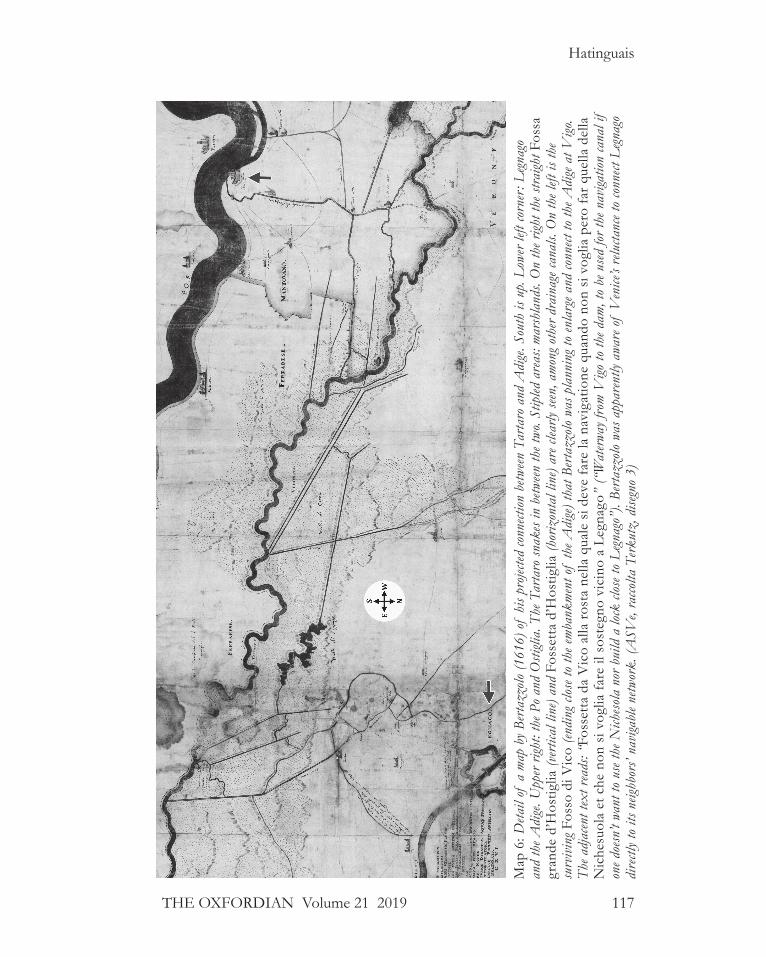
The strongest evidence that no navigation canal between Legnago and Tartaro survived at the end of the sixteenth century is the series of proposals, made at that time and later, to create one. For example, a project was formally presented to the Venetian senate in the 1580s to reactivate the connection between Legnago and Ostiglia; it went nowhere (Pollo 49). In 1598, a proposal made by the Mantuan engineer Bertazzolo to dig a canal connecting directly Adige and Tartaro via the Nichesola was received very coolly by the Venetians and nothing came of it (Togliani, “I Bertazzolo” 581; “Chiusa di Governolo” 256). Twenty years later the situation still had not changed: a project designed in 1616–1624 by the same Bertazzolo (map 6) also contemplated the cre-ation of a canal18 from Governolo (on the Mincio river, before it reaches the Po) to the Adige, south of Legnago; it would have reused and enlarged whatever was left of the Fosso di Vico (R. Scola Gagliardi, Navigazione 15). Venice rejected the proposal. In 1632 Aleotti wrote (290) that the Mantuans were trying to evade taxes that Ferrara levied at Ponte Lagoscuro (on the Po Grande) by opening a waterway that could take their boats from Ostiglia to the Tartaro, and via the Nichesola to Legnago and from there to the Adige and Venice. Clearly the project hadn’t been yet executed by 1632.
From the fragmentary picture left by early cartographers19 and from various archives, Italian historians have begun to reconstruct the complex chronology of all the hydraulic works executed over the centuries in this rather small area (the distance from Legnago to the Tartaro is under eight miles), and to identify their location and function.20 In the Po and lower Adige region, ditches and canals were constantly cut, redirected, embanked, filled in, made to flow over or under a river, and merged into abandoned beds. The resulting bewildering hydrography is a testimony to the courage, resilience and endless labor of the inhabitants of the Po basin over three millennia and a challenge to historians of the region.
Crucially, we should not make the mistake of assuming that because one particular waterway is present on a seventeenth or eighteenth century map, it was already there in the sixteenth century, and, more specifically, in the narrow date range (1575–76) of interest to Oxfordians. Nor should we assume that because a water feature was documented in the fourteenth or fifteenth cen-tury, it was still there in the sixteenth; or if it did survive, that it had retained the same scope and function.
What we do know is that only at the end of the eighteenth century (1762–80) was a navigable canal finally built between the Ponte Fior di Rosa, at Legnago, and the Tartaro, called the Naviglio di Legnago (R. Scola Gagliardi, Navi-gazione 20). The Naviglio di Legnago claimed in parts the ancient bed of the Nichesola and was fed by water drawn from the Adige (R. Scola Gagliardi,
117
Hatinguais
THE OXFORDIAN Volume 21 2019
Map
6: D
etail
of a
map
by B
erta
zzolo
(161
6) o
f hi
s pro
jected
conn
ection
betw
een T
arta
ro a
nd A
dige
. Sou
th is
up.
Low
er lef
t cor
ner:
Leg
nago
an
d th
e Adi
ge. U
pper
right
: the
Po
and
Osti
glia.
The
Tar
taro
snak
es in
betw
een th
e two
. Stip
led a
reas
: mar
shla
nds.
On
the r
ight t
he st
raigh
t Fos
sa
gran
de d
’Hos
tiglia
(ver
tical
line
) and
Fos
setta
d’H
ostig
lia (h
oriz
onta
l lin
e) ar
e clea
rly se
en, a
mon
g oth
er dr
aina
ge ca
nals.
On
the l
eft is
the
surv
iving
Fos
so d
i Vic
o (en
ding
clos
e to
the e
mba
nkm
ent o
f th
e Adi
ge) t
hat B
erta
zzolo
was
pla
nnin
g to
enla
rge a
nd co
nnect
to th
e Adi
ge a
t Vigo
. Th
e adj
acen
t tex
t rea
ds: “
Foss
etta
da
Vic
o al
la ro
sta
nella
qua
le s
i dev
e fa
re la
nav
igat
ione
qua
ndo
non
si v
oglia
per
o fa
r que
lla d
ella
N
iche
suol
a et
che
non
si v
oglia
fare
il s
oste
gno
vici
no a
Leg
nago
” (“
Wat
erway
from
Vigo
to th
e dam
, to
be u
sed fo
r the
nav
igatio
n ca
nal i
f on
e doe
sn’t
want
to u
se th
e Nich
esola
nor
bui
ld a
lock
clos
e to
Leg
nago
”). B
erta
zzolo
was
app
aren
tly a
ware
of
Ven
ice’s
relu
ctanc
e to
conn
ect L
egna
go
dire
ctly t
o its
neig
hbor
s’ na
vigab
le ne
twor
k. (A
SVe,
racco
lta T
erkut
z, d
isegn
o 3)

118 The OXFORDIAN Volume 21 2019
Catching the Flood: River Navigation from the Adige to the Po
“Sistema idrografico” 60). This canal, designed to connect the Adige and the Po (Brugnoli 797) specifically for navigation purposes, did not exist in the sixteenth century.
Roe’s basic intuition (53) that a navigable connection between Adige and Tartaro was possible through the Valli Veronesi was correct; indeed, we have seen that one had existed briefly in the early 1300s and again in the 1400s, that there were several plans to reactivate it in the sixteenth and seventeenth centuries, and that it finally was resurrected at the end of the eighteenth cen-tury. However, documents recording the many thwarted proposals just listed also indicate that no direct connection between Legnago and Tartaro existed in the 1570s. Roe was wrong on this particular point.
One reason, beyond Venice’s strategic concerns, this water link was appar-ently allowed to wither and disappear from the fifteenth to the eighteenth centuries may simply be that two alternate routes existed: the Adigetto and the Castagnaro (map 7).
The AdigettoThis distributary of the Adige was the result of a breach, the Rotta del Pinzone, which occurred in the mid-tenth century at Badia Polesine. Like the later Castagnaro, it became for a while the main branch of the Adige, starving the old river of its waters. Its flow was finally regulated in 1493 with a wooden
Map 7: Schematic map of itineraries by Hatinguais.

119
Hatinguais
THE OXFORDIAN Volume 21 2019
palisade constructed at its entrance, the Bova di Badia, rebuilt and upgraded in 1603 with stone walls and a sluice door (Bocchi, Trattato geografico 221; Crugola 79–81). This waterway is part of the route from Legnago to Ferrara which we detailed above: a boat would enter the Adigetto at the Bova, sail past Lendinara to Villanova del Ghebbo and there take the Scortico canal south down to the Tartaro-Canalbianco (R. Scola Gagliardi, Navigazione 14); follow the Canalbianco east for a short while and then take the canal Fossa Polesella south, and at Polesella, enter the Po.
The CastagnaroThis distributary, Diversivo di Castagnaro, was born of the catastrophic and apparently deliberate breach21 of the right embankment of the Adige in 1438 (Averone 147–148; Silvestri 102–103), a few miles downstream from Leg-nago. Over the ensuing decades the new water course was slowly embanked and contained, and a succession of hydraulic works were built at its entrance to better regulate its flow. But it was left open, for both economic and hydro-logical reasons: it offered a convenient way to travel from the Adige to the Po (Puppi 349–350), and it diverted some of the seasonal floodwaters of the Adige, thus relieving pressure on the levees further downstream.
By 1504, private landowners had already built many weirs across the Cast-agnaro to power their mills. The Venetian authorities ordered that all those small private weirs be dismantled, thus removing obstacles to navigation, and that two large ones be built at the entrance of the distributary in order to slow down and reduce the amount of water that the Castagnaro, because of its steeper slope, captured from the Chirola (as the old Adige came to be called) (Paleocapa 8–9). At the same location, a wooden palisade was also built to direct enough water into the Chirola to keep the old river navigable (Zendrini 1:153–154). Between 1545 and 1561 additional work was done at the entrance with three goals in mind: to reduce the width of the entrance thanks to two wing dams,22 to better hold back the incoming waters with a large dam or weir made of wooden gabions filled with stones and secured to the riverbed by piles, and to retain a deeper channel, closed by a sluice door, to allow for navigation (Paleocapa 14–15). These hydraulic works had to be raised several times in the following decades because the entrance kept silting up, but they otherwise remained unchanged until the end of the seventeenth century or beginning of the eighteenth.23 Until then the Castagnaro was there-fore open for trade with Lombardy all year round (Bocchi, Trattato geografico 413). In fact Aleotti (414), writing in the early seventeenth century based on information gathered in 1600, mentions the traffic that “comes down from Verona [through the Castagnaro entrance] and that, via the Fossa Polesella and the Po river travel to and from Lombardy,” confirming the importance of the itinerary Adige-Castagnaro-Tartaro-Fossa Polesella-Po to Lombardy at the end of the sixteenth century.

120 The OXFORDIAN Volume 21 2019
Catching the Flood: River Navigation from the Adige to the Po
Sailing at dawn from Verona under favorable conditions, it would take a boat 9 to 10 hours to reach the entrance to the Castagnaro, arriving long before dusk in midsummer, when navigation ceased for the night. Once a boat reached the confluence of the Castagnaro and the Tartaro near Canda, its captain had two options. One involved turning left, down the Tartaro- Canalbianco until he reached Arqua at the head of the Fossa Polesella, then turning right into said Fossa, where he would join the great traffic of boats converging from Verona and Venice to go to Ferrara and Bologna (Aleotti 404). All would enter the Po at Polesella, as had been the custom of boatmen since the mid-1400s (Gagliardi, Navigazione 14).
The other option was shorter but more tortuous, and involved turning right and sailing west, up the Tartaro—stopping on the way for inspection at Bastion della Crocetta (aka Torretta veneziana), a Venetian tollgate (R. Scola Gagliardi, Navigazione 35)—until the boat reached Bastion San Michele, a customs checkpoint at the border between the Veneto and Mantuan terri-tories (R. Scola Gagliardi, Navigazione 33). It would then take the Fossetta mantovana, ordered cut by the Gonzagas at the very end of the 1400s, up to the junction with the Fossa d’Ostiglia, a navigable canal already documented in the ninth century under the name Fossa Olobia (R. Scola Gagliardi, Navi-gazione 14–15). It would then sail down the Fossa all the way to Ostiglia, and after passing through the lock of Ostiglia, would enter the Po. From there, the boat had to be towed upstream, towards Milan. In other words, Roe’s description (54, 58) of this leg of the itinerary, i.e. Tartaro-Fossetta mantovana- Fossa d’Ostiglia to the Po is correct and historically documented (map 8).
As we see from this brief survey, there were several possible and well- documented itineraries to choose from when trying to go from the Adige to the Po, some longer than others, some easier in certain seasons than others, some insecure in times of political tensions between neighboring states.
Losing the Flood, Catching the FloodLeaving aside the humorous wordplay in Act II, scenes 2 and 3 The Two Gentlemen of Verona, can we determine whether Shakespeare may have been alluding to an actual phenomenon he would have observed while in Verona and the Veneto, when he wrote of “losing the tide” and “losing the flood?”
Magri (100) proposed that Shakespeare was referring to one of the Adige’s sudden floods, “rising rapidly within a few hours.” 24 Her description would seem to apply to the autumn floods—sudden, hazardous but short-lived—more readily than to the long spring and summer floods (Menna 96). As we have seen, boatmen do appreciate the increased speed and clearance afforded by a swollen river. Yet they might have been reluctant to start their journey

121
Hatinguais
THE OXFORDIAN Volume 21 2019
before they knew whether the rising water was going to become a raging flood capable of wrecking their boat (Berg, personal communication). In the fall especially, they might be tempted to wait until it peaked and time their launch just as the tail end of the flood began. A river’s floodwaters always recede much more slowly than they rose (Vernon-Harcourt 1:11). If the Adige’s waters rose to flood stage in a few hours, they would fall in one or two days.
In Magri’s scenario, the reason for the hurry implied in Shakespeare’s text would be the need for Lance to leave before the end of a short autumn flood. But assuming—as the text indicates—that Proteus boarded his ship just a few moments before Lance reached the landing,25 there would still be ample time for him to ride the tail end of the spate in a rowing boat and catch up
Map 8: (late fifteenth century) The area between the Tartaro and Po rivers. Upper third: the Tartaro river and its branch, the Tartarello; right: the fortified Bastion (San Michelle); lower third: the Fossetta mantovana, meeting the Fossa de Hostia (Ostiglia) at the Tor rota (ruined tower). Left: the Fossa and the road to Verona (“Strada” also called Via Clau-dia-Augusta) run jointly north-south, from Ostiglia to Pontemolino. Note the agricultural canals, bridges, rice paddies, farmhouses and dovecote towers. (ASMn, Archivio Gonzaga, b. 90, c. 49)

122 The OXFORDIAN Volume 21 2019
Catching the Flood: River Navigation from the Adige to the Po
with the departed ship. In the case of the spring flood, the waters were slower to rise and even slower to recede (a matter of days and weeks, respectively), so there would be even less need to hurry. Something does not quite add up to Magri’s explanation for Pantino’s urgent call for Lance not to delay.
In contrast, Roe (53) thinks the phrase alludes to the “turning” of a pound lock, the process by which water is raised and lowered in a modern lock, slowly lifting or dropping the “locking” boats along with it (Casciani-Wood). He also suggests that those locks were turned at specific times, on a known schedule. Roe is onto something.
Pound Locks, Flash Locks and the AdigeWhen we hear the word “lock” nowadays, we immediately picture a pound lock, a rectangular basin made of stone walls, closed at both ends by two strong miter gates, filled in and emptied slowly by the opening and closing of the “paddles,” i.e. smaller openings set in the miter gates that control the flow of water into and out of the pound. This slow and deliberate process minimizes the churn to which boats are subjected and relieves the pressure on the miter gates so that they can be easily opened. This ingenious machin-ery26 allows boats to safely overcome high “falls” between the higher and the lower reaches of a river or canal by eliminating the dangerous rush of water such a fall creates; moreover, it saves water in drier regions or in seasons when it is scarce.27
As a copious river, meandering in a raised bed through a low, flat plain and prone to massive floods, the lower Adige was unsuitable for this kind of hydraulic work to be built across its course. But we do know that most, if not all, the entrances of canals and distributaries splitting off the Adige were protected against erosion and the influx of floodwaters. They were regulated by hydraulic works of one kind or another (Guglielmini 304, 306, 310) using a variety of “locks,” with a combination of side buttresses, weirs, navigation channels, sluice-doors or gates (figure 9).
Before the very costly pound locks were progressively introduced across Italy and Europe between the sixteenth and the nineteenth centuries, a much more primitive and ancient method of navigation was universally used, “inter-mittent navigation” or “navigation by flashing” (Cuënot 3–4; Mas, Rivières canalisées 3–4; Lombardini 166; Nazzani 232). At intervals along a waterway, its flow was slowed down and the water level in the upper reach was raised by a dam or weir built across the riverbed; a gap or deeper channel was preserved in the weir, reserved for navigation (Berg, Pertuis, 14–21; Lagrene 2:19; Willan 87–88). This gap could be left wide open and the water running freely where and when it was abundant (Robertson 40–41). But in times of low waters, the channel was closed by a wide variety of contraptions or sluice doors. A “plank staunch” was made of a series of horizontal beams.

123
Hatinguais
THE OXFORDIAN Volume 21 2019
In order to close the gate these beams were driven, one on top of another, into vertical groves set on either side of the channel (Lagrene 2:23–24); to open it, they were lifted one by one by hooks, an arduous and rather slow process. A “needle sluice” used vertical pieces of wood, the needles kept in place by water pressure against a stone or wooden sill at the bottom of the riverbed and a swinging beam stretching above and across the current (figure 8). When the beam was released and swung clear of the channel the needles would yield and be carried away by the current; each was attached by a rope so they could later be easily retrieved (Lagrene 2:21–23; Paleo-capa 29). There were also systems using paddles and rymers, a variant of
Figure 8: Flash locks. Above: flash lock associated with a watermill (© Charles Berg). Below, left: two alternative closing systems: the needle lock (right) and the paddle-and-rymer lock (left). (© Charles Berg). Below, right: Da Vinci’s notional sketch of a series of weirs and transitional pound locks, and of bascule doors. (Berg , Du pertuis à l’écluse 53)

124 The OXFORDIAN Volume 21 2019
Catching the Flood: River Navigation from the Adige to the Po
the needle sluice (Paget-Tomlinson 49), vertically rising doors lifted with ropes and capstans (Bélidor 54). Those openings, with their ingenious but dangerous mechanisms for holding back the flow and releasing it all at once when needed, were called flash locks.28
Figure 9: Three views of the same flash lock. One of the two counter-weighted (O) swing beams serves as the working bridge (LQ) for the lock keeper. From the other (GH) hang the three vertical “needles” (K) against which the paddles (S) are set. Once the paddles were all removed and the swing beam released, it would pivot out of the way of the passing boats. (Belidor 4:344)

125
Hatinguais
THE OXFORDIAN Volume 21 2019
Scheduled Flashes and Pantino’s “Flood”“Navigation by flashes” required boats traveling down river to gather in a basin or roadstead immediately upstream of the weir (or downstream if traveling up river), and to wait for the gate to be opened by the lock keeper.29 Once the lock was opened, the captains had to steer their boats, one after another, into the current and through the gate, to be carried downstream by the suddenly rushing water without hitting the sides of the lock, the other boats before it, or the banks below the weir. It took great skill, a cool head, and luck to get through safely. Perilous and wasteful of water, this type of navigation had nevertheless the advantage of allowing ten to twelve boats to go through a lock at one time, whereas the pound lock could only accommo-date two or three per “turning,” a much slower process overall (Willan 93). “Intermittent navigation by flashes,” known since antiquity, was progressively replaced by “continuous navigation” with the use of pound locks, but did not disappear until the nineteenth century.30
The flash, this powerful but rather brief rush of water, is invariably defined, whether in English, French or Italian, by hydraulic engineers and by river boatmen alike, as an “artificial flood,” created deliberately to benefit naviga-tion (Paget-Tomlinson 50; Robertson 41;31 Mas, Rivières à courant libre 110; Mas, Rivières canalisées 3; Berg, Lexique; Museo; Mainardi 90–91). In the Veneto, it was called la butà or il buttà (Lombardini 166, Nazzani 232). This practice is well documented for several canals of Lombardy (the Martesana) and of the Veneto, notably the Battaglia, the Este-Monselice, the Cagnola, and the Scortico canals. Moreover, for all these canals, the butà operated on a regular schedule, usually twice a week (Collegio 21–24; Ministero 12; Mainardi 90; Turato et al. 34, 167; Bocchi, Trattato geografico 228; Frisi 456). Missing the scheduled opening time would mean having to wait several days for the next one.
We have seen that a weir and navigation channel was built at the entrance of the Castagnaro in 1545 (Paleocapa 14) to ensure that this distributary did not capture too much of the Adige’s flow and to keep the Adige navigable in times of low waters. We also know that after 1561, the water gate included a panconatura, some kind of staunch door (Paleocapa 15), unfortunately left undescribed. A much later drawing, dated 1749 (map 9, A & B, page 32), depicts the vertical grooves which normally would receive the horizontal beams of a plank staunch across the navigation channel. In 1632 this closing mechanism, whatever it was then, was controlled by a lock keeper (Aleotti 414) and, in all likelihood, had been since Venice ordered the works to be executed in the mid-sixteenth century.
Whether it was opened on demand or on a regular schedule I have not been able to establish.32 We can infer from Paleocapa’s detailed analysis of the

126 The OXFORDIAN Volume 21 2019
Catching the Flood: River Navigation from the Adige to the Po
Castagnaro’s interaction with the Adige and from Guglielmini’s description of regulated canals (310–311) that the practice may have varied according to necessity. In times of peak flood, we know it was left wide open to divert part of the waters of the Adige into the Castagnaro and relieve the pressure on the Adige’s levees downstream; but at those times navigation may have
Map 9A: Cross-section of the rosta (dam) at the head of the Castagnaro in 1600 (Aleotti 414). Water from the Adige comes from the right. The floodgates of the lock on top of the dam are operated by a capstan. The navigation gate is not visible.
Map 9B: Map view (1749) of the rosta and navigation channel (cunetta), closed by five thick planks (travi) dropped into vertical grooves. The dotted lines across the entrance indicate where—in the eighteenth century—the earthen dike was rebuilt every November. Two wooden palisades (paradori) direct water into the Adige. (ASVe, Archivio proprio Giovanni Poleni, b.22, tomo VIII, c.50)

127
Hatinguais
THE OXFORDIAN Volume 21 2019
been interrupted for safety reasons. In times of ordinary high waters, it prob-ably could have been opened on demand since water was abundant enough both to keep the Adige navigable and to supply flashes, as needed, for the Castagnaro. However, in times of lower waters, it would have made sense to open it only on schedule to save water for the Adige. This is, however, only informed speculation. The documentation I had access to is unfortunately silent on this particular point and does not allow me to state with certainty that the sluice gate at the head of the Castagnaro, one of the two possible water courses Proteus could have taken to get to Milan, worked on a schedule.
The entrance to the Scortico canal located on the alternate route to Milan, i.e. via the Adigetto, was also regulated by a lock. Described as a “lock with two openings and a door made of horizontal beams” (Bocchi, Trattato geograf-ico 228),33 this seems to have been a flash lock closed with a plank staunch. This lock, whatever its precise design was, did indeed operate on a weekly schedule: it is known, at least in 1598, to have been opened every Wednesday evening and closed every Thursday evening, interrupting navigation until the following week (Bocchi, Trattato geografico 228). It is likely to have already been the practice earlier in the sixteenth century.
In this context, the sense of urgency that Pantino expresses on Verona’s river landing begins to make sense. Lance had to catch up with his master’s boat in a hurry because after it had gone through the flash lock at the appointed opening time, it would be out of reach once the lock was closed and naviga-tion interrupted for the next few days. Lance would be left behind, stranded on the wrong side of the dam while his master sailed on to Milan without him.
ConclusionsIt is impossible for us to know exactly how much Shakespeare, while trav-eling in the Veneto, witnessed or experienced of the river travel described above. Navigation by flashing was used throughout Europe, including England. But before it be argued that Shakespeare was merely conflating what he knew of this navigation method on the upper Thames with an imag-ined Italian river, recall that in the sixteenth century, English non-tidal rivers were in private hands, along with their weirs and locks, and as a consequence, flashes were granted to watermen at the mill owners’ discretion, not on a publicly advertised schedule as in Italy. In England in the sixteenth century there was no trace of a system of regular, scheduled openings such as existed in Italy, where navigation on the Adige and the Po, which were crucial inter-national trade routes, was by economic necessity more regimented34 than in England.
Roe’s suggestion that “flood” in Act II, scene 3 of The Two Gentlemen of Verona referred not so much to a seasonal swelling of the Adige river itself,

128 The OXFORDIAN Volume 21 2019
Catching the Flood: River Navigation from the Adige to the Po
but rather to a more localized and controlled rush of water, is very plausible in view of the hydraulic works and navigation methods used in the Veneto in the sixteenth century. However, we need to add the important correction that “flood” cannot refer to a modern pound lock’s turning, as he thought (53), since pound locks are precisely designed to avoid any rush of water. But the term applies perfectly to the flash or artificial flood created on purpose at a flash lock by the sudden opening of a staunch, such as were often found at the entrance of canals or distributaries off the Adige.
Roe’s observation (40) that “tide” still had connotations in the sixteenth century of “time,” “opportune or critical moment,” “appointed hour” as per the Oxford English Dictionary, led him to suggest that Lance was about to miss an event of limited duration, the “flood,” which was supposed to occur at an appointed time and known in advance to bargemen. This interpretation perfectly fits the practice documented for a number of canals in the Veneto, where the gates at the entrances of regulated canals were open for navigation once or twice a week and then closed after a few hours.
Taking this scene of Two Gentlemen of Verona seriously instead of dismiss-ing it as a “howler,” and researching the possible implications to their logical conclusions, allows us to state, against his critics, that Shakespeare knew precisely what he was writing about. It is clear that river traffic in Northern Italy, notably between Verona and Milan, was not only possible but intense, well organized and highly regulated. Navigation by flashes, practiced since antiquity through the Middle Ages and the Renaissance until the nineteenth century, involved creating artificial floods by opening navigation gates, usually following a bi-weekly schedule. This common and well-documented practice accounts for the otherwise puzzling phrase “missing the flood.” By deepen-ing our understanding of the conditions, methods and routes of navigation between the Adige and Po in the sixteenth century, we have thus shown that, beyond what may have been Shakespeare’s poetic intentions, there is a very real river landscape that provided him with just one more thread to weave into his story.
AcknowledgmentsThis research would have been impossible without the generous help of several people to whom I am deeply indebted: Charles Berg, whose highly informative website was my introduction to the world of ancient navigation techniques; his historical knowledge combined with his lifelong experience of river navigation made him an invaluable source of information and insights; Andrea Cavallari, Francesca Grillo, and Lucia Tomasi Tongiorgi for kindly answering my questions; Susan Fischer and Marco Folliero for helping me get hold of sources which would otherwise have remained out of reach.

129
Hatinguais
THE OXFORDIAN Volume 21 2019
Image AuthorizationsThe illustrations included in this article are reproduced with permission from:
Biblioteca Civica di Verona, dated 16 April 2019:• M. Moro, “S. Anastasia” (BCVr, Collezione di Stampe 2.b.77).• “La Crovara” (BCVr, Collezione di Stampe 2.a.226, foglio 30).• “Verona città celeberima” di P. Ligozzi (BCVr, Collezione di Stampe
1.b.18).• “Veduta verso il Ponte delle Navi” (BCVr, Collezione di Stampe
1.g.223).• Mappa del territorio veronese, di Paolo Forlani (BCVr, Collezione di
Stampe 4.a.1).• “Veduta di Legnago” (BCVr, Collezione di Stampe 2.a.226, foglio 32).
Ministero per i beni e le attività culturali, Archivio di Stato di Venezia (ASVe–2019 Prot.2191):
• Verona e il suo territorio (ca. 1470s–1480s): ASVe, Scuola di S. Maria della Carità, b. 36, n. 2530.
• Campagna tra Legnago e Vangadizza (Cristoforo Sorte, 1562): ASVe, Provveditori sopra Beni inculti Rotolo 70, Mazzo n. 61a, disegno 3.
• Diversivo Castagnaro nel 1749: ASVe, Archivio proprio Giovanni Poleni, b.22, tomo VIII, c.50.
• Marezane presso Verona nel 1752 (disegno di Antonio Schiavi): ASVe, Archivio proprio Giovanni Poleni, b.17, tomo III (Adige), c. 239.
• Canal Tartaro-Legnago—“Novae Construendae Navigationis” (Disegno di Bertazzolo, 1616), ASVe, raccolta Terkutz, disegno 3.
Archivio di Stato di Mantova (email dated 12 April 2019): • Territorio tra Tartaro e Po (fine Quattrocento): ASMn, Archivio
Gonzaga, b. 90, c. 49.
Charles Berg (April 2019):• Typical layout of mill with weir.• Needle and paddle-and-rymer flash locks.

130 The OXFORDIAN Volume 21 2019
Catching the Flood: River Navigation from the Adige to the Po
Endnotes
1. In Great Englishmen of the sixteenth century: “To Italy—especially to cities of Northern Italy, like Venice, Padua, Verona, Mantua, and Mi-lan—Shakespeare makes frequent and familiar reference, and he supplies many a realistic portrayal of Italian life and sentiment. But the fact that he represents Valentine in The Two Gentlemen (I.i.71) as traveling from Verona to Milan (both inland cities) by sea, and the fact that Prospero in The Tempest embarks in a ship at the gates of Milan (I. ii.129–44) ren-ders it almost impossible that he could have gathered his knowledge of Northern Italy from personal observation. Shakespeare doubtless owed all his knowledge of Italy to the verbal reports of traveled friends and to Italian books, the contents of which he had a rare power of assimilating and vitalising” (299). The same error continues to infect commentary in languages oth-er than English. For example, the notes to the latest edition (2013) of Shakespeare’s complete works in French in the prestigious La Pléiade collection decry his “géographie fantaisiste qui fait voyager Valentin et Protée de Vérone à Milan par la voie maritime, en profitant de la marée pour la mise à flot du navire.”
2. Sullivan (223–228) who was the first to use Italian sources—with devas-tating effect—to counter the traditional story, accusing the commenta-tors of outright “carelessness,” Lambin (56–57), Grillo (141–144), Roe (49–58), Kreiler and Magri (101–102) have all argued persuasively that Shakespeare clearly refers to river navigation and not to a sea voyage when he sends Lance’s master on a boat from Verona to Milan.
3. These are precisely the details most likely to be mentioned in the travel books and tavern conversations that are supposed to be Shakespeare’s only sources for “local color” in his Italian plays. Why would an untrav-eled author, eager for his audience to recall these popular travel accounts, then neglect to mention in his plays the well-known tourist highlights they would have read or heard about?
4. There is no evidence that Will Shakspere of Stratford ever left England, no documentary trace that he received permission to do so, no letters or documents from people who might have traveled with him. In contrast, Edward de Vere, 17th Earl of Oxford is known to have traveled through France and Italy from January 1575 to April 1576. Other authorship can-didates are believed to have traveled outside England as well.

131
Hatinguais
THE OXFORDIAN Volume 21 2019
5. Stymied by the patchy documentation, Oxfordian scholars disagree on the exact itinerary that Edward de Vere followed (once he left Sturmius in Strasburg on April 26, 1575 and Germany sometime in May) in order to reach Venice by the end of May. Dorothy and Charlton Ogburn Jr. (83–84) have him skirt Milan, go by road to Lake Garda and the upper Adige, and on to Verona. B.M. Ward (105) lists the well-document-ed dates and places him in Padua and then Venice in May, offering no further conjecture regarding his possible itinerary. Charlton Ogburn Jr (543–544) suggests that de Vere navigated up the Rhine to Basel, then passed through Lake Constance and, in order to avoid the Duchy of Milan altogether, crossed the Alps either at the Reschen-Scheidek Pass or at the more heavily traveled Brenner pass; and finally descended the Adige and once in Trento, headed east to the Piave and Padua. Mark Anderson (79–80) proposes Basel, Lake Constance, the St. Gotthard Pass, the outskirts of Milan, then sailing “on a canal, then a network of rivers to Verona” and a two-day trip to Venice, presumably on horseback. At this remove and short of discovering new documents, it is impossible to know with certainty. But we can be reasonably sure that he did visit Verona at some point during his stay in Italy.
6. From Rivoalto, name (until the eleventh century) of the original settle-ment on a group of islands in the lagoon. When referring to Venice as a center of trade, historians often call her the “emporio realtino” (Fanfani), “storehouse of the Rialto.”
7. Montaigne (182) describes a “pais plein et tres fertile, difficile aus jans de pied en tamps de fange, d’autant que le pais de Lombardie est fort gras, et puis les chemins etant fermés de fossés de tous costés, ils n’ont de quoy se guarantir de la boue à cartier de maniere que plusieurs du pais marchent à tout ces petites échasses d’un demy pied de haut” (“a popu-lated and fertile country, difficult for people traveling on foot during mud season, especially since Lombardy’s soil is very clayey and the paths are surrounded by ditches everywhere, so that many local people, in order to avoid the thick mud, walk around on small stilts, that are half a foot high”).
8. Cozza and Grillo state (Ministero 10–11) that in Italy, contrary to the rest of Europe, canals were designed for multiple purposes. This needs to be clarified slightly. While navigation canals were indeed used to drain the surrounding countryside and to convey water for irrigation to agri-cultural estates on their route, many drainage and irrigation ditches were probably too shallow or too narrow to accommodate the larger burchi. Smaller skiffs, however, would likely have taken advantage of these local

132 The OXFORDIAN Volume 21 2019
Catching the Flood: River Navigation from the Adige to the Po
waterways to bring in the harvest. The profusion of terms designating waterways in Northern Italy can be disconcerting at first. Scolo, scolador and dugale designate drainage canals; condotto, seriola, cavo, an irrigation canal; fossa, fosso, fossetta, larger or ancient canals; naviglio, a navigation ca-nal; taglio, a man-made cut-off canal; rotta, a breach in the levees and the distributary created by it. Because waterways often have—by design or by custom—multiple purposes, one often cannot infer their role simply from their name.
9. A river is said to become “floatable” when it can convey at first loose tree trunks and logs and, further down, proper rafts. A floatable river can become “navigable” further downstream still, when boats can use its current without undue risk of running aground or being smashed and sunk. All navigable rivers are floatable but not all floatable rivers are also navigable (Vernon-Harcourt 1:64).
10. Rafts were built (Mainardi 47–52) in specialized yards along the river during seasonal low waters (in winter) and launched only when the river had risen enough. The trunks, tied together by ropes made of willow, were organized so that the ones intended for the farthest destination on the route were placed in the lower layer of the raft (Beggio, “Navigazi-one” 544–548). They were left with their bark on to protect them from water, scrapes and shocks. The rafts could reach 16 to 23 feet in width and 65 to 131 feet in length (Faccioli 2) and were dismantled upon arrival (Beggio, “Navigazione” 485). Several crews of drivers, all experts at riding and reading the river, would work in relays. One crew would hand over the raft to the next crew at predesignated stops, before heading back upriver on foot. Bridges being few and far between, smaller rafts were commonly used as ferries to carry people, horses, cattle and goods across rivers (Beggio, “Navigazione” 544).
11. Besides the flour and rice mills, “various kinds of machinery and plant were powered by water: mills, paper works, fulling and spinning machin-ery for the silk industry; hammers and bellows used in working iron; mechanical wood saws and presses for flax oil” (Ciriacono 47).
12. The mulini natanti, known in English as floating mills, ship mills or boat mills (Decker), were a common feature in Verona, the lower Adige and the Po until the nineteenth century. Whereas watermills built in stone could be found on the banks of smaller streams and canals in the Veneto, only boat mills were allowed on the Adige itself (Beggio, “Navigazione” 549). With their large vertical paddlewheel and their small cabin shelter-ing the millstones and engine, they floated on three wooden pontoons

133
Hatinguais
THE OXFORDIAN Volume 21 2019
and were anchored or tied to the bank by ropes. They were associated with a house and storeroom built on land (Beggio, “Navigazione” 554). They could only be moved a few yards up or downstream and closer or farther from the bank but were otherwise obligated to remain in their allotted stretch (ariale) of river (Mainardi 43–46). They numbered 400 in the nineteenth century. For a full history and description see Beggio, Mulini natanti.
13. The Dogana d’Isolo processed all merchandise coming down river from northern Europe. The Dogana Ponte delle Navi processed goods coming upriver from Venice and the Adriatic. Both remained in use until the eighteenth century.
14. Hughes (460) quotes Moryson’s observation: “They are carefull to avoyde infection of the plague, and to that purpose in euery Citty haue magistrates for health. So as in tymes of danger when any Citty in or neere Italy is infected, travelers cannot passe by land, except they bring a bolletino or certificate of their health from the place whence they come, and otherwise must make la quarantana or tryall of forty dayes for their health, in a lazaretto or hospitall for that purpose.”
15. Italian has, understandably, a rich terminology regarding rivers, floods and navigation: Piena, Gonfiezza, Escrecenza, which refer to the swelling or rise of a river, whether destructive or not; Esondazione, Inondazione, All-agamento which refer to the flooding of a city or the countryside; Straripa-mento, the overtopping of a bank or dike; Rotta, a breach in the levees but also the resulting distributary. Impaludamento, the long-term effect of flooding which turns a region into marshland. The Venetian dialect adds its own specific terms: Monta, Colma, (rising water), Dosana (falling water), Aqua colonbina (tail end of a spate), Brentana (impetuous rush), Turbion (sudden and violent rise), Corentiva (strong and fast current), Molente (stretch where the current suddenly slows down once past an obstacle), Spiasera (navigable channel), Filon (deepest part of a river or thalweg), Fiumèra (long and large channel), Mandracio (It. Mandracchio, a sheltered area where boats can lie safely and wait to be loaded or unloaded by lighters, to form a convoy, to enter a lock, etc., before starting on the next leg of their journey, i.e. a roadstead) (Turato et al. 159–203).
16. Fynes Moryson mentions taking a similar water coach, a “Barke which weekely passeth betwixt Venice and Ferrara” during his 1594 Italian travels (Sullivan 228).

134 The OXFORDIAN Volume 21 2019
Catching the Flood: River Navigation from the Adige to the Po
17. Puppi (350) concurs and quotes the label designating the said canal on that map, as stating: “fossa fexe far el ducha de milan” (i.e. Gian Galeazzo Visconti, master of Verona from 1387 to 1402).
18. It would have taken the following route: down the Mincio from Mantua to the Po; down the Po to Ostiglia; along the Fossa d’Ostiglia and the Fos-setta mantovana to Bastion San Michele; down the Tartaro to the Niches-ola confluence at Bastion della Crocetta; up the Nichesola and east along an existing canal, on to the Adige through a new lock to be built about half a mile south of Legnago (Supino 449; Togliani 584, note 206).
19. Many historical maps have now been digitized and can be consulted on-line on the website of the Italian State Archives: http://www.icar.benicul-turali.it/index.php?id=89
20. The remarkable study published by Morin and R. Scola Gagliardi in 1993 on precisely this area, although mostly focused on hydraulic works de-signed for agriculture, has thankfully begun to clarify the situation. Remo Scola Gagliardi’s 2014 study of the navigation between Adige and Po through the Valli Veronesi is also invaluable.
21. During a war between Venice and its neighbors, Gian Francesco Gon-zaga, Marquess of Mantua, is said to have driven his fleet from Ostiglia to the Tartaro, crossed the swamps (i.e. the Valli Veronesi) and breached the banks of the Adige in two places (Castagnaro and Malopera, roughly five and eight miles, respectively, downstream from Legnago), to enable his ships to get access to the river and attack the Venetians. Some authors question the tradition and argue that the two breaches were present since the twelfth century and were simply enlarged in 1438 as the result of a powerful flood (Morin 135). Whatever the cause, the result was the same: the waters of the Adige rushed into the breach, flooding the countryside all the way to Adria. Starved of a large part (calculated at between two-thirds and four-fifths) of its waters (Paleocapa 14), the old Adige became hardly navigable and even lost its name for a while, to become la Fossa Chirola in fifteenth and sixteenth century documents. Without sustained human intervention, the Castagnaro would simply have become the main course of the Adige (Paleocapa 8).
22. Wing dams or spur dikes are structures in wood, rocks, or nowadays cement, used to partially close a river channel (US Army Corps of Engi-neers 5–12). Judging from the stated purpose of the two castelli di travi mentioned in official documents of the time, it seems they would be called today “wing dams” in English.

135
Hatinguais
THE OXFORDIAN Volume 21 2019
23. This is when it was decided to close the Castagnaro on a seasonal basis: a large earthen dike was built to bar its entrance every year on November 11, at the beginning of the seasonal low waters, and it was dug open every year on May 8, when the spring floods arrived (Paleocapa 17–18). The Castagnaro was not closed, completely and permanently, until 1838.
24. She also says that the records indicate a flood in 1575 and 1576. Yet Menna (96) does not list those two dates among the years recorded for their memorable floods. We can therefore assume that the floods of 1575 and 1576 were within the expected, normal bounds of the seasonal swell-ing of the Adige.
25. Even allowing for poetic license, we cannot imagine that it would be physically possible for Lance, straining at his oars, to make up for more than an hour of delay.
26. In Europe, the use of miter gates and paddles in pound locks dates back to the fifteenth century in Milan (Willan 88). However, the use of a basin closed at both ends by a vertically raised door (guillotine gate) or by a sliding door, is much older. Aleotti includes a drawing (405) of such a transitional design used at the Polesella lock as late as 1637.
27. The pound lock is best adapted to the shallow, upstream stretches of fast-moving rivers where it solves the seasonal problem of insufficient depth for navigation, and to canals where the supply of water needed to keep them navigable is deficient. The canals around the Venetian lagoon did not have more than one or two, except the Brenta (Vernon-Hartcourt 2:499).
28. In old documents, the word “lock” should never be assumed to refer to a pound lock (Willan 87, 92; Robertson 47). In fact, chances are that what is meant is a “simple lock” “half-lock” or “flash lock.” The same confusion exists in Italian regarding the exact meaning of chiusa, sostegno or chiavi-ca in old documents (Supino 441). Aleotti (414–415) for example labels sostegno and chiusa illustrations of what are clearly flash locks. For a clear and illustrated history (in French) of the evolution from the flash lock, via the turf-sided lock, to the pound lock, see Berg, Du pertuis à l’écluse.
29. Because this system was very wasteful of water, the next “flash” had to wait, once the gate was closed again, for the water to rise again behind the dam and sluice, which could take from a few hours to a few days.
30. A few flash locks survive to this day and have been restored in heritage sites in England and France.

136 The OXFORDIAN Volume 21 2019
Catching the Flood: River Navigation from the Adige to the Po
31. Robertson also calls flashing “the tide in the affairs of bargemen” (40), but his statement is ambiguous and given without any further context or explanation. Navigation by flashes was widely used in England (Paget- Tomlinson 49, 51), where the opening of the weirs’ gates was left at the discretion of their private owners, who extorted exorbitant fees from bargemen for the privilege. This rather informal arrangement led to end-less conflicts between boatmen, sometimes detained at a closed weir for weeks on end, and the weir owners, anxious to hoard the water to power their mills. In England, “a non-tidal river belonged to the riparian owners and was private property as much as the land itself ” (Willan 22). As a re-sult, boatmen were left at the mercy of private weir and mill owners who decided when (or whether) to open their sluice gates for waiting boats and at what price.
32. Aleotti (414), based on a letter and drawing he received from a Venetian engineer, dated 1600, describes the rosta di Castagnaro as an “Opera di legname sì, ma tale che trattiene et ammette a volontà di chi n’ha cura la navigatione delle merci che da Verona scendono per la Fossa Policella e per la Fuosa nel Po per andare et tornare di Lombardia...” (“a wooden construction for sure, but one which allows those in charge of it to hold back or to let pass at will the traffic that comes down from Verona and that, via the Fossa Polesella and the Po river travel to and from Lombardy”). It is clear that the decision to open or close the passage is left to the lock keepers officially assigned to its operation, not to the boatmen.
33. “All’incile di questo canale coll’Adigetto esisteva nel 1598 un sostegno detto del Ghebbo, a due luci con panconatura orizzontale, che veniva aperto per la navigazione il mercordi sera d’ogni settimana, e si chiudeva il giovedi pur a sera”(Bocchi, Trattato geografico 228). (“At the entrance of this [the Gaibo] canal, there was in 1598 a dam called the Ghebbo, which had two openings with gates made of horizontal beams and which was opened for navigation every Wednesday evening and closed every Thurs-day, also in the evening”).
34. Another sign that river navigation in England was less developed and less formally organized than in Italy or France (Willan 121, 127) is the fact that while the boatmen’s trade in Verona had long been regulated by guilds and detailed statutes, English bargemen, “except for the watermen and lightermen in London, were not organized in companies or regulated by Act.” (Willan 109)

137
Hatinguais
THE OXFORDIAN Volume 21 2019
Works Cited
Aleotti, Giovan Batista. Della scienza e dell’arte del ben regolare le acque. Edited by Massimo Rossi, Modena, Franco Cosimo Panini, 2000.
Anderson, Mark. “Shakespeare” by another name. The life of Edward de Vere, Earl of Oxford, the man who was Shakespeare. New York, Gotham Books, 2005.
Associazione “Abitare Borgo Trento”. Breve Storia della Campagnola (Verona). http://borgotrentoverona.org/quartiere/il-passato/breve-storia-della- campagnola/. Last accessed 19 June 2019.
Averone, Antonio. Saggio sull’antica idrografia veneta. Mantova, Aldo Manuzio, 1911.
Bagolini, Bernardino. “La Valle dell’Adige nella preistoria.” Turri and Ruffo, 149–175.
Beggio, Giovanni. I mulini natanti dell’Adige. Saggio terminologico con notazioni storico-folkloristiche. Quaderni dell’Archivio linguistico veneto, n.5. Florence, Leo S. Olschki, 1969.
–––––. “Navigazione, trasporto, mulini sul fiume: I tratti di una tipologia.” Borelli, 483–567.
Belidor, Bernard Forest de. Architecture hydraulique, seconde partie, qui com-prend l’art de diriger les eaux de la mer, des rivières à l’avantage de la défense des places, du commerce, de l’agriculture. Paris, Jombert, 1750.
Berg, Charles. Du pertuis à l’écluse. Bulletin des amis du Musée de la Batellerie, no. 37, avril 1997. Conflans-Ste-Honorine, 2012.
–––––. Lexique fluvial et batelier. 2017. projetbabel.org/fluvial/lexique.htm. Last accessed 29 March 2019.
–––––. Re: Navigation par éclusées. Received by Catherine Hatinguais, 28 Nov. 2017 and 30 Jan. 2019.
Bocchi, Francesco Antonio. Trattato geografico economico comparativo per servire alla storia dell antica Adria e del Polesine di Rovigo in relazione a tutta la massa vallata padana. Adria, 1879.
–––––. “L’Adige e la sua rotta.” Archivio Veneto, Anno 13, vol. 25, 314–343, and vol. 26, 9–38. 1883.

138 The OXFORDIAN Volume 21 2019
Catching the Flood: River Navigation from the Adige to the Po
Borelli, Giorgio, editor. Una città e il suo fiume: Verona e l’Adige. 2 vols. Verona, Banco Popolare di Verona, 1977.
Brugnoli, Pierpaolo. “Il paesaggio atesino dalla Chiusa a Castagnaro.” Borelli, 741–798.
Calzona, Arturo and Daniela Lamberini, editors. La civiltà delle acque tra Medioevo e Rinascimento. Atti del Convegno internazionale, Mantova, 2 vols. 1–4 Oct. 2008. Florence, Leo S. Olschki, 2008.
Carroll, William C., editor. The Two Gentlemen of Verona. Bloomsbury: Arden Shakespeare, 2004.
Casciani-Wood, Jeffrey. Terms applying only to narrowboats and the canals. International Institute of Marine Surveying, 2014, Www.iims.org.uk/ wp-content/uploads/2014/03/Glossary-of-Narrowboat-and-Canal- terms.pdf. Last accessed 30 Mar. 2019.
Cavallari, Andrea. “Re: Question on river navigation.” Received by Catherine Hatinguais, 17 Mar. 2019.
–––––. Storia di Pontelagoscuro. Personal website, www.andreacavallari.it/Indici.php?arg=6250&prov=1. Last accessed 30 Mar. 2019.
Ciriacono, Salvatore. Building on Water : Venice, Holland and the Construc-tion of the European Landscape in Early Modern Times. Berghan Books, 2006.
Collegio veneto degli ingegneri. Studio sugli Atti della Commissione per lo Studio della Navigazione Interna nella Valle del Po. Atti del Collegio veneto degli ingegneri, anno I, vol. 1. fasc. 3. Venice, C. Ferrari, 1905.
Crugnola, Gaetano. L’Adige—sue condizioni idrografiche e lavori di sistemazione nel suo alveo. Turin, Bertolero, 1896.
Cuënot. Rivières canalisées et canaux. Paris, H.Dunot and E.Pinat, 1913.
Decker, Kris De. “Boat mills: water powered, floating factories.” Low-Tech Magazine. Lowtechmagazine.com/, 16 Nov. 2010, www.lowtechmagazine .com/2010/11/boat-mills-bridge-mills-and-hanging-mills.html. Last accessed 31 Mar. 2019.
Dickson, Andrew. “Shakespeare’s Italian journeys.” British Library, Discov-ering Literature: Shakespeare & Renaissance, 15 Mar. 2016, www.bl.uk/shakespeare/articles/shakespeares-italian-journeys. Last accessed 31 Mar. 2019.

139
Hatinguais
THE OXFORDIAN Volume 21 2019
Faccioli, Giovanni. Verona e la navigazione atesina, Compendio storico delle attività produttive dal XII al XIX sec. Verona, Lessinia, 1956.
Fanfani, Tommaso. “L’Adige come arteria principale del traffico tra nord Europa ed emporio realtino.” Borelli, 569–629.
Fiocca, Alessandra et al., editors. Arte e scienza delle acque nel Rinascimento. Convegno internazionale, Bologna, Oct. 2001, Venice, Marsilio, 2003.
Frisi, Paolo. “Dei Canali navigabili.” Raccolta d’autori che trattano del moto dell’acque, Tomo settimo, Florence, 1765–1774, 451–580.
Gorfer, Aldo. “L’identità atesina.” Turri and Ruffo, 177–261.
Gray, James A. The Walls of Verona. Venice, International Fund for Monu-ments, 1954.
Grillo, Ernesto. Shakespeare and Italy. Glasgow, R. Maclehose, 1949.
Guglielmini, Domenico. “Della Natura de’ Fiumi: Trattato Fisico Matem-atico.” Raccolta d’autori che trattano del moto dell’acque, Tomo I, Bologna, 1821.
Hughes, Charles, editor. Shakespeare’s Europe. Unpublished Chapters of Fynes Moryson’s Itinerary. Being a Survey of the Condition of Europe at the end of the 16th Century. London, Sherratt and Hughes, 1903.
Istituto Centrale per gli Archivi (ICAR ). Digitized maps from various State Archives: http://www.icar.beniculturali.it/index.php?id=89. Last accessed 30 June 2019.
Kreiler, Kurt. Anonymous Shake-Speare. The Man Behind. Dölling u. Galitz, 2011.
Lagrene, Henri Melchior de. Cours de navigation intérieure, fleuves et rivières. 3 Vols. Dunod, Paris, 1871.
Lambin, Georges. Voyages de Shakespeare en France et en Italie. Genève, E. Droz, 1962.
Laureti, Lamberto. “La costruzione del territorio atesino.” Turri and Ruffo, 265–323.
Lee, Sidney. Great Englishmen of the sixteenth century. London, A. Constable, 1907.

140 The OXFORDIAN Volume 21 2019
Catching the Flood: River Navigation from the Adige to the Po
Lombardini, Elia. Guida allo studio dell’idrologia fluviale e dell’idraulica pratica. Milano, 1870.
Magri, Noemi. Such fruits out of Italy: The Italian Renaissance in Shakespeare’s plays and poems. Edited by Gary Goldstein, Germany: Verlag Uwe Laugwitz, 2014.
Mainardi, Michele. Zingari d’acqua: L’epopea dei barcàri della bassa pianura Padana nella vicenda di un vecchio navigante. 2012. Università degli Studi Ca’Foscari, Venezia, Tesi di laurea, Edizioni Accademiche Italiane, 2017.
Mas, Fernand Barlatier de. Cours de navigation intérieure de l’École Nationale des Ponts et Chaussées. Rivières à courant libre. Paris, Baudry, 1899.
–––––. Cours de navigation intérieure de l’École Nationale des Ponts et Chaussées. Rivières canalisées. Paris, Béranger, 1903.
–––––. Cours de navigation intérieure de l’École Nationale des Ponts et Chaussées. Canaux. Paris, Béranger, 1904.
Menna, Federico. “La fisionomia e le caratteristiche fisiche dell’Adige.” Turri and Ruffo, 91–97.
Ministero dei Lavori Pubblici. Laghi, fiumi e canali navigabile. Cenni Sommarii sulle Condizioni Attuali e sull’avvenire della Navigazione Interna Italiana. Notizie raccolte dagli Ingegneri del Genio civile Luigi Cozza e Giovanni Grillo della Berta. Milan, Rudini, 1905.
Morin, Giovanni, and Remo Scola Gagliardi, editors. Un territorio e le sue acque: Profilo storico dell’idrografia e del paesaggio agrario fra Adige e Tregnon. Legnago. Consiorzio di Bonifica Valli Grandi e Medio Veronese, 1993.
Morin, Giovanni. “La Bassa Pianura.” Morin and Scola Gagliardi, 135–151.
Museo Civico della Navigazione Fluviale. “Storia della Navigazione Fluviale.” Museo Civico della Navigazione Fluviale, museonavigazione.eu/it/storia- della-navigazione-fluviale/. Last accessed 30 March 2019.
Nazzani, Ildebrando. Trattato di idraulica pratica per le scuole di applicazione degli ingegneri e gli idrotecnici pratici. Palermo, Luigi Pedone Lauriel, 1876.
Ogburn, Charlton Jr. The Mysterious William Shakespeare. The myth and the reality. 2nd Ed., EPM, 1992.
Ogburn, Dorothy and Charlton. This Star of England. “William Shake-speare”, Man of the Renaissance. Coward-McCann, 1952.

141
Hatinguais
THE OXFORDIAN Volume 21 2019
Orlando, Ermanno. “Governo delle acque e navigazione interna. Il Veneto nel Basso Medioevo.” Reti Medievali Rivista, 12:2, 2011, 251–293. Firenze University Press, 2011.
–––––. “Venezia, l’Adige e la Viabilità fluviale nel Basso Medioevo.” Il fiume, le terre, l’immaginario: L’Adige come fenomeno storiografico complesso. Atti del Convegno Rovereto, 21–22 febbraio 2013. Rovereto, 2016.
Paget-Tomlinson, Edward. The Illustrated History of Canal and River Naviga-tions. 2nd Ed., Sheffield Academic Pr. 1993.
Paleocapa, Pietro. Memorie d’idraulica pratica. Venezia, 1859.
Patitucci Uggeri, Stella. “Carta archeologica medievale del territorio ferrarese. Le vie d’acqua in rapporto al nodo idroviario di Ferrara.” Quaderni di archeologia medievale,. V:2. Florence, All’Insegna del Giglio, 2002.
Perry, Thomas A. “Proteus, Wry-Transformed Traveller.” Shakespeare Quar-terly, 5:1, Jan. 1954, 33–40. www.jstor.org/stable/2866524. Folger Shake-speare Library, 1954.
Pollo, Roberto and Andrea Ferrarese. La Riserva Naturale Palude Brusa Val-lette: lndagine naturalistica e storica sulle valli di Cerea. Provincia di Verona et al., 2007.
Puppi, Lionello. “Archeologia di un’immagine.” Borelli, 343–396.
Robertson, H. R. Life on the Upper Thames. London, 1875.
Roe, Richard Paul. The Shakespeare Guide to Italy: Retracing the Bard’s unknown travels. Harper Perennial, 2011.
Rösch, Gerhard. I rapporti tra Venezia e Verona per un canale tra Adige e Po nel 1310 nell’ambito della politica del traffico Veneziano. Quaderni no. 13. Venice, Centro Tedesco di Studi veneziani, 1979.
Rossini, Egidio. “La città tra Basso Medioevo ed Età Moderna: l’evoluzione urbanistica.” Borelli, 139–208.
Scola Gagliardi, Luisa. “Il paesaggio agrario.” Morin and Scola Gagliardi, 17–33.
Scola Gagliardi, Remo. La Navigazione dall’Adige al Po tra Torri e Paludi. Verona, Consorzio di Bonifica Valli Grandi e Medio Veronese, 2014.
–––––. “L’evoluzione del sistema idrografico: descrizione analitica.” Morin and Scola Gagliardi, 35–109.

142 The OXFORDIAN Volume 21 2019
Catching the Flood: River Navigation from the Adige to the Po
Silvestri, Carlo. Istorica e geografica descrizione delle antiche paludi Adriane, ora chiamate Lagune di Venezia, e del corso di que’ fiumi, che in varj tempi hanno contributto al loro interramento. Venice, Domenico Occhi, 1736.
Sullivan, Edward. “Shakespeare and the Waterways of North Italy.” Nine-teenth Century and After, 1 July 1908, Vol. 64, 215–232.
Supino, Giulio. “L’ingegneria idraulica durante il rinascimento gonzaghesco.” Mantova e i Gonzaga nella Civiltà del Rinascimento, Atti del convegno (Mantova, 6–8 ottobre 1974), 1978, 429–452.
Togliani, Carlo. “La chiusa di Governolo da Giovanni da Padova a Garbiele Bertazzolo.” Fiocca et al., 247–273.
–––––. “I Bertazzolo: ingegneri e territorio fra XVI e XVII secolo.” Calzona and Lamberini, 543–586.
Turato, Gianfranco et al. Canali e Burci. Battaglia Terme, La Galiverna, 1981.
Turri, Eugenio and Sandro Ruffo, editors. Adige: Il fiume, gli uomini, la storia. Verona, CIERRE, 2005.
US Army Corps of Engineers. “River Training Structures and Secondary Channel Modifications.” Upper Mississippi River System Restoration. Envi-ronmental Design Handbook. US Army Corps of Engineers, Dec. 2012, Chapter 7. www.mvr.usace.army.mil/Portals/48/docs/Environmental/EMP/HREP/EMP_Documents/2012%20UMRR%20EMP%20Envi-ronmental%20Design%20Handbook%20-%20FINAL.pdf. Last accessed 30 Mar. 2019.
Vernon-Harcourt, Leveson Francis. Rivers and canals; the flow, control, and improvement of rivers and the design, construction, and development of canals both for navigation and irrigation, with statistics of the traffic on inland water-ways. 2 vols. Oxford, Clarendon press, 1896.
Ward, B.M. The seventeenth Earl of Oxford, 1550–1604, from contemporary documents. London, John Murray, 1928.
Willan, T.S. River navigation in England, 1600–1750. London, Frank Cass, 1936.
Zamboni, Carlofilippo. La navigazione sull’Adige in rapporto al commercio veronese. Verona, QuiEdit, 2006.
Zendrini, Bernardino. Memorie storiche dello stato antico e moderno delle lagune di Venezia. 2 vols. Padua, 1811.


![Panasonic SIVI-IS! ~~~ [}(]oo[po](https://static.fdokumen.com/doc/165x107/631d3a1b76d2a4450503e6ab/panasonic-sivi-is-oopo.jpg)