Case of Omagba Erosion Site, Onitsha Anambra State, Nigeria
10
Journal of Environment and Earth Science www.iiste.org ISSN 2224-3216 (Paper) ISSN 2225-0948 (Online) Vol. 3, No.11, 2013 129 The Role of Surveying and Mapping in Erosion Management and Control: Case of Omagba Erosion Site, Onitsha Anambra State, Nigeria Ndukwe Chiemelu*, Francis Okeke, Kelechi Nwosu, Chiamaka Ibe, Raphael Ndukwu & Amos Ugwuoti. Dept. of Geoinformatics & Surveying University of Nigeria Enugu Campus * E-mail of the corresponding author: [email protected], [email protected] The paper was written from a project on erosion sponsored by World Bank/Federal Ministry of Environment (Nigeria Government) under NEWMAP project Abstracts Erosion has been described as the washing away of the top soil as a result of the actions of agents such as water and wind. Gully erosion, being the predominant in Southern Nigeria, is also a type of environmental degradation with a lot of disastrous consequences caused mainly by flood as a result of high precipitation, which is fallout of climate change. It can be determined, especially in terms of extent and scope, monitored and controlled. Surveyors’ contributions through provision of the necessary data, which includes, the topographic map of the area, DTM, catchment and watershed information, both centreline and cross sectional profiles of the resultant gully, the plan view of the gully and its tributaries, etc., for the research and design works on erosion control, have been examined. The data provided was also used for the computation of the volume of runoff from the catchment passing through the gully channel as well as the appropriate slope that would reduce the flow speed. Keywords: Watershed, Catchment, runoff, DTM. 1.0 Introduction Soil erosion is the detachment of soil particles and it occurs by the action of water, wind and glacial ice as the case may be. Soil erosion may be gradual process that continues relatively unnoticed, or it may occur at an alarming rate causing serious loss of top soil, which in some cases advance further into gullies of unimaginable magnitude and consequences( figure 8). For instance there were cases in the area of study where it was reported that farmers from a certain community returned from farm a certain day only to realize that their houses have been washed away following a heavy downpour and the flood that resulted from the rain created a deep gully that buried the houses of the farmers, and washed some away. Generally erosion occurs when raindrops, rainy seasons’ runoff, or floodwaters wear away and transport soil particles. It is a complex natural process that has often been accelerated by human activities such as land clearance, agriculture, construction, surface mining, and urbanization. 1.1 Types of Erosion There are many types of erosion and mentioned here are a few of them, which include: Sheet erosion, Rill erosion, Valley or stream erosion and Gully erosion. Gully erosion, being the main topic of the discus, results where water flows along a linear depression eroding a trench or gully. This is the type that is more predominant in the area of study and it’s environ. It is particularly noticeable in the formation of hollow ways where prior to being tarmacked, an old rural road has over many years become significantly lower than the surrounding fields. It usually begins gradually, being initially insignificant, and graduates into an unimaginable monstrous dimension of momentous consequences when ignored. In its developmental stage, it might be in form of a shallow depression following the line of a footpath, but would sooner grow and expand in both depth and bounds into a gruesome gully. 1.1.1 Causes of gully erosion The likely causative factors of gully erosion could be either natural or anthropogenic sources Natural factors include: 1. Nature of soil. Some soils have high erodibilty factors hence susceptible to high rate of erosion while some soils have very low erodibilty factors and as such low rate of erosion. 2. Topography of terrain. Rugged and steep terrains with high slope are more likely to experience high gully erosion rate than flat terrain. This is so because flood, which is an agent of soil erosion increases in velocity with high slope than on flat terrain thereby acquiring greater momentum to move displaced soil particles from one place to another. 3. Amount of precipitation results in high volume of rainfall, which is one of the major factors of gully erosion. The higher the amount of rainfall, the higher the quantity of soil particles that are dissolved, displaced and moved away. High precipitation amounts to high level of flood in most areas. Some areas experience higher precipitation than others. CORE Metadata, citation and similar papers at core.ac.uk Provided by International Institute for Science, Technology and Education (IISTE): E-Journals
-
Upload
khangminh22 -
Category
Documents
-
view
3 -
download
0
Transcript of Case of Omagba Erosion Site, Onitsha Anambra State, Nigeria
Journal of Environment and Earth Science www.iiste.org
ISSN 2224-3216 (Paper) ISSN 2225-0948 (Online)
Vol. 3, No.11, 2013
129
The Role of Surveying and Mapping in Erosion Management and
Control: Case of Omagba Erosion Site, Onitsha Anambra State,
Nigeria
Ndukwe Chiemelu*, Francis Okeke, Kelechi Nwosu, Chiamaka Ibe, Raphael Ndukwu & Amos Ugwuoti.
Dept. of Geoinformatics & Surveying University of Nigeria Enugu Campus
* E-mail of the corresponding author: [email protected], [email protected]
The paper was written from a project on erosion sponsored by World Bank/Federal Ministry of Environment
(Nigeria Government) under NEWMAP project
Abstracts
Erosion has been described as the washing away of the top soil as a result of the actions of agents such as water
and wind. Gully erosion, being the predominant in Southern Nigeria, is also a type of environmental degradation
with a lot of disastrous consequences caused mainly by flood as a result of high precipitation, which is fallout of
climate change. It can be determined, especially in terms of extent and scope, monitored and controlled.
Surveyors’ contributions through provision of the necessary data, which includes, the topographic map of the
area, DTM, catchment and watershed information, both centreline and cross sectional profiles of the resultant
gully, the plan view of the gully and its tributaries, etc., for the research and design works on erosion control,
have been examined. The data provided was also used for the computation of the volume of runoff from the
catchment passing through the gully channel as well as the appropriate slope that would reduce the flow speed.
Keywords: Watershed, Catchment, runoff, DTM.
1.0 Introduction
Soil erosion is the detachment of soil particles and it occurs by the action of water, wind and glacial ice as the
case may be. Soil erosion may be gradual process that continues relatively unnoticed, or it may occur at an
alarming rate causing serious loss of top soil, which in some cases advance further into gullies of unimaginable
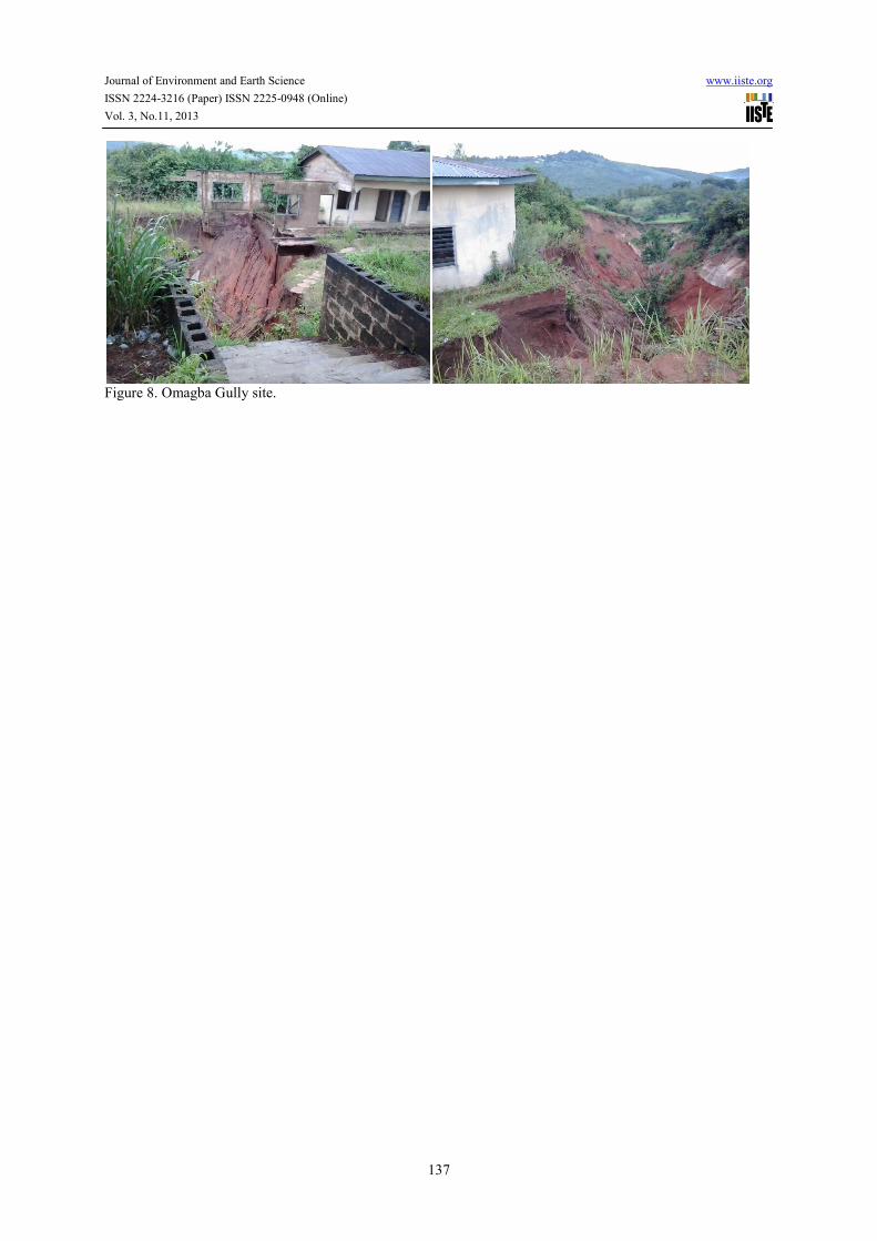
magnitude and consequences( figure 8). For instance there were cases in the area of study where it was reported
that farmers from a certain community returned from farm a certain day only to realize that their houses have
been washed away following a heavy downpour and the flood that resulted from the rain created a deep gully
that buried the houses of the farmers, and washed some away.
Generally erosion occurs when raindrops, rainy seasons’ runoff, or floodwaters wear away and transport soil
particles. It is a complex natural process that has often been accelerated by human activities such as land
clearance, agriculture, construction, surface mining, and urbanization.
1.1 Types of Erosion
There are many types of erosion and mentioned here are a few of them, which include: Sheet erosion, Rill
erosion, Valley or stream erosion and Gully erosion. Gully erosion, being the main topic of the discus, results
where water flows along a linear depression eroding a trench or gully. This is the type that is more predominant
in the area of study and it’s environ. It is particularly noticeable in the formation of hollow ways where prior to
being tarmacked, an old rural road has over many years become significantly lower than the surrounding fields.
It usually begins gradually, being initially insignificant, and graduates into an unimaginable monstrous
dimension of momentous consequences when ignored. In its developmental stage, it might be in form of a
shallow depression following the line of a footpath, but would sooner grow and expand in both depth and bounds
into a gruesome gully.
1.1.1 Causes of gully erosion
The likely causative factors of gully erosion could be either natural or anthropogenic sources
Natural factors include:
1. Nature of soil. Some soils have high erodibilty factors hence susceptible to high rate of erosion while
some soils have very low erodibilty factors and as such low rate of erosion.
2. Topography of terrain. Rugged and steep terrains with high slope are more likely to experience high
gully erosion rate than flat terrain. This is so because flood, which is an agent of soil erosion increases
in velocity with high slope than on flat terrain thereby acquiring greater momentum to move displaced
soil particles from one place to another.
3. Amount of precipitation results in high volume of rainfall, which is one of the major factors of gully
erosion. The higher the amount of rainfall, the higher the quantity of soil particles that are dissolved,
displaced and moved away. High precipitation amounts to high level of flood in most areas. Some areas
experience higher precipitation than others.
CORE Metadata, citation and similar papers at core.ac.uk
Provided by International Institute for Science, Technology and Education (IISTE): E-Journals
Journal of Environment and Earth Science www.iiste.org
ISSN 2224-3216 (Paper) ISSN 2225-0948 (Online)
Vol. 3, No.11, 2013
130
4. Land cover. Availability of tree canopies and some plants naturally break the effects of direct raindrops
on the soil on the one hand and reduce the velocity of flood and its consequences on the soil on the
other. Areas without these natural protections, experience high level of erosion and subsequent gullies.
Anthropogenic factors include:
1. Construction projects. Actions carried out both during and after construction such as grading, clearing,
and other activities that disturb the surface of the soil, alter existing topography, and remove existing
vegetation, can increase erosion potential during construction.
2. Urbanization involving road construction, building development, etc., contribute immensely to gully
sites development.
3. Sand excavation. Sand excavation along the sides of the roads by individuals who obtain permission to
carry out such excavation contribute to gully developments within the region of study.
4. Quarrying and mining activities. Abandoned pits as a result of mining activities over a long period of
time develop into gullies.
5. Increase in the areas covered by pavements and structures and a failure to incorporate into the
construction design, control measures that adequately stabilize slopes, re-establish cover on exposed
soils, or convey runoffs, can increase erosion long after construction is completed.
6. Poor construction e.g. of roads without adequate provision of drainage to rightly direct the runoffs.
7. Some other causative factors are cattle grazing, deforestation, and bad farming habits of the people and
so on.
1.1.2 Effects of erosion
The overbearing effects of erosion on the environment of the host areas cannot be emphasized. Apart from being
a major source of land degradation, it has been categorized as one of the major causes of environmental disaster
in the state and its environs. One of these effects includes the formation of gullies. As the erosion continues to
remove soil along drainage lines, the affected areas continue to deepen. The end results over a long period of
years are deep gullies, which continue to enlarge if no measure is taken to check it. The monstrous nature of
gullies are such that they continue to enlarge and deepen that some have gone as deep as over 100m and these
have resulted in the following
i. Displacement of communities/settlements. For example some communities in some sections of
Anambra State have been displaced by gully erosion. A typical case is that of Umuchiana
community near Ekwulobia in Anambra State where the entire community were completely
displaced in 2006 due to the expansion of gully sites. a similar case happened in Umuchu
community in Njaba area of a neighbouring Imo State. (Igbokwe et al. 2008).
ii. Destruction of Natural Habitat. Gullies are so devastating that they destroy the natural habitat
thereby affecting the flora and fauna in the area.
iii. Destruction of houses. Cracking of houses and falling of buildings into gully sites are common
features in the area. People have lost their investments to gully expansion in areas like Agulu,
Nanka, Nnewi, etc., including the study erosion site at Omagba II Onitsha.
iv. Sedimentation. One of the consequences of gully erosion is the resultant sedimentation. This is
because as the soil is being eroded from one area caused by water runoff, it is being deposited in
other areas as sediments (Firouzabadi & Davoodi. 2004). This has resulted in the disappearance of
some streams and rivers within the zone.
v. Land Degradation: this is one of the worst environmental problems facing many people worldwide.
Over 40million are affected in Nigeria (Uchegbu, 2002). It is the general and gradual reduction of
land value mainly as a result of some unhealthy anthropogenic activities on the land. When top
soils are washed away by erosion, the soil looses values due to the washing away of soil nutrients
by water. Also gullies on their own part create trenches and deep holes that suddenly cut off large
portions of lands thereby degrading the values of such lands.
vi. Damage to Infrastructure. Some infrastructures such as roads and concrete drainages have been
broken down and some communities completely cut off.
2.0 Aim and Objectives of the Study
This study is aimed at describing the role of surveying and mapping in the management and control of gully
erosion. Attempt to realize this was carried out with the following objectives in mind:
1. To explain how survey method was used for the field data capture.
2. Use of remote sensing technique to acquire and process terrain data
3. Data processing and analysis technique using geo-processing software
Journal of Environment and Earth Science www.iiste.org
ISSN 2224-3216 (Paper) ISSN 2225-0948 (Online)
Vol. 3, No.11, 2013
131
3.0 Literature Review/Theoretical Framework Advancements in geospatial technology, especially developments in both hardware and software components of
GIS, remote sensing and field survey equipment have revolutionalized the data acquisition, processing,
interpretation and presentation methods (Ghilani and Wolf, 2008., Kavanagh, 2006). According to Zinck et al,
(2001), remote sensing data offer promising possibilities for identification and monitoring of gullies. While
Kheir et al, 2008, also agreed that GIS and remote sensing through the application of its structural classification
techniques and decision-tree modelling is very good for erosion risk mapping.
In order to determine the DEM of the erosion catchment in their study, Daba et al, (2003), used the stereo pairs
of the digitized aerial photos. Gully boundaries and break lines were measured using DTM and feature collection
functionalities. Gully profiles were demarcated by positioning straight lines at regular intervals along the gully
length. Then the gully sections were defined as portions of a gully between neighbouring profiles. By applying
the relevant software, the gully volume was computed for every gully section. In order to generate topographic
parameters and DEM used in the erosion models for computation of soil loss, contour of the topographic maps
were digitized and integrated into GIS (Mitasova et al, 1996 and Rinos et al, )
Field survey techniques were also employed in the measurement of gully depths, width and lengths for the
computation of volume of soil displaced (Daba et al, 2003)
3.1 The Study Area
New Heritage I and II Omagba phase2 erosion sites as they are called are located towards the north-eastern part
of the commercial city of Onitsha in Anambra State south-east Nigeria. Its’ geographical location is 6o 09’N and
6o 49’E. The South-East lies within Awka-Orlu uplands and Enugu-Awgwu-Okigwe escarpment where gully
erosion is a general problem. The sites are situated along Nkpor-Onitsha axis with a high population density
hence heavy pressure on the land resources. The area is characterized by high rainfall, highly erodible soils and
undulating topography. Muoghalu and Okonkwo (2004) assert that being very close to Awka falls within the Imo
shale group. The area is predominantly sandy/clay with sand ranging from 58% to 80% in places. The two
erosion sites in the study are within two overlapping catchments with the gully heads expanding and cutting the
Enugu-Onitsha express way. One of the sites, the New Heritage II stretches approximately 1400m discharging
into Nkisi River, a tributary of the River Niger.
4.0 Materials and Methods
4.1 Materials
For data acquisition the following equipment were used:
1. Dual frequency post-processing GPS 1200 by Leica. Which has Geodetic precision
2. Leica (TPS) 1200 Total Station and its Accessories
Data used are as follows:
1m high resolution Satellite Image from Quickbird was used alongside downloaded ASTER-DEM data from
internet. XYZ coordinates data of the gully sites were acquired for cross section and centerline profile, as well as
for horizontal alignment/ Plan view
Software used for the data processing are: ArcGIS 9.3 version and Autodesk Land development desktop LDD
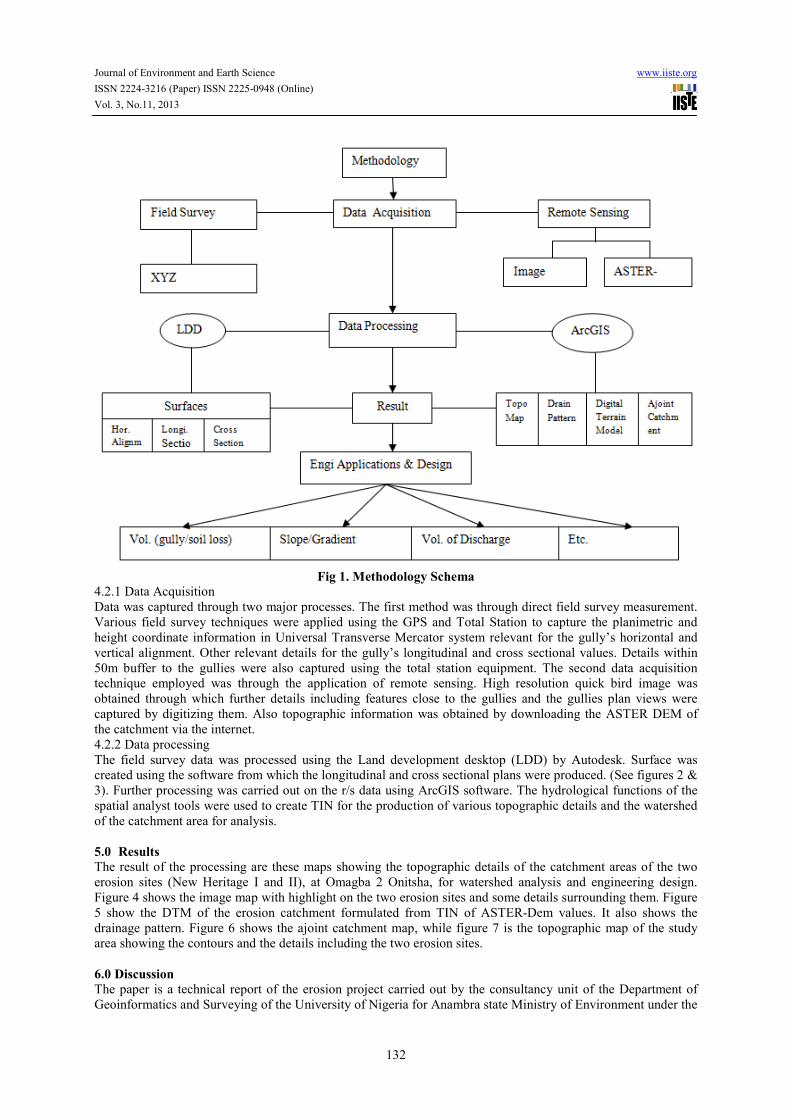
4.2 Methods
The project was accomplished from three basic approaches, which are: the field survey data acquisition method,
data acquisition through internet and remote sensing, and finally data processing for the final results. Fig 4 is the
methods schema
Journal of Environment and Earth Science www.iiste.org
ISSN 2224-3216 (Paper) ISSN 2225-0948 (Online)
Vol. 3, No.11, 2013
132
Fig 1. Methodology Schema
4.2.1 Data Acquisition
Data was captured through two major processes. The first method was through direct field survey measurement.
Various field survey techniques were applied using the GPS and Total Station to capture the planimetric and
height coordinate information in Universal Transverse Mercator system relevant for the gully’s horizontal and
vertical alignment. Other relevant details for the gully’s longitudinal and cross sectional values. Details within
50m buffer to the gullies were also captured using the total station equipment. The second data acquisition
technique employed was through the application of remote sensing. High resolution quick bird image was
obtained through which further details including features close to the gullies and the gullies plan views were
captured by digitizing them. Also topographic information was obtained by downloading the ASTER DEM of
the catchment via the internet.
4.2.2 Data processing
The field survey data was processed using the Land development desktop (LDD) by Autodesk. Surface was
created using the software from which the longitudinal and cross sectional plans were produced. (See figures 2 &
3). Further processing was carried out on the r/s data using ArcGIS software. The hydrological functions of the
spatial analyst tools were used to create TIN for the production of various topographic details and the watershed
of the catchment area for analysis.
5.0 Results
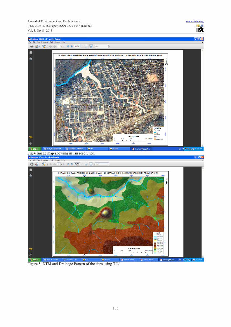
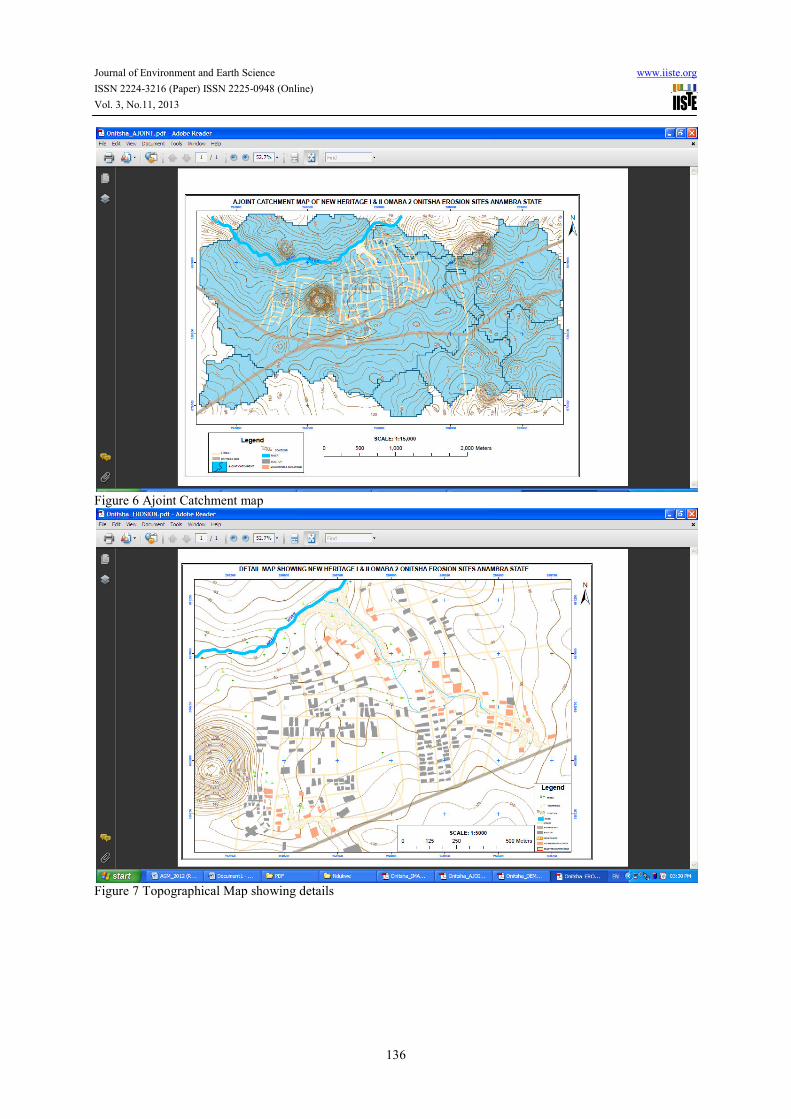
The result of the processing are these maps showing the topographic details of the catchment areas of the two
erosion sites (New Heritage I and II), at Omagba 2 Onitsha, for watershed analysis and engineering design.
Figure 4 shows the image map with highlight on the two erosion sites and some details surrounding them. Figure
5 show the DTM of the erosion catchment formulated from TIN of ASTER-Dem values. It also shows the
drainage pattern. Figure 6 shows the ajoint catchment map, while figure 7 is the topographic map of the study
area showing the contours and the details including the two erosion sites.
6.0 Discussion
The paper is a technical report of the erosion project carried out by the consultancy unit of the Department of
Geoinformatics and Surveying of the University of Nigeria for Anambra state Ministry of Environment under the
Journal of Environment and Earth Science www.iiste.org
ISSN 2224-3216 (Paper) ISSN 2225-0948 (Online)
Vol. 3, No.11, 2013
133
counterpart funding arrangement with the World Bank Newmap erosion project. The maps shown in the above
figures were as a result of the processed data acquired in the field by a team of surveyors from the institution.
These were done in accordance with the job order from the client under the supervision of an erosion engineer.
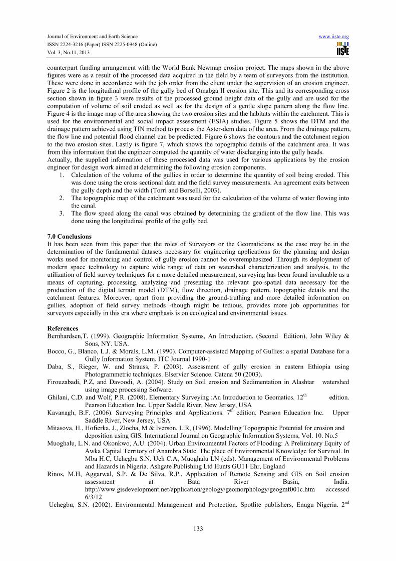
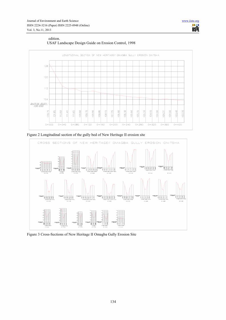
Figure 2 is the longitudinal profile of the gully bed of Omabga II erosion site. This and its corresponding cross
section shown in figure 3 were results of the processed ground height data of the gully and are used for the
computation of volume of soil eroded as well as for the design of a gentle slope pattern along the flow line.
Figure 4 is the image map of the area showing the two erosion sites and the habitats within the catchment. This is
used for the environmental and social impact assessment (ESIA) studies. Figure 5 shows the DTM and the
drainage pattern achieved using TIN method to process the Aster-dem data of the area. From the drainage pattern,
the flow line and potential flood channel can be predicted. Figure 6 shows the contours and the catchment region
to the two erosion sites. Lastly is figure 7, which shows the topographic details of the catchment area. It was
from this information that the engineer computed the quantity of water discharging into the gully heads.
Actually, the supplied information of these processed data was used for various applications by the erosion
engineer for design work aimed at determining the following erosion components.
1. Calculation of the volume of the gullies in order to determine the quantity of soil being eroded. This
was done using the cross sectional data and the field survey measurements. An agreement exits between
the gully depth and the width (Torri and Borselli, 2003).
2. The topographic map of the catchment was used for the calculation of the volume of water flowing into
the canal.
3. The flow speed along the canal was obtained by determining the gradient of the flow line. This was
done using the longitudinal profile of the gully bed.
7.0 Conclusions
It has been seen from this paper that the roles of Surveyors or the Geomaticians as the case may be in the
determination of the fundamental datasets necessary for engineering applications for the planning and design
works used for monitoring and control of gully erosion cannot be overemphasized. Through its deployment of
modern space technology to capture wide range of data on watershed characterization and analysis, to the
utilization of field survey techniques for a more detailed measurement, surveying has been found invaluable as a
means of capturing, processing, analyzing and presenting the relevant geo-spatial data necessary for the
production of the digital terrain model (DTM), flow direction, drainage pattern, topographic details and the
catchment features. Moreover, apart from providing the ground-truthing and more detailed information on
gullies, adoption of field survey methods -though might be tedious, provides more job opportunities for
surveyors especially in this era where emphasis is on ecological and environmental issues.
References
Bernhardsen,T. (1999). Geographic Information Systems, An Introduction. (Second Edition), John Wiley &
Sons, NY. USA.
Bocco, G., Blanco, L.J. & Morals, L.M. (1990). Computer-assisted Mapping of Gullies: a spatial Database for a
Gully Information System. ITC Journal 1990-1
Daba, S., Rieger, W. and Strauss, P. (2003). Assessment of gully erosion in eastern Ethiopia using
Photogrammetric techniques. Elservier Science. Catena 50 (2003).
Firouzabadi, P.Z, and Davoodi, A. (2004). Study on Soil erosion and Sedimentation in Alashtar watershed
using image processing Sofware.
Ghilani, C.D. and Wolf, P.R. (2008). Elementary Surveying :An Introduction to Geomatics. 12th
edition.
Pearson Education Inc. Upper Saddle River, New Jersey, USA
Kavanagh, B.F. (2006). Surveying Principles and Applications. 7th
edition. Pearson Education Inc. Upper
Saddle River, New Jersey, USA
Mitasova, H., Hofierka, J., Zlocha, M & Iverson, L.R, (1996). Modelling Topographic Potential for erosion and
deposition using GIS. International Journal on Geographic Information Systems, Vol. 10. No.5
Muoghalu, L.N. and Okonkwo, A.U. (2004). Urban Environmental Factors of Flooding: A Preliminary Equity of
Awka Capital Territory of Anambra State. The place of Environmental Knowledge for Survival. In
Mba H.C, Uchegbu S.N. Ueh C.A, Muoghalu LN (eds). Management of Environmental Problems
and Hazards in Nigeria. Ashgate Publishing Ltd Hunts GU11 Ehr, England
Rinos, M.H, Aggarwal, S.P. & De Silva, R.P., Application of Remote Sensing and GIS on Soil erosion
assessment at Bata River Basin, India.
http://www.gisdevelopment.net/application/geology/geomorphology/geogmf001c.htm accessed
6/3/12
Uchegbu, S.N. (2002). Environmental Management and Protection. Spotlite publishers, Enugu Nigeria. 2nd
Journal of Environment and Earth Science www.iiste.org
ISSN 2224-3216 (Paper) ISSN 2225-0948 (Online)
Vol. 3, No.11, 2013
134
edition.
USAF Landscape Design Guide on Erosion Control, 1998
Figure 2 Longitudinal section of the gully bed of New Heritage II erosion site
Figure 3 Cross-Sections of New Heritage II Omagba Gully Erosion Site
Journal of Environment and Earth Science www.iiste.org
ISSN 2224-3216 (Paper) ISSN 2225-0948 (Online)
Vol. 3, No.11, 2013
135
Fig.4 Image map showing in 1m resolution
Figure 5. DTM and Drainage Pattern of the sites using TIN
Journal of Environment and Earth Science www.iiste.org
ISSN 2224-3216 (Paper) ISSN 2225-0948 (Online)
Vol. 3, No.11, 2013
136
Figure 6 Ajoint Catchment map
Figure 7 Topographical Map showing details
Journal of Environment and Earth Science www.iiste.org
ISSN 2224-3216 (Paper) ISSN 2225-0948 (Online)
Vol. 3, No.11, 2013
137
Figure 8. Omagba Gully site.
This academic article was published by The International Institute for Science,
Technology and Education (IISTE). The IISTE is a pioneer in the Open Access
Publishing service based in the U.S. and Europe. The aim of the institute is
Accelerating Global Knowledge Sharing.
More information about the publisher can be found in the IISTE’s homepage:
http://www.iiste.org
CALL FOR JOURNAL PAPERS
The IISTE is currently hosting more than 30 peer-reviewed academic journals and
collaborating with academic institutions around the world. There’s no deadline for
submission. Prospective authors of IISTE journals can find the submission
instruction on the following page: http://www.iiste.org/journals/ The IISTE
editorial team promises to the review and publish all the qualified submissions in a
fast manner. All the journals articles are available online to the readers all over the
world without financial, legal, or technical barriers other than those inseparable from
gaining access to the internet itself. Printed version of the journals is also available
upon request of readers and authors.
MORE RESOURCES
Book publication information: http://www.iiste.org/book/
Recent conferences: http://www.iiste.org/conference/
IISTE Knowledge Sharing Partners
EBSCO, Index Copernicus, Ulrich's Periodicals Directory, JournalTOCS, PKP Open
Archives Harvester, Bielefeld Academic Search Engine, Elektronische
Zeitschriftenbibliothek EZB, Open J-Gate, OCLC WorldCat, Universe Digtial
Library , NewJour, Google Scholar