CARPC AGENDA COVER SHEET June 12, 2008 ... - Dane County
71
1 of 2 CARPC AGENDA COVER SHEET June 12, 2008 Executive Summary Item 7 Re: Consideration of Resolution CARPC No. 2008-15 amending the Dane County Land Use and Transportation Plan and the Dane County Water Quality Plan by revising the Central Urban Service Area boundary and environmental corridors in the Hornung Range portion of the City of Madison and Town of Burke Decision Items: 1. Adoption of resolution CARPC No. 2008-15 Staff Comment on Item: The proposed amendment will add 55.8 acres north of Wheeler Road and east of N. Sherman Avenue to the northern part of the Central Urban Service Area. There are 14.7 acres of existing development in the area to be added including tennis courts, a driving range, church property, and road right-of-way. The proposal calls for designation of 15.8 acres of environmental corridors (including 1.2 acres of church property) and redevelopment of the driving range resulting in 20.7 acres of residential development containing 159 residential units, 1.6 acres of neighborhood mixed use development containing 16 multifamily units, 3.4 acres in institutional use (church), 17.6 acres in parks, open space and drainage use, and 12.5 acres of street right-of-way. The 175 new residential units proposed will accommodate an estimated population of 438, including 75 school-aged children. The amendment would be a net addition of 25.3 developable acres to the Central Urban Service Area. Approximately 9 percent of the amendment area (5.2 acres) is currently in the City of Madison and 91 percent (50.6 acres) is in the Town of Burke. Staff Recommendation: The proposed amendment supports many of the goals and objectives of the CARPC and various regional plans. The proposal is part of an agreement which results in an overall reduction of 18.7 acres of developable land in the CUSA in and around Cherokee Marsh, a sensitive and valuable resource. This net reduction would in itself result in a net long-term water quality improvement. However, the reduction is in areas in the current CUSA which date back to the original delineation of urban service areas, and therefore are not held to water quality standards that are specially geared towards the mitigation of the adverse impacts of development on the Marsh. Therefore, the removal of these developable areas results in a double water quality bonus of preventing development which would be subject only to minimum stormwater standards. The conservation and restoration plans proposed as part of the overall plan for the Marsh include extensive wetland conservation acreage purchase and restoration as well as upland conservation acreage and restoration to native vegetative cover. Taken as a comprehensive package, these actions will result in significant improvements in water quality and habitat health. Since the entire plan and associated conservation activities and acquisitions are contingent on the approval of the proposed USA amendment, and since this is the result of lengthy negotiations between the developer/property owner and the City of Madison, staff recommends approval of the amendment based on the plans, services, land uses, and conservation activities outlined in the Cherokee Special Area Plan 2007, and based on the City of Madison submittal, and conditioned on the City pursuing the following:
-
Upload
khangminh22 -
Category
Documents
-
view
1 -
download
0
Transcript of CARPC AGENDA COVER SHEET June 12, 2008 ... - Dane County

1 of 2
CARPC AGENDA COVER SHEET June 12, 2008 Executive Summary Item 7
Re: Consideration of Resolution CARPC No. 2008-15 amending the Dane County Land
Use and Transportation Plan and the Dane County Water Quality Plan by revising the Central Urban Service Area boundary and environmental corridors in the Hornung Range portion of the City of Madison and Town of Burke
Decision Items:
1. Adoption of resolution CARPC No. 2008-15
Staff Comment on Item: The proposed amendment will add 55.8 acres north of Wheeler Road and east of N. Sherman Avenue to the northern part of the Central Urban Service Area. There are 14.7 acres of existing development in the area to be added including tennis courts, a driving range, church property, and road right-of-way. The proposal calls for designation of 15.8 acres of environmental corridors (including 1.2 acres of church property) and redevelopment of the driving range resulting in 20.7 acres of residential development containing 159 residential units, 1.6 acres of neighborhood mixed use development containing 16 multifamily units, 3.4 acres in institutional use (church), 17.6 acres in parks, open space and drainage use, and 12.5 acres of street right-of-way. The 175 new residential units proposed will accommodate an estimated population of 438, including 75 school-aged children. The amendment would be a net addition of 25.3 developable acres to the Central Urban Service Area. Approximately 9 percent of the amendment area (5.2 acres) is currently in the City of Madison and 91 percent (50.6 acres) is in the Town of Burke. Staff Recommendation: The proposed amendment supports many of the goals and objectives of the CARPC and various regional plans. The proposal is part of an agreement which results in an overall reduction of 18.7 acres of developable land in the CUSA in and around Cherokee Marsh, a sensitive and valuable resource. This net reduction would in itself result in a net long-term water quality improvement. However, the reduction is in areas in the current CUSA which date back to the original delineation of urban service areas, and therefore are not held to water quality standards that are specially geared towards the mitigation of the adverse impacts of development on the Marsh. Therefore, the removal of these developable areas results in a double water quality bonus of preventing development which would be subject only to minimum stormwater standards. The conservation and restoration plans proposed as part of the overall plan for the Marsh include extensive wetland conservation acreage purchase and restoration as well as upland conservation acreage and restoration to native vegetative cover. Taken as a comprehensive package, these actions will result in significant improvements in water quality and habitat health. Since the entire plan and associated conservation activities and acquisitions are contingent on the approval of the proposed USA amendment, and since this is the result of lengthy negotiations between the developer/property owner and the City of Madison, staff recommends approval of the amendment based on the plans, services, land uses, and conservation activities outlined in the Cherokee Special Area Plan 2007, and based on the City of Madison submittal, and conditioned on the City pursuing the following:

2 of 2
1. Submit a detailed stormwater management plan for CARPC and DCL&WCD staff review and approval prior to any land disturbing activities in the amendment area. The stormwater management plan should include the following:
• Control rates of runoff for all storms up to and including the 10-year event at predevelopment levels and divert these events away from the marsh
• Maximize infiltration • Prevent increased erosion • Consider the use of polymers during the construction phase of development • Prevent discharge of nutrients into the Marsh • Provide stormwater quality ponds for all developed areas within the amendment
area 2. Work with WDNR Bureau of Endangered Resources to identify needed protective
measures for threatened and endangered resources near the amendment area, and implement these protective measures as part of site design (including increased buffers if necessary).
3. Maintain wetland buffer areas as no-mow, no fertilizer, no pesticide zones with native
vegetation (prairie grasses) within 75 feet of the wetland edge to prevent discharge of nutrients into the Marsh.
It is also recommended that an on-the-ground archaeological survey be conducted by a qualified archaeologist prior to other land disturbing activities and two copies of the survey report be submitted to the CARPC.
Materials Presented with Item:
1. Staff Analysis dated June 5, 2008 2. Comments received on the amendment request 3. Draft Resolution CARPC No. 2008-15
Contact for Further Information:
Kamran Mesbah, Deputy Director 266-9283 [email protected]

1
6/5/08
Staff Analysis of Proposed Amendment to the Dane County Land Use and Transportation Plan and Water Quality Plan, Revising the
Central Urban Service Area Boundary and Environmental Corridors in the Hornung Range Portion of the City of Madison and Town of Burke
1. Applicant: City of Madison
2. Description of Proposal
The proposed amendment will add 55.8 acres north of Wheeler Road and east of N. Sherman Avenue to the northern part of the Central Urban Service Area (see Maps 1 and 2). There are 14.7 acres of existing development in the area to be added including tennis courts, a driving range, church property, and road right-of-way. The proposal calls for designation of 15.8 acres of environmental corridors (including 1.2 acres of church property) and redevelopment of the driving range resulting in 20.7 acres of residential development containing 159 residential units, 1.6 acres of neighborhood mixed use development containing 16 multifamily units, 3.4 acres in institutional use (church), 17.6 acres in parks, open space and drainage use, and 12.5 acres of street right-of-way (see Maps 3a and 3b). The 175 new residential units proposed will accommodate an estimated population of 438, including 75 school-aged children. The amendment would be a net addition of 25.3 developable acres to the Central Urban Service Area. Approximately 9 percent of the amendment area (5.2 acres) is currently in the City of Madison and 91 percent (50.6 acres) is in the Town of Burke.
Table 1: Central Urban Service Area, Cherokee Neighborhood Requested by the City of Madison
Proposed Density (units/acre) Total % of Housing No. of No. of Existing Environ. Develop-Land Use Proposal CUSA ( ac.) Total Units Persons Students Develop. Corridor able Residential 7.7 4.2 20.7 37% 159 402 72 0.0
Neighborhood Mixed Use 10.0 14.5 1.6 3% 16 36 3
Residential Total 7.8 6.6 22.3 40% 175 438 75 0.0 Institutional 3.4 6% 4.6 Park, Open Space, Drainage 17.6 32% 8.4 15.8 Street R-O-W 12.5 22% 1.7
TOTAL 55.8 100% 175 438 75 14.7 15.8 25.3
5.2 acres in City of Madison & 50.6 acres in Town of Burke
Source: City of Madison Planning Submittal and CARPC

N S
herm
an A
venu
e
Wheeler Road
Dennis Drive
Fiel
dsto
ne L
ane
P ac k
ers
Ave
nue
Larr
y L a
n e
Expr
e ss
Circ
le
51
51
151113
113
CV
CV
CentralUSA
AmendmentArea
Prepared by staffof the CARPC.
6 June 2008
Feet\
5000
Map 1Amendment to theCentral Urban ServiceArea and EnvironmentalCorridors in the Town ofBurke & City of Madison
Town ofBurke
City ofMadison
Proposed Urban Service Area Boundary
Existing Environmental CorridorIncorporated AreaExisting Urban Service Area Boundary
Service Area to be added (55.8 acres)Proposed Environmental Corridor (15.8 acres)

N S
herm
an A
venu
e
Wheeler Road
Dennis Drive
Fiel
dsto
ne L
ane
P ac k
ers
Ave
nue
Larr
y L a
n e
Expr
e ss
Circ
le
Prepared by staffof the CARPC.
6 June 2008
Feet\
5000
Map 2 2005 Aerial PhotographAmendment to theCentral Urban ServiceArea and EnvironmentalCorridors in the Town ofBurke & City of Madison
Town ofBurke
City ofMadison
Proposed Urban Service Area Boundary
Existing Environmental CorridorExisting Urban Service Area Boundary
Service Area to be added (55.8 acres)Proposed Environmental Corridor (15.8 acres)

N S
herm
an A
venu
e
Wheeler Road
Pack
ers
Aven
ue
Anhalt Drive
Mayfield Lane
Wyoming Way
Dako
ta D
rive
Delaware Boulevard
Texa
s Tr
ail
Rig
ney
Lane
Dennis Drive
Pond Street
Dovetail Drive
Arizona PassGulseth Street
Esch
Lan
eComanche Glen
Prai
rievi
ew D
rive
Fiel
dsto
ne L
ane
Whi
teta
il La
ne
Arkansas AvenueLa
rry L
a ne
Iowa Drive
Doe
Cr o
s si n
g Tr
a il
Prepared by staffof the CARPC.
6 June 2008
Feet\
7500
Map 3A Planned Land UseAmendment to theCentral Urban ServiceArea and EnvironmentalCorridors in the Town ofBurke & City of Madison
Town ofBurke
City ofMadison
Plan Boundary
Incorporated Area
Agriculture
Cemetery
Commercial Forest
Commercial Sales or Services
Communications or Utilities
Extractive
Industrial
Institutional or Governmental
Multi-Family
Open Land
Outdoor Recreation
Right of Way
Single Family
Transportation
Two Family
Under Construction
Vacant
Water
Woodland

m:/a
rc/a
vdat
a/c_
plan
/per
iper
al n
eigh
borh
ood
plan
s/ch
erok
ee/c
hero
kee
spec
ial a
rea
plan
map
s/cu
rren
t sap
map
s/m
ap 9
a
DELAWARE BLVD. N. S
HE
RM
AN A
VEN
UE
PAC
KE
RS
AVE
NU
E
WhitetailRidgePark
SaintPeter'sCatholicChurch
CherokeeCountry
Club
Cherokeeolf Course
N.S
HER
MA
HO
LLO
WR
IDG
E
ANHOLT DR.
(5)
ExistingMulti-FamilyResidential
rsary
WHEELER ROAD C.T.H. CV
DENNIS DR.
FIEL
DST
ON
E L
A.
(2)
(2)
(2)(2)
ExistingMulti-FamilyResidential Existing
Industrial
FutureEmployment
DOVETAIL DR.(4)
(3)
(6)
(2)
PotentialTrail Connection toInternational Lane
0 500 1,000
Feet
City of MadisonDept of Planning and Development, Planning Unit
Data Source:City of Madison, Dept. of Planning and Development
Cherokee Special Area Plan
January 2007
RECOMMENDED LAND USE
Last edited: January 24,2007*
1
3
2(2) A variety of type and size of structure is sought in these areas.
(3) Smaller scale structures are sought in these areas.
(4) Street alignment planning will continue to examine a connection to Packers Avenue at Dovetail Drive as a preferred option.
(5) Single-family detached housing is recommended for this area.
(6) The St. Peter's Church institutional use will continue. Should portions redevelop, residential at 8-15 dwelling units per net acre is recommended.
STUDY AREA
CORE PLANNING SUB-AREAS
RESIDENTIAL Low Density Residential Density Range (<8 du/net ac) Density Range (8-15 du/net ac)
Medium Density Residential (16-25 du/net ac)
COMMERCIAL/EMPLOYMENT/MIXED USE Neighborhood Mixed Use
Industrial
Employment
Cherokee Country Club
INSTITUTIONAL
PARK, OPEN SPACE, ANDSTORMWATER MANAGEMENT Park Drainage and Open space
Golf Course
Proposed Stormwater Detention
POTENTIAL FUTURE DEVELOPMENT AREA
LAND USE NOTES
STREET ROW (Public and Private)
SPECIAL FEATURES Runway Protection Railroad Realignment Cherokee Marsh Cons. Park Access Road Trail/Emergency Access Road Exisitng Bike Routes Proposed Routes,Paths and Trails
Map 3b

6
3. Existing Environment Natural Resources. The proposed project borders and also drains directly into Cherokee marsh. Cherokee Marsh is the largest remaining wetland in Dane County and the major wetland in the Lake Mendota watershed, in the Lower Rock River Basin. As part of a wetlands inventory for the region conducted in 1974 (as part of the initial resource inventory for the Water Quality Plan), Bedford and Zimmerman classified Cherokee Marsh as a Group I Wetland. These are among the best in the county and, in some cases, the best in Southern Wisconsin, and are slated for protection. In 1976 the state designated the Marsh as a State Natural Area. A plant and animal survey in 1973 indicates that there is a large diversity of wildlife in this 4,000 acre complex of wetland and upland communities. A Long Range Cherokee Marsh Open Space Plan was developed in 1981 by the City of Madison. Much of the wetland is now held in public ownership as the 1981 plan has been implemented. The area of the wetland adjacent to the proposed project is identified as shrubs, sedge meadow, and shallow marsh. The project also drains to sections indicated by the Wisconsin Bureau of Endangered Species as having terrestrial and aquatic endangered species or communities. The site also borders the Cherokee Marsh Natural Area identified in the Dane County Parks and Open Space Plan. All local and regional land use plans affecting Cherokee Marsh recognize it as a major open space area. One purpose of the Long Range Cherokee Marsh Open Space Plan was to identify the boundary of land which is intended to permanently remain as open space and have that boundary recognized by all current and future plans for the area. Three alternatives were considered as part of the plan:
1. Wetland only 2. Roadway to Roadway (River Rd. to CTH CV); and 3. Wetland Plus Critical Upland.
The third alternative was chosen because it was deemed more protective than (1) and less expensive and intrusive than (2). The site plan for the amendment area provides for a wetland buffer of 200 feet, with much wider buffers provided for most of the wetland’s edge. This is captured by the proposed Environmental Corridors and rear yards. This is the only Plan recommendation pertinent to the amendment area. The Plan recommendations have primarily to do with public use/acquisition/easements, which have slowly been implemented over the years. The current proposal is consistent with Plan implementation goals. A 350 acre portion of Cherokee Marsh is a State Natural Area (No. 130). The description for this Natural Area is as follows: “Cherokee Marsh is part of an extensive wetland complex of more than 2,000 acres. The north portion has been classified as a fen although it contains species characteristic of low prairies, shrub-carr, bogs, and sedge meadows. Southward are areas of shrubby meadow where about half of the cover is bog birch, willows, and dogwood. Most of the southern portion has been ditched. In several areas dried by the ditching, the community composition is more like wet prairie. Some areas along the southwest and southeast borders are quite disturbed with canary grass or nettles dominating. The hydrology of the area is complex as evidenced by the changing community structure on level topography. The site is used by many species of mammals, amphibians, reptiles, and birds.

7
Management activities include brushing, burning, and re-establishing normal hydrological systems. Cherokee Marsh is owned jointly by the City of Madison and the DNR and was designated a State Natural Area in 1976.” The Parks and Open Space Plan designates over 3,700 acres of the Marsh as a Natural Resource Area. The Plan describes the Natural Resource Area as follows: “CHEROKEE MARSH Natural Resource Area (City of Madison, Towns of Burke, Windsor, and Westport, 3721.7 acres). For the purposes of this planning report, the Cherokee Marsh project area includes the historic boundaries west of Interstate 90-94 and east of STH 113. Public ownership is a mixture of City of Madison, Dane County, and WDNR owned lands. The City of Madison has been conducting extensive vegetation and wetland management efforts on the south side of the Yahara River. Dane County has been working on removal of invasive species and prairie restoration on the north side of the river. Recommendations:
• Explore creation of a land based trail that provides connections to Token Creek Park and the Upper Yahara River Natural Resource Area.
• Continue vegetation management practices. • Investigate allowing hunting on County lands adjacent to WDNR public hunting
grounds where compatible with other park uses.”
The Wetlands of Dane County Report, commissioned by the Dane County Regional Planning Commission, identifies significant off-site restoration that could be accomplished through the donation of property (plugging ditches, etc.). These restoration opportunities have been detailed in the City of Madison’s proposed restoration plan description associated with the acquisition agreement related to this development and amendment. Overall the Cherokee Marsh is an important site but, except for the 200 foot buffer, most of the recommendations are targeted to protecting the critical mass or core (e.g., fens, public acquisition, etc.) and not targeted to preventing development along the edges (areas of the marsh which have already been largely impacted). This project includes the public acquisition of property in more sensitive/critical areas of the marsh, creating a net positive water quality and habitat impact for the Marsh.
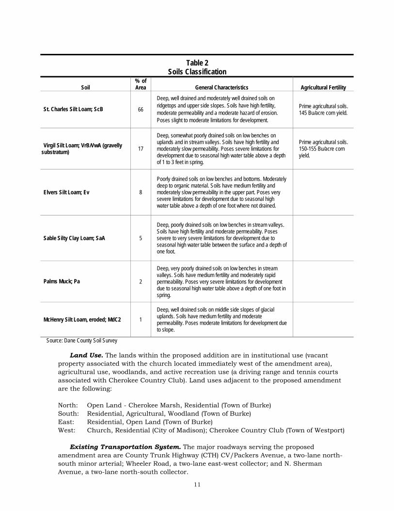
Depth to groundwater is 0 to 3 feet in the northern part of the amendment area closest to Cherokee Marsh, generally in the area proposed for environmental corridors. In the remainder of the amendment area depth to groundwater is 3 to 6 feet. Depth to sandstone bedrock is over 50 feet throughout the amendment area. The soils of the amendment area are in the Dodge-St. Charles-McHenry Association. These soils are well drained and moderately well drained deep silt loams underlain by sandy loam glacial till. Eighty-four (84%) percent of the amendment area contains prime agricultural soils. Table 2 summarizes the soil characteristics of the area and Maps 4 and 5 show the details of soil limitations and types. The Wisconsin Architecture and History Inventory of the State Historical Society includes a stone house located immediately west of the amendment area, on the church property. Staff site visit has revealed that the house has been razed. The SHS recommends an on the ground archaeological survey of the amendment area prior to other land disturbing activities (letter attached).

N S
herm
an A
venu
e
Wheeler Road
Dennis Drive
Fiel
dsto
ne L
ane
P ac k
ers
Ave
nue
Larr
y L a
n e
Expr
e ss
Circ
le
Prepared by staffof the CARPC.
6 June 2008
Feet\
5000
Map 4 Soil LimitationAmendment to theCentral Urban ServiceArea and EnvironmentalCorridors in the Town ofBurke & City of Madison
Town ofBurke
City ofMadison
Proposed Urban Service Area BoundaryExisting Urban Service Area Boundary
Prime Farmland (46.7 acres)Severe Limitations to Development (18.9 acres)

ScB
VrB
Ev
SaA
Pa
VwA
BbA
ScB
MdC2
MdC2
N S
herm
an A
venu
e
Wheeler Road
Dennis Drive
Fiel
dsto
ne L
ane
P ac k
ers
Ave
nue
Larr
y L a
n e
Expr
e ss
Circ
le
Prepared by staffof the CARPC.
6 June 2008
Feet\
5000
Map 5 Soil TypeAmendment to theCentral Urban ServiceArea and EnvironmentalCorridors in the Town ofBurke & City of Madison
Town ofBurke
City ofMadison
Proposed Urban Service Area BoundaryExisting Urban Service Area Boundary

N S
herm
an A
venu
e
Wheeler Road
Dennis Drive
Fiel
dsto
ne L
ane
P ac k
ers
Ave
nue
Larr
y L a
n e
Expr
e ss
Circ
le
CV
Prepared by staffof the CARPC.
6 June 2008
Feet\
5000
Map 6 ElevationAmendment to theCentral Urban ServiceArea and EnvironmentalCorridors in the Town ofBurke & City of Madison
Town ofBurke
City ofMadison
100 Foot Interval
20 Foot Interval
4 Foot Inverval
Existing Service Area
Service Area to be Added
11
Table 2 Soils Classification
Soil % of Area General Characteristics Agricultural Fertility
St. Charles Silt Loam; ScB 66
Deep, well drained and moderately well drained soils on ridgetops and upper side slopes. Soils have high fertility, moderate permeability and a moderate hazard of erosion. Poses slight to moderate limitations for development.
Prime agricultural soils. 145 Bu/acre corn yield.
Virgil Silt Loam; VrB/VwA (gravelly substratum) 17
Deep, somewhat poorly drained soils on low benches on uplands and in stream valleys. Soils have high fertility and moderately slow permeability. Poses severe limitations for development due to seasonal high water table above a depth of 1 to 3 feet in spring.
Prime agricultural soils. 150-155 Bu/acre corn yield.
Elvers Silt Loam; Ev 8
Poorly drained soils on low benches and bottoms. Moderately deep to organic material. Soils have medium fertility and moderately slow permeability in the upper part. Poses very severe limitations for development due to seasonal high water table above a depth of one foot where not drained.
Sable Silty Clay Loam; SaA 5
Deep, poorly drained soils on low benches in stream valleys. Soils have high fertility and moderate permeability. Poses severe to very severe limitations for development due to seasonal high water table between the surface and a depth of one foot.
Palms Muck; Pa 2
Deep, very poorly drained soils on low benches in stream valleys. Soils have medium fertility and moderately rapid permeability. Poses very severe limitations for development due to seasonal high water table above a depth of one foot in spring.
McHenry Silt Loam, eroded; MdC2 1 Deep, well drained soils on middle side slopes of glacial uplands. Soils have medium fertility and moderate permeability. Poses moderate limitations for development due to slope.
Source: Dane County Soil Survey
Land Use. The lands within the proposed addition are in institutional use (vacant property associated with the church located immediately west of the amendment area), agricultural use, woodlands, and active recreation use (a driving range and tennis courts associated with Cherokee Country Club). Land uses adjacent to the proposed amendment are the following:
North: Open Land - Cherokee Marsh, Residential (Town of Burke) South: Residential, Agricultural, Woodland (Town of Burke) East: Residential, Open Land (Town of Burke) West: Church, Residential (City of Madison); Cherokee Country Club (Town of Westport) Existing Transportation System. The major roadways serving the proposed amendment area are County Trunk Highway (CTH) CV/Packers Avenue, a two-lane north-south minor arterial; Wheeler Road, a two-lane east-west collector; and N. Sherman Avenue, a two-lane north-south collector.

12
Two regular Metro Transit fixed-routes, Routes 24 and 29, serve the proposed amendment area. Route 24 provides peak period service to the North Transfer Point (inbound a.m., outbound p.m.) and Dane County Airport (outbound a.m., inbound p.m.). Route 29 provides peak period limited-stop commuter service to downtown and the UW-Madison campus area. Metro also provides supplemental school day service to the area, which is designed primarily to transport students to Madison East High School. The Madison Area Transportation Planning Board’s Rideshare Etc. Program provides ride-matching services for individuals interested in car-pooling or vanpooling. Dane County also contracts with a private provider, Transit Solutions, for limited group ride service for the elderly and persons with disabilities to nutrition sites, senior center activities, adult day care, and shopping. The Retired Senior Volunteer Driver Escort Program (RSVP) uses volunteer drivers to provide individual rides for the elderly, primarily to medical appointments.
Bicycle travel is accommodated through shared use of roadways with motor vehicles. N. Sherman Avenue is a designated bicycle route and is considered suitable for most bicyclists. CTH CV/Packer Avenue and Wheeler Road currently have rural cross-sections without sidewalks. N. Sherman Avenue has sidewalk on the developed west side of the street.
4. Consistency or Conflict With Adopted Plans and Policies The proposal is consistent with the Cherokee Special Area Plan (adopted by the Madison Common Council on January 16, 2007) and the City of Madison Comprehensive Plan. The proposal also supports the Dane County Parks and Open Space Plan by facilitating the protection of the Cherokee Marsh State Natural Area. The amendment area is identified in the Town of Burke, Village of DeForest, City of Sun Prairie, and City of Madison Cooperative Plan as an area that will eventually be brought into the City of Madison. Analysis of 2030 land demand, based on 2006 population data, indicated that the Central Urban Service Area needed an additional 1,865 developable acres to accommodate the anticipated 2030 land demand. Since that calculation the CUSA has been amended five times (twice in the City of Middleton, twice in the Town of Burke, and once in the City of Madison), adding a total of 48.3 developable acres and reducing the 2030 land demand to 1,816.7 acres. The proposed amendment would add 25.3 developable acres. It should be noted that the agreement between the City of Madison and Cherokee Park Inc. (CPI) would result in the purchase of 44 acres of currently developable land within the CUSA for conservation (potentially to be designated as environmental corridors). Therefore, the net effect will be a reduction of net developable acres by 18.7 acres. This amendment is a key component in the implementation of the Cherokee Special Area Plan. A Memorandum of Understanding between the City of Madison and CPI describes the understanding between the two parties regarding the City’s proposed acquisition of approximately 330 acres of marshland and uplands from Cherokee Park, Inc. The Memorandum of Understanding allows CPI to withdraw from the acquisition and transfer of lands to the City if development approvals are withheld on several planned development areas, including the amendment area. The fee simple and conservation easement acquisitions of the marshland and uplands would provide significant benefit to the Cherokee Marsh area and the entire region, permanently protecting large areas of marsh and uplands from development. In addition, a portion of the acquisition will provide space for the city to retrofit stormwater management practices in areas that had no requirement

13
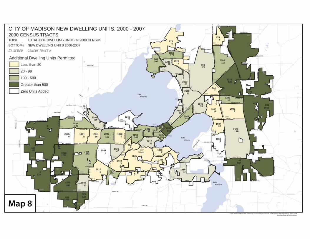
for stormwater management when platted in the 1960s. Installation of retrofit stormwater management measures will greatly improve the water quality of the runoff from these areas. The offer by the developer to sell other, more critical lands in exchange for the right to develop other, less critical lands falls well within the scope and spirit of the Cherokee Marsh Plan and actually does much to help implement the plan’s goals and objectives. The proposed amendment is a logical expansion of the urban service area. The amendment area is adjacent to the existing urban service area on the east, south and west sides, and fills in a “notch”. Services can be provided from existing facilities surrounding the amendment area. Overall, the amendment supports five CARPC goals. The proposal promotes the development of balanced communities by including a mixed neighborhood development component in the amendment area. The 1.6 acre mixed-use area included in the plan is intended to accommodate uses such as neighborhood retail, service or office as well as 16 multifamily residential units. The proposed development also supports the CARPC goal of promoting compact urban development. The residential density proposed is 7.8 units per acre, significantly exceeding the existing residential density in the CUSA of 6.6 units per acre. The combination of residential development of varying densities, including multifamily units, proposed for the development supports the CARPC goal of providing a full range of safe and affordable housing opportunities. The CARPC goal of developing and promoting a county-wide system of open space corridors as a framework to protect the natural environment and scenic values and to provide outdoor recreation opportunities is supported by the designation of 15.8 acres of environmental corridors which serve to protect Cherokee Marsh and provide recreational opportunities. The agreement between the developer and the City of Madison which results in an additional 330 acres of wetlands and upland acquisition for the Cherokee Marsh Open Space area also significantly furthers this goal. Finally, the amendment supports the CARPC goal of conserving and restoring water resources in the region by facilitating the protection and preservation of 330 acres of marshland and adjacent upland, including a wooded hill in the amendment area. The proposal has significant water quality and wetland resource benefits. Almost 84 percent of the amendment area is composed of prime agricultural soils and 23 acres of the area is under cultivation. However, the agricultural area is small and surrounded by existing development and Cherokee Marsh, limiting the viability of the agricultural use of the area other than for urban agriculture. The City of Madison has been very active in infill and redevelopment, supporting this objective of the RPC and the state Comprehensive Planning Law. Map 7 shows downtown redevelopment projects as of December 2007. Map 8 shows new dwelling units in the City of Madison, showing the infill and redevelopment residential units which have been built between 2000 and 2007 in the Isthmus and the near east and near west sides of the city, adding over 3,000 dwelling units in these older parts of the city. The proposed amendment satisfies the service area and infrastructure contiguity guidelines of the CARPC.

Map 7
BALZER RD
CEN TU RY A V E
SOO LINE RR
COMMERCIALMENDOTA
SOO LINE RRS S
TOU
GH
TON
RD
MILWAUKEE ST
EGATTOC EVORG DR
S STO
UG
HTO
N R
D
E
WASHIN
GTON
AVE
E
WASHIN
GTON
AVE
BLAIR ST
WIS AVE
JOHNSON ST
LAK
E
UNIV
PAR
K
BR
EES
E
SPEEDWAY RD
SOO LINERR
WA
LN
UT
CITY
LIMITS
CIT
Y
LIM
ITS
UNIVERSITY AVE
MONROEREGENT ST
PROUDFITST
HAYWOOD
WINGRA CREEK
FRA
NK
LIN
MID
VALE
BLV
D
LARENIM TNIOP DRNIM LARE NIOP T DR
WH
ITN
EY W
AY
SOO LI NE RR
ALL
EN B
LVDINU VERS YTI EVA
MIDDLETON
MADISON
GREENWAY
OLD SAUK RDOLD SAUK RD
GA
MM
ON
RD
BLACKHAWK RD
TWIN
VA
LLE
Y R
D
PIO
NEE
R R
D
VALLEY VIEW RD
C.T.
H. M
U.S
.H.
12
C.T
.H.
M
MIDTOWN RD RAYMOND RD
M C K
EN
NA
MC KEN
NA
PUTNAM
MA
PLE
GR
OV
E
KCM DR EE C.T.H. PD
HAMMERSLEY
E LI
NE
SEC
36
MONTICELLO
MCKEE RD
LACY RD
SE
MIN
OL
E H
WY
VE
RO
NA RD
C & R W R R
POST RD FISH
HAT
CHER
Y R
D
IG
RR
ODANA
MONROE ST
GLE
NW
AY
EDGEWOOD
W B E LT L IN E H W Y
U .S .H. 1 4 NINE SPRINGS CREEK
L BI R YB D
YAHARA RIVER
BR AO YAWD
MO
NO
NA
DR
NICHOLS RD
WIN
NEQUAH TRL
DEAN
A SILL
.H.S.U 12 & 18
DIV
ISIO
N S
TSHER
MAN
AVE
FOR
DE
M A
VE
C & NW
RR
AWSLIART Y
PAC
KER
S AV
E
NORTHPORT DR
N S
HER
MA
N A
VE
N S
TOU
GH
TON
RD
W L
INE
HAVEY RD
N S
HER
MA
N
RELEEHW DRNORTHPORT DRC & NW
RR
TROY DR
HA
RPE
RR
D
C/T/H CVMESSERSC TDIMH
NAH NOS RD
90-94-39
I 90-94-39
I 90-94-39
I 90
I 90
REI
NER
RD
LIEN RD
FEMRITE DR
BR
AN
DT
RD
S GGI E DR WOKL
VOGES RD
MA
RSH
RD
B U C K E Y E R D
S TAT E R D 3 0
COMMERCIAL
SPR
ECH
ER
AVE
THO
RS
ON
RD
NELSON RD
BURKE RD
POR
TAG
E R
D HOEPKER RDUS
HIG
HW
AY 5
1
32
11 16.02
16.01
17.01
18
19
12
10
9
832.012.02
10112.05
4.044.03
2.04
109.02
109.01
5.01
4.02
5.035.04
108107.02
6
14.02
7
13
14.01
15.01
15.0215.02 105
31
29
114
114
114
114
28
27
20
26.01
25
30.02
30.01
26.03
26.02
112
112112
24.01
23.0220.4210.32
22
21
102
4.01
110
32
879
346
1283
15261236
2237
2570
996
2505
844
1576
1328
1605
2675
2007
1037
2560
1004
41
1510
1074
1388
1363
1145
1472
10431910
10893326
1808
525
1975
609
4
696
2790
2595
2037
1491 1026
1426
1848 32982946
1291 1245
2712
33553333
894
3063
3060
879
86
2385
1483191
2457
0
4
47
38
473
359
2
1
3
37
16 162
148
0
0
1711 343 0
5 105
1323
879
883 30
6271029
9
943
8
22
38
687
0
10
18
46
12911833
115
586
39
31
442
65
50
115
4
26
2
8
179
10020
4
114
Lake MendotaLake Mendota
Lake MononaLake Monona
Lake Wingra
Lake Wingra
Lake WaubesaLake Waubesa
City of Madison Department of Planning & Community & Economic Development, Planning Division, March 2008Based on Building Permits Issued
Additional Dwelling Units PermittedLess than 20
20 - 99
100 - 500
Greater than 500
Zero Units Added
CITY OF MADISON NEW DWELLING UNITS: 2000 - 20072000 CENSUS TRACTS
ITALICIZED CENSUS TRACT #
TOP# TOTAL # OF DWELLING UNITS IN 2000 CENSUSBOTTOM# NEW DWELLING UNITS 2000-2007
Map 8

16
5. Proposed Urban Services
Public Water System. The proposed amendment is estimated to result in 45,000 gallons per day of potable water. Water service will be provided through the extension of existing 12-inch water mains in Wheeler Road and N. Sherman Avenue on the south and west sides of the amendment area. A small area of adjacent residential and commercial development along CTH CV was served by the Burke Utility District (BUD) No. 1 until recently when the City of Madison took ownership of the BUD. It is anticipated that the BUD well will eventually be abandoned and existing water mains in the area will be connected to the Madison water system. The current capacity of the City of Madison’s water system is 68 MGD, with an average daily demand of 32 MGD. Water service to the amendment area will be provided by well Number 13 located at 1201 Wheeler Road. The system is capable of providing 2,000 GPM for 2.5 hours for fire fighting.
Wastewater. The proposed amendment is estimated to generate 40,000 gallons per day of wastewater. Sanitary sewer service will be provided through the extension of an existing 48-inch diameter interceptor. The interceptor extends west across the amendment area from Dennis Drive to N. Sherman Avenue and beyond. The area is served by the Madison Metropolitan Sewerage District (MMSD). The Northeast interceptor will convey flow from the area to the Nine Spring Treatment Facility. The Nine Springs Treatment Facility is expected to reach capacity prior to 2020. A comprehensive long-range planning effort is currently underway to assess different approaches to providing wastewater treatment to the District. The alternatives being considered include satellite treatment facilities as well as recycling of highly treated wastewater. The wastewater collection and treatment facilities have adequate capacity to serve the proposed development.
Stormwater Management System. The amendment area is included in the Cherokee
Special Area Plan (SAP) Study Area. The Plan provides the framework for stormwater management within the Cherokee area. A key objective of the stormwater management approach is the protection of Cherokee Marsh, a high quality peat marsh with many valuable environmental and ecological functions.
The marsh, located along the northern edge of the amendment area, is part of an area recommended in the Cherokee SAP as park and open space. The surface drainage of the amendment area flows naturally toward the marsh. The post development flow is proposed to be managed to circumvent the marsh. Stormwater detention facilities are proposed for three locations along the north edge of the amendment area. Additionally, two existing facilities are located in the northwestern area of the amendment, one south of the tennis courts and one just outside the amendment area north of the tennis courts. These facilities are proposed to be linked through an open drainage system. The number, location and design of facilities will be finalized as engineering and design specifics are developed. Discharge of the runoff from the amendment site is proposed to be piped west to Sherman Avenue to flow northwesterly to the golf course and avoid the peat marsh. It is anticipated that only storm discharges in excess of a 10-year event will overflow through the marsh.
The stormwater facilities are proposed to be designed to control the 1, 2, 5, and 10-year storm events to pre-development runoff rates, and to infiltrate the natural pre-development

17
amounts of precipitation in the upland areas. Larger areas for infiltration are proposed to be dedicated to the public, while smaller areas on specific sites will remain private.
Environmental Corridors. The amendment includes 15.8 acres of environmental corridors proposed for a combination of park, drainage and open space preservation. The Cherokee SAP recommends a public neighborhood park in the hickory woods in the north central portion of the amendment area. The environmental corridors also provide at minimum the required 75-foot wide open space buffer between Cherokee Marsh and development in the amendment area. However, the site plan proposes a minimum of 150 feet of buffer (combination of environmental corridors and back-yards) in two locations, and a much wider buffer for the rest of the Marsh edge. These wide buffer areas (well beyond 300 feet) includes extensive upland and woodland areas. It should be noted that the 75-foot minimum buffer contained in the environmental corridors requirements is to protect wetlands and streams against sediment, phosphorus, pesticides, and nitrogen pollution in rain runoff. The wider buffers are for wildlife habitat and corridor protection and range from 100 feet for unthreatened species and maintaining species diversity, to 200-300 feet for threatened and endangered species (from various reports on buffers). The Cherokee Marsh has been impacted along its edge due to historic disturbance and adverse activities, and the threatened and endangered species are reported farther out in the central portions of the Marsh containing fens. The proposed environmental corridor designation exceeds the standards of the Dane County Water Quality Plan. Public Safety Services. The City of Madison Police Department provides police protection services to the City of Madison and will provide services to the portion of the proposed amendment within the City and any additional lands as they are annexed to the City in the future. The City currently has 411 full time equivalent police officers, or about 1.8 officers per 1,000 population, based on the City’s estimated January 1, 2007 population of 224,810. The number of officers and the ratio to population varies over time but the City expects to maintain average police staffing levels at about this level in the future. The proposed amendment is served from the North District Police Station located at 2033 Londonderry Drive, approximately 1.5 miles south of the amendment area. Fire protection services for the City of Madison are provided by the City of Madison Fire Department. The amendment area will be served by the City department as lands are annexed. Multiple fire stations are typically alerted to a fire call. Fire engine and ambulance services to the area would be provided by Fire Station No. 10, located at 1517 Troy Drive, ladder company fire engine and ambulance services provided by Fire Station No. 8, located at 3945 Lien road, and additional engine service provided by Station No. 11, located at 4011 Morgan Way. Response time to the amendment area is estimated to be approximately 4 to 8 minutes. The ISO fire rating for the City of Madison is 3, well within the CARPC guidelines and one of the highest in the region.
Other Urban Services. The City of Madison provides solid waste collection, street repair, street cleaning, and snow and ice control to City portions of the amendment area and will provide these services to portions of the amendment area as they are annexed to
18
the City of Madison for development. Currently, street services for the area would be provided from the East Side Public Works Facility located at 4602 Sycamore Avenue.
Parks and Open Space Plan. The Cherokee SAP includes recommendations for a number of park and open space features centering on Cherokee Marsh which are to be implemented as part of land subdivision approvals, and through open space easements and public acquisition aimed at preserving Cherokee Marsh. The plan recommends a four acre neighborhood park within the amendment area which would preserve the hickory woods in the north central portion of the area, adjacent to the marsh. A trail system is also proposed to be integrated into the park and open space areas. Within the greater Cherokee area there area extensive areas of opens space planned in close proximity to the amendment area. A large portion of Cherokee Marsh north of the amendment area is recommended for permanent preservation, including large areas of wetland, floodplains and associated open space buffer areas. Public lands to the northeast of the amendment area are designated and managed as a State Natural Area and the additional wetland to be acquired adjacent and north of the amendment area is anticipated to also be designated and managed as a State Natural Area. In addition to the large areas of preserved natural open space, Whitetail Ridge Park, located 1,000 feet south of the amendment area, provides additional recreation facilities.
Urban Transportation System. The Cherokee Special Area Plan proposes a grid network of streets for the amendment area with three access points to Wheeler Road. All three of these streets are proposed to extend south of Wheeler Road with connections to existing Hollow Ridge Road and Packers Avenue. Two street connections are shown to the existing residential development off CTH CV to the east. A street extension west to N. Sherman Avenue is recommended through the St. Peter’s Church parcel should additional development occur. A multi-use path is proposed along the north edge of the property through the open space area between CTH CV and N. Sherman Avenue. The City of Madison subdivision ordinance requires sidewalk on both sides of all public streets.
6. Impacts or Effects of Proposal Surface Water Impacts. The potential impacts of urban development on receiving
water bodies are to increase stormwater runoff rates and volumes causing hydrologic changes in receiving streams and wetlands, reduce groundwater recharge and stream base flow, and introduce additional contaminants into the receiving bodies of water. This occurs from the expansion of impervious surfaces (i.e., streets, parking areas, and roofs). Development can also cause substantial soil erosion and off-site siltation from construction activities. The proposed amendment and its watershed pose additional constraints to development. Stormwater from the amendment area flows to Cherokee Marsh, and then to Lake Mendota. Increased runoff rates and volumes can result in increased stream bed and bank erosion and channelization in wetland areas. Runoff containing nutrients fertilizes wetland areas and causes invasive plants to replace native plants. The Center for Watershed Protection’s wetland protection materials note: “Perhaps the most critical research gap is the lack of understanding about wetlands whose water balance is dominated by groundwater, and more specifically, how these wetlands are impacted by upland changes in groundwater recharge rates due to land development.” Also, “More research is warranted to explore how hydrologic changes, pollutants, and other stressors promote the spread of invasive wetland plants.” The increased runoff volume can also worsen the flooding in the Yahara watershed.

19
These impacts have been addressed by the proposal as follows: 1. The buffers shown in the proposed site plan are adequate to prevent sediment,
phosphorus, nitrogen, and pesticides in runoff, especially in light of the fact that runoff from the development is captured in stormwater management facilities, treated, and discharged to the golf course west of the amendment area (with discharge of treated stormwater directly to the Yahara River). In addition to the buffers in the amendment area, the agreement includes 44 acres of expanded upland buffers in adjacent areas within the current CUSA.
2. The proposed stormwater management standards will provide adequate construction
erosion control (against sedimentation) with the installation of facilities prior to other land disturbing activities (a City of Madison requirement) and with aggressive enforcement during building construction. The use of polymers during construction should be considered, and would provide additional protection.
3. The stormwater management plan diverts the runoff (up to the 10-year event) away
from the Marsh. This prevents the continued transport of nutrients into the Marsh, improving the success of restoration efforts.
4. The stormwater management plan allows storm events larger than the 10-year storm to
flow to the Marsh. This water is expected to be clean, since the pollutants are flushed during the first part of a rainfall event, treated in ponds, and transported to the golf course. Energy dissipaters, level spreaders, and stable outlets will be needed for the overflow to prevent erosion. It should be noted that with larger events the Marsh is flooded and the tailwater effect of the flooding in the Marsh protects against erosion.
5. The infiltration standard proposed in the application maintains natural pre-
development infiltration levels (8-inches). This should provide continued groundwater supply for the Marsh and maintain the pre-development volume of runoff for the most frequent (annual) rain event, therefore preventing increased downstream flooding.
6. The volume of runoff is likely to increase for larger storm events due to expanded
impervious area. When the overall 18.7-acre reduction in developable area (through conservation agreement removing developable acreage in the current CUSA) is taken into account, the net result would be a reduction in runoff volume for all events when compared to the alternative full build-out scenario. It should be noted that flooding in the Yahara Lakes system is related to a complicated combination of man-made control structures (locks and dams), the range in which they are operated (partly for flood control, partly for recreational lake level management, partly for power production in the lower dams in Stoughton and Dunkirk), man-made restrictions (railroad trestle south of McFarland), the natural gradient of the river, land use change in the watershed (prairie, woodland, and wetland to agriculture; agriculture to urban development), and the hydraulics of flow through the system. The system is very sluggish, and a storm flows through the system over weeks, while stormwater control structures typically attenuate flow over days. Therefore, stricter stormwater detention standards do not result in protection against flooding in the Yahara system. A project to develop a hydraulic model of the system is in its final stages. It is hoped that this model can be used to determine if the operation of the dams in the system can be optimized to address flooding concerns, if obstructions in portions of the system can be

20
removed to improve flow, or if more stringent limits on runoff volume increase are needed. A lake management plan could be generated form such a model to guide conservation, restoration, and development decisions in the watershed. This is a regional issue not predicated on a single development.
Groundwater Impacts. Urban development reduces the natural infiltration of
rainwater. This impact has been addressed by the proposal through target infiltration rates. However, withdrawal of groundwater also reduces baseflow for streams, springs, and other groundwater areas such as fens (wetlands which are sustained by groundwater flow instead of surface water flow). The Cherokee Marsh wetlands contain fens and these can be impacted by the regional groundwater recession. This impact is associated with growth in the region and not this particular development. The entire region is dependant on the same deep groundwater aquifer, and the Regional Hydrologic Model shows a baseflow reduction of 4.03 cfs (15.8%) by 2030 for the Yahara River (below Token Creek) from the projected groundwater withdrawal in the region. Maximizing infiltration is the usual on-site approach to mitigating this impact in the absence of a more regional approach such as recycling of highly treated wastewater. The shallow groundwater in the amendment area may limit the extent of infiltration beyond natural pre-development levels. Effort should be expended to increase infiltration to the extent practicable. In the final analysis, mitigating the impacts of groundwater withdrawal in the region will require a comprehensive regional approach that includes maximizing infiltration, but is heavily dependant on recycling the used groundwater.
Habitat Impacts. The Special Area Plan includes many restoration and conservation elements including oak savannah restoration for upland areas currently in the CUSA (and developable in the absence of the agreement). Most of these restoration measures are within the Marsh and through eradication of invasive plants, filling of ditches and removal of tiles. These activities, combined with the upland restoration activities would greatly surpass any adverse impact that would result from the proposed development in the amendment area. It is necessary to identify the location and nature of the threatened and endangered species in the Marsh in consultation with the WDNR Bureau of Endangered Resources and to provide necessary habitat protection based on this information (including but not limited to buffers).
Transportation System Impacts. The proposed amendment is intended for 21 acres of residential development accommodating an estimated 159 new housing units; a 1.6 acre neighborhood mixed-use area consisting of commercial or office uses and an estimated 16 housing units; and a 3.4 acre institutional use area for potential further development of the church property. A range of housing types is anticipated, including single-family, duplexes, and small multiple-family buildings. When fully developed, the amendment area could be expected to generate approximately 1,800 one-way vehicle trips on an average weekday.
In 2006, the average weekday traffic (AWT) volume on CTH CV north of Wheeler Road was 11,250, while the 2006 AWT volume on Packers Avenue south of Wheeler Road was 13,450. Wheeler Road had a 2006 AWT volume of 4,450 between N. Sherman Avenue and CTH CV/Packers Avenue. N. Sherman Avenue had a 2006 AWT volume of 4,300 south of Wheeler Road.
There is sufficient roadway capacity to handle the expected traffic from the proposed amendment. However, traffic volumes on CTH CV/Packers Avenue show that this roadway

21
corridor is experiencing congestion during peak periods. A capacity expansion will be needed on this two-lane rural roadway in the future. The Regional Transportation Plan 2030 identifies it as a need, but without identified funding at this time.
School System Impacts. Over 90 percent of the amendment area is within the DeForest Area School District. The DeForest Area School District has 3,255 students enrolled for the 2007-08 school year, and has experienced the tenth highest growth rate of the 15 suburban school districts in Dane County since the 1997-98 school year. The amendment as proposed is anticipated to generate approximately 75 school-aged children for the DeForest School District. Children residing in the amendment area would be eligible for DeForest School District bus transportation to the elementary, middle and high schools. The closest elementary school is located at 4352 Windsor Rd., 6.7 miles north of the amendment area, and the middle and high schools are located in the Village of DeForest, approximately 9.5 miles north of the amendment area.
The church property is within the Madison Metropolitan School District. Future students from this land would currently be assigned to Gompers Elementary School, Black Hawk Middle School, and East High School.
7. Alternatives
Although other areas may be suitable for comparable development, this amendment has no alternative due to the key part it plays in the City’s ability to acquire approximately 330 acres of marshland and uplands from the property owner, Cherokee Park, Inc. (CPI). The City has negotiated with CPI resulting in a Memorandum of Understanding allowing CPI to withdraw from the acquisition and transfer of lands to the City if development approvals (including from CARPC and the DNR) are withheld for certain planned development areas including the amendment area. As part of the planning and adoption process, the City has considered several development options. Some of these involved proposals from the neighborhood group and the Friends of Cherokee Marsh. In its consideration of these options, the City Plan Commission found that these options would require a predominantly high density apartment building development which would make the desired mix of housing impossible to achieve. It therefore decided against these alternatives. Although it may be possible to develop alternative designs with higher density or fewer units and more open space, the City has spent over two years in negotiation with the property owner to arrive at the proposed level of development coupled with the conservation purchase agreement. The overall approach has significant water quality and wetland protection and restoration characteristics.
8. Controversies, Comments Received, Unresolved Issues A public hearing before the Capital Area Regional Planning Commission is scheduled for June 12, 2008. Controversies related to the proposed development have been the subject of numerous City of Madison public meetings and discussions. Letter of comment from Mr. Jon Becker of the Friends of Cherokee Marsh and supporting materials is attached. Letter of comment from William F. White, Esq., on behalf of Cherokee Park, Inc., is also attached.

22
9. Conclusions, Staff Recommendation and Rationale The proposed amendment supports many of the goals and objectives of the CARPC and various regional plans. The proposal is part of an agreement which results in an overall reduction of 18.7 acres of developable land in the CUSA is and around Cherokee Marsh, a sensitive and valuable resource. This net reduction would in itself result in a net long-term water quality improvement. However, the reduction is in areas in the current CUSA which date back to the original delineation of urban service areas, and therefore are not held to water quality standards that are specially geared towards the mitigation of the adverse impacts of development on the Marsh. Therefore, the removal of these developable areas results in a double water quality bonus of preventing development which would be subject only to minimum stormwater standards. The conservation and restoration plans proposed as part of the overall plan for the Marsh include extensive wetland conservation acreage purchase and restoration as well as upland conservation acreage and restoration to native vegetative cover. Taken as a comprehensive package, these actions will result in significant improvements in water quality and habitat health. Since the entire plan and associated conservation activities and acquisitions are contingent on the approval of the proposed USA amendment, and since this is the result of lengthy negotiations between the developer/property owner and the City of Madison, staff recommends approval of the amendment based on the plans, services, land uses, and conservation activities outlined in the Cherokee Special Area Plan 2007, and based on the City of Madison submittal, and conditioned on the City pursuing the following: 1. Submit a detailed stormwater management plan for CARPC and DCL&WCD staff review
and approval prior to any land disturbing activities in the amendment area. The stormwater management plan should include the following:
• Control rates of runoff for all storms up to and including the 10-year event at predevelopment levels and divert these events away from the marsh
• Maximize infiltration • Prevent increased erosion • Consider the use of polymers during the construction phase of development • Prevent discharge of nutrients into the Marsh • Provide stormwater quality ponds for all developed areas within the amendment
area 2. Work with WDNR Bureau of Endangered Resources to identify needed protective
measures for threatened and endangered resources near the amendment area, and implement these protective measures as part of site design (including increased buffers if necessary).
3. Maintain wetland buffer areas as no-mow, no fertilizer, no pesticide zones with native
vegetation (prairie grasses) within 75 feet of the wetland edge to prevent discharge of nutrients into the Marsh.
It is also recommended that an on-the-ground archaeological survey be conducted by a qualified archaeologist prior to other land disturbing activities and two copies of the survey report be submitted to the CARPC.

FRIENDS OF CHEROKEE MARSH
“To protect, preserve, and restore the beauty, value, and health of the Cherokee Marsh and upper Yahara River watershed.”
Directors
Jon Becker President
Muriel Simms Vice President
Aaron Stephenson Treasurer
Jan Axelson Secretary
Sheri Harper
Richard D. Walker
Don Hammes *
Dorothy Wheeler *
Advisor
Janet Battista *
* non-voting
Friends of Cherokee Marsh, Inc. P. O. Box 3390 Madison, WI 53704
www.CherokeeMarsh.org
Submitted pending final approval by FOCM Board at next monthly meeting, 11 JUN 2008
Capital Area Regional Planning Commission c/o Kamran Mesbah Deputy Administrator & Director of Environmental Research/Planning 210 Martine Luther King Jr. Blvd., Room 362 Madison, WI 53703
tel 266-9283 [email protected]
5 June 2008 Dear CARPC Commissioners: The Friends of Cherokee Marsh support the City of Madison’s plans to annex Subarea 1 of the Cherokee Special Area Plan (SAP), also known as Hornung Range. The area is directly south of Cherokee Marsh.
The Friends are opposed to this area’s addition to the Central Urban Service Area (CUSA), if that allows new development to proceed therein.
What the Friends Propose The Friends favor acquisition and zoning of this area for future addition to the Cherokee Marsh Conservation Area, a proposal that also has the tentative support of county and state officials with responsibility for relevant funding.
The Friends continue to invite the potential developer of the area to consider this proposal, and we believe that, with a “willing seller”, the City of Madison could become a “willing municipality” and partner with the county and state in protecting this ecologically important area, next to the largest wetland conservation area in Dane County.
In a document submitted to the City in January 2007, the Friends wrote:
“The Cherokee Special Area Plan is a subset of the City of Madison Comprehensive Plan which lists as planning goal number 1 the redevelopment of lands with existing infrastructure and goal number 3 protection of natural areas, including wetlands, wildlife habitats, lakes, woodlands, open spaces and groundwater resources. After consultation with numerous experts, including biologists, geologists, and wetland ecologists, the Friends believe the Cherokee Special Area Plan, by allowing development north of Wheeler Road fails in meeting these important goals.”
The Friends provided considerable documentation of expert support for preserving as much as possible of this area for uplands (prairie) ecological restoration.
The Friends also provided an eminently workable alternative approach that would have allowed the developer to build a comparable number of Dwelling Units on property it also owns, just to the south, while maintaining a density and usage mix compatible with the City’s Comprehensive Plan for this area, which is currently overwhelmingly dominated by single-family residential.
Dangers of Development Since early 2007, the Friends’ resolve has been strengthened by information that only recently became available: Scientists are now predicting, based on decades-long trends, that the local effects of global climate warming will almost certainly include increased precipitation in the Yahara River watershed, with flashier and more intense storm events. The impacts on a marsh with an ecology that is sensitive to stormwater runoff are unknown.

~ 2 ~ From a presentation by hydrogeologist Ken Bradbury to the Friends earlier this year, we have also learned that the “cone of depression” affecting groundwater levels in portions of the City of Madison now extends below the southwest portion of Cherokee Marsh. In this area of the marsh, near Municipal Well 13 (off Wheeler Road), groundwater has already dropped 10 feet. It is uncertain what effect this drop will have on the survival of a marsh that relies for its ecological balance on groundwater flow (springs).
The Friends argue that this new information makes it incumbent upon the City to reexamine its previous planning decisions for this area.
The taxpayers of City of Madison, Dane County and the State of Wisconsin recently invested well over $3 million of public funds in Cherokee Marsh, for acquisition of 20 acres of uplands and over 200 wetlands acres just north of the proposed CUSA amendment area. That is to be followed by an additional investment of public resources for restoration of those wetland acres, and others to the west nearby, as well as continuation of restoration efforts already underway along the Yahara River in Cherokee Marsh Conservation Park.
The Friends believed that all of this large public investment could be put at risk by development of the area proposed for addition to the CUSA, and more so given the predicted local effects of global climate change.
In late 2006 and early 2007, the Friends submitted evidence to the City that nearby Cherokee Marsh almost certainly cannot be protected from the deleterious effects of the development outlined in the City’s CUSA amendment application. Those effects include, but are not limited to, increased stormwater runoff that would harm this type of marsh. It seems still seems almost certain that damaging runoff will result from development of this area, despite the best efforts of City planners and the team of the developer that owns much of this land.
There is recent evidence for this claim. The City’s Common Council recently approved another phase of this development, in SAP Subarea 5 (the Fifth Addition), for 47 Dwelling Units (DUs). With “one of the best plans” ever submitted to the City, according to testimony from one of its engineers, this 20-acre development
o falls short of controlling 100-year 24/hr events, creating a 30% (1.2 ac-ft*) increase in runoff, or an additional 391,200 gallons;
o falls short of targeted average annual stay-on rate of 90% (and the ideal: 100% on-site infiltration); and,
o allows average annual 430 pounds TSS to leave site.
* One acre-foot of water (the amount of water covering 1 acre to a depth of 1 foot) equals 326,000 gallons or 43,560 cubic feet of water, and weighs 2.7 million pounds.
The City is proposing that 175 DUS be built on 35 acres in the area proposed for addition to the CUSA. This relatively higher density (per acre) will make stormwater runoff management even more difficult.
City planning staff, in the CUSA application wrote: “Only storm discharges in excess of a 10 year event will overflow through the peat marsh.” It should be noted that there have been two “500-yr” events in the Yahara River watershed since 1990, in addition to other “100-yr” events, and, this past winter, a historic seasonal snowfall of over 100 inches (over 25% more than the past record).
It should be noted that groundwater levels and stormwater runoff are already causing problems for existing homes and business near the area proposed for CUSA addition, some to the west in the Yahara River watershed in Cherokee Park Neighborhood, and some to the east in the Starkweather Creek watershed, near the county airport.
The Friends are aware that CARPC must operate within its legal bounds. Legitimate concerns were raised in the CARPC Environmental Resources Technical Advisory Committee Water Work Group Meeting Notes of 1 May 2008:
“We need to be careful in identifying the location for future development and areas set aside for protection so as not to undermine current financial and legal commitments in infrastructure and other development support systems. Lands that have been annexed, zoned, and are within the Urban Service Area generally have financial or legal obligations compared to other lands held in speculation.”
However, the Friends believe that CARPC can fully respond to the water quality/quantity issues we have raised with regard to the City’s application, without undermining City commitments, because the developer can still build all planned DUs on nearby land that it also owns. Also, the area in the City’s proposed amendment to the CUSA formerly was zoned ag/rec by the Town of Burke; it was not platted.

~ 3 ~ Our Requests to CARPC 1. The City made a commitment to the developer to support development of this area following its annexation to the
City, but that commitment was made before local climate change trends were available, and without discussion of sub-marsh groundwater drawdown. The CARPC might now suggest to the City that, based on this new information, the City reconsider its commitment, while bearing in mind its responsibilities to other nearby City residents. CARPC might also urge the City consider the regional effects of upstream development in a watershed already challenged by water quality/quantity problems that will only be exacerbated by climate-induced precipitation increases.
2. The Friends also ask that additional risk management–related concerns be considered by the CARPC when reviewing the City’s CUSA amendment application. Specifically, we ask for review potential impacts from the proposed development of this land on the existing Madison Metropolitan Sewerage District (MMSD) 48-inch diameter gravity interceptor that traverses the north boundary of the area proposed for CUSA addition. In 2006, following a preliminary review, MMSD staff informed the Friends that the top of this interceptor is just 4-ft from ground surface level, and that because a portion of the interceptor lies under wetlands, it should be buried deeper and anchored. MMSD staff futher noted that stormwater detention facilities may not be placed over sewer pipes, so the Friends ask the CARPC to examine in particular the effects of post-development stormwater runoff management facilities on this interceptor, especially given the likelihood that global warming’s local effects are predicted to include additional precipitation. Based on information provided by MMSD staff, there seems to be a possibility that, if soil that becomes wetter from rising groundwater or stormwater, that will allow this interceptor to “float” up from its current location underground. The Friends’ JAN 2007 proposal had the additional advantage of avoiding development near two former landfills located just east of the area proposed for CUSA addition. Considering related liability issues, the Friends recommended that the SAP be modified to include language transferring liabilities to CPI from the City of Madison, from the Village of Maple Bluff, and from the Findorff Corporation for the following:
a. Landfill gas migration to private residences from either the Maple Bluff municipal landfill (Lic. #166) or from the Findorff Corporation demolition waste landfill located at the Hornung Range [the presence of the MMSD sewer line between the two landfills allows for extensive gas migration];
b. Land subsidence from settlement of the Findorff demolition waste that may be located beneath residences or public roadway infrastructure in the Hornung Range;
c. Any deleterious changes in water chemistry at Municipal Well #13 [MW #13 is cased only to 128 feet depth and nearby wetland organic matter may cause release of manganese or other substances from bedrock formations].
The Friends ask the CARPC staff to review the above risk management concerns during review of the City’s application.
3. The Friends’ 2006/7 proposal allowed preservation of most or all the 40-acre Hornung Woods, an area in the west section of the SAP’s Subarea 2 (Hornung Woods & Fields), a woods that in the City’s last Northside neighborhood plan (1992) was recommended for future use as a park. The Friends ask that CARPC consider the potential ecological corridor that could be preserved if Subarea 1 (Hornung Range) is not developed but rather conserved.
If the CARPC approves the CUSA amendment application tonight: 1. The Friends ask that CARPC recommend that the City consider this area for conservation purposes, while also
providing the developer with the opportunity to build with more density on the land that the developer already owns just south of the application area, in SAP Subarea 2 (Hornung Woods & Fields), to the extent viable given local water quality/quantity concerns and local precipitation trends from global climate change. 2. The Friends also ask that CARPC add conditions that protect Cherokee Marsh from:
• 500-year events, going beyond standard DNR and City of Madison stormwater management requirements (requiring non–engineered, sustainable stormwater runoff management approaches (e.g., upland/prairie restoration), as well as porous pavement, to the maximum extent possible)
• further groundwater drawdown related to development, including that caused by increased demand on municipal wells (requiring relevant monitoring to be performed by the City and relevant mitigation by the developer)
• plant invasives (requiring use of Yahara watershed plants only for landscaping)
• other impacts on the nearby conservation park (e.g., requiring dark sky lighting approaches, amphibian protection/underpassages, etc.)
Thank you for your consideration. Sincerely, Jon Becker Friends of Cherokee Marsh President

19.1
18.3 18.4 17.3
19.2 20.2
20.319.3 19.4
Scale
Date: 11/27/2002
TOWN OFBURKE
NE 1/4 - SEC. 19T8N, R10E
30'
TRUAX WEST INTERCEPTOR
DIRECT CONNECTIONNO.69, 9/26/88
DIR
EC
T C
ON
NE
CTI
ON
NO
. 11
5 9
/95
36" G
RA
VIT
Y M
AIN
CIT
Y O
F M
AD
ISO
N
8" GRAVITY MAINTOWN OF BURKE UD1
8" GRAVITY MAIN
TOWN OF BURKE UD1
8" GRAVITY MAINTOWN OF BURKE UD1
5529
5538
55095942
4607 45685334
5534
5331 5330 5529
5528
55255528
5525
5522
5515
5520
5516
5504
5492
4585
LAR
RY
LN
FIE
LD
ST
ON
E L
N
DENNIS DR
CO TRUNK HWY "CV"
DENNIS DR
DOVETAIL DR
EG
GE
ND
AR
T D
R
LAR
RY
LN
FIE
LD
ST
ON
E L
N
CO TRUNK HWY "CV"
DENNIS DR
DOVETAIL DR
EG
GE
ND
AR
T D
R
48" RCP 1971 48" RCP 1971
343'- 48" RCP 1971
299'
- 48
" R
CP
197
1
'- 48" RCP 1971
427'
- 48
" R
CP
197
1
472'- 48" RCP 1971
48" RCP
1971
500'- 48" RCP 1971 506'- 48" RCP 1971MH13-121MH13-122MH13-122AMH13-123MH13-124
MH13-125
MH13-125A
MH13-126
MH13-127
NORTHEAST INTERCEPTOR/WAUNAKEE-DEFOREST EXT
NORTHEAST INTERCEPTOR/WAUNAKEE-DEFOREST EXT
0 100 200 300 400 svy_ft
Intercepto r Info rmation Index
UP_STR_NO DN_STR_NO FROM _EI TO_EI MN_LEN SLOPE P_SZ CAP MATERIAL YR_INS
MH13-121 MH13-120 0.91 0.36 506 0.0005 48 21.2 RCP 1971
MH13-122 MH13-121 0.97 0.91 500 0.0005 48 21.2 RCP 1971
MH13-122A MH13-122 0.97 48 21.2 RCP 1971
MH13-123 MH13-122A 1.2 48 21.2 RCP 1971
MH13-124 MH13-123 1.21 1.2 472 0.0005 48 21.2 RCP 1971
MH13-125 MH13-124 1.59 1.21 427 0.0005 48 21.2 RCP 1971
MH13-125A MH13-125 1.59 48 21.2 RCP 1971
MH13-126 MH13-125A 1.95 48 21.2 RCP 1971
MH13-127 MH13-126 2.07 1.95 299 0.0005 48 21.2 RCP 1971
MH13-128 MH13-127 2.14 2.07 343 0.0005 48 21.2 RCP 1971
jonbecker
Text Box
Former landfill (construction waste materials)
jonbecker
Text Box
Former landfill (Town of Maple Bluff)

19.2
13.4 18.3 18.4
24.1 19.1
19.424.4 19.3
Scale
Date: 11/27/2002
TOWN OFBURKE
NW 1/4 - SEC. 19T8N, R10E
25'
25'
DIRE
CT C
ONNEC
TION
PERM
IT NO
. 75,5
/9/89
ST P
ETER
S CO
NGRE
GATIO
N
GRAVITY MAINCITY OF MADISON
4611
5001
5001
4431 2021
4912
4910
4902
4809
4814
4810
431
5001
4609
1902
1906
1910
1914
1918
1922
2002
2006
2014
46184606
4800
4802
4614
4618
4702
4706
4710
4714
4718
N S
HE
RM
AN
AV
DOVETAIL DR
PA
CK
ER
S A
VE
WHEELER RD
PA
CK
ER
S A
VE
WHEELER RD
RIGNEY LN
WHEELER RD
RIGNEY LN
597'- 48" RCP 1971 343'- 48" RCP 1971
474'- 48" RCP 1971453'- 48" RCP 1971
588'- 48" RCP 1971MH13-128
MH13-129MH13-130
MH13-131MH13-132
NORTHEAST INTERCEPTOR/WAUNAKEE-DEFOREST EXT
0 100 200 300 400 svy_ft
Intercepto r Info rmation Index
UP_STR_NO DN_STR_NO FROM _EI TO_EI MN_LEN SLOPE P_SZ CAP MATERIAL YR_INS
MH13-128 MH13-127 2.14 2.07 343 0.0005 48 21.2 RCP 1971
MH13-129 MH13-128 2.8 2.14 597 0.0005 48 21.2 RCP 1971
MH13-130 MH13-129 2.63 2.8 588 0.0005 48 21.2 RCP 1971
MH13-131 MH13-130 2.63 2.63 474 0.0005 48 21.2 RCP 1971
MH13-132 MH13-131 2.76 2.63 453 0.0005 48 21.2 RCP 1971
MH13-133 MH13-132 3.43 2.76 484 0.0005 48 21.2 RCP 1971
jonbecker
Text Box
Former landfill (Town of Maple Bluff)
jonbecker
Text Box
Former landfill (construction debris)
jonbecker
Text Box
MMSD Sanitary Intercept 48" diameter, concrete, 8-10 ft sections, manholes every 400-500', installed 1971, top of pipe 4-5' from surface, unanchored. Expects no gas migration from landfills along thisstructure; any such problem would more likely occur along local 8-10" local sanitary connectors in Burke subdivision on CV (tel communication, Gerry Sachs, MMSD, 222-1201)
jonbecker
Text Box
Sanitary intercepts usually installed 20 ft below surface.. Must be anchored if transiting across wetland. Engineered or naturalized stormwater detention facilities and buidlings may not be located over a sanitary line. (tel communication: Jeremy Balousek, Dane County 224-3747)
jonbecker
Text Box
Stormwater detention facility, proposed by CPI consultants, approximate location.
jonbecker
Text Box
Stormwater detention facility, approximate location proposed by CPI consultants.

BENEFITS FOR HUMANS AND OTHER LIVING THINGS Builds connections, by providing opportunities for involvement through volunteering in the Conservation Park projects Enlarges the conservation area, enhancing quality of life and reducing stress, while improving creativity and productivity Provides an opportunity to learn an area’s natural history while developing a sustainable culture Improves travel safety of pedestrians & bicyclists through inclusion of an eco- Overpass over Wheeler Rd. Provides environmental corridors connecting conservation areas to other parts of ecosystem Creates a better balance among open, wooded and wetland spaces in the conservation area Preserves more habitat, including more uplands, crucial for maintaining marsh species’ food and nesting areas Decreases flooding due to stormwater runoff caused by impervious surfaces, which disrupts natural communities Stabilizes absorption of greenhouse gases by protecting wooded areas Improves recreational opportunities by lengthening trails and providing connecting corridors, creating a larger health benefit FOR TAXPAYERS & FUTURE RESIDENTS OF THE DEVELOPMENT
Enhances community’s general health through better pollution reduction, protection of water quality, protection of the aquifer, air quality Reduces upfront and continuing costs of servicing development, by increasing density and concentrating development within existing CUSA Increases property values by using green construction and building techniques that, after recovering initially higher costs of 5-10%, add up to 20% over standard techniques Decreases future owner demands on energy/water/sewer/ communication infrastructure Lowers costs associated with providing traffic-related infrastructure Emphasizes upstream water quality control that protects municipal wells more cost effectively Increases property values for both Whitetail Ridge Neighborhood Assn residents (conservation area’s positive effect on property value extend _ mile) and those who purchase the new units Diminishes utility bills and other overhead for those residing in new units FOR DEVELOPER Reduces infrastructure cost in Subarea 2 by allowing higher density to be served No additional infrastructure costs in Subarea 1…no extension of CUSA needed Increases development’s value by enlarging conservancy, and bringing it closer to the existing units Builds reputation for being a “green” developer, which enhances future effort
Recommended Cherokee Special Area Plan Friendly Amendments Plan Commission--January 8, 2007 (reformatted JUN08)
jonbecker
Highlight
jonbecker
Highlight
jonbecker
Highlight
jonbecker
Highlight
jonbecker
Highlight

Introduction The Friends of Cherokee Marsh and Upper Yahara Watershed (Friends) were formed in May 2006 in response to the public announcement in April of a proposed development complex to be located near Cherokee Marsh. Since that time, the Friends have attended numerous presentations, hearings, and meetings to express their concerns about the proposed development. Despite objections of many of our members, we have respected the wishes of the principal negotiators and resisted any public comment or general public involvement prior to November 2006 when the Memorandum of Understanding between Cherokee Park, Inc. (CPI) and the City was announced.
In less than two months since the MOU announcement, we have attempted to present cogent arguments for revisions to the Special Area Plan, and to develop an alternative development plan for consideration. We believe an alternative plan that is satisfactory to the developer, the community and the City can be found. However, the holiday seasons have not allowed adequate time for the Friends to present their alternative plan to the affected neighbors, to negotiate with the developer, or to gain political support.
Primary Request In view of the above, the Friends primary request of the Plan Commission tonight is to provide additional time for adequate public review of this substantial and environmentally significant development.
Friends Amendments to the Special Area Plan The Friends recommend that the following amendments be added to the Cherokee Special Area Plan:
General Recommendations We recommend that the Plan Commission refer the Special Area Plan back to the City of Madison Planning Department, so that CPI, the City of Madison, Dane County and the Friends can work together to increase the amount of open space north of Wheeler Road in development plans for the Cherokee Marsh area.
Stormwater Recommendations In addition to the City Staff’s recommendations for stormwater management, the Friends, along with Wisconsin Wetlands Association and Madison Audubon Society, recommend that a minimum 75-foot buffer zone planted with native vegetation be emplaced between all detentions ponds and wetland areas.
Liability Recommendations The Friends recommend that the SAP be modified to include language transferring liabilities to CPI from the City of Madison, from the Village of Maple Bluff, and from the Findorff Corporation for the following: 1 Landfill gas migration to private residences from either the Maple Bluff municipal landfill (Lic. #166) or from the Findorff Corporation demolition waste landfill located at the Hornung Range [the presence of the MMSD sewer line between the two landfills allows for extensive gas migration]; 2 Land subsidence from settlement of the Findorff demolition waste that may be located beneath residences or public roadway infrastructure in the Hornung Range; 3 Any deleterious changes in water chemistry at Municipal Well #13 [MW #13 is cased only to 128 feet depth and nearby wetland organic matter may cause release of manganese or other substances from bedrock formations]. Conclusion The Cherokee Special Area Plan is a subset of the City of Madison Comprehensive Plan which lists as planning goal number 1 the redevelopment of lands with existing infrastructure and goal number 3 protection of natural areas, including wetlands, wildlife habitats, lakes, woodlands, open spaces and groundwater resources. After consultation with numerous experts, including biologists, geologists, and wetland ecologists, the Friends believe the Cherokee Special Area Plan, by allowing development north of Wheeler Road fails in meeting these important goals.
The plan is the result of meetings and discussions between the developer and City planning staff, mostly without public input, resulting in a distribution of residential development units that do not adequately meet the primary goals of the comprehensive plan. Cities across the country are altering their traditional planning concepts in favor of greater protection to open space and environmental ecology. We encourage the Plan Commission tonight to follow their lead and refer the Special Area Plan back to City Planners for further consideration.

Friends of Cherokee Marsh & Upper Yahara Watershed
Response to DRAFT Cherokee Special Area Plan
GENERAL CONSIDERATIONS
The Friends of Cherokee Marsh & Upper Yahara Watershed (FoCM) want to thank the developer, City of Madison staff, and the Plan Commission for the excellent work that has been done on this plan to date. We appreciate that so many of the community’s comments and concerns have been addressed as planning has advanced to this stage.
We now wish to take this opportunity to begin addressing remaining concerns, and to propose changes in the Special Area Plan (SAP) that would help create a truly outstanding development and community resource.
We want to praise the City for their commitment to restoring the full extent of the Cherokee Marsh to a high quality wetland community. This will benefit all of us as it works to help keep the Yahara and Starkweather watersheds flowing with clean, healthy water. We hope that the developer and the City will work to apply current Best Management Practices (BMP) when planning for stormwater management, as is stated in this version of the SAP. We are prepared to assist the City and the developer in any way we can to advocate for appropriate stormwater management practices that will protect the Marsh from any runoff that would be detrimental.
LAND USE In your packet you will find a description of a re-visioning of a part of this development.
We acknowledge that this is a bold concept, and ask that you allow yourselves to consider the possibility. We are faced with the opportunity to create a winning development plan for all players: the community, the environment, the developer, and the City.
Our proposal enhances the marsh’s conservation function by providing more of the uplands crucial for wildlife habitat. It leaves a larger swath of open space north of Wheeler Road, which was how the area was envisioned in previous City plans. In addition, it better protects the wetlands adjacent to Subarea 1 (Hornung Range) and Subarea 4 (Wheeler Triangle). Finally, it could preserve all or most of the existing 20acre forest on the western edge of Subarea 2 (Hornung Woods/Fields).
All this is accomplished by increasing density in the eastern area of Subarea 2 to a level that still falls within the range recommended in the SAP, while also allowing a large number of Dwelling Units to be built and providing the developer investment returns similar to those that might be predicted from the SAP.
Adopting this new version would mean that the City would not have to extend the Central Urban Service Area into Subarea 1, thus saving money for both the City and the developer. This would also guarantee that the City and the developer would not have to go to extraordinary lengths to manage runoff so that it does not end up damaging the delicate nearby area designated as “high quality peat wetland”. Our proposal would also mean that the neighborhoods directly to the south would have improved access to a large network of trails into the Marsh Conservation Area. Property values in the area (anywhere from _ mile to a mile from this expanded park) would improve, as studies indicate is correlated with proximity to accessible natural areas or open spaces.
We believe that it is possible to provide a mix of housing types with a higher density in Subarea 2, and allow Subarea 1 to be restored to a high quality uplands or mesic prairie, with walking and bike trails that connect it to the larger marsh conservation area to the

north. Shifting the development planned for Subarea 4 to Subarea 2 will better protect the wetlands adjacent to Subarea 4.
We understand that this proposal will require re-thinking and additional creativity in considering the development of Subarea 2, and we hope that the City and the developer will rise to the challenge. There are a variety of ways that we might work together to achieve this vision, and we hope that we have the opportunity to do so.
SUB AREA 4 (Wheeler Triangle) There are neighborhood concerns about development in Subarea 4, as well as
environmental concerns about the problem of pesticides being used so close to the adjacent wetland (even commercially applied pesticides are a problem for the wetland ecology). Housing on that corner will require significant stormwater management in order to prevent runoff from going into the neighboring wetland, which is not clearly stated in the SAP. Runoff is of great concern to both the neighbors and those of us who are concerned about the maintenance of adequate buffers between any development and the neighboring wetland.
If development must occur in Subarea 4, we ask that the City make it very clear that none will be allowed within the existing Open Space Easement, a portion of which is a county-designated environmental corridor.
POROUS PAVEMENT Porous pavement is a new technology that is not addressed in the SAP. The technology
for this product is continually advancing, but it is already being used in many new developments to improve groundwater recharge and reduce the burden of stormwater management.
Use of porous pavement will greatly decrease the amount of runoff that needs to be “managed”, while also reducing the stormwater fees that the developer or residents have to pay.
We ask the City and the developer to use porous pavement for all paths, driveways and sidewalks constructed in all the Subareas that will be developed, including the paved path between Burning Wood Way and Subarea 5 (the Fifth Addition).
We ask that you make porous pavement a requirement for the paved service road that the City will be constructing, and that you either require or strongly encourage the developer to utilize this pavement in all the Subareas that will be developed.
We encourage the City to consider porous pavement for the streets in this development as well.
We are attaching a description of porous pavement along with some of its benefits.
SUMMARY The FoCM are committed to working as partners with the neighborhood groups and
other concerned citizens, as well as the developer and the City staff, to help this Plan become a truly great one for all of us. We look forward to seeing the plans as they develop, and being a part of the process that refines those plans.

Friends of Cherokee Marsh & Upper Yahara Watershed
Response to DRAFT Cherokee Special Area Plan
STORMWATER/GROUNDWATER CONSIDERATIONS v.30NOV2006
The Friends of Cherokee Marsh and the Upper Yahara Watershed (FOCM) recognize the many wetland functions provided by Cherokee Marsh.
The Draft Special Area Plan (SAP) summarizes these functions well, including the critical role the Marsh plays in maintaining water quality in the Madison Lakes.
Directly or indirectly, degradation of the Marsh would severely impact the quality of life and economy of Dane County and the Upper Yahara region.
Stormwater management activities, changes in groundwater recharge and increased groundwater extraction may all contribute to degradation of the Marsh.
We reviewed the SAP with these considerations in mind, and provide numerous recommendations to help strengthen the City’s stated goals.
1 2
Neither CPI nor the City has provided enough information to assure that the wetlands, springs and fens at Cherokee Marsh and at the nearby Yahara River edge would not be affected adversely by increased groundwater extraction at Municipal Well UW-13, located on Wheeler Road. FOCM continues to encourage the City of Madison, Dane County and DNR to fund a revised and updated regional hydrogeologic model for the Upper Yahara Watershed. The fine-tuned model would help planners and the public understand how proposed developments, including that at Cherokee, would affect surface water features such as wetlands, springs, and fens as a result of groundwater extraction at municipal wells.
4. FOCM welcomes the City’s “Management Plan for Eastern Wetland.” The level of detail describing each named management unit and the “General Land Management Recommendations,” indicate sensitivity to the biodiversity and general importance of the Marsh. We recommend that the City establish baseline conditions for biodiversity and water levels in the marsh so that development impacts might be monitored over time. For example, should water levels appear to be declining due to groundwater pumping at UW13, restricting water usage and/or using UW-7 may be necessary.

Overall, it would be prudent for the City to approve phased development in the Marsh area, so that short-term adverse effects could be remedied through changes in water usage, alteration of stormwater management plans, or the modification of future development phases. Long-term adverse effects will be our legacy to future generations.

Friends of Cherokee Marsh & Upper Yahara Watershed
Response to DRAFT Cherokee Special Area Plan
LAND USE CONSIDERATIONS
SUBAREA DU/ACRE RELOCATION
The Friends of Cherokee Marsh & Upper Yahara Watershed (FoCM) respectfully request consideration of a real location of Dwell ing Units (DUs) as proposed in the Draft Special Area Plan (SAP).
The SAP narrative and its maps outl ine recommended DU numbers and densities for each of the Subareas. 338 DUs are recommended for 39.5 acres in SubArea 2 (Hornung Woods), for an average density of 8.6.
FoCM proposes that the DUs planned for Subarea 1 (242), SubArea 4 (24) and Subarea 5 (5, potentia l future development area), be transferred into a 35-45 acre portion within the eastern two-thirds of Subarea 2, currently mostly cropland.
Even if a l l those DUs were added to the 338 DUs already proposed for Subarea 2, the total DUs would be 609, creating an average density ranging from 13.5-17.4 DUs/acre, close to the City’s Low Density Range (8-15 DUs/net acre) designation for much of this area in the SAP.
Based on recent discussions with the Whitetai l Ridge Neighborhood Association (WRNA), which wil l be nearest to Subarea 2, there is general agreement that the FoCM proposal enhances the current SAP environmental ly, through the addition of open space north of Wheeler.
FoCM’s proposal al lows al l or most of the 20-acre forest on the west edge of Hornung Woods to be saved, in which case the WRNA desires that the forest wil l be restored for ecological sustainabil i ty, appearance, and user/neighbor safety.
The safe foot/bike route that an eco-overpass would provide is also desirable to WRNA. It is also l ikely that restricting development to the south of Wheeler Road wil l enhance traffic safety, a major concern of this neighborhood (and the neighbors near Subarea 4, Wheeler Triangle).
Based on WNRA input, FoCM tentatively recommends limiting average density in SubArea 2 to an average 11 DUs/acre, while also taking steps to
* preserve/enhance the proposed land and visual (trees) buffer behind homes on Gulseth; this buffer must be functional toward providing privacy for existing WRNA homes, providing year-round screening from new development to the north)
• preserve most or al l of the SAP’s proposed 6.1-acre Whitetai l Ridge Park addition (to the north of the existing park), or take great care to protect the proposed addition’s privacy function for existing WRNA homes, providing year-round screening from new development to the north)
FoCM feels that i t is possible that even higher density may be acceptable to WRNA residents, i f further meetings are held and visual examples could be provided that al low a better feel for the resulting function and appearance.
We hope that the City Planning & Development staff wil l work with FoCM, the WRNA, the developer, and the Northside community, using the services of Northside Planning Council facil i tator, to investigate this possibil i ty.
FIRST-RIGHT-OF-REFUSAL
The FoCM requests the addition to the SAP of language giving a conservancy designated by the FoCM to have the first-right of-refusal on al l properties n the proposed development, with a purchase decision deadline that mutually agreeable to the City, developer, and FoCM, to be determined.
jonbecker
Highlight

FROM GOOD TO GREAT Cherokee Special Area Plan
Friends of Cherokee Marsh & Upper Yahara Watershed January 16, 2007
CONTENTS
• STATEMENT TO THE COMMON COUNCIL
• ENVIRONMENTAL CONSIDERATIONS • LAND USE CONSIDERATIONS • BENEFITS OF THE FRIENDS' PLAN • PROCESS CONSIDERATIONS
STATEMENT TO THE COMMON COUNCIL: Before Voting to Approve the Cherokee Special Area Plan
During the plan review process, the Friends have done what the City asks of its citizens. We've provided rational proposals to improve the development plan while respecting the developer's rights. We've presented the facts as best as we could in the limited time available.
In the past months, we've learned much in talking with ecologists, biologists, geologists, and engineers. These experts have expressed concerns about the effect of nearby development on the ecology of the marsh, the health of Madison's lakes, and the ground water that city residents depend on. We're also concerned with the infrastructure costs the City may have to assume to support the development in the current plan.
The Friends are excited about the planned purchase of land and conservation easements on 280 acres of wetland and upland. We thank developer Dennis Tiziani, the mayor, City staff, and the Plan Commission for their foresight and willingness to work to negotiate the purchase.
We regret we didn't have the time or opportunity to inform all Council members individually about our concerns with the plan. We encourage you to read the documents we've provided to you tonight.
A motion tonight to delay approval for 45 days would allow us more time to explain our proposals and exchange information with the City, the developer, and the neighborhoods. The result could be a development plan that is better for everyone.
In the months to come, the Friends will continue to explore options for obtaining more land for wetland buffers. We'll work to encourage technologies and land-use policies that reduce water use and limit urban runoff in the developed areas.
The Friends acknowledge the rights of the landowner, and the interests of the City and neighborhoods, and will work to find solutions that are agreeable to all.

ENVIRONMENTAL CONSIDERATIONS
Cherokee Marsh is a vital player in the ecology of all Dane County*. For this reason, the neglect of City of Madison Planners to conduct a comprehensive environmental review of the potential effects of the proposed Cherokee Park, Inc. developments on Cherokee Marsh remains a serious failure in the planning process.
The Friends of Cherokee Marsh would like to go on record tonight pointing out some important deficiencies in the review process for this environmentally significant proposed development.
Hydrologic Budget
The significance of Cherokee Marsh justifies the incorporation of a comprehensive hydrologic budget,
including surface and groundwater factors, in the review process. According to Dane County staff1
, a hydrologic budget was conducted to investigate surface and groundwater implications relating to development at Token Creek and should have been performed for Cherokee Marsh.
To investigate implications of development in the Pheasant Branch Conservancy area, the United States
Geological Survey2
conducted a published three-year comprehensive surface and groundwater study for the City of Middleton. Although Cherokee Marsh has equal or greater significance to the Yahara Watershed than either the Token Creek or Pheasant Branch areas, similar hydrologic budget studies were not conducted for Cherokee Marsh.
Infrastructure Implications
Municipal well #13
Increased population in the area of Cherokee Marsh would increase water demand on Municipal Well #13 located on Wheeler Road. The Madison Water Utility has investigated and confirmed that sufficient water would be available to meet the projected water needs of the new population. However, effects on the springs, fens, and water table of Cherokee Marsh due to increased groundwater drawdown at the well have not been investigated. Furthermore, monitoring wells necessary to monitor watertable-drawdown levels and deleterious effects of additional pumping have not been incorporated into development plans.
A preliminary review by Montgomery & Assoc. suggests that increased groundwater pumping would result in reduced groundwater discharge to the Yahara River. Thus, the contribution of clean, cold groundwater to the Yahara Watershed would be reduced as well.
Investigations in other states, and preliminary investigations in Madison, suggest that high organic matter regions such as those beneath leaking landfills or wetlands can create conditions favorable to the release of manganese from bedrock formations. Excess manganese has been documented in the nearby Town of Burke well. Should water from the shallow Municipal Well #13 become unusable, City of Madison taxpayers would bear the cost of locating a new municipal well.

Stormwater Detention Basins
Proximity to Cherokee Marsh makes the location and performance of stormwater detention basins necessary to serve new development areas especially significant. Wisconsin Wetlands Association and Madison Audubon Society have indicated their concerns over adequate protection of the marsh, and recommend that 75 foot buffer zones planted with native vegetation be located between the marsh and any stormwater detention basins.
Specific plans for these basins, including distance to the wetland boundaries and width of buffer areas have not been available for general review. The location of a MMSD sewer line near the border of the marsh (Subarea 1) suggests possible difficulties in providing sufficient buffer areas for detention basins at that location.
The wetland ecologist with the most knowledge of Cherokee Marsh3
, has pointed out the failure of recently constructed detention basins in protecting nearby wetland vegetation in the Madison area.
Recent comments by the City of Madison engineering department4
suggest new recognition of the importance of biology in the management of stormwater runoff.
Closed Landfills
DNR files indicate the presence of two landfills near, or in, Subarea 1: a closed licensed municipal landfill owned and operated by the Village of Maple Bluff, and a closed demolition waste landfill used by the Findorff Corporation. Proposed development in Subarea 1 would be located west and south of the Village of Maple Bluff landfill, but the location of the closed Findorff demolition landfill has not been established.
Maple Bluff originally operated the landfill by the trench-fill method and when it closed in 1992, no monitoring wells or gas probes were installed. Encroachment of development near other landfills in Dane County has resulted in documented gas migration along subsurface channels near or into
homes and basements5
.
The Findorff demolition waste landfill may pose settlement problems to residences, roads or other infrastructure, as the borders of the demolition waste have not been determined. These issues raise the potential of additional cost to taxpayers in to order to locate new development in these areas.
Wildlife Ecology
Reduction of Upland
Madison Audubon Society (MAS) has indicated that significant acreage of upland is necessary to the ecological functioning of any wetland. City staff have documented that the upland/wetland ratio remaining after the CPI development would be 0.5/1. According to MAS, this ratio is far too small to support a functioning wetland ecosystem.

The City has responded that these ratios have only been established for waterfowl production in prairie pothole regions, but MAS reports that this is inaccurate. The Conservation Reserve Program, Wetland Reserve Program and other governmental agencies and wildlife groups support higher upland ratios for all aspects of wetland ecosystem function.
The value of upland, particularly in Subarea 1, has been documented6
, but no environmental investigations have been conducted to determine the effects on Cherokee Marsh ecology if adjacent upland is reduced.
Ecopassages
The Friends of Cherokee Marsh support the incorporation of ecopassages above and/or below roadways in the Cherokee Marsh area. Such passages would facilitate movement by people as well as wildlife across threatening roadways, and would confirm statements by CPI early in the planning process that their development would be ecologically friendly.
*Cherokee Marsh is strategically located to serve many important wetland functions in the Yahara Watershed. The marsh improves water quality in the Yahara River and its associated lakes by discharging large volumes of cold, clean groundwater into them. At the same time, the marsh acts as a filter capturing some of the runoff from upstream agricultural and construction sites in Dane County, thereby reducing sediment loads, nutrients and pollutants that enter the lakes. In times of high precipitation, the marsh acts as a sponge, tempering high flood surges before they enter the lakes.
1
Kevin Connors, Dane County 2
Dr. Randy J. Hunt, USGS, Madison
3
Dr. Quentin Carpenter, UW-Madison 4
Larry Nelson, P.E, City of Madison 5
Janet Battista, P.G., retired DNR Waste Management Program Hydrogeologist 6
Dr. Joe E. Meisel, Zoology Department, UW-Madison

LAND USE CONSIDERATIONS
The Friends have from the beginning consistently supported the land protection achieved by the easements or purchases summarized in the draft Cherokee Memorandum of Understanding (MOU) and draft Annexation Agreement/Attachment (AA/A).
The draft Cherokee Special Area Plan (SAP) was also a good document with many excellent features. We are also encouraged by recent Planning staff reports to the Plan Commission staff that indicate there will be many areas of agreement between the City and the Friends as we work to make this a great development for our city.
The Friends however continue to believe that our proposal offers significant land-use enhancements to the SAP, most importantly by saving at least 100 acres of additional open space for restoration toward inclusion in the City’s conservation park. The Friends’ main land use proposal better protects the marsh’s wetland ecology while also providing uplands habitat crucial for marsh wildlife.
Setting the Record Straight
Here are some frequently asked questions about the Friends’ plan:
Is the land use portion of the Friends’ proposal “10 miles away” from the City’s SAP?
Is it “radical” or “impractical” or even just “unclear”?
Will it result in a development pattern that is incompatible with nearby existing residential neighborhoods?
Will it require the planning process for the Special Area Plan to start over, along with negotiations on the acquisition of open space lands (the memorandum of understanding) and the annexation agreement?
Does it require the City to exercise its use power of condemnation (eminent
domain)?
The answer to each of the above questions, drawn from actual and mostly public City staff
remarks or reports, is “No.”
The Friends’ proposal is simply a modification of the City’s SAP that uses increased density in portions of one or two subareas to protect two other subareas north of Wheeler Road with far more ecological value.
The Friends’ proposed land use also allows retaining all of the features promised to, and still desired by at least some members of the Whitetail Ridge Neighborhood Association: a six-acre northward addition to an existing neighborhood park, about two acres for planting of a visual buffer between the new and existing houses, and 13 acres of lower density (6 DUs/acre) development just northeast of Whitetail. Additionally, as much as 100% of a 20-acre woodland that probably has been a woodlot since European settlement would be protected, for ecological purposes and use as a park. This woodland would also buffer existing CPI-constructed condos to the west from the new CPI development.
The Friends’ proposal confirms the developer’s right to build all the DUs agreed to in the City’s SAP or to

receive market-based compensation for any shortfall that may ensue should neighbors oppose some of the increased density. The land use proposed by the Friends would allow the developer to make as much or more profit, likely with less overhead and certainly with less risk.
Steve Hiniker, executive director of 1000 Friends of Wisconsin, and an expert in land use issues, wrote (email, 8 January 2007) this after reviewing the Friends’ proposal:
I think that a higher level of density than what is currently proposed [by the SAP] would benefit all parties. More of precious area of Cherokee Marsh would be spared development. Properly designed, higher density can help bring about a greater sense of community and make the area a more attractive community to live in. Obviously, the developer can gain by having less land to develop with a higher quality product in the end. The notion of higher density development is crucial to the future of Madison -we will either grow up or we will grow out - destroying the very resources that make us the attractive area we call home.
You have done your homework on alternatives. I hope that full consideration is given to your proposal.
Density The Friends’ proposal would require somewhat higher density than called for in the City’s recent
Comprehensive Plan, but only on about 5-10 acres. These acres are well-situated from a planning perspective, near the intersection of a main neighborhood road and an arterial road. The City’s SAP calls for additional density in this area.
The Friends land use proposal can be realized with dozens of scenarios but none of these require these 5-10 acres of increased density area to exceed the level termed “Medium Density” in the City’s Comprehensive Plan or 35-40 DUS/acre. Just as in the City’s SAP, all the other acres would be “Low Density” with most acreage in the 8-15 DUs/acre subcategory, and 1-3 acres in the <8DUS/acre category.
Water & the Density Debate At Plan Commission meetings, the developer’s consultants have claimed that the lower densities called for in SAP would be better for ground water infiltration and storm water. This is an outdated idea, contradicted by recent research that was provided to the Plan Commission earlier this month.
Notably, we found that the higher density scenarios generated less stormwater runoff per house at all scales and time periods. We found that:
With more dense development (eight houses per acre), runoff rates per house decrease by about 74 percent from one house per acre.
For the same number of houses, denser development produces less runoff and less impervious cover than low-density development.
For a given amount of growth, lower density development covers more of the watershed.
Taken together, these findings indicate that low-density development is often not the best strategy for reducing stormwater runoff In addition, the findings indicate that higher densities may better protect water quality, especially at the lot and watershed levels. Higher density developments consume less land while accommodating the same number of houses as lower density developments. Consuming less land means less impervious cover is created.
jonbecker
Highlight
Lynn Richards Senior Policy Analyst
U.S. Environmental Protection Agency Planning, JUNE 2006, p30
See www.epa.gov/smartgrowth for relevant reports. Three EPA reports are: Protecting Water Resources with Higher Density Development,
UsingSmart Growth Techniques as Stormwater Best Management Practices, and Protecting Water Resources with Smart Growth.
Parks & Open Space
City Planning Staff’s January 8 report states that its SAP will ”preserve the highest priority open space lands.”
The 100 acres north of Wheeler Road that the Friends propose to protect are adjacent to a Dane County Designated Natural Resource Area, and thus considered of such high priority that they are automatically eligible for the county’s conservation funds.
South of Wheeler Road, Hornung Woods was targeted for park or open space in the City’s Planning Department’s own Northport/Warner Park Neighborhood Plan (1992), the most recent neighborhood plan for this area. That park was a priority for the Northside residents who helped shape that plan. Current residents were not informed of this important history during the City’s recent Comprehensive Planning process. Development is slated for much of Hornung Woods in the City’s SAP.
Several key environmental experts, as well as representatives of environmental or conservation groups, all have written to the City in recent weeks, that both the 100 acres and the Hornung Woods acres, either because of their ecological importance or capacity to protect the marsh’s ecology from groundwater runoff, are also deemed by them to have “high priority”.
So, while the SAP does protect “high priority” open space lands, the Friends proposal protects 100-140 more such acres.
Neighbors
The Friends presented their proposed land use in a general map format, as database tables, and in numerical tabular scenarios with supporting images of density levels.
With additional time, even just 45-60 days, the Friends could have prepared a more user-friendly visual presentation of our land use proposal, especially the density, for use in meetings with neighbors.
[To allow this, the Council could tonight refer the SAP back to the Urban Design Commission, for 45-60 days.]
If the Friends' proposed density for Subarea 2 proves unacceptably high to neighbors, the 24 DUs slated in the SAP for Subarea 4 (Wheeler/Comanche Way Triangle) and up to 66 DUs from Subarea 1 could instead be reallocated to Subarea 3 (Cherokee County Club).
Subarea 3 is a 6-acre area currently dominated by a large paved surface parking lot that could be

overbuilt, with retail and DUs having greenroofs, adding density while enhancing stormwater management.
In the SAP, Subarea 3 is slated for only 24 DUs, or 4 DUs/acre. Adding 90 DUs from Subarea 4 and 1 would increase density in Subarea 3 to only 15 DUs/acre, within the City's upper Low Density designation (8-15 DUs/acre).
Acquisition/Funding It is not certain how much if any compensation would be due the developer if the Friends proposal
were accepted. Given that the same number of DUs would be built, and that there would be considerable cost savings possible from the higher density, as well as reduced risk, the profit differential between the SAP and the Friends proposal likely would be small.
Additionally, if any compensation would be necessary, its early delivery to the developer (at least relative to the 30-year build out that is being proposed with the SAP), would allow broad investment, helping the developer avoid the risk of the real estate marketplace.
The Friends began to research funding sources and established that most of the lands that it sought to protect were eligible for Dane County Conservation Funds.
In meetings and communications with county staff, it soon became clear that the county was interested in an application to the Conservation Fund for the 100+ acres the Friends wished to protect.
The Friends feel that the easiest and least costly way to apply would be to add these acres into the application for the MOU acreage for which the City is planning to apply to the Conservation Fund. Addition of the acreage in the Friends proposal would enhance the City’s application by adding elements that gain points in the Funds application rating system: additional upland, view shed protection, and other factors.
The entire package would then likely be eligible for increased Stewardship Funds, through the DNR.
The Friends could also apply separately from the City, as well as later, to avoid competing with the City for somewhat limited funds. Jim Welsh, executive director for the Natural Heritage Land Trust has written (4 JAN 2007):
The Natural Heritage Land Trust, a non-profit conservation organization, has already been in discussions with the City of Madison and hopes to partner with the City to obtain government funds not available to the City for the purchase of land and conservation easements the City hopes to make at Cherokee Marsh.
The Land Trust may be willing to work with the Friends of Cherokee Marsh & Upper Yahara Watershed in a similar fashion but has not made any commitment to do so, pending provision of additional information. The Land Trust seeks strong community consensus from local units of government and residents before assisting with such projects.
Given time, and a willing municipality and seller, the Friends could also raise private or foundation funds. With significant City, County, and State funds available as matching funds for grant applications, the necessary effort is not daunting.
[To allow exploration of this approach, the Council could refer this matter back to Parks Commission for 45-60 days.]

Willing Seller
Throughout most of 2006, the developer told the public and individuals on several occasions that “everything is for sale.” When the City asked for the Friends endorsement of the early version of the draft MOU, we gave our endorsement believing that we would have the opportunity to purchase land from the developer outright or though application to funders.
We asked the City negotiators to include in the final language the Option-To-Purchase (First-Right-of-Refusal) for the Friends or their proxy. Months later, when the draft MOU was about to made public, we met with City staff and learned that the Option-To-Purchase had not been proposed.
[The Council could tonight amend the MOU, AA/A and MOU to include this provision.]
After the draft MOU was announced publicly, the Friends were free of their confidentiality pledge and immediately arranged for a meeting with Whitetail Ridge Neighborhood Association to introduce the higher density aspects and other elements of the Friends’ land use proposal.
As soon as possible thereafter, the Friends asked the lawyer for the developer to meet with them on
Saturday, November 18th
. We discussed our proposal and made it clear that we would work to provide any required differential compensation to the developer. While skeptical, he did not close the door.
On that basis, on Monday November 20th
we presented our proposal to the Plan Commission, and asked for time to check on funding sources, including the County.
Negotiations
The Friends proposal need not endanger the City’s draft agreements with the developer regarding purchase or annexation, unless one of the parties wants it to do so.
Because the Friends proposal is a relatively modest modification of the SAP, there is little left to negotiate. A willing seller and municipality could arrive at terms in short order.
Adoption of the Friends proposals could rather easily be accomplished by amending the SAP, and relevant sections of the MOU and AA/A.
Even if the Council passes the MOU, AA/A, and SAP tonight, the various draft Cherokee documents can be amended later.

BENEFITS OF THE FRIENDS’ PLAN
The Friends’ proposal for the Cherokee Special Area Plan offers many benefits to the ecology of the marsh and watershed, the developer, the City, and the neighborhoods. The Friends’ proposal will:
• preserve 100 acres of upland areas adjacent to the Cherokee Marsh Natural Resource Area, allowing restoration as biologically important uplands for marsh wildlife with modest effort (including volunteer support pledged by the Friends)
• better protect the marsh’s deep peat marsh, fens, and other natural features from stormwater runoff by situating development at a more suitable distance from the marsh’s
• lower the chance of stormwater runoff entering the Yahara River (including the marsh) or Starkweather Creek watersheds by creating a large natural infiltration area while markedly reducing impervious surface area (up to 50% or 14 acres)
• preserve all or most of an existing 20-acre woodland and enhance its function as an ecological corridor
• diminish demands on municipal well water and potential related negative effects on groundwater supply to the mars, by reducing lawn area
• enhance profit for the developer, by reducing risk, infrastructure costs, and overhead
• create higher property value for owners of new construction
• creates up to 20% higher property value, for owners of existing homes in Whitetail Ridge
• reduce City infrastructure expenses
• reduce chances of flood-related resident and municipality/county government expenses
• create more open space, bringing long-term health benefits through provision of recreational and respite opportunities
• enhance health by providing natural airborne pollution control by increasing woodlands and natural areas
• preserve existing viewsheds across the marsh, an aesthetic asset of inestimable value to the City for centuries to come.

PROCESS CONSIDERATIONS
During the planning process for the proposed development adjacent to Cherokee Marsh, the Friends of Cherokee Marsh have done our best to serve as a voice for the marsh and watershed. Some of our concerns were heard and acted on, and we thank those involved for listening.
We also experienced frustration in working with the City, which encouraged citizen input but only late in the process. The Friends had little time to react and at that point there was little motivation for the City to change a detailed plan that was the result of much effort.
The following is a history of the process from our perspective. Delaying approval of the Cherokee Special Area Plan by 45 to 60 days would allow time for the Friends to exchange information with the City, the developer, and neighborhoods. The result could be a development plan that is better for everyone.
Hints of new development on Cherokee Park Inc. (CPI) land were circulated as early as 2002 to the current residents of Cherokee Park, of whom many were unhappy about it.
According to the information shared at the first public meeting at Warner Park Community Recreation Center (WPCRC) in December of 2005, the developer had been working on a plan for two years with Schreiber Anderson & Associates, and later for a year with City of Madison staff, because the property would eventually be annexed to the City from the Townships of Burke and Westport.
The developer's planning team laid out building plans to take place over the course of 30 years. He also stated that the major reason for this development was to promote the Country Club as a viable business for the residents of Cherokee and for all of the Northside. City planning staff was in favor of the development’s draft Special Area Plan (SAP), which they had developed in response to an initial plan put forth by the developer’s team.
The audience at this meeting voiced many concerns starting with increased traffic on roads already at high capacity. They expressed doubts about storm water management being sufficient to truly protect the marsh and the lake. They were worried about access to neighborhood parks as well as the available school districts for families with children (some of the property to be developed currently is not in the MMSD School District). Most of the citizens present at this meeting were unhappy with the new development plans. Many expressed doubt that new homes and condos would motivate a resurgence of interest in the country club.
Subsequent public input opportunities were largely due not to elected officials representing the people living near the proposed development, but to the Northside Planning Council’s effective effort to involve residents in a more public and democratic process.
Also held at the WPCRC, the next meeting was attended by over 100 people. This time the City took the lead laying out the plans for mostly Northside residents, vigorously advocating for the Cherokee development as “good” and also compatible with the City’s Comprehensive Plan (CP).
Once again the citizens in attendance overwhelmingly opposed the plan, primarily because they

wanted to protect the environment, specifically Cherokee Marsh, the Yahara River, and the waters of Lake Mendota, as well as the City’s groundwater. City staff was not able to assuage uneasy feelings about possible damage to the environment.
It was after this meeting that community leaders brought together other interested citizens to found the Friends of Cherokee Marsh & Upper Yahara Watershed hoping this organization could have a voice
in protecting the critical ecosystem of the marsh. On June 27th
, several members gave testimony to the Plan Commission that addressed some of the key environmental issues on this CPI project. Members of the commission had questions as well. The Plan Department later released a document with responses to the questions.
Then good news came from the mayor’s office! At the Friends request, the City had begun
negotiations with CPI to purchase the 5th
Addition, the area that Friends and others thought was the most ecologically important. After weeks of talks, a draft Memorandum of Understanding (MOU) was reached which gave the City the right to purchase a large portion of the Fifth Addition while also protecting over 200 acres of wetlands located east of North Sherman Avenue. The Friends’ were very quiet during this sensitive time so City staff could negotiate in good faith with CPI.
After more research and investigation, consultation with the proper experts including City and county staff, the Friends offered an alternative proposal for development at Cherokee, preserving even more land by increasing density in one or two subareas that could well handle it. These two subareas, both of them close to marshland while also providing the ecologically necessary uplands, would remain open space and be restored to natural conditions for inclusion in the City’s conservation park.
By this time, the approval of the Cherokee draft SAP, MOU and Annexation Agreement, all bound to each other (we were constantly reminded), were on the fast track. The Friends did not have enough time to finalize their plan prior to the first meeting of the Plan Commission in early December, and only were able to present an overview. Our plan hardly got a fair hearing from some City officials.
The City is relying on the County for partial funding of the land to be bought, the County has been all but ignored in the proceedings.
What’s wrong with this picture?
The Friends have high praise for the City’s willingness to hammer out an agreement with CPI. However, going back to the very first meetings, it was clear that Northside citizens wanted this development severely curbed if not stopped altogether. Once the Friends group got organized, we did more study and research, some of which called into question information provided by the City staff and City officials, yet were all but ignored or, worse, The Friends’ proposal was labeled “impractical” or “radical.”
The health of the marsh has enormous impact on the cleanliness of our lakes. Open space and eco-corridors enhance the quality of life of all residents, both those who live close by and those who come to this area to experience the wonders of a natural resources area and conservation park.

In Support of the Proposed Agreement to Purchase Lands at Cherokee Marsh
Friends of Cherokee Marsh and the Upper Yahara Watershed
Why is Cherokee Marsh important? Cherokee Marsh is strategically located to serve many important wetland functions in the Yahara Watershed. The marsh improves water quality in the Yahara River and its associated lakes by discharging large volumes of cold, clean groundwater into them. At the same time, the marsh acts as a filter capturing some of the runoff from upstream agricultural and construction sites in Dane County reducing the amount of sediment, nutrients and pollutants that enter the lakes. In times of high precipitation, the marsh acts as a sponge, tempering high flood surges before they enter the lakes.
Cherokee Marsh contains the Cherokee State Natural Area including large areas of native wetland vegetation, including groundwater-fed fen communities that contain many rare plant species, and provides habitat for a rich variety of wildlife including birds, waterfowl, reptiles, and amphibians. The Marsh is a place to learn about wetland ecosystems and to experience a sense of being close to nature. Many educators and naturalists use the outstanding diversity of the marsh to educate students and the public. Development in Dane County has threatened the few remaining areas of native wetland ecosystem, making Cherokee Marsh especially important. Why is it important for the public to purchase wetlands at Cherokee? The purchase of the Cherokee wetlands east Sherman Avenue and north of Wheeler Road is necessary in order to protect, restore and enhance the wetland functions of Cherokee Marsh. Why?
1. The City of Madison will be able to repair years of damage to this part of the marsh and maintain its good health. Over the years, attempts to drain and farm this area have degraded the supporting deep peat. Ditches and drainage tiles dug into the peat channel groundwater away and have allowed the peat to oxidize. The oxidation releases nutrients stored in the peat allowing them to be carried away. Where runoff and stored nutrients have discharged into the marsh, invasive trees, shrubs and grasses have taken over, choking out the native species. As a result, the native plant and animal diversity have been severely reduced.
As part of the Cherokee Park Conservancy, the City will be able to fill in the old drainage ditches, remove invasive trees and other vegetation, and restore the native habitat for wetland birds, waterfowl and other wetland species.
2. Good management of the wetlands will protect the neighboring Cherokee State Natural
Area. The ditches dug into the peat carry sediment and nutrients into the bordering Cherokee State Natural Area (SNA). This has allowed invasive species to encroach into the SNA. The location of the purchasable marshland dovetails with the airport restoration project at Cherokee, since it is adjacent to that ongoing mitigation effort. The wetland functions of the marsh as a whole will benefit from the expanded restoration area.

3. City management of the area west of Comanche Way will benefit the lakes. The purchase negotiations will allow the City to improve the land north of Wheeler west of Comanche Way, which has also been neglected and degraded for decades. Currently, drainage ditches in this area channel runoff water directly into Yahara River and Lake Mendota. Closing off the main drainage ditch in this area and putting in catch basins and/or detention ponds to stop the flow of water will be a positive change for the lakes. Removing the invasive species will give the natural plants and trees space to grow and flourish.
4. Public ownership will protect the land from future development.
Right now the wetlands are protected from development by state and federal laws, but laws can change. Population growth in the Madison area will almost certainly put pressure on the right to develop that land in the future. Furthermore, illegal filling and draining, such as has occurred in the past, could convert wetland to land considered available for development. Public ownership would protect the wetlands from such activities.
What is the value of the upland acres included in the land sale? 1. The purchase of land north of the golf course (within the “5th Addition”) preserves a
needed buffer between residential development, the river and/or the marsh, and Cherokee Park. Once again removing the invasive species will give the natural plants and trees space to grow and flourish. The “5th Addition” is now a corn field where agricultural runoff, including fertilizers and pesticides, flows directly into the marsh degrading the vegetation there. The City will restore the field to native upland vegetation to minimize degradation to the marsh.
2. The buffer will minimize light, noise and visual encroachment into the Cherokee Park Conservancy from the proposed new residential areas.
3. The uplands will protect a needed groundwater recharge area to provide clean groundwater into the wetlands.
4. The buffer area will provide needed upland habitat for those animal species that need both wetland and upland areas in their life cycle, to make a more viable wetland ecosystem.
Why purchase the land now? This is the first time in over 30 years that there has been a willing seller for property in the Cherokee Marsh area. With development pressure increasing in the Madison area, it is unlikely the upland would be available again. The Madison Common Council has approved development in all the areas proposed by Cherokee Park Inc. The wetlands of Cherokee Marsh will need more protection than ever.
We can’t emphasize strongly enough that this land is all in the Lake Mendota watershed and any improvement we can make will help us keep all the lakes in the chain cleaner. Lake Mendota and Lake Monona are now classified as impaired waters. Shouldn’t we be working very hard to reverse the negative impact before we have a real environmental disaster? The lakes are our most precious resource.

ANALYSIS: TABLES 5 & 6Dwelling Units / Acre (densities) Land Use Acres DUs DUs / acre Acres DUs DUs / acre Acres DUs DUs / acre Acres DUs DUs / acre Acres DUs DUs / acre Acres DUs DUs / acre Acres DUs DUs / acre
Residential 100.9 684 6.8 27.8 208 7.5 39.5 338 8.6 6.0 24 4.0 3.2 24 7.5 13.5 59 4.4 10.9 31 2.9
Low Density Range (<8 du/net ac) 71.5 371 5.2 15.7 90 5.7 22.3 143 6.4 6.0 24 4.0 3.2 24 7.5 13.5 59 4.4 10.9 31 2.9
Low Density Range (8-15 du/net ac) 29.4 313 10.7 12.2 118 9.7 17.2 195 11.3 0.0 0.0 0.0
Commercial / Employment 11.5 34 3.0 3.4 0.0 8.1
Neighborhood Mixed Use 3.4 34 10.1 3.4 34 10.1 0.0
Cherokee Country Club 8.1 0 0.0 8.1
Potential Future Development Area 2 5 2.5 2.0 5 2.5
TOTAL 114.4 723 6.3 2.0 5 2.5
Subarea 2 Hornung Woods (& Fields) ACRES DUs DUs / acre ACRES DUs DUs / acre ACRES DUs DUs / acre ACRES DUs DUs / acre ACRES DUs DUs / acre ACRES DUs DUs / acre ACRES DUs DUs / acre
609 DUs = 25 609 24.4 30 609 20.3 35 609 17.4 40 609 15.2 45 609 13.5 50 609 12.2 55 609 11.1
SAP Subarea 1's 242 DUs + 25 600 24.0 30 600 20.0 35 600 17.1 40 600 15.0 45 600 13.3 50 550 11.0 55 607 11.0
SAP Subarea 2's 338 DUs + 25 550 22.0 30 550 18.3 35 550 15.7 40 550 13.8 45 550 12.2
SAP Subarea 3's 24DUs + 25 500 20.0 30 500 16.7 35 500 14.3 40 500 12.5 45 497 11.0
SAP Subarea 3's 5 possible DUs 25 450 18.0 30 450 15.0 35 450 12.9 40 441 11.0
25 400 16.0 30 400 13.3 35 400 11.4
25 350 14.0 30 350 11.7 35 386 11.0
11 DUs/Acre = 25 300 12.0 30 331 11.0
WRNA working target density 25 276 11.0
ALT- 2B (50 acres) ALT- 2B (30 acres) ALT- 2B (55 acres) ALT- 2B (25 acres) ALT- 2B (35 acres) ALT- 2B (40 acres) ALT- 2B (45 acres)
CORE PLANNING SUB-AREAS
TOTAL 1 Hornung Range 2 Hornung Woods3 Cherokee Country
Club 4 Wheeler Triangle 5 Fifth Addition 6 High Hill

2B-altFields
2A-altWoods 2
13
5
6
4
Cherokee Special Area PlanDecember 12, 2006
Eco-Alternative
0 1,000 2,000500
Feet
Data Source:City of MadisonDept. of Planning and DevelopmentPlanning Unit
Friends of Cherokee Marsh
Proposed Land Use
? (To other parts ofcity annexations)
Core Planning Sub-Areas
4 Wheeler Road and Comanche Way
2 Hornung Woods & Fields1 Hornung Range
3 Cherokee Country Club
5 5th Addition
6 High Hill
24 DUs
338+ 208
+ 34+ 24+ 5
= 609DUs
Maximum
5 DUs
208 +34 DUs
Open Space
Low Density (<8 dwelling units/net acre)
Low Density (8-15 dwelling units/net acre)
Eco-Buffer
Eco-Overpass
Inholder Relocation
Comments on the
Draft Cherokee Special Area Plan
“Recommendations for Land Use and Development”
prepared by
Joe E. Meisel, Ph.D. (Zoology, UW-Madison)
Vice-President, Ceiba Foundation for Tropical Conservation 513 Bowman Avenue Madison, WI 53716
Email: [email protected]
13 December 2006
To Whom it May Concern, As a biologist, an experienced conservationist and a concerned citizen, I am pleased to provide comments on the current draft Cherokee Special Area Plan, and the recommendations contained within regarding the purchase, easement and development of lands within the greater Cherokee Marsh area. I have reviewed the draft Plan, and the supporting maps and other materials made available by the City of Madison. I made a brief site visit to the area on the morning of 13 December, and conducted informal discussions with members of the Friends of Cherokee Marsh (of which I am not a member) and the City Parks Commission. Allow me to make it clear at the outset that I accept the necessity for growth by the City of Madison, and adjacent townships, and that I am not inherently opposed to development. I respect the fact that the City of Madison must make difficult choices in order to balance the competing interests of developers, homeowners and conservation-minded citizens. The authors of the Special Area Plan are to be commended for their commitment to protecting the ecological and aesthetic values of Cherokee Marsh. A substantial portion of the document is dedicated to summarizing the services provided by a healthy marsh ecosystem, such as rainwater filtering and flood protection, and reviewing the applicable federal, state and local ordinances constraining development near marshes. Furthermore the Plan specifically recommends green building materials, rain gardens, exotic species control, and other environmentally sound approaches to housing construction in sensitive areas. Finally, several statements in the Plan underscore the importance of “view protection,” with specific reference to High Hill and the Hornung Woods. The Plan therefore reveals a laudable desire on the part of the City to restrain growth in an informed, intelligent fashion that takes into account the needs of developers, the ecological value of intact biological systems, and the desires of many of Madison’s dedicated conservationists to protect the city’s many areas of natural habitat. The open nature of the Parks and Planning Commission meetings which will establish the final Special Area Plan, and the willingness of these groups to receive public comment, further underscore the City’s commitment to finding a solution mutually acceptable to all parties.

The multi-area and multi-solution approach described in the current draft Plan permits considerable flexibility in meeting the City’s prior agreements with developers while maintaining a commitment to the conservation of the marshlands currently held by Cherokee, Inc. The authors have made several wise choices, such as the outright purchase of the marsh section of Sub-area 5 (“Fifth Addition”), and the implementation of easements in Sub-area 6 (“High Hill”). A number of other recommendations in the Plan, however, are in my opinion less wise choices that appear to sacrifice too much of the integrity of the greater Cherokee Marsh lands. I believe that a variety of modifications to the Plan could be adopted that would greatly strengthen the City’s commitment to protecting the environment, with little or no negative impact on the needs of developers. Many recommended modifications to the Plan have been prepared by the Friends of Cherokee Marsh. While I subscribe in principal to their broad aims, I have not had time to adequately review all their suggestions in detail. I will let their representatives speak for themselves, and instead present my own suggestions of how the draft Plan can be improved. If my suggestions coincide at times with those of the Friends, let that be taken as a form of concordance between like-minded environmentalists. First and foremost, I argue that the lands to the north of Wheeler Road (Sub-area 1, “Hornung Range”), are unsuitable for development. I offer several justifications. First, those lands clearly form the upland rim of the current marsh, due to their north-facing slope. Development in this sub-area would lead to greater runoff of storm wastewater and lawn-care chemicals directly into the marsh, with potentially severe and pervasive negative impacts on the marsh community. Second, as a nearby upland, such lands could serve as valuable habitat and foraging grounds for wildlife species (e.g., waders, cranes) that occur in the marsh. Note that although a considerable proportion of the sub-area currently is mowed grass, there also are sizeable woodlots and shrubby areas, and recovery to a natural upland community would likely occur rapidly and without expensive intervention. Third, the open areas of the western portion of this sub-area could serve as an ideal ecological corridor, linking the open marshes to the residential neighborhoods to the south, and permitting a green and aesthetically pleasing route for residents to access the trails and attractions of the marsh. The north-eastern section of Sub-area 1 deserves special mention. Development in this section should be prohibited, because of its close proximity to the Dane County Airport’s Runway Protection Zone. The marshlands within the Zone can be expected to remain as marsh, and development within this section therefore will insert a peninsula of residential properties into a pristine marsh, with the associated deleterious effects of runoff, vehicle-wildlife collisions, introduction of invasive species and so forth. In short, development should not be permitted north of Wheeler Road, and time should be provided to various concerned groups (including the Friends of Cherokee Marsh) to seek outside funding to enable the purchase of this area, so that it may be allowed to regenerate, and re-unite biologically with the marsh. The Plan’s proposal to install low-density housing units in the area currently occupied by Hornung’s Woods (Sub-area 2, western section) is, in my opinion, a poor use of a fine forested resource. As a biologist who has studied the role of forest fragments in human-managed systems, I can attest to the importance of forest patches such as Hornung’s Woods. Native wildlife relies on such forests, for food and shelter, nesting and hibernating locations, and as a thermal refuge from the extremes of Wisconsin’s climate. Additionally, migratory species such as Warblers repeatedly have been shown to utilize such forests as “stepping stones” or “stop overs” during their long, and climatically challenging, journey to the northern forests of the
jonbecker
Highlight
jonbecker
Highlight
jonbecker
Highlight
jonbecker
Highlight
jonbecker
Highlight
jonbecker
Highlight

US and Canada. Finally, these woods, located as they are near to an extensive marsh, provide valuable habitat for species that utilize and reside in the marsh. From a human standpoint, the Hornung Woods serve several purposes. Aesthetically, they provide residents an opportunity to experience a natural habitat within their own community; the current proposal to replace the woods, in part, with a “swings and see-saws” park will dramatically change the character of the site. Second, these woods form an integral part of the eco-corridor mentioned above, connecting the residential areas to the marsh via a continuous green space passing through sub-area 1 and into Cherokee Marsh proper. Indeed, the aesthetic value of these woods are mentioned in the draft Plan, which recommends that “some trees along the perimeter” be preserved so as to achieve “view protection.” The Commission should be advised that numerous conservation agencies (i.e., The Nature Conservancy, the Wildlife Conservation Society, et al.) have lambasted just this sort of development: the gutting of a forest by large houses, masked by the retention of perimeter trees, effectively destroys the habitat while preserving the illusion of remaining forest. In closing, I reiterate that much of the contents of the draft Plan outline an admirable balance between developer needs and environmental protection. Modifications to the Plan can be made, however, that substantially improve the degree of protection afforded the marsh lands, without overtly negatively affecting the carefully controlled growth of the City’s residential districts. I urge the Parks and Planning Commissions to consider carefully the fact that land use decisions made today will severely limit the environmental protection options available in the future. Thus these decisions must be made carefully, and with regard towards the potential costs of future protection (e.g., purchase of additional lands by the City) and the potential risks of under-protecting a natural system that provides critical flood mitigation and filtration of storm water overflow. The Commissions are to be congratulated for developing an excellent draft Plan, and for seeking public comment. I hope that the recommendations contained in this letter, along with the proposals of the Friends of Cherokee Marsh, be given serious consideration. Indeed, they seek only to improve the Plan, for all concerned. Yours truly,
Joe E. Meisel, Ph.D.
jonbecker
Highlight
jonbecker
Highlight
jonbecker
Highlight
jonbecker
Highlight

From: [email protected] To: [email protected]; [email protected]; [email protected]; [email protected] Subject: Cherokee Marsh - Support for Friends Recommendation Date: Thu, 4 Jan 2007 05:33:33 +0000 Dear Mr. Roll, Since I will probably not be able to speak on behalf of Madison Audubon at the Plan Commission meeting regarding Cherokee Marsh, please include this statement on behalf of Madison Audubon Society. I understand this needs to reach your desk by Thursday. Please provide email or print copies of this statement and request for a friendly amendment, to appropriate City contacts and Plan Commission members. --------------------------------------------------------------------------------------------------- The Madison Audubon Society recommends passage of the City of Madison plans for Cherokee Marsh protection and development with this friendly amendment: Friendly Amendment: The Plan Commission also supports implementation of the recommendations of the Friends of Cherokee to the extent possible within the framework of the agreement with the Developer and within the discretion of City departments regarding administrative codes, to achieve mutual long term benefits to the City, the Developer, the Neighborhood, and the Environment as follows: - maximize the ratio of upland acres to wetland acres to assure healthy, sustainable life cycle ecosystems - preserve remaining woods and remaining open uplands to the extent possible - work with the Developer and other parties to determine whether 100 upland acres north of Wheeler Road can be preserved through 3rd party purchase - enforce maximum environmental regulations for sensitive ecosystems and watersheds, not just the minimum or average required for a development - minimize impacts of runoff, plan in terms of 100 year floods, and assure runoff water quality does not degrade the ecosystem being preserved - apply strong, current, and appropriate building and usage codes for sensitive natural areas related to lighting, noise, usage, and visibility of development - apply Madison building density options (for example a P.U.D.) to locate and concentrate most development as far from the marsh as possible - maximize open space for natural areas, parks and recreation to the extent possible to benefit the neighborhood and the entire area To this effect, we request that Plan Commission members receiving this statement, please introduce, give due consideration, and vote to support this friendly amendment. Madison Audubon Society would like to thank the City staff, the Developer, and the Friends of Cherokee for their hard work so far on this matter and look forward to helping provide further public input in the interest of the environment. Paul Noeldner, Membership Chair Madison Audubon Society 222 South Hamilton Madison, WI 53702 608-255-2473 Phone 608-698-0104 Email [email protected] cc: Joanne Herfel, Madison Audubon Society President, MAS Office

--------------------------------------------

(sent by email, December 2006) Dear Mr. Roll and Mr. Murphy, I was not able to attend the public hearing on the Cherokee Marsh Development this evening, but would like to submit these comments. ______________________________________________ As a devoted visitor to Cherokee Park and retired environmental scientist, I wholeheartedly support the Memorandum of Understanding, the Annexation Agreement and the Draft Special Area Plan for the proposed Cherokee Marsh Development. Thank you for your time and effort in making them come to pass. I am particularly struck by the language of the Draft SAP that indicates sensitivity to the important function Cherokee Marsh plays in the Yahara Watershed. Regarding stormwater management - I wholeheartedly support the stated SAP goal of preventing stormwater runoff/discharge from affecting the marsh. I would like to suggest that the Eco-Alternate Development Plan developed by the Friends of Cherokee Marsh and Upper Yahara Watershed (FOC) would help achieve this goal by eliminating the need for additional detention basins where they could overflow into the marsh. This scenario would be possible if the residences currently planned for the area north of Wheeler Road (east of Sherman Avenue) are instead added to the development area south of Wheeler Road. In addition, the existing stormwater flow path should be directed elsewhere than the marsh area. Regarding groundwater extraction – Earlier, Montgomery & Associates presented an analysis of the effects of additional pumping at Municipal Well UW-13 to serve the water needs of new residents. Because the regional hydrogeological model developed by the Wisconsin geological survey (WGNHS) and the USGS has not been updated or fine-tuned for the Cherokee Marsh area, the analysis was necessarily preliminary. The bottom line is that we do not know whether increased pumping at UW-13 will impact Cherokee fens, springs or wetlands generally. Evidence from other Madison municipal wells located near the lakes strongly suggests that there will be negative consequences to at least parts of the wetland environment. The City should engage Wisconsin Survey (WGNHS) geologists, private consultants, or university students, to install strategically placed monitoring wells for water level measurements in order to establish baseline conditions, and later, to determine whether surface water is being drawn down to supply residents. An informed decision could be made to switch pumping to another municipal well (UW-7) should wetland features be compromised. We recently learned that the Madison Water Utility and other agencies are likely to fund updating the hydrogeological model. Results from the new model should be used periodically to assess potential impacts to the marsh as the number of new residents in the area grows over time. As proposed in the Eco-Alternate Development Plan, it would be most helpful if water usage in the area were limited both through the use of water efficient appliances, and by creation of native landscapes to minimize the extent of water-dependent lawns. Sincerely, Janet Battista

City of Madison Planning Commission
Janet Battista: Comments Regarding Cherokee Park Development Approvals
The Planning Commission should modify the Cherokee Marsh Strategic Area Plan, up for consideration on January 8, 2007, in order to allow for increased housing densities south of Wheeler Road. Ideally, new purchasers and a willing seller would enable more open space north of Wheeler Road to be preserved. However, if additional purchasers do not materialize, a modification allowing for higher densities, may satisfy the developer’s need for development units to be built, while protecting important open space near the marsh. I have testified and commented numerous times before this body and others, about the potential damage that might accrue from allowing detention basins to be built north of Wheeler Road to serve development there, and about the possible effects of additional groundwater extraction at Municipal Well #13 on groundwater supported springs, seeps, fens and marsh watertables. How might this happen with engineering review and many ordinances in place to manage stormwater and groundwater? Historically, engineers have addressed the water functions of a landscape without consideration of the ecology. Comments from Dr. Quentin Carpenter, the one scientist most knowledgeable about the ecology of Cherokee Marsh, are revealing. In a recent e-mail message to me regarding detention ponds near the marsh he said “A brief tour at the outfall of any recently-built detention pond that empties into a marsh will educate one on what really happens. Take a look at the outfall of the detention ponds at the end of "Sedge Meadow Road" in east Pheasant Branch to see what detention pond water does to a marsh or sedge meadow. Check out the one below the Target store south of Easttown which the WRM students studied a couple of years ago. Ask [the consultant] for a list of their ponds that are five to ten years old in the Madison area. A few photos and species lists could be enlightening as to whether or not "filtered" detention pond water is good for the marshes affected. The truth that is effects from these activities may not be catastrophic or sudden. They may not be apparent in our lifetimes or may only be noticeable by experts and naturalists - people who can tell the difference between a grass and a sedge, for example, or can recognize subtle changes to the water chemistry of lakes. We are talking about a slow, incremental erosion of the wetland functions served by Cherokee Marsh. The proposed development has the potential to degrade all the important wetland functions of Cherokee Marsh, but one important function served by open, green space has had little mention. That is, the value to Madison citizens of having a large expanse of native wildlife habitat close at hand. More and more children grow up without any experience of wilderness, who think green space is a gold course or mowed park. Let’s make our community one the next generations will be proud of.

Background
Cherokee Marsh is strategically located to serve many important wetland functions in the Yahara Watershed. The marsh improves water quality in the Yahara River and its associated lakes by discharging large volumes of cold, clean groundwater into them. At the same time, the marsh acts as a filter capturing some of the runoff from upstream agricultural and construction sites in Dane County, thereby reducing sediment loads, nutrients and pollutants that enter the lakes. In times of high precipitation, the marsh acts as a sponge, tempering high flood surges before they enter the lakes. Cherokee Marsh contains many acres of deep peat that can absorb great quantities of water. Cherokee Marsh also contains large areas of native wetland vegetation, including groundwater-fed fen communities that contain many rare plant species. These communities depend on the relatively high pH, calcium carbonate based groundwater. The marsh also provides habitat for a rich variety of wildlife including birds, waterfowl, reptiles, and amphibians. The Marsh is a place to learn about wetland ecosystems and to experience a sense of being close to nature. Many educators and naturalists use the outstanding diversity of the marsh to educate students and the public. Development in Dane County has threatened the few remaining areas of native wetland ecosystem, making Cherokee Marsh especially important. ___________________________ The proposed development has the potential to degrade all the important wetland functions of Cherokee Marsh, but one important function served by open, green space has had little mention. That is, the value to Madison citizens of having a large expanse of native wildlife habitat close at hand. More and more children grow up without any experience of wilderness, who think green space is a gold course or mowed park. Let’s make our community one the next generations will be proud of.

Dr. Quentin Carpenter Wetlands Ecologist UW-Madison “What exactly is "filtered" runoff? During the construction phase, a detention pond could be very helpful in reducing the initial sediment pulse when the ground is bare. After that, the pollutants are most likely lawn fertilizers and herbicides, and crud from the street system. You can check with someone like David Liebl or Ken Potter to get some data on what typical performance standards for detention pond look like. They do a pretty good job on sediment from small storms but as the storm magnitude and intensity increases, they pass-through an increasing proportion of the stormwater "unfiltered." These infrequent storms are, unfortunately, the ones that move the bulk of the sediment in any case. There is plenty of data around on what happens to the soluble fraction of the pollutants. I do not have the data in front of me, but I think that the general story is that detention ponds do little if any "treatment" on soluble pollutants - they simply do not stay in the system long enough. A typical detention pond is designed to empty to its base level in 12 to 24 hours. Soluble pollutants include various forms of nitrogen, lesser amounts of phosphorus and potassium, and in the winter, lots of chlorides. In addition, there are the ubiquitous petrochemicals associated with cars etc. All of these typically go right through the "filters" and are dumped into the marsh, which becomes the de facto "treatment" area. If Montgomery & Assoc. think this water is so good for wetlands, maybe they can design a "treatment wetland" on their client's property to ensure that their client, not the public, does the treatment of their effluent before it is dumped into the public's waters. A brief tour at the outfall of any recently-built detention pond that empties into a marsh will educate one on what really happens. Take a look at the outfall of the detention ponds at the end of "Sedge Meadow Road" in east Pheasant Branch to see what detention pond water does to a marsh or sedge meadow. Check out the one below the Target store south of Easttown which the WRM students studied a couple of years ago. Ask Montgomery et al. for a list of their ponds that are five to ten years old in the Madison area. A few photos and species lists could be enlightening as to whether or not "filtered" detention pond water is good for the marshes affected.”

January 7, 2007 To Whom It May Concern: As a member of the Friends of Cherokee Marsh and Upper Yahara Watershed, I enthusiastically support the Friends’ current proposal to preserve Area 1 and Area 4 of the Cherokee Park, Inc. property keeping those parcels as open space which will give added and necessary protection to the marsh. Unlike the action taken years ago by Mr. Fox when so much valuable marshland was filled in to accommodate his Cherokee Park development, all of us know better than to disturb nature in this most precarious way. What is left of the marshlands and the protective uplands needs to remain undisturbed to partially mitigate the effects of earlier development. I am really both surprised and disappointed that the city’s comprehensive plan includes this land for development. As a county official, I know these lands are designated eligible for the county Conservation Fund grant program by virtue of their inclusion in the Natural Resources Area Boundary in the Dane County Parks and Open Space Plan. Lands that are so classified denotes their value to Dane County citizens as open space for recreation or for protection of environmentally sensitive lands. Research shows that a wide buffer which includes the uplands adjacent to a known marshland is necessary for its ultimate protection, and, most importantly, this land is in the Lake Mendota Watershed area
The county together with the DNR is ultimately responsible for the cleanliness of our lakes. As the areas of development increase bringing with them the expected rise in impervious surfaces, the lakes are adversely affected by run-off. We all know that means more silt and other pollutants entering our lakes. Lake Mendota, Monona and Waubesa are already classified as impaired waters meaning what one would expect – these waters are polluted which impacts beneficial uses of the water from habitat for aquatic animals to human recreation opportunities. The non-point sources of pollution which is the primary problem comes from the runoff of agricultural and urban lands. When construction is about to happen in the Lake Mendota watershed area, we must all take special notice of its effect on our lakes. These lakes are so intricately responsible for the natural beauty of our county, they provide so many recreational opportunities, and add richly to the economic development of our community that we should fight to protect them, erring on the side of caution if necessary.
We understand that Mr. Tiziani has rights as the property owner. However, early on Mr. Tiaiani expressed in a public meeting his willingness to sell any of this property. If he is sincere and if he can realize the profit he expects by investing his gains from the sale of some of the lands plus any tax breaks that might be forthcoming, he could be persuaded to make good on his statement. We are pleased with his willingness to sell some of his lands to the city and we hope he will take another look at these other areas where the majority of us want no development.
I am very impressed with the leaders of the Friends of Cherokee Marsh for the knowledge and experience they bring to the table. What they don’t know or understand, they are willing to research for hours on end by accessing relevant topics on the internet. They have consulted with leaders of other environmental groups, scientists considered experts, neighbors of this proposed development, and government officials and staff who know how to get things done. They have the vision, the knowledge and the willingness to change public policy in a way that will benefit all of us pushing the envelope toward ever more sustainable development, taking many “natural steps” at once and showing us the way.
Dorothy Wheeler Dane County Supervisor – District 18

From: [email protected] To: [email protected]; [email protected]; [email protected] Subject: RE: Cherokee Marsh - Upland Acres Date: Thu, 4 Jan 2007 06:09:21 +0000 Thanks, Rick for your reply below to my query regarding Cherokee Marsh upland to wetland ratios (current and planned). The federal research behind the 4:1 ratio has documented that lower ratios will result in eventual degradation of the very resource being funded and preserved. This kind of degradation is sometimes imperceptibly gradual but in fact just as damaging as if done overnight, in terms of long range environmental viability. The current estimated ratio of 0.5:1 upland acres surrounding wetlands in Cherokee that you indicated, is truly alarming. While the federally recommended minimum 4:1 upland to wetland acre ratio for funding preservation and recovery is not possible soley using City owned land, it is possible within the discretion of City departments and codes to help maximize options for housing density such as a P.U.D. and other plat arrangement and building structure options that will help to concentrate proposed development within the framework of the City and Developer agreements. This means the City can in fact help preserve natural habitat and corridors to the extent possible alongside development areas and even within developments right up to buildings, both of which can help preserve upland acres. From an Audubon perspective, we need only look at similar planned concentrated developments that maximize surrounding habitat to see concrete results like significantly higher bird species counts. Therefore the Plan Commission must in all honesty be advised by your office that whatever can be done within the framework of the Cherokee Marsh plans and development agreements to increase the upland ratio, should be done. Since the current estimated ratio of 0.5:1 is far below the recommended minimum 4:1, please pass along these comments to Plan Commission members, and include mention of this specific issue and environmental recommendation in your official input to the Plan Commission for their hearing January 8. I have also sent you a statement on behalf of Madison Audubon Society, requesting the Plan Commission to approve a friendly amendment that would help maximize the upland ratio and other environmental protections. Thank you very much for your attention to these matters. cc: Joanne Herfel, President, Madison Audubon Society, MAS office Paul Noeldner 608-698-0104 / \ (:>) / \

Subject: RE: Cherokee Marsh - Upland Acres Date: Wed, 3 Jan 2007 13:50:03 -0600 From: [email protected] To: [email protected] Paul: Thanks for your interest in the Cherokee Special Area Plan. As you know, Cherokee Marsh is located in many jurisdictions. Most of Cherokee Marsh is not located within the City of Madison. We don't have the data needed to answer your questions, with the exception of your question 2. Our response to your question 2 is as follows: Protection of a large natural upland acreage adjacent to wetland is desirable for a variety of reasons: protection from runoff and pollution, better groundwater infiltration, wildlife habitat space and critical wildlife linkages to upland habitat, greater ecological diversity. Ecological studies can probably be found to support the value of ratios as high as 10 acres of upland per 1 acre of wetland, although the US Fish and Wildlife Service uses 4:1 as it’s administrative limit that will be funded for protection by the Federal Wetland Reserve Program. The 4:1 ratio was developed based on waterfowl reproduction research. The 1981 Long Range Plan for Cherokee Marsh used a minimum buffer in most areas not already committed to other uses to recommend a proposed open space of 2,200 acres upland and 4,000 acres wetland (0.5:1). To reach the 4:1 ratio for Cherokee Marsh would require 16,000 acres of upland, which could be achieved with a 1-mile buffer around the entire Token Creek - Cherokee Marsh area." Sincerely, Rick

From: Paul Noeldner [mailto:[email protected]] Sent: Thursday, December 21, 2006 11:30 PM To: Roll, Rick Subject: Cherokee Marsh - Upland Acres Re: Cherokee Marsh - Upland Acres STATEMENT FOR INPUT TO CHEROKEE MARSH DECISIONS I've testified both as a private citizen, and on behalf of Madison Audubon, at a couple hearings related to Cherokee Marsh and am in general support of the plan, if done with opportunity for further refinement of details related to maximizing ecosystem preservation. This is to emphasize a specific area of concern. My main concern is the importance of maintaining fully functional ecosystems that include significant upland habitat surrounding the wetland and peat habitat to support and sustain full life cycle activity and predator-prey food chains. Development cannot go right up near to wetlands and scientifically expect to preserve the very ecosystems people purport to want to preserve, instead they will almost certainly be degraded. In this case, with peat ecosystems that require very pure ground water, any development based runoff will change the chemistry and destroy the ecosystem unless substantial surrounding open upland is preserved. An important scientific consideration is that while federal formulas help fund 'wetland' purchases use an often quoted ratio of 4:1 upland to wetland, the federal formula for targeting these dollars to the best projects is strongly biased (at a scale of 10:1) to projects that preserve significantly more additional upland acres (eg a half a mile) through additional zoning, planning, and funding sources. The reason is that development directly adjacent to a base of 4:1 surrounding uplands has been scientifically documented to result in significant degradation to the very wetlands that are targeted for preservation and enhancement. Let's not end up degrading the very peat and marsh ecosystem we purport to try to maintain and recover, by putting development too close. Development should be concentrated as far from the marsh as possible, and surrounding remaining open upland should be preserved as much as possible. INFORMATION REQUEST Please advise me on the following important facts that are required to provide informed public input to the planning decisions. Also pass my comments in this email, and the figures you provide below, to the City committees that have held or will hold hearings related to Cherokee Marsh, and to the City Council, and to relevant County and Regional planning officials with a stake in preserving Cherokee Marsh as a viable habitat and watershed. I expect you already have data that will quickly answer these questions, since upland to wetland ratios are critical to preservation. 1. What is the current ratio of undeveloped (public and private) upland acres around Cherokee marsh, relative to wetland and peat topology, out to a margin of the first developed roadways and buildings? 2. What ratio was recommended in City and County plans for the Cherokee Marsh area over the past 15 years? 3. What ratio would result under the current Cherokee Park development proposal, if development concentration is not further focused? 4. What ratio would result under the proposal from Friends of Cherokee that would focus development south of Wheeler Road? 5. What ratio would result if in addition to 4 above, no further development were done on the north end of Sherman in areas 5 and 6? Thank you! Much appreciate the hard work the City is putting into this effort and the opportunities for public input. Paul Noeldner 608-698-0104 136 Kensington Maple Bluff, WI 53704

Dear Plan Commission Members: I, and many other citizens, remain concerned about the impact of the Cherokee Special Area Plan. While the city staff has included important recommendations to help improve the way the development will interact with the area on which it is to be built, there are aspects which have continued to be downplayed or ignored. I commend the city for having the vision to acquire the 234 acres of wetland that has been neglected for many years. Unfortunately, when they considered that area, they did not look at the whole ecosystem, which includes the lowland and upland areas just south of the peat marsh that the city wishes to purchase. These areas have been identified as recommended open space by Dane County, and are linked to the wetlands in many ways. Right now you have the opportunity to preserve one of the most important ecologies in Dane County. The Cherokee Marsh and its attendant lowlands and uplands perform critical functions for the Yahara River and all of our lakes downstream. It can also be used to help maintain or possibly improve our groundwater quality, if we choose to preserve and restore the whole so that it functions to its full capacity. By allowing development on this area, the city is risking further damage to the peat marsh, as many experts have testified during this long process. While mitigation efforts will be made, such efforts are expensive, and do not always succeed. Certainly, you will be choosing to let go of a naturally-occurring part of our infrastructure, one that humans cannot come close to replicating or improving upon. We are all approaching many tipping points in our human developments. This is one, as the loss of this open space will permanently alter the area. I know that the city staff say that they will "protect the environment", but our human record on that is poor, and even when we mean well, engineered solutions and "mitigation" never work as well as allowing "nature" to do the work. Using the natural infrastructure of the whole marsh area will save us money, protect our water quality, and preserve (or hopefully improve) the health of Madison's very precious lakes. The Friends of Cherokee Marsh ask you to amend the Special Area Plan so that we can pursue the option of maintaining Subarea 1 as open space, and eventually restoring it to its critical functions. We ask that you recommend that development be kept away from this are, and that all support be given to the Friends and the developer to find a solution that allows this to be open space. Because Subarea 4 is similarly environmentally delicate, we ask that you consider the same for this area. Whether it is through purchase, transfer of dwelling units to another location, or a combination of the two, we ask for the time and support to pursue the best options for these areas, rather than allow development to occur and leave us with a situation we may well regret in the future. We also ask that you include a requirement for porous pavement for the service drive connecting Burning Wood Way and Subarea 5, and for all internal pavement (driveways, walkways around dwelling units, and sidewalks) on Subareas 2, 3, 5 and 6. If development must occur in Subareas 1 and 4, we ask that porous pavement be required for everything other than streets in those areas. All of us will be living with your decisions on this plan for a long time. Please consider taking the most cautious stance, and allow us to pursue options that will preserve this area for generations to come. Ellen Barnard Friends of Cherokee Marsh & Upper Yahara Watershed

2 FEB 2007 TO: [email protected]
Cc: [email protected], [email protected], [email protected] FROM: [email protected] Dear Mayor Dave, Thank you for meeting with the Friends of Cherokee Marsh representatives yesterday, and for being such an attentive listener to our plea. This is to restate my general request that the City of Madison make clean, abundant groundwater, surface water, and drinking water a high priority. The Madison drinking water initiative is welcome but is only a small part of a larger concern. That concern is the pressure being put on the Madison aquifer, lakes and streams by population growth in Madison and Dane County. Yes, Madison must work with Dane County to achieve good water management. Here are a few suggestions for a future City of Madison water-planning board: * Help fund the proposed, upgraded, Dane County Regional Hydrogeological Model [contact
the Wisconsin Geological and Natural History Survey for more information].
* Support public education regarding groundwater, surface water, and drinking water interactions in the Madison Area, and the effects of development on them [contact UW Extension for suggestions].
* Make protection of groundwater discharge to the Lakes a priority [clean, cold groundwater is necessary for the lakes’ ecosystems].
* Ensure that future development in the Madison area incorporate strategies to minimize water use.
* Ensure that the Madison Water Utility evaluate impacts on wetland ecosystems before locating future municipal wells.
Here are a few examples of how the proposed CPI development in the Cherokee Marsh area will, or is likely to, affect Madison waters:
* Montgomery & Assoc. has documented that additional water pumping at UW-13 (on Wheeler Road) would reduce groundwater discharge to the Yahara River.
* Fens, seeps and springs along the Yahara River, and groundwater levels in Cherokee Marsh would be vulnerable to increased pumping at UW-13.
* Future manganese contamination could occur due to the known relationship between organic matter and manganese release from bedrock. The shallow UW-13 well casing, and the proximity of deep peat layers make this scenario possible.
Fewer single family homes in the proposed CPI development, and water saving appliances, would help minimize the additional water stress on UW-13. There are numerous additional reasons to keep development out of “Subareas 1 and 4” north of Wheeler Road, including protection of necessary upland acres surrounding the Cherokee wetland ecosystem; preserving a rare, extensive wetland viewshed; preventing stormwater runoff from impacting marsh vegetation, and eliminating additional infrastructure expenses to evaluate two old landfills and isolate a shallow MMSD sewer line. Thank you for your time and consideration, Janet Battista


Headquarters Building816 State StreetMadison, WI 53706-1482608-264-6400
Division of Historic PreservatiOffice: 608-264-6500Fax: 608-264-6504Web: www.wisconsinhistory.o
5 June 2008 K. Mesbah Community Analysis and Planning Division City-County Building, Room 362 210 Martin Luther King Jr. Boulevard Madison, WI 53703-2558 RE: Amending the Dane County Land Use and Transportation Plan and the Dane County Water Quality Plan by Revising the Central Urban Service Area Boundary and Environmental Corridors in the City of Madison and the Town of Burke. Dear Mr. Mesbah: No previously recorded archaeological sites or cemeteries have been recorded for the project area. However, this area has never been surveyed for cultural resources. Considering the location of the parcel, the lay-of-the-land, and the presence of a large wetland, it seems prudent to have an on-the-ground archaeological survey of the project area completed by a qualified archaeologist. When the survey is completed please send two copies of the report directly to our office. Under Wisconsin law, Native American burial mounds, unmarked burials, and all marked and unmarked cemeteries are protected from intentional disturbance. If anyone suspects that a Native American burial mound or an unmarked or marked burial is present in an area, the Wisconsin Historical Society should be notified. If human bone is unearthed during any phase of a project, all work must cease, and the Wisconsin Historical Society must be contacted at 1-800-342-7834 to be in compliance with Wis. Stat. 157.70 which provides for the protection of all human burial sites. Work cannot resume until the Burial Sites Preservation Office gives permission. If you have any questions concerning the law, please contact Mr. Chip Brown, 608-164-6508. If you have any questions, or if you need additional information, please feel free to contact me. Sincerely; John H. Broihahn State Archaeologist State Archaeology and Maritime Preservation 608-264-6496 [email protected] (asi searches/Dane/ Burke 6_5_08)

DRAFT Resolution CARPC No. 2008-15
Amending the Dane County Land Use and Transportation Plan and Dane County Water Quality Plan by Revising the Central Urban Service Area Boundary and Environmental
Corridors in the Hornung Range portion of the City of Madison and Town of Burke WHEREAS, the Capital Area Regional Planning Commission has adopted, amended and reaffirmed the Dane County Land Use and Transportation Plan and Water Quality Plan; and WHEREAS, said plans delineate urban service areas as amended through May 2008; and WHEREAS, the City of Madison has requested an addition to the Central Urban Service Area, and has based the request on the Cherokee Special Area Plan, adopted January 2007, and the City of Madison Comprehensive Plan, adopted in January 2006; and WHEREAS, a staff analysis of the proposed amendment has been prepared, which indicates that the amendment is generally consistent with adopted regional plans and policies;
NOW, THEREFORE, BE IT RESOLVED that in accordance with §66.0309, Wis. Stats., and Sec. 208 of Public Law 92–500, the Capital Area Regional Planning Commission amends the Dane County Land Use and Transportation Plan and recommends the amendment of the Dane County Water Quality Plan by revising the Central Urban Service Area boundary and environmental corridors as shown on the attached map.
Adoption of this amendment is based on the land use and urban service plans submitted in
support of this amendment, and conditioned on the City of Madison pursuing the following:
June 12, 2008 Date Adopted Jeff Miller, Chairperson