Buraidah City Profile - UN-Habitat
146
-
Upload
khangminh22 -
Category
Documents
-
view
0 -
download
0
Transcript of Buraidah City Profile - UN-Habitat


Future Saudi Cities ProgrammeCity Profiles Series: Buraidah
© 2019. Ministry of Municipal and Rural AffairsKing Fahd National Library Cataloging-in-publication Data
Ministry of Municipal and Rural AffairsAl-Buraidah City Profile./ Ministry of Municipal and Rural AffairsRiyadh, 2019..p ; ..cm
ISBN: 978-603-8279-03-8
1-Al-Qassim (Saudi Arabia) - History I-Title953.1191 dc 1440/8076
L.D. no. 1440/8076ISBN: 978-603-8279-03-8
© 2019. Ministry of Municipal and Rural Affairs and United Nations Human Settlements ProgrammeAll rights reserved.
Ministry of Municipal and Rural Affairs P.O. Box : 935 - King Fahd, Riyadh, 11136Tel: 00966114569999www.momra.gov.sa
United Nations Human Settlements Programme (UN-Habitat)P.O. Box 30030, 00100 Nairobi GPO KENYATel: 254-020-7623120 (Central Office)www.unhabitat.org
DisclaimerThe designations employed and the presentation of the material in this publication do not imply the expression of any opinion whatsoever on the part of the Secretariat of the United Nations concerning the legal status of any country, territory, city or area or of its authorities, or concerning the delimitation of its frontiers or boundaries. Views expressed in this publication do not necessarily reflect those of the Ministry of Municipal and Rural Affairs, the United Nations Human Settlements Programme, the United Nations or its Member States.
Excerpts may be reproduced without authorisation, on condition that the source is indicated.ACKNOWLEDGEMENTS
City Profiles Series Editors:Herman PienaarSalvatore FundaròCostanza La Mantia
Contributing Authors:Maria Cielecka (urban planning & design)Hatem Saleh Alkhathlan (urban planning & design)Pinar Caglin (content editor)Dennis Mwawati (regional planning)Anne Klen-Amin (legal & governance)Samuel Njuguna (legal & governance)Ayman El-Hefnawi (legal & governance)Giuseppe Tesoriere (economy & finance)Elizabeth Glass (economy & finance)Abdulkarim Alhowaish (economy & finance)Rayan Alrefaei (GIS)Antara Tandon (GIS)Mario Tavera (GIS)Solomon Karani (GIS)
Layout Design:Hai Anh Nguyen
Cover Page:UN-Habitat
The Future Saudi Cities Programme is a jointly implemented project managed by the Deputyship of Town Planning of the Ministry of Municipality and Rural Affairs of the Government of the Kingdom of Saudi Arabia and the United Nations Human Settlements Programme (UN-Habitat).
For UN-Habitat:Mr. Robert Lewis-LettingtonMr. Ayman El-HefnawiMs. Manka Bajaj

BURAIDAHبريدة
FUTURE SAUDI CITIES PROGRAMMECITY PROFILE

2
Date market in Buraidah

© Alastair Culham

CONTENTS
4
1Contents
1 INTRODUCTION ..........................................................................................................................................................9
1.1 About the Future Saudi Cities Programme ...................................................................................................................10
1.2 Saudi initiatives for sustainable urban development .....................................................................................................10
1.3 Objectives of the City Profile Report .............................................................................................................................10
1.3.1 Scope of the city profile .............................................................................................................................................10
1.3.2 Objectives of the city profile .......................................................................................................................................10
1.4 City Profile Methodology .............................................................................................................................................12
1.4.1 Evidence-based input approach ..................................................................................................................................12
1.4.2 The reviews ................................................................................................................................................................13
1.4.3 The City Prosperity Index assessment report ...............................................................................................................13
1.4.4 The GIS spatial analysis ...............................................................................................................................................13
2 NATIONAL AND REGIONAL SPATIAL CONTEXT .....................................................................................15
2.1 The Region's Role in the KSA .......................................................................................................................................16
2.1.1 Historical background ................................................................................................................................................16
2.1.2 Geography and location .............................................................................................................................................16
2.1.3 Demographic background ..........................................................................................................................................18
2.1.4 Socio-economic background ......................................................................................................................................18
2.1.5 National connectivity ..................................................................................................................................................20
2.2 Regional Development Patterns and Dynamics .............................................................................................................20
2.2.1 Regional organisation .................................................................................................................................................20
2.2.2 Regional structure and resources ................................................................................................................................22
2.3 City-region Structure and Dynamics .............................................................................................................................24
2.3.1 Structural elements ....................................................................................................................................................24
2.3.2 City-region environment and climate change risks ......................................................................................................26

CONTENTS
5
3 GOVERNANCE AND FINANCIAL FRAMEWORKS ...................................................................................29
3.1 Legal and Institutional Context ....................................................................................................................................30
3.2 Planning Instruments and Procedures ..........................................................................................................................31
3.2.1 Hierarchy of plans ......................................................................................................................................................31
3.2.2 The Al Qassim Regional Plan ......................................................................................................................................31
3.2.3 Buraidah Local Plan ....................................................................................................................................................34
3.2.4 The Buraidah Urban Growth and Development Protection Boundaries ........................................................................38
3.2.5 The Land Subdivision Plans .........................................................................................................................................40
3.3 The Institutional Context .............................................................................................................................................40
3.3.1 Urban institutions in KSA ...........................................................................................................................................40
3.3.2 Regional context – the Al Qassim Region ....................................................................................................................40
3.3.3 Local context – Buraidah ............................................................................................................................................41
3.3.4 Legal and institutional implications: Buraidah .............................................................................................................44
3.4 Financial Context .........................................................................................................................................................44
3.4.1 Financial system ........................................................................................................................................................44
3.4.2 Municipal revenue ......................................................................................................................................................44
3.4.3 Financing municipal operating costs ...........................................................................................................................46
3.4.4 Capital financing for municipal development ..............................................................................................................47
3.4.5 Financial sustainability ................................................................................................................................................48
4 THE CURRENT CITY .................................................................................................................................................51
4.1 Urbanisation Patterns ..................................................................................................................................................52
4.1.1 The city’s development patterns .................................................................................................................................52
4.1.2 Administrative boundaries ..........................................................................................................................................54
4.1.3 Urban density .............................................................................................................................................................54

CONTENTS
6
4.2 Structuring Elements ...................................................................................................................................................58
4.2.1 Natural and topographic elements .............................................................................................................................58
4.2.2 Major movement infrastructure ..................................................................................................................................60
4.2.3 Existing and proposed land use patterns .....................................................................................................................62
4.2.4 Vacant Land ...............................................................................................................................................................64
4.2.5 Accessibility to urban cores and facilities ....................................................................................................................65
4.3 Assessment of Future Plans .........................................................................................................................................66
4.3.1 Buraidah Local Plan ....................................................................................................................................................66
4.3.2 Public transport accessibility analysis ...........................................................................................................................66
4.3.3 Density scenario analysis ............................................................................................................................................70
4.4 Environmental & Climate Change Risk Implications ......................................................................................................72
4.4.1 Urban heat islands and desertification ........................................................................................................................72
4.4.2 Water scarcity and disconnected green and blue infrastructure ..................................................................................73
5 STRATEGIC DIAGNOSIS ........................................................................................................................................77
5.1 Identifying and Defining Main Strategic Issues .............................................................................................................78
5.1.1 Unbalanced growth and development patterns ..........................................................................................................78
5.1.2 Divisions and lack of cohesion in city structure ...........................................................................................................78
5.1.3 Monofunctional and polarised development ...............................................................................................................79
5.1.4 Socio-ecological and economic imbalance ..................................................................................................................79
5.2 Analysing Buraidah's Four Issues in Depth ...................................................................................................................80
5.2.1 Buraidah's unbalanced growth and development patterns .........................................................................................80
5.2.2 Divisions and lack of cohesion in Buraidah’s urban fabric ............................................................................................82
5.2.3 Buraidah’s monofunctional and polarised development ..............................................................................................84
5.2.4 Socio-ecological and economic imbalance in Buraidah ................................................................................................86
6 THE FUTURE CITY ....................................................................................................................................................89
6.1 Strategic Responses .....................................................................................................................................................90
6.1.1 The Compact City .......................................................................................................................................................90
6.1.2 The Connected City ....................................................................................................................................................90

CONTENTS
7
6.1.3 The Inclusive City ........................................................................................................................................................91
6.1.4 The Resilient City ........................................................................................................................................................91
6.2 Appropriate Models for Buraidah's Urban Development ..............................................................................................92
6.2.1 The Compact City: Consolidating development and densifying centres in Buraidah .....................................................92
6.2.2 The Connected City: Linking Buraidah through public transport ..................................................................................94
6.2.3 The Inclusive City: Equalising access to public facilities and economic opportunities in Buraidah ..................................96
6.2.4 The Resilient City: Rebalancing Buraidah's socio-ecological and economic systems ......................................................98
6.3 Vision for a Sustainable Buraidah ...............................................................................................................................100
6.4 Strategic Impact of the Vision on Urban Patterns .......................................................................................................102
7 ACTION PLAN ..........................................................................................................................................................115
7.1 From Strategy to Action ............................................................................................................................................116
7.1.1 Action 1: Set up a public transportation network and improve the road network .....................................................118
7.1.2 Action 2: Densify around existing transportation backbone and create diverse and vibrant urban centres .................120
7.1.3 Action 3: Preserve the natural assets and relink the blue and green networks ...........................................................122
7.2 Three Systemic Actions for Structural Change ............................................................................................................124
8 FINAL RECOMMENDATIONS: THE THREE-PRONGED APPROACH ............................................127
8.1 Spatial Recommendations .........................................................................................................................................128
8.1.1 A strategic view of the Al Qassim spatial development .............................................................................................128
8.1.2 Towards Buraidah, An Ecological Agro-city ...............................................................................................................130
8.2 Institutional and Legal Recommendations .................................................................................................................132
8.3 Financial Recommendations ......................................................................................................................................133
8.3.1 Own-source revenue instruments .............................................................................................................................133
8.3.2 Leveraging urban productivity .................................................................................................................................135
9 ANNEX .........................................................................................................................................................................139
9.1 Picture Credits ...........................................................................................................................................................140
9.2 List of Figures ............................................................................................................................................................141
9.3 Notes and References ................................................................................................................................................142

8

1 1
INTR
OD
UCT
ION
© alriyadh.com

INTRODUCTION
10
1.1 About the Future Saudi Cities Programme
The Future Saudi Cities Programme is a joint programme developed by the Saudi Ministry of Municipal and Rural Affairs (MoMRA) and UN-Habitat, implemented in close cooperation with the municipalities of 17 major Saudi cities. The cities have been selected based on their different population sizes, geographic distribution, and a range of criteria based on capacities and economic potential to create a more balanced regional development among the cities of Saudi Arabia. The chosen cities include Riyadh, Makkah, Jeddah, Taif, Madinah, Tabuk, Dammam, Qatif, Al-Ahsa, Abha, Najran, Jazan, Hael, Arar, Al Baha, Buraidah, and Skaka.
After undertaking city-level reviews in the 17 cities, five cities were chosen as a representative cross-section, for in-depth analysis. The city-level reviews considered the linkages between urban and territorial planning by examining the city within the relational context of its sub-region and exploring specific issues at the neighbourhood level. These reviews, when referenced with City Prosperity index (CPI) reports and validation processes in the Rapid Planning Studio workshops, were used to extrapolate strong, evidence-based conclusions that relate to the planning system as a whole.
Applied research, with a strong focus on action-oriented conclusions, was used to collect evidence to diagnose the strengths and weaknesses of the planning system and local planning practices in each city. The methodology utilised design tests and demonstration projects as avenues to apply and analyse potential solutions, before concluding on policy recommendations.
UN-Habitat’s three-pronged approach considers spatial planning in relation to legal and institutional frameworks, in addition to financial mechanisms. In this way, success criteria for the sustainable implementation of a spatial plan should include flexible but enforceable rules and regulations, in addition to a financing strategy and projections.
As a pragmatic explication of this approach, three local demonstration projects, representing essential elements of a strengthened and improved planning system, have been developed. These were elaborated to include schematic designs and feasibility studies, that can later be transformed into implementation plans. Such implementation plans are projected to be undertaken by MoMRA, in collaboration with other partners in the Kingdom.
In order to facilitate this process, a joint “FSCP Urban Lab” was created as a vehicle to strengthen endogenous capacities and to develop tailored tools, and instruments. The Lab, composed of international expertise from the planning, legal and economy branches of UN-Habitat Nairobi office, has been working with Saudi-based staff in the UN-Habitat Riyadh office (selected by MoMRA), to enhance knowledge exchange and to apply a learning-by-doing method to the programme.
As such, all 17 cities have been simultaneously engaged in a capacity-building strategy that included foundational learning, and ‘on the job’ training, culminating in Saudi-specific advanced training. This training was based on the planning-system conclusions and recommendations, that the FSCP produced. Thus, the Urban Lab functions as a tool to generate evidence whilst additionally strengthening capacities through a process of learning-by-doing.
1.2 Saudi initiatives for sustainable urban development
The Saudi Government, along with the respective Ministries, and in line with a larger country-wide transformation process, has made several efforts aimed at the sustainable development of its growing cities. These contributions vary from plans at the national level, like the National Spatial Strategy (NSS), to strategies and plans at the regional level, cutting across various sectors towards realising Vision 2030. The FSCP recognises these efforts as positive, supporting Vision 2030 goals to realise a sustainable urban environment for the Kingdom of Saudi Arabia. The FSCP acknowledges and builds upon the current tools, plans, and strategies as part of a comprehensive assessment and suggests variations and improvements where appropriate.
1.3 Objectives of the City Profile Report
1.3.1 Scope of the city profile
The city-profile combines MoMRA’s new strategy, with a review of existing studies, plans, and strategic documents, such as the review of the Kingdom of Saudi Arabia (KSA) National Spatial Strategy (NSS) to identify and address the root causes of problematic conditions outlined in the preliminary findings. The report acknowledged low uptake of the NSS by regions, utilities and ministries, as a key weakness. The issue of horizontal (sectors) and vertical (scales) integration is thus a key challenge that the FSCP aims to address going forward.
Policy recommendations for improving urban planning frameworks and practice shall be structured through a multi-scalar lens, considering the city as a continuum in the urban fabric, that should grow from the neighbourhood to the wider city-region, whilst influenced by dynamics and regulations at the national and supranational levels. This ensures that policy recommendations for these cities do not operate in isolation from the city’s envisioned role in the administrative region and the national system of cities.
1.3.2 Objectives of the city profile
The City Profile Report brings together diagnostic urban analysis and aligns that analysis with the UN-Habitat sustainable development framework and the Saudi Vision

11
FSCP workshop discussion in Buraidah with stakeholders and ministries© FSCP

INTRODUCTION
12
Cultivation of dates in Buraidah
2030. It performs as a thinking tool that constitutes together an assessment tool and guidance for the current and future planning of the city, whilst defining a clear strategy for sustainable development.
The definition of an ad-hoc strategy is rooted in an evidence-based approach to the issues, building upon both primary and secondary data collection and analysis. The profile, as well as the Programme as a whole, uses the data collected by the City Prosperity Initiative (CPI), to identify significant trends and challenges at the city level. This evidence is then combined with reviews of existing planning documents, and cross-referenced with multi-scalar GIS spatial analysis, to define the above-mentioned ad-hoc strategy.
1.4 City Profile Methodology
1.4.1 Evidence-based input approach
The evidence-based planning approach creates a deeper understanding of the spatial dynamics of the urban area, by combining and comparing urban datasets such as demographics, density, land use, natural features, and accessibility analysis.
The evidence (data) is reflected in the form of indicators that can be compared with best practice standards and benchmarks
for sustainable urban development. Not only does this provide a clear perspective on the main developmental issues, but it also quantifies the projected effect of future development proposals on the indicators applied in the analysis.
The programme recognises that the methodology, on which policy recommendations guiding improvements and adjustments in the planning system are based, needs to be evidence-based. For this purpose, different methods were integrated to first provide the necessary body of evidence on which to build an understanding, and full assessment of issues before making recommendations for the respective cities.
The elements constituting the evidence-based approach are primarily constituted of the following:
• Reviews of existing policy documents and plans;• CPI index;• GIS spatial analysis.
All of these elements are utilised in a cross-scalar diagnostic methodology that incorporates quantitative and qualitative evidence. The method used to generate evidence-based policy recommendations, which develops capacities and engages stakeholders in all 17 cities, provides conclusions derived from both top-down and bottom-up approaches, cross-cutting all scales of planning.

INTRODUCTION
13
N
N
P
P
R
R
M
UGB
C
C
N
N
N
N
P
P
R
R
M
UGB
C
C
N
N
N
N
P
P
R
R
M
UGB
C
C
N
N
N
N
P
P
R
R
M
UGB
C
C
N
N
N
N
P
P
R
R
M
UGB
C
C
N
N
N
N
P
P
R
R
M
UGB
C
C
N
N
National Scale
Al QassimRegion
Buraidah City-region
Buraidah Metropolitan Area
Buraidah City
Buraidah Neighbourhoods
By analysing how the structures of spatial, socio-environmental and economic issues interact at different scales of influence, the diagnostic methodology moves from the national to the neighbourhood scale, tracking the interdependencies within the city’s physical development patterns, and seeking to decrypt the reasons behind them.
1.4.2 The reviews
Several reviews of existing policy documents and plans were undertaken with the purpose of a) extracting information useful to the understanding of the context, and the city itself, and b) assessing their contents based on three criteria: content relevance, process integration, and effectiveness. The reviews focused on assessing the:
• National Spatial Strategy; • Al Qassim Regional Plan; • Buraidah Local Plan.
1.4.3 The City Prosperity Index assessment report
The City Prosperity Index is made up of six dimensions that serve to define targets and goals that can support the formulation of evidence-based policies. These include the definition of city-visions and long-term plans that are both ambitious and measurable. The six dimensions are:
• Productivity;• Infrastructure;• Quality of life;• Equity and inclusion;• Environmental sustainability;• Governance and legislation.
These dimensions have been assumed as guiding principles in the spatial assessment of Buraidah. There are ten detailed spatial indicators at the FSCP city profile level that link into the 72 flexible indicators of the CPI assessment.
1.4.4 The GIS spatial analysis
The spatial reflection of the above indicators highlights detailed patterns of development and the interactions and dynamics associated with movement, densities, and land use within the urban system. This process enables a dynamic understanding of the physical expressions of weaknesses and strengths in the urban system and the main issues to be addressed. The effect of proposals for future development can also be assessed by use of the same indicators.
CROSS SCALAR DIAGNOSTIC METHODOLOGY

14

2 2
NAT
ION
AL
AN
D R
EGIO
NA
L SP
ATIA
L CO
NTE
XT
© Tariq Almutlaq

NATIONAL AND REGIONAL CONTEXTN
N
P
P
R
R
M
UGB
C
C
N
N
16
2.1 The Region's Role in the KSA
2.1.1 Historical background
Buraidah is a relatively new city, founded in the 9th Hijrah century. It is the regional capital of Al Qassim Region and classifies as a National Growth Centre together with Unayzah, a city situated 30 kilometres away. The two settlements were in control of both the export of Arab horses and the caravan trade across the Kingdom. Buraidah grew steadily due to its important location in the KSA, situated at the crossroads of major trade routes, more specifically two important axes, first of which is the Riyadh - Buraidah - Hael - Skaka axis, which acts as a backbone of the Kingdom, and second is Madinah - Buraidah - Riyadh axis, which connects the Holy City to the capital. Additionally, the Zubaidah Trail passes through the region and is one of the oldest existing Hajj roads, and has held many historical events on it. It begins in Iraq, passing through the North Arabian Gulf and ends in Makkah Al Mukaramah, and Hajj caravans have used it for centuries. Over time, the city of Buraidah has had several improvements in its spatial plans and growth. In 1975, a Greek planning company contracted by the government developed a Master Plan for Buraidah City. The plan was not implemented in 1975; and by 1983, due to the increase in population, many modern residential developments were undertaken outside the areas set in the 1975 plan. Most of these unplanned developments happened in the North, while the proposed industrial zones in
the South had not been developed, as most of the industrial developments took place longitudinally along the main road towards Unayzah.
2.1.2 Geography and location
The Al Qassim Region is located in the centre of Saudi Arabia and is bordered by the Hael Region in the West and North-West, Riyadh Region in the South and East, and by the Madinah Region in the South-West. The Al Qassim Region has an area of approximately 70,000 square kilometres, representing 3.1% of the total area of the Kingdom.
Buraydah is the capital city of the Al Qassim Region in the North-central part of the Kingdom of Saudi Arabia. Buraidah metropolitan is located at the central part, East of the Al Qassim Region and 600 to 650 metres above sea level. Buraidah is approximately 330 kilometres North-West of Riyadh, about 700 kilometres North-East of Makkah, and about 500 kilometres East of Madinah. The urban footprint of Buraidah City is approximately 360 square kilometres. Buraidah has a typical desert climate, with hot summers, cold winters, and low humidity. The annual average temperature is 32 °C (High), 17 °C (Low), and an average annual rainfall of 146mm1.
4.45%
95.55%
Fig. 1. Population distribution, growth rate and urban areas within the Kingdom of Saudi Arabia
Rest of KSA population
Al Qassim Region population
Population (2010)Area (km2)Growth rate / yearRate of
Urbanisation
Percentage of the region compare to the total KSA
population in 2014

17
Dates market in Buraidah
©Suliman Al-Kurishan

NATIONAL AND REGIONAL CONTEXTN
N
P
P
R
R
M
UGB
C
C
N
N
18
2.1.3 Demographic background
The total population of the region is approximately 1,370,000, representing about 4.45% of the total population of the Kingdom, which amounted to 30.8 million people in 2014. 1.03 million Saudis and 343,000 non-Saudis make up the region. Buraidah governorate accounts for the largest portion of the region’s population with 50.5%, followed by 13.5% in Unayzah, 11% in Al Rass, 4.8% in Bakeriah, 4.7% in Al Badae, and lastly 3.9% in Annabhanayah.2
According to the 2010 census, the population of Buraidah was 536,396, this represented 41.5% of the population of the Al Qassim Province and about 2% of the entire population of the Kingdom of Saudi Arabia. In the period from 2004 to 2009, the average population growth rate was 3.76%, a growth rate higher than the average for both the region and the Kingdom. Buraidah today has an estimated population of 620,000 inhabitants and occupies a total footprint area of approximately 36,000 hectares.
Following the national population structure, Buraidah has a young population with 51% of the city population being below 30 years of age, and 3% of the population above 65 years, marking an increase of 2.4% from 2010. This means that it is imperative that actions are taken urgently to create more jobs for the youth.
2.1.4 Socio-economic background
Agriculture is the cornerstone of the economy of Al Qassim Region, as 17% of its GDP comes from agricultural production. The public sector provides 60% of employment, and the private sector, (a combination of various industries) accounts for the remaining 40%. The traditional oasis products like lemons, oranges, and other fruits are still important to the economy, a successful wheat-production effort has also promoted Al Qassim Region to one of the largest producers of agricultural products in the Kingdom. Additionally, Buraidah produces the largest amount of dates in the Kingdom and exports them to over 20 countries worldwide. Al Sbakh farms located in the South of Buraidah are rich in palm trees, orchards, and other vegetables. Notwithstanding, Buraidah is known for one of the largest camel markets.
Gross Domestic ProductThe Gross Domestic Product (GDP) of the Al Qassim Region in 2012 amounted to SR 67.5 billion, representing 2.5% of the GDP of the Kingdom, which increases to 4.7% when excluding the crude oil and gas sectors. According to SAGIA, the average annual growth rate pro-capita for the regional GDP of Al Qassim amounted to 21% during the period from 2009 to 2012. In regards to the contribution of primary economic sectors in GDP in the Al Qassim Region, the construction sector ranks first with 21.5%, followed by trade with 18%, the transport and communications sector with 12.2%, the agricultural sector with 8%, and lastly, the industrial sector
Farmers with their produce at the dates market
© alarabiya.net

NATINAL AND REGIONAL CONTEXT
19
N
N
P
P
R
R
M
UGB
C
C
N
N
Fig. 2. Regional Gross Domestic Product and economic sector contribution
Fig. 3. Transport connectivity between Saudi cities
Regional GDP (2012)GDP growth rate / yearRegion GDP to KSA
21.5%
18%
8% 4.8%1%
0.7%
26.4%
2.5%
4.5%
12.2%
Economic sector contribution to GDP in Al Qassim Region (2012)
Industry
Finance, real estate
Government services
Agriculture
Trade
Energy (electricity)
Transport
Social services
Mining
Construction
Dammam: King Fahd
International Airport
(Passengers 9,567,000);
Jeddah: King Abdulaziz
International Airport
(Passengers 30,000,000);
Riyadh: King Khalid
International Airport
(Passengers 22,300,000);
Madinah: Prince
Mohammad Bin Abdulaziz
International Airport
(Passengers 6,500,000);
Buraidah: Prince Nayef
Bin Abdulaziz International Airport
(Capacity 550,000).
Dammam-Abqaiq-Riyadh
Al Qassim-Majma’a-Riyadh
Makkah-Jeddah-Madinah
Persian Gulf Ports:
King Abdulaziz Port, Dammam
King Fahd Industrial Port, Jubail
Jubail Commercial Port
Ras Al Khair Port
Ras Tanura Port
Red Sea Ports:
Jeddah Islamic Port
King Fahd Industrial Port
Yanbu Commercial Port

NATIONAL AND REGIONAL CONTEXTN
N
P
P
R
R
M
UGB
C
C
N
N
20
with 4.8%.
2.1.5 National connectivity
Air TransportThe main airport, Prince Nayef Bin Abdulaziz International Airport, located in the Buraidah, has a handling capacity of 550,000 passengers with only one terminal and one runway. The airport is located about 20 kilometres Northwest of Buraidah and is well connected by King Fahd Road and King Abdulaziz Road. There are no bus services between the airport and Buraidah, or other cities close-by. Promoting the proposed BRT system would bridge the divide between city and regions, increasing efficiency, as well as easing access to these regional and cross-regional facilities and opportunities, thus creating better connectivity.
Railway TransportBuraidah is at the centre of the Saudi railway expansion project, hosting one of the main stations on the Northsouth line, connecting Riyadh all the way to Al Haditha, at the Jordanian border. The North-South line begins in Northwestern Saudi Arabia, and passes through Al Jouf, Hael, and the Al Qassim Regions, before terminating in Riyadh. It also extends to Hazm Al Jalamid to transport phosphate, to Al Zubaydah to haul bauxite, and to Ras Al Zour, where a major dry-port has being constructed, to export transported goods. The line from Riyadh to Buraidah, called Q1, has been operational since the beginning of 2017.
Road NetworkBuraidah is 317 kilometres from Riyadh, 450 kilometres from Madinah, and 250 kilometres from Hael. The highway passing through the Al Qassim Region and going to the capital city of Riyadh is the most significant link of the highway system in the KSA. Other important highways include Al Qassim–Al Madinah to the West, and Al Qassim–Hael to the North. This highlights a special characteristic of the Al Qassim Region; being the only crossing that connects the East of the Kingdom and its neighbouring countries to Holy Cities. There is also an inter-city bus service that is operated from Buraidah by the Saudi Arabian Public Transport Company, (SAPTCO). In addition, historically, Buraidah is on one of the old pilgrim routes coming from Iraq through the Zubaidah Trail, and played an influential role in the distribution of the population. As such, the pilgrimage route was of great importance for the establishment of urban centres, and the increased growth of urban settlements in the Al Qassim Region.
2.2 Regional Development Patterns and Dynamics
2.2.1 Regional organisation
Administrative boundariesBuraidah is located in the centre of Saudi Arabia, in the Al Qassim Region, and borders with Hael Region in the West, Riyadh Region in the East and South, Northern Borders Region
in the North, and Madinah Region in the Southwest. Due to its fertility, most of the land is suitable for the cultivation of all types of crops; making the Al Qassim Region one of the few food baskets for Saudi Arabia. Being the regional capital, Buraidah acts as a service centre for the entire Al Qassim Region, where the primary public facilities, manufacturing, and transport connections are agglomerated.
Al Qassim Regional PlanThe KSA covers an area of 2,200,000 km2 and hosts urban centres that lie far away from each other. Therefore, in 2001, the Kingdom developed a National Spatial Strategy to guide the spatial dimension of national development.
Buraydah and Unayzah are two of the largest cities that the NSS proposes to be National Growth Centers in the region, while the two cities of Al Rass and Ain Bin Fuheed are proposed to be Regional Growth Centers, according to their development potentials. There are seven small towns in the region assigned as Local Growth Centers and, 11 Rural Centers are distributed across the region. The region also consists of 26 villages and hamlets. The NSS, approved in 2001, envisions a total of 60 growth centres.
The NSS focuses on the management of interaction between various activities across the country; dealing with challenges of rapid urbanisation and polarisation of urban populations in a few large cities; reduction of the disparity gap between growing and lagging areas; and the promotion of diversification of regional economic bases. According to the NSS, Buraidah is classified as a strategic National Growth Centre and is tasked to promote a spatially balanced pattern of population distribution on a national scale, ensuring efficient utilisation of existing infrastructure and public services. It will also direct support to the overall growth of small and medium-sized cities, while at the same time, support new activities that contribute positively to the integration between rural and urban areas in the Al Qassim Region.
The polarisation of urban growth is a critical problem affecting Saudi cities’ urban development. The Al Qassim Region is no exception in this regard. The Regional Plan for the Al Qassim Region highlights key points in order to capitalise on strategic locations, economic potential, human and natural resources, while also focusing on the spatial organisation of the urban centres and the related development corridors.
The goal of the Regional Plan is to transform the Al Qassim Region into a Polycentric Urban Region, whereby not only does Buraidah provide a complete array of economic functions, urban facilities, services, and business environments, but the role of being a centre can be extended to the whole system of cities within the region. In this vision, cities are complementing each other and not competing, and businesses in one area can benefit from various functions and services that other

NATINAL AND REGIONAL CONTEXT
21
N
N
P
P
R
R
M
UGB
C
C
N
N
Fig. 4. Population distribution in the governorates
Fig. 5. Development corridors according to the Al Qassim Regional Plan by the Amanah

NATIONAL AND REGIONAL CONTEXTN
N
P
P
R
R
M
UGB
C
C
N
N
22
cities offer. These functions can also be more specialised, as the demand-market on which they focus on can grow larger due to the overlapping of hinterlands. To summarise, synergy in the region would be generated through two major themes:• Cooperation: regional organisation capacity or
frameworks for cooperation, and their functions leading to horizontal synergy; and
• Complementarity: differentiation in the economic roles of cities, in urban facilities, and residential milieus coupled with a regional demand leading to vertical synergy.
2.2.2 Regional structure and resources
Movement InfrastructureHighways link Buraidah and Unayzah to the major cities surrounding them. At the regional scale, connections are needed to Al Mithnab to the South, Ayn Ibn Fuyahd to the North, Al Rass and Al Khabra to the South-West. Today, connectivity of urban centres influences the way systems of a city as well as the way the city itself grows. Observing the type and quality of connectivity that Buraidah presents can help in understanding current and future growth dynamics.
There is no clear and strong connection between the two centers of Buraidah and Unayzah to the railway station, the closest of which is approximately 20 kilometres out. A key consideration that could be a major area of focus is to strengthen this city-region link using the proposed BRT system.
Economic ResourcesThere are plenty of opportunities to develop a sustainable urban future in the Al Qassim Region based on the information about current economic activity and future development plans. Important contributions to the economic activity in the Al Qassim Region are classified as follows:
Agriculture:The Al Qassim Region has significant comparative advantages, including water quality and availability, suitable soil for cultivation, and an appropriate climate for growing most crops, which has led to a significant increase in the production rates for many important crops, such as vegetables, fruits, and dates. The total area of cropland in the region in 2011 amounted to 104,000 hectares, representing 13.2% of the total crop area in the Kingdom.
However, it is important to preserve this sector from unsustainable practices that have led to a decrease in production. It should be noted that there was a significant decrease in the region’s production of wheat and barley, which was an average of about 17% and 11%, respectively per year. The numbers of camels, sheep, goats, and cattle have decreased by about 7.8%, 9.6%, 15.7%, and 3.3% respectively, while the numbers of poultry increased by 0.8% in the same period. In addition, the region’s production of green feed, dates, and fruits has grown by 11%, 2.3% and 1.8% annually over the same period.
Highway intersection in Al Qassim Region

NATIONAL AND REGIONAL CONTEXT
23
N
N
P
P
R
R
M
UGB
C
C
N
N
Fig. 6. Regional infrastructure
Fig. 7. Access and connectivity through the road network

NATIONAL AND REGIONAL CONTEXTN
N
P
P
R
R
M
UGB
C
C
N
N
24
Industry:The Al Qassim Region has a developed industrial city constructed on an area of 1.5 million square metres, where over 50 factories are operating. The construction of another industrial city is already underway, on an area of 4 million square metres. The region includes 228 productive factories, representing 3.6% of the total number in the Kingdom, which rose to 6,364 by the end of 2013. The total industrial investments in the region amounted to SR 11.5 billion, representing 1.3% of the total investment in production plants in the Kingdom, and is approximately SR 873.2 billion. There are 23,000 factory workers in the Al Qassim Region which represents around 2.8% of the total industrial workforce in the Kingdom, which was 828,000 workers at the end of 2013.
Mining and Quarrying:The mining and quarrying sector in the Al Qassim Region is one of the most important and promising activities due to the numerous natural resources, and it could also address the need for raw materials in the construction and industrial sectors. There are already a number of specialised corporations, who are extracting raw materials, such as limestone and gypsum, for manufacturing cement and gypsum products, as well as raw materials for ceramic (such as clay and kaolin), and other natural raw materials.
The main natural resources are gold, silver, and allied metals. Limestone is found in Al Sekhibrat, loam and gypsum in Kuwaiter and Naqeeb Mountain, and bauxite and kaolin in Al Boaitha.
Recently, one of the biggest and most important bauxite sites in the Kingdom was mined by the Saudi Arabian Mining Co. (Maaden), in the Al Boaitha (Zubeira) site. The site is adjacent to the Al Boaitha village, which is abundant in bauxite and kaolin fields. Precious metals are also found in the region, extracted by the Saudi Precious Metals Co. (a subsidiary of Maaden) in the Al Sekhibrat mine, which is adjacent to Oklat Al Sogour. Here, the ore is extracted and treated for the ultimate production of gold, with annual production of the Al Sekhibrat mine estimated at over 200kg of gold and 35kg of silver.
Trade:The total number of various establishments and businesses in the Al Qassim Region was 78,700 in 2012, representing 6.6% of the total trading establishments in the Kingdom, which amounted to 1,190,000 establishments.
The annual average increase in the number of new enterprises in the Al Qassim Region from 2004 to 2012, was approximately 6,382 enterprises.
2.3 City-region Structure and Dynamics
2.3.1 Structural elements
The Al Qassim Region has two major cities: Buraidah and Unayzah, which form a metropolitan system, possibly growing into a city-region of complementary cities, as indicated by the
Fig. 8. Economic resources

NATIONAL AND REGIONAL CONTEXT
25
N
N
P
P
R
R
M
UGB
C
C
N
N
Fig. 9. Tourism activities and natural reserves
Date palms in Buraidah© Saudi Press Agency

NATIONAL AND REGIONAL CONTEXTN
N
P
P
R
R
M
UGB
C
C
N
N
26
Regional Plan. Overall, there is an imbalanced distribution of services in the region. Some urban centres are oversupplied with social and health services, while other centres lack fundamental services and commute far distances to Buraidah or Unayzah. These are the two cities offering most of the services, as well as the infrastructure. Coverage and quality of infrastructure vary, based on the size and importance of the urban centres backing them.
Based on population, functionality, and location of the settlements, there is an implied formation of a city-region with Buraidah and Unayzah being at the core. The two National Growth Centres, and the Regional Centres Al Rass, Al Annabhanayah, Al Badae, and Al Bakeria, form an agglomeration with an urbanised population of over 75% of the region. It is worth mentioning that the public transportation to the two National Growth Centres, and to the regional artery; the rail line, is key in boosting economic opportunities in these key centres, as well as fostering the balanced and sustainable growth of the region.
2.3.2 City-region environment and climate change risks
The ecosystem of the KSA, made up of sea coasts, forests, mangroves, and coral reefs, has incalculable value, as they not only provide structure to the territory, but they are also key elements for the national economy and welfare of the population. Saudi Arabia has one of the highest rates of population growth in the world, at 2.52% annually. If not well managed, this growth can strongly deteriorate its natural systems, affecting biodiversity, and ecosystems’ dynamics. In the case of the Al Qassim Region and the city-region of Buraidah, a variety of drivers towards environmental degradation have been identified.
The burden on the environment is exacerbated by climate change, which is currently driving the already severe climate, to more extreme conditions. Buraidah City is located in the North Central area of the Al Qassim Region, in a relatively flat area 600-650 metres above sea level. It has a semiarid, to hyper-arid climate, with extreme conditions that are being exacerbated by climate change. The combination of these conditions is increasing the Urban Heat Island Effect, which means that the urban area is increasingly warmer than its rural surroundings. A cause of this is not just climate change, but also the way that land is being used, as well as energy.
By integrating elements that focus on addressing these solutions in the planning of the city, challenges posted by the Urban Heat Island (UHI) can be tackled, such as thermal discomfort, urban health, or high levels of energy consumption. It can be an opportunity to also enhance walkability and the use of the public spaces in the city.
Equally, on diversifying the city-regional economic base, it is important to preserve the natural environmental assets in the city-region by the protection of environmentally sensitive areas, (Wadi Sabkha cuts in the heart of it), and also preserving the agricultural footprint, as well as increasing it.

NATIONAL AND REGIONAL CONTEXT
27
N
N
P
P
R
R
M
UGB
C
C
N
N
Fig. 10. Natural resources
Fig. 11. Agricultural lands

28

© Hamad Altwaijri
3 3
GO
VERN
AN
CE A
ND
FI
NA
NCI
AL
FRA
MEW
ORK
S

30
GOVERNANCE AND FINANCIAL FRAMEWORK
3.1 Legal and Institutional Context
The planning legal framework of Buraidah is shaped by the Kingdom’s legislative environment, which is based on Islamic Sharia Law. The law-making authority is vested in four entities; the King, the Shura Council, the Council of Ministers and the Ministerial departments. Consequently, there are five legislative instruments (Royal Order, Royal Decree, Supreme Order, Council of Ministers Resolution, and Ministerial Decree) that function in a hierarchical order, underpinning their authority and validity.
Given this non-centralised law-making process, the city of Buraidah is guided by over 500 existing urban planning related instruments with most of these having been promulgated at the lowest administrative level (Circulars),3 that lack authoritative legal force.
urban controls to urban land use, and building regulations within the municipal boundary, while the Urban Growth Boundary aims to prevent urban sprawl in the outskirts of the city that lack adequate urban infrastructure. The Land Subdivision Plans are the basic building blocks that guide any Buraidah's developments.
Apart from NSS, these planning instruments are defined by procedural manuals within MoMRA, rather than by Law, and thus they lack legitimacy. By their nature, these instruments cannot construct a system of legal accountability and transparency of the relevant actors.
Moreover, there is evidence4 to suggest that weak enforcement of development controls and incompatible land uses, such as the various types of factories and warehouses scattered on King Abdul Aziz Road, and the lack of a clear gradient of road and transport networks have contributed to Buraidah’s unbalanced growth, and development, as well as social, economic, and environmental unsustainability.
In terms of reform, Buraidah would benefit from both fiscal and jurisdictional decentralisation to facilitate independent and innovative solutions to urban social problems at the Amanah level. This should entail:
• The transfer of local planning power, authority and function from MoMRA to the Amanah with provision for independent action without recourse to effectively address community needs. This is supported by the New Urban Agenda, which specifies that territorial urban design and planning processes should be led by sub-national and local governments, but their implementation will require coordination with all spheres of governments as well as participation of the civil society, the public sector and other relevant stakeholders.
• Fiscal decentralisation, which gives autonomy to the Amanah to source funds to finance development activities. Revenue generation activities in cities may also include taxes and levies. Urban areas, such as Buraidah should be allowed to collect some form of property taxes to fund development activities. The recent White Lands Act that imposes fees on undeveloped plots in urban areas to tackle land speculation, housing shortage and indiscriminate land development shows that regulatory mechanisms can be leveraged to generate revenue while fostering an efficient development framework.
• Opening of avenues for actors, including the private and voluntary sector and the general community, to participate in decisions regarding projects that affect them.
The legal framework also needs to enshrine an acceptable mode of public participation in public decision making to foster equality and inclusion. The consolidation of the urban
Fig. 12. Number of urban laws in KSA based on the Main Themes of
Urban Planning Legislation (UN-Habitat)
The Ministry of Municipal and Rural Affairs (MoMRA) plays a significant role in Buraidah’s growth and development patterns because it is legally entrusted with the task of conducting urban planning of the Kingdom’s cities, including the permitting of all types of construction activity. Consequently, the Municipality of the Al Qassim Region (Amanah), as the local level actor for Buraidah, merely acts as an implementing arm for MoMRA. The institutional budgetary system is also centralised, meaning that Buraidah’s development intervention is reliant on funds allocation from MoMRA through an annual line item budgeting, which is the sole fiscal means available.
The Kingdom’s planning system, which follows a hierarchy of spatial level and is predominantly top-down, influences the spatial system of Buraidah. The National Spatial Strategy (NSS) of 2001 is the guiding plan for the Kingdom. The Al Qassim Regional Plan (2005) highlights the pivotal role that Buraidah, as the regional capital, can play as the economic engine of the Al Qassim Region. The Buraidah Local Plan (2015), applies
Land management
Public space
Plots and blocks
Building regulations
Financing
Building & development rights
2 %
41 %
23 %
16%
16 %
3 %

31
GOVERNANCE AND FINANCIAL FRAMEWORK
legislation would also give legitimacy to the plans that Buraidah relies on.
Revising the Urban Growth Boundary (UGB) Law to include clear criteria on how it is set would enhance technical and vertical accountability. The law also needs to place more emphasis on establishing the Development Protection Boundary as a no-development zone to prevent not only haphazard development but also avert private interests from taking advantage of the laxity in the legal text.
These initiatives will strengthen policy formulation designed to make the city more sustainable, compact and dense. Primarily, post-legislative scrutiny of the UGB Law should be done to assess if it has met its policy objectives. This could, in turn, inform the legal reform process as well as the planning policy options.
3.2 Planning Instruments and Procedures
3.2.1 Hierarchy of plans
The planning system of Buraidah is derived from the de facto planning hierarchy of the Kingdom. In this framework, there are four different levels of spatial plans: national, regional, local and district. Figure 13 highlights the planning instruments in force in Buraidah.
3.2.2 The Al Qassim Regional Plan
Regional planning represents the second-tier of spatial planning in the KSA, which aims to address the natural, urban, social and economic regional development aspects. The Al Qassim Regional Plan (2005), was prepared by MoMRA and aims to adopt a 20 year comprehensive vision for economic, social, and spatial development based on the NSS (2001), Eighth Development Plan (2005-2010), and the results of surveys and studies that were undertaken as part of the Regional Plan project. NSS classifies growth centres into; a) National Growth Centres, b) Local Growth Centres, and c) Rural Centres. The city of Buraidah is a National Growth Centre and the regional capital, and hence has a strategic advantage from a fiscal perspective. The classification of growth centres in the Regional Plan generally corresponds to the NSS classification.
However, while the NSS identifies three important development corridors that connect the Al Qassim Region to different provinces, i.e., the Riyadh-Buraidah corridor in the South, the Buraidah–Al Madinah to the West, and the Buraidah Hafr Albaten to the East; the Regional Plan only focuses on the first two corridors. By neglecting the Buraidah-Hafr Albaten corridor, the Regional Plan undermines Buraidah's competitive investment advantage.
The Al Qassim Regional Plan demands multi-level arrangements for governance (horizontal and vertical), that includes all government sectors, private businesses, and NGOs. In specific
© Saudi Press Agency
Dates business in Buraidah

32
GOVERNANCE AND FINANCIAL FRAMEWORK
Fig. 13. FSCP simplified representation of hierarchy of plans and the planning instruments for the city of Buraidah

33
GOVERNANCE AND FINANCIAL FRAMEWORK

34
GOVERNANCE AND FINANCIAL FRAMEWORK
terms, the plan proposes to establish a regional planning commission under the umbrella of MoMRA. A principal function of the regional commission is to implement the contents of this plan and to evaluate its progress. To date, this commission has not been active. Other disparities between the NSS and the Regional Plan include:
• Economic development - The NSS sheds light on the importance of regional capital in supporting economic development, and attracting capital, and businesses. There is specific mention of the pivotal role that major urban centres such as Buraidah, play as economic engines of the Al Qassim Province. The NSS supports economic development by proposing the establishment of universities and institutions for technical training, allocating industrial zones, building inter and intra-city infrastructure, improving health services, and facilitating private investments. However, the Regional Plan has no clear roadmap for economic development, it limits economic diversification strategies to the Buraidah–Unayzah corridor, and it lacks mechanisms or any measurable indicators to evaluate economic development.
• Population distribution - The NSS highlights segregated spatial concentrations as a crucial problem for development at the national and regional level. It calls for regional plans to develop new strategies to distribute populations. The Al Qassim Regional Plan classifies urban centres, including Buraidah based on their: a) demographic size; b) location; c) availability of infrastructure and services; d) economic activities; and e) potential for future urban development.5 This plan also identifies population migration from Al Qassim to both Riyadh and Buraidah, at 29.8% and 27.8% respectively, but has been criticised for failing to have concrete action plans to change this status quo.6
3.2.3 Buraidah Local Plan
The Local Plan represents the third level of the urban planning system in KSA, and is largely focused on those areas of a municipality which are contained within the Urban Growth Boundary with a special focus on housing. The Local Plan contains the Urban Atlas which details the allowed land uses for every part of the city. It is complemented by a regulations report, which contains specifications on the permissible development rights, such as floor area ratio, street dynamics, building heights, and areas of special building regulations, etc.
The aim of the local plan is to a) apply urban controls to urban land use and building regulations; b) to provide public services and infrastructure in a cost effective and integrated manner; c) set basic requirements for proposed road networks; and d) help facilitate the development of public and private sector housing. Specifically, the main objectives of the Buraidah Local Plan include:7
• Implement the NSS by developing the national and
regional corridors, which are Riyadh/Madinah national corridor, and Hael speedway corridor;
• Balance the urban growth vs. preservation of agricultural land/solutions for sand dunes and desertification problems;
• Provide social and public facilities;• Improve spatial design and economic growth
opportunities;• Concentrate development in five poles/zones of the city;• Northeastern zone focusing on the railway, dry port;• Northwestern zone focused on the university, the airport,
and their associated activities;• Southern zone focused on regional services;• Southwestern zone focused on industrial and logistics;
and• Western zone focused on agricultural activities.
There is no legal framework including procedural manuals (guidelines), to direct its preparation and implementation. Rather, it is prepared by various consultants following the “Booklet of the Terms of Reference for the Preparation of the Local Plan”, which is formulated by MoMRA. This booklet was updated in 2015 and one key technical change is the requirement that the lifespan of new plans should be 14 years (2015-2029).
The development of the Local Plan is complicated as there are parallel structures set up by MoMRA and the Ministry of the Interior. Whilst the legal mandate for planning clearly lies in the Municipalities (under MoMRA), there are jurisdictional overlaps with the Mohafezat (Governorates, sub-regional), and Markaz (Districts), which are set up under the Ministry of Interior.
In other words, the Ministry of Interior is the oversight entity for regional project implementation,8 while MoMRA is the central spatial planning institution, but there is no clear coordination mechanism. This frequently leads to decision-making impasse which affects the delivery of technical standards within municipalities such as Buraidah. Other challenges include:
• Development is taking place quicker than the process of developing and approving the Local Plan, (it relatively takes 2-3 years to finalise the plan);
• The scope of Local Plans are beyond the established administrative boundaries as it covers all the processes of development at the metropolitan scale, as it has assumed the role of the defunct structure planning;
• The Local Plan is rarely supported by an implementation plan, which leaves room for discretionary actions based on the influence the Mayor has in the decision-making process; and
• There is no public participation and stakeholder engagement in the development of the Local Plan.

35
Date farm im Buraidah
© Twitter @Fahad_059

36
GOVERNANCE AND FINANCIAL FRAMEWORK
Fig. 14. FSCP simplified representation of Planning Process and Actors involved in the preparation of the city of Buraidah

37
GOVERNANCE AND FINANCIAL FRAMEWORK

38
GOVERNANCE AND FINANCIAL FRAMEWORK
3.2.4 The Buraidah Urban Growth and Development Protection Boundaries
Legal FrameworkIn 2008, the Prime Minister issued decree No. 157, which sets the overall regulations for both the 1450 Urban Growth Boundary (until 2030) and the Development Protection Boundary. The executive regulations were issued in 2010 by the MoMRA Ministerial Decree No. 11769 followed by the current revision (MoMRA Ministerial Decree No. 66000) which was enacted in 2014. The growth boundary is intended to control urban expansion and prevent sprawl in the outskirts of cities without adequate urban infrastructure, whereas the development protection boundary sets a long-term plan for future development of cities beyond the 1450 (2030) Urban Growth Boundary.
The 2014 Decree stipulates several general development principles including:
• Strategic development projects that are part of the spatial strategies, including major road and railway networks passing through private lands, should be prioritised over any other development projects;
• Development projects outside of the boundary are only permitted with the approval of MoMRA; and
• Large-scale development projects should follow specified detailed standards.
The Law also defines development standards that a developer is obliged to comply with based on strategic categories of national, regional, and local centres and the size of the lot. Buraidah is categorised as a National Growth Centre (See figure 15).
Legally, the area between the Development Protection Boundary and the 1450 (2030) Urban Growth Boundary is protected and not earmarked for development, but the law also outlines mechanisms for building mega or national-regional economic projects therein.
Moreover, given the law, certain agencies have rights to land situated in such areas, where approval of development projects is routinely controlled by set of regulations in this regard. Additionally, given the legal flexibility around the definition of “mega” or “strategic” projects, private residential developments exist outside the 1450 (2030) Urban Growth Boundary. These factors have undermined the functional effectiveness of the regulations, the rule of law, as well as compact development of urban areas.
Fig. 15. Matrix showing the development options within the phases of the UGB in the national growth centres (including Buraidah)
URBAN BOUNDARY CLASSIFICATION OF LAND SUBDIVISION APPROVALS AND THE URBAN BOUNDARY PHASES
EXECUTIVE REGULATION ISSUED BY THE MINISTERIAL DECREE
NO 66,000 IN 20/12/2014
1ST PHASE (2014-2018) 2ND PHASE (2019-2024) 3RD PHASE (2025-2030)
NATIONAL GROWTH CENTRES (HAEL, TABUK, BURAIDAH, UNAYZA, ARAR, NAJRAN, JAZAN, AL BAHA, SKAKA, ABHA, TAIF AND AL-AHSA)
MORE THAN 500,000 SQM
- Tarmacking of internal roads - Sanitation and electricity - Water if available - Storm water infrastructure
- Tarmacking of internal roads - Sanitation and electricity - Provide land for social services (schools, kindergartens, hospitals)
- Tarmacking of internal roads - Sanitation and electricity - Water if available - Storm water infrastructure - Connect to closest main road - Percentage of residential area completed not less than 50% - Provide land for social services (schools, kindergartens, hospitals, etc.)
- Tarmacking of internal roads - Sanitation and electricity - Water if available - Storm water infrastructure - Connect to closest main road - Percentage of residential area completed not less than 50% - Provide land for social services (schools, kindergartens, hospitals, etc.)
- -

39
GOVERNANCE AND FINANCIAL FRAMEWORK
Setting the BoundaryThe UGB for Buraidah was set simultaneously, along with other cities, by MoMRA, through a Committee under the Unit of Coordination and Projects. The composition of the committee is not yet clear, for instance, it did not involve the municipality of Buraidah, which is responsible for planning at the city level. There is an understanding that the calculations were based on selective factors, such as historical growth and expected population growth in the city; however, there is no accurate published criteria on how the size of the boundary was calculated. Spatially, the Committee was not guided by existing infrastructure and services, as the boundary was set symmetrically so that “all sides of the city” can benefit.
ChallengesAlthough the growth boundary regulations set standards for development and are limited to within the boundaries, it also imposes strict conditions for developers who want to develop outside the boundary. For instance, the Al Qassim Regional Plan proposes the introduction of regional facilities (such as the Al Qassim University campus, a new airport, and a regional railway station), 18-20 kilometres outside the actual city centre. Consequently, this has caused a socio-ecological and economic imbalance (incompatible land uses and land speculation), as well as unbalanced growth and development patterns (sprawl). The disparity between the size of the boundary and the demographic dynamics of Buraidah based on the committee’s calculations undermines densification. In other words, based on current population growth projections, the 2030 density will be 1042p/km2, which is well below any recommended target, including UN-Habitat best practice of 15,000p/km2.
PermittingDevelopment within the UGB is closely linked to permitting and development control. The process in Buraidah is as follows:• A developer submits a land subdivision plan, including
detailed implementation plans for the instalment of the requisite infrastructure to the Amanah of the Al Qassim Region;
• The Amanah will then assess the application in accordance with the provisions of the Law on the Urban Growth Boundary; except those cases defined by MoMRA Ministerial Decree No 17777. This Decree delegates certain roles to the mayors in regards to approving land subdivision, solely in relation to the size of residential projects. The Mayor of the Al Qassim Region is an approval authority under this Law;
• The application is then sent to MoMRA for review in accordance with development standards and applicable building codes, and building permits are either refused or granted by MoMRA;
• A developer whose permit has been refused has two
options of appeal: a) recourse to the Amanah and MoMRA calling a re-study of the application; or b) file the case in the relevant jurisdictional administrative court;
• The decision in the above appeal processes is final and binding to all the parties.
White Lands Act – Buraidah In Buraidah, areas on the periphery of residential developments are often left as vacant land (“white lands”), which are owned by the Government or private developers.9 According to the Buraidah Local Plan Report (2004), this is estimated to be 50.57% of the total land available for urbanisation within the 1450 Urban Growth Boundary. This status quo has been a major contributor to an incremental housing shortage in the city.
The government recently issued the White Lands Tax Law10 that imposes an annual land tax of 2.5% of its value on “white land,” which is defined as vacant land located in ‘populated areas’; zoned for residential or for dual residential and commercial use. This Law aims to: a) increase the supply of developed land to better address housing shortages; b) make residential land available at reasonable prices, and c) combat monopolistic practices. The Ministry of Housing, which is the implementing authority, will enforce the Law in phases. At the moment, the Act is operational only in Makkah, Riyadh, Dammam and Jeddah (see figure 16).
3.2.5 The Land Subdivision Plans
The Land Subdivision Plans are the basic building blocks for KSA cities’ growth and development. The Mayor of the Al Qassim Region has the power to approve the land subdivision in accordance with the following criteria (Ministerial Decree No. 17777 of 2010):
• The land must be within the approved urban boundaries;
Riyadh
Jeddah
Dammam
Others
45%
27%
21%
7%
Fig. 16. Percentage of white lands after implementation of the first
phase of the White Lands Law

40
GOVERNANCE AND FINANCIAL FRAMEWORK
• The land use specified for the land is consistent with the instructions and regulations governing it;
• The subdivision will not result in cancellation or modification of an approved regulation, planning or authorised land use;
• All necessary planning procedures have been completed and the Deputy Ministry for Town Planning (DMTP) has been issued with a certified copy of the plan after its approval.
The Amanah has approved 388 residential land subdivisions in 2017.11
3.3 The Institutional Context
3.3.1 Urban institutions in KSA
Buraidah’s growth and development pattern is impacted by the centralised planning institutional framework of the KSA, under the Ministry of Municipal and Rural Affairs (MoMRA). MoMRA is entrusted with the task of conducting urban planning of the Kingdom’s cities, including providing the necessary roads and fixtures, maintenance and cleanliness of the environment, as well as of licensing all types of construction activity.
The Deputy Ministry of Town Planning under MoMRA and its departments, such as Local Planning, Studies & Research, Projects Coordination and Urban Planning & Design, is mandated to coordinate with “concerned bodies” in charge of planning, to achieve comprehensive urban development.12 In practice, there is little coordination between these departments and the Amanah, and this affects service delivery and project implementation.
3.3.2 Regional context – the Al Qassim Region
According to the Ministry of Interior administrative classification, the Al Qassim is divided into 12 governorates (5 are class A while 7 are class B), and 139 centres (57 are class A while 82 are class B). Buraidah, being the regional capital, is not included in this classification but is instead governed through a “municipality” (Amanah), and headed by a Mayor.
This delineation is provided for by MoMRA with Buraidah’s actual status being a 2nd class Amanah.13 Given this structure, the Amanah is allocated funds by MoMRA for development action and municipal services through an annual line-item budgeting,14 which is the sole fiscal means available to Buraidah.15
There are additional institutions in the Al Qassim Region that manage and regulate the development process. The Amarah of the region, headed by the Regional Prince who, pursuant
to the Regional Law,16 reports to the Ministry of Interior. The same law mandates the Amarah to oversee all authorities and institutions operating within the Al Qassim Region. This supervisory role is related to supporting citizens’ welfare, as well as mediating the disputes arising between two or more government agencies. The Regional Council17 is based in the Amarah and is required to:18
• Identify the needs of the region and propose their inclusion in the National Development Plan;
• Identify beneficial projects for the region and submit these as activities requiring funding. These requests are vetted, and viable projects selected for funding. Funding is provided as part of the National Development Plans and annual budget of the country, which is the sole means available to municipalities;
• Study the organisational arrangement of the regional administrative centres, follow up implementation of any modifications; and
• Implement the provisions of the development and budget plan, and carry out the needed coordination.
The Municipal Council, also located in the Amanah, with two-thirds of its members elected by citizen’s votes while MoMRA appoints the rest, supervises the activities of the Amanah and municipalities to make sure that they conform to the Local Plan, as well as meet the current needs of the region. It approves:
• The municipal budget sourced from the cash allocation from the national government. This is constantly subject to revision as it is based on the agreed priorities between the Council and the Mayor;
• Examines the residential plans focusing on whether any procedural violation occurred;
• The scope of municipal services; and • Expropriation projects based on the priorities of the
Mayor.
3.3.3 Local context – Buraidah
The Al Qassim Region is composed of several cities including Buraidah, which is the capital and largest city. As mentioned earlier, the city is managed by the Amanah, which is headed by a Mayor. The Mayor is appointed by the Minister of MoMRA.
General Department of Urban Planning (GDUP),19 ensures compliance with MoMRA’s outline for the Kingdom’s cities, rural areas, streets and construction designs. GDUP has 8 planners and architects distributed in four units: a) urban planning; b) urban design; c) survey and data; and d) building permits.20
However, it is difficult to ascertain the role and functions of

41
GOVERNANCE AND FINANCIAL FRAMEWORK
these units, as well as the manner these units link with other authorities since the internal structure constantly changes with little technical accountability.
The Amanah established a Local Urban Observatory, which is monitored by the National Urban Observatory(MoMRA Ministerial Decree No. 1280 of 2007). This observatory supports GDUP by measuring, every three years, the progress of:
• Achieving Vision 2030;• Achieving Goal 11 of the SDGs; and• Achieving the City Prosperity Index indicators and other
contextualised urban indicators.
3.3.4 Legal and institutional implications: Buraidah
Most of the technical decisions and approvals in the local governance system (Amanah), including planning decisions, are made on a discretionary basis based on the priorities set between the Mayor and the Municipal Council. Therefore, the system lacks technical accountability, predictability, and practical clarity.
3.4 Financial Context
3.4.1 Buraidah Financial system
Efficient public finance and sound fiscal management are fundamental for establishing a solid financial base, strengthening the public sector, and, hence, supporting local development. This chapter examines the financial system in Saudi Arabia and in particular, Buraidah.
The financial system mirrors the degree of centralisation observed in the overall governance system of the Kingdom of Saudi Arabia (KSA). The Ministry of Municipal and Rural Affairs (MoMRA), via the Amanahs, is responsible for financing municipal service activities such as city planning, building licensing, and road maintenance. In addition to MoMRA, a number of other specialised agencies, (e.g., the emirs, and national ministries) fund and implement projects at the local level. For instance, the Ministry of Education funds city schools directly, instead of funding them through the Amanahs.
3.4.2 Municipal revenue
MoMRA has recently introduced municipal fees, which expanded their own-source revenue base; however, local revenues continue to be insufficient. Consequently, the Amanahs continue to rely on support from the central budget.
Date City in Buraidah© Suliman Alkurishan

42
GOVERNANCE AND FINANCIAL FRAMEWORK
Source: Ministry of Finance, Saudi Arabia (2016).
The central government finances most of the public services and infrastructure at the local level. Baladiyahs elaborate and submit project proposals to municipal governments so that they can be submitted for funding. Municipalities send these proposals to MoMRA and the MoF (see figure 17). The MoF allocates funds to ministries and government agencies, (e.g., emirs, and national ministries) and these are allocated based on various factors, such as population. Municipalities spend the amount received on the activities included in the line-item budget proposal.
MoMRA introduced new fees to increase municipality’s own sources of revenue. In the financial year 2016, Buraidah generated 15% of its budget with own-source revenue. Fines, leasing of government land, and advertisements are the primary contributors to own-source revenues. The gap between own-source revenue and the municipal budget is usually filled by intergovernmental transfers, resulting in municipal governments heavily relying on financial resources from the central government.
Between 2012 and 2016, own-source revenues in the Al Qassim Province Amanah increased from SAR 36 million to SAR 60 million. While own-source revenues have increased over the last several years, they remain below the NTP goal of 40%. To help bolster own-source revenues, UN-Habitat recommends introducing new tax tools and financing strategies in alignment with Saudi Arabia’s Vision 2030.21
Every year the MoF solicits budget proposals from each ministry. Thus, ministries are responsible for drafting budgets that are compliant with budgetary guidelines. Although the final decision is a top-down process, within MoMRA, the proposal process tends to be bottom-up wherein lower levels of government submit projects for the next budgetary cycle. For example, Amanahs aggregate project proposals from Baladiyahs, which are then submitted to MoMRA.
Following budget evaluations and revisions, the approved projects are included for review by the MoF. After review and approval, the MoF allocates funding accordingly.
3.4.3 Financing municipal operating costs
Despite minor setbacks between 2015 and 2016, own-source revenue increased from SAR 36 million in 2010 to SAR 60 million in 2015. In 2016, 15% of Buraidah’s budget was funded by own-source revenue with the remainder being funded by intergovernmental transfers and other financial resources provided by the central government. As a result, Buraidah/Al Qassim Region is heavily reliant on the central government.
Figure 19 shows a breakdown of Buraidah’s 2015 budget by expenditure category. Projects made up the largest share of Buraidah’s budget followed by salaries, operation, and maintenance/programmes, and lastly contracts, and operation expenses.
Fig. 17. Budgeting process
Ministry of Finance
Ministry of Municipal and Rural Affairs)MoMRA(
Municipal government)Amanah(
Municipal government)Amanah(
Baladiyah Baladiyah Baladiyah Baladiyah
Villages Villages Villages Villages Villages Villages Villages Villages

43
© Abeer Bajandouh
Traditional architectural features in Buraidah

44
GOVERNANCE AND FINANCIAL FRAMEWORK
While own-source revenue has increased over the last several years, its share of the total budget has not necessarily grown at the same rate. If the central authority pushes the 40% of own-source revenue target as proposed in the National Transformation Programme 2020, (NTP) without supportive policy incentives and intermediate goals, short-run incentives could push municipalities to promote certain types of land use and development projects that are sub-optimal and that create negative externalities.22
3.4.4 Capital financing for municipal development
The demand for capital to finance local infrastructure in emerging countries is becoming a priority, especially in cities like Buraidah. To fulfill the financial requirements and address these new development challenges, financing options available to countries such as Saudi Arabia has been rapidly expanding.Recent reforms are aiming to improve the Saudi capital market through increased market capitalisation. For example, the Capital Market Law, the Securities and Exchange Commission, and a privately owned Stock Exchange were recently launched in Saudi Arabia, with the goal of improving the domestic capital market. Between 2011 and 2016, Saudi equities increased in value from just over 50% to almost 70% of GDP (Gross Domestic Product). Today, Tadawul is the sole Saudi stock exchange market and the largest equities exchange market in the Arab world.23 In addition to Tadawul, Saudi Arabia introduced Nomu, an equity market with fewer listing requirements for small and medium-sized enterprises (SMEs). Nomu is a good option for SMEs that are interested in going public.
In addition to providing traditional banking services, Saudi Arabia’s domestic banks went through a series of mergers and acquisitions, changed their assets structure, and began to offer both conventional and Islamic financial products to a diversified investor base.24 The Saudi Arabian market is becoming an example of efficient capital allocation driven by strategic reforms and increased market capitalisation.25
Budget Category SAR (thousands)
Salaries
Operation Expenses
Operation and Maintenance Programmes and ContractsProjects
Total Approved Budget
125,240
14,394
99,151
401,600
640,385
Own-Source Revenue 111,750
Total Budget 725,135
2,000,000
Riyadh
Makkah
Jeddah
Taif
Tabuk
Dammam
Buraidah
Salaries/Operation Expenses
Madinah
0
Operation and Maintenance Programmes & Contracts Projects
4,000,000 8,000,0006,000,000
36%
28%
66%
30%
23%
15%
33%
30%
SAR
Source: Ministry of Finance, Saudi Arabia (2016).
Source: Ministry of Finance, Saudi Arabia (2016).
Fig. 18. Operational and maintenance costs (share of total budget), 2015-2016 (thousands SAR)
Fig. 19. Buraidah own-source revenue, 2015
Fig. 20. Approved Amanah budget, Buraidah (2016)
Other 27%
Service fees and charges
38%
Sales 3%
Leasing 32%
Source: Ministry of Finance, Saudi Arabia (2016).
Regarding Saudi Arabia’s debt market, the government began issuing bonds for debt financing in 1988. In the last 15 years, the debt market underwent a series of reforms, which changed the process for issuing bonds, pricing bonds, and setting bond maturity terms. One of the major buyers of government bonds is the group Investors in Government Development Bonds (GDBs), which consists of domestic financial institutions, banks, and foreign investors.26 GDBs are Zakat deductible

45
GOVERNANCE AND FINANCIAL FRAMEWORK
for domestic investors, and exempt from withholding tax on income for foreign investors.
Saudi Arabia’s approach to creating the competitive and attractive conditions for capital and equity investors is expected to have a wide-ranging impact on the local economies of cities like Buraidah in the future, thus increasing the availability of capital to fund urban development.
Housing Finance The Saudi Arabian real estate market is ten times larger than any real estate market in the Gulf region. Nevertheless, it remains underdeveloped with approximately 30% of Saudi’s citizens owning their own home. Home ownership is currently legally confined to Saudi nationals only, although foreigners can buy leasehold property in designated developments. The demand in the KSA is primarily generated by local buyers rather than foreign investors and is driven by the total population growth (3.1%), and the overall Saudi national population growth (2.2%).
Prior to the mortgage law and mortgage financing, either the Real Estate Development Fund or commercial banks financed the housing credit market. The Real Estate Development Fund is one of the main sources for soft loans to Saudi nationals to finance home building. Commercial banks, in general, provide mortgages to those who can provide large down payments. In order to fill the resulting financing gap in the housing market, a series of finance laws were approved consisting of (1) the Enforcement Law, (2) the Real Estate Finance Law, (3) the Registered Real Estate Mortgage Law, (4) the Finance Lease Law, and (5) the Finance Companies Control Law.27
Initially, the loan-to-value rate for mortgages was fixed at a rate of 70%. Compared to other countries, such as the United Kingdom
Fig. 21. Amanah budget breakdown (2016).
Projects63%
Operation Expenses
2%
Salaries20%
Operation and Maintenance
Programmes and Contracts
15%
Source: Ministry of Finance, Saudi Arabia (2016).
and India, where the rate is 90-95% and 80% respectively, the loan-to-value ratio offered in Saudi Arabia was considerably lower. Recently, Saudi Arabia’s central bank lifted the maximum loan-to-value rate on mortgages from 85% to 90% in an effort to stimulate the supply of mortgage loans.28 Thanks to the recent legislation, international finance companies are now able to extend credit lines in housing.
Financing UtilitiesIn 2016, the Ministry of Environment, Water and Agriculture, and the Ministry of Energy, Industry and Mineral Resources managed national utilities. The Electricity and Cogeneration Regulatory Authority (ECRA) was established in 2001, and it is responsible for licensing all entities operating in either the electricity or water desalination spheres, in addition to regulating providers. ECRA ensures that the Saudi Arabia’s supply of electricity and water is in pace with demand, that quality standards are met, and that water and electricity are priced fairly.
The largest electricity provider is the Saudi Electricity Company (SEC). In 2015, the SEC was solely responsible for distributing electricity to consumers, with the exception of two areas (Jubail and Yanbu), which were operated by Marafiq, the country’s first private integrated power and water utility company. Residential customers held the largest share of the SEC client base (6.7 million) in 2015 and consumed 48.4% of its energy output. The second largest consumer group was commercial users (1.5 million consumers, 16.3% of energy sales), followed by government (261,111 consumers, 13% of energy sales) and industry (10,044 consumers, 18.1% energy sales).29
The primary water provider is the Saline Water Conversion Corporation (SWCC), and it is responsible for approximately 60% of the Kingdom’s production of desalinated water. In 2015, 54% of all desalination plant units were owned and operated by the SWCC, with the largest of the SWCC’s plants located in Jubail. In 2016, Jubail’s production reached 358 million cubic metres, equivalent to 26% of SWCC’s total annual production. SWCC also has desalination plants located in Khobar, Jeddah, and Shuaibah. SWCC is also responsible for the transportation of desalinated water from the production plants to the country’s main potable water reservoirs.
The National Water Company (NWC) manages Saudi Arabia’s freshwater reservoirs, which is responsible for the water distribution. The NWC oversees water supply and sanitation in the largest cities, Riyadh, Jeddah, Makkah, and Taif. Outside of these metropolitan areas, the Ministry of Environment Water and Agriculture, and the Ministry of Energy Industry and Mineral Resources manage water supply and sanitation through regional directorates and branches, (i.e., the General Directorate of Water in the Al Qassim Region).
Although the SEC and the SWCC are largely government-run agencies, Saudi Arabia is exploring restructuring options that will allow private sector participation.

46
GOVERNANCE AND FINANCIAL FRAMEWORK
Financing Health and Social ServicesIn accordance with the Saudi constitution, the government provides all citizens and expatriates working within the public sector with full and free access to all public healthcare services.30 In this framework, the Ministry of Health is the primary government provider of healthcare services in Saudi Arabia, with a total of 249 hospitals and 2,094 primary health care facilities. Government healthcare comprise 60% of the total health services in Saudi Arabia.31
The private sector also contributes to the delivery of healthcare services, especially in more populated cities and towns. There are 125 private hospitals (11,833 beds) and 2,218 private dispensaries and clinics, comprising 21% of hospital services in the region.32
The Ministry of Health supervises 20 regional directorates of healthcare affairs in various parts of the country, (e.g., Al-Qassim Health Affairs General Directorate). The role of these 20 directorates includes (1) implementing healthcare policies, plans, and programmes, (2) managing and supporting the Ministry of Health healthcare services, (3) supervising and organising private sector healthcare services, (4) coordinating with other government agencies, and (5) coordinating with other relevant institutions.
In the Al Qassim Region, there are 18 hospitals operated by the Ministry of Health and 2,809 hospital beds.33 The Ministry of Health accredited hospitals in Buraidah in 2015 were the Qassim Armed Forces Hospital, King Fahd Specialist Hospital, Life Clinic, Buraidah Central Hospital, Buraidah Maternal and the Children’s Hospital, Buraidah Psychological Health Hospital and Dr. Sulaiman Al Habib Hospital.
To meet increasing demand for healthcare services, the Ministry of Health has given regional directorates more autonomy in terms of planning, recruitment, and in establishing agreements with healthcare service providers, and financial discretion in budgetary and expenditure matters. Nevertheless, for the majority of activities, regional directorates must receive authorisation from the Ministry of Health, therefore, limiting the degree to which directorates have autonomous decision-making power.34
3.4.5 Financial sustainability
Under the current centralised system, the central government funds most of the infrastructure and public services with municipal governments playing a minor role. Despite the concerted effort to improve fiscal health envisioned in the NTP, fiscal self-sustainability at the municipal level will remain a challenge in the context of rising urban populations, and unplanned urban development and expansion.
Land-Based FinanceLand is widely recognised as one of the most effective revenue generating instruments for subnational governments and it has been adopted globally in various contexts. Land-based financing provides both a stable revenue source and incentives to promote local economic and urban development. In the Al Qassim Amanah, land is already a major contributor to municipal revenue. In 2016,
20% of the municipal revenue was derived from land rental.35
The introduction of the 2.5% White Lands Tax (WLT) is further proof to the Kingdom’s recognition of land as a powerful revenue source. In Buraidah, where approximately 68% of land is vacant, the WLT is expected to provide a significant source of revenue for Ministry of Housing, curb land speculation, and promote development of idle land within the urban boundary.36 However, neither land leasing nor WTL, is a silver bullet to own-source revenue diversification in KSA. Land sales, rentals, and leasing are the simplest form of land-value financing, but these instruments do not generate a sufficient amount of revenue.
A wide spectrum of land-based financing instruments exists beyond its current focus on leasing and WTL. In the age of decreasing oil revenue, Buraidah will require greater revenue stability, predictability, and self-sustainability to meet their ever-growing expenditure needs. To this end, Buraidah and its Amanah must explore a variety of financing instruments and build the capacity of their existing land management system.
Urban Value GenerationPublic finance and sound fiscal management support local development by establishing a solid financial base that strengthens the public sector’s role., The National Development Plan guides Buraidah. This system is highly centralised and dependent on intergovernmental transfers, (vis-à-vis line item budgeting in the National Development Plan) to fund local development activities and projects. In 2017, the central government allocated 5% of the total budget to municipal services, which also covered projects and programmes managed by the Ministry of Municipal and Rural Affairs (MoMRA) (see figure 22 and figure 23).
To reduce the reliance on intergovernmental transfers and increase the performance of municipal services and activities, the government is exploring alternative means of generating revenue. Some public services that could be privatised include public transportation, tax administration and collection, waste management services, and municipal property management.
On the basis of these premises, the development of Buraidah and its capacity to generate value are strongly correlated to planning, finance, and governance. Land management and urban planning can support the transformation of municipal finance by improving local capacity to generate revenue.
The funding capacity of municipal government depends on the local finance mechanisms in use. Moreover, the attractiveness of municipal investment opportunities is influenced by local governance structures. Therefore, municipal capacity building should be a priority for local governments, especially for those interested in public-private partnerships (PPPs). Good governance is also vital to increasing land-value, boosting local revenue, privatising public services, and attracting local and foreign investment. Consequently, local governance structures that adopt a holistic approach will be key to maximising urban value in terms of project productivity, efficiency, and effectiveness.

47
GOVERNANCE AND FINANCIAL FRAMEWORK
Fig. 23. Saudi Arabia national expenditures by sector, 2017
Infrastructure& Transport
6%Public Programme Unit
12%
Public Administration
3%
Military21%
Security & Regional Administration
11%Municipality
Services5%
Education23%
Health & Social Development
14%
Economic Resources
5%
Source: Bhatia, R. (2017). Saudi Arabia Budget 2017. The Gulf’s International Bank.
Fig. 22. Saudi Arabia national expenditures by sector, 2016
Infrastructure& Transport
5%Public Programme Unit
10%
Public Administration
3%
Military25%
Security & Regional Administration
12%Municipality Services
3%
Education25%
Health & Social Development
12%
Economic Resources
5%
Source: Bhatia, R. (2017). Saudi Arabia Budget 2017. The Gulf’s International Bank.

48

4 4T
HE
CURR
ENT
CITY
© Rayan Muteb

50
THE CURRENT CITYN
N
P
P
R
R
M
UGB
C
C
N
N
BURAIDAH CITY COMPARED TO BARCELONA
POPULATION
620 000
POPULATION DENSITY on built-up area
22.5 p/ha
AGE PROFILE
51% < 30
POPULATION GROWTH RATE
3.67%780 000 Expected population by 2030
4.1 Urbanisation Patterns
4.1.1 The city’s development patterns
The city of Buraidah evolved from a small agglomeration within the boundaries of the historic walls in 1332H to a vast growing city. Over time, Buraidah has become a critical all-direction trade and transit crossover in the middle of Arabian Peninsula. Receiving a significant flow of people has affected the urban growth pattern of the city, which was primarily at the old city's entrances where services and housing were supplied. In time, King Abdul Aziz Road, that runs from the North to the South, has become a backbone for Buraidah's development. Currently, the road accommodates a significant amount of governmental and administrative institutions and has great importance in economic and commercial activities. Although it attracts a large amount of traffic, it has become instrumental in creating the shape of the city.
The Ministry of Municipal and Rural Affairs (MoMRA) prepared the Local Plan for the city of Buraidah in 2015. It emphasised the longitudinal axis from the South to the North as being “the part between King Khalid Road and King Abdullah road” and has foreseen the allocation of state-owned commercial and residential uses. It also highlighted the horizontal axis, the Riyadh to Madinah road, where regional services and public institutions serving the entire region have been allocated. Besides that, some areas in the Southeastern parts of the city are allocated to industrial use and should ideally be surrounded by an agricultural belt. Some of these belting lands and the Southern and Western areas of the city were open for agrarian investment as the areas in the North provide residential development.
The current urban footprint is mainly concentrated around the city centre and expands further North and South of King Fahd Road. Towards the West and the South, urban sprawl dominates the city's growth with a significant share of vacant land and farms that are planned but still vacant subdivisions and unplanned settlements exist. The primary physical constraints for urban development are Wadi Al Rummah, the lowlands on the Southeast side of the city, and the dunes towards the South. These constraints broadly impact the urban development directions and urban growth patterns of Buraidah.
Today the population of Buraidah is 621,212 inhabitants. While 79% are Saudi nationals, 21% are Non-Saudis, which is a considerably high number for the city. As with many other Saudi cities, Buraidah is facing a challenge of a growing young population; 51% is younger than 30 years of age, and this creates a necessity for the city to prepare for future needs regarding the provision of residential units, a supply of educational facilities, open and public spaces, as well as services and public infrastructure. Area: 27,469 ha
Population: 730,072

51
Fig. 24. Boundaries, neighbourhoods and key infrastructures

52
THE CURRENT CITYN
N
P
P
R
R
M
UGB
C
C
N
N
Development Protection Boundary
1435 Urban Growth Boundary
1450 Urban Growth Boundary
Fig. 25. Administrative boundaries in Buraidah Metropolitan Area
4.1.2 Administrative boundaries
The main administrative boundaries for the city of Buraidah are represented by the boundaries of the three sub-municipalities and 68 districts in charge of providing municipal services. In addition to these administrative boundaries, it has the Urban Growth Boundary (UGB) (with all its stages 1435, 1440, 1445, and 1450), that allocates suitable lands for urban development, and the Development Protection Boundary (DPB) maintains and allocates agricultural and conservation land in the long-term.
These boundaries have influenced the existing urban footprint, as well as urban growth patterns. As mentioned earlier, the UGB controls urban expansion, whereas the DPB prevents urban sprawl in the outskirts of cities without adequate infrastructure, by demarcating a no-development zone. Unfortunately, since 1435, the UGB of Buraidah has contrasted with its initial purpose, as it allowed and promoted urban sprawl developments around the city. The current UGB (1450) is not a single boundary framing the urban area, but it is composed of numerous small patches covering the sprawl developments in the periphery. Similarly, the effect of the DPB has been mostly adverse. Instead of consolidating the city, developers have been using it to develop plots further away; and as such, it has tremendously increased urban sprawl in Buraidah.
The Development Protection Boundary of Buraidah covers an area of 195,600 hectares, whereas the 1450 Urban Growth Boundary has 87,000 hectares. Like the DPB, the UGB need to be
carefully planned along with its strategic vision and goals closely aligned. The regulatory laws and initiatives undertaken by the municipality are not in pace with development. Therefore, their implementation does not have the required impact on the city. Private developers and companies are developing and dividing large pieces of land on the periphery of the city, fuelling urban sprawl with limited or no oversight from the local authorities.
4.1.3 Urban density
Buraidah has experienced various stages of urban growth during different periods of time. Being a very small scale historic town in 1957, Buraidah covered only 472 hectares of lands with a population of about 137,000 inhabitants that constitutes a population density of 290 p/ha. By 1985, the city had already spread to 6,868 hectares of land accommodating about 215,000 of inhabitants. This period reflects a boom in urban growth, representing a sharp decrease in population density from 290 p/ha to 31 p/ha between 1975 and 1985. By 1995, the urban footprint of the city extended to 12,276 hectares and grew to 27,469 hectares in 2018. The trend of decrease in population density continues, representing 27 p/ha in 1995 and 22.5 p/ha in 2018. Overall, since 1975 the city has grown by approximately 58 times its size, while the population has grown less than five times over during the same period.
87,020 Ha
195,592 Ha
58,632 Ha
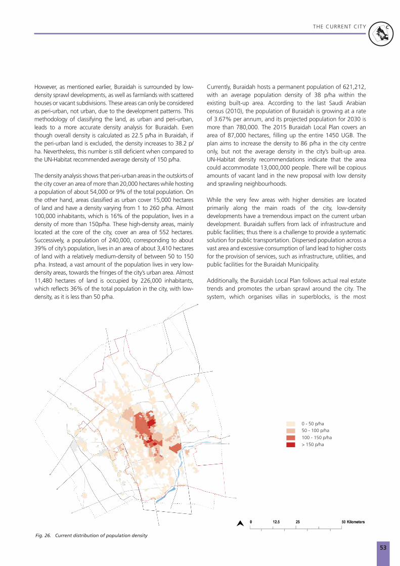
53
THE CURRENT CITYN
N
P
P
R
R
M
UGB
C
C
N
N
Fig. 26. Current distribution of population density
0 - 50 p/ha50 - 100 p/ha
100 - 150 p/ha
> 150 p/ha
However, as mentioned earlier, Buraidah is surrounded by low-density sprawl developments, as well as farmlands with scattered houses or vacant subdivisions. These areas can only be considered as peri-urban, not urban, due to the development patterns. This methodology of classifying the land, as urban and peri-urban, leads to a more accurate density analysis for Buraidah. Even though overall density is calculated as 22.5 p/ha in Buraidah, if the peri-urban land is excluded, the density increases to 38.2 p/ha. Nevertheless, this number is still deficient when compared to the UN-Habitat recommended average density of 150 p/ha.
The density analysis shows that peri-urban areas in the outskirts of the city cover an area of more than 20,000 hectares while hosting a population of about 54,000 or 9% of the total population. On the other hand, areas classified as urban cover 15,000 hectares of land and have a density varying from 1 to 260 p/ha. Almost 100,000 inhabitants, which is 16% of the population, lives in a density of more than 150p/ha. These high-density areas, mainly located at the core of the city, cover an area of 552 hectares. Successively, a population of 240,000, corresponding to about 39% of city’s population, lives in an area of about 3,410 hectares of land with a relatively medium-density of between 50 to 150 p/ha. Instead, a vast amount of the population lives in very low-density areas, towards the fringes of the city’s urban area. Almost 11,480 hectares of land is occupied by 226,000 inhabitants, which reflects 36% of the total population in the city, with low-density, as it is less than 50 p/ha.
Currently, Buraidah hosts a permanent population of 621,212, with an average population density of 38 p/ha within the existing built-up area. According to the last Saudi Arabian census (2010), the population of Buraidah is growing at a rate of 3.67% per annum, and its projected population for 2030 is more than 780,000. The 2015 Buraidah Local Plan covers an area of 87,000 hectares, filling up the entire 1450 UGB. The plan aims to increase the density to 86 p/ha in the city centre only, but not the average density in the city’s built-up area. UN-Habitat density recommendations indicate that the area could accommodate 13,000,000 people. There will be copious amounts of vacant land in the new proposal with low density and sprawling neighbourhoods.
While the very few areas with higher densities are located primarily along the main roads of the city, low-density developments have a tremendous impact on the current urban development. Buraidah suffers from lack of infrastructure and public facilities; thus there is a challenge to provide a systematic solution for public transportation. Dispersed population across a vast area and excessive consumption of land lead to higher costs for the provision of services, such as infrastructure, utilities, and public facilities for the Buraidah Municipality.
Additionally, the Buraidah Local Plan follows actual real estate trends and promotes the urban sprawl around the city. The system, which organises villas in superblocks, is the most

54
THE CURRENT CITYN
N
P
P
R
R
M
UGB
C
C
N
N
25 Km
50 Km
25 Km
50 Km
AREA: 472 haPOPULATION: 137,157
AREA: 6,868 haPOPULATION: 215,048
1975290 p/ha
198531 p/ha
Fig. 27. Land allocated per capita
0
200
400
600
800
1,000
1,200
1,400
1975 1980 1985 1990 1995 2000 2005 2010 2015 2020 2025 2030
UN Standard
Buraidah
66.67 sqm/capita
440 sqm/capita

55
THE CURRENT CITYN
N
P
P
R
R
M
UGB
C
C
N
N
UN Standard
Buraidah
25 Km
50 Km
25 Km
50 Km
25 Km
50 Km
AREA: 12,276 haPOPULATION: 337,173
AREA: 27,469 haPOPULATION: 620,000
199527 p/ha
201522.5 p/ha
Urban Growth Stages
2017Before 1957
Fig. 28. Urban growth pattern
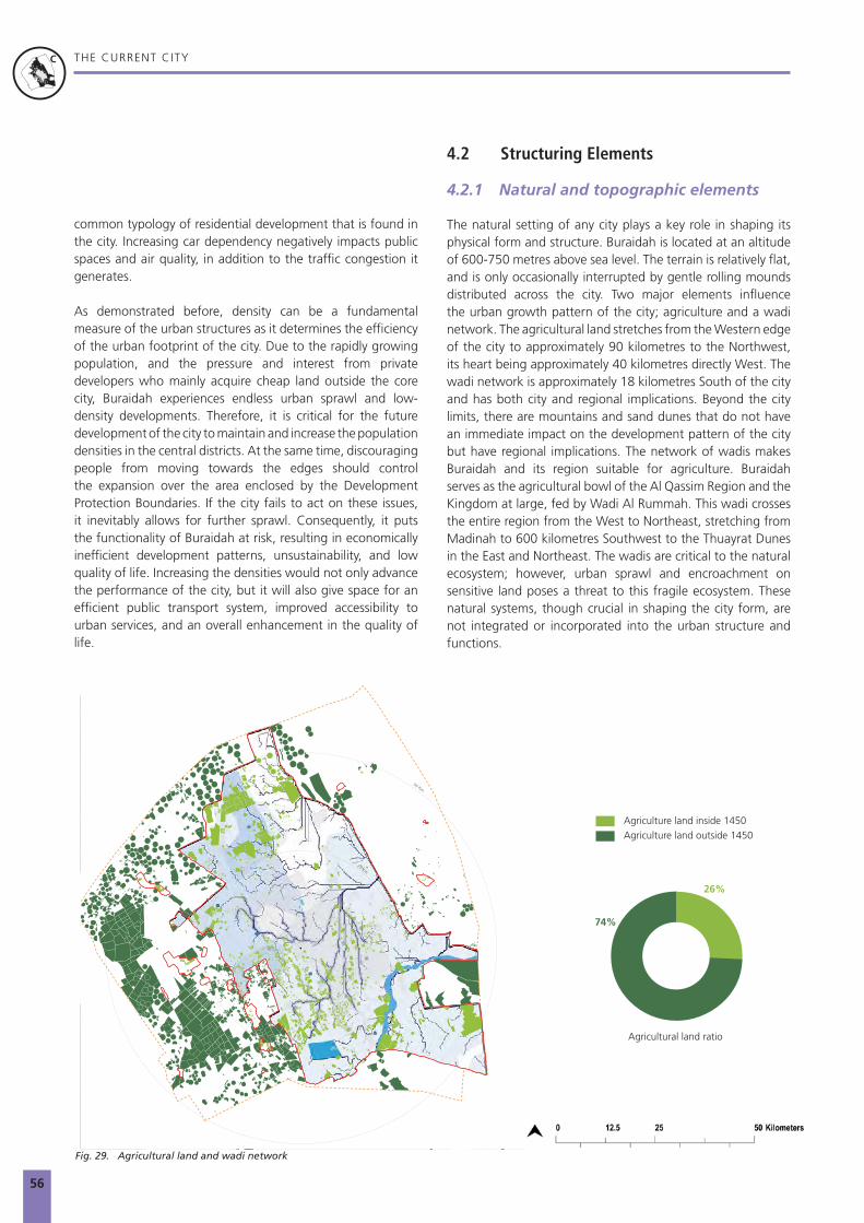
56
THE CURRENT CITYN
N
P
P
R
R
M
UGB
C
C
N
N
common typology of residential development that is found in the city. Increasing car dependency negatively impacts public spaces and air quality, in addition to the traffic congestion it generates.
As demonstrated before, density can be a fundamental measure of the urban structures as it determines the efficiency of the urban footprint of the city. Due to the rapidly growing population, and the pressure and interest from private developers who mainly acquire cheap land outside the core city, Buraidah experiences endless urban sprawl and low-density developments. Therefore, it is critical for the future development of the city to maintain and increase the population densities in the central districts. At the same time, discouraging people from moving towards the edges should control the expansion over the area enclosed by the Development Protection Boundaries. If the city fails to act on these issues, it inevitably allows for further sprawl. Consequently, it puts the functionality of Buraidah at risk, resulting in economically inefficient development patterns, unsustainability, and low quality of life. Increasing the densities would not only advance the performance of the city, but it will also give space for an efficient public transport system, improved accessibility to urban services, and an overall enhancement in the quality of life.
4.2 Structuring Elements
4.2.1 Natural and topographic elements
The natural setting of any city plays a key role in shaping its physical form and structure. Buraidah is located at an altitude of 600-750 metres above sea level. The terrain is relatively flat, and is only occasionally interrupted by gentle rolling mounds distributed across the city. Two major elements influence the urban growth pattern of the city; agriculture and a wadi network. The agricultural land stretches from the Western edge of the city to approximately 90 kilometres to the Northwest, its heart being approximately 40 kilometres directly West. The wadi network is approximately 18 kilometres South of the city and has both city and regional implications. Beyond the city limits, there are mountains and sand dunes that do not have an immediate impact on the development pattern of the city but have regional implications. The network of wadis makes Buraidah and its region suitable for agriculture. Buraidah serves as the agricultural bowl of the Al Qassim Region and the Kingdom at large, fed by Wadi Al Rummah. This wadi crosses the entire region from the West to Northeast, stretching from Madinah to 600 kilometres Southwest to the Thuayrat Dunes in the East and Northeast. The wadis are critical to the natural ecosystem; however, urban sprawl and encroachment on sensitive land poses a threat to this fragile ecosystem. These natural systems, though crucial in shaping the city form, are not integrated or incorporated into the urban structure and functions.
25 Km
50 Km
26%
74%
Fig. 29. Agricultural land and wadi network
Agriculture land inside 1450Agriculture land outside 1450
Agricultural land ratio

57
Date farms in Buraidah
© qassimnews.com

58
THE CURRENT CITYN
N
P
P
R
R
M
UGB
C
C
N
N
Ecologically productive land useBuraidah is well-known among the Saudi cities for its agricultural fertility, with almost 400 square kilometres dedicated to agriculture within the Development Protection Boundary. Agriculture is considered to be the cornerstone of the economy of Buraidah with 17% of its GDP coming from rural production. The agricultural sector is one of the primary sources of income for the city’s inhabitants. Notably, the dates market represents 37% of the total agricultural land area and generates on average 607,000,000 SAR in annual revenue (2011). Other traditional oasis products include lemons, oranges, and other fruits. Their production is still an essential and integral contribution to the local agricultural sector. Newer crops, such as wheat have been introduced more recently and were an immediate success, to the extent where Buraidah is now one of the largest wheat producers in the Kingdom. It is an indicator of the essential need to sustain a diverse and productive ecological landscape system in Buraidah. Particular attention must be paid to the integration of proper agricultural research, land, and resource management. Additionally, newer industries that relate to agricultural resources, such as food processing should be looked into. This would ensure long-term development and stable revenues for the region, especially when food security becomes a significant challenge, as the Kingdom is highly dependent on imports from other countries.
4.2.2 Major movement infrastructure
Buraidah lies on the crossroad of a very strong highway network, which connects to Riyadh, Madinah, and Hael. These three highways connect to the Ring Road that surrounds both Buraidah and Unayzah and act as a boundary to the existing urban core. The highway connecting Hael to Buraidah on the North, called the King Abdulaziz Road, crosses the city and links it to Unayzah in the South. It has an important effect on the urban structure, and together with the King Fahd Road crosses the city on the East-West axis and connects the airport and railway station on the two edges of the city-region.
Although Buraidah has a highly developed road infrastructure system, it currently does not have a public transportation network, and the lack of a robust public transportation network encourages private vehicle ownership. It ultimately promotes development sprawl, and vice-versa, sprawled development fosters car ownership. Often, overdimensioned urban secondary roads separate the neighbourhoods and divide the urban fabric of the city of Buraidah.
There is a proposed public transportation network for Buraidah, which includes two means of transport: one being an LRT passes through the city centre and connects Buraidah and Unayzah, and the other being a BRT system, which consists of six routes, connecting the city's’ major destinations with a great emphasis on connections to the airport and railway station. However, considering the current growth
FSCP workshop presentation in Buraidah with stakeholders and ministries
© FSCP

59
THE CURRENT CITYN
N
P
P
R
R
M
UGB
C
C
N
N
25 Km
50 Km
Fig. 31. Economic nodes and network
25 Km
50 Km
Commerce
Agriculture
Industry
Institutional
Airport
Railway
Km0 2.5 5 10 20
1450 Urban Growth Boundary
Development Protection Boundary
Economic Activities
Key
Al-Deira
Al-Safraa
Al-Basr
25 Km
50 Km
Commerce
Agriculture
Industry
Institutional
Airport
Railway
Km0 2.5 5 10 20
1450 Urban Growth Boundary
Development Protection Boundary
Economic Activities
Key
Al-Deira
Al-Safraa
Al-Basr
25 Km
50 Km
Commerce
Agriculture
Industry
Institutional
Airport
Railway
Km0 2.5 5 10 20
1450 Urban Growth Boundary
Development Protection Boundary
Economic Activities
Key
Al-Deira
Al-Safraa
Al-Basr
25 Km
50 Km
Commerce
Agriculture
Industry
Institutional
Airport
Railway
Km0 2.5 5 10 20
1450 Urban Growth Boundary
Development Protection Boundary
Economic Activities
Key
Al-Deira
Al-Safraa
Al-Basr
25 Km
50 Km
Commerce
Agriculture
Industry
Institutional
Airport
Railway
Km0 2.5 5 10 20
1450 Urban Growth Boundary
Development Protection Boundary
Economic Activities
Key
Al-Deira
Al-Safraa
Al-Basr
25 Km
50 Km
Commerce
Agriculture
Industry
Institutional
Airport
Railway
Km0 2.5 5 10 20
1450 Urban Growth Boundary
Development Protection Boundary
Economic Activities
Key
Al-Deira
Al-Safraa
Al-Basr
5
7 84
96
5
2
Prince Naif International Airport Sar Railway StationDates MarketCattle (camel) MarketAgricultural landIndustrial zoneQassim UniversityGovernment centre (municipality)Research centre
12 34 5 6789
Commerce
Institutional
Agriculture
Airport
Railway
Industry
Fig. 30. Existing transport network
To Riyadh
25 Km
50 Km
Rail station & airportRailway
Primary and secondary road networkDevelopment Protection Boundary

60
THE CURRENT CITYN
N
P
P
R
R
M
UGB
C
C
N
N
trend of the city, this proposal of a public transport network is overdimensioned and not aligned with the growth and development of the city. Furthermore, based on the criteria, that is the cost of implementation against population served, it is inefficient for a city the size of Buraidah, even though the proposal aims at developing an efficient, safe, and accessible mobility system. Instead, more sustainable transport solutions should be developed to target the current needs of the city.
The Prince Nayef Bin Abdulaziz National Airport is located 20 kilometres to the West of the city and handles a capacity of 550,000 passengers with only one terminal and one runway. To the East of the city, about 20 kilometres away, is the main railway station that serves the high-speed railway line connecting Riyadh to Al Haditha at the Jordanian border. Currently, the railway station and the airport are entirely disconnected from each other. Even though the city is potentially a multi-modal hub, it does not realise its full potential as a primary transportation hub.
The industrial districts, distributed around the city, are disconnected and distant from the regional railway hub, thus, affecting the efficiency of logistical services. It is inevitable to improve weak linkages between major industrial centres in Buraidah and the local transportation networks. The enhancement of productivity across all industries depends on the introduction of a public transportation network and improved linkages to reduce car dependency and accessibility to employment areas. In the long-term, a transportation
system, which connects Buraidah with the rest of the region, e.g., Unayzah, will be beneficial to boost the development of the city, as well as the region.
4.2.3 Existing and proposed land use patterns
Land use is categorised according to different socio-economic activities occurring in a particular area, the human behaviour patterns they create, and their effects on the environment. Land use usually provides direction and guidance in structuring how the city functions. Land use planning refers to the process by which institutions decide where, within their territory, different socio-economic activities such as agriculture, housing, industry, recreation, and commerce should take place. The current land use for Buraidah covers an area of 22,000 hectares. The largest land use is currently registered as agriculture, with an area of 9,000 hectares, equal to 41% of the total land use area. The second largest land use is residential, registering at 25%, or 5,580 hectares. This is followed by public service at 21% or 4,540 hectares as the third largest land use in the city. It should be noted that mixed-use accounts for approximately 1.5%, equal to 430 hectares, while commercial land use accounts for 4% or 938 hectares. The proposed land use does not account for an appropriate increment to this figure, considering only an additional 0.23% and 8% are dedicated to mixed and commercial land uses respectively.
Panoramic night view of Buraidah
© SAP
© qassimnews.com

61
THE CURRENT CITYN
N
P
P
R
R
M
UGB
C
C
N
N
To U
naiz
ah
1450 Urban Growth Boundary
Development Protection Boundary
Residential
Residential - Rest Houses
Commercial
Industrial
Warehouse
Mixed Use (Commercial/ Of�ce)
Mixed Use (Residential/ Agriculture)
Agriculture
Education
Healthcare
Religious
Government
University + Research Center
Community (Social)
Public (Open) space
Public Facilities
Airport
Utilities
Car Parking
Cemetry
Others
Others
Land Use - Existing
25 Km
50 Km
To U
naiz
ah25 Km
50 Km
2%
25%
4%1%
2%
20%5%
40%
2%8%
8%
12%
67%
Fig. 32. Existing land use (1439)
Residential
Residential
Industrial
Industrial
Commercial
Commercial
Agriculture
Agriculture
Public services
Public services
Governmental
Governmental
Airport
Mixed-use
Mixed-use
Fig. 33. Proposed land use by the Buraidah Plan by the Amanah

62
THE CURRENT CITYN
N
P
P
R
R
M
UGB
C
C
N
N
25 Km
50 Km
1450 UGBBuilt-up area
Vacant land within built-up area
Undeveloped land within 1450 UGB
Fig. 34. Vacant land and undeveloped area
4.2.4 Vacant Land
Buraidah has large amounts of vacant land both within its urban footprint and its administrative boundaries. 68% of the total area within the 1450 Urban Growth Boundary is vacant, which amounts to approximately 49,400 hectares. Furthermore, within the current urban built-up area 37% vacant land already exists, which corresponds to 10,163 hectares. These percentages include a broad spectrum of types of vacant land, ranging from unused open spaces to abandoned and contaminated brownfields.
High amounts of vacant land impact not only the social structure of neighbourhoods and districts but also the environmental performances of the city due to the increased air pollution caused by private car dependency. Vacant land acts as a fragmenting element within the urban fabric. It also has a negative impact on the local economy as it creates economic deserts, and depending on its size, may even disrupt product distribution networks. Moreover, vacant land increases the capital cost to provide services and infrastructure to a broader, dispersed area by default.
The UN-Habitat Principles recommends cities to maintain a medium to high density of at least 150 people per hectare. Based on this average density recommendation, the city could accommodate an additional 1,500,000 inhabitants within the vacant land existing in the city’s urban footprint. This approach would prevent further sprawl and readdress the city’s growth
The lack of consistent and diffused mixed-use and commercial services and public facilities may influence socio-spatial inequality and polarisation, which, in turn, may affect the overall socio-economic performance of the city. According to UN-Habitat’s international recommendations,37 a prosperous city should allocate at least 40% of the floor space for economic and commercial uses, including residential areas, promoting, therefore, mixed-use development. This model stimulates local jobs, promotes local economic opportunities, and helps to reduce socio-spatial inequalities. The Buraidah Local Plan, which covers an area of 87,020 hectares, fillis up the 1450 UGB. The plan is dominated by residential land use occupying 72% of the total area, and equal to 62,654 hectares, and this is followed by industrial use at 13% or 11,312 hectares.
Proportionately, the amount of land dedicated to the proposed land use speaks to an increased urban sprawl, especially because of the spatial distribution of these new residential areas, together with exacerbating the tendency to expand the city following a pattern dominated by large monofunctional areas. The city should revise this foreseen land use planning approach, promoting a correct mix for commercial, residential, and mixed-use areas as the city grows while devoting special attention to increasing the allocation of both agricultural fields and open public spaces. This will help the city to be competitive, attractive, sustainable, balanced, and livable.
57%31.5%
11.5%
Vacant land within 1450 UGB

63
THE CURRENT CITYN
N
P
P
R
R
M
UGB
C
C
N
N
patterns. As urban sprawl and low density profoundly impact Buraidah, vacant land remains a key competitive asset for implementing multiple economic development strategies. The infill of vacant land represents an opportunity for economic growth and the upgrade of several urban neighbourhoods, not to mention it is sufficient to accommodate the anticipated future population growth. Notably, the connection between the city centres, where the higher densities in the city can be observed, should be the focus of the development in regards to the strategic strengthening of the city.
4.2.5 Accessibility to urban cores and facilities
Buraidah has well established urban cores with a mix of land uses serving a higher population density. The city evolved into having two urban cores, one in the historic centre, (Old Urban Core) and the other approximately four kilometres North of the historic centre, (North Urban Core). Both urban cores are defined by large concentrations of commercial and mixed-use activities and have access from major arterial roads; however, there are no public transportation networks serving these urban cores currently.
The Old Urban Core is defined by a more compact and dense urban pattern supported by the King Abdulaziz Road being the main connecting transportation corridor, and secondary and tertiary connectivity completing the road network. Approximately 33% of the city’s population resides within a four-kilometre catchment radius of the Old Urban Core. The North Urban Core is defined by less compact and big box commercial activities, also supported by the King Abdulaziz Road as it’s main transportation corridor. Approximately 23% of the city’s population resides within a four-kilometre catchment radius of the North Urban Core.
Combining the two urban cores, approximately 10% or 79,082 residents are within a five-minute walking distance to these two centres, and approximately 15.5% or 121,394 residents are within a ten-minute walking distance. From a drivability point of view, 99.44% or 617,763 residents can access these urban cores within a 15-minute drive, while within a 30-minute drive, 99.45% or 617,803 residents have access.
There are currently proposals for public transportation networks, such as a light rail and bus rapid transport (BRT) to be established to serve these urban cores; thus, improving accessibility for citizens once implemented.
Fig. 35. Distribution of commercial activities
5km
10km
1:150,000
Kilometers6.53.250 13
Buraydah Commerial Centers
1450 Urban Growth BoundaryBuilt up area
Commercial Centers
Key
5km
10km
1:150,000
Kilometers6.53.250 13
Buraydah Commerial Centers
1450 Urban Growth BoundaryBuilt up area
Commercial Centers
Key1450 UGB
Built-up area
Commercial centres
(Northern) x181,832
(Southern) x 264,062
Buraidah residents within 4 km of the commercial area
7.5-minute walk from commercial centre centre (North)
x 19,689
7.5-minute walk from commercial centre Centre (Mmiddle)
7.5-minute walk from commercial centre (South)
x 52,269
x 7,512

64
THE CURRENT CITYN
N
P
P
R
R
M
UGB
C
C
N
N
4.3 Assessment of Future Plans
4.3.1 Buraidah Local Plan
Buraidah has been experiencing rapid urban growth since 1975 and has consequently been exposed to an excessive urban sprawl phenomenon, as well as large scale monofunctional clusters of economic and social facilities.
The Buraidah Local Plan is not limited to the 1450 UGB as it also covers the area of the DPB. The proposed land to be developed, in reference to the total land area within the boundaries is 46.8% within the 1450 UGB and 33.2% within the DPB. In other words, the plan proposes to develop additional land of 40,000 hectares within the 1450 UGB and 64,000 hectares in the DPB, of which 25,000 hectares are located outside the 1450 UGB, and that should be strictly disallowed. These proposals indicate low development densities and large amounts of vacant land as previously depicted.
The Buraidah Local Plan structure is dominantly agricultural followed by residential. The proposal for the Buraidah Local Plan is to re-prioritise land use shares and to define residential instead of agricultural land as the dominant function. The analysis of a combined land use scenario, overlaying the existing and the Buraidah Local Plan, allows assessing the distribution of the various functions strategically. The combined and-use plan highlights the substantial impact of residential land use on agricultural properties in the future. Likewise, not much land is dedicated to existing natural assets. For instance, the Sabkha salt lake and the wadis represent only 2.35% of the total urban land area. If well developed, these areas can provide a magnificent asset to the citizens of Buraidah.
The current land use planning approach is not recommended for a predominantly agricultural city. It should follow a clear strategy to preserve and reforest agrarian land. New residential land use areas should distribute in a way to minimise adverse impacts on existing agriculture. The analysis of the combined plans highlights a dispersion of governmental and industrial land uses across the city, devoting large amounts of land for these uses away in urban edges. It results in a lack of appropriate integration of these into the existing city structure. Without taking into account factors such as population density distribution, it forces long-distance commuting.
4.3.2 Public transport accessibility analysis
As stated previously, there are currently no citywide public transportation networks currently available. The only publicly available transport service available is the regional rail network, connecting Riyadh in the South and other cities in the North. The Buraidah Regional Rail Station is located approximately 20 kilometres Northwest of the city centre. Two key public
transportation networks have been proposed; a light rail and a bus rapid transport network. These initiatives denote a step in the right direction to promote public transport networks to support a more sustainable urban development, economic vibrancy, and improve the quality of life for all citizens.
Light RailAccording to Buraidah’s Proposed Public Transportation Update Report,38 a single line will form the Light Rail service. The line will run from the North to the South along King Abdulaziz Road, and its Southern terminus will be in the adjacent settlement of Unayzah, approximately 27 kilometres from Buraidah’s centre. Its projected Northern terminus will be in the Ar Rihab neighbourhood, just outside of Buraidah’s ring road and close to the 1450 Urban Growth Boundary, however, there is an intent to extend further North, to be determined in future phases. As explained earlier, this Light Rail proposal is overdimensioned, and not efficient for Buraidah. Moreover, it can exacerbate leapfrog development by extending further outside the city’s built-up area.
Bus Rapid Transport (BRT)According to Buraidah’s Proposed Public Transportation Update Report,39 a BRT network consisting of six lines (Red, Yellow, Blue, Purple, Green, and Orange) is proposed. The Purple and Blue lines run from East to West, using the airport and rail station as terminus points. The Red and Yellow lines run along the same route in the North to South direction, using the town of Unayzah in the South and the 1450 Urban Growth Boundary in the North as terminus points. The Green line is routed along the Eastern Ring Road, while the Yellow line is routed along the Western ring road. These six lines will consist of approximately 117 stops and covering an area of approximately 270 linear kilometres. Accessibility by citizens is measured by combining the six lines, resulting in 12.6% of residents, (equal to 78,192 inhabitants) having access to stops within a 5-minute walking distance, while 25.6% of residents, (equal to 158,464 inhabitants) will have access to stops within a 10-minute walking distance.
The six BRT lines mentioned above were reviewed and discussed in a joint workshop between the Amanah and the FSCP team, and it was concluded that the six BRT lines proposed are over-designed and are not aligned with the growth and development of the city, similar to the proposed LRT service. The criteria being the cost of implementation against population served, for instance, implied that two routes are redundant while two others are serving a low-density of population. It was concluded and recommended that the city should develop a phasing plan for the BRT network, with two lines in the first phase, Line 1 and Line 2.

65
THE CURRENT CITYN
N
P
P
R
R
M
UGB
C
C
N
N
Fig. 36. Accessibility to commercial city centres
5-minute walking distance from city centre
of the population reside within 5-minute walking distance from city centre
of the population reside within 5-minute walking distance from city centre
of the population reside within 10-minute walking distance from city centre
of the population reside within 10-minute walking distance from city centre
10-minute walking distance from city centre
3.7%
8.9%
5.8%
13.7%
Fig. 37. City wide accessibility to bus rapid transport
5-minute walking distance from BRT
10-minute walking distance from BRT
of the population reside within 5-minute walking distance from public transport line 2
of the population resides within 10 -minute walking distance from public transport line 2
12.6%
25.7%
Northern centre
Southern centre

66
THE CURRENT CITYN
N
P
P
R
R
M
UGB
C
C
N
N
Line 1 will maintain an East to West direction, connecting Buraidah’s airport approximately 20 kilometres West of the city centre and the rail station, approximately 20 kilometres West of the city centre. Line 2 will run parallel to the proposed Light Rail Line, connecting the Southern settlement of Unayzah and Buraidah’s Northern suburbs. Both lines pass through high density areas of the city, intersecting high commercial and mixed-use areas. The intersection of the two BRT lines with the Light Rail Line offers citizens a multi-modal public transportation alternative. A high-level analysis and comparison of the city’s proposed six lines versus UN recommended two lines is recorded in Section 6.4.
Bus NetworkThe Proposed Public Transportation Update Report40 recommends a comprehensive bus network across the city, the network proposed will consist of 17 lines. These 17 lines will consist of approximately 436 stops and covering an area of approximately 286 linear kilometres. In terms of accessibility for residents to these lines, combining the 17 lines, over 47% of residents, equal to 293,547 inhabitants will have access to stops within a 5-minute walking distance. Over 66% of residents, equal to 413,079 inhabitants will have access to stops within a 10-minute walking distance.
Fig. 38. City wide accessibility to bus network
5-minute walking distance from bus stops
10-minute walking distance from bus stops
of the population reside within 5-minute walking distance from bus stops
of the population resides within 10-minute walking distance from bus stops
47.3%
66.6%
The bus network will support the investment of the Light Rail and BRT networks, through the penetration of neighbourhoods that are beyond the catchment of the BRT and Light Rail systems. Thus, the bus network will act as a feeder that will increase ridership across all public transportation systems. Like all proposed transportation networks and systems in Buraidah, the bus network should be further analysed for an appropriate phasing plan, aligning with population density, cost, and the overall development of the city.

67
© Saudi Projects Overdimensioned highway infrastructure in Buraidah

68
THE CURRENT CITYN
N
P
P
R
R
M
UGB
C
C
N
N
4.3.3 Density scenario analysis
Crosscutting the diagnosis of the current urban conditions and the approved/submitted projects proposals, FSCP operated a scenario-analysis for increased urban density, according to various choices. The scenarios depict three conditions: the current situation, the situation developed in line with the approved planning instruments, and a situation where density distribution is allocated following the City Profile’s recommendations. This UN-Habitat scenario is based on the Five Principles for Sustainable Neighbourhood Planning, which are as follows:
• The UN-Habitat scenario is based on the Five Principles for Sustainable Neighbourhood Planning, which are as follows:
• Adequate space for streets and an efficient street network: The street network should occupy at least 30% of the land and at least 18 kilometres of street length per km²,
• High density: At least 15,000 people per km², that is 150 people/ha or 61 people/acre,
• Mixed land use: At least 40% of floor space should be allocated for economic use in any neighbourhood,
• Social mix: The availability of houses in different price ranges and tenures in any given neighbourhood to accommodate different incomes; 20% to 50% of the residential floor area should be for low-cost housing, and each tenure type should be not more than 50% of the total,
• Limited land use specialisation: This is to limit single function blocks or neighbourhoods; single function blocks should cover less than 10% of any neighbourhood.
Current ConditionThe current population in Buraidah is 621,212 spread across a built-up area of 27,469 hectares. This generates a population density of 22.5 p/ha, which is almost one-seventh of the recommended UN-Habitat density of 150 p/ha. When considering the earlier explained urban area, (not the peri-urban), this density figure increases to 38.2 which is still below the targeted recommendation.
Scenario 1: Buraidah Local Plan Buraidah’s Local Plan proposes 64,500 hectares of land as an extension area of Buraidah, in addition to the existing built-up area of 27,500 hectares. Assuming the extension area is to be fully developed by 2030, and hosting a total population of 780,000 as projected in Vision 2030, the average density would decrease to 9 p/ha in the built-up area. The Buraidah Local Plan significantly increases the built-up area and even proposes some development outside the 1450 UGB, in spite of the fact that the UGB of Buraidah is already delineated over-dimensionally and fragmented. Even with the substantial increase in population, it overestimates the spatial extents of the development, therefore, encourages sprawl. Sustainable urban development can only be achieved by concentrating the uses and planning for a compact form of settlement.
Scenario 2: UN-Habitat RecommendationThe UN-Habitat scenario supports sustainable neighbourhood planning for Buraidah, starting with promoting an increased density, in line with the average UN-Habitat recommended density of 150 p/ha. Based on the UN-Habitat recommendation, the city only requires an additional area of 1,000 hectares to host the expected population growth of 160,000 inhabitants to reach the projected population of 780,000 people by 2030. Considering the 10,000 hectares of vacant land that exists in the current built-up area, this scenario shows that it is not necessary to grow outside the current urban footprint and suggests strategic interventions to support policies that would facilitate the densification of existing urban areas. This would provide citizens with maximum benefits for an improved quality of life at an affordable cost.

69
THE CURRENT CITYN
N
P
P
R
R
M
UGB
C
C
N
N
CURRENT CONDITION
SCENARIO 1: BURAIDAH LOCAL PLAN
SCENARIO 2: UN-HABITAT RECOMMENDED SCENARIO
population
built-up area
average density on built-up area
620,000
27,469 ha
22.5 p/ha
population
planned built-up area
average density on planned built-up area
780,000
87,000 ha
9 p/ha
population 780,000
5,200 ha*
1,000 ha
150 p/ha
built-up area needed according to UN-Habitat
recommendations
vacant land needed to accommodate
population growth
average UN-Habitat recommended density
*1/16 of the built up area proposed by the Buraidah Plan

70
THE CURRENT CITYN
N
P
P
R
R
M
UGB
C
C
N
N
4.4 Environmental & Climate Change Risk Implications
4.4.1 Urban heat islands and desertification
Buraidah is located in the North Central area of the Al Qassim Region, in a relatively flat area, at 600-650 metres above sea level. It has a semiarid to a hyper-arid climate with extreme conditions that are being exacerbated by climate change. Changes in air temperature have been registered at the national level in the past decade. Due to climate change, in most areas temperatures have been increasing by about 0.2°C to 0.3°C per decade. In the Al Qassim Region, a substantial increase ranging from 0.052°C between 1978 and 2003 to 0.12°C between 2004 and 2013. Projections indicate an expected temperature of 27.1°C from 2030 to 2079, compared to the current minimum annual temperature of 25.1°C. These patterns intensify the occurrence of heat wave events, which have increased in the Al Qassim area from two events between 1978 and 1995 to 62 incidents from 1996 to 2013. They also impact the soil aridity, whose index is very low in the region, at less than 0.05.
On the contrary, it is essential to acknowledge that sandstorm events have been decreasing by about 31% over the last 20 years. Sandstorms are caused by Southwest winds which carry the sand from the dunes into the city. The agricultural land, located around those dunes supports the stabilisation of the soil and reduces the intensity and number of these storms.
Another prevailing wind direction comes from the Northwest bringing in cooling breezes to the city, which positively affects the local climate.
The urban climatic conditions are an important element to be considered in relation to energy consumption, citizen health, and urban form. Urban form, emerging from both streets layout, public space, and buildings typologies, has, therefore, a considerable impact in the way cities in Saudi Arabia cope considering its hyper-arid climate. All these conditions are increasing the Urban Heat Island Effect, which means that the urban area is increasingly warmer than its rural surroundings. This is not only due to climate change but is also caused by human activities, such as the modification of land uses and usage of energy. Often, vernacular and historic urban patterns perform better from an urban microclimate point of view.
Sustainable urban planning plays a pivotal role in reducing such effects by framing the urban patterns and living models that a city provides. In this sense, for the future of Buraidah, it is similarly vital to integrate climate conditions in a way that the development protects and prevents sandstorms and hannels the breeze to create a pleasant urban environment.
More than 150 p/ha
UHI parameters
100-150 p/ha
0-50 p/ha
Green areas
Sand dunes
Southeast prevailing wind - Sandstorms
Existing areas at highest risk of UHI
Areas for potential growth
Areas closest to the impacts of sand storms
North prevailing wind - Potential breeze
Boundaries
Fig. 39. Urban heat islands analysis
1
2
3
2
1
3

71
THE CURRENT CITYN
N
P
P
R
R
M
UGB
C
C
N
N
An estimation of Urban Heat Islands Effect has been developed according to the denser areas in the city, which usually experience higher temperatures. Wind and water bodies, as well as green spaces, were also mapped, with an understanding that these are structuring elements that can ameliorate the increasing temperatures. Challenges posted by the UHI can be tackled by integrating these features when planning the city. General problems are considered to include thermal discomfort, a decrease in urban health, and high levels of energy consumption. Contrastingly, there is an opportunity to enhance walkability and the use of public spaces in the city.
4.4.2 Water scarcity and disconnected green and blue infrastructure
Buraidah is characterised by deficient rainfall, due to its hyper-arid climate. The annual rainfall average is 134.4 mm/year, and there is an extremely high evapotranspiration phenomenon, increasing from 3.5 to 15 mm/day2. In the Al Qassim Region, a drastic decrease in annual total rainfall has been recorded at 0.41 mm/year between 1978 and 2003 and 11.34 mm/year between 2004 and 2013. Projected trends also identify a continuous decrease from a current mean annual precipitation of 134.4mm/year to 102.8mm/year from 2030 to 2079. For
this same period, a decrease of 2% in relative humidity is to be expected. In spite of the low rainfall, Buraidah faces seasonal flooding from storm events, especially along the wadis, which run through the city. Development patterns usually encroach and pave the natural waterways. They lead to flooding of the surrounding areas, strongly impacting housing and critical infrastructure. Some efforts used to reduce flooding risk include pooling lakes and retention areas that can store runoffs of water under heavy storm conditions, as well as prohibiting areas for building activities. However, a more in-depth study of flooding scenarios needs to be developed to better integrate water elements into the planning and the urban design of the city.
Regarding water resources, Saudi Arabia has the lowest freshwater resource endowment in the world. As a result, the Kingdom is facing water shortages, which means less than 1,000m3 of water per person per year. Besides this, the most significant share of water consumed for agricultural, municipal, and industrial purposes is retrieved from fossil groundwater in sedimentary aquifers of which some are rechargeable, and some are not. Nonetheless, the water demands have steadily been increasing, causing the excessive pumping of groundwater, as well as the number of drilled wells, giving rise
Fig. 40. Blue network
Water wellsStreams
Landfill
Built-up area
1450 UGB
Secondary water bearing soil
Main water bearing soil
Pooling lakes
Areas with flooding risk 1
Water systems1

72
THE CURRENT CITYN
N
P
P
R
R
M
UGB
C
C
N
N
to an alarming situation. Buraidah pumps water from the Saq aquifer, whose boundaries and capacities are changing due to its negligent recharge. Data shows that water consumption in the city is about 250 l/day per capita, and is double the average water consumption in developed countries. Shifting this consumption pattern is an urgent concern to ensure the durability of the water supply. The Saq aquifer, which is depleting at an approximate rate of 1.1 million litres per year, provides Buraidah with water-bearing soils. Additionally, the city is edged to the East by Wadi Al Rummah, its primary environmental feature.
Protecting these water features is essential, not only for its ecological importance but also because they support agricultural production, which is the cornerstone of the city’s economy. In Saudi Arabia, 30% of the crops and vegetables are produced by greenhouse cultivation. Traditional farming produces the remaining 70%. These conventional farms will be affected by the above-mentioned increase in temperature, the changes in precipitation, the higher evapotranspiration, and the low water reserves. In Buraidah, agriculture is mainly developed within the Development Protection Boundary. Approximately 400 square kilometres of land is currently under cultivation. Now, the leading agriculture technique is through sprinkler irrigations systems, which has proven to be unsustainable. Given the hyper-arid climatic conditions with high rates in air temperature and evapotranspiration, there is a high risk of losing an extensive amount of water.
All of the above showcase the importance of relating the green and blue infrastructure in the city, in a mutually supportive way, to build socio-economic and environmental resilience. For this purpose, the blue and the green system have been mapped. The mapping analysis shows that although the two systems were traditionally linked, due to new development patterns, this is no longer the case. Re-linking blue and green infrastructure systems is, therefore, crucial for a more sustainable future development of Buraidah. Open public spaces could play a key role in supporting the linkages between the blue and green systems. The network of green public areas can become a structural element linked to the water system and hold productive landscape characteristics while increasing the livability of the city.
Fig. 41. Existing green network
Built-up area
Centre pivot irrigated industrial agriculture
Boundary
ParksLandfill
Traditionaly irrigatied agricultureWadi
Green systems
Areas with green network along blue infrastructure
Potential areas for green within the city
Water-wise inefficient agriculture
Water and climate wise efficient agriculture
1
2
3
4
1
2
3
4

73
© Abeer Bajandouh
Sabeh farms

74

5 5S
TRAT
EGIC
DIA
GN
OSI
S
© Abeer Bajandouh

CITY’S STRATEGIC DIAGNOSIS
76
5.1 Identifying and Defining Main Strategic Issues
The in-depth, evidence-based analysis brought to light four main strategic, interrelated issues highlighting Buraidah’s performance in relation to the principles of sustainable urban development. These issues represent the strategic framing of a complex diagnosis, synthesised through four conceptual lenses. The lenses, once defined in their conceptual nature, were then contextualised by examining how they manifest spatially in Buraidah, at different scales. They are synthesised as follows:
5.1.1 Unbalanced growth and development patterns
Spatial patterns are defined by structural elements, fabric morphology, and density distribution, and are highly influenced by land use policy. Inherently, a coherent land use policy influences spatial patterns by determining the appropriate amount of land needed to accommodate future growth and by distributing urban functions and densities accordingly. The combination of these attributes can either generate urban quality or create and increase urban issues such as sprawl. This often happens when a city grows rapidly, presenting an extended sprawl phenomenon, and inharmoniously manifesting unbalanced developments across its territorial extension. Dysfunctionalities emerge in appropriate urban management and citizens experience. In this scenario, the city showcases low density and does not perform effectively, its services and facilities are not well balanced in distribution and accessibility, and therefore citizens do not equally benefit from the advantages of urban life. Additionally, it is costly and difficult for the municipality to provide and maintain basic servicesor efficient and sustainable infrastructure, such as public transport. This is an inherent issue in conditions of sprawl and low density as water, sewage, electricity and transport infrastructures require extension over longer distances to reach relatively fewer people. As such, the significant amounts of land per capita that urban sprawl tends to consume, requires larger capital investments for infrastructure installation and increasing maintenance costs.
The current development trends in Buraidah tend to reproduce disperse patterns of low-density and monofunctional land use, with scarce provisions for social activities and both empty interstitial spaces and large areas of vacant land between existing portions of the consolidated city. The tendency toward sprawl requires urgent address in order to halt progression of the condition, which is heavily affecting the city’s functionality by reproducing unsustainable development patterns of unbalanced growth at low-densities.
5.1.2 Divisions and lack of cohesion in city structure
In cases of unbalanced growth, sprawl, and inharmonious development, forms of non-contiguous and non-cohesive city structures tend to co-exist without integration. Pockets of leapfrog development are far and widespread. Undeveloped land, over-dimensioned infrastructures and/or large extensions of monofunctional developments, hinder the continuity of the city’s fabric, and therefore, its social, economic, and ecological performance. As in cases of sprawl, this renders the equal provision of infrastructure and services to the entire city difficult and costly. The fragmentation phenomenon also spatially affects the social dimension of sustainability, creating urban inequalities and segregation in areas that lie at a distance to the largest hubs and become isolated by a discontinuous urban landscape.
Fragmented cities tend to exhibit a presence of residential estates in the city outskirts, either as high income gated communities or as low-cost housing enclaves, built separately and far from shopping and commercial facilities, industrial, business, and directional centres, and recreational areas. This adds to fragmentation and unsustainable urban patterns, as large highways are often the only viable means of connectivity over such long distances, resulting in car-dependency and high mobility costs. As such, a city’s spatial patterns influence socio-spatial connectivity and increases travel times and congestion. People’s ability to move from their homes to their workplace, shops, school, and health centres is essential for a city’s performance, and needs to be considered both in terms of distance and comprehensive fabric connectivity. If there are many physical barriers to walk and traverse the city, the city becomes inaccessible to its inhabitants. A well connected urban fabric supports public transport and decreases congestion by increasing the overall accessibility. In well articulated, dense and cohesive urban areas, congestion is reduced, while social and economic vibrancy is increased.
DIVISIONS AND LACK OF COHESION IN THE CITY STRUCTURE[ FRAGMENTATION ]
UNBALANCE GROWTH AND DEVELOPMENT PATTERNS[ SPRAWL ]
21
Unbalanced Growth and Developmet Patterns Division and Fragmentation

CITY’S STRATEGIC DIAGNOSIS
77
5.1.3 Monofunctional and polarised development
When a city showcases a predominance of extended monofunctional zones and a lack in mixed-use areas, this implies polarised development. This is particularly acute in cases in which monofunctional developments are distantly scattered and isolated from the rest of the city. In Buraidah, the urban structure is characterised by monofunctional clusters of economic or social activity that amounts to socio-spatial polarisation, creating inequality with highly variable levels of access between different urban areas. Overall, various forms of polarised development result in inequality in a city, the most obvious example of which can be characterised by socio-economic segregations such as private compounds and gated communities, with high quantity and quality of services when compared to the majority of the consolidated city, in which they are lacking.
Monofunctional land use is a symptom of polarised development, which intrinsically induces socio-spatial inequality. This is demonstrated in reduced opportunities for lower income groups and limited possibilities of social interaction and integration. Monofunctional land use, particularly when coupled with low densities, encourages the use of individual mobility, increasing car dependency and eroding the viability of public transport networks. These conditions further reinforce the exclusion of less privileged social groups in the city. This kind of development hinders economic opportunities, as it precludes synergies and mutual stimulation amongst productive activities.
5.1.4 Socio-ecological and economic imbalance
Each city is formed by complex social, economic and ecological systems. In a sustainable city, the balance between these three interrelated systems is maintained and enhanced over time. If any one system is given continued preference over the others, over time, a structural imbalance will emerge that alters the sustainable trajectory of the city’s growth and development.
A socio-ecological and economic imbalance is also created when planning decisions for the city fail to consider preservation and management of existing natural resources, or the functional value of natural assets and their territorial continuity. Planning processes and spatial development practices that incorporate, for instance, integrated water-resource management, natural cycles, and more broadly, functional ecosystem services, are often undervalued by local municipalities all over the world.
Socio-ecologically unbalanced urban systems result in a number of threats to the environment, to overall urban quality, and to the health of citizens. Unsustainable consumption patterns, pollution, loss of biodiversity and of agricultural soil, pressure on ecosystems, as well as increased subjection to natural and manmade disasters, are examples of these. All of these conditions additionally carry heavy effect on the economic performances of a city, that can become increasingly clear over long-term observation.
SOCIO-ECOLOGICAL AND ECONOMIC IMBALANCE[LACK OF RESILIENCE ]
MONOFUNCTIONAL AND POLARISED DEVELOPMENT[ SPATIAL INEQUALITY ]
3 4
Unbalanced Socio-Ecologocal and Economic Systems
Mono-functional Clusters

CITY’S STRATEGIC DIAGNOSIS
78
5.2 Analysing Buraidah's Four Issues in Depth
5.2.1 Buraidah's unbalanced growth and development patterns
The issue of unbalanced growth and development patterns in Buraidah appears precisely at the city level. It is easy to identify how the main urban growth pattern has been sprawling in all directions, leaving a high amount of vacant land and resulting in large voids within the urban footprint. This ad-hoc development pattern leads to inefficiencies in land management, resource utilisation, and declining productivity among the residents.
Likewise, both existing and foreseen infrastructure is not equally distributed across the city. Sprawling growth requires infrastructure and facilities towards these directions and takes away opportunities for transversal connectivity and a more balanced and equalised distribution of services and facilities across the entire city. Furthermore, there is a clear imbalance between land uses at the core, and at the periphery, which are mainly monofunctional residential, with low-density. Without sustainable planning measures, like investment in a robust public transportation system, these communities tend to be heavily dependent on automobiles, making it their primary mode of transport.
One of the main factors for this unbalanced development pattern is the amount of vacant land that amounts to more than 10,000 hectares in the existing urban footprint of the city. In addition, due to the over-dimensioned 1450 UGB, 84% of the total land within the boundary is also classified as vacant land. Among this massive vacant land, 67% is dedicated to the future residential development, exacerbating the mono-functionality in the city's land use pattern. Most of these proposed monofunctional residential areas will be located in two sub-municipalities, Al Deira and Al Safraa as they cover the majority of vacant land in 1450 UGB. Furthermore, these proposed residential developments extend outside the 1450 UGB, once again supporting urban sprawl dynamics in many instances.
Similarly, the Development Protection Boundary, functions as a promoter of a sprawl, instead of being conceived and enforced as a development constraint. This boundary was intended to be a restrictive area of no development, or a development protection buffer zone. Instead, it was used to allow expansion of private land within it, often leveraging on the DPB development options for converting agricultural land into residential development. The Buraidah Local Plan is promoting the idea of sprawl and mono-use clusters into the Development Protection Boundary area, beyond the current city extents. With large swathes of land planned primarily as residential neighbourhoods and limited mixed-use, the new proposal will increase the pressure on infrastructure exponentially and also pose a financial burden to the city facilities.
As seen in the sample pattern from the Western extension of the city, even the planned neighbourhoods developed with a low-density
urban fabric are dominated by residential land use. These kinds of developments are becoming an obstacle for the efficient use of land, and affecting delivery-capacity for infrastructure and public services; thus, the neighbourhoods suffer from a lack of service provision.
Looking forward, the discontinuous and disconnected city fabric with low densities is unsustainable, and all future planning efforts must try to concentrate development in an organised manner. The current densities in Buraidah average about 17 p/ha, which is much lower than the UN-Habitat recommended density of 150 p/ha. While this recommended density may be too high for a city the size of Buraidah, the aim should be to inch closer to this number as the city grows in population and extent, rather than further away from it. The legal framework must streamline all new development in and around the city centres, encouraging in-fill development and maximising the potential of the vacant lands within city limits, rather than promoting new developments in the outskirts of the city.
Unbalanced Growth and Developmet Patterns
Industrial developments
Low density residentialdevelopments
© Dehraan
© Dehraan

CITY’S STRATEGIC DIAGNOSIS
79
Fig. 42. Buraidah's unbalanced growth and development patterns
Built-up area
Undeveloped land within the Ring Road
Sprawl direction Sprawl
Development Protection Boundary
1450 UGB
Road network
Unbalanced Growth and Developmet Patterns
50 km0 12.5

CITY’S STRATEGIC DIAGNOSIS
80
5.2.2 Divisions and lack of cohesion in Buraidah’s urban fabric
Buraidah presents a series of structural divisions visible at the different scales and simultaneously affecting its spatial, social, and economic fabric. Spatially, it is evident that in Buraidah, the agricultural lands, the roads infrastructure, and the dunes have not been integrated into the urban fabric. Instead, they became barriers affecting the overall spatial cohesion of the city. This starts with the fracture in the rural/urban connectivity of the green network between the regional and urban scales. At the urban scale, this fractured green network reads as a fragmented residual agricultural landscape and performs as disconnecting elements affecting the overall cohesion of the urban fabric.
The over-dimensioned and car-oriented infrastructure across the city also contributes to divisions in the fabric, rather than promoting a connecting system. The streetscape and distances are not adequately designed to promote walkability. The low-density developments, over-dimensioned infrastructure, and the lack of quality public space depict neighbourhoods characterised by divisions, low-quality development, and emptiness, therefore, unable to perform as a unified and connected system within the city.
Furthermore, the extended mono-functionality of residential developments causes a systematic lack of cohesion in the urban fabric and, subsequently, devises spatial inequality within the city. The emerging landscape becomes a discontinuous urban fabric, polarised in its functionality, and divided in its structure, characterised by a lack of diffused mixed-use development and a lack of a human scale.
At the neighbourhood scale, this reads as a non-integrated patchwork of residual agricultural fringes and a large concentration of monofunctional land uses, and residential fabric. All of this is further divided by an overdimensioned road infrastructure, which creates perceptual separation rather than adding porosity and connectivity to the whole neighbourhood. There is also a consistent lack of public open space, as the agricultural land is private and inaccessible. Overall the urban environment does not support the principles of a walkable, connected, integrated, and sustainable neighbourhood, although in the examined area the older parts have a compelling human scale to it, and an urban fabric with better performance concerning micro-connectivity and porosity.
Division and Fragmentation
Overdimensioned infrastructure
Division in urban fabric
Residual agricultural fringe
Non integrated structure
© Dehraan
© Dehraan
Agricultural edges
© Dehraan

CITY’S STRATEGIC DIAGNOSIS
81
Built-up areaDevelopment Protection Boundary
1450 UGB
Road network
Fig. 43. Divisions and lack of cohesion in Buraidah's urban fabric
Division and Fragmentation
Overdimensioned infrustructure
Agricultural fringes dividing the city
50 km0 12.5

CITY’S STRATEGIC DIAGNOSIS
82
5.2.3 Buraidah’s monofunctional and polarised development
Spatial polarisation in Buraidah can be found at the three scales: the regional, the urban, and the neighbourhood. At both the regional and the urban scales, the structure of Buraidah is characterised by monofunctional clusters of economic and social activities. At the regional scale, the spatial polarisation affects access to transport and infrastructure for industrial facilities, as well as an unbalanced distribution of services in the region. At the urban scale, this reads as two cores of mixed-use fabric: one at the centre, and another smaller one at the Northern edge of the city (Al Safraa district), separated by a large monofunctional residential area. A substantial industrial edge sits on the Eastern side of the city. Major transportation hubs sit opposite each other and at the extreme East and West edges of Buraidah, and there is no efficient public transport system granting connectivity between the two. Towards the Southern edge, the city is characterised by farms and agricultural areas, continuing towards the North and without integration to the city’s fabric.
The lack of diffused mixed-uses depicts a high level of spatial inequality between different urban areas, especially regarding access to job opportunities, municipal services, and facilities. The spatial polarisation and inequality affect the economic performance and prosperity of the overall urban system. This results in the lack of hierarchy and connectivity between urban cores and different neighbourhoods and influencing the social pattern. Only 29% of the total population has access to public services and facilities, such as schools, hospitals, parks, shops, etc. Less than 6% of the population resides within a 10-minute walk to a mixed-use area, while barely 13% of the population has access to dense commercial areas within a 500 m radius. The rest of Buraidah has to rely on automobiles to get around. Often, the lower income groups and the vulnerable populations get pushed out of the well-serviced neighbourhoods, tipping the burden unfavourably onto the disadvantaged groups.
Alarmingly, recent peripheral developments tend to emphasise and increase spatial inequality compared to older mature neighbourhoods in the city centre. Older areas have higher density developments linked to an efficient street hierarchy, and supported by a well-balanced mix of uses, favouring high connectivity and equal access to services and facilities. Instead, the new peripheral neighbourhoods are characterised by fewer connections, limited accessibility to the rest of the city, and very low-density developments. Although the plans for these neighbourhoods foresee the construction of services and facilities, often enough these structures do not get built because of their isolated location, and the low density of the neighbourhoods in question make the construction extremely expensive and inefficient. Notwithstanding the planning, the resulting implementation of these developments is poor and creates inequality across the various neighbourhoods, in regards to access to facilities, services, and infrastructure.
At the neighbourhood level, the selected snapshot that is located in the core of the city can be identified as a medium to high-density residential neighbourhood, and it represents one of the few good examples of a neighbourhood within the city. It hosts a maximum level of mixed-use compared to the rest of Buraidah, in addition to commerce, public facilities, and utilities. Structurally, the neighbourhood is mostly developed as residential, with approximately 15% of the land undeveloped, yet. It has commercial uses along the central vehicular spine, with more than 32% of it is dedicated to related economic activity. That makes this space adequately developed, particularly if compared to the poor distribution across the overall city.
The neighbourhood also comprises of a well-organised street hierarchy, which makes up approximately 36% of the total area. Blocks have different sizes and structures. The street hierarchy supports an efficient internal distribution to residential blocks towards the inner parts. Mixed-use is allocated away from the edges and face the outer sides along the main vehicular roads. The moderate size of blocks and the finer grain of the urban pattern towards the inner parts of the fabric help to provide a more porous and connected neighbourhood, with better access to public facilities.
Furthermore, it is suitable for pedestrian walkability in the city with more efficient use of land and infrastructure, as 80% of the neighbourhood has a density of around 150 p/ha (the UN-Habitat recommended density). As such, the area was selected as a positive example and a way to show that it is possible to develop better neighbourhoods in Buraidah, as some existing ones demonstrate.
Mono-functional Clusters
Monofuntional developments
© Dehraan

CITY’S STRATEGIC DIAGNOSIS
83
Fig. 44. Buraidah's monofunctional and polarised development
Built-up area
Mixed-use cluster
Points of interest
Industrial edge
Residential cluster
Agricultural edgesDevelopment Protection Boundary
Administrative cluster1450 UGB
Road network
Mono-functional Clusters
50 km0 12.5

CITY’S STRATEGIC DIAGNOSIS
84
5.2.4 Socio-ecological and economic imbalance in Buraidah
The urban area in Buraidah is located between agricultural lands and sand dunes, crossed by two wadis and bordered by another major wadi along the Southern edge. As previously mentioned, natural elements are not appropriately integrated into the urban fabric and the functioning of the city, and also lack integration and continuity with the regional scale.
The city draws water from the Saq aquifer, which reached a worrisome low degree due to a negligent recharge of the aquifer and increasing demand. Water needs have been increasing continuously. Due to the number of drilled wells (rising at an alarming rate), and the related pumping of groundwater for agricultural purposes, water is consumed at a rate of about 250 L/day per capita, (double the typical water consumption in developed countries). As water recharge systems are not in place and the extraction rate is high, the water table of the Saq aquifer, (the primary resource for agriculture) is rapidly depleting. Simultaneously, the rainy season gives rise to flooding events within the inner city.
Due to encroached development hindering the urban farmlands, the traditional agricultural patterns within the city that developed initially along the wadis, are becoming more and more fragmented and discontinuous. Furthermore, agricultural farms still sit along the blue network (wadis) in some areas of the city, however, the overall current status of integration between the blue and green system across the city is weak. Collectively with the hyper-arid climate, it negatively impacts the water system by increasing the evapotranspiration phenomenon. All of this depicts a scenario in which misuse of the limited water resources and consequent reduction in water tables recharge, loss of green and productive areas within the city and loss of biodiversity put agricultural production and citizens quality of life at risk. The inconsistent green system and its lack of linkage with the blue network need to be re-addressed reframing the two systems as inter-linked. This could reduce the evaporation factors and contribute to replenishment of underground water tables, which will also foster agricultural productivity. Furthermore, better integration of these two networks as structuring elements of the city would bring multiple benefits, from promoting the more efficient use of water resources to providing a system of green productive urban landscapes acting as public spaces, ameliorating the overall climatic and social performances of the city.
The relationship between anthropic and natural environments initially portrayed the city’s structure through an organic and well-linked system of small farming activities, integrated within the built fabric. Presently, the city is progressively losing this connection, and in turn, affecting its social, ecological, and economic system by threatening the livelihoods linked to the agricultural sector. As a consequence of the decreasing water and by losing urban green spaces, it worsens the city’s climactic performance and decreases the overall quality of life for its citizens.
Looking at the neighbourhood level, the selected shot, sitting at the extreme South of the city tangent to Wadi Al Rummah, typifies a typical urban fabric and development condition for the most recent developments in the city. The analysis of the land use pattern shows the implication of low-density development, dominated by residential land use, especially regarding scarce provisions of public services and facilities. Most importantly, the neighbourhood sample showcases a definite lack of integration between the urban fabric and the wadi. The area is also characterised by a consistent lack of green spaces, the infringement of an environmental buffer zone that should be protecting the wadi and developing both the street network and the built fabric close to the wadi’s edge which results in high risk of floods for the neighbourhood.
Unbalanced Socio-Ecologocal and Economic Systems
Agricultural edges
The wadi
© Dehraan
© Dehraan

CITY’S STRATEGIC DIAGNOSIS
85
Fig. 45. Socio-ecological and economic imbalance in Buraidah
Built-up area
Green network
Blue network
Development Protection Boundary
1450 UGB
Road network
Unbalanced Socio-Ecologocal and Economic Systems
50 km0 12.5

86

6 6
TH
E FU
TURE
CIT
Y
© Saudi Press Agency
THE FUTURE CITY
88
6.1 Strategic Responses
After performing a strategic diagnosis, and identifying four main issues affecting the urban development of Buraidah, four strategic recommendations were identified in response. Akin to the four strategic issues, the above-mentioned four strategic recommendations define the conceptual framing for a systemic and strategic level of solutions. Once defined in their conceptual nature, they are developed into a more detailed description, spatially interpreted and contextualised in Buraidah, at the various scales. This is followed by a roadmap to implementation, in the form of an articulated Action Plan.
6.1.1 The Compact City
According to the UN-Habitat principles, cities need to encourage spatial development strategies that take into account, as appropriate, the need to guide urban extension, prioritising renewal by planning for the provision of accessible and well-connected infrastructure and services, sustainable population densities, and compact design. They must consider integration of new neighbourhoods into the urban fabric, in order to prevent urban sprawl and marginalisation. UN-Habitat principles emphasise the relationship between urban form and sustainability, asserting that the shape and density of cities have implications for the sustainable use of resources into the future, and quality of life for citizens. Strong arguments have emerged to promote the Compact City as the most sustainable urban form. A Compact City is envisioned as a high-density urban settlement, characterised by mixed-use development, recognisable, dense, and revitalised central areas, with well-distributed services and facilities (hospitals, parks, schools, leisure, and entertainment). Establishing spatial and legal mechanisms, to consolidate a Compact City, should increase accessibility and walkability, therefore increasing use of public transport and public space, reducing congestion, boosting the local economy and increasing interactions across society. Policies to promote urban compaction involve the promotion of urban regeneration, the revitalisation of town centres, restraint on development in rural and peripheral areas, promotion of higher densities and mixed-use development, promotion of public transport, and the concentration of urban development at public transport nodes. In this scenario, a vibrant street life encourages people to walk or cycle more, and the high-density and mixed-land use developments will, in a sensible way, encourage a social mix who will enjoy close proximities to work, home, and services. Walkability helps to reduce automobile reliance, thus alleviating congestion, air pollution, and resource depletion. In addition, compact urban development aims to preserve land resources and natural assets, while increasing the efficiency of public infrastructure and transportation services. A compact built form, supported by an efficient public transport backbone, offers opportunities to increase densities, protect environmental resources, and enhance accessibility to the central area for all residents.
6.1.2 The Connected City
The New Urban Agenda asks cities to commit to creating access to public spaces, public transport, housing, education and health facilities, public information, and communication. The Connected City is envisaged as a continuous, well-connected, and well-balanced network of neighbourhoods, each with parks and public spaces, and accommodating a diversity of overlapping private and public activities, shaping a healthy and vital urban environment. The street network has a major role in shaping the urban structure which, in turn, sets the development patterns and scales for blocks, connective nodes, buildings, open spaces, and landscape. This involves development of a well-organised street hierarchy with arterial routes and local streets that is based on different modes of transport and traffic speeds, acting as connectors that should be considered both in terms of accessibility and of social interactions. In this scenario, public transport can provide fast cross-town connections linking public areas and functional cores of the city to the surrounding neighbourhoods. Most importantly, these neighbourhoods in turn, should provide opportunities and conveniently located facilities that are accessible locally by the community, which in turn reduces the dependency on private vehicles. In large cities, mass transit systems can provide high-speed, cross-town travel by linking one neighbourhood centre with another, leaving local distribution to local systems and foot traffic. This reduces the volume and impact of traffic, which can be calmed and controlled, particularly around the public cores of neighbourhoods. Local trains, light railway systems, and electric buses become more effective, and as a result, cycling and walking more pleasant. Moreover, congestion and pollution are drastically reduced, and a sense of security and conviviality in public space is increased.
THE CONNECTED CITY[ RE-STITCH ]
THE COMPACT CITY[ CONSOLIDATE ] 21

THE FUTURE CITY
89
6.1.3 The Inclusive City
The New Urban Agenda (NUA) requests commitment from cities in the promotion of diversity in cities and human settlements, to strengthen social cohesion, intercultural dialogue, understanding, tolerance, mutual respect, gender equality, innovation, entrepreneurship, inclusion, identity, safety, and the dignity of all people, while fostering liveability and a vibrant urban economy. However, while urbanisation is moving the global economy forward, rising inequality and exclusion within cities can derail development progress. The concept of an Inclusive City helps to guide urban development towards a model in which people can reap the benefits of urbanisation by ensuring that the local institutions promote pluralism and peaceful coexistence, within increasingly heterogeneous and multicultural societies.The concept of an Inclusive City is structured around:• a vibrant, sustainable, and inclusive urban economy;• building on endogenous potentials, competitive advantages,
cultural heritage, and local resources;• resource-efficient and resilient infrastructure; promoting
sustainable and inclusive industrial development, • sustainable consumption and production patterns; fostering
an enabling environment for businesses and innovation and livelihoods.
This means that for cities to provide opportunities and better living conditions for all, it is essential to understand that the concept of inclusive cities involves a complex web of multiple spatial, social, and economic factors:• Spatial inclusion: urban inclusion requires access to affordable
necessities such as housing, water, and sanitation. Lack of access to essential infrastructure and services is a daily struggle for many disadvantaged households;
• Social inclusion: an Inclusive City needs to guarantee equal rights and participation for all, including the most marginalised. Recently, the lack of opportunities for the urban poor and greater demand for a voice from the socially excluded, has exacerbated incidents of social upheaval in cities;
• Economic inclusion: creating jobs and providing urban residents with the opportunity to enjoy the benefits of economic growth is a critical component of urban inclusion.
The spatial, social, and economic dimensions of urban inclusion are tightly intertwined and tend to reinforce each other. On a negative path, these factors interact to trap people in poverty and marginalisation. When acknowledged and integrated effectively, they can lift people out of exclusion and improve lives (World Bank, 2016).
6.1.4 The Resilient City
A Resilient City takes into consideration appropriate built form and physical infrastructure to increase resilience to the physical, social, and economic challenges that arise from depleting carbon-based fuels and climate change. As such, a Resilient City can be defined as a sustainable network of physical systems and communities,41 in which physical systems consist of both the constructed and environmental components of the city. They include roads, buildings, physical infrastructure, communication facilities, soils, topography, physical features, geology, waterways, population density, etc. In sum, the physical systems act as the body of the city, its bones, arteries, and muscles. Resilient cities as explained by Godschalk (2003)42 are cities which are capable of withstanding severe shock and stress without either immediate chaos/damage or permanent deformation or rupture. These cities are designed in advance to anticipate and recover from the impacts of natural or technological hazards. According to the New Urban Agenda (NUA), cities need to ensure environmental sustainability by promoting clean energy and sustainable use of land and resources, protecting ecosystems and biodiversity, promoting sustainable consumption and production patterns, reducing disaster risks, as well as mitigating and adapting to climate change. These elements amount to resilience. The NUA states that cities need to invest in the generation and use of renewable and affordable energy, and sustainable and efficient transport infrastructure and services. This will provide benefits of connectivity and reduce the financial, environmental, and public health cost of inefficient mobility, congestion, air pollution, noise and urban heat island effects. Alongside this, a Resilient City also supports and is mutually supported by its territorial ecosystems, activating positive urban metabolism mechanisms, ensuring a reliable supply and balanced value chains. In line with all of this, Buraidah needs to protect and reinforce its green network, complementing it with new substantial green public spaces and linking it to the wadi system, while incrementally reinstating more natural water management, especially in relation to water-storm management and water-tables recharge mechanisms.
THE INCLUSIVE CITY[ REBALANCE ]
THE RESILIENT CITY[ PROTECT & IMPROVE ]3 4

THE FUTURE CITY
90
6.2 Appropriate Models for Buraidah's Urban Development
6.2.1 The Compact City: Consolidating development and densifying centres in Buraidah
The first approach focuses on the lack of mechanisms to control the continuous urban sprawl. The current extent of the UGB does not prevent the sprawl type of urban development in Buraidah, neither does it follow an integrated land use strategy. The city has been exposed to leapfrog developments consisting of low-density residential fragments, commonly poor distribution of open and public spaces and divisive, over-dimensioned infrastructure. Accumulations of higher density can only be seen in a minimal area, along the main vehicle corridor, which forms the urban core that is the heart of economic and social activities. The Compact City model proposes a development approach based on densification along nodes and corridors to relieve some of the pressure from the city core and the overall transportation system. This approach allows distribution of density across the city and to provide opportunities for targeted investment for economic development.
The densification strategy cannot be developed individually; it must be supported by the public transportation strategy that aims to improve accessibility rather than encouraging migration to areas outside of Buraidah to accommodate future growth. This would incrementally create polycentrism, transforming the city from a radial monocentric into a distributed polycentric model. As such, the envisaged nodes, linked to intermodal public transport and located within the 1450 UGB, would become new development clusters, acting as destinations distributed across the city and areas for redevelopment within the urban footprint, and become new centralities.
The model requires understanding the city as a multi-layer entity to identify areas suitable for densification and potential TOD hubs. According to the density analysis, new areas of development should be limited by the Ring Road, as Buraidah has sufficient land to adequately accommodate future population growth without adding new sprawling suburbs and distant, leapfrogging satellite developments, limiting urban sprawl, and promoting compactness and strategic densification. In this context, the infill development of vacant land within the existing city fabric and introducing the new block typologies would facilitate the densification process. Accordingly, the land between the 1450 UGB and the Development Protection Boundary should be protected from any development, except agricultural.
A new guided growth strategy, from town to neighbourhood level, requires the establishment of new guidelines and mechanisms. Directions for urban expansion and densification should address urban planning and design regulations, mixed-
use developments issues and support public-private, and community-focused partnerships. The proposed polycentric approach, with the densified inner city and several unique sub-centres, supports cities transformation into a vibrant and attractive place to live and visit. Simultaneously, the municipality and its restrictive authorities would benefit from drastically reducing the costs for the provision of infrastructure services and ultimately extending the public and social services, providing mixed-use developments.
Consolidate and densify land
uses along major nodes
Push for development of vacant
land within the ring road

THE FUTURE CITY
91
Fig. 46. The Compact City: Consolidating development and densifying centres in Buraidah
Growth restriction
Densification centresVacant land
Vacant land within built-up area
Built-up area
Unbalanced Growth and Developmet Patterns
50 km0 12.5

THE FUTURE CITY
92
6.2.2 The Connected City: Linking Buraidah through public transport
The second approach, which addresses the divided urban structure and to reduce the spatial fragmentation, highlights a much needed improved road network and an inter-model public transportation system. The cohesive network not only provides the inhabitants with access to alternative transportation options but also helps to connect the fragmented urban developments. This model reduces the individual car dependency, and improves the quality-of-life for Buraidah’s citizens.
Buraidah’s road network is laid out radially, which needs functional improvements and additional connections. The roads infrastructure should be redefined in size and scale, switching from an automobile-oriented transport network to a more public, pedestrian, and cycle-friendly one. It is essential to reduce the transit corridor sizes and revise existing over-dimensioned routes. Integrating pedestrian, slow mobility networks, and implementable public transportation become the critical element of connecting the city physically. In addition to the improvement in the existing road network, the new developments should also be designed to become less car-oriented, promoting walkability. Providing pedestrian sidewalks and cycling lanes would improve the connectivity between the individual neighbourhoods simultaneously transforming them into united vibrant urban areas.
A citywide improved public transportation network creates an efficient, sustainable, and viable alternative for commuters. For Buraidah, a Bus Rapid Transit (BRT) network is identified as the main alternative, which is characterised by cost-effectiveness and flexible implementation within the existing road passages. Supported by a feeder system of local buses and pedestrian networks would create a more sustainable and connected city. Moreover, the transit stations of the main BRT line have the potential to become points of economic activities, social interactions, and create unique identities for the restrictive neighbourhoods. The implementation of a well-functioning transportation network would not only foster the socio-economic development but can potentially connect built structures with the public, open space network. Connecting the destinations of interest has a vital value especially during the hot summer months. Accordingly, the outcome reveals an improved environment for the citizens of Buraidah.
Furthermore, accompanying the new public transport system with appropriate densification policies for its routes and around its nodes will promote and incentivise densification, and the creation of new mixed-use centres, supporting new land value-capture mechanisms. More importantly, a new mindset that values public transport needs to be promoted in the city, and growth policies need to follow this new mindset. By connecting the divided urban neighbourhoods of the city and by providing equal access to the inner city, Buraidah would enhance its status as an economically vibrant and environmentally friendly city.
Nodes
Consolidate and densify land
uses along major nodes
Transportation lines
Define transportation lines along
major axes
Transversal network
Create a secondary network for
improved accessibility

THE FUTURE CITY
93
Fig. 47. The Connected City: Linking Buraidah through public transport
Major nodes
Secondary nodes
Local nodes
BRT lines
Secondary connections
Built-up area
50 km0 12.5

THE FUTURE CITY
94
6.2.3 The Inclusive City: Equalising access to public facilities and economic opportunities in Buraidah
The third strategy addresses the need to rebalance social and economic opportunities within the city. The strategy aims to avoid monofunctional cluster development and locates land uses, which might have a harmful impact on the city and its citizens, in suitable locations where their influence significantly decreases. An example of this is situating industrial uses on the outskirts of the city, while still having direct access to main infrastructure, such as highways, rail, and airport without polluting and congesting the city.
As a first step, a strong emphasis needs to be placed on implementing the proposed public transportation system, which can act as a backbone for integration, by allowing movement, exchanges, and encounters, therefore, fostering socio-spatial integration across the city. Including the enhancement of the road and public transportation network, densification strategies around the inner city, along with the distribution of smaller districts and neighbourhood centres throughout the developments of the city allow for sufficient and accessible open spaces, public services, and commercial services. Ensuring equal access to the city and its different layers no matter the social status, origins, level of education, or gender would rebalance the current disconnection between the economy, and the social and institutional spheres. It will further help to increase the job disparity and decrease long commuting times within the city.
The Inclusive City strategy supports the polycentric model for Buraidah to redistribute services, facilities, and job opportunities strategically, and to build on the possibilities offered by public transport. The development of new centralities within the urban footprint supported by the proposed public transport backbone would create a more varied distribution of residential densities and mixed-use areas. By introducing mixed-use developments and diverse public services into the currently underserviced residential development would enhance the inclusive, active, and diversified neighbourhoods that lead to a better socio-economic balance.
The city should further incorporate an ecological dimension to create a healthy and inclusive city for all. The enhancement of the general public realm is one of the key measures, besides the preservation of agricultural lands, and the improvement of the public open space network.
Encourage equal participation
of women in all sectors
Implement public transport as
key to equalising access
Incorportate ecological
dimension

THE FUTURE CITY
95
Primary mixed-use arteries
Secondary mixed-use arteries
Built-up area
Fig. 48. The Inclusive City: Equalising access to public facilities and economic opportunities in Buraidah
Public transport stops and secondary urban centres
Sphere of influence of public transport stops
Proposed urban cores
BRT lines
50 km0 12.5

THE FUTURE CITY
96
6.2.4 The Resilient City: Rebalancing Buraidah's socio-ecological and economic systems
The last strategy focuses on the integration and management of the existing agricultural land and other natural features, (the wadis) with the prospected urban growth of the city. Until recently, the farmland within the urban fabric is a unique feature that distinguishes Buraidah from other towns in the province. The strategy aims to rebalance how the city functions together with its natural features; it intends to strengthen urban resilience, enhance resource efficiency, and environmental sustainability while triggering economies of scale and agglomeration by fostering risk reduction, food, and water security.
The existing agricultural corridors within the city’s urban fabric should to be preserved and restored to create harmony that enhances the balance between the natural and built environment. The city can benefit from using it as a structuring tool to control and belt the urban sprawl. The correct balance between agricultural land and urban fabric can contribute to an integrated and environmentally friendly urban growth.
Consequently, the land must not only be preserved but also be accessible, permeable, and carefully integrated with the urban fabric. A system of this kind provides many benefits to the city from the social, economic, and environmental perspective to better marketability. Furthermore, urban agriculture represents one of the most productive pillars of the local economy, not only in providing job opportunities but also in contributing to regional food security.
The green public spaces in Buraidah are currently scarce and relatively disconnected from each other, as well as from the blue network of wadis crossing the city. As such, the lack of green spaces in the central areas, together with the previously mentioned loss of agricultural land and freshwater, needs to be urgently addressed. This will reduce the disconnection and imbalance amongst the social, ecological, and economic dimensions of Buraidah, thus, making the city more resilient.
In addition, the agricultural network and its integration to a citywide public open space network draws on another potential source of economic growth and social development. A green economy approach provides a framework where decisions and actions can promote resource efficiency, effective environmental management, and improves the quality-of-life for its residents.
Due to climate change, increased rainfall and storms, flooding becomes a more regular hazard to the city and its residents. The strategy also aims to reduce flood risk and facilitate water-recharge mechanisms for the city by distributing compact retention ponds along and in connection to the wadi system. Measurements for stormwater management should be
introduced to reduce the damage that floods cause to the ecological and socio-economic environment. Primary wadis, which carry the main water flow toward the city and have the capacity to replenish underground water tables, will have to be protected from development encroachment, reopened, and re-naturalised where possible. This will provide opportunities for the establishment of new linear parks across the city, and for the development of a comprehensive pedestrian system, integrated with the blue and green networks.
Wadi
Integrate the wadi into the
green and blue network and
create infrastructure around it
Agriculture fringes
Incorporate into urban fabric
and use as an important
element of green network

THE FUTURE CITY
97
Green network incorporated into urban fabric
Existing green network
Built-up area
Fig. 49. The Resilient City: Rebalancing Buraidah's socio-ecological and economic systems
The wadi and reservoir
Green links
50 km0 12.5

THE FUTURE CITY
98
6.3 Vision for a Sustainable Buraidah
The four strategies proposed for Buraidah, as a Sustainable City, are aligned with the visions and goals of the New Urban Agenda and based on the three dimensions of sustainability. The overall vision emerging from the combination of the strategic recommendations aims to achieve the three aspects of sustainability by:
• Securing social equity in the distribution of wealth and social services (social sustainability);
• Keeping a stable economic growth while restructuring the productive system, in order to save resources and energy (economic sustainability); and
• Maintaining safe and comfortable living environments through lower emissions and opting for ecological restoration and complex socio-ecological infrastructure, that can devise basic services innovatively, (environmental sustainability).
Indeed, Buraidah has the opportunity to set itself on the right track towards a more sustainable urban development model, as some of its issues also embed possibilities for their solutions. This requires a strong political will, coupled with a pragmatic approach to its socio-economic and spatial restructuring.
A logical and incremental system of action needs to be detailed in order to build on endogenous potential and competitive advantages. It will add value to agricultural production and local resources, develop vibrant, sustainable, and inclusive urban economies, promote sustainable and inclusive agro-industrial development, as well as resource-efficient and resilient infrastructure. Additionally, it will shape new sustainable consumption and production patterns that are able to foster an enabling environment for businesses innovation, as well as basic livelihoods generation.
Farms in Buraidah© Hamad Altwaijri

99
Aerial view of Buraidah
© Shutterstock

THE FUTURE CITY
100
6.4 Strategic Impact of the Vision on Urban Patterns
The vision laid out for Buraidah in the preceding text has direct and tangible impacts on the urban form of Buraidah. The outcome of the strategic recommendations based on transit-oriented development can be assessed using the same methodology that was used to analyse the current conditions. The text and maps discussed in the sections below illustrate the impact of this vision on the density, land use, productivity, and accessibility of Buraidah.
Land UseBuraidah has a proposed public transportation system that includes a bus network, six BRT lines, as well as a light rail line. While the bus network is wide and extensive, the BRT
lines help structure the city by creating prominent and accessible North to South and East to West axes. BRT lines can significantly transform the urban structure by densifying along these corridors, and this can be done by re-aligning land use within a 10-minute walk from the public transport stops, and the development parcels adjacent to the main street. As shown in figure 52, the new corridors should focus mainly on commercial and mixed-land use along these transportation routes to maximise their use and increase accessibility.
The two primary nodes, to the North and South, along with the secondary nodes at the intersection of the BRT lines and light rail line lines become the focal points of activity and
Fig. 50. Existing land use
50 km0 12.5

THE FUTURE CITY
101
Fig. 51. Existing and FSCP proposal for land use (%)
Fig. 52. FSCP proposal for land use
Residential
Industrial
Commercial
Agriculture
Public facilities
Governmental
Mixed-use
25%
33%
4%
6%
1%
5%
2%
3%20% 27%5%
8%40%
18%
50 km0 12.5

THE FUTURE CITY
102
multi-modal transport connections. Drawing from studies and guidelines on good urbanism, the breakdown of land use assigned to this new, dense corridor is 60% mixed-use, 20% commercial, and 20% residential.
The FSCP proposed redistribution of land use suggests an increase in mixed-use, from 1.9% to 5.3%, and a slight reduction in all other functions, except for industrial, which is maintained at 2.6%.
DensityThe new land use designations along the two lines can accommodate a higher-density of residents with walking access to the BRT services. If developed to its maximum potential, as per the UN-Habitat recommended density of 150 p/ha, the
corridors can accommodate up to 840,139 people within a 10-minute walk buffer, therefore, eliminating the need to create new developments outside the current footprint that leads to sprawl.
Even with more conservative estimations, the area, with new developments on the vacant land, and higher-densities in other parts can comfortably accommodate the population growth for the next few years. Fig 54 shows the current population density distribution that averages 22.5 p/ha, and with the proposed mix of land uses, and UN-Habitat’s recommended density, the average is raised to 30.6 p/ha, demonstrating an 8.1 p/ha increase. This is a moderately acceptable standard within the Kingdom for a city the size of Buraidah. Fig 55 shows the density distribution under the proposed scenario
Fig. 53. Current population density
50 km0 12.5
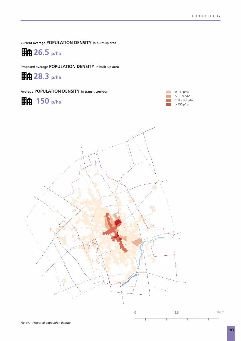
THE FUTURE CITY
103
Fig. 54. Proposed population density
Current average POPULATION DENSITY in built-up area
Proposed average POPULATION DENSITY in built-up area
Average POPULATION DENSITY in transit corridor
26.5 p/ha
28.3 p/ha
150 p/ha
0 - 49 p/ha
50 - 99 p/ha
100 - 149 p/ha
> 150 p/ha
50 km0 12.5

THE FUTURE CITY
104
that averages 150 p/ha in the transit corridors. The highest intensity of activities is concentrated along these corridors, bringing economic vibrancy and an improved quality of life, in terms of accessibility.
ProductivityAccess to jobs is a pivotal factor in the future growth and economic development of a city. The current land use allotment and the population distribution across the city of Buraidah can help estimate the number of jobs, which is a critical indicator of the spatial representation of economic opportunities. With greater access to jobs within close distances, the productivity of residents increases, as they spend less time on daily commutes and more time in productive work. Economic opportunities attract businesses and talent, which contribute to the competitive advantage of the city.
The productivity analysis is based on a few assumptions, which assign a certain number of jobs per square metre of a built-up area for each land use. While this assumption is broad and an approximation, it helps to understand the trends of job distribution in the city and reveals the inequities and gaps in their spatial distribution and access. The total jobs in the city at present is at 22 jobs per 100 residents. This number increases to 42 jobs per 100 residents in the proposed scenario by simply densifying land use and building heights within a 10-minute walk corridor along the two metro lines. Thus, for 1.5 times increase in population, the estimated increase in jobs is 2.5 times.
Job accessed by walking While the total number of jobs in the city increases at a rate higher than the population growth rate, the spatial distribution of these jobs is a critical factor in planning for future growth of the city. The map in figure 55 represents the number of
Fig. 55. Current job accessibility within a 10-minute walk
50 km0 12.5

THE FUTURE CITY
105
Fig. 56. Proposed job accessibility within a 10-minute walk
jobs accessible within a 10-minute walk from different city-regions. Presently, the job distribution in Buraidah seems to be uniformly distributed without dense concentration in the city centres. As expected, the farther extents of the city, which are majorly residential, have a low job density and hence lower access to jobs. The proposed land use scenario for Buraidah will increase the number of jobs accessed within a 10-minute walk from different city-regions. In the new scenario, each person can access 2,000 more jobs within a 10-minute walk anywhere in the city. Focusing on creating opportunities within the built-up footprint by filling in the gaps and densifying existing developments along the North-South and East-West axis will increase access to jobs by more than 400%, (See figure 56). Redistributing land uses by ensuring a balance of commercial, mixed and residential land use, will improve the spatial distribution and access to jobs across the city.
8 000 - 50 0004 000 - 8 000
2 000 - 4 000
1 000 - 2 000
500 - 1 000
0 - 500
JOBS
NUMBER OF JOBS ACCESSIBLE WITHIN A 10-MINUTE WALK
CURRENT PROPOSED
50 km0 12.5

THE FUTURE CITY
106
Jobs accessed by public transportThe proposed public transport lines, with the current land use pattern and distribution, give access to 32% of all jobs in the city to people residing and working within a 10-minute walk buffer and assuming a 20-minute public transport ride. With the current density and distribution of land use, the public transportation system will not be successful as it would struggle to serve a large percentage of the population.
Densifying and changing land use along the 10-minute walk catchment area from the public transport stations, triples the number of jobs accessed, increasing access to 57% of all jobs within the city. Densifying and changing land use along the 10-minute walk catchment area from the stations after re-aligning the transport line through the centre of the city, significantly increases the number of jobs accessed, increasing
access to 70% of all jobs within the city. The exact proportion of jobs added along these corridors will vary based on the density and distribution of land uses during implementation. However, developing along the guidelines mentioned in this document will ensure that the city benefits from the economic advantages of bringing people together and connecting them via public transport.
Jobs accessed by drivingJob distribution is calculated by estimating a certain number of jobs per square metre of the built-up area for each land use. As shown in figure 61, about 59% of all current jobs in the city can be accessed within a 20-minute drive from anywhere in the city. This analysis is dependent on the even distribution of land use and the road network. This means that central locations have greater reach to jobs within the city.
Fig. 57. Current job accessibility from public transport stations
50 km0 12.5
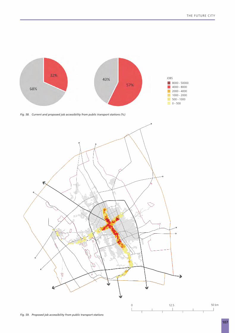
THE FUTURE CITY
107
Fig. 58. Current and proposed job accessibility from public transport stations (%)
Fig. 59. Proposed job accessibility from public transport stations
8000 - 500004000 - 8000
2000 - 4000
1000 - 2000
500 - 1000
0 - 500
JOBS
50 km0 12.5

THE FUTURE CITY
108
As the population increases and with a denser distribution in the city centre, the access to jobs by road should increase. However, with an increase in the number of people on the current road network, the travel speeds would reduce due to congestion. This is a fair assumption, as trends worldwide indicate that growing cities witness increased congestion and an overall reduction in travel speeds. Hence, the number of jobs accessed within a 20-minute drive will reduce to 58%, (figure 61). This statistic endorses the need to supplement this reduction in the number of jobs accessible by car by putting a public transportation system in place as the city grows. The public transportation system will increase the total number of jobs accessed when all modes of transport are considered together.
AccessibilityAs a consequence of the new land use designations, and higher-densities along the two BRT lines in Buraidah, the access to transportation significantly improves to developments within a 10-minute walking distance. The increase in density provides access to public transportation to a greater number of residents, giving them a choice to switch to more sustainable travel modes.
The population captured within a 5-minute walk to the BRT stations shifts from 16.5% or 101,972 inhabitants to 43.4% or 364,588 inhabitants with the new distribution of land use and updated density levels. The population captured within a 10-minute walk increases from 29.7% or 183,805 inhabitants
Fig. 60. Current job accessibility within a 20-minute drive
50 km0 12.5

THE FUTURE CITY
109
Fig. 61. Current and proposed job accessibility within a 20-minute drive (%)
Fig. 62. Proposed job accessibility within a 20-minute drive
80% - 100%
PERCENTAGE OF JOBS ACCESSIBLE WITHIN A 20-MINUTE DRIVE DISTANCE
60% - 80%
40% - 60%
20% - 40%
10% - 20%
0 - 10%
50 km0 12.5

THE FUTURE CITY
110
to 58% or 490,580 inhabitants. Movement within the city can be efficiently managed and serve a higher number of people.Densifying along these corridors will not only improve accessibility and increase density for a more sustainable urban form, but it will also create a coherent and comprehensible structure for the city of Buraidah, that is currently plagued with fragmented pockets of sprawling developments.
As illustrated in the sections above, the proposed scenario brings together spatial planning policies, urban mobility and economic development in Buraidah. By densifying and developing along mobility corridors, the total number of jobs in the city and the access to opportunities increases and the overall social and economic well being of the city benefits from agglomeration advantages.
Fig. 63. Current accessibility within a 10-minute walk from BRT stations
50 km0 12.5

THE FUTURE CITY
111
30%
70%
Current metro accessibility to jobs
1 2
79%
21%
Proposed metro accessibility to jobs
1 2
30%
70%
Current metro accessibility to jobs
1 2
79%
21%
Proposed metro accessibility to jobs
1 2Fig. 64. Current and proposed accessibility within a 10-minute walk from BRT stations (%)
5-minute walking distance from stops
10-minute walking distance from stops
Fig. 65. Proposed accessibility within a 10-minute walk from BRT stations
50 km0 12.5

112

77
ACT
ION
PLA
N
7
© sabq.com

114
ACTION PLAN
7.1 From Strategy to Action
Transforming conceptual recommendations into concrete and implementable strategies through both punctual and diffused interventions requires detailed systemic and scaffolded actions that can incrementally trigger the envisaged spatial, economic, and social transformations.
Intrinsically, an Action Plan that is rooted in the four strategic recommendations and grounded in a series of systematically scaffolded interventions for Buraidah serves as a guide in prioritising and detailing the subsequent actions needed for building an integrated and resilient city. The four central strategic actions, which impact Buraidah on the regional, urban, and local scale, to achieve long-term sustainability and socio-economic balance are:
• ACTION 1: Set up a public transportation network to create backbone for development and improve the road network
• ACTION 2: Densify around existing transportation backbone and create diverse and vibrant urban centres
• ACTION 3: Preserve the natural assets and relink the blue and green networks
Overall, the Action Plan creates impact at two scales: the urban and the neighbourhood scale. Actions 1 and 2 address the need for a system of urban interventions, in order to address the issue of sprawl and segregation in the city. The implementation of a public transportation network and the creation of new centralities around the main nodes acts at the city scale, rebuilding the relations between different city users, improving integration of the urban outskirts to the rest of the city, and improving transport and mobility network. Action 3, on the other hand, promotes punctual interventions by targeting diffused micro public space networks at the neighbourhood scale while addressing the socio-ecological rehabilitation of natural elements, for the whole city, by tackling the blue and green networks. If implemented, these actions have the potential to readdress Buraidah’s future urban development radically.
© Nawal Al - Ghannam
King Abdullah Park

115
© Salman Al Fayrouz
Buraidah dates farm

116
ACTION PLAN
7.1.1 Action 1: Set up a public transportation network and improve the road network
The first action addresses the need to restructure the city starting from its mobility patterns. It anticipates linking the fragmented developments by enhancing the traffic network and creating an intermodal public transportation system. It improves the connectivity between the individual urban fragments by using different modes of transportation. One of the critical interventions on the city level concerns the creation of an intermodal, capillary, and efficient public transport system formed by a primary bus rapid transit system and its integrated feeder bus transport lines, as well as adequate pedestrian and cycling infrastructure along the densified areas to reduce the traffic congestion and air pollution. Action 1 can be summarised in the following steps:
1.1 Establish two main public transport spines along the King Abdulaziz and King Fahd Roads The BRT system is identified as a primary mode of public transport for Buraidah. There are two main corridors that need to be prioritised to implement the BRT lines. One of them is the King Abdulaziz Road, which forms the backbone of the city’s transportation network. The foreseen BRT Line 1 crossing the city in the North-South direction will connect the existing commercial centre of the city with the new developments in the North and the neighbouring city Unayzah in the South. Thus, this primary BRT line will serve as a fast regional connection to the distant city of Unayzah (34 kilometres) and enhance the functional connectivity and socio-economic relationships of the two cities. On the other hand, the BRT Line 2 lies in the East-West direction along the King Fahd Road, and connects the airport in the West to the regional railway station in the East, crossing the first BRT line at the city centre. With the extension to the university located in the Northwest of the city, this line will connect Buraidah´s transit nodes and education hubs to the city.
1.2 Complement the main BRT network with local networks of busses to establish feeder systemsThe BRT network should be complemented with the capillary feeder system of local buses, which would facilitate the intermodal exchanges, allowing for better integration of the public transport system with the different neighbourhoods, diffusely reconnecting the city. These feeder lines are important for the overall functionality of the public transport network to support the East-West directional movement within the ring road of the city.
1.3 Reduce road corridor size to avoid fragmentationKing Abdulaziz Road and King Fahd Road are currently the two main physical dividers of the urban fabric within the ring road, as they function as a throughway, with traffic moving at high speeds. They should be rescaled and redimensioned to reduce high speeds and integrate traffic with the proposed BRT Lines 1 and 2. Repositioning and redesigning these two highways (inside the ring road), as pedestrian-friendly inner city boulevards will re-stitch the central urban fabric while acting as a central transportation spine. The inner city boulevards will incorporate vibrant commercial activities, recreational open spaces, and a pedestrian-friendly public realm. The proposed demonstration project by UN-Habitat in Arar can be used as a reference for such projects. The proposal has studied a specific segment of Highway 80 to demonstrate a transformation proposal for the highway system within the city into boulevards with additional residential neighbourhoods supported by public facilities, public spaces, commercial hubs, and public transport.
1.4 Improve road hierarchy and integrate Southern and Southwestern developmentsIn addition to the public transportation network and the primary road system, the currently insufficient secondary road network requires further development. It should blend local multi-model networks, ensuring access to public transportation and, if feasible, integrate suitable pedestrian and slow mobility passages into existing and new corridors. Roads corridors should be reduced to avoid creating barriers between urban developments, anticipating walking on shaded sidewalks of adequate width with rest areas in suitable distances. Furthermore, especially the developments in the South and Southwestern parts are not sufficiently connected to the overall city network and, therefore, should become a focus shortly. Further actions must be refined to improve access to services, the internal connectivity and the connection to the rest of the city.

117
ACTION PLAN
Fig. 66. Action 1: Set up a public transportation network to create backbone for development and improve the road network
Major nodes
Secondary nodes
Local nodes
BRT lines
Secondary connections
Built-up area
50 km0 12.5

118
ACTION PLAN
7.1.2 Action 2: Densify around existing transportation backbone and create diverse and vibrant urban centres
Following the implementation of a public transportation network, the city should start actively incentivising residential densification and mixed-use development in the areas with walkable access to public transport. Strategic densification should be applied to selected major nodes to define emergent new centralities, and able to rebalance the city’s overall distribution of services and facilities by encouraging mixed-use development and concentrations of services, and facilities around them. The transit and main stations, which allow changing between the modes of transportation, are particularly suitable for TOD developments. Creating new centres with higher identities, which offer a social mix along with diverse services and activities, will activate the surroundings, improve the quality of life of the residents and develop the accessibility of vital facilities within proximity. This should be enforced together with the interstitial spaces and the available vacant land within the urban footprint to prevent sprawl. As such, Action 2 is composed of the following steps:
2.1 Promote dense and mixed-use development along the public transport systemThe envisioned two BRT lines should act as densification and mixed-use development corridors providing public services and facilities, (educational, healthcare, and commercial areas). The transportation corridor is suitable to create a high-density urban typology attracting people/residents within walking distance of public transport connections and amenities. Distributing urban density following this criterium would increase the number of people serviced by public transport, thus reducing overall car-dependency for residents, as well as traffic and pollution, and improving the overall quality of life. The transit-oriented development would help to create vibrant, livable, and sustainable communities by focusing on housing, employment, and recreational activities within walking distance of public transport.
2.2 Develop a hierarchy of mixed-use nodes at strategic points along the public transport systemA hierarchy of densified mixed-use centres should be developed around the public transport network especially in the interchange points. Primary mixed-use nodes should be located along the two BRT lines. Secondary nodes must also be distributed following the criteria of rebalancing access to services, facilities, and jobs across the city. In regards to the densification of the TOD hubs along the principal public transportation axis, it is recommended to develop guidelines, which require higher densities within a 10-minute walking distance to the station. Special programmes and design guidelines should be established to determine areas of high development priority. Those areas would have a considerable trigger effect contributing to achieving more vibrant regions
by offering a social mix and access to various services offered, which reduce commuting times tremendously. This balanced distribution of different hierarchical centres would support the goal of ensuring equal access to services for all and improve the productivity and diversity of the city. Through enhanced street life, the areas would become more vibrant where points of attraction and unique identity are to be designed.
2.3 Incrementally develop available vacant land within the current built-up fabricDensification and connectivity of the existing urban fabric need to further focus on vacant land infill opportunities within the ring road, enforcing a boundary to limit and consolidate development. Developable vacant land (exclusive of waterways, slopes, hills, and other critical natural features), within the built-up area, should be incrementally developed to prevent sprawl, hosting future growth through densification and mixed-use development. Consumption of land in the outskirts of the city must be consequently avoided, instead, urban growth should be limited by the ring road, focusing development efforts on the structuring of a more sustainable, compact, and efficient urban form. Focusing on the future growth within the existing city, by densifying the wherever possible, would prevent the further fragmented urban sprawl to the limits of the urban edge.

119
ACTION PLAN
Fig. 67. Action 2: Densify around existing transportation backbone and create diverse and vibrant urban centres
Major nodes
Secondary nodes
Local nodes
BRT lines
Secondary connections
Built-up area
Vacant Land
50 km0 12.5

120
ACTION PLAN
be set in place to discourage and limit intensive and industrial agricultural farming methods so as to reduce stress on water resources and extraction in the entire Al Qassim Region, promoting the protection of the underground aquifers. Alternatively, it is important to encourage traditional models of farming to boost sustainable economic activities and reduce depletion of aquifers. Irrigators for open space vegetation within the city should reuse the wastewater.
Furthermore, industries which usually produce a vast amount of sewage should be required to treat their wastewater for further reuse in their industrial processes or irrigation. In regards to the natural resources, the implementation of deep wells in suitable, low topographical areas where the runoff water converges, should be integrated into the overall sustainability strategy due to the rechargeability of the aquifer of the Al Qassim Region. To raise their water tables, the runoff from precipitation, which has been recorded to reach up to more than 100 mm in recent years, can be injected into the aquifer by deep wells. Finally, awareness campaigns and implementation programmes must be established on different levels in society relating to the diverse sectors. On the household level, the installation of modern water saving devices should be introduced to reduce the wastage of water and lower the above average daily water consumption.
3.3 Create a public open space networkBesides the lack of service distribution, many of the typical Saudi neighbourhoods are lacking in public open spaces or spaces for social interaction in general. In the standard neighbourhood layout, provision for a central open space exists, but in many cases, it is not developed yet. In addition to promoting those spaces, it is expected to create a more complex hierarchy of open spaces, which allows for better connectivity between the neighbourhoods. In order to do that, the existing wadi network within the urban fabric needs to be re-naturalised and revitalised as a network of green public spaces in the city. The entire green network has to be designed with a concept of diversity and inviting public realm.
Furthermore, agricultural land running through the urban fabric and acting as a belting element should be rehabilitated and integrated into the blue and green network, which have positive effects on the urban climate. Moreover, the public space network needs to be complemented by the street level interventions; such as redesigning the streetscapes and providing secure and shaded pedestrian sidewalks to improve the accessibility and connectivity. The above-mentioned measures to improve connectivity and the upgrade of the pedestrian and slow mobility network would positively contribute to the connection of the fragments of the city and creation of liveable, integrated, and resilient neighbourhoods.
7.1.3 Action 3: Preserve the natural assets and relink the blue and green networks
Action 3 aims to make the city more resilient, more sustainable, and enjoyable for its residents. This intervention is a redefinition of the actual development models and integration strategies of ecologically sensitive areas. Introducing sustainable infrastructure and irrigation methods is one of the top criteria to preserve the existing natural features and assure long-term development and productivity. As such, and in parallel to the strategic densification process of Buraidah, vacant land has to be selectively preserved for the creation of green public space, especially in areas subjected to densification. The natural system of wadis, currently neglected as a structural element in the city’s functioning, would have to be naturalised and strengthened, moving towards natural water management systems at the entire urban scale, so as to play a key role in the city’s development. In addition, the promotion of urban and peri-urban agriculture along the wadis would gradually support the relinking of green and blue networks, while strengthening food security and resilience. Action 3 can be summarised in the following steps:
3.1 Enhance local identity by preserving agricultural land and connect it with the urban fabricConnectivity, balanced socio-economic development, and densification are indeed the primary drivers for the growth of Buraidah. Nevertheless, the city’s uniqueness comes from the vast number of agricultural lands, which are not only framing but are part of the city’s fabric. Various measures and programmes have to be undertaken to preserve this individual identity, addressing the general public as well as the farmers in the region. On a governmental level, legal tools and regulations need to be developed to protect and preserve the agricultural land. They should focus on the restriction of intruding the land, the maintenance of agriculture land, and foster enhanced productivity of farms without harming the ecosystem. They define the relationship between the built-up area and the farms. The restrictive regulations and building codes concerning the use and conversion of agricultural land should become legally binding to the local planning authorities.
3.2 Prepare a comprehensive water management strategy to save natural water resourcesWhile planning towards preserving the environmental assets and improving the quality of life, it is inevitable to address the scarcity of freshwater resources. As such, a comprehensive water management strategy must be introduced not only in the city of Buraidah but also in the entire region of Al Qassim. Due to the fertility of the soil in the region, the city is one of the largest wheat producers in the country. Nevertheless, the cultivation of grain and especially wheat require a significant amount of water and fertile soil, conditions which are rare to find in Saudi Arabia. Therefore, the introduction of an environmental protection plan and sustainability programmes are inevitable. To do this, programmes and incentives need to

121
ACTION PLAN
Major nodes
Secondary nodes
Local nodes
BRT lines
Secondary connections
Built-up area
Agricultural land
Green network within Ring Road
Green Links
Fig. 68. Action 3: Preserve the natural assets and relink the blue and green networks
50 km0 12.5

122
ACTION PLAN
7.2 Three Systemic Actions for Structural Change
The Action Plan presented here can be considered as a guide on how to incrementally trigger a structural change in Buraidah, moving away from an unsustainable model towards an integrated, ecological framework for urban development. A sustainable city brings together environmental, social, and economic factors, along with comprehensive urban planning and management efforts for a long-term sustainable society. This implies an integrated approach to sustainable urbanisation that should be based on a holistic view of social development, economic opportunities, environmental management, and governance frameworks.
This integrated approach should entail the coordination of objectives and programmes, among different city stakeholders (e.g., citizens, Government, and the business sector), as well as the development of linkages between and within socio-economic sectors and activities. As such, the above-described scaffolded system of actions will drive an overall transformation on the spatial, the social, and the economic fabric of the city. If the steps illustrated in the Action Plan are followed, Buraidah will manifest the strategic vision into a reality, making the city:
• Compact,• Connected,• Inclusive, and• Resilient.
Farms dividing the city structure of Buraidah
© Dehraan , Skyscrapercity.com

123
© Abeer Bajandouh
Scattered water features in the landscapes of Buraidah

124
88
FIN
AL
RECO
MM
ENDA
TIO
NS:
TH
E TH
REE-
PRO
NG
ED A
PPRO
ACH
© Rayan Muteb

126
THE THREE-PRONGED APPROACH
8.1 Spatial Recommendations
8.1.1 A strategic view of the Al Qassim spatial development
The Al Qassim Region has predominantly two main cities, which are Buraidah and Unayzah, and as earlier indicated in the metropolitan connectivity section, they form an initial Metropolitan System, that could grow into a city-region of complementary cities. According to the National Spatial Strategy (NSS), the regional plan of the Al Qassim Region aims to adopt a comprehensive vision of economic, social, and spatial development.
There is a potential in developing the Al Qassim Region as a leading economical and sustainable region in the Kingdom by optimising on the region’s competitive advantages. These include its location, transport network, industrial and commercial cities, and free services provided by the Chamber of Commerce and Industry.
Overall, there is an imbalanced distribution of services in the region. Some urban centres are oversupplied with social and health services, while other centres lack fundamental services and commute far distances to Buraidah or Unayzah, the two cities offering most of the services. Similarly, the same applies to infrastructure where coverage and quality of infrastructure vary, based on the size and political importance of the urban centres backing them. Looking at re-invigorating the development of the region means looking at creating an environment that is spatially balanced, as well as socio-economically inclusive. To achieve this, there is a need to strengthen the connectivity of the various growth centres as prescribed by the National Spatial Strategy (NSS), using public transportation as well as redistribution of public services like schools and hospitals.
At the current urban population growth rate of 3.76%, and with the Al Qassim Region being one of the top population attracting regions of the Kingdom, there is an urgent need to address key interventions at the city-region and regional level to ensure sustainable regional development.
Spatial interventions:• A strong focus on the idea of the hierarchical distribution
of urban and rural centres connected by a system of highways is needed. The following highlights some of the interventions necessary to achieve this.
• Strengthening the corridor to the North of Buraidah towards Mudarraj and Al Quwarar, which has immense agricultural potential would boost the Buraidah-Hail corridor and hence the region.
• Emphasising the connection between the two National Growth Centres; Buraidah and Unayzah, by supporting the development of the proposed BRT network and regional services hub. Equally important is linking the city-
region-wide public transportation network to the North-South railway line, which opens up to Al Haditha, the biggest dry port in the kingdom, and also as a passenger line.
• Encourage the functional connectivity and complementary economic activities of the two National Growth Centres while preserving the natural assets, such as the vast amount of agricultural land and major wadis located between the two cities.
• Encourage the establishment of a regional rail connection to Dammam, which will act as a transportation spine for local and exports through the port. As proposed by the Regional Plan, there is a need to establish necessary regional road networks to support future economic activities and commerce of the region. Thus, the National Highways System will link Al Qassim with Jubail City in the Eastern Region.
The NSS identified three important development corridors that connect the Al Qassim Region to neighbouring regions: Riyadh‐Buraidah corridor in the South, Buraidah–Madinah to the West, and Buraidah–Hafr Al Baten to the East. The Al Qassim Regional Plan has focused on the first two corridors, and the execution of these corridors is key to developing the spatial impetus required for the growth of the Al Qassim Region.
Diversifying the economic base of Al Qassim Region:The products of economic sectors in the region are not export-oriented commodities and are mainly products of crops and livestock that are consumed by the population of the Al Qassim Region and other nearby regions. Therefore, the region’s contribution to Saudi exports is minimal, as it is estimated at 0.01% of the total value of Saudi exports in 2012.
The region needs to benefit from the synergy created in the Hael–Riyadh axis, and Madinah–Eastern Region axse, and also its proximity to the capital of the KSA, in terms of infrastructure and commerce. Although the spaces of intensive economic activities are limited to Buraidah–Unayzah corridor, the spatial distribution of economic activities will be key to balance economic and regional development. In the next ten years, and considering the implementation of the Regional Plan, the regional economic dynamics are meant to shift, and the sectors described below are key to this.
There has been significant growth and development of the agricultural sector in the region during the past few years. There is potential to ensure the continuity of growth and increased diversity in the production of crops, such as grapes, oranges, lemons, grapefruits, mandarin oranges, pomegranates, and a large varieties of vegetables, that could

127
© Twitter @Fahad_059
Date farms

128
THE THREE-PRONGED APPROACH
attract large investments to the production of food products, agricultural equipment and machinery, and other industries and activities related to agricultural activity. With the current regional migration potential, there is need for increased agricultural production especially towards Al Fuwayliq, West of Buraidah, to create job opportunities.
The mining sector in the region still has great untapped potential, raw materials, and natural mineral resources which are characterised by their economic volume and industrial feasibility. With an estimated 102 million tonnes of bauxite, limestone and loam, gypsum, dolomites, silica sand and sandstone, as well as salt, an increase in excavation projects could work to increase productivity and hence the GDP contribution to the Kingdom.
Building infrastructure for the vibrant tourism industry is the first step to improving tourism activities in the region. As per the Regional Plan, major investment in housing and hospitality, coupled with biodiversity and heritage, have to be promoted as fundamental assets or as the Al Qassim Region tourism industry, which is achievable with the current regional touristic axis.
8.1.2 Towards Buraidah, An Ecological Agro-city
From a secondary city towards a significant productive hub in the KSADespite all the urban, social, and economic challenges the city of Buraidah has a notable potential to become a prosperous organism, placed at the heart of the Kingdom. Nevertheless, being prepared is vital for short and long-term development of the city.
One of the principal challenges is its growing young population, which will soon join the job and housing market. Constant rural migration to the city leads to the necessity of providing accommodation and suitable work opportunities. The responsibility to react to these challenges strongly relies upon the preparedness of the municipality, which translates into the implementation of integrated and intersectoral urban development plans and strategies. Unquestionably, a joint effort of all involved stakeholders is required to turn Buraidah into a sustainable, vibrant, and productive agro-industrial city.
The advantages of Buraidah are its existing environmental features, its current economic activities, and its central location. Furthermore, the multi-modality of the city provides direct access to the major highways, rail system, and the airport and are high-quality links to other regions. The proposed
Dates market in Buraidah
© Suliman Alkurishan

129
THE THREE-PRONGED APPROACH
Fig. 70. Action plan for Buraidah
Major nodes
Secondary nodes
Local nodes
BRT lines
Secondary connections
Built-up area
Blue network
Agricultural land
Green network within Ring Road
Densification areas with mixed-use development
Green links
50 km0 12.5

130
THE THREE-PRONGED APPROACH
national connections around Buraidah would foster economic development of the city. It also generates the opportunity of becoming more productive and prosperous at the Kingdom scale, and by being recognised as an essential hub, it competes with other regions. Developing industrial uses, such as logistics or manufacturing, and food processing would further stabilise the economic and socio-economic progress of Buraidah by creating white and blue collar work opportunities, and diversification of the employment market.
Significant improvements emphasised in the Action Plan are urgently needed for Buraidah to use its full potential and become a city which is sustainable, intermodal, diverse, vibrant, and productive.
SUSTAINABLE CITYThe different actions proposed along the public transport lines and agricultural lands will create a sustainable city in many ways, but it will mainly reinforce the natural ecosystem.
Buraidah, with its distinguished agricultural heritage, has a unique opportunity to promote its product worldwide. The rural area should be developed incorporating new sustainable energy and water harvesting solutions. Responsible use of natural resources reduces and potentially reverses any damage to the environment. Reactivation of existing vacant land contributes to further enhancements. Buraidah should consider sustainability as the ultimate environmental pursuit, and to strengthen the ecosystem by protecting the wadi and recognise it as its unique and natural asset. Focus on biodiversity protection would simultaneously result in a growing natural buffering green area, a reduction in flooding risk while at the same time adapting to climate change and reducing urban temperatures by capturing the dust.
INTERMODAL CITYCitywide zoning policies would enable controlled urbanisation processes. Planned clusters would connect to existing agricultural areas allowing further improvements. Adequately designed connection links are key to a well-functioning city. The action seeks to balance the existing road network and promote public transportation. Revised mobility corridors would continue to receive significant vehicular traffic, which would be discharged into the corresponding road system. Creating new green public transport, and pedestrian and cycling friendly route reduces traffic. Safer, environmentally-friendly, compact, and an accessible city is what the intermodal vision seeks to create. Moreover, linking the proposed BRT network with other linear corridors will connect the city in both horizontal and vertical directions. The implemented BRT system could contribute to a reduction in traffic jams, provide a safer and more friendly transport environment for drivers, as well as pedestrians and cyclists. Besides that, dedicated bus lanes reduce interaction between buses and other vehicles, minimising the risk of road incidents. Reduction in air pollution is a further elemental asset of the proposal.
VIBRANT CITYEnhancing the core of economic and social activity promotes an integrated urban and territorial planning. Compactness, polycentrism, appropriate density, and connectivity are a good combination with the versatile spaces in the built-up areas that consist of a mixture of social and economic uses.. A well-designed urban programme leads to industrialisation. The polycentric approach is an opportunity to introduce new businesses and strengthen the market. Economic progress and prosperity contribute to raising the living standards of citizens and densified, and the connected city results in more efficiency and equitability. Preventing urban sprawl will reduce mobility challenges, the cost of services, and negative impacts on the environment. Buraidah will transform into a vibrant, economically and socially active entity that will improve the quality of life for the public.
DIVERSE CITYConsumer demand and the nature of developing markets restrict design and adoptions of certain alternatives for residential standards. Nevertheless, the vision for Buraidah promotes innovation. Diverse urban economics, high productivity, accessibility for all and ecological consideration stimulate wealth creation.
The principal objective of the actions is to consolidate Buraidah as a diversified city regarding ecology, sustainability, economic activity, and social welfare. There is an immediate relationship between the size of cities, and diversity or specialisation. To implement heterogeneity, Buraidah would respectively contribute to consolidating a healthy financial structure for its citizens along with local government and visitors.
8.2 Institutional and Legal Recommendations
In terms of legal reform, Buraidah would benefit from both fiscal and jurisdictional decentralisation to facilitate independent and innovative solutions to urban social problems, at the Amanah level. This should entail:
• The transfer of local planning power, authority and function from MoMRA to the Amanah, with provision for independent action without recourse to effectively address community needs. This is supported by the New Urban Agenda, which specifies that territorial urban design and planning processes should be led by sub-national and local governments, but their implementation will require coordination with all spheres of governments, as well as the participation of the civil society, the public sector, and other relevant stakeholders;
• Fiscal decentralisation, which gives autonomy to the Amanah to source funds to finance development activities. Revenue generation activities in cities may also include taxes and levies. Urban areas should be allowed to collect some form of property taxes to fund development activities. The recent White Lands Act that imposes fees

131
THE THREE-PRONGED APPROACH
on undeveloped plots in urban areas to tackle land speculation, housing shortages, and indiscriminate land development shows that regulatory mechanisms can be leveraged to generate revenue while fostering an efficient development framework;
• The opening of avenues for actors, including the private and voluntary sector and the general community, to participate in decisions regarding projects that affect them.
Consolidation of the legal planning instruments would also support development intervention of Buraidah, along with the review, update, and modernisation of these laws to make them relevant to the current development situation. This should also entail re-thinking the lawmaking process to limit the number of actors. The mere existence of the laws in the KSA will not guarantee sustainable urban development as they must be functionally effective, i.e., precise in achieving their intended results, clear, consistent, and simple to understand. There is a need for a functionally effective urban planning law that, inter alia:
• Introduces incentives/requirements that will enable more compact city growth;
• Defines clear institutional roles and responsibilities at each level;
• Enforces linkage between all levels of plans (national- regional-local);
• Provides effective coordination and monitoring mechanisms; and
• Increases meaningful public participation and engagement in planning.
The legal framework also needs to enshrine an acceptable mode of public participation in public decision making to foster equality and inclusion. The consolidation of the urban legislation would also give legitimacy to the plans that Buraidah relies on.
Revising the Urban Growth Boundary Law to include clear criteria on how it is set would enhance technical and vertical accountability. The Law also needs to place more emphasis on establishing the Development Protection Boundary as a no-development zone to not only prevent haphazard development but also avert private interests from taking advantage of the laxity in the legal text. These initiatives will strengthen policy formulation designed to make the city more sustainable, compact and dense. Primarily, a post-legislative scrutiny of the urban growth boundary law should be done to assess if it has met its policy objectives. This could in turn inform the legal reform process as well as the planning policy options.
8.3 Financial Recommendations
8.3.1 Own-source revenue instruments
In 2015, the KSA began implementing a series of reforms meant to strengthen public finance by diversifying public revenue, introducing new tax mechanisms, improving tax administration,
Al Qassim University© Wiki

132
THE THREE-PRONGED APPROACH
THE IMPACT OF INFRASTRUCTURE
DEVELOPMENT ON LAND VALUE
Case examples Key findings
London, England
The Crossrail Property Impact Study (2012) estimated
that capital values in the areas around central
London Crossrail stations would rise by 35% for
residential properties and 27.5% for office properties;
outperforming the baseline projections.
Source: GVA (2018); Mohammad et al. (2017); Colliers International (2017); Rodríguez
and Targa (2004).
Dubai, United Arab
Emirates
Dubai, United Arab
Emirates
The impact of public transportation on property values
for dwellings and commercial properties is about 13%
and 76%, respectively, within an area of 1.5 kilometres.
Cairo, Egypt
• Urban development that included retail facilities
resulted in a price premium of 15 – 20%.
• Schools increased residential land prices by
approximately 13%.
• Walkability within a residential community increases
home values by up to 9%
Bogotá, ColombiaResearch suggests that for every additional 5-minutes
of walking time to a public transportation station,
rental prices fell by 6.8 - 9.3%
and attracting private investment. In addition to improving local finance and economic dynamism, the reforms were also meant to support the implementation of the New Urban Agenda (NUA) by fostering inclusive, sustainable, and equitable local financial and economic frameworks through progressive tax policies and own-source revenue generation.43 The geographic, cultural, social, demographic, and economic advantages of the KSA have made it a crucial international player and economic power. Historically, oil and gas have been the country’s primary exports, but the KSA has begun investing in other strategic sectors of the economy.
Under Vision 2030, KSA’s development roadmap also supports economic diversification into non-fuel.44 One of the objectives of Vision 2030 is to facilitate economic development in new industries and foster innovation and economic competitiveness. In part, National Transformation Programme (NTP) 2020 was launched to build the institutional capacity needed to reach the Vision 2030 goals, including supporting economic growth and diversification. The NTP utilises innovative methods to identify economic challenges, seize opportunities, adopt effective planning tools, increase engagement with the private sector, implement reforms, and evaluate performance.
The objective of the Saudi reforms proposed in the NTP is to support economic growth and diversification. The reforms are aimed at strengthening public finance, introducing new tax mechanisms, and attracting private investment into strategic economic sectors. One example of these reforms is the White Lands Tax, introduced in 2015, which aims to create a more stable, diversified, and sustainable public finance base. The White Lands Tax requires owners of empty urban plots, designated for residential or commercial use, to pay an annual tax of 2.5% of the land value. The land tax is levied on 10,000 square metres of urban land. The tax has been adopted in the cities of Riyadh, Jeddah, and Dammam. In addition to improving the own-source revenue base of municipal governments, these reforms also support the NUA, a framework for sustainable urbanisation. The new land tax aims to:
• Promote real estate development that addresses supply shortages in the region;
• Increase the availability of land for affordable housing development;
• Safeguard competitive markets and minimise monopolistic practices;
• Increase local revenue generation.
International experience and case studies from other countries and cities, including OECD countries, Hong Kong, Taiwan, and Colombia, provide valuable insight and a framework for introducing land-based taxes that support own-source revenue generation and local economic development. In the case of Buraidah, a policy aimed at increasing revenue sources should take into account socio-economic and demographic factors, such as the population growth rate, population density, and urban sprawl. Taking these factors into consideration, new financing instruments
Fig. 71. The Impact of infrastructure development on land value
that mobilise adequate local revenues and take into account future expenditures levels will be needed to support local finance and sustainable urban development. Hence, exploring own-source tax instruments, such as land-based financing mechanisms, will be a crucial part of reaching goals outlined in the NTP.
Experiences from other countries suggest that this mechanism can stimulate urban development, local economic growth, and incentivise efficient land use. On average, the potential revenue contribution through immovable property is 2.1% of GDP in high-income countries, while in middle-income countries it contributes an additional 0.6%to GDP. 45 Evidence from a diverse set of countries supports the use of land-value capture as a mechanism for capturing the value created by new infrastructure projects, zoning changes, and/or infrastructure upgrades. Land-value capture is based on the idea that individuals, businesses, and landowners in the adjacent areas that benefit from government and/or private investment in infrastructure (e.g., roads, railway, industrial infrastructure, schools, and hospitals) that increases the value of their land (see figure 71).

133
THE THREE-PRONGED APPROACH
KEY FACTORS IN DESIGNING
BETTERMENT LEVIES
Determining land value capture objectives
Revenue targets based on either
(a) a percent of infrastructure cots
or (b) a percent of the increase in
land value
• Betterment levies are a good option for scenarios involving
public transportation and waterfront development
• Data on changes in land value and efficient tax
administration are critical success factors
Timing and collection of paymentsPayments collected:
• Upfront, as with developer
contributions made before the
infrastructure is built
• Annually, as with an increment to
local government rates
• At the time the property is sold
• Consideration should be given to whether there are
negative financial consequences for landowners who may
not have the capacity to pay a levy or who are asset rich, but
income poor
• The government might consider only requiring the levy to
be paid when a property is sold or transferred
Application of the Levy by Land Use Groups
• Real estate developers
• Commercial landowners
• Residential landowners
• Application of the levy should be determined using the
beneficiary-pays principle
• If it can be demonstrated that benefits will flow to specific
types of property owners, then there is a strong case to
include them in the land value mechanism design
Source: Youngman, J.M. (1996). Tax on land and buildings. In Thuronyi, V., (Eds.) Tax law
design and drafting. International Monetary Fund. Washington, DC.
Application and Boundaries of Levy
Levies can be structured to have a
broad based (e.g. city-wide) or time/
distance based
• In Dammam, land value benefits are maximized for a 1.5 km
area with a walking catchment for public transportation.
• This benchmark is given supported by other cases (e.g.
Dubai, London, Bogotá) and will require additional analysis
focused on project specifics
Setting the RateThe rate structure is variable and is
determined on a case-by-case basis
• The choice of rate structure will need to reflect the choice of
who to tax and the revenue base selected.
• In Dammam, the base is related to the percent of land value
increase.
Governance structures for Land Value Capture
• Various existing legal instruments that could be used for the purpose of supporting value capture
tools
• Regulation of new area-specific levies associated with infrastructure projects or urban planning
• Selecting the right legal instrument reduces the potential for unintended consequences
• KSA and, specifically, Dammam currently use land value capture mechanisms
• Lessons learned from current instruments (e.g. White Lands Tax) can inform the selection and
implementation of appropriate legal instruments that support land value capture instruments
Land-based finance is particularly well suited to Buraidah. Increasing infrastructure investment demands, planned bus transportation networks, and the FSCP proposals for a new industrial development project are opportunities to introduce land-based taxation tools.
One land-based tax mechanism is betterment levies.46 Betterment levies are effective financing instruments that contribute greatly to large capital investment cost recovery. In addition, betterment levies are tailored for transportation infrastructure and changes in land use planning, making them a good candidate for the infrastructure projects planned in Buraidah. Betterment levies are also an important source of own-source revenue. Landowners and beneficiaries of infrastructure investments benefit from overall long-term land value increases, even after paying the levy.
Fig. 72. Key factors in designing betterment levies
Municipalities should ensure transparency, communication, and accountability in the proposal and implementation of betterment levies. By doing so, municipal governments can help build a broader public understanding of the concept, which will help local governments gain community support towards betterment levies on certain public projects. In addition, local governments should analyse the costs and benefits of land-based financing tools, which will help public officials develop proactive solutions, anticipate potential issues and bottlenecks, and seize opportunities. Figure 73 shows some of the factors that local governments should consider when conducting a cost-benefit analysis of land-based financing tools.
COST-BENEFIT ANALYSIS FACTORS
IN LAND-BASED FINANCING
COSTS BENEFITS
Source: Farvacque-Vitkovic and Kopanyi (2014); United Nations Human Settlements
Programme (2016).
- Alignment of Saudi reformswith New Urban Agenda (4th pillar) - Efficient and reliable source of local revenue
- The incentive for efficient land development and mixed land use
- Increased density and economic agglomeration
- Stimulate the development of specific infrastructure (e.g., public transport, educational and health and social infrastructure).
- Alternative investment incentives (e.g. PPPs).
- Increase in civic awareness and accountability
- Effort to enable and support legal framework and local governance
- Different administrative functions and tasks involved
- Length of the start-up process
- Investment in diagnostic tools for land information, monitoring systems (e.g., fiscal cadaster), and data collection
- Effort needed to combine urban planning with infrastructure investments
- Investment in capacity building and training
- Investment into communication systems and civic participation
Fig. 73. Cost-benefit analysis factors in land-based financing
8.3.2 Leveraging urban productivity
Leveraging urban productivity in Buraidah is strongly tied to land-based finance, infrastructure development, and private sector engagement. Harnessing Buraidah’s productive power will also foster industries in key sectors, such as agriculture and manufacturing. Additionally, investment in public infrastructure offers unique opportunities to improve accessibility, density, and mixed land use.
PPPs enhance urban productivity through collaboration with the private sector and reductions in public expenditures, in line with the National Transformation Programme 2020. Buraidah stands to benefit from PPPs in a number of ways through partnerships with private entities who are the most qualified provider of a service or infrastructure project, and by

134
THE THREE-PRONGED APPROACH
Chicago leased 34,500 curb side parking metres to the bank Morgan Stanley for 75 years, trading metre revenues for an upfront payment of nearly USD $1.16 billion. This type of PPP contract includes a fixed schedule of metre rate increases, which raised rates two to four-fold by 2013. As a result, Chicago had the highest curb side metre rates in the United States. Metres were netting USD $20 million annually while Morgan Stanley managed pricing and maintenance of the metres.
In 2007, Stockholm introduced a cordon pricing-based scheme to reduce congestion, local pollution, and generate local revenue. Following the introduction of the cordon, traffic decreased by 19% in the first year in addition to generating € 59 million annually. In Singapore, the implementation of an Area Licensing System (ALS) reduced traffic from 12,400 vehicles in May 1995 to 7,300 vehicles in August 1995 during restricted hours. Moreover, revenue from the sale of area licenses amounted to US$ 47 million with capital costs were USD $ 6.6 million in 1975 with an additional USD $17 million from ALS revisions in 1989.
Source: World Bank. Washington, DC.; Weinberger, R., Kaehny, J., & Rugo, M. (2010). U.S. parking policies: an overview of management strategies. Institute for Transportation and Development Policy. New York, NY.; Croci, E. (2016). Urban Road Pricing: A Comparative Study on the Experiences of London, Stockholm and Milan. Transportation Research Procedia 14,
253-262.; Phang, S., & Toh, R.S. (2004). Road Congestion Pricing in Singapore: 1975-2003. Transportation Journal, 43(2), 16-25.
PARKING FEES
CASE STUDIES AND BEST PRACTICES
CONGESTION FEES
harnessing private sector expertise in the implementation of ambitious large-scale projects.
PPPs are an effective financing tool that facilitates public-private sector engagement while harnessing private sector expertise and knowledge for public use. In Buraidah, the primary industries in the agriculture and manufacturing sectors would benefit from private sector collaboration with publicly funded services and infrastructure. Moreover, PPPs would help address the current gaps in the agriculture sector by facilitating innovation, improving marketing, and reducing coordination costs in intra-national and international trade.
Furthermore, private capital can support cities such as Buraidah in reaching a variety of development needs through the (1) development of vacant land, (2) increased population density, (3) enhanced local revenue, (4) reduction in municipal dependence on intergovernmental transfers, and (5) economic stimulus is crucial.47 Several tax instruments are available to local governments interested in expanding own-source revenue. Municipal governments can maximise the benefits of these tax instruments, (especially PPPs) by:
• Coordinating and collaborating with different levels of government to connect national strategies with local priorities. For example, establishing a local liaison office, or a local PPP unit linked to the National Centre for Privatization in charge of proposing, implementing, and monitoring PPP projects.
• Investing in capacity building and improving tax administration. The success of PPP projects is strongly correlated with the ability of officers to manage three strategic phases: (1) feasibility, (2) procurement, and (3) delivery and monitoring.
• Using a comprehensive approach. PPPs should be focused on linking infrastructure investment and land development and, thus, maximising benefits that correspond with mixed land use.
• Generating a diverse portfolio of income streams tailored to local needs. Indeed, sprawling and urban mobility behaviour needs to be faced by the government for the sake of increasing density and reducing the massive vehicle dependency of Saudi citizens for mobility.48 In this instance, impact fees might be suitable instruments to constrain sprawling, and in generating additional revenues for local government.49 In parallel, new parking fees and congestion fees are highly recommended to increase the use of public transportation and, consequently, the profitability of investment for the private sector.
Lastly, coordinating between planning, legal/regulatory frameworks, and local finance is crucial to creating the necessary local conditions for sustainable and equitable development as outlined in the New Urban Agenda.
Fig. 74. Cost-benefit analysis factors in land-based financing

135
© AboYasser
Road infrastructure in Buraidah

136

9 9A
NN
EX
© Shutterstock

138
ANNEX
9.1 Picture Credits
© Alastair Culham ...........................................................................................................................................................................................................................3
© alriyadh.com ................................................................................................................................................................................................................................9
© FSCP ........................................................................................................................................................................................................................................11
©Twitter ........................................................................................................................................................................................................................................12
© Tariq Almutlaq ...........................................................................................................................................................................................................................15
© Suliman Al-Kurishan ..................................................................................................................................................................................................................17
© alarabiya.net ..............................................................................................................................................................................................................................18
© Twitter ........................................................................................................................................................................................................................................22
© Saudi Press Agency ....................................................................................................................................................................................................................25
© Hamad Altwaijri ........................................................................................................................................................................................................................29
© Saudi Press Agency ....................................................................................................................................................................................................................31
© Twitter @Fahad_059 ..................................................................................................................................................................................................................35
© Suliman Alkurishan ...................................................................................................................................................................................................................41
© Abeer Bajandouh ......................................................................................................................................................................................................................45
© qassimnews.com .......................................................................................................................................................................................................................59
© FSCP ........................................................................................................................................................................................................................................60
© qassimnews.com .......................................................................................................................................................................................................................62
© SAP ........................................................................................................................................................................................................................................62
© Saudi Projects ...........................................................................................................................................................................................................................69
© Abeer Bajandouh ......................................................................................................................................................................................................................75
© Abeer Bajandouh ......................................................................................................................................................................................................................77
© Dehraan .....................................................................................................................................................................................................................................80
© Dehraan .....................................................................................................................................................................................................................................80
© Dehraan .....................................................................................................................................................................................................................................82
© Dehraan .....................................................................................................................................................................................................................................82
© Dehraan .....................................................................................................................................................................................................................................82
© Dehraan .....................................................................................................................................................................................................................................84
© Dehraan .....................................................................................................................................................................................................................................86
© Dehraan .....................................................................................................................................................................................................................................86
© Saudi Press Agency ....................................................................................................................................................................................................................89
© Hamad Altwaijri ......................................................................................................................................................................................................................100
© Shutterstock .............................................................................................................................................................................................................................101
© sabq.com ..................................................................................................................................................................................................................................115
© Nawal Al - Ghannam ...............................................................................................................................................................................................................116
© Salman Al Fayrouz ...................................................................................................................................................................................................................117
© Dehraan , Skyscrapercity.com .................................................................................................................................................................................................124
© Abeer Bajandouh ....................................................................................................................................................................................................................125
© Rayan Muteb ...........................................................................................................................................................................................................................127
© Twitter @Fahad_059 ................................................................................................................................................................................................................129
© Suliman Alkurishan .................................................................................................................................................................................................................130
© Wiki ......................................................................................................................................................................................................................................133
© AboYasser ................................................................................................................................................................................................................................137
© Shutterstock .............................................................................................................................................................................................................................139

139
ANNEX
9.2 List of Figures
Fig. 1. Population distribution, growth rate and urban areas within the Kingdom of Saudi Arabia ...................................................................................16
Fig. 2. Regional Gross Domestic Product and economic sector contribution ..........................................................................................................................19
Fig. 3. Transport connectivity between Saudi cities ..................................................................................................................................................................19
Fig. 4. Population distribution in the governorates .................................................................................................................................................................21
Fig. 5. Development corridors according to the Al Qassim Regional Plan by the Amanah ...................................................................................................21
Fig. 6. Regional infrastructure ...................................................................................................................................................................................................23
Fig. 7. Access and connectivity through the road network ......................................................................................................................................................23
Fig. 8. Economic resources ..........................................................................................................................................................................................................24
Fig. 9. Tourism activities and natural reserves ..........................................................................................................................................................................25
Fig. 10. Natural resources ...........................................................................................................................................................................................................27
Fig. 11. Agricultural lands ...........................................................................................................................................................................................................27
Fig. 12. Number of urban laws in KSA based on the Main Themes of Urban Planning Legislation (UN-Habitat) ...............................................................30
Fig. 13. FSCP simplified representation of hierarchy of plans and the planning instruments for the city of Buraidah .......................................................32
Fig. 14. FSCP simplified representation of Planning Process and Actors involved in the preparation of the city of Buraidah ...........................................36
Fig. 15. Matrix showing the development options within the phases of the UGB in the national growth centres (including Buraidah) .........................38
Fig. 16. Percentage of white lands after implementation of the first phase of the White Lands Law ................................................................................39
Fig. 18. Operational and maintenance costs (share of total budget), 2015-2016 (thousands SAR) .......................................................................................44
Fig. 19. Buraidah own-source revenue, 2015 ............................................................................................................................................................................44
Fig. 20. Approved Amanah budget, Buraidah (2016) ...............................................................................................................................................................44
Fig. 21. Amanah budget breakdown (2016). .............................................................................................................................................................................45
Fig. 22. Saudi Arabia national expenditures by sector, 2016 ....................................................................................................................................................47
Fig. 23. Saudi Arabia national expenditures by sector, 2017 ....................................................................................................................................................47
Fig. 24. Boundaries, neighbourhoods and key infrastructures ................................................................................................................................................51
Fig. 25. Administrative boundaries in Buraidah Metropolitan Area .......................................................................................................................................52
Fig. 26. Current distribution of population density ..................................................................................................................................................................53
Fig. 27. Land allocated per capita ..............................................................................................................................................................................................54
Fig. 28. Urban growth pattern ...................................................................................................................................................................................................55
Fig. 29. Agricultural land and wadi network ............................................................................................................................................................................56
Fig. 31. Economic nodes and network .......................................................................................................................................................................................59
Fig. 30. Existing transport network ............................................................................................................................................................................................59
Fig. 32. Existing land use (1439) .................................................................................................................................................................................................61
Fig. 33. Proposed land use by the Buraidah Plan by the Amanah ...........................................................................................................................................61
Fig. 34. Vacant land and undeveloped area ..............................................................................................................................................................................62
Fig. 35. Distribution of commercial activities ............................................................................................................................................................................63
Fig. 36. Accessibility to commercial city centres ........................................................................................................................................................................65
Fig. 37. City wide accessibility to bus rapid transport ...............................................................................................................................................................65
Fig. 38. City wide accessibility to bus network ..........................................................................................................................................................................66
Fig. 39. Urban heat islands analysis ............................................................................................................................................................................................70
Fig. 40. Blue network ..................................................................................................................................................................................................................71
Fig. 41. Existing green network ..................................................................................................................................................................................................72
Fig. 42. Buraidah's unbalanced growth and development patterns .......................................................................................................................................79
Fig. 43. Divisions and lack of cohesion in Buraidah's urban fabric ..........................................................................................................................................81
Fig. 44. Buraidah's monofunctional and polarised development ............................................................................................................................................83
Fig. 45. Socio-ecological and economic imbalance in Buraidah ...............................................................................................................................................85
Fig. 46. The Compact City: Consolidating development and densifying centres in Buraidah ................................................................................................91

140
ANNEX
9.3 Notes and References
Fig. 47. The Connected City: Linking Buraidah through public transport ...............................................................................................................................93
Fig. 48. The Inclusive City: Equalising access to public facilities and economic opportunities in Buraidah ..........................................................................95
Fig. 49. The Resilient City: Rebalancing Buraidah's socio-ecological and economic systems .................................................................................................97
Fig. 50. Existing land use ..........................................................................................................................................................................................................100
Fig. 51. Existing and FSCP proposal for land use (%) ..............................................................................................................................................................101
Fig. 52. FSCP proposal for land use ..........................................................................................................................................................................................101
Fig. 53. Current population density .........................................................................................................................................................................................102
Fig. 54. Proposed population density ......................................................................................................................................................................................103
Fig. 55. Current job accessibility within a 10-minute walk .....................................................................................................................................................104
Fig. 56. Proposed job accessibility within a 10-minute walk ..................................................................................................................................................105
Fig. 57. Current job accessibility from public transport stations ............................................................................................................................................106
Fig. 58. Current and proposed job accessibility from public transport stations (%) .............................................................................................................107
Fig. 59. Proposed job accessibility from public transport stations .........................................................................................................................................107
Fig. 60. Current job accessibility within a 20-minute drive .....................................................................................................................................................108
Fig. 61. Current and proposed job accessibility within a 20-minute drive (%) .....................................................................................................................109
Fig. 62. Proposed job accessibility within a 20-minute drive ..................................................................................................................................................109
Fig. 63. Current accessibility within a 10-minute walk from BRT stations .............................................................................................................................110
Fig. 64. Current and proposed accessibility within a 10-minute walk from BRT stations (%) ..............................................................................................111
Fig. 65. Proposed accessibility within a 10-minute walk from BRT stations ..........................................................................................................................111
Fig. 66. Action 1: Set up a public transportation network to create backbone for development and improve the road network ..................................117
Fig. 67. Action 2: Densify around existing transportation backbone and create diverse and vibrant urban centres ........................................................119
Fig. 68. Action 3: Preserve the natural assets and relink the blue and green networks ......................................................................................................121
Fig. 70. Action plan for Buraidah .............................................................................................................................................................................................129
Fig. 71. The Impact of infrastructure development on land value ........................................................................................................................................132
Fig. 72. Key factors in designing betterment levies ...............................................................................................................................................................133
Fig. 73. Cost-benefit analysis factors in land-based financing ..............................................................................................................................................133
Fig. 74. Cost-benefit analysis factors in land-based financing ..............................................................................................................................................134
1 Buraidah CPI Report
2 Central Department of Statistics and Information (CDSI)
3 Represent the instructions issued by a Minister, his representative or any official of the Ministry to announce new regulations and updates
regarding any intent or action to be undertaken.
4 See UN-Habitat Buraydah City Review Report pg. 51.
5 Review of Regional Planning in Saudi Arabia (UN-Habitat 2016) pg. 185.
6 Ibid, pg. 189.
7 UN-Habitat, Buraidah City Review Report pg. 31.
8 According to Article 7 and 8 of Regional Law, the Minister of Interior chairs the meeting with all regional Amirs to discuss issues affecting each
region and the general services required.
9 Urbanisation and Migration in Saudi Arabia: The Case of Buraydah City (University of Leicester, 2011).
10 Royal Decree No M/4 dated 24 November 2015 (the “Law”) and Council of Ministers Decision No. 377 dated 13 June 2016 (the "Regulations”).
11 FSCP Buraidah Workshop (December 2017).
12 See Royal Decree No. (1663) of 1976.
13 The big five regional capitals (Riyadh, Jeddah, Madinah, Dammam and Makkah) are the 1st Class AMANAHs.

141
ANNEX
14 A line-item budget lists, in vertical columns, each of the city’s revenue sources and each of the types of items such as capital outlays, contractual
services, personal services etc. the city will purchase during the fiscal year.
15 Chapter 5 of the State of Saudi Cities Report, “Managing Urban Transformation in Saudi Arabia - The Role of Urban Governance
(2018)” pg. 16.
16 See Article 5 of the Law of Regions to Royal Order No. A/92 (1993).
17 It consists of a) the Prince/Governor of the Region as president; b) Deputy Governor of the region as the vice president; c) Deputy Mayor of the
Emirate/AMARAH; d) Heads of government authorities in the Region who are determined pursuant to a decision issued by the Prime Minister
according to the directives of the Minister of Interior; and e) Ten citizens who are scholars, experts and specialists and are appointed by order of
the Prime Minister based on the nomination of the Prince of the Region and the approval of the Minister of the Interior, for a renewable four
year term.
18 See Article23 of the Law of Regions to Royal Order No. A/92 (1993).
19 This department is supported by the City Planning Department of MOMRA
20 FSCP workshop in Buraidah 2017.
21 Vision 2030. (2018). Kingdom of Saudi Arabia. Retrieved from http://vision2030.gov.sa
22 NTP goal is to increase own-source revenue to 40% of municipal budgets by 2020.
23 Jadwa Investment (2016). The Saudi Stock Exchange.
24 Saudi banking system is supervised by Saudi Arabian Monetary Authority (SAMA), which includes 12 licensed local banks and 12 branches of
licensed foreign banks. Saudi Arabia Monetary Authority http://www.sama.gov.sa/en-US/Pages/default.aspx
25 The Capital Market Law, formation of the Securities and Exchange Commission, and creation of a privately owned stock exchange were
launched with the aim of improving the domestic capital market. Saudi Arabian Monetary Authority. Retrieved from http://www.sama.gov.sa/
en-US/Pages/default.aspx
26 Hentov, E., Kassam, A., Kumar, A., Petrov, A. (2017). Transforming Saudi Arabia’s capital Markets, Strengthening the Financial Triad. State Street
Global Advisors.
27 Deloitte Transaction Services LLC (2013). Saudi mortgage laws: a formula for a well-functioning market? Deloitte Corporate Finance Limited.
Dubai International Finance Centre & Deloitte LLP, United Kingdom.
28 Saudi Arabian Monetary Agency (2015).
29 Energy and Cogeneration Regulatory Authority (2016).
30 Colliers International. (2012). Kingdom of Saudi Arabia health care overview. Retrieved from http://www.colliers.com/~/media/files/emea/emea/
research/speciality/2012q1-saudi-arabia-healthcare-overview.ashx
31 Ministry of Health. (2015). Health statistical book. Retrieved from https://www.moh.gov.sa/en/Ministry/Statistics/book/Pages/default.aspx
32 Ministry of Health. (2015). Health statistical book. Retrieved from https://www.moh.gov.sa/en/Ministry/Statistics/book/Pages/default.aspx
33 Ministry of Health. (2015). Health statistical book. Retrieved from https://www.moh.gov.sa/en/Ministry/Statistics/book/Pages/default.aspx
34 Almalki, M., Fitzgerald, G., & Clark, M. Health care system in Saudi Arabia: an overview. Eastern Mediterranean Health Journal, 17(10),
784-793.
35 Ministry of Finance, Kingdom of Saudi Arabia (2016).
36 UN-Habitat. (2016). Buraidah City Review Report. Retrieved from https://www.futuresaudicities.org/wp-content/uploads/2017/08/Buraidah_
English.pdf
37 UN Habitat Discussion Note 3: Urban Planning, A New Strategy of Sustainable Neighbourhood Planning: Five Principles.
38 Buraidah Proposed Public Transportation Update Report, Page 185
39 Buraidah Proposed Public Transportation Update Report, Page 265
40 Proposed Public Transportation Update Report, Page 108.
41 D. Godschalk (2003) Urban Hazard Mitigation: Creating Resilient Cities, Natural Hazards Review, Vol. 4, Issue 3
42 Godschalk, D. R. (2003). Urban Hazard Mitigation Creating Resilient Cities. Natural Hazards Review, 4, 136-143.
43 United Nations (2017). New Urban Agenda. United Nations Human Settlements Programme, Nairobi, Kenya
44 Vision 2030 (2018). Kingdom of Saudi Arabia. Retrieved from http://vision2030.gov.sa
45 Norregaard, J. (2013). Taxing immovable property: revenue potential and implementation challenges. International Monetary Fund, Working

142
ANNEX
Paper WP/13/129, Washington, DC.
46 This instrument has "a long tradition of being implemented in Colombia" going back to the passage of Act 25 in 1921. Medellin was one of the
first cities to use this funding instrument. It is estimated that more than 50% of Medellín's street grid was paid by betterment levies.; Walters,
L. (2016). Leveraging land: land-based finance for local governments. United Nations Human Settlements Programme. Nairobi, Kenya.
47 Ministry of Finance, Kingdom of Saudi Arabia (2016). In 2016, intergovernmental transfers represented 89% of the municipal budget.
48 General Authority for Statistics, Demographic Survey (2016). The people living in Al Qassim Region are 2,080,436 and the number of cars is
around 1,487,869.
49 Impact fees force developers to consider more seriously the costs of development. This fee is calculated on the infrastructure cost provision
and charged by developers before to develop the project. This instrument is highly recommended for facing the sprawling generated by
massive investment in real estate sector and development. Carruthers J. I., & Ulfarsson G. F. (2003). Urban sprawl and the cost of public services.
Environment and Planning B: Planning and Design, 30, 503-522.

143
ANNEX

ISBN: 978-603-8279-03-8