Sinjar Urban Profile - UN-Habitat
76
Sinjar Urban Profile
-
Upload
khangminh22 -
Category
Documents
-
view
0 -
download
0
Transcript of Sinjar Urban Profile - UN-Habitat

SinjarUrbanProfile


3
ACKNOWLEDGMENTS
This document presents the Sinjar District Profile.It has been prepared by UN-Habitat.
The project was implemented under the supervision of:Ms. Yuko Otsuki, Head of UN-Habitat Iraq a.i.and Dr. Erfan Ali, Director , Regional Office for Arab States, UN-Habitat
A dedicated team was established for this project and included the following people:UN-Habitat: Mr. Tommaso Cossu, Mr. Ivan Thung, Mr. Ameer Hussein, Ms. Sakar Mustafa.Other contributors from UN-Habitat are Mr. Kamal Sharo, Ms. Anna Soave, Ms. Raniah Kamal, Mr. Muslim Qazimi, Mr. Amanj Moruf, Mr. Hoveen Yasin, Mr. Karrar Yousif, Ms. Nathalie Garner.
The maps were drafted by the UN-Habitat project team, unless indicated otherwise. The presented satellite images were provided by Digital Globe, Nextview License, unless indicated otherwise.
Subject of cover photo: Markaz Sinjar satellite view 2018
UN-Habitat team would like to warmly thank the following officials for participating in the consultation meetings and their contributions: Mr. Alasdair Mackie (UNDP), Ms. Charlie Sell (IOM), Mr. Joachim Kleinmann (IOM), Ms. Christina Gkouvali (UNHCR), Mr. Mohamad Ereiqat (WHO), Mr. Zeyad Hamooshi (Ninewa Directorate of Planning), Mr. Ali Omar (Ninewa Governor Office).
DISCLAIMER
The designations employed and the presentation of material in this publication do not imply the expression of any opinion whatsoever on the part of the Secretariat of the United Nations concerning the legal status of any county, territory, city or area or its authorities, or concerning the delimitation of its frontiers or boundaries regarding its economic system or degree of development.
Copyright: © United Nations Human Settlements Programme in Iraq (UN-Habitat), 2019, unless indicated otherwise.
United Nations Human Settlements Programme (UN-Habitat),www.unhabitat.org
Excerpts may be reproduced without authorization, on condition that the source is indicated. Views expressed in this publication do not necessarily reflect those of the United Nations Human Settlements Programme, the United Nations and its member states.
Participants of consultation workshop with Technical Directorates:Mr. Sulaiman Ahmed Khalaf (Head of Sinjar Municipality), Mr. Dilshad Ali (Head of Sinjar Health Directorate), Mr. Luqman Sultan Hassan (Sinjar Health Directorate), Mr. Anan Mihede Saed (Head of Sinjar Education Directorate), Mr. Ibrahim Hasan Ali (Head of Sinjar Electricity Directorate), Mr. Jamil Sifok Morad (Head of Sinuni Municipality), Mr. Qasim Hamad Morad (Head of Sinuni Water Directorate), Mr. Baker Sulaiman Haji (Head of Sinuni Health Directorate), Mr. Abdalrahman Taha Abid (Head of Qayrawan Municipality), Mr. Khalid Asaad Yasin (Head of Qayrawan Healh Directorate), Mr. Yasir Alyas Khalaf and Mr. Ahmed Ghyib Hussein (Mukhtars in Sinjar), Mr. Darwesh Khalaf Hamed and Mr. Suliman Kabu Shamo (Mukhtars in Sinuni).
This project was generously funded by the Development Account. The Development Account is a capacity development programme of the United Nations Secretariat aiming at enhancing capacities of developing countries in the priority areas of the United Nations Development Agenda. The Development Account is funded from the Secretariat’s regular budget and implemented by 10 entities of the UN Secretariat (DESA, UNCTAD, UNEP, UN-Habitat, UNODC, ECA, ECE, ECLAC, ESCAP and ESCWA). The Account was originally established in 1997 and since then has programmed over 400 projects.
Sinjar Urban Profile4
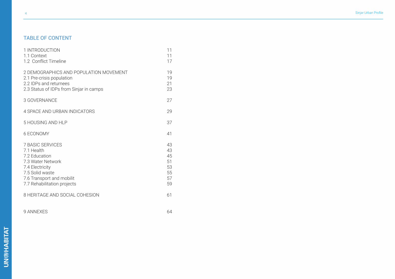
TABLE OF CONTENT
1 INTRODUCTION 111.1 Context 111.2 Conflict Timeline 17
2 DEMOGRAPHICS AND POPULATION MOVEMENT 192.1 Pre-crisis population 192.2 IDPs and returnees 212.3 Status of IDPs from Sinjar in camps 23
3 GOVERNANCE 27
4 SPACE AND URBAN INDICATORS 29
5 HOUSING AND HLP 37 6 ECONOMY 41 7 BASIC SERVICES 437.1 Health 437.2 Education 457.3 Water Network 517.4 Electricity 537.5 Solid waste 557.6 Transport and mobilit 577.7 Rehabilitation projects 59
8 HERITAGE AND SOCIAL COHESION 61
9 ANNEXES 64
5
LIST OF FIGURES
FIGURE 1. UN-Habitat’s previous City Profiles 9FIGURE 2. Mapping with local authorities (UN-Habitat, July 2019) 10FIGURE 5. Yazidi women during a ceremony to celebrate the Yazidi New Year in Lalish. Source: © AFP/David Sim, 2007 14FIGURE 6. Shrine and tomb of Shaykh ‘Adī ibn Musāfir al-Umawī in Lalish. Source: © Levi Clancy, 2019 15FIGURE 8. Widespread destruction to the housing stock in Al-Shemal sub-district (UN-Habitat, August 2019) 17FIGURE 7. Writing in Markaz Sinjar remembering the Yazidi genocide of 3rd of August 2014 (UN-Habitat, August 2019) 17FIGURE 9. Bullet holes from different weaponry on a building in Markaz Sinjar (UN-Habitat, August 2019) 18FIGURE 10. Sunni Mosque and Shia Shrine in Markaz Sinjar 19FIGURE 11. Distribution of IDPs from Ninewa in refugee camps by district of origin. Source: CCCM/REACH, “Intention surveys in AoO”, February 2019 25FIGURE 12. Movement intentions of IDPs from Sinjar District. 25FIGURE 13. Perception of safety of IDPs from Sinjar District. 25FIGURE 14. Bajet Kandala Camp, near Rabiaa (UN-Habitat, August 2019) 26FIGURE 15. View of Markaz Sinjar, from the Old City to the southern plains (UN-Habitat, August 2019) 29FIGURE 16. Devastation in Dhola (UN-Habitat, Mr. Mohamed Al Rubai’y, 2015) 37FIGURE 17. Different levels of damage in Al-Shemal sub-district, including complete destruction - second house from the right (UN-Habitat, August 2019) 37FIGURE 18. Example of STDM recorded parcels in Borek. Source: UN-Habitat HLP Team, August 2019 39FIGURE 19. Sinjar Silo on the right and Sinjar Flour Factory on the left (UN-Habitat, August 2019) 41FIGURE 20. Sinjar Cement Factory (UN-Habitat, August 2019) 41FIGURE 21. Flocks of sheeps on barren land in Al-Shemal sub-district (UN-Habitat, August 2019) 41FIGURE 22. Destroyed shops in Barbush neighborhood, Markaz Sinjar (UN-Habitat, August 2019) 41FIGURE 23. Fires in Al-Shemal district close to already damaged houses (UN-Habitat, August 2019 42FIGURE 24. Books and review notes dated 2010 from a destroyed school - details removed for privacy (UN-Habitat, August 2019 47FIGURE 25. Borehole for water extraction in Markaz Sinjar (UN-Habitat, August 2019) 51FIGURE 26. Mobile power stations in Markaz Sinjar (UN-Habitat, August 2019) 53FIGURE 27. Abandoned rubbles and waste in Sinjar (UN-Habitat, August 2019) 55FIGURE 28. The road heading east from Sinuni (UN-Habitat, August 2019) 57FIGURE 30. The shrine of Sheikh Abdul Aziz post-destruction (June 2018, (©Faris Mishko/All Rights Reserved) 62FIGURE 29. The shrine of Sheikh Abdul Aziz pre-destruction (October 2012, ©Robert Leutheuser/All Rights Reserved) 62
Sinjar Urban Profile6
LIST OF TABLES
TABLE 1. Number of original villages subjected to forced displacement per collective township (mujamma) 15TABLE 2. Estimated population before 2014 by sub-district and breakdown by ethnic/religious groups, as reported by municipalities and mukhtars 20TABLE 3. Number of families and returnees per village or area, June 2019. Source: IOM-DTM Returnee Master List and IOM-DTM IDP Master List, 30 June 2019 21TABLE 4. List of public buildings in Markaz Sinjar in July 2019. Source: Local Authorities 27TABLE 5. Markaz Sinjar neighborhoods area breakdown 31TABLE 6. Markaz Sinjar, Sinuni and Qayrawan land cover breakdown 33TABLE 7. Damage assessment breakdown in Markaz Sinjar based on satellite damage assessments by UNOSAT. This is a low estimate as satellite damage assessments are only able to identify a part of actual damages on the ground. 37TABLE 8. List of housing rehabilitations Source: Housing Damage Assessment & Rehabilitation Platform - UN-Habitat and Shelter Cluster Iraq 39TABLE 9. List of main health facilities in Sinjar District. Source: Local Authorities, July 2019 43TABLE 10. List of main education facilities in Sinjar District. Source: Local Authorities, July 2019 45TABLE 11. Continues from Table 10 47TABLE 12. List of education facilities in Markaz Sinjar, Sinuni and Qayrawan. Source: Local Authorities, July 2019 53TABLE 13. List of religious sites in Sinjar District. Source: Wikimapia and Yazda (August 2019), Destorying the Soul of the Yazidis 61
7
LIST OF APPENDICES
ANNEX I- Aerial view of Markaz Sinjar. Source: DigitalGlobe, August 2018 65ANNEX II- Aerial view of Sinuni. Source: DigitalGlobe, August 2016 66ANNEX III- Aerial view of Qayrawan. Source: DigitalGlobe, May 2019 67ANNEX IV- List of original villages, towns and hamlets in Sinjar District. Source: Wikimapia, August 2019 68ANNEX V - Original villages, towns and hamlets in Sinjar District. Source: Wikimapia, August 2019 69ANNEX VI- Borek Masterplan 70ANNEX VIII- Dogure Masterplan 70ANNEX IX - Khana Sor Masterplan 70ANNEX VII- Dhola Masterplan 70ANNEX XI- Guhbal Masterplan 71ANNEX XII - Markaz Sinjar Masterplan 71ANNEX X- Zorava Masterplan 71ANNEX XIII - List of main humanitarian interventions in Sinjar District 72ANNEX XIV - List of main water wells in Sinjar District. Source: UNDP Iraq FFS, August 2019 75
LIST OF ABBREVIATIONS & ACRONYMS
AoO Area of OriginCRRPD Commission on the Resolution of Real Property DisputesHLP Housing Land and PropertyHRW Human Rights WatchIDP Internally Displaced PeopleIGC Interim Governing CouncilIOM International Organization for MigrationIPCC Iraq Property Claims CommissionIPRF Iraqi Property Reconciliation FacilityISF Iraqi Security ForceISIL Islamic State of Iraq and Levant (or ISIS and often referred to as Daesh,abbreviation of the group’s name in Arabic)KDP Kurdistan Democratic PartyKRG Kurdistan Regional GovernmentKRI Kurdistan Region of IraqMOA Ministry of AgricultureMOJ Ministry of JusticeMoMPW Ministry of Municipalities & Public WorksNFI Non-Food ItemsNGO Non-governmental OrganisationOHCHR Office of the High Commissioner for Human RightsPKK Kurdistan Workers’ Party (Partiya Karkerên Kurdistanê in Kurdish)STDM Social Tenure Domain ModelUNAMI United Nations Assistance Mission for IraqUNHCR United Nations High Commissioner for RefugeesVBIED Vehicle-borne Improvised Explosive DeviceYPG Known as the People’s Protection Units - the main Kurdish force in Syria
Sinjar Urban Profile8
EXECUTIVE SUMMARY
Recovery and reconstruction following conflict is a long process, particularly after the level of damage incurred in Sinjar district, in northern Iraq, in the last few years. The district faces enormous challenges in its reconstruction and recovery. Reconstructing hard infrastructure, one facility at a time, allows for normal life to return to a city. However, for infrastructure to become a service it requires staff, maintenance and demand. It is nearly impossible to recover all of this at once, including all the skilled personnel required to operate infrastructure. The same is seen in the recovery of economic sectors, which depend on a variety of skills from a diverse population in order to return to the way the economy functioned prior to the conflict. It is a difficult step to take to return to a place where one has experienced extremely traumatic events, and to risk the lives and dignity of one’s family again. As recovery is a slow process, people should be able to return to their areas of origin to rebuild their lives at their own pace, before committing to the full relocation of their families. For IDPs from Sinjar, this is not possible for the time being due to current procedures in place that make it difficult to leave the Kurdistan Region, where most IDPs fled to. This requires going through long procedures to obtain approvals from multiple administrative and security authorities, which can take over a month. Once IDPs from Sinjar leave Kurdistan it is difficult for them to return and to re-obtain a tent inside the camps, therefore they risk losing the option to receive financial support, services, and the relative stability provided by camps. This is considered a major obstacle to return and at the very least, travels between Kurdistan and Sinjar should be a possibility until the level of services in Sinjar is higher than that of the camps. Many IDPs prefer to stay in the camps, where they know what conditions to expect, where there is the possibility to apply to emigrate to Europe or
settle down in old Yazidi villages and areas under Sharia administration where the population is low. The result is that Sinjar District is characterized by one of the lowest return rates in the entire country, and over two and a half years following the end of the conflict some villages remain deserted.
EXEC
UTI
VE S
UM
MAR
Y
9
METHODOLOGY
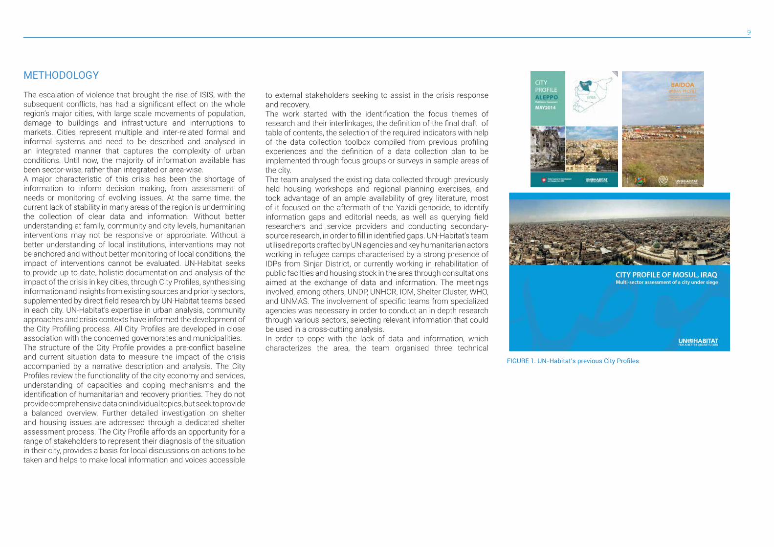
The escalation of violence that brought the rise of ISIS, with the subsequent conflicts, has had a significant effect on the whole region’s major cities, with large scale movements of population, damage to buildings and infrastructure and interruptions to markets. Cities represent multiple and inter-related formal and informal systems and need to be described and analysed in an integrated manner that captures the complexity of urban conditions. Until now, the majority of information available has been sector-wise, rather than integrated or area-wise. A major characteristic of this crisis has been the shortage of information to inform decision making, from assessment of needs or monitoring of evolving issues. At the same time, the current lack of stability in many areas of the region is undermining the collection of clear data and information. Without better understanding at family, community and city levels, humanitarian interventions may not be responsive or appropriate. Without a better understanding of local institutions, interventions may not be anchored and without better monitoring of local conditions, the impact of interventions cannot be evaluated. UN-Habitat seeks to provide up to date, holistic documentation and analysis of the impact of the crisis in key cities, through City Profiles, synthesising information and insights from existing sources and priority sectors, supplemented by direct field research by UN-Habitat teams based in each city. UN-Habitat’s expertise in urban analysis, community approaches and crisis contexts have informed the development of the City Profiling process. All City Profiles are developed in close association with the concerned governorates and municipalities.The structure of the City Profile provides a pre-conflict baseline and current situation data to measure the impact of the crisis accompanied by a narrative description and analysis. The City Profiles review the functionality of the city economy and services, understanding of capacities and coping mechanisms and the identification of humanitarian and recovery priorities. They do not provide comprehensive data on individual topics, but seek to provide a balanced overview. Further detailed investigation on shelter and housing issues are addressed through a dedicated shelter assessment process. The City Profile affords an opportunity for a range of stakeholders to represent their diagnosis of the situation in their city, provides a basis for local discussions on actions to be taken and helps to make local information and voices accessible
to external stakeholders seeking to assist in the crisis response and recovery.The work started with the identification the focus themes of research and their interlinkages, the definition of the final draft of table of contents, the selection of the required indicators with help of the data collection toolbox compiled from previous profiling experiences and the definition of a data collection plan to be implemented through focus groups or surveys in sample areas of the city.The team analysed the existing data collected through previously held housing workshops and regional planning exercises, and took advantage of an ample availability of grey literature, most of it focused on the aftermath of the Yazidi genocide, to identify information gaps and editorial needs, as well as querying field researchers and service providers and conducting secondary-source research, in order to fill in identified gaps. UN-Habitat’s team utilised reports drafted by UN agencies and key humanitarian actors working in refugee camps characterised by a strong presence of IDPs from Sinjar District, or currently working in rehabilitation of public facilties and housing stock in the area through consultations aimed at the exchange of data and information. The meetings involved, among others, UNDP, UNHCR, IOM, Shelter Cluster, WHO, and UNMAS. The involvement of specific teams from specialized agencies was necessary in order to conduct an in depth research through various sectors, selecting relevant information that could be used in a cross-cutting analysis.In order to cope with the lack of data and information, which characterizes the area, the team organised three technical
FIGURE 1. UN-Habitat’s previous City Profiles
Sinjar Urban Profile10
MET
HO
DO
LOG
Y
meetings with the aim of exploring themes of interest, substantiate particular assumptions and fill information gaps.
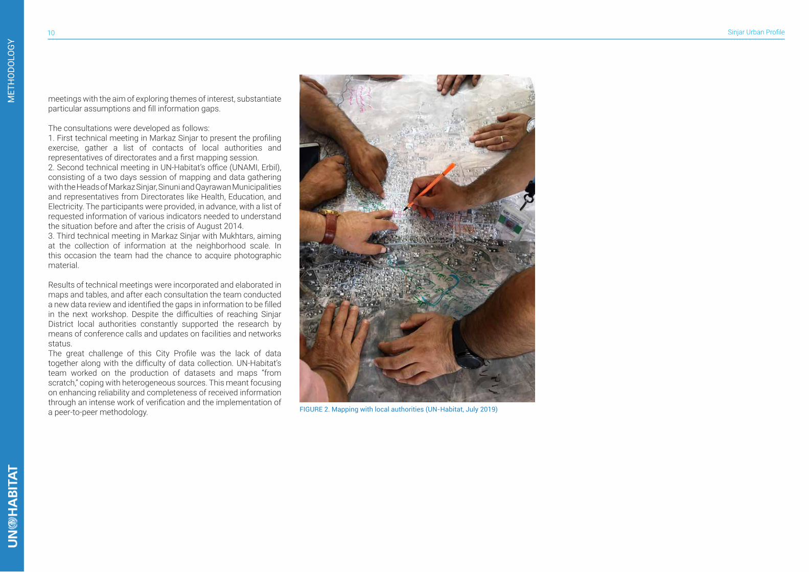
The consultations were developed as follows:1. First technical meeting in Markaz Sinjar to present the profiling exercise, gather a list of contacts of local authorities and representatives of directorates and a first mapping session.2. Second technical meeting in UN-Habitat’s office (UNAMI, Erbil), consisting of a two days session of mapping and data gathering with the Heads of Markaz Sinjar, Sinuni and Qayrawan Municipalities and representatives from Directorates like Health, Education, and Electricity. The participants were provided, in advance, with a list of requested information of various indicators needed to understand the situation before and after the crisis of August 2014.3. Third technical meeting in Markaz Sinjar with Mukhtars, aiming at the collection of information at the neighborhood scale. In this occasion the team had the chance to acquire photographic material.
Results of technical meetings were incorporated and elaborated in maps and tables, and after each consultation the team conducted a new data review and identified the gaps in information to be filled in the next workshop. Despite the difficulties of reaching Sinjar District local authorities constantly supported the research by means of conference calls and updates on facilities and networks status. The great challenge of this City Profile was the lack of data together along with the difficulty of data collection. UN-Habitat’s team worked on the production of datasets and maps “from scratch,” coping with heterogeneous sources. This meant focusing on enhancing reliability and completeness of received information through an intense work of verification and the implementation of a peer-to-peer methodology. FIGURE 2. Mapping with local authorities (UN-Habitat, July 2019)
11
INTRODUCTION
1.1 CONTEXT
NINEWA GOVERNORATE
The Governorate of Ninewa (also Nineveh), is located in northern Iraq on the border with Syria and adjacent to Dohuk, Erbil, Salah al-Din, and Anbar governorates. It is Iraq’s third largest (37,323 sq. km)1 and second most populated governorate, with 3,237,918 people in 2009.2 The population growth rate is estimated to be around 3%3, thus the population before the conflict with ISIS most likely exceeded 3,700,000 people. Agriculture is a key component of Ninewa’s economy, particularly in the production of cereal, as well as sugar cane, sunflowers, vegetables and herbs. Industrial activities consist mainly of cement, sugar, textiles, and beverage factories. Other activities include commercial retail stores, small factories and privately owned businesses, cereal crushing plants, and steel and timber producing plants. Ninewa ranks among some of the poorest governorates in Iraq. Food insecurity grew significantly in the last decade due to prolonged drought. In 2011, 26% of the population lived below the poverty line of US$ 2.5 per day, more than double the national level (11.5%). The literacy rate of 75.5% is lower than the national average. Rural intermediate school enrolment rates are among the worst in Iraq.4 Ninewa comprises nine districts: Al-Hatra, Al-Ba’aj, Tal Afar, Al-Mosul, Akre, Sinjar, Al-Hamdaniya, Tilkaef (here listed from the biggest to the smallest in terms of surface area).
DISTRICT GEOGRAPHY
Sinjar district is located in the north-west of Ninewa Governorate: it borders Syria on its north and west sides, Al-Ba’aj district on the south, and a small section borders Al-Hathra District and Tal-Afar District on the west. Its area is 2,886km2. The district is
1 UN Joint Analysis and Policy Unit (June 2015), “Ninewa Governorate Profile”
2 CSO (2009), “Iraq’s governorates by area and their relative share of area and population 1997 and 2009”
3 Iraq National Population Commission -INPC, supported by United Nations Population Fund - UNFPA (June 2012), “Iraq Population
Situation Analysis Report”
4 Ibid.
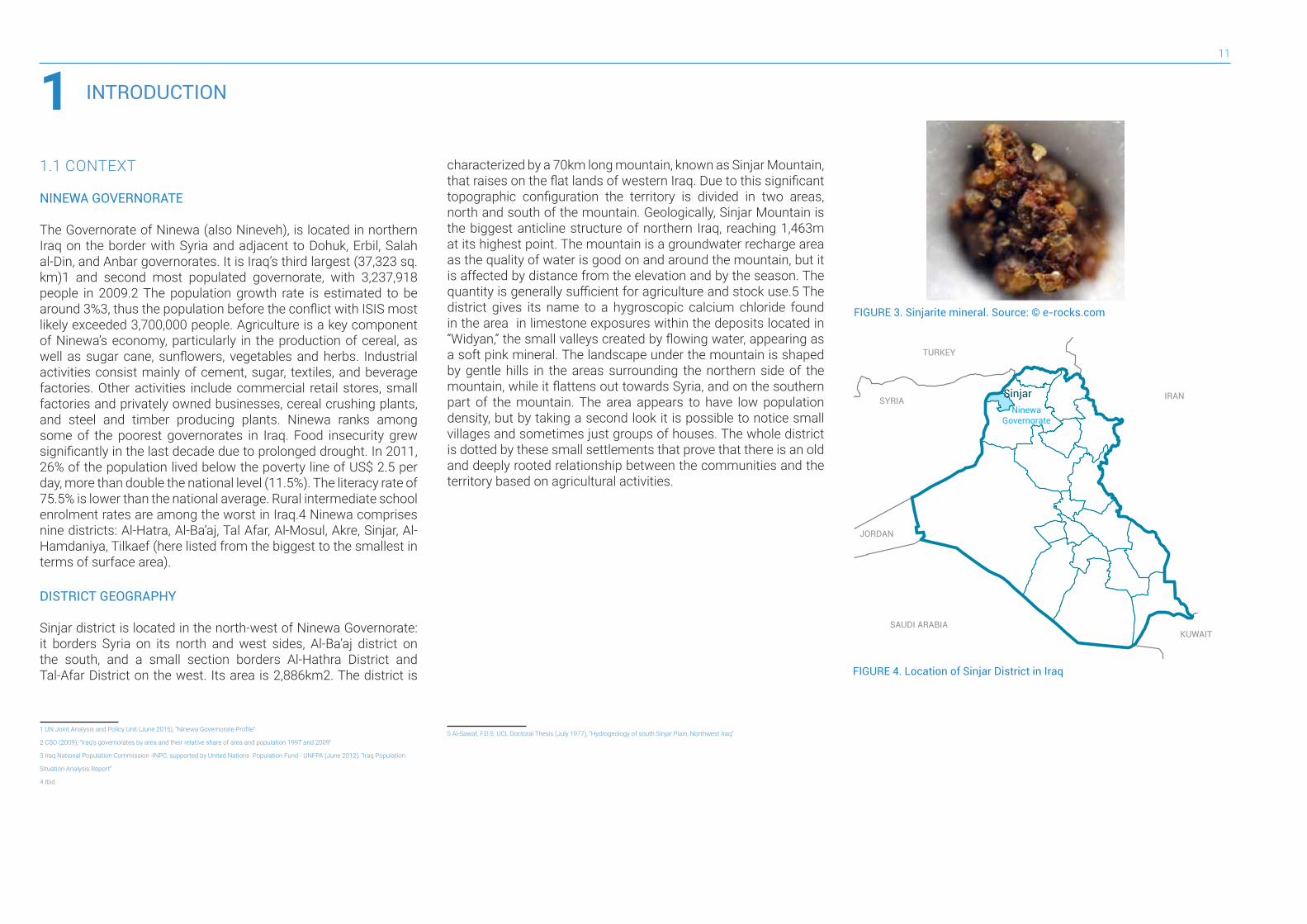
1characterized by a 70km long mountain, known as Sinjar Mountain, that raises on the flat lands of western Iraq. Due to this significant topographic configuration the territory is divided in two areas, north and south of the mountain. Geologically, Sinjar Mountain is the biggest anticline structure of northern Iraq, reaching 1,463m at its highest point. The mountain is a groundwater recharge area as the quality of water is good on and around the mountain, but it is affected by distance from the elevation and by the season. The quantity is generally sufficient for agriculture and stock use.5 The district gives its name to a hygroscopic calcium chloride found in the area in limestone exposures within the deposits located in “Widyan,” the small valleys created by flowing water, appearing as a soft pink mineral. The landscape under the mountain is shaped by gentle hills in the areas surrounding the northern side of the mountain, while it flattens out towards Syria, and on the southern part of the mountain. The area appears to have low population density, but by taking a second look it is possible to notice small villages and sometimes just groups of houses. The whole district is dotted by these small settlements that prove that there is an old and deeply rooted relationship between the communities and the territory based on agricultural activities.
5 Al-Sawaf, F.D.S. UCL Doctoral Thesis (July 1977), “Hydrogeology of south Sinjar Plain, Northwest Iraq”
FIGURE 3. Sinjarite mineral. Source: © e-rocks.com
FIGURE 4. Location of Sinjar District in Iraq
TURKEY
SYRIA
JORDAN
SAUDI ARABIAKUWAIT
IRANNinewa
Governorate
Sinjar
KHANA SOR AL-TA’MEEM
SINJAR
DEGUREHITEENSHEMAL
SINUNI
GUHBAL AL-ANDALUS
QABUSIYA
SÎBA ŞÊX XIDIRAL-JAZIRAH
EMDÎBANUMM AL-DHIBAN
AL-BA’AJ
KRZRK AL-ADNANIYAH
KER UZAIR AL-QATHANIYA
WARDIYÊ
ZORAVA AL-AROBA
RABIAA
DHOLA AL-QADISIYAH
BOREKAL-YARMOUK
DOMIZ CAMP
To Al-Ba’aj
To Syrian border
SYRIA
IRAQ
SINJAR MOUNTAIN
SINJAR MILITARY BASEBARA
QAYRAWAN
TAL QASSAB BAATH
TAL BANAT AL-WALEED
HARDAN 47To Mosul
To old Sahl Sinjar Air Base(dismissed)
CEMENT FACTORY
TAL AFAR
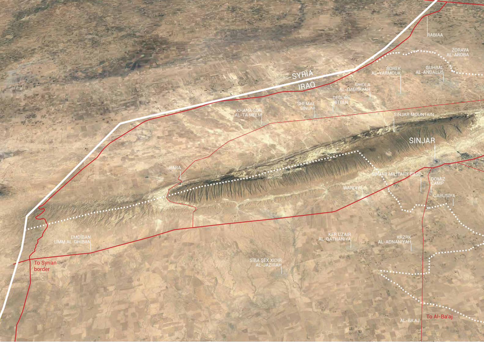
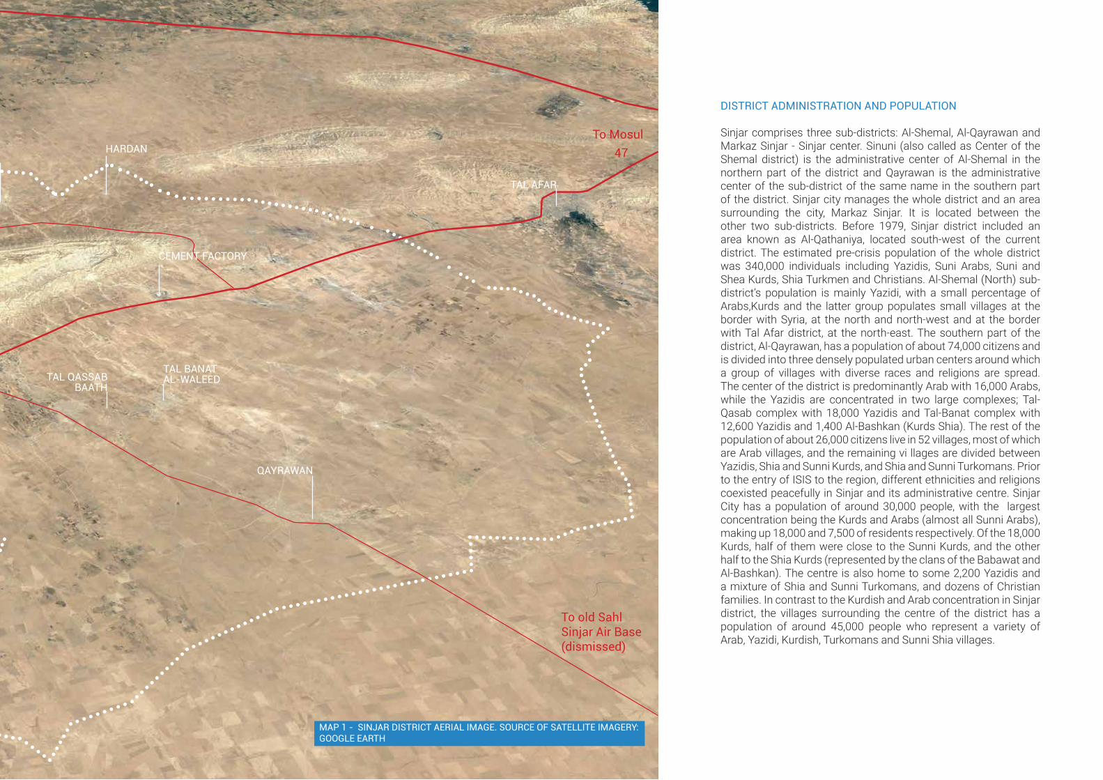
MAP 1 - SINJAR DISTRICT AERIAL IMAGE. SOURCE OF SATELLITE IMAGERY: GOOGLE EARTH
DISTRICT ADMINISTRATION AND POPULATION
Sinjar comprises three sub-districts: Al-Shemal, Al-Qayrawan and Markaz Sinjar - Sinjar center. Sinuni (also called as Center of the Shemal district) is the administrative center of Al-Shemal in the northern part of the district and Qayrawan is the administrative center of the sub-district of the same name in the southern part of the district. Sinjar city manages the whole district and an area surrounding the city, Markaz Sinjar. It is located between the other two sub-districts. Before 1979, Sinjar district included an area known as Al-Qathaniya, located south-west of the current district. The estimated pre-crisis population of the whole district was 340,000 individuals including Yazidis, Suni Arabs, Suni and Shea Kurds, Shia Turkmen and Christians. Al-Shemal (North) sub-district’s population is mainly Yazidi, with a small percentage of Arabs,Kurds and the latter group populates small villages at the border with Syria, at the north and north-west and at the border with Tal Afar district, at the north-east. The southern part of the district, Al-Qayrawan, has a population of about 74,000 citizens and is divided into three densely populated urban centers around which a group of villages with diverse races and religions are spread. The center of the district is predominantly Arab with 16,000 Arabs, while the Yazidis are concentrated in two large complexes; Tal-Qasab complex with 18,000 Yazidis and Tal-Banat complex with 12,600 Yazidis and 1,400 Al-Bashkan (Kurds Shia). The rest of the population of about 26,000 citizens live in 52 villages, most of which are Arab villages, and the remaining vi llages are divided between Yazidis, Shia and Sunni Kurds, and Shia and Sunni Turkomans. Prior to the entry of ISIS to the region, different ethnicities and religions coexisted peacefully in Sinjar and its administrative centre. Sinjar City has a population of around 30,000 people, with the largest concentration being the Kurds and Arabs (almost all Sunni Arabs), making up 18,000 and 7,500 of residents respectively. Of the 18,000 Kurds, half of them were close to the Sunni Kurds, and the other half to the Shia Kurds (represented by the clans of the Babawat and Al-Bashkan). The centre is also home to some 2,200 Yazidis and a mixture of Shia and Sunni Turkomans, and dozens of Christian families. In contrast to the Kurdish and Arab concentration in Sinjar district, the villages surrounding the centre of the district has a population of around 45,000 people who represent a variety of Arab, Yazidi, Kurdish, Turkomans and Sunni Shia villages.
Sinjar Urban Profile14
YAZIDIS
The entire Sinjar region (north, central and south of Sinjar Mountain) is known to be the homeland of the Yazidis, a religious minority that has lived in the region for centuries. The majority of Yazidis speak the Kurdish language Kurmanji, a Kurdish dialect used by the Kurds living in the northwestern regions of Iraq near the border with Turkey which is affected by its location in the Kurdish areas of Turkey and Syria. The Yazidi religion is said to be 4,000 years old1 and it shares many rituals and principles with other religions like Paganism, Zoroastrianism, Islam, Manichaeism and others. Prohibition to eat pork and circumcision are consistent with Islam, baptism with Christianity and the worship of water and sun with Mandaeism. The name Yazidi (also spelled Yezīdī, Azīdī, Zedī, Izadī, Êzidî) may find its origin from the persianized (angel, deity) or yazada (divine being). In Kurdish, Yazdan translates into God, whereby Yazidi means ‘worshipper of God’. Because of the blend of various belief systems, known religiously as syncretism, and contested interpretations of Yazidi theology, they have been often branded as heretics, apostates or unfairly “devil worshippers” and thus have historically been subject to sharp persecution. Traditionally, the Yazidi community was largely composed of farmers and herdsmen organized in tribes. For ethnic reasons, Yazidis are caught between Arabs and Kurds and have always remained on the fringes of Iraqi society. Many attempts to define their ethnic identity have been politically motivated. Isolated geographically, and accustomed to discrimination, the Yazidis forged an insular culture, reinforced also by the fact that Yazidi culture and religion are transmitted orally. Important cultural features of Yazidism include the system of caste and the traditional preference for living in Yazidi-only communities, which needs to be understood when reflecting upon their current displacement and settlement patterns.
1 Minority Rights Group International (2014), “Yazidis”, in World Directory of Minorities and Indigenous Peoples
TURKEY
TURKEY
SYRIADuhok
Erbil
Kirkuk
Salah Al-Din
Al-Ba’ajAl-Hatra
Makhmour
MosulHamdaniya
ShaikhanTalkaif
Talafar
Al-Shemal
Markaz Sinjar
Al-Qayrawan
Anbar
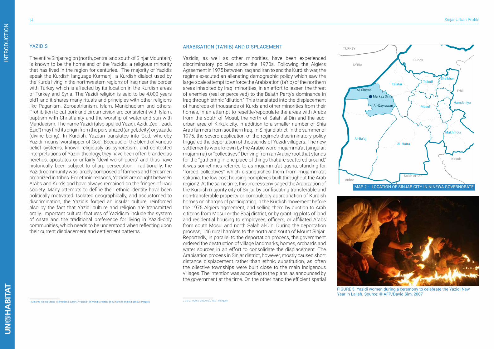
MAP 2 - LOCATION OF SINJAR CITY IN NINEWA GOVERNORATE
ARABISATION (TA’RIB) AND DISPLACEMENT
Yazidis, as well as other minorities, have been experienced discriminatory policies since the 1970s. Following the Algiers Agreement in 1975 between Iraq and Iran to end the Kurdish war, the regime executed an alienating demographic policy which saw the large-scale attempt to enforce the Arabisation (ta’rib) of the northern areas inhabited by Iraqi minorities, in an effort to lessen the threat of enemies (real or perceived) to the Ba’ath Party’s dominance in Iraq through ethnic “dilution.” This translated into the displacement of hundreds of thousands of Kurds and other minorities from their homes, in an attempt to resettle/repopulate the areas with Arabs from the south of Mosul, the north of Salah al-Din and the sub-urban area of Kirkuk city, in addition to a smaller number of Shia Arab farmers from southern Iraq. In Sinjar district, in the summer of 1975, the severe application of the regime’s discriminatory policy triggered the deportation of thousands of Yazidi villagers. The new settlements were known by the Arabic word mujamma’at (singular: mujamma) or “collectives.” Deriving from an Arabic root that stands for the “gathering in one place of things that are scattered around,” it was sometimes referred to as mujamma’at qasria, standing for “forced collectives” which distinguishes them from mujamma’at sakania, the low cost housing complexes built throughout the Arab region2. At the same time, this process envisaged the Arabization of the Kurdish-majority city of Sinjar by confiscating transferable and non-transferable property or compulsory appropriation of Kurdish homes on charges of participating in the Kurdish movement before the 1975 Algiers agreement, and selling them by auction to Arab citizens from Mosul or the Baaj district, or by granting plots of land and residential housing to employees, officers, or affiliated Arabs from south Mosul and north Salah al-Din. During the deportation process, 146 rural hamlets to the north and south of Mount Sinjar. Reportedly, in parallel to the deportation process, the government ordered the destruction of village landmarks, homes, orchards and water sources in an effort to consolidate the displacement. The Arabisation process in Sinjar district, however, mostly caused short distance displacement rather than ethnic substitution, as often the ollective townships were built close to the main indigenous villages. The intention was according to the plans, as announced by the government at the time. On the other hand the efficient spatial
2 Genat Melisande (2013), “Iraq”, in Niqash
FIGURE 5. Yazidi women during a ceremony to celebrate the Yazidi New Year in Lalish. Source: © AFP/David Sim, 2007
INTR
OD
UCT
ION
15
design of the mujamma’at contributed to enforce control: the wide grid-shaped streets and the modular blocks conceptualised in Baghdad were not only easy to build, but also to patrol, making the resettlement not only a development intervention but also a security project3. The main aim of the process was to impose security by removing 146 Yazidi villages by forcing residents to the new settlements and making their children join the compulsory military service, which the Yazidis did not abide by. Those forced to join the service often escaped to the caves in Sinjar Mountain and formed rebellious groups against the military. The importance of the impact of this process is that it envisaged the confiscation of land towards a complex collectivisation, and even today many inhabitants still experience the lack of property certificates for the plots in which they have their houses. UN-Habitat is currently leading a project on Housing, Land and Property (HLP) rights in order to deliver this kind of certification. The occupation from ISIL in August 2014 and that lasted until November 2015 caused a huge wave of displacement in Sinjar district. Around 300,000 Yazidis, 8,000 Kurds and 30,000 Turkmans were displaced, with most fleeing to refugee camps in northern KRI. Six years later, the displacement phenomenon is still the main issue impacting life in the district. Nowadays, Sinjar district is characterized by the lowest rate of return in the whole country. The average return rate in Iraq is 73%, while in the district it is around 34%.4
SOCIAL COHESION ISSUES
The conflict with ISIS, unfortunately, broke the fragile balance of tolerance and co-habitation between minorities. Instead of tightening as a group to fight off the invaders, the war caused fragmentation, and broke down the trust between communities, leading to clashes that continue to impact the safety and stability of the area today. This represents the main obstacle for the return of IDPs: 82% of IDPs in camps report increased safety and security as the first need to enable return5. These issues cut across the control of the territories, with many armed groups, security forces and militias claiming authority on villages and road checkpoints making the safety situation fluid. The political condition, which is
3 Zanger Maggy (2002), “Refugee in their own country”, in MER222 – Middle East Research and Information Project.
4 IOM - International Organisation for Migration (updated October 2019), “Iraq DTM Return Dashboard”, http://iraqdtm.iom.int/
DTMReturnDashboards.aspx
5 CCCM Cluster – REACH (February 2019), Op. cit.
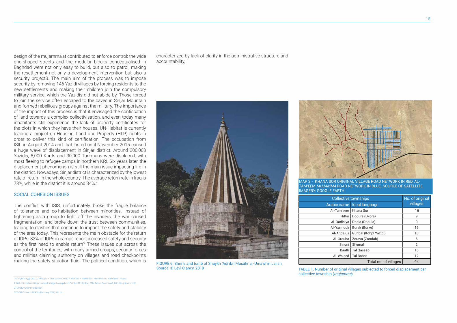
FIGURE 6. Shrine and tomb of Shaykh ‘Adī ibn Musāfir al-Umawī in Lalish. Source: © Levi Clancy, 2019 TABLE 1. Number of original villages subjected to forced displacement per
collective township (mujamma)
Collective townships No. of original villagesArabic name local language
Al-Tam’eem Khana Sor 16Hittin Dogure (Dkora) 9
Al-Qadisiya Dhola (Dhoula) 9Al-Yarmouk Borek (Burke) 16Al-Andalus Guhbal (Kohpl Yazidi) 10Al-Orouba Zorava (Zarafah) 6
Sinuni Shemal 2Baath Tal Qassab 16
Al-Waleed Tal Banat 12
Total no. of villages 94
MAP 3 - KHANA SOR ORIGINAL VILLAGE ROAD NETWORK IN RED, AL-TAM’EEM MUJAMMA ROAD NETWORK IN BLUE. SOURCE OF SATELLITE IMAGERY: GOOGLE EARTH
characterized by lack of clarity in the administrative structure and accountability,
Sinjar Urban Profile16
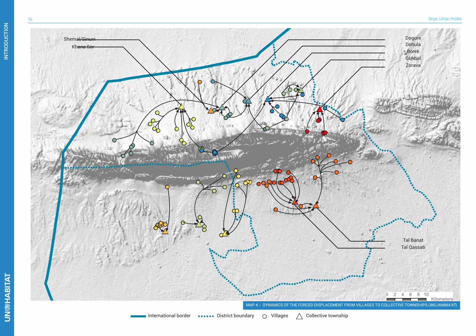
0 2 4 6 8 10 Kilometers
Zorava
Tal Qassab
Guhbal
Tal Banat
BorekDohulaDogureShemal/Sinuni
Khana Sor
MAP 4 - DYNAMICS OF THE FORCED DISPLACEMENT FROM VILLAGES TO COLLECTIVE TOWNSHIPS (MUJAMMA’AT)
International border Villages Collective townshipDistrict boundary
INTR
OD
UCT
ION
INTR
OD
UCT
ION
17
1.2 CONFLICT TIMELINE
Today, Sinjar District lies in a territory that has witnessed a succession of conflicts since ancient times. Many rulers brought their forces here and every change in power resulted in a conflict. From Assyrians to Babylonians around 600 BC, then to Achaemenid Persians at the end of the sixth century BC, Macedonians around 330BC and Parthians in the second half of the second century BC. Thereafter, Markaz Sinjar and the area surrounding the city fell under Roman control, but this did not mean peace and it witnessed numerous conflict between Romans and Persians. Around 360 AD, Markaz Sinjar was sacked by the Persians and it remained under their control until it fell under Byzantine administration in the late sixth century AD. Since there are no archeological excavations in the area, it is only possible to reconstruct the history of Sinjar through the writings of the conquering empire’s historians. Yet the more recent the events are, the more precisely it is possible to track the history of conflict. In the second millennium AD the area of today’s district saw a series of attacks and clashes, apart from the great regional wars, characterized by the targeting of minorities, Yazidis in particular. Minorities have often been victims of cultural change ventures, which likely turned into genocide attempts, with more than 74 of them targeting the Yazidis. Since the times of Sheykh ‘Adi ibn Musafir al-Umawi, different rulers attacked the Yazidi communities that were living around Sinjar Mountain and in the second area of concentration, Sheikhan (today’s north-eastern Ninewa). The aggressions often aimed not only at the conversion or elimination of Yazidis, but envisaged the looting and the destruction of their villages and their cultural and religious heritage. The tomb of Sheykh ‘Adi ibn Musafir al-Umawi has been desacrated several times, his bones set on fire and the building hosting the shrine has been turned into a public utility building many times. Yazidis and the minorities living in the area were targeted even more when subjected to authoritarian governments that could not accept their cultural and religious differences within their territory. An example of this intransigence is the series of attacks led by Ottoman rulers against Yazidis where their attacks aimed not only at the murder of people, but included the destruction of religious sites, cultural landmarks and entire villages. This tragic history continues into recent times, where the horrors of such cruel conflicts were brought to life again
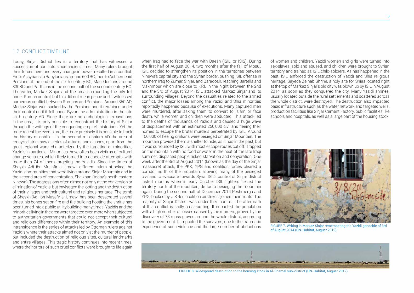
when Iraq had to face the war with Daesh (ISIL, or ISIS). During the first half of August 2014, two months after the fall of Mosul, ISIL decided to strengthen its position in the territories between Ninewa’s capital city and the Syrian border, pushing ISIL offense in northern Iraq to Zumar, Sinjar, and Qaraqosh, reaching Bartella and Makhmour which are close to KRI. In the night between the 2nd and the 3rd of August 2014, ISIL attacked Markaz Sinjar and its surrounding villages. Beyond the casualties related to the armed conflict, the major losses among the Yazidi and Shia minorities reportedly happened because of executions. Many captured men were murdered, after asking them to convert to Islam or face death, while women and children were abducted. This attack led to the deaths of thousands of Yazidis and caused a huge wave of displacement with an estimated 250,000 civilians fleeing their homes to escape the brutal murders perpetrated by ISIL. Around 100,000 of fleeing civilians were besieged on Sinjar Mountain. The mountain provided them a shelter to hide, as it has in the past, but it was surrounded by ISIL with most escape routes cut off. Trapped on the mountain with no food or water in the heat of the late Iraqi summer, displaced people risked starvation and dehydration. One week after the 3rd of August 2014 (known as the day of the Sinjar massacre) attack, the PKK, YPG and coalition forces cleared a corridor north of the mountain, allowing many of the besieged civilians to evacuate towards Syria. ISIL’s control of Sinjar district lasted months when in early October ISIL fighters seized the territory north of the mountain, de facto besieging the mountain again. During the second half of December 2014 Peshmerga and YPG, backed by U.S.-led coalition airstrikes, joined their fronts. The majority of Sinjar District was under their control. The aftermath of this conflict is sadly cross-cutting. It impacted the population with a high number of losses caused by the murders, proved by the discovery of 73 mass graves around the whole district, according to the government. It impacted the survivors, due to the traumatic experience of such violence and the large number of abductions
of women and children. Yazidi women and girls were turned into sex-slaves, sold and abused, and children were brought to Syrian territory and trained as ISIL child-soldiers. As has happened in the past, ISIL enforced the destruction of Yazidi and Shia religious heritage. Sayeda Zeinab Shrine, a holy site for Shias located right at the top of Markaz Sinjar’s old city was blown up by ISIL in August 2014, as soon as they conquered the city. Many Yazidi shrines, usually located outside the rural settlements and scattered across the whole district, were destroyed. The destruction also impacted basic infrastructure such as the water network and targeted wells, production facilities like Sinjar Cement Factory, public facilities like schools and hospitals, as well as a large part of the housing stock.
FIGURE 7. Writing in Markaz Sinjar remembering the Yazidi genocide of 3rd of August 2014 (UN-Habitat, August 2019)
FIGURE 8. Widespread destruction to the housing stock in Al-Shemal sub-district (UN-Habitat, August 2019)
Sinjar Urban Profile18
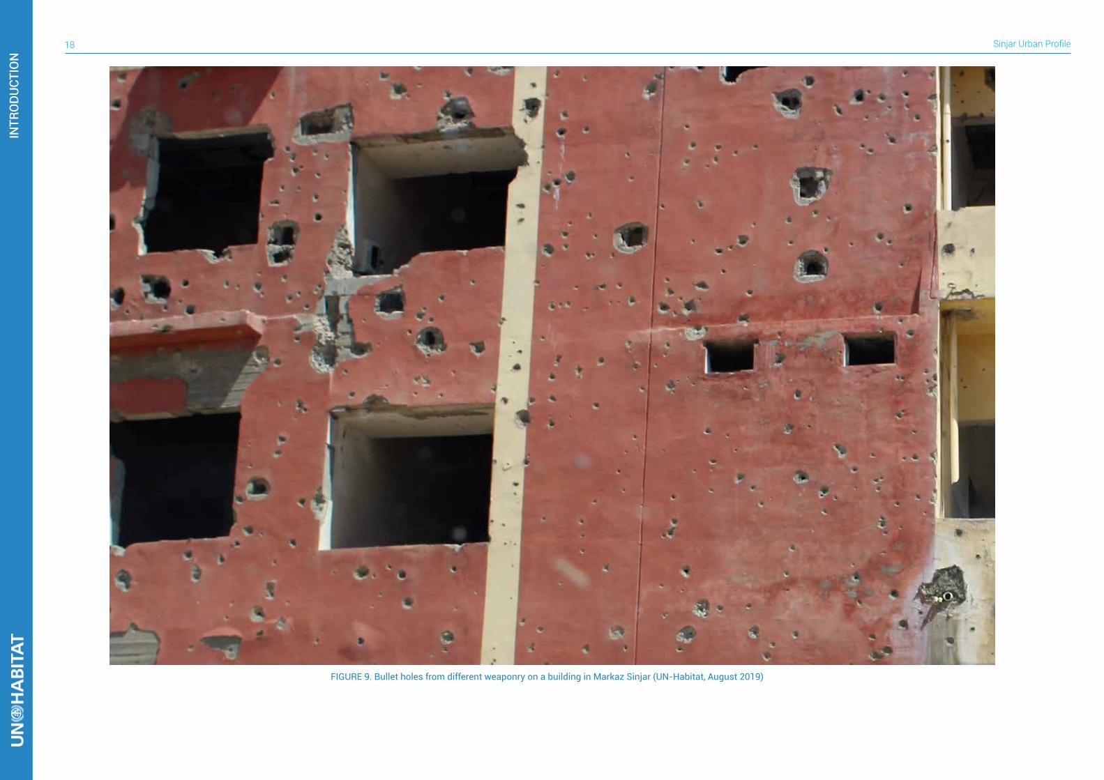
FIGURE 9. Bullet holes from different weaponry on a building in Markaz Sinjar (UN-Habitat, August 2019)
INTR
OD
UCT
ION
INTR
OD
UCT
ION
19
DEMOGRAPHICS AND POPULATION MOVEMENT2
2.1 PRE-CRISIS POPULATION
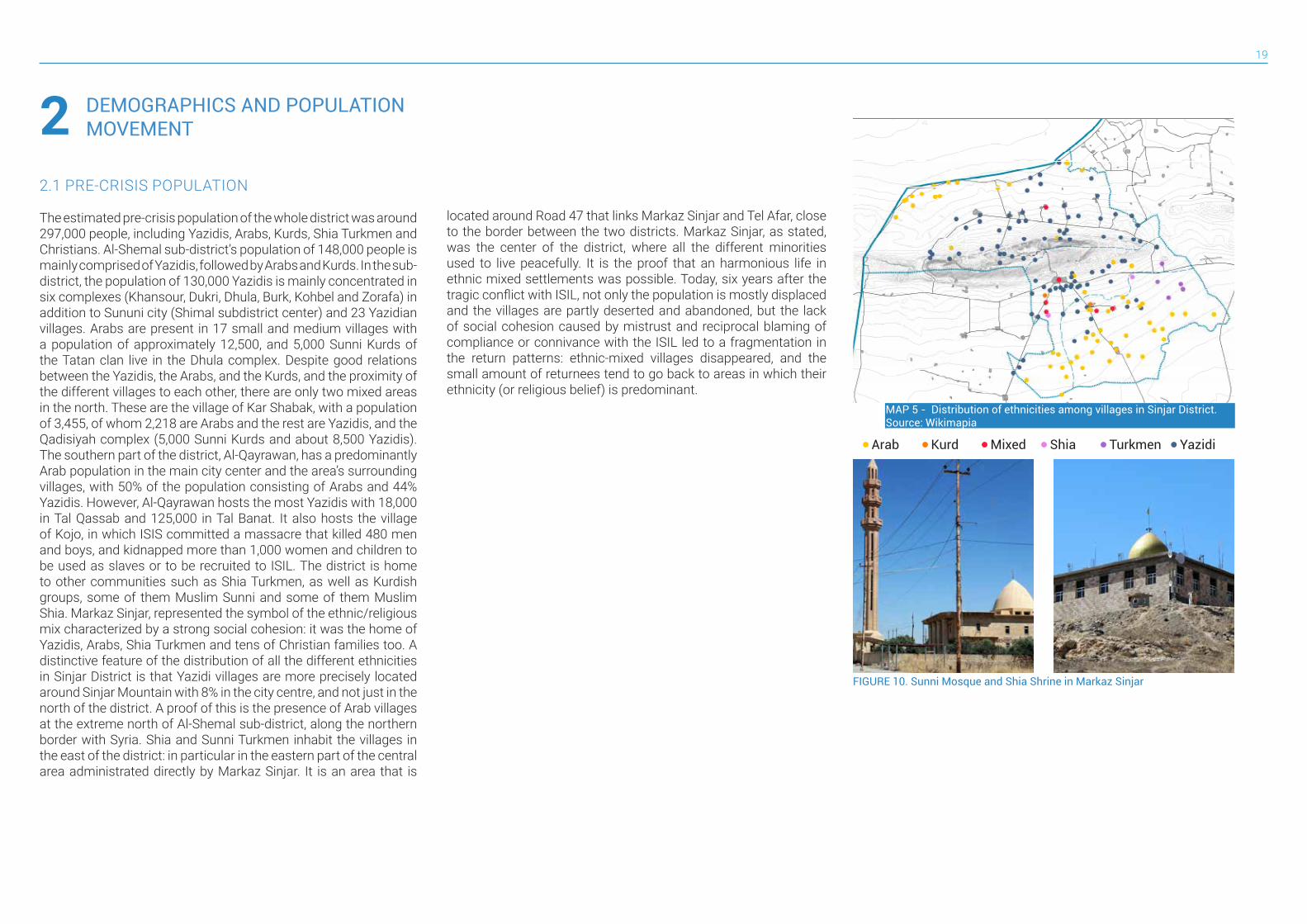
The estimated pre-crisis population of the whole district was around 297,000 people, including Yazidis, Arabs, Kurds, Shia Turkmen and Christians. Al-Shemal sub-district’s population of 148,000 people is mainly comprised of Yazidis, followed by Arabs and Kurds. In the sub-district, the population of 130,000 Yazidis is mainly concentrated in six complexes (Khansour, Dukri, Dhula, Burk, Kohbel and Zorafa) in addition to Sununi city (Shimal subdistrict center) and 23 Yazidian villages. Arabs are present in 17 small and medium villages with a population of approximately 12,500, and 5,000 Sunni Kurds of the Tatan clan live in the Dhula complex. Despite good relations between the Yazidis, the Arabs, and the Kurds, and the proximity of the different villages to each other, there are only two mixed areas in the north. These are the village of Kar Shabak, with a population of 3,455, of whom 2,218 are Arabs and the rest are Yazidis, and the Qadisiyah complex (5,000 Sunni Kurds and about 8,500 Yazidis). The southern part of the district, Al-Qayrawan, has a predominantly Arab population in the main city center and the area’s surrounding villages, with 50% of the population consisting of Arabs and 44% Yazidis. However, Al-Qayrawan hosts the most Yazidis with 18,000 in Tal Qassab and 125,000 in Tal Banat. It also hosts the village of Kojo, in which ISIS committed a massacre that killed 480 men and boys, and kidnapped more than 1,000 women and children to be used as slaves or to be recruited to ISIL. The district is home to other communities such as Shia Turkmen, as well as Kurdish groups, some of them Muslim Sunni and some of them Muslim Shia. Markaz Sinjar, represented the symbol of the ethnic/religious mix characterized by a strong social cohesion: it was the home of Yazidis, Arabs, Shia Turkmen and tens of Christian families too. A distinctive feature of the distribution of all the different ethnicities in Sinjar District is that Yazidi villages are more precisely located around Sinjar Mountain with 8% in the city centre, and not just in the north of the district. A proof of this is the presence of Arab villages at the extreme north of Al-Shemal sub-district, along the northern border with Syria. Shia and Sunni Turkmen inhabit the villages in the east of the district: in particular in the eastern part of the central area administrated directly by Markaz Sinjar. It is an area that is
located around Road 47 that links Markaz Sinjar and Tel Afar, close to the border between the two districts. Markaz Sinjar, as stated, was the center of the district, where all the different minorities used to live peacefully. It is the proof that an harmonious life in ethnic mixed settlements was possible. Today, six years after the tragic conflict with ISIL, not only the population is mostly displaced and the villages are partly deserted and abandoned, but the lack of social cohesion caused by mistrust and reciprocal blaming of compliance or connivance with the ISIL led to a fragmentation in the return patterns: ethnic-mixed villages disappeared, and the small amount of returnees tend to go back to areas in which their ethnicity (or religious belief) is predominant.
MAP 5 - Distribution of ethnicities among villages in Sinjar District. Source: Wikimapia
FIGURE 10. Sunni Mosque and Shia Shrine in Markaz Sinjar
Arab ShiaKurd TurkmenMixed Yazidi
Sinjar Urban Profile20
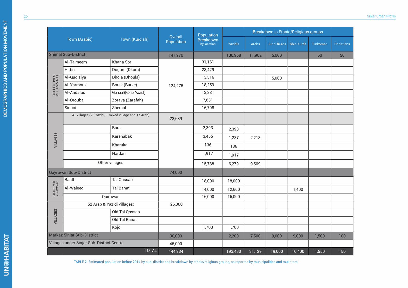
TABLE 2. Estimated population before 2014 by sub-district and breakdown by ethnic/religious groups, as reported by municipalities and mukhtars
Town (Arabic) Town (Kurdish) Overall Population
Population Breakdown
by location
Breakdown in Ethnic/Religious groups
Yazidis Arabs Sunni Kurds Shia Kurds Turkoman Christians
Shimal Sub-District 147,970 130,968 11,902 5,000 50 50CO
LLEC
TIVE
SM
UJA
MM
A’AT
Al-Ta’meem Khana Sor
124,275
31,161
Hittin Dogure (Dkora) 23,429
Al-Qadisiya Dhola (Dhoula) 13,516 5,000Al-Yarmouk Borek (Burke) 18,259
Al-Andalus Guhbal (Kohpl Yazidi) 13,281
Al-Orouba Zorava (Zarafah) 7,831
Sinuni Shemal 16,798
VILL
AGES
41 villages (23 Yazidi, 1 mixed village and 17 Arab)23,689
Bara 2,393 2,393
Karshabak 3,455 1,237 2,218
Kharuka 136 136
Hardan 1,917 1,917
Other villages 15,788 6,279 9,509
Qayrawan Sub-District 74,000
COLL
ECTI
VES
MU
JAM
MA’
AT
Baath Tal Qassab 18,000 18,000
Al-Waleed Tal Banat 14,000 12,600 1,400
Qairawan 16,000 16,000
VILL
AGES
52 Arab & Yazidi villages: 26,000
Old Tal Qassab
Old Tal Banat
Kojo 1,700 1,700
Markaz Sinjar Sub-District 30,000 2,200 7,500 9,000 9,000 1,500 100Villages under Sinjar Sub-District Centre 45,000
TOTAL 444,934 193,430 31,129 19,000 10,400 1,550 150
DEM
OG
RAPH
ICS
AND
PO
PULA
TIO
N M
OVE
MEN
TD
EMO
GRA
PHIC
S AN
D P
OPU
LATI
ON
MO
VEM
ENT

21
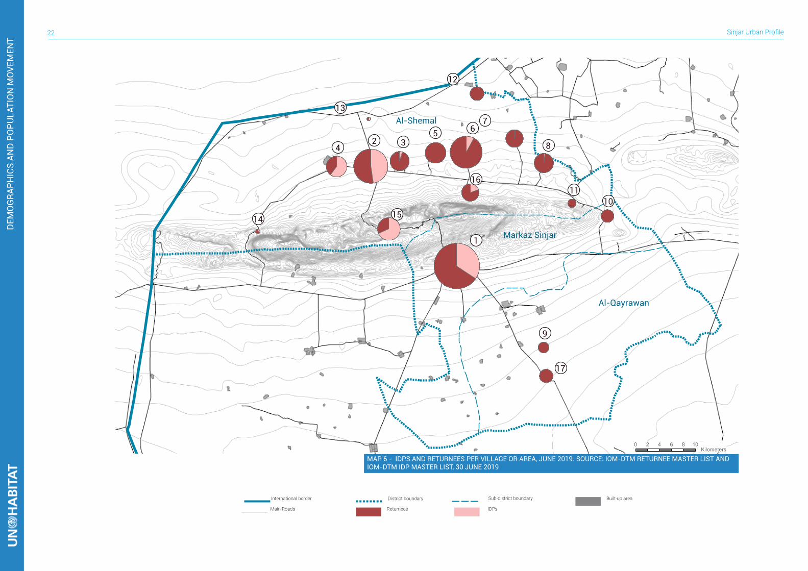
2.2 IDPS AND RETURNEES
The conflict with ISIL in Iraq, from 2014 to 2017, led to huge waves of displacement. In the country as a whole, the number of IDPs reached 3,4 million11. Sinjar district, too, saw large displacements with estimations reaching over 250,000 displaced Yazidis, mostly towards refugee camps in northern KRI. Currently, Sinjar District is characterized by the lowest rate of return in the whole country, where the average return rate in Iraq is 73%, while in the district it is around 30%12. This means that there are serious obstacles preventing the return of the displaced to their areas of origin. The displacement also occurred within the district, with many families leaving their homes to flee towards the northern part of the district. There was no secondary occupation in the north and there were procedures to use houses during the displacement, hence returnees can use the house of an IDP if their own homes are damaged. However, they must get approval from the owner (other IDPs) to use their house, and this arrangement could involve rent or be rent-free. A great number of people displaced within the district boundary are located on Sinjar Mountain. Some of them fled towards this area during ISIL’s attack and still shelter there. Some places where people settled, such as Sardashti camp, turned into a refugee camp, relying on support from humanitarian actors like UNDPO and Yazda, which deliver materials for repairing tents and consumables.Six years following the conflict with ISIL, displacement represents the main issue impacting life in the district. Some villages and towns are underpopulated, and in some cases almost deserted. Economically important facilities related to the production of goods from agriculture and livestock have not only been heavily damaged by ISIL looting, but today suffer from a labour shortage. At the same time, the provision of basic services has become a challenge due to the lack of qualified staff (e.g. teachers and doctors) to operate in the rehabilitated facilities. Understanding the patterns of return is crucial to deliver adequate and efficient support, both from the humanitarian sector and governmental institutions. There are often cases of rehabilitation of facilities that are not used due to lack of demand or the lack of skilled workers. It is possible to measure the return rate within the subdistrict: Qayrawan sub-district appears to be the area with the lowest rate, with numbers that hardly reach 10% of the original population, with no IDPs seeking shelter in villages. In Markaz
Sinjar, there is currently a flaw in the demographics. Before the ISIS occupation, the majority of the population were Sunni and Shia Kurds (18,000 Kurds), followed by Arabs (7,500 Sunni Arabs), 2,200 Yazidis and a number of Sunni and Shia Turkomen. Presently, there are a significant amount of IDPs in Markaz Sinjar who do not originate from there, including 12,000 Yazidis. Many of these Yazidi returnees were residents of the southern regions of Sinjar and cannot return due to their homes being destroyed. However, the number of returning Shia does not exceed 300 families. In the villages and Mujama’at north of the mountain the return rates are higher: likely driven by a lower level of damage of the housing stock caused by the conflict and a relatively more stable situation in terms of security. Generally, it is more likely for people to go back to their homes if their ethnicity matches the majority of the area.
11.IOM - International Organisation for Migration (updated on 30 June 2019), “Iraq DTM IDPs Dashboard”, http://iraqdtm.iom.int/
IDPsML.aspx
12. IOM - International Organisation for Migration (updated on 30 June 2019), “Iraq DTM Return Dashboard”, http://iraqdtm.iom.int/
DTMReturnDashboards.aspx
TABLE 3. Number of families and returnees per village or area, June 2019. Source: IOM-DTM Returnee Master List and IOM-DTM IDP Master List, 30 June 2019
# Location Returnees IDPs TOTAL1 Markaz Sinjar 16,227 8,514 24,7412 Markaz Sinuni 7,320 6,684 14,0043 Dogure 4,212 210 4,4224 Khana Sor 2,040 3,042 5,0825 Dhola 5,100 0 5,1006 Borek 11,400 960 12,3607 Guhbal and Shorka 3,648 42 3,6908 Zorava and Zirwa 4,386 54 4,4409 Qayrawan suburban 1,374 0 1,37410 Kulat 1,920 0 1,92011 Gormez 852 0 85212 Khazukah urban and
suburban villages 2,286 0 2,286
13 Bir Adam urban and suburban villages
72 90 162
14 Bara 174 66 24015 Sardashty area 1,920 4,212 6,13216 Sharaf Al-Din urban and
suburban villages2,886 696 3,582
17 Qayrawan 2,150 0 2,150TOTAL 67,967 24,570 92,537
Sinjar Urban Profile22
0 2 4 6 8 10 Kilometers
1
15
16
42
13
35 6
12
7
8
1110
17
9
14
Markaz Sinjar
Al-Shemal
Al-Qayrawan
MAP 6 - IDPS AND RETURNEES PER VILLAGE OR AREA, JUNE 2019. SOURCE: IOM-DTM RETURNEE MASTER LIST AND IOM-DTM IDP MASTER LIST, 30 JUNE 2019
International border Sub-district boundary Built-up areaDistrict boundary
Main Roads IDPsReturnees
DEM
OG
RAPH
ICS
AND
PO
PULA
TIO
N M
OVE
MEN
T
23
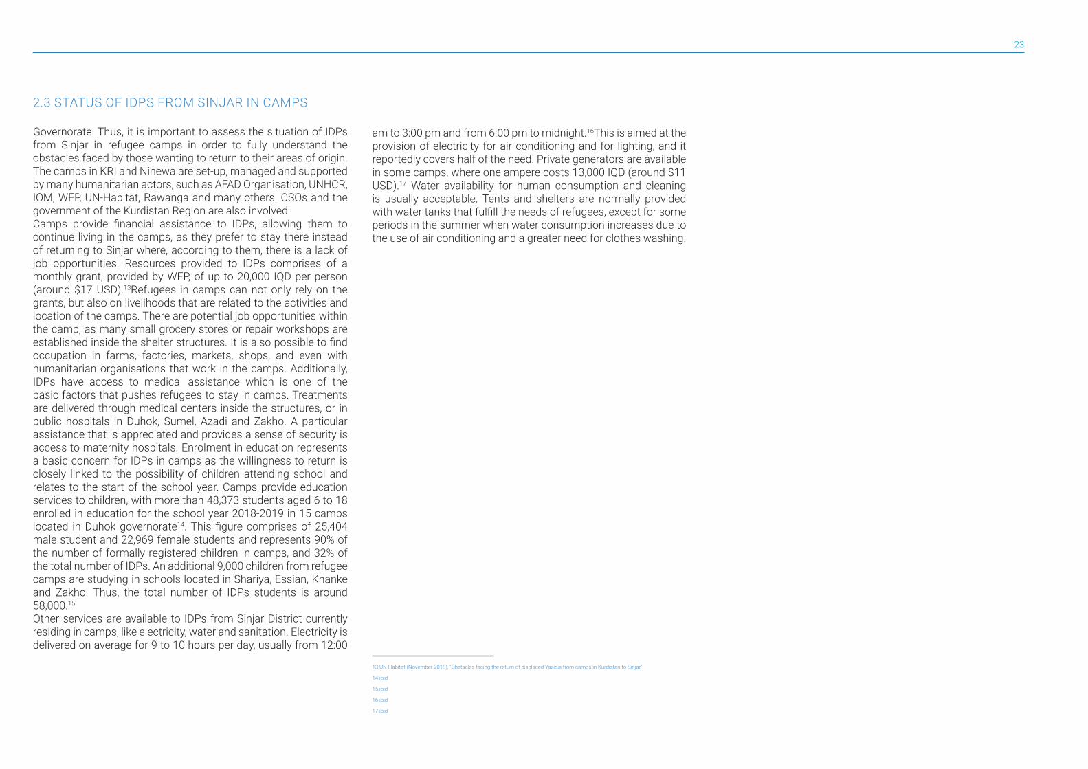
2.3 STATUS OF IDPS FROM SINJAR IN CAMPS
Governorate. Thus, it is important to assess the situation of IDPs from Sinjar in refugee camps in order to fully understand the obstacles faced by those wanting to return to their areas of origin. The camps in KRI and Ninewa are set-up, managed and supported by many humanitarian actors, such as AFAD Organisation, UNHCR, IOM, WFP, UN-Habitat, Rawanga and many others. CSOs and the government of the Kurdistan Region are also involved. Camps provide financial assistance to IDPs, allowing them to continue living in the camps, as they prefer to stay there instead of returning to Sinjar where, according to them, there is a lack of job opportunities. Resources provided to IDPs comprises of a monthly grant, provided by WFP, of up to 20,000 IQD per person (around $17 USD).13Refugees in camps can not only rely on the grants, but also on livelihoods that are related to the activities and location of the camps. There are potential job opportunities within the camp, as many small grocery stores or repair workshops are established inside the shelter structures. It is also possible to find occupation in farms, factories, markets, shops, and even with humanitarian organisations that work in the camps. Additionally, IDPs have access to medical assistance which is one of the basic factors that pushes refugees to stay in camps. Treatments are delivered through medical centers inside the structures, or in public hospitals in Duhok, Sumel, Azadi and Zakho. A particular assistance that is appreciated and provides a sense of security is access to maternity hospitals. Enrolment in education represents a basic concern for IDPs in camps as the willingness to return is closely linked to the possibility of children attending school and relates to the start of the school year. Camps provide education services to children, with more than 48,373 students aged 6 to 18 enrolled in education for the school year 2018-2019 in 15 camps located in Duhok governorate14. This figure comprises of 25,404 male student and 22,969 female students and represents 90% of the number of formally registered children in camps, and 32% of the total number of IDPs. An additional 9,000 children from refugee camps are studying in schools located in Shariya, Essian, Khanke and Zakho. Thus, the total number of IDPs students is around 58,000.15 Other services are available to IDPs from Sinjar District currently residing in camps, like electricity, water and sanitation. Electricity is delivered on average for 9 to 10 hours per day, usually from 12:00
am to 3:00 pm and from 6:00 pm to midnight.16This is aimed at the provision of electricity for air conditioning and for lighting, and it reportedly covers half of the need. Private generators are available in some camps, where one ampere costs 13,000 IQD (around $11 USD).17 Water availability for human consumption and cleaning is usually acceptable. Tents and shelters are normally provided with water tanks that fulfill the needs of refugees, except for some periods in the summer when water consumption increases due to the use of air conditioning and a greater need for clothes washing.
13 UN-Habitat (November 2018), “Obstacles facing the return of displaced Yazidis from camps in Kurdistan to Sinjar”
14.ibid
15.ibid
16 ibid
17 ibid
Sinjar Urban Profile24
0 5 10 15 20 25 Kilometers
2
8
5
97
1
4 3 6
11
13 12 10
14Mosul
Duhok
Erbil
International border Sub-district boundary Refugee CampSinjar District Main Roads Duhok Governorate Erbil GovernorateNinewa Governorate
ÆQ
Al-Ba’aj
Al-Hatra
Tal Afar
Al-Mosul
Al-Hamdaniyah
Tilkaef
Sheikhan
Akre
Al-Amedi
Duhok
Sumel
Zakho
Sinjar
MAP 7 - LOCATION OF REFUGEE CAMPS HOSTING IDPS FROM SINJAR IN NORTHERN IRAQ
DEM
OG
RAPH
ICS
AND
PO
PULA
TIO
N M
OVE
MEN
T
25
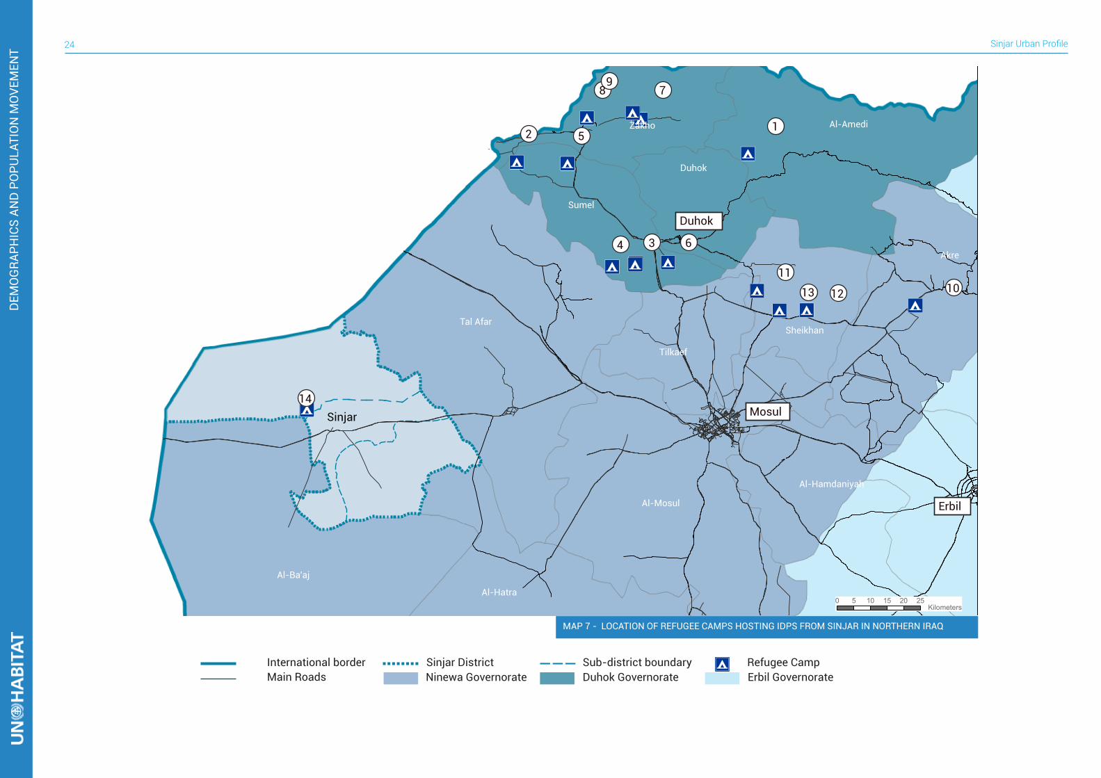
One of the crucial aspects to be assessed in order to understand the dynamics and above all the obstacles for the return of IDPs from Sinjar district to their areas of origin are intentions and perceptions of refugees living in camps. The last survey conducted with IDPs living in camps by CCCM and REACH reports insightful data on the reasons for the low return rate. First of all, it is worth mentioning that more than half (52%)18 of the whole displaced population coming from Ninewa Governorate, today, comes from Sinjar district. The great wave of displacement from Al-Mosul district is well known, but this district has also seen significant returns, whereas in Sinjar district the majority of people that fled the district are still living in camps.Among them significantly more than half (69%) reports the intention to remain in their current location, while almost a third are unsure about where they will be located in the future with only 3% reporting an intent to return to their area of origin19 .Those numbers give a sharp idea of future return patterns, if no significant action continues.The perceptions of shelter conditions may be an important cause behind the reluctance of families to return as among all the IDPs from Sinjar district, 75% report their home to be completely destroyed or heavily damaged. Our assessments suggest that this percentage does not match the reality on the ground. Only some villages south of Sinjar mountain reach these levels of damage. On average the level of damage, though significant, is likely lower than the perceptions of IDPs. Furthermore, a destroyed house is not considered as the main obstacle for return. More than 74% of households from Sinjar district report concerns about safety, and over 82% of households report that an increase in safety and security in Sinjar district is the most important condition for them when considering returning20. This issue concerns and significantly impacts the displaced population, more than the perception of services and assistance provided in the area of origin, even if 56% of surveyed IDPs reported a lack of availability of basic services and 65% reported the lack of livelihood opportunities21.
18 CCCM Cluster – REACH (February 2019), “Intentions Survey: IDP Areas of Origin”
19 ibid
20 ibid
21 ibid
Sinjar52%
Al-Mosul
Remain in current location
Have concerns about safety
Do not know
Have no or little concern about safety
Return to area of origin
Do not know
Less than 1% report intention to move to another location
Al-Ba’aj Other Tal Afar Al-Hamdaniyah
21%13%7%6%1%
FIGURE 11. Distribution of IDPs from Ninewa in refugee camps by district of origin. Source: CCCM/REACH, “Intention surveys in AoO”, February 2019
FIGURE 12. Movement intentions of IDPs from Sinjar District. Source: CCCM/REACH, “Intention surveys in AoO”, February 2019
FIGURE 13. Perception of safety of IDPs from Sinjar District. Source: CCCM/REACH, “Intention surveys in AoO”, February 2019
69% 28% 3%
74% 14% 12%
Sinjar Urban Profile26
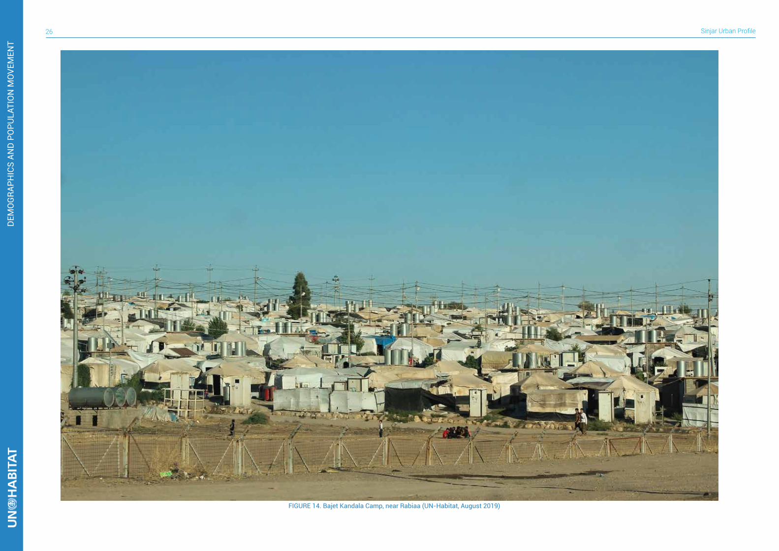
FIGURE 14. Bajet Kandala Camp, near Rabiaa (UN-Habitat, August 2019)
DEM
OG
RAPH
ICS
AND
PO
PULA
TIO
N M
OVE
MEN
T

27
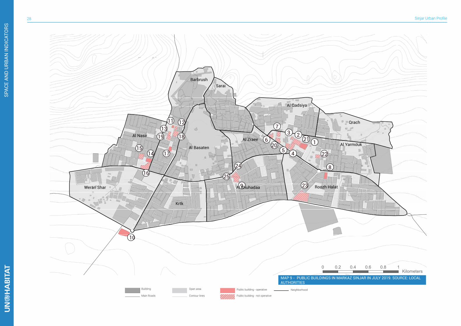
GOVERNANCE3Sinjar district (established in 1934) is part of Ninewa Governorate. Sinjar comprises of three sub-districts: Al-Shemal, Al-Qayrawan and Markaz Sinjar (Sinjar center). Sinuni (also called Shemal) is the administrative center of Al-Shemal, in the northern part of the district. The municipality area of Sinuni, with headquarters in the city, covers all the collective townships in the area in terms of provision of municipal services, such as cleaning up, removal of waste and rubble, paving streets, construction of curbstone and sidewalks, building parks and allocating land for various governmental projects. The municipality is now facing issues with the removal of rubbles, encroachments on municipal land and the lack of property rights for inhabitants. The latter is highlighted by the municipality as the main priority.Qayrawan is the administrative center of the sub-district of the same name, in the southern part of the district. The municipality area includes Tal Banat and Tal Qassab, which reportedly have no population at the moment. The majority of the main government buildings, located in Qayrawan center, are purported to be severely damaged and the offices have been moved to a temporary location. Qayrawan Municipality is not provided with a property registration office (tapo/tabu), making it hard to distribute, allocate, sell and rent private properties. Sinjar city manages the whole district and an area surrounding the city. It is located between the other two sub-districts. Markaz Sinjar hosts the headquarters of all the directorates which operate in the district, but most of them were damaged during the conflict and only one third of them are operative today. Currently the district is suffering from a lack of clarity in the definition of administrative and governmental roles, where some of the governance structures are duplicated, and these political issues severely impact the distribution of funds and the accountability for authorizations. The result is a lack of work spaces, personnel and equipment, as well as the increased feeling of precariousness for IDPs, thus impacting return rate too.
The annexes contain a collection of masterplans of several collective township in Al-Shemal sub-district, approved by the central government since 1990, which clearly show the modular urban structure as designed in around 1975.
!((
!((
!((
Al-Shemal Markaz Sinjar Al-Qayrawan
Sinuni
Markaz Sinjar
Qayrawan
# Name Status1 Water Directorate non operative2 Arabic Education Directorate non operative3 Irrigation Department of Sinjar non operative4 Garage/Public Transport non operative5 Agriculture Directorate non operative6 Police Station non operative7 Municipal Machinery Repairs Directorate non operative8 Kurdish Education Directorate operative9 Municipal Machinery Garage non operative10 Police Directorate operative11 Electricity Directorate operative12 Municipality Office non operative13 Communicate Directorate non operative14 Municipality Office operative15 Department of Social Welfare non operative16 Al-Qaemaqam Directorate non operative17 Department of Civil Conditions operative18 Sinjar Court non operative19 Sinjar Post Office non operative20 Municipality Office non operative21 Sinjar Water Directorate operative22 Government Store non operative23 Sinjar Slaughter non operative24 Municipality Office non operative25 Municipality Office non operative
TABLE 4. List of public buildings in Markaz Sinjar in July 2019. Source: Local Authorities
MAP 8 - SUB-DISTRICTS AND ADMINISTRATIVE CENTERS
Sinjar Urban Profile28
SPAC
E AN
D U
RBAN
IND
ICAT
ORS
Building Public building - operative
Public building - not operative
Open area
Main Roads Contour lines
Neighborhood
0 0.2 0.4 0.6 0.8 1 Kilometers
12123
45
620
7
8
22
239
24
25
10
11 1213
19
1415
16
17
18
Barbrushشششششش
Al Nasirششششش
Weran Sharششششش ششش
Al Basatenشششششششش
Krtkشششش
Al Shuhadaaششششششش
Saraiششششش
Al Zraeeششششششش
Al Qadsiyaشششششششش
Qrachشششش
Al Yarmoukششششششش
Roozh Halatششش شششش
MAP 9 - PUBLIC BUILDINGS IN MARKAZ SINJAR IN JULY 2019. SOURCE: LOCAL AUTHORITIES
29
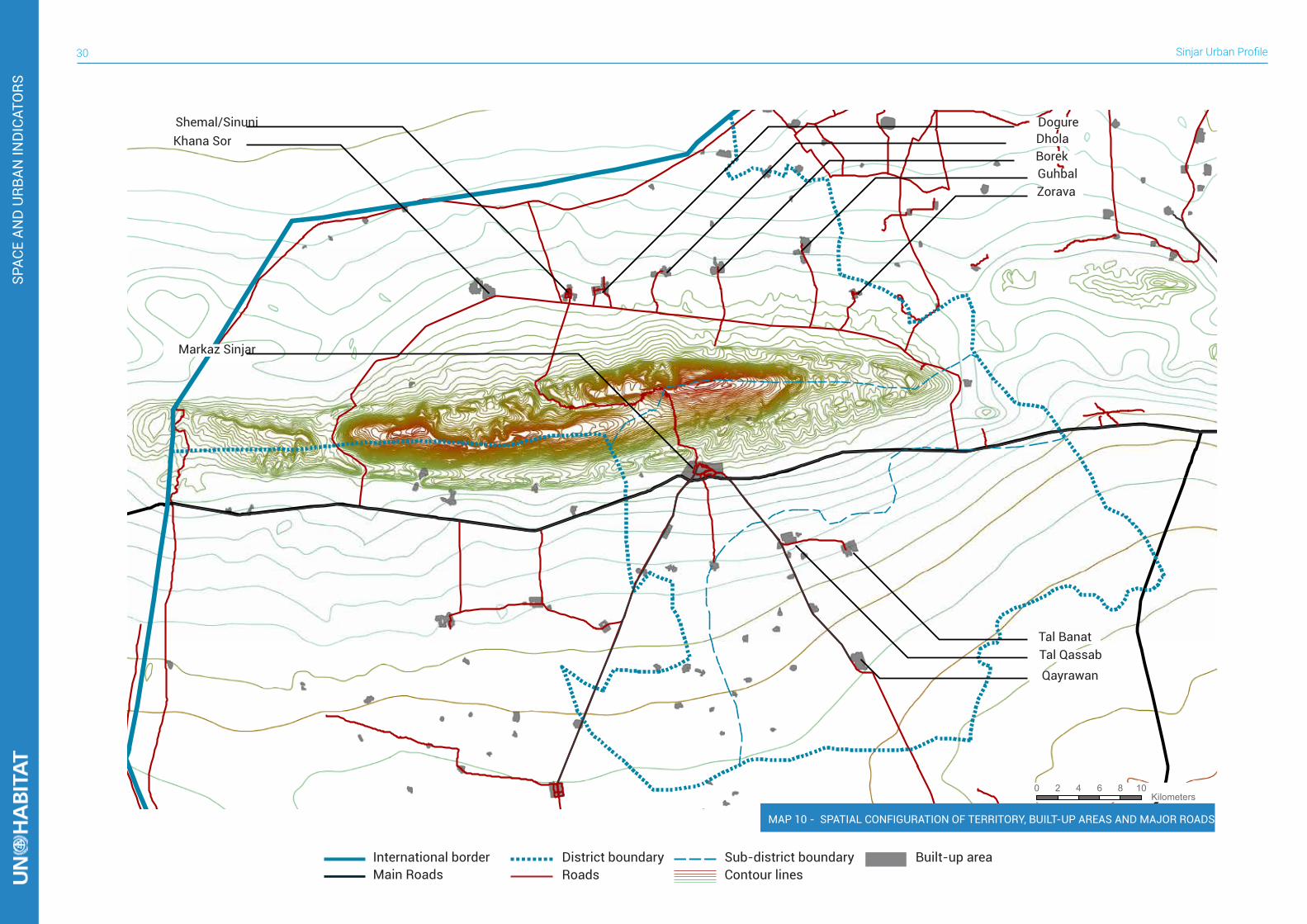
SPACE AND URBAN INDICATORS4Sinjar district is located in the north-west of Iraq in Ninewa Governorate and borders Syria to the north and west, Al-Ba’aj District to the south, a small portion of its boundary is adjacent to Al-Hatra District to the south-east, and Tal Afar District to the west. Its area is 2,886 sq. Km. The district is characterized by a 70 Km long mountain, known as Sinjar Mountain, reaches up to 1,463 m.a.s.l., on the flat lands of western Iraq. Due to this significant topographic configuration the territory is divided in two areas, north and south of the mountain. The northern part of the mountain is administratively represented by Al-Shemal sub-district. Here, the main villages are located along an east to west road that surrounds Sinjar Mountain on the northern side. Some of the built-up areas
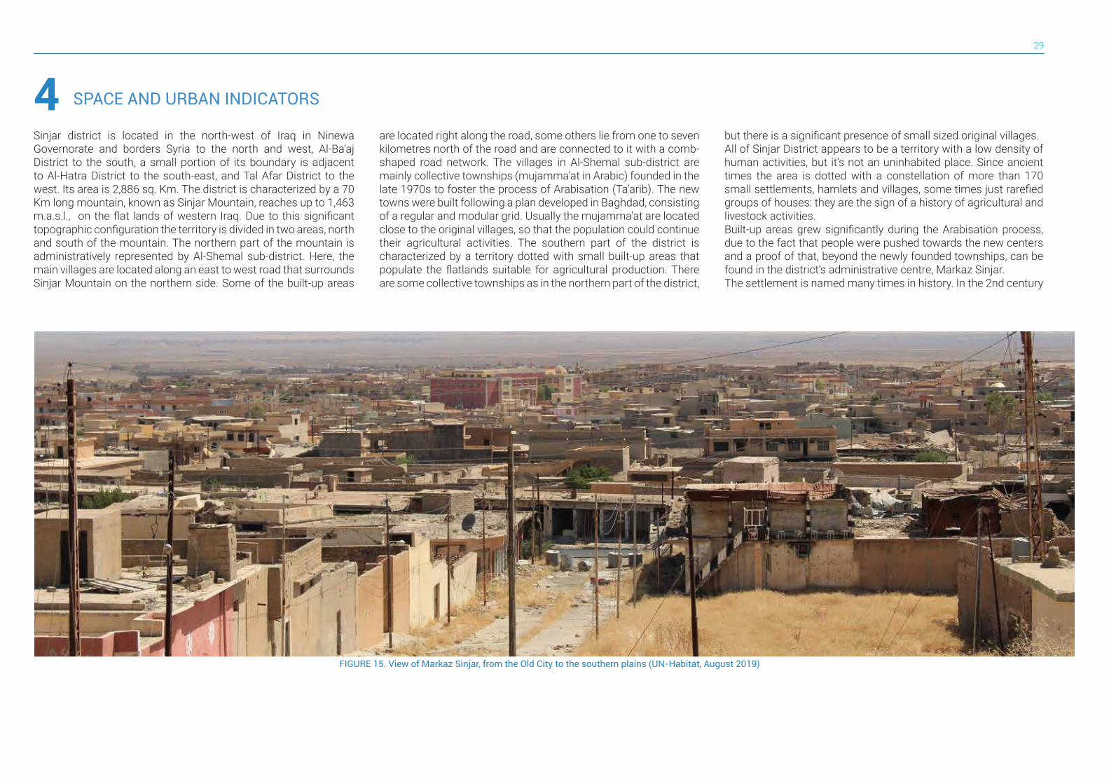
FIGURE 15. View of Markaz Sinjar, from the Old City to the southern plains (UN-Habitat, August 2019)
are located right along the road, some others lie from one to seven kilometres north of the road and are connected to it with a comb-shaped road network. The villages in Al-Shemal sub-district are mainly collective townships (mujamma’at in Arabic) founded in the late 1970s to foster the process of Arabisation (Ta’arib). The new towns were built following a plan developed in Baghdad, consisting of a regular and modular grid. Usually the mujamma’at are located close to the original villages, so that the population could continue their agricultural activities. The southern part of the district is characterized by a territory dotted with small built-up areas that populate the flatlands suitable for agricultural production. There are some collective townships as in the northern part of the district,
but there is a significant presence of small sized original villages. All of Sinjar District appears to be a territory with a low density of human activities, but it’s not an uninhabited place. Since ancient times the area is dotted with a constellation of more than 170 small settlements, hamlets and villages, some times just rarefied groups of houses: they are the sign of a history of agricultural and livestock activities. Built-up areas grew significantly during the Arabisation process, due to the fact that people were pushed towards the new centers and a proof of that, beyond the newly founded townships, can be found in the district’s administrative centre, Markaz Sinjar. The settlement is named many times in history. In the 2nd century
Sinjar Urban Profile30
0 2 4 6 8 10 Kilometers
Zorava
Tal QassabQayrawan
Guhbal
Tal Banat
BorekDholaDogureShemal/Sinuni
Khana Sor
Markaz Sinjar
SPAC
E AN
D U
RBAN
IND
ICAT
ORS
International border Sub-district boundary Built-up areaDistrict boundaryMain Roads Roads Contour lines
MAP 10 - SPATIAL CONFIGURATION OF TERRITORY, BUILT-UP AREAS AND MAJOR ROADS
31
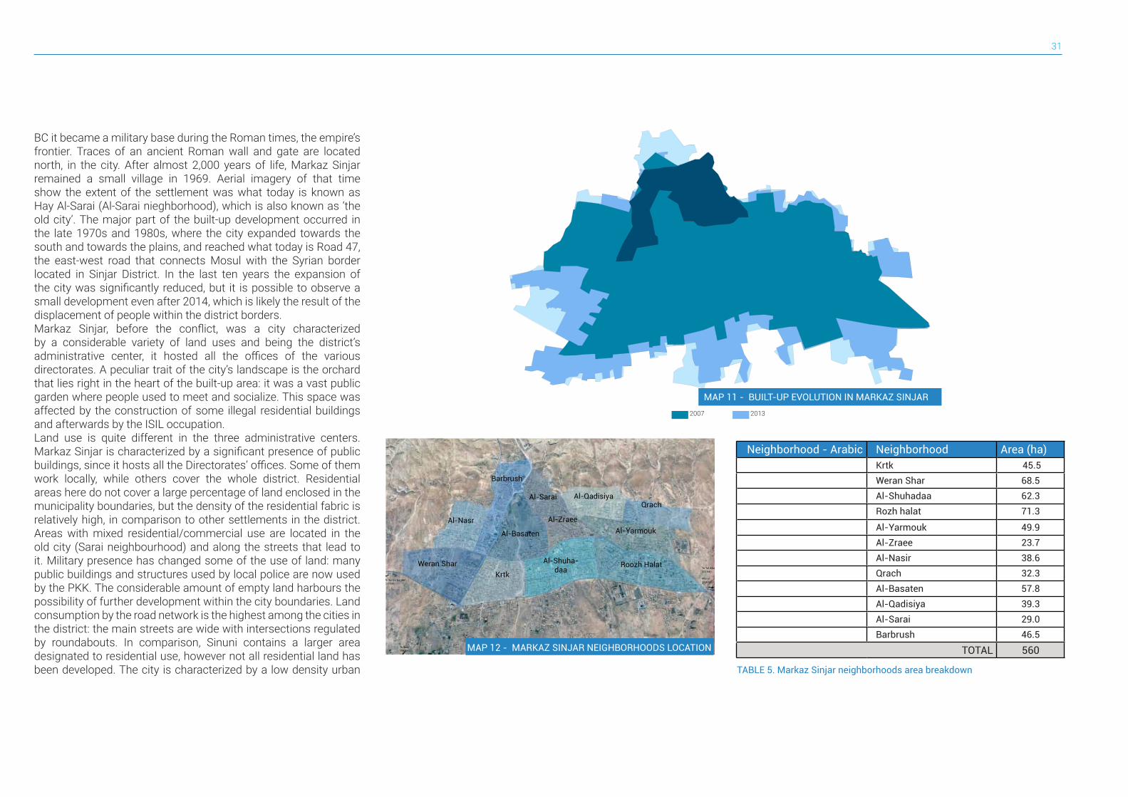
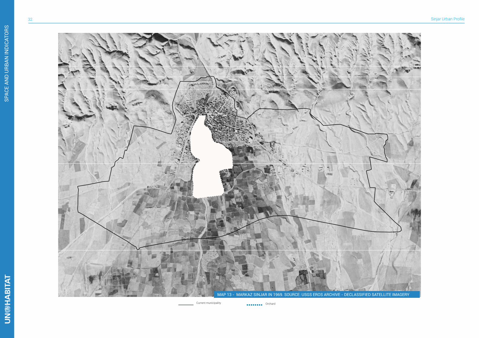
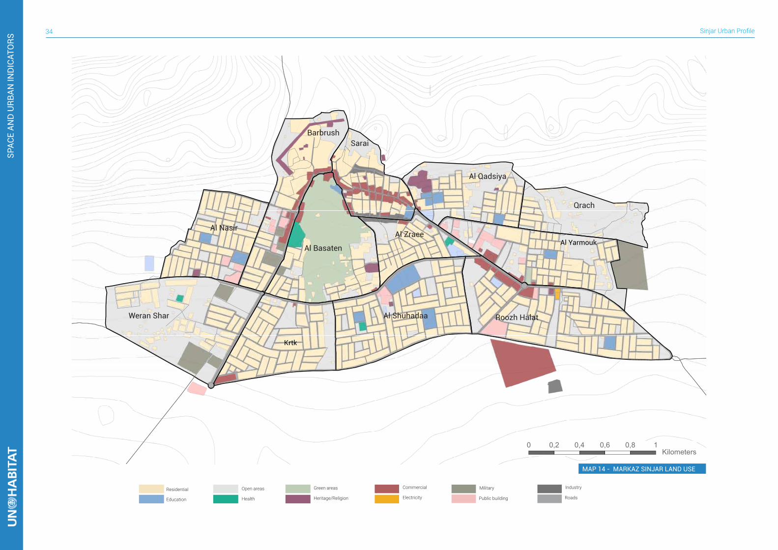
BC it became a military base during the Roman times, the empire’s frontier. Traces of an ancient Roman wall and gate are located north, in the city. After almost 2,000 years of life, Markaz Sinjar remained a small village in 1969. Aerial imagery of that time show the extent of the settlement was what today is known as Hay Al-Sarai (Al-Sarai nieghborhood), which is also known as ‘the old city’. The major part of the built-up development occurred in the late 1970s and 1980s, where the city expanded towards the south and towards the plains, and reached what today is Road 47, the east-west road that connects Mosul with the Syrian border located in Sinjar District. In the last ten years the expansion of the city was significantly reduced, but it is possible to observe a small development even after 2014, which is likely the result of the displacement of people within the district borders.Markaz Sinjar, before the conflict, was a city characterized by a considerable variety of land uses and being the district’s administrative center, it hosted all the offices of the various directorates. A peculiar trait of the city’s landscape is the orchard that lies right in the heart of the built-up area: it was a vast public garden where people used to meet and socialize. This space was affected by the construction of some illegal residential buildings and afterwards by the ISIL occupation.Land use is quite different in the three administrative centers. Markaz Sinjar is characterized by a significant presence of public buildings, since it hosts all the Directorates’ offices. Some of them work locally, while others cover the whole district. Residential areas here do not cover a large percentage of land enclosed in the municipality boundaries, but the density of the residential fabric is relatively high, in comparison to other settlements in the district. Areas with mixed residential/commercial use are located in the old city (Sarai neighbourhood) and along the streets that lead to it. Military presence has changed some of the use of land: many public buildings and structures used by local police are now used by the PKK. The considerable amount of empty land harbours the possibility of further development within the city boundaries. Land consumption by the road network is the highest among the cities in the district: the main streets are wide with intersections regulated by roundabouts. In comparison, Sinuni contains a larger area designated to residential use, however not all residential land has been developed. The city is characterized by a low density urban
2007 2013
MAP 11 - BUILT-UP EVOLUTION IN MARKAZ SINJAR
TABLE 5. Markaz Sinjar neighborhoods area breakdown
To Syrian border(51 km)
To Tal Afar (52 km)
Mosul (116 km)
To Snuni(44 km)
To Baaj(34 km)
Barbrushشششششش
Al-Nasrششششش
Weran Sharششششش ششش
Al-Basatenشششششششش
Krtkشششش
Al-Shuha-daaششششششش
Al-Saraiششششش
Al-Zraeeششششششش
Al-Qadisiyaشششششششش Qrach
شششش
Al-Yarmoukششششششش
Roozh Halatششش شششش
Neighborhood - Arabic Neighborhood Area (ha)شششش Krtk 45.5
ششششش ششش Weran Shar 68.5
ششششششش Al-Shuhadaa 62.3
ششش شششش Rozh halat 71.3
ششششششش Al-Yarmouk 49.9
ششششششش Al-Zraee 23.7
ششششش Al-Nasir 38.6
شششش Qrach 32.3
شششششششش Al-Basaten 57.8
شششششششش Al-Qadisiya 39.3
شششش Al-Sarai 29.0
شششششش Barbrush 46.5
TOTAL 560MAP 12 - MARKAZ SINJAR NEIGHBORHOODS LOCATION
Sinjar Urban Profile32
Current municipality Orchard
SPAC
E AN
D U
RBAN
IND
ICAT
ORS
MAP 13 - MARKAZ SINJAR IN 1969. SOURCE: USGS EROS ARCHIVE - DECLASSIFIED SATELLITE IMAGERY
33
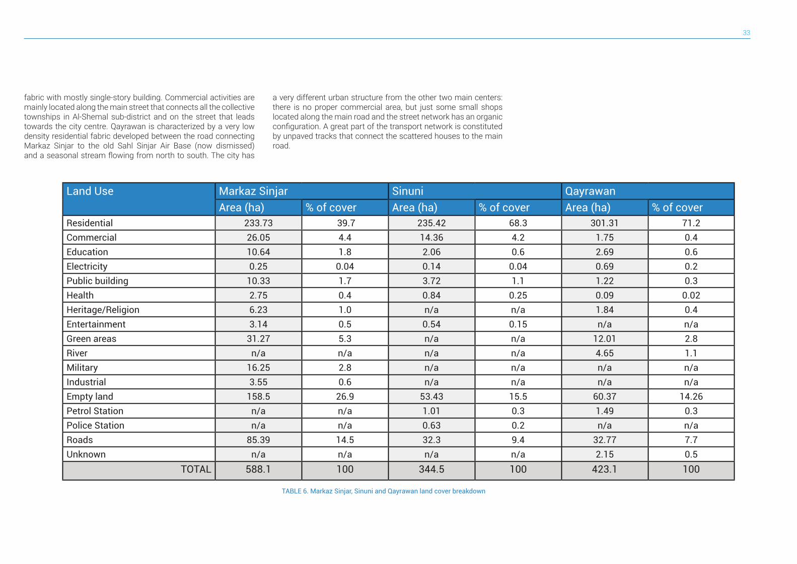
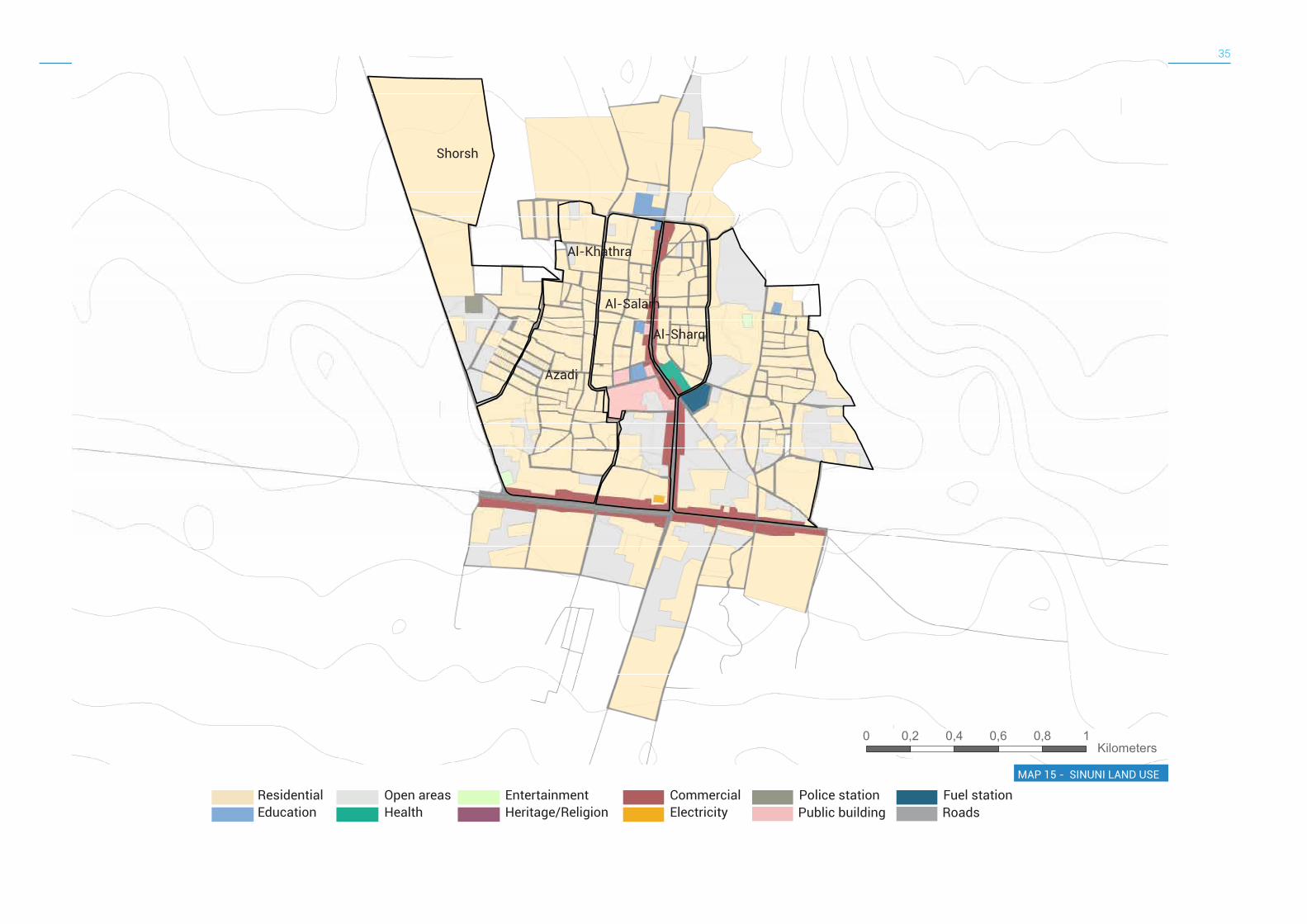
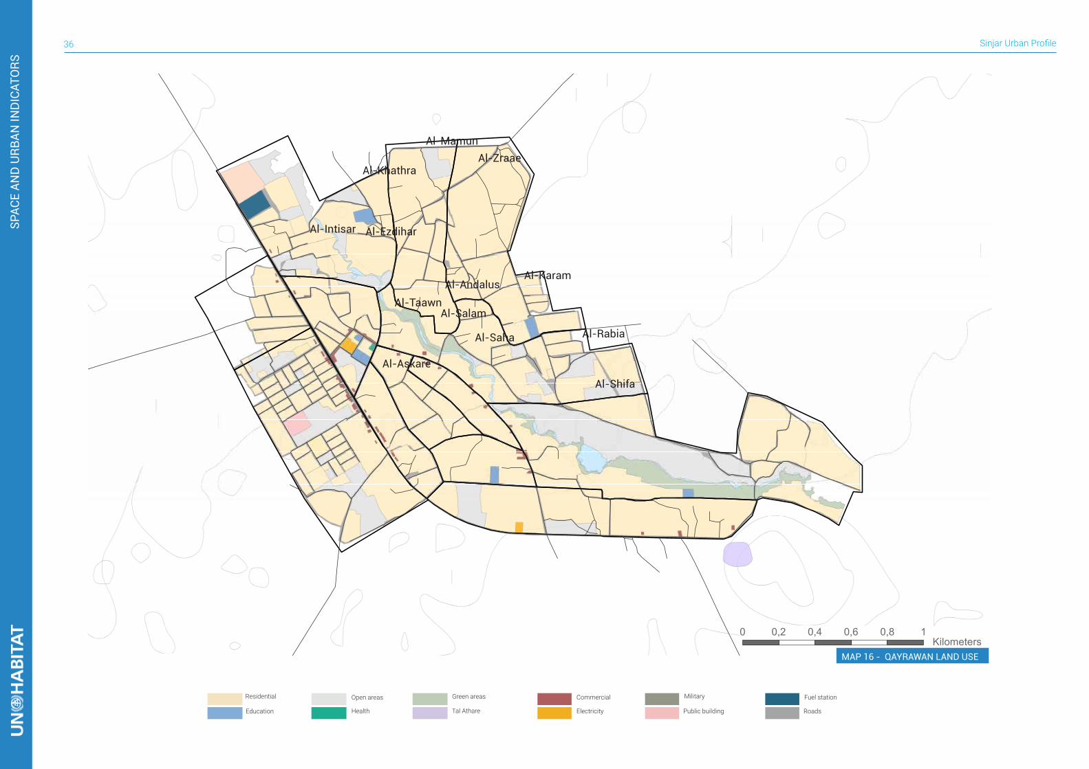
fabric with mostly single-story building. Commercial activities are mainly located along the main street that connects all the collective townships in Al-Shemal sub-district and on the street that leads towards the city centre. Qayrawan is characterized by a very low density residential fabric developed between the road connecting Markaz Sinjar to the old Sahl Sinjar Air Base (now dismissed) and a seasonal stream flowing from north to south. The city has
Land Use Markaz Sinjar Sinuni QayrawanArea (ha) % of cover Area (ha) % of cover Area (ha) % of cover
Residential 233.73 39.7 235.42 68.3 301.31 71.2Commercial 26.05 4.4 14.36 4.2 1.75 0.4Education 10.64 1.8 2.06 0.6 2.69 0.6Electricity 0.25 0.04 0.14 0.04 0.69 0.2Public building 10.33 1.7 3.72 1.1 1.22 0.3Health 2.75 0.4 0.84 0.25 0.09 0.02Heritage/Religion 6.23 1.0 n/a n/a 1.84 0.4Entertainment 3.14 0.5 0.54 0.15 n/a n/aGreen areas 31.27 5.3 n/a n/a 12.01 2.8River n/a n/a n/a n/a 4.65 1.1Military 16.25 2.8 n/a n/a n/a n/aIndustrial 3.55 0.6 n/a n/a n/a n/aEmpty land 158.5 26.9 53.43 15.5 60.37 14.26Petrol Station n/a n/a 1.01 0.3 1.49 0.3Police Station n/a n/a 0.63 0.2 n/a n/aRoads 85.39 14.5 32.3 9.4 32.77 7.7Unknown n/a n/a n/a n/a 2.15 0.5
TOTAL 588.1 100 344.5 100 423.1 100
TABLE 6. Markaz Sinjar, Sinuni and Qayrawan land cover breakdown
a very different urban structure from the other two main centers: there is no proper commercial area, but just some small shops located along the main road and the street network has an organic configuration. A great part of the transport network is constituted by unpaved tracks that connect the scattered houses to the main road.
Sinjar Urban Profile34
SPAC
E AN
D U
RBAN
IND
ICAT
ORS
Residential
Education
Green areas
Heritage/Religion
Commercial
Electricity
Military IndustryOpen areas
Health Public building Roads
0 0,2 0,4 0,6 0,8 1 Kilometers
Barbrushشششششش
Al Nasirششششش
Weran Sharششششش ششش
Al Basatenشششششششش
Krtkشششش
Al Shuhadaaششششششش
Saraiششششش
Al Zraeeششششششش
Al Qadsiyaشششششششش
Qrachشششش
Al Yarmoukششششششش
Roozh Halatششش شششش
MAP 14 - MARKAZ SINJAR LAND USE
35
0 0,2 0,4 0,6 0,8 1 Kilometers
ResidentialEducation
EntertainmentHeritage/Religion
CommercialElectricity
Police station Fuel stationOpen areasHealth Public building Roads
Shorshشششش
Azadiششششش
Al-Khathraششششششش
Al-Salamشششششش
Al-Sharqiشششششش
MAP 15 - SINUNI LAND USE
Sinjar Urban Profile36
0 0,2 0,4 0,6 0,8 1 Kilometers
SPAC
E AN
D U
RBAN
IND
ICAT
ORS
Residential
Education
Green areas
Tal Athare
Commercial
Electricity
Military Fuel stationOpen areas
Health Public building Roads
Al-Karamشش ششششششش
Al-Khathraشش ششششششش
Al-Zraaeشش ششششششش
Al-Mamunشش ششششششش
Al-Rabiaشش شششششش
Al-Shifaشش شششششش
Al-Taawnشش ششششششش
Al-Askareشش ششششششش
Al-Intisarشش شششششششش
Al-Salamشش شششششش
Al-Andalusشش ششششششش
Al-Sahaشش ششششش
Al-Ezdiharشش شششششششش
MAP 16 - QAYRAWAN LAND USE

37
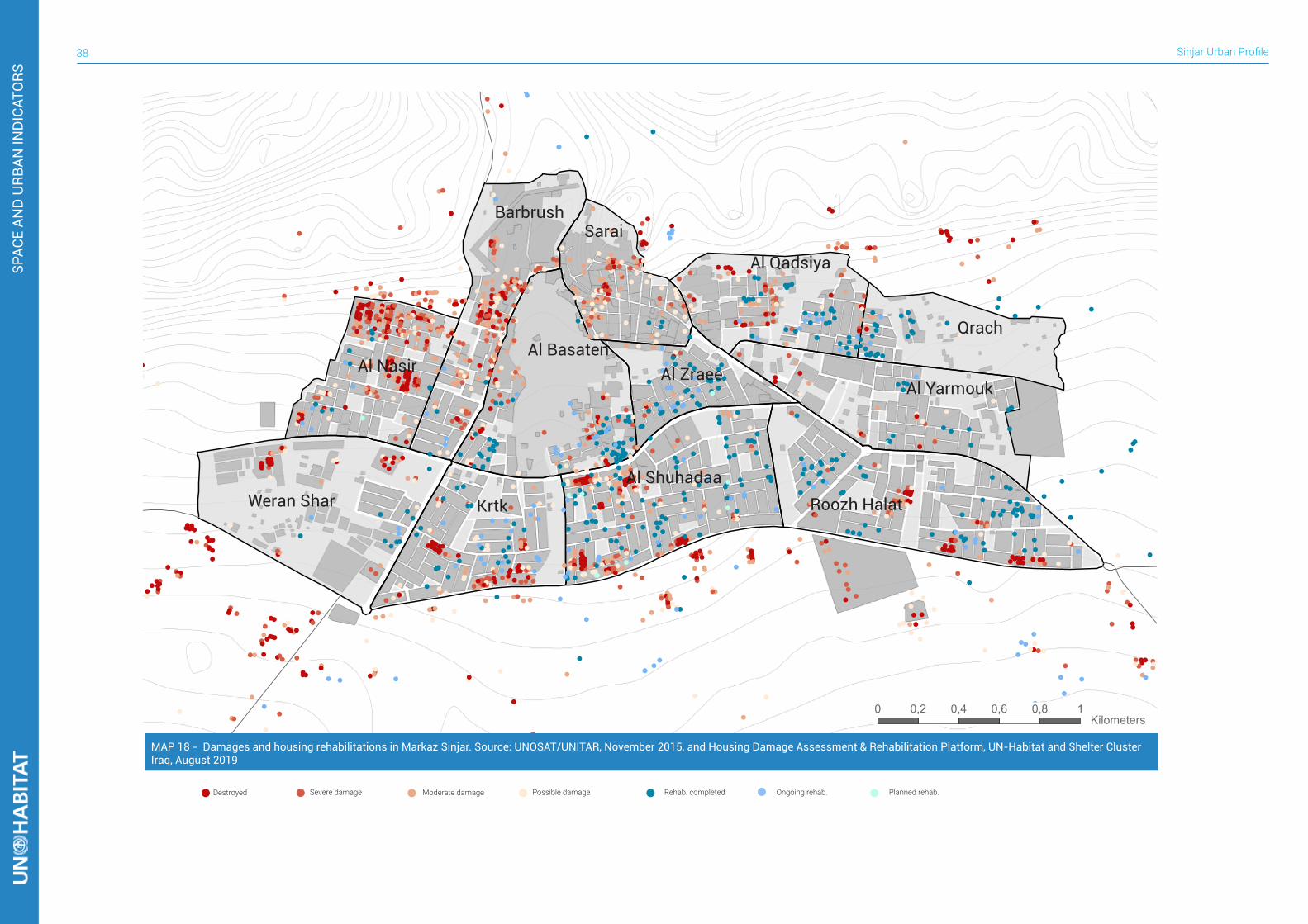
HOUSING AND HLP5The subsequent occupation, together with the status of abandonment of many villages and the displacement of many people within the district’s boundaries, the housing sector in Sinjar District is currently facing serious challenges. They face not only old issues with informal settlements, but today the condition of the housing stock is severely impacted in its physical status. Beyond this, the land and property situation is extremely challenging. While the situation was already muddled due to expropriations, the lack of a cadastre, and the prevalence of unregistered transitions before the crisis, the situation worsened after the displacement of inhabitants and destruction which resulted in the loss of documents and certificates. Both Sinuni and Sinjar Municipalities have reported housing violations resulting in an increase of informal settlements. Not only are there built-up extensions areas that were not envisaged in the approved masterplans, but also within the plan’s boundaries there are illegal residential buildings that do not comply with approved land-use designations. The violations are located both in open areas and on land owned by the municipality. In Markaz Sinjar the land occupied by informal settlements within the municipality boundary is almost 18 hectares, representing 7.7% of the whole residential land.
FIGURE 16. Devastation in Dhola (UN-Habitat, Mr. Mohamed Al Rubai’y, 2015)
The conflict has severely affected the housing stock, with the most affected areas being located south of Markaz Sinjar. Local government authorities mention that villages were damaged up to 80%22, but the damage is likely to be lower. As a result of this, some of those have seen no returnees yet. Those levels of damage impact on the overall perception of housing stock status of all IDPs from Sinjar District that are now living in refugee camps. IOM and UN-Habitat are already operating in specific areas in the district in order to rehabilitate dwellings, focusing on areas that are experiencing the highest rates of return: they comprehend all the collective townships (mujamma’at) in Al-Shemal sub-district and Markaz Sinjar, where a slower return rate is combined with the arrival of IDPs that come from the villages in the southern part of the district. UN-Habitat operates for example in Markaz Sinjar, in the neighborhoods with the highest percentage of damages: Al-Nasr and Al-Shuhadaa. However, the municipality has also pointed out the importance of rehabilitation in the Old City in Al-Sarai neighborhood, as this represents the main commercial hub in the city, where many small shops are currently nonoperational. The conflict has severely affected the housing stock, with the most affected areas being located south of Markaz Sinjar. Local
FIGURE 17. Different levels of damage in Al-Shemal sub-district, including complete destruction - second house from the right (UN-Habitat, August 2019)
TABLE 7. Damage assessment breakdown in Markaz Sinjar based on satellite damage assessments by UNOSAT. This is a low estimate as satellite damage assessments are only able to identify a part of actual damages on the ground.
Neighborhood Destroyed Severe damage
Moderate damage
Possible damage
Total
Al-Nasr 75 60 71 21 227Al-Yarmouk 6 5 7 5 23Al-Basaten 13 19 23 21 76Al-Qadisiya 18 20 28 12 78Al-Shuhadaa 51 39 57 35 182Al-Zraee 2 3 7 3 15Barbrush 32 58 51 35 176Krtk 32 21 21 33 107Qrach 1 - 3 1 5Rozh halat 32 22 19 11 84Al-Sarai 8 26 38 32 104Weran Shar 18 7 9 9 43
TOTAL 288 280 334 218 1120
Very High High Moderate Low
Barbrushشششششش
Al-Nasrششششش
Weran Sharششششش ششش
Al-Basatenشششششششش
Krtkشششش
Al-Shuhadaaششششششش
Al-Saraiششششش
Al-Zraeeششششششش
Al-Qadisiyaشششششششش
Qrachشششش
Al-Yarmoukششششششش
Roozh Halatششش شششش
22 Interviews conducted by UN-Habitat field staff in Sinjar District
MAP 17 - Damage level in Markaz Sinjar, per neighborhood. Source: UNOSAT/UNITAR, November 2015
Sinjar Urban Profile38
!!!
!
!
!!
!!!! !
!!
!!!! !!!
!!! !!!
!!!!
!!!!! !!
!
!!
!
!!!! !
!
!!
!! !!!!!!!!!
!!!!! !! !!
!!!!!!!
!!!!!!!!!!!
!!!!!!!!
!!!!!!!!!
!!!!
!!!!! !!
!!
!!
!
! !!!!!
!!
!!!
!!!!!
!!!!
!!!! !!!
! !!!!!
!! !
!!
!!
!!!! !!! !
! !!!!
!
!!! !
!!!
!!!!!!
!!
!
!!!!!!
!!!!!!!!
!
!!!
!!
!
!!!!
!
!!!!!!
!
!!
!!!!
!
!!
!!!
!!!!!!!!!!!!!!!!!
!!!!
!
!
!
!!!!!
!!!!!!! !
!!!!!!!!!!!
!!!!
!
!!!!!! !!
!
!
!
!
!!!!!!!!
!!
!
!!!!!!!!
!!!!!!!!
!
!!!!!
!!!!!
!!!!!
!!!!!
!!!!
! !
!!
!!!!!!
!!!!
!!
!! !!!! !
!!
!!!!
!
!!!!
!
!!
!!!
!
!
!!
!
!
!!
!!!!
!
!
!!
!!!
!
!!!!!!
!!
!
!
!
!
!!
!!
! !
! !!
!!!!!!!!!!
!!!
!
!!!! !!
!
!!
!!
!!!
!!!
!!! !!
!!
!!!!!!
!
!
!!!!!!!!
!
! !
!!
!
!
!!
!!
!
!!!
! !
!
!!!! !!!!
!
!!!
!
!
!!!!
!
! !!!!!!!!!
!!!!!
!
!!
!!!!!!
!
!!!
!!
!!!
!
!!!
!!
!!!!!
!
!!
!!
!
!
!
!!
!
! !
! !!!
!
!
!!!
! !!
! !!!
!!
!!!
!!
! !
! !!!!!!!!!!!!!!!!!!
! !!!!!!
!
!!! !
!!!!!
!
!!
!!! !
!
!
!
!
!!
!
!
!
!
!
!
!!
!!
!
!!
!
!!
!!
!
! !!!!
!
!!
!!!
!!
!!!!
!
!
!
!
!!
!!
!!
!!
!!
!
!!
!
!
!!!!!! !!
!
!!
!!!
!!
!!!!
!!!!!!!
!
!!!!!
!
!!!!
!
! !
!
!! !
!
!
!!!!!!!!
!!!!!!!!!
!!!!!!!!
! !
!!
!
!! !!
!!
!!!
!!
!
!
!
!
!!!!!!!!
!!!!
!!!
!!!!
!
!!!!!
!
!!!!
!!
!!!!!!
!
!!
!
!
!!
!!!!!!!!!!
!!!!
!!
!!!!
! !!!!
!!!
!!!!!!!!
!
!!
!!!!!! !
!!!
!!!!
!!!!! !
!
!
!!!
!!! !
!!!!
!!!
!
!!!!!!!!!!!!!!
!!
!!!!
!!!!!
!!
!
!!!!!!!
!!!
!!
!
!
!!
!!!!
!!!
!!!!
!!
!
!
!!!!
!!
!!!! !
!
!!
!!! !
!!
!
!
!!!
!!
!!
!!
!
!
!!!!!!
!!
!!!!
!
!!!!!!!!!!!
!!!
!!!
!
!!!!!!!
!!!!!
!!!
!
!
!!
!!
!!!!!
!
!!!
!!
!!
!
!
!!! !
!!!
!
!!!!
!
!!
!!
!
!
!!!
!
!!
!!
!!
!
!!!!!
!!!
!!!!!
!
!!!!!
!!!
!!!!!
!!!
!!
!!!!!!
!!!
!
!
!
!!!
!
!
!
!!
!
!!!!!
!!!!
!
!!
!!
!!
!
!!
!!!!!!
!!
!
!!!!!!!
!
!!!!
!
!
!
!
!!!!!!
!
!
!
!
!!!!!!
!!!!!!!
!!!!
!
!
!
!!
!!!!!!!!!!!
!!
!!
!!
!!
!
!!!!
!
!
!
!
!
!!!!!
!
!
!
!
!!!!
!
!!
!
!!
! !!
!!!!
!!
!
!
!!
!!!
!
!
!
!
!
!
!
!
!
!!
!
!
!
!
!!
!!!!
!
!!! !
!
!
!
!!!!!!!!!
!!!!
!
!
!
!
!
!!
!!!!
!
!!
!
!!
!
!
!
!!
!
!!!!!!!
!!
!!
!! !
!
!!
!!
!
!
!
!
!
!!
!
!!!
!
!!
!!
!
!!!
!!!!
!!
!!
!!
!
!
!
!
!! ! !
!! !!!
! !
!!!
!
!!
!
!
!
!!
!
!
!
!
!
!
! !
!!!
!!!
!!
!!
!!
!!!
!
!
!
!
!
!
!
!!! !!!
!
!
!
!
!
!!!!
!! !
!!
!
!
!
!!
!!!
!
!!!
!!
!!!
!!
!
!!
!
!
!
!!
!
!!
!
!
!!!
!
!
!
!!
!!
!
!
!!
!!!
!
!!
!
!
!
!
!
!!
!
!
!
!
!
!
!
!
!
!
!
!
!
!
!!
!
!
!
!
!
!
!!
!
!
!
!
!
!
!!
!
!
!!
!
!
!
!
!
!!!!
!
!
!
!
!
!
!
!
!
!
!
!
!
!
!
!
!
!!!!
!!!!!!
!!!
!!
!
!!!!!
!!
!!
!
!
!!
!
!!!!!
!!!!!! !
!
!!!
!
!
!
!!
!
!!
!
!
!!
!
!!
!
!
!!
!
!!!
!
!
!
!! !
!
!!
!
!
!!
!
!
!
!
!!
!!
!!
! !!
!
!!!
!!!
!! !
!
!
!
!
!
!
!!
!
!
!
!!
!
!!
!
!!
!
!
!!
!
!
!
!!!
!!
!
!!! !
!
!!
!
!!!
!!
!!
!!
!
!
!
!
!
!!!
!
!
!
!!
!
!
!
!
!!
!
!
!
!
!!
!!!
!!
!!
!
!!!
!!!!!
!!
!!
!!!
!
!
!!!
! !!
!
!
!
!
!
!
!
!!
!
!!
!
!
!
!
!
!
!
!!
!!
!
!!!!
!
!
!
!
!
!!
!
!!
!!
!
!!
!!
!
!
!
!!!!
!!
!
!
!
!
!
!
!
!!
!!
!
!!
!
!
!!!
!
!! !
!
!!
!
!
!
!
!
!
!!
!
!!
!
!
!!
!
!!
!
!
!
!
! !
!
!
!
!!!
! !
!
!!
!
!!
!!
!
!
!
!
!
!!!
!
!
!
!
!
!
!
!
!
!
!
!
!!
!
!
!
!
!!
!
!
!!
!!
!0 0,2 0,4 0,6 0,8 1 Kilometers
Destroyed Moderate damage Possible damage Rehab. completed Ongoing rehab. Planned rehab.Severe damage
Barbrushشششششش
Al Nasirششششش
Weran Sharششششش ششش
Al Basatenشششششششش
Krtkشششش
Al Shuhadaaششششششش
Saraiششششش
Al Zraeeششششششش
Al Qadsiyaشششششششش
Qrachشششش
Al Yarmoukششششششش
Roozh Halatششش شششش
SPAC
E AN
D U
RBAN
IND
ICAT
ORS
MAP 18 - Damages and housing rehabilitations in Markaz Sinjar. Source: UNOSAT/UNITAR, November 2015, and Housing Damage Assessment & Rehabilitation Platform, UN-Habitat and Shelter Cluster Iraq, August 2019
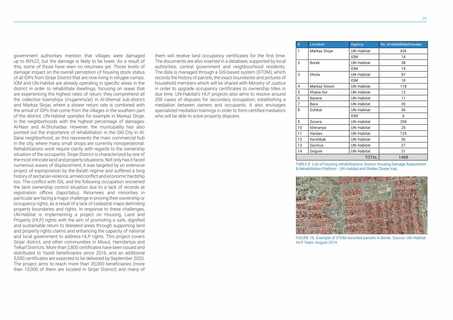
39
government authorities mention that villages were damaged up to 80%22, but the damage is likely to be lower. As a result of this, some of those have seen no returnees yet. Those levels of damage impact on the overall perception of housing stock status of all IDPs from Sinjar District that are now living in refugee camps. IOM and UN-Habitat are already operating in specific areas in the district in order to rehabilitate dwellings, focusing on areas that are experiencing the highest rates of return: they comprehend all the collective townships (mujamma’at) in Al-Shemal sub-district and Markaz Sinjar, where a slower return rate is combined with the arrival of IDPs that come from the villages in the southern part of the district. UN-Habitat operates for example in Markaz Sinjar, in the neighborhoods with the highest percentage of damages: Al-Nasr and Al-Shuhadaa. However, the municipality has also pointed out the importance of rehabilitation in the Old City in Al-Sarai neighborhood, as this represents the main commercial hub in the city, where many small shops are currently nonoperational. Rehabilitations work require clarity with regards to the ownership situation of the occupants. Sinjar District is characterized by one of the most intricate land and property situations. Not only has it faced numerous waves of displacement, it was targeted by an extensive project of expropriation by the Ba’ath regime and suffered a long history of sectarian violence, armed conflict and economic hardship too. The conflict with ISIL and the following occupation worsened the land ownership control situation due to a lack of records at registration offices (tapo/tabu). Returnees and minorities in particular are facing a major challenge in proving their ownership or occupancy rights, as a result of a lack of cadastral maps delimiting property boundaries and rights. In response to these challenges, UN-Habitat is implementing a project on Housing, Land and Property (HLP) rights with the aim of promoting a safe, dignified and sustainable return to liberated areas through supporting land and property rights claims and enhancing the capacity of national and local government to address HLP rights. This project covers Sinjar district, and other communities in Mosul, Hamdaniya and Telkaif Districts. More than 2,800 certificates have been issued and distributed to Yazidi beneficiaries since 2016, and an additional 5,000 certificates are expected to be delivered by September 2020. The project aims to reach more than 35,000 beneficiaries (more than 13,000 of them are located in Sinjar District) and many of
them will receive land occupancy certificates for the first time. The documents are also inserted in a database, supported by local authorities, central government and neighbourhood residents. The data is managed through a GIS-based system (STDM), which records the history of parcels, the exact boundaries and pictures of household members which will be shared with Ministry of Justice in order to upgrade occupancy certificates to ownership titles in due time. UN-Habitat’s HLP projects also aims to resolve around 350 cases of disputes for secondary occupation, establishing a mediation between owners and occupants. It also envisages specialized mediation trainings in order to form certified mediators who will be able to solve property disputes.
FIGURE 18. Example of STDM recorded parcels in Borek. Source: UN-Habitat HLP Team, August 2019
TABLE 8. List of housing rehabilitations Source: Housing Damage Assessment & Rehabilitation Platform - UN-Habitat and Shelter Cluster Iraq
# Location Agency No. of rehabilitated houses
1 Markaz Sinjar UN-Habitat 426IOM 14
2 Borek UN-Habitat 38IOM 14
3 Dhola UN-Habitat 97IOM 18
4 Markaz Sinuni UN-Habitat 1185 Khana Sor UN-Habitat 126 Barava UN-Habitat 117 Bara UN-Habitat 208 Guhbal UN-Habitat 36
IOM 69 Zorava UN-Habitat 25910 Kheranya UN-Habitat 2511 Hardan UN-Habitat 12512 Kershbak UN-Habitat 2613 Qurmus UN-Habitat 2714 Dogure UN-Habitat 21
TOTAL 1468
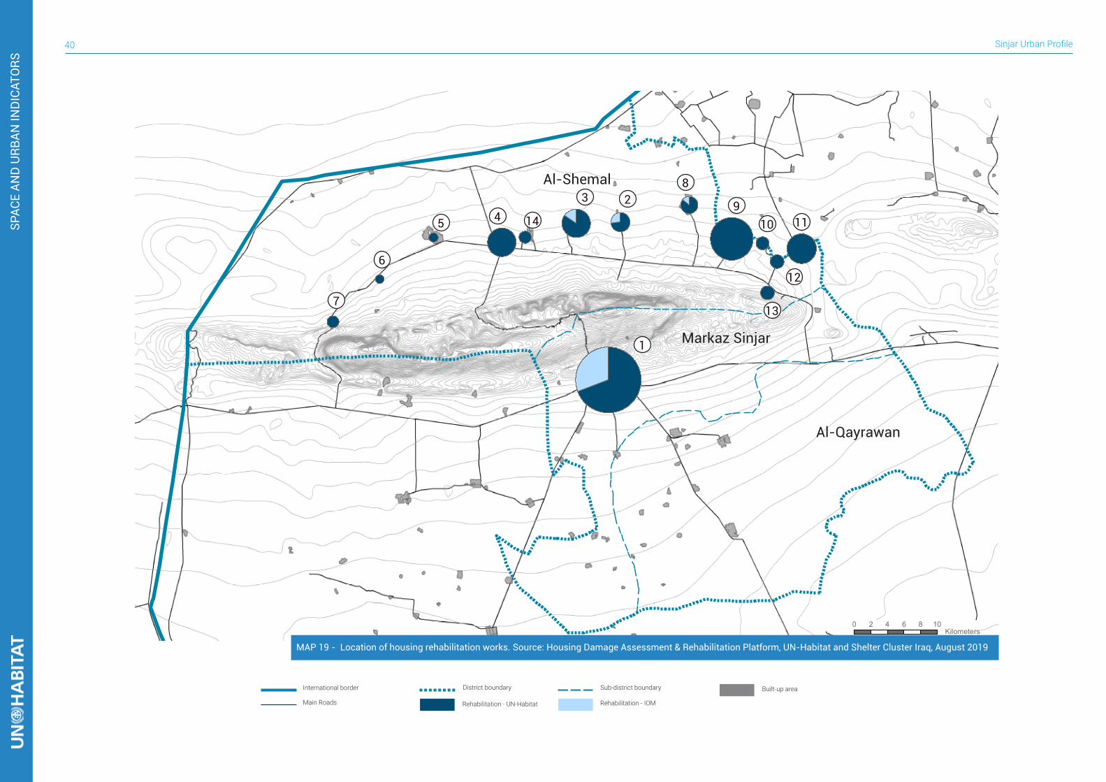
Sinjar Urban Profile40
SPAC
E AN
D U
RBAN
IND
ICAT
ORS
International border Sub-district boundary Built-up areaDistrict boundary
Main Roads Rehabilitation - IOMRehabilitation - UN-Habitat
0 2 4 6 8 10 Kilometers
1
2345
6
7
8
910 11
12
14
13
Markaz Sinjar
Al-Shemal
Al-Qayrawan
MAP 19 - Location of housing rehabilitation works. Source: Housing Damage Assessment & Rehabilitation Platform, UN-Habitat and Shelter Cluster Iraq, August 2019
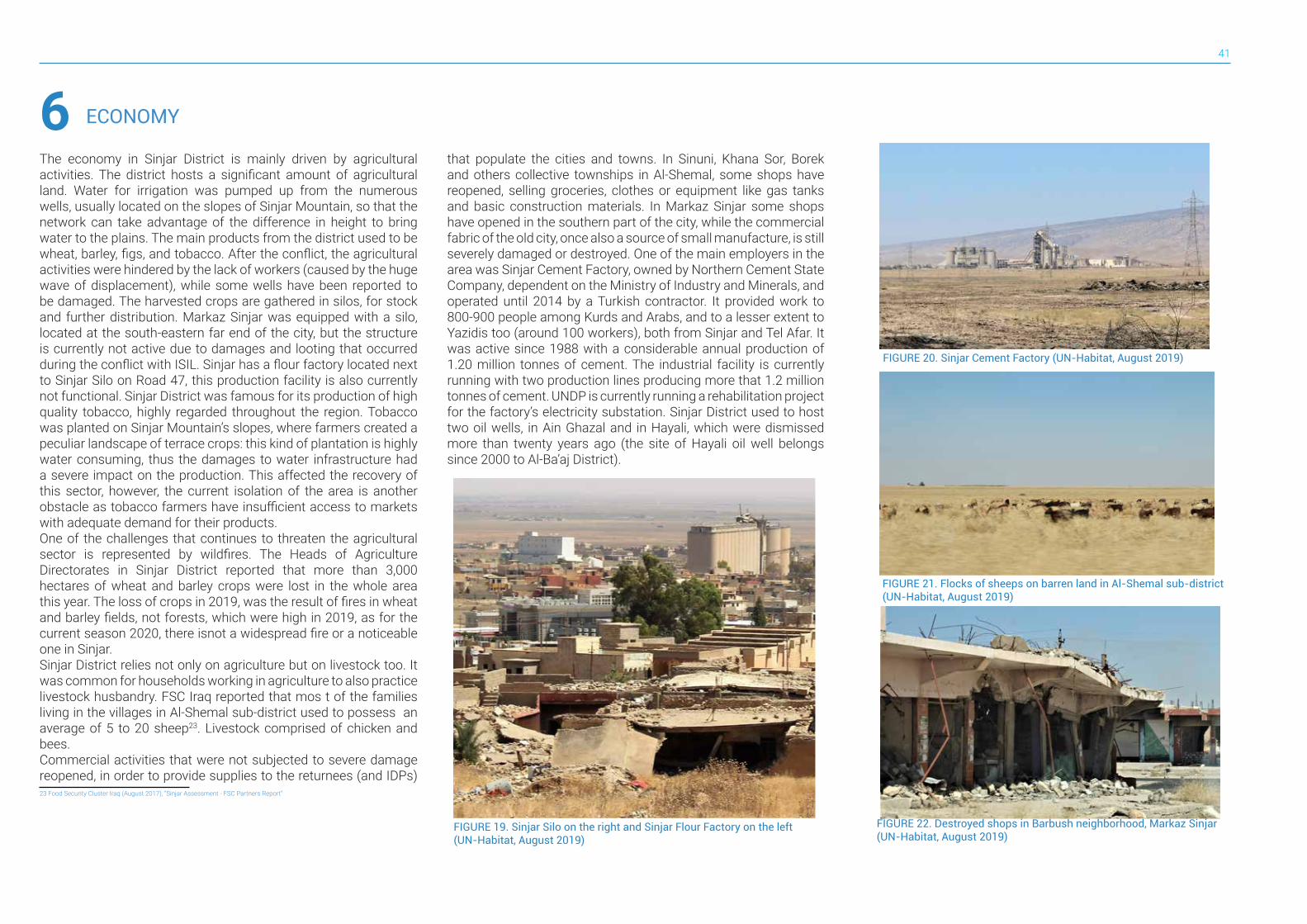
41
ECONOMY6The economy in Sinjar District is mainly driven by agricultural activities. The district hosts a significant amount of agricultural land. Water for irrigation was pumped up from the numerous wells, usually located on the slopes of Sinjar Mountain, so that the network can take advantage of the difference in height to bring water to the plains. The main products from the district used to be wheat, barley, figs, and tobacco. After the conflict, the agricultural activities were hindered by the lack of workers (caused by the huge wave of displacement), while some wells have been reported to be damaged. The harvested crops are gathered in silos, for stock and further distribution. Markaz Sinjar was equipped with a silo, located at the south-eastern far end of the city, but the structure is currently not active due to damages and looting that occurred during the conflict with ISIL. Sinjar has a flour factory located next to Sinjar Silo on Road 47, this production facility is also currently not functional. Sinjar District was famous for its production of high quality tobacco, highly regarded throughout the region. Tobacco was planted on Sinjar Mountain’s slopes, where farmers created a peculiar landscape of terrace crops: this kind of plantation is highly water consuming, thus the damages to water infrastructure had a severe impact on the production. This affected the recovery of this sector, however, the current isolation of the area is another obstacle as tobacco farmers have insufficient access to markets with adequate demand for their products.One of the challenges that continues to threaten the agricultural sector is represented by wildfires. The Heads of Agriculture Directorates in Sinjar District reported that more than 3,000 hectares of wheat and barley crops were lost in the whole area this year. The loss of crops in 2019, was the result of fires in wheat and barley fields, not forests, which were high in 2019, as for the current season 2020, there isnot a widespread fire or a noticeable one in Sinjar.Sinjar District relies not only on agriculture but on livestock too. It was common for households working in agriculture to also practice livestock husbandry. FSC Iraq reported that mos t of the families living in the villages in Al-Shemal sub-district used to possess an average of 5 to 20 sheep23. Livestock comprised of chicken and bees.Commercial activities that were not subjected to severe damage reopened, in order to provide supplies to the returnees (and IDPs)
that populate the cities and towns. In Sinuni, Khana Sor, Borek and others collective townships in Al-Shemal, some shops have reopened, selling groceries, clothes or equipment like gas tanks and basic construction materials. In Markaz Sinjar some shops have opened in the southern part of the city, while the commercial fabric of the old city, once also a source of small manufacture, is still severely damaged or destroyed. One of the main employers in the area was Sinjar Cement Factory, owned by Northern Cement State Company, dependent on the Ministry of Industry and Minerals, and operated until 2014 by a Turkish contractor. It provided work to 800-900 people among Kurds and Arabs, and to a lesser extent to Yazidis too (around 100 workers), both from Sinjar and Tel Afar. It was active since 1988 with a considerable annual production of 1.20 million tonnes of cement. The industrial facility is currently running with two production lines producing more that 1.2 million tonnes of cement. UNDP is currently running a rehabilitation project for the factory’s electricity substation. Sinjar District used to host two oil wells, in Ain Ghazal and in Hayali, which were dismissed more than twenty years ago (the site of Hayali oil well belongs since 2000 to Al-Ba’aj District).
23 Food Security Cluster Iraq (August 2017), “Sinjar Assessment - FSC Partners Report”
FIGURE 19. Sinjar Silo on the right and Sinjar Flour Factory on the left (UN-Habitat, August 2019)
FIGURE 20. Sinjar Cement Factory (UN-Habitat, August 2019)
FIGURE 21. Flocks of sheeps on barren land in Al-Shemal sub-district (UN-Habitat, August 2019)
FIGURE 22. Destroyed shops in Barbush neighborhood, Markaz Sinjar (UN-Habitat, August 2019)

Sinjar Urban Profile42
ECO
NO
MY
FIGURE 23. Fires in Al-Shemal district close to already damaged houses (UN-Habitat, August 2019)
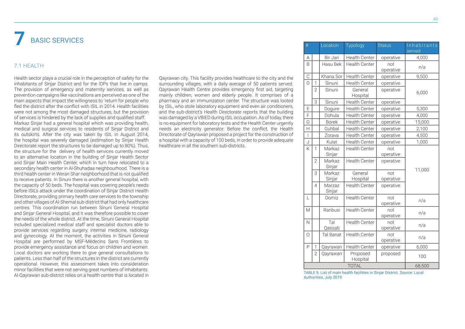
43
BASIC SERVICES77.1 HEALTH
Health sector plays a crucial role in the perception of safety for the inhabitants of Sinjar District and for the IDPs that live in camps. The provision of emergency and maternity services, as well as prevention campaigns like vaccinations are perceived as one of the main aspects that impact the willingness to `return for people who fled the district after the conflict with ISIL in 2014. Health facilities were not among the most damaged structures, but the provision of services is hindered by the lack of supplies and qualified staff. Markaz Sinjar had a general hospital which was providing health, medical and surgical services to residents of Sinjar District and its outskirts. After the city was taken by ISIL in August 2014, the hospital was severely damaged (estimation by Sinjar Health Directorate report the structures to be damaged up to 80%). Thus, the structure for the delivery of health services currently moved to an alternative location in the building of Sinjar Health Sector and Sinjar Main Health Center, which in turn have relocated to a secondary health center in Al-Shuhadaa neighbourhood. There is a third health center in Weran Shar neighborhood that is not qualified to receive patients. In Sinuni there is another general hospital, with the capacity of 50 beds. The hospital was covering people’s needs before ISIL’s attack under the coordination of Sinjar District Health Directorate, providing primary health care services to the township and other villages of Al-Shemal sub-district that had only healthcare centres. This coordination run between Sinuni General Hospital and Sinjar General Hospital, and it was therefore possible to cover the needs of the whole district. At the time, Sinuni General Hospital included specialized medical staff and specialist doctors able to provide services regarding surgery, internal medicine, radiology and gynecology. At the moment, the activities in Sinuni General Hospital are performed by MSF-Médecins Sans Frontières to provide emergency assistance and focus on children and women. Local doctors are working there to give general consultations to patients. Less than half of the structures in the district are currently operational. However, this assessment takes into consideration minor facilities that were not serving great numbers of inhabitants. Al-Qayrawan sub-district relies on a health centre that is located in
Qayrawan city. This facility provides healthcare to the city and the surrounding villages, with a daily average of 50 patients served. Qayrawan Health Centre provides emergency first aid, targeting mainly children, women and elderly people. It comprises of a pharmacy and an immunization center. The structure was looted by ISIL, who stole laboratory equipment and even air conditioners, and the sub-district’s Health Directorate reports that the building was damaged by a VBIED during ISIL occupation. As of today, there is no equipment for laboratory tests and the Health Center urgently needs an electricity generator. Before the conflict, the Health Directorate of Qayrawan proposed a project for the construction of a hospital with a capacity of 100 beds, in order to provide adequate healthcare in all the southern sub-districts.
# Location Typology Status I n h a b i t a n t s served
A Bir Jari Health Center operative 4,000B Hasu Bek Health Center not
operative n/a
C Khana Sor Health Center operative 9,500D 1 Sinuni Health Center operative
6,0002 Sinuni General Hospital
operative
3 Sinuni Health Center operativeE Dogure Health Center operative 5,300F Dohula Health Center operative 4,000G Borek Health Center operative 15,000H Guhbal Health Center operative 2,100I Zorava Health Center operative 4,500J Kulat Health Center operative 1,000K 1 Markaz
SinjarHealth Center not
operative
11,000
2 Markaz Sinjar
Health Center operative
3 Markaz Sinjar
General Hospital
not operative
4 Marzaz Sinjar
Health Center operative
L Domiz Health Center not operative n/a
M Ranbusi Health Center not operative n/a
N Tal Qassab
Health Center not operative n/a
O Tal Banat Health Center not operative n/a
P 1 Qayrawan Health Center operative 6,0002 Qayrawan Proposed
Hospitalproposed 100
TOTAL 68,500TABLE 9. List of main health facilities in Sinjar District. Source: Local Authorities, July 2019
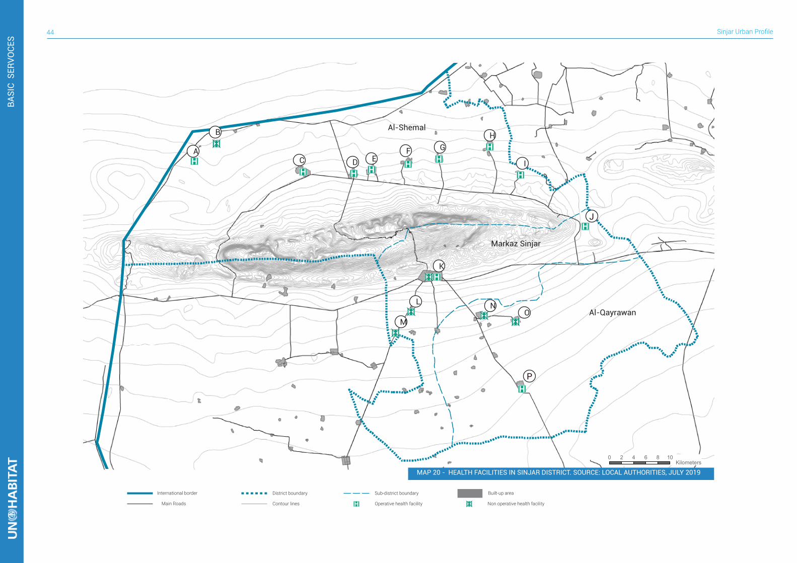
Sinjar Urban Profile44
BASI
C S
ERVO
CES
International border
Operative health facility Non operative health facility
District boundary Sub-district boundary
Main Roads Contour lines
Built-up area
0 2 4 6 8 10 Kilometers
A
B
C D EF G
H
I
J
K
M
L NO
P
Markaz Sinjar
Al-Shemal
Al-Qayrawan
MAP 20 - HEALTH FACILITIES IN SINJAR DISTRICT. SOURCE: LOCAL AUTHORITIES, JULY 2019
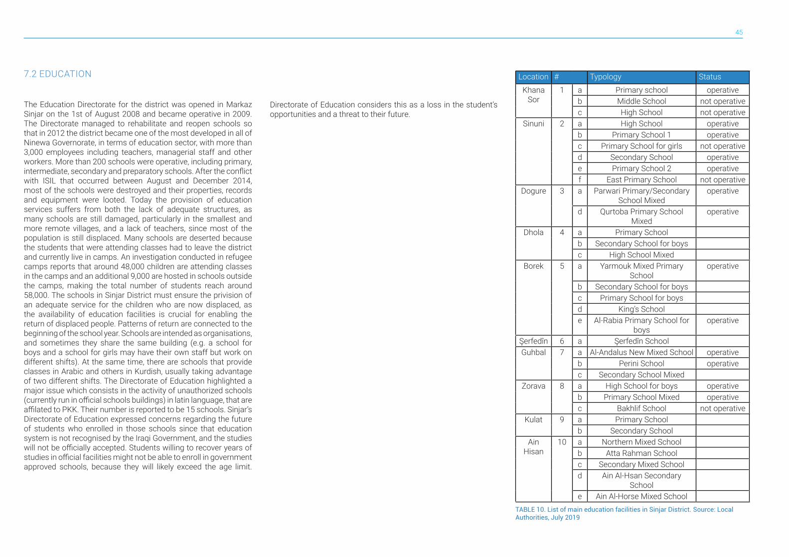
45
7.2 EDUCATION
The Education Directorate for the district was opened in Markaz Sinjar on the 1st of August 2008 and became operative in 2009. The Directorate managed to rehabilitate and reopen schools so that in 2012 the district became one of the most developed in all of Ninewa Governorate, in terms of education sector, with more than 3,000 employees including teachers, managerial staff and other workers. More than 200 schools were operative, including primary, intermediate, secondary and preparatory schools. After the conflict with ISIL that occurred between August and December 2014, most of the schools were destroyed and their properties, records and equipment were looted. Today the provision of education services suffers from both the lack of adequate structures, as many schools are still damaged, particularly in the smallest and more remote villages, and a lack of teachers, since most of the population is still displaced. Many schools are deserted because the students that were attending classes had to leave the district and currently live in camps. An investigation conducted in refugee camps reports that around 48,000 children are attending classes in the camps and an additional 9,000 are hosted in schools outside the camps, making the total number of students reach around 58,000. The schools in Sinjar District must ensure the privision of an adequate service for the children who are now displaced, as the availability of education facilities is crucial for enabling the return of displaced people. Patterns of return are connected to the beginning of the school year. Schools are intended as organisations, and sometimes they share the same building (e.g. a school for boys and a school for girls may have their own staff but work on different shifts). At the same time, there are schools that provide classes in Arabic and others in Kurdish, usually taking advantage of two different shifts. The Directorate of Education highlighted a major issue which consists in the activity of unauthorized schools (currently run in official schools buildings) in latin language, that are affilated to PKK. Their number is reported to be 15 schools. Sinjar’s Directorate of Education expressed concerns regarding the future of students who enrolled in those schools since that education system is not recognised by the Iraqi Government, and the studies will not be officially accepted. Students willing to recover years of studies in official facilities might not be able to enroll in government approved schools, because they will likely exceed the age limit.
Directorate of Education considers this as a loss in the student’s opportunities and a threat to their future.
Location # Typology Status
Khana Sor
1 a Primary school operativeb Middle School not operativec High School not operative
Sinuni 2 a High School operativeb Primary School 1 operativec Primary School for girls not operatived Secondary School operativee Primary School 2 operativef East Primary School not operative
Dogure 3 a Parwari Primary/Secondary School Mixed
operative
d Qurtoba Primary School Mixed
operative
Dhola 4 a Primary Schoolb Secondary School for boysc High School Mixed
Borek 5 a Yarmouk Mixed Primary School
operative
b Secondary School for boysc Primary School for boysd King’s Schoole Al-Rabia Primary School for
boysoperative
Şerfedîn 6 a Şerfedîn SchoolGuhbal 7 a Al-Andalus New Mixed School operative
b Perini School operativec Secondary School Mixed
Zorava 8 a High School for boys operativeb Primary School Mixed operativec Bakhlif School not operative
Kulat 9 a Primary Schoolb Secondary School
Ain Hisan
10 a Northern Mixed Schoolb Atta Rahman Schoolc Secondary Mixed Schoold Ain Al-Hsan Secondary
Schoole Ain Al-Horse Mixed School
TABLE 10. List of main education facilities in Sinjar District. Source: Local Authorities, July 2019
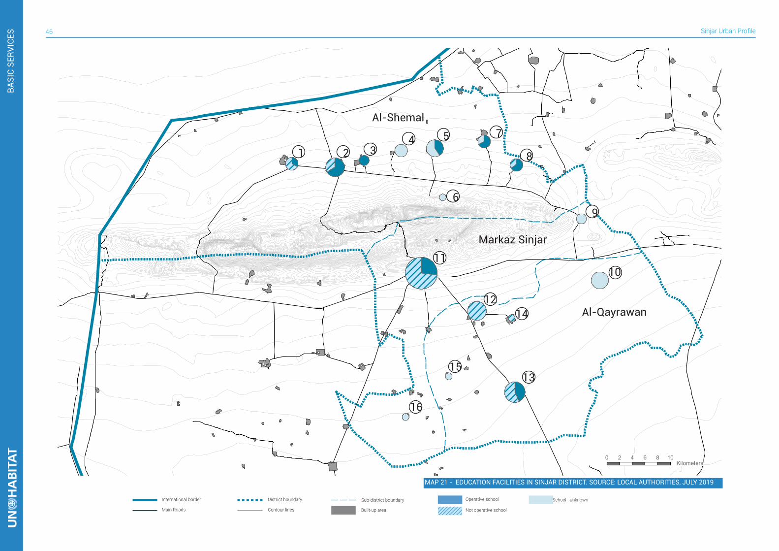
Sinjar Urban Profile46
BASI
C SE
RVIC
ES
International border Operative school School - unknownDistrict boundary Sub-district boundary
Main Roads Contour lines Built-up area
0 2 4 6 8 10 Kilometers
1 2 34 5
6
7
8
9
10
1412
11
16
1513
Markaz Sinjar
Al-Shemal
Al-Qayrawan
Not operative school
MAP 21 - EDUCATION FACILITIES IN SINJAR DISTRICT. SOURCE: LOCAL AUTHORITIES, JULY 2019
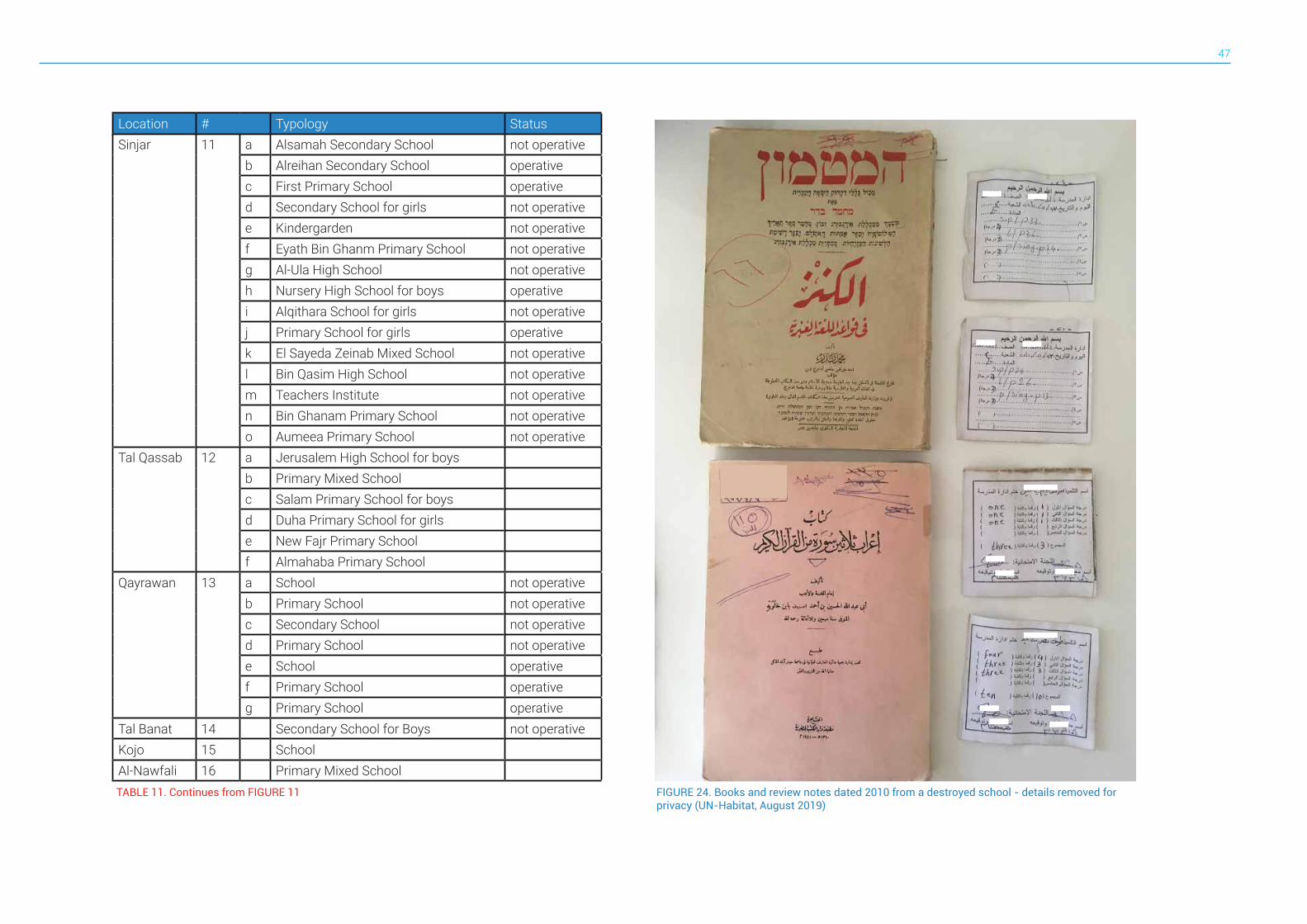
47
Location # Typology StatusSinjar 11 a Alsamah Secondary School not operative
b Alreihan Secondary School operativec First Primary School operatived Secondary School for girls not operativee Kindergarden not operativef Eyath Bin Ghanm Primary School not operativeg Al-Ula High School not operativeh Nursery High School for boys operativei Alqithara School for girls not operativej Primary School for girls operativek El Sayeda Zeinab Mixed School not operativel Bin Qasim High School not operativem Teachers Institute not operativen Bin Ghanam Primary School not operativeo Aumeea Primary School not operative
Tal Qassab 12 a Jerusalem High School for boysb Primary Mixed Schoolc Salam Primary School for boysd Duha Primary School for girlse New Fajr Primary Schoolf Almahaba Primary School
Qayrawan 13 a School not operativeb Primary School not operativec Secondary School not operatived Primary School not operativee School operativef Primary School operativeg Primary School operative
Tal Banat 14 Secondary School for Boys not operativeKojo 15 SchoolAl-Nawfali 16 Primary Mixed SchoolTABLE 11. Continues from FIGURE 11 FIGURE 24. Books and review notes dated 2010 from a destroyed school - details removed for
privacy (UN-Habitat, August 2019)
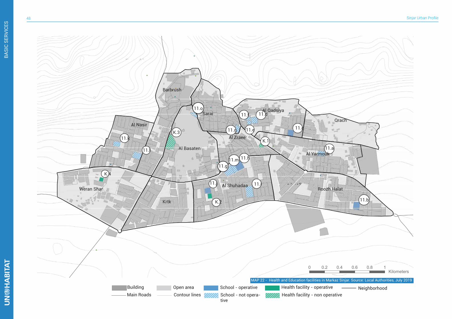
Sinjar Urban Profile48
BASI
C SE
RVIC
ES
Building School - operativeSchool - not opera-tive
Open areaMain Roads Contour lines
NeighborhoodHealth facility - operative
Health facility - non operative
0 0.2 0.4 0.6 0.8 1 Kilometers
11.a
11.b
11.i
11.c
11.d11.f
11.e11.n
11.o
11.h
11.g11.m
11.j
11.l
11.k K.1
K.2
K.3
K.4
Barbrushشششششش
Al Nasirششششش
Weran Sharششششش ششش
Al Basatenشششششششش
Krtkشششش
Al Shuhadaaششششششش
Saraiششششش
Al Zraeeششششششش
Al Qadsiyaشششششششش
Qrachشششش
Al Yarmoukششششششش
Roozh Halatششش شششش
MAP 22 - Health and Education facilities in Markaz Sinjar. Source: Local Authorities, July 2019

49
Building School - operative
School - not operative
Open area
Main Roads Contour lines
NeighborhoodHealth facility - operative
Health facility - non operative
0 0,2 0,4 0,6 0,8 1 Kilometers
2.a2.b
2.c
2.d
2.e
2.f
D.1D.2
D.3
Shorshشششش
Azadiششششش
Al-Sharqiشششششش
Al-Khathraششششششش
Al-Salamشششششش
MAP 23 - HEALTH AND EDUCATION FACILITIES IN SINUNI. SOURCE: LOCAL AUTHORITIES, JULY 2019
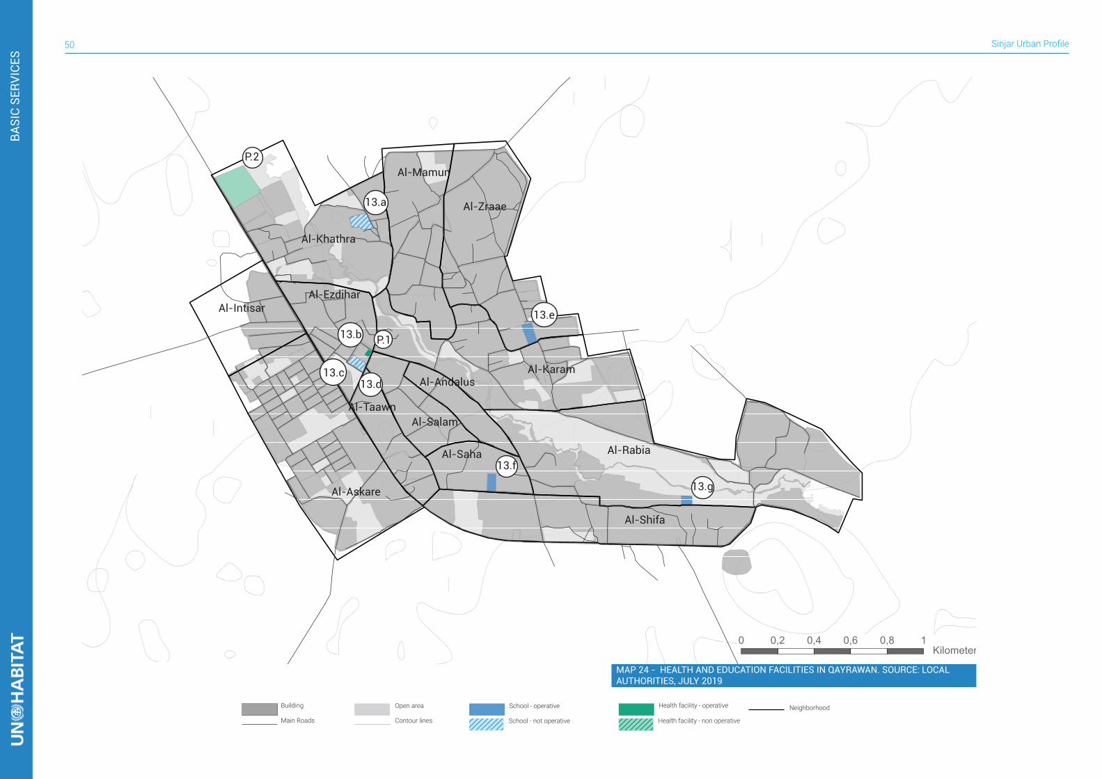
Sinjar Urban Profile50
Building School - operative
School - not operative
Open area
Main Roads Contour lines
NeighborhoodHealth facility - operative
Health facility - non operative
0 0,2 0,4 0,6 0,8 1 Kilometers
13.a
13.b
13.c13.d
13.e
13.f
13.g
P.1
P.2
Al-Karamشش ششششششش
Al-Khathraشش ششششششش
Al-Zraaeشش ششششششش
Al-Mamunشش ششششششش
Al-Rabiaشش شششششش
Al-Shifaشش شششششش
Al-Taawnشش ششششششش
Al-Askareشش ششششششش
Al-Intisarشش شششششششش
Al-Salamشش شششششش
Al-Andalusشش ششششششش
Al-Sahaشش ششششش
Al-Ezdiharشش شششششششش
BASI
C SE
RVIC
ES
MAP 24 - HEALTH AND EDUCATION FACILITIES IN QAYRAWAN. SOURCE: LOCAL AUTHORITIES, JULY 2019
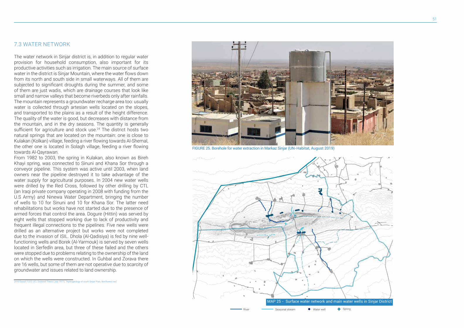
51
7.3 WATER NETWORK
The water network in Sinjar district is, in addition to regular water provision for household consumption, also important for its productive activities such as irrigation. The main source of surface water in the district is Sinjar Mountain, where the water flows down from its north and south side in small waterways. All of them are subjected to significant droughts during the summer, and some of them are just wadis, which are drainage courses that look like small and narrow valleys that become riverbeds only after rainfalls.The mountain represents a groundwater recharge area too: usually water is collected through artesian wells located on the slopes, and transported to the plains as a result of the height difference. The quality of the water is good, but decreases with distance from the mountain, and in the dry seasons. The quantity is generally sufficient for agriculture and stock use.24 The district hosts two natural springs that are located on the mountain: one is close to Kulakan (Kolkan) village, feeding a river flowing towards Al-Shemal, the other one is located in Solagh village, feeding a river flowing towards Al-Qayrawan.From 1982 to 2003, the spring in Kulakan, also known as Bireh Khayi spring, was connected to Sinuni and Khana Sor through a conveyor pipeline. This system was active until 2003, when land owners near the pipeline destroyed it to take advantage of the water supply for agricultural purposes. In 2004 new water wells were drilled by the Red Cross, followed by other drilling by CTL (an Iraqi private company operating in 2008 with funding from the U.S Army) and Ninewa Water Department, bringing the number of wells to 10 for Sinuni and 10 for Khana Sor. The latter need rehabilitations but works have not started due to the presence of armed forces that control the area. Dogure (Hittin) was served by eight wells that stopped working due to lack of productivity and frequent illegal connections to the pipelines. Five new wells were drilled as an alternative project but works were not completed due to the invasion of ISIL. Dhola (Al-Qadisiya) is fed by nine well-functioning wells and Borek (Al-Yarmouk) is served by seven wells located in Serfedîn area, but three of these failed and the others were stopped due to problems relating to the ownership of the land on which the wells were constructed. In Guhbal and Zorava there are 16 wells, but some of them are not operative due to scarcity of groundwater and issues related to land ownership.
24 Al-Sawaf, F.D.S. UCL Doctoral Thesis (July 1977), “Hydrogeology of south Sinjar Plain, Northwest Iraq”
FIGURE 25. Borehole for water extraction in Markaz Sinjar (UN-Habitat, August 2019)
MAP 25 - Surface water network and main water wells in Sinjar District
River Water well SpringSeasonal stream
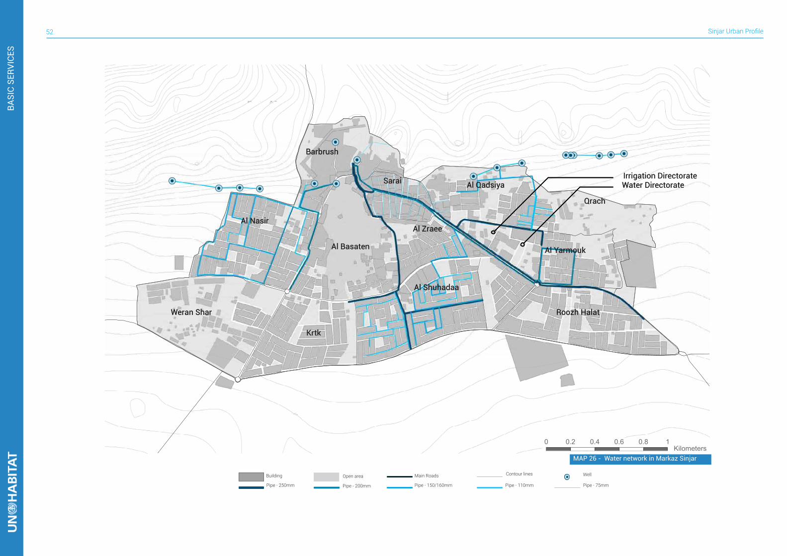
Sinjar Urban Profile52
Building Open area Main Roads Contour lines
Pipe - 250mm Pipe - 200mm Pipe - 150/160mm Pipe - 110mm Pipe - 75mm
Well
0 0.2 0.4 0.6 0.8 1 Kilometers
Water DirectorateIrrigation Directorate
Barbrushشششششش
Al Nasirششششش
Weran Sharششششش ششش
Al Basatenشششششششش
Krtkشششش
Al Shuhadaaششششششش
Saraiششششش
Al Zraeeششششششش
Al Qadsiyaشششششششش
Qrachشششش
Al Yarmoukششششششش
Roozh Halatششش شششش
Water DirectorateIrrigation Directorate
Barbrushشششششش
Al Nasirششششش
Weran Sharششششش ششش
Al Basatenشششششششش
Krtkشششش
Al Shuhadaaششششششش
Saraiششششش
Al Zraeeششششششش
Al Qadsiyaشششششششش
Qrachشششش
Al Yarmoukششششششش
Roozh Halatششش شششش
BASI
C SE
RVIC
ES
MAP 26 - Water network in Markaz Sinjar
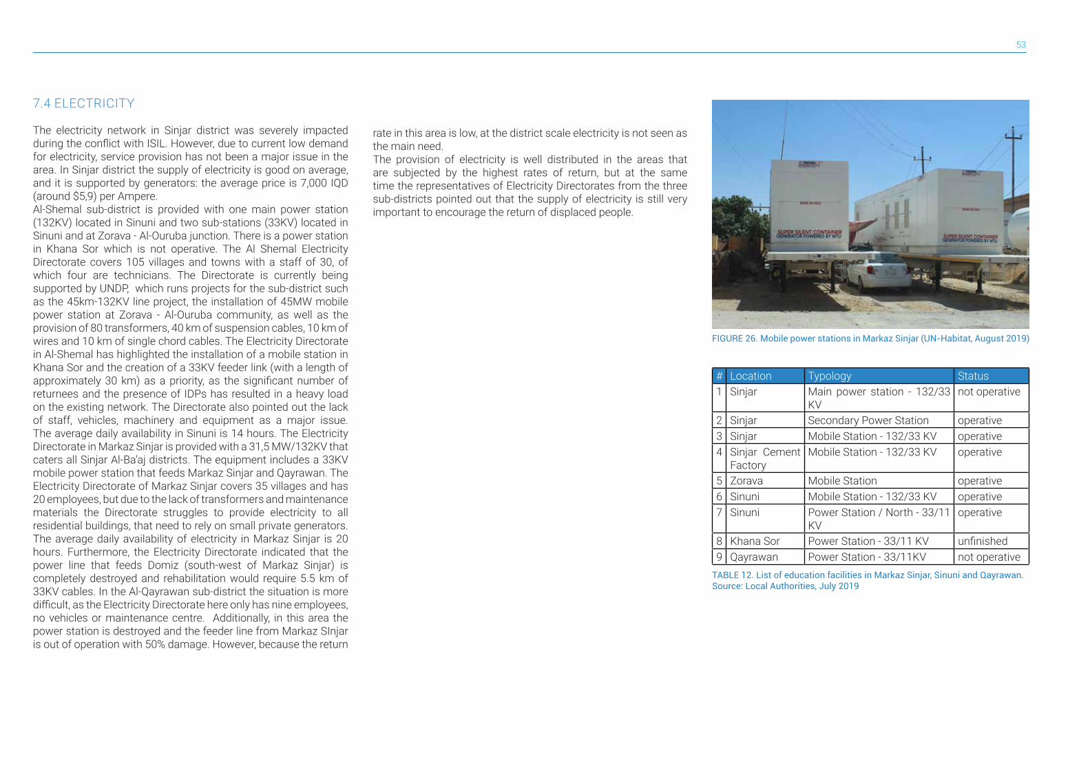
53
7.4 ELECTRICITY
The electricity network in Sinjar district was severely impacted during the conflict with ISIL. However, due to current low demand for electricity, service provision has not been a major issue in the area. In Sinjar district the supply of electricity is good on average, and it is supported by generators: the average price is 7,000 IQD (around $5,9) per Ampere. Al-Shemal sub-district is provided with one main power station (132KV) located in Sinuni and two sub-stations (33KV) located in Sinuni and at Zorava - Al-Ouruba junction. There is a power station in Khana Sor which is not operative. The Al Shemal Electricity Directorate covers 105 villages and towns with a staff of 30, of which four are technicians. The Directorate is currently being supported by UNDP, which runs projects for the sub-district such as the 45km-132KV line project, the installation of 45MW mobile power station at Zorava - Al-Ouruba community, as well as the provision of 80 transformers, 40 km of suspension cables, 10 km of wires and 10 km of single chord cables. The Electricity Directorate in Al-Shemal has highlighted the installation of a mobile station in Khana Sor and the creation of a 33KV feeder link (with a length of approximately 30 km) as a priority, as the significant number of returnees and the presence of IDPs has resulted in a heavy load on the existing network. The Directorate also pointed out the lack of staff, vehicles, machinery and equipment as a major issue. The average daily availability in Sinuni is 14 hours. The Electricity Directorate in Markaz Sinjar is provided with a 31,5 MW/132KV that caters all Sinjar Al-Ba’aj districts. The equipment includes a 33KV mobile power station that feeds Markaz Sinjar and Qayrawan. The Electricity Directorate of Markaz Sinjar covers 35 villages and has 20 employees, but due to the lack of transformers and maintenance materials the Directorate struggles to provide electricity to all residential buildings, that need to rely on small private generators. The average daily availability of electricity in Markaz Sinjar is 20 hours. Furthermore, the Electricity Directorate indicated that the power line that feeds Domiz (south-west of Markaz Sinjar) is completely destroyed and rehabilitation would require 5.5 km of 33KV cables. In the Al-Qayrawan sub-district the situation is more difficult, as the Electricity Directorate here only has nine employees, no vehicles or maintenance centre. Additionally, in this area the power station is destroyed and the feeder line from Markaz SInjar is out of operation with 50% damage. However, because the return
rate in this area is low, at the district scale electricity is not seen as the main need.The provision of electricity is well distributed in the areas that are subjected by the highest rates of return, but at the same time the representatives of Electricity Directorates from the three sub-districts pointed out that the supply of electricity is still very important to encourage the return of displaced people.
FIGURE 26. Mobile power stations in Markaz Sinjar (UN-Habitat, August 2019)
TABLE 12. List of education facilities in Markaz Sinjar, Sinuni and Qayrawan. Source: Local Authorities, July 2019
# Location Typology Status1 Sinjar Main power station - 132/33
KVnot operative
2 Sinjar Secondary Power Station operative3 Sinjar Mobile Station - 132/33 KV operative4 Sinjar Cement
FactoryMobile Station - 132/33 KV operative
5 Zorava Mobile Station operative6 Sinuni Mobile Station - 132/33 KV operative7 Sinuni Power Station / North - 33/11
KVoperative
8 Khana Sor Power Station - 33/11 KV unfinished9 Qayrawan Power Station - 33/11KV not operative
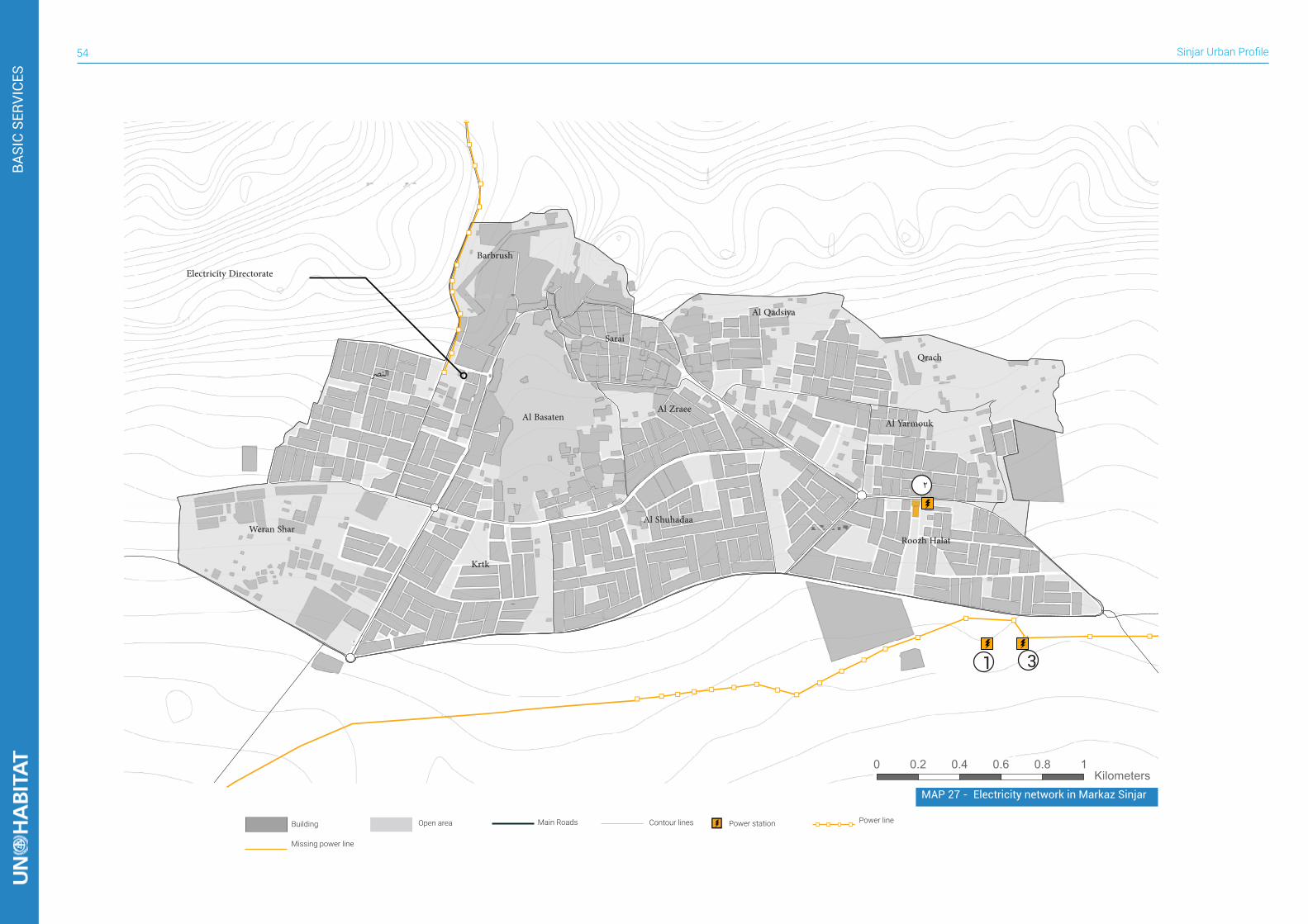
Sinjar Urban Profile54
Building Open area Main Roads Contour lines Power line
Missing power line
Power station
0 0.2 0.4 0.6 0.8 1 Kilometers
Electricity Directorate
1
2
3
Barbrush
النرص
Weran Shar
Al Basaten
Krtk
Al Shuhadaa
Sarai
Al Zraee
Al Qadsiya
Qrach
Al Yarmouk
Roozh Halat
MAP 27 - Electricity network in Markaz Sinjar
BASI
C SE
RVIC
ES
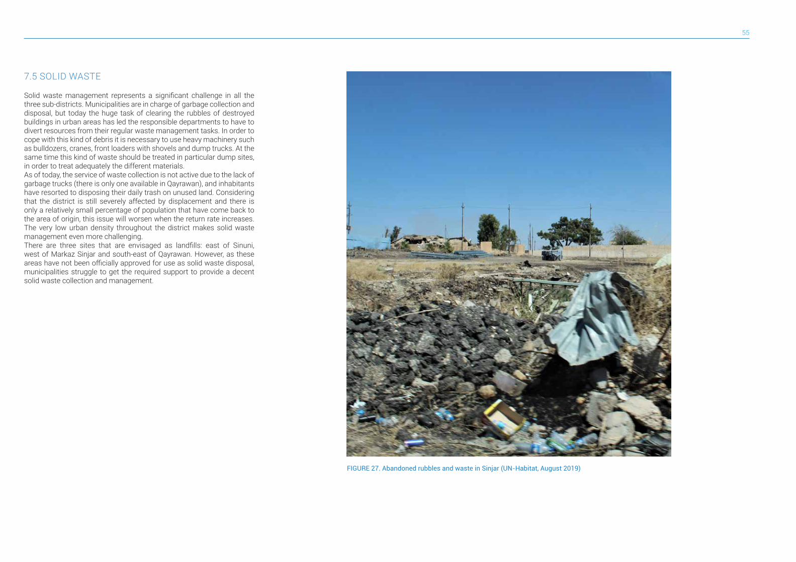
55
7.5 SOLID WASTE
Solid waste management represents a significant challenge in all the three sub-districts. Municipalities are in charge of garbage collection and disposal, but today the huge task of clearing the rubbles of destroyed buildings in urban areas has led the responsible departments to have to divert resources from their regular waste management tasks. In order to cope with this kind of debris it is necessary to use heavy machinery such as bulldozers, cranes, front loaders with shovels and dump trucks. At the same time this kind of waste should be treated in particular dump sites, in order to treat adequately the different materials. As of today, the service of waste collection is not active due to the lack of garbage trucks (there is only one available in Qayrawan), and inhabitants have resorted to disposing their daily trash on unused land. Considering that the district is still severely affected by displacement and there is only a relatively small percentage of population that have come back to the area of origin, this issue will worsen when the return rate increases. The very low urban density throughout the district makes solid waste management even more challenging.There are three sites that are envisaged as landfills: east of Sinuni, west of Markaz Sinjar and south-east of Qayrawan. However, as these areas have not been officially approved for use as solid waste disposal, municipalities struggle to get the required support to provide a decent solid waste collection and management.
FIGURE 27. Abandoned rubbles and waste in Sinjar (UN-Habitat, August 2019)
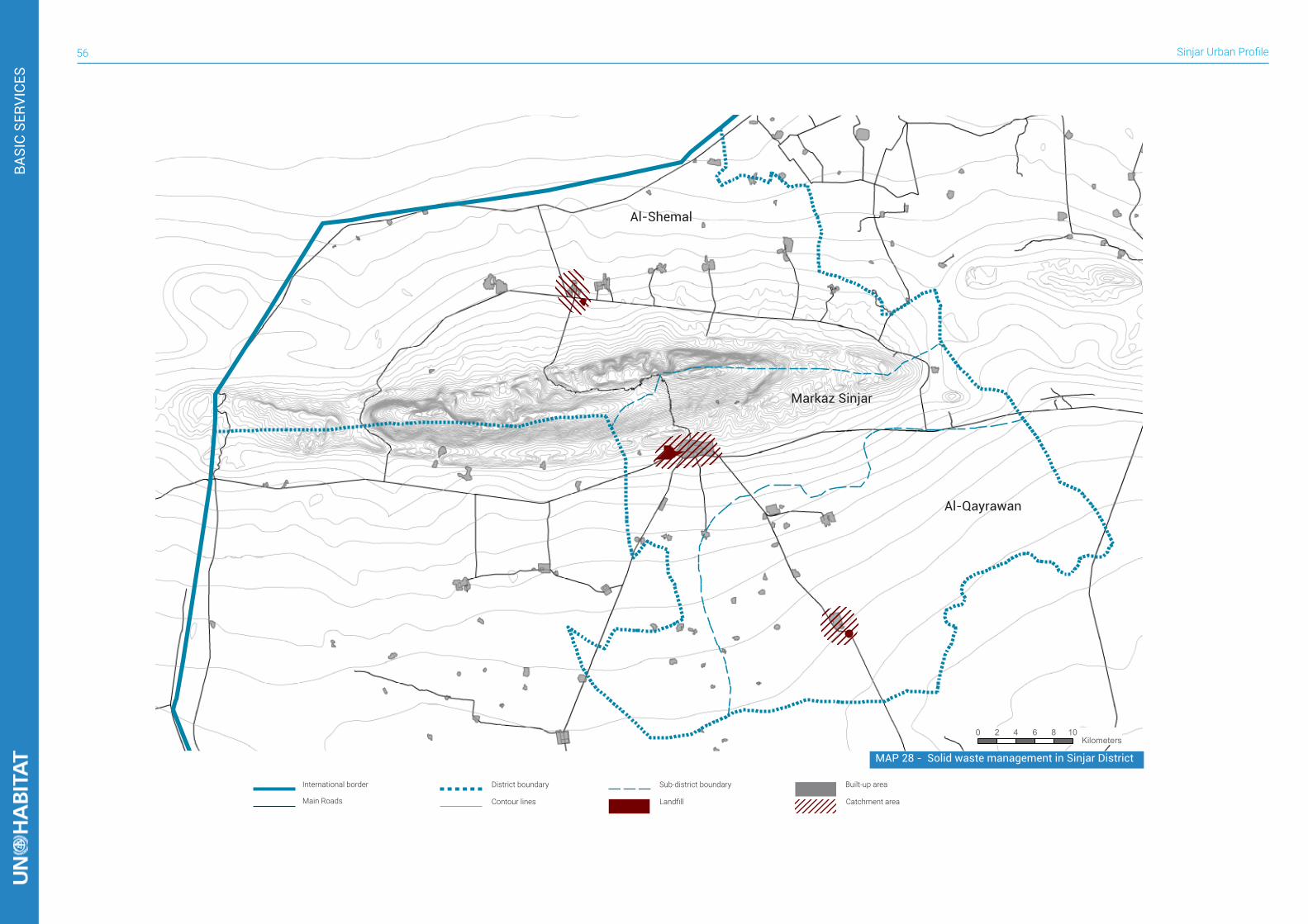
Sinjar Urban Profile56
0 2 4 6 8 10 Kilometers
International border
Landfill Catchment area
District boundary Sub-district boundary
Main Roads Contour lines
Built-up area
Markaz Sinjar
Al-Shemal
Al-Qayrawan
MAP 28 - Solid waste management in Sinjar District
BASI
C SE
RVIC
ES
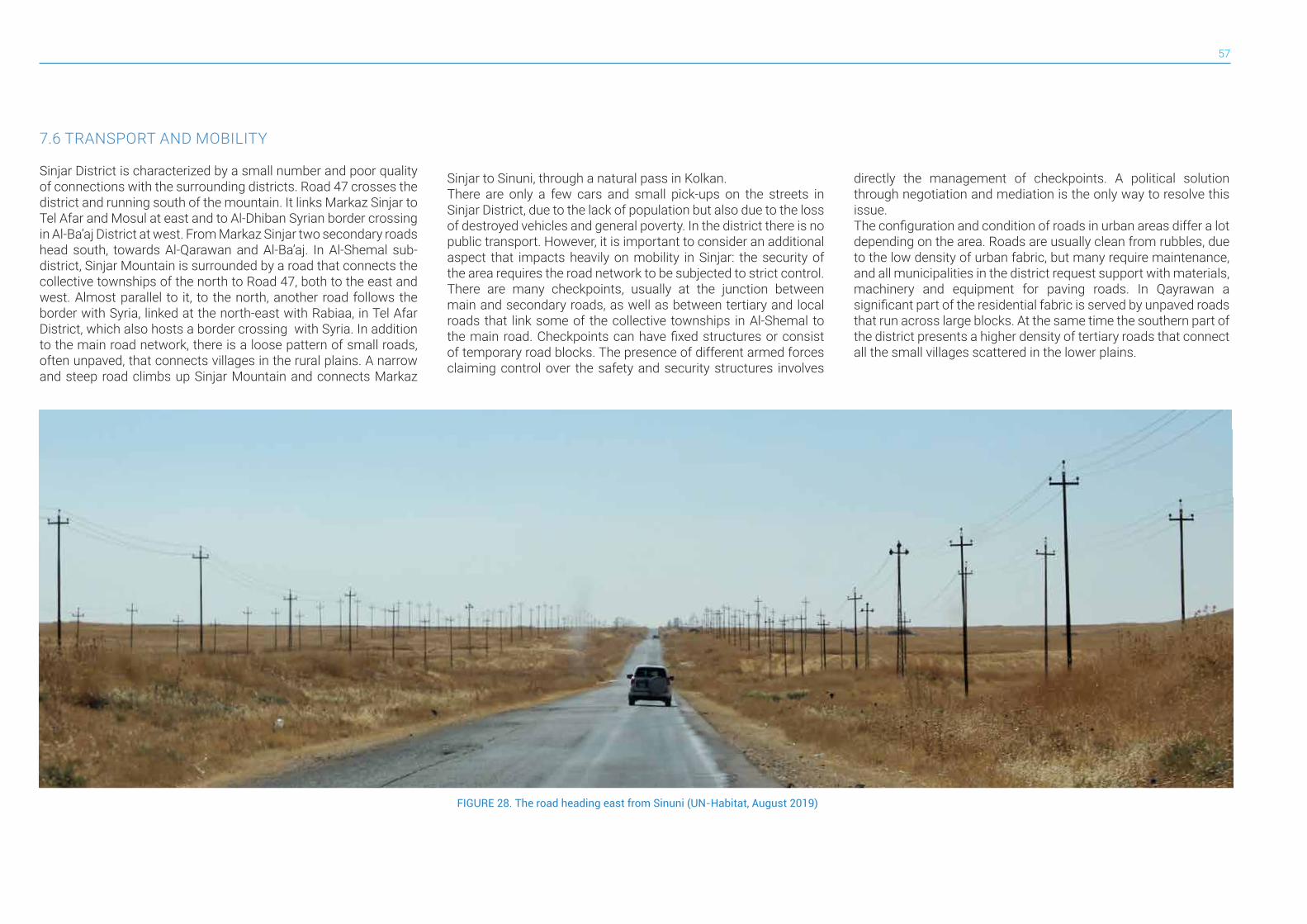
57
7.6 TRANSPORT AND MOBILITY
Sinjar District is characterized by a small number and poor quality of connections with the surrounding districts. Road 47 crosses the district and running south of the mountain. It links Markaz Sinjar to Tel Afar and Mosul at east and to Al-Dhiban Syrian border crossing in Al-Ba’aj District at west. From Markaz Sinjar two secondary roads head south, towards Al-Qarawan and Al-Ba’aj. In Al-Shemal sub-district, Sinjar Mountain is surrounded by a road that connects the collective townships of the north to Road 47, both to the east and west. Almost parallel to it, to the north, another road follows the border with Syria, linked at the north-east with Rabiaa, in Tel Afar District, which also hosts a border crossing with Syria. In addition to the main road network, there is a loose pattern of small roads, often unpaved, that connects villages in the rural plains. A narrow and steep road climbs up Sinjar Mountain and connects Markaz
FIGURE 28. The road heading east from Sinuni (UN-Habitat, August 2019)
Sinjar to Sinuni, through a natural pass in Kolkan.There are only a few cars and small pick-ups on the streets in Sinjar District, due to the lack of population but also due to the loss of destroyed vehicles and general poverty. In the district there is no public transport. However, it is important to consider an additional aspect that impacts heavily on mobility in Sinjar: the security of the area requires the road network to be subjected to strict control. There are many checkpoints, usually at the junction between main and secondary roads, as well as between tertiary and local roads that link some of the collective townships in Al-Shemal to the main road. Checkpoints can have fixed structures or consist of temporary road blocks. The presence of different armed forces claiming control over the safety and security structures involves
directly the management of checkpoints. A political solution through negotiation and mediation is the only way to resolve this issue.The configuration and condition of roads in urban areas differ a lot depending on the area. Roads are usually clean from rubbles, due to the low density of urban fabric, but many require maintenance, and all municipalities in the district request support with materials, machinery and equipment for paving roads. In Qayrawan a significant part of the residential fabric is served by unpaved roads that run across large blocks. At the same time the southern part of the district presents a higher density of tertiary roads that connect all the small villages scattered in the lower plains.
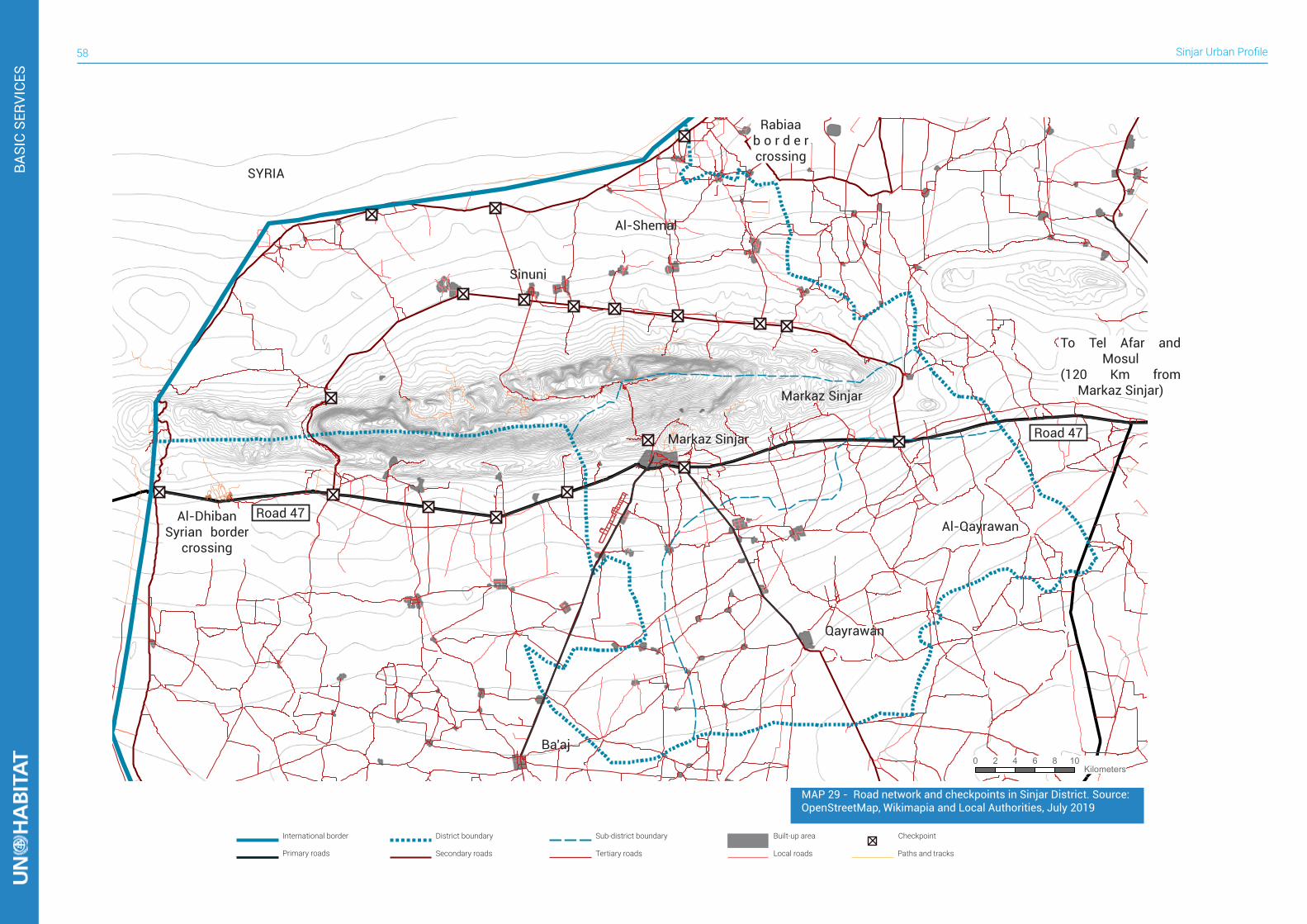
Sinjar Urban Profile58
BASI
C SE
RVIC
ES
0 2 4 6 8 10 Kilometers
International border Sub-district boundary Built-up areaDistrict boundary
Primary roads Secondary roads Tertiary roads Local roads Paths and tracks
Checkpoint
Road 47Markaz Sinjar
Markaz Sinjar
Al-Shemal
SYRIA
Al-Qayrawan
Qayrawan
Ba’aj
Sinuni
To Tel Afar and Mosul
(120 Km from Markaz Sinjar)
Al-Dhiban Syrian border
crossing
Rabiaa b o r d e r crossing
Road 47
MAP 29 - Road network and checkpoints in Sinjar District. Source: OpenStreetMap, Wikimapia and Local Authorities, July 2019
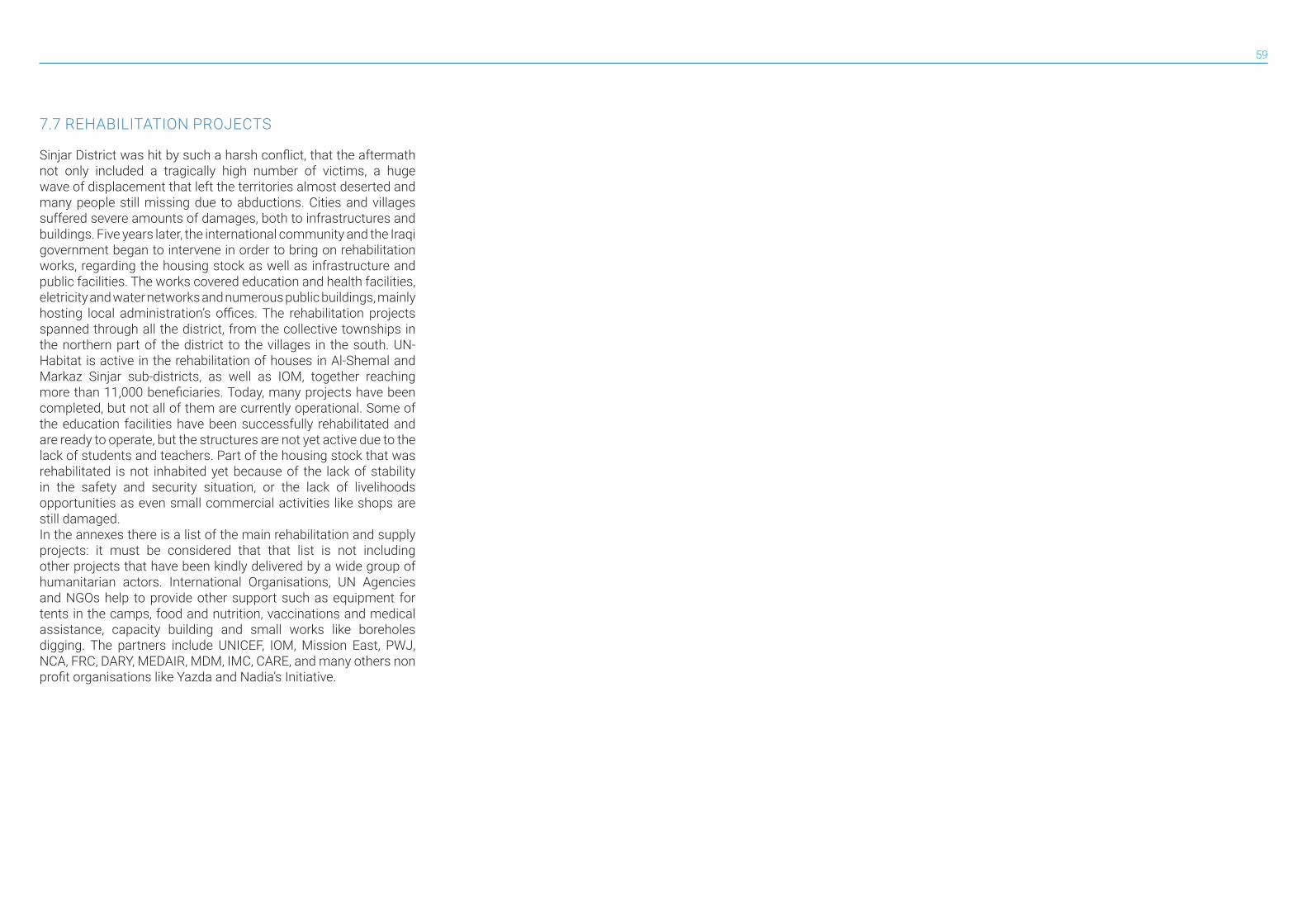
59
7.7 REHABILITATION PROJECTS
Sinjar District was hit by such a harsh conflict, that the aftermath not only included a tragically high number of victims, a huge wave of displacement that left the territories almost deserted and many people still missing due to abductions. Cities and villages suffered severe amounts of damages, both to infrastructures and buildings. Five years later, the international community and the Iraqi government began to intervene in order to bring on rehabilitation works, regarding the housing stock as well as infrastructure and public facilities. The works covered education and health facilities, eletricity and water networks and numerous public buildings, mainly hosting local administration’s offices. The rehabilitation projects spanned through all the district, from the collective townships in the northern part of the district to the villages in the south. UN-Habitat is active in the rehabilitation of houses in Al-Shemal and Markaz Sinjar sub-districts, as well as IOM, together reaching more than 11,000 beneficiaries. Today, many projects have been completed, but not all of them are currently operational. Some of the education facilities have been successfully rehabilitated and are ready to operate, but the structures are not yet active due to the lack of students and teachers. Part of the housing stock that was rehabilitated is not inhabited yet because of the lack of stability in the safety and security situation, or the lack of livelihoods opportunities as even small commercial activities like shops are still damaged.In the annexes there is a list of the main rehabilitation and supply projects: it must be considered that that list is not including other projects that have been kindly delivered by a wide group of humanitarian actors. International Organisations, UN Agencies and NGOs help to provide other support such as equipment for tents in the camps, food and nutrition, vaccinations and medical assistance, capacity building and small works like boreholes digging. The partners include UNICEF, IOM, Mission East, PWJ, NCA, FRC, DARY, MEDAIR, MDM, IMC, CARE, and many others non profit organisations like Yazda and Nadia’s Initiative.
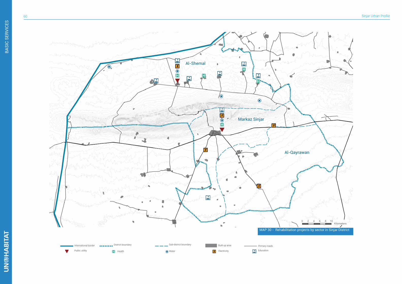
Sinjar Urban Profile60
BASI
C SE
RVIC
ES
0 2 4 6 8 10 Kilometers
Markaz Sinjar
Al-Shemal
Al-Qayrawan
MAP 30 - Rehabilitation projects by sector in Sinjar District
International border Sub-district boundary
WaterPublic utility
Built-up area
ElectricityHealth
District boundary Primary roads
Education
61
HERITAGE AND SOCIAL COHESION8Before the tragic displacement of its population, Sinjar district was characterized by the presence of many different sects groups: Yazidis, Sunni Arabs, Shia and Sunni Kurds, Sunni and Shia Turkmen and Christians. They lived both in homogeneous and mixed villages, Markaz Sinjar was hosting almost all the minorities of the district. The conflict with ISIS, unfortunately, broke the fragile balance of such a complex pattern of minorities: instead of tightening together to fight the invaders, the war brought fragmentation to all of the groups, and led to issues of trust between members of the population. These issues regard the control of the territories, with many armed groups, security forces and militias that claim authority on villages and road checkpoints making the safety situation fluid. The political condition that is characterized by lack of clarity in the administrative structure and accountability is a source of additional friction between members or supporters of the various parties.ISIL invasion and occupation in Sinjar district from August 2014 to December 2017 particularly targeted the network of religious sites that are spread around Sinjar Mountain. Since the first attack, ISIL pursued its attempt to erase the cultural heritage of all the minorities living in the area by attacking their religious buildings and holy sites. Markaz Sinjar alone hosted mosques, churches and shrines and many of them were purposely damaged or destroyed by ISIL.Yazidis in particular had numerous sites of worship in Sinjar district, located on the ridges and slopes of Sinjar Mountain. Yazidi shrines are usually shaped as an isolated squared room with a single entrance, sometimes provided with a small vestibule, covered with the typical conical faceted roofs. Most of the shrines in the southern part of the mountain and on the ridge were destroyed during ISIL occupation, while some of them are reported to have been the location for executions of captured men. There are still Yazidi Shrines in Sinjar district, where temples on the northern slopes were saved. The response to the rehabilitation or reconstruction of religious sites is a sensitive but fundamental topic. Some religious groups started rehabilitations of their buildings, and the delay suffered from the other groups is increasing frictions and tensions between TABLE 13. List of religious sites in Sinjar District. Source: Wikimapia and
Yazda (August 2019), Destorying the Soul of the Yazidis
# Typology Name1 Ancient cemetery2 Cemetery Rashkan (Kurdish/Shia
cemetery)3 Mosque Abdulrahman Mosque4 Yazidi Temple5 Mosque Mosque of Shuhada6 Mosque Zakir Al-Din Al-Araje's Shrine7 Mosque Al Qadsya Mosque8 Mosque Sarae Mosque9 Mosque Barbarush Mosque10 Church Catholic Church of Virgin Mary11 Church Armenian Church12 Yazidi Temple13 Yazidi Temple14 Shrine Sayyeda Zaynab15 Mosque Al-Nasr Mosque16 Yazidi Temple Çêl Mêra Temple17 Yazidi Temple Shrine of Sherfedin18 Yazidi Temple Seri Kanie Temple19 Yazidi Temple Shebel Qasim Temple20 Yazidi Temple Amedin Temple21 Yazidi Temple Khatuna Farhan Temple22 Yazidi Temple Sheikh Mand23 Yazidi Temple Sheikh Shims Temple24 Yazidi Temple Pira Fat25 Yazidi Temple Mahma Rashan26 Yazidi Temple Barzeka Hajali27 Yazidi Temple Yazid28 Yazidi Temple Sheikh Kresh29 Mosque Bashuka30 Mosque Ain Fathi31 Yazidi Temple Sheikh Abdul Qader32 Yazidi Temple Sheikh Hassan33 Yazidi Temple Malak Fakhraddin
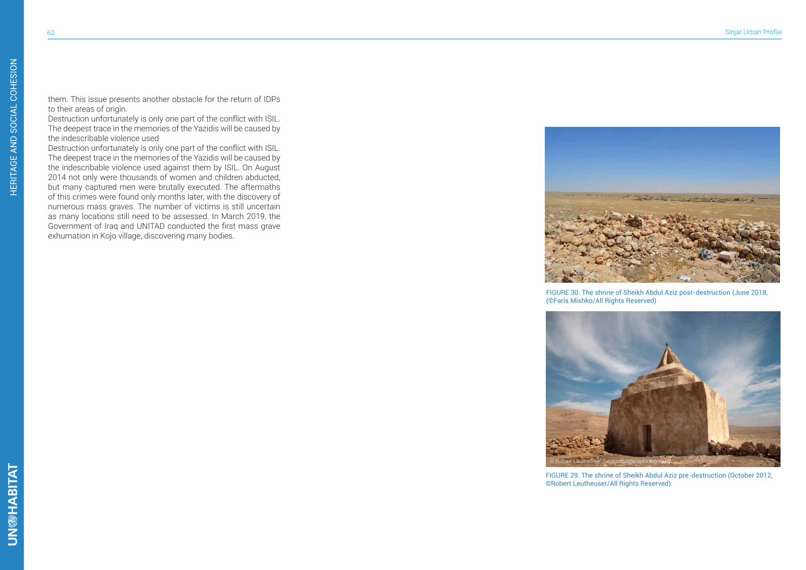
Sinjar Urban Profile62
HER
ITAG
E AN
D S
OCI
AL C
OH
ESIO
N
them. This issue presents another obstacle for the return of IDPs to their areas of origin.Destruction unfortunately is only one part of the conflict with ISIL. The deepest trace in the memories of the Yazidis will be caused by the indescribable violence used Destruction unfortunately is only one part of the conflict with ISIL. The deepest trace in the memories of the Yazidis will be caused by the indescribable violence used against them by ISIL. On August 2014 not only were thousands of women and children abducted, but many captured men were brutally executed. The aftermaths of this crimes were found only months later, with the discovery of numerous mass graves. The number of victims is still uncertain as many locations still need to be assessed. In March 2019, the Government of Iraq and UNITAD conducted the first mass grave exhumation in Kojo village, discovering many bodies.
FIGURE 29. The shrine of Sheikh Abdul Aziz pre-destruction (October 2012, ©Robert Leutheuser/All Rights Reserved)
FIGURE 30. The shrine of Sheikh Abdul Aziz post-destruction (June 2018, (©Faris Mishko/All Rights Reserved)
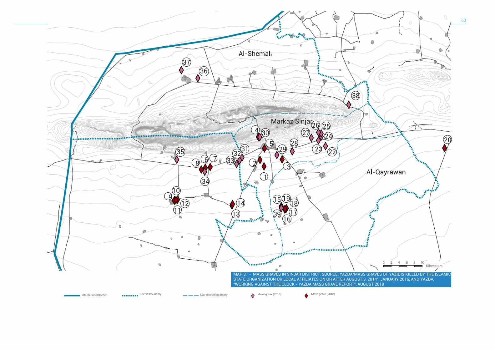
63
International border Sub-district boundaryDistrict boundary Mass grave (2016) Mass grave (2018)
0 2 4 6 8 10 Kilometers
XYXY XY
XYXY
XYXYXY
XYXYXYXY XYXY XYXYXYXYXY
XYXYXYXYXYXYXY
XYXY
XY
XYXYXYXY
XY
XYXY
XY
XY
2223
2728
3
529
304
3132
33 2
1
15 1819
1716
3914
13
6 78
34
910
1112
35
3637
38
20242526Markaz Sinjar
Al-Shemal
Al-Qayrawan
MAP 31 - MASS GRAVES IN SINJAR DISTRICT. SOURCE: YAZDA“MASS GRAVES OF YAZIDIS KILLED BY THE ISLAMIC STATE ORGANIZATION OR LOCAL AFFILIATES ON OR AFTER AUGUST 3, 2014”, JANUARY 2016, AND YAZDA, “WORKING AGAINST THE CLOCK - YAZDA MASS GRAVE REPORT”, AUGUST 2018
Sinjar Urban Profile64
ANN
EXES
ANNEXES9I - Aerial view of Markaz Sinjar in August 2018II - Aerial view of Sinuni in August 2016III - Aerial view of Qayrawan in May 2019IV - List of original villages, towns and hamlets in Sinjar DistrictV - Map of original villages, towns and hamlets in Sinjar DistrictVI- Borek MasterplanVII - Dhola MasterplanVII - Dogure MasterplanIX - Khana Sor MasterplanX - Guhbal MasterplanXI - Zorava MasterplanXII - Markaz Sinjar MasterplanXIII - List of main humanitarian interventions in Sinjar DistrictXIV - List of main water wells in Sinjar District
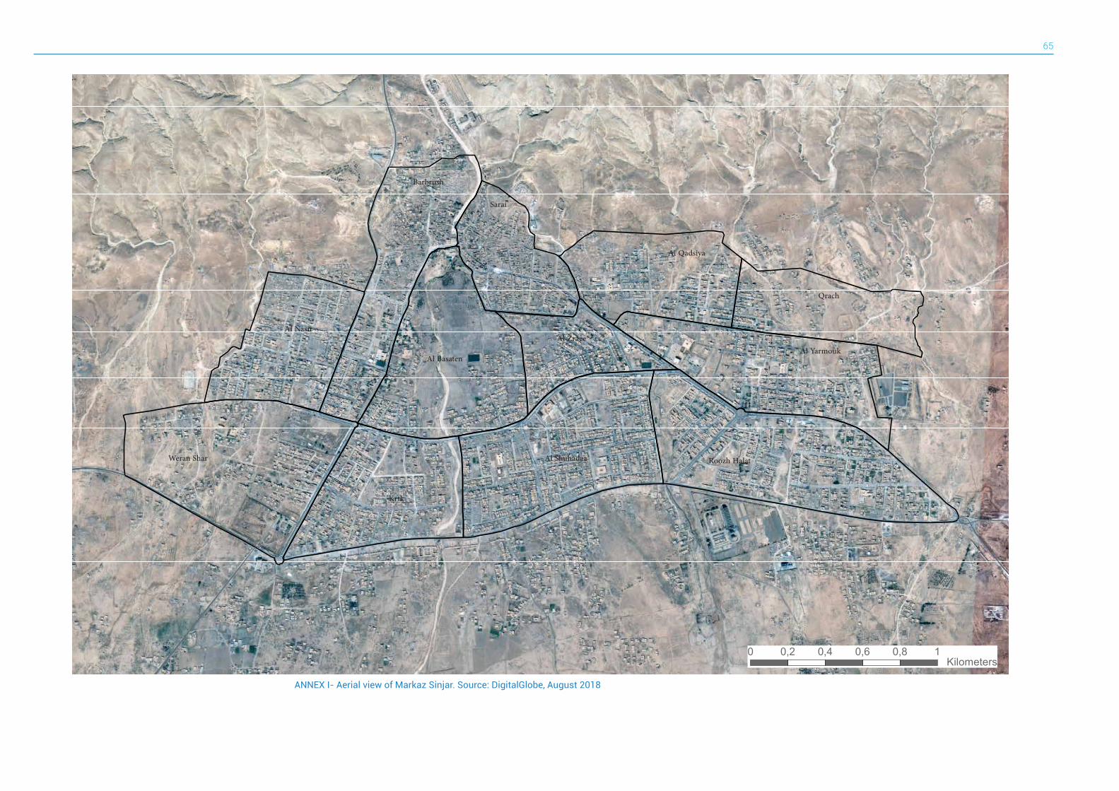
65
0 0,2 0,4 0,6 0,8 1 Kilometers
Barbrush
Al Nasir
Weran Shar
Al Basaten
Krtk
Al Shuhadaa
Sarai
Al Zraee
Al Qadsiya
Qrach
Al Yarmouk
Roozh Halat
ANNEX I- Aerial view of Markaz Sinjar. Source: DigitalGlobe, August 2018
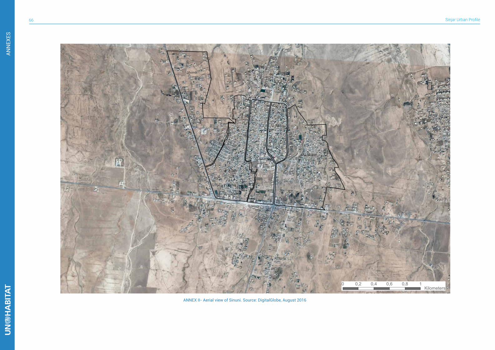
Sinjar Urban Profile66
ANN
EXES
0 0,2 0,4 0,6 0,8 1 Kilometers
ANNEX II- Aerial view of Sinuni. Source: DigitalGlobe, August 2016
Shorsh
Azadi
Al-Khathra
Al-Salam
Al-Sharqi
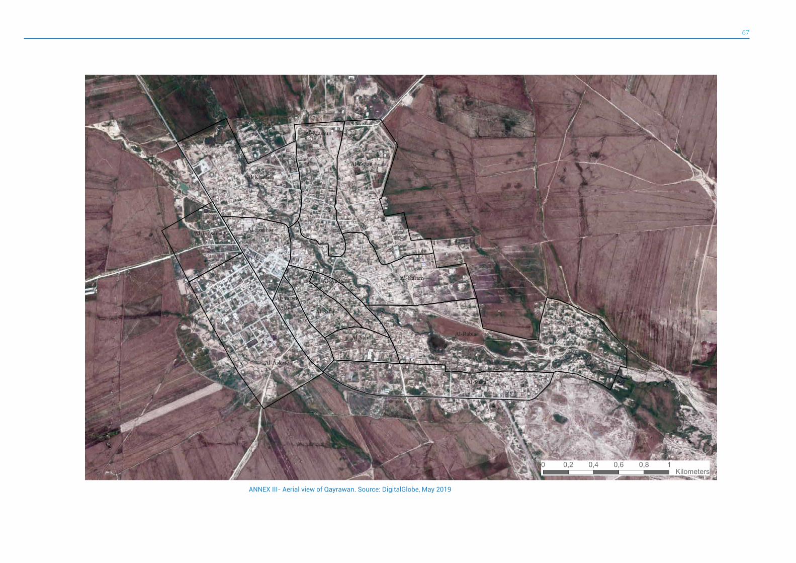
67
0 0,2 0,4 0,6 0,8 1 Kilometers
ANNEX III- Aerial view of Qayrawan. Source: DigitalGlobe, May 2019
Al-Karam
Al-Khathra
Al-Zraae
Al-Mamun
Al-Rabia
Al-Shifa
Al-Taawn
التعاون
Al-Askare
Al-Intisar
Al-Salam
Al-Andalus
Al-Saha
Al-Ezdihar
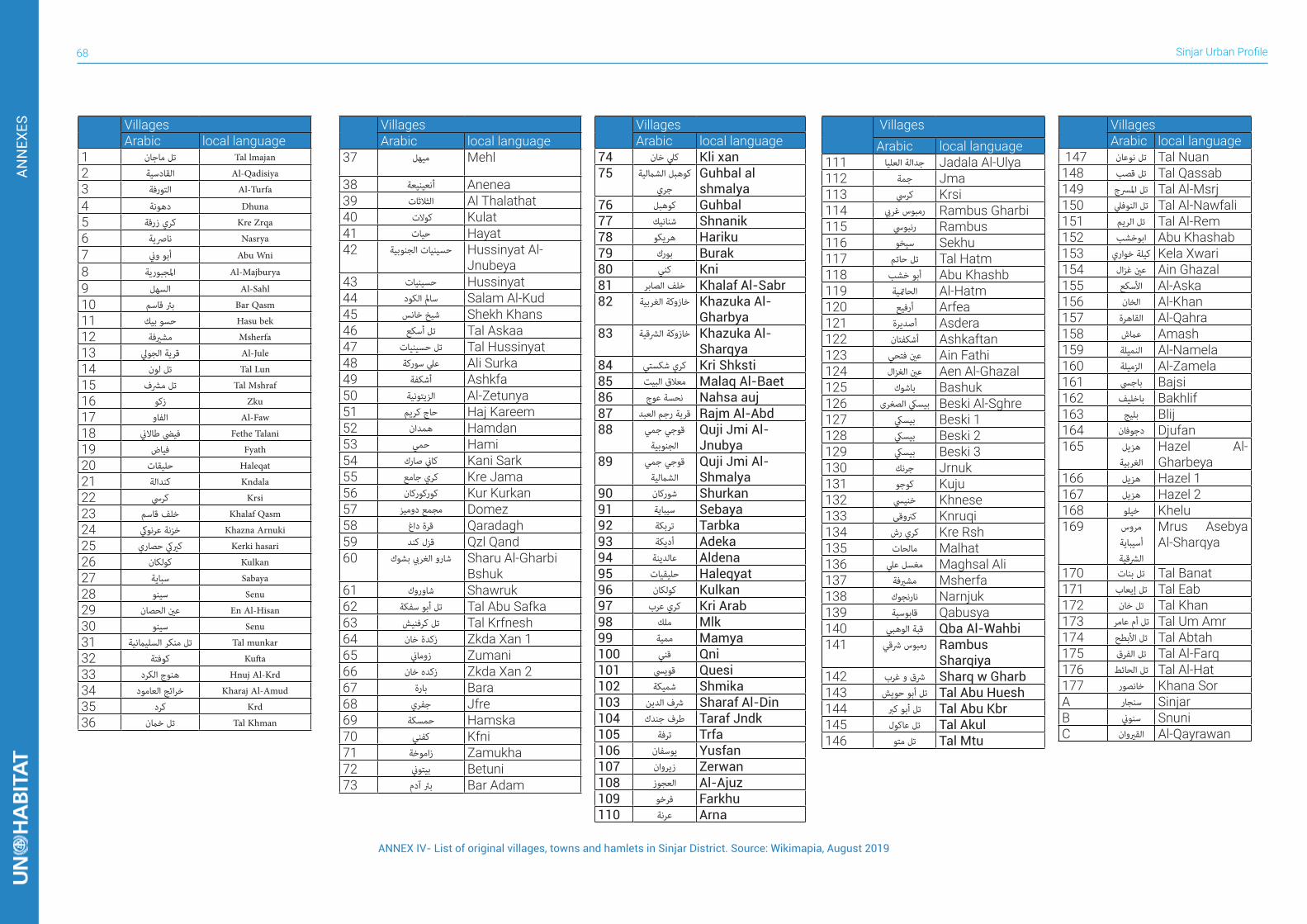
Sinjar Urban Profile68
ANN
EXES Villages
Arabic local language37 ميهل Mehl
38 أنعينيعة Anenea39 الثالثات Al Thalathat40 كوالت Kulat41 حيات Hayat42 حسينيات الجنوبية Hussinyat Al-
Jnubeya43 حسينيات Hussinyat44 سامل الكود Salam Al-Kud45 شيخ خانس Shekh Khans46 تل أسكع Tal Askaa47 تل حسينيات Tal Hussinyat48 عيل سوركة Ali Surka49 أشكفة Ashkfa50 الزيتونية Al-Zetunya51 حاج كريم Haj Kareem52 همدان Hamdan53 حمي Hami54 كاين صارك Kani Sark55 كري جامع Kre Jama56 كوركوركان Kur Kurkan57 مجمع دوميز Domez58 قرة داغ Qaradagh59 قزل كند Qzl Qand60 شارو الغريب بشوك Sharu Al-Gharbi
Bshuk61 شاوروك Shawruk62 تل أبو سفكة Tal Abu Safka63 تل كرفنيش Tal Krfnesh64 زكدة خان Zkda Xan 165 زوماين Zumani66 زكده خان Zkda Xan 267 بارة Bara68 جفري Jfre69 حمسكة Hamska70 كفني Kfni71 زاموخة Zamukha72 بيتوين Betuni73 برئ آدم Bar Adam
VillagesArabic local language
74 كيل خان Kli xan75 كوهبل الشاملية
جريGuhbal al shmalya
76 كوهبل Guhbal77 شنانيك Shnanik78 هريكو Hariku79 بورك Burak80 كني Kni81 خلف الصابر Khalaf Al-Sabr82 خازوكة الغربية Khazuka Al-
Gharbya83 خازوكة الرشقية Khazuka Al-
Sharqya84 كري شكستي Kri Shksti85 معالق البيت Malaq Al-Baet86 نحسة عوج Nahsa auj87 قرية رجم العبد Rajm Al-Abd88 قوجي جمي
الجنوبيةQuji Jmi Al-Jnubya
89 قوجي جمي
الشامليةQuji Jmi Al-Shmalya
90 شوركان Shurkan91 سيباية Sebaya92 تربكة Tarbka93 أديكة Adeka94 عالدينة Aldena95 حليقيات Haleqyat96 كولكان Kulkan97 كري عرب Kri Arab98 ملك Mlk99 ممية Mamya100 قني Qni101 قوييس Quesi102 شميكة Shmika103 رشف الدين Sharaf Al-Din104 طرف جندك Taraf Jndk105 ترفة Trfa106 يوسفان Yusfan107 زيروان Zerwan108 العجوز Al-Ajuz109 فرخو Farkhu110 عرنة Arna
VillagesArabic local language
111 جدالة العليا Jadala Al-Ulya112 جمة Jma113 كريس Krsi114 رمبوس غريب Rambus Gharbi115 رنبويس Rambus116 سيخو Sekhu117 تل حاتم Tal Hatm118 أبو خشب Abu Khashb119 الحامتية Al-Hatm120 أرفيع Arfea121 أصديرة Asdera122 أشكفتان Ashkaftan123 عني فتحي Ain Fathi124 عني الغزال Aen Al-Ghazal125 باشوك Bashuk126 بيسيك الصغرى Beski Al-Sghre127 بيسيك Beski 1128 بيسيك Beski 2129 بيسيك Beski 3130 جرنك Jrnuk131 كوجو Kuju132 خنييس Khnese133 كرنوقي Knruqi134 كري رش Kre Rsh135 مالحات Malhat136 مغسل عيل Maghsal Ali137 مشريفة Msherfa138 نارنجوك Narnjuk139 قابوسية Qabusya140 قبة الوهبي Qba Al-Wahbi141 رمبوس رشقي Rambus
Sharqiya142 رشق و غرب Sharq w Gharb143 تل أبو حويش Tal Abu Huesh144 تل أبو كرب Tal Abu Kbr145 تل عاكول Tal Akul146 تل متو Tal Mtu
VillagesArabic local language
147 تل نوعان Tal Nuan148 تل قصب Tal Qassab149 تل املرسج Tal Al-Msrj150 تل النوفيل Tal Al-Nawfali151 تل الريم Tal Al-Rem152 ابوخشب Abu Khashab153 كيلة خواري Kela Xwari154 عني غزال Ain Ghazal155 األسكع Al-Aska156 الخان Al-Khan157 القاهرة Al-Qahra158 عامش Amash159 النميلة Al-Namela160 الزميلة Al-Zamela161 باجيس Bajsi162 باخليف Bakhlif163 بليج Blij164 دجوفان Djufan165 هزيل
الغربيةHazel Al-Gharbeya
166 هزيل Hazel 1167 هزيل Hazel 2168 خيلو Khelu169 مروس
أسيباية
الرشقية
Mrus Asebya Al-Sharqya
170 تل بنات Tal Banat171 تل إيعاب Tal Eab172 تل خان Tal Khan173 تل أم عامر Tal Um Amr174 تل األبطح Tal Abtah175 تل الفرق Tal Al-Farq176 تل الحائط Tal Al-Hat177 خانصور Khana SorA سنجار SinjarB سنوين SnuniC القريوان Al-Qayrawan
VillagesArabic local language
1 تل ماجان Tal lmajan
2 القادسية Al-Qadisiya
3 التورفة Al-Turfa
4 دهونة Dhuna
5 كري زرقة Kre Zrqa
6 نارصية Nasrya
7 أبو وين Abu Wni
8 املجبورية Al-Majburya
9 السهل Al-Sahl
10 برئ قاسم Bar Qasm
11 حسو بيك Hasu bek
12 مشريفة Msherfa
13 قرية الجويل Al-Jule
14 تل لون Tal Lun
15 تل مرشف Tal Mshraf
16 زكو Zku
17 الفاو Al-Faw
18 فييض طاالين Fethe Talani
19 فياض Fyath
20 حليقات Haleqat
21 كندالة Kndala
22 كريس Krsi
23 خلف قاسم Khalaf Qasm
24 خزنة عرنويك Khazna Arnuki
25 كرييك حصاري Kerki hasari
26 كولكان Kulkan
27 سباية Sabaya
28 سينو Senu
29 عني الحصان En Al-Hisan
30 سينو Senu
31 تل منكر السليامنية Tal munkar
32 كوفتة Kufta
33 هنوج الكرد Hnuj Al-Krd
34 خرائج العامود Kharaj Al-Amud
35 كرد Krd
36 تل خامن Tal Khman
ANNEX IV- List of original villages, towns and hamlets in Sinjar District. Source: Wikimapia, August 2019
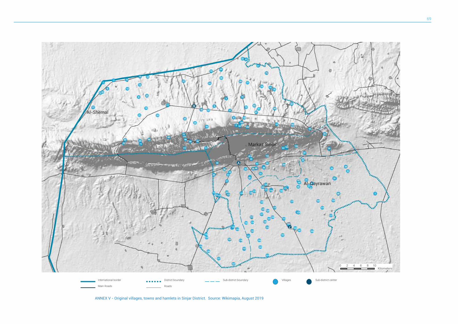
69
ANNEX V - Original villages, towns and hamlets in Sinjar District. Source: Wikimapia, August 2019
!((
!((
!((
9
8
7
6
5
4
3
2
1
9998
97
96
95
9493
92
91
90
89
88
86
85
84
82
81
80
79
78
77
76
75
74
73
72
717069 6867
66
65
63 62
61
59
58
57
56 5554
53 51
50
4948
47
46
45
4443
42 41
40
39
38
37
36
35
32
31
30
29
27
26
25
24
23
22
21 20
191817
16
15
14
13
12
11 10
177
176
175
174
173
172
171
170
169
168
167 166165
164
163
162
161160
157
156
155
154
153
152
151
150
149
148
147
146
145
144
143
142
141 139 138
137
136
135
134
133
132
131
130
129128
127
126
125
123
122
120
119
117
116
115114
113
112
111
110
109
108
107106
105
102
101
100
A
C
B
0 2 4 6 8 10 Kilometers
International border Villages Sub-district centerDistrict boundary Sub-district boundary
Main Roads Roads
Markaz Sinjar
Al-Shemal
Al-Qayrawan
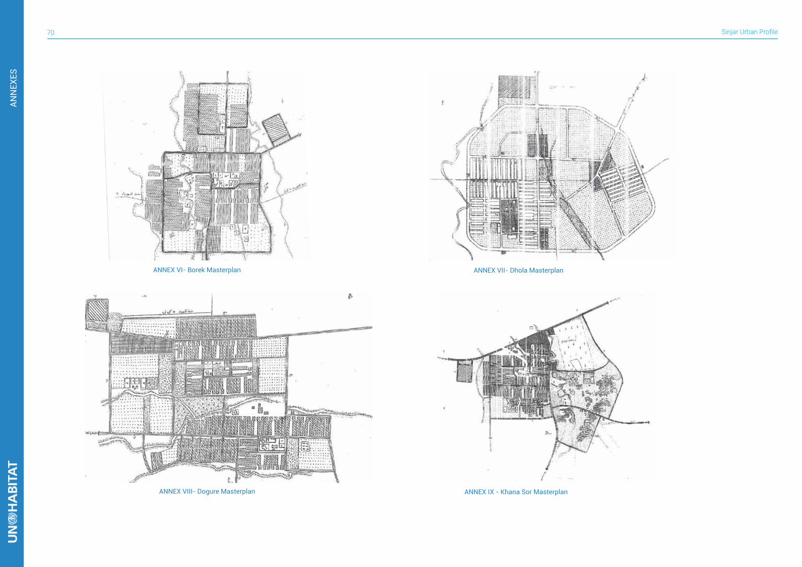
Sinjar Urban Profile70
ANN
EXES
ANNEX VI- Borek Masterplan ANNEX VII- Dhola Masterplan
ANNEX VIII- Dogure Masterplan ANNEX IX - Khana Sor Masterplan
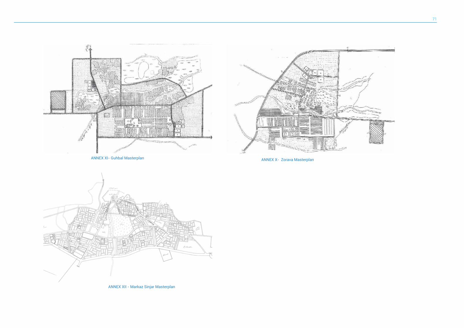
71
ANNEX X- Zorava MasterplanANNEX XI- Guhbal Masterplan
ANNEX XII - Markaz Sinjar Masterplan
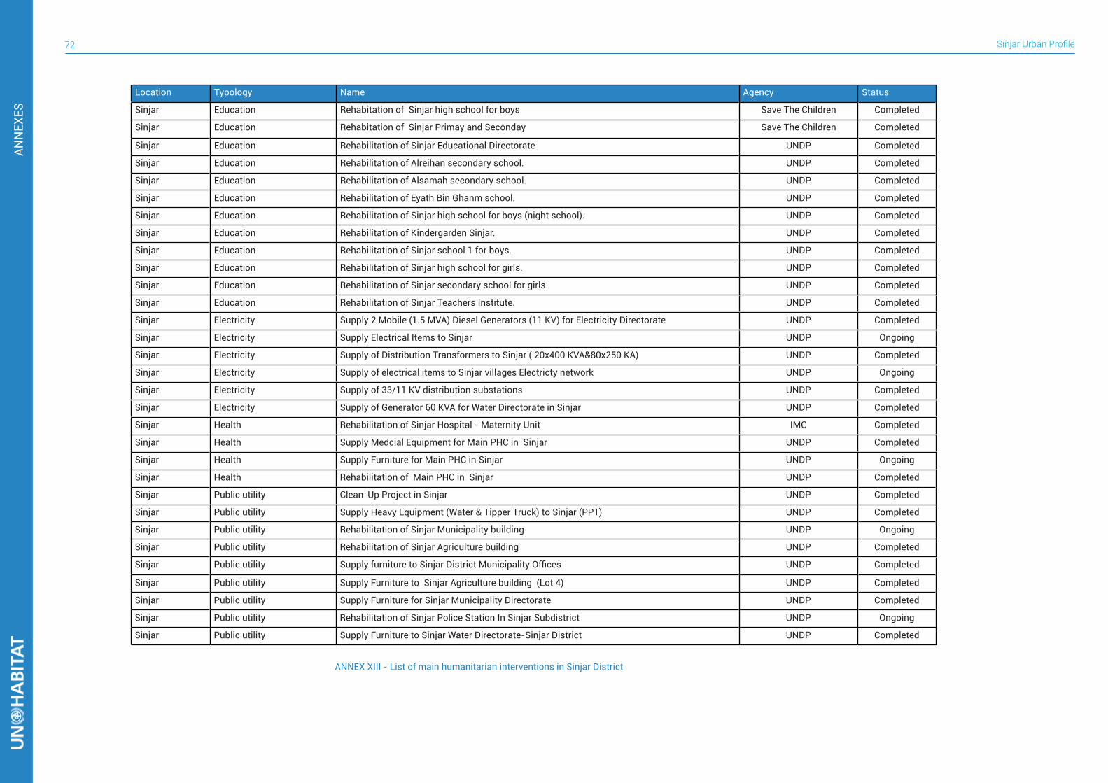
Sinjar Urban Profile72
ANN
EXES
Location Typology Name Agency Status
Sinjar Education Rehabitation of Sinjar high school for boys Save The Children Completed
Sinjar Education Rehabitation of Sinjar Primay and Seconday Save The Children Completed
Sinjar Education Rehabilitation of Sinjar Educational Directorate UNDP Completed
Sinjar Education Rehabilitation of Alreihan secondary school. UNDP Completed
Sinjar Education Rehabilitation of Alsamah secondary school. UNDP Completed
Sinjar Education Rehabilitation of Eyath Bin Ghanm school. UNDP Completed
Sinjar Education Rehabilitation of Sinjar high school for boys (night school). UNDP Completed
Sinjar Education Rehabilitation of Kindergarden Sinjar. UNDP Completed
Sinjar Education Rehabilitation of Sinjar school 1 for boys. UNDP Completed
Sinjar Education Rehabilitation of Sinjar high school for girls. UNDP Completed
Sinjar Education Rehabilitation of Sinjar secondary school for girls. UNDP Completed
Sinjar Education Rehabilitation of Sinjar Teachers Institute. UNDP Completed
Sinjar Electricity Supply 2 Mobile (1.5 MVA) Diesel Generators (11 KV) for Electricity Directorate UNDP Completed
Sinjar Electricity Supply Electrical Items to Sinjar UNDP Ongoing
Sinjar Electricity Supply of Distribution Transformers to Sinjar ( 20x400 KVA&80x250 KA) UNDP Completed
Sinjar Electricity Supply of electrical items to Sinjar villages Electricty network UNDP Ongoing
Sinjar Electricity Supply of 33/11 KV distribution substations UNDP Completed
Sinjar Electricity Supply of Generator 60 KVA for Water Directorate in Sinjar UNDP Completed
Sinjar Health Rehabilitation of Sinjar Hospital - Maternity Unit IMC Completed
Sinjar Health Supply Medcial Equipment for Main PHC in Sinjar UNDP Completed
Sinjar Health Supply Furniture for Main PHC in Sinjar UNDP Ongoing
Sinjar Health Rehabilitation of Main PHC in Sinjar UNDP Completed
Sinjar Public utility Clean-Up Project in Sinjar UNDP Completed
Sinjar Public utility Supply Heavy Equipment (Water & Tipper Truck) to Sinjar (PP1) UNDP Completed
Sinjar Public utility Rehabilitation of Sinjar Municipality building UNDP Ongoing
Sinjar Public utility Rehabilitation of Sinjar Agriculture building UNDP Completed
Sinjar Public utility Supply furniture to Sinjar District Municipality Offices UNDP Completed
Sinjar Public utility Supply Furniture to Sinjar Agriculture building (Lot 4) UNDP Completed
Sinjar Public utility Supply Furniture for Sinjar Municipality Directorate UNDP Completed
Sinjar Public utility Rehabilitation of Sinjar Police Station In Sinjar Subdistrict UNDP Ongoing
Sinjar Public utility Supply Furniture to Sinjar Water Directorate-Sinjar District UNDP Completed
ANNEX XIII - List of main humanitarian interventions in Sinjar District
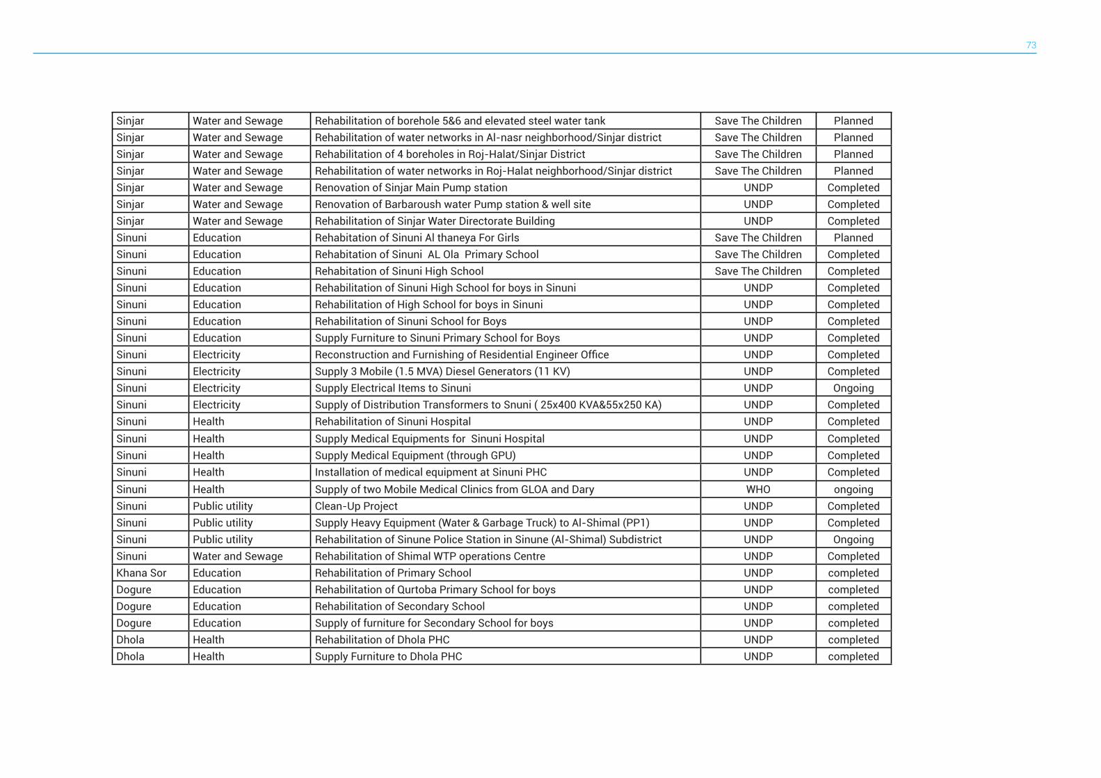
73
Sinjar Water and Sewage Rehabilitation of borehole 5&6 and elevated steel water tank Save The Children PlannedSinjar Water and Sewage Rehabilitation of water networks in Al-nasr neighborhood/Sinjar district Save The Children PlannedSinjar Water and Sewage Rehabilitation of 4 boreholes in Roj-Halat/Sinjar District Save The Children PlannedSinjar Water and Sewage Rehabilitation of water networks in Roj-Halat neighborhood/Sinjar district Save The Children PlannedSinjar Water and Sewage Renovation of Sinjar Main Pump station UNDP CompletedSinjar Water and Sewage Renovation of Barbaroush water Pump station & well site UNDP CompletedSinjar Water and Sewage Rehabilitation of Sinjar Water Directorate Building UNDP CompletedSinuni Education Rehabitation of Sinuni Al thaneya For Girls Save The Children PlannedSinuni Education Rehabitation of Sinuni AL Ola Primary School Save The Children CompletedSinuni Education Rehabitation of Sinuni High School Save The Children CompletedSinuni Education Rehabilitation of Sinuni High School for boys in Sinuni UNDP CompletedSinuni Education Rehabilitation of High School for boys in Sinuni UNDP CompletedSinuni Education Rehabilitation of Sinuni School for Boys UNDP CompletedSinuni Education Supply Furniture to Sinuni Primary School for Boys UNDP CompletedSinuni Electricity Reconstruction and Furnishing of Residential Engineer Office UNDP CompletedSinuni Electricity Supply 3 Mobile (1.5 MVA) Diesel Generators (11 KV) UNDP CompletedSinuni Electricity Supply Electrical Items to Sinuni UNDP OngoingSinuni Electricity Supply of Distribution Transformers to Snuni ( 25x400 KVA&55x250 KA) UNDP CompletedSinuni Health Rehabilitation of Sinuni Hospital UNDP CompletedSinuni Health Supply Medical Equipments for Sinuni Hospital UNDP CompletedSinuni Health Supply Medical Equipment (through GPU) UNDP CompletedSinuni Health Installation of medical equipment at Sinuni PHC UNDP CompletedSinuni Health Supply of two Mobile Medical Clinics from GLOA and Dary WHO ongoingSinuni Public utility Clean-Up Project UNDP CompletedSinuni Public utility Supply Heavy Equipment (Water & Garbage Truck) to Al-Shimal (PP1) UNDP CompletedSinuni Public utility Rehabilitation of Sinune Police Station in Sinune (Al-Shimal) Subdistrict UNDP OngoingSinuni Water and Sewage Rehabilitation of Shimal WTP operations Centre UNDP CompletedKhana Sor Education Rehabilitation of Primary School UNDP completedDogure Education Rehabilitation of Qurtoba Primary School for boys UNDP completedDogure Education Rehabilitation of Secondary School UNDP completedDogure Education Supply of furniture for Secondary School for boys UNDP completedDhola Health Rehabilitation of Dhola PHC UNDP completedDhola Health Supply Furniture to Dhola PHC UNDP completed
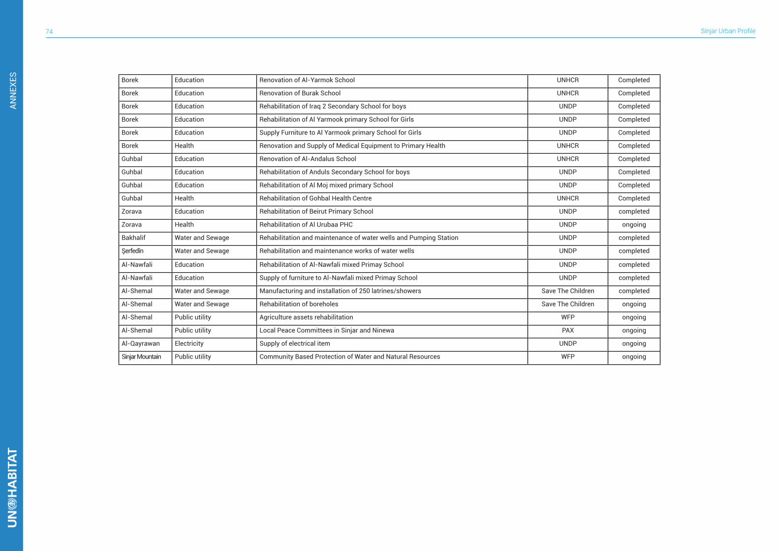
Sinjar Urban Profile74
ANN
EXES Borek Education Renovation of Al-Yarmok School UNHCR Completed
Borek Education Renovation of Burak School UNHCR Completed
Borek Education Rehabilitation of Iraq 2 Secondary School for boys UNDP Completed
Borek Education Rehabilitation of Al Yarmook primary School for Girls UNDP Completed
Borek Education Supply Furniture to Al Yarmook primary School for Girls UNDP Completed
Borek Health Renovation and Supply of Medical Equipment to Primary Health UNHCR Completed
Guhbal Education Renovation of Al-Andalus School UNHCR Completed
Guhbal Education Rehabilitation of Anduls Secondary School for boys UNDP Completed
Guhbal Education Rehabilitation of Al Moj mixed primary School UNDP Completed
Guhbal Health Rehabilitation of Gohbal Health Centre UNHCR Completed
Zorava Education Rehabilitation of Beirut Primary School UNDP completed
Zorava Health Rehabilitation of Al Urubaa PHC UNDP ongoing
Bakhalif Water and Sewage Rehabilitation and maintenance of water wells and Pumping Station UNDP completed
Şerfedîn Water and Sewage Rehabilitation and maintenance works of water wells UNDP completed
Al-Nawfali Education Rehabilitation of Al-Nawfali mixed Primay School UNDP completed
Al-Nawfali Education Supply of furniture to Al-Nawfali mixed Primay School UNDP completed
Al-Shemal Water and Sewage Manufacturing and installation of 250 latrines/showers Save The Children completed
Al-Shemal Water and Sewage Rehabilitation of boreholes Save The Children ongoing
Al-Shemal Public utility Agriculture assets rehabilitation WFP ongoing
Al-Shemal Public utility Local Peace Committees in Sinjar and Ninewa PAX ongoing
Al-Qayrawan Electricity Supply of electrical item UNDP ongoing
Sinjar Mountain Public utility Community Based Protection of Water and Natural Resources WFP ongoing
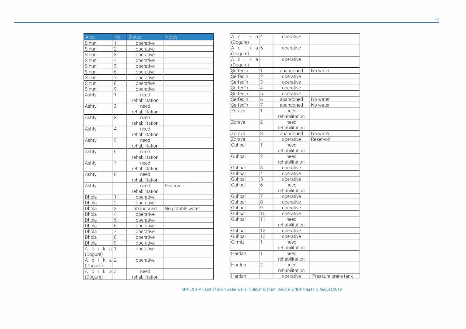
75
Area No. Status NotesSinuni 1 operative Sinuni 2 operative Sinuni 3 operative Sinuni 4 operative Sinuni 5 operative Sinuni 6 operative Sinuni 7 operative Sinuni 8 operative Sinuni 9 operative Ashty 1 need
rehabilitation
Ashty 2 need rehabilitation
Ashty 3 need rehabilitation
Ashty 4 need rehabilitation
Ashty 5 need rehabilitation
Ashty 6 need rehabilitation
Ashty 7 need rehabilitation
Ashty 8 need rehabilitation
Ashty - need rehabilitation
Reservoir
Dhola 1 operative Dhola 2 operative Dhola 3 abandoned No potable waterDhola 4 operative Dhola 5 operative Dhola 6 operative Dhola 7 operative Dhola 8 operative Dhola 9 operative A d i k a (Dogure)
1 operative
A d i k a (Dogure)
2 operative
A d i k a (Dogure)
3 need rehabilitation
A d i k a (Dogure)
4 operative
A d i k a (Dogure)
5 operative
A d i k a (Dogure)
- operative
Şerfedîn 1 abandoned No waterŞerfedîn 2 operative Şerfedîn 3 operative Şerfedîn 4 operative Şerfedîn 5 operative Şerfedîn 6 abandoned No waterŞerfedîn 7 abandoned No waterZorava 1 need
rehabilitation
Zorava 2 need rehabilitation
Zorava 3 abandoned No waterZorava - operative ReservoirGuhbal 1 need
rehabilitation
Guhbal 2 need rehabilitation
Guhbal 3 operative Guhbal 4 operative Guhbal 5 operative Guhbal 6 need
rehabilitation
Guhbal 7 operative Guhbal 8 operative Guhbal 9 operative Guhbal 10 operative Guhbal 11 need
rehabilitation
Guhbal 12 operative Guhbal 13 operative Girmiz 1 need
rehabilitation
Hardan 1 need rehabilitation
Hardan 2 need rehabilitation
Hardan - operative Pressure brake tank
ANNEX XIV - List of main water wells in Sinjar District. Source: UNDP Iraq FFS, August 2019
Urban Profile SinjarRegional Office for Arab States (ROAS)87 Tahrir st, Dokkie, Giza, EgyptTelephone: +2(02) 37618812, Fax: +2(02) 37618813www.unhabitat.org
UN-Habitat seeks to provide up to date, holistic documentation and analysis of the impact of the crisis in key cities, through City Profiles, synthesising information and insight from existing sources and priority sectors, supplemented by direct field research by UN-Habitat teams based in each city. This profile is part of a regional urban profiling exercise that aims to develop urban profiles for the cities of Basra, Sinjar, Derna (Libya), Mareb (Yemen) and Dara’a (Syria). UN-Habitat’s expertise in urban analysis, community approaches and crisis contexts have informed the development of the City Profiling process. All City Profiles are developed in close association with the concerned governorates and municipalities.
The structure of the City Profile provides a pre-crisis baseline and data from the current situation to understand the impact of the crisis accompanied by narrative description and analysis. Furthermore, City Profiles review the functionality of the city economy and services, understanding of capacities and coping mechanisms and the identification of humanitarian or development priorities. They do not provide comprehensive data on individual topics, but seek to provide a balanced overview. The City Profile affords an opportunity for a range of stakeholders to represent their diagnosis of the situation in their city, provides a basis for local discussions on actions to be taken and helps to make local information and voices accessible to external stakeholders seeking to assist in development response.