bruna cunha gondim de alencar vacinação com a proteína 2 ...

Institute of Archaeology, University College London
MA Archaeology Dissertation
Research question:
What can ceramic decoration tell us about the pre- and post- colonial past on the
Upper Tapajós River?
Bruna Cigaran da Rocha
Supervisors: Dr. José Oliver, Dr. Manuel Arroyo-Kalin
Degree Coordinator: Dr. Karen Wright
September 2012

i
DECLARATION
This dissertation is the result of my own work. Work done in collaboration is
specifically indicated in the text. Excluding title page, contents pages, lists of
figures and tables, abstract, acknowledgements, bibliography, captions and
contents of tables and figures, appendice, the main text of the dissertation
consists of 15,134 words.
Unless otherwise stated in the reference list, all translations into English were
undertaken by myself. Unless otherwise stated, all photographs were taken by
Vinicius Honorato de Oliveira or by myself. Unless otherwise indicated, all
illustrations are my own.

ii
What can ceramic decoration tell us about the pre- and post- colonial past on
the Upper Tapajós River?
Bruna Cigaran da Rocha
Abstract
The aim of this research, conducted in an as yet little known area of the Brazilian Amazon, is
to provide a first step in inserting the archaeology of the Upper Tapajós River, in the
southwest of Pará state, into the wider regional context. Its focus is on the analysis of ceramic
decoration from pottery collected from sites worked on, and its subsequent comparison to that
of adjacent areas and to the wider region. Following an overview of theoretical concepts and
tendencies pursued in the Brazilian Amazon, two distinct traditions are identified through
comparisons of pottery from other areas and consultation of historical accounts, and
interactions between their producers are postulated. This opens up a series of questions to be
investigated in the future.
Key words: Amazonian Archaeology, Tapajós River, Mangabal, Pimental, forest peoples,
Incised Punctuate tradition, Munduruku indians.

iii
Acknowledgements
This dissertation is the product of a trajectory that began six years ago. The project was made
possible because of the help of many individuals. I only hope to do justice to their efforts.
Eduardo Góes Neves welcomed me into his team and has been an unwavering source of
optimism and encouragement, providing me with intellectual guidance and the motivation to
“make indigenous history” throughout the years I have known him. I cannot thank him
enough.
I will always be grateful to Manuela Carneiro da Cunha, who recommended I study
archaeology, and who I admire for her commitment to the cause of the rights of forest
peoples in Brazil.
I thank friends of the Central Amazon Project and Museum of Archaeology and Ethnology,
who introduced me to Amazonian Archaeology in practice and shared experiences with me
that will always be cherished: Carla Gibertoni, Tereza Parente, Helena Pinto Lima, Marcos
Brito, Fernando Costa, Bernardo Lacale, Márcio Castro, Thiago Trindade, Jaqueline Belletti,
Eduardo Kazuo Tamanaha, Márjorie Lima, Leandro Camilo, Guilherme Mongeló and Agda
Sardinha.
The staff at the Museum of Archaeology and Ethnology’s Library at the University of São
Paulo, in particular Hélio Rosa de Miranda and Eleuza Gouveia, always bent over backwards
to help me.
Marcos Brito Castro digitalised our excavation profile drawings beautifully. Vinicius
Honorato created the other maps used here. Denise Gomes allowed me to reproduce images
from her book, Cotidiano e Poder na Amazônia Pré-Colonial, for which I am most grateful.
Klaus Hilbert assisted me immensely by scanning and sending me Peter Hilbert’s articles.
Francisco Pugliese was generous with his time and advice. Fernando and Dani, thank you for
your help in so many ways. Malu Camargo, I really appreciate your assistance. Daniel
Frechoso, thank you for rescuing my dissertation from the computational void!
I greatly value Fabíola Andrea Silva’s and Francisco Noelli’s encouragement and support of
our research on the Tapajós. You have set a high intellectual and ethical standard to be
followed.
Moving to the Tapajós, I am eternally indebted to Maurício Gonsalves Torres, our very own
Rei da Selva, who has dedicated his life to justice for forest peoples. Thank you for taking us
to Mangabal and providing us with the logistical support, good humour and critical
perspective we needed. This project wouldn’t have existed without you.
Eduardo Neves and Fernando Ozorio de Alemeida, thank you for agreeing to coordinate the
Projeto Alto Tapajós. Thank you to those who made up the team: Eduardo Kazuo Tamanaha,
Márjorie Lima, Leandro Camilo, and Gilmar Henriques. I am extremely grateful to Rosanna
Delellis and to Alfixit for pledging to support the project. Natália Guerrero kindly revised our
first report to the IPHAN.
iv
The people of Mangabal and Pimental who received and fed us, and took us to the sites in
their territories will forever be in my thoughts. Two strong women of the Tapajós, Odila
Braga and Gabriela Maria Bibiana da Silva symbolise the dignity of forest peoples and a way
of life that must be fought for. Pedro Braga da Silva, Raimundo Colares dos Santos,
Francisco Firmino da Silva, Solimar Ferreira dos Anjos, Josué Lobato Cirino and Teófilo
Braga Cirino took us to archaeological sites in 2010, when we stayed with Nildete Cardoso,
Raimundo Colares and at the Machado community. In 2011 we stayed with Dona Odila,
Pedro, Conceição, Odon and Tayrine at Sapucaia in Mangabal, and Pedro worked with us at
the Terra Preta do Mangabal archaeological site, to where he transported us every day.
Edmilson Ribeiro Azevedo and his son Dedê, Eudeir Francisco da Silva Azevedo, worked
with us on some days at the Pajaú site, introduced us to their grandmother and took us to the
historic site of the rubber period near Pimental, where we stayed with Marinildo de Sousa
Robertino, his wife Bete and their family. Geizy Carla Ribeiro Azevedo donated the
projectile point her son found among the rocks to us: thank you.
I am beholden to Denise Pahl Schaan for support in Santarém, by allowing the material we
collected to be stored, washed and analysed at the Curt Nimuendaju lab, whose team made
our stay so productive and enjoyable. Márcio Amaral, thank you for the friendly reception
and exchange of ideas. I hope this is just the beginning of a long collaboration. I similarly
thank Gizelle Morais and Cristiane Martins for the goodwill shown.
Still in Santarém, our good friends Anne and Claide helped us in every possible way they
could; I hope we can one day return their generosity. Rogério Andrade dos Santos dedicated
time and care to the analysis of the pottery, with Claide’s help, making all the difference to
this research. I am thankful to Ítala Nepomuceno and Cândido Neto da Cunha for the
hospitality. Muito obrigada.
In Itaituba, our stay was made infinitely more interesting and comfortable by Juan Doblas
Prieto, Maite Guedes, Bárbara Campello Silva and Leidiane Brusnello.
In London, the Institute of Archaeology’s Master’s Award made a huge financial difference.
My lecturers during the MA course were fantastic: Arlene Rosen, Bill Sillar, Todd Whitelaw,
Karen Wright, Norah Moloney and Patrick Quinn. José Oliver and Manuel Arroyo Kalin, my
supervisors at the Institute, have given me all the support, reassurance, guidance, critique,
ideas, suggestions, comments and good humour I could possibly hope for, and more. I am
privileged to have you as my orientadores. Gracias, professores!
And finally, my overwhelming expression of gratitude is to my family. My brother and sister,
Camilo and Ali, have constantly cheered me on and believed in me, along with my sister-in-
law, Juliana. Thank you to Lourdes for your care and affection. To my parents-in-law, Lúcio
and Hulda, I greatly appreciate your endorsement and encouragement. To my parents Jan and
Plauto, I am grateful for the love, support and sense of what is right. To Vinicius – husband,
friend and companion who has accompanied me from the beginning of my archaeological
career, and who partook in every stage of this project – which is yours as much as it is mine –
the biggest thank you of all.

v
Contents
1. Introduction 1
Portuguese and Brazilian Colonisation of the Tapajós River 3
Background to archaeological research in the area 5
2. The role of ceramics in Amazonian Archaeology 8
Horizons, traditions, phases and related concepts used to determine cultural units 11
The Incised Punctuate Tradition 12
Decoration vs. form 13
Justification for focus of research 14
3. Beiradeiros, cachoeiras and terra preta 16
Introduction 16
Characterisation of the area 17
Methodology: survey, site delimitation and excavation 19
Montanha and Mangabal 20
Ponta do Jatobá archaeological site 23
Terra Preta do Mangabal archaeological site 24
Survey along the Transamazon highway 26
Boa Vista archaeological site 27
Cocalino archaeological site 27
Pimental 28
Pajaú archaeological site 30
The Aracy-Paraguaçu museum in Itaituba 30
Conclusion 31
4. Pottery from the Upper Tapajós and beyond 32
Methods of ceramic analysis 32
Results 34
Terra Preta do Mangabal pottery 34
Pajaú pottery 36
Cocalino pottery 37
Discussion 38
Comparisons to ceramic decoration from the wider region 39
The pottery of Parauá, Lower Tapajós 39
The Tapajós-Trombetas area 40
Santarém pottery 40
Pottery from the Madeira basin 44
Pottery from the Xingu basin 45
Pottery from the Orinoco basin 47
Interpretation of results 48
Pajaú and Cocalino 48
Terra Preta do Mangabal 49
5. Conclusion 52
Bibliography 54
Appendix Annexes 1-11
Plates 1-9

vi
List of figures
1 Advert by Queiroz Galvão 3
2 Agate arrowhead found on the beach at Itaituba by Barbosa Rodrigues 5
3 Funerary urns from the Cururú River 6
4 Arrowheads from the Upper Tapajós 6
5 Map showing rivers mentioned in text 7
6 Nimuendaju’s Ethno-historical map 8
7 Distribution of sites representing the four horizon styles 10
8 Examples of the Incised Puntuate Tradition according to Lathrap 13
9 Pedro taking Vinicius and I to work on the Terra Preta do Mangabal site in his boat 16
10 Odila Braga in her kitchen with some of the ground stone axes she had collected 20
11 Pedro carrying a paneiro loaded with bananas 20
12 Josué preparing his roça to be planted with manioc 20
13 Sites identified in Montanha and Mangabal in 2010 21
14 Ceramic vessel found in the river by a diving gold miner 21
15 Josué and Bruna observe the surface of a campo area integrating the TPM site 21
16 Galdino: Francisco examines pottery fragments strewn in front of his home 21
17 Maloquinha: contrast between anthropogenic soil containing pottery and natural soil 22
18 Maloquinha: detail of rim within anthropogenic soil 22
19 Maloquinha: Francisca da Silva scrutinises ceramic pots buried in front of her house 22
20 Mangueira: ground stone axe and pottery 22
21 Buried urn (?) and ceramic fragments at Praia Chique 23
22 Buried urn (?) and ceramic fragments at Os Quirino 23
23 The Ponta do Jatobá community and archaeological site 24
24 Auger hole at The Ponta do Jatobá 24
25 Terra Preta do Mangabal: view to Tapajós River 24
26 Terra Preta do Mangabal: view from the campo area to Mangabal rapids 24
27 Terra Preta do Mangabal: the steep ascent up to the site 25
28 Terra Preta do Mangabal: marking out the grid 25
29 Terra Preta do Mangabal: midden/mound 26
30 Terra Preta do Mangabal: auger hole 26
31 Terra Preta do Mangabal: drawing one of the profiles of unit N1000 E1074 26
32 Boa Vista: Vinicius augering with Tapajós in background 27
33 Boa Vista: auger hole 27
34 Cocalino: general view of the site 27
35 Cocalino: auger hole 27
36 Pimental: Dona Gabriela and descendants 28
37 Pimental: view to the community from the river 28
38 Pimental: Geizy Carla Ribeiro Azevedo's son and siblings with biface 28
39 Bifacial lance head by Claide de Paula Moraes 28
40 Pimental port, with view to Bananal Island 28
41 Vinicius and Marinildo augering dark earth area 29
42 Non-anthropogenic? dark earth 29
43 Pottery located on Bananal Island, in front of Pimental 29
44 The barracão seringueiro at Pimental 29
45 View to Pajaú site 30
46 Pajaú: Edmilson cuts back thick vegetation so that the site can be delimited 30
47 Pajaú: yellow flags mark pottery fragments on the surface 30
48 Aracy-Paraguaçu museum: wooden anthropomorphic artefacts 31

vii
Cont.
49 Aracy-Paraguaçu museum: polished and ground stone axes and adzes 31
50 Aracy-Paraguaçu museum: silex projectile point 31
51 Lower Tapajós: Pottery from the Lago do Jacaré site, Parauá 39
52 Ceramic vessels from Santarém collected by Nimuendajú for Gothenburg Museum 41
53 Nhamundá-Trombetas: Pottery from the Erepecurú River and Sapuquá Lake 41
54 Nhamundá-Trombetas: Typical elements of Konduri style decoration 42
55 Hollow rims in profile 44
56 Madeira: Pottery from the Itapirema archaeological site 45
57 Xingu: Decorated rims & Arauquinoid-like adorno 46
58 Xingu: Sherd from Lower Iriry and rim found in Altamira 47
59 Orinoco: Pottery from the Valloid series 47
60 Hércule Florence watercolours of the Munduruku 49
61 Incised decoration on sherd found at the TPM site 49
62 Map produced by William Chandless (1862) 50
63 Engraving of Munduruku tattoos 50
List of tables and charts
Percentages of pottery from each site 33
Quantities of pottery from TPM 34
Quantities of pottery from Pajaú 36
Quantities of pottery from Cocalino 37
Overall characteristics of pottery analysed 39
Comparison between Santarém and Konduri pottery 43
1
What can ceramic decoration tell us about the pre- and post- colonial
past on the Upper Tapajós River?
1. Introduction
Archaeology has a vital, urgent role to play in constructing an alternative idea in the popular
imaginary about Amazonia, its people, and their past. Written records for the area under
investigation – the Upper Tapajós River, south-western Pará state in the Brazilian Amazon –
only began after two centuries of conquest, by which time the demographic collapse of
Amerindian populations was well underway (Denevan 1992). This dissertation is an initial
step in what we hope will be a long term archaeological research project in this region. As
such, more questions will be asked than answered.
On travelling to Montanha and Mangabal on the Upper Tapajós River in March 2010, our
expectation was to find pottery similar to the painted wares identified by Almeida (2008) in
south-eastern Amazonia, associated by him to Tupian groups. Linguistic and archaeological
theories postulate that groups belonging to the Tupi language stock would have traversed the
Upper Tapajós region from their centre of origin – thought to lie around the upper reaches of
the Madeira basin (Miller 1983) –, towards the east (Almeida 2008, Brochado 1984, Urban
1992). However, what we have found instead – so far – is quite different, and apparently
much more recent (I say apparently because we have yet to date the sites worked on).
In this dissertation I will attempt to relate the pottery of these sites, located in the
municipality of Itaituba, to a wider context by comparing the decorative patterns found on
their ceramics to those of adjacent areas (fig. 5). My justification for this can be found in the
following chapter, where I will situate this research within a wider theoretical framework
related to the role of ceramics in Amazonian archaeology. In the second chapter I will narrate
the two field expeditions undertaken and present their findings. Chapter three will present the
pottery collection analysed and compare its decorative patterns to those of adjacent regions,
after which I offer an interpretation of my findings; ethnohistorical literature has also been
consulted towards this end. Following this, some concluding remarks will be made.

2
We originally reached Montanha and Mangabal thanks to our friend Maurício Torres – a
geographer working for local communities’ land rights in the Brazilian Amazon.1 Maurício’s
research had been focussed on proving the beiradeiros (“riverbank dwellers”) of Mangabal
had legitimate claim to their territories, which they had historically occupied since the
nineteenth century (Torres 2008), but from which they were being threatened with expulsion
by landgrabbers from the south of the country. He demonstrated the longevity of the
communities in the area through their profound knowledge of their territories and its
environment, inherited from their Amerindian forebears; he also scoured historical
documents that could have recorded names of the present beiradeiros’ ancestors. Although
the beiradeiros are still there, their way of life is now being threatened by a far more
powerful force: the Brazilian Federal Government and a yet-to-be-defined consortium of state
and privately owned companies, which plan to build a series of hydroelectric dams on the
Tapajós.
1. The advert to the left, published in 1971, announces the “first”
birth of a child “in that brave new world we are helping to build…
in the greatest green space on the planet. Where only forests
existed. And legends. Myth and fear”. The then military
government’s program of “integration” of the Amazon, to be
facilitated by the opening up of the Transamazon Highway,
promised "a land without people for people without land" (Torres
et al. 2005).
The child, Transamazônico, was born “exactly where we are
beginning. Or rather, where Brazil is being discovered again”.
In: Torres 2008, 287.
There is something in common between the assumptions of the landgrabbers and of the
government; they are based on the premise that this is an empty space, a place without history
(fig. 1). Forest peoples are perceived to be impoverished and uncultured, people who do not
1 Hereafter, Montanha and Mangabal will be collectively referred to as Mangabal.

3
have a past, a stock of reserve labour waiting for “development” to turn them into workers, if
they are lucky. This situation, a re-edit of the last 500 years of Brazilian history, is repeated
along similar lines throughout the Amazon today.
Before I proceed, some background on the colonial history of the area in question is needed,
followed by a summary of the archaeological research conducted near the Upper Tapajós to
date.
Portuguese and Brazilian Colonisation of the Tapajós River
Up until the nineteenth century, sources referring to indigenous groups around the Lower
Tapajós River were invariably written by missionaries or colonial officials. Irrespective of
their Christian, European and male perspective, their observations provide us with glimpses
of this period and the Amerindian peoples with whom they engaged. These and later sources
suggest a high demographic density for the Lower Amazon and Tapajós, given the great
quantity of ethnonyms recorded (Menèndez 2006 [1992] 281).
In the sixteenth century, Gaspar de Carvajal’s (1941 [1546]) account of the expedition led by
Francisco de Orellana in 1541-2 introduces us to the female warriors who would give the
Amazon River its name, near the mouth of Nhamundá River, and describes the volley of
poisoned arrows that greeted the explorers – one of whom died within 24 hours of being
struck – fired by the Tapajó, thought to be the producers of the famous ceramics from
Santarém.
The following century is represented by a greater number of written sources. The missionary
João Felipe Bettendorf (1910 [1693-1699]) located several indigenous groups along the
banks of the middle Amazon River, and depicted their subsistence practices and interethnic
contact and trade (Menèndez 2006 [1992], 294). Visiting the Tapajó in 1661, the Jesuit
required a translator to communicate with them: this indicates that, unlike many of their
neighbours, their language did not belong to the Tupi language stock, since Bettendorf spoke
the língua geral based on Tupi (In: Nimuendaju 1952, 6). Another aspect of note relates to
observed burial practices. Narrating his travels with Pedro Teixeira two decades on, the judge
Heriarte (1662) wrote that the Konduris on the north bank of the Amazon had similar forms
of government, analogous ceremonies and worshipped the same “idols” as the Tapajó (In:
Guapindaia 2008, 14). He also noted that the Tapajó practiced endocannibalism, consuming
the ashes of their deceased (In: Nimuendaju 1952, 7).

4
It appears that the Tapajó and their neighbours, the Tupinambaranas, were expanding their
dominion along the Lower Tapajós until the mid-seventeenth century (Menèndez 2006, 282).
Contact with Europeans however resulted in “subjection, slavery and movement of groups”
(Menèndez 2006, 282); the Tupinambaranas were extinct by the end of that century. Ruthless
Portuguese colonial agents forced the Tapajó to raid other groups for captives (see Acuña
1894 [1641]). Portuguese violence allied to devastating Old World diseases meant it was only
a matter of time before the Tapajó were also wiped out. Living with members of other groups
in mission settlements, survivors would lose their identities. “Some being captive, others
having fled, the rest having been led to death, this beautiful tribe was extinguished, leaving its
memory perpetrated in the name of the Amazon [Valley’s] most beautiful river”, the
naturalist Barbosa Rodrigues lamented a century later (1875, 130).
Just as the Tapajó had been feared along the Lower Tapajós, upstream, the Munduruku2
“headhunters” (Murphy 1958) terrorized other ethnic groups and Christian missions
downstream from the 1770s (Ribeiro Sampaio 1825 [1775] In: Menèndez 2006 [1992], 284).
The Munduruku language family belongs to the Tupi language stock. Barbosa Rodrigues
(1875, 130) writes that the dwindling Tapajó could not resist their incursions. From this we
can infer a degree of interaction between them. This also demonstrates how the demographic
collapse downstream resulted in greater mobility of groups such as the Munduruku (F. Noelli,
pers. comm. 30/08/2011).
The upper course of the Tapajós River was to remain terra incognita to the white man until
the eighteenth century (Menèndez 2006 [1991], 286), only being navigated in its entirety by a
member of colonial society (a miner called João Sousa de Azevedo) in 1748 (Tocantins 1877,
76). It is still difficult to ascertain the degree to which the effects of colonisation – in the form
of disease, warfare and slave raiding – were felt further upstream following conquest. The
Munduruku today have in memory the first approach made by a white man into their
territories in the hinterland campinas (grasslands). The man was Antônio Gonçalves
Tocantins, who visited the Munduruku in 1875 and published a report of his expedition,
detailing his trajectory and Munduruku customs (1877). In 2004 a Munduruku man was
recorded stating that “Antonio Tocantins was the first white [to come]. He left salt, machetes,
hoes, [metal] axes. The Munduruku would take these things and grow to like them. Then they
2 Their self-denomination is in fact Wuy jugu. The name Munduruku comes from the eighteenth century, when
the Parintintins, their enemies, called them Munduruku: “red ants”, because of their aggressive raids against
rivals. (Ramos 2003. In: http://pib.socioambiental.org/pt/povo/munduruku/794)

5
became very ill. The white man brought measles and many people died” (In: PPTAL 2008,
40). By the late nineteenth century, a number of Europeans and Brazilians were navigating
the Tapajós, which would have resulted in the spread of diseases to hinterland areas.
This increased Euro-Brazilian presence along the river was due to the arrival of the
Portuguese Court in Brazil. Having fled from the Napoleonic wars, the monarch Dom João
VI opened Brazilian ports to friendly nations, thus unleashing a wave of scientific expeditions
throughout the territory. Some of these would travel down the Tapajós, navigating its entire
length from its tributaries in Mato Grosso. Through the watercolours of Hércule Florence, the
Russian Empire’s Langsdorff expedition (1820s) would deliver a fascinating register of the
places passed, its people and plants. The explorer William Chandless (1862) would describe
the peoples he encountered, their economic activities and other geographical and botanical
aspects of interest. Coming from the other end of the river, Barbosa Rodrigues (1875) got as
far as Montanha in 1872, before ill health forced him to return to Itaituba. The
aforementioned Tocantins (1877) left Belém with the express motive of visiting Munduruku
territories. Henri Coudreau (1895) was commissioned by Lauro Sodré, the state of Pará’s
Governor, to undertake a scientific survey along the river. By this time, occupation of the
area by national society was underway, and the extraction of latex from rubber trees had
become a profitable enterprise for rubber barons, who exploited the labour of northeastern
migrants lured to the area with promises of wealth, only to be exposed to conflict with
Amerindian groups and treated as slave labour. The account by Raimundo Pereira Brasil
(1910), one of the rubber lords of the Tapajós, elucidates the fast changes underway at the
time. He remarks how Munduruku indians living the Bacabal mission further upstream
“…were made to work. They died in great numbers” (1909, 62).
Background of archaeological research in the area
2. Agate arrowhead found on the beach at Itaituba. Reproduced from Barbosa Rodrigues
1876, Plate II.
The Brazilian naturalist Barbosa Rodrigues (1876) observed that the rocks along the river
near the port of Boburé had been used as “workshops” in the fabrication of ground stone

6
axes; he also found an arrowhead made of agate (fig. 2), on the beach in front of the village
of Itaituba (1876, 111-112).
In the 1920s Nimuendaju (2004, 124) noted remains of funerary urns “in the square of the
intendancy at Itaituba”; where he also collected some sherds (2004, Plate 177). In the 1950s,
Protásio Frikel, a Franciscan friar stationed at the São Francisco do Cururú mission on the
Upper Tapajós, disinterred ceramic funerary urns and sent them to archaeologist P. Hilbert at
the Goeldi Museum in Belém (fig. 3). They were found within a dark earth layer without an
apparent pattern in their disposition (Hilbert 1957, 3). The Munduruku indians with whom
the friar conversed stated that the urns were pariwat tï a – pots belonging to other, “foreign”
indians; the Munduruku do not practice secondary burial (1957, 11).
3. “Funerary urn with lid improvised by three pot sherds, used to bury a child”; “Composite funerary urn: A,
the urn proper; B and C: base sherds used as lids; D: pot fragments substituting base”. Adapted from Hilbert
1957, 4-5.
In 1976, Simões would publish a brief description of two arrowheads donated to geologists
travelling along the river (fig. 4). Roosevelt et al. (1996) would revisit these projectile points
twenty years on, although they incorrectly attributed their provenance to the Lower Amazon
(1996, 375).3 They wrote that their morphology and the technique used in their manufacture –
“continuous pressure retouching, well-articulated stems, and down-turned wings” linked
them to late Pleistocene triangular points of eastern South America (1996, 375).
4. A: hyaline quartz arrowhead found on Upper Tapajós’ left margin, below Chacorão rapid; B: silex arrowhead
found at cassiterite mine called “Grota do Caçaba” located at headwaters of Tucano stream, which flows into
the Mutum, a tributary on the right margin of the Upper Tapajós. (Adapted from Roosevelt et al. 1996, 373).
3 The locations at which the arrowheads were found are in the Upper Tapajós area.

7
Under the National Program of Archaeological Research of the Amazon Basin
(PRONAPABA), Celso Perota surveyed sites along the Transamazon Highway in the late
1970s between Itaituba and Jacareacanga (Simões 1978-1982, 57-60). Near Itaituba he found
anthropogenic dark earth and pottery decorated with polychrome painting, incisions and
excisions. Other sites contained funerary urns and lithics. He attributed some of the pottery to
the Incised Punctuate Tradition. However, no further details have been located about these
finds.
Sites have also been registered along the Transamazon Highway to the east of the Tapajós,
containing anthropogenic dark earth (Kern 2003, 63). More recently, the Federal University
of Pará’s Centre for Archaeology has also been working along the Transamazon (Martins
2010, 2012 and forthcoming) under the coordination of Denise Schaan, in the municipalities
of Itaituba and Rurópolis. It is hoped that we will be able to compare data in order to begin
building a fuller panorama of the region’s Amerindian past.
5. Rivers referred to in the text. Map by Vinicius Honorato, adapted from Natural Earth online
website: http://www.naturalearthdata.com/

8
2. The role of ceramics in Amazonian Archaeology
The culture historical framework has dominated the study of Amazonian archaeology during
the twentieth century, and still does today, albeit with increasing revision and critique. The
inescapable fact that languages belonging to the same stock or family have dispersed
throughout lowland South America is evidence of communication networks or migration
having taken place in the past, as can be seen in Nimuendaju‟s 1944 ethno-historical map
below (fig. 6).
6. Reproduced from Nimuendaju 1944.

9
Edited by Julian Steward, the Handbook of South American Indians (1940-1947) is a
testament to this approach. Based on technology and perceived socio-political complexity,
the volumes addressed the “Marginal Tribes”; the “Tropical Forest Tribes”, the “Circum-
Caribbean Tribes” and the “Andean Civilizations”. In volume 3, Robert Lowie (1948)
outlined the characteristic traits of “The Tropical Forest Tribes”: cultivation of tropical root
crops (in particular, bitter manioc); effective river craft; the use of hammocks; and the
manufacture of pottery (1948, 1).
This understanding of culture as “a structurally and functionally stable entity with „hard‟
spatial boundaries (i.e., the concept of culture area)” has been surpassed in recent decades (J.
Oliver, pers. comm. 11/09/2012). Projections into the past based on ethnographic
observations (the direct historical approach) of Amerindian groups who, in effect, were
survivors of unparalleled demographic collapse (Denevan 1992) are likewise untenable. In
spite of these acknowledged problems and shortcomings, vols. 1 and 3 were and can still be a
useful starting point for anthropologists and archaeologists working in Amazonia.
The theme of environmental determinism would permeate discussions on human adaptability
in the Amazon for decades to come (e.g. Lathrap 1970; Meggers 1971; Roosevelt 1980).
Betty Meggers and Clifford Evans of the Smithsonian Institution favoured Leslie White‟s
(1949) materialist approach in particular. Because they headed Brazil‟s National Program of
Archaeological Research in the Amazon Basin (PRONAPABA) and trained a generation of
Brazilian archaeologists, this theoretical approach would set the agenda of Brazilian
archaeology for decades to come.
Borrowing the Horizon-Style concept Kroeber (1944) had applied to the Andean area,
Meggers, Evans and associates compiled a panorama of Amazonian archaeology based
primarily on ceramic decoration (Meggers and Evans 1961, 373). They interpreted their
results as demonstrating four distinct and successive cultural influences (1961, 381), all of
which originated outside Amazonia.

10
7. Distribution of sites representing the four horizon styles. 1: the zoned-hachure horizon style; 2: the incised-
rim horizon style; 3: the polychrome horizon-style; 4: the incised-and-punctuate horizon style. The arcs
designate the postulated area of origin and the arrows show the suggested direction of spread (Adapted from
Meggers and Evans 1961, 375-380).
From oldest to most recent, the horizons defined (fig. 7) were:
1) the Zoned Hachured Horizon Style, dated at approximately 500 BC (Meggers and
Evans 1961, 382) in which “the use of broad line incision to outline areas that are
filled with fine, parallel strokes or crosshatching” was often combined with painting
“in the form of a red band at the rim or bands on the body of the vessel” (Meggers and
Evans 1961, 375);
2) the Incised Rim Horizon Style, dated from around Anno Domini (1961, 382). Its
diagnostic elements were “a broad, flat-topped rim produced by interior thickening,
giving a heavy, trianguloid cross section… [the] rim surface is usually decorated,
typically with rather broad, incised lines… red paint or red slip was used to cover the
exterior and/or interior surface of some vessels (1961, 378);
3) the Polychrome Horizon style, dating from c. AD 600 (1961, 382), identified by “a
white slip and polychrome (red-and-black-on-white) painting… [and] relatively
complex techniques”, such as “excision, incision retouched with red or white before
firing, and grooving. Incision or excision on a red slipped or white slipped surface is
also characteristic, whereas in all the other horizon styles the decorated surface is
typically unslipped” (1961, 379), and finally;
4) the Incised and Punctuate Horizon Style, dating from AD 1000 (1961, 382),
characterised by “the use of incision, punctuation and modelling in several consistent
1 2
3
4

11
ways and for convenience it has been named for the most universal trait, a
combination of incision and punctuation as alternating elements” (1961, 381).
Horizons, traditions, phases and related concepts used to determine cultural units
It was contemplated that the aforementioned traits had been rapidly diffused, which is why
they were named horizons. Twenty years later however, Meggers and Evans would be
referring to “traditions” instead of “horizons” (1983 [1978]), recognising that there had been
greater time-depth involved in the spread of traits than they had originally postulated. They
used Willey and Phillips (1958) definition of a tradition as “a (primarily) temporal continuity
represented by persistent configurations in single technologies or other systems of related
forms” (1958, 37, italics in original). Meggers and Evans (1983 [1978], 290) equated
“traditions” with the “series” concept first employed in Venezuela and the Caribbean by
Cruxent and Rouse (1958).
At the other end of the temporal and geographical scale, a “complex” was the local
chronological unit (Boomert 2000, 4), often referred to as “phase” in Brazil. Willey and
Phillips defined a “phase” as “an archaeological unit possessing traits sufficiently
characteristic to distinguish it from all other units similarly conceived… spatially limited to
the order of magnitude of a locality or region and chronologically limited to a relatively brief
interval of time” (1958, 22, italics in the original). Given the requirement of relatively short
temporal spans, phases were defined by the PRONAPABA by means of Fordian seriation
methods (Ford 1954). Temper was the principal attribute in developing their taxonomic
classification.
The creation of new phases seems almost to have become an end in itself; Schaan (2007)
writes that phases would become a “straight jacket, stopping other relevant questions beyond
pottery from being studied” (2007, 78). It was often assumed that phases equated
ethnolinguistic groups. Migration from external locations became the automatic explanation
for perceived change in pottery characteristics (Schaan 2007, 78).
Notwithstanding, Meggers and Evans‟ so-called “Experimental Formulation” is still with us
today and continues to provide a guiding framework for archaeologists working in the region,
although phases and traditions established by the PRONAPABA are being revised throughout
the Brazilian Amazon. For instance Schaan exemplifies how, by allying data on ceramic

12
decoration to other factors – settlement patterns and technological attributes – she was able to
reach a different conclusion about cultural changes on the island of Marajó (2007, 2004),
which were not solely a result of migration from outside Amazonia. Similarly, Lima (2008)
has argued for contextualising ceramic data – which does not mean scrapping everything that
came before. Lima‟s contextualisation in fact drove her to split the Manacupuru phase
established by P. Hilbert (1968) into two phases, Manacupuru and Açutuba (2006), the latter
being found deeper in the stratigraphy, prior to the formation of dark earth. Classification is
integral to scientific activity, so that patterns and groupings can be understood (Schaan 2007,
87-88). The creation of typologies and groupings are a means to an end, instruments to aid us
in reconstructing historical contexts (2007, 88). However, Lima (2008) herself has proposed a
flexibilisation of these categories, acknowledging that the limits of such archaeological units
will never be reached, because the mechanisms involved in the establishment, maintenance or
change and spread of technological traditions are varied and dynamic (2008, 160).
The Incised Punctuate Tradition
Much of the focus of this work is with the last of the four traditions defined by Meggers and
Evans (1961, 1983 [1978]), the Incised Punctuate Tradition, seen to be distributed along the
Orinoco and Amazon basins, British Guiana and the Brazilian state of Amapá. Following on
from Cruxent and Rouse (1958), Lathrap (1970) correlated the Incised-Punctuate Tradition
with the expansion of Carib speakers from the northeast quadrant of the Amazon Basin
(1970, 164-165). Although the archaeological equivalent to the Carib expansion has at times
seemed elusive, nonetheless, certain elements are “sufficiently coherent for them to be
perceived as a ceramic tradition, but it is a tradition that cross-cuts several of the other
horizons and traditions recognized” (1970, 165). Among these diagnostic traits (fig. 8)
Lathrap identifies
“…thin, deep incision, executed with a sharply pointed stylus… This mode of V-
shaped incised lines is almost always organized into rectilinear designs… By far the
most common germinal motif in all of the fine-line incised styles is a continuous band
of contiguous isosceles triangles” (Lathrap 1970, 165).
The “peculiar use of appliqué” was another distinctive characteristic: “The total effect could
well be simulated by using the ribbon of cake icing exuded from a pastry tube” (Lathrap
1970, 168). He also made the link between the use of cauixí temper and Carib speakers
(1970, 165).

13
8. Examples of the Incised Puntuate Tradition according to Lathrap (1970), from left to right: “Matraquero
Style, Middle Orinoco, Venezuela”; “Apostadero Style, Apostadero site, Lower Orinoco, Venezuela”;
“Arauquín Style, Lower Rio Aruaca, Llanos de Orinoco, Venezuela”. (Adapted from Lathrap 1970, 165-166).
The Incised-Punctuate Tradition was related to the dissemination of the Arauquinoid series
from Venezuela to Amazonia:
“The Incised and Punctuate tradition expanded down the Amazon and up the southern
tributaries. The most flamboyant member is the Santarem culture, which flourished at
the mouth of the Rio Tapajos until European contact. The evenly spaced, parallel
incisions terminating in punctuates or alternating with areas containing rings or
punctuates, which are diagnostic of this tradition, became widely disseminated during
the final centuries prior to the discovery of America” (Meggers and Evans 1983
[1978], 324).
Zucchi (1985) would refine this scenario, establishing three stages of occupation for makers
of cauixí-tempered pottery in the Middle Orinoco, from AD 400-500 (early stage), to AD
500-1000 (middle stage) and finally to AD 1000-1400 (third or “domination” stage) (Zucchi
1985, 25-39).
Decoration vs. form
This dissertation is centred on the observation of the ceramic decoration of the samples
collected and a comparison to those of adjacent areas; where possible, contextual and
technological data have also been considered. The term “decoration” is not ideal, because it
can imply an embellishment that does not have any further meaning – something that cannot
be assumed. However, it has been chosen because it is an overarching term that encompasses
varied techniques and motifs, and in order to keep the same terminology as is used in the
literature.
Roe (1976) demonstrates that neither surface decoration (contrary to Meggers‟ and Evans‟
argument [1961]) nor vessel form (as Lathrap [1970] proposed) is necessarily the paramount
indicator of cultural continuity and comparability. The main variables to identify include “the

14
degree to which either component partakes of social identification, e.g., ethnicity, or, the
degree to which emphasis is placed on form or decoration along a behavioural and cognitive
continuum between art and craft in the culture of the group involved” (1976, 85). He further
states that “from an information theory point of view a nonliterate culture has the capacity to
store, retrieve and recombine fewer data bits than one possessing writing”, and that “the art of
nonliterate peoples will be characterized by slow, incremental changes of circumscribed
magnitude” (1976, 88, ft. 39). However, Roe acknowledges that “shape is not so central to
identity, partaking as it does of a higher degree of technological utility” (1976, 82).
Justification for focus of research
I believe that as a starting point in an unknown area, the study of ceramic decoration is highly
profitable. Brazilian anthropologists and archaeologists have long considered that “…in pre-
industrial societies, the ambition of art is to signify, not simply represent” (Vidal & Lopes da
Silva, 2007 [1992], 281). Writing on the current Asuriní, Silva (2008) explains that “pottery
is an essential item in preparation of daily food preparation and ritual performance, in
addition to being one of their primary supports for graphic art, expressing fundamental
principles of this population‟s world view” (Silva 2008, 222). Meggers (1997) further argues
that “The most reliable evidence for historical relations can be obtained by the observation of
characteristics that are not susceptible to environmental or technological limitations, in
particular, decorative methods and motives” (1997, 11). Van der Leeuw (1993) postulates
that “not nature but culture is the main constraint of technique”; “The choices, rather than the
materials and tools, are crucial in determining the nature and shape of… [the potter‟s]
product” (1993, 241).
If recurrent decorative patterns are found, they may indicate a common grammar (Roe 1976)
being shared by peoples of a region. Although it is important to bear in mind Sassaman‟s
(1998, 96) recognition that to base an idea of identity upon limited material traits or
behaviours is “nothing more than an archaeological construct”, ethnographic examples
support linkages between language group and material culture in Amazonia. Along the
Uaupés River in the central northwest Amazon, Chernela (1992) found a system of craft
monopoly in which “differences in design repertories and artifact form are greater between
adjacent settlements of different language group affiliations than among members of the same
affiliation, despite vast distances between them” (1992, 118). This is because “artifact
manufacture is (with language) the most salient feature identifying social groups and

15
distinguishing one group from another” (1992, 121). This observation opens up various
possibilities for us to consider in correlating similar or disparate ceramic decorative patterns,
which will be turned to later, following the comparison between decorations found by us and
those from other locations.
Similar to Lima‟s (2008) application of the interaction sphere model in the Central Amazon
(as utilised by Boomert [2000] for Trinidad, Tobago and the Lower Orinoco River), I will
favour this idea in my interpretations, because it allows for the contemplation of
developments as influenced by local and external forces, and can help us to escape a
normative view of culture (Sassaman 1998, 94) by encouraging a consideration of
archaeological units as fluid, flexible entities.

16
*(Riverbank dwellers, rapids and anthropogenic dark earth)
3. Beiradeiros, cachoeiras, terra preta*
9. Pedro taking Vinicius and I to another day's work on the Terra Preta do Mangabal site in his boat, on the
Tapajós river; in the background, an illegal gold mining river dredge.
Introduction
“…as soon as [the Island of] Goiana is passed, immediately above the Island of
Lauritânia, the first currents of the Maranhãzinho rapid are reached. From then on,
there is nothing but rapids [and] cascades… up until its limits, and even up until the
heart of Mato Grosso. Below the two islands, the river is free, accessible to steamers;
upstream, the river is obstructed, it leaps from fall to fall, runs from rapid to rapid.
Downstream is the Amazon Valley; upstream lies the Brazilian Central Plateau”
(Coudreau 1977 [1897], 24).
Henri Coudreau’s lyrical depiction of the geological encounter between the Amazon Valley
and Brazil’s highland shield is culturally recognised today by the denominations Alto
(“Upper”) and Baixo (“Lower”) Tapajós. The Upper Tapajós stretches for over 400km, from
the south-western portion of the state of Pará up to its tributaries, the Juruena and Teles Pires,
which delimit the borders of the states of Mato Grosso, Amazonas and Pará. The difficulty of
navigation Coudreau so beautifully encapsulates is partly responsible for this area being largely
ignored scientifically, in contrast to the Lower Tapajós. The stretch of the river along which we

17
worked begins at the town of Itaituba and follows the river southwards until the Missão and
Rato igarapés (“streams”), where the territory of Mangabal ends.
Two field expeditions have so far been undertaken for this project by Vinicius Honorato and I.
In 2010 we conducted a surface survey at Mangabal, a territory situated on the left margin of
the Tapajós, 120km south of the town of Itaituba. Upon return we wrote a report about the
expedition (Rocha & Honorato 2011) and under the coordination of Eduardo Neves and
Fernando Ozorio de Almeida of São Paulo University applied to Brazil's National Institute of
Historic and Artistic Heritage (Instituto do Patrimônio Histórico e Artístico Nacional -
hereafter, IPHAN) for authorisation to work in the area, conducting sub-surface excavations
and collecting samples. Upon obtaining permission, Vinicius Honorato and I spent two months
on the Tapajós, from July to September 2011. We initially chose to look for sites along the
Transamazon Highway, around the environs of the town of Itaituba, imagining this would be a
cost-effective strategy. We would soon give up on this however, realising that two people
"navigating" the Transamazon in a 1.0 engine car in search of sites was somewhat unrealistic.
We opted for leaving Itaituba to go and stay with communities along the river, where sites
would be better preserved and our ability to work consistently was greater (fig. 9).
In Mangabal we worked on the Terra Preta do Mangabal (TPM) and Ponta do Jatobá sites,
delimiting both and excavating a 1m2 unit in the former. Downstream, close to the
aforementioned geological encounter described by Coudreau, we delimited and dug a 1m2 unit
at the Pajaú site, on the river’s right margin; we chose this area because its pottery would
provide us with a counterpoint to what we found upstream at Mangabal. Samples were taken
from five sites in all (TPM, Pajaú, Cocalino, Ponta do Jatobá and Boa Vista). The following
section will not be organised chronologically; following a general discussion of the physical
setting and social context of the area, the methodology employed will be outlined and
subsequently, the places worked in will be focussed on.
Characterisation of the area
The river’s crystalline water and its sandy soils result from long erosive processes and testify to
the Tapajós’ greater geological age and poverty of nutrients when compared to watercourses to
its west, engendered in the Andes (Morais 2008). Several geomorphological units are
traversed; excepting the Amazon floodplain around the vicinity of Itaituba, the landscape is
hilly or table land, often rising abruptly, close to the water’s edge. Dense tropical submontane

18
forest prevails, although the landscape is also peppered with grassland areas, known locally as
campos da natureza. The width of river in the stretch we covered varies from around four
kilometres just south of Itaituba to almost three at Mangabal. The dry season lasts for
approximately two and a half months every year and annual rainfall is on average 1700mm.
Much of the Tapajós River lies in what can be regarded a frontier area, where the historical
absence of the state has left a vacuum filled easily by organised crime (Arbex Jr. 2005, 40-62).
Social conflict is commonplace, as large scale capital interests – for which the Amazon region
is a repository of natural resources to be extracted at minimum cost and maximum gain – clash
with those of forest peoples (Amerindian communities, riverine dwellers, extractivists, among
others) who inhabit the region. Forest peoples see the landscape as their living space, from
where they draw sustenance and their histories are etched; they have been the most effective
agents in impeding the advance of deforestation.
The Upper Tapajós is where one of the planet’s greatest concentrations in biodiversity can be
found. A mosaic of conservation areas decreed by the federal government over the past few
decades1 have been a mixed blessing, however, because in some cases – such as with the
Amazon National Park – local people were violently expelled. This represents an elitist
environmentalist view that understands nature as pristine and local people as a hindrance
(tourists would be welcome, though) (Torres & Figueiredo 2005, 354-391). The Park’s borders
were later changed to accommodate mining interests.
The push by agribusiness interests – linked to land grabbing, deforestation, cattle ranching and
slave labour – is facilitated by the notorious Transamazon Highway (Torres et al. 2005). The
planned construction of several hydroelectric dams on the Tapajós basin has now heightened
social tensions further. The Tapajós basin also hosts the country’s largest gold province;
widespread wildcat gold mining activities have routinely generated violence, prostitution and
mercury pollution in the water and food chain. It is estimated that over half of the 110 thousand
goldminers spread throughout the Amazon are active here (Borges 2012).2
1 A number of these conservation units have recently been arbitrarily reduced by the government to pave the way
for the construction of hydroelectric dams. 2 http://www.valor.com.br/brasil/2765302/garimpo-invade-bacia-do-tapajos

19
Methodology: survey, site delimitation and excavation3
Archaeological sites are often part of living landscapes in Amazonia. Terras pretas de índio are
considered a legacy left by pre-colonial indigenous peoples to the Amazonian farmers of today
(Peterson, Neves & Heckenberger 2001); their location is usually known because of their
enhanced fertility. Practically all the sites were reached because of local knowledge of them.
This is a particularly useful way to begin surveying unknown places of difficult access, where
there is dense vegetation, sparse habitation and resources are limited – factors that make
random sampling (Orton 2000) impracticable – and is called levantamento oportunístico
("opportunistic" survey) in Portuguese. One of the drawbacks of this strategy is a bias towards
dark earth areas close to the river’s edge; however, bearing our limited time and resources in
mind, it proved an effective way of recording the maximum number of sites in the short time
available.
Once a site is selected, a point named N1000 E1000 is established – this way, it is unlikely
negative coordinates will be reached in any direction. Using a compass and metric tape, points
are then staked out at regular intervals and augered. Augering provides for a low-impact way to
assess the presence and density of remains below the surface (Neves 2000). For each1m-deep
hole, which is dug in arbitrary 20cm levels, a form is filled in detailing soil colour, type (or
lack) of archaeological material, etc.4 All the material collected is given a provenience number
that links it to its vertical and horizontal location on the site (see Annex 3).
Based on the results of augering, we choose a location to open up a 1m2 unit, which is named
according to its North East quadrant. It is dug in arbitrary 10cm levels and charted according to
x, y, and z (depth) coordinates. Each 10cm level is accounted for on a separate form, which
registers type of archaeological material found, its characteristics and quantity; soil texture,
colour (according to the Munsell soil chart) and compactness, and any other relevant
characteristics or observations.5 All soil extracted from the pit is sieved and archaeological
materials collected, again receiving provenience numbers. Photographs and drawings are used
to record the base of every level and any other occurrence of interest. Following the absence of
archaeological material for 20cm, an extra meter is dug with an auger, and provided no
archaeological material is found, the excavation is terminated. Profiles are then examined so
3 The methodology employed is derived from that developed by the Central Amazon Project.
4 See Annex 1.
5 See Annex 2.

20
that we can determine archaeological layers, which we document with photographs, drawings
and a detailed description. After this, the unit is closed.
Montanha and Mangabal
The people of Mangabal are descended from indigenous women and northeastern rubber
tappers and can be defined as forest peasants (Torres 2008, Ch. 2.2). They are extractivists who
rely on forest resources and “through the generations, have developed complex behaviours and
codes of conduct to administer these resources in such a way as to guarantee a balance between
use and the environment’s capacity to regenerate itself”; they practice itinerant agriculture;
their articulation to markets is weak and their technologies are low-impact (Torres &
Figueiredo 2005, 321-394) (figs. 10-12).
Clockwise from top: 10. Odila Braga in her kitchen with some of the ground stone axes she had collected. This
demonstrates a relationship with archaeological heritage by a social groups whose memory is oral. 11. Pedro
carrying a paneiro loaded with bananas. 12. Josué preparing his roça to be planted with manioc.
We first arrived here in March 2010; during this sojourn we covered a thirty kilometre stretch
along the river's left margin and identified 24 archaeological sites, from the Ilha da Montanha
up to the Cachoeira do Peruano rapid (fig. 13). At this stage we did not yet have authorisation
from the IPHAN to conduct sub-surface exploration through test holes or pits, nor to collect

21
samples. We could however photograph the locations and archaeological remains we could see,
describe these and annotate GPS references, the estimated size of sites, altitude, vegetation,
proximity to the water, and any other relevant characteristics.
13. Sites identified in Montanha and Mangabal in 2010. Map by Vinicius Honorato. 14. At the Vilhinha
community (and site), we are shown a ceramic vessel found in the river by a diving gold miner. 15. Josué and
Bruna observe the surface of a campo area integrating the Terra Preta do Mangabal site. 16. Francisco examines
pottery fragments strewn in front of his home, at the Galdino community and site.

22
Clockwise from left: Maloquinha site – 17 & 18. a cut made through the soil by a tractor exposes the contrast between
anthropogenic soil containing pottery and natural soil below; 19. Francisca da Silva scrutinises ceramic pots buried in front
of her house; 20. ground stone axe and pottery located on the Mangueira site.
Archaeological remains strewn over the surface, differences in soil colour and exposed soil
profiles were observed; we were shown ethnographic and archaeological artefacts found by
gold miners at the bottom of the river. We left Mangabal convinced of its high potential for
archaeological research (Rocha & Honorato 2011). The observations we made can be
summarised under three main points. Firstly, we noticed a pattern in settlement areas: although
archaeological remains were often found under current communities along the river's edge, the
larger sites containing ADEs were invariably located on bluffs, which offered larger flat areas
where a greater number of dwellings could have been built, safe from the high water mark
during the annual rise of the river. The larger sites found are named Apuí, Cabeceira da
Montanha, Itapel, Terra Preta do Mangabal, Sapucaia, Veia Teté and Ponta do Jatobá. Closer to
the river, where the beiradeiros live today, we still found lithic flakes, sherds, stone axes, and
buried pots, but not in the same density as on the bluffs. The contemporaneity of these remains
(by the water’s edge and in higher areas) is a matter for future research.
A second observation is related to buried vessels, seen closer to the water’s edge, which appear
to be funerary urns. If this is found to be the case, it points to a significant difference in
mortuary customs between these past peoples and what has been recorded for the Tapajó,
Konduri and Munduruku. The former two were thought to practice endocannibalism by

23
drinking the ashes of their deceased (Heriarte 1662 In: Nimuendaju 2004, 124).6 The
Munduruku, on the other hand, practice primary burial, putting their dead straight in the
ground. It therefore appears that there is greater similarity between buried pots (possible urns)
found in Mangabal (figs. 21 & 22) to what Friar Protásio Frikel at the São Francisco do Cururú
Mission recorded further upstream in the late 1950s (Hilbert 1957, 4-5; see Introduction).
Above: buried urn (?) and ceramic fragments at 21. Praia Chique (left) and 22. Os Quirino (right) sites.
Thirdly, all the pottery we saw was undecorated and coarse-tempered, usually with quartz sand.
The apparent lack of surface embellishments may be due to erosion; another possibility was
that it could have been made by “displaced persons”: Lathrap (1970, 129) writes how people
forced from the floodplain onto older alluvium in the Upper Amazon “could be expected to
lose the more complex aspects of their social and religious life, and there would be far less time
for non-functional embellishments of ceramics” (1970, 129). This is a possibility as the knock-
on effects of European conquest further downstream were felt; on the other hand, maybe time
was devoted to embellishing basketry or body ornamentation, invisible to us today.
Ponta do Jatobá
When we returned to Mangabal a year later, we revisited the Ponta do Jatobá archaeological
site, which extends from the shore line where a current community is established up to the
higher bluff area (altitude is approximately 90m above water level in August, which is a dry
month) (fig. 23). It is located approximately 150m west from the river, covered by a grass
patch recently used for pasture. Termite mounds and babaçu palms (Attalea speciosa) abound.
6 Recent discoveries at the Porto site in Santarém indicate that the Tapajó may in fact have used burial urns, as
pots decorated with stylised human forms were found containing pulverised bones (M. Amaral, pers. comm.,
20/08/2011; Martins et. al 2010, 138). The Tapajó are also recorded as having practiced mummification.

24
We delimited it digging nine test holes with an auger at 50m intervals (fig. 24).7 However,
pottery was only encountered in the first 20cm on three occasions, along the eastern portion of
the level area. Anthropogenic dark earth spread further than pottery horizontally and was found
in up to 40cm below the surface. We decided not to dig a 1m2
unit here due to the low density
of remains, which have not been included in the analysis.
23. The Ponta do Jatobá community and archaeological site. 24. Archaeological remains – pottery and lithics –
were found strewn along the water's edge, as well as on the higher land behind the present community in 2010; top
40cm are composed of anthropogenic earth.
Terra Preta do Mangabal (TPM)
25. View to TPM site from Tapajós River. 26. View from the sites’s campo area to Mangabal rapids.
Located on a steep bluff (±110m) overlooking the Mangabal rapid (Cachoeira do Mangabal),
this site contains anthropogenic dark earth, pottery and lithics (figs. 25 - 27). The estimated
dimension of the site is one hectare.8 It encompasses an area of successional vegetation
7 See Annex 1 for form used.
8 See Annex 4.

25
including a number of palm species (such as Astrocaryum murumuru and Attalea speciosa), a
recently-used planting area and an area known as a campo da natureza. In 2010 we identified
what appeared to be a mound or midden here and an abundance of archaeological remains. We
decided to delimit and excavate a 1m2 unit here. Due to recent anthropogenic activity, there
was dense undergrowth, which greatly hampered our work; we were unable to delimit the
whole site (fig. 28).
Fourteen test holes were dug with an auger at intervals of 25m, and pot sherds, lithic flakes and
dark earth were found in considerable amounts.9 Overall, there is a 40cm layer of
anthropogenic dark earth that covers the central area we augered. The colour of the soil below
40cm varied over different parts of the site, and the darker soil could “dip” to lower depths
after intervals at which it was shallower. This can suggest areas of differential activities,
intensity of occupation or even reoccupation; in some cases, it may be a result of post-
depositional events, such as agricultural activities. We often found small pottery and lithic
fragments at 100cm depth; however these frequently seemed to be related to bioturbation by
burrowing organisms. At this point it is not possible to affirm whether the site is
unicomponential or multicomponential. At the N1000 E975 point, the dark earth (10YR 2/1)
was not surpassed at 120cm depth, on what appeared to be the higher part of a mound or
midden. We chose to open up a 1m2 unit at the point E1000 N1074; the top of the
midden/mound was avoided because of the possibility of stratigraphic inversion.
9 See Annex 5.
27. The steep ascent up to the site. 28. Marking out the grid.

26
Clockwise from left: 29. Vinicius and Pedro act as scales to illustrate the midden/mound. 30. Auger hole showing
20cm levels from left to right. 31. Bruna and Vinicius draw one of the profiles of unit N1000 E1074 (photograph
by Pedro Braga da Silva).
We found that the layer that lies from zero to approximately 30cm depth has been impacted by
recent agricultural activities, causing pottery sherds to be smaller. The most clearly defined
archaeological layer lies between approximately 30-60cm depth, where the soil is greyer and
the largest quantity of pottery was encountered, alongside ground stone axes, arenite and quartz
lithic flakes and thermal flakes, as well as cobble-sized stones. A curious flake, resembling a
rudimentary arrowhead, was found associated to the pottery. Below, the soil becomes more
yellowish and compact, with few archaeological remains, which seem to be associated to
bioturbation.10
Survey along the Transamazon Highway
We knew that under the auspices of the PRONAPABA Celso Perota had found sites along the
highway in the late seventies and early eighties (Simões 1978-1982). We headed out along the
Transamazon, stopping at farmsteads and communities over a number of days, and in some
cases dug 1m test holes with an auger. The points dug were referenced to GPS locations.
10
See Annex 6.1 and 6.2.

27
Boa Vista archaeological site
The Boa Vista community is established by the Transamazon Highway’s (BR 230) 26th
kilometre south of Itaituba. Its residents told us about buried pots under one of the buildings.
Eight holes were dug with an auger at intervals of 25m, but the sandy soil only rendered one
pot sherd at 20-40cm depth. A few other sherds, including a couple of rims (see Plate 9), were
collected from the surface. This site, close to the water’s edge, was heavily impacted by the
recent community and its proximity to the Transamazon. We decided not to return.
Boa Vista: 32. Vinicius augering with Tapajós in background; 33. 20cm layers dug, clockwise from left.
Cocalino archaeological site
Located near the boundaries of the Parque Nacional da Amazônia (Amazon National Park,
hereafter, PARNA), this site, lying in a currently occupied area, contains a dark earth layer and
much pottery. Three test holes were dug using an auger at 25m intervals. It was not possible to
return to this site for more intensive work because of transport difficulties. However, the
sample collected was analysed because of its diagnostic design elements.
34. General view of the site, with dwelling in the background and abundance of palm trees; 35. Bruna registers
test hole showing anthropogenic soil for first 40cm, with a lighter colour in the deeper levels.

28
Pimental
Above: 36. Dona Gabriela surrounded by some of her many descendants; 37. view to community from the river.
Below: 38. Playing among rocks, Geizy Carla Ribeiro Azevedo's son (pictured) found the bifacial lance head he is
holding in the photograph. 39. The bifacial point, snapped at its proximal end (drawing by Claide de Paula
Moraes), was found at (40.) the community's port where we later found other lithics (view of Bananal island).
In 1923 Nimuendaju stayed at the Pimental community, on the right bank of the Tapajós, just
above its last rapids. Following his discovery of Santarém ceramics, he intended to travel
upstream to visit the Munduruku, but had to give up and search for Maué Indians instead
because his boat was not fit to cross the rapids (2001 [1929-1932], 190). In 2011, we met
Gabriela Maria Bibiana da Silva, 104, who may have seen the German ethnologist. She arrived
at Pimental in 1917, when she was eight years old; her parents were going to tap rubber in the
western state of Acre, but they missed their boat and instead came to the Upper Tapajós. She
told us of terrible conflicts with Amerindian groups and the harshness of life at the time; she
remembers the rubber baron, Pereira Brasil.11
Her descendants are many. Edmilson Ribeiro
11
Interview with Gabriela Maria Bibiana da Silva, 24/08/2011.

29
Azevedo, Dona Gabriela’s fifty-year-old grandson, took us to a site of the rubber period, where
the latex sent from upstream used to be stored for shipment to Itaituba. Dona Gabriela and her
progeny were anxious about the threatened construction of the São Luiz do Tapajós dam; if it
goes ahead, the community will go underwater.
Our host Marinildo took us to a dark earth area that apparently is not anthropogenic – we found
no pottery after augering eight holes at 50m intervals. Later we received a donation of a
silicified sandstone projectile point with invasive bifacial retouch. We identified a large flake
and a lithic core near to where it was found, at the community’s port. This suggests ancient
occupation in this area, possibly linking it to early Holocene/late Pleistocene occupations
identified by Roosevelt et. al (1996) and Simões (1976), when the climate was drier and the
vegetation was closer to open woodland (Rossetti 2004).
Above: 41. Vinicius and Marinildo digging holes with an auger in (non-anthropogenic?) dark earth area. Below:
42. dark earth (without pottery); 43. pottery located on Bananal Island, in front of Pimental; 44. the barracão
seringueiro, where an energy turbine was once brought from the Cururú River Fransciscan mission (where Friar
Protásio Frikel found the ceramic urns). Rubber shipped from upstream used to be stored here before being sent
to Itaituba.

30
Pajaú archaeological site
The Pajaú site is located near the Pimental community, on a bluff at approximately 85m above
water level.12
It is currently covered with successional vegetation; the area is used for hunting
by some of the locals. We had the good fortune to be helped by Edmilson and his son on some
days here.
45. View to Pajaú site; 46. Edmilson cuts back thick vegetation so that the site can be delimited; 47. yellow flags
mark pottery fragments on the surface.
The site contains a layer of dark earth that varies from 5-40cm in depth.13
Below this,
archaeological material – pottery sherds and lithic fragments, flakes and larger stones –
dwindles drastically. Due to its shallowness, it appears that the site may be unicomponential,
although this still needs to be confirmed. Twenty-three holes were dug with an auger at 25m
intervals. Following this, the point N1000 E1071 was selected for the opening of a 1m2 unit,
because this was near to where the greatest quantity of pottery was extracted from augering.
Two main archaeological layers were identified, from approximately 5-20cm depth and from
20-40cm, although the limit between them was diffuse.14
The upper layer yielded the greatest
amount of archaeological material (pottery, flakes and thermal flakes and charcoal). Below
40cm, archaeological vestiges dropped abruptly and the soil colour changed. At the end of the
excavation another 1m was dug with an auger to confirm absence of archaeological remains.
The Aracy-Paraguaçu Museum in Itaituba
Although the museum’s objects generally lack provenance (many donations were found
underwater) and need better conditions, the collection includes fascinating artefacts that
demonstrate the area’s rich archaeological record. The wooden anthropomorphic (male and
12
See Annex 7. 13
See Annex 8. 14
See Annex 9.
31
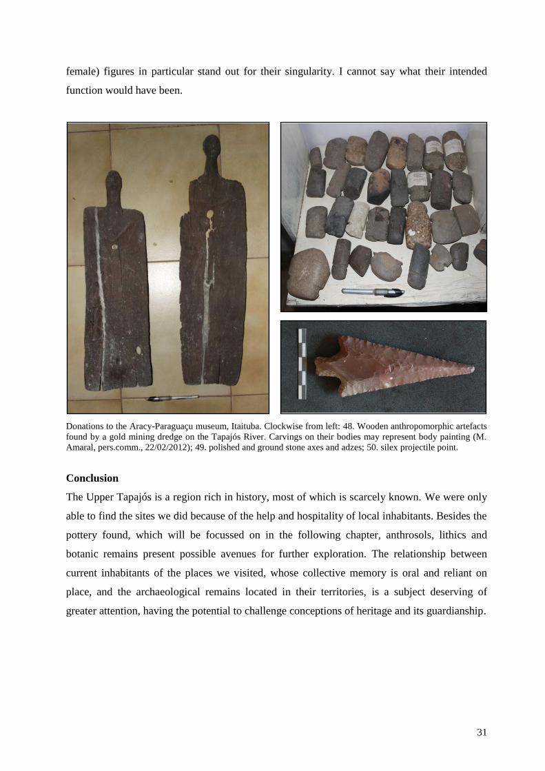
female) figures in particular stand out for their singularity. I cannot say what their intended
function would have been.
Donations to the Aracy-Paraguaçu museum, Itaituba. Clockwise from left: 48. Wooden anthropomorphic artefacts
found by a gold mining dredge on the Tapajós River. Carvings on their bodies may represent body painting (M.
Amaral, pers.comm., 22/02/2012); 49. polished and ground stone axes and adzes; 50. silex projectile point.
Conclusion
The Upper Tapajós is a region rich in history, most of which is scarcely known. We were only
able to find the sites we did because of the help and hospitality of local inhabitants. Besides the
pottery found, which will be focussed on in the following chapter, anthrosols, lithics and
botanic remains present possible avenues for further exploration. The relationship between
current inhabitants of the places we visited, whose collective memory is oral and reliant on
place, and the archaeological remains located in their territories, is a subject deserving of
greater attention, having the potential to challenge conceptions of heritage and its guardianship.

32
4. Pottery from the Upper Tapajós and beyond
Following the collection of pottery and lithics from the Upper Tapajós, we loaded the material onto
a steam boat in Itaituba and took it to the Curt Nimuendajú lab in Santarém, where it is presently
housed. We were able to wash most of the pottery and some of the lithics collected and photograph
some of the diagnostic sherds. Diagnostic sherds were considered thus either because of the part of
the vessel they came from (rim, handle or base) or because they presented decorative (plastic or
painted) elements. The sherds came from three archaeological sites1.
This chapter will present the analysis of the diagnostic pottery collected, compare its decoration to
those of ceramics from nearby areas and the wider region and finally offer an interpretation of what
we might infer from this. Absolute dates are not yet available, so our chrono-
stylistic interpretations are necessarily based on a comparison to the ceramics of other sites in the
region that have been dated, or that through seriation have been assigned to traditions (and therefore
time frames) established for the region; ethnohistorical evidence has also been used to this end.
Methods of ceramic analysis
Diagnostic sherds have been analysed for a number of attributes, the selection of which was related
to the information they could render in relation to technological practices, vessel form and their
1 The Boa Vista site also rendered a few sherds.
Terra Preta do Mangabal
47%
Pajaú 33%
Cocalino 17%
Boa Vista 3%
no. of sherds

33
decoration/design.2 The objective was to reconstruct a basic sequence involving the preparation of
the paste, the forming of the vessel, its decoration and firing. Signs of use-wear (e.g. fire clouds) or
post-depositional features, such as weathering or erosion, were also noted, but will not be
emphasised here. The focus of this work is on ceramic decoration; however, if we can associate this
to specific practices, it may represent a first step towards posterior modal analyses, by giving us
some indication of attributes or combinations of attributes that recur. Our comparisons with pottery
from the wider region may also be stronger if we compare sets of attributes, although this was not
the primary focus of the work. I based my choice of attributes on the Central Amazon Project‟s
pottery analysis form; some dimensions were altered to correspond to the specific characteristics of
the pottery, particularly in relation to decorative dimensions.
The technological attributes3 looked for include temper, its roundness/angularity (a BEL Photonics
binocular microscope with 45x magnification was used); firing atmosphere (indicated by core
colour)4
and surface treatment (i.e. smoothing, burnishing, or polishing). Formal attributes,
including measurements of sherd thickness (using a standard caliper) and estimated diameter of
vessel mouths and bases (using a rim chart) were noted, along with points of inflection, vessel
contour and base and lip shape (when possible). Finally, I analysed the decorative attributes and
techniques of the collection by viewing photographs of each sherd.
The decoration analysis contemplated the following criteria: decorated surface (internal/external),
type of decoration, slip colour, type of painting, paint colour, lip finish, plastic decoration tech-
niques and designs present. “Absent” or “not identified” categories were always listed as an option.
The location and type of decoration was then observed. Plastic decoration techniques looked for
include clay displacement (incision, ungulation, impression, perforation, modelling) and clay addi-
tions. When relevant, these categories were then split further into specific decorative patterns. Inci-
sions (“fish spines”, straight parallel lines, zoned-hachured lines, parallel curved lines); impressions
– divided into punctuation (with rectilineal instrument or round stylus) and cord or fibre impres-
sions –; perforation; and modelling were subsumed under “clay displacement” techniques. Clay ad-
dition was subdivided to specify whether fillets or “blobs” had been applied. I then attempted to ob-
serve the state of paste when the plastic decoration was executed (undetermined, wet/damp, leather
2 Annex 10 displays the lists of attributes considered in the analysis.
3 Technological and formal analyses were conducted by Rogério Andrade dos Santos at the Curt Nimuendajú Lab in
Santarém, supervised by Claide de Paula Moraes. 4 See Annex 11 for reference diagram used for determining firing environment through the examination of cross-section
of vessel walls.

34
hard/dry, post firing, pre slip, post slip). The results of these analyses were entered into a Microsoft
Word Excel spread sheet.
The order in which attributes observed will be referred to aims to reflect the different stages of the
pottery production process. Before the presentations of the results of the ceramic analyses of the
Terra Preta do Mangabal, Pajaú and Cocalino sites, some remarks will be made about the main dec-
orative techniques employed. Due to the small size of the collections analysed, I have given approx-
imate indications of quantities, since providing exact percentages may mislead the reader into a
false sense of security: that the trends observed from such figures are statistically meaningful. The
emphasis here is on qualitative rather than quantitative analysis.
Results
Terra Preta do Mangabal pottery
Pottery analysed from this site comes from the test pit N1000 E1074, from the two main
archaeological levels identified between 10 and 60cm depth.5 Level 0-10cm presented diminutive
sherds, as did the levels below 60cm, after which the change in soil characteristics suggests the
beginning of occupation at the site; sherds found below 60cm may be attributed to the effect of
bioturbations. I identified no obvious differences in attributes to mirror this distinction, so
characteristics from these different layers have been summarised together. Ninety sherds were
analysed from this site.
Rim sherds* 61
Point of inflection 1
Body sherds 28
Total 90
The predominant non-plastic is quartz sand, found on its own or together with cauixí (each of these
was found in a third of the sample).6 Cauixí, caraipé and quartz sand in conjunction were found to
temper just over ten per cent of the sample. The rest of the collection contained the following
mixtures: caraipé and quartz sand; cauixí and grog; quartz and quartz sand; charcoal and quartz
sand; cauixí, charcoal and quartz sand; cauixí, caraipé and grog; cauixí, caraipé, grog and quartz
sand; and cauixí, grog and quartz sand. The shape of the inclusions was mostly rounded.
5 Except from one rim sherd (Plate 3, fig. a).
* One rim sherd belonged to a griddle, so it was also a base sherd (see Plate 1, fig. b). 6 See Annex 11 for a description of cauixí and caraipé.

35
The information we have on form is as yet inconclusive, since morphological attributes were often
not discernible. Thickness of sherds ranged from 15mm to 4mm, although most frequently
thickness was 5mm. Rim diameter varies from 10cm to 47cm, averaging 27cm. Simple
(approximately 10%) and composite (<10%) vessel contours are present. Unrestricted and restricted
shapes were found in almost equal number, in a third of the sample. Rounded and acute inflections
were encountered infrequently (the small size of sherds hampered most identifications). Over half
of the rims examined are direct, while the remainder are everted. Almost half of the rims had flat
lips, followed by rounded lips (approximately a third), pointed lips (over a tenth) and thinned lips
(in approximately five per cent of cases).
Smoothing on both internal and external surfaces predominates, while burnishing and polishing are
rare exceptions. A few fragments were eroded making surface treatment difficult to discern. Plastic
decoration – incision, modelling, impressions (nail) and appliqué – prevails. It was invariably
performed on the exterior of vessel bodies or on rims. Rim lips were frequently nicked (a sixth of
the sample – see Plate 4) and sometimes carved to produce a “serrated” effect (see Plate 5, figs. a-
d). The remainder were flat, rounded or undetermined (a sixth of the sample). One rim – which
seems to be an outlier, possibly made elsewhere – has a modelled lip (see Plate 3, fig. a).
A particular design stands out at this site. It is made up of incised lines, which are cross-hatched at
acute angles forming lozenge (or diamond) shapes (see Plate 1, figs. a-e and Plate 2). Other incised
designs include straight parallel lines (Plate 1, figs. g, j, k).7 Applied vertical fillets were identified
in conjunction with incision, rim nicking and modelling (Plate 2). A wider range of decorative
practices was hinted at by rare specimens. These include a curved incised design (Plate 1, fig. j);
fingernail impressions (e.g. Plate 5, fig. e); fibre impression (followed by coating with a white slip –
Plate 3, fig. b). Modelling was detected only sporadically (Plate 3, figs. a, d, e). Painted decoration
appears to be rare: just two examples were identified. One consists of a dark (probably black)
horizontal line following a straight rim; the second is of reddish/orangey colour whose limits cannot
be defined. White, red and orange slip was recognised (see Plate 3).
Almost ninety per cent of the sherds analysed had oxidised pastes; one ninth of the collection
evidenced a reduced firing environment, while the rest only had reduced nuclei/were incompletely
oxidised.
7 However, because of the small size of the fragments the parallel lines may be misleading.

36
Pajaú pottery
The sherds included here came from the first two levels (0-10 and 10-20cm) of the 1m2 unit (save a
couple of fragments collected from the surface); the remainder were too small and associated to
bioturbations. Two thirds of the sample analysed was decorated.
Rim sherds 37
Body sherds 26
Handle 1
Total 64
Approximately a third of the sherds were tempered solely with quartz sand. Quartz sand mixed with
cauixí was the second most common temper, followed by quartz and quartz sand, and cauixí,
caraipé and quartz sand. Fewer specimens possessed a mixture of cauixí, charcoal and quartz sand,
or grog, cauixí and quartz sand; other variations of these same non-plastics were uncommon but not
absent.
Measurements of sherd thickness ranged from 4mm to 16mm, but most frequently thickness was
7mm. Simple (¼ of sample) and composite (one sixteenth of sample) vessel contours were detected.
A third of the sample was determined to represent unrestricted or restricted vessels. A handle was
found (Plate 6, fig. h); it is likely to have been part of a pair. Rims were either direct or everted. Rim
diameter varied from 14cm to 49cm, 21 to 23cm being the most frequent measures. Lips are mostly
rounded or flat shape (a few pointed and bevelled examples were also recognised).
Smoothing of surfaces was the norm, with polishing rarely identified. Slipping seems to have been
occasional. Decoration – plastic and painted – was observed on exterior vessel walls, on the interior
of everted rims and on lips. Rim and lip decoration seems to have been a relatively common
practice; lips were carved to produce a “serrated” effect (see Plate 7, figs. a, j, k) and everted rims
punctuated (e.g. Plate 7 fig. a). Punctuations are also present on the interior of an inverted rim (Plate
7, fig. i). A distinctive decorative feature present on three sherds consists in the application of clay
fillets, which are subsequently punctuated perpendicularly to the vessel using a rounded or
rectilinear tool (Plate 6, figs. a, b and e). In the three examples found, the fillets were applied
horizontally. Lines of punctuations applied straight onto the vessel surface also occur (Plate 7 figs.
b, c). Incisions are common. The “fish spine” design (Hilbert 1955a) (see Plate 6 fig. c and Plate 7
fig. e) and similar variations (Plate 7, fig. g) can be noted. Parallel incisions also occur, but less
frequently. A single example of a “T”-shaped incision was found (Plate 7, fig. f) but the small size

37
of the sherd means it is not possible to view the whole design. One specimen displays a
combination of rectilinear punctuation and a possible “fish-spine” incision (Plate 7, fig. d). Painting
is not uncommon. Red paint was the most frequently observed (Plate 6, figs. b-d, f, g, and i),
applied in bands which were often curved. One sherd with parallel, curved black lines was collected
(Plate 6, fig. j – this may be an example of resist paint).
The majority of sherds had been fully oxidised (reduced firings were identified in approximately a
sixth of the sample). A few sherds were incompletely oxidised.
Cocalino pottery
Thirty three sherds were analysed from this site. The sample is small and the stratigraphic
provenience of the pottery is imprecise (it was collected from the surface or extracted by digging
auger holes), but the decoration present is worthy of mention.
Rim sherds 17
Body sherds 13
Base sherds 3
Total 33
Almost half of the sample was tempered with cauixí and quartz sand, closely followed by sherds
tempered with quartz sand only. Mixtures of quartz sand, cauixí and caraipé, and caraipé and
quartz sand made up a tenth of the sample each; a single sherd had quartz and quartz sand temper.
Sherd thickness varied from 5mm and 13mm; the most frequent measure was 8mm. The three bases
found are ring shaped. Vessel contour proved difficult to distinguish; it was found to be simple in a
third of the sample and inflected on three occasions. Rim diameter varied from 7cm to 35cm,
although diameters of 22cm to 27cm were more common. Most rims were direct; four were everted.
Just under half of the rims had a rounded lip; flat lips were less common.
All of the fragments had smoothed surfaces. Twenty-one sherds were decorated on exterior vessel
walls, the interior surface of everted rims and on lips. Seventeen sherds have incisions; these could
cover the upper body right up to the rim‟s edge on direct rims (Plate 8 figs. a) or the internal face of
everted rims (Plate 8, fig. b). Parallel incised lines are the most common motif (Plate 8, figs. b and
e).8 Fish spine designs (Plate 8, fig. a) and what appear to be converging isosceles triangles (Plate 8,
8 However, due to the small size of some of the sherds, this may be a misrepresentation in some cases, where designs
that may have been “fish spines” only seem to be parallel.

38
figs. c and d) were also encountered. A small sherd (Plate 8, fig. f) displayed a fragment of what
appears to be a cross-hatch design similar to what was seen at Terra Preta do Mangabal.
Punctuation is apparently rare, being found on one lip (Plate 8, fig. h) as well as on carelessly
applied fillets (Plate 8, fig. g). Although the techniques employed in these instances may be similar
to those employed at the Pajaú site, the final effect is different.
Two thirds of the sherds were fired in an oxidising environment, while a third was fired in a
reductive environment.
Discussion
The main characteristics of the pottery analysed are summarised in the table below. The most
predominant temper used was quartz sand. This is not surprising, considering these sites‟ proximity
to the river and its sandy beaches. Cauixí was also favoured, but rarely on its own. Techniques
involving the displacement or subtraction of clay were employed at the three sites. Cutting –
incision, perforation and carving – was practiced, especially in the form of incision. The irregularity
of some of the incised lines, particularly at the Cocalino and Pajaú sites is owed to the coarse
temper used. Perforation – which entails the instrument being pressed perpendicularly through the
vessel wall – was rarely encountered; in any event it appears to have been employed as a functional,
not decorative, technique, possibly to make colanders (see Plate 7, fig. h). Impression, the pressing
of an instrument “into plastic or, more commonly, leather-hard clay, leaving a negative of its
motif… subsumed under the general term „punctuation‟” (Rye 1981, 92), was particularly favoured
at Pajaú. It appears that clay displacement practices were usually performed when the clay was in a
leather-hard state, because clay overhang was not perceived in the troughs of incised lines or
negatives of punctuations. Additions of clay to the surface of the vessel in the form of coils/fillets,
blobs or other shapes, when the clay of the vessel and of the applique is at roughly the same state –
leather-hard or plastic (Rice 1987, 148) –, were repeatedly noted on the three sites. The effect
produced by these similar techniques was divergent, however.
Painting, particularly in red, seems to have been more prevalent at the Pajaú site. Citing Corrêa
(1984), Guapindaia (1993, 28) mentions a red pigment used by the Tapajó for body painting and for
painting jewellery, cloths and utensils. This pigment was produced by fermenting leaves of the
Caragiru or Carajuru tree, which belongs to the Bignoniaceae family (Arrabidaea chica Verlot)
and dissolving them in oil. Another way of altering the colour of the surface was with the use of or-
ganic carbon, in the form of powdered charcoal from plant extracts, most probably after firing (see

39
Plate 6, fig. j). Slipping was occasionally encountered, especially at TPM. On low-fired pottery,
which is probably our case (although bonfires can quickly reach 900°C [Livingstone Smith 2001]),
Rice (1987, 150) states that slips are usually applied to completely dried wares, directly before fir-
ing and that most “are burnished or polished with a stone to compact and orient particles and to im-
part a luster”.
5.3 Comparisons to ceramic decoration from the wider region
The pottery of Parauá, Lower Tapajós
Aiming to ascertain whether the Tapajós “chiefdom” really was centralised and expansionist,
Gomes (2008, 12) conducted excavations on three archaeological sites in the locality of Parauá,
situated in the hinterland area of the left margin of the Lower Tapajós River. Ceramics dating from
the Formative period (at c. 4400 BP) up to the 17th
century AD were encountered; the author assigns
the bulk of the pottery to the Incised Rim Tradition however (2008, 16-17), which is prior to Tapajó
occupation, while pottery collected related to the Incised Punctuate Tradition is “quantitatively
inexpressive” (2008, 172). The dates obtained underscore this; the most recent is 910 ± 60 BP for
the Terra Preta site (2008, 173), falling within the temporal scope of the Incised Rim Tradition.
51. Pottery from the Lago do Jacaré, Parauá, Lower Tapajós. Adapted from Gomes, 2008, Plate 4, figs, 8, 11 and 23.
Notwithstanding, some of the pottery presented by the author displays decorative techniques and
motifs that are similar to what we found further upstream (fig. 51). These include linear
Site Temper Decorative
field Most prevalent decoration
Firing
atmosphere
TPM Quartz sand; quartz
sand + cauixí
Body and
rims/lips
Incised lozenges or parallel lines. Nicked lips
(isolated or in conjunction with) clay fillets. Oxidising
Pajaú Quartz sand; quartz
sand + cauixí
Body and
rims/lips
Incised fish spines, parallel lines and/or
punctuation. Punctuated clay fillets.
“Serrated” lips. Bands of paint.
Oxidising
Cocalino Quartz sand + cauixí;
quartz sand
Body and
rims/lips Incised parallel lines, fish spines Oxidising
Overall characteristics of pottery analysed.

40
punctuations produced with a rectilinear tool on the internal face of everted rims; what may be
considered “fish spine” incisions (below left) and applied fillets of clay with punctuations (below
centre). These decorative practices are reminiscent of pottery found at the Pajaú and Cocalino sites.
Gomes makes reference to the affinity between some of the pottery she found on the Lago do Jacaré
I site – namely, applied and punctuated fillets of clay – with that identified with the Valloid series in
Venezuela (Gomes 2008, 117; Tarble & Zucchi 1984, see below). This suggests that some of the
pottery she excavated falls outside the period for which dates were obtained (as she acknowledges,
when writing that the area was occupied up to AD 1600 [2008, 16-17]). It also appears that certain
decorative practices from earlier ceramic traditions – such as incisions and impressed punctuations
– may have been assimilated into the Incised Punctuate Tradition; something that had been
postulated before (e.g. Gomes 2002; Lathrap 1970).
Possibly owing to the primacy accorded to vessel form in order to infer function, when describing
and quantifying the decorative attributes of the pottery analysed – which spans millennia – Gomes
conflates the sample, giving us percentages of types of decoration (such as “short simple incisions”)
for each site (2008, 116-117; 141; 153). This is unfortunate as greater detail about when such
decorations were prevalent or in decline, or whether they could be related to particular types of
temper or stratigraphic location would allow us to more accurately assess change or continuity in
such attributes over time and relate them to surrounding areas and their respective time periods.
Although Gomes later states that there was ample stylistic continuity in the sites' utilitarian pottery
(2008, 172), it would still have been useful to separate the components further, relating them to time
periods.
The Tapajós-Trombetas area
The interaction between peoples living around the basins of the Tapajós, Trombetas and Nhamundá
Rivers in the late pre-colonial period is considered as something of a given. Ethnohistorical sources
(e.g. Heriarte 1662, see Introduction) suggested connections and archaeological ceramics from these
areas possess similar features (Gomes 2002; Guapindaia 1993, 2008; P. Hilbert 1955b; P. &
K.Hilbert 1980; Nimuendajú 2004; Palmatary 1960, etc). The nature of the relationship between the
makers of such analogous pottery is still undefined, however, and the geographical limits of these
interactions are also still open to further investigation.
Santarém pottery
The principal expositor of the famous pottery from Santarém and environs was Curt Nimuendajú,

41
who compiled collections for museums (notably the Gothenburg and Goeldi Museums) in the 1920s
(fig. 52). He described it as a testament to the “incredibly lively and bizarre imagination of the
Tapajó women potters... [it] yielded such a profusion of all possible and impossible heads and faces
that it may almost be possible to put together another Noah‟s Ark” (Nimuendaju 2004, 151). He
noted the caryatids as a distinguishing characteristic and that finger impressions were often used to
decorate rims (2004, 125).
52. Ceramic vessels from Santarém collected by Nimuendajú for the Gothenburg Museum. Reproduced from
Nimuendajú, 2004, Plates 193 and 195. Photographs taken by Ferenc Schwetz.
Collections from the Tapajós and Nhamundá-Trombetas areas have since been studied extensively
and provide us with valuable information related to pottery styles and technological practices (e.g.
Gomes 2002; Guapindaia 1993; Palmatary 1960). Citing Ehrenreich, Barata (1968, 87) pointed out
that geometric designs incised into pottery may be stylised animal representations.
53. Pottery from the Nhamundá-Trombetas basin. Left, “fish spine” incised sherds from the Erepecurú River (Rep. from
P. Hilbert 1955a, 32); Right: sherd collected near the Sapuquá lake (Rep. from Nimuendajú 2004, Plate 116, fig. m).
Following fieldwork along the Nhamundá and Trombetas River basins, P. Hilbert (1955a) created
two main pottery groupings, tempered with cauixí and quartz sand respectively. The latter was
restricted to the Trombetas River and its tributary, the Erepecurú River and seemed to be less

42
frequent (1955a, 29-31). Its coarse texture and “fish spine” motif (fig. 53) bears strong resemblance
to pottery from the Cocalino site (Plate 8, fig. a), and some similarity to what was encountered in
the Pajaú site.
P. Hilbert also described the cauixí-tempered Konduri and Globular styles of pottery (1955a, 33-69).
Both of these styles present elaborate plastic decoration, which includes anthropomorphic and
zoomorphic representations. P. Hilbert notes the “pompous application of nicks, incisions and points
or orifices” (1955a, 57) present in both styles. Tripod vessels were also deemed by him to be
diagnostic of pottery from this area (P. Hilbert 1955b). Below (fig. 54), the second “button” in fig. b
recalls that of an outlying rim sherd from Terra Preta do Mangabal (Plate 3, fig. a); the top
illustration of fig. c brings to mind the “serrated” rims found at Pajaú (Plate 7 fig. j and k); the
punctuations illustrated at the top of fig. d remind us of those found at Cocalino and Pajaú.
54. Left: “Typical elements of plastic
decoration, showing several ways of making a
given surface discontinuous. A and B,
buttons. C, fillets. D, incisions”. Above:
Handles belonging to the Konduri style from
Faro and Terra Santa (Reproduced from P.
Hilbert 1955a, 56 and 61).
In a later article, P. and K. Hilbert (1980) describe the Pocó and Konduri pottery complexes,
encountered at the same sites. Pocó pottery is related to the Zoned-Hachured Tradition and dated to
the Formative period (just before and after Anno Domini), being found in the deeper layers of
stratigraphic cuts. On the more superficial levels, within a dark earth context, the Konduri complex

43
was dated to AD 1400 ± 100 and related to the Incised Punctuate Tradition (P. Hilbert & K. Hilbert
1980, 8). Modelled-incised-punctuate decoration (fig. 54), ranging from applied “buttons” and
fillets to complex biomorphic adornos decorated with impressions, perforations and, above all,
punctuations and incisions (1980, 4), is determined to be diagnostic. Further attributes of the
Konduri style are the use of externally strengthened everted rims, producing triangular profiles in
transverse section, and manioc griddles (P. Hilbert & K. Hilbert 1980, 3). The rims of bowls, vessels
and griddles display incised decoration with straight motifs carried out with hard-edged instruments
(1980, 3).
More recently Guapindaia (2008) excavated sites in the Nhamundá-Trombetas area, including the
Boa Vista site worked on by P. Hilbert in the 1950s.9 The radiocarbon dates assigned to Konduri
pottery range from AD 1020 to AD 1450 (Guapindaia 2008, 170-171). By and large P. Hilbert‟s
(1955a) and P. and K. Hilberts‟ findings (1980) were confirmed, although Guapindaia came across
greater volumes of plain, undecorated wares than she had anticipated (2008, 170). She concludes
that it is not yet possible to affirm whether Pocó and Konduri occupations represent distinct
episodes or whether there is continuity between them, since the stratigraphy in some of the areas
excavated is continuous (2008, 185).
Hilbert also drew up a comparison between Santarém and Konduri ceramics (1955a, 72-73).
Guapindaia (1993, 33) later summarised them in a table, some of which is reproduced here:
Santarém Konduri
Moderate use of cauixi as temper Abundant use of cauixi as temper
Moderate use of incisions and adornos on handles Handles almost invariably decorated with punctuation,
nicks and incisions
Abundant use of caryatids Absence of caryatids
Rare presence of tripod vessel sherds Abundant presence of tripod vessel sherds
Hollow rims present Hollow rims absent
Angular pipes with neo-Brazilian decoration Pipes rarely found
Curved and straight incisions used in vessel decoration Solely straight incision used in vessel decoration
Painting executed in manifold colours, with resistant paint Rare vestiges of red paint, which are easy to remove.
This comparison is elucidating in showing that sherds found at the Cocalino and Pajaú sites appear
to have elements in common with both the Konduri (absence of hollow rims, only straight incisions
used to decorate vessels, absence of caryatids) and Santarém styles (vestiges of red paint [Pajaú],
9 This is not the same Boa Vista site as the one visited during our fieldwork. “Boa Vista” (“good view” in Portuguese) is
a common toponym.

44
anular bases [Cocalino]). No pipes or tripod vessel sherds were found whatsoever (which does not
mean they are absent). Interestingly, the Boa Vista and Terra Preta do Mangabal sites each yielded a
singular hollow rim sherd (fig. 55). Linné (1925, 129) considers the process involved during firing
such vessels, when rapid expansion of air inside the rims would lead to it bursting through the paste.
If apertures were not used, the vessels would have to be heated slowly and subsequently cooled
carefully (In: Palmatary 1960, 63). Palmatary (1960) encountered hollow rims on pottery she
classified as distinct from Santarém ceramics (1960, see Plate 85), although she concludes its
makers would have been “familiar with Tapajós ceramic processes… [since] this sherd is hollow
and the technique is excellent” (1960, 65).
55. Hollow rims in profile. Left: Boa Vista site; Right: eroded hollow rim from Terra Preta do Mangabal site (to
facilitate observation, drawing and photo have been included here).
Therefore, although the pottery found at the Cocalino and Pajaú sites is more rudimentary in terms
of paste preparation and decoration, there are motifs and decorative elements in common with those
employed in the Lower Tapajós, Nhamundá and Trombetas Rivers, such as straight line incisions,
applied “buttons” and fillets of clay (which often seem to compose the base line of highly
elaborated Tapajó and Konduri style vessels). some of the elements that compose the Konduri and
Globular style plastic decoration are recognizable to us. Further, the pottery from Cocalino and
Pajaú sites was also encountered within a relatively “shallow” context, suggesting these areas were
occupied relatively recently. Further upstream at Terra Preta do Mangabal, however, our results so
far seem to indicate a more tenuous connection.
Pottery from the Madeira River basin
The Madeira River lies to the west of the Tapajós and provides the Amazon River with its last,
mighty influx of sediments from the Andes. Starting with the work of Eurico Miller (1983), the
upper part of its basin has been the subject of investigations since the 1970s; an almost continuous
sequence of human occupation has been attested there from approximately 8000 BP to the
eighteenth century, with pottery initially dating to c. 2800 BP (Miller et al. 1992). The possible
association of pottery to language stock (namely, Tupi), to the domestication of manioc and other

45
plant species and to the oldest known terras pretas in Amazonia are among the complex questions
being addressed by archaeologists in the area.
Two main ceramic groupings have been identified in the Upper Madeira region: the Jatuarana sub-
Tradition and the Jamarí Tradition. Although plastic decoration, including punctuates, drag-and-jab
punctuate, ungulate, double-line incision feature in the Jatuarana sub-Tradition (dated to 2730 ± 75
BP), these are combined with other elements, such as polychrome painting, monochrome painting,
excised-scraped, pinched, among others, to create varied decorative motifs (Miller 1992, 223-224).
The Jamarí Tradition (dated from 2500 ± 90 BP) displays some decoration, which includes incision,
punctuation, superimposed coils, brushing, and occasional excision, serrungulation and use of
appliqué (Miller 1992, 224-225). Neither of these traditions seems to clearly resonate with the
pottery found by us on the Tapajós. This dissimilarity is also apparent in the more recent research
conducted in the area (fig. 56), which has been revising a number of phases created by Miller
(Almeida 2010, Zimpel Neto 2008, Zuse 2011). However, more work is needed before we can
definitely affirm that no similarities exist.
56. Pottery from the Itapirema archaeological site, on the Madeira River, facing the Jamarí. Reproduced from
Almeida 2010, 121-122. Photographs taken by Agda Sardinha.
On the other hand, the middle and lower courses of the Madeira River have been revealing a
different story. Simões and Lopes (1987) conducted a survey along its course in which they defined
ceramic phases (Axinim and Curralinho) attributed to the Incised Punctuate Tradition. However,
this is currently being questioned by Moraes (2010 and forthcoming), so at present it is not possible
to affirm whether there are common elements or not. It appears that pottery belonging to the
Polychrome Tradition and the Incised Modelled Traditions is prevalent in this area.
Pottery from the Xingu basin
To the east of the Tapajós lies the Xingu River, which like the Tapajós, connects the Amazon plain

46
to Brazil‟s highland shield. The Upper Xingu area, home to the Parque Indígena do Xingu (“Xingu
Indigenous Park”, PIX), created by the Villas Bôas brothers in 1961, has been the subject of
research for a number of years by archaeologist Michael Heckenberger (2005) and students, as well
as by a number of anthropologists. Within the PIX today, speakers of Carib, Gê and Arawak
languages compose a multi-ethnic system.
In his doctoral dissertation, Toney (2012) focuses on ceramic technology from AD 700 to AD 1770.
Toney likens some of the decoration of the “Developmental” period to Arauquinoid pottery (fig. 57)
(2012, 252) and postulates a Carib influence in the “Protohistoric Xingu” period, particularly
because of a chevron motif (fig. 57), which is however engraved rather than incised (2012, 253). He
considers that this discrepancy may be due to the fact that male Carib invaders “may have brought
the style without the skill of execution with them” (2012, 253). This hypothesis is strengthened by
the existence of an origin myth of Carib provenance in the area (Carneiro 1989 In: Toney 2012,
253). Dates related to Carib-related pottery lie at c. AD 1770 (2012, 259). There is some likeness
between the chevron designs and the converging isosceles triangles of the Cocalino and Pajaú sites,
although at Pajaú and Cocalino the body of the vessel was the chosen area, while the pottery of the
MT-FX-02 and MT-FX-13 sites has decorated rims.
57. Left: “Type 2 rims from MT-FX-02 surface collection with incised, engraved and thumbnail punctuate decorations”;
Right: “Type 2 rim adorno (Arauquinoid-like) from TU at MT-FX-13” (Reproduced from Toney 2012, 220 and 206,
respectively).
The Incised Punctuate Tradition has been detected in the Lower Xingu (Perota 1992, 215) in the
form of the Curuá phase, which is always associated to dark earth contexts (1992, 215). Images for

47
this phase were not available, so further comments will have to wait. The Curuá phase is dated to
275 ± 75 BP and 175 ± 55 BP (Perota 1992, 215).
Nimuendajú did however produce images of pottery he collected from the Xingu area (fig. 58)
during his travels, from 1917-21 (2004, 112). The Iriri River is a tributary of the Xingu, and on the
map produced by Perota (1992, 214), the Curuá phase is identified near its mouth. Nonetheless,
these are speculations that will have to await further evidence.
58. Left: Applied fillet with punctuation in
sigmoid form from the Lower Iriry, Xingu
area; Right: rim found in Altamira. (Adapted
from Nimuendaju 2004, Plates 54 and 55,
226 & 227).
Pottery from the Orinoco basin
59. Left: “Applied/incised, incised & modelled decoration of Valloid material. From Orupe (A, D, E, F), Paragüito del
Meta (B, C), El Valle (G, H, I), Agüerito (J, K, L, M) sites”. Right: “Applied/incised decoration of the Valloid material.
Sites: Cerro Aislado (A, D, E, H, I), Buena Vista (B, C, G), La Urbana (F)” (Rep. from Tarble & Zucchi 1984, 437).
Along the middle Orinoco River and its hinterland, a number of sites were encountered in which

48
pottery attributed to the Valloid series, dated to AD 900-1000, was found; its makers could have
been a Carib-speaking subgroup related to Carib speakers from western Guayana (Tarble & Zucchi
1984). Among the most prominent characteristics of this pottery are punctuated or notched applied
fillets (1984, 438) – a characteristic which bears clear correlation to sherds encountered at Pajaú
(Plate 6 figs. a, b, and e). Valloid ceramics are also found in association with pottery of the
Arauquinoid series, at times incorporating some of the latter‟s elements (1984, 440). The authors
note that incision is usually found in conjunction with applied fillets; its isolated presence seems to
be a later occurrence (1984, 438). Valloid pottery is also composed of handles and zoomorphic
adornos (1984, 437). Interestingly, no (manioc) griddles were found (1984, 436). Zucchi (1985, 37)
also describes the Valencioide series, whose features – sand and mica coarse-tempered pottery
decorated with appliqué and anthropomorphic and zoomorphic figures, combined with “clearly
Arauquinoid” incisions and punctuations – appear familiar to much of the pottery previously
described. I have not seen images however so this will have to await further investigation.
Interpretation of results
Pajaú and Cocalino
The pottery we encountered in the environs of Itaituba displays some common features with the
ceramics from Santarém, as it does with those from the Nhamundá and Trombetas Rivers, and (in
the case of Pajaú) with the Valloid series on the middle Orinoco. It seems reasonable to assert that
this pottery belongs to the Incised-Punctuate Tradition. Lathrap (1970) wrote that Carib speakers
colonised new areas through “raiding parties of young men who attacked the neighbouring peoples.
All adult males of the conquered villages were barbequed and eaten while the more desirable
women were taken as wives” (1970, 164). This would help to explain why – “if it is correct to
assume that art style and ceramic technology were feminine domains” (1970, 164) – many aspects
of Carib culture were transmitted in a “poorly understood and garbled form” (1970, 165). Zucchi
(1985) argues that the period from approximately AD 1000 was one of “domination” by Carib-
speaking groups of other areas.
Available dates for Santarém, Konduri and Valloid ceramics lead us to conclude that pottery on the
Pajaú and Cocalino sites was produced over the last six hundred years; already in the 1960s, Hilbert
(1968) observed that “all ceramic complexes connected with this [Incised Punctuate] horizon… are
always late in local sequences” (P. Hilbert 1968, 272). In fact, Pajaú and Cocalino pottery may have
been made in the post-conquest period by fugitives from Santarém, following devastating
incursions by the Portuguese. Barbosa Rodrigues (1875. 130) states that Portuguese violence made
the Tapajó flee to the interior and upstream. The comparatively impoverished decoration and
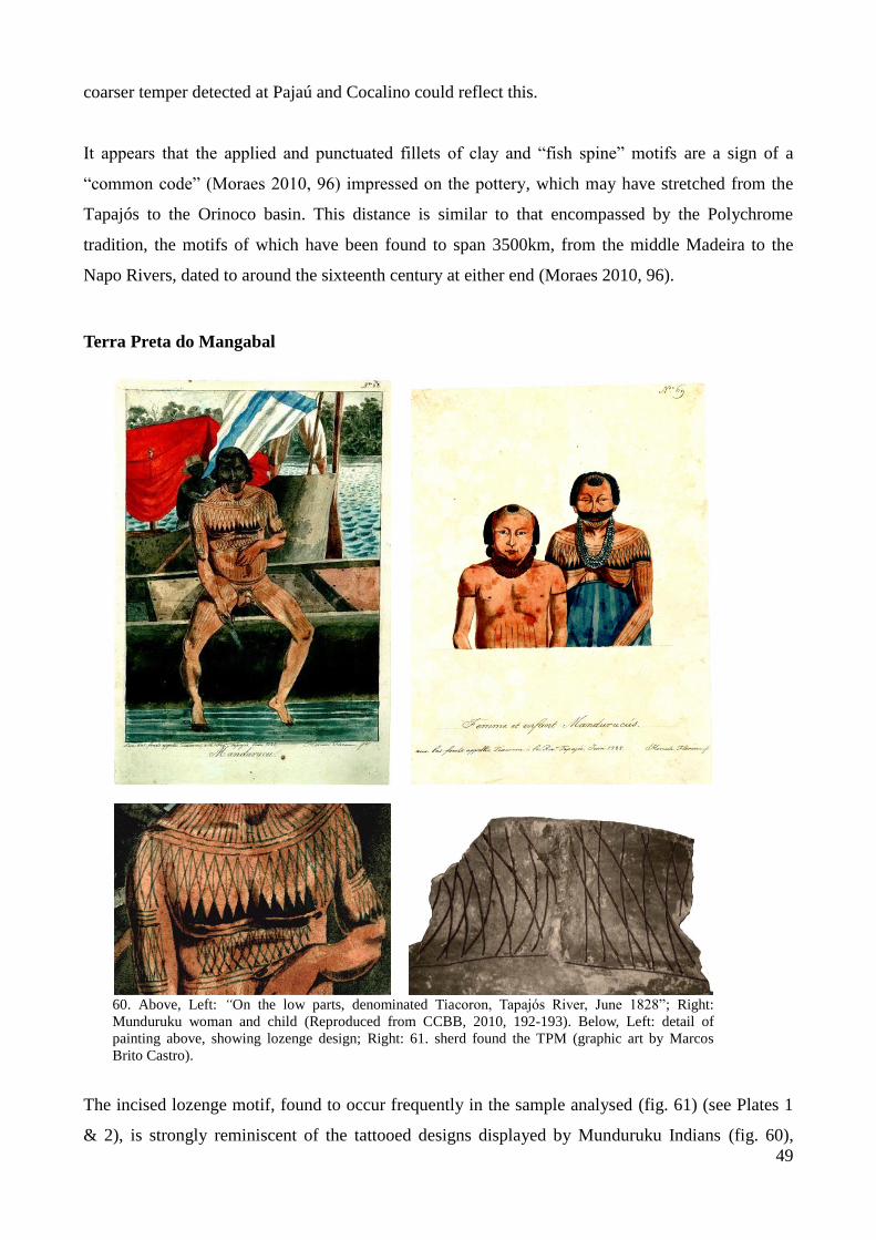
49
coarser temper detected at Pajaú and Cocalino could reflect this.
It appears that the applied and punctuated fillets of clay and “fish spine” motifs are a sign of a
“common code” (Moraes 2010, 96) impressed on the pottery, which may have stretched from the
Tapajós to the Orinoco basin. This distance is similar to that encompassed by the Polychrome
tradition, the motifs of which have been found to span 3500km, from the middle Madeira to the
Napo Rivers, dated to around the sixteenth century at either end (Moraes 2010, 96).
Terra Preta do Mangabal
60. Above, Left: “On the low parts, denominated Tiacoron, Tapajós River, June 1828”; Right:
Munduruku woman and child (Reproduced from CCBB, 2010, 192-193). Below, Left: detail of
painting above, showing lozenge design; Right: 61. sherd found the TPM (graphic art by Marcos
Brito Castro).
The incised lozenge motif, found to occur frequently in the sample analysed (fig. 61) (see Plates 1
& 2), is strongly reminiscent of the tattooed designs displayed by Munduruku Indians (fig. 60),

50
suggesting what DeBoer (1991, 147) has termed a “total artifactual environment” of pervasive
design. Information recorded in the nineteenth century by travellers to the Tapajós (see
introduction) corroborates this supposition. Chandless (1862) produced a map of the river (fig. 62),
and over the Mangabal area, the words “Mundurucú Vil.” are written (1862, 268); he states that “At
the shallow of Mangabal Grande… the hills on each side are of some height, and here and there the
hill-tops are open campo [fields/grassland]. A little below the Mangabal are two or three Mundrucús
[sic.] villages on the left bank, and the last on that side, as the Maué country begins soon below”
(1862, 277).
Left: 62. map produced by William
Chandless displaying the location of ethnic
groups along the Tapajós. The circle
encompasses the TPM site area (Adapted
from Chandless, 1862). Above: 63.
“Mundurucu tattoos: „captain‟ Gabriel”.
The artist has Europeanised the facial
features of “captain Gabriel” (Reproduced
from Coudreau 1977 [1895], 110, etching
n. 34).
Chandless also writes about Munduruku body ornamentation, stating that their faces were
“blackened all over, and the whole body tattooed in a check-pattern of black stripes” (1862, 277), as
we can see in Florence‟s watercolours. Tocantins (1877) explains how he recognised a family he

51
encounters as being Munduruku: “they were all painted on their face, chest and on all their bodies,
with the lozenges and other figures characteristic of the tribe” (1877, 76). He comments that these
tattoos are related to the Munduruku myth of origin (1877, 115).
Based on compiled information, Barbosa Rodrigues (1875) also offers descriptions of the
Munduruku, who he characterises as “…the most numerous and warlike [ethnic group] of the
Amazon Valley, and the most accomplished in feather work” (1875, 134-135). He explains that the
tattooed geometric pattern (fig. 60 & 62), which takes up to twenty years to complete, is always the
same, although some may have more lines, because these “are indicative of services they rendered
to the tribe. Some, in spite of their age, are not covered in paint, because they did not render
services that lead to painting” (1875, 136). Barbosa Rodrigues also mentions the existence of
Munduruku malocas (indigenous houses) along the course of the river, remarking that the ones
around the Mangabal rapid are abandoned (1875, 124).
However, given the depth of the dark earth found at the site, we may find that the Munduruku
reoccupied the area; this would resonate with the known predilection of the Munduruku today for
reoccupying areas of dark earth [PPTAL 2008, 25]).
Conclusion
It appears probable that the TPM site was occupied by Munduruku speakers, possibly in the post-
colonial period.10
As for the Cocalino and Pajaú sites, they indicate the existence of interactions
with occupations further downstream and beyond the north bank of the Amazon. At present it is not
possible to ascertain the nature of such interactions; further excavations and the knowledge of dates
will be necessary for this.
We may find that these three sites are contemporaneous. The outlying rim sherd (Plate 3, fig. a),
whose features are more akin to what is known from the Incised Punctuate Tradition (applied
“blob”, modelled rim), found on the surface of the TPM site seems to point to contact with people
further downstream.
10
Munduruku is a language family that belongs to the Tupi language stock.

52
5. Conclusion
Amerindian art is a “vehicle of aesthetic visual communication” in which “even the most
individualised manual talents are very much shared by the population: things are made by
local artisans through processes known by all” (Vidal & Lopes da Silva 2007 [1992], 281).
This premise has guided the choice of ceramic decoration as the subject of this research.
Comparisons to ceramic decoration encountered in other areas were based on the idea that
“borrowing is most likely to occur over a wide range of phenomena between cultures that
share similar dimensions-modes/grammars” (Roe 1976, 77).
We have found that pottery from the Pajaú and Cocalino sites, located south of Itaituba,
beyond the first rapids of the Upper Tapajós, share decorative elements with ceramics from
the Incised Punctuate Tradition – encompassing the Lower Tapajós, the Nhamundá-
Trombetas and parts of the Xingu and Orinoco River basins. This tradition has been
associated with speakers of Carib languages and their expansion from the Orinoco basin
(Cruxent & Rouse 1958, Lathrap 1970, Zucchi 1985). Further, the stratigraphic location of
the sherds analysed – found on the surface of the sites or in their uppermost layers – suggest
their relatively recent deposition when compared to pottery from older ceramic traditions in
Amazonia, which fits with the Incised Punctuate tradition’s chronology, dated to c. AD 1000
in northern South America and to around the fifteenth century in nearby areas in the Amazon.
This in turn has led us to speculate about whether the pottery worked on from Pajaú and
Cocalino was pre- or post-colonial.
In contrast, the pottery analysed from the Terra Preta do Mangabal site belongs to a different
tradition that has yet to be defined; it does not seem to possess decorative elements in
common with pottery from Pajaú and Cocalino, in spite of similar techniques and technology
employed. The recurrent lozenge motif, incised on vessel bodies and rims, is strikingly akin
to Munduruku body ornamentation in the form of tattooing. Accounts written by nineteenth
century travellers to the Upper Tapajós have strengthened this supposition, through their
description of the Munduruku tattooing process and its meanings, and through statements to
the effect that the area in which the Terra Preta do Mangabal site is located was occupied by
Mundurukus.
The bellicose incursions of the Munduruku into neighbouring territories made them feared
throughout the Tapajós; the first written accounts on the subject date from the eighteenth

53
century. This opens up the possibility that the TPM, Pajaú and Cocalino sites may in fact be
contemporaneous. As peoples downstream suffered the debilitating effects of European
conquest, they were attacked by the Munduruku “red ants”.
In the following stages of research a number of questions will need to be explored. The
association of Carib speakers to the Incised Punctuate Tradition in the Amazon is a critical
issue, and may bring us closer to postulating which language stock the Tapajó Indians of the
Lower Amazon belonged to. The nature of the interactions signalled by common decorative
elements must similarly be investigated – could they have been intermarital, commercial,
belligerent?
Following DeBoer’s (2003) example, the study of vessel forms will have to be conducted:
their comparison to forms of older known complexes will aid us in understanding longer term
continuities and ruptures in subsistence base and feasting patterns, for instance. The study of
the area’s rich lithic record, which stretches from pre-ceramic times into the sixteenth
century, will also contribute to this longer term perspective. Greater attention must also be
given to archaeological sites themselves, so that changes in population density or settlement
patterns may be perceived. Continuing the survey of the region is therefore a priority.
Ironically, this may soon take place as part of the archaeological salvage work preceding the
planned construction of hydroelectric dams along the river. The predominant assumption that
only archaeological heritage buried underground is legitimate and worthy of “rescue” and
preservation, however, means that while new sites will be found, forest peoples – inheritors
of the past we are studying and who live on or by the sites we will work on – will be
displaced. This calls for a longer term involvement in the area and work with local peoples in
valuing their ways of life and heritage.
As an initial step in determining interactions with peoples in adjacent areas and further afield,
ceramic decorations have much to tell about societies on the Upper Tapajós in the pre- and
post-colonial period. It has become clear that the Tapajós was an area marked by cultural and
linguistic diversity at the time of European conquest; upstream it was inhabited by the
Munduruku (whose language family is a branch of the Tupi language stock), while the Pajaú
and Cocalino sites may represent the Incised Punctuate Tradition’s southernmost limits as
regards the Tapajós River; the implications of this warrant further investigation.
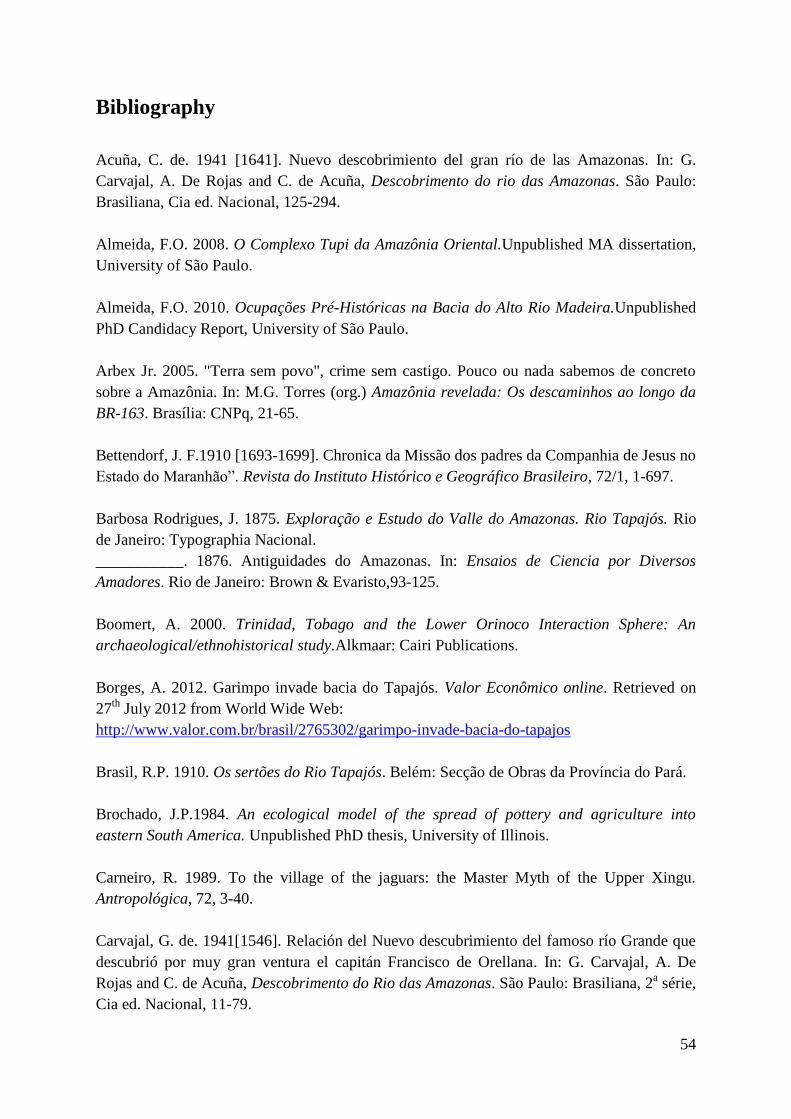
54
Bibliography
Acuña, C. de. 1941 [1641]. Nuevo descobrimiento del gran río de las Amazonas. In: G.
Carvajal, A. De Rojas and C. de Acuña, Descobrimento do rio das Amazonas. São Paulo:
Brasiliana, Cia ed. Nacional, 125-294.
Almeida, F.O. 2008. O Complexo Tupi da Amazônia Oriental.Unpublished MA dissertation,
University of São Paulo.
Almeida, F.O. 2010. Ocupações Pré-Históricas na Bacia do Alto Rio Madeira.Unpublished
PhD Candidacy Report, University of São Paulo.
Arbex Jr. 2005. "Terra sem povo", crime sem castigo. Pouco ou nada sabemos de concreto
sobre a Amazônia. In: M.G. Torres (org.) Amazônia revelada: Os descaminhos ao longo da
BR-163. Brasília: CNPq, 21-65.
Bettendorf, J. F.1910 [1693-1699]. Chronica da Missão dos padres da Companhia de Jesus no
Estado do Maranhão”. Revista do Instituto Histórico e Geográfico Brasileiro, 72/1, 1-697.
Barbosa Rodrigues, J. 1875. Exploração e Estudo do Valle do Amazonas. Rio Tapajós. Rio
de Janeiro: Typographia Nacional.
___________. 1876. Antiguidades do Amazonas. In: Ensaios de Ciencia por Diversos
Amadores. Rio de Janeiro: Brown & Evaristo,93-125.
Boomert, A. 2000. Trinidad, Tobago and the Lower Orinoco Interaction Sphere: An
archaeological/ethnohistorical study.Alkmaar: Cairi Publications.
Borges, A. 2012. Garimpo invade bacia do Tapajós. Valor Econômico online. Retrieved on
27th
July 2012 from World Wide Web:
http://www.valor.com.br/brasil/2765302/garimpo-invade-bacia-do-tapajos
Brasil, R.P. 1910. Os sertões do Rio Tapajós. Belém: Secção de Obras da Província do Pará.
Brochado, J.P.1984. An ecological model of the spread of pottery and agriculture into
eastern South America. Unpublished PhD thesis, University of Illinois.
Carneiro, R. 1989. To the village of the jaguars: the Master Myth of the Upper Xingu.
Antropológica, 72, 3-40.
Carvajal, G. de. 1941[1546]. Relación del Nuevo descubrimiento del famoso río Grande que
descubrió por muy gran ventura el capitán Francisco de Orellana. In: G. Carvajal, A. De
Rojas and C. de Acuña, Descobrimento do Rio das Amazonas. São Paulo: Brasiliana, 2a série,
Cia ed. Nacional, 11-79.

55
Chandless, W. 1862. Notes on the Rivers Arinos, Juruena, and Tapajos. Journal of the Royal
Geographical Society of London, 32, 268-280.
Chernela, J. 1992. Social Meaning and Material Transaction: The Wanano-Tukano of Brazil
and Colombia. Journal of Anthropological Archaeology, 11, 111-124.
Corrêa, M.P. 1984. Dicionário das plantas úteis do Brasil e das exóticas cultivadas. Rio de
Janeiro: Imprensa Nacional, Ministério da Agricultura, Instituto Brasileiro de
Desenvolvimento Florestal.
Coudreau, H. 1977 [1897]. Viagem ao Tapajós. Belo Horizonte: Itatiaia.
Cruxent, J. M. and Rouse, I. 1958. An Archaeological Chronology of Venezuela, vol. 1.
Washington D.C.: Pan American Union, Social Science Monographs 6.
DeBoer, W. 1991. The Decorative Burden: Design, Medium, and Change. In: W.A. Longacre
(ed.), Ceramic Ethnoarchaeology. Tucson: University of Arizona Press, 144-161.
___________. 2003. Ceramic Assemblage Variability in the Formative of Ecuador and Peru.
In: J. Scott Raymond and R.L. Burger (eds.), Archaeology of Formative Ecuador.
Washington D.C.: Dumbarton Oaks Research Library and Collection, 289-336.
Denevan, W. 1992. The Pristine Myth: The landscape of the Americas in 1492. Annals of the
Association of American Geographers, 82/3, 369-385.
Ford, J. 1954. On the Concept of Types: The Type Concept Revisited. American
Anthropologist, New Series, 56/1, 42-57.
Gomes, D.C. 2002. Cerâmica Arqueológica da Amazônia. São Paulo: Fapesp, Edusp,
Imprensa Oficial.
___________. 2008. Cotidiano e Poder na Amazônia Pré-colonial. São Paulo: Edusp,
Fapesp.
Guapindaia, V.L.C. 1993. Fontes Históricas e Arqueológicas sobre os Tapajó de Santarém:A
Coleção “Frederico Barata” do Museu Paraense Emílio Goeldi.Unpublished MA
Dissertation, Federal University of Pernambuco.
___________. 2008. Além da margem do rio – a ocupação Konduri e Pocó na região de
Porto Trombetas, PA. Unpublished PhD thesis, University of São Paulo.
Heckenberger, M.J. 2005. The Ecology of Power: Culture, Place, and Personhood in the
Southern Amazon, AD 1000–2000. New York: Routledge.
Heriarte, M. 1874 [1662]. Descrição do Estado do Maranhão, Pará, Corupá e Rio das
Amazonas. Vienna: Carlos Gerold.
56
Hilbert, P.P. 1955a. A Cerâmica Arqueológica da Região de Oriximiná. Belém: Instituto de
Antropologia e Etnologia do Pará, publicação n. 9.
___________. 1955b. Tripods in the Lower Amazon. In: Proceedings of the XXXI
International Congress of Americanists, São Paulo, 825-828.
___________. 1957. Urnas Funerárias do Rio Cururú, Alto Tapajós. Boletim do Museu
Paraense Emílio Goeldi, Nova Série Antropologia, n. 6, 1-14.
___________.1968. Archäologische Untersuchungen am Mittleren Amazonas. Berlin:
Dietrich Reimer Verlag.
Hilbert, P.P. and Hilbert, K. 1980. Resultados preliminares da pesquisa arqueológica nos rios
Nhamundá e Trombetas, Baixo Amazonas. Boletim do Museu Paraense Emilio Goeldi, Nova
série Antropologia, n. 75, 1-15.
Kern, D.C.; D’Aquino, G.; Rodrigues, T.E.; Franzão, F.J.L.; Sombroek, W.; Myers, T.P.;
Neves, E.G. 2003. Distribution of Dark Earths in the Brazilian Amazon. In: J. Lehmann; D.C.
Kern; L. German; J. McCann; C.C. Martins and A. Moreira (eds.), Amazonian Dark Earths:
Origin, Properties, Management. Dordrecht: Kluwer Academic, 51-76.
Kroeber, A.L. 1944. Peruvian archaeology in 1942. New York: Viking Fund Publications in
Anthropology, n. 4.
Lathrap, D.W.1970. The Upper Amazon. London: Thames and Hudson.
Lima, H.P; Neves, E.G.; Petersen, J. 2006. A fase Açutuba: um novo complexo ceramico na
Amazônia Central. Arqueologia Sul-Americana, 2/1, 26-52.
Lima, H.P. 2008. História das Caretas: A Tradição Borda-Incisa na Amazônia Central.
Unpublished PhD thesis in Archaeology, University of São Paulo.
Linné, S. 1925. The technique of South American ceramics. Gothenburg: Elanders
Boktryckeri Aktiebolag.
Livingstone-Smith, A. 2001. Bonfire II: The Return of Pottery Firing Temperatures. Journal
of Archaeological Science, 28, 991-1003.
Lowie, R. 1948. The tropical forests: an Introduction. In: J. Steward (ed.), Handbook of South
American Indians. The Tropical Forest Tribes. vol. 3. Bulletin n. 143, Bureau of American
ethnology. Washington D.C.: Smithsonian Institution.
Martins, C. M. P.; Lima, A. M. A.; Schaan, D. P.; Bezerra, I. A.; Veiga e Silva, W. F. 2010.
Padrões de sepultamento na periferia do domínio Tapajó. Amazônica, 2/1, 137-139.
Martins, C. M. P. 2012. Sobre contatos e fronteiras: um enfoque arqueológico. Amazônica,
4/1, 150-184.

57
Meggers, B. and Evans, C. 1961. An experimental formulation of horizon styles in the
Tropical Forest Area of South America. In: S.K. Lothrop (ed.), Essays in Pre-Columbian Art
and Archaeology. Cambridge: Harvard University Press, 372-288.
___________. 1983 [1978]. Lowland South America and the Antilles. In: J. Jennings (ed.),
Ancient South Americans. San Francisco: W. H. Freeman and Co, 287-336.
Meggers, B. 1997. La cerámica temprana en América del Sur: ¿Invención independiente o
difusión? Revista de Arqueología Americana, 13, 7-40.
Menèndez, M. 2006 [1992]. A área Madeira-Tapajós: situação de contato e relações entre
colonizador e indígenas. In: M.C. da Cunha (ed.), História dos Índios no Brasil. São Paulo:
Companhia das Letras, 281-296.
Miller, E.T. 1983. História da Cultura Indígena do Alto-Médio Guaporé (Rondônia e Mato
Grosso). Unpublished MA dissertation, Pontífica Universidade Católica, Rio Grande do Sul.
Miller, E.T. 1992. Archaeology in the Hydrolectric projects of Eletronorte. Brasília:
Eletronorte.
___________. 1992. Adaptação agrícola pré-histórica no alto rio Madeira. In: B.J. Meggers
(ed.), Prehistoria Sudamericana:Nuevas Perspectivas. Washington D.C.: Taraxacum, 219-
231.
Moraes, C.P. 2010. Arqueologia Regional na Amazônia Central: A fase Paredão e sua
inserção no contexto pré-colonial Amazônico. Unpublished PhD Candidacy Report,
University of São Paulo.
Morais, R. 2008. Águas Brancas, Pretas e Verdes. In: A. Ab’Saber (ed.), Leituras
Indispensáveis. São Paulo: Ateliê Editorial, 57-63.
Murphy, R.F. 1958. Headhunter’s heritage – social and economic change among the
Mundurucu indians. Berkeley: University of California Press.
Neves, E. G. 2000. Levantamento Arqueológico na Área de Confluência dos Rios Negro e
Solimões, Estado do Amazonas. Unpublished report submitted to FAPESP-MAE, University
of São Paulo.
Nimuendaju, C.U. 1944. Mapa Etno-Histórico de Curt Nimuendaju. Rio de Janeiro: Instituto
Brasileiro de Geografia e Estatística.
___________. 1952. The Tapajó. Translated and edited by John Howland Rowe. Berkeley:
The Kroeber Anthropological Society.
___________. 2001 [1929-1932]. Excursões pela Amazônia. Translated from German by
Thekla Hartmann. Revista de Antropologia da Universidade de São Paulo, 44/1, 189-200.

58
___________. 2004. In Pursuit of a Past Amazon: Archaeological Researches in the
Brazilian Guyana and in the Amazon Region. A posthumous work compiled and translated by
Stig Rydén and Per Stenborg. Gothenburg: Etnologiska Studier 45.
Orton, C. 2000. Sampling in Archaeology. Cambridge: Cambridge University Press.
Palmatary, H.C. 1960. The Archaeology of the Lower Tapajós Valley: Brazil. Transactions
of the American Philosophical Society, New Series, n. 50.
Petersen, J.B.; Neves, E.G; Heckenberger, M.J. Gift from the Past: Terra Preta and
Prehistoric Amerindian Occupation in Amazonia. In: C. McEwan; C. Barreto; E.G. Neves
(eds.), Unknown Amazon: Culture in Nature in Ancient Brazil. London: British Museum
Press, 86-107.
Perota, C. 1992. Adaptação agrícola no baixo Xingu. In: B.J. Meggers (ed.), Prehistória
Sudamericana: Nuevas Perspectivas. Washington D.C.: Taraxacum.
Projeto Integrado de Proteção às Populações e Terras Indígenas da Amazônia Legal. 2008.
Levantamento Etnoecológico Terra Indígena Munduruku. Brasília: FUNAI/PPTAL/GTZ.
Ramos, A. 2003. Munduruku. Nome e língua. Enciclopédia dos Povos Indígenas no Brasil
online. Retrieved on 11th September 2012 from World Wide Web:
http://pib.socioambiental.org/pt/povo/munduruku/794
Rice, P.M. 1987. Pottery Analysis. Chicago and London: The University of Chicago Press.
Rye, O.S. 1981. Pottery Technology. Principles and Reconstruction. Washington D.C.:
Taraxacum.
Rocha, B.C.; Honorato, V.E. 2011. Levantamento Arqueológico nas Localidades de
Montanha e Mangabal, Município de Itaituba (PA). Unpublished report submitted to the
IPHAN.
Roe, P.G. 1976. Archaism, form and decoration: an ethnographic and archaeological case
study from the Peruvian montaña. Ñawpa Pacha: Journal of Andean Archaeology, 14, 73-
94.
Roosevelt, A.C.; Lima da Costa, M.; Lopes Machado, C.; Michab, M.; Mercier, N.; Valladas,
H.; Feathers, J.; Barnett, W.; Imazio da Silveira, M.; Henderson, A.; Silva, J.; Chernoff, B.;
Reese, D.S.; Holman, J.A.; Toth, N.; Schick, K. 1996. Paleoindian Cave Dwellers in the
Amazon: The Peopling of the Americas. Science, New Series, 272/5260, 373-384

59
Rossetti, D.F.; Toledo, P.M.; Moraes-Santos, H.M.; Santos Jr., A.E.A. 2004. Reconstructing
habitats in central Amazonia using megafauna, sedimentology, radiocarbon, and isotope
analyses. Quaternary Research, 61, 289-300.
Sampaio, F.X.R. de. 1825 [1775]. Diário de uma viagem que em visita, e correição das
povoações da capitania de S. José do Rio Negro fez o ouvidor e intendente geral da mesma,
Fco. Xavier Ribeiro de Sampaio, nos annos de 1774 e 1775. Lisbon: Tipografia da Academia
Real de Ciências.
Sassaman, K.E. 1998. Crafting Cultural Identity in Hunter-Gatherer Economies. In: C.L.
Costin and R.P. Wright (eds.), Craft and Social Identity. Arlington: American
Anthropological Association, 93-107.
Schaan, D.P. 2004. The Camutins Chiefdom: Rise and Development of social complexity on
Marajó Island, Brazilian Amazon. Unpublished PhD thesis, University of Pittsburgh.
___________. 2007. Uma janela para a história pré-colonial da Amazônia: olhando além – e
apesar – das fases e tradições. Boletim do Museu Paraense Emílio Goeldi. Ciências Humanas,
2/1, 77-89.
Silva, F.A. 2008. Ceramic Technology of the Asurini do Xingu, Brazil: An
Ethnoarchaeological Study of Artifact Variability. Journal of Archaeological Method Theory,
15, 217–265.
Simões, M.F. 1976. Nota sobre duas pontas-de-projétil da Bacia do Tapajós (Pará). Boletim
do Museu Paraense Emílio Goeldi. Nova Série. Antropologia, n. 62.
___________.1983. Pesquisa e Cadastro de Sítios Arqueológicos na Amazônia Legal
brasileira 1978-1982. Publicações Avulsas do Museu Paraense Emílio Goeldi, 38, 57-60.
Simões, M.F. and Lopes, D.F. 1987. Pesquisas arqueológicas no baixo/medio Rio Madeira
(Amazonas). Revista de Arqueologia, 4/1, 117-133.
Steward, J. (ed.). 1940-50. Handbook of South American Indians. Bulletin n. 143, Bureau of
American ethnology. Washington D.C.: Smithsonian Institution.
Tarble, K.L. and Zucchi, A. 1984. Nuevos Datos sobre la Arqueología Tardía del Orinoco:
La Série Valloide. Acta Científica Venezolana, 35, 434-445.
Tocantins, A.M.G. 1877. Estudos sobre a Tribu “Mundurucú”. Revista Trimestral do Instituto
Histórico Geográfico Brasileiro, 73-161.
Toney, J.R. 2012. The Product of Labor: Pottery Technology in the Upper Xingu, Southern
Amazon, Brazil, A.D. 700-1770. Unpublished PhD Thesis, University of Florida.

60
Torres, M. (ed.). 2005. Amazônia Revelada. Os descaminhos ao longo da BR-163. Brasília:
Centro Nacional de Pesquisas.
___________. 2008. A beiradeira e o grilador: ocupação e conflito no Oeste do Pará.
Unpublished MA dissertation, University of São Paulo.
Torres, M. and Figueiredo, W. 2005. Yellowstone Paroara. Uma discussão sobre o papel das
Unidades de Conservação e o exemplo do Parque Nacional da Amazônia. In: M. Torres (ed.),
Amazônia Revelada. Os descaminhos ao longo da BR-163. Brasília: Centro Nacional de
Pesquisas, 321-395.
Urban, G. 2006 [1992]. A história da cultura brasileira segundo as línguas nativas. In: M.C.
Cunha (ed.), História dos Índios no Brasil. São Paulo: Companhia das Letras, 87-102.
van der Leeuw, S. 1993. Giving the potter a choice: conceptual aspects of pottery techniques.
In: P. Lemmonier (ed.), Technological Choices: transformation in material cultures since the
Neolithic. London: Routledge, 238-288.
Vidal, L. and Lopes da Silva, A. 2005 [1992]. Antropologia estética: enfoques teóricos e
contribuições metodológicas. In: L. Vidal (ed.), Grafismo Indígena. São Paulo: Studio Nobel,
Fapesp, Edusp, 279-293.
White, L. 1949. The Science of Culture: A study of man and civilization. New York: Grove
Press.
Willey, G. and Phillips, P. 1958. Method and Theory in American Archaeology. Chicago:
University of Chicago.
Zimpel Neto, C. A. 2008. Na Direção das Periferias Extremas da Amazônia: Arqueologia na
Bacia do Rio Jiparaná, Rondônia. Unpublished MA Dissertation, University of São Paulo.
Zucchi, A. 1985. Evidencias arqueológicas sobre grupos de posible lengua Caribe.
Antropológica, 63-64, 23-44.
Zuse, S. 2011. Ocupações pré-coloniais e variabilidade cerâmica nos sítios arqueológicos do
Alto rio Madeira, Rondônia. Unpublished PhD Candidacy Report, University of São Paulo.
Images and Maps:
Advert by Queiroz Galvão construction company announcing the birth of Juarez Furtado de
Araújo Transamazônico. Realidade magazine, 1971, 316 , “Amazonia”. In: M. G. Torres,
2008. A beiradeira e o grilador: ocupação e conflito no Oeste do Pará. Unpublished MA
dissertation, University of São Paulo, 287.

61
Florence, H. Aux bas-fonds appellés Tiacoron, à la Riv. Tapajós, Juin 1828; Femme et enfant
Mandurucús. In: CCBB, Expedição Langsdorff. São Paulo: Centro Cultural Banco do Brasil,
2010, 192-193.
Map in Introduction, p. 7 adapted by Vinicius Honorato from Natural Earth online website.
Retrieved on 16th September 2012 from the World Wide Web:
http://www.naturalearthdata.com/
Maps in Annexes 4 and 7 adapted by Vinicius Honorato from Miranda, E. E. de. 2005. Brasil
em Relevo. Campinas: Embrapa Monitoramento por Satélite. Retrieved on 1st October 2011
from World Wide Web: http://www.relevobr.cnpm.embrapa.br/

Appendix
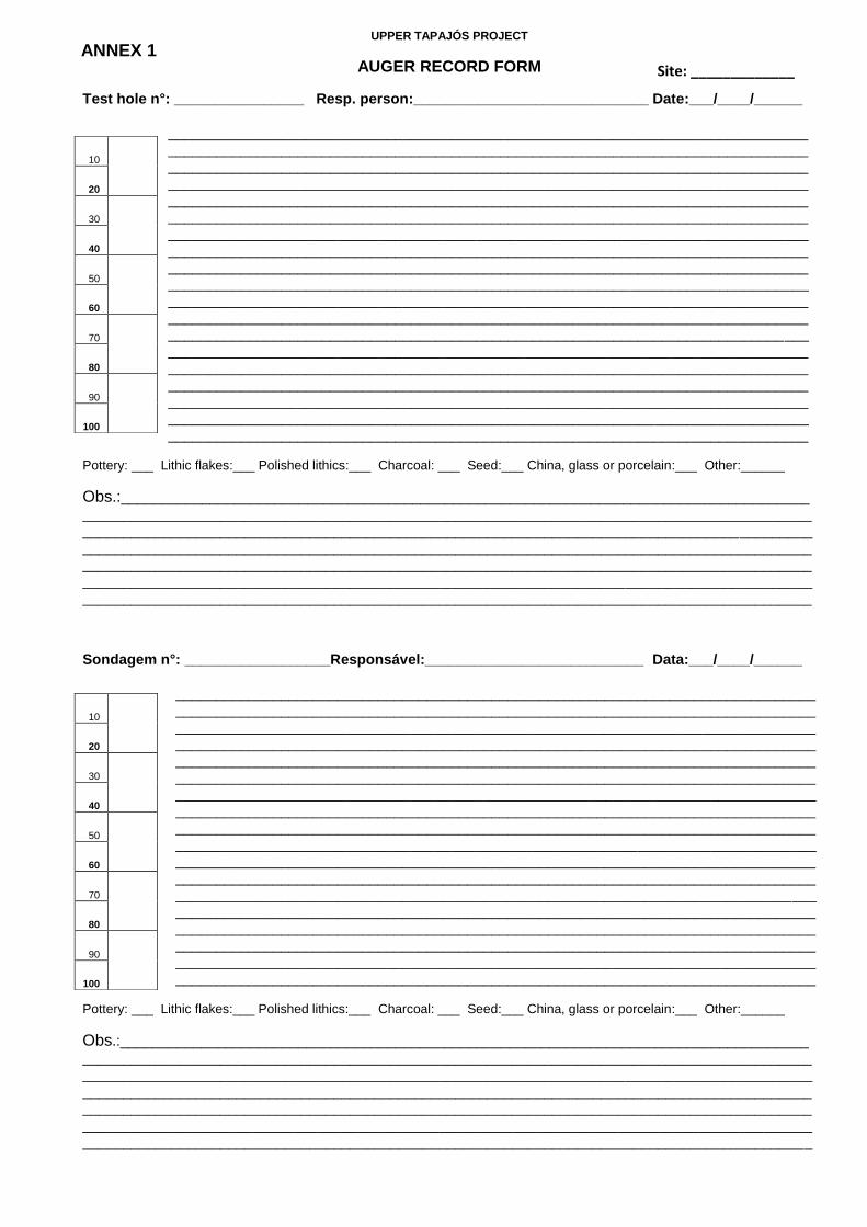
UPPER TAPAJÓS PROJECT
AUGER RECORD FORM
Test hole n°: ________________ Resp. person:_____________________________ Date:___/____/______
_____________________________________________________________________________________________________________________________________________________________________________________________________________________________________________________________________________________________________________________________________________________________________________________________________________________________________________________________________________________________________________________________________________________________________________________________________________________________________________________________________________________________________________________________________________________________________________________________________________________________________________________________________________________________________________________________________________________________________________________________________________________________________________________________________________________________________________________________________________________________________________________________________________________________________________________________________________________________________________________________________________________________________________________________________________________________________________________________________________________________________________________________________________________________
Pottery: ___ Lithic flakes:___ Polished lithics:___ Charcoal: ___ Seed:___ China, glass or porcelain:___ Other:______
Obs.:_____________________________________________________________________________________
____________________________________________________________________________________________________________________________________________________________________________________________________________________________________________________________________________________________________________________________________________________________________________________________________________________________________________________________________________________________________________________________________________________________
Sondagem n°: __________________Responsável:___________________________ Data:___/____/______
______________________________________________________________________________________________________________________________________________________________________________________________________________________________________________________________________________________________________________________________________________________________________________________________________________________________________________________________________________________________________________________________________________________________________________________________________________________________________________________________________________________________________________________________________________________________________________________________________________________________________________________________________________________________________________________________________________________________________________________________________________________________________________________________________________________________________________________________________________________________________________________________________________________________________________________________________________________________________________________________________________________________________________________________________________________________________________________________________________
Pottery: ___ Lithic flakes:___ Polished lithics:___ Charcoal: ___ Seed:___ China, glass or porcelain:___ Other:______
Obs.:_________________________________________________________________________________________________________________________________________________________________________________________________________________________________________________________________________________________________________________________________________________________________________________________________________________________________________________________________________________________________________________________________________________________________________________________________________________________________________________
10
20
30
40
50
60
70
80
90
100
10
20
30
40
50
60
70
80
90
100
Site: _____________ ANNEX 1

INSTITUTE OF ARCHAEOLOGY (UCL)UPPER TAPAJÓS PROJECTEXCAVATION LEVEL FORM
Legend:
Observations: ______________________________________________________________________________________________________________________________________________________________________________________________________________________________________________________________________________________________________________________________________________________________________________________________________________________________________________________________________________________________________________________________________________________________________________________________________________________________________________________________________________________________________________________________________________________________________________________________________________________________________________________________________________________________________________________________________________________________________________________________________________________________________________________________________________________________________________________________________________________________________________________________________________________________________________________________________________________________________________________________________________________________________________________________________________________________________________________________________________________________________________________________________________________________________________________________________________________________________________________________________________________________________________________________________________________________________________________________________________________________________________________________________________________________________________________________________________________________________________________________________________________________________________________________________________________________________________________________________________________________________________________________________________________________________________________________________________________________________________________________________________________________________________________________________________________________________________________________________________________________________________________________________________________________________________________________________________________________________________________
Unit: ___________________________
Level: __________________________
Layer:__________________________
PN(s):__________________________ __________________________
Charcoal collection:_______________
Dating sample:___________________ Soil colour:______________________ _______________________________
Soil texture: _____________________ ______________________________Responsible person: ______________ ______________________________
Date: _____/_____/_________
Lithic flake:
Polished lithic:Pottery:
Charcoal:
Seed:
China, glass, porcelain:
Bone:
Other:
NW NE
SESW Scale: 1:10
Defined limit between layers:
Diffuse limit between layers:
________________
- - - - - - - - - - ___________
Sheet n :___/___ANNEX 2

INSTITUTE OF ARCHAEOLOGY (UCL)
UPPER TAPAJÓS PROJECT
PROVENIENCE NUBER FORM
Site:________________________ Unit/Sector: _______________ Resp. Person:________________ Date:___/___/____
PN Description
ANNEX 3

TERRA PRETA DO MANGABAL ARCHAEOLOGICAL SITEItaituba - Pará, Brazil
Tapajós River
Tapajós River
1 m² unit
Contour (5m)
Auger hole
Cross section
KEY
A’A
N1000 E1000: UTM 21M 510468/9428160
200 m100 m50 m 50 m 150 m
TN
MN16.6
50 m
60 m
70 m
80 m
90 m
100 m
110 m
95 m
85 m 75 m
65 m
55 m
50 m
N10
00 E
1000
N10
00 E
1050
N95
0 E10
00
N10
25 E
1000
N11
25 E
1000
N10
00 E
950
N10
75 E
1000
N10
00 E
900
90 m
100 m
50 m
60 m
70 m
80 m
125 m 250 m 375 m 500 m
Section A-A’
110 m
650 m
A
A`
Tapajós
Terra Preta do Mangabal archaeological site
Ponta do Jatobá archaeological site
0 km 2 km 4 km 6 km 8 km 10 km
0 m
ANNEX 4
Source: MIRANDA, E. E. de; (Coord.). Brasil em Relevo. Campinas: Embrapa Monitoramento por Satélite, 2005.Available at: . Accessed on 01/10/2011
http://www.relevobr.cnpm.embrapa.br
Map by Vinicius Honorato

N1000 E 1025
10YR 2/1
10YR 3/1
10YR 4/3
10YR 4/3
10YR 5/610YR 4/3
N1000 E 1050
10YR 2/1
10YR 2/1
10YR 4/2
10YR 4/2
10YR 4/2
N950 E 1000
10YR 2/1
10YR 2/1
10YR 2/2
10YR 3/3
10YR 3/3, 10YR 5/6
N975 E 1000
10YR 2/1
10YR 3/1 (80%), 10YR 4/6 (20%)
10YR 3/1 (60%), 10YR 4/6 (40%)
10YR 4/6 (90%), 10YR 3/1 (10%)
10YR 4/6 (90%), 10YR 3/1 (10%)
N1025 E 1000
10YR 2/1
10YR 2/1
10YR 3/2
10YR 4/2 (50%), 10YR 4/6 (50%)
10YR 5/8 (50%), 10YR 3/3 (50%)
N1000 E 975
10YR 2/1
10YR 2/1
10YR 2/1
10YR 2/1
10YR 2/1
10YR 2/1
N1000 E 950
10YR 2/1
7.5YR 5/6 (50%)7.5YR 4/1 (50%)
10YR 2/2
7.5YR 5/6 (80%)7.5YR 4/1 (20%)
7.5YR 5/6 (80%)7.5YR 4/1 (20%)
N1000 E 925
10YR 2/1
10YR 2/2
10YR 3/2 (50%)10YR 4/6 (50%)
10YR 2/1
10YR 3/2 (50%)10YR 4/6 (50%)
N1000 E 900
10YR 3/2
10YR 3/2
10YR 3/4
10YR 3/4
10YR 3/6
10YR 3/6
N1000 E 1000
10YR 2/1
10YR 2/1
10YR 2/1
10YR 3/2
10YR 3/2
10YR 5/4
N1075 E 1000
10YR 2/1
10YR 2/1
10YR 2/1
10YR 3/2
10YR 3/2
N1075 E 1000
10YR 2/1
10YR 2/1
10YR 3/2
N1100 E 1000
10YR 2/1
10YR 2/1
10YR 3/2
10YR 3/2
10YR 4/6
N1050 E 1000
10YR 2/1
10YR 2/1
10YR 2/2
10YR 3/2 (50%), 10YR 3/6 (50%)
10YR 3/2 (50%), 10YR 3/6 (50%)
MN-16.6
TERRA PRETA DO MANGABAL ARCHAEOLOGICAL SITE:SOIL PROFILESItaituba- Pará, Brazil
ANNEX 5
Black
Very dark brown
Very dark gray
Very dark grayish brown
Dark brown
Dark yellowish brown
KEY*
Dark gray
Dark grayish brown
Brown
Yellowish brown10YR 5/410YR 5/610YR 5/8
10YR 2/1
10YR 2/2
10YR 3/1
10YR 3/2
10YR 3/3
10YR 3/4, 10YR 3/610YR 4/4, 10YR 4/6
10YR 4/17.5YR 4/1
10YR 4/2
10YR 4/3
7.5YR 5/6 Strong Brown
*Colours are approximate representations of Munsell Soil Color Chart.
Not to scaleGraphic art by Vinicius Honorato
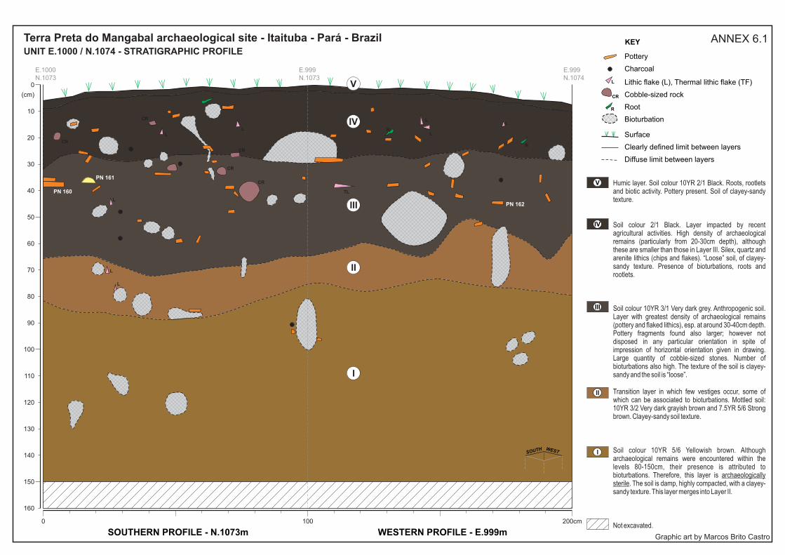
200cm1000
160
150
140
130
120
110
100
90
80
70
60
50
40
30
20
10
(cm)
0
PN 160
PN 161
PN 162
TL
LL
L
R
R
L
L
L
L
CR
CR
CR
CR
CR
L
E.1000 E.999 E.999N.1073 N.1073 N.1074
IV
V
III
II
I
SOUTHERN PROFILE - N.1073m WESTERN PROFILE - E.999m
R
CR
L
Diffuse limit between layers
Clearly defined limit between layers
Cobble-sized rock
Lithic flake (L), Thermal lithic flake (TF)
KEY
Root
Surface
Charcoal
Pottery
IV
V
III
II
I
Bioturbation
Humic layer. Soil colour 10YR 2/1 Black. Roots, rootlets and biotic activity. Pottery present. Soil of clayey-sandy texture.
Soil colour 2/1 Black. Layer impacted by recent agricultural activities. High density of archaeological remains (particularly from 20-30cm depth), although these are smaller than those in Layer III. Silex, quartz and arenite lithics (chips and flakes). “Loose” soil, of clayey-sandy texture. Presence of bioturbations, roots and rootlets.
Soil colour 10YR 3/1 Very dark grey. Anthropogenic soil. Layer with greatest density of archaeological remains (pottery and flaked lithics), esp. at around 30-40cm depth. Pottery fragments found also larger; however not disposed in any particular orientation in spite of impression of horizontal orientation given in drawing. Large quantity of cobble-sized stones. Number of bioturbations also high. The texture of the soil is clayey-sandy and the soil is “loose”.
Transition layer in which few vestiges occur, some of which can be associated to bioturbations. Mottled soil: 10YR 3/2 Very dark grayish brown and 7.5YR 5/6 Strong brown. Clayey-sandy soil texture.
Soil colour 10YR 5/6 Yellowish brown. Although archaeological remains were encountered within the levels 80-150cm, their presence is attributed to bioturbations. Therefore, this layer is archaeologically sterile. The soil is damp, highly compacted, with a clayey-sandy texture. This layer merges into Layer II.
Not excavated.
SOUTH WEST
Terra Preta do Mangabal archaeological site - Itaituba - Pará - BrazilUNIT E.1000 / N.1074 - STRATIGRAPHIC PROFILE
ANNEX 6.1
Graphic art by Marcos Brito Castro

100cm0
160
150
140
130
120
110
100
90
80
70
60
50
40
30
20
10
(cm)
0
LL
L
CR
E.999 E.1000N.1074 N.1074
IV
V
III
II
I
NORTHERN PROFILE - N.1074m
CR
L
Diffuse limit between layers
Clearly defined limit between layers
Cobble-sized rock
Lithic flake
KEY
Surface
Charcoal
Pottery
IV
V
III
II
I
Bioturbation
Humic layer. Soil colour 10YR 2/1 Black. Roots, rootlets and biotic activity. Pottery present. Soil of clayey-sandy texture.
Soil colour 2/1 Black. Layer impacted by recent agricultural activities. High density of archaeological remains (particularly from 20-30cm depth), although these are smaller than those in Layer III. Silex, quartz and arenite lithics (chips and flakes). “Loose” soil, of clayey-sandy texture. Presence of bioturbations, roots and rootlets.
Soil colour 10YR 3/1 Very dark grey. Anthropogenic soil. Layer with greatest density of archaeological remains (pottery and flaked lithics), esp. at around 30-40cm depth. Pottery fragments found also larger; however not disposed in any particular orientation in spite of impression of horizontal orientation given in drawing. Large quantity of cobble-sized stones. Number of bioturbations also high. The texture of the soil is clayey-sandy and the soil is “loose”.
Transition layer in which few vestiges occur, some of which can be associated to bioturbations. Mottled soil: 10YR 3/2 Very dark grayish brown and 7.5YR 5/6 Strong brown. Clayey-sandy soil texture.
Soil colour 10YR 5/6 Yellowish brown. Although archaeological remains were encountered within the levels 80-150cm, their presence is attributed to bioturbations. Therefore, this layer is archaeologically sterile. The soil is damp, highly compacted, with a clayey-sandy texture. This layer merges into Layer II
.Not excavated.
NORTH
Terra Preta do Mangabal archaeological site - Itaituba - Pará - BrazilUNIT E.1000 / N.1074 - STRATIGRAPHIC PROFILE
ANNEX 6.2
Graphic Art by Marcos Brito Castro

90 m
40 m
50 m
60 m
70 m
80 m
125 m 250 m 375 m 500 m
Section A-A’
Tapajós River
35 m
40 m
45 m
50 m
55 m
60 m
65 m
70 m
75 m
80 m
85 m
85 m
85 m
35 m
80 m
75 m
70 m
90 m
50 m 0 m 50 m 100 m 150 m 200 m
A
A’
N10
00 E
1000
N10
00 E
1075
N10
00 E
1150
N10
00 E
1225
N10
00 E
1300
N10
50 E
1075
N11
00 E
1075
N95
0 E
1075
1 m² unit Contour (5m)
Auger hole Cross section
KEY
A’A
N1000 E1000: UTM 21M 582600/94933124
0 km 3 km 6 km
Pajaú archaeological site
Tapajó
s R
iver
0 m
50 m
100 m
150 m
200 m
250 m
300 m
350 m
PAJAÚ ARCHAEOLOGICAL SITE Itaituba - Pará, Brazil
TN
MN16.6
Map b
y V
inic
ius
Honora
to
Source: MIRANDA, E. E. de; (Coord.). Brasil em Relevo. Campinas: Embrapa Monitoramento por Satélite, 2005.Available at: . Accessed on 01/10/2011http://www.relevobr.cnpm.embrapa.br
AN
NE
X 7

N1000 E975
10YR 2/1
10YR 3/2
7.5YR 4/1 (50%) 7.5YR 5/6 (50%)
N1075 E1075
1 0 Y R 3 / 2
10 YR 4/3
7.5YR 5/6
7.5YR 5/6
N1100 E1075
10YR 2/2
10YR 4/3
7.5YR 5/6
7.5YR 5/6
10YR 3/2
10YR 3/2
N1025 E1075
10YR 3/2
7.5YR 4/3 (50%)7.5YR 4/2 (50%)
7.5YR 5/6
7.5YR 5/6
10YR 3/2
N1050 E1075
10YR 2/2
7.5YR 4/2 (50%)7.5YR 5/6 (50%)
7.5YR 5/6
7.5YR 5/6
7.5YR 4/3 (90%)7.5YR 5/6 (10%)
N950 E1075
10YR 2/2
7.5YR 5/6
7.5YR 5/6
10YR 3/2 (80%)7.5YR 5/6 (20%)
10YR 3/2 (20%)7.5YR 5/6 (80%)
N925 E1075
10YR 2/2
7.5YR 5/6
7.5YR 5/6
10YR 4/4 (90%)7.5YR 5/6 (10%)
7.5YR 5/6 (90%)10YR 4/2 (10%)
N1000 E 1225
10YR 4/3
10YR 6/6 (50%)10YR 4/2 (50%)
10YR 6/6
10YR 4/4
10YR 6/6 (50%)10YR 4/2 (50%)
N975 E1075
10YR 2/2
7.5YR 4/2 (70% 7.5YR 5/6(30%)
7.5YR 4/2 (60%) 7.5YR 5/6(40%)
7.5YR 5/6
7.5YR 5/6
N1000 E 1325
10YR 3/2
10YR 4/3 (60%),10YR 5/6 (40%)
10YR 5/6
10YR 5/6 (70%)10YR 4/3 (30%)
10YR 3/2
N1000 E 1250
10YR 3/2
10YR 4/2 (50%)10YR 5/4 (50%)
10YR 5/4
10YR 5/4 (80%)10YR 4/2 (20%)
10YR 3/2
N1000 E 1275
10YR 3/2
10YR 4/3
10YR 6/6
10YR 6/6
10YR 3/2
N1000 E 1300
10YR 3/2
10YR 4/2
10YR 5/6
10YR 4/6
10YR 3/2
N1000 E1000
10YR 2/1
10YR 3/2
7.5YR 4/2 (60%) 7.5YR 5/6 (40%)
7.5YR 5/6
7.5YR 5/6
N1000 E1025
10YR 2/2
7.5YR 4/6 (70%)7.5YR 3/2 (30%)
7.5YR 5/6
7.5YR 5/6
7.5YR 5/6
N1000 E1050
10YR 2/2
10YR 3/3
7.5YR 4/6
7.5YR 4/6
7.5YR 4/6
N1000 E1075
10YR 2/1
10YR 2/2
7.5YR 5/6
10YR 4/2 (70%)7.5YR 4/6 (30%)
7.5YR 4/6 (70%) 10YR 4/2 (30%)
N1000 E1100
10YR 2/1
10YR 3/2
7.5YR 5/6
10YR 4/2 (50%)7.5YR 4/6 (50%)
7.5YR 4/6 (50%) 10YR 4/2 (50%)
N1000 E1125
10YR 3/1
7.5YR 5/6 (50%) 7.5YR 4/2 (50%)
7.5YR 5/6
7.5YR 5/6 (90%) 10YR 4/2 (10%)
7.5YR 5/6
N1000 E1150
10YR 2/2
10YR 3/2
7.5YR 5/6
10YR 4/6 (70%)7.5YR 5/6 (30%)
7.5YR 5/6 (70%)10YR 4/6 (30%)
N1000 E1175
10YR 2/2
10YR 4/2 (90%)7.5YR 5/6 (10%)
7.5YR 5/6
10YR 5/6 (90%) 7.5YR 4/2 (10%)
7.5YR 5/6
N1000 E1200
10YR 3/2
10YR 3/2
7.5YR 6/6
10YR 4/2 (50%) 10YR 5/4 (50%)
7.5YR 5/6
PAJAÚ ARCHAEOLOGICAL SITE:SOIL PROFILES
Itaituba- Pará, Brazil
Black
Very dark brown
Very dark gray
Very dark grayish brown
Dark brown
Dark yellowish brown
KEY*
Dark gray
Dark grayish brown
Brown
Yellowish brown10YR 5/410YR 5/6
10YR 2/1
10YR 2/2
10YR 3/1
10YR 3/2
10YR 3/3
10YR 3/4, 10YR 3/610YR 4/4, 10YR 4/610YR 4/4
10YR 4/17.5YR 4/1
10YR 4/2
10YR 4/3
7.5YR 5/6 Strong Brown
10YR 6/6 Brownish yellow
7.5YR 4/2 Brown
Dark brown7.5YR 3/2
7.5YR 6/6 Reddish yellow
MN-16.6
*Colours are approximate representations of Munsell Soil Color Chart.
Not to scaleGraphic art by Vinicius Honorato
ANNEX 8

200cm1000
90
80
70
60
50
40
30
20
10
(cm)
0
RCR
CR
R
R
R
R
R
R
R
R
R
RR
E.1070 E.1070 E.1071N.1079 N.1080 N.1080
IV
V
III
II
I
WESTERN PROFILE - E.1070m NORTHERN PROFILE - N.1080m
CR
Diffuse limit between layers
Cobble-sized rock
KEY
Root
Surface
Charcoal
Pottery IV
V
III
II
I
Bioturbation
Humic layer. Soil colour 10YR 2/2 Very dark brown. Roots, rootlets and biotic activity. Pottery present. Sandy-clayey soil.
Soil colour 2/1 Black. High density of archaeological remains (pottery and lithics). The pottery fragments found are larger; they are not disposed in any particular orientation. Lithics vary from chips to flakes; cobble-sized stones also found in great number. Charcoal present, however not collected because of proximity to surface. Presence of bioturbations, roots and rootlets.
Soil colour 10YR 2/2 Very dark brown. The density of archaeological remains (pottery and flaked lithics) is inferior to that of Layer IV. Presence of bioturbations, roots and rootlets. Charcoal collected from this layer. The texture of the soil is clayey-sandy and it becomes increasingly compact as Layer II approaches.
NORTHWEST
R
Transition layer whose inferior and superior limits are indistinct. Mottled soil: 10YR 4/2 Dark grayish brown and 7.5YR 5/6 Strong brown; the proportion of the latter increases with proximity to layer I. Clayey soil texture. Low density of archaeological remains. Charcoal present. Large amount of bioturbations filled with dark-coloured sediment.
Soil colour 7.5YR 5/6 Strong brown. Archaeologically sterile. Highly compacted soil, clayey texture. Bioturbations present; a cobble-sized stone can be seen in the profile. This layer merges into layer II.
Not excavated.
Pajaú archaeological site - Itaituba - PA - BrazilUNIT E.1071 / N.1080 - STRATIGRAPHIC PROFILE
ANNEX 9
Graphic Art by Marcos Brito Castro

Annex 10 1
ANNEX 10
Attributes related to technology (4-8), form (2, 3, 9-13, 15) and decoration (14, 16-
23) were observed:
1. Identification number
2. Type of fragment 3.1 Sherd thickness (mm) 3.2 Diameter (mm) 0 - Not identified 0 - Not identified 1 - Base 2 - Body sherd 3 - Inflection 4 - Body Flange 5 - Handle 6 - Adorno 7 - Rim 8 - Labial Flange 9 - Whole Vessel 4. Internal Surface Treatment 5. External Surface Treatment 6. Forming technique 4.0 - Other 5.0 - Other 6.0 - Undetermined 4.1 - Smoothed 5.1 - Smoothed 6.1 - Coiled 4.2 - Burnished 5.2 - Burnished 6.2 - Modelled 4.3 - Resin 5.3 - Resin 4.4 - Polished 5.4 - Polished 4.5 - Brushed 5.5 - Brushed 4.6 - Eroded 5.6 - Eroded
8. Temper 8. cont. 8.0 - Undetermined 8.8 - Shell 8.1 - Cauixí 8.9 - Quartz 8.2 - Caraipé 8.10 - Charcoal 8.3 - Grog 8.11 - Quartz sand 8.4 - Mineral 8.12 - Voids 8.5 - Haematite 8.6 - Clay 8.7 - Bone
9. Vessel contour 10. Vessel shape 11. Inflection point(s) 9.0 - Undetermined 10.0 - Undetermined 11.0 - None 9.1 - Simple 10.1 - Restricted 11.1 - Rounded 9.2 - Composite 10.2 - Unrestricted 11.2 - Acute 9.3 - Inflected 10.3 - Vertical 11.3 - Carinated 9.4 - Complex 12. Rim inclination 13. Lip shape 14. Lip finish 12.0 - None 13.0 - None 14.0 - None 12.1 - Direct 13.1 - Pointed 14.1 - Rounded 12.2 - Everted 13.2 - Bevelled 14.2 - Flat 12.3 - Introverted 13.3 - Internally strengthened 14.3 - Cut 13.4 - Ext.strengthened 14.4 - Impressed 13.5 - Expanded 14.5 - Slipped 13.6 - Rounded 14.6 - Painted 13.7 - Flat 14.7 - Modelled 13.8 - Excised/grooved 13.9 - Hollow
7. Colour of the Paste 7.0 - Undetermined 7.1 - Oxidised 7.2 - Reduced 7.3 - Internally Oxidised/ Externally Reduced 7.4 - Internally Reduced/Externally oxidised 7.5 - Reduced core

Annex 10 2
15. Base shape 16. Decorative surface 17. Decoration type and location
15.0 - None 16.0 - None 17.0 - None 15.1 - Flat 16.1 - Internal 17.1 - Painted internal 15.2 - Convex 16.2 - External 17.2 - Painted external 15.3 - Pedestal 16.3 - Both 17.3 - Plastic Internal 15.4 - Concave 17.4 - Plastic External 15.5 - Flat with leaf impression 17.5 - Slip internal 15.6 - Foot 17.6 - Slip External 17.7 - Rim 18. Colour of slip 19. Type of painting 20. Paint colour 18.0 - None 19.0 - None 20.0 - None 18.1 - White 19.1 - Fine lines 20.1 - Burgundy 18.2 - Burgundy 19.2 - Thick bands 20.2 - Red 18.3 - Red 19.3 - Straight lines 20.3 - Orange 18.4 - Orange 19.4 - Curved lines 20.4 - Yellow 18.5 - Yellow 19.5 - Post firing 20.5 - Black 18.6 - Black 19.6 - Pre-firing 20.6 - White 19.7 - Undetermined 20.7 - Negative 20.8 - Brown 21. Type of Pl. decoration 22. Plastic decoration patterns 21.0 - None 22.0 - None 22.2.3 Zoned-hachured incision 21.1 - Lip finish 22.1.1 Nicked lip 22.2.4 Incised curved lines 21.2 - Incised 22.1.2 "Serrated" lip 22.3.1 Ungulate/ finger tip 21.3 - Ungulate/Finger tip mark 22.1.3 Punctuated lip 22.4.1 Punctuation (rectilinear)
21.4 - Impressed 22.1.4 Undetermined 22.4.2 Punctuation (round stylus)
21.5 - Perforated 22.1.5 Fingernail ridged 22.4.3 Cord or fibre impression 21.6 - Modelling 22.2.1 “Fish spine” incision 22.5.1 Perforation 21.7 - Adornos 22.2.2 Parallel incision 22.6. Modelled 22.7.1 Applied fillet 22.7.2 Applied blob
23. State of paste when plastic decoration was executed 23.0 - Undetermined 23.1 - Wet/damp 23.2 - Leather hard/dry 23.3 - Post firing 23.4 - Pre-slip 23.5 - Post slip

ANNEX 11
Temper
Cauixí is the generic name given to freshwater sponges. The shape of the sponge
spicules is acicular. Caraipé derives from the burnt bark of certain trees. Both cauixí
and caraipé are high in silica content.
Tempers commonly used in Amazonia. Left, cauixí; Right, caraipé and quartz. Photographs of Paredão pottery (40x magnification) by Claide de Paula Moraes.
Identification of firing environment
Adapted from chart used by the Central Amazon Project, courtesy of Márjorie Lima.

f
Plate 1
Terra Preta do Mangabal
Figs. a-e: lozenge-shaped incisions on rim and body sherds; f & i: perpendicular incision - possible «fish spine» motif; g, j, k: straight, parallel incisions; h: triangular-shaped incision - possible «fish spine»motif; l: parallel, curvilinear incision.
lk
j
ih
g
fe
d
c
b
a

Plate 2
Terra Preta do Mangabal
Fig. a: remountable fragments of vessel withridges, also nicked.
lozenge-shaped incision, «nicked» rim and lip, applied vertical fillets forming
a

Plate 3
Terra Preta do Mangabal
Fig. a: Orange-slipped rim sherd with modelled lip and appliqué blob (found on surface); b: fibre-impressed body sherd, subsequently coated with white slip; c: rim sherd displaying clay additions around circumference; d: modelled rim producing «wavy» effect; e: modelling on body sherd.
ab
cd
e

Figs. a - f: everted, «nicked» rims and lips; g: direct «nicked» rim.
Plate 4
Terra Preta do Mangabal
ab
c
d
e f g

Plate 5
Terra Preta do Mangabal
Figs. a-d: direct, «serrated» rims and lips; e: ungulate impression on body sherd; f: impressed punctuation on rim; g: modelled body sherd.
f
a
b
c
de
g

Plate 6
Pajaú
Fig. a & e: horizontally applied clay fillets with round-edged punctuations; b: rim sherd with horizontally applied clay fillets and round-edged punctuations -- fillets are accompanied by lines of orange paint; c: body sherd with «fish spine» incision and vestige of red paint; d, f, g, i: body sherds with red paint; h:modelled, undecorated handle; j: body sherd with black resist paint in curvilinear design. Photographs of figs. c, e, f and g taken by Rogério Andrade dos Santos.
a
b
c
d
fg
i
h
j
e

5cm
Plate 7
Pajaú
Fig. a: Double-line rectangular-shaped punctuations on internal face of everted, «serrated» rim; b: lines of rectangular-shaped punctuations on body sherd; c: lines of parallel rectangular-shaped punctuation below rim on external surface of sherd; d: line of rectangular-shaped punctuation placed above incision (possible «fish spine» motif); e: «fish spine» incisions; f: «T» shaped parallel incision; g: possible «fish spine» motif - otherwise, convergent lines; h: perforations - possible colander?; i: impressed lip; j & k: «serrated» lips.
f
kji
h
e
d
cb
a
g

Plate 8
Cocalino
Fig. a: incised “fish-spine” design on outer surface near rim; b: parallel vertical incisions on internal face of everted rim; c and d: converging isoceles triangles; e: parallel incisions; f: crossed incised design; g: applied fillets with punctuation; h: punctuation along lip.
c
b
a
d e f
g h

Plate 9
Boa Vista
Fig. a: Hollow rim sherd; b: hollow, red-slipped rim with «wavy» modelled lip. Photograph of fig. a. taken by Rogério Andrade dos Santos.
ba
Copyright © 2022 FDOKUMEN