BLACK SEA ARCHAEOLOGY STUDIES Recent Developments
258
-
Upload
khangminh22 -
Category
Documents
-
view
0 -
download
0
Transcript of BLACK SEA ARCHAEOLOGY STUDIES Recent Developments


BLACK SEA ARCHAEOLOGY STUDIES Recent Developments
Edited by Dr. Davut Yiğitpaşa, Dr. Hakan Öniz, Dr. Akın Temür
Graphics: Metehan Samet Gül

SUPPORTED BY

I
SCIENTIFIC COMMITTEE
Prof. Dr. Asuman BALDIRAN (Selcuk University) Prof. Gocha R. TSETSKHLADZE (Oxford University, England) Prof. Dr. Mehmet ÖZSAİT (Samsun, Turkey) Prof. Dr. Mustafa ŞAHİN (Uludag University, Turkey) Prof. Dr. Önder BİLGİ (Samsun, Turkey) Prof. Dr. Rainer CZICHON (Usak University, Turkey) Prof. Dr. S. Yücel ŞENYURT (Gazi University, Turkey) Prof. Dr. Sümer ATASOY (Samsun, Turkey) Prof. Dr. Şamil AKTAŞ (İstanbul University, Turkey) Assoc. Prof. Dr. Alan Micheal GREAVES (University of Liverpool, England)Assoc. Prof. Dr. Ayşe F. EROL (Gazi University, Turkey) Assoc. Prof. Dr. Hakan ÖNİZ (ICOMOS-ICUCH / Selcuk Uni., Turkey) Assoc. Prof. Dr. Murat EGİ (Divers Alert Network – DAN Europe) Assist. Prof. Dr. Akın TEMÜR (Ondokuz Mayis University, Turkey)Assist. Prof. Dr. Davut YİĞİTPAŞA (Ondokuz Mayis University, Turkey)Assist. Prof. Dr. Eric JEAN (Hitit University, Turkey) Assist. Prof. Dr. Murat KARADEMİR (Selcuk University, Turkey)Assist. Prof. Dr. Blazej STANISLAWSKI (Polish Academy of Sciences, Poland)Assist. Prof. Dr. Michele STEFANILE (University of Naples l'orientale, Italy)Assist. Prof. Dr. Sergey FAZLULIN (Russian Academy of Sciences, Russia)

CONTENTS
CHAPTER 1: EXCAVATIONS & SURVEYS
CHAPTER 2: UNDERWATER & MARITIME ARCHAEOLOGY
Sümer ATASOYForeword
Oguz AydemirForeword
1. Akın Temür, Gazanfer İltarGiresun, the Excavation of the Island of Aretias/Khalkeritis
IV
V
1
13
16
32
39
46
59
71
78
85
II
1. A. Y. Predtechenskaya, I.R. Nikolaev Law Conflicts in the Management of Underwater Cultural Heritage in the Caribbean by the Example of Cuba
2. Alexandra Bivolaru, Matthie Giaime, Veronica Rossi, Valentin Bottez, Nick Marriner, Christophe Morhange, Vasilica Lungu, Marius StreinuGiresun, the Excavation of the Island of Aretias/Khalkeritis
3. Hakan Öniz, Murat Karademir Underwater Surveys on the Coast of Antalya - 2014-2015
4. Ivan Nıkolaev, N. Karbaia, S. Fazlullin Underwater Cultural Heritage and NGOs in the UK: Problems and Achievements
5. Maria Ayça Koçdağ Maritime Historical and Cultural Heritage of the Cyprus Island: Underwater Surveys and Underwater Archaeological Excavations
6. Mert Ugur Kara Structure, Development and Functionality of Keels on Ancient Ships
7. Madonna Mshvildadze, Nikolov Tushabramishvili Georgia’s Black Sea Coast and the Prospects Regarding the Underwater Archaeology
8. Okay SütçüogluDiving Activities in the Black Sea According to the Ottoman Archives: Goals, Reasons and Ethnic Origins of Divers
9. Okay Sütçüoglu\ Ayşe TaşkesenChaikas in the Black Sea; Conceptual Problems and Action Areas

III
102
110
128
143
155
161
172
180
192
203
209
220
227
241
93
CHAPTER 3: SETTLEMENT ARCHAEOLOGY
1. Ayla Baş Finds from the Excavations at the Foundation of the Sinop Teacher Training High School
2. Ayşe F. Erol An Archaeological Assessment of the Turkish Eastern Black Sea Region in the Light of Fatsa Surveys and Cıngırt Kayası Excavations
3. Davut Yigitpaşa An Overview of the Iron Age Settlements in Samsun
4. Fatma Bagdatlı Çam From Myths to Reality: New Approaches on the Reality of Amazons
5. Fevziye Eker Glass Vessels in the Ordu Pasaoglu Mansion and Ethnography Museum
6. Füsun Tülek A Small Island of Great Importance in Maritime Trade of the South Black Sea Coast: Daphnousia Island/Kefken
7. Gökhan Mustafaoglu Preliminary Observations on the Palaeolithic Period Finds Found in the Western Black Sea Region Between the Eregli and Akcakoca Districts
8. F. Gülden Ekmen New Archaeological Surveys in the Western Black Sea Region of Turkey
9. Gülgün Köroglu Balatlar Community Church Building Complex
10. İbrahim Tellioglu The Role of Archaeology in Historical Studies of Black Sea
11. Mehmet Köseoglu Kinneir’s Narratives about Amisos and His Historical Resources
12. Murat Tekin Historical and Cultural Structure of Sebastopolis and its Vicinity in the Light of the Archaeological Surveys on the Southern Part of Pontus
13. Osman Aytekin, Hasan BugrulAn Evaluation on Bronze Movable Cultural Assets in Artvin-Savsat Found by Chance
14. Sümer AtasoySurveys and Excavations on the Eastern Black Sea Coast of Turkey
15. Şengül Dilek FULA General Review on the Excavations in Sebastopolis in Colopene Part of Pontus Area

IV
FOREWORD
The Black Sea studies in Turkey have not attained the desired level yet. The Southern Coast of the Black Sea has been neglected in terms of archaeological studies. Along the coast, the ancient cities have been overbuilt by modern settlements and recent road con-structions have destroyed the ancient remains. All sites mentioned in ancient sources as the lands of the Amazons and other local tribes who lived in this region are still a legend only. Although there are some surveys and fieldwork being carried out by Turkish and foreign scholars, there still remains a lot to be done. Studies of the Black Sea cover a large area, and concern the study of different cultural complexes as reflected in different peoples, states and countries. This volume shows recent field projects and studies in the archaeology and ancient history of the Black Sea and their relationship with the Mediter-renean underwater studies. Opportunities, as offered by this volume, to exchange views and present new evidence, are crucial to the subject. The volume contains 22 papers from Turkey and other Black Sea countries, segregated in chapters of Excavations & Surveys, Settlement Archaeology and Underwater & Maritime Archaeology. It is an obligation to congratulate personally all writers, and thank them all for their studies and contribution to this publication. I also would like to thank Davut Yigitpaşa, Hakan Öniz, Akın Temür as editors for their contributions. I believe that the volume will provide support to the education of young scholars, and enhance the studies related with the Black Sea region.
Prof. Dr. Sümer ATASOY

V
FOREWORD
Black Sea has always been a marginal sea connected to an ocean which has many inter-esting features. The Turkish straits namely Bosphorus and Dardanelles connect the Black Sea to the Aegean Sea via Marmara Sea. Black Sea was sailed by Hittites, Carians, Colchi-ans, Thracians, Greeks, Persians, Cimmerians, Scythians, Romans, Byzantines, Goths, Huns, Avars, Slavs, Crusaders, Venetians, Genoese, Tatars and Ottomans which makes it very rich historically. Deepwater archaeology shows that prehistoric settlements and ancient shipwrecks are exceptionally well preserved due to the absence of oxygen. TINA The Turkish Institute of Nautical Archaeology is proud and privileged to sponsor the 10th International Symposium on Underwater Research (ISUR), Black Sea Archaeology.
Oguz Aydemir
President of Turkish Foundation for Underwater Archaeology

CHAPTER 1
EXCAVATIONS & SURVEYS

1
Giresun, the Excavation of the Island of Aretias/Khalkeritis
Akın TEMÜR1 Gazanfer İLTAR2
Abstract The Island of Giresun lying approximately 1.6 km. off the city of Giresun/Kerasous, which was one of the most significant sites of the Pontus region, is the only island in the Eastern Black Sea region that witnessed settlement during the Ancient Era and the Middle Age. According to the ancient sources, the island was called “Aretias” during the Classical Era, while it was referred to as “Khalkeritis” during the Roman Empire. The island, which covers an area of 40.000 m² with an altitude of 24 m. above the sea level, bears remains dating mainly to the Middle Ages. The first archaeological excavations in the island were carried out in 2011 and 2012. Following a pause in 2013 and 2014, the excavations were resumed by the Giresun Museum in 2015. Since then, several architectural remains have been discovered, and the excavations focused on three different sites; the church/monastery complex, the chapel and the area containing Pithoi. In contrast to ruins of the Middle Ages, the sherds found in the excavations indicate that the history of the island date as far back as to the Classical Period. Key Words: Giresun Island, Aretias, Khalkeritis, Black Sea, Kerasous, Pontos, Amazon The History of the Island Located in the Eastern of the Black Sea region, the province of Giresun and its surroundings, despite lack of popularity, have been home to significant archaeological finds and cultura l heritage. This region of Pontos, frequently mentioned in historical records, is mountanious and covered with forests, with a narrow plain by the sea and shore (Strabon, Geo., XII, 3.19). These geographical conditions offer advantages as well as disadvantages for the region. First of all, while the very narrow shore hinders development of settlements beyond a certain level, high mountains and forests provide a significant advantage for defence. Due rather to its geographical structure, the region has generally been marked by small kingdoms fighting for dominance than foreign occupiers (Figure 1). In Ksenephon’s terms, East Pontos is “a region populated by autochtonous people, usually named differently, who lived in the region semi-autonomously in the first millenium” (Ksenephon Anab., IV. 5-30). The Greek Colony cities appearing in the Black Sea from 7th century B.C. soon after reached as far as the East Pontos. However, in the 6th century BC, it was part of the Great Persian Kingdom just as the entire Asia Minor at the time. During the Hellenistic period, with the foundation of the Pontus Kingdom by Mithridates I, the region was first dominated by the Hellenistic Pontus Kingdom, followed by the Roman Empire with the defeat of Mithridates IV by Romans, and then by the Byzantium Empire. As a result of the Latin invasion of Constantinople during the Fourth Crusade in 1204, a new state established in Trebizond by the Komnenos Dynasty led to a rapid development of the region. It is known that the Island experienced significant construction activities during this
1 Assist. Prof. Dr., Department of Archaeology, Faculty of Letters, Ondokuz Mayıs University, Samsun/TURKEY, [email protected] 2 Assist. Prof. Dr., Giresun University, Faculty of Fine Arts, Giresun/TURKEY, [email protected]

2
period, and was fortified during the reign of Alexios Komnenos, the Emperor of Trebizond (1297-1330). The region fell gradually under the Turkish domination following the struggles between the Byzantines and the Cephni who settled around Giresun during the 13th century, and consequently Ottomans gained control of the region in 1461 (Örenç 2009, 43). The settlement and habitation of the island are related to the city of Kerasous across the island. The island of Aretias (Giresun Adası) situated 1.6 km. offshore of the city of Giresun has an altitude of 24.5 m above the sea level, covering an area of 40.000 m2. Despite limited number of remains have survived until today, the ancient literature bears very valuable information on this small island (Figure 2). The fact that Ksenophon defined Kerasus as a Greek colony city of Sinope by the end of 5th century B.C. (Ksenophon Anab., V. 3.2) suggests that the island might have been populated as well during this period considering its proximity to the city and its strategic features. In the 3rd century B.C, Apollonios, recounting the travel of Argonauts, tells of a low-lying island, a temple dedicated to Ares and a black rock altar where Amazons sacrificed horses for the god of war here on the island on their way to war, numerous birds that were disrespectful of humans and settled on the desolate shores of the island, and the struggle between Argonauts and the birds of Ares inhabiting the island (Apoll. Rhod. Argon., II. 1165-1174, 1030-1230). In the first half of the 2nd century A.D., Arrian who sailed for inspection of the Roman headquarters also refers to the island as the “island of Ares” and reports that the island is 30 stadia away from Pharnakeia (Arslan 2005, 127-129). In brief, according to the ancient resources, the island was called ‘Ares’ during the Greek Period, and ‘Khalkeritis’ during the reign of the Roman Empire; it is situated right across Pharnakeia; it hosts a temple dedicated to Ares; and the Amazons worshipped a sacred black stone on the island. Such information provides the main reference points for determining the name and location of the island (Doksanaltı, Aslan and Mimiroglu 2011, 146). Survey on the Giresun Island The first survey on the island was carried out between 2009-2011 by a team under the coordination of by Assc. Prof. Ertekin M. Doksanaltı from the Archeology Department of Selçuk University (Doksanaltı, Aslan and Mimiroglu 2011, 143-162; 2012a, 117-147; 2012b, 197-2012). After an interruption period from 2013 to 2014, the excavations in the island was restarted under the auspices of the Administration of the Giresun Museum by a team, includ in g myself, supervised by Asst. Prof. Gazanfer Iltar from the Department of History of Arts at Celal Bayar University. Several architectural remains have been found during the excavations, which are now focused on the complex of Church/Monastery, Chapel and the area with Pithoi (Figure 3). The Pier Surrounded by a rocky coastline, the island has a port where ships easily anchor, and also two small natural bays to the northeast and southeast of the island, serving as a harbour for small vessels and for disembarkment. Especially the northeastern bay has a size enough for vessels to seek shelter (Figure 4). It is assumed that landing on the island was from the southeastern bay, and carved rings on the rocks along the eastern coast and round-shaped high moorings were used to anchor vessels (Doksanaltı, Aslan and Mimiroglu 2011, 148).

3
period, and was fortified during the reign of Alexios Komnenos, the Emperor of Trebizond (1297-1330). The region fell gradually under the Turkish domination following the struggles between the Byzantines and the Cephni who settled around Giresun during the 13th century, and consequently Ottomans gained control of the region in 1461 (Örenç 2009, 43). The settlement and habitation of the island are related to the city of Kerasous across the island. The island of Aretias (Giresun Adası) situated 1.6 km. offshore of the city of Giresun has an altitude of 24.5 m above the sea level, covering an area of 40.000 m2. Despite limited number of remains have survived until today, the ancient literature bears very valuable information on this small island (Figure 2). The fact that Ksenophon defined Kerasus as a Greek colony city of Sinope by the end of 5th century B.C. (Ksenophon Anab., V. 3.2) suggests that the island might have been populated as well during this period considering its proximity to the city and its strategic features. In the 3rd century B.C, Apollonios, recounting the travel of Argonauts, tells of a low-lying island, a temple dedicated to Ares and a black rock altar where Amazons sacrificed horses for the god of war here on the island on their way to war, numerous birds that were disrespectful of humans and settled on the desolate shores of the island, and the struggle between Argonauts and the birds of Ares inhabiting the island (Apoll. Rhod. Argon., II. 1165-1174, 1030-1230). In the first half of the 2nd century A.D., Arrian who sailed for inspection of the Roman headquarters also refers to the island as the “island of Ares” and reports that the island is 30 stadia away from Pharnakeia (Arslan 2005, 127-129). In brief, according to the ancient resources, the island was called ‘Ares’ during the Greek Period, and ‘Khalkeritis’ during the reign of the Roman Empire; it is situated right across Pharnakeia; it hosts a temple dedicated to Ares; and the Amazons worshipped a sacred black stone on the island. Such information provides the main reference points for determining the name and location of the island (Doksanaltı, Aslan and Mimiroglu 2011, 146). Survey on the Giresun Island The first survey on the island was carried out between 2009-2011 by a team under the coordination of by Assc. Prof. Ertekin M. Doksanaltı from the Archeology Department of Selçuk University (Doksanaltı, Aslan and Mimiroglu 2011, 143-162; 2012a, 117-147; 2012b, 197-2012). After an interruption period from 2013 to 2014, the excavations in the island was restarted under the auspices of the Administration of the Giresun Museum by a team, includ in g myself, supervised by Asst. Prof. Gazanfer Iltar from the Department of History of Arts at Celal Bayar University. Several architectural remains have been found during the excavations, which are now focused on the complex of Church/Monastery, Chapel and the area with Pithoi (Figure 3). The Pier Surrounded by a rocky coastline, the island has a port where ships easily anchor, and also two small natural bays to the northeast and southeast of the island, serving as a harbour for small vessels and for disembarkment. Especially the northeastern bay has a size enough for vessels to seek shelter (Figure 4). It is assumed that landing on the island was from the southeastern bay, and carved rings on the rocks along the eastern coast and round-shaped high moorings were used to anchor vessels (Doksanaltı, Aslan and Mimiroglu 2011, 148).
The Fortifications The island is surrounded by a substantial wall right behind the rocky coastline (Figure 5). The walls have an approximate length of 600 m and a height of 6 m. The inner and outer surfaces of the walls are made of quadrangular, relatively well-cut stones, while the inner parts are tiled with small and irregular pebbles or a mixture of mortar and boulder. A part of the walls, 150 m in length in total, were destroyed and some other parts, almost 450 m. in length, have been partially preserved to date. On the western side of the walls, however, are two semi-circ le towers adjacent to the walls (Figure 6). Even though it is not possible to date the walls with certainty, they are known to have been erected during the reign of the Emperor of Trebizond, Alexios II Komnenos (1297- 1330) (Bryer -Winfield 1985, quoted by Doksanaltı, Aslan and Mimiroglu 2011, 150) and those parts of the walls that have survived until now are believed to have been restored, together with the Castle of Giresun during the Ottoman- Russian War (Örenç 2009, 45; Aydın 2012, 46). Open-Air Temple Site Depending on Apollonius’ accounts of the expeditions of Argonauts, it is well understood that there is a holy black stone as well as an outdoor worship site on this island (Apoll. Rhod. Argon. ll. 1168- 1178). Finds that can be related to the holy black stone or the cult of Kybele and remains that belong to the temple were found. Some of the most significant findings include dents with different sizes carved on three main stones in the rocky area to the eastern coastline of the island. These artifacts, called as sink or bowl altar, should have had a cultic function in worship of Cybele, the Mother Goddess (Kınal 1986, 235- 236; Isık 1999, 20). Also, beside this site with sink altars lies a block of black stone (Figure 7). This large block of stone situated by the coast is nowadays called “the stone of Hamza”, and regarded holy by people who visit the festival organised on the 7th May of every year, and make wishes by turning around the stone 3 times. In this respect, it can be understood that it is an outdoor worship site related to the cult of Cybele and through cultural transmission it maintains, though in different forms, its holiness today. The Tower A tower-like building 10x10m in size and 12 m in height was found to the south of the island close the middle section (Figure 8). Due to the wood beam holes found on the walls of the structure, it can be deduced that it had four storeys. The construction of the walls which have partly survived to date shows that it was bonded by cut stone-rubble stone mortar technique. The construction technique with embrasures at lower sections and thick walls suggest that it might have been used both as a military defence base and for accommodation. The Church-Monastry Complex The excavations between 2011 and 2012 carried out in the island by Ertekin Doksanaltı and his team revealed the main church, a monastry complex dedicated to Eleousa or Saint Phokas dating back to 9th-11th centuries A.D. in the centre of the island (Doksanaltı, Karaoglan and Erdogan 2013, 175-190) (Figure 9). During the excavation in the church site, foundation rows of a small structure with a quadrangular plan underneath the church walls were found. Despite uncertainty regarding its plan, it appears to be a small temple based on its location and plan. The construction technique with large quadrangular blocks of conglomerate points to the Hellenistic Period, while the construction date was not determined with certainty. Black-glazed

4
ceramic fragments found at the foundation level and underneath the temple appear to be related to a pre-temple settlement. Similarly, ceramic fragments from the Hellenistic Period are concurrent with the temple. The original materials of the temple were reused during the construction of the church. The church appears to be a single-nave building with a naos in the east-west direction and apsidal chapels at the eastern ends which were annexed to the south and north of the naos afterwards, and a narthex with a quadrangular plan added to the west of the naos. These supplemental chapels, attached symmetrically to the north and the south of the church should have been planned as cemetery. Therefore, with these additions, the building originally planned with a single nave was converted into a three-section church. During the excavations, a total of 128 graves were found at the site between the South and North Chapels and to the west of the Church (For the anthropological investigation of these graves cf. Acar 2015, 30-87). In these graves, it appears that all deceased were buried in east to west direction, with their heads facing west, directly into the earth. Most of the bodies were buried, regardless of any grave limits, on top of each other, and most of the buried were covered with clay plates. Even though the bodies found in the graves around the Church complex were buried according to the Orthodox Christian funeral traditons, the coins found near the mouth or hands of the dead are indicative of the fact that pagan traditions were observed, though partially, until the Middle Ages (Doksanaltı, Karaoglan and Erdogan 2013, 185-186). The Chapel The focus during the excavations in 2015-2016 is the Chapel located to the northeast of the island (Figure 10). The building consists of a naos with an apse from east to west and a quadrangular room to the north of the naos. The outer walls are covered with rectangular regular cut stones while the inner side of the walls are bonded with mutually placed coarse stones and partly with bricks and smaller stones combined with mortar. Removal of the deposit and access to the bedrock have made it clear that the eastern and southeastern parts of the building were up against the bedrock. The apse of the building face east, in contrast to other chapels, and the walls of the apse are seated on the bedrock. A big portion of the building has not survived until today. Its northern walls have been partially preserved because it has remained almost 1 m beneath the earth. The excavation in the Chapel yielded a total of 26 graves including cut stone graves reflecting a mass burial tradition and single burials of individuals. Unlike graves found around the church, these graves belong to children. Single bodies were buried directly under earth regardless of any grave boundaries, and the Orthodox Christianity tradition was used in all burials as in the Church/Monastery building. Graves with cut-stones used for mass burials, however, are most likely to have been unearthed during burials in later period by gathering skeletons of the previous period. Throughout the excavations found are stone and earthenware plates used in the inner and outer architectural ornaments of the building, largely destroyed coins, and Byzantine ware decorated with with geometrical and vegetative patterns. Without doubt, the most significant finds are the black glazed ceramics of the Late Classical period which have been unearthed during the previous excavation in the Church/Monastery complex. These finds are very important in demonstrating that the island has been inhabited since the Late Classical Period. The Area with Pithoi Another area where the excavation has been in progress since 2015 is the site with pithoi, used for storage and located to the northeast of the island (Figure 11). The excavation has been carried around two pithoi, only part of which have survived to date due to natural events and illegal excavations. During the excavation, 11 pithoi of varying sizes were discovered. Some

5
ceramic fragments found at the foundation level and underneath the temple appear to be related to a pre-temple settlement. Similarly, ceramic fragments from the Hellenistic Period are concurrent with the temple. The original materials of the temple were reused during the construction of the church. The church appears to be a single-nave building with a naos in the east-west direction and apsidal chapels at the eastern ends which were annexed to the south and north of the naos afterwards, and a narthex with a quadrangular plan added to the west of the naos. These supplemental chapels, attached symmetrically to the north and the south of the church should have been planned as cemetery. Therefore, with these additions, the building originally planned with a single nave was converted into a three-section church. During the excavations, a total of 128 graves were found at the site between the South and North Chapels and to the west of the Church (For the anthropological investigation of these graves cf. Acar 2015, 30-87). In these graves, it appears that all deceased were buried in east to west direction, with their heads facing west, directly into the earth. Most of the bodies were buried, regardless of any grave limits, on top of each other, and most of the buried were covered with clay plates. Even though the bodies found in the graves around the Church complex were buried according to the Orthodox Christian funeral traditons, the coins found near the mouth or hands of the dead are indicative of the fact that pagan traditions were observed, though partially, until the Middle Ages (Doksanaltı, Karaoglan and Erdogan 2013, 185-186). The Chapel The focus during the excavations in 2015-2016 is the Chapel located to the northeast of the island (Figure 10). The building consists of a naos with an apse from east to west and a quadrangular room to the north of the naos. The outer walls are covered with rectangular regular cut stones while the inner side of the walls are bonded with mutually placed coarse stones and partly with bricks and smaller stones combined with mortar. Removal of the deposit and access to the bedrock have made it clear that the eastern and southeastern parts of the building were up against the bedrock. The apse of the building face east, in contrast to other chapels, and the walls of the apse are seated on the bedrock. A big portion of the building has not survived until today. Its northern walls have been partially preserved because it has remained almost 1 m beneath the earth. The excavation in the Chapel yielded a total of 26 graves including cut stone graves reflecting a mass burial tradition and single burials of individuals. Unlike graves found around the church, these graves belong to children. Single bodies were buried directly under earth regardless of any grave boundaries, and the Orthodox Christianity tradition was used in all burials as in the Church/Monastery building. Graves with cut-stones used for mass burials, however, are most likely to have been unearthed during burials in later period by gathering skeletons of the previous period. Throughout the excavations found are stone and earthenware plates used in the inner and outer architectural ornaments of the building, largely destroyed coins, and Byzantine ware decorated with with geometrical and vegetative patterns. Without doubt, the most significant finds are the black glazed ceramics of the Late Classical period which have been unearthed during the previous excavation in the Church/Monastery complex. These finds are very important in demonstrating that the island has been inhabited since the Late Classical Period. The Area with Pithoi Another area where the excavation has been in progress since 2015 is the site with pithoi, used for storage and located to the northeast of the island (Figure 11). The excavation has been carried around two pithoi, only part of which have survived to date due to natural events and illegal excavations. During the excavation, 11 pithoi of varying sizes were discovered. Some
are surrounded by large rubble stones for reinforcement using brickdust. Next to the pithoi are two grave chambers. In one of the graves with a single burial, which was covered with bricks, the head of the body is placed in the pithos and supported from beneath, facing eastwards. Since the excavation at the area with pithoi is still in progress, it is hard to interpret about the function and the period of the area. Since the coin finds are rather damaged, they do not attest a certain period of time. However, the graves found at the site indicate that the structure has been used as a graveyard after losing its function. As a result, the excavation on the Island of Giresun will not only be limited to removal and transfer of the archaeological finds to the museums, but it also aims to examine and revitalize the finds through preservation and restoration, that seems to be more and more lacking each passing day in our country. Contributing to the economy of the region in terms of tourism, it will shed light on the Island of Giresun and the City of Giresun, which have been continuous ly inhabited since the Ancient Age.

6
Bibliography Acar, E. 2015. Giresun/Khalkeritis (Aretias) Adası Nekropolü ve Iskeletlerin Paleoantropolojik Analizi. Unpublished Master Thesis, University of Selçuk, Konya. Apollonios, R. 1967. Argonautica. The Argonautica. With an English Translation by R.C. Seaton, Reprint. Cambridge, Mass. - London. Ksenophon, Anabasis. 1974. Onbinlerin Dönüsü. With an Turkish Translation by T. Gökçel, Hürriyet Publications, Istanbul. Arslan, M. 2005. Ariannus’un Karadeniz Seyahati, Antik Kaynaklar Dizisi: 1, Odin Yayıncılık Istanbul. Arslan, M. 2007. Roma’nın Büyük Düsmanı Mithradates VI Eupator, Istanbul. Aydın, M. 2012. “Giresun Kalesi (1764-1840)”, Karadeniz Inceleme Dergisi, sayı12, 39-56 Bryer, A. and Winfield D. 1985. The Byzantine Monuments and Topography of the Pontos, Washington. Doksanaltı, E. M., Aslan, E. and Mimiroglu, I. M. 2011. “Giresun Ili ve Giresun Adası Arkeolojik Yüzey Arastırmaları: 2009”, 28. Arastırma Sonuçları Toplantısı 2, Ankara, 143- 162. Doksanaltı, E. M., Aslan, E. and Mimiroglu, I. M. 2012a. “Giresun Ili ve Giresun Adası Arkeolojik Yüzey Arastırması: 2010”, Arastırma Sonuçları Toplantısı 29.2, Ankara, 117- 147. Doksanaltı, E. M., Aslan, E. and Mimiroglu, I. M. 2012b. “Giresun Ili ve Giresun Adası Arkeolojik Yüzey Arastırması: 2011”, Arastırma Sonuçları Toplantısı 30.2, Ankara, 197- 211. Doksanaltı, E. M., Karaoglan, I. and Erdogan, U. 2013, “Giresun-Aretias/Khalkeritis Adası 2011-2012 Kazıları Ön Raporu”, M. Tekocak (ed.), K. Levent Zoroglu’na Armagan, 175- 190. Istanbul. Doksanaltı, E.M., Mimiroglu, I.M. and Güleç, H. 2012. “Giresun Adası Kazı Raporu 2011, Giresun (Aretias- Khalkeritis) Adası Kazısı Ön Rapor: 2011”, Anadolu ve Çevresinde Ortaçag, Sayı: 5, 163- 184. Isık, F. 1999. Doga Ana Kubaba Tanrıçaların Ege’de Bulusması, Istanbul. Kınal, F. 1986. “Kara Tanrıça Olarak Kybele”, IX. Türk Tarih Kongresi, Ankara 21-25 Eylül 1981, cilt 1, Ankara, 235- 244. Örenç, A. F. 2009. “Geçmisten Günümüze Giresun Adası”, Uluslararası Giresun ve Dogu Karadeniz Sosyal Bilimler Sempozyumu 09- 11 Ekim 2008, Cilt: 1, Ankara, 40- 54. Strabon, Geographika,1993. Antik Anadolu Cografyası. With an Turkish Translation by A. Pekman, Arkeoloji ve Sanat Publications, Istanbul.

7
Figure 1: Southeastern Black Sea (Arslan 2005, 50, Fig. 1a)City/Settlement, Fortress, Scale: 1 cm=300 stadia/60 km/38 miles
Figure 2: The Giresun Island (Photo by the Author)
Figures:
Bibliography Acar, E. 2015. Giresun/Khalkeritis (Aretias) Adası Nekropolü ve Iskeletlerin Paleoantropolojik Analizi. Unpublished Master Thesis, University of Selçuk, Konya. Apollonios, R. 1967. Argonautica. The Argonautica. With an English Translation by R.C. Seaton, Reprint. Cambridge, Mass. - London. Ksenophon, Anabasis. 1974. Onbinlerin Dönüsü. With an Turkish Translation by T. Gökçel, Hürriyet Publications, Istanbul. Arslan, M. 2005. Ariannus’un Karadeniz Seyahati, Antik Kaynaklar Dizisi: 1, Odin Yayıncılık Istanbul. Arslan, M. 2007. Roma’nın Büyük Düsmanı Mithradates VI Eupator, Istanbul. Aydın, M. 2012. “Giresun Kalesi (1764-1840)”, Karadeniz Inceleme Dergisi, sayı12, 39-56 Bryer, A. and Winfield D. 1985. The Byzantine Monuments and Topography of the Pontos, Washington. Doksanaltı, E. M., Aslan, E. and Mimiroglu, I. M. 2011. “Giresun Ili ve Giresun Adası Arkeolojik Yüzey Arastırmaları: 2009”, 28. Arastırma Sonuçları Toplantısı 2, Ankara, 143- 162. Doksanaltı, E. M., Aslan, E. and Mimiroglu, I. M. 2012a. “Giresun Ili ve Giresun Adası Arkeolojik Yüzey Arastırması: 2010”, Arastırma Sonuçları Toplantısı 29.2, Ankara, 117- 147. Doksanaltı, E. M., Aslan, E. and Mimiroglu, I. M. 2012b. “Giresun Ili ve Giresun Adası Arkeolojik Yüzey Arastırması: 2011”, Arastırma Sonuçları Toplantısı 30.2, Ankara, 197- 211. Doksanaltı, E. M., Karaoglan, I. and Erdogan, U. 2013, “Giresun-Aretias/Khalkeritis Adası 2011-2012 Kazıları Ön Raporu”, M. Tekocak (ed.), K. Levent Zoroglu’na Armagan, 175- 190. Istanbul. Doksanaltı, E.M., Mimiroglu, I.M. and Güleç, H. 2012. “Giresun Adası Kazı Raporu 2011, Giresun (Aretias- Khalkeritis) Adası Kazısı Ön Rapor: 2011”, Anadolu ve Çevresinde Ortaçag, Sayı: 5, 163- 184. Isık, F. 1999. Doga Ana Kubaba Tanrıçaların Ege’de Bulusması, Istanbul. Kınal, F. 1986. “Kara Tanrıça Olarak Kybele”, IX. Türk Tarih Kongresi, Ankara 21-25 Eylül 1981, cilt 1, Ankara, 235- 244. Örenç, A. F. 2009. “Geçmisten Günümüze Giresun Adası”, Uluslararası Giresun ve Dogu Karadeniz Sosyal Bilimler Sempozyumu 09- 11 Ekim 2008, Cilt: 1, Ankara, 40- 54. Strabon, Geographika,1993. Antik Anadolu Cografyası. With an Turkish Translation by A. Pekman, Arkeoloji ve Sanat Publications, Istanbul.

8
Figure 3: The remains found on the island (Doksanaltı, Aslan and Mimirog u 2010, 156, Drawing 2) The Giresun Island 2009 Plan 2 A: Pier B: Mooring C1: Tower C2: Shore C3: Spout and Channel C4: Cistern C5: Gate D: Sanctuary of Cybele D1: Boulder D2: Boulder E: Tower/Administrative Building F: Church Remains G: Chapel
Figure 3: The remains found on the island (Doksanaltı, Aslan and Mimiroğlu 2010, 156, Drawing 2)

9
Figure 4: The Pier (Photo by the Author)
Figure 5: The Walls (Photo by the Author)
Figure 6: The Tower (Photo by the Author)
Figure 4: The Pier (Photo by the Author)
Figure 5: The Walls (Photo by the Author)
Figure 6: The Tower (Photo by the Author)

10
Figure 7: Open-Air Temple Site- The Stone of Hamza
Figure 8: The Tower (Photo by the Author)
Figure 9: The Church Monastry Complex-Plan (Doksanaltı, Karaoglan and Erdogan 2013, 176, Fig.1)
Figure 7: Open-Air Temple Sİte- The Stone of Hamza
Figure 8: The Tower (Photo by the Author)
Figure 9: The Church Monastry Complex-Plan (Doksanaltı, Karaoğlan and Erdoğan 2013, 176, Fig. 1

11
Figure 10: The Chapel (Photo by the Author)
Figure 11: The Area with Pithoi (Photo by the Author)
Figure 10: The Chapel (Photo by the Author)
Figure 11: The Area with Pithoi (Photo by the Author)

12
CHAPTER 2
UNDERWATER & MARITIME ARCHAEOLOGY
Conflicts of Law in the Management of Underwater Cultural Heritage in the Caribbean: The Case of Cuba
A.Y. PREDTECHENSKAYA, I.R. NIKOLAEV1
The preservation of cultural heritage in the Cuban region causes conflict between countries. This is caused by the ambiguous attitude to the heritage by former colonial powers and the participants of armed conflicts in the post-colonial period such as Cuba, Spain, United Kingdom (UK) and the United States (USA). Because each country pursues its own interest, such conflicts are resolved by administrative, legal and other similar measures. The lack of a global clearly-defined legal framework and conceptual apparatus, which is indispensable to the development of normative acts on the status, conservation and management of the underwater cultural heritage, restricts open access to researchers. United Kingdom and the United States have not signed the UNESCO Convention on the Protection of Underwater Cultural Heritage 2001, which is the main instrument of UNESCO in the strengthening of the legal and practical protection of underwater cultural heritage. The most controversial provision of the Convention 2001 is that States will have primary control over a specific transaction or activity with the object in question being underwate r cultural heritage (article 9). (The UNESCO 2001, 21) Suppose that at the bottom of Cuban territorial waters, a citizen of Spain, sailing on a vessel under the U.S. flag, discovered the British military shipwreck. According to the "Draft operational guidelines" submitted as clarification to article 9, there are two alternatives: (The UNESCO 2010, 18) A) The above mentioned citizen (Spain) or the captain of the ship (the USA) have to make a choice where to send the information: the state party whose citizen or vessel whose flag discovered was referred to the heritage as well as the relevant coastal state party (Cuba). B) Another alternative is that such information is directed only to the state party whose citizen or vessel whose flag discovered was referred to the heritage, and the latter communicated information to all other states parties. The Convention does not cover and does not change the norms of international law and state practice pertaining to sovereign immunity (sovereign wreck). Therefore, it is not clear whether the very discovery of the property of a third state is not party to this expedition? (UK). This determines the urgency of the problem both in theoretical and practical respects. A number of legal acts (Elizabeth II 1973; 1978; 1979; 1986; 1995; 1996) developed before the Convention of 2001 allows the UK to claim the heritage outside territorial waters and the Exclusive Economic Zone. These claims are controversial with respect to the international law. The Protection of Military Remains Act 1986 establishes the protection of the Underwater Cultural Heritage, including outside the territorial waters, even if the purpose of the law is not for the protection of heritage itself. The law includes downed and fallen aircraft as well as ships that sank or were stranded during military service. (Elizabeth II 1986, 2-3) Despite the fact that the protection of wrecks, victims as a result of military service, is run by the Ministry of Defense, the right of ownership lies with the British Crown, as she is the origina l owner of all of the military courts. (Service Personnel and Veterans Agency 2011, 1) If we have
1 Russian State Universities for the Humanities, Moscow, [email protected]

13
CHAPTER 2
UNDERWATER & MARITIME ARCHAEOLOGY
Conflicts of Law in the Management of Underwater Cultural Heritage in the Caribbean: The Case of Cuba
A.Y. PREDTECHENSKAYA, I.R. NIKOLAEV1
The preservation of cultural heritage in the Cuban region causes conflict between countries. This is caused by the ambiguous attitude to the heritage by former colonial powers and the participants of armed conflicts in the post-colonial period such as Cuba, Spain, United Kingdom (UK) and the United States (USA). Because each country pursues its own interest, such conflicts are resolved by administrative, legal and other similar measures. The lack of a global clearly-defined legal framework and conceptual apparatus, which is indispensable to the development of normative acts on the status, conservation and management of the underwater cultural heritage, restricts open access to researchers. United Kingdom and the United States have not signed the UNESCO Convention on the Protection of Underwater Cultural Heritage 2001, which is the main instrument of UNESCO in the strengthening of the legal and practical protection of underwater cultural heritage. The most controversial provision of the Convention 2001 is that States will have primary control over a specific transaction or activity with the object in question being underwate r cultural heritage (article 9). (The UNESCO 2001, 21) Suppose that at the bottom of Cuban territorial waters, a citizen of Spain, sailing on a vessel under the U.S. flag, discovered the British military shipwreck. According to the "Draft operational guidelines" submitted as clarification to article 9, there are two alternatives: (The UNESCO 2010, 18) A) The above mentioned citizen (Spain) or the captain of the ship (the USA) have to make a choice where to send the information: the state party whose citizen or vessel whose flag discovered was referred to the heritage as well as the relevant coastal state party (Cuba). B) Another alternative is that such information is directed only to the state party whose citizen or vessel whose flag discovered was referred to the heritage, and the latter communicated information to all other states parties. The Convention does not cover and does not change the norms of international law and state practice pertaining to sovereign immunity (sovereign wreck). Therefore, it is not clear whether the very discovery of the property of a third state is not party to this expedition? (UK). This determines the urgency of the problem both in theoretical and practical respects. A number of legal acts (Elizabeth II 1973; 1978; 1979; 1986; 1995; 1996) developed before the Convention of 2001 allows the UK to claim the heritage outside territorial waters and the Exclusive Economic Zone. These claims are controversial with respect to the international law. The Protection of Military Remains Act 1986 establishes the protection of the Underwater Cultural Heritage, including outside the territorial waters, even if the purpose of the law is not for the protection of heritage itself. The law includes downed and fallen aircraft as well as ships that sank or were stranded during military service. (Elizabeth II 1986, 2-3) Despite the fact that the protection of wrecks, victims as a result of military service, is run by the Ministry of Defense, the right of ownership lies with the British Crown, as she is the origina l owner of all of the military courts. (Service Personnel and Veterans Agency 2011, 1) If we have
1 Russian State Universities for the Humanities, Moscow, [email protected]

14
lost vessel on which war risk insurance was paid out, the shipwreck becomes "an acquired state property". (Service Personnel and Veterans Agency 2011, 1) Warships and vessels in private ownership under contract to the government during the time frame of the state of conflict are afforded the protection of sovereign immunity. Sovereign immunity is a doctrine with which no state could assert its jurisdiction against the vessel. The UK position is that the vessel with sovereign immunity does not lose it either in a shipwreck or through the passage of time. The UK believes that the sunken vessels have sovereignty, even if they are within the territorial sea of another state. (Elizabeth II 1978, 3-8) In addition to public law, it should be noted that the UK Government, and in addition, individuals and organizations can also possess Underwater Cultural Heritage on the high seas or the area within the jurisdiction of other States. Even where other countries set the state property to the objects of heritage located on their territory, the rights of existing, identifiab le owners remain. The application of such laws in the UK is not limited to UCH, to which there is cultural or historical interest. In cases stipulated by the Dealing in Cultural Objects (Offences) Act of 2003, for example, it imposes liability for a person’s interactions with cultural objects (including UCH) that have been "tainted" by the illegal export or excavation. It does not depend on where the object was stolen or removed, and does not depend on whether it has a place with the UK at all. (Elizabeth II 2003, 2) It becomes apparent that international legal instruments, in particular the United Nations Convention on the Law of the Sea of 1982 and the 2001 UNESCO Convention on the Protection of Underwater Cultural Heritage, require clarifications and amendments to several of its provisions because of the rapidly changing world situation. In addition, there is no effective mechanism of control over observance of these conventions. In some countries legal framework for the protection of national heritage does not exist due to the lack of financial, scientific and technical resources. On the other hand, countries most advanced in the field of naval communications (UK, USA) are not ready to ratify the Convention in the interest of national security and rely solely on their own domestic laws. These domestic laws often do not match or even conflict with other national laws or international conventions. Admittedly, to resolve social contradictions is extremely difficult. To date, the compromise is that each state party has the opportunity to make its own national law, specifying the provisions of the Convention.
15
Bibliography Elizabeth II. 1973. Protection of Wrecks Act (PWA). London. Elizabeth II. 1978. State Immunity Act. London. Elizabeth II. 1979. Ancient Monuments and Archaeological Areas Act (In Scotland). London. Elizabeth II. 1986. Protection of Military Remains Act. London. Elizabeth II. 1995. Merchant Shipping Act. London. Elizabeth II. 1996. Treasure Act. London. Elizabeth II. 2003. Dealing in Cultural Objects (Offences) Act. London. Service Personnel & Veterans Agency. 2011. Crashed military aircraft of historical interest. Licensing of excavations in the UK. Notes for guidance of recovery groups. Gloucester. The UNESCO. 2001. Convention on the Protection of the Underwater Cultural Heritage. Paris. The UNESCO. 2010. Convention on the Protection of the Underwater Cultural Heritage. Meeting of States Parties. Third session. Paris.
lost vessel on which war risk insurance was paid out, the shipwreck becomes "an acquired state property". (Service Personnel and Veterans Agency 2011, 1) Warships and vessels in private ownership under contract to the government during the time frame of the state of conflict are afforded the protection of sovereign immunity. Sovereign immunity is a doctrine with which no state could assert its jurisdiction against the vessel. The UK position is that the vessel with sovereign immunity does not lose it either in a shipwreck or through the passage of time. The UK believes that the sunken vessels have sovereignty, even if they are within the territorial sea of another state. (Elizabeth II 1978, 3-8) In addition to public law, it should be noted that the UK Government, and in addition, individuals and organizations can also possess Underwater Cultural Heritage on the high seas or the area within the jurisdiction of other States. Even where other countries set the state property to the objects of heritage located on their territory, the rights of existing, identifiab le owners remain. The application of such laws in the UK is not limited to UCH, to which there is cultural or historical interest. In cases stipulated by the Dealing in Cultural Objects (Offences) Act of 2003, for example, it imposes liability for a person’s interactions with cultural objects (including UCH) that have been "tainted" by the illegal export or excavation. It does not depend on where the object was stolen or removed, and does not depend on whether it has a place with the UK at all. (Elizabeth II 2003, 2) It becomes apparent that international legal instruments, in particular the United Nations Convention on the Law of the Sea of 1982 and the 2001 UNESCO Convention on the Protection of Underwater Cultural Heritage, require clarifications and amendments to several of its provisions because of the rapidly changing world situation. In addition, there is no effective mechanism of control over observance of these conventions. In some countries legal framework for the protection of national heritage does not exist due to the lack of financial, scientific and technical resources. On the other hand, countries most advanced in the field of naval communications (UK, USA) are not ready to ratify the Convention in the interest of national security and rely solely on their own domestic laws. These domestic laws often do not match or even conflict with other national laws or international conventions. Admittedly, to resolve social contradictions is extremely difficult. To date, the compromise is that each state party has the opportunity to make its own national law, specifying the provisions of the Convention.

16
Between the Danube Delta and the Black Sea: Preliminary Results of a Multi-Proxy Study of Two Archaeological Sites (Histria and Halmyris, Romania)
Alexandra BIVOLARU1, Matthie GIAIME2, Veronica ROSSI2, Valentin BOTTEZ3,
Nick MARRINER4, Christophe MORHANGE4, Vasilica LUNGU5, Marius STREINU5
Abstract This paper presents the preliminary results of the AMIDEX-GEOMED and COFUND geoarchaeological projects investigating ancient sites located on the Danube delta. The study is based on three cores. We compare and contrast bio-sedimentological analyses with archaeological data from two important sites: Histria and Halmyris. The aim of our project is to give a general overview of the environmental evolution and human impact between the Neolithic and the Classical Periods. Our research focuses on human settlement dynamics in relation to the evolution of the geomorphological context. The Danube Delta is a strategic interface, which has always provided access overland, as well as overseas. It is neighbored by the Black Sea to the East and is connected to Central Europe via the Danube valley. This important geographical corridor is essential for understanding the long-term evolution of Balkan civilizations. Key Words: Geoarchaeology, ancient harbour, multi-proxy, Black Sea, Danube delta, Histria, Halmyris 1. Introduction The Black Sea is the largest anoxic basin in the world, with a surface area of 423,000 km2. Since c 9000 BP, the Black Sea has been reconnected to the Mediterranean, hence their water bodies respond synchronously to glacio-eustatic changes (Soulet et al. 2011). In the context of sea level stabilization since c 6000 BP, geomorphic and climatic phenomena such as deltaic progradation, floods, storms etc. have severely impacted the coastal system, and along with human interventions, had a strong influence on the deltaic environment. Understanding these climatic and geomorphological processes will help us to better understand the Danube delta’s evolution and the history of different societies to these changes. The Danube delta is one of the largest deltas in the world, and its geomorphological evolution a source of scientific debate. From the beginning of the 20th century (Antipa 1914), the delta was divided into two distinct units: the western fluvial delta and the south-eastern marit ime delta (Figure 1). Deciphering their dynamics is essential for our research, since Halmyris is located in the fluvial unit, while Histria is in the maritime realm. Recent work by Vespremeanu-
1 Aix-Marseille Université, UM34, CNRS CEREGE UMR 7330, Europôle de l’Arbois, 13545 Aix-en-Provence, France, [email protected] [email protected], [email protected] 2 Dipartimento di Scienze Biologiche, Geologiche e Ambientali, Via Zamboni 67, 40127 Bologna, Italia, [email protected] 3 University of Bucharest, Department of Ancient History, Archaeology and Art History, Faculty of History, University of Bucharest, 4-12 Bd. Regina Elisabeta, Sector 5, code 030018, Bucharest, [email protected] 4 CNRS, Laboratoire Chrono-Environnement UMR6249, Université de Franche-Comté, UFR ST, 16 Route de Gray, 25030 Besançon, France, [email protected] 5 Romanian Academy, Bucharest, Romania, Institute of South East European Studies, [email protected]
Stroe et al. 2016 minutely reconstructs the evolution of the delta, giving new insights into its chronology and development. For the fluvial delta, the authors emphasize two phases, which span the period between 8000/7500 BP to 5500 BP and consist of the delta front advancing into the Danube bay, followed by fluvial aggradation (Vespremeanu-Stroe et al. 2016). The maritime unit appeared when the Danube delta entered under the direct morphogenetic action of the swell and near shore currents, c 6000 BP, creating a landscape dominated by open-coast deltaic lobes (Panin 2003, Vespremeanu-Stroe et al. 2016). Tracking the evolution of the Danube delta is crucial in the context in which this landform was inhabited constantly since the Neolithic Period, even though traces of human activity date back to the Upper Palaeolithic Period. The spatial distribution of human settlements, reflected in their internal development, as well as in their rise and decline, is an indicator not only of the delta’s morphogenesis, but also constraints and potentialities of these areas. The fluvial and deltaic sediments are rich archives (bio- indicators, macro-remains, artifacts, etc.) that, when corroborated with archaeological data, allow reconstruction of the landscape history. The stratigraphic sequences in coastal environments comprise, in many places, a clearly identified anthropogenic signature, notably in ancient harbours. In open beach contexts, a distinct sedimentary suite differs from the natural aggradational sequence for marit ime harbours. The harbour sequence is characterized by low-energy silts and associated lagoon fauna (defined as the Ancient Harbour Parasequence), as opposed to the gradual upwards-coarsening sequence specific for a ‘natural’ progradation (defined as Coastal Progradationa l Parasequence). Thus, the artificially protected harbour structures create rich archives, typical of anthropogenically-modified sedimentation (Marriner and Morhange 2006, 2007; Marriner et al. 2016). Within this framework, our work aims to decipher the historical development of the ancient harbours of Halmyris and Histria in the context of the geomorphological evolution of the deltaic environment, whereas the degree of technical development translates their capacity to adapt to rapidly changing environments. We must consider, therefore, that Halmyris is in a proximal position (near the Saint George fluvial branch), while Histria lies in a more distal area (southernmost margin of the Danube delta, at the southern end of the sedimentary cell). 2. Methodology Our work is based on the analysis of three long, continuous cores (one at Halmyris; Figure 3 and two at Histria; Figure 5). GPS data were collected to record their coordinates. Each core was described and sampled directly at the investigated site. For a high-resolution analysis, each core was sampled with a resolution of between 5 to 10 cm., depending on the collected sediment. The samples were analyzed at the CEREGE laboratory according to the methodology established by Marriner and Morhange (2007) and Marriner (2009). The multi-proxy approach implied an analysis of the biological indicators, such as mollusks and ostracods, as well as sedimentological proxies (granulometry and sediment texture). Core stratigraphies were divided into homogeneous units and dated. The
14C dating was performed at the Poznan Radiocarbon Dating Centre. Conventiona l
radiocarbon ages were calibrated using the IntCal 13 and Marine13 curves (Reimer et al., 2013; Figure 2). From the total of performed AMS radiocarbon determinations, six dates were retained for Halmyris and other six for Histria; the others were rejected because of possible

17
Between the Danube Delta and the Black Sea: Preliminary Results of a Multi-Proxy Study of Two Archaeological Sites (Histria and Halmyris, Romania)
Alexandra BIVOLARU1, Matthie GIAIME2, Veronica ROSSI2, Valentin BOTTEZ3,
Nick MARRINER4, Christophe MORHANGE4, Vasilica LUNGU5, Marius STREINU5
Abstract This paper presents the preliminary results of the AMIDEX-GEOMED and COFUND geoarchaeological projects investigating ancient sites located on the Danube delta. The study is based on three cores. We compare and contrast bio-sedimentological analyses with archaeological data from two important sites: Histria and Halmyris. The aim of our project is to give a general overview of the environmental evolution and human impact between the Neolithic and the Classical Periods. Our research focuses on human settlement dynamics in relation to the evolution of the geomorphological context. The Danube Delta is a strategic interface, which has always provided access overland, as well as overseas. It is neighbored by the Black Sea to the East and is connected to Central Europe via the Danube valley. This important geographical corridor is essential for understanding the long-term evolution of Balkan civilizations. Key Words: Geoarchaeology, ancient harbour, multi-proxy, Black Sea, Danube delta, Histria, Halmyris 1. Introduction The Black Sea is the largest anoxic basin in the world, with a surface area of 423,000 km2. Since c 9000 BP, the Black Sea has been reconnected to the Mediterranean, hence their water bodies respond synchronously to glacio-eustatic changes (Soulet et al. 2011). In the context of sea level stabilization since c 6000 BP, geomorphic and climatic phenomena such as deltaic progradation, floods, storms etc. have severely impacted the coastal system, and along with human interventions, had a strong influence on the deltaic environment. Understanding these climatic and geomorphological processes will help us to better understand the Danube delta’s evolution and the history of different societies to these changes. The Danube delta is one of the largest deltas in the world, and its geomorphological evolution a source of scientific debate. From the beginning of the 20th century (Antipa 1914), the delta was divided into two distinct units: the western fluvial delta and the south-eastern marit ime delta (Figure 1). Deciphering their dynamics is essential for our research, since Halmyris is located in the fluvial unit, while Histria is in the maritime realm. Recent work by Vespremeanu-
1 Aix-Marseille Université, UM34, CNRS CEREGE UMR 7330, Europôle de l’Arbois, 13545 Aix-en-Provence, France, [email protected] [email protected], [email protected] 2 Dipartimento di Scienze Biologiche, Geologiche e Ambientali, Via Zamboni 67, 40127 Bologna, Italia, [email protected] 3 University of Bucharest, Department of Ancient History, Archaeology and Art History, Faculty of History, University of Bucharest, 4-12 Bd. Regina Elisabeta, Sector 5, code 030018, Bucharest, [email protected] 4 CNRS, Laboratoire Chrono-Environnement UMR6249, Université de Franche-Comté, UFR ST, 16 Route de Gray, 25030 Besançon, France, [email protected] 5 Romanian Academy, Bucharest, Romania, Institute of South East European Studies, [email protected]
Stroe et al. 2016 minutely reconstructs the evolution of the delta, giving new insights into its chronology and development. For the fluvial delta, the authors emphasize two phases, which span the period between 8000/7500 BP to 5500 BP and consist of the delta front advancing into the Danube bay, followed by fluvial aggradation (Vespremeanu-Stroe et al. 2016). The maritime unit appeared when the Danube delta entered under the direct morphogenetic action of the swell and near shore currents, c 6000 BP, creating a landscape dominated by open-coast deltaic lobes (Panin 2003, Vespremeanu-Stroe et al. 2016). Tracking the evolution of the Danube delta is crucial in the context in which this landform was inhabited constantly since the Neolithic Period, even though traces of human activity date back to the Upper Palaeolithic Period. The spatial distribution of human settlements, reflected in their internal development, as well as in their rise and decline, is an indicator not only of the delta’s morphogenesis, but also constraints and potentialities of these areas. The fluvial and deltaic sediments are rich archives (bio- indicators, macro-remains, artifacts, etc.) that, when corroborated with archaeological data, allow reconstruction of the landscape history. The stratigraphic sequences in coastal environments comprise, in many places, a clearly identified anthropogenic signature, notably in ancient harbours. In open beach contexts, a distinct sedimentary suite differs from the natural aggradational sequence for marit ime harbours. The harbour sequence is characterized by low-energy silts and associated lagoon fauna (defined as the Ancient Harbour Parasequence), as opposed to the gradual upwards-coarsening sequence specific for a ‘natural’ progradation (defined as Coastal Progradationa l Parasequence). Thus, the artificially protected harbour structures create rich archives, typical of anthropogenically-modified sedimentation (Marriner and Morhange 2006, 2007; Marriner et al. 2016). Within this framework, our work aims to decipher the historical development of the ancient harbours of Halmyris and Histria in the context of the geomorphological evolution of the deltaic environment, whereas the degree of technical development translates their capacity to adapt to rapidly changing environments. We must consider, therefore, that Halmyris is in a proximal position (near the Saint George fluvial branch), while Histria lies in a more distal area (southernmost margin of the Danube delta, at the southern end of the sedimentary cell). 2. Methodology Our work is based on the analysis of three long, continuous cores (one at Halmyris; Figure 3 and two at Histria; Figure 5). GPS data were collected to record their coordinates. Each core was described and sampled directly at the investigated site. For a high-resolution analysis, each core was sampled with a resolution of between 5 to 10 cm., depending on the collected sediment. The samples were analyzed at the CEREGE laboratory according to the methodology established by Marriner and Morhange (2007) and Marriner (2009). The multi-proxy approach implied an analysis of the biological indicators, such as mollusks and ostracods, as well as sedimentological proxies (granulometry and sediment texture). Core stratigraphies were divided into homogeneous units and dated. The
14C dating was performed at the Poznan Radiocarbon Dating Centre. Conventiona l
radiocarbon ages were calibrated using the IntCal 13 and Marine13 curves (Reimer et al., 2013; Figure 2). From the total of performed AMS radiocarbon determinations, six dates were retained for Halmyris and other six for Histria; the others were rejected because of possible

18
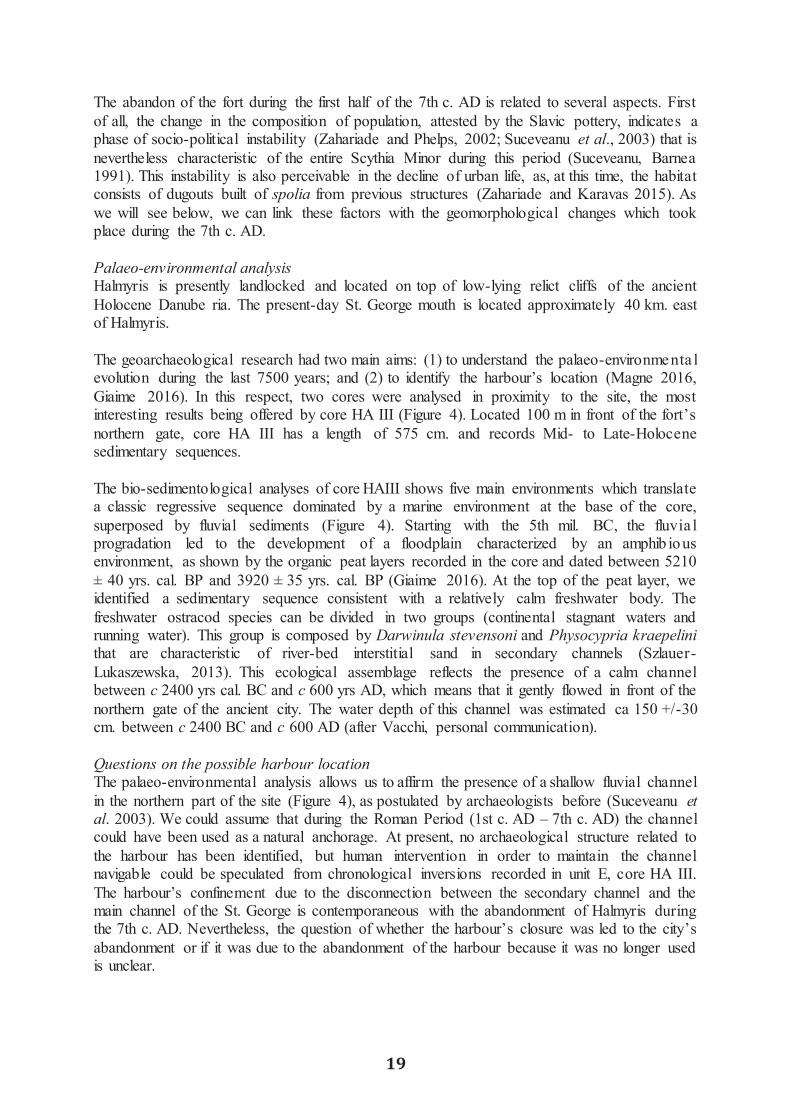
reworking. The sampled material comprises vegetal remains, charcoal and fresh-water shells for Halmyris, and marine shells for Histria. The local marine reservoir age used is 498 ± 41 BP (Siani et al. 2000). 3. Halmyris - a Roman fort on the Saint George branch Historical and archaeological contexts The ancient fort of Halmyris is located on the Northern part of the Dunavat promontory and faces the St. George arm, the oldest branch that has had an uninterrupted flux over the last 8000/7500 years (Vespremeanu-Stroe et. al 2016). Access to the settlement was possible via the St. George's and the Dunavat’s branches. The ancient history of Halmyris is divided into three main occupation phases (Suceveanu et al. 2003). The oldest traces of occupation are dated to the 4th c. BC, when the Getae populatio n settled on the site of the future fort. Notwithstanding this, the oldest sherd discovered on the site dates to the 6th c. BC, typologically belonging to the Middle Style II bowl of the Oriental style (Suceveanu and Angelescu 1988; Zahariade and Karavas 2015). The uppermost archaeologica l layer corresponds to the period between the 4th – 3rd c. BC, while the layer that follows corresponds to the dwelling level dated to the 2nd – 1st c. BC, and can possibly be related to a dava, a fortified Getae settlement. Regarding the settlement type, researchers (Zahariade 1991; Suceveanu et al. 2003; Zahariade and Karavas 2015) suggest that pre-Roman Halmyris could have been an emporion, integrated in the chora of Histria or, more probably, in that of Orgamè. The authors base their hypothesis on the toponymy (Halmyris is possibly a Greek name, related to the ancient homonymic gulf, which could mean salt water; for the toponymic discussion also see Suceveanu, Zahariade, 1987; Suceveanu et al. 2003; Zahariade, Alexandrescu 2011; Zahariade, Karavas 2015) and the Greek pottery discovered (especially amphorae from Chios, Chersonessos and Thassos). Even though the hypothesis of a Greek foundation where the Getae mixed with the Greek element is plausible, there is not sufficient archaeological data to unequivocally support it. During the Early Roman Period (1st – 3rd c. AD), Halmyris played an important strategic role. Initially an earth-fortification (last quarter of the 1st c. AD), Halmyris was rebuilt in stone during the 2nd c. AD as a fort. The newly-built fort played an important role in controlling the last segment of the Roman Limes on the Danube, overseeing the territory between Aegyssus (Tulcea) and the mouth of the St. George arm (Suceveanu et al., 2003). The most important discoveries dating from this epoch are eight inscriptions in which a vicus classicorum is mentioned (Suceveanu and Zahariade 1986; AÉ 1988 987; Zahariade and Alexandrescu 2011, 29–30, no. 6; Matei-Popescu 2016, 217-220). The date of the inscript io n (2nd – 3rd c. AD) suggests that in this period, the naval base of the Classis Flavia Moesica (the fleet organized by Emperor Vespasian) was located near Halmyris. The last phase of occupation covers the interval between the last quarter of the 3rd c. AD and the 3rd or 4th decades of the 7th c. AD (Suceveanu et al., 2003). During the Late Roman Period, the military character of Halmyris was mixed with civilian dwellings, given the apparition of constructions such as thermae. Regarding the harbour, an ancient text (Zos. IV, 10) informs us about Halmyris being a point of transfer from large maritime vessels to fluvial ones. Moreover, considering the conflicts with the barbarians during the 5th c. AD, archaeologists take into account the possibility of the fort also having a military harbour (Suceveanu et al., 2003).
The abandon of the fort during the first half of the 7th c. AD is related to several aspects. First of all, the change in the composition of population, attested by the Slavic pottery, indicates a phase of socio-political instability (Zahariade and Phelps, 2002; Suceveanu et al., 2003) that is nevertheless characteristic of the entire Scythia Minor during this period (Suceveanu, Barnea 1991). This instability is also perceivable in the decline of urban life, as, at this time, the habitat consists of dugouts built of spolia from previous structures (Zahariade and Karavas 2015). As we will see below, we can link these factors with the geomorphological changes which took place during the 7th c. AD. Palaeo-environmental analysis Halmyris is presently landlocked and located on top of low-lying relict cliffs of the ancient Holocene Danube ria. The present-day St. George mouth is located approximately 40 km. east of Halmyris. The geoarchaeological research had two main aims: (1) to understand the palaeo-environmenta l evolution during the last 7500 years; and (2) to identify the harbour’s location (Magne 2016, Giaime 2016). In this respect, two cores were analysed in proximity to the site, the most interesting results being offered by core HA III (Figure 4). Located 100 m in front of the fort’s northern gate, core HA III has a length of 575 cm. and records Mid- to Late-Holocene sedimentary sequences. The bio-sedimentological analyses of core HAIII shows five main environments which translate a classic regressive sequence dominated by a marine environment at the base of the core, superposed by fluvial sediments (Figure 4). Starting with the 5th mil. BC, the fluvia l progradation led to the development of a floodplain characterized by an amphib ious environment, as shown by the organic peat layers recorded in the core and dated between 5210 ± 40 yrs. cal. BP and 3920 ± 35 yrs. cal. BP (Giaime 2016). At the top of the peat layer, we identified a sedimentary sequence consistent with a relatively calm freshwater body. The freshwater ostracod species can be divided in two groups (continental stagnant waters and running water). This group is composed by Darwinula stevensoni and Physocypria kraepelini that are characteristic of river-bed interstitial sand in secondary channels (Szlauer-Lukaszewska, 2013). This ecological assemblage reflects the presence of a calm channel between c 2400 yrs cal. BC and c 600 yrs AD, which means that it gently flowed in front of the northern gate of the ancient city. The water depth of this channel was estimated ca 150 +/-30 cm. between c 2400 BC and c 600 AD (after Vacchi, personal communication). Questions on the possible harbour location The palaeo-environmental analysis allows us to affirm the presence of a shallow fluvial channel in the northern part of the site (Figure 4), as postulated by archaeologists before (Suceveanu et al. 2003). We could assume that during the Roman Period (1st c. AD – 7th c. AD) the channel could have been used as a natural anchorage. At present, no archaeological structure related to the harbour has been identified, but human intervention in order to maintain the channel navigable could be speculated from chronological inversions recorded in unit E, core HA III. The harbour’s confinement due to the disconnection between the secondary channel and the main channel of the St. George is contemporaneous with the abandonment of Halmyris during the 7th c. AD. Nevertheless, the question of whether the harbour’s closure was led to the city’s abandonment or if it was due to the abandonment of the harbour because it was no longer used is unclear.
19
reworking. The sampled material comprises vegetal remains, charcoal and fresh-water shells for Halmyris, and marine shells for Histria. The local marine reservoir age used is 498 ± 41 BP (Siani et al. 2000). 3. Halmyris - a Roman fort on the Saint George branch Historical and archaeological contexts The ancient fort of Halmyris is located on the Northern part of the Dunavat promontory and faces the St. George arm, the oldest branch that has had an uninterrupted flux over the last 8000/7500 years (Vespremeanu-Stroe et. al 2016). Access to the settlement was possible via the St. George's and the Dunavat’s branches. The ancient history of Halmyris is divided into three main occupation phases (Suceveanu et al. 2003). The oldest traces of occupation are dated to the 4th c. BC, when the Getae populatio n settled on the site of the future fort. Notwithstanding this, the oldest sherd discovered on the site dates to the 6th c. BC, typologically belonging to the Middle Style II bowl of the Oriental style (Suceveanu and Angelescu 1988; Zahariade and Karavas 2015). The uppermost archaeologica l layer corresponds to the period between the 4th – 3rd c. BC, while the layer that follows corresponds to the dwelling level dated to the 2nd – 1st c. BC, and can possibly be related to a dava, a fortified Getae settlement. Regarding the settlement type, researchers (Zahariade 1991; Suceveanu et al. 2003; Zahariade and Karavas 2015) suggest that pre-Roman Halmyris could have been an emporion, integrated in the chora of Histria or, more probably, in that of Orgamè. The authors base their hypothesis on the toponymy (Halmyris is possibly a Greek name, related to the ancient homonymic gulf, which could mean salt water; for the toponymic discussion also see Suceveanu, Zahariade, 1987; Suceveanu et al. 2003; Zahariade, Alexandrescu 2011; Zahariade, Karavas 2015) and the Greek pottery discovered (especially amphorae from Chios, Chersonessos and Thassos). Even though the hypothesis of a Greek foundation where the Getae mixed with the Greek element is plausible, there is not sufficient archaeological data to unequivocally support it. During the Early Roman Period (1st – 3rd c. AD), Halmyris played an important strategic role. Initially an earth-fortification (last quarter of the 1st c. AD), Halmyris was rebuilt in stone during the 2nd c. AD as a fort. The newly-built fort played an important role in controlling the last segment of the Roman Limes on the Danube, overseeing the territory between Aegyssus (Tulcea) and the mouth of the St. George arm (Suceveanu et al., 2003). The most important discoveries dating from this epoch are eight inscriptions in which a vicus classicorum is mentioned (Suceveanu and Zahariade 1986; AÉ 1988 987; Zahariade and Alexandrescu 2011, 29–30, no. 6; Matei-Popescu 2016, 217-220). The date of the inscript io n (2nd – 3rd c. AD) suggests that in this period, the naval base of the Classis Flavia Moesica (the fleet organized by Emperor Vespasian) was located near Halmyris. The last phase of occupation covers the interval between the last quarter of the 3rd c. AD and the 3rd or 4th decades of the 7th c. AD (Suceveanu et al., 2003). During the Late Roman Period, the military character of Halmyris was mixed with civilian dwellings, given the apparition of constructions such as thermae. Regarding the harbour, an ancient text (Zos. IV, 10) informs us about Halmyris being a point of transfer from large maritime vessels to fluvial ones. Moreover, considering the conflicts with the barbarians during the 5th c. AD, archaeologists take into account the possibility of the fort also having a military harbour (Suceveanu et al., 2003).
The abandon of the fort during the first half of the 7th c. AD is related to several aspects. First of all, the change in the composition of population, attested by the Slavic pottery, indicates a phase of socio-political instability (Zahariade and Phelps, 2002; Suceveanu et al., 2003) that is nevertheless characteristic of the entire Scythia Minor during this period (Suceveanu, Barnea 1991). This instability is also perceivable in the decline of urban life, as, at this time, the habitat consists of dugouts built of spolia from previous structures (Zahariade and Karavas 2015). As we will see below, we can link these factors with the geomorphological changes which took place during the 7th c. AD. Palaeo-environmental analysis Halmyris is presently landlocked and located on top of low-lying relict cliffs of the ancient Holocene Danube ria. The present-day St. George mouth is located approximately 40 km. east of Halmyris. The geoarchaeological research had two main aims: (1) to understand the palaeo-environmenta l evolution during the last 7500 years; and (2) to identify the harbour’s location (Magne 2016, Giaime 2016). In this respect, two cores were analysed in proximity to the site, the most interesting results being offered by core HA III (Figure 4). Located 100 m in front of the fort’s northern gate, core HA III has a length of 575 cm. and records Mid- to Late-Holocene sedimentary sequences. The bio-sedimentological analyses of core HAIII shows five main environments which translate a classic regressive sequence dominated by a marine environment at the base of the core, superposed by fluvial sediments (Figure 4). Starting with the 5th mil. BC, the fluvia l progradation led to the development of a floodplain characterized by an amphib ious environment, as shown by the organic peat layers recorded in the core and dated between 5210 ± 40 yrs. cal. BP and 3920 ± 35 yrs. cal. BP (Giaime 2016). At the top of the peat layer, we identified a sedimentary sequence consistent with a relatively calm freshwater body. The freshwater ostracod species can be divided in two groups (continental stagnant waters and running water). This group is composed by Darwinula stevensoni and Physocypria kraepelini that are characteristic of river-bed interstitial sand in secondary channels (Szlauer-Lukaszewska, 2013). This ecological assemblage reflects the presence of a calm channel between c 2400 yrs cal. BC and c 600 yrs AD, which means that it gently flowed in front of the northern gate of the ancient city. The water depth of this channel was estimated ca 150 +/-30 cm. between c 2400 BC and c 600 AD (after Vacchi, personal communication). Questions on the possible harbour location The palaeo-environmental analysis allows us to affirm the presence of a shallow fluvial channel in the northern part of the site (Figure 4), as postulated by archaeologists before (Suceveanu et al. 2003). We could assume that during the Roman Period (1st c. AD – 7th c. AD) the channel could have been used as a natural anchorage. At present, no archaeological structure related to the harbour has been identified, but human intervention in order to maintain the channel navigable could be speculated from chronological inversions recorded in unit E, core HA III. The harbour’s confinement due to the disconnection between the secondary channel and the main channel of the St. George is contemporaneous with the abandonment of Halmyris during the 7th c. AD. Nevertheless, the question of whether the harbour’s closure was led to the city’s abandonment or if it was due to the abandonment of the harbour because it was no longer used is unclear.
20
4. Histria - a city on the Southern margin of the delta Geomorphological context The ancient city of Histria is located on the southern margin of the Razelm-Sinoe lagoon system. This area is defined by the existence of many geomorphological units, namely two major beach ridge plains (Saele, where Histria is located, and Chituc), sandy barriers (Lupilo r) and shallow lakes (Sinoe on the E, Istria and Nuntasi on the W) interconnected by natural and artificial channels. The main sedimentary input came from St. George’s branch, via the Dunavatz and Dranov channels which, before their artificialization in 1912, represented its secondary distributaries (Antipa 1914; Hanganu 2012, 24; Vespremeani-Stroe et al. 2013, 248). The intense coastal progradation of the region due to the proximity of the Danube, along with the long shore currents, lead to the formation of the Saele beach ridge plain, with a maximum length of 9.5 km. and a width of 3 km. The older unit, Saele West (Vechi) is OSL dated to 5000 – 2730 cal. BP (Hanganu 2012; Preoteasa et al. 2013; Vespremeanu-Stroe et al. 2013; Vespremeanu-Stroe et al. 2016) and connects the green schist palaeo-island (where Histria’s acropolis is located) to the continent. The existence of this coastal plain before the foundation of the city by the Milesians in the second half of the 7th c. BC is also supported by archaeological data, because we have dwelling structures from the Archaic Period (end of 7th – 5th c. BC) built directly on the sand in this area, called the Western Plateau (Dimitriu 1966, 27-37). Historical and archaeological overview The continuous occupation during almost 1300 years can be grouped into five main archaeological periods: (1) the Archaic Period (7th – 5th c. BC); (2) the Classical Period (5th – 4th c. BC); (3) the Hellenistic Period (4th – 1st c. BC); (4) the Early Roman Period (1st – 3th c. AD); and (5) the Late Roman Period (4th – 7th c. AD) (Angelescu, Bâltâc 2002-2003). Since its foundation, the city comprised two nuclei, the acropolis and the western plateau. For the Archaic Period, there are dwelling levels on the acropolis, where the Sacred Area is located (Alexandrescu 2005, Avram et al. 2013), as well as on the western plateau, where habitation structures were discovered (Dimitriu 1966). Along with these, a segment of the Archaic defense wall was discovered on the western part of the plateau (Suceveanu 2005) while, in the centre and in the southern part of the acropolis, structures dating from this epoch were also identified (Bottez 2015). An interesting remark concerning the spatial distribution of the archaeological features of the Archaic Period is their absence over a 450 m distance between the Classical defense wall and the western plateau. The Classical Period is characterized by a flourishing economy, considering that around 450 BC, Histria started to mint its own coin (Talmatchi 2011, passim). Among the previous dwelling spots, we encounter new ones on the western plateau, as well as a new defense wall for the Acropolis which encompasses a larger surface than the Archaic one; also, there is some evidence for the existence of a second defense wall, intended to protect the Plateau (Angelescu 2003-2005, 84). Beginning in the 4th c. BC, the double defense wall system was implemented at Histria, one for protecting the acropolis and which enclosed a c 10 ha surface, and another which follows almost the same trajectory as the Archaic one (Angelescu 2003- 2005, 70). The Hellenis t ic Period was unfortunately marked by geopolitical instability. The city was engaged in local conflicts (the war between Scythians north of the Black Sea and southern Thracians), as well
as in regional ones (the wars between Hellenistic kingdoms) (Pippidi 1967). The Early Roman Period marks the end of Histria’s autonomy. In spite of this, the city became prosperous once again in the 2nd c. AD, as demonstrated by the archaeological material. Another defense wall was built, west of the Hellenistic one, while the Sacred Area was abandoned and over it a residential district was raised (Avram et al. 2013). Furthermore, during this period, the city received two bath complexes (Suceveanu 1982), as well as the civil basilica from the agora. After the period of stability ensured by Emperor Trajan, Histria was confronted with increased barbarian pressure starting with the Marcomanic Wars during the reign of emperor Marc Aurelius. The peak of this conflict was during the second half of the 3rd c. AD, when a Gothic invasion caused the city’s most violent destruction – (SHA, Max. Balb. 16, 3 mentions the excidium Histriae) (Dorutiu-Boila 1985, 133-134). The last phase of occupation corresponds to the Late Roman Period. After the 3rd c. AD destruction, a new defense wall was built – the last one –, which enclosed a surface of c 7 ha. A last period of prosperity is attested archaeologically during the 6th c. AD (Suceveanu 2013); following this, the final decline of the city started, ending with its abandonment during the first half of the 7th c. AD, after 1300 years of uninterrupted occupation. Geoarchaeological research – Identification of a possible harbour? Our work at Histria was concentrated in the NW part of the city (Saratura site, Figure 5) and sought to answer two main questions: (1) how did this area evolve from a geomorphologica l point of view? and (2) was this area suitable for an anchorage/harbour activities? For our study, four cores were drilled in the centre of the site and in its proximity, with the most interesting results being observed in cores HIS I and HIS III. Regarding the geomorphology of the Histrian region before the foundation of the city, our cores indicate a connection between the palaeo-island of Histria and the continent. According to the stratigraphy of cores HIS I and HIS III, we observed an evolution from an open marine environment to a lagoonal one c 2000 BC (Bivolaru 2016). Although chronology needs to be reinforced, the stratigraphy obtained in core HIS I was extremely interesting, as we have two main units: the one at the base, dated to the period before the city’s foundation, indicates a protected lagoon environment (2456 - 2142 cal. BC), which started to communicate with the sea around 2280 - 2035 cal. BC, more than one millennium before the foundation of Histria. The bio-sedimentological assemblage of unit B was interpreted as possibly corresponding to the functioning of the ancient harbour (Bivolaru 2016). A better chronostratigraphic framework was identified in core HIS III (Figure 6). The bio-sedimentological analysis shows a geomorphological evolution from an open marine environment (1488 - 1216 cal. BC) to an open lagoon around 394 - 307 cal. BC (Bivolaru 2016), with the onset of a protected environment, characterized by the deposition of silts and clay in unit B. Radiocarbon dating is confirmed by pottery finds from the core, which were also dated to the Hellenistic Period. The bio-sedimentological sequence identified here is possibly characteristic of a harbour basin. It consists of a unit which records an abrupt siltation (HIS III, unit B) above a coarse deposit (HIS III, unit A). The malacological assemblage and the ostraco-fauna of unit B are similar to that corresponding to an open lagoon, with species such as Cerastoderma edule for mollusks and Cyprideistorosa for ostracods being recorded. Furthermore, the chronological inversion recorded at the top of this unit could be an indicat ion for possible dredging in order to maintain the harbour functional.

21
as in regional ones (the wars between Hellenistic kingdoms) (Pippidi 1967). The Early Roman Period marks the end of Histria’s autonomy. In spite of this, the city became prosperous once again in the 2nd c. AD, as demonstrated by the archaeological material. Another defense wall was built, west of the Hellenistic one, while the Sacred Area was abandoned and over it a residential district was raised (Avram et al. 2013). Furthermore, during this period, the city received two bath complexes (Suceveanu 1982), as well as the civil basilica from the agora. After the period of stability ensured by Emperor Trajan, Histria was confronted with increased barbarian pressure starting with the Marcomanic Wars during the reign of emperor Marc Aurelius. The peak of this conflict was during the second half of the 3rd c. AD, when a Gothic invasion caused the city’s most violent destruction – (SHA, Max. Balb. 16, 3 mentions the excidium Histriae) (Dorutiu-Boila 1985, 133-134). The last phase of occupation corresponds to the Late Roman Period. After the 3rd c. AD destruction, a new defense wall was built – the last one –, which enclosed a surface of c 7 ha. A last period of prosperity is attested archaeologically during the 6th c. AD (Suceveanu 2013); following this, the final decline of the city started, ending with its abandonment during the first half of the 7th c. AD, after 1300 years of uninterrupted occupation. Geoarchaeological research – Identification of a possible harbour? Our work at Histria was concentrated in the NW part of the city (Saratura site, Figure 5) and sought to answer two main questions: (1) how did this area evolve from a geomorphologica l point of view? and (2) was this area suitable for an anchorage/harbour activities? For our study, four cores were drilled in the centre of the site and in its proximity, with the most interesting results being observed in cores HIS I and HIS III. Regarding the geomorphology of the Histrian region before the foundation of the city, our cores indicate a connection between the palaeo-island of Histria and the continent. According to the stratigraphy of cores HIS I and HIS III, we observed an evolution from an open marine environment to a lagoonal one c 2000 BC (Bivolaru 2016). Although chronology needs to be reinforced, the stratigraphy obtained in core HIS I was extremely interesting, as we have two main units: the one at the base, dated to the period before the city’s foundation, indicates a protected lagoon environment (2456 - 2142 cal. BC), which started to communicate with the sea around 2280 - 2035 cal. BC, more than one millennium before the foundation of Histria. The bio-sedimentological assemblage of unit B was interpreted as possibly corresponding to the functioning of the ancient harbour (Bivolaru 2016). A better chronostratigraphic framework was identified in core HIS III (Figure 6). The bio-sedimentological analysis shows a geomorphological evolution from an open marine environment (1488 - 1216 cal. BC) to an open lagoon around 394 - 307 cal. BC (Bivolaru 2016), with the onset of a protected environment, characterized by the deposition of silts and clay in unit B. Radiocarbon dating is confirmed by pottery finds from the core, which were also dated to the Hellenistic Period. The bio-sedimentological sequence identified here is possibly characteristic of a harbour basin. It consists of a unit which records an abrupt siltation (HIS III, unit B) above a coarse deposit (HIS III, unit A). The malacological assemblage and the ostraco-fauna of unit B are similar to that corresponding to an open lagoon, with species such as Cerastoderma edule for mollusks and Cyprideistorosa for ostracods being recorded. Furthermore, the chronological inversion recorded at the top of this unit could be an indicat ion for possible dredging in order to maintain the harbour functional.

22
Therefore, at Histria, we may have a first phase of anchorage on a pocket beach during the Archaic Period (following HIS III data), followed by a lagoonal (artificial?) basin starting with the Hellenistic Period in the central-northern part of the site. An important argument in support of our hypothesis is the preliminary geophysical investigations undertaken by Höckmann (1996 and 1998) (Figure 7). In 1996, geo-electrical research undertaken in the so-called Saratura site, where core HIS I is located, led Höckmann to interpret this spot as a narrow gulf which could have served as a natural anchorage (Höckmann et al. 1996-1998, Höckmann 2001). Important results were also obtained in 1998, when a sonar investigation was undertaken on Lake Sinoe. In the western part of the lake, archaeological structures as well as a ditch 150 m long and oriented WNW-ESE were detected, which on its E extremity turns in an obtuse angle towards the E for another 60 m; all these structures were identified under the bottom of the lake (Höckmann et al. 1996-1998, Höckmann 2001). On the eastern extremity of the initial segment, two parallel ditches were identified; another is oriented E-W (Höckmann et al. 1996-1998, Höckmann 2001). The same extremity meets a curved bed, called ‘The Plateau Channel’, which has structures from an unknown period identified on its banks (Höckmann et al. 1996-1998, Höckmann 2001). The whole assembly (Figure 7) was interpreted as a possible northern extremity of the Saratura gulf (Höckmann et al. 1996-1998, Höckmann 2001). Moreover, the existence of a harbour basin during the Hellenistic Period is attested by a series of epigraphic monuments discovered on the site, which mention the port. Among them is a series of proxeny decrees that attest to the presence of a harbour, the oldest of which dates to the 5th c. BC (Avram 2000 = SEG 50 681 = BÉp. 2004 228, Avram 2007 no. XXXI, Cojocaru 2016, no. 8(1)). Equally interesting for our research is an inscription initially dated to the 2nd c. BC (ISM I 64), but more recently re-dated to the middle of the 3rd c. BC (see Avram 2007, no. 64 for Ju. G. Vinogradov’ comment) that mentions a Histrian fleet which helped Apollonia Pontica (Sozopol, Bulgaria) in its war with Messambria (Nessebar, Bulgaria). In addition, another epigraphic monument from the 3rd c. BC (ISM I 112, Avram 2007, no. 112, Alexandrescu-Vianu 200 no. 178) makes a brief reference to a possible Histrian fleet. This is very important for the investigation of the harbour of Istros, as the existence of a fleet implies the presence of certain harbour constructions, such as naval structures necessary for maintaining an operational fleet (Blackmann et al. 2013). 5. Conclusions and perspectives Our research offers new insights regarding the palaeo-environmental evolution of Halmyris and Histria, two ancient settlements of the Danube delta. We focused on the search for the harbours or anchorages at each site. At Halmyris, located on the fluvial part of the delta, our investigations reveal the presence of a secondary channel of the St. George in proximity to the city. According to our bio-sedimentological analyses, this channel flowed north of Halmyris between the 3rd m. BC and the 7th c AD and may have been used as a natural harbour during the Roman Period. Even if the disconnection between the secondary channel and the St. George arm of the Danube is contemporaneous with the abandonment of Halmyris by the Romans, in the present state of research we cannot affirm that this context is responsible for the abandonment of the site. In fact, the 7th c. AD marks the beginning of a period of disequilibrium at the frontier of the Empire that forced the Romans to abandon a large number of cities in Scythia Minor and eventually led to the fall of the Danubian limes (Suceveanu, Barnea 1991). Therefore, it could be that the departure of the population resulted in the rapid infilling of the harbour.
For Histria, located on the southern margin of the maritime delta, we observe a transition from an open marine environment to an open lagoonal one around 394 - 307 cal. BC (dating to be confirmed). Our multi-proxy approach led us to hypothesize the presence of a primit ive anchorage on a pocket beach during the Archaic Period, followed by the construction of a basin at the beginning of the Hellenistic Period in the central- northern part of the site. As in the case of Halmyris, we cannot clearly determine at this moment if the abandonment of the city is alsorelated to the loss of harbour facilities due to the emergence of the Chituc – East Saele beach ridge plains starting with 1400 BP (Vespremeanu-Stroe et al. 2016), apart from the alreadymentioned socio-political factors.
Nevertheless, our preliminary results will be completed with new bio- sedimentological data,as well as with radiocarbon datings, in order to offer a more solid reconstruction in the future.Moreover, the data will be cross-checked with geophysical and archaeological investigations,in order to identify possible structures related to the harbour basin (Histria) or the channel respectively (Halmyris).
Acknowledgements
This project received funding from the European Union’s Horizon 2020 research andinnovation program under the Marie Skłodowska-Curie grant agreement No.713750. Also, it was carried out with the financial support of the Regional Council of Provence-Alpes-Côte d’Azur and with the financial support of A*MIDEX (n° ANR- 11- IDEX-0001-02), funded bythe Investissements d'Avenir project funded by the French Government, managed by the French National Research Agency (ANR). Support was also provided by the Institut Universitaire de France, through the project “Geoarchaeology of Ancient Harbours” (headed by C. Morhange). We thank the Eccorev federation and the sedimentology laboratory of the CEREGE (D.Delanghe-CEREGE) for the funding of the binocular microscope Leica MZ125. We would like to thank Emmanuel Gandouin, Vincent Olivier, Majid Shah-Hosseini, Sabin Rotaru and FlorinZainescu for their help during the fieldwork.

23
Therefore, at Histria, we may have a first phase of anchorage on a pocket beach during the Archaic Period (following HIS III data), followed by a lagoonal (artificial?) basin starting with the Hellenistic Period in the central-northern part of the site. An important argument in support of our hypothesis is the preliminary geophysical investigations undertaken by Höckmann (1996 and 1998) (Figure 7). In 1996, geo-electrical research undertaken in the so-called Saratura site, where core HIS I is located, led Höckmann to interpret this spot as a narrow gulf which could have served as a natural anchorage (Höckmann et al. 1996-1998, Höckmann 2001). Important results were also obtained in 1998, when a sonar investigation was undertaken on Lake Sinoe. In the western part of the lake, archaeological structures as well as a ditch 150 m long and oriented WNW-ESE were detected, which on its E extremity turns in an obtuse angle towards the E for another 60 m; all these structures were identified under the bottom of the lake (Höckmann et al. 1996-1998, Höckmann 2001). On the eastern extremity of the initial segment, two parallel ditches were identified; another is oriented E-W (Höckmann et al. 1996-1998, Höckmann 2001). The same extremity meets a curved bed, called ‘The Plateau Channel’, which has structures from an unknown period identified on its banks (Höckmann et al. 1996-1998, Höckmann 2001). The whole assembly (Figure 7) was interpreted as a possible northern extremity of the Saratura gulf (Höckmann et al. 1996-1998, Höckmann 2001). Moreover, the existence of a harbour basin during the Hellenistic Period is attested by a series of epigraphic monuments discovered on the site, which mention the port. Among them is a series of proxeny decrees that attest to the presence of a harbour, the oldest of which dates to the 5th c. BC (Avram 2000 = SEG 50 681 = BÉp. 2004 228, Avram 2007 no. XXXI, Cojocaru 2016, no. 8(1)). Equally interesting for our research is an inscription initially dated to the 2nd c. BC (ISM I 64), but more recently re-dated to the middle of the 3rd c. BC (see Avram 2007, no. 64 for Ju. G. Vinogradov’ comment) that mentions a Histrian fleet which helped Apollonia Pontica (Sozopol, Bulgaria) in its war with Messambria (Nessebar, Bulgaria). In addition, another epigraphic monument from the 3rd c. BC (ISM I 112, Avram 2007, no. 112, Alexandrescu-Vianu 200 no. 178) makes a brief reference to a possible Histrian fleet. This is very important for the investigation of the harbour of Istros, as the existence of a fleet implies the presence of certain harbour constructions, such as naval structures necessary for maintaining an operational fleet (Blackmann et al. 2013). 5. Conclusions and perspectives Our research offers new insights regarding the palaeo-environmental evolution of Halmyris and Histria, two ancient settlements of the Danube delta. We focused on the search for the harbours or anchorages at each site. At Halmyris, located on the fluvial part of the delta, our investigations reveal the presence of a secondary channel of the St. George in proximity to the city. According to our bio-sedimentological analyses, this channel flowed north of Halmyris between the 3rd m. BC and the 7th c AD and may have been used as a natural harbour during the Roman Period. Even if the disconnection between the secondary channel and the St. George arm of the Danube is contemporaneous with the abandonment of Halmyris by the Romans, in the present state of research we cannot affirm that this context is responsible for the abandonment of the site. In fact, the 7th c. AD marks the beginning of a period of disequilibrium at the frontier of the Empire that forced the Romans to abandon a large number of cities in Scythia Minor and eventually led to the fall of the Danubian limes (Suceveanu, Barnea 1991). Therefore, it could be that the departure of the population resulted in the rapid infilling of the harbour.
For Histria, located on the southern margin of the maritime delta, we observe a transition from an open marine environment to an open lagoonal one around 394 - 307 cal. BC (dating to be confirmed). Our multi-proxy approach led us to hypothesize the presence of a primit ive anchorage on a pocket beach during the Archaic Period, followed by the construction of a basin at the beginning of the Hellenistic Period in the central- northern part of the site. As in the case of Halmyris, we cannot clearly determine at this moment if the abandonment of the city is alsorelated to the loss of harbour facilities due to the emergence of the Chituc – East Saele beach ridge plains starting with 1400 BP (Vespremeanu-Stroe et al. 2016), apart from the alreadymentioned socio-political factors.
Nevertheless, our preliminary results will be completed with new bio- sedimentological data,as well as with radiocarbon datings, in order to offer a more solid reconstruction in the future.Moreover, the data will be cross-checked with geophysical and archaeological investigations,in order to identify possible structures related to the harbour basin (Histria) or the channel respectively (Halmyris).
Acknowledgements
This project received funding from the European Union’s Horizon 2020 research andinnovation program under the Marie Skłodowska-Curie grant agreement No.713750. Also, it was carried out with the financial support of the Regional Council of Provence-Alpes-Côte d’Azur and with the financial support of A*MIDEX (n° ANR- 11- IDEX-0001-02), funded bythe Investissements d'Avenir project funded by the French Government, managed by the French National Research Agency (ANR). Support was also provided by the Institut Universitaire de France, through the project “Geoarchaeology of Ancient Harbours” (headed by C. Morhange). We thank the Eccorev federation and the sedimentology laboratory of the CEREGE (D.Delanghe-CEREGE) for the funding of the binocular microscope Leica MZ125. We would like to thank Emmanuel Gandouin, Vincent Olivier, Majid Shah-Hosseini, Sabin Rotaru and FlorinZainescu for their help during the fieldwork.

24
Bibliography Ancient texts SHA, Max. Balb. – Historia Augusta (English tr. D. Magie). Vol. II. (1993). Harvard University Press. Zos. Zosimos (Historicus), Historia Nova. (French tr. F. Paschoud) Vol. II.2 (1979). Les Belles Lettres. Corpora of sources AÉ – Année Épigraphique. Paris. ISM I – Pippidi, D. M. (ed.), 1983. lnscriptiones Scythiae Minoris. 1. Inscriptiones Histriae et viciniae, Bucharest. SEG – Supplementum Epigraphicum Graecum, Brill. Modern works Alexandrescu, P. 2005. Histria VII. La zone sacrée d’époque grecque. Paris-Bucharest, Les Belles Lettres-Ed. Academiei. Alexandrescu-Vianu, M. 1999. Histria IX. Les statues et les reliefs en pierre. Paris- Bucharest, Les Belles Lettres-Ed. Academiei. Angelescu, M.V. 2003-2005. Histria. Sistemul de duble incinte în epoca greaca. Studii si Cercetari de Istorie Veche si Arheologie 54-56, Bucuresti, 55-84. Antipa, G., 1914. Câteva probleme stiintifice si economice privitoare la Delta Dunarii. Analele Academiei Române. Memoriile Sectiunii Stiintifice 2, 36. Avram, Al., 2000. Le plus ancien décret d’Istros octroyant la proxénie, in A. Avram and M. Babes (eds.), Civilisation grecque et cultures antiques périphériques. Hommage à Petre Alexandrescu à son 70e anniversaire. Bucharest, Ed. Enciclopedica, 235-238. Avram, Al., 2007. Le corpus d’inscriptions d’Istros revisité. Dacia (N.S.) 51, 79-132. Avram, Al., Bîrzescu, I., Margineanu Cârstoiu, M., Zimmermann, K., 2013. Archäologische Ausgrabungen in der Tempelzone von Histria, 1990-2009. Il Mar Nero 8 (2010-2011), 39-101. Blackmann, D., Rankov, B., Baika, K., Gerding, H., Pakkanen J., 2013. Shipsheds of the Ancient Mediterranean. Cambridge, Cambridge University Press. Bleahu, M., 1962. Observatii asupra evolutiei zonei Histria în ultimele trei milenii. Probleme de geografie, 9, 45-56. Bivolaru, Al. 2016. Analiza geoarheologica a mobilitatii paleo-mediului litoral. Studiu ce caz: NV cetatii Histria. Unpublished MA dissertation, University of Bucharest.
Bottez, V., 2015. Old digs, new data: archaeological topography of the southern part of the Acropolis of Istros during the Greek period (the Basilica Pârvan Sector), in G.R. Tsetskhladze, A. Avram and J. Hargrave (eds.), The Danubian Lands between the Black, Aegean and Adriatic Seas (7th. century BC-10th. century BC). Proceedings of the Fifth International Congres on Black Sea Antiquites (Belgrade-17-21 September 2013), 363-369. Oxford, Archaeopress. Canarache, V., 1956. Obseravtii noi cu privire la topografia Histriei. Studii si Cercetari de Istorie Veche si Arheologie 7, Bucuresti, 289-318. Condurachi, E. (ed.) 1954. Histria I. Monografie arheologica. Bucuresti, Editura Academiei Republicii Populare Române. Cojocaru, V., 2016. Institutia proxeniei în spatiul pontic. Cluj, Mega. Cotet, P.V. 1966. Tarmul Marii Negre si evolutia lui în timpurile istorice (cu privire speciala asupra regiunii Histria). In Em. Condurachi (ed.), Histria II. Monografie arheologica, 337-352. Bucuresti, Editura Academiei Republicii Populare Române. Dorutiu-Boila, Em., 1985. Excidium Histriae (zu ISM I, 168). Dacia, N.S., 29, 133-134. Dimitriu, S. 1966, Cartierul de locuinte din zona de vest a cetatii în epoca arhaica. Sapaturi 1955-1960. In Em. Condurachi (ed.), Histria II. Monografie arheologica, 19-133. Bucuresti, Editura Academiei Republicii Populare Române. Giaime, M., 2016. Géoarchéologie des ports antiques en contextes deltaïques: quelques exemples de Méditerranée et de mer Noire. Unpublished PhD thesis, Aix-Marseille University. Hanganu, D. 2012. Histria - Studiu de geoarheologie. Unpublished PhD thesis, University of Bucharest. Magne, G. 2016. Histoire environnementale de la cité antique d'Halmyris dans le delta du Danube (Roumanie): approche paléobiologique. Unpublished MA thesis, Aix-Marseille University. Marriner, N., Morhange, C., 2007. Geoscience of ancient Mediterranean harbours. Earth- Science Review, 80, 137-194. Marriner, N., Morhange, C. 2006. Geoarchaeological evidence for dredging in Tyre’s ancient harbor, Levant. Quaternary Research 65, 164-171. Mariner, N., Morhange, C., Flaux, C., Carayon, N. 2016. Harbors and Ports, Ancient. In A. S. Gillbert (ed.), Encycopedia of Geoarchaeology, 382-403. Springer Netherlands. Matei-Popescu, F., 2016. Vicus Nov(iodunum) and vicus classicorum. On the origins of the municipium Noviodunum. Ancient West and East 15, 213-222. Opreanu, P.A., 2003. Contribution to the Knowledge of Recent Ostracod Fauna from Some Danube Delta Lakes. Geo-Eco-Marina, 9–10.

25
Bibliography Ancient texts SHA, Max. Balb. – Historia Augusta (English tr. D. Magie). Vol. II. (1993). Harvard University Press. Zos. Zosimos (Historicus), Historia Nova. (French tr. F. Paschoud) Vol. II.2 (1979). Les Belles Lettres. Corpora of sources AÉ – Année Épigraphique. Paris. ISM I – Pippidi, D. M. (ed.), 1983. lnscriptiones Scythiae Minoris. 1. Inscriptiones Histriae et viciniae, Bucharest. SEG – Supplementum Epigraphicum Graecum, Brill. Modern works Alexandrescu, P. 2005. Histria VII. La zone sacrée d’époque grecque. Paris-Bucharest, Les Belles Lettres-Ed. Academiei. Alexandrescu-Vianu, M. 1999. Histria IX. Les statues et les reliefs en pierre. Paris- Bucharest, Les Belles Lettres-Ed. Academiei. Angelescu, M.V. 2003-2005. Histria. Sistemul de duble incinte în epoca greaca. Studii si Cercetari de Istorie Veche si Arheologie 54-56, Bucuresti, 55-84. Antipa, G., 1914. Câteva probleme stiintifice si economice privitoare la Delta Dunarii. Analele Academiei Române. Memoriile Sectiunii Stiintifice 2, 36. Avram, Al., 2000. Le plus ancien décret d’Istros octroyant la proxénie, in A. Avram and M. Babes (eds.), Civilisation grecque et cultures antiques périphériques. Hommage à Petre Alexandrescu à son 70e anniversaire. Bucharest, Ed. Enciclopedica, 235-238. Avram, Al., 2007. Le corpus d’inscriptions d’Istros revisité. Dacia (N.S.) 51, 79-132. Avram, Al., Bîrzescu, I., Margineanu Cârstoiu, M., Zimmermann, K., 2013. Archäologische Ausgrabungen in der Tempelzone von Histria, 1990-2009. Il Mar Nero 8 (2010-2011), 39-101. Blackmann, D., Rankov, B., Baika, K., Gerding, H., Pakkanen J., 2013. Shipsheds of the Ancient Mediterranean. Cambridge, Cambridge University Press. Bleahu, M., 1962. Observatii asupra evolutiei zonei Histria în ultimele trei milenii. Probleme de geografie, 9, 45-56. Bivolaru, Al. 2016. Analiza geoarheologica a mobilitatii paleo-mediului litoral. Studiu ce caz: NV cetatii Histria. Unpublished MA dissertation, University of Bucharest.
Bottez, V., 2015. Old digs, new data: archaeological topography of the southern part of the Acropolis of Istros during the Greek period (the Basilica Pârvan Sector), in G.R. Tsetskhladze, A. Avram and J. Hargrave (eds.), The Danubian Lands between the Black, Aegean and Adriatic Seas (7th. century BC-10th. century BC). Proceedings of the Fifth International Congres on Black Sea Antiquites (Belgrade-17-21 September 2013), 363-369. Oxford, Archaeopress. Canarache, V., 1956. Obseravtii noi cu privire la topografia Histriei. Studii si Cercetari de Istorie Veche si Arheologie 7, Bucuresti, 289-318. Condurachi, E. (ed.) 1954. Histria I. Monografie arheologica. Bucuresti, Editura Academiei Republicii Populare Române. Cojocaru, V., 2016. Institutia proxeniei în spatiul pontic. Cluj, Mega. Cotet, P.V. 1966. Tarmul Marii Negre si evolutia lui în timpurile istorice (cu privire speciala asupra regiunii Histria). In Em. Condurachi (ed.), Histria II. Monografie arheologica, 337-352. Bucuresti, Editura Academiei Republicii Populare Române. Dorutiu-Boila, Em., 1985. Excidium Histriae (zu ISM I, 168). Dacia, N.S., 29, 133-134. Dimitriu, S. 1966, Cartierul de locuinte din zona de vest a cetatii în epoca arhaica. Sapaturi 1955-1960. In Em. Condurachi (ed.), Histria II. Monografie arheologica, 19-133. Bucuresti, Editura Academiei Republicii Populare Române. Giaime, M., 2016. Géoarchéologie des ports antiques en contextes deltaïques: quelques exemples de Méditerranée et de mer Noire. Unpublished PhD thesis, Aix-Marseille University. Hanganu, D. 2012. Histria - Studiu de geoarheologie. Unpublished PhD thesis, University of Bucharest. Magne, G. 2016. Histoire environnementale de la cité antique d'Halmyris dans le delta du Danube (Roumanie): approche paléobiologique. Unpublished MA thesis, Aix-Marseille University. Marriner, N., Morhange, C., 2007. Geoscience of ancient Mediterranean harbours. Earth- Science Review, 80, 137-194. Marriner, N., Morhange, C. 2006. Geoarchaeological evidence for dredging in Tyre’s ancient harbor, Levant. Quaternary Research 65, 164-171. Mariner, N., Morhange, C., Flaux, C., Carayon, N. 2016. Harbors and Ports, Ancient. In A. S. Gillbert (ed.), Encycopedia of Geoarchaeology, 382-403. Springer Netherlands. Matei-Popescu, F., 2016. Vicus Nov(iodunum) and vicus classicorum. On the origins of the municipium Noviodunum. Ancient West and East 15, 213-222. Opreanu, P.A., 2003. Contribution to the Knowledge of Recent Ostracod Fauna from Some Danube Delta Lakes. Geo-Eco-Marina, 9–10.

26
Opreanu, P.A., 2008. Ostracode relicte Ponto-Caspice ın sectorul Românesc al Marii Negre. Geo-Eco-Marina, 14, 57-62. Panin, N., 2003. The Danube Delta geomorphology and Holocene evolution: a synthesis. Geomorphologie: Relief, Processus, Environment 4, 247-262. Preoteasa, L., Bîrzescu, I., Haganu, D., Vespremeanu-Stroe, A. 2012. Schimbari morfologice în regiunea Histria produse în timpul si dupa declinul cetatii. Studii si Cercetari de Istorie Veche si Arheologie 63, 3-4, 201-223. Preoteasa, L., Vespremeanu-Stroe, A., Hanganu, D., Katona, O., Timar-Gabor, A., 2013. Coastal changes from open coast to present lagoon system in Histria region (Danube delta). Journal of Coastal Research, Special Issue 65, 564-569. Reimer, P.-J., Bard, E., Bayliss, A., Beck, J.-W., Blackwell, P.-G., Ramsey, C.-B., Buck, C.-E., Cheng, H., Edwards, R.-L., Friedrich, M., Grootes, P.-M., Guilderson, T.-P., Haflidison, H., Hajdas, I., Hatté, C., Heaton, T., Hoffmann, D.-L., Hogg, A., Hughen, K.-A., Kaiser, K., Kromer, B., Manning, S.-W., Niu, M., Reimer, R., Richards, D.-A., Scott, E.-M., Southon, J.-R., Staff, R., Turney, C., Van der Plicht, J., 2013. IntCal13 and Marine13 Radiocarbon Age Calibration Curves 0-50,000 years cal BP. Radiocarbon, 55, 1869-1887. Siani, G., Paterne, M., Arnold, M., Bard, E., Metivier, B., Tisnerat, N., Bassinot, F., 2000. Radiocarbon reservoir ages in the Mediterranean Sea and Black Sea. Radiocarbon 42, 271-280. Soulet, G., Ménot, G., Garreta, V., Rostek, F., Zaragosi, S., Lericolais, G., Bard, E., 2011. Black Sea “Lake” reservoir age evolution since the Last Glacial — Hydrological and climatic implications. Earth and Planetary Science Letters 308, 1-2, 245-258. Suceveanu, Al., 1982. Histria VI. Les thermes romains. Bucharest, Ed. Academiei. Suceveanu, Al., 2013. Histria XIII. La basilique épiscopale. Les résultats des fouilles. Bucharest, Ed. Academiei. Suceveanu, Al., Zahariade, M., Topoleanu, Fl., Poenaru-Bordea, G.H., 2003. Halmyris I. Monografie arheologica. Cluj-Napoca, Nereamia Napocae. Suceveanu, Al., Angelescu, M.V., 1988. Nouvelles découvertes dans l’établissement gétique d Independenta (dép. de Tulcea). Dacia. N.S., 32, 145-150.Suceveanu, Al., Barnea, Al., 1991. La Dobroudja Romaine. Bucuresti, Editura Enciclopedica.Suceveanu, Al., Zahariade, Em., 1987. Du nom antique de la cité romaine tardive d’Independenta. Dacia, N.S., 31, 87-96. Szlauer‐Łukaszewska, A., 2013. Variation of ostracod communities in a lowland river channel as exemplified by the lower course of the Oder (N‐W Poland). International Review of Hydrobiology, 98(6), 313-321. Talmatchi, G., 2011. Monetariile oraselor vest-pontice Histria, Callatis si Tomis în epoca autonoma. Cluj, Ed. Mega.

27
Opreanu, P.A., 2008. Ostracode relicte Ponto-Caspice ın sectorul Românesc al Marii Negre. Geo-Eco-Marina, 14, 57-62. Panin, N., 2003. The Danube Delta geomorphology and Holocene evolution: a synthesis. Geomorphologie: Relief, Processus, Environment 4, 247-262. Preoteasa, L., Bîrzescu, I., Haganu, D., Vespremeanu-Stroe, A. 2012. Schimbari morfologice în regiunea Histria produse în timpul si dupa declinul cetatii. Studii si Cercetari de Istorie Veche si Arheologie 63, 3-4, 201-223. Preoteasa, L., Vespremeanu-Stroe, A., Hanganu, D., Katona, O., Timar-Gabor, A., 2013. Coastal changes from open coast to present lagoon system in Histria region (Danube delta). Journal of Coastal Research, Special Issue 65, 564-569. Reimer, P.-J., Bard, E., Bayliss, A., Beck, J.-W., Blackwell, P.-G., Ramsey, C.-B., Buck, C.-E., Cheng, H., Edwards, R.-L., Friedrich, M., Grootes, P.-M., Guilderson, T.-P., Haflidison, H., Hajdas, I., Hatté, C., Heaton, T., Hoffmann, D.-L., Hogg, A., Hughen, K.-A., Kaiser, K., Kromer, B., Manning, S.-W., Niu, M., Reimer, R., Richards, D.-A., Scott, E.-M., Southon, J.-R., Staff, R., Turney, C., Van der Plicht, J., 2013. IntCal13 and Marine13 Radiocarbon Age Calibration Curves 0-50,000 years cal BP. Radiocarbon, 55, 1869-1887. Siani, G., Paterne, M., Arnold, M., Bard, E., Metivier, B., Tisnerat, N., Bassinot, F., 2000. Radiocarbon reservoir ages in the Mediterranean Sea and Black Sea. Radiocarbon 42, 271-280. Soulet, G., Ménot, G., Garreta, V., Rostek, F., Zaragosi, S., Lericolais, G., Bard, E., 2011. Black Sea “Lake” reservoir age evolution since the Last Glacial — Hydrological and climatic implications. Earth and Planetary Science Letters 308, 1-2, 245-258. Suceveanu, Al., 1982. Histria VI. Les thermes romains. Bucharest, Ed. Academiei. Suceveanu, Al., 2013. Histria XIII. La basilique épiscopale. Les résultats des fouilles. Bucharest, Ed. Academiei. Suceveanu, Al., Zahariade, M., Topoleanu, Fl., Poenaru-Bordea, G.H., 2003. Halmyris I. Monografie arheologica. Cluj-Napoca, Nereamia Napocae. Suceveanu, Al., Angelescu, M.V., 1988. Nouvelles découvertes dans l’établissement gétique d Independenta (dép. de Tulcea). Dacia. N.S., 32, 145-150.Suceveanu, Al., Barnea, Al., 1991. La Dobroudja Romaine. Bucuresti, Editura Enciclopedica.Suceveanu, Al., Zahariade, Em., 1987. Du nom antique de la cité romaine tardive d’Independenta. Dacia, N.S., 31, 87-96. Szlauer‐Łukaszewska, A., 2013. Variation of ostracod communities in a lowland river channel as exemplified by the lower course of the Oder (N‐W Poland). International Review of Hydrobiology, 98(6), 313-321. Talmatchi, G., 2011. Monetariile oraselor vest-pontice Histria, Callatis si Tomis în epoca autonoma. Cluj, Ed. Mega.
Vespremeanu-Stroe, A., Preoteasa, L., Hanganu, D., Brown, T., Bîrzescu, I., Toms, P., Timar-Gabor, A., 2013. The impact of the Late Holocene coastal changes on the rise and decay of the ancient city of Histria (Southern Danube Delta). Quaternary International 293, 245–256. Vespremeanu-Stroe, A., Preoteasa, L., Zainescu, F., Tatui, F., 2016. The Evolution of Danube Delta After Black Sea Reconnection to World Ocean, in M. Radoane and A. Congress of Roman Frontier Studies, 311-317. Exeter, University of Exeter Press. Zahariade, M., 2011. The ancient place name, in Zahariade M. and C. G. Alexandrescu (eds.), Greek and Latin Inscriptions from Halmyris. Inscriptions on stone, signa and instruments found between 1981 and 2010. British Archaeological Reports International Series 2261, 13-15. Oxford. Zahariade, M., Phelps, M.K., 2002. Halmyris, a settlement and fort near the mouth of the Danube: interim report. Journal of Roman Archaeology, 15, 230-245. Zahariade, M., Karavas, J. 2015. A Fort of the Danubian Roman Frontier: Halmyris. In L. Zerbini (ed.), Culti e religiosità nelle province danubiane. Atti del III Convengo Internazionale, Ferrara 20-22 Novembre 2013, 575-583. Bologna, Casa editrice Emil di Odoya.

28
Figure 1: TheDanube Delta: The geomorphological map and localization of the main archaeological sites
Figures:

29
Legend: B.S.: below surface b.s.l.: below sea level Figure 2: Radiocarbon determinations and calibrations.
Figure 3. Halmyris: A general plan of the Roman fort and position of the core HA III.
Legend: B.S.: below surface b.s.1: below sea levelFigure 1: TheDanube Delta: The geomorphological map and localization of the main archaeological sites
Figure 3: Halmyris: A general plan of the Roman fort and position of the core HA III.

30
Figure 4. Halmyris: A general plan of the Roman fort and position of the core HA III
Figure 5. Halmyris: An age-depth model for the core HA III. The highlighted unit is the possible harbour (Giaime 2016).
Figure 6. Histria: A general plan of the archaeological structures and position of the cores HIS
Figure 4: Halmyris: A general plan of the Roman fort and position of the core HA III.
Figure 5: Halmyris: An age-depth model for the core HA III. The highlighted unit is the possible harbour (Giaime 2016).
Figure 6: Histria: A general plan of the archaeological structures and position of the cores HIS 1 and HIS III.

31
Figure 7: The results of Hookmann’s geophysical investigations: A. the cove (‘Fisherman point’); D. Submerged part of the Early Roman defence wall; E. Submerged archaeological structures*; F. Plateau channel with fortifi-cation (?) on its southern site; G. The Gully harbour. After Hookmann 2011, 178. *noted as ‘fortification (?)’ by Hookmann.

32
Underwater Surveys on the Coast of Alanya - 2014-2015
Hakan ÖNİZ1 Murat KARADEMİR2
Abstract Alanya, which had various names such as Coracesium, Kalonaros in history and then Alaiyye in the period of Anatolian Seljuk Empire, is a settlement with thousands of years of historica l background. This region has been an important trade centre since ancient times as it establishes the connection between the Silk Road and the sea. Alanya is located to the east of Antalya and it has made a contribution to the development of shipping trade with its long coastline, safeguarded port and a topography suitable for defense. The region, known with intense maritime trade, naval battles, and pirate activities during the Classical Period is now home to many wrecks and archaeological remains. The studies and archaeological activities performed in and around the region in recent years are prominent. These underwater archaeologica l explorations contribute to establishment of an underwater cultural heritage inventory. This study is intended to determine and evaluate the underwater culture heritage and underwater researches carried out in specific places of the city in recent years by the Underwater Research Centre of Selçuk University. Key Words: Alanya, Underwater Archaeology, Harbor, Amphorae Introduction Alanya, which had various names such as Coracesium, Kalonaros in history (Lloyd-Rice 1989, 1), and then Alaiyye during the Anatolian Seljuk Empire, is a settlement with thousands of years of historical background (Konyalı 1946, 57). This region has been an important trade centre since ancient times as it establishes the connection between the Silk Road and the sea (Yardım 2002, 5). Pirates and rebels considered the city as a convenient asylum because of its safeguarded port and a topography suitable for defense. Geographical conditions account for the situation of Kalonaros region before the period of Seljukians. Accessibility problem from other regions because of narrow and rough transportation routes, the narrow hinterland and the fact that mountain ranges of Taurus Mountains make it difficult to enter Anatolian Plateau near Kalonaros reveal how it is hard to dominate the city (Bostan 1989, 340). After the city was conquered by the Seljuk Sultan Alaaddin Kaykubad in 1221, it had its heyday. The shipyard and many of the currently existing structures were built in that period. The shipyard attracts attention as the first shipyard that was built by Anatolian Seljukians in the Mediterranean Sea (Yetkin 1993, 23). Alanya is located to the east of Antalya and it has made a contribution to the development of shipping trade with its long coastline, safeguarded port and a topography suitable for defense, and it was an important settlement throughout history. Especially because of the wars since ancient times and the political problems due to those wars, the region was used as a base and a booty store by the pirates. Intensity of shipping trade in the region, sea warfares since ancient times and pirate activities are now home to many shipwreck and archaeological remains. The archaeological and art history studies performed about Alanya in recent years are remarkable. First, the archaeological excavations performed in and around
1 Assoc. Prof. Dr., Akdeniz University, Antalya/TURKEY, [email protected] 2 Assist. Prof. Dr., Department of Art History, Selcuk University, Konya/TURKEY, [email protected]
33
Underwater Surveys on the Coast of Alanya - 2014-2015
Hakan ÖNİZ1 Murat KARADEMİR2
Abstract Alanya, which had various names such as Coracesium, Kalonaros in history and then Alaiyye in the period of Anatolian Seljuk Empire, is a settlement with thousands of years of historica l background. This region has been an important trade centre since ancient times as it establishes the connection between the Silk Road and the sea. Alanya is located to the east of Antalya and it has made a contribution to the development of shipping trade with its long coastline, safeguarded port and a topography suitable for defense. The region, known with intense maritime trade, naval battles, and pirate activities during the Classical Period is now home to many wrecks and archaeological remains. The studies and archaeological activities performed in and around the region in recent years are prominent. These underwater archaeologica l explorations contribute to establishment of an underwater cultural heritage inventory. This study is intended to determine and evaluate the underwater culture heritage and underwater researches carried out in specific places of the city in recent years by the Underwater Research Centre of Selçuk University. Key Words: Alanya, Underwater Archaeology, Harbor, Amphorae Introduction Alanya, which had various names such as Coracesium, Kalonaros in history (Lloyd-Rice 1989, 1), and then Alaiyye during the Anatolian Seljuk Empire, is a settlement with thousands of years of historical background (Konyalı 1946, 57). This region has been an important trade centre since ancient times as it establishes the connection between the Silk Road and the sea (Yardım 2002, 5). Pirates and rebels considered the city as a convenient asylum because of its safeguarded port and a topography suitable for defense. Geographical conditions account for the situation of Kalonaros region before the period of Seljukians. Accessibility problem from other regions because of narrow and rough transportation routes, the narrow hinterland and the fact that mountain ranges of Taurus Mountains make it difficult to enter Anatolian Plateau near Kalonaros reveal how it is hard to dominate the city (Bostan 1989, 340). After the city was conquered by the Seljuk Sultan Alaaddin Kaykubad in 1221, it had its heyday. The shipyard and many of the currently existing structures were built in that period. The shipyard attracts attention as the first shipyard that was built by Anatolian Seljukians in the Mediterranean Sea (Yetkin 1993, 23). Alanya is located to the east of Antalya and it has made a contribution to the development of shipping trade with its long coastline, safeguarded port and a topography suitable for defense, and it was an important settlement throughout history. Especially because of the wars since ancient times and the political problems due to those wars, the region was used as a base and a booty store by the pirates. Intensity of shipping trade in the region, sea warfares since ancient times and pirate activities are now home to many shipwreck and archaeological remains. The archaeological and art history studies performed about Alanya in recent years are remarkable. First, the archaeological excavations performed in and around
1 Assoc. Prof. Dr., Akdeniz University, Antalya/TURKEY, [email protected] 2 Assist. Prof. Dr., Department of Art History, Selcuk University, Konya/TURKEY, [email protected]
the Alara Castle under the direction of Prof. Osman Eravşar (Eravşar 2009, 1-9) and then the archaeological excavations and works for preservation going on since 2013 in and around the Alanya Castle provide important information about the history of the region. In parallel with these studies, underwater surveys on the Alanya coasts which have been progressing since 2011 under the direction of Assistant Professor Hakan Öniz make a contribution to create an inventory of the underwater cultural heritage of the region (Öniz 2016, 34). 1) Syedra Ancient City Coasts During the surveys on the coast of Syedra Ancient City, which is located 17 km. to the east of Alanya headland, a harbour launch which probably belonged to a shipyard and port structures were identified (Photo 1). In studies involving satellite photography of these coasts, some forms similar to docks, which appeared to be man-made, were seen on the shoreline (Photo 2). As a result of the studies performed on these forms, it was determined that they were completely natural. On the other hand, on the shoreline near the islet in front of the Syedra Ancient City, there are potsherds/ marble fragments under the water as well as some ancient port structures. An excavation which will be performed in this region can enlighten the structures of the port, shipyard and docks (Photo 3). 2) Alanya Region and the Castle The studies in the Alanya Region and the Castle were carried out in cooperation with the Alanya Castle Excavation team under the direction of Prof. Osman Eravşar. Underwater surveys were performed to locate the port which was thought to be present between Red Tower and the shipyard at Alanya Castle, and the region was scanned by scuba and skin-diving techniques and sonar devices (Photo 4). The drawings of the ruins in the water just in front of the Red Tower in the east entrance of the castle; and the drawings of the ruins of the structures under the water in the line of shipyard and Red Tower were made (Photo 5). Some architectural remains were seen on a parent rock stretching to the shipyard, but their functions are unknown. On the other hand, in the southern section of the shipyard structure, a man-made layer of fill which was tought to be a mole was seen and the drawings were made. It is thought that this fill was started to be built so that the ships which entered and left the shipyard could be protected from the waves coming from the south and the southeast directions, however it probably could not be completed. This was thought to be so because there was another fill in nearly 20 meters northeast of the fill (possibly the cargo that belonged to a ship) and because of the gap between main fill and this fill (Photo 6-7). During underwater scanning activities between this gap and the new port to the east, a lot of sherds were found and dated back the Seljuk and Ottoman Periods (Photo 8). In other surveys performed in this area, no other similar or larger ruins were found most probably because of the the seasonal weather conditions on the sea floor. However, especially the anchors of the daily tour boats damage the sea floor and the potential archeological layers below it. Probably the fractures on many ceramics occurred because of the anchors of those boats. Because of the historical and archeological significance of the region, it would be sensible to forbid mooring in front of the shipyard, and enlarge the archeological site in such a way that it includes the area between the port and the peninsula. 3) Demirtaş / Demirtaş Shipwreck Underwater surveys were performed on the coast of Demirtaş town lying to the east of Alanya, and a shipwreck with a cargo of amphorae was detected (Photo 9-10). This shipwreck consisted

34
of three different products stored inside amphorae, which were scattered aroubd a 300 m2 area 2-5 meter underwater (Photo 11-12). The anchor of the ship could not be found, but some iron remains were observed.

35
of three different products stored inside amphorae, which were scattered aroubd a 300 m2 area 2-5 meter underwater (Photo 11-12). The anchor of the ship could not be found, but some iron remains were observed.
Bibliography Bostan, I. 1989. “Alanya”, Türkiye Diyanet Vakfı İslam Ansiklopedisi, Ankara, 2, 339-341 Eravsar, O. 2009. Excavations at Alara in 2008, Anmed, News of Archaeology from Anatolia’s Mediterranean Areas, Antalya. Lloyd, S. -Rice, D.S. 1989. Alanya (Alâiye), Ankara. Konyali, İ.H. 1946. Alanya (Alâiye), İstanbul. Oniz, H. 2016. Dogu Akdeniz’de Amphoralar, Antalya. Yardım, A. 2002. Alanya Kitabeleri Tesbit, Tescil, Tasnif ve Degerlendirme, İstanbul.

36
Figure 1: A view from the remains on the coast of the ancient port city of Syedra
Figure 2: A view from the remains on the coast of the ancient port city of Syedra
Figure 4: A general view of the survey areasFigure 3: A view from the survey area on the coast of the ancient port city of Syedra
Figures:
Figure 5: A general view of the survey area, Alanya

37
Figure 6: A detail from the mole, Alanya
Figure 7: A detail from the mole, Alanya Figure 8: A detail from the shipyard, Alanya
Figure 9: A general view of the Demirtaş shipwreck

38
Figure 10: A general view of the Demirtaş shipwreck Figure 11: A detail from the Demirtaş shipwreck
Figure 12: A detail from the Demirtaş shipwreck

39
Underwater Cultural Heritage and NGOs in the UK: Problems and Achievements
I. NIKOLAEV, N. KARBAIA, S. FAZLULLIN1
Professional skills are a pre-requisite for the study, conservation, and restoration of underwater cultural heritage (UCH). However, there is a scarcity of qualified and experienced professionals, insufficient financing, lack of fieldwork instigated by NGOs and universit ies conducting advanced educational programs for protection of the UCH. There is an urgent need for financing, volunteerism, and active involvement. The United Kingdom (UK) is an interesting example in this regard. The government refused to vote in support of the UNESCO Convention on the Protection of Underwater Cultural Heritage 2001, but despite the lack of ratification, the UK already carries out a large part of the procedures established by the Convention. Cultural heritage in the country follows the basic requirement that the excavations should be carried out by competent personnel as stated by both the Convention and the British law. The Article 23 of the Convention says that all project team members should have qualifications and competence appropriate to their role in the excavation (The UNESCO 2001, 28). The Article 22 says that the project should be controlled and monitored by a qualified and competent specialist in underwater archaeology. The specialist must be qualified and competent, to be responsible, and the rest of the team must be qualified to competently perform their role (The UNESCO 2001, 28). The provisions of the Convention differ little from the requirements set out in the Protection of Wrecks Act 1973, which stipulate that a license to conduct archaeological activities shall be granted only to "competent and properly equipped" people. (Elizabeth II 1973, 2) Here we meet with the difficulty of finding funding for projects. Conducting archaeologica l research by obtaining funding directly from the authorities is often not the case. Opportunit ies are limited, and the agencies dealing with heritage are incapable of staffing full teams of divers -archaeologists or maritime archaeologists. Such opportunities usually arise during marine projects e.g. pipe line or harbour redevelopment projects where maritime archaeologica l surveys are a pre-requisite. Another important point is that maritime archaeology mostly necessitates labor-intensive work performed by a large team of experts and other qualified individuals that requires abundant financing especially when the presence of long-term, and large-scale projects spanning multiple decades where excavations are necessary prior to the protection of the national heritage and conservation following unearthing the finds are considered. There are many maritime archaeologists (the discipline of land archaeology and maritime is completely different, as are the qualifications and experience) – both novices and experts – who have, at least, the opportunity to work for the UCH. The work is usually carried out in small groups, on a voluntary basis. Some studies are carried out or supported by organizations mostly through their own resources, such as equipment, and consumables or goods, rather than by
1 Russian State University for the Humanities, Moscow P.P. Shirshov’s Institute of Oceanology, RAS [email protected]

40
funding. The alternative is to apply for grants. Well-funded studies are rare, and those that are available are generally only for university activities, not NGO’s. The UK has a fine tradition of involvement in the archaeological process. There are many opportunities to gain experience and obtain skills. The Anglo-Danish Maritime Archaeologica l Team (ADMAT) and Nautical Archaeology Society (NAS), for example, have developed an internationally recognised program of training amateurs and students for the work with UCH. (Nautical Archaeology Society 2015) An effective form of involvement in the archaeological process, which allows a wide range of people, ranging from beginners to experienced people to assist with the archaeological activit ies are non-profit organizations (NGOs). Currently in the UK, many non- state voluntary organizations exist, and their activities have made a significant contribution to the development of knowledge about the underwater cultural heritage, not only in the UK but all over the world. It is a beneficial work by skilled archaeologists and volunteers from other professional fields. The largest UK non-profit organizations, some world renown are discussed here, in no order of importance: • Nautical Archaeology Society (NAS) • The South West Maritime Archaeological Group (SWMAG) • Honor Frost Foundation (HFF) • The Maritime Archaeology Trust (MAT) • Maritime Archaeology Sea Trust (MAST) • Anglo Danish Maritime Archaeological Team (ADMAT) • Joint Nautical Archaeology Policy Committee (JNAPC) The main tasks of these organizations is training, organization and financing of the expeditions, sponsorship of museums, galleries, publishing of journals, books, and legislative initiat ive. Some of these institutions, such as ADMAT work with the government to protect the UCH. Speaking of the largest private organizations working in underwater archaeology, we must mention the most well known of them - the Nautical Archaeology Society (NAS). The Society "educates" and trains would-be archaeologists and recreational divers. The purpose of the NAS program is to develop respect and understanding of the maritime cultural heritage. In addition, the society is engaged in the development potential of the maritime archaeological sector by providing courses of relevant archaeological and underwater skills for the trainees. (Nautical Archaeology Society 2013a) In 2004, the society undertook the research and analysis of the remains of an Elizabethan era shipwreck, "Gresham", discovered in the Thames during dredging works in the port of London Authority. The remains of a ship dating back to 1754, is now being examined by a five- year project with the participation of the Museum in Docklands, Institute of Archaeology at University College London, Gresham College and the University of Southern Denmark (Nautical Archaeology Society 2013b). The research is a large contribution in the development of the volunteer programs, and underwater archaeology.

41
funding. The alternative is to apply for grants. Well-funded studies are rare, and those that are available are generally only for university activities, not NGO’s. The UK has a fine tradition of involvement in the archaeological process. There are many opportunities to gain experience and obtain skills. The Anglo-Danish Maritime Archaeologica l Team (ADMAT) and Nautical Archaeology Society (NAS), for example, have developed an internationally recognised program of training amateurs and students for the work with UCH. (Nautical Archaeology Society 2015) An effective form of involvement in the archaeological process, which allows a wide range of people, ranging from beginners to experienced people to assist with the archaeological activit ies are non-profit organizations (NGOs). Currently in the UK, many non- state voluntary organizations exist, and their activities have made a significant contribution to the development of knowledge about the underwater cultural heritage, not only in the UK but all over the world. It is a beneficial work by skilled archaeologists and volunteers from other professional fields. The largest UK non-profit organizations, some world renown are discussed here, in no order of importance: • Nautical Archaeology Society (NAS) • The South West Maritime Archaeological Group (SWMAG) • Honor Frost Foundation (HFF) • The Maritime Archaeology Trust (MAT) • Maritime Archaeology Sea Trust (MAST) • Anglo Danish Maritime Archaeological Team (ADMAT) • Joint Nautical Archaeology Policy Committee (JNAPC) The main tasks of these organizations is training, organization and financing of the expeditions, sponsorship of museums, galleries, publishing of journals, books, and legislative initiat ive. Some of these institutions, such as ADMAT work with the government to protect the UCH. Speaking of the largest private organizations working in underwater archaeology, we must mention the most well known of them - the Nautical Archaeology Society (NAS). The Society "educates" and trains would-be archaeologists and recreational divers. The purpose of the NAS program is to develop respect and understanding of the maritime cultural heritage. In addition, the society is engaged in the development potential of the maritime archaeological sector by providing courses of relevant archaeological and underwater skills for the trainees. (Nautical Archaeology Society 2013a) In 2004, the society undertook the research and analysis of the remains of an Elizabethan era shipwreck, "Gresham", discovered in the Thames during dredging works in the port of London Authority. The remains of a ship dating back to 1754, is now being examined by a five- year project with the participation of the Museum in Docklands, Institute of Archaeology at University College London, Gresham College and the University of Southern Denmark (Nautical Archaeology Society 2013b). The research is a large contribution in the development of the volunteer programs, and underwater archaeology.
The South West Maritime Archaeological Group (SWMAG) works around the port of Salcombe in South Devon, including The Ledge which is the second southernmost point in mainland United Kingdom. Originally the group's goal was to search and explore the historically famous wrecks and objects. In the course of research and searching, there have been very significant archaeological results. (South West Maritime Archaeological Group 2014) Reports of shipwrecks became commonplace in the mid-18th century so that many of the wrecks are known. These include 18th-century Dutch East Indies campaign shipwrecks, the shipwreck of the frigate HMS Crocodile, the shipwreck of the 19th- century sailing vessel Meirion, the shipwrecks of the First World War, etc. (MCdonald 2002, 121-146) The organization is in regular contact with local groups on regional events and national conferences. In some cases, in the area there are unauthorized diving on the wreck sites. To protect the site, the group signed an agreement with Prawle Point National Coast Watch Station. Any underwater activity in the vicinity of the Coast Watch Station associated with the organization is monitored. If it is determined that diving is illegal, the group will inform the authorities. Even in the event that diving activities are permitted, a police helicopter usually tracks the movement of the boat. Some organizations, despite being located in the United Kingdom, work mainly on internationa l projects. One of them, The Honor Frost Foundation (HFF), was founded in 2011. Honor Frost was one of the pioneers of underwater archaeology. When Honor died in 2010, she bequeathed most of her property to create a Fund, promoting maritime and underwater archaeology with an emphasis on the Eastern Mediterranean. The Foundation supports research mainly in the countries where she worked such as Cyprus, Lebanon, Syria, Malta and Sicily. The mission of the Foundation is to promote progress and research, including publicat ions involving underwater archaeology. (The Honor Frost Foundation 2016a) Outside the geographical limits of the Fund may also be granted subsidies. Projects must be related to research interests which include Honor Frost, contributions to the study of Phoenicia, or a study introducing a methodological or scientific contribution to the development of maritime archaeology as a discipline. The Fund gives preference to projects that demonstrate close collaboration with regional partners, especially with local organizations. (The Honor Frost Foundation 2016b) To date, HFF has issued more than £1,300,000 through grants and other support for marine archaeological projects in the Eastern part of the Mediterranean Sea. (The Honor Frost Foundation 2016b) This includes support for research, training and development of education in the region. The grants, beyond the Eastern Mediterranean, are jointly engaged with the British Academy project. Small research grants in maritime archaeology and maritime cultural heritage do not have regional focus, but require a British academic as the applicant. All applications for funding are handled by the British Academy. Grants are issued twice per year and may reach a maximum of £10,000. (The Honor Frost Foundation 2016c) The Maritime Archaeology Trust (MAT) is a registered charitable organization with an experience of over 20 years in the field of scientific research, maritime cultural heritage.

42
A distinctive feature of the organization is a variety of programs intended to promote marine archaeology. MAT is at the forefront of such communities, their projects for educational and outreach activities are highly valued (MA Ltd 2016a). Programs have been implemented at the local, regional, national and international levels for over ten years. By creating resources and activities face to face with representatives of all ages and origins, as well as through teacher training, MAT has extensive experience in selected activities. Along with advocacy, the organization works directly as a team of experienced archaeologis ts and scientists in the field of underwater archaeological work. The team is actively using information technology in work, commitment to the formation of innovation. Reports of the work that's regularly updated on the official site is free for distribution (MA Ltd 2016b). The Maritime Archaeology Sea Trust (MAST) is a charitable organization. It operates in England and abroad. Its Central mission is the organization positioning study, protection and preservation of the British wrecks that lie outside territorial waters of the state. (Maritime Archaeology Sea Trust 2016a) The company specializes in training recreational divers (the Basic Archaeological Diver training) and research and protection of shipwreck sites. Since its establishment, it has become a key and well financed player in the field of maritime heritage and policy and partnerships with educational institutions. MAST works closely with the Bournemouth University, one of the key partners on a number of major archaeological projects. From 2010 to 2013, the organization participated in the excavation of the Swash Channel Wreck, a Dutch merchant ship which sank in the 17th century in Dorset. It also funds the preservation of some of the key artifacts found in the ship, which will soon be exhibited in the Poole Museum. In 2014, MAST launched a research on the losses of the Royal Navy between 1512 and 1545, holding a large-scale assessment of the location of Royal Navy wrecks in international waters. (Maritime Archaeology Sea Trust 2016b) The Anglo Danish Maritime Archaeological Team (ADMAT) which is a non- profit scientific organization concentrates mainly on the post-Columbian era wrecks in the Caribbean and Americas. Every year, hurricanes uncover and destroy historic wrecks. Once uncovered, they are extremely vulnerable to looting and further destruction by the elements, where the rule of law may not be enforced. ADMAT’s archives contain information on approximately 1,000 historic wrecks in the Caribbean and Americas, and promote the urgent surveying of these to enable protective measures to be evaluated in order to ensure a proper level of protection. (ADMAT Archaeological Services 2016). ADMAT advises governments on the protection of their underwater cultural heritage as well as enabling first class maritime archaeology by training a team of maritime archaeological students (graduate and post graduate) and volunteers from around the world. The team, then, participates in surveys and where applicable excavations, of numerous historic shipwrecks which ADMAT has undertaken, most of which are French. The wrecks are identified by the forensic archaeology, which include identifica t ion of Le Casimir 1829, Le Dragon 1783, the armed French merchantman called The Tile Wreck 1723 and others. A new wreck was discovered in 2016 in the historic Monte Cristi Bay in the Dominican Republic. This will be part of the 2017 survey to analyse and identify the wreck. Since 2001, ADMAT has been the major maritime archaeological organization operating in the Caribbean, saving many shipwrecks from the looters and treasure hunters. ADMAT has achieved it by in-depth forensic analysis of the wreck sites and working with local and national

43
A distinctive feature of the organization is a variety of programs intended to promote marine archaeology. MAT is at the forefront of such communities, their projects for educational and outreach activities are highly valued (MA Ltd 2016a). Programs have been implemented at the local, regional, national and international levels for over ten years. By creating resources and activities face to face with representatives of all ages and origins, as well as through teacher training, MAT has extensive experience in selected activities. Along with advocacy, the organization works directly as a team of experienced archaeologis ts and scientists in the field of underwater archaeological work. The team is actively using information technology in work, commitment to the formation of innovation. Reports of the work that's regularly updated on the official site is free for distribution (MA Ltd 2016b). The Maritime Archaeology Sea Trust (MAST) is a charitable organization. It operates in England and abroad. Its Central mission is the organization positioning study, protection and preservation of the British wrecks that lie outside territorial waters of the state. (Maritime Archaeology Sea Trust 2016a) The company specializes in training recreational divers (the Basic Archaeological Diver training) and research and protection of shipwreck sites. Since its establishment, it has become a key and well financed player in the field of maritime heritage and policy and partnerships with educational institutions. MAST works closely with the Bournemouth University, one of the key partners on a number of major archaeological projects. From 2010 to 2013, the organization participated in the excavation of the Swash Channel Wreck, a Dutch merchant ship which sank in the 17th century in Dorset. It also funds the preservation of some of the key artifacts found in the ship, which will soon be exhibited in the Poole Museum. In 2014, MAST launched a research on the losses of the Royal Navy between 1512 and 1545, holding a large-scale assessment of the location of Royal Navy wrecks in international waters. (Maritime Archaeology Sea Trust 2016b) The Anglo Danish Maritime Archaeological Team (ADMAT) which is a non- profit scientific organization concentrates mainly on the post-Columbian era wrecks in the Caribbean and Americas. Every year, hurricanes uncover and destroy historic wrecks. Once uncovered, they are extremely vulnerable to looting and further destruction by the elements, where the rule of law may not be enforced. ADMAT’s archives contain information on approximately 1,000 historic wrecks in the Caribbean and Americas, and promote the urgent surveying of these to enable protective measures to be evaluated in order to ensure a proper level of protection. (ADMAT Archaeological Services 2016). ADMAT advises governments on the protection of their underwater cultural heritage as well as enabling first class maritime archaeology by training a team of maritime archaeological students (graduate and post graduate) and volunteers from around the world. The team, then, participates in surveys and where applicable excavations, of numerous historic shipwrecks which ADMAT has undertaken, most of which are French. The wrecks are identified by the forensic archaeology, which include identifica t ion of Le Casimir 1829, Le Dragon 1783, the armed French merchantman called The Tile Wreck 1723 and others. A new wreck was discovered in 2016 in the historic Monte Cristi Bay in the Dominican Republic. This will be part of the 2017 survey to analyse and identify the wreck. Since 2001, ADMAT has been the major maritime archaeological organization operating in the Caribbean, saving many shipwrecks from the looters and treasure hunters. ADMAT has achieved it by in-depth forensic analysis of the wreck sites and working with local and national
authorities, to prevent looting and treasure hunting. This in comparison with other NGO ’s is where the difference lies, in that most other NGOs only train or conduct surveys as well as saving data which actually do not help protect the heritage. ADMAT worked with the French government to repatriate Le Dragon 1783, the last French warship lost during the American Revolutionary War. This wreck was surveyed and identified by ADMAT’s research department, and due to the significance of its history and the battle surrounding it, it is now back as a French Sovereign wreck with full protection even though it is located on the northern coast of the Dominican Republic. ADMAT has a non-profit scientific sub-division called ADMAT-FRANCE., which is based in the Institut de Paléontologie Humaine, Muséum National d’Histoire Naturelle, Paris. ADMAT-FRANCE has full access to the scientific facilities of the French government, and has contributed to analysis of numerous French shipwrecks. ADMAT operates solely by the support of sponsors and donations as well as voluntary participation of the team members. (ADMAT Archaeological Services, 2016) Protection of historical shipwrecks and the underwater cultural heritage from destruction and advising governments are the main subject of activities. (ADMAT Archaeological Services 2016) The Joint Nautical Archaeology Policy Committee (JNAPC) was established by individua ls and representatives of institutions interested in increasing the knowledge in the field of underwater cultural heritage in the UK. (JNAPC 2016a) JNAPC's belief is that significant historic wrecks in international waters should not be used for commercial gain. The organization recommends that the government of the United Kingdom should ratify the Convention 2001. (JNAPC 2016b) The aim of the JNAPC is to raise the profile of nautical archaeology and to ensure the possibility of joint work of government and non-governmental organizations in the field of underwater heritage. (JNAPC 2016b) JNAPC emphasizes the importance of maritime heritage for all nations using the seas. The organization is actively seeking funding for underwater archaeological work, and shows initiative in the projects of improvement of the legislation (JNAPC 2016a). A number of papers were published on this subject, proposing detailed recommendations of the legal and administrative changes to improve protection of the underwater cultural heritage the UK. In a publication in May 1989, they put forward proposals to improve the protection of archaeological sites under water. (JNAPC 2016a) In addition, the organization has created a code of practice for researchers of the seabed, as well as various brochures for divers with detailed guidance on work with objects of underwater cultural heritage. The lack of public funding in the field of protection and management of underwater cultura l heritage is a problem that many countries encounter. Volunteerism is an important component of modern marine archaeology. In underwater archaeology, volunteers provide a cost-effective addition to professionals, and the extent of their participation is likely to increase. Experience of the non-profit associations in the UK, illustrates how successful volunteer ism can become. Most organizations have specific features; some pay more attention to the preservation of heritage, other to marketing disciplines, while some others are attracting and training new specialists. There are also different research interests: – While MAST focuses on

44
the British heritage abroad, HFF is engaged primarily in the Mediterranean Sea, and ADMAT in the Americas and Caribbean. Specialization allows organizations to improve the quality of the research results, developing the scientific discipline in the right direction. The experience of these organizations has demonstrated the potential to significantly improve the existing system, for the study and protection of underwater cultural heritage in Russia and the world.

45
the British heritage abroad, HFF is engaged primarily in the Mediterranean Sea, and ADMAT in the Americas and Caribbean. Specialization allows organizations to improve the quality of the research results, developing the scientific discipline in the right direction. The experience of these organizations has demonstrated the potential to significantly improve the existing system, for the study and protection of underwater cultural heritage in Russia and the world.
Bibliography ADMAT Archaeological Services. 2016. Full http://www.admat.org.uk.htm Elizabeth II. 1973. Protection of Wrecks Act. London. JNAPC. 2016a. THE JNAPC - PAST, http://www.jnapc.org.uk/history.htm information on PRESENT AND ADMAT. FUTURE. JNAPC. 2016b. Wrecks in International Waters: JNAPC Position Statement. http://www.jnapc.org.uk/index.htm MA Ltd. 2016a. Leading the field in research, protection and preservation of marine cultural heritage. http://www.maritimearchaeologytrust.org/ MA Ltd. 2016b. Archaeological Reports. http://www.maritimearchaeologytrust.org/archaeologicalreports Maritime Archaeology Sea Trust. 2016a. Maritime Archaeology Sea Trust: Not for Profit. http://www.thisismast.org/charity.html Maritime Archaeology Sea Trust. 2016b. Royal Navy Loss List. http://www.thisismast.org/royal-navy- loss- list.html McDonald К. 2002. Shipwrecks of the South Hams. Thurlestone. Nautical Archaeology Society. 2013a. Discover more with the NAS Education Program. http://www.nauticalarchaeologysociety.org/content/discover-more-nas-education- programme Nautical Archaeology Society. 2013b. GRESHAM SHIP PROJECT: Researching a Tudor ship from the Thames. http://www.nauticalarchaeologysociety.org/content/gresham-ship- project-researching-tudor-ship-thames Nautical Archaeology Society. 2015. The new NAS Education Programme. Portsmouth. South West Maritime Archaeological Group. 2014. Home. http://www.swmag.org/ The Honor Frost Foundation. 2016a. About HFF. ttp://honorfrostfoundation.org/about- hff/ The Honor Frost Foundation. 2016b. Grants. http://honorfrostfoundation.org/grants/ The Honor Frost Foundation. 2016c. British Academy and HFF Small Grant Awards. http://honorfrostfoundation.org/british-academy-and-hff-small-grant-awards/ The UNESCO. 2001. Convention on the Protection of the Underwater Cultural Heritage. Paris.

46
Maritime Historical and Cultural Heritage of the Cyprus Island: Underwater Surveys and Underwater Archaeological Excavations
Maria Ayça KOÇDAG1
Abstract
Cyprus Island has been a crossroad of civilizations throughout the history. The first settlement found and studied on Cyprus dates to the Neolithic Age, and since then, Cyprus has been invaded or colonised many times by various civilizations, leading to today’s vast amount of historical and cultural heritage on the Island. Many people from various countries performedunderwater surveys and underwater archaeological excavations on the coasts of the Cyprus Island.
Introduction
The life on the island of Cyprus dates back to the Holocene and Pleistocene Periods where the Cyprus dwarf elephants (Palaeoloxodon Cypriotes), an extinct species that inhabited the islandof Cyprus during the Pleistocene until around 11,000 years BC, and the Cyprus dwarf hippopotamus or Cypriot pygmy hippopotamus (Hippopotamus minor), an extinct species of hippopotamus that inhabited the island of Cyprus until the early Holocene. As being an oceanic island, which evolved through volcanic activity and has never been connected to the mainland; the first visitors came to the island by sailing the sea. There is lack of archaeological evidenc efor the early seafarers to the Cyprus Island because of the water level changes in the coastal areas throughout the history. The evidence for early seafaring is indirect; it is rather the evidence for human presence on the Island, and the first human evidence revealed through archaeologica l studies of visitors of Cyprus are dated to the Palaeolithic Era. Ever since, Cyprus Island has been a crossroad of civilizations throughout the history; and since the first human activity onthe Island, it has been inhabited or colonised by various civilizations as a connection between the East and the West, sometimes as a major station on the trade routes, area of imports, andsometimes a major military base. The history of civilizations that looks like a mosaic has resulted in a vast amount of historical and cultural heritage on the Island, particularly marit ime heritage. This study aims to present the archaeological studies performed on the coasts and sea of the Island, which will help reveal the magnificent maritime historical and cultural heritage of the Cyprus Island through underwater archaeological surveys and excavations as well as presenting new perspectives for future studies.
Below is the timeline of underwater surveys and excavations performed in Cyprus foridentification of maritime historical and cultural heritage:
1. Kyrenia Shipwreck – 1968-69; 2 field seasons2. Cape Andreas – 1969-1970, 2006, 2008.3. Cape Kiti – 1970’s4. Amathus Harbour – 1974-20145. Kioni – early 90’s6. Southwest Cyprus Maritime Landscape Project – 2002-2005-2006-2007 (Kouklia-Palaipafos and potential east-west sea lands) Also known as: The Maritime Cultural Landscape
1 Russian State University for Humanities

47
Maritime Historical and Cultural Heritage of the Cyprus Island: Underwater Surveys and Underwater Archaeological Excavations
Maria Ayça KOÇDAG1
Abstract
Cyprus Island has been a crossroad of civilizations throughout the history. The first settlement found and studied on Cyprus dates to the Neolithic Age, and since then, Cyprus has been invaded or colonised many times by various civilizations, leading to today’s vast amount of historical and cultural heritage on the Island. Many people from various countries performedunderwater surveys and underwater archaeological excavations on the coasts of the Cyprus Island.
Introduction
The life on the island of Cyprus dates back to the Holocene and Pleistocene Periods where the Cyprus dwarf elephants (Palaeoloxodon Cypriotes), an extinct species that inhabited the islandof Cyprus during the Pleistocene until around 11,000 years BC, and the Cyprus dwarf hippopotamus or Cypriot pygmy hippopotamus (Hippopotamus minor), an extinct species of hippopotamus that inhabited the island of Cyprus until the early Holocene. As being an oceanic island, which evolved through volcanic activity and has never been connected to the mainland; the first visitors came to the island by sailing the sea. There is lack of archaeological evidenc efor the early seafarers to the Cyprus Island because of the water level changes in the coastal areas throughout the history. The evidence for early seafaring is indirect; it is rather the evidence for human presence on the Island, and the first human evidence revealed through archaeologica l studies of visitors of Cyprus are dated to the Palaeolithic Era. Ever since, Cyprus Island has been a crossroad of civilizations throughout the history; and since the first human activity onthe Island, it has been inhabited or colonised by various civilizations as a connection between the East and the West, sometimes as a major station on the trade routes, area of imports, andsometimes a major military base. The history of civilizations that looks like a mosaic has resulted in a vast amount of historical and cultural heritage on the Island, particularly marit ime heritage. This study aims to present the archaeological studies performed on the coasts and sea of the Island, which will help reveal the magnificent maritime historical and cultural heritage of the Cyprus Island through underwater archaeological surveys and excavations as well as presenting new perspectives for future studies.
Below is the timeline of underwater surveys and excavations performed in Cyprus foridentification of maritime historical and cultural heritage:
1. Kyrenia Shipwreck – 1968-69; 2 field seasons2. Cape Andreas – 1969-1970, 2006, 2008.3. Cape Kiti – 1970’s4. Amathus Harbour – 1974-20145. Kioni – early 90’s6. Southwest Cyprus Maritime Landscape Project – 2002-2005-2006-2007 (Kouklia-Palaipafos and potential east-west sea lands) Also known as: The Maritime Cultural Landscape
1 Russian State University for Humanities
of Western Cyprus 2002-20077. Underwater Survey of Episkopi Bay – 2003-2004-2005-2006-2007 (covered area in total isfrom Episkopi to Cape Greco and towards Protaras)8. Akrotiri Dreamer’s Bay – 20069. Mazotos Shipwreck-2007-2008-2008-2009 (surveys), 2010-2011 (excavations)10. Excavations at Akamas-Aspros – 2007 underwater survey conducted during landexcavations.11. Eastern Cyprus Maritime Survey – 200812. Nissia Shipwreck – 2014 survey and excavation
The underwater surveys and excavations performed have provided archaeological evidence about different periods of the history of Cyprus respectively: 1. Roman Period, 2. Cypro-Classical-Hellenistic Period, 3. Byzantine Period, 4. Bronze Age, Cypro-Geometric, Cypro Archaic, Middle Ages, and Ottoman Period.
No archaeological information was obtained about the Neolithic and Chalcolithic Periods during the underwater surveys and excavations. (Figure 1).
Underwater excavations and surveys, revealing the maritime historical and cultural heritage of the Cyprus Island in this section, the underwater excavations and surveys will be presented in detail. The studies are listed in a chronological order based on the initial date of the surveyed/excavated area, rather than the chronological order of the period these studies shed light upon.
Trade has played a major role in Cyprus’ relations with other cultures, and trade connections of Cyprus have been elucidated to a great extent by the underwater archaeological studies. Regarding the finds from shipwrecks, trade can be traced mainly through sherds, particula r ly of amphora sherds, as they are the main remains, but not the only cargo of most shipwrecks. Perishable or other commodities (such as metals) played a significant role in the ancient economy, but most archaeological finds consist of sherds. Thus, it has become the main (but not the only) tool for tracing trade-routes as well as identifying the exchange mechanisms used during Antiquity. Fine pottery vessels found on land-sites have been defined, and analyzed at great length, so various aspects of their distribution are often used in studies on trade connections and exchange networks (Boardman 1988).2 Since fine pottery was often used as a secondary cargo, it cannot demonstrate adequately the mechanisms of trade (Gill 1991).3Amphoras, on the other hand, due to their particular nature as containers for bulk transport on ships, offer unique potential for further investigations into the ‘economic and political changes at a local, regional or inter-regional level’4 as stated by Demesticha, 2010. Therefore, extra attention should be paid to the pottery cargo found in the shipwrecks.
The first underwater survey and excavation was performed under the organization of Suzan and Michael Katzev to the Kyrenia shipwreck with a hull size of 4.8x11.4m, located in Kyrenia region on the northern coast of Cyprus. It was found by Andreas Cariolou, a sponge diver. The
2 Demestica, S., 2010, ‘The 4th-Century-BC Mazotos Shipwreck, Cyprus : a preliminary report’, in The International Journal of Nautical Archaeology, 10. Oxford., Boardman, J., 1988, Trade in Greek decorated pottery, Oxford Journal of Archaeology 7.1, 27–333 Demestica, S., 2010, ‘The 4th-Century-BC Mazotos Shipwreck, Cyprus: a preliminary report’, in The International Journal of Nautical Archaeology, 10. Oxford., Gill, D. W. J., 1991, Pots and trade: spacefillers or objets d’art? Journal of Hellenic Studies 111, 29–474 Demestica, S., 2010, ‘The 4th-Century-BC Mazotos Shipwreck, Cyprus: a preliminary report’, in The International Journal of Nautical Archaeology, 10. Oxford.

48
ship was built in circa 325 - 315 BC, and sank circa 295 - 285 BC. The remains of the ship were excavated, and removed between 1968 and 69 under the direction of Michael Katzev.
The finds of the first season’s field work of 1968 included more than 300 amphorae from the upper level, a cargo of 29 blocks of stone grain mills, and 1 oil jug (gutti). During the 1969 campaign, the entire circumference of the vessel was excavated, yielding considerable amount of pottery from fore and aft cabin, a very extensive mass of concreted iron on the stern of preserved hull, and, adjacent to it, isolated wooden members presumably part of the ship’s steering mechanism, and 96 more amphoras were excavated within the wooden hull, and some jars containing almonds, with almonds outside the amphoras resting in masses within the hull, three small black-glazed pitchers, two casserole lids, coarse-ware mixing bowls, ladles, fragments of pottery sieves, a pitcher coated with bitumen, and a copper cauldron crushed when the ship settled down, 3 oil jugs (gutti), and 4 small echinus bowls or salt dishes. Also found are fragments of wooden spoons, one lathe-turned wooden bowl in pieces, thirteen black-glazed echinus bowls, numerous black-glazed plates, four drinking cups, 4 oil jugs (gutti), two concentrations of lead weights once attached to the fishing nets, a seal impression in lead depicting Athena Promachos, and four bronze coins as well as, one single lamp fragment at the aft cabin area, one ‘inkwell’, a marble columnar pedestal, and 100 flat lead rings, and 10 double knobs that were scattered throughout the stern area. The total number of finds were 403 amphoras lifted in two campaigns, and 9,000 almonds which suggested that the nuts were transported aboard in sacks of perishable material such as burlap. And, 29 heavy grain millstones cut from a volcanic stone bear a variety of mason’s marks –single Greek letters chisled into their sides.
According to Katzev, the ship bears on the ancient milling technology and trade patterns within the Classical world. The finds used for the crew’s meals were thirteen black-glazed echinus bowls, numerous black-glazed plates, four drinking cups, and 4 oil jugs (gutti), which are indicative of the number of the crewmen. In the front of the bow cabin area lay two concentrations of lead weights once attached to the fishing nets, and among the weights were a seal impression in lead depicting Athena Promachos and three bronze coins. A fourth bronze coin appeared amidst the weights from the second net fust forward of the cabin. Two coins could be read; one of these was minted during the reign of Antigonos Monophthalamos (316-301 BC), and the other was struck during the reign of his son, Demetrios Poliorketes (306-294BC). Of the 10 distinct amphora shapes – each perhaps representing a different port of call –two types were identified positively: those of Samos and Rhodes. A possible source of the volcanic source for the volcanic grain mill blocks is the island of Kos. Thus, the log of our merchant vessel might have told us of a trading ship sailing southward along the Anatolian coast, threading her way through the Dodecanese Islands. Borne by the prevailing winds, she would have turned eastward in search of a market for her Rhodian wine. That she called at a port on Cyprus is suggested by one of the bronze coins and perhaps also by the almonds, since Cyprus was a famous producer of almonds in Antiquity.5 It has been exhibited permanently in Kyrenia Castle’s Shipwreck Museum since 1974.
Two replicas of the Kyrenia shipwreck were built for an analysis of its voyage; the first replica was named Kyrenia II, and the second Kyrenia Liberty. Kyrenia II was built and launched in 1984. She undertook two long experimental voyages to Cyprus and back to Greece between 1984 and 1987, and other voyages over the years. At present, she is permanently exhibited in the Thalassa Museum, Agia Napa, Cyprus.
5 Katzev, M.L, Kyrenia 1969, p. 1-5. http://www.penn.museum/documents/publications/expedition/pdfs/12-4/kyrenia.pdf, 05.11.2016
Kyrenia Liberty was experimented with replicated full cargo, and proved that the ancient hull should have been higher than estimated.6
In 1967, Michael and Susan Katzev, tıgether with E. T. Hall and Jeremy Green from Oxford's Research Laboratory for Archaeology, conducted an underwater survey under the name of Cyprus Underwater Archaeological Search, off the tip of Cape St. Andreas. The team explored three potential wreck sites, ranging in date from the 4th century BC to the early Byzantine Period.7 Then, Jerremy Green returned to perform a survey in the area and continued his surveys until 1970. Green extended the surveys to Ayios Photios along the north coast and to Khelones along the south. The next underwater survey was performed in 2006 by Hakan Öniz, associated with the work at Kale Burnu/Galinoporni and another survey in 2008. Working under the permitgranted to faculty members from the Eastern Mediterranean University, Cyprus, and the University of Tübingen, Germany, a new underwater archaeological survey was conducted along the peninsula’s coastline in the summer of 2008. The survey conducted by Hakan Öniz of the Eastern Mediterranean University on the Karpaz Peninsula, not far from the Alasia Archeological Excavation site revealed the existence of Bronze Age stone anchors, amphora parts that may be linked to a Hellenistic-Roman Age shipwreck, and stone anchor with Egyptian hieroglyphics. The vast number of scattered finds led to the conclusion of a probability of Alasia having a port on the territory.8
As part of Paul Åström's excavations at the Bronze Age site of Hala Sultan Tekke, several campaigns of underwater survey were conducted by Engvig and McCaslin in the 1970s in Cape Kiti area. The surveys brought to light a variety of material remains, including an extensive range of ceramics as well as anchors of different types.
Another underwater excavation as part of the land excavations took place in 1984-1986. Amathus Harbour Excavations performed by the French School at Athens since 1975, and underwater excavations were performed in 1984-1986 by Jean-Yves Empereur and his team who investigated the submerged outer harbour. The team established the preliminary topographic and structural elements of the enclosed outer harbour. They discovered that the inner silted circular basin at the southernmost part of the lower city was possibly connected to it (Aupert and Hermany 1980, 221; Empereur & Verlinden 1987, 7), and it is thought to be invoking the Phoenician harbour building techniques (Theodoulou 2006, 148).9 Amathus is believed to have been founded by autochthonous Cypriots, i.e. Cypriots that did not become part of the Greek tradition following the Greek colonisation. Another theory suggests that the city was founded in the 9 c. BC by Phoenicians. Habitation was continuous from the Geometric to the Late Roman Period. As revealed by the rich archaeological records, the city thrived both culturally and economically as early as the Geometric Period.10
6 Katzev, S., 2008, The Kyrenia Ship: Her Recent Journey, in Near Eastern Archaeology, Ancient Cyprus: American Research, publication of The American School of Oriental Research, p. 78-79.7 Harpster, M., 2010, The 2008 Maritime Heritage Assessment Survey along the Karpaz Peninsula, Cyprus, The International Journal of Nautical Archaeology, p.2958 Personal communication with Hakan Öniz, and personal participation in the underwater survey as underwater photographer.9 Ktori, M., 2014 The Submerged Harbour and its future perspectives, Submerged Heritage Potopljena bastina, Yearbook of the Inetrnational Centre of Underwater Archaeology in Zadar, p. 49.10 Kaldeli A., 2013, Roman amphorae from Cyprus: integrating trade and exchange in the Mediterranean, Institute of Archaeology University College London, p. 56-58.

49
ship was built in circa 325 - 315 BC, and sank circa 295 - 285 BC. The remains of the ship were excavated, and removed between 1968 and 69 under the direction of Michael Katzev.
The finds of the first season’s field work of 1968 included more than 300 amphorae from the upper level, a cargo of 29 blocks of stone grain mills, and 1 oil jug (gutti). During the 1969 campaign, the entire circumference of the vessel was excavated, yielding considerable amount of pottery from fore and aft cabin, a very extensive mass of concreted iron on the stern of preserved hull, and, adjacent to it, isolated wooden members presumably part of the ship’s steering mechanism, and 96 more amphoras were excavated within the wooden hull, and some jars containing almonds, with almonds outside the amphoras resting in masses within the hull, three small black-glazed pitchers, two casserole lids, coarse-ware mixing bowls, ladles, fragments of pottery sieves, a pitcher coated with bitumen, and a copper cauldron crushed when the ship settled down, 3 oil jugs (gutti), and 4 small echinus bowls or salt dishes. Also found are fragments of wooden spoons, one lathe-turned wooden bowl in pieces, thirteen black-glazed echinus bowls, numerous black-glazed plates, four drinking cups, 4 oil jugs (gutti), two concentrations of lead weights once attached to the fishing nets, a seal impression in lead depicting Athena Promachos, and four bronze coins as well as, one single lamp fragment at the aft cabin area, one ‘inkwell’, a marble columnar pedestal, and 100 flat lead rings, and 10 double knobs that were scattered throughout the stern area. The total number of finds were 403 amphoras lifted in two campaigns, and 9,000 almonds which suggested that the nuts were transported aboard in sacks of perishable material such as burlap. And, 29 heavy grain millstones cut from a volcanic stone bear a variety of mason’s marks –single Greek letters chisled into their sides.
According to Katzev, the ship bears on the ancient milling technology and trade patterns within the Classical world. The finds used for the crew’s meals were thirteen black-glazed echinus bowls, numerous black-glazed plates, four drinking cups, and 4 oil jugs (gutti), which are indicative of the number of the crewmen. In the front of the bow cabin area lay two concentrations of lead weights once attached to the fishing nets, and among the weights were a seal impression in lead depicting Athena Promachos and three bronze coins. A fourth bronze coin appeared amidst the weights from the second net fust forward of the cabin. Two coins could be read; one of these was minted during the reign of Antigonos Monophthalamos (316-301 BC), and the other was struck during the reign of his son, Demetrios Poliorketes (306-294BC). Of the 10 distinct amphora shapes – each perhaps representing a different port of call –two types were identified positively: those of Samos and Rhodes. A possible source of the volcanic source for the volcanic grain mill blocks is the island of Kos. Thus, the log of our merchant vessel might have told us of a trading ship sailing southward along the Anatolian coast, threading her way through the Dodecanese Islands. Borne by the prevailing winds, she would have turned eastward in search of a market for her Rhodian wine. That she called at a port on Cyprus is suggested by one of the bronze coins and perhaps also by the almonds, since Cyprus was a famous producer of almonds in Antiquity.5 It has been exhibited permanently in Kyrenia Castle’s Shipwreck Museum since 1974.
Two replicas of the Kyrenia shipwreck were built for an analysis of its voyage; the first replica was named Kyrenia II, and the second Kyrenia Liberty. Kyrenia II was built and launched in 1984. She undertook two long experimental voyages to Cyprus and back to Greece between 1984 and 1987, and other voyages over the years. At present, she is permanently exhibited in the Thalassa Museum, Agia Napa, Cyprus.
5 Katzev, M.L, Kyrenia 1969, p. 1-5. http://www.penn.museum/documents/publications/expedition/pdfs/12-4/kyrenia.pdf, 05.11.2016
Kyrenia Liberty was experimented with replicated full cargo, and proved that the ancient hull should have been higher than estimated.6
In 1967, Michael and Susan Katzev, tıgether with E. T. Hall and Jeremy Green from Oxford's Research Laboratory for Archaeology, conducted an underwater survey under the name of Cyprus Underwater Archaeological Search, off the tip of Cape St. Andreas. The team explored three potential wreck sites, ranging in date from the 4th century BC to the early Byzantine Period.7 Then, Jerremy Green returned to perform a survey in the area and continued his surveys until 1970. Green extended the surveys to Ayios Photios along the north coast and to Khelones along the south. The next underwater survey was performed in 2006 by Hakan Öniz, associated with the work at Kale Burnu/Galinoporni and another survey in 2008. Working under the permitgranted to faculty members from the Eastern Mediterranean University, Cyprus, and the University of Tübingen, Germany, a new underwater archaeological survey was conducted along the peninsula’s coastline in the summer of 2008. The survey conducted by Hakan Öniz of the Eastern Mediterranean University on the Karpaz Peninsula, not far from the Alasia Archeological Excavation site revealed the existence of Bronze Age stone anchors, amphora parts that may be linked to a Hellenistic-Roman Age shipwreck, and stone anchor with Egyptian hieroglyphics. The vast number of scattered finds led to the conclusion of a probability of Alasia having a port on the territory.8
As part of Paul Åström's excavations at the Bronze Age site of Hala Sultan Tekke, several campaigns of underwater survey were conducted by Engvig and McCaslin in the 1970s in Cape Kiti area. The surveys brought to light a variety of material remains, including an extensive range of ceramics as well as anchors of different types.
Another underwater excavation as part of the land excavations took place in 1984-1986. Amathus Harbour Excavations performed by the French School at Athens since 1975, and underwater excavations were performed in 1984-1986 by Jean-Yves Empereur and his team who investigated the submerged outer harbour. The team established the preliminary topographic and structural elements of the enclosed outer harbour. They discovered that the inner silted circular basin at the southernmost part of the lower city was possibly connected to it (Aupert and Hermany 1980, 221; Empereur & Verlinden 1987, 7), and it is thought to be invoking the Phoenician harbour building techniques (Theodoulou 2006, 148).9 Amathus is believed to have been founded by autochthonous Cypriots, i.e. Cypriots that did not become part of the Greek tradition following the Greek colonisation. Another theory suggests that the city was founded in the 9 c. BC by Phoenicians. Habitation was continuous from the Geometric to the Late Roman Period. As revealed by the rich archaeological records, the city thrived both culturally and economically as early as the Geometric Period.10
6 Katzev, S., 2008, The Kyrenia Ship: Her Recent Journey, in Near Eastern Archaeology, Ancient Cyprus: American Research, publication of The American School of Oriental Research, p. 78-79.7 Harpster, M., 2010, The 2008 Maritime Heritage Assessment Survey along the Karpaz Peninsula, Cyprus, The International Journal of Nautical Archaeology, p.2958 Personal communication with Hakan Öniz, and personal participation in the underwater survey as underwater photographer.9 Ktori, M., 2014 The Submerged Harbour and its future perspectives, Submerged Heritage Potopljena bastina, Yearbook of the Inetrnational Centre of Underwater Archaeology in Zadar, p. 49.10 Kaldeli A., 2013, Roman amphorae from Cyprus: integrating trade and exchange in the Mediterranean, Institute of Archaeology University College London, p. 56-58.

50
The construction period of the harbour dates back to between 4th century B.C. - 3rd century B.C. It is an artificial outer harbour, with a port basin size of 13,000 m2. The ancient "closed"harbour of Amathus was built at the end of the 4th century possibly for supporting the warfareof Demetrios Poliorketes or Ptolemy Soter, and it was abandoned, maybe even before itscompletion, when Ptolemy Soter reseized Cyprus in 294 B.C.11
The naval trade and the war fleet of Amathus were stationed until then in the natural gulf north of the Hellenistic closed port. The basin of this natural port, which is today located under the old national road of Limassol - Nicosia, has been investigated with electromagnetic methods by the French Archaeological School of Athens that excavated the outer harbour from 1984 to 1986.
The underwater survey of the south-west Cyprus by the Universities of Cambridge and Southampton also known as the “Southwest Cyprus Maritime Landscape Project” was conducted between 2005 and 2006 by Duncan Howitt-Marshall (director of the investigations) of Magdalene College, Cambridge, Centre of Maritime Archaeology, Southhampton, Department of Antiquities, Cyprus. The finds are probably from the Bronze Age. The 120 stone anchors found in 2005 are the second largest collection of such artifacts found to date in the eastern Mediterranean. The vast number of stone anchors at one site strongly suggests that itwas an important anchorage in Antiquity, and may have served to transport trade items and pilgrims to Palaipaphos and the Sanctuary of Aphrodite from far flung destinations around the Mediterranean Sea.12
The second season (2006) of the surveys was carried out in two distinct phases. The first phase focused on remote sensing and geophysical survey of the seabed using side scan sonar, mapping the approaches into Kouklia-Palaipaphos and potential east-west sea lands used by mariners in Antiquity. Remote sensing equipment was supplied and operated by the UK’s National Oceanography Centre to search for cultural anomalies at depths less than 30 m. A small number of sediment samples were raised from the seabed by the archaeological diving team in order to create the basis of a habit map of the offshore area.13
The second phase of the 2006 survey of south-west Cyprus concentrated on mapping the shallow water area using a comprehensive system of swim-lines by diver-deployed survey. During each line, all cultural material was position-fixed in situ using a hand-held GPS (Global Positioning System) and a bathymetric profile of the seabed was logged every four seconds using a dive computer. The data from the profiles were transcribed into a GIS (Geographica l Information Systems) program this autumn (2006) at the University of Cambridge, creating the initial layer of the digital archive.14
Another long term survey was performed at the Episkopi Bay, which lasted for four seasons (2003-2004-2005-2006) performed by the Institute of Nautical Archaeology, Texas A&M University, under the direction of Justin Leidwanger. During the first field work in 2003, the
11 Theodoulou T., 2011, Cyprus-Amathus, National Technical University of Athens, School of Civil Engineering, p. 1-2.: http://www.ancientportsantiques.com/wp-content/uploads/Documents/PLACES/GreeceIslands/Limenoscope/Amathus1.pdf, 12.03.201712 Department of Antiquities, 2006, Southwest Cyprus Maritime Landscape Project: Department of Antiquities/ Magdalene College, Cambridge/Centre of Maritime Archaeology, Southampton) http://www.mcw.gov.cy/mcw/DA/DA.nsf/All/85E624B1DF147E5D422577B2003A3F05?OpenDocument, 12.03.201713 Department of Antiquities, 2006 14 Department of Antiquities, 2006
principal aim was exploration of some of the most promising areas of the bay in order to gain a better general understanding of the maritime history of the of this region in anticipation of a larger high-tech operation during 2004. To this end, two general survey areas (Area I and Area II) were selected for investigation: Area I: Kourion Mole, the western Kourion cliffs, Kouris river mouth Area II: West coast of Akrotiri, Cape Zevgari During the 2004 campaign, material dating to the Classical, Hellenistic and Roman Periods were recovered.15 The 2006-2007 fieldwork Cape Greco and north toward Protaras was surveyed in collaboration with the Department of Antiquities in an effort to determine the area’s long-term maritime history. Eventually well-preserved shipwrecks were located. Six stone and metal anchors were recorded in the area, probably dating back to the Antiquity through at least the Medieval Period of merchants stopping at the numerous natural and manmade ports on these shores.16 Four weeks were dedicated to investigating a shallow shipwreck discovered in 2007. The vessel that was carrying a mixed cargo, contained at least three amphora types: jars from southeast Asia Minor, which predominate; a small number or a poorly documented type or unknown origin, perhaps from Cyprus itself or the neighbouring mainland; and, of most interest, form manufactured along the Mediterranean coast or France, alongside what we believe are local knock-offs or these more cosmopolitan Gaulish wine jars. Thick remains or a resinous lining probably confirm a wine content, at least for this latter type, and although additional non-cargo ceramics were recorded, and no anchor or other ship fittings have yet been found.17 The amphorae and other cultural material recovered provide solid evidence for maritime traffic dating from the Archaic Period to the Classical Period. The much greater quantities of Hellenistic through Late Roman pottery, though, identify these centuries as the most commercially prosperous. Among the more important finds is an extensive wreck site dating to the early imperial Roman era, around the 1st century A.D., and carrying a mixed cargo of several amphora types: predominantly jars from the southeast Aegean area. Though the wreck is in shallow to moderate waters, and thus disturbed by the environment, the site can still be recognized as one of some importance for the understanding of the region’s maritime trade during the period of Cyprus’ early incorporation into the Roman Empire.18 Though scattered, the remains may provide significant insights into the long- distance and regional commercial connections of this quiet Roman province.19 The Akrotiri ‘Dreamer’s Bay’ Ancient Port Project (A-DBAPP) launched its first field season during 2006 under the direction of Brock University and J.L. Leonard, with a goal of informal
15 Leidwanger J., 2004, Episkopi Bay Survey, Cyprus, 2003, The INA Quarterly, p. 17-26. 16 Underwater Survey of Episkopi Bay, 2008, in Annual Report of the Department of Antiquities for the year 2007, by Pavlos Flourentzos, p. 78-79. 17 Leidwanger J., 2008, Cyprus Far Flang Trade in a quiet Roman Neighbourhood, in The INA Quarterly, 2008 Projects The Field Season in Review, p. 15 18 Underwater Survey of Episkopi Bay, 2008. 19 Leidwanger J., 2008.

51
principal aim was exploration of some of the most promising areas of the bay in order to gain a better general understanding of the maritime history of the of this region in anticipation of a larger high-tech operation during 2004. To this end, two general survey areas (Area I and Area II) were selected for investigation: Area I: Kourion Mole, the western Kourion cliffs, Kouris river mouth Area II: West coast of Akrotiri, Cape Zevgari During the 2004 campaign, material dating to the Classical, Hellenistic and Roman Periods were recovered.15 The 2006-2007 fieldwork Cape Greco and north toward Protaras was surveyed in collaboration with the Department of Antiquities in an effort to determine the area’s long-term maritime history. Eventually well-preserved shipwrecks were located. Six stone and metal anchors were recorded in the area, probably dating back to the Antiquity through at least the Medieval Period of merchants stopping at the numerous natural and manmade ports on these shores.16 Four weeks were dedicated to investigating a shallow shipwreck discovered in 2007. The vessel that was carrying a mixed cargo, contained at least three amphora types: jars from southeast Asia Minor, which predominate; a small number or a poorly documented type or unknown origin, perhaps from Cyprus itself or the neighbouring mainland; and, of most interest, form manufactured along the Mediterranean coast or France, alongside what we believe are local knock-offs or these more cosmopolitan Gaulish wine jars. Thick remains or a resinous lining probably confirm a wine content, at least for this latter type, and although additional non-cargo ceramics were recorded, and no anchor or other ship fittings have yet been found.17 The amphorae and other cultural material recovered provide solid evidence for maritime traffic dating from the Archaic Period to the Classical Period. The much greater quantities of Hellenistic through Late Roman pottery, though, identify these centuries as the most commercially prosperous. Among the more important finds is an extensive wreck site dating to the early imperial Roman era, around the 1st century A.D., and carrying a mixed cargo of several amphora types: predominantly jars from the southeast Aegean area. Though the wreck is in shallow to moderate waters, and thus disturbed by the environment, the site can still be recognized as one of some importance for the understanding of the region’s maritime trade during the period of Cyprus’ early incorporation into the Roman Empire.18 Though scattered, the remains may provide significant insights into the long- distance and regional commercial connections of this quiet Roman province.19 The Akrotiri ‘Dreamer’s Bay’ Ancient Port Project (A-DBAPP) launched its first field season during 2006 under the direction of Brock University and J.L. Leonard, with a goal of informal
15 Leidwanger J., 2004, Episkopi Bay Survey, Cyprus, 2003, The INA Quarterly, p. 17-26. 16 Underwater Survey of Episkopi Bay, 2008, in Annual Report of the Department of Antiquities for the year 2007, by Pavlos Flourentzos, p. 78-79. 17 Leidwanger J., 2008, Cyprus Far Flang Trade in a quiet Roman Neighbourhood, in The INA Quarterly, 2008 Projects The Field Season in Review, p. 15 18 Underwater Survey of Episkopi Bay, 2008. 19 Leidwanger J., 2008.

52
and non-intensive survey of the full site, that is located inside the boundaries of the British RAF-Akrotiri base on the southern coast of the Akrotiri Peninsula in southern Cyprus as well as documenting the visible ancient structures and other features through photography, preparing scale top-plans, and creating an overall site map.20
Offshore, the team examined underwater the area of the ancient breakwater using snorkelling gear and a motorboat provided by local friends of the project. Squared stones and ancient pottery fragments were noted on the seabed, including a previously unrecorded scatter of large stone blocks lying at 2-3m of water at the foot of the ancient earthen ramp that abuts the cliff-top quarry. Underwater video documentation of the ancient breakwater at Akrotiri-‘Dreamers Bay’ took place a little later, in October 2006, due to technical difficulties. The 2006 surveys revealed that numerous seaside and cliff top buildings existed around the shores of ‘Dreamer’s Bay’ in Early Christian times, while on the ridge-top above the harbour there appear to have stood other structures, possibly villas, that overlooked the bay and surrounding area.21
Another shipwreck at least as important as Kyrenia shipwreck found by divers in 2006 is the Mazotos Shipwreck. Four surveys took place through which the preliminary mapping of the wreck was completed. Field-seasons for surveying were organized in 2007, 2008, 2008 and 2009. Excavation of the ship started in 2010, and carried on in 2011 under the direction of Stella Demestica. Mazotos shipwreck reveals to be a commercial ship with finds of Chian amphoras, lead stocks, parts of the remains of three anchors, a large number of olive pits and wine jugs. As far as known, the dating of the ship can be based on the amphorae unearthed so far, which is the 4th century BC. The depth of the shipwreck is 44 m., and is located at Mazotos, Southeastof Cyprus Island.
The dimensions of the ship can only be estimated from the concentration of the amphoras resembling the shape of a ship. According to the concentration of amphoras, its maximum vertical relief measures 1 m and its maximum dimensions are 17.5 x 8 m.22
Among the finds of the ship, only six amphoras have been lifted so far, each being a representative of the different types that were distinguished during the pre-disturbance survey. Demestica states: ‘On the photomosaic we could count c.500 amphorae. The majority come from the island of Chios in the north Aegean. Chios had a long period of amphora production in antiquity, from the 6th to the 2nd century BC. ... In the Mazotos cargo, two different sizes of Chian amphorae have been distinguished so far, represented by amphorae NM1 and NM2 (Table 1) ... Apart from the Chian examples, four amphorae of a different type were also identified in the cargo assemblage. These belong to the ‘mushroom-rim/knob toe’ type or Solokha I, a type very common in the Aegean from the beginning of the 4th century BC (Mantsevich, 1987; see also the amphora types K, L, M from the El Sec wreck, dated to the first half of that century— Cerda, 1987: 64; for the type see also Lawall, 2005: 33, n. 14). Erythrai and Samos had been proposed initially as their source (Grace, 1971: 112), but their production has also been verified by kiln discoveries in Klazomenai (Doger, 1986), Paros, Ephesos, Knidos, Datca peninsula, Rhodes (Empereur and Tuna, 1989: 289; Garlan, 2000: 73) and Cos (Kantzia, 1994: 335–7).23
20 Survey of Akrotiri-Dreamer’s Bay, 2006, in Annual Report of the Department of Antiquities for the year 2006, by Pavlos Flourentzos, p. 96.21 Survey of Akrotiri-Dreamer’s Bay, 2006, p. 97-98.22 Demestica, S., 2010, p. 2.23 Demestica, S., 2010, p. 3.
Apart from the amphoras, two lead rods with remains of wood were also found; these used to belong to the tow of one of the ship’s anchors.
24
A vast majority of the visible amphoras on the Mazotos shipwreck belong to the standard Chian type of the third quarter of the 4th century BC, so Chian wine should be considered as the ‘primary cargo’ of the ship (Nieto, 1997).25
In the 4th century BC in particular, it seems that Chios was one of the main exporters of wine, especially along the western, northern and southern coasts of Pontus, where Chian amphorae are predominant among the Aegean imports. This trade was probably enhanced by the fact that merchants from the island were involved with the wheat trade from the Pontus to Athens and the Aegean (Sarikakis, 1986: 123–4; Bylkova, 2005: 219–23).26
During the 2011 excavation, most of the transport amphorae recovered belonged to the main type of the cargo that came from the island of Chios in the Aegean. One amphora from the island of Kos was also found, which may have been part of the crew’s provisions. Moreover, parts of two anchor stocks were also excavated which, added to the one found last year, providevaluable information on the sailing equipment of ancient ships. Of prime importance was the discovery of the keel and part of the wooden hull of the ship, as it proves that a considerable part of the ancient ship is still lying under the main concentration of the amphorae.27
Demestica concludes as follows: ‘Wine was an almost indispensable part of everyday life in antiquity, but in a different way from other vital supplies like olive oil, grain, metals etc. Thus the study of the wine trade, which usually happened on the back of trade in other main commodities, can be illuminating as to trade mechanisms in antiquity. The Mazotos wreck has revealed a shipment of Chian wine amphoras; it was lost in the seas off the south coast of Cyprus, during the third quarter of the 4th century BC. According to the (scattered) archaeological evidence, Greek wine was not imported to Cyprus on a regular basis. Simila r ly,(if so), grain and copper were occasionally exported from the island to Athens (or to the Aegean). The frequency of these exchanges (metal and grain) cannot be traced due to the nature of the material. In fact, at the present stage of research, the (irregular or regular) wine trade between Cyprus and the Aegean during the 4th century BC, cannot be adequately documented either. Quantitative amphora studies are still lacking and no dramatic change (increase or decrease) in Aegean wine imports has been reported for the 4th century BC thus far. Still, it is rather obvious that the total of local and Levantine amphoras is higher than the number of imports from the Aegean. The fact that the Mazotos wreck is the only one of its kind (i.e. the only shipwreck with Chian amphoras as its main cargo) known in the area, may also be indicative of this reality”.
“The fluctuation of the wine trade between viticulture areas (like Cyprus and Chios) can depend on various factors: pure commercial interests (a need for a return cargo on certain ventures for grain or metals), the demand for certain praised vines by a certain clientele (e.g. Cypriots who appreciated Greek products), or changes in established trade networks due to politica l
24 Demestica, S. 2010, in Cyprus National Report on Underwater Cultural Heritage, United Nations Educational, Scientific and Cultural Organization25 Demestica, S., 2010, p. 1026 Demestica, S., 2010, p. 11.
Underwater archaeological research at Mazotos shipwreck 2011 field season, 2011, Press Release, p.1, http://www.mcw.gov.cy/mcw/da/da.nsf/All/E7FA95DF40DFCFAE422577B200386256/$file/PIO%20Mazotos%20Shipwreck%202011 %20engl. pdf, 01.03.2017

53
and non-intensive survey of the full site, that is located inside the boundaries of the British RAF-Akrotiri base on the southern coast of the Akrotiri Peninsula in southern Cyprus as well as documenting the visible ancient structures and other features through photography, preparing scale top-plans, and creating an overall site map.20
Offshore, the team examined underwater the area of the ancient breakwater using snorkelling gear and a motorboat provided by local friends of the project. Squared stones and ancient pottery fragments were noted on the seabed, including a previously unrecorded scatter of large stone blocks lying at 2-3m of water at the foot of the ancient earthen ramp that abuts the cliff-top quarry. Underwater video documentation of the ancient breakwater at Akrotiri-‘Dreamers Bay’ took place a little later, in October 2006, due to technical difficulties. The 2006 surveys revealed that numerous seaside and cliff top buildings existed around the shores of ‘Dreamer’s Bay’ in Early Christian times, while on the ridge-top above the harbour there appear to have stood other structures, possibly villas, that overlooked the bay and surrounding area.21
Another shipwreck at least as important as Kyrenia shipwreck found by divers in 2006 is the Mazotos Shipwreck. Four surveys took place through which the preliminary mapping of the wreck was completed. Field-seasons for surveying were organized in 2007, 2008, 2008 and 2009. Excavation of the ship started in 2010, and carried on in 2011 under the direction of Stella Demestica. Mazotos shipwreck reveals to be a commercial ship with finds of Chian amphoras, lead stocks, parts of the remains of three anchors, a large number of olive pits and wine jugs. As far as known, the dating of the ship can be based on the amphorae unearthed so far, which is the 4th century BC. The depth of the shipwreck is 44 m., and is located at Mazotos, Southeastof Cyprus Island.
The dimensions of the ship can only be estimated from the concentration of the amphoras resembling the shape of a ship. According to the concentration of amphoras, its maximum vertical relief measures 1 m and its maximum dimensions are 17.5 x 8 m.22
Among the finds of the ship, only six amphoras have been lifted so far, each being a representative of the different types that were distinguished during the pre-disturbance survey. Demestica states: ‘On the photomosaic we could count c.500 amphorae. The majority come from the island of Chios in the north Aegean. Chios had a long period of amphora production in antiquity, from the 6th to the 2nd century BC. ... In the Mazotos cargo, two different sizes of Chian amphorae have been distinguished so far, represented by amphorae NM1 and NM2 (Table 1) ... Apart from the Chian examples, four amphorae of a different type were also identified in the cargo assemblage. These belong to the ‘mushroom-rim/knob toe’ type or Solokha I, a type very common in the Aegean from the beginning of the 4th century BC (Mantsevich, 1987; see also the amphora types K, L, M from the El Sec wreck, dated to the first half of that century— Cerda, 1987: 64; for the type see also Lawall, 2005: 33, n. 14). Erythrai and Samos had been proposed initially as their source (Grace, 1971: 112), but their production has also been verified by kiln discoveries in Klazomenai (Doger, 1986), Paros, Ephesos, Knidos, Datca peninsula, Rhodes (Empereur and Tuna, 1989: 289; Garlan, 2000: 73) and Cos (Kantzia, 1994: 335–7).23
20 Survey of Akrotiri-Dreamer’s Bay, 2006, in Annual Report of the Department of Antiquities for the year 2006, by Pavlos Flourentzos, p. 96.21 Survey of Akrotiri-Dreamer’s Bay, 2006, p. 97-98.22 Demestica, S., 2010, p. 2.23 Demestica, S., 2010, p. 3.
Apart from the amphoras, two lead rods with remains of wood were also found; these used to belong to the tow of one of the ship’s anchors.
24
A vast majority of the visible amphoras on the Mazotos shipwreck belong to the standard Chian type of the third quarter of the 4th century BC, so Chian wine should be considered as the ‘primary cargo’ of the ship (Nieto, 1997).25
In the 4th century BC in particular, it seems that Chios was one of the main exporters of wine, especially along the western, northern and southern coasts of Pontus, where Chian amphorae are predominant among the Aegean imports. This trade was probably enhanced by the fact that merchants from the island were involved with the wheat trade from the Pontus to Athens and the Aegean (Sarikakis, 1986: 123–4; Bylkova, 2005: 219–23).26
During the 2011 excavation, most of the transport amphorae recovered belonged to the main type of the cargo that came from the island of Chios in the Aegean. One amphora from the island of Kos was also found, which may have been part of the crew’s provisions. Moreover, parts of two anchor stocks were also excavated which, added to the one found last year, providevaluable information on the sailing equipment of ancient ships. Of prime importance was the discovery of the keel and part of the wooden hull of the ship, as it proves that a considerable part of the ancient ship is still lying under the main concentration of the amphorae.27
Demestica concludes as follows: ‘Wine was an almost indispensable part of everyday life in antiquity, but in a different way from other vital supplies like olive oil, grain, metals etc. Thus the study of the wine trade, which usually happened on the back of trade in other main commodities, can be illuminating as to trade mechanisms in antiquity. The Mazotos wreck has revealed a shipment of Chian wine amphoras; it was lost in the seas off the south coast of Cyprus, during the third quarter of the 4th century BC. According to the (scattered) archaeological evidence, Greek wine was not imported to Cyprus on a regular basis. Simila r ly,(if so), grain and copper were occasionally exported from the island to Athens (or to the Aegean). The frequency of these exchanges (metal and grain) cannot be traced due to the nature of the material. In fact, at the present stage of research, the (irregular or regular) wine trade between Cyprus and the Aegean during the 4th century BC, cannot be adequately documented either. Quantitative amphora studies are still lacking and no dramatic change (increase or decrease) in Aegean wine imports has been reported for the 4th century BC thus far. Still, it is rather obvious that the total of local and Levantine amphoras is higher than the number of imports from the Aegean. The fact that the Mazotos wreck is the only one of its kind (i.e. the only shipwreck with Chian amphoras as its main cargo) known in the area, may also be indicative of this reality”.
“The fluctuation of the wine trade between viticulture areas (like Cyprus and Chios) can depend on various factors: pure commercial interests (a need for a return cargo on certain ventures for grain or metals), the demand for certain praised vines by a certain clientele (e.g. Cypriots who appreciated Greek products), or changes in established trade networks due to politica l
24 Demestica, S. 2010, in Cyprus National Report on Underwater Cultural Heritage, United Nations Educational, Scientific and Cultural Organization25 Demestica, S., 2010, p. 1026 Demestica, S., 2010, p. 11.
Underwater archaeological research at Mazotos shipwreck 2011 field season, 2011, Press Release, p.1, http://www.mcw.gov.cy/mcw/da/da.nsf/All/E7FA95DF40DFCFAE422577B200386256/$file/PIO%20Mazotos%20Shipwreck%202011 %20engl. pdf, 01.03.2017
54
conditions or military activity. For instance, there is a documented change in Aegean trade networks after the middle of the 4th century BC, mainly because of the political situation. Athens was not the unchallenged sea ruler in the Aegean anymore, and piracy was a threat, and thus grain supplies were sought elsewhere than the Black Sea, i.e. in Egypt or Sicily. It is tempting to argue that Cypriot merchants belonged to an “international merchant class” and included Cyprus in their entrepreneurial activities, when the conditions were favourable, bringing expensive Aegean wines and fine pottery to Cyprus and taking copper or grain back to Aegean or Athens. The sea route from the Aegean to Egypt via the south coast of Cyprus was used frequently and was considered safe. Nevertheless, unpredictable events obviously happened (unfortunately or not ...), leaving us today with the precious material evidence”.
Another underwater survey conducted in 2007
was carried out by a team of nine divers from the United States and Cyprus. The lead archaeologist on the dives was Duncan Howitt-Marshall. The underwater survey at the early archaeological site of Aspros in the Akamas has resulted in the discovery of chipped stone tools and ground stone implements in several submerged areas in front of the site. The site is important as it reveals the settlement submerged in the water belonging to before 10,000 B.C. The new archaeological remains show that the pre-Neolithic site was originally several times larger than what is observed on land today. The richest area documented by the survey occurs at a depth of 10m in the water and in a position 100m from the present coastline. This is a very important discovery as this is the first time that archaeological material of such an early date (that is, material going back to the time before the Aceramic Neolithic period on the island, which starts around 8, 200 cal. B.C.) has been recovered in a submerged context off the coast of Cyprus. It represents a major breakthrough in terms of the study of the earliest archaeology of Cyprus and the origins of seafaring in the Mediterranean world.28
In 2014, a rare late Ottoman ship Nissia Shipwreck was surveyed and partly excavated. Survey and excavation took place in September 2014. The finds of the ship compose of an iron cannon, wooden rigging-elements, pistol bullets, ceramics, glass tableware and bricks. The ship was built during the Late Ottoman Period. Now, it is lying at -28 meters at Paralimni on the eastern coast of the Cyprus Island. The ship has been known by divers since 1980s. The underwater excavations have revealed a small part of the side of the hull to be in a good state of preservation, while several moveable finds included wooden rigging-elements, pistol bullets, ceramics, glass tableware and bricks. ... 3 cannons; one already removed.29
The conservation of the cannon that was removed are being performed by the Maritime Archaeological Research Laboratory (MARELab) of the Archaeological Research Unit of the University of Cyprus.
New perspectives for underwater surveys and explorations for revealing more of maritime historical and cultural heritage of Cyprus Island
As described by underwater surveys and excavations, it comes clear that the northern half of the island has not been investigated although there are vast amount of cultural objects under the
28 Excavations at Akamas-Aspros, in Annual Report of the Department of Antiquities for the year 2007, by Pavlos Flourentzos, p. 51.29 Rare Ottoman shipwreck excavated in Paralimni, 2015, in Cyprus Mail, http://applications.ucy.ac.cy/dailypress/dailypress.manage_documents2.download?p_file=F341761264/CM20150212_16180309.pdf, 12.03.2016
water. Although an underwater survey was not performed, we know of the possible ‘Missing Harbour of Evagoras at Salamis’ through the surface surveys performed at the sea side of the ancient city of Salamis.30 Also part of the Salamis city remains are sunken into the sea, while remaining are under conservation in situ, awaiting our decision for our future action to embrace it with modern spirit. On the same coast line as ancient city of Salamis, at Trikomo (Bogaz) region, historical artefacts are waiting silently under the water at Amphora Beach dive site beneath 14 meters of water, for surveying in order to reveal and strengthen new or known facts about the maritime historica l and cultural heritage of the Cyprus Island. The site is likely to be an anchorage of ancient times with various stone anchors and amphora fragments. The surveys performed by Hakan Öniz and Jerremy Green already promise vast amount of historical and cultural heritage of the Cyprus Island hidden under the waters of Karpaz peninsula at certain places. The northern coast of Karpaz peninsula apparently has not been surveyed at all. It is highly possible that the area holds vast amount of heritage objects. Project Aphrodite – A multidisciplinary project aiming to perform a costal survey of the Island, build an underwater park for divers and snorkelers leading to actualization of Cyprus’s marit ime historical and cultural heritage and establish a museum of maritime historical and cultura l heritage of Cyprus island– proposes to explore the north-eastern coast of Cyprus island to reveal the hidden underwater cultural and historical heritage of the Cyprus Island lying under the sea.
30 See Davies E. M., The Problem of the Missing Harbour of Evagoras at Salamis, Cyprus: a review of the evidence and pointers to a solution, 2012, in The International Journal of Nautical Archaeology (2012) 41.2, p. 362-371.

55
water. Although an underwater survey was not performed, we know of the possible ‘Missing Harbour of Evagoras at Salamis’ through the surface surveys performed at the sea side of the ancient city of Salamis.30 Also part of the Salamis city remains are sunken into the sea, while remaining are under conservation in situ, awaiting our decision for our future action to embrace it with modern spirit. On the same coast line as ancient city of Salamis, at Trikomo (Bogaz) region, historical artefacts are waiting silently under the water at Amphora Beach dive site beneath 14 meters of water, for surveying in order to reveal and strengthen new or known facts about the maritime historica l and cultural heritage of the Cyprus Island. The site is likely to be an anchorage of ancient times with various stone anchors and amphora fragments. The surveys performed by Hakan Öniz and Jerremy Green already promise vast amount of historical and cultural heritage of the Cyprus Island hidden under the waters of Karpaz peninsula at certain places. The northern coast of Karpaz peninsula apparently has not been surveyed at all. It is highly possible that the area holds vast amount of heritage objects. Project Aphrodite – A multidisciplinary project aiming to perform a costal survey of the Island, build an underwater park for divers and snorkelers leading to actualization of Cyprus’s marit ime historical and cultural heritage and establish a museum of maritime historical and cultura l heritage of Cyprus island– proposes to explore the north-eastern coast of Cyprus island to reveal the hidden underwater cultural and historical heritage of the Cyprus Island lying under the sea.
30 See Davies E. M., The Problem of the Missing Harbour of Evagoras at Salamis, Cyprus: a review of the evidence and pointers to a solution, 2012, in The International Journal of Nautical Archaeology (2012) 41.2, p. 362-371.

56
Bibliography Boardman, J. 1988. Trade in Greek decorated pottery, Oxford Journal of Archaeology 7.1 Demestica, S. 2010. Cyprus National Report on Underwater Cultural Heritage, United Nations Educational, Scientific and Cultural Organization Demestica, S. 2010. The 4th-Century-BC Mazotos Shipwreck, Cyprus: a preliminary report, in The International Journal of Nautical Archaeology, 10. Oxford. Department of Antiquities, 2006, Southwest Cyprus Maritime Landscape Project: Department of Antiquities/ Magdalene College, Cambridge/Centre of Maritime Archaeology, Southampton, http://www.mcw.gov.cy/mcw/DA/DA.nsf/All/85E624B1DF147E5D422577B2003A3F 05? OpenDocument Flourentzos P. 2008. Excavations at Akamas-Aspros, in Annual Report of the Department of Antiquities for the year 2007. Flourentzos P. 2008. Underwater Survey of Episkopi Bay, 2008, in Annual Report of the Department of Antiquities for the year 2007. Flourentzos P. 2007. Survey of Akrotiri-Dreamer’s Bay, 2006, in Annual Report of the Department of Antiquities for the year 2006. Gill, D. W. J. 1991. Pots and trade: spacefillers or objets d’art? Journal of Hellenic Studies 111. Harpster, M. 2010. The 2008 Maritime Heritage Assessment Survey along the Karpaz Peninsula, Cyprus, in The International Journal of Nautical Archaeology. Kaldeli A. 2013. Roman amphorae from Cyprus: integrating trade and exchange in the Mediterranean, Institute of Archaeology University College London. Katzev, M.L, Kyrenia 1969, http://www.penn.museum/documents/publications/expedition/pdfs/12- 4/kyrenia.pdf, 05.11.2016 Katzev, S. 2008. The Kyrenia Ship: Her Recent Journey, in Near Eastern Archaeology, Ancient Cyprus: American Research, publication of The American School of Oriental Research. Ktori, M. 2014. The Submerged Harbour and its future perspectives, Submerged Heritage Potopljena bastina, in Yearbook of the Inetrnational Centre of Underwater Archaeology in Zadar. Leidwanger J. 2004 Episkopi Bay Survey, Cyprus, 2003, in The INA Quarterly. Leidwanger J. 2008. Cyprus Far Flang Trade in a quiet Roman Neighbourhood, in The INA Quarterly, 2008 Projects The Field Season in Review.

57
Bibliography Boardman, J. 1988. Trade in Greek decorated pottery, Oxford Journal of Archaeology 7.1 Demestica, S. 2010. Cyprus National Report on Underwater Cultural Heritage, United Nations Educational, Scientific and Cultural Organization Demestica, S. 2010. The 4th-Century-BC Mazotos Shipwreck, Cyprus: a preliminary report, in The International Journal of Nautical Archaeology, 10. Oxford. Department of Antiquities, 2006, Southwest Cyprus Maritime Landscape Project: Department of Antiquities/ Magdalene College, Cambridge/Centre of Maritime Archaeology, Southampton, http://www.mcw.gov.cy/mcw/DA/DA.nsf/All/85E624B1DF147E5D422577B2003A3F 05? OpenDocument Flourentzos P. 2008. Excavations at Akamas-Aspros, in Annual Report of the Department of Antiquities for the year 2007. Flourentzos P. 2008. Underwater Survey of Episkopi Bay, 2008, in Annual Report of the Department of Antiquities for the year 2007. Flourentzos P. 2007. Survey of Akrotiri-Dreamer’s Bay, 2006, in Annual Report of the Department of Antiquities for the year 2006. Gill, D. W. J. 1991. Pots and trade: spacefillers or objets d’art? Journal of Hellenic Studies 111. Harpster, M. 2010. The 2008 Maritime Heritage Assessment Survey along the Karpaz Peninsula, Cyprus, in The International Journal of Nautical Archaeology. Kaldeli A. 2013. Roman amphorae from Cyprus: integrating trade and exchange in the Mediterranean, Institute of Archaeology University College London. Katzev, M.L, Kyrenia 1969, http://www.penn.museum/documents/publications/expedition/pdfs/12- 4/kyrenia.pdf, 05.11.2016 Katzev, S. 2008. The Kyrenia Ship: Her Recent Journey, in Near Eastern Archaeology, Ancient Cyprus: American Research, publication of The American School of Oriental Research. Ktori, M. 2014. The Submerged Harbour and its future perspectives, Submerged Heritage Potopljena bastina, in Yearbook of the Inetrnational Centre of Underwater Archaeology in Zadar. Leidwanger J. 2004 Episkopi Bay Survey, Cyprus, 2003, in The INA Quarterly. Leidwanger J. 2008. Cyprus Far Flang Trade in a quiet Roman Neighbourhood, in The INA Quarterly, 2008 Projects The Field Season in Review.
Öniz H. 2008. personal communication Rare Ottoman shipwreck excavated in Paralimni, 2015, in Cyprus Mail http://applications.ucy.ac.cy/dailypress/dailypress.manage_documents2.download?p_fi le=F341761264/CM20150212_16180309.pdf, 12.03.2016 Theodoulou T. 2011 Cyprus-Amathus, National Technical University of Athens, School of Civil Engineering, http://www.ancientportsantiques.com/wpcontent/uploads/Documents/PLACES/GreeceIslands/Limenoscope/Amathus1.pdf, 12.03.2017 Underwater archaeological research at Mazotos shipwreck 2011 field season, 2011, Press Release, http://www.mcw.gov.cy/mcw/da/da.nsf/All/E7FA95DF40DFCFAE422577B20038625 6/$file/PIO%20Mazotos%20Shipwreck%202011%20engl.pdf , 01.03.2017

58
Figure 1
Figures:
Figure: 1
Structure, Development and Functionality of Keels on Ancient Ships
Mert Ugur KARA
Abstract
Studies on ancient merchantmen have become a popular subject in maritime archaeology. Thoroughly surveyed and studied ship building techniques of these vessels throughout the 20th and 21th centuries enable us to come to an understanding about their capacities and to see the dimensions of the seaborne trade. When the knowledge about these wonderful ancient engineering techniques were revealed, it has been realized that the ships were like spacecrafts for Antiquity. The very first thing to know when starting to study on ancient sailboats is what features a seagoing vessel need to have. A vessel doesn’t have a large and fine sail, a strong hull bilge and a keel would not be suitable to set sail open water, and that is why I focused onthe correlation between the keels and sails of ancient merchantmen of which we knew that they set sail through the Mediterranean Sea for commercial purposes. In order to put some ideas forward and to find out possible performance and development of ancient keels, I comparedand worked on four known and well published ancient merchantmen from different times throughout the ancient era by getting help from the data we know about the modern sailboats.
Key words: Keel performance, merchantman, ancient sailboats, hull construction, ship building, ancient sailing
What is a Keel?
A wooden or metal piece which is set and laced to the frames of a boat from stem to stern is called a keel (Katran 2012, 320), and a keel in the modern meaning (Figure 1), a wooden or metal board that is being dropped and pulled from inside of a boat is called drop keel (Katran 2012, 327). As for ancient merchantman, a keel was the same piece I described above, but eventually needed to function like the two meanings above to overcome the difficulties of open water sailing conditions. But, it did not as we will see below.
Rudder and Keel Design
These parts of the sailboats are two of the most crucial ones. The results having importance like the performance at the luff, stability of the boat, velocity on various wind angles are mostly related to this design (Karataş 1992, 66).
On the rudder design, anticipation from a proper one is the ability to steer on the preferredvelocity and the momentum. Rudders throughout the historical development have shown three different forms such as unbalanced, semi-balanced and balanced (single point suspended andseparated from keel).
On a sailboat, lateral area of the rudder has to be roughly about %8-10 of the total lateral area of a vessel. Lack of control on the smaller percentages and increased resistance on the bigger percentages are inevitable (Karataş 1992, 74).

59
Structure, Development and Functionality of Keels on Ancient Ships
Mert Ugur KARA
Abstract
Studies on ancient merchantmen have become a popular subject in maritime archaeology. Thoroughly surveyed and studied ship building techniques of these vessels throughout the 20th and 21th centuries enable us to come to an understanding about their capacities and to see the dimensions of the seaborne trade. When the knowledge about these wonderful ancient engineering techniques were revealed, it has been realized that the ships were like spacecrafts for Antiquity. The very first thing to know when starting to study on ancient sailboats is what features a seagoing vessel need to have. A vessel doesn’t have a large and fine sail, a strong hull bilge and a keel would not be suitable to set sail open water, and that is why I focused onthe correlation between the keels and sails of ancient merchantmen of which we knew that they set sail through the Mediterranean Sea for commercial purposes. In order to put some ideas forward and to find out possible performance and development of ancient keels, I comparedand worked on four known and well published ancient merchantmen from different times throughout the ancient era by getting help from the data we know about the modern sailboats.
Key words: Keel performance, merchantman, ancient sailboats, hull construction, ship building, ancient sailing
What is a Keel?
A wooden or metal piece which is set and laced to the frames of a boat from stem to stern is called a keel (Katran 2012, 320), and a keel in the modern meaning (Figure 1), a wooden or metal board that is being dropped and pulled from inside of a boat is called drop keel (Katran 2012, 327). As for ancient merchantman, a keel was the same piece I described above, but eventually needed to function like the two meanings above to overcome the difficulties of open water sailing conditions. But, it did not as we will see below.
Rudder and Keel Design
These parts of the sailboats are two of the most crucial ones. The results having importance like the performance at the luff, stability of the boat, velocity on various wind angles are mostly related to this design (Karataş 1992, 66).
On the rudder design, anticipation from a proper one is the ability to steer on the preferredvelocity and the momentum. Rudders throughout the historical development have shown three different forms such as unbalanced, semi-balanced and balanced (single point suspended andseparated from keel).
On a sailboat, lateral area of the rudder has to be roughly about %8-10 of the total lateral area of a vessel. Lack of control on the smaller percentages and increased resistance on the bigger percentages are inevitable (Karataş 1992, 74).

60
Function of a Keel
Sailboat performance varies by the sailing direction and the weather conditions of which the boat is sailing, more precisely, differs according to true wind-force and the angle (close hauled course, reaching, run). When considered from this point of view, by benefiting the basic aerodynamic and hydrodynamic theories, boat performance is being transformed into a problem of engineering mathematics. The knowns of this problem are the true wind velocity and the true wind angle, unknowns on the other hand are tilt angle, boat speed, drift angle, apparent wind velocity and apparent wind angle. Keel is one of the most significant factors of this equation which constitutes the boat performance,
Equation of tilt is:
Righting momentum of the Boat and Keel = heeling momentum of the Rigging and Sail (Karataş 1992, 81) (Figure 2).
meaning, aerodynamically, while the heeling momentum of the rigging and sail that is coming from wind is pushing boat to heel, hydrodynamic righting momentum of the boat and keel stabilizes the sailboat and prevents capsizing (Figure 3). In order to increase the velocity, we need to reach acute angles for close hauled and reaching courses, but that would cause increased heeling momentum, to prevent capsizing and stabilize the boat, and of course, we need to have a strong boat and a strong keel, so we can sail through open water (Çakıcı 2013, 12-27).
Development of the Keel on the Ancient Ships
It is not possible to make an evaluation on the parts of a seagoing vessel without sailboats, to begin with, we need to mention sails, and only after that, we can discuss the keels of the ancient ships. Sail trials went back to circa 4000 BC. In search for a way to move their vessels without using manpower, Egyptians thought of the wind force, and in the beginning they placed the leaves of ferns and date palms onto the bows of their ships, and then they developed this technique, using a mast and placed knitted leaves and sedges on, so that they obtained real sailboats. This scenery is dated to the middle of the fourth millennium, roughly c. 3500 BC (Casson 2002, 8-10). From that moment on, building techniques of seagoing vessels kept developing and keel fell into place with it. I will try to explain this development by the data I have about the four ancient merchantmen; Hatshepsut’s Ships, Uluburun Ship, Ma’agan Michael Ship and Kyrenia Ship.
Planking and Other Building Techniques
A brief introduction about the ship building techniques is –I think- compulsory to understand the keel performance on sailboats. There are two types of ship building methods. First is the clinker-built (Figure 4). Seams and planks are superpositioned, by doing so, a stepped outlook is obtained. This method of building naturally contains a keel plank, because it needs to be solid, hence, the boat would be eligible for seafaring. Second method is carvel-built (Figure 4). In this technique, all wooden elements are joined by inserting harmoniously, in this way, planking would have a plain and smooth outlook. This method is considered as the strongest, and thus inevitably has a fine keel plank. As far as archaeology is concerned, carvel-built technique started to be used in the 11th century AD at the earliest. Sailboats in the ancient era were usually clinker-built.

61
There are two types of planking techniques to join the wooden elements of clinker-built boats. First and earliest one of these is the lacing (Figure 5). Hull is placed and strengthened with various ropes by lacing. These vessels are not usually eligible for seafaring, and therefore the keel –exception proves the rule- hardly exists, some don’t have it at all.
Second technique is called mortise and tenon joint (Figure 6). In this method, wooden elements are assembled by using mortises and tenons, and then laced, however, in some applications of this method, after joining these parts to each other, parts were nailed together in order to strengthen the joints. Mortise and tenon joint method has the most suitable planking for a proper keel. The strongest boats among all the seagoing vessels were usually built by this technique (Mark 2000, 26-29).
Other than the above mentioned methods, there are also two different techniques in wooden ship building. Frame-first is the latest and the modern one. Keel and the frame are made first on this, stem and stern are inserted later, after that, ship is being built from inside. However, this method is started to be seen in 6th century AD at the earliest. Shell-first is the method that the shipwrights had been using through the ancient era. After keel, stem and stern are set, plankings are joined to the keel and the shell of the boat is completed, then the work continues inside of the boat (Balkozak 2007, 37-38).
Hatshepsut’s Ships
Boat building tradition of the ancient Egypt goes far back from the depictions of the Pharaoh Hatshepsut’s ships. There is also a unique feature of the ships in Egypt compared to those in other cultures. They built their boats for religious reasons. This sort of vessels was built for pharaohs to use them in afterlife, therefore, they built a boat and burried it to the tombs segmentally, so that pharaohs could rebuild it for their after life journeys. In order to do that Egpytian shipwrights invented laced ships. One of the pitfalls of this method was that the boats didn’t have strong keels. As an instance for that, we can show the Keops I vessel dated to the c. 2650 BC, which was buried under the Keops Pyramid (Özdaş 2000, 129).
Most frequently used sea route and course of transport of the Egyptians, who invented the sail around the middle of the 4th millenium BC, is the Nile River and valley. For this reason, the Egyptian culture and the building techniques were developed for river transportation. Even a plain bottomed raft could be enough for the still water sailing and river transportation. Having said that, there were no vessels in Egypt which were suitable for open water seafaring at the earliest stages. A sailboat has to have strong plankings and contain a keel, even a primitive one to make open water seafaring for commercial concerns. For Egypt, this technology was only possible in the middle of the 3rd millenium BC. Hatshepsut’s ships were the earliest depictions of ships which were able to sail in open water (Figure 7). These ships are known from the monumental tomb of Pharaoh Hatshepsut at Deir el-Bahari, Egypt. These depictions offer the most detailed descriptions we have about the Egyptian Ships (Aydınoğlu 2013, 65-68). They are dated to the 16th century BC (Casson 1991, 10-13). It is known that these ships were in those reliefs to honour a campaign to an ancient city called Punt. According to Charles Freeman, Punt must be somewhere in the African coasts of the Red Sea, and it indicates an open water sefaring (Freeman 2013, 47).
The wooden elements of the Hatshepsut’s ships were laced. They had square sails on a mast. Most significant feature of them is that they had proto-keels at the bottoms of the vessels. This means an insufficient keel, and some scientists doubt whether it is a keel or not, however,

62
Egyptian shipwrights developed another technique. The Hatshepsut’s ships have hogging trusses which started to be seen in Egypt at c. 3000 BC. These are twisted ropes, which were placed on top of four props holding and strengthening the boat from stem to stern (Figure 8).
Hogging trusses are supporting the insufficient or not even existed proto-keels, hence, giving the wooden elements of the ships the strength and the watertightness that they need to sail in open waters. So, hogging trusses work like the keel at this system. However, either the extraropes and oars which were hanged on the two sides of the ships or the hogging trusses indicate that these vessels weren’t suitable for long open water sailing, and they also seemed not strong enough to sail under five-six beaufort wind speed. But still, they were able to sail on the safe routes and reliable weather conditions in order to satisfy the needs of the ancient era (Mark 2000, 46-52).
Uluburun Ship
A Bronze Age shipwreck that was discovered in Kaş District of Antalya Province off the shores of Uluburun was reconstructed with experimental studies (Polzer 2011, 360). To build an appropriate replica, observations, current knowledge about the ancient ship building techniques and the data of the remainder wooden elements of the ship have been considered. The Uluburun Ship was built shell-first. A shell was installed by fastening the planking to the frame and each other using mortise and tenon joint technique (Figure9). She has a mast with two booms and a square sail. The area of the sail is 87, 5 square meters, and it has an enormous outlook. There is an explicit keel on the ship and it is made of oak. Although, this keel has been interpreted as a proto-keel by thinking the inefficacy of the ship building techniques of the era (Polzer 2011, 361), cruising experiments –in my opinion- has showed otherwise. In measurements of the Uluburun II’s experimental journeys of approximately 2000 nautical mile (Figure 10), it has been recorded that the ship could sail under the four-six Beaufort windforce adequately and she could perform the running and also broad reach points of sail perfectly (Yalçın 2006, 327-332).
From where I stand, it is indubious that this 14th century BC ship that could sail with velocity of six-seven knots per hour (approximately 12 kilometers per hour) with tons of Cargo and her crew on her, has to have a proper keel.
Ma’agan Michael Ship
She was discovered 70 m off the shore of Kibbutz Ma’agan Michael, Haifa, Israel, and dated to c. 400 BC. She measures approximately 13,5 m in length. The ship was built shell-first and mortise and tenon jointed (Kahanov 1998, 155). The hull has been found in situ (Figure 11). The keel of the ship is apparent, made of pine, and it is solid. There is a stanchion on the keel which was thought to be added to support the safety of the cargo and strengthen the ship (Figure 12). As for the joints, they have been strengthened with the support of a false keel. Garboards were fixed to the keel.
The hull of the boat was differentiated from the premises. She was shaped like a wineglass, so, a hull which is aerodynamically more efficient has been set off. There is a keelson, but it was definitively not a proper keelson owing to the fact that it was neither made in a single piece nor connected directly to the keel (Mark 2000, 71-72), howsoever, it was another factor that brought an endurance to the boat. Ship had a mast with a square sail. There is no experimental study orcruise carried out with the Ma’agan Michael Ship. Notwithstanding, it is likely to make

63
Egyptian shipwrights developed another technique. The Hatshepsut’s ships have hogging trusses which started to be seen in Egypt at c. 3000 BC. These are twisted ropes, which were placed on top of four props holding and strengthening the boat from stem to stern (Figure 8).
Hogging trusses are supporting the insufficient or not even existed proto-keels, hence, giving the wooden elements of the ships the strength and the watertightness that they need to sail in open waters. So, hogging trusses work like the keel at this system. However, either the extraropes and oars which were hanged on the two sides of the ships or the hogging trusses indicate that these vessels weren’t suitable for long open water sailing, and they also seemed not strong enough to sail under five-six beaufort wind speed. But still, they were able to sail on the safe routes and reliable weather conditions in order to satisfy the needs of the ancient era (Mark 2000, 46-52).
Uluburun Ship
A Bronze Age shipwreck that was discovered in Kaş District of Antalya Province off the shores of Uluburun was reconstructed with experimental studies (Polzer 2011, 360). To build an appropriate replica, observations, current knowledge about the ancient ship building techniques and the data of the remainder wooden elements of the ship have been considered. The Uluburun Ship was built shell-first. A shell was installed by fastening the planking to the frame and each other using mortise and tenon joint technique (Figure9). She has a mast with two booms and a square sail. The area of the sail is 87, 5 square meters, and it has an enormous outlook. There is an explicit keel on the ship and it is made of oak. Although, this keel has been interpreted as a proto-keel by thinking the inefficacy of the ship building techniques of the era (Polzer 2011, 361), cruising experiments –in my opinion- has showed otherwise. In measurements of the Uluburun II’s experimental journeys of approximately 2000 nautical mile (Figure 10), it has been recorded that the ship could sail under the four-six Beaufort windforce adequately and she could perform the running and also broad reach points of sail perfectly (Yalçın 2006, 327-332).
From where I stand, it is indubious that this 14th century BC ship that could sail with velocity of six-seven knots per hour (approximately 12 kilometers per hour) with tons of Cargo and her crew on her, has to have a proper keel.
Ma’agan Michael Ship
She was discovered 70 m off the shore of Kibbutz Ma’agan Michael, Haifa, Israel, and dated to c. 400 BC. She measures approximately 13,5 m in length. The ship was built shell-first and mortise and tenon jointed (Kahanov 1998, 155). The hull has been found in situ (Figure 11). The keel of the ship is apparent, made of pine, and it is solid. There is a stanchion on the keel which was thought to be added to support the safety of the cargo and strengthen the ship (Figure 12). As for the joints, they have been strengthened with the support of a false keel. Garboards were fixed to the keel.
The hull of the boat was differentiated from the premises. She was shaped like a wineglass, so, a hull which is aerodynamically more efficient has been set off. There is a keelson, but it was definitively not a proper keelson owing to the fact that it was neither made in a single piece nor connected directly to the keel (Mark 2000, 71-72), howsoever, it was another factor that brought an endurance to the boat. Ship had a mast with a square sail. There is no experimental study orcruise carried out with the Ma’agan Michael Ship. Notwithstanding, it is likely to make
interpretations about her performance in the light of the data that came to hand. She has a keel more apparent than the Uluburun Ship. Although the joining techniques of wooden elements are more advanced and various, there are extra supportive materials like stanchion, and she seems to be a solid boat with respect to her dimensions. Giving the high efficiency of the keel in comparison with the Uluburun’s and the experience the shipwrights of Mediterranean must have developed over the centuries, it can easily be assumed that the Ma’agan Michael Ship is suitable for open water seafaring, and it has a hull structure resistant to the Mediterranean winds, and also has a keel capacity that is almost capable of performing the beam reach point of sail. Kyrenia Ship She has sunken off the shores of North Cyprus, and she is dated to the end of the 4th century BC, approximately 300 BC. She was built on a keel that is made of Aleppo pine. The keel is about 20.3 cm. in length, and it was adjusted to get thinner when estranging from center to stem to stern (Figure 13). The hull was connected with mortise and tenon joints, and the elements of this application were made of Turkey Oak (Quercus cerris) (Steffy 2012, 42-48). The keel was supported with additional wooden materials, and all the frame timbers of the ship were nailed to the plankings. She has a wine glass shape just like the Ma’agan Michael Ship. Technically, she was considered to be a little superior than the Ma’agan Michael Ship (Steffy 2001, 51). There is a mast with a square sail at front which is closer to the bow than the premises. Owing to her supreme keel compared to the Ma’agan Michael Ship, it has been considered to have had a superior sail performance, due to the fact that the sail type was continued to be the same-square sail- until the Roman Period, there was no increase of boat performance recorded till the latest periods. The Kyrenia Ship was able to perform running, beam reach, and may be in still waters close reach points of sail while she had her cargo and crew on her (Figure 14), and all these must have been enough to satisfy the needs of the ancient era. Conclusion It is clear that there was no keel in the ancient age for the purpose of increasing the performance of the sailboats, however, there was keel as a backbone of hull structure resembling the nowadays freighters. There were hogging trusses on the Hatshepsut’s Ships, where there were keels work like backbones on the Uluburun, Ma’agan Michael and Kyrenia ships. In that case, how did these ships get protected from capsizing? Wasn’t performance an asset? The main purpose of the ancient merchantmen was transportation. The enhanced durability of boats resulted in simultaneous expansion in the cargo tonnage of cargoes. As a result, importance of the weight was discovered. A heavy ship that has a strong hull –with a relative ly passive keel- could sink in a certain level without capsizing which would allow her to sail better. One of the biggest ships that is best-known with her huge cargo is the Alonissos shipwreck. The ancient seamen who were on a return journey were aware of this fact, and they used ballast which was equal to the weight of their cargo before unloading the ship. This application gave the support that the ship’s hull and keel needed to prevent capsizing. Another supportive factor was the material of ships. Wood was the only known material for boat building at ancient age,

64
but was also the material that was necessary, because, wood becomes heavier and tighter while on water. The ancient merchantmen had broad and rounded beams, so they could be loaded with more cargo. Beams being broad and large also prevented sudden acceleration and reduced the average speed, thus, helping the ship to be stabilized. Moreover, having square-sails also prevented high performances due to their inefficacy of perform close reaching and close hauled points of sails. As it is seen, even if there was a keel which was bigger or geometrically different and superior, it would not have changed the outcome for the aspects of performance. Because keel itself is not enough to increase the performance of a sailboat, and other pitfalls would have prevented that. Besides, what the ancient seamen sought for was to transport safely throughout Mediterranean Sea. They did not sail open water for so long, and preferred to sail from port to port. Also it was good for business, and current sail performance should have been satisfactory for them. Due to the fact that ancient merchantmen were square sailed, keel performance was enigmatic. Once again, if there was keel with supreme features or more efficient geometry, it had to wait for lateen sail to be invented which was happened in ca. 200 AD in order to prove its effects on sailboat performance because the fast sailing points like close reaching and close hauling were only possible with lateen sail which allows sailors to stabilize the ship and prevent capsizing while sailing at high velocities. Unfortunately, we do not have enough wooden material of ancient ships to comprehend this matter correctly and suggest subjects like keel development in a gradual way, and to be able to do that, more archaeological excavations, scientific experiments and interdisciplinary works should be done in the future.

65
Bibliography Aydınoglu. A. 2013. Baslangıcından Roma Dönemi’ne Kadar Dogu Akdeniz’de Denizcilik ve Gemi Yapımı, Unpublished MA thesis, Çanakkale Onsekiz Mart University, Çanakkale, Turkey. Balkozak. Ö. 2007. Tunç Çag’da Dogu Akdeniz’de Ticâret ve Gemi Teknolojisi, Unpublished MA thesis, Selçuk Üniversitesi, Konya, Turkey. Casson L. 1991. The Ancient Mariners, New Jersey, Princeton University Press. Casson, L. 2002. Antik Çagda Denizcilik ve Gemiler, (G. Ergin, Trans.), Istanbul, Homer Kitabevi ve Yayıncılık. Çakıcı F. and Usta O. 2013. Farklı Salma Geometrilerinin Tekne Karinasının Kaldırma Kuvvetine Etkileri, Gemi ve Deniz Teknolojisi, 196, Istanbul, TMMOB Gemi Mühendisleri Odası Publications, 12-17. Freeman C. 2013. Mısır, Yunan ve Roma, Antik Akdeniz Uygarlıkları, (S. K. Angı, Trans.), Ankara, Dost Kitabevi Yayınları. Kahanov Y. 1998. The Ma’agan Mikhael Ship (Israеl): A Comparative Study of Its Hull Construction, Archaeonautica, Construction navale maritime et fluviale. Approches archéologique, historique et ethnologique. P. Pomey-E. Rieth, 14, 155-160. Karatas I. 1992. Yelkenli Teknelerde Tasarım Prosedürü, Unpublished MS thesis, Istanbul Technical University, Istanbul, Turkey. Katran, S. and Ölçen G. and Ersöz Y. and Ercan A. 2012. Ulastırma Denizcilik ve Haberlesme Terimleri Sözlügü, 16, Ankara, T.C. Ulastırma Denizcilik ve Haberlesme Bakanlıgı Yayınları. Mark S. E. 2000. Homeric Seafaring, Texas, Texas A&M University Press. Özdas, A. H. 2000. Anadolu’da Tekne Tipolojisi (M.Ö.3000-M.S.400), Unpublished PhD thesis, Hacettepe University, Ankara. Polzer M. E. 2011. Early Ship Building in the Eastern Mediterranean, A. Catsambis-B. Ford-D. L. Hamilton (ed.), The Oxford Handbook of Maritime Archaeology, 349-378, New York, Oxford University Press. Steffy J. R. 2001. “The Development of Ancient and Medieval Ship Building Techniques”, Trabalhos de Arqueologia 18 - Proceedings. International Symposium on Archaeology of Medieval an Modern Ships of Iberian-AtlanticTradition. Hull remains, manuscripts and ethnographic sources: a comparative approach. (Centro Nacional de Arqueologia Náutica e Subaquática / Academia de Marinha.) F. Alves, 51. Steffy J. R. 2012. Wooden Ship Building and The Interpretation of Shipwrecks, Texas, Texas A&M University Press. Yalçın Ü. and Pulak C. and Slotta R. 2006. Uluburun Gemisi 3000 Yıl Önce Dünya Ticâreti, Bochum-Istanbul, Deutsches Bergbau-Museum Bochum Press.

66
Trabalhos de Arqueologia 18 - Proceedings. International Symposium on Archaeology of Medieval an Modern Ships of Iberian-AtlanticTradition. Hull remains, manuscripts and ethnographic sources: a comparative approach. (Centro Nacional de Arqueologia Náutica e Subaquática / Academia de Marinha.) F. Alves, 51. Steffy J. R. 2012. Wooden Ship Building and The Interpretation of Shipwrecks, Texas, Texas A&M University Press. Yalcın Ü. and Pulak C. and Slotta R. 2006. Uluburun Gemisi 3000 Yıl Önce Dünya Ticâreti, Bochum-İstanbul, Deutsches Bergbau-Museum Bochum Press.
Figures
Figure 1: http://s.hswstatic.com/gif/sailboat-parts.gif
Figure 2: https://upload.wikimedia.org/wikipedia/commons/thumb/3/3f/Capsizing_effect_of_keel.svg/7 48px-Capsizing_effect_of_keel.svg.png
Figure 1: http://s.hswstatic.com/gif/sailboat-parts.gif
Figure 2: https://upload.wikimedia.org/wikipedia/commons/thumb/3/3f/Capsizing_effect_of_keel.svg/748px-Capsizing_effect_of_keel.svg.png
Figures:

67
Figure3:
https://s-media-cache
ak0.pinimg.com/736x/d2/17 /e1 /d217eH6feSa6d4 8d8cd434fl 162f7cb.jpg
Clinker-built Carvel-built
Figure 4:
https://upload.wikimedia.org/wikipedia/commons/thumb/d/d6/Clinker-carvel.svg/2000px
Clinker-carvel.svg.png
Figure 5: Mark. S. E. 2000. Homeric Seafarin9, Texas Graduate School ofTexas A&M University,
(PhD thesis), College St.ation. Texas, 27.
Figure 3: https://s-media-cacheak0.pinimg.com/736x/d2/17/e1/d217e1f6fe5a6d48d8cd434f1162f7cb.jpg
Figure 4: https://upload.wikimedia.org/wikipedia/commons/thumb/d/D6/Clinker-carvel.svg/2000px-Clinker-carvel.svg.png
Figure 5: Mark, S. E. 2000. Homeric Seafaring. Texas Graduate School of Texas A&M University, (PhD thesis), College Station, Texas, 27.

68
Figure 6: Mark, S. E. 2000. Homeric Seafaring. Texas Graduate School of Texas A&M University, (PhD thesis), College Station, Texas, 28.
Figure 8: Mark, S. E. 2000. Homeric Seafaring. Texas Graduate School of Texas A&M University, (PhD thesis), College Station, Texas, 5.
Figure 7: https://southernrogues.files.wordpress.com/2014/10/ancient-egyptian-ship.jpg

69
Figure 9: Yalçın, Ü. and Pulak, C. and Slotta, R. 2006. Uluburun Gemisi 3000 Yıl Önce Dünya Ticâreti, Bochum-İstanbul, Deutsches Berghau-Museum Bochum Yayınları, 328.
Figure 10: Yalçın, Ü. and Pulak, C. and Slotta, R. 2006. Uluburun Gemisi 3000 Yıl Önce Dünya Ticâreti, Bochum-İstanbul, Deutsches Berghau-Museum Bochum Yayınları, 331.
Figure 11: https://upload.wikimedia.org/wikipedia/commons/f/fb/Hecht_090710_Maagan_Michael_Boat_2.jpg

70
Figure 12: Mark, S. E. 2000. Homeric Seafaring. Texas Graduate School of Texas A&M University, (PhD thesis), College Station, Texas, 74.
Figure 13: https://nauticalarch.org/wp-content/uploads/2015/08/before-and-after-Copy.jpg
Figure 14: Casson, L. 1991. The Ancient Mariners: Seafarers and Sea Fighter of the Mediterranean in Ancient Times, New Jersey, Princeton University Press, 157

71
Georgia's Black Sea Coast and the Prospects Regarding the Underwater Archaeology
Madona MSHVILDADZE1, Nikoloz TUSHABRAMISHVILI2
In terms of Archaeology, the studies on the Black Sea coastline of Georgia and the related hydrological network have quite a long history. Due to the favorable climatic conditions, the human exploration of the coastline originated in the early period. A vivid example of it is the discovered archaeological sites of low hilly area along the Georgian coastline dating back to the Mesolithic, Neolithic, and Neolithic Periods such as Okumi, Kistriki, Yashtkhva, Tsivtskala, Jampali in Abkhazia, Kobuleti, Khutsubani, Choloki, Jikhanjuri in Achara and others. Up to 400 sites that are dated to the Old Stone Age (Paleolithic - the lower, middle, upper) have been discovered in Colchis and its foothill zone. Among them are Neanderthals’ and Homo sapiens’ world-known habitations like Jruchuli, Ortvala Klde, Brinjao, Sakazhia, Deviskhvreli, and Bond caves. Various types of human anthropological remains were found in the mentioned caves. The value of these findings is strengthened by the fact that the largest number of the earliest human remains (Homo erectus georgicus) in Eurasia was discovered in Georgia, namely around Dmanisi. The remains are considered to belong to “the first Europeans”. From the chronological point of view, archaeological sites are the coevals with the last section of the New Euxinian stage of the Black Sea development and with the old Black Sea phase (Janelidze 2015, 63-64).
Also, among archaeological sites, that has been confirmed in Abkhazia, Achara and Colchis lowland coastal zone, there are settlements in Ispani, Ontskhoshia and Ochamchire, dating back to the early and the second halves of the Early Bronze Age. From the chronological side, the early and the second halves of the Early Bronze Age match the Early Subboreal cooling phase of the climate (about 4000-4600 years ago). Regrettably archaeological stratigraphy of these sites has not been thoroughly studied, though the lithological- facial and radioisotope analysis and latest building sediments have been relatively better analyzed.
The Ispani settlement was discovered in 60s of the 20th Century in Kobuleti seaside plain, in a peat swamp at the height of 0.3-0.5 m., 2 km. away from the sea coastline. The oldest age of the wood pulp and peat samples radioisotope taken from the peat was identified as 5100 ± 200; 5000 ± 300 and 4800 ± 150 years (Janelidze 2015, 68-69; Papuashvili 2002, 36).
Before the origin of Ispani and Ontskhoshia settlements, between their location points and the coast line, there was a swampy plain of 1.5-2.2 km. width. The swamping of the plain started 1000-1500 years before the origin of the mentioned settlements. The swamping of the coastal plain was caused by the first peak-era of the neo-Black Sea transgressions period (about 6000-5000 years ago), with the Black Sea average level rise (compared with the present level), and with the erosion level rise. A relatively favorable ecological environment for human habitation was established in the coastal areas in the Early Subboreal regression period (about 5000-4200 years ago), when the sea level lowered in 2-3 m. increments compared with the levels of the first peak-era of the neo-Black Sea transgressions period.
1 Doctor of Archaeology, National Agency for Cultural Heritage Preservation of Georgia (GIS Operator) [email protected]:[email protected] 2 Ilia State University, Professor, [email protected]

72
At the final stage of the Early Bronze Age (end of III millennium BC), as a result of sea level rise, a new type of settlement emerged, which represented wooden facilities built on mounds in the low plains. The Colchian settlement remains of this type, preserved until today, are known under the names of Dikhagudzuba, Gudzuba, Zurga, Gorika and the others. The mounds are located near the sea shore (Pichori River; Gagida Basin coastal strip; Anaklia - Inguri River region; Namcheduri - Kobuleti plains and other). The distances of the mounds from the sea differ between 8 km. and 50 km. (Mamulia Dikhagudzuba – between Inguri River and valleys of Churia; Naokhvamu – near Kvaloni; Nosiri – on the right bank of Tekhuri River; Namarnu – near Kodori village, on the left bank of Rioni River and the others). Another interesting fact is that Zurga archaeological point is located in Kvemo Chaladidi village, the residents of which call it “Customs”. Ancient settlements existing there, as well as relatively new ones, must have been related to the favorable location of the river, land and sea roads intersection. Therefore, the name “Customs” must have been of the early period origin and not of the late, as it is kept in the local tradition (Mikeladze 1978, 21).
The archaeological research started in 60-70s of the 20th Century has revealed that the Black Sea used to define people’s socio-economic and political development for centuries. Intense studies of the written sources and the comparison with archaeological data has confirmed the existence of a number of habitations and inhabited settlements of the Classical Period along the coast, namely: Apsarosi (near Gonio), Tsikhisdziri- Bobokvati, Kobulet-Pichvnari, Ureki, Phazisi (near Poti), Anaklia, Pichori, Gienosi (near Ochamchire), Dioskuria-Sabastopolis (near Sokhumi), Eshera, Pitiunti (near Bichvinta) and others. The mentioned coastal settlements, of course, would have been closely linked to the Black Sea and to the important cities of the Mediterranean countries such as Miletus, Chios, Rhodes, Athens, Sinope, Amisos, Khersones and others. During the studies of trade and economic relations with the Greek world, many archaeological finds were recovered from the Pichvnari settlement and the cemeteries (273 excavated burials) (Kakhidze and Khalvashi 2005, 170; Kakhidze1975, 7). A similar diversity of the imported products was unavailable from other sites on the Eastern Black Sea coast (Kakhidze and Kakhidze 1999, 23).
Beginning from the early Hellenistic Period, a lot of data can also be found among the works of Greco-Roman authors regarding the development of trade relations. A number of settlements are mentioned on the Colchian seaside by Arrian Pomponius Mela, Strabo, Claudius Ptolemy, Procopius of Caesarea. The geographer Claudius Ptolemy divides Colchis into two areas: seaside (Θαλασση) and inner part (Μεσονειοι). Each of the five settlements are named by him according to settlements and coordinates (Lordkipanidze and Kipiani 2009, 3; Kipiani 2014, 9-10). Their interest in the Black Sea coast is a direct reference to the mentioned settlement’s convenient geographic zone, providing a clue about establishing Greek colonizations there. The Greek cities founded on the Black Sea coast had intensive trade and economic relations, both with the Mediterranean trade and workshop centers (which was the most important factor of the building and development of trade ships related to each other in the Black Sea ports), and with the local population, which required the search of the ways of communication.
The trade relations on the Eastern Black Sea coast (as it was throughout the ancient Eastern Black Sea) was mainly carried out by the marine waterways. It is confirmed by a reference in Strabo’s “Geography,” according to which any kind of shipbuilding material could be found in Colchis, since the number of forests was increasing... “Cultivate large linen, hemp, wax and resin.” (Kaukhchishvili 1957, XI, II, 17). It is also important that the eastern part of the Black Sea is called “Colchis Sea” by Strabo (Kaukhchishvili 1957, XI, I, 6), by which he stresses
73
the fact of Georgia’s immense importance in this region regarding the maritime knowledge. It is most likely that sailboats and warships were built (as well as throughout the ancient world) on the eastern Black Sea coast of the VI-I centuries BC.
Along with the maritime branch, the development of navigation in Georgia was defined by rivers, lakes and wetlands (Lordkipanidze 1999, 27; Inadze 1999, 17). The navigable highway of Rioni River was part of a historically important road. There is a detailed description in Strabo’s “Geography”, according to which it was possible to enter the Mtkvari River from the Caspian Sea by boats. After a four-day trip by land, foreign merchants would enter western Georgia, and reach the trade city of Sarapanisi (Shorapanisi) in the confluence of the rivers Kvirila and Dzirula. They would pass Kvirila by boats, then Rioni River, and reload their goods to their ships in the city of Phazisi.
Along with the Rioni River, its tributaries were also favorable for navigation. Those were the rivers Tskhenistskali, Lajanuri, Tekhuri, and Gubistskali, and left tributaries were Kvirila, Jejori, and Khanistskali. To the north of Rioni, there was one more river, favorable for navigation, - Khobi. Until recently, among navigable rivers, Chorokhi was of high importance. The written sources regarding historical Georgia showed relationships that existed between ancient Colchis and Iberia, and Greece and Rome or were directly connected to the wars and campaigns, that were unleashed by the Greek and Roman invaders (Kutaleishvili 1987, 7). According to Apollonius of Rhodes, during the early stages of the Greek expansion, Colchis was limited to those “ships”, characteristic of the Colchis Kingdom, which differed from the Greek vessels. The Colchian ships of the King used to reach Orchomenus and travelled back upon the beginning of the favorable monsoons (Kutaleishvili 1987, 51).
One of the kinds of further development of Eastern Black Sea Trade vessels may have been skiff boats, seen on the Eastern Black Sea coast by foreign missionaries, travelers and diplomats (Avitabile, Castel, Lambert, Chardin, Gamba, Ievlev and others).
The confirmed remains found near city of Poti, in the sea shelf, seven hundred meters by the left branch of Rioni River were considered such timber skiff a few years ago by G. Gamkrelidze (the length of the skiff was up to 23 m., with a maximum width of 6m, and a height of 2.3 m.). The prow, the stern and the sides of the vessel are seen in the water Flat-headed forged nails were used in shipbuilding. Unfortunately, the skiff was not removed due to lack of funds (Gamkrelidze 2005, 183; Figure 3).
The only lake used for navigation (that is still used now) is Lake Paliastomi. It has been allocated as a result of the Black Sea surf, though it is connected with the Sea by the strait and is fed by the waters of rivers Pichora, Shavitskali and Tkhorini. There are several references to Lake Paliastomi in historical resources, for example, according to Agathias, the scholastic, Byzantine historian of the VI century, “There is a lake that they call sea and that merges Euxine Pontus” in the Rioni confluence region (Janelidze 2015, 52; Figure 2).
The role of navigation in the economic life of the country was indicated by the fact that after Trapezus, the strongest point in the south-east of the Black Sea was right here, in a small town of Gonio Apsarus (Akampsis), a castle and in the old Georgian Chorokhi basin (though it should be noted that the changing coast shoreline and river silt made it harder to arrange seaports here).

74
The geomorphological change of the seashore played one of the negative roles in the history of Colchis. In particular, geomorphologists suggest that Black Sea transgressions changed Phanagoria regression (about I millennium, second half), while on the eve of the old and new eras the sea-level rise started again. This caused the submergence of the ancient settlements which ceased to exist.
As we have seen, archaeological and geological works, that started from 60-70s of the 20th Century, contain important information. The idea is being formed regarding the period when people started developing of historical Georgia’s Black Sea Coast and what processes passed on the background of geographic changes, though it should also be noted that in order to get a relatively complete picture, it is necessary to study the process of underwater archeology along with the use and involvement of modern technology (the necessity of which was demonstrated in 2012 by fragments of a vessel discovered in Choloki-Natanebi waters, 10 km. away from the sea coast, which were retrieved from about 119m depth during the seiner fishing. Now it is stored in the Batumi Archaeological Museum, and is being examined by the museum's director, Professor A. Kakhidze (Figure 4). The Tbilisi Ilia State University contributes to the development of underwater archaeological sector. In 2009, a memorandum was signed with the Stockholm University (Sweden) under which students are allowed to attend diving certification courses. Within the same project, it became possible to take part in the underwater-collected material processing in the Institute of Nautical Archaeology at Bodrum, Turkey (Soderlind 2010, 226). In addition, the Engineering Faculty of Ilia State University holds quite a strong technical base, the Black Sea Research Base in Grigoleti equipped with a Research Ship “Saint Ilia”, Side Scan and Sub Bottom Profiling Sonar, Sediment Corer (up to 6 m.), Motor boat, Diving Equipment, Earthmoving and Carne harvester machine, Microbiology Laboratory, Geophysical exploration equipment (Seismic tomography, Electric tomography (GPR) for underwater archaeological work and related projects. Such a project has been developed in “Blessed lands” by the Ilia State University under the direction of archeology Full Professor N. Tushabramishvili. The content of the project includes:
1. The Black Sea regional study by merging historical, archaeological, geographical,geological and hydrological fields.2. Comparison and determination of the information obtained by written sources and travelersnotes with the modern.3. Ethnographic data gathering regarding navigation and water cult.4. Taking of GPS coordinates and selection of the coastal strip diving points.5. Searches of maps of historical Georgia’s Black Sea Coast, research and the restoration ofthe old navigation ways on their basis.
The underwater archaeological surveys using modern methods complement the already existing terrestrial data to a great extent. Moreover, these surveys may reveal new archaeological sites that would change the established information.
Bibliography Beradze T. 1981. Navigation in old Georgia (In Georgian), Tbilisi. Castel. 1977. Information and album about Georgia (In Georgian), Tbilisi. Gamba, Z. P. 1987. Trip to the Caucasus (In Georgian), Tbilisi. Gamkrelidze G. 2005. “Towards the History of Navigation of the Classical Period Eastern Black Sea Lattoral”. Iberia-Colchis, Dziebani – The Journal of the Centre for Archaeological Studies Georgian Academy of Sciences N2, 181-186.

75
Bibliography Beradze T. 1981. Navigation in old Georgia (In Georgian), Tbilisi. Castel. 1977. Information and album about Georgia (In Georgian), Tbilisi. Gamba, Z. P. 1987. Trip to the Caucasus (In Georgian), Tbilisi. Gamkrelidze G. 2005. “Towards the History of Navigation of the Classical Period Eastern Black Sea Lattoral”. Iberia-Colchis, Dziebani – The Journal of the Centre for Archaeological Studies Georgian Academy of Sciences N2, 181-186. Inadze M. 1999. “The Navigation and trade on the Southern and Eastern coasts of the Black Sea in CC8th-7th BC, Trade on the Black Sea in the Archaic and Classical Periods: Historical Perspective of the Silk Road”, Dziebani - The Journal of the Centre for Archaeological Studies Georgian Academy of Sciences. Supplements I, 17-18. Janelidze Z. 2015. Black Sea Coastal Zone of Georgia, retrospective-predictive analysis (In Georgian), Tbilisi. Kakhidze, A. 1975. Eastern Black Sea ancient monuments (In Georgian), Batumi. Kakhidze A. and Kakhidze E. 1999. “Trade and Economic contacts of the South-Western Georgian Seaboard with the Classical world in the Late Archaic and Classical Periods (According to the Materials discovered at Pichvnari)”, Dziebani - The Journal of the Centre for Archaeological Studies Georgian Academy of Sciences. Supplements I, 23-24. Kakhidze A. and Khalvashi, M. 2005. “Towards the Dating of the group of Chain Amphorae (According to the 5th century BC Necropolis of Pichvnari)”, Dziebani, Journal of the Georgian Archaeology, Otar Lordkipanidze Centre for Archaeological Studies Georgian Academy of Sciences N15-16, 2005, 170-172. Kipiani G. 2014. City of “Σουριον”, Tbilisi. Kaukhchishvili T. 1957. Strabo’s Geography, Notes about Georgia (In Georgian), Tbilisi. Kutaleishvili Z. 1987. Sailing in Georgia (In Georgian), Tbilisi. Lordkipanidze, G. and Kipiani, G. 2009. “Σαραη" city localization, Tbilisi. Lordkipanidze, O. 1999. “Trade on the Black Sea – The Historic Premise of the Great Silk Road”. Dziebani - The Journal of the Centre for Archaeological Studies Georgian Academy of Sciences, Supplements I, 26-28. Mikeladze T. 1978. Archaeological studies of Rioni downstream (In Georgian), Tbilisi. Papuashvili R. 2002. “Ontsqoshia – Underpeat Settlement Site, Dziebani” – The Journal of the Centre for Archaeological Studies Georgian Academy of Sciences N10, 35-38. Söderlind U. 2010. Maritime archaeology over the boarders - A project description, Caucasus Journal of Social Sciences, Tbilisi (co-outhors Beritashvili, I. Donadze, P. Jaramillo, R. Tskvitinidze, N. Mshvildadze, M.).

76
Figure 2: Russion military-topographic map 1888. Lake Paliastomi and the surround area.
Figure 1: Papuashvili, R. 2002. Ontsqoshia – Underpeat Settlement Site, N10, Village Ergeti’s layout plan, 36
Inadze M. 1999. “The Navigation and trade on the Southern and Eastern coasts of the Black Sea in CC8th-7th BC, Trade on the Black Sea in the Archaic and Classical Periods: Historical Perspective of the Silk Road”, Dziebani - The Journal of the Centre for Archaeological Studies Georgian Academy of Sciences. Supplements I, 17-18. Janelidze Z. 2015. Black Sea Coastal Zone of Georgia, retrospective-predictive analysis (In Georgian), Tbilisi. Kakhidze, A. 1975. Eastern Black Sea ancient monuments (In Georgian), Batumi. Kakhidze A. and Kakhidze E. 1999. “Trade and Economic contacts of the South-Western Georgian Seaboard with the Classical world in the Late Archaic and Classical Periods (According to the Materials discovered at Pichvnari)”, Dziebani - The Journal of the Centre for Archaeological Studies Georgian Academy of Sciences. Supplements I, 23-24. Kakhidze A. and Khalvashi, M. 2005. “Towards the Dating of the group of Chain Amphorae (According to the 5th century BC Necropolis of Pichvnari)”, Dziebani, Journal of the Georgian Archaeology, Otar Lordkipanidze Centre for Archaeological Studies Georgian Academy of Sciences N15-16, 2005, 170-172. Kipiani G. 2014. City of “Σουριον”, Tbilisi. Kaukhchishvili T. 1957. Strabo’s Geography, Notes about Georgia (In Georgian), Tbilisi. Kutaleishvili Z. 1987. Sailing in Georgia (In Georgian), Tbilisi. Lordkipanidze, G. and Kipiani, G. 2009. “Σαραη" city localization, Tbilisi. Lordkipanidze, O. 1999. “Trade on the Black Sea – The Historic Premise of the Great Silk Road”. Dziebani - The Journal of the Centre for Archaeological Studies Georgian Academy of Sciences, Supplements I, 26-28. Mikeladze T. 1978. Archaeological studies of Rioni downstream (In Georgian), Tbilisi. Papuashvili R. 2002. “Ontsqoshia – Underpeat Settlement Site, Dziebani” – The Journal of the Centre for Archaeological Studies Georgian Academy of Sciences N10, 35-38. Sod rlind U. 2010. Maritime archaeology over the boarders - A project description, Caucasus Journal of Social Sciences, Tbilisi (co-outhors Beritashvili, I. Donadze, P. Jaramillo, R. Tskvitinidze, N. Mshvildadze, M.).
Figures
Figure 1: Papuashvili, R. 2002. Ontsqoshia – Underpeat Settlement Site, N10, Village Ergeti’s layout plan, 36
Figures:

77
Figure 3: Gamkrelidze, G. 2005. Towards the History of Navigation of the Classical Period EasternBlack Sea Lattoral, N2, timber vessel found in the left branch of Rioni River. Drawing by Kipiani, G. p.185.
Figure 4: Vessel fragments from Choloki-Natanebi waters, Batumi Archaeological Museum,Drawing by Kipiani, G. (together with Mshvildadze, M.)

78
Diving Activities in the Black Sea According to the Ottoman Archives: Goals, Reasons and Ethnic Origins of Divers
Okay SÜTÇÜOGLU1
Abstract
In the Ottoman Archives, we witness that the diving activities carried out in the Black Sea Basin were different in many respects than those performed in other regions. The core of divingactivities conducted in Black Sea was always shaped by the aim of ‘rescuing and removing artifacts from underwater’. Fishing and sponge fishing carried out in the Mediterranean Sea cannot be seen in Black Sea naturally. The names of the divers mentioned in the archives show their ethnic origins. According to this, the fact that nearly all divers were of foreign origin poses a new problem. Why were the divers not brought up as divers? And why did the Turks livingon the coast of the Black Sea and nearly all population on this coast considered to be sailors not participate in these activities? The reason for this is that during the Ottoman rule, the marine trade of Black Sea and ship building technology were restricted in such a way that it could not create any competition compared to other regions. Particularly, when entering the 19th century,it seems that Russians also participated in diving activities; and from time to time, they violatedthe Turkish seas. This case cannot be merely explained by Russians’ diving into the Black Sea because in the core of these activities lie the aim of obtaining valuable metals and minera ls lying under the sea, and make money out of diving activities and have a say over the ones carrying out the same job in the vicinity rather than fight. The statistical data about divingactivities of the Ottomans during this period appears to be a clear indicator of how much power and control the Ottomans lost in the Black Sea.
Key Word: Black Sea, Ottoman Diving System, Underwater Archaeology
Introduction
The word ‘diver’ started to appear in the documents kept in the Ottoman Archives after the 16th century. However, there was no systematic diving during that century. Some diving activit ies were needed for rescue and siege operations. The experienced Greek divers living on the Aegean islands were employed in these operations. It is understood that a specific system started to be used because the term ‘diver’ was often used at the beginning of the 16th century.During this period, diving equipment began to be developed, and become prevalent in Europe.Meanwhile, in the Aegean Sea, ‘sponge hunting’ was popular as one of the most important means of living (Çoruh 2009, 79-93; Sakaoglu 2007, 161). The people, who were engaged in this activity, were usually Greeks. They carried out underwater surveys and rescue activities for money as a subtask. Some of them worked in the Ottoman shipyards on payroll, and others worked independently to be paid in return for work they performed, or possessing some of the materials they removed from the sea. (Bostan 2003, 77) Even though it is not often mentioned,some of them were engaged in removal and sales of the materials they illegally obtained. There was an increasing demand for Antique coins due to minor and individual collectorships which started to be popular in Europe after the 15th century. Since the diving facilities of this century were restricted, underwater environment was not spoiled much yet. When reached to the 19th century, as a result of developed diving systems employed in sponge hunting, it became
1 Underwater Archeology (Phd. Cand.), Selcuk University, Konya/TURKEY, [email protected]
common to come across to historical artefacts under the water and have the opportunity to make money off them. The Greek divers, making use of these opportunities quite a lot, did not lose time to improve this work and got in touch with European costumers. (Howard 1978, 79) Ottoman archives possess numerous documents about this issue; yet, they will not be studied as they are not related with our topic. Another illegal activity was that the underwater metal materials were revomed and sold. The Ottoman State and Navy were very sensitive particula r ly in removing bronze and iron materials from underwater. The Ottoman Government, being at war in four fronts, was in difficulty fiscally; therefore, it experienced hardships in providing the metal that the navy needed. A number of sample documents in the archive are full of announcements written to everywhere throughout the empire not to leave any piece of metal underwater. These documents were written to the local officials working on the coasts of the Mediterranean Sea, Aegean Sea and Black Sea and the Danube River. The officials were asked to raise sunken cannons, cannon balls, anchors and chains, and send them to the İstanbulshipyard.2 This requirement created opportunities for divers in many places. The people, who were engaged in marine activities in the areas they resided, and who knew how to dive, came together and rowed to every possible place they could dive to the depths to raise such materia ls. In the 20th century, it seems that these groups were allowed to have license in return for the chore that they would do for Ottoman government.3 The Ottoman government would assign the people who would perform this task in return for certain payment; and then, when necessary, the government would employ them. When viewed from one perspective, a great majority of the divers employed in the navy and shipyard were Greeks from the Aegean islands. Owing to the fact that people was residing especially on Simi Island, known as ‘Sömbeki’ in Ottoman Turkish, and who were engaged in diving and sponge hunting in general, they were called ‘Sömbeki’ in the Ottoman terminology instead of ‘diver’.4 That was the case especially in the sites throughout Mediterranean, Aegean Sea and İstanbul. (Randolph 1998, 27)
Certainly, the Ottoman Archives contained documents about the dives and divers in Black Sea as well. Scanning archive documents will help us understand that these documents display differences from those related to Mediterranean in terms of some points such as number, objective, identity information. Based on these documents, carrying out an analysis will hold a crucial mission not only in history, but also in the activities associated with underwater researches. The documents in which the divers and diving in the Black Sea are mentioned, are listed below. We have to indicate that they are not the only documents available in the archives. There are still many documents, books of records and accounts in the archives waiting to be examined. However, even few documents that we tackle reveal that there are inconsistencies in
2 For Example; BOA. 1776 tarihli, 84 numaralı dosya, gömlek: 4017, fon: C.BH. (POA. Dated 1776, with file no:84, inside file:4017, Fon:C.BH.), In the document, ‘this is the order written to the judges stating that cannons, anchors, iron and other materials found till the coasts of Agaclı, Midye, Suzebolu and Varna should be removed by the divers and sent to İstanbul by any merchant ships passing by.’ 3 For Example: BOA. 1901 tarihli, 12 numaralı dosya, gömlek: 1191, fon: Y.EE.KP. (POA. Dated 1901, with file number 12, inner file no:1191, fon:Y.EE.KP.) In the document the below is mentioned ‘according to theagreement contracted between the firm of Diver Undertaker, Haralembo, it is necessary that two persons from the local government be assigned to register the properties and equipment they removed.’ 4 BOA. 1847 tarihli, 7. Numaralı dosya, gömlek: 18, fon: A.MKT. DV. (POA. Dated 1847, with file number 7, inner file no:18, Fon: A.MKT.DV.). In the document, ‘That his sons would be assigned instead of Kulekapılı Suleyman who performed the job of Sömbeki (Diving) in Tersane-i Amire. It is understood that the phrase Sömbeki was used XVII century at least retrospectively.’For divers of the 17th century, both the term ‘Gavvas’ and ‘Sömbeki’ were used side by side. See: Evliya Çelebi Seyahatnamesi, (The Travel Book of Evlya Celebi), İnkılap Publications, Ankara, undated, p.35: ‘...They approached to our boat by diving (performing the job of Gavvas) ...’ Also ‘...one night, they put Abhaza Pasha into the Sömbeki Frigate and kidnapped him...’ p.196. It is understood that both terms were in use during the 17th century.

79
Diving Activities in the Black Sea According to the Ottoman Archives: Goals, Reasons and Ethnic Origins of Divers
Okay SÜTÇÜOGLU1
Abstract
In the Ottoman Archives, we witness that the diving activities carried out in the Black Sea Basin were different in many respects than those performed in other regions. The core of divingactivities conducted in Black Sea was always shaped by the aim of ‘rescuing and removing artifacts from underwater’. Fishing and sponge fishing carried out in the Mediterranean Sea cannot be seen in Black Sea naturally. The names of the divers mentioned in the archives show their ethnic origins. According to this, the fact that nearly all divers were of foreign origin poses a new problem. Why were the divers not brought up as divers? And why did the Turks livingon the coast of the Black Sea and nearly all population on this coast considered to be sailors not participate in these activities? The reason for this is that during the Ottoman rule, the marine trade of Black Sea and ship building technology were restricted in such a way that it could not create any competition compared to other regions. Particularly, when entering the 19th century,it seems that Russians also participated in diving activities; and from time to time, they violatedthe Turkish seas. This case cannot be merely explained by Russians’ diving into the Black Sea because in the core of these activities lie the aim of obtaining valuable metals and minera ls lying under the sea, and make money out of diving activities and have a say over the ones carrying out the same job in the vicinity rather than fight. The statistical data about divingactivities of the Ottomans during this period appears to be a clear indicator of how much power and control the Ottomans lost in the Black Sea.
Key Word: Black Sea, Ottoman Diving System, Underwater Archaeology
Introduction
The word ‘diver’ started to appear in the documents kept in the Ottoman Archives after the 16th century. However, there was no systematic diving during that century. Some diving activit ies were needed for rescue and siege operations. The experienced Greek divers living on the Aegean islands were employed in these operations. It is understood that a specific system started to be used because the term ‘diver’ was often used at the beginning of the 16th century.During this period, diving equipment began to be developed, and become prevalent in Europe.Meanwhile, in the Aegean Sea, ‘sponge hunting’ was popular as one of the most important means of living (Çoruh 2009, 79-93; Sakaoglu 2007, 161). The people, who were engaged in this activity, were usually Greeks. They carried out underwater surveys and rescue activities for money as a subtask. Some of them worked in the Ottoman shipyards on payroll, and others worked independently to be paid in return for work they performed, or possessing some of the materials they removed from the sea. (Bostan 2003, 77) Even though it is not often mentioned,some of them were engaged in removal and sales of the materials they illegally obtained. There was an increasing demand for Antique coins due to minor and individual collectorships which started to be popular in Europe after the 15th century. Since the diving facilities of this century were restricted, underwater environment was not spoiled much yet. When reached to the 19th century, as a result of developed diving systems employed in sponge hunting, it became
1 Underwater Archeology (Phd. Cand.), Selcuk University, Konya/TURKEY, [email protected]
common to come across to historical artefacts under the water and have the opportunity to make money off them. The Greek divers, making use of these opportunities quite a lot, did not lose time to improve this work and got in touch with European costumers. (Howard 1978, 79) Ottoman archives possess numerous documents about this issue; yet, they will not be studied as they are not related with our topic. Another illegal activity was that the underwater metal materials were revomed and sold. The Ottoman State and Navy were very sensitive particula r ly in removing bronze and iron materials from underwater. The Ottoman Government, being at war in four fronts, was in difficulty fiscally; therefore, it experienced hardships in providing the metal that the navy needed. A number of sample documents in the archive are full of announcements written to everywhere throughout the empire not to leave any piece of metal underwater. These documents were written to the local officials working on the coasts of the Mediterranean Sea, Aegean Sea and Black Sea and the Danube River. The officials were asked to raise sunken cannons, cannon balls, anchors and chains, and send them to the İstanbulshipyard.2 This requirement created opportunities for divers in many places. The people, who were engaged in marine activities in the areas they resided, and who knew how to dive, came together and rowed to every possible place they could dive to the depths to raise such materia ls. In the 20th century, it seems that these groups were allowed to have license in return for the chore that they would do for Ottoman government.3 The Ottoman government would assign the people who would perform this task in return for certain payment; and then, when necessary, the government would employ them. When viewed from one perspective, a great majority of the divers employed in the navy and shipyard were Greeks from the Aegean islands. Owing to the fact that people was residing especially on Simi Island, known as ‘Sömbeki’ in Ottoman Turkish, and who were engaged in diving and sponge hunting in general, they were called ‘Sömbeki’ in the Ottoman terminology instead of ‘diver’.4 That was the case especially in the sites throughout Mediterranean, Aegean Sea and İstanbul. (Randolph 1998, 27)
Certainly, the Ottoman Archives contained documents about the dives and divers in Black Sea as well. Scanning archive documents will help us understand that these documents display differences from those related to Mediterranean in terms of some points such as number, objective, identity information. Based on these documents, carrying out an analysis will hold a crucial mission not only in history, but also in the activities associated with underwater researches. The documents in which the divers and diving in the Black Sea are mentioned, are listed below. We have to indicate that they are not the only documents available in the archives. There are still many documents, books of records and accounts in the archives waiting to be examined. However, even few documents that we tackle reveal that there are inconsistencies in
2 For Example; BOA. 1776 tarihli, 84 numaralı dosya, gömlek: 4017, fon: C.BH. (POA. Dated 1776, with file no:84, inside file:4017, Fon:C.BH.), In the document, ‘this is the order written to the judges stating that cannons, anchors, iron and other materials found till the coasts of Agaclı, Midye, Suzebolu and Varna should be removed by the divers and sent to İstanbul by any merchant ships passing by.’ 3 For Example: BOA. 1901 tarihli, 12 numaralı dosya, gömlek: 1191, fon: Y.EE.KP. (POA. Dated 1901, with file number 12, inner file no:1191, fon:Y.EE.KP.) In the document the below is mentioned ‘according to theagreement contracted between the firm of Diver Undertaker, Haralembo, it is necessary that two persons from the local government be assigned to register the properties and equipment they removed.’ 4 BOA. 1847 tarihli, 7. Numaralı dosya, gömlek: 18, fon: A.MKT. DV. (POA. Dated 1847, with file number 7, inner file no:18, Fon: A.MKT.DV.). In the document, ‘That his sons would be assigned instead of Kulekapılı Suleyman who performed the job of Sömbeki (Diving) in Tersane-i Amire. It is understood that the phrase Sömbeki was used XVII century at least retrospectively.’For divers of the 17th century, both the term ‘Gavvas’ and ‘Sömbeki’ were used side by side. See: Evliya Çelebi Seyahatnamesi, (The Travel Book of Evlya Celebi), İnkılap Publications, Ankara, undated, p.35: ‘...They approached to our boat by diving (performing the job of Gavvas) ...’ Also ‘...one night, they put Abhaza Pasha into the Sömbeki Frigate and kidnapped him...’ p.196. It is understood that both terms were in use during the 17th century.

80
diving activities conducted in the Black Sea geography in some ways compared to the other places. These inconsistencies can be summarized as lack of divers in this region, involvement of foreign countries in such activities in the field, diverse origin of divers other than the Black Sea, and their aim being only formal tasks and making money.
Lack of Divers in the Black Sea Region during the Ottoman Period
Without doubt, among the sailors being busy with maritime activities in the Black Sea region, there were also divers. Nonetheless, the documents reveal that they were a few in number.5 The reason for this can be explained in two ways: Initially, in 1453, after the conquest of İstanbul,the way the Ottomans looked at the Black Sea changed. Since any potential threat to come from the Black Sea was minimized with the construction of two fortresses that could control İstanbulStrait on both sides, the Black Sea became a closed lake. (Issawi 2000, 157-170) In the Black Sea, there was no group of people engaged in sea, ports and shipyards in a capacity to compete with each other unlike the Mediterranean Sea where trade ships sailed under control. The Ottoman government was contented with the control of the ports and shipyards here, and they only carried out the transportation of timber and goods produced in this region and took shares from the trade and commuting international markets. (Pitcher 2001, 126) Within this landscape, a marine fleet and navigation potential to be able to compete in international scale both as war and trade remained idle. In addition, diving, a part of the marine culture, remained limited and at the back of the time in connection with this reason. Another reason is that the Black Sea does not have hunting resources necessitating diving. The sponge fields in the Mediterranean and pearl fields in the Red Sea and Persian Gulf accommodated the people who were engaged in diving for at least 2000 years. These specific cases determined the regions where divers would emerge and grow up. It seems that the lack of resources in the Black Sea became a fundamenta l deterrent factor to nurture divers. (Figure 1)
The Ethnic Origins of Divers
In the Black Sea region, there were divers undertaking the tasks of recovering the materials lost during accidents, or as a result of a conflict, and also recovering archaeological finds by scanning the sea bottom, and then sending these either to the İstanbul shipyard or handing them over to government officials who accompanied them.
An overview of the ethnic origins of these divers shows that the Greeks were the leading ones as stated before.6 It appears that some of the divers were Arab.7 As a result of the Morea riot, which broke out in early 18th century, and the Greek independence movements, an uneasiness started against Greeks working for ages as technical staff of the Ottoman Navy ; during the early 19th century, Greek sailors started to be fired from the naval forces. (Balta 2006, 89-97)
5 For Example: BOA. 1793 tarihli, 1018 dosya numaralı, gömlek: 44632, fon: C.AS. (POA, dated 1793, with file no:1018, inner file no:44632, Fon:C.AS.). In the document ‘As there are no divers (Sömbeki) to raise the cannons and their balls under the sea in Anapa, it is necessary to send divers and diver boats from İstanbul.’ 6 BOA.1866 Tarihli, 322 dosya numaralı belge, Gömlek: 7, Fon: MVL. (POA, dated 1866, with 322 numbered document, inner file no:7, Fon: MVL.). It is about submitting a licence to a diver, Nikola Karsiri, to raise the remains from sunken ships in the Black Sea.7 (A) BOA. 1876 Tarihli, 1322 dosya numaralı belge. Gömlek No: 96, fon kodu: DH.MKT . (POA, dated 1876, with 1322 numbered document, Inner File no:96, Fon code: DH.MKT.). (Sending divers from the Red Sea, Bahri Ahmer). B) BOA.1866 tarihli, 256 dosya numaralı belge, Gömlek no: 7, Fon Kodu: MVL. (POA, dated 1866, with 256file number document, Inner file no:7, Fon code: MVL.) (The Algerian divers suggested to remove the shipmaterials sunk in Sinop Harbour)
Being a technical issue, it was an inevitable result for diving. However, it caused a great shortage in the field since apparantly it was the Greeks who carried out these activities. In this process, the Ottoman government gave precedence to Turkish sailors living in the coastal zones of Anatolia and other Muslim sailors in Arabia. (Slade 1945, 172; Komatsu 2013, 172; Heinzelman 2009, 208). Due to this fact it is possible to state that Arab divers were also diving in the Black Sea. In some documents, it is understood that Russians were also directly or indirectly interested in diving in the Black Sea.8 There is no doubt that they were aware of the conflict in the area as well. In the 19th and 20th centuries, the Ottoman State had no complete dominance over the Black Sea. On one hand, a state of war was in progress between Ottomans and Russians, and on the other the trade activities were going on in the region. The fact that Russian divers were present in the Danube River, and Ottoman State felt annoyance of the Diving School established in Russia confirms that the finds from underwater must have been part of a trade.9 It is understood that the divers acted in small groups; nevertheless, according to documents, even if they seemed to be under the control of the government, they still performed a number of illegal and uncontrollable researches and activities.10 As a result, they sold some of the finds from underwater to whoever paid them. It seems that the Ottoman Statecould not control this issue until a Diver School was founded in the 20th century.11 It is understood that the Ottoman State attempted numerous times to store the finds in its shipyards as much as possible, and to hinder the sale of these materials to other countries with the force of imperial orders and prohibitions; in addition, it also applied bid offering method to control the divers in this field and to attain partly income from these activities. For this purpose, groups generally composed of the same ethnicity came together, and they offered a bid to perform diving activities.12
Diving Purposes
A severe financial crisis started in the Ottoman State during the 16th century, and it lasted until the 20th century. In Russia, the case was indifferent. When the issue was metal, even Europe
8 A) BOA. 1833 tarihli 1345 dosya numaralı, Gömlek: 52591, fon: HAT, (POA, dated 1883, with 1345 file number document, Inner file no:52591, Fon code: HAT.) In the document, it says ‘Interference and protection of Russians to the diver boats. B) BOA. 1807 Tarihli, 220 dosya numaralı, Gömlek: 10234, fon: C.BH. (POA, dated 1807, with 220 file numberdocument, Inner file no: 10234, Fon code: C:BH.) in the document, it says; ‘licence terms stipulated to a Russiandiver, Kalbuk’.C) BOA. 1804 Tarihli, 76 Dosya Numaralı, Gömlek: 3621, fon: C.BH. (POA, dated 1804, with 76 file numberdocument, Inner file no: 3621, Fon code: C.BH.) In the document, it says ‘the payment to the Russian diverKalyon for the materials he raised from the Danube River’.9 BOA. 1906 Tarihli, 495 dosya numaralı, Gömlek: 76, fon: Y.A.HUS. (POA, dated 1906, with 495 file numberdocument, Inner file no:76, Fon code: Y.A.HUS.) In the document, it says ‘there were more Bulgarians thannormal in Russian Diving schools’.10 For example: BOA:1847 tarihli, 22 numaralı dosya, gömlek:12, fon: MVL. (POA, dated 1847, with 22 filenumber document, Inner file no:12, Fon code: MVL.) In the document, it says ‘Diving activity of Diver Yorgi and Yofili in corporation with a Russian Ship, Golet without permission; and their disagreement in sharing thecoins they found and the issue was taken to the court.’11 BOA. 1794 tarihli, 131 dosya numaralı, gömlek: 44632, fon: C.AS. (POA, dated 1794, with 131 file numberdocument, Inner file no:44632, Fon code: C.AS.) In the document, it says ‘Sending divers from İstanbul to raisethe sunken cannons between Samsun and Bafra.12 For example: BOA. 1900 tarihli, 2217dosya numaralı, gömlek: 65, fon: DH.MKT. (POA, dated 1900, with2217 file number document, Inner file no:65, Fon code: DH.MKT.) In the document, it says ‘The researchcarried out under the supervision of officials sent by the Navy Department to diver Anderya and his partnersupon the licence given to raise the materials underwater from İstanbul till Black Sea. They came to an agreementthat half of the materials removed would be given to the state, the other half would be given to the divers’.

81
diving activities conducted in the Black Sea geography in some ways compared to the other places. These inconsistencies can be summarized as lack of divers in this region, involvement of foreign countries in such activities in the field, diverse origin of divers other than the Black Sea, and their aim being only formal tasks and making money.
Lack of Divers in the Black Sea Region during the Ottoman Period
Without doubt, among the sailors being busy with maritime activities in the Black Sea region, there were also divers. Nonetheless, the documents reveal that they were a few in number.5 The reason for this can be explained in two ways: Initially, in 1453, after the conquest of İstanbul,the way the Ottomans looked at the Black Sea changed. Since any potential threat to come from the Black Sea was minimized with the construction of two fortresses that could control İstanbulStrait on both sides, the Black Sea became a closed lake. (Issawi 2000, 157-170) In the Black Sea, there was no group of people engaged in sea, ports and shipyards in a capacity to compete with each other unlike the Mediterranean Sea where trade ships sailed under control. The Ottoman government was contented with the control of the ports and shipyards here, and they only carried out the transportation of timber and goods produced in this region and took shares from the trade and commuting international markets. (Pitcher 2001, 126) Within this landscape, a marine fleet and navigation potential to be able to compete in international scale both as war and trade remained idle. In addition, diving, a part of the marine culture, remained limited and at the back of the time in connection with this reason. Another reason is that the Black Sea does not have hunting resources necessitating diving. The sponge fields in the Mediterranean and pearl fields in the Red Sea and Persian Gulf accommodated the people who were engaged in diving for at least 2000 years. These specific cases determined the regions where divers would emerge and grow up. It seems that the lack of resources in the Black Sea became a fundamenta l deterrent factor to nurture divers. (Figure 1)
The Ethnic Origins of Divers
In the Black Sea region, there were divers undertaking the tasks of recovering the materials lost during accidents, or as a result of a conflict, and also recovering archaeological finds by scanning the sea bottom, and then sending these either to the İstanbul shipyard or handing them over to government officials who accompanied them.
An overview of the ethnic origins of these divers shows that the Greeks were the leading ones as stated before.6 It appears that some of the divers were Arab.7 As a result of the Morea riot, which broke out in early 18th century, and the Greek independence movements, an uneasiness started against Greeks working for ages as technical staff of the Ottoman Navy ; during the early 19th century, Greek sailors started to be fired from the naval forces. (Balta 2006, 89-97)
5 For Example: BOA. 1793 tarihli, 1018 dosya numaralı, gömlek: 44632, fon: C.AS. (POA, dated 1793, with file no:1018, inner file no:44632, Fon:C.AS.). In the document ‘As there are no divers (Sömbeki) to raise the cannons and their balls under the sea in Anapa, it is necessary to send divers and diver boats from İstanbul.’ 6 BOA.1866 Tarihli, 322 dosya numaralı belge, Gömlek: 7, Fon: MVL. (POA, dated 1866, with 322 numbered document, inner file no:7, Fon: MVL.). It is about submitting a licence to a diver, Nikola Karsiri, to raise the remains from sunken ships in the Black Sea.7 (A) BOA. 1876 Tarihli, 1322 dosya numaralı belge. Gömlek No: 96, fon kodu: DH.MKT . (POA, dated 1876, with 1322 numbered document, Inner File no:96, Fon code: DH.MKT.). (Sending divers from the Red Sea, Bahri Ahmer). B) BOA.1866 tarihli, 256 dosya numaralı belge, Gömlek no: 7, Fon Kodu: MVL. (POA, dated 1866, with 256file number document, Inner file no:7, Fon code: MVL.) (The Algerian divers suggested to remove the shipmaterials sunk in Sinop Harbour)
Being a technical issue, it was an inevitable result for diving. However, it caused a great shortage in the field since apparantly it was the Greeks who carried out these activities. In this process, the Ottoman government gave precedence to Turkish sailors living in the coastal zones of Anatolia and other Muslim sailors in Arabia. (Slade 1945, 172; Komatsu 2013, 172; Heinzelman 2009, 208). Due to this fact it is possible to state that Arab divers were also diving in the Black Sea. In some documents, it is understood that Russians were also directly or indirectly interested in diving in the Black Sea.8 There is no doubt that they were aware of the conflict in the area as well. In the 19th and 20th centuries, the Ottoman State had no complete dominance over the Black Sea. On one hand, a state of war was in progress between Ottomans and Russians, and on the other the trade activities were going on in the region. The fact that Russian divers were present in the Danube River, and Ottoman State felt annoyance of the Diving School established in Russia confirms that the finds from underwater must have been part of a trade.9 It is understood that the divers acted in small groups; nevertheless, according to documents, even if they seemed to be under the control of the government, they still performed a number of illegal and uncontrollable researches and activities.10 As a result, they sold some of the finds from underwater to whoever paid them. It seems that the Ottoman Statecould not control this issue until a Diver School was founded in the 20th century.11 It is understood that the Ottoman State attempted numerous times to store the finds in its shipyards as much as possible, and to hinder the sale of these materials to other countries with the force of imperial orders and prohibitions; in addition, it also applied bid offering method to control the divers in this field and to attain partly income from these activities. For this purpose, groups generally composed of the same ethnicity came together, and they offered a bid to perform diving activities.12
Diving Purposes
A severe financial crisis started in the Ottoman State during the 16th century, and it lasted until the 20th century. In Russia, the case was indifferent. When the issue was metal, even Europe
8 A) BOA. 1833 tarihli 1345 dosya numaralı, Gömlek: 52591, fon: HAT, (POA, dated 1883, with 1345 file number document, Inner file no:52591, Fon code: HAT.) In the document, it says ‘Interference and protection of Russians to the diver boats. B) BOA. 1807 Tarihli, 220 dosya numaralı, Gömlek: 10234, fon: C.BH. (POA, dated 1807, with 220 file numberdocument, Inner file no: 10234, Fon code: C:BH.) in the document, it says; ‘licence terms stipulated to a Russiandiver, Kalbuk’.C) BOA. 1804 Tarihli, 76 Dosya Numaralı, Gömlek: 3621, fon: C.BH. (POA, dated 1804, with 76 file numberdocument, Inner file no: 3621, Fon code: C.BH.) In the document, it says ‘the payment to the Russian diverKalyon for the materials he raised from the Danube River’.9 BOA. 1906 Tarihli, 495 dosya numaralı, Gömlek: 76, fon: Y.A.HUS. (POA, dated 1906, with 495 file numberdocument, Inner file no:76, Fon code: Y.A.HUS.) In the document, it says ‘there were more Bulgarians thannormal in Russian Diving schools’.10 For example: BOA:1847 tarihli, 22 numaralı dosya, gömlek:12, fon: MVL. (POA, dated 1847, with 22 filenumber document, Inner file no:12, Fon code: MVL.) In the document, it says ‘Diving activity of Diver Yorgi and Yofili in corporation with a Russian Ship, Golet without permission; and their disagreement in sharing thecoins they found and the issue was taken to the court.’11 BOA. 1794 tarihli, 131 dosya numaralı, gömlek: 44632, fon: C.AS. (POA, dated 1794, with 131 file numberdocument, Inner file no:44632, Fon code: C.AS.) In the document, it says ‘Sending divers from İstanbul to raisethe sunken cannons between Samsun and Bafra.12 For example: BOA. 1900 tarihli, 2217dosya numaralı, gömlek: 65, fon: DH.MKT. (POA, dated 1900, with2217 file number document, Inner file no:65, Fon code: DH.MKT.) In the document, it says ‘The researchcarried out under the supervision of officials sent by the Navy Department to diver Anderya and his partnersupon the licence given to raise the materials underwater from İstanbul till Black Sea. They came to an agreementthat half of the materials removed would be given to the state, the other half would be given to the divers’.

82
was not at the state of ignoring this essential metal under the water. Spratt and his team’s attempts and thefts of historical artefacts from Anatolia (1844), and their searching for metal cannons and cannon balls under the water show this reality. (Spratt 2008, 125) The Ottoman (İstanbul) shipyard did its best to recover such metal material from underwater and to ship them to the centre of the state to recycle for shipbuilding and arms production. It is understood that the divers, deployed in the port area such as Sinop, Samsun and Trabzon, where trade ships approached, actively played roles in ship crashes frequently met in the Black Sea, and tried to earn money out of these plots. State’s control over the divers, working under the water to earn money from trade ships consisted only of solving the disagreements happening between divers and tradesmen. Otherwise, the divers worked depending on the bargain with the merchants. Provision of this job was done either by taking some part of the recovered goods rather than getting paid in cash. In the early 20th century, divers were employed in order to prevent a Russian-Greek corporation by means of the trade ships navigating in the Black Sea. Nevertheless, these activities were conducted in İstanbul rather than in the Black Sea. (Yılmaz 1999, 638)13
Diving during the Ottoman Period in the Black Sea for Underwater Archaeology
Many diving activities carried out between the 16th and the 20th centuries will, without doubt, have reflections in the investigations that will be conducted today for underwater archaeology. Above all, it is possible to state clearly that the sites off the Black Sea coasts, mainly ports and cities, were rummaged thoroughly until a depth of 30 metres. Due to these efforts, these shipwreck sites were cleared of metal items, one of the important cultural assets of the period. The fact that the cannons and the anchors, which have a valuable contribution in discovering potential sunken ships and shipwrecks, were already removed is a significant aspect which should be taken into consideration. It was possible to transfer these materials to other countries such as Russia so that they could be evaluated. This, therefore, means that the materials, which have not not been recycled in the places where they were sent, may have been found irrelevant to each other. Some of the Ottoman sunken ships are examined according to their cannon, cannon balls and anchors. Any sunken ships which do not have such equipments make us to ask this question: ‘Do these materials belong to a trade ship?’ That is why, this question should be initially answered by taking it into consideration that these materials might have been removed before. We believe that such material should be more frequently found in places deeper than 30 metres.
13 BOA. 1788 tarihli, 123 numaralı dosya, gömlek: 5981, fon: C.BH. (POA, Dated 1788, with 123 file number document, Inner file no:5981, Fon code: C.BH.) ‘In the document, it says ‘The reports of the divers about the cases of the ships to examine the sunken Russian ships.’
Bibliography (A) Coruh, Haydar, 2009, “Sponge Hunting in Ottoman Empire (1840-1912)”, International Social Research Journal, Number: 2/9, İstanbul Sakaoglu, Necdet, 2007, Ottoman Geography at the beginning of XX Century (1907- 1908), Deniz Publications, İstanbul Bostan, Idris, 2003, Ottoman Navy Organization- Shipyard of Administration in XVII. Century, TTK. Publications, Ankara Howard, G.W. Frederich, 1978, Journey in Turkish Waters, translated by Sevket Serdar Turet, Tercüman Publications, İstanbul Evliya Çelebi Seyahatnamesi, undated, (The Travel Book of Evliya Celebi), İnkılap Publications, Ankara Randolph, Bernard, 1998, Aegean Archipelago, translated by Ümit Koçer, Pera Publications, İstanbul Issawi C. 2000. Osmanlı Imparatorlugunun Avrupa Ekonomisindeki Yeri (1600- 1914)’, (The Place of Ottoman Empire in European Economy (1600-1914) The Ottoman and the World, prepared by Kemal Karpat, Ufuk Book Publications, İstanbul Pitcher D. E. 2001, The Historical Geography of Ottoman Empire, translated by Bahar Tırnakcı, YKY. Publications, İstanbul Balta E. 2006. The Island World of Aegean (XV and XIX centuries’, Mediterranean World: History of Thought, Outlook). Editor: Kudret Emiroglu, İletisim Publications, İstanbul Slade A. (Müsavir Pasha), 1945, (Advisor Pasha), The Turkey Travels and Black Sea Campaign He performed on Turkish Navy, Translated by A. Rıza Seyfioglu, Askeri Deniz Matbaası Publications, Ankara Komatsu K. 2013. Modern Age Ottoman Navigation and Black Sea People, approaching to the Pier/Seas, Ships, Sailors, Compiled by Orhan Berent, Iletisim Publications, İstanbul Heinzelman T. 2009. From Jihad to Country Defence, General Military Responsibility in Ottoman Empire, translated by Turkish Noyan, Book Printing House, İstanbul Spratt T. A. B. and Forbes E. 2008. Lykia Journeys, AKMED Publications, Antalya Yilmaz S. 1999. In 1823, The Relations between Istanbul and Ottoman States via sea way, Ottoman Encyclopedia, 3. v., Editor: Güler Eren, Yeni Türkiye Publications, Ankara, Part: 638-643 Bibliography (B): Ottoman Archive Documents Boa. 1776 tarihli, 84 numaralı dosya, gömlek: 4017, fon: C.BH. (POA. Dated 1776, with file no:84, inside file:4017, Fon:C.BH.) Boa. 1788 tarihli, 123 numaralı dosya, gömlek: 5981, fon: C.BH. (POA. Dated 1788, with file no:123, inside file:5681, Fon:C.BH.)

83
was not at the state of ignoring this essential metal under the water. Spratt and his team’s attempts and thefts of historical artefacts from Anatolia (1844), and their searching for metal cannons and cannon balls under the water show this reality. (Spratt 2008, 125) The Ottoman (İstanbul) shipyard did its best to recover such metal material from underwater and to ship them to the centre of the state to recycle for shipbuilding and arms production. It is understood that the divers, deployed in the port area such as Sinop, Samsun and Trabzon, where trade ships approached, actively played roles in ship crashes frequently met in the Black Sea, and tried to earn money out of these plots. State’s control over the divers, working under the water to earn money from trade ships consisted only of solving the disagreements happening between divers and tradesmen. Otherwise, the divers worked depending on the bargain with the merchants. Provision of this job was done either by taking some part of the recovered goods rather than getting paid in cash. In the early 20th century, divers were employed in order to prevent a Russian-Greek corporation by means of the trade ships navigating in the Black Sea. Nevertheless, these activities were conducted in İstanbul rather than in the Black Sea. (Yılmaz 1999, 638)13
Diving during the Ottoman Period in the Black Sea for Underwater Archaeology
Many diving activities carried out between the 16th and the 20th centuries will, without doubt, have reflections in the investigations that will be conducted today for underwater archaeology. Above all, it is possible to state clearly that the sites off the Black Sea coasts, mainly ports and cities, were rummaged thoroughly until a depth of 30 metres. Due to these efforts, these shipwreck sites were cleared of metal items, one of the important cultural assets of the period. The fact that the cannons and the anchors, which have a valuable contribution in discovering potential sunken ships and shipwrecks, were already removed is a significant aspect which should be taken into consideration. It was possible to transfer these materials to other countries such as Russia so that they could be evaluated. This, therefore, means that the materials, which have not not been recycled in the places where they were sent, may have been found irrelevant to each other. Some of the Ottoman sunken ships are examined according to their cannon, cannon balls and anchors. Any sunken ships which do not have such equipments make us to ask this question: ‘Do these materials belong to a trade ship?’ That is why, this question should be initially answered by taking it into consideration that these materials might have been removed before. We believe that such material should be more frequently found in places deeper than 30 metres.
13 BOA. 1788 tarihli, 123 numaralı dosya, gömlek: 5981, fon: C.BH. (POA, Dated 1788, with 123 file number document, Inner file no:5981, Fon code: C.BH.) ‘In the document, it says ‘The reports of the divers about the cases of the ships to examine the sunken Russian ships.’
Bibliography (A) Coruh, Haydar, 2009, “Sponge Hunting in Ottoman Empire (1840-1912)”, International Social Research Journal, Number: 2/9, İstanbul Sakaoglu, Necdet, 2007, Ottoman Geography at the beginning of XX Century (1907- 1908), Deniz Publications, İstanbul Bostan, Idris, 2003, Ottoman Navy Organization- Shipyard of Administration in XVII. Century, TTK. Publications, Ankara Howard, G.W. Frederich, 1978, Journey in Turkish Waters, translated by Sevket Serdar Turet, Tercüman Publications, İstanbul Evliya Çelebi Seyahatnamesi, undated, (The Travel Book of Evliya Celebi), İnkılap Publications, Ankara Randolph, Bernard, 1998, Aegean Archipelago, translated by Ümit Koçer, Pera Publications, İstanbul Issawi C. 2000. Osmanlı Imparatorlugunun Avrupa Ekonomisindeki Yeri (1600- 1914)’, (The Place of Ottoman Empire in European Economy (1600-1914) The Ottoman and the World, prepared by Kemal Karpat, Ufuk Book Publications, İstanbul Pitcher D. E. 2001, The Historical Geography of Ottoman Empire, translated by Bahar Tırnakcı, YKY. Publications, İstanbul Balta E. 2006. The Island World of Aegean (XV and XIX centuries’, Mediterranean World: History of Thought, Outlook). Editor: Kudret Emiroglu, İletisim Publications, İstanbul Slade A. (Müsavir Pasha), 1945, (Advisor Pasha), The Turkey Travels and Black Sea Campaign He performed on Turkish Navy, Translated by A. Rıza Seyfioglu, Askeri Deniz Matbaası Publications, Ankara Komatsu K. 2013. Modern Age Ottoman Navigation and Black Sea People, approaching to the Pier/Seas, Ships, Sailors, Compiled by Orhan Berent, Iletisim Publications, İstanbul Heinzelman T. 2009. From Jihad to Country Defence, General Military Responsibility in Ottoman Empire, translated by Turkish Noyan, Book Printing House, İstanbul Spratt T. A. B. and Forbes E. 2008. Lykia Journeys, AKMED Publications, Antalya Yilmaz S. 1999. In 1823, The Relations between Istanbul and Ottoman States via sea way, Ottoman Encyclopedia, 3. v., Editor: Güler Eren, Yeni Türkiye Publications, Ankara, Part: 638-643 Bibliography (B): Ottoman Archive Documents Boa. 1776 tarihli, 84 numaralı dosya, gömlek: 4017, fon: C.BH. (POA. Dated 1776, with file no:84, inside file:4017, Fon:C.BH.) Boa. 1788 tarihli, 123 numaralı dosya, gömlek: 5981, fon: C.BH. (POA. Dated 1788, with file no:123, inside file:5681, Fon:C.BH.)

84
Boa. 1793 tarihli, 1018 dosya numaralı, gömlek: 44632, fon: C.AS. (POA, Dated 1793, with file no: 1018, inner file no:44632, Fon:C.AS.)

85
Chaikas in the Black Sea; Conceptual Problems and Action Areas
Okay SÜTÇÜOGLU1
Ayse TASKESEN2
Abstract
Maritime activities by the Ottomans show a rise after 1453. During this period, a variety of boat types such as Galleas-Galleon-Frigate-Barge were part of the armada both in the Ottoman Empire and Europe; on the other hand, small-scale boats, pinnace, and cockboat were in thebackground. This kind of small-sized craft was particularly used for trade, transportation andsecurity in the Danube, Tigris and the Nile Rivers; between whiles the navy was supported bythese small-scale boats, pinnace and cockboats. But chaika had a different safeguard than other types of boats. Chaikas did not have a distinct type, but they were modified according to thearea they were used, e.g., chaikas used for transportation in the Black Sea before the 16th century. These ships were converted into war ships with some add-ons after the 16th century. Numerous chaikas traveled along the Anatolian coasts during these centuries. Regretfully, there are no extensive studies on the chaikas used in the Ottoman Navy as such comprehensive studies are needed. We will discuss some new information about chaikas such as conceptual problems, their action areas and typologies.
Key Words: Black Sea, Chaika, Ottoman Navy, Pirates
War of Dominance and Authority Gap in the Black Sea
The trade and dominance in the Black Sea carried on particularly by Genoese sailors under the supervision of Byzantium throughout the Medieval Age, passed to Turks when İstanbul was seized by Fatih Sultan Mehmet (Mehmet the Conqueror) in 1453. Within 100 years followingthis seizure, efforts were made to convert the whole Black Sea into a Turkish lake. During this period, Russia was not a global power yet. Keeping foreign merchantsmen away from the BlackSea trade became a standard policy of the Ottoman State. (Akdag undated, 130; Yagcı 2002, 561) The Ottoman State, mainly positioning its warpower in the regions such as the Mediterranean Sea and the Persian Gulf, seems not to have made sufficient investment to control the Black Sea, which they regarded as an area of their dominance. Thereby, two kinds of reflections occurred in the region with this authority gap. Primarily, any kind of navigat ion development to create competition in the area was blocked because commercial activities by other nations were not allowed. Although there were shipyards of Ottoman State on the coasts of the Black Sea, they were generally assigned to build warships. Therefore, trade was carried out by Turkish merchants, who did not show much improvement. The other negative influence was that by giving rise to the emergence of unexpected enemies who would make use of this authority gap, a battleground, late to interfere, was created. Notably, in the 16th century, the Ottoman Navy, mainly fighting in regions except for Black Sea often confronted pirates, who didn’t get much attention at first; however, later on, they became a trouble for the state. In the 16th century, the Cossack groups coming to the Black Sea via the Dnieper and Don rivers in small boats started to pose a threat to the coasts of Black Sea and trade ships.
1 Department of Underwater Archeology (Phd. Cand.), Selcuk University, Konya/TURKEY [email protected] Graduate Student (MA), Department of Underwater Archeology, Selcuk University, Konya/TURKEY [email protected]
Boa. 1793 tarihli, 1018 dosya numaralı, gömlek: 44632, fon: C.AS. (POA, Dated 1793, with file no: 1018, inner file no:44632, Fon:C.AS.)

86
Due to their Black Sea policy, Russians wanted to expand; and seized Astrakhan on the Volga Delta in 1556. As a result of this, the attitude of local communities in the region started to change steadily. Until that time, Nogays inhabiting in the area between the Caspian Sea and the Black Sea, and Cossacks on the banks of the Don River, and Circassians in the north of Caucasian were counting on Moscow. When Kazan and Astrakhan were seized, it was accepted that Russians became a de facto state. (Inalcık 1948, 363) Hence, the income, earned from the transportation of trade goods extremely valuable for the Ottomans, also fell into danger. There was no control on the transportation of trade slaves brought from Caucasia and Russia, dried fish, fur and caviar and the trade made from Crimea ports; and minerals, fabrics, fur, alum reaching to Trabzon from various regions; and spices and luxurious goods coming from Iran to West Mediterranean via İstanbul and to inner parts of Europe via the Danube any more. (Fleet 2009, 64). The Cossack groups, which had their eyes on this mouth-watering trade goods transportation and income, but did not have state status, did not lose time to set out to Black sea. Until 1570, Cossacks, who acted together with Tatars and who severely clashed with Russia, were one of the nomadic tribes. However, very unusual for nomadic culture, they took up navigat ion activities, which directed them to the south; that is; the places where coastal settlements and income generating goods were located. Until then, they learned to use the simple boats after they had armed and designed them to carry warriors. (Pitcher 2001, 177). Cossack War Boats (Chaikas) in the Black Sea Our focus in this study is on the warboats (Chaikas), on which the Cossacks sailed down into the Black Sea via the Dnieper, the Dniester and particularly the Don rivers. It is especially essential to state that we do not have sufficient scientific publications and information about Cossack Chaikas. However, it is possible to come across with the name ‘Chaika’ in numerous publications in Ottoman archives about Ottoman navigation. Yet, the ‘chaikas’ mentioned here in this paper are different from those we will study on. The Ottoman archives mention about one of the boats as ‘Chaika’ firstly used on the Danube (Bilge, 2013) and the Tigris Rivers. (Orhonlu 1984, 123) I. Hakkı Uzunçarsılı (Uzunçarsılı 1988, 458) and Idris Bostan (Bostan 2010, 132) describe these Chaikas as boats, which had 3 cannons, 20 paddlers and 20 warriors on board, which were administered by a steersman and a captain, and indicate that when necessary, the number of the warriors on the boat could be 50. The same sources define the boats, which could reach to a capacity of 50 warriors. The Cossack Chaikas got their name from ‘seagull’ in Russian which altered to ‘Çayka’ as warboats with a flat bottom and wide board. There is no other source where we can reach more detailed information about Cossack Chaikas (Sancar 2006, 357; Tezel 1973, 721). The only illustra t ion available giving a profile is drawn by Dimaski in “Nusret-ul Islam”, a book referenced by Bostan. (Bostan 2010, 133) (Figure 1) Technical Specifications of Cossack War-Boats (Chaikas) The most comprehensive research about Cossack Chaikas is by Ostapchuk. (Ostapchuk 2009, 241- 253) As he states, since there is no Cossack Chaika wreck discovered during underwater archeological surveys, it is difficult to define them clearly. Nevertheless, it is possible to present a partly description of these boats depending on the fields they were used, their usage purposes and the information narrated by their users. They were boats with a capacity to carry a crew of

87
Due to their Black Sea policy, Russians wanted to expand; and seized Astrakhan on the Volga Delta in 1556. As a result of this, the attitude of local communities in the region started to change steadily. Until that time, Nogays inhabiting in the area between the Caspian Sea and the Black Sea, and Cossacks on the banks of the Don River, and Circassians in the north of Caucasian were counting on Moscow. When Kazan and Astrakhan were seized, it was accepted that Russians became a de facto state. (Inalcık 1948, 363) Hence, the income, earned from the transportation of trade goods extremely valuable for the Ottomans, also fell into danger. There was no control on the transportation of trade slaves brought from Caucasia and Russia, dried fish, fur and caviar and the trade made from Crimea ports; and minerals, fabrics, fur, alum reaching to Trabzon from various regions; and spices and luxurious goods coming from Iran to West Mediterranean via İstanbul and to inner parts of Europe via the Danube any more. (Fleet 2009, 64). The Cossack groups, which had their eyes on this mouth-watering trade goods transportation and income, but did not have state status, did not lose time to set out to Black sea. Until 1570, Cossacks, who acted together with Tatars and who severely clashed with Russia, were one of the nomadic tribes. However, very unusual for nomadic culture, they took up navigat ion activities, which directed them to the south; that is; the places where coastal settlements and income generating goods were located. Until then, they learned to use the simple boats after they had armed and designed them to carry warriors. (Pitcher 2001, 177). Cossack War Boats (Chaikas) in the Black Sea Our focus in this study is on the warboats (Chaikas), on which the Cossacks sailed down into the Black Sea via the Dnieper, the Dniester and particularly the Don rivers. It is especially essential to state that we do not have sufficient scientific publications and information about Cossack Chaikas. However, it is possible to come across with the name ‘Chaika’ in numerous publications in Ottoman archives about Ottoman navigation. Yet, the ‘chaikas’ mentioned here in this paper are different from those we will study on. The Ottoman archives mention about one of the boats as ‘Chaika’ firstly used on the Danube (Bilge, 2013) and the Tigris Rivers. (Orhonlu 1984, 123) I. Hakkı Uzunçarsılı (Uzunçarsılı 1988, 458) and Idris Bostan (Bostan 2010, 132) describe these Chaikas as boats, which had 3 cannons, 20 paddlers and 20 warriors on board, which were administered by a steersman and a captain, and indicate that when necessary, the number of the warriors on the boat could be 50. The same sources define the boats, which could reach to a capacity of 50 warriors. The Cossack Chaikas got their name from ‘seagull’ in Russian which altered to ‘Çayka’ as warboats with a flat bottom and wide board. There is no other source where we can reach more detailed information about Cossack Chaikas (Sancar 2006, 357; Tezel 1973, 721). The only illustra t ion available giving a profile is drawn by Dimaski in “Nusret-ul Islam”, a book referenced by Bostan. (Bostan 2010, 133) (Figure 1) Technical Specifications of Cossack War-Boats (Chaikas) The most comprehensive research about Cossack Chaikas is by Ostapchuk. (Ostapchuk 2009, 241- 253) As he states, since there is no Cossack Chaika wreck discovered during underwater archeological surveys, it is difficult to define them clearly. Nevertheless, it is possible to present a partly description of these boats depending on the fields they were used, their usage purposes and the information narrated by their users. They were boats with a capacity to carry a crew of
40 to 70 people and 4 or 6 small cannons, with a width of 3-3,5m and with a length of 18m. They had two streams which directed the ship not only from the prow, but also from the stern, and which were installed into a fork-like mechanism at prow and stern that were used as paddlers. Double rudder mechanism of these boats helped them manoeuvre quickly both on the sea and on the river. Being very light due to being built with a technique without keels, these boats were supported with reed bundles tightly tided on both sides to cope with the wild waves of the Black Sea. The bundles can be easily seen in the illustrations of Dimaski. Chaikas, with their proximity to the water level and very little depth of the board could come aboard and sail away without being noticed. Therefore, they could chase the Ottoman navy and merchant ships. (Ostapchuk 2009, 243) Since they were light and had a flat bottom, it was possible that they came aboard to the coast easily and were held and carried to short distances while fleeing away. These advantages provided them a tactical superiority. Furthermore, during the sea battles, they would not sink due to the reed bundles tided on both sides; and would prove to be real trouble to their rivals. (Figure 2) Cossack Chaikas Posing A Problem for the Ottomans: Kazak Chaikas, which were much smaller than the Ottoman galleys, had a number of advantages compared to enemy ships despite their size. Before anything else, due to its flat ground and small body, they were not afraid to move near the Turkish harbours. In case of a follow-up by a strong fleet, they would run towards to shore, and wait in the lines that were out of galleys’ reach and range. At night, their close position to the water level would make them almost impossible to be seen. Another technical advantage was being equipped with natural pontoons, which were reed bunches. [Imber 2002, 317] Naima, an Ottoman author, mentioned this case as “Even if the chaika is full of water and even if these damned Cossacks sink into the water till their throats, they continue fighting. Such blackguard nation as Cossacks has never been seen.” (Naima 2007, 579) In 1638, Piyale Kethuda, an admiral of the Ottoman Navy at that time, pursued Cossack Chaikas seen off the Black Sea. Experiencing a severe psychologica l warfare owing to waiting for months at the mouths of rivers for Cossack Chaikas that became invisible after they sailed up to rivers, he turned back saying “There is no sense in waiting so long”. (Katip Çelebi 2007, 135) Without doubt, this unpleasant situation sometimes used to lead to a comic case for Ottoman Navy and State owing to the fact that it seemed as though the global sea power of the time, Ottoman Navy, was in such a situation to set war against small boats in the Black Sea. (Daver undated, 54) It is definite that this case was not taken seriously at the beginning. Nonetheless, by considering that the world is too small to be governed by two emperors, Selim I (Yavuz), who generated splendid policies, was able to foresee it during his reign. Therefore, prior to Iran campaign, when the Sultan asked his vizier Piri Pasha who the enemies of the Ottoman State were, and when he responded this question as ‘Safavids’, he got furious upon this answer, and reprimanded his vizier by saying “You are wrong, Pasha! The real enemies are Tatars as they are not obliged to wait on the warships”. Perhaps when Selim I uttered this statement, he meant the situation mentioned above. (Solakzade 1989, 106) Conclusion In the 15th century, the Black Sea, which became a closed sea for the Ottomans, was neglected in terms of control based on solid reasons. Cossacks, living in the basins of the rivers flowing down into the Black Sea, somewhat found themselves in corsair activities as a result of the economic and politic constraints within their residential places. Cossacks, who heavily plundered the settlements on the coasts of the Black Sea actively in the 16th and 17th centuries, used chaikas asa means of transportation. During the end of the 17th century, the Cossack

88
navigation, melting down in the complex wars fought between the Ottomans and Russians, made use of these ships as long as their existence. Despite being designed to be utilized on the rivers, these authentic boats were adapted to marine conditions with some additions; and, by this way, they turned them into a form to benefit some strategic achievements. Therefore, they could carry out some raids and caused serious damages to the Ottoman Navy, the super sea power of the time. Numerous documents in the Ottoman archive mention about these sea wars. Therefore, when looked from the perspective of underwater archaeology, it is possible to come across the remains of these boats during surveys to be performed in the Black Sea. Cossack Chaikas, with peculiar distinctive properties of their own, are clearly different from the other chaikas mentioned to have been sailing on the other rivers such as the Tigris and the Danube. These distinctive characteristics mae them easy to be identified by underwater remains. Underwater archaeologists are supposed to know the plan characteristics of the potential types of ships and boats to be found during the surveys they will carry out. In this paper, we assume that we were able to identify Cossack chaikas by discussing conceptual problems of boats known as chaikas. Since there is no sunken or sample boat available, it is impossible support our study with illustrations. Nevertheless, we can state that the double rudder technique seen as a standard and ropes and rings on the sides to tie the bundles of reeds and flat bottom will be reference to our study.

89
navigation, melting down in the complex wars fought between the Ottomans and Russians, made use of these ships as long as their existence. Despite being designed to be utilized on the rivers, these authentic boats were adapted to marine conditions with some additions; and, by this way, they turned them into a form to benefit some strategic achievements. Therefore, they could carry out some raids and caused serious damages to the Ottoman Navy, the super sea power of the time. Numerous documents in the Ottoman archive mention about these sea wars. Therefore, when looked from the perspective of underwater archaeology, it is possible to come across the remains of these boats during surveys to be performed in the Black Sea. Cossack Chaikas, with peculiar distinctive properties of their own, are clearly different from the other chaikas mentioned to have been sailing on the other rivers such as the Tigris and the Danube. These distinctive characteristics mae them easy to be identified by underwater remains. Underwater archaeologists are supposed to know the plan characteristics of the potential types of ships and boats to be found during the surveys they will carry out. In this paper, we assume that we were able to identify Cossack chaikas by discussing conceptual problems of boats known as chaikas. Since there is no sunken or sample boat available, it is impossible support our study with illustrations. Nevertheless, we can state that the double rudder technique seen as a standard and ropes and rings on the sides to tie the bundles of reeds and flat bottom will be reference to our study.
Bibliography
Akdag. M. undated, Türkiye’nin Iktisadi ve Içtimai Tarihi (1453-1559), (The Economic and Social History of Turkey) v.II, Cem Publishing House, İstanbul.
Bilge S. M. 2013. “Osmanlı Macaristan’ında Nehir Ulasımı, (River Transportation inOttoman Hungary)”, Uluslararası Osmanlı Devletinde Nehirler ve Göller Sempozyumu Kitabı, (International Symposium of Rivers and Lakes in Ottoman State) Erciyes University,Kayseri
Bostan İ. 2010. Osmanlılar ve Deniz, Deniz Politikaları, Teskilat ve Gemiler, (Ottomans and Sea, Sea Policies, Organizations and Ships), Kure Publications, İstanbul.
Daver. A. undated, Turk Denizciligi, Varoglu Publishing, İstanbul.
Fleet K. 2009. “Osmanlı Devletinin Erken Döneminde Dogu Akdeniz ve Karadeniz’deDenizcilik Faaliyetleri, (During Early period of Ottoman, Navy Activities in Mediterraenian and Black Sea)”, Baslangıçtan XVII. Yüzyılın Sonuna Kadar Türk Denizcilik Tarihi, (From the Beginning until the end of XVII century Turkish Navigation History), Editors: Idris
Bostan, Salih Ozbaran, Boyut Publication, İstanbul.
Imber C. 2002. The Ottoman Empire 1300-1650, Macmillan,
Inalcik, H., 1948, Osmanlı Rus Rekabetinin Mensei ve Don-Volga Kanalı Tesebbüsü (1569), (The Origin of Ottoman-Russian Rivalry and The Don-Volga Canal Attempt (1569), Turkish History Institution publications, Ankara
Kâtip Çelebi, Tuhfetu-l Kibar Fi Esfari’l Bihar. 2007. Edited by: Orhan Saik Gokyay, Kabalcı Publications, İstanbul,
Orhonlu C. 1984. Osmanlı Imparatorlugunda Sehircilik ve Ulasım Üzerine Arastırmalar, (Research on Urbanization and Transportation in Ottoman Empire), Ege University, Faculty of Letters publication, İzmir
Ostapchuk, Victor. 2009. “XVI. Ve XVII. Yüzyıl Kazak Deniz Akınları Karsısında Osmanlı Karadeniz’I, (XVI and XVII century Ottoman Black Sea against Cossack Raids)”,Baslangıçtan XVII. Yüzyılın Sonuna Kadar Türk Denizcilik Tarihi, (From the Beginning until the end of XVII century Turkish Navigation History), Editors: Idris Bostan, Salih Ozbaran,Boyut Publication, İstanbul, part: 241,253
Pitcher D. E. 2001. Osmanlı Imparatorlugunun Tarihsel Cografyası, (Historical Geography of Ottoman Empire), translated by Bahar Tırnakcı, YKY. Publications, İstanbul.
Sancar E. 2006. 21.yy. Stratejilerinde Türk Denizcilik Tarihi, (Turkish Navigation History in XXI Century Strategies), IQ publishing, İstanbul.
Solakzade Tarihi. 1989. (History of Solakzade), Edited by: Vahit Cabuk, Turkish Culture Ministry Reference Sources Series Number: 34, Ankara

90
Tarih-i Naima. 2007. (History of Naima), Edited by: Mehmet Ipsirli, Ankara TEZEL, Hayati. 1973. Anadolu Türklerinin Deniz Tarihi, (Naval History of Anatolian Turks), v:1, Deniz Printing House, İstanbul Uzunçarsılı, I. Hakkı. 1988. Osmanlı Devletinin Merkez ve Bahriye Teskilatı, (Central and Navy Organization of Ottoman State), ed. 3, Turkish History Institution, Ankara YAGCI Z. Gümüs. 2002. “XVIII. Yüzyılda Osmanlı Devletinin Dogu Karadeniz Politikası, Türkler, (‘The Black Sea Policy of Ottoman State’, Turks)”, v. 12, Yeni Türkiye Publications, Ankara

91
Ministry Reference Sources Series Number: 34, Ankara Tarih-i Naima. 2007. (History of Naima), Edited by: Mehmet Ipsirli, Ankara TEZEL, Hayati. 1973. Anadolu Türklerinin Deniz Tarihi, (Naval History of Anatolian Turks), v:1, Deniz Printing House, İstanbul Uzuncarşılı, I. Hakkı. 1988. Osmanlı Devletinin Merkez ve Bahriye Teskilatı, (Central and Navy Organization of Ottoman State), ed. 3, Turkish History Institution, Ankara YAĞCI Z. Gümüş. 2002. “XVIII. Yüzyılda Osmanlı Devletinin Dogu Karadeniz Politikası, Türkler, (‘The Black Sea Policy of Ottoman State’, Turks)”, v. 12, Yeni Türkiye Publications, Ankara
Figures
Figure 1: A Cossack warboat (Chaika), Late 18th century (Dimaşki, Nusretü’l Islam, TMSK, B. 326, vr.88a)
Figure 1: A Cossack warboat (Chaika), Late 18th century (Dimaşki, Nusretü’l Islam, TMSK, B. 326, vr.88a)
Figure 2: Top view with sail and oars (by Okay SUTCUOGLU)
Figures:
Tarih-i Naima. 2007. (History of Naima), Edited by: Mehmet Ipsirli, Ankara TEZEL, Hayati. 1973. Anadolu Türklerinin Deniz Tarihi, (Naval History of Anatolian Turks), v:1, Deniz Printing House, İstanbul Uzunçarsılı, I. Hakkı. 1988. Osmanlı Devletinin Merkez ve Bahriye Teskilatı, (Central and Navy Organization of Ottoman State), ed. 3, Turkish History Institution, Ankara YAGCI Z. Gümüs. 2002. “XVIII. Yüzyılda Osmanlı Devletinin Dogu Karadeniz Politikası, Türkler, (‘The Black Sea Policy of Ottoman State’, Turks)”, v. 12, Yeni Türkiye Publications, Ankara

92
CHAPTER 3
SETTLEMENT ARCHAEOLOGY
Finds from the Excavations at the Foundation of the
Sinop Teacher Training High School
Ayla BAS1 The subject of this article is the finds from the excavations at the foundation of the Teacher Training High School in Sinop (Figure 1). In 1957, the construction of the building was commissioned as a school of non-commissioned officer. During the groundbreaking of the school,2 three terracotta pots and two metal artifacts were raised to daylight. With the establishment of the Sinop Archeology Museum in 1970, these works were donated to the Museum.3 Two of the terracotta pots were pottery; the other is in the form of a half beak rim test. Bronze spear in metal works; the second is the needle. The investigations we made, terracotta containers, BC Early Bronze Age and Middle Bronze Age; Metal works belong to the Middle Bronze Age. Pottery There are three boxes in total. Two of them are in pots and the other half is a beak border test. The first example of terracotta crops is the 11.4.70 inventory. Pinkish cream color paste. Sand, mica, dense lime and straw are added. It has medium cooking characteristics. No secrets were found on it. Produced in the shape of a pot, the tencer has a straight inward mouth, a spine sharp profile and a flat base. There are horizontal stalks on both sides of the cabinet. The inverted "V" embossed gypsum is depicted in the vertebrae section. (Figure 3) The second terra cotta is the 11.3.70 inventory. It exhibits first paste-like paste properties. Pink cream color paper clay, sand, mica, dense lime and mat. Tencered o n the unglazed pot. It has a flat mouth, a soft line-shaped body and a flat base. The right side of the cabinet has a vertical handle; In the middle part there is an inverted "V" ornamentation as relief. (Figure 4) The third terracotta sample is an 11.5.70 inventory. Half beak is in the form of wheel test. It has a spherical body, medium-sized neck structure. On the right side of the casket there is a gr ip that begins to be spotted and ends in the mouth. The characteristics of the dough observed in both doors are visible. Pink cream colored cake. Sand, mica, dense lime and straw were used as additives. (Figure 5) Metal Finds The metal findings in our study consist mainly of front ends and needles used with arsenic copper. Inventory leads 11.1.70 of metal works. 25.1 x 4.5 x 0.7. Centimeter. It has a square stitch and a half stalk. On both sides of the spear wing, it was tried not to move with the two vineyard holes at the end of the grooves and at the body. It has been observed that the spear tip
1 Department of Archaeology, Faculty of Letters and Sciences, Ondokuz Mayıs University, Samsun/TURKEY [email protected]/[email protected] 2 This school was later named the “Sinop Teacher High School” for Girls, and currently “Anatolian Teacher High School”. 3 I would like to thank Hüseyin Vural, the Director of the Museum, who made it possible for me to study at the Sinop Archaeology Museum.

93
CHAPTER 3
SETTLEMENT ARCHAEOLOGY
Finds from the Excavations at the Foundation of the
Sinop Teacher Training High School
Ayla BAS1 The subject of this article is the finds from the excavations at the foundation of the Teacher Training High School in Sinop (Figure 1). In 1957, the construction of the building was commissioned as a school of non-commissioned officer. During the groundbreaking of the school,2 three terracotta pots and two metal artifacts were raised to daylight. With the establishment of the Sinop Archeology Museum in 1970, these works were donated to the Museum.3 Two of the terracotta pots were pottery; the other is in the form of a half beak rim test. Bronze spear in metal works; the second is the needle. The investigations we made, terracotta containers, BC Early Bronze Age and Middle Bronze Age; Metal works belong to the Middle Bronze Age. Pottery There are three boxes in total. Two of them are in pots and the other half is a beak border test. The first example of terracotta crops is the 11.4.70 inventory. Pinkish cream color paste. Sand, mica, dense lime and straw are added. It has medium cooking characteristics. No secrets were found on it. Produced in the shape of a pot, the tencer has a straight inward mouth, a spine sharp profile and a flat base. There are horizontal stalks on both sides of the cabinet. The inverted "V" embossed gypsum is depicted in the vertebrae section. (Figure 3) The second terra cotta is the 11.3.70 inventory. It exhibits first paste-like paste properties. Pink cream color paper clay, sand, mica, dense lime and mat. Tencered o n the unglazed pot. It has a flat mouth, a soft line-shaped body and a flat base. The right side of the cabinet has a vertical handle; In the middle part there is an inverted "V" ornamentation as relief. (Figure 4) The third terracotta sample is an 11.5.70 inventory. Half beak is in the form of wheel test. It has a spherical body, medium-sized neck structure. On the right side of the casket there is a gr ip that begins to be spotted and ends in the mouth. The characteristics of the dough observed in both doors are visible. Pink cream colored cake. Sand, mica, dense lime and straw were used as additives. (Figure 5) Metal Finds The metal findings in our study consist mainly of front ends and needles used with arsenic copper. Inventory leads 11.1.70 of metal works. 25.1 x 4.5 x 0.7. Centimeter. It has a square stitch and a half stalk. On both sides of the spear wing, it was tried not to move with the two vineyard holes at the end of the grooves and at the body. It has been observed that the spear tip
1 Department of Archaeology, Faculty of Letters and Sciences, Ondokuz Mayıs University, Samsun/TURKEY [email protected]/[email protected] 2 This school was later named the “Sinop Teacher High School” for Girls, and currently “Anatolian Teacher High School”. 3 I would like to thank Hüseyin Vural, the Director of the Museum, who made it possible for me to study at the Sinop Archaeology Museum.

94
is bent towards the end. (Figure 6) The other metal sample is 11.2.70 inventory pin ornaments. 10.1x 0.2 cm. It has a ball shaped head and a cylindrical body. At the tip is a curvature that is thought to be originated from the use (Figure 7). Conclusion Sinop Teacher High School, consisting of three terracotta vessels and two metal finds, was found from the foundation excavation finds of terakota vessels to the beginning of the Early Bronze Age and the beginning of the Middle Bronze Age; Metal works belong to the Middle Bronze Age. Ikiztepe (Alkım, Alkım and Bilgi 1988; Alkım, Alkım and Bilgi 2003; Bilgi 2000), which reflects the Bronze Age cultures of the region; The works of Kocagöz (Demirci) Höyük (Erzen 1956), Hıdırlı Cemetery (Dönmez 2004; Dönmez 2008; Dönmez 2010) and Keçi Türbesi (Isın 1990; Isın 1998; Koçak 2002) in Sinop province constitute our reference sources. Similar samples of Sinop Teacher High School pottery are found in Kocagöz Höyük4, Hıdırlı cemetery (Dönmez 2010, Figure 8-9) (Figure 11) and in Keçi Türbesi (Isın 1998, Pl. 27) (Figure 10). These cups, which have a rounded rim and vertebrate walls, have been decorated with different types of reliefs. Teacher High School pots use the crescent motif instead of the inverted "V" motif. The resemblances of the crescent motifs made with relief technique are also seen on the building level of Kültepe IB and Beycesultan V. In general, these ornaments are used on the inward-looking mouth and vertebrate bowls. They are said to have been tested and stamped on the cube as a motif (Yurtsever 2004, 70). However, it is not known what the "V" motif represents, but similar examples were not found except for Keçi Türbesi Höyük.5 While the first examples of the spear tip recovered from Sinop Teacher High School emerged in the Late Chalcolithic Age; 3nd Millennium BC. it is seen that there are more examples. It is followed by completing the development process when the 2nd Millennium BC comes (Fidan 2004, 69). Similar examples of spearheads in the Sinop region come from the Keçi Türbesi (Figure 10) and the Hıdırlı Necropolis (Figure 8). In other words, these spearheads are typologically similar to the spearhead of the Hittite king Anitta (Dönmez and Beyazıt 2008, 108) (Figure 9). The spearhead and pin are also physically twisted. (Figure 6-7) This situation raises the question that the works are consciously bent. This practice is seen both in European prehistoric graves and in Early Bronze Age graves in Anatolia. The twisted capture of metal finds in the Resulo glu excavation near Çorum indicates the tradition of this practice. (Figure 12) One of the purposes of this practice is to bring the metal objects in dead ash into consciously unusable condition. The other purpose is to protect metal objects (Zimmermann 2010, 373). It can also be said that the spearhead and pin are part of this practice. As a result, pottery from the Sinop Teacher's High School was dated to the end of the Early Bronze Age and to the beginning of the Middle Bronze Age. Metal artifacts exhibit Middle Bronze Age features. Both terracotta pots and heads and needles have similar characteristics to those found in the Central Anatolian Assyrian Trade Colonial Centers, such as in the Central Black Sea Region.
4 Publication studies of the Kocagöz Höyük excavations are based on the excavation reports only. Among the artifacts exhibited at the Sinop Archeology Museum are these types of pottery. 5 These vessels were not included in the publications of Keçi Türbesi. However, we noticed during our study in the Sinop Archeology Museum that such vessels are exhibited among the Keçi Türbesi finds.
This shows that the trade network in the Assyrian Colony Period must extend to the Middle Black Sea Region. The coexistence of Keçi Türbesi and Sinop Teacher High School with Hıdır lı Necropolis shows that the influence of Assyrian Colonial Period is not limited to a single center.

95
is bent towards the end. (Figure 6) The other metal sample is 11.2.70 inventory pin ornaments. 10.1x 0.2 cm. It has a ball shaped head and a cylindrical body. At the tip is a curvature that is thought to be originated from the use (Figure 7). Conclusion Sinop Teacher High School, consisting of three terracotta vessels and two metal finds, was found from the foundation excavation finds of terakota vessels to the beginning of the Early Bronze Age and the beginning of the Middle Bronze Age; Metal works belong to the Middle Bronze Age. Ikiztepe (Alkım, Alkım and Bilgi 1988; Alkım, Alkım and Bilgi 2003; Bilgi 2000), which reflects the Bronze Age cultures of the region; The works of Kocagöz (Demirci) Höyük (Erzen 1956), Hıdırlı Cemetery (Dönmez 2004; Dönmez 2008; Dönmez 2010) and Keçi Türbesi (Isın 1990; Isın 1998; Koçak 2002) in Sinop province constitute our reference sources. Similar samples of Sinop Teacher High School pottery are found in Kocagöz Höyük4, Hıdırlı cemetery (Dönmez 2010, Figure 8-9) (Figure 11) and in Keçi Türbesi (Isın 1998, Pl. 27) (Figure 10). These cups, which have a rounded rim and vertebrate walls, have been decorated with different types of reliefs. Teacher High School pots use the crescent motif instead of the inverted "V" motif. The resemblances of the crescent motifs made with relief technique are also seen on the building level of Kültepe IB and Beycesultan V. In general, these ornaments are used on the inward-looking mouth and vertebrate bowls. They are said to have been tested and stamped on the cube as a motif (Yurtsever 2004, 70). However, it is not known what the "V" motif represents, but similar examples were not found except for Keçi Türbesi Höyük.5 While the first examples of the spear tip recovered from Sinop Teacher High School emerged in the Late Chalcolithic Age; 3nd Millennium BC. it is seen that there are more examples. It is followed by completing the development process when the 2nd Millennium BC comes (Fidan 2004, 69). Similar examples of spearheads in the Sinop region come from the Keçi Türbesi (Figure 10) and the Hıdırlı Necropolis (Figure 8). In other words, these spearheads are typologically similar to the spearhead of the Hittite king Anitta (Dönmez and Beyazıt 2008, 108) (Figure 9). The spearhead and pin are also physically twisted. (Figure 6-7) This situation raises the question that the works are consciously bent. This practice is seen both in European prehistoric graves and in Early Bronze Age graves in Anatolia. The twisted capture of metal finds in the Resulo glu excavation near Çorum indicates the tradition of this practice. (Figure 12) One of the purposes of this practice is to bring the metal objects in dead ash into consciously unusable condition. The other purpose is to protect metal objects (Zimmermann 2010, 373). It can also be said that the spearhead and pin are part of this practice. As a result, pottery from the Sinop Teacher's High School was dated to the end of the Early Bronze Age and to the beginning of the Middle Bronze Age. Metal artifacts exhibit Middle Bronze Age features. Both terracotta pots and heads and needles have similar characteristics to those found in the Central Anatolian Assyrian Trade Colonial Centers, such as in the Central Black Sea Region.
4 Publication studies of the Kocagöz Höyük excavations are based on the excavation reports only. Among the artifacts exhibited at the Sinop Archeology Museum are these types of pottery. 5 These vessels were not included in the publications of Keçi Türbesi. However, we noticed during our study in the Sinop Archeology Museum that such vessels are exhibited among the Keçi Türbesi finds.
This shows that the trade network in the Assyrian Colony Period must extend to the Middle Black Sea Region. The coexistence of Keçi Türbesi and Sinop Teacher High School with Hıdır lı Necropolis shows that the influence of Assyrian Colonial Period is not limited to a single center.

96
Bibliography Alkım, B. U., Alkım, H., Bilgi, Ö. 1988. Ikiztepe I, Birinci ve Ikinci Dönem Kazıları, The First and Second Seasonn’s Excavations (1974-1975), Ankara, Türk Tarih Kurumu. Alkım, B. U., Alkım, H., Bilgi, Ö. 2003. Ikiztepe II, Üçüncü, Dördüncü, Besinci, Altıncı, Yedinci Dönem Kazıları-The Third, Forth, Fifth, Sixth and Seventh Seasons’ Excavations, (1976-1980), Ankara, Türk Tarih Kurumu. Bilgi, Ö. 1984. “Metal Objects from Ikiztepe- Turkey”. Beiträge zur Allgemeinen und Vergleichenden Archäologie/ 6, 31-97. Bilgi, Ö. 1990. “Metal Objects from Ikiztepe-Turkey”. Beiträge zur Allgemeinen und Vergleichenden Archäologie/9-10, 119-219. Bilgi, Ö. 2000. “Ikiztepe Kazıları.” Türkiye Arkeolojisi ve Istanbul Üniversitesi, (Ed. Oktay Belli), 111-117. Dönmez, S. 2004. “Yeni Arkeolojik Bulguların Isıgında IÖ 2. Binyılda Sinop-Sinop Province in the Second Millennium B.C.”, Belleten 68/251, 1-31. Dönmez, S. 2008. “An Overview of the 2nd Millennium BC Cultures of the Central Black Sea Region in the Light of new Research”, TÜBA-AR/11, 85-104. Dönmez, S. 2010.“An Overview of the 2nd Millennium BC and Iron Age Cultures of the Province of Sinop in Light of New Research”, Ancient Civilizations from Scythia to Siberia/16, 153-174. Dönmez, S., Beyazıt, A.Y.2008. “General Look at the Central Black Sea Region of Turkey During the Middle Bronze Age and a New Approach to the Zalpa Problem in the Light of New Evidence” Anatolia and the Jazira during the Old Assyrian period, PIHANS 111, 101-135. Erzen, A. 1956. “Sinop Kazısı 1953 Yılı Çalısmaları” Türk Arkeoloji Dergisi/VI-1, 69-72. Fidan, M. E. 2004. Iç Batı Anadolu Orta Tunç Çagı Öncesi Metal Eserleri, Istanbul Üniversitesi, Sosyal Bilimler Enstitüsü, Yayımlanmamıs Yüksek Lisans Tezi. Isın, M. A.,1990. " Sinop Bölgesi Yüzey Arastırması", Tarih Boyunca Karadeniz Kongresi Bildirileri II-1, Samsun, 241-276. Isın, M. A., 2002. “Sinop Region Field Survey", Anatolia Antiqua/Eski Anadolu/VI, 97-139. Koçak, Ö., 2002. “Kastamonu ve Sinop Müzelerinde Bulunan Bazı Tunç Çag Çanak- Çömlegi”, Belleten LXV/243, Ankara, 519-527. Yurtsever, A., 2004. “M.Ö. 2. binyılı Orta Karadeniz Bölgesi Çanak Çömlegi,” (Ikiztepe Kazıları Isıgında), Istanbul Üniversitesi, Sosyal Bilimler Enstitüsü, Yayımlanmamıs Yüksek Lisans Tezi, 2004.
Zimmermann, T., 2010, “Verbogen, zerschlagen, zerhackt – Spuren ekstatischer Inszenierungen in frühbronzezeitlichen Gräbern Anatoliens” Colloquium Anatolicum/9, 367-380.

97
Bibliography Alkım, B. U., Alkım, H., Bilgi, Ö. 1988. Ikiztepe I, Birinci ve Ikinci Dönem Kazıları, The First and Second Seasonn’s Excavations (1974-1975), Ankara, Türk Tarih Kurumu. Alkım, B. U., Alkım, H., Bilgi, Ö. 2003. Ikiztepe II, Üçüncü, Dördüncü, Besinci, Altıncı, Yedinci Dönem Kazıları-The Third, Forth, Fifth, Sixth and Seventh Seasons’ Excavations, (1976-1980), Ankara, Türk Tarih Kurumu. Bilgi, Ö. 1984. “Metal Objects from Ikiztepe- Turkey”. Beiträge zur Allgemeinen und Vergleichenden Archäologie/ 6, 31-97. Bilgi, Ö. 1990. “Metal Objects from Ikiztepe-Turkey”. Beiträge zur Allgemeinen und Vergleichenden Archäologie/9-10, 119-219. Bilgi, Ö. 2000. “Ikiztepe Kazıları.” Türkiye Arkeolojisi ve Istanbul Üniversitesi, (Ed. Oktay Belli), 111-117. Dönmez, S. 2004. “Yeni Arkeolojik Bulguların Isıgında IÖ 2. Binyılda Sinop-Sinop Province in the Second Millennium B.C.”, Belleten 68/251, 1-31. Dönmez, S. 2008. “An Overview of the 2nd Millennium BC Cultures of the Central Black Sea Region in the Light of new Research”, TÜBA-AR/11, 85-104. Dönmez, S. 2010.“An Overview of the 2nd Millennium BC and Iron Age Cultures of the Province of Sinop in Light of New Research”, Ancient Civilizations from Scythia to Siberia/16, 153-174. Dönmez, S., Beyazıt, A.Y.2008. “General Look at the Central Black Sea Region of Turkey During the Middle Bronze Age and a New Approach to the Zalpa Problem in the Light of New Evidence” Anatolia and the Jazira during the Old Assyrian period, PIHANS 111, 101-135. Erzen, A. 1956. “Sinop Kazısı 1953 Yılı Çalısmaları” Türk Arkeoloji Dergisi/VI-1, 69-72. Fidan, M. E. 2004. Iç Batı Anadolu Orta Tunç Çagı Öncesi Metal Eserleri, Istanbul Üniversitesi, Sosyal Bilimler Enstitüsü, Yayımlanmamıs Yüksek Lisans Tezi. Isın, M. A.,1990. " Sinop Bölgesi Yüzey Arastırması", Tarih Boyunca Karadeniz Kongresi Bildirileri II-1, Samsun, 241-276. Isın, M. A., 2002. “Sinop Region Field Survey", Anatolia Antiqua/Eski Anadolu/VI, 97-139. Koçak, Ö., 2002. “Kastamonu ve Sinop Müzelerinde Bulunan Bazı Tunç Çag Çanak- Çömlegi”, Belleten LXV/243, Ankara, 519-527. Yurtsever, A., 2004. “M.Ö. 2. binyılı Orta Karadeniz Bölgesi Çanak Çömlegi,” (Ikiztepe Kazıları Isıgında), Istanbul Üniversitesi, Sosyal Bilimler Enstitüsü, Yayımlanmamıs Yüksek Lisans Tezi, 2004.
Zimmermann, T., 2010, “Verbogen, zerschlagen, zerhackt – Spuren ekstatischer Inszenierungen in frühbronzezeitlichen Gräbern Anatoliens” Colloquium Anatolicum/9, 367-380.

98
Figures
Figure 1: Map of Sinop
Figure 2: Map of the Archaelogical Sites in Sinop
Figure 3: Pottery from the Sinop Teacher Training High School excavations
Figure 1: Map of Sinop
Figure 3: Pottery from the Sinop Teacher Training High School excavations
Figure 1: Map of the Archaeological Sites in Sinop
Figures:

99
Figure 4: Pottery from the Sinop Teacher Training High School excavations
Figure 5: A Beak-Spouted Pitcher from the Sinop Teacher Training High School excavations
Figure 6: A spearhead from the Sinop Teacher Training High School excavations

100
Figure 7: A fibula from the Sinop Teacher Training High School excavations
Figure 8: Spearhead and Fibulae from the Hıdırlı Cemetery (Dönmez, 2010)
Figure 9: Anitta’s Dagger from Kültepe/Kanes

101
Figure 10: Pottery and A Spearhead from Keçi Türbesi Mound (Sinop Archaeology Museum)
Figure 11: A vessel from the Hıdırlı Cemetery (Dönmez, 2010)
Figure 12: Bent spearheads and fibulae from the Resuloğlu Necropolis
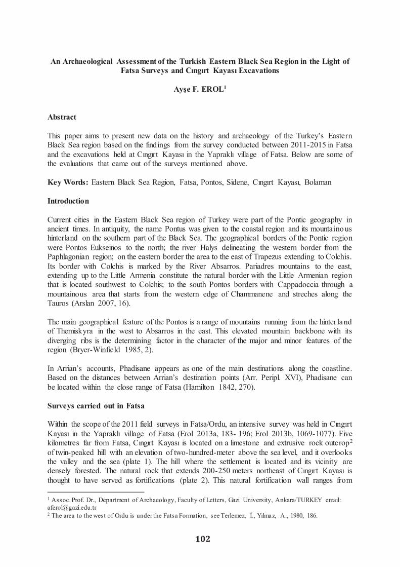
102
An Archaeological Assessment of the Turkish Eastern Black Sea Region in the Light of
Fatsa Surveys and Cıngırt Kayası Excavations
Ayse F. EROL1
Abstract This paper aims to present new data on the history and archaeology of the Turkey’s Eastern Black Sea region based on the findings from the survey conducted between 2011-2015 in Fatsa and the excavations held at Cıngırt Kayası in the Yapraklı village of Fatsa. Below are some of the evaluations that came out of the surveys mentioned above. Key Words: Eastern Black Sea Region, Fatsa, Pontos, Sidene, Cıngırt Kayası, Bolaman Introduction Current cities in the Eastern Black Sea region of Turkey were part of the Pontic geography in ancient times. In antiquity, the name Pontus was given to the coastal region and its mountainous hinterland on the southern part of the Black Sea. The geographical borders of the Pontic region were Pontos Eukseinos to the north; the river Halys delineating the western border from the Paphlagonian region; on the eastern border the area to the east of Trapezus extending to Colchis. Its border with Colchis is marked by the River Absarros. Pariadres mountains to the east, extending up to the Little Armenia constitute the natural border with the Little Armenian region that is located southwest to Colchis; to the south Pontos borders with Cappadoccia through a mountainous area that starts from the western edge of Chammanene and streches along the Tauros (Arslan 2007, 16). The main geographical feature of the Pontos is a range of mountains running from the hinter land of Themiskyra in the west to Absarros in the east. This elevated mountain backbone with its diverging ribs is the determining factor in the character of the major and minor features of the region (Bryer-Winfield 1985, 2). In Arrian’s accounts, Phadisane appears as one of the main destinations along the coastline. Based on the distances between Arrian’s destination points (Arr. Peripl. XVI), Phadisane can be located within the close range of Fatsa (Hamilton 1842, 270). Surveys carried out in Fatsa Within the scope of the 2011 field surveys in Fatsa/Ordu, an intensive survey was held in Cıngırt Kayası in the Yapraklı village of Fatsa (Erol 2013a, 183- 196; Erol 2013b, 1069-1077). Five kilometres far from Fatsa, Cıngırt Kayası is located on a limestone and extrusive rock outcrop2 of twin-peaked hill with an elevation of two-hundred-meter above the sea level, and it overlooks the valley and the sea (plate 1). The hill where the settlement is located and its vicinity are densely forested. The natural rock that extends 200-250 meters northeast of Cıngırt Kayası is thought to have served as fortifications (plate 2). This natural fortification wall ranges from
1 Assoc. Prof. Dr., Department of Archaeology, Faculty of Letters, Gazi University, Ankara/TURKEY email: [email protected] 2 The area to the west of Ordu is under the Fatsa Formation, see Terlemez, I., Yılmaz, A., 1980, 186.
northeast to south, to the area with khamasorion sarcophagi. This section is about 50 metres high, and does not have any paths or forest roads. There were three main arguments that stood out about the finds of the survey: first, Cıngırt Kayası’s defensive location whereas Mithridates' strongholds were, as a rule, on hilltops 3; second, a stepped rockcut tunnel descending from the summit of Cıngırt Kayası to the Kavaklar River, typical for phrouriai (Højte 2009, 103; Wilson 1960, 199; Von Gall 1967, 504–527) of the Pontic Kingdom; and third, coins obtained from the survey, dating back to the reign of the Pontic King Mithridates VI (Erol 2013a, plate 3-4). The results led us to ask the following question: Could this area be a fort settlement from the reign of the Pontic King Mithridates VI? In addition to these, remains of mortared walls and other small finds obtained during the survey pointed to continuous settlement throughout the Roman and Byzantine periods (Erol 2013a, 187,188; Erol-Ünal 2012, 117-121). On the basis of the data gathered from the survey, under the permission granted by the General Directorate for Cultural Heritage and Museums of the Ministry of Culture and Tourism of Turkey, the excavation of Cıngırt Kayası was conducted in three sessions between 2012 and 2014.4 The excavations from 2012 to 2014 mostly concentrated on the summit of the settlement (Erol, 2016, 567, map 1), and yielded architectural remains dating from the Late Hellenistic period up to the Roman and the Byzantine periods (Erol 2015a, 453-459) (plate 3). Ceramics and minor objects were also found and used as evidence to set those dates (Erol 2015b, resim 7-11; Erol 2015a, 453-459; Erol-Tamer 2013, 165-173, plate 002-011; Erol-Tamer 2016, 202-225, levha. 2-7; Erol- Ünal 2012, 117- 121; Erol- Yıldırım 2016, 135-143). Data gathered from the survey was confirmed by excavations. There are some leads of data that suggest that Cıngırt Kayası was arranged as a phrouria during the reign of Mithridates VI of the Pontic Kingdom: • Cıngırt Kayası’s defensive location whereas Mithradates' strongholds were, as a rule, on hill tops, Cıngırt Kayası’s location also controls the harbour5 of Phadisane where there is an exposed anchorage known to exist in the same period (Wilson 1960, 199), • Presence of a stepped tunnel structure cut in the bedrock6, • recovery of many metal finds from the summit such as arrow and catapult bolt heads (Erol-Yıldırım 2016, 135-148) as well as many stone canon balls (Erol 2016, 563, plate 6), • The bronze coins of Mithridates VI are those used for military payments (Erol- Tamer 2013, 159-181),
3 Strab. Geog. XII. 3. 28. Strabon mentions that the region is characterised by deep valleys, cliffs and series of mountains, making it suitable for the foundation of big castles. 4 It was carried out under the auspices of the Museum of Ordu and under my scientific supervision.5 Abundant number of amphora finds from Cıngırt Kayası points to the fact that the settlement had developed commercial ties with coastal cities, primarily with Sinope and Colchis. It also suggests that there was a harbour in the settlement or nearby, see Erol, 2014, 386. 6 For the relationship between stepped water tunnels and fort settlements, please see Von Gall 1967, 504–527; In their research in Paphlagonia, Bittel and Naumann discovered stepped tunnels, similarly cut in the bedrock, leading to the river right on the slopes of the high hills of rock-cut tombs in Tasköprü –Kalekapı, Kastamonu. Around this rock-cut tombs, they also found foundation remains of structures, which led them to define the area as a fort settlement, see Bittel – Naumann 1965, 72.

103
An Archaeological Assessment of the Turkish Eastern Black Sea Region in the Light of
Fatsa Surveys and Cıngırt Kayası Excavations
Ayse F. EROL1
Abstract This paper aims to present new data on the history and archaeology of the Turkey’s Eastern Black Sea region based on the findings from the survey conducted between 2011-2015 in Fatsa and the excavations held at Cıngırt Kayası in the Yapraklı village of Fatsa. Below are some of the evaluations that came out of the surveys mentioned above. Key Words: Eastern Black Sea Region, Fatsa, Pontos, Sidene, Cıngırt Kayası, Bolaman Introduction Current cities in the Eastern Black Sea region of Turkey were part of the Pontic geography in ancient times. In antiquity, the name Pontus was given to the coastal region and its mountainous hinterland on the southern part of the Black Sea. The geographical borders of the Pontic region were Pontos Eukseinos to the north; the river Halys delineating the western border from the Paphlagonian region; on the eastern border the area to the east of Trapezus extending to Colchis. Its border with Colchis is marked by the River Absarros. Pariadres mountains to the east, extending up to the Little Armenia constitute the natural border with the Little Armenian region that is located southwest to Colchis; to the south Pontos borders with Cappadoccia through a mountainous area that starts from the western edge of Chammanene and streches along the Tauros (Arslan 2007, 16). The main geographical feature of the Pontos is a range of mountains running from the hinter land of Themiskyra in the west to Absarros in the east. This elevated mountain backbone with its diverging ribs is the determining factor in the character of the major and minor features of the region (Bryer-Winfield 1985, 2). In Arrian’s accounts, Phadisane appears as one of the main destinations along the coastline. Based on the distances between Arrian’s destination points (Arr. Peripl. XVI), Phadisane can be located within the close range of Fatsa (Hamilton 1842, 270). Surveys carried out in Fatsa Within the scope of the 2011 field surveys in Fatsa/Ordu, an intensive survey was held in Cıngırt Kayası in the Yapraklı village of Fatsa (Erol 2013a, 183- 196; Erol 2013b, 1069-1077). Five kilometres far from Fatsa, Cıngırt Kayası is located on a limestone and extrusive rock outcrop2 of twin-peaked hill with an elevation of two-hundred-meter above the sea level, and it overlooks the valley and the sea (plate 1). The hill where the settlement is located and its vicinity are densely forested. The natural rock that extends 200-250 meters northeast of Cıngırt Kayası is thought to have served as fortifications (plate 2). This natural fortification wall ranges from
1 Assoc. Prof. Dr., Department of Archaeology, Faculty of Letters, Gazi University, Ankara/TURKEY email: [email protected] 2 The area to the west of Ordu is under the Fatsa Formation, see Terlemez, I., Yılmaz, A., 1980, 186.
northeast to south, to the area with khamasorion sarcophagi. This section is about 50 metres high, and does not have any paths or forest roads. There were three main arguments that stood out about the finds of the survey: first, Cıngırt Kayası’s defensive location whereas Mithridates' strongholds were, as a rule, on hilltops 3; second, a stepped rockcut tunnel descending from the summit of Cıngırt Kayası to the Kavaklar River, typical for phrouriai (Højte 2009, 103; Wilson 1960, 199; Von Gall 1967, 504–527) of the Pontic Kingdom; and third, coins obtained from the survey, dating back to the reign of the Pontic King Mithridates VI (Erol 2013a, plate 3-4). The results led us to ask the following question: Could this area be a fort settlement from the reign of the Pontic King Mithridates VI? In addition to these, remains of mortared walls and other small finds obtained during the survey pointed to continuous settlement throughout the Roman and Byzantine periods (Erol 2013a, 187,188; Erol-Ünal 2012, 117-121). On the basis of the data gathered from the survey, under the permission granted by the General Directorate for Cultural Heritage and Museums of the Ministry of Culture and Tourism of Turkey, the excavation of Cıngırt Kayası was conducted in three sessions between 2012 and 2014.4 The excavations from 2012 to 2014 mostly concentrated on the summit of the settlement (Erol, 2016, 567, map 1), and yielded architectural remains dating from the Late Hellenistic period up to the Roman and the Byzantine periods (Erol 2015a, 453-459) (plate 3). Ceramics and minor objects were also found and used as evidence to set those dates (Erol 2015b, resim 7-11; Erol 2015a, 453-459; Erol-Tamer 2013, 165-173, plate 002-011; Erol-Tamer 2016, 202-225, levha. 2-7; Erol- Ünal 2012, 117- 121; Erol- Yıldırım 2016, 135-143). Data gathered from the survey was confirmed by excavations. There are some leads of data that suggest that Cıngırt Kayası was arranged as a phrouria during the reign of Mithridates VI of the Pontic Kingdom: • Cıngırt Kayası’s defensive location whereas Mithradates' strongholds were, as a rule, on hill tops, Cıngırt Kayası’s location also controls the harbour5 of Phadisane where there is an exposed anchorage known to exist in the same period (Wilson 1960, 199), • Presence of a stepped tunnel structure cut in the bedrock6, • recovery of many metal finds from the summit such as arrow and catapult bolt heads (Erol-Yıldırım 2016, 135-148) as well as many stone canon balls (Erol 2016, 563, plate 6), • The bronze coins of Mithridates VI are those used for military payments (Erol- Tamer 2013, 159-181),
3 Strab. Geog. XII. 3. 28. Strabon mentions that the region is characterised by deep valleys, cliffs and series of mountains, making it suitable for the foundation of big castles. 4 It was carried out under the auspices of the Museum of Ordu and under my scientific supervision.5 Abundant number of amphora finds from Cıngırt Kayası points to the fact that the settlement had developed commercial ties with coastal cities, primarily with Sinope and Colchis. It also suggests that there was a harbour in the settlement or nearby, see Erol, 2014, 386. 6 For the relationship between stepped water tunnels and fort settlements, please see Von Gall 1967, 504–527; In their research in Paphlagonia, Bittel and Naumann discovered stepped tunnels, similarly cut in the bedrock, leading to the river right on the slopes of the high hills of rock-cut tombs in Tasköprü –Kalekapı, Kastamonu. Around this rock-cut tombs, they also found foundation remains of structures, which led them to define the area as a fort settlement, see Bittel – Naumann 1965, 72.

104
• The records of ancient sources (Strab. Geog, XII. 3.16, 3.28) and scientific studies of contemporary academics who conducted excavations and surveys in the Black Sea Region (Senyurt- Akçay 2016, 221-248; Wilson, 1960, 199; Weimert 1984, 152; Olshausen-Biller 1984, 154, 155). Strabon mentions in his records that ancient Sidene (Strab. Geog XII. 3.16, 3.28) had three coastal strongholds (Strab. Geog. XII, 3, 16), including Chabacta (Unye/Kalekoy?) (Olshausen – Biller 1984, 120; Wilson 1960, 199), Phabda (Cıngırt Kayası?), and Side/Polemonion forts7. Olshausen – Biller mention that Phabda was a Hellenistic fort in the Sidene region, which was identified with Phadisane harbour (Olshausen – Biller 1984, 154) (map 1). Wilson conducted surveys in 1960 and he pointed out that Phadisane was a harbour for Polemonion with a fort settlement, and also suggested that Phabda can be located in Cıngırt Tepesi on the banks of the River Kahveler (Wilson 1960, 199, 246a). Cıngırt Kayası was suggested to be a part of a defense chain consisting of phrouria in the Pontic region to provide control and defense, just like other examples within the Providence of Ordu.8 Field surveys conducted at the northern west slopes of Cıngırt Kayası revealed various heavily damaged khamasorion sarcophagi carved into the rock, i.e. a typical grave style of the region. These remains suggest that the area was used as a necropolis (plate 4). The surveys conducted in Uzunbahce (Karakız Kayası), around the Balıköre River in the village of Yapraklı yielded remains of a 7-8 m long stone paved road. This road is believed to have provided access to the sacred area of Karakız Kayası, located further down the valley. Some other remains located in this area indicates presence of a sacred area where rituals were performed (Erol 2012, 188). This area is reached by rock cut steps, and it displays niches carved into the rock and platforms formed on the ground (plate 5). Given the cross sections on the surface of rocks, it can be argued that this area was covered. To the west of it are seven khamasorions, which were cut in rock. The cross sections on top of them indicate that they had lids. The fact that the sacred area was close to the khamasorions makes us think that it was intended to hold rituals related to the cult of death. During the establishment of this sacred area, rocks, as natural materials, were used as an extension of the geological characteristics of the region. The choice of rocks as the building material by many communities can be easily explained by its existence as a natural resource ready to use. However, there are no data available from the khamasorions that can aid in determining the date of the ritual area. The presence of rock shelters, khamasorions carved into the rock, and numerous other rockworks at the east and western foots of Cıngırt Kayası shows that the settlers of the region worked on the natural rock resources in order to turn it into units of various different functions such as rock altars with niches and stairs (plate 6), and channels through which blood of the sacrifice must have been drained during ceremonies. During our surveys, the archaeological finds, which were obtained from the under- rock shelters at the northeastern slopes of Cıngırt Kayası, indicate human activity in the region even in prehistorical times (Erol 2013a, 183, plate. 1). We have also identified remains of a church in the Bolaman District, 6 km. east to the centre of Fatsa. The southern and northern walls of the
7 Strab. Geog. XII, 3, 16; of these, Side probably lies near the stream Sidenus (Bolaman Stream) and was the forerunner of the later Polemonium, please see Wilson, 1960, 199. 8 There are similar constructions, such as Kurul Kalesi within the borders of Ordu, please see Senyurt- Akçay, 2016, 221-248.
structure are currently visible at a reduced height, extending on the east-west axis (plate 7) and run parallel to the seashore for some distance. The fact that these walls bevelled to the east suggests that it was the apsis section of the church back in the days. Schultze notes that it was one of the churches of Pontus Polemoniacus (Schultze 1922, 183). The name of the region was derived from the plant named Polemonium. Captain Kinneir mentions the ruin of a vaulted building, which must be the church of which the walls still stands to a height of 6 or 7 metres in places (Kinneir 1817, 32). It was also reported by Winfield - Wainwright9 and Bryer- Winfield10. It is a large church of which an accurate plan could not be made without excavations since there is much fallen masonry and undergrowth around it. The interior section of the walls is of roughly squared stones laid in regular courses, and there is a rubble core with fragments of flat brick among it, and a lime and pebble mortar. There are a few pottery vessels let into the masonry which are often said to be for acoustic purposes but are more likely to have been used to lighten the weight of the masonry in the vault (Winfield - Wainwright 1962, 156). The use of such pottery vessels was a Roman practice, which was continued by the Byzantines (Winfie ld - Wainwright 1962, 156). The remains of a stone cornice carved with vine and bunches of grapes run around it (Winfield - Wainwright, 1962 156, fig.13). We found yellow-glazed ceramic fragments around the remains, which gives clues pointing to the Late Byzantine Period11. The fact that the remains are very close to the modern settlement makes the area vulnerable to damage. Therefore, excavations and ensuing restroration works have the potential to transform the area into a regional cultural hot spot. We carried out some investigations in the village of Kaleönü, which is 3.15 km. away from the centre of Fatsa and 90 mt above the sea-level. This fort settlement is built on a natural rock, commanding the site (plate 8a). The hill where the fort is located and its vicinity are densely forested. Therefore, it is difficult to follow the plan of the structure and to take measurements. There are remains of inner and outer fortification walls. The fact that the land is heavily vegetated makes it hard to get a good assessment of the area. The remains of the fortifica t ion walls can be seen to the east and south of the fort. The outer fortification wall and majority of one of the bastions are still standing (plate 8b). They were constructed with irregular rubble stones at different sizes combined with mortar. Different materials can be observed at the wall structure, indicating several renovation works at different periods. The inner fortification wall, as opposed to its outer counterpart, is composed of more regularly shaped stones. We documented terracotta roof covering materials scattered around a vast area. The inner fortification wall lies 15-20 metres behind the outer one. It is possible to observe from the current remains that the entrance to the inner fort was through a barrel vaulted gateway (plate 9). This gateway is made of a combination of stone and bricks, with a clear cut masonry. Remains of the bastion, which lies to the east adjacent to the arched structure, has an homogeneous wall similar to the inner wall. Sockets for horizontal beams that were used to ease the pressure of the weight can be observed in the inner fortification wall. The inner part of the fort has been damaged by heavy vegetation and illegal excavation trenches. Our general assessment from the investigations we carried under difficult circumstances is that the fort
9 Winfield - Wainwright 1962, 155-157. They described this building as large stone-vaulted construction 32 m long, with a main apse round on the interior and pentagonal on the exterior. 10 Bryer- Winfield 1985, 113. Plate. XXVIa. They mentioned this building pentagonal on the exterior in the thirteenth-century Trapezuntine style. 11 Other examples similar to this structure have been dated to the end of 12th and beginning of 13th century AD. Please see Winfield - Wainwright, 1962, footnote. 110-111. This period also overlaps with the date of the ceramic finds.

105
• The records of ancient sources (Strab. Geog, XII. 3.16, 3.28) and scientific studies of contemporary academics who conducted excavations and surveys in the Black Sea Region (Senyurt- Akçay 2016, 221-248; Wilson, 1960, 199; Weimert 1984, 152; Olshausen-Biller 1984, 154, 155). Strabon mentions in his records that ancient Sidene (Strab. Geog XII. 3.16, 3.28) had three coastal strongholds (Strab. Geog. XII, 3, 16), including Chabacta (Unye/Kalekoy?) (Olshausen – Biller 1984, 120; Wilson 1960, 199), Phabda (Cıngırt Kayası?), and Side/Polemonion forts7. Olshausen – Biller mention that Phabda was a Hellenistic fort in the Sidene region, which was identified with Phadisane harbour (Olshausen – Biller 1984, 154) (map 1). Wilson conducted surveys in 1960 and he pointed out that Phadisane was a harbour for Polemonion with a fort settlement, and also suggested that Phabda can be located in Cıngırt Tepesi on the banks of the River Kahveler (Wilson 1960, 199, 246a). Cıngırt Kayası was suggested to be a part of a defense chain consisting of phrouria in the Pontic region to provide control and defense, just like other examples within the Providence of Ordu.8 Field surveys conducted at the northern west slopes of Cıngırt Kayası revealed various heavily damaged khamasorion sarcophagi carved into the rock, i.e. a typical grave style of the region. These remains suggest that the area was used as a necropolis (plate 4). The surveys conducted in Uzunbahce (Karakız Kayası), around the Balıköre River in the village of Yapraklı yielded remains of a 7-8 m long stone paved road. This road is believed to have provided access to the sacred area of Karakız Kayası, located further down the valley. Some other remains located in this area indicates presence of a sacred area where rituals were performed (Erol 2012, 188). This area is reached by rock cut steps, and it displays niches carved into the rock and platforms formed on the ground (plate 5). Given the cross sections on the surface of rocks, it can be argued that this area was covered. To the west of it are seven khamasorions, which were cut in rock. The cross sections on top of them indicate that they had lids. The fact that the sacred area was close to the khamasorions makes us think that it was intended to hold rituals related to the cult of death. During the establishment of this sacred area, rocks, as natural materials, were used as an extension of the geological characteristics of the region. The choice of rocks as the building material by many communities can be easily explained by its existence as a natural resource ready to use. However, there are no data available from the khamasorions that can aid in determining the date of the ritual area. The presence of rock shelters, khamasorions carved into the rock, and numerous other rockworks at the east and western foots of Cıngırt Kayası shows that the settlers of the region worked on the natural rock resources in order to turn it into units of various different functions such as rock altars with niches and stairs (plate 6), and channels through which blood of the sacrifice must have been drained during ceremonies. During our surveys, the archaeological finds, which were obtained from the under- rock shelters at the northeastern slopes of Cıngırt Kayası, indicate human activity in the region even in prehistorical times (Erol 2013a, 183, plate. 1). We have also identified remains of a church in the Bolaman District, 6 km. east to the centre of Fatsa. The southern and northern walls of the
7 Strab. Geog. XII, 3, 16; of these, Side probably lies near the stream Sidenus (Bolaman Stream) and was the forerunner of the later Polemonium, please see Wilson, 1960, 199. 8 There are similar constructions, such as Kurul Kalesi within the borders of Ordu, please see Senyurt- Akçay, 2016, 221-248.
structure are currently visible at a reduced height, extending on the east-west axis (plate 7) and run parallel to the seashore for some distance. The fact that these walls bevelled to the east suggests that it was the apsis section of the church back in the days. Schultze notes that it was one of the churches of Pontus Polemoniacus (Schultze 1922, 183). The name of the region was derived from the plant named Polemonium. Captain Kinneir mentions the ruin of a vaulted building, which must be the church of which the walls still stands to a height of 6 or 7 metres in places (Kinneir 1817, 32). It was also reported by Winfield - Wainwright9 and Bryer- Winfield10. It is a large church of which an accurate plan could not be made without excavations since there is much fallen masonry and undergrowth around it. The interior section of the walls is of roughly squared stones laid in regular courses, and there is a rubble core with fragments of flat brick among it, and a lime and pebble mortar. There are a few pottery vessels let into the masonry which are often said to be for acoustic purposes but are more likely to have been used to lighten the weight of the masonry in the vault (Winfield - Wainwright 1962, 156). The use of such pottery vessels was a Roman practice, which was continued by the Byzantines (Winfie ld - Wainwright 1962, 156). The remains of a stone cornice carved with vine and bunches of grapes run around it (Winfield - Wainwright, 1962 156, fig.13). We found yellow-glazed ceramic fragments around the remains, which gives clues pointing to the Late Byzantine Period11. The fact that the remains are very close to the modern settlement makes the area vulnerable to damage. Therefore, excavations and ensuing restroration works have the potential to transform the area into a regional cultural hot spot. We carried out some investigations in the village of Kaleönü, which is 3.15 km. away from the centre of Fatsa and 90 mt above the sea-level. This fort settlement is built on a natural rock, commanding the site (plate 8a). The hill where the fort is located and its vicinity are densely forested. Therefore, it is difficult to follow the plan of the structure and to take measurements. There are remains of inner and outer fortification walls. The fact that the land is heavily vegetated makes it hard to get a good assessment of the area. The remains of the fortifica t ion walls can be seen to the east and south of the fort. The outer fortification wall and majority of one of the bastions are still standing (plate 8b). They were constructed with irregular rubble stones at different sizes combined with mortar. Different materials can be observed at the wall structure, indicating several renovation works at different periods. The inner fortification wall, as opposed to its outer counterpart, is composed of more regularly shaped stones. We documented terracotta roof covering materials scattered around a vast area. The inner fortification wall lies 15-20 metres behind the outer one. It is possible to observe from the current remains that the entrance to the inner fort was through a barrel vaulted gateway (plate 9). This gateway is made of a combination of stone and bricks, with a clear cut masonry. Remains of the bastion, which lies to the east adjacent to the arched structure, has an homogeneous wall similar to the inner wall. Sockets for horizontal beams that were used to ease the pressure of the weight can be observed in the inner fortification wall. The inner part of the fort has been damaged by heavy vegetation and illegal excavation trenches. Our general assessment from the investigations we carried under difficult circumstances is that the fort
9 Winfield - Wainwright 1962, 155-157. They described this building as large stone-vaulted construction 32 m long, with a main apse round on the interior and pentagonal on the exterior. 10 Bryer- Winfield 1985, 113. Plate. XXVIa. They mentioned this building pentagonal on the exterior in the thirteenth-century Trapezuntine style. 11 Other examples similar to this structure have been dated to the end of 12th and beginning of 13th century AD. Please see Winfield - Wainwright, 1962, footnote. 110-111. This period also overlaps with the date of the ceramic finds.

106
settlement, which was built in accordance with the topography of the area, is consistent with characteristics of Byzantine Ages with respect to materials used, and architectural and technica l features. Yalıköy is 9 km. away from the centre of Fatsa, on the Samsun-Ordu highway. Surveys carried out here revealed a settlement, possibly a fort, approximately 35 mt above the sea level, in a dominant location in respect to its surroundings. After carrying out surveys despite heavy vegetation and deep topography (both characteristic to the Black Sea region), we have identified remains of walls made of block-cut stones combined with mortar. The edges of the settlement, located on the cape (plate 10a) present architectural structures that were erected with a combination of brick and mortared stone, though currently in ruins (plate 10 b). They point to the Byzantine Period. In respect to location and settled area, we can conclude that the settlement was not large in size. That is why we suggest that this settlement was either an outpost or a military checkpoint. The area has also been subjected to both natural and man-inflicted damage. After identifying it as cultural heritage that is necessary to protect, we also applied to the General Directorate for Preservation of Natural Heritage for its registration. Other field surveys were carried out in the Bolaman peninsula, which has remains of fortification walls and houses built on top of these remains in the 19th century. The remains of the castle from the Middle Age were surmounted by a mansion built by the affluent Haznedarogulları family in the 19th century. The peninsula was declared as an Urban Archaeological Protected Area by the Samsun Council for the Protection of Cultural and Natural Heritage in 2009. The castle is built on a roughly triangular wedge of rock about 65 m. long, projecting into the sea12, which has traces of a complete defensive walling on its perimeter (plate 11). Fortification walls which made use of the natural rock as base, and augmented with roughly-shaped stones, rubble and mortar laid in regular courses in which the mortar has now been largely eroded, stand up to a height of 6 m on the landward side to the south. Rectangular sockets on the wall structure could be for horizontal beams, while brick fragments must have been placed to render the wall with flexibility. It was suggested that the wall be strengthened and cleaned up because of erosion and damage over time. During the surveys carried out in the Bolaman District, 6 km. east to the centre of Fatsa we identified a tomb with three arcosolia in a barrel vaulted structure (plate 12) in a land under private ownership. The preserved height of the vaulted structure is 2.85 m. While the vault’s opening is 2.63 m. This structure is made of walls that are composed of small-to-large stones combined with mortar. The vaulted structure has been damaged by treasure hunters, and we have not been able to find any cultural material that could indicate a date. However, based on similar examples (Eliüsük 2016, 30-31), it can be dated to the Roman Period. There are also illegal excavation trenches around it. After identifying it as cultural heritage that is necessary to protect, we also applied to General Directorate for the Preservation of Natural Heritage for its registration. Rock cut tombs, the characteristic grave style of the Black Sea Region, have been found in Töngelli, in the district of Aslancami, that is 19 km. away from the centre of Fatsa (plate. 13a-b). These rock cut tombs are characterised by a simple and plain architecture: front facades are fold inwards from the main rock in order to protect the tomb from rain; tombs are not laid in a single
12 Hamilton noted that “it is only a Genoese castle, built on a rock which projects in to the sea, having a small snug harbour to the east, and wooded hills rising immediately behind it” see. Hamilton 1842, 270-71.
axis; and their chambers have irregularly formed entrances. Originally, the entrance is thought to be closed with a cover stone. The ceilings of the tomb chambers are hipped or gable roofed. The floor level is below the entrance. The tomb chambers are generally rectangular, while the burial was laid on the Klines extending along the rear and side walls. The fact that tomb entrances are open makes them susceptible to grave robbery. That is most probably why we couldn’t find any cultural objects that could have suggested a date for the tombs. Based on the archaeological heritage of the area, we suggested that it should be classified as a 2nd degree Archaeological Protected Area. Conclusion In conclusion, the surveys we conducted in Fatsa revealed many underground shelters, rock cut tombs, khamasorions and engraved rocks. Thanks to the geology of the region, different rock formations were engraved into units with different functions. Remains from both Kaleönü and Yalıköy share the following characteristics: they are located in a dominant spot, high above the sea level, controlling its surroundings; equipped with fortification systems; and not occupying a large area. All these elements lead us to conclude that these settlements were either outposts or military garrisons. Different materials and construction techniques in their wall structure attest to different stages of renovations and differences in periods. As a general periodisation for these fort settlements, we would suggest the Byzantine Period. Our evaluations concluded that the region indicates human activity even during prehistorica l period up to the Ottoman Period. Surveys in Fatsa aimed at providing more archaeologica l information about the history and archaeology of the Eastern Black Sea region in Turkey. This, in turn, would constitute a basis for further planning of continuous scientific excavations. In fact, a series of excavations took place after 2012 in Cıngırt Kayası. Through discovery of ancient settlements, we are hoping to increase the frequency of excavations in Fatsa, and help developing destinations for cultural tourism in the region.

107
settlement, which was built in accordance with the topography of the area, is consistent with characteristics of Byzantine Ages with respect to materials used, and architectural and technica l features. Yalıköy is 9 km. away from the centre of Fatsa, on the Samsun-Ordu highway. Surveys carried out here revealed a settlement, possibly a fort, approximately 35 mt above the sea level, in a dominant location in respect to its surroundings. After carrying out surveys despite heavy vegetation and deep topography (both characteristic to the Black Sea region), we have identified remains of walls made of block-cut stones combined with mortar. The edges of the settlement, located on the cape (plate 10a) present architectural structures that were erected with a combination of brick and mortared stone, though currently in ruins (plate 10 b). They point to the Byzantine Period. In respect to location and settled area, we can conclude that the settlement was not large in size. That is why we suggest that this settlement was either an outpost or a military checkpoint. The area has also been subjected to both natural and man-inflicted damage. After identifying it as cultural heritage that is necessary to protect, we also applied to the General Directorate for Preservation of Natural Heritage for its registration. Other field surveys were carried out in the Bolaman peninsula, which has remains of fortification walls and houses built on top of these remains in the 19th century. The remains of the castle from the Middle Age were surmounted by a mansion built by the affluent Haznedarogulları family in the 19th century. The peninsula was declared as an Urban Archaeological Protected Area by the Samsun Council for the Protection of Cultural and Natural Heritage in 2009. The castle is built on a roughly triangular wedge of rock about 65 m. long, projecting into the sea12, which has traces of a complete defensive walling on its perimeter (plate 11). Fortification walls which made use of the natural rock as base, and augmented with roughly-shaped stones, rubble and mortar laid in regular courses in which the mortar has now been largely eroded, stand up to a height of 6 m on the landward side to the south. Rectangular sockets on the wall structure could be for horizontal beams, while brick fragments must have been placed to render the wall with flexibility. It was suggested that the wall be strengthened and cleaned up because of erosion and damage over time. During the surveys carried out in the Bolaman District, 6 km. east to the centre of Fatsa we identified a tomb with three arcosolia in a barrel vaulted structure (plate 12) in a land under private ownership. The preserved height of the vaulted structure is 2.85 m. While the vault’s opening is 2.63 m. This structure is made of walls that are composed of small-to-large stones combined with mortar. The vaulted structure has been damaged by treasure hunters, and we have not been able to find any cultural material that could indicate a date. However, based on similar examples (Eliüsük 2016, 30-31), it can be dated to the Roman Period. There are also illegal excavation trenches around it. After identifying it as cultural heritage that is necessary to protect, we also applied to General Directorate for the Preservation of Natural Heritage for its registration. Rock cut tombs, the characteristic grave style of the Black Sea Region, have been found in Töngelli, in the district of Aslancami, that is 19 km. away from the centre of Fatsa (plate. 13a-b). These rock cut tombs are characterised by a simple and plain architecture: front facades are fold inwards from the main rock in order to protect the tomb from rain; tombs are not laid in a single
12 Hamilton noted that “it is only a Genoese castle, built on a rock which projects in to the sea, having a small snug harbour to the east, and wooded hills rising immediately behind it” see. Hamilton 1842, 270-71.
axis; and their chambers have irregularly formed entrances. Originally, the entrance is thought to be closed with a cover stone. The ceilings of the tomb chambers are hipped or gable roofed. The floor level is below the entrance. The tomb chambers are generally rectangular, while the burial was laid on the Klines extending along the rear and side walls. The fact that tomb entrances are open makes them susceptible to grave robbery. That is most probably why we couldn’t find any cultural objects that could have suggested a date for the tombs. Based on the archaeological heritage of the area, we suggested that it should be classified as a 2nd degree Archaeological Protected Area. Conclusion In conclusion, the surveys we conducted in Fatsa revealed many underground shelters, rock cut tombs, khamasorions and engraved rocks. Thanks to the geology of the region, different rock formations were engraved into units with different functions. Remains from both Kaleönü and Yalıköy share the following characteristics: they are located in a dominant spot, high above the sea level, controlling its surroundings; equipped with fortification systems; and not occupying a large area. All these elements lead us to conclude that these settlements were either outposts or military garrisons. Different materials and construction techniques in their wall structure attest to different stages of renovations and differences in periods. As a general periodisation for these fort settlements, we would suggest the Byzantine Period. Our evaluations concluded that the region indicates human activity even during prehistorica l period up to the Ottoman Period. Surveys in Fatsa aimed at providing more archaeologica l information about the history and archaeology of the Eastern Black Sea region in Turkey. This, in turn, would constitute a basis for further planning of continuous scientific excavations. In fact, a series of excavations took place after 2012 in Cıngırt Kayası. Through discovery of ancient settlements, we are hoping to increase the frequency of excavations in Fatsa, and help developing destinations for cultural tourism in the region.

108
Bibliography Arr. Peripl. 2015. Arriani Periplus Ponti Euxini (Arrianus’un Karadeniz Seyahati). Çev. Murat Arslan, Libri I: 93-124. Arslan, M. 2007. Mithradates VI Eupator: Roma’nın Büyük Düsmanı, Istanbul. Bittel, K., R. Naumann. 1965. “Notizen über einige Paphlagonische Felsgräber”, Anadolu Arastırmaları 2: 71-84. Bryer, A., Winfield, D. 1985. The Byzantine Monuments and Topography of the Pontos, Vol. I, Dumbarton Oaks Studies XX, Washington. Eliüsük, M. 2016. “Kelenderis Besik Tonozlu Mezarları Üzerine Bir Degerlendirme” Celal Bayar Üniversitesi Sosyal Bilimler Dergisi Cilt: 14, Sayı: 1: 25-45. Erol, A. F., Ünal E. 2012. “Fatsa Cıngırt Kayası’ndan Ele Geçen Bir Bizans Kursun Mührü”, in: Ömer Çapar’a Armagan, T. Yigit/M. A. Kaya/A. Sina (eds.), Ankara: 117-122. Erol, A. F. 2013a. “Ordu Ili, Fatsa Ilçesi Arkeolojik Yüzey Arastırması 2011”, Arastırma Sonuçları Toplantısı 30/2: 183-196. Erol, A. F. 2013b. “Archaeological Survey in Fatsa Cıngırt Kayası: New Findings for the Archaeology of the Eastern Black Sea Region”, SOMA 2012 (Proceedings of the 16th Symposium on Mediterranean Archaeology) “Identity and Connectivity” L. Bombardieri, Anacleto D’Agostino, Guido Guarducci, Valentina Orsi and Stefano Valentini (eds.) BAR 2581 (II), Archaeopress: 1069-1077. Erol, A. F., Tamer D. 2013. “Fatsa Cıngırt Kayası’ndan Ele Geçen 10 Sikke Üzerine Gözlemler”, Seleucia ad Calycadnum III: 159-181. Erol, A. F. 2014. “Ordu Ili Fatsa Ilçesi Cıngırt Kayası Kazısı 2013”, Kazı Sonuçları Toplantısı 36/1: 383-400. Erol, A. F. 2015a. “New Findings on the History and Archaeology of the Eastern Black Sea Region of Turkey: The Excavation at Cıngırt Kayası”, Fifth International Congress on Black Sea Antiquities, Gocha R. Tsetskhladze, Alexanduru Avram and James Hargrave (eds.), Archaeopress: 451-460. Erol, A. F. 2015b. “Ordu Ili Fatsa Ilçesi Cıngırt Kayası Kazısı 2013”, Kazı Sonuçları Toplantısı 36/1: 383-400. Erol, A. F. 2016. “Ordu Ili, Fatsa Ilçesi Cıngırt Kayası Kazısı 2014”, Kazı Sonuçları Toplantısı 37/2: 559-572. Erol, A. F., Tamer D. 2016. “Cıngırt Kayası Erken Bizans Dönemi Cam Buluntuları”, Seleucia ad Calycadnum VI: 319-359. Erol, A. F., Yıldırım E. 2016. “Fatsa Cıngırt Kayası Kazısında Bulunan Ok Uçları”, Arkeoloji ve Sanat 153: 133-148. Hamilton, W. J. 1842. Researches in Asia Minor, Pontus, and Armenia: with some account of their antiquities and geology; in two volumes (Band 1), London.
Højte, J.M. 2009, “The Administrative Organization of the Pontic Kingdom”, in: Mithridates VI and thePontic Kingdom, J.M. Højte (ed.), Aarhus: 95-107. Kinneir, J. M. 1817, Travels in Armenia, London, 1817. Olshausen, E., Biller J. 1984. Historisch-geographische Aspekte der Geschichte des Pontischen und Armenischen Reiches. Teil 1: Untersuchungen zur historischen Geographie von Pontos unter den Mithradatiden, Wiesbaden. Schultze, V. 1922. Altchristliche Stadte und Landschaften. Kleinasien, Vol. II, Gutersloh. Strabon. 1993. Antik Anadolu Cografyası (Geographika: XII-XIII-XIV., Çev. A. Pekman, Istanbul. Senyurt, S. Y., Akçay A. 2016. “Kurul Kalesi (Ordu) VI. Mithradates Dönemi Yerlesimi Üzerine Ön Degerlendirmeler”, Seleucia ad Calycadnum VI: 221-248. Terlemez, I., Yılmaz, A. 1980. “Ünye - Ordu - Koyulhisar - Resadiye Arasında Kalan Yörenin Stratigrafisi” Bulletin of the Geological Society of Turkey, V. 23: 179-191. Weimert, H. 1983. Wirtschaft als landschaftsgebundenes Phänomen. Die Antike Landschaft Pontos – Eine Fallstudie, Unpublished Dissertation, University of Stuttgart. Wilson, D. R. 1960. The Historical Geography of Bithynia, Paphlagonia and Pontos in the Greek and Roman Periods, Unpublished Bacholar thesis, Oxford University. Winfield D., Wainwright J. 1962. “Some Byzantine Churches from the Pontus” Anatolian Studies 12: 131-161. Von Gall, H. 1967. “Zu den Kleinasiatischen Treppentunneln” Archäologischer Anzeiger 82: 504-527

109
Bibliography Arr. Peripl. 2015. Arriani Periplus Ponti Euxini (Arrianus’un Karadeniz Seyahati). Çev. Murat Arslan, Libri I: 93-124. Arslan, M. 2007. Mithradates VI Eupator: Roma’nın Büyük Düsmanı, Istanbul. Bittel, K., R. Naumann. 1965. “Notizen über einige Paphlagonische Felsgräber”, Anadolu Arastırmaları 2: 71-84. Bryer, A., Winfield, D. 1985. The Byzantine Monuments and Topography of the Pontos, Vol. I, Dumbarton Oaks Studies XX, Washington. Eliüsük, M. 2016. “Kelenderis Besik Tonozlu Mezarları Üzerine Bir Degerlendirme” Celal Bayar Üniversitesi Sosyal Bilimler Dergisi Cilt: 14, Sayı: 1: 25-45. Erol, A. F., Ünal E. 2012. “Fatsa Cıngırt Kayası’ndan Ele Geçen Bir Bizans Kursun Mührü”, in: Ömer Çapar’a Armagan, T. Yigit/M. A. Kaya/A. Sina (eds.), Ankara: 117-122. Erol, A. F. 2013a. “Ordu Ili, Fatsa Ilçesi Arkeolojik Yüzey Arastırması 2011”, Arastırma Sonuçları Toplantısı 30/2: 183-196. Erol, A. F. 2013b. “Archaeological Survey in Fatsa Cıngırt Kayası: New Findings for the Archaeology of the Eastern Black Sea Region”, SOMA 2012 (Proceedings of the 16th Symposium on Mediterranean Archaeology) “Identity and Connectivity” L. Bombardieri, Anacleto D’Agostino, Guido Guarducci, Valentina Orsi and Stefano Valentini (eds.) BAR 2581 (II), Archaeopress: 1069-1077. Erol, A. F., Tamer D. 2013. “Fatsa Cıngırt Kayası’ndan Ele Geçen 10 Sikke Üzerine Gözlemler”, Seleucia ad Calycadnum III: 159-181. Erol, A. F. 2014. “Ordu Ili Fatsa Ilçesi Cıngırt Kayası Kazısı 2013”, Kazı Sonuçları Toplantısı 36/1: 383-400. Erol, A. F. 2015a. “New Findings on the History and Archaeology of the Eastern Black Sea Region of Turkey: The Excavation at Cıngırt Kayası”, Fifth International Congress on Black Sea Antiquities, Gocha R. Tsetskhladze, Alexanduru Avram and James Hargrave (eds.), Archaeopress: 451-460. Erol, A. F. 2015b. “Ordu Ili Fatsa Ilçesi Cıngırt Kayası Kazısı 2013”, Kazı Sonuçları Toplantısı 36/1: 383-400. Erol, A. F. 2016. “Ordu Ili, Fatsa Ilçesi Cıngırt Kayası Kazısı 2014”, Kazı Sonuçları Toplantısı 37/2: 559-572. Erol, A. F., Tamer D. 2016. “Cıngırt Kayası Erken Bizans Dönemi Cam Buluntuları”, Seleucia ad Calycadnum VI: 319-359. Erol, A. F., Yıldırım E. 2016. “Fatsa Cıngırt Kayası Kazısında Bulunan Ok Uçları”, Arkeoloji ve Sanat 153: 133-148. Hamilton, W. J. 1842. Researches in Asia Minor, Pontus, and Armenia: with some account of their antiquities and geology; in two volumes (Band 1), London.
Højte, J.M. 2009, “The Administrative Organization of the Pontic Kingdom”, in: Mithridates VI and thePontic Kingdom, J.M. Højte (ed.), Aarhus: 95-107. Kinneir, J. M. 1817, Travels in Armenia, London, 1817. Olshausen, E., Biller J. 1984. Historisch-geographische Aspekte der Geschichte des Pontischen und Armenischen Reiches. Teil 1: Untersuchungen zur historischen Geographie von Pontos unter den Mithradatiden, Wiesbaden. Schultze, V. 1922. Altchristliche Stadte und Landschaften. Kleinasien, Vol. II, Gutersloh. Strabon. 1993. Antik Anadolu Cografyası (Geographika: XII-XIII-XIV., Çev. A. Pekman, Istanbul. Senyurt, S. Y., Akçay A. 2016. “Kurul Kalesi (Ordu) VI. Mithradates Dönemi Yerlesimi Üzerine Ön Degerlendirmeler”, Seleucia ad Calycadnum VI: 221-248. Terlemez, I., Yılmaz, A. 1980. “Ünye - Ordu - Koyulhisar - Resadiye Arasında Kalan Yörenin Stratigrafisi” Bulletin of the Geological Society of Turkey, V. 23: 179-191. Weimert, H. 1983. Wirtschaft als landschaftsgebundenes Phänomen. Die Antike Landschaft Pontos – Eine Fallstudie, Unpublished Dissertation, University of Stuttgart. Wilson, D. R. 1960. The Historical Geography of Bithynia, Paphlagonia and Pontos in the Greek and Roman Periods, Unpublished Bacholar thesis, Oxford University. Winfield D., Wainwright J. 1962. “Some Byzantine Churches from the Pontus” Anatolian Studies 12: 131-161. Von Gall, H. 1967. “Zu den Kleinasiatischen Treppentunneln” Archäologischer Anzeiger 82: 504-527

110
An Overview of the Iron Age Settlements in Samsun1
Davut YIITPASA2
Abstract
The purpose of this study is to discuss the sites from the Iron Age discovered during the survey and archaeological excavations conducted in the province and districts of Samsun in central Black Sea region, and provide information about these settlements. Within the scope of this study, we aimed to obtain information about Samsun and its environment; mounds, castles,ancient settlements and graves, architectural remains, potteries and houses. Based on the archaeological studies that have started from the beginning of 1900s and increased in later periods in that region, it is known that there was a settlement from the Mesolithic Period, andthe early history of Samsun started with the Tekkekoy settlement. However, during the IronAge, the region witnessed very intense settlement. We can see this from the building ruins which belong to that period. There are 54 sites, including mounds, castles, rock graves andcaves, which were established in the low altitude and arable areas with abundant water.However, because of the inadequate archaeological excavations in that region, this period is presented based on a few pieces of pottery, which were revealed from the sites identified during the surveys.
Key Words: Samsun, Iron Age, Settlement, Castle, Mound.
Introduction
During the surveys and excavations conducted in the city of Samsun and its districts in 2015and 2016 by the experts of the Samsun Museum, a total of 17 Iron Age settlements were discovered. These settlements, including tumuli, single-period settlements, rock-cut tombs andcastles, have been found for the first time ever and introduced to the scientific world. This article discusses the Iron Age settlements located in the city of Samsun, Central Black Sea Region. It aims to detect and evaluate the archaeological assets of the region dating back to the Iron Age as well as documenting, registering and examining the movable and non- movable cultural assets; publishing the results of scientific evaluations of these assets and promo tingthem in public. Information about the tumuli, castles, tombs, architectural items, pottery andsettlements found in Samsun and its vicinity are presented. We aimed to collect information onthe subject by studying the distribution of settlements, the areas with intense settlement and the remains of material cultural artefacts such as pottery.
An Overview of the Iron Age Settlements in Samsun
A total of 54 sites dating back to Iron Age, including tumuli, castles, tombs, caves and open-air temples, have been discovered in Samsun and its provinces until today. The Iron Age settlements are listed in the alphabetical order: Açıklı Esme Mound (Özsait 2004, 275), Akalan
1 I would like to thank Necati Kodalak, Director of Samsun Museum, for permitting me to publish the ceramics, and experts Emine Yılmaz, Ugur Terzioglu, Mustafa Kolagasıoglu and Orhan Alper Sirin for their invaluable help2 Assist. Prof. Dr., Department of Archaeology, Faculty of Letters, Ondokuz Mayıs University, Samsun/TURKEY. E-mail: [email protected]
(Macridy 1907, 167-175; Bilgi, Atasoy, Dönmez and Summerer 2002, 279-296), Aytepe (Dönmez 1999, 233), Bag Tepe (Alkım 1974, 556; Kızıltan 1992, 226), Beypınarı Köyiçi (Türker 2016, 29), Çakır Mound (Özsait-Özsait 2003, 327), Çam Tepe (Alkım 1974b, 554), Çıgırgan (Karagöl II) (Türker 2016, 28), Danabasan Tepesi, Dedetepe (Alkım 1972, 426; Alkım 1974a, 8; Kızıltan 1992, 217), Dedealtı Tepesi, Dedeüstü Tepesi, Deliklitepe (Tepecik) Mound (Yigitpasa 2012, 83-98; Yigitpasa 2015, 339-358), Devserkaya (Tasköprü) Tepesi, Dingilkalecik Tepesi (Özsait 2003a, 201; Özsait 2004, 273), Dombalak Tepe Mound (Türker 2016, 30), Dökme Tepe II (Alkım 1974, 25), Garco Tepe, Gök Tepe (Alkım 1974a, 8), Gucuk Tepe Mound (Türker 2016, 30), Hacıbaba Tepesi3, Ikiztepe (Alkım 1979, 152; Bilgi 1999, 167-190), Kaledorugu (Dönmez 1999a, 517), Kale Tepe (Dönmez 1999a, 517), Kaleyeri Tepesi (Alkım 1973, 437), Karasamsun/Amisos (Dönmez 2003, 3), Karagöl Tepe (Türker 2016, 28), Karaseyh Tepesi (Tepecik) (Alkım 1972, 436), Kayalı Tepe, Kel(e)bes Tepe (Dönmez 1999a, 514), Kilise Tepe (Özsait 2004, 276), Kurupelit (Akyüz et al. 2011, 117-134), Kümbettepe (Alkım 1973, 437; 1978, 27), Kürkürün (Tepecik) Höyügü (Yigitpasa), Ladik/Köyiçi Tepesi (Alkım 1974b, 555; Dönmez 2005b, 65-109; Kızıltan 1992, 232), Ören Tepe, Pasaseyh Tepesi (Alkım 1972, 426; Alkım 1974a, 8), Patlanguç Tepe, Salıpazarı/Esat Çiftligi Köyü-Sadırlık Mahallesi Inbükü Cave (Yılmaz 2012, 131), Salıpazarı/Garpu Kale Open Air Temple Rock Altar (Yılmaz 2012, 131), Salıpazarı/Yesilköy Kaya Graves (Yılmaz 2012, 131), Sarıgazel (Özsait 2003, 128), Seyfibaba Tekkesi (Özsait 2004, 276), Sivri Tepe (Alaçam) (Kökten-Özgüç-Özgüç 1945, 394 vd.; Alkım 1974a, 8; Kızıltan 1992, 217), Sivri Tepe (Havza) (Özsait 2003, 128), Seyhsafi Tepesi, Sirlek Tepe (Cirlek Tepe, Kusçular Tepesi, Hoskadem Tepesi) (Kökten- Özgüç-Özgüç 1945, 394; Kızıltan 1992, 219), Taskaracaören Tepe (Alkım 1973, 437; Alkım 1974b, 24; Kızıltan 1992, 230; Dönmez 2002, 880), Tatardere Tepe (Türker 2016, 29), Tedigün Tepe (Tödügün Tepe) (Dönmez 1999a, 515), Tepecik Tepe (Terzili) (Alkım 1973, 436; Alkım 1974b, 24), Vezirköprü/Oymaagaç (Alkım, 1974, s. 554; Czichon 2008, 187-196), Vezirköprü/Zindankaya (Dönmez 2005b, 65-109; Dönmez 2007, 143-160), Yük Tepe-Salur (Özsait 2001, 128-129).
In addition to these sites, a total of 17 Iron Age sites were discovered by the experts of the Samsun Museum in 2015 and 2016 including;
1. Akbelen Mound and Tumuli
A Tumulus located in Tepeüstü location, Akbelen District, Kavak Province, Samsun (Figure 1). Sherds dating back to the Bronze Age, the Iron Age (Figure 2), and the Hellenistic and Roman Periods were discovered. This wide settlement is now a level plantation with a gentle slope to the west. There is a mid-size Tumulus (No I) on the mound. Although there are traces of illegal excavations conducted in the past, it is evident that the burial chamber remained untouched. There is a large tumulus (No II) 250 m west to this mound. The peak of Tumulus II was filled with rubble stone, unlike that of Tumulus I, which was filled with earth only.
2. Asarcık Kaletepe Settlement
Kaletepe Settlement is located in the Gökgöl District of Asarcık Province (Figure 3). It is a hill covered with trees and bushes. A cultural layer containing potsherds was discovered thanks to the stabilized forest roads opened at several points on the hill (Figure 4). The evidence shows that the settlement began in the Bronze Age at this site, followed by the Iron Age (Figure 5-6) to the East Roman Period. It widens from the peak to the foothill and extends to the main
3 Hacıbaba Tepesi is presumed to have been the settlement of Sivritepe by Kılıç Kökten. Alkım 1972, 436.

111
An Overview of the Iron Age Settlements in Samsun1
Davut YIITPASA2
Abstract
The purpose of this study is to discuss the sites from the Iron Age discovered during the survey and archaeological excavations conducted in the province and districts of Samsun in central Black Sea region, and provide information about these settlements. Within the scope of this study, we aimed to obtain information about Samsun and its environment; mounds, castles,ancient settlements and graves, architectural remains, potteries and houses. Based on the archaeological studies that have started from the beginning of 1900s and increased in later periods in that region, it is known that there was a settlement from the Mesolithic Period, andthe early history of Samsun started with the Tekkekoy settlement. However, during the IronAge, the region witnessed very intense settlement. We can see this from the building ruins which belong to that period. There are 54 sites, including mounds, castles, rock graves andcaves, which were established in the low altitude and arable areas with abundant water.However, because of the inadequate archaeological excavations in that region, this period is presented based on a few pieces of pottery, which were revealed from the sites identified during the surveys.
Key Words: Samsun, Iron Age, Settlement, Castle, Mound.
Introduction
During the surveys and excavations conducted in the city of Samsun and its districts in 2015and 2016 by the experts of the Samsun Museum, a total of 17 Iron Age settlements were discovered. These settlements, including tumuli, single-period settlements, rock-cut tombs andcastles, have been found for the first time ever and introduced to the scientific world. This article discusses the Iron Age settlements located in the city of Samsun, Central Black Sea Region. It aims to detect and evaluate the archaeological assets of the region dating back to the Iron Age as well as documenting, registering and examining the movable and non- movable cultural assets; publishing the results of scientific evaluations of these assets and promo tingthem in public. Information about the tumuli, castles, tombs, architectural items, pottery andsettlements found in Samsun and its vicinity are presented. We aimed to collect information onthe subject by studying the distribution of settlements, the areas with intense settlement and the remains of material cultural artefacts such as pottery.
An Overview of the Iron Age Settlements in Samsun
A total of 54 sites dating back to Iron Age, including tumuli, castles, tombs, caves and open-air temples, have been discovered in Samsun and its provinces until today. The Iron Age settlements are listed in the alphabetical order: Açıklı Esme Mound (Özsait 2004, 275), Akalan
1 I would like to thank Necati Kodalak, Director of Samsun Museum, for permitting me to publish the ceramics, and experts Emine Yılmaz, Ugur Terzioglu, Mustafa Kolagasıoglu and Orhan Alper Sirin for their invaluable help2 Assist. Prof. Dr., Department of Archaeology, Faculty of Letters, Ondokuz Mayıs University, Samsun/TURKEY. E-mail: [email protected]
(Macridy 1907, 167-175; Bilgi, Atasoy, Dönmez and Summerer 2002, 279-296), Aytepe (Dönmez 1999, 233), Bag Tepe (Alkım 1974, 556; Kızıltan 1992, 226), Beypınarı Köyiçi (Türker 2016, 29), Çakır Mound (Özsait-Özsait 2003, 327), Çam Tepe (Alkım 1974b, 554), Çıgırgan (Karagöl II) (Türker 2016, 28), Danabasan Tepesi, Dedetepe (Alkım 1972, 426; Alkım 1974a, 8; Kızıltan 1992, 217), Dedealtı Tepesi, Dedeüstü Tepesi, Deliklitepe (Tepecik) Mound (Yigitpasa 2012, 83-98; Yigitpasa 2015, 339-358), Devserkaya (Tasköprü) Tepesi, Dingilkalecik Tepesi (Özsait 2003a, 201; Özsait 2004, 273), Dombalak Tepe Mound (Türker 2016, 30), Dökme Tepe II (Alkım 1974, 25), Garco Tepe, Gök Tepe (Alkım 1974a, 8), Gucuk Tepe Mound (Türker 2016, 30), Hacıbaba Tepesi3, Ikiztepe (Alkım 1979, 152; Bilgi 1999, 167-190), Kaledorugu (Dönmez 1999a, 517), Kale Tepe (Dönmez 1999a, 517), Kaleyeri Tepesi (Alkım 1973, 437), Karasamsun/Amisos (Dönmez 2003, 3), Karagöl Tepe (Türker 2016, 28), Karaseyh Tepesi (Tepecik) (Alkım 1972, 436), Kayalı Tepe, Kel(e)bes Tepe (Dönmez 1999a, 514), Kilise Tepe (Özsait 2004, 276), Kurupelit (Akyüz et al. 2011, 117-134), Kümbettepe (Alkım 1973, 437; 1978, 27), Kürkürün (Tepecik) Höyügü (Yigitpasa), Ladik/Köyiçi Tepesi (Alkım 1974b, 555; Dönmez 2005b, 65-109; Kızıltan 1992, 232), Ören Tepe, Pasaseyh Tepesi (Alkım 1972, 426; Alkım 1974a, 8), Patlanguç Tepe, Salıpazarı/Esat Çiftligi Köyü-Sadırlık Mahallesi Inbükü Cave (Yılmaz 2012, 131), Salıpazarı/Garpu Kale Open Air Temple Rock Altar (Yılmaz 2012, 131), Salıpazarı/Yesilköy Kaya Graves (Yılmaz 2012, 131), Sarıgazel (Özsait 2003, 128), Seyfibaba Tekkesi (Özsait 2004, 276), Sivri Tepe (Alaçam) (Kökten-Özgüç-Özgüç 1945, 394 vd.; Alkım 1974a, 8; Kızıltan 1992, 217), Sivri Tepe (Havza) (Özsait 2003, 128), Seyhsafi Tepesi, Sirlek Tepe (Cirlek Tepe, Kusçular Tepesi, Hoskadem Tepesi) (Kökten- Özgüç-Özgüç 1945, 394; Kızıltan 1992, 219), Taskaracaören Tepe (Alkım 1973, 437; Alkım 1974b, 24; Kızıltan 1992, 230; Dönmez 2002, 880), Tatardere Tepe (Türker 2016, 29), Tedigün Tepe (Tödügün Tepe) (Dönmez 1999a, 515), Tepecik Tepe (Terzili) (Alkım 1973, 436; Alkım 1974b, 24), Vezirköprü/Oymaagaç (Alkım, 1974, s. 554; Czichon 2008, 187-196), Vezirköprü/Zindankaya (Dönmez 2005b, 65-109; Dönmez 2007, 143-160), Yük Tepe-Salur (Özsait 2001, 128-129).
In addition to these sites, a total of 17 Iron Age sites were discovered by the experts of the Samsun Museum in 2015 and 2016 including;
1. Akbelen Mound and Tumuli
A Tumulus located in Tepeüstü location, Akbelen District, Kavak Province, Samsun (Figure 1). Sherds dating back to the Bronze Age, the Iron Age (Figure 2), and the Hellenistic and Roman Periods were discovered. This wide settlement is now a level plantation with a gentle slope to the west. There is a mid-size Tumulus (No I) on the mound. Although there are traces of illegal excavations conducted in the past, it is evident that the burial chamber remained untouched. There is a large tumulus (No II) 250 m west to this mound. The peak of Tumulus II was filled with rubble stone, unlike that of Tumulus I, which was filled with earth only.
2. Asarcık Kaletepe Settlement
Kaletepe Settlement is located in the Gökgöl District of Asarcık Province (Figure 3). It is a hill covered with trees and bushes. A cultural layer containing potsherds was discovered thanks to the stabilized forest roads opened at several points on the hill (Figure 4). The evidence shows that the settlement began in the Bronze Age at this site, followed by the Iron Age (Figure 5-6) to the East Roman Period. It widens from the peak to the foothill and extends to the main
3 Hacıbaba Tepesi is presumed to have been the settlement of Sivritepe by Kılıç Kökten. Alkım 1972, 436.

112
tributary of the Abdal River. Archaeological data and the high quality sherds indicate that the site was an important and strategic settlement. There are traces of a wall around the center on the peak of the hill. The traces show that it was a drywall, and its stones were later used to construct the Mosque in the Cincioglu Street. It was also found that architectural elements dating back to the Hellenistic and Roman Periods were used as tomb stones in the cemetery located in the same street.
3. Bakacak Kaya Cave Settlement
The Bakacak Kaya Cave Settlement is located in Kabaçukur, Esençay Subdistrict of Bafra District (Figure 7). A cave settlement that was occupied during the Bronze Age was discovered. There are also the remains of a church known as Panayır Yeri Monastery at the foothill of the rock mass.
The cave settlement is accessed via a narrow path cut in rock, which follows the ancient road over the remains of the church. There is a 9.50 m wide entrance to the cave, which houses two galleries extending in the southeast-southwest direction (Figure 7, 9). The southwest gallery has an entrance diameter of 3.50 m, and it is 8 m long. The southeast gallery, on the other hand, has an entrance diameter of 5.50 m, and has two interconnected sections which are 19 m and 5.5 m long, respectively. Chimneys built in the galleries are notable. There is a niche at the entrance of the gallery, which was probaly used to place a goddess idol, a commonly observed feature in the Iron Age (Figure 10). The cave settlement which is interconnected is approximately 24 m long (Figure 8). It features traces of simple adobe wall and fragments of ceramics from the Bronze Age, the Middle Iron Age (Figure 11), the Late Iron Age (Figure 12) and the Late Antiquity, which are of good quality for their periods. The cave which overlooks the region is located at a very strategic point, and is close to the ancient caravan route. The cave is close to the Hayat Kayası Cave and Tependeligi Kaya settlement, which provides significant information about the life conditions and social-cultural outlook of the region circa 3000 B.C.
4. Hill Settlement and Tumulus at Kömür Ocagı
It is an unregistered hill settlement at Kömür Ocagı in the Emirli Subdistrict of Kavak District (Figure 13-14). The bush covered site is bordered by the Uçuk creek in north and east. A cultura l layer of potsherds can be traced in cross-sections exposed by stabilized roads opened on the eastern foothill (Figure 15). Material from the Bronze-Iron Age (Figure 16-17) are intensif ied in the eastern part of the hilltop. Traces of illegal excavations conducted in the past, which left fragments of ceramics dating back to the Hellenistic, Roman and East Roman Periods, can be observed at the center of the hilltop. To the north, there is a tumulus at the border with the Uçuk creek. There is no trace of a burial chamber although there are pits from previous illega l excavations, which yielded potsherds dating back to the Hellenistic Period. In order to reach the burial chamber, pits were opened on the steep slope extending to the creek, which failed due to firm soil conditions.
5. Kiraz Tepe Mound
The Kiraz Tepe Mound is located in the Elifli Village of Bafra District (Figure 18-19). It is observed that the settlement began during the Bronze Age in the widespread Kiraz Tepe Mound, yielding high quality potsherds. There are plenty of sherds dating back to the Bronze and Iron Ages (Figure 20-21), and the Hellenistic and Roman Periods. There are also remains of an adobe building. A terra-cotta bull figurine (ETD 484) dating back to the Bronze Age was
discovered during the survey. It is 15.8 cm. in length. The mound had remained unnoticed due to the intense vegetation covering it. The soil covering the center and peak of the tumulus, where culture layer was intensified, was removed (about 40 years ago), which reduced the mound to the level ground. It was presumed that the roads extending in the east-west direction over the hill and at the foothill had been built at this time. Currently, crops are grown on the area. The survey revealed that water pipes had been installed in channels opened on the previously levelled ground (Figure 19). 6. Tepen Deligi Rock-Hillside Settlement The Tepen Deligi Rock-Hillside Settlement is located in the Basaran Subdistrict of Bafra District (Figure 22-23). The settlement is 40 km. away from Bafra, and located at a very rocky area between the Kanara and Aygörmez Creeks. It was observed that the settlement began during the Bronze Age. A cave located 1 km. east to the Tependeligi settlement was also discovered. The natural borders of the Tepen Deligi settlement, which form a peninsula, is mostly set by creeks. Natural protection provided by creeks and rocks made the site a strategically important point, which, in turn, attracted the attention of settlers. There is a cave known as Hayat Kayası, 1 km. east to the Tependeligi settlement. This cave hosts a creek called Su Batar, which runs along the border of the cave through a naturally formed channel. The Su Batar creek reaches the surface approximately 1 km. to the west, and runs to the north of Kanara and Tependeligi, where it joins Hasan creek, an extension of Aygörmez creek. Hasan creek and Kanara creek join Esençay within the borders of Çagçur village and flow into Kızılırmak. The Old Caravan Route, which runs along the Kanara creek and joins the current Çakıralan road in the northwest borders of Tependeligi, still attracts local people. The Tependeligi rock settlement is on the old caravan route, and potsherds discovered on the surface indicate that it had been settled since the Bronze Age, including the East Roman Period. There are partly deformed stairs carved on the rocky area. There is also a postern providing access to the Aygörmez creek (Figure 24). A total of 136 stairs was counted on the postern (Hellenistic tunnel) (Figure 25). The stairs on the rocks, on the other hand, were observed to have traditional features of the Iron Age, which was confirmed by the discovery of ceramic fragments discovered on the surface (Figure 26-27). A few posherds dating back to the Bronze Age were discovered on the intensely rocky center of the area with little soil. The number of posherds increased on the northern and eastern slopes, though. Furthermore, rock pits which might serve as tombs or shelters were detected on the steep slopes of rock masses found on the edges of the valley formed by Aygörmez creek. 7. Uzgur Mound The Uzgur Tumulus located in the Uzgur town of Ilkadım District (Figure 28-29). This tumulus was listed in 2008, and was declared as a First Degree Archaeological Site while the adjacent Uzgur Mound was listed in 2014, and was declared as a First Degree Archaeological Site. Examinations conducted in Uzgur Tumulus and Mound showed the traces of numerous illega l excavations conducted manually or by using heavy construction equipment. 8. Kızlar Castle The Kızlar Castle is located in the Çamlıkale Village of Ayvacık District. It lies on a rocky area which overlooks the Yesil Irmak Valley and its vicinity (Figure 30-31). It sits on a natural rocky ground. The slope of the hill narrows from the foothill and rises to the top. The hilltop is flat.

113
tributary of the Abdal River. Archaeological data and the high quality sherds indicate that the site was an important and strategic settlement. There are traces of a wall around the center on the peak of the hill. The traces show that it was a drywall, and its stones were later used to construct the Mosque in the Cincioglu Street. It was also found that architectural elements dating back to the Hellenistic and Roman Periods were used as tomb stones in the cemetery located in the same street.
3. Bakacak Kaya Cave Settlement
The Bakacak Kaya Cave Settlement is located in Kabaçukur, Esençay Subdistrict of Bafra District (Figure 7). A cave settlement that was occupied during the Bronze Age was discovered. There are also the remains of a church known as Panayır Yeri Monastery at the foothill of the rock mass.
The cave settlement is accessed via a narrow path cut in rock, which follows the ancient road over the remains of the church. There is a 9.50 m wide entrance to the cave, which houses two galleries extending in the southeast-southwest direction (Figure 7, 9). The southwest gallery has an entrance diameter of 3.50 m, and it is 8 m long. The southeast gallery, on the other hand, has an entrance diameter of 5.50 m, and has two interconnected sections which are 19 m and 5.5 m long, respectively. Chimneys built in the galleries are notable. There is a niche at the entrance of the gallery, which was probaly used to place a goddess idol, a commonly observed feature in the Iron Age (Figure 10). The cave settlement which is interconnected is approximately 24 m long (Figure 8). It features traces of simple adobe wall and fragments of ceramics from the Bronze Age, the Middle Iron Age (Figure 11), the Late Iron Age (Figure 12) and the Late Antiquity, which are of good quality for their periods. The cave which overlooks the region is located at a very strategic point, and is close to the ancient caravan route. The cave is close to the Hayat Kayası Cave and Tependeligi Kaya settlement, which provides significant information about the life conditions and social-cultural outlook of the region circa 3000 B.C.
4. Hill Settlement and Tumulus at Kömür Ocagı
It is an unregistered hill settlement at Kömür Ocagı in the Emirli Subdistrict of Kavak District (Figure 13-14). The bush covered site is bordered by the Uçuk creek in north and east. A cultura l layer of potsherds can be traced in cross-sections exposed by stabilized roads opened on the eastern foothill (Figure 15). Material from the Bronze-Iron Age (Figure 16-17) are intensif ied in the eastern part of the hilltop. Traces of illegal excavations conducted in the past, which left fragments of ceramics dating back to the Hellenistic, Roman and East Roman Periods, can be observed at the center of the hilltop. To the north, there is a tumulus at the border with the Uçuk creek. There is no trace of a burial chamber although there are pits from previous illega l excavations, which yielded potsherds dating back to the Hellenistic Period. In order to reach the burial chamber, pits were opened on the steep slope extending to the creek, which failed due to firm soil conditions.
5. Kiraz Tepe Mound
The Kiraz Tepe Mound is located in the Elifli Village of Bafra District (Figure 18-19). It is observed that the settlement began during the Bronze Age in the widespread Kiraz Tepe Mound, yielding high quality potsherds. There are plenty of sherds dating back to the Bronze and Iron Ages (Figure 20-21), and the Hellenistic and Roman Periods. There are also remains of an adobe building. A terra-cotta bull figurine (ETD 484) dating back to the Bronze Age was
discovered during the survey. It is 15.8 cm. in length. The mound had remained unnoticed due to the intense vegetation covering it. The soil covering the center and peak of the tumulus, where culture layer was intensified, was removed (about 40 years ago), which reduced the mound to the level ground. It was presumed that the roads extending in the east-west direction over the hill and at the foothill had been built at this time. Currently, crops are grown on the area. The survey revealed that water pipes had been installed in channels opened on the previously levelled ground (Figure 19). 6. Tepen Deligi Rock-Hillside Settlement The Tepen Deligi Rock-Hillside Settlement is located in the Basaran Subdistrict of Bafra District (Figure 22-23). The settlement is 40 km. away from Bafra, and located at a very rocky area between the Kanara and Aygörmez Creeks. It was observed that the settlement began during the Bronze Age. A cave located 1 km. east to the Tependeligi settlement was also discovered. The natural borders of the Tepen Deligi settlement, which form a peninsula, is mostly set by creeks. Natural protection provided by creeks and rocks made the site a strategically important point, which, in turn, attracted the attention of settlers. There is a cave known as Hayat Kayası, 1 km. east to the Tependeligi settlement. This cave hosts a creek called Su Batar, which runs along the border of the cave through a naturally formed channel. The Su Batar creek reaches the surface approximately 1 km. to the west, and runs to the north of Kanara and Tependeligi, where it joins Hasan creek, an extension of Aygörmez creek. Hasan creek and Kanara creek join Esençay within the borders of Çagçur village and flow into Kızılırmak. The Old Caravan Route, which runs along the Kanara creek and joins the current Çakıralan road in the northwest borders of Tependeligi, still attracts local people. The Tependeligi rock settlement is on the old caravan route, and potsherds discovered on the surface indicate that it had been settled since the Bronze Age, including the East Roman Period. There are partly deformed stairs carved on the rocky area. There is also a postern providing access to the Aygörmez creek (Figure 24). A total of 136 stairs was counted on the postern (Hellenistic tunnel) (Figure 25). The stairs on the rocks, on the other hand, were observed to have traditional features of the Iron Age, which was confirmed by the discovery of ceramic fragments discovered on the surface (Figure 26-27). A few posherds dating back to the Bronze Age were discovered on the intensely rocky center of the area with little soil. The number of posherds increased on the northern and eastern slopes, though. Furthermore, rock pits which might serve as tombs or shelters were detected on the steep slopes of rock masses found on the edges of the valley formed by Aygörmez creek. 7. Uzgur Mound The Uzgur Tumulus located in the Uzgur town of Ilkadım District (Figure 28-29). This tumulus was listed in 2008, and was declared as a First Degree Archaeological Site while the adjacent Uzgur Mound was listed in 2014, and was declared as a First Degree Archaeological Site. Examinations conducted in Uzgur Tumulus and Mound showed the traces of numerous illega l excavations conducted manually or by using heavy construction equipment. 8. Kızlar Castle The Kızlar Castle is located in the Çamlıkale Village of Ayvacık District. It lies on a rocky area which overlooks the Yesil Irmak Valley and its vicinity (Figure 30-31). It sits on a natural rocky ground. The slope of the hill narrows from the foothill and rises to the top. The hilltop is flat.

114
This natural form suggests that it might have been used as an outpost which controlled the caravan routes running along the Yesil Irmak River before reaching Bogazkesen (Tasova/Erbaa), but archaeological findings showed that it had been used for different purposes in time. On the foothills of the rock mass which forms Kızlar Castle, remains of what seems like a fortification wall built without mortar were found. There were also architectural remains at the sub-base level extending to the center of the rock mass. Other findings included rocks smoothened by humans and remains and fragments of a roof tile tomb. Furthermore, remains of a rectangular architectural structure whose function was not identified was detected at the foothill. The carefully mortared structure was built with stones, and seemed to have a vaulted roof. Pits formed due to illegal excavations were observed at the site. Analysis of the potsherds found on the surface revealed that the sherds discovered at the foothill dated back to the Iron Age while the roofing tiles found at the top dated back to the Late Antiquity. 9. Yesilköy Rock Stairs-Asar Kale The Yesilköy Rock Stairs are located in the Ayvacık–Salıpazarı District (Figure 32-33). It is believed that Harmankaya / Üç Kayalar open air worship site found in the Yayla Village of Salıpazarı District and the Garpu Castle open air worship site found in the same district served for the same purpose. 10. Salıpazarı Çaglayan A terra-cotta sarcophagus was found in Çaglayan, Salıpazarı District (Figure 34). There is a stylized horse relief on the damaged terra-cotta sarcophagus (Figure 35). It should have been related with the status of the deceased. The horse is 28 cm. long, and one of its forefeet is not visible since it was broken (Figure 36-37). The phallus of the horse, which has a long body, was also carved. 11. Inbükü Cave The Inbükü Cave was found in the forest at Parcel No.1, Plot No. 101, Esatçiftligi Village in the Salıpazarı District of Samsun (Figure 38-39). The entrance of the cave is 20 m wide, and the cave itself is 45 m long. It narrows down at the end. The narrowest part is 3 m wide (Yılmaz 2012, 131). The space in the cave was widened by humans and served as an animal shelter at times. There were no paintings, writings, etc. on the walls. There were pits formed after illega l excavations conducted in the cave. We believe that Inbükü Cave, with its size, natural beauty and other features, may serve as a natural monument. Potsherds from the Middle Iron Age were found in the cave (Figure 40-41). 12. Konakören Heybelik Mound It is a rock settlement located near the Egriyol Bridge of Terme District where central quarter of Ambartepe and Heyebelik of Konakören Village are separated by the Bolas Creek (Figure. 42). The bridge is on the Tokat, Niksar – Amasya, Tasova and Ordu, Akkus caravan route. Since there is a road opened between the rock mass and the slope (Figure. 43), most of the potsherds are found on the slope (Figure 44-45). The settlement is located in a valley formed by the Bolas Creek, and is surrounded by a fertile land. A settlement in the same village may be related with the Garpu Castle (Amazon Castle) open air worship site / rock horses, and is rich in Bronze-Iron Age materials. It is of significant importance since it is the first ancient settlement discovered other than Tekkeköy in the east of Samsun. Thus, it showed that the
culture which used Garpu Castle open air worship site / rock horses in Konakören Village and Yesilköy Rock Tombs was similar to the culture in Heybelik, which dates back to 3000 B.C. It was nominated for declaration as an archaeological site. In addition, the stylized horse relief carved on a slightly baked clay plate which was found in Çaglayan Village indicates Bronze Age, and sheds light on the ancient history and culture of the region.
13. Harmanankaya/Üçkayalar Open Air Worship Site
The Harmankaya/Üç Kayalar Open Air Worship Site is located in the Yayla Village of Salıpazarı District. It is accessed via a path from the Sogankırıgı Village (Figure 46-47). There is a waterfall on the path. Harmankaya consists of three huge crags, and has several levelled areas, which are supported by stairs carved into rocks (Figure 48). One of the three crags was accessed, revealing potsherds dating back to the Bronze and Iron Ages (Figure 49). The fact that potsherds found were mostly of Iron Age indicates a traditional open air worship site of the era. Probably it served for the same purpose as the Garpu Castle open air worship site in the same region. Harmankaya is of crucial importance for the recently emerging Salıpazar ı archaeology and the settlement history of the vicinity.
14. Esençay Inözü Boz Tarla Mother Goddess Kybele Open Air Worship Site
The Mother Goddess Kybele Open Air Worship Site is located in Inözü Boz Tarla of Esençay Subdistrict in Bafra District (Figure 50). There is a huge Kybele rock niche and a Kybele throne dating back to the Iron Age (Figure 51). Potsherds were also discovered.
15.Çaglayan Egri Castle and Kirgil Kuskayası
It is located in the Salıpazarı District, and are close to each other (Figure 52-53). Potsherds (Figure 54) and various iron fragments dating back to the Iron Age were discovered (Figure 55-56).
16. Ladik Baslamıs Mound
It was found in the Baslamıs Village of Ladik District. The tumulus was registered in the past. Although there are few potsherds found on the tumulus, it can be dated back to the Iron Age (Figure 57).
17. Evliya Yanı Site
A large amount of iron slags found in Terme Dumantepe Salıpazarı spreads onto an area of approximately 500 m2, and indicates that the site was intensely used during the Iron Age either as an iron mine or as a forge (Figure 58).
Conclusion
A study of the early history of Samsun located in the Central Black Sea Region reveals that the earliest findings are those discovered from Tekkeköy, dating back to the Mesolithic Period. One of the major disadvantages of the archaeology of the region is the lack of Neolithic settlements. The archaeological excavations conducted in the region provided invaluable information about the cultural outlook of the region beginning from the end of 4000 B.C. It is a fact that an intense settlement began in Samsun during the Chalcolithic Age, and accelerated particularly during

115
This natural form suggests that it might have been used as an outpost which controlled the caravan routes running along the Yesil Irmak River before reaching Bogazkesen (Tasova/Erbaa), but archaeological findings showed that it had been used for different purposes in time. On the foothills of the rock mass which forms Kızlar Castle, remains of what seems like a fortification wall built without mortar were found. There were also architectural remains at the sub-base level extending to the center of the rock mass. Other findings included rocks smoothened by humans and remains and fragments of a roof tile tomb. Furthermore, remains of a rectangular architectural structure whose function was not identified was detected at the foothill. The carefully mortared structure was built with stones, and seemed to have a vaulted roof. Pits formed due to illegal excavations were observed at the site. Analysis of the potsherds found on the surface revealed that the sherds discovered at the foothill dated back to the Iron Age while the roofing tiles found at the top dated back to the Late Antiquity. 9. Yesilköy Rock Stairs-Asar Kale The Yesilköy Rock Stairs are located in the Ayvacık–Salıpazarı District (Figure 32-33). It is believed that Harmankaya / Üç Kayalar open air worship site found in the Yayla Village of Salıpazarı District and the Garpu Castle open air worship site found in the same district served for the same purpose. 10. Salıpazarı Çaglayan A terra-cotta sarcophagus was found in Çaglayan, Salıpazarı District (Figure 34). There is a stylized horse relief on the damaged terra-cotta sarcophagus (Figure 35). It should have been related with the status of the deceased. The horse is 28 cm. long, and one of its forefeet is not visible since it was broken (Figure 36-37). The phallus of the horse, which has a long body, was also carved. 11. Inbükü Cave The Inbükü Cave was found in the forest at Parcel No.1, Plot No. 101, Esatçiftligi Village in the Salıpazarı District of Samsun (Figure 38-39). The entrance of the cave is 20 m wide, and the cave itself is 45 m long. It narrows down at the end. The narrowest part is 3 m wide (Yılmaz 2012, 131). The space in the cave was widened by humans and served as an animal shelter at times. There were no paintings, writings, etc. on the walls. There were pits formed after illega l excavations conducted in the cave. We believe that Inbükü Cave, with its size, natural beauty and other features, may serve as a natural monument. Potsherds from the Middle Iron Age were found in the cave (Figure 40-41). 12. Konakören Heybelik Mound It is a rock settlement located near the Egriyol Bridge of Terme District where central quarter of Ambartepe and Heyebelik of Konakören Village are separated by the Bolas Creek (Figure. 42). The bridge is on the Tokat, Niksar – Amasya, Tasova and Ordu, Akkus caravan route. Since there is a road opened between the rock mass and the slope (Figure. 43), most of the potsherds are found on the slope (Figure 44-45). The settlement is located in a valley formed by the Bolas Creek, and is surrounded by a fertile land. A settlement in the same village may be related with the Garpu Castle (Amazon Castle) open air worship site / rock horses, and is rich in Bronze-Iron Age materials. It is of significant importance since it is the first ancient settlement discovered other than Tekkeköy in the east of Samsun. Thus, it showed that the
culture which used Garpu Castle open air worship site / rock horses in Konakören Village and Yesilköy Rock Tombs was similar to the culture in Heybelik, which dates back to 3000 B.C. It was nominated for declaration as an archaeological site. In addition, the stylized horse relief carved on a slightly baked clay plate which was found in Çaglayan Village indicates Bronze Age, and sheds light on the ancient history and culture of the region.
13. Harmanankaya/Üçkayalar Open Air Worship Site
The Harmankaya/Üç Kayalar Open Air Worship Site is located in the Yayla Village of Salıpazarı District. It is accessed via a path from the Sogankırıgı Village (Figure 46-47). There is a waterfall on the path. Harmankaya consists of three huge crags, and has several levelled areas, which are supported by stairs carved into rocks (Figure 48). One of the three crags was accessed, revealing potsherds dating back to the Bronze and Iron Ages (Figure 49). The fact that potsherds found were mostly of Iron Age indicates a traditional open air worship site of the era. Probably it served for the same purpose as the Garpu Castle open air worship site in the same region. Harmankaya is of crucial importance for the recently emerging Salıpazar ı archaeology and the settlement history of the vicinity.
14. Esençay Inözü Boz Tarla Mother Goddess Kybele Open Air Worship Site
The Mother Goddess Kybele Open Air Worship Site is located in Inözü Boz Tarla of Esençay Subdistrict in Bafra District (Figure 50). There is a huge Kybele rock niche and a Kybele throne dating back to the Iron Age (Figure 51). Potsherds were also discovered.
15.Çaglayan Egri Castle and Kirgil Kuskayası
It is located in the Salıpazarı District, and are close to each other (Figure 52-53). Potsherds (Figure 54) and various iron fragments dating back to the Iron Age were discovered (Figure 55-56).
16. Ladik Baslamıs Mound
It was found in the Baslamıs Village of Ladik District. The tumulus was registered in the past. Although there are few potsherds found on the tumulus, it can be dated back to the Iron Age (Figure 57).
17. Evliya Yanı Site
A large amount of iron slags found in Terme Dumantepe Salıpazarı spreads onto an area of approximately 500 m2, and indicates that the site was intensely used during the Iron Age either as an iron mine or as a forge (Figure 58).
Conclusion
A study of the early history of Samsun located in the Central Black Sea Region reveals that the earliest findings are those discovered from Tekkeköy, dating back to the Mesolithic Period. One of the major disadvantages of the archaeology of the region is the lack of Neolithic settlements. The archaeological excavations conducted in the region provided invaluable information about the cultural outlook of the region beginning from the end of 4000 B.C. It is a fact that an intense settlement began in Samsun during the Chalcolithic Age, and accelerated particularly during

116
the Bronze Age. Activities such as illegal excavations, agricultural activities and road construction works resulted in destruction of the mounds, tumuli and rock tombs. In addition, findings dating back to the Iron Age were discovered in Oymaagaç (Nerik), which is thought to be a worship site of Hittites. A study of the Iron Age settlements located in the region reveal that inner regions of the Central Black Sea Region were preferred for settlement since altitude was lower compared to the rest of the region, which was mountainous. These sites were flat, and close to water resources, which was crucial for agriculture. This resulted from the fact that mountains made transportation, agriculture and animal husbandry difficult in the coastal region. The number of single-period sites is low in the region. There are niches carved into rocks in Garpu castle and Inözü Boz Tarla Kybele Open Air Worship Site, which are similar to those observed in Phrygian lands. These niches resemble those discovered in Yazılıkaya in Eskisehir, an ancient Phrygian city. The assumption that a statue of the Mother Goddess was placed in these niches may be verified by researchs. The data seem to confirm that the borders of the Phrygians extended to the Central Black Sea Region. Although significant settlements have been discovered in Samsun and its provinces, thanks to surveys and excavations conducted, it is evident that there are many undiscovered archaeological sites which remain to be uncovered. Of all the Iron Age cultural remains discovered in Samsun and its provinces, 92% are tumuli, %4 are castles, 2% are rock tombs and 2% are caves. Further archaeological excavations are likely to reveal more information about the landscape of the Iron Age in the region.

117
the Bronze Age. Activities such as illegal excavations, agricultural activities and road construction works resulted in destruction of the mounds, tumuli and rock tombs. In addition, findings dating back to the Iron Age were discovered in Oymaagaç (Nerik), which is thought to be a worship site of Hittites. A study of the Iron Age settlements located in the region reveal that inner regions of the Central Black Sea Region were preferred for settlement since altitude was lower compared to the rest of the region, which was mountainous. These sites were flat, and close to water resources, which was crucial for agriculture. This resulted from the fact that mountains made transportation, agriculture and animal husbandry difficult in the coastal region. The number of single-period sites is low in the region. There are niches carved into rocks in Garpu castle and Inözü Boz Tarla Kybele Open Air Worship Site, which are similar to those observed in Phrygian lands. These niches resemble those discovered in Yazılıkaya in Eskisehir, an ancient Phrygian city. The assumption that a statue of the Mother Goddess was placed in these niches may be verified by researchs. The data seem to confirm that the borders of the Phrygians extended to the Central Black Sea Region. Although significant settlements have been discovered in Samsun and its provinces, thanks to surveys and excavations conducted, it is evident that there are many undiscovered archaeological sites which remain to be uncovered. Of all the Iron Age cultural remains discovered in Samsun and its provinces, 92% are tumuli, %4 are castles, 2% are rock tombs and 2% are caves. Further archaeological excavations are likely to reveal more information about the landscape of the Iron Age in the region.
Bibliography
Alkım, B. 1972. “Islahiye ve Samsun Bölgesi’nde 1971 Çalısmaları”, Belleten XXXVII 143,422-426.
Alkım, B. 1973. “Islahiye ve Samsun Bölgesi’nde 1972 Dönemi Çalısmaları”, BelletenXXXVII/147, 435-438.
Alkım, B. 1974a. “Tilmen Höyük ve Samsun Bölgesi Çalısmaları (1971)”, TAD XX-2, 5-25.
Alkım, B. 1974b. “Samsun Bölgesi’nde 1973 Çalısmaları”, Belleten XXXVIII-151, 553-556.
Alkım, B. 1979. “Ikiztepe Kazısı: Ilk Sonuçlar”, T.T. Kong., VIII/1, 151-157.
Akyüz, U.; Kolagasıoglu, M.; Sirin, O. A. 2011. “Samsun Ili, Atakum Ilçesi, Çakalca (Karacadogan Höyük) KurupelitKurtarma Kazısı 2009”, 19. Müze Çalısmaları ve KurtarmaKazıları Sempozyumu, 117-134.
Bilgi, Ö. 1999. “Samsun-Ikiztepe Arkeolojik Kazıları Tepe III Çalısmaları (1995 Dönemi Sonuçları)”, Anadolu Arastırmaları 15, 167-190.
Bilgi, Ö.; Atasoy, S.; Dönmez, S.; Summerer, L. 2002. “Samsun (Amisos) Bölgesinin Kültürel Gelisimi Projesi ile ilgili Yüzey Arastırması 2000”, 19. Arastırma Sonuçları Toplantısı-1,279-296.
Bilgi, Ö.; Dönmez, S.; Ulugergerli, E. U. 2005. “Samsun Ili 2003 Dönemi Yüzey Arastırması”, 22. Arastırma Sonuçları Toplantısı, 1., 116;
Burney, C. 1956. “'Northern Anatolia before Classical Times”, Anatolian Studies VI, 179-203 Czichon, R. M. 2008. “Oymaagaç- Vezirköprü Yüzey Arastırması 2006”, 25. ArastırmaSonuçları Toplantısı, 1, 187-196.
Dönmez, S. 1999a. “Sinop-Samsun-Amasya Illeri Yüzey Arastırması, 1997”, XVI. Arastırma Sonuçları Toplantısı-II, 515.
Dönmez, S. 1999b. “Sinop-Samsun-Amasya illeri 1998 Yüzey Arastırması, 17. Arastırma Sonuçları Toplantısı II, 233.
Dönmez, S. 2004. “Akalan Hakkında Yeni Gözlemler”, Anadolu Arastırmaları 17/1,67-91.
Dönmez, S. 2005b. “Orta Karadeniz Bölgesi’nde Önemli Bir Demir Çagı Yerlesmesi: Lâdik-Köyiçi Tepesi/Ikizari”, Anadolu Arastırmaları 18/1, 65-109; 50
Dönmez, S. 2007. “Zindankaya: The Largest Known Iron Age Settlement in the Central Black Sea Region, Turkey”, Eirene XLIII. Third International Congress on Black SeaAntiquities(Pontic Congress), (Ed. P. Kitzler), 143-160.
Gökoglu, A. 1952. Paphlagonia Gayrimenkul Eski Eserleri ve Arkeolojisi, Cilt I.
Kızıltan, Z. 1992. “Samsun Bölgesi Yüzey Arastırmaları (1971-1977)”, Belleten LVI/215,213-241.

118
Kortanoglu, R. E. 2006.Hellenistik ve Roma Dönemlerinde Daglık Phrygia Bölgesinde Kaya Mezarları, Istanbul Üniversitesi, Sosyal Bilimler Enstitüsü, Yayınlanmamıs Doktora Tezi.
Kökten, K.; Özgüç, T.; Özgüç, N. 1945. “1940-1941 Yılında Türk TarihKurumu Adına Yapılan Samsun Bölgesi KazılarıHakkında Ilk Kısa Rapor”, Belleten IX- 35,361-400.
Macridy, T. 1907. “Une Citadelle archaique du Pont”, Mitteilungender Vorderasiatischen Gesellschaft 4, 167-175.
Özgüc, T. 1971. Demir Devri’nde Kültepe ve Civarı/Kültepe and Its Vicinity in the Iron Age ,Ankara.
Özsait, M. 2003a. “Les Ceramiques Du Fer Ancien dans les Regions d'Amasya et de Samsun”, Identifying Changes: The Transition from Bronze to Iron Ages in Anatolia and its Neighbouring Regions, 199-212.
Özsait, M. 2003b. “2001 Yılı Samsun ve Amasya Yüzey Arastırmaları”, 20. Arastırma Sonuçları Toplantısı, 128.
Özsait, M. 2004. “2002 Yılı Samsun–Amasya Yüzey Arastırmalarının Ilk Sonuçları”, 21.Arastırma Sonuçları Toplantısı 2, 273-276.
Özsait, M.; Özsait, N. 2003. “La Ceramique Dite 'Galate' Du Bassun DuKızılırmak”, AnatoliaAntiqua XI, 323-342.
Türker, A. 2016. “Samsun Bölgesi Arkeolojik Yüzey Arastırması 2015 Yılı Çalısmaları Sonuç Raporu: Atakum Lokalitesi ve Kültürel Mirasını Koruma Önerileri”, Atakum’a Akademik Bir Bakıs, Yeni Atakum, (Ed. B. Sisman), 27-44.
Yılmaz, E. 2012. “Salıpazarı Yesilköy Kaya Mezarları ve Garpu Kale Üzerine Bir Degerlendirme”, Samsun Sempozyumu (13-16 Ekim 2011), (Eds. M. Aydın-B. Sisman-S. Özyurt-H. Atsız), Samsun, 117-136.
Yılmaz, M. A. 2012. “Demir Çagı’nda Samsun: Kazılar ve Yüzey ArastırmalarıIsıgında Genel Bir Bakıs”, Samsun Sempozyumu (13-16Ekim 2011), (Eds. M. Aydın-B. Sisman-S. Özyurt-H. Atsız), 99-117.
Yigitpasa, D. 2010. Arkeolojik Veriler Isıgında Dogu Anadolu Geç Demir Çagı (M.Ö. 6.-4. Y.Y.) Çanak Çömlegi, Yüzüncü Yıl Üniversitesi, Sosyal Bilimler Enstitüsü, Yayınlanmamıs Doktora Tezi.
Yigitpasa, D. 2010. “Samsun Ilinde Yeni Kesfedilen Iki Höyük (Samsun Province Newly Discovered Two Mound)”, SamsunSempozyumu (13-16 Ekim 2011), (Edt. M. Aydın- B. Sisman-S. Özyurt-H. Atsız), Samsun.
Yigitpasa, D. 2013. “Samsun Ili’nde Geç Kalkolitik Çag’a Tarihlenen Delikli Tepe Ve Kürkürün Höyügü”, M. Taner Tarhan’a Sunulan Makaleler”, (Edt.: O. Tekin-M. H. Sayar-E. Konyar),Istanbul, 339-358.

119
Kortanoglu, R. E. 2006.Hellenistik ve Roma Dönemlerinde Daglık Phrygia Bölgesinde Kaya Mezarları, Istanbul Üniversitesi, Sosyal Bilimler Enstitüsü, Yayınlanmamıs Doktora Tezi.
Kökten, K.; Özgüç, T.; Özgüç, N. 1945. “1940-1941 Yılında Türk TarihKurumu Adına Yapılan Samsun Bölgesi KazılarıHakkında Ilk Kısa Rapor”, Belleten IX- 35,361-400.
Macridy, T. 1907. “Une Citadelle archaique du Pont”, Mitteilungender Vorderasiatischen Gesellschaft 4, 167-175.
Özgüc, T. 1971. Demir Devri’nde Kültepe ve Civarı/Kültepe and Its Vicinity in the Iron Age ,Ankara.
Özsait, M. 2003a. “Les Ceramiques Du Fer Ancien dans les Regions d'Amasya et de Samsun”, Identifying Changes: The Transition from Bronze to Iron Ages in Anatolia and its Neighbouring Regions, 199-212.
Özsait, M. 2003b. “2001 Yılı Samsun ve Amasya Yüzey Arastırmaları”, 20. Arastırma Sonuçları Toplantısı, 128.
Özsait, M. 2004. “2002 Yılı Samsun–Amasya Yüzey Arastırmalarının Ilk Sonuçları”, 21.Arastırma Sonuçları Toplantısı 2, 273-276.
Özsait, M.; Özsait, N. 2003. “La Ceramique Dite 'Galate' Du Bassun DuKızılırmak”, AnatoliaAntiqua XI, 323-342.
Türker, A. 2016. “Samsun Bölgesi Arkeolojik Yüzey Arastırması 2015 Yılı Çalısmaları Sonuç Raporu: Atakum Lokalitesi ve Kültürel Mirasını Koruma Önerileri”, Atakum’a Akademik Bir Bakıs, Yeni Atakum, (Ed. B. Sisman), 27-44.
Yılmaz, E. 2012. “Salıpazarı Yesilköy Kaya Mezarları ve Garpu Kale Üzerine Bir Degerlendirme”, Samsun Sempozyumu (13-16 Ekim 2011), (Eds. M. Aydın-B. Sisman-S. Özyurt-H. Atsız), Samsun, 117-136.
Yılmaz, M. A. 2012. “Demir Çagı’nda Samsun: Kazılar ve Yüzey ArastırmalarıIsıgında Genel Bir Bakıs”, Samsun Sempozyumu (13-16Ekim 2011), (Eds. M. Aydın-B. Sisman-S. Özyurt-H. Atsız), 99-117.
Yigitpasa, D. 2010. Arkeolojik Veriler Isıgında Dogu Anadolu Geç Demir Çagı (M.Ö. 6.-4. Y.Y.) Çanak Çömlegi, Yüzüncü Yıl Üniversitesi, Sosyal Bilimler Enstitüsü, Yayınlanmamıs Doktora Tezi.
Yigitpasa, D. 2010. “Samsun Ilinde Yeni Kesfedilen Iki Höyük (Samsun Province Newly Discovered Two Mound)”, SamsunSempozyumu (13-16 Ekim 2011), (Edt. M. Aydın- B. Sisman-S. Özyurt-H. Atsız), Samsun.
Yigitpasa, D. 2013. “Samsun Ili’nde Geç Kalkolitik Çag’a Tarihlenen Delikli Tepe Ve Kürkürün Höyügü”, M. Taner Tarhan’a Sunulan Makaleler”, (Edt.: O. Tekin-M. H. Sayar-E. Konyar),Istanbul, 339-358.
Samsun”, Identifying Changes: The Transition from Bronze to Iron Ages in Anatolia and its Neighbouring Regions, 199-212. Özsait, M. 2003b. “2001 Yılı Samsun ve Amasya Yüzey Araştırmaları”, 20. Arastırma Sonuçları Toplantısı, 128. Özsait, M. 2004. “2002 Yılı Samsun–Amasya Yüzey Araştırmalarının İlk Sonucları”, 21. Arastırma Sonuçları Toplantısı 2, 273-276. Özsait, M.; Özsait, N. 2003. “La Ceramique Dite 'Galate' Du Bassun DuKızılırmak”, Anatolia Antiqua XI, 323-342. Türker, A. 2016. “Samsun Bo gesi Arkeolojik Yüzey Araştırması 2015 Yılı Calışmaları Sonuc Raporu: Atakum Lokalitesi ve Kültürel Mirasını Koruma Önerileri”, Atakum’a Akademik Bir Bakıs, Yeni Atakum, (Ed. B. Şişman), 27-44. Yılmaz, E. 2012. “Salıpazarı Yeşilko Kaya Mezarları ve Garpu Kale Üzerine Bir Degerlendirme”, Samsun Sempozyumu (13-16 Ekim 2011), (Eds. M. Aydın-B. Şişman-S. Özyurt-H. Atsız), Samsun, 117-136. Yılmaz, M. A. 2012. “Demir Cagı’nda Samsun: Kazılar ve Yüzey AraştırmalarıIşıgında Genel Bir Bakış”, Samsun Sempozyumu (13-16Ekim 2011), (Eds. M. Aydın-B. Şişman-S. Özyurt-H. Atsız), 99-117. Yigitpaşa, D. 2010. Arkeolojik Veriler Isıgında Dogu Anadolu Geç Demir Çagı (M.Ö. 6.-4. Y.Y.) Çanak Çömlegi, Yüzüncü Yıl Üniversitesi, Sosyal Bilimler Enstitüsü, YayınlanmamışDoktora Tezi.Yigitpaşa, D. 2010. “Samsun İlinde Yeni Keşfedilen İki Ho ük (Samsun Province NewlyDiscovered Two Mound)”, SamsunSempozyumu (13-16 Ekim 2011), (Edt. M. Aydın- B.Şişman-S. Özyurt-H. Atsız), Samsun.Yigitpaşa, D. 2013. “Samsun İli’nde Gec Kalkolitik Cag’a Tarihlenen Delikli Tepe VeKürkürün Ho ügü”, M. Taner Tarhan’a Sunulan Makaleler”, (Edt.: O. Tekin-M. H. Sayar-E.Konyar), İstanbul, 339-358.
Figures
Map 1: Sites from the Iron Age in Samsun Map 1: Sites from the Iron Age in Samsun
Figure 2 : Potsherds from the Iron Age
Figure 3: A General View of the Site Figure 4 : A Detail from the Site
Figure 1: A General View of the Akbelen Mound
Figures:

120
Figure 5: Potsherds of Reddish Brown Slipped Ware from the Middle Iron Age
Figure 7: Bakacak Kaya Cave Settlement
Figure 6 : Potsherds of Cream-Slipped Ware from the Late Iron Age
Figure 8 : Bakacak Kaya Cave Settlement
Figure 9: Bakacak Kaya Cave Settlement
Figure 11: Potsherds from the Middle Iron Age
Figure 10 : Niches
Figure 12 : Potsherds from the Late Iron Age

121
Figure 13: A General View of the Hill Settlement
Figure 15: Foothill of the Hill Settlement
Figure 14 : A General View
Figure 16 : Potsherds of the Cream-Slipped Ware from the Middle Iron Age
Figure 17: Potsherds of the Brown Slipped Ware from the Middle Iron Age

122
Figure 18: A General View of the Hill Settlement
Figure 20: Potsherds of the Red Slipped Ware from the Middle Iron Age
Figure 21 : Potsherd of the Cream Slipped Ware from the Middle Iron Age
Figure 19 : The Channel
Figure 22: A General View of the Tepen Deliği Mound
Figure 23 : A View of the Tepen Deliği Mound

123
Figure 24: The Postern (Tunnel) at Tepen Deliği
Figure 26: Potsherds from the Middle Iron Age
Figure 28: A General View of Uzgur
Figure 25 : The Postern (Tunnel) at Tepen Deliği
Figure 27 : Potsherds from the Middle Iron Age
Figure 29 : A General View of Uzgur
Figure 30: A General View of Kızlar Castle Figure 31 : A General View of Kızlar Caste

124
Figure 32: A General View of Yeşilköy Rock Stairs
Figure 34: A General View of Çağlayan
Figure 36: Horse Relief
Figure 33 : Stairs
Figure 35 : Terracotta fragments
Figure 37 : A General View of Uzgur
Figure 38: Entrance of the İnbükü Cave Figure 39 : An Inside View of the İnbükü Cave

125
Figure 40: Potsherds from the Middle Iron Age
Figure 42: A General View of the Heybelik Mound
Figure 44: Potsherds Recovered from the Heybelik Mound
Figure 41: Potsherds from the Middle Iron Age
Figure 43: The Foothill of Heybelik Mound
Figure 45: Potsherds Recovered from the Heybelik Mound
Figure 46: A General View of Harmankaya/ Üç Kayalar Figure 47: A General View of Harmankaya/ Üç Kayalar

126
Figure 49: Potsherds from the Middle Iron Age
Figure 51: A Rock Niche
Figure 53: A View from Kırgıl Eğri Castle and Kırgıl Kuşkayası
Figure 48: Stairs
Figure 50: A General View of Esençay İnönü
Figure 52: A General View of Çağlayan Kuşkayası
Figure 54: Middle Iron Age Potsherds Recovered from Kırgıl Kuşkayası
Figure 55: Iron Artefacts Recovered from Kırgıl

127
Figure 57: Potsherds from the Middle Iron AgeFigure 56: Iron Artefacts Recovered from Kırgıl Kuşkayası
Figure 58: Metal Slags

128
From Myths to Reality: New Approaches on the Reality of Amazons
Fatma BAGDATLI ÇAM1
First pieces of information regarding the Amazons come from ancient texts and art. In the earliest known written record of Greek history, Homer’s’ Iliad, and in Classical Greek historian, Herodotus’ history books, the Amazons are described in detail. They seem to have impressedthe ancient authors enough to have their names mentioned all the way till the Roman Period,and are still considered an awe-inspiring topic.
In Ancient Greek “a-mazon” means “without breast” (Diodorus Scilius, III, 53; Blok 2008,99)2. Amazons who rode horses like men and famed for their warrior nature had a major influence on Greek Classical art and culture. They played an important role in the myths regarding the establishment of Greek colonies in Anatolia’s western coastline (Blok 1996, 81-83). After the Late Archaic Period, Amazon women were portrayed extensively in vase paintings, architectural friezes, and famous sculptor’s works. Until recently Amazons were usually associated with legends and in parallel to these mythological tales they were studiedsolely for their appearance in Greek art. However, the discovery of grave goods belonging to warrior women at archaeological digs in Ukraine and Ural regions in the past several years have forced Amazon women’s historicity to be reconsidered.
Greek historians indicated that Amazons lived in Thermedos which lied to the eastern border of the Greeks, and that their homelands were in the Scythian territory in South Russia (Ukraine),Scythian territory in Thrace, Libya and North Africa (Herodotus, IV, 110-119; Diodorus Scilius, II, 44-45 and III, 52-55; Blok 2008, 99-100; Eraslan 2014, 67). Amazons who appear as characters in Greek mythology will be examined in comparison with the informationprovided by ancient writers.
Cimmerian-Scythian Tribe and Amazon relations in historical and archaeological records, along with historicity of the Amazon myths will be reviewed in detail.
Amazons in Ancient Sources
Amazons appear in Greek culture and art after the 8th century BC. The earliest written source mentioning Amazons was by Homer (Iliad III, 189 and VI 186). In the Iliad, Amazons are mentioned as allies of Trojans. Priam is mentioned taking part in a war against Amazons in Phrygia. The poet used the term “antianeirai” (men- like) to describe Amazon women (Homer,Iliad III, 189). In another chapter, a Lycian hero Bellerophon is said to have killed Amazons (Homeros, Ilias VI, 186). The information regarding Amazons fighting on Trojan side comes from Virgil’s saga “Aeneid” (Virgil, Aeneid, I, 453-498). In the saga, it is mentioned that Amazons fought in the Trojan War under Penthesilea’s leadership using crescent shaped shields. After the Trojan epic, first historical record regarding the Amazons come from Herodotus’ Amazons (Herodotus, IV, 110-119). He describes the Amazons as members of the Sarmatian tribe, identifies their region as Thermodon, and narrates that Scythians referred to them as “oiorpata” (men-killer). Perhaps the most comprehensive description of Amazons
1 Assoc. Prof. Dr., Classical Archaeology Department, Bartın University, Bartın/TURKEY2 Amazon, Iranian sources suggest “ha-mazon” (warrior). In Circassian ǀa-mez-a-neǀ, “Amezan” woman warrior queen”, çömmen in Indo-European texts and North Caucasian culture. It is seen that this word is used in Iliad texts from 8th century BC. SeeMayor – Colarusso and Saunders, 2014, pp 453-454
comes from Sicilian Diodorus (Diodorus Scilius, II, 44-61). When describing the mythologica l and historical development of the Scythians, Diodorus mentions that the Amazons expanded from Caucasus and around Lake Maeotis (Lake Azak) to Thrace, even Egypt. Diodorus also states that some of the many Scythian tribes migrated to Pontus and Paphlagonia due to pressure from Assyrians, while some remained between Media and Tanais (Don River Delta), and they are called Sarmatians. During the reign of Persian King Kyros, Scythian governance was dominated by women, which has been supported by the fact that Kyros fought against a Scythian queen. Diodorus Scilius also states that Amazons are Scythians, and they live in a big city near Thermedon River called Themiskyra that harbors a large palace (Diodorus Scilius, II, 44-45)3. He indicates that the Amazon Queen, which Diodorus refers to as the ‘daughter of Ares’, determines the law and leads women in battle. According to him, women of the tribe would sear baby girls’ breasts, as they believed the organ weakened them in battle (Diodorus Scilius, II, 45-46). Hippocrates also mentions similar information regarding Amazons; Scythians that lived around Lake Maeotis were known as Sarmatians, and their women did not marry until they killed their enemies in battle (De aere aquis et locis, Part 17, XVII.). He states that these women did not have right breasts, and that their mothers had seared them with a hot bronze tool when they were babies. In the book where Argonauts’ adventures around the Black Sea while looking for the “Golden Fleece” are narrated, Apollonius of Rhodes who lived towards the end of 1300 BC mentions Amazons’ living grounds (Apollonius Rhodius, Argonautika, II, 369- 374, 963-1000, 1169-1176). He states that Amazonian capital was Thermodon, and they consisted of three tribes. While writing about this region, Apollonius relays the information that Hyppolite who rescued Amazonian Melanippe from Herakles by bribing him was one of Ares’s daughters (Apollonius Rhodius, Argonautika, II, 963-1000). According to Apollonius, Amazonians were the daughters of Ares and Harmonia, and they regularly sacrificed sheep at the altar of Temple of Ares. In this temple, which is described as roofless, there was a sacred black stone where the Amazonians prayed around it (Apollonius Rhodius, Argonautika, II, 963-1000, 1169-1176). According to the Diodorus Sicilius, Amazonian connection with Libya is very interesting (Diodorus Scilius, III, 52-55). Diodorus states that Amazons lived in Thermodon region, but they’d lived in Libya in earlier times. He talks of a story very similar to that of Atlas and Hesperids in Greek mythology as taking place in Libya, and states that a huge city named Khersonesus was built in the region. It is highly possible that Diodorus had misinterpreted the older texts he was researching and thought Khersonesus was built in Libya’s land (Diodorus Scilius, III, 52-55). From him, we learn that Amazons in Libya moved towards Syria, Cilic ia and from there to the banks of Kaikos River (Bakicay) in Phrygia4. Although Diodorus’ work is mistaken about the location of Chersoneses, we learn from it that Amazons lived in Chersoneses. There is a variety of information acquired from ancient texts regarding the geography of Amazons. The region spreading from Caucasus to the Azak Sea in modern day Ukraine, Thermodon River banks, which is in the vicinity of modern day Samsun, and Thrace appears
3 For information on Thermodon River and Thermiskyra Region, please see Bekker-Nielsen- Jensen, 2015, 231-242. 4 Although such a conclusion can not be made for the Amazons, we know that the Scyt hian influx caused the Cimmerian migration because they were forced by Persians to move towards Syria from Iran, and from there to Libya. See Ürkmez 2015, 214-27.

129
From Myths to Reality: New Approaches on the Reality of Amazons
Fatma BAGDATLI ÇAM1
First pieces of information regarding the Amazons come from ancient texts and art. In the earliest known written record of Greek history, Homer’s’ Iliad, and in Classical Greek historian, Herodotus’ history books, the Amazons are described in detail. They seem to have impressedthe ancient authors enough to have their names mentioned all the way till the Roman Period,and are still considered an awe-inspiring topic.
In Ancient Greek “a-mazon” means “without breast” (Diodorus Scilius, III, 53; Blok 2008,99)2. Amazons who rode horses like men and famed for their warrior nature had a major influence on Greek Classical art and culture. They played an important role in the myths regarding the establishment of Greek colonies in Anatolia’s western coastline (Blok 1996, 81-83). After the Late Archaic Period, Amazon women were portrayed extensively in vase paintings, architectural friezes, and famous sculptor’s works. Until recently Amazons were usually associated with legends and in parallel to these mythological tales they were studiedsolely for their appearance in Greek art. However, the discovery of grave goods belonging to warrior women at archaeological digs in Ukraine and Ural regions in the past several years have forced Amazon women’s historicity to be reconsidered.
Greek historians indicated that Amazons lived in Thermedos which lied to the eastern border of the Greeks, and that their homelands were in the Scythian territory in South Russia (Ukraine),Scythian territory in Thrace, Libya and North Africa (Herodotus, IV, 110-119; Diodorus Scilius, II, 44-45 and III, 52-55; Blok 2008, 99-100; Eraslan 2014, 67). Amazons who appear as characters in Greek mythology will be examined in comparison with the informationprovided by ancient writers.
Cimmerian-Scythian Tribe and Amazon relations in historical and archaeological records, along with historicity of the Amazon myths will be reviewed in detail.
Amazons in Ancient Sources
Amazons appear in Greek culture and art after the 8th century BC. The earliest written source mentioning Amazons was by Homer (Iliad III, 189 and VI 186). In the Iliad, Amazons are mentioned as allies of Trojans. Priam is mentioned taking part in a war against Amazons in Phrygia. The poet used the term “antianeirai” (men- like) to describe Amazon women (Homer,Iliad III, 189). In another chapter, a Lycian hero Bellerophon is said to have killed Amazons (Homeros, Ilias VI, 186). The information regarding Amazons fighting on Trojan side comes from Virgil’s saga “Aeneid” (Virgil, Aeneid, I, 453-498). In the saga, it is mentioned that Amazons fought in the Trojan War under Penthesilea’s leadership using crescent shaped shields. After the Trojan epic, first historical record regarding the Amazons come from Herodotus’ Amazons (Herodotus, IV, 110-119). He describes the Amazons as members of the Sarmatian tribe, identifies their region as Thermodon, and narrates that Scythians referred to them as “oiorpata” (men-killer). Perhaps the most comprehensive description of Amazons
1 Assoc. Prof. Dr., Classical Archaeology Department, Bartın University, Bartın/TURKEY2 Amazon, Iranian sources suggest “ha-mazon” (warrior). In Circassian ǀa-mez-a-neǀ, “Amezan” woman warrior queen”, çömmen in Indo-European texts and North Caucasian culture. It is seen that this word is used in Iliad texts from 8th century BC. SeeMayor – Colarusso and Saunders, 2014, pp 453-454
comes from Sicilian Diodorus (Diodorus Scilius, II, 44-61). When describing the mythologica l and historical development of the Scythians, Diodorus mentions that the Amazons expanded from Caucasus and around Lake Maeotis (Lake Azak) to Thrace, even Egypt. Diodorus also states that some of the many Scythian tribes migrated to Pontus and Paphlagonia due to pressure from Assyrians, while some remained between Media and Tanais (Don River Delta), and they are called Sarmatians. During the reign of Persian King Kyros, Scythian governance was dominated by women, which has been supported by the fact that Kyros fought against a Scythian queen. Diodorus Scilius also states that Amazons are Scythians, and they live in a big city near Thermedon River called Themiskyra that harbors a large palace (Diodorus Scilius, II, 44-45)3. He indicates that the Amazon Queen, which Diodorus refers to as the ‘daughter of Ares’, determines the law and leads women in battle. According to him, women of the tribe would sear baby girls’ breasts, as they believed the organ weakened them in battle (Diodorus Scilius, II, 45-46). Hippocrates also mentions similar information regarding Amazons; Scythians that lived around Lake Maeotis were known as Sarmatians, and their women did not marry until they killed their enemies in battle (De aere aquis et locis, Part 17, XVII.). He states that these women did not have right breasts, and that their mothers had seared them with a hot bronze tool when they were babies. In the book where Argonauts’ adventures around the Black Sea while looking for the “Golden Fleece” are narrated, Apollonius of Rhodes who lived towards the end of 1300 BC mentions Amazons’ living grounds (Apollonius Rhodius, Argonautika, II, 369- 374, 963-1000, 1169-1176). He states that Amazonian capital was Thermodon, and they consisted of three tribes. While writing about this region, Apollonius relays the information that Hyppolite who rescued Amazonian Melanippe from Herakles by bribing him was one of Ares’s daughters (Apollonius Rhodius, Argonautika, II, 963-1000). According to Apollonius, Amazonians were the daughters of Ares and Harmonia, and they regularly sacrificed sheep at the altar of Temple of Ares. In this temple, which is described as roofless, there was a sacred black stone where the Amazonians prayed around it (Apollonius Rhodius, Argonautika, II, 963-1000, 1169-1176). According to the Diodorus Sicilius, Amazonian connection with Libya is very interesting (Diodorus Scilius, III, 52-55). Diodorus states that Amazons lived in Thermodon region, but they’d lived in Libya in earlier times. He talks of a story very similar to that of Atlas and Hesperids in Greek mythology as taking place in Libya, and states that a huge city named Khersonesus was built in the region. It is highly possible that Diodorus had misinterpreted the older texts he was researching and thought Khersonesus was built in Libya’s land (Diodorus Scilius, III, 52-55). From him, we learn that Amazons in Libya moved towards Syria, Cilic ia and from there to the banks of Kaikos River (Bakicay) in Phrygia4. Although Diodorus’ work is mistaken about the location of Chersoneses, we learn from it that Amazons lived in Chersoneses. There is a variety of information acquired from ancient texts regarding the geography of Amazons. The region spreading from Caucasus to the Azak Sea in modern day Ukraine, Thermodon River banks, which is in the vicinity of modern day Samsun, and Thrace appears
3 For information on Thermodon River and Thermiskyra Region, please see Bekker-Nielsen- Jensen, 2015, 231-242. 4 Although such a conclusion can not be made for the Amazons, we know that the Scyt hian influx caused the Cimmerian migration because they were forced by Persians to move towards Syria from Iran, and from there to Libya. See Ürkmez 2015, 214-27.

130
to be connected. On top of this information, it is understood that Amazons were in Sicily and Aegean islands as well as Libya (Saphiro 1983, 106). The vastness of the area associated with Amazonians seems questionable, however all sources point to the banks of the Thermedon River, and Lake Maeotis. In order to determine the regions where Amazons inhabited, a thorough review of all texts mentioning events related with them is necessary as well as trying to determine a chronology and a regional border, followed by questioning the accuracy of available information. All of these, along with archaeological data will help reach more solid results. Archaeological Evidence What was known as Scythian Region in the Ancient Period is “Eurasia” located between the Altai Mountains in the East, and Thrace (Guliaev 2003, 112). In ancient sources, reports regarding the Scythian regions mention the Maeotis Sea which lies in between the Danube (Tuna) and Tanais (Don) rivers to the north of the Black Sea5. It is known through archaeological records that from the 7th century BC to the 3rd century BC the Scythians lived in the region (Petrenko 1995, 5-26; Ivantchik 2011, 71-106). According to Herodotus and other ancient writers, Amazon region was Thermodon in the south of the Black Sea, and through Amazons mingling with the Scythians, the Sarmatians came to exist (Guliaev 2003, 113-114). Guliaev believes that Herodotus’ claim about Amazons being Sarmatians is backed by the findings from the archaeological excavations in Volga and Ural regions between 1960 and 1970. In these excavations, graves belonging to wealthy women were unearthed, among which large quantities of weapons and horse riding equipments were remarkable. Among the objects discovered in the graves were finds that had ritualistic functions such as stone altars, which indicate that alongside these women’s warrior identities lay a religious one as well. In 1991, graves of 112 women between the ages of 16 and 30 were found between the Danube and Tanais Rivers (Guliaev 2003, 114). The graves discovered in Ukraine included many ornaments and jewelleries such as bronze bracelets, necklaces and mirrors as well as bronze arrows and spearheads, and iron laminated hides called war belts (Guliaev 2003, 114-115). An arrow stuck in the patella of a woman’s skeleton indicates that she may have died in battle (Guliaev 2003, 115). Through these graves, we observe that while many died young, some burials along with infant or adolescent skeletons indicate that some of these women were married and had children. The graves found along the Tanais River were mostly dated to the 5th and 4th centuries BC (Guliaev 2003, 115-117). The Greek vases along with Scythian style animal figurines in some graves dating back to the 4th century BC along with a number of precious jewels and guns indicating the wealth and nobility of the owners of these graves support the Amazonian image depicted in ancient sources. Finds from kurgans (large burial mounds) number 8, 10, and 12 appeared to back such claims (Guliaev 2003, 117-120). Guliaev, based on the grave finds, indicates that from the end of 6th century BC onwards Amazons lived in the Tanais region and the women warriors whom Herodotus referred to as Sarmatians were Amazons serving as warriors to the Scythian government (Guliaev 2003, 120)6. According to Guliaey, it proves that women served in the army as well as men just like Sicilian Diodorus had claimed (Guliaev 2003, 121; Diodorus Scilius II, 44-46).
5 Sicillian Diodorus also tells us that the Amazons at Thermedon came from the North and they prayed to Ares around stone altars. 6 Based on the evidence from North Caucasus, we know that Scythians existed during this period. See Petrenko 1995, 8.
Kurgans near the Tanais River enclose clues of the Amazon warrior women as described through Greek art and texts may have actually existed. In studies conducted by Davis-Kimball on the existence of Eurasian women warriors, graves of high status priestess, warrior or women described as priestess- warriors found between the Southern Siberia and Kazakhstan, Ural steppes and the region to the north of Afghanistan were examined (Davis-Kimball 2005, 2-4; Davis- Kimball 2002). The excavations conducted between 1992-1995 in South Ural region (Pokrovka 182) yielded women graves. These women are believed to be Sarmatian (Davis-Kimball 2005, 8). The graves found in the Ural region were dated to between the 6th century BC and the 2nd century BC. More evidence were obtained from the Karagodeouashkh Tumulus in the Kuban Valley7 (Davis-Kimball 2005, 11-12), the Pazirik Kurgans (dated to the 5th century BC) (Davis-Kimball 2005, 12-137), a grave in Siberia’s Ukak Plato (the Scythian animal figurines and cult objects resembling shaman tradition found in the grave excavated in 1995 indicate that the person buried may have been a priestess) (Davis-Kimball 2005, 13-14), and the Tillya Hill excavations within Afghanistan borders (excavations uncovered 5 women burials between the ages of 15 and 30) (Davis -Kimball 2005, 16-18), and the Issik (Esik) Kurgan in the southern part of Kazakhstan (dated to the 5th century BC). It is thought that the warrior women buried belonged to an early nomadic culture (Davis-Kimball 2005, 16- 18), and finally in the light of the data gathered through the excavations at Prokhorovska (Davis-Kimball 2005, 20-22)8 and Filippovka Kurgans, high status warrior and nun graves were discovered in a vast region spreading from Afghanistan to Ukraine. Chronologically, the graves has a time period spanning from the 5th century BC to the 3rd century BC. Davis-Kimball observed that these women were members of a nomadic Sarmatian community and that even though the ritual objects found in graves showed diversity in accordance with the era and geographical location they were found in, they showed common characteristics of mother goddess worship evolving into “goddess ruler of animals” and later into Cybele worship (Davis- Kimball 2005, 25-26). Black Sea Region The interest in the Black Sea archaeology has been increasing rapidly in the past several years. With the publication of excavations and interpretation of findings, we are now starting to have valuable information. Hopefully in the future, we will be able to reach better results through more detailed archaeological data. The most important recent discovery in regards to our topic was the clues pointing to the existence of Cimmerians and Scythians in the Black Sea. Donmez interprets the Eurasian Nomad Culture in the Black Sea region through archaeological data gathered at Masat Höyük, Oluz Höyük (Amasya), Bogazköy, Samsun, Imirler Kurgan at Amasya, and Sinop (Dönmez 2011, 130-133; Dönmez 2007, 59-65). The discovery of harnesses belonging to nomadic societies, and recovery of human and horse skeletons buried together at the above mentioned centers have provided us with invaluable clues.9 It appears that bronze finds such as arrowheads and spearheads that are displayed in museums were obtained through
7 Kuban Valley covers the region to the North of the Azov Sea and the southern foothill of the Caucas us. The tumulus is dated to the end of 4th century BC. 8 In 2003 a 30 years old female warrior’s tomb was found in the Prokhorovska kurgan. It is believed to belong to the Early Scythian Culture. In Filippovka kurgan (Ural Steppas), the 1986 and 1990 excavations yielded royal tombs belonging to the 4th century BC. It is thought that this woman was either a high ranking warrior or a priestess. 9 In the light of Scythian graves found in North Caucasus, we assume that being buried with a horse was a sign of social status in the horse-riding nomadic tribes. See Petrenko 1995, 9-11.

131
to be connected. On top of this information, it is understood that Amazons were in Sicily and Aegean islands as well as Libya (Saphiro 1983, 106). The vastness of the area associated with Amazonians seems questionable, however all sources point to the banks of the Thermedon River, and Lake Maeotis. In order to determine the regions where Amazons inhabited, a thorough review of all texts mentioning events related with them is necessary as well as trying to determine a chronology and a regional border, followed by questioning the accuracy of available information. All of these, along with archaeological data will help reach more solid results. Archaeological Evidence What was known as Scythian Region in the Ancient Period is “Eurasia” located between the Altai Mountains in the East, and Thrace (Guliaev 2003, 112). In ancient sources, reports regarding the Scythian regions mention the Maeotis Sea which lies in between the Danube (Tuna) and Tanais (Don) rivers to the north of the Black Sea5. It is known through archaeological records that from the 7th century BC to the 3rd century BC the Scythians lived in the region (Petrenko 1995, 5-26; Ivantchik 2011, 71-106). According to Herodotus and other ancient writers, Amazon region was Thermodon in the south of the Black Sea, and through Amazons mingling with the Scythians, the Sarmatians came to exist (Guliaev 2003, 113-114). Guliaev believes that Herodotus’ claim about Amazons being Sarmatians is backed by the findings from the archaeological excavations in Volga and Ural regions between 1960 and 1970. In these excavations, graves belonging to wealthy women were unearthed, among which large quantities of weapons and horse riding equipments were remarkable. Among the objects discovered in the graves were finds that had ritualistic functions such as stone altars, which indicate that alongside these women’s warrior identities lay a religious one as well. In 1991, graves of 112 women between the ages of 16 and 30 were found between the Danube and Tanais Rivers (Guliaev 2003, 114). The graves discovered in Ukraine included many ornaments and jewelleries such as bronze bracelets, necklaces and mirrors as well as bronze arrows and spearheads, and iron laminated hides called war belts (Guliaev 2003, 114-115). An arrow stuck in the patella of a woman’s skeleton indicates that she may have died in battle (Guliaev 2003, 115). Through these graves, we observe that while many died young, some burials along with infant or adolescent skeletons indicate that some of these women were married and had children. The graves found along the Tanais River were mostly dated to the 5th and 4th centuries BC (Guliaev 2003, 115-117). The Greek vases along with Scythian style animal figurines in some graves dating back to the 4th century BC along with a number of precious jewels and guns indicating the wealth and nobility of the owners of these graves support the Amazonian image depicted in ancient sources. Finds from kurgans (large burial mounds) number 8, 10, and 12 appeared to back such claims (Guliaev 2003, 117-120). Guliaev, based on the grave finds, indicates that from the end of 6th century BC onwards Amazons lived in the Tanais region and the women warriors whom Herodotus referred to as Sarmatians were Amazons serving as warriors to the Scythian government (Guliaev 2003, 120)6. According to Guliaey, it proves that women served in the army as well as men just like Sicilian Diodorus had claimed (Guliaev 2003, 121; Diodorus Scilius II, 44-46).
5 Sicillian Diodorus also tells us that the Amazons at Thermedon came from the North and they prayed to Ares around stone altars. 6 Based on the evidence from North Caucasus, we know that Scythians existed during this period. See Petrenko 1995, 8.
Kurgans near the Tanais River enclose clues of the Amazon warrior women as described through Greek art and texts may have actually existed. In studies conducted by Davis-Kimball on the existence of Eurasian women warriors, graves of high status priestess, warrior or women described as priestess- warriors found between the Southern Siberia and Kazakhstan, Ural steppes and the region to the north of Afghanistan were examined (Davis-Kimball 2005, 2-4; Davis- Kimball 2002). The excavations conducted between 1992-1995 in South Ural region (Pokrovka 182) yielded women graves. These women are believed to be Sarmatian (Davis-Kimball 2005, 8). The graves found in the Ural region were dated to between the 6th century BC and the 2nd century BC. More evidence were obtained from the Karagodeouashkh Tumulus in the Kuban Valley7 (Davis-Kimball 2005, 11-12), the Pazirik Kurgans (dated to the 5th century BC) (Davis-Kimball 2005, 12-137), a grave in Siberia’s Ukak Plato (the Scythian animal figurines and cult objects resembling shaman tradition found in the grave excavated in 1995 indicate that the person buried may have been a priestess) (Davis-Kimball 2005, 13-14), and the Tillya Hill excavations within Afghanistan borders (excavations uncovered 5 women burials between the ages of 15 and 30) (Davis -Kimball 2005, 16-18), and the Issik (Esik) Kurgan in the southern part of Kazakhstan (dated to the 5th century BC). It is thought that the warrior women buried belonged to an early nomadic culture (Davis-Kimball 2005, 16- 18), and finally in the light of the data gathered through the excavations at Prokhorovska (Davis-Kimball 2005, 20-22)8 and Filippovka Kurgans, high status warrior and nun graves were discovered in a vast region spreading from Afghanistan to Ukraine. Chronologically, the graves has a time period spanning from the 5th century BC to the 3rd century BC. Davis-Kimball observed that these women were members of a nomadic Sarmatian community and that even though the ritual objects found in graves showed diversity in accordance with the era and geographical location they were found in, they showed common characteristics of mother goddess worship evolving into “goddess ruler of animals” and later into Cybele worship (Davis- Kimball 2005, 25-26). Black Sea Region The interest in the Black Sea archaeology has been increasing rapidly in the past several years. With the publication of excavations and interpretation of findings, we are now starting to have valuable information. Hopefully in the future, we will be able to reach better results through more detailed archaeological data. The most important recent discovery in regards to our topic was the clues pointing to the existence of Cimmerians and Scythians in the Black Sea. Donmez interprets the Eurasian Nomad Culture in the Black Sea region through archaeological data gathered at Masat Höyük, Oluz Höyük (Amasya), Bogazköy, Samsun, Imirler Kurgan at Amasya, and Sinop (Dönmez 2011, 130-133; Dönmez 2007, 59-65). The discovery of harnesses belonging to nomadic societies, and recovery of human and horse skeletons buried together at the above mentioned centers have provided us with invaluable clues.9 It appears that bronze finds such as arrowheads and spearheads that are displayed in museums were obtained through
7 Kuban Valley covers the region to the North of the Azov Sea and the southern foothill of the Caucas us. The tumulus is dated to the end of 4th century BC. 8 In 2003 a 30 years old female warrior’s tomb was found in the Prokhorovska kurgan. It is believed to belong to the Early Scythian Culture. In Filippovka kurgan (Ural Steppas), the 1986 and 1990 excavations yielded royal tombs belonging to the 4th century BC. It is thought that this woman was either a high ranking warrior or a priestess. 9 In the light of Scythian graves found in North Caucasus, we assume that being buried with a horse was a sign of social status in the horse-riding nomadic tribes. See Petrenko 1995, 9-11.

132
either private purchasing or through coincidence at unrelated excavations, and thus they have not attracted much attention until now. The most important clues of this study come from kurgans and tumuli. Among the war instruments found in Amasya-Imirler, Elazıg-Norsuntepe, Ankara-Polatlı Gordion and in Eskisehir’s Demircihöyük were war pickaxes, swords, arrow heads, and harnesses as well as the remains of human and horses buried together, which all indicate that these graves belonged to a nomadic culture. The earliest find dated among this group was from the Imir Kurgan (Amasya) dating to the 8th century BC. In Oluz Hoyuk, an important Black Sea center, Scythian arrowheads, harnesses, and a crater piece with a horse engraving (Architectural layer date 5th-3rd century BC) were found. A harness set in Masat Höyük, and a pickaxe handle in Sinop can be interpreted as a proof of Eurasian nomadic warriors in the Black Sea region from the 8th century BC onwards (Dönmez 2011, 133-134). Even though said findings do not prove the existence of Amazons in the Black Sea, they can be attributed to an “Eurasian Nomad Warrior’ tribe. As Donmez also states in his study, although acquiring such through illegal excavations and museum purchases plus the lack of attention given to the finds have resulted in loss of information, which ultimately has restricted evaluat ion of these finds as a definitive proof, they still remain as small, but valuable clues to our research. Cimmerians in Anatolia – Scythian Influx and its Reflection in Art Until now, we have listed the clues pointing to the Eurasian Tribes in the Black Sea region from an archaeological perspective. In order to interpret these clues properly, it is essential to examine the historical and archaeological records of the Eurasian nomadic tribes, who have migrated to Anatolia from the Eurasia region. A study that aimed to interpret the evidence of Cimmerian and Scythian existence in Anatolia compared to the findings at the necropolis looked into the Cimmerians who had allegedly mobilized towards Anatolia due to the Scythian threat in the 8th century BC, and addressed the topic through necropolis finds (Ürkmez 2015, 214). The earliest written sources concerning Cimmerians are the Assyrian tablets (721-705 BC) (Ürkmez 2015, 214; Xydopoulos 2015, 119-120). At this point, it is understood from ancient sources that the city of Magnesia in Lydia was destroyed during conflict (Demir 2014, 167, 200). Starbon describes in detail how the Cimmerian Treres Tribe destroyed Magnesia (Strabon 14.1.40; Demir 2014, 167). The earliest mention of the Cimmerians in Greek sources is found in Homer’s Odyssey and the most comprehensive information comes from Heredotus. It’s presumed that they reached Phrygia toward the end of the 8th century BC and ravaged Gordion.10 It appears that the Lydian King, Kyges asked for Assyrian (Assyrian king Asurbanipal, 668-627 BC) help against the Cimmerians who were ravaging through Western Anatolia. The Cimmerian destruction in Lydian centers can be observed in the layers of 668 and 652 BC (Demir 2014, 201-203; Ürkmez 2015, 214-20.). It is also observed that Cimmerian traces slowly disappeared after the treaty of 585 BC between Alyattes and the King of Medes. The impact of the Cimmerian destruction in mainland Greece can be understood from the fact that the Cimmerian figure on the François vase is depicted with his name (Barringer 2004, 15-19, Fig. 2.1). The figurine, which bears a pointed helmet, can also be seen on the Klazomena i tomb paintings in the scenes describing the Greek and Cimmerian conflict. Even though the Cimmerian traces disappear after Persians invaded Anatolia in the 6th century BC, Scythian
10 Gordion’s destruction by the Cimmerians is around 696/5 BC. During this period, the Phrygian King Midas commits suicide by drinking a bull’s blood. See. Demir 2014, 200-201.
traces persisted to appear.11 Unlike Cimmerians, Scythians are usually seen around the North Anatolian regions. The most crucial information is provided by Herodotus (Petrenko 1995, 5-8). It is thought that with the establishment of Greek colonies in the Black Sea in the 6th century BC, Greeks and Scythians began a peaceful relationship (Ürkmez 2015, 214-20). The Greek vases recovered from the Scythian kurgans and Scythian figurines out of war context on these Greek vases can be interpreted as an evidence (Barringer 2004, 19-25, Fig. 2.2-12). The growing tension between the Scythians and Persians due to Scythian influx in Iran after the 8th century BC is observed in a Persian commander’s tumulus located in Afyon/Dinar Kelainai. In the burial chamber, the conflict between Persians and Scythians is depicted in a way that indicates Persian victory (Ürkmez 2015, 214-20)12. The tumulus is dated to around 480 BC. In resemblance to the Klazomenai tombs where the Ionians depict their victory against the Cimmerians, Persian tumuli paintings where victory against Scythians are depicted can be seen as links to the Greek depictions of battle against Amazons in the 5th century BC called “amazonamachi”. Amazons in Greek Art The most notable substantial data come from the Amazon depictions in Greek art (von Bothmer, 1957). Most of the prior studies on Amazons usually focus on their presence in Greek art. The earliest artistic examples come from the vases dated to the end of the 6th century BC (Tarbell 1920, 228). The scenes portraying the battle between Heracles and the Amazons match with ancient texts describing the same story. In these texts, Amazons are portrayed as warrior women who live in Thermodon region and ride horses like men, and most importantly they are referred to as daughters of Ares.13 In the 5th century BC, the struggle between the Greeks and Amazons became a popular topic in architectural sculpture (Tarbell 1920, 226). According to the Greek mythology, Amazons attack Attica because Heracles kills the Amazon queen Hyppolite while Theseus kidnaps her sister Antiope (Cömert 2006, 122). Amazons who sieged Athens retreat after Antiope sides with Theseus. Scenes portraying the struggle between the Amazons and the Greeks are usually referred to as “amazonamachi”. The most famous examples are the metope on the Parthenon’s western wall, Parthenon’s cult statue’s shield, and friezes on the Bassae Apollo Temple and the ornaments on the throne of the Olympian Zeus Temple (Tarbell 1920, 226-227; Lego 2013, 55-56).
11 The Cimmerian existence is only seen in Assyrian sources and ancient Greek historians’ unreliable records. No archaeological evidence exists. For this reason, we are unable to determine what is real and what is myth. See Xydopoulos, 2015, 119-126. 12 Greeks met the Eurasian Nomadic tribes during the 7th and 8th centuries BC, and created close ties with them from the 6th century onwards due to Greek colonies established near the Black Sea. The evidence for this relationship can be seen in Greek vases and Greek culture. During the Peisistratos Period (546-510 BC) Scythian horseback warriors were hired. It is understood that Athens had 300 Scythian archers during the Salamis War (480 BC). We also know that Scythian people were in Athens either as slaves or as free citizens. It is known that the scribe Demosthenes was half Scythian, that his mother was Scythian. We see that towards the end of the 6th century BC as a result of these close ties, Scythian and Amazons are depicted even more in the Greek culture. See Mayor- Colarusso and Saunders 2014, 450-453. 13 Sicillian Diodorus also tells us that the Amazons at Thermedon came from the North and that they prayed to Ares around stone altars. It is understood that Greeks were impressed by their warrior nature and wanted to associate them with Ares, the God of War.

133
traces persisted to appear.11 Unlike Cimmerians, Scythians are usually seen around the North Anatolian regions. The most crucial information is provided by Herodotus (Petrenko 1995, 5-8). It is thought that with the establishment of Greek colonies in the Black Sea in the 6th century BC, Greeks and Scythians began a peaceful relationship (Ürkmez 2015, 214-20). The Greek vases recovered from the Scythian kurgans and Scythian figurines out of war context on these Greek vases can be interpreted as an evidence (Barringer 2004, 19-25, Fig. 2.2-12). The growing tension between the Scythians and Persians due to Scythian influx in Iran after the 8th century BC is observed in a Persian commander’s tumulus located in Afyon/Dinar Kelainai. In the burial chamber, the conflict between Persians and Scythians is depicted in a way that indicates Persian victory (Ürkmez 2015, 214-20)12. The tumulus is dated to around 480 BC. In resemblance to the Klazomenai tombs where the Ionians depict their victory against the Cimmerians, Persian tumuli paintings where victory against Scythians are depicted can be seen as links to the Greek depictions of battle against Amazons in the 5th century BC called “amazonamachi”. Amazons in Greek Art The most notable substantial data come from the Amazon depictions in Greek art (von Bothmer, 1957). Most of the prior studies on Amazons usually focus on their presence in Greek art. The earliest artistic examples come from the vases dated to the end of the 6th century BC (Tarbell 1920, 228). The scenes portraying the battle between Heracles and the Amazons match with ancient texts describing the same story. In these texts, Amazons are portrayed as warrior women who live in Thermodon region and ride horses like men, and most importantly they are referred to as daughters of Ares.13 In the 5th century BC, the struggle between the Greeks and Amazons became a popular topic in architectural sculpture (Tarbell 1920, 226). According to the Greek mythology, Amazons attack Attica because Heracles kills the Amazon queen Hyppolite while Theseus kidnaps her sister Antiope (Cömert 2006, 122). Amazons who sieged Athens retreat after Antiope sides with Theseus. Scenes portraying the struggle between the Amazons and the Greeks are usually referred to as “amazonamachi”. The most famous examples are the metope on the Parthenon’s western wall, Parthenon’s cult statue’s shield, and friezes on the Bassae Apollo Temple and the ornaments on the throne of the Olympian Zeus Temple (Tarbell 1920, 226-227; Lego 2013, 55-56).
11 The Cimmerian existence is only seen in Assyrian sources and ancient Greek historians’ unreliable records. No archaeological evidence exists. For this reason, we are unable to determine what is real and what is myth. See Xydopoulos, 2015, 119-126. 12 Greeks met the Eurasian Nomadic tribes during the 7th and 8th centuries BC, and created close ties with them from the 6th century onwards due to Greek colonies established near the Black Sea. The evidence for this relationship can be seen in Greek vases and Greek culture. During the Peisistratos Period (546-510 BC) Scythian horseback warriors were hired. It is understood that Athens had 300 Scythian archers during the Salamis War (480 BC). We also know that Scythian people were in Athens either as slaves or as free citizens. It is known that the scribe Demosthenes was half Scythian, that his mother was Scythian. We see that towards the end of the 6th century BC as a result of these close ties, Scythian and Amazons are depicted even more in the Greek culture. See Mayor- Colarusso and Saunders 2014, 450-453. 13 Sicillian Diodorus also tells us that the Amazons at Thermedon came from the North and that they prayed to Ares around stone altars. It is understood that Greeks were impressed by their warrior nature and wanted to associate them with Ares, the God of War.

134
The fact that “Amazonamachi” are usually preferred for temple walls is attributed to the Greek victory against Persians in 480 BC (Tarbell 1920, 227).14 This topic was also thought to symbolize Greek superiority against non-Greek (barbarian) societies. However, examples from places such as Trysa Heroon in Lykia (around 380 BC) and the wall of Mausoleion built for Persian Satrap Mausolos by famous sculptors of the time (350 BC) suggest that instead of a symbol of superiority, “amazonamachi” could just be a popular symbol of “victory” (Tarbell 1920, 229). From this point of view, it makes sense that Heracles who killed the Amazon queen as well as Theseus and Akhilleus become popular characters in Greek art after the 6th century BC.15 The variation of Amazon depiction throughout the period brings the question of whether they had actually met to mind. A more realistic theory would be to assume that the Greeks had come across women warriors a few times between the 7th and 8th centuries BC, and it created a shock effect that spreaded around, and became a part of the Greek myths in time. The story of Priamos seeing Amazon women at the battle of Phrygia as narrated in Iliad may be a reflection of this (Homeros, Ilyada III, 189). The way Amazons are depicted in Greek art help us understand how the Greeks perceived the Amazons. From this perspective, we see that Amazon women in Greek art are represented in two different ways: “Greek Warrior Type” and “Eastern Warrior Type” (Saphiro 1983, 106; Eraslan 2014, 68-69). According to Eraslan, in the Greek Warrior Type Amazon women are depicted as wearing short khitons, armor, and helmets which is mostly seen in vase paintings between the 6th and 7th centuries BC (Saphiro 1983, 106-113; Eraslan 2014, 68). In the Eastern Warrior Type, they are depicted among the Scythian, Thracian, Persian and Anatolian warriors. They wear pointy hats, resemble Scythians with their bow and arrows, Thracians with their half crescent shaped shields, Persians with their pants, and Anatolians with their double edged war axes (Eraslan 2014, 68). These types of depictions appear throughout the 6th century BC to the 5th century AD. Most of the vase paintings portray Heracles killing Hippolyta, Theseus fighting Amazons, and Akhilleus killing Penthesilia (Eraslan 2014, 69-70).16 After the 5th century AD, we see that sculptures of Amazons wear short khitons with one breast uncovered (Eraslan 2014, 70).17 It may be that Greek artists used classic Greek types when asked to depict the Amazons, but after learning more about them through earlier figures of Cimmerians and Scythians, they may have adapted their style to depict a barbarian race. However, the short khiton wearing “Greek Type” may have fitted with the Amazon description of “antianeirai/man- like” and took on a different meaning for Greeks, and they used this depiction style until late Antiquity.
14 It is thought that “gigantomachi” where Giants fight with Gods is told in order to symbolise the victory against the Persians. This was one of the most important victories for the Greeks, that’s why they may have wanted to describe it by using a symbolic language. See Barringer 2008, 69 ve 83-85. 15 Just as in the myths describing Amazons founding of cities; these myths are told to create a unity between the non-Greek peoples, who now had to live with Greeks in colonised cities. 16 Amazon figures associated with the Scythian culture start appearing from the first quarter of the 6th century BC, and become even more popular in the 4th century BC. Clothing similar to those depicted on vases showing Scythians and Amazons were found in Scythian graves from the 6th and 3rd century BC. See Mayor- Colarusso and Saunders 2014, 447-448. 17 Eraslan suggests that the Southern Greek influence, and warm climates affect the clothing style. As an example, he shows the Amazon statues made for the Amazon statue contest held at Ephesos. However, its also possible that the Greeks chose these clothes when depicting Amazons because they thought of the Amazons as mythological daughters of Ares just like Nymphs were.
Cities Founded by Amazons After seeing influences of warrior women figure to mythology and art, it is essential to look at how the Amazons influenced the foundation myths of the Greek coastal colonies in West Anatolia. The Greek city-states (polis) are known to have unique foundation legends that portray the city’s ethnic mix as well as the story of establishment (Blok 1996, 81). From a mythologica l perspective, Amazon existence precede Trojan wars; they were thought to be near the borders of Troy (Blok 1996, 82). In a world where Homer’s legends dominate, Amazons are famed not for naming cities, but for being enemies of the Greeks. It is more common to see city names associated with male heroes or gods. Even though most city names are in the feminine form, they are always established by a male. In Western Anatolia from the 8th century BC to the 4th century BC there were many cities where myths refer to foundation by or for Amazon queens. Myrina, Kyme, Pitane, Priene, Ephesus, Smyrna are among the most famous examples (Blok 1996, 83-90; Gezgin 2008, 102-103). Strabon claims that Amazons founded many cities in Anatolia, and built altars and tombs to honor the founders (Strabon XII, 3, 20; Blok 1996, 85). According to the Amazon version of Ephesus as narrated by Pausanias, there was an Artemis cult established by Amazons before arrival of the Ionian migrants (Pausanias VII, 2, 6-9 ve IV xxxi, 8). About Sinope, it is said that the city got its name from either a Nymph or from an Amazon queen who married the region’s king (Blok 1996, 84, dipnot: 9). Hekataios tells us that Kyme is a city either established by Amazons or named after them (Blok 1996, 85). According to him, even though earlier sources claim that Aeolia cities (Kyme being one of them) were built by successors of Tantalos, Pelops and Agamemnon, there remains a cult in Kyme dedicated to Amazons who are believed to have founded Kyme. In addition to Sinope, Ephesus, Smyrna and Myrina are seen as cities that have been founded by the Amazons. Blok tells us that renarration of city’s mythological sources to incorporate Amazons rapidly became very popular (Blok 1996, 85-86). Tacitus tells us that there are many different myths about foundation of Smyrna. While some claim it was found by Tantalus, some say it was Theseus, and yet others claim it was the Amazons (Tacitus, Annales, IV,1v also III, 1x-1xii; Blok 1996, 85-86). It’s also known that associating the city’s foundation myths with a well-known mythological character gave the city’s image a boost, and was very popular amongst cities built in the Archaic or Classical Periods. An association can be made between the extensive use of Amazon depictions during the Archaic and Classical periods in this regard. When we look at the structure of Greek cities we can see that, just like Athens and in many other city myths that have been around since the Mycenaean Period, it is associated with the region. In Anatolia, it can be observed that most cities were established either after the intense Ionian migration in the 1st millennium BC or during the Colonial Period in the 8th century BC. It’s also known that during the Hellenistic Period, many new cities were established or re-built in accordance with the Alexander the Great’s policies. From all this, we can assume that Greek cities in Anatolia were established in three different ways during three different periods. It’s observed that after the establishment of Greek polis, city myths’ associated with godlike and/or mythological heroes were made to ensure a peaceful co-existence of the population. Even though in the Colonial Period cities were founded by the people chosen by Oracles, these founders were still highly respected, referred to as heroes and given special burial grounds or memorials. In some instances, they become associated with gods or mythological characters to create a sacredness regarding the establishment of the city. This tradition is believed to be

135
The fact that “Amazonamachi” are usually preferred for temple walls is attributed to the Greek victory against Persians in 480 BC (Tarbell 1920, 227).14 This topic was also thought to symbolize Greek superiority against non-Greek (barbarian) societies. However, examples from places such as Trysa Heroon in Lykia (around 380 BC) and the wall of Mausoleion built for Persian Satrap Mausolos by famous sculptors of the time (350 BC) suggest that instead of a symbol of superiority, “amazonamachi” could just be a popular symbol of “victory” (Tarbell 1920, 229). From this point of view, it makes sense that Heracles who killed the Amazon queen as well as Theseus and Akhilleus become popular characters in Greek art after the 6th century BC.15 The variation of Amazon depiction throughout the period brings the question of whether they had actually met to mind. A more realistic theory would be to assume that the Greeks had come across women warriors a few times between the 7th and 8th centuries BC, and it created a shock effect that spreaded around, and became a part of the Greek myths in time. The story of Priamos seeing Amazon women at the battle of Phrygia as narrated in Iliad may be a reflection of this (Homeros, Ilyada III, 189). The way Amazons are depicted in Greek art help us understand how the Greeks perceived the Amazons. From this perspective, we see that Amazon women in Greek art are represented in two different ways: “Greek Warrior Type” and “Eastern Warrior Type” (Saphiro 1983, 106; Eraslan 2014, 68-69). According to Eraslan, in the Greek Warrior Type Amazon women are depicted as wearing short khitons, armor, and helmets which is mostly seen in vase paintings between the 6th and 7th centuries BC (Saphiro 1983, 106-113; Eraslan 2014, 68). In the Eastern Warrior Type, they are depicted among the Scythian, Thracian, Persian and Anatolian warriors. They wear pointy hats, resemble Scythians with their bow and arrows, Thracians with their half crescent shaped shields, Persians with their pants, and Anatolians with their double edged war axes (Eraslan 2014, 68). These types of depictions appear throughout the 6th century BC to the 5th century AD. Most of the vase paintings portray Heracles killing Hippolyta, Theseus fighting Amazons, and Akhilleus killing Penthesilia (Eraslan 2014, 69-70).16 After the 5th century AD, we see that sculptures of Amazons wear short khitons with one breast uncovered (Eraslan 2014, 70).17 It may be that Greek artists used classic Greek types when asked to depict the Amazons, but after learning more about them through earlier figures of Cimmerians and Scythians, they may have adapted their style to depict a barbarian race. However, the short khiton wearing “Greek Type” may have fitted with the Amazon description of “antianeirai/man- like” and took on a different meaning for Greeks, and they used this depiction style until late Antiquity.
14 It is thought that “gigantomachi” where Giants fight with Gods is told in order to symbolise the victory against the Persians. This was one of the most important victories for the Greeks, that’s why they may have wanted to describe it by using a symbolic language. See Barringer 2008, 69 ve 83-85. 15 Just as in the myths describing Amazons founding of cities; these myths are told to create a unity between the non-Greek peoples, who now had to live with Greeks in colonised cities. 16 Amazon figures associated with the Scythian culture start appearing from the first quarter of the 6th century BC, and become even more popular in the 4th century BC. Clothing similar to those depicted on vases showing Scythians and Amazons were found in Scythian graves from the 6th and 3rd century BC. See Mayor- Colarusso and Saunders 2014, 447-448. 17 Eraslan suggests that the Southern Greek influence, and warm climates affect the clothing style. As an example, he shows the Amazon statues made for the Amazon statue contest held at Ephesos. However, its also possible that the Greeks chose these clothes when depicting Amazons because they thought of the Amazons as mythological daughters of Ares just like Nymphs were.
Cities Founded by Amazons After seeing influences of warrior women figure to mythology and art, it is essential to look at how the Amazons influenced the foundation myths of the Greek coastal colonies in West Anatolia. The Greek city-states (polis) are known to have unique foundation legends that portray the city’s ethnic mix as well as the story of establishment (Blok 1996, 81). From a mythologica l perspective, Amazon existence precede Trojan wars; they were thought to be near the borders of Troy (Blok 1996, 82). In a world where Homer’s legends dominate, Amazons are famed not for naming cities, but for being enemies of the Greeks. It is more common to see city names associated with male heroes or gods. Even though most city names are in the feminine form, they are always established by a male. In Western Anatolia from the 8th century BC to the 4th century BC there were many cities where myths refer to foundation by or for Amazon queens. Myrina, Kyme, Pitane, Priene, Ephesus, Smyrna are among the most famous examples (Blok 1996, 83-90; Gezgin 2008, 102-103). Strabon claims that Amazons founded many cities in Anatolia, and built altars and tombs to honor the founders (Strabon XII, 3, 20; Blok 1996, 85). According to the Amazon version of Ephesus as narrated by Pausanias, there was an Artemis cult established by Amazons before arrival of the Ionian migrants (Pausanias VII, 2, 6-9 ve IV xxxi, 8). About Sinope, it is said that the city got its name from either a Nymph or from an Amazon queen who married the region’s king (Blok 1996, 84, dipnot: 9). Hekataios tells us that Kyme is a city either established by Amazons or named after them (Blok 1996, 85). According to him, even though earlier sources claim that Aeolia cities (Kyme being one of them) were built by successors of Tantalos, Pelops and Agamemnon, there remains a cult in Kyme dedicated to Amazons who are believed to have founded Kyme. In addition to Sinope, Ephesus, Smyrna and Myrina are seen as cities that have been founded by the Amazons. Blok tells us that renarration of city’s mythological sources to incorporate Amazons rapidly became very popular (Blok 1996, 85-86). Tacitus tells us that there are many different myths about foundation of Smyrna. While some claim it was found by Tantalus, some say it was Theseus, and yet others claim it was the Amazons (Tacitus, Annales, IV,1v also III, 1x-1xii; Blok 1996, 85-86). It’s also known that associating the city’s foundation myths with a well-known mythological character gave the city’s image a boost, and was very popular amongst cities built in the Archaic or Classical Periods. An association can be made between the extensive use of Amazon depictions during the Archaic and Classical periods in this regard. When we look at the structure of Greek cities we can see that, just like Athens and in many other city myths that have been around since the Mycenaean Period, it is associated with the region. In Anatolia, it can be observed that most cities were established either after the intense Ionian migration in the 1st millennium BC or during the Colonial Period in the 8th century BC. It’s also known that during the Hellenistic Period, many new cities were established or re-built in accordance with the Alexander the Great’s policies. From all this, we can assume that Greek cities in Anatolia were established in three different ways during three different periods. It’s observed that after the establishment of Greek polis, city myths’ associated with godlike and/or mythological heroes were made to ensure a peaceful co-existence of the population. Even though in the Colonial Period cities were founded by the people chosen by Oracles, these founders were still highly respected, referred to as heroes and given special burial grounds or memorials. In some instances, they become associated with gods or mythological characters to create a sacredness regarding the establishment of the city. This tradition is believed to be

136
directly associated with that of making offerings at hero tombs in Mycenaean Period, and is believed to have been bought into the newly established city culture. This way it would be easier to ensure official and religious unity of the polis. Such necessity arose from the need to mingle the locals with the new comers (Blok 1996, 87- 89). It seems that sacred grounds in city squares were utilized to create an adaptation of founding gods or goddesses and beliefs of the locals. Myths that would be accepted by the former residents were chosen especially in cities established during the Colonial Period. This way the city would have a new identity for its residents to use when interacting with the outside world. This approach originates from the Hellenistic Period cities by mingling the old local Gods with newly introduced Greek ones to create new cults. In Roman Period cities, it is more common to see depictions of emperors and local gods communicating or establishing new religious areas for cults (Blok 1996, 88-90). After understanding the Greek concern for establishing city myths, we must also understand that these myths aim to explain the “start/genesis”, and may also contain traces of truth (Eliade 1996, 90). In the introduction of the Amazon chapter, Erhat emphasizes that the Anatolian myths are based on true events and actual people (Erhat 1993, 32). The adaptation period between the local cultures and the Greeks in Anatolia provide us with valuable information regarding the emergence of myths. During the Greek migration into the West Anatolia, Greeks had to establish close relationships with indigenous cultures of Lelegians, Carians, Phrygians and Lydians (Blok 1996, 93-95).18 Kyme and Smyrna represent the best examples, as they were neighbors to Phrygians and Lydians. The marriage of the Phyrigian King Midas II with a Kymian woman is the best example of inter-cultural relations in the area. Through such relations, myths were transferred and spreaded (Blok 1996, 93-95). Admission of the Phrygian goddess Cybele to the Greek pantheon or Lydian King Kroisos’ donation to the Greek Artemis are examples of such cross-cultural relations. Considering the Greek identity in Anatolia and their citys’ association with Amazons, Blok proposes a new approach using Kyme as an example. He claims that the ancient Greek polis, Kyme’s myth is associated with Agamemnon’s successors, and thereby with the Trojan War. However, it does not represent the Kyme’s indigenious population. Creating a new association with a heroine of Amazon identity, one who also appeared in Homer’s Epics would be accepted by both Greeks and by the locals. Amazon culture’s most remarkable characteristic being “equal to men” also seemed to overlap with the patriarchal nature of the Greek culture. Andron, a geographer from Teos mentions a marriage between an Amazon woman and a non-Greek king, which might be associated with symbolization of a marriage between the local population and the Greek population. According to Blok, another foundation myth of Kyme states that the city was founded under the name of Pelops, but was later captured by the Amazon Queen Kyme, and therefore renamed. He proposes that the Greeks voluntarily accepted a myth that would symbolize the preexistence of indigenious people before their arrival. It’s indicated that the cities with an Amazon founder
18 As an example to these types of relationships, Herodotus shows Carians and Lydians. He tells us that when Heracles kills the Amazonian Queen Hyppolite, he takes her war axe and brings it to the Lydian Queen Omphale as a gift. The axe remains a symbol of Lydian royalty for centuries, but is taken by Arselis. During the Kandules Period, Arselis come to Lydia as an ally of Gyges and after killing Kandules takes the axe to Mylasa. The axe is placed at the temple of Zeus and renamed as Labraudeus. See Demir 2014, 165-166. Demir also suggests a link between the Lydian and Carian languages. See Demir 2014, 166, DN. 393.
spreaded through West Anatolia from Sinope to Troy, including Aeolia. Blok suggests that the Amazon presence is observed alongside Greek presence in cities as a force symbolizing the local factors. Such pattern of acknowledgment of a Greek enemy, who is not inferior goes back to Iliad, continues with Heracles and Theseus. Rather than being accepted as historical figures, Amazons were utilized to create a new identity for a captured city with their legendary identit ies and representation of feminine faiths. Amazons’ Belief of Mother Goddess It is known that the matriarchal nature of Amazons is related with the mother goddess worship (Rostovtzeff, 1919, 400-421; Rostovtzeff 1922, 33-34; Guliaev 2003, 121). There is evidence indicating a concurrent period of mother goddess worship in Caucasus and Northern Black Sea during the Scythian period as well as in Anatolia (Guliaev 2003, 121-122). Pre-existence of the Artemis cult in Ephesus, a city said to be founded by Amazons, such as Cybele, Artemis, Demeter, is a notable example. Depiction of mother goddess figures on bronze mirrors and earrings found in Ukrainian kurgans indicate presence of a similar belief among Scythians. Finding weapons and harnesses as well as stone altars with ritualistic functions at high status graves excavated in Volga and Ural regions indicate that these women had a religious identity as well as a warrior one.19 As a result of the excavations conducted at the Tanais River kurgans, it can be argued that the Amazon women warriors depicted in Greek art may have been real. Davis-Kimball observed that these women were members of the nomadic Sarmatian community, and that even though the ritual objects found in graves showed diversity for the era and geographical location they were found in, they showed common characteristics of mother goddess worship evolving into a “goddess ruler of animals”, and later, into Cybele worship (Davis-Kimball 2005, 25-26). According to Herodotus Cybele was brought to the Scythians from Anarkharsis (Herodotos, IV, 76).20 Amazons’ relationship with Ares, the Greek God of war is described by Apollonius from Rhodes (Apollonius Rhodius, Argonautika, II, 963-1000, 1169-1176). He refers to Amazons as daughters of Ares and mentions that they made sacrifices of sheep at the altar in the Temple of Ares. In this temple, which is described as roofless, there was a sacred black stone once the Amazons used to pray around it (Apollonius Rhodius, Argonautika, II, 963-1000, 1169-1176). This black stone at the roofless temple Apollonius associates with Ares worship may be an important element of Cybele worship, i.e. Apollonius described the cult correctly, but associated it with the wrong deity (Dönmez 2014, 293). Presence of a black stone thought to be a meteorite at the temple of Phrygian goddess Cybele in Pessinus (Eskisehir) is well known (Dönmez 2014, 293). This stone is believed to have had an important role in the emergence of Mother Goddess worship.21 Oluk Hoyuk at Amasya, was mentioned earlier as an important site
19 Sicillian Diodorus also tells us that the Amazons at Thermedon came from the North and that they prayed to Ares around stone altars . 20 Anarcharsis was a traveller. On the way back to his homeland, he stops at Kyzikos and witnesses a ritual sacrifice for the mother goddess. However, he is seen, and reported to the King by a Scythian, and immediately executed. Herodotos tells us that Scythian King Skyles initiated himself to the Dionisiac mysteries and escaped to Thrace. See Herodot IV, 78-80. 21 This stone is believed to represent the need for abstract thought in Mother Goddess worship who became a prominent deity from the Early Bronze Age. Similar examples are seen at Aphrodisias and Troy. The tendency to worship a black stone that fell from the skies comes from this abstract thought. We see the sacred stone called as “mother of Gods” as it was moved from Pessinus to Rome in 204 AD. See Isık 1999, 16-17.

137
spreaded through West Anatolia from Sinope to Troy, including Aeolia. Blok suggests that the Amazon presence is observed alongside Greek presence in cities as a force symbolizing the local factors. Such pattern of acknowledgment of a Greek enemy, who is not inferior goes back to Iliad, continues with Heracles and Theseus. Rather than being accepted as historical figures, Amazons were utilized to create a new identity for a captured city with their legendary identit ies and representation of feminine faiths. Amazons’ Belief of Mother Goddess It is known that the matriarchal nature of Amazons is related with the mother goddess worship (Rostovtzeff, 1919, 400-421; Rostovtzeff 1922, 33-34; Guliaev 2003, 121). There is evidence indicating a concurrent period of mother goddess worship in Caucasus and Northern Black Sea during the Scythian period as well as in Anatolia (Guliaev 2003, 121-122). Pre-existence of the Artemis cult in Ephesus, a city said to be founded by Amazons, such as Cybele, Artemis, Demeter, is a notable example. Depiction of mother goddess figures on bronze mirrors and earrings found in Ukrainian kurgans indicate presence of a similar belief among Scythians. Finding weapons and harnesses as well as stone altars with ritualistic functions at high status graves excavated in Volga and Ural regions indicate that these women had a religious identity as well as a warrior one.19 As a result of the excavations conducted at the Tanais River kurgans, it can be argued that the Amazon women warriors depicted in Greek art may have been real. Davis-Kimball observed that these women were members of the nomadic Sarmatian community, and that even though the ritual objects found in graves showed diversity for the era and geographical location they were found in, they showed common characteristics of mother goddess worship evolving into a “goddess ruler of animals”, and later, into Cybele worship (Davis-Kimball 2005, 25-26). According to Herodotus Cybele was brought to the Scythians from Anarkharsis (Herodotos, IV, 76).20 Amazons’ relationship with Ares, the Greek God of war is described by Apollonius from Rhodes (Apollonius Rhodius, Argonautika, II, 963-1000, 1169-1176). He refers to Amazons as daughters of Ares and mentions that they made sacrifices of sheep at the altar in the Temple of Ares. In this temple, which is described as roofless, there was a sacred black stone once the Amazons used to pray around it (Apollonius Rhodius, Argonautika, II, 963-1000, 1169-1176). This black stone at the roofless temple Apollonius associates with Ares worship may be an important element of Cybele worship, i.e. Apollonius described the cult correctly, but associated it with the wrong deity (Dönmez 2014, 293). Presence of a black stone thought to be a meteorite at the temple of Phrygian goddess Cybele in Pessinus (Eskisehir) is well known (Dönmez 2014, 293). This stone is believed to have had an important role in the emergence of Mother Goddess worship.21 Oluk Hoyuk at Amasya, was mentioned earlier as an important site
19 Sicillian Diodorus also tells us that the Amazons at Thermedon came from the North and that they prayed to Ares around stone altars . 20 Anarcharsis was a traveller. On the way back to his homeland, he stops at Kyzikos and witnesses a ritual sacrifice for the mother goddess. However, he is seen, and reported to the King by a Scythian, and immediately executed. Herodotos tells us that Scythian King Skyles initiated himself to the Dionisiac mysteries and escaped to Thrace. See Herodot IV, 78-80. 21 This stone is believed to represent the need for abstract thought in Mother Goddess worship who became a prominent deity from the Early Bronze Age. Similar examples are seen at Aphrodisias and Troy. The tendency to worship a black stone that fell from the skies comes from this abstract thought. We see the sacred stone called as “mother of Gods” as it was moved from Pessinus to Rome in 204 AD. See Isık 1999, 16-17.

138
regarding the Eurasian Nomadic culture around the Black Sea region, and a structure dating to 600-500 BC was attributed to Cybele (Kubaba) worship (Dönmez 2014, 293).22 It is highly probable that the Scythians and Cimmerians, and therefore Amazons first encountered Kubaba/Cybele worship when they met with the Phrygians during the first Cimmerian influx in the 8th century BC.23 Amazons most likely adopted this goddess worship in no time. The mention of Amazons worshipping around a black stone in ancient sources and the cult objects belonging to Scythian period women warriors found in South Russia and Ukraine indicate that Amazon’s mother goddess worship had been around since 6th century BC. The foundations of the Cybele Temple in Oluz Hoyuk can also be associated with the period Amazons resided in the area. Interpretation Amazons, due to their women-warrior identities, have been a subject of an unceasing interest since Antiquity. In previous studies, representation of Amazons in Greek art and mythology have been examined from an iconographic perspective, and evaluated through the purview of what Amazons symbolized for the Greeks. Little has been done in regards to their historic ity. This study aimed to understand how the Greeks viewed the Amazons in Antiquity through reviewing ancient sources, Amazon depictions in Greek art and myths, and compare these findings with historical data to determine the periods they may have lived. The data gathered from the excavations in the North Black Sea and Caucasus were evaluated from an archaeological perspective with the help of finds in museums. The relation between Greek cities in Anatolia and the Amazons, the way this relation influenced Greek depiction of Amazons in their art was somewhat clarified with Blok’s interpretation of the foundation myth of Kyme; the story of how Pelops first founded the city, but then captured by the Amazon Queen Kyme and renamed is interpreted as a foundation myth serving to acknowledge the presence of a local population. The fact that the city can be associated with Amazon women, one that is told in Homer’s Epics shows that both the local people and the Greeks could be represented under such feminine culture. It’s indicated that the cities with an Amazon founder spreaded throughout West Anatolia from Sinope to Troy, including Aeolia. According to this, historic ity of Amazons is not as relevant as the role they played in symbolizing local identity and feminine belief. However, theories on how regional spread of the cities thought to have been founded by the Amazons influenced a inter-cultural mingling fall short. Considering the archaeological data gathered from both North Anatolia and Ural Region, it can be concluded that nomadic warrior women cults and cultures existed, and what the Greeks referred to as “Amazons” may not just be a symbol for an Anatolian local culture, but it may have existed. In summary, most studies done on Amazons until now have viewed the topic from a limited perspective, and ignored the question of historicity. Yet, Priamos in Homeros’ Illiad tells us that the Amazons came into Anatolia with the Cimmerian influx during the 8th century. These women serving in the Cimmerian army must have attracted Greek attention, and caused
22 The city adapted Phryigian culture, language, and belief system as a result of the Phrygian assimiliation policy, which may have spreaded the Cybele cult to the Black Sea Region. 23 In Diodorus’ accounts, Amazons are claimed to have entered Phyrigian territory through Khers onesus. They moved to the Phyrgian territory and established cities.
excitement. Greeks have not only depicted the Cimmerian warriors, but they also recorded the warriors’ names on vases. It indicates that the Greeks witnessed the Cimmerian invasion. After the Cimmerians, Scythians migrated to North Anatolia and the Black Sea, and created close ties with the Greeks there. It is highly probable that Greeks had the chance of meeting women warriors in Scythian ranks. All historians that came after this date, including Herodotus, claim a Scythian and Amazonian kinship. It is understood that the women warriors Herodotus mention may have been Sarmatian women, who were serving under the Scythians. According to Diodorus, Scythian women had equal footing to men in the army. On top of that, the graves from the 4th and 5th centuries BC excavated between Eurasia and the Azov Sea in Caucasus prove the existence of Amazons. Similar evidence is provided from the excavations conducted in Central Asia near Afghanistan and Tajikistan where the 4th century BC graves belonging to warrior and/or priestess women were unearthed. Although Thermedon is perhaps the most important part of documentation from ancient writers, there is very little quantifiable evidence from the site to support it. Finds belonging to warrior nomadic tribes from the 4th and 6th centuries BC, and the Cybele Temple do match with Amazons, and their belief systems as described in ancient texts. As Donmez emphasizes in his work, it is crucial that archaeologica l surveys in the Central Black Sea Region should be increased and attention should be paid when evaluating archaeological finds.

139
regarding the Eurasian Nomadic culture around the Black Sea region, and a structure dating to 600-500 BC was attributed to Cybele (Kubaba) worship (Dönmez 2014, 293).22 It is highly probable that the Scythians and Cimmerians, and therefore Amazons first encountered Kubaba/Cybele worship when they met with the Phrygians during the first Cimmerian influx in the 8th century BC.23 Amazons most likely adopted this goddess worship in no time. The mention of Amazons worshipping around a black stone in ancient sources and the cult objects belonging to Scythian period women warriors found in South Russia and Ukraine indicate that Amazon’s mother goddess worship had been around since 6th century BC. The foundations of the Cybele Temple in Oluz Hoyuk can also be associated with the period Amazons resided in the area. Interpretation Amazons, due to their women-warrior identities, have been a subject of an unceasing interest since Antiquity. In previous studies, representation of Amazons in Greek art and mythology have been examined from an iconographic perspective, and evaluated through the purview of what Amazons symbolized for the Greeks. Little has been done in regards to their historic ity. This study aimed to understand how the Greeks viewed the Amazons in Antiquity through reviewing ancient sources, Amazon depictions in Greek art and myths, and compare these findings with historical data to determine the periods they may have lived. The data gathered from the excavations in the North Black Sea and Caucasus were evaluated from an archaeological perspective with the help of finds in museums. The relation between Greek cities in Anatolia and the Amazons, the way this relation influenced Greek depiction of Amazons in their art was somewhat clarified with Blok’s interpretation of the foundation myth of Kyme; the story of how Pelops first founded the city, but then captured by the Amazon Queen Kyme and renamed is interpreted as a foundation myth serving to acknowledge the presence of a local population. The fact that the city can be associated with Amazon women, one that is told in Homer’s Epics shows that both the local people and the Greeks could be represented under such feminine culture. It’s indicated that the cities with an Amazon founder spreaded throughout West Anatolia from Sinope to Troy, including Aeolia. According to this, historic ity of Amazons is not as relevant as the role they played in symbolizing local identity and feminine belief. However, theories on how regional spread of the cities thought to have been founded by the Amazons influenced a inter-cultural mingling fall short. Considering the archaeological data gathered from both North Anatolia and Ural Region, it can be concluded that nomadic warrior women cults and cultures existed, and what the Greeks referred to as “Amazons” may not just be a symbol for an Anatolian local culture, but it may have existed. In summary, most studies done on Amazons until now have viewed the topic from a limited perspective, and ignored the question of historicity. Yet, Priamos in Homeros’ Illiad tells us that the Amazons came into Anatolia with the Cimmerian influx during the 8th century. These women serving in the Cimmerian army must have attracted Greek attention, and caused
22 The city adapted Phryigian culture, language, and belief system as a result of the Phrygian assimiliation policy, which may have spreaded the Cybele cult to the Black Sea Region. 23 In Diodorus’ accounts, Amazons are claimed to have entered Phyrigian territory through Khers onesus. They moved to the Phyrgian territory and established cities.
excitement. Greeks have not only depicted the Cimmerian warriors, but they also recorded the warriors’ names on vases. It indicates that the Greeks witnessed the Cimmerian invasion. After the Cimmerians, Scythians migrated to North Anatolia and the Black Sea, and created close ties with the Greeks there. It is highly probable that Greeks had the chance of meeting women warriors in Scythian ranks. All historians that came after this date, including Herodotus, claim a Scythian and Amazonian kinship. It is understood that the women warriors Herodotus mention may have been Sarmatian women, who were serving under the Scythians. According to Diodorus, Scythian women had equal footing to men in the army. On top of that, the graves from the 4th and 5th centuries BC excavated between Eurasia and the Azov Sea in Caucasus prove the existence of Amazons. Similar evidence is provided from the excavations conducted in Central Asia near Afghanistan and Tajikistan where the 4th century BC graves belonging to warrior and/or priestess women were unearthed. Although Thermedon is perhaps the most important part of documentation from ancient writers, there is very little quantifiable evidence from the site to support it. Finds belonging to warrior nomadic tribes from the 4th and 6th centuries BC, and the Cybele Temple do match with Amazons, and their belief systems as described in ancient texts. As Donmez emphasizes in his work, it is crucial that archaeologica l surveys in the Central Black Sea Region should be increased and attention should be paid when evaluating archaeological finds.

140
Bibliography
Apollonius Rhodius, Argonautika, Translated by R. C. Seaton. http://classics.mit.edu/Apollonius/argon.2.ii.html
Diodorus Scilius, Library of History, Loeb Classical Library edition, Translated by C.H. Oldfather, 1935.
http://penelope.uchicago.edu/Thayer/E/Roman/Texts/Diodorus_Siculus/home.html Herodotos, Herodot Tarihi, (Çev.M. Ökmen), Istanbul, 1991.
Hippocrates, De aere aquis et locis, in “Hippocrates Collected Works I. Hippocrates.” (ed. W. H. S. Jones), Cambridge, Harvard University Press, 1868. http://www.perseus.tufts.edu/hopper/text?doc=Perseus%3Atext%3A1999.01.0251%3Atext%3 DAer.%3Asection%3D17 (14.12.2015)
Homeros, Ilyada, (Çev. A. Erhat-A. Kadir), Istanbul, 2002.
Pausanias, Description of Greece, (Trans. By. W. H. S. JONES), http://www.theoi.com/Text/Pausanias7A.html (22.12.2015).
Strabon, Geographika. Antik Anadolu Cografyası, (Çev. A. Pekman), Arkeoloji ve Sanat Yayınları, Istanbul, 2000.
Tacitus, Annales, Translated by Alfred John Church and William Jackson Brodribb, http://classics.mit.edu/Tacitus/annals.html
Vergilius, Aeneis, (Çev.TürkanUzel), Istanbul, 1998.
Barringer, J.M., 2004. “Skythian Hunters on Attic Vase”, Greek Vases: Images, Contextsand Controverses (ed.C. Marconi), Brill, Leiden-Boston, pp.15-19, Fig.2.1
Barringer, J.M., 2008. Art, Myth, and Rituel in Classical Greece, Cambridge University Press.
Bekker-Nielsen, T. - Jensen, M., 2015. “Two Pontic Rivers”, Cedrus III, pp.231-242.Bennett, F.M., 2004. Religious Cults Associated with the Amazons, Amazon Research Network,http://www.myrine.at/Amazons
Blok, J.H., 1996. “A Tale of Many Cities: Amazons in the Mythical Past of Greek Cities inAsia Minor”, in Proof and Persuasion: Essays on Authority, Objectivity and Evidence, ed. By E. Lunbeck and S. Marchand, Turnhout, Belgium, pp.81-99.
Blok, J.H., 2008. “Amazons”, in The Oxford Encyclopedia of Women History, Vol.1, (ed.B. G. Smith), Oxford University Press, pp..99-100.
Cömert, B., 2006. Mitoloji ve Ikonografi, Istanbul.
Davis-Kimball, J., 1998. Statuses of Eastern Early Iron Age Nomads, Papers from the EAAThird Annual Meeting at Ravenna 1997, Volume 1, Pre- and Proto-History, Archaeopress, Oxford, pp. 142 to 149.

141
Davis-Kimball, J., 2002. Warrior Women, Warner Books, New York. 83
Davis-Kimball, J., 2005. “Eurasian Warrior Women and Priestesses. Petroglyphic, Funerary,and Textual Evidence for Women of High Status”, Center for the Study of EurasianNomads, Ventura, CA. http:/ www.csen.orgaciaa_articleEurasian%20Women%20Warriors3.htm
Demir, M., 2014. Lydialılar: Mythos’tan Logos’a, TTK, Ankara.
Dönmez, S., 2007. “Sinop Province During the Iron Age in the Light of New Research”, Anatolia Antiqua XV, pp.59-65.
Dönmez, S., 2011. “Avrasyalı Savasçı-Atlı Göçebeler’in Karadeniz Bölgesi’ndeki Varlıklarına Ait Yeni Kanıtlar”, Karadeniz’den Fırat’a Bilgi Üretimleri, Önder Bilgi’ye Armagan Yazılar (eds.A. Öztan-S. Dönmez), Bilgi Yayınları, Ankara, pp.129-146.
Dönmez, S., 2014. “Kuzey-Orta Anadolu’da Yeni Bir Arkeolojik Kesif: Oluz Höyük Kubaba (Matar Kubileya) Tapınagı (Kızılırmak Kavsi içinde Ana Tanrıça ile Ilgili Güncel Bulgular)”, Arkeolojiyle Geçen Bir Yasam Için Yazılar, Veli Sevin’e Armagan, (ed.A. Özfırat), Ege Yayınları, Istanbul, pp. 289-304.
Eliade, M., 2001.Mitlerin Özellikleri, Om yayınevi, Istanbul.
Eraslan, S., 2014. “Antik Dönem Sanatında Amazon Kraliçeleri”, Arkeoloji ve Sanat Dergisi,Vol.147 pp. 67-78.
Erhat, A., 1993. Mitoloji Sözlügü, Istanbul.
Gezgin, I., 2008. Sanatın Mitolojisi, Sel Yayınevi, Istanbul.
Guliaev, V.I., 2003. “Amazons in the Scythia: New Finds at the Middle Don, Southern Russia”, in World Archaeology, Vol. 35, No.1, The Social Commemoration of Warfare (Jun.2003), pp.112-125.
Isık, F., 1999. Doga Ana Kubaba, Tanrıçaların Ege’de Bulusması, Suna-Inan Kıraç AkdenizMedeniyetleri Arastırma Enstitüsü, Monografi Dizisi 1, Istanbul.
Ivantchik, A.I., 2011. “The Funeral of Scythian Kings: The Historical Reality and The Description of Herodotus (4.71-72)”, in The Barbarians of Ancient Europe Realities andInteractions (ed.L. Bonfante), Cambridge University Press, pp.71-106.
Lego, A.E.,2013. “Amazons: Comparative study of Amazon mythology in ancient literature and art”, in Macquarie Matrix: Special edition, ACUR 2013, 52-69.
Mayor, A.- Colarusso J. and Saunders, D. 2014. “Making Sense of Nonsense Inscriptions Associated with Amazons and Scythians on Athenian Vases”, Hesperia: The Journal of theAmerican School of Classical Studies at Athens, Vol. 83, No. 3 (July-September 2014), pp. 447-493
Namerova, A., 2010. “Relations Between Greeks and Scythians in Black Sea Area” Anodos. Studies of The Ancient World 10/2010, pp.207-211.

142
Glass Vessels in the Ordu Pasaoglu Mansion and Ethnography Museum
Fevziye EKER1
Abstract In this study, eight glass vessels that have been currently displayed or stored among the archaeological objects in the Ordu Museum were examined. While three of these vessels are in the exhibition hall, the other five are preserved in storage. The finds were brought to the museum by various ways such as a rescue excavation performed in the grave at the Emiryakup locality of Koçcugaz village in the Ordu-Korgan district by the Ordu Museum Directorate, or by means of transfer, donations or purchase. Glass vessels were produced by core-formed, free blowing and mould blowing technique. The majority of vessels that were decorated with trails, wheel cutting and pinching techniques remained intact. Firstly, we made an inventory of the vessels that were divided into five categories based on their form as amphoriskoi, bottles, cups, jars and unguentaria by photographic means, and then prepared a catalogue by drawing them in a computer program. Following archaeological finds analysis, we sought origin and route of importation based on form and ornamental features. Key Words: Ordu, Glass, Amphoriskos, mould blowing technique. Introduction Ordu is a coastal city surrounded by the Black Sea in the North, Giresun in the East, Samsun in the West and Sivas and Tokat in the South. Among the earliest people who lived in the Central Black Sea region where the Province of Ordu is located are the Colchians, Drilae, Mossynoeci, Chalybes and Tibareni. The region was dominated by Cimmerians and Milesians during the 7th
century BC, Persians in the 6th century BC, and Alexander the Great after the 4th century BC. The Kingdom of Pontus which dominated region from the 3rd century BC to the 1st century BC, was conquered by the Roman Empire; afterwards, with the secession of the Roman Empire, the region was seized by the Byzantine Empire in 395 AD (Uzunçarsılı 1988, 153; Demir 1998; Atasoy 1997, 2-11; Özsait 1991, 357-376; Özsait 1993, 459-482) Within the scope of the study, several finds have been unearthed and they have still been excavated in Ordu. Apart from these, the archaeological finds displayed in the Pasaoglu Mansion and Ethnography Museum shed light on the history of Ordu in various ways that we will mention in detail below. Within the scope of our museum study, eight glass vessels have been analysed. The finds were brought to the museum by various ways such as a rescue excavation performed in the grave at the Emiryakup locality of Koçcugaz village in the Ordu-Korgan district by the Ordu Museum Directorate, or by means of transfer, donations or purchase. While three of these vessels are in the exhibition hall, the other five are preserved in storage. Glass vessels which have been examined in our study were produced by core-formed, free blowing and mould blowing techniques, and decorated with trails, wheel cutting and pinching techniques. The vessels were
1 Assist. Prof. Dr., Department of Archaeology, Faculty of Science and Letters, Ordu University, Ordu/TURKEY
Petrenko, V.G., 1995. “Scythian Culture in the North Caucasus”, in Nomads of the Eurasian Steppes in the Early Iron Age, (eds. J. Davis-Kimball, V. A. Bashilov and L. T. Yablonsky), Zinat Press, Berkeley, pp.5-26.
Rostovtzeff, M. 1919. “Le culte de la Grande Déesse dans la Russie Méridionale”, Revue des Étudesgrecques (jubilee number 32, 1919), pp. 400-421.
Rostovtseff, M., 1921. “South Russia in the Prehistoric and Classical Period”, TheAmerican Historical Review, Vol.26, No.2, pp.203-224.
Rostovtzeff, M., 1922. Iranians and Greeks in South Russia, Oxford: Clarendon Press.
Saphiro, H.A., 1983. “Amazons, Thracians and Scythians”, Greek, Roman and Byzantine Studies Vol.24, No:2, pp..105-114.
Tarbell, F.B., 1920. “Centauromachy and Amazonomachy in Greek Art: The Reasons for Their Popularity”, AJA (American Journal of Archaeology), Vol.24, No.3, pp.226-231.
Ürkmez, Ö., 2015. “I.Ö. VII.-VI. Yüzyıllarda Kimmer-Iskit Tehditi ve Anadolu’daki Nekropolojik Yansımaları”, History Studies, Vol.7, S.1, A Tribute to Prof. Dr. Ibrahim Güler, pp.213-227.
von Bothmer, D., 1957. Amazons in Greek Art, Oxford.
Xydopoulos, I. K., 2015. “The Cimmerians: their origins, movements and their difficulties”, in The Danubian Lands Between the Black, Agean and Adriatic Seas (7th Century BC-10th Century AD) Proceedings of the Fifth International Congress on Black Sea Antiquities(Belgrade, 17-21 September 2013), (eds. G.R. Tsetskhladze, A. Avram and J. Hargrave), Archeopress, Oxford, pp.119-126.

143
Glass Vessels in the Ordu Pasaoglu Mansion and Ethnography Museum
Fevziye EKER1
Abstract In this study, eight glass vessels that have been currently displayed or stored among the archaeological objects in the Ordu Museum were examined. While three of these vessels are in the exhibition hall, the other five are preserved in storage. The finds were brought to the museum by various ways such as a rescue excavation performed in the grave at the Emiryakup locality of Koçcugaz village in the Ordu-Korgan district by the Ordu Museum Directorate, or by means of transfer, donations or purchase. Glass vessels were produced by core-formed, free blowing and mould blowing technique. The majority of vessels that were decorated with trails, wheel cutting and pinching techniques remained intact. Firstly, we made an inventory of the vessels that were divided into five categories based on their form as amphoriskoi, bottles, cups, jars and unguentaria by photographic means, and then prepared a catalogue by drawing them in a computer program. Following archaeological finds analysis, we sought origin and route of importation based on form and ornamental features. Key Words: Ordu, Glass, Amphoriskos, mould blowing technique. Introduction Ordu is a coastal city surrounded by the Black Sea in the North, Giresun in the East, Samsun in the West and Sivas and Tokat in the South. Among the earliest people who lived in the Central Black Sea region where the Province of Ordu is located are the Colchians, Drilae, Mossynoeci, Chalybes and Tibareni. The region was dominated by Cimmerians and Milesians during the 7th
century BC, Persians in the 6th century BC, and Alexander the Great after the 4th century BC. The Kingdom of Pontus which dominated region from the 3rd century BC to the 1st century BC, was conquered by the Roman Empire; afterwards, with the secession of the Roman Empire, the region was seized by the Byzantine Empire in 395 AD (Uzunçarsılı 1988, 153; Demir 1998; Atasoy 1997, 2-11; Özsait 1991, 357-376; Özsait 1993, 459-482) Within the scope of the study, several finds have been unearthed and they have still been excavated in Ordu. Apart from these, the archaeological finds displayed in the Pasaoglu Mansion and Ethnography Museum shed light on the history of Ordu in various ways that we will mention in detail below. Within the scope of our museum study, eight glass vessels have been analysed. The finds were brought to the museum by various ways such as a rescue excavation performed in the grave at the Emiryakup locality of Koçcugaz village in the Ordu-Korgan district by the Ordu Museum Directorate, or by means of transfer, donations or purchase. While three of these vessels are in the exhibition hall, the other five are preserved in storage. Glass vessels which have been examined in our study were produced by core-formed, free blowing and mould blowing techniques, and decorated with trails, wheel cutting and pinching techniques. The vessels were
1 Assist. Prof. Dr., Department of Archaeology, Faculty of Science and Letters, Ordu University, Ordu/TURKEY
Petrenko, V.G., 1995. “Scythian Culture in the North Caucasus”, in Nomads of the Eurasian Steppes in the Early Iron Age, (eds. J. Davis-Kimball, V. A. Bashilov and L. T. Yablonsky), Zinat Press, Berkeley, pp.5-26.
Rostovtzeff, M. 1919. “Le culte de la Grande Déesse dans la Russie Méridionale”, Revue des Étudesgrecques (jubilee number 32, 1919), pp. 400-421.
Rostovtseff, M., 1921. “South Russia in the Prehistoric and Classical Period”, TheAmerican Historical Review, Vol.26, No.2, pp.203-224.
Rostovtzeff, M., 1922. Iranians and Greeks in South Russia, Oxford: Clarendon Press.
Saphiro, H.A., 1983. “Amazons, Thracians and Scythians”, Greek, Roman and Byzantine Studies Vol.24, No:2, pp..105-114.
Tarbell, F.B., 1920. “Centauromachy and Amazonomachy in Greek Art: The Reasons for Their Popularity”, AJA (American Journal of Archaeology), Vol.24, No.3, pp.226-231.
Ürkmez, Ö., 2015. “I.Ö. VII.-VI. Yüzyıllarda Kimmer-Iskit Tehditi ve Anadolu’daki Nekropolojik Yansımaları”, History Studies, Vol.7, S.1, A Tribute to Prof. Dr. Ibrahim Güler, pp.213-227.
von Bothmer, D., 1957. Amazons in Greek Art, Oxford.
Xydopoulos, I. K., 2015. “The Cimmerians: their origins, movements and their difficulties”, in The Danubian Lands Between the Black, Agean and Adriatic Seas (7th Century BC-10th Century AD) Proceedings of the Fifth International Congress on Black Sea Antiquities(Belgrade, 17-21 September 2013), (eds. G.R. Tsetskhladze, A. Avram and J. Hargrave), Archeopress, Oxford, pp.119-126.

144
divided into five categories based on their form as amphoriskoi, bottles, cups, jars and unguentaria. Details about these vessels are as follows; 1. Amphoriskos: It is a small glass vessel which contains fragrance and oils. Similar forms are observed since the early ages. This find that we have studied under the Cat. No. A1 has been donated to the museum. This amphoriskos was produced by using the inner mold technique, which is the earliest technique of glass production. It has a cylindrical neck, an oval body tapering towards the base, and a ball shaped base. It has two handles, which were attached first at the shoulders, then pulled upwards and finished under the rim. The decorations were made with yellow and turquoise colored trails in different shapes on dark blue glass vessel. While shoulder, handles and base part remain dark blue, an ornament band was made in neck and near the bottom with yellow and turquoise colored trails. In addition, feather patterns with yellow and turquoise glass can be seen on the body. A similar form and color, except for the difference of the decoration on the body can be seen in Yüksel Erimtan’s collection (Arslan-Lightfoot 1992, no. 1; Istanbul Arkeoloji Müzesi, Inv. Nr. 1586 C). It has a form which was often used during its era in examples both from inside and outside Anatolia. Based on its production technique, form and ornamental features, it can be dated to between the 2nd -1st centuries BC. 2. Unguentarium: Another find is an unguentarium with a bulbous body, which is included in the unguentarium group at the exhibition of Ordu Museum. In general, these vessels which contain fragrant perfumes and oils have frequently been found as burial gifts. When we consider the form, it is seen that this type of unguentariums is composed of a short neck and a bulbous body which reflect the determinant feature of the form. While the transition line from the neck to body part was sharper in early examples, this sharpness is reduced in the examples from the late period. Generally, unguentariums with a bulbous body that were made of colorless glass and green, blue tones, were moulded by free blowing. These types of vessels have been examined by Isings under Form 26 group, and Morin-Jean has examined the same type under Form 25 group and they have stated that these vessels were used from the 1st century AD to
the 3rd century AD (Isings 1957, 40; Morin-Jean 1922-23, 78, form 25, fig. 77) The vessel that we studied as Cat. No. U1, was found during the rescue excavation in a grave near the Emiryakup locality of Koçcugaz village in the Korgan District of Ordu by the Directorate of the Museum. It is made of light green colored glass, and was produced and shaped using the free blowing technique. This translucent and thin-walled unguentarium has an everted rim, short and cylindrical neck, bulbous body, slight concave base, pitting of surface bubbles and iridescence. This artifact which can be frequently seen both inside and outside Anatolia has been dated to the second half of the 1st century AD. Another vessel in the unguentarium form which was examined under Cat. No. U2 is candlestick shaped. It was recovered from the same location as Cat. No. U1. The form, which was made of light green colored glass, was moulded by free blowing technique. The tool marks are visible, especially around the neck. With a translucent and thin-walled form, it has an everted rim, cylindrical neck, bulbous body, and pointed base. The surface of the glass vessel has bubbles and iridescence. Isings studied it within the group of Form 28b and indicated that the eastern-centered production is developed, but these artifacts were recovered from many different centers, and they were extensively used
between the end of the 1st century AD and the beginning of the 3rd century AD. Similar examples are exhibited with 6174 inventory number in the collection of the Tokat Museum (Eker and Eker 2016, 48). The sample in the Tokat Museum has exactly the same features observed in our find. It is also possible to see samples with similar form features in the Türkiye Sisecam (Canav 1985, fig.94) and Yüksel Erimtan’s collection (Arslan and Lightfoot 1992, no. 46). It compares to the other similar samples glass unguentarium of the Ordu Museum, therefore it can be dated to the 3rd century AD. 3. Bottle: Bottles that have been extensively produced in each period since early times, have been used for various purposes ranging from drinking vessels to cosmetic vessels. The colors of these vessels were green and shades of green, and they were made by means of die casting, with free blowing and mould blowing techniques. Translucent ones made with blowing technique are common. In Ordu Museum, there are bottles in three different forms: Human-headed bottle, bottle with a globular body and rib-decorated bottle. 3.1. Human-headed bottle: It usually contains cream or fragrances, and its body is made by mould blowing technique. Similar to our other glass objects, it is recovered among grave goods. When we consider its form, the most important features include double sided or single sided human headed shape made by mould blowing. In some samples, rim and neck are moulded by free blowing technique. Isings indicates that these bottles, which he examined under the Form 78a group, can be seen particularly in the late Roman Period of Karanis (Isings 1957, Form 78a, 93). The find that we have discussed in Cat. No. B1 was brought to the museum through donation. It was made by mould blowing technique, and was tooled to shape at the final stage. The bottle, which is made of green colored glass, is thick-walled and semi-translucent. It has an everted rim, short neck, and flat bottom and loss of gloss in some parts of surface. In the body part, a human head with a light smile, fluffy hair and bulging eyes was depicted. Among those examples with similar features such as their production technique and human- headed shape are the find number 91 in the Tire Museum’s collection and a Syrian-Palestinian sample exhibited in the Scotland Museum (Gürler 2000, 72, no. 91; Lightfoot 2007, 104, no. 240). Considering the period when the techniques were used for similar examples, it can be dated to the 2nd
century AD. 3. 2. Bottle with a globular body: The rims of such bottles are flat, sheared and unprocessed. There are also a few types of rims that are rounded or twisted by holding on fire. The necks are usually narrowed towards the body, and held long. They have a rounded bottom. This type of bottles is usually not decorated, but sometimes have excised decorations on the neck and body parts, which are particularly common in Anatolian examples (Erten, 1999, 172, fig.7). Also in vessels where light green glass was used, there is yellowish colors, which were made by free blowing technique. This type of bottles are particularly used in tableware in dining places and were not very common to use as grave goods (Isings 1957, 43). It can be seen between the 2nd-

145
divided into five categories based on their form as amphoriskoi, bottles, cups, jars and unguentaria. Details about these vessels are as follows; 1. Amphoriskos: It is a small glass vessel which contains fragrance and oils. Similar forms are observed since the early ages. This find that we have studied under the Cat. No. A1 has been donated to the museum. This amphoriskos was produced by using the inner mold technique, which is the earliest technique of glass production. It has a cylindrical neck, an oval body tapering towards the base, and a ball shaped base. It has two handles, which were attached first at the shoulders, then pulled upwards and finished under the rim. The decorations were made with yellow and turquoise colored trails in different shapes on dark blue glass vessel. While shoulder, handles and base part remain dark blue, an ornament band was made in neck and near the bottom with yellow and turquoise colored trails. In addition, feather patterns with yellow and turquoise glass can be seen on the body. A similar form and color, except for the difference of the decoration on the body can be seen in Yüksel Erimtan’s collection (Arslan-Lightfoot 1992, no. 1; Istanbul Arkeoloji Müzesi, Inv. Nr. 1586 C). It has a form which was often used during its era in examples both from inside and outside Anatolia. Based on its production technique, form and ornamental features, it can be dated to between the 2nd -1st centuries BC. 2. Unguentarium: Another find is an unguentarium with a bulbous body, which is included in the unguentarium group at the exhibition of Ordu Museum. In general, these vessels which contain fragrant perfumes and oils have frequently been found as burial gifts. When we consider the form, it is seen that this type of unguentariums is composed of a short neck and a bulbous body which reflect the determinant feature of the form. While the transition line from the neck to body part was sharper in early examples, this sharpness is reduced in the examples from the late period. Generally, unguentariums with a bulbous body that were made of colorless glass and green, blue tones, were moulded by free blowing. These types of vessels have been examined by Isings under Form 26 group, and Morin-Jean has examined the same type under Form 25 group and they have stated that these vessels were used from the 1st century AD to
the 3rd century AD (Isings 1957, 40; Morin-Jean 1922-23, 78, form 25, fig. 77) The vessel that we studied as Cat. No. U1, was found during the rescue excavation in a grave near the Emiryakup locality of Koçcugaz village in the Korgan District of Ordu by the Directorate of the Museum. It is made of light green colored glass, and was produced and shaped using the free blowing technique. This translucent and thin-walled unguentarium has an everted rim, short and cylindrical neck, bulbous body, slight concave base, pitting of surface bubbles and iridescence. This artifact which can be frequently seen both inside and outside Anatolia has been dated to the second half of the 1st century AD. Another vessel in the unguentarium form which was examined under Cat. No. U2 is candlestick shaped. It was recovered from the same location as Cat. No. U1. The form, which was made of light green colored glass, was moulded by free blowing technique. The tool marks are visible, especially around the neck. With a translucent and thin-walled form, it has an everted rim, cylindrical neck, bulbous body, and pointed base. The surface of the glass vessel has bubbles and iridescence. Isings studied it within the group of Form 28b and indicated that the eastern-centered production is developed, but these artifacts were recovered from many different centers, and they were extensively used
between the end of the 1st century AD and the beginning of the 3rd century AD. Similar examples are exhibited with 6174 inventory number in the collection of the Tokat Museum (Eker and Eker 2016, 48). The sample in the Tokat Museum has exactly the same features observed in our find. It is also possible to see samples with similar form features in the Türkiye Sisecam (Canav 1985, fig.94) and Yüksel Erimtan’s collection (Arslan and Lightfoot 1992, no. 46). It compares to the other similar samples glass unguentarium of the Ordu Museum, therefore it can be dated to the 3rd century AD. 3. Bottle: Bottles that have been extensively produced in each period since early times, have been used for various purposes ranging from drinking vessels to cosmetic vessels. The colors of these vessels were green and shades of green, and they were made by means of die casting, with free blowing and mould blowing techniques. Translucent ones made with blowing technique are common. In Ordu Museum, there are bottles in three different forms: Human-headed bottle, bottle with a globular body and rib-decorated bottle. 3.1. Human-headed bottle: It usually contains cream or fragrances, and its body is made by mould blowing technique. Similar to our other glass objects, it is recovered among grave goods. When we consider its form, the most important features include double sided or single sided human headed shape made by mould blowing. In some samples, rim and neck are moulded by free blowing technique. Isings indicates that these bottles, which he examined under the Form 78a group, can be seen particularly in the late Roman Period of Karanis (Isings 1957, Form 78a, 93). The find that we have discussed in Cat. No. B1 was brought to the museum through donation. It was made by mould blowing technique, and was tooled to shape at the final stage. The bottle, which is made of green colored glass, is thick-walled and semi-translucent. It has an everted rim, short neck, and flat bottom and loss of gloss in some parts of surface. In the body part, a human head with a light smile, fluffy hair and bulging eyes was depicted. Among those examples with similar features such as their production technique and human- headed shape are the find number 91 in the Tire Museum’s collection and a Syrian-Palestinian sample exhibited in the Scotland Museum (Gürler 2000, 72, no. 91; Lightfoot 2007, 104, no. 240). Considering the period when the techniques were used for similar examples, it can be dated to the 2nd
century AD. 3. 2. Bottle with a globular body: The rims of such bottles are flat, sheared and unprocessed. There are also a few types of rims that are rounded or twisted by holding on fire. The necks are usually narrowed towards the body, and held long. They have a rounded bottom. This type of bottles is usually not decorated, but sometimes have excised decorations on the neck and body parts, which are particularly common in Anatolian examples (Erten, 1999, 172, fig.7). Also in vessels where light green glass was used, there is yellowish colors, which were made by free blowing technique. This type of bottles are particularly used in tableware in dining places and were not very common to use as grave goods (Isings 1957, 43). It can be seen between the 2nd-

146
4th centuries AD in both western and eastern regions of the Roman Empire, as well as during the 5th century AD. The find we have discussed in Cat. No. B2 was excavated during a rescue excavation in a grave by the Directorate of the Museum. A part of the body was broken, it has a sheared rim formed by flattening with fire, a tubular neck, a deep knuckle which was tooled between the body and the neck, globular body, and oval bottom. It has incised decorations, which were made using the wheel-cut technique on the neck and body. Isings dated this type to the 3rd-4th centuries AD in Form 103 while Morin-Jean dated it to the 4th century AD in Form 42, and to the 3rd-
4th centuries AD in Summary Type V B-a. Similar one in Nea Anchialos, Greece has been dated to the 3rd- 4th centuries AD. The object in the Corning Museum Collection (Whitehouse 2001, 270, no. 865) that has the identical form, but differs by the Apollo and Nike symbols on it is dated to the 3rd-4th centuries AD. In Hüseyin Kocabas Glasswork Collection (Akat, Fıratlı
and Kocabas 1984, No.246, image 108) this form was dated to the 2nd- 3rd centuries AD while three similar finds in the Gaziantep Museum Collection (Gaziantep Museum, Inv. Nr. 126.77.74, 126.78.74, 126.89.74) were dated to the 3rd-4th centuries AD. Based on the above
mentioned similar finds, we can date Cat. No. B2 to the 3rd-4th centuries AD. 3.3. Rib-Decorated Bottle: Named after the decorations on its rib, this vessel has been examined under Cat. No. B3. It was transferred from the Adana Museum, and made of light green colored glass. Following its production by free blowing technique, the lower part of body was compacted by tool to shape thin ribs. Also, a trail decoration was added on the neck later. It has a funnel shaped form with a wide everted rim, conical body and flat base. It has an intensely matte surface. It is a rare find with respect to its form and decorations. There is a similar find in the Yüksel Erimtan’s Collection (Lightfoot and Arslan 1992, 147, no. 89). They have similarities on wide and funnel-shaped rim, but there is a difference since the body of the
vessel, which was dated to the 4th century AD is longer than our find. Based on its decorations the bottle can be dated to the 4th century AD. 4. Cup: Glass cups commonly used in tableware as a drinking vessel were usually produced by means of free blowing and mould blowing techniques. The form of this vessel, which was extensively made of green and shades of green colored glass, is one of the extensively produced forms since the early times. There was one particular find that we enumerated as Cat. No. C1 in the Ordu Museum. It was excavated during a grave rescue excavation in the Emiryakup locality of the Koçcugaz village in the Korgan district of Ordu by the Directorate of Ordu Museum. The cup was made of light green colored glass, and was produced by means of free blowing. It is translucent, having a medium thickness. The rim is unfinished, three wheel-made incised decorations made 2.5-3 cm. apart are 4 cm. below the rim, it has a slight concave ring base and intense bubbles on the surface. Similar samples can be seen in the Eskisehir Museum (Olcay 2001, 147, fig. 1-a),
which was examined by Isings (Isings 1957 Form 29) under Form 29, Georgia and the Royal Ontario Museum in Toronto, when compared to similar samples of this form, it should be dated to the 2nd- 3rd centuries AD. 5. Jar: The find we have examined under Cat. No. J1 was purchased by the museum. This type of vessels are generally used for storing liquids. Translucent and thin-walled jar was produced by means of free blowing and was tooled. It has an everted and fire rounded rim, a cylindr ica l body, and a deeply indented base, which was extensively used in the late period. Similar vessels which have been examined by Isings in Form 130 group, were favorably used during the 4th
century AD (Isings 1957, 160, Form 130). Similar samples are observed in Yüksel Erimtan’s collection (Lightfoot and Arslan 1982, no. 132), Giresun Museum’s collection (Giresun Müzesi, Inv. Nr. 399/32.4.2002) and Tokat Museum’s collection (Eker and Eker 2016, 116). Based on similar samples, the find was dated to the 3rd- 4th centuries AD. Conclusion An analysis of the glass vessels in the Ordu Pasaoglu Mansion and Ethnography Museum showed that the finds are similar to the samples from the Black Sea and the Mediterranean region. Since, the excavations in Ordu are insufficient, it is difficult for us to come to a definite judgment on the existence of a glass workshop in this region. However, we believe that future excavations may reveal the remains related to glass production. Recovery of some glass vessels during a grave excavation suggests that there may be a production site (workshop) related to glass art in Ordu or neighbouring cities. On the other hand, the possibility of not having such a workshop has led us to make different interpretations. The glass production workshops that were unearthed during the excavations in the ancient cities of Ampulum and Dacia in Romania show that it is a production center in the Black Sea region, and there is a possibility that the vessels were exported to the other Black Sea cities. As a result of analyses on the vessels that have been preserved and examined in the Ordu Museum, the similarities in the form and production techniques to Mediterranean vessels should not be ignored. Therefore, it is also possible to say that these vessels might have come from the Mediterranean Region through trade, or they were produced with the influence of the Mediterranean culture.

147
which was examined by Isings (Isings 1957 Form 29) under Form 29, Georgia and the Royal Ontario Museum in Toronto, when compared to similar samples of this form, it should be dated to the 2nd- 3rd centuries AD. 5. Jar: The find we have examined under Cat. No. J1 was purchased by the museum. This type of vessels are generally used for storing liquids. Translucent and thin-walled jar was produced by means of free blowing and was tooled. It has an everted and fire rounded rim, a cylindr ica l body, and a deeply indented base, which was extensively used in the late period. Similar vessels which have been examined by Isings in Form 130 group, were favorably used during the 4th
century AD (Isings 1957, 160, Form 130). Similar samples are observed in Yüksel Erimtan’s collection (Lightfoot and Arslan 1982, no. 132), Giresun Museum’s collection (Giresun Müzesi, Inv. Nr. 399/32.4.2002) and Tokat Museum’s collection (Eker and Eker 2016, 116). Based on similar samples, the find was dated to the 3rd- 4th centuries AD. Conclusion An analysis of the glass vessels in the Ordu Pasaoglu Mansion and Ethnography Museum showed that the finds are similar to the samples from the Black Sea and the Mediterranean region. Since, the excavations in Ordu are insufficient, it is difficult for us to come to a definite judgment on the existence of a glass workshop in this region. However, we believe that future excavations may reveal the remains related to glass production. Recovery of some glass vessels during a grave excavation suggests that there may be a production site (workshop) related to glass art in Ordu or neighbouring cities. On the other hand, the possibility of not having such a workshop has led us to make different interpretations. The glass production workshops that were unearthed during the excavations in the ancient cities of Ampulum and Dacia in Romania show that it is a production center in the Black Sea region, and there is a possibility that the vessels were exported to the other Black Sea cities. As a result of analyses on the vessels that have been preserved and examined in the Ordu Museum, the similarities in the form and production techniques to Mediterranean vessels should not be ignored. Therefore, it is also possible to say that these vessels might have come from the Mediterranean Region through trade, or they were produced with the influence of the Mediterranean culture.

148
Bibliography Akat, Y. and Fıratlı N. and Kocabas H. 1984. Hüseyin Kocabas Koleksiyou Cam Eserler Katalogu, Arkeoloji Sanat Yayınları, Istanbul. Atasoy, S. 1997. Amisos, Karadeniz Kıyısında Bir Antik Kent, Samsun. Canav, Ü. 1985. Türkiye Sise ve Cam Fabrikaları A.S. Cam Eserler Koleksiyonu. Ancient Glass Collection. Istanbul. Çebi, S. 1987. Ordu’da Osmanlı Devri Kitabeleri, Ordu Valiligi Il Kültür Ve Turizm Müdürlügü, Ordu. Demir, N. 2007. “Ordu Ilinin Eski Adı "Kotyora" Ve Tarihî Alt Yapısı” Turkish Studies / Türkoloji Arastırmaları Volume 2/2 Spring 179-184. Demir, N. 2016. "Giresun ve Ordu Yöresi Agızları Üzerine", Türklük Bilimi Arastırmaları, Sayı: 7, Sivas. Eker, K. 2016. Tokat Müzesindeki Cam Kaplar ve 3D Modelleme Çalısmaları, Atatürk Üniversitesi Sosyal Bilimler Enstitüsü Yüksek Lisans Tezi, Erzurum. Eker, K. and Eker, F. 2016. Tokat Müzesi'ndeki Cam Kaplar Camın 3D Modelleme Uygulamaları, Almanya. Gürler, B. 2000. Tire Müzesi Cam Eserleri, T.C. Kültür Bakanlıgı, Ankara. Grose, D. F. 1989. The Toledo Museum of Art: Early Ancient Glass, NewYork. Harden, D. B. 1981. Catalogue of Greek and Roman Glass in the British Museum Vol.1: Core and Rod-Formed Vessels and Pendants nad Mycenaean Glass Objects, London. Hayes, J.W. 1975. Roman and Pre-Roman Glass in the Royal Ontario Museum, Toronto. Isings, C. 1957. Roman Glass from Dated Finds, Archaelogia Traiectina II, Groningen/ Djakarta. Lightfoot, C. S.2007. Ancient Glass in National Museum Scotland, Scoland. Lightfoot, C. S. and Arslan, M., Anadolu Antik Camları: Yüksel Erimtan Koleksiyonu, Ankara. Matheson, S. B. 1980. Ancient Glass in the Yale University Art Gallery, New Haven. Morin-Jean. 1922. La Verrerie en Gaule Sous L’empire Romain, Paris. Olcay, B. Y. 2001. “Ancient Glass Vessels in Eskisehir Museum” Anatolian Studies, Vol.51, 147-157. Özsait M. 1991. “1990 Yılında Ordu Mesudiye Çevresinde Yapılan Yüzey Arastırmaları” IX. Arastırma Sonuçları Toplantısı, 357-376.
Özsait M. 1994. “1993 Yılında Ordu-Mesudiye ve Sivas Koyulhisar Yüzey Arastırmaları” XII. Arastırma Sonuçları Toplantısı, 459-482. Stern, E. M. 1995. Roman Mold-blown Glass. The First Through Sixth Centuries, The Toledo Museum of Art, Toledo, Ohio. Uzunçarsılı, H. 1988. Anadolu Beylikleri ve Akkoyunlu, Karakoyunlu Devletleri, Ankara. Whitehouse, D. 2001. Roman Glass in the Corning Museum of Glass, Vol. 2, New York.

149
Özsait M. 1994. “1993 Yılında Ordu-Mesudiye ve Sivas Koyulhisar Yüzey Arastırmaları” XII. Arastırma Sonuçları Toplantısı, 459-482. Stern, E. M. 1995. Roman Mold-blown Glass. The First Through Sixth Centuries, The Toledo Museum of Art, Toledo, Ohio. Uzunçarsılı, H. 1988. Anadolu Beylikleri ve Akkoyunlu, Karakoyunlu Devletleri, Ankara. Whitehouse, D. 2001. Roman Glass in the Corning Museum of Glass, Vol. 2, New York.

150
Figures:
Cat.No. : A1 Form: Amphoriskos M.Inv.No. : 459 Findspot : Donation (İsmet ERÇAL) Sizes: H :12,5 cm, Diameter of rim: 2,5 cm Color : Yellow and turquoise on dark blue Technique : Core-Formed Definition : Cylindrical neck, an oval body tapering towards the base, and a ball shaped base, two handles which are attached on the shoulders and pulled upwards and finished under the rim, feather decoration on the body Similar Samples : Hayes 1975, Plate 3, no: 34; Grose, 1989, s. 107, no. 172; Hard-en 1981, Plate XX, no: 359; İzmir Museum of Commercial History, Inv. No:22. Date : 2nd and 1st centuries BC.
Cat.No :U1 Form: Unguentarium M.Inv.No. : 26 Findspot : Rescue excavation Sizes: H : 8, 5 cm Diameter of the Rim: 3cm, Diameter of the Bottom:4,5 cm Color : Light green Technique : Free blowing-Tooling Definition : Translucent and thin walled, everted rim, short and cylindrical neck, bulbous body, slight concave bottom, bubble and iridescence surface. Similar Samples : Isings 1957, Form 26a; Hayes 1975, s. 51, pl. 16no. 99; Canav 1985, no. 65, 66, 67; Stern 1989, 598, fig.3/3; Lightfoot-Arslan 1992 no.113. Date : second half of the 1st century AD.
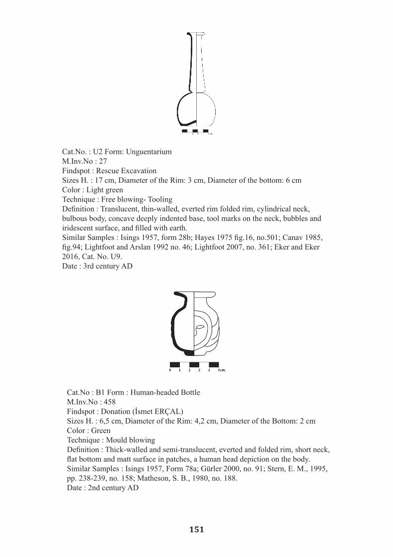
151
Cat.No. : U2 Form: Unguentarium M.Inv.No : 27 Findspot : Rescue Excavation Sizes H. : 17 cm, Diameter of the Rim: 3 cm, Diameter of the bottom: 6 cm Color : Light green Technique : Free blowing- ToolingDefinition : Translucent, thin-walled, everted rim folded rim, cylindrical neck, bulbous body, concave deeply indented base, tool marks on the neck, bubbles and iridescent surface, and filled with earth. Similar Samples : Isings 1957, form 28b; Hayes 1975 fig.16, no.501; Canav 1985, fig.94; Lightfoot and Arslan 1992 no. 46; Lightfoot 2007, no. 361; Eker and Eker 2016, Cat. No. U9. Date : 3rd century AD
Cat.No : B1 Form : Human-headed Bottle M.Inv.No : 458 Findspot : Donation (İsmet ERÇAL) Sizes H. : 6,5 cm, Diameter of the Rim: 4,2 cm, Diameter of the Bottom: 2 cm Color : Green Technique : Mould blowing Definition : Thick-walled and semi-translucent, everted and folded rim, short neck, flat bottom and matt surface in patches, a human head depiction on the body. Similar Samples : Isings 1957, Form 78a; Gürler 2000, no. 91; Stern, E. M., 1995, pp. 238-239, no. 158; Matheson, S. B., 1980, no. 188. Date : 2nd century AD

152
Cat.No : B2 Form : Bottle with Globular Body M.Inv.No : 33 Findspot : Rescue excavationSizes Diameter of the Rim : 2 cm Color : Light green Technique : Free blowing, tooling Definition : Some parts of the body broken, fire-rounded cut rim, tubular neck, deep knuckle which was tooled between the body and the neck, globular body, and oval base.,wheel-made incised decorations on the neck and body, bubbles on the clean surface. Similar Samples : Fıratlı and Akat and Kocabaş 1984, No. 246 Res.108; Canav 1985, 93; Lightfoot 1990, Fig. 8; Lighfoot and Arslan 1992, Fig. 69, 98; Özet 1998, No. 95; Gürler 2000, 101, 102, 128, Eker 2014, Cat. No. 98; Eker 2016, Cat. No. Ş64. Date : 3rd- to 4th centuries AD
Cat.No : B3 Form : Rib-Decorated Bottle M.Inv.No. : 40 Findspot : Transfer Sizes H. : 10 cm, Diameter of the Rim: 4,5 cm, Diameter of the Bottom: 5,5 cm Color : Light green Technique : Free blowing- Tooling Definition : Funnel shaped, wide everted and folded rim, trail decorations on the neck, thin ribs tooled on conical shaped body and flat base, flat bottom, matt sur-face. Similar Samples : Lightfoot and Arslan 1992, s. 147, no. 89 Date : 4th century AD
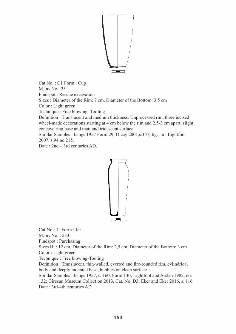
153
Cat.No. : C1 Form : Cup M.Inv.No : 25 Findspot : Rescue excavation Sizes : Diameter of the Rim: 7 cm, Diameter of the Bottom: 3,5 cm Color : Light green Technique : Free blowing- Tooling Definition : Translucent and medium thickness. Unprocessed rim, three incised wheel-made decorations starting at 4 cm below the rim and 2.5-3 cm apart, slight concave ring base and matt and iridescent surface. Similar Samples : Isings 1957 Form 29; Olcay 2001,s.147, fig.1-a ; Lightfoot 2007, s.94,no.215. Date : 2nd – 3rd centuries AD.
Cat.No : J1 Form : Jar M.Inv.No. : 233 Findspot : Purchasing Sizes H. : 12 cm, Diameter of the Rim: 2,5 cm, Diameter of the Bottom: 3 cm Color : Light green Technique : Free blowing-Tooling Definition : Translucent, thin-walled, everted and fire-rounded rim, cylindrical body and deeply indented base, bubbles on clean surface. Similar Samples : Isings 1957, s. 160, Form 130; Lightfoot and Arslan 1982, no. 132; Giresun Museum Collection 2013, Cat. No. D3; Eker and Eker 2016, s. 116.Date : 3rd-4th centuries AD

154
A Small Island of Great Importance in Maritime Trade of the South Black Sea Coast: Daphnousia Island/Kefken
Füsun TÜLEK1
Abstract
Daphnousia is a small island along the north coast of the ancient city of Nicomedeia in Black Sea (Pontus Euxine). The island, presently named Kefken, first appears in Classical literature in the Voyage of Argonauts in the third century BC. Argonauts after sailing through the clashing rocks of the Bosphorous Strait proceeded east, to the first harbor along the southern coast of the Black Sea, the Harbour of Thynias Island. The Argonauts built an altar and sacrificed animal to the Lord of Dawn, to God Apollo, for they witnessed epiphany of Him at Dawn. Thus, a cult of Apollo and Daphne was established on the island from where presumably the cult of Apollo disseminated in the region. The harbor of the island must have prospered after getting integrated to the territory of the emporion Heracleia am Pontica throughout the Roman, Byzantine and the late medieval ages. The harbours and their installations were protected with fortresses of which most were Byzantine foundations in origin, and they only began to be facilitated first by the Venetian merchants other than Byzantine nauclarii in the last decades of the 11th century AD.
Key Words: Emporion, Bithynia, nauclarii, Venetian merchants, fortress, harbor, Black Sea
Coast
Daphnousia or Thynias, is a small island on southern coast of the Black Sea, Pontus Euxine in Bithynia region. Bithynia, where Thyns of the Thracian tribes settled during the Iron Age, is a region which encompasses the land east of the Bosphorous Straits and the Sea of Propontis, including south and north shores of the Astakos Gulf, where the land is irrigated by the rivers Sangarius and Hypius extending to the Black Sea Coast. The north coast of Bithynia along the Black Sea is adorned with small bays and promontories jutting to the Sea with a few tiny islands and rocks surfacing the sea. The biggest of all these Bithynian islands is the island of Daphnousia, which has a harbor large and safe enough for ships to anchor en route heading to east to the first major port, the port of the ancient city of Heracleia am Pontica. The island is very close to coast, to the Calpe Bay, present day Kerpe, which is just 4.5 sea miles southwest of the island where ships can anchor, as well.
Heracleia am Pontica was a colony settlement founded as an emporion during the Greek colonization period in 550 BC (Asheri 1972, 12) by Dor tribes together with Boeotians(Pausanias 5.26.7). It was the largest and busiest harbor to the east of Bithynia along the Black Sea Coast. In the 6th century, Heracleia am Pontica controlled the Bithynian coast of the Black Sea, including the island of Daphnousia and the Calpe Bay. In the early Hellenistic period, Heracleia am Pontica prospered via maritime trade, and expanded its territory to west, to the west of Pisilis River and to east, to the land beyond rivers Sangarius and Billaios until the river Parthenios. Thus, gaining power over the towns of Tieion and Amastris (Asheri 1972, 13), Heracleia am Pontica created a thalassocracy along the Bithynian and Paphlagonian coasts. The territory expansion policy of Heracleia am Pontica during the fourth century BC spreaded southwards, to inland as well, including the city of Kieros and its chora, which was safe and
1 Kocaeli University, Kocaeli/TURKEY

155
A Small Island of Great Importance in Maritime Trade of the South Black Sea Coast: Daphnousia Island/Kefken
Füsun TÜLEK1
Abstract
Daphnousia is a small island along the north coast of the ancient city of Nicomedeia in Black Sea (Pontus Euxine). The island, presently named Kefken, first appears in Classical literature in the Voyage of Argonauts in the third century BC. Argonauts after sailing through the clashing rocks of the Bosphorous Strait proceeded east, to the first harbor along the southern coast of the Black Sea, the Harbour of Thynias Island. The Argonauts built an altar and sacrificed animal to the Lord of Dawn, to God Apollo, for they witnessed epiphany of Him at Dawn. Thus, a cult of Apollo and Daphne was established on the island from where presumably the cult of Apollo disseminated in the region. The harbor of the island must have prospered after getting integrated to the territory of the emporion Heracleia am Pontica throughout the Roman, Byzantine and the late medieval ages. The harbours and their installations were protected with fortresses of which most were Byzantine foundations in origin, and they only began to be facilitated first by the Venetian merchants other than Byzantine nauclarii in the last decades of the 11th century AD.
Key Words: Emporion, Bithynia, nauclarii, Venetian merchants, fortress, harbor, Black Sea
Coast
Daphnousia or Thynias, is a small island on southern coast of the Black Sea, Pontus Euxine in Bithynia region. Bithynia, where Thyns of the Thracian tribes settled during the Iron Age, is a region which encompasses the land east of the Bosphorous Straits and the Sea of Propontis, including south and north shores of the Astakos Gulf, where the land is irrigated by the rivers Sangarius and Hypius extending to the Black Sea Coast. The north coast of Bithynia along the Black Sea is adorned with small bays and promontories jutting to the Sea with a few tiny islands and rocks surfacing the sea. The biggest of all these Bithynian islands is the island of Daphnousia, which has a harbor large and safe enough for ships to anchor en route heading to east to the first major port, the port of the ancient city of Heracleia am Pontica. The island is very close to coast, to the Calpe Bay, present day Kerpe, which is just 4.5 sea miles southwest of the island where ships can anchor, as well.
Heracleia am Pontica was a colony settlement founded as an emporion during the Greek colonization period in 550 BC (Asheri 1972, 12) by Dor tribes together with Boeotians(Pausanias 5.26.7). It was the largest and busiest harbor to the east of Bithynia along the Black Sea Coast. In the 6th century, Heracleia am Pontica controlled the Bithynian coast of the Black Sea, including the island of Daphnousia and the Calpe Bay. In the early Hellenistic period, Heracleia am Pontica prospered via maritime trade, and expanded its territory to west, to the west of Pisilis River and to east, to the land beyond rivers Sangarius and Billaios until the river Parthenios. Thus, gaining power over the towns of Tieion and Amastris (Asheri 1972, 13), Heracleia am Pontica created a thalassocracy along the Bithynian and Paphlagonian coasts. The territory expansion policy of Heracleia am Pontica during the fourth century BC spreaded southwards, to inland as well, including the city of Kieros and its chora, which was safe and
1 Kocaeli University, Kocaeli/TURKEY

156
fertile irrigated by the River Hypius (Ameling 1985, 2). The ancient city of Kieros was founded by the Boetian and Thessalian phylae of the Dor tribes, who were the kinsmen of Heracleia am Pontica, and it was a productive hinterland for the emporion. In Bithynia region, on the southeastern end of the Astakos Gulf, the town of Astakos/Olbia was founded by Megarian colonists on the coast of the inner sea Propontis (Bosch 1946, 37- 38). It is not clear whether these two archaic settlements, the city of Astakos and Heracleia am Pontica are contemporarily founded settlements during the Greek colony period. The geographer Memnon, a native of Heracleia am Pontica asserted that settlement of Astakos was founded much earlier than Heracleia am Pontica (Memnon XX.1). The settlement Astakos, somehow faded in history leaving no literary record unto present, apart from some architectural remains in Basiskele locality, presumed site of the ancient town on the southeastern end of the Gulf. In the early Hellenistic period, the city of Nicomedeia was founded on the northern bank of the Astakos Gulf across the archaic settlement of Astakos, which must have fallen in oblivion by then. The Astakos Gulf with its both northern and southern banks must have been more convenient for the Thyn and Megarian phyle to found settlements where safer maritime trade and seafaring could be conducted. The Gulf of Astakos stretches deep to east with a smooth sea and mild weather conditions. During the mid-Hellenistic period, Kingdom of Bithynia under the King Prusias the First attempted to expand its territory to east, claiming rights over the town of Kieros. The hegemony conflict between the cities Heracleia am Pontica and Nicomedeia over the easternmost parts of the Bithynia region resulted in clash of the two powers. Eventually, King Prusias the First took the city of Kieros and renamed it as Prusias ad Hypium. Ancient texts of the geographers Arrianus of Nicomedeia, and Memnon of Heracleia did not record any similar hegemony conflict between the two powers over the Daphnousia Island and the Calpe Bay. Indeed, the northern coast of Bithynia region, except foundation of the emporion Heracleia, was left unsettled for a very long time, until the Hellenistic Period. In the fifth century BC when Xenophon came to the area, there was no settlement along the bay of Calpe and on the island. The earliest written record about the Calpe Bay is by Xenophon of Athens in the fifth century BC (Xenophon 6.2-6.4). Xenophon, a philosopher and a historian happened to find himself as the commander of the Army of Ten Thousands that disembarked at Calpe Bay. The soldiers had to go inland to fetch food and water, where they confronted hostile locals of the region. Xenophon, while narrating clash of soldiers with locals, described a harbor, but not a harbor settlement in the Calpe Bay. Ancient settlements in size of a village were 30 stadia, ca. five kilometers distant from the sea (Xenophon 6.3.2). The land was fertile and the inhabited villages were cultivating wheat, barley, grapes, everything, but not olives (Xenophon 6.4.6). Xenophon’s historical record provides a terminus post quem for settlement foundation and building program on the island and on the coast of Calpe Bay, as well as, for power and territory expansion policy of Heracleia am Pontica, which also created smaller emporia substantia t ing its maritime trade. Daphnousia Island with its harbor is first mentioned in ancient literature in the Voyage of Argonauts to the Black Sea to find the Golden Fleece in the third century BC. Apollonius of Rhodes named it as the island of Thynias along the land of Bithynians, where Thyns of the Thracian tribes settled (Apollonius II. 341-359). According to Apollonius, Argonauts after sailing through the clashing rocks of the Bosphorous Strait sailed to east in the Pontus Euxine and proceeded to the first harbor along the coast with an anchorage, the harbor of the Thynias Island. On the island, Argonauts witnessed epiphany of the God Apollo at dawn holding a silver bow and a quiver at his back, as he stepped the earth shook and the waves beat the shore. They

157
fertile irrigated by the River Hypius (Ameling 1985, 2). The ancient city of Kieros was founded by the Boetian and Thessalian phylae of the Dor tribes, who were the kinsmen of Heracleia am Pontica, and it was a productive hinterland for the emporion. In Bithynia region, on the southeastern end of the Astakos Gulf, the town of Astakos/Olbia was founded by Megarian colonists on the coast of the inner sea Propontis (Bosch 1946, 37- 38). It is not clear whether these two archaic settlements, the city of Astakos and Heracleia am Pontica are contemporarily founded settlements during the Greek colony period. The geographer Memnon, a native of Heracleia am Pontica asserted that settlement of Astakos was founded much earlier than Heracleia am Pontica (Memnon XX.1). The settlement Astakos, somehow faded in history leaving no literary record unto present, apart from some architectural remains in Basiskele locality, presumed site of the ancient town on the southeastern end of the Gulf. In the early Hellenistic period, the city of Nicomedeia was founded on the northern bank of the Astakos Gulf across the archaic settlement of Astakos, which must have fallen in oblivion by then. The Astakos Gulf with its both northern and southern banks must have been more convenient for the Thyn and Megarian phyle to found settlements where safer maritime trade and seafaring could be conducted. The Gulf of Astakos stretches deep to east with a smooth sea and mild weather conditions. During the mid-Hellenistic period, Kingdom of Bithynia under the King Prusias the First attempted to expand its territory to east, claiming rights over the town of Kieros. The hegemony conflict between the cities Heracleia am Pontica and Nicomedeia over the easternmost parts of the Bithynia region resulted in clash of the two powers. Eventually, King Prusias the First took the city of Kieros and renamed it as Prusias ad Hypium. Ancient texts of the geographers Arrianus of Nicomedeia, and Memnon of Heracleia did not record any similar hegemony conflict between the two powers over the Daphnousia Island and the Calpe Bay. Indeed, the northern coast of Bithynia region, except foundation of the emporion Heracleia, was left unsettled for a very long time, until the Hellenistic Period. In the fifth century BC when Xenophon came to the area, there was no settlement along the bay of Calpe and on the island. The earliest written record about the Calpe Bay is by Xenophon of Athens in the fifth century BC (Xenophon 6.2-6.4). Xenophon, a philosopher and a historian happened to find himself as the commander of the Army of Ten Thousands that disembarked at Calpe Bay. The soldiers had to go inland to fetch food and water, where they confronted hostile locals of the region. Xenophon, while narrating clash of soldiers with locals, described a harbor, but not a harbor settlement in the Calpe Bay. Ancient settlements in size of a village were 30 stadia, ca. five kilometers distant from the sea (Xenophon 6.3.2). The land was fertile and the inhabited villages were cultivating wheat, barley, grapes, everything, but not olives (Xenophon 6.4.6). Xenophon’s historical record provides a terminus post quem for settlement foundation and building program on the island and on the coast of Calpe Bay, as well as, for power and territory expansion policy of Heracleia am Pontica, which also created smaller emporia substantia t ing its maritime trade. Daphnousia Island with its harbor is first mentioned in ancient literature in the Voyage of Argonauts to the Black Sea to find the Golden Fleece in the third century BC. Apollonius of Rhodes named it as the island of Thynias along the land of Bithynians, where Thyns of the Thracian tribes settled (Apollonius II. 341-359). According to Apollonius, Argonauts after sailing through the clashing rocks of the Bosphorous Strait sailed to east in the Pontus Euxine and proceeded to the first harbor along the coast with an anchorage, the harbor of the Thynias Island. On the island, Argonauts witnessed epiphany of the God Apollo at dawn holding a silver bow and a quiver at his back, as he stepped the earth shook and the waves beat the shore. They
offered sacrifice and libations and called it sacred isle of Apollo of the Dawn upon a suggestion by Orpheus (Apollonius II. 669-685). Thus, cult of Apollo together with his mistress Daphne must have been established on the island from where presumably the cult of Apollo disseminated in the region; and all over the coastal lands of Black Sea once existence of worship to the cult of Apollo has been evidenced (Konstantinos 2013). Geographers Arrianus of Nicomedeia and Strabo of Amaseia mentioned the island in the first century AD. Arrian of Nicomedia named it as the island of Apollonia while describing coastal landscape of the Pontus Euxine from west to east listing the rivers, bays, harbors, islands and settlements even giving the distance between them in stadia. For Arrian, Calpe harbor having good water and timber resources was a good qualified place for the ships to anchor, which was 210 stadia distant from the previous mooring place, estuarine of the Psilis River, present day Sile. Arrian notes that after the Bay of Calpe, the next place good for mooring was the bay of Rhoe, present day Kefken, just 20 stadia to the west. Arrian indicates that the island of Apollonia had a harbor behind (on north side) and was 20 stadia north of the Rhoe bay (Arrianus XIII: 1- 4). However, he mentioned nothing else about the Island. Strabo did not describe the Island in details either, aside from naming it the island of Thynias and that it was situated along the Bithynian coast (Strabon XII.3.7). It is Ptolemy, the Greek astronomer and geographer of the second century AD, who mentioned the island in both names as Daphnousia and Thynias (Ptolemaeus V. 14.1). Daphnousia Island must have played some role of significance in seafaring and maritime trade of the south coast of the Black Sea all throughout history, so that the harbor and the small settlement on it survived into the early medieval ages recorded in Church accounts. In the Medieval Period, maritime trade of the Pontus Euxine was under monopoly of the Byzantine Empire, of which only the Byzantine nauclarii actively conducted seafaring and maritime trade. Daphnousia had a church under the bishopric of Nicomedia, and its one of the renown bishops was the titular Saint Sabas, who was a martyr having the feast day on May the 2nd. Bishop Leon of the church of the Daphnousia Island made amends to the second session of the VIIIth ecumenical council in 869 AD, and after 1300 AD, nothing was heard of the church of the island (Janin 1960, 82). In the 11th century, the Byzantine Empire, at the time of the Emperor Alexios Comnenos I made allies with Venetians against Normans, and the Venetian Fleet defeated Normans in the Sea of Adriatic (Anna Comnena VI, 191). In return, the Venetians were rewarded with high rank titles and granted the privilege to run maritime trade in harbors of the Byzantine Empire with concession of being exempt of tax in May of 1082 (Ostrogorsky 1991, 331). In the last quarter of the twelfth century, for a while privileges of the Venetians were suspended by the emperor Manuel Comnenus. However, in 1182 AD Venetians did not only regained the privileges of tax exempt trade in harbors of the Byzantine Empire, they also gained the power to control the maritime trade of the Byzantine Empire. Thus, when the Latins invaded Constantinople, it was the Venetians who most benefited the political situation, and they literally reinstated a Venetian Thalassocracy in waters of the Empire. They controlled the Straits of Dardanelles and the Bosphorus, as well as, the most important harbors in Pontus Euxine such as, the harbor of Heracleia am Pontica (Ostrogorsky 1991 391). In the 13th century, two princes of the Comnenus Dynasty, Alexios and David Comnenus founded a kingdom, the Pontus Kingdom in Trapezus. The newly founded Pontus Kingdom, claiming rights over the southern coast of Pontus Euxine, took control of the harbors of Sinope and Heracleia am Pontica. Harbors of the Black Sea, which were out of sight, silent and peaceful

158
during the hegemony of the Byzantine Empire, began to be the stage of clash of ruling powers after the year 1204 AD. The Byzantine Empire stationed in Nicea under the Laskarids Dynasty renewed the marit ime trade agreement with the Venetians in 1219 AD (Ostrogorsky 1991, 398). On the other hand, the Laskarids took back the southern coast until Sinop including harbors of the Heracleia and Amastris. In 1225, Latins captured Nicomedia and in 1260 AD Venetian fleet together with Latins laid siege to the island of Daphnousia (Ostrogorsky 1991, 415). The siege of the Daphnousia Island was a golden opportunity for the Byzantines to take back the capital, the city of Constantinople, which was left unguarded. In 1261, the Byzantine Emperor Mikhail VIII granted Genoese merchants similar privileges once granted to the Venetians. Eventually, in 1265 AD Genoese and Venetian fleets battled; victorious was the Venetian fleet which took back all the privileges and rights (Ostrogorsky 1991, 420). The Turks, under the command of Orhan Gazi, first took Nicea/ Iznik in 1331 and Nicomedia in 1337. However, Heracleia am Pontica and its harbor continued to be under the control of the Byzantine Empire and its nauclarii for some more decades until the conquest of Constantinop le by the Ottomans (Ostrogorsky 1991, 467). During the Turkish Independence War, the Daphnousia Island, as the only island with a harbor good for mooring along the western part of the Black Sea Coast, played a very important role in deliverance of ammunition to Anatolia. In the middle of the 19th century travelers such as Hommaire de Hell and Charles Texier explored the Bithynia region. After the Independence war, mainly German scholarship conducted several surveys in the Bithynia region such as Bosch, Bittel, Dörner. It is Konrat Ziegler who first studied the history of the island in 1936 (Ziegler 1936, 18; Dörner, Hoepfner 1989: 104). F.K. Dörner conducted an archaeological survey in Bithynia and on the northern coast of Anatolia along the Black Sea Coast, Historisch- archaeologische Forschungen in Bithynien und an der türkischen Schwarzmeerküste, in 1984 to1986, and in 1989 published Turkish scholars conducted excavations and surveys in the area right after the Second World War; Arif Müfid Mansel of the Istanbul University and Nezih Fıratlı of the Istanbul Archaeology Museums undertook archaeological examinations in the region. Fıratlı surveyed the island and its vicinity including the bays of Calpe/ Kerpe and Rhoe/ Kefken in 1949 and 1951. A comprehensive archaeological examination of the Daphnousia Island was published by Dörner and Hoepfner in 1989. In the year 2006, the Archaeology Department of Kocaeli University surveyed and evaluated the archaeological remains on the island. The report of the Kocaeli University attested the significance of archaeological structures mostly remaining in good state and reinforced register of the site as a First Degree Archaeological Heritage. The ancient harbor and the architectural remains are protected as the First Degree Archaeologica l site under the auspices of the Turkish Ministry of Culture. In his preliminary report examining ancient remains on the Island, Fıratlı observed that a strong fortification wall encloses the island, which most of it stands firmly. For Fıratlı, round towers of the fortification walls on west side of the island demonstrated repairs of the 11th and 12th centuries, and walls on the south and east sides of the island preserved the ashlar masonry of conglomerate stones built without mortar (Fıratlı 1946, 16). Dörner and Hoepfner, agreeing with Fıratlı, noted that most of the remaining fortification walls belonged to the Byzantine Period, whereas the walls on the northern part of the island are of the Hellenistic Period (Dörner and Hoepfner 1989: 105). Fıratlı, even, suggested that the block of stones of the ashlar masonry must have been quarried from a quarry on a cape across the island. Rows of ashlar stones of the wall masonry were irregular, varying in thickness from 0.27 meters to 0.46 meters. Several
cisterns were observed on the island, as well as a lighthouse of which Dörner and Hoepfner presumed to be ancient in origin. Survey reports of both scholars recorded ramparts of the 20th century, which demonstrated potsherds in cross sections of the land dating to the fifth and fourth centuries BC. Fıratlı provided detailed information about the types of the pottery, which were all black slipped late Classical and Hellenistic pottery of kylix, kotyle, and kantahros types, as well as including a wide dish. The island is ±600 meters in length and ± 110 meters in width measuring circa 600 acres and ±30 meters above sea level. At present, the modern harbor and its moles placed on the southern part of the island, together with the only modern structure belong to marine rescue station of the Turkish Navy. Fortification walls with Hellenistic ashlar masonry still survive in good state. The mole of the ancient harbor in the island is sunken. Remains of some structures within the enclosure of the walls are detected beneath vegetation on the island. Remarkable are the remains on the western part of the island behind the modern structure of the marine rescue station, which appear to be a rectangular structure with an apsis on its east side, possibly a church. Potsherds of similar type found in previous surveys having black shiny slipped ware of the Hellenis t ic period, as well as green glazed ware of the medieval period are observed, as well. The coast of the island is rich in terms of ancient underwater remains. A cursory survey of the island shores yields several stone anchors as well as fragments of amphorae. The ongoing study of the island is expected to uncover more information about the island and the coastland across it.
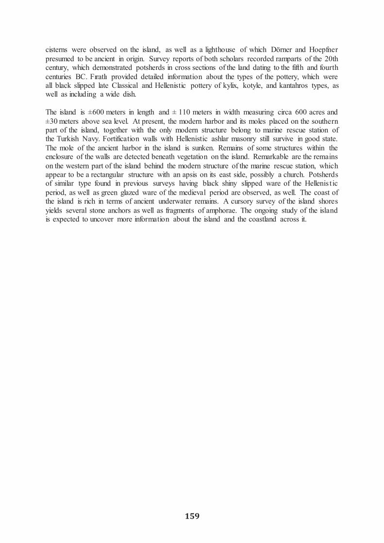
159
cisterns were observed on the island, as well as a lighthouse of which Dörner and Hoepfner presumed to be ancient in origin. Survey reports of both scholars recorded ramparts of the 20th century, which demonstrated potsherds in cross sections of the land dating to the fifth and fourth centuries BC. Fıratlı provided detailed information about the types of the pottery, which were all black slipped late Classical and Hellenistic pottery of kylix, kotyle, and kantahros types, as well as including a wide dish. The island is ±600 meters in length and ± 110 meters in width measuring circa 600 acres and ±30 meters above sea level. At present, the modern harbor and its moles placed on the southern part of the island, together with the only modern structure belong to marine rescue station of the Turkish Navy. Fortification walls with Hellenistic ashlar masonry still survive in good state. The mole of the ancient harbor in the island is sunken. Remains of some structures within the enclosure of the walls are detected beneath vegetation on the island. Remarkable are the remains on the western part of the island behind the modern structure of the marine rescue station, which appear to be a rectangular structure with an apsis on its east side, possibly a church. Potsherds of similar type found in previous surveys having black shiny slipped ware of the Hellenis t ic period, as well as green glazed ware of the medieval period are observed, as well. The coast of the island is rich in terms of ancient underwater remains. A cursory survey of the island shores yields several stone anchors as well as fragments of amphorae. The ongoing study of the island is expected to uncover more information about the island and the coastland across it.

160
Bibliography Ameling, Walter. 1985. Die Inschriften von Prusias ad Hypium. Bonn Anna Comnena. 1969. The Alexiad of Anna Comnena. E.R.A. Sewter (trans). London. Apollonius Rhodius. 1912. Argonautica. Seaton, R. C. trans). Loeb Classical Library. London. Arrianus, Arrianus’un Karadeniz Seyahati. Murat Arslan (çev). Odin Yayıncılık. 2005. Asheri, David. 1972. Herakleia Pontike. (eds) F. Dörner. TAM Suppl. 5 Wien. Bosch, Clemens. 1946. Bitinya Tetkikleri I. Çev. Sabahat Atlan. Belleten. X. 37. 29- 53 Dörner, F.K., Hoepfner 1989. “Das Eiland Thynias- Apollonia”. Istanbuler Mitteilungen. 39: 103- 106 Fıratlı, Nezih. 1946. Bitinya Arastırmalarına Birkaç Ilave. Belleten. XVII. 15- 25. Janin, Raymond. 1960. Daphnousia. Dictionnaire d’Histoire et de Geographie Ecclesiastiques. R. Aubert, E. Van Cauwenbergh (eds). Paris. Konstantinos, Moschakis. 2013. Healing Gods: The Cult of Apollo Iatros, Asclepius and Hygieia in the Black Sea Region. MA Dissertation submitted to the Hellenic University, Thessaloniki. Thessaloniki. Memnon, Herakleia Pontike Tarihi. Murat Arslan (çev). Odin Yayıncılık. 2007. Istanbul. Pausanias, Description of Greece. W.H.S. Jones, Litt.D., and H.A. Ormerod. (trans). Harvard University Press. Cambridge, MA.1918. Ostrogorsky, Georg. 1991. Bizans Devleti Tarihi. Çeviren Fikret Isıltan. Türk Tarih Kurumu Yayınları. X.7. Ankara Ptolemaeus Claudii Ptolemaei. Geographia. Karl Friedrich August (ed). 1843-1845. Lipsiae. Strabo, Geography. H. C. Hamilton, W. Falconer (trans). George Bell & Sons. 1903. London. Ziegler, Konrat. 1936. Thynias. Realencyclopädie der classischen Altertumswissenschaft neue Bearbeitung, VI.A. Halbband 11. August Pauly, Georg Wissowa, Wilhelm Kroll, Kurt Witte, Karl Mittelhaus, Konrat Ziegler, (eds). Stuttgart. Xenophon. Xenophon in Seven Volumes, 3. Carleton L. Brownson (trans). 1922. Harvard University Press, Cambridge, MA.

161
Preliminary Observations on the Palaeolithic Period Finds Found in the Western Black Sea Region Between the Eregli and Akçakoca Districts
Gökhan MUSTAFAOGLU
Abstract
The archaeological data on the West Black Sea Region of Turkey, particulary on prehistoric periods are rather restricted due to a small number of researchers working in the area as well as the challenging topography and intense forest vegetation of the region. Thus, our aim was to investigate Heraclea Pontica located within the boundaries of the Eregli District in the Zonguldak Province and its vicinity (its hinterland/territorium/khora) within the scope of both classical and protohistoric as well as prehistoric archaeological dynamics. We present arguments about the results of our preliminary observations related to the finds and findspots identified during our one-week prehistoric archaeology survey. The finds dating to the prehistoric period came from a region between the Eregli-Akçakoca Districts near the western boundary of the survey area. Although the geography is relatively suitable for a surface survey,intense vegetation and woodland made it difficult to see the surface. Consequently, finds were identified around the forest/village roads or in zones where physical disturbances such as water channel and also where exposed subsoil was visible. All of the finds identified at 4 different areas included chipped stones, which possibly belong to different stages of the Middle Palaeolithic Period, and yet doubtfully to the Upper Palaeolithic Period. The areas 1 and 2 are singular, while the areas 3 and 4 demonstrate features of a workshop area. The presence of these finds has an important role in terms of unveiling the traces of human existence back to the Palaeolithic Period, which has been unknown until today in this particular district of the West Black Sea region.
Key Words: West Black Sea Region, Turkey, Palaeolithic-Archaeological Survey- Traces of Human Existence
Introduction
With an aim to investigate Herakleia Pontike located in the district of Eregli within the borders of the Zonguldak Province and its hinterland (Map 1) in terms of prehistoric archaeology, we conducted a survey between September 27th and October 2nd 2016 according to the objectives listed below:▪ To get an idea about potential findspots by topographical and geomorphological observation
of region’s geography,▪ To identify Prehistoric Age findspots of the survey area,▪ To determine local-regional developments of these areas,▪ In the context of historical progress and interaction, to reveal findspots identified in the
nearby geography of the region by previous surveys with their potential connections,▪ To contribute to the local cultural inventory by identifying findspots belonging to merely
known periods of the region.
Bibliography Ameling, Walter. 1985. Die Inschriften von Prusias ad Hypium. Bonn Anna Comnena. 1969. The Alexiad of Anna Comnena. E.R.A. Sewter (trans). London. Apollonius Rhodius. 1912. Argonautica. Seaton, R. C. trans). Loeb Classical Library. London. Arrianus, Arrianus’un Karadeniz Seyahati. Murat Arslan (çev). Odin Yayıncılık. 2005. Asheri, David. 1972. Herakleia Pontike. (eds) F. Dörner. TAM Suppl. 5 Wien. Bosch, Clemens. 1946. Bitinya Tetkikleri I. Çev. Sabahat Atlan. Belleten. X. 37. 29- 53 Dörner, F.K., Hoepfner 1989. “Das Eiland Thynias- Apollonia”. Istanbuler Mitteilungen. 39: 103- 106 Fıratlı, Nezih. 1946. Bitinya Arastırmalarına Birkaç Ilave. Belleten. XVII. 15- 25. Janin, Raymond. 1960. Daphnousia. Dictionnaire d’Histoire et de Geographie Ecclesiastiques. R. Aubert, E. Van Cauwenbergh (eds). Paris. Konstantinos, Moschakis. 2013. Healing Gods: The Cult of Apollo Iatros, Asclepius and Hygieia in the Black Sea Region. MA Dissertation submitted to the Hellenic University, Thessaloniki. Thessaloniki. Memnon, Herakleia Pontike Tarihi. Murat Arslan (çev). Odin Yayıncılık. 2007. Istanbul. Pausanias, Description of Greece. W.H.S. Jones, Litt.D., and H.A. Ormerod. (trans). Harvard University Press. Cambridge, MA.1918. Ostrogorsky, Georg. 1991. Bizans Devleti Tarihi. Çeviren Fikret Isıltan. Türk Tarih Kurumu Yayınları. X.7. Ankara Ptolemaeus Claudii Ptolemaei. Geographia. Karl Friedrich August (ed). 1843-1845. Lipsiae. Strabo, Geography. H. C. Hamilton, W. Falconer (trans). George Bell & Sons. 1903. London. Ziegler, Konrat. 1936. Thynias. Realencyclopädie der classischen Altertumswissenschaft neue Bearbeitung, VI.A. Halbband 11. August Pauly, Georg Wissowa, Wilhelm Kroll, Kurt Witte, Karl Mittelhaus, Konrat Ziegler, (eds). Stuttgart. Xenophon. Xenophon in Seven Volumes, 3. Carleton L. Brownson (trans). 1922. Harvard University Press, Cambridge, MA.

162
Method
A literature review was performed before the Heraclea Pontica Surface Survey.1 The satellite footage of the investigation area was examined to evaluate mountain side/forested areas, hillsand so forth elevations, valleys and valley slopes-inclinations of the slopes, river-riverlet-brook and so forth springs, coastal plains, settlement areas, industrial areas and agricultural areas. This way, we tried to determine both suitable areas for the survey and the potential findspots based on the previous finds within the borders of the target area. By taking the dynamics of a Prehistoric period survey into consideration, a “Heraclea Pontica Survey Archaeologica l Findings Record Form” was developed, and a detailed location information of every find or findspot was recorded with GPS based on the GIS. Since it was our initial year of the survey, we primarily explored the spotted areas after our literature review in order to know the region better due to the compelling topography and intense vegetation of the region.2
Thus, we defined walking areas and height codes. In general terms, the initial survey was executed as field walking, without any use of extensive and intensive survey techniques. At the land visits, we also talked with the local residents and got information about potential findspots.
Previous Archaeological Studies in the Survey Area and Its Neighborhood
The earliest phase known in region’s history begins around the Early Bronze Age; materia ls related with this age were found during the excavations conducted by Turan Efe at the Yassıkaya Cave (Efe 2004). Other surveys which may be considered in the context of the Western Black Sea include those conducted by M. Özdogan in the Eastern Marmara region (Özdogan 1985, 1986, 1988, 1990), G. Karauguz (Karauguz 2009a, 2009b) and G. Karauguz –B. Düring between 2004 and 2006 in the Zonguldak Province, and districts of Devrek,Gökçebey, Çaycuma and Eregli (Karauguz and Düring 2009). It’s indicated that the areasidentified within the scope of the prehistoric ages after these studies can be dated to the EarlyChalcolithic Age-EBA date range. In addition to these studies, some Early Holocene Periodsettlements that were identified after the surveys conducted within the borders of the Cide andSenpazar Districts of the Kastamonu Province between 2009 and 2011 by a team under thesupervision of B. Düring, C. Glatz and T.E. Serifoglu should be qualified as importantsettlements, particularly in the context of the Western Black Sea region (Düring et al. 2012).The similarities of these settlements especially with the Early Holocene settlements identifiedin the east of Marmara region on the Black Sea coastline, bear important meaning in terms ofthe prehistoric archaeology in Eregli and its neighborhood.
Many chipped stones and findspots which may be dated to the Lower-Middle- Upper Palaeolithic and Epi-Palaeolithic Periods have been identified during the continuous surveys conducted by Prof. M. Kartal and his team since 2013 in the Province of Sakarya and its districts (Kartal et al. 2013, 2014), which share the same geographic shore formation with the survey area, and lie to the east of the Western Black Sea Region. These finds are also one of the reasons
1 It will be referred to as HPSS from now on. 2 The forestland is densified in the Center district as well as the Devrek, Karadeniz Ereglisi and Alaplı districts. This area of 180.000 hectares consists of 94% of copse and 6% of coppice trees. This high rainfall zone has coniferous trees (fir, pine) at its heights, broad-leaved trees (beech, oak, chestnut, elm, linden, poplar) at its the lower parts, poplar, willow trees at its river sides. This green habitat is comprised of underwood vegetation as rhododendron, evergreen oak, ilex, laurel, arbutus, cornus, cherry, heather, huckleberry, rose hip, blackberry, wild strawberry, and fern. http://bakka.gov.tr/assets/raporlar/Karabuk_Zonguldak_Bartin_Illeri_Cevresel_Durum_Deg erlendirmesi_954463.pdf
of our focus on the region enclosing Akkaya, Beyhanlı, Çayagzı and Dadalı villages remaining between the Alaplı – Akçakoca districts, and particularly located within the western border of HPYA during the 2016 campaign. Similarly, recovery of chipped stone tools during a survey by Assoc. Prof. A. Baysal in 2014 (Baysal 2015) in an area beginning right at the center of the Eregli District of Zonguldak at 37 km. in the East – West direction and 15 km. in the North – South direction, should be interpreted as evidence of other potential Palaeolithic Age finds in the region. The 2016 Campaign Starting from the western coast of the Eregli District, in 2016 studies, overall topographic nature of the land were observed firstly by driving to Topçalı, Bölücek, Hamzakafalı and Yaraslıyörük villages located on the banks of the Gülüç River, followed by Asagıdogancılar, Çayköy, Musabeyli, Asagıdagköy and Isafakılı villages located on the eastern side of the Alaplı stream. The fieldwalking surveys were mostly made between Alaplı and Akçakoca, which officia l ly forms the very western border of the survey area. We focused on the Akkaya, Beyhanlı, Çaya gzı and Dadalı villages during the 2016 campaign. In this region, we identified 4 findspots (Figure 1). Apart from these areas, including the Inönü Cave in the Inönü locality of the Kelçe neighborhood, Çaylıoglu/Günesli town of the Karadeniz Eregli District, 3 caves in the Dört Inler neighborhood of Alacabük village, and 2 caves in the Sarmasık In neighborhood, a total of 6 caves were visited. While the Inönü cave is already listed in the literature (Karauguz 2016, 22), we were informed about the caves in the Alacabük Village by a local from the Çaylıgo lu village. These caves are known by local residents, and can only be reached with the help of a local guide, after a challenging walk and climb in the forest for about 4 hours. All the visited caves have been destroyed by illicit diggings. Not a single chipped stone tool was recovered neither in these illicity digged pits nor in their surroundings. Findspot No. 1 It is located in the vicinity of the Akkaya Village picnic site within the borders of Akkaya Village, with an altitude of 61 m on a hillside vegetated with nut trees. The distal part of a flint -based flake of probably Middle Palaeolithic character has been identified in this area (Figure 2). Apart from this, blocks of flint-based raw materials of various scales have been found without any specific removal scars. Observing has not been easy due to the fact that the whole surface is covered with hazelnut tree leaves. More detailed studies will be dully executed in 2017 under the framework of HPSS. Findspot No. 2 It lies about 1.8 km. east of Dadalı Village, 5.7 km. northwest of the Findspot No. 1. A disc shaped denticulated flake (Figure 3) was identified in a plain area at 29 m. altitude to the left of the village trail, which is surrounded with hazelnut tree covered slopes (Figure 4). No other specific finding of Middle Palaeolithic character has been identified nearby. Findspot No. 3 It lies about 1.3 km. east of Dadalı Village, 630 m. northwest of the Findspot No. 2. It is on a hillside vegetated with nut trees, with an altitude of 61 m. While trying to find a visible soil on the otherwise covered with nut tree leaves and extensively vegetated area, a crimson-brown colored soil level has been observed on both sides of the trail used to access hazelnut grove

163
of our focus on the region enclosing Akkaya, Beyhanlı, Çayagzı and Dadalı villages remaining between the Alaplı – Akçakoca districts, and particularly located within the western border of HPYA during the 2016 campaign. Similarly, recovery of chipped stone tools during a survey by Assoc. Prof. A. Baysal in 2014 (Baysal 2015) in an area beginning right at the center of the Eregli District of Zonguldak at 37 km. in the East – West direction and 15 km. in the North – South direction, should be interpreted as evidence of other potential Palaeolithic Age finds in the region. The 2016 Campaign Starting from the western coast of the Eregli District, in 2016 studies, overall topographic nature of the land were observed firstly by driving to Topçalı, Bölücek, Hamzakafalı and Yaraslıyörük villages located on the banks of the Gülüç River, followed by Asagıdogancılar, Çayköy, Musabeyli, Asagıdagköy and Isafakılı villages located on the eastern side of the Alaplı stream. The fieldwalking surveys were mostly made between Alaplı and Akçakoca, which officia l ly forms the very western border of the survey area. We focused on the Akkaya, Beyhanlı, Çaya gzı and Dadalı villages during the 2016 campaign. In this region, we identified 4 findspots (Figure 1). Apart from these areas, including the Inönü Cave in the Inönü locality of the Kelçe neighborhood, Çaylıoglu/Günesli town of the Karadeniz Eregli District, 3 caves in the Dört Inler neighborhood of Alacabük village, and 2 caves in the Sarmasık In neighborhood, a total of 6 caves were visited. While the Inönü cave is already listed in the literature (Karauguz 2016, 22), we were informed about the caves in the Alacabük Village by a local from the Çaylıgo lu village. These caves are known by local residents, and can only be reached with the help of a local guide, after a challenging walk and climb in the forest for about 4 hours. All the visited caves have been destroyed by illicit diggings. Not a single chipped stone tool was recovered neither in these illicity digged pits nor in their surroundings. Findspot No. 1 It is located in the vicinity of the Akkaya Village picnic site within the borders of Akkaya Village, with an altitude of 61 m on a hillside vegetated with nut trees. The distal part of a flint -based flake of probably Middle Palaeolithic character has been identified in this area (Figure 2). Apart from this, blocks of flint-based raw materials of various scales have been found without any specific removal scars. Observing has not been easy due to the fact that the whole surface is covered with hazelnut tree leaves. More detailed studies will be dully executed in 2017 under the framework of HPSS. Findspot No. 2 It lies about 1.8 km. east of Dadalı Village, 5.7 km. northwest of the Findspot No. 1. A disc shaped denticulated flake (Figure 3) was identified in a plain area at 29 m. altitude to the left of the village trail, which is surrounded with hazelnut tree covered slopes (Figure 4). No other specific finding of Middle Palaeolithic character has been identified nearby. Findspot No. 3 It lies about 1.3 km. east of Dadalı Village, 630 m. northwest of the Findspot No. 2. It is on a hillside vegetated with nut trees, with an altitude of 61 m. While trying to find a visible soil on the otherwise covered with nut tree leaves and extensively vegetated area, a crimson-brown colored soil level has been observed on both sides of the trail used to access hazelnut grove

164
(Figure 5). This structure has 25 cm. of width in the middle of 1 m. depth section. This level continues until the part where the section goes down for 30 cm. in depth and for 10 m. along the negative inclination of the slope (Figure 6). This level is characterized by flint debitage, with a dimension of about 1-2 cm. On the first observation, a great quantity of flint-based low quality, gray-beige tones debitage, flakes, broken core pieces and 3 pebble hammers have been found. Two of the flakes is has a long form, and one of them is denticulated. Even though these finds can be identified having a Middle Palaeolithic character, a broken piece which probably belongs to a core with a removed blade, and another piece which belongs to the distal part of a blade make an exact dating difficult for now. It is highly probable that the area had been used as an atelier on the grounds that typical tools, retouched flakes or blades are almost nonexistent, yet there are a great number of debitage (Figure 7). No ceramic or terra-cotta finding, which can be dated to prehistoric era has been encountered. Findspot No. 4 The area is located about 2 km. east of Dadalı Köy center and 720 m. northeast of the Findspot No. 3. Being elevated 37 m. from the sea level, it lies on a slope covered with hazelnut trees just as the general characteristic of this region. Similar to the Findspot No. 3, a crimson-brown colored soil level has been observed on both sections of the trail used to access hazelnut grove (Figure 8). These sections have less depth than the Findspot number 3, in both right and left sections and their bottoms, an outnumbered debitage and other chipped stone findings were identified (Figure 9). The raw material is low quality flint in gray-beige tones. Similar to the Findspot No. 3, core pieces, flake and mostly broken blade formed pieces are remarkable. Very little existence of typical tools and retouched flake or blades and a lot of debitage, increase its possibility of being a workshop area (Figure 10). Probably chipping was made in the area and the typical or useful forms were taken away by sculptors. Neither ware nor terra-cota finds from prehistoric period have been recovered. Conclusion The main objective of the survey on Heraclea Pontica and its hinterland in terms of prehistoric archaeology was to determine potential findspots belonging to the prehistoric periods of the region by observing the topography and geographic dynamics of the region. After about one week of surface surveys, we can say that our main objective was reached identification of finds belonging to the Middle Palaeolithic Period that had no levallois technology, and to the Upper Palaeolithic Period and after. It’s clear that the findspots no. 3 and 4 where intensive findings were discovered, have a high potential in terms of chipped stone findings. Although there is a 750 m. distance between these parallelly located findspots, the finds are retained in both areas at the same position and about 30 meters along the slope (Figure 1). Considering that the findspot is a slope, the fact that the finds are located 30-40 cm. right below the top soil level make us think that the flow of sedimentary elements along the slope in time resulted in covering of the slope which is believed to have been used as a workshop area. It increases the possibility of chipped stone being in-situ, observed particularly on the section surface. In the context of this observation, another point to be emphasized is that in the findspot no. 3, among the chipped stone elements located in the 2 m high section between the ones identified at the bottom of the section with 0.30 m and 0.50-0.70 m., there are differences in terms of raw material, technology and typology. This difference
may be based on stratigraphic dynamics; the elements from different chronologies have a strong possibility of being produced in the same location. The altitude range of the positions where findings were identified is between 39-61 m. above from sea level. The existence of these findings seems to corroborate the existence of human history back in the Palaeolithic Period in this part of the Western Black Sea region. In the areas surveyed by fieldwalking, no finding that may be qualified as prehistoric was identified. It may be due to the topographic structure characterizing the region and the intense vegetation preventing to see the surface. In the future, both fieldwalking and extensive and intensive survey techniques will be used from an interdisciplinary viewpoint and with the participation of experts from various disciplines such as geomorphology, spelaeology and paleobotany.

165
(Figure 5). This structure has 25 cm. of width in the middle of 1 m. depth section. This level continues until the part where the section goes down for 30 cm. in depth and for 10 m. along the negative inclination of the slope (Figure 6). This level is characterized by flint debitage, with a dimension of about 1-2 cm. On the first observation, a great quantity of flint-based low quality, gray-beige tones debitage, flakes, broken core pieces and 3 pebble hammers have been found. Two of the flakes is has a long form, and one of them is denticulated. Even though these finds can be identified having a Middle Palaeolithic character, a broken piece which probably belongs to a core with a removed blade, and another piece which belongs to the distal part of a blade make an exact dating difficult for now. It is highly probable that the area had been used as an atelier on the grounds that typical tools, retouched flakes or blades are almost nonexistent, yet there are a great number of debitage (Figure 7). No ceramic or terra-cotta finding, which can be dated to prehistoric era has been encountered. Findspot No. 4 The area is located about 2 km. east of Dadalı Köy center and 720 m. northeast of the Findspot No. 3. Being elevated 37 m. from the sea level, it lies on a slope covered with hazelnut trees just as the general characteristic of this region. Similar to the Findspot No. 3, a crimson-brown colored soil level has been observed on both sections of the trail used to access hazelnut grove (Figure 8). These sections have less depth than the Findspot number 3, in both right and left sections and their bottoms, an outnumbered debitage and other chipped stone findings were identified (Figure 9). The raw material is low quality flint in gray-beige tones. Similar to the Findspot No. 3, core pieces, flake and mostly broken blade formed pieces are remarkable. Very little existence of typical tools and retouched flake or blades and a lot of debitage, increase its possibility of being a workshop area (Figure 10). Probably chipping was made in the area and the typical or useful forms were taken away by sculptors. Neither ware nor terra-cota finds from prehistoric period have been recovered. Conclusion The main objective of the survey on Heraclea Pontica and its hinterland in terms of prehistoric archaeology was to determine potential findspots belonging to the prehistoric periods of the region by observing the topography and geographic dynamics of the region. After about one week of surface surveys, we can say that our main objective was reached identification of finds belonging to the Middle Palaeolithic Period that had no levallois technology, and to the Upper Palaeolithic Period and after. It’s clear that the findspots no. 3 and 4 where intensive findings were discovered, have a high potential in terms of chipped stone findings. Although there is a 750 m. distance between these parallelly located findspots, the finds are retained in both areas at the same position and about 30 meters along the slope (Figure 1). Considering that the findspot is a slope, the fact that the finds are located 30-40 cm. right below the top soil level make us think that the flow of sedimentary elements along the slope in time resulted in covering of the slope which is believed to have been used as a workshop area. It increases the possibility of chipped stone being in-situ, observed particularly on the section surface. In the context of this observation, another point to be emphasized is that in the findspot no. 3, among the chipped stone elements located in the 2 m high section between the ones identified at the bottom of the section with 0.30 m and 0.50-0.70 m., there are differences in terms of raw material, technology and typology. This difference
may be based on stratigraphic dynamics; the elements from different chronologies have a strong possibility of being produced in the same location. The altitude range of the positions where findings were identified is between 39-61 m. above from sea level. The existence of these findings seems to corroborate the existence of human history back in the Palaeolithic Period in this part of the Western Black Sea region. In the areas surveyed by fieldwalking, no finding that may be qualified as prehistoric was identified. It may be due to the topographic structure characterizing the region and the intense vegetation preventing to see the surface. In the future, both fieldwalking and extensive and intensive survey techniques will be used from an interdisciplinary viewpoint and with the participation of experts from various disciplines such as geomorphology, spelaeology and paleobotany.

166
Bibliography
Baysal, A. 2015. “Zonguldak Ereglisi Prehistorik Yüzey Arastırması: 2014 Yılı Yüzey Arastırması” 33. Arastırma Sonuçları Toplantısı-II, 563-579.
Efe, T. 2004. “Yassıkaya, an Early Bronze Age Site near Heracleia Pontica (Kdz Eregli) on the Black Sea Coast”, Festschrift für Nemejcová Pavùková, s.27-38.
Düring, C.B., Glatz, T. Serifoglu, E. 2012. "The Cide Archaeological Project 2011: Third preliminary report." Anatolia Antiqua XX, 167-75.
Düring, C.B., Glatz, T. Serifoglu, E. 2011."The Cide Archaeological Project 2010: Secondpreliminary report”, Anatolia Antiqua XIX, 279-288.
Karauguz, G. 2009a. “Çaycuma, Gökçebey (Tefen) ve Devrek Ilçeleri Yüzey Arastırması, 2007".Arastırma Sonuçları Toplantısı, 26(1), 105-116.
Karauguz, G. 2009b. “Zonguldak Bölgesi 2008 Yılı Yüzey Arastırması”. Arastırma Sonuçları Toplantısı, 27(1), 175-186.
Karauguz, G. and Düring, C.B. 2009. “A Note on the Prehistory of the Devrek Region, Northern Turkey” Anatolica XXXV, 153-165.
Karauguz, G. 2016. “2004-2008 Yılı Arkeolojik Yüzey Arastırması Isıgında ZonguldakBölgesi’nin Eskiçag Tarihi Kronolojisi Üzerine Kısa Bir Not”. “Insan, Kimlik, Mekân Baglamında Zonguldak Sempozyum Bildirileri”, 21-31
Kartal, M., Karakoc, M., Erbil, E. 2014 “Sakarya Ili Tarih Öncesi Arkeolojisi Yüzey Arastırması 2013”, 32. Arastırma Sonuçları Toplantısı-I, 9-26.
Kartal, M. Erbil, E. Karakoc, M. 2015. “Sakarya Ili Tarih Öncesi Arkeolojisi Yüzey Arastırması (II) 2014” 33. Arastırma Sonuçları Toplantısı-II, 390-408.
Özdogan, M. 1985. “1983 Yılı Dogu Marmara ve Trakya Arastırmaları”, 2. Arastırma Sonuçları Toplantısı, 221-232.
Özdogan, M. 1986. “1984 Yılı Trakya ve Dogu Marmara Arastırmaları”, 3. Arastırma Sonuçları Toplantısı, 409-420.
Özdogan, M. 1988. “1986 Yılı Trakya ve Marmara Bölgesi Arastırmaları”, 5. ArastırmaSonuçları. Toplantısı, 157-173.
Özdogan, M. 1990. “1988 Yılı Trakya ve Marmara Bölgesi Arastırmaları”, 7. Arastırma Sonuçları Toplantısı, 443-457. Batı Karadeniz Kalkınma Ajansı Karabük-Zonguldak-Bartın Illeri Çevresel Durum Degerlendirmesi http://bakka.gov.tr/assets/raporlar/Karabuk_Zonguldak_Bartin_Illeri_Cevresel_Durum_ Degerlendirmesi_954463.pdf
Google Earth Image/Maps

167
Map 1:
Figures
Figure 1
Figure 2
Figure 1:
Figures:
Bibliography
Baysal, A. 2015. “Zonguldak Ereglisi Prehistorik Yüzey Arastırması: 2014 Yılı Yüzey Arastırması” 33. Arastırma Sonuçları Toplantısı-II, 563-579.
Efe, T. 2004. “Yassıkaya, an Early Bronze Age Site near Heracleia Pontica (Kdz Eregli) on the Black Sea Coast”, Festschrift für Nemejcová Pavùková, s.27-38.
Düring, C.B., Glatz, T. Serifoglu, E. 2012. "The Cide Archaeological Project 2011: Third preliminary report." Anatolia Antiqua XX, 167-75.
Düring, C.B., Glatz, T. Serifoglu, E. 2011."The Cide Archaeological Project 2010: Secondpreliminary report”, Anatolia Antiqua XIX, 279-288.
Karauguz, G. 2009a. “Çaycuma, Gökçebey (Tefen) ve Devrek Ilçeleri Yüzey Arastırması, 2007".Arastırma Sonuçları Toplantısı, 26(1), 105-116.
Karauguz, G. 2009b. “Zonguldak Bölgesi 2008 Yılı Yüzey Arastırması”. Arastırma Sonuçları Toplantısı, 27(1), 175-186.
Karauguz, G. and Düring, C.B. 2009. “A Note on the Prehistory of the Devrek Region, Northern Turkey” Anatolica XXXV, 153-165.
Karauguz, G. 2016. “2004-2008 Yılı Arkeolojik Yüzey Arastırması Isıgında ZonguldakBölgesi’nin Eskiçag Tarihi Kronolojisi Üzerine Kısa Bir Not”. “Insan, Kimlik, Mekân Baglamında Zonguldak Sempozyum Bildirileri”, 21-31
Kartal, M., Karakoc, M., Erbil, E. 2014 “Sakarya Ili Tarih Öncesi Arkeolojisi Yüzey Arastırması 2013”, 32. Arastırma Sonuçları Toplantısı-I, 9-26.
Kartal, M. Erbil, E. Karakoc, M. 2015. “Sakarya Ili Tarih Öncesi Arkeolojisi Yüzey Arastırması (II) 2014” 33. Arastırma Sonuçları Toplantısı-II, 390-408.
Özdogan, M. 1985. “1983 Yılı Dogu Marmara ve Trakya Arastırmaları”, 2. Arastırma Sonuçları Toplantısı, 221-232.
Özdogan, M. 1986. “1984 Yılı Trakya ve Dogu Marmara Arastırmaları”, 3. Arastırma Sonuçları Toplantısı, 409-420.
Özdogan, M. 1988. “1986 Yılı Trakya ve Marmara Bölgesi Arastırmaları”, 5. ArastırmaSonuçları. Toplantısı, 157-173.
Özdogan, M. 1990. “1988 Yılı Trakya ve Marmara Bölgesi Arastırmaları”, 7. Arastırma Sonuçları Toplantısı, 443-457. Batı Karadeniz Kalkınma Ajansı Karabük-Zonguldak-Bartın Illeri Çevresel Durum Degerlendirmesi http://bakka.gov.tr/assets/raporlar/Karabuk_Zonguldak_Bartin_Illeri_Cevresel_Durum_ Degerlendirmesi_954463.pdf
Google Earth Image/Maps
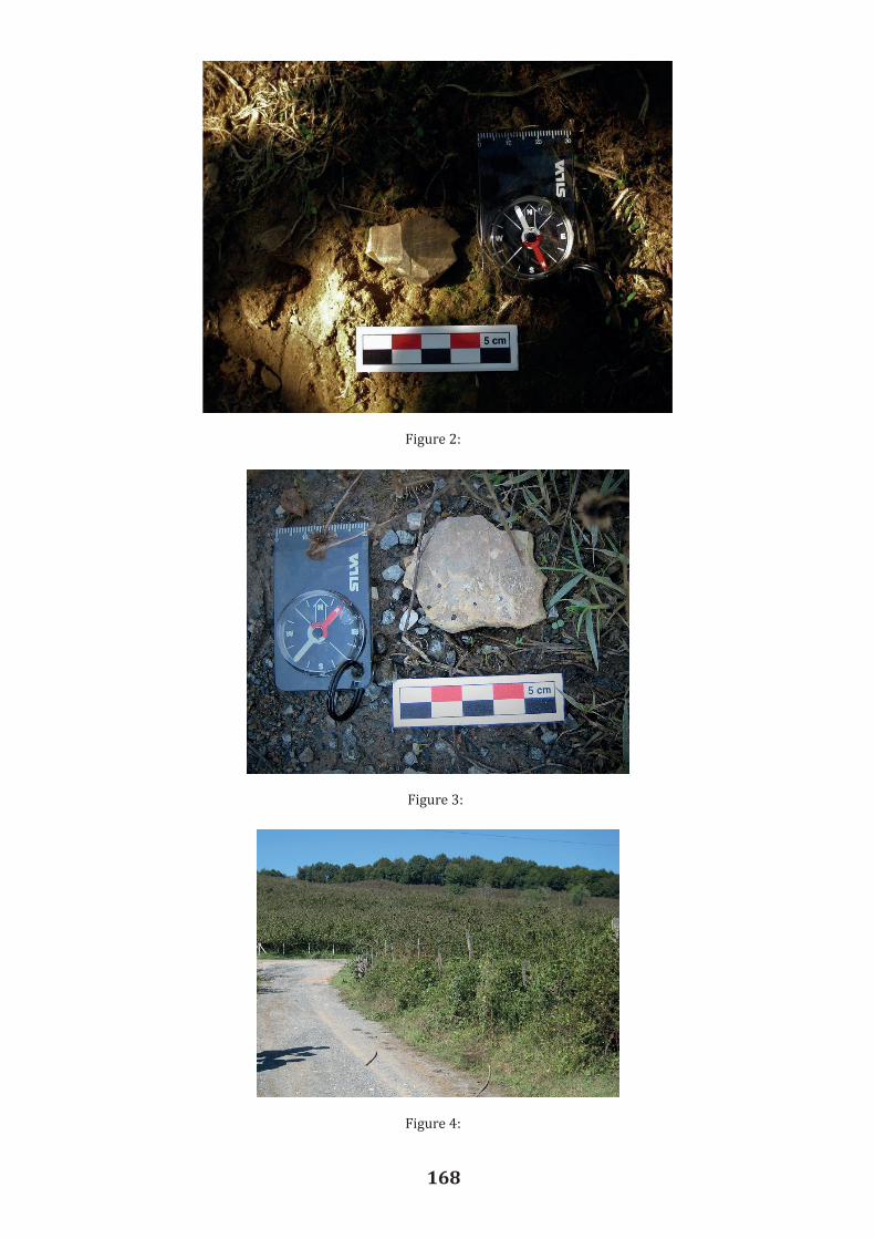
168
Figure 3:
Figure 4:
Figures
Figure 1
Figure 2 Figure 2:

169
Figure 5:
Figure 6:

170
Figure 8:
Figure 7:

171
Figure 9:

172
New Archaeological Surveys in the Western Black Sea Region of Turkey
F. Gülden EKMEN1
Abstract The prehistoric period in the Western Black Sea region of Turkey has been underinvestigated. This is because the Black Sea region has a steep, rocky coast with rivers that cascade through the gorges of the coastal ranges. In addition to this, vast majority of the region is covered with intense forests. Therefore, it is not easy to make an archaeological survey in the region. An ongoing and multidisciplinary survey has been started in 2016 by the Archaeology Department of Bülent Ecevit University. In this season, numerous cave sites were determined with protohistoric assemblages. This study presents the preliminary results of the Heraclea Pontica and its territory’s survey. The focus of this paper is on the protohistoric period in the valley of the Aydınlar Creek within the borders of the Zonguldak Province. The archaeological material which contains sherds presented here was collected from four caves and Yassıkaya in the valley of Aydınlar Creek. The sherds from the Dörtinler cave and Inönü cave date roughly to the late fifth millennium BC. These sherds should be considered as evidence for a connection between the Northeast Aegean, the Northwest Turkey and the Balkan Cultures. We hope that this discussion will contribute to the understanding of the prehistoric period in the Northwest Turkey. Key Words: Western Black Sea, Relief band with finger impression, Horned handle, Chalcolithic, Zonguldak, Heraclea Pontica. Introduction The first season of the Heraclea Pontica and its territory’s archaeological survey project directed by Tayyar Gürdal, took place in September 2016. The HPSS (HPYA - Heraclea Pontica Yüzey Arastırması) is aiming to explore the archaeology of Karadeniz Eregli, a district of Zonguldak, located on the Black Sea coast. Our main team consists of three sub-teams as Prehistoric, Protohistoric and Classic, Post-Classic. Our methodological strategies are based on topographic conditions of the sites. Generally, surveys were carried out in the form of fieldwalking because of the mountainous topography and heavy vegetation. In other words, we decided whether we prefer extensive or intensive survey tradition depending on conditions of sites. In this season, we identifed 8 sites and 8 caves. All of these sites are located in the valley of the Aydınlar Creek, which flows into the Black Sea, and the sites are covered by forest (Figure 1). The HPYA Project’s region, Heraclea Pontica was the most important harbour of the Western Black Sea Region during the Classical Ages. It has been selected for archaeological surface survey for various reasons; our first aim is to shed light on the prehistory of Eregli, and second one is to fulfill the lack of systematic archaeological surveys and data about the region. Previous explorations performed in the area are limited in number. Hoepfner (1966), Asheri (1973), Burstein (1976), Marek (1993), Akkaya (1994), Bittner (1998) and Erciyas (2003) refer to classical and post-classical periods of the site. Prehistory of Western Black Sea region has been poorly investigated, but recent studies directed by Efe (2001 and 2004) and Karauguz (2010), have shown that the region was settled during the Chalcolithic and Early Bronze Ages (Efe and
1 Assist. Prof. Dr., Bülent Ecevit University, Zonguldak/TURKEY, [email protected]
Mercan 2002; Efe 2004; Karauguz and Düring 2009; Karauguz 2010) Inönü Caves the Inönü caves are located near the Çaylıoglu village in the district of Eregli of Zonguldak Province, this complex consists of three caves, and the largest one which is called Inönü I, is at the center of the complex (Figure 2). The potsherds which were collected from the Inönü I cave and slopes of the cave, are divided into two ware groups; slipped and unslipped. The slipped group commonly has brown paste with stone-, mica- and calcium-temper. The surface colors are red. The pastes of the second group are varying from brown to reddish gray, again with stone-, mica- and calcium-temper. Based on the form and decoration, vessels with horned handles and vessels with relief bands with finger impression decorations are noted (Figure 3). Dörtinler Caves Dörtinler caves are located in the vicinity of Alacabük village of Eregli District (Figure 4). The complex consists of three caves, with a height of about 550 m, which are higher than the Inönü caves. The potsherds collected from the Dörtinler caves, are divided into two groups; slipped and unslipped. The first group, the slipped one, has reddish gray, dark gray and light brown paste, tempered stone and calcium. Surface colors are usually reddish brown and pale brown. The unslipped group is similar to the first group, reddish brown and dark gray paste with stone- and calcium-temper. The ceramics that help us to understand the pottery tradition and estimate the approximate occupation dates of the caves, are similar to those recoeverd from the Inönü caves. An important groups of finds are those vessels with horned handles, and relief bands with finger impression decorations (Figure 5). Yassıkaya We visited the Yassıkaya rock shelter that was previously excavated by Turan Efe. As it is understood from the photo, (Figure 6) Yassıkaya commands the valley of Aydınlar Creek. In fact, detailed information has been provided in the articles published by Turan Efe (Efe and Mercan 2002, 361 ff; Efe 2004, 27 ff.). Turan Efe refers to the Filyos culture whose ceramics are related to the Balkans and Western Anatolia. We also collected potsherds with the same features. The first of the three identified ceramics groups is red slipped, has light brown paste with stone- temper. The second one is the unslipped group, which has again brown paste and tempered with stone. But the third group is both red slipped and burnished with gray stony paste. If we evaluate the ceramics according to their decoration, here again, the most distinc t ive feature is the relief bands with finger impression (Figure 7). In addition, we found a handle type which is called “the loop handle” in small quantities (Figure 8). Conclusion In this report, we outlined the preliminary results of the first season of the HPSS which aims to explore the archaeology of the region. We focused on the valley of Aydınlar Creek as protohistoric team of the Project. I tried to introduce here three caves and sixteen settlements that have been determined on this season. An overall review of the potsherds recovered from the Inönü caves, Dörtinler caves and Yassıkaya shows that vessels with horned handles and vessels decorated with finger impressed relief bands are dominant, which serves as distinguishing elements for dating the sites.

173
New Archaeological Surveys in the Western Black Sea Region of Turkey
F. Gülden EKMEN1
Abstract The prehistoric period in the Western Black Sea region of Turkey has been underinvestigated. This is because the Black Sea region has a steep, rocky coast with rivers that cascade through the gorges of the coastal ranges. In addition to this, vast majority of the region is covered with intense forests. Therefore, it is not easy to make an archaeological survey in the region. An ongoing and multidisciplinary survey has been started in 2016 by the Archaeology Department of Bülent Ecevit University. In this season, numerous cave sites were determined with protohistoric assemblages. This study presents the preliminary results of the Heraclea Pontica and its territory’s survey. The focus of this paper is on the protohistoric period in the valley of the Aydınlar Creek within the borders of the Zonguldak Province. The archaeological material which contains sherds presented here was collected from four caves and Yassıkaya in the valley of Aydınlar Creek. The sherds from the Dörtinler cave and Inönü cave date roughly to the late fifth millennium BC. These sherds should be considered as evidence for a connection between the Northeast Aegean, the Northwest Turkey and the Balkan Cultures. We hope that this discussion will contribute to the understanding of the prehistoric period in the Northwest Turkey. Key Words: Western Black Sea, Relief band with finger impression, Horned handle, Chalcolithic, Zonguldak, Heraclea Pontica. Introduction The first season of the Heraclea Pontica and its territory’s archaeological survey project directed by Tayyar Gürdal, took place in September 2016. The HPSS (HPYA - Heraclea Pontica Yüzey Arastırması) is aiming to explore the archaeology of Karadeniz Eregli, a district of Zonguldak, located on the Black Sea coast. Our main team consists of three sub-teams as Prehistoric, Protohistoric and Classic, Post-Classic. Our methodological strategies are based on topographic conditions of the sites. Generally, surveys were carried out in the form of fieldwalking because of the mountainous topography and heavy vegetation. In other words, we decided whether we prefer extensive or intensive survey tradition depending on conditions of sites. In this season, we identifed 8 sites and 8 caves. All of these sites are located in the valley of the Aydınlar Creek, which flows into the Black Sea, and the sites are covered by forest (Figure 1). The HPYA Project’s region, Heraclea Pontica was the most important harbour of the Western Black Sea Region during the Classical Ages. It has been selected for archaeological surface survey for various reasons; our first aim is to shed light on the prehistory of Eregli, and second one is to fulfill the lack of systematic archaeological surveys and data about the region. Previous explorations performed in the area are limited in number. Hoepfner (1966), Asheri (1973), Burstein (1976), Marek (1993), Akkaya (1994), Bittner (1998) and Erciyas (2003) refer to classical and post-classical periods of the site. Prehistory of Western Black Sea region has been poorly investigated, but recent studies directed by Efe (2001 and 2004) and Karauguz (2010), have shown that the region was settled during the Chalcolithic and Early Bronze Ages (Efe and
1 Assist. Prof. Dr., Bülent Ecevit University, Zonguldak/TURKEY, [email protected]
Mercan 2002; Efe 2004; Karauguz and Düring 2009; Karauguz 2010) Inönü Caves the Inönü caves are located near the Çaylıoglu village in the district of Eregli of Zonguldak Province, this complex consists of three caves, and the largest one which is called Inönü I, is at the center of the complex (Figure 2). The potsherds which were collected from the Inönü I cave and slopes of the cave, are divided into two ware groups; slipped and unslipped. The slipped group commonly has brown paste with stone-, mica- and calcium-temper. The surface colors are red. The pastes of the second group are varying from brown to reddish gray, again with stone-, mica- and calcium-temper. Based on the form and decoration, vessels with horned handles and vessels with relief bands with finger impression decorations are noted (Figure 3). Dörtinler Caves Dörtinler caves are located in the vicinity of Alacabük village of Eregli District (Figure 4). The complex consists of three caves, with a height of about 550 m, which are higher than the Inönü caves. The potsherds collected from the Dörtinler caves, are divided into two groups; slipped and unslipped. The first group, the slipped one, has reddish gray, dark gray and light brown paste, tempered stone and calcium. Surface colors are usually reddish brown and pale brown. The unslipped group is similar to the first group, reddish brown and dark gray paste with stone- and calcium-temper. The ceramics that help us to understand the pottery tradition and estimate the approximate occupation dates of the caves, are similar to those recoeverd from the Inönü caves. An important groups of finds are those vessels with horned handles, and relief bands with finger impression decorations (Figure 5). Yassıkaya We visited the Yassıkaya rock shelter that was previously excavated by Turan Efe. As it is understood from the photo, (Figure 6) Yassıkaya commands the valley of Aydınlar Creek. In fact, detailed information has been provided in the articles published by Turan Efe (Efe and Mercan 2002, 361 ff; Efe 2004, 27 ff.). Turan Efe refers to the Filyos culture whose ceramics are related to the Balkans and Western Anatolia. We also collected potsherds with the same features. The first of the three identified ceramics groups is red slipped, has light brown paste with stone- temper. The second one is the unslipped group, which has again brown paste and tempered with stone. But the third group is both red slipped and burnished with gray stony paste. If we evaluate the ceramics according to their decoration, here again, the most distinc t ive feature is the relief bands with finger impression (Figure 7). In addition, we found a handle type which is called “the loop handle” in small quantities (Figure 8). Conclusion In this report, we outlined the preliminary results of the first season of the HPSS which aims to explore the archaeology of the region. We focused on the valley of Aydınlar Creek as protohistoric team of the Project. I tried to introduce here three caves and sixteen settlements that have been determined on this season. An overall review of the potsherds recovered from the Inönü caves, Dörtinler caves and Yassıkaya shows that vessels with horned handles and vessels decorated with finger impressed relief bands are dominant, which serves as distinguishing elements for dating the sites.

174
The horned handle tradition is known throughout the Chalcolithic Age in the Balkans, Aegean Islands, Northern and Western Anatolia and Thrace. In detail, we have noted that this type of handles gradually decreases in the Chalcolithic Age. In other words, it is mostly seen in the Middle Chalcolithic Age and reduced towards the end of the period. Often a horizontal, but occasionally vertical relief band with finger impression decoration is a typical ornament in Black Sea Coast of Bulgaria, Ezero culture, Sitagroi and Thrace. It is found in Western Anatolian settlements from the 5th millennium BC to the Late Chalcolithic Age except Demircihöyük. In the Early Bronze Age, it is known from Çatalca (Thrace), Ikiztepe and Demircihöyük. It is also found in large quantities in the Early Bronze Age period of Yassıkaya. Thus, Inönü and Dörtinler caves were settled during the Chalcolithic Period. It is already known that Yassıkaya was settled in the Early Bronze Age. Inönü cave was also visited by Güngör Karauguz, and it was dated to the Chalcolithic Age based on the potsherds collected. Dörtinler caves which were identified by our team, were settled during the Chalcolithic Age like Inönü caves. In our opinion, Inönü I cave is the center of all others. A few of the potsherds are wheelmade, which indicates that it was settled after the Chalcolithic Age. In the mid of the fourth millenium BC, it appears that when the water level of the Black Sea changed and accordingly the climate became drier and colder, people, who lived in these caves, had relationships both with the land and the sea., We know that people living in these caves shared a common culture with the people who lived in the Balkans, Aegean Islands, Thrace and Western Anatolia, and they maintained this relationship in the Early Bronze Age. Shortly, I would like to mention the importance of the archaeological explorations in the region. Chronological identification of Balkans, especially Bulgarian cultures, known as Early, Middle and Late Bronze Age, are revised from Crete, Mainland Greece and the Cyclades, in the 1950s. There is still no consensus on the beginning of the Early Bronze Age and the end of the Chalcolithic Age in the Balkans, and the dynamics of the cultural formation of the period are also not clear. In settlements such as Ezero and Karanovo, which determine the basic cultura l characteristics of the region, a hiatus is detected between the Chalcolithic and Early Bronze Ages. In recent years, we see that the Early Bronze Age begins from 3400 BC based on the surveys conducted by Mehmet Özdogan in Thrace. The hiatus between the years 4000 and 3400 BC is explained by a migration due to climatic variation according an earlier argument (Nikolova 2000 1 ff.). So HPSS or any other archaeological projects focusing in this region, can provide answers to these specific questions. Acknowledgements We would like to thank the Ministry of Culture and Tourism and its staff, Ahmet Mercan at the Karadeniz Eregli Museum, and our representative Melek Tüysüz Aydın from the Karadeniz Eregli Museum. We are also grateful for the support and grants of Bülent Ecevit University and Karadeniz Eregli Municipality. Of course, we would like to thank the director of project, Tayyar Gürdal, the protohistoric team of HPSS, Hamza Ekmen, Ali Güney, Kadir Serkan Tetik, Derya Demirkapı, Emre Filiz, Berk Alparslan, and Mehmet Hasan Kıraç. Finally, we are thankful to Professor Turan Efe for his contributions and sharing Yassıkaya data with us.

175
Bibliography
Akkaya, T. 1994. Herakleia Pontike (Karadeniz Ereglisi)’nin Tarihi Gelisimi ve Eski Eserleri. Istanbul.
Asheri, D. 1972. Über die Frühgeschichte von Herakleia Pontike. Forschungen an der Nordküste Kleinasiens, Band I, 9-34.
Bittner, A. 1998. Gesellschaft und Wirtschaft in Herakleia Pontike, Eine Polis zwischen Tyrannis und Selbstverwaltung. Bonn.
Burstein, S. M. 1976. Outposts of Hellenism: The Emergence of Heraclea on the Black Sea.University of California Press, Berkeley.
Efe, T. and Mercan, A. 2002. “Yassıkaya: Karadeniz Eregli (Heraclea Pontica) Yakınlarında Tunç Çagı Yerlesimleri”. Kazı Sonuçları Toplantısı, XXIII, 361–374.
Efe, T. 2004. Yassıkaya, an Early Bronze Age Site near Heraclea Pontica (Kdz Eregli) on the Black Sea Coast. In B. Hänsel (ed.) Festschrift für Nemejcová Pavùková, 27-38, Berlin.
Erciyas, B. 2003. Herakleia Pontica and Amastris. In D. V. Grammenos and E. K. Petropoulos (eds.), Ancient Greek Colonies in the Black Sea Vol.II, 1403-1405, Greece.
Hoepfner, W. 1966. Herakleia Pontike-Eregli, Forschungen an der Nordküste Kleinasiens. Ergänzungsbände zu den Tituli Asiae Minoris, Band II, 1966.
Karauguz, G. and Düring, B.S. 2009. A Note on Prehistory of the Devrek Region, Northern Turkey. Anatolica XXXV, 153-165.
Karauguz, G. 2010. Zonguldak Bölgesi Arkeoloji, Eskiçag Tarihi ve Cografya Arastırmaları, Arkeolojik Yerlesmeler, Kalıntılar, Buluntular ile Kdz. Eregli ve Amasra Arkeoloji Müzesi’nden Bazı Eserler. Konya.
Marek, C. 1993. “Stadt, Ara und Territorium in Pontus-Bithynia und Nord-Galatia”.İstanbuler Forschungen Band 39.
Nikolova, L. 2000. Social Transformations and Evolution in the Balkans in the Fourth andThird Millenia BC. In L. Nikolova (ed), Analyzing The Bronze Age,1-8, Sofia.

176
Figure 2:
Figure 1:
Fıgures:
Bittner, A. 1998. Gesellschaft und Wirtschaft in Herakleia Pontike, Eine Polis zwischen Tyrannis und Selbstverwaltung. Bonn. Burstein, S. M. 1976. Outposts of Hellenism: The Emergence of Heraclea on the Black Sea. University of California Press, Berkeley. Efe, T. and Mercan, A. 2002. “Yassıkaya: Karadeniz Eregli (Heraclea Pontica) Yakınlarında Tunc Cagı Yerleşimleri”. Kazı Sonuçları Toplantısı, XXIII, 361–374. Efe, T. 2004. Yassıkaya, an Early Bronze Age Site near Heraclea Pontica (Kdz Eregli) on the Black Sea Coast. In B. Hänsel (ed.) Festschrift für Nemejcová Pavùková, 27-38, Berlin. Erciyas, B. 2003. Herakleia Pontica and Amastris. In D. V. Grammenos and E. K. Petropoulos (eds.), Ancient Greek Colonies in the Black Sea Vol.II, 1403-1405, Greece. Hoepfner, W. 1966. Herakleia Pontike-Eregli, Forschungen an der Nordküste Kleinasiens. Ergänzungsbände zu den Tituli Asiae Minoris, Band II, 1966. Karauguz, G. and Düring, B.S. 2009. A Note on Prehistory of the Devrek Region, Northern Turkey. Anatolica XXXV, 153-165. Karauguz, G. 2010. Zonguldak Bölgesi Arkeoloji, Eskiçag Tarihi ve Cografya Arastırmaları, Arkeolojik Yerlesmeler, Kalıntılar, Buluntular ile Kdz. Eregli ve Amasra Arkeoloji Müzesi’nden Bazı Eserler. Konya. Marek, C. 1993. “Stadt, Ara und Territorium in Pontus-Bithynia und Nord-Galatia”. Istanbuler Forschungen Band 39. Nikolova, L. 2000. Social Transformations and Evolution in the Balkans in the Fourth and Third Millenia BC. In L. Nikolova (ed), Analyzing The Bronze Age,1-8, Sofia.
Figures

177
Figure 3:
Figure 4:

178
Figure 5:
Figure 6:
Figure 7:
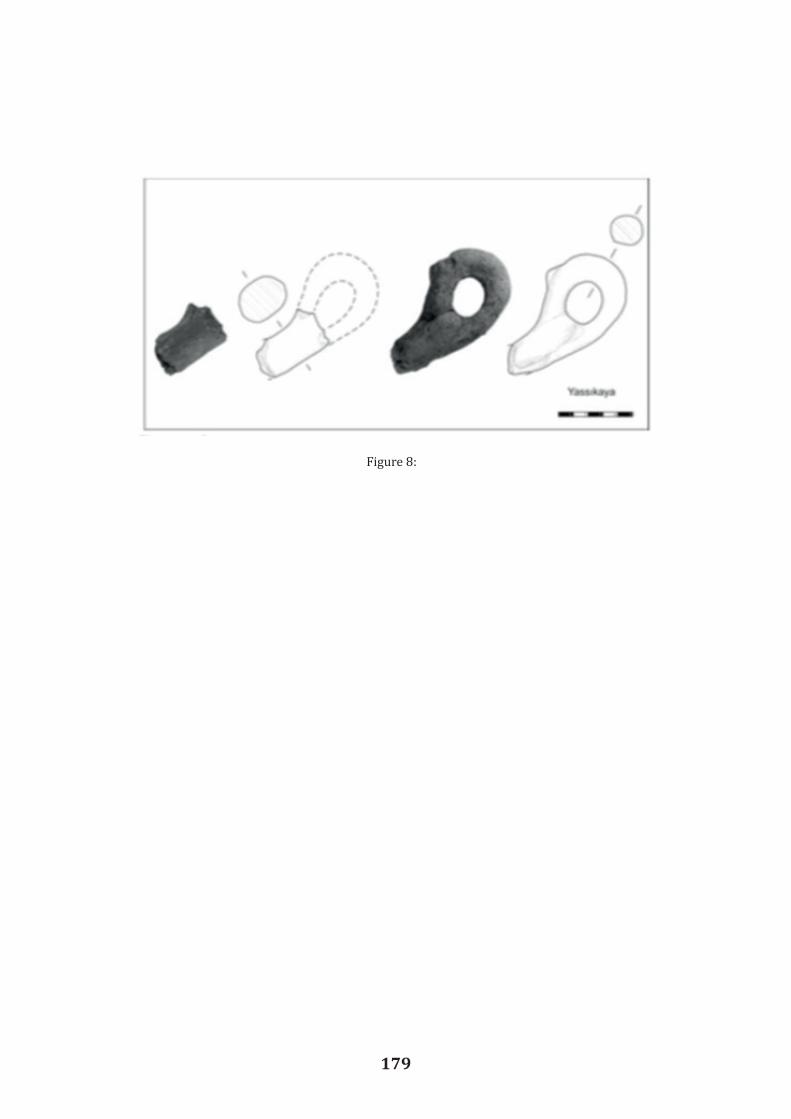
179
Figure 8:
180
Balatlar Community Church Building Complex
Gülgün KÖROGLU1
Abstract The archaeological excavations in the ruins of the high walls of the building that has survived to date at the city center of Sinop began in 2010, and were completed in seven years. As a result of the excavations on the late Roman period building remains that were dated to the 3th and 4th centuries the caldarium, tepidarium and frigidarium, sports area (palaestra) and furnace (praefurnium) sections of Roman Thermae (bath) have been revealed. The cross-shaped sectionof the bath was converted into a church in the 5th century as the Christianity was the offic ia lreligion at the time. Human burials were made in the church and its environs in the 5th-6th centuries. The first half of the 7th century, a small chapel was annexed to the southern part of the caldarium. The cell that consists of a vaulted tomb (hipogeum) must belong to this period. The Room No. 1 was used as the ‘katholikon’ of the monastery in the period between the 13th century and the first quarter of the 20th century. There are paintings on the walls and a barrel vault associated with the Christian architecture. In the period between the 17th -20th centuries the area surrounding the church has been used as a cemetery for the Greek Orthodox community.
Key Words: Sinop, Roman Bath, archaeological excavation, Greek Orthodox community,church.
In Ada Avenue of Sinop, there are ruins of a big building, which are 5-6 meters high, built using regular rows of stone and brick walls that have survived until present (Figure 1). The area surrounding this building was exposed to heavy construction. It is known and referred to as 'Balatlar Church' or 'Mithridates Palace' among local people and in scientific publications. The word “Balat” is due to Palace of Mithridates, Legendary hero king of Sinop, is believed to have lived here. In time, “Balat” must have transformed from the Latin word “Palatium”. The most important factor in this definition is the church located at the center of the buildings, which was used by local Christian community during the Ottoman period. Regarding this building, there is no historical or philological source except for a few documents from the 19th century. Before the excavations, the best detailed description on the ruins was in a book written by Bryer and Winfileld (Bryer and Winfield 1985, 79-88), which provides information about its history and different usage periods. It is mentioned that, the building was built as a bath-gymnasium-palestra trio during the Late Roman Period. During the Eastern Roman Empire (6th-7th centuries), the monastery was founded here, and it was used as grain silo between 11th-13th centuries, and after the Turkish conquest, it was converted into amonastery again. As mentioned in Bryer and Winfileld’s book, without archeologica l excavations, it is not possible to understand the actual function of this building. From the 3rd – 4th century to the first quarter of 20th century, the building was used for differentfunctions. Short time after population exchange, gravestones, which belong to the later periodof the building were removed, and the field was used for agricultural activities. Especially, since the church is open and unprotected, vaults and the paintings on the walls have been destroyed by natural conditions and human attacks.
Prof. Dr., Departmant of History of Art, Faculty of Science and Letters, Mimar Sinan Fine Arts University,Bomonti Campus Sisli Istanbul/TURKEY, [email protected]
With the permission of the Ministry of Culture and Tourism, archeological excavations started in July 2010 by a team led by Prof. Gulgun Koroglu. The excavations, cover the 1st degree archeological site which is enclosed by Roman walls (Figure 2-plan). Here there are two major cross shaped buildings and one rectangular shaped hall which are linked to each other. The roofs of the building were collapsed. Only the vaults of the mutual corners of the first cross planned building remained intact. The walls of the church (katholikon) which were decorated according to the Christian belief, was one of the sections that remained intact, and southern part was used as a place for the bones that were found (Figure 3-4). The Panaghia Monastery was founded in the area where building ruins remained dating to the Roman Period, and the Ottoman period from Yıldırım Beyazıd (1360-1403) to 1924. Here, “Theotokos/Mother of God” and “Archangel Michael” was mentioned together. On the south entrance of the church, “Dormition of Mary (Koimesis)” (Figure 5), on the west “Archange l Michael” (Figure 6), and Isaiah (Figure 7) were depicted. Both scenes are related to death and the cemetery. The old resources also mention that, Saint Phocas, who was believed to be protector of the Black Sea, was consecrated in this sacred building. In addition, white mussels, and sea shells which were found at cemetery yard are believed to be in relation with a presentation made in memory of Saint Phocas or symbolism of rebirth and pilgrimage, that belongs to the Roman period (Figure 8). Thanks to the excavations conducted between 2010 and 2016, it appears that the building has layers from the late Roman Period to end of the Ottoman Empire. Beneath the surface down to 2 m deep, there is an Orthodox Christian cemetery which is dated to the Late Ottoman period (18th-19th centuries). Including the floor of the church, all part of the ruins was used as a Roman Orthodox Christian cemetery (Figure 9). The Latin cross-plan building called Hall VIII in the eastern part of the church is likely to be the caldarium of the Roman Bath (Figure 10). Excavations have shown us that during the Late Ottoman Period, the existing building ruins were used as cemetery (koimitorion) of the monastery. The Hall VIII is located at the eastern part of the church. It has a closed Latin cross plan with corner rooms on all four sides. Original entrance must be at the north and the west (Figure 11). It appears that, Orthodox Christian people tried to maximize utilization from the Roman period ruins and tried to expand the area for cemetery. Intact part of the Roman building walls and niche carriers were scraped-carved cut, and some necessary architectural elements such as niches, doors, windows, graves, sacred spring pools established. With the help of the finds, the graves found in cultural layers in all areas, starting from just beneath the surface to 2 m depth are dated to the 18th-19th century to the early 20th century. It is understood that this place is used as a cemetery for not only clergyman, but also for people of all ages and sexes (Figure 12). In accordance with the traditions of the Christianity, dead bodies were buried on their back, with heads facing west, and feet facing east. It is observed that rosaries, cross necklaces, different forms of glass bottles and candles, commonly used Canakkale, Kutahya, and Eyup ceramics and porcelains imported from Europe and China were left to graves (Figure 13). A few graves are for one person only. In most of the graves, 5-6 persons’ skeletons are seen together (Figure 14). Bones of previous burials were gathered together to make space for new

181
With the permission of the Ministry of Culture and Tourism, archeological excavations started in July 2010 by a team led by Prof. Gulgun Koroglu. The excavations, cover the 1st degree archeological site which is enclosed by Roman walls (Figure 2-plan). Here there are two major cross shaped buildings and one rectangular shaped hall which are linked to each other. The roofs of the building were collapsed. Only the vaults of the mutual corners of the first cross planned building remained intact. The walls of the church (katholikon) which were decorated according to the Christian belief, was one of the sections that remained intact, and southern part was used as a place for the bones that were found (Figure 3-4). The Panaghia Monastery was founded in the area where building ruins remained dating to the Roman Period, and the Ottoman period from Yıldırım Beyazıd (1360-1403) to 1924. Here, “Theotokos/Mother of God” and “Archangel Michael” was mentioned together. On the south entrance of the church, “Dormition of Mary (Koimesis)” (Figure 5), on the west “Archange l Michael” (Figure 6), and Isaiah (Figure 7) were depicted. Both scenes are related to death and the cemetery. The old resources also mention that, Saint Phocas, who was believed to be protector of the Black Sea, was consecrated in this sacred building. In addition, white mussels, and sea shells which were found at cemetery yard are believed to be in relation with a presentation made in memory of Saint Phocas or symbolism of rebirth and pilgrimage, that belongs to the Roman period (Figure 8). Thanks to the excavations conducted between 2010 and 2016, it appears that the building has layers from the late Roman Period to end of the Ottoman Empire. Beneath the surface down to 2 m deep, there is an Orthodox Christian cemetery which is dated to the Late Ottoman period (18th-19th centuries). Including the floor of the church, all part of the ruins was used as a Roman Orthodox Christian cemetery (Figure 9). The Latin cross-plan building called Hall VIII in the eastern part of the church is likely to be the caldarium of the Roman Bath (Figure 10). Excavations have shown us that during the Late Ottoman Period, the existing building ruins were used as cemetery (koimitorion) of the monastery. The Hall VIII is located at the eastern part of the church. It has a closed Latin cross plan with corner rooms on all four sides. Original entrance must be at the north and the west (Figure 11). It appears that, Orthodox Christian people tried to maximize utilization from the Roman period ruins and tried to expand the area for cemetery. Intact part of the Roman building walls and niche carriers were scraped-carved cut, and some necessary architectural elements such as niches, doors, windows, graves, sacred spring pools established. With the help of the finds, the graves found in cultural layers in all areas, starting from just beneath the surface to 2 m depth are dated to the 18th-19th century to the early 20th century. It is understood that this place is used as a cemetery for not only clergyman, but also for people of all ages and sexes (Figure 12). In accordance with the traditions of the Christianity, dead bodies were buried on their back, with heads facing west, and feet facing east. It is observed that rosaries, cross necklaces, different forms of glass bottles and candles, commonly used Canakkale, Kutahya, and Eyup ceramics and porcelains imported from Europe and China were left to graves (Figure 13). A few graves are for one person only. In most of the graves, 5-6 persons’ skeletons are seen together (Figure 14). Bones of previous burials were gathered together to make space for new

182
dead bodies. The skulls of relatives were lined up on a regular basis around the head of a newly buried body, and other bones were collected around feet. The section located next to the east of the apse is the most sacred part of the cemetery. Small babies were buried at the nearest section to the apse. At this very sacred and important area, graves which belonged to clergymen of the Late Ottoman Period monastery were found. The graves were covered with large stone plates (Figure 15). The higher western wall of the grave cell had an inclination towards south. Religious ceremonial costumes, headgear, shoes and religious accessories were found on the skeletons of the clergymen, which, in accordance with Orthodox Christian tradition were laid with their heads facing west. In addition, glass cups which were used as candle holders, ceramic pots, rosary and Bible were left into the niches in the western part of the graves. During excavations, there were other finds in addition to sherds. The eye-shaped silver and bronze plaques inside the church and cemetery from antiquity reflect an old tradition that has been used against evil eye. Also eye- shaped or eye portrait drawn silver plates were left in front of icons and other sacred imagery as a presentation or today as a votive object. In 2011, the trench in the southwest part of hall VIII, was excavated deeper, yielding a late Ottoman period cemetery. Here a thick layer of limestone vault ruins and at level -3.25 m a regular basis flooring and two graves were found (Figure 16). Graves are covered with large flat stones and mortared with plaster. Burial pits have rectangular shapes and their side walls are built with regular bricks and mortared with plaster. Graves belong to the Christians. The earlier period style of burial of graves is not different from the late Ottoman Period. These graves include bones of many individuals as well. However, in both graves there were no burial gifts nor any find to estimate the approximate date of the burials. During the excavations, some architectural ruins were unearthed, suggesting that the building was used as a bath during the late Roman period (Figure 17), which was also supported by presence of four vaulted cisterns. In room IX which lies to the southeast of the cross planned building, a warm water pool with a water channel was uncovered (Figure 18). To the southeast lies a later (5th - 6th century?) brick kiln. Due to inappropriate kiln drying, some disfigured bricks and tile slag were identified around the kiln. During the excavations, the so-called mixed soil surface, belonging to a period between the 5th century BC and the 20th century AD yielded unglazed ware, amphorae, glazed ceramics, and porcelain ware decorated with different techniques which were imported from the Eastern Mediterranean, Cyprus, the Aegean Sea, the Crimea, Constantinople and also different European countries (Figure 19). The most important work that was given priority besides excavations was restoring and protecting the church vault and wall paintings. The paintings that have not been under any protection for many years suffered heavy damage due to natural conditions and vandalism (Figure 20). The territory of the Balat community building complex is not limited to the area, which was declared as the 1st degree archaeological site. The walls of the ruins of another building belonging to this structure complex extend further especially in the northern, southern and western directions. Existing ruins of walls that have been squeezed between houses and remained under soil were determined and applied to the plan., The Balatlar church and its

183
dead bodies. The skulls of relatives were lined up on a regular basis around the head of a newly buried body, and other bones were collected around feet. The section located next to the east of the apse is the most sacred part of the cemetery. Small babies were buried at the nearest section to the apse. At this very sacred and important area, graves which belonged to clergymen of the Late Ottoman Period monastery were found. The graves were covered with large stone plates (Figure 15). The higher western wall of the grave cell had an inclination towards south. Religious ceremonial costumes, headgear, shoes and religious accessories were found on the skeletons of the clergymen, which, in accordance with Orthodox Christian tradition were laid with their heads facing west. In addition, glass cups which were used as candle holders, ceramic pots, rosary and Bible were left into the niches in the western part of the graves. During excavations, there were other finds in addition to sherds. The eye-shaped silver and bronze plaques inside the church and cemetery from antiquity reflect an old tradition that has been used against evil eye. Also eye- shaped or eye portrait drawn silver plates were left in front of icons and other sacred imagery as a presentation or today as a votive object. In 2011, the trench in the southwest part of hall VIII, was excavated deeper, yielding a late Ottoman period cemetery. Here a thick layer of limestone vault ruins and at level -3.25 m a regular basis flooring and two graves were found (Figure 16). Graves are covered with large flat stones and mortared with plaster. Burial pits have rectangular shapes and their side walls are built with regular bricks and mortared with plaster. Graves belong to the Christians. The earlier period style of burial of graves is not different from the late Ottoman Period. These graves include bones of many individuals as well. However, in both graves there were no burial gifts nor any find to estimate the approximate date of the burials. During the excavations, some architectural ruins were unearthed, suggesting that the building was used as a bath during the late Roman period (Figure 17), which was also supported by presence of four vaulted cisterns. In room IX which lies to the southeast of the cross planned building, a warm water pool with a water channel was uncovered (Figure 18). To the southeast lies a later (5th - 6th century?) brick kiln. Due to inappropriate kiln drying, some disfigured bricks and tile slag were identified around the kiln. During the excavations, the so-called mixed soil surface, belonging to a period between the 5th century BC and the 20th century AD yielded unglazed ware, amphorae, glazed ceramics, and porcelain ware decorated with different techniques which were imported from the Eastern Mediterranean, Cyprus, the Aegean Sea, the Crimea, Constantinople and also different European countries (Figure 19). The most important work that was given priority besides excavations was restoring and protecting the church vault and wall paintings. The paintings that have not been under any protection for many years suffered heavy damage due to natural conditions and vandalism (Figure 20). The territory of the Balat community building complex is not limited to the area, which was declared as the 1st degree archaeological site. The walls of the ruins of another building belonging to this structure complex extend further especially in the northern, southern and western directions. Existing ruins of walls that have been squeezed between houses and remained under soil were determined and applied to the plan., The Balatlar church and its
vicinity were registered as a 3rd degree archaeological site, unfortunately they have not been adequately protected. At present, its status has been upgraded to the 1st degree archaeologica l site, and further destruction has been prevented by the Samsun Regional Council for Preservation of Cultural Heritage. During archaeological excavations between 2010 and 2016, geophysical and geomagne tic methods were applied. Based on the obtained magnetic maps, some magnetic anomalies which can be attributed to architectural ruins of underground heating installations have been identified. These ruins were set up by piling on circle shaped hipocaust bricks which enables hot air circulating around Roman bath. At the entrance, a dome at the center of a cross plan building and the presence of a sub-floor were determined. These studies will be expanded to the 1st degree protected area, and underlying archaeological ruins in these areas will be identified. The scope of the study about the water supply of the Roman Bath- which is known as Balatlar Church-, has been further expanded to determine how Sinop supplied water during the Roman period. During the excavations at the cemetery dated to the last period of the Ottoman Empire, skeletons were examined by anthropologists in terms of age, sex, reason of death and illness. Based on the late Ottoman grave typology and physical findings about buried individuals, our excavation studies and observations enable us to reach valuable historical and sociological information about the Balatlar Orthodox cemetery community in terms of commercial and artistic interactions, perceptions of death, religious and cultural processes applied after death and the changes throughout the history of Christianity.
Figures:
vicinity were registered as a 3rd degree archaeological site, unfortunately they have not been adequately protected. At present, its status has been upgraded to the 1st degree archaeological site, and further destruction has been prevented by the Samsun Regional Council for Preservation of Cultural Heritage.
During archaeological excavations between 2010 and 2016, geophysical and geomagnetic methods were applied. Based on the obtained magnetic maps, some magnetic anomalies which can be attributed to architectural ruins of underground heating installations have been identified. These ruins were set up by piling on circle shaped hipocaust bricks which enables hot air circulating around Roman bath. At the entrance, a dome at the center of a cross plan building and the presence of a sub-floor were determined. These studies will be expanded to the 1st degree protected area, and underlying archaeological ruins in these areas will be identified.
The scope of the study about the water supply of the Roman Bath- which is known as Balatlar Church-, has been further expanded to determine how Sinop supplied water during the Roman period.
During the excavations at the cemetery dated to the last period of the Ottoman Empire, skeletons were examined by anthropologists in terms of age, sex, reason of death and illness. Based on the late Ottoman grave typology and physical findings about buried individuals, our excavation studies and observations enable us to reach valuable historical and sociological information about the Balatlar Orthodox cemetery community in terms of commercial and artistic interactions, perceptions of death, religious and cultural processes applied after death and the changes throughout the history of Christianity.
Figures
Figure 1: A bird’s eye view of the Balatlar complex Figure 1: A bird’s eye view of the Balatlar complex

184
Figure 2: A plan of the buildings in the Balatlar complex and its surroundings
Figure 3: Room-I, that was used as a church
Figure 2: A plan of the buildings in the Balatlar complex and its surroundings
Figure 3: Room-I, that was used as a church
Figure 2: A plan of the buildings in the Balatlar complex and its surroundings
Figure 3: Room-I, that was used as a church

185
Figure 4: Room-VI
Figure 5: The entrance to the South, the Church of the Virgin Mary
Figure 4: Room-VIFigure 4: Room-VI
Figure 5: The entrance to the South, the Church of the Virgin Mary Figure 5: The entrance to the South, the Church of the Virgin Mary

186
Figure 6: The depiction of the Archangel Michael at Room III
Figure 7: The depiction of Prophet Isaah in the southwestern part of the Church
Figure 6: The depiction of the Archangel Michael at Room III
Figure 7: The depiction of Prophet Isaah in the southwestern part of the Church
Figure 6: The depiction of the Archangel Michael at Room III
Figure 7: The depiction of Prophet Isaah in the southwestern part of the Church

187
Figure 8: Sea shells
Figure 9: The graves from the Late Ottoman Period
Figure 8: Sea shellsFigure 8: Sea shells
Figure 9: The graves from the Late Ottoman Period Figure 9: The graves from the Late Ottoman Period
Figure 10: The graves of clergymen at Hall VIII
Figure 11: The apse at the Hall VIII of the Early Byzantine Church
Figure 10: The graves of clergymen at Hall VIII

188
Figure 10: The graves of clergymen at Hall VIII
Figure 11: The apse at the Hall VIII of the Early Byzantine Church Figure 11: The apse at the Hall VIII of the Early Byzantine Church
Figure 12: The skull of a clergyman called Dimitrakis
Figure 13: Glazed bowls from Canakkale ware
Figure 14: A large number of skeletons in a grave
Figure 12: The skull of a clergyman called DimitrakisFigure 12: The skull of a clergyman called Dimitrakis
Figure 13: Glazed bowls from Canakkale ware
Figure 14: A large number of skeletons in a grave
Figure 13: Glazed bowls from Çanakkale ware

189
Figure 12: The skull of a clergyman called Dimitrakis
Figure 13: Glazed bowls from Canakkale ware
Figure 14: A large number of skeletons in a grave Figure 14: A large number of skeletons in a grave
Figure 15: The grave of a clergyman unearthed in Hall VIII
Figure 16: Two graves from the Early Byzantine Period
Figure 17: A plan of the Balatlar complex at the end of the 2016 campaign
Figure 15: The grave of a clergyman unearthed in Hall VIIIFigure 15: The grave of a clergyman unearthed in Hall VIII
Figure 16: Two graves from the Early Byzantine Period
Figure 17: A plan of the Balatlar complex at the end of the 2016 campaign
Figure 16: Two graves from the Early Byzantine Period

190
Figure 15: The grave of a clergyman unearthed in Hall VIII
Figure 16: Two graves from the Early Byzantine Period
Figure 17: A plan of the Balatlar complex at the end of the 2016 campaign Figure 17: A plan of the Balatlar complex at the end of the 2016 campaign
Figure 18: Hall XI
Figure 19: Potsherds of vessels imported from different European countries
Figure 20: The interior of the section used as a Church 1
Figure 18: Hall XIFigure 18: Hall XI
Figure 19: Potsherds of vessels imported from different European countries
Figure 20: The interior of the section used as a Church 1
Figure 19: Potsherds of vessels imported from different European countries

191
Figure 18: Hall XI
Figure 19: Potsherds of vessels imported from different European countries
Figure 20: The interior of the section used as a Church 1 Figure 20: The interior of the section used as a Church 1
192
The Role of Archaeology in Historical Studies of Black Sea
İbrahim TELLİOGLU1
Abstract
Historical researches on the Black Sea have gained acceleration during the early XIXth century.Especially in the middle of the XXth century, they have increased, and historians have elucidated different historical aspects of the Black Sea basin. However, there is ongoing debate on many subjects regarding its ancient history. Due to lack of information in historical sources,some subjects lead to dispute on a multinational basis from time to time. One of them is about the first residents of the Black Sea basin. Several communities claim to be the origina l inhabitants of that region. Also another question of which community had the biggest impact on the region’s history of civilisation is very argumentative. In respect to that, archeologica l findings are very important. Archeological findings provide criteria for verifying the historica l information. Besides, even if there is any historical record, a researcher can proceed by using archeological findings. Information on written documents can be interpreted in very different ways by various archaeologists, however archeological findings are more descriptive than written documents and they can help reach plain facts. Thanks to archeological research onNorthern Black Sea coast, many issues about the ancient history of the region have been clarified. On the other hand, the number of archeological studies on the southern part of the region is limited.
Key Words: Black Sea basin, history, archaeology, scientific work, settlement, civilisation.
The recent period of the history appeals most to the reader. Yet, this period is one of the shortest periods in human history. Considering the ancient historical periods which lasted thousands of years, the New Era is of no time-wise value when compared to the Mesolithic Era lasting almost 2000 years. However, with regards to intensity of the events, it would be impossible to compare the events in the 20th century to another timeline in the history. On the other hand, it is hard to unearth the periods of the ancient history. Especially with the advent of audio and visual resources, controversies in recent period are less than the ones in the antiquity. A great number of issues in ancient history can be interpreted in various ways due to the inefficacy of the information in resources. Thus, Black Sea gets its share of these interpretation differences. In order these differences to be resolved, an interdisciplinary solidarity between the fields of history and archaeology is needed.
The first important archaeological research on the southern coast of the Black Sea watershedappeared in 1940s. These researches were carried out in Samsun (Özgüç 1945) and Bayburt (Kökten 1944). From the findings, it was revealed that Bayburt and its vicinity was an important archaeological centre (Kökten 1944/1, 478). In the following years, as a result of investigat ions the existence of cave habitation in the district was found (Kökten 1952, 189-190, 203-204). With the archaeological materials obtained ten years after the first excavations, the history of especially Samsun and its vicinity has begun to be illuminated (Burney 1956). Several surface surveys and excavations were conducted in the city (Gündüzalp 1986, 49-54; Alkım 1998; Dönmez 2000; Özsait 2000, 335-341; Bilgi 2001; 315-326; Dönmez 2002; Alkım 2003; Bilgi
1 Prof. Dr., Department of History, Faculty of Science and Letters, Ondokuz Mayıs University, Samsun/TURKEY, e-mail: [email protected]
2005; Erciyas 2006; Çiğdem 2008; Erciyas 2009; Çiğdem 2013). However, many questions about the ancient history of the Black Sea still remain to be unanswered. The first one is the homeland of the Kaska and in which part of the Black Sea they expanded. In historical ages, the Kaska, contemporaries of the Hittites, are considered the first habitants of the city (Murat 2016; Alp 2002, 73). However, as there is no archaeological finding available, questions of how the Kaska contributed to the civilization history of the region, in which part of the city they settled, what were their inhabiting models and means of living still wait to be answered. Related to this problem some issues of the existence of Hittites in the city are still unknown. Although Hittites-Kaska interaction can be understood in Hittite texts to a certain extent, the issue of whether Hittites reached Black Sea coast or not is still controversial (Maksimova 1951; Macqueen 2001, 58). The excavations will enable this issue to be enlightened. The excavations in Vezirköprü-Oymaağaç increased the possibility the that the site can be identified as Nerik, the religious centre of the Hittites (Czichon-Klinger 2010). Therefore, it has become obvious that the ones who have been seeking the religious centre of Hittites in Çorum are mistaken. With new findings, the history of the Hittites and Black Sea can be rewritten. Another question is related with the Hayasa-Azzi Kingdom living in the East Black Sea and Northeast Anatolian Region during the same period. Mentioned as the neighbours of the Kaska in Hittite resources, these communities are also very important for the Anatolian history (Pehlivan, 1991). Although there is no evidence as to what their origin was and where they came from, they played an important role in the establishment of Armenia, which gained independence after WWI. With the “Hay” word by which the Armenians describe themselves, the efforts of establishing a connection between Hayasa and Hay by etymological assumptions out of a name similarity without literary and archaeological data shows the necessity of excavations in this region (Kurkijan, 1964). Immigrations started after Cimmerians and Scythians who settled in the Black Sea Region after the Kaska and Hayasa-Azzi Kingdom. It is possible to obtain various information about the existence of these societies especially from Greek resources. However, incorporation of these data will be possible after archaeological findings. Data on the fact that Cimmerians expanded from Paphlagonia to the east couldn’t enlighten the issue of where their area of sovereignty was. Did Cimmerians found a centre of population and live on the coastal regions or live behind the mountainside? The latter is more reasonable for as much as there were no resource for seminomad Cimmerians to live for. However, recovery of materials belonging to Cimmerians both in Gümüşhacıköy-Amasya and Ünye (Tarhan 1984, 111-118) shows that the weaker possibility took place as well. On the other hand, Strabo states that Enete, the former name of Samsun comes from Enetoi tribe, which was an ally of the Cimmerians (Strabon, 1969, 22). The archaeological excavations can reveal the extent of the connection between these two tribes. The hegemony and sequel of the Scythians in the Black Sea region is another issue about the region during the Antiquity. Based on various resources, it is obvious that Scythians were present in the region when the colonists arrived in the region (Herodotus 1991, 50, 193; Saint-Martin 1852, 441; Vadala 1934, 3; Asherson 1996, 49, 116, 210; Koromila 1991, 33-35). Furthermore, the borders of the Scythian dominance cannot be determined accurately. According to available resources, we described Scythian settlements on the southern coast of Black Sea as beachside of the highlands (Tellioğlu 2004, 28-29), which have been supported by recent archaeological findings. Likewise, the cave paintings and writings in runic letters in Ordu/Mesudiye/Esatlı village (Somuncuoğlu 2008, 484-491), Terme and Salıpazarı towns of Samsun (Yılmaz 2011) and Artvin (Aytekin 1999) confirm our assumptions. However, majority of these findings appeared by chance. It seems that a surface survey in the cityt will yield a great many of materials belonging to Scythians as it did in Samsun/Ladik (Atasoy 1997, 19). It

193
The Role of Archaeology in Historical Studies of Black Sea
İbrahim TELLİOGLU1
Abstract
Historical researches on the Black Sea have gained acceleration during the early XIXth century.Especially in the middle of the XXth century, they have increased, and historians have elucidated different historical aspects of the Black Sea basin. However, there is ongoing debate on many subjects regarding its ancient history. Due to lack of information in historical sources,some subjects lead to dispute on a multinational basis from time to time. One of them is about the first residents of the Black Sea basin. Several communities claim to be the origina l inhabitants of that region. Also another question of which community had the biggest impact on the region’s history of civilisation is very argumentative. In respect to that, archeologica l findings are very important. Archeological findings provide criteria for verifying the historica l information. Besides, even if there is any historical record, a researcher can proceed by using archeological findings. Information on written documents can be interpreted in very different ways by various archaeologists, however archeological findings are more descriptive than written documents and they can help reach plain facts. Thanks to archeological research onNorthern Black Sea coast, many issues about the ancient history of the region have been clarified. On the other hand, the number of archeological studies on the southern part of the region is limited.
Key Words: Black Sea basin, history, archaeology, scientific work, settlement, civilisation.
The recent period of the history appeals most to the reader. Yet, this period is one of the shortest periods in human history. Considering the ancient historical periods which lasted thousands of years, the New Era is of no time-wise value when compared to the Mesolithic Era lasting almost 2000 years. However, with regards to intensity of the events, it would be impossible to compare the events in the 20th century to another timeline in the history. On the other hand, it is hard to unearth the periods of the ancient history. Especially with the advent of audio and visual resources, controversies in recent period are less than the ones in the antiquity. A great number of issues in ancient history can be interpreted in various ways due to the inefficacy of the information in resources. Thus, Black Sea gets its share of these interpretation differences. In order these differences to be resolved, an interdisciplinary solidarity between the fields of history and archaeology is needed.
The first important archaeological research on the southern coast of the Black Sea watershedappeared in 1940s. These researches were carried out in Samsun (Özgüç 1945) and Bayburt (Kökten 1944). From the findings, it was revealed that Bayburt and its vicinity was an important archaeological centre (Kökten 1944/1, 478). In the following years, as a result of investigat ions the existence of cave habitation in the district was found (Kökten 1952, 189-190, 203-204). With the archaeological materials obtained ten years after the first excavations, the history of especially Samsun and its vicinity has begun to be illuminated (Burney 1956). Several surface surveys and excavations were conducted in the city (Gündüzalp 1986, 49-54; Alkım 1998; Dönmez 2000; Özsait 2000, 335-341; Bilgi 2001; 315-326; Dönmez 2002; Alkım 2003; Bilgi
1 Prof. Dr., Department of History, Faculty of Science and Letters, Ondokuz Mayıs University, Samsun/TURKEY, e-mail: [email protected]
2005; Erciyas 2006; Çiğdem 2008; Erciyas 2009; Çiğdem 2013). However, many questions about the ancient history of the Black Sea still remain to be unanswered. The first one is the homeland of the Kaska and in which part of the Black Sea they expanded. In historical ages, the Kaska, contemporaries of the Hittites, are considered the first habitants of the city (Murat 2016; Alp 2002, 73). However, as there is no archaeological finding available, questions of how the Kaska contributed to the civilization history of the region, in which part of the city they settled, what were their inhabiting models and means of living still wait to be answered. Related to this problem some issues of the existence of Hittites in the city are still unknown. Although Hittites-Kaska interaction can be understood in Hittite texts to a certain extent, the issue of whether Hittites reached Black Sea coast or not is still controversial (Maksimova 1951; Macqueen 2001, 58). The excavations will enable this issue to be enlightened. The excavations in Vezirköprü-Oymaağaç increased the possibility the that the site can be identified as Nerik, the religious centre of the Hittites (Czichon-Klinger 2010). Therefore, it has become obvious that the ones who have been seeking the religious centre of Hittites in Çorum are mistaken. With new findings, the history of the Hittites and Black Sea can be rewritten. Another question is related with the Hayasa-Azzi Kingdom living in the East Black Sea and Northeast Anatolian Region during the same period. Mentioned as the neighbours of the Kaska in Hittite resources, these communities are also very important for the Anatolian history (Pehlivan, 1991). Although there is no evidence as to what their origin was and where they came from, they played an important role in the establishment of Armenia, which gained independence after WWI. With the “Hay” word by which the Armenians describe themselves, the efforts of establishing a connection between Hayasa and Hay by etymological assumptions out of a name similarity without literary and archaeological data shows the necessity of excavations in this region (Kurkijan, 1964). Immigrations started after Cimmerians and Scythians who settled in the Black Sea Region after the Kaska and Hayasa-Azzi Kingdom. It is possible to obtain various information about the existence of these societies especially from Greek resources. However, incorporation of these data will be possible after archaeological findings. Data on the fact that Cimmerians expanded from Paphlagonia to the east couldn’t enlighten the issue of where their area of sovereignty was. Did Cimmerians found a centre of population and live on the coastal regions or live behind the mountainside? The latter is more reasonable for as much as there were no resource for seminomad Cimmerians to live for. However, recovery of materials belonging to Cimmerians both in Gümüşhacıköy-Amasya and Ünye (Tarhan 1984, 111-118) shows that the weaker possibility took place as well. On the other hand, Strabo states that Enete, the former name of Samsun comes from Enetoi tribe, which was an ally of the Cimmerians (Strabon, 1969, 22). The archaeological excavations can reveal the extent of the connection between these two tribes. The hegemony and sequel of the Scythians in the Black Sea region is another issue about the region during the Antiquity. Based on various resources, it is obvious that Scythians were present in the region when the colonists arrived in the region (Herodotus 1991, 50, 193; Saint-Martin 1852, 441; Vadala 1934, 3; Asherson 1996, 49, 116, 210; Koromila 1991, 33-35). Furthermore, the borders of the Scythian dominance cannot be determined accurately. According to available resources, we described Scythian settlements on the southern coast of Black Sea as beachside of the highlands (Tellioğlu 2004, 28-29), which have been supported by recent archaeological findings. Likewise, the cave paintings and writings in runic letters in Ordu/Mesudiye/Esatlı village (Somuncuoğlu 2008, 484-491), Terme and Salıpazarı towns of Samsun (Yılmaz 2011) and Artvin (Aytekin 1999) confirm our assumptions. However, majority of these findings appeared by chance. It seems that a surface survey in the cityt will yield a great many of materials belonging to Scythians as it did in Samsun/Ladik (Atasoy 1997, 19). It

194
will not only contribute to shed light on the hegemony of Scythians, but also understand the cultural legacy from Turkistan to the Black Sea. Especially, the latter is of great importance in terms of Turks’ existence in the Black Sea region. The seals, which are considered to have been inherited from Scythians, represent the earliest Turkic trace peremptorily. On the other hand, the controversy on the origin of these peoples will come to an end by archaeological excavations in the region where non-Greek speaking societies lived after Scythian hegemony as introduced by ancient writers such as Scylax of Caryanda, Xenophon, Strabo, Herodotus and Pliny (Ksenophon 1984, 133-161; Herodotus 1991, 173-174; Strabon 1969, 1-2, 23, 33, 35; Baschmakoff 1948, 67-69). One of the most controversial issue in the history of the Black Sea history is about who the indigenous people were in this region. Especially during the nation building period, everybody claimed that they were the earliest settlers in the Black Sea Region by trying to write the history on their behalves (Siharulidze-Manvelişvili and others 1998, 85-88; Vanilişi-Tandilava 1992, 10, 36). Thus, they would try to make a conclusion, and prove with the evidences that they were the primary components of the geography they lived and the eternal owner of their countries. Such political conflict is still available today although it seems to have gone off the boil. On the other hand, during the time when the admiration for Greek culture was fervent in Europe, it was imbued with that the first people of the Black Sea were the Greek colonists. It is still repeated by means of various works (Koromila, 1989). The fact that the data in the ancient resources are insufficient to enlighten some issues established a ground for everybody to comment on their behalves and for discussions to continue up to now. However, with the archaeological excavations, these discussions began to fade away. As a result of excavations on the northern shore of the Black Sea, ethnic stratification of this part of the basin is highly revealed. Consequently, these discussions have come to an end as such. In addition to this, info pollution about the first people of the area is going on as similar research has not been carried out on the southern shores of the basin. Various writers who accept communities such as Mushki, Tibareni, Chalybes, Macrones, Mossynoeci, Saspeires, Marres, Byzeres, Taochoi, Ekekheiri, Bechir aforementioned after 6th century BC as the first inhabitants (Herodotus 1991, 173-174; Baschmakoff 1948, 67-69; Ksenophon 1984, 133-161) established a bond between these people and some of the communities today. However, historical basis of this approach is weak. Archaeological excavation is needed for further evaluations. Another controversial topic among historians is about when the colonies of trade were established in the Black Sea. Since Fallmerayer (Fallmerayer 1827), it has been a tradition to start the history of civilization with colonists in the Black Sea Region. In many works for a long time, it was considered as if no one lived to leave a trace of civilization before the colonists on the shores of the Black Sea. Although some tribes are mentioned as the first inhabitants of the region, colonists are placed in the first step in the civilization stages as the others are probably thought not to have enough cultural accumulation to leave a trace. However, archaeologica l evidence indicates that it doesn’t reflect the reality (Carpenter 1948; Drews 1976). It has been understood that communities apart from the colonists produced works, which contributed a lot to the human history of the region. However, it is limited to the northern part of the Black Sea. The excavations in the region contributed to understand the settlement history of the area. The recovery of archaeological ruins of communities such as Cimmerians-Scythians, made it clear as well as the development of the cities such as Berezan, Olbia, Cherson, Dniester, Histria, Phanagoria (Lordkipanidzé- Lévêque 1990; Tsetskhladze 1998; Tsetskhladze 2001; Graham 2001; Grammenos 2003; Petropoulos, 2005; Braund, 2005; Solovyov 2007). However, it is still controversial since no similar research has been carried out on the southern shores. The historical understanding which promotes that the cities were first established in trade centers

195
will not only contribute to shed light on the hegemony of Scythians, but also understand the cultural legacy from Turkistan to the Black Sea. Especially, the latter is of great importance in terms of Turks’ existence in the Black Sea region. The seals, which are considered to have been inherited from Scythians, represent the earliest Turkic trace peremptorily. On the other hand, the controversy on the origin of these peoples will come to an end by archaeological excavations in the region where non-Greek speaking societies lived after Scythian hegemony as introduced by ancient writers such as Scylax of Caryanda, Xenophon, Strabo, Herodotus and Pliny (Ksenophon 1984, 133-161; Herodotus 1991, 173-174; Strabon 1969, 1-2, 23, 33, 35; Baschmakoff 1948, 67-69). One of the most controversial issue in the history of the Black Sea history is about who the indigenous people were in this region. Especially during the nation building period, everybody claimed that they were the earliest settlers in the Black Sea Region by trying to write the history on their behalves (Siharulidze-Manvelişvili and others 1998, 85-88; Vanilişi-Tandilava 1992, 10, 36). Thus, they would try to make a conclusion, and prove with the evidences that they were the primary components of the geography they lived and the eternal owner of their countries. Such political conflict is still available today although it seems to have gone off the boil. On the other hand, during the time when the admiration for Greek culture was fervent in Europe, it was imbued with that the first people of the Black Sea were the Greek colonists. It is still repeated by means of various works (Koromila, 1989). The fact that the data in the ancient resources are insufficient to enlighten some issues established a ground for everybody to comment on their behalves and for discussions to continue up to now. However, with the archaeological excavations, these discussions began to fade away. As a result of excavations on the northern shore of the Black Sea, ethnic stratification of this part of the basin is highly revealed. Consequently, these discussions have come to an end as such. In addition to this, info pollution about the first people of the area is going on as similar research has not been carried out on the southern shores of the basin. Various writers who accept communities such as Mushki, Tibareni, Chalybes, Macrones, Mossynoeci, Saspeires, Marres, Byzeres, Taochoi, Ekekheiri, Bechir aforementioned after 6th century BC as the first inhabitants (Herodotus 1991, 173-174; Baschmakoff 1948, 67-69; Ksenophon 1984, 133-161) established a bond between these people and some of the communities today. However, historical basis of this approach is weak. Archaeological excavation is needed for further evaluations. Another controversial topic among historians is about when the colonies of trade were established in the Black Sea. Since Fallmerayer (Fallmerayer 1827), it has been a tradition to start the history of civilization with colonists in the Black Sea Region. In many works for a long time, it was considered as if no one lived to leave a trace of civilization before the colonists on the shores of the Black Sea. Although some tribes are mentioned as the first inhabitants of the region, colonists are placed in the first step in the civilization stages as the others are probably thought not to have enough cultural accumulation to leave a trace. However, archaeologica l evidence indicates that it doesn’t reflect the reality (Carpenter 1948; Drews 1976). It has been understood that communities apart from the colonists produced works, which contributed a lot to the human history of the region. However, it is limited to the northern part of the Black Sea. The excavations in the region contributed to understand the settlement history of the area. The recovery of archaeological ruins of communities such as Cimmerians-Scythians, made it clear as well as the development of the cities such as Berezan, Olbia, Cherson, Dniester, Histria, Phanagoria (Lordkipanidzé- Lévêque 1990; Tsetskhladze 1998; Tsetskhladze 2001; Graham 2001; Grammenos 2003; Petropoulos, 2005; Braund, 2005; Solovyov 2007). However, it is still controversial since no similar research has been carried out on the southern shores. The historical understanding which promotes that the cities were first established in trade centers
founded by the colonists brings many mistakes along. As it is mentioned in many works, the understanding which derives the names of the cities from exchange centres founded by colonists, shows these places as the first core of the city. However, it is a short-sighted approach. It is stated in the works about the name of the places in the area that few of the names had Greek roots, and most of them appeared after evolving a previous name to a Greek one (Pereira 1972, 239; Wittek 1970, 193-240). Nevertheless, there has been a persistence of this approach. On the other hand, did the colonists convert their headquarters where the trade goods were bought and sold to sites? It is highly unfavourable to generalise this question. Because colonies haven’t expanded mostly as a site. On the contrary, there are clear evidences in historical records that they didn’t allow the other colonies to settle near them, and they even destroyed other settlements. In the example of Samsun, from the period of the establishment of the colony, Amisos, being invaded by the Ottoman Empire was found at the locality of Baruthane until 1419, and the city had grown around today’s Saathane around the Samsun Castle founded by the Seljuks (Tellioğlu 2012, 61-183). However, based on the historical sources such determinations can be made for specific regions. For the claim that the Black Sea cities started with colonies, historia ns have been waiting for answers from the field of archaeology. The borders of the Pontic Empire and Rome is another problem for the southern coast of the Black Sea. After a short domination of Alexander in the region, Mithridates dynasty emerged and began to invade the area, mostly the Central Black Sea (Goloğlu 1973; Tezcan 2007; Arslan 2007; Emir 2015). It is not clear in historical sources where domination reached in the era of transition between the Hellenistic and the Roman Periods. In the same way, although the Romans seem to possess all along the southern coast of the Black Sea, there is no trace of them in some places. Naturally, in certain parts of the region, Roman domination has been symbolic. On the other hand, the historical records mention of the magnificent structures in some places though, there is not the slightest trace of them today, and the same resources do not provide information about the fate of these works. Archaeological studies can respond to these questions. On the other hand, there is a great need for recovery of remains from this period in order to clarify if the Mithridaic dynasty was Roman or Anatolian. Underdevelopment of Turkish Archaeology is one of the reasons that historical studies of the Black Sea in Turkey leave pre-Ottoman period in the dark. In order to make healthy determinations on the Pre-Ottoman Turkish sites, within the time frame from the XI. century to the XV century, traces of the Turks who settled in the Black Sea region should be identified. In the Black Sea region, there are very few traces of the architectural works from the Seljuk and Principalities Period. However, it is known that the area that extends parallel to the sea in the southern part of the mountainous area was under the Turkish domination in the immediate aftermath of the Battle of Manzikert. And the coastline was an area where Turks settled since the middle of the XII. Century (Tellioğlu 2004, 61-192). Their archaeological traces have a great importance in terms of the creation of the identity of the city. Currently, Turkish-Islamic Art concentrates on the Ottoman period in most of the coastal cities in the region. However, it goes further back. The similar cemeteries of Danishmendli in Tokat or White Sheep Turkomans in Bayburt have to be in the whole region, which serve as the most tangible evidence of the Turkish presence in the region. On the other hand, very few architectural structures from the Principalities and Seljuk Period are known. Similarly, archaeological studies in Artvin, Rize and Trabzon valleys have great importance in terms of the impact of Kipchaks in the region. The ram gravestones (Özmenli 2016, 530) found in the region are their first signs.

196
In the Black Sea region, as a result of surveys and archaeological studies at both Byzantine and post-Byzantine period, important conclusions were reached about the constructions dating to this period. Today visible marks of churches, monasteries, castles scrapings, etc. have been unearthed, and also as mentioned in the historical resources, the location of a large extent of settlements has been revealed. On the other hand, emergence of most of the churches and monasteries in the region of the post-Tanzimat period made a change in the conception of the common history. Contrary to popular belief, churches and monasteries in the region does not belong to the ancient history, and besides Christianity remained limited to certain centers at the time Romans appeared. Sites like Limnia referred by ancient resources, whose exact location is unknwon can be identified with surveys. (Bryer-Winfield 1985; Bryer 2002). When such studies with Turkish communities in the region during the pre-Ottoman period are performed, there will be an important contribution to the cultural history of the southern part of the Black Sea. In this regard, surveys in the city of Artvin (Aytekin 2000; Aytekin 2001; Aytekin 2002; Aytekin 2003; Aytekin 2005; Aytekin 2006; Aytekin 2007; Aytekin 2008; Aytekin 2009; Aytekin 2010; Aytekin 2011; Aytekin 2012) in Gumushane-Bayburt (Çiğdem, Özkan, Yurttaş 2004; Çiğdem, Özkan, Yurttaş 2005; Çiğdem, Özkan, Yurttaş 2006; Çiğdem, Özkan, Yurttaş 2007; Çiğdem 2008; Çiğdem, Özkan, Yurttaş 2009; Çiğdem, Özkan, Yurttaş 2011; Çiğdem 2013; Çiğdem, Özkan, Yurttaş 2016; etc) should be mentioned specifically. It shows us how important archaeological findings from these studies can be important in the historiography. Dealing with the Black Sea region’s archaeology, we should not take only the land into consideration. Actually, one of the most important issues of the Black Sea archaeology is the lack of underwater archaeological studies. Especially, knowing that some archaeological sites like Olbia, which is in the North of Black Sea region, is underwater; these studies have become more important. Because of this, developing underwater archaeology in the Black Sea, which has a large history of coastal settlement, is necessary. It is known that the Black Sea had been in the form of a lake and reached the Aegean Sea and Marmara Sea by overflowing since the Neolithic Period (Ryan-Pitman, 2003; Emir 2011, 34-36). Accordingly, it is obvious that some unanswered questions related with the prehistoric period of the Black Sea can be clarified thanks to underwater archaeology studies. Besides, with the archaeological data obtained from the sunken ships, the trading volume of the region and the quantity and quality of local products can be revealed. As a result, there is a great need for archaeological data to enlighten the Ancient Age of the Black Sea Region. Archaeological studies will shed light on the issues like early settlements, trails of civilisations, indigenous people and territory of states. These issues are not only being discussed in scientific basis, but sometimes they also cause international crisis. Due to the scarcity of information in historic resources, those with different perspectives can reach very different conclusions following the discovery of archaeological remains. The conclusions reached after archaeological studies on the northern shores of the Black Sea are the most vivid examples for this. Naturally, if a similar type of research is done in the southern part of the Black Sea, unknown history of the region will come to light. The situation of the Black Sea region in the Middle Age is another important issue waiting for a solution with the support of archaeology. In order to determine the dominance of the Romans in the Black Sea region, we need archaeological evidence. From historical records, this dominance has been symbolic in many places where it is assumed to be under the Roman rule. No trace was ever found from the Roman times in the region until today. On the other hand, the remains of many of the religious structures of the post-Roman era contains important hints about the development of Christianity in the region. Significant progress has been made with
studies on this issue. However, archaeological studies that will clarify pre-Ottoman Turkish period are still at infancy stage. Archaeological studies on the Principalities and Seljuk Period focusing on the traces of Turkish people in the region will further contribute to understand ing the history of the region.

197
In the Black Sea region, as a result of surveys and archaeological studies at both Byzantine and post-Byzantine period, important conclusions were reached about the constructions dating to this period. Today visible marks of churches, monasteries, castles scrapings, etc. have been unearthed, and also as mentioned in the historical resources, the location of a large extent of settlements has been revealed. On the other hand, emergence of most of the churches and monasteries in the region of the post-Tanzimat period made a change in the conception of the common history. Contrary to popular belief, churches and monasteries in the region does not belong to the ancient history, and besides Christianity remained limited to certain centers at the time Romans appeared. Sites like Limnia referred by ancient resources, whose exact location is unknwon can be identified with surveys. (Bryer-Winfield 1985; Bryer 2002). When such studies with Turkish communities in the region during the pre-Ottoman period are performed, there will be an important contribution to the cultural history of the southern part of the Black Sea. In this regard, surveys in the city of Artvin (Aytekin 2000; Aytekin 2001; Aytekin 2002; Aytekin 2003; Aytekin 2005; Aytekin 2006; Aytekin 2007; Aytekin 2008; Aytekin 2009; Aytekin 2010; Aytekin 2011; Aytekin 2012) in Gumushane-Bayburt (Çiğdem, Özkan, Yurttaş 2004; Çiğdem, Özkan, Yurttaş 2005; Çiğdem, Özkan, Yurttaş 2006; Çiğdem, Özkan, Yurttaş 2007; Çiğdem 2008; Çiğdem, Özkan, Yurttaş 2009; Çiğdem, Özkan, Yurttaş 2011; Çiğdem 2013; Çiğdem, Özkan, Yurttaş 2016; etc) should be mentioned specifically. It shows us how important archaeological findings from these studies can be important in the historiography. Dealing with the Black Sea region’s archaeology, we should not take only the land into consideration. Actually, one of the most important issues of the Black Sea archaeology is the lack of underwater archaeological studies. Especially, knowing that some archaeological sites like Olbia, which is in the North of Black Sea region, is underwater; these studies have become more important. Because of this, developing underwater archaeology in the Black Sea, which has a large history of coastal settlement, is necessary. It is known that the Black Sea had been in the form of a lake and reached the Aegean Sea and Marmara Sea by overflowing since the Neolithic Period (Ryan-Pitman, 2003; Emir 2011, 34-36). Accordingly, it is obvious that some unanswered questions related with the prehistoric period of the Black Sea can be clarified thanks to underwater archaeology studies. Besides, with the archaeological data obtained from the sunken ships, the trading volume of the region and the quantity and quality of local products can be revealed. As a result, there is a great need for archaeological data to enlighten the Ancient Age of the Black Sea Region. Archaeological studies will shed light on the issues like early settlements, trails of civilisations, indigenous people and territory of states. These issues are not only being discussed in scientific basis, but sometimes they also cause international crisis. Due to the scarcity of information in historic resources, those with different perspectives can reach very different conclusions following the discovery of archaeological remains. The conclusions reached after archaeological studies on the northern shores of the Black Sea are the most vivid examples for this. Naturally, if a similar type of research is done in the southern part of the Black Sea, unknown history of the region will come to light. The situation of the Black Sea region in the Middle Age is another important issue waiting for a solution with the support of archaeology. In order to determine the dominance of the Romans in the Black Sea region, we need archaeological evidence. From historical records, this dominance has been symbolic in many places where it is assumed to be under the Roman rule. No trace was ever found from the Roman times in the region until today. On the other hand, the remains of many of the religious structures of the post-Roman era contains important hints about the development of Christianity in the region. Significant progress has been made with
studies on this issue. However, archaeological studies that will clarify pre-Ottoman Turkish period are still at infancy stage. Archaeological studies on the Principalities and Seljuk Period focusing on the traces of Turkish people in the region will further contribute to understand ing the history of the region.

198
Bibliography
Alkım, U. Bahadır and others 1998. Ikiztepe, I, Ankara, Türk Tarih Kurumu Publication.
Alkım, U. Bahadır and others 2003. Ikiztepe, II, Ankara, Türk Tarih Kurumu Publication. Alp, Sedat 2002. Hitit Çagında Anadolu, Ankara, Tübitak Publication.
Arslan, M. 2007. Mithradates VI Eupator Roma’nın Büyük Düsmanı, Istanbul, Odin Publication.
Asherson, N. 1996. Black Sea, London, Hill&Wang.
Atasoy, S. 1997. Amisos Karadeniz Kıyısında Antik Bir Kent, Samsun, Samoto.
Aytekin, O. 1999. “Artvin-Yusufeli’nde Prehistorik Bir Magara ve Runik Yazıtı”, Tarih ve Medeniyet, 61, 70-72.
Aytekin, O. 2000. “Artvin ve Çevresindeki Türk-Islam Eserleri Yüzey Arastırması- 1998”, 21.Uluslar arası Kazı, Arastırma ve Arkeometri Sempozyumu (XVII. Arastırma Sonuçları Toplantısı), I, Ankara, 95-108.
Aytekin, O. 2001. “Artvin Ili ve Ilçelerindeki Tarihi Mezarlıklar ve Mezar Tasları Yüzey Arastırması-1999”, 22. Uluslararası Kazı, Arastırma ve Arkeometri Sempozyumu (XVIII. Arastırma Sonuçları Toplantısı), I, Ankara, 75-86.
Aytekin, O. 2002. “Artvin Ili ve Ilçelerindeki Tarihi Mezarlıklar ve Mezar Tasları Yüzey Arastırması-2000”, 23. Uluslararası Kazı, Arastırma ve Arkeometri Sempozyumu (XIX.Arastırma Sonuçları Toplantısı), I, Ankara, 101-116.
Aytekin, O. 2003. “Artvin Ili-Çoruh Vadisindeki Tarihi Yollar ve Kültür Varlıkları Yüzey Arastırması-2001”, 24. Uluslararası Kazı, Arastırma ve Arkeometri Sempozyumu (XX.Arastırma Sonuçları Toplantısı, I, Ankara, 1–16.
Aytekin, O. 2004. “Artvin Ili-Çoruh Vadisindeki Tarihi Yollar ve Kültür Varlıkları Yüzey Arastırması-2002”, 25. Uluslararası Kazı, Arastırma ve Arkeometri Sempozyumu (21.Arastırma Sonuçları Toplantısı), I, Ankara, 235–250.
Aytekin, O. 2005. “Artvin Ili-Çoruh Vadisindeki Tarihi Yollar ve Kültür Varlıkları Yüzey Arastırması-2003”, 26. Uluslararası Kazı, Arastırma ve Arkeometri Sempozyumu (22.Arastırma Sonuçları Toplantısı), I, Ankara, 227–240.
Aytekin, O. 2006. “Artvin Ili-Çoruh Vadisindeki Tarihi Yollar ve Kültür Varlıkları Yüzey Arastırması, 2004”, 27. Uluslararası Kazı, Arastırma ve Arkeometri Sempozyumu (23. Arastırma Sonuçları Toplantısı), II, Ankara, 309–322.
Aytekin, O. 2007. “Artvin ve Erzurum Illeri Çoruh Vadisi’ndeki Tarihi Yollar ve Kültür Varlıkları Yüzey Arastırması-2005”, 28. Uluslararası Kazı, Arastırma ve Arkeometri Sempozyumu (24. Arastırma Sonuçları Toplantısı), II, Ankara, 363–382.
Aytekin, O.2008. “Artvin-Erzurum Illeri Çoruh Vadisi’ndeki Tarihi Yollar ve Kültür Varlıkla r ı Yüzey Arastırması-2006”, 29. Uluslararası Kazı, Arastırma ve Arkeometri Sempozyumu (25. Arastırma Sonuçları Toplantısı), III, Ankara, 411–428.
199
Bibliography
Alkım, U. Bahadır and others 1998. Ikiztepe, I, Ankara, Türk Tarih Kurumu Publication.
Alkım, U. Bahadır and others 2003. Ikiztepe, II, Ankara, Türk Tarih Kurumu Publication. Alp, Sedat 2002. Hitit Çagında Anadolu, Ankara, Tübitak Publication.
Arslan, M. 2007. Mithradates VI Eupator Roma’nın Büyük Düsmanı, Istanbul, Odin Publication.
Asherson, N. 1996. Black Sea, London, Hill&Wang.
Atasoy, S. 1997. Amisos Karadeniz Kıyısında Antik Bir Kent, Samsun, Samoto.
Aytekin, O. 1999. “Artvin-Yusufeli’nde Prehistorik Bir Magara ve Runik Yazıtı”, Tarih ve Medeniyet, 61, 70-72.
Aytekin, O. 2000. “Artvin ve Çevresindeki Türk-Islam Eserleri Yüzey Arastırması- 1998”, 21.Uluslar arası Kazı, Arastırma ve Arkeometri Sempozyumu (XVII. Arastırma Sonuçları Toplantısı), I, Ankara, 95-108.
Aytekin, O. 2001. “Artvin Ili ve Ilçelerindeki Tarihi Mezarlıklar ve Mezar Tasları Yüzey Arastırması-1999”, 22. Uluslararası Kazı, Arastırma ve Arkeometri Sempozyumu (XVIII. Arastırma Sonuçları Toplantısı), I, Ankara, 75-86.
Aytekin, O. 2002. “Artvin Ili ve Ilçelerindeki Tarihi Mezarlıklar ve Mezar Tasları Yüzey Arastırması-2000”, 23. Uluslararası Kazı, Arastırma ve Arkeometri Sempozyumu (XIX.Arastırma Sonuçları Toplantısı), I, Ankara, 101-116.
Aytekin, O. 2003. “Artvin Ili-Çoruh Vadisindeki Tarihi Yollar ve Kültür Varlıkları Yüzey Arastırması-2001”, 24. Uluslararası Kazı, Arastırma ve Arkeometri Sempozyumu (XX.Arastırma Sonuçları Toplantısı, I, Ankara, 1–16.
Aytekin, O. 2004. “Artvin Ili-Çoruh Vadisindeki Tarihi Yollar ve Kültür Varlıkları Yüzey Arastırması-2002”, 25. Uluslararası Kazı, Arastırma ve Arkeometri Sempozyumu (21.Arastırma Sonuçları Toplantısı), I, Ankara, 235–250.
Aytekin, O. 2005. “Artvin Ili-Çoruh Vadisindeki Tarihi Yollar ve Kültür Varlıkları Yüzey Arastırması-2003”, 26. Uluslararası Kazı, Arastırma ve Arkeometri Sempozyumu (22.Arastırma Sonuçları Toplantısı), I, Ankara, 227–240.
Aytekin, O. 2006. “Artvin Ili-Çoruh Vadisindeki Tarihi Yollar ve Kültür Varlıkları Yüzey Arastırması, 2004”, 27. Uluslararası Kazı, Arastırma ve Arkeometri Sempozyumu (23. Arastırma Sonuçları Toplantısı), II, Ankara, 309–322.
Aytekin, O. 2007. “Artvin ve Erzurum Illeri Çoruh Vadisi’ndeki Tarihi Yollar ve Kültür Varlıkları Yüzey Arastırması-2005”, 28. Uluslararası Kazı, Arastırma ve Arkeometri Sempozyumu (24. Arastırma Sonuçları Toplantısı), II, Ankara, 363–382.
Aytekin, O.2008. “Artvin-Erzurum Illeri Çoruh Vadisi’ndeki Tarihi Yollar ve Kültür Varlıkla r ı Yüzey Arastırması-2006”, 29. Uluslararası Kazı, Arastırma ve Arkeometri Sempozyumu (25. Arastırma Sonuçları Toplantısı), III, Ankara, 411–428.
Aytekin, O. 2009. “Artvin-Erzurum Illeri Çoruh Vadisi’ndeki Tarihi Yollar ve Kültür Varlıkla r ı Yüzey Arastırması-2007”, 30. Uluslararası Kazı, Arastırma ve Arkeometri Sempozyumu (26. Arastırma Sonuçları Toplantısı) I, Ankara, 427–436.
Aytekin, O. 2010. “Artvin-Erzurum Illeri Çoruh Vadisi’ndeki Tarihi Yollar ve Kültür Varlıkla r ı Yüzey Arastırması-2008”, 31. Uluslararası Kazı, Arastırma ve Arkeometri Sempozyumu (27. Arastırma Sonuçları Toplantısı) III, Ankara, 435–446.
Aytekin, O. 2011. “Artvin-Erzurum Illeri Çoruh Vadisi’ndeki Tarihi Yollar ve Kültür Varlıkla r ı Yüzey Arastırması-2009”, 32. Uluslararası Kazı, Arastırma ve Arkeometri Sempozyumu (28. Arastırma Sonuçları Toplantısı), III, Ankara, 429–448.
Aytekin, O. 2012. “Artvin-Erzurum Illeri Çoruh Vadisi’ndeki Tarihi Yollar ve Kültür Varlıkla r ı Yüzey Arastırması-2010”, 33. Uluslararası Kazı, Arastırma ve Arkeometri Sempozyumu (29. Arastırma Sonuçları Toplantısı), I, Ankara, 285–302.
Baschmakoff, A. 1948. La Synthese des Periples Pontiques, Paris, Librairie Orientaliste Paul Geuthner.
Bilgi, Ö. 2001. “Ikiztepe Kazılarının 1999 Dönemi Sonuçları”, 22. Kazı Sonuçları Toplantısı,I, Ankara, 315-326.
Bilgi, Ö., Sevket Dönmez, Emin U. Ulugergerli 2005. “2003 Yılı Samsun Yüzey Arastırmas ı”,22. Arastırma Sonuçları Toplantısı, I, Ankara, 115-124.
Braund, D. 2005. Scythians and Greeks, Exeter, University of Exeter.
Bryer, Anthony-Winfield, David 1985. The Byzantine Monuments and Topography of thePontos, I, Washington, Dumbarton Oaks.
Bryer, A. 2002. The Post-Byzantine Monuments of the Pontos, Hampsire, Ashgate Publicat ion.
Burney, C.A. 1966. “Northern Anatolia Before Classical Times”, Anatolian Studies, VI, 179- 193.
Carpenter, R. 1948. “The Greek Penetration of the Black Sea”, American Journal ofArchaeology, 52/1, 1-10.
Çigdem, S., Özkan H., Yurttas H. 2004. “2002 Yılı Gümüshane ve Bayburt Illeri Yüzey Arastırması”, 21. Arastırma Sonuçları Toplantısı, II, Ankara, 167-178.
Çigdem, S., Özkan H., Yurttas H. 2005. “2003 Yılı Gümüshane Yüzey Arastırması”, 22.Arastırma Sonuçları Toplantısı, I, Ankara, 285-300.
Çigdem, S., Özkan H., Yurttas H. 2006. “2004 Yılı Gümüshane Yüzey Arastırması”, 23.Arastırma Sonuçları Toplantısı, II, Ankara, 57-70.
Çigdem, S., Özkan H., Yurttas H. “2007. 2005 Yılı Gümüshane Yüzey Arastırması”, 24.Arastırma Sonuçları Toplantısı, I, Ankara, 501-512.

200
Çigdem, S. 2008. Gümüshane Bölgesinin Tarih ve Arkeoloji Arastırmaları, Erzurum, Gümüshane Valiligi Yayınları.
Çigdem, S., Özkan H., Yurttas H. 2009. “2007 Yılı Gümüshane Yüzey Arastırması”, 26.Arastırma Sonuçları Toplantısı, I, Ankara, 167-180.
Çigdem, S., Özkan H., Yurttas H. 2011. “2009 Yılı Bayburt Yüzey Arastırması”, 28. Arastırma Sonuçları Toplantısı, I, Ankara, 155-174.
Çigdem, S. 2013. “Bayburt Aydıntepe Yüzey Arastırması Isıgında Bölgenin Eskiçag Tarihinin Degerlendirilmesi”, Atatürk Üniversitesi Güzel Sanatlar Enstitüsü Dergisi, 30, 65-81.
Çigdem, S., Özkan H., Yurttas H. 2016. “2014 Yılı Bayburt Yüzey Arastırması”, 33. Arastırma Sonuçları Toplantısı, I, Ankara, 119-136.
Dönmez, S. 2000. Orta Karadeniz Bölgesi Yüzey Arastırması, Türkiye Arkeolojisi ve Istanbul Üniversitesi (Ed. O. Belli), Ankara, Istanbul Üniversitesi Publication.
Dönmez, S. 2002. “1997-1999 Yılları Yüzey Arastırmalarında Incelenen Samsun- Amasya IlleriI.Ö. 2. Binyılı Yerlesmeleri", Belleten, LXV/244, 877-881.
Drews, R. 1976. "The Earliest Greek Settlements on the Black Sea", The Journal of Hellenic Studies, 98, 18-31.
Emir, O. 2011. Prehistorik Dönemden Roma Dönemine Kadar Trabzon ve Çevresi,Trabzon, Serander Publication.
Emir, O. 2014. Hellenistik ve Roma Dönemlerinde Pontos (MÖ IV. yy. - MS III. yy.)Yayınlanmamıs Doktora Tezi, KTÜ Sosyal Bilimler Enstitüsü.
Emir, O. 2015. “Mithradates Krallıgı ve Mahmut Gologlu’nun Anadolu’nun Milli Devleti Pontos Adlı Eserinin Genel Bir Degerlendirmesi”, Her Yönüyle Mahmut Gologlu Sempozyumu (Trabzon 08-10 Mayıs 2014) Bildirileri, Ankara, Atatürk Arastırma Merkezi Publication, 163-173
Erciyas, D. B. 2006. “Tokat Ili Komana Antik Kenti Yüzey Arastırması 2004”, 23. Arastırma Sonuçları Toplantısı, II, Ankara, 13-22.
Erciyas, D. B., Emine Sökmen 2009. “Komana Antik Kenti ve Çevresi Yüzey Arastırmas ı 2007”, 26. Arastırma Sonuçları Toplantısı, I, Ankara, 289-306. Fallmerayer, Jakop Philipp 1827. Geschichte des Kaiserthums von Trapezunt, Munich, Verlagvon Anton Weber.
Gologlu, M. 1973. Anadolu’nun Milli Devleti Pontos, Ankara, Gologlu Yayınları. Graham, A. J. 2001. Collected Papers on Greek Colonization, Leiden, Brill.
Grammenos, Demetrios B. 2003. Ancient Colonies in the Black Sea, I-II,Thessalonik i, Archaeological Institue of Northern Greece.
Günduzalp, N. 1986. “Iç Dogu Karadeniz Bölgesinden Prehistorik Buluntular”, Türk Tarih Kongresi, 9, Ankara, 49-54.

201
Çigdem, S. 2008. Gümüshane Bölgesinin Tarih ve Arkeoloji Arastırmaları, Erzurum, Gümüshane Valiligi Yayınları.
Çigdem, S., Özkan H., Yurttas H. 2009. “2007 Yılı Gümüshane Yüzey Arastırması”, 26.Arastırma Sonuçları Toplantısı, I, Ankara, 167-180.
Çigdem, S., Özkan H., Yurttas H. 2011. “2009 Yılı Bayburt Yüzey Arastırması”, 28. Arastırma Sonuçları Toplantısı, I, Ankara, 155-174.
Çigdem, S. 2013. “Bayburt Aydıntepe Yüzey Arastırması Isıgında Bölgenin Eskiçag Tarihinin Degerlendirilmesi”, Atatürk Üniversitesi Güzel Sanatlar Enstitüsü Dergisi, 30, 65-81.
Çigdem, S., Özkan H., Yurttas H. 2016. “2014 Yılı Bayburt Yüzey Arastırması”, 33. Arastırma Sonuçları Toplantısı, I, Ankara, 119-136.
Dönmez, S. 2000. Orta Karadeniz Bölgesi Yüzey Arastırması, Türkiye Arkeolojisi ve Istanbul Üniversitesi (Ed. O. Belli), Ankara, Istanbul Üniversitesi Publication.
Dönmez, S. 2002. “1997-1999 Yılları Yüzey Arastırmalarında Incelenen Samsun- Amasya IlleriI.Ö. 2. Binyılı Yerlesmeleri", Belleten, LXV/244, 877-881.
Drews, R. 1976. "The Earliest Greek Settlements on the Black Sea", The Journal of Hellenic Studies, 98, 18-31.
Emir, O. 2011. Prehistorik Dönemden Roma Dönemine Kadar Trabzon ve Çevresi,Trabzon, Serander Publication.
Emir, O. 2014. Hellenistik ve Roma Dönemlerinde Pontos (MÖ IV. yy. - MS III. yy.)Yayınlanmamıs Doktora Tezi, KTÜ Sosyal Bilimler Enstitüsü.
Emir, O. 2015. “Mithradates Krallıgı ve Mahmut Gologlu’nun Anadolu’nun Milli Devleti Pontos Adlı Eserinin Genel Bir Degerlendirmesi”, Her Yönüyle Mahmut Gologlu Sempozyumu (Trabzon 08-10 Mayıs 2014) Bildirileri, Ankara, Atatürk Arastırma Merkezi Publication, 163-173
Erciyas, D. B. 2006. “Tokat Ili Komana Antik Kenti Yüzey Arastırması 2004”, 23. Arastırma Sonuçları Toplantısı, II, Ankara, 13-22.
Erciyas, D. B., Emine Sökmen 2009. “Komana Antik Kenti ve Çevresi Yüzey Arastırmas ı 2007”, 26. Arastırma Sonuçları Toplantısı, I, Ankara, 289-306. Fallmerayer, Jakop Philipp 1827. Geschichte des Kaiserthums von Trapezunt, Munich, Verlagvon Anton Weber.
Gologlu, M. 1973. Anadolu’nun Milli Devleti Pontos, Ankara, Gologlu Yayınları. Graham, A. J. 2001. Collected Papers on Greek Colonization, Leiden, Brill.
Grammenos, Demetrios B. 2003. Ancient Colonies in the Black Sea, I-II,Thessalonik i, Archaeological Institue of Northern Greece.
Günduzalp, N. 1986. “Iç Dogu Karadeniz Bölgesinden Prehistorik Buluntular”, Türk Tarih Kongresi, 9, Ankara, 49-54.
Herodotus 1991. Herodot Tarihi (Çev. M. Ökmen), Istanbul, Remzi Kitabevi. Koromila, M. 1989. Pontos Anatolia, Athens, Lucy Braggiotti. Koromila, M. 1991. The Greeks in the Black Sea, Athens, Panorama Cultural Society. Kökten, I. K. 1944. “Orta, Dogu ve Kuzey Anadolu'da Yapılan Tarih Öncesi Arastırmala r ı”, Belleten, VIII/ 32, 659-680. Kökten, I. K. 1944/1. “Kuzeydogu Anadolu Prehistoryasında Bayburt Çevresinin Yeri”, Ankara Üniversitesi Dil Tarih Cografya Fakültesi Dergisi, III/5, 465-486. Kökten, I. K. 1952. “Anadolu'da Prehistorik Yerlesme Yerlerinin Dagılısı Üzerine Bir Arastırma”, Ankara Üniversitesi Dil Tarih Cografya Fakültesi Dergisi, X/3-4, 167-207. Ksenophon 1984. Anabasis (Çev. T. Gökcöl), Istanbul, Sosyal Publication. Kurkjian, M. Vahan 1964. A History of the Armenia, New York, Lydian Press. Lordkipanidzé, O- Lévêque, P. 1990. “Le Pont-Euxin vu par les Grecs Sources écrites et Archéologie: Symposium de Vani (Colchide)”, Paris, Les Belles Lettres. Macqueen, J. G. 2001. Hititler ve Hitit Çagında Anadolu (Çev. E. Davutoglu), Ankara, Arkadas Publication. Maksimova, M. I. 1951. “Hittites in the Black Sea Region”, Journal of Near Eastern Studies, 10/2, 74-81. Murat, L. 2016. Anadolu’da Kaskalar, Ankara, Hel Publication. Özgüç, N.-T. 1945. 1940 ve 1941 Yılında Türk Tarih Kurumu Adına Yapılan Samsun Bölgesi Kazıları Hakkında Ilk Kısa Rapor, Belleten, IX/35, 361-400. Özmenli, M. 2016. Ortaçag’da Dogu Karadeniz’de Oguz ve Kıpçak Yerlesimi, Atatürk Üniversitesi Sosyal Bilimler Enstitüsü Dergisi, 20 (2), 515-536. Özsait, M. 2000. Orta Karadeniz Bölgesi Yüzey Arastırmaları, Türkiye Arkeolojisi ve Istanbul Üniversitesi (Ed. O. Belli), Ankara, Istanbul Üniversitesi Yayınları, 335-341. Pehlivan, M. 1991. Hayasa (M.Ö. XV-XII. Yüzyıllarda Kuzey-Dogu Anadolu), Erzurum, A.Ü. Fen-Edebiyat Fakültesi Publication. Pereira, M. 1972. East of Trebizond, London, Readers Union. Petropoulos, E. K. 2005. Hellenic Colonization in Euxineos Pontos, Oxford, Archaeopress. Ryan, W. – P., W. 2003. Nuh Tufanı: Tarihi Degistiren Olaya Iliskin Yeni Bilimsel Kesifler (Çev. D. Bayrak), Ankara, Arkadas Publication. Saint-Martin, M. Vivien de 1852. Description Historique et Geographique de L'Asie Mineure, II, Paris, Arthus Bertrand.

202
Solovyov, S. L. 2007. Greeks and Natives in the Cimmerian Bosphorus 7th-1st Centuries BC (Proceedings of the International Conference, October 2000, Taman Russia), Oxford, Archaeopress. Somuncuoglu, S. 2008. Sibirya’dan Anadolu’ya Tastaki Türkler, Istanbul, A-Z Yapı Publication. Strabon 1969. Cografya (Geographika) Kitap XII Bölüm I-II-III (Çev. A. Pekman), Istanbul, Istanbul Üniversitesi Edebiyat Fakültesi Publication. Siharulidze Yuri-Manvelisvili, Alexandre v.d. 1998. Dogu Karadeniz Halklarının Tarih ve Kültürleri (Çev. H. Hayrioglu), Istanbul, Sorun Publication. Tarhan, M. T. 1984. Eski Anadolu Tarihinde Kimmerler, Eski Eserler ve Müzeler Genel Müdürlügü I. Arastırma Sonuçları Toplantısı (Istanbul 23-26 Mayıs 1983), 109- 120. Tellioglu, I. 2004. Osmanlı Hakimiyetine Kadar Dogu Karadeniz’de Türkler, Trabzon, Serander Publication. Tellioglu, I. 2012. Ilk Çagdan Osmanlılara Samsun, Samsun, Ilkadım Belediyesi Publication. Tezcan, M. 2007. Pontos Krallıgı (M.Ö. III.-M.S. IV. Yüzyıl), Baslangıçtan Günümüze Pontus Sorunu (Ed. V. Usta), Trabzon, Serander Publication, 77-107. Tsetskhladze, G. R. 1998. The Greek Colonisation of the Black Sea Area, Stutgart, Franz Steiner Verlag. Tsetskhladze, G. R. 2001. North Pontic Archaeology, Leiden, Brill. Vadala, R. 1934. Samsoun, Paris, Paul Geuthner. Vanilisi, M.- Tandilava, A. 1992. Lazların Tarihi (Çev. H. Hayrioglu), Istanbul, Ant Publication. Wittek, P. 1970. Bizanslılardan Türklere Geçen Yer Adları (Çev. M. Eren), Selçuklu Arastırmaları Dergisi, I, 193-240. Yılmaz, E. 2011. Samsun’da Kaya Yosunlarının Sakladıgı Sır Tamgalar, www.muzeder.org /img/makaleler/ tamgalar.pdf.

203
Kinneir’s Narratives about Amisos and His Historical Resources
Mehmet KÖSEOGLU1
Abstract
To explore the route traversed by The Ten Thousand as recorded by Xenophon, Scottish military officer John Macdonald Kinneir (born in 1782) and his friend William Chavasse (born in 1785) attempted to make a journey. Their journey to Austria, Hungary and the Ottoman Empire started in 1813. On April 29, 1814 they departed from Istanbul, and arrived Samsun onMay 23, 1814 by road. Kinneir was interested in copying ancient inscriptions. In this study, Kinneir’s work “Journey through Asia Minor Armenia and Koordistan” published in London in 1818 will be discussed. His work covers his evaluations on colonization process of the City Amisos, domination of the Roman Empire in the region and presence of Amazons. As the method, the source of information given by Kinneir along the trips will be analysed. In addition, information on the architectural structures and remains of the region as of May 1814 will be given. The historical resources of Kinneir in his narratives about Amisos include several Greek,Roman and such as Strabo, Theopompus, Pliny, Xenophon, Marcus Junianus Justinus,Diodorus Siculus, Quntus Curtius, Mestrius Plutarchus, and modern British historians Jacob Bryant and Edward Gibbon.
Key Words: Macdonald Kinneir, Amisos, Amazon, Historical Resources.
1. John Macdonald Kinneir’s Life
Kinneir was born in Carnden, Lintlithgow in Britain in 1782 (Schiffer 1999, 383). In 1804, he was assigned to the Madras city of India as infantry. Afterwards in 1808-9, he joined Sir John Malcolm, the governor of the East India Company. With his support, he made numerous journeys to Persia (Allen and Co. 1831, 144). During the Napoleonic Wars, the British goverment appointed Colonel Neil Campbell as attaché and Macdonald accompanied him. With retreat of the French forces, he resigned.
To explore the route traversed by The Ten Thousand as recorded by Xenophon, Scottish military officer John Macdonald Kinneir (born in 1782) and his friend William Chavasse (born in 1785) attempted to make a journey. Their journey to Austria, Hungary and the Ottoman Empire started in 1813. On April 29, 1814, they departed from Istanbul, and arrived in Samsun on May 23, 1814 by road.
In June, 1814, they took the Trabzon highway to go to Erzurum, from there they followed Bitlis,Siirt and Mardin route and went to Mosul in July, 1814. Their journey continued until they arrived Tigris, Bagdat. The narratives of the journey were published in London in 1818 in a book titled “Journey through Asia Minor, Armenia and Koordistan”.
In 1824, he was assigned to Iran as an envoy of the East India Company. He played a significant role in the Treaty of Turkmanchay signed between Russia and Iran in 1828. And, then he diedin Tabriz on June 12, 1830 (Martin, 2005, 36-38).2
1 History Teacher -Samsun Rotary Club Science and Art Center.2 I’m thankful to Prof. Dr. Metin Taskın and translator Ayse Mamal for their help in translation.
Solovyov, S. L. 2007. Greeks and Natives in the Cimmerian Bosphorus 7th-1st Centuries BC (Proceedings of the International Conference, October 2000, Taman Russia), Oxford, Archaeopress. Somuncuoglu, S. 2008. Sibirya’dan Anadolu’ya Tastaki Türkler, Istanbul, A-Z Yapı Publication. Strabon 1969. Cografya (Geographika) Kitap XII Bölüm I-II-III (Çev. A. Pekman), Istanbul, Istanbul Üniversitesi Edebiyat Fakültesi Publication. Siharulidze Yuri-Manvelisvili, Alexandre v.d. 1998. Dogu Karadeniz Halklarının Tarih ve Kültürleri (Çev. H. Hayrioglu), Istanbul, Sorun Publication. Tarhan, M. T. 1984. Eski Anadolu Tarihinde Kimmerler, Eski Eserler ve Müzeler Genel Müdürlügü I. Arastırma Sonuçları Toplantısı (Istanbul 23-26 Mayıs 1983), 109- 120. Tellioglu, I. 2004. Osmanlı Hakimiyetine Kadar Dogu Karadeniz’de Türkler, Trabzon, Serander Publication. Tellioglu, I. 2012. Ilk Çagdan Osmanlılara Samsun, Samsun, Ilkadım Belediyesi Publication. Tezcan, M. 2007. Pontos Krallıgı (M.Ö. III.-M.S. IV. Yüzyıl), Baslangıçtan Günümüze Pontus Sorunu (Ed. V. Usta), Trabzon, Serander Publication, 77-107. Tsetskhladze, G. R. 1998. The Greek Colonisation of the Black Sea Area, Stutgart, Franz Steiner Verlag. Tsetskhladze, G. R. 2001. North Pontic Archaeology, Leiden, Brill. Vadala, R. 1934. Samsoun, Paris, Paul Geuthner. Vanilisi, M.- Tandilava, A. 1992. Lazların Tarihi (Çev. H. Hayrioglu), Istanbul, Ant Publication. Wittek, P. 1970. Bizanslılardan Türklere Geçen Yer Adları (Çev. M. Eren), Selçuklu Arastırmaları Dergisi, I, 193-240. Yılmaz, E. 2011. Samsun’da Kaya Yosunlarının Sakladıgı Sır Tamgalar, www.muzeder.org /img/makaleler/ tamgalar.pdf.

204
2. The Narrative Resources of Amisos
Kinneir came to Samsun on May 23, 1814 (Kinneir 1818, 302). First of all, he drew upon the works of Strabo for the ancient history of the city.
a) The Writingss of StraboStrabo (64 BC) was born in Amaseia, Pontus. His ancestors held important positions, such asbureaucrats under the regime of the kings of Pontus. The Geopraphica is the work of Strabowhich consists of 17 books, providing information from prehistoric period about the geographyfrom the Atlantic Ocean in the west to Indus River in the east. (Strabon, 2012, XVIII- XIX)
According to the information he received from Strabo’s works, Kinneir thinks that the ancient time of Amisos city started with the colonisation process. He regards the city as the most magnificent city after Sinope. Also he states that the city was founded by colonies from Miletus and Athens, and it maintained its independence until it was conquered by the Persians. He declares that they succeeded in maintaning their liberty under Alexander, but afterwards they became subject to the kings of Pontus. Furthermore, he refers to the same Mithridates, who fought so bravely against the Romans, and spent much of his time at Amisos which he decorated with many stately edifices, particularly erected, at a short distance from the city, a magnificent palace which he named Eupotaria. He explains that it was taken after a long siege by Lucullus, and set on fire by Callimachus, the governor, but saved from destruction by a sudden fall of rain, which estinguished the flames. He considers that it was a favorite residence of Pompey the Great, who rebuilt the city and restored it. He expresses, that liberation of the inhabitants was confirmed by Caesar and Augustus. (Kinneir 1818, 303-304) He quotes from Strabo about the history of the city:
“After Gazelon one comes to Saramenê, and to a notable city, Amisus, which is about nine hundred stadia from Sinopê. Theopompus says that it was first founded by the Milesians… by a leader of the Cappadocians, and thirdly was colonised by Athenocles and Athenians and changed its name to Peiraeus. The kings also took possession of this city; and Eupator adorned it with temples and founded an addition to it. This city too was besieged by Lucullus, and then by Pharnaces, when he crossed over from the Bosporus. After it had been set free by the deified Caesar, it was given over to kings by Antony. Then Straton the tyrant put it in bad plight. And then, after the Battle of Actium, it was again set free by Caesar Augustus; and at the present time it is well organised. Besides the rest of its beautiful country, it possesses also Themiscyra, the abode of the Amazons, and Sidenê. Themiscyra is a plain; on one side, it is washed by these and is about sixty stadia distant from the city, and on the other side it lies at the foot of the mountainous country, which is well-wooded and coursed by streams that have theirs our cest here in. Soon a river, called the Thermodon, being supplied by all these streams, flows out through the plain; and another river similar to this, which flows out of Phanaroea, as it is called, flows out through the same plain, and is called the Iris.” (Kinneir 1818, 303)
Kinneir states that the city was small, and consisted of nearly two thousand inhabitants. He describes that it was surrounded by the arches of the old gate and a decayed wall supposedly built by the Turks and containing some ancient pieces of sculpture intermixed with the other stones. Also he says that the older walls almost buried in waves could be seen towards the sea. He confirms that the city had five mosques with minarets, a hamam and a large caravanserai. (Kinneir, 1818, 304)

205
2. The Narrative Resources of Amisos
Kinneir came to Samsun on May 23, 1814 (Kinneir 1818, 302). First of all, he drew upon the works of Strabo for the ancient history of the city.
a) The Writingss of StraboStrabo (64 BC) was born in Amaseia, Pontus. His ancestors held important positions, such asbureaucrats under the regime of the kings of Pontus. The Geopraphica is the work of Strabowhich consists of 17 books, providing information from prehistoric period about the geographyfrom the Atlantic Ocean in the west to Indus River in the east. (Strabon, 2012, XVIII- XIX)
According to the information he received from Strabo’s works, Kinneir thinks that the ancient time of Amisos city started with the colonisation process. He regards the city as the most magnificent city after Sinope. Also he states that the city was founded by colonies from Miletus and Athens, and it maintained its independence until it was conquered by the Persians. He declares that they succeeded in maintaning their liberty under Alexander, but afterwards they became subject to the kings of Pontus. Furthermore, he refers to the same Mithridates, who fought so bravely against the Romans, and spent much of his time at Amisos which he decorated with many stately edifices, particularly erected, at a short distance from the city, a magnificent palace which he named Eupotaria. He explains that it was taken after a long siege by Lucullus, and set on fire by Callimachus, the governor, but saved from destruction by a sudden fall of rain, which estinguished the flames. He considers that it was a favorite residence of Pompey the Great, who rebuilt the city and restored it. He expresses, that liberation of the inhabitants was confirmed by Caesar and Augustus. (Kinneir 1818, 303-304) He quotes from Strabo about the history of the city:
“After Gazelon one comes to Saramenê, and to a notable city, Amisus, which is about nine hundred stadia from Sinopê. Theopompus says that it was first founded by the Milesians… by a leader of the Cappadocians, and thirdly was colonised by Athenocles and Athenians and changed its name to Peiraeus. The kings also took possession of this city; and Eupator adorned it with temples and founded an addition to it. This city too was besieged by Lucullus, and then by Pharnaces, when he crossed over from the Bosporus. After it had been set free by the deified Caesar, it was given over to kings by Antony. Then Straton the tyrant put it in bad plight. And then, after the Battle of Actium, it was again set free by Caesar Augustus; and at the present time it is well organised. Besides the rest of its beautiful country, it possesses also Themiscyra, the abode of the Amazons, and Sidenê. Themiscyra is a plain; on one side, it is washed by these and is about sixty stadia distant from the city, and on the other side it lies at the foot of the mountainous country, which is well-wooded and coursed by streams that have theirs our cest here in. Soon a river, called the Thermodon, being supplied by all these streams, flows out through the plain; and another river similar to this, which flows out of Phanaroea, as it is called, flows out through the same plain, and is called the Iris.” (Kinneir 1818, 303)
Kinneir states that the city was small, and consisted of nearly two thousand inhabitants. He describes that it was surrounded by the arches of the old gate and a decayed wall supposedly built by the Turks and containing some ancient pieces of sculpture intermixed with the other stones. Also he says that the older walls almost buried in waves could be seen towards the sea. He confirms that the city had five mosques with minarets, a hamam and a large caravanserai. (Kinneir, 1818, 304)
Kinneir refers that the kingdom of Pontus must be interesting for every reader, who reads history because for thirty years, it resisted against the bravest generals and finest armies ever sent by the Romans under the reign of the Prince. He describes that it was bounded on the N, by the Exuine; E. by Colchos; S. by Cappadocia and Galatia; and W. by the Halys. Besides, he indicates that the name of Pontus was derived from the Pontus Exuinus, now the Black Sea, or the king of Pontus. (Kinneir 1818, 305)
b) The Writings of PlinyKinneir conveys the notes (23-29 BC) from the Roman philosopher and historian Pliny: “Pliny calls it the free and confederate city of the Amisos, and says that they were governed bytheir own laws”. It is possible to say that Kinneir read this information from the Pliny’s letters(Welmoth, 1809, 253)
c) The Writings of HerodotusHeredotus is a Greek historian, who was born in Halicarnassus in 490 BC. He is widely referredto as “The Father of History”. Generally, he went to great expeditions. Also he gatheredinformation about many verbal narratives of the inhabitants, and he examined their offic ia lletters. His work is very important in the way of historical, archaeological and folklor icresources. It is estimated that he died in 435 BC. (Heredotus, 2015, viii-xi)
The inhabitants living around Amisos were called Leuco-Syrii or white Syrians. Kinneir got this information from readings of Herodotus. Also he adds that all the natives of Cappadocia were called by this ethnic name. (Kinneir 1818, 305)
With this useful information from Herodotus, Kinneir talks about the history of the city in his work. The city was dominated by the Romans after the Persians. It was divided into three parts under the Roman Empire. Furthermore, Kinneir gives the explanatory information about the content of the battle between the Roman and Pontus kings:
“... part until it was created into a separate state by Darius Hystaspes, in favour of Artabazes, the son of one of those nobles who conspired against the Magi. Under the Romans, it was divided into three provinces, Pontus Cappadocius, Pontus Polemoniacus, and Pontus Galatic us, of which Amasia was the capital. The other cities were Sinope, Amisus, Themiscyra, Pharnacia, and Trapezus. Thirteen kings reigned over Pontus from Artabazes to the great Mithridates, after whose fall it was declared a Roman province by Pompey. It was however, restored to Carnius, the son of Pharnaces, by Mark Anthony, in gratitude for his services during the civil war, and he was succeeded by Polemon the son of a celebrated orator at Laodicea, from whom it descended to his son Polemon II. On the death of this prince, Pontus was again absorbed in the Roman Empire, and that part adjoining Sinope and the Halys received the appellation of Helenopontus from Helen, the mother of Constantine.” (Kinneir 1818, 306)
3. The Narratives of Amazons
Kinneir came to the Çarsamba town after Amisos. On May 25, 1814, he arrived in Terme, which was founded near the Thermodon River. He clearly states that the river witnessed the stories of the Amazon women, who excited the attention of the learned community and were mentioned by many of the Greek and the Roman writers.
a) The Writings of Xenophon (430-355 BC)Cyrus, one of the Persian nobels, organised an expedition against his elder brother, King

206
Artaxerxes II of Persia. For this military expediton, he received help from the mercenaries of the Greek army. Xenophon was one of these mercenaries. (Ksenophon, 2011, 9) Yet after he failed at this military expedition against his elder brother, Xenophon and other mercenaries went to the Black Sea. Their journey continued until they arrived Kotyora near Amisos. After carefully examining the work titled Anabasis of Xenophon, Kinneir indicates in his writings that the Greek philosopher never referred to the Amazons. (Kinneir 1818, 313)
b) The Writings of Marcus Junianus JustinusKinneir emphasizes the silence of the Roman historians about the Amazons. He adds that theRoman commander Lycullus, in his war against Mithridates, over-ran the Themiscyracompletely, but no allusion was made to the Amazons by any of the Roman historia ns.According to the writings of the Roman historian Marcus Junianus Justinus (300- 201BC), hestates that Amazons descended from a Scythian tribe, and were driven from their native soil.Based on the information from Justinus’ writings, Kinneir explained that this tribe was locatedon the southern borders of Euxine and the banks of Thermodon. He gave more details on hisnarratings:
“...The males having fallen in battle, the women renounced marriage as in-compatible with freedom, and accustomed to the martial exercises of riding and hunting, boldly defended themselves against all intruders, and propagated their race by admitting, at intervals, the embraces of their neighbours: the male children were discarded or slaughtered, but the females were trained to arms; and the right breast is said to have been burnt off that it might not incommode them in the use of the bow.”
c) The Writings of Diodorus SicilusDiodorus Sicilus (90-30 BC) is a Greek historian. He is known for his work named BibliothecaHistorica. From this work, Kinneir mentions about an Amazon queen, who conquered the landsbetween Tannais that is to the North of Azak Sea and Syria. (Kinneir 1818, 314)
d) The Writings of Quintus CurtiusQuintus Curtius is a Roman historian, probably of the 1st century. His important work isHistoriæ Alexandri Magni. This work is one of the sources that arouse interest in Amazons.Kinneir made use of this work of the Roman historian. What draws Kinneir’s attention in thiswork was that the Amazon Queen Thalestris went to visit Alexander the Great. The queen fellin love with him despite his diminutive stature, and she wished him to give her an heir to herthrone. One of their queens erected temples to Maria and Diana, and built a city calledThemisycra at the mouth of the Thermodon, which afterwards stood a siege against TheRomans under Lucullus. (Kinneir 1818, 314)
e) The Writings of Mestrius PlutarchusPlutarchus (AD 46-AD120) is a Greek historian. Plutarch’s best-known work is the ParallelLives, a series of biographies of famous Greeks and Romans (Plutarkhos 2015, ix-x). Kinneirquotes from this work about the life of Lucullus. He says that Plutarch mentioned the plunderof Themisycra, but said nothing of the Amazons. Also he explains that the city made a vigorousresistance, and wild beasts with swarms of bees were let into the mines by the governor.(Kinneir, 1818, 313-314)
F) The Writings of the Modern HistoryIt is a fact that Kinneir drew upon the English historical books written in the 18th century afterhe examined the ancient sources about Amazons. He conveys his footnotes about Amazons:

207
Artaxerxes II of Persia. For this military expediton, he received help from the mercenaries of the Greek army. Xenophon was one of these mercenaries. (Ksenophon, 2011, 9) Yet after he failed at this military expedition against his elder brother, Xenophon and other mercenaries went to the Black Sea. Their journey continued until they arrived Kotyora near Amisos. After carefully examining the work titled Anabasis of Xenophon, Kinneir indicates in his writings that the Greek philosopher never referred to the Amazons. (Kinneir 1818, 313)
b) The Writings of Marcus Junianus JustinusKinneir emphasizes the silence of the Roman historians about the Amazons. He adds that theRoman commander Lycullus, in his war against Mithridates, over-ran the Themiscyracompletely, but no allusion was made to the Amazons by any of the Roman historia ns.According to the writings of the Roman historian Marcus Junianus Justinus (300- 201BC), hestates that Amazons descended from a Scythian tribe, and were driven from their native soil.Based on the information from Justinus’ writings, Kinneir explained that this tribe was locatedon the southern borders of Euxine and the banks of Thermodon. He gave more details on hisnarratings:
“...The males having fallen in battle, the women renounced marriage as in-compatible with freedom, and accustomed to the martial exercises of riding and hunting, boldly defended themselves against all intruders, and propagated their race by admitting, at intervals, the embraces of their neighbours: the male children were discarded or slaughtered, but the females were trained to arms; and the right breast is said to have been burnt off that it might not incommode them in the use of the bow.”
c) The Writings of Diodorus SicilusDiodorus Sicilus (90-30 BC) is a Greek historian. He is known for his work named BibliothecaHistorica. From this work, Kinneir mentions about an Amazon queen, who conquered the landsbetween Tannais that is to the North of Azak Sea and Syria. (Kinneir 1818, 314)
d) The Writings of Quintus CurtiusQuintus Curtius is a Roman historian, probably of the 1st century. His important work isHistoriæ Alexandri Magni. This work is one of the sources that arouse interest in Amazons.Kinneir made use of this work of the Roman historian. What draws Kinneir’s attention in thiswork was that the Amazon Queen Thalestris went to visit Alexander the Great. The queen fellin love with him despite his diminutive stature, and she wished him to give her an heir to herthrone. One of their queens erected temples to Maria and Diana, and built a city calledThemisycra at the mouth of the Thermodon, which afterwards stood a siege against TheRomans under Lucullus. (Kinneir 1818, 314)
e) The Writings of Mestrius PlutarchusPlutarchus (AD 46-AD120) is a Greek historian. Plutarch’s best-known work is the ParallelLives, a series of biographies of famous Greeks and Romans (Plutarkhos 2015, ix-x). Kinneirquotes from this work about the life of Lucullus. He says that Plutarch mentioned the plunderof Themisycra, but said nothing of the Amazons. Also he explains that the city made a vigorousresistance, and wild beasts with swarms of bees were let into the mines by the governor.(Kinneir, 1818, 313-314)
F) The Writings of the Modern HistoryIt is a fact that Kinneir drew upon the English historical books written in the 18th century afterhe examined the ancient sources about Amazons. He conveys his footnotes about Amazons:
“The learned Bryant has proved, I think, that the whole of the story of the Amazons is fabulous, the name having been common to all the natives of Cappadocia and Pontus, who were worshippers of the sun. Gibbon and Rennell appear to be of the same opinion.” (Kinneir, 1818, 313) Kinneir doesn’t give any information about Bryant’s identity. Jacob Bryant (1715-1804) is a British social scientist. Among Bryant’s works are an Analysis of Ancient Mythology (1774), Observation on the Plain of Troy (1795) and Dissertation Concerning the Wars of the Troy (1796). (Morritt 2011, 1-2) Edward Gibbon (1737-1794) is an English historian. His most important work is The History of the Decline and Fall of the Roman Empire published in six volumes between 1776 and 1788. (Gibbon 1822, 1-2) James Rennel (1742- 1830) is an English geographer, historian and oceanographer. He described almost the whole of the Anatolia in his works. He also mentioned Pontus in the fifth section of the second volume in his two volume work in 1831. (Rennell 1831, 6-7) Conclusion Kinneir was an insatiable book reader in social sciences as well as a soldier and diplomat. He was sensitive about the art, and interested in copying the ancient inscriptions. He noted distances of the settlements he traveled with a compass. He came down Samsun from a hill covered with olive trees. He settled in a coffee house with his fellows to stay. In his book, he describes the historical landscape of Amisos while traveling in the city. Based on the works of the geographer Strabo living in Pontus, the Greek historian and the philisopher Pliny thinks that the history of Amisos started with the colonisation process. He evaluates the domination policy of the kingdom of Pontus and the Roman Empire for the city. Another site that draws Kinneir’s attention is Thermodon to the west of Amisos. He talks about the lives of Amazons in his works. The ancient written sources in his narratives about Amazons are from the Greek historians Xenophon, Diodorus Sicilus and Plutarchus. He made use of the works of the Roman historian Junianus Justinus and Quintus Curtius as well as the works of the modern British historians Jacob Bryant, and Edward Gibbon and the geographer James Rennell.

208
Bibliography Allen P. and Co. 1831. The Asiatic Journal and Monthly Register for British and Foreign India, China and Avustralasia, Vol: IV, London. Gibbon E. 1822. the History of the Decline and Faal of the Roman Empire, Vol: III, New York. Heredotus, 2015. Tarih, translated by Müntekim Ökmen, Istanbul. Kinneir, John Macdonald, 1818, Journey Asia Minor, Armenia and Koordistan, London. Ksenophon, 2011, Anabasis Onbinlerin Yürüyüsü, translated by Oguz Yarlıgas, Istanbul. Martin V. (ed.) 2005. The Clergy and The British Perceptions of Religion and The Ulama in Early Qajar Iran, Robert Gleave, Anglo-Iranian Relations Since 1800, p. 36-38, New York. Morritt Robert D. (ed) 2011. Jacob Bryant, An Analysis of Antient Mythology, Cambridge Scholars Publishing, Newcastle. Plutarkhos 2015. Paralel Hayatlar, translated by Io Çokona, Istanbul. Rennell J. 1831. A Treatise On the Comparative Geography of Western Asia, London. Schiffer R. 1999. Oriental Panorama: British Travellers in 19th Century Turkey, Amsterdam and Atlanta. Strabon 2012. Antik Anadolu Cografyası (Geographika Kitap XII, XIII, XIV), translated by Adnan Pekman, Istanbul, Welmoth W. 1809. The Letters of Pliny the Consul, Vol: II, Boston

209
Historical and Cultural Structure of Sebastopolis and its Vicinity in the Light of the Archeological Surveys on the Southern Part of Pontus1
Murat TEKIN2
Abstract Sebastopolis is located 68 km. to the south of Tokat. We conducted surveys in the Sulusaray, Yesilyurt, Artova and Turhal Districts from 2013 until 2016 (Figure 1). During these surveys, a number of tumuli were found along a broad line, which extends from southwest to the northeast of Sebastopolis. We can say that as one moves away from Sebastopolis, the number of tumuli decreases while the number of mounds increases. The surveys carried out at Kazova, which is located on the southern part of Turhal yielded that there are more tumuli than the mounds in the region. Also, in the unbound rock block whereby the most magnificent of rock-tombs observed in the area of our survey, there is a sacred area, which we think that it is related with this rock-tomb. In this paper, the historical and cultural structure of Southern Pontus area will be elucidated utilising other cultural elements we have obtained as well as the data we have mentioned above. Key words: Pontus, Survey, Tumulus, Mound, Rock-Tomb. Sulusaray, is a district of Tokat, located 68 km. from the city centre, 30 km. from Artova, and 12 km. from Yesilyurt. It is in the middle of a large alluvial plain that is adjacent to Sivas to the south, Yozgat to the west, and Zile to the north. The existing findings indicate that ancient city of Sebastopolis in Sulusaray was established in a district known to have been a continuous settlement area. This settlement area with a 5000-year-old history had its golden age under the Roman Empire in Sebastopolis. The city which was intensively repopulated during the Byzantine Period was later controlled by Danishmends, Seljuks and Ottomans (Tekin and Ful 2015, 127). The Archaeological surveys in Sulusaray where the remains of the ancient city of Sebastopolis are, expanded from the centre of the district to its outskirts. The architectural components of the ancient city, particularly those from the Roman Empire Era were found to be dismantled and reused for various purposes in the households of the region. Among other examples are the use of block stones for masonry purposes, especially as cornerstones of houses, and the use of columns as load-bearing elements inside buildings. Additionally, various architectural elements (e.g., columns, architrave and pieces of columns) were idle in the yards of the houses or on the streets while there were also seemingly in situ architectural elements like columns which were evaluated where they were found. An example for this final group of ruins may be the use of the ruins of a wall with Khorasan mortar as part of an enclosing wall at a house on the southern part of the Roman Baths. The Khorasan mortars did not match with the structure of the enclosing wall of this house.
1 This article is an evaluation of all the archaeological surveys which were conducted between 2013 and 2016, and the results of the period between 2013 and 2014, which were published in the 32nd and 33rd books of the Annual Conference Proceedings. 2 Assist. Prof. Dr., History Department, Gaziosmanpasa University, Tokat/TURKEY, e -mail: [email protected]
Bibliography Allen P. and Co. 1831. The Asiatic Journal and Monthly Register for British and Foreign India, China and Avustralasia, Vol: IV, London. Gibbon E. 1822. the History of the Decline and Faal of the Roman Empire, Vol: III, New York. Heredotus, 2015. Tarih, translated by Müntekim Ökmen, Istanbul. Kinneir, John Macdonald, 1818, Journey Asia Minor, Armenia and Koordistan, London. Ksenophon, 2011, Anabasis Onbinlerin Yürüyüsü, translated by Oguz Yarlıgas, Istanbul. Martin V. (ed.) 2005. The Clergy and The British Perceptions of Religion and The Ulama in Early Qajar Iran, Robert Gleave, Anglo-Iranian Relations Since 1800, p. 36-38, New York. Morritt Robert D. (ed) 2011. Jacob Bryant, An Analysis of Antient Mythology, Cambridge Scholars Publishing, Newcastle. Plutarkhos 2015. Paralel Hayatlar, translated by Io Çokona, Istanbul. Rennell J. 1831. A Treatise On the Comparative Geography of Western Asia, London. Schiffer R. 1999. Oriental Panorama: British Travellers in 19th Century Turkey, Amsterdam and Atlanta. Strabon 2012. Antik Anadolu Cografyası (Geographika Kitap XII, XIII, XIV), translated by Adnan Pekman, Istanbul, Welmoth W. 1809. The Letters of Pliny the Consul, Vol: II, Boston

210
A partially renovated bridge (Figure 2) built of cut block stones, belonging to the Roman Empire Era, with a Greek inscription (For the inscription, see Mitford 1991, 195) on its eastern facade and a cross pattern on its west side, within the north-south direction of the Çekerek River (Scylax) to the north of the ancient city of Sebastopolis is still being used. Additionally, six different columns in the Dereköy River (which has a flow direction that changes depending on the season) placed parallel to each other from north to south and have only 75 cm. of visibility over the soil is a significant architectural feature in the southern part of the city centre. The fact that these columns are used as piers of a bridge made of simple metal to allow people to pass across during the high-flow season of the river is another example of various ways of use of these remains that belong to the ancient city of Sebastopolis. During the surveys which were carried out to understand the relationship between Sebastopolis and the rural area, and conducted in the middle of the rural area line, eleven tumuli related to the ancient city have been found. These tumuli surround the city with a large band that start from its southwest section and ends at its northeast. We believe that these tumuli facing each other on the heights overlooking the city form one of the important necropolis sites. Among these, Ziyarettepe (Göktepe) Tumulus is the most magnificent tumulus within our survey area with its 1195m of height and 150x120 m. of size (Figure 3). The height of this tumulus on a natural hill is approximately 27 m. A considerable number of the above-mentioned tumuli have been destroyed due to illic it excavations. The tumuli around Uylubagı, Kustepe and Killik reflect these destructions most intensely. Another striking example of such destructions is observed in Ballıkaya Tumulus. The Uylubagı Tumulus is located in the Uylubagı Village, 8 km. away from the district centre to the west of Sulusaray. This tumulus has a 1156m of height while on the 1.5 km.- southwest of the town, it is 4 m. high with a dimension of 50x35m. The illicit excavations made with heavy construction equipment on the western part of the tumulus have revealed some round - arched elements, the three sides of which were built of cut block stones. The tumulus in Killik approximately 3 km. to the northwest of Sulusaray has been heavily destroyed due to illic it excavations carried out particularly on its western side. The tumulus with a height of 1137m and a size of 55x52 m. has been almost divided into two parts due to illicit excavations which resulted in a deep pit in the middle of the tumulus. Although it is not easily understood whether the illicit excavations reached at the chamber tomb or not due to the pit later being filled with soil, the random layout of the block stones around the pit indicates that the chamber tomb has unfortunately been plundered. The Kustepe Tumulus is situated 2870 m to the southeast of Dutluca Village, 6 km. from Sulusaray, and it shares a similar misfortune. The tumulus is 1094 m high, with a lenght of 12 m and a width of 75 m x 80 m. As a result of the illicit excavations, the lintel entrance on two block stones facing each other and the vaulted chamber tomb constructed of cut block stones with a smaller but similar entrance have also been plundered. The Ballıkaya Tumulus which is situated 1090 m to the southeast of Ballıkaya Village, 12 km. far from Sulusaray has been heavily destroyed. A two-storey house was constructed on the tumulus, and a substantial part of the tumulus has been swept away. The remaining part of the tumulus has a height of 2.5 m. The above-mentioned tumuli are important findings as they provide information about the burial traditions, and help us better understand the cultural history pertaining to their period.

211
A partially renovated bridge (Figure 2) built of cut block stones, belonging to the Roman Empire Era, with a Greek inscription (For the inscription, see Mitford 1991, 195) on its eastern facade and a cross pattern on its west side, within the north-south direction of the Çekerek River (Scylax) to the north of the ancient city of Sebastopolis is still being used. Additionally, six different columns in the Dereköy River (which has a flow direction that changes depending on the season) placed parallel to each other from north to south and have only 75 cm. of visibility over the soil is a significant architectural feature in the southern part of the city centre. The fact that these columns are used as piers of a bridge made of simple metal to allow people to pass across during the high-flow season of the river is another example of various ways of use of these remains that belong to the ancient city of Sebastopolis. During the surveys which were carried out to understand the relationship between Sebastopolis and the rural area, and conducted in the middle of the rural area line, eleven tumuli related to the ancient city have been found. These tumuli surround the city with a large band that start from its southwest section and ends at its northeast. We believe that these tumuli facing each other on the heights overlooking the city form one of the important necropolis sites. Among these, Ziyarettepe (Göktepe) Tumulus is the most magnificent tumulus within our survey area with its 1195m of height and 150x120 m. of size (Figure 3). The height of this tumulus on a natural hill is approximately 27 m. A considerable number of the above-mentioned tumuli have been destroyed due to illic it excavations. The tumuli around Uylubagı, Kustepe and Killik reflect these destructions most intensely. Another striking example of such destructions is observed in Ballıkaya Tumulus. The Uylubagı Tumulus is located in the Uylubagı Village, 8 km. away from the district centre to the west of Sulusaray. This tumulus has a 1156m of height while on the 1.5 km.- southwest of the town, it is 4 m. high with a dimension of 50x35m. The illicit excavations made with heavy construction equipment on the western part of the tumulus have revealed some round - arched elements, the three sides of which were built of cut block stones. The tumulus in Killik approximately 3 km. to the northwest of Sulusaray has been heavily destroyed due to illic it excavations carried out particularly on its western side. The tumulus with a height of 1137m and a size of 55x52 m. has been almost divided into two parts due to illicit excavations which resulted in a deep pit in the middle of the tumulus. Although it is not easily understood whether the illicit excavations reached at the chamber tomb or not due to the pit later being filled with soil, the random layout of the block stones around the pit indicates that the chamber tomb has unfortunately been plundered. The Kustepe Tumulus is situated 2870 m to the southeast of Dutluca Village, 6 km. from Sulusaray, and it shares a similar misfortune. The tumulus is 1094 m high, with a lenght of 12 m and a width of 75 m x 80 m. As a result of the illicit excavations, the lintel entrance on two block stones facing each other and the vaulted chamber tomb constructed of cut block stones with a smaller but similar entrance have also been plundered. The Ballıkaya Tumulus which is situated 1090 m to the southeast of Ballıkaya Village, 12 km. far from Sulusaray has been heavily destroyed. A two-storey house was constructed on the tumulus, and a substantial part of the tumulus has been swept away. The remaining part of the tumulus has a height of 2.5 m. The above-mentioned tumuli are important findings as they provide information about the burial traditions, and help us better understand the cultural history pertaining to their period.
Likewise, mounds around the region are also of importance as they shed light on the settlement history of the region. On this line, there are two mounds within Sulusaray Town. In the region, fragments of roofing tiles together with few sherds and fragments of very big pithoi belonging to the Roman and Byzantium Era are intensively observed in the first mound called Höllüklük, which is situated very close to and on the north of the ancient city of Sebastopolis and near the Çekerek River and on the road to Dutluca Village. Additionally, the ruins of a stone wall above the mound with a small visib le part are significant as it is an in-situ finding. The second mound in the Sulusaray Town is in Balıkhisar Village, which lies 12 km. to the west of the town centre. The size of the mound is 100m2 with an approximate height of 25 m. Ithas been mostly destroyed as a result of illicit excavations by heavy construction vehicles. The stratification indicates presence of different cultures. A large number of sherds found on the skirts and surroundings of the mound are dated to the 2nd Millennium BC, and mostly to the Iron Age. The surveys have been extended towards Yesilyurt and Artova towns, respectively to be able to discover the historical and cultural elements around the ancient city of Sebastopolis. The Küçüktepe and Üyük mounds are in Ekinli Village, to the east of Yesilyurt Town, 7 km. from Yesilyurt town centre, 12 km. to the east of Sulusaray. An abundance of sherds reflecting various types of vessels belonging to a period between the Early Bronze Age, and the Iron Age is observed on these mounds. The Küçüktepe Mound is located 850 km. north of the Ekinli village and 13 m east from the road that connects the village to the town. The area covered by the mound is around 110 m x 80 m, and 11m high, and it has been destroyed due to illicit excavations and agricultura l activities on its skirts. The Üyük Mound is on the bank of the Çekerek River, 1900 m to the northwest of the village. The area covered by the mound is around 120 m x120 m, and it is 5m high. The Mound has unfortunately been destroyed due to farming activit ies on and around its skirts and has shrunk towards the lowlands. Several tumuli are observed on the hills in Yesilyurt Town and Karacaören and Damlalı villages. Among them, the twin tumuli located on a region called Boztepe out of Damlalı Village are remarkable. These tumuli known as Boztepe Tumuli are located at an altitude of 1174m, and are measured 16m in height. The lower parts of the tumuli display a shaved outlook due to illegal excavations, and there are not any findings except by destruction. There is a rock tomb (Figure 4) at a rocky area named Bahdolu Site at the outskirts of the Boyun Pınar Village of Artova District of Tokat, located 10 km. from Artova, 30 km. to the north Sulusaray. It reflects a very different grave tradition. This rock tomb is situated at an altitude of 1385 m, and it has a plain facade, and it was constructed as a burial chamber by carving out the bedrock. The gate of the chamber is 50 cm. high, and there is a stone bench inside the chamber. The excavations at the Kayapınar Mound (Temizer 1954, 317-30) 3 km. to the south of Yenice Village (previously known as Ayazmayeni), which is 9 km. far from Artova Town, revealed a stratification ranging from the Late Chalcolithic Age to the Iron Age. The elevation of the mound is 1346 m, and it is situated on a high spot overlooking the lowlands. The unearthed finds shed light on a period dating as early as the Late Chalcolithic Age. According to current

212
findings, this settlement has a particular significance in terms of being the starting point of the settlement history in the region. There are also several tumuli in the Kazova area to the south of Turhal, 77 km. away from Sulusaray, particularly in Kat, Dökmetepe and Necip villages. The Tumulus in the Dökmetepe Village which is situated to the east of Turhal and 20 km. from the town centre is at the entrance of the village and to the left of the former Tokat-Turhal road. The Dökmetepe Tumulus is 16m high, and it is the highest tumulus which has been discovered in lowlands. The Tumulus has been destroyed due to the terracing and afforestation works conducted by DSI in 1960s. Hutepe is a 10 m. high tumulus in Necip Village 22 km. to the east of Turhal. In addition to the tumuli mentioned so far at the lowland level, there are also tumuli on the peaks of the sites that are not very far from the ones we have mentioned around the Tokat-Turhal road. These tumuli are located in Çarıksız Village and Senyurt Town. The Boncuktepe Tumulus (Figure 5), has a gate that leads into a burial chamber that provided detailed information. The tumulus is located to the east side of the centre in Çariksiz Village, 17 km. from Turhal. It is 12 m. high situated on Boncuktepe that is 3 km. north to the village with an altitude of 1134 m. It has been revealed that the burial chamber has been entered and robbed by illega l excavations. The tomb we reached through tunnels that were excavated illicitly consisted of a single chamber (Figure 6) and a rather big dromos. The floor of the chamber measured 3.24 x 3.10 x 2.73 cm. and was filled with soil, and it has a height of 2.64 cm. The Chamber tomb was built with cut block stones, and covered with a vaulted roof. Although the soil prevents measuring the chamber properly due to the fact that the interior part of the dromos is filled with it, the measured height is approximately 1.77 cm. and width is 1.57 cm. The Mercimektepe Tumulus is located to the southeast of Turhal in Senyurt District, 12 km. from Turhal centre, on top of the Mercimek Hill, with an altitude of 1203 m. A reflector antenna tower built on the tumulus has resulted in destruction. Additionally, there is a rock tomb on the left side of the road to Mercimek Hill. This tomb is known as Sivri Kaya Tomb (Figure 7), and it is the most magnificent tomb within our survey area. The Sivri Kaya Tomb was carved out on the closest part to the peak part of an independent rock block which is approximately 50 m high. This tomb with a triangular pediment and plain facade has one single bed, and is in arcosolium style. Immediately behind the tomb, there is a sacred area (Figure 8), that is, in our belief, linked to a cult of the dead. The dimensions of the sacred area are 5.00 m x 3.90 m x 2.77 m x 170 cm., and it seems to be an open air temple. The Mounds that represent the settlement history of the region in Turhal are Katmerkaya, Hutepe, Dökmetepe and Dedogtepesi lying to the south of Turhal. Of these, Dökmetepe Mound (Figure 9) in Uluöz Village 30 km. away from the town centre is one of the biggest mounds in Turhal. A large number of sherds (Figure 10) in this mound with a height of 10 m. represents a settlement period dating from the Early Bronze Age to the Iron Age. The Kümbet Mound in Tatlicak Village which is 12 km. far from the town centre, has a height of 5 m, and the uninterrupted continuity of the settlement is reflected with large number of sherds in various types dating from the Early Bronze Age until the Byzantine Period. The Dedog Mound with an approximate height of 5 m is remarkable, particularly with its rich findings of pottery that

213
findings, this settlement has a particular significance in terms of being the starting point of the settlement history in the region. There are also several tumuli in the Kazova area to the south of Turhal, 77 km. away from Sulusaray, particularly in Kat, Dökmetepe and Necip villages. The Tumulus in the Dökmetepe Village which is situated to the east of Turhal and 20 km. from the town centre is at the entrance of the village and to the left of the former Tokat-Turhal road. The Dökmetepe Tumulus is 16m high, and it is the highest tumulus which has been discovered in lowlands. The Tumulus has been destroyed due to the terracing and afforestation works conducted by DSI in 1960s. Hutepe is a 10 m. high tumulus in Necip Village 22 km. to the east of Turhal. In addition to the tumuli mentioned so far at the lowland level, there are also tumuli on the peaks of the sites that are not very far from the ones we have mentioned around the Tokat-Turhal road. These tumuli are located in Çarıksız Village and Senyurt Town. The Boncuktepe Tumulus (Figure 5), has a gate that leads into a burial chamber that provided detailed information. The tumulus is located to the east side of the centre in Çariksiz Village, 17 km. from Turhal. It is 12 m. high situated on Boncuktepe that is 3 km. north to the village with an altitude of 1134 m. It has been revealed that the burial chamber has been entered and robbed by illega l excavations. The tomb we reached through tunnels that were excavated illicitly consisted of a single chamber (Figure 6) and a rather big dromos. The floor of the chamber measured 3.24 x 3.10 x 2.73 cm. and was filled with soil, and it has a height of 2.64 cm. The Chamber tomb was built with cut block stones, and covered with a vaulted roof. Although the soil prevents measuring the chamber properly due to the fact that the interior part of the dromos is filled with it, the measured height is approximately 1.77 cm. and width is 1.57 cm. The Mercimektepe Tumulus is located to the southeast of Turhal in Senyurt District, 12 km. from Turhal centre, on top of the Mercimek Hill, with an altitude of 1203 m. A reflector antenna tower built on the tumulus has resulted in destruction. Additionally, there is a rock tomb on the left side of the road to Mercimek Hill. This tomb is known as Sivri Kaya Tomb (Figure 7), and it is the most magnificent tomb within our survey area. The Sivri Kaya Tomb was carved out on the closest part to the peak part of an independent rock block which is approximately 50 m high. This tomb with a triangular pediment and plain facade has one single bed, and is in arcosolium style. Immediately behind the tomb, there is a sacred area (Figure 8), that is, in our belief, linked to a cult of the dead. The dimensions of the sacred area are 5.00 m x 3.90 m x 2.77 m x 170 cm., and it seems to be an open air temple. The Mounds that represent the settlement history of the region in Turhal are Katmerkaya, Hutepe, Dökmetepe and Dedogtepesi lying to the south of Turhal. Of these, Dökmetepe Mound (Figure 9) in Uluöz Village 30 km. away from the town centre is one of the biggest mounds in Turhal. A large number of sherds (Figure 10) in this mound with a height of 10 m. represents a settlement period dating from the Early Bronze Age to the Iron Age. The Kümbet Mound in Tatlicak Village which is 12 km. far from the town centre, has a height of 5 m, and the uninterrupted continuity of the settlement is reflected with large number of sherds in various types dating from the Early Bronze Age until the Byzantine Period. The Dedog Mound with an approximate height of 5 m is remarkable, particularly with its rich findings of pottery that
belong to the Early Bronze Age. This mound is located in Taslıhöyük Village, and 23 km. far from the town centre. In addition to the tumuli and mounds, there are also a few fortresses within our survey area. The most important of these fortresses located on strategic points and commanding heights over the lowlands are Karagözgöllüalan, Kusaklı and Demir fortresses. The Karagözgöllüalan Fortress’ named after the village lying 5 km. from the town centre to the south of Yesilyurt. The fortress is situated 1200 m. to the east of the village. Sherds belonging to the Middle and Late Iron Ages can be extensively found in the fortress, the walls of which were revealed as a result of illegal excavations and on the skirts. The Kusaklı Fortress lies is to the east of Turhal and 2 km. to the northwest of Necip Village, which is 22 km. from the village. The fortress has an altitude of 863 m. and it is located to the right of the stabilised road that leads to the Kolluk Plateau. The density of roofing tiles from the Byzantine Period is noteworthy inside the fortress where traces of fortress walls can be seen at the foundation level. As for Demir Fortress (Figure 11), it is located in Akçatarla Village (previously known as Dazmana), which lies to the northeast of Turhal and 13 km. from the town centre. Some preserved wall ruins made of rubble stones within the fortress are 170 cm. high. Additionally, there are also few sherds from the Iron Age. Conclusion The survey extended from Sulusaray towards Yesilyurt and Artova towns indicates that as a characteristic of the historical and cultural background of the region, the number of mounds increases as we go further away from the ancient city of Sebastopolis although the tumulus tradition represented powerfully at the ancient city continues to exist with a decreasing pattern. The lower south part of Turhal and its northern part with a rugged terrain and rich vegetation are different from each other in terms of the distribution and percentage of cultural property. On this line, while there are mounds in little density to the south (i.e., on the parts of Kazova where research was carried out), there are not any mounds to the north. Likewise, the tradition of tumulus use that we frequently encounter to the south is also observed to the north. Furthermore, differently from other tumuli within our survey area, the fact that tumuli around Kat, Dökmetepe and Necip villages exist at the lowlands level or close to lowlands level is remarkable. While the widespread grave tradition mainly consists of tumuli use, there are also few rock tombs in the region. Therefore, we can claim that grave tradition varies according to geography. It has been found that the number of settlements increased in the region during the Early Bronze Age that follows the Late Chalcolithic Age, during which a few movements of settlement started in the region. It has also been revealed that the number of settlements decreased during the 2nd millennium BC although it increased once again starting from the Iron Age, particularly from the Middle Iron Age. It is also observed that the Hellenistic Period was represented weakly in the region while the region strengthened once again during the Roman Empire. The fact that a significant part of tumuli and rock tombs date back to the Roman Era proves this observation.

214
Bibliography
Ful S. D., Tekin M., Akın E. S. Susam T. 2014. “Tokat Ili-Sulusaray Ilçesi-Sebastopolis Antik Kenti ve Çevresi 2013 Yılı Arkeolojik Yüzey Arastırması”. 32. Arastırma Sonuçları Toplantısı,C. 2, Ankara, 209-226.
Ful S. D., Tekin M., Akın E. S. Susam T. 2016. “Tokat Ili-Sulusaray Ilçesi-Sebastopolis Antik Kenti ve Çevresi 2014 Yılı Arkeolojik Yüzey Arastırması”. 33. Arastırma Sonuçları Toplantısı,C. 2, Ankara, 477-498.
Mitford T. B. 1991. “Inscriptiones Ponticae: Sebastopolis”. Zeitschrift Für Papyrologie Und Epigraphik 87, 181-243.
Tekin M. and Ful S. D. 2015. “Sebastopolis Antik Kenti’ne Ait Yapı Elemanlarının Sulusaray Ilçesi’nde ve Çevresinde Devsirme Malzeme Olarak Kullanılması Üzerine Bir Inceleme ”.Tokat Tarihi ve Kültürü Sempozyumu (25-26 Eylül 2014), C. I, Tokat, 127-132.
Temizer R. 1954. “Kayapınar Höyügü Buluntuları”. Belleten XVIII/71, 317-330.

215
SAMSUN
SURVF.Y ARF.A
AMASYA
YOZGAT
1S 30 60 ...... -=====:::::ı .............. ,m
Figure 1: Survey Area
Figure 2: Roman Bridge
YEl51LYUIU
SULUSARAY c:J.ı,ım:ı•.'" LJ""'" c::JReıwıM;; -TIJAHAL
['1121.,
• • �l('f . """"'
-lMilç•y,cıl ...
-�l)'OIU
-G:,l'le;�e!let -lnnı�ar
Figure 1: Survey Area
Figure 2: Roman Bridge
SAMSUN
SURVF.Y ARF.A
AMASYA
YOZGAT
1S 30 60 ...... -=====:::::ı .............. ,m
Figure 1: Survey Area
Figure 2: Roman Bridge
YEl51LYUIU
SULUSARAY c:J.ı,ım:ı•.'" LJ""'" c::JReıwıM;; -TIJAHAL
['1121.,
• • �l('f . """"'
-lMilç•y,cıl ...
-�l)'OIU
-G:,l'le;�e!let -lnnı�ar
Figures:Bibliography
Ful S. D., Tekin M., Akın E. S. Susam T. 2014. “Tokat Ili-Sulusaray Ilçesi-Sebastopolis Antik Kenti ve Çevresi 2013 Yılı Arkeolojik Yüzey Arastırması”. 32. Arastırma Sonuçları Toplantısı,C. 2, Ankara, 209-226.
Ful S. D., Tekin M., Akın E. S. Susam T. 2016. “Tokat Ili-Sulusaray Ilçesi-Sebastopolis Antik Kenti ve Çevresi 2014 Yılı Arkeolojik Yüzey Arastırması”. 33. Arastırma Sonuçları Toplantısı,C. 2, Ankara, 477-498.
Mitford T. B. 1991. “Inscriptiones Ponticae: Sebastopolis”. Zeitschrift Für Papyrologie Und Epigraphik 87, 181-243.
Tekin M. and Ful S. D. 2015. “Sebastopolis Antik Kenti’ne Ait Yapı Elemanlarının Sulusaray Ilçesi’nde ve Çevresinde Devsirme Malzeme Olarak Kullanılması Üzerine Bir Inceleme ”.Tokat Tarihi ve Kültürü Sempozyumu (25-26 Eylül 2014), C. I, Tokat, 127-132.
Temizer R. 1954. “Kayapınar Höyügü Buluntuları”. Belleten XVIII/71, 317-330.

216
Figure 4. Rock Tomb
Figure S. Boncuktepe Tumulus
Figure 4. Rock Tomb
Figure S. Boncuktepe Tumulus
Figure 3: Ziyarettepe Tumulus
Figure 4: Rock Tomb
Figure 5: Boncuktepe Tumulus
Figure 4. Rock Tomb
Figure S. Boncuktepe Tumulus

217
Figure 6: Boncuktepe Tumulus Chamber Tomb
Figure 7: Sivri Rock Tomb
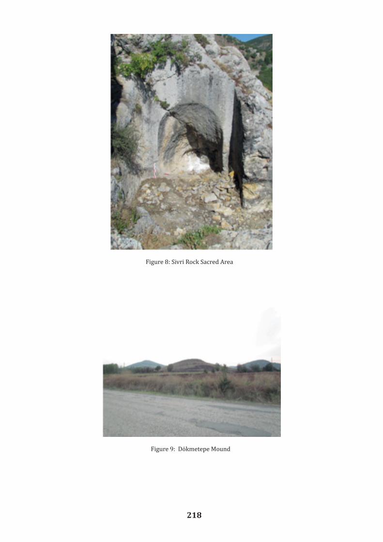
218
Figure 8: Sivri Rock Sacred Area
Figure 9: Dökmetepe Mound

219
Figure 10: Potsherds from Dökmetepe Mound
Figure 11: Demir Fortress

220
An Evaluation on Bronze Movable Cultural Assets in Artvin-Savsat Found by Chance
Osman AYTEKIN1
Hasan BUGRUL2
Abstract
There are information about the ancient period of the city of Artvin, which is located in the Eastern Black Sea Region and on the border of Georgia, which are not based on archaeologica l evidence at the present time. We have been conducting a study since 1998; the surveys are carried out by different academicians in cooperation with the Ministry of Culture and Tourism in the region, including mainly medieval and later ages. The Excavation and Restoration Work on the Savsat (Satlel) Castle, located at the Merkez Sögütlü Neighbourhood in the Savsat District, of Artvin Province started during my presidency and continues since 2007. It has enabled us to access significant archaeological finds from the Middle Age, Georgian Modern Age, and Ottoman Period. Prehistoric and historical periods need to be evaluated together to reveal the history of a place in chronological order. Considering this fact, in this study seven movable cultural assets found in the rural area of Bzata settlement of Meydancık village in 1932 in the district of Savsat and delivered to the Ankara Ethnography Museum including two axes with eye, a tubular axe, a pair of axes, a hoe with eye and a bullion will be presented. The mentioned movable cultural assets were published by Dr. Kurt Bittel in a journal in 1933.However, the researcher only made an evaluation on the works in the museum, without visit ingthe archaeological site. In the light of the international and Turkish archaeological data since 1933, we aim to obtain a periodical result by re-evaluating these bronze artifacts comparative ly.
Key Words: Archaeology, Savsat, Findings, Bronze, Cave, Axe, Dig
Geographical Location and History of Savsat
The district of Savsat has borders with the Georgian Republic, the Province of Ardahan through its districts named Hanak and Posof and the two other districts in Artvin, named Ardanuç and Borçka. The altitude of the the district center is 1.100 m., and the altitude of the village settlements reach up to approximately 1800 m. There are also settlements near the hamlet andthe plateau where mountains are over 3000 m. high.
Savsat, which is a district of Artvin has 62 villages (Orhan 2015, 141-142). It has a surface area of approximately 1317 square kilometers, representing the second largest district in the province. According to the census of 2015, the total population of the district is 17,524. The population seems to have decreased compared to previous years, and the migration to the big cities still continues. The villages are almost deserted.
The district with a Black Sea coastal climate in the continental climate transition zone is rich in plants, fauna, forests, land lakes, green meadows and highland potential. Thanks to the National Parks and Conservation areas, nature and wildlife have been preserved. Thanks to many festivals aiming to preserve traditions and customs, local and foreign tourists visit the area,especially in summer. By carrying this rich potential of Savsat into the future, we believe that it will gain strength with the appellation the "CittaSlow", which it deserved, in 2015.
1 Assist. Prof. Dr., Archeologist, Art Historian, Faculty of Literature, Yüzüncüyıl University , Van/TURKEY2 Assist. Prof. Dr., Philologist, Art Historian, Yüzüncüyıl University , Van/TURKEY

221
An Evaluation on Bronze Movable Cultural Assets in Artvin-Savsat Found by Chance
Osman AYTEKIN1
Hasan BUGRUL2
Abstract
There are information about the ancient period of the city of Artvin, which is located in the Eastern Black Sea Region and on the border of Georgia, which are not based on archaeologica l evidence at the present time. We have been conducting a study since 1998; the surveys are carried out by different academicians in cooperation with the Ministry of Culture and Tourism in the region, including mainly medieval and later ages. The Excavation and Restoration Work on the Savsat (Satlel) Castle, located at the Merkez Sögütlü Neighbourhood in the Savsat District, of Artvin Province started during my presidency and continues since 2007. It has enabled us to access significant archaeological finds from the Middle Age, Georgian Modern Age, and Ottoman Period. Prehistoric and historical periods need to be evaluated together to reveal the history of a place in chronological order. Considering this fact, in this study seven movable cultural assets found in the rural area of Bzata settlement of Meydancık village in 1932 in the district of Savsat and delivered to the Ankara Ethnography Museum including two axes with eye, a tubular axe, a pair of axes, a hoe with eye and a bullion will be presented. The mentioned movable cultural assets were published by Dr. Kurt Bittel in a journal in 1933.However, the researcher only made an evaluation on the works in the museum, without visit ingthe archaeological site. In the light of the international and Turkish archaeological data since 1933, we aim to obtain a periodical result by re-evaluating these bronze artifacts comparative ly.
Key Words: Archaeology, Savsat, Findings, Bronze, Cave, Axe, Dig
Geographical Location and History of Savsat
The district of Savsat has borders with the Georgian Republic, the Province of Ardahan through its districts named Hanak and Posof and the two other districts in Artvin, named Ardanuç and Borçka. The altitude of the the district center is 1.100 m., and the altitude of the village settlements reach up to approximately 1800 m. There are also settlements near the hamlet andthe plateau where mountains are over 3000 m. high.
Savsat, which is a district of Artvin has 62 villages (Orhan 2015, 141-142). It has a surface area of approximately 1317 square kilometers, representing the second largest district in the province. According to the census of 2015, the total population of the district is 17,524. The population seems to have decreased compared to previous years, and the migration to the big cities still continues. The villages are almost deserted.
The district with a Black Sea coastal climate in the continental climate transition zone is rich in plants, fauna, forests, land lakes, green meadows and highland potential. Thanks to the National Parks and Conservation areas, nature and wildlife have been preserved. Thanks to many festivals aiming to preserve traditions and customs, local and foreign tourists visit the area,especially in summer. By carrying this rich potential of Savsat into the future, we believe that it will gain strength with the appellation the "CittaSlow", which it deserved, in 2015.
1 Assist. Prof. Dr., Archeologist, Art Historian, Faculty of Literature, Yüzüncüyıl University , Van/TURKEY2 Assist. Prof. Dr., Philologist, Art Historian, Yüzüncüyıl University , Van/TURKEY
The etymology of the word “Savsat” is uncertain (Aytekin 2011, 61-70). The region was called "Savaseti" in the Middle Age. It means "Black Forest Area" in Georgian language. However, to which language the former names Satlel/Satle belonged in the Sögütlü neighborhood where Savsat Castle is located at, has not been determined yet.
Meydancık (Diyoban), one of the important settlements of Savsat since the Middle Age, consists of three counties and 15 villages. At that time, Balıklı Village was one of the three counties of Meydancık Town. In fact, although the town was reduced to village status in 2012 due to the lack of population. In the region, known as the Imerkev valley and bordered by Georgia, there are settlements consisting of villages, hamlets and plateaus. Village settlements have been started to be considered as a holiday place by locals living in the country especially in summer despite the recent abandonment of the majority of the hamlets and plateaus.
According to (Bittel 1933, 150-156), it seems the history of the Savsat District dates back to the Ancient Age. However, considering the data of this period which was found by chance and belonged to c. 2000 BC according to analyses by the experts, the dating is based on bronze axes from the the Bronze Age. According to (Kırzıoglu 1993, 121- 249; Aydın 1998, 284-285; Basar 1997, 122; Kılıç 1997, 177; and Aytekin 2000, 6170), it seems that no artifacts from the Urartians, one of the civilizations of the Iron Age, was discovered in Savsat (Köroglu). We donot have solid archeological data on whether Scythians and Persians set foot in the area during the Urartian Period and afterwards or not. In the period, when Greek, Roman-Byzantine, Sasani and Abbas civilizations were dominant in the region, there might have been ane active role of the local principals in Savsat. No traces of the Seljuk Turks, who invaded Anatolia in the first half of the 11th century AD, was detected in Savsat. While the Seljuks carried out invasions in Anatolia in the first half of the 11th century AD, an Ottoman administration was assigned to Savsat during the reign of Sultan Süleyman the Magnificent in the mid-16th century AD and continued as semi-autonomous "organization" until 1860s. It has been stated (Özdemir 2001, 10-20) that following the Ottoman-Russian War of 1877-1878, Savsat was also handed over tothe Tsarist Russia as a war compensation, and maintained this status until the date of re-unification with the homeland in February 1921. During the Russian occupation and during theFirst World War, the Muslim Turkish people had to leave their homeland and migrate toAnatolia. After the occupation, while some of them returned to their homes in Savsat, aconsiderable number of them preferred to stay in the territories allocated by the Ottoman Statein places such as Bursa, Kocaeli, Istanbul, Tokat, Amasya, Ordu and Samsun. In the period ofthe Republic of Turkey, the town was first connected to the province of Ardahan (27 February1921) for a short period, and then to the province of Artvin (July 7, 1921). The municipa lityorganization was established in Savsat in 1928.
Bronze Finds
It has been stated (Bittel 1933, 150-156) that in 1933, an article titled, "Artvin'de Bulunan Tunçtan Mamul Asarı Atika" (Bronze Made Precious Work Found in Artvin) was published in "Turkish History Archaeologist and Ethnography Magazine" by German-born Dr. K. Bittel. According to Aytekin (1999, 297) it seems that the works mentioned in the article were found in in 1932 in the location of Sazergele, neighborhood of Akbıyık (Bzata) of Balıklı Village – in Savsat District of Artvin Province; and then delivered to the Museum Management in Ankara by the Ministry of National Education to be examined. We found out that the findspot in question is about half an hour away from Akbıyık neighborhood, and it is near a stream bed (Figure 1). Balıklı Village is located on the route of Meydancık road and it is 37 km. from Savsat district center. Apart from the central district of Balıklı Village, there are two other

222
neighborhoods named Akbıyık (Bzata) Quarter and Karayigit (Soltishev). In the Meydancık-Tasköprü neighborhood, besides the various works from the Middle Age, there is a registered immovable cultural property known as Tamara Castle (Parih Kalesi) built or repaired by the Georgian Queen Tamara Dodopali (1184- 1213). According to Bittel (1933, 150), this piece was found in a cave in the Sasazkale forest of Zate neighborhood of Balikli village by a student of Kursunlu School during an excursion. There is neither knowledge of the villagers about the cave, nor any narrate about it by the villagers. This work was found on a shelf inside the cave. The cave has a small hole. One of the artifacts was found in front of the entrance, while the others were inside the cave. There is a castle in the vicinity of the cave, one hour away, which is said to have been built by a Georgian woman named Famara Dudubal, and it is named after her. It is reported that there are more precious artifacts available from the villagers, which have been monitored by the headteacher of the school. The date on which the artifact was found is not exactly known. No other artifacts were found in the cave except this art work. Dr. K. Bittel examined the finds displayed in the Ankara Ethnographic Museum. These movable cultural assets include two axes with eye, a tubular axe, a pair of axes, a hoe with a wide bit, and a casted ingot, totally seven artifacts. Axe with eye -1; the bit side of the axe seems to be overdistorted. The diameter of the bit side of the axe, which has a total length of 17.7 cm., is 7.9 cm. The length of the eye of the axe is 5.3 cm., and the width is 3.1 cm. In the middle of the axe, curving from the axe lip to the inner side, there is an outwardly curved top (Figure 2). Axe with eye -2; it is emphasized that the bit side has been distorted very much and that this part has been transformed into a hammer. The diameter of the bit side of the axe, which has a total length of 7.4 cm., is 5.2 cm. In the middle of the axe, curving from the axe lip to the inner side, there is an outwardly curved top (Figure 3). Tubular axe; the total length is 10.9 cm. and its bit side length is 5.7 cm. The bit side has been distorted very much. It has an eye that extends upward from the bottom (Figure 4). A hoe with eye; the total length of the anchor, starting from its lip part and extends to upward, is 8.7 cm. The width of the eye part is 8.5 cm. The right side of the bit is broken, and there is an axe handle eye in a circular form (Figure 5). One pair of axes; both of these axes, in the appearance of battle axes, are similar to each other. It is understood that the eyes of the axe handles were broken and became smaller by time. The lengths of the bits diameters are 12.6 cm. and 13.8 cm. Both of them have small broken pieces in the bit parts (Figure 6). A bullion; it is estimated that the bullion, which has a 13.7 cm. total length, was a rounder in the original (Figure 7). Evaluation and Conclusion It has been stated (Aytekin 2001, 51-63) that the most important aspect of this research is to be able to date the movable cultural assets correctly. No archaeological excavation for the ancient period of Artvin and its districts has been performed until the present day, and accidental finds have been transferred to other cities over time as there is still no museum of its own.
It seems that Bittel (1933, 155-156) made some fixation according to archaeological data of the 1930s. For example, he tried to compare the more undamaged axes with eye with the axes found by H. Schlimann in Troy. In the meantime, he especially expressed the importance of Caucasus and South Russia in terms of mining, and he mentioned that archaeological studies to be carried out in the future in these areas would benefit from enlightenment of the period and emphasized that the artifacts might belong to the Middle Bronze Age, that is, the second half of the c. 2000 BC.
According to Kılıç (2000, 6-7), the earliest of the axes with eye in the Colchis region in Western Georgia began to appear from the 2000 BC.
According to Ünsal (2010, 13-14), the finds found by chance in the villages of the Yusufe li district might belong to the Bronze Age. He says that, among these, an axe was found around Demirköy (Nizgivan) during a road construction. However, he does not mention where this find is today.
We applied to the Ankara Ethnographical Museum to examine the movable cultural assets found in the rural area of Balikli Village. The museum replied that they do not have artifacts registered under these names. These artifacts were probably first in the Ankara Ethnography Museum and later, when the Ankara Civilizations Museum opened, they might have been transferred there with other archaeological works.
Based on a study (Mamuladze-Kakhidze et al. 2007, 8), it is understood that the samples that resemble most to those in Savsat-Balıklı Village's neighborhood are the anchor and axes displayed in the museum of Batum after being found in 1990s in the village of Kirnati of the Autonomous Republic of Acara of Georgia located in the Çoruh River valley, very close to Borçka-Muratlı Village. These artifacts have been dated to the Late Bronze Age, that is 1200-1000 BC. by Georgian archeologists (Figure 8).
As a result, as the above mentioned researchers did not visit the region, they might have used some incorrect names forsome of the places and interpreted them accordingly. To me, it is due to Georgian words derived from the reading of these terms. In a relation to this issue, a retired imam called Yücel Ekinci – who is a local resident – stated that his father – who is 83 years old, remembers the time these finds were found, and he also knows the location of the related cave.
As mentioned earlier, the findspot of these artifacts is not "Sazaskale", but "Sazergele". This word, which is in Georgian, means "Sazer Valley". The cave, which is mentioned, is really located in the stream bed. It is not known whether this cave, which is located outside the residential area today, is on any road route.
In order to identify these movable cultural assets correctly, which are of no doubt belong to the Bronze Age and the Colcish culture in Western Georgia today, it is necessary to see the artifacts physically in the Ankara Anatolian Civilizations Museum inventory and perform a dating method on them. We believe that we will confirm the importance of Artvin in terms of cultura l and political cooperation between Anatolia and the Caucasus.

223
neighborhoods named Akbıyık (Bzata) Quarter and Karayigit (Soltishev). In the Meydancık-Tasköprü neighborhood, besides the various works from the Middle Age, there is a registered immovable cultural property known as Tamara Castle (Parih Kalesi) built or repaired by the Georgian Queen Tamara Dodopali (1184- 1213). According to Bittel (1933, 150), this piece was found in a cave in the Sasazkale forest of Zate neighborhood of Balikli village by a student of Kursunlu School during an excursion. There is neither knowledge of the villagers about the cave, nor any narrate about it by the villagers. This work was found on a shelf inside the cave. The cave has a small hole. One of the artifacts was found in front of the entrance, while the others were inside the cave. There is a castle in the vicinity of the cave, one hour away, which is said to have been built by a Georgian woman named Famara Dudubal, and it is named after her. It is reported that there are more precious artifacts available from the villagers, which have been monitored by the headteacher of the school. The date on which the artifact was found is not exactly known. No other artifacts were found in the cave except this art work. Dr. K. Bittel examined the finds displayed in the Ankara Ethnographic Museum. These movable cultural assets include two axes with eye, a tubular axe, a pair of axes, a hoe with a wide bit, and a casted ingot, totally seven artifacts. Axe with eye -1; the bit side of the axe seems to be overdistorted. The diameter of the bit side of the axe, which has a total length of 17.7 cm., is 7.9 cm. The length of the eye of the axe is 5.3 cm., and the width is 3.1 cm. In the middle of the axe, curving from the axe lip to the inner side, there is an outwardly curved top (Figure 2). Axe with eye -2; it is emphasized that the bit side has been distorted very much and that this part has been transformed into a hammer. The diameter of the bit side of the axe, which has a total length of 7.4 cm., is 5.2 cm. In the middle of the axe, curving from the axe lip to the inner side, there is an outwardly curved top (Figure 3). Tubular axe; the total length is 10.9 cm. and its bit side length is 5.7 cm. The bit side has been distorted very much. It has an eye that extends upward from the bottom (Figure 4). A hoe with eye; the total length of the anchor, starting from its lip part and extends to upward, is 8.7 cm. The width of the eye part is 8.5 cm. The right side of the bit is broken, and there is an axe handle eye in a circular form (Figure 5). One pair of axes; both of these axes, in the appearance of battle axes, are similar to each other. It is understood that the eyes of the axe handles were broken and became smaller by time. The lengths of the bits diameters are 12.6 cm. and 13.8 cm. Both of them have small broken pieces in the bit parts (Figure 6). A bullion; it is estimated that the bullion, which has a 13.7 cm. total length, was a rounder in the original (Figure 7). Evaluation and Conclusion It has been stated (Aytekin 2001, 51-63) that the most important aspect of this research is to be able to date the movable cultural assets correctly. No archaeological excavation for the ancient period of Artvin and its districts has been performed until the present day, and accidental finds have been transferred to other cities over time as there is still no museum of its own.
It seems that Bittel (1933, 155-156) made some fixation according to archaeological data of the 1930s. For example, he tried to compare the more undamaged axes with eye with the axes found by H. Schlimann in Troy. In the meantime, he especially expressed the importance of Caucasus and South Russia in terms of mining, and he mentioned that archaeological studies to be carried out in the future in these areas would benefit from enlightenment of the period and emphasized that the artifacts might belong to the Middle Bronze Age, that is, the second half of the c. 2000 BC.
According to Kılıç (2000, 6-7), the earliest of the axes with eye in the Colchis region in Western Georgia began to appear from the 2000 BC.
According to Ünsal (2010, 13-14), the finds found by chance in the villages of the Yusufe li district might belong to the Bronze Age. He says that, among these, an axe was found around Demirköy (Nizgivan) during a road construction. However, he does not mention where this find is today.
We applied to the Ankara Ethnographical Museum to examine the movable cultural assets found in the rural area of Balikli Village. The museum replied that they do not have artifacts registered under these names. These artifacts were probably first in the Ankara Ethnography Museum and later, when the Ankara Civilizations Museum opened, they might have been transferred there with other archaeological works.
Based on a study (Mamuladze-Kakhidze et al. 2007, 8), it is understood that the samples that resemble most to those in Savsat-Balıklı Village's neighborhood are the anchor and axes displayed in the museum of Batum after being found in 1990s in the village of Kirnati of the Autonomous Republic of Acara of Georgia located in the Çoruh River valley, very close to Borçka-Muratlı Village. These artifacts have been dated to the Late Bronze Age, that is 1200-1000 BC. by Georgian archeologists (Figure 8).
As a result, as the above mentioned researchers did not visit the region, they might have used some incorrect names forsome of the places and interpreted them accordingly. To me, it is due to Georgian words derived from the reading of these terms. In a relation to this issue, a retired imam called Yücel Ekinci – who is a local resident – stated that his father – who is 83 years old, remembers the time these finds were found, and he also knows the location of the related cave.
As mentioned earlier, the findspot of these artifacts is not "Sazaskale", but "Sazergele". This word, which is in Georgian, means "Sazer Valley". The cave, which is mentioned, is really located in the stream bed. It is not known whether this cave, which is located outside the residential area today, is on any road route.
In order to identify these movable cultural assets correctly, which are of no doubt belong to the Bronze Age and the Colcish culture in Western Georgia today, it is necessary to see the artifacts physically in the Ankara Anatolian Civilizations Museum inventory and perform a dating method on them. We believe that we will confirm the importance of Artvin in terms of cultura l and political cooperation between Anatolia and the Caucasus.

224
Bibliography
Aytekin, O. 1999. Ortaçagda Osmanlı Dönemi Sonuna Kadar Artvin’deki Mimari Eserler.Ankara, Kültür Bakanlıgı Yayınları.
Aytekin O. 2000. “Artvin Ve Çevresindeki Türk-Islam Eserleri Yüzey Arastırması, 1998”. 17.Arastırma Sonuçları Toplantısı I, 95-108. Ankara, Anıtlar ve Müzeler Genel Müdürlügü Yayınları.
Aytekin O. 2001. “Artvin'in Çevre Müzelerinde Bulunan Kültür Degerleri”. Yüzüncü Yıl Üniversitesi Sosyal Bilimler Enstitüsü Dergisi 2. 51-63.
Aytekin O. 2011. “Savsat (Satlel) Kalesi 2007 Yılı Kazı ve Restorasyon Çalısması”. 30. Kazı Sonuçları Toplantısı, II, 61-70. Ankara, Kültür Varlıkları ve Müzeler Genel Müdürlügü.
Aydın D. 1998. Erzurum Beylerbeyligi ve Teskilatı Kurulus ve Gelisme Devri (1535 – 1566).Ankara, Türk Tarih Kurumu Basımevi.
Basar F. 1997. Osmanlı Eyâlet Tevcihâtı (1717 – 1730). Ankara, Türk Tarih Kurumu Basımevi.
Bittel K. 1933. “Artvin'de Bulunan Tunçtan Mamul Asari Atika”. Türk Tarih Arkeologya Dergisi I, 150-156.
Kılıc O. 1997. XVIII. Yüzyılın Ilk Yarısında Osmanlı Devleti’nin Idari Teskilatı, Eyalet ve Sancak Tevcihatı. Elazıg, Ceren Matbaacılık.
Kılıc S. 2000. “Artvin'de Bulunan Tunç Baltalar”. Kıyı Kültür ve Sanat Dergisi 168, 6-7.
Kırzıoglu F. 1993. Osmanlılar'ın Kafkas Ellerini Fethi (1451-1590). Ankara, Türk Tarih Kurumu Basımevi. Köroglu, K. 1997. “1995 Yılı Artvin-Ardahan Illeri Yüzey Arastırması”. XIV. Arastırma Sonuçları Toplantısı I, 369-395. Ankara, Anıtlar ve Müzeler Genel Müdürlügü Yayınları.
Mamuladze S., Kakhidze A. and Kakhidze E. 2007. Gonio-Apsarosi. Tiflis, Siesta Yayınları.
Özdemir H. 2002. Artvin Tarihi. Ankara, Ajans Ege Matbaacılık Hizmetleri.
Orhan F. 2015. Savsat'ın Beseri Ve Ekonomik Cografyası. Ankara, Eflal Ajans Matbaacılık.
Ünsal V. 2010. “Eskiçagda Yusufeli Ve Çevresi”. Gecmisten Gelecege Yusufeli Sempozyumu Bildirileri, 11-18. Istanbul, Yusufeli Belediyesi Yayını.

225
Figures:
Figure 1: Balıklı and its surroundings. By Y. Ekinci - 2016
Figure 2-3: Bronze Axes with eye, side and top By K. Bittel.
Figure 4-5: A tubular Axe and A hoe with a wide bıt. By K. Bittel
Bibliography
Aytekin, O. 1999. Ortaçagda Osmanlı Dönemi Sonuna Kadar Artvin’deki Mimari Eserler.Ankara, Kültür Bakanlıgı Yayınları.
Aytekin O. 2000. “Artvin Ve Çevresindeki Türk-Islam Eserleri Yüzey Arastırması, 1998”. 17.Arastırma Sonuçları Toplantısı I, 95-108. Ankara, Anıtlar ve Müzeler Genel Müdürlügü Yayınları.
Aytekin O. 2001. “Artvin'in Çevre Müzelerinde Bulunan Kültür Degerleri”. Yüzüncü Yıl Üniversitesi Sosyal Bilimler Enstitüsü Dergisi 2. 51-63.
Aytekin O. 2011. “Savsat (Satlel) Kalesi 2007 Yılı Kazı ve Restorasyon Çalısması”. 30. Kazı Sonuçları Toplantısı, II, 61-70. Ankara, Kültür Varlıkları ve Müzeler Genel Müdürlügü.
Aydın D. 1998. Erzurum Beylerbeyligi ve Teskilatı Kurulus ve Gelisme Devri (1535 – 1566).Ankara, Türk Tarih Kurumu Basımevi.
Basar F. 1997. Osmanlı Eyâlet Tevcihâtı (1717 – 1730). Ankara, Türk Tarih Kurumu Basımevi.
Bittel K. 1933. “Artvin'de Bulunan Tunçtan Mamul Asari Atika”. Türk Tarih Arkeologya Dergisi I, 150-156.
Kılıc O. 1997. XVIII. Yüzyılın Ilk Yarısında Osmanlı Devleti’nin Idari Teskilatı, Eyalet ve Sancak Tevcihatı. Elazıg, Ceren Matbaacılık.
Kılıc S. 2000. “Artvin'de Bulunan Tunç Baltalar”. Kıyı Kültür ve Sanat Dergisi 168, 6-7.
Kırzıoglu F. 1993. Osmanlılar'ın Kafkas Ellerini Fethi (1451-1590). Ankara, Türk Tarih Kurumu Basımevi. Köroglu, K. 1997. “1995 Yılı Artvin-Ardahan Illeri Yüzey Arastırması”. XIV. Arastırma Sonuçları Toplantısı I, 369-395. Ankara, Anıtlar ve Müzeler Genel Müdürlügü Yayınları.
Mamuladze S., Kakhidze A. and Kakhidze E. 2007. Gonio-Apsarosi. Tiflis, Siesta Yayınları.
Özdemir H. 2002. Artvin Tarihi. Ankara, Ajans Ege Matbaacılık Hizmetleri.
Orhan F. 2015. Savsat'ın Beseri Ve Ekonomik Cografyası. Ankara, Eflal Ajans Matbaacılık.
Ünsal V. 2010. “Eskiçagda Yusufeli Ve Çevresi”. Gecmisten Gelecege Yusufeli Sempozyumu Bildirileri, 11-18. Istanbul, Yusufeli Belediyesi Yayını.

226
Figure 6-7: A pair of axes that resembling battle-axes and a bronze bullion. By K.Bittel’den
Figure 8: Axes and digs found near Batum. By Ş. Mamuladze-A. Kakhidze and E. Kakhidze, 2007.

227
Surveys and Excavations on the Eastern Black Sea Coast of Turkey
Sümer ATASOY1
Abstract This paper presents the information on the Eastern Black Sea Coast of Turkey from an archaeological point of view. This region has been archaeologically neglected on account of the expansion of modern settlements. In general, archaeological studies in this region have focused on the Classical Period and later. The knowledge acquired so far by the excavations conducted in the area under examination is presented especially for the ancient Greek cities of Sinope, Amisos and Trapezous as well as other minor sites (Ikiztepe, Kurul Kayasi). These surveys and excavations are limited to the Greek colonies and settlements of the southern Black Sea coast. Many sites referred to in written sources are impossible to locate. Most of them were small, and often situated on a peninsula. Some 85 small towns, fortresses, etc. are known from ancient sources. But we know of only six cities: Heraclea Pontica, Tios, Amastris, Sinope, Amisos and Trapezous. This region has been archaeologically neglected. Because the ancient cities have been overbuilt by modern settlements, and the recent road constructions destroyed the ancient remains. The Black Sea coast was inhabited during the Middle and Upper Palaeolithic Period. Agricultural village sites appear along the southern littoral as early as the 6th or 5th millennium BC. Archaeological surveys along the central Turkish Black Sea coast suggest Early Bronze Age coastal settlements similar to the settlement pattern and land use preferences of the later classical ports and colonies. There were quite favourable geographical conditions along this coast for the establishment of Greek colonies. The distribution of the 3rd- and 2nd-millennia artefacts in the Black Sea basin with close parallels in the Aegean world, indicate a direct long-distance trade. An ancient coastline, which appears to have been abruptly flooded, is preserved in many places with a minimum of sedimentation at 150 m below the present-day surface. The Black Sea littoral has always been culturally distinct from the mainland Anatolia. This discrete character is, in part, determined by geographical factors: the steep mountain chains of the Pontus are an impediment to communications with the hinterland even today. By contrast, the sea would have facilitated transport along the coast as soon as seafaring was taken up. The second broad question, thus, concerns the relationship between local societies with those in the mainland Anatolia and other regions surrounding the Black Sea and the resulting patterns of cultural influence and connectivity through time. Our aim is to present the information on the Eastern Black Sea Coast from an archaeologica l point of view. Land and Underwater Surveys at Sinope/Sinop The Black Sea became a major crossroads of the ancient world with the advent of Greek colonisation in the period 800–700 BC. Trade links between the Crimea and the southern Black Sea coast started only from the later 5th century BC.
1 Prof. Dr., Sümer Atasoy, sü[email protected]

228
Sinop is the best natural harbour along the southern Black Sea coast, and its fertile and gentle coastal plain has evidence of occupation right down to modern times (Fig. 1).
Archaeological data from land surveys on the Sinop Peninsula record maritime connections between the Sinop Peninsula and Bosphorus from as early as the Chalcolithic Period (4500 BC) and continuing throughout the Ottoman Period (17th century AD). The Bronze Age (mid-3rd to late 2nd millennium BC) was characterised by extensive subsistence settlements and ceramics that suggest a widely dispersed network of connections.
The coastal valleys provide good beach landings for the small boats used for local fishing and offer a potential for transporting local products to the primary port of Sinop for distribution overseas. The rich fishing resources of the Black Sea might have been even more important than trade in motivating the contact between the Black Sea communities before the establishment of the Milesian colonial network in the 7th century BC.
The first excavations began in the 1950s by E. Akurgal and L. Budde. Since then, several important excavations were conducted in the town and the province of Sinop. Amphora workshops have been uncovered at Zeytinlik and Demirciköy, and a Late Antique burial chamber was investigated at Gelincik, and mosaic floors were brought to light at Sinop. The church of a rural settlement was also excavated at Çiftlik. A research team led by G. Köroglu and the Sinop Museum is currently investigating a Late Roman bath complex at Balatlar.
Two American research projects have contributed greatly to a better knowledge of the area’s history. Four merchant shipwrecks were discovered during water sonar surveys a part of the Black Sea Trade Project directed by R. Ballard, while the participants in the Sinop Regiona l Archaeological Project led by O. Doonan have conducted landscape archaeological research and field surveys on the Sinop Peninsula.
In 2000, a team of marine archaeologists led by Ballard discovered three ancient shipwrecks to the west of Sinop at depths of 100 m. The wrecks A and C date to the Late Roman (the 2nd–4th centuries AD), and the wreck B to the Byzantine period (5th–7th centuries AD). To the east of Sinop, the team discovered a well-preserved shipwreck (wreck D) at a depth of 324 m. It was dated to the 5th–6th century AD. Examination of all four shipwrecks provides direct evidence for the Black Sea maritime trade so well attested by the distribution of ceramics on land. The wrecks A and B had carrot-shaped amphorae which are known from kiln sites at Demirci near Sinop.
Excavations of Amphora Workshops
On the southern Black Sea coastline technologically very qualified transport amphorae were produced from the Late Classical to the Middle Byzantine Period. Sinope, Heraclea Pontica and Amastris, thus, became famous during Antiquity on account of their wine production and trade. A great number of Roman sherds, coarse-ware fabrics, transport amphorae and so-called Pontic sigillata were found on this coast line.
In the Roman and Early Byzantine Periods, settlement density in the hinterland reached its highest pre-modern levels. A variety of special-purpose sites are in evidence, includ ing industrial, maritime, agricultural and other specialties. A major secondary port and amphora production facility was established at Demirci, about 15 km. south of the main port. The most

229
significant study of ceramics is the excavation of amphora workshops at Demirci, which has been conducted by Garlan and Kassab Tezgör with the co-operation of Sinop Museum since 1994, where Dr Garlan identified the names of potters and stamps on the amphorae. In 1997, the excavation of Sinop amphora workshops conducted by the Sinop Museum continued and concentrated on underwater research.
Between 1994 and 1998, the excavation of the Early Byzantine church at Çiftlik, conducted by the British Institute of Archaeology at Ankara under the directorship of the Sinop Museum, aimed at rescue and excavation of mosaic pavements.
The Gelincik Tomb Chamber
In 1999, a tomb chamber with six burials was discovered at Gelincik, Sinop, during a road construction. The chamber had a vaulted ceiling, and it measured 4.73 m. x 4.33 m. in size and was 2.70 m. in height. The stone walls were covered by coloured frescoes. The grave-goods –amphora sherds, a bronze coin, glass unguentarium, pottery lamp – indicate that the tomb was built in the Late Roman Period (Fig. 2).
The Balatlar Church Excavation
A series of ruins, known as Balatlar Kilisesi (the Balat Church), are used as gardens in Sinop (Fig. 3). The building complex is surrounded by chambers with high outer walls that are connected to each other. The original purpose of the structure is not clear, and it dates between the Roman and the Ottoman periods. The ruins extend over an area of about 10,000 m2 includ ing a place, gymnasium and bath complex, a cistern, a granary and a church. The structure was used as a monastery at a later time.
The excavation of the Balat Church was started in 2010, and it was conducted by G. Köroglu under the directorship of the Sinop Museum. Geophysical works were undertaken in the area and new architectural remains were identified. During this excavation, many graves from the Late Ottoman Period were found under the rooms. Among the grave finds were glass lamps, pottery sherds, bronze crosses and finger rings.
Excavations at Ikiztepe, Bafra
Ikiztepe is located 7 km. to the north-west of Bafra and close to the Halys (Kızılırmak) Delta (Fig.5). The Chalcolithic, Bronze, Iron, Hittite and Byzantine level settlements have been identified on four hills.
The excavations at Ikiztepe were conducted by B. Alkım between 1974 and 1980. Then, the work continued under the direction of Ö. Bilgi. Studies from 1993 onwards have yielded finds from the Late Bronze Age and Hellenistic Period. In addition, a tomb with a dromos and two chambers was found. A gold coin and other finds, combined with the masonry workmanship, indicate that it is Hellenistic. Both Hellenistic and Hittite pottery sherds were recovered from the debris.
The painted pottery sherds obtained from Akalan, Ikiztepe and Sinop, together with the architectural terracottas from Akalan, show that some relationship existed with the hinter land people, or that the region was resettled by people coming from Central Anatolia during the Late Iron Age (which can be roughly dated to between 650 and 500 BC).
230
A considerable number of metal objects dated to the Bronze Age have been uncovered in the Central Black Sea region of Turkey as a result of the excavations at Dundartepe and Tekkekoy near Samsun, and in particular from Ikiztepe near Bafra. In addition to these, the objects that have been collected by the Samsun Museum since 1972 show that from the point of both quantity and quality, the metal objects of the Central Black Sea region have an important place in the metallurgical development of Anatolia. It is clear from the implements uncovered at Ikiztepe that the people of this region produced metal objects locally. It is apparent from surveys in the region that the metals used by the Ikiztepe people were acquired from locals working the copper ore beds at Bakircay on the Tavsan Mountain near Merzifon. The development and distribution of the pottery and the existence of metal objects without parallels elsewhere indicate that no ethnic groups settled this region through migration. Starting in the Hellenistic Period, the area was heavily settled – there is plentiful evidence from necropoleis and from the settlements themselves – mainly to exploit the mineral resources. The Late Iron Age settlements at Akalan and Ikiztepe had come to an end before the arrival of the Greeks. Pontic people were already familiar with the Anatolian art. Thus, it was quite easy for them to accept and absorb the new cultural waves brought by the colonists, especially in view of the fact that similar painted pottery has been found in abundance at sites such as Pazarlı, Masathöyük, Alisarhöyük, Kultepe, Alacahöyük and Bogazköy. We can justifiably suggest that the Late Iron Age people of the Central Black Sea region may have originated from the Central Anatolia. Surveys and Excavations at Amisos / Samsun Amisos is the most archaeologically active site anywhere along the southern Black Sea coast. Unfortunately, throughout Amisos and its environs, the plundering of archaeological sites, especially graves, is rife, complemented by an outbreak of illegal house-building. Rescue Excavation in 1991 During the rescue excavation of the Samsun Museum in 1991, 13 burials (simple rectangular pits in the ground) on the western slope of ancient city were found. Some finds, such as gold earrings, some fragments of a necklace and various others were taken to the museum. During this excavation, the spoil heap came down the west slope as far as the Baruthane River and the museum team found large quantities of sherds, terracotta lamps and spindle whorls. The finds are dated to the Hellenistic and Roman Periods. Discovery of a Rock-Cut Tomb in 1995 In 1995, during the excavation of a new road, an unplundered hewn tomb was discovered on the eastern slope of the ancient city. The tomb, consisting of a dromos and a chamber, is 5 m long, 5 m. wide and 2.30 m. high. The plaster, which covered the walls, the floor and the ceiling, has mostly fallen away. Three inhumations were found in the chamber. Examination of the bones, gold jewellery and toilet-case fragments reveals that one male and two females were buried. The quantity of gold jewellery makes it clear that this tomb belonged to a rich family living in Amisos. The offerings, terracotta lamps, glass bowl and gold jewellery give a Hellenistic date. The gold jewellery (a pair of earrings with Nike pendants; 11 brooches with Medusa in relief; ten ornaments in the shape of Nereid; a pair of bracelets – the ring is of twisted wire terminating in the head of a woman; a gold pendant, with a pair of chains passing through

231
A considerable number of metal objects dated to the Bronze Age have been uncovered in the Central Black Sea region of Turkey as a result of the excavations at Dundartepe and Tekkekoy near Samsun, and in particular from Ikiztepe near Bafra. In addition to these, the objects that have been collected by the Samsun Museum since 1972 show that from the point of both quantity and quality, the metal objects of the Central Black Sea region have an important place in the metallurgical development of Anatolia. It is clear from the implements uncovered at Ikiztepe that the people of this region produced metal objects locally. It is apparent from surveys in the region that the metals used by the Ikiztepe people were acquired from locals working the copper ore beds at Bakircay on the Tavsan Mountain near Merzifon. The development and distribution of the pottery and the existence of metal objects without parallels elsewhere indicate that no ethnic groups settled this region through migration. Starting in the Hellenistic Period, the area was heavily settled – there is plentiful evidence from necropoleis and from the settlements themselves – mainly to exploit the mineral resources. The Late Iron Age settlements at Akalan and Ikiztepe had come to an end before the arrival of the Greeks. Pontic people were already familiar with the Anatolian art. Thus, it was quite easy for them to accept and absorb the new cultural waves brought by the colonists, especially in view of the fact that similar painted pottery has been found in abundance at sites such as Pazarlı, Masathöyük, Alisarhöyük, Kultepe, Alacahöyük and Bogazköy. We can justifiably suggest that the Late Iron Age people of the Central Black Sea region may have originated from the Central Anatolia. Surveys and Excavations at Amisos / Samsun Amisos is the most archaeologically active site anywhere along the southern Black Sea coast. Unfortunately, throughout Amisos and its environs, the plundering of archaeological sites, especially graves, is rife, complemented by an outbreak of illegal house-building. Rescue Excavation in 1991 During the rescue excavation of the Samsun Museum in 1991, 13 burials (simple rectangular pits in the ground) on the western slope of ancient city were found. Some finds, such as gold earrings, some fragments of a necklace and various others were taken to the museum. During this excavation, the spoil heap came down the west slope as far as the Baruthane River and the museum team found large quantities of sherds, terracotta lamps and spindle whorls. The finds are dated to the Hellenistic and Roman Periods. Discovery of a Rock-Cut Tomb in 1995 In 1995, during the excavation of a new road, an unplundered hewn tomb was discovered on the eastern slope of the ancient city. The tomb, consisting of a dromos and a chamber, is 5 m long, 5 m. wide and 2.30 m. high. The plaster, which covered the walls, the floor and the ceiling, has mostly fallen away. Three inhumations were found in the chamber. Examination of the bones, gold jewellery and toilet-case fragments reveals that one male and two females were buried. The quantity of gold jewellery makes it clear that this tomb belonged to a rich family living in Amisos. The offerings, terracotta lamps, glass bowl and gold jewellery give a Hellenistic date. The gold jewellery (a pair of earrings with Nike pendants; 11 brooches with Medusa in relief; ten ornaments in the shape of Nereid; a pair of bracelets – the ring is of twisted wire terminating in the head of a woman; a gold pendant, with a pair of chains passing through
three biconical beads decorated with filigree; a pair of bracelets in the shape of a snake; a pair of bracelets with lion’s heads; 15 necklaces of gold and stones; a finger ring with an emerald; a gold diadem) is now in the collection of the Samsun Museum. Excavation in Amisos in 1996 Amisos now lies within a military area, and little is visible on the surface. Many ancient remains were destroyed during the construction of the American Radar Facility between 1954 and 1956. Today, within the walled city area, nothing remained except a Byzantine cistern, capitals, a floor mosaic and some remains of city walls. In 1996, the first excavation at Amisos was carried out on behalf of the Samsun Museum and in close co-operation between this museum and the University of Thrace at Edirne. There was a floor mosaic with a geometric border near the cistern, and during the 1996 excavation a new section of the mosaic was found. This section has geometric and floral patterns, birds and a female bust symbolising ‘spring’. It is dated to the Late Roman–Early Byzantine Period. The main part of the mosaic was taken to the museum. In the same season, seven different soundings were taken on the acropolis and some remains of walls were found on the southern side of the floor mosaic. The walls were covered with marble slabs. The pottery sherds, coloured plasters and glass fragments were dated to the Hellenistic and Roman Periods, Sholars with various interests in the region joined together in 2000 to start a project named ‘The Cultural Development of the Amisos Region’, with topographical surveys of sites and other investigation of the district to the fore. Asarkale The citadel is about 30 km. from Bafra, in the valley of the Halys, to the south of the village of Asar. It was built to command the valley and the route that connects the coast of the Black Sea to the hinterland of the region. It is on the southern slope and summit of a hill. Different sections of walls show different construction techniques. There are two citadels. At the top of the hill, there are levels of bigger blocks dating from the Hellenistic Period. It is because of the topographical position that apparently this hilltop (upper citadel) was first occupied. Based on the defense walls, which are placed on rocks, rectangular and rounded towers, and style of masonry, it was built during the Hellenistic Period and was occupied until the 13th and 14th centuries AD. The settlement was placed in the form of terraces. There are two main gates into the citadel/settlement. Within the upper citadel, there is a cistern dug into the rock; in the lower citadel, a tunnel with stairs, which has an opening to the bank of the Halys. The Halys is navigable as far as Çeltik. The evidence for a Byzantine route down the Halys, either by land or by river, is provided by the retreat of the Crusaders from around Merzifon to Bafra after their defeat in 1101. The natural route for this retreat would have been down the Halys valley in which two castles are reported: Asarkale, on the west bank and Konstantinu sagı on the east bank of the river. The topographical measurements of this citadel were taken and its plan was prepared. In addition, the potsherds found within it and in its vicinity are being studied in detail.

232
Rock-Cut Tombs In the rocky area around Asarkale, also on both sides of the Halys, there are elaborately made rock-cut tombs with columns. These are characteristic of the Hellenistic Period. Placed higher than the road level (by approximately between 5 and 35 m), they are four-columned and with triangular pediments, typical examples of such tombs for Pontos Paphlagonia. They have all been robbed; thus we have no finds. Kaletepe / Çirisli Tepe / Çamurlu Tepe There is an open-air sanctuary at the top of Kale Tepe near the village of Emirli in Kavak district. In 1883, the British Consul-General in Trabzon, Alfred Billiotti, excavated the site. Large quantities of terracotta figurines (bulls and women) were found in addition to a bilingua l inscription (Greek and Latin), telling us that the Temple of Apollo Didymeus was located here in the 1st century BC. Today, there are two concentric stone walls encircling the water source. The inner wall is 6 m x 3.6 m and 0.70 m thick; the outer wall is 12.80 m x 9.70 m and varying between 1.20 and 2.20 m in thickness. Local villagers believe that there is Moslem saint buried there, and they leave money and scarves on the outer wall in expectation of their wishes coming true. The Kavak / Çivril Tumulus The Kavak tumulus, near the village of Çivril in the Kavak district, contained a ruined tomb 5–6 m below the surface. The tumulus was covered with heavy foliage. The tomb had a dromos and a single chamber. The dromos was constructed of stone, and had a vaulted arch. Part of the side walls of the dromos are cut from the rock. The chamber itself, of rectangular plan and with a vaulted roof (like the dromos) was made entirely by cutting into the rock face. Immedia te ly facing the door of the chamber, there is an elevated platform for the body. The tomb and dromos both show Hellenistic characters. Grave robbers had entered the tomb and ruined both the chamber and the dromos. The Excavation of Baruthane Tumuli Two tumuli on Baruthane hill were revealed after rescue excavations that took place in the summers of 2004, 2005 and 2006. Excavation of the Baruthane Tumuli was conducted by the author and the Samsun Museum. The South Tumulus: Beneath the tumulus is a two chambered tomb. The tomb, measuring 6 m x 2.5 m x 3 m in size, was formed by carving into a conglomerate layer. The walls, ceiling and the floor of the rooms were covered by cream-coloured plaster. Along the side walls of the front room there are benches. In the back room, there is a kline and the front side of the kline is decorated with an egg-shaped ornament in red and black. During excavation, pottery sherds, a jug, unguentaria, bone and bronze small finds were recovered from the chamber (Fig.4). The North Tumulus: Beneath the tumulus a three-chambered tomb was carved into a conglomerate layer. It has a total length of 18 m, a width of 2.80–3.25 m and a height of 2.50 m. No plastering was applied in the chambers with only pseudo-half columns. During the excavation no finds were recovered. The architectural characteristics of the tombs and the finds show that the two tumuli were built in Hellenistic Period.

233
Rock-Cut Tombs In the rocky area around Asarkale, also on both sides of the Halys, there are elaborately made rock-cut tombs with columns. These are characteristic of the Hellenistic Period. Placed higher than the road level (by approximately between 5 and 35 m), they are four-columned and with triangular pediments, typical examples of such tombs for Pontos Paphlagonia. They have all been robbed; thus we have no finds. Kaletepe / Çirisli Tepe / Çamurlu Tepe There is an open-air sanctuary at the top of Kale Tepe near the village of Emirli in Kavak district. In 1883, the British Consul-General in Trabzon, Alfred Billiotti, excavated the site. Large quantities of terracotta figurines (bulls and women) were found in addition to a bilingua l inscription (Greek and Latin), telling us that the Temple of Apollo Didymeus was located here in the 1st century BC. Today, there are two concentric stone walls encircling the water source. The inner wall is 6 m x 3.6 m and 0.70 m thick; the outer wall is 12.80 m x 9.70 m and varying between 1.20 and 2.20 m in thickness. Local villagers believe that there is Moslem saint buried there, and they leave money and scarves on the outer wall in expectation of their wishes coming true. The Kavak / Çivril Tumulus The Kavak tumulus, near the village of Çivril in the Kavak district, contained a ruined tomb 5–6 m below the surface. The tumulus was covered with heavy foliage. The tomb had a dromos and a single chamber. The dromos was constructed of stone, and had a vaulted arch. Part of the side walls of the dromos are cut from the rock. The chamber itself, of rectangular plan and with a vaulted roof (like the dromos) was made entirely by cutting into the rock face. Immedia te ly facing the door of the chamber, there is an elevated platform for the body. The tomb and dromos both show Hellenistic characters. Grave robbers had entered the tomb and ruined both the chamber and the dromos. The Excavation of Baruthane Tumuli Two tumuli on Baruthane hill were revealed after rescue excavations that took place in the summers of 2004, 2005 and 2006. Excavation of the Baruthane Tumuli was conducted by the author and the Samsun Museum. The South Tumulus: Beneath the tumulus is a two chambered tomb. The tomb, measuring 6 m x 2.5 m x 3 m in size, was formed by carving into a conglomerate layer. The walls, ceiling and the floor of the rooms were covered by cream-coloured plaster. Along the side walls of the front room there are benches. In the back room, there is a kline and the front side of the kline is decorated with an egg-shaped ornament in red and black. During excavation, pottery sherds, a jug, unguentaria, bone and bronze small finds were recovered from the chamber (Fig.4). The North Tumulus: Beneath the tumulus a three-chambered tomb was carved into a conglomerate layer. It has a total length of 18 m, a width of 2.80–3.25 m and a height of 2.50 m. No plastering was applied in the chambers with only pseudo-half columns. During the excavation no finds were recovered. The architectural characteristics of the tombs and the finds show that the two tumuli were built in Hellenistic Period.
Samsun municipality has designed the area where the tumuli are situated as an archaeologica l park. It is reached by cable-car. It has wooden walking paths giving the opportunity to visit the two tombs, a café and a restaurant with a wide view of the Black Sea.
Kurupelit Rescue Excavation in 2009
In 2009, during the construction of a light rail system in Samsun, a small ancient settlement was discovered at Kurupelit, 7 km. west of Amisos, and a rescue excavation was undertaken by the Samsun Museum. Plain buildings with rubble foundations, architectural remains, pottery sherds and small finds were discovered. Moulded figurines (Kore and Cybele), which have been dated to the Archaic Period, and painted imported pottery indicate the presence of Greek colonists at Kurupelit and the area was probably a small trading centre. A Central Anatolian-type pottery of Phrygian culture found along with the imported finds indicates that the Greek colonists were not alone in the settlement and probably lived with the local people.
New Graves at Amisos
The necropoleis of Amisos are now located under the modern settlement. Their exact boundaries have not been identified. Most of the tombs have been robbed, either in Antiquity or more recently.
The tombs were made by hewing into the conglomerate rock of the region. During the excavations for road construction by the Samsun municipality in 1991, 1995, 2001, 2005 and 2006, a large number of tombs were discovered. All of them were studied after rescue excavations conducted by Samsun Museum.
The type of burial practised in the necropolis was inhumation. The only example to date of a cremation burial was discovered in 2006. The Tınaztepe tomb chamber was an unplundered hewn grave.
We have distinguished five main types of burials belonging to ancient city so far; simple pit burials, hewn graves, graves with roof tiles, tumuli, terracotta sarcophagi. All the finds in the tombs are dated to the Hellenistic Period, with practically nothing available from the Archaic or Classical Periods.
An unpublished master’s thesis covers the types of grave and burial practice from the 3rd millennium BC till the end of the Roman Period.
Excavation at Kurul Kayası, Ordu
Kurul Kayası, the citadel, is 20 km. from Ordu, in the Bayadı village (Fig. 5). It was built on the top of a rock, which is 570 m above sea level. Within the citadel, there is a cistern and a tunnel with stairs dug into the rock. There was a small settlement near the citadel. The survey and excavation of the site was started in 2010, and conducted by S.Y. Senyurt and the Ordu Museum. Architectural remains and other finds indicate that the settlement was established in an early period and was occupied until the 1st century BC.

234
Excavations at Giresun Adası (Aretias/Ares/Khalkeritis Island) It is a small island, one mile off modern Giresun. Surveys and excavation of the site were started in 2011 and conducted by E. Doksanaltı under the directorship of the Giresun Museum. The excavation continues under the direction of Dr. G. Iltar.
The first settlement in the island was related to the nearby city of Kerasos. The natural bay was used as a harbour and the coast where ships may anchor to be protected against the northern and western winds made it attractive for settlement, which as at Kerasos, should have begun in the Archaic or Classical Periods.
Most of the remains seen on the island today are from the Middle Ages. Nevertheless, the harbour, the stepped altar related to open-air rock altar and the offering holes discovered in recent studies indicate a Classical-Hellenistic settlement. The monastery complex with church and chapel were dated to the 7th – 12th centuries AD. A Roman or Late Antique structure with a mosaic floor was found below the church, and the remains of a Greek temple were discoveredin the deepest layer. During the excavations from 2011 to 2015, 172 skeletons, ten graves of children, seven pithoi, some small finds, such as bronze beads, Byzantine coins were found.
Rescue Excavation at Cıngırt Kayası (Fatsa-Ordu)
Cıngırt Kayası is a castle settlement in the vicinity of Yapraklı village, Fatsa-Ordu. A rescue excavation was started in 2011, and conducted by Dr Ayse Fatma Erol under the direction of the Ordu Museum. There is a gallery/tunnel with stairs carved into the main rock at the summit of the hill. Architectural remains and coins dating to the Hellenistic and Roman Periods,especially to the reign of Mithridates VI, were discovered. Small finds obtained from under rock shelters located on the north-east slopes of Cıngırt Kayası suggest that the region was also settled in prehistoric times. Excavations in 2012 and 2013 were conducted on the peak andnorthern slopes of Cıngırt Kayası. The rock mass on the northern slope having a sacrifice pit with blood grooves suggest that the site was used for sacrifice and rituals, and the area was designed as an open air sanctuary.
Rescue Excavation at Trapezous / Trabzon
We have no archaeological evidence and no new information from the ancient city of Trapezous. In 1997, a rescue excavation conducted by the Trabzon Museum revealed some architectural elements such as architraves and friezes belonging to monumental structures dated to the 2nd/3rd century AD and a Corinthian capital and a column base dated to the 3th / 4th century AD. In addition to these, a statue of a young male (Apollo) was also unearthed. These finds may be associated with the ancient city during the Roman Imperial Period.

235
Excavations at Giresun Adası (Aretias/Ares/Khalkeritis Island) It is a small island, one mile off modern Giresun. Surveys and excavation of the site were started in 2011 and conducted by E. Doksanaltı under the directorship of the Giresun Museum. The excavation continues under the direction of Dr. G. Iltar.
The first settlement in the island was related to the nearby city of Kerasos. The natural bay was used as a harbour and the coast where ships may anchor to be protected against the northern and western winds made it attractive for settlement, which as at Kerasos, should have begun in the Archaic or Classical Periods.
Most of the remains seen on the island today are from the Middle Ages. Nevertheless, the harbour, the stepped altar related to open-air rock altar and the offering holes discovered in recent studies indicate a Classical-Hellenistic settlement. The monastery complex with church and chapel were dated to the 7th – 12th centuries AD. A Roman or Late Antique structure with a mosaic floor was found below the church, and the remains of a Greek temple were discoveredin the deepest layer. During the excavations from 2011 to 2015, 172 skeletons, ten graves of children, seven pithoi, some small finds, such as bronze beads, Byzantine coins were found.
Rescue Excavation at Cıngırt Kayası (Fatsa-Ordu)
Cıngırt Kayası is a castle settlement in the vicinity of Yapraklı village, Fatsa-Ordu. A rescue excavation was started in 2011, and conducted by Dr Ayse Fatma Erol under the direction of the Ordu Museum. There is a gallery/tunnel with stairs carved into the main rock at the summit of the hill. Architectural remains and coins dating to the Hellenistic and Roman Periods,especially to the reign of Mithridates VI, were discovered. Small finds obtained from under rock shelters located on the north-east slopes of Cıngırt Kayası suggest that the region was also settled in prehistoric times. Excavations in 2012 and 2013 were conducted on the peak andnorthern slopes of Cıngırt Kayası. The rock mass on the northern slope having a sacrifice pit with blood grooves suggest that the site was used for sacrifice and rituals, and the area was designed as an open air sanctuary.
Rescue Excavation at Trapezous / Trabzon
We have no archaeological evidence and no new information from the ancient city of Trapezous. In 1997, a rescue excavation conducted by the Trabzon Museum revealed some architectural elements such as architraves and friezes belonging to monumental structures dated to the 2nd/3rd century AD and a Corinthian capital and a column base dated to the 3th / 4th century AD. In addition to these, a statue of a young male (Apollo) was also unearthed. These finds may be associated with the ancient city during the Roman Imperial Period.
Bibliography
Akkaya M. 1993. “Amisos Antik Kenti Kurtarma Kazısı”. In 3. Müze Kurtarma Kazıları Semineri 27–30 Nisan 1992 (Efes/Ankara), 207–09.
Akkaya, M.. 1997. Amisos Treasure (Samsun).
Akurgal E. and Budde L.1956. Vorläufiger Bericht über die Ausgrabungen in Sinope (Türk Tarih Kurumu yayınlarından. V. dizi 14) (Ankara).
Akyüz U., Kolagasıoglu M. and Sirin O. A. 2011. “Samsun, Atakum, Çakılca Kurupelit Kurtarma Kazısı 2009”. In XIX. Müze Çalısmaları ve Kurtarma Kazıları Sempozyumu, Ordu 2010 (Ankara), 117–34.
Alkım B., Alkım H. and Bilgi Ö. 2003. Ikiztepe II (Ankara)Anderson, W. 2009. “Late Byzantine Occupation of the Castle at Tios”. Anatolia Antiqua 17,265–77.
Atasoy S. 2001. “The Cultural Development of the Amisos Region”. In 2nd International Congress on Black Sea Antiquities, Ankara, 2–9 September (Abstracts), 59.
Atasoy S. 2003. “Amisos”. In Grammenos, D.V. and Petropoulos, E.K. (eds.), Ancient Greek Colonies in the Black Sea (Publications of the Archaeological Institute of Northern Greece 4). (Thessaloniki), 1331–78.
Atasoy S. 2007. History Revealed: Ancient Samsun (Amisos) (Istanbul).
Atasoy S. 2008. “Zonguldak–Filyos (Tios/Tieion/Tion/Tianos/Tieum) Kurtarma Kazısı”. In Delemen I., Çokay-Kepçe, S. Özdizbay, A. and Turak, Ö. (eds.), Prof. Dr. HalukAbbasoglu’na 65. Yas Armaganı (Antalya), 91–97.
Atasoy S. 2009. “New Graves at Amisos”. In Iltar, G. (ed), Giresun ve Dogu KaradenizSosyal Bilimler Sempozyumu, 9–11 Ekim 2008, Bildiriler, vol 2 (Ankara), 169–78.
Atasoy S., Endogru, M. and Dönmez, S. 2007. ‘Samsun Baruthane Tümülüsleri Kurtarma Kazısı’. Anadolu Arastırmaları 18.2, 153–65.
Atasoy S. and Erpehlivan H. 2012. “Filyos–Tios Kenti: Ilk Yerlesmeye ait KeramikBuluntular”. InSahin, I. (ed.), Ismail Fazlıoglu Anı Kitabı (Edirne), 1–12.
Atasoy S. and Ertugrul Ö. 1998. “1996 Amisos Kazısı”. In 19. Kazı Sonuçları Toplantısı. 26–30 Mayıs 1997 Ankara (Ankara), 523–30.
Atasoy, S. and Yıldırım, S. 2011. “Filyos–Tios 2009 Yılı Kazısı”. In 32. Kazı Sonuçları Toplantısı, vol. 4. (Ankara), 1–16.
Atasoy, S. and Yıldırım, S. 2015. Zonguldak’ta Bir Antik Kent: Tıos. 2006-2012 Arkeolojik Çalısmaları ve Genel Degerlendirme (An Ancient City in Zonguldak: Tios. General Assessment of Works Between 2006 and 2012) (Ankara)

236
Atesogulları A. and Simsek Ö. 1995. “Bartın Ili Amasra Ilçesi, Küçüksanayi Sitesi Insaatında Bulunan Roma Dönemi Heykellerini Kurtarma Kazısı”. In 5. Müze Kurtarma Kazıları Semineri. 25–28 Nisan 1994 (Didim/Ankara), 93–111. Bailey D.M. 1975. A Catalogue of the Lamps in the British Museum (London). Ballard R., Foley B., Croff K., Major C. and Torre F. 2001: ‘Deepwater Archaeology of the Black Sea: The 2000 Season at Sinop, Turkey’. American Journal of Archaeology 105, 607–23. Belke K. 1996.Tabula Imperii Byzantini, 9: Paphlagonien und Honorias (Vienna). Bilgi Ö. 1999. ‘Ikiztepe in the Late Iron Age’. Anatolian Studies 49, 27–54. Bilgi Ö. 2001. Protohistoric Age Metallurgists of the Central Black Sea Region (Istanbul). Bryer, A. and Winfield, D. 1985. The Byzantine Monuments and Topography of the Pontos (Washington DC). Csiky G. 2012. ‘The Pontus Region from a New Perspective Research on the Early Medieval Contacts of Sinope’. Hungarian Archaeology E-journal, Autumn, 1–7. Dereli F. 2001. ‘Sinop Gelincik Mezar Odası’. In 11. Müze Çalısmaları ve Kurtarma Kazıları Sempozyumu. 24–26 Nisan 2000 (Denizli/Ankara), 235–48. Doksanaltı E.M. and Mimiroglu I.M. 2010. ‘Giresun/Aretias-Khalkeritis Island’. Anodos 10, 85–101. Doksanaltı E.M., Karaoglan I. and Erdogan U. 2013. “Giresun-Aretias / Khalkeritis Adası 2011-2012 Kazıları Ön Raporu”, In Tekocak, M.(ed.), K. Levent Zorogluna Armagan (Antalya), 175-90 Dönmez, S. 2010. ‘Sacral Monuments of the North-Central Anatolia’. In Petropoulos, E.K. and Maslennikov, A. (eds.), Ancient Sacral Monuments in the Black Sea (Thessaloniki), 515–62. Doonan O. P. 2004. Sinop Landscapes: Exploring Connection in the Hinterland of a Black Sea Port (Philadelphia). Doonan O. P. 2006. ‘Exploring Community in the hinterland of a Black Sea port’. In Bilde, P. Guldager and Stolba, V.F. (eds.), Surveying the Greek Chora: Black Sea Region in a Comparative Perspective (Black Sea Studies 4) (Aarhus), 47–58. Düring B. and Glatz C. 2010. ‘The Cide Archaeological Project 2009. First Results’. Anatolia Antiqua 18, 203–13. Düring B. S. and Glatz C.(eds.) 2015. Kinetic Landscapes.The Cide Archaeological Project: Surveying the Turkish Western Black Sea Region. In De Gruyder Open Düring B., Glatz C. and Serifoglu T.E. 2012. ‘The Cide Archaeological Project 2011. Third preliminary report’. Anatolia Antiqua 20, 167–75.

237
Atesogulları A. and Simsek Ö. 1995. “Bartın Ili Amasra Ilçesi, Küçüksanayi Sitesi Insaatında Bulunan Roma Dönemi Heykellerini Kurtarma Kazısı”. In 5. Müze Kurtarma Kazıları Semineri. 25–28 Nisan 1994 (Didim/Ankara), 93–111. Bailey D.M. 1975. A Catalogue of the Lamps in the British Museum (London). Ballard R., Foley B., Croff K., Major C. and Torre F. 2001: ‘Deepwater Archaeology of the Black Sea: The 2000 Season at Sinop, Turkey’. American Journal of Archaeology 105, 607–23. Belke K. 1996.Tabula Imperii Byzantini, 9: Paphlagonien und Honorias (Vienna). Bilgi Ö. 1999. ‘Ikiztepe in the Late Iron Age’. Anatolian Studies 49, 27–54. Bilgi Ö. 2001. Protohistoric Age Metallurgists of the Central Black Sea Region (Istanbul). Bryer, A. and Winfield, D. 1985. The Byzantine Monuments and Topography of the Pontos (Washington DC). Csiky G. 2012. ‘The Pontus Region from a New Perspective Research on the Early Medieval Contacts of Sinope’. Hungarian Archaeology E-journal, Autumn, 1–7. Dereli F. 2001. ‘Sinop Gelincik Mezar Odası’. In 11. Müze Çalısmaları ve Kurtarma Kazıları Sempozyumu. 24–26 Nisan 2000 (Denizli/Ankara), 235–48. Doksanaltı E.M. and Mimiroglu I.M. 2010. ‘Giresun/Aretias-Khalkeritis Island’. Anodos 10, 85–101. Doksanaltı E.M., Karaoglan I. and Erdogan U. 2013. “Giresun-Aretias / Khalkeritis Adası 2011-2012 Kazıları Ön Raporu”, In Tekocak, M.(ed.), K. Levent Zorogluna Armagan (Antalya), 175-90 Dönmez, S. 2010. ‘Sacral Monuments of the North-Central Anatolia’. In Petropoulos, E.K. and Maslennikov, A. (eds.), Ancient Sacral Monuments in the Black Sea (Thessaloniki), 515–62. Doonan O. P. 2004. Sinop Landscapes: Exploring Connection in the Hinterland of a Black Sea Port (Philadelphia). Doonan O. P. 2006. ‘Exploring Community in the hinterland of a Black Sea port’. In Bilde, P. Guldager and Stolba, V.F. (eds.), Surveying the Greek Chora: Black Sea Region in a Comparative Perspective (Black Sea Studies 4) (Aarhus), 47–58. Düring B. and Glatz C. 2010. ‘The Cide Archaeological Project 2009. First Results’. Anatolia Antiqua 18, 203–13. Düring B. S. and Glatz C.(eds.) 2015. Kinetic Landscapes.The Cide Archaeological Project: Surveying the Turkish Western Black Sea Region. In De Gruyder Open Düring B., Glatz C. and Serifoglu T.E. 2012. ‘The Cide Archaeological Project 2011. Third preliminary report’. Anatolia Antiqua 20, 167–75.
Erciyas D.B. 2006.Wealth, Aristocracy and Royal Propaganda under the Hellenistic Kingdom of the Mithridatids (Colloquia Pontica 12) (Leiden/Boston). Erol F. A. 2015. ‘New Findings on the History and Archaeology of the Eastern Black Sea Region of Turkey.The Excavation of Cıngırt Kayası’. In Tsetskhladze, G.R. Avram, A.and Hargrave, J.(eds.), The Danubian Lands Between the Black, Aegean and Adriatic Seas (7th Century BC – 10th Century AD). Proceedings of the Fifth International Congress on Black Sea Antiquities (Belgrade- 17-21 September 2013) (Oxford),453-62 Erol F. A. 2016. ‘Research Results of Archaeological Survey of Fatsa During 2011 to 2015 Field Season’, In 38. International Symposium of Excavations, Surveys and Archaeometry, (23-27 May, Edirne) (in print) Garlan, Y. and Tatlıcan, I. 1998. ‘Fouilles d’ateliers amphoriques a Nisiköy et a Zeytinlik en 1996 et 1997’. Anatolia Antiqua 6, 407–22. Hill S. 1999. ‘Rescue excavations at Çiftlik (Sinop)’. In Matthews, R. (ed.), Ancient Anatolia: Fifty Years’ Work by the British Institute of Archaeology at Ankara (London), 285–300. Kassab Tezgör, D. 2010. Les Fouilles et le materiel de I’atelier amphorique de Demirci pres de Sinope (Varia Anatolica 22) (Paris). Kaya E. 1999: ‘Trabzon Il Merkezindeki Kurtarma Kazısında Ortaya Çıkan Buluntular’. In 9. Müze Kurtarma Kazıları Semineri, 27–29 Nisan 1998 (Antalya/Ankara), 321–34. Köroglu G. 2011. ‘Sinop Balatlar Kilisesi Kazı Çalısmaları 2010’. Haberler 32 (Mayıs), 60–62. Senyurt S.Y. 2015. ‘Kurul Kalesi Excavations: Archaeological Contributions to the Pontic Kingdom of Mithridates VI Eupator’, In Frecer, R.(ed.), Contacts, Migrations and Climate Change. Conference in Honour of Jan Bouzek’s illustrious 80th Birthday.May 19th- 23rd.2015 (Conference abstracts) (Prague), 12 Sirin O. A. - Kolagasıoglu M. 2016. Çakalca-Karadogan Höyügü. Arkaik Dönemde Amisos ve Kybele Kültü, Samsun. Tsetskhladze G.R. 2007. ‘Greeks and Locals in the Southern Black Sea Littoral: A Re- examination’. In Herman, G. and Shatzman, I. (eds.), Greeks between East and West: Essays in Greek Literature and History in Memory of David Asheri (Jerusalem), 160–95. Tsetskhladze G.R. 2015. ‘Greeks, Locals and Others around the Black Sea and Its Hinterland: Recent Developments’. In Tsetskhladze, G.R., Avram, A.and Hargrave, J.(eds.), The Danubian Lands Between the Black, Aegean and Adriatic Seas (7th Century BC – 10th Century AD). Proceedings of the Fifth International Congress on Black Sea Antiquities (Belgrade- 17-21 September 2013) (Oxford),16-21 Ünan S. 2010. Samsun ve Çevresi Mezar Tipleri ve Ölü Gömme Adetleri (MÖ. 3. Bin – MS. 4. yy) (Dissertation, Kütahya University). Wilson D. R. 1960. The Historical Geography of Bithynia, Paphlagonia and Pontus in the Greek and Roman Periods: A new survey with particular reference to surface remains still visible (BA dissertation, Oxford).

238
Yüksel A. F., Köroglu G. and Yıldız M. S. 2012. ‘Archaeogeophysical studies conducted on Sinop Balatlar Church’. In Digital Library SEG, Jan.
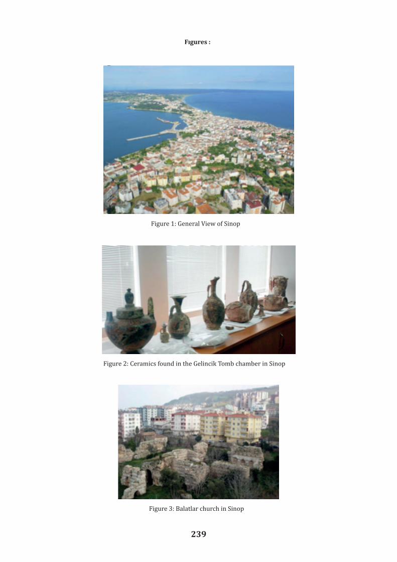
239
Figure 1: General View of Sinop
Figure 2: Ceramics found in the Gelincik Tomb chamber in Sinop
Figure 3: Balatlar church in Sinop
Fıgures :Yüksel A. F., Köroglu G. and Yıldız M. S. 2012. ‘Archaeogeophysical studies conducted on Sinop Balatlar Church’. In Digital Library SEG, Jan.

240
Figure 4: Chambers of the South Tumulus Baruthane, Amisos
Figure 5: Excavations in Kurul Kayası, Ordu

241
A General Review on the Excavations in Sebastopolis in Colopene Part of Pontus Area
Şengül Dilek FUL1 Abstract The ancient settlement in Sulusaray is known as Sebastopolis or Heracleopolis in the Roman Empire Period. According to the sounding and excavations accomplished by the administra t ion of the museum management in Tokat during the years of 1987-1990, it was found that Sulusaray has had a settlement continuity since the Bronze Age. At the same time, the archaeologica l findings suggest that the settlement went on in later years as well. The finds unearthed during the archaeological excavations performed in the mound, which is currently under the residentia l area suggest that the mound was inhabited during the Early Bronze Age, Hittite and Phrygian Periods. Besides it seems that the city lived its the most magnificent years during the Roman Empire Period based on the findings. The archaeological excavations in the city have been resumed after a long period of time in 2013. In the excavations performed in an area, where the ruins of a Roman Bath and Byzantium Churh were found, some important finds have been unearthed providing the plans of the existing structures. This paper provides an overview on the excavations between the years of 2013 and 2016. Key Words: Pontus, Sebastopolis, Excavation, Roman Bath, Byzantium Church. Sulusaray, a town in Tokat province, is 68 km. away from the center of Tokat, 30 km. from Artova town and 5 km. from Yeşilyurt town. It is situated in the middle of a broad alluvial plain, and is bordered by Sivas to the south, Yozgat to the west, and Zela and Artova to the north. The ancient settlement is located in Sulusaray town, and was called Sebastopolis -Heracleopolis during the Roman era. The word Sebastopolis comes from Greek, and is derived from the words Sebastos (almighty, venerable, great and magnificent) and polis (city). It means “the great, almighty city” (Özcan 1990, 264). Heracleopolis, on the other hand, means the city of Heracles. Heracles is a demi-god who symbolizes power in Greek and Roman mythology. This alternate name of the ancient city bears the same meaning with the word Sebastopolis. Pliny was the first to refer to Sebastopolis, and he defined it as a small town of Colopene (Plin. nat. VI. 3. 8). We learn from Strabo that the ancient city was once called Carana, and was governed by Ateporix, a local Galatian chieftain (StrabonXII. III. 37). On Ateporix’s death in 3-2 BC, this small town was transferred to the Roman Empire and annexed to Pontus Galacticus Province; and hence became a polis. This also marks the foundation of the city and as of that date, it was called Sebastopolis (Anderson 1903, 34), It has been revealed that Sulusaray (Sebastopolis) was an important settlement not only during the Roman Period, but also in the earlier periods. The sounding and excavation activities carried out between 1987 and 1990 by the Directorate of the Tokat Museum (Özcan 1990, 261-307; Özcan 1991, 167-190) revealed uninterrupted settlement in Sulusaray (Sebastopolis) beginning from the Bronze Ages. Some later archeological findings evinced also that the site continued to be inhabited in the following ages as well. The remains found in the mound on which modern buildings are erected, show that it was inhabited in the Early Bronze Age (3000 BC), Hittite (2000 BC) and Phrygian (the first half of the I. millennium BC) Period. The ancient city covering the slopes as well as the northeast and south of the mound, on the other hand, was reported to be settled during the Hellenistic, Roman, and Byzantine Periods. After a long time, we resumed archeological excavations in the area of the mound located at the town center of
Assist. Prof. Dr., Art History Department, Gaziosmanpaşa University, Tokat/TURKEY

242
Sulusaray in 2013. The excavations were commenced in the vicinity of the ruins of a Roman Bath on the eastern slope of the mound, and a Byzantine Church on the northeastern slope of the mound (Figure 1). The excavations carried out by the Directorate of the Tokat Museum between 1987 and 1990 yielded the whole tepidarium section and some parts of the frigidariumsection of the Roman bath which was constructed using largestone blocks (Özcan 1990, 268: Both the bath and the church were largely built of cut limestone blocks excavated from the quarry between the Alpudere and Çıkrık villages) put together without mortar. The tepidarium section has a rectangular plan, with traces of a clay pipe on the southern wall. As to the frigidarium, its floor is paved with rectangular stone slabs of different sizes arranged at a specific slope. On the floor stand pillars and between the pillars are the columns in situ with broken upper parts. The part where columns are placed is surrounded by frigidarium (Özcan 1990, 268), around which is a circular mortared rubble wall that stands on large blocks of cut stone, and, is at some parts 4 to 5 m high. Here there is a water discharging channel which lies in the north-south direction, according to the overall plan of the bath, and runs towards the east. The channel measures 236 cm. in length and 18 cm. in width. Furthermore, in the excavation works mentioned before, the caldarium section was also partially uncovered. This section, which has an octagonal plan, includes clay pillars which have remained intact up to a certain height, but have some ruined parts as well. To the south of this part is an arched praefurnium constructed of two layers of terracotta tiles. During the excavations between 2013 and 2016, the rest of the caldarium of the Roman bath was discovered, a portion of which was unearthed in previous excavations. Furthermore, next to this caldarium with an octagonal plan measureing 6.50x6.43m in dimensions, a second caldarium with the same plan and a praefurnium were also unearthed. Therefore, the first of these caldariums was labeled I, and the other is labeled II. Finally, in the subject caldarium section, the brick pillars of the hypocaust system have largely been ruined. Between the aforementioned two caldariums there are two ruined alveus places opposite to each other. They have a north-south orientation, and are surrounded on three sides by brick walls. The south alveus measures 191x140 cm., and in the middle of its southern wall is an earthenware water pipe, which is positioned close to the floor, and used to supply water to the pools. The north alveus measures 230x230 cm. In the southeastern part of the bath, many brick pillars of the hypocaust system were discovered. These brick pillars are largely ruined, but some are in better condition than the others. The brick pillars in Caldarium I have a quadrangle base measuring 33x32 cm and an upper part made of circular bricks with a diameter of 21 cm. In Caldarium II, there is a praefurnium constructed of terracotta tiles, which measures 365x83x90 cm. It has a square platform on the surface for kettles. Given these findings, as Yegül also argues (Yegül 2006, 100), we believe that praefurniums did not only heat the hypocaust, but also cauldrons. However, behind the praefurnium, no traces of a corridor for servants have been found yet. In the works carried out in the frigidarium, a small pool was also uncovered. It seems to be the pool of the frigidarium and it has a floor paved with cut stone slabs of different sizes. Besides, the interior of the pool is plastered. The pool measures 3.25x3.06 cm., and is connected to the water discharging channel of the frigidarium. There are two doors on the eastern wall of the frigidarium. These doors open to a large section defined as apodyterium. In this section, there are many brick pilae of circular form on a square pedestal of the hypocaust system. Besides, in this part many bone objects, on which meander, geometric and plant patterns as well as cross figures among birds were depicted and traces of paintwere visible, were excavated. Some of the bone objects were recovered with nails on them. It suggests that the bone objects were possibly hung on walls for the purposes of decoration. Cross figures, on the other hand, indicate that the bath facility was utilized for other purposes in later times. In addition to these bone objects, five oil-lamps from the late Roman era, most of which were nearly intact, and many corroded coins from the Byzantine era were found. In the works in the vicinity of the bath, the point where eastern border of the structure reached has also been

243
Sulusaray in 2013. The excavations were commenced in the vicinity of the ruins of a Roman Bath on the eastern slope of the mound, and a Byzantine Church on the northeastern slope of the mound (Figure 1). The excavations carried out by the Directorate of the Tokat Museum between 1987 and 1990 yielded the whole tepidarium section and some parts of the frigidariumsection of the Roman bath which was constructed using largestone blocks (Özcan 1990, 268: Both the bath and the church were largely built of cut limestone blocks excavated from the quarry between the Alpudere and Çıkrık villages) put together without mortar. The tepidarium section has a rectangular plan, with traces of a clay pipe on the southern wall. As to the frigidarium, its floor is paved with rectangular stone slabs of different sizes arranged at a specific slope. On the floor stand pillars and between the pillars are the columns in situ with broken upper parts. The part where columns are placed is surrounded by frigidarium (Özcan 1990, 268), around which is a circular mortared rubble wall that stands on large blocks of cut stone, and, is at some parts 4 to 5 m high. Here there is a water discharging channel which lies in the north-south direction, according to the overall plan of the bath, and runs towards the east. The channel measures 236 cm. in length and 18 cm. in width. Furthermore, in the excavation works mentioned before, the caldarium section was also partially uncovered. This section, which has an octagonal plan, includes clay pillars which have remained intact up to a certain height, but have some ruined parts as well. To the south of this part is an arched praefurnium constructed of two layers of terracotta tiles. During the excavations between 2013 and 2016, the rest of the caldarium of the Roman bath was discovered, a portion of which was unearthed in previous excavations. Furthermore, next to this caldarium with an octagonal plan measureing 6.50x6.43m in dimensions, a second caldarium with the same plan and a praefurnium were also unearthed. Therefore, the first of these caldariums was labeled I, and the other is labeled II. Finally, in the subject caldarium section, the brick pillars of the hypocaust system have largely been ruined. Between the aforementioned two caldariums there are two ruined alveus places opposite to each other. They have a north-south orientation, and are surrounded on three sides by brick walls. The south alveus measures 191x140 cm., and in the middle of its southern wall is an earthenware water pipe, which is positioned close to the floor, and used to supply water to the pools. The north alveus measures 230x230 cm. In the southeastern part of the bath, many brick pillars of the hypocaust system were discovered. These brick pillars are largely ruined, but some are in better condition than the others. The brick pillars in Caldarium I have a quadrangle base measuring 33x32 cm and an upper part made of circular bricks with a diameter of 21 cm. In Caldarium II, there is a praefurnium constructed of terracotta tiles, which measures 365x83x90 cm. It has a square platform on the surface for kettles. Given these findings, as Yegül also argues (Yegül 2006, 100), we believe that praefurniums did not only heat the hypocaust, but also cauldrons. However, behind the praefurnium, no traces of a corridor for servants have been found yet. In the works carried out in the frigidarium, a small pool was also uncovered. It seems to be the pool of the frigidarium and it has a floor paved with cut stone slabs of different sizes. Besides, the interior of the pool is plastered. The pool measures 3.25x3.06 cm., and is connected to the water discharging channel of the frigidarium. There are two doors on the eastern wall of the frigidarium. These doors open to a large section defined as apodyterium. In this section, there are many brick pilae of circular form on a square pedestal of the hypocaust system. Besides, in this part many bone objects, on which meander, geometric and plant patterns as well as cross figures among birds were depicted and traces of paintwere visible, were excavated. Some of the bone objects were recovered with nails on them. It suggests that the bone objects were possibly hung on walls for the purposes of decoration. Cross figures, on the other hand, indicate that the bath facility was utilized for other purposes in later times. In addition to these bone objects, five oil-lamps from the late Roman era, most of which were nearly intact, and many corroded coins from the Byzantine era were found. In the works in the vicinity of the bath, the point where eastern border of the structure reached has also been
identified. On the eastern border, there is a water discharging channel covered with stones, which is larger than the one in the frigidarium and surrounds the bath from outside. The water discharging channel in the frigidarium continues to the east through an earthenware water pipeline, being connected to the larger channel. Excavations were run in the area of the remains of the Byzantine Church, which had a basilica plan, at the same time as the excavations in the area of the remains of the bath structure. As a consequence of the excavations run by the Directorate of the Tokat Museum, the main apse, the south and north apsides and such sections as naos, bema, and synthronos parts of the church as well as some parts of the floor in opus sectile were unearthed (Özcan 1990, 171 ff.). The structure was built using large blocks of cut stone, and it is a typical Byzantine church in east-west direction, with a large main apse in the middle and smaller apsides at the sides, three apsides, three naves, a naos, a bema and a synthronos. However, it has largely been ruined. The outer side of the main apsides has a polygonal structure while the inner part is semi-circular, and it has a diameter of 6.10m. In the central neva, there is a floor in opus sectile, which was made by laying black, brown and white quadrangle shaped marble slabs to form geometric meander shapes in a row (Özcan 1990, 266 ff.). Floor coverings of the Saint Nicholas Church (Doğan, S., Çorağan, N., Bulgurlu, V., Alas, Ç.-Fındık, E., Apaydın, E. 2014, 55 ff.) and those in the one we excavated resemble considerably in terms of material and shape. The wall that sets central nave and south nave apart has a fresco on its side facing the west. There is a two-line inscription on the fresco; however, it is incomplete since the upper part of the fresco is broken. It is known that the word “pothos” (longing/yearning etc.) that appears in the second line is a common word in prayers in Christianity. Therefore, it suggests that this inscript ion might be an excerpt from a Christian prayer or chorale. For this reason, the fresco must be dated to the post Byzantine modern era, that is, to the 17th or 18th century AD (We are grateful to Prof. Dr. Hasan MALAY for the information he provided regarding the inscription on this fresco). In the church, several green, blue and black colored and a few gilded tesserae were found. As the tesserae were scattered around the larger part of the church, it is thought that they used to form rich mosaic compositions on the walls or ceilings of the church. Besides, many ceramic pieces from the Byzantine era were also found. They were mostly decorated with plant and geometric patterns. Conclusion In terms of its plan, the church resembles, among the structures of its kind in Anatolia, to the Saint Nicholaos Church in Antalya, Kale (Kohl, M., Matoğlu, M., Alkan, A. 2011, 562: The church resembles in terms of its form and size to the Chora Mosque and Hagia Irene Church in İstanbul). Believed to have been constructed in the 5th and 6th centuries AD, the central and side apsides, bema, the entrance to the side apsides and the synthronos of the church are highly similar to those in the church we excavated (Özcan 1990, 268). Therefore, the church in Sebastopolis must have been built in the cited centuries. Due to the expropriation problems regarding the church area (Figure 2), it has not yet been possible to reveal the plan of the church as a whole (Figure 3). In the excavations made in the bath area, eastern, western and southern borders of the bath have been fully defined (Figure 4). Therefore, in the light of the data collected up to now, it is possible to say that except for the palestra section, which is located in the north, we believe that the whole plan of the bath has been revealed (Figure 5). Nevertheless, given the size of the ancient city of Sebastopolis, it appears that this bath is only one of the many baths in the ancient city.

244
Bibliography
AntiqueSources Plin. nat. (= G. PliniusSecundus, NaturalisHistoria) Text and Translations: Pliny, Natural History. Trans.: H. R. Rackham, W. H. S. Jones – D. E. Eichholz, vols. I-X. Cambridge, Massachusetts-London 1938-1971 (The LoebClassical Library).
Strabon 1993. Antik Anadolu Cografyası (Geographika: XII-XIII-XIV). Çev.: A. Pekman. 3. Baskı, Istanbul,
Modern Sources Anderson J. G. C. 1903. StudiaPontica I: A Journal of Exploration in Pontos. Bruxelles.
Dogan S., Coragan N., Bulgurlu V., Alas Ç.-Fındık E., Apaydın E. 2014. Demre-Myra Aziz Nikolaos Kilisesi. Arkeoloji ve Sanat Yayınları, Istanbul.
Özcan B. 1990. Sulusaray-Sebastopolis Antik Kenti. I. Müze Kurtarma Kazıları Semineri.Ankara, 261-307.
Özcan B. 1991. “Sulusaray 1990 Kurtarma Kazısı”. II. Müze Kurtarma Kazıları Semineri.Ankara, 167-190.
Yegül F. 2006. Antik Çag'da Hamamlar ve Yıkanma. Homer Kitabevi ve Yayıncılık, Istanbul.

245
located in the north, we believe that the whole plan of the bath has been revealed (Figure 5). Nevertheless, given the size of the ancient city of Sebastopolis, it appears that this bath is only one of the many baths in the ancient city.
Bibliography AntiqueSources Plin. nat. (= G. PliniusSecundus, NaturalisHistoria) Text and Translations: Pliny, Natural History. Trans.: H. R. Rackham, W. H. S. Jones – D. E. Eichholz, vols. I-X. Cambridge, Massachusetts-London 1938-1971 (The LoebClassical Library). Strabon 1993. Antik Anadolu Cografyası (Geographika: XII-XIII-XIV). Cev.: A. Pekman. 3. Baskı, İstanbul, Modern Sources Anderson J. G. C. 1903. StudiaPontica I: A Journal of Exploration in Pontos. Bruxelles. Dogan S., Coragan N., Bulgurlu V., Alas C.-Fındık E., Apaydın E. 2014. Demre-Myra Aziz Nikolaos Kilisesi. Arkeoloji ve Sanat Yayınları, İstanbul. Özcan B. 1990. Sulusaray-Sebastopolis Antik Kenti. I. Müze Kurtarma Kazıları Semineri. Ankara, 261-307. Özcan B. 1991. “Sulusaray 1990 Kurtarma Kazısı”. II. Müze Kurtarma Kazıları Semineri. Ankara, 167-190. Yegül F. 2006. Antik Çag'da Hamamlar ve Yıkanma. Homer Kitabevi ve Yayıncılık, İstanbul.
Figures
Figure 1: A general view of the excavation area Figure 1: A general view of the excavation area
Fıgures :
Figure 2: Byzantine Church
Figure 3: Plan of the Byzantine Church
Figure 2: Byzantine Church

246
Figure 2: Byzantine Church
Figure 3: Plan of the Byzantine Church Figure 3: Plan of the Byzantine Church
Figure 4: The Roman Bath
Figure 5: Plan of the Roman Bath
Figure 4: The Roman Bath

247
Figure 4: The Roman Bath
Figure 5: Plan of the Roman Bath Figure 5: Plan of the Roman Bath

248

249