
Beyond master planning? New approaches to spatial planning in Ekurhuleni, South Africa
7
Beyond master planning? New approaches to spatial planning in Ekurhuleni, South Africa Alison Todes * , Aly Karam, Neil Klug, Nqobile Malaza School of Architecture and Planning, University of the Witwatersrand, Private Bag 3, Wits 2050, South Africa Keywords: Spatial planning Ekurhuleni South Africa Master planning Spatial frameworks Integrated planning abstract Traditional master planning has been criticised, but continues in various forms. This paper critically assesses an initiative by a South Africa metropolitan municipality to develop ‘local spatial development frameworks’: comprehensive integrated plans, dealing with 22 sectors, for some 103 areas, to guide land use decisions and to provide a framework for development. The paper concludes that despite some innovative aspects, several elements of traditional master planning were evident. New approaches to spatial planning were being shaped by older thinking, but also by the impact of a traditional land use management system. The findings point tothe need for greater attention to debating alternative forms of spatial planning and their appro- priateness in various contexts. Ó 2009 Elsevier Ltd. All rights reserved. Introduction In recent years, there has been a revival of interest in urban plan- ning in developing countries among some international development agencies, organisations and countries (Farmer et al., 2006; UN- Habitat, 2009). This revival is centred both on the roles planning could play in promoting sustainable urbanisation, and on new approaches to planning that go beyond the critiques of old style master planning. The broad outlines of current thinking are expressed in the Global Planner's Network document on ‘Reinventing Planning’ (Farmer et al., 2006), which sees planning as promoting integrated, inclusive and participatory development, in contrast to past technocratic and narrowly physical planning approaches. New approaches to spatial planning have also been emerging for some time (Healey, Khakee, Motte, & Needham, 1997), and there have been initiatives to develop more appropriate approaches for developing countries (Clarke, 1992; Singh & Steinberg, 1996). Traditional master planning nevertheless continues in several contexts (UN-Habitat, 2009), and in some cases there is a reversion to older forms of planning which have been criticised in the past (Berrisford, 2009; Mattingly & Winarso, 2000). Further, new forms of planning sometimes exist alongside traditional forms of planning (UN-Habitat, 2009). Reasons for the persistence of or reversion to master planning are contextual and remain to be fully explored. Some explanations focus on political dimensions (Roy, 2009) or the dominance of modernist ideas amongst political elites and technocrats (Watson, 2009). Others argue that planning is still being shaped by perspectives and discourses linked to traditional approaches (Devas, 1993). New languages are sometimes in use, but are not always meaningful in practice. There has been insufficient discussion and debate about alternative approaches to spatial planning for developing countries of different types. While there are many manuals to assist governments and practitioners to incorporate elements of the new approaches into planning (such as gender, diversity, environment, participation etc), and the broad outlines of current thinking are clearly available, there has been less work on appropriate forms of spatial planning. This paper considers an initiative by the Ekurhuleni metropolitan municipality, South Africa, to develop local spatial development frameworks (LSDFs), a third layer below the level of its broad indicative metropolitan and regional spatial frameworks. Compre- hensive integrated plans were to be developed both to guide land use decisions and to provide a framework for development. Since the municipality did not have the capacity to undertake this planning on its own, it developed a detailed generic ‘Scope of Work’ document which would serve as a brief for consultants. Before commissioning plans, the municipality requested an ‘academic critique’ of the Scope of Work document. In the process of assessment, it became apparent that while some emphases and elements of the plan were consistent with current thinking, in other respects, the approach adopted represented a return to more traditional forms of spatial planning. This paper draws from that assessment. It was based on analysis of documents, five interviews with officials in the housing, environ- mental, transport and economic development departments, two sets of discussions with councillors, and a further three with officials in the spatial planning department. The paper provides a critique of the * Corresponding author. Tel.: þ27 11 7177702; fax: þ27 11 7177739. E-mail addresses: [email protected] (A. Todes), [email protected] (A. Karam), [email protected] (N. Klug), [email protected] (N. Malaza). Contents lists available at ScienceDirect Habitat International journal homepage: www.elsevier.com/locate/habitatint 0197-3975/$ e see front matter Ó 2009 Elsevier Ltd. All rights reserved. doi:10.1016/j.habitatint.2009.11.012 Habitat International 34 (2010) 414e420
-
Upload
independent -
Category
Documents
-
view
4 -
download
0
Transcript of Beyond master planning? New approaches to spatial planning in Ekurhuleni, South Africa
lable at ScienceDirect
Habitat International 34 (2010) 414e420
Contents lists avai
Habitat International
journal homepage: www.elsevier .com/locate/habitat int
Beyond master planning? New approaches to spatial planningin Ekurhuleni, South Africa
Alison Todes*, Aly Karam, Neil Klug, Nqobile MalazaSchool of Architecture and Planning, University of the Witwatersrand, Private Bag 3, Wits 2050, South Africa
Keywords:Spatial planningEkurhuleniSouth AfricaMaster planningSpatial frameworksIntegrated planning
* Corresponding author. Tel.: þ27 11 7177702; fax:E-mail addresses: [email protected] (A. T
(A. Karam), [email protected] (N. Klug), Nqobile.Ma
0197-3975/$ e see front matter � 2009 Elsevier Ltd.doi:10.1016/j.habitatint.2009.11.012
a b s t r a c t
Traditionalmaster planning has been criticised, but continues in various forms. This paper critically assessesan initiative bya South Africametropolitanmunicipality to develop ‘local spatial development frameworks’:comprehensive integrated plans, dealingwith 22 sectors, for some103 areas, to guide land use decisions andto provide a framework for development. The paper concludes that despite some innovative aspects, severalelements of traditional master planning were evident. New approaches to spatial planning were beingshaped by older thinking, but also by the impact of a traditional land usemanagement system. The findingspoint to the need for greater attention to debating alternative forms of spatial planning and their appro-priateness in various contexts.
� 2009 Elsevier Ltd. All rights reserved.
Introduction
In recent years, there has been a revival of interest in urban plan-ning in developing countries among some international developmentagencies, organisations and countries (Farmer et al., 2006; UN-Habitat, 2009). This revival is centred both on the roles planning couldplay inpromoting sustainable urbanisation, andonnewapproaches toplanning that go beyond the critiques of old style master planning.The broad outlines of current thinking are expressed in the GlobalPlanner's Network document on ‘Reinventing Planning’ (Farmeret al., 2006), which sees planning as promoting integrated, inclusiveand participatory development, in contrast to past technocratic andnarrowly physical planning approaches. New approaches to spatialplanning have also been emerging for some time (Healey, Khakee,Motte, & Needham, 1997), and there have been initiatives to developmore appropriate approaches for developing countries (Clarke, 1992;Singh & Steinberg, 1996). Traditional master planning neverthelesscontinues in several contexts (UN-Habitat, 2009), and in some casesthere is a reversion to older forms of planning which have beencriticised in the past (Berrisford, 2009; Mattingly & Winarso, 2000).Further, new forms of planning sometimes exist alongside traditionalforms of planning (UN-Habitat, 2009).
Reasons for the persistence of or reversion to master planning arecontextual and remain to be fully explored. Some explanations focuson political dimensions (Roy, 2009) or the dominance of modernist
þ27 11 7177739.odes), [email protected]@wits.ac.za (N. Malaza).
All rights reserved.
ideas amongst political elites and technocrats (Watson, 2009).Others argue that planning is still being shaped by perspectivesand discourses linked to traditional approaches (Devas, 1993). Newlanguages are sometimes in use, but are not always meaningful inpractice. There has been insufficient discussion and debate aboutalternative approaches to spatial planning for developing countries ofdifferent types. While there are many manuals to assist governmentsand practitioners to incorporate elements of the new approaches intoplanning (such as gender, diversity, environment, participation etc),and the broad outlines of current thinking are clearly available, therehas been less work on appropriate forms of spatial planning.
This paper considers an initiative by the Ekurhulenimetropolitanmunicipality, South Africa, to develop local spatial developmentframeworks (LSDFs), a third layer below the level of its broadindicative metropolitan and regional spatial frameworks. Compre-hensive integrated plans were to be developed both to guide landuse decisions and to provide a framework fordevelopment. Since themunicipality did not have the capacity to undertake this planning onits own, it developed a detailed generic ‘Scope of Work’ documentwhich would serve as a brief for consultants. Before commissioningplans, themunicipality requested an ‘academic critique’ of the ScopeofWork document. In the process of assessment, it became apparentthat while some emphases and elements of the planwere consistentwith current thinking, in other respects, the approach adoptedrepresented a return to more traditional forms of spatial planning.This paper draws from that assessment. It was based on analysis ofdocuments, five interviews with officials in the housing, environ-mental, transport and economic development departments, two setsof discussions with councillors, and a further three with officials inthe spatial planningdepartment. The paper provides a critique of the
A. Todes et al. / Habitat International 34 (2010) 414e420 415
LSDF approach, considering the extent to which it moves beyondmaster planning. Although it is a particular case, it does exemplifyone tendency in spatial planning, and provides a platform forcontinuing debate over appropriate forms of spatial planning indeveloping countries.
The paper is structured as follows. Thefirst two sections provide anoverview of the evolution of approaches to spatial planning interna-tionally and in South Africa, focusing particularly on the critiqueof master planning in the case of the former, and contemporaryapproaches in the case of the latter. The third section provides anassessment of the LSDF approach. The paper concludes with a discus-sion of the implications of the case study, and possible alternatives.
From master planning to contemporary approaches
In many parts of the world master planning became the domi-nant form of spatial planning after World War II. According toWatson (2008: 19), master plans are ‘spatial or physical planswhichdepict on a map the state and form of an urban area at a futurepoint in time when the plan is ‘realized’’. Planning was viewed asa technical activity, developing comprehensive plans showing theprojected density and intensity of various land uses and their spatialdistribution. From the late 1970s, however a wide-ranging critiqueof master planning developed.
Several critics have argued that master plans were static andrigid. They emerged in part as a method of long-term planning forinfrastructure, services and public investment in the relatively slowgrowing cities of developed countries (Clarke, 1992), but provedto be inappropriate in the context of rapid urbanisation and changein developing countries. In countries where data sources werepoor, they took years to produce and were soon out of date. Evenin developed countries, unexpected changes in the economy and inthe size and type of households in the 1970s undermined this typeof planning (Healey et al., 1997).
Further, master planning centred on the production of planson paper, with little attention to implementation (Njoh, 2008).The plan thus became an end in itself. It was not linked to sectoraldepartments or to budgets, and the institutional organisationand negotiations necessary to make it operable was seen as outsideof its scope. Master planning was also often separate from devel-opment control and did not necessarily impact on these activities.Frequently planning was in a department which was not in a posi-tion to effect change after the plan was in place (Clarke, 1992;Devas, 1993). In addition, both funds and institutional capacity togive effect to the plans were lacking (Clarke, 1992).
Planning was largely a technocratic process, with little attentionto social diversity and little interest in public participation. As Njoh(2008: 20) argues:
‘master or comprehensive planning makes a number ofassumptions of which the following are noteworthy. The first isthat there is a ‘one best way’ for addressing any given planningproblem and that trained plannersdthe expertsdare capable offinding this ‘best way.’ The second is that the planning contextcan be controlled with modern scientific knowledge and tech-nology. The third is that there is a common identifiable publicinterest. Finally, there is the belief that planning of the top-downvarietydthat is, centralized planningdis capable of effectuatingsocio-economic change.’
The social, political and economic dynamics shaping the city anddriving change were typically neglected, as were the many actorsand interests involved, and the probability of conflicting interests.Too much power was accorded to the plan. The anti-urbanand modernist strand of master planning has also been widelycritiqued, particularly its failure to accept and accommodate urban
growth and informality, and the repressive actions taken againstinformal dweller and traders in the name of planning (Harris, 1983;UN-Habitat, 2009). Themaster planwas also difficult to enforce dueto its inability to manage informal growth and the lack of capacityto implement regulations. Estimates of future urban growth weretypically low, and soon outstripped by actual growth, exacerbatingthese problems (Devas, 1993).
Other criticisms were that plans attempted to be ‘too compre-hensive, covering all possible aspects, like a mini national develop-ment plan, rather than focusing on key issues (Ahmed, 1989: 8)’(Devas, 1993: 72). Nevertheless, land use and physical planningremained the central concern,with little attention to environmental,economic and social dimensions (Devas, 1993; McNeil, 1983).
In response to these critiques, new approaches to planning haveemerged. New forms of planning are encapsulated in the GlobalPlanner's Network document on ‘Reinventing Planning’, whichdefines principles for planning (Farmer et al., 2006). These include,inter alia:
� a focus on sustainability;� integration between sectors and with budgets;� participatory planning, bringing in a wide range ofstakeholders;
� understanding markets and producing credible plans, backedby public investment where appropriate;
� recognition of the reality of informal settlements and slums;� development of contextually appropriate, affordable, strategicand effective forms of planning and land use management; and
� pro-poor and inclusive planning, recognising diversity.
In the European context, spatial planning has shifted from focusingpurely on land use towards an emphasis on the spatial integration ofsectors and policies. Strategic spatial planning has become significantover the past decade as a way of shaping urban growth. In contrast tomaster planning, there is a strong emphasis on inclusive stakeholderparticipation processes, and planning focuses only on key strategicelements (Healey, 2006; Watson, 2008). Nevertheless, new forms ofmaster planning focused on urban design have emerged since the1980s in the context of large property led urban regeneration initia-tives in the United Kingdom. Critics argue that these approaches arealso inappropriate due to their static nature and their marginalisationof social questions (Giddings & Hopwood, 2006).
In developing country contexts, strategic structure planning,drawing from an action planning base, has been used by UN-Habitat in post-conflict situations (UN-Habitat, 2009). IntegratedUrban Infrastructure Development Planning (IUIDP) attempted toprovide an alternative form of planning, linking infrastructuredevelopment to planning (Singh & Steinberg, 1996). IUIDP involvedthe development of a city level strategic plan, linking infrastructuredevelopment and budgets, and included a broad Physical andEnvironmental Development Plan (PEDP). Similar initiatives haveoccurred in Tanzania, with its Strategic Urban Development Plan.There has however been some debate over the efficacy of this typeof planning. In India, Indonesia and Nepal, planning of this sort wasin some cases displaced by master planning or was marginalised asa consequence of political and institutional processes (Mattingly,2001; Mattingly & Winarso, 2000). In Tanzania, there are debatesover whether the Strategic Urban Development Plan is adequateto guide land development, and there are pressures to return tomaster planning (Kasala, 2008). While there are often politicalreasons for the return to master planning, these tensions are alsoindicative of the persistence of old ideas and approaches persist,and the need for exploration of alternatives. The following sectionconsiders the evolution of spatial planning in South Africa, anddebates around these issues.
A. Todes et al. / Habitat International 34 (2010) 414e420416
South Africa: from master planning to spatialframeworks and beyond
Under apartheid, spatial planning in South African cities largelytook the form of master planning (Dewar & Uytenbogaardt, 1991)and was fragmented and differentiated along racial lines. Severalauthors have noted the influence and importance of modernistplanning ideas of the time in terms of both the spatial concepts inuse and the form of spatial planning (Harrison, Todes, & Watson,2008; Mabin & Smit, 1997; Watson, 2002). The main focus of spatialplanning was on the physical design of areas and the managementof land use change through ‘town planning schemes’which detailedthe land uses allowed and their intensity. Simplified schemes existedin areas reserved for black people. Although some level of strategicplanning existed in the form of ‘guide plans’ and later ‘structureplans’ to manage the overall growth of areas (Mabin, 1994), thesewere developed unevenly across cities, and both infrastructureplanning andGroup Areas planningweremore important in shapingthe spatial organisation of cities.
In reaction to both the form and content of South African plan-ning, and influenced by critiques of master planning internationally(Mabin & Smit, 1997; Todes, 2006; Watson, 2002), South Africanplanning in the post-apartheid era tended to emphasise strategicspatial planning focused on macro-level urban restructuring. From2000, spatial frameworks were required as an element of statutoryintegrated development plans (IDPs): strategic plans intendedto guide the work of municipalities. In terms of regulations linkedto the Municipal Systems Act, 2000 and the 2001 White Paper onSpatial Planning and Land Use Management, spatial frameworkswere intended to give effect to the principles and priorities of theIDP, and to act as a flexible instrument to manage urban growth andchange within municipalities. Spatial frameworks were expected toinclude, inter alia: a physical plan showing the desired spatial formof municipality; the major directions for growth and change, andareas for strategic intervention; a strategic environmental assess-ment; guidance on capital expenditure over a 5-year period; andpolicy and basic guidelines on land use management. Althougha new set of principles was put in place at national level throughthe 1995 Development Facilitation Act (DFA), legislation at nationallevel to give effect to new forms of land use management remainsoutstanding, hence old systems remain in place.
Inpractice,many of the spatial frameworkswhichwere producedin the late 1990s and early 2000s were very broad plans that weretoo loose to achieve their intentions. Critics have argued that theydid not sufficiently understand and engage with spatial dynamics incities (Harrison et al., 2008; Todes, 2008; Turok, 2000; Watson,2002); they were poorly linked to infrastructure development andthe work of other departments (Todes, 2008; Watson, 2003) andwere contradicted by both public and private sector developments(Todes, Pillay, & Krone, 2003; Watson, 2002, 2003). Further, theywere so loose and vague that they could be interpreted in manydifferent ways from the perspective of land use decisions (Turok,2000). Critics argued that land use decision-making did not linksufficiently to spatial frameworks (Harrison et al., 2008; Watson,2002), nor did they reflect the principles contained in these plans orin the DFA (Oakenfull, 1998). In many provinces, land use manage-ment is still governed by provincial ordinances from the apartheidperiod, and decisions on land use change are made in terms of theolder discourse and logic of these ordinances (Todes, 2006).
The breadth of plans was in part linked to the way they wereconceptualised, but also reflected the fact that they covered hugemunicipal areas. In the South African context, local government hasbeen consolidated into some 258 local, 52 district municipalitiesand 6 metropolitan municipalities covering very large populationsand physical areas.
In response to both the very large scale of metropolitan spatialframeworks, and critiques of their ineffectiveness, several metropol-itan municipalities have been exploring ways to ‘ground’ their spatialplans. Initiatives include, inter alia, attempting to link spatial planningand spatial frameworks to infrastructure planning, and to developregional and local spatial frameworks beneath the level of metropol-itan spatial frameworks. In Johannesburg, for example, some 7regional spatial frameworks linked to regional urban managementstructures have been developed. In Cape Town, eThekwini (Durban)and Ekurhuleni between three and four regional spatial frameworkshave been formulated to move beyond the breadth of the metropol-itan spatial framework, but these do not link to land usemanagementsystems. Several municipalities are using precinct and local spatialplans or frameworks, but these are generally linked to spatiallyselective area basedmanagement systems or to specific problemareas(Ahmed, 2008; Sim, 2008; Walker, 2008). The Ekurhuleni munici-pality is relatively unusual in proposing the development of genericlocal spatial frameworks and in attempting to produce a systematicbrief to guide them. The following section explores and criticallyassesses this initiative.
Assessing the local spatial development framework approach
Context and approach
The Ekurhuleni municipality is one of three metropolitan munici-palities in the coreGauteng region. It covers an area of some190147haand has an estimated population of 2.5 million. It is an amalgamation(in 2000) of 9 previously independently administered towns into onecity, and is spatially highly fragmented both socially and economically.As a legacy of apartheid some areas are well located in relationto current economic opportunities while others (mainly the formertownship areas previously reserved for African people and located onthe periphery) have remained locationally disadvantaged. One chal-lenge in thismetropolitan area is thus to integrate these areas into thehistoric nodes and to improve their economic opportunities. Themunicipality is an important manufacturing centre but has experi-enced some level of industrial restructuring, as well as the decline ofmining. Managing local economic change and promoting economicdevelopment and enabling livelihoods are thus of some importance.Other significant challenges facing the municipality include: poorlinkages across the area; decaying central business districts; servicebacklogs in previously disadvantaged areas; the legacy of mining,coupled with geotechnical problems across parts of the area; uncoor-dinated land use management approaches between variousformer towns and uneven distribution of social and institutionalinfrastructure.
Further, there is a common perception among planners andpoliticians that the municipality lacks a specific identity as an entity,as the nine towns still have stronger identities than municipality asa whole. While it might be debated whether such a single identityis necessary for the efficient functioning of the region, the currentinstitutional structures, which are still based in the nine towns,appear to be hindering planning coordination between the varioussectors within the municipality.
The current spatial planning structure includes an over-archingmetropolitan spatial development framework, which informs threeregional spatial development frameworks. These have been regularlyprepared and reviewed. In addition, several local spatial developmentframeworks have been prepared. These are currently being reviewedin response to newdevelopments, but are also seen as too generalisedto deal with specific development pressures within the area. Thesepressures have come from two broad sources, firstly from privatedevelopers in selected areas, and secondly from other governmentdepartments or agencies encouraging the municipality to apply for
A. Todes et al. / Habitat International 34 (2010) 414e420 417
grant finance for particular types of developments. The most impor-tant of the latter is the Neighbourhood Development Grant,which aims to promote economic and social development throughurban regeneration projects in former townships. In response to theperceived inadequacies of existing local spatial development frame-works, the spatial planning department within the municipalitydeveloped a detailed brief (or Scope of Work document) to improvetheir quality, and to enable stronger guidance on development initi-ated by both the private and public sector. Planners hoped to providegreater certainty on how the municipality would respond to devel-opment applications in particular areas, as well as on the futuredevelopment of different parts of the municipality.
The stated objectives of the LSDFs were however broader,namely to (EMM 2008: 3):
� ‘provide a strategic development vision for the study area.inline with broad development objectives’;
� ‘draft a comprehensive spatial development framework foreach study area’;
� ‘address specific development issues and challenges in thestudy area’;
� ‘provide a strategic context for the integration and imple-mentation of existing studies applicable to the study area’;
� ‘to identify specific interventions to realise the vision’; and� ‘to ensure sustainable integrated development.’
In addition, the LSDF should (EMM 2008:3):
� ‘inform, improve and guide cross-sectoral policy/projectimplementation and integration’;
� ‘inform the decision-making capacity for spatial developmentand guide infrastructure investment’;
� ‘inform long-term policy/strategy formulation processes’; and� ‘improve and enhance interactions between [the municipality]and its citizens/residents’.
Some 103 areas for LSDFs were set out using a range of criteria.In the South African context, each municipality is divided intowards, from which a local councillor is elected. Ward committeesrepresenting a range of interests are set up in each ward. Sincewards were not demarcated along functional lines and since theysometimes change between elections, the LSDF areas cross-cutward boundaries. The LSDF areas varied in size, but on the wholewere relatively small. Some 12 LSDFs were to be piloted in the shortterm.
The Scope of Work document for the LSDF was wide-rangingand all inclusive. It was based on 22 comprehensive sector-specificmodules dealing with municipal facilities and infrastructure, urbanspace, economy, housing, environment, and security as well asaspects of management. Each module had a set of key deliverableswhich included a ‘Status Quo Report’ as well as a corresponding‘Plan’. Together, these provided a detailed analysis of sector-relatedissues, proposals and requirements (see Table 1). Several modulesinclude an implementation framework, requiring project proposalslinked to budgets and phasing. An additional two modulesprovided for project management and public participation.
With around 70 planners working in the spatial planning andland use management departments in the municipality, and mostfocused on the latter in nine municipal offices, it was recognisedthat the municipality did not itself have the capacity to produce theLSDFs. Thus LSDFs were to be developed using consultants, at a costof around R2m (around US$269,264 in November 2009) per plan.Consultants were expected to manage a team of specialists, and todevelop an integrated product over a period of a year.
Table 1 provides an indication of the focus of various modules.
Assessment
The proposed LSDF is an ambitious attempt to forge a new formof spatial planning that would help to guide decisions on land usemanagement, public sector investment, and to enable integrationbetween sectors. It is innovative in attempting to address awide rangeof issues that are frequently left out of or poorly integrated into spatialframeworks in the South African context, including environmentalplanning (Todes, Sim, Singh, Hlubi, & Oelofse, 2005); infrastructure(Todes, 2008); informal trade; public land; safety; and economicdevelopment (Harrison et al., 2008). In including these issues, theLSDF approach addresses elements of the critique of master planning,which focused on the narrow, physical end-state approach to spatialplanning, and its lack of attention to the real economy, to land andproperty market dynamics, and to the key social issues. Integrateddevelopment and inter-sectoral coordination e a core focus ofcontemporary planning e is central to the plan and its process. Inaddition, considerable attention is paid to participation e an impor-tant deficit within master planning. Further, in accepting informaltrade and focusing on its management, the LSDF goes beyond tradi-tional modernist planning, with its tendency to suppress informality.
Nevertheless, in several respects, the proposed approach toLSDFs is open to criticisms levelled at traditional forms of spatialplanning.
First, a detailed comprehensive approachwas used. Although onlya fewpilot LSDFswere initially proposed, the intentionwas thatwall-to-wall plans would ultimately be produced. Further, extensiveanalysis and planning is required in each module. While pilot LSDFsfocused mainly on selected modules, some level of coverage for all22 modules was required for each LSDF. This approach beliesthe capacity of themunicipality to evenmanage and engagewith theprocess. The extensive requirements of the modules, the number ofmeetings, and extent of coordination would be challenging forconsultants, and could compromise quality. Further, while plans areexpected to be revised every 5 years, avoiding the criticism thatcomprehensive plans of this sort take years to produce and are soonoutdated, the costs and difficulties of doing so could prevent thisfrom occurring.
Second, notwithstanding the reference to implementation,projects andphasing,much of the emphasis is onproducing plans onpaper e a common criticism of traditional forms of planning. Yetthe desired integration between sectors is rarely achieved throughmerely plans on paper: it requires ongoing discussion and negotia-tion between departments, and through this process, the emergenceof common understanding and agreement. Although the participa-tion process does include inter-sectoral and inter-governmentalcoordination meetings, they would be unlikely to be sufficient tomake such coordination possible. Similarly, developmental aspectsof the plans, such as an informal trademanagement planwould needto be negotiated with stakeholders and departments, and ongoingstructures would need to be set up. As critiques of master planninghave suggested, a technocratic planning process is insufficientto enable co-operationwithin large complex institutions. Analyses ofSouth African initiatives with more macro integrated developmentplanning, and more developmental and action oriented area basedplanning have shown the difficulties of securing intra-institutionalco-operation (e.g. Harrison, 2006; Robinson, McCarthy, & Forster,2004). In eThekwini (Durban) a local spatial development planningprocess focused simply on land use-infrastructural links in a growingarea took some two years to achieve agreement between depart-ments (Sim, 2008). In the municipality studied, securing collabora-tion between departments is already difficult in many cases, as wasevident even in the production of the briefs for the LSDFs and in themetropolitan and regional spatial frameworks processes. Problemshere also reflect the position of the spatial planning department as
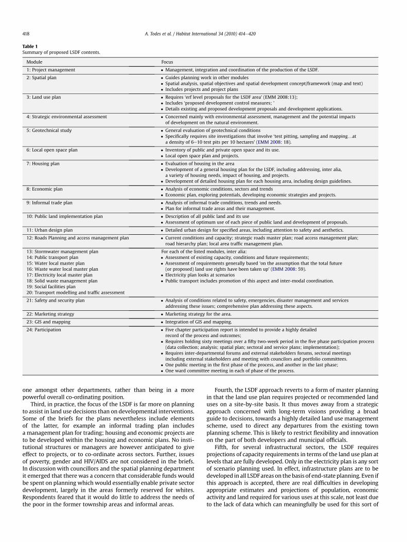
Table 1Summary of proposed LSDF contents.
Module Focus
1: Project management � Management, integration and coordination of the production of the LSDF.
2: Spatial plan � Guides planning work in other modules� Spatial analysis, spatial objectives and spatial development concept/framework (map and text)� Includes projects and project plans
3: Land use plan � Requires ‘erf level proposals for the LSDF area’ (EMM 2008:13);� Includes ‘proposed development control measures; ’� Details existing and proposed development proposals and development applications.
4: Strategic environmental assessment � Concerned mainly with environmental assessment, management and the potential impactsof development on the natural environment.
5: Geotechnical study � General evaluation of geotechnical conditions� Specifically requires site investigations that involve ‘test pitting, sampling and mapping.at
a density of 6e10 test pits per 10 hectares’ (EMM 2008: 18).
6: Local open space plan � Inventory of public and private open space and its use.� Local open space plan and projects.
7: Housing plan � Evaluation of housing in the area� Development of a general housing plan for the LSDF, including addressing, inter alia,a variety of housing needs, impact of housing, and projects.
� Development of detailed housing plan for each housing area, including design guidelines.
8: Economic plan � Analysis of economic conditions, sectors and trends� Economic plan, exploring potentials, developing economic strategies and projects.
9: Informal trade plan � Analysis of informal trade conditions, trends and needs.� Plan for informal trade areas and their management.
10: Public land implementation plan � Description of all public land and its use� Assessment of optimum use of each piece of public land and development of proposals.
11: Urban design plan � Detailed urban design for specified areas, including attention to safety and aesthetics.
12: Roads Planning and access management plan � Current conditions and capacity; strategic roads master plan; road access management plan;road hierarchy plan; local area traffic management plan.
13: Stormwater management plan14: Public transport plan15: Water local master plan16: Waste water local master plan17: Electricity local master plan18: Solid waste management plan19: Social facilities plan
For each of the listed modules, inter alia:� Assessment of existing capacity, conditions and future requirements;� Assessment of requirements generally based ‘on the assumption that the total future(or proposed) land use rights have been taken up’ (EMM 2008: 59).
� Electricity plan looks at scenarios� Public transport includes promotion of this aspect and inter-modal coordination.
20: Transport modelling and traffic assessment
21: Safety and security plan � Analysis of conditions related to safety, emergencies, disaster management and servicesaddressing these issues; comprehensive plan addressing these aspects.
22: Marketing strategy � Marketing strategy for the area.
23: GIS and mapping � Integration of GIS and mapping.
24: Participation � Five chapter participation report is intended to provide a highly detailedrecord of the process and outcomes;
� Requires holding sixty meetings over a fifty two-week period in the five phase participation process(data collection; analysis; spatial plan; sectoral and service plans; implementation);
� Requires inter-departmental forums and external stakeholders forums, sectoral meetingsincluding external stakeholders and meeting with councilors and portfolio committees.
� One public meeting in the first phase of the process, and another in the last phase;� One ward committee meeting in each of phase of the process.
A. Todes et al. / Habitat International 34 (2010) 414e420418
one amongst other departments, rather than being in a morepowerful overall co-ordinating position.
Third, in practice, the focus of the LSDF is far more on planningto assist in land use decisions than on developmental interventions.Some of the briefs for the plans nevertheless include elementsof the latter, for example an informal trading plan includesa management plan for trading; housing and economic projects areto be developed within the housing and economic plans. No insti-tutional structures or managers are however anticipated to giveeffect to projects, or to co-ordinate across sectors. Further, issuesof poverty, gender and HIV/AIDS are not considered in the briefs.In discussion with councillors and the spatial planning departmentit emerged that there was a concern that considerable funds wouldbe spent on planning which would essentially enable private sectordevelopment, largely in the areas formerly reserved for whites.Respondents feared that it would do little to address the needs ofthe poor in the former township areas and informal areas.
Fourth, the LSDF approach reverts to a form of master planningin that the land use plan requires projected or recommended landuses on a site-by-site basis. It thus moves away from a strategicapproach concerned with long-term visions providing a broadguide to decisions, towards a highly detailed land use managementscheme, used to direct any departures from the existing townplanning scheme. This is likely to restrict flexibility and innovationon the part of both developers and municipal officials.
Fifth, for several infrastructural sectors, the LSDF requiresprojections of capacity requirements in terms of the land use plan atlevels that are fully developed. Only in the electricity plan is any sortof scenario planning used. In effect, infrastructure plans are to bedeveloped in all LSDFareas on the basis of end-state planning. Even ifthis approach is accepted, there are real difficulties in developingappropriate estimates and projections of population, economicactivity and land required for various uses at this scale, not least dueto the lack of data which can meaningfully be used for this sort of
A. Todes et al. / Habitat International 34 (2010) 414e420 419
analysis. While some population figures exist at ward level, LSDFareas do not correspond to wards, and figures relating to employ-ment and economic activity are only available at much larger scales.
Sixth, there are problems associated with the scale and scope ofLSDFs, which compounds the difficulties associated with treatingeach as comprehensive ‘mini-national development plans’. Severalaspects of the modules included in the Scope of Work documentcould not be adequately dealt with at the specified local level suchas elements of environmental planning, housing, economic androads planning. What is useful as ‘local scale’ planning for variousissues (such as roads or housing) is not necessarily the same, and itis counterproductive to box them all together. The requirement toproduce a ‘plan’ for each of the topics addressed by the modules,rather simply asking for attention to these issues as appropriatecompounds this problem. Similarly, some spatial concepts used inthe regional and metropolitan spatial frameworks, such as corri-dors, cross-cut areas, and would not be appropriately addressedwithin a series of LSDFs. Further since each LSDF is likely to beproduced by different consultants, the task of alignment betweenvarious plans would be considerable.
Finally, the process formulated by the municipality with regard toitsmandate for broadbasedparticipationat variousphases of the LSDFprocess essentially reflects the attitude and approach that has gener-ally marked the document e an attempt at strategic, yet comprehen-sive vision and implementation. At one level, the municipality hassuggested processes that could be seen as progressive in that a verywide range of actors and stakeholders are to be included: formallyelected councillors, local ward committees, sector representatives,business, civil society organisations, officials and laypeople. Yet thecomplex but rigid process set up, requiring frequent meetings witha multitude of stakeholders over a short period of time, wouldnecessitate very tight scheduling and seamless execution, with verylittle room for error and iteration. Further, since LSDF areas do notcorrespond with ward boundaries, several ward committees wouldneed to be involved in each plan, increasing complexity, confusion andlogisticaldifficulties. Lastly,despite theattentiongiventoparticipation,groupswhich are not formally organisedwould have little voice in theprocess. Those working in planning and participation in South Africaand elsewhere (Sandercock, 2004; Sandercock & Forsyth, 1992;Watson, 2003) have highlighted the need to actively and consciouslyinclude thoseon themarginsof formalprocessesof resourceallocationand distribution, such as stakeholder groups like foreign nationals, theelderly, women and child-headed households, in this instance.
Conclusion
The paper has shown that the LSDF approach contains someinnovative aspects that are consistent with current planningthought, but it also includes elements of traditional spatial planningapproaches which have been criticised in the past: a highlycomprehensive approach which belies institutional capacity andwhich would be difficult tomanage and execute; a reliance on paperplans and insufficient attention to institutional issues and questionsof implementation; a relatively technocratic approach combinedwith a labyrinthine approach to participation; end-state land andinfrastructural planning; and difficulties in the ‘scale’ of planning.
There are tensions in the form of planning e between a strategicand a comprehensive approach, and between the objectives of a planto direct land use management and those related to developmentand to inter-sectoral integration. While there is considerableemphasis on ‘integrated planning’, in effect ‘integrated’ equates withcomprehensiveness, which is likely to be difficult to achieve. Mech-anisms to achieve integration are not well developed. Althoughthe forms of integration anticipated heremight be possible in specificcases and around particular projects, it seems unlikely to occur on the
systematic basis that is anticipated here. In practice, there is greaterfocus on planning to direct land use change than on more develop-mental planning, but the overly detailed end-state planning is likelyto make plans inflexible and unable to respond to change.
In the case of Ekurhuleni, the alternative would be to opt fora more focused approached e to undertake more detailed planningin areas of strategic importance, development pressure, expectedchange, and areas where significant interventions are anticipated.In these cases, the nature of planning e the sectors considered andthe way they are addressed e need to be shaped by the concernsand issue to be addressed. There is also space for a stronger focus ondevelopmental planning linked to implementation as a way toimprove conditions in poorer areas. Area based institutions to drivechange may be useful in this contest. Planning of this sort is con-cerned with facilitating development, with operational manage-ment, and with ‘soft’ projects as much as with capital works.
The research findings beg the question of why Ekurhulenireverted to what was in effect master planning. In the study con-ducted and in the interaction with the municipality, there was noevidence that this was occurring for political reasons as suggestedin some of the literature (Roy, 2009; UN-Habitat, 2009) althoughmodernist notions of planning were evident. The shift towardsmaster planning was not deliberate, but rather emerged from thepressures towards greater certainty in responding to developmentapplications, and from a conception of ‘integrated development’as comprehensive planning. Indeed planners were responsive tothe critique presented, and were prepared to shift to a more stra-tegic approach. Although the need for a flexible approach is writteninto legislation, it is in tension with the persistence of traditionalforms of land use planning. In the case of Ekurhuleni, this tension isexacerbated by the dominance of land use management as a focusfor planning. It is also apparent that the broad spatial frameworkswhich have been in use in South Africa are insufficient to manageurban development. While several municipalities have attemptedto introduce forms of planning which go beyond these limitations,there has not beenmuch formal interaction betweenmunicipalitiesaround these issues. Ekurhuleni was relatively isolated in thisregard.
Beyond the case of Ekurhuleni, there is a need to debate andexplore alternatives to traditional forms of spatial planning. Whilethe perpetuation of master planning or a reversion to traditionalforms of planning often occurs for political reasons, this is notnecessarily the case. Modernist conceptions of planning remain oreven are resurgent as is evident even in relation to urban designschemes in theUnited Kingdom. The intersection of newapproacheswith older land use management systems provides part of theexplanation. And exploration of alternatives is sometimes shaped bymodernist perspectives and discourses linked to traditional forms ofplanning. New languages are sometimes in use, but are not alwaysmeaningful in practice. In addition, new strategic spatial planningapproaches being put forward as an alternative to master planningare not necessarily being developed in ways that are sufficient tomanage urban development. There is a surprising lack of debate andexploration on alternative forms of spatial planning, yet there is anurgent need for such engagement.
Acknowledgements
Wewish to thank the Ekurhulenimunicipality for their permissionto publish the results of the study, for their openness in commis-sioning the work, and their active participation in the process. BrianBoshoff, Roger Behrens and Samson Kasala are thanked for theircontribution to the original assessment. The financial support of theNational Research Foundation is also acknowledged.
A. Todes et al. / Habitat International 34 (2010) 414e420420
References
Ahmed, N. (September 1989). Managing urban growth in Karachi. Paper presented tothe workshop on planning and management of urban development in the 1990s,Birmingham.
Ahmed, P. (October 2008). City of Johannesburg, development planning and urbanmanagement. Interview.
Berrisford, S. (March 2009). Planning and law consultant. Discussion.Clarke, G. (1992). Towards appropriate forms of urban planning. Habitat Interna-
tional, 16(2), 149e165.Devas, N. (1993). Evolving approaches. In N. Devas, & C. Rakodi (Eds.), Managing
fast-growing cities. Harlow: Longman.Dewar, D., & Uytenbogaardt, R. (1991). South African cities: A manifesto for change.
Cape Town: University of Cape Town.Ekurhuleni Metropolitan Municipality. (2008). Local spatial development framework
modules: scope of work.Farmer, P., Frojmovic, M., Hague, C., Harridge, C., Narang, S., Shishido, D., et al. (June
2006). Reinventing planning: a new governance paradigm for managing humansettlements. In Position paper for the World Planners Congress, Vancouver.
Giddings, B., & Hopwood, B. (2006). From evangelist bureaucrat to visionarydeveloper: the changing character of the master plan in Britain. PlanningPractice and Research, 21(3), 337e348.
Harris, N. (1983). Metropolitan planning in developing countries: tasks for the1980s. Habitat International, 7(3/4), 5e17.
Harrison, P. (2006). Integrated development plans and third way politics. InU. Pillay, R. Tomlinson, & J. du Toit (Eds.), Democracy and delivery: Urban policy inSouth Africa. Johannesburg: HSRC Press.
Harrison, P., Todes, A., & Watson, V. (2008). Planning and transformation. Lessonsfrom the South African experience. London: Routledge.
Healey, P. (2006). Urban complexity and spatial strategies: Towards a relationalplanning for our times. London: Routledge.
Healey, P., Khakee, A., Motte, A., & Needham, B. (Eds.). (1997). Making strategicspatial plans. Innovation in Europe. London: UCL Press.
Kasala, S. (2008). Dar es Salaam, paper for the phase 1 of the academic critique ofthe local spatial development framework modules.
Mabin, A. (1994). Urban crisis, growth management and the history of metropolitanplanning in South Africa. Paper presented at the South African Institute of Town andRegional Planners conference of growth management and cities in crisis, Cape Town.
Mabin, A., & Smit, D. (1997). Reconstructing South Africa's cities? The making ofurban planning 1900e2000. Planning Perspectives, 12, 193e223.
Mattingly, M. (2001). Spatial planning for urban infrastructure planning and invest-ment, A guide to training and practice. London: Development Planning Unit,University College London.
Mattingly, M., & Winarso, H. (2000). Urban spatial planning and public capitalinvestments. The experience of Indonesia's integrated urban infrastructure invest-ment programme. Development Planning Unit Working Paper 113, London.London: University College.
McNeil, D. (1983). The changing practice of urban planning. Habitat International, 7(5/6), 117e127.
Njoh, A. (2008). The emergence and spread of contemporary urban planning. Draftchapter for the global report on human settlements: revisiting planning. InReport to the UN-HABITAT, Nairobi.
Oakenfull, L. (1998). The chapter 1 principles: Practical experiences. Development andPlanning Commission Document 67/98. Pretoria: Development and PlanningCommission.
Robinson, P., McCarthy, J., & Forster, C. (Eds.). (2004). Urban reconstruction ina developing world. Sandown: Heinemann.
Roy, A. (2009). Why India cannot plan its cities: informality, insurgence and theidiom of urbanisation. Planning Theory, 8(1), 76e87.
Sandercock, L. (2004). Cosmopolis II: Mongrel cities of the 21st century. London:Continuum.
Sandercock, L., & Forsyth, A. (1992). Feminist theory and planning theory: theepistemological linkages. Planning Theory, 7-8, 45e49.
Sim, V. (October 2008) eThekwini planning and development department, interview.Singh, K., & Steinberg, F. (1996). Multi-sectoral investment planning approach for
integrated development of urban services. In K. Singh, F. Steinberg, & N. vonEinsiedel (Eds.), Integrated urban infrastructure development in Asia. London: ITPublications.
Todes, A. (2006). Urban spatial policy. In U. Pillay, R. Tomlinson, & J. Du Toit (Eds.),Democracy and delivery: Urban policy in South Africa. Johannesburg: HSRCPress.
Todes, A. (2008). Rethinking spatial planning. Town and Regional Planning, 53,10e14.
Todes, A., Pillay, C., & Krone, A. (2003). Urban restructuring and land availability. InF. Khan, & P. Thring (Eds.), Housing policy and practice in South Africa. CapeTown: University of Cape Town Press.
Todes, A., Sim, V., Singh, P., Hlubi, M., & Oelofse, C. (2005). Relationship betweenenvironment and planning in KwaZulu-Natal. In: KwaZulu-Natal ProvincialPlanning and Development Commission e Main Series, Vol. 77. 1e222.
Turok, I. (2000). Persistent polarisation post-Apartheid? Progress towards urbanintegration in Cape Town, urban change and policy research group discussionpaper 1. Glasgow: University of Glasgow.
UN-Habitat. (2009). Sustainable urbanisation: Revisiting the role of urban planning,global report on human settlements. Nairobi: UN-Habitat.
Walker, N. (October 2008). City of cape town spatial planning department,interview.
Watson, V. (2002). Change and continuity in spatial planning. Metropolitan planningin Cape Town under political transition. London: Routledge.
Watson, V. (2003). Conflicting rationalities: implications for planning theory andethics. Planning Theory and Practice, 4(4), 395e407.
Watson, V. (2008). Introduction, draft chapter for the Global Report on humansettlements: Revisiting planning. Report to the UN-HABITAT, Nairobi.
Watson, V. (2009). ‘The planned city sweeps the poor away.’. Urbanisation and21st century urbanisation. Progress in Planning, 72, 151e193.