Between Surface and Summit: the Process of Mound Construction at Feltus
11
Between Surface and Summit: the Process of Mound Construction at Feltus MEGAN C. KASSABAUM 1 * , EDWARD R. HENRY 2 , VINCAS P. STEPONAITIS 3 AND JOHN W. O’HEAR 4 1 Department of Anthropology and Research Laboratories of Archaeology, University of North Carolina, Chapel Hill, NC 27599, USA 2 Department of Anthropology, Washington University in St. Louis, St. Louis, MO 63130, USA 3 Research Laboratories of Archaeology, University of North Carolina, Chapel Hill, NC 27599, USA 4 Department of Sociology and Anthropology, The University of Mississippi, University, MS 38677-1848, USA ABSTRACT Geophysical methods that explore depths more than 1 m below the surface were employed at Feltus (22Je500), a Coles Creek period (AD 700–1200) mound-and-plaza group in southwestern Mississippi, USA. It is difficult to assess the internal structure of large platform mounds such as those at Feltus using excavation and traditional geophysical techniques alone. As a result, such investigations often focus only on activities that took place during and after the final stage(s) of construction. Our 2012 research at Feltus utilized electrical resistivity tomography and downhole magnetic susceptibility to examine the internal structure of two platform mounds at depths beyond those commonly targeted by shallow techniques. These methods revealed mound stages, prepared floors, midden and pit features, and construction attributes within the fill episodes. By refocusing our attention on the process of mound building rather than the final use of the mound summits, this research broadened our view of the role of monuments in creating and strengthening community ties. Copyright © 2014 John Wiley & Sons, Ltd. Key words: electrical resistivity tomography; downhole magnetic susceptibility; monument construction; stratigraphy; earthen platform mounds; eastern North America Introduction Historically, studies of mounds in the USA have emphasized their post-construction use (as either activity platforms or burial locations) through analysis of the cultural remains from mound tops and plazas (Sherwood and Kidder, 2011). Such studies have tended to focus on mounds as static structures rather than mound building as a dynamic process (Pauketat and Alt, 2003; Sherwood and Kidder, 2011; Ortmann and Kidder, 2013). Here we discuss the use of geophys- ical techniques that explore depths beyond those commonly targeted in shallow geophysics, that is, more than 1 m below surface, to provide a more dynamic view of mound construction and use at the Feltus site in southwestern Mississippi, USA. We used two geophysical techniques, electrical resistivity tomography and downhole magnetic susceptibility, with two goals in mind: (i) to relocate and map the extent of subsurface archaeological features that had previously been encountered at the site (e.g. clay floors, burned features, and middens); and (ii) to further assess the nature of mound construction through an investigation of stratigraphy (Henry and Johnson, 2012). In addition to locating and tracing the extent of mound surfaces, our research revealed previ- ously unknown midden deposits and feasting pits, and deepened our understanding of the techniques and cadence of mound construction. By refocusing our atten- tion on the process of mound building rather than the final use of the mound summits, this research broadened our view of the social relationships that may have been created, negotiated and enacted during the site’s use. A more dynamic view of mound building emphasizes the * Correspondence to: M. C. Kassabaum, Department of Anthropology and Research Laboratories of Archaeology, University of North Carolina, Chapel Hill, NC 27599, USA. E-mail: [email protected] Copyright © 2014 John Wiley & Sons, Ltd. Received 28 August 2013 Accepted 28 December 2013 Archaeological Prospection Archaeol. Prospect. 21, 27–37 (2014) Published online 4 February 2014 in Wiley Online Library (wileyonlinelibrary.com) DOI: 10.1002/arp.1473
Transcript of Between Surface and Summit: the Process of Mound Construction at Feltus
* Correspondence to: M. C.and Research LaboratorieCarolina, Chapel Hill, NC 2E-mail: [email protected]
Copyright © 2014 John
Archaeological ProspectionArchaeol. Prospect. 21, 27–37 (2014)Published online 4 February 2014 in Wiley Online Library(wileyonlinelibrary.com) DOI: 10.1002/arp.1473
Between Surface and Summit: the Process ofMound Construction at Feltus
MEGANC. KASSABAUM1*, EDWARDR. HENRY2, VINCAS P. STEPONAITIS3
AND JOHN W. O’HEAR4
1 Department of Anthropology and Research Laboratories of Archaeology, University of North Carolina,Chapel Hill, NC 27599, USA2 Department of Anthropology, Washington University in St. Louis, St. Louis, MO 63130, USA3 Research Laboratories of Archaeology, University of North Carolina, Chapel Hill, NC 27599, USA4 Department of Sociology and Anthropology, The University of Mississippi, University, MS 38677-1848, USA
ABSTRACT Geophysical methods that explore depths
more than 1m below the surface were employed at Feltus (22Je500), aColes Creek period (AD 700–1200) mound-and-plaza group in southwestern Mississippi, USA. It is difficult to assessthe internal structure of large platform mounds such as those at Feltus using excavation and traditional geophysicaltechniques alone. As a result, such investigations often focus only on activities that took place during and after the finalstage(s) of construction. Our 2012 research at Feltus utilized electrical resistivity tomography and downhole magneticsusceptibility to examine the internal structure of two platform mounds at depths beyond those commonly targeted byshallow techniques. These methods revealed mound stages, prepared floors, midden and pit features, andconstruction attributes within the fill episodes. By refocusing our attention on the process of mound building ratherthan the final use of the mound summits, this research broadened our view of the role of monuments in creatingand strengthening community ties. Copyright © 2014 John Wiley & Sons, Ltd.Key words: electrical resistivity tomography; downhole magnetic susceptibility; monument construction; stratigraphy;earthen platform mounds; eastern North America
Introduction
Historically, studies of mounds in the USA haveemphasized their post-construction use (as eitheractivity platforms or burial locations) through analysisof the cultural remains from mound tops and plazas(Sherwood and Kidder, 2011). Such studies havetended to focus on mounds as static structures ratherthan mound building as a dynamic process (Pauketatand Alt, 2003; Sherwood and Kidder, 2011; Ortmannand Kidder, 2013). Here we discuss the use of geophys-ical techniques that explore depths beyond thosecommonly targeted in shallow geophysics, that is,more than 1m below surface, to provide a more
Kassabaum, Department of Anthropologys of Archaeology, University of North7599, USA.du
Wiley & Sons, Ltd.
dynamic view of mound construction and use at theFeltus site in southwestern Mississippi, USA.We used two geophysical techniques, electrical
resistivity tomography and downhole magneticsusceptibility, with two goals in mind: (i) to relocateand map the extent of subsurface archaeologicalfeatures that had previously been encountered at thesite (e.g. clay floors, burned features, and middens);and (ii) to further assess the nature ofmound constructionthrough an investigation of stratigraphy (Henry andJohnson, 2012). In addition to locating and tracing theextent of mound surfaces, our research revealed previ-ously unknown midden deposits and feasting pits, anddeepened our understanding of the techniques andcadence of mound construction. By refocusing our atten-tion on the process of mound building rather than thefinal use of the mound summits, this research broadenedour view of the social relationships that may have beencreated, negotiated and enacted during the site’s use. Amore dynamic view of mound building emphasizes the
Received 28 August 2013Accepted 28 December 2013
28 M. C. Kassabaum et al.
variety of functions that platform mounds may haveserved throughout their lives and moves us away fromthe assumption that all platform mounds served primar-ily elite functions.
The Feltus mounds
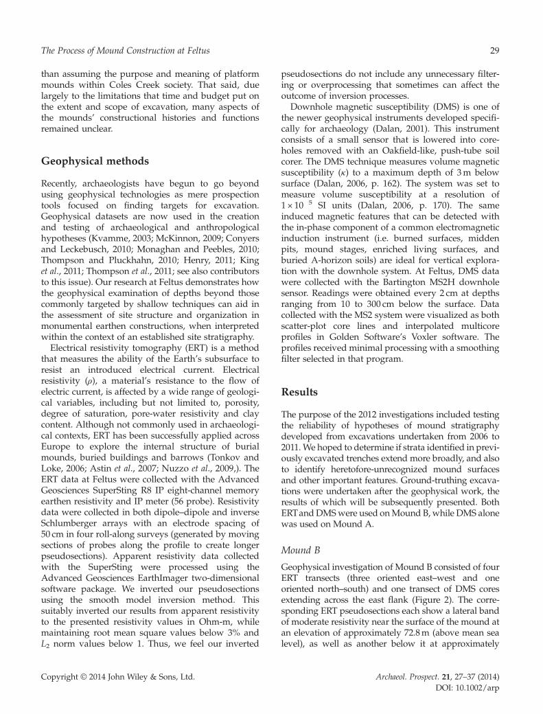
Coles Creek culture flourished in the southern part ofthe Lower Mississippi River Valley from AD 700 to1200. Coles Creek sites are best known for a distinctivepottery style and flat-topped mounds arranged aroundplazas (Steponaitis, 1986, p. 385; Kidder, 2002, p. 85).Due in large part to the presence of these platform-mound-and-plaza complexes, archaeologists oftenlook to Coles Creek for early evidence of sociopoliticalhierarchy and other defining characteristics of laterMississippian societies. Although some Mississippiantraits do have their roots in Coles Creek developments,Coles Creek also represents a continuation of manyearlier patterns. Gaining a better understanding ofthe nature of Coles Creek society relies on gatheringdetailed knowledge about the variety of activities thattook place on and around the mounds.The Feltusmound group (22Je500) is a well-preserved
Coles Creek site in southwestern Mississippi (Figure 1).It is situated on the edge of 30-m-high loess bluffs
Figure 1. Topographic map of the Feltus Mounds in southwesternMississippi. Contour interval, 1m. Note that Mound D no longerexists, and only its former location is shown with stippling.
Copyright © 2014 John Wiley & Sons, Ltd.
overlooking the Mississippi alluvial valley. The siteoriginally consisted of four platformmounds symmetri-cally arranged around a plaza. Three mounds (A, B andC) stand today, but the smallest (D), at the south end ofthe plaza, was destroyed sometime between 1935 and1947. From 2006 to 2011, we excavated in each of thethree extant mounds and in the south plaza near theformer location ofMoundD. These excavations revealeda great deal about the constructional history and use ofthe mounds (Steponaitis et al., 2007, 2010, 2012; O’Hearet al., 2009).Mound A, on the north side of the plaza, is 7m tall.
Initial investigations showed that the mound was builtin three stages: an original construction 2m high,capped by two massive fill deposits that raised themound an additional 5m. The mound was built atopan extremely rich, dense, and well-preserved middenresulting from one or more rapid dumping episodes,probably associated with feasting (Kassabaum, 2013).However, unlike many other Coles Creek mounds,Mound A at Feltus yielded no evidence of woodenbuildings or occupational debris on its summits. Thisindicates either that its primary use was not as afoundation for a building, or that all evidence of suchuse was carefully removed prior to the next phase ofmound construction.Mound B is 6m tall and was found to have an inter-
nal structure different from that of Mound A, with fivestages of construction clearly evident. Each stage wasveneered with a thin clay cap, and some of the surfacesshowed evidence of postholes and fire-reddenedfloors, suggestive of burned wooden buildings.Mound C, 4m tall, was excavated by Warren King
Moorehead in 1924 (Moorehead, 1932). He founddisarticulated human remains and bundle burials withvirtually no grave goods — a typical Coles Creekpattern (Kassabaum, 2011). A flank trench excavated in2006 exposed two stages of construction and coring nearthe summit revealed at least one more. Moorehead’sburials were all associated with the final stage and theirinclusion may represent a decommissioning event.Moorehead also excavated Mound D, at the south endof the plaza, and found several bundle burialssuggesting that it was similar in form and function toMound C.Our excavations thus revealed dramatic structural
and functional differences among the mounds. MoundA showed little evidence of surfaces and no evidenceof buildings; Mound B showed multiple, clearlydefined surfaces with prepared floors and buildings;and Mounds C and D were connected with mortuaryactivities. These dramatic differences in moundfunction speak to the importance of determining rather
Archaeol. Prospect. 21, 27–37 (2014)DOI: 10.1002/arp
29The Process of Mound Construction at Feltus
than assuming the purpose and meaning of platformmounds within Coles Creek society. That said, duelargely to the limitations that time and budget put onthe extent and scope of excavation, many aspects ofthe mounds’ constructional histories and functionsremained unclear.
Geophysical methods
Recently, archaeologists have begun to go beyondusing geophysical technologies as mere prospectiontools focused on finding targets for excavation.Geophysical datasets are now used in the creationand testing of archaeological and anthropologicalhypotheses (Kvamme, 2003; McKinnon, 2009; Conyersand Leckebusch, 2010; Monaghan and Peebles, 2010;Thompson and Pluckhahn, 2010; Henry, 2011; Kinget al., 2011; Thompson et al., 2011; see also contributorsto this issue). Our research at Feltus demonstrates howthe geophysical examination of depths beyond thosecommonly targeted by shallow techniques can aid inthe assessment of site structure and organization inmonumental earthen constructions, when interpretedwithin the context of an established site stratigraphy.Electrical resistivity tomography (ERT) is a method
that measures the ability of the Earth’s subsurface toresist an introduced electrical current. Electricalresistivity (ρ), a material’s resistance to the flow ofelectric current, is affected by a wide range of geologi-cal variables, including but not limited to, porosity,degree of saturation, pore-water resistivity and claycontent. Although not commonly used in archaeologi-cal contexts, ERT has been successfully applied acrossEurope to explore the internal structure of burialmounds, buried buildings and barrows (Tonkov andLoke, 2006; Astin et al., 2007; Nuzzo et al., 2009,). TheERT data at Feltus were collected with the AdvancedGeosciences SuperSting R8 IP eight-channel memoryearthen resistivity and IP meter (56 probe). Resistivitydata were collected in both dipole–dipole and inverseSchlumberger arrays with an electrode spacing of50 cm in four roll-along surveys (generated by movingsections of probes along the profile to create longerpseudosections). Apparent resistivity data collectedwith the SuperSting were processed using theAdvanced Geosciences EarthImager two-dimensionalsoftware package. We inverted our pseudosectionsusing the smooth model inversion method. Thissuitably inverted our results from apparent resistivityto the presented resistivity values in Ohm-m, whilemaintaining root mean square values below 3% andL2 norm values below 1. Thus, we feel our inverted
Copyright © 2014 John Wiley & Sons, Ltd.
pseudosections do not include any unnecessary filter-ing or overprocessing that sometimes can affect theoutcome of inversion processes.Downhole magnetic susceptibility (DMS) is one of
the newer geophysical instruments developed specifi-cally for archaeology (Dalan, 2001). This instrumentconsists of a small sensor that is lowered into core-holes removed with an Oakfield-like, push-tube soilcorer. The DMS technique measures volume magneticsusceptibility (κ) to a maximum depth of 3m belowsurface (Dalan, 2006, p. 162). The system was set tomeasure volume susceptibility at a resolution of1 × 10�5 SI units (Dalan, 2006, p. 170). The sameinduced magnetic features that can be detected withthe in-phase component of a common electromagneticinduction instrument (i.e. burned surfaces, middenpits, mound stages, enriched living surfaces, andburied A-horizon soils) are ideal for vertical explora-tion with the downhole system. At Feltus, DMS datawere collected with the Bartington MS2H downholesensor. Readings were obtained every 2 cm at depthsranging from 10 to 300 cm below the surface. Datacollected with the MS2 system were visualized as bothscatter-plot core lines and interpolated multicoreprofiles in Golden Software’s Voxler software. Theprofiles received minimal processing with a smoothingfilter selected in that program.
Results
The purpose of the 2012 investigations included testingthe reliability of hypotheses of mound stratigraphydeveloped from excavations undertaken from 2006 to2011.We hoped to determine if strata identified in previ-ously excavated trenches extend more broadly, and alsoto identify heretofore-unrecognized mound surfacesand other important features. Ground-truthing excava-tions were undertaken after the geophysical work, theresults of which will be subsequently presented. BothERTandDMSwere used onMound B, while DMS alonewas used on Mound A.
Mound B
Geophysical investigation of Mound B consisted of fourERT transects (three oriented east–west and oneoriented north–south) and one transect of DMS coresextending across the east flank (Figure 2). The corre-sponding ERT pseudosections each show a lateral bandof moderate resistivity near the surface of the mound atan elevation of approximately 72.8m (above mean sealevel), as well as another below it at approximately
Archaeol. Prospect. 21, 27–37 (2014)DOI: 10.1002/arp
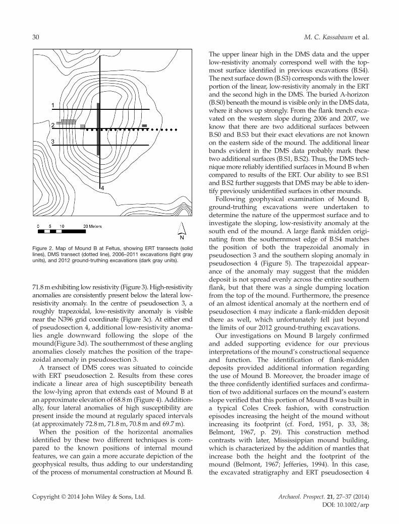
Figure 2. Map of Mound B at Feltus, showing ERT transects (solidlines), DMS transect (dotted line), 2006–2011 excavations (light grayunits), and 2012 ground-truthing excavations (dark gray units).
30 M. C. Kassabaum et al.
71.8mexhibiting low resistivity (Figure 3).High-resistivityanomalies are consistently present below the lateral low-resistivity anomaly. In the centre of pseudosection 3, aroughly trapezoidal, low-resistivity anomaly is visiblenear the N396 grid coordinate (Figure 3c). At either endof pseudosection 4, additional low-resistivity anoma-lies angle downward following the slope of themound(Figure 3d). The southernmost of these anglinganomalies closely matches the position of the trape-zoidal anomaly in pseudosection 3.A transect of DMS cores was situated to coincide
with ERT pseudosection 2. Results from these coresindicate a linear area of high susceptibility beneaththe low-lying apron that extends east of Mound B atan approximate elevation of 68.8m (Figure 4). Addition-ally, four lateral anomalies of high susceptibility arepresent inside the mound at regularly spaced intervals(at approximately 72.8m, 71.8m, 70.8m and 69.7m).When the position of the horizontal anomalies
identified by these two different techniques is com-pared to the known positions of internal moundfeatures, we can gain a more accurate depiction of thegeophysical results, thus adding to our understandingof the process of monumental construction at Mound B.
Copyright © 2014 John Wiley & Sons, Ltd.
The upper linear high in the DMS data and the upperlow-resistivity anomaly correspond well with the top-most surface identified in previous excavations (B.S4).The next surface down (B.S3) corresponds with the lowerportion of the linear, low-resistivity anomaly in the ERTand the second high in the DMS. The buried A-horizon(B.S0) beneath themound is visible only in the DMS data,where it shows up strongly. From the flank trench exca-vated on the western slope during 2006 and 2007, weknow that there are two additional surfaces betweenB.S0 and B.S3 but their exact elevations are not knownon the eastern side of the mound. The additional linearbands evident in the DMS data probably mark thesetwo additional surfaces (B.S1, B.S2). Thus, the DMS tech-nique more reliably identified surfaces in Mound Bwhencompared to results of the ERT. Our ability to see B.S1and B.S2 further suggests that DMS may be able to iden-tify previously unidentified surfaces in other mounds.Following geophysical examination of Mound B,
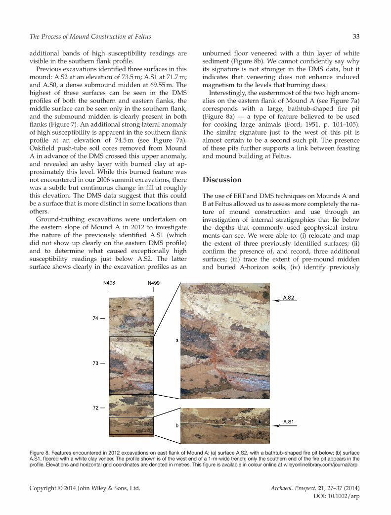
ground-truthing excavations were undertaken todetermine the nature of the uppermost surface and toinvestigate the sloping, low-resistivity anomaly at thesouth end of the mound. A large flank midden origi-nating from the southernmost edge of B.S4 matchesthe position of both the trapezoidal anomaly inpseudosection 3 and the southern sloping anomaly inpseudosection 4 (Figure 5). The trapezoidal appear-ance of the anomaly may suggest that the middendeposit is not spread evenly across the entire southernflank, but that there was a single dumping locationfrom the top of the mound. Furthermore, the presenceof an almost identical anomaly at the northern end ofpseudosection 4 may indicate a flank-midden depositthere as well, which unfortunately fell just beyondthe limits of our 2012 ground-truthing excavations.Our investigations on Mound B largely confirmed
and added supporting evidence for our previousinterpretations of the mound’s constructional sequenceand function. The identification of flank-middendeposits provided additional information regardingthe use of Mound B. Moreover, the broader image ofthe three confidently identified surfaces and confirma-tion of two additional surfaces on the mound’s easternslope verified that this portion of Mound B was built ina typical Coles Creek fashion, with constructionepisodes increasing the height of the mound withoutincreasing its footprint (cf. Ford, 1951, p. 33, 38;Belmont, 1967, p. 29). This construction methodcontrasts with later, Mississippian mound building,which is characterized by the addition of mantles thatincrease both the height and the footprint of themound (Belmont, 1967; Jefferies, 1994). In this case,the excavated stratigraphy and ERT pseudosection 4
Archaeol. Prospect. 21, 27–37 (2014)DOI: 10.1002/arp
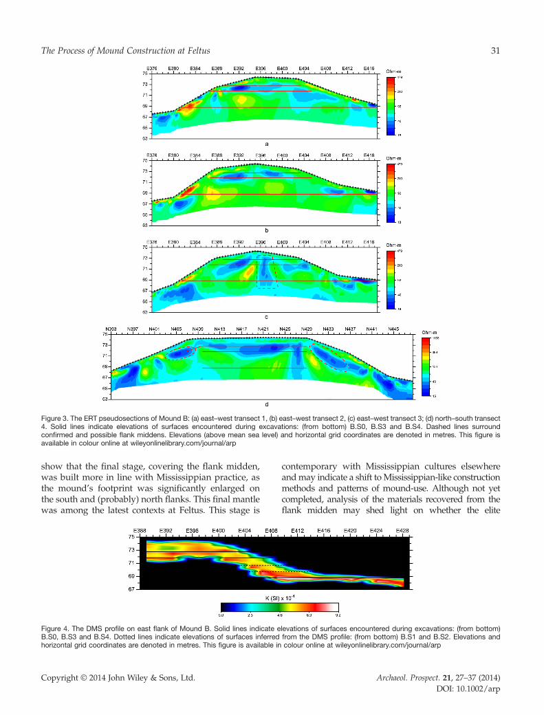
Figure 3. The ERT pseudosections of Mound B: (a) east–west transect 1, (b) east–west transect 2, (c) east–west transect 3; (d) north–south transect4. Solid lines indicate elevations of surfaces encountered during excavations: (from bottom) B.S0, B.S3 and B.S4. Dashed lines surroundconfirmed and possible flank middens. Elevations (above mean sea level) and horizontal grid coordinates are denoted in metres. This figure isavailable in colour online at wileyonlinelibrary.com/journal/arp
31The Process of Mound Construction at Feltus
show that the final stage, covering the flank midden,was built more in line with Mississippian practice, asthe mound’s footprint was significantly enlarged onthe south and (probably) north flanks. This final mantlewas among the latest contexts at Feltus. This stage is
Figure 4. The DMS profile on east flank of Mound B. Solid lines indicate eB.S0, B.S3 and B.S4. Dotted lines indicate elevations of surfaces inferredhorizontal grid coordinates are denoted in metres. This figure is available in
Copyright © 2014 John Wiley & Sons, Ltd.
contemporary with Mississippian cultures elsewhereandmay indicate a shift toMississippian-like constructionmethods and patterns of mound-use. Although not yetcompleted, analysis of the materials recovered from theflank midden may shed light on whether the elite
levations of surfaces encountered during excavations: (from bottom)from the DMS profile: (from bottom) B.S1 and B.S2. Elevations andcolour online at wileyonlinelibrary.com/journal/arp
Archaeol. Prospect. 21, 27–37 (2014)DOI: 10.1002/arp
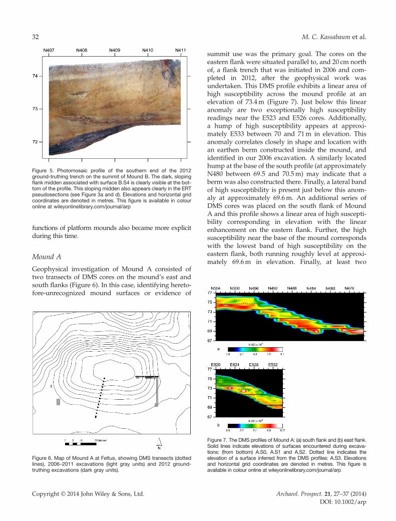
Figure 5. Photomosaic profile of the southern end of the 2012ground-truthing trench on the summit of Mound B. The dark, slopingflank midden associated with surface B.S4 is clearly visible at the bot-tom of the profile. This sloping midden also appears clearly in the ERTpseudosections (see Figure 3a and d). Elevations and horizontal gridcoordinates are denoted in metres. This figure is available in colouronline at wileyonlinelibrary.com/journal/arp
32 M. C. Kassabaum et al.
functions of platform mounds also became more explicitduring this time.
Mound A
Geophysical investigation of Mound A consisted oftwo transects of DMS cores on the mound’s east andsouth flanks (Figure 6). In this case, identifying hereto-fore-unrecognized mound surfaces or evidence of
Figure 6. Map of Mound A at Feltus, showing DMS transects (dottedlines), 2006–2011 excavations (light gray units) and 2012 ground-truthing excavations (dark gray units).
Copyright © 2014 John Wiley & Sons, Ltd.
summit use was the primary goal. The cores on theeastern flank were situated parallel to, and 20 cm northof, a flank trench that was initiated in 2006 and com-pleted in 2012, after the geophysical work wasundertaken. This DMS profile exhibits a linear area ofhigh susceptibility across the mound profile at anelevation of 73.4m (Figure 7). Just below this linearanomaly are two exceptionally high susceptibilityreadings near the E523 and E526 cores. Additionally,a hump of high susceptibility appears at approxi-mately E533 between 70 and 71m in elevation. Thisanomaly correlates closely in shape and location withan earthen berm constructed inside the mound, andidentified in our 2006 excavation. A similarly locatedhump at the base of the south profile (at approximatelyN480 between 69.5 and 70.5m) may indicate that aberm was also constructed there. Finally, a lateral bandof high susceptibility is present just below this anom-aly at approximately 69.6m. An additional series ofDMS cores was placed on the south flank of MoundA and this profile shows a linear area of high suscepti-bility corresponding in elevation with the linearenhancement on the eastern flank. Further, the highsusceptibility near the base of the mound correspondswith the lowest band of high susceptibility on theeastern flank, both running roughly level at approxi-mately 69.6m in elevation. Finally, at least two
Figure 7. The DMS profiles of Mound A: (a) south flank and (b) east flank.Solid lines indicate elevations of surfaces encountered during excava-tions: (from bottom) A.S0, A.S1 and A.S2. Dotted line indicates theelevation of a surface inferred from the DMS profiles: A.S3. Elevationsand horizontal grid coordinates are denoted in metres. This figure isavailable in colour online at wileyonlinelibrary.com/journal/arp
Archaeol. Prospect. 21, 27–37 (2014)DOI: 10.1002/arp
33The Process of Mound Construction at Feltus
additional bands of high susceptibility readings arevisible in the southern flank profile.Previous excavations identified three surfaces in this
mound: A.S2 at an elevation of 73.5m; A.S1 at 71.7m;and A.S0, a dense submound midden at 69.55m. Thehighest of these surfaces can be seen in the DMSprofiles of both the southern and eastern flanks, themiddle surface can be seen only in the southern flank,and the submound midden is clearly present in bothflanks (Figure 7). An additional strong lateral anomalyof high susceptibility is apparent in the southern flankprofile at an elevation of 74.5m (see Figure 7a).Oakfield push-tube soil cores removed from MoundA in advance of the DMS crossed this upper anomaly,and revealed an ashy layer with burned clay at ap-proximately this level. While this burned feature wasnot encountered in our 2006 summit excavations, therewas a subtle but continuous change in fill at roughlythis elevation. The DMS data suggest that this couldbe a surface that is more distinct in some locations thanothers.Ground-truthing excavations were undertaken on
the eastern slope of Mound A in 2012 to investigatethe nature of the previously identified A.S1 (whichdid not show up clearly on the eastern DMS profile)and to determine what caused exceptionally highsusceptibility readings just below A.S2. The lattersurface shows clearly in the excavation profiles as an
Figure 8. Features encountered in 2012 excavations on east flank of MoundA.S1, floored with a white clay veneer. The profile shown is of the west end oprofile. Elevations and horizontal grid coordinates are denoted in metres. This
Copyright © 2014 John Wiley & Sons, Ltd.
unburned floor veneered with a thin layer of whitesediment (Figure 8b). We cannot confidently say whyits signature is not stronger in the DMS data, but itindicates that veneering does not enhance inducedmagnetism to the levels that burning does.Interestingly, the easternmost of the two high anom-
alies on the eastern flank of Mound A (see Figure 7a)corresponds with a large, bathtub-shaped fire pit(Figure 8a) — a type of feature believed to be usedfor cooking large animals (Ford, 1951, p. 104–105).The similar signature just to the west of this pit isalmost certain to be a second such pit. The presenceof these pits further supports a link between feastingand mound building at Feltus.
Discussion
The use of ERT and DMS techniques on Mounds A andB at Feltus allowed us to assess more completely the na-ture of mound construction and use through aninvestigation of internal stratigraphies that lie belowthe depths that commonly used geophysical instru-ments can see. We were able to: (i) relocate and mapthe extent of three previously identified surfaces; (ii)confirm the presence of, and record, three additionalsurfaces; (iii) trace the extent of pre-mound middenand buried A-horizon soils; (iv) identify previously
A: (a) surface A.S2, with a bathtub-shaped fire pit below; (b) surfacef a 1-m-wide trench; only the southern end of the fire pit appears in thefigure is available in colour online at wileyonlinelibrary.com/journal/arp
Archaeol. Prospect. 21, 27–37 (2014)DOI: 10.1002/arp
34 M. C. Kassabaum et al.
unknown features such as flank midden deposits andfired pits; and (v) record differential fill zones withinmound construction episodes. Although our initialinterpretations of the constructional history andfunction of Mound B were largely confirmed by theDMS data, the use of ERTwas successful at identifyingnew midden features associated with the penultimatemound summit. The ERT allowed us to identify twoflank-midden deposits and roughly determine theirshape and extent, while ground-truthing excavationsallowed us to determine the character and contents ofthe midden.In the case of Mound A, the discovery of a
previously unrecognized burned surface and two largecooking pits using DMS greatly changed our interpre-tation of the mound’s function and history of use. Byusing geophysical methods to assess areas of earthenmonuments between the surface and the summit, wefeel that we have more completely evaluated theseColes Creek period mounds than we could have usingeither traditional excavation strategies or shallowgeophysical techniques. For instance, the probableidentification of a construction berm in the east slopeprofile (and possibly also in the south slope profile)reinforces the idea that DMS, as well as other geophys-ical techniques that explore further than 1m belowsurface, may allow us to see interesting features withinmound stages (Monaghan and Peebles, 2010; Henryet al., 2014). Moreover, we were able to see evidenceof mound use from earlier stages in Mound A’sconstruction history.These features indicate that feasting activity took
place not only before the mound was built, but alsoduring the multiple phases of its construction. Themidden under Mound A is over 20 cm thick and fullof broken pottery, charcoal and animal bones.Numerous lines of evidence suggest that the middenwas deposited rapidly and that it was covered bymound fill immediately after its deposition. Thus, boththe submound midden and the bathtub-shaped pitsare directly associated with mound constructionepisodes andmay indicate that feasting andmoundbuild-ing were linked as parts of a ritual cycle. Elsewhere,Kassabaum has argued that the nature of the materialobjects and substances included in this sequence suggesta ritual cycle that emphasizes the similarities andconnections between the participating group rather thanthe differences among its members (Kassabaum andNelson, 2014; Nelson and Kassabaum, 2014).In his often-cited article, Trigger (1990, p. 119) states
that monumental constructions have two principaldefining features: (i) their scale and elaboration exceedthe requirements ofmere utilitarian function; and (ii) their
Copyright © 2014 John Wiley & Sons, Ltd.
construction necessitates some organization of labourand resources beyond that of the household unit. He goeson to argue that because of their labour and surplusrequirements, monumental constructions correlate withincreasing stratification and differentiation within asociety. This view has historically dominated interpreta-tions of platform mounds, especially when combinedwith sixteenth and eighteenth century European accountsof the American South that connect chiefly status withmound-top residences. However, recent literature onmounds in this region has emphasized the importanceof understanding the variety of roles that mounds mighthave played in past societies (Lindauer and Blitz, 1997;Pauketat and Alt, 2003; Milner, 2004; Pauketat, 2007;Kassabaum et al., 2011).It is particularly important to recognize the wide
variety of mounds’ potential functions and meaningsin the Coles Creek case. Due to its position just beforethe rise of decidedly hierarchical Mississippiancultures in the region, Coles Creek social organizationhas been the focus of much recent research (Kidder,1992; Kidder and Fritz, 1993; Wells, 1998; Barker,1999; Schilling, 2004; Roe, 2010; Kassabaum, 2011).Like later Mississippian sites, Coles Creek moundsites are characterized by large platform moundsarranged around open plazas and this has commonlybeen taken as evidence for institutionalized statusdifferentiation. However, Coles Creek sites lack othertraits commonly associated with this type of organi-zation. For example, Coles Creek sites lack evidencefor large-scale consumption of crops (Kidder andFritz, 1993; Fritz and Kidder, 2000; Roberts, 2006;Listi, 2008). Likewise, the Coles Creek mortuaryprogramme looks egalitarian and there is no evidencefor long-distance trade or accumulation of statusitems (Kassabaum, 2011). The material evidence forColes Creek sociopolitical organization thus remainsambiguous, and it is important to consider the possi-bility that the Coles Creek platform mounds may nothave served the same functions as their later Missis-sippian counterparts. Changes in mound constructionpractices from Coles Creek toMississippian times maybe indicative of these potential differences (Belmont,1967; Jefferies, 1994).Moreover, despite similarities in their final form, the
mounds at Feltus show dramatic functional differences.Mound A was constructed rapidly in relatively few,large episodes. Its construction was associated withcommunal feasts and its summits show no evidence ofbuildings or regular, repeated use. Mound B was builtmore gradually and shows multiple, clearly definedfloors with prepared surfaces and postholes. Its sequen-tial summits show evidence of substantial summit use,
Archaeol. Prospect. 21, 27–37 (2014)DOI: 10.1002/arp

35The Process of Mound Construction at Feltus
including at least some wooden constructions. MoundsC and D were connected with mortuary activities.Finally, in order to fully acknowledge the variety of
functions that platform mounds may have served, itis necessary to look at a mound’s entire history. ‘Thequestion of mound function may be misplaced if byfunction we mean the end product and its use as afinished, unitary form after construction was complete… [instead] it seems reasonable to infer the mound wasa ritual feature whose significance lies, at least in part,in the act of its construction’ (Ortmann and Kidder,2013, p. 79). This focus on process is longstanding inthe broader literature on monumental architecture (e.g.Tilley, 1994; Bender, 1998; Phear, 2007) and has beengaining wider acceptance within the USA (Knight,1981, 1989; Pauketat and Alt, 2003; Sherwood andKidder, 2011; Ortmann and Kidder, 2013). Given thenecessary association between monumental construc-tions and communal building practices, it is likely thata large number of people would have played a part inthe creation and interpretation of monuments duringtheir construction (Bradley, 1991; Barrett, 1994; Brück,2001; Pauketat and Alt, 2003; Ashmore, 2004; Pauketat,2007). This communal production of meaning undoubt-edly had the ability to expand the significance ofmonuments beyond the inscription of political powerrelationships as posited by Trigger (1990) and into theformation and negotiation of a group identity.Innovations in geoarchaeological and geophysical
techniques have greatly facilitated research on moundconstruction processes in North America (such assediment selection, pace and duration of construction,specific construction techniques, and labour require-ments) (Monaghan and Peebles, 2010; Sherwood andKidder, 2011; Ortmann and Kidder, 2013). The use ofgeophysical techniques that target deep depositsallows access to deeply buried mound stages withoutthe time and energy expenditure of traditional excava-tions. This access helps us to gain a more dynamicview of mound building, one that recognizes the roleof communal building practices in maintaining socialcohesion and creating group identities.
Acknowledgements
This paper was presented originally at the 69th AnnualMeeting of the Southeastern Archaeological Conferencein Baton Rouge, Louisiana in 2012. The work wasfunded in part by an Archaeological Research Grantfrom the Mississippi Department of Archives andHistory and by the Graham Research Fund at theUniversity of North Carolina at Chapel Hill. DavidCranford, Erin Nelson, and the students on our 2012
Copyright © 2014 John Wiley & Sons, Ltd.
excavation crew provided expertise and labour on theproject. The geophysical equipment was graciously pro-vided by Dr Jay Johnson of the Center for ArchaeologicalResearch and Dr Craig Hickey of the National Center forPhysical Acoustics, both at the University of Mississippi.We are grateful to Buck Banker, Sr., Buck Banker, Jr.and Sonny Freeman for permission to excavate andthe use of their equipment, and to our many otherfriends in Natchez, too numerous to list, for their helpand support.
References
Astin T, Eckardt H, Hay S. 2007. Resistivity imagingsurvey of the Roman barrows at Bartlow, Cambridge-shire, UK. Archaeological Prospection 14(1): 24–37. DOI:10.1002/arp.287.
Ashmore W. 2004. Social archaeologies of landscape. In ACompanion to Social Archaeology, Meskell L, Preucel RW(eds). Blackwell Publishers: Malden, MA; 255–271.
Barker AW. 1999. Chiefdoms and the economics ofperversity. PhD dissertation, Department of Anthropol-ogy, University of Michigan: Ann Arbor.
Barrett JC. 1994. Fragments from Antiquity: An Archaeology ofSocial Life in Britain, 2900–1200BC. Blackwell: Oxford.
Belmont J. 1967. The culture sequence at the Greenhousesite. Southeastern Archaeological Conference Bulletin 6:27–35.
Bender B. 1998. Stonehenge: Making Space. Berg Publishers:Oxford.
Bradley R. 1991. Ritual, time and history. World Archaeol-ogy 23: 209–219.
Brück J. 2001. Monuments, power and personhood in theBritish Neolithic. The Journal of the Royal AnthropologicalInstitute 7(4): 649–667.
Conyers LB, Leckebusch J. 2010. Geophysical archaeologyresearch agendas for the future: some ground-penetrating radar examples. Archaeological Prospection17(2): 117–123. DOI: 10.1002/arp.379.
Dalan RA. 2001. A magnetic susceptibility logger forarchaeological application. Geoarchaeology 16(3):263–273.
Dalan RA. 2006. Magnetic susceptibility. In RemoteSensing in Archaeology: An Explicitly North AmericanPerspective, Johnson JK (ed.). University of AlabamaPress: Tuscaloosa; 161–203.
Ford JA. 1951. Greenhouse: A Troyville–Coles Creek PeriodSite in Avoyelles Parish, Louisiana. AnthropologicalPapers, 11(1). American Museum of Natural History:New York, NY.
Fritz GJ, Kidder TR. 2000. Recent investigations intoprehistoric agriculture in the Lower Mississippi Valley.In Imperfect Balance: Landscape Transformations in thePre-Columbian Americas, Lentz D (ed.). ColumbiaUniversity Press: New York, NY; 1–14.
Henry ER. 2011. A multi-stage geophysical approach todetecting and interpreting archaeological features atthe LeBus Circle, Bourbon County, Kentucky. Archae-ological Prospection 18(4): 231–244. DOI: 10.1002/arp.418.
Archaeol. Prospect. 21, 27–37 (2014)DOI: 10.1002/arp
36 M. C. Kassabaum et al.
Henry ER, Johnson JK. 2012. Geophysical Investigationsat Feltus Mounds (22Je568), Jefferson County, MS. Re-port prepared for Mississippi Department of Archivesand History, Jackson.
Henry ER, Laracuente NR, Case JS, Johnson JK. 2014.Incorporating multi-staged geophysical data intoregional-scale models: a case study from an Adenaburial mound in central Kentucky. ArchaeologicalProspection 21(1): 15–26. DOI: 10.1002/arp.1474
Jefferies RW. 1994. The Swift Creek site and woodlandplatform mounds in the southeastern United States. InOcmulgee Archaeology 1936–1986, Hally D (ed.).University of Georgia Press: Athens; 71–83.
Kassabaum MC. 2011. Looking beyond the obvious:identifying patterns in Coles Creek mortuary data.Southeastern Archaeology 30(2): 215–225.
Kassabaum MC. 2013. Feasting reconceptualized: a viewfrom the American South. Paper presented at the Societyfor American Archaeology Conference, Honolulu, Hawaii.
Kassabaum MC, Nelson ES. 2014. Standing posts andspecial substances: ritual deposition at Feltus, JeffersonCounty, Mississippi. To appear in Theorizing Ritual De-position, Purcell C, Giles B (eds). University of FloridaPress: Gainesville, FL.
Kassabaum MC, Cranford DJ, Nelson ES. 2011. Multiplemodes of monumentality: case studies from theAmerican South. The SAA Archaeological Record 11(4):33–37.
Kidder TR. 1992. Coles Creek Period social organiza-tion and evolution in northeast Louisiana. In Lordsof the Southeast: Social Inequality and the Native Elitesof Southeastern North America, Barker A, Pauketat T(eds). Archaeological Papers of the AmericanAnthropological Association, No. 3: Washington,DC; 145–162.
Kidder TR. 2002. Woodland Period archaeology of theLower Mississippi Valley. In The Woodland Southeast,Anderson DG, Mainfort RC (eds). University ofAlabama Press: Tuscaloosa; 66–90.
Kidder TR, Fritz GJ. 1993. Subsistence and social changein the Lower Mississippi Valley: the Reno Brake andOsceola sites, Louisiana. Journal of Field Archaeology20(3): 281–297.
King A, Walker CP, Sharp RV, Reilly FK, McKinnon DP.2011. Remote Sensing Data from Etowah’s Mound A:Architecture and the Re-Creation of the MississippianTradition. American Antiquity 76(2): 355–371.
Knight VJ. 1981. Mississippian ritual. PhD dissertation,Department of Anthropology, University of Florida:Gainesville.
Knight VJ. 1989. Symbolism of Mississippian mounds. InPowhatan’s Mantle: Indians in the Colonial Southeast,Wood PH, Waselkov GA, Hatley MT (eds). Universityof Nebraska Press: Lincoln; 279–291.
Kvamme K 2003. Geophysical surveys as landscapearchaeology. American Antiquity 68(3): 435–457.
Lindauer O, Blitz JH. 1997. Higher ground: the archaeol-ogy of North American platform mounds. Journal ofArchaeological Research 5(2): 169–207.
Listi G. 2008. Bioarchaeological analysis of diet andnutrition during the Coles Creek Period in the LowerMississippi Valley. PhD dissertation, Department ofAnthropology, Tulane University: New Orleans.
Copyright © 2014 John Wiley & Sons, Ltd.
McKinnon DP. 2009. Exploring settlement patterning at apremier Caddo mound site in the Red River Great BendRegion. Southeastern Archaeology 28(2): 248–258.
Milner G. 2004. Old mounds, ancient hunter-gatherers,and modern archaeologists. In Signs of Power: The Riseof Cultural Complexity in the Southeast, Gibson JL, CarrPJ (eds). University of Alabama Press: Tuscaloosa;300–315.
Monaghan GW, Peebles CS. 2010. The construction, use,and abandonment of Angel Site Mound A: tracing thehistory of a Middle Mississippian town through itsearthworks. American Antiquity 75(4): 935–953.
Moorehead WK. 1932. Exploration of the Etowah sitein Georgia. In Etowah Papers by Phillips AcademyDepartment of Archaeology. Yale University Press:New Haven, CT.
Nelson ES, Kassabaum MC. 2014. Expanding socialnetworks through ritual deposition: a case study fromthe Lower Mississippi Valley. Archaeological Review fromCambridge 29(1), in press.
Nuzzo L, Leucci G, Gri S. 2009. GPR, ERT and magneticinvestigations inside the Martyrium of St Philip,Hierapolis, Turkey. Archaeological Prospection 16(3):177–192.
O’Hear JW, Steponaitis VP, Kassabaum MC. 2009. EarlyColes Creek ceremonialism at the Feltus Mounds,Jefferson County, Mississippi. Paper presented at theAnnual Meeting of the Southeastern ArchaeologicalConference, Mobile, Alabama.
Ortmann AL, Kidder TR. 2013. Building mound A atPoverty Point, Louisiana: monumental public architec-ture, ritual practice, and implications for hunter-gatherer complexity. Geoarchaeology 28(1): 66–86.
Pauketat TR. 2007. Chiefdoms and Other ArchaeologicalDelusions. AltaMira Press: Lanham, MD.
Pauketat TR, Alt SM. 2003. Mounds, memory, andcontested mississippian history. In Archaeologies ofMemory, Van Dyke RM, Alcock SE (eds). BlackwellPublishers: Malden, MA; 151–179.
Phear S. 2007. The monumental earthworks of Palau,Micronesia: a landscape perspective. BAR InternationalSeries 1626.
Roberts KM. 2006. Seasonality, optimal foraging, andprehistoric plant food production in the LowerMississippi in the Tensas Basin, northeast Louisiana.PhD dissertation, Washington University: St Louis, MO.
Roe L. 2010. Social complexity and mound ceremony inthe Coles Creek culture: research at the RaffmanMound Center in Madison Parish, Louisiana. PhDdissertation, Department of Anthropology, TulaneUniversity: New Orleans, LA.
Schilling T. 2004. Excavations at the Bayou GrandeCheniere Mounds (16Pl159): A Coles Creek Periodmound complex. Masters thesis, Department ofGeography and Anthropology, Louisiana StateUniversity, Baton Rouge.
Sherwood SC, Kidder TR. 2011. The DaVincis of dirt:geoarchaeological perspectives on Native Americanmound building in the Mississippi River Basin. Journalof Anthropological Archaeology 30(1): 69–87.
Steponaitis VP. 1986. Prehistoric archaeology in theSoutheastern United States, 1970–1985. Annual Reviewof Anthropology 15: 363–404.
Archaeol. Prospect. 21, 27–37 (2014)DOI: 10.1002/arp
37The Process of Mound Construction at Feltus
Steponaitis VP, O’Hear JW, Kassabaum MC, et al. 2007.Feltus: a Coles Creek Mound site in the NatchezBluffs. Paper presented at the Annual Meeting ofthe Southeastern Archaeological Conference, Knoxville,Tennessee.
Steponaitis VP, O’Hear JW, Kassabaum MC. 2010. ColesCreek Ritual and Plaza Construction near Mound Dat Feltus. Paper presented at the Annual Meeting of theSoutheastern Archaeological Conference, Lexington,Kentucky.
Steponaitis VP, Kassabaum MC, O’Hear JW. 2012. ColesCreek earthworks and ritual at the Feltus Mounds insouthwest Mississippi, AD 700–1100. Poster presentedat the Annual Meeting of the Society for AmericanArchaeology, Memphis, Tennessee.
Thompson VD, Pluckhahn TJ. 2010. History, complexhunter-gatherers, and the mounds and monumentsof Crystal River, Florida, USA: a geophysical
Copyright © 2014 John Wiley & Sons, Ltd.
perspective. The Journal of Island and Coastal Archae-ology 5(1): 33–51.
Thompson VD, Arnold PJ, Pluckhahn TJ, VanderwarkerAM. 2011. Situating remote sensing in anthropologicalarchaeology. Archaeological Prospection 18(3): 195–213.DOI: 10.1002/arp.400.
Tilley C. 1994. A Phenomenology of Landscape: Places, Pathsand Monuments. Berg Publishers: Oxford.
Tonkov N, Loke MH. 2006. A resistivity survey of a burialmound in the ‘Valley of the Thracian Kings’.ArchaeologicalProspection 13(2): 129–136. DOI: 10.1002/arp.273.
Trigger BG. 1990. Monumental architecture: a thermody-namic explanation of symbolic behaviour. WorldArchaeology 22(2): 119–132.
Wells DC. 1998. The early Coles Creek Period and theevolution of social inequality in the Lower MississippiValley. PhD dissertation, Department of Anthropology,Tulane University: New Orleans, LA.
Archaeol. Prospect. 21, 27–37 (2014)DOI: 10.1002/arp