
Attachments of Ordinary Council - 15 May 2018 - City of Canning
Upload
khangminh22Category
view
0download
0
ATTACHMENTS
COOK SHIRE COUNCIL PLANNING SCHEME 2017 - DRAFT MAJOR AMENDMENTS
Planning and Environment Standing Committee Meeting
7 September 2018


Planning and Environment Standing Committee Meeting Attachments 7 September 2018
Page 3
Table of Contents
5.1 Cook Shire Council Planning Scheme - First Round Amendments
Attachment 1 Cook Shire Council Planning Scheme 2017 - Draft Major Amendment ......... 4
Planning and Environment Standing Committee Meeting Attachments7 September 2018
Item 5.1- Attachment 1 Page 4
biod

Planning and Environment Standing Committee Meeting Attachments7 September 2018
Item 5.1- Attachment 1 Page 5

Planning and Environment Standing Committee Meeting Attachments7 September 2018
Item 5.1- Attachment 1 Page 6
Citation and commencement
This planning scheme may be cited as the Cook Shire Council Planning Scheme 2017.
A notice was published in the Government Gazette No. 84 on 16 December, 2016 for the planning scheme for Cook Shire Council.
The commencement date for the planning scheme was 1 February, 2017.
Amendments to the planning scheme are included at Appendix 2.

Planning and Environment Standing Committee Meeting Attachments 7 September 2018
Item 5.1- Attachment 1 Page 7
Contents Part 1 ............... About the planning scheme .................................................................................................................. 1
1.1 .... Introduction ......................................................................................................................................................... 1 1.2 .... Planning scheme components ........................................................................................................................... 3 1.3 .... Interpretation ...................................................................................................................................................... 4
1.3.1 ....... Definitions ................................................................................................................................................ 4 1.3.2 ....... Standard drawings, maps, notes, footnotes and editor’s notes ............................................................... 4 1.3.3 ....... Punctuation .............................................................................................................................................. 4 1.3.4 ....... Zones for roads, waterways and reclaimed land ..................................................................................... 4
1.4 .... Categories of development ................................................................................................................................ 5 1.5 .... Hierarchy of assessment benchmarks ............................................................................................................... 5 1.6 .... Building work regulated under the planning scheme ......................................................................................... 5
Part 2 ............... State planning provisions ..................................................................................................................... 7 2.1 .... State planning policies ....................................................................................................................................... 7 2.2 .... Regional plan ..................................................................................................................................................... 7 2.3 .... Regulated requirements ..................................................................................................................................... 7
Part 3 ............... Strategic framework ............................................................................................................................... 8 3.1 .... Preliminary.......................................................................................................................................................... 8 3.2 .... Strategic intent ................................................................................................................................................... 8 3.3 .... Economic wellbeing .......................................................................................................................................... 10
3.3.1 ....... Strategic outcomes ................................................................................................................................ 13 3.3.1.1 .... Specific outcomes ............................................................................................................................. 13
3.4 .... Land Use Pattern ............................................................................................................................................. 14 3.4.1 ....... Strategic outcomes ................................................................................................................................ 15
3.4.1.1 .... Specific outcomes ............................................................................................................................. 15 3.5 .... Environmental wellbeing .................................................................................................................................. 17
3.5.1 ....... Strategic outcomes ................................................................................................................................ 18 3.5.1.1 .... Specific outcomes ............................................................................................................................. 18
3.6 .... Infrastructure and servicing .............................................................................................................................. 19 3.6.1 ....... Strategic outcome .................................................................................................................................. 19
3.6.1.1 .... Specific outcomes ............................................................................................................................. 20 3.7 .... Strong communities .......................................................................................................................................... 21
3.7.1 ....... Strategic outcomes ................................................................................................................................ 22 3.7.1.1 .... Specific outcomes ............................................................................................................................. 22
Part 4 ............... Local government infrastructure plan ............................................................................................... 24 4.1 .... Preliminary........................................................................................................................................................ 24 4.2 .... Planning assumptions ...................................................................................................................................... 24
4.2.1 ....... Population and employment growth ....................................................................................................... 27 4.2.2 ....... Development .......................................................................................................................................... 27 4.2.3 ....... Infrastructure demand ............................................................................................................................ 28
4.3 .... Priority infrastructure area ................................................................................................................................ 28 4.4 .... Desired standards of service ............................................................................................................................ 29
4.4.1 ....... Water supply network ............................................................................................................................. 29 4.4.2 ....... Sewerage network ................................................................................................................................. 32 4.4.3 ....... Stormwater network ............................................................................................................................... 35 4.4.4 ....... Transport network .................................................................................................................................. 37 4.4.5 ....... Public parks and land for community facilities network ......................................................................... 39
4.5 .... Plans for trunk infrastructure ............................................................................................................................ 43 4.5.1 ....... Plans for trunk infrastructure maps ........................................................................................................ 43 4.5.2 ....... Schedules of works ................................................................................................................................ 43
Editors note ─ Extrinsic material ................................................................................................................................ 43 Part 5 ............... Tables of assessment .......................................................................................................................... 44
5.1 .... Preliminary........................................................................................................................................................ 44 5.2 .... Reading the tables ........................................................................................................................................... 44 5.3 .... Categories of development and assessment ................................................................................................... 44
5.3.1 ....... Process for determining the category of development and the category of assessment ...................... 44 5.3.2 ....... Determining the categories of development and assessment ............................................................... 45

Planning and Environment Standing Committee Meeting Attachments 7 September 2018
Item 5.1- Attachment 1 Page 8
5.3.3 ....... Determining the requirements for accepted development and assessment benchmarks and other matters for assessable development ..................................................................................................... 46
5.3.4 ....... Accepted development for the planning scheme ................................................................................... 46 5.4 .... Regulated categories of development and categories of assessment prescribed by the Regulation ............. 47 5.5 .... Categories of development and assessment—Material change of use ........................................................... 47 5.6 .... Categories of development and assessment—Reconfiguring a lot ................................................................. 64 5.7 .... Categories of development and assessment—Building work .......................................................................... 64 5.8 .... Categories of development and assessment—Operational work .................................................................... 64 5.9 .... Categories of development and assessment—Local plans ............................................................................. 65 5.10 .. Categories of development and assessment—Overlays ................................................................................. 66
Part 6 ............... Zones ..................................................................................................................................................... 71 6.1 .... Preliminary........................................................................................................................................................ 71 6.2 .... Zone codes ....................................................................................................................................................... 71
6.2.1 ....... Low density residential zone code ......................................................................................................... 71 6.2.1.1 .... Application......................................................................................................................................... 71 6.2.1.2 .... Purpose ............................................................................................................................................. 71 6.2.1.3 .... Criteria for assessment ..................................................................................................................... 72
6.2.2 ....... Medium density residential zone code ................................................................................................... 73 6.2.2.1 .... Application......................................................................................................................................... 73 6.2.2.2 .... Purpose ............................................................................................................................................. 73 6.2.2.3 .... Criteria for assessment ..................................................................................................................... 74
6.2.3 ....... Centre zone code ................................................................................................................................... 75 6.2.3.1 .... Application......................................................................................................................................... 75 6.2.3.2 .... Purpose ............................................................................................................................................. 76 6.2.3.3 .... Criteria for assessment ..................................................................................................................... 76
6.2.4 ....... Mixed use zone code ............................................................................................................................. 78 6.2.4.1 .... Application......................................................................................................................................... 78 6.2.4.2 .... Purpose ............................................................................................................................................. 78 6.2.4.3 .... Criteria for assessment ..................................................................................................................... 79
6.2.5 ....... Township zone code .............................................................................................................................. 81 6.2.5.1 .... Application......................................................................................................................................... 81 6.2.5.2 .... Purpose ............................................................................................................................................. 81 6.2.5.3 .... Criteria for assessment ..................................................................................................................... 82
6.2.6 ....... Industry zone code ................................................................................................................................. 84 6.2.6.1 .... Application......................................................................................................................................... 84 6.2.6.2 .... Purpose ............................................................................................................................................. 84 6.2.6.3 .... Criteria for assessment ..................................................................................................................... 85
6.2.7 ....... Community facilities zone code ............................................................................................................. 87 6.2.7.1 .... Application......................................................................................................................................... 87 6.2.7.2 .... Purpose ............................................................................................................................................. 87 6.2.7.3 .... Criteria for assessment ..................................................................................................................... 87
6.2.8 ....... Rural residential zone code ................................................................................................................... 89 6.2.8.1 .... Application......................................................................................................................................... 89 6.2.8.2 .... Purpose ............................................................................................................................................. 89 6.2.8.3 .... Criteria for assessment ..................................................................................................................... 90
6.2.9 ....... Rural zone code ..................................................................................................................................... 91 6.2.9.1 .... Application......................................................................................................................................... 91 6.2.9.2 .... Purpose ............................................................................................................................................. 91
6.2.10 ..... Recreation and open space zone code ................................................................................................. 94 6.2.10.1 .. Application......................................................................................................................................... 94 6.2.10.2 .. Purpose ............................................................................................................................................. 94 6.2.10.3 .. Criteria for assessment ..................................................................................................................... 95
6.2.11 ..... Environmental management and conservation zone ............................................................................. 96 6.2.11.1 .. Application......................................................................................................................................... 96 6.2.11.2 .. Purpose ............................................................................................................................................. 96 6.2.11.3 .. Criteria for assessment ..................................................................................................................... 96
Part 7 ............... Local plans ........................................................................................................................................... 99 7.1 .... Preliminary........................................................................................................................................................ 99
7.1.1 ....... Eastern Kuku Yalanji Local Plan Code .................................................................................................. 99 7.1.1.1 .... Application......................................................................................................................................... 99

Planning and Environment Standing Committee Meeting Attachments 7 September 2018
Item 5.1- Attachment 1 Page 9
7.1.1.2 .... Purpose ............................................................................................................................................. 99 7.1.1.3 .... Criteria for assessment ................................................................................................................... 100
7.1.2 ....... Lakeland Local Plan ............................................................................................................................. 103 7.1.2.1 .... Application ............................................................................................................................................ 103 7.1.3 ....... Purpose ................................................................................................................................................ 103
Part 8 ............... Overlays .............................................................................................................................................. 104 8.1 .... Preliminary...................................................................................................................................................... 104 8.2 .... Overlay codes ................................................................................................................................................ 105
8.2.1 ....... Airport environs overlay code .............................................................................................................. 105 8.2.1.1 .... Application....................................................................................................................................... 105 8.2.1.2 .... Purpose ........................................................................................................................................... 105 8.2.1.3 .... Criteria for assessment ................................................................................................................... 105
8.2.2 ....... Biodiversity overlay code ..................................................................................................................... 107 8.2.2.1 .... Application....................................................................................................................................... 107 8.2.2.2 .... Purpose ........................................................................................................................................... 107 8.2.2.3 .... Criteria for assessment ................................................................................................................... 107
8.2.3 ....... Bushfire hazard overlay code .............................................................................................................. 109 8.2.3.1 .... Application....................................................................................................................................... 109 8.2.3.2 .... Purpose ........................................................................................................................................... 109 8.2.3.3 .... Criteria for assessment ................................................................................................................... 109
8.2.4 ....... Character overlay code ........................................................................................................................ 112 8.2.4.1 .... Application....................................................................................................................................... 112 8.2.4.2 .... Purpose ........................................................................................................................................... 112 8.2.4.3 .... Criteria for assessment ................................................................................................................... 113
8.2.5 ....... Extractive resources overlay code ....................................................................................................... 126 8.2.5.1 .... Application....................................................................................................................................... 126 8.2.5.2 .... Purpose ........................................................................................................................................... 127 8.2.5.3 .... Criteria for assessment ................................................................................................................... 127
8.2.6 ....... Flood and other coastal hazards overlay code .................................................................................... 128 8.2.6.1 .... Application....................................................................................................................................... 128 8.2.6.2 .... Purpose ........................................................................................................................................... 128 8.2.6.3 .... Criteria for assessment ................................................................................................................... 128
8.2.7 ....... Scenic amenity overlay code ............................................................................................................... 135 8.2.7.1 .... Application....................................................................................................................................... 135 8.2.7.2 .... Purpose ........................................................................................................................................... 135 8.2.7.3 .... Criteria for assessment ................................................................................................................... 135
8.2.8 ....... Landslide hazard overlay code ............................................................................................................ 136 8.2.8.1 .... Application....................................................................................................................................... 136 8.2.8.2 .... Purpose ........................................................................................................................................... 136 8.2.8.3 .... Criteria for assessment ................................................................................................................... 137
Part 9 ............... Development codes ........................................................................................................................... 139 9.1 .... Preliminary...................................................................................................................................................... 139 9.2 .... Development that cannot be made assessable in accordance with schedule 6 of the Planning Regulation
2017 ................................................................................................................................................................ 139 9.3 .... Use codes....................................................................................................................................................... 139
9.3.1 ....... Extractive industry use code ................................................................................................................ 139 9.3.1.1 .... Application....................................................................................................................................... 139 9.3.1.2 .... Purpose ........................................................................................................................................... 140 9.3.1.3 .... Criteria for assessment ................................................................................................................... 140
9.3.2 ....... Home based business use code .......................................................................................................... 142 9.3.2.1 .... Application....................................................................................................................................... 142 9.3.2.2 .... Purpose ........................................................................................................................................... 142 9.3.2.3 .... Criteria for assessment ................................................................................................................... 142
9.3.3 ....... Residential use code ............................................................................................................................ 143 9.3.3.1 .... Application....................................................................................................................................... 143 9.3.3.2 .... Purpose ........................................................................................................................................... 143 9.3.3.3 .... Criteria for assessment ................................................................................................................... 143
9.3.4 ....... Roadside stall use code ....................................................................................................................... 146 9.3.4.1 .... Application....................................................................................................................................... 146 9.3.4.2 .... Purpose ........................................................................................................................................... 146

Planning and Environment Standing Committee Meeting Attachments 7 September 2018
Item 5.1- Attachment 1 Page 10
9.3.4.3 .... Criteria for assessment ................................................................................................................... 146 9.3.5 ....... Service station use code ...................................................................................................................... 147
9.3.5.1 .... Application....................................................................................................................................... 147 9.3.5.2 .... Purpose ........................................................................................................................................... 147 9.3.5.3 .... Criteria for assessment ................................................................................................................... 147
9.4 .... Other development codes .............................................................................................................................. 149 9.4.1 ....... Reconfiguring a lot code ...................................................................................................................... 149
9.4.1.1 .... Application....................................................................................................................................... 149 9.4.1.2 .... Purpose ........................................................................................................................................... 149 9.4.1.3 .... Criteria for assessment ................................................................................................................... 149
9.4.2 ....... Parking and access code ..................................................................................................................... 154 9.4.2.1 .... Application....................................................................................................................................... 154 9.4.2.2 .... Purpose ........................................................................................................................................... 154 9.4.2.3 .... Criteria for assessment ................................................................................................................... 154
9.4.3 ....... Works, services and infrastructure code .............................................................................................. 156 9.4.3.1 .... Application....................................................................................................................................... 156 9.4.3.2 .... Purpose ........................................................................................................................................... 156 9.4.3.3 .... Criteria for assessment ................................................................................................................... 157
9.4.4 ....... Third Party Signs Code ........................................................................................................................ 160 9.4.4.1 .... Application....................................................................................................................................... 160 9.4.4.2 .... Purpose ........................................................................................................................................... 160 9.4.4.3 .... Criteria for assessment ................................................................................................................... 160
Schedule 1 ...... Definitions ........................................................................................................................................... 165 SC1.1 ............... Use definitions ................................................................................................................................... 165
SC1.1.1 ....... Defined activity groups ......................................................................................................................... 184 SC1.1.2 ....... Industry thresholds ............................................................................................................................... 185
SC1.2 ............... Administrative terms and definitions ............................................................................................... 187 Schedule 2 ...... Mapping .............................................................................................................................................. 193 SC2.1 ............... Map index ............................................................................................................................................ 193
SC2.1.1 ....... Strategic framework maps ................................................................................................................... 194 SC2.1.2 ....... Zone maps ........................................................................................................................................... 194 SC2.1.3 ....... Local plan maps ................................................................................................................................... 194 SC2.1.4 ....... Overlay maps ....................................................................................................................................... 194 SC2.1.5 ....... Planning partnerships maps ................................................................................................................ 194
Schedule 3 ...... Local government infrastructure plan mapping and support material ........................................ 195 SC3.1 ............... Planning assumption tables ............................................................................................................. 195 SC3.2 ............... Schedules of works ........................................................................................................................... 206 SC3.3 ............... Local government infrastructure plan maps ................................................................................... 208 Schedule 4 ...... Notations required under the Planning Act 2016 ........................................................................... 208 SC4.1 ............... Notation of decisions affecting the planning scheme under section 89 of the Act .................... 208
25/SP287489 ............................................................................................................................................................ 208 SC4.2 ............... Notation of resolution(s) under Chapter 4, Part 2, Division 2 of the Act ...................................... 208 SC4.3 ............... Notation of registration for urban encroachment provisions under section 267 of the Act ...... 209 Schedule 5 ...... Designation of premises for development ...................................................................................... 210 Schedule 6 ...... Planning scheme policies ................................................................................................................. 211 SC6.1 ............... Development Manual Planning Scheme Policy .............................................................................. 211 SC6.2 ............... Provision of Public Open Space Planning Scheme Policy ............................................................ 211 SC6.3 ............... Landscaping Planning Scheme Policy ............................................................................................ 212 SC6.4 ............... Guidelines for development in the Eastern Kuku Yalanji Local Plan Area Planning Scheme
Policy ................................................................................................................................................... 238 SC6.5 ............... Bushfire Hazard Analysis Planning Scheme Policy ....................................................................... 245 Appendix 1 ...... Index and glossary of abbreviations and acronyms ...................................................................... 251 Appendix 2 ...... Table of amendments ........................................................................................................................ 252

Planning and Environment Standing Committee Meeting Attachments7 September 2018
Item 5.1- Attachment 1 Page 11
Part 1 About the planning scheme
1.1 Introduction
(1) The Cook Shire Council planning scheme (planning scheme) has been prepared in accordance with the Sustainable Planning Act 2009 (the SP Act) as a framework for managing development in a way that advances the purpose of the SP Act.
(2) The planning scheme was amended for alignment with the Planning Act 2016 (the Act) by the Minister’s rules under section 293 of the Act on 19 February 2018.
(3) The planning scheme was amended for an LGIP Amendment to make a New LGIP in accordance with the SP Act and the Statutory Guideline 03/14 on 13 July 2018.
(4) In seeking to achieve this purpose, the planning scheme sets out Cook Shire Council’s intention for the future development in the planning scheme area, over the next 20 years.
(5) The planning scheme seeks to advance state and regional strategies through more detailed local responses, taking into account the local context.
(6) While the planning scheme has been prepared with a 20 year horizon, it will be reviewed periodically in accordance with the Act to ensure that it responds appropriately to the changes of the community at a local, regional and state level.
(7) The planning scheme applies to the local government area of Cook Shire Council including all premises, roads and internal watercourses and interrelates with the surrounding local government areas illustrated in Map 1.
Editor’s note–The planning scheme has been amended to align with the regulated requirements as provided in the Planning Act 2016. In accordance with section 16(3) of the Act, the regulated requirements apply to the planning scheme to the extent of any inconsistency.
Editor’s note—State legislation may state that the planning scheme does not apply to certain areas, e.g. strategic port land under the Transport Infrastructure Act 1994.

Planning and Environment Standing Committee Meeting Attachments7 September 2018
Item 5.1- Attachment 1 Page 12
Map 1–Local government planning scheme area and context

Planning and Environment Standing Committee Meeting Attachments7 September 2018
Item 5.1- Attachment 1 Page 13
1.2 Planning scheme components
(1) The planning scheme comprises the following components: (a) about the planning scheme; (b) state planning provisions; (c) the strategic framework; (d) the local government infrastructure plan; (e) tables of assessment; (f) the following zones:
(i) Low density residential zone (ii) Medium density residential zone (iii) Centre zone (iv) Mixed use zone (v) Township zone (vi) Industry zone (vii) Community facilities zone (viii) Rural residential zone (ix) Rural zone (x) Recreation and open space zone (xi) Environmental management and conservation zone
(g) The following Local Plans: (i) Eastern Kuku Yalanji Local Plan (ii) Lakeland Local Plan
(h) The following overlays: (i) Airport environs overlay; (ii) Biodiversity overlay (iii) Bushfire hazard overlay; (iv) Character overlay; (v) Extractive resources overlay; (vi) Flood and other coastal hazards overlay; (vii) Future urban expansion overlay; (viii) Infrastructure services overlay; (ix) Rural land use overlay; (x) Scenic amenity overlay; (xi) State controlled roads overlay; (xii) Water resources overlay; (xiii) Wetlands and watercourses overlay; (xiv) Old dam site overlay; (xv) Landslide hazard overlay;
(i) The following development codes: (i) Extractive industry use code; (ii) Home based business use code; (iii) Residential use code; (iv) Roadside stall development code; (v) Service station development code; (vi) Reconfiguring a lot code; (vii) Parking and access code; (viii) Works, services and infrastructure code;
(j) Schedules and appendices. (2) The following planning scheme policies support the planning scheme:
(a) PSP1 – Development Manual Planning Scheme Policy (b) PSP2 – Provision of Public Opens Space Planning Scheme Policy (c) PSP3 – Landscaping Planning Scheme Policy (d) PSP4 – Guidelines for development in the Eastern Kuku Yalanji Local Plan Area
Planning Scheme Policy (e) PSP5 – Bushfire Hazard Analysis Planning Scheme Policy

Planning and Environment Standing Committee Meeting Attachments7 September 2018
Item 5.1- Attachment 1 Page 14
1.3 Interpretation
1.3.1 Definitions
(1) A term used in the planning scheme has the meaning assigned to that term by one of the following: (a) the Planning Act 2016 (the Act) (b) the Planning Regulation 2017 (the Regulation) (c) the definitions in Schedule 1 of the planning scheme; or (d) the Acts Interpretation Act 1954; or (e) the ordinary meaning where that term is not defined in the Act, the Regulation,
Schedule 1 of the planning scheme or the Acts Interpretation Act 1954.
Note—a term which is defined in more than one of the above listed items, adopts the definition from the highest item in the list (i.e. a definition under item (a) overrides a definition under item (c) for the same term).
(2) In the event a term has been assigned a meaning in more than one of the instruments listed in sub-section 1.3.1(1), the meaning contained in the instrument highest on the list will prevail.
(3) A reference in the planning scheme to any Act includes any regulation or instrument made under it, and where amended or replaced, if the context permits, means the amended or replaced act.
(4) A reference in the planning scheme to a specific resource document or standard, means the latest version of the resource document or standard.
(5) A reference to a part, section, table or schedule is a reference to a part, section, table or schedule of the planning scheme.
Editor’s note – In accordance with section 16(3) of the Act the regulated requirements apply to this planning scheme to the extent of any inconsistency with the planning scheme.
1.3.2 Standard drawings, maps, notes, footnotes and editor’s notes
(1) Standard drawings contained in codes or schedules are part of the planning scheme.
(2) Maps provide information to support the outcomes and are part of the planning scheme.
(3) Notes are identified by the title ‘Note’ and are part of the planning scheme.
(4) Editor’s notes and footnotes are extrinsic material, as per the Acts Interpretation Act 1954, and are identified by the title “editor’s note” and “footnote” and are provided to assist in the interpretation of the planning scheme; they do not have the force of law.
Note—this is an example of a note.
Editor’s note—this is an example of an editor’s note.
Footnote1—see example at bottom of page.
1.3.3 Punctuation
(1) A word followed by “;” or “and” is considered to be “and”
(2) A word followed by “; or” means either or both options can apply.
1.3.4 Zones for roads, waterways and reclaimed land
(1) The following applies to a road, closed road, waterway or reclaimed land in the planning scheme area:
1 Footnote—this is an example of a footnote.

Planning and Environment Standing Committee Meeting Attachments7 September 2018
Item 5.1- Attachment 1 Page 15
(a) if adjoined on both sides by land in the same zone—the road, waterway or reclaimed land is in the same zone as the adjoining land; or
(b) if adjoined on one side by land in a zone and adjoined on the other side by land in another zone—the road, waterway or reclaimed land is in the same zone as the adjoining land when measured from a point equidistant from the adjoining boundaries; or
(c) if the road, waterway or reclaimed land is adjoined on one side only by land in a zone—the entire waterway or reclaimed land is in the same zone as the adjoining land; or
(d) if the road, waterway or reclaimed land is covered by a zone then that zone applies.
Editor’s note—the boundaries of the local government area are described by the maps referred to within the Local Government (Operations) Regulation 2010.
1.4 Categories of development
(1) The categories of development under the Act are: (a) accepted development
Editor’s note – A development approval is not required for development that is accepted development. Under section 44(6)(a) of the Act, if a categorising instrument does not apply a category of development to a particular development, the development is accepted development. Schedule 7 of the Regulation also prescribes accepted development.
(b) assessable development i. code assessment ii. impact assessment
Editor’s note – A development approval is required for assessable development. Schedules 9, 10 and 12 of the Regulation also prescribe assessable development.
(c) prohibited development.
Editor’s note – A development application cannot be made for prohibited development. Schedule 10 of the Regulation prescribes prohibited development.
(2) The planning scheme states the category of development for certain types of development and specifies the category of assessment for assessable development in the planning scheme area in Part 5 – Tables of assessment.
Editor’s note—Section 43 of the Act identifies that a categorising instrument categorises development and specifies categories of assessment and may be a regulation or local categorising instrument. A local categorising instrument includes a planning scheme, a TLPI or a variation approval.
1.5 Hierarchy of assessment benchmarks
(1) Where there is inconsistency between provisions in the planning scheme, the following rules apply: (a) the strategic framework prevails over all other components to the extent of the
inconsistency for impact assessment; (b) relevant codes as specified in schedules 6 and 10 of the Regulation prevail over all
other components to the extent of the inconsistency (c) overlays prevail over all other components (other than the matters mentioned in (a)
and (b)) to the extent of the inconsistency; (d) local plan codes prevail over zone codes, use codes and other development codes
to the extent of the inconsistency; (e) zone codes prevail over use codes and other development codes to the extent of
the inconsistency.
1.6 Building work regulated under the planning scheme
(1) Section 17(b) of the Regulation identifies the assessment benchmarks for building work that a local planning instrument must not change the effect to the extent the building work is regulated under the building assessment provisions unless permitted under the Building Act 1975.
(2) The building assessment provisions are listed in section 30 of the Building Act 1975.

Planning and Environment Standing Committee Meeting Attachments7 September 2018
Item 5.1- Attachment 1 Page 16
Editor’s note—The building assessment provisions are stated in section 30 of the Building Act 1975 and are assessment benchmarks for the carrying out of building assessment work or building work that is accepted development subject to any requirements (see also section 31 of the Building Act 1975).
(3) This planning scheme, through Part 5, regulates building work in accordance with sections 32 and 33 of the Building Act 1975:
Editor’s note—the Building Act 1975 permits planning schemes to:
regulate, for the Building Code of Australia (BCA) or the Queensland Development Code (QDC), matters
prescribed under a regulation under the Building Act 1975 (section 32). These include variations to provisions contained in parts MP1.1, MP1.2 and MP1.3 of the QDC such as heights of building s related to obstruction and overshadowing, siting and design of buildings to provide visual privacy and adequate sight lines, on-site parking and outdoor living spaces. It may also regulate other matters such as designating land liable to flooding, designating land as bushfire prone areas and transport noise corridors
deal with an aspect of, or matter related or incidental to building work prescribed under a regulation under
section 32 of the Building Act 1975;
specify alternative boundary clearance and site cover provisions for Class 1 and 10 structures under section
33 of the Building Act 1975.
Refer to Schedule 9 of the Regulation to determine assessable development, the type of assessment and any referrals applying to the building work.
(4) The building assessment provisions are contained in s5.7 -Tables of assessment for Building Work.
Editor’s note—a decision in relation to building work that is assessable development under the planning scheme should only be issued as a preliminary approval. See section 83(b) of the Building Act 1975.
Editor’s note—in a development application the applicant may request preliminary approval for building work. The decision on that development application can also be taken to be a referral agency’s response under section 271 of the Act, for building work assessable against the Building Act 1975. The decision notice must state this.
Part 1

Planning and Environment Standing Committee Meeting Attachments7 September 2018
Item 5.1- Attachment 1 Page 17
Part 2 State planning provisions
2.1 State planning policies
The Minister has identified that the following state planning policies are appropriately reflected in the planning scheme: State interests in the state planning policy (April 2016) appropriately reflected (1) Liveable communities and housing
(a) Liveable communities (b) Housing supply and diversity
(2) Economic growth (a) Agriculture (b) Development and construction (c) Mining and extractive resources (d) Tourism
(3) Environment and Heritage (a) Biodiversity (b) Coastal environment (c) Cultural heritage (d) Water quality
(4) Hazards and safety (a) Emissions and hazardous activities (b) Natural hazards, risk and resilience
(5) Infrastructure (a) Energy and water supply (b) State transport infrastructure (c) Strategic airports and aviation facilities (d) Strategic ports
State interests in the state planning policy (April 2016) not reflected Nil State interests in the state planning policies not relevant to Cook Shire Council Nil Editor’s note–In accordance with section 8(4)(a) of the Act the State Planning Policy applies to the extent of any inconsistency.
2.2 Regional plan
The Minister has identified that the planning scheme, specifically the strategic framework, appropriately advances the Cape York Regional Plan, as it applies in the planning scheme area.
2.3 Regulated requirements
The regulated requirements prescribed in the Planning Regulation 2017 (dated 3 July 2017) are appropriately reflected in full in the planning scheme.
Editor’s note—Section 16(3) of the Act states that the contents prescribed by the Regulation apply instead of a local planning instrument, to the extent of any inconsistency.
Part 1

Planning and Environment Standing Committee Meeting Attachments7 September 2018
Item 5.1- Attachment 1 Page 18
Part 3 Strategic framework
3.1 Preliminary
(1) The strategic framework sets the policy direction for the planning scheme and forms the basis for ensuring appropriate development occurs in the planning scheme area for the life of the scheme.
(2) Mapping for the strategic framework is included in Schedule 2. (3) For the purpose of describing the policy direction for the planning scheme, the strategic
framework is structured in the following way: (a) the Strategic Intent; (b) the following five themes that collectively represent the policy intent of the
scheme: (i) Economic wellbeing (ii) Land use pattern (iii) Environmental wellbeing (iv) Infrastructure and servicing (v) Strong communities
(c) the strategic outcomes sought for development in the planning scheme area for each theme; and
(d) the specific outcomes sought for each or a number of elements. (4) Although each theme has its own section, the strategic framework is read in its entirety
as the policy direction for the planning scheme.
3.2 Strategic intent
(1) Development in Cook Shire over the next 20 years will deliver an efficient land use pattern, sustainable economic growth, sound environmental management, infrastructure security and resilient communities. The Cook Shire Community Plan 2011-2021 identifies the priority issues of public interest including the delivery of road and communications infrastructure, the need for secure employment and a diverse economy, maintaining culture and history, the liveability of townships, and increasing housing diversity. Given the size, remoteness and tenure issues confronting Cook Shire, these issues involve a wide range of stakeholders and all levels of government.
(2) Following on from the Community Plan, Cook Shire Council prepared the Cook Shire Tourism Strategy July 2012 and the Cook Shire Economic Development Plan 2013-2015. It commissioned detailed analysis of the following key policy areas: (a) Rural land use constraints and opportunities (b) Potential flood impacts on townships (c) Potential bushfire risks for townships (d) Aligning the planning scheme with Traditional Owner aspirations for getting back
on country (e) Identification and protection of extractive and mineral resources in Cook Shire.
(3) At the time of preparing the planning scheme, the above documents provided detailed strategic context and identified key challenges and informed preferred development outcomes as discussed below.
Strategic context
(1) Cook Shire is home to nearly 4,500 residents, almost a quarter of the population of Cape York (16,837 people; OESR population profile). About half the population lives in Cooktown, with smaller population centres at Marton, Laura, Lakeland, Coen, Ayton, Rossville, Helenvale, Portland Roads and offshore settlements including Lizard and Haggerstone Islands.
(2) A snapshot of life in Cook Shire would include: (a) Its proud history, built on its Aboriginal and Torres Strait Islander cultural heritage and
the tough and colourful pastoral, agricultural and mining interests. (b) Its culture, diverse history, environment and fishing, factors that attract thousands of
visitors each year.

Planning and Environment Standing Committee Meeting Attachments7 September 2018
Item 5.1- Attachment 1 Page 19
(c) The town of Cooktown, its regional hub and government outpost. (d) Its population, which over the next 20 years, is expected to grow at a rate of about
1.3% per annum to around 5,200 persons with potential for further growth in light of major regional and sub-regional economic development initiatives.
(e) Its median age, which is set to increase from 40 to 53 over the same period2.
(f) Its population, 20% being of Aboriginal or Torres Strait Islander origin3 with a strong
and proud cultural connection to land and lore. (g) Its unemployment rate, which in 2011 was around 20%, relatively high numbers
of international backpackers employed as seasonal workers in the south-east of the Shire and a strong permanent agricultural workforce, particularly in Lakeland
district.4
(h) Its extreme seasonality, with cyclones and monsoon rains regularly affecting road access to parts of the Shire for up to five months of the year.
(3) The importance of the economy, employment and housing choice will therefore need to be amplified over the coming decades if the vibrant culture and resilient communities are to remain strong.
(4) Cook Shire’s land area is 106,169km and stretches 800km from the Bloomfield River in the south to just north of the Jardine River. It is the largest Local Government Area in Queensland by land area and is larger than Tasmania, yet Council’s rate base relies on around 2,200 properties. Over 90% of the Shire land tenure is in National Parks (14%), nature reserves (23%) and mining, state lands and reserves (53%). Significantly, the Shire includes two world renowned World Heritage Areas, being the Wet Tropics of Queensland and the Great Barrier Reef.
(5) Cook Shire is also well placed to benefit from current Cairns initiatives that seek to encourage development and diversify that City’s economy, which historically has been dependent on tourism. This includes capitalising on the potential for major Chinese investment in development as well as State and federal investment in infrastructure such as upgrading the hospital, expanding the port and potential redevelopment of the airport (in a 20-year State Government-approved plan).
Key Challenges
(1) While Cook Shire comprises many distinct communities, expectations for Council services, business and retail services, product range and quality is generally increasing. At the same time the commercial sector continues to struggle with skill shortages in the workforce, isolation and extreme seasonality. This is set against a backdrop of high living costs; a housing shortage in Cooktown and Lakeland; more extreme weather events due to climate change; a lack of major infrastructure investment; and the limitations on investment due to land tenure issues.
(2) Challenges are not new for Cook Shire and for communities to remain strong, independent and resilient, Cook Shire needs to participate in the digital economy; secure supplies of gravel/rock for road works and construction; make improvements towards achieving food security and ensure decisions about development are sustainable and benefit the community.
The Future
(1) Investment and development presents opportunities for the community to increase self-sufficiency, create regional and local collaboration to improve services, improve food supply (and food security), infrastructure, arts and culture and natural resource management. Future prosperity and a stable economic structure for Cook Shire relies on certainty about where development is intended to occur; removing unnecessary impediments to such development particularly in the rural and agricultural sectors and recognising how long-term
2 Cook Shire Community Plan 2011-2021 p4
3 Cook Shire Economic Profile 2013-2015; p6
4 Cook Shire Economic Profile 2013-2015; p3

Planning and Environment Standing Committee Meeting Attachments7 September 2018
Item 5.1- Attachment 1 Page 20
investments can benefit communities and the environment, notwithstanding potential short-term impacts.
(2) The current project to upgrade the Endeavour River foreshore at the foothill of Grassy Hill in Cooktown will prove to be the catalyst for investment and growth. Implementation of the adopted master plan will also provide the Shire’s residents with a world class community facility for their benefit and enjoyment.
(3) The recent investment in private school education facilities in Cooktown, the first major commitment since the Sisters of Mercy established St Mary’s Convent and Boarding school in 1889 (now the Cooktown Museum) is a threshold moment for the town and Shire as whole. Not only does this bring employment in the construction industry and education sector, it also provides a very clear example of resilience, self-sufficiency and confidence in the future growth and development of the Shire. Families need no longer send their children to regional centres for a quality education. Cooktown is set to benefit from this sort of investment.
(4) Fundamental to the success of these projects is providing housing choice and affordability for those in the construction industry, those offered ongoing employment and for existing residents.
(5) The future of development and investment in Cook Shire will be guided by this planning scheme.
(6) The relationship between development and utility infrastructure recognises that Marton, Laura, Lakeland, Coen, Ayton, Rossville, Helenvale and Portland Roads require a level of infrastructure provision appropriate to the circumstances.
3.3 Economic wellbeing
Policy Context
(1) Council’s Economic Development Plan 2013-2015 (EDP) outlines the goal for a sustainable economy, drawing on key industries and partnerships, critical for community resilience and wellbeing. The EDP identifies the following key assets for the economy
5:
(a) Location – working with natural attractions to ensure businesses thrive; (b) Tourism infrastructure – promoting key assets including sealed roads, a range of
accommodation options and services, fishing charters, croc spotting, bird watching, aboriginal culture tours, horse riding, historical tours and key events, such as the Cooktown Discovery Festival;
(c) Roads – The 2,750km of roads in Cook Shire are the lifeblood of the Shire and have the potential to boost the region’s economic growth. The Mulligan Highway was sealed in 2006 providing year round access between Cairns and Cooktown; while the Peninsula Development Road between Lakeland and Laura was sealed in 2012;
(d) Air – Air services provide flights to Cooktown, Coen, Weipa and surrounding areas most days of the week;
(e) Sea – Cooktown is on the itinerary for several cruise ships, while cargo vessels operate from Cairns to the tip of the Cape;
(f) Internet connectivity – The National Broadband Network is expected to be rolled out early in the life of the scheme in the central business area of Cooktown, providing a boost to economic and social activity; and
(g) Economic infrastructure – This includes the Cooktown Events Centre, Cooktown Airport and future industrial subdivision, and the Cooktown foreshore with potential development opportunities.
(2) In addition to these assets is Cooktown’s strategic importance as the logistical base for the live coral trout export industry, reef fishing, crayfish fishing and prawning, as well as its importance as a recreational fishing hub.
(3) Economic development opportunities also exist with the expansion of eco-tourism in National Parks.
5 Cook Shire Economic Profile 2013-1015; p7

Planning and Environment Standing Committee Meeting Attachments7 September 2018
Item 5.1- Attachment 1 Page 21
(4) Also important to a strong economy are the townships and industries contributing to the economy and enriching the lifestyle, including: (a) Cooktown – the major township for public administration, business, accommodation,
education and services; (b) Coen – the service centre for the northern region of the Shire; (c) Laura – famous for its amazing rock art and the Quinkan and Regional Cultural Centre; (d) Lakeland – key farming and grazing industries. A large proportion of the finite
supply of agricultural land with good access to markets but limited access to water; and
(e) Rossville, Ayton, Portland Roads and the Endeavour Valley – recognised for their low impact lifestyles and niche horticulture and eco-tourism ventures.
(5) The following hard rock quarries and major resources have been identified in Cook
Shire.6:
(a) Archer River Quarry – The only operating hard rock quarry north of Lakeland
capable of producing strong and durable materials and aggregates for road base, road surfacing and airfields. This is of regional significance for the Cape.
(b) Musgrave Quarry – A greenfield hard rock quarry strategically located between
Lakeland and the Archer River, expected to produce road bases, aggregates and rock products to reduce reliance on imports into the region. This is of regional significance for the Cape.
(c) Butchers Hill Quarry – A basalt quarry well positioned off the Mulligan Highway at
Lakeland and a source of high-quality aggregates for road surfacing, concrete and drainage media. This is of regional significance for local and State-controlled roads and to the building and construction industry.
(d) Mt Amos Quarry– A small to medium sized hard rock quarry close to Cooktown
with long-term capacity to supply the south-east region with aggregates and pavement materials. This quarry, together with nearby resources to the north, is of regional significance.
(e) Hard rock resources at Archer River and Mount Amos (Wegryzniak resource), Melody Rocks limestone resource, and the Lochinvar hard rock resource (near Coen) are of regional significance to fulfil future demands.
(f) Wongai Coal Mine – Future production of coking coal located in the Laura Basin,
150 km north-west of Cooktown on land owned by the Kal Powar Aboriginal Land Trust under a heads of agreement with Aust Pac Capital P/L.
(6) Gravel pits of significance because of road safety and the economy of Cook Shire are:7
(a) Bizant Pit – Located beside the Bizant airstrip in Lakefield National Park. This large gravel pit produces roadbase materials for roads frequently damaged during the wet season yet requiring constant upgrade due to increasing tourist numbers. These resources are very scarce and are critical for road safety and tourism.
(b) Battle Camp Road gravel pits – These gravel deposits are ideal grading for road
base and loam materials are a valuable binding agent used in roads locally and regionally across the Cooktown and Laura regions. It is therefore critical these gravel pits and nearby resources close to Battle Camp Road are not sterilised by expansion of the Lakefield National Park. There are no known replacement resources in the region and their sterilisation would have significant impacts on road safety, tourism and economic development.
(c) Violet Vale Pit – This strategically located gravel pit is used for maintenance of
State- controlled roads by the Department of Transport and Main Roads. This is a rare source of durable hard rock.
(d) Black Pinch Pit – This pit services local roads south of Cooktown and the
townships of Helenvale, Rossville and communities further south including Wujal Wujal, Shiptons Flat and Daintree.
(e) Construction sand – Access to clean, fine sand is important for the construction
industry. Sand is currently extracted in small amounts from a variety of alluvial,
6 Review of Extractive and Mineral Resources in the Cook Shire – 1 March 2013; Ecoroc Pty Ltd; p12-14
7 Review of Extractive and Mineral Resources in the Cook Shire – 1 March 2013; Ecoroc Pty Ltd; p15-16

Planning and Environment Standing Committee Meeting Attachments7 September 2018
Item 5.1- Attachment 1 Page 22
riverine and estuarine environments. Access and extraction is often limited by land tenure issues and controlled via permits issued under the Water Act or administered under the Environment Protection Act. New opportunities to access construction sand and improve construction efficiency and viability will be supported.
(7) It is recognised that future industries, infrastructure, energy and resources may not be
known at the present time; however this does not limit the potential for exploration and investment into new technology to realise future opportunities in Cook Shire.
(8) The role of key agricultural and pastoral areas in supporting the Shire’s economy is described as follows
8:
(a) Lakeland – Cropping is well developed with unusually high proportion of freehold land on high-quality fertile soils but with limited access to irrigation. This sector relies on economies of scale; further urban residential subdivision of land outside of the Local Plan Area or the establishment of incompatible uses (including permanent plantations) in areas mapped as agricultural land will not be supported. On site workers accommodation and value-adding industry will be supported. The Local plan identifies appropriate locations for urban growth, subject to further structure planning and demonstration of infrastructure availability. Further opportunity for Rural Lifestyle allotments exists in the locality to meet housing needs, as provided for in 3.4.1.1(5) and the recongiguring a lot code.
(b) Coen – An undeveloped area of agricultural land exists to the west of Coen on
Merapah, Holroyd River and Kendall River Stations, with limited environmental or land use constraints. Value-adding industry and investment to improve road infrastructure, labour supply and accommodation will be supported.
(c) Endeavour Valley and Bloomfield – Existing small scale tropical cropping serving
the local market. Opportunities to establish or expand small-scale cropping on existing freehold tenure, close to services will be supported if amenity impacts can be mitigated.
(d) Livestock grazing – The industry has a long and proud history of adapting and
overcoming challenges of land tenure. Graziers across the Cape also play a significant role in fighting uncontrolled fires and battling the relentless encroachment of noxious weeds and feral animals. Development and investment in infrastructure for the marshaling, movement, transport and spelling of livestock will be supported.
(e) Forestry plantations and sequestration – Managed forestry provides opportunities
for employment and integration of environmental and community outcomes and the application of innovative technologies and management techniques. Permanent plantations will not be supported on agricultural land around Lakeland and west of Coen.
(f) Rural tourism – Rural amenity and scenic values play an important role in the
Shire’s tourism economy. Uses ranging from small scale farm stay operations to purpose built lodges (e.g. fishing charters; eco-tourism etc.) are supported where the use is ancillary to rural activities, helps alleviate constraints on local communities and assists in educating the community about the realities of rural life in Cook Shire.
(9) Cook Shire’s abundance of natural and cultural assets provide opportunities for
establishment and expansion of tourism-related development and infrastructure in the following areas: (a) National Parks, where amenity and environmental impacts can be managed.
(b) RVs and camping particularly in close proximity to Cooktown’s services and
facilities.
(c) Educational and cultural experiences, such as rural farm stays and Indigenous
experiences, where there is community support, adequate facilities and risks from natural hazards can be avoided or managed. Small-scale cultural tourism in
8 Review of Rural Land Use, Constraints & Opportunities – October 26, 2012; LRAM Pty Ltd; p3-12

Planning and Environment Standing Committee Meeting Attachments7 September 2018
Item 5.1- Attachment 1 Page 23
‘Good Living Areas’ under the Eastern Kuku Yalanji Local Plan where consistent with adopted Community Development Plans.
9
3.3.1 Strategic outcomes
(1) Cooktown, the regional centre for southern Cape York, and smaller townships, is a place of high amenity, where businesses invest, create regional partnerships, broaden the economic base and deliver employment opportunities.
(2) Cook Shire’s finite supply of agricultural land around Lakeland is protected from fragmentation and alienation. Development and investment that increases food production capability, improves food security and achieves value-add opportunities will be supported.
(3) Cook Shire’s growing tourism industry attracts development and investment that captures visitation, increases visitor nights, protects natural assets and diversifies visitor experiences.
(4) Tertiary education and high tech industry opportunities are realised. (5) Sources of extractive materials such as gravel pits and quarries (hard rock, loose rock,
sand and soils) used for the construction of roads, buildings, pipelines and other infrastructure essential to the economy are protected. Expansion or establishment of new quarries will be supported where there is a demonstrated need and impacts can be managed.
(6) Major industries and social and physical infrastructure and energy projects (such as liquid fuels, solar and wind) are supported where there are demonstrated economic benefits to the local community, local employment opportunities and impacts on cultural, rural and environmental values are managed in line with community expectation.
(7) Innovative businesses which contribute to and improve community lifestyle and services, overcome remoteness, improve education and facilitate trade to wider markets are supported.
(8) Cook Shire is resilient in the face of natural and man-made disasters. Businesses and accommodation services avoid or mitigate risks to life and property, providing sustainable employment and continued services.
3.3.1.1 Specific outcomes
(1) Cooktown and the smaller townships (identified on Strategic Map 1) continue to play a critical role in the Shire’s economy, as follows:
(a) Cooktown’s role as the major township and population centre is protected and
enhanced through efficient use of commercial land in the business centre maximizing infill development opportunities that exist.
(b) Cooktown’s role as the regional centre for community facilities and services on
the southern Cape is enhanced by facilitating the expansion of State and Federal government services and infrastructure and growth in the public and private education sector.
(c) Industrial development opportunities for Cooktown are also realised (on industrial
zoned land) in the town, in Marton and at the Cooktown Airport.
(d) Development which encourages the delivery of key infrastructure such as the
waterfront precinct (in accordance with the Waterfront Master-plan) will be supported.
(e) The role of townships as summarised in section 3.3 above is protected and
enhanced. Opportunities to establish or expand industries that support the role of these townships are supported if amenity impacts can be managed and tenure constraints can be overcome.
9 Community Development Plans are prepared by Traditional Owners for the Good Living
Areas of the Shire. A formal echeme amendment process is required to incorporate these Community Development Plans into the Planning Scheme.

Planning and Environment Standing Committee Meeting Attachments7 September 2018
Item 5.1- Attachment 1 Page 24
(f) Increases in population density and housing supply and diversity in Cooktown and
the townships are supported to cater for increased economic activity where there is suitable access to services and infrastructure.
(2) The role of the Shire’s roads and infrastructure (shown on Strategic Map 1) in supporting business development is protected and enhanced.
(3) Opportunities to diversify and grow the tourism industry, including cultural, adventure and nature-based tourism are realised subject to consideration of amenity and environmental impacts and infrastructure requirements.
(4) Hard rock quarries and resources identified on Strategic Map 1 and their associated infrastructure are protected for their regional economic significance. These resources are protected from encroachment of incompatible uses in the area or on main transport routes.
(5) Gravel pits identified on Strategic Map 1 are critical to road infrastructure in Cook Shire and these are protected against sterilisation.
(6) The utility, integrity and safety of petroleum, gas and oil pipeline routes are protected but do not encroach on identified agricultural land. Development must not occur on pipeline land without the prior consent of the pipeline licence holders.
(7) The long term viability of existing and future agricultural production, rural industries, stock routes and other rural land uses is protected and enhanced and industry which value adds to primary produce will be encouraged.
(8) Development ensures the secure and sustainable water supply for agriculture, industry and construction. Existing and future infrastructure for dams, weirs and bores are protected.
3.4 Land Use Pattern
Policy context
(1) Cook Shire has a tough and colourful past built around the pastoral industry, agriculture and mining
10. Today, Cook Shire’s unique culture, history, and environment
continue to shape built form and land use, offering lifestyle choice, fostering proud and resilient communities and attracting tourists.
(2) Council’s Community Plan 2011-2021 provides insight into the concerns and aspirations of local residents. By far the biggest issue for residents is road infrastructure, followed by job shortages, small business development, economic diversity and communications infrastructure. In terms of the future land use pattern for the Shire, relevant context for these challenges are as follows:
(a) Land tenure - 37% of the Shire’s land area is occupied by National Parks and
nature reserves; 53% is occupied by mining, State lands and reserves. Only 1% of the Shire is held in freehold title, leasehold (5%) and Aboriginal lease/trust (4%);
(b) Cooktown, Marton and Endeavour Valley – Situated 324km north of Cairns and
with a population of 2093 persons. Opportunities exist for consolidation of the commercial centre of Cooktown while protecting the historic urban fabric of the town. There are also opportunities for industrial expansion in Cooktown, at Marton and at the Cooktown airport. There has been a significant investment in the education sector. A key issue is housing choice and affordability;
(c) Bloomfield Valley and Ayton – 60km south of Cooktown, near Wujal Wujal
Aboriginal Shire and with a population of 125. Providing rural and township living in a rainforest setting, this area also provides opportunities for nature based and cultural tourism. Key issues include potential impact of flooding and coastal hazards;
(d) Rossville and Shiptons Flat– 41km south of Cooktown with a population of 288
persons. The area historically supported tin mining and pastoral industries. Key features include being part of the Bloomfield Track, the Lions Den Hotel and accommodation at Home Rule;
10
Cook Shire Economic Profile; p2

Planning and Environment Standing Committee Meeting Attachments7 September 2018
Item 5.1- Attachment 1 Page 25
(e) Lakeland – 78km south-west of Cooktown, Lakeland is a small agricultural/farming community with bananas being the primary industry, as well as supporting melons, sorghum and cattle industries. Opportunities exist for value adding industries to primary produce. Key issues include supply of residential and worker accommodation, town water and sewerage and irrigation sources;
(f) Laura – 142km west of Cooktown, Laura is a service centre for travellers, with a
major tourism asset in the Quinkan and Regional Cultural Centre. Traditional Owners are recognised by a series of Land Trusts for reserves in and around the township. Key issues include land tenure limiting options for growth, accommodation shortages and high infrastructure costs;
(g) Coen – 390km north-west of Cooktown and 252km south-east of Weipa, Coen
has a population of 322. It services the northern part of the region and is an important supply point for travellers. Key issues are housing and the need and opportunity for growth;
(h) Port Stewart – 54km east of Coen and consisting of two settlements – Moojeeba
and Theethinji. It contains camping grounds, a ranger station and tourism services;
(i) Portland Roads – 39km north of Lockhart River Aboriginal Shire, Portland Roads
has a population of around 30. A key issue is providing facilities for increasing numbers of tourists.
(3) These issues are all, to some degree, influenced by development and the distribution of land uses, infrastructure and services across the Shire. The challenge for the future will be creating opportunities for development and investment to protect and enhance the lifestyle and resilience of these communities.
3.4.1 Strategic outcomes
(1) The planned distribution of residential, industrial, rural, commercial, community, open space and conservation land in conjunction with the delivery of infrastructure and services provides certainty for investment and economic growth. Development in conflict with the intended land use and built form outcomes may be supported if there is an overwhelming need in the public interest. Further it is acknowledged there may be major industries, infrastructure and energy projects and resource enterprises of benefit to the community that are not known at the time of writing this planning scheme.
(2) Lifestyle choice for urban living, rural living, remote rural and coastal living and Traditional Owners living on country is provided. Development respects the lifestyle and amenity of these communities and where possible improves resilience and self-sufficiency.
(3) Natural resources, extractive resources and productive rural land are protected from incompatible land uses.
(4) Development that makes efficient use of existing infrastructure and does not place unreasonable burden on Council resources or compromise development and investment from occurring in more suitable, planned locations is supported
(5) Business innovation, enhanced government services and infrastructure, education and niche markets that enhance the local economy and protect amenity are supported.
(6) Cook Shire is subject to extreme weather and natural hazards such as cyclones, flooding, coastal hazards, landslide and bushfire. New development does not increase risk to life or property or the exposure to hazards.
(7) Development maintains and enhances opportunities for public access and use of public open space, waterways and the coastal foreshore.
(8) Facilitate consolidation of coastal settlement by concentrating future development in existing urban areas through infill and redevelopment.
3.4.1.1 Specific outcomes
Specific outcomes for land use in Cook Shire include: (1) Increased residential density on serviced lots close to town centres, with minimal
impact on amenity and character, will be supported.

Planning and Environment Standing Committee Meeting Attachments7 September 2018
Item 5.1- Attachment 1 Page 26
(2) OM6 - Future Urban Expansion Overlay Maps recognises areas where long-term expansion of the town may occur and the land is protected from subdivision or changes of use that may jeopardise the logical pattern of growth and efficient infrastructure delivery. Further subdivision of these lands must demonstrate community need for urban expansion.
(3) Rural-based tourism will be supported at an appropriate scale that contributes to the viability of the primary rural use and without sterilising existing or future commercial operations in the region.
(4) Freehold land surrounding Lakeland (outside the Local Plan Area) and west of Coen on Merapah, Holroyd River and Kendall River Stations is identified on OM8 – Rural Land Use Overlay Map and contains agricultural land as a commercial arable precinct. It is Council’s intent to prevent land uses in this area that would alienate existing and potential commercial cropping values. Conversely it intends to encourage land uses integral to support commercial farming;
(5) Opportunities exist to create rural lifestyle allotments down to 4ha in areas of the shire close to services and facilities and with appropriate access to such services and facilities. Such allotments provide for small-scale horticultural and tropical fruit enterprises as well as housing choice in a rural/natural setting.
(6) Industrial uses are consolidated on land in the Industry Zone where amenity and environmental impacts can be managed. In limited circumstances, industrial activities may occur outside the Industry Zone but only where impacts on amenity, infrastructure and the environment can be managed, including: (a) Industry directly associated with agriculture, animal husbandry or extractive
resources which allow value-add activities close to the product source; (b) Major industry and/or infrastructure which generates community benefit through
employment, but cannot reasonably be accommodated in the Industry Zone due to specific land requirements and/or potential impacts;
(c) Industry within the smaller townships or settlements that services a local need and demonstrates a community benefit.
(7) Establishing and expanding businesses in the Centre, Mixed Use and Township Zones is supported. Small-business and niche markets may be supported outside of these centres only where amenity impacts can be managed and the role of the centre is not undermined. The proliferation of commercial and industrial uses in residential areas is discouraged.
(8) Development in all Zones must ensure drainage, waste disposal, tidiness, weed and pest control, are managed to create healthy living environments and sustainability for future generations.
(9) Development inconsistent with the planned location, intensity or type of land use must demonstrate there is a community need for such development, no adverse amenity or environmental impact and adequate access to infrastructure or orderly extension of that infrastructure, including community infrastructure.
(10) The Eastern Kuku Yalanji Local Plan precincts at Trevethan, Little Annan, Shiptons Flat and Mungumby contain ‘Good Living Areas’ where Traditional Owners will construct dwellings and associated buildings in line with the particular precinct intent. These areas were identified by Traditional Owners in negotiation with the State government and Wet Tropics Management Authority having regard to ecological values, topography, aspect, accessibility, and traditional lore. The planning scheme may be amended to incorporate new Local Plans or reflect new precincts and/or changes to precincts that have been negotiated under an ILUA.
(11) Townships maintain a compact form to avoid areas identified as having potential hazards, including: (a) OM5 - Flood and Other Coastal Hazards Overlay Map showing potential
flooding across the Shire, Medium and High Hazard flooding in the townships of Cooktown, Ayton, Marton, Coen and Laura and coastal erosion and tidal inundations;
(b) OM2 - Bushfire Hazard Overlay Maps show potential bushfire hazard areas in the townships of Cooktown, Ayton, Marton, Laura, Lakeland, Rossville and Portland Roads;

Planning and Environment Standing Committee Meeting Attachments7 September 2018
Item 5.1- Attachment 1 Page 27
(c) OM14 - Landslide Hazard Overlay Map shows the potential landslide hazard in Cooktown;
(12) Development proposed in areas of potential natural hazard must identify and protect existing physical, geotechnical and environmental features, drainage lines, topography, vegetation types and coastal values.
(13) Non-resident workforce accommodation is located to avoid areas of natural hazard and is designed to provide residents with a high standard of safety and amenity. Where proposed in environmentally sensitive areas or on agricultural land, the non-resident workforce accommodation is located and designed to minimise impacts and ensure the land can be rehabilitated at the end of the life of the use.
Specific outcomes for townships and regions of Cook Shire include: (14) Specific outcomes for Cooktown are as follows:
(a) The historic built form of Charlotte Street is retained and new building work reflects the scale, height and architectural quality of this historic streetscape
(b) The town’s scenic backdrop of hills and mountains is retained and respected by new development in and around these areas;
(c) Public access to the town’s waterfront is maintained and enhanced with quality recreational open space, wharf facilities and tourist related business in accordance with Council’s ‘Cooktown Foreshore Redevelopment Plan’;
(d) The Cooktown Foreshore Precincts identified as ‘CF1’ and ‘MU1’ on the Cooktown Zoning Map 13 (along with the adjoining Recreation and Open Space Zones) will improve public access to the waterfront with recreational space, mixed use development and tourism-related business.
(e) Development around Cooktown Airport does not compromise airport operations or residential amenity.
(15) Specific outcomes for Coen are as follows: (a) Development for tourism and government services are supported; (b) Development is to reflect the existing low density built form and open character; (c) Urban development is consolidated within the township until land tenure issues
are resolved; (d) Development occurs on land with flood immunity and is not constrained by past
mining activities. (16) Specific outcomes for Laura are as follows:
(a) Development reinforces Laura as a significant service centre for travellers and as a gateway to Lakefield National Park
(b) Development captures opportunities afforded by tourism by providing improved accommodation, signage and infrastructure development including sealing roads and campgrounds.
(17) Specific Outcomes for Lakeland include: (a) Development which value adds to primary production captures opportunities
afforded by high-quality road access and proximity to Cooktown. (b) Development reinforces Lakeland’s role as an agribusiness centre in close
proximity to major agricultural production, including agricultural land (18) Specific outcomes for Helenvale, Rossville, Ayton and Portland Roads are as follows:
(a) Development provides a range of basic services and facilities for residents, tourists and the surrounding rural area;
(b) Commercial uses occur in Rossville where the scale and intensity is compatible with the ‘village in the rainforest’ character of the locality;
(c) Residential amenity is protected and built form is low and consistent with local character;
(d) Portland Roads provides limited visitor accommodation and basic services to fishing trawlers and recreational vessels;
(e) Development in Ayton and Rossville accommodates limited population growth and provides opportunities for nature and recreational tourism based on the Wet Tropics World Heritage Area, the Bloomfield River, waterfalls and beach areas;
(f) In the townships of Rossville, Portland Roads and Ayton the natural environment is protected and where possible, opportunities are created for increased

Planning and Environment Standing Committee Meeting Attachments7 September 2018
Item 5.1- Attachment 1 Page 28
services. Important infrastructure and lifestyle valued by residents and appreciated by travellers is protected.
3.5 Environmental wellbeing
Policy context
(1) The Community Plan 2011-2021 identifies the environment as fundamental to community wellbeing and vitality and as a major factor contributing to people deciding to live in the Shire. At the same time, the Community Plan identifies land tenure and environmental legislation as key challenges for the future of Cook Shire. Land tenure has the potential to create uncertainty for future urban development; while environmental legislation preserves existing uses but makes it difficult to expand business such as cattle or horticulture. Tenure issues are highlighted in the Community Plan which identifies that 90% of the Shire is unavailable as it is held in National Parks (14%); Nature reserves (23%); mining, State lands and reserves (53%)
11.
(2) The goal is therefore to ensure economic, residential, recreational and cultural activities are balanced and development supports healthy living
12. To achieve this, the
key policy issues are the protection of natural resources from incompatible uses; ensuring development provides sustainable living environments through management of drainage, waste and pests; and improving community pride and self-sufficiency.
3.5.1 Strategic outcomes
(1) Development avoids significant adverse environmental impacts or mitigates significant impacts where they cannot be avoided.
(2) Areas of environmental significance are protected and enhanced. Where development occurs within or adjacent to these areas, it is designed, located and constructed to minimise disturbance to the natural landform, ecology and wildlife habitats.
(3) Natural drainage, coastal environments, coastal resources, coastal processes, groundwater levels and landscape features are protected or enhanced.
(4) Development ensures storm water quality and flow is managed and risk of erosion is mitigated to protect the ecological properties of waterways and the functioning of the aquatic ecosystem. Wastewater and solid waste disposal activities and facilities are not located in areas of highly permeable soils or a high groundwater table and take into account topography.
(5) Energy resources, extractive resources, land, air and water resources, are managed to allow communities and industries to meet current needs, without compromising the ability for future generations to meet their needs. Development to extract non-renewable resources provides sustainable long-term economic, social and environmental benefits for the Shire.
(6) Air quality is protected and development minimises the effects of adverse acoustic emissions on the health and wellbeing of the community and the natural environment.
(7) Cook Shire’s coastal areas are subject to potential hazards from coastal erosion and tidal inundation. Development is designed, located, constructed and operated to avoid the impacts of coastal hazards, while coastal resources and biodiversity are protected, managed and rehabilitated.
3.5.1.1 Specific outcomes
(1) Development protects and enhances areas of regional, State, national and world environmental significance including: (a) Declared Fish Habitat Areas at Annan River, Princess Charlotte Bay, Temple
Bay, Margaret Bay, Silver Plains, Starcke River (Ngulun), Escape River and Pine River Bay;
(b) The Wet Tropics and Great Barrier Reef World Heritage Areas;
11
Cook Shire Community Plan 2011-2021; p5 12
Cook Shire Community Plan 2011-2021; p8

Planning and Environment Standing Committee Meeting Attachments7 September 2018
Item 5.1- Attachment 1 Page 29
(c) Major river catchments for the Wenlock, Annan, Stewart and Lockhart basins; and
(d) National Parks, State forests and reserves including but not limited to Jardine River, Lakefield, Melville, Endeavour River and Munkan Kanju National Parks.
(2) Development protects and enhances other areas of environmental significance including: (a) Coastal habitats, wetlands, waterways and coastal vegetation; (b) Prominent ridgelines and foothills, such as Grassy Hill; (c) Areas of known rare and threatened species; and (d) Ecological linkages and buffers for continuity of habitat.
(3) Development within protected areas will be limited to: (a) Small-scale maintenance buildings, depots and visitor facilities; (b) Essential infrastructure; and (c) Outcomes in accordance with an Indigenous Land Use Agreement, as reflected
in the Eastern Kuku Yalanji Local Plan. (4) Development is designed to ensure water quality is protected and enhanced by:
(a) Minimising disturbance to riparian habitats in and adjoining waterways and wetlands;
(b) Minimising the discharge of contaminants and silt; (c) Specific management techniques must be incorporated into development to
avoid the harmful consequences of disturbing or generating acid sulphate soils; (d) Responding to local climate and landscape characteristics; (e) Protecting natural drainage lines and overland flow paths and mitigating
potential erosion risk; and (f) Avoiding ground water contamination.
(5) Water resources such as the Annan River and Duck Farm sub-artesian area (shown on OM11 – Water Resources Overlay) are protected.
(6) Development manages the interface between industrial and sensitive uses by protecting the health, wellbeing, amenity and safety of individuals and the community.
(7) Urban development in the coastal townships of Cooktown, Ayton and Marton is consolidated within existing urban zoned land, to minimise the extent of development into the coastal zone and avoid exposure to coastal hazards.
(8) Development avoids erosion prone areas, storm tide inundation areas, and undeveloped sections of tidal waterways. Where development cannot avoid erosion prone areas, significant adverse environmental impacts are mitigated. Coastal dependant development will be supported in preference to other types of development.
(9) Development maintains and enhances opportunities for public access and use of public open space, waterways and the coastal foreshore.
3.6 Infrastructure and servicing
Policy context
(1) While Cook Shire has an abundance of natural resources, scenic amenity and lifestyle options, its vast size and low population base creates challenges for the efficient provision of infrastructure and services.
(2) The importance of infrastructure is highlighted in the Community Plan, Council’s Economic Development Plan and strategies within this framework for tourism, extractive resources and rural land use. The key issues are maintaining safe roads, delivering communication infrastructure, health and education services.
(3) In response, this Planning Scheme provides a plan to accommodate population growth, enhanced lifestyle and expanded business opportunities through protection of resources that are critical to maintaining infrastructure and the logical distribution of land uses.
3.6.1 Strategic outcome
(1) Cook Shire’s infrastructure and services are delivered, managed and augmented in an orderly manner that supports the planned land use pattern. Development matches

Planning and Environment Standing Committee Meeting Attachments7 September 2018
Item 5.1- Attachment 1 Page 30
infrastructure demand with capacity so that community needs are met and the surrounding environment is protected.
(2) Cook Shire provides sustainable and reliable water supplies for residents, business and industry.
(3) Development must provide adequate drainage and waste management services to ensure safety, healthy waterways, pest control and community pride.
(4) Development ensures that road, air, marine and port infrastructure is protected and enhanced to facilitate connection, mobility, a diversified economy and improved amenity for all. Major roads maintain appropriate levels of connection between settlements and their operational safety is maintained. Local streets are legible, safe and promote healthy communities for pedestrians and cyclists. Car parking meets the needs of uses and patrons without detracting from local character.
(5) Cook Shire maintains sustainable and reliable energy and communication infrastructure for residents, businesses and industry. Efficient communication technology ensures Cook Shire is connected to outside markets, information and services. Critical energy and communication infrastructure is buffered from incompatible development.
(6) Renewable energy projects, including solar and wind projects at Lakeland, represent an opportunity to create sustainable and resilliant infrastructure for the benefit of the Cape. Such projects should be directed away from Good Quality Agricultural Land.
3.6.1.1 Specific outcomes
(1) The Local Government Infrastructure Plan (LGIP) identifies the location, size and timing of trunk infrastructure delivery within the Priority Infrastructure Area (PIA). Development within the PIA will be required to contribute to the delivery of trunk infrastructure or construct non-trunk infrastructure to connect into the network.
(2) Development outside of the Cooktown PIA will: (a) Ensure infrastructure design and delivery in accordance with the Development
Manual Planning Scheme Policy; (b) Reach an agreement with Council to provide infrastructure; and (c) Contribute to additional costs where required.
(3) Development facilitates the provision, uptake and application of high-speed broadband options in Cooktown to build the capacity of businesses and increase commercial activity and liveability.
(4) Development supports the progression of key infrastructure such as the Cooktown waterfront masterplan and the Lakeland water/sewerage delivery, to increase liveability and facilitate urban expansion.
(5) Cook Shire’s key community infrastructure is protected and enhanced, including the Cooktown Events Centre (which is also a cyclone shelter for Cooktown), education facilities, aged housing, emergency services and community facilities (public library, swimming pool and sporting ground).
(6) Opportunities to develop energy and allied industries are supported where: (a) It provides a secure green energy future such as wind, solar or hydro power; (b) Long-term economic growth and employment; (c) Significant natural and cultural areas are avoided; and (d) Impacts on sensitive uses can be managed.
(7) Existing and planned energy infrastructure (such as high voltage power lines, gas and oil pipelines) is protected from incompatible development.
(8) Telecommunications are available in all townships for business, education, social connection, tourism and emergencies. Where available, development provides or augments fibre optic cable/broadband infrastructure.
(9) Road and transport infrastructure that provides intra-regional access and support to economic development is protected and enhanced, as follows: (a) Shiptons Flat Road, Endeavour Valley Road, the Peninsula Development Road
and the Mulligan Highway are State controlled roads (see Strategic Map 1). These roads are protected from development that is sensitive to traffic noise, is visually obtrusive, or would impede traffic, stock and freight movements or future upgrades.

Planning and Environment Standing Committee Meeting Attachments7 September 2018
Item 5.1- Attachment 1 Page 31
(b) Other key roads (see Strategic Map 1) provide important, and sometimes the only, road access to remote settlements on Cape York. These roads are preserved and maintained at the appropriate standard for this purpose and development considers potential impacts on their operation.
(c) Cooktown Airport is the principal aviation infrastructure for the Shire and provides for remote access and regional development needs. It is protected from incompatible forms of development, including noise sensitive urban activities and uses that would create aviation hazards.
(d) Strategic airports including the RAAF Base Scherger, Weipa airport and Northern Peninsula airport are protected from incompatible intrusions that would compromise aircraft safety in operational airspace. State and local road corridors are also protected.
(e) Small regional airports such as Coen, Laura, Lockhart River and Ayton are protected from development that would threaten operations.
(f) The urban expansion area identified in the Lakeland Local Plan is sequenced in a way that provides for the orderly and efficient provision and integration of land use and infrastructure.
(g) Gravel pits critical to road infrastructure, including those identified on Strategic Map 1 remain accessible so that roads can be maintained for public safety and supporting the economy.
(h) The Cooktown Foreshore Commercial Precinct will meet the economic, environmental and social demand for recreational boating, commercial facilities and trading vessel facilities.
(i) Compatible land uses, such as industry, commercial, retail and other employment activities are located near major transport corridors, subject to mitigation of noise and visual impacts, and in a manner that does not adversely affect the safety and efficiency of the road network.
(j) Development surrounding the strategic port in Weipa (identified on Strategic Map 1) is compatible with, depends upon and gains economic advantage from proximity to the port; and equally supports the port’s role as a freight and logistics hub.
(k) Cooktown’s locally significant port is protected and enhanced as a communal focal point and place of economic development. It is protected as a safe and efficient port for recreational and commercial vessels.
(l) The role of ports and associated infrastructure at Portland Roads, Archer Point and Skardon River are protected and enhanced by infrastructure improvements and development.
(10) Development integrates land uses and enables complementary businesses and industries to co-locate. This will assist in reducing vehicle trips, prioritise a safe and comfortable walking and cycling environment and increase resilience to potential impacts of oil vulnerability.
(11) Waste, storm water and waste water infrastructure is designed and located to protect the environment and amenity, as follows: (a) Landfills and resource recovery facilities are located outside of flood prone areas
and areas of high ecological significance. Cooktown landfill is protected from encroachment of sensitive uses.
(b) Commercial, industrial and multi-unit dwellings provide accessible bin areas, including areas for recycling.
(c) In rural and remote areas, local waste management and recovery is encouraged for domestic and small- scale operations. Larger development requiring transportation of waste are located close to transport infrastructure.
(d) Best practice stormwater and wastewater management protects the environmental values of receiving water and avoids contaminants entering waterways.
(12) Development protects and enhances the role of parks and community facilities in providing important recreation opportunities, drainage, scenic amenity, bushland protection and buffering.
(13) Council supports future water supply infrastructure that facilitates growth in agriculture and the urban population at Lakeland.
Planning and Environment Standing Committee Meeting Attachments7 September 2018
Item 5.1- Attachment 1 Page 32
3.7 Strong communities
Policy context
(1) The Community Plan identifies community needs and articulates the long-term community vision, aspirations and priorities. Three themes in the Community Plan particularly highlight the importance of community in Cook Shire. These include: (a) Active, Creative and Connected – sports and play, cultural vitality and clubs and
organisations (b) Safe, Healthy and Inclusive – feeling safe at home and during emergencies,
health and allied services, and services and facilities affecting equity (c) Identity and integrity – recognising that the lifestyle and character of the people
is strongly connected to the history and sense of place (2) These themes cut across a range of issues related to land use, development and
infrastructure. The Community Plan indicates that the Cook Shire community overwhelmingly wants development to be in keeping with existing values and current lifestyle and spirit; and that their local histories are recognised and respected.
13
(3) Areas of indigenous cultural heritage and important landscapes are not specifically identified in the planning scheme due to cultural sensitivity.
3.7.1 Strategic outcomes
(1) The lifestyle opportunities, amenity and safety available in unique and diverse communities of Cook Shire is protected and enhanced.
(2) Cook Shire’s pre- and post-contact history is recorded, protected and promoted as appropriate.
(3) Cook Shire is inclusive for people of all ages, cultures and abilities. Development provides housing choice and protects and enhances community infrastructure and services.
(4) Development providing economic growth and employment opportunities, balanced with access to commercial, cultural, recreational, educational and community services is supported.
(5) The visual character which defines townships, streetscapes, built form and hillsides is protected and reinforced.
3.7.1.1 Specific outcomes
(1) Developers are required to discharge their duty of care under the Aboriginal Cultural Heritage Act 2003, particularly where development is proposed which would involve surface disturbance beyond that which has already occurred.
(2) Development protects and preserves heritage and visual amenity through sensitive design and integration with existing buildings, landscapes, hill slopes, streetscape and infrastructure on-site and in the surrounding area.
(3) Places of local heritage significance have been identified, registered and protected via the Character Overlay Code in Part 8 of this Planning Scheme. The re-use of places of local heritage significance is supported where the heritage significance and amenity is maintained. Development adjoining places of local heritage significance maintain and enhance the heritage values of the nominated.
(4) Within townships, commercial development is designed to directly front the street and street awnings are maintained and extended where possible. (a) Cooktown – The historic built form of the main commercial area is retained and
new building work reflects the scale, height and architectural quality of this historic streetscape. The town’s scenic backdrop of hills and mountains retains its natural appearance and new development in such areas is not visually obtrusive.
(b) All other townships – There is a general mix of land use typical of smaller townships, with non-residential uses being limited in scale and designed so as
13
Community Plan 2011-2021; p12

Planning and Environment Standing Committee Meeting Attachments7 September 2018
Item 5.1- Attachment 1 Page 33
not to compromise residential amenity. New buildings and land uses reflect the low density, spacious character and design of the existing township.
(5) Development protects and enhances the healthy and active lifestyle of residents by integrating open space and recreation areas and providing opportunities for linkages between areas.
(6) Development which increases the opportunity for people from all backgrounds, age, economic status, lifestyle and physical ability to live in close proximity to services, facilities and employment will be supported.
(7) Development creates safe, integrated and well serviced communities. Infill development maximises opportunities for people to live and work close to existing or planned community services and open space facilities and community facilities create focal points for community activity.
(8) Community safety and crime prevention are incorporated into development through casual surveillance opportunities, land use mix and activity generation, a clear definition of public and private spaces, exterior building design and lighting.
(9) Non-resident workforce accommodation associated with existing or approved mining, agriculture, industry or infrastructure projects is located within existing townships where the accommodation can be integrated without adversely impacting on nearby sensitive land uses. Where it is more efficient to locate the accommodation outside of existing townships it is to be self-sufficient in terms of infrastructure servicing.
Planning and Environment Standing Committee Meeting Attachments7 September 2018
Item 5.1- Attachment 1 Page 34
Part 4 Local government infrastructure plan
4.1 Preliminary
(1) This local government infrastructure plan has been prepared in accordance with the
requirements of the Planning Act 2016.
(2) The purpose of the local government infrastructure plan is to:
o integrate infrastructure planning with the land use planning identified in the
planning scheme
o provide transparency regarding a local government’s intentions for the provision
of trunk infrastructure
o enable a local government to estimate the cost of infrastructure provision to
assist its long term financial planning
o ensure that trunk infrastructure is planned and provided in an efficient and
orderly manner.
o provide a basis for the imposition of conditions about infrastructure on
development approvals.
(3) The local government infrastructure plan:
(a) states in Section 4.2 (planning assumptions) the assumptions about future
growth and urban development including the assumptions of demand for each
trunk infrastructure network
(b) identifies in Section 4.3 (priority infrastructure area) the prioritised area to
accommodate urban growth up to 2031.
(c) states in Section 4.4 (desired standards of service) for each trunk infrastructure
network the desired standard of performance
(d) identifies in Section 4.5 (plans for trunk infrastructure) the existing and future
trunk infrastructure for the following networks:
(i) water supply
(ii) sewerage
(iii) transport

Planning and Environment Standing Committee Meeting Attachments7 September 2018
Item 5.1- Attachment 1 Page 35
(iv) parks and land for community facilities
(e) provides a list of supporting documents that assist in the interpretation of the
local government infrastructure plan in the Editor’s note – Extrinsic material at
the end of Section 4
4.2 Planning assumptions
(1) The planning assumptions state the assumptions about:
(a) population and employment growth
(b) the type, scale, location and timing of development including the demand for
each trunk infrastructure network
(2) The planning assumptions together with the desired standards of service form a basis
for the planning of the trunk infrastructure networks and the determination of the
priority infrastructure area.
(3) The planning assumptions have been prepared for:
(a) the base date 2016 and the following projection years to accord with future
Australian Bureau of Statistics census years:
(i) mid 2021
(ii) mid 2026
(iii) mid 2031; and
(iv) Ultimate development
(b) the LGIP development types in column 2 that include the uses in column 3 of
Table 4.2.1.
(c) the projection areas identified on Local Government Infrastructure Plan Map PIA
01:04 in Schedule 3—Local government infrastructure plan mapping and tables.
Table 4.2.1—Relationship between LGIP development categories, LGIP development types and uses
Column 1
LGIP development category
Column 2
LGIP development type
Column 3
Uses
Residential development
Detached dwelling Caretaker’s accommodation
Dwelling house
Attached dwelling Dual occupancy
Dwelling unit
Multiple dwelling
Retirement facility
Short-term accommodation
Other dwelling Community residence
Home based business
Non-resident workforce accommodation

Planning and Environment Standing Committee Meeting Attachments7 September 2018
Item 5.1- Attachment 1 Page 36
Column 1
LGIP development category
Column 2
LGIP development type
Column 3
Uses
Outstation
Relocatable home park
Residential care facility
Rooming accommodation
Tourist Park
Non-residential development
Retail Adult store
Agricultural supplies store
Bulk landscape supplies
Food and drink outlet
Garden centre
Hardware and trade supplies
Outdoor sales
Service station
Shop
Showroom
Wholesale nursery
Commercial Bar
Club
Function facility
Hotel
Indoor sport and recreation
Nature-based tourism
Nightclub entertainment facility
Office
Resort complex
Theatre
Veterinary services
Industry Extractive Industry
High impact industry
Low impact industry
Medium impact industry
Service industry
Transport depot
Warehouse
Community Purposes Cemetery
Child care centre
Community care centre
Crematorium
Community use
Educational establishment
Emergency services
Funeral parlour
Health care services
Hospital
Outdoor sport and recreation
Park

Planning and Environment Standing Committee Meeting Attachments7 September 2018
Item 5.1- Attachment 1 Page 37
Column 1
LGIP development category
Column 2
LGIP development type
Column 3
Uses
Place of Worship
Rural and Other Uses Air services
Animal Husbandry
Animal keeping
Aquaculture
Cropping
Environment facility
Intensive animal industry
Intensive horticulture
Major electricity infrastructure
Permanent plantation
Renewable energy facility
Roadside stall
Rural industry
Substation
Telecommunications facility
Utility installation
(4) Details of the methodology used to prepare the planning assumptions are stated in
the extrinsic material.
4.2.1 Population and employment growth
(1) A summary of the assumptions about population and employment growth for the
planning scheme area is stated in Table 4.2.1.1—Population and employment
assumptions summary.
Table 4.2.1.1—Population and employment assumptions summary Column 1 Description
Column 2 Assumptions
Base date 2016 2021 2026 2031
Ultimate development
Population 6,307 6,779 7,288 7,834 8,422
Employment 2,295 2,412 2,539 2,675 2,821
(2) Detailed assumptions about growth for each projection area and LGIP development
type category are identified in the following tables in Schedule 3 Local government
infrastructure plan mapping and tables:
(a) for population, Table SC3.1.1 – Existing and projected population
(b) for employment, Table SC3.1.2 – Existing and projected employees
4.2.2 Development
(1) The developable area is identified on Local Government Infrastructure Plan Map PIA
01:04 in Schedule 3—Local government infrastructure plan mapping and tables.

Planning and Environment Standing Committee Meeting Attachments7 September 2018
Item 5.1- Attachment 1 Page 38
(2) The planned density for future development is stated in Table SC3.1.3 in Schedule 3—
Local government infrastructure plan mapping and tables.
(3) A summary of the assumptions about future residential and non-residential
development for the planning scheme area is stated in Table 4.2.2.1—Residential
dwellings and non-residential floor space assumptions summary.
Table 4.2.2.1—Residential dwellings and non-residential floor space assumptions summary Column 1 Description
Column 2 Assumptions
Base date 2016 2021 2026 2031
Ultimate development
Residential dwellings
2,949 3,202 3,469 3,753 4,035
Non-residential floor space (m2 GFA)
99,763 105,167 110,977 117,206 123,922
(4) Detailed assumptions about future development for each projection area and LGIP
development type are identified in the following tables in Schedule 3 Local government
infrastructure plan mapping and tables:
(a) for residential development ,Table SC3.1.4 – Existing and projected residential
dwellings; and,
(b) for non-residential development, Table SC3.1.5 – Existing and projected non-
residential floor space
4.2.3 Infrastructure demand
(1) The demand generation rate for a trunk infrastructure network is stated in Column 4 of
Table SC3.1.3 in Schedule 3 Local government infrastructure plan mapping and tables.
(2) A summary of the projected infrastructure demand for each service catchment is stated
in:
(a) for the water supply network, Table SC3.1.6
(b) for the sewerage network, Table SC3.1.7
(c) for the transport network, Table SC3.1.8
(d) for the parks and land for community facilities network, Table SC3.1.9
4.3 Priority infrastructure area
(1) The priority infrastructure area identifies the area prioritised for the provision of trunk
infrastructure to service the existing and assumed future urban development up to
2031.
(2) The priority infrastructure area is identified on Local Government Infrastructure Plan
Map LGIP—PIA 01:04.

Planning and Environment Standing Committee Meeting Attachments7 September 2018
Item 5.1- Attachment 1 Page 39

Planning and Environment Standing Committee Meeting Attachments 7 September 2018
Item 5.1- Attachment 1 Page 40
4.4 Desired standards of service
(1) This section states the key standards of performance for a trunk infrastructure network.
(2) Details of the standard of service for a trunk infrastructure networks are identified in the extrinsic material.
4.4.1 Water supply network
Table 4.4.1.1 – Desired Standards of Service – Water Supply
Desired Goal Planning Standard Design and Construction Standard Community Outcome
Reliable Water Supply Network
Department of Energy and water Supply “Planning Guidelines for Water Supply and Sewerage - Chapter 1-11: March 2014 (as amended);
Plan the network so that water supply infrastructure that provides service to each premise in the defined service catchment.
Network planning should ensure pressures are maintained through a series of network links providing redundancy in the network;
Network modelling and planning reflects the land use needs;
Ensure the pipe network is sized appropriate to provide pressures at the desired levels as set out in the Customer Service obligations;
Provide adequate storage in the system to accommodate reasonable outages of electricity supply needed for treatment and pumping.
Undertake risk management planning and development of appropriate strategies and action plans to deal with adverse events.
Network meets the Levels of Service within the Cook Shire Council Total Management Plan
(a) The design of the network and its construction is managed under the following Guidelines, Policies, Codes and Standards.
(b)
Plans for Trunk Infrastructure – Water Supply;
FNQROC Development Manual Design Guidelines - D6 Water Reticulation
WSA 03-2011 Water Supply Code of Australia;
IPEWA – Standard Drawings;
AUS-SPEC specifications.
Water Act 2000
Water Supply (Safety and Reliability) Act 2008
Cook Shire System Leakage Management Plan
Cook Shire Drought Management Plan
Cook Shire Council Total Management Plan for Water Supply and Sewage Services
Ensures that all premises within the service catchment are provided with a water supply service that meets the Customer Service Obligations of Council.

Planning and Environment Standing Committee Meeting Attachments 7 September 2018
Item 5.1- Attachment 1 Page 41
Desired Goal Planning Standard Design and Construction Standard Community Outcome
Optimise Whole of Lifecycle Cost
Department of Energy and water Supply “Planning Guidelines for Water Supply and Sewerage – Chapter 7-9: March 2014 (as amended);
Delivery of the water supply network planning must be carried out as efficiently as can be reasonably achieved balancing the costs of both construction and operation;
In seeking to minimise capital costs consider:
o Optimising network solutions in
respect of location, alignment, sizing, and staging;
o Infrastructure constructed provides
durability and performance; o Infrastructure is fit for purpose (not
over or undersized and allows for growth capacity);
o Use standard fittings and
components wherever possible to ensure value for money;
In seeking to minimise operational costs consider assets with least impact on:
o operating costs – e.g electricity,
consumables, staffing o maintenance – labour, parts,
consumables cleaning/replacement
o asset life/durability – frequency of
replacement/renewal of components or entire asset.
Ensure alternative network outcomes are investigated for trunk assets incorporating the demands of both the existing and location, timing and intensity of the future urban environment;
Through the appropriate planning, design and construction the following benefits are achieved:
Extend asset life
Defer system augmentation
Improve environmental flows
Reduced greenhouse gas emissions
Reduce extraction of water from source
Defer requirement for new water source
Reduced cost of energy
Cost effective service for community
Reduced cost of energy and chemicals
Improve water quality.
Reduced environmental effects from chemical production
Reduced maintenance costs
Reduced overall operation costs
Reduced replacement costs

Planning and Environment Standing Committee Meeting Attachments 7 September 2018
Item 5.1- Attachment 1 Page 42
Desired Goal Planning Standard Design and Construction Standard Community Outcome
Investigate staged delivery of infrastructure in line with growth in demands to minimise where possible the overall cash flow position;
Implement a comprehensive asset management system to ensure the system is reliable and robust minimising the uncontrolled loss of water (e.g water meter inaccuracies, unauthorised consumption, main breaks, valve failure etc.) from the system.
Minimise Risk from Fire
Department of Energy and Water Supply “Planning Guidelines for Water Supply and Sewerage - March 2014 – Chapter 6 Network Modelling and Applications (as amended);
The network is planned to provide adequate firefighting capacity both in terms of pressure and flow rate;
Planning and design provides Hydrants located conveniently to all premises to permit ready access to water.
The water supply system provides, where possible, a network of firefighting capacity to reduce the risk of fire to person and property;
Reduces the overall cost of fire incidents to the community;
Provides the necessary support to the fire services in fighting fire safely and effectively.
Maintain Public Health and Sustainable Environmental Quality
Plan the network so that a supply of potable drinking water is provided to each premise within the urban area and to any area of concentrated residential settlement including park and rural residential.
The planning ensure a network can deliver drinking water complies with the NHMRC Australian Drinking Water Guidelines for colour, turbidity and microbiology. >95% water test compliance;
Comply with Integrated Environmental Management Strategy and associated Environmental Management Plans.
Provides uniform quality of water monitored in relation to recognised standards.
Provide a safe and reliable water supply.
Safeguards community health.
Provides for system operation and monitoring in accordance with recognised standards.
Ensures environmental controls maintained.
Ensures potable water is provided in a manner consistent with environmental standards.

Planning and Environment Standing Committee Meeting Attachments 7 September 2018
Item 5.1- Attachment 1 Page 43
4.4.2 Sewerage network
Table 4.4.2.1 – Desired Standards of Service – Wastewater
Desired Goal Planning Standard Design Standard Community Outcome
Provide a Reliable Sewerage Network
Department of Energy and water Supply “Planning Guidelines for Water Supply and Sewerage - Chapter 1-11 - March 2014 (as amended);
Plan the network so that sewerage infrastructure provides service to each premise in the defined service catchment.
Network planning should ensure that the likelihood of adverse events (blockages, overflow, odour infiltration etc) are minimised or eliminated;
Network modelling and planning reflects the land use needs;
Ensure the pipe network is sized appropriate to provide appropriate capacity desired levels as set out in the Customer Service obligations;
Provide adequate storage in the system to accommodate reasonable outages of electricity supply needed for pumping.
Undertake risk management planning and development of appropriate strategies and action plans to deal with adverse events.
(c) The design of the network and its construction is managed under the following Guidelines, Policies, Codes and Standards.
FNQROC Development Manual Design Guidelines - D7 Sewerage System.
WSA 02-2002 Sewerage Code of Australia
WSA 02-2014 Gravity Sewerage Code of Australia
WSA 04-2005 Sewage Pumping Station Code Of Australia
WSA 07-2007 Pressure Sewerage Code of Australia ; and
Environmental Protection Act (EPA) including EPP requirements, policy and guidelines; and
Plan for Trunk Infrastructure – Wastewater; and
Water Supply (Safety and Reliability) Act 2008
Cook Shire Council Total Management Plan for Water Supply and Sewage Services
Reduced impact from blockages, overflows and spills;
Amenity is maintained;
Reduced impact on residents
Minimises release of nitrogen and phosphorous to the environment
Improved community health
Rapid response to breakages
Reduction in use of potable water supply and treatment
Reduction of raw water extraction from source
Reduced overflows to local waterways and marine waters.

Planning and Environment Standing Committee Meeting Attachments 7 September 2018
Item 5.1- Attachment 1 Page 44
Desired Goal Planning Standard Design Standard Community Outcome
Optimise Whole of Lifecycle Cost
Department of Energy and water Supply “Planning Guidelines for Water Supply and Sewerage – Chapter 7-9 March 2014 (as amended);
Delivery of the sewerage network planning must be carried out as efficiently as can be reasonably achieved balancing the costs of both construction and operation;
Wherever possible reduce or eliminated active assets (e.g pump stations) in lieu of gravity systems of collection;
In seeking to minimise capital costs consider:
o Optimising network solutions in
respect of location, alignment, sizing, and staging;
o Infrastructure constructed provides
durability and performance; o Infrastructure is fit for purpose (not
over or undersized and allows for growth capacity);
o Use standard fittings and
components wherever possible to ensure value for money.
In seeking to minimise operational costs consider assets with least impact on:
o operating costs – e.g electricity,
consumables, staffing o maintenance – labour, parts,
consumables cleaning/replacement
o asset life/durability – frequency of
replacement/renewal of components or entire asset.
Ensure alternative network outcomes are investigated for trunk assets incorporating the demands of both the existing and
Reduced cost of energy
Cost effective service for community
Greenhouse gas reduction
Reduced maintenance costs
Reduced overall operation costs
Reduced replacement costs
Reduced environmental effects from chemical production.
Beneficial use of reclaimed water and biosolids
Opportunity for cost recovery for reclaimed water treatment
Reduced cost of energy for effluent transport, treatment and disposal
Maximise life of system

Planning and Environment Standing Committee Meeting Attachments 7 September 2018
Item 5.1- Attachment 1 Page 45
Desired Goal Planning Standard Design Standard Community Outcome
location, timing and intensity of the future urban environment;
Investigate staged delivery of infrastructure in line with growth in demands to minimise where possible the overall cash flow position;
Reuse effluent where possible to use the resource which is created through its appropriate treatment;
Implement a comprehensive asset management system to ensure the system is reliable and robust minimising the breakdown of active assets (e.g pump station failures)and adverse environmental incidents (overflow, odour etc)
Ensure infiltration and inflow in the sewerage collection and transportation system remains within industry acceptable limits (compliance with Environmental licences, IEMS and associated EMPs).
Maintain Public Health and Sustainable Environmental Quality
Plan the network so that sewerage is provided to each premise within the urban area to ensure sewage is collected and treated offsite;
Comply with associated Environmental Management Plans.
Minimise work, health and safety risks
Noise control
Reduction in release of nitrogen and phosphorous to the environment
No adverse visual effect
Control of overflows from system
Improves community health
Ensure odour control
Minimise environmental effects
Reduction in contaminated discharges

Planning and Environment Standing Committee Meeting Attachments 7 September 2018
Item 5.1- Attachment 1 Page 46
4.4.3 Stormwater network
Table 4.4.3.1 – Desired Standards of Service – Stormwater
Desired Goal Planning Standard Design Standard Community Outcome
Stormwater is managed to ensure urban land is flood free.
Provide system of shared stormwater infrastructure allowing free and safe drainage of urban.
Ensure development occurs on land that is flood free or on land that can be appropriately filled to provide land
Any filling work must not adversely affect neighbouring land through increased flooded depth or velocities.
Design stormwater infrastructure to comply with;
National Water Quality Management Strategy (NWQMS)
Far North Queensland Regional Organisation of Councils (FNQROC) Development Manual – Design Guidelines;
Queensland Urban Drainage Manual,
Australian Rainfall and Runoff; and
Dept. Environmental and Heritage Protection requirements and guidelines; and
Plans for Trunk Infrastructure – Stormwater.
Minimises inundation of habitable areas.
Minimises the damage and risk associated with flooding.
Minimises the impact of development on the ecological health and water quality within waterway corridor.
Minimises impact on the community of mosquitoes and biting midges.
Stormwater Quantity is managed to ensure not adverse impacts on neighbouring properties.
Implement regional and on-site detention facilities to minimise the impact of peak run-off for the full range of events (100% AEP to Council’s Defined Flood Level (DFL)) from developments, taking into account safety and risk.
Design detention basins to maintain pre-development peak flow levels from the development site for all flood events (100% AEP to Council’s Defined Flood Level (DFL)).
Design attenuation measures in the same catchment to ensure that the coincident peak discharge at downstream control points is not increased.
Free and safe drainage of urban land.
Provision of infrastructure that is fit for purpose and has a viable whole of life cycle cost to the community.
Meets the performance requirements of the infrastructure to ensure water quantity and quality is appropriately managed.
Negative impacts on adjoining and downstream properties are minimised. Reduces the cumulative impact from existing and future developments on peak flow levels.
Reduces the need to increase the size of waterway corridors and underground drainage.
Increases active and passive recreation opportunities.
Stormwater discharge from urban environments does not adversely affect waterways and
Ensure the use of Water Sensitive Urban Design and other types of on-site infrastructure to minimise impact on trunk infrastructure
Ensure sufficient buffers from urban
Minimises the impact on the environmental values of downstream waterway corridors by maintaining pre-development flows and velocities.
Reduces downstream sedimentation by slowing

Planning and Environment Standing Committee Meeting Attachments 7 September 2018
Item 5.1- Attachment 1 Page 47
Desired Goal Planning Standard Design Standard Community Outcome
aquatic ecosystems development along waterway corridors for ecological links (including rehabilitation of degraded waterway corridor banks, where required).
Ensure natural stream processes are maintained within waterway corridors
Implement Water Sensitive Urban Design principles (including use of bio-retention, trash racks and GPTs) to achieve maximum on site quantity and quality treatment and minimise offsite discharge.
flow velocities.
Ensures that cumulative discharge of attenuation systems do not adversely affect parts of the natural catchments.
Reduces pollution to waterways.
Provides waterways infrastructure at least life cycle cost.
Reduces the scale of shared infrastructure by optimising on site solutions.
Improves water quality at the point of discharge to benefit the waterway corridor’s health.
Maintain or improves environment amenity such as scenic values and natural construction.
Erosion and sedimentation is minimised.
Negative impacts on adjoining and downstream properties are minimised.
Protects environmentally sensitive areas from development.
Reduces the need for costly structural treatments of waterway corridor banks.
Provides for natural processes of accretion, erosion and sedimentation and reduces environmental effects from pollution.
Increases regional water quality Maximise the water quality within the system. Maintain or improve water quality and ecological
health.
Provides for combined improvement of the riparian habitat as major ecological corridors within the urban context.

Planning and Environment Standing Committee Meeting Attachments 7 September 2018
Item 5.1- Attachment 1 Page 48
4.4.4 Transport network
Table 4.4.4.1 – Desired Standards of Service – Transport
Desired Goal Planning Standard Design Standard Community Outcome
Provide a safe and efficient transport system.
Site master planning and lot and road configuration to be undertaken in accordance with Cook Shire Council Planning Scheme – ROL Code;
Road network planning to be undertaken in an Urban environment with:
o Complete Streets (2011) – Institute
of Public Works Engineering Australasia
Or rural environment with:
o Road Planning and Design Manual
(2nd Edition) July 2013 Main Roads
Define the road network as a functional Urban and Rural hierarchy and freight routes which supports the urban, rural and mining activities that support commercial and economic development.
Provide safe and convenient pedestrian pathways and cycleways network in the townships.
Lot reconfiguration layouts provides for a highly connected and permeable path network between home and key activity nodes.
Road network system is designed and provided in accordance with:
FNQROC Development Manual Design Guidelines - D1 Road Geometry
FNQROC Development Manual Design Guidelines - D3 Road Pavements
Department of Transport and Main Roads:
o Road Planning and Design Manual (2nd
Edition) July 2013
o Transport and Main Roads
Specifications (October 2014)
o Transport and Main Roads Standard
Drawings (October 2014)
o Bridges- DTMR Bridge Design Manual;
o Manual of Uniform Traffic Control
Devices (MUTCD) (May 2014)
Austroads
AGRD Guide to Road Design
AGTM Guide to Traffic Management (February 2014 latest update)
AGPT Guide to Pavement Technology (June 2014 latest update)
AGBT Guide to Bridge Technology
Street Lighting
AS/NZS 1158 Set: 2010 - Lighting for roads and public spaces
AS/NZS 2890 Set: 2009 – Parking Facilities
AS 1742.2-2009 Manual of uniform traffic
Safety/Amenity
Protects the amenity of residential communities by removing non-local traffic.
Improves local safety by removing “through” traffic.
Encouragement of cycling and walking has positive health outcomes.
Promotes health benefits.
Improves transport opportunities for local trips.
Ensures an acceptable level of amenity for users.
Allows for high propensity to use walk and cycle options when convenient connections are provided.
Limits community severance.
Efficiency
Maintains reliability of connectivity.
Maintains travel speeds in off-peak periods.
Reduces fuel consumption and emission levels by sustaining efficient operating speeds.
Reduces vehicle operating costs.
Supports economic growth by developing efficient and integrated transport networks.
Minimises through traffic and heavy vehicles in residential areas.
Reduces fuel consumption and emission levels through the use of efficient transport modes.

Planning and Environment Standing Committee Meeting Attachments 7 September 2018
Item 5.1- Attachment 1 Page 49
Desired Goal Planning Standard Design Standard Community Outcome
control devices – Traffic control devices for general use
Other:
Urban Drainage
o Queensland Urban Drainage Manual
(2013 Provisional Edition) Department of Energy and Water Supply
Standard Drawings – Institute of Public Works Engineering Australia
Sealed Local Roads Manual – Guidelines to Good Practice: Design, construction, maintenances and rehabilitation of pavements. ARRB
Cycleway and footpaths
o Plans for trunk infrastructure
o Design standards adopted by Council.
Reduce delays during peak periods.
Improve safety by reducing vehicle speed differentials.
Supports efficient and integrated freight movement network.
Environmental
Design bridges and culverts with appropriate flood immunity and capacity to convey floodwater, taking into account the Council’s road hierarchy.
Construction of bridges and culverts must not adversely impact on the natural environment, such as through the loss of vegetation and undesirable impacts on bio-diversity.
Design bridges and culverts to maintain fauna and recreational links where feasible.
Ensures road crossings operate safely in times of inundation.
Reduces the risk of flooding for upstream properties.
Provides opportunities for extended pedestrian and bicycle links.
Enhances ecological links.
Optimise Whole of Lifecycle Cost
Planning ensures cross-sections and pavements are delivered which are fit for purpose in terms of operating width and durability. Optimising capital and operational costs;
Road alignments should be determined to minimise the impact structures to require to accommodate watercourses and other natural features where possible;
Design solutions are taken from the most appropriate best practice design guideline (as above) and aligned to the operational needs of the transport network component;
Design and construction solutions which are, readily sourced, prefabricated, modular and are to be preferred than bespoke design solutions.
Reduced cost of energy
Cost effective service for community
Greenhouse gas reduction
Reduced maintenance costs
Reduced overall operation costs
Reduced replacement costs
Maximise life of system

Planning and Environment Standing Committee Meeting Attachments 7 September 2018
Item 5.1- Attachment 1 Page 50
Desired Goal Planning Standard Design Standard Community Outcome
Traffic control devices are carefully determined to ensure their operation meets the requirement management outcome but also the operation of the device is within the technical capability of Council.
Embellishment on the road reserve including control devices and amenity improvements have high durability and are appropriate located.
Application of standards to achieve road design outcomes are carefully crafted to be consistent but at the same time fit for purpose in any given location.
4.4.5 Public parks and land for community facilities network
Table 4.4.5.1 – Desired Standards of Service – Public parks and land for community facilities
Planning Standard Community Outcome
Provide a connected and accessible network of parks, open space, and community facilities that meets the needs of the local government’s residents and visitors.
Provides opportunities for access and increased usage of open space, recreational and community facilities.
Provides for an appropriate balance of land uses and ensures high levels of amenity in the urban form.
Provides a basis for a healthy and active community.
Ensure strong linkages and where possible co-location of existing and future parks, open space and community facilities.
Ensures utilisation of existing and future assets while maintaining maximum access.
Makes economic efficiency of land owned by the Community.
Provide a preferred level of development or embellishments to public parks, commensurate with the range of activities envisaged.
Provides safe open space embellishments that meet the needs of the community by providing a range of facilities for social activities and/or fitness/recreational pursuits.
Ensures activities are met and contained within designated areas - reducing potential off site impacts to other more sensitive areas in the Local government area.

Planning and Environment Standing Committee Meeting Attachments 7 September 2018
Item 5.1- Attachment 1 Page 51
Maximises the use of the land and provides the basis for a healthy community.
Ensure that existing and future parks, open space and community facilities with significant environmental, waterway or cultural heritage value are managed appropriately.
Protects and enhances items of cultural interest in the Local government for the benefit of current and future communities in the area.
Provides a basis for tourism opportunities.
Protection of the natural landscape ensures maintenance of quality of air, water and land resources reducing negative impacts requiring amelioration.
Planning Standard Community Outcome
Public parks and community land areas are provided in accordance with standard of provision (minimum park size) defined in Council’s Public parks and land for community facilities design criteria, and where identified in accordance with the Plans for Trunk Infrastructure – Public Parks and Community Land.
Provides a standard of service consistent with community expectations.
Land and facilities are developed to optimise layout and use.
Facilities are provided in close proximity to the residents of the Local government and provide for a range of active and passive pursuits.
Access to public parks and community facilities are to be in accordance with Council’s Public parks and community land design criteria.
Provides community access to a range of park, open space and community facilities.
Land characteristics including shape, road frontage and gradient are in accordance with the desired land characteristics defined in Council’s Public parks and community land design criteria.
Topography does not reduce or interfere with amenity and recreation use.
Flood immunity for parks and community lands are achieved in accordance with Council’s Public parks and community land design criteria.
Ensure adequate provision of safe, accessible and usable facilities.
Public park embellishments are provided in accordance with:
the type and purpose of public park as identified below;
Plans for Trunk Infrastructure – Public Parks and Community Land.
Provides a range of park types that are suitability embellished to meeting their purpose within the park hierarchy.
Table 4.4.5.2 – Desired Standards of Service – Public parks and Community Land Design Criteria
Park Type Hierarchy Min Park Size Accessibility (catchment)
Land Characteristics
Informal Recreation
District >0.2Ha None- located by natural characteristics of site
Land provides a natural landscape that provides for adventure based recreational activities. Minimal modification of the land form to allow for safe access and use of the site. Sites with interesting natural characteristics including remnant vegetation, rock outcrops, vantage points, ephemeral streams, foreshore areas, embayment’s, small water bodies.
Recreation Local 0.3Ha of usable 1000m Shape: Square to rectangular with sides no greater than 2:1

Planning and Environment Standing Committee Meeting Attachments 7 September 2018
Item 5.1- Attachment 1 Page 52
Park Type Hierarchy Min Park Size Accessibility (catchment)
Land Characteristics
space Gradient: Max 1:20 for main use area, 1:50 for kick-about area, variable for remainder Road frontage: 30-50% of perimeter to have direct frontage
Flood immunity: Main use area above Q10, 10% of total area above Q50 and free of hazards.
Village 1Ha of usable space
1000m
Shape: Square to rectangular with sides no greater than 2:1
Gradient: Max 1:20 for main use area, 1:50 for kick-about area, variable for remainder Road frontage: 30-50% of perimeter to have direct frontage on a collector road Flood immunity: Main use area above Q10, 10% of total area above Q50 and free of hazards.
Township 2Ha of usable space
10 minutes drive Shape: Square to rectangular with sides no greater than 2:1 Gradient: Max 1:20 for main use area, 1:50 for kick-about area, variable for remainder Road frontage: 30-50% of perimeter to have direct frontage on a collector road Flood immunity: Main use area above Q10, 10% of total area above Q50 and free of hazards.
Shire/ Regional
Varies 1 hour drive Shape: Square to rectangular with sides no greater than 2:1 Gradient: Max 1:20 for main use area, 1:50 for kick-about area, variable for remainder
Road frontage: 30-50% of perimeter to have direct frontage on a collector road Flood immunity: Main use area above Q10, fields/courts above Q50, built facilities above
Q100, free of other physical hazards.
Sportsgrounds and Courts
Village 1.5Ha 10 minutes drive Shape: Square or rectangular Gradient: 1:50 for all playing surfaces Road frontage: approx. 25% of perimeter to have direct road frontage Flood immunity: Fields/courts above Q50, built facilities above Q100, free of other physical hazards.
Township 3HA 10 minutes drive Shape: Square or rectangular
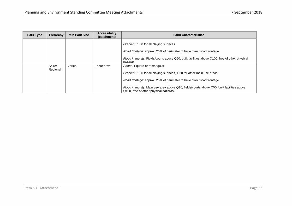
Planning and Environment Standing Committee Meeting Attachments 7 September 2018
Item 5.1- Attachment 1 Page 53
Park Type Hierarchy Min Park Size Accessibility (catchment)
Land Characteristics
Gradient: 1:50 for all playing surfaces Road frontage: approx. 25% of perimeter to have direct road frontage
Flood immunity: Fields/courts above Q50, built facilities above Q100, free of other physical hazards.
Shire/ Regional
Varies 1 hour drive Shape: Square or rectangular Gradient: 1:50 for all playing surfaces, 1:20 for other main use areas Road frontage: approx. 25% of perimeter to have direct road frontage
Flood immunity: Main use area above Q10, fields/courts above Q50, built facilities above Q100, free of other physical hazards.

Planning and Environment Standing Committee Meeting Attachments7 September 2018
Item 5.1- Attachment 1 Page 54
4.5 Plans for trunk infrastructure
(1) The plans for trunk infrastructure identify the trunk infrastructure networks intended to
service the existing and assumed future urban development at the desired standard of
service up to 2036.
4.5.1 Plans for trunk infrastructure maps
(1) The existing and future trunk infrastructure networks are shown on the following maps in
Schedule 3—Local government infrastructure plan mapping and tables:
(a) Local Government Infrastructure Plan Map LGIP-WS 01:06—Plan for trunk
infrastructure - water supply
(b) Local Government Infrastructure Plan Map LGIP-S 01:03—Plan for trunk
infrastructure - sewerage
(c) Local Government Infrastructure Plan Map LGIP-TR 01:05—Plan for trunk
infrastructure - transport
(d) Local Government Infrastructure Plan Map LGIP-PPCL 01:05—Plan for trunk
infrastructure - parks and land for community facilities
(2) The State infrastructure forming part of transport trunk infrastructure network has been
identified using information provided by the relevant State infrastructure supplier.
4.5.2 Schedules of works
(1) Details of the existing and future trunk infrastructure networks are identified in the
electronic Excel schedule of works model which can be viewed here: Cook Shire Council
Schedules of Works Model.
(2) The future trunk infrastructure is identified in the following tables in Schedule 3—Local
government infrastructure plan mapping and tables:
(a) for the water supply network, Table SC3.2.1
(b) for the sewerage network, Table SC3.2.2
(c) for the transport network, Table SC3.2.3
(d) for the parks and land for community facilities network, Table SC3.2.4
(a) Editors note ─ Extrinsic material
The below table identifies the documents that assist in the interpretation of the local government infrastructure plan and are extrinsic material under the Statutory Instruments Act 1992.
List of extrinsic material
Column 1 Title of document
Column 2 Date
Column 3 Author
Extrinsic material to the Local Government Infrastructure Plan
October 2017 Integran Pty Ltd.

Planning and Environment Standing Committee Meeting Attachments7 September 2018
Item 5.1- Attachment 1 Page 55

Planning and Environment Standing Committee Meeting Attachments7 September 2018
Item 5.1- Attachment 1 Page 56
Part 5 Tables of assessment
5.1 Preliminary
The tables in this part identify the category of development, and the category of assessment and assessment benchmarks for assessable for development within the planning scheme area.
5.2 Reading the tables
The tables identify the following: (1) The category of development:
(a) accepted (including accepted with requirements); (b) assessable development, that requires either code or impact assessment; and (c) prohibited.
(2) the category of assessment – code or impact – for development in: (a) a zone and, where used, a precinct of a zone; (b) a local plan and, where used, a precinct of a local plan; (c) an overlay.
(3) the assessment benchmarks for assessable development, including: (a) whether a zone code or specific provisions in the zone code apply (shown in the
“assessment benchmarks” column); (b) if there is a local plan, whether a local plan code or specific provisions in the local
plan code apply (shown in the “assessment benchmarks” column); (c) if there is an overlay:
(i) whether an overlay code applies (shown in the table in section 4.10); or (ii) whether the assessment benchmarks as shown on the overlay map (noted
in the ‘assessment benchmarks’ column) applies; (d) any other applicable code(s) (shown in the “assessment benchmarks” column).
(4) any variation to the category of assessment (shown as an “if” in the “category of assessment” column) that applies to the development.
Note—development will only be taken to be prohibited development under the planning scheme if it is identified as prohibited development in schedule 10 of the Regulation.
Editor’s note—Examples of matters that can vary the category of assessment are gross floor area, height, numbers of people or precinct provisions.
5.3 Categories of development and assessment
5.3.1 Process for determining the category of development and the category of assessment
The process for determining a category of development and the category of assessment is: (1) for a material change of use, establish the use by reference to the use definitions in
Schedule 1; (2) for all development, identify the following:
(a) the zone or zone precinct that applies to the premises, by reference to the zone map in Schedule 2;
(b) if a local plan or local plan precinct applies to the premises, by reference to the local plan map in Schedule 2;
(c) if an overlay applies to the premises, by reference to the overlay map in Schedule 2.
(3) determine if the development is accepted development under schedule 6 of the Regulation;
(4) determine if the development is assessable development under schedule 10 of the Regulation, Section 4.4 Regulated categories of development and categories of assessment prescribed by the Regulation;
Planning and Environment Standing Committee Meeting Attachments7 September 2018
Item 5.1- Attachment 1 Page 57
(5) if the development is not listed in the tables in section 5.4 Regulated categories of development and categories of assessment prescribed by the Regulation, determine the initial category of assessment by reference to the tables in: (a) section 5.5 Categories of development and assessment—Material change of use (b) section 5.6 Categories of development and assessment—Reconfiguring a lot (c) section 5.7 Categories of development and assessment—Building work (d) section 5.8 Categories of development and assessment—Operational work
(6) a precinct of a zone may change the category of development or assessment and this will be shown in the ‘category of assessment’ column of the tables in sections 5.5, 5.6, 5.7 and 5.8;
(7) if a local plan applies refer to the table(s) in section 5.9 Categories of development and assessment—Local plans, to determine if the local plan changes the category of development or assessment for the zone;
(8) if a precinct of a local plan changes the category of development or assessment this will be shown in the “Category of development and assessment” column of the table(s) in section 5.9;
(9) if an overlay applies refer to section 5.10 Categories of development and assessment—Overlays, to determine if the overlay further changes the category of development or assessment.
5.3.2 Determining the categories of development and assessment
(1) A material change of use is assessable development requiring impact assessment— (a) unless the table of assessment states otherwise (b) if a use is not listed or defined (c) unless otherwise prescribed within the Act or the Regulation.
(2) Reconfiguring a lot is assessable development requiring code assessment unless the tables of assessment state otherwise or unless otherwise prescribed within the Act or the Regulation.
(3) Minor building work is accepted development. Building work and operational work is accepted development, unless the tables of assessment state otherwise or unless otherwise prescribed within the Act or the Regulation.
(4) Where an aspect of development is proposed on premises included in more than one zone, local plan or overlay, the category of development or assessment is the highest category under each of the applicable zones, local plans or overlays.
(5) Where development is proposed on premises partly affected by an overlay, the category of development or assessment for the overlay only relates to the part of the premises affected by the overlay.
(6) For the purposes of Schedule 6, Part 2 Material change of use section(2)(2)(d)(i) or (ii) of the Regulation, an overlay does not apply to the premises if the development meets the acceptable outcomes that form the requirements for accepted development in the relevant overlay code.
(7) If development is identified as having a different category of development or category of assessment under a zone than under a local plan or an overlay, the highest category of development or assessment applies as follows— (a) accepted development subject to requirements prevails over accepted
development; (b) code assessment prevails over accepted development (including where subject to
requirements); (c) impact assessment prevails over code assessment and accepted development
(including where subject to requirements). (8) Despite sub-subsection 5.3.2(4) and (7) above, a category of development or
assessment in a local plan overrides a category of assessment in a zone, and a category of development or assessment in an overlay overrides a category of assessment in a zone or local plan.
(9) The category of development prescribed under Schedule 6 of the Regulation overrides all other categories of development or assessment for that development under the planning scheme to the extent of any inconsistency.
Editor’s note—Schedule 7 of the Regulation also identifies development that the state categorises as accepted development. Some development in the schedule may still be made assessable under the planning scheme.

Planning and Environment Standing Committee Meeting Attachments7 September 2018
Item 5.1- Attachment 1 Page 58
(10) Despite all of the above, if development is listed as prohibited development under schedule 10 of the Regulation, a development application cannot be made.
Note—Development is to be taken to be prohibited development under the planning scheme only if it is identified in schedule 10 the Regulation.
5.3.3 Determining the requirements for accepted development and assessment benchmarks and other matters for assessable development
(1) Accepted development does not require a development approval and is not subject to assessment benchmarks. However, certain requirements may apply to some types of development for it to be accepted development. Where nominated in the tables of assessment, accepted development must comply with the requirements identified as acceptable outcomes in the relevant parts of the applicable code(s) as identified in the relevant column.
(2) Accepted development that does not comply with one or more of the nominated acceptable outcomes in the relevant parts of the applicable code(s) becomes code assessable development, unless otherwise specified.
(3) The following rules apply in determining assessment benchmarks for each category of development and assessment.
(4) Code assessable development: (a) is to be assessed against all the assessment benchmarks in the assessment
benchmarks column; (b) that occurs as a result of development becoming code assessable pursuant to sub-
section 5.3.3(2), must: (i) be assessed against the assessment benchmarks for the development
application, limited to the subject matter of the required acceptable outcomes that were not complied with or were not capable of being complied with under sub-section 5.3.3(2)
(ii) comply with all required acceptable outcomes identified in sub-section 5.3.3(1), other than those mentioned in sub-section 5.3.3(2);
(c) that complies with: (i) the purpose and overall outcomes of the code complies with the code; (ii) the performance or acceptable outcomes complies with the purpose and overall
outcomes of the code; (d) is to be assessed against any assessment benchmarks for the development
identified in section 26 of the Regulation.
Editor’s note—Section 27 of the Regulation also identifies the matters that code assessment must have regard to.
(5) Impact assessable development: (a) is to be assessed against the identified assessment benchmarks in the assessment
benchmarks column (where relevant) (b) assessment is to have regard to the whole of the planning scheme, to the extent
relevant (c) is to be assessed against any assessment benchmarks for the development
identified in section 30 of the Regulation.
Note—the first row of each table of assessment is to be checked to confirm if there are assessment benchmarks that commonly apply to general scenarios in the zone, local plan or overlay.
Editor’s note—Section 31 of the Regulation identifies the matters that impact assessment must have regard to.
5.3.4 Accepted development for the planning scheme
(1) This section identifies development which is accepted development under the planning scheme.
(2) Development described in Tables 5.3.4.1 and 5.3.4.2 is accepted development for the planning scheme.

Planning and Environment Standing Committee Meeting Attachments7 September 2018
Item 5.1- Attachment 1 Page 59
Table 5.3.4.1—Prescribed categories of development and assessment: building work
Zone Category of development and assessment
Assessment benchmarks
Minor building work
Accepted development
In all circumstances Nil
Filling and excavation
Accepted development
If involving less than 10m³ of material Nil
Table 5.3.4.2—Prescribed categories of development and assessment: operational work
Zone Category of development and assessment
Assessment benchmarks
Rural zone
Accepted development
Operational work associated with an off-stream dam
Nil
All Accepted development
Operational work for extractive industry if for a borrow pit
Nil
5.4 Regulated categories of development and categories of assessment prescribed by the Regulation
The following schedules of the Regulation are relevant to the Cook Shire Council Planning Scheme: (1) Schedule 6, Part 2, 6 of the Regulation, Material change of use for community
residence; (2) Schedule 12 of the Regulation, Particular reconfiguring a lot requiring code assessment; (3) Schedule 13 of the Regulation, Requirements for cropping involving forestry for wood
production.
5.5 Categories of development and assessment—Material change of use
The following tables identify the categories of development or assessment for development in a zone for making a material change of use.
Table 5.5.1—Low density residential zone
Use Category of development and assessment
Requirements for accepted development and assessment benchmarks
Dwelling house Accepted development
If not including a secondary dwelling
Nil
Accepted development subject to requirements
If: including a secondary
dwelling; and complying with the
assessment benchmarks
Low density residential zone code – Section 1 Residential use code – Section 1
Code assessable
If not accepted development or accepted development subject to requirements
Low density residential zone code Residential use code Parking & access code Works, services & infrastructure code

Planning and Environment Standing Committee Meeting Attachments7 September 2018
Item 5.1- Attachment 1 Page 60
Use Category of development and assessment
Requirements for accepted development and assessment benchmarks
Dual occupancy Accepted development subject to requirements
If on a lot greater than 1,000m² and complying with the assessment benchmarks
Low density residential zone code – Section 1 Residential use code – Section 1 Parking & access code Works, services & infrastructure code
Code assessment
If on a lot greater than 1,000m² and not complying with the assessment benchmarks
Low density residential zone code Residential use code Parking & access code Works, services & infrastructure code
Impact assessment
If not accepted development, accepted development subject to requirements or code assessment.
The planning scheme
Home based business
Accepted development subject to requirements
If complying with the assessment benchmarks
Low density residential zone code – Section 1 Home based business use code
Code assessment
If not accepted development subject to requirements
Low density residential zone code Home based business use code Parking & access code Works, services & infrastructure code
Major electricity infrastructure
Code assessment
All Low density residential zone code Parking & access code Works, services & infrastructure code
Park Accepted development
All Nil
Shop Code assessment
If the gross floor area does not exceed 200m²
Low density residential zone code Parking & access code Works, services & infrastructure code
Substation Accepted development
All Nil
Utility installation Accepted development
If not involving any of the following:
a) Waste facilities; or b) The construction or use of
any building or other structure having a floor area greater than 30m² or a height greater than 4.5m; or
c) The use of land greater than 800m² in area.
Nil
Code assessment
If not accepted development and Low density residential zone code

Planning and Environment Standing Committee Meeting Attachments7 September 2018
Item 5.1- Attachment 1 Page 61
Use Category of development and assessment
Requirements for accepted development and assessment benchmarks
not involving waste facilities Parking & access code Works, services & infrastructure code
Impact assessment
Any other use not listed in this table. Any other undefined use.
The planning scheme
Table 5.5.2—Medium density residential zone
Use Category of development and assessment
Requirements for accepted development and assessment benchmarks
Dwelling house Home based business
Accepted development
If not including a secondary dwelling
Nil
Accepted development subject to requirements
If: not accepted development;
and complying with the
assessment benchmarks
Medium density residential zone code – Section 1 Residential use code – Section 1
Code assessable
If not accepted development or accepted subject to requirements.
Medium density residential zone code Residential use code Parking & access code Works, services & infrastructure code
Dual occupancy Accepted development subject to requirements
If on a lot greater than 800m² and complying with the assessment benchmarks
Medium density residential zone code – Section 1 Residential use code – Section 1 Parking & access code Works, services & infrastructure code
Code assessment
If on a lot greater than 800m² and not complying with the assessment benchmarks
Medium density residential zone code Residential use code Parking & access code Works, services & infrastructure code
Impact assessment
If not accepted development subject to requirements or code assessable.
Medium density residential zone code Residential use code Parking & access code Works, services & infrastructure code
Home based business
Accepted development subject to requirements
If complying with the assessment benchmarks
Medium density residential zone code – Section 1 Home based business use code
Code assessment
If not accepted development subject to requirements
Medium density residential zone code Home based business use code

Planning and Environment Standing Committee Meeting Attachments7 September 2018
Item 5.1- Attachment 1 Page 62
Use Category of development and assessment
Requirements for accepted development and assessment benchmarks
Parking & access code Works, services & infrastructure code
Major electricity infrastructure
Code assessment
All Medium density residential zone code Parking & access code Works, services & infrastructure code
Multiple dwelling Retirement facility Residential care facility Rooming accommodation
Code assessment
All Medium density residential zone code Parking & access code Works, services & infrastructure code Where Applicable: Residential use code
Park Accepted development
All
Substation Accepted development
All
Utility installation Accepted development
If not involving: a) The construction or use of any building or other structure having a
floor area greater than 30m² or a height greater than 4.5m; or b) The use of land greater than 800m² in area.
Code assessment
If not accepted development Medium density residential zone code Parking & access code Works, services & infrastructure code
Impact assessment
Any other use not listed in this table. Any other undefined use.
The planning scheme
Table 5.5.3— Centre zone
Use Category of development and assessment
Requirements for accepted development and assessment benchmarks
Bar Car park
Garden centre
Hardware and trade
supplies
Hotel
Relocatable home
park
Resort complex
Short term
accommodation Tourist park
Code assessment
All Centre zone code Parking & access code Works, service & infrastructure code
Where applicable: Residential use code
Caretaker’s accommodation Child care centre
Accepted development subject to requirements
If complying with the assessment benchmarks and
Centre zone code – Section 1 Parking & access code

Planning and Environment Standing Committee Meeting Attachments7 September 2018
Item 5.1- Attachment 1 Page 63
Use Category of development and assessment
Requirements for accepted development and assessment benchmarks
Community care centre Community use Club Food and drink outlet Function facility Health care services Indoor sport & recreation Nightclub entertainment facility Office Place of Worship Service industry Shop Theatre Veterinary services
if the material change of use occurs within an existing building where no external building work is required.
Works, service & infrastructure code
Where applicable: Residential use code – Section 1
Code assessment
If not accepted development subject to requirements
Centre zone code Parking & access code Works, service & infrastructure code
Where applicable: Residential use code
Major electricity infrastructure
Code assessment
All Centre zone code Parking & access code Works, service & infrastructure code
Substation Accepted development
All
Utility installation Accepted development
If not involving: a) The construction or use of any building or other structure
having a floor area greater than 30m² or a height greater than 4.5m; or
b) The use of land greater than 800m² in area.
Code assessment
If not accepted development Centre zone code Parking & access code Works, service & infrastructure code
Impact assessment
Any other use not listed in this table. Any other undefined use.
The planning scheme
Table 5.5.4—Mixed use zone
Use Category of development and assessment
Requirements for accepted development and assessment benchmarks
Club Community care centre Community use Function facility Health care services Indoor sport & recreation Multiple dwelling Nightclub entertainment facility
Code assessment
All Mixed use zone code Parking & access code Works, services & infrastructure code
Where applicable: Residential use code
Impact assessment
If in the MU1 Precinct (Cooktown Foreshore Mixed Use Precinct) and exceeding three storeys.
The planning scheme

Planning and Environment Standing Committee Meeting Attachments7 September 2018
Item 5.1- Attachment 1 Page 64
Use Category of development and assessment
Requirements for accepted development and assessment benchmarks
Place of worship Retirement facility Short term accommodation Theatre Tourist park Veterinary services
Dwelling house Accepted development
If not including a secondary dwelling
Accepted development subject to requirements
If: including a secondary
dwelling; and complying with the
assessment benchmarks
Mixed use zone code – Section 1 Residential use code – Section 1
Code assessable
If not accepted development or accepted development subject to requirements
Mixed use zone code Residential use code Parking & access code Works, services & infrastructure code
Dual occupancy Accepted development subject to requirements
If on a lot greater than 800m² and complying with the assessment benchmarks
Mixed use zone code – Section 1 Residential use code – Section 1 Parking & access code Works, services & infrastructure code
Code assessment
If on a lot greater than 800m² and not complying with the assessment benchmarks
Mixed use zone code Residential use code Parking & access code Works, services & infrastructure code
Impact assessment
If not accepted development subject to requirements or code assessable.
Mixed use zone code Residential use code Parking & access code Works, services & infrastructure code
Food & drink outlet Home based business Office Shop
Accepted development subject to requirements
If complying with the assessment benchmarks and located within an existing building.
Mixed use zone Code – Section 1 Residential Use Code – Section 1 Parking & access code Works, service & infrastructure code Where applicable: Home based business use Code
Code assessment
If not accepted development subject to requirements and: not in the MU1 Precinct
(Cooktown Foreshore Mixed Use Precinct); or
not exceeding three storeys.
Mixed use zone Code Residential Use Code Parking & access Code Works, service & infrastructure Code Where applicable: Home based business use Code
Impact assessment
If not accepted development and The planning scheme

Planning and Environment Standing Committee Meeting Attachments7 September 2018
Item 5.1- Attachment 1 Page 65
Use Category of development and assessment
Requirements for accepted development and assessment benchmarks
in the MU1 Precinct (Cooktown Foreshore Mixed Use Precinct) and exceeding three storeys.
Major electricity infrastructure
Code assessment
All Mixed use zone code Parking & access code Works, services & infrastructure code
Substation Accepted development
All Nil
Utility installation Accepted development
If not involving: a) The construction or use of
any building or other structure having a floor area greater than 30m² or a height greater than 4.5m; or
b) The use of land greater than 800m² in area.
Nil
Code assessment
If not accepted development Centre zone code Parking & access code Works, services & infrastructure code
Impact assessment
Any other use not listed in this table. Any other undefined use.
The planning scheme
Table 5.5.5—Township zone
Use Category of development and assessment
Requirements for accepted development and assessment benchmarks
Agricultural supplies store Child care centre Community care centre Community use Dual occupancy Educational establishment Garden centre Health care services Office Retirement facility Service industry Shop Short term accommodation Tourist park Veterinary services
Code assessment
All Township zone code Parking & access code Works, service & infrastructure code
Where applicable: Residential use code
Dwelling house Home based business
Accepted development
If not including a secondary dwelling
Nil
Accepted development subject to requirements
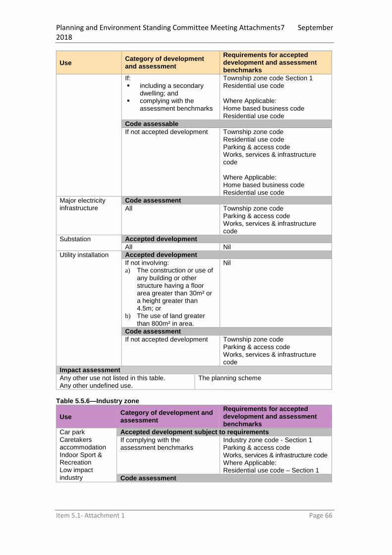
Planning and Environment Standing Committee Meeting Attachments7 September 2018
Item 5.1- Attachment 1 Page 66
Use Category of development and assessment
Requirements for accepted development and assessment benchmarks
If: including a secondary
dwelling; and complying with the
assessment benchmarks
Township zone code Section 1 Residential use code Where Applicable: Home based business code Residential use code
Code assessable
If not accepted development Township zone code Residential use code Parking & access code Works, services & infrastructure code
Where Applicable: Home based business code Residential use code
Major electricity infrastructure
Code assessment
All Township zone code Parking & access code Works, services & infrastructure code
Substation Accepted development
All Nil
Utility installation Accepted development
If not involving: a) The construction or use of
any building or other structure having a floor area greater than 30m² or a height greater than 4.5m; or
b) The use of land greater than 800m² in area.
Nil
Code assessment
If not accepted development Township zone code Parking & access code Works, services & infrastructure code
Impact assessment
Any other use not listed in this table. Any other undefined use.
The planning scheme
Table 5.5.6—Industry zone
Use Category of development and assessment
Requirements for accepted development and assessment benchmarks
Car park Caretakers accommodation Indoor Sport & Recreation Low impact industry
Accepted development subject to requirements
If complying with the assessment benchmarks
Industry zone code - Section 1 Parking & access code Works, services & infrastructure code Where Applicable: Residential use code – Section 1
Code assessment

Planning and Environment Standing Committee Meeting Attachments7 September 2018
Item 5.1- Attachment 1 Page 67
Use Category of development and assessment
Requirements for accepted development and assessment benchmarks
Service industry Warehouse
If not accepted development subject to requirements
Industry zone code Parking & access code Works, service & infrastructure code Where Applicable: Residential use code
Major electricity infrastructure
Code assessment
All Industry zone code Parking & access code Works, services & infrastructure code
Air Services Service Station
Code assessment
where on Lot 2 on SP287154;
Industry zone code Parking & access code Works, services & infrastructure code Where Applicable: Service Station Development Code
Shop Food and Drink
Code assessment
where on Lot 2 on SP287154;
where containing less than 200m
2 of GFA;
where not already provided on the land.
Industry zone code Parking & access code Works, services & infrastructure code
Medium impact industry Office Rural industry Transport depot
Code assessment
All Industry zone code Parking & access code Works, services & infrastructure code
Substation Accepted development
All Nil
Utility installation Accepted development
If not involving: a) The construction or use of
any building or other structure having a floor area greater than 30m² or a height greater than 4.5m; or
b) The use of land greater than 800m² in area.
Nil
Code assessment
If not accepted development Industry zone code Parking & access code Works, services & infrastructure code
Impact assessment
Any other use not listed in this table. Any other undefined use.
The planning scheme

Planning and Environment Standing Committee Meeting Attachments7 September 2018
Item 5.1- Attachment 1 Page 68
Table 5.5.7—Community facilities zone
Use Category of development and assessment
Requirements for accepted development and assessment benchmarks
Air service Accepted development
If on the site of Map ID 50 on the zone map
Nil
Caretaker’s accommodation Child care centre Club Community care centre Community use Educational establishment Emergency services Function facility Hospital Indoor sport & recreation Outdoor Sport & Recreation Place of Worship Theatre
Code assessment
All Community facilities zone code Parking & access code Works, services & infrastructure Code Where applicable: Residential use code
Community use (kiosk) Food & drink outlet Office Shop Warehouse
Accepted development
If located in the CF1 Precinct - Cooktown Foreshore Commercial Precinct on Zoning Map 13
Nil
Code assessment
If not accepted development Community facilities zone code Parking & access code Works, services & infrastructure code
Dwelling house Multiple dwelling Residential care facility
Code assessment
If located at 30 Charlotte Street, Cooktown (Cooktown & District Youth Club)
Community facilities zone code Parking & access code Works, services & infrastructure code Residential use code
Major electricity infrastructure
Code assessment
All Community facilities zone code Parking & access code Works, services & infrastructure code
Park Accepted development
All Nil
Substation
Accepted development
All Nil
Utility installation Accepted development

Planning and Environment Standing Committee Meeting Attachments7 September 2018
Item 5.1- Attachment 1 Page 69
If involving extractive and screening activities for the utility installation
OR
If not involving: a) The construction or use of
any building or other structure having a floor area greater than 30m² or a height greater than 4.5m; or
b) The use of land greater than 800m² in area.
Nil
Code assessment
If not accepted development Community facilities zone code Parking & access code Works, services & infrastructure code
Impact assessment
Any other use not listed in this table. Any other undefined use.
The planning scheme
Table 5.5.8—Rural residential zone
Use Category of development and assessment
Requirements for accepted development and assessment benchmarks
Animal Husbandry Animal keeping Cropping Permanent plantation Roadside stall Rural Industry
Code assessment
All Rural residential zone code Parking & access code Works, services & infrastructure code
Where applicable
Home based business code
Roadside stall code
Dwelling house Home based business
Accepted development
If not including a secondary dwelling
Nil
Accepted development subject to requirements
If: including a secondary
dwelling; and complying with the
assessment benchmarks
Rural residential zone code - Section 1 Residential use code – Section 1 Where Applicable: Home based business code Residential use code
Code assessable
If not accepted development Rural residential zone code Parking & access code Works, services & infrastructure code
Where Applicable: Home based business code Residential use code
Major electricity infrastructure
Code assessment
All Rural residential zone code Parking & access code Works, services & infrastructure code

Planning and Environment Standing Committee Meeting Attachments7 September 2018
Item 5.1- Attachment 1 Page 70
Use Category of development and assessment
Requirements for accepted development and assessment benchmarks
Substation Accepted development
All Nil
Utility installation Accepted development
If not involving: a) The construction or use of
any building or other structure having a floor area greater than 30m² or a height greater than 4.5m; or
b) The use of land greater than 800m² in area.
Nil
Code assessment
If not accepted development Rural residential zone code Parking & access code Works, services & infrastructure code
Impact assessment
Any other use not listed in this table. Any other undefined use.
The planning scheme
Table 5.5.9—Rural zone
Use Category of development and assessment
Requirements for accepted development and assessment benchmarks
Agricultural supplies store
Code assessment
In all circumstances Rural zone code Works, services & infrastructure code
Animal Husbandry Animal keeping
Accepted development
If on a site more than 2km from urban or rural residential zoned land
Nil
Accepted development subject to requirements
If on a site less than 2km from urban or rural residential zoned land
Rural zone code – Section 1
Code assessment
If not accepted development or accepted development subject to requirements
Rural zone code
Aquaculture Accepted development subject to requirements
If using above ground tanks in a
roofed facility with a floor area
not exceeding 50m2
Accepted development requirements for material change of use that is aquaculture is provided in the State code
Editor’s note—This Code is provided by the Department of Agriculture and Fisheries .
Impact assessment
If not accepted development subject to requirements
The planning scheme

Planning and Environment Standing Committee Meeting Attachments7 September 2018
Item 5.1- Attachment 1 Page 71
Use Category of development and assessment
Requirements for accepted development and assessment benchmarks
Bulk landscape supplies
Code assessment
All Rural zone code Works, services & infrastructure code
Caretaker’s accommodation Environment facility Nature-based tourism Non-residents workers accommodation Roadside stall Rural industry Short Term Accommodation Veterinary services
Code assessment
All Rural zone code Parking & access code Works, services & infrastructure code
Where applicable: Residential use code
Roadside stall code
Cropping Accepted development
All Nil
Dwelling house Home based business
Accepted development
If not including a secondary dwelling
Nil
Accepted development subject to requirements
If: including a secondary
dwelling; and complying with the
assessment benchmarks
Rural zone code Section 1 Residential use code – Section 1
Where applicable: Home based business code
Residential use code
Code assessable
If not accepted development or accepted development subject to requirements
Rural zone code Residential use code – Section 1
Where applicable: Home based business code
Residential use code Parking & access code Works, services & infrastructure code
Permanent plantation
Accepted development subject to requirements
If complying with the assessment benchmarks
Rural zone code
Code assessment
If not accepted development subject to requirements
Rural zone code Parking & access code Works, services & infrastructure code
Extractive industry
Accepted development
If for a Borrow pit Intensive animal Code assessment
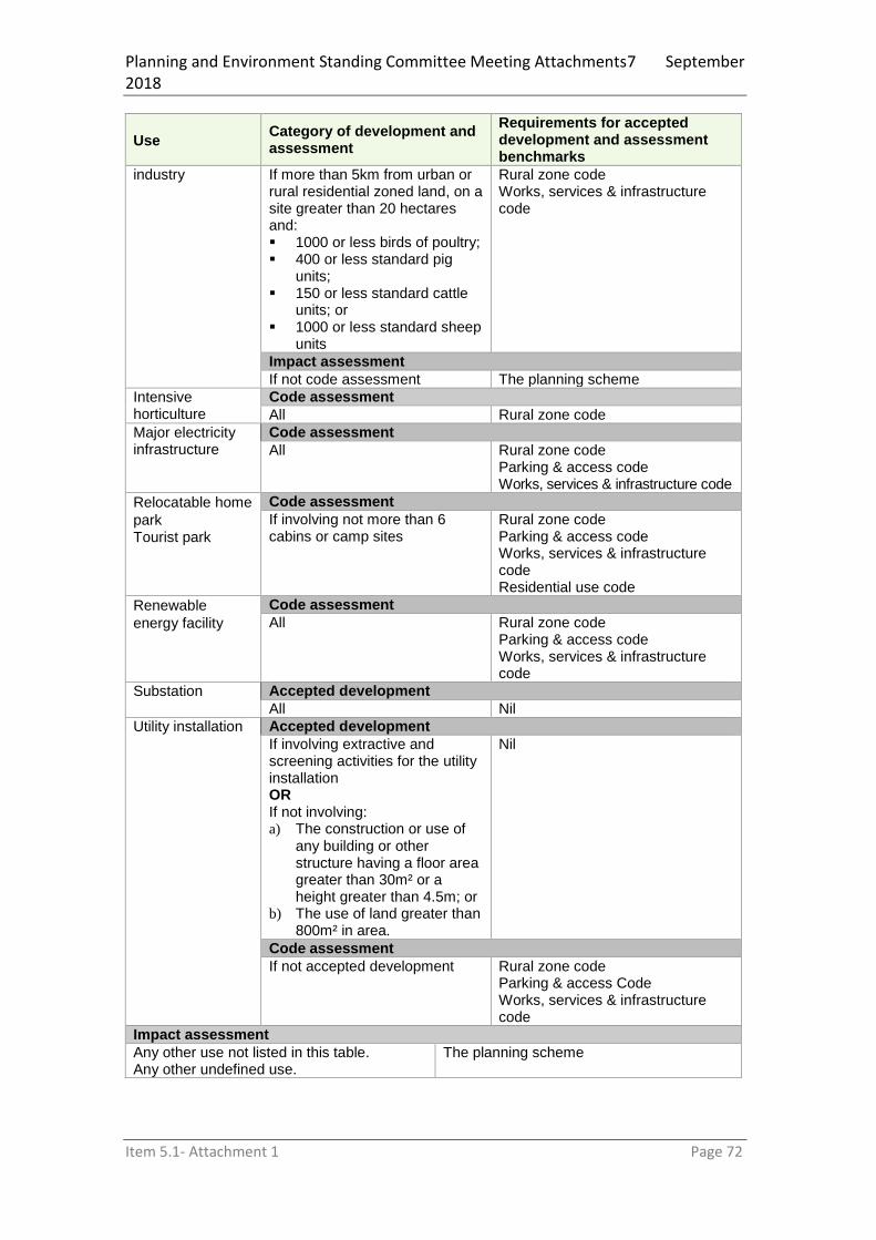
Planning and Environment Standing Committee Meeting Attachments7 September 2018
Item 5.1- Attachment 1 Page 72
Use Category of development and assessment
Requirements for accepted development and assessment benchmarks
industry If more than 5km from urban or rural residential zoned land, on a site greater than 20 hectares and: 1000 or less birds of poultry; 400 or less standard pig
units; 150 or less standard cattle
units; or 1000 or less standard sheep
units
Rural zone code Works, services & infrastructure code
Impact assessment
If not code assessment The planning scheme
Intensive horticulture
Code assessment
All Rural zone code
Major electricity infrastructure
Code assessment
All Rural zone code Parking & access code Works, services & infrastructure code
Relocatable home
park Tourist park
Code assessment
If involving not more than 6 cabins or camp sites
Rural zone code Parking & access code Works, services & infrastructure code
Residential use code
Renewable
energy facility
Code assessment
All Rural zone code Parking & access code Works, services & infrastructure code
Substation Accepted development
All Nil
Utility installation Accepted development
If involving extractive and screening activities for the utility installation
OR
If not involving: a) The construction or use of
any building or other structure having a floor area greater than 30m² or a height greater than 4.5m; or
b) The use of land greater than 800m² in area.
Nil
Code assessment
If not accepted development Rural zone code Parking & access Code Works, services & infrastructure code
Impact assessment
Any other use not listed in this table. Any other undefined use.
The planning scheme

Planning and Environment Standing Committee Meeting Attachments7 September 2018
Item 5.1- Attachment 1 Page 73
Table 5.5.10—Recreation and open space zone
Use Category of development and assessment
Requirements for accepted development and assessment benchmarks
Caretakers accommodation Community care centre Community use Outdoor Sport & Recreation Place of Worship
Code assessment
All Recreation and open space zone code Parking & access code Works, services & infrastructure code
Where applicable: Residential Use Code
Major electricity infrastructure
Code assessment
All Recreation and open space zone code Parking & access code Works, services & infrastructure code
Park Accepted development
All Nil
Substation Accepted development
All Nil
Utility installation Accepted development
If involving extractive and screening activities for the utility installation
OR
If not involving: a) The construction or use
of any building or other structure having a floor area greater than 30m² or a height greater than 4.5m; or
b) The use of land greater than 800m² in area.
Nil
Code assessment
If not accepted development Recreation and open space zone code Parking & access Code Works, services & infrastructure Code
Impact assessment
Any other use not listed in this table. Any other undefined use.
The planning scheme
Table 5.5.11—Environmental management and conservation zone
Use Category of development and assessment
Requirements for accepted development and assessment benchmarks
Caretaker’s accommodation
Accepted development subject to requirements
If complying with the assessment benchmarks.
Note: more than one Caretaker’s accommodation can be located on one allotment.
Environmental management and conservation zone code Parking & access code Works, services and infrastructure code Residential use code
Code assessment
If not complying with the assessment benchmarks.
Environmental management and conservation zone code Parking & access code Works, services and infrastructure code Residential use code

Planning and Environment Standing Committee Meeting Attachments7 September 2018
Item 5.1- Attachment 1 Page 74
Use Category of development and assessment
Requirements for accepted development and assessment benchmarks
Dwelling house Code assessment
All Environmental management and conservation zone code Parking & access code Works, services & infrastructure code
Environment facility
Accepted development subject to requirements
All Environmental management and conservation zone code Parking & access code Works, services and infrastructure code
Extractive industry
Accepted development
If for a borrow pit Home based business Short term accommodation
Code assessment
All Environmental management and conservation zone code Parking & access code Works, services & infrastructure code
Where applicable: Home based business code Residential use code
Nature-based tourism
Code assessment
All Environmental management and conservation zone code Parking & access code Works, services & infrastructure code
Utility installation
Accepted development
If involving extractive and screening activities for the utility installation
OR
If not involving: a) The construction or use
of any building or other structure having a floor area greater than 30m² or a height greater than 4.5m; or
b) The use of land greater than 800m² in area.
Nil
Code assessment
If not accepted development Environmental management and conservation zone code Parking & access code Works, service & infrastructure Code
Impact assessment
Any other use not listed in this table. Any other undefined use.
The planning scheme
Editor’s note–The above levels of assessment apply unless otherwise prescribed in the Act or the Regulation.

Planning and Environment Standing Committee Meeting Attachments7 September 2018
Item 5.1- Attachment 1 Page 75
5.6 Categories of development and assessment—Reconfiguring a lot
The following table identifies the categories of development or assessment for reconfiguring a lot. Table 5.6.1—Reconfiguring a lot
Zone Category of development and assessment
Assessment benchmarks
All zones Code assessment
All aspects of Reconfiguring a lot The relevant zone code Reconfiguring a lot code Works, services & infrastructure Code
Impact assessment
Not applicable
Editor’s note–The above levels of assessment apply unless otherwise prescribed in the Act or the Regulation.
5.7 Categories of development and assessment—Building work
There is no building work regulated by the planning scheme.
5.8 Categories of development and assessment—Operational work
The following table identifies the categories of development or assessment for operational work. Table 5.8.1—Operational work
Zone Category of development and assessment
Assessment benchmarks
All zones Code assessment
Filling or excavation if: Involving more than 10m³ of
material in any zone other than the Rural Zone; or
Involving more than 1,000m3
of material in the Rural Zone; and
On a slope with a gradient of 15% or greater
Works, services and infrastructure code
All zones Code assessment
Third party sign Third party sign code
Editor’s note–The above categories of development or assessment apply unless otherwise prescribed in the Act or the Regulation.
5.9 Categories of development and assessment—Local plans
5.9.1: Eastern Kuku Yalanji Local Plan

Planning and Environment Standing Committee Meeting Attachments7 September 2018
Item 5.1- Attachment 1 Page 76
Table 5.9.1 A—Eastern Kuku Yalanji Local Plan: Material change of use
Use Category of development and assessment
Requirements for accepted development and assessment benchmarks
Where not in a local plan precinct
All development No change Nil
Where in a local plan precinct
Caretaker’s accommodation Community use if for a ranger station or community shed Dual occupancy Dwelling house Home based business Multiple dwellings Outstation
Accepted development subject to requirements
If: not exceeding the extent of
development in Table 6.1.1 and
located in the ‘Good Living Area’ on the Precinct Maps and
complying with the assessment benchmarks
Acceptable outcomes of the Eastern Kuku Yalanji local plan code
Code assessment
If: not exceeding the extent of
development in Table 7.1.1 and
located in the ‘Good Living Area’ on the Precinct Maps and
not complying with the assessment benchmarks
Eastern Kuku Yalanji local plan code Parking and Access Code Works, services & infrastructure Code
Impact assessment
If not accepted development subject to requirements or code assessable
The planning scheme
Table 5.9.1 B— Eastern Kuku Yalanji Local Plan: Reconfiguring a lot
Local plan Category of development and assessment
Assessment benchmarks
Where not in a local plan precinct
No change
Where in a local plan precinct
Eastern Kuku Yalanji Local Plan
No Change Eastern Kuku Yalanji local plan code
5.9.2: Lakeland Local Plan Table 5.9.2 A—Lakeland Local Plan: Material change of use5.9.2 A—Lakeland Local Plan: Material change of use5.9.2 A—Lakeland Local Plan: Material change of use5.9.2 A—Lakeland Local Plan: Material change of use
Use Category of development and assessment
Requirements for accepted development and assessment benchmarks
Where not in a local plan precinct
All development No change Nil
Where in a local plan precinct
All development
No change Lakeland Local Area Plan

Planning and Environment Standing Committee Meeting Attachments7 September 2018
Item 5.1- Attachment 1 Page 77
Table 5.9.2 B—Lakeland Local Plan: Reconfiguring a Lot5.9.2 B—Lakeland Local Plan: Reconfiguring a Lot5.9.2 B—Lakeland Local Plan: Reconfiguring a Lot5.9.2 B—Lakeland Local Plan: Reconfiguring a Lot
Local plan Category of development and assessment
Assessment benchmarks
Where not in a local plan precinct
No change
Where in a local plan precinct
All Development
No Change Lakeland Local Area Plan
5.10 Categories of development and assessment—Overlays The following table identifies where an overlay changes the category of development or assessment from that stated in a zone or local plan and the relevant assessment benchmarks.
Table 5.10.1—Overlays: Categories of development and assessment
Development Category of development and assessment
Requirements for accepted development and assessment benchmarks
Airport Environs Overlay
Any: (a) material change of use; (b) building work not associated with a
material change of use; (c) operational work not associated with a
material change of use within the Building Restricted Areas identified on the SPP Interactive Mapping.
Accepted Development if complying with the assessment benchmarks Note—If the use is identified as code or impact assessable in sections 4.5 through 4.9, then the category of assessment is not lowered to accepted development.
Airport Environs Overlay Code
Any: (a) material change of use; (b) building work not associated with a
material change of use; within the Wildlife Hazard Buffer identified on the SPP Interactive Mapping.
Accepted Development if complying with the assessment benchmarks Note—If the use is identified as code or impact assessable in sections 4.5 through 4.9, then the category of assessment is not lowered to accepted development.
Airport Environs Overlay Code
Biodiversity Overlay
All development within a State Environmental Area identified on OM1 – Biodiversity Overlay Map
Accepted Development if complying with the assessment benchmarks Note—If the use is identified as code or impact assessable in sections 4.5 through 4.9, then the category of assessment is not lowered to accepted
Biodiversity Overlay Code

Planning and Environment Standing Committee Meeting Attachments7 September 2018
Item 5.1- Attachment 1 Page 78
Development Category of development and assessment
Requirements for accepted development and assessment benchmarks
Bushfire Hazard Overlay
Any: (a) material change of use; (b) reconfiguring a lot; (c) building work not associated with a
material change of use; within a Bushfire Hazard Area or Potential Impact Buffer identified on OM2 – Bushfire Hazard Overlay Map
Accepted Development if complying with the assessment benchmarks Note—If the use is identified as code or impact assessable in sections 4.5 through 4.9, then the category of assessment is not lowered to accepted development.
Bushfire Hazard Overlay Code
Character Overlay14
Any material change of use on a site identified as being Neighbourhood Character and/or Local Heritage Place and/or adjoining a Local Heritage Place on OM3 – Character Overlay Map
Code Assessable Note—If the use is identified as impact assessable in sections 4.5 through 4.9, then the category of assessment is not lowered to code assessable.
Character Overlay Code
Any building work where not associated with a material change of use on a site identified as being Neighbourhood Character and/or Local Heritage Place and/or adjoining a Local Heritage Place on OM3 – Character Overlay Map.
Code assessable if: (a) altering, extending
or partially demolishing a Local Heritage Place; or
(b) erecting a new or separate building on the site of a Local Heritage Place; or
(c) affecting the external appearance of the building or structure on a site in the Neighbourhood Character area
Character Overlay Code
Impact assessable if involving the full demolition of a Local Heritage Place
The planning scheme
Any operational work on a site identified as being Neighbourhood Character and/or Local Heritage Place on OM3 – Character Overlay Map, where involving a change to landscaping or natural features of land referred to in the citation for a heritage place
Code assessable Character Overlay Code
14
Editor’s Note: An application is required to the State for development on the site of a Queensland Heritage Place.

Planning and Environment Standing Committee Meeting Attachments7 September 2018
Item 5.1- Attachment 1 Page 79
Development Category of development and assessment
Requirements for accepted development and assessment benchmarks
Extractive Resources Overlay
A material change of use or operational work for extractive industry if for a Bborrow pit Animal husbandry Cropping
Accepted development
Any other: (a) material change of use; (b) reconfiguring a lot; (c) operational work not associated with a
material change of use; (d) building work not associated with a
material change of use; associated with extractive industry within the Resource Area, Potential Resource Area or Separation Area on OM4 – Extractive Resources Overlay
Code assessable Extractive Resources Overlay Code
Any other development not identified in this section of the Table where within the Resource Area, Potential Resource Area or Separation Area
Impact assessment The planning scheme
Flood and Other Coastal Hazards Overlay
Any material change of a use in the Potential Flood Hazard Area on OM5 Flood and Other Coastal Hazards Overlay Map
Accepted Development if complying with the assessment benchmarks Note—If the use is identified as code or impact assessable in sections 4.5 through 4.9, then the category of assessment is not lowered to accepted development.
Flood and Other Coastal Hazards Overlay Code
Any material change of use in the Medium or High Hazard Areas on OM5 Flood and Other Coastal Hazards Overlay Map
Code assessable Note—If the use is identified impact assessable in sections 4.5 through 4.9, then the category of assessment is not lowered to accepted development.
Flood and Other Coastal Hazards Overlay Code
Any material change of use in the Erosion Prone Area on OM5 Flood and Other Coastal Hazards Overlay Map
Code assessable Note—If the use is identified impact assessable in sections 4.5 through 4.9, then the category of assessment is not lowered to accepted development.
Flood and Other Coastal Hazards Overlay Code
Any reconfiguring a lot identified in a Hazard Area, Potential Hazard Area, or Erosion Prone Area on OM5 Flood and Other Coastal Hazards Overlay Map
No change Flood and Other Coastal Hazards Overlay Code

Planning and Environment Standing Committee Meeting Attachments7 September 2018
Item 5.1- Attachment 1 Page 80
Development Category of development and assessment
Requirements for accepted development and assessment benchmarks
Any building work identified in a Hazard Area or Potential Hazard Area on OM5 Flood and Other Coastal Hazards Overlay Map
Accepted Development if complying with the assessment benchmarks Note—If the use is identified as code or impact assessable in sections 4.5 through 4.9, then the category of assessment is not lowered to accepted development.
Flood and Other Coastal Hazards Overlay Code – Section 1
Any building work identified in an Erosion Prone Area on OM5 Flood and Other Coastal Hazards Overlay Map
Code assessable Note—If the use is identified impact assessable in sections 4.5 through 4.9, then the category of assessment is not lowered to accepted development.
Flood and Other Coastal Hazards Overlay Code
Any operational work on a site identified in a Hazard Area on OM5 Flood and Other Coastal Hazards Overlay Map
Accepted Development if complying with the assessment benchmarks Note—If the use is identified as code or impact assessable in sections 4.5 through 4.9, then the category of assessment is not lowered to accepted development.
Flood and Other Coastal Hazards Overlay Code
Any operational work identified in an Erosion Prone Area on OM5 Flood and Other Coastal Hazards Overlay Map
Code assessable Note—If the use is identified impact assessable in sections 4.5 through 4.9, then the category of assessment is not lowered to accepted development.
Flood and Other Coastal Hazards Overlay Code
Landslide Hazard Overlay
All development within the Landslide Hazard Area on OM14 – Landslide Hazard Overlay Map
Accepted Development if complying with the assessment benchmarks Note—If the use is identified as code or impact assessable in sections 4.5 through 4.9, then the category of assessment is not lowered to accepted development.
Landslide Hazard Overlay Code
Old Dam Site Overlay
Clearing vegetation on land within the boundary of the Old Dam Site on OM13.1 - Old Dam Site Overlay Map
Code assessable Low Density Residential Zone Code

Planning and Environment Standing Committee Meeting Attachments7 September 2018
Item 5.1- Attachment 1 Page 81
Development Category of development and assessment
Requirements for accepted development and assessment benchmarks
Rural Land Use Overlay
Permanent plantation within the Agricultural Land – Class A area on OM8 Rural Land Use Overlay Map
Impact Assessable The planning scheme
Scenic Amenity Overlay
Any material change of use within the Scenic Amenity Overlay on OM9 – Scenic Amenity Overlay Map
Accepted Development if complying with the assessment benchmarks Note—If the use is identified as code or impact assessable in sections 4.5 through 4.9, then the category of assessment is not lowered to accepted development.
Scenic Amenity Overlay Code
Any building work where not associated with a material change of use on a site identified as being in the Scenic Amenity Area on OM9 – Scenic Amenity Overlay Map.
Code assessable if affecting the external appearance of the building or structure
Scenic Amenity Overlay Code
Any operational work where not associated with a material change of use and involving retaining walls over 1.5m high on a site within the Scenic Amenity Overlay on OM9 – Scenic Amenity Overlay Map
Code assessable Note—If the use is identified as impact assessable in sections 4.5 through 4.9, then the category of assessment is not lowered to accepted development.
Scenic Amenity Overlay Code
Part 1

Planning and Environment Standing Committee Meeting Attachments7 September 2018
Item 5.1- Attachment 1 Page 82
Part 6 Zones
6.1 Preliminary
(1) Zones organise the planning scheme area in a way that facilitates the location of preferred or acceptable land uses.
(2) Zones are mapped and included in Schedule 2. (3) The categories of development and assessment for development in a zone are in Part 5. (4) Assessment benchmarks for zones are contained in a zone code. (5) A precinct may be identified for part of a zone. (6) Precinct provisions are contained in the zone code. (7) Each zone code identifies the following:
(a) the purpose of the code; (b) the overall outcomes that achieve the purpose of the code; (c) the performance outcomes that achieve the overall outcomes and the purpose of
the code; (d) the acceptable outcomes that achieve the performance and overall outcomes and
the purpose of the code; (8) The following are the zone codes for the planning scheme:
(a) Low density residential zone code (b) Medium density residential zone code (c) Centre zone code (d) Mixed use zone code (e) Township zone code (f) Industry zone code (g) Community facilities zone code (h) Rural residential zone code (i) Rural zone code (j) Recreation and open space zone code
(k) Environmental management and conservation zone code
6.2 Zone codes
6.2.1 Low density residential zone code
6.2.1.1 Application
This code applies to assessing a material change of use or a reconfiguring a lot for development in the Low density residential zone. When using this code, reference should be made to section 5.3.2 and, where applicable, section 5.3.3 located in Part 5.
6.2.1.2 Purpose
(1) The purpose of the low density residential zone is to provide for— (a) a variety of low density dwelling types, including dwelling houses; and (b) community uses, and small-scale services, facilities and infrastructure, to support
local residents. (2) The purpose of the code will be achieved through the following overall outcomes:
(a) Built form reflects a low-density scale and provides a pleasant living environment with a high standard of amenity.
(b) Development is dominated by single residential dwelling houses. (c) Residential neighbourhoods are located close to services, community facilities
and appropriate levels of infrastructure. (d) Non-residential uses reflect the intended residential built form, support the
immediate community and maintain residential amenity.

Planning and Environment Standing Committee Meeting Attachments7 September 2018
Item 5.1- Attachment 1 Page 83
6.2.1.3 Criteria for assessment
Table 6.1—Accepted development subject to requirements and assessable development
Performance Outcomes Acceptable Outcomes
Section 1 For accepted development subject to requirements and assessable development
Built Form
PO1 The scale and height of buildings is consistent with low density residential built form and has the appearance and bulk of a single dwelling house on a residential lot.
AO1.1 Accommodation density does not exceed one dwelling per site.
Note: A secondary dwelling is not a separate dwelling for the purpose of satisfying this outcome.
And AO1.2 Building height does not exceed 8.5m. And AO1.3 Site cover does not exceed 50%.
Siting
PO2 Buildings are sited to allow privacy and ventilation to adjoining properties and contribute to a pleasant streetscape by providing sufficient area for landscaping.
AO2.1 Buildings and structures maintain the following boundary clearance:
(a) no less than 6m to the primary street frontage; and
(b) no less than 3m to all other road frontages.
And
AO2.2 Buildings and structures maintain the
following minimum side and rear boundary clearance:
(a) 1.5 metres for that part of the building which is 4.5 metres or less above ground level;
(b) 2 metres for that part of the building which is greater than 4.5 metres but not greater than 7.5 metres above ground level;
(c) 2 metres, plus 0.5 metres for every 3 metres or part thereof for that part of the building which is greater than 7.5 metres above ground level.
And AO2.3 Privacy screens are provided on decks
and balconies overlooking habitable rooms on adjoining premises.
Section 2 For assessable development
Design
PO3 The design of buildings: (a) is in keeping with the intended character
of the area; (b) incorporates Crime Prevention Through
Environmental Design (CPTED) through casual surveillance to all street frontages; and
(c) is appropriate for the tropical climate
AO3.1 Buildings have windows, doors and balconies fronting the street.
And AO3.2 Building bulk is softened by use of
verandahs, eaves and overhangs, windows and variations in materials.
And AO3.3 Fences or walls along all street
frontages are: (a) a maximum of 1.8m above ground level
and are at least 50% transparent; or (b) if the fence is not at least 50%
transparent, has a maximum height of 1.2m above ground level.
And AO3.4 Car parking is not located between the

Planning and Environment Standing Committee Meeting Attachments7 September 2018
Item 5.1- Attachment 1 Page 84
Performance Outcomes Acceptable Outcomes
buildings and the street frontage/s.
PO4 Effective landscaping is employed to provide an attractive presentation to the street.
No Acceptable Outcome specified.
PO5 Safe and efficient vehicle movements are facilitated.
No Acceptable Outcome specified.
PO6 Waste material is stored so as not to be unsightly and so as to be conveniently collected.
No Acceptable Outcome specified.
Acid Sulphate Soils
PO7 Natural or built environments and human health are not harmed by the production of acid leachate resulting from disturbance of potential and/or actual acid sulphate soil by:
(a) Avoiding disturbance of such areas; or
(b) Treating and managing the disturbance to minimise the volume of acidic leachate within manageable levels; and
(c) Treating and managing surface and groundwater flows from areas of acid sulphate soils to minimise environmental harm.
AO7.1 No potential or actual acid sulphate soils are disturbed as part of the development.
And AO7.2 Where the proposal disturbs soil below
5m AHD or 500m³ or more of soil, the impacts are appropriately managed.
Clearing vegetation at Old Dam Site in Cooktown
PO8 Clearing of vegetation on any lot forming part of the Old Dam Site in Cooktown is limited to the practical minimum required to construct a single house and ancillary structures and access thereto.
No Acceptable Outcome specified.
Pest Management
PO9 Movement of State declared or environmental pest plants and pest animals is prevented by:
(a) not introducing any new declared or environmental pest plants or animals onto the property; and
(b) not allowing seed or plant parts of declared or environmental pest plants to leave the property.
No Acceptable Outcome specified.
6.2.2 Medium density residential zone code
6.2.2.1 Application
This code applies to assessing a material change of use or a reconfiguring a lot for development in the medium density residential zone. When using this code, reference should be made to section 4.3.2 and, where applicable, section 4.3.3 located in Part 4.
6.2.2.2 Purpose
(1) The purpose of the medium density residential zone is to provide for— (a) medium density multiple dwellings; and (b) community uses, and small-scale services, facilities and infrastructure, to support
local residents. (2) The purpose of the code will be achieved through the following overall outcomes:

Planning and Environment Standing Committee Meeting Attachments7 September 2018
Item 5.1- Attachment 1 Page 85
(a) Built form reflects a medium density scale and provides a pleasant living environment with a high standard of amenity.
(b) Development comprises a mix of houses, dual occupancy and multiple dwelling units.
(c) Residential neighbourhoods are located close to services, community facilities and appropriate levels of infrastructure.
(d) Non-residential uses reflect the intended residential built form, support the immediate community and maintain residential amenity.
6.2.2.3 Criteria for assessment
Table 6.2—Accepted development subject to requirements and assessable development
Performance Outcomes Acceptable Outcomes
Section 1 For accepted development subject to requirements and assessable development
Built Form
PO1 The scale and height of buildings is consistent with medium density residential built form.
AO1.1 Building height does not exceed 8.5m. And AO1.2 Site cover does not exceed: (a) 50% for buildings up to 4.5m in height (b) 40% for buildings over 4.5m but not
exceeding 7.5m in height (c) 35% for buildings exceeding 7.5m in
height.
Siting
PO2 Buildings are sited to allow privacy and ventilation to adjoining properties and contribute to a pleasant streetscape by providing sufficient area for landscaping.
AO2.1 Buildings and structures maintain the following boundary clearance:
(a) no less than 6m to the primary street frontage; and
(b) no less than 3m to all other road frontages.
And
AO2.2 Buildings and structures maintain the
following minimum side and rear boundary clearance:
(a) 1.5 metres for that part of the building which is 4.5 metres or less above ground level;
(b) 2 metres for that part of the building which is greater than 4.5 metres but not greater than 7.5 metres above ground level;
(c) 2 metres, plus 0.5 metres for every 3 metres or part thereof for that part of the building which is greater than 7.5 metres above ground level.
And AO2.3 Privacy screens are provided on decks
and balconies overlooking habitable rooms on adjoining premises.
Section 2 For assessable development
Design
PO3 The design of buildings: (a) is in keeping with the intended character
of the area; (b) incorporates Crime Prevention Through
Environmental Design (CPTED) through casual surveillance to all street frontages; and
(c) is appropriate for the tropical climate
AO3.1 Buildings have windows, doors and balconies fronting the street.
And AO3.2 Building bulk is softened by use of
verandahs, eaves and overhangs, windows and variations in materials.
And AO3.3 Fences or walls along all street
frontages are:

Planning and Environment Standing Committee Meeting Attachments7 September 2018
Item 5.1- Attachment 1 Page 86
Performance Outcomes Acceptable Outcomes
(a) a maximum of 1.8m above ground level and are at least 50% transparent; or
(b) if the fence is not at least 50% transparent, has a maximum height of 1.2m above ground level.
And AO3.4 Car parking is not located between the
buildings and the street frontage/s.
PO4 Effective landscaping is employed to provide an attractive presentation to the street.
No Acceptable Outcome specified.
PO5 Safe and efficient vehicle movements are facilitated.
No Acceptable Outcome specified.
PO6 Waste material is stored so as not to be unsightly and so as to be conveniently collected.
No Acceptable Outcome specified.
Acid Sulphate Soils
PO7 Natural or built environments and human health are not harmed by the production of acid leachate resulting from disturbance of potential and/or actual acid sulphate soil by:
(a) Avoiding disturbance of such areas; or
(b) Treating and managing the disturbance to minimise the volume of acidic leachate within manageable levels; and
(c) Treating and managing surface and groundwater flows from areas of acid sulphate soils to minimise environmental harm.
AO7.1 No potential or actual acid sulphate soils are disturbed as part of the development.
And AO7.2 Where the proposal disturbs soil below
5m AHD or 500m³ or more of soil, the impacts are appropriately managed.
Pest Management
PO8 Movement of State declared or environmental pest plants and pest animals is prevented by:
(c) not introducing any new declared or environmental pest plants or animals onto the property; and
(d) not allowing seed or plant parts of declared or environmental pest plants to leave the property.
No Acceptable Outcome specified.
6.2.3 Centre zone code
6.2.3.1 Application
This code applies to assessing a material change of use or a reconfiguring a lot for development in the Centre zone. When using this code, reference should be made to section 4.3.2 and, where applicable, section 4.3.3 located in Part 4.
6.2.3.2 Purpose
(1) The purpose of the centre zone is to provide for a variety of uses and activities to service
all or part of the local government area, including, for example, administrative, business, community, cultural, entertainment, professional, residential or retail uses or activities.
(2) The purpose of the code will be achieved through the following overall outcomes: (a) Land is used for a range of business, commercial, retail, professional, tourism and
entertainment facilities;

Planning and Environment Standing Committee Meeting Attachments7 September 2018
Item 5.1- Attachment 1 Page 87
(b) Land in the Centre Zone functions as the town centre with a range of retail and commercial activities to support the local community and tourists and visitors.
(c) Retail and commercial uses are consolidated within this zone, to achieve greater efficiency and accessibility;
(d) Non-commercial uses which conflict with or could undermine the core functions of the town centre do not occur within the Centre Zone;
(e) Residential uses are provided only in conjunction with a ground floor commercial use.
6.2.3.3 Criteria for assessment
Table 6.3—Accepted development subject to requirements and assessable development
Performance Outcomes Acceptable Outcomes
Section 1 For accepted development subject to requirements and assessable development
Built Form
PO1 The scale and height of buildings and structures is consistent with the existing built form of the town centre.
AO1.1 Building height does not exceed 11m. And AO1.2 AO1.2 Site cover does not exceed 80%.
Siting
PO2 Buildings and structures are sited to: (a) Complement the predominant
character of the area; (b) Create a vibrant town centre
street frontage not dominated by car parking;
(c) Protect the amenity of residential uses in surrounding zones.
(d) Ensure that internal car parking areas are capable of surveillance from dwellings located on site;
AO2.1 Buildings and structures are built up to the primary street frontage.
And AO2.2 Buildings and structures are built to the
side and rear boundaries unless AO2.3 is applicable.
Or AO2.3 Where the adjoining premises is in the
Low Density Residential Zone, Medium Density Residential Zone or Township Zones, new development provides the following:
(a) A 3m setback to the common boundary;
(b) A 2m wide landscape strip within the setback area to the standard set out in the Landscaping Planning Scheme Policy;
(c) A solid 1.8m fence that is 100% impervious fence along the common boundary.
And AO2.4 On-site car parking areas are located
behind the building. Or AO2.5 Where car parking areas are provided on
the street frontage, a continuous landscaped strip (excluding access/egress points) is to be provided to the standard specified in the Landscaping Planning Scheme Policy.
Note: The creation of common driveways and/or parking areas to achieve this outcome will be supported.
And
AO2.6 Awnings provide pedestrian shelter, consistent with the character of the Centre, and:
(a) includes under awning lighting (b) protects the normal flow of pedestrians (c) is continuous across the frontage/s of a

Planning and Environment Standing Committee Meeting Attachments7 September 2018
Item 5.1- Attachment 1 Page 88
Performance Outcomes Acceptable Outcomes
site (d) aligns to provide continuity with shelter
on adjoining sites (e) is cantilevered from the main building.
Posts within the footpath must be non–load–bearing
Note Council must provide written consent prior to awnings being constructed over public land.
Section 2 For accepted development subject to requirements and assessable development
Design
PO3 The design of buildings and structures is in keeping with the predominant character of the area and:
(a) incorporates Crime Prevention Through Environmental Design (CPTED) through casual surveillance to all street frontages;
(b) creates a safe and active pedestrian environment;
(c) address the street with a high level of visual appeal;
(d) provide a commercial/shop front presentation at ground level
(e) Ensure that walls facing the street frontage are articulated and punctuated by windows and doors;
(f) Employ the use of eaves and overhangs;
(g) Complement the existing streetscape.
AO3.1 Residential uses only occur above and in conjunction with a ground floor commercial or retail use.
And AO3.2 Upper level dwellings have windows,
doors and balconies fronting the street. And AO3.3 Buildings address the street with
entrances fronting the street. And AO3.4 The design of new buildings or
alterations reflects the architectural qualities (scale, roof form, colour, indented windows etc.) and traditional materials of nearby heritage buildings, but do not necessarily imitate historical architectural styles.
And AO3.5 Ground level interface between the
building and pedestrian footpath is designed to:
(a) integrate with adjoining premises; and
(b) take advantage of natural light and ventilation
Waste Management
PO4 Waste storage and collection areas must be unobtrusive and adverse impacts on the environment and neighbouring properties must be mitigated.
AO4.1 All bins and waste storage areas are located on site and screened so as to not be visible from the street or neighbouring properties.
Acid Sulphate Soils
PO5 Natural or built environments and human health are not harmed by the production of acid leachate resulting from disturbance of potential and/or actual acid sulphate soil by:
(a) Avoiding disturbance of such areas; or
(b) Treating and managing the disturbance to minimise the volume of acidic leachate within manageable levels; and
(c) Treating and managing surface and groundwater flows from areas of acid sulphate soils to
AO5.1 No potential or actual acid sulphate soils are disturbed as part of the development.
Or AO5.2 Where the proposal disturbs soil below
5m AHD or 500m³ or more of soil, the impacts are appropriately managed.

Planning and Environment Standing Committee Meeting Attachments7 September 2018
Item 5.1- Attachment 1 Page 89
Performance Outcomes Acceptable Outcomes
minimise environmental harm.
Pest Management
PO6 Movement of State declared or environmental pest plants and pest animals is prevented by:
(a) not introducing any new declared or environmental pest plants or animals onto the property; and
(b) not allowing seed or plant parts of declared or environmental pest plants to leave the property.
No Acceptable Outcome specified.
6.2.4 Mixed use zone code
6.2.4.1 Application
This code applies to assessing a material change of use or a reconfiguring a lot for development in the mixed use zone. When using this code, reference should be made to section 5.3.2 and, where applicable, section 5.3.3 located in Part 5.
6.2.4.2 Purpose
(1) The purpose of the mixed use zone is to provide for a variety of uses and activities, including, for example, business, residential, retail, service industry, tourist accommodation or low impact industrial uses or activities.
(2) The purpose of the code will be achieved through the following overall outcomes: (a) A comprehensive mix of commercial and residential uses with an emphasis on
tourist related uses, although longer-term residential accommodation may also form part of the mix.
(b) Commercial and entertainment facilities are provided at ground level, while residential units are located predominantly above ground level and provide for high density tourist accommodation and longer term residential living;
(c) Tourist facilities and services are established within or adjacent to tourist accommodation; and
(d) In the MU1 Precinct (Cooktown Foreshore Mixed Use Precinct), development will: (i) Comprise a mix of business, tourist accommodation and community use
(education facilities); and (ii) Achieve a high level of design quality in the built form which complements
the natural characteristics of the area, including the protection; (iii) Maintenance, rehabilitation and enhancement of the natural characteristics
of Grassy Hill; and (iv) Avoid and mitigate against natural hazards such as landslide, flooding and
coastal hazards.
6.2.4.3 Criteria for assessment
Table 6.4—Accepted development subject to requirements and assessable development
Performance Outcomes Acceptable Outcomes
Section 1 For accepted development subject to requirements and assessable development
Height, scale and density
PO1 The scale, density and bulk of buildings is consistent with the mixed use area.
AO1.1 Except for a dwelling house, a minimum of 50% of ground floor GFA consists of non-accommodation related commercial uses. This area is located at the street frontage(s) of the site.
And AO1.2 Where residential or commercial
accommodation uses are provided,

Planning and Environment Standing Committee Meeting Attachments7 September 2018
Item 5.1- Attachment 1 Page 90
Performance Outcomes Acceptable Outcomes
density shall not exceed one dwelling unit per 150m
2 of site area.
Note: A secondary dwelling is not a separate dwelling for the purpose of satisfying this outcome.
PO2 Buildings are consistent in height and bulk with the existing pattern of construction in the area.
AO2.1 Building height does not exceed 8.5m.
And AO2.2 Site cover does not exceed 60%.
PO3 Built form in the MU1 Precinct provides a high level of visual quality which minimises the impact of development on Grassy Hill and complements the natural characteristics of the area.
Where in the MU1 Precinct: AO3.1 Building height does not exceed 3
storeys and 11.5m above ground level
And AO3.2 Site cover does not exceed 80%
Siting
PO4 Buildings and structures are sited to: (a) Complement the predominant
character of the area; (b) Create a vibrant town centre
street frontage not dominated by car parking;
(c) Protect the amenity of residential uses in surrounding zones.
(d) Ensure that internal car parking areas are capable of surveillance from dwellings located on site;
AO4.1 Buildings and structures are setback a maximum of 6m from the street frontage(s) and a minimum of 3m from all other street frontages.
And AO4.2 Where for a Dwelling house, all
buildings and structures shall maintain the following side and rear boundary setback:
(a) 1.5 metres for that part of the building which is 4.5 metres or less above ground level;
(b) 2 metres for that part of the building which is greater than 4.5 metres but not greater than 7.5 metres above ground level;
(c) 2 metres, plus 0.5 metres for every 3 metres or part thereof for that part of the building which is greater than 7.5 metres above ground level.
Or AO4.3 Where for a mixed use development
adjoining the Low Density Residential Zone or Medium Density Residential Zone, non-residential uses provide the following:
(a) A 3m setback to the common boundary;
(b) A 2m wide landscape strip within the setback area to the standard set out in the Landscaping Planning Scheme Policy;
(c) A solid 1.8m fence that is 100% impervious fence along the common boundary.
And AO4.4 On-site car parking areas are located
behind the building. Or AO4.5 Where car parking areas are provided on
the street frontage, a continuous

Planning and Environment Standing Committee Meeting Attachments7 September 2018
Item 5.1- Attachment 1 Page 91
Performance Outcomes Acceptable Outcomes
landscaped strip (excluding access/egress points) is to be provided to the standard specified in the Landscaping Planning Scheme Policy.
Note: The creation of common driveways and/or parking areas to achieve this outcome will be supported.
And
AO4.6 Awnings provide pedestrian shelter, consistent with the intended character of the Mixed use zone and:
(a) includes under awning lighting (b) protects the normal flow of
pedestrians (c) is continuous across the
frontage/s of a site (d) aligns to provide continuity with
shelter on adjoining sites (e) is cantilevered from the main
building. Posts within the footpath must be non–load–bearing
Note: Council must provide written consent prior to awnings being constructed over public land.
Section 2 For accepted development subject to requirements and assessable development
Design
PO5 The design of buildings and structures is in keeping with the predominant character of the area and:
(a) incorporates Crime Prevention Through Environmental Design (CPTED) through casual surveillance to all street frontages;
(b) creates a safe and active pedestrian environment;
(c) address the street with a high level of visual appeal;
(d) provide a commercial/shop front presentation at ground level
(e) Ensure that walls facing the street frontage are articulated and punctuated by windows and doors;
(f) Employ the use of eaves and overhangs;
(g) Complement the existing streetscape.
AO5.1 Residential uses only occur above ground level and in conjunction with a ground floor commercial or retail use.
And AO5.2 Upper level dwellings have windows,
doors and balconies fronting the street. And AO5.3 Buildings address the street with
entrances fronting the street. And
AO5.4 The design of new buildings or alterations reflects the architectural qualities (scale, roof form, colour, indented windows etc.) and traditional materials of nearby heritage buildings, but do not necessarily imitate historical architectural styles.
And
AO5.5 Ground level interface between the building and pedestrian footpath is designed to:
(a) integrate with adjoining premises; and
(b) take advantage of natural light and ventilation
Waste Management
PO6 Waste storage and collection areas must be unobtrusive, and adverse impacts on the environment and neighbouring properties must be mitigated.
AO6.1 All bins and waste storage areas are located on site and screened so as to not be visible from the street or neighbouring properties.

Planning and Environment Standing Committee Meeting Attachments7 September 2018
Item 5.1- Attachment 1 Page 92
Performance Outcomes Acceptable Outcomes
Acid Sulphate Soils
PO7 Natural or built environments and human health are not harmed by the production of acid leachate resulting from disturbance of potential and/or actual acid sulphate soil by:
(a) Avoiding disturbance of such areas; or
(b) Treating and managing the disturbance to minimise the volume of acidic leachate within manageable levels; and
(c) Treating and managing surface and groundwater flows from areas of acid sulphate soils to minimise environmental harm.
AO7.1 No potential or actual acid sulphate soils are disturbed as part of the development.
Or AO7.2 Where the proposal disturbs soil below
5m AHD or 500m³ or more of soil, the impacts are appropriately managed.
Pest Management
PO8 Movement of State declared or environmental pest plants and pest animals is prevented by:
(a) not introducing any new declared or environmental pest plants or animals onto the property; and
(b) not allowing seed or plant parts of declared or environmental pest plants to leave the property.
No Acceptable Outcome specified.
6.2.5 Township zone code
6.2.5.1 Application
This code applies to assessing a material change of use or a reconfiguring a lot for development in the township zone. When using this code, reference should be made to section 5.3.2 and, where applicable, section 5.3.3 located in Part 5.
6.2.5.2 Purpose
(1) The purpose of the township zone is to provide for— (a) small to medium urban areas in a rural or coastal area; and (b) a variety of uses and activities to service local residents, including, for example,
business, community, education, industrial, open space, recreation, residential or retail uses or activities; and
(c) tourist attractions and short-term accommodation, if appropriate for the area. (2) The purpose of the code will be achieved through the following overall outcomes:
(a) A range of commercial, retail and community land uses, as well as low density residential, is to be provided.
(b) Employment generating activities are located to support the local community without detrimentally impacting upon the amenity of the township;
(c) Subdivision of land only occurs where there is a demonstrated community need; and (d) The design of buildings and structure is sympathetic to the existing character and
the natural setting of the township.

Planning and Environment Standing Committee Meeting Attachments7 September 2018
Item 5.1- Attachment 1 Page 93
6.2.5.3 Criteria for assessment
Table 6.5—Accepted development subject to requirements and assessable development
Performance Outcomes Acceptable Outcomes
Section 1 For accepted development subject to requirements and assessable development
Built Form
PO1 The scale, height and bulk of buildings
is consistent with the existing pattern of construction.
AO1.1 Accommodation density does not exceed one dwelling per site.
Note: A secondary dwelling is not a separate dwelling for the purpose of satisfying this outcome.
And AO1.2 Building height does not exceed 8.5m. And AO1.3 Site cover does not exceed 50%. And
AO1.4 Buildings are to have pitched roof
forms. Siting
PO2 High standards of residential amenity
and landscaping are maintained, and new buildings are setback from boundaries so as to minimise adverse impacts on the amenity of adjoining sensitive uses and the streetscape.
AO2.1 Buildings and structures are setback
6m to the primary street frontage and 3m from all other boundaries.
Section 2 For accepted development subject to requirements and assessable development
Design
PO3 New buildings and structures are
designed to: (a) Provide a high level of visual
appeal and attractive presentation to the street.
(b) Be in keeping with the predominant character of the area.
(c) Ensure that walls facing the street frontage are articulated with windows and doors; and long expanses of blank and/or flat walls are avoided.
(d) incorporate Crime Prevention
Through Environmental Design (CPTED) through casual surveillance of the street frontage and car parking areas.
AO3.1 The following design features are included:
(a) Windows, doors and balconies fronting the street.
(b) Privacy screens on decks and balconies overlooking habitable areas on neighbouring properties;
(c) Non-residential uses provide weather protection for pedestrians.
And AO3.2 Built form protects views to significant
local landmarks and distant views to prominent features and landscapes.
And AO3.3 Where a non-residential use is
proposed and the adjoining premises is used for any residential or community purpose (excluding a Utility installation or Telecommunications facility), the following shall be used:
(a) A solid 1.8m high fence (e.g. timber paling, masonry, brick, metal cladding with neutral finishes); and
(b) A minimum 2m wide landscaped
buffer provided and maintained to the minimum standard specified in the Landscaping

Planning and Environment Standing Committee Meeting Attachments7 September 2018
Item 5.1- Attachment 1 Page 94
Performance Outcomes Acceptable Outcomes
Planning Scheme Policy PO4 Non-residential uses provide
appropriate weather protection for pedestrians.
AO4.1 Awnings provide pedestrian shelter, consistent with the character of the Township, and:
(a) includes under awning lighting (b) protects the normal flow of
pedestrians (c) is continuous across the
frontage/s of a site (d) aligns to provide continuity with
shelter on adjoining sites
(e) is cantilevered from the main
building. Posts within the footpath must be non–load–bearing
Note: Council must provide written consent prior to awnings being constructed over public land.
PO5 Safe and efficient vehicle movements
are facilitated. No Acceptable Outcome specified.
Waste management
PO6 Waste storage and collection areas
must be unobtrusive, and adverse impacts on the environment and neighbouring properties must be mitigated.
AO6.1 All bins and waste storage areas are
located on site and screened so as to not be visible from the street or neighbouring properties.
Acid sulphate soils
PO7 Natural or built environments and
human health are not harmed by the production of acid leachate resulting from disturbance of potential and/or actual acid sulphate soil by:
(a) Avoiding disturbance of such areas; or
(b) Treating and managing the disturbance to minimise the volume of acidic leachate within manageable levels; and
(c) Treating and managing surface
and groundwater flows from areas of acid sulphate soils to minimise environmental harm.
AO7.1 No potential or actual acid sulphate soils are disturbed as part of the development.
Or
AO7.2 Where the proposal disturbs soil below
5m AHD or 500m³ or more of soil, the impacts are appropriately managed.
Pest Management
PO8 Movement of State declared or
environmental pest plants and pest animals is prevented by:
(a) not introducing any new declared or environmental pest plants or animals onto the property; and
(b) not allowing seed or plant parts
of declared or environmental pest plants to leave the property.
No Acceptable Outcome specified.

Planning and Environment Standing Committee Meeting Attachments7 September 2018
Item 5.1- Attachment 1 Page 95
6.2.6 Industry zone code
6.2.6.1 Application
This code applies to assessing a material change of use or a reconfiguring a lot for development in the industry zone. When using this code, reference should be made to section 4.3.2 and, where applicable, section 4.3.3 located in Part 4.
6.2.6.2 Purpose
(1) The purpose of the industry zone is to provide for— (a) a variety of industry activities; and (b) other uses and activities that—
(i) support industry activities; and (ii) do not compromise the future use of premises for industry activities.
(2) The purpose of the code will be achieved through the following overall outcomes - (a) The primary land use is industry. Commercial uses only occur where
complementary or ancillary to industry uses; (b) The local economy will be supported through the provision of land for all industrial
uses (except Extractive Industry) and related commercial uses. (c) The type and scale of development is located, designed and managed to
incorporate Crime Prevention Through Environmental Design (CPTED) to maintain the safety of people;
(d) The amenity for surrounding land uses in non-industrial zones is maintained; (e) Significant adverse effects on the environment are avoided; (f) Off –site impacts are managed and minimised; (g) Industrial uses are consolidated to allow cost effective provision of infrastructure;
and (h) Regionally focused, transport reliant, industrial activities are located close to
Endeavour Valley Road in Cooktown. (i) Development at the Cooktown Airport (Lot 2 on SP287154) is sited, designed and
managed to: (i) ensure the safe and efficient operation of the Cooktown Airport including
the airport access road; (ii) maintain the safety of people and works; (iii) maintain an acceptable level of amenity on site and in the locality; (iv) avoid or minimise adverse off-site impacts including those on the
environment; (v) ensure adequate services and infrastructure is available of suitable
standard to efficiently facilitate existing and future uses
6.2.6.3 Criteria for assessment
Table 6.6—Accepted development subject to requirements and assessable development
Performance Outcomes Acceptable Outcomes
Section 1 For accepted development subject to requirements and assessable development
Built Form
PO1 The scale and height of buildings and structures is consistent with industrial built form and appropriate to the area.
AO1.1 Building height does not exceed 11m And AO1.2 Site cover does not exceed 70%.
Siting
PO2 Buildings and structures are sited to complement the industrial character or the area, minimise impacts on roads and adjoining properties and contribute to a pleasant streetscape.
AO2.1 Buildings or structures are setback at least 6m from the primary street frontage.
And AO2.2 A 2m landscape strip is provided within
the site and along all street frontages to the standard set out in the

Planning and Environment Standing Committee Meeting Attachments7 September 2018
Item 5.1- Attachment 1 Page 96
Performance Outcomes Acceptable Outcomes
Landscape Planning Policy. And AO2.3 A commercial waste bin storage
area is provided at the front of the site (i.e. between buildings and the street frontage) and screened from the street frontage and side boundaries with a solid 1.8 m high fence (for example timber paling, masonry, brick, metal cladding with neutral finishes) that is 100% impervious.
And AO2.4 Buildings and structures are built to the
side and rear boundary, unless adjoining a residential or community use zone.
Or AO2.5 Where the adjoining premises is in the
Low Density Residential, Rural Residential or Community Use Zones, the proposed development provides the following along the common boundary:
(a) A solid 1.8m high fence (for example timber paling, masonry, brick, metal cladding with neutral finishes) that is 100% impervious; and
(b) A 3m boundary clearance which includes a 2m wide landscaped buffer provided along the boundary and maintained to the minimum standard specified in the Landscaping Planning Scheme Policy.
And AO2.6 Buildings and structures are setback
20m from any wetland or waterway and no clearing occurs within this setback.
Design
PO3 The design of buildings and structures: (a) is in keeping with the intended
industrial character of the area; (b) incorporates Crime Prevention
Through Environmental Design (CPTED) through casual surveillance to all street frontages; and
(c) creates a safe environment for workers, visitors and pedestrians.
AO3.1 10% of the site is landscaped to the standards specified in the Landscaping Planning Scheme Policy.
And AO3.2 All vehicles are able to enter and exit
the site in a forward gear.
Section 2 For accepted development subject to requirements and assessable development
Waste management
PO4 Waste storage and collection areas must be unobtrusive, and adverse
AO4.1 All bins and waste storage areas are located on site and screened so as to

Planning and Environment Standing Committee Meeting Attachments7 September 2018
Item 5.1- Attachment 1 Page 97
Performance Outcomes Acceptable Outcomes
impacts on the environment and neighbouring properties must be mitigated.
not be visible from the street or neighbouring properties.
Acid sulphate soils
PO5 Natural or built environments and human health are not harmed by the production of acid leachate resulting from disturbance of potential and/or actual acid sulphate soil by:
(a) Avoiding disturbance of such areas; or
(b) Treating and managing the disturbance to minimise the volume of acidic leachate within manageable levels; and
(c) Treating and managing surface and groundwater flows from areas of acid sulphate soils to minimise environmental harm.
AO5.1 No potential or actual acid sulphate soils are disturbed as part of the development.
Or AO5.2 Where the proposal disturbs soil below
5m AHD or 500m³ or more of soil, the impacts are appropriately managed.
Pest Management
PO6 Movement of State declared or environmental pest plants and pest animals is prevented by:
(a) not introducing any new declared or environmental pest plants or animals onto the property; and
(b) not allowing seed or plant parts of declared or environmental pest plants to leave the property.
No Acceptable Outcome specified.
6.2.7 Community facilities zone code
6.2.7.1 Application
This code applies to assessing a material change of use or a reconfiguring a lot for development in the community facilities zone. When using this code, reference should be made to section 5.3.2 and, where applicable, section 5.3.3 located in Part 5.
6.2.7.2 Purpose
(1) The purpose of the community facilities zone is to provide for community-related uses, activities and facilities, whether publicly or privately owned, including, for example— (a) educational establishments; and (b) hospitals; and (c) transport and telecommunication networks; and (d) utility installations.
(2) The purpose of the code will be achieved through the following overall outcomes: (a) The Shire is to be well serviced with community facilities and services, including
education facilities, emergency services, health care and the like. (b) Community uses are conveniently located and easily accessible to the targeted
community group; (c) The built form of community and other uses is consistent in scale, height and bulk
with surrounding development; (d) Ancillary uses only occur where they provide support to the primary community
use; (e) The community benefits associated with these uses are provided without
impacting on the amenity of the adjoining neighbours or the locality; (f) Community uses retain and enhance semi -natural and natural habitats and/or the
landscape values of the locality;

Planning and Environment Standing Committee Meeting Attachments7 September 2018
Item 5.1- Attachment 1 Page 98
(g) Commercial waterfront uses consistent with the purposes of the reserves may occur within the CF1 Precinct (Cooktown Foreshore Commercial Precinct) identified on Zoning Map 13; and
(h) Complementary community uses are clustered for efficient use of land and infrastructure.
6.2.7.3 Criteria for assessment
Table 6.7—Accepted development subject to requirements and assessable development
Performance Outcomes Acceptable Outcomes
Section 1 For accepted development subject to requirements and assessable development
Built Form
PO1 The scale and height of buildings and structures is consistent with the built form of the neighbourhood.
AO1.1 Building height does not exceed 8.5m.
and AO1.2 Site cover does not exceed 50%.
Siting
PO2 Buildings and structures are sited to complement the character or the area, minimise impacts on adjoining properties and contribute to a pleasant streetscape.
AO2.1 Buildings or structures are setback at least 6m from the primary street frontage.
And AO2.2 Buildings or structures are setback
at least 3m from all other boundaries.
And AO2.3 A minimum 10% of the site area is to
be landscaped to the standard specified in the Landscaping Planning Scheme Policy and this includes a 2m landscape strip along all street frontages (excluding access/egress points).
And AO2.4 Where the adjoining premises is in the
Low Density Residential, Medium Density Residential or Mixed-Use Zones, the proposed development provides the following along the common boundary:
(a) A solid 1.8m high fence (for example timber paling, masonry, brick, metal cladding with neutral finishes) that is 100% impervious; and
(b) A 2m boundary clearance which includes a 2m wide landscaped buffer provided along the boundary and maintained to the minimum standard specified in the Landscaping Planning Scheme Policy.
And AO2.5 Buildings and structures are setback
20m from any wetland or waterway and no clearing occurs within this setback.
Section 2 For accepted development subject to requirements and assessable development
Design
PO3 The design of buildings: AO3.1 New buildings and structures are

Planning and Environment Standing Committee Meeting Attachments7 September 2018
Item 5.1- Attachment 1 Page 99
Performance Outcomes Acceptable Outcomes
(a) is in keeping with the intended character of the area;
(b) incorporates Crime Prevention Through Environmental Design (CPTED) through casual surveillance to all street frontages; and
(c) creates a safe environment for residents, visitors, pedestrians and vehicle movements.
designed to: (a) Address the street with windows,
doors and balconies fronting the street;
(b) Use eaves and overhangs; (c) Ensure internal car parking spaces
are capable of surveillance; (d) Complement the intended
character of the area. And AO3.2 All vehicles are able to enter and exit
the site in a forward gear.
Waste Management
PO4 Waste storage and collection areas must be unobtrusive, and adverse impacts on the environment and neighbouring properties must be mitigated.
AO4.1 A commercial waste bin storage area is provided at the front of the site (i.e. between buildings and the street frontage) and screened from the street frontage and side boundaries with a solid 1.8 m high fence (for example timber paling, masonry, brick, metal cladding with neutral finishes) that is 100% impervious.
Acid Sulphate Soils
PO5 Natural or built environments and human health are not harmed by the production of acid leachate resulting from disturbance of potential and/or actual acid sulphate soil by:
(a) Avoiding disturbance of such areas; or
(b) Treating and managing the disturbance to minimise the volume of acidic leachate within manageable levels; and
(c) Treating and managing surface and groundwater flows from areas of acid sulphate soils to minimise environmental harm.
AO5.1 No potential or actual acid sulphate soils are disturbed as part of the development.
Or AO5.2 Where the proposal disturbs soil below
5m AHD or 500m³ or more of soil, the impacts are appropriately managed.
Pest Management
PO6 Movement of State declared or environmental pest plants and pest animals is prevented by:
(a) not introducing any new declared or environmental pest plants or animals onto the property; and
(b) not allowing seed or plant parts of declared or environmental pest plants to leave the property.
No Acceptable Outcome specified.

Planning and Environment Standing Committee Meeting Attachments7 September 2018
Item 5.1- Attachment 1 Page 100
6.2.8 Rural residential zone code
6.2.8.1 Application
This code applies to assessing a material change of use or a reconfiguring a lot for development in the rural residential zone. When using this code, reference should be made to section 5.3.2 and, where applicable, section 5.3.3 located in Part 5.
6.2.8.2 Purpose
(1) The purpose of the rural residential zone is to provide for residential uses and activities
on large lots, including lots for which the local government has not provided infrastructure and services.
(2) The purpose of the code will be achieved through the following overall outcomes: (a) The Rural residential zone is characterised by large residential lots offering a high
standard of residential amenity in a semi-rural setting; (b) The predominant built form is one dwelling house per lot, with a maximum height
of two storeys; (c) Low impact activities such as hobby farming occur where compatible with the rural
residential nature of the surrounds and do not detrimentally impact upon local amenity via odour, chemical sprays, traffic or noise;
(d) Where town water and sewerage are not available, domestic infrastructure is contained entirely within the boundaries of the site;
(e) Rural residential areas do not alienate agricultural land or compromise farming activities on adjoining rural zoned land;
(f) Community services and facilities are readily accessible; and (g) The environmental and biodiversity values of the land are protected. (h) Rural residential zoned land is protected from subdivision or changes of use. OM6
– Future Urban Expansion Overlay Map identifies Rural Residential land that may provide for the long-term expansion of the township only where there is an overwhelming community need.
6.2.8.3 Criteria for assessment
Table 6.8—Accepted development subject to requirements and assessable development
Performance Outcomes Acceptable Outcomes
Section 1 For accepted development subject to requirements and assessable development
Built Form
PO1 The scale and height of buildings and structures have the appearance and bulk of a single house, and are consistent with the semi-rural character of the area.
AO1.1 Accommodation density does not exceed one dwelling per site.
Note: A secondary dwelling is not a separate dwelling for the purpose of satisfying this outcome.
And AO1.2 Building height does not exceed 8.5m. And AO1.3 Site cover does not exceed 50%. And AO1.4 Buildings have a pitched roof.
Siting
PO2 Buildings and structures are sited to protect the residential amenity of the area when viewed from roads and neighbouring properties and are consistent with the existing pattern of construction in the area.
AO2.1 Buildings and structures are setback: (a) 6m from the any street frontage; (b) 1.5m from all other boundaries
for residential buildings and structures; and
(c) 3m from all other boundaries for non-residential buildings and structures.

Planning and Environment Standing Committee Meeting Attachments7 September 2018
Item 5.1- Attachment 1 Page 101
Performance Outcomes Acceptable Outcomes
PO3 Extractive industry operations and known resource deposits are protected from the encroachment of incompatible land uses.
AO3.1 A dwelling is not located within: (a) 200m from an extractive industry
or resource not involving blasting;
(b) 1,000m from an extractive industry or resource involving blasting
Section 2 For assessable development
Siting
PO4 The siting of buildings and structure ensures:
(a) High standards of residential amenity are maintained;
(b) Landscaping can minimise adverse impacts on the amenity of adjoining properties and their streetscape.
AO4.1 Non-residential buildings and structures (excluding a Roadside Stall) are setback:
(a) 50m from the centre line of a State controlled road identified on OM10 – State Controlled Roads Overlay Map; and
(b) 6m from the any other street frontage;
(c) 3m from all other boundaries; (d) 6m from the edge of the road
reserve for Roadside Stalls; (e) 2m from the primary road
frontage and 6m from all other boundaries for an Advertising Device.
Landscaping
PO5 Landscaping is used to provide an attractive presentation to the street.
No Acceptable Outcome specified.
Acid Sulphate Soils
PO6 Natural or built environments and human health are not harmed by the production of acid leachate resulting from disturbance of potential and/or actual acid sulphate soil by:
(a) Avoiding disturbance of such areas; or
(b) Treating and managing the disturbance to minimise the volume of acidic leachate within manageable levels; and
(c) Treating and managing surface and groundwater flows from areas of acid sulphate soils to minimise environmental harm.
AO6.1 No potential or actual acid sulphate soils are disturbed as part of the development.
Or AO6.2 Where the proposal disturbs soil below
5m AHD or 500m³ or more of soil, the impacts are appropriately managed.
Pest Management
PO7 Movement of State declared or environmental pest plants and pest animals is prevented by:
(a) not introducing any new declared or environmental pest plants or animals onto the property; and
(b) not allowing seed or plant parts of declared or environmental pest plants to leave the property.
No Acceptable Outcome specified.

Planning and Environment Standing Committee Meeting Attachments7 September 2018
Item 5.1- Attachment 1 Page 102
6.2.9 Rural zone code
6.2.9.1 Application
This code applies to assessing a material change of use or a reconfiguring a lot for development in the rural zone. For development within the Rural Zone and the Eastern Kuku Yalanji Local Plan area, development shall be assessed against both codes. The provisions of the Eastern Kuku Yalanji Local Plan Code prevail over the Rural Zone Code to the extent of any inconsistency. When using this code, reference should be made to section 5.3.2 and, where applicable, section 5.3.3 located in Part 5.
6.2.9.2 Purpose
(1) The purpose of the rural zone is to— (a) provide for rural uses and activities; and (b) provide for other uses and activities that are compatible with—
(i) existing and future rural uses and activities; and (ii) the character and environmental features of the zone; and
(c) maintain the capacity of land for rural uses and activities by protecting and managing significant natural resources and processes.
(2) The purpose of the code will be achieved through the following overall outcomes; (a) Agricultural land is protected from fragmentation or alienation; (b) Adequate infrastructure (particularly roads) is provided to service rural
communities and support the rural economy; (c) Intensive rural activities and aquaculture is separated from sensitive land uses to
ensure they do not have a detrimental impact on the amenity of adjoining land; (d) Existing extractive industries and known resource deposits are protected and
provide opportunities for new extractive industry operations. All new and existing operations are located and designed to mitigate environmental impacts;
(e) Appropriate forms of tourism-based activities and associated short term accommodation are supported where at an appropriate scale and impacts can be managed;
(f) Development in the Eastern Kuku Yalanji Local Plan is supported, including higher densities for rural zoned sites at Little Annan and South Mungumby (Precincts 4 and 5 of the Local Plan).
(g) Built form is consistent with the rural character, which is typically a single dwelling house and ancillary structures necessarily associated with the rural activity, such as sheds.
(h) Scenic landscape values and rural character are protected from the visual impacts of clearing, construction and intensive uses;
(i) Development maintains adequate separation from natural features such as prominent hills and ridges, creeks, gullies, waterways, wetlands so they are retained, managed and enhanced.
(j) Non-rural development is designed and located so it does not compromise the long-term use of the land for rural purposes.
Rural zoned land is protected from adhoc subdivision or changes of use. OM6.4 – Future Urban Expansion Overlay Map identifies Rural zoned land that may provide for the long-term expansion of the township subject to the provision of infrastructure and orderly, sequencing and assessment of constraints(k)
Criteria for assessment 6.2.9.3 Table 6.9—Accepted development subject to requirements and assessable development
Performance Outcomes Acceptable Outcomes
Section 1 For accepted development subject to requirements and assessable development
Built Form
PO1 The scale, density and height of buildings and structures is consistent with the rural built form.
AO1.1 One dwelling per site.
Note: A secondary dwelling is not a separate dwelling for the purpose of satisfying this outcome.

Planning and Environment Standing Committee Meeting Attachments7 September 2018
Item 5.1- Attachment 1 Page 103
Performance Outcomes Acceptable Outcomes
And AO1.2 Building height does not exceed 8.5m. And AO1.3 Buildings have a pitched roof.
Siting
PO2 Buildings and structures are sited to protect the rural amenity of the area when viewed from roads and neighbouring properties, and to minimise the impacts of noise and dust.
AO2.1 For uses other than Rural industry, Animal Keeping, Aquaculture, Intensive Animal Industries and Advertising Devices, buildings and structures are setback:
(a) 50m from the centre line of a State controlled road identified on OM10-State controlled roads; and
(b) 6m from all other boundaries.
State controlled road - amenity
PO3 Development achieves acceptable levels of amenity for residents and visitors.
For sites with frontage to a State controlled road as mapped on OM10 – State controlled road Overlay: AO3.1 Development uses noise attenuation
measures, such as earth mounds and noise barrier fences, between the noise source and the noise sensitive place.
Or AO3.2 Development maintains an appropriate
buffer distance between the noise source and the noise sensitive place.
Cropping
PO4 Agricultural land is protected for agricultural production.
AO4.1 Permanent plantations do not occur on agricultural land mapped on Overlay Map 8.
Note. This does not apply to windbreaks that are grown to protect legitimate agricultural crops.
Section 2 For assessable development
Siting
PO5 Buildings and structures are sited to protect the rural amenity of the area when viewed from roads and neighbouring properties, and to minimise the impacts of noise and dust.
AO5.1 Rural Industry buildings and structures are setback as follows:
(a) Where access is from a sealed road, a minimum of 6m from all boundaries; or
(b) Where access is from an unsealed road, a minimum of 20m from the road frontage; and
(c) a minimum of 6m from all boundaries; and
(d) a minimum of 200m from any dwelling on an adjoining premises; and
(e) a minimum of 200m from any land in the Low Density Residential, Township or Rural Residential Zones;
Or AO5.2 For Intensive Animal Industries buildings
and structures are setback in accordance with the minimum requirements in Schedule 1 of this code.
Or AO5.3 If the use is not listed in Schedule 1 of
Planning and Environment Standing Committee Meeting Attachments7 September 2018
Item 5.1- Attachment 1 Page 104
Performance Outcomes Acceptable Outcomes
this code, no Acceptable Outcome is specified.
Rural land use
PO6 Development ensures the following rural outcomes are achieved:
(a) new or existing rural or extractive industries will not be prevented from establishing and/or expanding.
(b) infrastructure critical to agricultural and extractive industry supply chains are protected and used sustainably; and
(c) rural landscape values, water resources and environmental quality are protected.
AO6.1 Development complies with minimum lot size and dimensions identified in Schedule 1 of the Reconfiguring a Lot Code.
And AO6.2 Development does not occur within the
Annan River Resource Buffer on the Water Resource area identified on OM11- Water Resources Overlay.
Extractive resources
PO7 Extractive industry operations and proven resource deposits are protected from the encroachment of incompatible land uses.
AO7.1 A dwelling is not located within: (a) 200m from an extractive industry
or resource not involving blasting; (b) 1,000m from an extractive
industry or resource involving blasting;
Stock routes
PO8 Development must not compromise the primary use of the stock route or capacity for stock movement.
AO8.1 Development on sites adjoining a stock route identified on OM8 Rural land use Overlay must demonstrate access is safe and protects the usability of the stock route.
Visual amenity
PO9 Development maintains and enhances the scenic amenity of prominent hillsides, coastal landscapes, views and vistas.
No Acceptable Outcome specified.
Schedule 1 – Minimum setback distances for certain types of Animal Keeping and Intensive Animal Industries
Setback from Abattoir, piggery or feedlot
Poultry farm or processing plant
Cattery or kennel
Aquaculture
Road frontage 200m 60m 50m 50m
Natural waterway, wetlands or declared fish habitat area
100m 50m 50m 100m
Side or rear boundary
15m 15m 15m 15m
Any house on surrounding land
500m 400m 200m 100m

Planning and Environment Standing Committee Meeting Attachments7 September 2018
Item 5.1- Attachment 1 Page 105
6.2.10 Recreation and open space zone code
6.2.10.1 Application
This code applies to assessing a material change of use or a reconfiguring a lot for development in the Recreation and open space zone. When using this code, reference should be made to section 5.3.2 and, where applicable, section 5.3.3 located in Part 5.
6.2.10.2 Purpose
(1) The purpose of the recreation and open space zone is to provide for— (a) a variety of cultural, educational, leisure, recreation and sporting uses and
activities, including, for example— (i) parks, playgrounds or playing fields for the use of residents and visitors;
and (ii) parks, or other areas, for the conservation of natural areas; and
(b) facilities and infrastructure to support the uses and activities stated in paragraph (a).
(2) The purpose of the code will be achieved through the following overall outcomes: (a) A range of functional open space areas, including playgrounds, are provided for
the use and enjoyment of tourists and residents for active and passive sport and recreational pursuits;
(b) Important scenic areas and areas with significant ecological value (e.g. river esplanades) are protected;
(c) Opportunities are provided for sporting clubs and include (in suitable locations) playing fields and associated club facilities;
(d) Infrastructure such as boat ramps are provided to permit the enjoyment of coastal wetlands and fisheries;
(e) Recreational or club facilities do not affect the amenity of adjacent areas (particularly residential areas) and demonstrate careful design and siting to prevent adverse effects on sensitive land uses and scenic and ecological values;
(f) Open space is provided along the Cooktown foreshore to promote better access, use and enjoyment by residents, visitors and tourists; and
(g) Limited commercial facilities such as kiosks and small scale restaurants which complement the use and enjoyment of Park Facilities will occur in some locations where they support the primary use of the site for recreation.
6.2.10.3 Criteria for assessment
Table 6.10—Assessable development
Performance Outcomes Acceptable Outcomes
Section 1 For assessable development
Built Form
PO1 The scale and height of buildings and structures is limited to providing necessary infrastructure for recreation and open space purposes.
AO1.1 Building height does not exceed 8.5m.
Siting
PO2 Buildings are sited to minimise impacts on adjoining properties.
AO2.1 Buildings and structures are setback 6m from all property boundaries.
Design
PO3 The design of buildings and structures is of a high standard, in keeping with the intended character for the area, incorporates Crime Prevention Through Environmental Design (CPTED) through casual surveillance of the street and open space, and contribute to a pleasant streetscape through use of landscaping.
AO3.1 The building has windows, doors and balconies fronting the street and overlooking recreation areas.
And AO3.2 Architectural features such as retaining
walls, ramps, balconies, and fences soften the edges of buildings and use a mix of materials to complement the existing character.
And

Planning and Environment Standing Committee Meeting Attachments7 September 2018
Item 5.1- Attachment 1 Page 106
Performance Outcomes Acceptable Outcomes
AO3.3 The design of new buildings or alterations reflects the architectural qualities (scale, roof form, colour, indented windows etc.) and traditional materials of nearby heritage buildings, but do not necessarily imitate historical architectural styles.
PO4 Vehicle movements are safe and efficient.
AO4.1 All vehicles are able to enter and exit the site in a forward gear.
PO5 Waste material is stored: (a) so as not to be unsightly; (b) so as to be conveniently
collected; and (c) to ensure adequate containment
and retention of waste material.
AO5.1 A commercial waste bin storage area is to be provided between the building and street frontage, is screened with a solid 1.8m high fence that is 100% impervious, and with an impervious base that is drained to an approved waste disposal system and provided with a dedicated hose cock.
Acid Sulphate Soils
PO6 Natural or built environments and human health are not harmed by the production of acid leachate resulting from disturbance of potential and/or actual acid sulphate soil by:
(a) Avoiding disturbance of such areas; or
(b) Treating and managing the disturbance to minimise the volume of acidic leachate within manageable levels; and
(c) Treating and managing surface and groundwater flows from areas of acid sulphate soils to minimise environmental harm.
AO6.1 No potential or actual acid sulphate soils are disturbed as part of the development.
Or AO6.2 Where the proposal disturbs soil below
5m AHD or 500m³ or more of soil, the impacts are appropriately managed.
Pest management
PO7 Movement of State declared or environmental pest plants and pest animals is prevented by:
(a) not introducing any new declared or environmental pest plants or animals onto the property; and
(b) not allowing seed or plant parts of declared or environmental pest plants to leave the property.
No Acceptable Outcome specified.

Planning and Environment Standing Committee Meeting Attachments7 September 2018
Item 5.1- Attachment 1 Page 107
6.2.11 Environmental management and conservation zone
6.2.11.1 Application
This code applies to assessing a material change of use or a reconfiguring a lot for development in the Environmental management and conservation zone. For development within the Environmental management and conservation zone and the Eastern Kuku Yalanji Local Plan area, development shall be assessed against both codes. The provisions of the Eastern Kuku Yalanji Local Plan Code prevail over the Environmental management and conservation zone code to the extent of inconsistency. When using this code, reference should be made to section 5.3.2 and, where applicable, section 5.3.3 located in Part 5.
6.2.11.2 Purpose
(1) The purpose of the environmental management and conservation zone is to provide for the protection and maintenance of areas that support 1 or more of the following— (a) biological diversity; (b) ecological integrity; (c) naturally occurring land forms; (d) coastal processes.
(2) The purpose of the code will be achieved through the following overall outcomes - (a) Low impact residential uses, recreational uses and/or nature based tourism may
occur where there are no significant adverse impacts on ecological values or scenic amenity, such as in ‘Good Living Areas’ within the Eastern Kuku Yalanji Local Plan area; and
(b) The biological diversity, ecological integrity and scenic backdrop of Cooktown is protected.
6.2.11.3 Criteria for assessment
Table 6.11—Assessable development
Performance Outcomes Acceptable Outcomes
Section 1 For assessable development
Built Form
PO1 Buildings and structures are of such a small scale as to be unobtrusive.
AO1.1 Building height does not exceed 8.5m or extend above the surrounding tree canopy, whichever is the lesser.
And AO1.2 Building and structures use materials
and colours that blend in with the natural setting.
Siting
PO2 Buildings and structures are sited to minimise clearing and ensure that natural environmental and scenic values are not diminished.
AO2.1 Ground level disturbance is minimised by avoiding the cutting, filling or benching of sites.
And AO2.2 New buildings or works are setback a
minimum of 20m from the wetlands and/or waterways identified on the OM12 -Wetlands and Watercourses Overlay Maps and no clearing of vegetation occurs within this setback.
And AO2.3 Vehicle access tracks are minimised or
avoided all together. And AO2.4 Waste material is screened from view
and located to permit easy collection.

Planning and Environment Standing Committee Meeting Attachments7 September 2018
Item 5.1- Attachment 1 Page 108
Performance Outcomes Acceptable Outcomes
Acid Sulphate Soils
PO3 Natural or built environments and human health are not harmed by the production of acid leachate resulting from disturbance of potential and/or actual acid sulphate soil by:
(a) Avoiding disturbance of such areas; or
(b) Treating and managing the disturbance to minimise the volume of acidic leachate within manageable levels; and
(c) Treating and managing surface and groundwater flows from areas of acid sulphate soils to minimise environmental harm.
AO3.1 No potential or actual acid sulphate soils are disturbed as part of the development.
Or AO3.2 Where the proposal disturbs soil below
5m AHD or 500m³ or more of soil, the impacts are appropriately managed.
Pest Management
PO4 Movement of State declared or environmental pest plants and pest animals is prevented by:
(a) not introducing any new declared or environmental pest plants or animals onto the property; and
(b) not allowing seed or plant parts of declared or environmental pest plants to leave the property.
No Acceptable Outcome specified.
Land use
PO5 Development ensures the landscape values, water resources and environmental quality are protected.
AO5.1 Development complies with minimum lot size and dimensions identified in Schedule 1 of the Reconfiguring a Lot Code.
And AO5.2 Development does not occur within the
Annan River Resource Buffer on the Water Resource area identified on OM11- Water Resources Overlay.
Or AO5.3 Development does not occur within
20m of a wetland or waterway identified on OM12 – Wetlands and waterways.
Stock routes
PO6 Development must not compromise the primary use of the stock route or capacity for stock movement.
AO6.1 Development on sites adjoining a stock route identified on OM8 Rural land use Overlay must demonstrate access is safe and protects the useability of the stock route.
Visual amenity
PO7 Development maintains and enhances the scenic amenity of prominent hillsides, coastal landscapes, views and vistas.
No Acceptable Outcome specified.
Part 1

Planning and Environment Standing Committee Meeting Attachments7 September 2018
Item 5.1- Attachment 1 Page 109
Part 7 Local plans
7.1 Preliminary
(1) Local plans organise the planning scheme area at the local or district level and provide more detailed planning for the zones.
(2) Local plans are mapped and included in Schedule 2. (3) A precinct may be identified for part of a local plan. (4) The categories of development and assessment for development in a local plan are in
Part 5. (5) Assessment benchmarks for local plans are contained in a local plan code. (6) Each local plan code identifies the following:
(a) the application of the local plan code; (b) the purpose of the local plan code; (c) the overall outcomes that achieve the purpose of the local plan code; (d) the purpose and overall outcomes for each precinct; (e) the performance outcomes that achieve the overall outcomes of the local plan
code; (f) the acceptable outcomes that achieve the performance outcomes of the local plan
code; (g) the performance and acceptable outcomes of a precinct that achieve the overall (h) outcomes of the precinct.
(7) The following are the local plan codes for the planning scheme: (a) Eastern Kuku Yalanji Local Plan
(i) Precinct 1 – Trevethan (ii) Precinct 2 – Mungumby North (iii) Precinct 3 – Little Annan (iv) Precinct 4 – Mungumby South (v) Precinct 5 – Shipton’s Flat.
(b) Lakeland Local Plan.
7.1.1 Eastern Kuku Yalanji Local Plan Code
7.1.1.1 Application
This code applies to assessing a material change of use or a reconfiguring a lot for development in a precinct of the Eastern Kuku Yalanji Local Plan Area as shown on the Local Plan Maps in Schedule 2 of this planning scheme. When using this code, reference should be made to section 5.3.1 and, where applicable, section 5.3.2 located in Part 5. For the purpose of this Local Plan the following definitions apply:
Bama Eastern Kuku Yalanji people Bubu Land of the Eastern Kuku Yalanji people Bayan Dwellings (being dwelling houses or units) of the Eastern Kuku Yalanji people
7.1.1.2 Purpose
(1) The purpose of the Eastern Kuku Yalanji Local Plan is to enable Eastern Kuku Yalanji Bama to live on their Bubu, so they can manage the environment, culture, ecology, infrastructure and resources.
(2) The purpose of the code will be achieved through the following overall outcomes: (a) Development only occurs within the Good Living Areas identified on the Precinct
Maps in Schedule 2; (b) Built form consists of low-scale, light-weight bayan and outbuildings that are
visually unobtrusive; (c) Development is responsive to site constraints and does not occur in areas of
potential natural hazard; (d) Buildings maintain adequate separation to creeks, as well as cultural and
historical sites; (e) On-site vegetation removal is minimised to the greatest extent possible;

Planning and Environment Standing Committee Meeting Attachments7 September 2018
Item 5.1- Attachment 1 Page 110
(f) An appropriate level of on-site infrastructure and services are provided; (g) Adverse impacts on the amenity of adjoining premises is avoided or appropriately
managed.
7.1.1.3 Criteria for assessment
Table 7.1—Accepted development subject to requirements and assessable development
Performance Outcomes Acceptable Outcomes
Built Form
PO1 Development is consistent with the overall outcomes sought for the Eastern Kuku Yalanji Local Plan.
AO1.1 Development, other than development identified within Table 7.1.1 below, does not occur.
PO2 Development complements, and is subservient to, the surrounding environment and is in keeping with the unique ecological and scenic values of the area.
AO2.1 Building height does not exceed 8.5m or extend above the surrounding tree canopy, whichever is the lesser.
And AO2.2 Buildings and structures use materials
and colours that blend in with the natural setting.
Siting
PO3 Development is located within the Good Living Area and avoids:
(a) Areas of natural hazard; (b) Areas of ecological or biodiversity
significance; (c) Areas of native vegetation or fauna
habitat.
AO3.1 Buildings are located above 5 metres AHD.
And AO3.2 Buildings are located;
(a) 20m from the high bank of any wetland or watercourse;
(b) away from any overland flow path; And AO3.3 Buildings are located on slopes less
than 15% (approximately 1m rise or fall across 6.5m).
PO4 Development is located to maintain the character and amenity of the area.
AO4.1 Buildings are at least 20 metres from road boundaries and 10 metres from side and rear boundaries.
Vegetation
PO5 Rehabilitation of natural processes on disturbed sites is undertaken to improve the environmental integrity of the area.
AO5.1 Any existing cleared areas that are suitable for buildings, gardens and driveways are used instead of clearing more native vegetation for buildings, gardens or driveways.
And AO5.2 Corridors of bush for wildlife to move
through are maintained. And AO5.3 Areas that are cleared during building
but are not needed for buildings, firebreaks, gardens or driveways are replanted with local native plants.
And AO5.4 Cleared areas between the front
boundary and the Bayan are replanted with local native plants.
PO6 Development is located to maintain the values of the area.
AO6.1 Clearing for driveways is no more than 4 metres wide, with 6 metre wide passing bay on longer driveways.
And AO6.2 Rather than clearing new tracks, any
existing tracks to the Bayan site are used where suitable.
And
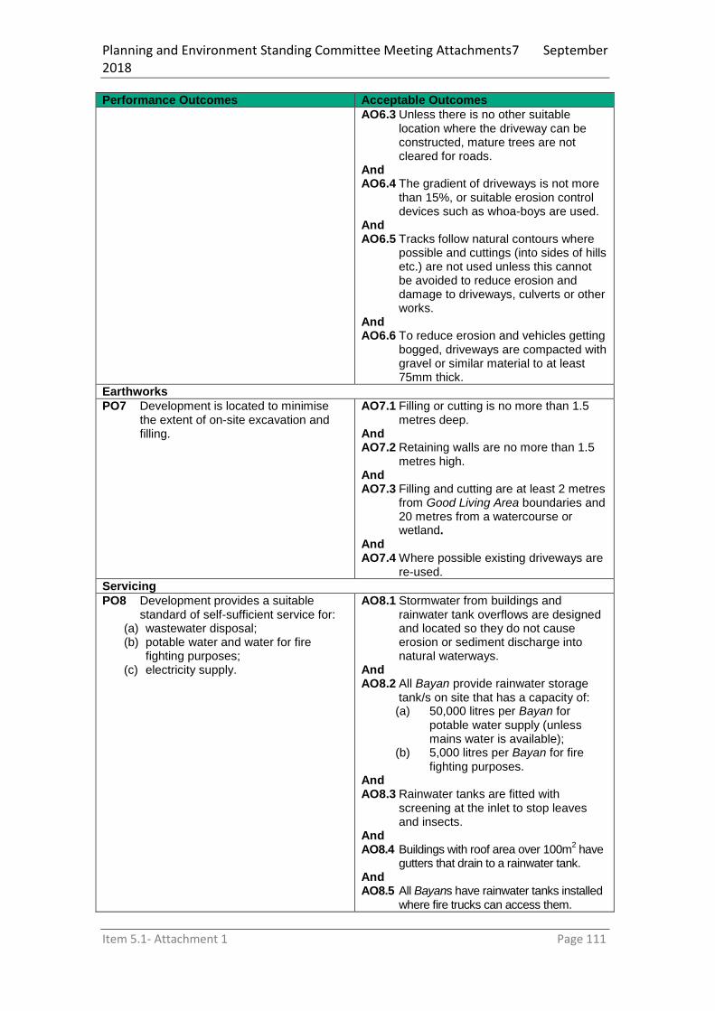
Planning and Environment Standing Committee Meeting Attachments7 September 2018
Item 5.1- Attachment 1 Page 111
Performance Outcomes Acceptable Outcomes
AO6.3 Unless there is no other suitable location where the driveway can be constructed, mature trees are not cleared for roads.
And AO6.4 The gradient of driveways is not more
than 15%, or suitable erosion control devices such as whoa-boys are used.
And AO6.5 Tracks follow natural contours where
possible and cuttings (into sides of hills etc.) are not used unless this cannot be avoided to reduce erosion and damage to driveways, culverts or other works.
And AO6.6 To reduce erosion and vehicles getting
bogged, driveways are compacted with gravel or similar material to at least 75mm thick.
Earthworks
PO7 Development is located to minimise the extent of on-site excavation and filling.
AO7.1 Filling or cutting is no more than 1.5 metres deep.
And AO7.2 Retaining walls are no more than 1.5
metres high. And AO7.3 Filling and cutting are at least 2 metres
from Good Living Area boundaries and 20 metres from a watercourse or wetland.
And AO7.4 Where possible existing driveways are
re-used.
Servicing
PO8 Development provides a suitable standard of self-sufficient service for:
(a) wastewater disposal; (b) potable water and water for fire
fighting purposes; (c) electricity supply.
AO8.1 Stormwater from buildings and rainwater tank overflows are designed and located so they do not cause erosion or sediment discharge into natural waterways.
And AO8.2 All Bayan provide rainwater storage
tank/s on site that has a capacity of: (a) 50,000 litres per Bayan for
potable water supply (unless mains water is available);
(b) 5,000 litres per Bayan for fire fighting purposes.
And AO8.3 Rainwater tanks are fitted with
screening at the inlet to stop leaves and insects.
And AO8.4 Buildings with roof area over 100m
2 have
gutters that drain to a rainwater tank. And AO8.5 All Bayans have rainwater tanks installed
where fire trucks can access them.

Planning and Environment Standing Committee Meeting Attachments7 September 2018
Item 5.1- Attachment 1 Page 112
Performance Outcomes Acceptable Outcomes
And AO8.6 Rainwater tanks are fitted with a 50mm
ball valve with a camlock fitting for fire truck access (Councils and tank suppliers can give advice on this).
And AO8.7 Waste water management systems
(toilets and grey water) are the self-composting or bio-cycle type, unless otherwise approved under the FNQROC standards.
And AO8.8 Household and community rubbish
systems are designed and located to contain rubbish within the site and are not visible from road frontages.
And AO8.9 Where Bama want electricity and
mains power is not available, an environmentally friendly and energy efficient power supply is connected, such as a hybrid solar/generator, wind turbine or micro-hydroelectric system.
PO9 Residents, workers and visitors are provided with adequate access and parking for vehicles.
AO9.1 Each Bayan is provided with one car parking space that enables vehicles to be parked and moved in all-weather events.
and AO9.2 Community uses provide one car
parking space per 50m2 of gross floor
area that enables vehicles to be parked and moved in all-weather events.
and AO9.3 One access point per site is provided
in accordance with the requirements of AO6.1 to AO6.6.
Table 7.1.1 – Extent of development within the identified good living area of each Precinct
Precinct Extent of development
Trevethan A maximum of five bayan’s
One community use (ranger station/communal shed)
Mungumby North One community use (communal shed)
Little Annan A maximum of two bayan’s
Mungumby South A maximum of two bayan’s
Shiptons Flat A maximum of one bayan per good living area

Planning and Environment Standing Committee Meeting Attachments7 September 2018
Item 5.1- Attachment 1 Page 113
7.1.2 Lakeland Local Plan
7.1.2.1 Application
(1) This code applies to assessing a material change of use, reconfiguring a lot, operational work or building work in the Lakeland Local Plan area, if: a. Assessable development where this code is an applicable code identified in
the assessment benchmarks column of a table of assessment for a local plan; or
b. Impact assessable development. (2) Land in the Lakeland Local area is identified on Local Plan Maps 7 and 8. (3) When using this code, reference should be made to Sections 1.5 and 5.3.
7.1.3 Purpose
(1) The purpose of the Lakeland Local Plan is to provide finer grained planning at a local level to guide the growth and development of the township of Lakeland generally in accordance with Local Plan Maps 7 and 8.
(2) The purpose of the Lakeland Local Plan code will be achieved through Overall Outcomes.
(3) The Overall Outcomes for the Local Plan area are:
a. The existing agricultural activities and future agricultural potential is protected
from medium to long term sterilisation as a result of development or fragmentation/isolation.
b. Greenfield development does not occur until infrastructure is available to
service the development to an appropriate urban standard.
c. New retail, commercial and rural service industry uses are centred around the
Penninsula Development Road and Foyster Drive.
d. Development contributes to the pedestrian environment through the provision
of footpaths (1.5m wide) and shared cycle/pedestrian paths (2.5m wide) in locations indicated on the Local Plan Map 8 as well as the provision of landscaping and street trees.
e. Development on land fronting the Mulligan Highway/Penninsula Development
Road intersection facilitates the establishment of a future information centre and Cape York gateway signage.
f. Development contributes towards and does not prejudice a future highway
pedestrian crossing opposite the Lakeland Roadhouse to link the primary school and the sport and recreation facility.
g. Development is not envisaged to occur adjacent to Perfume Gully. Where
development is proposed, it protects and enhances Perfume Gully as a public passive recreation space.
h. New residential development:
(i) occurs in locations identified for Residential Expansion on the Local Plan Map 7 subject to the provision of services;
(ii) does not occur outside the locations identified for Residential Expansion on the Local Plan Map 7 unless economic and planning need is demonstrated;
(iii) is consistent with an approved structure plan identifying how the site and adjoining land can be serviced; and
(iv) contributes to predestrian linkages connecting to existing services, facilities and residential and recreational areas generally in accordance with Local Plan Map 8.
i. The ongoing use of land for Low impact industry, Rural Industry and Service
industry is supported in the locations shown on the Local Plan Map 7 and is protected from incompatible development
j. Development for an industrial use is located, designed and managed to
maintain safety to people and minimises impacts on adjacent non-industrial land including sensitive uses.

Planning and Environment Standing Committee Meeting Attachments7 September 2018
Item 5.1- Attachment 1 Page 114
k. Medium impact industry and High impact industry is supported on land west
of Lakeland where indicated on the Local Plan Map 7.
l. Short term accommodation, including use as a Caravan park, is supported on
Lot 2 on RP744574

Planning and Environment Standing Committee Meeting Attachments7 September 2018
Item 5.1- Attachment 1 Page 115
Part 8 Overlays
8.1 Preliminary
(1) Overlays identify areas within the planning scheme that reflect state and local level interests and that have one or more of the following characteristics: (a) there is a particular sensitivity to the effects of development; (b) there is a constraint on land use or development outcomes; (c) there is the presence of valuable resources; (d) there are particular opportunities for development.
(2) Overlays are mapped and included in Schedule 2. (3) The changed category of development or assessment, if applicable, for development
affected by an overlay are in Part 5. (4) Some overlays may be included for information purposes only. This should not result in
a change to the category of development or assessment or any additional assessment benchmarks.
(5) Assessment benchmarks for an overlay may be contained in one or more of the following: (a) a map for an overlay (b) a code for an overlay (c) a zone code (d) a local plan code (e) a development code
(6) Where development is proposed on premises partly affected by an overlay, the assessment benchmarks for the overlay only relates to the part of the premises affected by the overlay.
(7) The overlays for the planning scheme are: (a) Airport environs overlay code (b) Biodiversity overlay code (c) Bushfire hazard overlay code (d) Character overlay code (e) Extractive resources overlay code (f) Flood and other coastal hazards overlay code (g) Landslide overlay code (h) Scenic amenity overlay code
(8) The following overlays for the planning scheme without code(s) are: (a) Wetlands and waterways overlay (b) Future urban expansion overlay (c) State controlled roads overlay (d) Infrastructure services overlay (e) Water resources overlay
(i) Duck Farm Sub-artesian Basin (ii) Annan River Catchment
(f) Rural land use overlay (g) Old dam site overlay
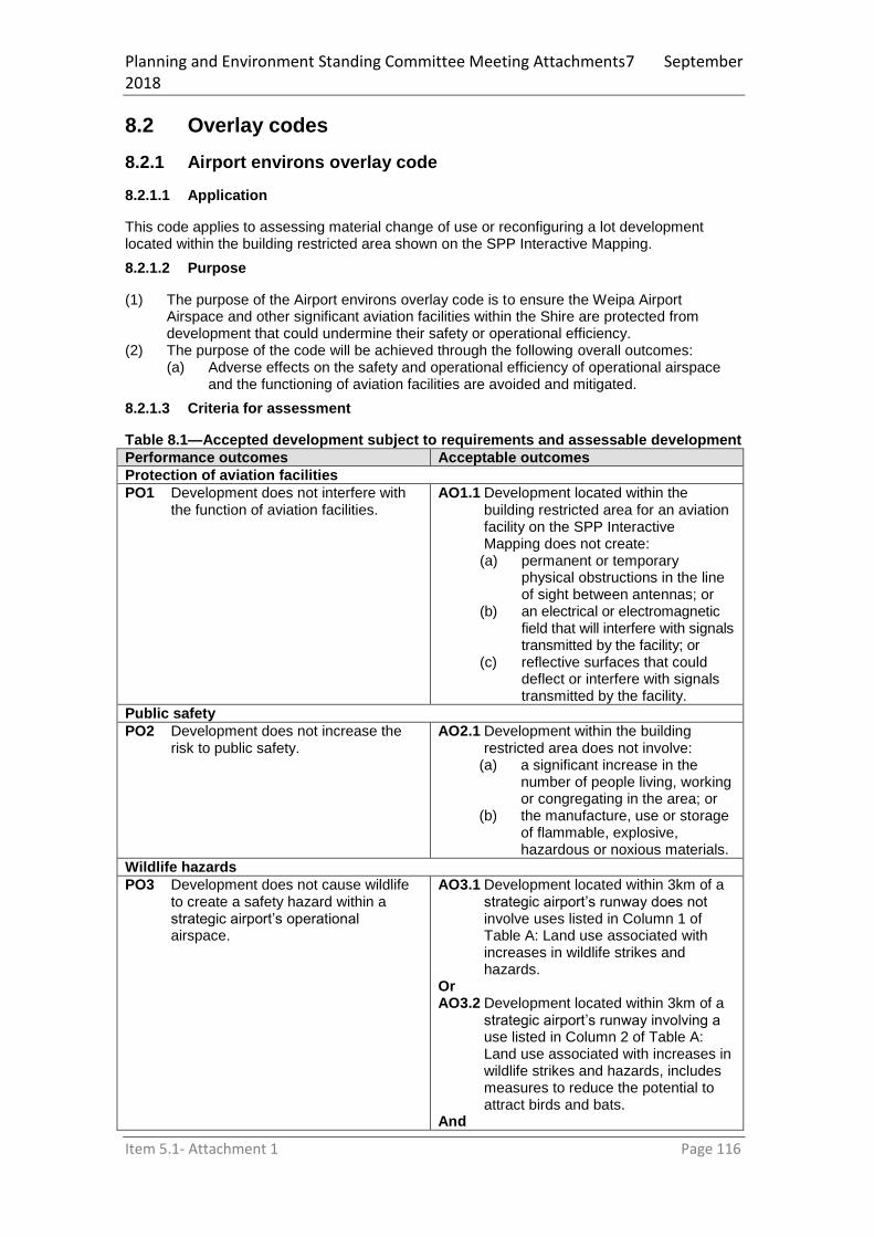
Planning and Environment Standing Committee Meeting Attachments7 September 2018
Item 5.1- Attachment 1 Page 116
8.2 Overlay codes
8.2.1 Airport environs overlay code
8.2.1.1 Application
This code applies to assessing material change of use or reconfiguring a lot development located within the building restricted area shown on the SPP Interactive Mapping.
8.2.1.2 Purpose
(1) The purpose of the Airport environs overlay code is to ensure the Weipa Airport Airspace and other significant aviation facilities within the Shire are protected from development that could undermine their safety or operational efficiency.
(2) The purpose of the code will be achieved through the following overall outcomes: (a) Adverse effects on the safety and operational efficiency of operational airspace
and the functioning of aviation facilities are avoided and mitigated.
8.2.1.3 Criteria for assessment
Table 8.1—Accepted development subject to requirements and assessable development
Performance outcomes Acceptable outcomes
Protection of aviation facilities
PO1 Development does not interfere with the function of aviation facilities.
AO1.1 Development located within the building restricted area for an aviation facility on the SPP Interactive Mapping does not create:
(a) permanent or temporary physical obstructions in the line of sight between antennas; or
(b) an electrical or electromagnetic field that will interfere with signals transmitted by the facility; or
(c) reflective surfaces that could deflect or interfere with signals transmitted by the facility.
Public safety
PO2 Development does not increase the risk to public safety.
AO2.1 Development within the building restricted area does not involve:
(a) a significant increase in the number of people living, working or congregating in the area; or
(b) the manufacture, use or storage of flammable, explosive, hazardous or noxious materials.
Wildlife hazards
PO3 Development does not cause wildlife to create a safety hazard within a strategic airport’s operational airspace.
AO3.1 Development located within 3km of a strategic airport’s runway does not involve uses listed in Column 1 of Table A: Land use associated with increases in wildlife strikes and hazards.
Or AO3.2 Development located within 3km of a
strategic airport’s runway involving a use listed in Column 2 of Table A: Land use associated with increases in wildlife strikes and hazards, includes measures to reduce the potential to attract birds and bats.
And

Planning and Environment Standing Committee Meeting Attachments7 September 2018
Item 5.1- Attachment 1 Page 117
Performance outcomes Acceptable outcomes
AO3.3 Development located between 3km and 8km of a strategic airport’s runway involving a use listed in Column 1 or column 2 of Table A: Land use associated with increases in wildlife strikes and hazards, includes measures to reduce the potential to attract birds and bats.
And AO3.4 Development located between 8km
and 13km of a strategic airport’s runway involving a use listed in Column 1 or column 2 of Table A: Land use associated with increases in wildlife strikes and hazards, does not increase the potential to attract birds and bats.
Lighting and reflective surfaces
PO4 Development does not include external lighting or reflective surfaces that could distract or confuse pilots.
AO4.1 Development within the lighting buffer zone for a strategic airport does not include any of the following types of outdoor lighting:
(a) straight parallel lines of lighting 500m to 1,000m long;
(b) flare plumes; (c) upward shining lights; (d) flashing lights; (e) laser lights; (f) sodium lights; (g) reflective surfaces;
AO4.2 Development within the lighting buffer for a strategic airport does not emit light that will exceed the light intensity specified for the area.
Editor’s note: A development proposal on land located within a building restricted area should be referred to Airservices Australia or the Department of Defence (for RAAF Scherger) for assessment. Airservices Australia or the Department of Defence will provide local government and proponents with authoritative advice about the impact of a proposed development on the function of an aviation facility, requirements for risk assessment processes, and mitigation methods. It is recommended that advice be sought during pre-lodgement stage of development assessment processes to avoid objections from Airservices Australia or the Department of Defence.
Table A: Land uses associated with increases in wildlife strikes and hazards
Column 1: High risk Column 2: Moderate risk
Rural activities
Cropping (turf farm)
Cropping (fruit tree farm)
Intensive animal industry (piggery)
Aquaculture (fish processing/packing plant)
Conservation
Conservation estate (e.g. wetland) Recreation activities
Major sport, recreation and entertainment facilities (showground)
Industry activities
Low-impact; medium-impact or high-impact industry (food processing plant)
Rural activities
Animal husbandry (cattle/dairy farm)
Intensive animal industry (poultry farm) Conservation
Conservation estate (all other) Recreation activities
Major sport, recreation and entertainment facilities (all other)
Outdoor sport and recreation
Park Utility installation
Non-putrescible waste facility (e.g. landfill)
Sewerage/wastewater treatment facility

Planning and Environment Standing Committee Meeting Attachments7 September 2018
Item 5.1- Attachment 1 Page 118
Utility installation
Food/organic waste facility
Putrescible waste facility (e.g. landfill)
8.2.2 Biodiversity overlay code
8.2.2.1 Application
This code applies to material change of use or reconfiguring a lot development occurring within an area of State environmental significance mapped OM1 – Biodiversity Overlay Map.
8.2.2.2 Purpose
(1) The purpose of the Biodiversity overlay code is to protect biodiversity through: (a) avoiding development within biodiversity areas; (b) minimising the adverse impacts of development on biodiversity; (c) management of pest and invasive species; (d) strategic rehabilitation occurs through restoration of terrestrial and aquatic
ecosystems; (e) encourage expansion of habitat connectivity; (f) minimise downstream impacts on biodiversity including fish habitats and the Great
Barrier Reef. (2) The purpose of the code will be achieved through the following overall outcomes:
(a) Conservation, consolidation, connection and restoration of the network of lands with environmental significance.
(b) Protection and enhancement of waterways, wetlands and coastal environments with environmental significance and their hydrological value and water-cleaning functions.
(c) Avoidance of impacts to areas of environmental significance through the appropriate design and location of development.
8.2.2.3 Criteria for assessment
Table 8.2—Assessable development
Performance Outcome Acceptable Outcome
Section 1 - Accepted and assessable development
PO1 Development avoids areas of environmental significance.
AO1.1 Development does not result in the clearing of vegetation and is set back a minimum of 20 metres from a wetland or water course mapped on OM12 – Wetland and Watercourses Overlay Map.
- Assessable development
PO2 Development minimises or mitigates adverse impacts on areas of environmental significance where such impacts are unavoidable.
AO2.1 Development within an area identified on OM1 – Biodiversity Overlay Map does not involve vegetation clearing.
Or AO2.2 Where development within an area
identified on OM1 – Biodiversity Overlay Map is unavoidable, measures recommended by a suitably qualified ecologist are incorporated to protect and retain the environmental values and underlying ecosystem processes within or adjacent to the development site to the greatest extent practical.
Editor’s note: To demonstrate compliance with AO2 or

Planning and Environment Standing Committee Meeting Attachments7 September 2018
Item 5.1- Attachment 1 Page 119
Performance Outcome Acceptable Outcome PO2, Council may require the applicant to provide an ecological assessment prepared by a suitably qualified ecologist.
PO3 Development is designed to avoid and minimise edge effects and other impacts to Protected Areas, Marine Parks and Declared Fish Habitat Areas identified on OM1 – Biodiversity Overlay.
AO3.1 Development is setback a minimum of 100m from Protected Areas, Marine Parks and Declared Fish Habitat Areas identified on OM1 – Biodiversity Overlay.
Or AO3.2 Development which is compatible
with the long-term preservation of Protected Areas, Marine Parks and Declared Fish Habitat Areas identified on OM1 – Biodiversity Overlay.is located within 100m of the areas, including: (a) roads and pathways; (b) landscaping or habitat
restoration areas consisting of local indigenous plant species;
(c) open space land uses; (d) storage areas; (e) employee or communal
recreation areas; (f) stormwater management
infrastructure where adopting water sensitive urban design solutions.
And AO3.3 Development minimises noise and
light spillage into Protected Areas, Marine Parks and Declared Fish Habitat Areas identified on OM1 – Biodiversity Overlay. by: (a) directing light away from the
nominated areas or using light shields;
(b) establishing 20m dense native vegetation buffers between development and the nominated areas;
(c) locating artificial noise-generating activities away from the nominated areas.
PO4 An adequate buffer to wetlands identified on OM1 – Biodiversity Overlay Map is provided and maintained.
AO4.1 A buffer for an area of state environmental significance (wetland protection area) has a minimum width of: (a) 200 m where the area is
located outside an urban area; or
(b) 50 m where the area is located within an urban area.

Planning and Environment Standing Committee Meeting Attachments7 September 2018
Item 5.1- Attachment 1 Page 120
8.2.3 Bushfire hazard overlay code
Editor’s Note: Land shown on the bushfire hazard overlay map is designated as the bushfire prone area for the purposes of section 12 of the Building Regulations 2006. The bushfire hazard area (bushfire prone area) includes land covered by the very high, high and medium hazard areas as well as the buffer area category on the overlay map.
8.2.3.1 Application
This code applies to material change of use or reconfiguring a lot development occurring on premises identified on the OM2 - Bushfire Risk Overlay Map within a Bushfire Hazard Area or within the Potential Impact Buffers.
8.2.3.2 Purpose
(1) The purpose of the Bushfire Hazard Overlay Code is to: (a) Provide for the assessment of the suitability of development in the Bushfire
Hazard Overlay area to ensure that risk to life, property, community, economic activity and the environment during bushfire events is minimised.
(b) Ensure that development does not increase the potential for bushfire damage on-site or to other property.
(2) The purpose of the Bushfire Hazard Overlay Code will be achieved through the following overall outcomes: (a) the development siting, layout, and access responds to the risk of the bushfire
hazard and minimises risk to personal safety (b) the development is resilient to bushfire hazard events by ensuring siting and
design accounts for the potential risks of bushfire hazards to property (c) the development supports, and does not unduly burden disaster management
response or recovery capacity and capabilities (d) the development directly, indirectly and cumulatively avoids an unacceptable
increase in severity of then bushfire hazard and does not significantly increase the potential for damage on the site or to other properties
(e) development avoids the establishment or intensification of vulnerable uses in or near areas subject to bushfire hazard
(f) the development avoids the release of hazardous materials as a result of a bushfire hazard event
(g) impacts from bushfire mitigation treatments on natural processes and the protective function of landforms and/or vegetation are avoided or minimised
8.2.3.3 Criteria for assessment
Table 8.3—Accepted development subject to requirements and assessable development
Performance outcomes Acceptable outcomes
Section 1 - For accepted and assessable development
Safety
PO1 Development maintains the safety of people and property by avoiding Bushfire Hazard areas or mitigating the risk of bushfire hazard through lot design, firebreaks, emergency vehicle access, safe evacuation and adequate water supply.
AO1.1 Development will be located in an
area with a Low or Very Low Bushfire Hazard Rating in accordance with the ‘Bushfire Hazard Checklist’ in Bushfire Hazard Analysis Planning Scheme Policy.
Note: A copy of the completed Bushfire Hazard Checklist must be submitted to Council with the MCU or ROL development application. For accepted MCU development, a copy must be provided to the building certifier.
PO2 Landscaping does not increase the potential bushfire risk.
AO2.1 Landscaping uses species that are less likely to exacerbate a bushfire event, and does not increase fuel loads in separation areas.
PO3 The risk of bushfire and the need to AO3.1 Bushfire risk mitigation treatments
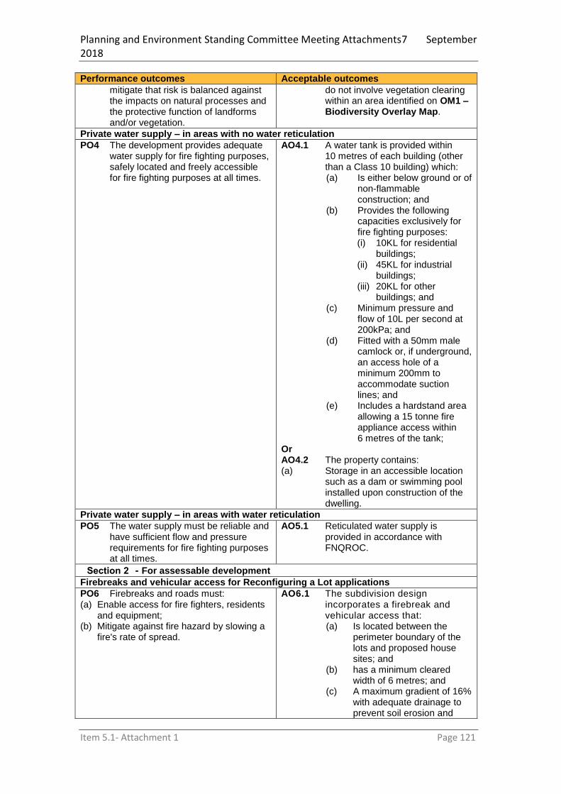
Planning and Environment Standing Committee Meeting Attachments7 September 2018
Item 5.1- Attachment 1 Page 121
Performance outcomes Acceptable outcomes
mitigate that risk is balanced against the impacts on natural processes and the protective function of landforms and/or vegetation.
do not involve vegetation clearing within an area identified on OM1 – Biodiversity Overlay Map.
Private water supply – in areas with no water reticulation
PO4 The development provides adequate water supply for fire fighting purposes, safely located and freely accessible for fire fighting purposes at all times.
AO4.1 A water tank is provided within 10 metres of each building (other than a Class 10 building) which: (a) Is either below ground or of
non-flammable construction; and
(b) Provides the following capacities exclusively for fire fighting purposes: (i) 10KL for residential
buildings; (ii) 45KL for industrial
buildings; (iii) 20KL for other
buildings; and (c) Minimum pressure and
flow of 10L per second at 200kPa; and
(d) Fitted with a 50mm male camlock or, if underground, an access hole of a minimum 200mm to accommodate suction lines; and
(e) Includes a hardstand area allowing a 15 tonne fire appliance access within 6 metres of the tank;
Or AO4.2 The property contains: (a) Storage in an accessible location
such as a dam or swimming pool installed upon construction of the dwelling.
Private water supply – in areas with water reticulation PO5 The water supply must be reliable and
have sufficient flow and pressure requirements for fire fighting purposes at all times.
AO5.1 Reticulated water supply is provided in accordance with FNQROC.
Section 2 - For assessable development Firebreaks and vehicular access for Reconfiguring a Lot applications PO6 Firebreaks and roads must: (a) Enable access for fire fighters, residents
and equipment; (b) Mitigate against fire hazard by slowing a
fire's rate of spread.
AO6.1 The subdivision design incorporates a firebreak and vehicular access that: (a) Is located between the
perimeter boundary of the lots and proposed house sites; and
(b) has a minimum cleared width of 6 metres; and
(c) A maximum gradient of 16% with adequate drainage to prevent soil erosion and

Planning and Environment Standing Committee Meeting Attachments7 September 2018
Item 5.1- Attachment 1 Page 122
Performance outcomes Acceptable outcomes
minimise ongoing maintenance; and
(d) accommodates geometry and turning radii in accordance with Qld Fire and Emergency Services’ Fire Hydrant and Vehicle Access Guidelines.
And AO6.2 Private driveways:
(a) Have a maximum length of length of 60m from the street to the building; and
(b) Do not exceed a gradient of 12.5%; and
(c) Have a minimum width of 3.5 metres; and
(d) Have a minimum of 4.8 metres vertical clearance; and
(e) Serve no more than 3 dwellings or buildings.
And AO6.3 Road design is capable of
providing access for fire fighting and emergency vehicles in accordance with the FNQROC.
And AO6.4 Vehicular links are provided along
the firebreak either to existing firebreaks or roads, and these links are designed to suit topography, fire fighter safety and access to water supplies.
And AO6.5 The firebreak and/or road has
vehicle access at both ends to either another firebreak or road.
Or AO6.6 A turning circle, or ‘T’ or ‘Y’ shaped
turning bay, is provided at the end of the firebreak/road, provided it is of sufficient size for the turning of a fire fighting vehicle.
And AO6.7 The firebreak provides areas for
vehicles to pass or turn at intervals of not more than 400 metres and with a maximum grade of 5% (1 in 20).
And AO6.8 Firebreaks/vehicle access located
on private land have an access easement granted in favour of Council and fire brigades.
Land use
PO7 Vulnerable uses must not result in a high concentration of people living or congregating in a Very High, High or
AO7.1 Vulnerable uses are not established or expanded in a Very High, High or Medium Bushfire

Planning and Environment Standing Committee Meeting Attachments7 September 2018
Item 5.1- Attachment 1 Page 123
Performance outcomes Acceptable outcomes
Medium Bushfire Hazard Area unless there is an overriding need or other exceptional circumstances.
Hazard Area unless supported by a Bushfire Hazard Management Plan.
Or AO7.2 Vulnerable uses proposed in a
Very High, High or Medium Bushfire Hazard Areas are supported by a Bushfire Hazard Management Plan demonstrating satisfactory safety measures and have direct access to low hazard evacuation routes.
Note: To demonstrate compliance with this provision, the applicant shall engage a suitably qualified person to prepare a Bushfire Hazard Management Plan; and submit the Plan with their development application to Council.
Council reserves the right to refer the Plan to the Queensland Fire & Rescue Service for third party advice during their assessment of the development application. If Council approves the development, a condition may be included to require compliance with the Plan at all times.
PO8 Development involving hazardous materials manufactured or stored in bulk does not create an increase in risk of bushfire hazard.
AO8.1 The manufacture or storage of hazardous material in bulk does not occur within bushfire hazard area.
8.2.4 Character overlay code
8.2.4.1 Application
The Character Overlay Code applies to material change of use, reconfiguring a lot, building work and operational work development occurring on premises within the Neighbourhood Character and Heritage Places layer on OM3 - Character Overlay Map and further identified in Schedule 1 of this code.
8.2.4.2 Purpose
(1) The purpose of the Character overlay code is to ensure development protects heritage places and areas of local or state heritage value.
(2) The purpose of the code will be achieved through the following overall outcomes: (a) The built heritage values of historic streetscapes and individual sites within those
streetscapes are protected and (where feasible) enhanced; (b) New buildings or structures and extensions to new buildings and structures
incorporate (but not necessarily identically replicate) the main features of existing historic architectural styles and streetscape values within the character precinct and are sympathetic to and blend with the original building types in the character precinct;
(c) New buildings and structures on or adjoining the Cooktown waterfront, when viewed from both land and water, exhibit a high standard of design consistent with their function, to achieve attractive presentation and distinct point of entry for residents and visitors arriving by water; and
(d) Demolition of existing buildings and structures only occurs where those buildings and structures have no significant built heritage value or where there is no feasible alternative to demolition.
(e) Development on or adjacent to a Heritage Place will not have an adverse impact in terms of: (i) Visibility (ii) Public accessibility (iii) Physical change; or

Planning and Environment Standing Committee Meeting Attachments7 September 2018
Item 5.1- Attachment 1 Page 124
(iv) Damage or removal.
8.2.4.3 Criteria for assessment
Table 8.4—Assessable development
Performance outcomes Acceptable outcomes
Architectural form
PO1 New building and structures and alterations to the external appearance of buildings and structures are of a high quality design, reflecting the built heritage features of historic buildings and the streetscape.
AO1.1 Commercial buildings incorporate the following design features (refer to figures 1 to 10 of this code for illustration):
Cooktown (a) High pitched roof forms.
Flatter roof forms may be used provided they are hidden behind parapet walling, which is continuous across the facade and sides of the building.
(b) Cantilevered awnings with imitation supporting posts set back 600mm from the face of the kerb and extending the full width of the building frontage (awning and setback mandatory). This includes buildings on corner sites.
(c) Gable ends. (d) Skillion, bellcast or concave
roofs for footpath awnings. (e) Parapet walling. (f) Walls include features such
as cornice, picture rails, window hoods, pilasters.
(g) Verandahs are unenclosed by permanent construction, however roll –up blinds may be incorporated to provide protection from the elements.
(h) Verandah balustrade must be open.
(i) Awnings and verandahs must include features such as brackets, capitals, astragals and stop chamfered posts.
(j) Rectangular or square building form.
(k) Extensive use of timber, rendered brick, or masonry block or other material that imitates rendered brick or block i.e. sheet material that is rendered.
(l) Extensive use of corrugated iron.
(m) Quadrant or ogee roof guttering is used.

Planning and Environment Standing Committee Meeting Attachments7 September 2018
Item 5.1- Attachment 1 Page 125
Performance outcomes Acceptable outcomes
(n) The major doorway for customer use faces the major street.
(o) Staircases and balustrade to staircases must be open.
Coen, Laura and Maytown (a) High pitched roof forms. (b) Post supported awnings
extending to the street property boundary and the full width of the building frontage (awning mandatory). This includes buildings on corner sites.
(c) Gable ends. (d) Skillion awnings. (e) Rectangular or square
building form. (f) Extensive use of timber and
corrugated iron. (g) Quadrant or ogee roof
guttering is used. (h) The major doorway for
customer use faces the major street
(i) Staircases and balustrade to staircases must be open.
And AO1.2 Residential buildings and
structures reflect vernacular “Queenslander” design and incorporate:
Cooktown (a) High pitched roof forms. (b) Gable or hip roofs. (c) Skillion, bellcast or concave
roofs for verandahs. (d) Window hoods. (e) Verandahs are unenclosed
by permanent construction, however roll –up blinds may be incorporated to provide protection from the elements.
(f) Verandah balustrade must be open.
(g) Verandahs must include features such as brackets, capitals, astragals and stop chamfered posts.
(h) The proportions of windows emphasising the vertical and where more natural light is required, windows are divided into a series of windows.
Scale
PO2 Buildings and structure do not diminish the amenity of the area or
AO2.1 Commercial buildings and structures (refer to figures 1 to 10

Planning and Environment Standing Committee Meeting Attachments7 September 2018
Item 5.1- Attachment 1 Page 126
Performance outcomes Acceptable outcomes
create an adverse impact on the historic character of the precinct due to excessive scale and bulk.
of this code for illustration): Cooktown
(a) Are of a scale and bulk that is consistent with adjoining development and the local streetscape.
(b) Obstruction of significant local and distant views of prominent features, landscapes and landmarks is minimised.
(c) Have parapet walls on frontages of similar design to existing development in the local streetscape.
(d) Have their visual impact softened by the introduction of horizontal and vertical architectural elements such as cornice detailing, sill locations, false windows panel features, awning and verandah post detailing and stepping in vertical planes. Such detailing will be provided to building facades of all street frontages including corner sites.
(e) May exceed two storeys, however the facade must emulate a two storey building characteristic of the historic streetscape.
Coen, Laura and Maytown (a) Are of a scale and bulk that
is consistent with adjoining development and the local streetscape.
(b) Obstruction of significant local and distant views of prominent features, landscapes and landmarks is minimised.
(c) Have their visual impact softened by the introduction of horizontal and vertical architectural elements such as cornice detailing, sill locations, false windows panel features, awning and verandah post detailing and stepping in vertical planes. Such detailing will be provided to building facades of all street frontages including corner sites.
(d) Must not exceed two storeys.
Or
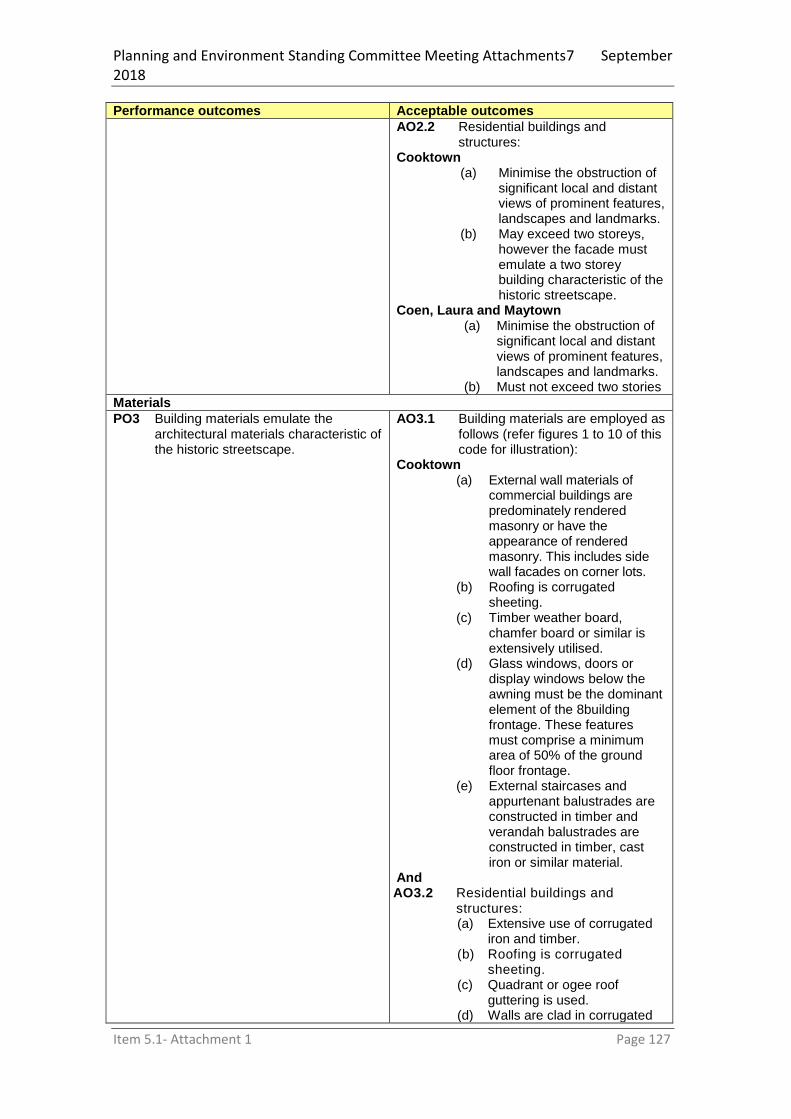
Planning and Environment Standing Committee Meeting Attachments7 September 2018
Item 5.1- Attachment 1 Page 127
Performance outcomes Acceptable outcomes
AO2.2 Residential buildings and structures:
Cooktown (a) Minimise the obstruction of
significant local and distant views of prominent features, landscapes and landmarks.
(b) May exceed two storeys, however the facade must emulate a two storey building characteristic of the historic streetscape.
Coen, Laura and Maytown (a) Minimise the obstruction of
significant local and distant views of prominent features, landscapes and landmarks.
(b) Must not exceed two stories
Materials
PO3 Building materials emulate the architectural materials characteristic of the historic streetscape.
AO3.1 Building materials are employed as follows (refer figures 1 to 10 of this code for illustration):
Cooktown (a) External wall materials of
commercial buildings are predominately rendered masonry or have the appearance of rendered masonry. This includes side wall facades on corner lots.
(b) Roofing is corrugated sheeting.
(c) Timber weather board, chamfer board or similar is extensively utilised.
(d) Glass windows, doors or display windows below the awning must be the dominant element of the 8building frontage. These features must comprise a minimum area of 50% of the ground floor frontage.
(e) External staircases and appurtenant balustrades are constructed in timber and verandah balustrades are constructed in timber, cast iron or similar material.
And AO3.2 Residential buildings and
structures: (a) Extensive use of corrugated
iron and timber. (b) Roofing is corrugated
sheeting. (c) Quadrant or ogee roof
guttering is used. (d) Walls are clad in corrugated

Planning and Environment Standing Committee Meeting Attachments7 September 2018
Item 5.1- Attachment 1 Page 128
Performance outcomes Acceptable outcomes
iron or horizontal timber chamfer board or weatherboard.
Texture
PO4 Building design avoids repetition and creates textural effect in the streetscape.
AO4.1 Commercial buildings and structures (refer figures 1 to 10 of this code for illustration): (a) Have primary entrance
doorways recessed to provide off-footpath entry.
(b) Use only parapets and awning fascia for commercial advertising signage.
(c) Have window hoods installed over windows (not required under awnings or verandahs).
(d) Utilise timber framed or coloured aluminium framed windows and doors.
(e) Windows have a vertical dimension greater than their horizontal dimension.
(f) Incorporate composite materials in the facade and awning.
Or AO4.2 Residential buildings and
structures incorporate: (a) Window hoods over windows
(not required under awnings or verandahs).
(b) Staircases feature on the elevation facing the street frontage.
(c) Building elevations facing the major street frontage incorporate verandahs.
Setting
PO5 New buildings and structures and extensions to existing buildings and structures complement the setting of the existing historic streetscape.
AO5.1 Commercial buildings and structures (refer figures 1 to 10 of this code for illustration):
Cooktown (a) Are oriented parallel with the
street frontage (b) Have car parking, loading and
unloading bays located at the rear (or otherwise screened from the street frontage).
(c) Utilise enclosed timber paling fencing with minimum height of 1.8 metres.
(d) Employ street furniture (where provided) of a simple design which does not imitate generic heritage designs.
(e) Provide simple square paling surround planter boxes similar to the fencing style.

Planning and Environment Standing Committee Meeting Attachments7 September 2018
Item 5.1- Attachment 1 Page 129
Performance outcomes Acceptable outcomes
(f) Are painted in a heritage colour scheme sympathetic to the buildings’ architectural style and the streetscape generally.
(g) Comply (where advertising is provided) with Lettering and Signs on Buildings c.1850 - 1900 Australian Council of National Trust technical bulletin 2.2 published March 1984.
Coen, Laura and Maytown (a) Are oriented parallel with the
street frontage. (b) Have car parking, loading and
unloading bays located at the rear (or otherwise screened from the street frontage).
(c) Employ street furniture (where provided) of a simple design which does not imitate generic “heritage designs”.
(d) Are painted in a heritage colour scheme sympathetic to the building’s architectural style and the streetscape generally.
(e) Comply (where advertising is provided) with Lettering and Signs on Buildings c.1850-1900 Australian Council of National Trust technical bulletin 2.2 published March 1984.
And AO5.2 Residential buildings and
structures: (a) Are oriented parallel with the
street frontage. (b) Utilise enclosed timber paling
fencing with a minimum height of 1.2 m.
(c) Are painted in a heritage colour scheme sympathetic to the building’s architectural style and the streetscape generally.
Demolition
PO6 Demolition of existing buildings and structure only occurs where:
(a) The existing building or structure has no significant built heritage value; or
(b) It is not feasible to restore the existing building and there is no reasonable alternative to demolition;
Providing that in either case, plans for
AO6.1 Engineering documentary evidence is provided to substantiate demolition need.
And
AO6.2 Recording of buildings or structures is undertaken by a suitably qualified person.
And

Planning and Environment Standing Committee Meeting Attachments7 September 2018
Item 5.1- Attachment 1 Page 130
Performance outcomes Acceptable outcomes
replacement buildings or structures which comply with the requirements of this code are provided prior to such demolition being approved.
AO6.3 Where part of a building is intended to be demolished or adapted for an adjusted need (i.e. to provide disabled access) the additional works are constructed in a similar character to the original building and the remaining part of the building retains its original character.
Protection of cultural heritage values
PO7 Development involving a Heritage Place must provide for the conservation and management of cultural heritage values.
No Acceptable Outcome specified.
PO8 Development on land adjacent to a Heritage Place must be designed, executed and operated to:
(a) Be compatible with the cultural heritage significance of the listed site and not detrimentally impact on its values or its setting; and
(b) Not obscure the appearance or prominence of the place when viewed from adjacent public or semi-public streets or open spaces, nor intrude into the place.
No Acceptable Outcome specified.
Protection of archaeological values
PO9 Development does not adversely affect the archaeological significance of a place.
AO9.1 For development on the site identified as having archaeological values in Schedule 1 of this Code, an archaeological investigation is carried out for development involving a high level of surface or sub-surface disturbance.
Or AO9.2 The impact of any excavation is
minor and limited to parts of the site that have been disturbed by previous excavation.
Editor’s Note. Developers are required to discharge their duty of care under the Aboriginal Cultural Heritage Act 2003, particularly where development is proposed which would involve surface disturbance beyond that which has already occurred.

Planning and Environment Standing Committee Meeting Attachments7 September 2018
Item 5.1- Attachment 1 Page 131
Figure 1 Rectangular building form, extensive use of rendered brick and corrugated sheeting. See also figures 3 and 4 for examples of post-supported awnings.
Figure 2 Two storey façade with two internal stories and mezzanine floor.
Figure 4 - Simple paling fence.
Figure 3 Use of timber chamfer board. Ground floor windows predominate ground floor of building. Parapets used for signage, windows have greater vertical than horizontal dimensions. Pilasters assist in softening dominance of façade. Parapet walling includes architectural features.

Planning and Environment Standing Committee Meeting Attachments7 September 2018
Item 5.1- Attachment 1 Page 132
Figure 5 Street trees planted in simple rectangular tree surrounds.
Figure 6 Type and location of signage. This highly decorative Tuscan face is usually associated with hotels and eating houses. In most cases lettering used is a simple unembellished type set out as uniform capital letters. See also figures 2 and 3 for further examples.
Figure 7 Examples of verandah post decoration.

Planning and Environment Standing Committee Meeting Attachments7 September 2018
Item 5.1- Attachment 1 Page 133
a)
b) Figure 8- Example of decorative gable end cornices, barge board treatment and
imitation quoin to front wall.
c)
d) Figure 9. Examples of tongue and groove spandrel ends on awnings and parapet
wall capping, lean-to and concave awnings.
e)

Planning and Environment Standing Committee Meeting Attachments7 September 2018
Item 5.1- Attachment 1 Page 134
f)
g) Figure 10. Gable roofs, stop chamfered awning posts, gable and verandah gable
architectural treatment, picket fences. h) Schedule 1 Identified Local Heritage Places
Map ID
Cultural feature Property Description
Cultural heritage values/significance
1 Anzac Park Lots 48-49, 51-56, 65-66, 68 C 1793 and Lots 2-3 RP744394 and Lots 1-2 RP744695 and Lots 1-2 RP744723
As ANZAC park this site is historically significant to the local community of Cooktown, and nationally important as a memorial to the soldiers of the Australian and New Zealand Army Corps.
2 Cannon Lot 1 C17974 The cannon is significant to the local community due to its associations with a perceived invasion in 1885.
2 Kennedy Memorial
Lot 1 C17974 The Kennedy Memorial is significant due to its associations with explorer Edmund Kennedy, and his exploration of Cape York Peninsula.
2 Town Well Lot 1 C17974 Significance as a heritage site has been depleted due to re-development of the well to a commemorative fountain but is a significant site of local importance.
3 Chimney, Well & Concrete foundation
Lot 18 SP214624
These relics of the former Criterion Hotel are of significance in Queensland’s history for potential archaeological research.
4 Church Lot 2 RP867048 Despite the demolition of the Church after suffering severe damage from the 1949 cyclone and its re erection in the 1950’s, it is representative of its type and a good example of small timber church construction. The Church is important in Cooktown as a religious meeting place for worship and for maintaining religious traditions.

Planning and Environment Standing Committee Meeting Attachments7 September 2018
Item 5.1- Attachment 1 Page 135
Map ID
Cultural feature Property Description
Cultural heritage values/significance
5 Commercial building (previously quarters for bank staff)
Lot 320 C1791 Significance is considered in respect of its representativeness and apparent intactness. Adaptations are minimal affording excellent research opportunity.
6 Cook’s Landing Site
Esplanade and below high water mark directly opposite Cooktown Court House (Lot 14 CP846856)
The location and cairn are highly significant for their associations with Captain (then Lieutenant) James Cook’s landing site in 1770.
7 Cooktown Hotel Lot 18 RP748191 This building has retained most of its original features despite extensive but basic structural adaptations. The building remains a significant place for social gatherings.
8 CWA Lot 912 C1793 This building is locally significant as a meeting place for the Country Women’s Association. CWA societies are historically very important to the social fabric of country towns.
9 Flower pot Below high water mark adjacent to Lot 4 CP889653
Local anecdotal history suggests the former barge was beached at this site after construction of the screw pile Annan River Bridge. This hull is significant for its connection with pile driving for the bridge.
10 Former Power Station
Lot 61 C17922 This building is significant for its previous use as a power generating station. As such it reflects an early stage of power reticulation in Queensland.
11 Former Town Dump
Lot 2 C179109 The significance of this place lies particularly in its association with the early Chinese residents of Cooktown and environs. Evidence of Chinese ceramics is important for future archaeological research. The site has a substantial range of Chinese ceramics and in particular Chinese ceramic shipping container fragments. The site is also of local cultural significance for its remnant artefacts from the Cooktown Brewery.
12 Grassy Hill Lots 1-2 SP271411 Of high historic importance due to its associations with Captain James Cook (Grassy Hill). The lighthouse and its surrounds are State Heritage listed and do not form part of this listing, notwithstanding it is significant for its associations with the Palmer River gold rush and the facilitation of shipping during a period of prosperous commercial activity. The lighthouse is also significant as one of the earliest established on the Queensland coast.
13 Hotel-West Coast Lot 410 SP154663 A typical Queensland Hotel that despite unsympathetic alterations still retains the essence of its origins. Is significant as a place for social gatherings.
14 House (4 Helen St)
Lot 108 C17912 The building is significant as one of the early cottages built in Cooktown which is

Planning and Environment Standing Committee Meeting Attachments7 September 2018
Item 5.1- Attachment 1 Page 136
Map ID
Cultural feature Property Description
Cultural heritage values/significance
still extant.
15 House (7 Helen St)
Lot 615 C17912 This building is significant as it shows the evolution of domestic architecture in North Queensland coastal towns. Despite significant alterations and adaptation, the building retains its aesthetic charm.
16 House (82 Hope St)
Lot 207 C17912 This Building is a good representative example of a modest timber and iron cottage in North Queensland towns around the turn of the century.
17 House (89 Hope St)
Lot 133 C1793 This dwelling is representative of early domestic dwellings constructed of timber and iron. The building has retained most of its integrity despite minor alterations. It is believed that Land Surveyor A Starke resided in the dwelling. Starke is notable for surveys in the Cooktown area and in particular the survey of the Cooktown Botanic Gardens. The building was owned by renowned botanical artist Vera Scarth-Johnson O.A.M until her death 1999.
18 House (9 Green St)
Lot 408 C17932 This building is primarily significant because it is one of the remaining high set corrugated iron dwellings in the area. The existence of the semi-detached stove area in the kitchen suggests a relatively early example of vernacular building style. It reflects a design and construction approach now rarely encountered.
19 House (94 Hope St)
Lot 201 C17912 This building is significant as it shows the evolution of domestic architecture in North Queensland coastal towns.
20 Jacky Jacky Store
Lot 22 SP263748 The building is locally significant as one of the earliest commercial properties in Cooktown still extant. The building’s social history is reasonably documented adding a useful element to physical significance.
21 Lands Office and Court House
Lot 14 CP846865 The significance of this building lies in the quality of the structure, retention of its original appearance and its representativeness as an example of a rural Queensland court house combined with its ability to blend with the Cooktown streetscape.
22 Mast base, foundations and dwelling
Lot 73 RP706825 This site is significant as a former wireless station facilitating radio contact with shipping into the prosperous Cooktown port. The building offers an opportunity for further research into the structure, engineering of the flag base and the integrated use of the place.
Planning and Environment Standing Committee Meeting Attachments7 September 2018
Item 5.1- Attachment 1 Page 137
Map ID
Cultural feature Property Description
Cultural heritage values/significance
23 Old Railway Station
Lots 53-54 C1793 This building is historically significant to Cooktown, despite its relocation from its original site, as the upper storey of the former railway station. The place is considered to have local significance due to its associations with the Cooktown to Laura railway. The building is a good example of an alternative use of a heritage building and reflects the frequent practice in North Queensland of relocating properties to suit changing needs.
24 Pilots Wharf Lot 82 BS246 This site reflects the importance of shipping to Cooktown and represents a highly localised feature custom built to suit local needs. Its primary significance lies in its relevance to the local history of Cooktown.
25 Post Office Lot 4 RP746054 This building is important for its local significance to the community as there is no postal service in Cooktown. The building was constructed in 1887 and has housed the Post Office since that time. The building is a good example of this type of architecture and has retained its integrity despite minor adaptations.
26 Queens steps Lot 1 CP889652 Significant only due to its associations with Queen Elizabeth during her visit to Cooktown in 1970. Purely a social significance is attached to the site.
27 R.S.L Lot 2 C17973 This building is locally significant because of its use as local government offices for almost 60 years, and its associations with the Returned Services League since 1942 when the building became the Soldiers Memorial Hall. The building is a good example of this type of construction in the late 1800
’s.
28 Vault of former Burns Philp Building
Lot 906 RP851371 Integrity of the site is low due to significant modification and the site is only significant due to archaeological potential and the potential for study of the technological aspects of the vault construction.
29 Wharf area In Endeavour River adjacent to Lot 2 CP889652 and Lot 82 BS246
The wharf area is highly significant to the history of Cooktown being the centre of early transport facilities and the oldest developed and settled section of Cooktown. The wharfs are only identifiable by a number of timber piles located below the high water mark.
i)

Planning and Environment Standing Committee Meeting Attachments7 September 2018
Item 5.1- Attachment 1 Page 138
8.2.5 Extractive resources overlay code
8.2.5.1 Application
The Extractive resources overlay code applies to development occurring on premises identified on OM4 - Extractive Resources Overlay Map.
8.2.5.2 Purpose
(1) The purpose of the Extractive resources overlay code is to protect extractive resources from development that might prevent or constrain current or future utilisation of the resource to meet the needs of the community.
(2) The purpose of the code will be achieved through the following overall outcomes: (a) Existing or future development of extractive resource in areas to which OM4 –
Extractive Overlay Map applies is not prejudiced by the intrusion of incompatible development.
(b) Activities not associated with extractive industry are buffered from, and mitigate any existing or potential impacts caused by extractive industry activities.
8.2.5.3 Criteria for assessment
Table 8.5—Assessable development
Performance outcomes Acceptable outcomes
PO1 Development does not reduce the long-term viability or availability of the extractive resources mapped on OM4 – Extractive Resources Overlay Map.
AO1.1 Development is for: (a) extractive industry or directly
associated with extractive industry; or
(b) uses that would not constrain existing or future extractive industries; or
(c) a temporary use. And
AO1.2 Sensitive land uses are located outside all resource and separation areas mapped on OM4 – Extractive Resources Overlay Map.
And AO1.3 Sensitive land uses are located a
minimum of 100m from a transport route mapped on OM4 – Extractive Resources Overlay Map.
PO2 Development incorporates measures to mitigate the potential adverse effects from existing or future extractive industry that will occur in all resource areas mapped on OM4 Extractive Resources Overlay Map.
AO2.1 Sensitive land uses occurring within the separation distances listed in AO1.2 above achieve noise and air levels in accordance with the National Construction Code.
And AO2.2 The number of people working and
congregating in the separation area is not increased.
And AO2.3 The number of properties with
access points to the transport route is not increased.
Or AO2.4 Access points are designed to
avoid adversely affecting the safe and efficient operation of vehicles

Planning and Environment Standing Committee Meeting Attachments7 September 2018
Item 5.1- Attachment 1 Page 139
Performance outcomes Acceptable outcomes
transporting extractive materials.
PO3 Reconfiguration does not lead to land use conflict that would compromise the operation of extractive resource deposits within the Shire.
AO3.1 New lots are not created within the resource or separation areas shown on OM4- Extractive Resources Overlay Map.
Schedule 1 – Gravel pits
Quarry name Latitude Longitude
Bizant pit -14.744989 144.122003
Battle Camp Road -15.290704 144.994747
-15.266853 144.945888
Violet vale -14.750394 143.561889
Black pinch quarry -15.74125 145.233472
8.2.6 Flood and other coastal hazards overlay code
8.2.6.1 Application
This code applies to assessing material change of use and reconfiguring a lot development that is located within a flood or erosion prone hazard area, as shown on the OM5 - Flood and Other Coastal Hazards Overlay Maps. When using this code, reference should be made to section 5.3.2 and, where applicable, section 5.3.3 located in Part 5.
8.2.6.2 Purpose
(1) The purpose of the Flood and other coastal hazards overlay code is to manage development in identified flood and erosion prone hazard areas so that risk to life, property, community and the environment from natural hazards is minimised, and to ensure that development does not increase the potential for flood damage on site or to other property and manages impacts on coastal processes.
(2) The purpose of the code will be achieved through the following overall outcomes: (a) development maintains the safety of people from flood events; (b) development minimises the potential damage to property from flooding; (c) development does not result in adverse impacts on the environment or the
amenity of a location; (d) development provides an evacuation path to enable the safe evacuation of people
during a flood event or a place to provide the safe refuge of people during a flood event;
(e) development does not have an adverse impact on flood conveyance capacity, flood levels and velocities, floodplain storage capacity and drainage characteristics, taking into account the additional impacts of flood from cumulative impacts of development;
(f) development avoids the release of hazardous materials as a result of a natural hazard event;
(g) development supports, and does not unduly burden disaster management response or recovery capacity and capabilities;
(h) adverse impacts on coastal processes and resources are avoided or minimised;
8.2.6.3 Criteria for assessment
Table 8.6 Accepted development subject to requirements and assessable development
Performance outcomes Acceptable outcomes
Section 1 - For accepted and assessable development
Development standards for land use
PO1 Development provides flood immunity to ensure the safety of people and protection of property.
Flood For Cooktown, Marton and Ayton AO1.1 Development for a material change
of use: (a) meets the minimum floor

Planning and Environment Standing Committee Meeting Attachments7 September 2018
Item 5.1- Attachment 1 Page 140
Performance outcomes Acceptable outcomes
levels set out in Schedule 1 of this code; and
(b) Provides clear and direct pedestrian and vehicle evacuation routes from the site to flood free areas
Or AO1.2 Development for reconfiguring a
lot: (a) meets the minimum lot levels
set out in Schedule 2 of this code; and
(b) Provides clear and direct pedestrian and vehicle evacuation routes from the site to flood free areas.
Or For Coen, Laura and Lakeland AO1.3 Development is:
(a) Located on the highest part of the site; and
(b) Designed with elevated habitable floor levels or lot levels; and
(c) Provides clear and direct pedestrian and vehicle evacuation routes from the site to flood free areas.
Note: Council has not set minimum floor levels for development outside of Cooktown, Marton and Ayton. Council may, at their discretion, require the applicant to submit a site-based flood study that investigates the impact of the development on the floodplain and demonstrates compliance with the relevant Performance Outcomes.
Or For Potential Flood Hazard Areas AO1.4 Development is:
(a) Located on the highest part of the site; and
(b) Designed with elevated habitable floor levels.
PO2 The development supports, and does not unduly burden, disaster management response or recovery capacity and capabilities.
AO2.1 Development does not: (a) Increase the number of people
calculated to be at risk from flooding;
(b) Increase the number of people likely to need evacuation;
(c) Shorten flood warning times (d) Impact on the ability of traffic
to use evacuation routes, or unreasonably increase traffic volumes on evacuation routes
Community infrastructure
PO3 Development is able to function effectively during and immediately after a flood event.
AO3.1 Development for community activities, emergency services, major electricity infrastructure, substation, telecommunication facility or utility installation is not

Planning and Environment Standing Committee Meeting Attachments7 September 2018
Item 5.1- Attachment 1 Page 141
Performance outcomes Acceptable outcomes
located in a Medium or High Hazard Area.
Other development or infrastructure
PO4 Development is resilient to flood events by ensuring design and built form account for the potential risks of flooding.
AO4.1 The design of buildings for business activities, community activities, accommodation activities and centre activities allow for the flow of water and flood storage underneath minimum floor levels (i.e. buildings are not constructed as slab on ground).
And AO4.2 The design of buildings for industry
activities allow for the flow of flood waters through the building at ground floor and includes a second level or mezzanine that complies with Schedule 1 of this code and may be used for storage, office functions or other flood-sensitive activities.
And AO4.3 Where flood-free egress is not
available, the development has an area designated for safe refuge for people within the site.
PO5 Infrastructure proposed as part of the development is located with due regard to flood risks associated with public safety, loss of function and economic loss.
AO5.1 Mechanical and electrical infrastructure (e.g. pump stations, emergency generators) are above the Annual Exceedance Probability of 1%.
And AO5.2 Any components of buildings that
are likely to fail to function or may result in contamination when inundated by flood water (e.g. electrical switchgear and motors, lift motors, communications and data infrastructure, water supply pipeline air valves): (a) meet the minimum floor levels
in Schedule 1 of this code; or (b) are designed and constructed
to exclude flood water intrusion/infiltration.
PO6 Public safety, water quality of waterways and the environment are not adversely affected by the intrusion of waste water into flood waters.
AO6.1 Where development includes an on-site facility to treat and/or store waste water, that facility: (a) is located above the flood level
associated with a flood event with an Annual Exceedance Probability of 1%; or
(b) is designed and constructed to exclude flood water intrusion/infiltration.
Structural soundness
PO7 Development is designed to preserve structural performance during and
AO7.1 Where located in a High Hazard Area, buildings can withstand the

Planning and Environment Standing Committee Meeting Attachments7 September 2018
Item 5.1- Attachment 1 Page 142
Performance outcomes Acceptable outcomes
after a flood event. force of floodwater, debris, and buoyancy associated with a flood event with an Annual Exceedance Probability of 1%.
And AO7.2 Where located in a high hazard
area, levees, dams and bridges are constructed to withstand the force of floodwater, debris, and buoyancy associated with a flood event with an Annual Exceedance Probability of 1%.
Management of hazardous materials
PO8 Public safety and the environment are not adversely affected by the impacts of floodwater on hazardous materials.
AO8.1 Where the development involves the manufacture and/or storage of hazardous materials, the: (a) development achieves
minimum floor levels in Schedule 1 of this code; or
(b) buildings or structures used to accommodate the manufacture or storage of the hazardous materials are designed to prevent intrusion/infiltration of floodwaters.
Section 2 - For assessable development
Maintenance
PO9 Flood mitigation structures, devices or works (e.g. detention basins, grills, piped flow) are able to maintain functionality during flood events.
No acceptable outcome prescribed.
Flood characteristics and effect
PO10 Development minimises adverse impacts on people’s safety and on property by:
(a) counteracting any changes the development will cause to flood behaviour; and
(b) not resulting in any reductions of on-site flood storage capacity; or
(c) not changing the flood characteristics outside the subject site, including cumulative impacts on flood characteristics, that result in:
(i) loss of flood storage; and (ii) loss/changes to flow
paths; and (iii) acceleration or
retardation of flows; and (iv) any reduction in flood
warning times elsewhere.
Note—Council requires the preparation of an Engineering/Flood Report to demonstrate compliance with this performance outcome.
No acceptable outcome prescribed.
Building design and materials
PO11 Where a building is located in a flood hazard area, and whole or part of the building is located below the minimum
No acceptable outcome prescribed.

Planning and Environment Standing Committee Meeting Attachments7 September 2018
Item 5.1- Attachment 1 Page 143
Performance outcomes Acceptable outcomes
floor level as identified at Schedule 1 of this code, buildings are designed and constructed of materials that are flood resilient and:
(a) preserve structural performance during and after a flood event; and
(b) prevent further post flood deterioration; and
(c) minimise repair costs following a flood; and
(d) ensure ease of cleaning after a flood event.
Reconfiguring a lot
PO12 All lots contain a suitably sized and shaped area to accommodate a building and ancillary structures and provide maximum possible flood immunity for the safety of people and the protection of property for all flood events.
AO12.1 For development involving the reconfiguring of a lot in a flood hazard area, a building location plan is provided for each lot demonstrating that each lot can contain an area for a building/s and ancillary structures that is a minimum of 10 metres in width and the greater of: (a) 60% of the new lot size; or (b) a 300m
2 rectangular shaped
area, and (c) achieves the design levels in
Schedule 2 of this code.
Evacuation in flood events
PO13 The development maximises the safety of people in flood events including an acceptable level of risk for flood evacuation.
AO13.1 The development provides an evacuation route from a building or site to a dedicated road that is safely accessible and trafficable during a flood event with an Annual Exceedance Probability of 1% and provides access to key community infrastructure.
Erosion Prone Area
PO14 Natural processes and the protective function of landforms and vegetation are maintained.
AO14.1 Development within the Erosion Prone Area: (a) maintains vegetation on coastal
landforms where removal or damage may: (i) destabilise the area and
increase the potential for coastal erosion
(ii) interrupt natural sediment trapping processes or dune or land building processes
(b) minimises the need for erosion control structures or riverbank hardening;
(c) maintains physical coastal processes outside the development footprint for the development, including longshore transport of sediment along the coast
AO14.2 Where development proposes the

Planning and Environment Standing Committee Meeting Attachments7 September 2018
Item 5.1- Attachment 1 Page 144
Performance outcomes Acceptable outcomes
construction of an erosion control structure: (a) it is demonstrated that it is the
only feasible option for protecting permanent structures from coastal erosion; and
(b) those permanent structures cannot be abandoned or relocated in the event of coastal erosion occurring;
AO14.3 Development involving reclamation: (a) does not alter, or otherwise
minimises impacts on, the physical characteristics of a waterway or the seabed near the reclamation, including flow regimes, hydrodynamic forces, tidal water and riverbank stability
(b) is located outside the active sediment transport area, or otherwise maintains sediment transport processes as close as possible to their natural state
(c) ensures activities associated with the operation of the development maintain the structure and condition of vegetation communities and avoid wind and water run-off erosion
PO15 Development avoids or minimises adverse impacts on coastal resources and their values to the maximum extent reasonable.
AO15.1 Coastal protection work that is in the form of beach nourishment uses methods of placement suitable for the location that do not interfere with the long-term use of the locality, or natural values within or neighbouring the proposed placement site.
AO15.2 Marine development is located and designed to expand on or redevelop existing marine infrastructure unless it is demonstrated that it is not practicable to collocate the development with existing marine infrastructure.
Schedule 1 – Assigned minimum floor levels
Use or activity Minimum floor levels15
Part 1 Where: (a) a new building; or (b) an extension to an existing building that is greater than 50% of the existing gross
floor area or 50m2 (whichever is lesser)
Class 1, 2, 3 or 4 building All habitable floor levels to be greater than or
15
Annual Exceedance Probability levels are described in Schedule 3 of this Code.

Planning and Environment Standing Committee Meeting Attachments7 September 2018
Item 5.1- Attachment 1 Page 145
equal to the 1% Annual Exceedance Probability plus 0.3 metres. Non-habitable floor levels to be greater than or equal to the 1% Annual Exceedance Probability
Agricultural supplies store, bar, club, community use, food and drink outlet, function facility, funeral parlour, garden centre, hardware & trade supplies, high impact industry, hotel, indoor sport and recreation, intensive animal husbandry, intensive horticulture, low impact industry, medium impact industry, office, place of worship, rural industry, service industry, shop, tourist park, transport depot, veterinary services, warehouse, wholesale nursery
All floor levels to be greater than or equal to the 1% Annual Exceedance Probability
Child care centre, community care centre, educational establishment, emergency services, hospital, major electricity infrastructure, substation, utility installation, telecommunications facility
All floor levels to be greater than or equal to the 0.2% Annual Exceedance Probability
Service station, any use involving the manufacture and/or storage of hazardous materials.
All floor levels and storage areas/bund levels to be greater than or equal to the 0.2% Annual Exceedance Probability
Any other use not specified in this table No acceptable outcome is prescribed.
Note—As no acceptable outcome is prescribed, the development must demonstrate compliance with performance outcome PO1.
Part 2 – An extension to an existing building where the existing floor levels are lower than described in Part 1 of this table and the proposed additional gross floor area is up to 50% of the existing gross floor area or 50m
2 whichever is the lesser
All uses Floor level is close as practical to the applicable minimum floor levels described in Part 1 of this table and not less than the floor level of the existing building being extended and: (a) is located in a Low Hazard Area; and
(b) uses flood resilient building materials.
Schedule 2 – Flood immunity levels for reconfiguring a lot
Zone Minimum lot levels16
Residential, Rural residential,
Centre, Village or Industry zone
Greater than or equal to the 1% Annual Exceedance Probability
Any other zone not specified in this table
No Acceptable Outcome is prescribed
Note—As no acceptable outcome is prescribed, the development must demonstrate compliance with performance outcome PO12.
Schedule 3 – Annual Exceedance Probability levels
17
Area 1% Annual Exceedance Probability
0.2% Annual Exceedance Probability
Cooktown 2.66m AHD 3.07m AHD
Marton 2.66m AHD 3.07m AHD
Quarantine Bay 4.66m AHD Not available
16
Annual Exceedance Probability levels are described in Schedule 3 of this Code. 17
Includes 0.8m allowance for estimated climate change.

Planning and Environment Standing Committee Meeting Attachments7 September 2018
Item 5.1- Attachment 1 Page 146
Ayton 2.66m AHD 3.07m AHD
Other locations Not available Not available
8.2.7 Scenic amenity overlay code
8.2.7.1 Application
This code applies to assessing the following aspects of development where located in the Scenic Amenity area on OM9 – Scenic Amenity Overlay Map:
material change of use;
operational work triggered by Category of Development and Assessment tables 5.8. When using this code, reference should be made to section 5.3.2 and, where applicable, section 5.3.3 located in Part 5.
8.2.7.2 Purpose
(1) The purpose of the Scenic Amenity Overlay Code is to ensure that Grassy Hill and other elevated areas are maintained as an attractive scenic backdrop to Cooktown.
(2) The purpose of the code will be achieved through the following overall outcomes: (a) all buildings and structures are designed to minimise their visual impact when
viewed from a road, the water and public spaces; (b) Excavation and fill and Operational Works for access construction and service
provision are minimised, so as to preserve the natural profile of the elevated slopes and to avoid land constrained by excessive slope, landslip hazard and erosion potential;
(c) Natural vegetation and landscape character are retained wherever practicable and new trees and landscaping are provided to ameliorate the visual intrusiveness of buildings and structures.
(d) Advertising devices do not impact on the scenic qualities of the elevated areas surrounding Cooktown.
8.2.7.3 Criteria for assessment
Table 8.7 Accepted development subject to requirements and assessable development
Performance outcomes Acceptable outcomes
Section 1 - For accepted and assessable development
Building siting and design
PO1 Buildings and structures (including extensions to existing buildings and structures) are sited and designed so as not to be visually obtrusive when viewed against the backdrop of the hillside and pole home and/or stepped terrace design is used in preference to extensive benching.
AO1.1 Buildings and structures are designed by an architect (or suitably qualified design professional) and plans are accompanied by the architect’s statement about how the requirements of this code were taken into consideration during their preparation.
And AO1.2 Architect’s plans show existing and
proposed contours in relation to building footprints, access and car parking areas and structures (including swimming pools), elevations, finishing materials and subdued colour palette to blend with the natural landscape.
And AO1.3 The highest point of buildings and
structures does not exceed 7.5m at any point vertically projected above existing ground level.

Planning and Environment Standing Committee Meeting Attachments7 September 2018
Item 5.1- Attachment 1 Page 147
Performance outcomes Acceptable outcomes
And AO1.4 Construction does not occur on
slopes with a gradient in excess of 1:3.
Earthworks
PO2 Earthworks do not scar the hillside and do not lead to slope instability.
AO2.1 Retaining walls do not exceed 1.5m in height and are certified by a qualified engineer.
Vegetation and landscaping
PO3 Existing vegetation is retained wherever practicable and new landscaping is provided to screen buildings and structures when viewed against the backdrop of the hillside.
AO3.1 Architect’s plans show location and canopy spread of existing trees >150cm in diameter (measured at 1.5m above ground level) and identify trees proposed for removal.
And AO3.2 A landscaping plan is developed to
provide screening to proposed buildings and structures, while allowing residents reasonable opportunity to enjoy distant views. Such plan shall employ the use of suitable native species (species that do not contain volatile oils listed in the Landscaping Planning Scheme Policy will be acceptable).
Repainting of existing buildings and structures
PO4 The external finish of existing buildings and structures is subdued so as to blend as nearly as practicable with the natural backdrop of the hillside.
No Acceptable Solution specified.
8.2.8 Landslide hazard overlay code
8.2.8.1 Application
The Landslide Hazard Overlay Code applies to material change of use, reconfiguring a lot, building work and operational work development occurring on premises identified on the OM14 - Landslide Hazard Overlay Map within a Landslide Hazard Area.
8.2.8.2 Purpose
(1) The purpose of the Landslide Hazard Overlay Code is to: (a) Provide for the assessment of the suitability of development in the Landslide
Hazard Area to ensure that risk to life, property, community, economic activity and the environment during landslide events is minimised.
(b) Ensure that development does not increase the potential damage on-site or to other property.
(2) The purpose of the code will be achieved through the following overall outcomes: (a) the development is compatible with the level of landslide risk; (b) the development siting, layout, and access responds to the landslide risk and
minimises risk to personal safety; (c) the development is resilient to landslide events by ensuring siting and design
accounts for the potential landslide risks to property; (d) the development directly, indirectly and cumulatively avoids an unacceptable
increase in severity of landslide hazards and does not significantly increase the potential for damage on the site or to other properties.

Planning and Environment Standing Committee Meeting Attachments7 September 2018
Item 5.1- Attachment 1 Page 148
8.2.8.3 Criteria for assessment
Table 8.8 Accepted development subject to requirements and assessable development
Performance Outcomes Acceptable Outcomes
Section 1 - For accepted and assessable development
PO1 Development maintains the safety of people and property from the risk of landslide.
AO1.1 Development must be supported
by approved or lawful earthworks certified by a suitably qualified geotechnical engineer.
And AO1.2 All water run-off is controlled to
prevent concentrated discharge onto soil slopes (whether vegetated or otherwise).
Editor’s note— Building work is required to meet the structural adequacy requirements under the National Construction Code.
Section 2 - For assessable development
PO2 Development mitigates the risk to public safety and the potential for damage on the site or to other properties.
AO2.1 Where development cannot avoid Landslide Hazard Areas identified on OM14 – Landslide Hazard Overlay, all building work must be designed and constructed to: (a) prevent soil/rock movement
downslope which has the potential to undermine or overload the building structures; and
(b) remain in place and structurally sound if the interface between the soil and rock mass moves or falls; and
(c) All permanent excavations deeper than lm at the site must be supported by retaining walls appropriately designed by a suitably qualified engineer and using soil/structure interaction parameters provided by a suitably qualified geotechnical engineer.
And AO2.2 Permanent cuts in rock steeper
than 2:1 (horizontal: vertical) are certified for stability by an appropriately qualified geotechnical engineer
And AO2.3 Filling is not placed on the site
unless it comprises approved select material, placed in a controlled manner, immediately behind engineered retaining walls.
And AO2.4 All rainwater run-off from
impermeable and hardstand areas on the site, such as paving slabs and roofing, is controlled to prevent

Planning and Environment Standing Committee Meeting Attachments7 September 2018
Item 5.1- Attachment 1 Page 149
Performance Outcomes Acceptable Outcomes
concentrated discharge onto soil slopes (whether vegetated or otherwise)

Planning and Environment Standing Committee Meeting Attachments7 September 2018
Item 5.1- Attachment 1 Page 150
Part 9 Development codes
9.1 Preliminary
(1) Development codes are codes for assessment where identified as an applicable code in Part 5.
(2) The following codes and requirements apply to development under schedule 6 of the Regulation are relevant for the planning scheme.
(3) Use codes and other development codes are specific to each local government area. (4) The following are the codes and requirements under the Regulation for development in
the planning scheme area: (a) Community residence code requirements applying to development that may not
be made assessable development under the planning scheme; (b) Cropping (involving forestry for wood production) code applying to development
that may not be made assessable development under the planning scheme; (c) Reconfiguring a lot (subdividing one lot into two lots) and associated operational
work code applying to development for which code assessment is required under schedule 10, part 12 and schedule 10, part 14 division 2 of the Regulation.
(5) The following are the use codes for the planning scheme: (a) Extractive industry use code; (b) Home based business use code; (c) Residential use code; (d) Roadside stall use code; (e) Service station use code.
(6) The following are the other development codes for the planning scheme: (a) Reconfiguring a lot code; (b) Parking and access code; (c) Works, service and infrastructure code.
9.2 Development that cannot be made assessable in accordance with schedule 6 of the Planning Regulation 2017
The following schedules of the Regulation are relevant to the Cook Shire Council planning scheme: (1) Schedule 6, Part 2, 6 of the Regulation, Material change of use for community residence (2) Schedule 13 of the Regulation, Requirements for cropping involving forestry for wood
production (3) Schedule 12 of the Regulation, Particular reconfiguring a lot requiring code assessment.
9.3 Use codes
The following are the use codes for the planning scheme: (a) Extractive industry use code (b) Home based business use code (c) Residential use code (d) Roadside stall use code (e) Service station use code
9.3.1 Extractive industry use code
9.3.1.1 Application
This code applies to assessing material change of use for Extractive industry where identified as code or impact assessable in Part 5. When using this code, reference should be made to section 5.3.2 and, where applicable, section 5.3.3 located in Part 5.

Planning and Environment Standing Committee Meeting Attachments7 September 2018
Item 5.1- Attachment 1 Page 151
9.3.1.2 Purpose
(1) The purpose of the Extractive industry development code is to ensure operations do not cause significant loss of amenity or threaten life or property in the locality.
(2) The purpose of the code will be achieved through the following overall outcome: (a) Operations are adequately separated from sensitive land uses to ensure public
safety and minimise potential for nuisance or complaint. (b) Operations follow leading environmental practice for extractive industry and sites
are effectively rehabilitated. (c) Operations are conducted so as not to cause nuisance or significant loss of
amenity in the locality.
9.3.1.3 Criteria for assessment
Table 9.1—Assessable development
Performance outcomes Acceptable outcomes
Design and operation
PO1 The extractive industry is designed and operated to avoid or minimise potential impacts on nearby areas.
AO1.1 No extraction or processing of extractive materials is carried out within:
(a) 20m from any public road; (b) 10m of any land not used for
extractive industry purposes; (c) 40m of a watercourse, unless
the extractive industry site is located in a watercourse.
Buffers, safety and amenity
PO2 Extractive industry is located, designed and managed to:
(a) avoid impacts on amenity and public safety; and
(b) prevent nuisance to sensitive land uses; and
(c) not cause significant nuisance or endanger life or property on adjoining land.
AO2.1 Extractive industry sites are located no closer than the following from any residential dwelling, or from land in the Rural Residential or Township Zones:
(a) 200m where not involving blasting;
(b) 1,000 where involving blasting; And AO2.2 Where located within 500m of a public
road or dwelling house, the extractive industry is screened from external view using a minimum 20m wide landscaping buffer.
And AO2.3 Safety fencing or other suitable
barriers are provided to prevent unauthorised access to excavation pits or areas of the site where water may pond to a depth of 1m or greater. Access gates to the site are securely locked when employees or staff are not present on site.
And AO2.4 All blasting is conducted so that stone,
rock and other materials are not ejected from the site. Blasting does not occur:
(a) Before 7 am; (b) After 5 pm; or (c) On public holidays or any Sunday

Planning and Environment Standing Committee Meeting Attachments7 September 2018
Item 5.1- Attachment 1 Page 152
Performance outcomes Acceptable outcomes
Access, traffic and transport
PO3 Entrances and exits to the site area are located and constructed so as not to cause a traffic hazard.
AO3.1 Each entrance and exit to the site is: (a) Minimum 6m wide (b) Maximum 9m wide; and (c) At least 9m from any other entrance
or exit.
PO4 The transportation of materials is undertaken in a way which maintains the safety and efficiency of the transport route and minimises the amenity impacts on premises within any transport route separation area.
AO4.1 A road impact analysis is submitted, detailing:
(a) The proposed transport route for heavy vehicles;
(b) The number of vehicles the use will generate; and
(c) Whether the road/s is of a standard sufficient to carry traffic of the nature that the use would be likely to generate and does not compromise traffic safety in the area
Environmental management
PO5 Extractive industry incorporates mitigation measures to minimise the likely adverse impacts on environmental, ecological and hydrological processes and noise and dust nuisance.
AO5.1 Extracted materials, overburden and waste materials are transported and stored on site so as to avoid contamination of waterways, drainage areas, sewers or sewer easements. A plan is submitted demonstrating:
(a) Erosion controls; (b) Sediment basins; (c) Stormwater management devices; (d) Containment/suppression of dust, sand
and soil to prevent blowing onto public roads or adjoining premises.
Rehabilitation
PO6 The extractive industry operations provides for the progressive rehabilitation of the site to provide for the optimal future land use and land form after extraction is completed.
AO6.1 A rehabilitation plan is prepared and submitted. The plan shall:
(a) Demonstrate the site will be rehabilitated to a stable, useable and functional state;
(b) Indicate staging of the rehabilitation, to allow revegetation of areas where excavation is completed;
(c) Indicate ongoing rehabilitation, including spreading of overburden stockpiles and restoration of the soil profile;
(d) Show storage of materials, overburden and waste to avoid contamination of waterways, drainage areas and sewers; Provide for removal of disused buildings, structures, plant, machinery and materials from the site after extractive industry activities are complete; and
(e) Provide for the return of the land to a stable, non-polluting landform, which does not pose a risk to humans, livestock or native fauna.

Planning and Environment Standing Committee Meeting Attachments7 September 2018
Item 5.1- Attachment 1 Page 153
9.3.2 Home based business use code
9.3.2.1 Application
This code applies to assessing material change of use for Home Based Business where identified as code or impact assessable in Part 5. When using this code, reference should be made to section 5.3.2 and, where applicable, section 5.3.3 located in Part 5.
9.3.2.2 Purpose
(1) The purpose of the Home Based Business Development Code is to encourage home based business and maintain residential amenity.
(2) The purpose of the code will be achieved through the following overall outcomes: (a) The amenity of the area is not compromised by the Home Based Business
operations (b) The design of any building or structure associated with the Home Based Business
is in keeping with the desired built form and landscape character of the Zone.
9.3.2.3 Criteria for assessment
Table 9.2—Accepted development subject to requirements and assessable development
Performance outcomes Acceptable outcomes
Scale of use
PO1 The use is low impact and occurs within a single dwelling house which is occupied by the business operator.
AO1.1 The Home Based Business; (a) takes place in a single Dwelling House; (b) occupies no more than one third of the
floor area of the premises or a maximum of 30m² gross floor area, whichever is the lesser;
(c) only residents of the Dwelling House are employed at the premises.
And AO1.2 Where the Home Based Business is a
bed and breakfast, the following shall apply;
(a) no more than three bedrooms in a dwelling are used accommodation; and
(b) no more than six guests are accommodated at one time.
And AO1.3 Where the Home Based Business is a
host farm, the following shall apply; (a) the host lives on the same lot; (b) no more than three separate units are
used for accommodating guests; (c) no more than 12 guests are
accommodated on site at any one time.
Visual amenity
PO2 The dwelling house retains the appearance of a single residential dwelling.
AO2.1 For all Home Based Business; (a) There is no open storage of goods on
site. (b) No goods are displayed or sold on site. (c) no more than one client attends the site
at one time. And AO2.2 For a bed and breakfast, guest
bedrooms are not detached from the Dwelling House and are not fully self-contained (ensuite facilities may be provided, but kitchens are not acceptable).

Planning and Environment Standing Committee Meeting Attachments7 September 2018
Item 5.1- Attachment 1 Page 154
Performance outcomes Acceptable outcomes
And AO2.3 For a host farm, units for
accommodating guests may be provided in separate, self-contained buildings with a maximum gross floor area of 60m².
9.3.3 Residential use code
9.3.3.1 Application
This code applies to a material change of use for the following land uses: (a) Caretakers accommodation (b) Dual occupancy (c) Dwelling house (d) Multiple dwelling (e) Non-resident workforce accommodation (f) Retirement facility (g) Short-term accommodation (h) Relocatable home park (i) Tourist park
9.3.3.2 Purpose
(1) The purpose of the Residential development code is to facilitate a high standard of design and amenity for all residential development.
(2) The purpose of the code will be achieved through the following overall outcomes: (a) Buildings are designed and located to ensure the amenity of future residents and
sensitive uses on adjoining premises are protected and enhanced.
9.3.3.3 Criteria for assessment
Table 9.3—Accepted development subject to requirements and assessable development
Performance outcomes Acceptable outcomes
Section 1 - For accepted and assessable development
Scale of use
PO1 The site has adequate area to accommodate buildings and structures, car parking, landscaping and communal and private open space.
AO1.1 Development for Multiple Dwellings occurs on a site with the following minimum dimensions;
(a) a site area of 800m²; and (b) a primary street frontage of 20m. And AO1.2 Development for Dual Occupancy
occurs on a site with the following minimum dimensions;
(a) a site area of 800m² where serviced by reticulated sewerage; or
(b) a site area of 1000m² where not serviced by reticulated sewerage.
And AO1.3 Development for a Relocatable home
park or Tourist park occurs on a site; (a) with access to a sealed road of minimum
20m reserve width; (b) with a minimum area of 1ha; and (c) is well drained and flood free.
Caretaker’s accommodation
PO2 The scale of the caretaker’s accommodation is limited to meeting
AO2.1 Only one caretaker’s accommodation is established on the site and does not

Planning and Environment Standing Committee Meeting Attachments7 September 2018
Item 5.1- Attachment 1 Page 155
the caretaking function on the site. exceed 150m² of gross floor area.
Secondary dwellings
PO3 The secondary dwelling is subservient to the primary use of the existing Dwelling House on site.
AO3.1 For a Dwelling House, no more than one secondary dwelling is provided on site and:
(a) is directly connected to the Dwelling House;
(b) does not exceed 50% of the gross floor area of the Dwelling House;
(c) is for the exclusive use of a direct relative of the owner or occupier of the lot.
Non-resident workforce accommodation
PO4 Non-resident workforce accommodation is for the sole purpose of housing workers (including live-in housekeepers and home tutors) genuinely required for a remote business or farming operation.
AO4.1 Accommodation is provided on the same site as the place of employment of the non-resident workforce.
PO5 The site is remote from alternative sources of accommodation, or insufficient accommodation is available locally to serve the needs of the non-resident workforce
No Acceptable Outcome specified.
PO6 Air conditioning units and plant are; (a) not obtrusive when viewed from the
public street; and (b) are acoustically screened where located
in proximity to other dwellings.
No Acceptable Outcome specified.
PO7 Designated areas are provided for the recreational needs of non-resident workers.
AO7.1 A minimum area of 25m² recreational space is provided for each accommodation unit.
Note: Recreational open space may be provided as one area to service multiple units.
PO8 Development mitigates against the impacts of spray drift on non-resident workforce accommodation.
AO8.1 A minimum 40m vegetated buffer is provided between the accommodation units and irrigated crops.
PO9 Development is of a scale and character that does not detract from the character or amenity of the area.
No Acceptable Outcome specified.
Relocatable home park or Tourist park
PO10 Individual sites have adequate area for the comfort of guests and maintain adequate separation between individual sites and facilities to provide privacy and comfort to guests.
AO10.1 Minimum individual area for sites area as follows:
(a) Caravan 90m² (b) Campervan 60m² (c) Tent 60m² (d) Relocatable home 120m² (e) Cabin 120m² And AO10.2 The following separation distances
are maintained; (a) 3m between caravans, campervans,
tents, relocatable homes or cabins; (b) 6m between any accommodation type
and the amenities or ablution building.

Planning and Environment Standing Committee Meeting Attachments7 September 2018
Item 5.1- Attachment 1 Page 156
PO11 Safe and efficient vehicle movements are facilitated both on site and on adjoining public streets.
AO11.1 Vehicle access and manoeuvring for a Relocatable home park or Tourist park;
(a) Allows vehicles towing caravans are able to enter and exit the site in a forward gear; and
(b) Provides a parking space for guest check-in/check-out entirely on site and adjacent to the office or Caretaker’s Residence.
PO12 Landscaping; (a) Provides a pleasant visual presentation
to the street frontage; (b) Reduces the impacts on adjoining
properties through extensive use of boundary plantings;
(c) Makes use of (and/or supplements) existing native vegetation wherever possible; and
(d) Provides shade to guests.
AO12.1 The following landscaping is provided to the standard nominated in the Landscaping Planning Scheme Policy;
(a) Minimum 6m width (excluding vehicle access and egress points) is provided along the street frontage;
(b) Minimum 3m wide strip is provided along all other boundaries.
Open Space
PO13 Private and communal open space is sufficient to meet the needs of residents and their guests
AO13.1 For Rooming Accommodation or Short Term Accommodation development, a minimum of;
(a) 35% of the site area (not including driveways, parking and service areas) is provided for private open space;
(b) 50m² is provided in one whole area with a minimum dimension of 5m.
And AO13.2 For Multiple Dwelling or a Retirement
Facility development, private open space is provided for each dwelling located wholly or partly on the ground floor storey, at the following rates;
(a) 30m² for each one bedroom dwelling;
(b) 40m² for each two bedroom dwelling;
(c) 50m² for each three or more bedroom dwellings.
And AO13.3 For Multiple Dwelling or Retirement
Facility development, each dwelling located wholly above the ground floor storey is provided with a balcony with a minimum area of 8m² and a minimum dimension of 2m.
And AO13.4 Each dwelling unit has a minimum
60m² of private open space accessible only from that dwelling and for the sole use of occupants of that dwelling.
And AO13.5 For a Relocatable home park or
Tourist park, a minimum of 75 of the site area (exclusive of boundary setback landscaping) is provided for communal open space and recreation. Such space has a length to width ratio

Planning and Environment Standing Committee Meeting Attachments7 September 2018
Item 5.1- Attachment 1 Page 157
no greater than 1:3.
Section 2 - For assessable development
Amenity
PO14 Development is designed to protect the amenity of sensitive land uses on adjoining premises and future residents of the site.
AO14.1 The following is prepared to demonstrate there will be no overlooking or loss of privacy on adjoining premises;
(a) A Site Analysis Plan showing; (i) The orientation, vegetation,
topography, overland flow paths and infrastructure on the subject site; and
(ii) The adjoining premises, including the location and height of buildings and structures, habitable rooms and private open space; and
(b) A Site Plan showing; (i) the location and height of
proposed buildings, structures, habitable rooms and private open space; and
(ii) the location and height of buildings and structures, habitable rooms and private open space on adjoining premises.
9.3.4 Roadside stall use code
9.3.4.1 Application
This code applies to a material change of use for a Roadside stall.
9.3.4.2 Purpose
(1) The purpose of the Roadside stall development Code is to allow for the sale of fresh agricultural produce directly from farms where it is grown.
(2) The purpose of the code will be achieved through the following overall outcomes; (a) The functioning of the road network is not impaired and public safety is
maintained. (b) Roadside stalls do not compromise the amenity of rural areas.
9.3.4.3 Criteria for assessment
Table 9.4—Accepted development subject to requirements and assessable development
Performance outcomes Acceptable outcomes
Location
PO1 Roadside Stalls provide for the sale of fresh agricultural produce directly from the farm on which it is grown.
AO1.1 Roadside Stalls occur on land in the Rural Zone and are for the sale of produce grown on the same site.
Scale and density
PO2 Roadside Stalls are limited in scale and do not perform a general retail function.
AO2.1 Only one Roadside Stall is established per farm.
And AO2.2 The total area occupied by the use
(including any structures) is no more than 30 m
2.
Traffic safety
PO3 Roadside Stalls do not impair safe No Acceptable Solution specified.

Planning and Environment Standing Committee Meeting Attachments7 September 2018
Item 5.1- Attachment 1 Page 158
Performance outcomes Acceptable outcomes
and efficient traffic movement.
Amenity and design
PO4 Roadside Stalls do not have the appearance of permanent structures, may be easily relocated and do not compromise rural amenity.
AO4.1 Roadside Stall construction is limited to:
(a) Relocatable (i.e. wheeled) trailers or carts;
(b) Freestanding shelves, tables or display areas; and/or
(c) Structural coverings for weather protection only (i.e. no solid walls)
And AO4.2 Roadside Stall construction does not
involve any building work that is assessable against the Building Regulations.
9.3.5 Service station use code
9.3.5.1 Application
This code applies to a material change of use for a Service station.
9.3.5.2 Purpose
(1) The purpose of the Service station development Code is to ensure they are appropriately located and provided with adequate road access to serve the needs of motorists in the Shire.
(2) The purpose of the code will be achieved through the following overall outcome; (a) Service stations are located on sites of sufficient area to accommodate the
development, vehicle access and buffering to sensitive land uses; (b) Service stations provide convenient points of service for residents, visitors and
travellers; (c) Negative impacts on the amenity of adjoining land are prevented.
9.3.5.3 Criteria for assessment
Table 9.5—Accepted development subject to requirements and assessable development
Performance outcomes Acceptable outcomes
Location
PO1 The site is appropriate for the use and does not cause a traffic hazard.
AO1.1 Unless in the Rural Zone, the Service station is located on a corner site.
And AO1.2 The site has a minimum street
frontage of 40m. And AO1.3 The site has an area of 1,500m².
Waste management
PO2 Waste material is contained and stored so as not to be unsightly, cause environmental harm and can be conveniently collected.
AO2.1 Refuse storage areas are; (a) Screened so as to not be visible from the
street or neighbouring properties; (b) Allow appropriately sized collection
vehicles to enter and exit the site in a forward gear;
(c) Provided with an impervious base that is drained to an approved waste disposal system and provided with a dedicated hose cock.
Access
PO3 Site access maintains the safety and AO3.1 All vehicles enter and exit the site in a

Planning and Environment Standing Committee Meeting Attachments7 September 2018
Item 5.1- Attachment 1 Page 159
Performance outcomes Acceptable outcomes
efficiency of the road servicing the site and surrounding development.
forward gear. And AO3.2 Fuel tankers are able to stand
completely within the site while unloading.
Landscaping and amenity
PO4 Buildings are setback from boundaries so as to minimise adverse impacts on the amenity of adjoining sensitive land uses and contribute to a pleasant streetscape.
AO4.1 Where the adjoining premises contains a sensitive land use, or the adjoining premises is included in the Low Density Residential Zone, Medium Density Residential Zone, Mixed Use, Township Zone or the Community Facilities Zone, any boundary adjoining such use shall be provided with a solid 1.8m high fence (timber paling, masonry, brick, metal cladding with neutral finishes) that is 100% impervious.
And AO4.2 A 3m wide landscaped strip is
provided and maintained to all road frontages (excluding entrance/exit points) to the minimum standard specified in the Landscaping Planning Scheme Policy.

Planning and Environment Standing Committee Meeting Attachments7 September 2018
Item 5.1- Attachment 1 Page 160
9.4 Other development codes
The following are the other development codes for the planning scheme: (1) Reconfiguring a lot code (2) Parking and access code (3) Works, services & infrastructure code
9.4.1 Reconfiguring a lot code
9.4.1.1 Application
This code applies to assessing development for reconfiguring a lot, with the exception of lot amalgamation, where identified as code or impact assessable in Part 5. When using this code, reference should be made to section 5.3.2 and, where applicable, section 5.3.3 located in Part 5.
9.4.1.2 Purpose
(1) The purpose of the Reconfiguring a lot code is to ensure new lots are suitable for their intended use and are appropriately designed and sited given the local landscape and topography:
(2) The purpose of the code will be achieved through the following overall outcomes: (a) Lots are of a size and dimension suitable for their intended use and have due
regard to local geographical constraints, identified hazards, fragmentation of agricultural land and community expectations of residential separation and character.
(b) Environmental and scenic values are protected; (c) Reconfiguration does not impact on the Shire’s water resources; (d) Subdivision of land achieves the efficient use of land and the efficient provision of
infrastructure and transport services; (e) Lots are provided with the appropriate level of infrastructure to meet user
requirements; (f) A range and mix of lot sizes is provided to facilitate a variety of commercial,
industry and housing types; (g) Subdivision design achieves road networks that provide connectivity and
circulation for vehicles and provides safe and efficient access for pedestrians, cyclists and public transport;
(h) Subdivision design provides opportunities for walking and cycling, for recreation and as alternative methods of travel;
(i) Subdivision of land provides and integrates a range of functional parkland, including local and district parks and open space links for the use and enjoyment of the residents of the locality and the region;
(j) Subdivision of land contributes to an open space network that achieves connectivity along riparian corridors and connectivity between areas with conservation values;
(k) Subdivision of land in the Rural zone does not result in the fragmentation or alienation of Good Quality Agricultural Land.
(l) Subdivision within the Rural zone maintains rural landholdings in viable parcels unless it can be demonstrated that the land is suitable for rural lifestyle allotments that and the other overall outcomes in this section are not compromised.
(m) New Rural Lifestyle Lots: a. Are in reasonable proximity to services and facilities such as health, education
and retail opportunities; b. Have frontage to a road and access to a road network that complies with the
rural roads design criteria in the FNQROC Development Manual; c. Protects rural activities and extractive industry from encroachment by sensitive
land uses; d. Will not impact transport/supply chains critical to rural production, rural
industry and extractive industry;

Planning and Environment Standing Committee Meeting Attachments7 September 2018
Item 5.1- Attachment 1 Page 161
e. Have a sustainable level of impact on the natural environment having regard to water supply and water quality effluent disposal, potential erosion and natural habitat.
f. Provide a high level of residential and scenic amenity and safety from risk of natural hazards such as bushfire;
g. Does not compromise the orderly development of land where such land is subject to the Future Urban Expansion Overlay.
9.4.1.3 Criteria for assessment
Table 9.6—Assessable development
Performance outcomes Acceptable outcomes
Lot configuration
PO1 Lots have adequate area and appropriate dimensions for their intended use and agricultural land is not lost to production through its fragmentation into economically unviable units, unless over-riding public benefit can be demonstrated.
The subdivision is demonstrated to be appropriate having regard to:
(a) The unique size, shape, location or topography of existing and proposed allotments;
(b) The unique character of the proposed use intended to be made of the land following subdivision (as set out in the development application);
(c) The existing and future amenity of the locality;
(d) The ability of the site to accept and disperse wastewater within the site without causing infiltration of the groundwater or runoff to nearby watercourses;
(e) The relevant zone and overlay overall outcomes and performance outcomes.
AO1.1 Lots comply with the minimum area and dimensions for those zones listed in Schedule 1 of this code.
(a)
Subdivision design
PO2 Subdivision design: (a) Provides each lot with practical
access to the public road system;
(b) Minimises strip development; (c) Provides for safe and efficient
traffic movements; and (d) Does not compromise the long
term potential for further higher density subdivision in the Cooktown locality.
AO2.1 Subdivision of land in the Rural and Rural Residential Zones provides for the opening of a new internal public road connecting to the external public road system and access to all lots is via the internal road.
And AO2.2 Applications for subdivisions creating
10 or more additional lots are accompanied by a Traffic Impact Assessment prepared by a suitably qualified engineer. At a minimum such assessment shall detail existing conditions, expected vehicle trip generation and the capacity of the local and trunk road network to deal with the additional demand.

Planning and Environment Standing Committee Meeting Attachments7 September 2018
Item 5.1- Attachment 1 Page 162
Performance outcomes Acceptable outcomes
PO3 Noise amelioration features are incorporated in the development to mitigate impacts from road networks and such noise amelioration features are designed to minimise adverse impacts on visual amenity.
No Acceptable Outcome specified.
PO4 Rear lots only occur in exceptional circumstances where justified by the need to protect amenity or where the site’s physical characteristics make this form of subdivision more practical.
AO4.1 The development does not propose rear lots.
Or AO4.2 If the development proposes rear lot
access, the access handle is located and constructed to: (a) Minimise impacts on adjoining
properties (b) Allow all weather practical
access (c) Prevent erosion and
sedimentation due to vehicle movements;
(d) Minimise dust generation; and (e) Ensure stormwater flow is
managed and discharged to a legal point.
PO5 Secure access of adequate width and standard to accommodate emergency vehicles is provided to all rear lots.
AO5.1 Where the access handle from the public road does not form part of the rear lot, the handle is protected by an access easement shown on the plan of survey.
And AO5.2 The minimum width of access
handles for land in each zone is as follows: (a) Rural Zone – 10m (b) Rural Residential, Township or
Industry Zone – 6m (c) All other zones – 4m
Duck Farm Sub-Artesian Area
PO6 Development does not have an adverse impact on the capacity or water quality of the Duck Farm-Sub-Artesian Area.
AO6.1 Development does not create additional lots in the Duck Farm Sub-Artesian Area or the Annan River Water Resource Catchment as shown on OM11 – Water Resource Overlay Map.
Or AO6.2 Development wholly or partly within
the Duck Farm Sub-Artesian Area or the Annan River Water Resource Catchment as shown on OM11 – Water Resource Overlay Map does not result in: (a) Additional groundwater
extraction. (b) Infiltration of sewerage effluent
or other contaminants.
Public open space
PO7 Public open space for recreation purposes is provided in a manner which:
AO7.1 Public open space (or monetary payment) is provided in accordance with the Provision of Public Open

Planning and Environment Standing Committee Meeting Attachments7 September 2018
Item 5.1- Attachment 1 Page 163
Performance outcomes Acceptable outcomes
(a) Meets the recreation and leisure needs of the community;
(b) Is not subject to constraints such as inundation or excessive slope which would reduce its usefulness;
(c) Has a functional shape; (d) Connects with existing public
open space or natural areas where feasible;
(e) Is readily and safely accessible by vehicles, cyclists and pedestrians; and
(f) Conserves and takes advantage of significant landmarks and natural vegetation.
Space Planning Scheme Policy. And AO7.2 Land within 20m of the edge of the
dam at the Old Dam Site shown on OM13 – Old Dam Overlay Map is transferred to public ownership.
Erosion prone land
PO8 Reconfiguration of Erosion Prone Areas provides protection from future development that increases risk of erosion.
No Acceptable Outcome specified
Acid sulphate soils
PO9 Natural or built environments and human health are not harmed by the production of acid leachate resulting from disturbance of potential and/or actual acid sulphate soil by:
(a) Not reconfiguring lots in such areas; or
(b) Treating and managing the disturbance to minimise the volume of acidic leachate within manageable levels; and
(c) Treating and managing surface and groundwater flows to minimise environmental harm.
No Acceptable Outcome specified.
Watercourse protection
PO10 Where reconfiguration involves land adjacent to or including a wetland and/or watercourses, there are no significant adverse effects on:
(a) Water quality; (b) Ecological and biodiversity
values; or (c) Landscape quality.
No Acceptable Outcome specified.
Protection of rural values – Rural Zone
PO11 Reconfiguring a lot in the Rural Zone results in lots that:
(a) reflect the capability and sustainability of land for agricultural or pastoral purposes;
(b) Protects rural activities and extractive industry from encroachment by sensitive land uses; and
(c) Will not impact transport/supply chains critical to rural
AO11.1 Each proposed lot has access from a constructed, gazetted road;
And AO11.2 The proposed subdivision achieves
the minimum area, road frontage and depth to frontage ratio specified in Schedule 1 below.
Or AO11.3 The subdivision results in one or
more allotments with a minimum area, road frontage and/or depth to frontage ratio less than specified in Schedule 1

Planning and Environment Standing Committee Meeting Attachments7 September 2018
Item 5.1- Attachment 1 Page 164
Performance outcomes Acceptable outcomes
production, rural industry and extractive industry.
and the proposed allotments contain building envelopes capable of accommodating a dwelling house that: (a) Maintains the minimum
separation distances to existing rural activities or extractive industry as detailed in Schedule 1 of the Rural Zone Code;
(b) Ensures risks associated with flood, bushfire and landslide hazard can be managed;
(c) Maintain safe road access; and (d) Each allotment sustains a proven
and reliable water supply.
Rural Lifestyle Allotments
PO12 Reconfiguring a lot in the Rural Zone results in Rural Lifestyle Lots that:
(a) Are in reasonable proximity to services and facilities such as health, education and retail opportunities;
(b) Have frontage to a road and access to a road network that complies with the rural roads design criteria in the FNQROC Development Manual;
(c) Protects rural activities and extractive industry from encroachment by sensitive land uses;
(d) Will not impact transport/supply chains critical to rural production, rural industry and extractive industry;
(e) Have a sustainable level of impact on the natural environment having regard to water supply and water quality effluent disposal, potential erosion and natural habitat.
(f) Provide a high level of residential and scenic amenity and safety from risk of natural hazards such as bushfire;
(g) Does not compromise the orderly development of land where such land is subject to the Future Urban Expansion Overlay.
No Acceptable Outcome specified.
Note – as contemplated in section 3.4.1.1 of the scheme, Council will consider proposals for Rural Lifestyle Allotments down to 4ha in size, where compliance with the Performance Outcome is demonstrated.
Protect key infrastructure and corridors
PO13 Reconfiguration of lots does not compromise or adversely impact upon the efficiency and integrity of major electricity infrastructure.
AO13.1 Residential subdivision of land containing Major Electricity Infrastructure or the Electricity Substation (as identified on OM7 – Infrastructure Overlay Map) demonstrates that all allotments are capable of siting all buildings and structures outside of easements or otherwise a minimum of:

Planning and Environment Standing Committee Meeting Attachments7 September 2018
Item 5.1- Attachment 1 Page 165
Performance outcomes Acceptable outcomes
(a) 20m for transmission lines up to 132 kilovolts; or
(b) 30m for transmission lines between 133 kilovolts and 275 kilovolts; or
(c) 40m for transmission lines exceeding 275 kilovolts.
PO14 Reconfiguring of lots ensures that access requirements of major electricity and bulk water supply infrastructure are maintained.
AO14.1 Major Electricity Infrastructure or an Electricity Substation traversing or within private land (as identified on OM7 – Infrastructure Overlay Map) are protected by an easement in favour of the service provider for access and maintenance
Schedule 1— Minimum Lot Dimensions
Zone Minimum Area(a) Minimum road frontage
Maximum depth to frontage ratio
Low density residential zone
800m2 20m
NA
Medium density residential zone
800m2 20m
NA
Mixed use zone 800m2 20m NA
Centre zone 400m2 10m NA
Industry zone 1,000m2 20m NA
Rural zone 100ha 100m 5:1
Rural residential zone 2,000m² where reticulated water is available
40m 3:1
4,000m²where reticulated water is not available
Township zone 800m2 20m NA
Community use zone Not specified Not specified Not specified
(a) For rear allotments, the minimum area excludes the area of the proposed access way.
9.4.2 Parking and access code
9.4.2.1 Application
This code applies to assessing material change of use and reconfiguring a lot development identified in Part 5. When using this code, reference should be made to section 5.3.2 and, where applicable, section 5.3.3 located in Part 5.
9.4.2.2 Purpose
(1) The purpose of the Transport, parking and access code is to ensure transport, access and car parking is safe, efficient and convenient.
(2) The purpose of the code will be achieved through the following overall outcomes: (a) The amount of parking provided for a particular land use is sufficient to meet the
parking needs for that use; (b) Parking and manoeuvring areas, passenger setdown/pickup areas and goods
loading/unloading facilities are provided in a safe and efficient manner; and (c) Access arrangements do not compromise the safety and efficiency of the
transport network.
Planning and Environment Standing Committee Meeting Attachments7 September 2018
Item 5.1- Attachment 1 Page 166
9.4.2.3 Criteria for assessment
Table 9.7—Accepted development subject to requirements and assessable development
Performance outcomes Acceptable outcomes
Car parking provision
PO1 Sufficient car parking spaces are provided on site to accommodate the amount and type of vehicle traffic likely to be generated by the use.
AO1.1 Car parking for the land uses listed in the table in Schedule 1 of this code is provided as per that table
Car parking location
PO2 On-site car parking areas are conveniently located, easily accessible, attractive and safe to use.
AO2.1 For residential uses, short-term visitor parking is provided at the front of the site, with direct access to the building entry.
Access
PO3 Access points are located to operate efficiently and safely and minimise conflicts considering the: (a) Amount and type of vehicular
traffic; (b) Type of use and road traffic
conditions; (c) Nature and extent of future
street or intersection improvements;
(d) Current and future on street parking; and
(e) Available sight distances.
AO3.1 The location of the access points is in accordance with the provisions of Australian Standards AS 2890.1 Parking Facilities – Off-street Carparking and AS 2890.2 Parking Facilities – Off-street commercial vehicle facilities.
Design and layout
PO4 Car parking layout, individual spaces, manoeuvring and service areas are of a suitable size to meet user requirements and are designed to ensure they are safe, convenient and functional.
AO4.1 The design and layout of car parking spaces and areas including car park widths, aisle widths and circulation areas are in accordance with Australian Standards – AS 2890.1 Parking Facilities – Off-street Carparking and AS 2890.2 Parking Facilities – Off-street commercial vehicle facilities.
And AO4.2 Car parking spaces are line marked.
PO5 Service vehicle movement and loading areas are of a suitable size and dimension to meet user requirements.
AO5.1 Service vehicle movement and loading areas are designed in accordance with Australian Standards AS 2890.1 Parking Facilities – Off-street Carparking and AS 2890.2 Parking Facilities – Off-street commercial vehicle facilities and meet the minimum design requirements for the service vehicle specified in Schedule 2 of this code.
PO6 Parking spaces are available and easily accessible for persons with disabilities and/or mobility difficulties.
AO6.1 The proportion of total parking spaces provided for people with disabilities is in accordance with the Australian Standard – AS2890.1 Parking Facilities – Off-street Carparking.
And AO6.2 Access to spaces for people with
disabilities is provided in accordance with Australian Standard – AS1428.1

Planning and Environment Standing Committee Meeting Attachments7 September 2018
Item 5.1- Attachment 1 Page 167
Performance outcomes Acceptable outcomes
Design for access and mobility – General requirements for access – New building work.
And AO6.3 Disabled parking is directly accessible
from the entrance of the premises. And AO6.4 Disabled parking is clearly identified
via signage and/or line marking.
Schedule 1—Vehicle parking and service vehicle requirements
Use Minimum Number of Car Parking Spaces
Caretaker’s Accommodation 1 space.
Child Care Centre 1 space per 10 children plus 1 space per full time staff member and an additional minimum of 3 spaces to be used for the setting down and picking up of children.
Dual Occupancy 2 covered spaces.
Dwelling House 1 covered space.
Food & Drink Outlet 1 space per 50 m2 of GFA.
Hazardous, Noxious or Offensive Industry 1 space per 100 m2 of total use area.
Health Care services 1 space per 50 m2 of GFA.
Home Based Business 1 space for the occupants plus 1 client space – total of 2 spaces.
Home Based Business (for Bed and Breakfast)
1 space for the permanent residents, plus 1 additional space for each bedroom used for guest accommodation.
Hotel 1 space per accommodation unit plus 1 space per 30 m
2 of GFA for the remaining
building.
Industry (all) 1 space per 100 m2 of total use area.
Multiple Dwelling 1.2 spaces per dwelling unit.
Office 1 space per 50 m2 of GFA.
Relocatable home park Tourist Park Nature based tourism
1 space for each caravan, cabin and tent site plus one visitor space for each 10 sites.
Roadside Stall 1 space for every 30m2 of GFA.
Rooming accommodation 1 space per two rooms or part thereof.
Service Station 4 spaces plus one space per 50 m2 of GFA
for any restaurant or shop component.
Shop; or Adult shop
(a) Where less than 200m² GFA) (b) otherwise
(a) 1 space per 20 m2 of GFA.
(b) 1 space per 50 m2 of GFA.
Short Term Accommodation 1 space per unit and 1 additional staff space for each 20 beds, plus (if the development includes a Restaurant open to the general public) 1 space per 50 m
2 of
dining area.
The following uses: (a) Club (b) Function facility (c) Indoor sport & recreation (d) Nightclub entertainment facility (e) Theatre
1 space per 50m2 of GFA.
Transport Depot 1 space per 200 m2 of site area.
Veterinary Services 1 space per 50 m2 of total use area.

Planning and Environment Standing Committee Meeting Attachments7 September 2018
Item 5.1- Attachment 1 Page 168
Use Minimum Number of Car Parking Spaces
Warehouse 1 space per 100 m2 of total use area.
Schedule 2—Vehicle parking and service vehicle requirements
Minimum Service Provisions Width Length Vertical Clearance
Small rigid vehicle 3.5 m 7.0 m 3.5 m
Heavy rigid vehicle 3.5 m 11.5 m 4.5 m
9.4.3 Works, services and infrastructure code
9.4.3.1 Application
This code applies to material change of use, reconfiguring a lot and operational work development where identified as code or impact assessable in Part 5. When using this code, reference should be made to section 5.3.2 and, where applicable, section 5.3.3 located in Part 5.
9.4.3.2 Purpose
(1) The purpose of this code is to ensure development is provided with the range of infrastructure services expected by the community.
(2) The purpose of the code will be achieved through the following overall outcomes: (a) Infrastructure is designed and constructed to a suitable standard; (b) Works, services and infrastructure do not cause environmental degradation or
increase the risk of natural hazards; and (c) Development is designed, constructed and managed to avoid or minimise impacts
on receiving waters.
9.4.3.3 Criteria for assessment
Table 9.8—Accepted development subject to requirements and assessable development
Performance outcomes Acceptable outcomes
Infrastructure services
PO1 An adequate, safe and reliable supply of potable and general use water is provided.
AO1.1 If the site is located within Council’s reticulated water area, as identified on an OM7 – Infrastructure Services Overlay Map, the site must be connected to Council’s reticulated water supply system in accordance with Section D6 of the Development Manual Planning Scheme Policy.
And AO1.2 If the site is not located within
Council’s reticulated water area as identified on OM7 – Infrastructure Services Overlay Map, rainwater tanks of minimum capacity 50,000 litres must be installed for each residential dwelling unit.
PO2 Provision is made for the treatment and disposal of sewerage effluent to ensure there are no adverse impacts on water quality and no adverse ecological impacts as a result of the effluent disposal system or as a result of the cumulative effect of systems in the locality.
AO2.1 If the site is located within Council’s reticulated sewerage area, as identified on an OM7 – Infrastructure Services Overlay Map, the site must be connected to Council’s reticulated sewerage network in accordance with Section D7 of the Development Manual Planning Scheme Policy.
And

Planning and Environment Standing Committee Meeting Attachments7 September 2018
Item 5.1- Attachment 1 Page 169
Performance outcomes Acceptable outcomes
AO2.2 If the site is not located within Council’s reticulated sewerage area, as identified on an OM7 – Infrastructure Services Overlay Map, an on-site sewerage treatment facility must be installed.
PO3 Land is provided with internal and external drainage to an appropriate standard to minimise runoff and impacts on receiving waters.
AO3.1 A reticulated drainage system is provided in accordance with Sections D4 and D5 of the Development Manual Planning Scheme Policy.
PO4 Land is provided with a reliable electricity supply.
AO4.1 Connection is made to an electricity supply network in accordance with Section D8 of the Development Manual Planning Scheme Policy.
PO5 The road to the frontage of the site must be constructed to provide for the safe and efficient movement of:
(a) Vehicles on the road adjacent to the site;
(b) Vehicles to and from the site; (c) Pedestrians and cyclists
adjacent to the site; and (d) Pedestrians and cyclists to and
from the site.
AO5.1 The road to the frontage of the site is constructed in accordance with Sections D1 and D3 of the Development Manual Planning Scheme Policy.
And AO5.2 Vehicle crossover/s are constructed to
provide access to the site in accordance with Sections D1 and D3 of the Development Manual Planning Scheme Policy.
PO6 Works associated with a Material Change of Use or Operational Work must not affect the efficient functioning of public utility mains, services or installations.
AO6.1 Public utility mains, services and installations are altered or repaired in association with the works so that they continue to function and satisfy the relevant Design Guidelines set out in Section D8 of the Development Manual Planning Scheme Policy.
Filling and excavation
PO7 Filling and excavation does not result in the instability of a site or adjacent land.
AO7.1 Filling and excavation is no greater than 1.5m in height or depth (above or below existing ground level).
And AO7.2 Retaining walls and other structures
used for the supporting of fill and excavated areas do not exceed 1.5m in height.
And AO7.3 Filling and excavation does not occur
within 2m of the site boundary. And AO7.4 Soil is not stockpiled in locations that
can be viewed from adjoining properties or from a road frontage for more than 1month.
And AO7.5 Filling and excavation works comply
with Australian Standard – AS 3798 Guidelines on Earthworks for Commercial and Residential Development as set out in Section D2 in the Development Manual Planning Scheme Policy.
PO8 Filling and excavation does not result in a change to the run off
AO8.1 Filling and excavation does not result in the ponding of water on the site or

Planning and Environment Standing Committee Meeting Attachments7 September 2018
Item 5.1- Attachment 1 Page 170
Performance outcomes Acceptable outcomes
characteristics of a site or have a detrimental impact upon the site and nearby land.
adjacent land. And AO8.2 Filling and excavation does not result
in an increase in flow of water from the site to any other land or a transport corridor.
And AO8.3 Filling and excavation does not result
in an increase in the volume of water or concentration of water in a watercourse or overland flow paths.
And AO8.4 Filling and excavation complies with
the specifications set out in Section D2 – D7 of the Development Manual Planning Scheme Policy.
PO9 Filling and excavation does not result in a reduction of the water quality of receiving waters.
AO9.1 Water quality complies with Section D5 of the Development Manual Planning Scheme Policy.
PO10 Filling and excavation is carried out so that the visual amenity of the area and the privacy of adjoining properties are not compromised.
No Acceptable Solution specified.
PO11 Effective measures are put in place such that filling and excavation associated with site works and construction activity do not cause erosion.
AO11.1 Filling and excavation and associated site works and construction activity are carried out as follows:
(a) Construction activity is timed to avoid periods of high rainfall;
(b) Earth works/site regrading and rehabilitation is carried out at the completion of each stage of works;
(c) Erosion/sediment control barriers/fences and drains are installed and maintained;
(d) Hydro-mulching or similar treatment is applied to newly disturbed areas; and
(e) Revegetation of a disturbed area commences immediately upon the completion of works on that area and is maintained for a period of at least 3 months.
Major electricity infrastructure and buffers
PO12 Development involving a sensitive land use is sufficiently separated from major electricity infrastructure or substations to minimise the likelihood of nuisance or complaint.
AO12.1 Sensitive land uses maintain the following separation distances from Major Electrical Infrastructure or Electricity Substation shown on OM7 – Infrastructure Overlay Map:
(a) 20 m for transmission lines up to 132 kilovolts; or
(b) 30m for transmission lines between 133 kilovolts and 275 kilovolts; or
(c) 40 m for transmission lines exceeding 275 kilovolts.
PO13 Major electricity infrastructure on private land is included in an
AO13.1 Existing infrastructure easements are maintained and where none currently

Planning and Environment Standing Committee Meeting Attachments7 September 2018
Item 5.1- Attachment 1 Page 171
Performance outcomes Acceptable outcomes
easement. exist, new easements are created which are sufficient for the electricity provider’s requirements.
Fire services in developments accessed by common private title
PO14 Hydrants are located in positions that will enable fire services to access water safely, effectively and efficiently.
AO14.1 Residential streets and common access ways within a common private title should have hydrants placed at intervals of no more than 120 metres and at each intersection. Hydrants may have a single outlet and should be situated above or below ground.
AO14.2 Commercial and industrial streets and access ways within streets serving commercial properties such as factories, warehouses and offices should be provided with above or below ground fire hydrants at not more than 90 metre intervals and at each street intersection. Above ground fire hydrants should have dual valved outlets.
PO15 Road widths and construction within the development are adequate for fire emergency vehicles to gain access to a safe working area close to dwellings and near water supplies whether or not on-street parking spaces are occupied.
AO15.1 Road access minimum clearances of 3.5 metres wide and 4.8 metres high are provided for safe passage of emergency vehicles.
PO16 Hydrants are suitably identified so that fire services can locate them at all hours.
AO16.1 Hydrants are identified as specified in the ‘Traffic and Road Use Management Manual, Volume 1: Guide to traffic management, Part 10: Traffic Control and Communication Devices, section 6.7.2-1 Fire hydrant indication system’ available on the Department of Transport and Main Roads Website http://www.tmr.qld.gov.au/business-industry/Technical-standardspublications/Traffic-and-Road-Use-Management-manual/Volume-1.aspx.
9.4.4 Third Party Signs Code
9.4.4.1 Application
This code applies to assessing operational work where identified as code assessable in Part 5. When using this code, reference should be made to section 5.3.2 and, where applicable, section 5.3.3 located in Part 5.
9.4.4.2 Purpose
(1) The purpose of the Third party sign code is to manage the visual and other off-site impacts of advertising signs that promote products, services, events or activities on sites other than the site on which they are erected.
(2) The purpose of the code will be achieved through the following overall outcomes: (a) Third party signs contribute to a cohesive built form for the locality in which they
are placed;

Planning and Environment Standing Committee Meeting Attachments7 September 2018
Item 5.1- Attachment 1 Page 172
(b) Third party signs are placed so that the appearance of the surrounding area is not adversely affected by a proliferation of signs;
(c) Light impacts from third party signs are managed to avoid any adverse impacts on surrounding properties or the safety of the road network;
(d) Third party signs provide for the safe and unhindered movement of vehicles and pedestrians;
(e) Personal and property safety is not compromised by unstable third party signs;
9.4.4.3 Criteria for assessment
Table 9.9—Accepted development subject to requirements and assessable development
Performance outcomes Acceptable outcomes
PO1 An above awning sign is consistent with the scale and design of buildings and other works in the area, does not contribute to visual clutter and maintains recognised acceptable limits of light emissions.
Editor’s Note – An example of an above awning sign is provided below.
AO1.1 The above awning sign: (a) does not have a face area in
excess of 2.5m2 or more than 2
faces; (b) where it has 2 faces — has a
maximum angle between each face of 45 degrees;
(c) has a maximum height of 1.5m above the awning on which it is displayed;
(d) is not displayed less than 3m from another above awning sign;
(e) is be displayed less than 1.5m from any side boundary;
(f) has a face area length greater than the face area height;
(g) if illuminated — does not result in light nuisance on a light-sensitive use off-site;
(h) is installed without “guide wires” or exposed supporting framework;
PO2 A billboard/hoarding sign is consistent with the scale of development in the area and does not contribute to visual clutter.
Editor’s Note – An example of a billboard/hoarding sign is provided below.
AO2.1 The sign: (a) has a maximum face area of
45m2;
(b) has a maximum height of 15m; (c) does not directly face adjoining
premises unless it is more than 3m from each boundary of the premises;
(d) is not located or constructed so as to expose an unsightly back view of the sign;
(e) does not have more than 2 faces;
And AO2.2 If the sign has 2 faces — has a
maximum angle between each face of 45 degrees;
And AO2.3 Only 1 double-sided sign is displayed
on premises except where the street front boundary of the premises exceeds 100m.
And AO2.4 If the street front boundary of the
premises exceeds 100m, more than 1

Planning and Environment Standing Committee Meeting Attachments7 September 2018
Item 5.1- Attachment 1 Page 173
Performance outcomes Acceptable outcomes
double-sided sign is permitted, however, the signs are a minimum 100m apart.
And AO2.5 The sign is not displayed less than 3m
from any side boundary. And AO2.6 The sign is installed without “guide
wires” or exposed supporting framework.
PO3 A pole sign is consistent with the scale of development in the area and does not contribute to visual clutter.
Editor’s Note – An example of a pole sign is provided below.
AO3.1 The sign has a maximum height of 5m above ground level.
And AO3.2 The sign is not displayed less than 3m
from any side boundary.
PO4 A projecting sign is consistent with the scale of development in the area, does not obstruct vehicle movement and does not contribute to visual clutter.
Editor’s Note – An example of a projecting sign is provided below.
AO4.1 The front elevation of the sign does not project beyond the outline of the wall to which it is attached.
And AO4.2 The sign is positioned and designed in
a manner which is compatible with the architecture of the building to which it is attached.
And AO4.3 The sign maintains a minimum
clearance of 2.4m from any road related area directly adjacent to the sign.
And AO4.4 The sign is installed without “guide
wires” or exposed supporting framework.
PO5 A pylon sign is consistent with the scale of development in the area and does not contribute to visual clutter.
Editor’s Note – An example of a pylon sign is provided below.
AO5.1 If the sign has 2 faces — has a maximum angle between each face of 45 degrees.
And AO5.2 The sign has a maximum face area of
40m2.
And AO5.3 The sign has a maximum height of
15m above ground level. And AO5.4 Only 1 double-sided sign is displayed
on premises except where the street front boundary of the premises
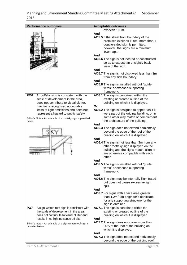
Planning and Environment Standing Committee Meeting Attachments7 September 2018
Item 5.1- Attachment 1 Page 174
Performance outcomes Acceptable outcomes
exceeds 100m. And AO5.5 If the street front boundary of the
premises exceeds 100m, more than 1 double-sided sign is permitted, however, the signs are a minimum 100m apart.
And AO5.6 The sign is not located or constructed
so as to expose an unsightly back view of the sign.
And AO5.7 The sign is not displayed less than 3m
from any side boundary. And AO5.8 The sign is installed without “guide
wires” or exposed supporting framework.
PO6 A roof/sky sign is consistent with the scale of development in the area, does not contribute to visual clutter, maintains recognised acceptable limits of light emissions and does not represent a hazard to public safety.
Editor’s Note – An example of a roof/sky sign is provided below.
AO6.1 The sign is contained within the existing or created outline of the building on which it is displayed.
Or AO6.2 The sign is designed to appear as if it
were part of the original building, or in some other way match or complement the architecture of the building.
And AO6.3 The sign does not extend horizontally
beyond the edge of the roof of the building on which it is displayed.
And AO6.4 The sign is not less than 3m from any
other roof/sky sign displayed on the building and the signs match, align or are otherwise compatible with each other.
And AO6.5 The sign is installed without “guide
wires” or exposed supporting framework.
And AO6.6 The sign may be internally illuminated
but does not cause excessive light spill.
And AO6.7 For signs with a face area greater
than 1.2m2, an engineer’s certificate
for any supporting structure for the sign is obtained.
PO7 A sign-written roof sign is consistent with the scale of development in the area, does not contribute to visual clutter and results in no light nuisance off-site.
Editor’s Note – An example of a sign-written roof sign is provided below.
AO7.1 The sign is contained within the existing or created outline of the building on which it is displayed.
And AO7.2 The sign does not cover more than
25% of the roof of the building on which it is displayed.
And AO7.3 The sign does not extend horizontally
beyond the edge of the building roof.

Planning and Environment Standing Committee Meeting Attachments7 September 2018
Item 5.1- Attachment 1 Page 175
Performance outcomes Acceptable outcomes
And AO7.4 The sign is visually compatible with
other sign written roof signs on the building.
And AO7.5 The sign is not visible from any
residential building located adjacent to the building on which it is displayed.
And AO7.6 The sign is not illuminated.
PO8 A wall sign is consistent with the scale of development in the area and maintains recognised acceptable limits of light emissions.
Editor’s Note – An example of a wall sign is provided below.
AO8.1 The sign does not project in excess of 100mm from the wall to which it is affixed.
And AO8.2 The sign does not project beyond any
edge of the wall. And AO8.3 The sign integrates, and is
compatible, with the architecture of the building on which it is placed.
And AO8.4 The shape of the sign is similar to the
shape of the wall on which it is placed. And AO8.5 The face area of the sign does not
cover more than 75% of the area of the wall on which it is placed.
And AO8.6 The sign is installed without “guide
wires” or exposed supporting framework.
And AO8.7 The sign may be internally but not
externally illuminated and does not result in light nuisance on a light-sensitive use off-site

Planning and Environment Standing Committee Meeting Attachments7 September 2018
Item 5.1- Attachment 1 Page 176
Schedule 1 Definitions
SC1.1 Use definitions
(1) As prescribed by section 7 of the Regulation the definitions for the following use terms and definitions are located in schedule 3 column 1 and 2 of the Regulation.
(2) Use definitions have a specific meaning for the purpose of the planning scheme. (3) Any use not listed in Table SC1.1.2 column 1 is an undefined use.
Note—development comprising a combination of defined uses is not considered to be an undefined use.
(4) A use listed in Table SC1.1.2 column 1 has the meaning set out beside that term in column 2.
(5) The use definitions listed here are the definitions used in this planning scheme. (6) Column 3 of Table SC1.1.2 identifies examples of the types of activities that are
consistent with the use identified in column 1. (7) Column 4 of Table SC1.1.2 identifies examples of activities that are not consistent with
the use identified in column 1. (8) Columns 3 and 4 of Table SC1.1.2 are not exhaustive lists. (9) Uses listed in Table SC1.1.2 columns 3 and 4 that are not listed in column 1, do not form
part of the definition.
Table SC 1.1-Index of use definitions
Index of use definitions
Adult store
Agricultural supplies store
Air service
Animal husbandry
Animal keeping
Aquaculture
Bar
Brothel
Bulk landscape supplies
Caretaker’s accommodation
Car wash
Cemetery
Child care centre
Club
Community care centre
Community residence
Community use
Crematorium
Cropping
Detention facility
Dual occupancy
Dwelling house
Dwelling unit
Educational establishment
Emergency services
Environment facility
Extractive industry
Food and drink outlet
Function facility
Funeral parlour
Garden centre
Hardware and trade supplies
Health care services
High impact industry
Home-based business
Hospital
Hotel
Indoor sport and recreation
Intensive animal industry
Intensive horticulture
Landing
Low impact industry
Major electricity infrastructure
Major sport, recreation and
entertainment facility
Marine industry
Market
Medium impact industry
Motor sport facility
Multiple dwelling
Nature-based tourism
Nightclub entertainment
facility
Non-resident workforce
accommodation
Office
Outdoor sales
Outdoor sport and recreation
Outstation
Park
Parking station
Party house
Permanent plantation
Place of worship
Port service
Relocatable home park
Renewable energy facility
Research and technology
industry
Residential care facility
Resort complex
Retirement facility
Roadside stall
Rooming accommodation
Rural industry
Rural workers’
accommodation
Sales office
Service industry
Service station
Shop
Shopping centre
Short-term accommodation
Showroom
Special industry
Substation
Telecommunications facility
Theatre
Tourist attraction
Tourist park
Transport depot
Utility installation
Veterinary service
Warehouse
Wholesale nursery
Winery

Planning and Environment Standing Committee Meeting Attachments7 September 2018
Item 5.1- Attachment 1 Page 177
Table SC 1.2-Use definitions
Column 1 – Use term
Column 2 – Definition Column 3 – Examples include
Column 4 – Does not include the following examples
2. Adult store
adult store means the use of
premises for the primary purpose of displaying or selling— (a) sexually explicit materials;
or (b) products and devices that
are associated with, or used in, a sexual practice or activity.
3. Sex shop
4. Shop, newsagent, registered pharmacist or video hire, where the primary use of these are concerned with:
the sale, display or hire of printed or recorded matter (not of a sexually explicit nature) or
the sale or display of underwear or lingerie or
the sale or display of an article or thing primarily concerned with or used in association with a medically recognised purpose.
5. Agricultural supplies store
agricultural supplies store
means the use of premises for the sale of agricultural supplies and products. 6. Examples of agricultural supplies and products—
7. animal feed, bulk veterinary supplies, chemicals, farm clothing, fertilisers, irrigation materials, saddlery, seeds
8. 9. Bulk landscape supplies, garden centre, outdoor sales wholesale nursery
Air service air service means the use of premises for— (a) the arrival or departure of
aircraft; or (b) housing, servicing,
refuelling, maintaining or repairing aircraft; or
(c) the assembly and dispersal of passengers or goods on or from an aircraft; or
(d) training and education facilities relating to aviation; or
(e) aviation facilities; or (f) an activity that—
(i) is ancillary to an activity or facility stated in paragraphs (a) to (e); and
(ii) directly services the needs of aircraft passengers.
10. Airport, air strip, helipad, public or private airfield
11. Animal husbandry
animal husbandry means the
use of premises for— (a) producing animals or
animal products on native or improved pastures or vegetation; or
(b) a yard, stable, temporary holding facility or machinery repairs and
12. Cattle stud, grazing of livestock, non-feedlot dairy
13. Animal keeping, intensive animal industry, aquaculture, feedlots, piggeries

Planning and Environment Standing Committee Meeting Attachments7 September 2018
Item 5.1- Attachment 1 Page 178
Column 1 – Use term
Column 2 – Definition Column 3 – Examples include
Column 4 – Does not include the following examples
servicing, if the use is ancillary to the use in paragraph (a).
14. Animal keeping
animal keeping means the use of premises for— (a) boarding, breeding or
training animals; or (b) a holding facility or
machinery repairs and servicing, if the use is ancillary to the use in paragraph (a).
15. Aviary, cattery, kennel, stables, wildlife refuge
16. Aquaculture, cattle studs, domestic pets, feedlots, grazing of livestock, non-feedlot dairying, piggeries, poultry meat and egg production, animal husbandry
17. Aquaculture
18. aquaculture means the use of
premises for cultivating, in a confined area, aquatic animals or plants for sale.
19. Pond farms, tank systems, hatcheries, raceway system, rack and line systems, sea cages
20. Intensive animal industry
21. Bar
bar means the use of premises,
with seating for 60 or less people, for— (a) selling liquor for
consumption on the premises; or
(b) an entertainment activity, or preparing and selling food and drink for consumption on the premises, if the use is ancillary to the use in paragraph (a).
22. 23. Club, hotel, nightclub entertainment facility, tavern
24. Brothel
brothel means premises made available for prostitution by 2 or more prostitutes at the premises. 25. Note — See the Prostitution Act 1999, schedule 4.
26. 27. Adult store, club, nightclub entertainment facility, shop
28. Bulk landscape supplies
29. bulk landscape supplies means
the use of premises for the bulk storage and sale of mainly non-packaged landscaping and gardening supplies, including, for example, soil, gravel, potting mix or mulch.
30. 31. Garden centre, outdoor sales, wholesale nursery
32. Caretaker’s accommodation
33. caretaker’s accommodation
means the use of premises for a dwelling for a caretaker of a non-residential use on the same premises.
34. 35. Dwelling house
36. Car wash
37. car wash means the use of premises for the commercial cleaning of motor vehicles.
38. 39. Service station
40. Cemetery
41. cemetery means the use of premises for the interment of bodies or ashes after death.
42. Burial ground, crypt, columbarium, lawn cemetery, pet cemetery,
43. Crematorium, funeral parlour

Planning and Environment Standing Committee Meeting Attachments7 September 2018
Item 5.1- Attachment 1 Page 179
Column 1 – Use term
Column 2 – Definition Column 3 – Examples include
Column 4 – Does not include the following examples
mausoleum
44. Childcare centre
childcare centre means the use of premises for the care, education and minding, but not residence, of children.
45. Crèche, early childhood centre, kindergarten, before or after school care, vacation care
46. Educational establishment, home based child care, family day care
47. Club
club means the use of premises for— (a) an association established
for social, literary, political, sporting, athletic or other similar purposes; or
(b) preparing and selling food and drink, if the use is ancillary to the use in paragraph (a).
48. Club house, guide and scout clubs, surf lifesaving club, RSL, bowls club
49. Hotel, nightclub entertainment facility, place of worship, theatre
50. Community care centre
community care centre— (a) means the use of
premises for (i) providing social
support to members of the public; or
(ii) providing medical care to members of the public, if the use is ancillary to the use in subparagraph (i); but
(c) does not include the use of premises for providing accommodation to members of the public.
51. Disability support services, drop in centre, respite centre, indigenous support centre
52. Child care centre, family day care, home based child care, health care services, residential care facility
53. Community residence
community residence— (a) means the use of
premises for residential accommodation for— (i) no more than
(A) 6 children, if the accommodation is provided as part of a program or service under the Youth Justice Act 1992; or
(B) 6 persons who require assistance or support with daily living needs; and
(ii) no more than 1 support worker; and
(b) includes a building or structure that is reasonably associated with the use in paragraph (a).
54. Hospice
55. Dwelling house, dwelling unit, residential care facility, rooming accommodation, short-term accommodation
56. Community use
community use means the use of premises for—
(a) providing artistic, social or cultural facilities or community
57. Art gallery, community centre, community hall, library, museum
58. Cinema, club, hotel, nightclub entertainment facility, place of worship

Planning and Environment Standing Committee Meeting Attachments7 September 2018
Item 5.1- Attachment 1 Page 180
Column 1 – Use term
Column 2 – Definition Column 3 – Examples include
Column 4 – Does not include the following examples
services to the public; or
(b) preparing and selling food and drink, if the use is ancillary to the use in paragraph (a)
59. Crematorium
60. crematorium means the use of premises for the cremation or aquamation of bodies.
61. 62. Cemetery
63. Cropping
cropping means the use of premises for— (a) growing and harvesting
plants, or plant material, that are cultivated in soil, for commercial purposes; or
(d) harvesting, storing or packing plants or plant material grown on the premises, if the use is ancillary to the use in paragraph (a); or
(e) repairing and servicing machinery used on the premises, if the use is ancillary to the use in paragraph (a).
64. Forestry for wood production, fodder and pasture production, producing fruits, nuts, vegetables and grains, plant fibre production, sugar cane growing, vineyard
65. Permanent plantations, intensive horticulture, rural industry
66. Detention facility
detention facility means the use of premises for the lawful detention of persons.
67. Prison, correctional facility, detention centre
68.
69. Dual occupancy
dual occupancy— (a) means a residential use of
premises for 2 households involving (i) 2 dwellings (whether
attached or detached) on a single lot or 2 dwellings (whether attached or detached) on separate lots that share a common property; and
(ii) any domestic outbuilding associated with the dwellings; but
(b) does not include a residential use of premises that involves a secondary dwelling.
70. Duplex, two dwellings on a single lot (whether or not attached), two dwellings within one single community title scheme under the Body Corporate and Community Management Act 1997, two dwellings within the one body corporate to which the Building Units and Group Title Act 1980 continues to apply
71. Dwelling house, multiple dwelling
72. Dwelling house
dwelling house means a
residential use of premises involving— (a) 1 dwelling for a single
household and any domestic outbuildings associated with the dwelling; or
73. Caretaker’s accommodation, dual occupancy, rooming accommodation, short-term accommodation, student accommodation, multiple dwelling
Planning and Environment Standing Committee Meeting Attachments7 September 2018
Item 5.1- Attachment 1 Page 181
Column 1 – Use term
Column 2 – Definition Column 3 – Examples include
Column 4 – Does not include the following examples
(b) 1 dwelling for a single household, a secondary dwelling, and any domestic outbuildings associated with either dwelling.
74. Dwelling unit
75. dwelling unit means the use of premises containing a non-residential use for a single dwelling, other than a dwelling for a caretaker of the non-residential use.
76. ‘Shop-top’ apartment
77. Caretaker’s accommodation, dwelling house
78. Educational establishment
educational establishment
means the use of premises for— (a) training and instruction to
impart knowledge and develop skills; or
(b) student accommodation, before or after school care, or vacation care, if the use is ancillary to the use in paragraph (a).
79. College, outdoor education centre, primary school, secondary school, special education facility, technical institute, university
80. Child care centre, home based child care, family day care
81. Emergency services
emergency services means the use of premises by a government entity or community organisation to provide— (a) essential emergency
services; or (b) disaster management
services; or (c) management support
facilities for the services. 82.
83. Ambulance station, evacuation centre, fire station, police station
84. Community use, hospital, residential care facility
85. Environment facility
environment facility— (a) means the use of
premises for a facility for the appreciation, conservation or interpretation of an area of cultural, environmental or heritage value; but
(b) does not include the use of premises to provide accommodation for tourists and travellers.
86. Nature-based attractions, walking tracks, seating, shelters, boardwalks, observation decks, bird hides
87.
88. Extractive industry
extractive industry means the use of premises for— (a) extracting or processing
extractive resources; and (b) any related activities,
including, for example, transporting the resources to market.
89. Quarry
90.
91. Food and drink outlet
food and drink outlet means the use of premises for— (a) preparing and selling food
and drink for consumption on or off the premises; or
(b) providing liquor for consumption on the premises, if the use is
92. Café, coffee shop, drive-through facility, kiosk, milk bar, restaurant, snack bar, takeaway shop, tearoom
93. Bar, club, hotel, shop, theatre, nightclub entertainment facility

Planning and Environment Standing Committee Meeting Attachments7 September 2018
Item 5.1- Attachment 1 Page 182
Column 1 – Use term
Column 2 – Definition Column 3 – Examples include
Column 4 – Does not include the following examples
ancillary to the use in paragraph (a).
94. Function facility
function facility means the use
of premises for— (a) receptions or functions; or (b) preparing and providing
food and liquor for consumption on the premises as part of a reception or function.
95. Conference centre, reception centre
96. Community use, hotel
97. Funeral parlour
funeral parlour— (a) means the use of
premises for— (i) arranging and
conducting funerals, memorials and other similar events; or
(ii) a mortuary; or (iii) storing and preparing
bodies for burial or cremation; but
(b) does not include the use of premises for the burial or cremation of bodies.
98. 99. Cemetery, crematorium, place of worship
100. Garden centre
garden centre means the use of premises for— (a) selling pants; or (b) selling gardening and
landscape products and supplies that are mainly in pre-packaged form; or
(c) a food and drink outlet is ancillary to the use in paragraph (a).
101. Retail plant nursery
102. Bulk landscape supplies, wholesale nursery, outdoor sales
103. Hardware and trade supplies
104. hardware and trade supplies means the use of premises for selling, displaying or hiring hardware and trade supplies, including, for example, house fixtures, timber, tools, paint, wallpaper or plumbing supplies.
105. 106. Shop, showroom, outdoor sales and warehouse
107. Health care services
health care service means the use of premises for medical purposes, paramedical purposes, alternative health therapies or general health care, if overnight accommodation is not provided on the premises.
108. Dental clinic, medical centre, physiotherapy clinic
109. Community care centre, hospital
110. High impact industry
high impact industry means the use of premises for an industrial activity—
(a) that is the manufacturing, producing, processing, repairing, altering, recycling, storing, distributing, transferring or treating of products, and
(b) that a local planning instrument applying to the premises states is a high impact industry; and
(d) Abattoirs, concrete batching plant, boiler making and engineering and metal foundry
111.
112. Note – additional examples may be shown in SC1.1.2 industry thresholds.
113. Tanneries, rendering plants, oil refineries, waste incineration, manufacturing or storing explosives, power plants, manufacturing fertilisers, service industry, low impact industry, medium impact industry, special industry

Planning and Environment Standing Committee Meeting Attachments7 September 2018
Item 5.1- Attachment 1 Page 183
Column 1 – Use term
Column 2 – Definition Column 3 – Examples include
Column 4 – Does not include the following examples
(c) that complies with any thresholds for the activity stated in a local planning instrument applying to the premises, including, for example, thresholds relating to the number of products manufactured or the level of emissions produced by the activity.
114. Home-based business
115. home-based business means the use of a dwelling or domestic outbuilding on premises for a business activity that is subordinate to the residential use of the premises.
116. Bed and breakfast, home office, home based child care
117. Hobby, office, shop, warehouse, transport depot
118. Hospital
hospital means the use of premises for— (a) the medical or surgical
care or treatment of patients, whether or not the care or treatment requires overnight accommodation; or
(b) providing accommodation for patients; or
(c) providing accommodation for employees, or any other use, if the use is ancillary to the use in paragraph (a) or (b).
119. 120. Health care services, residential care facility
121. Hotel
hotel— (a) means the use of
premises for— (i) selling liquor for
consumption on the premises; or
(ii) a dining or entertainment activity, or providing accommodation to tourists or travellers, if the use is ancillary to the use in subparagraph (i); but
(b) does not include a bar.
122. Pub, tavern
123. Nightclub entertainment facility
124. Indoor sport and recreation
indoor sport and recreation means the use of premises for a leisure, sport or recreation activity conducted wholly or mainly indoors.
125. Amusement parlour, bowling alley, gymnasium, squash courts
126. Cinema, hotel, nightclub entertainment facility, theatre
127. Intensive animal industry
intensive animal industry— (a) means the use of
premises for— (i) the intensive
production of animals or animal products, in an enclosure, that requires food and water to be provided mechanically or by
128. Feedlots, piggeries, poultry and egg production
129. Animal husbandry, aquaculture, drought feeding, milking sheds, shearing sheds, weaning pens

Planning and Environment Standing Committee Meeting Attachments7 September 2018
Item 5.1- Attachment 1 Page 184
Column 1 – Use term
Column 2 – Definition Column 3 – Examples include
Column 4 – Does not include the following examples
hand; or (ii) storing and packing
feed and produce, if the use is ancillary to the use in subparagraph (i); but
(b) does not include the cultivation of aquatic animals.
130. Intensive horticulture
intensive horticulture— (a) means the use of
premises for— (i) the intensive
production of plants or plant material carried out indoors on imported media; or
(ii) the intensive production of plants or plant material carried out outside using artificial lights or containers; or
(iii) storing and packing plants or plant material grown on the premises, if the use is ancillary to a use in subparagraph (i) or (ii); but
(b) does not include the cultivation of aquatic plants.
131. Greenhouse, hydroponic farm, mushroom farm
132. Wholesale nursery
133. Landing
landing means the use of
premises for a structure— (a) for mooring, launching,
storing and retrieving vessels; and
(f) from which passengers embark and disembark.
134. Boat ramp, jetty, pontoon
135. Marina
136. Low impact industry
low impact industry means the use of premises for an industrial activity— (a) that is the manufacturing,
producing, processing, repairing, altering, recycling, storing, distributing, transferring or treating of products; and
(b) that a local planning instrument applying to the premises states is low impact industry; and
(c) that complies with any thresholds for the activity states in a local planning instrument applying to the premises, including, for example, thresholds relating to the number of products manufactured or the level of emissions
Repairing motor vehicles, fitting and turning workshop Note – additional examples may be shown in SC1.1.2 industry thresholds.
137. Panel beating, spray painting or surface coating, tyre recycling, drum re-conditioning, wooden and laminated product manufacturing, service industry, medium impact industry, high impact industry, special industry

Planning and Environment Standing Committee Meeting Attachments7 September 2018
Item 5.1- Attachment 1 Page 185
Column 1 – Use term
Column 2 – Definition Column 3 – Examples include
Column 4 – Does not include the following examples
produced by the activity.
138. Major electricity
139. infrastructure
major electricity infrastructure—
(a) means the use of premises for— (i) a transmission grid
or supply network; or (ii) a telecommunication
facility, if the use is ancillary to the use in subparagraph (i); but
(b) does not include the use of premises for a supply network or private electricity works stated in schedule 6 [Development local categorising instrument is prohibited…], section 26(5), unless the use involves— (i) a new zone
substation or bulk supply substation; or
(ii) the augmentation of a zone substation or bulk supply substation that significantly increases the input or output standard voltage.
140. Powerlines greater than 66kV
141. Minor electricity infrastructure, substation
142. Major sport, recreation and entertainment facility
major sport, recreation and entertainment facility means the use of premises for large-scale events, including, for example, major sporting, recreation conference or entertainment events.
143. Convention centre, exhibition centre, horse racing facility, sports stadiums
144. Indoor sport and recreation, local sporting field, motor sport, park, outdoor sport and recreation
145. Marine industry
marine industry means the use of waterfront premises for— (a) manufacturing, storing,
repairing or servicing vessels or maritime infrastructure; or
(b) providing fuel or disposing of waste, if the use is ancillary to the use in paragraph (a).
146. Boat building, boat storage, dry dock
147. Marina
148. Market
market means the use of premises on a regular basis for— (a) selling goods to the public
mainly from temporary structures, including, for example, stalls, booths or trestle tables; or
(b) providing entertainment, if the use is ancillary to the use in paragraph (a).
149. Flea market, farmers market, car boot sales
150. Shop, roadside stall
151. Medium impact industry
medium impact industry means the use of premises for an industrial activity— (a) that is the manufacturing,
152. Spray painting and surface coating,
155. Concrete batching, tyre manufacturing and

Planning and Environment Standing Committee Meeting Attachments7 September 2018
Item 5.1- Attachment 1 Page 186
Column 1 – Use term
Column 2 – Definition Column 3 – Examples include
Column 4 – Does not include the following examples
producing, processing, repairing, altering, recycling, storing, distributing, transferring or treating of products; and
(b) that a local planning instrument applying to the premises states is a medium impact industry; and
(c) that complies with any thresholds for the activity stated in a local planning instrument applying to the premises, including, for example, thresholds relating to the number of products manufactured or the level of emissions produced by the activity.
wooden and laminated product manufacturing (including cabinet making, joining, timber truss making or wood working)
153.
154. Note – additional examples may be shown in SC1.1.2 industry thresholds.
retreading, metal recovery (involving a fragmentiser), textile manufacture, chemically treating timber and plastic product manufacture, service industry, low impact industry, high impact industry, special industry
156. Motor sport facility
motor sport facility means the use of premises for— (a) organised or recreational
motor sports; or (b) facilities for spectators,
including, for example, stands, amenities or food and drink outlets, if the use is ancillary to the use in paragraph (a).
157. Car race track, go-kart track, trail bike park, 4WD park
158. Major sport, recreation and entertainment facility, outdoor sport and recreation
159. Multiple dwelling
160. multiple dwelling means a residential use of premises involving 3 or more dwellings, whether attached or detached, for separate households.
161. Apartments, flats, units, townhouses, row housing, triplex
162. Rooming accommodation, dual occupancy, duplex, granny flat, residential care facility, retirement facility
163. Nature-based tourism
nature-based tourism means the use of premises for a tourism activity, including accommodation for tourists, for the appreciation, conservation or interpretation of— (a) an area of environmental,
cultural or heritage value; or
(b) a local ecosystem; or (c) the natural environment.
164. Environmentally responsible accommodation facilities including cabins, huts, lodges and tents
165. Environment facility
166. Nightclub entertainment facility
nightclub entertainment facility means the use of premises for—
(a) providing entertainment that is cabaret, dancing or music; or
(b) selling liquor and preparing and selling food, for consumption on the premises, if the use is ancillary to the use in paragraph (a).
167. 168. Club, hotel, tavern, pub, indoor sport and recreation, theatre, concert hall
169. Non-resident workforce
non-resident workforce accommodation means the use of premises for—
(a) accommodation for non-
170. Contractor’s camp, construction camp,
171. Relocatable home park, short-term

Planning and Environment Standing Committee Meeting Attachments7 September 2018
Item 5.1- Attachment 1 Page 187
Column 1 – Use term
Column 2 – Definition Column 3 – Examples include
Column 4 – Does not include the following examples
accommodation resident workers; or (b) recreation and
entertainment facilities for persons residing at the premises and their visitors, if the use is ancillary to the use in paragraph (a).
single person’s quarters, temporary workers’ accommodation
accommodation, tourist park
172. Office
office— (a) means the use of
premises for— (i) providing an
administrative, financial, management or secretarial service or function; or
(ii) the practice of a profession; or
(iii) providing business or professional advice or services; but
(b) does not include premises used for making, selling or hiring goods.
173. Bank, real estate agent, administration building
Home based business, home office, shop, outdoor sales
174. Outdoor sales
outdoor sales means the use of premises for— (a) displaying, selling, hiring
or leasing vehicles, boats, caravans, machinery, equipment or other similar products, if the use is mainly conducted outdoors; or
(b) repairing, servicing, selling or fitting accessories for the products stated in paragraph (a), if the use is ancillary to the use in paragraph (a).
175. Agricultural machinery sales yard, motor vehicles sales yard
176. Bulk landscape supplies, market
177. Outdoor sport and recreation
outdoor sport and recreation means the use of premises for— (a) a recreation or sporting
activity that is carried on outdoors and requires areas of open space; or
(b) providing and selling food and drink, change room facilities or storage facilities, if the use is ancillary to the use in paragraph (a).
178. Cricket oval, driving range, golf course, swimming pool, tennis court
179. Major sport, recreation and entertainment facility, motor sport, park, community use
180. Outstation
outstation means the use of premises for— (a) cultural or recreation
activities by Aboriginal people or Torres Strait Islanders; or
(b) facilities for short-term or long-term camping activities, if the use is ancillary to the use in paragraph (a).
181. Indigenous camp site
182. Dwelling house, hostel, multiple dwelling, relocatable home park, short-term accommodation, tourist park

Planning and Environment Standing Committee Meeting Attachments7 September 2018
Item 5.1- Attachment 1 Page 188
Column 1 – Use term
Column 2 – Definition Column 3 – Examples include
Column 4 – Does not include the following examples
183. Park
184. park means the use of premises, accessible to the public free of charge, for sport, recreation and leisure activities and facilities.
185. Urban common
186. Tourist attraction, outdoor sport and recreation
187. Parking station
188. parking station means the use
of premises for parking vehicles, other than parking that is ancillary to another use.
189. Car park, ‘park and ride’, bicycle parking
190.
191.
192. Party house
party house means premises containing a dwelling that is used to provide, for a fee, accommodation or facilities for guests if— (a) guests regularly use all or
part of the premises for parties (bucks parties, hens parties, raves, or wedding receptions, for example); and
(b) the accommodation or facilities are provided for a period of less than 10 days; and
(c) the owner of the premises does not occupy the premises during that period.
193. 194.
195. Permanent plantation
196. permanent planation means the use of premises for growing, but not harvesting, plants for the carbon sequestration, biodiversity, natural resource management or another similar purpose.
197. Permanent plantations for carbon sequestration, biodiversity or natural resource management
198. Forestry for wood production, biofuel production
199. Place of worship
place of worship means the use of premises for— (a) organised worship and
other religious activities; or (b) social, education or
charitable activities, if the use is ancillary to the use in paragraph (a).
200. Church, chapel, mosque, synagogue, temple
201. Community use, child care centre, funeral parlour, crematorium
202. Port service
port service means the use of premises for— (a) the arrival and departure
of vessels; or (b) the movement of
passengers or goods on or off vessels; or
(c) storing, servicing, maintaining or repairing vessels; or
(d) ancillary uses that directly service the needs of passengers of the vessels.
Marina, ferry terminal
203. Landing
204. Relocatable home park
relocatable home park means the use of premises for— (a) relocatable dwellings for
long-term residential
205. 206. Tourist park
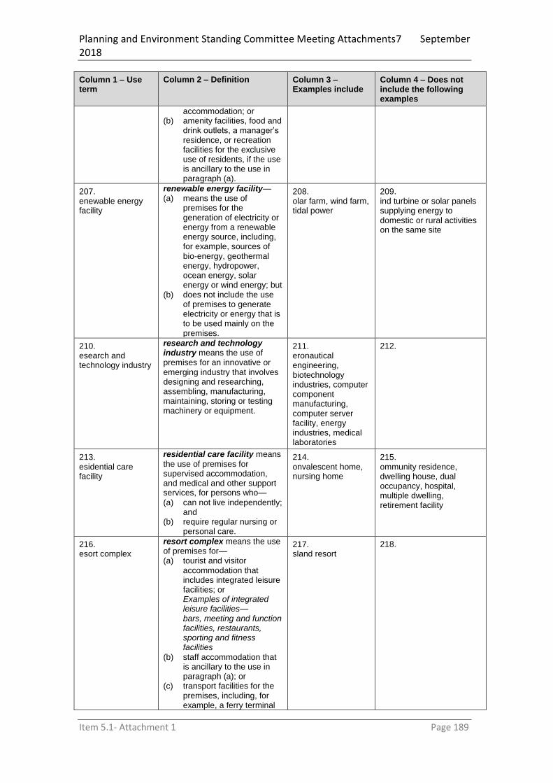
Planning and Environment Standing Committee Meeting Attachments7 September 2018
Item 5.1- Attachment 1 Page 189
Column 1 – Use term
Column 2 – Definition Column 3 – Examples include
Column 4 – Does not include the following examples
accommodation; or (b) amenity facilities, food and
drink outlets, a manager’s residence, or recreation facilities for the exclusive use of residents, if the use is ancillary to the use in paragraph (a).
207. Renewable energy facility
renewable energy facility— (a) means the use of
premises for the generation of electricity or energy from a renewable energy source, including, for example, sources of bio-energy, geothermal energy, hydropower, ocean energy, solar energy or wind energy; but
(b) does not include the use of premises to generate electricity or energy that is to be used mainly on the premises.
208. Solar farm, wind farm, tidal power
209. Wind turbine or solar panels supplying energy to domestic or rural activities on the same site
210. Research and technology industry
research and technology industry means the use of premises for an innovative or emerging industry that involves designing and researching, assembling, manufacturing, maintaining, storing or testing machinery or equipment.
211. Aeronautical engineering, biotechnology industries, computer component manufacturing, computer server facility, energy industries, medical laboratories
212.
213. Residential care facility
residential care facility means
the use of premises for supervised accommodation, and medical and other support services, for persons who—
(a) can not live independently; and
(b) require regular nursing or personal care.
214. Convalescent home, nursing home
215. Community residence, dwelling house, dual occupancy, hospital, multiple dwelling, retirement facility
216. Resort complex
resort complex means the use of premises for— (a) tourist and visitor
accommodation that includes integrated leisure facilities; or Examples of integrated leisure facilities— bars, meeting and function facilities, restaurants, sporting and fitness facilities
(b) staff accommodation that is ancillary to the use in paragraph (a); or
(c) transport facilities for the premises, including, for example, a ferry terminal
217. Island resort
218.

Planning and Environment Standing Committee Meeting Attachments7 September 2018
Item 5.1- Attachment 1 Page 190
Column 1 – Use term
Column 2 – Definition Column 3 – Examples include
Column 4 – Does not include the following examples
or air service.
219. Retirement facility
retirement facility means a residential use of premises for— (a) accommodation for older
members of the community, or retired persons, in independent living units or services units; or
(b) amenity and community facilities, a manager’s residence, health care and support services, preparing food and drink or staff accommodation, if the use is ancillary to the use in paragraph (a).
220. Retirement village
221. Residential care facility
222. Roadside stall
223. roadside stall means the use of premises for the roadside display and sale of goods in a rural area.
224. Produce stall
225. Market
226. Rooming accommodation
rooming accommodation means the use of premises for— (a) residential
accommodation, if each resident— (i) has a right to occupy
1 or more rooms on the premises; and
(ii) does not have a right to occupy the whole of the premises; and
(iii) does not occupy a self-contained unit, as defined in the Residential Tenancies and Rooming Accommodation Act 2008, schedule 2, or
has only limited facilities available for private use; and
(iv) shares other rooms, facilities, furniture or equipment outside of the resident’s room with 1 or more other residents, whether or not the rooms, facilities, furniture or equipment are on the same or different premises; or
(b) a manager’s residence, an office or providing food or other services to residents, if the use is ancillary to the use in paragraph (a).
227. Boarding house, hostel, monastery, off-site student accommodation
228. Hospice, community residence, dwelling house, short-term accommodation, multiple dwelling

Planning and Environment Standing Committee Meeting Attachments7 September 2018
Item 5.1- Attachment 1 Page 191
Column 1 – Use term
Column 2 – Definition Column 3 – Examples include
Column 4 – Does not include the following examples
229. Rural industry
rural industry means the use of premises for— (a) storing, processing or
packaging products from a rural use carried out on the premises or adjoining premises; or
(b) selling products from a rural use carried out on the premises or adjoining premises, if the use is ancillary to the use in paragraph (a).
230. Packing shed
231. Intensive animal husbandry, intensive horticulture, roadside stall, wholesale nursery, winery, abattoir, agricultural supply store
232. Rural workers’ accommodation
rural worker’s accommodation means the
use of premises as accommodation, whether or not self-contained, for employees of a rural use, if— (a) the premises, and the
premises where the rural use is carried out, are owned by the same person; and
(b) the employees are not non-resident workers.
233. Farm workers’ accommodation
234. Short-term accommodation, caretaker’s accommodation, dual occupancy, dwelling house, nature or rural based tourist accommodation, non-resident workforce accommodation, multiple dwelling
235. Sales office
sales office means the use of
premises for temporary display of land parcels or buildings that— (a) are for sale or proposed to
be sold; or (b) can be won as a prize in a
competition.
236. Display dwelling
237. Bank, office
238. Service industry
service industry means the use of premises for an industrial activity that— (a) does not result in off-site
air, noise or odour emissions; and
(b) is suitable for location with other non-industrial uses.
239. Audio visual equipment repair, film processing, bicycle repairs, clock and watch repairs, computer repairs, dry cleaning, hand engraving, jewellery making, laundromat, locksmith, picture framing, shoe repairs, tailor
Small engine mechanical repair workshop, cabinet making, shop fitting, sign writing, tyre depot, low impact industry, medium impact, high impact industry, special industry
240. Service station
service station means the use of premises for— (a) selling fuel, including, for
example, petrol, liquid petroleum gas, automotive distillate or alternative fuels or
(b) a food and drink outlet, shop, trailer hire, or maintaining, repairing, servicing or washing vehicles, if the use is ancillary to the use in paragraph (a).
241. 242. Car wash
243. Sshop means the use of 244. B245. A

Planning and Environment Standing Committee Meeting Attachments7 September 2018
Item 5.1- Attachment 1 Page 192
Column 1 – Use term
Column 2 – Definition Column 3 – Examples include
Column 4 – Does not include the following examples
hop premises for— (a) displaying, selling or hiring
goods; or (b) providing personal
services or betting to the public.
etting agency, corner store, department store, discount variety store, hair dressing salon, liquor store, supermarket
dult store, food and drink outlet, showroom, market
246. Shopping centre
247. shopping centre means the use of premises for an integrated shopping complex consisting mainly of shops.
248. 249.
250. Short-term accommodation
short-term accommodation— (a) means the use of
premises for— (i) providing
accommodation of less than 3 consecutive months to tourists or travellers; or
(ii) a manager’s residence, office, or recreation facilities for the exclusive use of guests, if the use is ancillary to the use in subparagraph (i); but
(b) does not include a hotel, nature-based tourism, resort complex or tourist park.
251. Motel, backpackers accommodation, cabins, serviced apartments, hotel, farm stay
252. Hostel, rooming accommodation, tourist park
253. Showroom
showroom means the use of premises for the sale of goods that are of— (a) a related product line; and (b) a size, shape or weight
that requires— (i) a large area for
handling, display or storage; and
(ii) direct vehicle access to the building that contains the goods by members of the public to enable the loading and unloading of the goods.
Bulk stationary supplies, bulky goods sales, motor vehicles sales showroom, bulk stationary supplies
254. Food and drink outlet, shop, outdoor sales
255. Special industry
special industry means the use of premises for an industrial activity— (a) that is manufacturing,
producing, processing, repairing, altering, recycling, storing, distributing, transferring or treating products; and
(b) that a local planning instrument applying to the premises states is a
Tanneries, rendering plants, oil refineries, waste incineration, manufacturing or storing explosives, power plants, manufacturing fertilisers 256. Note – additional examples may be shown in Error! Reference source not found. Industry thresholds.
257. Low impact industry, medium impact industry, high impact industry, service industry

Planning and Environment Standing Committee Meeting Attachments7 September 2018
Item 5.1- Attachment 1 Page 193
Column 1 – Use term
Column 2 – Definition Column 3 – Examples include
Column 4 – Does not include the following examples
special industry; and (c) that complies with any
thresholds for the activity states in a local planning instrument applying to the premises, including, for example, thresholds relating to the number of products manufactured or the level of emissions produced by the activity.
258. Substation
substation means the use of premises— (a) as part of a transmission
grid or supply network to— (i) convert or transform
electrical energy from one voltage to another; or
(ii) regulate voltage in an electrical circuit; or
(iii) control electrical circuits; or
(iv) switch electrical current between circuits; or
(b) for a telecommunications facility for— (i) works, as defined
under the Electricity Act, section 12(1); or
(ii) workforce operational and safety communications.
Substations, switching yards
259. Major electricity infrastructure, minor electricity infrastructure
260. Telecommunications facility
261. telecommunications facility means the use of premises for a facility that is capable of carrying communications and signals by guided or unguided electromagnetic energy.
262. Telecommunication tower, broadcasting station, television station
263. Aviation facility, ‘low-impact telecommunications facility’ as defined under the Telecommunications Act 1997
264. Theatre
theatre means the use of premises for— (a) presenting movies, live
entertainment or music to the public; or
(b) the production of film or music; or
(c) the following activities or facilities, if the use is ancillary to a use in paragraph (a) or (b) — (i) preparing and selling
food and drink for consumption on the premises;
(ii) facilities for editing and post-production;
(iii) facilities for wardrobe, laundry and make-up;
266. Cinema, concert hall, film studio, music recording studio
267. Community hall, hotel, indoor sport and recreation facility, temporary film studio

Planning and Environment Standing Committee Meeting Attachments7 September 2018
Item 5.1- Attachment 1 Page 194
Column 1 – Use term
Column 2 – Definition Column 3 – Examples include
Column 4 – Does not include the following examples
(iv) set construction workshops;
(v) sound stages. 265.
268. Tourist attraction
tourist attraction means the use of premises for– (a) providing entertainment to,
or a recreation facility for, the general public; or
(b) preparing and selling food and drink for consumption on the premises, if the use is ancillary to the use in paragraph (a).
269. Theme park, zoo
270. Hotel, major sport, recreation and entertainment facility, nightclub entertainment facility
271. Tourist park
tourist park means the use of premises for— (a) holiday, accommodation in
caravans, self-contained cabins, tents or other similar structures; or
(b) amenity facilities, a food and drink outlet, a manager’s residence, offices, recreation facilities for the use of occupants and their visitors, or staff accommodation, if the use is ancillary to the use in paragraph (a).
272. Camping ground, caravan park, holiday cabins
273. Relocatable home park, tourist attraction, short-term accommodation, non-resident workforce accommodation
274. Transport depot
transport depot means the use
of premises for— (a) storing vehicles, or
machinery, that are used for a commercial or public purpose; or
(b) cleaning, repairing or servicing vehicles or machinery, if the use is ancillary to the use in paragraph (a).
275. Using premises to store buses, taxis, trucks, heavy vehicles or heavy machinery.
Home based business, warehouse, low impact industry, service industry
276. Utility installation
utility installation means the use of premises for— (a) a service for supplying or
treating water, hydraulic power or gas; or
(b) a sewerage, drainage or stormwater service; or
(c) a transport service; or (d) a waste management
service; or (e) (e) a maintenance depot,
storage depot or other facility for a service stated in paragraphs (a) to (d).
277. Sewerage treatment plant, mail depot, pumping station, water treatment plant
Telecommunications tower, major electricity infrastructure, minor electricity infrastructure, substation, renewable energy facility, transport depot
278. Veterinary services
veterinary service means the use of premises for- (a) the medical or surgical
treatment of animals; or (b) the short-term stay of
animals, if the use is ancillary to the use in paragraph (a).
Animal keeping

Planning and Environment Standing Committee Meeting Attachments7 September 2018
Item 5.1- Attachment 1 Page 195
Column 1 – Use term
Column 2 – Definition Column 3 – Examples include
Column 4 – Does not include the following examples
279. Warehouse
warehouse means the use of premises for— (a) storing or distributing
goods, whether or not carried out in a building; or
(b) the wholesale of goods, if the use is ancillary to the use in paragraph (a).
280. Self-storage facility, storage yard.
281. Hardware and trade supplies, outdoor sales, showroom, shop
282. Wholesale nursery
wholesale nursery means the use of premises for— (a) the wholesale of plants
grown on or next to the premises; or
(b) selling gardening materials, if the use is ancillary to the use in paragraph (a).
283. 284. Bulk landscape supplies, garden centre
285. Winery
winery means the use of premises for— (a) making wine; or (b) selling wine that is made
on the premises.
286. 287. Rural industry
SC1.1.1 Defined activity groups
There are no defined activity groups for the planning scheme.

Planning and Environment Standing Committee Meeting Attachments7 September 2018
Item 5.1- Attachment 1 Page 196
SC1.1.2 Industry thresholds
(1) The industry thresholds listed below are to be used in conjunction with the defined use terms listed in Table SC1.1.2—low impact industry, medium impact industry, high impact industry and special industry.
Table SC 1.3-Industry thresholds
Column 1 Use
Column 2 Additional examples include
Low impact industry
(a) Repairing and servicing motor vehicles, including mechanical components, radiators, electrical components, wheel alignments, exhausts, tyres, suspension or air conditioning, not including spray painting;
(b) Repairing and servicing lawn mowers and outboard engines; (c) Fitting and turning workshop; (d) Assembling or fabricating products from sheet metal or welding steel,
producing less than 10 tonnes a year and not including spray painting; (e) Assembling wood products not involving cutting, routing, sanding or spray
painting; (f) Dismantling automotive or mechanical equipment, not including debonding
brake or clutch components.
Medium impact industry
(a) Metal foundry producing less than 10 tonnes of metal castings per annum; (b) Boiler making or engineering works producing less than 10 000 tonnes of
metal product per annum; (c) Facility, goods yard or warehouse for the storage and distribution of
dangerous goods not involving manufacturing processes and not a major hazard facility under the Work Health and Safety Act 2011;
(d) Abrasive blasting facility using less than 10 tonnes of abrasive material per annum;
(e) Enamelling workshop using less than 15 000 litres of enamel per annum; (f) Galvanising works using less than 100 tonnes of zinc per annum; (g) Anodising or electroplating workshop where tank area is less than 400
square metres; (h) Powder coating workshop using less than 500 tonnes of coating per annum; (i) Spray painting workshop (including spray painting vehicles, plant, equipment
or boats) using less than 20 000 litres of paint per annum; (j) Scrap metal yard (not including a fragmentiser), dismantling automotive or
mechanical equipment including debonding brake or clutch components; (k) Manufacturing clay or ceramic products including bricks, tiles, pipes and
pottery goods, less than 200 tonnes per annum; (l) Processing, smoking, drying, curing, milling, bottling or canning food,
beverages or pet food, less than 200 tonnes per annum; (m) Vegetable oil or oilseed processing in works with a design production
capacity of less than 1000 tonnes per annum; (n) Manufacturing wooden products including cabinet making, joinery, wood
working, producing less than 500 tonnes per annum; (o) Manufacturing medium density fibreboard, chipboard, particle board,
plywood, laminated board or wood veneer products, less than 250 tonnes per annum;
(p) Sawmilling, wood chipping and kiln drying timber and logs, producing less than 500 tonnes per annum;
(q) Recycling and reprocessing batteries; (r) Repairing or maintaining boats; (s) Manufacturing substrate for mushroom growing; (t) Manufacturing or processing plaster, producing less than 5000 tonnes per
annum; (u) Recycling or reprocessing tyres including retreading; (v) Printing advertising material, magazines, newspapers, packaging and
stationery; (w) Transport depot, distribution centre, contractors depot and storage yard; (x) Manufacturing fibreglass, foam plastic, composite plastic or rigid fibre-

Planning and Environment Standing Committee Meeting Attachments7 September 2018
Item 5.1- Attachment 1 Page 197
Column 1 Use
Column 2 Additional examples include
reinforced plastic or plastic products, less than 5 tonnes per annum (except fibreglass boats, tanks and swimming pools);
(y) Manufacturing PET, PETE, polypropylene and polystyrene plastic or plastic products, less than 10 000 tonnes per annum;
(z) Reconditioning metal or plastic drums; (aa) Glass fibre manufacture less than 200 tonnes per annum; (bb) Manufacturing glass or glass products, where not glass fibre, less than 250
tonnes per annum.
High impact industry
(a) Metal foundry producing 10 tonnes or greater of metal castings per annum; (b) Boiler making or engineering works producing 10 000 tonnes or greater of
metal product per annum; (c) Major hazard facility for the storage and distribution of dangerous goods not
involving manufacturing processes; (d) Scrap metal yard including a fragmentiser; (e) Manufacturing clay or ceramic products including bricks, tiles, pipes and
pottery goods, greater than 200 tonnes per annum; (f) Vegetable oil or oilseed processing in works with a design production
capacity of greater than 1000 tonnes per annum; (g) Manufacturing wooden products including cabinet making, joinery, wood
working, producing greater than 500 tonnes per annum; (h) Manufacturing medium density fibreboard, chipboard, particle board,
plywood, laminated board or wood veneer products, 250 tonnes or greater per annum;
(i) Sawmilling, wood chipping and kiln drying timber and logs, producing greater than 500 tonnes per annum;
(j) Manufacturing or processing plaster, producing greater than 5000 tonnes per annum;
(k) Enamelling workshop using 15 000 litres or greater of enamel per annum; (l) Galvanising works using 100 tonnes or greater of zinc per annum; (m) Anodising or electroplating workshop where tank area is 400 square metres
or greater; (n) Powder coating workshop using 500 tonnes or greater of coating per annum; (o) Spray painting workshop (including spray painting vehicles, plant, equipment
or boats) using 20 000 litres or greater of paint per annum; (p) Concrete batching and producing concrete products; (q) Treating timber for preservation using chemicals including copper, chromium,
arsenic, borax and creosote; (r) Manufacturing soil conditioners by receiving, blending, storing, processing,
drying or composting organic material or organic waste, including animal manures, sewage, septic sludges and domestic waste;
(s) Manufacturing fibreglass pools, tanks and boats; (t) Manufacturing, fibreglass, foam plastic, composite plastic or rigid fibre-
reinforced plastic or plastic products, 5 tonnes or greater per annum (except fibreglass boats, tanks and swimming pools);
(u) Manufacturing PET, PETE, polypropylene and polystyrene plastic or plastic products, 10 000 tonnes or greater per annum;
(v) Manufacturing tyres, asbestos products, asphalt, cement, glass or glass fibre, mineral wool or ceramic fibre;
(w) Recycling chemicals, oils or solvents; (x) Waste disposal facility (other than waste incinerator); (y) Recycling, storing or reprocessing regulated waste; (z) Manufacturing batteries; (aa) Manufacturing wooden products including cabinet making, joinery, wood
working, producing greater than 500 tonnes per annum; (bb) Abrasive blasting facility using 10 tonnes or greater of abrasive material per
annum; (cc) Glass fibre manufacture producing 200 tonnes or greater per annum; (dd) Manufacturing glass or glass products, where not glass fibre, less than 250

Planning and Environment Standing Committee Meeting Attachments7 September 2018
Item 5.1- Attachment 1 Page 198
Column 1 Use
Column 2 Additional examples include
tonnes per annum.
Special industry
(a) Oil refining or processing; (b) Producing, refining or processing gas or fuel gas; (c) Distilling alcohol in works producing greater than 2 500 litres per annum; (d) Processing, smoking, drying, curing, milling, bottling or canning food,
beverages or pet food, greater than 200 tonnes per annum; (e) Power station; (f) Producing, quenching, cutting, crushing or grading coke; (g) Waste incinerator; (h) Sugar milling or refining; (i) Pulp or paper manufacturing; (j) Tobacco processing; (k) Abattoir; (l) Tannery or works for curing animal skins, hides or finishing leather; (m) Textile manufacturing, including carpet manufacturing, wool scouring or
carbonising, cotton milling, or textile bleaching, dyeing or finishing; (n) Rendering plant; (o) Manufacturing chemicals, poisons and explosives; (p) Manufacturing fertilisers involving ammonia; (q) Manufacturing polyvinyl chloride plastic.
SC1.2 Administrative terms and definitions
(1) Administrative terms and definitions assist with the interpretation of the planning scheme but do not have a meaning in relation to a use term.
(2) An administrative term listed in Table SC1.2.2 column has the meaning set out beside that term in column 2 under the heading.
(3) The administrative definitions listed here are the definitions for the purpose of the planning scheme.
Table SC 1.2.1-Index of administrative definitions
Index of administrative definition
Adjoining premises
Advertising device
Affordable housing
Agricultural land
Average width
Base date
Basement
Borrow pit
Boundary clearance
Building height
Commercial building
Defined flood level
Demand unit
Development footprint
Domestic outbuilding
Domestic pet
Dwelling
Flood
Gross floor area
Ground level
Household
Minor building work
Minor electricity infrastructure
Net developable area
Off-stream dam
Non-resident workers
Outermost projection
Planning assumptions
Projection area(s)
Rural lifestyle allotment
Projection area(s)
Secondary dwelling
Service catchment
Setback
Site
Site cover
Storey
Temporary use
Third party sign
Total use area
Ultimate development
Urban purpose
Vulnerable use

Planning and Environment Standing Committee Meeting Attachments7 September 2018
Item 5.1- Attachment 1 Page 199
Table SC 1.2
Column 1 Term
Column 2 Definition
Adjoining premises
adjoining premises means premises that share a common boundary, including premises that meet at a single point on a common boundary.
Advertising device advertising device— (a) means boundary permanent sign, structure or other device used, or intended
to be used, for advertising; and (b) includes a structure, or part of a building, the primary purpose of which is to
support the sign, structure or device.
Affordable housing
Affordable housing means housing that is appropriate to the needs of households with low to moderate incomes, if the members of the households will spend no more than 30% of gross income on housing costs.
Agricultural land Means Agricultural Land Classification Class A and Class B.
Average width average width, of a lot, means the distance, measured in metres, between the
midpoint on each side boundary of the lot.
Base date base date means the date from which the local government has estimated future
infrastructure demand and costs for the local government area.
Basement basement means a space— (a) between a floor level in a building and the floor level that is immediately
below it; and (b) no part of which is more than 1m above ground level.
Boundary clearance
boundary clearance means the distance between a building or structure on premises and the boundary of the premises, measured from the part of the building or structure that is closest to the boundary, other than a part that is— (a) an architectural or ornamental attachment; or (b) a rainwater fitting. Examples— 1 If the fascia of a building is the part of the building that is closest to the boundary, the boundary clearance is the distance between the outside of the fascia and the boundary. 2 If a point on the roof of a building is the part of the building that is closest to the boundary, the boundary clearance is the distance between that point on the roof and the boundary.
Borrow pit An extractive industry operated by a government authority or agent in or adjacent to a road reserve to provide gravel materials for road maintenance and construction.
Building height building height, of a building, means— (a) the vertical distance, measured in metres, between the ground level of the
building and the highest point on the roof of the building, other than a point that is part of an aerial, chimney, flagpole or load-bearing antenna; or
(b) the number of storeys in the building above ground level.
Commercial building
Any building lawfully used for food and drink outlet, office, service industry, shop, shopping centre, bar, club, function facility, hardware and trade supplies, hospital, hotel, nightclub, showroom, theatre, veterinary, warehouse and health care services or any combination thereof.
Defined flood level (DFL)
The defined flood level, declared under Section 13 of the Building Regulation 2006, is: (a) Cooktown and Ayton – 2.66mAHD (b) Quarantine Bay – 4.66mAHD (c) Elsewhere – 1%AEP level
Demand unit demand unit means a unit of measurement for measuring the level of demand for
infrastructure.

Planning and Environment Standing Committee Meeting Attachments7 September 2018
Item 5.1- Attachment 1 Page 200
Column 1 Term
Column 2 Definition
Development footprint
development footprint, for development, means a part of the premises that the development relates to, including, for example, any part of the premises that, after the development is carried out, will be covered by— (a) buildings or structures, measured to their outermost projection; or (b) landscaping or open space; or (c) facilities relating to the development; or (d) on-site stormwater drainage or wastewater treatment; or (e) a car park, road, access track or area used for vehicle movement; or (f) another area of disturbance.
Domestic outbuilding
domestic outbuilding means a non-habitable class 10a building that is— (a) a shed, garage or carport; and (b) ancillary to a residential use carried out on the premises where the building
is.
Domestic pet An animal that is either noted in Section 4 or does not require a permit under Section 11 of the Cook Shire Council Subordinate Local Law No. 6 (Keeping and Control of Animals) 2008.
Dwelling dwelling means all or part of a building that— (a) is used, or capable of being used, as a self-contained residence; and (b) contains—
(i) food preparation facilities; and (ii) a bath or shower; and (iii) a toilet; and (iv) a wash basin; and (v) facilities for washing clothes.
Flood Flooding as a result of fluvial or storm tide inundation that includes the anticipated impacts of climate change on storm tide inundation.
Gross floor area gross floor area, for a building, means the total floor area of all storeys of the building, measured from the outside of the external walls and the centre of any common walls of the building, other than areas used for— (a) building services, plant or equipment; or (b) access between levels; or (c) a ground floor public lobby; or (d) a mall; or (e) parking, loading or manoeuvring vehicles; or (f) unenclosed private balconies, whether roofed or not.
Ground level ground level means— (a) the level of the natural ground; or (b) if the level of the natural ground has changed, the level as lawfully changed.
Household household means 1 or more individuals who— (a) live in a dwelling with the intent of living together on a long-term basis; and (b) make common provision for food and other essentials for living.
Minor building work
minor building work means building work that increases the gross floor area of a
building by no more than the lesser of the following— (a) 50m2; (b) an area equal to 5% of the gross floor area of the building.
Minor electricity infrastructure
minor electricity infrastructure means development stated in the Planning Regulation 2017, schedule 6 section 26(5).
Net developable area
net developable area, for premises, means the area of the premises that— (a) is able to be developed; and (b) is not subject to a development constraint, including, for example, a
constraint relating to acid sulfate soils, flooding or slope.

Planning and Environment Standing Committee Meeting Attachments7 September 2018
Item 5.1- Attachment 1 Page 201
Column 1 Term
Column 2 Definition
Non-resident workers
non-resident worker means a person who— (a) performs work as part of—
(i) a resource extraction project; or (ii) a project identified in a planning scheme as a major industry or
infrastructure project; or (iii) a rural use; and
(b) lives, for extended periods, in the locality of the project, but has a permanent residence elsewhere.
Example of a non-resident worker— a person engaged in fly-in/fly-out, or drive in/drive out, working arrangements
Off-stream dam A water storage facility not located on a watercourse, as defined by the Water Act 2000.
Outermost projection
outermost projection, of a building or structure, means the outermost part of the building or structure, other than a part that is— (a) a retractable blind; or (b) a fixed screen; or (c) a rainwater fitting; or (d) an ornamental attachment.
Planning assumptions
planning assumption means an assumption about the type, scale, location and timing of future growth in the local government area.
Projection area projection area means a part of the local government area for which the local
government has carried out demand growth projection.
Rural lifestyle allotment
An allotment less than 100ha in area the Rural Zone.
Secondary dwelling
secondary dwelling means a dwelling, whether attached or detached, that is used in conjunction with, and subordinate to, a dwelling house on the same lot.
Service catchment service catchment means an area serviced by an infrastructure network.
Setback setback, for a building or structure, means the shortest distance, measured
horizontally, between the outermost projection of the building or structure to the vertical projection of the boundary of the lot where the building or structure is.
Site site, of development, means the land that the development is to be carried out on. Examples—
(a) 1 If development is to be carried out on part of a lot, the site of the development is that part of the
lot.
(b) 2 If development is to be carried out on part of 1 lot and part of an adjoining lot, the site of the
development is both of those parts.
Site cover site cover, of development, means the portion of the site, expressed as a percentage, that will be covered by a building or structure, measured to its outermost projection, after the development is carried out, other than a building or structure, or part of a building or structure, that is— (a) in a landscaped or open space area, including, for example, a gazebo or
shade structure; or (b) a basement that is completely below ground level and used for car parking;
or (c) the eaves of a building; or (d) a sun shade.
State Environmental Area
State Environmental Area means one of the following areas identified on Overlay Map OM1:
Regulated vegetation (intersecting a watercourse)
Wildlife habitat
High Ecological Significance wetlands
Regulated vegetation (endangered and of concern only)
Protected area
Declared fish habitat area
Marine park

Planning and Environment Standing Committee Meeting Attachments7 September 2018
Item 5.1- Attachment 1 Page 202
Column 1 Term
Column 2 Definition
Storey storey— (a) means a space within a building between 2 floor levels, or a floor level and a
ceiling or roof, other than— (i) a space containing only a lift shaft, stairway or meter room; or (ii) a space containing only a bathroom, shower room, laundry, toilet or
other sanitary compartment; or (iii) a space containing only a combination of the things stated in
subparagraph (i) or (ii); or (iv) a basement with a ceiling that is not more than 1m above ground level;
and (c) includes—
(i) a mezzanine; and (ii) a roofed structured that is on, or part of, a rooftop, if the structure does
not only accommodate building plant and equipment.
Temporary use temporary use means a use that— (a) is carried out on a non-permanent basis; and (b) does not involve the construction of, or significant changes to, permanent
buildings or structures.
Third party sign An advertising device that promotes a product, service, event or activity that is not supplied, available or occurring on the site on which the device is placed. For the purposes of the Planning Scheme, third party signs are limited to the sign types defined in Table SC1.2.3 below.
Total use area The sum of all parts of the lot used for that particular “use”, including any ancillary use, but does not include areas used for: (a) car parking; (b) landscaping; and (c) vehicle manoeuvring. For the purpose of calculating car parking requirements the term includes the total floor area of all “buildings”.
Ultimate development
ultimate development, for an area or premises, means the likely extent of development that is anticipated in the area, or on the premises, if the area or premises are fully developed.
Urban purpose For the purpose of local government infrastructure plans, urban purposes includes residential (other than rural residential), retail, commercial, industrial, community and government related purposes.
Vulnerable use For the purpose of bushfire hazard management, a vulnerable use includes: (a) the accommodation or congregation of vulnerable sectors of the community
such as child care centres, community care centre, educational establishments, detention facilities, hospitals, rooming accommodation, retirement facilities or residential care facilities; or
(b) the provision of essential services including community uses, emergency services, utility installation, telecommunications facility, substations and major electricity infrastructure.
Table SC 1.2.3-Third party sign types
Sign type Definition
Above awning sign an advertising device located on top of an awning or verandah of a building used for purposes other than residential purposes, with no part of the advertising device projecting:
(a) above the roof, parapet or ridge line of the building
(b) beyond the edge of the awning or verandah
Billboard/hoarding sign an advertising device which
(a) is free-standing; and
(b) has a face area greater than 2.4m2; and
(c) has a face area width greater than its face area height; and

Planning and Environment Standing Committee Meeting Attachments7 September 2018
Item 5.1- Attachment 1 Page 203
Sign type Definition
(d) is normally elevated from the ground and supported by 1 or
more vertical columns, pylons or poles
Pole sign an advertising device which is free-standing on 1 or more vertical supports which has a face area not in excess of 2.4m
2 on any side
and may have a face area consisting of separate slats, panels or components which are removable and replaceable
Projecting sign an advertising device which:
(a) is displayed on the wall of a building; and
(b) projects at right angles to the building more than 1.5m from the
wall on which it is displayed; and
(c) does not project higher than the height of the building to which
it is attached.
Pylon sign an advertising device which may have a face area consisting of separate slats, panels or components which are removable and replaceable and:
(a) is free-standing; and
(b) has a face area greater than 2.4m2; and
(c) has a face area height greater than its face area width; and
(d) is normally elevated from the ground and supported by 1 or
more vertical columns, pylons or poles
Roof/sky sign an advertising device fitted to the roof of a building
Sign-written roof sign an advertising device which is painted or otherwise affixed to the roof of a building and directed at, or visible from, a road
Wall sign an advertising device painted or otherwise affixed flat to the wall of a building that does not protrude from the wall more than 100mm
(a)

Planning and Environment Standing Committee Meeting Attachments7 September 2018
Item 5.1- Attachment 1 Page 204
Schedule 2 Mapping
SC2.1 Map index
The table(s) below list any strategic framework, zoning, local plan and overlay maps applicable to the planning scheme area. Table SC 2.1-Map index
Map number Map title Gazettal date
Strategic framework maps
Strategic Map 1 Cook Shire Council Planning Scheme – Strategic Framework Map
16 December 2016
Zone maps
Zone Map 1 to 11 Rural Locality 16 December 2016
Zone Map 12 Cooktown Locality 16 December 2016
Zone Map 13 Cooktown 16 December 2016
Zone Map 14 Marton 16 December 2016
Zone Map 15 Ayton 16 December 2016
Zone Map 16 Rossville 16 December 2016
Zone Map 17 Portland Roads 16 December 2016
Zone Map 18 Lakeland 16 December 2016
Zone Map 19 Laura 16 December 2016
Zone Map 20 Coen 16 December 2016
Zone Map 21 Maytown 16 December 2016
Zone Map 22 Weipa 16 December 2016
Local plan maps
Local Plan Map 1 Context Map 16 December 2016
Local Plan Map 2 Trevethan Precinct 16 December 2016
Local Plan Map 3 Mungumby North Precinct 16 December 2016
Local Plan Map 4 Little Annan Precinct 16 December 2016
Local Plan Map 5 Mungumby South Precinct 16 December 2016
Local Plan Map 6 Shiptons Flat Precinct 16 December 2016
Local Plan Map 7 Lakeland Local Plan Map 1 – Future Land Use Intent
TBD
Local Plan Map 8 Lakeland Local Plan Map 2 – Future Pathway Network
TBD
Overlay maps
Overlay Map OM 1 Biodiversity Overlay 16 December 2016
Overlay Map OM 2 Bushfire Hazard Overlay 16 December 2016
Overlay Map OM 3 Character Overlay 16 December 2016
Overlay Map OM 4 Extractive Resources Overlay 16 December 2016
Overlay Map OM 5 Flood and Other Coastal Hazards Overlay 16 December 2016
Overlay Map OM 6 Future Urban Expansion Overlay 16 December 2016
Overlay Map OM 7 Infrastructure Services Overlay 16 December 2016
Overlay Map OM 8 Rural Land Use Overlay 16 December 2016
Overlay Map OM 9 Scenic Amenity Overlay 16 December 2016
Overlay Map OM 10 State Controlled Roads Overlay 16 December 2016
Overlay Map OM 11 Water Resources Overlay 16 December 2016
Overlay Map OM 12 Wetlands and Waterways Overlay 16 December 2016
Overlay Map OM 13 Old Dam Site Overlay 16 December 2016
Overlay Map OM 14 Landslide Overlay 16 December 2016

Planning and Environment Standing Committee Meeting Attachments7 September 2018
Item 5.1- Attachment 1 Page 205
SC2.1.1 Strategic framework maps
SC2.1.2 Zone maps
SC2.1.3 Local plan maps
SC2.1.4 Overlay maps
SC2.1.5 Planning partnerships maps
There are no planning partnership maps in this planning scheme.
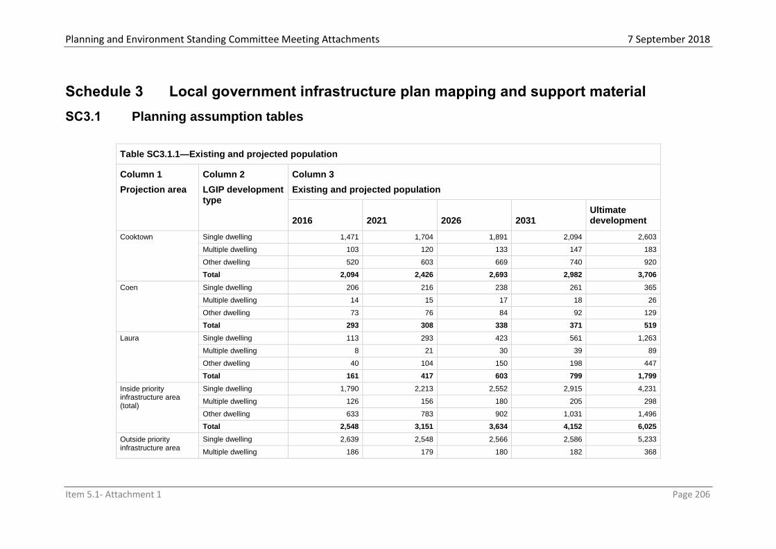
Planning and Environment Standing Committee Meeting Attachments 7 September 2018
Item 5.1- Attachment 1 Page 206
Schedule 3 Local government infrastructure plan mapping and support material
SC3.1 Planning assumption tables
Table SC3.1.1—Existing and projected population
Column 1
Projection area
Column 2
LGIP development type
Column 3
Existing and projected population
2016 2021 2026 2031 Ultimate development
Cooktown Single dwelling 1,471 1,704 1,891 2,094 2,603
Multiple dwelling 103 120 133 147 183
Other dwelling 520 603 669 740 920
Total 2,094 2,426 2,693 2,982 3,706
Coen Single dwelling 206 216 238 261 365
Multiple dwelling 14 15 17 18 26
Other dwelling 73 76 84 92 129
Total 293 308 338 371 519
Laura Single dwelling 113 293 423 561 1,263
Multiple dwelling 8 21 30 39 89
Other dwelling 40 104 150 198 447
Total 161 417 603 799 1,799
Inside priority infrastructure area (total)
Single dwelling 1,790 2,213 2,552 2,915 4,231
Multiple dwelling 126 156 180 205 298
Other dwelling 633 783 902 1,031 1,496
Total 2,548 3,151 3,634 4,152 6,025
Outside priority infrastructure area
Single dwelling 2,639 2,548 2,566 2,586 5,233
Multiple dwelling 186 179 180 182 368

Planning and Environment Standing Committee Meeting Attachments 7 September 2018
Item 5.1- Attachment 1 Page 207
Table SC3.1.1—Existing and projected population
Column 1
Projection area
Column 2
LGIP development type
Column 3
Existing and projected population
2016 2021 2026 2031 Ultimate development
(total) Other dwelling 933 901 907 915 1,850
Total 3,758 3,628 3,654 3,683 7,451
Cook Shire Council Single dwelling 4,429 4,761 5,118 5,502 9,464
Multiple dwelling 312 335 360 387 666
Other dwelling 1,566 1,684 1,810 1,946 3,347
Total 6,307 (b) 6,779 7,288 7,834 13,476
Table SC3.1.2—Existing and projected employees
Column 1
Projection area
Column 2
LGIP development type
Column 3
Existing and projected employees
2016 2021 2026 2031
Ultimate development
Cooktown Retail 96 105 112 120 139
Commercial 382 415 441 470 541
Industry 246 267 284 301 346
Community Purposes 292 317 336 357 410
Rural and Other Uses 444 454 461 469 489
Total 1,461 1,557 1,634 1,717 1,927
Coen Retail 7 7 8 8 11
Commercial 33 34 36 39 50
Industry 9 9 10 11 14

Planning and Environment Standing Committee Meeting Attachments 7 September 2018
Item 5.1- Attachment 1 Page 208
Table SC3.1.2—Existing and projected employees
Column 1
Projection area
Column 2
LGIP development type
Column 3
Existing and projected employees
2016 2021 2026 2031
Ultimate development
Community Purposes 25 26 27 29 38
Rural and Other Uses 16 17 19 20 29
Total 89 93 100 107 141
Laura Retail 0 4 7 11 28
Commercial 45 61 72 84 144
Industry 0 6 10 14 37
Community Purposes 60 72 80 89 134
Rural and Other Uses 40 61 76 92 173
Total 146 203 246 290 516
Inside priority infrastructure area (total)
Retail 103 116 127 139 178
Commercial 460 510 549 592 735
Industry 255 282 304 327 398
Community Purposes 378 414 444 476 583
Rural and Other Uses 500 531 555 581 691
Total 1,696 1,853 1,979 2,115 2,585
Outside priority infrastructure area (total)
Retail 25 20 18 17 93
Commercial 122 108 107 106 444
Industry 89 81 80 79 263
Community Purposes 33 21 18 14 237
Rural and Other Uses 330 329 336 344 629
Total 598 559 559 560 1,666
Cook Shire Council Retail 128 136 145 155 271
Commercial 582 618 657 698 1,179

Planning and Environment Standing Committee Meeting Attachments 7 September 2018
Item 5.1- Attachment 1 Page 209
Table SC3.1.2—Existing and projected employees
Column 1
Projection area
Column 2
LGIP development type
Column 3
Existing and projected employees
2016 2021 2026 2031
Ultimate development
Industry 344 363 384 406 661
Community Purposes 410 435 462 490 820
Rural and Other Uses 831 860 892 926 1,320
Total 2,295 2,412 2,539 2,675 4,251

Planning and Environment Standing Committee Meeting Attachments 7 September 2018
Item 5.1- Attachment 1 Page 210
Table SC3.1.3—Planned density and demand generation rate for a trunk infrastructure network
Column 1
Area classification
Column 2
LGIP development type
Column 3
Planned density
Column 4
Demand generation rate for a trunk infrastructure network
Non-residential plot ratio
Residential density
(dwellings/ dev ha)
Water supply network
(EP/dev ha)
Sewerage network
(EP/dev ha)
Transport network
(vpd/dev ha)
Parks and land for community facilities network
(persons/dev ha)
Stormwater network
(imp ha/dev ha)
Residential development
Centre 42 69.4 69.4 416 69.4 0.9
Low Density Residential 11 23.4 23.4 108 23.4 0.4
Medium Density Residential 13 26.7 26.7 129 26.7 0.7
Mixed Use 23 39.1 39.1 234 39.1 0.7
Mixed Use – MU1 52 86.4 86.4 518 86.4 0.9
Rural 0 0.02 0.02 0.2 0.02 0
Rural Residential – Water available 3 7.5 7.5 33 7.5 0.1
Rural Residential – Water not available 2 4.5 4.5 20 4.5 0.1
Township 10 22.5 22.5 100 22.5 0.1
Non-residential development and mixed development18
Centre 2.4 56.4 56.4 250 0.9
Community Facilities 1 18.0 18.0 80 0.4
(c) Environmental Management and Conservation 0 0 0 0
0
Industry 0.8 33.8 33.8 150 0.9
Mixed Use 1.2 45.1 45.1 200 0.7
Mixed Use – MU1 2.4 56.4 56.4 250 0.9
Recreation and Open Space 0 0 0 0 0
Note––1. Table SC3.1.3 Mixed development is development that includes residential development and non-residential development.

Planning and Environment Standing Committee Meeting Attachments 7 September 2018
Item 5.1- Attachment 1 Page 211
Strategic Port Land 0.8 33.8 33.8 150 0.9
Table SC3.1.4—Existing and projected residential dwellings
Column 1
Projection area
Column 2
LGIP development type
Column 3
Existing and projected residential dwellings
2016 2021 2026 2031 Ultimate development
Cooktown Single dwelling 637 745 833 929 1,155
Multiple dwelling 60 71 79 88 110
Other dwelling 282 330 369 411 511
Total 979 1,146 1,282 1,428 1,776
Coen Single dwelling 89 95 105 116 162
Multiple dwelling 8 9 10 11 15
Other dwelling 39 42 46 51 72
Total 137 145 161 178 249
Laura Single dwelling 49 128 187 249 560
Multiple dwelling 5 12 18 24 53
Other dwelling 22 57 83 110 248
Total 75 197 287 383 862
Inside priority infrastructure area (total)
Single dwelling 775 968 1,125 1,293 1,877
Multiple dwelling 74 92 107 123 178
Other dwelling 343 429 498 573 831
Total 1,192 1,488 1,730 1,989 2,886
Outside priority infrastructure area
Single dwelling 1,143 1,114 1,131 1,147 2,321
Multiple dwelling 109 106 107 109 221

Planning and Environment Standing Committee Meeting Attachments 7 September 2018
Item 5.1- Attachment 1 Page 212
(total) Other dwelling 506 494 501 508 1,028
Total 1,757 1,714 1,739 1,764 3,570
Cook Shire Council Single dwelling 1,917 2,082 2,256 2,441 4,198
Multiple dwelling 182 198 214 232 399
Other dwelling 849 922 999 1,081 1,859
Total 2,949 3,202 3,469 3,753 6,456
Table SC3.1.5—Existing and projected non-residential floor space
Column 1
Projection area
Column 2
LGIP development type
Column 3
Existing and projected non-residential floor space (m2 GFA)
2016 2021 2026 2031 Ultimate development
Cooktown
Retail 2,868 3,138 3,354 3,589 4,177
Commercial 11,473 12,454 13,241 14,093 16,233
Industry 36,951 40,046 42,529 45,220 51,975
Community Purposes 7,312 7,919 8,407 8,935 10,262
Rural and Other Uses 8,886 9,072 9,221 9,383 9,789
Total 67,491 72,629 76,753 81,220 92,436
Coen
Retail 209 216 232 248 322
Commercial 984 1,017 1,085 1,158 1,487
Industry 1,341 1,396 1,505 1,622 2,154
Community Purposes 621 643 686 733 946
Rural and Other Uses 318 335 370 408 578
Total 3,472 3,607 3,878 4,169 5,488
Laura Retail 0 130 225 325 834
Commercial 1,356 1,821 2,159 2,516 4,335
Industry 0 867 1,499 2,165 5,560
Community Purposes 1,507 1,796 2,006 2,228 3,360

Planning and Environment Standing Committee Meeting Attachments 7 September 2018
Item 5.1- Attachment 1 Page 213
Table SC3.1.5—Existing and projected non-residential floor space
Column 1
Projection area
Column 2
LGIP development type
Column 3
Existing and projected non-residential floor space (m2 GFA)
2016 2021 2026 2031 Ultimate development
Rural and Other Uses 803 1,217 1,517 1,834 3,451
Total 3,666 5,830 7,406 9,067 17,540
Inside priority infrastructure area (total)
Retail 3,077 3,484 3,811 4,161 5,334
Commercial 13,813 15,292 16,485 17,767 22,056
Industry 38,293 42,309 45,533 49,007 59,689
Community Purposes 9,439 10,357 11,099 11,897 14,568
Rural and Other Uses 10,008 10,624 11,109 11,625 13,818
Total 74,629 82,066 88,037 94,456 115,464
Outside priority infrastructure area (total)
Retail 749 601 553 500 2,795
Commercial 3,646 3,245 3,211 3,171 13,315
Industry 13,312 12,159 12,012 11,839 39,494
Community Purposes 823 520 440 353 5,927
Rural and Other Uses 6,604 6,576 6,724 6,886 12,574
Total 25,133 23,101 22,940 22,750 74,106
Cook Shire Council
Retail 3,826 4,085 4,363 4,662 8,129
Commercial 17,459 18,537 19,695 20,938 35,371
Industry 51,604 54,468 57,545 60,846 99,183
Community Purposes 10,262 10,878 11,540 12,249 20,495
Rural and Other Uses 16,612 17,201 17,833 18,512 26,392
Total 99,763 105,167 110,977 117,206 189,570

Planning and Environment Standing Committee Meeting Attachments 7 September 2018
Item 5.1- Attachment 1 Page 214
Table SC3.1.6—Existing and projected demand for the water supply network
Column 1
Service catchment19
Column 2
Existing and projected demand (EP)
2016
(base date) 2021 2026 2031
Ultimate development
Cooktown (WS01) 3,159 3,606 4,022 4,479 8,291
Coen (WS02) 347 367 412 461 686
Laura (WS03) 234 496 688 892 1,936
Lakeland (WS04) 244 228 227 226 375
TOTAL 3,985 4,697 5,349 6,058 11,288
Table SC3.1.7—Existing and projected demand for the sewerage network
Column 1
Service catchment20
Column 2
Existing and projected demand (EP)
2016
(base date) 2021 2026 2031
Ultimate development
Cooktown (S01) 2,829 3,266 3,658 4,088 6,987
Coen (S02) 347 367 412 461 686
Laura (S03) 234 496 688 892 1,936
Note––2. Table Column 1 The service catchments for the water supply network are identified on Local Government Infrastructure Plan Map LGIP-WS 01:06 (Plan for trunk infrastructure - water supply) in Schedule 3 (local government infrastructure mapping and tables).
Note––3. Table SC3.1.7 Column 1 The service catchments for the sewerage network are identified on Local Government Infrastructure Plan Map LGIP-S 01:03 (Plan for trunk infrastructure - sewerage) in Schedule 3 (local government infrastructure mapping and tables).

Planning and Environment Standing Committee Meeting Attachments 7 September 2018
Item 5.1- Attachment 1 Page 215
Table SC3.1.7—Existing and projected demand for the sewerage network
Column 1
Service catchment20
Column 2
Existing and projected demand (EP)
2016
(base date) 2021 2026 2031
Ultimate development
TOTAL 3,410 4,129 4,758 5,441 9,609
Table SC3.1.8—Existing and projected demand for the transport network
Column 1
Service catchment21
Column 2
Existing and projected demand (vpd)
2016
(base date) 2021 2026 2031
Ultimate development
Cooktown (TR01) 11,123 14,164 16,438 18,906 35,413
Coen (TR02) 1,380 1,540 1,729 1,934 2,824
Laura (TR03) 955 2,147 3,009 3,931 8,588
Lakeland (TR04) 998 1,011 1,015 1,020 1,614
Remainder of LGA (TR05) 21,776 22,929 23,901 24,951 49,842
TOTAL 36,231 41,791 46,091 50,743 98,280
Table SC3.1.9—Existing and projected demand for the parks and land for community facilities network
Note––4. Table SC3.1.8 Column 1 The service catchments for the transport network are identified on Local Government Infrastructure Plan Map LGIP-TR 01:05 (Plan for trunk infrastructure - transport) in Schedule 3 (local government infrastructure mapping and tables).

Planning and Environment Standing Committee Meeting Attachments 7 September 2018
Item 5.1- Attachment 1 Page 216
Column 1
Service catchment22
Column 2
Existing and projected demand (ha/1000 persons)
2016
(base date) 2021 2026 2031
Ultimate development
Cooktown (PPCL01) 2,741 3,074 3,369 3,694 7,093
Coen (PPCL02) 293 308 338 371 520
Laura (PPCL03) 161 417 602 798 1,802
Lakeland (PPCL04) 244 233 232 232 335
Remainder of LGA (PPCL05) 2,816 2,697 2,686 2,685 3,570
TOTAL 6,256 6,729 7,227 7,780 13,321
Note––5. Table SC3.1.9 Column 1 The service catchments for the parks and land for community facilities network are identified on Local Government Infrastructure Plan Map LGIP-PPCL 01:05(Plan for trunk infrastructure - parks and land for community facilities) in Schedule 3 (local government infrastructure mapping and tables).

Planning and Environment Standing Committee Meeting Attachments7 September 2018
Item 5.1- Attachment 1 Page 217
SC3.2 Schedules of works
Table SC3.2.1—Water supply network schedule of works
Column 1
Map reference
Column 2
Trunk infrastructure
Column 3
Estimated timing
Column 4
Establishment cost23
FWR_01 Secondary Reservoir - Cooktown 2036 $3,600,000
FWB_01 Future Bore - Lakeland 2022 $82,800
FWT_01 Annan Treatment - Upgrade 2017 $107,500
FWT_02 Annan Treatment - Upgrade 2022 $115,000
FWT_03 Annan Treatment - Upgrade 2025 $575,000
FWT_04 Coen Treatment - SCADA Upgrade 2017 $64,500
FWT_05 Coen Treatment - Upgrade 2018 $102,125
FWT_06 Coen Treatment - Upgrade 2025 $28,750
FWT_07 Lakeland Treatment - Generator Upgrade 2017 $64,500
FWT_08 Lakeland Treatment - Upgrade 2018 $21,500
FWT_09 Lakeland Treatment - Filtration and Disinfection Upgrade 2025 $603,750
FWT_10 Laura Treatment - Generator Upgrade 2021 $53,750
FWT_11 Laura Treatment - Upgrade 2018 $21,500
FWT_12 Laura Treatment - Upgrade 2025 $28,750
WMF_01 Future bore/reservoir connection - Lakeland 2022 $138,532
TOTAL $5,607,957
Table SC3.2.2—Sewerage network schedule of works
Column 1
Map reference
Column 2
Trunk infrastructure
Column 3
Estimated timing
Column 4
Establishment cost24
FST_01 Coen - SCADA monitoring upgrade 2022 $230,000
FST_02 Cooktown - SCADA upgrade (stage 1) 2019 $53,750
FST_03 Cooktown - SCADA upgrade (stage 2) 2022 $115,000
FST_04 Cooktown - Treatment Plant Upgrade 2020 $241,875
FPS_01 Pump Station 3 - Upgrade 2019 $80,625
FPS_02 Pump Station 5 - Upgrade 2021 $64,500
FPS_03 Regent St Pump Station - Upgrade 2018 $26,875
TOTAL $812,625
Note––6. Table SC3.2.1 Column 4 The establishment cost is expressed in current cost terms as at the base date.
Note––7. Table SC3.2.2 Column 4 The establishment cost is expressed in current cost terms as at the base date.

Planning and Environment Standing Committee Meeting Attachments7 September 2018
Item 5.1- Attachment 1 Page 218
Table SC3.2.3—Transport network schedule of works
Column 1
Map reference
Column 2
Trunk infrastructure
Column 3
Estimated timing
Column 4
Establishment cost25
RU_01a Charlotte St – Upgrade (Stage 1) 2020 $1,612,500
RU_01b Charlotte St – Upgrade (Stage 2) 2025 $1,725,000
TOTAL $3,337,500
Table SC3.2.4—Parks and land for community facilities schedule of works
Column 1
Map reference
Column 2
Trunk infrastructure
Column 3
Estimated timing
Column 4
Establishment cost26
FP_01 Esplanade Revitalisation Project 2018 $2,150,000
FP_02 John Street Oval 2020 $844,305
FP_04 Skate Park 2020 $32,250
FP_06 Pathway upgrade through cemetary 2020 $268,750
FP_07 Racecourse and Recreation upgrade 2018 $0
FP_08 Lakelands Recreation 2020 $297,990
FP_09 Lakelands Shire Rec 2018 $311,589
FP_10 Future Lakelands Recreation 2020 $621,740
TOTAL $4,526,625
Note––8. Table SC3.2.3 Column 4 The establishment cost is expressed in current cost terms as at the base date.
Note––9. Table SC3.2. SC3.2.4 Column 4 The establishment cost is expressed in current cost terms as at the base date.

Planning and Environment Standing Committee Meeting Attachments7 September 2018
Item 5.1- Attachment 1 Page 219
SC3.3 Local government infrastructure plan maps
Local Government Infrastructure Plan Map LGIP PIA 01:04 Priority infrastructure area and projection areas map
Local Government Infrastructure Plan Map LGIP-WS 01:06 – Plan for trunk infrastructure - water supply
Local Government Infrastructure Plan Map LGIP-S 01:03 – Plan for trunk infrastructure - sewerage
Local Government Infrastructure Plan Map LGIP-TR 01:05 – Plan for trunk infrastructure - transport
Local Government Infrastructure Plan Map LGIP-PPCL 01:05 – Plan for trunk infrastructure - parks and land for community facilities

Planning and Environment Standing Committee Meeting Attachments7 September 2018
Item 5.1- Attachment 1 Page 220
Schedule 4 Notations required under the Planning Act 2016
SC4.1 Notation of decisions affecting the planning scheme under section 89 of the Act
Table SC 4.1-Notation of decisions under section 89 of the Act
Date of decision Location (real property description)
Decision type File/Map reference
Editor’s note—This schedule must include details of:
development approvals that are substantially inconsistent with the planning scheme
variation approvals;
decisions agreeing to superseded planning scheme request to apply to a superseded scheme to a particular development.
SC4.2 Notation of resolution(s) under Chapter 4, Part 2, Division 2 of the Act
Table SC 4.1-Notation of resolutions under Chapter 4, Part 2, Division 2 of the Act
Date of resolution Date of effect Details Contact information
6 July 2018 13 July 2018 Local Government Infrastructure Plan
Available at Cook Shire Council’s Chambers, 10 Furneaux Street Cooktown; or online on Council’s website
Editor’s note—this schedule must provide details regarding the adopted infrastructure charges for the local government and where a copy of the adopted charges can be obtained, including a link to the local government website where a copy of the infrastructure charges resolution can be viewed or downloaded in accordance with the requirements of section 117(1)(a) of the Act.
SC4.3 Notation of registration for urban encroachment provisions under section 267 of the Act
Table SC 4.2-Notation of registrations made under section 267 of the Act
Date of registration of the premises
Location of premises (real property description
Details of registration
Term of registration
Schedule 1

Planning and Environment Standing Committee Meeting Attachments7 September 2018
Item 5.1- Attachment 1 Page 221
Schedule 5 Designation of premises for development
There is no land designated for community infrastructure in the local government area
Schedule 1

Planning and Environment Standing Committee Meeting Attachments7 September 2018
Item 5.1- Attachment 1 Page 222
Schedule 6 Planning scheme policies
The planning scheme policies for this planning scheme are:
(a) Development Manual Planning Scheme Policy (b) Provision of Public Open Space Planning Scheme Policy (c) Landscaping Planning Scheme Policy (d) Guidelines for development in the Eastern Kuku Yalanji Local Plan are Planning
Scheme Policy (e) Bushfire Hazard Analysis Planning Scheme Policy
SC6.1 Development Manual Planning Scheme Policy
Purpose To adopt the Far North Queensland Regional Organisation of Councils (FNQROC) Development Manual as a planning scheme policy.
Application This policy applies to the whole area covered by the Planning Scheme for Cook Shire.
Intent This planning scheme policy is intended to provide comprehensive and consistent development standards that are in accordance with the Act and its supporting legislation.
SC6.2 Provision of Public Open Space Planning Scheme Policy
Purpose The purpose of this policy is to ensure that new development makes adequate provision for public open space to cater for the additional need for such public open space created by the development.
Application The policy applies to all applications for Material Change of Use for residential uses in the Low Density Residential, Medium Density Residential, Mixed Use, Village, Community Uses and Business Zones. It also applies to all applications for Reconfiguring a Lot in the Low Density Residential, Medium Density Residential, Mixed Use, Township and Rural Residential Zones.
Intent Where an increased demand for public open space will result from new development, Council may, as a condition of development approval, require the dedication of land as public open space. Alternatively, Council may at its discretion require a monetary contribution in lieu of land.
Quantity and Quality of Land to be Provided In the case of reconfiguration of larger areas of land (i.e. exceeding 4 ha) a contribution of 10 %of the total area as public open space may be acceptable provided the land to be contributed:
(a) Is provided in one consolidated parcel. (b) Is well drained, flood free and does not slope in excess of 1:10 grade. (c) Has a functional shape, not exceeding a maximum depth to width ratio of 3:1. (d) Is a fair average of the land to be reconfigured. (e) Has a gazetted and constructed road frontage (or will have as a result of the proposed
reconfiguration). Any such land to be contributed shall be transferred to Council at the time of Council endorsement of the formal plan of survey for the reconfiguration. In some circumstances, it

Planning and Environment Standing Committee Meeting Attachments7 September 2018
Item 5.1- Attachment 1 Page 223
may be feasible for land not included in the lot(s) to be reconfigured to be dedicated as public open space. This may be permitted where the land to be contributed meets the above criteria and is in close proximity to and may be easily accessed from the lot(s)to be reconfigured. In most cases it would be expected to adjoin such lot(s). Where this occurs, the land proposed as public open space shall be transferred to Council at the time of Council endorsement of the formal plan of survey for the reconfiguration.
Contribution of Money Where it is not possible to contribute land of sufficient area or quality from within the site of the development application (or adjacent to it), Council will require a monetary contribution in lieu of land. Such contribution shall be used by Council for the provision of public open space or for the upgrading of existing public open space in the general vicinity of the development site. The amount of money to be contributed in lieu of land for public open space is to be calculated based on the number of additional Residential Units generated by the development. Level of Monetary Contribution – Reconfiguring a Lot(s) In the case of Reconfiguring a Lot(s), each residential lot is taken to equate to one Residential Unit. Consequently, the number of Residential Units for which a contribution is required, equals the number of residential lots after the reconfiguration, less the number of residential lots prior to the reconfiguration. Providing the resulting number is positive, a contribution will apply. The value of each Residential Unit is set in accordance with Council’s Fees and Charges Schedule as updated from time to time. Level of Monetary Contribution – Material Change of Use In the case of a Material Change of Use, the contribution is also based on the increase in the number of Residential Units that result from the development. The number of Residential Units is derived from the gross floor areas of dwelling units as follows:
Gross Floor Area of Dwelling Unit Equivalent Number of Residential Units
< 60 m2 0.5
60 m2 to 100 m2 0.75
> 100 m2 1.0
Consequently, the number of Residential Units for which contribution is required equals the number of proposed dwelling units (reduced by the above factors if applicable), less the number of existing dwelling units (reduced by the above factors if applicable). Each existing vacant lot is deemed to have a credit of one Residential Unit. The value of each Residential Unit is set in accordance with Council’s Fees and Charges Schedule, as updated from time to time.
SC6.3 Landscaping Planning Scheme Policy
Purpose The purpose of this policy is to ensure that landscaping works achieve acceptable minimum standards and utilise an appropriate selection of species so as to provide effective screening and enhance the visual presentation of the locality. Application This policy is applicable to all landscaping works undertaken as a result of requirements elsewhere in this planning scheme for accepted and assessable development. Physical Preparation
(a) Landscape areas to be constructed of raised beds with imported topsoil. (b) Beds to be edged with either hard (treated timber, formed concrete or pavers) or soft
(hedging or grasses) edge treatments. (c) Beds to be provided with a minimum 100 mm layer of mulched hardwood or similar
organic material.

Planning and Environment Standing Committee Meeting Attachments7 September 2018
Item 5.1- Attachment 1 Page 224
(d) A water connection point is to be available for irrigation. A water efficient reticulation system is to be provided and designed according to local conditions.
Selection of Plants At least 25% of plants should be species endemic to the region and selected in response to proposed site irrigation, long-term maintenance requirements and the encouragement of native birds and wildlife. Wherever feasible, existing appropriate shrubs and trees should be retained as part of the landscaping works. Trees shall be selected and placed such that at their ultimate size, they are no closer than 4 metres from overhead electricity or telecommunications poles or lines and no closer than 7.5 metres from streetlights. Trees and shrubs are to be selected for their shade and visual buffer qualities. In this regard, palms are not to be relied upon, except as accent plants only. Plants toxic to humans or with spines should not be used. Species that contain volatile oils can be a fire hazard and should not be used in Medium, High, and Very High Bushfire Hazard Areas identified on OM2 – Bushfire Hazard Overlay Map.Environmental Pest Plants must be avoided.
Density of Plantings Plantings should utilize advanced stock. Trees should be no less than 1 m in height, well-branched and planted from a minimum 300 mm container. Mass planting should incorporate a three-tier approach of trees, shrubs and ground cover at the following densities:
(a) Ground Cover – Up to 0.6 m centres. (b) Shrubs – Up to 1.5 m centres. (c) Trees – Up to 3 m centres for landscape buffer/screen areas and up to 6 m centres for
other areas. (d) Shade trees are to be provided in car parking areas at the minimum rate of one tree
per six car parking spaces.
Maintenance Landscaped areas should be subject to regular and on-going maintenance, including through the timely replacement of damaged or dead plants. While not exhaustive, Schedule 1 of this policy lists species of trees and shrubs which are: Native to the Cook Shire region and generally acceptable as landscaping species. Exotic, but nevertheless useful decorative landscaping species. Problem species which must be avoided. Schedule 2 of this policy lists Environmental Pest Plants which must not be planted. Schedule 3 of this policy lists some contact points for further information on appropriate landscaping species and vegetation issues generally.

Planning and Environment Standing Committee Meeting Attachments 7 September 2018
Item 5.1- Attachment 1 Page 225
j) List 1: Species Generic to Cape York (including Palmer River, Lakeland, Bloomfield, Rossville, Cooktown, Laura, Musgrave, Coen,
Archer River and Moreton)
k) Small Plants for Dry Areas (refer to the following key for descriptive characteristics of each species):
l) - Hot Dry Areas Only
m) } - Attracts Birds
n) + - Attracts Butterflies
o) # - Bush Tucker
p) * - Propagate from Treated Seed
q) F – Contains Volatile Oils Generic Plants - Shrubs, Vines & Groundcovers
r) Botanical Name s) Common
Name
t) Notes u) Habitat v) Siz
e
w) Family
x) Acacia calyculata y) z) }* F aa) Cape York bb) 1.2
m
cc) Mimosac
eae
dd) A holosericea ee) Silver
Wattle
ff) * F gg) Tropical Aust hh) To
5m
ii) Mimosac
eae
jj) A. humifusa kk) ll) Shrub. mm) 100km from coast.
Dry.
nn) 1m oo) Mimosac
eae
pp) A. leptostachya qq) Townsville
Wattle
rr) Shrub }* F ss) Tropical Qld tt) 2-
5m
uu) Mimosac
eae
vv) A. multisiliqua ww) xx) Shrub }* F yy) Dry Tropical Aust zz) 1-
2m
aaa) Mimosac
eae
bbb) A. simsii ccc) Sim’s
Wattle
ddd) }* F eee) Tropical Aust fff) 2-
4m
ggg) Mimosac
eae
hhh) Alyxia spicata iii) jjj) Scrambler/shrub. kkk) Vine/dune forests lll) mmm) Apocynac
eae
nnn) Alyxia ruscifolia ooo) Chain Fruit ppp) Shrub. qqq) Open scrub, Vine
Thickets
rrr) 2.5
m
sss) Apocynac
eae

Planning and Environment Standing Committee Meeting Attachments 7 September 2018
Item 5.1- Attachment 1 Page 226
r) Botanical Name s) Common
Name
t) Notes u) Habitat v) Siz
e
w) Family
ttt) Baekea spp uuu) Baekea
spp
vvv) Small tree. F www) Dry Tropical Aust xxx) Var
ious 1-4m
yyy) Myrtacea
e
zzz) Breynia
oblongifolia
aaaa) Native
Coffee
bbbb) Arching shrub. cccc) Tropical Aust dddd) 0.5
-3m
eeee) Euphorbi
aceae
ffff) Banksia spp gggg) Banksia
spp
hhhh) Various, Shrub/Small
tree. }*
iiii) Aust jjjj) Var
ious, 1-16m
kkkk) Proteace
ae
llll) Brachychiton
paradoxus
mmmm) Re
d-Flowered
Kurrajong
nnnn) Deciduous. oooo) Nth Qld, NT pppp) 2-
3m
qqqq) Sterculiac
eae
rrrr) Callistemon
chisholmii
ssss) tttt) May require occasional
water. }
uuuu) Dry Tropical Aust vvvv) 2-
4m
wwww) Myrtacea
e
xxxx) Callistemon
polandii
yyyy) zzzz) Shrub. }+ aaaaa) Cooktown bbbbb) 2-
5m
ccccc) Myrtacea
e
ddddd) Capparis lasiantha eeeee) Native
Orange
fffff) #} ggggg) Inland Qld, NT, WA hhhhh) 1-
3m
iiiii) Capparac
eae
jjjjj) Cycas spp kkkkk) Cycad lllll) Toxic to stock. Use local
dry country sp. Propagate from
seed. F
mmmmm) Tropical
Aust
nnnnn) Slo
w grower to
4m
ooooo) Cycadace
ae
ppppp) Dodonaea
polyandra
qqqqq) Wild Hop rrrrr) May require occasional
water. Well-drained. } F
sssss) Cape York ttttt) 1-
5m
uuuuu) Sapindac
eae
vvvvv) Flueggea virosa wwwww) W
hite Berry Bush
xxxxx) }# yyyyy) Tropical Aust zzzzz) 1-
4m
aaaaaa) E
uphorbiaceae
bbbbbb) Gnaphaliu
m rupicola syn
Helichrysum rupicola
cccccc) Everlasting
Daisy
dddddd) eeeeee) Tropical
Aust
ffffff) 0.5
m
gggggg) A
steraceae
hhhhhh) Grevillea
spp
iiiiii) Grevillea jjjjjj) }+ F kkkkkk) Aust llllll) vari
ous
mmmmmm) P
roteaceae

Planning and Environment Standing Committee Meeting Attachments 7 September 2018
Item 5.1- Attachment 1 Page 227
r) Botanical Name s) Common
Name
t) Notes u) Habitat v) Siz
e
w) Family
nnnnnn) Grevillea
dryandri
oooooo) Dr
yander
pppppp) Prostrate. }+ qqqqqq) Dry
Tropical Aust
rrrrrr) 1m ssssss) Proteace
ae
tttttt) Graptophyllum
excelsum
uuuuuu) Let
ter-leaf, Scarlet
Fuschia
vvvvvv) Well-drained. } wwwwww) Coastal
Cape York
xxxxxx) 1.5
-8m
yyyyyy) Acanthac
eae
zzzzzz) Haemodorum
coccineum
aaaaaaa) Blo
odroot
bbbbbbb) Grow with
Morinda reticulata.
ccccccc) ddddddd) 0
.5m
eeeeeee) H
aemodoraceae
fffffff) Hibbertia spp ggggggg) Gu
inea Flower,
various
hhhhhhh) Yellow flowers. iiiiiii) Dry Tropical Aust jjjjjjj) 1.5
m
kkkkkkk) D
illeniaceae
lllllll) Hibiscus
heterophyllus
mmmmmmm) Na
tive Hibiscus
nnnnnnn) Prune. Massed
planting.
ooooooo) Tropical
Aust
ppppppp) 1
m
qqqqqqq) M
alvaceae
rrrrrrr) Hibiscus
meraukensis
sssssss) Na
tive Hibiscus
ttttttt) Prune. Massed planting. uuuuuuu) Tropical
Aust
vvvvvvv) 1
m
wwwwwww) M
alvaceae
xxxxxxx) Hoya spp yyyyyyy) Ho
ya
zzzzzzz) Waxy climber.
aaaaaaaa) Spectacular
flowers.
bbbbbbbb) Tropical
Aust
cccccccc) dddddddd) A
sclepidaceae
eeeeeeee) Jacksonia
spp
ffffffff) Various gggggggg) Cuttings. * F hhhhhhhh) Dry
Tropical Aust
iiiiiiii) 0.5
-2.5m
jjjjjjjj) Fabaceae
kkkkkkkk) Kailarseni
a ochreata
llllllll) Native
Gardenia
mmmmmmmm) Scented, Fresh
seed or cuttings.
nnnnnnnn) Dry
Tropical Aust
oooooooo) 2
-5m
pppppppp) R
ubiaceae
qqqqqqqq) Melaleuca
arcana
rrrrrrrr) ssssssss) White to pink
flowers. } F
tttttttt) Cooktown uuuuuuuu) 4
m
vvvvvvvv) M
yrtaceae
wwwwwwww) M.
minutifolia
xxxxxxxx) yyyyyyyy) } F zzzzzzzz) Dry
Tropical Aust
aaaaaaaaa) 3
-7m
bbbbbbbbb) M
yrtaceae

Planning and Environment Standing Committee Meeting Attachments 7 September 2018
Item 5.1- Attachment 1 Page 228
r) Botanical Name s) Common
Name
t) Notes u) Habitat v) Siz
e
w) Family
ccccccccc) M.
tamariscina
ddddddddd) eeeeeeeee) White to mauve
flowers. } F
fffffffff) Dry Tropical Aust ggggggggg) T
o 5m
hhhhhhhhh) M
yrtaceae
iiiiiiiii) M. uncinata jjjjjjjjj) kkkkkkkkk) White to yellow
flowers. F
lllllllll) Dry Tropical Aust mmmmmmmmm) T
o 3m
nnnnnnnnn) M
yrtaceae
ooooooooo) Morinda
citrifolia
ppppppppp) Ch
eesefruit,
qqqqqqqqq) No
ni
rrrrrrrrr) Maintain as shrub. sssssssss) Tropical
Aust
ttttttttt) 3-
10m
uuuuuuuuu) R
ubiaceae
vvvvvvvvv) Morinda
reticulata
wwwwwwwww) xxxxxxxxx) Toxic to stock
Prefers dry clay. }
yyyyyyyyy) Dry
Tropical Aust
zzzzzzzzz) 0
.5m
aaaaaaaaaa) R
ubiaceae
bbbbbbbbbb) Murraya
paniculata
cccccccccc) Mo
ck Orange
dddddddddd) Highly
perfumed.}
eeeeeeeeee) Tropical
Aust
ffffffffff) 2-
4m
gggggggggg) R
utaceae
hhhhhhhhhh) Neofabicia
myrtifolia
iiiiiiiiii) jjjjjjjjjj) Yellow flowers. F kkkkkkkkkk) Tropical
Aust
llllllllll) To
4m in dry
areas
mmmmmmmmmm) M
yrtaceae
nnnnnnnnnn) Persoonia
falcata
oooooooooo) Ge
ebung
pppppppppp) Yellow flowers.
#}
qqqqqqqqqq) Tropical
Aust
rrrrrrrrrr) 3
-5 m
ssssssssss) P
roteaceae
tttttttttt) Petalostigma
pubescens
uuuuuuuuuu) Qu
inine Bush
vvvvvvvvvv) Yellow fruit. wwwwwwwwww) Tro
pical Aust
xxxxxxxxxx) 2
-5m
yyyyyyyyyy) E
uphorbiaceae
zzzzzzzzzz) Premna
serratilfolia
aaaaaaaaaaa) Cr
eek Premna
bbbbbbbbbbb) May require
some water. }+
ccccccccccc) Dry
Tropical Aust
ddddddddddd) 3
-10m
eeeeeeeeeee) V
erbenaceae
fffffffffff) Santalum
lanceolatum
ggggggggggg) Sa
ndlewood,
Plumwood
hhhhhhhhhhh) Root parasite.
iiiiiiiiiii) Difficult to propagate.
Leave as appropriate when
clearing. # } F
jjjjjjjjjjj) Dry Tropical Aust kkkkkkkkkkk) T
o 5m
lllllllllll) Santalace
ae

Planning and Environment Standing Committee Meeting Attachments 7 September 2018
Item 5.1- Attachment 1 Page 229
r) Botanical Name s) Common
Name
t) Notes u) Habitat v) Siz
e
w) Family
mmmmmmmmmmm) S
caveola taccada
nnnnnnnnnnn) syn S.
sericea
ooooooooooo) Se
a Lettuce, Fan
Flower
ppppppppppp) Sand & salt
tolerant. May require some
water. Beach protection.
qqqqqqqqqqq) Coastal
Dry Tropics
rrrrrrrrrrr) 2
-3m
sssssssssss) G
oodeniaceae
ttttttttttt) Sophora
tomentosa
uuuuuuuuuuu) Sil
ver Bush
vvvvvvvvvvv) Sand & salt
tolerant. May require some
water. Beach protection.
wwwwwwwwwww) Co
astal Dry Tropics
xxxxxxxxxxx) 3
-4m
yyyyyyyyyyy) F
abaceae
zzzzzzzzzzz) Sterculia
quadrifida
aaaaaaaaaaaa) Pe
anut Tree
bbbbbbbbbbbb) Beach
protection. #}
cccccccccccc) Tropical
Aust
dddddddddddd) 5
-10m
eeeeeeeeeeee) S
terculiaceae
ffffffffffff) Swainson
a spp.
gggggggggggg) St
urt’s Desert Pea
hhhhhhhhhhhh) Annual.
Watering can cause mould or
fungii.*
iiiiiiiiiiii) Dry Aust jjjjjjjjjjjj) Pro
strate
kkkkkkkkkkkk) F
abaceae
llllllllllll) Syzygium
rubrimolle
mmmmmmmmmmmm) L
aura Apple
nnnnnnnnnnnn) #} oooooooooooo) Dry Cape
York
pppppppppppp) T
o 4m
qqqqqqqqqqqq) M
yrtaceae
rrrrrrrrrrrr) S.
suborbiculare
ssssssssssss) La
dy Apple
tttttttttttt) #} uuuuuuuuuuuu) Cape York vvvvvvvvvvvv) 8
-12m
wwwwwwwwwwww) M
yrtaceae
xxxxxxxxxxxx) Xanthorrh
oea spp
yyyyyyyyyyyy) Gr
ass Tree
zzzzzzzzzzzz) Slow-growing.
#}+ F
aaaaaaaaaaaaa) Ca
pe York
bbbbbbbbbbbbb) T
o 5m
ccccccccccccc) X
anthorroeaceae

Planning and Environment Standing Committee Meeting Attachments 7 September 2018
Item 5.1- Attachment 1 Page 230
Generic Plants - Trees
ddddddddddddd) B
otanical Name
eeeeeeeeeeeee) C
ommon
fffffffffffff) Na
me
ggggggggggggg) Notes hhhhhhhhhhhhh) Ha
bitat
iiiiiiiiiiiii) S
ize
jjjjjjjjjjjjj) F
amily
kkkkkkkkkkkkk) Alphitonia
excelsa
lllllllllllll) Red Ash mmmmmmmmmmmmm) }
F
nnnnnnnnnnnnn) Qld
, NT,WA, NSW
ooooooooooooo) T
o 10m
ppppppppppppp) R
hamanaceae
qqqqqqqqqqqqq) B
ombax ceiba
rrrrrrrrrrrrr) Re
d Kapok
sssssssssssss) Deciduous. }+ ttttttttttttt) Tropical
Aust
uuuuuuuuuuuuu) 1
0-20m
vvvvvvvvvvvvv) B
ombacaceae
wwwwwwwwwwwww) Br
achychiton australis
xxxxxxxxxxxxx) Br
oad-leafed Bottle
Tree
yyyyyyyyyyyyy) Deciduous. zzzzzzzzzzzzz) Tropical
Aust
aaaaaaaaaaaaaa) M
ed - Tall
bbbbbbbbbbbbbb) S
terculiaceae
cccccccccccccc) B.
diversifolius
dddddddddddddd) N
orthern Kurrajong
eeeeeeeeeeeeee) Semi-
deciduous.
ffffffffffffff) Dry
Tropical Aust
gggggggggggggg) 7
-15m
hhhhhhhhhhhhhh) S
terculiaceae
iiiiiiiiiiiiii) B. grandiflorus jjjjjjjjjjjjjj) Cape
Kurrajong
kkkkkkkkkkkkkk) Decidu
ous.
llllllllllllll) Cape York mmmmmmmmmmmmmm) T
o 10m
nnnnnnnnnnnnnn) S
terculiaceae
oooooooooooooo) B.
rupestris
pppppppppppppp) Q
ueensland Bottle
Tree
qqqqqqqqqqqqqq) Semi-
deciduous.
rrrrrrrrrrrrrr) Dry Central
Qld
ssssssssssssss) T
o 10m
tttttttttttttt) S
terculiaceae
uuuuuuuuuuuuuu) C
anarium australanium
vvvvvvvvvvvvvv) M
elville Is White
Beech
wwwwwwwwwwwwww) Decidu
ous. * F
xxxxxxxxxxxxxx) Qld
, NT, WA
yyyyyyyyyyyyyy) 1
0-15m
zzzzzzzzzzzzzz) B
urseraceae
aaaaaaaaaaaaaaa) C
anthium coprosmoides
bbbbbbbbbbbbbbb) C
oast Canthium
ccccccccccccccc) Dry
Coastal.
ddddddddddddddd) Nth
Qld
eeeeeeeeeeeeeee) 2
-6m
fffffffffffffff) R
ubiaceae
ggggggggggggggg) C.
oleiofolium
hhhhhhhhhhhhhhh) W
ild Lemon
iiiiiiiiiiiiiii) }+ jjjjjjjjjjjjjjj) Nth Qld kkkkkkkkkkkkkkk) 3
-8m
lllllllllllllll) R
ubiaceae
mmmmmmmmmmmmmmm) C
apparis lucida
nnnnnnnnnnnnnnn) C
oast Caper
ooooooooooooooo) Small
tree. #}+
ppppppppppppppp) Qld
, WA
qqqqqqqqqqqqqqq) 3
-6m
rrrrrrrrrrrrrrr) C
apparaceae

Planning and Environment Standing Committee Meeting Attachments 7 September 2018
Item 5.1- Attachment 1 Page 231
ddddddddddddd) B
otanical Name
eeeeeeeeeeeee) C
ommon
fffffffffffff) Na
me
ggggggggggggg) Notes hhhhhhhhhhhhh) Ha
bitat
iiiiiiiiiiiii) S
ize
jjjjjjjjjjjjj) F
amily
sssssssssssssss) C.
mitchellii
ttttttttttttttt) Wil
d Orange
uuuuuuuuuuuuuuu) }+ vvvvvvvvvvvvvvv) Inl
and Aust
wwwwwwwwwwwwwww) 3
-10m
xxxxxxxxxxxxxxx) C
apparaceae
yyyyyyyyyyyyyyy) C
ochlospermum gillivraei
zzzzzzzzzzzzzzz) Y
ellow Kapok
aaaaaaaaaaaaaaaa) Decidu
ous.
bbbbbbbbbbbbbbbb) Qld
, NT
cccccccccccccccc) 3
-12m
dddddddddddddddd) B
ixaceae
eeeeeeeeeeeeeeee) C
ommersonia bartramia
ffffffffffffffff) Br
own Kurrajong
gggggggggggggggg) Hardy,
attractive.
hhhhhhhhhhhhhhhh) NS
W-Cape York
iiiiiiiiiiiiiiii) 5
-12m
jjjjjjjjjjjjjjjj) S
terculiaceae
kkkkkkkkkkkkkkkk) C
ordia subcordata
llllllllllllllll) Se
a Trumpet
mmmmmmmmmmmmmmmm) B
each Protection.
nnnnnnnnnnnnnnnn) Tro
pics
oooooooooooooooo) 2
-15m
pppppppppppppppp) B
oraginaceae
qqqqqqqqqqqqqqqq) C
orymbia spp
rrrrrrrrrrrrrrrr) Blo
odwood, various
ssssssssssssssss) } F tttttttttttttttt) Nth Aust uuuuuuuuuuuuuuuu) V
arious 10-
30m
vvvvvvvvvvvvvvvv) M
yrtaceae
wwwwwwwwwwwwwwww) C
orypha utan
xxxxxxxxxxxxxxxx) l
arge Fan Palm
yyyyyyyyyyyyyyyy) Spectac
ular. Flowers & dies 40-50 yrs.
zzzzzzzzzzzzzzzz) Ca
pe York, Arhnem Land
aaaaaaaaaaaaaaaaa) H
uge
bbbbbbbbbbbbbbbbb) P
almeae
ccccccccccccccccc) Er
ythrina vespertillio
ddddddddddddddddd) B
ats Wing Coral
Tree
eeeeeeeeeeeeeeeee) Decidu
ous.
fffffffffffffffff) Aust-NSW-
North
ggggggggggggggggg) 6
-10m
hhhhhhhhhhhhhhhhh) F
abaceae
iiiiiiiiiiiiiiiii) Erythophl
eum chlorostachys
jjjjjjjjjjjjjjjjj) Co
oktown Ironwood
kkkkkkkkkkkkkkkkk) Toxic. F lllllllllllllllll) Tropical
Aust
mmmmmmmmmmmmmmmmm) 8
-15m
nnnnnnnnnnnnnnnnn) C
aesalpinaceae
ooooooooooooooooo) E
citriodora
ppppppppppppppppp) L
emon-scented
Gum
qqqqqqqqqqqqqqqqq) Too
large for small garden. F
rrrrrrrrrrrrrrrrr) East Qld sssssssssssssssss) 4
0-50m
ttttttttttttttttt) M
yrtaceae
uuuuuuuuuuuuuuuuu) E
phoenicea
vvvvvvvvvvvvvvvvv) S
carlet Gum
wwwwwwwwwwwwwwwww) }
+ F
xxxxxxxxxxxxxxxxx) Tro
pical Aust
yyyyyyyyyyyyyyyyy) T
o 12m
zzzzzzzzzzzzzzzzz) M
yrtaceae

Planning and Environment Standing Committee Meeting Attachments 7 September 2018
Item 5.1- Attachment 1 Page 232
ddddddddddddd) B
otanical Name
eeeeeeeeeeeee) C
ommon
fffffffffffff) Na
me
ggggggggggggg) Notes hhhhhhhhhhhhh) Ha
bitat
iiiiiiiiiiiii) S
ize
jjjjjjjjjjjjj) F
amily
aaaaaaaaaaaaaaaaaa) E
xocarpus latifolia
bbbbbbbbbbbbbbbbbb) N
ative Cherry
cccccccccccccccccc) Parasiti
c, difficult to cultivate. Retain if
appropriate. #
dddddddddddddddddd) Tro
pical Aust
eeeeeeeeeeeeeeeeee) 4
-8m
ffffffffffffffffff) S
antalaceae
gggggggggggggggggg) Gr
evillea spp & cvs
hhhhhhhhhhhhhhhhhh) V
arious
iiiiiiiiiiiiiiiiii) Hardy. F jjjjjjjjjjjjjjjjjj) Aust kkkkkkkkkkkkkkkkkk) V
arious 1-
15m
llllllllllllllllll) P
roteaceae
mmmmmmmmmmmmmmmmmm) G
. glauca
nnnnnnnnnnnnnnnnnn) B
ushman’s
Clothespeg
oooooooooooooooooo) }+ F pppppppppppppppppp) Ca
pe York
qqqqqqqqqqqqqqqqqq) 3
-10m
rrrrrrrrrrrrrrrrrr) P
roteaceae
ssssssssssssssssss) G.
parallela
tttttttttttttttttt) uuuuuuuuuuuuuuuuuu) }+ F vvvvvvvvvvvvvvvvvv) Tro
pical Aust
wwwwwwwwwwwwwwwwww) 2
.5-15m
xxxxxxxxxxxxxxxxxx) P
roteaceae
yyyyyyyyyyyyyyyyyy) G
pteridifolia
zzzzzzzzzzzzzzzzzz) G
olden Grevillea
aaaaaaaaaaaaaaaaaaa) }
+ F
bbbbbbbbbbbbbbbbbbb) T
ropical Aust
ccccccccccccccccccc) ddddddddddddddddddd) P
roteaceae
eeeeeeeeeeeeeeeeeee) H
akea persiehana
fffffffffffffffffff) ggggggggggggggggggg) }
+ F
hhhhhhhhhhhhhhhhhhh) C
ape York
iiiiiiiiiiiiiiiiiii) 4
-6m
jjjjjjjjjjjjjjjjjjj) P
roteaceae
kkkkkkkkkkkkkkkkkkk) La
gerstroemia archeriana
lllllllllllllllllll) Na
tive Crepe Myrtle
mmmmmmmmmmmmmmmmmmm) D
eciduous.
nnnnnnnnnnnnnnnnnnn) C
ape York
ooooooooooooooooooo) T
o 7m
ppppppppppppppppppp) L
ythraceae
qqqqqqqqqqqqqqqqqqq) L
ivistona muellerii
rrrrrrrrrrrrrrrrrrr) Ca
irns Fan Palm,
Cabbage Palm
sssssssssssssssssss) Fan
Palm.
ttttttttttttttttttt) Cape York uuuuuuuuuuuuuuuuuuu) T
o 12m
vvvvvvvvvvvvvvvvvvv) A
raceaea
wwwwwwwwwwwwwwwwwww)
xxxxxxxxxxxxxxxxxxx) Ly
siphyllum carroni
yyyyyyyyyyyyyyyyyyy) B
auhinia
zzzzzzzzzzzzzzzzzzz) Decidu
ous. }
aaaaaaaaaaaaaaaaaaaa) Q
ld, NSW
bbbbbbbbbbbbbbbbbbbb) 5
-20m
cccccccccccccccccccc) C
aesalpinaceae
dddddddddddddddddddd) L
. cunninghami
eeeeeeeeeeeeeeeeeeee) B
auhinia
ffffffffffffffffffff) Semi-
deciduous. }+
gggggggggggggggggggg) D
ry Tropical Aust
hhhhhhhhhhhhhhhhhhhh) 5
-10m
iiiiiiiiiiiiiiiiiiii) C
aesalpinaceae

Planning and Environment Standing Committee Meeting Attachments 7 September 2018
Item 5.1- Attachment 1 Page 233
ddddddddddddd) B
otanical Name
eeeeeeeeeeeee) C
ommon
fffffffffffff) Na
me
ggggggggggggg) Notes hhhhhhhhhhhhh) Ha
bitat
iiiiiiiiiiiii) S
ize
jjjjjjjjjjjjj) F
amily
jjjjjjjjjjjjjjjjjjjj) L. hookerii kkkkkkkkkkkkkkkkkkkk) H
ooker’s Bauhinia
llllllllllllllllllll) Semi-
deciduous. }+
mmmmmmmmmmmmmmmmmmmm) C
entral Qld
nnnnnnnnnnnnnnnnnnnn) 5
-10m
oooooooooooooooooooo) C
aesalpinaceae
pppppppppppppppppppp) M
elaleuca spp
qqqqqqqqqqqqqqqqqqqq) T
ea Tree
rrrrrrrrrrrrrrrrrrrr) }+ F ssssssssssssssssssss) Au
st
tttttttttttttttttttt) V
arious
uuuuuuuuuuuuuuuuuuuu) M
yrtaceae
vvvvvvvvvvvvvvvvvvvv) Mi
musops elengi
wwwwwwwwwwwwwwwwwwww) R
ed Condoo
xxxxxxxxxxxxxxxxxxxx) Beach
Protection. #}
yyyyyyyyyyyyyyyyyyyy) Co
astal Nth Aust
zzzzzzzzzzzzzzzzzzzz) 1
0-15m
aaaaaaaaaaaaaaaaaaaaa) S
apotaceae
bbbbbbbbbbbbbbbbbbbbb) M
orinda citrifolia
ccccccccccccccccccccc) C
heesefruit, Noni
ddddddddddddddddddddd) P
rune for shape. #
eeeeeeeeeeeeeeeeeeeee) T
ropical Aust
fffffffffffffffffffff) 3
-10m
ggggggggggggggggggggg) R
ubiaceae
hhhhhhhhhhhhhhhhhhhhh) O
wenia acidula
iiiiiiiiiiiiiiiiiiiii) E
mu Apple
jjjjjjjjjjjjjjjjjjjjj) Stock food,
shade tree.
kkkkkkkkkkkkkkkkkkkkk) T
ropical Aust
lllllllllllllllllllll) 5
-8m
mmmmmmmmmmmmmmmmmmmmm) M
eliaceae
nnnnnnnnnnnnnnnnnnnnn) O
. reticulata
ooooooooooooooooooooo) ppppppppppppppppppppp) qqqqqqqqqqqqqqqqqqqqq) T
ropical Aust
rrrrrrrrrrrrrrrrrrrrr) T
o 10m
sssssssssssssssssssss) M
eliaceae
ttttttttttttttttttttt) O.
vernicosa
uuuuuuuuuuuuuuuuuuuuu) vvvvvvvvvvvvvvvvvvvvv) wwwwwwwwwwwwwwwwwwwww) xxxxxxxxxxxxxxxxxxxxx) T
o 12m
yyyyyyyyyyyyyyyyyyyyy) M
eliaceae
zzzzzzzzzzzzzzzzzzzzz) P
lanchonia careya
aaaaaaaaaaaaaaaaaaaaaa) C
ocky Apple
bbbbbbbbbbbbbbbbbbbbbb) #
} F
cccccccccccccccccccccc) dddddddddddddddddddddd) 4
-10m
eeeeeeeeeeeeeeeeeeeeee) L
ecythidaceae
ffffffffffffffffffffff) Pleiogyniu
m timorense
gggggggggggggggggggggg) B
urdekin Plum
hhhhhhhhhhhhhhhhhhhhhh) D
eciduous. Prefers coastal. #
iiiiiiiiiiiiiiiiiiiiii) Qld jjjjjjjjjjjjjjjjjjjjjj) 1
0-20m
kkkkkkkkkkkkkkkkkkkkkk) A
nacardiaceae
llllllllllllllllllllll) Pittosporu
m phylliyaeoides
mmmmmmmmmmmmmmmmmmmmmm) nnnnnnnnnnnnnnnnnnnnnn) Q
uick, hardy. }+
oooooooooooooooooooooo) D
ry Aust
pppppppppppppppppppppp) 5
-8m
qqqqqqqqqqqqqqqqqqqqqq) P
ittosporaceae
rrrrrrrrrrrrrrrrrrrrrr) St
erculia quadrifida
ssssssssssssssssssssss) P
eanut Tree
tttttttttttttttttttttt) Deciduous. # uuuuuuuuuuuuuuuuuuuuuu) T
ropical Aust
vvvvvvvvvvvvvvvvvvvvvv) 5
-10m
wwwwwwwwwwwwwwwwwwwwww) S
terculiaceae
xxxxxxxxxxxxxxxxxxxxxx) T
erminalia aridicola
yyyyyyyyyyyyyyyyyyyyyy) zzzzzzzzzzzzzzzzzzzzzz) } aaaaaaaaaaaaaaaaaaaaaaa) T
ropical Aust
bbbbbbbbbbbbbbbbbbbbbbb) S
mall Tree
ccccccccccccccccccccccc) C
ombretaceae

Planning and Environment Standing Committee Meeting Attachments 7 September 2018
Item 5.1- Attachment 1 Page 234
ddddddddddddd) B
otanical Name
eeeeeeeeeeeee) C
ommon
fffffffffffff) Na
me
ggggggggggggg) Notes hhhhhhhhhhhhh) Ha
bitat
iiiiiiiiiiiii) S
ize
jjjjjjjjjjjjj) F
amily
ddddddddddddddddddddddd) T
. ferdinandiana
eeeeeeeeeeeeeeeeeeeeeee) B
illy Goat Plum
fffffffffffffffffffffff) #} ggggggggggggggggggggggg) D
ry Tropical Aust
hhhhhhhhhhhhhhhhhhhhhhh) T
o 10m
iiiiiiiiiiiiiiiiiiiiiii) C
ombretaceae
jjjjjjjjjjjjjjjjjjjjjjj) T. muelleri kkkkkkkkkkkkkkkkkkkkkkk) B
lue Quandong
lllllllllllllllllllllll) #} mmmmmmmmmmmmmmmmmmmmmmm) C
oastal Tropical Aust
nnnnnnnnnnnnnnnnnnnnnnn) 6
-10m
ooooooooooooooooooooooo) C
ombretaceae
ppppppppppppppppppppppp) T
. oblongata
qqqqqqqqqqqqqqqqqqqqqqq) rrrrrrrrrrrrrrrrrrrrrrr) sssssssssssssssssssssss) D
ry Tropical Aust
ttttttttttttttttttttttt) M
edium Tree
uuuuuuuuuuuuuuuuuuuuuuu) C
ombretaceae
vvvvvvvvvvvvvvvvvvvvvvv) T
. platyphylla
wwwwwwwwwwwwwwwwwwwwwww) xxxxxxxxxxxxxxxxxxxxxxx) D
eciduous.
yyyyyyyyyyyyyyyyyyyyyyy) T
ropical Aust
zzzzzzzzzzzzzzzzzzzzzzz) T
o 20m
aaaaaaaaaaaaaaaaaaaaaaaa) C
ombretaceae
bbbbbbbbbbbbbbbbbbbbbbbb) W
odyetia bifurcata
cccccccccccccccccccccccc) F
oxtail Palm
dddddddddddddddddddddddd) H
ardy.
eeeeeeeeeeeeeeeeeeeeeeee) M
elville Ra. Cape York
ffffffffffffffffffffffff) T
o 15m
gggggggggggggggggggggggg) P
almeae
hhhhhhhhhhhhhhhhhhhhhhhh) List 2: Supplementary - Cook Shire Eastern Maritime Coastline Species Only
iiiiiiiiiiiiiiiiiiiiiiii) (Refer to the following key for descriptive characteristics of each species):
jjjjjjjjjjjjjjjjjjjjjjjj) } - Attracts Birds
kkkkkkkkkkkkkkkkkkkkkkkk) + - Attracts Butterflies
llllllllllllllllllllllll) # - Bush Tucker
mmmmmmmmmmmmmmmmmmmmmmmm) F – Contains Volatile Oils Native Plants – Shrubs, Vines and Groundcovers
nnnnnnnnnnnnnnnnnnnnnnnn) B
otanical Name
oooooooooooooooooooooooo) C
ommon Name
pppppppppppppppppppppppp) N
otes
qqqqqqqqqqqqqqqqqqqqqqqq) P
rovenance
rrrrrrrrrrrrrrrrrrrrrrrr) S
ize
ssssssssssssssssssssssss) F
amily
tttttttttttttttttttttttt) Abelmos
chus moschatus subsp.
tuberosus
uuuuuuuuuuuuuuuuuuuuuuuu) N
ative Rosella
vvvvvvvvvvvvvvvvvvvvvvvv) Water.
Ground cover creeper.
wwwwwwwwwwwwwwwwwwwwwwww) T
ropical Aust,
Pacific
xxxxxxxxxxxxxxxxxxxxxxxx) 0
.5m
yyyyyyyyyyyyyyyyyyyyyyyy) M
oraceae

Planning and Environment Standing Committee Meeting Attachments 7 September 2018
Item 5.1- Attachment 1 Page 235
nnnnnnnnnnnnnnnnnnnnnnnn) B
otanical Name
oooooooooooooooooooooooo) C
ommon Name
pppppppppppppppppppppppp) N
otes
qqqqqqqqqqqqqqqqqqqqqqqq) P
rovenance
rrrrrrrrrrrrrrrrrrrrrrrr) S
ize
ssssssssssssssssssssssss) F
amily
zzzzzzzzzzzzzzzzzzzzzzzz) A
locasia macrorrhiza
aaaaaaaaaaaaaaaaaaaaaaaaa) C
unjevoi
bbbbbbbbbbbbbbbbbbbbbbbbb) T
oxic
ccccccccccccccccccccccccc) Water. ddddddddddddddddddddddddd) A
ust, Asia, Pacific
eeeeeeeeeeeeeeeeeeeeeeeee) 1
.5m
fffffffffffffffffffffffff) A
raceae
ggggggggggggggggggggggggg) A
lpinia caerulea
hhhhhhhhhhhhhhhhhhhhhhhhh) N
ative Ginger
iiiiiiiiiiiiiiiiiiiiiiiii) Water, semi-shade. jjjjjjjjjjjjjjjjjjjjjjjjj) W
et Tropical Aust
kkkkkkkkkkkkkkkkkkkkkkkkk) 1
.5m
lllllllllllllllllllllllll) Zin
giberaceae
mmmmmmmmmmmmmmmmmmmmmmmmm) A
ristolochia tagala
nnnnnnnnnnnnnnnnnnnnnnnnn) N
ative Dutchman’s
Pipe
ooooooooooooooooooooooooo) Vine,
Cairns Birdwing host
ppppppppppppppppppppppppp) Other
Aristolochia sp lethal to Birdwing
qqqqqqqqqqqqqqqqqqqqqqqqq) T
ropical Aust
rrrrrrrrrrrrrrrrrrrrrrrrr) sssssssssssssssssssssssss) A
ristolochiaceae
ttttttttttttttttttttttttt) A
splenium spp
uuuuuuuuuuuuuuuuuuuuuuuuu) B
irds Nest, Crow’s
Nest Ferns
vvvvvvvvvvvvvvvvvvvvvvvvv) Water,
shade
wwwwwwwwwwwwwwwwwwwwwwwww) T
ropical Aust
xxxxxxxxxxxxxxxxxxxxxxxxx) 1
m
yyyyyyyyyyyyyyyyyyyyyyyyy) A
spleniaceae
zzzzzzzzzzzzzzzzzzzzzzzzz) B
owenia spectabilis
aaaaaaaaaaaaaaaaaaaaaaaaaa) Z
amia Fern
bbbbbbbbbbbbbbbbbbbbbbbbbb) W
ater, shade.
cccccccccccccccccccccccccc) N
E Qld
dddddddddddddddddddddddddd) 1
m
eeeeeeeeeeeeeeeeeeeeeeeeee) Z
amiaceae
ffffffffffffffffffffffffff) C
allistemon spp & cvs
gggggggggggggggggggggggggg) B
ottlebrush
hhhhhhhhhhhhhhhhhhhhhhhhhh) W
ater, many small, showy cultivars.
iiiiiiiiiiiiiiiiiiiiiiiiii) A
ust
jjjjjjjjjjjjjjjjjjjjjjjjjj) V
arious
kkkkkkkkkkkkkkkkkkkkkkkkkk) M
yrtaceae
llllllllllllllllllllllllll) Canavali
a rosea
mmmmmmmmmmmmmmmmmmmmmmmmmm) J
ack Bean
nnnnnnnnnnnnnnnnnnnnnnnnnn) C
reeper, Water, beach protection.
oooooooooooooooooooooooooo)
Pods toxic.
pppppppppppppppppppppppppp) N
SW-WA
qqqqqqqqqqqqqqqqqqqqqqqqqq) 0
.2m
rrrrrrrrrrrrrrrrrrrrrrrrrr) F
abaceae
ssssssssssssssssssssssssss) C
lausena brevistyla
tttttttttttttttttttttttttt) uuuuuuuuuuuuuuuuuuuuuuuuuu) +
+ +
vvvvvvvvvvvvvvvvvvvvvvvvvv) E
Qld
wwwwwwwwwwwwwwwwwwwwwwwwww) 2
-3m
xxxxxxxxxxxxxxxxxxxxxxxxxx) R
utaceae
yyyyyyyyyyyyyyyyyyyyyyyyyy) C
ordyline spp
zzzzzzzzzzzzzzzzzzzzzzzzzz) V
arious Native spp
aaaaaaaaaaaaaaaaaaaaaaaaaaa) A
ttractive.
bbbbbbbbbbbbbbbbbbbbbbbbbbb) N
th Qld
ccccccccccccccccccccccccccc) V
arious to 5m
ddddddddddddddddddddddddddd) A
gavaceae

Planning and Environment Standing Committee Meeting Attachments 7 September 2018
Item 5.1- Attachment 1 Page 236
nnnnnnnnnnnnnnnnnnnnnnnn) B
otanical Name
oooooooooooooooooooooooo) C
ommon Name
pppppppppppppppppppppppp) N
otes
qqqqqqqqqqqqqqqqqqqqqqqq) P
rovenance
rrrrrrrrrrrrrrrrrrrrrrrr) S
ize
ssssssssssssssssssssssss) F
amily
eeeeeeeeeeeeeeeeeeeeeeeeeee) C
rinum spp
fffffffffffffffffffffffffff) V
arious Native spp
ggggggggggggggggggggggggggg) N
ative Lilies.
hhhhhhhhhhhhhhhhhhhhhhhhhhh) N
SW-Nth Aust
iiiiiiiiiiiiiiiiiiiiiiiiiii) 0
.5-1m
jjjjjjjjjjjjjjjjjjjjjjjjjjj) Lili
aceae
kkkkkkkkkkkkkkkkkkkkkkkkkkk) C
. pedunculatum
lllllllllllllllllllllllllll) M
angrove Lily
mmmmmmmmmmmmmmmmmmmmmmmmmmm) A
ttractive.
nnnnnnnnnnnnnnnnnnnnnnnnnnn) N
SW-Cape York
ooooooooooooooooooooooooooo) 1
-3m
ppppppppppppppppppppppppppp) L
iliaceae
qqqqqqqqqqqqqqqqqqqqqqqqqqq) C
urcuma australasica
rrrrrrrrrrrrrrrrrrrrrrrrrrr) N
ative Tumeric
sssssssssssssssssssssssssss) C
ape York Lily
ttttttttttttttttttttttttttt) Attractive. uuuuuuuuuuuuuuuuuuuuuuuuuuu) C
ape York NT
vvvvvvvvvvvvvvvvvvvvvvvvvvv) 0
.5-1m
wwwwwwwwwwwwwwwwwwwwwwwwwww) Z
ingiberaceae
xxxxxxxxxxxxxxxxxxxxxxxxxxx) D
ianella spp
yyyyyyyyyyyyyyyyyyyyyyyyyyy) V
arious Native Flax
Lilies
zzzzzzzzzzzzzzzzzzzzzzzzzzz) Attracti
ve flowers and berries.
aaaaaaaaaaaaaaaaaaaaaaaaaaaa) A
ust
bbbbbbbbbbbbbbbbbbbbbbbbbbbb) V
arious 0.2 – 1m
cccccccccccccccccccccccccccc) L
iliaceae
dddddddddddddddddddddddddddd) D
racaena angustifolia
eeeeeeeeeeeeeeeeeeeeeeeeeeee) N
ative Dracaena
ffffffffffffffffffffffffffff) Attractive, now
known as Pleomele angustifoli.
gggggggggggggggggggggggggggg) N
th Qld, NT
hhhhhhhhhhhhhhhhhhhhhhhhhhhh) 1
-5m
iiiiiiiiiiiiiiiiiiiiiiiiiiii) Ag
avaceae
jjjjjjjjjjjjjjjjjjjjjjjjjjjj) Drynaria
quercifolia
kkkkkkkkkkkkkkkkkkkkkkkkkkkk) R
ock Fern
llllllllllllllllllllllllllll) Useful, hardy. mmmmmmmmmmmmmmmmmmmmmmmmmmmm) Q
ld, NT, WA
nnnnnnnnnnnnnnnnnnnnnnnnnnnn) 0
.5m
oooooooooooooooooooooooooooo) P
olypodiaceae
pppppppppppppppppppppppppppp) E
pipremnum pinnatum
qqqqqqqqqqqqqqqqqqqqqqqqqqqq) N
ative Monstera
rrrrrrrrrrrrrrrrrrrrrrrrrrrr) Useful fleshy
climber.
ssssssssssssssssssssssssssss) N
E Qld
tttttttttttttttttttttttttttt) uuuuuuuuuuuuuuuuuuuuuuuuuuuu) A
raceae
vvvvvvvvvvvvvvvvvvvvvvvvvvvv) E
ugenia reiwardtiana
wwwwwwwwwwwwwwwwwwwwwwwwwwww) B
each Cherry
xxxxxxxxxxxxxxxxxxxxxxxxxxxx) Beach
protection. #}
yyyyyyyyyyyyyyyyyyyyyyyyyyyy) Q
ld
zzzzzzzzzzzzzzzzzzzzzzzzzzzz) 1
-4 m
aaaaaaaaaaaaaaaaaaaaaaaaaaaaa) M
yrtaceae
bbbbbbbbbbbbbbbbbbbbbbbbbbbbb) E
ustrephus latifolius
ccccccccccccccccccccccccccccc) W
ombat Berry
ddddddddddddddddddddddddddddd) A
ttractive scrambler.
eeeeeeeeeeeeeeeeeeeeeeeeeeeee) E
ast Coast Aust
fffffffffffffffffffffffffffff) 1
-2m
ggggggggggggggggggggggggggggg) P
hiesiaceae
hhhhhhhhhhhhhhhhhhhhhhhhhhhhh) I
pomoea pes-caprae
subsp. brasliensis
iiiiiiiiiiiiiiiiiiiiiiiiiiiii) G
oats-foot Morning
Glory
jjjjjjjjjjjjjjjjjjjjjjjjjjjjj) Beach Protection.
kkkkkkkkkkkkkkkkkkkkkkkkkkkkk) P
rostrate scrambler.
lllllllllllllllllllllllllllll) C
oastal Qld
mmmmmmmmmmmmmmmmmmmmmmmmmmmmm) 0
.3m
nnnnnnnnnnnnnnnnnnnnnnnnnnnnn) C
onvovulaceae

Planning and Environment Standing Committee Meeting Attachments 7 September 2018
Item 5.1- Attachment 1 Page 237
nnnnnnnnnnnnnnnnnnnnnnnn) B
otanical Name
oooooooooooooooooooooooo) C
ommon Name
pppppppppppppppppppppppp) N
otes
qqqqqqqqqqqqqqqqqqqqqqqq) P
rovenance
rrrrrrrrrrrrrrrrrrrrrrrr) S
ize
ssssssssssssssssssssssss) F
amily
ooooooooooooooooooooooooooooo) J
asminum spp
ppppppppppppppppppppppppppppp) V
arious Native
Jasmine spp
qqqqqqqqqqqqqqqqqqqqqqqqqqqqq) C
limbers.
rrrrrrrrrrrrrrrrrrrrrrrrrrrrr) N
th Aust
sssssssssssssssssssssssssssss) ttttttttttttttttttttttttttttt) O
leaceae
uuuuuuuuuuuuuuuuuuuuuuuuuuuuu) L
eea indica
vvvvvvvvvvvvvvvvvvvvvvvvvvvvv) B
andicoot Berry
wwwwwwwwwwwwwwwwwwwwwwwwwwwww) E
asily pruned Maintain as shrub. }
xxxxxxxxxxxxxxxxxxxxxxxxxxxxx) N
E Qld
yyyyyyyyyyyyyyyyyyyyyyyyyyyyy) T
o 5m
zzzzzzzzzzzzzzzzzzzzzzzzzzzzz) L
eeaceae
aaaaaaaaaaaaaaaaaaaaaaaaaaaaaa) K
ailarsenia ochreata
bbbbbbbbbbbbbbbbbbbbbbbbbbbbbb) G
ardenia
cccccccccccccccccccccccccccccc) H
ardy, suitable coast and inland dry
areas.
dddddddddddddddddddddddddddddd) N
E Qld
eeeeeeeeeeeeeeeeeeeeeeeeeeeeee) 2
-5m
ffffffffffffffffffffffffffffff) R
ubiaceae
gggggggggggggggggggggggggggggg) L
eea rubra
hhhhhhhhhhhhhhhhhhhhhhhhhhhhhh) B
andicoot Berry
iiiiiiiiiiiiiiiiiiiiiiiiiiiiii) Rainforest understory
plant, hardy, tolerate dry conditions.
jjjjjjjjjjjjjjjjjjjjjjjjjjjjjj) N
th Qld and NT
kkkkkkkkkkkkkkkkkkkkkkkkkkkkkk) 1
-3m
llllllllllllllllllllllllllllll) Le
eaceae
mmmmmmmmmmmmmmmmmmmmmmmmmmmmmm) L
eptospermum madidum
subsp madidum
nnnnnnnnnnnnnnnnnnnnnnnnnnnnnn) oooooooooooooooooooooooooooooo) A
ttractive weeping, needs good drainage.
pppppppppppppppppppppppppppppp) C
ape York, south
to Cooktown
qqqqqqqqqqqqqqqqqqqqqqqqqqqqqq) 0
.5-0.7m
rrrrrrrrrrrrrrrrrrrrrrrrrrrrrr) M
yrtaceae
ssssssssssssssssssssssssssssss) L
inospadix sp ‘Mt Lewis’
tttttttttttttttttttttttttttttt) P
alm
uuuuuuuuuuuuuuuuuuuuuuuuuuuuuu) C
lumping palm, needs shady protected
position, moist soil, high humidity.
vvvvvvvvvvvvvvvvvvvvvvvvvvvvvv) M
t Lewis, Mt
Spurgeon,
above 900m
altitude
wwwwwwwwwwwwwwwwwwwwwwwwwwwwww) 0
.8-3m
xxxxxxxxxxxxxxxxxxxxxxxxxxxxxx) A
raceaea
yyyyyyyyyyyyyyyyyyyyyyyyyyyyyy) L
omandra banksii
zzzzzzzzzzzzzzzzzzzzzzzzzzzzzz) a) Tussocky rush-like plant. b) Cape
York to Cardwell
c) To 3m d) Xanthorrho
eacea
e) Lomandra
filiformis
f) Wattle
Mat-rush
g) Small tussocky rush-like plant of
sandy and rocky soils.
h) Atherton
tablelands, SE
Qld, East NSW
i) To
30cm
j) Xanthorrho
eacea
k) Lomandra
hystrix
l) m) Tufted rush-like plant. n) NE Qld
& Sth Qld to Nth
NSW
o) To 1m p) Xanthorrho
eacea

Planning and Environment Standing Committee Meeting Attachments 7 September 2018
Item 5.1- Attachment 1 Page 238
nnnnnnnnnnnnnnnnnnnnnnnn) B
otanical Name
oooooooooooooooooooooooo) C
ommon Name
pppppppppppppppppppppppp) N
otes
qqqqqqqqqqqqqqqqqqqqqqqq) P
rovenance
rrrrrrrrrrrrrrrrrrrrrrrr) S
ize
ssssssssssssssssssssssss) F
amily
q) Lomandra
longifolia
r) Spiny-
headed Mat-rush
s) Tussocky rush-like plant. t) Eastern
Aust, Tas, SA
u) To 1m v) Xanthorrho
eacea
w) Mackinlaya
macrosciadia
x) y) Straggly multi-stemmed, needs
shade, protection, good drainage, water.
z) NE Qld
rainforests & NT
aa) To 9m bb) Araliaceae
cc) Melastoma
affine
dd) Blue
Tongue
ee) Edible fruit. Needs rich open
soil, partial shade.
ff) Nth Aust
and NSW
gg) 0.5-3m hh) Melastomat
aceae
ii) Micromelium
minutum
jj) Lime
Berry
kk) Full sun or semi-shade, food
plant for many butterflies and birds.
+++}}
ll) Nth Qld
to Nth NSW
coastal
mm) 2-3m nn) Annonacea
ea
oo) Morinda
reticulata
pp) qq) Small scrambling shrub with
white bracts.
rr) Cape
York Nth Qld in
open forest
ss) To 1m tt) Rubiaceae
uu) Neofabricia
myrtifolia
vv) ww) Attractive. xx) Cape
York
yy) To 4m zz) Myrtaceae
aaa) Orthosiphon
aristatus
bbb) Cats
Whiskers
ccc) Spreading herbaceous shrub,
shady corners or full sun with water.
ddd) Nth Qld
along streams
eee) To 1m fff) Lamiaceae
ggg) Pandorea
jasminoides
hhh) Bower of
Beauty
iii) Vigorous climber, needs full
sun, easy maintenance.
jjj) Sth Qld,
East NSW &
VIC
kkk) Vine lll) Bignoniace
ae
mmm) Passiflora
aurantia
nnn) Native
Passionfruit
ooo) Fast growing, screen, food plant
butterflies, not edible. Full sun,
drainage. ++
ppp) NE Qld
to NE NSW
qqq) Vine rrr) Passiflorac
eae
sss) Petalostigma
pubescens
ttt) Quinine
Bush
uuu) Slow. Fruit bitter. Parts used by
Aborigines for medicinal purposes.
vvv) Tropical
Aust & Nth NSW
www) 2-6m xxx) Euphorbiac
eae
yyy) Platycerium
bifurcatum
zzz) Elkhorn aaaa) Epiphytic (grows on trees and
rocks) fern. Needs protection and water.
bbbb) Nth Qld
to Sth NSW
cccc) dddd) Polypodiac
eae

Planning and Environment Standing Committee Meeting Attachments 7 September 2018
Item 5.1- Attachment 1 Page 239
nnnnnnnnnnnnnnnnnnnnnnnn) B
otanical Name
oooooooooooooooooooooooo) C
ommon Name
pppppppppppppppppppppppp) N
otes
qqqqqqqqqqqqqqqqqqqqqqqq) P
rovenance
rrrrrrrrrrrrrrrrrrrrrrrr) S
ize
ssssssssssssssssssssssss) F
amily
eeee) Platycerium
superbum
ffff) Staghorn gggg) Epiphytic (grows on trees) fern.
Needs protection from drying wind and
needs water.
hhhh) Nth Qld
to Nth NSW on
trees and rocks
in moist areas
iiii) jjjj) Polypodiac
eae
kkkk) Ptychosperma
macarthurii
llll) Macarthur
Palm
mmmm) Hardy palm, needs full
sun, drainage, N fertilisers.
nnnn) Cape
York and NG
oooo) To 8m pppp) Araceae
qqqq) Rauwenhoffia
Leichhardt
rrrr) Zig-Zag
Vine
ssss) Large woody climber with edible
fruit.
tttt) East Qld
rainforests
uuuu) Large
Vine
vvvv) Annonacea
e
wwww) Ricinocarpus
ledifolius
xxxx) Wedding
Bush
yyyy) Partial shade, water. zzzz) NE Qld aaaaa) To 3m bbbbb) Euphorbiac
eae
ccccc) Sauropus
macrathus
ddddd) eeeee) Attractive rainforest plant for
shady area.
fffff) NE Qld ggggg) To 2m hhhhh) Euphorbiac
eae
iiiii) Scaevola
taccada
jjjjj) kkkkk) Hardy salt tolerant for coastal
dunes or sandy soils.
lllll) Tropical
Aust. on coastal
sand dunes and
mangroves
mmmmm) T
o 2m
nnnnn) Goodeniac
eae
ooooo) Sophora tomosa ppppp) Silver
Bush
qqqqq) Hardy salt wind tolerant for
dune restoration or sandy soils.
rrrrr) Coast
Qld, NE NSW
and NT
sssss) 3-4m ttttt) Fabaceae
uuuuu) Syzygium
wilsonii subsp. Wilsonii
vvvvv) Powderpu
ff Lillypilly
wwwww) Wet rainforest plant,
reddish new growth, attractive large red
flowers, needs protection from sun and
wind, needs water.
xxxxx) NE Qld yyyyy) To 3m zzzzz) Myrtaceae
aaaaaa) Taberna
emontana orientalis
bbbbbb) G
ondola Bush
cccccc) Attractive flowers and seed
capsules. Filtered sun and rich soils
best.
dddddd) N
th Qld NT and
WA
eeeeee) 1
-3m
ffffff) Apocynace
ae

Planning and Environment Standing Committee Meeting Attachments 7 September 2018
Item 5.1- Attachment 1 Page 240
nnnnnnnnnnnnnnnnnnnnnnnn) B
otanical Name
oooooooooooooooooooooooo) C
ommon Name
pppppppppppppppppppppppp) N
otes
qqqqqqqqqqqqqqqqqqqqqqqq) P
rovenance
rrrrrrrrrrrrrrrrrrrrrrrr) S
ize
ssssssssssssssssssssssss) F
amily
gggggg) Taberna
emontana pandacaqui
hhhhhh) B
anana Bush
iiiiii) Attractive flowers and seed
capsules. Filtered sun and rich soils
best.
jjjjjj) Nth Qld
NT and WA
kkkkkk) 1-3m llllll) Apocynace
ae
mmmmmm) Violet
hederacea
nnnnnn) Vi
olet
oooooo) Herb. Needs water and
shade. Good groundcover.
pppppp) A
ll states except
WA and NT
qqqqqq) T
o 10cm
rrrrrr) Violaceae
ssssss) Xanthorrhoea
johnsonii
tttttt) Grass
Tree
uuuuuu) Understorey plant.
Needs good drainage or can get crown
rot.
vvvvvv) Dry Qld
and NSW
wwwwww) T
o 5m
xxxxxx) Xanthorrho
eaceae
Native Plants - Trees
yyyyyy) Botanic
al Name
zzzzzz) Common
Name
aaaaaaa) Notes bbbbbbb) P
rovenance
ccccccc) Si
ze
ddddddd) F
amily
eeeeeee) Aidia
racemosa
fffffff) Archer
Cherry
ggggggg) } hhhhhhh) T
ropical Aust
iiiiiii) To 15m jjjjjjj) Rubiacea
e
kkkkkkk) Aleurite
s moluccana
lllllll) Candlenu
t
mmmmmmm) #} nnnnnnn) T
ropical Aust,
Pacific
ooooooo) T
o 20m
ppppppp) E
uphorbiaceae
qqqqqqq) Archont
ophoenix alexandreae
rrrrrrr) Alexander
Palm
sssssss) Water. } ttttttt) Qld uuuuuuu) T
o 35m
vvvvvvv) P
almeae
wwwwwww) Banksia
spp
xxxxxxx) B
anksia
yyyyyyy) }+ F zzzzzzz) A
ust
aaaaaaaa) V
arious to 15m
bbbbbbbb) P
roteaceae
cccccccc) Barringt
onia calyptrata
dddddddd) C
assowary Pine
eeeeeeee) Showy flowers. }+ ffffffff) Nth Qld gggggggg) 5-
10 m
hhhhhhhh) L
ecythdiaceae
iiiiiiii) Brachychiton
acerifolius
jjjjjjjj) Flame
Tree
kkkkkkkk) } llllllll) NSW-
Cape York.
mmmmmmmm) 2
0m
nnnnnnnn) S
terculiaceae

Planning and Environment Standing Committee Meeting Attachments 7 September 2018
Item 5.1- Attachment 1 Page 241
yyyyyy) Botanic
al Name
zzzzzz) Common
Name
aaaaaaa) Notes bbbbbbb) P
rovenance
ccccccc) Si
ze
ddddddd) F
amily
oooooooo) Buchan
ania arborescens
pppppppp) B
each Berry,
Banday
qqqqqqqq) #} rrrrrrrr) Nth Qld,
NT
ssssssss) 8-
12m
tttttttt) Anacardia
ceae
uuuuuuuu) Bucking
hamia celissima
vvvvvvvv) Iv
ory Curl Tree
wwwwwwww) Masses of flowers,
Branches from ground. }+
xxxxxxxx) Q
ld Wet Tropics.
yyyyyyyy) 1
0m
zzzzzzzz) P
roteaceae
aaaaaaaaa) Calliste
mon spp
bbbbbbbbb) B
ottlebrush
ccccccccc) Many attractive spp &
cvs. }+
ddddddddd) A
ust
eeeeeeeee) V
arious spp
fffffffff) 1-10m
ggggggggg) M
yrtaceae
hhhhhhhhh) Calliste
mon viminalis
iiiiiiiii) Weeping
Bottlebrush
jjjjjjjjj) Local sp, water. }+ kkkkkkkkk) N
SW-Cape York
lllllllll) 8m mmmmmmmmm) M
yrtaceae
nnnnnnnnn) Canang
a odorata
ooooooooo) M
acassar Oil Tree,
Ylang Ylang
ppppppppp) Water, highly perfumed
flowers. }+
qqqqqqqqq) T
ropics
rrrrrrrrr) 10-20m sssssssss) A
nnonaceae
ttttttttt) Castanospermu
m australe
uuuuuuuuu) Bl
ack Bean
vvvvvvvvv) Showy red flowers. } wwwwwwwww) N
SW – Cape
York
xxxxxxxxx) 1
0-30m
yyyyyyyyy) 1
0m in dry area
zzzzzzzzz) F
abaceae
aaaaaaaaaa) Casuari
na equisitifolia
bbbbbbbbbb) C
oastal She-oak
cccccccccc) Beach Protection. F dddddddddd) N
SW, Qld, NT
eeeeeeeeee) 5-
10m
ffffffffff) Casuarin
aceae
gggggggggg) Cerbera
floribunda
hhhhhhhhhh) C
assowary Plum
iiiiiiiiii) Cassowary Food, Showy
Flowers.
jjjjjjjjjj) NE Qld kkkkkkkkkk) 1
0-15m
llllllllll) Apocynac
eae
mmmmmmmmmm) C
. manghas
nnnnnnnnnn) M
ilkwood
oooooooooo) Showy Flowers. }+ pppppppppp) N
E Qld
qqqqqqqqqq) 2-
7m
rrrrrrrrrr) A
pocynaceae
ssssssssss) Chionan
thus ramiflorus
tttttttttt) Native
Olive, Sleep Tree
uuuuuuuuuu) } vvvvvvvvvv) N
E Qld
wwwwwwwwww) T
o 10m
xxxxxxxxxx) O
leaceae

Planning and Environment Standing Committee Meeting Attachments 7 September 2018
Item 5.1- Attachment 1 Page 242
yyyyyy) Botanic
al Name
zzzzzz) Common
Name
aaaaaaa) Notes bbbbbbb) P
rovenance
ccccccc) Si
ze
ddddddd) F
amily
yyyyyyyyyy) Cleistan
thus apodus
zzzzzzzzzz) W
eeping
Cleistanthus
aaaaaaaaaaa) Attractive specimen,
water.
bbbbbbbbbbb) N
E Qld
ccccccccccc) 5
m
ddddddddddd) E
uphorbiaceae
eeeeeeeeeee) Clerode
ndrum spp
fffffffffff) incl
Witches Tongues,
Flowers of Magic,
Lollybush
ggggggggggg) } hhhhhhhhhhh) N
th Aust
iiiiiiiiiii) Various to
5m
jjjjjjjjjjj) Verbenac
eae
kkkkkkkkkkk) Cryptoc
arya spp
lllllllllll) Native
Laurels
mmmmmmmmmmm) Flowers of
some spp unpleasant odour. }} + +
nnnnnnnnnnn) T
ropical Aust
ooooooooooo) V
arious 4-30m
ppppppppppp) L
auraceae
qqqqqqqqqqq) Cyathea
spp
rrrrrrrrrrr) V
arious Native
Tree Ferns
sssssssssss) Attractive, water ttttttttttt) Aust uuuuuuuuuuu) V
arious to 12 m
vvvvvvvvvvv) C
yatheaceae
wwwwwwwwwww) D
eplanchea tetraphylla
xxxxxxxxxxx) G
olden Bouquet
Tree
yyyyyyyyyyy) }} + + zzzzzzzzzzz) C
oastal NE Qld
aaaaaaaaaaaa) 6-
12m
bbbbbbbbbbbb) Bi
gnoniaceae
cccccccccccc) Dillenia
alata
dddddddddddd) R
ed Beech
eeeeeeeeeeee) Water. #}} ffffffffffff) N
th Qld, NT
gggggggggggg) 6-
12m
hhhhhhhhhhhh) D
illeniaceae
iiiiiiiiiiii) Diosporys spp jjjjjjjjjjjj) Native
Ebony spp
kkkkkkkkkkkk) } llllllllllll) Nth Qld,
NT
mmmmmmmmmmmm) V
arious 3- 25m
nnnnnnnnnnnn) E
benaceae
oooooooooooo) Drypete
s lasiogyna var.
australasica
pppppppppppp) G
rey Boxwood
qqqqqqqqqqqq) }} rrrrrrrrrrrr) N
th Aust
ssssssssssss) 5-
15m
tttttttttttt) E
uphorbiaceae
uuuuuuuuuuuu) Flacourt
ia sp “Cooktown”
vvvvvvvvvvvv) D
junka Berry
wwwwwwwwwwww) ## xxxxxxxxxxxx) W
et NE Qld
yyyyyyyyyyyy) T
o 7m
zzzzzzzzzzzz) Fl
acoutiaceae
aaaaaaaaaaaaa) G
ardenia spp
bbbbbbbbbbbbb) V
arious Native
Gardenia spp
ccccccccccccc) Attractive ddddddddddddd) N
E Qld – Cape
York
eeeeeeeeeeeee) V
arious 2-8m
fffffffffffff) R
ubiaceae

Planning and Environment Standing Committee Meeting Attachments 7 September 2018
Item 5.1- Attachment 1 Page 243
yyyyyy) Botanic
al Name
zzzzzz) Common
Name
aaaaaaa) Notes bbbbbbb) P
rovenance
ccccccc) Si
ze
ddddddd) F
amily
ggggggggggggg) H
ydriastele wendlandiana
hhhhhhhhhhhhh) A
Native Palm
iiiiiiiiiiiii) Clumping, shade, water jjjjjjjjjjjjj) NE Qld,
NT
kkkkkkkkkkkkk) T
o 25m
lllllllllllll) Palmeae
mmmmmmmmmmmmm) L
agerstroemia archeriana
nnnnnnnnnnnnn) N
ative Crepe Myrtle
ooooooooooooo) Deciduous, fast
growing, colourful flowering.
ppppppppppppp) C
ape York
qqqqqqqqqqqqq) T
o 7m
rrrrrrrrrrrrr) L
ythraceae
sssssssssssss) Lepidoz
amia hopei
ttttttttttttt) Z
amia Palm
uuuuuuuuuuuuu) Large, long
lived (1000 yrs) cycad for shade or
filtered sun.
vvvvvvvvvvvvv) N
E Qld
wwwwwwwwwwwww) T
o 20m
xxxxxxxxxxxxx) Z
amiaceae
yyyyyyyyyyyyy) Licuala
ramsayi
zzzzzzzzzzzzz) M
ission Beach Fan
Palm
aaaaaaaaaaaaaa) Fan Palm with
slender trunk. Needs shade protection
and water.
bbbbbbbbbbbbbb) C
oastal NE Qld
cccccccccccccc) 6
-18m
dddddddddddddd) A
raceae
eeeeeeeeeeeeee) L
ophostemon suaveolens
ffffffffffffff) S
wamp Mahogany,
Swamp Box
gggggggggggggg) Needs water. hhhhhhhhhhhhhh) E
astern Australia
iiiiiiiiiiiiii) To 15m jjjjjjjjjjjjjj) Myrtacea
e
kkkkkkkkkkkkkk) L
ivistona meulleri
llllllllllllll) Dwarf
Fan Palm, Cairns
Fan Palm
mmmmmmmmmmmmmm) Fan
Palm.
nnnnnnnnnnnnnn) N
th Qld
oooooooooooooo) T
o 12m
pppppppppppppp) A
raceae
qqqqqqqqqqqqqq) M
acaranga involucrata
rrrrrrrrrrrrrr) M
acaranga
ssssssssssssss) Lowland
rainforest plant needs water, shade.
tttttttttttttt) N
E Qld to NT
uuuuuuuuuuuuuu) 4
-7m
vvvvvvvvvvvvvv) E
uphorbiaceae
wwwwwwwwwwwwww) M
acaranga tanarius
xxxxxxxxxxxxxx) B
rush Macaranga,
Heart Leaf
yyyyyyyyyyyyyy) Fast growing
lowland rainforest plant needs water,
shade.
zzzzzzzzzzzzzz) N
E Qld to NE
NSW
aaaaaaaaaaaaaaa) T
o 6m
bbbbbbbbbbbbbbb) E
uphorbiaceae
ccccccccccccccc) M
allotus philippensis
ddddddddddddddd) R
ed Kamala
eeeeeeeeeeeeeee) Grows smaller
in dry areas. Good screen, wind-break.
Red Dye from powder on fruit.
fffffffffffffff) N
th Aust and NE
NSW
ggggggggggggggg) 6
-20m
hhhhhhhhhhhhhhh) E
uphorbiaceae
iiiiiiiiiiiiiii) Manilto
a lenticellata
jjjjjjjjjjjjjjj) C
ascading Bean
kkkkkkkkkkkkkkk) Large shrub,
small tree, or large tree. Needs
protection, drainage, water.
lllllllllllllll) N
E Qld
mmmmmmmmmmmmmmm) v
ariable
nnnnnnnnnnnnnnn) C
aesalpiniaceae

Planning and Environment Standing Committee Meeting Attachments 7 September 2018
Item 5.1- Attachment 1 Page 244
yyyyyy) Botanic
al Name
zzzzzz) Common
Name
aaaaaaa) Notes bbbbbbb) P
rovenance
ccccccc) Si
ze
ddddddd) F
amily
ooooooooooooooo) M
elaleuca argentea
ppppppppppppppp) S
ilver-leaved
Paperbark
qqqqqqqqqqqqqqq) Graceful
weeping tree, tolerant of flooding.
rrrrrrrrrrrrrrr) N
th Aust along
streams
sssssssssssssss) 8
-20m
ttttttttttttttt) M
yrtaceae
uuuuuuuuuuuuuuu) M
elaleuca leucadendra
vvvvvvvvvvvvvvv) W
eeping Tea Tree
wwwwwwwwwwwwwww) Large
tree unsuitable for small garden. Needs
water.
xxxxxxxxxxxxxxx) }} F
yyyyyyyyyyyyyyy) N
orthern Aust
zzzzzzzzzzzzzzz) 1
0-30m
aaaaaaaaaaaaaaaa) M
yrtaceae
bbbbbbbbbbbbbbbb) M
elaleuca bracteata
cccccccccccccccc) B
lack Tea Tree
dddddddddddddddd) Hardy. }} + + eeeeeeeeeeeeeeee) A
ust
ffffffffffffffff) 5-
8m
gggggggggggggggg) M
yrtaceae
hhhhhhhhhhhhhhhh) M
elaleuca dealbata
iiiiiiiiiiiiiiii) jjjjjjjjjjjjjjjj) Blue-grey shade or
shelter tree, sandy soils, coastal dune
stabilisation. }} + +
kkkkkkkkkkkkkkkk) N
th Aust
llllllllllllllll) 5-
20m
mmmmmmmmmmmmmmmm) M
yrtaceae
nnnnnnnnnnnnnnnn) M
elaleuca spp
oooooooooooooooo) T
ea Tree
pppppppppppppppp) Many attractive
spp & cvs. }} + + F
qqqqqqqqqqqqqqqq) A
ust
rrrrrrrrrrrrrrrr) ssssssssssssssss) M
yrtaceae
tttttttttttttttt) Melicop
e elleryana
uuuuuuuuuuuuuuuu) P
ink Euodia,
Corkwood
vvvvvvvvvvvvvvvv) Host plant
Ulysses Butterfly. Small Tree in dry
areas. Needs water. +
wwwwwwwwwwwwwwww) W
et Tropics
xxxxxxxxxxxxxxxx) 1
2-20m
yyyyyyyyyyyyyyyy) R
utaceae
zzzzzzzzzzzzzzzz) M
imusops elengi
aaaaaaaaaaaaaaaaa) R
ed Coondoo
bbbbbbbbbbbbbbbbb) Hardy,
compact, shade or street tree, coastal
stabilisation.
ccccccccccccccccc) N
th Aust
ddddddddddddddddd) 1
0-15m
eeeeeeeeeeeeeeeee) S
apotaceae
fffffffffffffffff) Morinda
citrifolia
ggggggggggggggggg) C
heesefruit, Great
Morinda
hhhhhhhhhhhhhhhhh) # Fruit edible,
medicinal, needs semi-shade, drainage.
iiiiiiiiiiiiiiiii) N
th Aust
jjjjjjjjjjjjjjjjj) 3-
10m
kkkkkkkkkkkkkkkkk) R
ubiaceae
lllllllllllllllll) Musgra
vea heterophylla
mmmmmmmmmmmmmmmmm) B
riar Silky Oak
nnnnnnnnnnnnnnnnn) Large and
buttressing in rainforest, attractive
juvenile large rusty deeply lobed leaves.
ooooooooooooooooo) L
owland
rainforest NE
Qld
ppppppppppppppppp) T
o 15m, 30m
qqqqqqqqqqqqqqqqq) P
roteaceae

Planning and Environment Standing Committee Meeting Attachments 7 September 2018
Item 5.1- Attachment 1 Page 245
yyyyyy) Botanic
al Name
zzzzzz) Common
Name
aaaaaaa) Notes bbbbbbb) P
rovenance
ccccccc) Si
ze
ddddddd) F
amily
rrrrrrrrrrrrrrrrr) Musgra
vea stenostachya
sssssssssssssssss) C
rater Silky Oak,
Grey Silky Oak
ttttttttttttttttt) Some buttressing. uuuuuuuuuuuuuuuuu) H
igh rainforest
Cape York
vvvvvvvvvvvvvvvvv) 1
5m-20m
wwwwwwwwwwwwwwwww) P
roteaceae
xxxxxxxxxxxxxxxxx) M
yristica insipida
yyyyyyyyyyyyyyyyy) N
ative Nutmeg
zzzzzzzzzzzzzzzzz) Large spreading
horizontal shade tree for large
properties. }} Torres Strait Pidgeon.
Nutmeg alternative.
aaaaaaaaaaaaaaaaaa) T
ropical Aust
bbbbbbbbbbbbbbbbbb) 1
0-20m
cccccccccccccccccc) M
yristicaeae
dddddddddddddddddd) N
auclea orientalis
eeeeeeeeeeeeeeeeee) L
eichhardt Tree
ffffffffffffffffff) Deciduous fast growing
tree for parks and larger gardens only.
gggggggggggggggggg) T
ropical Aust
hhhhhhhhhhhhhhhhhh) 1
0-25m
iiiiiiiiiiiiiiiiii) R
ubiaceae
jjjjjjjjjjjjjjjjjj) Paraseri
anthes toona
kkkkkkkkkkkkkkkkkk) M
ackay Cedar, Red
Siris
llllllllllllllllll) * Deciduous, needs sun,
drainage.
mmmmmmmmmmmmmmmmmm) C
ape York to
Mackay
nnnnnnnnnnnnnnnnnn) 1
-30m
oooooooooooooooooo) M
imosaceae
pppppppppppppppppp) P
eltophorum pterocarpum
qqqqqqqqqqqqqqqqqq) Y
ellow Flame Tree,
Yellow Poinciana
rrrrrrrrrrrrrrrrrr) * Deciduous, hardy
adaptable to soils and conditions, fast
shade tree for larger areas.
ssssssssssssssssss) T
ropical Aust
tttttttttttttttttt) 1
0-12m
uuuuuuuuuuuuuuuuuu) C
aesalpiniaceae
vvvvvvvvvvvvvvvvvv) P
ittosporum ferrugineum
wwwwwwwwwwwwwwwwww) R
usty Pittosporum
xxxxxxxxxxxxxxxxxx) Needs some
shade, water, drainage.
yyyyyyyyyyyyyyyyyy) N
th Qld
zzzzzzzzzzzzzzzzzz) 8
-20m
aaaaaaaaaaaaaaaaaaa) P
ittosporaceae
bbbbbbbbbbbbbbbbbbb) P
ittosporum venulosum
ccccccccccccccccccc) B
rown Pittosporum
ddddddddddddddddddd) Attractiv
e bushy adaptable.
eeeeeeeeeeeeeeeeeee) N
E Qld
fffffffffffffffffff) T
o 8m
ggggggggggggggggggg) P
ittosporaceae
hhhhhhhhhhhhhhhhhhh) P
leiogynium timorense
iiiiiiiiiiiiiiiiiii) B
urdekin Plum
jjjjjjjjjjjjjjjjjjj) Deciduous, Prefers
coastal. #
kkkkkkkkkkkkkkkkkkk) Q
ld
lllllllllllllllllll) 1
0-20m
mmmmmmmmmmmmmmmmmmm) A
nacardiaceae
nnnnnnnnnnnnnnnnnnn) P
odocarpus elatus
ooooooooooooooooooo) B
rown Pine, She
Pine
ppppppppppppppppppp) Rainfor
est, fruit stalk eaten by birds, needs
water, drainage.
qqqqqqqqqqqqqqqqqqq) N
E Qld to SE
NSW
rrrrrrrrrrrrrrrrrrr) T
o 20m
sssssssssssssssssss) P
odocarpaceae
ttttttttttttttttttt) Podocar
pus greyae
uuuuuuuuuuuuuuuuuuu) G
rey Pine
vvvvvvvvvvvvvvvvvvv) Large rainforest
tree.
wwwwwwwwwwwwwwwwwww) N
E Qld
xxxxxxxxxxxxxxxxxxx) L
arge
yyyyyyyyyyyyyyyyyyy) P
odocarpaceae

Planning and Environment Standing Committee Meeting Attachments 7 September 2018
Item 5.1- Attachment 1 Page 246
yyyyyy) Botanic
al Name
zzzzzz) Common
Name
aaaaaaa) Notes bbbbbbb) P
rovenance
ccccccc) Si
ze
ddddddd) F
amily
zzzzzzzzzzzzzzzzzzz) P
olyscias elegans
aaaaaaaaaaaaaaaaaaaa) C
elery Wood
bbbbbbbbbbbbbbbbbbbb) Spreadi
ng shade tree, prefers rich soil, water.
cccccccccccccccccccc) N
E Qld to SE
NSW
dddddddddddddddddddd) T
o 10m
eeeeeeeeeeeeeeeeeeee) A
raliaceae
ffffffffffffffffffff) Pongam
ia pinnata
gggggggggggggggggggg) hhhhhhhhhhhhhhhhhhhh) *
Deciduous, Fast growing, coast and
stream bank stabilisation, toxin causes
vomiting.
iiiiiiiiiiiiiiiiiiii) T
ropical Aust
jjjjjjjjjjjjjjjjjjjj) 5-
10m
kkkkkkkkkkkkkkkkkkkk) F
abaceae
llllllllllllllllllll) Ptychos
perma elegans
mmmmmmmmmmmmmmmmmmmm) S
olitaire Palm
nnnnnnnnnnnnnnnnnnnn) Feather
palm, prefers loamy soil, water.
oooooooooooooooooooo) N
E Qld
pppppppppppppppppppp) T
o 10m
qqqqqqqqqqqqqqqqqqqq) A
raliaceae
rrrrrrrrrrrrrrrrrrrr) Randia
fitzlanii (also called
Atractocarpus fitzlanii)
ssssssssssssssssssss) B
rown Gardenia
tttttttttttttttttttt) Bushy neat plant, needs
shade.
uuuuuuuuuuuuuuuuuuuu) N
E Qld
vvvvvvvvvvvvvvvvvvvv) T
o 5m
wwwwwwwwwwwwwwwwwwww) R
ubiaceae
xxxxxxxxxxxxxxxxxxxx) R
andia sessilis (also
called Atractocarpus
sessilis)
yyyyyyyyyyyyyyyyyyyy) F
alse Gardenia
zzzzzzzzzzzzzzzzzzzz) Bushy, needs
shade, water. Perfumed.
aaaaaaaaaaaaaaaaaaaaa) N
E Qld
bbbbbbbbbbbbbbbbbbbbb) T
o 5m
ccccccccccccccccccccc) R
ubiaceae
ddddddddddddddddddddd) S
colopia braunii
eeeeeeeeeeeeeeeeeeeee) B
rown Birch
fffffffffffffffffffff) Attractive, adaptable,
screen to ground. Food plant for
Australian Rustic Butterfly.
ggggggggggggggggggggg) N
E Qld to NE
NSW
hhhhhhhhhhhhhhhhhhhhh) T
o 10m
iiiiiiiiiiiiiiiiiiiii) Fl
acourtiaceae
jjjjjjjjjjjjjjjjjjjjj) Stenoca
rpus sinuatus
kkkkkkkkkkkkkkkkkkkkk) F
ire-wheel Tree,
Wheel of Fire,
White Silky Oak
lllllllllllllllllllll) Rainforest, slow
growing, needs rich soil, drainage, sun.
mmmmmmmmmmmmmmmmmmmmm) N
E Qld to NE
NSW
nnnnnnnnnnnnnnnnnnnnn) T
o 15m
ooooooooooooooooooooo) P
roteaceae
ppppppppppppppppppppp) S
terculia quadrifida
qqqqqqqqqqqqqqqqqqqqq) P
eanut Tree
rrrrrrrrrrrrrrrrrrrrr) Deciduous,
shade or shelter and coastal
stabilisation.
sssssssssssssssssssss) N
th Tropical Aust
to Nth NSW
ttttttttttttttttttttt) 5-
10m
uuuuuuuuuuuuuuuuuuuuu) S
terculiaceae
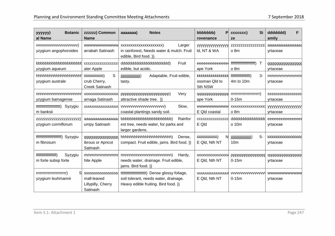
Planning and Environment Standing Committee Meeting Attachments 7 September 2018
Item 5.1- Attachment 1 Page 247
yyyyyy) Botanic
al Name
zzzzzz) Common
Name
aaaaaaa) Notes bbbbbbb) P
rovenance
ccccccc) Si
ze
ddddddd) F
amily
vvvvvvvvvvvvvvvvvvvvv) S
yzygium angophoroides
wwwwwwwwwwwwwwwwwwwww) Y
arrabah Satinash
xxxxxxxxxxxxxxxxxxxxx) Larger
in rainforest, Needs water & mulch. Fruit
edible, Bird food. }}.
yyyyyyyyyyyyyyyyyyyyy) Q
ld, NT & WA
zzzzzzzzzzzzzzzzzzzzz) T
o 8m
aaaaaaaaaaaaaaaaaaaaaa) M
yrtaceae
bbbbbbbbbbbbbbbbbbbbbb) S
yzygium aqueum
cccccccccccccccccccccc) W
ater Apple
dddddddddddddddddddddd) Fruit
edible, but acidic.
eeeeeeeeeeeeeeeeeeeeee) C
ape York
ffffffffffffffffffffff) T
o 8m
gggggggggggggggggggggg) M
yrtaceae
hhhhhhhhhhhhhhhhhhhhhh) S
yzygium australe
iiiiiiiiiiiiiiiiiiiiii) S
crub Cherry,
Creek Satinash
jjjjjjjjjjjjjjjjjjjjjj) Adaptable, Fruit edible,
tasty.
kkkkkkkkkkkkkkkkkkkkkk) M
ossman Qld to
Sth NSW
llllllllllllllllllllll) 3-
4m to 10m
mmmmmmmmmmmmmmmmmmmmmm) M
yrtaceae
nnnnnnnnnnnnnnnnnnnnnn) S
yzygium bamagense
oooooooooooooooooooooo) B
amaga Satinash
pppppppppppppppppppppp) Very
attractive shade tree. }}
qqqqqqqqqqqqqqqqqqqqqq) C
ape York
rrrrrrrrrrrrrrrrrrrrrr) 1
0-15m
ssssssssssssssssssssss) M
yrtaceae
tttttttttttttttttttttt) Syzygiu
m banksii
uuuuuuuuuuuuuuuuuuuuuu) vvvvvvvvvvvvvvvvvvvvvv) Slow,
coastal plantings sandy soil.
wwwwwwwwwwwwwwwwwwwwww) N
E Qld coastal
xxxxxxxxxxxxxxxxxxxxxx) T
o 8m
yyyyyyyyyyyyyyyyyyyyyy) M
yrtaceae
zzzzzzzzzzzzzzzzzzzzzz) S
yzygium cormiflorum
aaaaaaaaaaaaaaaaaaaaaaa) B
umpy Satinash
bbbbbbbbbbbbbbbbbbbbbbb) Rainfor
est tree, needs water, for parks and
larger gardens.
ccccccccccccccccccccccc) N
E Qld
ddddddddddddddddddddddd) T
o 10m
eeeeeeeeeeeeeeeeeeeeeee) M
yrtaceae
fffffffffffffffffffffff) Syzygiu
m fibrosum
ggggggggggggggggggggggg) F
ibrous or Apricot
Satinash
hhhhhhhhhhhhhhhhhhhhhhh) Dense,
compact. Fruit edible, jams. Bird food. }}
iiiiiiiiiiiiiiiiiiiiiii) N
E Qld, Nth NT
jjjjjjjjjjjjjjjjjjjjjjj) 5-
10m
kkkkkkkkkkkkkkkkkkkkkkk) M
yrtaceae
lllllllllllllllllllllll) Syzygiu
m forte subsp forte
mmmmmmmmmmmmmmmmmmmmmmm) W
hite Apple
nnnnnnnnnnnnnnnnnnnnnnn) Hardy,
needs water, drainage. Fruit edible,
jams. Bird food. }}
ooooooooooooooooooooooo) N
E Qld, Nth NT
ppppppppppppppppppppppp) 1
0-15m
qqqqqqqqqqqqqqqqqqqqqqq) M
yrtaceae
rrrrrrrrrrrrrrrrrrrrrrr) S
yzygium leuhmannii
sssssssssssssssssssssss) S
mall-leaved
Lillypilly, Cherry
Satinash
ttttttttttttttttttttttt) Dense glossy foliage,
soil tolerant, needs water, drainage.
Heavy edible fruiting. Bird food. }}
uuuuuuuuuuuuuuuuuuuuuuu) N
E Qld, Nth NT
vvvvvvvvvvvvvvvvvvvvvvv) 1
0-15m
wwwwwwwwwwwwwwwwwwwwwww) M
yrtaceae

Planning and Environment Standing Committee Meeting Attachments 7 September 2018
Item 5.1- Attachment 1 Page 248
yyyyyy) Botanic
al Name
zzzzzz) Common
Name
aaaaaaa) Notes bbbbbbb) P
rovenance
ccccccc) Si
ze
ddddddd) F
amily
xxxxxxxxxxxxxxxxxxxxxxx) S
yzygium papyraceum
yyyyyyyyyyyyyyyyyyyyyyy) P
aperbark Satinash
zzzzzzzzzzzzzzzzzzzzzzz) Attractiv
e, small, slow growing, needs water,
drainage.
aaaaaaaaaaaaaaaaaaaaaaaa) N
E Qld
bbbbbbbbbbbbbbbbbbbbbbbb) 4
-6m, to15m
cccccccccccccccccccccccc) M
yrtaceae
dddddddddddddddddddddddd) S
yzygium tierneyanum
eeeeeeeeeeeeeeeeeeeeeeee) R
iver Cherry
ffffffffffffffffffffffff) Needs water, mulch,
drainage. Stabilises creekbanks.
gggggggggggggggggggggggg) N
E Qld
hhhhhhhhhhhhhhhhhhhhhhhh) T
o 10m
iiiiiiiiiiiiiiiiiiiiiiii) M
yrtaceae
jjjjjjjjjjjjjjjjjjjjjjjj) Syzygiu
m wilsonii subsp.
cryptophlebium
kkkkkkkkkkkkkkkkkkkkkkkk) llllllllllllllllllllllll) Wet rainforest plant,
bright red new growth, needs protection,
water.
mmmmmmmmmmmmmmmmmmmmmmmm) N
E Qld
nnnnnnnnnnnnnnnnnnnnnnnn) T
o 10m
oooooooooooooooooooooooo) M
yrtaceae
pppppppppppppppppppppppp) S
yzygium wilsonii subsp.
Wilsonii
qqqqqqqqqqqqqqqqqqqqqqqq) P
owderpuff Lillypilly
rrrrrrrrrrrrrrrrrrrrrrrr) Wet rainforest
plant, reddish new growth, attractive
large red flowers, needs protection from
sun and wind, needs water.
ssssssssssssssssssssssss) N
E Qld
tttttttttttttttttttttttt) T
o 3m
uuuuuuuuuuuuuuuuuuuuuuuu) M
yrtaceae
vvvvvvvvvvvvvvvvvvvvvvvv) T
erminalia catappa
wwwwwwwwwwwwwwwwwwwwwwww) B
each Almond
xxxxxxxxxxxxxxxxxxxxxxxx) Beachsi
de planting, salt hardy.
yyyyyyyyyyyyyyyyyyyyyyyy) N
E Qld coastal
zzzzzzzzzzzzzzzzzzzzzzzz) T
o 20m
aaaaaaaaaaaaaaaaaaaaaaaaa) C
ombretaceae
bbbbbbbbbbbbbbbbbbbbbbbbb) T
erminalia seriocarpa
ccccccccccccccccccccccccc) ddddddddddddddddddddddddd) Large
shade tree for parks and larger gardens.
eeeeeeeeeeeeeeeeeeeeeeeee) N
th Aust
fffffffffffffffffffffffff) 2
0-30m
ggggggggggggggggggggggggg) C
ombretaceae
hhhhhhhhhhhhhhhhhhhhhhhhh) T
hespesia populneoides
iiiiiiiiiiiiiiiiiiiiiiiii) jjjjjjjjjjjjjjjjjjjjjjjjj) Hibiscus-like flower,
beachside plantings.
kkkkkkkkkkkkkkkkkkkkkkkkk) N
th Tropical Aust
coastal
lllllllllllllllllllllllll) T
o 6m
mmmmmmmmmmmmmmmmmmmmmmmmm) M
alvaceae
nnnnnnnnnnnnnnnnnnnnnnnnn) W
odyetia bifurcata
ooooooooooooooooooooooooo) F
oxtail Palm
ppppppppppppppppppppppppp) Attractiv
e foxtail shaped leaved palm, hardy for
long dry season.
qqqqqqqqqqqqqqqqqqqqqqqqq) M
elville Range,
Cape York
rrrrrrrrrrrrrrrrrrrrrrrrr) T
o 15m
sssssssssssssssssssssssss) A
raceae
ttttttttttttttttttttttttt) X
anthorrhoea johnsonii
uuuuuuuuuuuuuuuuuuuuuuuuu) G
rass Tree
vvvvvvvvvvvvvvvvvvvvvvvvv) Attractiv
e, single trunk with crown of grass-like
leaves. Needs drainage and sun.
wwwwwwwwwwwwwwwwwwwwwwwww) Q
ld, NSW, dryer
areas
xxxxxxxxxxxxxxxxxxxxxxxxx) T
o 5m
yyyyyyyyyyyyyyyyyyyyyyyyy) X
anthorrhoeaceae

Planning and Environment Standing Committee Meeting Attachments 7 September 2018
Item 5.1- Attachment 1 Page 249
yyyyyy) Botanic
al Name
zzzzzz) Common
Name
aaaaaaa) Notes bbbbbbb) P
rovenance
ccccccc) Si
ze
ddddddd) F
amily
zzzzzzzzzzzzzzzzzzzzzzzzz) X
anthostemon
chrysanthus
aaaaaaaaaaaaaaaaaaaaaaaaaa) G
olden Penda
bbbbbbbbbbbbbbbbbbbbbbbbbb) A
ttractive golden flowers. Soil tolerant,
needs full sun, water.
cccccccccccccccccccccccccc) N
E Qld
rainforests
dddddddddddddddddddddddddd) T
o 10m
eeeeeeeeeeeeeeeeeeeeeeeeee) M
yrtaceae
ffffffffffffffffffffffffff) List 3: Suitable Exotic Ornamentals
gggggggggggggggggggggggggg) B
otanic Name
hhhhhhhhhhhhhhhhhhhhhhhhhh) C
ommon Name
iiiiiiiiiiiiiiiiiiiiiiiiii) N
otes
jjjjjjjjjjjjjjjjjjjjjjjjjj) P
rovenance
kkkkkkkkkkkkkkkkkkkkkkkkkk) F
amily
llllllllllllllllllllllllll) Acalypha spp
mmmmmmmmmmmmmmmmmmmmmmmmmm) A
. wilkesiana cvs
nnnnnnnnnnnnnnnnnnnnnnnnnn) A
calypha
oooooooooooooooooooooooooo) V
ariegated. Hardy. Easily
grown from cutting.
Easily pruned. To 3m
pppppppppppppppppppppppppp) U
nknown
qqqqqqqqqqqqqqqqqqqqqqqqqq) E
uphorbiaceae
rrrrrrrrrrrrrrrrrrrrrrrrrr)
ssssssssssssssssssssssssss) C
odiaeum spp.
tttttttttttttttttttttttttt) C.
variegatum cv
uuuuuuuuuuuuuuuuuuuuuuuuuu) C
roton
vvvvvvvvvvvvvvvvvvvvvvvvvv) V
ariegated. Hardy. Easily
grown from cutting.
Easily pruned. To 3m
wwwwwwwwwwwwwwwwwwwwwwwwww) P
acific Is, Malaysia, Aust
xxxxxxxxxxxxxxxxxxxxxxxxxx) E
uphorbiaceae
yyyyyyyyyyyyyyyyyyyyyyyyyy)
zzzzzzzzzzzzzzzzzzzzzzzzzz) C
ordyline spp & cvs
aaaaaaaaaaaaaaaaaaaaaaaaaaa) C
ordyline
bbbbbbbbbbbbbbbbbbbbbbbbbbb) H
ardy. Easily grown from
cutting. Easily pruned.
To 4m.
ccccccccccccccccccccccccccc)
ddddddddddddddddddddddddddd) A
ust, Pacific, Tropical
America
eeeeeeeeeeeeeeeeeeeeeeeeeee) A
gavaceae
fffffffffffffffffffffffffff)
ggggggggggggggggggggggggggg) D
racaena spp & cvs
hhhhhhhhhhhhhhhhhhhhhhhhhhh) D
racaena incl Happy Plant
iiiiiiiiiiiiiiiiiiiiiiiiiii) Often
variegated.
jjjjjjjjjjjjjjjjjjjjjjjjjjj) Hardy.
Easily grown from
cutting. Easily pruned.
To 6m.
kkkkkkkkkkkkkkkkkkkkkkkkkkk) A
ust, Pacific, Asia,
Tropical America
lllllllllllllllllllllllllll) Agavacea
e
mmmmmmmmmmmmmmmmmmmmmmmmmmm)

Planning and Environment Standing Committee Meeting Attachments 7 September 2018
Item 5.1- Attachment 1 Page 250
ffffffffffffffffffffffffff) List 3: Suitable Exotic Ornamentals
gggggggggggggggggggggggggg) B
otanic Name
hhhhhhhhhhhhhhhhhhhhhhhhhh) C
ommon Name
iiiiiiiiiiiiiiiiiiiiiiiiii) N
otes
jjjjjjjjjjjjjjjjjjjjjjjjjj) P
rovenance
kkkkkkkkkkkkkkkkkkkkkkkkkk) F
amily
nnnnnnnnnnnnnnnnnnnnnnnnnnn) G
raptophyllum pictum cvs
ooooooooooooooooooooooooooo) G
raptophyllum
ppppppppppppppppppppppppppp) V
ariegated.
qqqqqqqqqqqqqqqqqqqqqqqqqqq) H
ardy. Easily grown from
cutting. Easily pruned.
To 4m.
rrrrrrrrrrrrrrrrrrrrrrrrrrr) A
ust, Pacific
sssssssssssssssssssssssssss) A
canthaceae
ttttttttttttttttttttttttttt)
uuuuuuuuuuuuuuuuuuuuuuuuuuu) H
ibiscus sp
vvvvvvvvvvvvvvvvvvvvvvvvvvv) H
ibiscus rosa-sinensis cvs
wwwwwwwwwwwwwwwwwwwwwwwwwww) H
ibiscus
xxxxxxxxxxxxxxxxxxxxxxxxxxx) H
ardy. Easily grown from
cutting. Easily pruned.
To 6m.
yyyyyyyyyyyyyyyyyyyyyyyyyyy) A
sia, Pacific, Aust
zzzzzzzzzzzzzzzzzzzzzzzzzzz) M
alvaceae
aaaaaaaaaaaaaaaaaaaaaaaaaaaa)
bbbbbbbbbbbbbbbbbbbbbbbbbbbb) M
onstera sp
cccccccccccccccccccccccccccc) M
onstera deliciosa
dddddddddddddddddddddddddddd) F
ruit Salad Plant
eeeeeeeeeeeeeeeeeeeeeeeeeeee) H
ardy. Easily grown from
cutting. Climber. Wet
area.
ffffffffffffffffffffffffffff) A
ust, Tropical America
gggggggggggggggggggggggggggg) A
raceae
hhhhhhhhhhhhhhhhhhhhhhhhhhhh) M
ussaenda sp.
iiiiiiiiiiiiiiiiiiiiiiiiiiii) M.
erythrophylla cv
jjjjjjjjjjjjjjjjjjjjjjjjjjjj) Bangkok Rose kkkkkkkkkkkkkkkkkkkkkkkkkkkk) E
asily grown from
cutting.
llllllllllllllllllllllllllll) To 3m.
mmmmmmmmmmmmmmmmmmmmmmmmmmmm) nnnnnnnnnnnnnnnnnnnnnnnnnnnn) R
ubiaceae
oooooooooooooooooooooooooooo)
pppppppppppppppppppppppppppp) P
lumeria sp.
qqqqqqqqqqqqqqqqqqqqqqqqqqqq) P
. obtusa
rrrrrrrrrrrrrrrrrrrrrrrrrrrr) P.
rubra & cvs
ssssssssssssssssssssssssssss) F
rangipanni
tttttttttttttttttttttttttttt) E
asily grown from
cutting. Leave cutting 2
weeks before planting.
To 8m.
uuuuuuuuuuuuuuuuuuuuuuuuuuuu) T
ropical America
vvvvvvvvvvvvvvvvvvvvvvvvvvvv) A
pocynaceae
wwwwwwwwwwwwwwwwwwwwwwwwwwww)

Planning and Environment Standing Committee Meeting Attachments 7 September 2018
Item 5.1- Attachment 1 Page 251
ffffffffffffffffffffffffff) List 3: Suitable Exotic Ornamentals
gggggggggggggggggggggggggg) B
otanic Name
hhhhhhhhhhhhhhhhhhhhhhhhhh) C
ommon Name
iiiiiiiiiiiiiiiiiiiiiiiiii) N
otes
jjjjjjjjjjjjjjjjjjjjjjjjjj) P
rovenance
kkkkkkkkkkkkkkkkkkkkkkkkkk) F
amily
xxxxxxxxxxxxxxxxxxxxxxxxxxxx) P
olyscias spp
yyyyyyyyyyyyyyyyyyyyyyyyyyyy) P
. ficifolia cvs
zzzzzzzzzzzzzzzzzzzzzzzzzzzz) P
. guilfoylei cvs
aaaaaaaaaaaaaaaaaaaaaaaaaaaaa) P
. scuttelaria cvs
bbbbbbbbbbbbbbbbbbbbbbbbbbbbb) P
olyscias
ccccccccccccccccccccccccccccc) O
ften Variegated.
ddddddddddddddddddddddddddddd) H
ardy. Easily grown from
cutting. Easily pruned.
eeeeeeeeeeeeeeeeeeeeeeeeeeeee) A
ust, Asia, Pacific
fffffffffffffffffffffffffffff) A
raliaceae
ggggggggggggggggggggggggggggg) P
seuderanthemum sp
hhhhhhhhhhhhhhhhhhhhhhhhhhhhh) P
seuderanthemum
iiiiiiiiiiiiiiiiiiiiiiiiiiiii) Hardy.
Easily grown from
cuttings. Easily pruned.
To 2m.
jjjjjjjjjjjjjjjjjjjjjjjjjjjjj) Aust,
Pacific Rim, Asia,
Tropical America
kkkkkkkkkkkkkkkkkkkkkkkkkkkkk) A
canthaceae
lllllllllllllllllllllllllllll)
mmmmmmmmmmmmmmmmmmmmmmmmmmmmm) P
edilanthus tithymaloides & cvs
nnnnnnnnnnnnnnnnnnnnnnnnnnnnn) Z
ig-zag Plant
ooooooooooooooooooooooooooooo) H
ardy. Easily grown from
cutting. Easily pruned.
To 1.5m
ppppppppppppppppppppppppppppp) C
entral America
qqqqqqqqqqqqqqqqqqqqqqqqqqqqq) E
uphorbiaceae
rrrrrrrrrrrrrrrrrrrrrrrrrrrrr) Pentas
lanceolata & cvs
sssssssssssssssssssssssssssss) S
tar Cluster
ttttttttttttttttttttttttttttt) S
mall shrubs, seed or tip
cutting.
uuuuuuuuuuuuuuuuuuuuuuuuuuuuu) A
frica, Middle East
vvvvvvvvvvvvvvvvvvvvvvvvvvvvv) R
ubiaceae
wwwwwwwwwwwwwwwwwwwwwwwwwwwww) R
hoeo discolour
xxxxxxxxxxxxxxxxxxxxxxxxxxxxx) M
oses Bbasket
yyyyyyyyyyyyyyyyyyyyyyyyyyyyy) H
ardy, seed or division.
Low growing.
zzzzzzzzzzzzzzzzzzzzzzzzzzzzz) M
exico
aaaaaaaaaaaaaaaaaaaaaaaaaaaaaa) C
ommelinaceae
bbbbbbbbbbbbbbbbbbbbbbbbbbbbbb) R
usselia juncea
cccccccccccccccccccccccccccccc) F
ountain Bush
dddddddddddddddddddddddddddddd) H
ardy, cuttings.
eeeeeeeeeeeeeeeeeeeeeeeeeeeeee) S
outh America
ffffffffffffffffffffffffffffff) S
crophulariaceae

Planning and Environment Standing Committee Meeting Attachments 7 September 2018
Item 5.1- Attachment 1 Page 252
ffffffffffffffffffffffffff) List 3: Suitable Exotic Ornamentals
gggggggggggggggggggggggggg) B
otanic Name
hhhhhhhhhhhhhhhhhhhhhhhhhh) C
ommon Name
iiiiiiiiiiiiiiiiiiiiiiiiii) N
otes
jjjjjjjjjjjjjjjjjjjjjjjjjj) P
rovenance
kkkkkkkkkkkkkkkkkkkkkkkkkk) F
amily
gggggggggggggggggggggggggggggg) W
hitfieldia elongata
hhhhhhhhhhhhhhhhhhhhhhhhhhhhhh) W
hite Candles
iiiiiiiiiiiiiiiiiiiiiiiiiiiiii) Needs
rich soil to flower well,
seed and cuttings
jjjjjjjjjjjjjjjjjjjjjjjjjjjjjj) Africa kkkkkkkkkkkkkkkkkkkkkkkkkkkkkk) A
canthaceae
llllllllllllllllllllllllllllll) Yucca
elephantipes
mmmmmmmmmmmmmmmmmmmmmmmmmmmmmm) S
pineless Yucca
nnnnnnnnnnnnnnnnnnnnnnnnnnnnnn) N
eeds well drained soil,
seed and division.
oooooooooooooooooooooooooooooo) N
orth America
pppppppppppppppppppppppppppppp) A
gavaceae

Planning and Environment Standing Committee Meeting Attachments7 September 2018
Item 5.1- Attachment 1 Page 253
qqqqqqqqqqqqqqqqqqqqqqqqqqqqqq) List 4: Problem Plants
rrrrrrrrrrrrrrrrrrrrrrrrrrrrrr) There are a number of plants that should not be planted due to their
undesirable characteristics. Listed below are species that are not acceptable for inclusion in
landscaping plans that require Council approval, and their use elsewhere is discouraged.
ssssssssssssssssssssssssssssss) B
otanical Name
tttttttttttttttttttttttttttttt) C
ommon Name
uuuuuuuuuuuuuuuuuuuuuuuuuuuuuu) N
otes
vvvvvvvvvvvvvvvvvvvvvvvvvvvvvv) A
cacia farnesiana
wwwwwwwwwwwwwwwwwwwwwwwwwwwwww) M
imosa Bush
xxxxxxxxxxxxxxxxxxxxxxxxxxxxxx) Probl
ematic weed.
yyyyyyyyyyyyyyyyyyyyyyyyyyyyyy) A
lstonia actinophylla
zzzzzzzzzzzzzzzzzzzzzzzzzzzzzz) L
arge-leafed Milky
Pine,
a) Milkwood
b)
c) Drops branches, Caustic sap damages
paint.
d) A. scholaris e) Milky Pine f) Tall tree, grows very large.
g) Bauhinia sp h) Orchid
Tree
i) Rural environmental weed.
j) Bougainvillea
spp & cvs
k) Bougainvill
ea
l) Bears thorns. Thorns may arise from
root system.
m) Carica papaya n) Paw Paw o) Extracts lime from concrete.
p) Cassia alata
Cassia siamea
Cassia spp
q) Golden
Candles,
Siamese Cassia
Cassia, Golden
Shower spp
r) Weed.
Weed, grows very large.
Weed potential.
s) Cocos
nucifera
t) Coconut u) Falling nuts potential public liability.
v) Delonix regia w) Poinciana x) Drops branches.
y) Falls over.
z) Rural environmental Weed.
aa) Eucalyptus
Brassiana
bb) Cape York
Red Gum
cc) Susceptible to white ants. Dangerous
tree.
dd) Ficus sp ee) Fig sp ff) Threatens water pipes & drainage.
May be contained in pot.
gg) Mangifera
indica
hh) Mango ii) Caustic sap damages paint and
inhibits cultivation of other species.
jj) Melia
azadarach
kk) White
Cedar
ll) Toxic, Drops branches.
mm) Falls over.
nn) Sansevieria
trifasciata
oo) Mother-in-
Law’s Tongue
pp) Environmental weed.
qq) Schefflera
actinophylla
rr) Umbrella
Tree
ss) Threatens water pipes & drainage.
tt) Senna sp. uu) Sometimes vv) Weed potential. Senna obtusifolia =

Planning and Environment Standing Committee Meeting Attachments7 September 2018
Item 5.1- Attachment 1 Page 254
ssssssssssssssssssssssssssssss) B
otanical Name
tttttttttttttttttttttttttttttt) C
ommon Name
uuuuuuuuuuuuuuuuuuuuuuuuuuuuuu) N
otes
known as Cassia Sicklepod.
ww) Spathodia
campanulata
xx) African
Tulip Tree
yy) Weed.
zz) Tecoma sp aaa) Yellow
Bells
bbb) Weed potential.
ccc) Wedelia
trilobata
ddd) Singapore
Daisy
eee) Environmental weed.
fff) And all declared noxious weeds
SC6.4 Guidelines for development in the Eastern Kuku Yalanji Local Plan Area Planning Scheme Policy
Purpose The purpose of this policy is to provide guidance in the preparation of development applications in the Eastern Kuku Yalanji (EKY) Local Plan area and;
1. Promote building design suitable to the lifestyle and cultural requirements of Traditional Owners;
2. Facilitate certainty about the process and information Council requires, so that Traditional Owners can move back to country;
3. Enable applicants to benefit from the accepted development status and avoid having to make a development application to Council; and
4. Where possible, align with Community Development Plans to simplify and streamline the approval process
The Policy is made up of the following components;
Part 2.0 - Using the Planning Scheme
Part 3.0 - Design Guidelines
Part 4.0 - Community Development Plans
Note: The following Eastern Kuku Yalanji terms are used throughout this Policy; Bama Traditional Owners Bubu Land of the Traditional Owners Bayan Dwelling
Background
In 2007 the Federal Court of Australia recognised the Eastern Kuku Yalanji people’s Native Title over 126,900ha of Eastern Kuku Yalanji country between the South Mossman River (in Cairns Regional Council) and just north of Black Mountain near Cooktown. The Eastern Kuku Yalanji people negotiated Indigenous Land Use Agreements (ILUAs) for their country with the Queensland Government and other parties including the Wet Tropics Management Authority (WTMA). Specifically, under the ‘Eastern Yalanji, Queensland and WTMA (Freehold Grants) ILUA’, Eastern Kuku Yalanji people agreed to exercise their Native Title rights and interests on the Pink Zone only in accordance with the Cooperative Management Agreement for the Pink Zone (Pink Zone CMA). The Pink Zone CMA covers about 14 500ha of Aboriginal freehold land within the Wet Tropics World Heritage Area and provides for the Eastern Kuku Yalanji native title holders to use and develop this land in a way that provides for the protection and management of the Wet Tropics World Heritage Area.

Planning and Environment Standing Committee Meeting Attachments7 September 2018
Item 5.1- Attachment 1 Page 255
The Pink Zone CMA provides that the Traditional owners and WTMA may agree to a Community Development Plan to determine where activities can be undertaken within the Pink Zone CMA area. To date, Community Development Plans (CDPs) have been created for Mungumby and Trevethan. The Jabalbina Yalanji Aboriginal Corporation (JYAC or Jabalbina) was established as the Registered Native Title Body Corporate (RNTBC) for the Eastern Kuku Yalanji people’s Native Title Rights and Interests and as sole grantee of the Jabalbina Yalanji Land Trust, holding 65 000ha of new Aboriginal freehold land. Jabalbina implements the Eastern Kuku Yalanji ILUAs on behalf of Eastern Kuku Yalanji Bama and represents their interests.
Relationship of the CDP to the Cook Shire Planning Scheme
The Cooperative Management Agreement and associated CDP provide the basis for the Eastern Kuku Yalanji Local Plan, contained in Part 7 of the Cook Shire Planning Scheme. In effect, the ILUA, Cooperative Management Agreements and CDPs, created over the course of approximately four years, represent agreement between stakeholders and provide a non-statutory plan for future development. The Cook Shire Planning Scheme is the statutory vehicle for implementing that plan. In order to streamline the process of moving back to country, the Planning Scheme adopts a similar level of regulation as the CDP and Activity Guidelines, and where possible, includes the same design requirements. Traditional owners wanting to move back to country are encouraged to create similar CDP in consultation with key stakeholders and with as much detail as possible. Where this occurs, Council may consider amending the Planning Scheme to reflect the CDP in the Eastern Kuku Yalanji Local Plan and simplify the assessment process.
What is a ‘Dwelling'? A ‘dwelling’ is defined in Schedule 1 of the Planning Scheme as a building used as a self-contained residence and must include food preparation facilities, a bath or shower, a toilet and wash basin and clothes washing facilities. The term includes outbuildings, structures and works normally associated with a dwelling. What is the purpose of the Eastern Kuku Yalanji Local Plan? The Purpose of the Local Plan is to allow Bama to live on their Bubu and create a simplified process for getting approval to build Bayan within Good Living Areas. Commercial uses and other non-residential uses are secondary to residential uses and require more detailed applications to be lodged with Council. The focus of commercial uses should be to enable Bama to live and work on their Bubu. This aligns with the Table of Assessment for the Local Plan in Part 5.6 of the Planning Scheme, which identifies predominantly residential uses are intended within the Good Living Areas. How to ensure your Bayan complies with the Planning Scheme and the Building Code of Australia (BCA) As stated in the EKY Local Plan, Council recognise that Bayan can be simple dwellings that meet the needs of Bama, such as an enclosed shelter with separate communal living; cooking and cleaning facilities (see Image 2 below). Council also recognises that many Bama will self-build, using locally sourced or second hand materials and that the design and construction must be easy to maintain. Once Bama have a Bayan design, it is to be assessed for compliance with the Planning Scheme and the BCA, using this four-step process;
1. Create a ‘Site Plan’ that shows where you will put the Bayan on your Bama (within a Good Living Area), making sure it complies with the provisions of the EKY Local Plan Code;

Planning and Environment Standing Committee Meeting Attachments7 September 2018
Item 5.1- Attachment 1 Page 256
2. Contact Cook Shire Council’s Planning Department on 4069 5444 to discuss getting approval to construct your Bayan. This should happen before any construction occurs on site.
3. If required based on advice from Council officers, make any necessary changes to your plans to ensure you comply with the Planning Scheme and/or BCA;
4. Once you have Council approval, construct the Bayan. The following resources may also provide information that will help improve the quality of your project and provide guidance on design and construction;
1. Centre for Appropriate Technology (CAT) produces fact sheets and information guides on various topics such as housing, water, energy, waste, communication, accessibility and community engagement. These fact sheets, called BUSH TECHS are available on the CAT website and can be downloaded in PDF format:
(4) http://www.icat.org.au/default.asp?action=article&ID=116 2. CAT has also produced a National Indigenous Infrastructure Guide that provides
practical guidance on installing and maintaining infrastructure that is appropriate and sustainable for remote Aboriginal and Torres Strait Islander communities. It will assist people working with infrastructure in Indigenous communities –community managers, essential service officers, government officers, planners, service providers, contractors and the communities themselves. NIIG is available on the CAT website: http://www.icat.org.au/niig/
How to determine if a Development Application needs to be submitted to Council Firstly, all buildings and structures need approval for Building Works, so if Bama propose to construct any buildings or structures (including sheds etc) they must be approved by a Building Certifier. It is recommended that you contact Councl’s Planning Department (4069 5444) to discuss obtaining the necessary building approval before constructing. Secondly, not all buildings and structures require town planning approval for a Material Change of Use. Part 5.6 of the Planning Scheme identifies the Level of Assessment and the ‘triggers’ for a development application to be lodged with Council. If further direction is required to explain this process, please contact the Council or speak with a private building certifier, however the following points are provided for guidance;
Development listed as accepted development in the Table must be assessed against the Codes listed in the right-hand column. If the development complies with all of the provisions in the Codes, it does not require a Material Change of Use application to be lodged with Council.
Development that doesn’t comply with one or more provisions of the Codes listed in the right hand column does require a development application to be lodged with Council.
All development listed as accepted development in the Table does require Building Work approval from a building certifier.
Development listed as code assessable does require a development application to be lodged with Council.
Development listed as impact assessable does require a development applications to be lodged with Council.
Any development not listed in the Table will be assigned the level of assessment for the relevant Zone.
Any proposal to Reconfigure a Lot (subdivide) land to establish residential or commercial leases will require a Code Assessable application to be lodged with Council.

Planning and Environment Standing Committee Meeting Attachments7 September 2018
Item 5.1- Attachment 1 Page 257
How to comply with specific provisions of the EKY Local Plan Code
The following guidelines are provided to help comply with the provisions of the Local Plan Code. AO1 Site Analysis To respond to AO1 in the EKY Local Plan, applicants are required to prepare a Site Analysis Plan to identify key features of the site and demonstrate how the proposed uses/structures relate to the site and surrounds. The process of preparing a site analysis is as follows;
1. Prepare a site analysis plan. Identify where you will locate your Bayan and/or additional structures having regard to provisions of the EKY Local Plan Code. Produce a site analysis plan and plan of development similar to that shown in Figures 1 & 2 below.
2. For more complex developments, such as those requiring Impact Assessment, Council may require the site analysis plan to be prepared by a design professional and showing more detail.
Figure 1 – Site Analysis Plan

Planning and Environment Standing Committee Meeting Attachments7 September 2018
Item 5.1- Attachment 1 Page 258
Figure 2 – Plan of Development AO2 Housing choice To ensure compliance with AO2, Bama are encouraged to follow the process outlined in Section 2.2 of this Policy. For further guidance, the following images show the type of structures that may or may not be approved as a dwelling/Bayan;
Image 1 – Shelter that would not be approved as a dwelling
Image 2 – A habitable building, plus separate outbuildings including a shelter for food preparation, cleaning, a toilet and shower and covered living area are collectively classed as a dwelling. AO3 to AO8 Land use within Precincts & development intensity AO3 to AO8 relate to land use and development intensity. To comply with these provisions, development must not exceed the number of dwellings specified or include a land use not specified within a designated Good Living Area. The following images provide guidance on the type of buildings and structures considered appropriate;

Planning and Environment Standing Committee Meeting Attachments7 September 2018
Item 5.1- Attachment 1 Page 259
Dwelling house As discussed, a dwelling is to comprise food preparation facilities, a bath or shower, a toilet and wash basin and clothes washing facilities. The following images are provided for guidance on the type of structures considered acceptable as out-buildings associated with a dwelling;
Image 2 – Example of an acceptable toilet block and shelter Development intensity This provision provides specific density criteria related to the number of Bayan that can be constructed within a Good Living Area. The following provides guidance on how to determine compliance with provisions AO3 to AO8;
The maximum number of Bayan, is the number of existing Bayan plus the proposed Bayan. For example, AO4 of the EKY Local Plan Code permits five Bayan and one ranger station/communal shed. The following scenarios provide guidance on determining compliance with these provisions;
o Scenario 1 – The Good Living Area contains four Bayan and the proposal is
to construct one new Bayan, creating a total of five Bayan within the Good Living Area. This complies with AO4 and subject to complying with all other relevant provisions, the development will remain accepted development.
o Scenario 2 – The Good Living Area contains four Bayan and the proposal is
to construct two new Bayan, creating a total of six Bayan within the Good Living Area. This fails to comply with AO4 and requires a Material Change of Use (Impact Assessment) for a Multiple Dwelling to be lodged with Council.
The Good Living Area is not cadastre based, however has been determined on areas of least constraint and defined by the meets and bounds description provided in the appendices to the EKY Local Plan. It is incumbent upon Bama to prove the buildings are located well within the Good Living Area, based upon the property boundaries, site features and Local Plan Precinct Maps.
Council’s role and responsibility While Council is flexible in regard to housing choice and design, Council will not apply discretion when it comes to the following matters;
Illegal building work – all structures must be approved by a qualified building certifier. Council may take enforcement action against illegal building work, requiring structures to either be approved or removed.
Health and safety – health and safety standards must be maintained by residents. Council regulates this under their Local Laws.
Access – standard of road access and the capacity of road infrastructure must be adequate to handle additional people (particularly for Impact Assessable development exceeding planned density).

Planning and Environment Standing Committee Meeting Attachments7 September 2018
Item 5.1- Attachment 1 Page 260
To demonstrate compliance with building legislation and standards, applicants may consider obtaining approval for Bayan, structures or effluent treatment systems for multiple buildings within one Good Living Area. Discussions with Council or private building certifiers would be essential.
COMMUNITY DEVELOPMENT PLANS
To date, Community Development Plans (CDPs) have been created for Trevethan and Mungumby (which includes Little Annan, Mungumby North and Mungumby South Precincts of the EKY Local Plan). By creating CDPs, Traditional owners have also created certainty about the development that is to occur within Good Living Areas and in turn benefit from having lower levels of assessment in the Planning Scheme. Where the necessary Indigenous Land Use Agreements are in place, Council encourages other Traditional owners to create similar CDPs in consultation with relevant stakeholders. Where this occurs, Council will consider amending the Planning Scheme to reflect the CDP in the EKY Local Plan or similar. The following excerpts are taken from Part D of each CDP. TREVETHAN COMMUNITY DEVELOPMENT PLAN
The Eastern Kuku Yalanji native title holders agree the Woibo, McLean and Mapoon families speak for the Trevethan Precinct. These families are Kuku Bayan, one of the several Eastern Kuku Yalanji Clan groups. Traditional Owners are particularly keen to be able to live on country with access to services at Cooktown, or to be able to live for short term on country interspaced with living in Hopevale and/or Cooktown. Many of the Kuku Bayun Traditional Owners have expressed that they would like to live on country and still be able to commute to their workplaces in Cooktown or Hopevale. The majority of Eastern Kuku Yalanji native title holders live off-country in Cairns and further south. Traditional Owners living off-country would like to be able to visit and bring their old people and children to visit and to live on country for short terms.
Development & Infrastructure Traditional Owners have decided that the southern block is the designated housing block, which is shown as a Good Living Area on the Local Plan Precinct Map 2 – Trevethan Precinct. Five houses are proposed for the Trevethan Good Living Area: three over the crossing on the south side of the creek and two on the north side. The proposed ranger outstation will also be on the southern block closer to Mt Amos Road although still in the Pink Zone area. The proposed houses on the southern block will be powered by generators until extensions from the existing neighbouring power lines adjacent to the southern block are available. Other blocks shown as ‘Possible Future GLA’ on Precinct Map 2 – Trevethan Precinct have not been designated for development at this stage but consideration for other Eastern Kuku Yalanji Bama to build there can be negotiated with the Traditional Owners in the future and will require a development application to Council. The existing access track will need to be upgraded and maintained by the Traditional Owners. Access driveways are required for the five proposed houses and land would need to be cleared for fire breaks around the individual house blocks. A culvert may need to be built across the creek when funding is available, and the Traditional Owners suggest in the meantime they will use their four wheel drives to make crossings. The Traditional Owners want to use suitable felled timbers for building their houses and for fencing around the houses – necessary because cattle currently frequent the southern block.

Planning and Environment Standing Committee Meeting Attachments7 September 2018
Item 5.1- Attachment 1 Page 261
Water supply will be gravity fed from higher parts of Trevethan Creek into household tanks. Septic tanks and/or eco-friendly toilets will be needed for each house. At this time there is no available waste collection to the Trevethan Mt Amos Road area and Traditional Owners agree to maintain rubbish disposal themselves on a regular basis until such service becomes available. MUNGUMBY COMMUNITY DEVELOPMENT PLAN The Mungumby North parcel is inside the Wet Tropics World Heritage Area. The Mungumby South and Little Annan parcels are outside the World Heritage Area. The provisions of the Wet Tropics Management Plan apply to the Mungumby North parcel. There are approximately 800 family clan members associated with the Mungumby Pink Zone and the majority currently live off-country. Many of the Traditional Owners have expressed that they would like to come back to country, but there would need to be a livelihood for them to do this. The Mungumby Pink Zone area is within 30 minutes commuting distance to Cooktown. Development & Infrastructure Proposed houses and ancillary domestic development will require access driveways from the existing access track to the north-west corner of the block. Water supply to the Mungumby South block will be negotiated with the nearby leaseholder for sharing the existing gravity fed pipes from the Mungumby Falls area. Water will be gravity fed from below the waterfall that is situated to north-east of the Mungumby South block into tanks. The Mungumby North block will also need a water source which is proposed to come from the negotiated leaseholder’s existing pipes as above. The water source for the Little Annan block will be pumped from the Little Annan into tanks. There are access roads into all the proposed blocks. A second access road to the Mungumby South block is proposed off Mungumby Road and is approximately 50 metres east of the Mungumby Creek access road. The Mungumby North block has a partial access track that has been negotiated with the neighbouring leaseholder. The Little Annan block has an access track parallel to the river and another running northeast to northwest parallel to the highway just above the Pink Zone area. The Traditional Owners envisage the multipurpose structure and the Mungumby South houses will be powered from the existing power lines on the northern end of the block. Main power utilities are in close proximity to both of the proposed residential blocks. Septic tanks and/or eco-friendly toilets will be needed for each house. A septic system is proposed for toilets in the multipurpose structure. Eco-friendly toilets are suggested for the Little Annan residential structures because of the close proximity to the river system and possible flooding. Waste and recycling will be the responsibility of the Traditional Owners until such time as the Cook Shire Council provides a waste collection service to the area. The Mungumby Traditional Owners may in the future propose a cemetery for their clan to be buried on country according to lore and custom. It has not been determined to this date where the cemetery will be located. The possible site suggested was for the Mungumby South block outside the Good Living Area and will be discussed at a time in the future. Vegetation will be cleared around individual house blocks for fire breaks in accordance with the Eastern Kuku Yalanji Local Plan Code. The Traditional Owners propose to use suitable felled timbers for building their houses and any material for any necessary fencing.
SC6.5 Bushfire Hazard Analysis Planning Scheme Policy

Planning and Environment Standing Committee Meeting Attachments7 September 2018
Item 5.1- Attachment 1 Page 262
PURPOSE The purpose of this Planning Scheme Policy is to guide land owners through the assessment of the bushfire hazard rating of their property. The Policy takes the form of a checklist, which highlights the key factors related to bushfire hazard that owners need to consider when developing their land. EXPLANTORY NOTES The following notes should be read before completing the checklist.
Fire season severity Patterns of fire within the Cook Shire are distinctly seasonal. The main fire season begins as soon as the country is dry enough to burn after the wet season, and lasts until the onset of the next wet season (Table 1). If fire is being used to reduce fuel loads on properties, planned burns normally occur early in the season, between May and July, depending on the wet season and degree of accessibility across country. This can vary from year to year and means that fire programs cannot be too prescriptive – they need to be flexible to accommodate year-to-year variability. Table 1. Summary of early and late season burns
Fire season information
Early season burns
Begin straight after the wet season, as soon as the country is dry enough to burn. This could be between May and July, depending on the extent of the wet season and the ability to access different parts of the country. Fires are lit in different areas often until the onset of the next wet season
Late season burns Fires lit from August onwards tend to be larger and more intense than those lit in the early dry season. Repeated hot fires can damage vegetation and limit the resources available to animals
Fire frequency Parts of the western and central regions of the Cook Shire have burned four to seven times between 2004 and 2010 (high frequency) which is equivalent to burning, on average, every second year up to every year. A reliable wet season rainfall produces enough grassy fuel to sustain a wildfire every year. Medium fire frequency corresponds to areas that have burnt two to three times within the same time period. In contrast, coastal regions in the east of the Shire have either not burned or burnt only once in the same time period (low frequency). Figure 1 below shows where these areas are;

Planning and Environment Standing Committee Meeting Attachments7 September 2018
Item 5.1- Attachment 1 Page 263
Figure 1. Fire frequency within the Cook Shire 2004-2010 (NAFI 2011)
Weather patterns Knowledge of weather patterns is critical to understanding potential fire hazard. Before
completing the checklist, see Bureau of Meteorology,
http://www.bom.gov.au/climate/averages/tables/cw_031017.shtml.

Planning and Environment Standing Committee Meeting Attachments7 September 2018
Item 5.1- Attachment 1 Page 264
FIRE HAZARD ANALYSIS The following analysis can be completed by the land owner to provide their own written summary of issues. If any clarification is required, please contact Council’s Town Planning section on (07) 4069 5533.
Fuel type: the type of fuel affects ignition potential and fire intensity.
Describe the fuel on the property e.g. part of the site is cleared and has grass that is regularly
mown/slashed; part of the site is eucalypt woodland with an understorey of native grasses; the
site is dominated by introduced, high biomass grasses.
Comment: __________________________________________________________________
___________________________________________________________________________
___________________________________________________________________________
Topographic features: the rate of spread of a fire increases when it travels uphill. Features
such as creeks and gullies can slow the rate of spread.
Describe the topography of the site and surrounding area e.g. The block slopes west and south
into nearby drainage lines; proposed Lot 1 is steeper than the other blocks; a deep creek
separates the blocks from nearby forest.
Comment: __________________________________________________________________
___________________________________________________________________________
___________________________________________________________________________
Fire history: some areas experience fire more often than others, resulting in a higher
likelihood of ignition.
Describe the fire history of the area over the last 10 years, based on evidence. e.g. fire scar
maps; charring on trees; personal knowledge; anecdotal evidence.
Comment: __________________________________________________________________
___________________________________________________________________________
___________________________________________________________________________
Proposed development: the strategic location of buildings and infrastructure can considerably
reduce the risk of ignition in the event of a bushfire.
Describe the proposed development relative to potential bushfire hazard e.g. the proposal is a
house located in a cleared part of the site, 80m away from woodland area etc.
Comment: __________________________________________________________________
___________________________________________________________________________
___________________________________________________________________________
Damage potential: What are the possible consequences of a wildfire? Describe the potential damage that could result from a bushfire entering the property.
Comment: __________________________________________________________________
___________________________________________________________________________
___________________________________________________________________________

Planning and Environment Standing Committee Meeting Attachments7 September 2018
Item 5.1- Attachment 1 Page 265
Protection measures
Describe the protection measures available and the reasons they are required. E.g. minimise
risk by mowing/slashing to ensure a low grassy fuel load; connect to the existing network of fire
trails etc.
Comment: __________________________________________________________________
___________________________________________________________________________
___________________________________________________________________________
FIRE HAZARD ASSESSMENT CHECKLIST
Property Description - _______________________________________ Property Address - _______________________________________ Assessor name - _______________________________________ Assessment date - _______________________________________
1. FUEL AVAILABLE to sustain fire:
Vegetation: Open forest or woodland + Grass 5
Tall, wet eucalypt forest 4
Grassland 3
Heath 3
Acacia thickets 2
Cropping, horticulture 2
Rainforest and other types 1
Fuel Load: VERY HIGH 15.1 t/ha + 5
HIGH 10.1 - 15.0 4
MODERATE 5.1 - 10.0 3
LOW 2.1 - 5.0 2
VERY LOW 0.1 - 2.0 1
SUB-TOTAL _____________

Planning and Environment Standing Committee Meeting Attachments7 September 2018
Item 5.1- Attachment 1 Page 266
2. TOPOGRAPHY:
Slope Very Steep 16 + 5
Steep 11 - 15 4
Moderate 7 - 10 3
Gentle 2 - 6 2
Flat 1 1
Aspect: North 5
Northwest to west 4
Mixed 3
North to east 2
East to south 1
SUB TOTAL ____________
3. IGNITION SOURCES:
VERY HIGH (Very frequent outbreaks) 10
HIGH (Frequent fires, 1 every 1-2 years) 8
MODERATE (Occasional fires, 1 every 3-5 years) 5
LOW (Rarely any fire, 1 every 6-10 years) 2
VERY LOW (No previous fires) 1
4. FIRE SEASON SEVERITY:
VERY HIGH (Normally Very High to Extreme Fire Danger exists) 5
HIGH 4
MODERATE (Normally Moderate Fire Danger exists) 3
LOW 2

Planning and Environment Standing Committee Meeting Attachments7 September 2018
Item 5.1- Attachment 1 Page 267
VERY LOW (Normally Low to Very Low Fire Danger exists) 1 5. HOUSING/BUILDING DENSITY:
VERY HIGH (One house per 0.5ha.) 10
HIGH (One house per 0.6 – 2ha.) 8
MODERATE (One house per 2-10ha.) 6
LOW (One house per 10-50ha.) 4
VERY LOW (One house per 50ha. +) 2
6. DAMAGE POTENTIAL:
VERY HIGH (Complete destruction possible) 10
HIGH (Partial destruction, complete scorch) 8
MODERATE (Some severe scorch) 5
LOW (Minimal damage can occur) 2
VERY LOW (No damage) 1
Summary of scores: 1.
2. 3. 4. 5. 6.
TOTAL SCORE: ____________ CATEGORIES/RISK (please circle based on your score above): VERY LOW Score: 5 – 13 LOW Score: 14 – 24 MODERATE Score: 25 – 35 HIGH Score: 36 – 46 VERY HIGH Score: 47 – 55

Planning and Environment Standing Committee Meeting Attachments7 September 2018
Item 5.1- Attachment 1 Page 268
Overall assessment: ________bushfire hazard.
Appendix 1 Index and glossary of abbreviations and acronyms
Table AP 0.1-Abbreviations and acronyms
Abbreviation/ acronym
Description
MCU Material change of use as defined in the Act
ROL Reconfiguring a lot as defined in the Act
the Act Planning Act 2016
the Regulation Planning Regulation 2017
the SP Act Sustainable Planning Act 2009 (repealed)
the SP Regulation Sustainable Planning Regulation 2009 (repealed)

Planning and Environment Standing Committee Meeting Attachments7 September 2018
Item 5.1- Attachment 1 Page 269
Appendix 2 Table of amendments
Table AP 0.1-Table of amendments
Date of adoption and effective date
Planning scheme version number
Amendment type Summary of amendments
1/02/2017 1.0 N/A Original scheme version for commencement
4/07/2017 1.1 Alignment Alignment with the Planning Act 2016, in accordance with the Alignment amendment rules
19/02/2018 1.2 Alignment Further alignment with the Planning Act 2016, in accordance with the Alignment amendment rules
13 July 2018 1.3 LGIP Amendment and Planning Scheme Administrative Amendment
Incorporating a new LGIP into the planning scheme and performing necessary renumbering of provisions and cross references in the planning scheme
XX/XX/2018 2.0 Major Changes to Level of Assessment Tables for Reconfiguring a Lot and Overlays Changes to Overlay Codes Introduction of Lakeland Local Area Plan
Copyright © 2022 FDOKUMEN