Attachments of Ordinary Council - 15 May 2018 - City of Canning
297
Ordinary Council Meeting 15 May 2018 Large Attachments to Reports The information contained in this Agenda is made available free to any member of the public. Subject to copyright restrictions, members of the public may obtain copies of reports, attachments and tabled documents in accordance with the provisions of the Local Government Act 1995. NB: Plans are generally not permitted to be copied due to copyright restrictions.
-
Upload
khangminh22 -
Category
Documents
-
view
2 -
download
0
Transcript of Attachments of Ordinary Council - 15 May 2018 - City of Canning

Ordinary Council Meeting
15 May 2018
Large Attachments to Reports
The information contained in this Agenda is made available free to any member of the public.
Subject to copyright restrictions, members of the public may obtain copies of reports, attachments and tabled documents in accordance with the provisions of the Local Government Act 1995.
NB: Plans are generally not permitted to be copied due to copyright restrictions.

Page 1
ORDINARY COUNCIL MEETING
15 May 2018
LARGE ATTACHMENTS TO REPORTS
ITEM SUBJECT PAGE NO
Director Canning Community and Commercial
CC-020-18 Monthly Financial Report March 2018
Attachment 1 Warrant Listing as at 15 April 2018 ......................................................... 2
CC-021-18 Rating Strategy
Attachment 1 Rating Discussion Paper ..................................................................... 16
Attachment 2 Rating Discussion Paper Survey Results .............................................. 44
Director Canning Sustainable Development
SD-016-18 Cecil Avenue Concept Design Consultation Outcomes; 2017-2018 Budget Amendments and Revised Project Phasing for the City Centre Regeneration Program
Attachment 1 City Centre Concept Design Report Cecil Avenue ................................ 58
Attachment 4 Schedule of Submissions ................................................................... 107
EN-011-18 Cycling and Walking Plan - Final Adoption
Attachment 1 City of Canning Cycling and Walking Plan and Appendix ................... 130
Attachment 2 Cycling and Walking Plan Schedule of Submissions........................... 269

Item CC-020-18 - Attachment 1 Warrant Listing as at 15 April 2018
Page 2
Chq/EFT
00244928
00244929 00244930 00244931
00244932 00244933 00244934
00244935 00244936 00244937
00244938 00244939 00244940 00244941
00244942 00244943
00244944 00244945 00244946 00244947
00244948 00244949 00244950
00244951 00244952 00244953
00244954 00244955 00244956
00244957 00244958
00244959 00244%0
00244961 00244962 00244963
00244964 00244965 00244966 00244967
00244968 00244969 00244970
00244971
002449n 00244973
00244974 00244975 00244976 002449n
00244978 00244979
00244900 00244981 00244982 00244983
00244984 00244985 00244986
00244987 00244988 00244989
00244990 00244991 00244992
00244993 00244994 00244995 00244996
00244997 00244998 00244999
00245000
00245001 00245002 00245003
Date Payft:
21-Mar-18 Petty cash -COrporate 21-Mar-18 Petty cash- Creec
21-Mar-18 Landgate 21-Mar-18 Water COrporation
21-Mar-18 Alinta Eroergy
21-Mar-18 OverDrive Inc 21·Mar4 18 New Sdenlisr: 21-Mar-18 Allgroup lniiOStments Ply ltd
21-Mar-18 AlelOinderChun Keng Um and SOphia 21-Mar-18 M I Rivers
21-Mar-18 East Fremantle Junior Football Oub 21-Mar-18 Grande<ign pty Ul:l
21-Mar-18 ACTON VICTORIA PARK 2 MINT STREET
21-Mar-18 K lEverett & C A Everett 2 Coocrao 21-Mar-18 Yama 5aghar 21-Mar-18 Mr A Yates & Ms 5 J Yates 29 Walpol 21-Mar-18 Fa<restfield & Districts Bowling 0
21-Mar-18 Aquapole Australasia pty ltd 21-Mar-18 101 Residential Pty ltd
21-Mar-18 101 Resldendal Pty ltd 21-Mar-18 NAL5ervia!S 21-Mar-18 Mr BJ tia9gaoty
21-Mar-18 Mr BJ tia9gaoty
21-Mar-18 Andrea McFaull 21-Mar-18 Meroedes Netball Club 21-Mar-18 Bullcreeklee.-nlngScoot~
21-Mar-18 ca~ey Nicole Robbins
21-Mar-18 Town of\lictona Park 21-Mar-18 101 Resldendal Pty ltd
21-Mar-18 MCKeMah Smith 21-Mar-18 TheScudsSociaiGolfOub 21-Mar-18 101 Residential Pty ltd 21-Mar-18 5 Mathew & S Sony
21-Mar-18 Ida Rose
21-Mar-18 Felicia Tedjokusmo
21-Mar-18 5alil Pandrt
21-Mar-18 The Owners Colahan Court 21-Mar-18 Kenwick Junior Football Oub 21-Mar-18 Kalamunda Rugby League Oub 21-Mar-18 lynwood llnited SoccerOub
21-Mar-18 Rossmoyne Junior Football Oub 21-Mar-18 Armadale Soccer Club 21-Mar-18 Vespoli Enterprises pty Ltd Atf Sam
22-Mar-18 l Della Maddalena 22-Mar-18 Mr Adam Salem 28-Mar-18 Petty cash - COrporate
28-Mar-18 Water COrpcxabon 28-Mar-18 Architecture Media pty ltd
28-Mar-18 Pl & ER Conquest 28-Mar-18 SA and AD ftay 28-Mar-18 Mr 0 A Galipo 28-Mar-18 R Kaur & A Singh 28-Mar-18 Oass Patios Pty ltd
28-Mar-18 M Y Kong
28-Mar-18 5 H Addenbrooke 28-Mar-18 5 H Addenbrooke 28-Mar-18 C Y Wong 28-Mar-18 C Y Wong 28-Mar-18 Ben Trage.- Homes pty ltd
28-Mar-18 Ben Trager Homes pty ltd 28-Mar-18 Ben Trager Homes pty Ltd
28-Mar-18 Danmar Homes Pty ltd
28-Mar-18 Mrs oannielle Knaop 28-Mar-18 Java Ralph 28-Mar-18 R H 5ureshkumar
28-Mar-18 Mrs H Shaddick 28-Mar-18 H Fernihough 28-Mar-18 Hamersley Rove<s Junior FC Inc 28-Mar-18 P MeiYOITa
28-Mar-18 Pl Baines 28-Mar-18 K l B<acty 28-Mar-18 Mr A Patil & l De-<146 Keslake Way
28~Mar·18 Masters Athletics WA
28-Mar-18 BrookJands FO<>I:ball Club 28-Mar-18 Wllletton FO<>I:ball Oub
28-Mar-18 Wllletton Netball Oub
Warranl15 April 2018- Final Copy.xls.XLSX Sheei:Summary
Description
Petty cash Reimbursment
Petty cash Reimbursment POS Valuations Water Accounts
Gas Accounts One Drive Resources Magazine Subscriptions
Rates Refund Refund Council Conb'ibudon Rates Refund Krdsport
Application Withdrawn Rates Refund
Rates Refund Bond Refund
Rates Refund Bowling Membership Fee
Refund Hall Bookng Refund Rejected Verge Permit
Refund Rejected Verge Perm~ Kerb Refund
Xaver Refund Refund Council Conb'ibution
oog Registrauon Refund
Kodsport Kldsport
Staff Reimbursement - Harmony Day
Hire Healthy Communities B!ender Bake Refund Rejected Verge Permit Youth Ae<om Qverpayment Refund
Small Community Grant Refund Rejected Verge Permit
Refund Council Conb'ibution Bond Refud
Refund Duplicate Tennis Payment Refund Bond
Refund cancelled Event Kidsport Kldsport Kidsport
Kidsport
Kidsport Rates Refund
Rates Refund Broken WindOW' Repairs
Petty cash Reombursmeo>: Water Accounts
Magazine Subscriptions Rates Refund
Young People Fly High - Grant Refund Council Conbibudon
Refund Council Conb'ibudon Kerb Refund
Kerb Refund Kerb Refund Refund Council Contribution
Xaver Refund Refund Coundl Conb'ibution KertJ Refund
Xaver Refund Xaver Refund KertJ refund Bond Refund
Refund Dog Registration Xaver Refund
xover Refund Young People Fly High - Grant Kidsport Refund Sw1mming Lessons
Refund Council Conb'ibudon
Refund Council Conb'ibution Ra~ Refund Sport And Rec Equipment Grant
Sport And Rec Equipment Grant Sport And Rec Equipment Grant Sport And Rec Equipment Grant
Paid
120.85 41.35
168.70 387.23
129-00 19.24
250.00
1,199.86 579.90 664.16 150.00
1,544.85 20.00
179.19
1,000.00 659.44 60.00
593.00 148.50
148.50 1,100.00
1,389.30 486.40
150.00 150.00 150.00
34.10
40-00 148.50 290.00
500.00 148.50
486.40 1,000.00
16.00 1,000.00
46.00 1,150.00
150.00 150.00
300.00
!65.00 454.09
489.41 550.00 340.25
4,239.09
47.00 441.10
300-00 486.40
486.40 770.00
1,100.00 1,278.60
486.40
1,620-50 486.40
1,100.00
1,040.60 568.00
1,100.00 1,000.00
30.00 579.90
579.90 100.00 150.00 162.00 486.40
486.40 1,813.79
642.60 1,000.00 1,000.00
630.n
16104/2018 12:15

Item CC-020-18 - Attachment 1 Warrant Listing as at 15 April 2018
Page 3
Chq/ EFT 00245004 00245005 00245006
00245007 00245008 00245009
00245010 00245011 00245012
00245013 00245014 00245015
00245016 00245017 00245018 00245019
00245020
00245021 00245022
00245023 00245024 00245025 00245026
00245027 00245028 00245029
00245030 00245031
00245032
00245033 00245034 00245035
00245036 00245037 00245038
00245039 00245040
00245041
00245042 00245043 00245044
00245045 00245046 00245047 00245048
00245049
00245050 00245051
00245052 00245053 00245054 00245055 00245056
00245057 00245058
00245059 00245060
00245061
00245062
00245063 00245064
00245065 00245066 10519651 10521249
3876.89100073·01 3877.3977·01 3878.3977·01
3879.3977·01 3880.11821.0 I 3880.13234.01
3880.15115·01 3880.18481.0 I 3880.296·01
3880.653·01 3880.946·01
3881.2419+01
3881.27413.01
3881.30154.01 3881.30747.01 3881.33279.01
Date Payee
28·Mar·18 R Malhotra 28·Mar·l8 R Chandran
28·Mar·18 A Amin 28-Mar-18 A Amin
28·Mar·18 Buittech Coostructlon Pty Ltd
28·Mar·18 Brigitl Faulds 28·Mar·18 Y M Goodsir & C IE Goodsir 28·Mar·l8 Yoshihiro !ida 04-Apr-18 Petty C.sll ·Riverton Ubrary
04·Apr·18 Wate< Corporation 04·Apr·18 Owners Of Hamlluon Gardens Strata P
04-Apr-18 Petty C.sll·C.nnlngton Leisureplex 04·Apr·18 Plunkett Homes ( 1903) Pty Ltd 04-Apr-18 Aussie Patio Desig""
04·Apr·18 J Bridge 04·Apr·18 K Y Choi 04·Apr·18 Maria Bacani
04·Apr·18 Lam wa Lal 04·Apr·18 Michael Mladlneo 04·Apr·18 B Colhns 04-Apr-18 Damon Walling
04·Apr·18 Ms Susan Webber 04-Apr-18 lnnsan Contracting Pty Ltd
04·Apr·18 Hendrikus Akkenna"" 04·Apr·18 Bimal Nair 04·Apr·18 M C Giblett & M L Giblett 119 Leach
04·Apr·l8 M I Rivers 04·Apr·18 Ismail Turkaslan 04-Apr-18 Menn Khit Wong
04-Apr-18 Papas Nominees (WA) Pty Ltd
04·Apr·18 R I Willemer 04-Apr-18 Wigman Holdings Pty Ltd
ll·Apr·18 Petty cas11 • COrp<mote ll·Apr·18 Petty C.sll ·Conning Lodge 11·Apr·18 Petty C.sll • Youth S..VIces
ll·Apr-18 Petty casll·Ri""'<ln Leisureplex
ll·Apr·18 Petty C.sll • Creec 11·Apr·18 Water Corporation l l·Apr-18 COnsblJCtionTraining Fund 11·Apr·18 Unitrade lntemati<lnol Pty Ltd 11·Apr·18 Yu Xun Foe 11-Apr-18 0 A Picdrilli and C Piccinllt
11·Apr·18 Office of State Rever>Je 11·Apr·18 Hod< San Yap 53 Chamberlain Circle
11·Apr·18 City Of Sunbury ll·Apr·18 Ben Antony Shaw
11·Apr·18 Kara and Colin Molr
ll·Apr-18 P P Chua ll·Apr·18 Kinbuild Pty Ltd
11·Apr·18 5 K Uang ll·Apr· 18 Dr A Khossousi ll·Apr·18 H Hso & VW LOk ll·Apr·18 C Y Wong
ll·Apr·18 Mr M Sheng
11·Apr·18 R 5u and L C Choo 11·Apr·18 5 L Liang & X H Liang 11·Apr·18 Ms 0 M Sheng 11·Apr·18 Julie Blizard
ll·Apr·18 S Utile
ll·Apr·18 City of Sunbury ll·Apr·18 Ms 0 A Van Kuyt & Mr J 0 Van Kuyt
11·Apr·18 X Y Chen & G W Yang 24 Jasmine Loop 11·Apr·18 A F Houareau 21·Mar·18 National Australia Bank (Eft Paymen 28·Mar·18 Nabonal Australia Bank (Eft Paymen
21·Mar·18 ATO Mail Payments
21·Mar·18 Flexi Staff Pty Ltd 21·Mar·18 Flexi Staff Pty Ltd 21·Mar·18 Flexi Staff Pty Ltd
21·Mar·18 llonl<a Foods 21-Mar-18 Woodhams Refrigeration
21-Mar-18 Comcare Foodservice Repairs Pty Ltd
21·Mar·18 Bidfood WA Pty Ltd
21-Mar-18 IGA Riverton 21·Mar·18 Mebo Filters 21·Mar-18 Smorgasbord Products Pty Ltd 21·Mar·18 Quantified Tree Risk Assessment Ltd
21·Mar·18 Willettoo Netball 0..0 21·Mar·18 Bullcreek Leeming Junior Football C
21·Mar·18 Mr W M Alexande.-21-Mar-18 ColM1Cillor M A Hall
Warranl15 April 2018 ·Final Copy.xls.XLSX Sheei:Summary
Description
Rates Refund Bond Refund
Kertl Refund
Refund Council ContJibution Kem Refund
Kem Refund
Rates Refund Refund Rip Membership
Petty Cosh Relmbursrner< Water Accounts
Levy Contribution; Mar· May 2018
Petty Cosh Relmbursrnent Application Withdrawn
Refund Overpayment Kem Refund Rates Refund
Refund For Hall 8ooking
Refund Membership
Bond Refund Kem Refund
Refund For Hall 8ooldng Client Is In Credit Balance
Kem Refund Transfer 01 Unspent Home care Funds
Refund For Hall 8ooldng
Rates Refund
Rates Refund Bond Refund Home Internet Expenses Kertl Refund
Kem Refund
Kert> Refund
Petty Cosh Relmbursmer< Petty Cosh Relmbursrner< Petty Cosh Reimbursrner<
Petty Cosh Relmbursmer< Petty Cosh Reimbursment Water Accounts
BCfTF
Refund SUb OM- Development
Membership Refund Refund ColMlCII Contribution
Rates Refund Rates Refund Long S..Voce Leave I.Jaboloty
Young People Fly Hi9h • G<ant
Young People Fly Hi9h • Grar< Kem Refund
Xover Refund SUbdivision Development Kem Refund Kertl Refund
Kem Refund Xover Refund
Refund ColMlCil Contribution
Refund ColMlCil ContJibution
Refund Council ContJibution Young People Fly Hi9h Grant
Rates Refund Long 5enlice Leave l.lability Rates Refund
Rates Refund Refund Crossover Term Oeposot Investment Term 0e)l0Sit Investment
PAYG Tax
Temporal'( Labour Temporal'( Labour
Temporal'( Labour Groceries Fndge Repairs Repairs
Groceries Groceries Plant and Equipment
ProcessedVeg Tree Assessments Kidsport
Kidsport Professional Membership
Councillors Allowance 08/03/18 • 21/03/18
Paid
398.28 1,000.00 1,679.90
486.40 1,506.50
770.00
264.51
360.00 428.95
2,287.96
486.35 82.85
920.82 192.00
1,100.00 382.44
100.00
204.60 100.00
770.00 45.00 72.00
770.00 182.83
28.50
55,807.1>3
664.17 800.00 279.92 770.00
770.00 770.00
896.30 285.75 235.15
52.00
71.30
3,503.57 21,860.93
15,000.00 61.50
486.40
122.38 1,256.96 3,434.68
300.00
300.00 2,950.40 2,418.40
7,650.00 1,100.00
770.00
770.00 6,600.00
486.40
486.40 486.40 300.00 252.71
5,476.90 967.96
552.72 297.00
1,500,000.00 1,000,000.00
533,164.50
8,432.85 1,508.90
11,008.02 876.38 350.00 198.00
7,119.75 174.90
72.60 80.00
145.20 150.00
150.00 120.00
1,340-92
1610412018 12:15

Item CC-020-18 - Attachment 1 Warrant Listing as at 15 April 2018
Page 4
Chq/ EFT 3881.33280-<ll 3881.33281-<ll
3881.33282·01 3881.33283-<ll
3881.33285·01 3881.33286-<ll 3881.33300-<ll 3881.34203·01 3881.34319-<ll
3881.34320-<ll 3881.34321·01 388!.34451-<ll
3881.34484·01 3882.1004·01 3882.10195-<ll 3882.1021·01
3882.10222·01 3882.10472-<ll
3882.1070·01 3882.1081-01 3882.1084·01 3882.1117·01 3882.11262-<!1
3882.1164·01 3882.1165·01 3882.11734-<!1
3882.11821-<ll 3882.1188·01 3882.1195·01
3882.1205·01 3882.1218·01 3882.12436-<ll
3882.1245·01 3882.12516-<ll 3882.12748-<!1
3882.12981·01 3882.13157-<ll 3882.136·01
3882.13695·0 I 3882.13716-<ll 3882.141·01
3882.14405-<ll 3882.14944-<ll 3882.15163·01 3882.16252-<ll
3882.16580-<ll
3882.16653-01 3882.17047-<ll
3882.17583-<ll 3882.18098·01 3882.182·01
3882.18211·01
3882.18281·01 3882.183-01
3882.18481·01 3882.18524-<ll 3882.18737-<ll 3882.19144·01 3882.19171-<!1
3882.19420-<ll 3882.1965·01
3882.1983·01 3882.19934-<ll 3882.20196-<ll 3882.20250-<!1
3882.20349·01 3882.20391-<ll 3882.20497-<!1
3882.20748·01 3882.21276-<ll 3882.21278-<!1
3882.2181·01 3882.221·01
3882.22191-<!1 3882.22222-{)1
3882.225·01 3882.22625-<ll
3882.2369·01 3882.23693-<ll 3882.23866-{)1 3882.23907-<ll
Date Payee 21·Mar·18 Councillor P V Hall 21-Mar-18 Councillor L P Holland
21·Mar·18 Councillor J G Jacob< 21-Mar-18 Co«lcillor B Kunze 21·Mar·18 Co\Kleillor T Porter
21·Mar·18 Councillor C L Cunningham 21-Mar-18 Co«lcillor P Ng 21-Mar-18 L S Kensell 21-Mar-18 Councillor G Bany
21·Mar-18 Counc.illor Y Ponndhurai 21·Mar·18 CouncillorS Seber!
21-Mar-18 Mana Opalina Nellssen 21·Mar·l8 Mr P R Stephenson 21-Mar-18 Total Turf 21-Mar-18 Bollnda Publishing PtyUd 21-Mar-18 Trugrade Medical Supplies
21·Mar·18 Rossmoyne Chemmart Pharmacy 21·Mar·18 1.0011 Government Professionals 21·Mar·18 West Australian Newspape.s Ud 21·Mar·18 Wormald Australia Pty Ud 21-Mar-18 Deportment Fire & Emergency Service 21·Mar·18 Westrac Equipment
21-Mar-18 M<Gees National Property Consultant
21·Mar·18 Child Support Agency
21·Mar·18 City Of Canning S<ldal Oub
21-Mar-18 DepartmentOfTr~nsport
21·Mar·18 Ilonka Foods 21·Mar·18 L G R C E U 21-Mar-18 HBF Health limJted
21-Mar-18 John Hughes
21·Mar·18 Australian Serv1ce:s Union 21-Mar-18 Granny's Pies & Cakes
21·Mar·18 SVne<9Y 21-Mar-18 Australasian Fteet Management 21-Mar-18 Central Lock & Key
21-Mar-18 Miss Maud
21·Mar·18 ~Equip Pty Ud 21·Mar·18 8P Australia Pty Ltd
21·Mar·18 Good Reading Magazine Pty UrMed 21·Mar-18 Sigma Chem1cals 21·Mar·18 Bunolngs Ltd 21·Mar·18 Medical Seles & service Pty Ud
21-Mar-18 Black Box Control Pty Ud
21-Mar-18 StrataGreen 21-Mar-18 AI Steel & Alloy Brescacln Hold1ngs
21·Mar·18 The Goods Australia (Formerly
21·Mar·18 Kenwi<k Auto Electrics
21-Mar-18 Gosnell$ Pcyc
21-Mar-18 Modern Motor Trimmers
21·Mar·18 Westem Power 21·Mar·18 Bulllvants Pty Ltd 21-Mar-18 Waste Stream Management Pty ltd
21-Mar-18 A~antic Healthcare Services
21·Mar·18 Boral Construction Materials Group 21·Mar·18 Bidfood WA Pty ltd
21·Mar-18 Wo~er 21·Mar·18 lombard The Paper People
21-Mar-18 Green Octopus Cabinet Wol1cs
21-Mar-18 Intelife Group
21·Mar·18 Gemmill Homes Pty Ud 21·Mar·18 WattleupTracto~
21·Mar·18 CaMing Districts Hockey Oub 21·Mar·18 T-Quip
21·Mar·18 Ageocy Health Setv1ces Pty Ud 21-Mar-18 Rent A Feroce Pty Ud
21-Mar-18 All U""" & Signs 21·Mar·18 Totally Worl< Wear
21-Mar-18 Kenwi<k Teeball & Baseball Oub 21·Mar·18 l'fd Food Servi<es Pty Ud 21·Mar·18 Canning Communoty Men's Shed
21-Mar-18 Great Temptations
21-Mar-18 Coca-Cola Amatil Pty Ud 21-Mar-18 Boc Gases Australia Ltd 21-Mar-18 Lynwood united Football Club
21-Mar-18 Ricoh Australia Ptyltd 21·Mar·18 City Of Cann1ng 21-Mar-18 Toll Fast
21-Mar-18 Kin<J Earthmoving 21-Mar-18 Mlzco Pty Ud 21-Mar-18 International Mowers Pty Ud
21-Mar-18 Outsource Business Support Solution
Warranl15 April 2018- Final Copy.xls.XLSX Sheet:Summary
Description
Councillo" Allowance 08/03/18 • 21/03/18 Councillors Allowance 08/03/18 • 21/03/18 Councillors Allowance 08/03/18- 21/03/18
Councillors Allowance 08/03/18 • 21/03/18 Councllloo; Allowance 08/03/18 • 21/03/18
Councillors Allowance 08/03/18 • 21/03/18 Councillo" Allowance 08/03/IB · 21/03/18 Staff Re<mbursement Councillors Allowance 08/03/18 • 21/03/18
Councillo" Allowance 08/03/18- 21/03/18 Counclllo" Allowance 08/03/18 • 21/03/18 Kids Code Oub Police Clearance Reimbu"sement
Fertiliser Printing of Books Medical Supplies
Medical Supplies Finance COnference 2018 Nev.spapers
SeiVicing Of Fire Equ1prnent Emergency SeiVices Plant and Equipment
Property Consultant Payroll Deduction
Payroll Deduction
Veh•cte Search Fees Groceries Payroll Deduction Payroll Deduction Plant and Equipment
Payroll Deduction Cafe Stock
Power Accounts Fleet Industry Information Forum Maintenance SeiVice
Caterin<J Medical Supplies Fuel
Good Readin<J Magazine Subscription
Standing Order · SUlk SOdium Hardware Items MediCal Supphes
Gps TraciUn<J Charges 5 X 20L Stoller Iron Chelates weld•ng Repairs
Cleaning Goods
EleciJical Maintenance Kldsport Workshop Supplies
Drainage Modification Feasibility Round Synthetic Sling Asbestos Removal Temporary Services
Asphalt Groceries
To Inspect Exlt And Emeryency Ughts
Balloons Refurbishin<J Kitchen
Brokerage Fee Kerib Refund Plant and Equipment Kidsport
Plant and Equipment Temporary Services Temporary Hire Unemarlcing To Riverton Ubrary
Unifonm & Ppe- Kyle Rolbson Kidsport
Cafe Stock SUpply Of Australian Animal Shapes Groceries Groceries
Containers Kidsport Photocopier Charges An...,al Food Business Inspection Fee
Courier Services Backhoe Hire
V<N Box Checks
Bare Cutting Deck Soltware Support
Paid
1,340.92 1,340.92 1,448.72
1,340.92 1,340.92 2,195.39
2,999.19 63.94
1,340.92 1,340.92
1,340.92 240.00
52.60 3,075.60 1,439.19 1,516.63
1,151.75 2,940.00
50.00
17,820.07 226,775.20
23.65
3,300.00 1,710.45
452.00
69.60 245.34
1,255.63 1,537.55
272.40
314.60 57.25
161,051.00 118.00 515.00 233.75
7,152.00 11,010.29
109.50
950.40 974.53 456.80
71.50 635.58 242.00
1,303.83
957.00 165.00
342.57 275.00 108.90 492.78
12,431.75
8,268.26 3,348.75
1,056.48 24.41
7,876.00 1,408.00
2,100.40 565.50
85.00 1,428.40 3,298.82
82.50 2,255.00
413.81 230.00
1,356.30 500.00 229.68 292.24
125.35 2,100.00
83.01 187.00 58.84
I4,421.62
10,582.00 2,486.00
10,542.67
16104/2018 12:15

Item CC-020-18 - Attachment 1 Warrant Listing as at 15 April 2018
Page 5
Chq/ EFT 3882.23908-Q I 3882.2392-01 3882.2398-01 3882.2399-01
3882.240-01
3882.2415-01 3882.24263-Q1
3882.24633-01 3882.24652-QI 3882.24989-Q1
3882.25550-01 3882.25577-QI
3882.25664-01 3882.2567-01 3882.2568-01 3882.25735-01
3882.25958-01 3882.26021-QI 3882.26187-01
3882.26206-o I 3882.2629-01 3882.26502-01 3882.26625-Q1
3882.26858-QI 3882.2688-01 3882.27092-Q1
3882.27110-01 3882.27319-QI 3882.27568-Q1
3882.27659-01 3882.277-01
3882.27886-ol 3882.28-Q1
3882.28445-QI 3882.28528-Q1
3882.28562-01 3882.28767-QI 3882.28845-Q1
3882.28852-01 3882.29257-QI 3882.296-01
3882.29879-QI 3882.30117-QI 3882.3088-01 3882.31441-QI
3882.31549-QI
3882.31611-01 3882.31644-QI
3882.320-01 3882.32199-01 3882.322-01 3882.3223-01
3882.32280-01 3882.32553-Q I 3882.32724-01
3882.328-Q1 3882.32845-ol 3882.32871-01 3882.32881-ol
3882.33053-o I 3882.33272·0 I
3882.33296-Q I 3882.33346-o I 3882.33375-o I 3882.33420-QI
3882.33509-0 I 3882.33527-ol 3882.33556-ol
3882.33578·0 I 3882.33590-o I 3882.33592-ol
3882.33636-0 I 3882.33670-o I 3882.33687-QI
3882.33692-ol 3882.33702-QI 3882.33716-o1
3882.33720-Q I 3882.33759-o I 3882.33762-o1 3882.33767-ol
Date Payee 21-Mar-18 MKIIard Mowe<s 21-Mar-18 Daimler Trudcs Pertl1
21-Mar-18 Vibra lrdUSI!ial Altra!ion A'Asia
21-Mar-18 Tip Top 8akeries 21-Mar-18 Boral Coostluction Materials Group
21-Mar-18 sse Pty ltd 21-Mar-18 Qmnington Delovery Rourd 21-Mar-18 City Of canning (Rates) 21-Mar-18 Nextmedoa Pty Ud
21-Mar-18 Roy Gripsl<e & Sons Pty Ud 21-Mar-18 Japanese TI\ICk & Bus Spares Ptv ltd
21-Mar-18 Bro•mes Foods Operations Pty ltd 21-Mar-18 Complete Office Supplies Pty ltd 21-Mar-18 Ashdown- Ingram
21-Mar-18 Westbooks 21-Mar-18 OepartmentOfTranspolt
21-Mar-18 Fe< The Coffee Table
21-Mar-18 Covs Parts Pty Ud 21-Mar-18 8atlYOoms By Burton & Hart 21-Mar-18 Co\Kltry Pak Wholesalers 21-Mar-18 Riverton-Rossmoyne Vet Hospital 21-Mar-18 Michael Page lntemat:ional
21-Mar-18 Dove"" Air Pty l td 21-Mar-18 CuNIIi Plumbing
21·Mar·18 City Of Armadale
21-Mar-18 West Coast Sprong Water" Pty Ltd 21·Mar·l8 Bridgestone Australia Ud 21·Mar·18 Gosnells Oty Football, Sporting & 21-Mar-18 Curost Milk Supply 21-Mar~ 18 Riverside Chri$tian Football Oub I
21-Mar-18 Coates Hire Operations Pty ltd
21-Mar-18 Perth Safety Products Pty ltd 21-Mar-18 AnalytiC<!! Reference Lab Wa
21·Mar·18 Cd Interiors 21-Mar-18 Paral11<l00! Security SeiVIces
21-Mar-18 East VICtoria Park De!iveryRoord
21-Mar-18 Kardens Garden 8ags 21-Mar-18 Superior Pak Pty Ltd
21-Mar-18 West Coast Profolers Pty Ud 21-Mar-18 Jets 8asketball CU. Inc
21·Mar·l8 !GA Riverton 2l·Mar-18 System Maintenance
21-Mar-18 Department Of Human Resources 21-Mar-18 Safety Signs Service
21-Mar-18 Premier Woricplaoe Solutions 21·Mar·18 Access Without 8arriers Pty Ud
21-Mar-18 Profile Painting & Decorating Ptv l 21-Mar-18 Bucher Municipal Pty Ltd 21·Mar·18 Oulux Australia
21-Mar-18 Rjb Concrete
21-Mar-18 Mcleods 21-Mar-18 Wootworths Group Umited
21-Mar-18 Laura Anne Farano (Podiatry)
21-Mar-18 E-Par Pty Umitl!d 21-Mar-18 Curtin Uriversity Football Club Inc
21-Mar-18 Landgate 21-Mar-18 Technclogy One Umlted 21-Mar-18 Redfisl1 Technclogies
21-Mar-18 Bluegum Building Services 21-Mar-18 J w Beckett (Trading as Jay's Galde
21·Mar·18 WRC Mechanical WA 21-Mar-18 Superstock Servoces 21·Mar·l8 Allstate Kerblng and Concrete
21·Mar·18 The Bin Experts 21-Mar-18 Aquamonox Pty Ud
21-Mar-18 Matket Oty Operatol" Co Pty Ud
21-Mar-18 Go Blue (WA) Pty Ltd 21-Mar-18 South Metropolitan TAFE
21·Mar·18 Sledgehammer COncrete CUtting 5ervi 21·Mar·18 Mcintosh & Son WA 21-Mar-18 EWP Seovice
21-Mar-18 Trau~"na CJean 21-Mar-18 Perdaman Advanced Energy 21-Mar-18 StepChange Consullant< Pty Ud
21-Mar-18 The Distributors Perth 21-Mar-18 Turf care WA Pty Ltd 21-Mar-18 Leading Nutrition Pty Ltd 21-Mar-18 Strut Specialists W.A.
21-Mar-18 lntegranet Technology Group Pty Ud
21-Mar-18 KleenheatGas
21-Mar-18 Success Print
Warranl15 April 2018- Final Copy.xls.XLSX Sheet:Summary
Description
Equopment Oil & Fuel Filters Plant and Equipment
Groceries Aspha~
Kerb refuoo Newspopers
Payroll Deduction Magazine Subscription Cutting Blades
WOI1<shop Supplies
Grocenes Stationery
Emergency li9ht Untt Books Vehicle Sea~<:h Fees
Groceries Plant and Equipment Bathroom Refurt>isl1ments
Groceries Vet Appointment Temporary Labour Repairs Repairs
Printing S<opply of Water
Plant and Equipment Kldsport Groceries Kidsport
Waterfilled 8arrfers Safety Products AnalySis GocKIS
Rossmoyne Retirement Untt Refurt>isl1ments Security Cosh Pick Up
Financial Reviews
Gallien 8ag Hire Maintenance Seovice Proliler Kodsport
Groceries Investigate Faults With Grey Water Row
2017/18 Centrepay Payments Muster Sign Fe< Dept Sol lards And Keys
Roof Maintenance
Painting Diesel Filter Painting
Concrete Kerb Legal Advice Groceries Podiatry Services Platinum Envtronmental Management system For Golf Kidsport
POS Valuations Technology One Consultant Technology Services
AUtol"nabt lockng Gates L.awni'TI()Wing
Woricshop Supplies
Groceries Kerblng Bin Cleaning Removal of Old Racfoo ard Antenna Electricity Monmly Charges
S<opply ISC Core Charge Tale Fees
Concrete Cutting WOI1<shop Supplies
carried Out Annuallnspect1on Service Cleaning
Fault Investigation()( Solar Inverters ConsUiancy Services Qelivery I«
Bulk Fertil•ser Weight Tracke< Door Maintenance
Project Manager Gas Prestart Checldist
Paid
2,400.00 164.14 95.70
49.20 1,790.25 2,140.60
53.00 20.00 95.00
412.34
1,066.90 209.20
291.39 906.90
6,763.43 50.25
95.25 560.38
21,238.00
125.55 30.00
2,578.22
2,946.35 5,097.86
596.20
194.61 9,341.30
165.00 765.68
300.00 6,248.13
591.80
121.00 1,265.00
594.00 100.76
50.00 1,573.00
19,834.09
150.00 2,448.21
567.61
92.07 61.27
5,654.00 90,156.00
49,313.00 2,569.17
143.81
990.00 2,040.39
869.55
150.00 5,778.28
150.00
4,917.00 3,740.00 1,980.00 4,975.00
465.00 550.00
199.68 8,281.63
938.30 17,493.50
376.89
550.00 3,220.00
225.90 854.10 448.78
2,772.00
165.00 46,585.00
615.10
15,376.00 240.90 38.50
25,932.50 622.65 993.00
1610412018 12:15

Item CC-020-18 - Attachment 1 Warrant Listing as at 15 April 2018
Page 6
Chq/ EFT 3882.33770-<ll 3882.33865-<ll
3882.33884-0 I 3882.33905-<ll
3882.33986-01 3882.34013-<ll 3882.34017-<ll
3882.34047-01 3882.3405 1-<ll
3882.34059-<ll 3882.34064-01 3882.34075-<ll 3882.34087-<ll 3882.3413-01 3882.341 50-<ll 3882.34175-01
3882.34186-01 3882.34195-<ll 3882.34206·01
3882.34210-<ll 3882.34212-<ll 3882.34230-0 I 3882.34252-<ll 3882.34253-<ll 3882.34273-<ll 3882.34288-<ll
3882.34292·01 3882.34302-<ll 3882.34310-<ll 3882.34311-01 3882.34336-<ll 3882.34340-<ll
3882.34342·01 3882.34346-<ll 3882.34358-<ll
3882.34359-01 3882.34362-<ll 3882.34368-<!1
3882.34402-0 I 3882.34414-<ll 3882.34417-<ll
3882.34422-<ll 3882.34425-<ll 3882.34428-01 3882.34435-<ll
3882.34453-<ll
3882.34461-01 3882.34462-<ll 3882.34463-<ll 3882.34468-01 3882.34471-<ll 3882.34474-01
3882.34478-01 3882.34481-<ll 3882.374-01
3882.3800-01 3882.3834-01 3882.3894-01 3882.3929-01
3882.3977-01 3882.405-01 3882.4467-01
3882.4540-01 3882.466-01 3882.4674-01
3882.4781-01 3882.5113-01 3882.549-01
3882.5496-01 3882.554-01 3882.560-01
3882.5666-01 3882.648-01 3882.657-01
3882.6692-01 3882.6720-01 3882.675-01
3882.6838-01 3882.6938-01 3882.6956-01 3882.7110-01
Date Payee 21-Mar-18 A BobcatS..V1ce
21-Mar-18 Urboqua Ud 21-Mar-18 Filtered Sound 21-Mar-18 ONQ Oistrib\ltor-s 21-Mar-18 Retro Musk: Box Pty Ud
21-Mar-18 Weed Em and Reap 21-Mar-18 Unilever Austral~ Ud 21-Mar-18 Air Uqulde Healthcare Pty Ud 21-Mar-18 O.nlsh Pa~sserie
21-Mar-18 Bonlssimo 21-Mar-18 e-Tools SOftware
21-Mar-18 Bollnda Digital Pty ltd 21-Mar-18 Elizabeth Richards School Supplies 21-Mar-18 Sunny Industrial Brushware 21-Mar-18 RSA Signs Pty Ud 21-Mar-18 Harve!f Norman A'VlT Superstore canni
21-Mar-18 Battery Mart 21-Mar-18 Perth Autobody Repairs Pty Ud
21-Mar-18 Peel O.iry 21-Mar-18 BurgtecAustrolasia Pty ltd 21-Mar-18 KOR Technology Solutions Pty ltd 21-Mar-18 A Way With Words
21-Mar-18 Chrysalis Services Pty Ud 21-Mar-18 Flyt Pty Ud
21-Mar-18 Perth P13y9round &. Ribber 21-Mar-18 Jock Bri<;kpaving and Rei-ting Pt 21-Mar-18 Global Quality Ass<lrance Pty Ud 21-Mar-18 Radio 96FM Perth Pty Ud 21-Mar-18 Bakers Delight Stocldand Rivertoo
21-Mar-18 Filters Bite (WA) Pty Ud 21-Mar-18 The TI\JStee for Bovells and Blue Rl
21-Mar-18 Wil<t> Bectrical 21·Mar·18 Jem Training 21-Mar-18 VIrginia Moore Dementia ConS<Jitancy 21-Mar-18 Iconic Property Services Pty Ud 21-Mar-18 Kl!~ka FencewrightWA PtyUd
21-Mar-18 5 Petrovskl 21-Mar-18 Centigrode Services Pty ltd 21-Mar-18 OPS Screening & Crushing Equipment 21-Mar-18 Jim's Mowing (Ferndale) 21-Mar-18 Raymond l Williamson 21-Mar-18 The West Austrolian Music Industry
21-Mar-18 HHG legal Group 21-Mar-18 Easl Salary Packaging
21-Mar-18 Museums W1tllo<t walls 21·Mar·18 lnventium 21-Mar-18 AndrewWinton
21-Mar-18 The Event Mill Pty Ud 21-Mar-18 Pott<; 21-Mar-18 Wild Honey Australia 21-Mar-18 TBE Investments Pty Ud 21-Mar-18 Aloha Surf-House Joondalup Pty ltd
21-Mar-18 Avente<lge Pty Ud
21-Mar-18 Battery Wor1d Welshpool 21-Mar-18 Enzed Welshpool 21-Mar-18 Industrial Rubber SuPI>iies Pty Ud 21-Mar-18 Op~ma Press Pty Ltd 21-Mar-18 Toolmart Australia Pty Ud
21-Mar-18 Neverfail Springwater Ltd 21-Mar-18 Flexi Staff Pty Ud 21-Mar-18 Neopost Australia Pty Ud T/A Gbc
21-Mar-18 Magptes Magazine The litercsture 8as 21-Mar-18 Burridge Martial Ails
21-Mar-18 Garrards Pty Ud
21-Mar-18 Tera100 Catenng 21-Mar-18 City 01 Rockingham 21-Mar-18 Satellite Security Services
21-Mar-18 Jason Signmakers. 21-Mar-18 Able Westchem 21-Mar-18 .lorissen Electrics (T~ Tech Group 21-Mar-18 Blackwoods 21-Mar-18 Heavy Automatics 21-Mar-18 Major Motors Pty ltd 21-Mar-18 Bea<t>n Equipment
21-Mar-18 Beaver Tree 5eMceS 21-Mar-18 Cannon Hy<Jiene Austrolia Pty Ud 21-Mar-18 Wine Austrana Pty Umited 21-Mar-18 eampbells
21-Mar-18 Window Wipers 21-Mar-18 Wa Hino Sales & Service
21-Mar-18 Marl<etforce Pty Ud
Warranl15 April 2018- Final Copy.xls.XLSX Sheei:Summary
Description
Pruning Removal Design Of lake St Urban Stream Parkland Mid Week Eats 2018 Collection 01 20l Used 011 Uve @ The Ampltheatre Production Gardening Assorted Ice Creams Hire Oxygen Equipment Feb18 Groceries Coffee Beans Nero Online lmplementa~rifl'rolning E·Resourtes Indigenous Seasons carpet Hardware Items Signs Trent & Steel Ice Maker Battery
Auto Repairs
Groceries
Stand Desks Labour Hire Speech Pathologist
Staff Coverage Draft r,. Report
Long Jump Run Up Bnckpaving R"9'Jiatory Audit Marke~ng
Catering Wortshop SuP!>iies Bakery SuPI>iies Install New Gpo Training
Behaviour Tralnlng Programme Cleaning Services Install Fence Airconchtlonlng Maintenance Akconchtlonlng Maintenance Hire of Shredder Machine
Lawnmow~ng
land Administration Contract Services
Ubraries Are loud Music And Songwriting Facil1tat
Preparation of legal Agreement Employee Salary Packaging Catalpa Story PresentatiOn lmovation Matulty Index
Andrew Winton Trio Entertairwnent For Event Entertairwnent For Event
Removal 01 Bee Hives At Whaleback Golf Course In T P\M'K:ture Repair Kits April School Holiday Progrom
Workplace Mental Health Seminar Registrotion Batteries
Wor1<shop SuP!>iies Ribbed Rubber Business Cards Spaooer Water Temporary labour
Maintenance Service
Magpies Magazmes Subscnption Kldsport Battleaxe Pro Aero Catering Disposal 01 Depot Waste
Install ElectroniC Access
Veh1cle Identification
Chemicals Security lights Faulty Repair Aaa Batteries Rotational Speed Sensor Assembly
Plant and Equipment Plant and Equipment Tree Pruning
Monthly Service Stationery Items TOiletry Items
Window aeaner Repairs AdvertiSement
Paid
308.58 15,114.00 18,196.00
27.50 38,995.00 2,310.00
219.75 133.25 199.16
2,390.47
429.00 218.95
1,075.89
1,300.75 603.90 299.00
149.60 4,077.70 1,571.82
1,020.25 8,396.48 1,298.00
22,940.96 1,870.00
26,290.00
292.60 880.00 560.00
16.50 745.16
263.15 435.55
2,474.25
2,100.00 500.50
4,791.60
1,449.80 3,311.00
21,070.45
310.00 2,731.25 1,375.00
9,680.00 1,499.77
300.00 7,700.00
1,200.00 8,214.80 1,000.00
1,200.00 500.00 250.00
2,308.90 55.99
699.04
302.50 242.00 50.45
255.21 8,083.78 2,124.10
51.00 300.00 462.00 315.00
8,602.44
8,235.00 1,574.65
250.60 6,364.19 2,016.43
265.93
735.99 506.90 761.20
44.14 568.92 361.08
2,750.00 1,601.30
353.03
1610412018 12:15
Item CC-020-18 - Attachment 1 Warrant Listing as at 15 April 2018
Page 7
Chq/ EFT 3882.716-01 3882.7380-01 3882.7429-01 3882.7439-01
3882. 760·01 3882.781-01 3882.7844-01
3882.785-QI 3882.7869-01
3882.7999-01 3882.826·01 3882.83-01
3882.8428-01 3882.843-QI 3882.8489-01 3882.8554-01
3882.8575-01 3882.879·01 3882.881-01
3882.885-01 3882.9175-01 3882.9614-01 3882.9628-01
3882.9755·01 3882.989·01 3882.992-01
3882.994·01 3882.999·01
3883.34428-QI
3884.3977-01 3885.3977·01 3886.11046-01
3886.11821·01 3886.149·01
3886.15424-QI
3886.18481-01 3886.25664-QI 3886. 946·01
3887.14439·01 3887.21531-QI 3887.27539-QI
3887 .33279-Q I 3887.34363-QI 3887.34487·01 3887 .34488-Q I
3887 .34489-Q I
3888.1004·01
3888.10195-QI
3888.10303-QI
3888.10472·01 3888.1 0535-Q I 3888.1089-01 3888.11470-01
3888.1164·01
3888.1165·01 3888.1188·01 3888.1195·01 3888.1198-01
3888.1205·01 3888.1218·01
3888.12235·01 3888.1245-01
3888.12981-QI 3888.13157-QI 3888.13190-QI
3888.13297-01 3888.13716-QI 3888.13988-QI
3888.14092·01 3888.141·01
3888.14570-Q1
3888.14729-01 3888.14743-QI 3888.148·01
3888.14998·0 I 3888.15019-QI
3888.15163-Q1
3888.154-01 3888.15484-QI 3888.15951-Q1 3888.163·01
Date Payee 21-Mar-18 NewTown Toyota 21-Mar-18 Advanced Traffic Management (WA) Pt 21-Mar-18 Drake Australia Pty Ud
21-Mar-18 Amgrow Australia Pty LW 21·Mar·18 Professionall.ocllservice
21-Mar-18 PeerlessJal Ptyltd 21-Mar-18 Sopa Groop Nominees Pty LW
21-Mar-18 Paciftc Magazines Pty Umited 21-Mar-18 Landmar'< Operation< Umited
21-Mar-18 Autosmart Wa Sowth Metro
21·Mar·l8 E & M J Rasher Pty ltd
21-Mar-18 United Voice 21·Mar·18 Total Otgital Solutions
21-Mar- 18 Riverton Forum Fk>rist 21-Mar-18 Reece Pty LW
21-Mar-18 Slle"ord Constructions Pty LW 21-Mar- 18 Isentia Pty ltd
21·Mar·l8 Soothslde News 21-Mar-18 Soothslde Mrts<bishi 21-Mar-18 Surgical House OfWa
21-Mar-18 Hays Specialist Recruitment 21·Mar·18 Health Insurance fund Of Wa
21-Mar-18 Kleenheat<X>s 21-Mar-18 Statewide Bearings
21·Mar·l8 Tenw!\'S Hardware Pty Ltd 21-Mar-18 Trev<>r> Carpet 21·Mar·l8 TudorGiass&Giazing 21·Mar·l8 Royal ~e Saving Sooety 23-Mar-18 Easi Salary Packaging
28-Mar-18 Flexi Staff Pty LW
28·Mar·18 Field Staff Pty Ltd 28-Mar-18 Western Resoorce Recovery
28·Mar·l8 llorl<a Foo<Js
28·Mar·l8 Bunzlltd 28-Mar-18 Fildes Food Safety Pty Ltd
28-Mar-18 Bidfood WA Pty Ltd 28-Mar-18 Complete Offtoe SUpplies Pty Ltd 28-Mar-18 Smorgasbord Products Pty Ltd
28-Mar-18 J M Gordin 28·Mar-18 Bentley Baptist Chur<h Inc 28·Mar·l8 Huntingdale Netball Club 28-Mar-18 CoiMlCillor M A Hall
28-Mar-18 Miss J M Pocldington
28-Mar-18 C J Burdett 28-Mar-18 Mr 5 N Harshaw 28·Mar·l8 Miss C N Robtlins
28·Mar·l8 Total Turf
28-Mar-18 Bolinda Publishing Pty LW 28·Mar·l8 Freedom Pools 28-Mar-18 Local Government Professionals 28-Mar-18 Dell AUSir.!IIO Pty LW
28-Mar-18 Work Clobber 28-Mar-18 M & L Australia Pty ltd
28·Mar·l8 Child Support Agency
28-Mar-18 City Of Canning S<ldal Oub 28·Mar·l8 L G R C E U 28·Mar·l8 HBF Health Umlted 28-Mar-18 Sopa lga Hambleys
28-Mar-18 John Hughes 28-Mar-18 Australian 5ervloe-s Union
28·Mar·l8 Sunny Sign Company Pty Ud 28-Mar-18 Synergy 28·Mar·l8 Miss Maud 28·Mar·l8 HospEquip Pty Ud
28-Mar-18 24 Seven Door Services 28-Mar-18 Worldwide East Perth
28·Mar·18 Sigma Olemlcals 28-Mar-18 Compu-Stor 28·Mar·l8 Australian Institute Of Arthit«t>
28·Mar·l8 Bunnlngs LW 28-Mar-18 Altronic Distributor.; Pty Ltd
28-Mar-18 Exceed Consulting (Wa) Pty Ud
28-Mar-18 Arbor Logoc
28-Mar-18 Benara Nurseries
28-Mar-18 River Sands Pty Ltd 28·Mar·l8 landmarl< Engineering & Design (Exte
28-Mar-18 StrataGreen 28-Mar-18 Brooks Hire Service Pty Ud
28-Mar-18 Specialised Security Shredding
28·Mar·l8 WA Treeworl<s 28-Mar-18 Blue Collar People
Warranl15 April 2018 ·Final Copy.xls.XLSX Sheei:Summary
Description
Plant and Equipment Traffic Managment Temporary Labour
Garden1ng Maintenance Repairs of Lock Service Equ1pment
Herbicides Magazine s.bscrlption Better Homes And Gardens FertiliSer Plant and Equipment
Plant and Equipment
Payroll Deduction Printing
Flower.;
Reticulation Items Contract 09/2017 Oilton Par'< Reserve New Changerooms
Media Monitoring
Newspapers Filter Oil
Medical Supplies cann1ng Lodge
Temporary Labour Payroll Deduction
Gas Taper Bearings
Tools And Consumables Replaoe CarpelS Repairs
Certificates Employee Packaged Items Temporary Labour
Temporaoy Labour
Grease Trap Clean
Gnx:enes Hardware Items FoO<l Safety Products
Groceries
Stationery Items Groceries At Parks Week Event At O..nnington Park On Friday
Small Community Grant Kldsport
Reimlx.wsement Of Expenses
Re1mbll'sed Parking Fee Reimtx..sement Of Expenses Reimbwsement Of Expenses
Reimb<nement Of Expenses
Stationery Items
Books Kerb Refund Membership SUpply And Install Computers Safety Boots
Name Ba<lges Payroll Deduction
Payroll Deduction
Payroll Deduction Payroll Deduction Groceries Plant and Equipment
Payroll Deduction Signs
Power Accounts catering Mattresses Door Repa1rs
Mar<h Ubrary Show case Pool O>emicals Archive Storage
Online Training Session· Drop Jn, Chill OUt lives Hardware Items Electronic Testing Equ1pment consutancv Servioes
Arborist Report Tree Planting
cabernet Pigment
SUpply And Delivery Of XI Frame For A Arther Tree Heavy Duty Harness Hire Equipment
Document Disposal Tree Pruning M<l week Eats • Blue Collar People: Provision Of 1
Paid
65.99 6,655.84
25,660.62
1,963.50 835.84 456.53
3,920.40
128.00 1,632.62
170.50
524.65 27.70
246.95 100.00
26,194.31 235,242.12
2,899.60
194.95
182.63 156.00
1,540.88 830.60
356.79 506.27
151.79
3,070.00 532.00 299.20
16,474.42
1,508.90 6,988.08
220.00
1,852.32 1,102.48
385.00
31111.89
533.68
318.50 115.00
499.54 150.00 85.51
7.06 3,148.74
186.31 117.99
463.10 1,088.30
1,540.00 85.00
70,377.06 164.00
119.92 702.19 52.00
1,173.63 619.25
10.46
80.S9 27.45
3,702.33
22,838.70 32.95
484.50 335.00 264.00
781.83 1,114.67
190.00 721.31
132.00 550.00
1,518.00 382.25
4,371.40
376.20 323.71
1,841.00
91.08
10,659.00 212.85
1610412018 12:15

Item CC-020-18 - Attachment 1 Warrant Listing as at 15 April 2018
Page 8
Chq/ EFT
3888.16501-<!1 3888.16519-<!1
3888.16753-0 I 3888.169-01
3888.17199-01
3888.18098-<ll 3888.18131-<ll 3888.18281-01 3888.183-01
3888.18481-<ll 3888.18737-01 3888.19144-<ll
3888.1937·01 3888.1963-01 3888.19889-<ll 3888.1991·01
3888.19934·01 3888.20028-<ll
3888.20132·01 3888.20689-<ll 3888.20799-<ll 3888.2115-01 3888.21244-<ll
3888.21558-<ll 3888.21837-<ll 3888.221-01
3888.22191-<ll 3888.22346-<ll 3888.225-01
3888.22625-01 3888.23028-<ll 3888.23030-<ll
3888.232-01 3888.2335-01 3888.234-01
3888.2369·01 3888.23907-<ll 3888.2399-01
3888.240-01 3888.24389-<ll 3888.24633-<ll
3888.25151-<ll 3888.25470-<ll 3888.25664-01 3888.2567-01
3888.25824-<ll
3888.25958·01 3888.26021-<ll
3888.26213-<ll 3888.26236-01 3888.26502-<ll 3888.2654·01
3888.266-<ll 3888.26625-<ll 3888.26818-01
3888.26858-<!1 3888.26875-<ll 3888.2688-01 3888.27110-<!1
3888.27144-<ll 3888.27398·01
3888.27475-<ll 3888.27568-<ll 3888.27606-<ll 3888.27688-<!1
3888.277·01 3888.27888-<ll
3888.28-<ll
3888.28528·01 3888.28531-<ll 3888.2863-01
3888.28845-01 3888.28852-<ll 3888.29024-<!1
3888.2905·01 3888.29098-<!1 3888.29257-<!1
3888.29462-<ll 3888.29606-01 3888.29974-<!1 3888.30163-<ll
Date Payee 28-Mar-18 Safemaster Safety Products Pty Ltd 28-Mar-18 West Coast Turf 28-Mar-18 Gso Stainless Engineering
28-Mar-18 6a1leys Fertllisers 28·Mar·18 Rowson's Plumbing Services Pty Ltxl
28-Mar-18 Westem Power 28-Mar-18 Porter ConS1Jit1ng Engineers 28-Mar-18 Atlantic Healthcare Services 28-Mar-18 Bora! Construction Materials Group
28-Mar-18 Bidfood WA Pty Ltd 28·Mar·18 lllmbard The Paper People
28-Mar-18 Green OCtopus cabinet Wol1<s 28-Mar·18 Atrium Homes WA Pty Ltd 28-Mar-18 Queens Parle Junior Football Club 28·Mar·18 United Equipment Pty Ltd 28-Mar-18 Proffessional cabling 5ervlce
28-Mar-18 T·Quip
28·Mar·18 Wren Oil 28-Mar-18 The Educational Experience Pty Ltd 28·Mar·18 Powell Industrial Pty Ltd 28·Mar·18 Envision Ware Pty Ltd 28·Mar·18 Riverton Football Club Inc
28-Mar-18 Banyan Creat1ve 28·Mar·18 Blikmakers 28·Mar·18 Kleen~ Pty Ltd 28-Mar-18 Bot Goses Austrolio Ltd 28·Mar·18 Lynwood United Football Club 28-Mar·18 Renos & Repairs 28-Mar-18 City Of C.nn1ng
28-Mar-18 Toll Fast 28·Mar·18 Knight Industrial Brake & Outdl Co
28-Mar-18 Bo-Mien Tree Consultancy 28·Mar·18 CSbp Limited 28·Mar·18 Wo~aoe SUpplies Welshpool 28-Mar-18 Costrol Australio Pty Ltd
28-Mar-18 King Earthmoving 28·Mar·18 OUtsource Busmess SUppon Solution
28-Mar-18 Tip Top Bakeries
28-Mar-18 Bora! Construction Materials Group 28·Mar·18 Sito Elevato< & Escalator Service 28·Mar·18 City Of canning (Rates) 28·Mar·18 SUez Reqding & !Recovery (Perth) P
28-Mar-18 Thyssenkrupp Elevator 28-Mar-18 Complete Office SUpplies Pty Ltd
28-Mar-18 Ashdown- Ingram 28-Mar·18 Alsoo Pty Limited
28·Mar·18 For The Coffee Table
28-Mar-18 Covs Parts Pty Ltd 28·Mar·18 Mr R Buonomo 28-Mar·18 Sc«t Printers Pty Ltd 28·Mar·18 MIChael Page International
28-Mar-18 Tree SUrgeons Of WA 28-Mar-18 C.bcharge Australia Pty Ltd
28·Mar·18 ();verse Air Pty Ltd 28-Mar-18 Auswest Timbers 28-Mar-18 Curulli Plumbing 28-Mar·18 Residential Building WA Pty Ltd
28-Mar-18 City Of Armadale 28-Mar-18 Blidgestone Australio Ltd
28·Mar·18 Aveling Homes Pty Ltd 28·Mar·18 Vv111ettoo Scouts 28-Mar·18 Belmont JUnior Football Oub 28·Mar·18 CuiOSt Milk SUpply 28·Mar·18 Alinta Sales Pty Ltd
28-Mar-18 Railtra1n Pty Ltd 28-Mar-18 Coates Hire Operatioos Pty Ltd 28·Mar·18 Perth Safety Products Pty Ltd
28-Mar-18 Analytical Reference Lab Wa 28·Mar·18 Parall10'.0l\ Security Services 28·Mar·18 YelakiQ Moort Nyungar Assoc Inc 28-Mar-18 Altona Plumbing
28-Mar-18 SUperior Pak Pty Ltd 28-Mar-18 West Coast Prolilers Pty Ltd 28-Mar-18 Learning Seat Pty Ltd
28-Mar-18 Danmar Homes pty Ltd 28·Mar-18 Talent Propeller l'ty Limited
28·Mar·18 Jets Basketball CUllnc 28·Mar·18 Talis Consultants Fty Ltd 28-Mar-18 Insight Coli Centre Services 28·Mar· 18 Spraymaster Spray S00p
28-Mar-18 Sonic Health Plus Pty Ltd
Warranl15 April 2018 ·Final Copy.xls.XLSX Sheei:Summary
Description
Recertification Height Safety Roll Clr1 Turf Supply of Stainless Steel
FertiliSer Repair Hose Street Lighting Connection Costs
COI\SUtanc:v Services
Tempoo!ry Services Asphatt
Groceries Balloons New Kitchen Rossmoyne Retirement Village
Kerb Refund Kidsi>ort Equipment Maintenance Cabling Services
Plant and Equipment Empty Waste Oil
Crocodile lnterac:tiYe Wall Panel
EQUipment Maintenance Cba Vantage Note Update Licence Kldsport
Worikshop Supply and Delivery Slicks
AnH·Gratfl!l Treatment Of Retalring Walls
Containers Kidsport
Maintenance Service Annual Pool Inspection & Sampling
Courier Services Worikshop SUpplies Arboricuttural Assessment
Single Soil Sample Worikshop Rags Fuel
Backhoe Hire
Sollware SUpport Groceries Asphalt
Service lift Payroll Deduction Recycling
Uft Maintenance Stationery Ambar Mag Base Ught
Floor Mats And Tea T"""'l Service Groceries Aaa Sattel)' Mechanical Maintenance
Printing Waste Guide Booklets Temporal)' Services Stump Grinding
Cab Services Repair Water Leaks Jartah Timber For Pari< Benches Plumbing Maintenance Kerb rerund Mar1<eting Flyers Puncture Repair
Xover Ref\Jncl Kldsport Kidsport
Groceries Gas Acoount H1re of Equipment Water Filled Barriers
Hazard Signs Analysis Of Soil Test
5ecurity services Noongar Language Oass Plumbing Maintenance Actuator fautt Proliler Monthly Fee xover Ref\Jncl
Monthly SUbscription Kidsi>ort COI\SUtanc:v Services
Ove<all Coli Fees Spray Chemicals Pre-Employment Medical
Paid
1,267.20 330.00 530.20
976.80 280.50
6,166.15
3,393.50 10,646.92 10,076.22 2,504.17
186.31 7,634.00 2,950.40
800.00 547.25 264.00
1,958.03 16.50
503.80
116.05 88.00
595.00 6,075.30 9,278.28
23,150.39
4.85 450.00 792.00 457.00 40.07
968.00 429.00
64.02 227.15 171.40
7,586.52
6,110.81 64.34
387.75
363.00 20.00
13,457.13
1,667.95 545.68 457.60 454.16
128.75 22.97
1,435.50
3,514.50 4,177.45 2,552.00
233.35 3,646.50
711.05 2,757.36 1,100.00
72.39 2,929.45
2,477.60 150.00
140.00 191.42
21,309.76 589.59 715.00
693.00 1,815.00
3,267.00 600.00 121.00
1,781.20
3,316.25 2,121.90 2,418.40
660.00 300.00
6,909.02
2,445.34 4,070.00 7,348.00
16104/2018 12:15

Item CC-020-18 - Attachment 1 Warrant Listing as at 15 April 2018
Page 9
Chq/ EFT 3888.31209-<ll 3888.31999-<ll 3888.322-01
3888.3223·01 3888.32382-01 3888.3255-01 3888.32680-<ll 3888.328-<ll
3888.3288 1-<ll
3888.33053-0 I 3888.33267-01 3888.33272.01 3888.33371-<ll 3888.33419-01 3888.33420-<ll 3888.33447·01
3888.33461-01 3888.335-01
3888.33578·01 3888.33687-<ll 3888.33701.()1 3888.33702-0 I 3888.33762.()1
3888.33807.01 3888.33816.()1 3888.33931.01
3888.33946-<ll 3888.33953.0 I 3888.3'1013.0 I
3888.3'1017-0 I 3888.34078.() I 3888.34153.01
3888.341 59·0 I 3888.34173.01 3888.34186-<ll
3888.34195-0 I 3888.34280-<ll 3888.34285.01
3888.34304-01 3888.34317.()1 3888.34336-<ll
3888.34339.()1 3888.34349-<ll 3888.34359-01 3888.3438-01 3888.34384.()1
3888.34433-01 3888.34441.0 I 3888.34475.()1
3888.374-<ll 3888.378-01 3888.3834·01
3888.3894-01 3888.3929-01 3888.400-01
3888.407-<ll 3888.442-01 3888.457-01 3888.4604-01
3888.4644-01 3888.4674-01 3888.474-01
3888.4742-01 3888.5014·01 3888.5075-01
3888.5084-01 3888.549-01 3888.554-01
3888.560-01 3888.6039·01 3888.611-01
3888.645-01 3888.648-01 3888.650-01
3888.657-01 3888.6692-01 3888.675-01
3888.7021-01 3888.7338-01 3888.7380-01 3888.7429-01
Date Payee 28-Mar-18 Puma Ene<yy (Australian) Fuels Pty
28-Mar-18 Australian Hvac Services
28-Mar-18 Mcleods 28-Mar-18 Woolwo<ths Group limited 28-Mar-18 Chlllipoj)
28-Mar-18 Hold (Aust) Pty ltd 28-Mar-18 U<S <:on.tructions (WA) Pty Ud
28-Mar-18 Landgate 28-Mar-18 Bluegum Buoldl09 Services
28-Mar-18 J W Beckett (Tradi09 as Jay's Garde 28-Mar-18 Enviro Pipes Pty ~td
28-Mar-18 WRC Mechanical WA 28-Mar-18 candice Uo-,d
28-Mar-18 Hanson C~ Materials Pty l 28-Mar-18 Aquamoolx Pty UC 28-Mar-18 Bea..ronde Hospitality Australia Pty
28-Mar-18 Australian loQ\II)r Mall<eters Pty Ud 28-Mar-18 Daynite Towi09 services (WA) Pty U
28-Mar-18 Sledgehammer COncrete C\Jtti"9 5eiVi 28-Mar-18 StepChange Consultants Pty Ud 28-Mar-18 Skipper Transport Parts 28·Mar-18 Tuof Care WA Pty Ud
28-Mar-18 Kleenheat Gas 28-Mar-18 Green Services 28-Mar-18 Safeway Buildl09 & Renovations Pty
28-Mar-18 BikeOr Oi<;le Services Pty Ud 28-Mar-18 Aquaspex Water Tesdng Products 28-Mar-18 Big Sky Entertainment WA Pty Ud 28-Mar-18 Weed Em and Reap
28-Mar-18 Unilewr Australia Ud
28-Mar-18 SUccessful Resumes - Fremantle 28-Mar-18 Gymcare 28-Mar-18 SOUl Gar<leni09 28-Mar-18 JR & A Hersey Pty ltd 28-Mar-18 Battery Mart 28-Mar-18 Perth Autobody Repairs Pty ltd
28-Mar-18 Bricks 4 Kidz Go5nells & cannington 28-Mar-18 Masterplan Consultants
28-Mar- 18 Department of Planni09, Lands and 28-Mar-18 All Fence U Rent Pty Ud 28-Mar-18 The TNStee for Bovells and Blue RJ 28-Mar-18 MonlcaDee Photography
28-Mar-18 The Dance Wool<stoop 28-Mar-18 Ka~k.> Fencewrignt WA Pty Ud
28-Mar-18 Unlcare Health 28-Mar-18 Steves Kerb Repairs
28-Mar- 18 Ascon SUM!'/ and Drafting Pty Ud
28-Mar-18 Event Staff Per>onnel 28-Mar-18 The Green Ufe Soil Company 28-Mar-18 Enze<l Welshpoot 28-Mar-18 Educational Art SUpplies Company
28-Mar-18 Optima Press Pty ltd 28-Mar-18 Toolmart Australia Pty Ud
28-Mar-18 Neverfall Springwater Ltd 28-Mar-18 Filter SUpplies (Wa) 28-Mar-18 Fuji Xerox Australia Pty Ltd 28-Mar-18 Gronbek Security 28-Mar- 18 Gteenlite El~cal Contractors Pt
28-Mar-18 Ecoscape
28-Mar-18 I st cannl09 Scouts Groop 28-Mar-18 Teranno caterl09 28-Mar-18 Wembley Cement (Humes) 28-Mar-18 canni09 Vale JuniOO< Football Oub 28-Mar-18 Inte'1jroty carpets Pty ltd
28-Mar-18 Dignte Pty ltd 28-Mar-18 Rossnnoyne Junior Football Oub 28-Mar-18 Jason Signmakers
28-Mar-18 Jarissen Electrics (Tri Tech Group 28-Mar-18 Blacl<woods 28-Mar-18 Relationships Australia Western 28-Mar-18 Western Australian Local Government
28-Mar-18 Mo<lern Teachi09 Aids Pty ltd 28-Mar-18 Major Motors Pty ltd
28-Mar-18 Main Roads Dept 28-Mar-18 Beacon Equipment 28-Mar-18 Beaver Tree SeNices 28·Mar-18 Wine Australia Pty Umited
28-Mar-18 capital Recycli09 28-Mar-18 SUez Recycling & Recovery Pty Ud 28-Mar- 18 Advanced Traffic Management (WA) Pt
28-Mar-18 Drake Australia Pty Ud
Warranl15 April 2018- Final Copy.xls.XLSX Sheet:Summary
Description
Diesel Job Safety Analysis Legal Services
Groceries Additional Rash Vests Wor1<shop SUpploes
Roof Replacement Rental Valuation Install New Door Frame Lawn Mowing
Wor1<shop SUpploes Wor1<shop SUpploes Entertai...nent For Event
Kerb Bond lnstalladon Hml Cateri09
Alcohol Towi09 Of Abandoned Vehicle Kerb, COncrete & Road art~ng
ConsUtancy Services Wor1<shop SUpplies Tree Assessment
Gas A<;oount 2018 Home Eco Audits
Stage 1 ConsetVation Works Woodloes Homestead
Boke Week 2018 Water Testing
Children Shows
Gardenmg maintenance Assorted Ice Creams
Resume Wortshop Gym Equipment SeMoe SOUl Gardeni09 For Event Jarrah Tree Stakes Battery Rear Bumper and Step
Lege OUb - 6 Sessoons - canno09ton ConsUtancy Services Heritage Corlerenc:e Fenci09 For Event Groceries Photography For Event
Dance Workshop
Fenci09 Mattresses Kerb Repairs
Site SUrvey Event EQuipment Garden SUpplies
Wor1<shop SUpplies Educational SUpplies Performanre Optimisation Leaming Workbook E09raver For Wor1<shop Bottled Water Delivery Oil Atter
PhoW<opyi09 Securlty Maintenance Electrical Maintenance Data AnalySis KldSport
Cateri09
Precast Concrete Products KldSport Carpe~09
Equipment Hire
KidSport
Signmal<ong Electrical Maintenance Equipment
Raisl09 Boys Wool<shop Waste Workshop Equipment
Wor1<shop SUpplies Refund of Unused Materials Hardware Items Tree RerJ101iC.'I Grocery SUpplies Recycling of Road Materials
Recycli09 Traffic Management Staff Coverage
Paid
32,805.29 4,039.44 5,522.00
36.50 603.90
71.01 3,110.00 1,605.44 2,360.00
285.00
1,017.50 825.00
5,600.00 770.00
3,067.90 4,332.00
827.06 121.00
1,724.92
24,200.00 26.22
1,437.04
360.70 5,000.00
83,261.53
715.00 135.74 550.00 615.00
110.88 300.00
1,520.70
1,800.00 7,194.00
149.60 1,292.50
675.00 20,350.00
330.00
1,212.75 753.05 500.00
300.00 35,877.60
129.50 715.00
856.90 2,677.50
300.00 1,593.50
144.65 866.80
59.95 41.75
7.04
5,037.60 588.86
6,278.50 7,972.80
150.00 1,478.00
7,867.99 600.00 863.50 594.00 450.00
572.00 6,598.30
686.96
300.00 500.00 166.11
112.80 52,800.00 17,666.00
43,744.72 1,290.77 2,774.23
428,133.25 10,614.74 14,188.99
1610412018 12:15

Item CC-020-18 - Attachment 1 Warrant Listing as at 15 April 2018
Page 10
Chq/ EFT 3888.781-01 3888.7829-01 3888.7999-01
3888.823-01
3888.826·01 3888.8407·01 3888.843-01 3888.8489-01 3888.8765-01
3888.893·01 3888.9175·01
3888.9221·01
3888.9348-01 3888.9614-01 3888.9628·01 3888.9789-01
3888.989.01 3888.994·01
3889.11459·01
3890.32627-QI 3891.39n·01 3892.30111·01
3892.33279-{)1
3892.33280-<l I
3892.33281-01 3892.33282-{)1
3892.33283-0 I 3892.33285-Q I
3892.33286-{)1
3892.33300·0 I
3892.34319-()1 3892.34320-<ll
3892.34321·01 3892.4644·01 3893.1004·01
3893.10125-01 3893.10383-()1 3893.10472-{)1
3893.1081-01 3893.11491-()1
3893.11561.01
3893.11821-()1 3893.1198-01 3893.1205-01 3893.12436-{)1 3893.13006-()1
3893.13157-01
3893.13297-{)1
3893.13328-()1
3893.13356-01 3893.14-<ll
3893.14045·01
3893.141.01 3893.14944-() I 3893.15042·01
3893.15163-()1 3893.15484-()1 3893.15928·01
3893.15951-{)1
3893.163-01
3893.16580·01
3893.16934-()1
3893.17199·01 3893.17327.01 3893.17660.01
3893.17845-01 3893.18098-() I 3893.18481-{)1
3893.1886·01 3893.18974-Q I 3893.1991-01
3893.19934-01 3893.20028-Q I 3893.2065-01
3893.20748·01 3893.20797-()1 3893.21001-{)1
3893.21278-()1
3893.21385-()1 3893.2181·01 3893.22572-()1
Date Payee 28-Mar-18 Peerless Jal Pty Ltd 28-Mar-18 Site Waste Services
28-Mar-18 Autosmart wa Sooth Metro
28-Mar-18 Richgro Garden Products 28·Mar·18 E & M l Rasher Pty Ltd
28-Mar-18 ABCO Products 28-Mar-18 Riverton Forum Fk>rist
28-Mar-18 Reece Pty Ltd 28-Mar-18 Power Equipment Centre (WA)
28-Mar-18 Sunnyvale Plants 28-Mar-18 Hays Specialist Recruitment
28-Mar-18 Kelyn Training Services 28-Mar-18 509 Army cadet Unit Lynwood
28-Mar-18 Health Insurance Fund Of Wa 28-Mar-18 Kleenheat Gas 28-Mar-18 Institute Of Public Works Engineeri
28-Mar-18 T""'"'"'$ Hardware Pty Ltd
28-Mar-18 Tudor Glass & Glazing 29-Mar-18 COmmonwealth ([nvestment/Cred~ COr
03·AI>f·l8 Oick Super 04-AJlf·l8 Flexi Staff Pty Ltd
04·A1>f·18 Clasls Christian Centre
04-AJlf·18 COoo:illor M A Hall 04-AJlf·l8 COoo:illor P V Hall
04·AJlf·18 COoo:illor L P Holland 04-AJlf·l8 COoo:illor J G Jacx>bs 04-AJlf·l8 COoo;illor B Kunze
04·AI>f·18 COuncillor T Porter 04-Apr-18 COuncillor C L Cunningham
04-AJlf·18 COuncillor P Ng 04-Apr-18 COuncillor G Bany 04-Apr-18 COoo:illor Y Ponoothurai 04-AJlf·l8 COoo:illor 5 Seberi 04-AJlf·l8 1st COnning 5oouts Group 04-Ap<-18 Total Turf
04-AJlf·18 Practical Products Pty Ltd 04-Apr-18 Tile l.Jbrary
04-Apr-18 Local Government Professionals
04-AJlf·l8 Wormald Australia Pty Ltd
04-AJlf·l8 5portSWQrtd Of W.A. 04-Apr-18 OffiCe National Conning Vale
04-AJlf·l8 Ilonka Foods 04-AJlf·l8 Supa Iga Hambley.; 04-Apr-18 John Hughes
04-Apr-18 Granny's Poes & Cokes 04-AJlf·l8 Toys "R" Us
04-Apr-18 HospEquip Pty Ltd
04-Apr-18 Worldwide East Perth 04·AJlf·l8 Abbotts Industrial Cooling 04-AJlf·18 David Wills & Associates 04-Apr-18 AvTruckSeiVices PtyLtd 04-Apr-18 Rain Biro Australia Pty Ltd
04-Apr-18 Bunoings Ltd 04-Apr-18 Blade Box COntrol Pty Ltd
04-Apr-18 Swan Towing Service Pty Ltd 04-Apr-18 StrataGreen
04-Apr-18 Specialised Security Shredding 04-Apr-18 Risk Management Institution Of
04-Apr-18 WA Treeworks 04-Apr-18 Blue COllar People 04·AJlf·18 The Goods AustJa lla ( Fonmerly 04-Apr-18 Chemform 04-Apr-18 Rowson's Plumbing Services Pty Ltd 04·Apr·l8 Col OUt Emergency li<jhting Services 04-Apr-18 Action Gtass & AhJm~nium
04-Apr-18 Jb Hifi<anningtcn
04-Apr-18 Westem Power 04-Apr-18 Bidfood WA Pty Ltd 04-AJlf·l8 Conning Districts HistoricaiSOclet 04-Apr-18 Truck Centre (Wa) Pty. Ltd. 04-Apr-18 Proffessional Cobl•ng Service
04-Ap<-18 T-Quip 04-Apr-18 Wren Oil 04-Apr-18 ForparkAustralia
04-Apr-18 Pld Food Services Pty Ltd 04-Apr-18 Tim Eva's N~ 04-Apr-18 COmmercial Alluatics Australia Pty L 04-Apr-18 GreatTemptations
04-Apr-18 Tree Definitions 04·Apr·18 COca-Cola Amatil Pty Ltd 04-Apr-18 Optum Previously T/A Ppc World Wode
Warranl15 April 2018 ·Final Copy.xls.XLSX Sheet:Summary
Description
Mop Replacements Cleaning Mobile Toilets
Workshop Supploes
Sool Oil Filter
Cleaning Equipment
Flowers Reticulation Items Husqvama Art>orist Helmet
Plants
Temporary Labour
Traffic COntroller COUrse Kidsport
Payroll Deduction Gas IPWEA State COnference
Hardware Items Glass Repairs Cred~ earn Supply And Install W1Fi Outlet Temporary Labour Bond Refund
Councillors Allowance 24/3/18- 4/4/18 Councillors Allowance 24/3/18 - 4/4/18
Councillors Allowance 24/3/18 • 4/4/18 Councillors Allowance 24/3/18 • 4/4/18 Councillors Allowance 24/3/18 - 4/4/18 Councillors Allowance 24/3/18- 4/4/18 Councillors Allowance 24/3/18 - 4/4/18
Councillors Allowance 24/3/18 - 4/4/18 Councillors Allowance 24/3/18 • 4/4/18
Councillors Allowance 23/3/18- 4/4/18 Councillors Allowance 24/3/18 • 4/4/18 Volunteer SUpport Grant Fertiliser Fridge Replacement
Tiles
Spotlight on Homelessness Fire Hydrant Maintenance
Goggles And Accessones Wlliteboards Meat Supplies
Groceries Workshop Supplies catering Beach Playset
Mattresses Harmony Day 2018 Radiator Repair
Inspection Of Sevenoaks Street Retaining Wall New Coolant Expansion Tonk Golf Centro! Control
Variovs Hardware Black Box GPS 5eM<e Towing
Rally Hesson Roll
Shredding Secunty
Remedial Pruning
EntertaiM'Ient For Event Oeanlng Goods Clean1ng Equipment
Repair Tap Scissor Uft Hire For The Repairs In The Aljuatics Replacement Of Windows
Youth Services Gift CO<ds
Street Ughting Maintenance catering
CommiSson on Weddings Vehicle Maintenance Install and Supply Wifi Outlet Equipment
Workshop Supplies Playg(ound Parts Groceries Plants
Replace 25M 02 Boost Pump And Spa Soda Ash Tlbing catering
Prune Trees Groceries Employee Assistance Program (Eap) Counselling
Paid
528.82 132.00 440.00
742.50 508.85
3,632.52 200.00
4,622.18 754.50 715.00
3,466.98 315.00
105.00
69.50 310.99
1,915.00
553.09
384.00 30,475.28
518,283.59 2,076.97
400.00 1,340.92 1,340.92
1,340.92
1,340.92 1,340.92 1,340.92 2,195.38 2,999.19
1,340.92 1,340.92
1,340.92 500.00
3,075.60 5,060.00
339.00
50.00 824.18
1,911.25 390.00 65.85
226.73 393.04 96.15
13.91
2,491.00 363.00
160.18 30,043.81 3,297.54
605.00
1,745.20
473.00 1,138.50
1,991.48 50.60
400.00
1,959.10 1,389-03
763.35 47.08
345.11 9,170.43
50,050.00 1,400.00
6,657.00 2,061.07
1,374.55 481.20 891.00
12,717.05
511.50 621.50
1,677.95
3,850.00 1,741.85
229.68 773.45 661.97
1,584.00
16/04/2018 12:15

Item CC-020-18 - Attachment 1 Warrant Listing as at 15 April 2018
Page 11
Chq/ EFT 3893.234-01 3893.2369-01
3893.23693-01 3893.23907-0 I 3893.24389·01
3893.25550-()1 3893.25577-()1
3893.25658-01 3893.25664-ol
3893.2567-01 3893.2568·01 3893.25687-()1
3893.25958-()1
3893.26206-01 3893.26213-()1
3893.2629-01
3893.26502·01
3893.26858-()1
3893.2688·01 3893.26943-ol 3893.27057-()1 3893.27092·01
3893.27110-()J
3893.27606-01 3893.27636-() I 3893.281·01
3893.28528-()1 3893.286·01 3893.2863-01
3893.28768·01
3893.28845-()1 3893.29087-()1
3893.29180-()1 3893.29610-()1 3893.31312-()J
3893.31549-01 3893.31999-()1 3893.320·01
3893.322-01 3893.3223·01 3893.328·01
3893.32871-() I 3893.32881-()1
3893.33048·0 I 3893.33071-()1
3893.33085-o I
3893.33116-01 3893.33295-() I
3893.33296-Q I 3893.33345-01 3893.33382-()1 3893.33410-01
3893.33418·01 3893.33432-()1 3893.33437·01
3893.33463-()1 3893.335-01
3893.33551-0 I
3893.33620-()1
3893.33687-()1
3893.33692·0 I
3893.33697-()1
3893.33739·0 I 3893.33762-() I 3893.33770-Q I
3893.33792·01 3893.33835-() I 3893.33861-()1
3893.33886-0 I 3893.33908-() I 3893.33916-01
3893.33924-0 I 3893.33935-() I 3893.33979-QI
3893.34013-0 I 3893.34051-() I
3893.34059-()1
3893.34070-() I
3893.34083-() I 3893.3413·01 3893.34150-() I
Date Payee 04-Ap<-18 castro~ Australia Pty Lid
O+Apr·l8 King Earthmoving
04-Apr-18 Mizco Pty li:D 04-Ap<-18 0\Jtwvrce Busmess Support Solution O+Apr·l8 Sito Elevator & Escalator Service
O+Apr-18 Japanese Truck& Bus Spares Pty ltd 04-i\p<-18 Brovmes Foods Operations pty ltd
04-Apr-IB Mr L Thorn 04-Apr-18 Complete Office Supplies Pty Ltd
04-Apr-18 Ashdown - Ingram
O+Apr·18 Westbool<s 04-Apr-18 PriO<ity I Fire An<1 5afety Training
04·Apr-IB FO< The Coffee Table 04-Apr-18 ColK1try Pak Wholesalers
04-Apr-18 Mr R Buonomo 04-Apr-18 Riverton-Rossmoyne Vet Hospital
O+Apr·l8 Mi<hael Page International O+Apr·18 Curulll Plumbing
04-Apr-18 Oty Of Armadale 04-Apr-18 Zeroz pty lid
04-Apr-18 Endurequip Services Wa 04-Apr-18 West Coast Spring Water Pty Lid
04-Apr-18 Bridgestone Austr~lia Ud O+Apr·18 Alinta 5ales pty U:D
04·Apr·18 O.C.P. Sales 04-Apr-18 The Compllell Farrily Trust O+Apr·l8 Paramount Security Services 04·Apr-18 City Of Gosnells 04-Apr-18 AltoM Plumbing
O+Apr·18 Legalwise Seminars pty Ltd
04·Apr·18 Superior Pak Pty Ltd 04-Apr-18 Planet Security Pty ltd
O+Apr·18 Jackson McDonald O+Apr·18 EnYlronmental !lte Services 04-Apr-18 Assetit Australia Ply Ltd
04-Apr-18 Attess Without Barriers pty ltd
O+Apr·18 Australian Hvac Services
O+Apr·18 Oulux Austrafla 04-Ap<-18 MtleodS O+Apr·18 Woolwo<ths Group Limited
O+Apr·18 Landgate 0+Apr·l8 Redfish Tedvlologoes
04-Apr-18 Bluegum Building Services O+Apr·18 We IRSU!IIIt Pty ltd 04-Apr-18 0-Teth Contracting Pty Lid T/A 0-Te
0+Apr·l8 R""90sm Tasty Treat
O+Apr·18 Database COnsultants Australia
04-Apr-18 Promapp Soll(ions ltd
04·Apr·l8 5uperstock Services 04-Apr-18 Rli Pty Lid
04-Apr-18 MC5 Security Group Pty Ltd
04-Apr-18 RUIC Fire O+Apr·18 Perth Training Centre
O+Apr·18 All Attess Australasia 04-Apr-18 ERS Australia Pty Umited 04-Apr-18 Main Event Hire
04-Apr-18 Daynlte Towing Services (WA) Pty U 04-Apr-18 Sidra Solutions
04·Ap<·18 canoing Vale Storage Urnts. 04-Apr-18 StepChange Consultants pty Lid
04·Apr·18 The OlstributOIS J>erth 04·Ap<·l8 FO<est'«>le Trees Ply Ltd O+Apr·18 Downer EDI WO<l<:s Pty Ltd 04·Apr·18 Kleenheat Gas
04-Ap<-18 A Bobcat 5ervoce
O+Apr·18 .JM 5ales 04·Apr·18 Baroness Holdings Pty Ud 04·Ap<· 18 Sign - A- Rama (Conning Vale)
04-Apr·lS PiCniC Tables Hire O+Apr·18 Precision Visual Group Pty Ud
04-Ap<-18 AO Lets Go Poster Dostribution Pty
04-Apr-18 Business Foundations Inc 04-Apr-18 Newic:k.'s Etectncal Servtees 04-Ap<-18 WA Ubo'aoy Supplies
04-Ap<-18 Weed Em and Reap O+Apr·18 Danosh Patisserie 04-Ap<·18 Bonlssimo O+Apr·18 llfainllow Services Pty Lid
04-Apr-18 K Fitzgerald 04·Ap<·18 Sunny Industrial Brushware
04-Apr-18 RSA Signs Pty Ltd
Warranl15 April 2018 ·Final Copy.xls.XLSX Sheet:Summary
Description
W0<1<:shop Supplies Hire of backhoe Supply and Deliver SSR
Datil Migration Escalator Maintenance Fan Belt Set
Groceries Prcwlde Bunuru Baa· loy Autumn CUltural Walk And T Statione<y Items WO<kshop Supplies
Books Fire Warden Training
Catering Grocenes Radio Maintenance Emergency Medical Treatment Tempocaoy Labour
Plumbing Maintenance Printing
Small Soatk Box 250
Service Hoist Spring Water
lyres
Gas Account
Waterproor Portable Transceiver E""nts Colendar Marth Marl<eting cash Handling
King Of The Hill Willetton !lkate Park ptumbing Maintenance Legal Services
W0<1<:shop Supplies Monthly Setunty System
Legal Services Changeroom Ma!r«:enance Tethnital Support
Hire of Equipment
RJp • Investigate Issue With At2S
Painting
Legal Services Ku-.g ()(The Hill Qualifier Wiltetton Skate Park Ma
Valuation Assessment Network cables
Replacement DoO< Entertainment For Event Generator Quarterly Service
Catering
Jrtringement Rolls (88 Rolls) Monthly SUbscription Groceries Install Powe< Module Security Services Bushfire Management Plan Staff Training
DVDS WO<kshop Robo Wash Service
Entert.ainment for Event Towing An1'0Jal Subscription
Storage Unit Renwl Cor>sUtancy Services Groceries Supply and Install Viminals
Electrical Maintenance Gas Atcount
Remove Gravel And Bitumen And Soil
Equipment
Tree Watenng
Signage Entertainment For Event Printing For Event Ente.-tainment For Event Business W0<1<:shop
Entertainment For Event Ubo'aoy Supplies Gardening Maintenace
Catering catering Disposal Of Debris
Hanmony Week 2018 W0<1<:shop Supplies Signs
Paid
853.00 8,824.16
98.00
12,573.04 4,712.40
62.20 301.19 400.00
1,353.15
132.00
2,787.70 1,800.00
99.25 170.45 592.90 171.65
4,721.09 373.41 563.22
290.45 512.88 33.50
12,732.75 8,645.19
732.60
9,416.00
594.00 2,750.00
489.34 960.00
1,172.60 33.00
4,310.89 649.00
3,850.00 2,930.93
339.64
249.27 s,uo.n
43.52 2,702.70 1,727.00
2,110.00 1,309.00
484.00
492.80
2,310.00 4,125.00
239.14
8,613.68 609.18
3,630.00
2,550.00 30.14
444.40
4,562.34 209.00 605.00
1,254.00 42,900.00
356.50
6,358.00 151,781.57
936.80 716.17 619.50
24,888.18 2,557.50
13,940.85 343.20
1,606.00 1,100.00
8,344.52 7,071.20 1,100.00
191.45 977.50
2,332.00
500.00 922.90 182.60
1610412018 12:15

Item CC-020-18 - Attachment 1 Warrant Listing as at 15 April 2018
Page 12
Chq/ EFT 3893.34173-<)1
3893.34186-01
3893.34195·01 3893.34206-Q 1
3893.34230·01
3893.34252-QI 3893.34311-Q1
3893.34317·01
3893.34336-QI
3893.34342-QI
3893.34367·01
3893.34403-Q I
3893.34413-Q1
3893.34417·01
3893.34425-QI
3893.34428·01
3893.34433-01
3893.34436-01
3893.34440·01
3893.34449-Q I
3893.34454-QI
3893.34458·01
3893.34460-Q1
3893.34463-Q I
3893.34464-QI
3893.34469-Q1
3893.34472·01
3893.34479-QI
3893.34495-Q1
3893.374·01
3893.3834·01
3893.3977-01
3893.4333·01
3893.442·01
3893.4674·01
3893.4815·01
3893.520·01
3893.549·01
3893.5496·01
3893.554·01
3893.5560-01
3893.560·01
3893.611·01
3893.627-Q1
3893.645·01
3893.648·01
3893.650-Q1
3893.653·01
3893.6692·01
3893.675-Q1
3893.6838·01
3893.6956·01
3893.7021-01
3893.7380-01
3893.7429·01
3893.7558·01
3893.7714·01
3893.781·01
3893.7844·01
3893.7999·01
3893.8094·01
3893.823·01
3893.826·01
3893.8407·01
3893.8489·01
3893.8673·01
3893.879·01
3893.890·01
3893.897·01
3893.9175·01
3893.9186-01
3893.9755-01
3893.989·01
3893.9903-01
3893.992·01
3893.994·01
3893.999-01
3894.89100073·01
3895.1164·01
3895.1165·01
3895.1188·01
Date Payee 04·1\p<-18 JR & A Hersey Pty Ltd
04-Apr-18 Battery Mart 04-Apr-18 Perth AUIObody Repairs Pty Ltd
04-Ap<-18 Peel Dairy
O+Apr·18 A Way With Words
04-Apr-18 Chry>al" 5eMces Pty Ltd
04·1\p<-18 Frlters Site (WA) l'ty Lt<l
04-Apr-18 All Fence U Rent Pty ltd
04-Apr-18 Tho Trustee to< Bovells and Blue Rl
04·Apr·18 Jem Training
O+Apr-18 Tho Trustee to< Uddgroup Family Tr
O+Apr-18 Ferret SOftware Ltd
04-Apr-18 Kristen Metcher
O+Apr-18 Raymond l Williamson
04-Apr-18 HHG Legal Group
04-Apr-18 Easi Salary Packaging
O+Apr-18 Ascon SuN<!'! and Drafting Pty Ud
O+Apr-18 Meter Australia Pty Ltd
04-Apr-18 Urited Wolves
04-Apr-18 Aquatic SeNices WA Pty Ltd
04-Apr-18 Roodswest Engineering Group Pty Ltd
04-Apr-18 Chrtstina Neobauer
04-Apr-18 Ultimo Catering & Events Pty Ud
04-Apr-18 Potts
04-Apr-18 Bizlrcus Assoc Inc 04-Apr-18 The trustee for The Earnshaw Trust
O+Apr·18 Nature calls Portable Toilets
04·Apr·18 Six By Nine Agency
04-Apr-18 Soothern Shades
04-Apr-18 Enzed Welshpool
04-Apr-18 Optlma Press Pty l td
04-Apr-18 Flexi Staff Pty ltd
O+Apr·18 Eric Hood Pty Ud
O+Apr·18 Gronbel< Secunty
04-Apr-18 Teramo Catering
04-Apr-18 Zip Heate<S (Aust) Pty Ltd
04-Apr-18 Hydroquip Pumps
04-Apr-18 Jason Signmakers.
04-Ap<-18 Able Westchem
O+Apr·18 Jarissen Electrics (Tri Tech Group
O+Apr·18 Bollinger & Co
04-Apr-18 Bladwoods
O+Apr-18 Western Australian Local Govemment
O+Apr-18 Lyons Alrconditioning Services 04-Apr-18 Modern Teaching Aids Pty Ltd
0+Apr·l8 Major Motors Pty Lt<l
04-Apr-18 Main Roods Dept
04-Apr-18 Metro Atters 04·Apr·18 Beaver Tree Sefvices
O+Apr-18 Wine Australia Pty Umited 04-Apr-18 Campbells
04-Apr-18 Wa Hino Sales & Service
04-Apr-18 CaPital Recycling
O+Apr-18 AdVanced Traffic Management (WA) PI 04-Apr-18 Drake Australia Pty Ud
O+Apr·18 Si>ollight Stores Pty ltd
O+Apr-18 Wurth Australia Pty Ud
04-Apr-18 Peerless Jal Pty Ltd
04·1\p<-18 Supa Group Nominees Pty Ltd
04-Apr-18 Autosmart Wa SOI!Jth Metn>
04-Apr-18 Taman Diamond Tools
04·1\p<-18 Ricl-9ro Garden Products
O+Apr·18 E & M l Rasher Pty Ltd
04·Apr·18 ABCC Products
04-Ap<-18 Reece Pty Ltd
04-Apr-18 Total Packaging W.A. Pty ltd
04-Apr-18 Soothside News
04·1\p<-18 St Jot-.1 Amtx.ianot! Western Australk>
O+Apr·18 AAA Print Group Fonmerty StJames P
O+Apr·18 Hays Spiedalrst Recrurtment
O+Ap<-18 K Mart (Canmogron)
04-Apr-18 Statewide Bearings
O+Apr-18 Tenveys Hardware Pty Ud
04-Apr-18 GaMns Plumbing Supplies
04-Ap<-18 Tfe'JOI'S carpet
O+Apr·18 Tudor Gloss & Gl<ozing
04-Ap<-18 Royal Ufe Salling Society
05·Apr·18 ATO Mail Payments
05-Apr-18 Child Support Agerq
05-Ap<-18 City Of Canning Social Oub
05-Apr-18 l G R C E U
Warranl15 April 2018 ·Final Copy.xls.XLSX Sheet:Summary
Description
Jarrah Tree Stakes
Woruhop Supplies
Woruhop Supploes
Groceries Assessment Review
Temporary Labour
Air Filter Mid Week Eats 2018
Catering
Training Calendar- Soft Skills Courses Plumbing and Gas Maintenance Auto IIWOioe Matching
15 Hour Presentation· How To Use Gumtree
Land Administration Contract Services Legal Services Total Of Employee Pacl<aged Items Py05-20
Site SuN<!'! WaterpiOOf Paper
Entertainment For Event
Maintenance Service 2018 Traffic And PedestTian Bridges Inspections
People on Bikes Commuting Wor1<shop
Entertainment For Event Entertainment For Event
Mid Week Eats 20!8
Air Condibonmg Ma•ntenance Ert"ertainment For Event EntertaiMlent For Event Maintenance Service Woruhop Supplies
Marketlng
Temporary Services Painting
Security Maintenance Catering
Repiace Watl!r Atters
Pump Maintenance Sign making
Chemicals Repiace lighting
Electrical Maintenance Consunables
Agenda And Mirute taking Course Alrcondi~onlng SeNices Tee Pee And Piaymat Kit
Workshop Supplies
Installation Of Signage
Alter Cleaning seMce Programmed Pruning
Consunables For Childrens Sport Programs
Toiletries Supply And Deliver Equipment
Recy<:ling of Rood Matl!rials
Traffic Management Temporary Labour
Equ1pment For Youth SUmmit 81acl< Nitrile Powcler·fi'ee
Chemicals canning Lodge
Weed Spraying
Mechanical Services Maintenance Service
Garden•ng Maintenance Woruhop Supplies Vacuum Reticulation ltems Dog Pooch Bags
Newspaper Delivery
Midweek Eats 2018
Printing
Temporary Labour
lllumin8 YoiAh Summit April2018 Supplies Woruhop Supplies
Hardware Items Pu'chase Of A Disabled To<let Seat
carpet
Repiacement Of Windows
Adult Oefib Pads • Op
Payroll Deduction
Payroll Deduction
Payroll Deduction
Payroll Deduction
Paid
8,393.00
260.70
76.!6
201.03
550.00
18,104.56
40.02
88.00
113.40
2,504.15
447.15
294.00 270.00
3,182.50
7,106.57
663.46
5,176.05
451.00
8,512.50
1,580.70
11,796.40
490.00
2,272.00
1,000.00
900.00
4,200.00
6,135.00
1,100.00
338.20
402.33
1,237.50
1,642.32
2,090.00
618.88
4,067.50
268.40
1,804.00
1,946.45
38.93
15,786.62
179.00
474.01
567.00
520.30
208.96
3,939.17
20,947.34
26.40
20,691.56
585.47
213.41
69,335.40
10,622.70
12,202.31
24,636.37
99.90
186.23
1,595.76
21,907.00
287.10
385.00
1,290.00
382.40
993.24
5,670.05
605.00
108.60
4,995.78
1,405.80
2,034.87
129.00
143.62
761.13
296.28
847.00
1.125.00
261.00
469,431.50
1,370.47
412.00
82.00
1610412018 12:15

Item CC-020-18 - Attachment 1 Warrant Listing as at 15 April 2018
Page 13
Chq/ EFT
3895.1195-01
3895.1218-01
3895.9614-01
3896.1245-01
3897.34428·01
3898.3977·01 3899.3977-01
3900.11821·01
3900.13234-111
3900.149-01
3900.18481·01
3900.946-01
3901.33279-01
3901.33521·01
3901.34320.01
3901.34447-0 I
3902.1004·01
3902.1070-01
3902.1084·01
3902.1089-01
3902.11491.01
3902.11617-01
3902.1198-01
3902.1205·01
3902.1245·01
3902. 12981.01
3902.13297-01
3902.136·01
3902.13716-{)1
3902.13988·01
3902. 141·01
3902.147-01
3902.148·01
3902.15484-Q I
3902.16653.01
3902.17845-01
3902. 18216-ol
3902.1862·01
3902. 19934-0 I
3902.20028-QI
3902.20250.01
3902.2036-01
3902.20689-QI
3902.20747·01
3902.20748-QI
3902.21001.01
3902.221-QI
3902.22180-QI
3902.226-01
3902.22625·01
3902.22850.01
3902.234-01
3902.23866-01
3902.23907-QI
3902.2.392·01
3902.240.01
3902.24263.01
3902.25063-01
3902.25152.01
3902.252-01
3902.25550·0 I
3902.25577.01
3902.25824.01
3902.25958-Q I
3902.26206-Q1
3902.26213·01
3902.26502-Q I
3902.26858.01
3902.27110·01
3902.27524-QI
3902.27568.01
3902.27606-01
3902.27688.01
3902.277-01
3902.27886-01
3902.28.01
3902.28086-01
3902.28091-QI
3902.28528.01
3902.2863·01
3902.28845.01
Date Payee 05-Ap<-18 HBF Health Umrte<l
05·Apr·l8 Australian Services Urion 05-Apr-18 Health Insurance fund 01 wa
05·Apr·1B Syne<gy 06-Apr· l8 East salary Packaging
11-Apr-18 Flex! Staff Pty ltd
11-Apr-18 Flexi Staff Pty ltd 11-Apr- 18 Ilonka Foods
11-Apr-18 Woodhams Refiig..,..llc>n
11·Apr·18 Bu!llllb:l
11·Apr· 18 Bldfood WA Pty ltd
11-Apr-18 Smo'!iasbord Products Pty Ltd
11·Apr-18 Countillor M A Hall
11-Apr-18 Mr A Kyron
11-Apr-18 ColMltillor Y Ponoothural
11-Apr-18 Mr 0 B Masnor
11·Apr· 18 Tolal Turf
ll·Apr-18 WestAustrallan Newspapers Ud
11-Apr-18 Department Fire & Emergency 5er'Jice
11-Apr-18 Worl< Clobber
11-Apr-18 Sportswortd Of W.A.
11·Apr-18 Les Mills
11-Apr-18 Supa lga Hambleys
II·Apr-18 John Hughes
II·Apr· 18 5yne<gy II·Apr-18 Moss Maud
ll·Apr-18 Worldwide East Perth
II·Apr-18 BP Australia Pty Ltd
11-Apr-18 Sigma ChemicalS
II·Apr-18 Compu-Stor
II·Apr-18 Bunnlngs llxl
11-Apr-18 Iron Mounlain Australia Group Pty L
II·Apr· l8 Benara Nurseries
11·Apr·l8 Spedalised Security Shredding
I I·Apr-18 Kenwick Auto Electrics
11-Apr-18 lb Hifi-caiVlington
II·Apr·l8 Simoco Wireless Solutions Pty Ud
ll·Apr-18 canning-South Perth Slate Emergency
11-Apr-18 T·Quip
ll·Apr· l8 Wren Oil
11·Apr· l8 Rer( A fence Pty Ud
11·Apr·l8 Australia Post
11-Apr-18 Powell Industrial Pty Ud
11·Apr· l8 Atco Gas Australia
11-Apr-18 Pfd Food 5eMces Pty ltd II·Apr-18 Commercial Aquatics Australia Pty l
11·Apr· l8 Boc Gases Australia Ltd
11-Apr-18 H Poles'( & CO Pty Ud
ll·Apr·18 Culling Ed9es Pty ltd 11-Apr-18 Toll Fast
11-Apr-18 Classic ShutteB
11-Apr- 18 castro! Australia Pty Lid
II·Apr-18 Intema~onal Mowers Pty ltd
11-Apr-18 OUtsource Business Support SOlution
11-Apr-18 Daimler Trudcs Perth
11-Apr-18 Bor<~l Construction Materials Group
11·Apr·l8 cannington Delivery Round
11·Apr-18 S Sujatna
II·Apr·l8 Pennington Scott Pty ltd II·Apr-18 Crommetlns Machinery
11·Apr· l8 Japanese Truck & Bus Spares Pty Lid
11·Apr·l8 BI1>Wnes Foods Oi>e<ations Pty ltd
11·Apr·l8 Alsco Pty Umited
11·Apr· l8 For The Coffee Table
11-Apr-18 Country Pak Wholesalers
11·Apr·18 Mr R Buonomo
11·Apr· l8 Michael Page International
11-Apr-18 Cuoulli Plumbing
II·Apr· l8 Blid9estone Australia Ud
11·Apr·l8 Gantner Electronics Pty Ud
11-Apr-18 Cuoosl Milk Supply
11-Apr-18 Alinta sales Pty ltd 11-Apr- 18 Rai~rain Pty ltd 11-Apr-18 Coates Hire ~tlons Pty Llxl
11-Apr-18 Perth safety Products Pty Ltd
ll·Apr· 18 Ana"tticol Reference Lab Wa
11-Apr-18 VO'!IOO Pty ltd 11-Apr-18 Avantgarde Technologies Pty ltd
11-Apr- 18 Paramount Security Services
11·Apr·l8 Altona Plumbing
11-Apr-18 Supenor Pak Pty Llxl
Warranl15 April 2018- Final Copy.xls.XLSX Sheet:Summary
Description
Payooll Deduction
Payooll Deduction
Payooll Deduction
Electricity Charges
Tool of Employment Packages
Temporary Labour
Temporary Labour
Groceries Fridge Repair
Containers
Groceries Grocenes Reimb<fiement Of Expenses
Professional Membership
Reimb<fiement Of Expenses Reimbu-ement 01 Expenses
Turf care Newspaper Delivery
Emergency Services
safety Uniform
GQ991es And Accessories
Clp • Final Ucensing Payment For Les Mills Group
Grocenes Wheel Steering
Synergy Account
Catering Hanmony Week 2018
Bp Fuel March 2018
Oehve<y of Sodium
510'"90 Hardware Items Iron Mountain Data Protection Plants
Shredding
Workshop Supplies
Audio VtsUal Items
Workshop Supplies
Reimb<nement of Expenses Workshop Supplies
Collec!Jon of Waste Oil
Reml of Fence Posting
Workshop Supplies
Maintenance Service
Groceries March Aquatic Ser'Jice Medical Supplies
Laminated Bags Workshop Supplies
Courier Delivery
Replaoemeot Shutte<s
Workshop Supplies
Workshop Supplies
Tech One Data Migration
Workshop Supplies
Aspha~
Newspaper Delivery
Tal Chi 5esslons Anaiy>is Of Soil Test
Workshop Supplies
Workshop Supplies
Groceries Maintenance Service Groceries Groceries Groceries
Temporary Labour
~umbing Maintenance Workshop Supplies
New Locker Access cards
Groceries Various Gas Aceo4Mlt
Hire of Equipment
Hire of Equipment
safety Products
SOol samples
GQ991es And Accessories
Supply and Install SOftware
Daily cash Handling
Plumbing Ma1ntenance Workshop Supploes
Paid
918.30
287.15
761.10
11,492.86
15,275.99
11,339.71
16,132.86
1,986.82
400.00
1,608.02
7,606.33
1,121.00
430.74
149.61
187.59
66.00
411.40
40.00
98,719.34
164.00
158.40
1,672.87
22.15
675.98
158,604.80
192.80
198.00
13,025.20
1,690.70
1,727.41
105.87
231.97
444.95
91.08
363.00
2,079.28
1,188.00
2,517.09
1,651.50
16.50
116.88
5,833.42
14.86
3,216.70
350.65
495.00
78.30
1,056.00
823.72
40.07
698.50
696.91
92.40
6,438.61
204.n
10,358.26
39.75
600.00
3,300.00
10.65
978.6S
498.97
445.04
112.00
146.40
4,482.50
6,254.7S
3,448.94 2,890.04
363.00
574.26
80,965.33
1,281.72
833.71
1,243.00
990.00
4,540.53
9,614.00
990.00
2,677.53
113.85
16104/2018 12:15

Item CC-020-18 - Attachment 1 Warrant Listing as at 15 April 2018
Page 14
Chq/ EFT
3902.28852-<)1 3902.28867-()1
3902.28918·01
3902.29021.01
3902.29043-01
3902.29098-QI
3902.30163.01
3902.30493·01
3902.30900-Q I
3902.31196-QI
3902.31209·01
3902.31549-QI
3902.31644-01
3902.31671·01
3902.31779-QI
3902.31786-01
3902.31999·01
3902.320·01
3902.32199·01
3902.3223·01
3902.32471-Q I
3902.328·01
3902.33106-Q1
3902.33345-QI
3902.33385-Q I
3902.33411.01
3902.33578-Q I
3902.33686-Q I
3902.33706-o1
3902.3375 1·0 1
3902.33760-Q I
3902.33762.01
3902.33776-Q I
3902.33861-Q I
3902.33922.01
3902.33938-0 I
3902.33939-Q I
3902.33989.01
3902.34()17 ·0 I
3902.34051-Q I
3902.34070.01
3902.34132-QI
3902.34153-QI
3902.34160·01
3902.34175-Q I
3902.3419·01
3902.34195·01
3902.34228-QI
3902.34253-Q I
3902.34311·01
3902.34375-QI
3902.34389·01
3902.34395·01
3902.34425-QI
3902.34433·01
3902.34449.01
3902.34456-Q I
3902.34466-01
3902.34473.01
3902.34480-Q I
3902.34492·0 I
3902.34507-QI
3902.374·01
3902.378·01
3902.3834·01
3902.3977-01
3902.4503·01
3902.467·01
3902.474·01
3902.4781·01
3902.5268-01
3902.554·01
3902.560·01
3902.5686-01
3902.657·01
3902.6671·01
3902.6692-01
3902.675-01
3902.6956-01
3902.7021·01
3902.716·01
Date Payee 11·1\p<-18 West Coast Prolilers Pty Ud
11-Apr-18 Jigsaws ~ivered
11·Apr· 18 lnleQnty De\'elopments (WA) Pty Ud
11-Ap<-18 O<versus
11·Apr· l8 Wheele<s 8ooks
11-Apr-18 Talent Propeller Pty Umited
11-i\p<-18 Sonic Health Plus Pty ltd
11-Apr- 18 Seamless (Aust) Ply Ud 11-Apr-18 JOS1 Consulting Engineers Ptyltd
11·Apr·18 MrTP Kelly
11·Apr· 18 Puma Energy (Australian) Fuels Pty
11-Apr-18 Access Without Baniers Pty ltd
11-Apr-18 Bucher Municipal Ply Ud
11-Apr-18 Rarlord Primary Sdlool
11-Apr-18 120 Solutions Pty Ud 11-Apr-18 Pumps Australia Ply Ud
11-Apr-18 Australian Hvac Services
11·Apr·18 Dulux Australia
11-Apr-18 Rlb COncrete
11-Apr-18 WoolwO<ths Group Umited
11-Apr-18 1XOM ()pe<ations l'ty Ud 11-Apr-18 Landgate
11-Apr-18 GfG ConstJiting
11·Apr·18 Rli Pty Ud
11·Apr· 18 estrat
11-Apr-18 Pet City Bentley
11·Apr·l8 Sledgehammer COocr<!te CUtting Servi
11·Apr-18 Veraison Enterpr1ses Pty ltd
11-Apr-18 OEM Groop Ply ltd
11-Apr-18 KleenheatGas
11·Apr· 18 ReQ<nts Ply ltd
11-Apr-18 Kleenheat Gas
11·Apr· 18 Skateboo<ding WA
11·Apr· 18 Sign · A · Rama (canning Vale)
11-Apr-18 Fone Zone Pty ltd 11-Apr-18 Simon Vanyai
11·Apr·18 SIR Civil Consulting Pty Ud
11·Apr·18 The Trusteefo<Wilb<o Unit Trust
11·Apr· 18 Unilever Australia Ud
11·Apr· 18 Dan1sh Patisserie
11·Apr· 18 Drainllow Services Pty Ud 11-Apr-18 NS Projects Pty ltd
11-Apr-18 Gyroo~re
11-Apr-18 Air Uqulde Australia Umlted
11-Apr-18 Harvey Norman AVIT SuperStore cannl
11-Apr-18 Fulton Hogan lndustnes Pty ltd
11·Apr· 18 Perth Aulobody Repairs Pty UXI
11-Apr-18 1nteQra Water Tneatment Solutions
11·Apr·18 Flyt Pty Ud
11-Apr-18 Filters Elite (WA) Ply Ud 11-Apr-18 The Trustee fo<CK Giles Family Tru
11-Apr- 18 Focus Consulting WA
11-Apr-18 CDCConsulong Engineers
11·Apr·18 HHG LOQal Group
11-Apr-18 Ascon Survey and Drafting Pty ltd
11·Apr· 18 Aquatic Services WA Ply ltd
11·Apr-18 Nature Play WA Inc. 11-Apr-18 Place Soore Ply ltd
11·Ap<·18 South West Corri<lor Development
11·Apr·18 Clyde & Co 11·Apr· 18 Sl<illed Migrant Professionals Austr
11·1\p<-18 Mr R HoldswO<th
11·Apr·18 Enzed Welshpool
11·Apr· 18 Educational Art SUpplies Company
11-Ap<-18 Optima Pr<!ss Pty ltd
11-Apr-18 Fl""i Staff Ply ltd
11·Apr· 18 YouthAffalrsCoundl OIWA
11-Ap<-18 G K Tnmmers
11·Apr· 18 Wembley Cement (Humes)
ll·Apr·18 City Of Rod<ingham
11-i\p<-18 Bee Jays canvas Ply Ud
11-Apr-18 Jarissen Electrics (Tri Tech Group
11-Apr- 18 Blad<woods
ll·Ap<·18 Zurich Insurance Ltd
11-Apr-18 Beacon Equipment
11·Apr· 18 Accvweigh WA Ply ltd
11-Ap<-18 Beaver Tr<!e Services
11-Apr-18 Wine Australia Ply Umlted
11-Apr- 18 Wa Hino Sales & Servioe
11·i\p<·18 capital Recycling
11-Apr-18 New Town Toyota
Warranl15 April 2018 ·Final Copy.xls.XLSX Sheei:Summary
Description
Hire of Bobcat Junior Jigsaw Puzzles
Kertl Refund
2017·2018 Website Maintenance and Support
E·Sooks
Resume and webs<te Subsail)(ions
Pre-Employment Medical
Maintenance SeNtce Consulting Services
Harmony Week 2018
WOI1<shop SUpplies
Hlr<!OfBarriers
Workshop Supplies
Keys Cut X2 From Ranford Primary
Maintenance Servtce Maintena~ Service Morthly Payment Hvac Servioes
Supply Paint
Concr<!te Kem Laying
Grocery SUpplies Chlorine Gas SUpply
LOQal Services
Pro)<ct Management Install and Delivery of Program
Disaster Recovery StrateQY
Food For The Pound Concrete Kertl laying
Coaching Sessions
WOI1<shop Supplies
Gas Account
WOI1<shop Supplies
Gas Account
Skate Oinic 2018 Installation Of Wind Soc
callboard Morttly Rental Standing Order
Harmony Week 2018
Cons<Ating Services
Supply and ~lvefv Bare Brides Grocery SUpplies
Grocery SUppl~
Drain Fk:Mo Maintenance Regeneration Program
Gym Equipment Service
Rent Of C\lllnders
Equipment Maintenance Asphalt
Motor Vehicle Maintenance Water Treatment
Traffic MOOelling
WOI1<shop SUpplies
Netball umpinng
Cons<Ating Services
Cons<Ating Services
Preparation of LOQOI Services
Site Survey
Pool Maintenance Parlr.s Week 2018
Cons<Ating Services
Nabve Fauna Program
LOQal Fees Harmony Week 2018
WA Aa:red1~t10n Renewal
WOI1<shop SUpplies
Educational Supplies
Printing Temporary Laboor
Harmony Week 2018
Workshop Supplies
Precast COncrete Products
Tip Fees
Workshop Supplies
Electrical Maintenance
Equipment Maintenance lnsul"anc:e e:cess Workshop SUpplies
Site 5ufvey
Programmed Pruning Grocery Supplies
WOI1<shop Supplies
Recycling of Road Materials
Workshop Suppl~
Paid
4,117.51
995.95
770.00
6,160.00
1,102.76
660.00
507.10
3,324.50
2,200.00
800.00
33,935.16
2,622.35
1,329.24
68.32
2,475.00
43.95
844.25
118.46
1,980.00
176.77
179.87
1,163.80
7,339.20
4,433.50
4,328.50
14.12
733.23
3,580.50
45.04
2,901.43
35,718.91
418.95
2,200.00
440.00
137.50
1,100.00
3,146.00
2,475.00
427.26
345.41
3,764.20
3,036.00
1,Z37.03
310.22
2,285.00
132,675.n
1,162.70
2,136.20
2,618.00
1,002.21
275.00
5,706.25
1,210.00
5,549.50
1,050.50
4,517.92
4,284.50
12,815.00
6,600.00
2,889.70
200.00
883.20
618.43
217.69
1,851.30
8,083.78
242.00
202.00
17,177.16
10,373.44
2,959.00
10,767.82
2,627.62
2,000.00
853.70
2,112.00
128,124.96
523.96
141.01
2,593.80
207.87
1610412018 12:15

Item CC-020-18 - Attachment 1 Warrant Listing as at 15 April 2018
Page 15
Chq/EFT Date Payee Description Paid
3902.7380-01 11-Ap<-18 Advanced Traffic M<Jnagement (WA) Pt Traffic Management 6,785.08 3902.7642·01 li·Apr·18 AllsCite Safety Products Salety Products 1,897.50
3902.826·01 11-Apr-18 E & M l Rosher Pty ltd Wor1cshop SUpplies 291.35
3902.6407·01 11·Apr·18 ABCO Products Chemocal O.Uer 2,310.48
3902.643-()1 11·Apr·18 Riverton Forum Flo<1st Flowers 100.00
3902.6489-01 11-Apr-18 Reece Pty Ltd Equipment Maintenance 583.18
3902.8566-01 11-Apr-18 Green Skills Inc Weed Control 786.50
3902.885·01 11·Apr· 18 SUrgical House Of Wa Medical SUpplies 562.09
3902.8868-01 11-Apr-18 CFC Holdings Ply lld Equipment Maintenance 153.57
3902.9175-01 11-Apr-18 Hays Specialist Recruitment Temporary labour Hire 4,355.25
3902.989-()1 11·Apr· l8 Tenveys Hardwart! Pty Ltd Hardware Items 214.07
3903.1164-01 11-Apr-18 Child SUppoot Agency Payn>l Deduction 702.19
3903.1188-01 11-Apr-18 LGRCEU Payn>l Deduction 1,173.63
3903.1195·01 li·Apr-18 H8F Health Umite<l Payn>l Deduction 619.25 4702131 09-Apr-18 Bankwest(Ert) Investments 1,000,000.00
4702136 09-Apr-18 Bankwe<t (Eft) Investments 2,000,000.00
624947 28-Mar-18 Westpac Bank (Ert Payment) Investments 2,500,000.00
F8032176 26-Mar-18 PerpetUal Wealth Focus SUper ~an & SUper ContribWons 22/02/18 • 21/03/18 2,916.00
F8032678 27-Mar-18 Westem Australian Treasury Corp LOan 555,437.78
Total Non Payroll 15,116,808.39
Payroll Transactions 00000000 20-Mar-18 Commonweatth Bank • Municipal Accou 228,164.98
00000000 20-Mar-18 Commonwealth Bank • Municipal Accou 83!,642.61
00000000 28-Mar-18 Commonwealth Bank - Munic1pal Ac;.cou 155,325.61
00000000 28-Mor-18 COmmonwealth ~nk- Municipal Accou 327,828.45
00000000 29·Mar·18 Commonwealth Bank • MuniCipal Accou 2,601.51
00000000 04-Apr-18 Commonwealth Bank - Municipal Accou 736,702.98
00000000 05·Apr·18 Commonwealth Bank • Municipal Accou 204,372.92
00000000 06-Apr·18 Commonwealth Bank • Munoclpal Accou 6,707.97
00000000 11-Apr-18 Commonwealth Bank - Munic•pal Ac<ou 131,681.40
00000000 11·Apr·18 Corrmonweafth Bank· Municipal Ac<:ou 343,913.81
Total Payroll 2,969,162.24
Grand Total 18,085,970.63
Warranl15 April 2018- Final Copy.xls.XLSX Sheei:Summary 16104/2018 12:15

Item CC-021-18 - Attachment 1 Rating Discussion Paper
Page 16
RATING STRATEGY 2018-2019
DISCUSSION PAPER
FOR PUBLIC COMMENT

Item CC-021-18 - Attachment 1 Rating Discussion Paper
Page 17
RATING STRATEGY
DISCUSSION PAPER FOR PUBLIC COMMENT
The City of Canning is preparing a future Rating Strategy and is seeking your feedback.
Our current rating structure takes a simple approach w ithout any distinction across all residential,
commercial, industrial or vacant properties. A single rate in the dollar is applied against the gross
rental values as determined by the Valuer General, w ith a minimum rate payable.
Gross rental values are reassessed every three years. The recent revaluation resulted in increased
residential valuations and a decrease for non-residential. This created a shift in the rating burden.
After many years of mostly consistent economic growth, future revaluations may also create further
change.
A rating strategy establishes a framework by which the burden of rates and charges can be equitably
shared by the community.
It aims to address the following key elements:
1. That the basis for rating continues to be Gross Rental Value.
2. To maintain consistency and transparency each year in rating charges.
3. To provide specific funding towards specific services and infrastructure.
4. That properties exempt from rates have the same access to and enjoy the use of City
infrastructure and services.
5. That electronic communication methods are more efficient and effective.
The objectives of the rating discussion paper are to;
• Inform the community and ratepayers towards current and future rating considerations.
• Take into account and recognise the feedback received when drafting the City's Rating
Strategy
Your feedback helps towards future planning for our community.
The discussion paper is available online (link) or by calling 1300 422 664.
Submissions close 31 March 2018
City of Canning I Rating Strategy 2018-2019 Discussion Paper for Public Comment

Item CC-021-18 - Attachment 1 Rating Discussion Paper
Page 18
HAVE YOUR SAY Community feedback wi ll inform the preparation of the City's Rating Strategy. Residents and ratepayers are asked to make comment towards the following discussion points Submissions are available online here https://www.surveymonkey.com/r/GXNJRFG 1. Do you know rates are based on your property's Gross Rental Value (GRV)?
0 Yes I did 0 No I didn't
2. Did you know the Valuer General determines your property's gross rental value (GRV)? 0 Yes I did 0 No I didn't
3. Did you know that property GRV's are revalued every 3 years? 0 Yes I did 0 No I didn't
4. Did you know that Council determines the rate in the dollar applied against your property's gross rental value? This determines your rates payable.
0 Yes I did 0 No I didn't
5. Did you know that the City of Canning charges all land owners the same rate in the dollar? 0 Yes I did 0 No I didn't
6. The City of Canning charges separately for rates, waste and security. Other Councils may rate a combined charge for these services. Do you consider Canning's separate rates and charges as transparent?
0 Yes - Canning's separated charges are transparent 0 No- Canning's separated charges are not transparent
7. Should yours and other land owner rates charges be consistent with previous years? 0 Yes- Consistent with previous years 0 No- May increase or decrease subject to triennial revaluations
8. Differential rating is charging a different rate for different property types. It is being considered as
a means to achieve greater uniformity in rates revenue across property types. Do you think the
different property types being considered are suitable categories?
Residential (where we live- units, duplexes, single residences) Non-residential (where we work - shopping centres, industrial and commercial areas) Vacant land (where no development currently exists) 0 Suitable 0 Not suitable 0 Unsure (why)
City of Canning I Rating Strategy 2018-2019 Discussion Paper for Public Comment

Item CC-021-18 - Attachment 1 Rating Discussion Paper
Page 19
9. Differential rating can use higher (positive) rate in the dollar charges for different categories. How should the different property types considered be charged? *Choose 1 standard, 1 higher, 1 higher stil l.
Residential
Non-residential Vacant land
Standard I Higher I Higher Still Standard I Higher I Higher Stil l Standard I Higher I Higher Stil l
10. Specified area rating is about charging some land owners more to contribute towards additional services (i.e. better street scaping) and towards new infrastructure (i.e. better roads and lights). Would you support specified area rating for some land owners to pay more towards funding the development of the City Centre?
D Yes I support specified area rates for the City centre D No I don't D I am unsure (why)
11. Would you support specified area rating for some District, Neighbourhood and Local Centres land owners to pay more towards the provision of new infrastructure and services?
D Yes I support specified area rating for new infrastructure and services D No I don't D I am unsure (why)
12. An increase in Urban Forest (the trees growing within the City) is an important objective identified in the Strategic Community Plan. Would you support specified area rating to pay more to plant a large number of additional suburban trees that would increase our tree canopy cover from 9%?
D D D
Yes I support specified area rating (paying more) for planting additional trees No I don't I am unsure (why)
13. Should properties exempt from paying rates still contribute to the cost of maintaining the City? D Yes D No D I am unsure (why)
14. If you receive paper rates notices by mail, should you contribute towards these costs? (with the exemption of pensioners)
D Yes D No D I am unsure (why)
Alternatively, please post your written submissions to; City of Canning Attention: Steve Leeson Locked Bag 80, Welsh pool WA 6986
Submissions close 31 March 2018
City of Canning I Rating Strategy 2018-2019 Discussion Paper for Public Comment

Item CC-021-18 - Attachment 1 Rating Discussion Paper
Page 20
1 A RATING STRATEGY 5
1.1 Introduction 5
1.2 What Are Rates? 5
1.3 Valuations 5
1.4 Statutory Requirements 6
1.5 Rates and Revenue 6
1.6 Taxation Principals 7
1.7 The Application of a Minimum Rate 7
1.8 The Application of a Service Charge 7
2 CURRENT RATING STRATEGY 8
3 CONSIDERATIONS 12
4 PROPOSED OPTIONS 14
4.1 Differential Rating 14 4.1.1 Residential Improved land 14
4.1.2 Non-Residential Improved land 15
4.1.3 Vacant land (Residential I Non Residential) 15
4.1.4 local Government Comparisons 15
4.2 Specif ied Area Rating 17 4.2.1 Existing Use of Specified Area Rating 18
4.2.2 Future Specified Area Rating 20
4.3 Rate Exempt Properties 24
4.4 Rates Notification 25
5 STATE GOVERNMENT GUIDELINES 25
6 EXCLUSIONS 26
6.1 Rubbish Removal Fee 26
6.2 Property Surveillance and Security Service Charge 26
6.3 Emergency Services Levy 26
6.4 Seniors and Pensioners 26
6.5 Payment of Rates- Difficulties I Financia l Hardship 26
City of Canning I Rating Strategy 2018-2019 Discussion Paper for Public Comment

Item CC-021-18 - Attachment 1 Rating Discussion Paper
Page 21
1 A RATING STRATEGY
1.1 Introduction
The City of Canning is undertaking a rating strategy and is seeking community feedback.
The purpose of a rating strategy is to establish a framework by which a fair and equitable share of
rates and charges are paid by each property owner for the City's services and infrastructure. It also
considers funding requirements to meet the specific needs of certain areas within the City, as wel l as
the long term plans and future aspirations of the community.
The City is considering a rating framework that al lows for;
- Differential rating
- Specified area rating
- Rating exemptions, and
- Rate notice charges
A rating strategy doesn't consider how much Council needs to raise from rates, this is determined by
the annual budget process adopted by Council each year. A rating strategy broadens the City's
approach towards how it may rate in the future.
Prior to dealing with the rating strategy, it is important to have a broad knowledge of the present
rating structure.
1.2 What Are Rates?
Councils collect rates (which are a form of property tax) from property owners to fund community
infrastructure and services that benefit the whole community.
In Western Australia the unimproved valuation of a property or its gross rental valuation, is used as
the basis for calculating how much each property owner pays. Against this valuation, the City imposes
a rate in the dollar, along with setting a minimum rate charged.
1.3 Valuations
Landgate values all properties in the State to complete what is known as a general valuation under the
provisions of the Valuation of land Act (1978).
Every three years the Valuer General determines all properties Gross Rental Value (GRV) relative to al l
other properties. Rental values are influenced by factors like location, the age of a building, building
materials, size, the number of car shelters and if there is a pool. By analysing property rents against
these attributes and characteristics it is possible to assess a valuation for all properties- whether they
are rented or not.
The 2017/2018 revaluation was undertaken based on property values at 1 August 2015.
City of Canning I Rat ing Strategy 2018-2019 Discussion Paper f or Public Comment

Item CC-021-18 - Attachment 1 Rating Discussion Paper
Page 22
There is a common misconception that as property values increase, counci l receives a 'windfall gain' of
additional revenue. This is not so as the revaluation process results in a red istribution of the rate
burden across al l properties in the City. As a result of the revaluation, some property owners may pay
more in rates and others less, depending on their new property valuation, relative to other properties.
Supplementary valuations are made during the f inancial year when a significant change to the
valuation occurs. The most common causes for supplementary valuations are:
- construction of a new dwelling or building;
- subdivision of a property; or
- consolidation of properties
As a result of a supplementary valuation, an interim rate notice is issued to reflect any change in rates.
1.4 Statutory Requirements
Western Australian local government raise rates in accordance with the Local Government Act (1995).
The statutory requirements related to this discussion paper, allow for a Council to declare the
following rates and charges;
a. may set a general rate (s6.32)
b. may set differential general rates (s6.33)
c. limit revenue raised from general rates (s6.34)
d. may set a minimum payment for rates (s6.35)
e. must give public notice of certain rates (s6.36)
f. may set specified area rates (s6.37)
g. may set service charges to meet the cost of prescribed works or services (s6.38)
The Act sets further requirements regarding-
h. serving of rates notice (s6.41)
1.5 Rates and Revenue
Local Governments raise their revenue f rom the following sources (s6.15):
- Rates- a system of taxation based on the value of a property, which tends t o be the major source
of revenue for most local governments;
- Service Charges- a legislated type of user charge associated with the provision of a specific service,
e.g. property surveillance and security, television and radio rebroadcasting, underground
electricity, and water.
- Fees and Charges- charges raised for the use of services such as swimming and recreation centres,
application fees etc.
- Borrowings - Loans which are tied to specific purposes.
- Investments-The investment of surplus funds generates income.
- Any other Source- This may include;
Dealings in property.
City of Canning I Rating Strategy 2018-2019 Discussion Paper for Public Comment

Item CC-021-18 - Attachment 1 Rating Discussion Paper
Page 23
- Grants and Subsidies; funds provided by other levels of government that are either
general purpose grants or provided specifically for the provision of services. All local
governments in Australia receive a share of Commonwealth taxation revenues and the
proportion received is based on both population and an assessment of the need of each
local government.
Income from Commercial Activities; some local governments undertake activities that
provide profits from their operation. Typical ly the activities may include quarry
operations, saleyards, caravan parks and engineering works for other governments or the
general public. It may also include rent from City owned commercial properties.
1.6 Taxation Principals
There are five principles that apply to the imposition of taxes on communities. These are:
1. Equity- taxpayers with the same income pay the same tax (horizontal equity), wealthier taxpayers
pay more vertical equity)
2. Benefit - taxpayers should receive some benefits from paying tax, but not necessarily to the extent
of the tax paid;
3. Ability to pay - in levying taxes the ability of the taxpayer to pay the tax must be taken into
account;
4. Efficiency- if a tax is designed to change consumers behaviour and the behaviour changes, the tax
is efficient (e.g. tobacco taxes), if the tax is designed to be neutral in its effect on taxpayers and it
changes taxpayers behaviour a tax is inefficient; and
5. Simplicity- the tax must be understandable, hard to avoid, but easy to collect.
To some extent these principles are in conflict with each other. Governments must balance the
application of the principles, the policy objectives of taxation, the need to raise revenue and the
effects of the tax on the community.
1.7 The Application of a Minimum Rate
The Local Government Act 1995 allows councils t o impose a minimum rate, which may not apply to
more than 50% of rateable properties. The effect is to increase the rates payable by lower valued
properties so that every ratepayer makes a minimum contribution to the cost of the services provided.
1.8 The Application of a Service Charge
A counci l may impose a f ixed charge on every property in its area, where is considered that everyone
benef its from the goods and services provided and that everyone should make a contribution to the
cost of provision. A service charge may be applied for;
a. property survei llance and security;
b. television and radio rebroadcasting;
c. underground electricity;
d. water.
City of Canning I Rating Strategy 2018-2019 Discussion Paper for Public Comment

Item CC-021-18 - Attachment 1 Rating Discussion Paper
Page 24
2 CURRENT RATING STRATEGY
The City of Canning current rating structure https://www.canning. wa.gov.au/en/Residents/Rates
takes a simple approach without distinction across all residentia l, commercial, industrial properties
which includes;
- A single rate in the dollar with a minimum amount payable.
- A specified area rate for the Canning Vale estates (to maintain a higher streetscape amenity)
- Annual service charges for the provision of a 24 hour security, plus any zoned underground power
charges (deferred upfront payment, being repaid over 10 years).
*A separate fee is charged for rubbish removal and swimming pool inspections.
City of Canning landowners are rated as follows;
Gross Rental Value x Rate in the Dollar = Rates+ Rubbish+ Security+ ESL (State Gov't)
$ Valuer General Counci l Ratepayer
Landgate
For an average Canning residential property, the 2017/2018 rates and charges were calculated as
follows;
The City's rate in the dollar is determined each year through the annual budget process. Following the
triennial revaluation of properties by t he Valuer General, the rate in the dollar is adjusted according to
the overal l value of the properties being rated.
Revenue raising is set w ithin the context of the City's Long Term Financial Plan 2017-2027 .
The City will levy $61.3M in rates revenue for 2017/2018, across nearly 38,000 rateable properties.
Details of the current rating distribution are below;
City of Canning I Rating Strategy 2018- 2019 Discussion Paper for Public Comment

Item CC-021-18 - Attachment 1 Rating Discussion Paper
Page 25
C ITY OF CANN ING STATEMENT OF RAT1NG INFORMAT10N FOR THE YEAR ENDING 30 ..JUNE 2018
Genen" Rate
tnterwn Rotc~
Specified Areo
Qr-.;wnd Tout
General R ete
No ol
Prop
s
OR:V RMI!I1
on$
21.V11 1,20-4,5 1 7,770 0 0441120
27.~71 1 ,20-4·,517,770
3.2S3 91.~.8~ 0~
3.2$3 8 1 .t8G.820
27 .• 71 1 .2ee.&04.a ao
Curren t Year E stimated 2017/2018
M.lnlmum Rate
RlllteY~
~3.1 .. 3 ,324
No ol
Prop M~ ......
tO, t29 t50,007,GU:. 777
53,143,324 10,128 1 50.007,815
5 3 .427.32e 10.12. 1 50,007.815
Total
53, 14·3,324
7,870 233 7,870,233
7 ,e70,2ll C1 ,0 13,507
7 .. e70.233 et .H7.saa
The City's 38,000 rateable properties are predominately residential. The higher gross rental valuations
for commercial and industrial properties return a fair higher proportion of overall rates revenue.
No. of Properties by Type Rates$ by Type
""
On rates per residential assessment, Canning's rating remains one of the lowest in the Perth Metropolitan
area.
$2:,000
Sl,IOJ
$1,600
$1,4(10
Sl,200
$1,000
,.., , ... .... ....
so
Total Rates Showing Components ~ onA~•tt~ellc.Jd-~,.. P<~~ty<JfW(IOISZI..Z04....:1 PoQPVMd 17/18 ...,q~
$1.6"* $1..67$
Sl,Sst
C«!nir\1·1!{16 c-nlnrl· l(o(17 · c-,lnrl· 17/l&• ..,...,ortt-17/l8-s9M· s.s111.•
......
MdttW~ · l7f18·
"' Soul:h P~fth·
17/18 Coclo;IM.trn-17118
-171'"
.......
Gos.ne·-171111· 1.9S"
• Security Levv
• ESL
• Rubbish
• Rates
_j
City of Canning I Rat ing Strategy 2018- 2019 Discussion Paper f or Public Comment

Item
CC
-021-1
8 - A
ttach
men
t 1
Ratin
g D
iscu
ssio
n P
ap
er
Page 2
6
Tabl" 1 -I :::r lD
Q: 0 ~. ::::>
Cltl .... "' CT ro V>
a.
n · · ·~~~~· ·~· ·-- -·--•v .,... ~~-- .,-~. ~• ••- • v .,.. -·---~---- ·-- .,.. -~-~-,-· . --·--•v Y -~-·-- - y .,_ ·- -·--•v lD .... "' ~· Residential 28,943 92.49% $ 66,553,960 78.15% $0.06379582 28,943 $53,417,616 74.54% $ 1,258.15 10,441 $ 13,136,344 19.74% ::::>
Q. lD
n Melville Vacant 875 2.80% $ 1,713,5{)9 2.01% $ 0.07186171 855 $ 1,605,280 2.24% $ 802.50 130 $ 104,325 6.10% ciQ' "' :::r :J Commercial/Industrial 1,474 4.71% $16,899,142 19.84% $ 0.07213036 1,494 $16,637,574 23.22% $ 976.00 272 $ 265,472. 1.57",1, CT :J 0 :;·
General 45,604 97.61% $ 61,587,551 95.46% $ 0.06272000 38, 730 $ 55,098,495 95.03% 6,874 $ 6,489,056 99.29% <:::
"" ..... -;;
$ 1,865,527 $ 0.07526000 $ 1,835,319 32 $ ::::>
~ Rural 937 2.01% 2.89% 905 3.17",.(, 30,208 0.46% Cltl :;·
Town centre 79 0.17% $ 625,649 0.97% $ 0.07213000 74 $ 620,929 1.07% 5 $ 4,720 0.07",.(, 0 "" n )q
0.08% $ ~
Ql Gosnells Extractive industry 3 0.01% $ 46,830 0.07"/6 $0.11916000 3 $ 46,830 944.00 $ 0.00% Cltl
~ 0 Tenancy Agreements 59 0.13% $ 160,946 0.25% $0.06772000 50 $ 152,450 0.26% 9 $ 8,4% 0.13% <
-< !!! "' $ $0.24460000 26 $ 3 $ 0 uv -Rural 29 0.06% 84,064 0.13% 81,232 0.14% 2,832. 0.04% ::::> .... 3 "' UV - Rural concession 9 0.02% $ 143,433 0.22% $0.19560000 9 $ 143,433 0.25% $ 0.00% lD I ;a "' $ 62,730,284 $0.07319000 $46,978,317 $ 1,303.00 $ 15,751,967 0 Improved residential 29,02.5 86.72% 64.01% 29,025 58.05% 12,089 25.11% ..... .... "' <J:)
Improved commercial/industrial 7.73% $ 29,428,079 30.03% $ 0.07683000 $ 29,270,623 36.17"/o $ 208 $ 0.54% cr. 0 2,586 2,586 757.00 157,456 ::::> ;;;· Cltl ,.,
Improved commercial · caravan 2 0.01% $ 177,3.80 0.18% $ 0.09975000 2 $ 177,380 0.22% $ 757.00 0 $ 0.00% c Cockburn ~ ~
5' Vacant 1,580 4.72% $ 4,903,543 5.00% $0.08660000 1,580 $ 3,752,206 4.64% $ 753.00 1,529 $ 1,151,337 23.48% <::: :J ~ ., uv -Rural Vacant 52 0.16% $ 283,047 0.29% $ 0.00398000 52 $ 281,203 0.35% $ 922.00 2 $ 1,844 0.65% <::: "' 'C
$ $ 0.002.58000 224 $ 0.57",1, $ 11 $ ro
~ UV · Rural General 224 0.67% 474,651 0.48% 464,509 922.00 10,142 2.14% Y' - n ~ Residential 19,521 96.78% $ 32,062,989 89.24% 17J49 $ 30,347,339 88.88% $ 968.20 1,772 $ 1,715,650 96.20% :::r ., South Perth s 0.06556300 "' c Commercial 3.22% $ 3,864,248 10.76% $ 3,796,474 11.12% $ 70 $ 3.80% oQ CT 650 580 968.20 67,774 ;;· lD
Residential 15,111 39.66% $ 2.5,067,331 57.36% $ 0.08160000 11,893 $ 21,215,385 53.74% $ 1,197.00 3,218 $ 3,851,941) 91.11% V> n Victoria Park. "' 0 ::::> 3 Commercial/Industrial 1,891 4.96% $18,636,169 42.64% $0.09130000 1,589 $18,260,179 46.26% $ 1,245.00 302 $ 375,990 8.89% a. 3
ro' "' ::'.. lD !"

Item
CC
-021-1
8 - A
ttach
men
t 1
Ratin
g D
iscu
ssio
n P
ap
er
Page 2
7
Table 2
$0.0034640 3,249 s 284,002 s 3.25% 10% s 54.90 Estat es
Belmont ~~o~~er~ial I NA $ 20.00 5.50% 11% Included $ 298.40 $ 402.84 I I
n ~· 0
Ql Melville I vacant I NA I I $ n.oo I 4.00% I 8% I $ 55.30 I Included I $ 456.70 :J :J :;·
"" -;; ~ :;·
"" jq
~I a\': <
I Gosnells I Extractive irndustrv I The Avenues I so.oo5m o I 498 I s 59.468 I s 14.oo I 5.50% I 11% I No service I S 3o6.oo I s 306.00
"' 0 .... "' I
"' 0 .... <J:) ... ' t' ' "'¥ ........ . .._ ........ .... . ·~· .... .
0 Port Coogee ;;;· Improved commercial/industrial $ 0.01221 ? $ 206,342 " Maintenance c ~ Improved commercial - caravan I $ lS.oo I I I No se!Vice I Included I $ 510.00 5 ' Cockburn 3.50% 7% :J Vacant .,
Port Coggee "' $ ? $ 'C UV- Rural Vacant 0.01221 79,742 ~ Waterways - - . -~ ., gl I South Perth 11\t:~•uc• • ... a•_ I NA I I I s 1o.oo I 5.50% I 11% No service I S 28o.oo I s 386.00 " n 0
~ I Victoria Park l"c~•uc• •uu• _ . I NA I I $ 39.oo I 5.50% I 11% No se~Vice I Included I $ 510.00 "' ::'..

Item CC-021-18 - Attachment 1 Rating Discussion Paper
Page 28
What is important in setting a rating strategy is to be accountable and responsible for the policy decisions
w ith respect to the range of services provided, the expenditure and delivery of the services and the way
services are funded and paid for by the community. This also includes consideration towards meeting the
future needs of the community which includes community asset renewal and rep lacement.
A lower rating effort may inhibit the capability to invest in new capital works.
A single rating approach may inhibit the capability to meet specific infrastructure needs for particular
areas ofthe City.
3 CONSIDERATIONS
A Rating Strategy 2018-2023 aims to address the following key elements:
1. That the basis of valuation for rating purposes continues to be Gross Rental Value.
*There is only a very small area of urban farmland remaining within the City of Canning boundaries,
which does not justify the introduction of the Unimproved Valuation basis.
2. To maintain consistency and transparency each year in annual rating and service charges.
*The use of differential rating is considered a means to achieve greater uniformity in annual rate
revenues across property types. Properties are subject to fluctuations in their triennial gross rental
valuation reviews. Significantly higher or lower rates can result through the revaluation process.
3. To provide specific funding towards specific services that meet infrastructure project needs.
* The use of specified area rating is a strategy which would support funding requirements for future
major projects.
4. That properties exempt from rates (this includes charitable and some lifestyle villages) have the same
access to and enjoy the use of City infrastructure and services.
*Rating exempt properties still access and enjoy the benefits of City provided infrastructure and
services
5. That electronic communicat ion methods can be more efficient and effective.
*Consideration of a user pays system to recover the cost of printing and postage
The recent revaluation resulted in increased residentia l gross rental values and a decrease for non
residential, creating a shift in the rating burden.
City of Canning I Rating Strategy 2018 - 2019 Discussion Paper f or Public Comment

Item CC-021-18 - Attachment 1 Rating Discussion Paper
Page 29
~
. , ... ,~
GROSS RENTAL VALUE CHANGE 2014- 2017
OUEENSPARK ... , . "'
GRV Change 2014 • 2017
>eo% (86)
eo- eo% (46)
-40 - 60% (196)
20-40% (611)
1 - 20% (29373)
0 (1348)
-20 - -1% (6410)
- <-20% (126)
SCALE: 1:60,000 DATE: 3010612017
City of Canning I Rating Strategy 2018- 2019 Discussion Paper for Public Comment

Item CC-021-18 - Attachment 1 Rating Discussion Paper
Page 30
An example of the effect in rating burden shift as a result of a revaluation is demonstrated in the fol lowing table which compares the City's major shopping centre's 2016/2017 and 2017/2018 rating.
Carousel Bentley Riverton Southlands livingston Rates GRV Rates GRV Rates GRV Rates GRV Rates GRV
16/17 $2.646,082.93 61,694,637 $153,461.23 3,578,019 $470,207.49 10,963,103 $394,234.37 9,191,755 $256,821.25 5,987,905
17/18 $2.662,!42.87 60,!43,220 $149.017.46 l,l77,549 $4!4,676.86 9,85U50 S40L291.70 9,095,460 $258,806.60 5,865,970
16259.8') -1351417.00 ..... 3.77 -200470.00 -35530.63 -1110953.00 7057.33 -96295.00 1~.35 -121935.00
The overall effect was a combined decrease in gross rental values of $2.8M which reduced rates contributions by $14,671 less, when without the effect of the revaluation, these properties would have contributed $137,000 more. This shifts the rating burden onto other ratepayers to balance the required rates.
Refer to Table 1 for applicable rates imposed upon shopping centres by neighbouring counci ls.
4 PROPOSED OPTIONS
4.1 Differential Rating
Section 6.33 of the Local Government Act 1995 provides local governments with the option of
implementing differential rates, based on any combination of the fol lowing characteristics;
- Zoning of land
*The City is in the process of transition to a new town planning scheme. Along with having a large
number of categories identified within the scheme, differential rating based upon zoning is
considered to require a higher administrative burden and more likely to incur changes and misclassification.
Land use
*Two categories of land use prevail in other local governments- residential and non-residential.
Improved or unimproved land, or
"'The City may be considered fully developed and undergoing renewal. Vacant land does not
contribute to the amenity of an area.
- A combination of the above.
The City may consider the establishment of the following differential rate charges;
4.1.1 Residential Improved Land
This incorporates residentia l single dwellings, duplex, multi-unit, strata and Homeswest improved
properties.
City of Canning I Rating Strategy 2018-2019 Discussion Paper for Public Comment

Item CC-021-18 - Attachment 1 Rating Discussion Paper
Page 31
* To ensure that the proportion of total rate revenue derived from Residential properties remains essentially consistent with previous years and also includes the ongoing maintenance and service
provision of the City's assets and services primarily used by residential ratepayers. This will ensure a
reasonable contribution to the cost of local government services and facilities available to residents.
* A minimum rate payable would be set each year.
4.1.2 Non-Residential Improved Land
This incorporates all light industry, general industry, commercial, mixed use, service commercial,
centre, local centre and district centre.
* The positive differential rate for non-residential improved land is proposed in order to fund the additional costs of servicing these types of properties. Commercial premises generate higher volumes
of pedestrian and traffic movements than residential properties which results in increased road and streetscape maintenance requirements, additional on street parking needs and the requirement to
install additional traffic treatments. Due to the increased presence of litter surrounding commercial
and industrial land the City is also required to provide additional litter collection services to these
areas. Patrons and employees of commercial and industrial premises are consumers of municipal
services but unless they are also property owners within the City, are not contributing to the cost of
services used by them in the City of Canning. This will also ensure rates revenue from Industrial and
commercial properties remains essentially consistent with previous years.
*A minimum rate payable would be set each year.
4.1.3 Vacant Land (Residential I Non Residential)
The City may implement differential rating based on whether the land is Improved or Unimproved
under 56.33 1(c).
* A positive differential rate for unimproved land is proposed in order to recognise the additional costs
of servicing these types of properties. Vacant properties are more likely to be the sites of illegal
dumping and in some cases can become overgrown and unkempt, or become places of antisocial
behaviour. Additional street cleaning and gully educting is also required due to sand and debris originating from vacant land spreading onto the roads and gutters. The above requires the allocation
of City resources over and above that required for residential improved properties. As an effort to
promote development, setting a higher rate for vacant properties acts towards stimulating growth and development in the economy.
There are currently 1,261 properties or 3.3% of the rate base classified as unimproved land.
4.1.4 Local Government Comparisons
A comparison to neighbouring local governments currently using differential rating and their
categories are below;
City of Canning I Rating Strategy 2018-2019 Discussion Paper for Public Comment

Item CC-021-18 - Attachment 1 Rating Discussion Paper
Page 32
City of M elville
3 differentia l rating categories being;
- Residential Improved Land
- Residential Unimproved Land
A higher rate in the dollar is applied to fund the additional cost of servicing the land in terms of
illegal dumping, anti-social behaviour and additional street cleaning.
- Commercial/Industrial Land.
A higher rate in the dollar is applied due to the higher level of increased road and streetscape
maintenance requirements, additional traffic treatments and litter collection services.
City of Gosnells
5 differentia l rating categories being;
- General
- Rural
A 20% concession off the Rural UV rate is offered to owners of rural properties who meet certain
criteria.
- Industry
A higher rate in the dollar has been applied to Extractive Industry as Council considers it appropriate
given the impact this activity has on the road infrastructure and the environment.
- Town Centre
A higher rate in the dollar is applicable to all commercial properties in the Gosnells Town Centre to
recognise both the investment by the City in the Town Centre Revitalisation project and the additional
operational expenses associated with the ongoing level of service provided.
- Tenancy Agreements.
A higher rate in the dollar is applicable to all organisations incorporated under the Associations
Incorporations Act 1987 that tenant City property in order to recover administration expenses
associated with managing these tenancies.
City of Cockburn
6 differentia l rating categories being;
- Residential
- Commercial/Industrial
A higher rate in the dollar to offset the costs associated with increased maintenance of infrastructure
and higher levels of services associated with properties in this category.
City of Canning I Rat ing Strategy 2018- 2019 Discussion Paper for Public Comment

Item CC-021-18 - Attachment 1 Rating Discussion Paper
Page 33
- Caravan Park
The reason for this rote is to impact land valued as caravan parks with a higher differential general
rate to maintain rating equity with other small unit dwellings in the City. The aim is to achieve a rate
equivalent to 80% the minimum residential improved rate over the next ten year:s.
- Vacant
A higher rate in the dollar to promote the development of vacant land held for residential, commercial
or industrial purposes within the City of Cockburn.
Rural Vacant
A higher rate in the dollar to promote the development of vacant rural land, effectively providing a
disincentive to owners for land banking and not actively developing their vacant rural land for its
intended purpose.
Rural General Improved
A rate commensurate with the rural use of the land, to ensure that all ratepayers on rural/and make a
reasonable contribution towards the provision of works, services and facilities throughout the City and
their ongoing maintenance.
City of Armadale
3 differential rating categories being;
Residential
- Vacant Land
A higher rate in the dollar in an effort to promote the development of all properties to their full
potential thereby stimulating economic growth and development in all areas of the community.
Business
A rate in the dollar to ensure that the proportion of total rate revenue derived from business improved
land remains consistent with previous years and is higher than the residential land rate to recognise
the higher demand on the City's infrastructure and services.
4.2 Specified Area Rating
Section 6.37 of the Local Government Act 1995 provides local government s with the option of
implementing specif ied area rates for the purpose of meeting the cost of specific works, services or
facilities within that area. An additional charge would provide funding towards;
Major infrastructure projects and the repayment of specific loans
Rejuvenating local and neighbourhood precincts
- The implementation of strategies which improve City amenity and our communities standard of
living
Meeting established higher service levels or specific local community needs as identified
City of Canning I Rat ing Strategy 2018-2019 Discussion Paper for Public Comment

Item CC-021-18 - Attachment 1 Rating Discussion Paper
Page 34
4.2.1 Existing Use of Specified Area Rating
A specified area rate exists for the Canning Vale Public Open Space Maintenance. The Canning Vale
(Livingstone, Waratah and Ranford) Estate ratepayers are additionally rated to meet additional
servicing costs of maintaining the areas of public open space and streetscapes to a higher standard,
which were ful ly developed and initially provided at the expense of the respective subdividers. This
maintains the level of public open space development at the established standards. No change is being
considered to this rate at this time.
City of Canning I Rating Strategy 2018- 2019 Discussion Paper for Public Comment

Item CC-021-18 - Attachment 1 Rating Discussion Paper
Page 35
•• . . .!"
LEGEND --·-· Ptr\a&Ft-..noM
('1~ •• "1. .,.• ..... ~ . • . . . .
~
.. .. , . . ~· ~· -
·'· •""' .. 0
c • .~·
. . . ~ . ~ . . ..
0 .. " ;+"• 1 c;.c
"o.,,n•"'• oc
0
.::
CANNING VALE ESTATE
. "' < . .
~ . i
... -
~---.-.-~--·-., _ .. ____ , ___ _ ----·--*Git"~--·~·M~ ... - ..... --. -·- ---
City of Canning I Rating Strategy 2018- 2019 Discussion Paper for Public Comment

Item CC-021-18 - Attachment 1 Rating Discussion Paper
Page 36
4.2.2 Future Specified Area Rating
The City's Local Commercial and Activities Centre Strategy (September 2015) i dentifies the following
areas; Figure 14. City of Canning activity locations list
Wood peeker Avenue Glenmoy Avenue Herald Avenue Lynwood Avenue (I) Parkvvood Square Seve11oaks Street East Cannington Queens Park Treasure Road Wharf Street Chapnnan Road (I) Hillview Terrace Eureka Road
High Road Lynwood Avenue (II) Railway Manning Road Chapman Road (II) Cannington Station (I) Cannington Station (II) Hillrowe Group Canning Va le
The use of specified area rate charges is a strategy which would support funding future improvements
at City activity locations. This could address;
Improved urban amenity and form
Improved pedestrian accessibility and cycle ways connectivity
- Car parking at and around activity centres
Improved residential density around public transport nodes
- The need to provide social spaces in activities centres for t heir continued success
Local land owners would recognise the investment in revitalisation of these activity locations.
City of Canning I Rating Strategy 2018- 2019 Discussion Paper for Public Comment

Item CC-021-18 - Attachment 1 Rating Discussion Paper
Page 37
4.2.2.1 The City is considering the establishment of the following specified area rates;
City Centre
The Canning City Centre is a strategic metropolitan centre endorsed by the Western Australian
Planning Commission. A number of boundaries define t he Canning City Centre within the Metropolitan
Region Scheme and City of Canning Local Planning Scheme, as depicted in the map below.
The City has developed a forward capital works program that seeks to enhance the Canning City
Centre over time. This works program will be reviewed and revised and im[plemented as budgets
permit and includes:
- The provision of road infrastructure improvements, particularly the upgrading of Cecil Ave,
extension of Carousel Road and Lake Street, Southern Link Road, internal access roads and
laneways
- Environmental and public realm improvements such as development of urban streams and
streetscape works, and
- Social infrastructure proposals
The focus of these works wi ll:
a. Facilitate development and investment that would leverage further economic benefits.
b. Activate the City Cent re through the creat ion of a main street in sections of Cecil Avenue with,
alf resco dining areas and new public squares.
c. Increase use of passive transport modes including: walking, cycling and public transport.
d. Improve movement and access throughout the City Centre.
e. Enhance amenity and liveability.
f . Enhance and preserve the natural environment.
g. Deliver new opportunities for work and play.
h. Enable a shift from retail to mixed use.
i. Improve personal and vehicular safety.
j . Create stronger social networks.
City of Canning I Rating Strategy 2018- 2019 Discussion Paper for Public Comment

Item CC-021-18 - Attachment 1 Rating Discussion Paper
Page 38
Landowners w ithin this area would be additionally rated as they benefit directly through the provision
of City Centre infrastructure, the establishment of amenity and future economic activity. A specified
area rate is not necessarily to recover the full cost of improvements. It may be a partial contribution
towards the improved local amenity.
4.2.2.2 District, Neighbourhood and Local Centres
The City's local commercial and activity areas are depicted in the map below;
Figure 13. City of Canning activity locations map
OtyofSouth l'tnh
Town of I'Kior~ Pa,.
Albo.,.Higilw'J' I Corridor)
Hll>itwTtrr><> .
M<rnnlngRoodi(orrldor)
• !oulhl•nds
CltyofMelvlle
1Mngs10n .
OtyofCod<burn
Wollllpool lln4u!tolol)
~ ll"woodA..,ueiH) . lynwoodAnnlltiO
Legend
Gty of Gowlol~
• St~ategi< metropolitan centre
• Oistlictcentre
• Neighbourhood centre
A LDcal <entre
• Commeffial corridor
• lndustrialarea
These local areas perform an important role in our daily community lives.
City of Canning I Rating Strategy 2018- 2019 Discussion Paper for Public Comment

Item CC-021-18 - Attachment 1 Rating Discussion Paper
Page 39
The value of presentation of the interior of shopping centres is wel l-known. Centre owners periodically
redevelop or re-dress their centres to ensure the shopping environment provides a pleasant,
convenient and safe experience. People tend to stay longer in such an environment and are more
likely to spend more money, which is the goal in providing a shopping centre in the first place.
In contrast, neighbourhood and local activity centres are typically less amenable spaces, and provide
only the bare necessities of access and parking. Patrons generally spend little time in these locations.
Similarly, research on main street shopping environments has indicated that the better the quality of
the environment, the longer people are likely to stay, and the more they are likely to spend at that
location. Street trees, shading from the sun and rain, amenities such as clean, accessible toilets, roomy
footpaths and attractive f inishes are all examples of public realm infrastructure that can improve the
quantity and quality of transactions in a centre.
Following the establishment of local commercial and activity redevelopment plans along with
community consultation, the use of specified area rating could fund or assist towards redevelopment
project costs. Landowners within this area would be additionally rated as they benefit directly through
the provision of City infrastructure, the establishment of amenity and future economic activity.
Specified area rating is not necessarily to recover the fu ll cost of improvements. It may be a partial
contribution from certain land owners towards the improvements provided.
fxisting local centre Improved loco/ centre
4.2.2.3 Strategy and Plan Implementation
Council has adopted several strategies which support the overall objectives of the Strategic
Community Plan. Together these will shape the City's future direction, priorities and service delivery.
Major city wide projects or local area initiatives could be funded through the use of specified area
rating. For example, a specified area rate may provide funding to achieve;
- A proposed Urban Forest Strategy for increased tree canopy, through the planting of a large
number of suburban trees
- A better connected community, through more public Wi-Fi
- Renewable energy and water technologies projects to help Canning become more self-sustaining.
- Safer public places, through improved lighting and increased CCTV
City of Canning I Rating Strategy 2018- 2019 Discussion Paper for Public Comment

Item CC-021-18 - Attachment 1 Rating Discussion Paper
Page 40
4.2.2.4 Benefits of Specified Area Rating
Funding improvements to local areas through the use of specified area rates benefit both residential
areas and business owners. This may include;
- Uplift in the appeal and reputation of the area
- Improved property values
- Activate dormant areas by attracting new business
- Increased customer patronage by local residents
- Ability to commence improvements sooner due to increased funding
These benefit s would relate to resident owners and occupiers through improved urban amenity. Investors who live outside of the local area would also benefit f rom improved City and community facilities that positively improve property values.
4.3 Rate Exempt Properties
Over the past few years the transfer of State housing to not for profit ownership along with new
retirement housing developments has increased t he number of properties exempt from paying rates
due to the charitable ownership status. Retirement village properties do maintain their own road and
drainage network and lighting within the vil lage. However retirement villages and providers of
charitable accommodation services have the same access as all other ratepayers to City infrastructure
and services.
In 2017/2018 the value or rate exemptions is approximately $820,000.
As the City charges separately for rates, waste and security, rate exempt properties do pay for waste
and security services. Many residents within reti rement villages also receive a pensioner discount.
Canning discounts eligible pensioners and seniors $59 off their residential waste service ($366pa).
To address the inequity in rate exempt properties not paying for having equal access to community
infrastructure, other local governments adjust their waste service charges.
With reference to Table 2 the City may consider increasing its charge by $100 to $150.
City of Canning I Rating Strategy 2018- 2019 Discussion Paper for Public Comment

Item CC-021-18 - Attachment 1 Rating Discussion Paper
Page 41
4.4 Rates Notification
There are near 38,000 rateable property assessments within the City that are issued w ith a rates
notice annually. Approximately half of all ratepayers elect to pay their rates by instalment, requiring
the issue of three further reminder notices.
Digital notices were established for 2016/2017 rating year. Ratepayers may elect to have their notice
emailed or received through online banking (via BPay View), avoiding the use of paper and postage,
which aligns with the City's Sustainability Policy.
It is now common place for banks, utility service providers and other government agencies to interact
via digital channels with their customers.
Despite campaigns and advertising promotions to encourage the switch to eRates (emailed rate
notifications) the take up remains at a low 4,000 of 38,000 ratepayers. This is despite the majority of
ratepayers paying via online banking.
Annually, the City spends $170,000 on its printing and postage of rate notices.
The City is considering implementing a cost recovery fee for postage and handling of its rate notices.
The fee would be waived for pensioners and all ratepayers receiving the rates notice by email or
online banking. Currently under legislation, the first rates notice is required t o be posted and only
instalment notices could be considered for cost recovery. This may change with the review of the Local
Government Act.
5 STATE GOVERNMENT GUIDELINES
The Department of Local Government has documented key values for the Minister to consider when
determining applications for Differentia l Rating being;
- Objectivity
This is the process of using zoning and land use as a basis for a different rate in the dollar and where
the local government has proposed a differential at twice the lowest differential rate.
- Fairness & Equity
The Council has reviewed its expenditure and considered efficiency measures as part of the budget
process. The City is required to have a publicly available document with clearly defined objects and
reasons for implementation of each new rate or higher yield.
- Consistency
To satisfy the consistency objective strategic plans such as the corporate business plan and long term
financia l plan for example should be alignment. The local government is to rate similar properties in
the same manner and to consider the proposed rates in neighbouring Councils.
City of Canning I Rating Strategy 2018- 2019 Discussion Paper for Public Comment
Item CC-021-18 - Attachment 1 Rating Discussion Paper
Page 42
- Transparency and efficiency
The local government is to prepare and make publically available a notice describing the object of
and reason for, each differential and advertise a period for submissions. The notice is to be published
in a newspaper and placed on Council notice boards. The counci l is to consider al l submissions and
must provide the Minister w ith the minutes and agenda papers when resolving to implement a
differential rate.
6 EXCLUSIONS
6.1 Rubbish Removal Fee
This paper does not consider any change in the current fee for service for rubbish removal. The City
considers it appropriate to separately identify this charge to ratepayers and continue to provide
eligible pensioners with a discount.
6.2 Property Surveillance and Security Service Charge
There is no change proposed to the current 24 hour property surveillance and security service
provided throughout the City. The City considers it appropriate to separately identify this charge to
rate payers.
6.3 Emergency Services Levy
This paper does not consider any change in the Emergency Services Levy, being that it is a Western
Australian State Government imposed rate that local governments are obligated to charge and collect.
6.4 Seniors and Pensioners
There is no change proposed to Councils current support for our seniors and pensioners. Eligible
pension card holders are entitled to a 50 per cent rebate for their principal place of residence, up to a
maximum amount set by the State Government each year. The City continues t<l provide a discounted
waste service charge as well as waiving interest charges on rate payments made by instalment.
6.5 Payment of Rates- Difficulties I Financial Hardship
This paper does not consider any changes to the current approach in collecting rates. No discount is
proposed for annual rates amounts paid in ful l for this approach only favours those with financial
capacity to do so. The instalment administration charge was replaced in the City's 2017-2018 Annual
Budget with an instalment interest charge of 3.25%. The change equalises the benefit available across
all rate payers, who elect to pay their rates by instalments. The set rate of 3.25% is the equivalent of
$15.00 in interest otherwise payable by an average City of Canning residential property (*assumed
$20,198 GRV) paying their rates through instalments. Eligible pensioners and seniors are exempt from
this charge.
City of Canning I Rating Strategy 2018-2019 Discussion Paper for Public Comment

Item CC-021-18 - Attachment 1 Rating Discussion Paper
Page 43
Ratepayers who are experiencing difficulty in paying their rates should contact the City immediately
on 1300 422 664 to discuss payment options. Al l enquiries are treated confidentially, and early
communication may help prevent the commencement of costly legal action for the recovery of
outstanding rates.
In the event that rates and charges become overdue, the City wil l issue an overdue fina l notice which
includes interest charges. If the account remains unpaid the City may take legal action. This may
include the selling of the property by way of Section 181 proceedings. All fees and court costs are
recoverable from the ratepayer.
City of Canning I Rating Strategy 2018-2019 Discussion Paper for Public Comment

Item CC-021-18 - Attachment 2 Rating Discussion Paper Survey Results
Page 44
Rating Discussion Paper
01 Do you know rates are based on your property's Gross Rental Value (GRV)?
ANSWER CHOICES
Yes I did
No I didn~
TOTAL
Yes I did
No I didn't
Answered: 116 Skipped: 1
0% 10% 20% 30% 40% 50% 60% 70% 80% 90% 100%
RESPONSES
84.48% 98
15.52% 18
116
1 I 14

Item CC-021-18 - Attachment 2 Rating Discussion Paper Survey Results
Page 45
Rating Discussion Paper
02 Did you know the Valuer General determines your property's gross rental value (GRV)?
Yes I did
No I didn't
ANSWER CHOICES
Yes I did
Answered: 116 Skipped: 1
0% 10% 20% 30% 40% 50% 60% 70% 80% 90% 100%
RESPONSES
73.28%
26.72%
85
31 No I didn~
TOTAL 116
2 I 14

Item CC-021-18 - Attachment 2 Rating Discussion Paper Survey Results
Page 46
Rating Discussion Paper
03 Did you know that property GRV's are revalued every 3 years?
ANSWER CHOICES
Yes I did
No I didn~
TOTAL
Yes I did
No I didn't
Answered: 115 Skipped: 2
0% 10% 20% 30% 40% 50% 60% 70% 80% 90% 100%
3 I 14
RESPONSES
49.57%
50.43%
57
58
115

Item CC-021-18 - Attachment 2 Rating Discussion Paper Survey Results
Page 47
Rating Discussion Paper
04 Did you know that Council determines the rate in the dollar applied against your property's gross rental value? This determines your rates payable. 1. Did you know that Council determines the rate in the
dollar applied against your property's gross rental value? This determines your rates payable.
ANSWER CHOICES
Yes I did
No I didn~
TOTAL
Yeo I did
No I didn•t
Answered: 115 Skipped: 2
0% 10% 20% 30% 40% 50% 60% 70% 80% 90% 100%
4 I 14
RESPONSES
69.57%
30.43%
80
35
115

Item CC-021-18 - Attachment 2 Rating Discussion Paper Survey Results
Page 48
Rating Discussion Paper
05 Did you know that the City of Canning charges all land owners the same rate in the dollar?
ANSWER CHOICES
Yes I did
No I didn~
TOTAL
Yes I did
No I didn't
Answered: 116 Skipped: 1
0% 10% 20% 30% 40% 50% 60% 70% 80% 90% 100%
RESPONSES
43.10%
56.90%
5 I 14
50
66
116

Item CC-021-18 - Attachment 2 Rating Discussion Paper Survey Results
Page 49
Rating Discussion Paper
Q6 The City of Canning charges separately for rates, waste and security. Other Councils may rate a combined charge for these services. Do you
consider Canning's separate rates and charges as transparent?
YesCanning's ...
No- Canning's separated ...
Answered: 116 Skipped: 1
0% 10% 20% 30% 40% 50% 60% 70% 80% 90% 100%
ANSWER CHOICES
Yes- Canning's separated charges are transparent
No- Canning's separated charges are not transparent
TOTAL
6 I 14
RESPONSES
87.07%
12.93%
101
15
116

Item CC-021-18 - Attachment 2 Rating Discussion Paper Survey Results
Page 50
Rating Discussion Paper
07 Should yours and other land owner rates charges be consistent with previous years?
YesConsistent w ...
No-May increase or ...
Answered: 115 Skipped: 2
0% 10% 20% 30% 40% 50% 60% 70% 80% 90% 100%
ANSWER CHOICES
Yes- Consistent with previous years
No - May increase or decrease subject to triennial revaluations
TOTAL
RESPONSES
45.22%
54.78%
7 I 14
52
63
115

Item CC-021-18 - Attachment 2 Rating Discussion Paper Survey Results
Page 51
Rating Discussion Paper
08 Differential rating is charging a different rate for different property types. It is being considered as a means to achieve greater uniformity in rates revenue across property types. Do you think the different property types being considered are suitable categories?- Residential (where we
live- units, duplexes, single residences)- Non-residential (where we work - shopping centres, industrial and commercial areas)- Vacant land
(where no development currently exists) Answered: 117 Skipped: 0
Suitable
Not Suitable I Unsure
0% 10% 20% 30% 40% 50% 60% 70% 80% 90% 100%
ANSWER CHOICES
Suitable
Not Suitable
Unsure
TOTAL
8 I 14
RESPONSES
83.76%
5.13%
11 .11%
98
6
13
117
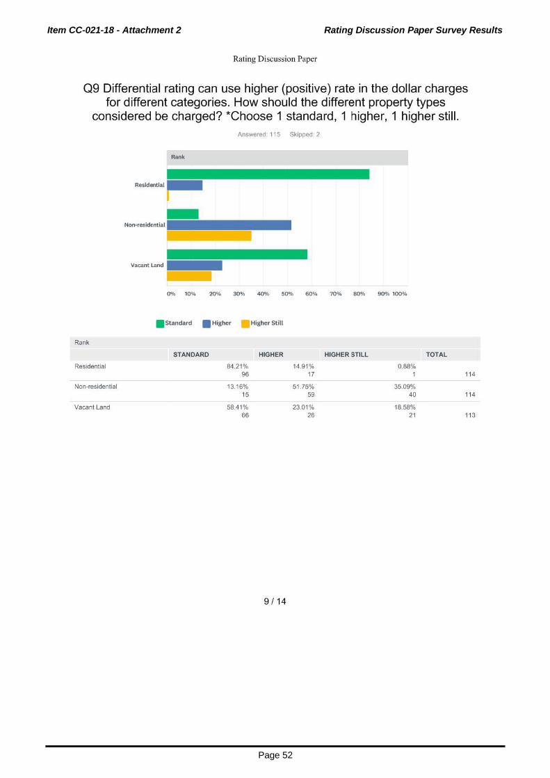
Item CC-021-18 - Attachment 2 Rating Discussion Paper Survey Results
Page 52
Rating Discussion Paper
09 Differential rating can use higher (positive) rate in the dollar charges for different categories. How should the different property types
considered be charged? *Choose 1 standard, 1 higher, 1 higher still. Answered: 115 Skipped: 2
Rank
Residential
Non-residential
Vacant Land
0% 10% 20% 30% 40% 50% 60% 70% 80% 90% 100%
. Standard • Higher Higher Still
Rank
STANDARD HIGHER HIGHER STILL TOTAL
Residential 84.21% 14.91% 0.88% 96 17 1 114
Non-residential 13 16% 51.75% 35.09% 15 59 40 114
Vacant Land 58.41% 23.01% 18.58% 66 26 21 113
9 I 14

Item CC-021-18 - Attachment 2 Rating Discussion Paper Survey Results
Page 53
Rating Discussion Paper
010 Specified area rating is about charging some land owners more to contribute towards additional services (i.e. better street scaping) and towards new infrastructure (i.e. better roads and lights). Would you
support specified area rating for some land owners to pay more towards funding the development of the City Centre?
Yes I support specified ar ...
No 1 don't
I am unsure (why)
ANSWER CHOICES
Answered: 116 Skipped: 1
0% 10% 20% 30% 40% 50% 60% 70% 80% 90% 100%
Yes I support specified area rates for the City Centre
RESPONSES
50.86%
No I don't
I am unsure (why)
TOTAL
10 I 14
40.52%
8.62%
59
47
10
116

Item CC-021-18 - Attachment 2 Rating Discussion Paper Survey Results
Page 54
Rating Discussion Paper
011 Would you support specified area rating for some District, Neighbourhood and Local Centres land owners to pay more towards the
provision of new infrastructure and services?
Yes I support specified ar ...
No I don't
I am unsure (why)
ANSWER CHOICES
Answered: 116 Skipped: 1
0% 10% 20% 30% 40% 50% 60% 70% 80% 90% 100%
Yes I support specified area rating for new infrastructure and services
RESPONSES
38.79%
No I don't
I am unsure (why)
TOTAL
47.41%
13.79%
11 I 14
45
55
16
116

Item CC-021-18 - Attachment 2 Rating Discussion Paper Survey Results
Page 55
Rating Discussion Paper
012 An increase in Urban Forest (the trees growing within the City) is an important objective identified in the Strategic Community Plan. Would you
support specified area rating to pay more to plant a large number of additional suburban trees that would increase our tree canopy cover from
9%?
Yes I support specified ar ...
No 1 don't
I am unsure (why)
ANSWER CHOICES
Answered: 114 Skipped: 3
0% 10% 20% 30% 40% 50% 60% 70% 80% 90% 100%
Yes I support specified area rating (paying more) for planting additional trees
No I don't
I am unsure (why)
TOTAL
12 I 14
RESPONSES
46.49% 53
45.61% 52
7.89% 9
114

Item CC-021-18 - Attachment 2 Rating Discussion Paper Survey Results
Page 56
Rating Discussion Paper
013 Should properties exempt from paying rates still contribute to the cost of maintaining the City?
Yes
I am unsure (why)
ANSWER CHOICES
Yes
No
I am unsure (why)
TOTAL
Answered: 115 Skipped: 2
0% 10% 20% 30% 40% 50% 60% 70% 80% 90% 100%
13 I 14
RESPONSES
91.30%
4.35%
4.35%
105
5
5
115

Item CC-021-18 - Attachment 2 Rating Discussion Paper Survey Results
Page 57
Rating Discussion Paper
014 If you receive paper rates notices by mail, should you contribute towards these costs? (with the exemption of pensioners) 1. If you
receive paper rates notices by mail, should you contribute towards these costs? (with the exemption of pensioners)
Yes
No
I am unsure (why}
ANSWER CHOICES
Answered: 116 Skipped: 1
0% 10% 20% 30% 40% 50% 60% 70% 80% 90% 100%
RESPONSES
Yes 40.52% 47
No
I am unsure (why)
TOTAL
14 I 14
55.17% 64
4.31% 5
116
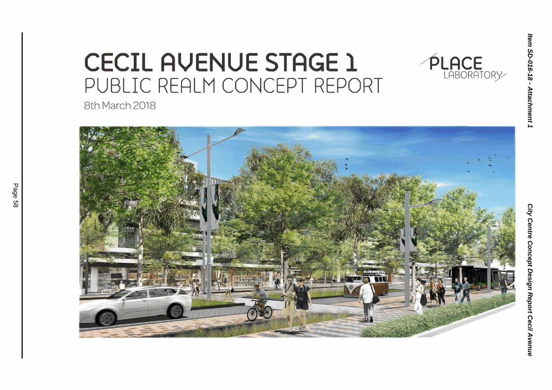
Item
SD
-016-1
8 - A
ttach
men
t 1
City
Cen
tre C
on
cep
t Desig
n R
ep
ort C
ecil A
ven
ue
Page 5
8

Item
SD
-016-1
8 - A
ttach
men
t 1
City
Cen
tre C
on
cep
t Desig
n R
ep
ort C
ecil A
ven
ue
Page 5
9
TEAM AND CONTENTS
PLACE BORATO~Y-"
Oocumet'lt Comrol
1.02.18
12.02.18
08.03.18
Cecit AVf!f'IUe Stage 1
1723 -l-001- Cecil Avenue Sll Concept Rcpol'!
1723
M1ke Rov."lands. Hans Oet"lemans. Arvl3 Chawel. Rob Gfaodison
RG
MR
MR
MR
MR
MR
1.02.18
12.02.18
08.03.18
INTRODUCTION
The purpose of this Concept Design P3
Guiding Documents P4
CECIL AVENUE
Overall Strategy
Street Tree Masterplan
Stage 1 Concept Stage 1 Concept: Finishes
Material Precedents:
KEY ELEMENTS
1. Water
2. Paving and Kerbs
3. Trees
4. Furniture
5. Lighting
6. Pedestrian Crossings
7. Bicycles & Public Transport
TUDYAREAS
Pedestrian Crossing & Bus Stop
Side Street Crossing
Driveway Crossover
Intersection
BEFORE AND AFTER
AFTER-A AFTER-B
P6
PS
P10 P12
P16
P18
P22
P26
P30
P32
P34
P36
P38
P40
P42
P44
P47
P49 PLACE
LABORATOR)V

Item
SD
-016-1
8 - A
ttach
men
t 1
City
Cen
tre C
on
cep
t Desig
n R
ep
ort C
ecil A
ven
ue
Page 6
0
INTRODUCTION
Cecil Avenue plays a vital role 1n providing places for people 1n Canning City Centre. The street is not only a traffic corndor for cars and buses. and later for light rail1t 1s also the entry 1nto the heart of the c1ty centre and an 1conic space for Cann1ng.lt 1s the heart-l1ne for pedestnan activity and VItality of the City centre and the backbone of the public realm connecting the two squares. Carousel. the railway stat1on. the parks via its side streets and 1t connects the c1ty centre w1th the Canning R1ver. The design of Cecill Avenue is therefore essential to the identity of the city centre.
The Concept Design for Cecil Avenue combines the traffiC function with the pedestrian usage and two of the identity themes - R1verine Canning and Multicultural Cann1ng. The design uses the civol road lay-out for Cecil Avenue as 1ts basis. This road layout is modelled and designed to accommodate the requ~red traffic and is a four-lane street. with additional tum-off lanes at each cross1ng. An 1nnovat1ve approach has been taken for the design of Cecil Avenue to ensure that 1t is a street w1th character that priorit1ses city life over traffic movements.
PLACE 3 LABORATORy

Item
SD
-016-1
8 - A
ttach
men
t 1
City
Cen
tre C
on
cep
t Desig
n R
ep
ort C
ecil A
ven
ue
Page 6
1
INTRODUCTION GUIDING DOCUMENTS
THE CANNING CITY CENTRE ACTIVITY CENTRE PLAN (ACP) The Canning City Centre has been the subject of a detailed planning study addressing the desired land uses and built form controls, which are set out in the Canning City Centre Activity Centre Plan (ACP), endorsed by the Council in September 2016.
CANNING CITY CENTRE URBAN DESIGN AND PUBLIC REALM MASTERPLAN In 2017 the City of Canning commissioned the Urban Design and Public Realm Concept Masterplan (Masterplan) to develop a rich layer of public realm detail that integrates the planned future context with the existing surrounding environment and character of the City.
The Masterplan conceptually illustrates the development pattern envisaged by the ACP and sits alongside it, as part of a suite of documents allowing developers and the community to graphically understand the ultimate potential of the City Centre. At a technical level, the concept plan provides a reference point for the contents of the City's Public Realm Style and StreetT ype Guide and Paving Selection Policy, which lists the various products to be used.
The Masterplan incorporates key thematiC design ideas and concepts that will inform and define the deslfed future character of the City Centre. This includes a detailed level of landscape and urban design for the key urban spaces; built form opportunities for residentlal and commerCial building typologies and detail on how built form and the public realm interact.
The Masterplan also involved developing a detailed concept design for Cecil Avenue as a Main Street and a 3D model and v1deo fly-through of the revitalised City Centre, all of which bnng the vision for the City Centre to life.
The Masterplan and graphics have been used by the City as a communication tool to promote the City Centre, allowing all interested parties to better understand the value proposition of what Canning City Centre can be into the future.
This Masterplan builds on the Activity Centre Pl;:m and prov1des a more detailed framework within which the City Centre can be redeveloped to support greater economic diversity, density and a greatly enriched and unique identity within Perth's greater metropolitan area.
SMART CITY With Australia's population in cities set to double in the next few decades. the focus on developing intelligent and effic1ent cities and transport infrastructure has never been stronger. The increasing pressure on Infrastructure and urban serv1ces has placed an amplified demand on smart systems and technology- wh1ch will be Increasingly critical for ensuring that our cities are smart. liveable and sustainable.
This is a philosophy that the City of Canning supports and views the redevelopment of the Canning City Centre as the nght moment for Canning to "go d1g1tal" and implement it's Learning Ctty initiative.
CECIL AVENUE Cecil Avenue is re-conceived as a major c1ty centre boulevard characterised by continuous and activated street frontage and high density mixed-use development. The City Centre's highest density development is along Cecil Avenue and includes a number of landmark development sites adjacent to Station Square and Cecil Square. The precinct inocrporates Carousel's Cecil Avenue frontage and is an opportunity to creatively re-think this important frontage in terms of how the the suburban shopping centre can successfully integrate with an activated high street
1. RATIONALIZING THE MEDIAN 2. MID-BLOCK BUS STOPS & CROSSING 3. CHANGING THE PAVEMENT
The concept design moves the bus stops to the m1ddle of the block and combines them With the pedestnan crossings. This will improve the pedestrian permeability and makes it possible to continue the street tree alignments on the footpaths.
!i
CANNING CITY CENTRE
~ ~
ea.-.~c.......
~~=
The concept design grades the bus lane f parking zone, making it flush with both the footpath and the car lane. The granite pavement of the footpath is continued in the priority lane, in a slightly darker material to emphasize the different function of the zone along with tactile pavers to mark the edge of the footpath. The parking bays and bus stops are marked with lighter colour gran1te in the bus lane pavement, clearly indicating to drivers that outside priority times they can park here.
The overall effect of these changes is a reduct•on 1n the amount of tarmac in Cecil Avenue creating an experience that pnontises people over cars.
THE CONCEPT DESIGN The three moves together result in a concept des•gn that strikes a better balance between prioritising the pedestrian experience of Cecil Avenue as a vibrant main street and the traffic engineering reqwements to facilitate 18.000 vehicles per day.
The trees are planted a minimum of 5.5 metres from the fao;:ade, creating enough distance to select large street tree species that will deliver an abundance of shade to the s•dewalk and create a luxurious atmosphere. All trees in the street are supported by fertile soil and tree cells collect1ng storm-water, to create excellent growing conditions and ensure the trees will grow to full stature.
FUTURE LIGHT RAIL The concept design has the ability to integrate future light ra•l. The final arrangement of t he light ra11 within the road reserve IS dependent on the light rail system that will be selected. Some systems would prefer the inner lanes, others the outer lanes. Both systems can be integrated without the need to change the lay-out or tree planting within in the street profile. Trees that are planted now can mature without the need to be relocated or cut down to make way for t he light rail.
Related documents (from left to right): the Activity Centre Plan. the Regeneration Program ond the Public Realm Style Guide and Canning City Centre Urban Design & Public Realm masterplan.
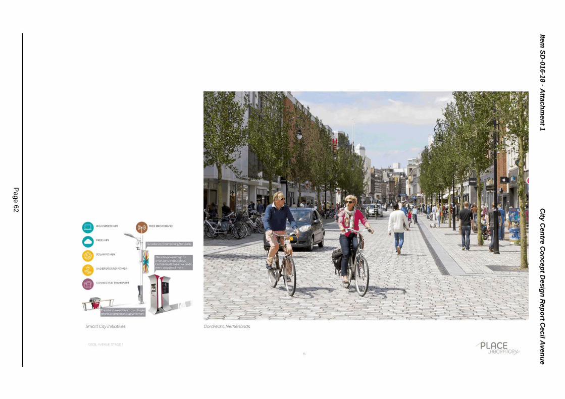
Item
SD
-016-1
8 - A
ttach
men
t 1
City
Cen
tre C
on
cep
t Desig
n R
ep
ort C
ecil A
ven
ue
Page 6
2
i ~
•r· e:
;;; ~ g
3
! e
15
* ~
~ ~
~ ~
1: 5 X
eoe
I lfl s 0 .ft
~ s b
f 0
0 u 0
e ~
~
0 W
li U
3 (!gf
...J-'
'~

Item
SD
-016-1
8 - A
ttach
men
t 1
City
Cen
tre C
on
cep
t Desig
n R
ep
ort C
ecil A
ven
ue
Page 6
3
CECIL AVENUE OVERALL STRATEGY
1'=-\J)
12, :.(.
l ..(.
~ r )>
~ ~ ~
SECTION 1
Higher traffic volumes
Longer turning lanes
Opportunity for on-street parking
Barrier kerbs to median and verges
Multiple crossing locations
6
SECTION 2
Lower traffic volumes
Reduced number of lanes
On-street parking (non peak periods)
Flush kerbs to median and verges
Shared Space street design Increased pedestrian priority
Increased pedestrian permeability reduced traffic speed
0 ~ <e. 'A ' ~ b
_____ ...... ---..,.
CECIL SQUARE

Item
SD
-016-1
8 - A
ttach
men
t 1
City
Cen
tre C
on
cep
t Desig
n R
ep
ort C
ecil A
ven
ue
Page 6
4
I I I I
I I I I I I I --·
SECTION3
Lower traffic volumes
On-street parking (non peak periods)
Barrier kerbs to median and verges
Increased pedestrian permeability
SECTION 4
Lower traffic volumes
Reduced number of lanes
On-street parking (non peak periods)
Flush kerbs to median and verges
Shared Space street design
Increased pedestrian priority
Increased pedestrian permeability
reduced traffic speed
~ ~ tn \Q, <(
0 ~ (0 (fl
PLACE LABORATOR)Y

Item
SD
-016-1
8 - A
ttach
men
t 1
City
Cen
tre C
on
cep
t Desig
n R
ep
ort C
ecil A
ven
ue
Page 6
5
CECIL AVENUE TREET TREE MASTERPLAN
~ 0)
~ :.:.
\
M '? Y'
~ ~ ~
SECTION 1
0 Spot ted Gum 0 London Plane
8
-tl
~
--
-1 ~ ~ ~ ~
SECTION 2
0 Smoothed 0 London Plane Barked Apple
()
~ ~ ~ .....
~ ;
CECIL SQUARE
FEATURE TREES Cecil Square and Station Square will provide opportunities to incorporate ondividual or groupings of feature tree specomens that punctuate and highlight the change in urban condotion and character associated with these areas. Suitable tree options include but are not limited to:

Item
SD
-016-1
8 - A
ttach
men
t 1
City
Cen
tre C
on
cep
t Desig
n R
ep
ort C
ecil A
ven
ue
Page 6
6
I I I I I I I I I I I I I .-·
SECTION 3
0 Spotted Gum 0 London Plane
1-fjj ~ (/)
~ :5
SECTION 4
0 Smoothed Barked Apple
FEATURE TREES Cecil Square and Stat1on Square will provide opportunities to incorporate individual or groupings of feature tree specimens that punctuate and highlight the change in urban condition and character associated w1th these areas. Suitable tree options include but are not limited to:
9
~ \fi tn ~ 4.. 0
~ ~ 1}1
~LACE LABORATOR)V

Item
SD
-016-1
8 - A
ttach
men
t 1
City
Cen
tre C
on
cep
t Desig
n R
ep
ort C
ecil A
ven
ue
Page 6
7
CECIL AVENUE TAGE l CONCEPT
LOT2
1342-1346 ALBANY HWY
r-~ ~ ~
~~ rE * 1
0) BIKE & BUS LANE Urbanstone Pavers
® DOUBLE OUTREACH MULTI POLE
® PEDESTRIAN POLE LIGHTS
@ BIKERACKS
® BENCH WITH BACKREST
LEILA STREET
LOT40
6-10CECILAVE LOT300
12CECILAVE
LOT301
14CECILAVE
~--1 ~--1
1-+~ 1=:T=~ I
®BUS-SHELTER
0 PLANTED MEDIAN with barrier kerb
® RAIN GARDEN VERGE barrier kerb with stormwater inlets
® TREES at 8.0m centres
""" ROAD ~ Brikmakers- Roadpave 60
@ PEDESTRIAN CROSSING
@ LOW HEDGE PLANTING TO CARPARK INTERFACE
@ TREEGRATE
@ TRAFFICABLE CROSSOVERS
z 0
~ ::l z t= z 0 u ~ e ~ UJ
15 z ~ ::l ~
- - .. •l;
I
~
z 0
~ ::l z t= z 8 ~
e ~ UJ
15 z ~ ::l 1-

Item
SD
-016-1
8 - A
ttach
men
t 1
City
Cen
tre C
on
cep
t Desig
n R
ep
ort C
ecil A
ven
ue
Page 6
8
l z I Q I ~ I~ It= z 10 u I ~ le I ~ UJ
lei l z lg l t--1
z 0
~ ::> z t= z 8 ~ e ~ UJ
e; z ~ ::> ....
PATTIE STREET
LOTl-114
NOS. l-8,
18CECILAVE
LOT202
20CECILAVE
~-·1 ~-·1 ~-·1
=+=~ 1=+=~ 1=+=~ I
CECIL AVE
LOTl-5
NOS.l-5,
22CECILAVE
LOT88
24CECILAVE
~-·1 ~--1
~ 1=f=~ r±~ 1
LOT 3797
26CECILAVE
~ ~<> <> <> <> <>n

Item
SD
-016-1
8 - A
ttach
men
t 1
City
Cen
tre C
on
cep
t Desig
n R
ep
ort C
ecil A
ven
ue
Page 6
9
CECIL AVENUE TAGE l CONCEPT: FINISHES
CD FOOTPATHS, BIKE/BUS LANES, PEDESTRIAN CROSSINGS, CROSSOVERS
@ GENERAL TRAFFIC LANES @KERBS
. . .
@)TACTILE (TGSI)
• • • • • • • • • • • • • • • • • • • • • • • • • • • • • • • • • • • • • • • • • • • • • • • • • • • • • • • • • • • • • 0 •••••••••••••••••••• 0 •••••••••••••••• • • • •• • •••••••••••••••••••••••••••••••••••••
~'..: ~-t~: i: . .,:';. ·;.~~ ~.7; _. ~, .. "•• :.'fl I .. ;.~• • . . • ••
·,_~~.>~t}~\~ .. ~-~:',.- ~~~,~-! ~ ·-:~:~·: . ., .. ,.:~~ -~·~ ~, .. , ... ~ :;.·~~:~ ..... ' :- ·-. ~ .... ~ 1 i .... "· .• ,,,.. •· ·'!' . • , ..:_ ~ ... 'l\ k; - -- , , ......... ~ ' ... ., •\··· .:~·r., ~ •• ·f.'~.~,.,..:~ ' 'J p;'-:', ;-~a.,·,~ .. _ :--.~ .. ~ - .- •' :_--:-; ~(rt ,4_-~ _ .. -:-· ·~,; .. , ; . ....... -~ ..... "' .. , .\, .. ~' .. ,. ' '-'~- ,. ::-.l:.':.:J r• :••;..• ,. :·t.··· ·'*'.';,:.~~f':_"!~-;.,. ~·:~ .. A- •" ·· 4 , ~~·'..~·~-'-~,! t'JI
_; :'~-~~'! ~--~:~~·f-:~~5~.~-~-... . -. . .
Urbanstone New Amber Urbanstone Granite Bronze
. . . l'<'l
-• Brikmakers • Roadpave 60 ·Charcoal
12
Granite Urbanstone 300x300 TGSis

Item SD-016-18 - Attachment 1 City Centre Concept Design Report Cecil Avenue
Page 70
.l33~.lS Vll3l

Item
SD
-016-1
8 - A
ttach
men
t 1
City
Cen
tre C
on
cep
t Desig
n R
ep
ort C
ecil A
ven
ue
Page 7
1
CECIL AVENUE TAGE l CONCEPT: FINISHES
CD FOOTPATHS, BIKE/BUS LANES, PEDESTRIAN CROSSINGS, CROSSOVERS
@GENERAL TRAFFIC LANES @KERBS
. . .
@TACTILE (TGSI)
• • • • • • • • • • • • • • • • • • • • • • • • • • • • • • • • • • • • • • • • • • • • • • • • • • • • • • • • • • • • • 0 ••••••••••••••••• 0 •• 0 •••••••••••••••• • • • •• • ••••••••• • •••••••••••••••••••••••••••
!~: ~ -t~: _;: .~:,.. 'l~~ '~:- ~ ~. ' . ,· _., . i ;_'fJ !- ........ ,. .. :_ .. _ .... ,. • . -" .} .... :.~ ·. ... ) :: _! .... ·. ' .... • ~ ' .• ~f.·''"' ·~,· :··~· ~- • .. ~ ..... ,s ·p... . .. . ~-- .... , •.. ~
•.• _ ··~ -...... ...,, t~'• '". ·~f''il.);_• ._ ~ ~.~ . .,.l._f ., .• ,,.,... -':.'•·-. I •• ~ -~·· 'l\ -~, .. ·. • /I ~:' o .... ;, ~ ', .. -'.•\'.!t'~-~-~~1 "'t·~~,,..,.,~.~ ' . ..:. . ;. ·~ ~~ ; . . . . . ', 'II ~ ,~_-... ,• ·.' c ·~,;,, ; " ' '.'. i': ' .... ' .,.,,. ~' .. ,. \ ·~.;- ... :'..t!J ~- ....... , . . '"f~:-." , . ';.:.~ ... • ~:r...-· ~-·f· A- . ..... ~-,~.:1''-~;.;,fl .. _;·;,~-~.~~ -~·:_i'tl~~~:~~~~~-~--~-
... . -. . .
Urbanstone New Amber Urbanstone Granite Bronze
. . . ...-.. ..
'·:: .'<: ' . ~-~·~ '-.... ,· .J •• ~ .....
• • Brikmakers, Roadpave 60 , Charcoal
14
"'-
· ... ~----.. ..u;.;.-:f~J~ ~&~-'-;.:;~-- ~,_-·_
Granite Urbanstone 300x300 TGSis
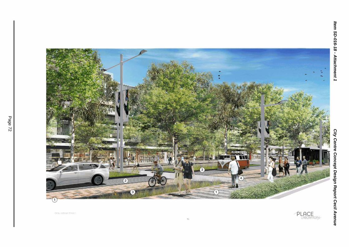
Item
SD
-016-1
8 - A
ttach
men
t 1
City
Cen
tre C
on
cep
t Desig
n R
ep
ort C
ecil A
ven
ue
Page 7
2

Item
SD
-016-1
8 - A
ttach
men
t 1
City
Cen
tre C
on
cep
t Desig
n R
ep
ort C
ecil A
ven
ue
Page 7
3
CECIL AVENUE MATERIAL PRECEDENTS: URBANSTONE CONCRETE PAVERS
Footpaths, bikejbus lanes, pedestrian crossings, crossovers
16

Item
SD
-016-1
8 - A
ttach
men
t 1
City
Cen
tre C
on
cep
t Desig
n R
ep
ort C
ecil A
ven
ue
Page 7
4
CECIL AVENUE MATERIAL PRECEDENTS: BRIKMAKERS CONCRETE PAVER
General Traffic Lanes
~ --'- -. . :::."'<z ~ '-', ... ~ ·--,
•
Lakelands Town Centre
PLACE 17 LABORATORy

Item
SD
-016-1
8 - A
ttach
men
t 1
City
Cen
tre C
on
cep
t Desig
n R
ep
ort C
ecil A
ven
ue
Page 7
5
KEY ELEMENTS lfllj11fJ:fi•I;•iGU"U1
1. WATER 2. PAVING & KERBS 3. TREES 4. FURNITURE 5. LIGHTING 6. PEDESTRIAN CROSSINGS 7. BICYCLES & PUBLIC TRANSPORT
-~ ....... ,· .. .;,./ "·· "'' '( /""' /
/' ... \ ' ' , >· /~ / // ',\ // ,~.\
/ . '// // /""\, ' '·,····· ...
- ' / \'~<" .... ·""' .
-"" ~//:t 0 ')
,.,. Iii,·--.......:/
;;> . ' < ' . . / / '
• ;>"~-<, ____ /~/ ·-----;·. / '' . ~ ., ~',,
~ '~-.........
·'
-CECIL AVE WATER EXPRES
SION
URBAN WATER FEATURE
WATER STRATEGY The Masterplan identifies the opportunity to celebrate the role of water ecology as an enJoyable experience for resrdents and viSitors to the C•tY Centre and enable people to engage more directly with the water and become aware of the cities strong natura I connection to the Canning River.
Cecil Avenue is located at a watershed in the drainage system. Natural water is not available in this street; however, water should still be
part of the experience of the civic heart of the c1ty centre. Providing adequate water to the street trees, through tree cells and grey water harvesting, will form the core of the Cecil Avenue experience. Drink fountains along the street, with smart release and collect systems, will provide free drinking water to all users. At Cecil Square, in the heart of the centre, a water feature will form the landmark at the crossing of Cecil Avenue and Carousel Road, artistically celebrating the connection of the centre with the Canning River.
Along Cecil Avenue, the storm water can be collected 1n the tree cells under the pavement. prov1d1ng water for the trees and rnfiltrating into the soil.
f:ij-7 WATER SYSTEM
11 ~ -1 HIGH GROUNDWATER
~ RIVERINE LANDSCAPE
-1
18
M+~ DAYLIGHTING GREY WATER DRAINS RE-USE
fmfiJ+r,=;;l ~ ~ MELALEUCAS RAISED
PARKING
~+[[} RIVER, WETLANDS & PAPER BARK INSPIRED DESIGN
STREET CROSSING Where the water system crosses a street, the water does not need to disappear from the street level experrence. The water course can be expressed in the design of the pavement, emphasizing the presence of water below the pavements. Ra11ings along the sidewalk. on top of the culvert. further indicate the water, while creat1ng places for pedestrians to lean and look at the stream.
'-"~ · . -n--· ,~- .... -- ..... ,4///
~ . . ;/_ ... ~----./. ~<~.-."·:.~· ·:$ :.#.:~~ ,·· ~ -~~. ,/~.#!¥.~ ~~ .c . • . ~y :~. .· / ~v._-'. - ? 7 I -,~ · '-'l .· ' •;I{ ~ .'e "'/,~, .;;. ,. ,. / •. - I' ' '/ f'l r · ,.,.,. - -·
The crossing of living streams con be expressed in the pavement of the streets
" J,, ~ } , ' li,':'. .r ,'~ •;;; ·:fJ.~~· j, IJ' .~ t-~· o>l> r ,,.1,.,-! .. ';• -I~ c!Jj :"·t f' • . ;1' .,.. • ., • - · ~ ·: p ......... .
;':' . '1 ~ ·~, "'" &! ~ •!J"'--:~· ~::; : ~:.,;~-·:.> ~·-.,~.· \~ ~.;.ffi_•· ··! . :'._'•. I • .. - · ..
.... •,., ;• ~ . -
!'!II ,._i:.. .:.:.::!-:::"'~~ RIVERINE CANNING

Item
SD
-016-1
8 - A
ttach
men
t 1
City
Cen
tre C
on
cep
t Desig
n R
ep
ort C
ecil A
ven
ue
Page 7
6
RAIN GARDENS CD KERB INLETS
Ganite Kerbs 1nlets with limestone spa II
® STONE MULCH to prevent scouring
® MAX 1:4 SLOPE TO RAINGARDEN SIDES planted with water tolerant shrubs and ground covers. max 300deep
@ GRAPHIC FEATURE PAVING to pedestrian areas with reference to water thematic
19

Item
SD
-016-1
8 - A
ttach
men
t 1
City
Cen
tre C
on
cep
t Desig
n R
ep
ort C
ecil A
ven
ue
Page 7
7
KEY ELEMENTS Bik11t1:fi•1:JiiGU"U1
1. WATER 2. PAVING & KERBS 3. TREES 4. FURNITURE 5. LIGHTING 6. PEDESTRIAN CROSSINGS 7. BICYCLES & PUBLIC TRANSPORT
RAIN GARDENS
NOTES: 1. REO.U!M:MEHT FOR TAUS TO 8E AA1SEO FftOM 8AS£ Of
RAINGAAOEN TO 8t OETUI.MIN[O 8Y FINAl SPECJESSEUCOON 2. GAROEN 8(0 AREA$ TO BE EXCAVATED WHERE NECESSARY TO
iU.lOW FOR SOJliNSTAUATJON TO "OPOSEO FlNISHED lE'/llS A.HOTOACHIM IWNGAADEN VOLUMES.
3. 810FilTAATIOH SOl~ MEOlA MUST MEET O(PARTMENT OF WAT(R SPEOFICATIOH BEl OW:
o SATURATf.O HYDRAULIC CONDUCTIVIlY IN RANGE lOO.~MMMR
• CL.A'I' AND Sill • VI:R'f FIN[ SAND
<l"(<O.OSMM) S·~ (0.05.0.1.SMM)
• FtNESANO 10.J~(O.I$.0.2SMM)
• MEDIUM TO COARSE SAND 40-~(0.lS•l.OMM)
• COAASESANO HO'K(t.D-2.0MM)
o HNEGRAV£L <l%U..0.3.4MM)
5.5·7.5
o ELECTRICAL CONDUCTIVJTY <1.2DS/M
o AT LEAST l"lOW NUTRI(Nl-COtfTENTOAGANIC MATTEA
• <80MG/I:G Ofi.THOPHQSPHAT(<lOOOMG/ICG TOTAl NJTR()6(N CONTENT
• AMEND SOli. WITH S." MUlCH ANO S." HARDWOOD CHIPS (6MM) 8V VOLUMt:
810 RETENTION BASIN
Suitable retention basin species selection
Y«Gt:l"l(
~o:= •uoctot"«W-•9-•'•..1o-·OOt.-·-...,.
TIUt6AATt-----, ·-"' "'"'' CONCRI:ltll:lt& ............ .......
~~~
~~~ h~ e J. Rtfti!NOTO
SECTION A-A
-----------------.,___ =1 ;-------h----------_j .-. I!OfafRAT10NSCJit ·~--- - ·-··-·-·- ...... I
SECTIONB-8 lJI((C£tUIIlf(ll lOII.IIIiff~
O£fAILS ~~ llfffll NQTU
20

Item
SD
-016-1
8 - A
ttach
men
t 1
City
Cen
tre C
on
cep
t Desig
n R
ep
ort C
ecil A
ven
ue
Page 7
8
IRRIGATION As irngation plays an important role in the enhancement and maintenance of the amemty of the soft landscape for Cecil Avenue, the provision of a suitable water supply and irngation system is a core consideration for the landscape of the project.
KEY CONSIDERATIONS: Ground water extraction via bore· In the event that groundwater analysis indicates high levels of dissolved Iron, then a rev1ew and recommendation concerning the application of a SUitable Water Treatment System will be made at that time.
All spnnklers and equ1pment utilised shall be in conformance with the specifications and requirementS of the City of Canning.
All trees shall receive supplementary watering. Where a tree 1s to be watered 1n conjunction with the landscape area in which the tree is installed, the flow rate of the bubbler shall be varied in accordance with the precipitation rate of the landscape sprinklers, so that all trees receive an equivalent and appropriate volume of water dunng an irrigation cycle.
Wherever possJble, sprinklers shall be positioned to min1m1se over-spray onto non-planted areas.
Generally, alllfrigatlon should be undertaken at n1ght. between the hours of 8.00PM and 8.00AM, on
a contiguous period of 8 hours maximum, on five(S) occasions per week.
Minomis1ng water requirementS for establishment and maintenance of garden areas will be achieved by adoption of the following measures:
The irrigation system will be designed and installed according to best water efficient practices
The controller must be able to irrigate d1fferent zones with different irrigation rates.
Emitters must disperse coarse dropletS or be subterranean and conform to the City of Cannong's specifications.
TREE IRRIGATION AND AERATION
1. Example of a subsurface system to introduce a1r and water directly to the root zone. Good for trees in hardstand areas where paving may reduce exposed ground surrounding the trunk
2. Typical above ground pop-p nozzle tree lfrigation systems
21
ESTABLISHMENT PERIOD RECOMMENDED DURATION • Generally accepted to be 2 years
HOW MANY LITRES A DAY FOR TREES? • 100L trees- 20L/day
• 200L trees- 40Lfday
• SOOL trees -100Lfday and
• 1000L trees- 200L/day
HOW MANY LITRES A DAY FOR SHRUB PLANTING? • In the Perth metro area an application of 30mm/wk during peak season is generally accepted.
Native plants can survive on as little as half of this (15mmfwk for Perth metro) and results in less vigorous growth and a poorer specimen
FREQUENCY OF WATERING? • For trees it is accepted to be daily
• A watering regime or volume for specific trees, shrubs is usually found to be 3 times a week at 10mmperrun
POST ESTABLISHMENT PERIOD HOW MANY LITRES A DAY FOR TREES? • Generally the trees in garden beds are valved separately to trees in hard stand areas. This allows
irrigation to trees in beds (once established) can be switched off. In hard stand areas the only water the trees will receive is from the irrigation system (a negligible amount comes from rain and associated run off).
• Once trees in irrigated areas are established they generally get enough from the surrounding Irrigation to keep them happy, 1n hard stand areas the trees Stoll require a dedocated supply. 30-40mm application per week as an estimate.
FREQUENCY OF WATERING? This is dependent on the system operator, most commercial systems operate in a 40 hourtweek window from 9pm to Sam. It's up to the operatorof they want to provide a single application of the full volume or spread 1t out over more. It is advisable to provide both a deep water once a week and shallow top ups and you can get very deep w1th the "how much" and "when". Most systems split the requirement evenly over the week (e.g. 30 mmfwk at 6mm{day for 5 days/week)
• Please note that the Information provided is as a guide only. A specialist Irrigation Consultant should be engaged to provide a comprehensive Irrigation Strategy that is specific to the Project and the City of Canning's requirements.
-1>~fi£~oRy

Item
SD
-016-1
8 - A
ttach
men
t 1
City
Cen
tre C
on
cep
t Desig
n R
ep
ort C
ecil A
ven
ue
Page 7
9
KEY ELEMENTS lfllj1l;t1:fi•n•iGU"U1
1. WATER 2. PAVING & KERBS 3. TREES 4. FURNITURE 5. LIGHTING 6. PEDESTRIAN CROSSINGS 7. BICYCLES & PUBLIC TRANSPORT
TACTILE (TGSI) . ,
Urbanstone 300x300 TGSis
KERBS
Granite
FOOTPATHS, BIKE/BUS LANES, PEDESTRIAN CROSSINGS, CROSSOVERS
.\:.~;t.'~;·;;~~. l::/.;.< \ .. .. ,,, ...... , .... ,.,·
~~··..:.~.:~~;~·.;.;· ;'i~~~:.::~· .. ~ -~.·'·~ .~ ,, ... .. •,. :~· -,;~.:.~it~~~~ ~~'i':;'(':·_fi
~:f~:·\~~%;~-r. Urbanstone Domino Urbanstone Gunmetal
Urbanstone Silver Grey Urbanstone Coolangatta
Urbanstone New Amber Urbanstone Gran1te Bronze
22
GENERAL TRAFFIC LANES
-• Bnkmakers ·Road pave 60 · Charcoal
TRAFFIC ISLANDS / REFUGES
Holcim Spinifex

Item
SD
-016-1
8 - A
ttach
men
t 1
City
Cen
tre C
on
cep
t Desig
n R
ep
ort C
ecil A
ven
ue
Page 8
0
PAVING PATTERN CONCEPT
Opportunity to incorporate graphic paving patterns and varying textural/colour changes- to express the water thematic in a contemporary and sophisticated way.
UNIT PAVER- FOOTPATH UNIT PAVER- TRAFFICABLE
23
RIVERINE PRECEDENT
Darling Otr. Sydney diSplayrng successful use of pattern through dtffenng mater ~a I finishes
-i'LACE LABORATOR)V

Item
SD
-016-1
8 - A
ttach
men
t 1
City
Cen
tre C
on
cep
t Desig
n R
ep
ort C
ecil A
ven
ue
Page 8
1
KEY ELEMENTS lfllj1f:t1:fi•I;•iGU"U1
1. WATER 2. PAVING & KERBS 3. TREES 4. FURNITURE 5. LIGHTING 6. PEDESTRIAN CROSSINGS 7. BICYCLES & PUBLIC TRANSPORT
RELATIONSHIP BETWEEN THE BUS /BIKE LANE AND THE FOOTPATH
To achieve a successful Maon-street environment that places emphasis on peoples experience over the vehicles otIS critical to establish a visual and physical onteractoon between the Bus/Bike Lanes and the adjacent footpath. While thos is not practical along the full length of Stage 1, there is a section between Leila St. & Pattie St. where this relationship can be achieved. Interaction is provided through the following means:
Allow for time restricted parking outside of bus priority times to enable activation (food trucks, street vendors)
Remove rain-gardens and provide paver infill tree grates to reinforce the connection between the footpath and bus lane and provide unhindered permeability for pedestrians.
Paving Treatment to create a visual relationship between footpath and bus/boke lane to reduce the perceived dominance of ·carnageway" over pecestrianised areas.
PAVING PATTERN CONCEPT
24

Item
SD
-016-1
8 - A
ttach
men
t 1
City
Cen
tre C
on
cep
t Desig
n R
ep
ort C
ecil A
ven
ue
Page 8
2
CD BIKE & BUS LANE Herringbone 300x200mmx70 Urbanstone paver
Colour: Grey & Red tone pattern m1x.
® VERGE/FOOTPATH Alternating bands-varying widths x60 Urbanstone paver
Stretcher Bond- 600x300. 300x200, 300x150
Soldier Course Header- 300x150
Colour: Varying colour and finish. Grey & Red tone pattern mix.
® GENERAL TRAFFIC LANE Herringbone 220X110X60 Brikmakers- Roadpave 60
Colour: Charcoal
25
VEHICLE CROSSOVER- NOT SHOWN Herringbone 300x200mmx70 Urbanstone paver
Further testing and assessment of paving samples should occur in the following design phase to confirm paving pattern 1 colour/ finishes and colour contrast 1 slip resistance requirements.
-1>LACE LABORATORy

Item
SD
-016-1
8 - A
ttach
men
t 1
City
Cen
tre C
on
cep
t Desig
n R
ep
ort C
ecil A
ven
ue
Page 8
3
KEY ELEMENTS Bllj!tli•ljliGU"Ud
1. WATER 2. PAVING & KERBS 3. TREES 4 . FURNITURE 5. LIGHTING 6. PEDESTRIAN CROSSINGS 7. BICYCLES & PUBLIC TRANSPORT
LEGEND ....
TREE STRATEGY Species selection has impact and reinforces character
Contribution to biodiversity
Provide shade and cooling microclimate
Provide for successful growth & species health
Trees are a key element of any successful city centre. They perform many roles includ1ng protection against the blazing sun, reducing the heat island effect, cooling of the air, softening the urban environment. visual amenity and enhancing ecological connections.
For the city centre the Masterplan proposes three categories of street trees:
grand street trees;
tush street trees; and
Riverine Metateuca street trees.
DETAIL The Grand Street Trees witt be tall trees that tine the sign1ficant connecting streets through the city centre including Cecil Avenue. Sevenoaks Street and Albany Highway.
For Albany Highway and Sevenoaks Street natiVe eucalyptus trees are suitable for their tall habit. although they are less effective in provid1ng shade and cooling. Given the function of Cecil Avenue as a pedestrian orientated main street, trees with a wide and thick canopy have been selected to cover the multiple lanes of the road and provide shade and cool1ng for pedestroans.
TREE CELLS Street trees are given the greatest opportunity for health and rapid growth through the use of Strata Cell modules. Placed beneath pavement, the system provides an open skeletal structure that satisfies vertical and horizontal strength requirements for all pedestrian and traffic movements above, whilst creating optimum root growth conditions for street uees be1ow. The large apertures in the cells prov1de adequate space for conduits, seNice pipes and aeration systems which will share the road reseNe and footpath areas.
MELAl.EUCAS
GRANO STREET TREES
LUSH STREET TREES
. . ... .,. SOUAil£&PARKTREES
CANNIINGRIVER VEGETATION
c:==::J POWERSUBSTATION
PUBUCREALM
~,::: _::]. PlAN AREA
26
TREE SPECIES SELECTION CRITERIA:
1st order tree - 15 metres or taller
providing deep shade and cooling
grow1ng well in paved situations
upright growing crown, able to prune up to 4.5metre
SPECIES OPTIONS: Platanus acerifolia (London Plane)
Ccrymbia macutata (Spotted Gum)
Angophora costata (Smooth Barked Apple)
PROPOSED TREE SPACING 8metres

Item
SD
-016-1
8 - A
ttach
men
t 1
City
Cen
tre C
on
cep
t Desig
n R
ep
ort C
ecil A
ven
ue
Page 8
4
CITY OF CANNING STREET TREE REQUIREMENTS: This is a preliminary hst for consideration for use in the City Centre.
CONSIDERATIONS: Sufficient stature to have an impact.
2. Sufficient cooling shade.
3. In the context of stature and shade, select trees to provide cooling shade to areas where needec i.e. tall trees may cast shade on road surface not pecestrian areas where needed, if not appropriately positioned.
4. Non-Weec varieties- related to wetlands particularly.
5. Mixec species to accommodate loss through disease and climate change.
6. Long term management- consider impost for ongo1ng maintenance.
7. Cons1der leaf shed and potential nutrient loading.
8. Consider contribution to biodiversity.
9. Tolerant to high water table.
Preparation for planting:
1. Deep root zones to be establishec.
2. Judicious use of root cell structures.
3. Ensure soil m1x IS appropriate to species selection.
4. Ensure volume of soil mix IS appropriate where root cell structures are usee.
THE TREE LIST: The list on the following table is not prescnptive. It is a guide only. It does not purport to determine where the trees are to be located (or the" spacings) but does make some suggestions as to locations.
CANNING CITY CENTRE STREET TREE LIST (provided by City of Canning)
27
t.llwiSII•UI ---·-..:::..!~. ..,.~---
--... _,.. -
·- ..... ~= .. ..,.._ -~..=-~
·--
-~J ,_., ---
~~).4 --... .... -·-::.s-:..~ ·-
.,__ I $IAI:IMI ..... IO .... Miifll0ol('l
25ulk!MI~IIIUI
------· --~_,-= -~~--·· ·-~· ~=-.,..,.,_ .....
) lr!M .... ot.cl-.-d-..-:1 ..... 10 ...... CO<*ICI_ID .. _._ IIMCIId !tVI.._~-IollloOtOflooM ..... IIOI~ .. -..._
-.·fMIII~~ • ~w..s ........ --10-elllrlcb,.._..... ~ ...,~ .. __..,...'-.....,..~ ... .-~ • l'"t*"'-..----lfi'OOIIIOrOIIIO(IIn;ll~IMIIt!IMto'lf.....-........... I.Cmsdei~ICI~ • ,_.... •• _Ylllll _ .. _ I OIWIIIIOI-10bt~ 2AiddDui1Ma4JUIIOII~
3~·-.,..·~10~~ . ~--,.-............ .,.._._~ .........
PLACE LABORATORy

Item
SD
-016-1
8 - A
ttach
men
t 1
City
Cen
tre C
on
cep
t Desig
n R
ep
ort C
ecil A
ven
ue
Page 8
5
KEY ELEMENTS IYIYj.W'J:fi•1iJiiGU"U1
1. WATER 2. PAVING & KERBS 3. TREES 4 . FURNITURE 5. LIGHTING 6. PEDESTRIAN CROSSINGS 7. BICYCLES & PUBLIC TRANSPORT
TREE GRATE SELECTION Where grates are required using onfill style grates will allow
Seamless continuation of pavong material
Allows a large tree pit area with reduced vis1.1al impact
Slop resistance matches paving standard
Permeable paved surface
CltvGreen- Castle Tree Grate
MEDIAN TREES
CORYMBIA MACULATA
SPOTTED GUM
A tall tree with smooth pale grey, pink or cream bark shedding in irregular patches. White fiowers in autumn and winter.
Height and spread: 30m x Bm
C. maculata Mur(ay Streer West Perth
28
VERGE TREES
PLATANUS ACERIFOLIA
LONDON PLANE
Large shade tree. Good street tree choice due to its tolerance to industrial pollution. Fast growing
Height and spread: 25m x 15m
P acefifot1a · MOUf'lts Bay Rd Perth

Item
SD
-016-1
8 - A
ttach
men
t 1
City
Cen
tre C
on
cep
t Desig
n R
ep
ort C
ecil A
ven
ue
Page 8
6
TREE CELLS Street t rees are given the greatest opportunity for health and rapid growth through the use of Strata Cell modules Placed beneath pavement, the system provides an open skeletal structure that satisfies vertical and horizontal strength requirements for all pedestrian and traffic movements above, whilst creating optimum root growth conditions for street trees below. The large apertures in the cells provide adequate space for conduots, seNice pipes and aeration systems which will share the road reseNe and footpath areas.
RR.AA82RootR•In AR&ORVENT DUAl DEEP WATERING A AERATJONS't$T[M
COMPAaEO GAAN COLL.AA AS P£11. SPECIFICATfONS
FtS600R.oocSt~8A LAJOONOlJU:RWAI PIT.
tOOmm DAAIHAGE S-l0mm5.t0tlethlp
"" 0
;oJ ¥d • t )~
, -· 1 rr
--..... _.. 1\0 II\ [0, \0 10, \f.J
~" 10 t U
.l.SOF
110 \U IU \0 "-YER· "•
,. .l; ( .
II\ 10/\0 II\ 10 1'-'
II IU \0
'\)
f. { .~· A
0 0 [OJ
101\01/\10/\01/ \ \U)\u >.'L
FINISH VARIES REFER PlAN. BASE COUIRSE COMPACT lEVelS TO ENGINEER SPECifiCATIONS
-ttfAWGAAI)( NON·WOVEN Fll T(R FA&RIC WITH REINfORCING GRJO TO TOP SUI\fACE OF Str<tUC~I MATRIX, ANO FOlOED TO lJN£ OUT£R EDGE OF MATRIX TO DEPT I-f Of)()Omtn.
n 101 1u11~1u, lf lfliO, \UII IU l\U H
tU 1U 10
IU \f.J IU \IU \U IU :.:
29
TRlEGAATE-------, fiNI$.HQ(
""'"" CO!«JJ(T£Klill8
~T~OAO
~p2~ - l iU(PUHJIHGAS
Wf.OfltD
:;~~'Ld! t~ ~
SC2SOStr.ttacell--------, STRUCTURAl SOIL MOOUI.ES l0A0(0 WI Tit SCREENED SANOY 4.0AM SOil Mil(.. Ofl.GANIC 4-8% &VVO\.UM(.
r T I
i
RRPRECt RootR~in PRECINCT SINGlE 1Nl£T f.OR INmAL W"TtRlNG OF ROOT81Ul ZONE.
PLACE LABORATOR)Y

Item
SD
-016-1
8 - A
ttach
men
t 1
City
Cen
tre C
on
cep
t Desig
n R
ep
ort C
ecil A
ven
ue
Page 8
7
KEY ELEMENTS Bj11fJ:fi•l;liWit1U1
1. WATER 2. PAVING & KERBS 3. TREES 4. FURNITURE 5. LIGHTING 6. PEDESTRIAN CROSSINGS 7. BICYCLES & PUBLIC TRANSPORT
FURNITURE STRATEGY
BLACKWELLS TEXT:
The use of durable yet elegant furniture and materials of h>gh quality and finish wtll help reinforce the central core as the heart of a vibrant. busy and flourishing City.
The paving and furniture will consist of a neutral colour palette allowing colour to be brought out through signage, lighting, artwork and people.
Asymmetric furniture and organic shapes/patterns in the style of the adjacent images have been selected to distinguish the Central Core from the rest of the City Centre.
:.t
FGP Recycled Plastic & Steel
Seat l.andsc~orms _
'Stop' Bollard
Landscape Forms
30
'Ride' Bike Rack landscape F01ms
i Complimentary 240L Bin Enclosure
Metno 40 Shelter Landscape Forms
Forms sty1e

Item
SD
-016-1
8 - A
ttach
men
t 1
City
Cen
tre C
on
cep
t Desig
n R
ep
ort C
ecil A
ven
ue
Page 8
8
1-
I (!) :J w
...J 0 0..
V>
~
z ~
w
<{
u V
>
~
<{
I
1-
a:: V
>
w
u w
~
z 0
iii w
w
aJ
0..
e @
@
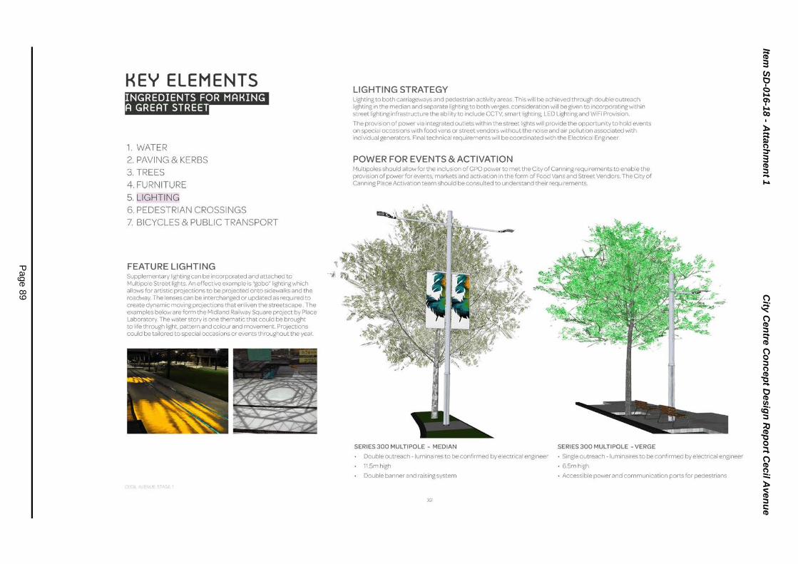
Item
SD
-016-1
8 - A
ttach
men
t 1
City
Cen
tre C
on
cep
t Desig
n R
ep
ort C
ecil A
ven
ue
Page 8
9
KEY ELEMENTS IYIIjW'Ii·n•n#li"Ud
1. WATER 2. PAVING & KERBS 3. TREES 4 . FURNITURE 5. LIGHTING 6. PEDESTRIAN CROSSINGS 7. BICYCLES & PUBLIC TRANSPORT
FEATURE LIGHTING 11 Supplementary lighting can be incorporated and attached to • "i1
Mult1pole Street lights. An effective example is "gobo"lighting wh1ch allows for artistic projections to be projected onto sidewalks and the roadway. The lenses can be interchanged or updated as required to create dynamic moving projections that enliven the streetscape. The examples below are form the Midland Railway Square project by Place Laboratory. The water story is one thematic that could be brought to l1fe through light. pattern and colour and movement Project1ons could be tailored to spec1al occasions or events throughout the year_
LIGHTING STRATEGY Lighting to both carriageways and pedestrian activity areas. This will be achieved through double outreach lighting 1n the median and separate lighting to both verges. consideration will be given to incorporating within street lighting infrastructure the ability to include CCTV, smart lighting, LED Lighting and WiFi Provision.
The provision of power via integrated outlets within the street lights will provide the opportunity to hold events on special occasions with food vans or street vendors without the noise and air pollution associated with individual generators. F1naltechnical requirements will be coordinated w1th the Electrical Engineer.
POWER FOR EVENTS & ACTIVATION Multipoles should allow for the 1nclusion of GPO power to met the City of Canning requirements to enable the provision of power for events, markets and activation in the form of Food Vans and Street Vendors. The City of Cann1ng Place Activation team should be consulted to understand their requirements.
SERIES 300 MULTIPOLE - MEDIAN
Double outreach -luminaires to be confirmed by electrical eng1neer
11.5mhigh
Double banner and rais1ng system
32
SERIES 300 MULTIPOLE -VERGE
• Single outreach- luminaires to be confirmed by electncal engineer
• 6.5mhigh
• Accessible power and communication ports for pedestrians

Item
SD
-016-1
8 - A
ttach
men
t 1
City
Cen
tre C
on
cep
t Desig
n R
ep
ort C
ecil A
ven
ue
Page 9
0
I I I I I I I I I I I I I I I I I I I I I I I I
____ 1l e~
~~
~ 5 ~ i ~ ~ " ~;i ~~
_______ l '
1 '
' I
I ' ' ' I ' I I ' ' I I I I I I I I I I I I I I I I I I I I I I I I •z
:~
tO
tUJ
•l:
I I
:~ :o ,a
.
:5 l::l ll:

Item
SD
-016-1
8 - A
ttach
men
t 1
City
Cen
tre C
on
cep
t Desig
n R
ep
ort C
ecil A
ven
ue
Page 9
1
KEY ELEMENTS lfllj1ft1:fi•1:JiiGU"U1
1. WATER 2. PAVING & KERBS 3. TREES 4 . FURNITURE 5. LIGHTING 6. PEDESTRIAN CROSSINGS 7. BICYCLES & PUBLIC TRANSPORT
STRATEGY The overarchingprincipal of pedestrian priority is reinforced through the following measures:
Major pedestrian cross-walks will be clearly delineated by a continuation of the footpath paving material. This material shall interrupt any road surface treatment (i.e. bus lane and tarmac).
Generous width at dedicated crossings
Frequency of c rossings to encourage connections between both sides of the street
The pages following show study areas outlining various pedestrian crossing scenarios on Stage 1 of works
-.1-'* - - - - - ·-
PEDESTRIAN CROSSING
Vtew Showscont•nuatiOf"' of footpath matenal taktng precedooce over road surface.
34

Item
SD
-016-1
8 - A
ttach
men
t 1
City
Cen
tre C
on
cep
t Desig
n R
ep
ort C
ecil A
ven
ue
Page 9
2
SECTIONS The following sections illustrate the proposed transitions between varying surface treatments and infrastructure. Location and alignment of tree cells, electrical conduits servicing street lighting. and pavement build ups satisfy;ng traffic-able area recuirements are to be coordinated.
SECTION A - A
...:OWt~TifriO snou-, St:l!CTIOHJO&!:COWIRM£0 l
-------------------~::~~~~;
Detail section through planted medoan, kerb and cross walk
35
·< ): :(
UN!lPAWfGTOPlOI.Sl Moi.N -t..:._j L...J
•
SECTIONB - B
Detail section through road carriageway and cross-walk showing transition from road surface through flush kerb and pedestrian pavement in traffic-able format.
PLACE LABORATORy

Item
SD
-016-1
8 - A
ttach
men
t 1
City
Cen
tre C
on
cep
t Desig
n R
ep
ort C
ecil A
ven
ue
Page 9
3
KEY ELEMENTS Bj.11tJ:fi•1iJIU:Ji"U1
1. WATER 2. PAVING & KERBS 3. TREES 4 . FURNITURE 5. LIGHTING 6. PEDESTRIAN CROSSINGS 7. BICYCLES & PUBLIC TRANSPORT
BUS STOP OPTIONS
BICYCLES, PUBLIC TRANSPORT & CARS The Masterplan ams to achieve a traffic speed of 30 km/hour on Cecil Avenue to promote pedestrian and cycle activity. This approach will make it possible for bicycles to safely integrate w•th the car traffic on the streets and bicycle racks have been integrated onto the urban design along Cecil Avenue to promote the use of bicycle withon the city.
Cecil Avenue will be the main route for public transport. with bus stops on every block and a central hub at the Canning traon statoon. Cecil Avenue has also been designed to accommodate future light rail allowing for the retention of street trees wothout a complete redesign of the street.
Street parkong encourages pedestrian movement on the streets and can contribute to reducing the traffic speed. Parking is an important requirement; however, it should not dominate the streetscape and needs to be balanced with hospitality and public uses such as al(resco areas. seating areas, garden beds, bicycle racks and other amenities for the community.
The following pages show options for PTA approved bus stop layouts as they apply to Stage 1 bus stop location
Street furniture outlined in the Canning City Public Realm Style Guide indicates a preferred product for bus stop shelters.
Within this range exist various options for over all size and extent of weather protection. Combining these and varied seating optoons, such as leaning rails and seats, will provide comfort for waoting passengers.
36

Item
SD
-016-1
8 - A
ttach
men
t 1
City
Cen
tre C
on
cep
t Desig
n R
ep
ort C
ecil A
ven
ue
Page 9
4
BUS STOP ARRANGEMENT Bus stop layout based on recommendation 58 found in PTA Bus Stop Site Layout Gurdelines. Revision 2A
0 ®
""' 0
®
37
0
f ®
CD BUSSTOP
1 Roof overhead shown dashed. Seats not shown for clanty
® TACTILE INDICATORS 1 Shown as requrred by PTA standards
® BUS INFORMATION SIGN AGE
1 Shown as requrred by PTA standards
@ GARDENBED
1 woth low hedge planting
® TREEGRATE I woth infill paving
® PEDESTRIAN LIGHTING

Item
SD
-016-1
8 - A
ttach
men
t 1
City
Cen
tre C
on
cep
t Desig
n R
ep
ort C
ecil A
ven
ue
Page 9
5
STUDY AREA PEDESTRIAN CROSSING & BUS STOP
~ 38
CD ® ® @) ® ® 0
PAVED CROSSINGS- 4.0M
BUS SHELTER & STAND WITH SEATING
TREE GRATE (PAVER INFILL)
RAIN GARDEN
LOW HEDGE PLANTING TO CARPARK INTERFACE
SEATING AND MULTIPOLE FOOTPATH LIGHTING
MULTI POLE MEDIAN LIGHTING
. . . . . . .
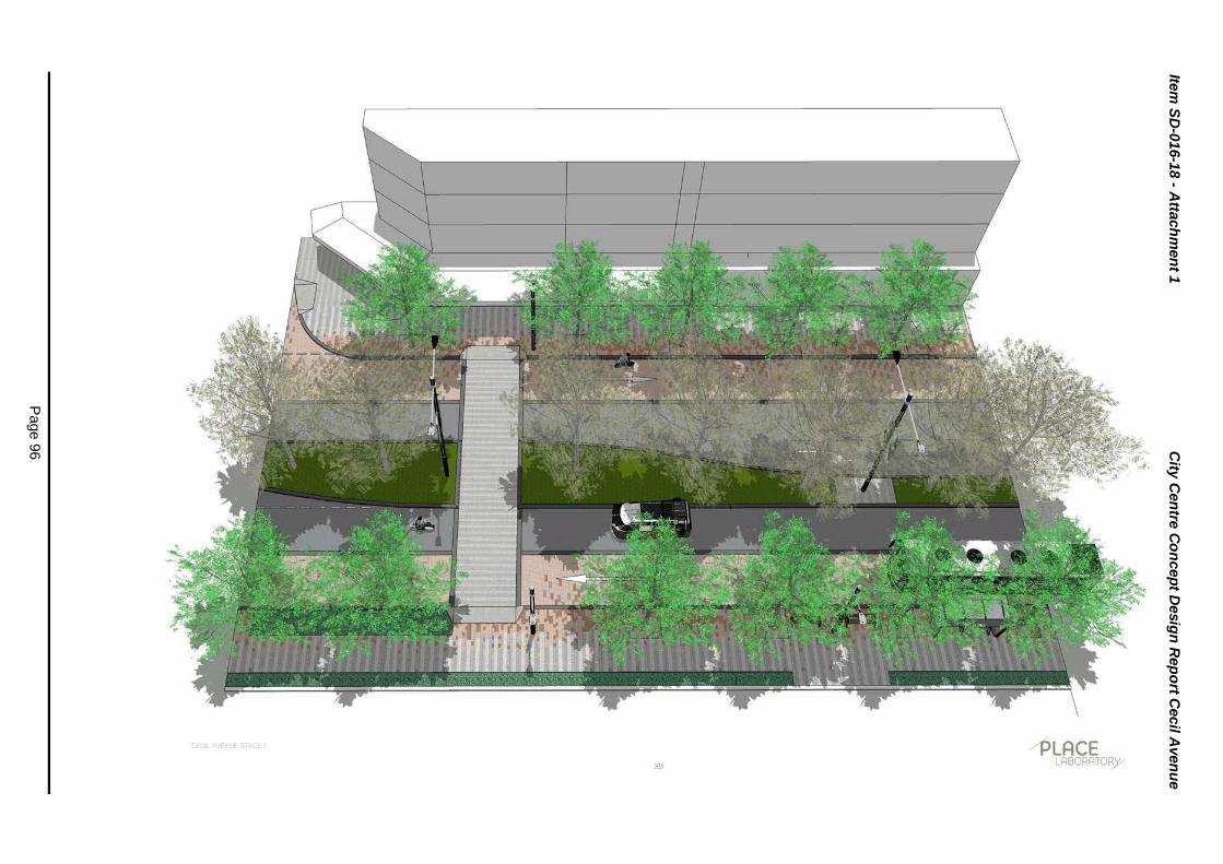
Item
SD
-016-1
8 - A
ttach
men
t 1
City
Cen
tre C
on
cep
t Desig
n R
ep
ort C
ecil A
ven
ue
Page 9
6

Item
SD
-016-1
8 - A
ttach
men
t 1
City
Cen
tre C
on
cep
t Desig
n R
ep
ort C
ecil A
ven
ue
Page 9
7
STUDY AREA IDE STREET CROSSING
.... VIEW ~
40
0 ® ® @
® ® 0
LEILA ST .
G.OM RADIUS TO INTERSECTION CORNERS
TREE GRATE (PAVER IN FILL)
RAINGARDEN
LOW HEDGE PLANTING TO CARPARK INTERFACE
SEATING AND BIN
MULTI POLE MEDIAN LIGHTING
r . ~

Item
SD
-016-1
8 - A
ttach
men
t 1
City
Cen
tre C
on
cep
t Desig
n R
ep
ort C
ecil A
ven
ue
Page 9
8
tii <(
....J w
....J

Item
SD
-016-1
8 - A
ttach
men
t 1
City
Cen
tre C
on
cep
t Desig
n R
ep
ort C
ecil A
ven
ue
Page 9
9
STUDY AREA DRIVEWAV CROSSOVER
LEILA ST.
l 42
G) PAVED CROSSOVERS- HERRINGBONE
® ® @
TREE GRATES SHOWN FOR ULTIMATE SCENARIO
TREE GRATE (PAVER INFILL)
RAINGARDEN
® LOW HEDGE PLANTING TO CARPARK INTERFACE
® SEATING AND MUL TIPOLE FOOTPATH LIGHTING
0 MULTI POLE MEDIAN LIGHTING
® BIKERACKS

Item
SD
-016-1
8 - A
ttach
men
t 1
City
Cen
tre C
on
cep
t Desig
n R
ep
ort C
ecil A
ven
ue
Page 1
00

Item
SD
-016-1
8 - A
ttach
men
t 1
City
Cen
tre C
on
cep
t Desig
n R
ep
ort C
ecil A
ven
ue
Page 1
01
PATTIE ST
STUDY AREA INTERSECTION
(!) PAVED INTERSECTION- HERRINGBONE
l 1-~~
® PAVED PEDESTRIAN CROSSINGS
f :;
J ® PAVED BUS & GENERAL TRAFFIC LANES
\" ::; @) RAINGARDEN
® LOW HEDGE PLANTING TO CARPARK INTERFACE
® SEATING AND MULTI POLE FOOTPATH LIGHTING
PATTIE ST 0 MULTI POLE MEDIAN LIGHTING
® BIKERACKS
44

Item
SD
-016-1
8 - A
ttach
men
t 1
City
Cen
tre C
on
cep
t Desig
n R
ep
ort C
ecil A
ven
ue
Page 1
02

Item
SD
-016-1
8 - A
ttach
men
t 1
City
Cen
tre C
on
cep
t Desig
n R
ep
ort C
ecil A
ven
ue
Page 1
03
3 0 z
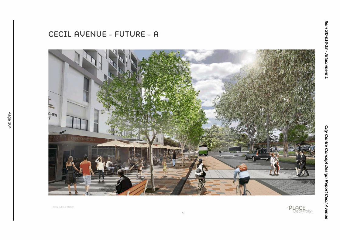
Item
SD
-016-1
8 - A
ttach
men
t 1
City
Cen
tre C
on
cep
t Desig
n R
ep
ort C
ecil A
ven
ue
Page 1
04
([
w
a:: ::::> ~
::::> u.
w
::::> z w
::::> ([
.....J ........ u w
u

Item
SD
-016-1
8 - A
ttach
men
t 1
City
Cen
tre C
on
cep
t Desig
n R
ep
ort C
ecil A
ven
ue
Page 1
05
3 0 z

Item
SD
-016-1
8 - A
ttach
men
t 1
City
Cen
tre C
on
cep
t Desig
n R
ep
ort C
ecil A
ven
ue
Page 1
06
w
::::> z w
::> a: ...J t-1
u w
u

Item
SD
-016-1
8 - A
ttach
men
t 4
Sch
ed
ule
of S
ub
mis
sio
ns
Page 1
07
018/ 59780
NO. TRIM NO.
1. Georgina
(018/59441 ) 2. C Brede
(018/59441 )
SCHEDULE OF SUBMISSIONS
Cecil Avenue West - Concept Design April 2018
llr CONTENT OF SUBMISSION
Excellent please hurry.
My three main concerns when looking at the concept plans are:
OFFICER'S COMMENTS
Noted.
a) Negotiating traffic to enter Carousel - which is I a) already difficult and is not improved by this plan.
The plan for Cecil Avenue is designed for the future context, enabling the Canning City Centre to accommodate up to 10,000 dwellings in transit oriented development adjacent to a train station in one of the State's designated Strategic Metropolitan Centres. The new traffic lights at Pattie Street will assist to alleviate the currently traffic issues experienced due to Carousel traffic.
b) The use of non-WA native plantings and trees -biodiversity should rnean WA natives, not introduced species, especially plants like Jacarandas which are recognised as weeds. It is cited in the environment strategy that there is to be a policy of increasing native planting and providing habitat and food for fauna and yet here is a missed opportunity to provide those; and
b) The choice of species for the City Centre project has been a topic of much discussion and research. The City has very well qualified and experienced staff involved with the project that along with the lead Landscape Architects finalised a palette of species based on a number of success criteria:
i) Ability to represent the design intent.
ii) Ability to thrive in an urban environment.
! I Page

Item
SD
-016-1
8 - A
ttach
men
t 4
Sch
ed
ule
of S
ub
mis
sio
ns
Page 1
08
018/59780
NO. I~ TRIM NO. ~ CONTENT OF SUBMISSION
c) The lack of any attempt at carbon offsetting. There I c) is a lot of paving and concrete in this plan. Why not include some green walls or roof spaces?
OFFICER'S COMMENTS
iii) Ability to provide benefit to the pedestrian.
iv) Reduced risk to the public and surrounding infrastructure.
Although the City would prefer to use strictly endemic species, the outcome of this choice would not be favourable in this urban context. The City however has recognised the need for native species and has identified clearly in both the draft Local Biodiversity Strategy and the draft Street Tree Strategy the need to focus on endemic species in certain areas. The Biodiversity Strategy has identified key corridors that will require the City to plant species that enhances the biodiversity and links key natural areas within the City and to other local government areas.
Approximately 95 x 500 litre trees (refers to the root ball size) will be planted in the verges and median strip of the new streetscape for Cecil Avenue, some in root cell structures and some within rain gardens. The new 5m wide footpaths will be constructed in high quality paving, and accommodate the new trees for greater shade and pedestrian amenity. The City has other
21 Page

Item
SD
-016-1
8 - A
ttach
men
t 4
Sch
ed
ule
of S
ub
mis
sio
ns
Page 1
09
018/59780
NO. ~ TRIM NO. ~ CONTENT OF SUBMISSION ~ OFFICER'S COMMENTS
sustainability measures when negotiating with developers to try to encourage green initiatives on buildings.
3. AMah I love the concept to transform Cecil Avenue and the Noted. surrounds into a modern and vibrant city centre. I
(018/59441) would like to see it go ahead as soon as possible. 4. G Galhenage Hi, this is exactly what the city needs, closer density Noted.
vibrant hubs that thrive with activity. Looking forward to (018/59441) seeing and enjoying tlle work. Great work City of
Canning! Possibly example to other council's too. 5. J Best Very excited about the whole project. It will make the Noted.
area a very vibrant and interesting place in which to (018/59441) live.
6. G Varian Glad to see Cannington moving in the right direction. I Noted. am looking forward to seeing Cecil Square becoming a
(018/59441) Cultural Centre with some great events.
I also hope the Light Rail Metro Net Plan goes ahead.
Glad to see Canning River being preserved. 7. C Cumming Please send me updates. Noted.
(018/59441) Will go onto 'Your Say Canning' with my comments. 8. No Name Please send me updates - notice of Council meetings Noted.
Provided. etc.
(018/59441)
3 1Page

Item
SD
-016-1
8 - A
ttach
men
t 4
Sch
ed
ule
of S
ub
mis
sio
ns
Page 1
10
018/59780
NO. ~ TRIM NO. ~ CONTENT OF SUBMISSION ~ OFFICER'S COMMENTS
9. Karin Kralupper Please send me updates. Noted and see comments at 2 above for landscape.
(018/59441) Please put as many trees/plants as possible. Please show more consideration to disabled people - The footpaths and streets will be designed for access to all areas. people of all abilities. Greenery on flat roofs.
More trees/shade for car parks. 10. AGoh Please send me updates. Noted.
(D18/59441) Very happy. 11. A Mitchell One way or 2 way Cecil Avenue? Noted and Cecil Avenue is two way.
(D18/59441) Please send me updates. 12. J Campbell Please send me updates. Noted.
(D18/59441} 13. S Ducey No comments provided . Noted.
(D18/59441) 14. Jodie Duong No comments provided at Rocks Ministry. Noted.
(D18/59441) 15. Canning Eye No comments provided. Noted.
Clinic
(018/59441) 16. D lndradjaja No comments provided. Noted.
(D18/59441)
4 1 Page

Item
SD
-016-1
8 - A
ttach
men
t 4
Sch
ed
ule
of S
ub
mis
sio
ns
Page 1
11
018/59780
NO. I~ TRIM NO. ~ 17. R Oktarina
(018/59441)
18. Seok
(018/59441)
CONTENT OF SUBMISSION
Council plans related to land locked/scheme Rd.
OFFICER'S COMMENTS
Noted. The matter of less access to Cecil Avenue from Leila Street is addressed in the
Please send me all mapping of the proposed I report at Paragraphs 20- 22. development.
I have questions re Queens Park Centre on zoning changes. Can you please contact me via email. Sealing the opening in the middle of Cecil Avenue will be inconvenient for motorists from Leila Street to turn right and enter Albany Highway faster. Please email updates.
The matter of Queens Park zoning has been passed on to Strategic Planning who will contact you. Noted. The matter of less access to Cecil Avenue from Leila Street is addressed in the Council report at paragraphs 20 - 22.
My only 2 concerns for this redevelopment of Cecil With regard to cycling, there are no bicycle Avenues are as follows: 1) Inconvenience for us to lanes proposed on Cecil Avenue. The access to Albany Highway heading to city. After the overriding design concept for the street is for redevelopments, we need to turn left at Cecil Avenue, a pedestrian and cycling friendly slower turn left again to Pattie Street and then turn left again at speed traffic environment. Wharf Street then enter Albany Highway. We are required to go a big round in order to reach Albany Highway and consume more petrol, which is not eco-friendly. Currently we can just turn right at Cecil Avenue and reach Albany Highway going towards city direction easily. 2) Consequences of adding bicycle lanes to encourage bicycle traffic. While we enjoy riding bicycles to the places we like, with the fairly new traffic ruling that requires motor vehicles to keep 1 - 1.5 meters away from bicycles will make the motorists worry and under pressure while driving along Cecil Avenue. Motorists are not just required to watch out for pedestrians crossing the road but also need to constantly be aware of bicycles which might just sway into the car lanes. Since there will be new bicycle lanes added to the Wharf Street and Liege Street as I was
S I Page

Item
SD
-016-1
8 - A
ttach
men
t 4
Sch
ed
ule
of S
ub
mis
sio
ns
Page 1
12
018/59780
NO. ~ TRIM NO. ~ CONTENT OF SUBMISSION ~ OFFICER'S COMMENTS
told at the Rocks Ministry consultation session on 12/4/18, is it possible to omit the provision of bicycle lane at Cecil Avenue? I was told that the lane is both for buses and bicycles, but if this lane is labelled for both then cyclists may thought they could actually cycle with high speed in this lane and may in tum, risk the safety of the pedestrians. All and all, I feel that people will not be able to relax crossing and using this avenue as there are too many different types of vehicles that carry different traffic rules may have impacts on each other. As a result of that, pedestrians' safety is in question.
19. 0 Pascoe Please send me a hard copy of Cecil Avenue Stage 1 Noted. Public Realm Concept Report.
(018/59441) 20. CWilson No comments provided. Noted.
(018/59441) 21 . M Poynton Please send me updates. Noted.
(018/59441) 22. Alex Keen to know what the Council is planning to do with Noted and the report covers off on the City
the Canning City Centre proposal Centre. (018/59441)
23. I Kruger Excellent Plan. Very exciting future. Noted.
(018/59441)
G I Page

Item
SD
-016-1
8 - A
ttach
men
t 4
Sch
ed
ule
of S
ub
mis
sio
ns
Page 1
13
018/59780
NO. I~ TRIM NO. ~
24.
25.
26.
A Kruger
(018/59441)
No name provided.
(018/59441) S Walker
(018/59441)
CONTENT OF SUBMISSION
Thoughtful detail design.
Ambitious concept that will make a substantially difference City Centre.
Good Luck! Good.
No comments provided at the Rocks Ministry meeting, however a wide ranging submission was received subsequently, with the points relevant to the Cecil Avenue consultation addressed below. (A copy of the full submission can be made available if required).
OFFICER'S COMMENTS
Noted.
Noted.
Cecil Avenue Main Street should construction in 2016.
have begun I The City Centre Regeneration Program was approved in April 2017.
Some aspects from your March 2018 Agendas item listing (that were not adequately covered in your I Noted. YourSayCanning link).
1. Clearly Scentre Group is still resisting any widening I The concept design allows for the works to works next to Albany Highway, adjacent to McDonalds. progress in conjunction with McDonald's
continuing operation.
2. Scentre Group wanting a completion of Cecil Avenue I The contract of sale allowed for this cessation main street works by 24/8/2018. How is that of works to occur. Service Relocations are reasonable? Cecil Avenue Main Street works should proposed to occur prior to August 2018. not stop in August 2018.
7 1 Page

Item
SD
-016-1
8 - A
ttach
men
t 4
Sch
ed
ule
of S
ub
mis
sio
ns
Page 1
14
018/59780
NO. I~ TRIM NO. ~ CONTENT OF SUBMISSION
The smart poles - I expected high tech poles?
I don't believe larger trees are needed. Unnecessary cost increase
City of Canning needs to have the details of all its project elements ready so when - in any year a State or Federal Government source/MP can immediately selecUproceed with. There have been many examples in Perth where Members of Parliament have gone on the hunt for something to fund in any non-election year. Therefore don't assume all decisions are made in the lead up to State/Federal Elections.
Your Advertising of this public comment: I think it was possibly not cost-effective.
Ten years is too long for Cecil Avenue Main Street to be constructed. Six years at most should be the Goal.
OFFICER'S COMMENTS
The City is using Smart Poles.
Trees are fundamental component of the new Cecil Avenue; providing mature trees provides an immediate impact and provides a high level of shade and amenity from the outset.
The plans for all of Cecil Avenue will be used to seek funding opportunities. The City is continuing to lobby both state and federal members.
The advertising included a range of mediums, including full page adverts in local paper, website (Your Say Canning), FAQs, social media, direct mail, face to face meetings and a community drop in session.
The current timeframe is 10 years over three distinct phases; the t iming could be reduced if funding is secured through state or federal government commitments.
Really disappointing to find out that Southern Link road I The Southern Link Road is not relevant to the construction being delayed until late in the year. Cecil Avenue Project; the land has recently
been acquired and the construction of this
8 1Page

Item
SD
-016-1
8 - A
ttach
men
t 4
Sch
ed
ule
of S
ub
mis
sio
ns
Page 1
15
018/59780
NO. I~ TRIM NO. ~ CONTENT OF SUBMISSION
All you needed was a quality pedestrian environment. To see the word 'high quality' used creates a risk that too much funding will be spent on that single element, when there are many other important elements of the Canning City Centre Activity Centre to be funded now.
OFFICER'S COMMENTS
road to Grey Street is programmed to commence later this year.
Cecil Avenue will be constructed in quality materials to create a much needed pedestrian amenity in the City Centre. There are a range of projects over the life of the Program that will be considered by Council in the future.
Do not want London Plane Tree. Ruined other areas of I London Plane Trees are considered to be the Perth. Alternative options? best suited tree to a main street environment
and are regularly chosen in Perth to provide the highest level of amenity and shade. It should be noted that the Public Realm Plan for the balance of the street tree planting in the City Centre uses native species.
This proposed 'intensive' watering of Cecil Avenue had I The planting of trees and greening of Cecil better not be rolled out elsewhere in Canning City Avenue requires irrigation which will come Centre. from improvements to the Coker Park bore.
Note 30km/hour is proposed. Agree low speed I Noted. environment. Presently difficult to get cars travelling slow on many sections of Cecil Avenue. Changing driver behaviour to get them to 40 km/hour will be difficult.
Overall, need to discourage private vehicle traffic away I Noted. from Cecil Avenue, particularly away from entering/exit ing the Carousel Shopping Centre via Albany Highway/Cecil Avenue intersection. Prefer private vehicles use other access points such as Liege Street, Grose Avenue, Southern Link Road, Lake
9 1Page

Item
SD
-016-1
8 - A
ttach
men
t 4
Sch
ed
ule
of S
ub
mis
sio
ns
Page 1
16
018/59780
NO. I~ TRIM NO. ~ CONTENT OF SUBMISSION OFFICER'S COMMENTS
Street, Carousel Road.
Worry costs of electronic signage. Is there a real need I Noted. for more than two (one at each end) electronic signs to say Roadworks ahead.
$10m Canning City Centre ten-year funded program that the Canning Council supported in April 2017, and also in the July 2017 budget:
They should not have approved it. The amount was too I The financial implications associated with the high for the facts which were already on the table. Long Term Financial Plan have been included
in the officer report.
A 'poor' deal from one of the major commercial The City secured significant upgrades and stakeholders, bullying/negotiating their way to bare contributions to infrastructure as part of the minimum on many aspects, does not deserve that sort Carousel Redevelopment. These comments of support from City of Canning. The public, and the are not considered relevant to the Cecil local government of Canning citizens have been let Avenue Concept Design. down massively.
By 2018 it appears that no timeframe is in sight or I The Canning City Centre Regeneration concrete for Scentre Group's Stage 2 Carousel Program is flexible and can be adapted to suit Upgrade. stakeholder requirements.
I noticed in December 2017 was a Metro Central JDAP I The commentary around the JDAP approval listing for Scentre Group regarding their hyped new is not considered relevant to the Cecil Avenue Albany Highway pedestrian bridge. Concept Design.
A lot of motor vehicle accidents on Albany Highway in I Noted. proximity to Cecil Avenue including the traffic signals recently, in the last two years.
10 I Page

Item
SD
-016-1
8 - A
ttach
men
t 4
Sch
ed
ule
of S
ub
mis
sio
ns
Page 1
17
018/59780
NO. I~ TRIM NO. ~
2 7. N Drake
(018/59441)
CONTENT OF SUBMISSION
Mr. Drake provided a 3 page submission with annotated plan which can be provided to Councilors in full but is summarized below: • Single lanes are proposed and are exactly what we
have now, which is why there is so much congestion.
• The drawings provided are misleading as they lack details such as traffic lights.
• The phase 3 traffic lights will be yet another impediment for traffic flowing along Cecil Avenue.
OFFICER'S COMMENTS
In order to accommodate the movement of people into, out of and within the Canning City Centre as it develops, the percentage of people using public transport, cycling and walking needs to increase. The Cecil Avenue (West) works provide for this change and the proposed traffic signals at Pattie Street I Shopping Centre will assist with improving the current right turn movements into and out of the Centre.
The following improvements should be incorporated: • The most important aim should be to obtain two I The additional two lanes that have been
lanes of general traffic in each direction along Cecil added to Cecil Avenue are dedicated public Avenue and removing the new choke points of transport lanes. single lanes.
• Do not put 'Urbanstone Pavers' across Albany P~vers will not be installed across Albany Highway at the pedestrian crossing. They will not Highway. The paving proposed for and remain solid and the joins within the adjoining structural design of Cecil Avenue can bitumen will be a constant problem. Pedestrians also accommodate the forecast traffic for the road. need a smooth pathway. There cannot be a guarantee that they will not move, cause by the cornering of vehicles exiting Cecil Avenue and the skewing pressure from tyres. When new they will be perfect, but it will be a difficult and very disruptive and expensive job to replace and repair them thereafter.
• Eliminate the 8 'Rain Garden Verqes'. They reduce
H I Page

Item
SD
-016-1
8 - A
ttach
men
t 4
Sch
ed
ule
of S
ub
mis
sio
ns
Page 1
18
018/59780
NO. I~ TRIM NO. ~ CONTENT OF SUBMISSION
the amount of space for roads, will get messy and unsightly and will need constant upkeep. Will they be watered during the long dry months? They are not suitable for busy roads and is not practical in this context.
• If footpaths are the correct width within the verges there, then eliminating the verges will stil l give footpaths that meet standards. This will aid additional width required for second traffic lanes.
• Reduce the width of the 'Median Strip' from the proposed 2.5m to gain more width for the second lanes.
• Reduce or delete 'Low Hedge Planting'. They create a pedestrian barrier into lots and require on-going maintenance and up-keep.
• Eliminate the choke point outside of the McDonalds exit from the Shopping Centre car parking into Cecil Avenue. This will allow cars to turn on to the left turn slip road onto Albany Highway.
OFFICER'S COMMENTS
Rain Gardens in the verges are an integral part of the water sensitive urban design of the concept plan and aid with 'greening' the City Centre.
The concept plan is not about meeting standards, it is about creating greater pedestrian amenity. The wide verge will also provide space for cyclists and alfresco dining.
The median is required to accommodate street lights, pedestrian refuge, traffic signal poles and restrict right turn access/egress. See point above.
Vehicles making this movement could simply turn left from the car park into Albany Highway. It is not good design to have vehicles turning from a crossover into a left turn pocket.
• Create two exit lanes f~om the car parking, one to 1 This would not meet Main Roads WA turn left and one lo turn 1nto the flow of traffic. standards.
The wide crossing point is there to enhance pedestrian safety and amenity. Should the number of people crossing Cecil Avenue midblock warrant a zebra crossing then it will be considered in the future.
• Officers stated there would not be a Zebra Crossing, the illustration displays one shown. This will disrupt traffic flow. A solution would be to have a normal crossing with a visual count down timer to work in time with the Pattie Street traffic lights.
• The illustration shows that Pattie Street is in line with I The Shopping Centre has constructed their the car park entrance to the shoooina centre but this carpark w1th the access road be~ng used as a
12 I Page

Item
SD
-016-1
8 - A
ttach
men
t 4
Sch
ed
ule
of S
ub
mis
sio
ns
Page 1
19
018/59780
NO. I~ TRIM NO. ~
28. EScott
(018/59441)
CONTENT OF SUBMISSION OFFICER'S COMMENTS
is not the case at present. Will a new one be built carpark now and converted to the access and the brand new one be demolished? Will there road as part of the Cecil Avenue works. The be a traffic queuing problem to get out of the traffic lights will not be synchronized with the shopping Centre? Will the lights be in sync with the Albany Highway traffic lights. Albany Highway traffic lights? Two lanes of moving traffic will make this work better.
• Reduce the redundant square meterage of brick paving abutting the petrol station exit corner. This will eliminate the choke point which creates one lane only for all traffic. Is the ultimate aim to ban right turns in?
• What will be achieved by spending millions of dollars on Cecil Avenue, if the concept plan is implemented without improvements?
• What benefits in traffic f low will be noticeable other than buses in their own lane?
• Please plan the area for reality, which is that the vast majority of patrons uti lize the motor vehicle due to distance, heat, age, weight or convenience.
Thank you for providing this information, somehow I missed earlier information concerning the information sessions, so am glad I have this opportunity. I am very impressed by the plans, and how they have been articulated, in guiding me to make my comments. However, I have not seen any reference to using environmental design to address community safety issues; I am sure that you are aware that this is a real issue for all of us who use this area regularly. As an example, there are no indications within your examples of large pedestrian spaces of control of lighting etc. Also, what a shame that the new Cannington Library was not part of this redevelopment, instead of being
Western Power infrastructure prevents the widening of the road at this location.
The road network for the City Centre as it develops relies on the construction of Sevenoaks Street, Southern Link Road, Lake Street Extension and Carousel Road Extension to distribute the traffic. The construction of these roads reduces the importance of Cecil Avenue as a major traffic route. Noted. The WAPC endorsed Canning City Centre Activity Centre Plan which is the approved planning framework covering the area makes clear reference to Crime Prevention Through Environmental Design (CPTED).
13 1Page
Item
SD
-016-1
8 - A
ttach
men
t 4
Sch
ed
ule
of S
ub
mis
sio
ns
Page 1
20
018/59780
NO. I~ TRIM NO. ~ CONTENT OF SUBMISSION OFFICER'S COMMENTS
29.
built on that horrid intersection, which makes it unattractive and less accessible than it should be.
Anonymous I Our office has been contacted by a concerned lady who Submission to works on Cecil Avenue in relation to the upgrade of Bill Johnston MLA Cecil Avenue.
Firstly, the City has fully acknowledged that there will be some disruption to businesses when the road works occurs, but will be working with the selected contractors to ensure this is minimized and that access is maintained throughout the works.
(018/59441) She feels the disruption, due to the works that will be carried out, will impact on people wanting to attend shops/businesses on Cecil Avenue, resulting in a loss in clientele. The works to Cecil Avenue are in two parts:
Furthermore, she advised she attended the Rocks 1 • Service Relocations commencing in May/June and finishing in August 2018; and
Ministry on Thursday 121h April to view the design and
speak with staff and claims she was told that Council had not secured any contractors to carry out the work, 1 • Main streetscape work (and any
relocations) nor had council successfully purchased the land on the Carousel side of Cecil Avenue. She is questioning how works can commence at the end of May if contractors have not been sought or the land purchased.
Also, she is asking if Council will consider
rema1mng service commencing February 2019.
Initial Service Relocations (May to August 2018)
compensating bu~inesses if indeed they lose customers I The initial works (where the City is due to the d1srupt1on. undertaking those works on behalf of the
service agencies) will occur predominantly within the 1Om corridor to the south side of Cecil Avenue within land currently owned by Scentre Group. Besides some minor traffic management arrangements that will be in place, these works will have a limited impact on the existing configuration of Cecil Avenue. The contractors appointed to do this work will be required to submit a traffic management plan that enables the safe movement of traffic
14 I Page

Item
SD
-016-1
8 - A
ttach
men
t 4
Sch
ed
ule
of S
ub
mis
sio
ns
Page 1
21
018/ 59780
NO. I~ TRIM NO. ~ CONTENT OF SUBMISSION OFFICER'S COMMENTS
and allows access to residences and businesses during the works. The timing of these works will depend on Council's resolution in May 2018, whether the City can secure early access agreements with Scentre Group before the purchase of the land is f inalised (settled) and the availability of the successful contractor to commence the works.
Other Service Relocations and Main Works (From February 2019)
Some communication providers will be undertaking works to relocate their existing assets to accommodate the upgrade; the City has received detailed quotes for this work to be undertaken. These providers have experienced contractors on staff who regularly undertake similar upgrade and relocation works, and it is anticipated that these works involve short term disruptions.
With the Main Works, contractors appointed by the City will be required to implement detailed traffic management plans and will need to liaise with affected businesses as part of the preparation for such plans. There will also be a requirement for the contractor to provide regular updates to businesses (which the City will also manage and distribute) and be available to address any concerns raised
15 I Page

Item
SD
-016-1
8 - A
ttach
men
t 4
Sch
ed
ule
of S
ub
mis
sio
ns
Page 1
22
018/59780
NO. I~ TRIM NO. ~
30. G Beacroft
(018/59441)
CONTENT OF SUBMISSION OFFICER'S COMMENTS
during the construction.
An FAQ sheet for the project was prepared for local businesses. It was posted on our website and made available at the community engagement event and it will give you further background information as to the proactive approach the City is taking. As previously mentioned, this project will cause some disruption which we intend to manage to the best of our abilities.
With regard to compensation, whilst there will be some managed disruption to traffic, it is not envisaged the works will compromise access and if required alternative arrangements may be made.
The Canning City Centre project is an ambitious City funded program of works over the next 10 years, designed to deliver much needed amenity for the City Centre and the people of Canning; the local businesses will only benef it in the long term from this investment.
The proposal to upgrade Cecil Avenue as part of the I Noted. above program is full of merit to make the Centre a vibrant and 24/7 attraction for Citizens and Visitors, the reasons for an upgrade are many and include the lack of public interaction with only car parks and business hours businesses on either side,
The proposed improvements however will be to the
16 I Page

Item
SD
-016-1
8 - A
ttach
men
t 4
Sch
ed
ule
of S
ub
mis
sio
ns
Page 1
23
018/59780
NO. I~ TRIM NO. ~
31. E McAuliffe
(018/59441)
CONTENT OF SUBMISSION
advantage of newly established outlets who will benefit from the release of land which at the moment is not available for use due to various reasons , the main one being the Power lines which at the moment are on the Carousel Centre land
OFFICER'S COMMENTS
This land is available to the City under the agreement When the City contemplates undergrounding which allowed the current shopping center extensions power in Phase 3 of the City Centre and with the under grounding of the power lines will Regeneration Program, Scentre Group will allow the owners of the Centre to develop a new line of pay their proportion. business premises alongside Cecil Avenue which should be grounds enough for a considerable amount of the cost to be borne by the Centre owners who will be gaining on two fronts and is an unfair burden on the Cities resources.
The proposed infill of the City Center with 10,000 units The Canning City Centre project is an and 25,000 residents is a recipe for disaster, a plan to ambitious City funded program of works over consider developer proposals on an individual basis the next 10 years, designed to deliver much considering more local congestion, and the chance of needed amenity for the City Centre and the creating ghettos, (must be considered) both will people of Canning; the local businesses will happen if most of the units are owned by speculators only benefit in the long term from this and rented out to put out a specific number is to invite investment. substandard proposals by developers who will use the figures to pressure approval and walk away from any future problems. Brilliant in depth insight to a great vision by the Council. I Noted. Very excited to see the implementation of the city centre. Exactly what the City needs to create an identity for the community to grow with and make the City of Canning an attraction to other residents and visitors of Perth.
17 I Page

Item
SD
-016-1
8 - A
ttach
men
t 4
Sch
ed
ule
of S
ub
mis
sio
ns
Page 1
24
018/59780
NO. ~ TRIM NO. ~ CONTENT OF SUBMISSION ~ OFFICER'S COMMENTS
32. K Kralupper I had a good look at the Canning City Centre project. I Noted. would prefer more public seating, more benches and See Item No.9 above for previous response
(018/59441) less pavement in the new centre. Pavement could be to Karin reduced without obstructing the pedestrians. More shrubs, benches, maybe some tables and chairs and small flower beds would make the area look so much more inviting. We have to remember that gradually the temperatures are rising worldwide and the more trees and greenery there is, the better. Another suggestion: in some European countries nowadays it is compulsory to plant flat roof with grasses, low shrubs, etc. to cool the surrounding down. How about considering that.
18 I Page

Item
SD
-016-1
8 - A
ttach
men
t 4
Sch
ed
ule
of S
ub
mis
sio
ns
Page 1
25
018/ 59780
NO. I~ TRIM NO. ~ CONTENT OF SUBMISSION OFFICER'S COMMENTS
33. J Duong on I We wish to bring to your attention a number of strong behalf of objections that we have with regard to the proposed Business Owners development of Cecil Avenue.
The substance of the comments made by the local businesses has been largely responded to in the Council report at paragraphs 13 -19. 22 and 24 Cecil
Avenue, Cannington
(018/59441)
As current business owners on Cecil Avenue, we are of I Noted. the view that the proposed development will have a serious impact on our businesses.
Part 1: Detrimental impact on local businesses and access to essential healthcare
a) With the proposed change, access (to 22 and 24 Cecil Avenue) off Pattie Street will be restricted to left in only due to the installation of traffic signals at Pattie Street.
Current ly, customers are able to access the parking area of 22 & 24 Cecil Avenue via Left or Right In & Out off Pattie Street
The position of crossovers immediately adjacent to the Pattie Street and Cecil Avenue is already contributing to congestion and traffic safety issues, and even without the proposed traffic lights being contemplated required addressing.
Restricting the traffic flow into our parking area will l it is noted that whilst the two crossovers will have a detrimental impact on our businesses. We be retained, right in and right out access foresee that customers will choose alternate would be restricted by median islands. businesses to attend if it is difficult to access ours.
A large proportion of our customers that currently I Noted, however access arrangements from frequent our businesses are elderly with multiple the City's road network cannot be maintained health conditions, impaired mobility and poor as per existing. vision. They rely heavily on easy access, direct to door parking to the businesses, which is currently available. However with the proposed change, access (to 22 & 24 Cecil Avenue) is restricted and
19 I Page

Item
SD
-016-1
8 - A
ttach
men
t 4
Sch
ed
ule
of S
ub
mis
sio
ns
Page 1
26
018/59780
NO. I~ TRIM NO. ~ CONTENT OF SUBMISSION
therefore will impact negatively on the accessibility of these essential services for our elderly customers.
OFFICER'S COMMENTS
Looking at the entire Canning City Centre Plan, we can The Canning City Centre project is an see how the community will benefit with the proposal to ambitious City funded program of works over revitalize the Canning City Centre and realize its the next 10 years, designed to deliver much potential as a Strategic Metropolitan Centre of Perth. needed amenity for the City Centre and the With the goal of creating a vibrant city centre to improve people of Canning; the local businesses will lifestyle, employment, recreational and entertainment only benefit in the long term from this opportunities. We also see the value of a more investment. balanced level of access for the various transport modes (pedestrians, cyclists, public transport and motorists).
We don't disagree that the intersection of Cecil Avenue I Noted. and Pattie Street can be quite chaotic at times and a change is necessary for the safety of all its road users.
As a result we would like to propose an alternate solution to allow greater access to our properties(@ 22 & 24 Cecil Avenue).
Currently there is a Left In & Out at 24 Cecil Avenue into our car park. This entry is mostly being util i.zed as an exit as 90% of the customers use the Pattie Street entrance as the entry point.
We propose for a break in the median strip on Cecil Avenue to allow a Right turn (in only) off Cecil Avenue into our car park. We believe this not only will help to balance the access issue with the proposed installation of the traffic signal but wi ll also help to alleviate traffic
Copy of Map circulated to Councillors. The City's Engineer and Consulting Engineer (Porters) have reviewed the proposed amendment to the plans and have advised that creating such a break in the median, midaway through a right turn pocket associated with the traffic lights along Cecil Avenue, would introduce traffic safety concerns which would also not meet Main Roads WA requirements.
20 I Page

Item
SD
-016-1
8 - A
ttach
men
t 4
Sch
ed
ule
of S
ub
mis
sio
ns
Page 1
27
018/59780
NO. I~ TRIM NO. ~ CONTENT OF SUBMISSION
congestion at Cecil Avenue and Pattie Street junction.
If Council objects to this proposal, we are open to any other suggestions that you may have to combat access to our carpark issue.
We would be grateful if council would take our concerns and proposal into consideration when deciding this application. We would welcome the opportunity to meet with a representative of the planning department to discuss further on the matter at hand. Should council decide to approve the application and reject our proposal, we would consider requesting the council compensate us for tt1e loss of business that this proposal will likely cause.
Part 2: Impact during major works scheduled for 2 019.
As the major physical streetscape works is scheduled to commence in February 2019 with completion by the end of 2019. We want to highlight areas of concerns and hope that it be high on the list of considerations for the appointed contractors.
OFFICER'S COMMENTS
As noted at paragraph 18 of the Council Report the City is actively seeking to explore additional short to medium term access opportunities which need to be further considered with other property owners. The officer recommendation requires officers to present on options explored and potential solutions prior to the commencement of the main works in February 2019.
As mentioned , this project will cause some disruption which we intend to manage to the best of our abilities. With regard to compensation, whilst there will be some managed disruption to traffic, it is not envisaged the works will compromise access and if required alternative arrangements may be made.
With the Main Works, the contractors appointed by the City will be required to implement detailed traffic management plans and will need to liaise with affected businesses as part of the preparation for such plans.
Although we understand there will be a certain level of I The City is putting into a place a plan that will
21 I Page

Item
SD
-016-1
8 - A
ttach
men
t 4
Sch
ed
ule
of S
ub
mis
sio
ns
Page 1
28
018/59780
NO. I~ TRIM NO. ~ CONTENT OF SUBMISSION OFFICER'S COMMENTS
unavoidable disruptions. Our concerns are not without merits. attempt to address the issues caused by the as we have already experienced firsthand the chaos that was development of Momentum and is speaking associated with the construction of the Momentum to the same developer ahead of their works Apartments@ 18 Cecil Avenue, and the ongoing major on Pattie Street. renovations at Carousel There has been excessive congestion along Albany Highway and Cecil Avenue and There will be a requirement for the contractor trades people as well as Carousel shopping centre customers to provide regular updates to businesses using our parking, which are reserved for our customers. This (which the City will also manage and could have been avoided with better traffic management distribute) and be ava ilable to address any controls. concerns raised during the construction.
We would like the council to further negotiate:
a) Traffic management plans for the streetscaping works to I Noted. The City will liaise with local be available for public viewing, and allow public businesses when the Traffic Management comments and feedbacks before works commence. Plan is being prepared.
b) Local works depot. Where will it be located? Will I This will need to be considered as part of the sufficient parking be allocated to cater for trades people Traffic Management Plan. so as not to take up or block customer dedicated parking.
c) Controlled hours of operation (off peak times) and other I Noted. restrictions that might make the duration of the works less disruptive for the local businesses.
d) We request council fund handout flyers for customers to I Yes, the City will work with the local outline what to expect in terms of traffic flow well in businesses to ensure this can occur. advance of the project commencing.
We would like to thank the Council in advance for taking the I Noted. time to read and consider our submission. We are a group of very concerned businesses that have operated in our current locations for up to 20 years, and would be grateful for council's
22 I Page
Item
SD
-016-1
8 - A
ttach
men
t 4
Sch
ed
ule
of S
ub
mis
sio
ns
Page 1
29
018/ 59780
NO. ~ TRIM NO. ~ CONTENT OF SUBMISSION ~ OFFICER'S COMMENTS
serious consideration on the matter. Please do not hesitate to
I
contact us should you require further information or discussions.
34. Mr Puca We are the owners of 24 Cecil Avenue and believe your Noted. Please see comments at no. 33 plans will cause harm to the value of our property and above.
(018/59441 ) also be a negative influence to our tenant's business due to difficulty in accessing the property as a result of the median strip being installed at Pattie Street intersection.
How do you propose to compensate us as owners and also the tenants who have outlaid some $400k on a new fit out?
We look forward to your communication regarding our concerns.
35. M Shrekelli I bet hobos will congregate on this place furthermore. Noted.
(018/59441) 36. P Zanotti Great design I think it is well and truly due to have this Noted.
area turned into a vibrant and family safe area. (018/59441 )
23 I Page

Item EN-011-18 - Attachment 1 City of Canning Cycling and Walking Plan & Appendix
Page 130
O a. ~~ityoj
CANNING
Cycling and Walking Plan
City of Canning
IW 167800-0000-CT -RPT -0001
Final
18 September 2017

Item EN-011-18 - Attachment 1 City of Canning Cycling and Walking Plan & Appendix
Page 131
Cycling and Walking Plan
Cycling and Walking Plan
Project No:
Document Title:
Document No.:
Revision:
Date:
Client Name:
Client No:
Project Manager: Author:
File Name:
IW167800
Cycling and Walking Plan
IW 167800-0000-CT -RPT -0001
Final v7
15 September 2017
City of Canning
Client Reference
A. Sun, L. Fogarty A. Sun, E Richardson, L.Fogarty, L. Donovan
J :\IE\ Projects\06_ Central West\IW167800
Jacobs Group (Australia) Ply Limited ABN 37 001 024 095 11th Floor, Durack Centre 263 Adelaide Terrace PO Box H615 Perth WA 6001 Australia T +61 8 9469 4400 F +61 8 9469 4488 www.jacobs.com
~ityof JACOBS' CANNl G
C Copynght 2016 Jacobs Group (Australia) Pty Limited. The concepts and information contained in th1s document are the property of Jacobs. Use or copying of this document in whole or in part without the written permission of Jacobs constitutes an infringement of copyright.
limitation: This report has been prepared on behalf of, and for the exclus1ve use of Jacobs' Client, and is subject to, and issued in accordance w1th, the
provisions of the contract between Jacobs and the Client. Jacobs accepts no liability or responsibility whatsoever for, or in respect of, any use of, or reliance
upon, this rep<>rt by any third party.
Document history and status
Description
Draft for internal review/release to
IN 11o500 0000 C. T RPT 001

Item EN-011-18 - Attachment 1 City of Canning Cycling and Walking Plan & Appendix
Page 132
Cycling and Walking Plan G:cityof dACOBS' CANNI G
Contents
Executive Summary ......................................................................................................................................... 1
Part 1 Strategic Section ................................................................................................................................... 8
1. Introduction .........•................................................................................................................................ 9
1.1 Objective ..................................................................................................... ........................................... 9
1.2 Structure of this Plan .............................................................................................................................. 9
2. Current Cycling and Walking in Canning .......................................................................................... 11
2.1 Population and Potential Growth ..................................................................... ........................ ............. 11
2.2 Mode Share Trends .... ............................... .......................................................................................... 12
3. Role and Benefits of Cycling and Walking ........................................................................................ 15
3.1 Role of Cycling and Walking ............... ..................................................... .... ............................ ............. 15
3.2 Reducing Traffic Congestion ................................................................................................................ 15
3.3 Environmental Benefits ....................................................................... ................................................. 16
3.4 Improved Health and Fitness ................................................................................................................ 16
3.5 Reduced Road Trauma ........................................................................................................................ 16
3.6 More Cost Effective Transport lnfrastructure ...... ................................................................................... 16
3.7 Independent Travel Options .................................................................................................... ... .......... 17
3.8 Improved Social Cohesion ....................................................................... ........................................... .. 17
3.9 Economic Benefits to Private Business ................................................................................................. 17
3.10 Economic Benefits to Individuals .......................................................................................................... 19
4. Review of Policies, Strategies and Guidelines ................................................................................. 20
4.1 Integrated Transport Strategy ............................................................................................................... 20
4.2 Canning City Centre Movement Access and Parking Strategy (MAPS) ................................................. 20
4.3 City of Canning Sustainability Policy ....................... ................................................................. ............. 21
4.4 City of Canning Housing Strategy ............................................................................................ ............. 21
4.5 City of Canning Community Safety and Crime Prevention Plan ............................................................. 22
4.6 City of Canning Disability and Inclusion Plan ................................................... ........................... .......... 23
4.7 City of Canning Existing Bicycle Plan ................................................................................................... 24
4.8 Guideline for Developing a Bicycle Plan ......... ...................................................................................... 25
4.9 Cycling lmagineering Workshop Report ................................................................................................ 25
4.10 DoT/Main Roads Planning and Designing for Pedestrians .................................................................... 26
5. Data Collection and Analysis ............................................................................................................ 27
5.1 Identification of Key Attractors .............................................................................................................. 27
5.2 Crash Data and Analysis ...................................................................................................................... 28
5.3 Strava ............. ........................... .......................................................................................................... 31
5.4 Saddle Surveys ....................................................................................... .................... ......................... 31
6. Community and Stakeholder Engagement ....................................................................................... 33
6.1 Consultation Strategy ........................................................................................................................... 33
6.2 Key Stakeholder Responses ...... ................ ............................................................................. ............ . 33
6.2.1 Workshop 1 .......................................................................................................................................... 33
6.2.2 Workshop 2 ............. ....... ......................................................................... ................................ ............. 34
IN 11 )5()0 0001) c T RPT 0001

Item EN-011-18 - Attachment 1 City of Canning Cycling and Walking Plan & Appendix
Page 133
Cycling and Walking Plan @ cltyof JACOBS' CANNING
6.3 Community Response .......................................................................................................................... 34
6.3.1 Schools .... ............................................................................................................................................ 34
6.3.2 General Community ................................... ............... .............................................................. ............. 35
7. Vision, Principles and Targets ........................................................................................................... 38
7.1 Vision for Cycling and Walking in Canning ............................................................................................ 38
7.2 What Increases Cycling and Walking? Case Studies in Other Cities ......................... ............................ 38
7 .2.1 Cycling ................................................................................................................................................. 38
7.2.2 The Hague ...................................................................................................................................... ..... 39
7.3 Relationship Between Cycling and Train Stations ................................................................................. 40
7.4 Planning Principles for Cycling and Walking ...... ................................... .................................. .... ......... .41
7.5 Mode Share Targets ... ................................................................................ ................................... ..... .41
7 .5.1 Cycling Mode Share Targets ............................................................................................................... .41
7.5.2 Walking Mode Share Targets .................................................................. ................................ ........... . .42
7.5.3 Overall Mode Share Targets - City of Canning ......................................................................... ... .......... 42
8. Strategies to Increase Cycling and Walking in Canning .................................................................. 43
8.1 Land Use .................... ........................................................................................................................ .43
8.2 Develop Safe Connected Network .................. .................................. ....................................... ... ......... .43
8.3 Change Mind set Through Education .................. ............................... ................................................... .43
8.4 Develop and Implement Travel Plans .................................................................................................. .44
8.5 Policy Development for Improved Safety and Accessibility .. .............. .... .................... .......................... . .44
8.6 More Tree Cover and Shade ...... ................................................................. ........................ ................. 44
Part 2 Implementation Section ...................................................................................................................... 45
9. Funding .............................................................................................................................................. 46
10. Cycling and Walking Network ............................................................................................................ 47
10.1 Legislation Change ................................................................................................................. ............ .47
10.2 Design Guidelines ................................................................................................................................ 47
10.2.1 Cycling ............ .................................................................................................................................... .47
10.2.2 Walking ........... ............................................................................................ ........ ................................. 49
10.3 Network Plan lmplementation ............. ........... ............... ........ .... ....................................................... ... .. 50
10.3.1 Cycling Network Improvement Options ........................................................ ......................................... 50
10.3.2 5 Key Routes and Other Links ................................................................................................. ............. 53
10.3.3 Canning City Centre ............................................................................................................................. 54
10.3.4 Assessment, Costing and Prioritisation .................................................................................... ............. 58
10.3.5 Pedestrian lmprovements ................ ... ...................................... ............................................................ 62
10.3.6 Considerations for Aged Care Residents and Mobility Scooter Users .................................................... 63
10.3.7 Pedestrian/Cycle Bridge Over Freight Rail Line ................................................................... ........... .... .. 64
11 . Changing Behaviour .......................................................................................................................... 66
11 .1 TraveiSmart!Your Move Officer ............................................................................................................ 66
11 .2 Identifying Target Groups for Promotion and Behaviour Change Programmes ...................................... 66
11.3 TraveiSmart!Your Move and Personalised Travel Planning Programmes ...... ........................................ 67
11 .3.1 TraveiSmart and Your Move .............................. .............................................. ........................ ............. 67
IN 1155CO 0000 c T RPT 0001 Ill

Item EN-011-18 - Attachment 1 City of Canning Cycling and Walking Plan & Appendix
Page 134
Cycling and Walking Plan ~•yof "Acoas· CANNING
11.4 Demonstrating How Cycling and Walking Integrate with Other Forms of Mobility .................................. 68
11.5 Wayfinding ........................................................................................................................................... 69
11.6 Reducing Car Use, Re-educating Drivers .................................................... ........................ ... ............ .. 71
11.7 Travel Plans and Parking Requirements During Development Approval Process ..................... ............. 72
11 .8 Bicycle Parking, End of Trip (EOT) and Maintenance Facilities ............................................................. 72
11 .9 Bike Share Schemes ............................................................................................................................ 74
12. Summary and Recommendations ..................................................................................................... 75
12.1 Summary ................ .......................... ................... ................................................................................ 75
12.2 Recommendations ............................................................................................................................ ... 82
Appendix A. Strava Data
Appendix B. Saddle Survey Results
Appendix C. School Survey Results
Appendix D. Community Survey Results
Appendix E. Community Identification of Places Needing Cycling and Walking Improvements
Appendix F. Intersections/Crossings Requiring Assessment
Appendix G. Implementation Plan
Appendix H. Maps
IN 1165CO 0000 c. T RPT 001 v

Item EN-011-18 - Attachment 1 City of Canning Cycling and Walking Plan & Appendix
Page 135
Cycling and Walking Plan & ,YlJf .JACOBS' CA NTNG
Executive Summary
The City of Canning (the City) recognises that increasing cycling and walking will result in lower levels of driving which will lead to a range of societal benefits including reduced congestion, improved social cohesion, improved levels of health and fitness, and economic and environmental benefits across the region. The City has worked collaboratively with key stakeholders to develop a vision and strategies for increased levels of cycling and walking that will transform how people will travel around the City.
Vision
Cycling and walking will be a safe, attractive and viable travel option between
neighbourhoods and destinations within the City of Canning and beyond.
This vision is fundamental in engendering change in how people travel in the City. The City of Canning will work to forge partnerships, educate the community and design and implement facilities that are both safe and attractive for use.
Need for Cycling and Walking in Canning A number of City of Canning strategic documents recognise the need for cycling and walking to be given a high profile. These include the:
• Strategic Community Plan - that will guide the development of the City over the long term. It identifies a Community Goal to have integrated, accessible, safe and sustainable transport options for the City. One of the ways this goal will be achieved is via the provision and continued improvement of pedestrian and cycling infrastructure and pathways. Integrated Transport Strategy - that considered all forms of transport in the City. It stated that walking was an often-neglected form of transport that had considerable potential to replace many short- length car trips. With regards to cycling, it found that cycling is becoming a more popular mode of transport and that uptake could be increased if better facilities were available.
• City of Canning Sustainability Policy - which defines sustainability and aims to embed sustainable practices into the City's planning and decision making processes. Transport has been identified as a key area where sustainability improvements can be made.
Planning Principles The planning principles for both cycling and walking in the City have been based on principles originally developed in the Netherlands for cycling. They are:
Attractiveness - each route should feel attractive to use and include a feeling of personal safety for users.
Coherence - there should be a choice of routes and the network should be legible and easy to use.
Comfort - surfaces should be smooth and well maintained and shading should be provided along paths. Continuity of movement along the route should be preserved.
Directness - direct routes with no unnecessary detours to provide journey times by bicycle that are competitive with the car.
Safety - separate cyclists from motorists and pedestrians where necessary, but allow mixed use along low speed, low volume streets. Design should be predictable in terms of alignment and priority.
Cycling Mode Share Targets
Currently cycling mode share in the City is about the metropolitan average but well below that in the best performing municipalities in Perth. The mode share targets for cycling in the City of Canning are:
• Short term to 2021 - 4% mode share;
IN 11 >5C0 0001) c T RPT 001

Item EN-011-18 - Attachment 1 City of Canning Cycling and Walking Plan & Appendix
Page 136
Cycling and Walking Plan & ,YIJf JACOBS'
• Medium tenn to 2031 - 6% mode share; and
Long term to 2051 - 10% mode share.
Walking Mode Share Targets
CA NING
Walking mode share within the City of Canning is estimated to be a little lower than the metropolitan average of about 10%. Walking mode share to work is very low at less than 2%, well below that of the City ·Of Subiaco which enjoys 12.4% mode share for walking to work and an all modes mode share approximately 20%. The walking mode share targets for the City are:
• Short tenn to 2021 - 11% mode share;
• Medium tenn to 2031 - 14% mode share; and
• Long term to 2051 - 18% mode share.
Within activity centres the walking mode share should be set to a higher level. The target mode share for walking to and within the Canning City Centre is:
• Medium term to 2031 - 15% mode share; and
• Long term to 2051 - 20% mode share.
Strategies to Increase Cycling and Walking
Six broad strategies have been adopted by the City of Canning to increase the uptake of cycling and walking:
Land use change at activity centres, along activity corridors and transit oriented developments (TODs) around rail stations.
• Plan and implement a safe connected bicycle network that provides viable and direct linkage to the key activity centres, rail stations, schools, shops and other attractions.
• Change the mind set of planners, decision makers and daily travellers through education programmes.
• Develop travel plans and introduce behaviour change programmes.
• Develop policies that support best practice to improve accessibility and safety for cyclists and pedestrians.
• Provide for greater shading and tree cover for pedestrian and cycling paths.
Funding Funding for cycling facilities in the Perth metropolitan area and in the City of Canning is currently below the level required to achieve the proposed mode share targets. The recommended annual funding for cycling should be increased to $15 per head of population by 2021, increasing to $20 per head of population by 2031. The City's share of this funding should increase to $750,000 per annum in 2021 and rise to $1.25 million by 2031. Equivalent levels of funding should be sought from the State and Commonwealth governments, increasing overall funding for cycling in the City to $2.5 million by 2031, or $20 per head of population.
Cycling Network Plan The proposed cycling network plan is shown in Figure E1 (this map is provided at A3 size in Appendix H, Map 5). It provides a connected network of off road shared paths and bicycle lanes complemented by bicycle boulevards along low speed, low volume streets. At the heart of the plan are five major bicycle routes which are shown in Figure E2 (this map is provided at A3 size in Appendix H, Map 6). These routes connect to major activity centres such as the Canning City Centre, Curtin University, major schools and rail stations. It is recognised that some of the routes will need to be extended beyond the City's boundaries to connect to for example, major rail stations and the Perth City Centre. In this regard, discussion will need to be held with neighbouring councils. Further detail on the proposed major bicycle routes is contained in Section 10. The implementation timeframe for constructing the major bicycle routes wil l be dependent on the level of funding and is discussed in Section 10 of this report. A completion date for the five major routes of between 2023 and 2025 has been proposed.
IN 11 >5C0 0001) c T RPT 001 2

Item EN-011-18 - Attachment 1 City of Canning Cycling and Walking Plan & Appendix
Page 137
Cycling and Walking Plan @ Ci,yct .JACOBS' CANNING
Figure E1 : Proposed City of Canning path network
IW 116500 0000 CT RPT 0001 '3

Item EN-011-18 - Attachment 1 City of Canning Cycling and Walking Plan & Appendix
Page 138
Cycling and Walking Plan ~ty iJf JACOBS' CANNlNG
Figure E2: Proposed routes in the City of Canning path network
IN 11 >500 0000 c T RPT 001 4

Item EN-011-18 - Attachment 1 City of Canning Cycling and Walking Plan & Appendix
Page 139
Cycling and Walking Plan @ CityDf JACOBS'
CANNING
Improving the Pedestrian Network A comprehensive network of footpaths exists throughout the City of Canning but a degree of segregation exists where high volume, relatively high speed roads pass through centres and communities. A program to investigate safer, improved pedestrian crossings of major roads is proposed, including reducing waiting times for pedestrians at traffic si,gnals where feasible. This will require negotiations with Main Roads (MRWA). A number of pedestrian improvements have been proposed as part of planning for the Canning City Centre and some have been approved as conditions of development of the Westfield Carousel shopping centre. This includes a new pedestrian overpass over Albany Highway to link the proposed residential development on the south side of Albany Highway with the main retail centre. Plans for a main street along Cecil Avenue are also well developed. The preliminary design provides for a shared path along Cecil Avenue.
Choice of Cycling Facilities Austroads has provided recommendations on when it is appropriate for cyclists to travel along local streets in mixed traffic, when bicycle lanes could be recommended and when separate paths are preferred (refer to Figure E3). Complementing this are guidelines on where pedestrian and cyclist shared paths are appropriate and where separate cycling and walking paths are likely to be required based on the number of cyclists and pedestrians (refer to Figure E4). There guidelines have been used to determine the most appropriate type of facility to construct as part of the cycling network.
Figure E3: Recommended traffic volume/speed thresholds and cycle infrastructure (Source: Austroads) Volume. o( m<><o• v~hkl~• (vehicle)/ d>y) 11.000
11.000
10.000
•.ooo
1.000
5.000
'000
0 ~ ~ ~ • ~ 60 ~ CIICI<NIO 19'1J, DEl.C lt!/9, 0NllOOO,SOS"rAWS. I091
IN 1165CO 0000 c T RPT 0001

Item EN-011-18 - Attachment 1 City of Canning Cycling and Walking Plan & Appendix
Page 140
Cycling and Walking Plan
The Department of Transport has advised that all future shared paths should be a minimum of 2.5 metres wide. Whilst 2.5 metres is an appropriate standard width for most shared paths, reference should be made to Figure E4 where volumes of cyclists and pedestrians are high. It is now legal for cyclists to cycle on footpaths unless specifically prohibited. It is expected that cyclists using footpaths would travel at low speeds and give way to pedestrians at all times. The standard width of these footpaths should remain at 1.5 metres, except where there are high volumes of pedestrians (for example, at shopping centres).
Bicycle lanes should be a minimum of 1.5 metres wide and are suitable for construction along neighbourhood connectors with a speed limit of 50kmfh or less and a daily traffic volume of less than 7,000 vpd. Bicycle lanes can also be considered along slightly higher volume roads, but on such roads it is advised that bicycles be separated from general traffic, for example by raising the bicycle lane slightly above the road surface by use of a mountable kerb. On higher volume roads, with high volumes of cyclists, separated one-way cycle lanes along the verge are preferred. A minimum buffer of 0.7 metres should be provided between the cycle lane and the adjacent road or parking.
Figure E4: Treatment of paths to be used by pedestrians and cyclists 200
180
160
~ 140 ;x
! 8. 120
"' ~ 1 100
.. c
~ 80
: ! 60 0 <i z 40
20
No. ol cyc1sts (~Wo-Way per peak hour)
Bicycle boulevards are a new type of bicycle facility. They would generally be constructed on low volume streets and a speed limit of 30kmfh would be applied. At the current time there are no specific design standards and the Department of Transport is encouraging councils to develop innovative designs in consultation with the Department and to monitor their operation.
Behaviour Change Programmes The City of Canning recognises that a significant increase in cycling and walking will not be achieved through infrastructure improvements alone. A range of behaviour change programmes are proposed in this report to increase cycling and walking and to reduce the proportion of trips made as car drivers. It is proposed that the City of Canning employ a Travel Smart Officer with specific responsibilities to achieve high levels of cycling and walking as a part of a more integrated and safe transport system. Other measures aimed at encouraging greater levels of cycling and walking are recommended in the report. These include:
I.V 11 )5(;0 0000 C T RPT C001 6

Item EN-011-18 - Attachment 1 City of Canning Cycling and Walking Plan & Appendix
Page 141
Cycling and Walking Plan ~ity cf .JACOBS' CANNING
• Provision of end of trip facilities (bicycle parking and lockers and showers for cyclists, joggers and pedestrians). Rates for bicycle parking, showers and lockers are proposed for consideration as a condition of development approval.
• Individualised marketing programmes such as TraveiSmart or Your Move designed to increase walking, cycling and public transport use and reduce the proportion of car driving.
• Wayfinding and improved signage to improve the legibility of cycling and walking routes and encourage greater use.
• Media campaigns to increase driver awareness of cyclists and pedestrians and encourage more peaceful co-existence between all road users.
• A variety of demand management measures designed to encourage cycling and walking and provide some discouragement of excessive driving (refer to Section 11.6).
• Proactive travel planning to encourage more cycling and walking to schools, to rail stations and to major office and retail developments.
tN 11 )sco ooon c. r RPT oo1

Item EN-011-18 - Attachment 1 City of Canning Cycling and Walking Plan & Appendix
Page 142
Cycling and Walking Plan @ a,y cf JACOBS' CANNlNG
Part 1 Strategic Section
tN 11 )sco ooon c. T RPT 001 6

Item EN-011-18 - Attachment 1 City of Canning Cycling and Walking Plan & Appendix
Page 143
Cycling and Walking Plan &1y ct JACOBS' CANNING
1. Introduction
1.1 Objective
Cycling and walking are healthy, environmentally-friendly and sustainable forms of transport. Increased walking and in particular, increased cycling, has the potential to reduce the level of car driving for daily transport journeys. This can result in significant benefits including less congestion, less use of petrol and fossil fuels, improved health and fitness within the community and financial savings to governments from reduced expenditure on road infrastructure. Additionally, people who cycle and walk may make f inancial savings due to reduced driving and parking costs and in some instances, a lower level of car ownership.
In recognition of the above, the City of Canning is keen to increase cycling and walking within its boundaries. It has articulated a vision and objectives in its Integrated Transport Strategy to facilitate and encourage increased travel by active and public transport. This is in line with state government objectives to encourage local governments to create cycle-friendly infrastructure, which enables people to reach all destinations safely and conveniently by bicycle. Many of the provisions made for cyclists also assist pedestrians. Pedestrians too, require connected, safe, attractive and convenient routes to traverse. Behaviour modification and demand management are just as important as infrastructure provision in encouraging the uptake of cycling and walking. The promotion of cycling and walking can be aided at the local level by planning scheme provisions and the employment of a Travel Smart Officer. In addition, state government can provide design guidance for cycling and walking infrastructure and allocate appropriate funding to local government so that it can build the infrastructure.
The City of Canning has worked with various key stakeholders to produce this Cycling and Walking Plan. The objective of this document i'S to lay out a vision and a long term strategic plan, thereby providing a framework for the development, over time, of a cycling and walking friendly city. It will guide the City towards achieving a practical, appropriately resourced active transport system designed to significantly increase the mode share of daily cycling and walking trips.
1.2 Structure of this Plan
This Plan is presented in two parts. Part 1 (Chapters 2 to 8) focusses on the development of a vision and strategies for the increased uptake of cycling and walking. Part 2 (Chapters 9 to 11) indicates how these strategies could be implemented in the City of Canning.
Chapter 2 provides information about the population characteristics of the City of Canning. It goes on to discuss the level of mode share cycling and walking have in the City at present and then looks at the factors that influence mode share trends.
Chapter 3 looks at the benefits the City can expect to realise by promoting cycling and walking and making these viable transport options. Benefits can be social, economic or environmental and can occur both at the local area level and the individual personal level.
Chapter 4 incorporates a review of applicable policies and the City of Canning's existing bicycle plan.
In Chapter 5 the available crash data and other data are analysed. A desktop exercise is conducted to identify the key attractors in the City. The results of the saddle survey are presented and discussed.
Chapter 6 details the community and stakeholder engagement as undertaken. Most notably this was in the form of two key stakeholder workshops. Input from the first workshop informed the vision, principles and strategies to be applied in the City and at the second workshop, participants firmed up the cycling and walking path network espoused for Canning. With regards to community engagement, schools were given the opportunity to comment on the cycling and walking routes around their schools. City of Canning residents were given the opportunity to participate in a survey asking about their cycling and walking habits. They were also asked to identify areas in the City that need walk or cycle improvements by pinpointing the places on an online map.
1>"111 500 0000 c T RPT 001 !l

Item EN-011-18 - Attachment 1 City of Canning Cycling and Walking Plan & Appendix
Page 144
Cycling and Walking Plan ~ity cf .JACOBS' CANNING
Chapter 7 articulates the vision, principles and targets developed in the City to increase the uptake of cycling and walking. It states the mode share that the City can aim for based on the results achieved by other cities.
Chapter 8 details the strategies to be employed to increase cycling and walking in the City. These are based on strategies developed by Dutch transport planners and have been refined to suit the City of Canning's local circumstances.
Chapter 9 discusses the level of funding the City of Canning will need to allocate and/or secure in order to deliver the cycling and walking strategies. It advises on long term funding options.
Chapter 10 proposes an integrated network of foot and cycle paths for the City of Canning. There are five major routes through the City as well as a number of other identified links. Each route or link is split into sections, which have been assessed, prioritised and allocated to a works year between 2018 and 2036. An indicative cost for each project is also provided.
Chapter 11 outlines the promotion and behaviour change techniques that can be employed to complement the cycling and walking infrastructure improvements. It also discusses the employment of a Travel Smart Officer.
Chapter 12 concludes the report and provides recommendations.
tN 11 )sco ooon c. r RPT oo1

Item EN-011-18 - Attachment 1 City of Canning Cycling and Walking Plan & Appendix
Page 145
Cycling and Walking Plan ~itycf JACOBS' CANNlNG
2. Current Cycling and Walking in Canning
2.1 Population and Potential Growth
The City of Canning lies in the south-east of the Perth metropolitan area (see Figure 2.1 ). It is approximately ?km from the Perth CBD. The City comprises a number of residential suburbs as well as commercial and industrial areas. It is serviced by the Armadale rail line. Major roads passing though the City include Albany Highway, Leach Highway and Roe Highway. The City Canning already has expansive footpath and bicycle path networks (refer to Appendix H, Maps 1 and 2). Part of the challenge will be ensuring that these are sufficient to serve both walkers and cyclists, now and into the future.
Figure 2.1: Location of the City of Canning (Source: City of Canning Intra maps, 2016)
CITY OF BELMONT
T()V',N OF VICTORIA
SHIRE OF KALAI<IUNOA
CITY OF SOUTH PERTH
CITY OF MEL VILLE
CITY OF GOSNELLS
CiTY OF COCI<BURN
CITY OF ARMAOALE
IN 11 >5C0 0000 c T RPT 0001

Item EN-011-18 - Attachment 1 City of Canning Cycling and Walking Plan & Appendix
Page 146
Cycling and Walking Plan & ,ycf JACOBS' CANN1NG
The City's estimated 2016 population is 100,000. The City of Canning's Local Housing Strategy estimates that 23,598 additional dwellings could be built within the City. The majority of these dwellings will be within the Caning City Centre, other activity centres or project areas. With significant proposed housing within these centres, possibly within apartments, an average occupancy rate of 2.2 is assumed. The estimated population growth is therefore about 50,000 people, making for an estimated population of 150,000 by around 2051.
2.2 Mode Share Trends
Since just after the turn of the century, the level of car driving per person has declined in almost all OECD1
countries. A wide range of factors have caused this significant change in travel patterns. They include:
• Congested streets are making car driving less attractive;
• Improved public transport systems with higher frequency services along priority routes are a more attractive travel alternative for some travellers;
• Price factors includ'ing higher parking fees are influencing travel behaviour;
• Young people are driving less; they are substituting some travel for electronic communications or travelling by public transport where they can communicate en route by electronic devices; and
• Many young people find it inconvenient and expensive to drive and own a car. This is evidenced in research undertaken by the RACV which indicated that the number of young people with a driving licence has declined substantially. The report estimated that in 2014, more than one third of 18-24 year old Victorians were not yet licenced to drive. It seems that driving is no longer considered a "right of passage" by young adults as it once was.
Figure 2.2 shows how car driving per person has declined in every Australian capital city.
Figure 2.2: Car driving trends in Australian capital cities•
13500
13000
12500
12000
cll500 ~ ~ 11000
~ 10500 E ~ 10000
9500
9000
-+-Melbourne
-e-Sydney
..,._Brisbane
...,...Pert!)
--Adel• lde
..... eanber,.
In Perth, car driving per person declined by more than 15% between 2004/05 and 2011112. This is broadly consistent with a reduction in car driver mode share from about 63% at its peak in the early to mid-1990's to an estimated 56% at present. Over the past 10 or 15 years the average number of daily trips in Perth by all modes has been 3.5 trips per day. Applying these figures within the City of Canning (current population 100,000), the estimated daily travel is 350,000 trips per day, of which 196,000 (56%) are made as a car driver. Estimated trips by cycling and walking are 7,000 (2%) and 35,000 (10%) respectively.
1 Organisation for Economic Co-operation and Development (OECD) 2 Car and transit use per capita in Australian cnies. Charting Transport. October 2013
IN 116500 0000 C T RPT 0001 2

Item EN-011-18 - Attachment 1 City of Canning Cycling and Walking Plan & Appendix
Page 147
Cycling and Walking Plan G~•y cf JACOBS. CANNING
The trend to lower levels of car driving and higher levels of travel by public and active transport (cycling and walking) is corroborated by the Australian Bureau of Statistics (ABS) data for journey to work.
Table 2.1 shows that the trend towards higher levels of walking, cycling and public transport commenced between 2001 and 2006, but became more pronounced between 2006 and 2011.
Table 2.1: Journey to work mode change between 2001 and 201 1 for Perth and Peel
I Mode Change Mode Change Mode Change 2001-2006 2006-2011 2001 -2011
Car Driver - 1.2% - 3.9% - 5.0% -Car Passenger 0% - 8.7% - 8.7%
Public Transport + 11.1% + 25.9% + 40.0%
Walking + 11.8% + 11.7% + 24.9%
I Cycling +4.5% + 11.2% + 16.2%
The percentage of cycling and walking is much higher in inner areas than in outer areas as is shown in Table 2.2, showing mode share for journey to work.
Table 2.2: Journey to work mode share by municipality
Car Driver Walking Cycling
Subiaco 52.8% 12.4% 5.3%
Vincent 58.1 % 10.2% 4.3%
Canning 72.2% 1--
1.8% 1.3%
Rockingham 73.6% 2.4% 0.6%
Wanneroo 75.2% 1.5% 0.4%
Perth and Peel Average 72.9% 2.8% 1.3% -
Across the Perth Metropolitan Area and in the City of Canning, journey to work as a car driver has declined by 5% on average. However. the level of decline has been greater in inner suburbs where there are more alternative travel choices:
Subiaco (-16%)
Vincent (-11 .5%)
Walking mode share to work in the City is 36% less than for the Perth and Peel average (1 .8% compared to 2.8%), whereas the cycling mode share to work in the City is at the Perth and Peel average of 1.3%.
Table 2.3 shows how the mode share of walking and cycling to work has changed between 2001 and 2011 in the City and in two municipalities (Subiaco and Vincent) with the highest walking and cycling mode shares.
IN 11 500 0000 c T RPT 0001

Item EN-011-18 - Attachment 1 City of Canning Cycling and Walking Plan & Appendix
Page 148
Cycling and Walking Plan ~i•y(Jt .JACOBS' CANNlNG
Table 2.3: Journey to work mode share and growth in Canning compared to best performing municipalities
lLGA Walking Cycling
I Canning
2001 2011
t Growth 2001 2011 Growth
- - ,...----
1.3% 1.8% +38% 1.3% 1.3% Zero
[ Subiaco 10.5% 12.4% t-+18% -=i__ 3.8% 5.3% +39%
[-vincent c- 1-- - -
7.9% 10.2% +29% 2.7% 4 .3% +59% - ~ -
Walking to work in the City has increased by 38% but remains at less than 2% of travel to work. Cycling to work in the City of Canning has not grown in the 10 years to 2011 and remains at 1.3% of travel to work.
IN 11 )500 0001) c T RPT 001

Item EN-011-18 - Attachment 1 City of Canning Cycling and Walking Plan & Appendix
Page 149
Cycling and Walking Plan G::i.y cf JACOBS' CANNlNG
3. Role and Benefits of Cycling and Walking
There are many benefits of increased levels of cycling and walking. It is important that these benefits are properly understood by the community, government and decision makers responsible for the development of cycling and walking fadlities and the development of policy. Local governments and the state Department of Transport should work together and lead in the promotion of the benefits of cycl ing and walking.
3.1 Role of Cycling and Walking
In some world cities, cycling plays a major role in the movement of people around the city for transport purposes on a daily basis. In some cities cycling has always been a popular mode of travel, whereas in others, increases in the numbers of cycling trips have been induced by supportive policies and strategies and by creating safe. continuous networks for cyclists to use. Even in cities with traditional high levels of cycling, the growth of car travel on city streets caused cycling to reduce substantially. This was partly because of the convenience of the car at the time and partly because the presence of large numbers of cars created more dangerous travel for cyclists on the road system. In Amsterdam, for example, cycling mode share decreased rapidly from 75% in 1955 to 25% in 1970. At this time it became apparent that increased use of cars was resulting in increased congestion and the initial comparative attraction and convenience of driving compared to cycling was much reduced. However, one significant barrier to cycling remained, namely the danger (real and perceived) to cyclists from the volume and speed of traffic on the roads. In the ear1y 1970s, Amsterdam changed its policies to provide separate bicycle paths, instead of on-road cycle lanes and increased the number of traffic calmed low speed streets to provide safer cycling. This reversed the decline in cycling and the mode share of cycling increased from 25% in 1970 to 37% in 20013.
In Australian capital cities 50% of car trips are under 5 km, which if safe routes were to be available, is a comfortable cycling distance for most people. Time-wise, for short trips, cycling can take as little or less time as driving and is often quicker than travel by public transport. Given that about 80% of all trips are currently car trips (driver or passenger), it can be deduced that about 20% of all the short car trips (under 5 km) would need to be converted from car to bicycle over a 25 year period to achieve a growth of cycling from 2% to 10% mode share. An increase in cycling of this magnitude could reduce car driving in the City of Canning by 1 0% from a mode share of 56% to 50%. The trend to more development in inner city areas and higher density mixed use activity centres will increase the number of short trips and assist in increasing cycling mode share.
Walking plays a critical rol,e in the transport system. It forms a part of every journey and is a near-universal human activity. It continues to maintain its importance even when there is an effective public transport or road vehicle network in place. Yet it is largely neglected in transportation planning. Pedestrians tend to be undercounted in travel surveys. Short trips, non-work travel, recreational travel, journeys by children or part-walk journeys are omitted. Under representation in surveys, tends to be perceived as lack of demand. This is an issue as planning for vehicle infrastructure (wide roads, parking which induces demand for driving) dominates at the expense of pedestrian paths. A further reason why walking is undervalued is because transport managers and decision makers are mostly concerned with higher speed and longer distance travel. Externalities such as environmental damage, congestion and vehicle ownership cost are largely ignored. Similarly, benefits like health and enjoyment of walking are given no value.
3.2 Reducing Traffic Congestion
Traffic congestion is a problem in many cities and a growing concern in Perth. It impacts upon both economic productivity and quality of life. More time expended travelling means less time for other activities i11 our daily lives. For Perth as a whole, one million car trips each day could be taken off the road system by 2051 if cycling mode share were to be increased to 10% and walking mode share increased to 20%. Cycling and walking along with public transport can make an enormous contribution to reducing congestion.
3 Pucher and Buehler, 2007, At the Frontiers of Cycling: Policy Innovations in the Netherlands. Denmark and Germany. World Transport Policy and Practice, December 2007.
IW 11 >500 0000 c T RPT 001

Item EN-011-18 - Attachment 1 City of Canning Cycling and Walking Plan & Appendix
Page 150
Cycling and Walking Plan G::i.y cf .JACOBS' CANNING
3.3 Environmental Benefits
Environmental benefits of less car use could include reduced consumption of petrol and fossil fuels as well as a reduction in heat island effect. Reduced use of petrol and fossil fuels through more cycling and walking will improve air quality and help move Perth towards a low carbon economy with consequential benefits in reduced greenhouse gases.
Heat island effect refers to the overall increase in temperature of an urban environment relative to its nonurbanised surrounds, as a result of human activities. In occurs when surfaces that were once permeable and moist (such as undeveloped land with natural vegetation) become impermeable and dry (such as through the construction of buildings, roads and paving). Mitigation measures include increasing vegetation cover (such as by tree planting or the use of green roofs) and the use of so called cool roofs and pavements (on both paths and roads). that reflect heat and solar energy. If more cycling and walking can be achieved there is potential for a reduction in road users and following on from this, a reduction in the surface area dedicated to roads. Such areas could remain vegetated or be revegetated to assist in the reduction of heat island effect.
3.4 Improved Health and Fitness
Cycling and walking are attractive to some who choose to combine part of their daily exercise with a necessary transport journey, thus saving time in their overall routine. Cycling and walking for everyday travel can ensure that people engage in the 30 minutes of daily physical activity as recommended by the National Physical Activity Guidelines for Australians. Over-reliance on the car and commensurate inadequate physical activity is impacting on the health of the community. Australia is experiencing a major and growing health problem from obesity, diabetes and cardiovascular disease. More exercise through cycling and walking has the potential to reduce premature death and suffering of individuals, and make major savings to the health budget.
3.5 Reduced Road Trauma
Road trauma is a significant personal and community cost. Reduced driving per capita, through increased uptake of cycling and wall<ing, should lead to reduced opportunities for a person to be involved in a motor vehicle accident.
There is an argument that higher levels of cycling and walking may result in higher injury rates for cyclists and pedestrians. The RACWA however argues that though the individual cost of an accident is high, overall this is offset by improvements in health and fitness community wide. There is also an argument that cycle and pedestrian accident rate will fall as there will be "safety in numbers" when more people ride and walk. This has proven to be the case in countries like Denmark and The Netherlands. where the proportion of travel by cycling is high. Safer, better maintained cycle and pedestrian infrastructure may be a further outcome of increased investment in path networks.
3.6 More Cost Effective Transport Infrastructure
Constructing safe connected cycling facilities is much less costly than constructing roads to meet capacity needs for the growing population. Despite this, there appears to be an assumption that large road or public transport projects could achieve a greater cost benefit return. Cycling projects have therefore not been considered to be a funding priority. The RAG (2013) released a business case for investment in cycling in Western Australia•. The report showed that, in many cases the benefit cost for smaller cycling improvements is higher than for large road projects. It also found:
• Economic, social, health and environmental benefits for the community of between 3.4 and 5.4 times the costs incurred; and
• Financial returns in dollar terms are nearly twice the costs incurred because individuals who cycle will spend less on travel costs and gains in health and fitness will result in savings on health services.
4 The Economic Cycle, RAG, 2013. http://rac.com.au
IW 11 >500 0000 c. T RPT 001 6

Item EN-011-18 - Attachment 1 City of Canning Cycling and Walking Plan & Appendix
Page 151
Cycling and Walking Plan & ,YIJ/ JACOBS' CANNlNG
A further factor to consider is that the investment in cycle infrastructure to date has not had the opportunity to have full impact. Limited funding has meant that significant gaps remain in the cycle path network. Full economic return on investment on the money already spent will not be realised until the network is connected.
Roads take up space and accelerate urban sprawl. Less driving results in less demand for roads. Cycling and walking both benefit from more compact urban design, which also reduces urban sprawl.
3.7 Independent Travel Options
For young people under driving age, those without a car or others who choose not to drive, cycling and walking provide an independent means of travel (saving parents or others from having to escort passengers for a variety of trips). This can result in a significant benefit in improved accessibility, independent mobility and improved quality of life.
3.8 Improved Social Cohesion
Increased focus on planning for the needs of pedestrians and cyclists can also have social benefitss. Physically, economically and socially disadvantaged people rely heavily on active transport so a focus on provision for these modes provides equity value. In a typical community some members of the population will be unable to drive due to disability, low income or age, but they can make short trips or errands by active transport, if cycling and walking are accommodated. It is further recognised that in the case of walkers, pedestrian environments are a critical part of the public realm and provide space for people to naturally interact, stand, wait, play and socialise. More activated places in the public realm are less subject to anti-social behaviour and real or perceived lack of safety, thus tying in with the aims of CPTED (Crime Prevention Through Environmental Design), in which the built environment is used to make people feel safer, thereby creating better liveability and quality of life in communities. Pedestrians and cyclists create "passive surveillance" and their presence deters crime.
A final social issue to consider is that building of roads can sever and split established communities, creating an insurmountable physical barrier that interrupts the social interactions within the community. A focus on cycling and walking can reduce the need for new roads and preserve existing social interactions. In communities where severance has already occurred, the provision of new cycling and walking infrastructure such as underpasses, overhead bridges, improved intersections or crossings can reduce this barrier effect, allowing social interactions to resume.
3.9 Economic Benefits to Private Business
Car parks are often not the highest and best use of land. Reduced need for car parking frees up land for redevelopment, particularly in activity centres, where available land is scarce and hence at a premium cost.
At a broader, state-wide scale, a suitable and well-maintained cycle network in local government are.as such as Canning will reduce car dependence in the population. This will help to make Western Australia more resil ient to supply shocks or other variability in price of fossil fuels. This has a roll-on effect for the stability of the price of goods and services.
Pedestrians are more likely to window shop when walking through strip shopping areas than if they drive past and this can lead to more spending at local businesses. There is a growing number of studies around the world that demonstrate that road lanes converted to bicycle lanes can result in increased retail sales. In Fort Worth, United States, a 4 lane street was re-configured into two traffic lanes in each direction and protected bicycle lanes were installed. After the change, restaurant revenues increased by 179%e.
s Ulman, T. (2016) "Evaluating Active Transport Benefits and Costs" http://www.vtpi.org/nmt-tdm.pdf 6 Blue, E (2013) "How Bike Lanes Increase Small Business Revenue" http://www.triplepundit.com/2013/12/bike-lanes-increase-small-business
revenue/#
IN 11 >5C0 0001) c T RPT 001

Item EN-011-18 - Attachment 1 City of Canning Cycling and Walking Plan & Appendix
Page 152
Cycling and Walking Plan @a,ycf JACOBS' CANNING
In New York City, United States, the NY Department of Transportation has recorded increases in retail sales of up to 49% following the implementation of parking-protected bicycle lanes along Slh and gth Avenues in Manhattan7 (depicted in Figure 3.1).
Figure 3.1: Parking-protected bicycle lanes in New York City, United States
Firat protected blc:ycle lane In the US: 8th and 9th Avenues (Manhattan)
In Melbourne, Masters Student, Alison Lee undertook research• on the economic impact of shoppers who drove to Lygon Street Carlton, compared to those who rode bicycles. Her results are depicted in Figure 3.2. She found that the retail spend for one parking space was $27 per hour and the retail spend of one bicycle parking space was $16.20 per hour. However one car parking space could accommodate six bicycles, which in total had a retail spend of $97.20 per hour.
7 NY Department of Transportation (2012) "Measuring the Street: New Metncs for 21" Century Streets" 8 Lee, A (2008) "What is the Economic Contribution of Cyclists Compared to Car Drivers in Inner Suburban Melbourne Shopping Strips" University of
Melbourne.
IN 11 )SCQ 0000 c. T RPT 001 8

Item EN-011-18 - Attachment 1 City of Canning Cycling and Walking Plan & Appendix
Page 153
Cycling and Walking Plan & ,YIJf JACOBS' CANNlNG
Figure 3.2: Retail spend per hour generated by the space allocated to one car park when fully utilised by one car as compared to when the same space is fully utilised by six bicycles .
..
.. • •
3.10 Economic Benefits to Individuals
Cycling and walking are low cost means of travel. If individuals can substitute some journeys by car or public transport with bicycle or foot travel , saving in fuel, maintenance, parking and fare costs can be obtained. In some cases, mode substitution could even result in one less family car being required.
The annual cost of owning and running a car is high. The RACWA has estimated that the annual cost of car ownership in WA is:
• Small vehicles: More than $8,000;
• Medium vehicles: more than $10,000;
• Large vehicles: more than $12,000.
The cost of running a car represents an opportunity cost for households. Families or individuals who are able to reduce car ownership can make a substantial saving. This can be directed into other aspects of living such as mortgage payments.
IN 116500 0000 C. T RPT 0001
Item EN-011-18 - Attachment 1 City of Canning Cycling and Walking Plan & Appendix
Page 154
Cycling and Walking Plan
4. Review of Policies, Strategies and Guidelines
4.1 Integrated Transport Strategy
The City of Canning's Integrated Transport Strategy {ITS) (2015) gives consideration to all modes of transport within the City of Canning and provides strategies for managing the City's transport needs now and for the period up to 2031. The City is experiencing a period of sustained urban growth. There has also been industrial development in Canning Vale, Welshpool and along Albany Highway. As the population increases, so too does the number of cars in the City and the negative impacts of car travel. This is despite increased uptake of public transport and active transport (cycling and walking). The ITS indicates that 68% of City of Canning residents travel by car to work. The use of active transport (public transit, cycling and walking) rose from 12.7% to16.1% in the five years to 2011 . The City wishes to maintain this upward trend.
The ITS mentions that the City currently has on-road cycle routes (many of which do not specifically separate cyclists from vehicle traffic), shared paths on the road verge (where cyclists and pedestrians share the space) and off-road shared paths (typically for recreational purposes and once again shared by cyclists and pedestrians). The ITS acknowledges that the City has an extensive network of pedestrian paths, but states that the number of people who identify themselves "in need of assistance" is increasing. People "in need of assistance" includes both people with a disability as well as those people who become less able as they age (the general aging of the population may increase the number of people in this category). The City has obligations under both the Disability Services Act 1993 [WA] and the Disability Discrimination Act 1992 [Cwlth]. It is important that footpaths are designed or retrofitted to meet the needs of these users. For example, these users may be aided by ramps to replace steps, hand rails to aid balance or street benches for resting.
Finally, the ITS recommends the review and update of the City of Canning Bicycle Plan (the purpose of this plan). The development of a clear vision and appropriate mode share targets in this plan will support the City to grow the use of sustainable transport.
4.2 Canning City Centre Movement Access and Parking Strategy {MAPS)
This study looked at the challenges and opportunities surrounding access in the Canning City Centre. Existing congestion on roads including Albany Highway and Liege Street is a significant challenge. Congestion acts as a disincentive for investors looking to develop in the centre. Subsidised ("free") parking at the Carousel shopping centre does little to encourage people to use alterative transport to the private car. There is however scope for improvement in the future.
The planned high density residential development in the vicinity will increase the number of people living and working in the centre. The short distances to be travelled will mean that these people will have a greater opportunity and may have a preference for cycling and walking. This will provide impetus for the expansion of the limited existing path network in the area. Likewise, there is likely to be increased demand for public transport, so that commuters can access Perth City and other nearby strategic regional centres at Curtin, Murdoch and the airport. The existing rail station and bus routes will go some way to meeting this need.
This study noted the need to find a balance between transport and place-making in the centre. It proposes five key strategies (Figure 4.1 ). This cycling and walking plan expands upon Strategies 3, 4 and 5.
tN 11 )sco ooon c. T RPT 001 20

Item EN-011-18 - Attachment 1 City of Canning Cycling and Walking Plan & Appendix
Page 155
Cycling and Walking Plan ~ii}'D/ JACOBS'
Figure 4.1: Strategies identified in the Canning City Centre MAPS
Strategy5 Manage
Demand for travel
Strategy1
Ttanstt Oriented
Development Strategy
Canning City Centre
Movement Parking and Access
Strategies
Strategy2
Enablegreater use of public
transport
strategy4
Develop a well connected network
Strategyl
Promote and enable walking
and cycling
4.3 City of Canning Sustainability Policy
CANNING
The City of Canning has a Sustainability Policy which aims to define sustainability and embed sustainability thinking into the City's strategic planning and decision making processes.
The City of Canning is committed to an ongoing journey towards more sustainable processes and outcomes. The Council acknowledges its role as the guardian of the community's quality of life with a responsibil ity for sustainably managing the social, natural and built environment without compromising opportunities for future generations. The Council is committed to leading by example, undertaking exemplary projects and practices which comply with the sustainability principles.
Transport is a key area where sustainability improvements can be made.
The Sustainability Policy provides the broad high level context and direction for the City of Canning, under which more detailed actions (such as this Cycling and Walking Plan) are undertaken.
4.4 City of Canning Housing Strategy
The Local Housing Strategy was written in September 2014. This document guides future residential development within the Local Government Area and indicates when more intense housing may be appropriate. It has been developed in consideration with Directions 2031 and Beyond, the strategic plan for Perth, which targets 11440 additional dwellings in Canning by 2031 . Assuming 100% development efficiency, the Local Housing Strategy yields 9358 additional dwellings, but at 85% development efficiency (which is more realistic), 7948 dwellings could be expected. This could be about 20,000 extra residents. In addition, the Local Housing
IW 116500 0000 C T RPT 0001 21

Item EN-011-18 - Attachment 1 City of Canning Cycling and Walking Plan & Appendix
Page 156
Cycling and Walking Plan
Strategy also makes provision for some additional areas of high intensity housing. At 85% development efficiency, this means there could be around 23,598 dwellings developed in total. The City of Canning population may therefore rise to about 150,000 people by around 2050 if the full development of the City Centre proceeds as planned.
The Local Housing Strategy informs the City of Canning Local Planning Strategy which in turn provides strategic direction for the City of Canning's new local planning scheme. The Local Housing Strategy generally recommends that housing could be intensified around District, Neighbourhood and Local Centres; along Albany Highway, Manning Road and High Road; and within specific redevelopment projects in Bentley, Queens Park and Cannington.
All these additional residents will need to travel. Transport is a therefore a consideration when planning for intensification. Supply of car parking, built form and transit-oriented development are linked with uptake of cycling and walking. Car parking is limited in some areas and provision of bicycle parking and shared paths will help to make cycling and walking more convenient modes than driving, thereby promoting uptake.
State Planning Policy 4.2- Activity Centres for Perth and Peel, provides guidance about appropriate densities and uses in activity centres. It recommends the use of planning controls to regulate the supply of car parking, provide adequate levels of cycle parking and to prescribe appropriate built form. Built form (the height, size, style and positioning of the building on the lot) and more broadly, urban form, impacts walkability. Blocks should be small and walkable; buildings should address the street, providing natural surveillance; sleeving of bulky development or car parks with more active uses should occur; and town squares and/or parks must be attractive and useable.
Transit Oriented Development (TOO) is recommended for some areas in the City. TOO is the integrating of public transport with a high enough residential density to make the public transport infrastructure viable and to activate the surrounding area. Walkability is a key consideration. Threshold distances are prescribed in Development Control Policy - 1.6 Planning to Support Transit Use and Transit Oriented Development. These are 10-15 minutes walking time or 800m to access a rail station or major bus interchange and 5-7 minutes walking time or 400m to access a high frequency bus services.
The Western Australian Bicycle Plan 2012-2021 is considered in the Local Housing Strategy. This provides for the development of a high quality, connected bicycle network and considers how the network should integrate with other developments, projects and programs.
This cycling and walking plan takes into account the provisions of the Local Housing Strategy by:
• Focussing on the Cannington City Centre, Queens Park and Bentley.
• Providing links to the train stations and bus interchanges (Southlands, Curtin).
• Providing links to activity centres.
• Using the Serpentine Trunk Main (particularly through Riverton, Willetton and Canning Vale) as an offroad connection for pedestrians and cyclists.
• Suggesting routes that pass along the corridors of Albany Highway, Manning Road and High Road.
• Suggesting routes that pass via activity centres such as shopping centres and schools.
4.5 City of Canning Community Safety and Crime Prevention Plan
The City has a Community Safety and Crime Prevention Plan for the period 2016 to 2020. This plan provides an overview of the current status of crime and crime perception in the City, using community surveys, Australian Bureau of Statistics and WA Police figures. It also evaluates the City's existing crime prevention programs and provides additional ideas and evidence to support expanding the capacity of crime prevention measures in the City. The future actions and activities identified by the plan fall into four categories:
IW 11 >500 0000 c T RPT 001 22

Item EN-011-18 - Attachment 1 City of Canning Cycling and Walking Plan & Appendix
Page 157
Cycling and Walking Plan ~ity(Jt JACOBS' CANNTNG
• Community Awareness and Education;
• City Services;
• Community Partnerships; and
• Safe Places and Spaces.
Support for walking and cycling is encompassed in Goal 1.7 to "Raise awareness of road safety". A key action to attain this goal is to "Expand the City's TraveiSmart/Your Move program and endorse the City's Cycling and Walking Plan."
4.6 City of Canning Disability and Inclusion Plan
The City recognises the value of people with disability and their right to the same opportunities as others within the community. The Disability and Inclusion Plan 2017 - 2022 (DIAP) outlines the way in which the City will provide for those with a disability. There is correlation between Outcome 2 of the DIAP and the principles (to be discussed in later chapters) of this Cycling and Walking plan. Outcome 2 states:
"People with a disability have the same opportunities as other people to access the buildings and other facilities of the City of Canning."
In order to promote this outcome, the City already undertakes activities in support of disabled people. In particular, the City investigates and fulfils priority requests f rom people with disabili ty seeking improved physical access via the installation and upgrading of footpaths, has improved pathways within the parks and reserves and has ensured that public conveniences (toilets and change rooms) meet high levels of accessibility.
The City also acknowledges that it has obligations under the:
• Disability Services Act 1993 [WA]; and
• Disability Discrimination Act 1992 [Cwlth].
The City has created an im[plementation plan for further improving access and inclusion for people with a disability going forward. Actions include:
• Investigating and implementing ways of minimising inconvenience and danger to people with a disability when paths and ramps are removed during works;
Investigating and implementing ways of ensuring that footpaths are not blocked by overgrown bushes and overhanging branches or blocked by service vehicles during works;
• Seeking the advice of an access consultant when planning and designing new Council buildings;
Working with the state government and adjoining local governments to improve road safety (such as difficult crossings) for people with disability; and
Ensuring all signage complies with access standards and guidelines.
The Cycling and Walking Plan supports these actions, as many of the improvements to the path network that aid people with disability will also aid pedestrians and cyclists.
IW 11 )SCQ 0000 c T RPT 001 2J

Item EN-011-18 - Attachment 1 City of Canning Cycling and Walking Plan & Appendix
Page 158
Cycling and Walking Plan &,yo/ JACoas· CANNING
4.7 City of Canning Existing Bicycle Plan
The City of Canning has a Bicycle Plan dated April 2005, which was reviewed during the development of this current plan and compared to the City of Canning's lntramaps aerial photography. The City does not have a Walking Plan at present.
The first finding in the review of the existing Bicycle Plan was with regards to the current path widths. As per the Austroads Guide to Road Design Part 6A (2009), 2.5 metres is the minimum width for paths having a predominant purpose of commuting and recreation respectively, during periods of peak use. In the past 2.0m has been considered an acceptable path width where paths experience very low use at all times and on all days, where significant constraints exist limiting the construction of a wider path, and may be acceptable for a commuting path where the path user flows are highly tidal in nature. However, the Department of Transport is now proposing that 2.5 metres is the minimum width required to designate a path as a shared path. A significant proportion of the developed paths designated as shared paths in the City of Canning Bicycle Plan 2005 are less than 2.0 m wide and therefore, would not qualify as shared paths if constructed now. There is however no intention to re-designate these paths which may be widened in the future when they are reconstructed.
Secondly, in the existing bicycle plan, "on road cycle routes" have been divided to 3 different types:
• Stage 1 Local Cycle Route; • Stage 2 Local Cycle Route; • Other On Road Cycle Route.
Comparing the plan with the existing path network shows that there are no on-road cycle lanes at the section of the roads that are marked as above on the plan. Some of the maps that are marked as above are marked a "Good Road Riding Environment" in the Department of Transport Canning and Armadale Comprehensive map.
Lack of connectivity is identified within the existing path network. For example:
Street
Marquis Street
Fleming Avenue
Leach Highway
Footpaths on both sides but these have not been marked on the plan.
No footpath on any side south of Leach Highway.
The paths proposed to be provided as part of the existing Bicycle Plan and along the Shelley bridge have not been built yet. There is also no connection between the PSP along Leach Highway to the east of Albany Highway and the shared path along Leach Highway west of Manning Road. There is also the path between Beatrice Avenue and Fifth Avenue.
--!--
Fern Road
There is a path on the south side of Station Street from Albany Highway to the railway Hne b"t on the Blcyde Pl•n the P'th h" been "'"ked only on the "'"th •Ide fmm I Albany Highway to Grey Street.
There is a gap on the approach to Leach Highway. There is a gap between the shared path (3 m wide separated, with red asphalt) provided on the south side of Fern Road adjacent to Wilson Park and a path extending along Bywater Way. The path along Fern Road on the approach to Fleming Avenue is too narrow to be considered as a shared ath less than 1.5m .
~--------------~
1.8m paths extend along Manning Road from Albany Highway to the University. These paths are marked as shared paths on the City of Canning Bicycle Plan. There are a few paths from the surrounding residential areas that connect to Manning Road but the majority of them are less than 1.8 m wide. These paths are not wJ II connected and there is lack of connectivity at a few points along these paths.
IN 11 )SCQ 0001) c T RPT 001 24

Item EN-011-18 - Attachment 1 City of Canning Cycling and Walking Plan & Appendix
Page 159
Cycling and Walking Plan G::i.y iJ/ JACOBS' CANNTNG
This is the major origin-destination in the metropolitan region for heavy freight vehicles. As per the Public Transport for Perth in 2031 (2011) 25,000 jobs are located
_j in the Welshpool Industrial Area. The path network to and inside of this area is limited.
Westfield Carousel Shopping Centre
Willetton Senior High School
Willetton Primary School
Train Stations
Riverton Forum Shopping Centre
Shared paths are provided along at least one side of the road leading to Carousel, but apart from the paths along Albany Highway and Cecil Avenue, the majority of the paths are less than 2m wide. Trees are located at the centre of the path on the north side of Gross Avenue but the path on the south side is quite reasonable.
The path provided on the school side of Pinetree Gully Road is not of a high standard and the width varies from 1.5 to 2.0m.
There is no foot path on any side of the access roads to the east, west and south of the school. The paths on the school side of the adjacent roads are less than 2.0m wide.
The Armadale line connects the Perth CBD to the south east through the City of Canning. Currently there is a PSP extending from Welshpool Train Station to Beckenham Station and there is no on-road or off-road path from Welshpool Station to the north west. There are also 3.5m wide footpaths extended along bo~h sides of Albany Highway to the northwest of Welshpool Train Station.
AIPart from the shared path that extends along the railway line to the north west of the Beckenham Train Station, there is no other path that connects the train station to the surrounding area.
Currently, there is no direct connection from the City toward Perth CBD. It is also noted that there are a lot of access points to Albany Highway from the adjacent lots.
Confident cyclists continue their path, on the road, along Albany Highway and j Railwa Parade toward the Cit . Paths are provided along both sides of High Road to the north of the shopping centre j with the width varies between 1.5m to 2.0m.
Finally, some of the proposed paths in the 2005 Bicycle Plan have not been built yet.
4.8 Guideline for Developing a Bicycle Plan
In the preparation of this Cycling and Walking Plan for the City of Canning, the approach advocated in the Department of Transport guidelines• to collect data, understand the local situation, plan for future requirements and prioritise actions has generally been followed. In agreement with the City of Canning, consultation was undertaken with key stakeholders and community engagement was undertaken as described in Section 6. Further public consultation was undertaken by the City of Canning through its website. The approach taken to prioritising projects differs slightly to that advised in the guidelines and has focussed on creating five continuous routes through the City of Canning. This is described in Section 10.
4.9 Cycling lmagineering Workshop Report
This plan incorporates many of the design ideas recommended in the Cycling lmagineering Workshop•o Report where circumstance permits. In March 2015 the Department of Transport (DOT) and the RAC hosted a visit by two Dutch cycle planners and designers to transfer knowledge on The Netherlands approach to bicycle planning and design and to explore innovative cycling solutions for Perth. Solutions discussed at the event, which may
9 http://Www. transport wa gov.aulmediaFileslaclive-transport/AT _ CYC _p _ GuideOevelopBicyclePian2 pdf 10 http://WWw.transport. wa.gov.au/mediaFiles/ act•ve-transport/A T _P _ Cycling_imagi neenng_ workshOp _report. pdf
IN 11 >SCO ooon c r RPT ouo1 25

Item EN-011-18 - Attachment 1 City of Canning Cycling and Walking Plan & Appendix
Page 160
Cycling and Walking Plan @ City (Jt .JACOBS' CANNlNG
be appropriate for the City include: bicycle boulevards, consideration of whole routes rather than specific problem points, wayfinding, focussing on schools, connecting to train stations and hospitals and how the (state provided) Principal Shared Paths (PSPs) integrate with the (local government provided) shared paths.
A full day workshop was attended by planners, designers and decision makers. The attendees were· presented with an overview of successful measures that are commonplace in The Netherlands and have increased the amount of cycling and the safety of cycling. Event attendees were challenged to keep an open mind on potential measures to improve cycling safety and increase cycling usage.
A number of design options were proposed to improve the level of service for cycling in Perth, including low speed bicycle boulevards along local streets, options for off-carriageway paths or lanes on the road verge of higher volume and speed roads, design options for intersections, including roundabouts and guidelines relating to path widths and intersection treatments along busy cycling corridors.
The DOT is commended for its initiative in organising the lmagineering Workshop and in progressing the workshop outcomes. It is recommended that the City of Canning works in close co-operation with the DOT in implementing measures promoted at the workshop to improve cycling safety and to increase the amount of cycling. In particular, the DOT's assistance should be sought in gaining approval for designs of new treatments for verge paths, intersection treatments and bicycle boulevards.
4.10 DoT/Main Roads Planning and Designing for Pedestrians
This publication" recognises that pedestrians are vulnerable road users and that there is a need to plan and design pedestrian infrastruiCture on streets and intersections that is safe, well-connected and comfortable for pedestrians (including people with disabilities) to use. In discussions at the first workshop it was agreed that the principles first developed in The Netherlands for cycling are also appropriate for planning walking networks. The principles, slightly modified, are:
Attractiveness - each route should feel attractive to use and include a feeling of personal safety for users.
Coherence - there should be a choice of routes and the network should be legible and easy to use.
Comfort - surfaces should be smooth and well maintained and shading provided along paths. The number of stops along the route should be minimised.
Directness - direct routes with no unnecessary detours to provide journey times by bicycle that are competitive with the car.
Safety - separate cyclists from motorists and pedestrians where necessary, but allow mixed use along low speed, low volume streets. Design should be predictable in terms of alignment and priority.
These are discussed further in Section 7.4 of this report.
11 http://WWw. transport. wa.gov.aulmediaFiles/active-transport/A T _WALK _P _plan_ design_pedestrians _guidelines.pdf
IW 11 ):)CQ 0000 c. T RPT l!V1 26

Item EN-011-18 - Attachment 1 City of Canning Cycling and Walking Plan & Appendix
Page 161
Cycling and Walking Plan & .YD/ .JACOBS' CANNING
5. Data Collection and Analysis
Data collection and analysis were undertaken to further understand the current state of cycling and walking in the City of Canning. This included:
A desktop mapping study of the existing footpath and cycle network;
Mapping of activity centres, employment centres, education facilities and public transport hubs likely to be key attractors for cyclists and to a lesser degree, walkers;
Analysis of crash statistics, traffic volumes and speeds along different road types and intersections;
Analysis of data from Strava which is an online application that allows cyclists and walkers to upload their routes, distances and times; and
Conducting a saddle survey.
Together with key stakeholder input and community consultation (described in Chapter 6), outcomes of this analysis identify missing links in the cycling and walking network and locations in the City that are hazardous for cyclists and pedestrians. It is then possible to identify where safer connected routes may be achieved.
5.1 Identification of Key Attractors
A desktop mapping exercise was undertaken in order to become familiar with the extent of the City of Canning, its various land uses, its urban form and the amenities and services available to residents, workers and visitors.
The major activity centres are key attractors, including for cycling and walking trips and it is important to understand how the City is laid out and where people need to travel to and from as they partake in their daily routines to attend work or school, visit family and friends, partake in leisure activities or to obtain goods and services. This helps to determine people's motivation for travel and begins to explain elements of their travel behaviour. It indicates popular destinations where there is likely to be existing demand for cyclist and pedestrian infrastructure and where there is potential to encourage mode shift (out of cars) to cycling and walking.
The key attractors are summarised in Table 5.1 and mapped in Appendix H, Map 4.
Table 5.1: Key attractors in the City of Canning
Location
Train stations Welshpool, Queens Park, Cannington, Beckenham (City of Gosnells). future Ranford Road, future Nicholson Road, Bull Creek (City of Melville), Murdoch (City of Melville) r-
Bus interchanges f-
Albany Highway/Cecil Avenue, Southlands, Curtin University (Town of Victoria Park)
High schools r--
Rossmoyne, Willetton, Lynwood, Sevenoaks, St Norberts
Universities Curtin (Town of Victoria Park), Murdoch University (City of Melville)
Main shopping areas Carousel, Bentley La Plaza, Riverton Forum, Southlands, Livingston
Hospitals Bentley, Fiona Stanley Hospital (City of Melville) and St. John of God (City of Melville)
Sports areas and Cannington Leisureplex, Riverton Leisureplex, Burrendah Reserve (opposite regional open space Southlands), Bentley (Hedley Place), Queens Park Regional Open Space, Canning
Vale Regional Sports Complex (proposed), Centenary Park, Canning River Foreshore, Kent Street Weir
r-Industrial areas Welshpool, Canning Vale, Willetton
Perth City
IN 11 >500 00011 c T RPT 0001 2

Item EN-011-18 - Attachment 1 City of Canning Cycling and Walking Plan & Appendix
Page 162
Cycling and Walking Plan ~i•yct .JACOBS' CANNTNG
5.2 Crash Data and Analys is
Main Roads WA provided a Detailed Crash Extract for the City of Canning for the period of 5 years between January 2010 and December 2014. The data was analysed to identify and understand places of key concern in terms of the high number of crashes involving pedestrians or cyclists. These locations may be targeted for improvement later in this plan.
A total of 11,633 crashes were recorded, of which 162 involved cyclists and 88 involved pedestrians. Almost all of the crashes involved a motor vehicle. Proportionally to the mode share of car driving, cycling and walking, there is a higher rate of car crashes than for cycling and walking.
Crashes involving cyclists are summarised in Table 5.2 and shown graphically in Figure 5.1. Of the crashes that involved cyclists:
• 85% occurred on the carriageway;
• 14% occurred on the path;
• 1% occurred on the right verge after leaving the carriageway.
There was one fatal crash, which occurred at the intersection of Kewdale Road and Dowd Street in 2014.
Table 5.2: Crashes involving cyclists in the City of Canning (January 2010 to December 2014).
Type \ Severity PDO Minor Total
Right Angle 11 56 107
Rear End 3 5 10
Sideswipe Same Direction 3 t
6 12
Right Turn Through 2 3 2
Hit Object
Head On
Non Collision 2
Other 2 3 2 12 r
Total 21 41 17 _L
82 162
Source: Main Roads WA Reporting Centre, February 2016
IN 11 )500 0001) c T RPT 001 28

Item EN-011-18 - Attachment 1 City of Canning Cycling and Walking Plan & Appendix
Page 163
Cycling and Walking Plan &.ycf JACOBS'
Figure 5.1: Severity of crashes involving cyclists
45
40
35
30
25
20
15
10
5
0 2010 2011 2012 2013
Source: Main Roads WA Reporting Centre, February 2016
2014
. PDO Minor
. PDO Major
• Medical
C Hospital
• Fatal
CANNING
Crashes involving pedestrians are summarised in Table 5.3 and shown graphically in Figure 5.2. Of the crashes that involved pedestrians:
• 93% occurred on the carriageway;
• 5% occurred on the path;
• 2% occurred on the left verge after leaving carriageway.
There were five fatal pedestrian crashes, which occurred at the following locations:
• Intersection of Chapman Road and Pitt Street;
Intersection of Albany Highway and Nicholson Road;
• On Gibbs Street between Davies Street and Batten Road;
On Ferndale Crescent between Karri way and Crowea Way;
• On Nicholson Road between Brookman Avenue and Montrose Street.
Table 5.3: Crashes involving pedestrians in the City of Canning (January 2010 to December 2014).
I 1 1 PDO PDO
Type \ Severity Fatal Hospital Medical . . Total MaJor M1nor
l Hit Pedestrian 5 38 20 l J 24 _ _J___88 _j Source: Main Roads WA Reporting Centre, February 2016
IN 11 500 0000 c T RPT 0001 29

Item EN-011-18 - Attachment 1 City of Canning Cycling and Walking Plan & Appendix
Page 164
Cycling and Walking Plan &.ycf JACOBS'
Figure 5.2: Severity of crashes involving pedestrians
2010 2011 2012 2013
Source: Main Roads WA Reporting Centre, February 2016
Further investigation of the crash data revealed that:
2014
. PDO M inor
. PDO Major
• Medical
Hospital
• Fatal
• Of crashes involving cyclists 69% occurred at an intersection;
• Of crashes involving pedestrians 70% occurred in a midblock location.
CANNING
In order to reduce the potential for cyclist and pedestrian accidents as much as possible, this plan should focus on (but not be limited to):
• Provision of safe cyclist crossing facilities at intersections;
Provision of sufficient and safe midblock crossing facilities for pedestrians.
Crash data held by the City of Canning for cycle and pedestrian incidents were also analysed. These datasets are mapped in Appendix HI, Maps 1 (cyclists) and 2 (pedestrians). The data are summarised in Table 5.4.
Table 5.4: City of Canning cyclist and pedestrian crash locations
Cyclist/Pedestrian Location Intersection Type
Cyclist Welshpool Road and Swansea Street East Uncontrolled intersection
Cyclist l Boulder Street and Ash burton Street Roundabout --- ,____
Cyclist
1
Roe Highway Principal Shared Path, Orrong Road Traffic lights and Welshpool Road East
Cyclist Nicholson Road and Bannister Road Traffic lights and slip lanes
Cyclist Acanthus Road and Karel Avenue Uncontrolled intersection
Pedestrian Ashburton Street, Albany Highway, John Street Traffic lights 1--
Pedestrian Palmerston Street, Albany Highway, Tate Street Uncontrolled intersection
Pedestrian Mallard Way and Sevenoaks Street Uncontrolled/entry to park and ride
Pedestrian Cecil Avenue and Albany Highway Traffic lights
Pedestrian 1 Albany Highway, opposite Cockram Street Uncontrolled intersection '-- - - --~
IN II 500 0000 c T RPT 001 30

Item EN-011-18 - Attachment 1 City of Canning Cycling and Walking Plan & Appendix
Page 165
Cycling and Walking Plan &,Yilf JACOBS' CANNING
Pedestrian
Source: City of Canning
Some of these accidents occurred at the borders of Canning and its neighbouring local government areas. It may be appropriate for the City of Canning to liaise with its neighbours when planning for and delivering infrastructure and this has been suggested in the Implementation Plan in Section 10 of this document. Cyclists and pedestrians ideally, should not be able to pick where the local government boundaries are and the infrastructure, when built, should be seamless.
5.3 Strava
Strava data was supplied by the City of Canning. The data is documented in Appendix A and mapped in Appendix H, Map 3. Strava data indicates popular bicycle travel patterns and volumes travelling along routes.
Strava is an online application where athletes (including cyclists and walkers) can up load their routes, distances, times and other statistics and compare themselves with others for competition or training purposes. The aggregated data is made available to local governments to inform where demand for cycling and walking is high and can be used to support decision making when planning, maintaining and upgrading cycling and pedestrian facilities.
Strava data is not without bias. As it is crowdsourced, it is likely to favour popular routes and reflect the preferences of technology-savvy, keen, commuter or recreational cyclists rather than provide a holistic assessment of the use of and need for paths within the City. Gaps in the Strava data may indicate gaps in the cycle network. These are documented in Appendix A. Some of these gaps have been recommended for improvement later in this plan.
5.4 Saddle Surveys
A saddle survey, commencing at the City of Canning office, was undertaken on Friday 11 March 2016 (see Figure 5.3). This consisted of three teams of two cyclists. Teams included staff members from the City of Canning or the Department of Transport. Teams had varying levels of cycling experience. This was intentional, to obtain a spectrum of views. The purpose of the survey was to provide an overview of the connectivity and riding conditions on key bicycle paths and also assist in identification of any missing links. The teams traversed their assigned routes and noted deficiencies or other problems.
Figure 5.3: Saddle survey participants preparing at City of Canning office.
The saddle survey results are presented in Appendix B.
I>'V 116500 0000 c T RPT 0001 31
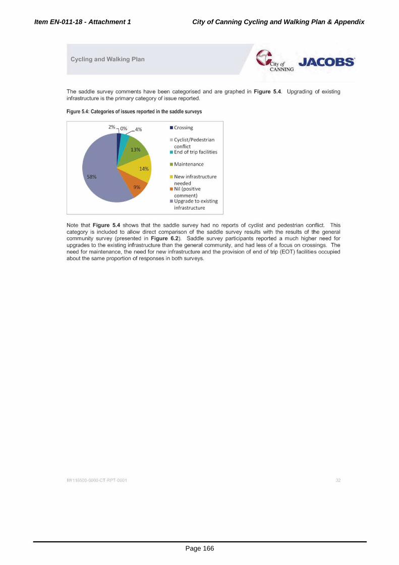
Item EN-011-18 - Attachment 1 City of Canning Cycling and Walking Plan & Appendix
Page 166
Cycling and Walking Plan ~ityDt JACOBS' CANNING
The saddle survey comments have been categorised and are graphed in Figure 5.4. Upgrading of existing infrastructure is the primary category of issue reported.
Figure 5.4: Categories of issues reported in the saddle surveys
2% 0% • crossing
Cyclist/Pedestrian conflict
• End of trip facilities
• Maintenance
New infrastructure needed
• Nil (positive comment)
• Upgrade to existing infrastructure
Note that Figure 5.4 shows that the saddle survey had no reports of cyclist and pedestrian conflict. This category is included to allow direct comparison of the saddle survey results with the results of the general community survey (presented in Figure 6.2). Saddle survey participants reported a much higher need for upgrades to the existing infrastructure than the general community, and had less of a focus on crossings. The need for maintenance, the need for new infrastructure and the provision of end of trip (EOT) facilities occupied about the same proportion of responses in both surveys.
IN 11 >500 0001) c T RPT 0001 32

Item EN-011-18 - Attachment 1 City of Canning Cycling and Walking Plan & Appendix
Page 167
Cycling and Walking Plan &lye/ JACOBS. CANNING
6. Community and Stakeholder Engagement
6.1 Consultation Strategy
The City of Canning convened a steering committee comprising both engineering and planning staff from the City, as well as policy officers from the Department of Transport. The steering committee members guided the development of this plan and provided local knowledge as well as information about state policies. Monthly steering committee meetings were held throughout the development of this plan.
A consultation strategy to engage both key stakeholders and the community was developed.
The steering group identified the following stakeholders:
• State government agencies;
• Bicycle user groups;
• Disability representatives;
• Westcycle;
Adjacent local governments;
• Local schools; and
• Interested community members.
Engagement was achieved through the facilitation of two workshops. The first was designed to discuss and agree on a vision and strategic plan for cycling and walking and the second focussed on proposals for implementation of any cycling and walking infrastructure. These workshops provided the opportunity for stakeholders to meet as a group, provide input on the plan, and assist in influencing key planning principles and strategies subsequently adopted. Community members were also engaged by handing out flyers notifying of the development of the Cycling and Walking Plan during Bike Week 2016 and by providing regular updates on the City's website as the development of the Plan progressed.
Community consultation has the primary purpose of keeping the ratepayers and residents of the City of Canning informed and engaged about the development of important policy and future planning directions for the City. Successful community engagement enables residents and ratepayers to comment on the development of the plan early in the process and throughout the planning process. This is often referred to as "consult early and consult often".
Community comments were invited in the form of an online survey. Written submissions were also accepted for those who do not use the internet. In addition, a survey was sent to all schools in the City of Canning , providing a chance for the school 's administration to assess and advocate for cycling and walking facilities in the vicinity of their schools.
Summaries of the outcomes from the two workshops and community consultation follow.
6.2 Key Stakeholder Responses
6.2.1 Workshop 1
Workshop 1 was held on Thursday 181h of February 2016 at the Canning River Eco Education Centre. The workshop was attended by 21 participants, including personnel from the City of Canning, state government departments and neighbouring local governments.
1>"111 500 0000 c T RPT 001 33

Item EN-011-18 - Attachment 1 City of Canning Cycling and Walking Plan & Appendix
Page 168
Cycling and Walking Plan & ly cf JACOBS' CA Nll'IIG
Participants responded to the icebreaker question: "What is the most important aspect to you with regards to cycling and walking in the City of Canning?" Powerpoint slides detailing the current situation as well as possible future options were presented. There was a group discussion on vision, with the consensus being that all streets in the City should accommodate cycling and walking. A short term target was not specified, but longer term targets were presented for consideration.
Strategies for promotion arnd behavioural changes were discussed. There was discussion on the Dutch bicycle planning principles, which were subsequently adopted by the workshop group as appropriate for the City. Participants completed a questionnaire on City-specific issues and a group activity to map areas in the City requiring improvement was undertaken. It was agreed to refine the vision, targets, principles and strategies for the next Steering Committee meeting which was held on 81
h March 2016 and to map network links for discussion at Workshop 2, which would be held to consider proposals for network improvements.
6.2.2 Workshop 2
Workshop 2 was held on Tuesday 51h of April 2016 at the City of Canning offices. The workshop was attended by 14 participants, including personnel from the City of Canning, state government departments and neighbouring local governments.
Workshop participants were updated on the progress of the project and then presented with a map showing a suggested path network for the City. Participants split into two groups. One group focussed on the portion of the City north of the Canning River. The other group focussed on the portion of the City south of the Canning River. The groups were asked to provide comment about the suggested routes, such as where a known route has not been identified and to suggest a priority for each route. A key issue that arose was the interfacing of the City of Canning with its neighbouring local governments. Some neighbouring local governments (such as the City of Belmont) are also active in providing cycling and walking infrastructure and wish to continue to work together with the City of Canning to provide seamless facilities across the boundary. This will benefit residents in both Cities. The City will need to liaise with some of its other neighbouring local governments to encourage commitment (in the form of infrastructure provision) to cycling and walking and ensure seamless transition as pedestrians and cyclists move across local government boundaries.
Information collated in Workshop 2 has been used to inform the final proposed routes and prioritisation later in this plan.
6.3 Community Response
6.3.1 Schools
Survey forms were sent to all primary and high schools in the City of Canning. Four schools provided a response. These were Bannister Creek Primary School (in Lynwood), Lynwood Senior High School, Shelley Primary School and Queern of Apostles Primary School (in Riverton). Results can be found in Appendix C. It should be noted that four schools is a low response rate to this survey. The majority of schools in the City of Canning did not provide a response.
In summary, at all responding schools except Queen of Apostles, 5% or more of the children ride to school (either with their parents or alone). At Queen of Apostles, the figure is 2-3%. At Shelley and Bannister Creek Primary Schools more than 20% of children walk to school. At Lynwood Senior High 15-20% of students walk to school. Queen of Apostles estimates that less than 5% of its students walk to school. Bicycle parking/storage is provided at all schools. At Bannister Creek Primary, demand for bicycle parking presently exceeds supply. Shower facilities are available to students at Lynwood Senior High and Bannister Creek Primary. No schools have plans (or Education Department funding) to increase the level of end of trip (EOT) facilities.
All the schools that responded to the survey conduct programs to promote active travel. These include: Cycle/Walk to School Days, Bike Ed, the Walking School Bus and the School, Drug and Road Aware (SDERA) initiative. Bannister Creek is a Travel Smart school.
1>"111 500 0000 c T RPT 001 34

Item EN-011-18 - Attachment 1 City of Canning Cycling and Walking Plan & Appendix
Page 169
Cycling and Walking Plan & .y cf JACOBS' CANNING
The responders reported that the cycle routes to their schools were inadequate or non-existent. Crossing Metcalfe Road was identified by both Lynwood Senior High and Bannister Creek Primary as a hazard. These schools also flagged Romney Way, Gama Court, Lynwood Avenue, Woodford Ave, High Road and Nicholson Road as dangerous for cyclists and walkers. Shelley Primary flagged crossing of Leach Highway (between Riverton and Shelley) as an issue. All schools ranked the quality of shared paths near their schools to be poor, but most ranked the footpaths to be of medium quality.
Convenience, distance, weather and time were flagged as key motivators/disincentives to partake in active transport. Lack of safe crossings and paths, feeling of safety/security and lack of confidence/training were also identified as disincentives.
All schools said they woul,d promote active transport if provision for cycling and walking could be improved. Shelley and Bannister Creek particularly expressed a desire to be more involved with the Travel Smart Officer at the City of Canning or to be consulted about future upgrades, programmes and works. Particular attention has been given to the schools that responded to the survey in the plan and suggestions are made to address many of the issues of concern.
6.3.2 General Community
The community was given the opportunity to participate in a survey aimed at understanding current cycling and walking habits, opinions and concerns. There was also a map, where community members could pinpoint areas needing infrastructure provision or upgrade for pedestrians and or cyclists.
The survey was completed! by 71 respondents. It was not compulsory for participants to provide demographic details, but from the people who did provide these details, we know that the survey reached both men and women across a range of age groups and suburbs within the City and outside of it. The sample included 51% male and 49% female respondents. Figure 6.1 shows the age of respondents, with the 26-35 years and the 56-65 years having the largest proportions. Table 6.1 shows the suburbs in which respondents reside. There are responses from people resident outside of the City. This indicates that non-residents also use (and therefore have an interest in) the City's cycling and walking amenities, possibly to access work or other services.
Figure 6.1: Age of respondents
4%
• 18-25
26-35
• 36-45
• 46-55
56-65
• Over65
Table 6.1: Place of residence of respondents
Canning Suburbs Percentage Non-Canning Suburbs Percentage
Bentley 3.1 Bull Creek 1.5
Canning Vale Gosnells 1.5
Cannington Langford 1.5
East Cannington 3.1 f Leeming 1.5
1>"111 500 0000 c T RPT 0001 35

Item EN-011-18 - Attachment 1 City of Canning Cycling and Walking Plan & Appendix
Page 170
Cycling and Walking Plan G::i,y ot JACOBS'
CANNING
Ferndale
Lynwood 4.6
Park wood 1.5
Queens Park 10.8
Riverton 9.2 -+
Rossmoyne 4.6
Shelley 9.2
Willetton 15.4 -;
Wilson 6.2
Total in Canning 92.3 Total Non-Canning 7.7
There were 15 questions in the suNey. The initial question asked which mode of transport the participant regularly uses. Remaining questions then target either the cycling or walking habits of the participant. Responses given by participants to the suNey questions are depicted in Figure A1 to Figure A15 of Appendix D.
In Figure A 1, it can be seen that car as driver is the dominant means of transport with 39% of respondents regularly using this mode. Cycling is next most regularly used mode at 25%, followed by walking at 16%. Given that this community suNey is likely to attract people already engaged in walking and especially in cycling, caronly users are likely to be under-represented, so the mode share demonstrated in this result cannot be extrapolated to all of the City's residents. Rather, this result provides some indication of the long term mode share that could be achieved if enthusiasm for cycling and walking was more widespread in the City's population.
Recreational cycling is popular with 47% of respondents engaging in this activity (Figure A3). Cycling for the purpose of commuting is the next most popular reason for using a bicycle at 33%, followed by cycling for a sport at 18%. In Figure A5 it can be seen that more than two-thirds of respondents cycle either daily or weekly (during the weekdays). The key destinations people ride to broadly support this dominant reason for cycling (Figure A7). Parks and rivers are the most popular destination at 37%, followed by workplaces at 19% of cycle trips and train stations at 13% of cycle trips. These two destinations reflect the commuter cyclists in the suNey. 15% of respondents go to tihe shop by bicycle and 8% reach school by bicycle.
In Figure A6, we see that 96% of respondents believe they have average to high levels of bicycle riding skills. Only 4% of people indicated that they cannot ride a bicycle. Nobody claimed to have poor to average skills. This indicates that, in general, the respondents represent the more experienced riders and feel competent in the operation of a bicycle.
89% of respondents claim to currently cycle (Figure A2) and 97% of respondents own a bicycle (Figure A4). Access to a bicycle (or economic means to purchase a bicycle) is therefore not an impediment to cycling. A perceived or real lack of cycling paths and facilities is the main barrier to cycling in the City, with 62% of participants giving this response (Figure AS). 94% of respondents would consider cycling more if the correct infrastructure was available (Figure A9). This indicates that infrastructure provision is a key need for the encouragement of cycling in the City.
21 % of respondents do not wish to cycle more than 10km (Figure A10). A further 21 % of respondents will cycle up to 15km. These distances are longer than could be expected for a broad range of cyclists, confirming again that the sample is representative of more serious cyclists.
Moving to the questions specific to walking, Figure A11 reveals that 73% of respondents walk either daily or weekly (during the week days). 81 % of people will walk up to 2km (Figure A12).
IN 1165CO 0001) c T RPT 0001 'J6

Item EN-011-18 - Attachment 1 City of Canning Cycling and Walking Plan & Appendix
Page 171
Cycling and Walking Plan & .YIJf .JACOBS' CANNlNG
We see in Figure A15 that, similar to cycling, parks and river areas are key destinations for walkers at 35%. 30% of respondents walk to the shop. Walking to reach the train station or bus stop is also popular at 22%. It is rarer for respondents to access schools or workplaces by walking. These destinations attract only 7% and 4% of respondents according to the survey. This number of people who walk to school is not as high as might be expected and again, indicates that the survey is likely not representative of all the City's residents.
There are numerous barriers to walking in the City (Figure A13). Safety and security is perceived to be the key issue at 21%, followed closely by inconvenience (for example when carrying shopping) at 20%. Related to safety and security, 17% of respondents say there is insufficient lighting at night and a further 17% cite a lack of footpaths or footpaths being too narrow as a barrier to walking. 15% of respondents find the weather to be a deciding factor and a final10% believe a lack of safe pedestrian crossings or intersections is a problem. 83% of respondents would consider walking more if these issues could be rectified. The results to this question suggest that the barriers to walking are more varied than those that stop cycling. Walkers are likely a more diverse group than cyclists and warrant special attention. It would appear there is no one, clear response to how the barriers to walking can be overcome. Though cyclists and pedestrians in some ways have similar needs, in other ways they are not congruent. Section 1 0.2.1 provides guidance for accommodating cyclists and Section 10.2.2 addresses the needs of pedestrians.
It should be understood that the survey was not completed by a cross-section of people throi.Jghout the community. The responders are most likely keen, competent cyclists. The views of those who do not cycle, those who only walk, as well as those who are less able (perhaps children) are almost certainly underrepresented. The sample size (number of people completing the survey) was also low, given the population of the City. The results of the survey should be interpreted with these caveats in mind.
Results of the mapping exercise are in Appendix E. 194 locations were pinpointed by the public (including the school survey and responses received in hardccpy at the City of Canning office). Many of these places have subsequently been targeted for improvement later in this plan. Similar to the saddle survey comments, the public reports have been categorised according to the nature of the problem (Figure 6.2). The public sees cyclist and pedestrian conflict as a big problem, with 35% of reported places on the map having this issue. Crossings and the need to build and maintain new cycling and walking infrastructure also rate highly as concerns (at 19%, 15% and 13% of the reports). The manner in which cyclists and pedestrians interact is a behavioural issue as well as an infrastructure provision one and is addressed later in this plan.
Figure 6.2: Categorising of issues reported by the public
tN 116500 ooon c T RPT 001
• Crossing
Cyclist/Pedestrian conflict
• End of trip faci lities
• Maintenance
New infrastructure needed
• Nil (positive comment)
• Upgrade to existing infrastructure
3

Item EN-011-18 - Attachment 1 City of Canning Cycling and Walking Plan & Appendix
Page 172
Cycling and Walking Plan @ily(J' JACOBS' CANNlNG
7. Vision, Principles and Targets
7.1 Vision for Cycling and Walking in Canning
The following vision was developed by the City of Canning following discussion at the workshops:
Cycling and walking will be a safe, attractive and viable travel option between neighbourhoods and
destinations within the City of Canning and beyond.
This vision of how the City of Canning wants to be perceived in relation to cycling and walking in the future is fundamental in engendering change. The City of Canning wants to promote an environment friendly to both cyclists and walkers by improving the connectivity between neighbourhoods and destinations; where shared paths, greenways and bicycle facilities are further developed and integrated and all users are provided safe and convenient access. The City of Canning will work to forge partnerships, educate the community and design facilities that are both safe and attractive for use.
7.2 What Increases Cycling and Walking? Case Studies in Other Cities
Major change in mode share due to resident uptake of active transport is not unprecedented. Berlin, Germany and Portland, United States provide case study examples for cycling, whilst The Hague in The Netherlands provides a case study for walking.
The successes achieved by these cities in uptake of active transport, give encouragement to the City to set challenging, aspirational targets for mode shift. Common to all these case studies is that to achieve high levels of mode shift, local governments must commit to the implementation of proposed strategies and invest heavily in cycling and walking. Achievement of a transformational change of the type proposed will require the Council at all levels to understand the benefits, (including financial} that can accrue from the change.
7.2.1 Cycl ing
Cities that have high mode shares for cycling typically have continuous off road carriageway cycling facilities where cyclists are physically separated from cars and trucks on busy roads. The raised bicycle lanes installed in Copenhagen, Denmark (and now colloquially termed "Copenhagen-style" paths in Australia) were successful in increasing cycling 70% between 1970 and 2006. Another European city, Berlin never had the historic high level of cycling that cities such as Copenhagen are famous for, but it experienced considerable cycling mode share increase from 3% (in 1970 in West Berlin and 1990 in East Berlin) to 10% (Berlin-wide} by 2005. The introduction of safe (mostly off road} facilities is also credited with transforming cycling in Berlin. In 2004, Berlin had:
• 620 km of separate bicycle paths;
• 60 km of on road bicycle lanes;
• 50 km of bicycle lanes on paths;
70 km of shared bicycle lanes;
• 100 km of joint pedestrian I cyclist sidewalks;
• 190 km of off road bicycle ways through parks and forests; and
• 3,800 km of traffic calmed neighbourhoods.
The transformation that has occurred in Portland, Oregon in the USA is perhaps more relevant to bicycle transport planning in Australia. The level of car dependence in the USA is similar to that in Australia and it can be argued that the factors that reduce car dependence in favour of more cycling in Portland are likely to be applicable in Australia.
1>"111 500 0000 c T RPT 001 38

Item EN-011-18 - Attachment 1 City of Canning Cycling and Walking Plan & Appendix
Page 173
Cycling and Walking Plan @ City ll/ JACOBS'
CANNING
Between 1996 and 2008 the mode share of cycling in Portland, Oregon increased from 2% to 8%. As was the case in the European cities, a key success factor was the construction of many kilometres of separate bicycle paths. 480km of bicycle way have been constructed, most of these after 1991. Much of the bicycle way has been constructed with Copenhagen-Style raised bicycle lanes (see Figure 7.1 ). The experience in Portland is that people will cycle if they are provided with safe facilities separated from motor vehicles.
Figure 7.1: Copenhagen style raised bicycle lanes
~ldcwalk rurnlsh.nqs Separate Pedestrian~
Travel l ane Parking o-2· 5'·10' Vories V~rics ~41") {t.>-Jal
Source: Alta Planning and Design, Portland Oregon 2009.
7.2.2 The Hague
!iidew~GI. ru,l\bhin~
Sep~r~te Podourt.an"
Travel l~nc Varies
Travel Lane 0· 2' 5-10' Varies (0..6m)(IS._ l_..,.,.l ____ _,
The Hague, in The Netherlands provides an example of a city that has identified and implemented specific strategies to encourage walking. The City recognises that walking is clean, healthy, cheap, takes up less public space than other modes, and that the presence of pedestrians contributes to a vivid, safe and secure city. It realised that walking had been neglected in its previous transport plans, despite recognising that walking plays a part in nearly every individual journey (such as getting to the car park or public transport stop, or after leaving the bicycle rack). The City has subsequently employed both "hardware" and "software" measures are to promote walking. Walking mode share in The Hague is now about 30%.
The "Hardware" aspect has four main themes:
• Safety - walking in the neighbourhood. Residential areas are designed so that daily services can be reached by foot in a safe way. This may incorporate speed calming of vehicles, wide paths and crossings to make pedestrians feel safe. Accessibility measures for vulnerable pedestrians (the elderly, disabled) and walking routes to school are given attention.
• Connectivity - walking as part of a trip. This concerns the logical placement of public transport stops and stations. The stations and stops themselves as well as routes to the stations and stops should be of high quality, comfort and safety, barrier free and well lit.
JW 116500 ooon c T RPT ·oo1 39

Item EN-011-18 - Attachment 1 City of Canning Cycling and Walking Plan & Appendix
Page 174
Cycling and Walking Plan @ Ci,yDf .JACOBS' CANNlNG
• Predominance - walking in the city centre. This recognises that people walk as a leisure activity, not just as a form of transport and that walking can contribute to the local economy. Design for walking in The Hague city centre incorporates public spaces, street furniture and signage to points of interest.
• Attractiveness - walking in parks. In The Hague green areas are made accessible and safe so as to encourage walking and increase quality of life. Where possible traffic is diverted away from green areas.
"Software" measures that have been successfully employed in The Hague include, marketing campaigns, provision of information and targeting people at periods of change in their life (such as moving house) to reassess their travel habits. These measures respond to the notion that a person's daily travel patterns can be strongly habitual and encouraging ingrained car-users to walk more can be difficult if only the "hardware" aspects are focussed on.
7.3 Relationship Between Cycling and Train Stations
In 2011, Painted Dog Research conducted a study to investigate cycling and non-cycling behaviour amongst train passengers. Of the sample of train users who cycle to the station, only 11% used the Arm ad ale line (which runs through the City of Canning). This is a low proportion in comparison to the other train lines and may suggest that there is scope to encourage people to cycle to the train stations in the City. Most people who currently cycle to the station live within 1 to 2 km or 2 to 5 km of the station. 5 km appears to be the optimum maximum distance a public transport user will cycle. The study found that 80% of those who cycle to the stations are male and fall within the 20-39 and 40-59 years age groups. Motivations were exercise, environmental concerns and proximity to the train station.
Cyclists were asked about the provision of amenities at train stations. There was a strong preference to use Lock and Ride Shelters. Bicycle lockers were the next most popular form of storage. Many cyclists expressed a desire to take their bicycles on the train with them (this preference increased as the value of the bi-cycle rose, suggesting that security or perception of security of storage facilities was an issue). Cyclists strongly agreed that cycling is a better alternative than driving to the station and parking a car, they also agreed that cycling is a better alternative than catching a bus to the station, although cycling is not necessarily faster than driving or catching a bus to the station. Secure storage facilities, end of trip (EOT) facilities, ability to take bicycles on trains in peak periods and provision of cycling paths were raised as areas for improvement.
Train users who do not cycle to the station were also surveyed. Key reasons for not cycling were convenience, time taken, and distance from the station. Concerns about the inconvenience of changing from cycle clothes to work clothes were raised, as was the need to use the car for other tasks before or after taking the train. 46% of non-cyclists own a bicycle and of these, over one third cycle at least once a week for recreational purposes. This group may be the easiest to target to mode shift from cars/feeder buses to active transport to reach the station since, it can be inferred that lack of skill or dislike of cycling in general is not an issue. The profile of these respondents is actually somewhat similar to the profile of those who cycle to the train station, (again most fall in the 20-39 and 40-59 years age groups and whilst the proportion living more than 5km from the station is higher, a majority still live either 1 to 2km or 2 to 5km from their nearest station; 53% are male) so the possibility of increasing the number of people cycling to stations exists if the reasons for not cycling can be mitigated. Non-cyclists strongly agreed that cycling to train stations is good for the environment and for exercise. Many perceived they would also save money compared to taking the bus or driving. Non-cyclists identified the same areas for improvement as cyclists. In addition. a bicycle hire scheme was also suggested (it can be inferred that lack of access to a serviceable bicycle and-or cost are issues for some non-cyclists).
Applicability to the City of Canning:
• Ensure a connected network of bicycle paths and crossings particularly in the 5km catchment of rail stations. Address issues of cyclist and pedestrian conflict. Rail stations in the City of Canning are located at Welsh pool, Queens Park and Cannington. Bull Creek, Oats Street and Beckenham stations are not located in the City of Canning, but are close enough to its boundaries to be considered as trip attractors in this plan. Train stations are shown in Appendix H, Map 4.
IW 11 >500 0000 c T RPT 001 40

Item EN-011-18 - Attachment 1 City of Canning Cycling and Walking Plan & Appendix
Page 175
Cycling and Walking Plan & .ycf JACOBS' CANNTNG
• When undertaking behaviour management programs, promote cycling to the station as a viable alternative to taking a feeder bus or driving a car.
• Work with Transperth to provide and maintain weatherproof bicycle storage facilities and monitor their security.
• Make City facilities, in particular showers and lockers available for end of trip (EOT) purposes. The Cannington Leisureplex may be particularly well placed for this role, as it is in close proximity to both the Queens Park and Cannington Stations. Alternatively, work with Transperth to provide lockers and showers at train stations.
• Work with Transperth to determine if it is feasible for changes to shorten the period where bicycles on trains are banned (comments from participants in the study suggest it could be half an hour shorter, rather than 7am-9am and 4.30 to 6.30pm, bicycle could be permitted after 8.30am and after 6pm) and or for dedicated bicycle carriages on trains.
7.4 Planning Principles for Cycling and Walking
Planners in the Netherlands adopted the following principles to guide bicycle planning:
Attractiveness - each route should feel attractive to use and include a feeling of personal safety for users.
Coherence - there should be a choice of routes and the network should be legible and easy to use.
Comfort - surfaces should be smooth and well maintained. The number of stops along the route should be minimised.
Directness - direct routes with no unnecessary detours to provide journey times by bicycle that are competitive with the car.
Safety - separate cyclists from motorists and pedestrians where necessary, but allow mixed use along low speed, low volume streets. Design should be predictable in terms of alignment and priority.
These principles have been used successfully in many countries and jurisdictions to guide bicycle planning. These principles were discussed at the first key stakeholder workshop (181h February 2016) and the general consensus was that these principles should be applied to walking as well as cycling. It was also noted that the Department of Transport has adopted the Dutch planning procedure for cycling.
The City of Canning has determined that in Perth's hot climate, shading for pedestrians and cyclists is a critically important part of the comfort criterion. It should therefore be modified as follows:
Comfort - surfaces should be smooth and well maintained and shading should be provided along paths. Continuity of movement along the route should be preserved.
7.5 Mode Share Targets
7.5.1 Cycling Mode Share Targets
Currently cycling mode share in the City is about the metropolitan average of 1.3% for journey to work and 2% for all modes. However, the rate of growth of cycling in Canning is well below that in inner areas and less than the average rate of growth in metropolitan Perth.
There are examples in Gennany (Berlin) and America (Portland, Oregon) where significant growth in the mode share of cycling has been achieved in a relatively short timeframe. In Perth, cycling to work has achieved 50% growth to an average of 3.8%, in the ten years to 2011 (on average) in the inner city municipalities of Vincent, South Perth, Victoria Park, Subiaco and Cambridge. The mode share of cycling by all modes is likely to be greater, although no data is available.
IN 11 >5C0 0001) c T RPT 001 4

Item EN-011-18 - Attachment 1 City of Canning Cycling and Walking Plan & Appendix
Page 176
Cycling and Walking Plan & 1y c1 JACOBS' CANNlNG
The City of Canning has a street network that is reasonably conducive to cycling and there are plans to increase density and the level of mixed use in its activity centres, particularly the Canning City Centre. The City is therefore well placed to increase the mode share of cycling in the short, medium and long term in accordance with the following targets:
Short term to 2021 - to 4% mode share;
Medium term to 2031 -to 6% mode share;
Long term to 2051- to 10% mode share.
7.5.2 Walking Mode Share Targets
Walking mode share in the City of Canning is estimated to be a little lower than the metropolitan average. The current mode share of walking in the City for all trips is estimated at about 10%, although there is a lack of data to verify this. The street network in the City is reasonably well suited to walking and the Local Housing Strategy which advocates for more mixed use development in centres, in particular the Canning City Centre, provides hope that walking can become a more popular mode of transport in the future.
Walking mode share in the City of Subiaco is already much higher than in the City of Canning. Journey to work mode share in Subiaco was 12.4% in 2011 and mode share for all purposes is likely to be approaching 20%. Suggested mode share targets for walking city wide in the City are:
Short term to 2021 - to 11% mode share;
Medium term to 2031 - to 14% mode share;
Long term to 2051 -to 18% mode share.
However within activity centres in the City of Canning, the walking mode share targets should be set at a higher level. The Canning City Centre should set walking mode share targets of:
Medium term to 2031 -to 15% mode share;
Longer term to 2051 - to 20% mode share.
7.5.3 Overall Mode Share Targets - City of Canning
The above mode share targets and projected increases in public transport have the potential to reduce the amount of car driving by more than 25% (or 80,000 vpd) when compared to current mode shares. The targeted mode shares for all modes for the City of Canning are shown in Table 7.1 .
Table 7.1 : Mode Share Targets for City of Canning
Mode Share (2050)
42%
Car passenger 22% 14%
Public Transport 7% 14%
Cycling 2% 10%
Walking 9% 18%
Other 1% 1%
1>"111 500 0000 c T RPT 001 42

Item EN-011-18 - Attachment 1 City of Canning Cycling and Walking Plan & Appendix
Page 177
Cycling and Walking Plan & ,YIJf .JACOBS' CANN1NG
8. Strategies to Increase Cycling and Walking in Canning
Six broad strategies have been adopted by the City of Canning, to increase the uptake of cycling and walking.
8.1 Land Use
Land use change at activity centres, activity corridors and Transit Oriented Developments (TODs) around railway stations.
Objective: to get more people living close to jobs, shops and other activities.
Status: already a part of City of Canning policy.
Key benefits: will benefit both cycling and walking.
8.2 Develop Safe Connected Network
Plan and implement a safe connected bicycle network that provides viable and direct linkage to the key activity centres, rail stations, schools, shops and other attractions.
Objective: to overcome people's fear of cycling and increase the level of cycling.
Key features: safe, off street bicycle facilities separated from traffic and (where necessary) pedestrians; bicycle boulevards along local, low speed, low volume streets in specific locations, shared paths to access schools and lower level centres where bicycle and pedestrian use is relatively low; safer improved intersections and road crossings.
Status: initial planning work has commenced. Significant planning and design work required.
Benefit: will mainly benefit cycling but will also benefit walking in some areas.
8.3 Change Mindset Through Education
Change the mindset of planners, decision makers and daily travellers through education programmes.
Objective: to encourage more cycling and walking, increase the level of cycling and walking facilities and provide for a safer transport network for all.
Key features: promote the benefits of cycling and walking and work with partners such as schools, major employers, local and state governments and the RAC in development and delivery of the programme.
Key benefits: improved community health and fitness; reduced congestion through less car driving per person; reduced overall cost to fund transport system; travel cost savings to individuals; improved accessibility for more people, including independent travel for youth; environmental benefits (reduced pollution and greenhouse gases).
Status: Education and training, although fundamental to improving road safety and changing mindsets, needs further development in WA. Will benefit all travellers regardless of how they travel.
IN 11 sco 0000 c T RPT 001 4J

Item EN-011-18 - Attachment 1 City of Canning Cycling and Walking Plan & Appendix
Page 178
Cycling and Walking Plan & IYD/ JACOBS' CANNING
8.4 Develop and Implement Travel Plans
Develop travel plans and introduce behaviour change programmes.
Objectives: to encourage more cycling and walking.
Key features: travel plans for universities, TAFE, government and local government offices and schools; travel plans and end of trip facilities for major developments as condition of development; Travel Smart behaviour change programmes to schools, community facilities and mixed use centres.
Status: where introduced delivers benefits through less car ownership and more walking, cycling and public transport. Implementation has been inconsistent and patchy.
Benefits: all travellers through reduced congestion around schools, in centres and throughout community.
8.5 Policy Development for Improved Safety and Accessibility
Develop policies that support best practice to improve accessibility and safety for cyclists and pedestrians.
Objectives: enable pedestrians and cyclists to move around more safely in a way that improves overall accessibility.
Key features: safer bicycle and pedestrians road crossings; safer intersections with priority for cyclists and safe crossing for pedestrians; design guidelines for bicycle and shared use paths, including road crossing facilities.
Status: existing policies need reviewing and design guidelines for separate bicycle and shared use paths need to be developed in the light of proposals suggested at the 2015 Cycling lmagineering Workshop (Department of Transport). The Department of Transport and the City would need to work closely on these matters.
8.6 More Tree Cover and Shade
Provide for greater shading and tree cover for pedestrian and cycling paths.
Objectives: Provide sufficient shading of paths to ensure the comfort of pedestrians and cyclists.
Key features: Additional tree planting along pedestrian and cycl ing paths, appropriate tree species selected.
Status: Tree planting and shading policies need to be reviewed to ensure appropriate tree planting and street awnings to provide improved amenity for pedestrians and cyclists. Awnings along shopping streets in centres to be addressed as part of structure planning.
1>"111 500 0000 c T RPT 001 44

Item EN-011-18 - Attachment 1 City of Canning Cycling and Walking Plan & Appendix
Page 179
Cycling and Walking Plan @ a,y cf JACOBS' CANNlNG
Part 2 Implementation Section
tN 11 )sco ooon c. T RPT 001 45

Item EN-011-18 - Attachment 1 City of Canning Cycling and Walking Plan & Appendix
Page 180
Cycling and Walking Plan & ,YIJ/ .JACOBS' CANNlNG
9. Funding In the 2014/2015 and 2015/2016 financial years, the City of Canning spent approximately $650,000 on cycling path projects. The City has around 100,000 residents, so this funding amounts to $6.50 per head of population. The amount of money available for the City to spend may from time to time be supplemented by grants from the Department of Transport for specific cycling or walking infrastructure projects (the $650,000 include a Department of Transport contribution).
It is recommended that the annual funding for cycling in the City of Canning is doubled, increasing to $15 per head of population by 2021, and then more than tripled, increasing to $20 per head of population by 2031. This compares to the following levels of funding either existing or proposed in countries and cities that either have or aspire to have good cycling infrastructure:
• The Netherlands- $48 per person (existing); London - $28 per person (proposed);
• UK - $20 per person increasing to $40 per person (recommendation of the All Party Parl iamentary Cycling Group).
Assuming a population of 100,000 within the City of Canning, expenditure on cycling should reach $1.5 million by 2021 , rising to $2.5 million by 2031 (assuming an increased population of 125,000). These figures should be based on the real purchasing power of the dollar (ie. the expenditure in future years should be indexed upwards to compensate for the future increased cost of infrastructure).
This proposed expenditure should be shared between the City of Canning and the State Government notionally on a 50/50 basis, which is the basis in which state grants to local government are dispensed. The City of Canning's share of funding could therefore be expected to increase from the current average of about $650,000 (including DoT contribution) to about $750,000 excluding DoT contribution by 2021 and to $1.25 million excluding DoT contribution by 2031 .
The State Government has spent an average of $17 million per annum over the last 3 or 4 years. This expenditure includes bicycle expenditure within the roads budgets (on projects like the PSP along Roe Highway). To meet these targets in the future, the State Government will need to increase its overall expenditure to $34 million per annum with the vast majority of the additional funding going to Local Government grants based on a 50% contribution by the Local Government. This implies that there would need to be a large increase in State Government grants to Local Government. This may not be achieved in total, but also not all Councils will have good projects approved and the matching funding in their budgets. Those councils that do will be better placed to receive a higher proportion of State Government grants.
Not all of the expenditure would necessarily need to be expended on infrastructure. Some level of expenditure could be allocated to TraveiSmart/Your Move behaviour change programmes, education programmes and to employment of a TraveiSmart!Your Move Officer with responsibilities for implementing and managing cycling and walking initiatives.
In summary, the current level of expenditure on cycling is low compared to expenditure on roads. There is certainly a reasonable annual increase in funding that would need to be budgeted to double cycling in the City by 2021 and triple it to 6% by 2031 . However, the benefits to the community will be substantial and it could be expected that per capita funding for car travel would reduce in line with lower per capita car use. As road infrastructure is more expensive than cycling infrastructure, there could even be a saving in the long term.
IN 11 >5C0 0001) c T RPT 001 46

Item EN-011-18 - Attachment 1 City of Canning Cycling and Walking Plan & Appendix
Page 181
Cycling and Walking Plan ~ity cf .JACOBS' CANNlNG
10. Cycling and Walking Network
This report suggests a network of safe, connected cycling and walking routes will need to be implemented to improve safety and increase participation in cycling and walking. These have been developed based upon analysis of the existing situation, consideration of community and stakeholder comments and the need to create bicycle routes that accord with agreed bicycle planning principles and strategies as outlined in Sections 7 and 8 of this report.
10.1 Legislation Change
On Tuesday the 26 April 2016, the Western Australian Road Traffic Code was changed to permit cyclists of any age to ride along footpaths. Previously this had been prohibited for people aged over 12.
This change brings Western Australia into line with the rest of Australia and is designed to improve safety for cyclists travelling at low speed and who do not feel safe riding on the road.
It means that all footpaths effectively become shared paths, although the intent remains that footpaths continue to give priority to pedestrians. Cyclists are expected to travel with care on footpaths at low speed. Local governments may elect to use bylaws to ban cycling on specific footpaths if bicycles and pedestrians are deemed incompatible. Such a situation may occur in a busy shopping strip or in front of an aged care facil ity.
Education of both cyclists and pedestrians to share the amenities is discussed in Section 11.6.
10.2 Design Guidelines
10.2.1 Cycl ing
The City of Canning should encourage the Department of Transport (DOT) to develop a cycle design guide and then adopt the provisions of the guide, as appropriate, within the City. In its role as the lead agency for the transport portfolio, the DOT should liaise with Main Roads WA, the Public Transport Authority and local government in the development of this guidance. Austroads•2 has existing guidance, but there is an opportunity for DOT to customise the guide to Western Australian conditions and local governments would further apply the guidance to local conditions. Four aspects that the guide could address and which would be applicable in the City are:
• Cycle facility development and management at large shopping centres such as in the Canning City Centre I Carousel shopping centre;
• On verge bicycle path designs to create safe, convenient facilities, particularly at intersections; • On road lane designs; and • Road markings for cyclists, particularly where cyclists enter and negotiate intersections.
Space to ride, smooth surfaces, speed maintenance, sight lines, connectivity and information are the basic considerations when designing for cyclists. The cyclist envelope (Figure 10.1) gives the minimum dimensions for designers to focus on.
12 httos:llwww.onlineoublicallons.austroads.com.auiilems/AP-G88·14 Cycling aspects of Auslroads Guides
IN 11 ,:)',)Q lJOUf) t. T RP'T l!V1 4

Item EN-011-18 - Attachment 1 City of Canning Cycling and Walking Plan & Appendix
Page 182
Cycling and Walking Plan ~ily cf JACOBS'
Figure 10.1: Cyclist envelope (Source: Austroads)
~ fs'Otn i .<JI ~onet .;'t'fl"'9 I spo<e <lecr~nc e
I I I ~· I ____ l____l___!_~ ---
.1 I On
8 !( 'f( I! ttf"l9l ~ ( Q i'T
be l u<en c s 17},.
CANNlNG
The following should be considered in the development of design guidelines for cyclists:
• Cyclists require additional clearances to fixed objects (the "car dooring" described in the saddle survey results) and to passing vehicles.
• It is desirable that surfaces used for cycling be smoother than roads. Since bicycles have narrow, highly inflated tyres and no suspension, smooth paths make a large impact on cyclist comfort and safety.
• Paths should be maintained to be free from debris. Designs should minimise the likelihood of debris going on to paths. Appropriate landscaping choices should be made.
• Continuous routes where cyclists do not have to slow down or stop frequently are desirable, but in practice this may be difficult to achieve on a shared path where pedestrian safety is a consideration. On a cycle path, cyclists typically travel at a speed of 20-30 km/h, but this may rise as high as 50km/h in some circumstances. It takes effort to brake and then regain speed.
• Designing for cyclist sight lines helps to minimise cyclist/pedestrian conflict and to view and react to hazards on the path.
• Infrastructure provision should be continuous and changes between treatments (eg. from shared path to bicycle lane) should be seamless.
• Bicycle routes should be signposted to indicate distance, direction, time and points of interest.
When providing paths for cycl ing, consider:
• Design criteria including bicycle operating speed, horizontal alignment, width, vertical alignment, crossfall and drainage, clearances/batters/fences and sight distances.
• How paths cross roads. Options may include grade separation, signalised crossings, with movements to allow cyclists or un-signalised crossings, such as median refuges.
• How paths cross other paths. Designs should cause cyclists to lower their speeds and the angle of intersection is relevant. Painted give way or stop markings may be appropriate.
• Path terminal treatments, where a path ends or is about to intersect and road or other hazard.
IN 11 >5C0 0000 c T RPT 0001 46

Item EN-011-18 - Attachment 1 City of Canning Cycling and Walking Plan & Appendix
Page 183
Cycling and Walking Plan
• Lighting for paths that are heavily used at dawn, dusk or night.
When providing for cyclists on-road consider:
• Design criteria including road geometry, gradient, cross section and clearances.
• Accommodation of cyclists on-road. Methods include wide kerbside lanes, sealed shoulders or dedicated bicycle lanes. The decision needs to balance the needs of all groups of road users.
• The various types of bicycle lane treatments available. Choose the one that is best for the road being designed for. Lanes should ideally be provided on both sides of the road so that cyclists can travel in the same direction as the vehicles. Integration of lanes with parking spaces and public transport stops will need additional attention.
• Curves and turns, which can present a hazard for cyclists. In terms of curves, cycl ists can experience sideswipes and rear impact accidents from motor vehicles that are too close. Protection to cyclists, for example in the form of raised traffic islands or mountable kerbs to allow the cyclist to move off the road, may be appropriate.
• Lane channellisation can be used where it is necessary to reinforce the exclusive nature of bicycle lanes and could be in the form of continuity lines, rumble edge lines or low profile rubber kerbing.
When providing for cyclists at intersections, consider:
• How to remove or mitigate common hazards, including "squeeze points", vehicles turning left into a side street or driveway, areas where motor vehicles converge and diverge, cyclists having to weave through traffic to turn right and motorists misjudging cyclist speeds or not looking for cyclists.
• At signalised intersections, the needs of on-road (typically experienced cyclists) such as detection, signal phasing/timing and road space, and for off-road cyclists, the incorporation of cycle paths as they feed into intersections. A bicycle box that provides cyclists a head-start in relation to motorists may be desirable at some intersections.
• At roundabouts cyclists are at particular risk. It may be possible to provide a ramp to allow on-road cyclists to join the path to negotiate the roundabout. Or a specific (painted and marked) cycle lane can be provided within the roundabout.
10.2.2 Walking
A number of design measures can improve the walking environment. The document "Planning and designing for pedestrians: guidelines" (2016) produced by the WA Department of Transport is useful. Considerations include:
• Road Safety: pedestrians are the most vulnerable road users and it is highly desirable that they are separated from traffic.
• Pedestrian safety: design of path networks should take the principles of passive surveillance into account. For example, footpaths can be overlooked from buildings and sufficient lighting provided.
• Walking speed: the typical adult walking speed is 1.5m/s, but for an elderly person this may drop to 1m/s. These measures become important when assessing how long a crossing will take.
• Path widths: can vary from 1.2m (which will permit a wheelchair) to 3-4m in a very busy CBO area. At least 2.4m is desirable for commercial and shopping areas.
1>"111 500 0000 c T RPT 001 49

Item EN-011-18 - Attachment 1 City of Canning Cycling and Walking Plan & Appendix
Page 184
Cycling and Walking Plan @City()' .JACOBS' CA NTNG
• Street furniture: such as benches and bins can aid walker comfort but it should be situated off the path. The colour of street furniture should contrast with the background. Water fountains may provide for a more comfortable pedestrian experience in hot climates.
• Drainage grates: must meet minimum slot sizes so as to prevent feet, wheels or canes from becoming caught.
• The infrastructure needs of disabled users must be accounted for under the provisions of the Disability Discrimination Act 1992 [Cwlth]. Australian Standards AS 1428.1 - 2009 Design for Access and Mobility Part 1 and 1428.2 - 1995 Design for access and mobility Part 2 may apply.
• At crossings consider the need for kerb ramps, landings, pedestrian refuges, grab rails, directional and warning TGSI and audio tactile amenities. Ensure that signalised intersections have pedestrian phases.
• Consider the need for zebra crossings in mid-block areas. Crossings should be located conveniently to ensure pedestrians are able to cross nearby facilities and public transport stops.
• Various types of pedestrian crossing control are available for railways. These range from bridges and underpasses to at grade crossings that use pedestrian mazes or lockable gates to protect pedestrians.
• Consider the need for markings on footpaths e.g. walking to school and other signage such as to alert motorists to a school zone.
• Maintenance of footpaths.
• Streetscape designs to incorporate tree planting where possible to provide ample shade to the path.
• Integration of garden beds where appropriate to enhance the streetscape as well as incorporating urban water wise principles.
10.3 Network Plan Implementation
A precinct by precinct planning approach was undertaken to create a connected network within and between precincts in the City. Routes were developed, casted and prioritised. For cost reasons, it will not be possible to develop a fully connected city network within the first 5 years.
The implementation plan was developed based upon the knowledge gained during the workshop, survey and consultation processes described earlier in this report. It can be seen in Appendix G and should be read in conjunction with Appendix H, Maps 7 to 12.
10.3.1 Cycling Network Improvement Options
It is recommended that consideration be given to the following design options when planning and delivering a connected network of cycling routes within the City of Canning.
Bicycle boulevards along low speed, low volume streets. The Department of Transport (DOT) recommends bicycle boulevards for roads with less than 1500 vehicles per day. Currently there is no single template for design. The DOT is encouraging local councils to develop innovative designs, to consult with the local community and to apply for grants for implementation of trial schemes. The intention is that these bicycle boulevards would have a maximum speed limit of 30km/h for all vehicles.
• Shared use paths are provided for both pedestrians and cyclists to use. These paths may be built to the standard determined by DOT or to a different standard as determined by the City. In the main, the shared paths recommended in this Cycling and Walking Plan will be built to DOT standards. Non-DOT standard shared paths will only be shown for the Canning City Centre (refer to additional detail in Section 10.3.3). The DOT has recommended that newly approved shared use paths have a minimum width of 2.5 metres. Some principal shared paths may have a width of up to 4 metres depending on potential future usage of both pedestrians and cyclists. This design option is often preferred for access to schools and local centres where the facility is likely to be used by many young or inexperienced cyclists.
IN 11 >5C0 0001) c T RPT 001 50

Item EN-011-18 - Attachment 1 City of Canning Cycling and Walking Plan & Appendix
Page 185
Cycling and Walking Plan & 1y c1 JACOBS' CANNING
• Cycle lanes. Cycle lanes are most commonly created by providing a 1.5 to 2.0 metre painted or coloured bitumen lane adjacent to the kerb (see Figure 10.2). In the past, these lanes have been provided along both neighbourhood connector streets and high speed f high volume arterial roads. Experience in Perth and other cities in Australia, Europe and North America has shown that very few cyclists use on-street cycle lanes along arterial roads. Austroads has also developed guidelines that recommend against using on-street cycle lanes on busy high speed streets. For streets with either a speed limit of greater than 50km/hr or a traffic volume of more than 70,000 vpd, on street cycle lanes are not recommended.
• Separate cycle lanes. These lanes provide a cycling facility that is separated from both vehicles and pedestrians. They are most commonly provided along the verge of moderately high to high volume traffic streets. They can be either one way or two-way. At this stage of their development in Western Austral ia, it is recommended that implementation be restricted to one-way separate cycle paths. Being one way in the same direction as normal traffic, these lanes generally provide a safer crossing of intersections and driveways and are preferred to shared paths where there are a large number of crossing streets or where there are large numbers of pedestrians and cyclists projected to use the street in the longer term. Guidelines (refer to Figure 10.6) have been developed for use in determining when a separate cycle path may be preferred based on the volume of cyclists and pedestrians. There are various potential designs for separated paths. Figure 7.1 shows designs used in Portland, Oregon and Figure 10.3 shows a design prepared for the Yanchep City Centre.
• Footpaths. In May 2015 legislation in WA was amended to permit cyclists to ride on footpaths. Previously only young people under 12 years old were legally able to ride on footpaths. The right to ride on footpaths is conditional on cyclists riding slowly and carefully and giving way to pedestrians at all times. This change in legislation is not intended to replace shared paths. Rather it provides an option for a cyclist to travel along a footpath for a short distance, where it is safer than the alternative. Inexperienced cyclists or adults accompanying children may also find it convenient to use this option.
With regard to choice of options, it is considered that all of these options could potentially be used and the preferred option will depend on the circumstances.
The City can also give consideration to improvements that would benefit cyclists and pedestrians at intersections, for example cycle head starts, dedicated cycle and pedestrian phases.
I>'V II 500 0000 c T RPT 0001 5

Item EN-011-18 - Attachment 1 City of Canning Cycling and Walking Plan & Appendix
Page 186
Cycling and Walking Plan ~i•ycf JACOBS. CANNING
Figure 10.2: Example of painted bicycle lanes in Apsley Road, Willetton (Image source: Google Earth Street View)
t.v 11 sco oooo c. r RPT 0001 52
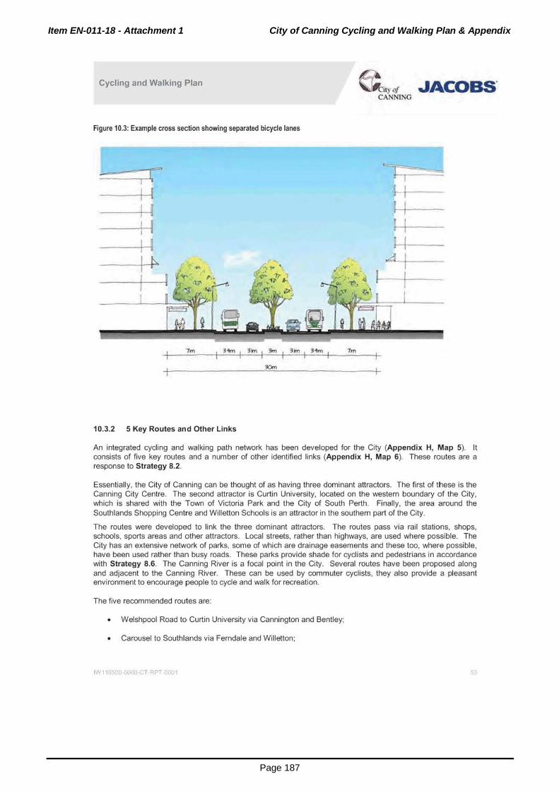
Item EN-011-18 - Attachment 1 City of Canning Cycling and Walking Plan & Appendix
Page 187
Cycling and Walking Plan ~ity()' JACOBS' CA NING
Figure 10.3: Example cross section showing separated bicycle lanes
7m I Hm r 3m I 3m I 3m I Hm I 7rn
10.3.2 5 Key Routes and Other Links
An integrated cycling and walking path network has been developed for the City (Appendix H, Map 5). It consists of five key routes and a number of other identified links (Appendix H, Map 6). These routes are a response to Strategy 8.2.
Essentially, the City of Canning can be thought of as having three dominant attractors. The first of these is the Canning City Centre. The second attractor is Curtin University, located on the western boundary of the City, which is shared with the Town of Victoria Park and the City of South Perth. Finally, the area around the Southlands Shopping Centre and Willetton Schools is an attractor in the southern part of the City.
The routes were developed to link the three dominant attractors. The routes pass via rail stations, shops, schools, sports areas and other attractors. Local streets, rather than highways, are used where possible. The City has an extensive network of parks, some of which are drainage easements and these too, where possible, have been used rather than busy roads. These parks provide shade for cyclists and pedestrians in accordance with Strategy 8.6. The Canning River is a focal point in the City. Several routes have been proposed along and adjacent to the Canning River. These can be used by commuter cyclists, they also provide a pleasant environment to encourage people to cycle and walk for recreation.
The five recommended routes are:
• Welshpool Road to Curtin University via Cannington and Bentley;
• Carousel to Southlands via Ferndale and Willetton;
IN 1165(;0 0000 c T RPT C001 5J

Item EN-011-18 - Attachment 1 City of Canning Cycling and Walking Plan & Appendix
Page 188
Cycling and Walking Plan ~ily (J' JACOBS' CANNlNG
• Carousel to Rossmoyne High School via Lynwood and Willetton;
• Carousel to Curtin University via Wilson;
• The North South Route from Curtin University to Canning Vale.
In addition, a number of other links have been identified. These have been termed other identified links. The five routes and other identified links are shown in Appendix H, Maps 7 to 12.
10.3.3 Canning City Centre
The Canning City Centre is a designated strategic metropolitan centre within the Perth Metropolitan Region. As such, it is being planned and developed as the major activity centre within the Canning Region. It will be a major hub for all modes of transport, including walking, cycling and public transport. Over 30 to 40 years it is planned that the Canning City Centre will expand as follows:
• 80,000m2 of additional commercial floor space;
• 60,000m2 of additional retail floor space;
• 40,000m2 of additional community/institutional floor space; and
• 10,000 new dwellings to house about 20,000 new residents.
The Canning City Centre Structure Plan is shown in Figure 10.4.
IN II 0 0000 CT RPT 001 54

Item EN-011-18 - Attachment 1 City of Canning Cycling and Walking Plan & Appendix
Page 189
Cycling and Walking Plan
Figurn 10.4: Canning City Centre map
' .
.r<PT 01
< , '
- ( ... f-~ . \o# .. "l'##~ 0 ........ .,, .. ...,....,~ldt._..
'-~~ - ... _ . ._."~· ... .,_( .................. ~....,
a-t:i 1\(Joo . ·-·--._'"'---~ ..... --~_.,_ .. , -~ ... -"'-~ -.,.~~~ ~~-~
... ·-~,----~.f .. ~ ---~ .......... .._ • .-.(h-~
- ~~· Q tN-.. ·-

Item EN-011-18 - Attachment 1 City of Canning Cycling and Walking Plan & Appendix
Page 190
Cycling and Walking Plan ~ity ot JACoas· CANNING
There are five major strategies to guide the transport planning for the growth of the Canning City Centre. Combined, these strategies are planned to decrease the mode share of car driving by over 30%. The mode share of walking is projected to grow from 9% in 2011 to 15% and that of cycling from 2% in 2011 to 12% in the longer term (refer to Table 10.1 ).
Table 10.1: Short and long term mode share targets for Canning City Centre
Mode Share in 2011 Mode Share Longer Term (2040-50)
Car driver 58% 40%
Car passenger 23% 10%
Public transport 7% 16%
Cycling 2% 12%
Walking 9% 20%
Other 1% 2%
In the future we are likely to see about 20,000 walking trips and 12,000 cycling trips to, from and within the Canning City Centre each day. A significant level of improvement to the cycling and walking network will be necessary within the city centre as well as to I from the city centre to meet the future demand for cycling and walking. Previous planning for city centres in major Australian cities largely ignored provision for cycling and walking and this has resulted in difficulties in providing the required accessibility retrospectively. For example, whilst bicycle access to the edge of Perth City is well-developed, access within and through the Perth City is more limited. One means of providing access for bicycles within a city centre is to build bicycle lanes, preferably at verge level, to ensure cyclists are separated from both pedestrians and motor vehicles. One design option that will provide separation from vehicles and pedestrians is to raise the cycle lane to half the verge height.
The City is currently refining its plans for cyclists and pedestrians within the City Centre. Cecil Avenue is a particularly important street for both cyclists and pedestrians. It is being proposed that Cecil Avenue be developed as an activity corridor or main street between Albany Highway and the Cannington Railway Station. Whilst the final provision for cyclists and pedestrians within the City Centre is not yet finalised, it is envisaged that shared paths will be provided. As discussed in Section 1 0.3.1, these may be a combination of DOT standard shared paths and shared paths built to a standard approved by the City. A preliminary plan for the provision of cycling infrastructure in the City Centre is shown in Figure 10.5.
It is proposed that a significant level of bicycle parking be provided both at Cannington Railway Station and within the city centre.
Albany Highway is a major segregator of that portion of the city centre adjacent to the River and the main retail core of the City Centre. It is desirable that a new pedestrian and bicycle bridge be provided over Albany Highway as it will provide improved access into the core of the retail area.
IW 11 500 0000 c T RPT 0001 56

Item EN-011-18 - Attachment 1 City of Canning Cycling and Walking Plan & Appendix
Page 191
( Traffic Stgnals H.gh$chools
" SPQI15Are~ - KeyAtlractor
-Roads ..... , Cadastre - Sho,..og
=- Railway Celli res
_ City Centre Parb&
Boundary Re..., ..
Other Shared - F'at.ti(C.ty
Centre}- Type 1
Other Shate<:f - Path(City
Centre)- Type 2
- DOT Shared
~-• '"">eipo!Sho'Od
~ ...
Western Australia
-Oaun Get~C»M'ic Oaturn of A LI&tnllia 19\)t PrOfKtiOn UfP Grid Aut;trflla. Zon. 50
Sources Cadastre : LandQ81e WFS. 2016 Roe4t: u.-rwofodt 2016 Cycle A.outn & AcMy Ate a& OtydCann~ttg 2'04»
F'M g024_1W116500_ Pr()j)_A4P_Rt '09 (£W 03110120114)
.IACOBS" JACOB$ 263 Ade .. iele Tetnce Perth WA 6000 Tel: •61 a 9469 u oo f•J: •61 8 9469 4"88
11lia ,.._. IMIJ. MM compiled will'o ciMI tom numerous -.mea with ditfotrenl leYellol«Qi'liCY¥'Cir.-ab.,.¥'CI .. QOntoQefed~lhtMI!hortiObefc~llt ilandod purpoH • I flelmll of pu~
How-. Alhoolllbll Meed llwllhe lf'llcrrnMOn a/'ow"ntnay N Mb)ed to ct..nqe end ~lrnllillty. mlp ..... .,.,equrtd II) dt~ .._. lulllbMy of ..-!of •t¥t 1)111!1::~ .. .., flu!J')()M
JAC08$ do ... Mi -~~ Nt ~~~ '""" 11 he from .,cwa cw ~ JACOBS.,. .. n01 be.,..,)'....,,_.. tor 1051. dllma>ge or WIJ~ 110 tilt"'* ol Nlrntpcrr•ny~~Ot()fgOI.,..IIoJ'IconMCp.~enl ~or.,tiCitr"' .. IOIIe _.__ottmnor-IIOniOI'I._rNp.

Item EN-011-18 - Attachment 1 City of Canning Cycling and Walking Plan & Appendix
Page 192
Cycling and Walking Plan ~ityot JACOBS. CANNING
10.3.4 Assessment, Costing and Prioritisation
Appendix G shows the recommended treatment, estimated cost and priority for each section of the planned network as referred to in this sub-section.
The suggested path network has been split into small sections for needs analysis. For each section, the estimated length and current treatment have been obtained using aerial imagery and measuring tools available in the City of Canning's lntramaps application. The treatment suggested for each section has been added. In Appendix H, Maps 7 to 12 show each of the routes plus the other links, symbolised according to the type of treatment recommended.
Treatments include:
Bicycle boulevards on low volume/low speed streets;
Bicycle lanes;
Shared paths for cyclist and pedestrians.
Some sections in the path network are not in the City's boundaries, but are included in the implementation plan to demonstrate continuity and the desire to have seamless provision of infrastructure across local government boundaries. It is suggested that City of Canning officers liaise with counterparts in neighbouring local governments to encourage them to provide cycling and walking infrastructure at the boundary interfaces to a similar standard as the City of Canning.
Figure 10.6: Treatment of paths to be used by pedestrians and cyclists 200
180
160
i 1ol0 X
& i 120 ~
i 100
.. e. .. 80 s
l 60 0 0 z oiO
20
0
No. ot cyctsts (I'M)oW'ay per peak hoUr)
The treatment most frequently recommended is a 2.5m shared path, which can be used by both pedestrians and cyclists. This width was agreed in consultation with the City of Canning Steering Committee and reflects a balanced approach to gradually upgrading the City's already extensive footpath network to a series of shared path routes. In addition, the City of Canning should refer to Figure 10.6 which provides guidance as to when a
IW 1165CO 0000 C T RPT C001 58

Item EN-011-18 - Attachment 1 City of Canning Cycling and Walking Plan & Appendix
Page 193
Cycling and Walking Plan & ,yof .JACOBS. CANNING
wider or narrower path might be appropriate depending on the volumes of cyclists and pedestrians using the path. Further, Figure 10.7 indicates when volumes may become sufficient to consider segregation of pedestrians and cyclists.
A second recommended treatment is bicycle lanes. Bicycle lanes should be implemented where the traffic volume and vehicle speed are insufficient to warrant the building of separate paths. Figure 10.7 (from Austroads} provides guidance.
Figure 10.7: Recommended traffic volume/speed thresholds and cycle infrastructure (Source: Austroads)
Volumfl ol motor vehklei (nhlde ... day} 12.000
11.000
10.000
t .OOO
t.OOO
1.000
s.ooo
4.000
3.000
1.000
1.000
0
0 10 20 ;JO 44 54 60 10 eo 90 too ~ CIIOWIO 199J,OW: 19'19,0/!D ZOOO,SUSTAAHS. 1091 ts• per<entll• ~ed In kmlh
The final recommended treatment is the bicycle boulevard. Bicycle boulevards are a new concept for cycle management in Perth, but have been used successfully in The Netherlands for a number of years. They are low speed roads (30km/h) where cars must give way to bicycle riders. The DOT recommends the treatment only for roads that have a volume of less than 1500 vehicles per day. The roads will be clearly marked and designed to reduce the need for cyclists to stop frequently. In addition, crossings are optimised for cyclist safety and cyclists are permitted to ride two-abreast. Some diagrams showing the concepts for the Belmont Bicycle
IN 11 )SCO 0000 c T RPT 0001 59

Item EN-011-18 - Attachment 1 City of Canning Cycling and Walking Plan & Appendix
Page 194
Cycling and Walking Plan @i.yor JACOBS' CANNING
Boulevard are below in Figure 10.8. There are various factors to take into consideration when deciding whether to implement bicycle boulevards, including bus routes and street parking. There is a need to determine whether these functions are compatible with the intent and operation of streets to be treated as bicycle boulevards or if bicycle boulevards should only be placed on streets that do not already have these functions.
Figure 10.8: Example bicycle boulevard designs (Source: City of Belmont)
Some minor~ Will betaMd 10
~~spo.dsond~-(ot ~ aossinr rhe ~ (lldcotM}.
Slow poir>l fleounMtS wit be iosldled ob1f rhe I'OCite w enswe ~ $peeds Of~ rNx,ed (lftdialtMj.
The first bicycle boulevards are to be implemented in the City of Belmont in 2016. The City has also expressed a desire to have bicycle boulevards as "signature projects" in its path network. The first bicycle boulevard in the City is proposed for Gibbs Street. This has been prioritised in the first five years, nominally in 2018. There are no set designs yet for bicycle boulevards in Perth. This is a new and evolving active transport prioritisation method. As such, it is recommended that there be active evaluation of the different bicycle boulevard designs with a view to continuous improvement for cydists and other road users.
A cost to build each section was approximated for the purposes of preliminary budgeting. In calculating the approximate cost, the following assumptions have been made:
• All paths recommended in this plan are to be 2.5m wide shared (pedestrian and cyclist) paths;
• The City of Canning advised that paths cost approximately $100 per square metre ($250,000 per kilometre) to design and construct;
Bicycle lanes are also assumed to cost $250,000 per kilometre.
• The Department of Transport has advised that bicycle boulevards are likely to cost $500,000 per kilometre.
It should be noted that these cost estimates will need to be refined as designs are developed.
The priority of the works on each section was then assessed. The criteria applied in the prioritisation include:
That the section falls within the City of Canning boundary;
That there is no existing treatment or (for sections where shared path is recommended) that the existing footpath is less than 2m in width;
That the section contributes towards a connected network (one of the five identified City of Carnning Path Routes or an extension to one of these routes).
IN 11 >500 00011 c T RPT 0001 60

Item EN-011-18 - Attachment 1 City of Canning Cycling and Walking Plan & Appendix
Page 195
Cycling and Walking Plan &,y ot .JACOBS' CANNING
Each section was then given a priority of high, medium or low:
• Yes to all criteria gives high priority.
• Yes to two criteria gives medium priority.
• Yes to one criterion gives low priority.
It is also possible for sections to be identified as "No work needed" if the treatment in place is the treatment recommended. Where a path is recommended, the section will not be marked "no work needed" until all the paths in the section are at least 2.5m wide.
The sections and their priorities were then considered further by the City of Canning Steering Group members for:
Ability to implement;
Level of support/reference to the section in the community consultation;
Background knowledge of the City of Canning Steering Group members; and
Cost and cost effectiveness.
After calculating the cost of each section and assessing its priority, a determination was made as to which year the project could be undertaken in. The speed with which the suggested path network can be implemented is highly dependent on the level of funding the City of Canning can secure from the Department of Transport for active transport infrastructure. This report recommends that cycling and walking funding should rise to $15 per head of population per annum by 2021 and to $20 per head of population by 2031. With a population of 100,000 this means that the City should secure at least $1 .5 million per annum. There should be a 50/50 split in funding between the City of Canning and the Department of Transport. The City of Canning has committed to increasing the funds it allocates to cycling from the current $650,000 (including DOT contribution) to $750,000 (excluding DOT contribution) per annum. Ideally DOT would match this contribution by way of grants to local governments, but in recent years has provided as little as $250,000 to the City of Canning.
Figure 10.9 to Figure 10.11 graphically indicate how much more quickly the suggested path network can be completed if more substantial levels of funding are forthcoming. The projects are tabulated into 5 year increments in Table 10.2.
Figure 10.9: Timeline to implement with 1 million pa funding
2018 2019 2020 2021 2022 2023 2024 2025 2026 2027 2028 2029 2030 2031 2032 2033 2034 2035 2036
Route l I Route 2
Route 3
Route4 L J Route S I I CilY~nltt iond Q\hcridcntified l•nb I
Figure 10.10: Timeline to implement with 1.25 million pa funding
2o18 I 2019 I 2020 I 2021 I 2022 I 2o23 I 2024 I 2025 I 2026 I 2021 I 2o28 I 2o29 I 2o30 I 2031 I 2032 I 2033 I 2034 I 2o35 I 2036
Route 1
Route 2
Route 3 L I Route4 L J Route 5 I I OtyCentlc and othcridentificd links. I I
IN 11 )5()0 0000 c T RPT 0001 6
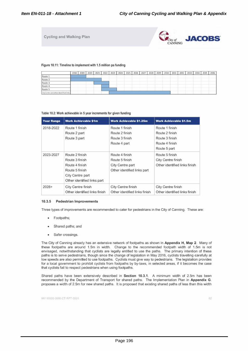
Item EN-011-18 - Attachment 1 City of Canning Cycling and Walking Plan & Appendix
Page 196
Cycling and Walking Plan ~ity ot .JACOBS. CANNLNG
Figure 10.11: Timeline to implement with 1.5 million pa funding
2o18 1 20t9 1 2020 1 2021 1 2022 1 2on 1 2o24 1 2025 1 2026 1 2021 1 2028 1 2029 1 2o30 1 203t 1 2032 1 2on 1 2034 1 2035 1 2036 Route 1
Route 2 Route 3 Route 4 RouteS l J CHy C4!'ntteanclott'ler ldentffiedlinb I
Table 10.2: Work achievable in 5 year increments for given funding
2018-2022
2023-2027
Route 1 finish
Route 2 part
Route 3 part
Route 2 finish
Route 3 finish
Route 4 finish
Route 5 finish
Route 1 finish
Route 2 finish
Route 3 finish
Route 4 part
Route 4 finish
Route 5 finish
City Centre part
Other identified links part
I
Route 1 finish
Route 2 finish
Route 3 finish
Route 4 finish
Route 5 part
Route 5 finish
City Centre finish
Other identified links finish
City Centre part _j Other identified links pa~ City Centre finish I City Centre finish 2028+
Other identified links finish Other identified links finish Other identified links finish
10.3.5 Pedestrian Improvements
Three types of improvements are recommended to cater for pedestrians in the City of Canning. These are:
• Footpaths;
• Shared paths; and
Safer crossings.
The City of Canning already has an extensive network of footpaths as shown in Appendix H, Map 2. Many of these footpaths are around 1.5m in width. Change to the recommended footpath width of 1.5m is not envisaged, notwithstanding that cyclists are legally entitled to use the paths. The primary intention of these paths is to serve pedestrians, though since the change of legislation in May 2016, cyclists travelling carefully at low speeds are also permitted to use footpaths. Cyclists must give way to pedestrians. The legislation provides for a local government to prohibit cyclists from footpaths by by-laws, in selected areas, if it becomes the case that cyclists fail to respect pedestrians when using footpaths.
Shared paths have been extensively described in Section 10.3.1 . A minimum width of 2.5m has been recommended by the Department of Transport for shared paths. The Implementation Plan in Appendix G. proposes a width of 2.5m for new shared paths. It is proposed that existing shared paths of less than this width
IN 11 500 0000 c. T RPT 0001 62

Item EN-011-18 - Attachment 1 City of Canning Cycling and Walking Plan & Appendix
Page 197
Cycling and Walking Plan & ,y of "Acoas· CANNING
remain until such time as there is a need for their re-construction. Pedestrians would benefit as well as cyclists from these new or upgraded shared paths.
This report does not aim to provide detailed engineering designs for the footpath network. Safer street crossings and intersection improvements for pedestrians should be a key consideration when designing solutions and delivered when construction or upgrading of infrastructure occurs. Reference should be made to Appendices B and D where the saddle survey participants and community members have identified locations as needing particular attention in the design stage. These identified crossings or intersections include but are not limited to those listed in Appendix F. This list has not been prioritised.
10.3.6 Considerations for Aged Care Residents and Mobility Scooter Users
There are a number of aged care faculties in the City. Elderly people may be less agile than the general population, but still benefit from physical exercise, such as walking. People with a disability who are in a wheelchair or reliant on walking frames also benefit from well-maintained paths. A further consideration for the City is the provision of street furniture in the form of park benches close to aged care facilities, so that residents have a known place to rest, if needed. The City may also wish to work with state authorities to ensure pedestrian crossing phases of adequate length at traffic lights near aged car homes and to provide crosswalks. Application of universal design principles in general will aid elderly residents.
Residents may like to use tlhe upgraded path network in the vicinity of these their establishment. These are listed in Path network near aged care homes Table 10.3. Refer to Map 6 in Appendix H.
Table 10.3: Path network near aged care homes
Location
Adventist Care 31 Webb Street, Rossmoyne Other identified links ~ Margaret Hubery House 62 Fifth Avenue, Rossmoyne Other identified links
Pallotine Centre 50-60 Fifth Avenue, Rossmoyne Other identified links
Joseph Cooke Hostel 36 Fifth Avenue, Rossmoyne I Other identified links ~
Lot 1637 Elshaw Street, Queens Park I Route 1; Other identified links -
Queens Park Day Centre
Homestay Village 267 Wharf Street, Queens Park Route 1; Other identified links -
Wilson Village 22 Beaton Street, Wilson Route 4; Route 5; Other identified links
Castledare Village 108 Fern Road, Wilson Route 4; Other identified links ~ --
241 Ferndale Crescent, Ferndale -Route 2
Howard Solomon Home 91 Hybanthus Road, Ferndale Route 3
Canning Lodge 8 Caprice Place, Willetton Route 2; Other identified links
River Pines Community 25-27 Parkhill Way, Wilson Route 4; Route 5; Other identified links -
Multiple Sclerosis WA 1 Wendouree Road, Wilson Route 4; Route 5; Other identified links
1-Agmaroy Home 81 Bungaree Road, Wilson -
Route 4; Other identified links
It is also suggested to consider mobility scooters as possible users of the path network. Mobility scooters can allow people with limited walking ability to maintain a certain level of independence, day to day convenience,
IN 11 )SCQ 0000 c T RPT 0001 6J

Item EN-011-18 - Attachment 1 City of Canning Cycling and Walking Plan & Appendix
Page 198
Cycling and Walking Plan &,yot -JACOBS' CANNING
connection with others and mental well-being. These affordable, electric devices may increase in popularity as the City's population ages. In Western Australia, mobility scooters (and motorised wheelchairs) are classed as pedestrians if the maximum speed of the device is less than 10 km/hr. These devices are permitted therefore to travel on footpaths, shared paths and the side of a road (as per a pedestrian) if there is no path. Devices capable of a maximum speed of over 10km/hr must be registered as vehicles.
Planning for mobility scooter users can involve:
• Continuing to roll-out the strategies in the Canning Disability Access and Inclusion Plan. Scooter users, like other mobility impaired people, will benefit from wide debris-free footpaths, kerb ramps and pedestrian crossings;
• Obtaining advice about universal design when building, renovating or upgrading City facilities; • Providing circulation/manoeuvrability space in car parks, at intersections and in public spaces; • Providing scooter parking. As most scooter users can actually walk for short distances, a place to leave
the device at public locations (such as at City facilities or shopping centres) will be needed; • Creating a "mobility map" for Canning - depicting routes that are currently accessible by scooter users
(over and above the standard footpath maps); and • As scooters run off electric batteries, provision of battery charging stations would increase the range
scooter users can cover.
It should be noted that mobility scooters are not meant to be used as a replacement for a motor vehicle. They can be dangerous and there have been accidents and fatalities. Mobility scooters do not have effective headlights and are impractical for use in rainy, windy or very hot weather. They cannot be used to travel long distances. People who are long term or permanently unable to walk may be better off to investigate the use of on-demand transport (including taxis or services such as Uber and Chafer) together with accessible public transport to cater for their accessibility needs. Seniors and pensioners travel for free on Transperth services.
Finally, as there are currently no laws in Western Australia that prohibit the use of mobility scooters by people who do not have limited mobility, there are certain people may who abuse mobility scooters and use them without having a medical need for the devices. State and local authorities should monitor this phenomenon and take action to restrict this behaviour so that the problem does not exacerbate to a level such that people who have a genuine need for assistance are deprived. Further to this, though there may be mental well-being benefits to those who use mobility scooters to stay connected, everybody who is able, benefits from light exercise, such as walking .a short distance. It is not advised to encourage the use of mobility scooters in the general population as it ages.
10.3.7 Pedestrian/Cycle Bridge Over Freight Rail Line
A pedestrian/cycle overhead bridge is required to provide connectivity in the North-South Route and allow users to pass over the freight rail line in Canning Vale. The location of the bridge is: 32.073593· s. 115.906129•E (the closest road on the north side is Mordaunt Circuit and on the south side, the closest road is Park Lane). Figure 10.12 below shows the situation.
The situation has been notionally examined by a structural engineer in a desktop exercise using aerial photography. This seems to indicate that as the bridge ramp launches and rai l reserve appear to be similar in level, the ramp lengths will need to be in the order of 90-100m in length to ensure the required clearance over the rail reserve. This would however depend on obtaining exact ramp launch levels and the available space for the ramps (ie. circular or straight ramps). The cost of the bridge is estimated to be around $6.5 million to $7 million. This provides for:
• A span of approximately 30-35m.
• A width of approximately 3.5m.
• Height sufficient to allow for freight trains to pass underneath.
This budget would likely include:
IN 11 >SCO 0000 c T RPT 001 64

Item EN-011-18 - Attachment 1 City of Canning Cycling and Walking Plan & Appendix
Page 199
Cycling and Walking Plan & ,y of JACOBS. CANNING
• Delivery agency fees;
• Professional fees;
• Contractor overhead and margin; and
• Project risk and contingencies.
Figure 10.12: Google map aerial image of site
Though this bridge has a significant cost, it is an important and strategic link in the cycling and pedestrian network and it is recommended that the City of Canning liaise with the Department of Transport to determine if funds may be available to facilitate its construction in future years.
Due to its expense, the bridge is likely to be a longer term project. However if funding could be secured to build the bridge, it could be needed as early as 2024 (in the $1m funding scenario), 2023 (in the $1.25m funding scenario) or 2022 (in the $1.5m funding scenario), in order to complete the North-South route.
Design guidance, including for ramp gradients, tactile ground surface indicators (TGSI) and balustrading for pedestrian overhead bridges is contained in "Planning and designing for pedestrians: guidelines" produced by the WA Department of Transport and should be considered in the detailed design of this bridge.
A different option for cyclists and pedestrians needing to cross the freight railway line is by using the path on the Ranford Road bridge. The upgrade of the bridge is to be undertaken as a part of the Ranford Road works programmed for 2016.
IN 11 )SCQ 0000 c T RPT 001 65

Item EN-011-18 - Attachment 1 City of Canning Cycling and Walking Plan & Appendix
Page 200
Cycling and Walking Plan @ i,y of .JACOBS. CANNING
11. Changing Behaviour Increasing the mode share of cycling and walking will not be achieved by the implementation of physical infrastructure changes alone - a level of behavioural change in the residents, workers and those who visit the City of Canning is required . Consideration of behavioural change strategies to promote cycling and walking is therefore warranted. These may be complemented by changes to local planning strategies and regulations.
In addition to behavioural change programmes, such as Your Move, promotional strategies are recommended to highlight improvements in connections to schools and public transport hubs as well as other public areas such as hospitals. Promotional products, such as leaflets, webpages or information sessions should inform the general public on the improvements as they are planned and implemented in order to gain buy in from the general public for the plan. Cycling and walking maps depicting routes, cycle parking and end of trip facilities would also be beneficial. Promotion of the environmental and health benefits to the user may further assist in encouraging cycling and walking as alternative modes of transport (these were detailed in Chapter 3).
Behavioural change programmes or promotional strategies should be discussed with the Department of Transport to determine what subsidies or grants may be available for specific programmes within the City of Canning. Discussions with other stakeholders (for example, schools or tertiary education institutions or major centres) should also be held.
11.1 TraveiSmart/Your Move Officer
It is recommended that the City of Canning employ a dedicated TraveiSmarVYour Move Officer. This officer would focus on attaining mode shift and ensuring that cycling and walking measures are integrated with the overall land and transport planning activities of the City. This Officer would also have a role to:
• Organise education and cycle proficiency programmes in schools; • Conduct cycle training and driver awareness campaigns with city residents; • Develop walking programmes that link to existing national and local walking initiatives that offer a
variety of routes, paces and distances at different times of the day; • Organise community cycling events such as Bike to Work or Cycle on Wednesdays; • Organise community walking events, such as walking groups, community challenges, 'walkathons' or
programmes for adults who are not active enough; • Ensure all programmes address safety, cultural and disability issues; • Provide information tailored for individuals who want to walk or cycle without joining a group or club; • Define and promote appropriate and safe cycling and walking routes to other community events; • Liaise with neighbouring councils regarding provision of cycling and walking facilities at the interface of
City boundaries; and • Work with workplaces to minimise car use or create incentives for not using car parking.
The Department of Transport may provide seed funding (first year salary) for the establishment of TraveiSmarVYour Move Officer positions within local governments.
11.2 Identifying Target Groups for Promotion and Behaviour Change Programmes
The ultimate objective of behaviour change programmes is to transform the current mindset that makes the car the priority. Cycling and walking need to become habitual. To quote Ceri Woolsgrove, road safety policy officer at the European Cycling Federation in an interview for the BBC on how to get a city cycling- March 2015:
IN 11 >SCO 0000 c T RPT 001 66

Item EN-011-18 - Attachment 1 City of Canning Cycling and Walking Plan & Appendix
Page 201
Cycling and Walking Plan ~ity ot .JACOBS' CANNING
"Once cycling becomes your main mode of transporl, your go-to mode, then it takes pretty bad weather to shift you from that formed hablt," he says. "After all, the Danes carry on cycling even when conditions are much colder than those London experiences, while in sunny Australia cycling is the exception rather than the rule. ·~3
Promotion must be as wide as possible. This can be achieved by campaigns and measures that target specific groups within the commurnity. Differing methods may be needed to reach and then encourage cycling and walking within each targeted group.
At the Key Stakeholder Workshop 1 (held on 181h February 2016), participants identified various target groups:
• Schools and universities; • Workers; • Householders who make trips both for shopping/utility purposes and recreation; • Event attendees; and • People who drive or take feeder buses only a short distance to rail stations.
Suggestions for reaching the various target groups include:
• Brochures, fact sheets and maps advising residents of the City about cycling and walking and the recommended routes to travel in and around the City. New residents could be targeted in particular, possibly with a "Welcome to the City" package;
• People who have started walking as a leisure activity to also consider walking as a means of transport; • Social media, as many cyclists love sharing their thoughts and opinions on good and bad facilities.
Being on a bicycle makes it easy to stop and take a photo to share with others electronically; • Bicycle try-out days and weeks or testing events; and
Advertising at train stations.
11.3 TraveiSmart/Your Move and Personalised Travel Planning Programmes
Behaviour is influenced by a range of economic, cultural and environmental conditions, social and community networks and individual factors such as age and sex. Combinations of interventions that tackle population, community and individual-level factors are needed to help people change their behaviour in both the short and longer term. Interventions tailored to the needs of individuals as well as user groups have had success in other Western Australian and international jurisdictions.
11 .3.1 TraveiSmart and Your Move
The Western Australian Department of Transport has run its TraveiSmart programme since the late 1990s. The programme has enjoyed considerable success in achieving mode shift from vehicles to walking, cycling and public transport. It has since been taken up by other cities in Australia and overseas. TraveiSmart uses individualised marketing to inform households about non-car travel options and how their decisions may provide environmental, financial and health benefits.
TraveiSmart can also be implemented at a community level in conjunction with local governments, schools, universities, hospitals and workplaces. Necessary information is provided so that these organisations can encourage desirable travel behaviour changes in their residents, staff, students or customers. In 2013, the schools programme achieved a 12% increase in active transport and a 9% reduction in car trips" and the workplace programme achieved a 13% average reduction in single car travel15• See Table 11.1 for further results by area. The figures for cycling, whilst encouraging, need to be considered with caution, since the base levels of cycling were low.
13 http://www.bbc.com/future/story/20150324-hw-to-get-a-city-cycling 1• http://www.transport.wa.gov.au/activetransportl24611.asp 15 http://www. transport. wa.gov.au/mediaFileslactive-transport/A T _ TS _P _ Evaluation_LocaiGov _ W OO<place. pdf
IN 11 >SCO 0000 c T RPT l!u1 6
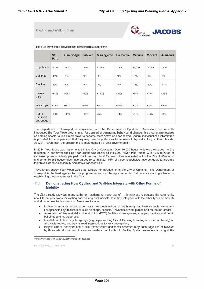
Item EN-011-18 - Attachment 1 City of Canning Cycling and Walking Plan & Appendix
Page 202
Cycling and Walking Plan ~ity of JACoas· CANNING
Table 11.1: TraveiSmart Individualised Marketing Results for Perth
Sth Cambridge Subiaco Marangaroo Fremantle Melville Vincent Armadale Perth
Population 35,000 I 24,ooo 15,000 11,000 17,000 19,000 15,000 7,000
r-- - -
Car trips -14% l -7o/o 1 -12% -4% -12% -12% -9% -9%
I -9o/o
I Carkm -17% -16% -7% -14% -13% -12% -11%
f- -
Bicycle +61% I +67% +25% +140% +38% +75% +30% +29%
trips r-- - -
Walk trips +35% +11 % +11% +57% +25% +22% +22% +45%
Public +20% I +10% I +12% +8% +14% +1 1% +10% +9% transport
I I patronage
The Department of Transport, in conjunction with the Department of Sport and Recreation, has recently introduced the Your Move programme. Also aimed at generating behavioural change, this programme focuses on helping people to find simple ways to become more active and connected. Again, individualised information is provided to participants so that they may tailor opportunities for increased physical activity to their lifestyle. As with TraveiSmart, the programme is implemented via local governments••.
In 2014, Your Move was implemented in the City of Cockburn. Over 10,000 households were engaged. A 5% reduction in car driver trips per participant was achieved (410,000 fewer trips) along with 10.5 minutes of increased physical activity per participant per day. In 2015, Your Move was rolled out in the City of Wanneroo and so far 10,556 households have agreed to participate. 91% of these households have set goals to increase their levels of physical activity and active transport use.
TraveiSmart and/or Your Move would be suitable for introduction in the City of Canning. The Department of Transport is the lead agency for this programme and can be approached for further advice and guidance on establishing the programmes in the City.
11.4 Demonstrating How Cycling and Walking Integrate with Other Forms of Mobility
The City already provides many paths for residents to make use of. It is relevant to educate the community about these provisions for cycling and walking and indicate how they integrate with the other types of mobility and allow access to destinations. Measures include:
• Mobile phone apps and/or paper maps (for those without smartphones) that illustrate cycle routes and linkages with key destinations such as shops, schools, universities, work places and recreation areas; Advertising of the availability of end of trip (EOT) facilities at workplaces, shopping centres and public buildings to encourage use;
• Installation of clear bicycle signage (e.g.: eye-catching City of Canning branding or route numbering) on all bicycle routes, and at vital road intersections to assist navigation; Bicycle library, pedelecs and E-bike infrastructure and rental schemes may encourage use of bicycles by those who do not wish to own and maintain a bicycle. In Seville, Spain passengers arriving at the
'" http:/twww.transport.wa.gov.au/activetransport/34365.asp
I>'V 11 500 0000 C T K uu1 68

Item EN-011-18 - Attachment 1 City of Canning Cycling and Walking Plan & Appendix
Page 203
Cycling and Walking Plan &,y ot .JACOBS' CANNING
main bus station can use their ticket to borrow one of nearly 200 rental bicycles, free for the whole day" . Ideas such as this have helped Seville increase its cycle share from 0.5% to 6% in only a few years.
• Ensure walking routes are integrated with accessible public transport links to support longer journeys. Signage should give details of the distance and/or walking time, in both directions, between public transport facilities and key destinations.
11 .5 Wayfinding
The establishment of a user-friendly way-finding system can promote the use of active travel. Wayfinding systems serve multiple purposes:
• To inform users about the availability and location of facilities; • To inform users of t he time/distance/direction to a facility; and • To create community pride, provoke conversation and communicate local knowledge (to locals and
visitors).
Types of wayfinding systems may include notice boards, pole-top or ground-based signage. A local government may wish to consider the following factors when choosing which method is appropriate for their area:
Cost; • Need for permanence;
Size of geographical area to be covered; • How close together the signs need to be (legibility and walkability of streets); and • The number of facilities/amenities in the locality.
What could the signs show:
• Name of facilities/amenities but also what you can do there. For example, Smith Park (which has basketball rings) could say Smith Park - shoot some hoops. For example, Willetton Park (which has natural bush or a formal garden) could say Willetton Park - relax in with nature;
• Direction, distance and time (to walk as well as to cycle for an average person); • Instructions for use of bicycle maintenance stations, end of trip (EOT) facilities or bicycle store facilities; • Safety/Courtesy signs. For example, cyclists please sound bell/watch for pedestrians; • Location of bicycle parking; • Advertising for local businesses; • Footprints to show children the safe (desirable) path they should take to school (ie. via manned
crossings, avoiding busy roads etc); • Link in with public transport. For example, take this stop- go to Perth, Fremantle etc; • Marking route of recreational trails/community walking tours;
Location of public toilets/water fountain; • Location of disabled/child facilities/ramps/Stairs; • Teaching or history points. For example, about trees or old buildings.
Design considerations should include:
• Text size and font for readability and to achieve a sense of consistency (also ensure it meets requirements of visually impaired people including tactile features as appropriate); Colours for readability in bright light and at night (does it need to be lit up at night?); Use of symbols where possible;
• Cardinal points- N, S, E, W best. Try to avoid anything more complex eg, SE, NW or bendy arrows; • Use distance in metres and a time estimate for the distance to a place; • Consider multilingual signage if relevant for the local area;
17 http://www.theguardian.com/cities12015/ja'li28/sevilte-cycling-capital-scuthem-europe-bike-lanes
IW 11 )SCQ 0000 c T RPT 001 69

Item EN-011-18 - Attachment 1 City of Canning Cycling and Walking Plan & Appendix
Page 204
Cycling and Walking Plan &,~ ot "ACOBS' CANNING
• Number the signs and provide a number/email people can call the Local Government to report damage/problems;
• Where to install - before you reach a destination (to guide your user) rather than at the destination. Consider where "decision points" are, eg. At corners. These are typically good places to put signs. Be aware of "clustering". Placing too many signs together creates visual confusion and makes it hard for user to find/understand information.
Potential funding sources for a wayfinding system:
• Local government; • State Government programs, such as Your Move; • Sustainable travel advocates, such as the RAC or bicycle and walking groups; • Business owners who also get to advertise; and • In terms of installation and maintenance costs: noticeboard signage is likely to be the most expensive
option and ground signage is likely to be the cheapest. Pole signage will be in between.
The recent Your Move Wanneroo programme saw the delivery of the world's largest ground-based wayfinding project. It involved the installation of over 800 signs onto City of Wanneroo footpaths (see Figure 11.1). An extensive process of mapping locations where signage was needed, determining the links between places and the activities to engage in at the places. was undertaken using Google Maps. From here, a spreadsheet of a point, together with the features N, S, E and W of it was developed. A "mail merge" process was used to produce a sign for each point in graphic design software. The signs to be installed on the paths were then printed onto a hardwearing, purpose developed, aluminium-based material called Enviro Non-Slip, specifically designed for resilient footpath marking. As its name implies, the material is non-slip, being infused with glass to create a rough, sand-like texture. When installed, signs appear as if they have been "painted" on to the path. Signs have a lifespan of around two years, although this will vary with the amount of foot/cycle traffic the path takes, and environmental factors like sun/rain. The company producing the signs has made changes to the materials it makes the signs from as new, improved materials become available.
Feedback from the community has been positive, with many people indicating that the signs had helped them to become aware of facilities in the local area of which they were not aware. There was some initial damage (it is possible to "lift" the signage, if someone deliberately wants to dislodge it with a knife). The City of Wanneroo's response was the same as for graffiti - to rectify the damage as soon as possible so that offenders see that their damage will not be tolerated.
The key reason for the choice of ground-based signs was cost. The City of Wanneroo is an extensive, outermetro (some parts still rural) local government area. This meant that hundreds of sign posts would be required to service the area adequately. This was prohibitively expensive. Ground based signs were a low cost infrastructure initiative to achieve way finding in the area.
Figure 11.1: Examples of signa.ge used in the City of Wanneroo
IN 11 >5C0 0000 C T RPT C001 10

Item EN-011-18 - Attachment 1 City of Canning Cycling and Walking Plan & Appendix
Page 205
Cycling and Walking Plan e~,t ot "ACoas· CANNING
Pole based signage has been installed in Perth City (see Figure 11.2). Perth City benefits from more visitors that the outer-metropolitan regions of Perth, has a number of "big-tickef' attractions, and has more footpath space to install the signs, but a smaller local government area (so there are actually less way-finding signs than in City of Wanneroo). It also has different budget considerations. The volume of people on the footpaths is higher and it is hard to read ground signs when many pedestrians are walking on them. Pole base signs have the same design considerat ions as for ground based signs. Placement of poles also requires consideration.
Figure 11.2: Pole based signage in the City of Perth
A further option is notice board signs. Typical in large cities, these provide the user with a large scale geographical map of the walkable catchments (typically 400 to BOOm) surrounding the sign. These are good for dense cities with a number of attractions in a small area, conversely they are good when a whole small area can be depicted all at once (such as in small regional Western Australian towns, typically in a shelter as you enter the town). This type of sign is very expensive to install and modify as faci lities/attractions change. As with the design of colour, typology and symbols on the other two sign types, the clatity of the cartography on the map will influence how easily and effectively users can find their way. Heads-up mapping is a more recent manner of presenting a walkable wute and may also be suitable in some cases.
It is recommended that the City of Canning examine the potential to implement a way finding system for cyclists along its proposed major cycling routes. The general approach adopted in Wanneroo may be applicable to the City. The lower cost ground maps can be installed at regular intervals along the major City of Canning cycle routes with reinforcement after each turn on the route.
11.6 Reducing Car Use, Re-educating Drivers
Provision of increased cyding and walking infrastructure and behaviour modification programmes can be accompanied by measures to provide a disincentive to excessive car use and re-educate drivers. "Share the road" media education campaigns may help to increase driver awareness and encourage more peaceful coexistence between pedestrians, bicycles and drivers (ie. All road users).
IN 11 >5C0 0000 G T RPT 0001 ,.

Item EN-011-18 - Attachment 1 City of Canning Cycling and Walking Plan & Appendix
Page 206
Cycling and Walking Plan ~ityof .JACoas· CANNLNG
Local government can work with state government on demand management and legislative change to protect cyclists and pedestrians. For example:
• Laws to protect cyclists from bigger and heavier vehicles on the road. In the Netherlands and Denmark (two countries in the world that have come closest to restoring the bicycle to its pre-auto role), cyclists are protected by an extensive legal framework and are fully recognised users of the road;
• Demand management measures designed to reduce car traffic whilst encouraging cycling and walking; • Develop the Safe Routes to School agenda and 40km/h zones programme. The local government can
promote Safe Routes to School Schemes in association with School Travel Plans every year and also 30kph zones. These provide improvements to pedestrian facilities and speed-reducing features around schools and residential roads in the City.
• Reducing vehicle speed limits to 30km/h in the City Centre and activity centres and giving priority to cyclists in designated "bicycle boulevards" to mitigate car and bicycle conflict. Three streets in metropolitan Perth have also been identified as suitable to be bicycle boulevards and will be converted shortly. These are the first for Western Australia, and are located in Shakespeare Street, City of Vincent; Leake Street, City of Bayswater and Surrey Road, City of Belmont.
Push policies may also be appropriate. Studies by the municipality of Amsterdam have shown that push policies such as discouraging car use are more effective than "pull policies" such as improving bicycle facilities, in increasing bicycle use. Push policies (which again may require the State government to intervene) include:
• Car exclusion zones around schools (such as 2km zone enforced by police); Reducing the supply of free car parking;
• Introduction of paid parking at shopping centres and in surrounding streets; • Car free days.
11.7 Travel Plans and Parking Requirements During Development Approval Process
Cycling and walking can become normalised at the planning level by considering them in existing processes. Travel plans are often required as a condition of development for major centres, office developments or retail expansion. Following negotiation, developers are required to implement measures such as improved and safer bicycle access and provide a greater level of bicycle parking and other end of trip facilities such as lockers and showers. The City of Canning can consider mandating such Travel Plans as part of all significant development approvals. This would ensure that the cycling and walking consequences of proposed development are rigorously evaluated. This includes evaluating their impact on health inequalities, in all processes in the city governance. In addition, the City can require cycle and pedestrian audits of all proposed road building or widening, and traffic management schemes. Audit procedures need to be adopted to make sure that opportunities are not missed to enhance cycling and walking conditions, and help avoid inadvertently making them worse.
The City of Canning can encourage development patterns and plan the location of residences in the vicinity of other land uses, so that on'ly short trips may need to be made to work, places of education and other locations. This can be achieved by providing developers with clear guidelines on the requirements for cyclists and walkers in their developments.
It may also be appropriate for the local government review its car parking requirements and set maximum desirable car parking levels for new and existing development rather than minimum quotas. This will reduce the amount of land utilised for car parking, which could be instead employed for pedestrian or cycle facilities.
11.8 Bicycle Parking, End of Trip (EOT) and Maintenance Facilities
It is essential that sufficient parking and end of trip facilities be provided for cyclists. Bicycles, on average, require about one sixth of the parking space required for cars. The amount of bicycle parking required should be determined based on the future mode share of parking. For example, in the Canning City Centre a mode share of cycling of 12% is projected and a mode share for car driving of 40%. As a rough guide therefore, the amount of bicycle parking in the city centre should be about 30% of car parking.
I'"' 11 500 0000 c. T RPT 0001 /2

Item EN-011-18 - Attachment 1 City of Canning Cycling and Walking Plan & Appendix
Page 207
Cycling and Walking Plan & tyof .JACOBS' CANNING
As part of development control, the City of Canning will achieve future levels of bicycle parking in the same way as it does for car parking by requiring developers to provide a certain level of parking or by requiring developers (of generally smaller developments) to pay a cash-in-lieu payment.
Intensity of development is planned to be greater in the Canning City Centre than it is outside of the centre. For this reason the provision of bicycle parking and end of trip facilities may be at a higher rate in the City Centre than it is for the remainder of the City.
The following estimates of bicycle parking (per 100m2 of NLA unless otherwise specified) are provided for the City of Canning:
Table 11.2: Bicycle parking rates
Land use
Office, commercial, 0.6 bicycle bays (0.5 workers + 0.1 visitors) 0.4 bicycle bays (0.3 workers + 0.1 visitors) health, civic,
Retail uses, 0.5 bicycle bays (0.4 visitors+ 0.1 staff) 0.5 bicycle bays (0.4 visitors + 0.1 staff) restaurant, child care and other uses with low staff: customer ratio1
Residential 1 bicycle bay per 3 dwellings (residents) + 1 bicycle bay per 3 dwellings (residents)+ apartments• 0.1 bicycle bays per dwelling (visitors) 0.1 bicycle bays per dwelling (visitors)
f--- - -Industrial, Not a permitted use in the City Centre 0.2 bicycle bays (mainly staff) showroom (bulky goods) and veterinary centre1
-Education2 Primary and secondary Primary and secondary
0.5 bicycle bays per student + 0.5 bicycle bays per student +
0.1 bicycle bays per staff member 0.1 bicycle bays per staff member
Tertiary Tertiary
0.15 bicycle bays per staff and students 0.15 bicycle bays per staff and students
'This is in accordance with the R-Codes (SPP 3.1) as amended on 2311012015 but could be increased to 1 bicycle bay per dwelling
(residents)+ 0.1 bicycle bay per dwelling (visitors).
' These uses presume that mainly staff will require the bicycle bays but customers will drive.
'These uses presume that both staff and customers will require the bicycle bays.
For smaller developments, in some cases it will be necessary to charge a cash-in-lieu payment for bicycle parking. Given that bicycle parking requires about one sixth the space of car parking, the cash-in-lieu payment should be around $8000 per bay. It is recommended that the City undertakes further due diligence about cashin-lieu payments.
In addition, the City will require developers to provide other end of trip facilities including lockers and showers. The Department of Transport has advised that lockers should be provided at a rate of 1.3 times the number of staff bicycle parking bays. This is because some walkers or joggers also have a requirement for lockers.
The following estimates for lockers (per 100m2 of NLA unless otherwise specified) and other end of trip facilities are provided for the City of Canning:
IN 1155CO 0000 c T RPT 001
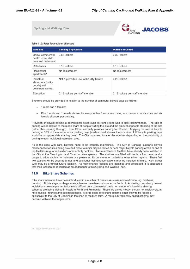
Item EN-011-18 - Attachment 1 City of Canning Cycling and Walking Plan & Appendix
Page 208
Cycling and Walking Plan
Table 11.3: Rates for provision of lockers
Retail uses
Residential apartments*
Industrial, showroom {bulky goods) and veterinary centre
Education
0.13 lockers
No requirement
Not a permitted use in the City Centre
0.13 lockers per staff member
~ity of JACoas· CANNING
0.13 lockers per staff member
Showers should be provided in relation to the number of commuter bicycle bays as follows:
• 1 male and 1 female;
• Plus 1 male and 1 female shower for every further 8 commuter bays, to a maximum of six male and six female showers pe:r building.
Provision of bicycle parking at recreational areas such as Kent Street Weir is also recommended. The rate of parking will be related to the mode share of people visiting the site and the amount of people stopping at the site (rather than passing through). Kent Street currently provides parking for 90 cars. Applying the rate of bicycle parking at 30% of the number of car parking bays (as described above), the provision of 27 bicycle parking bays would be an appropriate starting point. The City may need to alter this number depending on the popularity of cycling to each individual recreation area.
As is the case with cars, bicycles need to be properly maintained. The City of Canning supports bicycle maintenance facilities being provided close to major bicycle routes or near major bicycle parking areas or end of trip facilities (e.g. at rail stations or in activity centres). Two maintenance facilities have already been installed in the City at the Cannington and Riverton Leisureplexes. The stations are fitted with tools, a foot pump and a gauge to allow cyclists to maintain lyre pressures, fix punctures or undertake other minor repairs. These first two stations will be used as a trial, and additional maintenance stations may be installed in future. Kent Street Weir may be a further future location. As maintenance facilities are identified and developed, it is suggested that their location be recorded as an addendum to this Cycling and Walking Plan.
11.9 Bike Share Schemes
Bike share schemes have been introduced in a number of cities in Australia and worldwide (eg. Brisbane, London). At this stage, no large scale schemes have been introduced in Perth. In Australia, compulsory helmet legislation makes implementation more difficult on a commercial basis. A number of micro bike sharing schemes are being trialled in hotels in Perth and Fremantle. These are aimed mostly, though not exclusively, at hotel guests- tourists and businesspeople. A large scale bike share scheme is not likely to be feasible exclusively to the City of Canning in the short to medium term. A more sub-regionally based scheme may become viable in the longer term.
1>"111 500 0000 c T RPT 0001 /4
Item EN-011-18 - Attachment 1 City of Canning Cycling and Walking Plan & Appendix
Page 209
Cycling and Walking Plan & ,y of ,.JACOBS' CANNING
12. Summary and Recommendations
12.1 Summary
The City of Canning recognises that increasing cycling and walking will result in lower levels of driving which will lead to a range of societal benefits including reduced congestion, improved social cohesion, improved levels of health and fitness, and economic and environmental benefits across the region. The City has worked collaboratively with key stakeholders to develop a vision and strategies for increased levels of cycling and walking that will transform how people will travel around the City.
Vision
Cycling and walking wi ll be a safe, attractive and viable travel option between
neighbourhoods and destinations within the City of Canning and beyond.
This vision is fundamental in engendering change in how people travel in the City. The City of Canning will work to forge partnerships, educate the community and design and implement facilities that are both safe and attractive for use.
Need for Cycling and Walking in Canning A number of City of Canning strategic documents recognise the need for cycling and walking to be given a high profile. These include the:
• Strategic Community Plan - that will guide the development of the City over the long term. It identifies a Community Goa! to have integrated, accessible, safe and sustainable transport options for the City. One of the ways this goal will be achieved is via the provision and continued improvement of pedestrian and cycling infrastructure and pathways.
• Integrated Transport Strategy - that considered all forms of transport in the City. It stated that walking was an often-neglected form of transport that had considerable potential to replace many short-length car trips. With regards to cycling, it found that cycling is becoming a more popular mode of transport and that uptake could be increased if better facilities were available.
• City of Canning Sustainability Policy - which defines sustainability and aims to embed sustainable practices into the City's planning and decision making processes. Transport has been identified as a key area where sustainability improvements can be made.
Planning Principles The planning principles for both cycling and walking in the City have been based on principles originally developed in the Netherlands for cycling. They are:
Attractiveness - each route should feel attractive to use and include a feeling of personal safety for users.
Coherence - there should be a choice of routes and the network should be legible and easy to use.
Comfort- surfaces should be smooth and well maintained and shading should be provided along paths. Continuity of movement along the route should be preserved.
Directness - direct routes with no unnecessary detours to provide journey times by bicycle that are competitive with the car.
Safety- separate cyclists from motorists and pedestrians where necessary, but allow mixed use along low speed, low volume streets. Design should be predictable in terms of alignment and priority.
IN 1165CO 0000 c T RPT 0001 rs

Item EN-011-18 - Attachment 1 City of Canning Cycling and Walking Plan & Appendix
Page 210
Cycling and Walking Plan &,y ot .JACOBS' CANNING
Cycling Mode Share Targets
Currently cycling mode share in the City is about the metropolitan average but well below that in the best performing municipalities in Perth. The cycling mode share targets for cycling in the City of Canning are:
• Short term to 2021 - 4% mode share;
• Medium term to 2031 - 6% mode share; and
• Long term to 2051 - 10% mode share.
Walking Mode Share Targets
Walking mode share within the City of Canning is estimated to be a little lower than the metropolitan average of about 10%. Walking mode share to work is very low at less than 2%, well below that of the City of Subiaco which enjoys 12.4% mode share for walking to work and an all modes mode share of approximately 20%. The walking mode share targets for the City are:
• Short term to 2021 - 11% mode share;
• Medium term to 2031 - 14% mode share; and
• Long term to 2051 - 18% mode share.
Within activity centres the walking mode share should be set to a higher level. The target mode share for walking to and within the Canning City Centre is:
• Medium term to 2031 - 15% mode share; and
Long term to 2051 - 20% mode share.
Strategies to Increase Cycling and Walking
Six broad strategies have been adopted by the City of Canning to increase the uptake of cycling and walking:
• Land use change at activity centres, along activity corridors and transit oriented developments (TODs) around rail stations.
• Plan and implement a safe connected bicycle network that provides viable and direct linkage to the key activity centres, rail stations, schools, shops and other attractions.
• Change the mind set of planners, decision makers and daily travellers through education programmes.
• Develop travel plans and introduce behaviour change programmes.
• Develop policies that support best practice to improve accessibility and safety for cyclists and pedestrians.
• Provide for greater shading and tree cover for pedestrian and cycling paths.
Funding Funding for cycling facilities in the Perth metropolitan area and in the City of Canning is currently below the level required to achieve the proposed mode share targets. The recommended annual funding for cycling should be increased to $15 per head of population by 2021 , increasing to $20 per head of population by 2031. The City's share of this funding should increase to $750,000 per annum in 2021 and rise to $1 .25 million by 2031. Equivalent levels of funding should be sought from the State and Commonwealth governments, increasing overall funding for cycling in the City to $2.5 million by 2031 , or $20 per head of population.
IN 115500 0000 c T RPT 001 16

Item EN-011-18 - Attachment 1 City of Canning Cycling and Walking Plan & Appendix
Page 211
Cycling and Walking Plan @,,y of "ACOBS. CANNING
Cycling Network Plan The proposed cycling network plan is shown in Figure 12.1 (this map is provided at A3 size in Appendix H, Map 5}. It provides a connected network of off road shared paths and bicycle lanes complemented by bicyde boulevards along low speed, low volume streets. At the heart of the plan are five major bicycle routes which are shown in Figure 12.2 (this map is provided at A3 size in Appendix H, Map 6). These routes connect to major activity centres such as the Canning City Centre, Curtin University, major schools and rail stations. It is recognised that some of the routes will need to be extended beyond the City's boundaries to connect to for example, major rail stations and the Perth City Centre. In this regard, discussion will need to be held with neighbouring local governments. Further detail on the proposed major bicycle routes is contained in Section 1 0. The implementation timeframe for constructing the major bicycle routes will be dependent on the level of funding and is discussed in Section 10 of this report. A completion date for the five major routes of between 2023 and 2025 has been proposed.
Improving the Pedestrian Network A comprehensive network of footpaths exists throughout the City of Canning but a degree of segregation exists where high volume, relatively high speed roads pass through centres and communities. A program to investigate safer, improved pedestrian crossings of major roads is proposed, including reducing waiting times for pedestrians at traffic si,gnals where feasible. This will require negotiations with Main Roads (MRWA). A number of pedestrian improvements have been proposed as part of planning for the Canning City Centre and some have been approved as conditions of development of the Westfield Carousel shopping centre. This includes a new pedestrian overpass over Albany highway to link the proposed residential development on the south side of Albany Highway with the main retail centre. Plans for a main street along Cecil Avenue are also well developed. The preliminary design provides for a shared path along Cecil Avenue.
IN 11 >5C0 0000 c T RPT 001

Item EN-011-18 - Attachment 1 City of Canning Cycling and Walking Plan & Appendix
Page 212
Cycling and Walking Plan @i,y of .JACOBS' CANNLNG
Figure 12.1: Proposed City of Canning path network
IW 116500 0000 CT RPT 0001 16

Item EN-011-18 - Attachment 1 City of Canning Cycling and Walking Plan & Appendix
Page 213
Cycling and Walking Plan ~ity ot JACOBS' CANNING
Figure 12.2: Proposed routes in the City of Canning path network
1."111 0 GOOD c. T RPT 001 19

Item EN-011-18 - Attachment 1 City of Canning Cycling and Walking Plan & Appendix
Page 214
Cycling and Walking Plan &,rot JACOBs· CANNING
Choice of Cycling Facilities Austroads has provided recommendations on when it is appropriate for cyclists to travel along local streets in mixed traffic, when bicycle lanes could be recommended and when separate paths are preferred (refer to Figure 12.3). Complementing this are guidelines on where pedestrian and cyclist shared paths are appropriate and where separate cycling and walking paths are likely to be required based on the number of cyclists and pedestrians (refer to Figure 12.4). These guidelines have been used to determine the most appropriate type of facility to construct as part of the cycling network.
Figure 12.3: Recommended traffic volume/speed thresholds and cycle infrastructure (Source: Austroads) Volu'"" o( ono<or ve hldu (vd\k:leol d•y) 12.000
11.000
10.000
t.OOO
1.000
7,000
6.000
s.ooo
) .000
1.000
1000
9
' ~~---r---r---r--~
0 10 lO )() iO ~ 60 '0 eo iO 100 ~ CN:J.Nifli99J.DlL<l1999,01tQ lOOO.SlJSTMHI. I~7 as• pen:~tlle opeed ln l<nl/11
The Department of Transport has advised that all future shared paths should be a minimum of 2.5 metres wide. Whilst 2.5 metres is an appropriate standard width for most shared paths, reference should be made to Figure 12.4 where volumes of cyclists and pedestrians are high. It is now legal for cyclists to cycle on footpaths unless specifically prohibited. It is expected that cyclists using footpaths would travel at low speeds and give way to pedestrians at all times. The standard width of these footpaths should remain at 1.5 metres, except where there are high volumes of pedestrians (for example, at shopping centres).
Bicycle lanes should be a minimum of 1.5 metres wide and are suitable for construction along neighbourhood connectors with a speed limit of 50km/h or less and a daily traffic volume of less than 7,000 vpd. Bicycle lanes can be considered along slightly higher volume roads if the bicycle lane is raised slightly above the road surface by use of a mountable kerb. On higher volume roads, with high volumes of cyclists, separated one way cycle lanes along the verge are preferred. A minimum buffer of 0.7 metres should be provided between the cycle lane and the adjacent road or parking.
IN 11 >5C0 0000 c T RPT 0001 80

Item EN-011-18 - Attachment 1 City of Canning Cycling and Walking Plan & Appendix
Page 215
Cycling and Walking Plan ~ityot .JACOBS' CANNING
Figure 12.4: Treatment of paths to be used by pedestrians and cyclists 200
180
180
j 1'0 "' t
i 120 ...
1 100
.. c
t 80
eo 0 0 z
~
20
0
50 100 200 JOO 500 600 700
No. ot cyc;1sts (1WO-Way per peak hour)
Bicycle boulevards are a new type of bicycle facility. They would generally be constructed on low volume streets and a speed limit of 30km/h would be applied. At the current time there are no specific design standards and the Department of Transport is encouraging councils to develop innovative designs in consultation with the Department and to monitor their operation.
Behaviour Change Programmes The City of Canning recognises that a significant increase in cycling and walking wi ll not be achieved through infrastructure improvements alone. A range of behaviour change programmes is proposed in this report to increase cycling and walking and to reduce the proportion of trips made as car drivers. It is proposed that the City of Canning employ a Travel Smart Officer with specific responsibilities to achieve high levels of cycling and walking as a part of a more integrated and safe transport system. Other measures aimed at encouraging greater levels of cycling and walking are recommended in the report. These include:
• Provision of end of trip faci lities (bicycle parking and lockers and showers for cyclists, joggers and pedestrians). Rates for bicycle parking, showers and lockers are proposed for consideration as a condition of development approval. Individualised marl<eting programmes such as TraveiSmart or Your Move designed to increase walking, cycling and public transport use and reduce the proportion of car driving.
• Wayfinding and improved signage to improve the legibility of cycling and walking routes and encourage greater use.
• Media campaigns to increase driver awareness of cyclists and pedestrians and encourage more peaceful co-existence between all road users.
• A variety of demand management measures designed to encourage cycling and walking and provide some discouragement of excessive driving (refer Section 11.6).
• Proactive travel planning to encourage more cycling and walking to schools, to rail stations and to major office and retail developments.
IN 116500 0000 c T RPT 0001 81

Item EN-011-18 - Attachment 1 City of Canning Cycling and Walking Plan & Appendix
Page 216
Cycling and Walking Plan &,y ot .JACOBS' CANNING
12.2 Recommendations
It is recommended that the City accepts the findings in Part 1 of this report and then begins to implement the measures discussed in Part 2, thereby progressing towards the creation of a connected network of cycling and walking routes, supported by appropriate travel behaviour. Key recommendations are:
1) Planning:
The City needs to accommodate cycling and walking in its planning process. It is recommended that the City of Canning adopts the vision for cycling and walking in Canning (Section 7.1 ), accepts the proposed mode share targets (Section 7.5) and takes on the principles for cycling and walking as these help to guide planning (Section 7.4). The broad strategies (Chapter 8) provide direction for how to go about increasing the uptake of cycling and walking and should be borne in mind as infrastructure and behavioural change programmes are developed.
It is recommended that the City communicates this Cycling and Walking Plan to the public when it is adopted by Council, and provides updates on the status of its implementation to both residents and the Council at regular intervals. This may be achieved in various ways.
At adoption of the Plan by Council:
• Advising the adoption of the plan on the City's website; Printing the maps at full size and displaying the hardcopies at key local government facilities; Reporting the adoption of the plan in the local newspaper; Informing the participants of the two workshops undertaken during the development of the plan; Informing those who responded to the public and school surveys undertaken during the development of the plan;
• Organising a public launch of the plan, ideally at a cycling or walking event; and • Making all City staff aware of the adoption of the plan so that it can be considered in other works and
planning.
As implementation of the plan progresses, it will be important to:
• Provide residents with an annual update of works completed (via the local newspaper, the City's website and other Council communications such as in the newsletter delivered with rates notices);
• Keep local bicycle user and walking group contacts informed; Report progress to the Council and champion for continuation and increase in funds per head for cycling and walking; and
• Work with neighbouring local governments and state governments to achieve the plan.
All communications should be made accessible to people with a disability as per the City's Disability Access and Inclusion Plan 2017 - 2022.
The City may have scope in its current revtston of the Local Planning Scheme to strengthen statutory requirements to support the uptake of cycling and walking. It is therefore recommended that the City requires applicants to address cycling and walking during the statutory development approvals process (Section 11.7). The City can mandate certain levels of bicycle parking (in a similar manner that it does for car parking) for prescribed land uses within its local planning scheme. For now, the City can lead by example and it is recommended that appropriate bicycle parking and end of trip (EOT) facilities are provided at City of Canning public buildings and that private businesses within the City are encouraged to provide similar facilities for their customers and staff (Section 11.8).
2) Working with the State and Local Governments:
It is recommended that the City of Canning work closely with state government and other funding agencies to secure appropriate levels of funding for the implementation and ongoing maintenance of infrastructure and behaviour change and promotional programmes (Chapter 9). The City should also actively participate with the
IN 11 >5C0 0000 c T RPT 001 82

Item EN-011-18 - Attachment 1 City of Canning Cycling and Walking Plan & Appendix
Page 217
Cycling and Walking Plan &,yot JACOBS. CANNING
state government in the development of cycling and walking design guides, as appropriate, or when detail designing cycling and walking infrastructure (Section 10.2). Bicycle boulevards are a key new type of infrastructure for Perth that will require refining to local circumstances. It would also be appropriate for the City of Canning to work with the Public Transport Authority to ensure sufficient provision of bicycle parking and storage at train stations in the City of Canning (Section 11.8). It is appropriate for the City to liaise with neighbouring local governments, particularly in the provision of paths in order to enable a smooth transition in infrastructure at the boundaries of local government areas and to facilitate "through" travellers (particularly cyclists) that transit the City of Canning.
3) Build the Infrastructure:
As time and budget penmits, it is recommended that the City of Canning builds the five key routes and other identified links as detailed in the implementation plan (Section 10.3 and Appendix G). It is further recommended that the City develops a wayfinding system for the City of Canning (Section 11.5) to enable cyclists and walkers to better navigate and use the full extent of the network and access destinations.
4) Behavioural Change:
It is recommended that the City employs a Travel Smart Officer who can focus on attaining mode shift to cycling and walking, particularly through the implementation of behavioural change programmes (Section 11.1). This recommendation should be actioned in the short term as this Officer will be responsible for implementing suitable behavioural change programmes, such as Your Move (Section 11.3) and conducting events that promote cycling and walking. It may be particularly appropriate to target school children in these campaigns (Sections 11.2 and 11.4). It is further recommended that the City works to educate all road users {drivers, cyclists and pedestrians) to share the facil ities it provides (Section 11.6). This may be in conjunction with suitable government agencies or even the private sector, for example, the RAC or bicycle groups.
IN 11 500 0000 c T RPT 001 83

Item EN-011-18 - Attachment 1 City of Canning Cycling and Walking Plan & Appendix
Page 218
Cycling and Walking Plan ~ity ot .JACOBS. CANNING
Appendix A. Strava Data
Strava routes:
Route I Reason
1 Nicholson Road from Ranford Road to From Canning Vale residential area to Canning Vale Garden Street. industrial area, Canning City Centre, train station, CBD.
Ranford Road from Roe Highway to From Canning Vale residential area to Roe
2 Nicholson Road. Highway/South Street for Fiona Stanley Hospital, Murdoch University, Murdoch train station, CBD, Jandakot - employment.
3 Roe Highway from South Street to Links Melville/Cockburn local government areas with Nicholson Road. Canning City Centre.
Nicholson Road from Garden Street to From Canning Vale residential area via Lynwood/ 4 Albany Highway. Langford and over Canning River to Canning City
Centre, CBD.
5 Bannister Road. Access to industrial area - employment.
6 High Road from Meadowbrook Drive to Access to Lynwood High School. Nicholson Road.
- - - !- __, Willeri Drive/Riley Road/Riverton Drive Access to Riverton Forum shop and Riverton
7 East from Roe Highway to Canning River. Leisureplex. Links to Riverton Bridge and Shelley Bridge to cross Canning River (to Curtin, CBD).
High Road from Willeri Drive to Vahland Access to schools, Riverton Forum shop and Riverton 8 Avenue and Vahland Avenue from High Leisureplex. Link to Southlands precinct.
Road to just before Burrendah Boulevard. t Southtaods '"op, wmettoo High School, 'ports gmoOd, -Burrendah Boulevard, part of Vahland
9 Avenue, South Street from Vahland ! aoy, ""' totecchaoge. Avenue to Karel Avenue.
Leach Highway from Karel Avenue to dge to cross Canning River, then to Curtin, CBD, City 10 Shelley Bridge. ntre, Welshpool (employment). Access to
ssmoyne High School. r--- - --
Riverton Drive West from Riverton/Shelley Bridge to cross Canning River, then to Curtin, CBD, City 11 Bridges to Bull Creek Road. Centre, Welshpool (employment). Access to
Rossmoyne High School. Recreational riders.
Fern Road from Riverton Bridge to Links western portion of Canning to Canning City 12 Flemtog A"ooe. -f.'"'· tcaio ~atlon, CBD, Corno. AJtemali•e to LeaCh
Highway.
13 Bungaree Road. Curtin, CBD, Bentley library/sports ground.
14 Manning Road from Albany Highway to Links Canning City Centre with Curtin. Lawson Street.
J--- - r--
15 Leach Highway from Shelley Bridge to Access to Welshpool/airport. Alternative access to Orrong Road. Curtin and Canning City Centre.
16 Hill View Terrace/Lawson Street from Links Curtin and Shepparton Rd (for CBD) and Albany Highway to Manning Road. Welshpool train station. --
17 Albany Highway from Welshpool Road to Access to CBD or Canning City Centre. Manning Road.
IN 11 >5C0 0000 c T RPT 001 8<1

Item EN-011-18 - Attachment 1 City of Canning Cycling and Walking Plan & Appendix
Page 219
Cycling and Walking Plan ~~yof .JACOBS.
19
20
21
22
23
24
25
26
CANNING
Fleming Avenue and George Street West. Links Fern Rd to Albany Highway for Canning City Centre, train station.
Various routes around river (not Fern Alternative to Fern Rd for access to City Centre from Road} from Riverton Bridge to Fleming western part of Canning. Access from SE part of Avenue/George Street. Canning to City Centre. Recreational riders.
Sevenoaks Street from Welshpool Road to I Links train stations. Access to Sevenoaks High School w ;n;am Sl<eet. I aod Wel•hpool aod Ca<o"'"'"c;ty Ceol<e. Allemati"
access to the CBD.
Wharf Street from Albany Highway to Alternative route to Hamilton Street. Access to Welshpool Road. Sevenoaks High School, St Norbert High School,
Cannington Pool/Library, Queens Park Train station. Has a crossing over the rail line.
Hamilton Road from Albany Highway to Welshpool Road.
Gibbs Street from Orrong Road to Sevenoaks Street.
Welshpool Road from Shepparton Road/ Albany Highway to McDowell Road/Orrong Road/Roe Highway.
Alternative route to Wharf Street. Access to Welshpool (employment), St Norbert High School, Queens Park Train station. Has a crossing over the rail line.
Access to Cannington Station, Welshpool (employment).
1
Access to Cannington Station, Welshpool (employment).
Access between Albany Highway/Shepparton Road (to CBD) and Roe Highway, via Welshpool (employment), Welshpool train station.
Issues evident from Strava data:
Comment/Explanation Potential Fix
Gap in Strava on High Road Shared path exists as for either Look into provision for cyclists at between Duff Road and W illeri side of this gap. Lots of driveways Riverton Forum. Drive. that service Riverton Forum Maybe lack of shade for
shopping area. No-one pedestrians along High Road. cycles/walks to Riverton Forum?
Gap in Strava on High Road from Mostly contains big box or Nil. Vahland Avenue to Leach Highway. showroom facilities - people like to
drive to these type of uses. Houses probably accessed via local streets. A shared path already exists.
- r-- -Gap in Strava on Vahland Avenue Shared path exists as for either Check path/lighting provision between Burrendah Boulevard and side of this gap. Appears that through Lincoln Park and upgrade Farleigh Drive. people might be walking/cycling via to shared path if necessary as this
paths in Lincoln Park, rather than seems to be the shorter and down Vahland Avenue - suggests preferred route for users. traffic is going to Southlands, not South Street.
IW 11 500 0000 c. T RPT 001 85
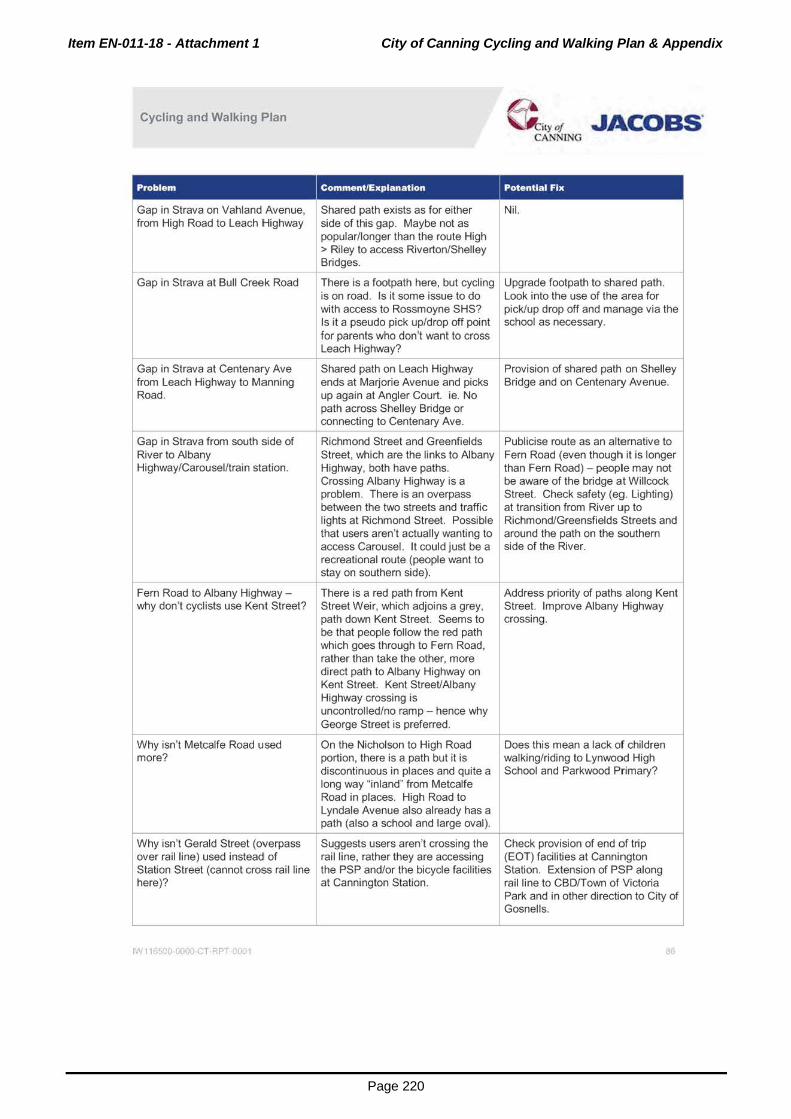
Item EN-011-18 - Attachment 1 City of Canning Cycling and Walking Plan & Appendix
Page 220
Cycling and Walking Plan
Gap in Strava on Vahland Avenue, from High Road to Leach Highway
Shared path exists as for either side of this gap. Maybe not as popular/longer than the route High
Bridges.
@ ity ot .JACOBS' CANNING
> Riley to access Riverton/Shelle~
--+--Gap in Strava at Bull Creek Road
Gap in Strava at Centenary Ave from Leach Highway to Manning Road.
Gap in Strava from south side of River to Albany Highway/Carousel/train station.
Fern Road to Albany Highwaywhy don't cyclists use Kent Street?
There is a footpath here, but cycling Upgrade footpath to shared path. is on road. Is it some issue to do Look into the use of the area for with access to Rossmoyne SHS? pick/up drop off and manage via the Is it a pseudo pick up/drop off point school as necessary. for parents who don't want to cross Leach Highway?
Shared path on Leach Highway ends at Marjorie Avenue and picks up again at Angler Court. ie. No path across Shelley Bridge or connecting to Centenary Ave.
Richmond Street and Greenfields Street, which are the links to Albany Highway, both have paths. Crossing Albany Highway is a problem. There is an overpass between the two streets and traffic lights at Richmond Street. Possible that users aren't actually wanting to access Carousel. It could just be a recreational route (people want to stay on southern side).
There is a red path from Kent Street Weir, which adjoins a grey, path down Kent Street. Seems to be that people follow the red path which goes through to Fern Road, rather than take the other, more direct path to Albany Highway on Kent Street. Kent Street/Albany Highway crossing is
Provision of shared path on Shelley Bridge and on Centenary Avenue.
Publicise route as an alternative to Fern Road (even though it is longer than Fern Road) - people may not be aware of the bridge at Willcock Street. Check safety (eg. Lighting) at transition from River up to Richmond/Greensfields Streets and around the path on the southern side of the River.
Address priority of paths along Kent Street. Improve Albany Highway crossing.
uncontrolled/no ramp- hence why --+-G_e_orge Street is preferred. :___]_
On the Nicholson to High Road ~s this mean a lack of children portion, there is a path but it is walking/riding to Lynwood High discontinuous in places and quite a School and Parkwood Primary?
Why isn't Metcalfe Road used more?
long way "inland" from Metcalfe Road in places. High Road to Lyndale Avenue also already has a path (also a school and large oval).
-;-- --,.--Why isn't Gerald Street (overpass Suggests users aren't crossing the I Check provision of end of trip over rail line) used instead of rail line, rather they are accessing (EOT) facthttes at Canmngton Station Street (cannot cross rail line the PSP and/or the bicycle facilities Station. Extension of PSP along here)? at Cannington Station. rail line to CBD/Town of Victoria
Park and in other direction to City of Gosnells.
IN 11 )SCQ 0000 c T RPT 0001 86

Item EN-011-18 - Attachment 1 City of Canning Cycling and Walking Plan & Appendix
Page 221
Cycling and Walking Plan ~~yot .JACOBS. CANNING
Comment/Explanation Potential Fix
Lack of pedestrian/ bicycle crossing No previous requirement to allow Residential side has existing over industrial rail line from bicycle /pedestrian access to shared path that runs parallel with Canning Vale residential area into industrial area. Avoidance of the rail line. The issue on the Canning Vale light industrial area through bicycle /pedestrian traffic in industrial side could be that there causes users to go the "long way" industrial area. are few places to build a path via Nicholson and Bannister through. There is one apparent Roadds. path from near Parkland Trail on
the residential side directly over the rail line and behind the run of lots on the western side of Mordaunt Circuit. Provides a link Baile Rd > Bannister> Willeri (on down towards Riverton Bridge). Another option is the rail corridor for the spur line from the main rail line to Baile Rd (if this still exists- rail line is no longer there, and the corridor appears to have been redeveloped/amalgamated into other lots). This could join the residential side at Lansdown Ent.
- I--Lack of bicycle facilities on Leach No cycle lanes, cyclists must ride Upgrade to provide cycle Highway. on road on a major highway. lane/paths (PSP from Welshpool
Road northward in City of Belmont, but not in Canning).
Extension of PSP westwards The PSP exists along the rail Suggest to neighbouring LGAs that towards Perth CBD after Welshpool section that runs through City of the PSP be extended. Station (Town of Vic Park) and Canning, but not before or after it. eastwards after Beckenham Station Cyclists must leave PSP on (City of Gosnells) to provide a Canning's edges and venture continuous route. without the PSP - impacts some
crash hotspots. - r---
Potential conversion to Bicycle Willcocks Street, Ferndale Investigate use of parks and Boulevard. Crescent, Blancoa/Metcalfe Roads, easements as cycling and walking
Willcock Street, provides a Ferndale Crescent to High Road routes.
continuation from Carousel, across provides a continuation from
the River. Carousel, across River to western
Rostrata Avenue, Killara Road, via part of City.
existing "path" (it is an easement? It Collins/Rostrata/Killlara/existing
runs behind the houses) through to path parallel to Cantebury Dr
High Road, so users could access provides an alternative (quiet, safer
Riley Rd/River crossing. route) to Willeri Drive.
Ensure link to City of Melville (for Check that PSP on Roe Highway Work with neighbouring LGA. Murdoch University and Fiona extends into Melville . Stanley Hospital) is in place. ~
IW 11 500 0000 c. T RPT 0001 87
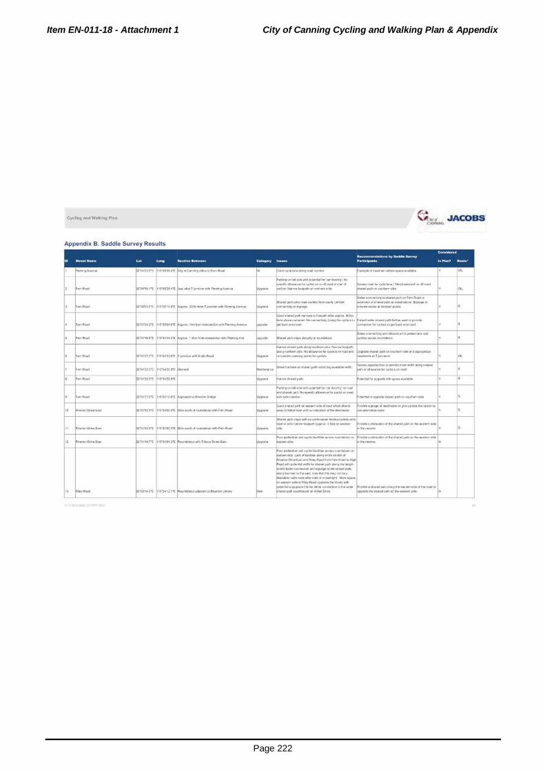
Item EN-011-18 - Attachment 1 City of Canning Cycling and Walking Plan & Appendix
Page 222
CyeUng and W~ll<ing Plan ~"' .JACOBS .,_,, .. ,.,.
Appendix B. Saddle Survey Results

Item EN-011-18 - Attachment 1 City of Canning Cycling and Walking Plan & Appendix
Page 223
Cyeling and W~l~ing Plan.
rrl):11fH'S 1$"'&4'1~" ~...-t>Hq>Rotd
-r-
------.. ---- f"o:r,~ 1S'5-4'18TE ~on...r'llli:tlv.~~gr-"....,.,•
;;- -- f'o:t240"S 11S'Sot'167"E ~~..-.R.-tt~
- -f-
~Ort../~nlltowR~ p,. ....... 1S"'$o4'252"t ~ - -
" itllor>0..../8annllo¥frut !" . .,.,. ... 15'5-4'2S2"( ~--
" ........... p.-........ 15"'$-4'~2"£ •"..-tiiWalti!Qrrt..l.lnl~llon..
.. -·"' rr03'461"S 1S'$4'1t:rt ~-~~w-e~~
" .._.,.. f-04191"'$ 1S"'&;r34ft _.,.,w~·...a$WJIS$""
.. ........ p, ........ 1~23n: f"ire~~RoeHIQti'Qy
" ........ p. ... , ... 1S'&3'1t'"'l ~rJn~-FtllltHp..,.
e~.,.. .JACOBS
~.,.....,.r~for~An.tlonOI'iwoil
f-.~~IOhfOed'lloid'l•~~ .. ~~lt.ir,~ltlht..._ y
~~Ill* ~~c:y~==-~ ::.::::~ ... ~~--~ OOipl(l'.~~aeud'ldtllllJI'IC:OOfla•bul
Jtop P~-._.., .. ..._lklr'OIIM~IrM -40tf!IOINihoocWII-.101ht~
~-:::.::::.:::::=:':.s llklcp....,.anhrold(bolhcl~~).
on"*'oroffroitd ..... foot)'ta. ~ow~ ~,_tillottlrld.......,~~~or~"'-S-~Ot!~ .... b'~IO~DO' ar;ctMM~Nop!WIIrtrnpt'IO.aMt"""'PI'tlle "'*IICI.p«t\~ti.U.~I«<MIM
~ ~f<W~IO~~ 'f
~--di'IO~~~
~pcMI'!NI);o~-.,...,.,"""Ot!w.ltlem~ ~··~--~ft:JI)Utllc ,_poA~,....,~pelt>QntcMhlmll.i!M y
~~f«:iHIM•I'c»td~tllfpoot~ '-C.Qfi~IOif'lt!ihettdf*jl.M~~irl
~~IOirr._llt_QI'J~ llOI"fll'doari .... ,.,.,IIIP<J!IIIl.sOII~Af Y

Item EN-011-18 - Attachment 1 City of Canning Cycling and Walking Plan & Appendix
Page 224
Cycling .and Walking Plan
~ .. au._. RoM ~04'01H"S 1S"SZ41 8"E ~olt«<lonffOl'lso.Ato"'""
~-Gut, RoN p:-o:run 1S'S2'38r£~A
- t-· ~ .. ou~RoeoJ ~o:nTTS 1S"5<2'388'1: r---
,, ~Guf(~ prm•n 1$'S2'3lt"l ~----
" "'""""ou-,RoeoJ pronors 1S"n)1ft ~•'II•Uutrllnd"'Bot.l~ - - r- - -t-
" -..o . .,._, ~03'190"'S 1S~2"( ~~lo~lf>IIH
- - t--
,. ""'TI'M<iolly~f...,...,.RO.O p.-........ 1SW0111"t r--· ~SirWf .......... ~.nd -- p.-..... n 1S'$ZSO!'rt ~A.a.daoii! HoghRCild
"""""
I$'!.3'179"E ~A-
~~t,... -JACOBS
~$1fl~daMIIO~ No/!Mted~ ...._roedlodc,O...,.,.•""*'IIboro'eiDbepo _..,. ~a..,.troman-,acc-.-
.,;-J'OI,.(IfNhel'lll(ltCIIIrOIICioranrlllldliO~twlollow
IQrthe~dqo;t;r;r.~~~.._.~
--IDIIMrWIJI-n~plllhMIIill'pl,.,... _..on..-c:.o;_..._
~*'*'-~*'t}dlt..,..on........,
r--- ~=--~..-IDbefiO..,.,_b ~~f<lrpr~lor~l$· ... ~ y
- r-
-I--'- - ;;;.. __ .... _,..._,_... 1- -DllltoowdtoAclflifrR-on~-.-lrd.ldlng!ti•Cifl
~ Good~w.r.dpjth("""OIC 20m..tclll) rwdl.abro
Good eurnpied ~- ;roun4Gboul lor c)dlm to
~--"'-1...:1.-t~.ForGI!h.-•-lo
r-
~llnumMIII(I flln)ltlltnldpdll~bolh--d
,._,_,...,.,._.,,..roed~()Om ... d
~nallh!Dedgedloall*hallli!N.I.JmilildCI'WIIIIIt ~for~(...,._lnltiniM!Mdi .. ~--11\it~IOOfnb'Oitt~
~pO<tW;Icwlonf'OIIIdilftd.-.~bPtC*~atld
P:)dltlon-temiiOtWIIh'*'-(fCIP'OIII21ft) ~c<oml~on-.,._
llllllupgrat.~~IOIIIIIM'onf!IIMC)dllllToo
~1D...,_'-hMdrgln~figtt4uo:;Oon ~-li....U.Iri•._.IO .... ~~~~~~~ ~bypMSM~to.-no~-.. ~-.__~IO~W·~~~b
1Wd0Qiif9'10-
~ ...... droed~ ..... lo~k>l'lllll).
rwor.ot1t~~be!MISeMirurHcioon5klr
-...~r-~-*'rfurc~kl-rdr-"• '-*•~Wih~.cl.tolhltdln:.I..,IW«<
.,. ...... ~~I¥0AA~~....,.., IMtlkMC""'""'-~·tdjlleii!'IIIDhe,otillleneW.
~IU.."Pol·~~-
~~~or~nqdiftttior'O
~,_.:andar...,loofC*!'I[~ ISm~~ _.,..,...,stcJC~Png•SiniMI~trd·
~.,...lfdP'd'l(--....,"911'0 .. 2-0..)IJI~on ~lilmW~•IIr.ddCJIIICIIIfl'lller..c....N,.._.,_
~.0. ::::-tO)OI'IIH .... ....,.,~tlongfM ~f~~=OII-CII'boltll~ ...... N

Item EN-011-18 - Attachment 1 City of Canning Cycling and Walking Plan & Appendix
Page 225
Cycling .and Walking Plan q~""' -JACOBS
., -·- Fz"00'$1VS 1$''53'201"E ~~o~SoioStr.ttPSP fw-~ ... IOa'-IM~(IIJholf>S:PO'ISOo.tllset.«
~-=:.::::::::::::::::-~
~·*"r"19t<I•G1'1Vtti._.,A........,., -'vw _...,.~fOIOtotftlr;;od.-hlftd.,...lor
~to'**..._IO!Mopclonta..,..•~ liigNMI~IJIICOI!II!'9PSP Y "" .. .......... p.-.... ,.. 1~"'$)'200'£ ~A.....wto>~~ fw- ~-PSP~Imilld.....,.oro!WI•........,_ ~t.c.lftd~~krc~llllsiO~
~- y "" ........,to0cl.,.......(~3rlfl..t:#lti'OI'I'I~)
~CdR"IIRoJIO•IIIIt<l~tol_,IIIMc- COu6cl
~~~~b~Qeo c~""'--"¥«tF«t!CI""'Y p.-........ ~H~IO .. R.-1 fw-~~~«*~NI'IoJt~pOIIII"UttiO~ ., llfllrlnrw.NCII'Ihllouf'CI 15"5•4'1.44'£ ~lr'ldelw'p~lll~to~ """""" N
~fiiCI(Ir(DC.2,_..._,~·twld9*
~*8..,_ ~ !llenciAIIi~HyP'•Id•llo'I .. IIO
L.t«;~H11111My ~H~IOOrlorvftoed f'w-~-..c..fac~V..,~bqdlllll'fliln'-9'1
~ .. .mltMI_...or...:nPSP~JefhrSII'Mt ~ .. 1"~$'5 1~""M'3e2'1: Po-tion<~~ hMvJWihdel~>~t-s., IN left I-
~~O'~M-..cticlnOtliotCIII'IGIMir
~~ ....... ~veJ!oe ... ,....-oll(""""liQf'll ~rouncl05tJidNJ-jtiWidcbe""""'dlecfi ... O"l orlrtiiiO......, PSP ...:1 Pf'(Mdot qt'JH..-.ed
~ "--~HIQI'-f 1"~0'"$ 15'"'452"£ ~"*"W~Fl.- fw- ~...,or.,,.l..:l~he~ ~-L..-./W~ N
., -~HII)"-r 1'59'07r5 1~"'W054"f. P.....- ~ ~=:.:::-u~::.:::-;: __ IW:*orwo.IJ"""*"Ior~ :A y "" .. -.- ft2"01'01 5"S 1~"'$S58ft ~S.Mt...Sfle"lc:htrS•Mt t'-'"""' _10t4111d ... ~(IIPI'fl -~-~M4 ...... N
., -.- ~01'022'"5 15"""W01ft ~-lh'eet~ f"o'- ""*"roto.r-......,,t>MI*h~ ~---- N
-.- f-ot'074'"S r-a..-ry10(:~ fw-..,.,,mploi'Ur"teaiorldolll"''llllniiiP..tl'lor.-;roll'l
~~Adde)dllt~ .. t~"WWtn ~ ............ N
;--.- ~''"'"' 15"WWtft ~l"f1.,1r)'IOCcr,_.c.rotr. ~- ~--~ ..... IWidM~ r-- - . f-
.. -...- pronon WWtO$"l ~tttnlrci"*YL9c.-OUMI f-- r""'p:w'll._.buJ ...... -''-"'ql -- N
" _,...,..., p:ron7n 15'51"189'£ ~...nn211d-..10c.o....t fw-
~-..mplon .. .alcndo.-IIGihupllo'ldl~ln
~--~.aAigiWMIII.ollddqota~~rnatmg. N
" -- p:-ot'ttcrs 15'56'2:lr"'li r-li~10""* f'w- ro-b· 11.66-lt ... y 001.
" _ .. _
p:rot't71"'S 1S"56254~ ~EN'(10 .. ho91 fw- !'--.... ... _. .... y "" .. -·- prot'I-4TS 1S"562Sn P.:..•U.Sl:tMI: fo-- 5q6:.w:pclftclleln~lh. ,. .... ._. N
" -·- f"Ot'11 9"'S 1S"W22$"1i: ~1--.yiO .... ~-!'"' __ ,.., -- N
" -·- f"01'10f'$ WW21 3't. 1ft.,.,.IOIII"IOPI f'w- !'--
... __ N
" -·- proi'OU'$ 1~'"W204~ t.,.,. ..... fw- !'--....
... __ N
.. -··- f-o•'O.ln 15'M'2&3"'E ~ ......... - ~- ~-.... ~~--~kr~IDI'*-......,
.... N

Item EN-011-18 - Attachment 1 City of Canning Cycling and Walking Plan & Appendix
Page 226
Cycling and Walking Plan
" -- p.-....... 1SW2Sft "ll!lrt~thopt f-... ~~ ....... ~blin:l"""""~qo;"'V ,_,1-.o.ciiiO~pece YflfY"'"*'IiGIM"o
~~~R-I>No.hWIIII;t!'~~ P.• y ""-
-- p.-....... f'w-.YNirolit*l\ r.t..ctlclfl111t:t!~oeflwqdln r--............... -. ., 1SV2Sr£ ~c,dil'lt....,_•_ y ""-
;;- Gta~•A_.... 01'010"$ 1S'Wl09'1: ~AA,.c.-.. RoM f'"'- m ....... r---- H
- --f-~ ..... 106ir.ct» ............ ("'"J ............
r-
" ()la.•A---1'1-~~ F"OO'SI f'S 1S"Se4JrE f'w- r--~~·-kai«J) ~--- y ""-.. -- p.-....... 1S"Se4Sft ~- f'w- ~191f01'1060'c~~-..w.~.woc~m.- r--- y ""-
P-lldro •~~~"- P.-c.lO"Ciil..-lit1 irlllfn4Ud by .. -- f-ocr4tn 1S'M'.ST'E f-.-~-d~Veqleie~lklf>il*h-
~W.•'-**-'t"*' y ""-~soun.IO~~III'IdiMrkl;
- - - r- - - 1-- --~~.-on~ _,.-....~~•N f-f-
" -- ~00'~5"'S 1S"Se50ft ~sn.tirll~ f'w- ~.,....f9CIU, .. ~~~O'OMII'\t(Ofr.CIItiN'-01'1~ y ""-.. -- procmrs 1$"$T110"t ~$ .... $u-. t--- ... GIII*I\,_I«<IId....,~td ..,._.~~OI~Illlt-ho..,,on,_,) y ""-
" -·- procr'-01"$ 1S"S6'583't ~Mhlit_$1T .. f'w- ~-.... .. .__
H .. -- ~"""'""' 1S'W52fJ't fw- !---- ...,....,._.lllklrlgp«h(aNaiW;e,....onro.l) y "" .. """'"""' ., ... 1$"WS2ft r--· f"'"' ... .rypoat~kl~-lllndmerb --· y ""-
,. "''""' ~Ot'01 t'S 1$"W-'3 1't. f'w"' pt"'I'OI•b: .. to:IOI'Ii*tl
=ptllllatlltpl-m~f>91kldoC1rlltlic*-OIIf'ld H
" """"' ~""""'"' 1$,..,.---;::;
~-·- ~- ~e.-'*-'CI.,W.••9'1h Chto"'t~oi~Ot~ ........ l»ttl H
- - 1-- - r- 1---~-·"'"Y~_,»riliton-cQmi'Qr1ttllll ~~ •• ~ ... P$P~"Qrlflheb' ... r- r--,
bt.n~P•IIde F-t_,kkel'hllmS!JIIIon,no.tlll~-tctr.:llan ~ ~lfOCid~c:.oWI!MIIJ1!~,-~ INIIIldlnWII!Hn~diredlrlgC)dalllkiPSP y ""-
....., ..... f-o•·:, rs ~-- f'w-~)dol.~-..-.....n.ow,..,_ lniCIIIIII,lrWIQ•~..n..tPSP.,..(a-PSf'
" 1$"$7'156'( ~~~Sl ktMNm!klliotl) y ""-· - - -
~~IOII>cbWPSP No~»llh:lbll;t r.till...,..eg•~"'ibil•lr-lfti;.»PSPAOCI~»
I" ~llyP•IIde f"o•·urs l$''$7'G$1"E foo"PSP fw- lr.rtc10PSP No~(IIIOI'Ofoting. -·· y "''
" ~ .. y ...... p:rocr4tn, 1$"5e'.t27"E F--- .. ,. .. Lll)lti!M~~,tw-.. l'tlek$ ..,...._ .... .-..:lo$ y ""-
" ltlh<loyP8rMt ~""""'" 1~"Se11ft fv-PIIIt~ .. ,. .. .ry ... tlil;eloc'-n lnMIII-tla.eQCIIa(SwltiiW'IO~) y "" tllr!Ndt-,IIOO<fd"'iWif«•.-vn-.Wid-~~~~lfWIWWOPIC'I ...........
" ......... f'w-~--Jol'*lt(IIINPIIf'l,eiiOblrd~
y ""-~ .. ii:tla<Sdedllll,_,..,,...
" ........ ~teochool 1-- .:!..:l....unp.no~•llll ~qdlll~Add!JI.-d ... y ""-
" -- a.tii"!!n..,...,Higillwtly ....., -.... .. - ~qo::IM~.Add~t11l y ""-

Item EN-011-18 - Attachment 1 City of Canning Cycling and Walking Plan & Appendix
Page 227
Cyeling and W~l~ing Plan.
" ~""""'""'* prot'02n 1S'$$')5fri
......... ~01'0:28"$ ~~~'128"t
" """""' p:-ot'Ot rs 1S"'$6'1$6"10 r--
., -·- f"o•·toN 15,..'11,o1't
I~
E.lfl.\ii'IOC.,eltC.,..NIIW10>t"........,.,-1$trl
Mllarlgble~v.tndi~OI'bie•*'-1-ll.o:lllbiQ,.,.,. ...... ~-~ ....,_ C,.:..fed~~·.,.._.....~
Lld:ai ..... F.Io!RC*I~~~~
o..-w~ ..... try~-""'.....,..,. -A44 .. bqWI*ICII~ -~~.C~A.......r~Rolld
E.lilf;t....C.(/l•l*...,,.,_..,l*f!o......,F ...... ACifli4
.ndKfii'II$'!1MttM!dini~OioldhiiW.-, TIIOifOIII•~
~·~~...,...,~r.of~A
"="""'*'ttu..~~JIIQNOI'I~
Slrang<»N-•n.fi\WI~A_....ID~
~lfl.tions-&NJC!hdn.rti~ Olld8DrollloLMttiM#IIy
L-;t.<ii~·~Sir-~~"<JC-ri!v fMNAt..I~Siwky ... •~piatlr~.Cif'i'IC-SIWWriC...,_.•tocaldlosbn~- uch~Rd~~-'-not~ Cp;lll._.~~«<~lo~R<*l ,...,.,_.,.,... Y
$1\;QdpllltlckJM.ftOI~Io)fW*'O"-uui
~C*IInul~ed...-d~"led
E•W~g~-...~~
~fiO·pjlolt Strlfllooq)dl~lfotnH~P!..:.~~
=o.o.dcJdledpdw.
I;.Cflfld~Pfll;l'l fiO~A...,..,..(•~~ I;~~:Wld...-.-;tp«ttkllt'-'cw~O....E.(_t __ ).
AOS~~IQ~
... _.. ............
.....vr.nlbotplltf'Oinlo• ... ..-..:1~ hiallg;ad,. ab>g LAa::h ~ ~ W;l-.d
ISI!>~G'tbotiNI•CIIlNdl~ ~to~qde~
r~.-co~ .. ~--IJ!•*~"" T~~~~<J'~ilb.ltllnqi.Ndl
~ -Tllft'l~all~-~l.M(.tl~~- ~~""""'t.Mid'I~......,..,.R*
~-... -- -P~an~lrift'a::roqt..MaiHq~Wwf.. _ ,:t_.-~toW ..... PrliNrySci'IDOI ....... ~IDt~.-~•-'-d~~dt. !""·-tftll~~bfkiOo-u .. rar~(-bla ~bJ ... ornM111r-.•llot*l-pus.t!-IIMs?).
=""~~~~~arto~l~hbh LK\CII~~~-topwh~em..s .......
,.~~<liii~M>d-ttwt ... nnr;...'-dld
=:::=::::="w*~ _,.._ W~..cr-..toWAon~
~~- .... ~~fCMr..,C116..ct
=uw-.s bJWfiton P"mwy..,.COm«:*v&tooolll -*'Pf•-

Item EN-011-18 - Attachment 1 City of Canning Cycling and Walking Plan & Appendix
Page 228
Cycling .and Walking Plan
.. .._ .... p.-........ 1~'6-4'17)"[ ~Ro-fMd L_......,_.,
,.....,,RC*I40~~~ F-00'44 1"$ 1S"$4'»f"t
~ .. ~OO'«f'S
.,,._ p,-........ ,~'"$20"£
- -
pz-00"3()9"$ 1S'!l'.t82't:
-- - +---+-
---
FOCifPtltloro_1_.,.d~(.w:dy)
,.,_._cl+bo!M..,.N~
sw..- - •~«eu.~
~,.....,.tooi'I~Gf".W.C-....06ttllf)4ri;Ofl~ .__ L~~Gf~
ktyc:)'tltllllrfii~IOII~ .. RON ••tlr~lbe
f-.-:!b'f~•~w-......._,. No_,... tor ~*10
~--~oc:~~--F~Cr\WitiOootGfU....O
HiQI'IVa'lo:""*--icq-10CI'Oitfllf'CIIId No ......... tltl .... sl$~llbpah,
F~tltl-~d .. taild .. _ S~HC~hll·bul~b•llhorttlol1.
tf-'lo-u....cnS1~c..flttM;y t.~1-D"oK!e_, ................ .:lbnctu.to ....
~·._.~..._U.....,.Gf~nlroe
tfOC~Cie*'*-lrUCtLH• lll*ttomtii!Wlg..,IC•park. CcUd not fWicl qdr!g IErOG. T<lpfdti• ........ C.W.Wlg
F:.~d"*'eWloiCM!*'k-'Mlo~
,_.,l*f\OI'I~~Iil:>td...._, .. R<*II ......,.,..peiii!Woo.n:tl..UH9'M'Iy~WI ,........,_u_ (Dw1NrtinQ1110flft:llld
RN.wrilling~ --S!gMINN~-c:olfr
R.--...-blp.--~falng
GoocJc:)dir'O.....w....... _ ~-.. ·~"'"-'--
~Rllw-tGf_.,~ A...__,~~ .... >9Mdn~~W•-WIIh•,._ Soo!W-dll'ltca-l)llrti•Cifhdl!!blt;tc~b!MSI -~ ~PMI'IaCI'IOut~~Of~IJOO.C "-LLtt...._,...,IMC...I*'k-~ ..... IJiotl ht.tlendCIIIWflf..-.. ... c.nngedlege Jof4«110'-tllllbikt'l*~ NM10tool·l'low~••ftd.,_Cu~-..._..,lf
=-~-:=-==~= =~~:=:.~~--"'~ ;:IO:=:f;~""::::.~=~ =~~~t«~~ftVIcPWl ~~lhtlloc:tCion Gal~t-"IIQI GA~~c:wW,--~-....,.,~ [OOI!IIetlllyot7olcM. l!uldtihpethlac:)'dllloo-Cwtirlvrowdlc*ectt,o Y
FOOiill«f>OIIOtll~ ...... .cl$141thOftcr..-.....BM~IIWINtlutpoort
~H ...... ROid•r..itltii'Cr9Mil'llrleto POCI'C)odWIG~ ~ Adle COlin Nlallll'iltllc: ..._.,_
~""""""db.IMIII!~INMIJ(Ift MIJIIher«<,..,OII~-t40Cieoi~Ro.d
~ ..... 'kntyd ... Mp!:lftlt._~ NM410-.clr~...._............,.o.tln~y
U....eiiiACirdnoll'fiiY"-~ • .. ,..,..tiiOdofVIp
~=~~
""
·'
·'

Item EN-011-18 - Attachment 1 City of Canning Cycling and Walking Plan & Appendix
Page 229
Cyeling •nd W31king Plan.
p:rocr,, n 1~'S4·ou·l
.. ......,. ....
~"'"' .JACOBS e.\,.\..~11'10
F~ot~..,...OdNroed
C:rrArii!Citlf~WI--'<IIIf\•~cJIId.-,
~IMriO~IN-. CJdo'IQ..,,....,~ ... .q,llit.wt""'""'*d
t.... .. lltJ'rlllonAOieCo!.ll\. Poor~~ AC(t6tir'!COJ_..,AOIIO ..... l<ltot..,.d!Mf•.... Mai'ltll.lt<OM~~
~~-1Mwtll••l*'rillfonf'1~~ ~Wftti'Mbi.t-~ ~r~•bauleoow<~~
B.ryt»IM'*tlrlbcd!W$
FOCJIIPIIflfl!1bolh_,.
lk,cciiW...*""~~~"~IICIHI"""l~
~~IIHi.,_T_,_
~IICI...:Itlt"t"""'~-bo!lltrfecl"oh ~ ... H..._I_t_ s~'*"'"~~~~-~.._or-.o8ol>nMyROIICII
~ ......... .,.""' ....... LK\.OIIc.~IMI«MIII .. ortHi.._T __
P..,..,..,'bbr;roo.~t,gt-.-itlffor_.,.cJ,_ Gc>ofc~~
~(tMbon-11lbu!~l9'*tloMio111d114). lroll;ollcytt!t~ ............ ,~~
FOCJIIPiitl<w>4Q~cJNtOild.«<!!r~ ... tliopll
~CDb.-tOUI!t
It$~~~
F~CII'II>altl ...... «tt..ro.d Ol/t,ll~r(llld._
S...mule- buf*'PJ;
~-.ab001!'19~1t.-!
f'l~tcl..,....~ftc.d'~Acr.d
A-.,.c)dill;J--.If>N9,..«1Wtdf
~yAa.i.""""lloc,M;WM(tliQ\Inti SMp~CI'!II"*"d8oundarrRc.s
0\Aettot.itii'IO!Il --p:-00'101"8 ~~...,..,3fU'£ f"-o - ---... ~-
•t. 2, 3. 4. 5,. Rootas 1 to 5; OIL* Olher kientfied Unka.. ReferloAppe(\dix GfOr reccmmended treatments Of route seccions..

Item EN-011-18 - Attachment 1 City of Canning Cycling and Walking Plan & Appendix
Page 230
Cyellng and Walking Plan
Appendix C. School Survey Results
What is. the percentage d students riding tatlrom sd'IOOI (With parents or 5% or more by themsetvel)?
Whal i& the pertentage d students walking laffrom school (<Mth parenla or 20% or tnOfe by themsei'IM)?
How many bic;de parkinof ~~spaces doN the lChool have (for 15 or more blcyda rickws. to use)
How~~itlgi&Cili\iesdoeslhtt(t'IOOII'Iavt(IOftie:)'de N~
riders to use)?
HM the schOol got plens to upgrade ShoWetfcht!lnglng f8CilitJes for bkyde No riders In the near future? No fmcts from DoE for this
t5ormore
1().15
No
What programmes doH the sd'IOOI CU'I'1Itlttf r.v.to enc:owage eewe tqvef(Walkif'9'~trai"'SS))rt)?
Cyde/Walk/SeooC to sd'lool dayS. Bike Ed ProYiSiotl Of MCu'e bil<e raet. liealttl I)C'Ogram Jor Year~ education l)r'OIJ..,s encourage acciYe
lraveiDOifromsd'IOOI.
Are there safe crossing poiniS a!/or near the lChool? Wh«e about are ...,..,
Ate thete direct •nd aci&Quate wal<lng roules tQ!from schOOl? WNch walking routes are mos1 frequently ll5ed by st!Jdents?
CroslingMth a Tratfic Warden on the comeJd Tribute and MonotaAve . StudenlsYiholtYeinRiverion havek) cross Leactl H~ghway near Nurdi Parl(, this iS a vefV oa.,.ous etosslng.
Tl'lefe are paths tnac '*HI students to acoess the school from al diAICborls.
•~•n~M,~mbefdbl.l$es.trevelllng lhrough L..angfotd, In addrtlon to public bu .. L
Routes..-. 3<51QW!Ie. O•SUtnot., the malntssue.
Aiong Metcalfe Reed from bOih ll'le Ferndale and PaOlwood ends. Nlc:hot$on Road and High Road ftaTI boltl dintettoM. Also YICI Romney Way end Gama~rt.
TraffiC lignals. on the High and Melca1fe Road inter&ection. T raffle: warden on Metcalte Road near Zeii!.OY.a Way.
MeQUltlle W* ~ths SUn"Ounding thot
""""'· $irnii8Jr to t:ta. ri<lng routes with the Od<I~ ... IIO<tlel ~tOUgi!RomnoyWay
5"'ormoJe (65-) -....... (1M children)
2-3%
15ormore ~10
Need MOre 40 SC*t$. 65 ~r ~
<5 -
No No No funding and not the demand
Tl'aYel Stn811 tchoef. 'Will< t1:t SChocl Day" il'llllallve
SOERA (School, Otug J.-.cl Road A,..,.) htiatlves. 'Walt.IRicte to Sc:oocA Days' supported by 80% ol OAI6 stt.~dents 'W8iklng School ..... WeM!yWIIikingWedMsday 'llltief'e we COllect data on ~udentl walling or riding losehool ~ ewatd ~ l)l'ite ....... Rot.l\es not lcleqt.~a:e mol our $1~1$ No tjirec;l ~es. CWy $.(1 Chidren liOe etoss Me4caJI'e Road esuy. bikes ei"'CC the'y c:ot"M v.a different routes..
No marted crosY'lgs on roads bordering Comer o1 T ribule StnMC and Tudor Ave lhe perimet ... d the fdiOOI.
Frequent patent C(.l'l'lptain!S lboul the a.ct ol sere~ crOSSings on Metcalfe Road.
Pathways tea<tlng to SChool. Yes. AlmOst no Ch•khn WBIJc to SChoOl -m~4-51nlotal

Item EN-011-18 - Attachment 1 City of Canning Cycling and Walking Plan & Appendix
Page 231
Cycling and Walking Plan
What do you consider the quaUty of bicyde mules, Shared patha. and fOOlpalhs around the school?
Wo!Ad you eocourage &tudenl5 or sraff to C)'de Of walk more il the right lnfrastruclure was avaMabkt?
Wl\aldoyOu<::OnSider1hek)l)lhr .. ktyfaclor$tna\~~~rOm walkil'lg Of eyeing ~rom SChool?
Any othef comments you may haYe
Bicyde rooles - Poor
Sl\lr«' Pl'!hs- Medium Footpaths· Meclu.rn
Yes
Convenittll w ...... Time (longer to w.Jiklcyde 11\an bolng dropped off by car)
II wotad ba good kJ see a City of Csnnu-.g CydingiWaljrjng llai!JOO offlcef to coordfl\8te with sdtool& to encourage
--"""910""""'
BK:yde routes - None
Shlrtd PIII'IS-High Fool,paithS. High
We enccuage 51udents and staff to ride rtOW- the health 81$1)8d.le$$en ·~~ oongestlon from cars etc.
Disaane. w-Time (longet' to .,.ltlcyde tl\aln being dropped off by car)
Bicyda rootes.-Poor SI\Ned polllhS- M«<ium Footpeth:s • Medlt.m
Bicycle routes- None
~pe""-Nc>M
Footpeltts- Medium
Yes. WeholdWalk/Rideto&d'lootdays Yes 10 promote 81Cflve •~tiYetiO cltlvlng to -s.afetyfMCurily
I.Mtl o1 eotlf'l(ler'!Wtlding Skills ladt of safe road aosslog poonll!l
lM;k of good eydlng tOUtwfOOipathS
223 studems I hoe on the OCher side of Mefcale Roed, OIJf oommunlly would like safe pedestnan cro&Sing point& on Me~e Road. kjeall)' these would ln'k With I)W!~S ~h) U'lt $Ch001, Many ehild!'M also erou L)'I'MOOd Ave where t'*- are no dNignated .safe eross.ngs.
Mal'l)' complaints from parentS abool llmled pai1Ung around the school peorWnttet. Wallt.t\g oonfmtabOn from the Council fOf ~~a set DowniPiek Ul) ar.a ouUide our 8Chool Pareots are encouraged to paR futthe( from the SChool at Wooc:Won:l Pa111. bultl'le lack ol &
et0$$!1'19 bttwMtl WoodfOtd ~and the SChool grOI.H'Ids hlnelets peqnt.s from u:slngttlbopbOO.
I woukllike 10 have mora o~r1unibeS to ~iclt feedbactl on & variety ol issu.s,

Item EN-011-18 - Attachment 1 City of Canning Cycling and Walking Plan & Appendix
Page 232
Cycling and Walking Plan
Appendix D. Community Survey Results
Figure A 1: What modes of transport do you most commonly use?
Figure A2: Do you currently cycle?
Figure A3: What is the main reason you cycle?
2%
IW 11.>5\i0-0000-CT ·RPT ..()0(,1
• Car driver
Car passenger
• Train
• Bus
Cycling
• Walking
• Yes
No
• Commuting/ Travelling
Sport training
• Recreational
• Other
~••yor ,.JACOBS' CANNING
uil

Item EN-011-18 - Attachment 1 City of Canning Cycling and Walking Plan & Appendix
Page 233
Cycling and Walking Plan
Figure A4: Do you own or have access to a bicycle?
3%
Figure AS: how often do you use your bicycle?
33%
• Yes
No
• Daily l Weekly once/t wice
• Weekly Weekends only
• Monthly
Never
~••yo/ JACOBS' CANNING
Figure A6: How would you rate your level of riding skill on a scale of 1 (low) to 10 (high)?
25
20
~ 15 Q. 4> a: 0 10 *-
5
0 1 2 3 4 5 6 7 8 9 10
Rating 1 (low) to 10 (high)

Item EN-011-18 - Attachment 1 City of Canning Cycling and Walking Plan & Appendix
Page 234
Cycling and Walking Plan
Figure A7: What are the key destinations for cycling?
• Schools
Shops
• workplace
• Parks Rivers
Train stations
• Other
Figure AS: What are the barriers to cycling in Canning?
1%
• Lack of cycle l paths/facilities
Lack of confidence/riding skills
• Do not own a bicycle
• Weather
Other
Figure A9: Would you consider cycling more if the right infrastructure was available?
• Yes
No
IW 11650 0000-CT ·RPT -OOC 1
~ityor ..JACOBS' CANNING
·cv

Item EN-011-18 - Attachment 1 City of Canning Cycling and Walking Plan & Appendix
Page 235
Cycling and Walking Plan
Figure A 10: How far do you consider is too far to ride?
2%
, 13% 8 3km
Skm
8 10km
58% 8 15km
20km
Figure A 11: How often do you walk as a mode of transport?
• Daily
Weekly once/twice
• Weekly weekends only
• Monthly
Never
Figure A12: How far do you co11sider is too far to walk?
IW 116500- 00-CT -RPT -00( 1
• 400m
lkm
8 1.5km
8 2km
~••yo/ JACOBS' CANNING
'01
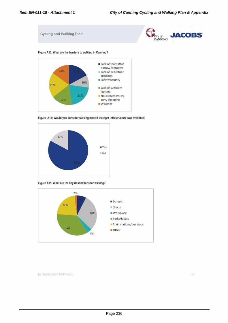
Item EN-011-18 - Attachment 1 City of Canning Cycling and Walking Plan & Appendix
Page 236
Cycling and Walking Plan
Figure A13: What are the barriers to walking in Canning?
• Lack of footpaths/ narrow footpaths Lack of pedestrian crossings
• Safety/security
• Lack of sufficient light ing
Not convenient eg. carry shopping
• Weather
Figure A14: Would you consider walking more if the right infrastructure was available?
• Yes
No
Figure A 15: What are the key destinations for walking?
2%
• schools
Shops
• workplace
• Parks/Rivers
Train stations/bus stops
• Other
IW11650 OO.CT·RPT-00(1
~••yo/ ,.JACOBS' CANNING
'02

Item EN-011-18 - Attachment 1 City of Canning Cycling and Walking Plan & Appendix
Page 237
Cycling .and W-alking Plan
Appendix E. Community Identification of Places Needing Cycling and Walking Improvements
~~SNI:Ifld.PIU'o
-!-=-=MISh.OidP•h -·-~-• V~A.
--12" Sl'lol:dflc c..w. I) ~t~to.o.tC<oMII'IQR .... tOF"ttfld ...
_!!.......~~ " w..,err-v .. .,...., ...
32"02"17srs ...!.!._$'51'303"£_
32"CI2'170"S 1U"-51'303'E: _ =~-:::::::::-N~R~ - :~
11 S'S4"t4.3'1: Mlr•A-~A~_!.CI!"""'---f"'"--#'01'541S'$ 11 S".$1"t42"t
---_ :12"0t'2ars_ 115'5nt5"£_ ~Sir"""~~~ _ ~
32"W"JSS"S 11 5"54"183"( ,...,__
·-e: -;;:::"~-+---------~--,..,.,. ... 11 S'52"'47_1"'E. --32"UJ'UI)"S-
11 S'S3"4&.$'1: 32'00"410"S
11 5'51"4&!o"E
.):l'(0"41V$ 11 S'5.f4&$"t
l:'l'"W411TS 11 5'574&ni
_ DllflaAiof~roe«asAiatd"an'lc.no.n.l•lr~
Nooro..-lbl...,_
-~--!p!!<lli'rlt.
- :
- · v
~Mill~· ~ ..... 22"3di!o&Od-.eucs-~~ Road~ r......-.--~*:&11-IKII:dU.~~anu .......
----------~~~------ ~~~~OO'Irotdw OO'dlrii'ICI!he ..-lmtl•d ... tdlcd
:srontn
.)7(11'4STS •• s·~-11"£ w-~">e .w w_..
~ta"~.!C'_,.~
"'-IDFlocidirQ WIIBI'III•flooc5ecl fiCioelncar1~GIIVOuGhlhill*l\
--~-"-edfocMp.w.:~I-W-Roedla~~_.,be ..
-
..!.,',._
... ,_..L.._
'
·-.,._

Item EN-011-18 - Attachment 1 City of Canning Cycling and Walking Plan & Appendix
Page 238
Cycling .and Walking Plan
"""'" ll ~"»Wft N-~iDolf$AiiiO
..... _ .)T(It"1lTS rt~·~n•n
11~"~7ft ·--,..,..rs !1 5'~!J'OI3'ti BMir1ot/l, ....... dst.
f-!L ..............
1 .. --
-------P'32"CC2'37•-s ~·$3"00n:_ N-~w~
3:2"W41 T$ 11 5'~ .ni N ... H.,..CWI S~
-~n-....!..!_!.S$4t~.:!.._~tc.tSrr..t
»"00'181TS 115'~rt N-s--oMaSD-
.£..._ ~'-! I :Jl"((I"I&M ...!.!.!J_.f'4$~ N-~"-:1
~0""-U.I 32"0!.491"$ 115.$('1)01"£ N-T~s .... uu
..M.._fl!"l~ 32"01'281'$ 115"$4")'77"{ N_.Hala~
...,..,._.CG'IftQ
---- --
----+~""----
----- __,.,._
P'rclbli!MOO'ISM.Irci.,-_..,....,Ptl'kRioll'lptOpit~*'911-.o...IIMll'l-~_,cw-~69.-d'ordlilct'en«ld~"-111:1 " ....... e-n_ . ....,.,._
~IIOnO ..... ~IfOWIO'MI'OCII»IfWI~~ _ N
Thtrouno:'~Nl .... -.:.-lrwrtr.c~it...,.~JOt~ Tht ~..,.llllllll'OW_,tl811~0'hW"-IIo ...... hrooodillboutwMon
~a.!=.:!!~=·~~~"""* -~--~~~~...._,.~.---~ .... kW~ c..
-~-=:.~~~ ....... O""CMJnuMf•bbuch
===-~::r.~:al· .. -:m:-;!: ...
fHotfoorptlihahauklt..-..cl1o.-.o.._c)CirQ 11a1tl0dolngolr-larqdi!S 10-R~Drt4 Thta-_not....,._.,.i;rii'IOIO!iHd..-18c~ly buHs811d~topas~ lflhe.-lsedwhlcil~nc:ti*B,I'MI-111 .. .:,.,,_up N
r.t!\Ro..:I~~EIIItdgitlfWI~ .. Rolocl~,.....""'l'l Mitw~ai'ICI~pacl\_ Thtpafllohol*lbtOII ... OIIIIfetiMf$Ft1!1Road10 ~hr!Ndto..-.s-lowSlrMII...,Holltlltoad C)d&MJthoulclbt~IOVM ... e)Citw~....cii'ICIIIfiCM~ba.tlonF.,
-
Ro.d-IWaf' ___ ...,...,.~IO--"it __ -'-.!C __ _l_! _ _j

Item EN-011-18 - Attachment 1 City of Canning Cycling and Walking Plan & Appendix
Page 239
Cycling .and Walking Plan
.....
..
---
-~1'260"8
l.l'l'"Ot 1rs
371;11 4G04"$
lT(IT.U$"'S
,..,.. ...
,..,.., .. 32"01'24r'"S
11:)"SJ"58st:_
11 5"Sft98"'£
11 5"55""00-Tt
11 $"5Z'$0r£
•• s·~n
11 $"$$'4lr'fii
11 5"55"2'36"£
,_ .. .... M""'0\1~0<10-ICI IC ... O'O'I$~
W-RtiMitMIC.,tSnr.
Ftt'lldtltCtftwodf~t$11" ..
IIIU..P.a,-.... w•
~ShtiWtiMti'ICIT....:Ii:IIA-1 -
_ ......... ... I c. ,..,.!111ft~
t--
t .......
[C)dii:PeM&IriMCOI!IIa
n..~Qfi(~~ ..... ~~ ... MtO~~~<J ~~~~ n.~IIGIII~...tldlttont~.,_....,Wodlli_~ pr&'bdonhbtndlarlllflvperbildir!Mo ~--.-.w.......,. .... tlel"ooOINo'~tiiAIOOICI~N.,.onQIIItlwo d""-rold~--ICI~Ioi'(M,_~ TM~wtti--IIIWtlnt
-.1 .......... Ml~......,.llfNIICI-~rCJitwtwhi:iit" ConWgh .. ...,.Ntoo .. ,...ero~~....,~-.., .tl'«tlld . ...,._!Htprol)lottnll.ldO'-.dl ....... tllolto-'•tnaew(Jf_.,.,.. .....
-~ to1~lfrlhe pod;illlllll..._.,.tlhlrll NO STNtDING ~ .cJII $1110 ~INE$ IMI ..-.ewon4it'iltOHdt,._.fOIICIOI\Il'leberdiiMI....:t~•~20-.,. ·--
~ICit.....ud ......... F"...,..er.c..t•boehb~•..c~~•cr juM~MIIIICIId!Mr,.,.~F'""""'...t'Wdl.-e~•roct Sfttr..t ..... ~MIGUI!h ___ ......... ~Otl.,.... ......
_ ___,fCI' $Iii: fl'w;IIAI ICI """-on-.c! tw.
Woltliltshan~-.ltwri_IWO_d~t.slflhcll_...noUHiul ~ ThtM•t"<<II)*I~IIOfl.lhlty .... ...:ht~«Wo..,.""" lorwldm<li.,.Nc:J!knot}OUICig.ldf'lfll6bl~..-.dc..-Ofut,.-ll.tlwnclc.
:':.!.':~:.!~-===-~~="rd .. ~
N..cl~err;llpd!J;*"'e~"...,_., .._,~~,-.•~•••"'*lllirv ,.,t.alorl--.cJn""""-•IWDI*""""'bloltro~ltiiO I.Otlg -""""-llllaulclbtt-h,IWid~P!f"GIItocah ... dlMCl\~ =~~":.n.r.__ll;l;l;:~,...,.., Rldl•pl'lllpMht~·~
Wt~~ft.,;IIJ"'CCI'II'IICiiol'lbllniOihon?ltiiiCIIDetfl')'rwttbA.IIhoughNM'Id pntogtttollwt--.PSPOtiA....,Pw.llde•krQ-Irlin..._,l~trotldoo """"'~.._ .. ,PSPhltll_..._,loiCWI'Ofii~I ... ~MiMtOOCIOfl
--
co._
-.w"---------+~S"L ...!!J"M'OU"£ -+---------+"' ----j.P"m.torlc~~-30._)1Nni"!CIII~ ... -'-~cb-. r-!"· --t---1 fNJ~,...wypoorWDbllty~ff"OIII---- ROidklm-'1D-. -- I :::;;;:.e::::;::rs.:of~""flf~Mao-onm.,._•hlll..:l N

Item EN-011-18 - Attachment 1 City of Canning Cycling and Walking Plan & Appendix
Page 240
Cycling .and Walking Plan
n-o.a.~UMdCI"'*~,~-~·tr.lkyOII._~In201$. ~ .. lt.,E•J..,..Wtttt.:~M""""iflflt~lo'ld.....,ar.ol'l'l-...,.. wtillr-*u ... rN~ lllll'-"'rUMd~~Hnn~tou..~_, ......... c.ru.
KoftliNator'ol.,.....~ldllfcAto-•.mcCC~TW~toutdtNtldtttrw Theo P$PhNbMfii)N.IId...cl~lo~pil:rtylolftdgr~~lrl..-c!OIIIal MPCitw.et T~qeift.tlflel,.,..,....thoUid,_...plolty TNt JIII'O(fliCIII~bll~.-dlhloc.tll'lculdblllle_PlJ_ •mMYIII ~bl.o"9.....00M"'...,.Io«f'4._POI'l,..-.r.._lf.-... ~"4/'1 ...... ~forc~-*'tloOc:tCRROII~·rtleullet!OIIIealoc)Cie
,..!!..._ ~'-----------+"""'"-'-''--if-"-'""-''-""-+""'"""""'!!L-----+""'""--------j-"=ID!!!.:.. .. ~:::: .. W ... Dr!WMII_.., __ •..,.·bull'llllllll- y N-AOIHiaho _ ...
_!!.._~-·
.. ---
1'36 .. 1_~--,....,,,..
,....,.T$
·· ~·~·"t
11 $'~0't;
11 5"5t"l$8'1:
u5·.s.rson
, __ N-Vtllgo_A ...
·--· N-~RC*I
~P~....:II$¢ c ...
.AI_~~4o'l:!_ -
N..,Roe HIQiwow;'
N .... GI*'I ..... W
I .An:~ra.ctwo;WIIorlo.t..
-o-.
~---..
n.•ahorMblla~dlNc)del)llh-Nrtwr #OW .--pot~ .... -*!no~,.....eo-.•tJ~V~IIwlr-.,.._,be~ -""*"~lllllfie•M""' ..... ~CIIh4t ..,....,
n...-ro;~~~c~r, .... ,_bloo:udGIJ•~polf!!IMtlll~ ~a~~a~~6orqdi511ot')W'Otole*'flt~Adlwof~
---~-~~IICI---~ ... ..-cran:•lltld ... to'ld.t-111~ MrMI'Ic--.~ru.~~hour-lhol.lgh._ .. ~tobe•qoNtlut..t -(~lflfle~beuelrlgVai'I.....,A....,ut')Cerftollouldbtclto
~.t>eqdlr~.t!OUidb.~ ...:IOOn•prgptrly.•-"-hn•• ...._.pdl-'*hlllllr~tu:kedby~MICMS,Ofii!.-~ .... ~~~'IIIIIIOflg __ ... - -~!""'~~~·- ----r~---t~----i
---_ ..
At:trMt~--'*'-lo~ ...... _.IO_.,...cMII~IMcrir~~--hMV!Itolo1t'W ..... CirMin~~ls :a::-:::•--orqdf C....on~...,""""'"'•-t• v tto.C)Cttf'OIMGOol""""'"llitiOIIId<ilqWie T~_..._,~.,.MUU.. PSP atllw_,..<JIGRIUOnfthotl'u.d~A!olnlt~gMno_,IOtr..el::fl'arl "'ff'1CIMtttt't~-l*'OOfllft'O*I<I.l.<ofl~n......-IObtl
I :::.,...~._::::;::~,;.::;::=. lV<l .,oro.tocoro>ectuplhe_"'"_---t-'----t-'-----l IIO'IOllll e001'ft.MI IO.,_We ••.,.,_.SID ....
n-o.qdtta~Qcon~lltoa~•TIIot~~.,._.u,. PSP, tllN..._..doOI!IIinDINtoediO~l~O*'O"""tiDD'~IrOII'I ~dfle'rll!!'rK-wOI-.;oOfn.tmwwar.tu•~ n-...-~.:~t.•
~=~..:~~·=='VA.Inor<ltriOCO'I!I«tupiNRoe
HN·S£qoc:Je,_Cllft'IIICUIIIWManiD8uiO.....Smlan.,...._,....ICaolll ... _.....-,_a.-•lar9,_. C)dl raul• ,._,.lobe CGI'Ilftoed1lvcoq"l
NNrl.uth~
_ .. ~-+~~~---------------r~~~~~~~~~~~~~-------1~~----------r~~·~~.~~~::;~~~~-~~
,..,.,. ... _ 11 5'.53'3!_!1'1:
.. ... "'"' N-~WIIY - nw.-tNed'il: .... --.~·~yWnpo.liltMtl) ............... ~~tNtptf> ()roc.yW',..,_, ~it no!*M...., ~etet-"9 nllw:toonnMdiiMtbeibedto/npow.J*'~------J-!---f-'~-
l ~:..*:c':!~~·"""..W.no~ Verrbld.cuufor

Item EN-011-18 - Attachment 1 City of Canning Cycling and Walking Plan & Appendix
Page 241
Cyc.l!ng .and Walking Plan
·-----115'~%'£- ~Rotd
:l"'1"116"S
JT01"n•-s 11 5"5f'?Jr£
32"01"2~rs 115"»'2415'"£ N-~-SI:Y-
32"01'53M N~RCIM
.. 32"'al"UM 11 5"5$'112'1: .... ftMC..-...g . .. .., I32"1XJ'•D:rs 11 5"55'1711"1: w
-A.a."
--32"(12"1:rn 1t s·.sn3n
c. _ __ _ ftilf'<*t·*Y~IOo:rcM. ..... ,.,....C_IICiti~IOUI*I...n .....,. - y
Or.-··~· -COIItl bulliii"!N'a.dc;op.w.r....:~PI'C*lr ... PidllirslMd fltl'lllk"'fl•--mo.Ongtlclill' ...... .,....ltllt.~-. .....,.,..,
-----jl-"""c:.-"'''~~-~-~~:d .... p-hf;:::;::,:- 8iodcloot9"~11t.w'.-ct y
t--~~-
~~-t--
... ·-
n.~•IIIII'P- ltM!) ,_•kllalurodont..,...~al.,.rv ~..n.OOOdr.ogN!i"IMwd~lllfMibcaotn . • .,_«<a''c..S• til SleW-a lb
NoNf • ....,.f~pacl .. "*-atld~IICigotCIICI ... ~C....tra Goirlgto W\ ... OrMirhR-In-..~-.
Slw'edS*I!.tl.ftll~-~-------· .... ~'\f!Cinlhe flllditla~diflc.IIIICI~~-Nwall'thrandll'e~tolook autbtr.r.:on.M.ni!IA..-1
-
""- -
00.
00.

Item EN-011-18 - Attachment 1 City of Canning Cycling and Walking Plan & Appendix
Page 242
Cycling .and Walking Plan
-
-
,,.
---_!29_ Cennir!i._RMI'FitjloNIIPirll
ISO"""'- ,._
~·-s: 11 5"$.1'2'33'1:_ N-M'OII.str .. -I.,,,,,~. 15 '55'11'"' I CIIIII'Oinc:lloll Slllllrwtto _,.Sill 1M<
,..,.,, .. 11 5".5r.ltt'1: N-(IIM!n0r .....
~$5'"$ n $·.woon 1,.-A- -.......... ......,.,.. 11 5'53"3otl"t ........ ._ 32"02'". •-s
,...,... ... 11 5"53"Se!l"t
;J2'01'UO•'S 11 5"~0"(
-Wft
,..,...!"'_ 11 5"5of'Oe.l'1:_ ~Ao.t -1,...,.. .... 11 5"56'.35"E l c~~nn~na~o~ S11111a11 --,..,.,, ... 11 5"sr2'l l"t -,...., ... ll $"5$71:ni
,....,, ... 11 5"~$'1! Sl'.~S-.-E!A
C-J!Itl~aro:IWIIoo'IOnw
32"Ur<lll"$ 11 5"$Nl<1'1! l !cl ~..., :.~~~ .... :rl"tlt '2srs lt s · sst33"E
--... 1.-...
I ... ..,
~ ..
~ --I ......
~ --
c.-. 1.-...
I ......
1.-...
~--Endolt~
I ......
ltilpjott-IQI'UIIJ(IUIID- I*'• .. IOito..t<*i~l~ID-..allio;hot•
::::-- . ...·---~~.,.. -~ ~ .......... ~~ruooc-..tott..._/~~cw.... _,.. "'
- ::::::::::::-~RoM - r; Prueo:tedblkoo,...,_.NoroVIIHendA-M'I<i/oGrWWDI'Iveklp""'de ---n..H.e,_~PDr'IIJ-1-rllfllllt!.«IIOnMilrtf'lrlgRdllndc.run.y • q\:~<'iiCII'IOMitlit~ lt.e~~~~~~~--.loCH~ ::oroon'l IIMtli!t~k'lfOMIII ... IpOOI'IIefldUIIIIOioiiO~dah(l)to
~--c-...,~ ... -oooe~ ....... ~..-d--_,...oughtlw..,.rlhcoun:l-llwltmlill!ldelw"""*ec,delll Ul' ........... ~ n.--,.~~~~ouldbol~«ledqoW""- .... toou ...... CUlM be tcr.o.lld .. _kit..,. lllt.~·IO~iltaii!N .. IIO~IOIIHlhlfCI'OffOI't iiQht 11'1"101.~ llgttlatumrQf'fil#.onlytnggoenwii'!GOII.n<S«>-IMltllil;glffortlk• ... I ....,..Deenhlllweb)'ta"taCCQiiood...._W!dlll4tot_I'O...,.Iac..t;IIDIDdll ovtlr:lrqdit.bcrp«<~Tt..p.UI....,..IIt~.u.rtd .... RIC*t....,I'OO~
-~:~:.:~~=-dNtbooOtft~ -r-;-
NoCWI'~CII'wiiMC)dlltltl'>ou6dOO......,Iht..,.,..uMpl'lh .... n...eldef~IIIICI'OIIsirgllwfOIIdortltln(lel'q't ·cydhts"-'IIDUM ""* tlltft .. l'lttd • ....,.toWIOQtf ... llgl-.~·~ ~tlwfOIId• twc
, _
------+1" .,d0-.,..!:'""" ... ~6hc!Mlh~end'-lwve ~r••fwlc.lbll_-_ .. -+"-" --+ ---+ ~e>ikt ...... ttqUQCI:IIongW'-fSW'MlotletiO'elltmolli!bto~ -need!r.IIDbeca-ne::terod~
C)Nya.,...bbftd<!IW:-UQwlrhtlblon-~-. L<*d.q.d =e11CIIltoputlli'.M8o6.41tcllilt'lllot-~fl\ll<-l,..., ftoll01~
c...-~eonflet -~llflll\l!.e,.....,.anc~ .. a!.ln!t~tu,•PMIIiMe-."P"f•MI ·-r!--
- ~: ~lnc-t~~P·~~"~M'4J'...,IdMI<I"
_ Vwy~loh>cM'wlwf~-.,,_-,~...:Nr'ld
tww Ef'DH-fcr'fatcOIII'«ttCCnW A
~
-t-'-----P"" -'"
I"""'"'

Item EN-011-18 - Attachment 1 City of Canning Cycling and Walking Plan & Appendix
Page 243
Cycling and Walking Plan
_ ... _
--
,...,.,..
,..,. ...
- 32"CCI"Otn
3:2'01400"$
-------!'"""!" 'G1S"S :Jr0t'GIO"$
11 5"~2"t
11 5'SS'OSI't
_!!.5'~1'1:_
11 $'$4'40ni ·--T A.,. RM!tal'l'"
~-... 1 ......
~-... ....... I~
1 ......
- rE'--.... Elldolll'it
M;orrT~qR-.tMa..--u-~klr-w. Thlr•lt.110_.,. .,_....,.lore; til ,...,..-,IIO~U-1011
Vfllylt ... kMr ............ <*oQli'Ctt.y ... or'ON-Gfi4Ut.l&,..... ~A~to·-~~ ....... rwr-.1ofil .... _ylo1rdil;;or!U.. -.~......,;ngl..,HiGtNo'fY W'-!lr$1U5tlholifl't.....,ftllfd~~twdto ...... ...... t.bo'tt~~ .... bdrlidfbyCIIt,-d>OU(IhN~-klrM M!IOQiit;l'd~ U..c~to,..•••h<Udbe•pri<wty-~~ .no.Mbe ... ~ptOgr-fotpet..u~IOi"'8--10011'*"""-...t,._kldr. .... ore 10ldloal
_ C)ot.r..U~IMt.-..e.mt.....S•rcdlDpr<I!M:t...,.....w.ln
~~.-ckll._bMfl edloockJI.elllll_,rd_.-.o.t_...
Ughli .. YVfpooltf~torpac!Ml!Wwandqda!l.kJrorvf'-IO'MIIlor! lt
_,.,.lrllo'IQieolta,.td~lftlhtll'lddl•d•Mrlu~Al_.llm ... I'IOt Mle)dabl.....,fiCr'IMtMiilitM-.o_,_,o..,.,..fc:r.....,lqi'Uto~
11Mt41~ l llri¥fllf'lclillic:uii1101'1Ngi11 • .._. .. ~ .... ~----The'IOdf'OfJIM6ho!.fdbell'lllltllllo-. ...... -IIO~.""•,.,.. ~t..tm.:t-.olhlti-=~~- ..... ~~~~Mtl.u:
fHit....J.It"d'orr•~<ltt~uiiWICI-.,.......faacltrM~
Hobo'.ef"lltb-1
V ..... I'IIIIA-iiiQJWIIN-SrOIIII!IfOI~butl~t...,......., ~~ ..... ll'*jclrltuoti'!IOOIIt, .... hROI8PSPII'IN~IWICI twltM'llldePSPinlM~
Prtiff~,..~~-tllitlnllltMCtiofldQMo'l'l.....,.....,,......,....
IIQH;...._ f"~lll ... E..C~..tdlr**-' IO'IIr_,.~ ft.. W•l~l'*-.-loba h
--
""
""

Item EN-011-18 - Attachment 1 City of Canning Cycling and Walking Plan & Appendix
Page 244
Cycling .and Walking Plan
... -- ,..,..,.. II S'M'24t'l
,, _,......, lt"$9'.03'$ II S'k4?t't
e...... ... 32"01.,01'S .... 31~3"S 11 5'51'304"1:
... H•-~ ~1 !lt'S43"S 11 5'$3".)11~
"' ---32"CCI"Ur! II S'$of'4?4'!._
- ~~ ~_!_02"1:_
32"CC't5rs 1U"$on1ft
,.,.,.,. ... 11 5'!i:r56S'E
,...,. .. ~!?.:L lT(I1'3115"S 11 5'56'165"1;
,...,.,.. ,, :rM"fOrt
-W'*f'9<!DIA<>ad
... N..,T tWIGI
N-W.wfaR!Ra.d
N-WJDrtRa.o!
N-~H~
_.,..,...,
--_ ...,_ ----
------·- ....... __ _ -.2!!_ ..!!:!!......o.ta~--------1'32"'CIO"»rs ..!..!.!'58'28"- Wrw.f&r.~ _____ -1"'----
--
n..•"""""~-·paMIIG'l .... groo;nlhtriiNII:h-.~~""11111 -POit"'llbuttllot__...~hM-I:JoMtli • ..:.ld ........... '*"'••'-V'..,.,....,.~ ..... upiiOIM 1/)ollh~h. ThiJI\I•f'l¥d10 -'"':tG~.~-ft;hlontopdil.and~-,..~~toi'OII'...,.., .ndeluMJCUIO-diJCurbilll,_._ltD~*'!ICI~IMJklecl . .,_ TheCI'001"-dfWIUI~~-1111Joole*h""'Y*'O'tof*ke¥a.Wh4oft :::::::*"""*•~t>O ..... ICIO>illbikJt~iltld~a.lililclrcldiOti6tOtl Nf••INYe~lbleto~ltlwe-IIOC)dlrlltb .. ll'wll'ldGIIN =-· -rt.~tacb•••,..,.~--"'*·'*""'*"'0'~
n..--qd.plrtlib'{l._r<*!&_.,-......,~~.~:-rdraor..n.nllboao..ort• '-10h<lponklhro-;!.S.IO~~c-or.,.;;a ... Cl'*'*'"' T'*'• ...:.WCI'Mb, ... ltctNMOMoii ... ~~...,_ ... I'OMIIIIOCINy aft..., •2.o3cm hotl_ ... drlww ~hr.-:1
hcowpM.~Ihot-VI"'.....,*'-1'01:"-dw"r~ur~. OII., ~ ... ~., ........ ltii¥1Nftlr:llll~l!*l'ltiUI"'r••.,......,,..potl'lirltCI'I lwt~J*Il.
Thlrl;.ec)dltorlyQ'OI.Nig.,_!t.Cwtli!'MRII!ion. ind.,;tmglhlt~.,, tt;piiCModlo ..... _ HIMIY«~IJI"'CCtdellf¥11tMtll*hllwf•re.._,touw
kch_,..,_tt#CO'Wit(;"=".....,.II'Qo•..O. llllclbolh'-"M..,.,.IIwlll""'
I=-~:~..:::=::..~~ Wt..!ptiOpill_..., .. ._.
WWIU~tCIOttl'l'i:lw;wl!ooi'IO~t~ TIW'"'bkl~ .,.,,.,;Q .. .--Illlc....,bo.ll..,.lrfi"~INtG011!1«Mtt.nllelfoa.l
~....W..t__ _ Y
c.r-&d:tflltll(lll. ... lifll*(. htfldtl- M>loOWI y
The~b._L..m.....,...clfllc.-..IS~c-•IJNt!lbl• Qol~ilo..,. ____ ..... llolll..atllll4llftl'--- But
---~ ...... p.cec~.doM~tl\ll:lr.lot .. ciiO~·...,....ne ~*•-!9101(--.orM¥1ftonl)IOpll ... ~ltiMM ... ) Thll»'~ ..... ~~ll.aflauiii-·IIM!bl..nclllw~~'"' ..... ooiel'l""'.....,... • ._~be~-~ ~IMOOIM IWII:IIdfotld~~~~IOU..Bin..,.~C«<V. StdlelltMI!:f1if«.nat
. ,.

Item EN-011-18 - Attachment 1 City of Canning Cycling and Walking Plan & Appendix
Page 245
Cycling .and W-alking Plan
-~7"$
_ 32W"41N
-'1Y'4in
11 5"SS'217'1:_ H......,.,Sir_,
_!!_S"54"583"t _
<----------+' ------ l1'1o9"4t0"$
"' ... " li"M'YS"$ II S"S$"00 1"1: ·- 1 ... -
,...,,,.. 11 5".srQ87"( t.lllf"IIII*Sirlllol ~--...... .._ 132"0:1'2:44"$ -- I~
-. ..... ,...,, ... 11 s·smn f,._.,Hicllto 1..-
M~;~nH~ l.MdiH~
'-t--------------+~-1 ... _
lo._ ....
lT(II'WT$ ll $"~r£ -3:2"01'4$3'"$ II $"$6'24$"'E
"'
fN•olfrr;il:llrlclhw•it~,r.d~ . ........, •• ~DCI~byW.II lt•"'*'.-.t•IIO..O.IItcundlhlili'-'d.bl.l'Chllilid~ __ -f-!- 0... _ rtot~IW\1f.ln~~n••WI'fl\ll/ti)W AP9t~.....,~.,..c
\OINIII~qdlri...O__.I*!IM~IO__.peH"""'- -1-'""---j-- _ '~-~ • ..,. ........... r.omu....-tiiO-f~LJ.~ ~tiJ'•II'"rOQII....O.tl'lt~
FOO!Ptlh ....... (.tloleblock)•--rowlor~.toflcllt~OIItleu'td~
--,;;ngo--. - N --,_
lhiii.U"'""ia.bu.li~orllla_...po~ad(IIQ'*~ ,....,.._r.oo -*-" .... d.....,.•-.Wd•bi;CIR'Kl-10 ..... The~~ --.III~IIIMCibtt~-~-*'OaQ<.Iielo:et!IIY' .... II'dN ---~o:.cnu_,....:~-..,a-...IOqodin..S.,..,_ Tt.. ~lclll!l-...,g,.ap;gs&ate-..qot"'t....und .. -..gc:.-c;.,bed<ffo.oll
~~.,.::==101*\~~_.._..,..10 ....
n...a,....~!<OM..f'llllt!IOM~ .. ..,it'IINN...SIJ..,.._._.,.,. but ·-PSP~ .. ,,_,~~.,_~_.,._.,.~, ,..,......,. • ._ .. 1M ...........
..__.._,......_...~~n••......,.,......PG~~r;-•10!
,out~t ... dold ~._,d,...._klt~cydiiMI.IOI'dt-..ouQtt.~lhoul. l'll!;lll'lfb ... Nhtyd~-..SIII'IIIIIId'tlihnCW>IIOa ___ _
~·~ """""~ ~_,...Of'l,.. ..... .....,._..~ll;o;lpootldt .... , ........ W..,dU..a-W!poor.._,.WI,. -.urec...nctctt.n.--.cl~
=:~:«~":.~~::.,..ru::-.,....,...,c~-t...._.,
-

Item EN-011-18 - Attachment 1 City of Canning Cycling and Walking Plan & Appendix
Page 246
Cycling .and W-alking Plan
- 32"tl1'4&t'S 115"~ --8c_F..,..,_cr..c.wt81'1d~ w
31'$$)1T$ , , ~·~··n
l:!2'm'un 11 5"5Z'OIS"t , __
'""""' ,.....," 11 5".$3".l3.$"t t--32"m'41!rS -·- , __
L...t.Hbtlo
'"""""'
,...,._ • .....,._dCCINOKIIng~)dlo~ .......... barrW&.-.q.h ~IOdilti'IOUf'tiOjfiJI\_, n...llhould~......,Mitl~~
r""""' - . n. pd> ...... ......,. ·-... h 11 ..... .ndiJI-- "--10toe P'<IC*'Y ~cn-:.=..~tt!OMM~Ot~wiii'IOIP'IO~
1 :-c:::::::::0:.0.:~":-~':~~::;::~10 ._ ..
koWyCtOMinffcrcyctiK Fouriltftnfllf'OeOIIOO'OM....,C...COIIWlt"-loul'
., __ -
""-

Item EN-011-18 - Attachment 1 City of Canning Cycling and Walking Plan & Appendix
Page 247
Cycling and Walking Plan ~ily of JAcoas· CANNING
Appendix F. Intersections/Crossings Requiring Assessment
Intersection/Crossing
Albany Highway and Cockram Street
Albany Highway and Hamilton Street
Albany Highway from Liege Street to Nicholson Road
r---Albany Highway and Kent Street
Albany Highway and Welshpool Road r---Bannister Road and Baile Road
Bannister Road and Willeri Drive
Burrendah Boulevard and Pinetree Gully Road r-- -Hamilton Street and Sevenoaks Street
r--High Road from Augusta Street to Herald Avenue
High Road and Rose Hill Crescent r---High Road and Willeri Drive/Riley Road
r---Hossack Road and Willeri Drive i Vahland Avenue from Burrendah Boulevard to High Road
Leach Highway from Braibrise Road to Wendouree I
Road r---Leach Highway near Nurdi Way
Leach Highway and Welshpool Road
Lynwood Avenue
Manning Road and Bungaree Road r---Manning Road from Centenary Avenue to Lawson Street
r---Manning Road and Hamilton Street
r--Maderia Road and Wil leri Drive f-Metcalfe Road
r---Nicholson Road and Spencer Road
r---Sevenoaks Street and Wharf Street r--Vahland Avenue and Sharba Close r--Webb Street
Woodford Road near Bannister Creek School
JW116500- 00-CT-RPT -0 ( 1

Item EN-011-18 - Attachment 1 City of Canning Cycling and Walking Plan & Appendix
Page 248
Cycling .and Walking Plan
Appendix G. Implementation Plan
C!ntung Pllh Ntlw9t!t Roytt 1 !Wtlsl!ooof Road to Cw1ln•
Gibbs Street 2210 2210 1.512m footpath Bltie bo~Aetvard Yes Yes No Medium 1105000 2019 2019 2019
Cedi Avenue 1004 1004 2.5m Shared pelh 2.5mShared path Yes No YO$ Medium 251000 2020 2020 2019
Pattie Street 313 ,, 1.5mf001palh 2.5m~edpath Yes Yes Yes H~h 58250 2019 2018 2018
Wl\4tri Street from ~tie Street~ ._lwt CloM 41 41 2m._. .. 2..5mShllte<'path y .. Yes Yes H~h 102$0 2018 2018 2018
Halsey ClOse 212 212 t .Smf~·h 9lke b!XIeYan:l Yes Yes Yes H~h 106000 2019 2018 2018
-"'- 308 308 1 .5MI~Ih Bikt i;M)Mvard Yos Yes y .. High 154000 2018 2018 2018
Oous!Sireet 528 528 1.5m fOO(pelh S•kt~lfd Yos Yes YO$ High ~000 2020 2020 2019
IIYI&. Streel between ~ Streel and Albany 1-ighway 182 182 1 5m footpath 2.5mshared path y., Yes Yes High ..... 2019 2019 2018
Albany Highway from M1ik Street 10 M•khell Stret1 392 237 3..5m Shared path, 2mfootpailh
2.5mstt.ar.d path Yes No Yes Medium 59250 2020 2019 2019
Motc;het Street from Al~y Highway 10 BOUid., Stroet 200 200 1 2m lootpllth 2 Sm $~\fred path YO$ Yes Yes H~h soooo 2018 2018 2018
Boulder Slteet from Mltefld Street toA~on Street sao sao 1.Sm footpelh 6•kt~ard Yos Yes Yes High 290000 2020 2019 2019
Astltlul1on Stteet ltOtn Solider SbWIIIO Poloc:t S~ 518 0 25m stl¥td Ptlh 25m~peth Yos No YO$ No- 2018 2018 2018 ........ WO>yPlaco 190 190 1.2m footpelh 2.5maha<ed peth Yes Yes YO$ High 47500 2018 2018 2018
MonnockRoad 150 150 1.2mfootpelh 2.5m 51\eted path Yes Yes Yes H~h 37500 2018 2018 2018
Tarea Slreel from Mannoct Road to Reen Street 511 511 1.5mfOCJII)elh, 2.5m st.ed path Yes Yes Yes H~h 142750 2018 2018 2018 ..... Tatee SWelftomReenStteetto~Road(To.o.ndVIePatl) 1.5mfi00te)tlh UMo!'l by CcfC
'AithTVPlo No YK YO$ -- 2018 2018 2018
uQQJ'&dtk12..5m 5hlwedpath.
Boundary Road ftom Tare& Street to Hll VIew Terrace {TOIIWI of life Pari!.) 1.5m footpath lJaa:son byCcfC No Ye• Yes Medoum 2018 2018 2018 M1hTVPto upgflldeto2.5m -.. .. ,.
JtJtteh Ro3CI ft'Ofl"' Hill ViewT~ toAd•Coutl {Town d V.CP•I'II.) 1.5m f0Qip81h end ~ ........ U.....byCCIC
IMihTVPlo No Yts YO$ Medium 2018 2018 2018
upgf8de to 2.5m shatedpeth
Adie CcwttoCwtln Univ~ (T<MTI of Victoria Park) 2mlootpath and 40km&ftroed >Mth
llai!lon byCcfC v.ithTVPto
No No Yes La« 2018 2018 2018
(OW$ prohibil9d upgntdeto 2.5m Sh8ted peth
Sl:!!!nlng P!!!! Htb!!2rk R2!!!t2 (SI:!!SU!!I! S2 ~WhiJC!SJ!} eowams .... 152 152 ..... 2.5mlha'ed path Yos y .. y,. Higfl 38000 2019 2018 2018
C8lrdan Orive from Coc:tram Street to Greenfield S1feel 134 134 1.Smfootpalh 2.Sm shared path y., Yes Yes Higfl 33500 2019 2018 2018

Item EN-011-18 - Attachment 1 City of Canning Cycling and Walking Plan & Appendix
Page 249
Cyel!ng and Walking Plan
WilCock Street
Fttnelale CIHcenl from WilCock Street 10 B&8ncoe Aoad BlaOC'JC» ROQd frttn Ferndale Crescent kllamber1ia W-r
Ferndale Oe&cenl from lambertia Wily to Butsarla Ctescanl
ButMI'il Crescent lrom Fetndal• o.c.nt to AdeNa RcJ
Aclenia Road (ust ~)then via prark
veroon Place t1igh Road from v~ Pl3et 10 Rt>Mttill ~ Roset111 Ctesotnt k) park(~ easement) Part.; (dfamage easement) to Wooii'IEif Green
Wodner Green Keilman RO&d from Woofner Green to ~een Wi¥1
Greon W$Y from Ko*n$r'l Roed 10 v~ A.venuo
Green W3)' from Vahland AYttM.Ie 10 Huon SttMt to Shldfat:e P8rk
Sl'leldnt:• Park.~,.., and ~1'1!19 Path. to A.psloy Road
Green way, Acleryn P¥\t to Plnelree G4Aiy Road (~ Aderyn Place)
PinetroeG\ItyROfd (eftetAd4lt)'n Piece) to~
Pineltee Guly R03dfi'CM Buf'l'el'ldaf'l. ~aid to~h ClOse
Casllereagh CI058
Cannlna Path NtiWork Rou1• 3 tC•rousel to Roumoynt Hioh 5ohoo1l
CocktamS!teet
Cetden Onv• from ~m Sttett 10 Gr~W~rltiO SttMC Through P8f1l to M.Wrian'lul:> Slr681
Marriamup Street frttn park to WOIXIoes Street
Nichofson Road South from Woodloes Saraat to Nilchclbon Rosd
NiehOf~ Roe<! from W~$ttoet toM .. CII'• Roed
Melcatf• Rd from part~; k) BMgeway ""enut Vtagreenway k)~~
473
941
132
410
468
186
195
138
876
221 421
124 158
233
126 476
2!0
141
"' 1000
83
218
592
225
S23
764
169
99
92 3m Shared palh, 2r'nf0of,palh, 1.5m -941 1.5mfootpeth,
25mshatec:l path v .. No
vos No
Yes Yes
Yes MediUITI
Yes High
Yes MediUm
YM High
1.2mfc>o1tJ*th 132 2miootpalh
410 2mloot.path
468 ......
25mshate.d path
Bike bcdev*d
2.5m~~th
186 1 5m footpath, 2m 2.5m shared path
Ye:s Yes Yts
v .. No Yes Medium toccpolh
195 2m!ooq)llh
96 NoM, 151'1'1 foalpath. 2.5m - Ye-s Yes
72 3m sl\ared pMtl, 2.5m Sl\lttod peth Ye-s No hnlr.toVerdon PI~ miSSing
221 2m rootpa1b, none 2.5m Shared peth
421 2r'ntootpelh
124 NoM
158 2mlootpath
233 ...... 126 Nooo
476 2mlooepeilh, 2rn sNtt<l path
250 2m sl\llred ~lh
747 2m sl\llred path. :!mtoccpolh
445 2mrootpalh
1000 1 Sm •nc12m
""""'" 83 2mJootpalh
2.5mll\llt'e!d path
2.5msh.ared path
2.5mshar'ed path
2.5m ah.afed path
2-Smther'e.d peth
25m~path
2.5mstt.ar.d path
2.5m 51\eted path
25m Shate.d path
2.5mstl.ll'.cl path
Yes Yes v .. No
Ye-s Yes v .. No
Yes Yes
Yes Yes
v .. No
v .. No
v .. No
YO$ No
v .. No
v .. No
Yes Medium
Yes High
Yes MediUm
Yes Medium
Yes High
Yes High
Yes MediUm
Yes Modium v .. Medium
Yes Meclium
218 1 $m footpath 2.5m ~ed path Yes Yes Yes High
.. abo'l• 2.5m Sbated path
,.. abo'l• 2.5m Sh.at.cl Pith
0 3m Shared patti 2.5m Shared pa1h Yes No Yes No worl<
0 2.5m ah.ated path 2.5m 51\ared path Y.s No
0 2.5m ll'latt<l P.lUh 2.5m Shatt<l peth Yt'$ No
0 2.5m shared path, 2.5m shared path ........... (do&ed road, few co<>)
164 2m iootpatho 2-5m Shared path
1Ei9 1.5mf()()l(p&th
99 2mfootl)alh
25m~I)Jth
2.5mSh.at.cl peth
v .. No
Yes YH
v .. No
....... Yes Nowcrt -Yes Nowork -Yes NoworX -Yes MediUm
Yes High
Yes MediUm
33000
205000 117000
46500 .. ,., 24000
18000
552!0
105200 31000 39500
582!0 31500
119000
62500
186750
111250
2!0000
20750
54500
191000
422!0
24750
,.;;.. '-'gr~l>lO JACOBS
2022
2021
2020 2021 2021 2021
2022 2020
2021
2019 2021 2020 2021 2019 2019
2022
2022 2022
2022 2022
2023
2020
2022
2022
2022
2022
2023 2022 2024
2021
2019 2020
2021
2020
2021 2019
2020
2019 2021
2019 2021
2019 2019 2021
2021 2021
2021
2021
2021
2019
2021
2021
2021
2021
2022 2021 2022
2021
2020
2019 2020
2020
2020
2021
2018
2020
2018 2021
2018 2021
2018 2018 2021
2020
2020
2020
2020
2020
2019
2021
2021
2021
2021
2021
2021
2021

Item EN-011-18 - Attachment 1 City of Canning Cycling and Walking Plan & Appendix
Page 250
Cyel!ng and Walking Plan
Cbelty Cresocent tD park
Vill)llrk to EesltlOume Sli'Mt
EaSlbou~ s~ grttn way
l)"'W«Xld Ave from Eastboome Street green way $0 WoodfOfd Road
Woodford RocMt
W$11.ngAV(W.Ie from WoodOtd RoOO to lv-eston Roed
Ne-5lon RQilid lromW~IhngAve to~ Creet.: greoen ~
Sanni$1et et.tk grton W3y I rom tvt$t101'1 ROIId to MtiCallt Rc*
Melcatfe Road from BannrSter Creek green way to tugh Road
Me1catfe Road from~ Road to HDssack A.,.enue
HosMd( Aveooe W~ltl'l Orivt M:lm Hoss&ek Avefltlt 10 K~tn Offlt
KillataOrtYe
Rotsttata Avenue from Kllata DltvtiO Gltnmoy A~ Glet'lmO)'A~ut
Stlart:leOose --Karel AVMUe from~ Road 10 Kelilh Road
Canning P1lh Htrwort Routt 4 r<:arouut to Cyttlnl
"''''"'""' su..o Via pal'll. to Gledhl Way
Gledhill w~ (from BebingtOn Cooo to Kent Street)
Ctol.sKen1$ti"Mtll'lenviliPtrtt(....stoiWOtk.J~)IOFemROll(l
Brklge Street from Upnor Street to Bfidge Park
Bric%)ePartt
Cen1enary Ave from Bridge Par1r. to Manrwlg Roed
McKay Slreet from Marwllng Road to Mlwquls Street
Marqujs StreM from McKRay Street lo eniM Canning College
106
362
434 136 426
45 198 S05
187
832
856 242
460
175
4SO
22()
252
774
26()
329
1710
147
258
135
129()
306 111
106 None 0 2,$m foo!ptlh
434 2m~th t36 1 5m footpath
426 2m footpath
4$ 2mlootpillh
198 2mfootpailh
0 2 5M footpath
t87 1.5mfootpalh
360 25m footpath, 1 .$ml~th
a56 t.Smtooepath
25m shated path Yes Yes
2.5m Shlt.cl Pith Yes No
2.5m ~ path Yet No 2.5m shafed path Yes Yes
2.5m shared path Yes No
2.5m ShlWed path Yet No 2.5m 5hllted path Yes No
2 SM "*tel pillth Yes No
2.5m shated path
2.Smshared path
2-Smsl\lttcl path
YK Yes
Yes Yes
0 2.5m f(IO(path el'ld 2 5m SNttcl path 1.5mfoolpe.th
460 2m lootpaU\ 2.5m Sfl,nd peth
175 2m lootpaltlo 2_5m Sha'ed pillth
450 1.8mfCIOCPelhtn(l 2-Sm~peth bike lanes
265 None 2.Sm shated path
0 2n\11.Sm loof&ilth &lke lanes and bike lanes
v .. No
v .. No
Yt:S Yes
Yes Yes
v .. No
Yes High
Yes Nowork ....... Yt$ Medium
Yes High
Yes Medium
Yes Med~~,m
Yes MediUm
Yet NoWOI'k ....... Yes High
Yes High
Yes High
Yt$ No....ork ....... Yes Medium
Yt$ Medium
Yt$ High
Yes High
Yes Nowonc -220 BIJte lanes.. 1.~ 2.5m 6hareod path Yes No Yes Medlllm 2m_ .. 25m fOOIJ)Ith 25m sNred path No No Yes No ....ork -
110 2m ~b. 2.5m 2.5m ShlWed path Yet No loapalh
0 2.5m Shar*l peth 2_5m ~ peth
200 None 2_5m 5hllteod path
0 2 .Smlfl3ftdPith 25mll\lteodprath
900 2.5m Shared palh $nd 1.5m ~th.then2tn
foapath end I.Sm loccpolh
147 Nont
258 None
135 2mtootpaltlo
0 2.5-3.5m shared Pith, 2.5-lm loapalh
306 1.5mfoolpath
111 1.5m footpeth
2.5m~path
e~t:e~ll'd
Blt;eboi.Aevant
2.5m~path
2.5mshafed pelh
v .. No
Yes Yes
v .. No
Yt$ Yts
Y.s Yes
v .. No
v .. No
Yes Nowork ....... Yes High
Yes Nowor11: ....... Yes High
Yes High
Yes High
Yes Medium
Yes Nowor1c -Yes Yes Yes High
Yes High Yes Yes
26500
0
108500 34000
106500
1t2SO
49SOO 0
.. ,so 90000
214000 0
115000
43750
112500
662SO
0
60000
73500 129000 33750
0
153000 55500
2()24
2022
2()24 2()22
2()23
2()23
2023 2()22
2022
2()23
2023
2022
2023
2023
2023
2()22
2022
2023
2()22
2024
2024
2024
"''' 2024
2024
2024
2024
2024
2()24
2024
2022
2021
2022 2021
2022
2022 2022 2021
2021
2022
2022 2021
2022 2021
2022
2022 2021
2022
2021
2023
2022
2022 2022
2023
2023 2023 2023
2022
2023 2023
2021
2021
2021
2021
2022
2022 2022 2021
2021
2021
2021
2021
2021
2021
2021
2021
2021
2021
2021
2022
2022
2022
2022
2022
2022
2022 2022
2022
2022 2022

Item EN-011-18 - Attachment 1 City of Canning Cycling and Walking Plan & Appendix
Page 251
Cycling .and Walking Plan f~of """''""'
JACOBS
C8l'lnlng CallegeandCunlnlJnlvEifSlly (lnTownotVk::loria Par11.) 1 5m footpath lJabon by CofC No Yes Yes MediiJm 202• 2022 2022 MlhTVPto upgnlde to 2.Sm .,...., path
' !!!tung Pi !!! f:!l~ RS!!.!jl ~ [NS!!%! &~!"')
Cw11n LMNeraty and Canning Colage (T ovm of VIctoria Pant) ........ Uai:5on byCofC MlhTVPto upgrade to 2_5m -.. ....
M31tquis SttMt ttOm C.nnif19 Co1e9e to McKa'y Stteet --· 81t;e bol.levltr<l
McKay Street from M81Quis SWM1 to ~ng: A.08<1 _...,. 811ceboi.HYM:I
Cen1en<try Avefrcm ~Road IOBridfia Park ........ 2_5m shafed path
Bridge Part: --· 2.5m~P3tl'l
Bridge Street from Bridge Pant to Fern Road 232 0 3m._. .. 2-Sm shared path y., No y., No"""' 2024 2023 2022 -Fem Ro.d from B6dge Street to ~iv«ton Drive east J63 0 2.Smf~lh 2.5m Sfl.nd path y .. No y,. """""" 202• 2023 2022 -RMtrtoo Drive E8Sli'RNerton 8Jidge to Verdon Place via pant , .. 0 3mst\8redp;M. 2.5m lhared pa\1'1 Yos No Yes """""" 2024 2023 2022 see~~tfOtllnJc -to Verdon Place
Verdon Place ........ 2.5m shared path
High RO<td from Ven:ton Pl.ce 10 W-' Drive 1$8 ........ 25mshlwed~th
W~leri Drive to 6anmter Road 2427 0 3m5t\8redpalh. 2.5m Sheted path y., No y .. No"""' 202• 2023 2022 2.5tn footpath -Bannister Road to Bale Road 598 598 ""'--.. 2SmSI\afed path y., No Yes Medium 149500 2025 2023 2022
Balle Road IC E6 Road 582 582 None 2.5m Sha'6d patl'l y .. Yes Yes High 145500 2025 2023 2022
E6 Road to Easement .. .. None 2_5mshared path Yes Yes Yes High 24500 2025 2023 2022
Easemen to Railway ~ne 489 489 None 2.Sm lhared path y., Yo• y .. H~h 122250 2025 2023 2022 Footbndge aci'OGS Ullllway 11na from CanniRg Vale llA to Parte Lane Csnnlng Vale 0 0 ......... &M<Ibrlctge(25m Yos Yes Yos H~h 202< 2023 2022
S1hartld path) Via green way bltliOO Pamand Trail to Waratah Pal'k 191 0 2.5mf~th 2.5mSI\W.cl Pith y .. No y,. No- 202• 2023 2022 -Waratah Parft to Warat.ah Boo.Mii.-d 340 340 ""'--.. 2.5mshared path y., No y., Modoum 85000 2025 202• 2023
Waratah BoiJievard from W•alah Patte to ~oro Roed 245 245 2m_ .. 2 5m Shared path Yes No y,. MediUm 61250 202< 202• 2023
R.onf""' RQ8ld ltOm W81ratah ~ .... ,rei to Willre<~ Roed 345 345 2mlooepa1b. 2.5m $hated patl'l Yes YO$ y .. H~h 86250 2025 2023 2022 miSSing 1.5m -· Wilfred ROiid from ~CW\1 Rood 10 green W$IY 82 0 25mf~lh 25m Sheted path Yes No y .. No"""' 202• 2023 2022 -Green way from Wilh'ed Road to Jlicholson Road 2040 0 J.-3.5m "**' 2.5mSI\W.clpeth y .. No y .. No"""' ,.,. 2023 2022 .... -Garron Rest (Crty d Gosnelb) 2m_ .. u...onbyC<:IC No No y .. LON 202• 2023 2022
\IIIith CcfGto upgt$Ciel025m -.. ....
Othlr kSt!Jt jfl!d Unkt
McDowell Stteet from Welshpool Road to Ormng Road 193 193 2m-th 2.5m shared path y., No No ""' 48250 2031 """ 2025
Ke¥1daAa Road from M1tes Roed (Cily of Belmoot) to Welshpool Roed 1470 1470 2mloolpa .. 2.5m shared path Yes No No l"" 367500 2031 2027 2025

Item EN-011-18 - Attachment 1 City of Canning Cycling and Walking Plan & Appendix
Page 252
Cycling .and W-alking Plan
HamllklnStreet
Wn&rl SttM:tlrom Sevenollks StrMt to AJI)ffty High....-r
Catden Onv.ICMe Gardens ftaTI Albany Hlgllway k1 park
Fletnitlg A~ue from CMc ~ 10 Manning Roe<!
Fem Road from Fleming Avenue to part( near worts depol
Hl1:nry Street from Glbb$ Streel toGeriird Strite(
Genwd Street from Hervy Street to Leke Streel
Ntw •nk ftQtn Gtt.vd Slr..Ukt Stlett I'Ou4"'d&IXIut kll..tigt Strttt l.eiQt Su.et
Manning Road from Hamilton Street kl Centenary AVEM'Ille
As~Qwton Street from BotA<W Streee to Albany Highway
JoMStrMI
G~Street
Boulder S.-eet from Ashbllrton Streelto Patmef'Ston Street
South end d Taree Street behind Btownlie T~s to new North South Ftoad (a.nentty Hedley Pad~.) to Man ling Road Ellis Street from Mal'lnlog Roed to Andrews Roed
Andrew& Road
WendOurec~ Roe<! from Andl'l!WS Road to Cententwy Ptrt~rperk kl Ceneen.ry Awtnue Ktf"'t Strttt frOM Gltdhil W~ to Oveen$ Parte ROiaCI (in C*k)
Queens Pad: Road (1n park)
Glecltil way from OLtNns Park Road to s.blngton Court (In park)
Kent Street (near Canning River Cafe) wa p;wt;. ewer footbridge at Kent Slleet war tMn 'lla '*"' to F~ Crescent neat Nai"Vel way
Ferndale Crescent from Narvel W3'1 1o 81Jrsarla Crescent
Groen we)' bthinc:l ~r\il o.sc.nt ftem ~~' Roecl to ~hus R08ICI
Hybantl'lus ROid (via park) 10 Metcalfe ROid L~ Av.lrom Ea:stboume Street via WOOCII'O«< PM: to Oueensviite Av.
Oueensvifte Ave via pad 10 Fw.chley SCree«
F~ StreectoNk::hOison Road
Nlchot~n Road from Flnchley Slreet to Roe Highwaly
Collins Road from Macqull'ie PM~: to WoodthOtpe ~
Woodlhorpe Drive
Pot1cuas Drive from Woodthofpe Drive 1o green w;ry before Dory Place
Green way from PotiCUIIIS OrWe (befc:w. Dory Place) to V&Mand Avenue
Groen way from v~ Avenut to Bufttf'ld8h Boulevard
Burrendah Boulevard to WlleQon :Sctloois via Kemon Part
2579
1082 419 ... 268
167
375
634 S09
2300
302
1118
528 218 526
56
.. 1
579
235
276
,.. 914
89()
438
425 271
143
291
771
154
432 7()6
343 611
2579 1 5m footpath
719 2,$1'2miOC(p3\.h
419 :zmlooq)&"' a64 2·1.5mtoolpa1h
and bike lanes 268 1.5mfootpalh
187 1$mfootpillh
375 2mfootpailh
.,.. -
25m shatec:l path Yes Yes No MEidiUITI
2-Sm Shlt.cl path Y.s No No low
2.Sm sNted path YH No No Low
Bikt ...... $ YtiS Yes No Medium
2.5m shared path Yes Yes No Medium
2.5m ShlWec:l path Yet YH No MQQ~~,m
2.5m Shllted path Yes No No l.c:M' 2 Sm "*tel path Yes Yes No Modium
2.Sm sNted path Yet No No NO wortc ....... 2300 1 5l2m foo&path 2.Sm shared path Yes Yes No Medium
0 2.5m 5hared path 2.5m lhafed path Yes No No Nowortc
528 2mloorpath
218 2mloolpath
525 None
56 1.5mfootpelh
681 1 5m footpath, ....,. 579 1.5mfoo!peth, 2m
""""''" 0 3m$ha*'l)alh
0 3msharedpalh
0 3msl\l*'l)alh
0 3m shared path. 2.Smfootbfldge, 3msl\ared_pa1h
0 2 5m footpath
438 -425 2.5m footpltl'l
271 2m!OQ4)a"'
-Yes No No Nowortc ....... 25mshated path
B1ke boi.Hv<Wd
Yes No No Low Ya Yes No MIJdium
2 5m Shared path Yes Yes No Meclium
2.Sn'l Shafed path YH Yes No Medium
2.5m Shared path Yes Yes No Medium
2.5m ShlWed path Yes Yes No Med~~.~m
25mst'lar*'Pith Yes No No Nowortc ....... 25mshatedpqith Yes No No Nowortc -2.Sm sNted peth Yes No No No wortc ....... 2.5m shared path Yet No No Nowork -2.5m shared path Yes No No Nowork -2-Sm sra.re<~ petri Yes Yes No Mecl~~,~m
2 Sm "*ed path Yes No No Lew
2..5m:lhlredpeth YM No No Lew
143 None 2 5m $h¥ed path Yes Yes No Medium
291 None 2.5m ... edpath Y.a Yes
771 1.Smfoolpiltt'IMd 2.5msharedpath Yet No 2m-h
154 1,5mfcotgrlll'l..-.d 2..5m~peth y ... No 2m-
432 None 2.5m Shared path Yes No
No MediUm
No Lew
No Lew
0 2.5m footpath and 2.5m shared path bikt'*'-
YK No No Nowork -343 1,5tn stwwtd petl'l 2.5tn sNted Pith Yes Yes No MeciiUM
0 2.5m footoatl'l 2..5m Sl'la'td path Yes No No Nowortc -0 2.5m footpeth 2.5m sha'ed path Yes No No No work
64A750
179750
104750
216000
""""' <87SO 93750
150500 0
576000
0
132000 109000
131250
14000
170250
144750
10950()
106250 67750
35750
n750
192750
30500
108000
115750
0
2028 2030 2002
2025
2026 2028 2002 2025 2()24
2026 2024
""' 2030 2027 2027
""' 2027
2027
2()24
""' 2()24
2024
2024
2026 2002 2()30
2028
""" 2002
2002 2024
2()28
2024
""'
2026
2026 2()28
2()27
2026
2026 2()28
2025
= 2024
= = 2027 2024
2024
= 202S
2024
= 2025 2()28
2024 2026
=· 2()28
2027
2()28
= 2027 2022
2022
2024
2024
2024
2024
= 2023
= = 2026
2023
2023
= 2024
2024
2022
2023 2()28
2025
2025 2023
2027
2025

Item EN-011-18 - Attachment 1 City of Canning Cycling and Walking Plan & Appendix
Page 253
Cycling .and W-alking Plan
Arlington ertv. trcwn All•nglon PM vii~,...,. w-r to V•hland A~ I"'Ht Soulh Street Vahland AWW'~Ue frOm Mnglon green way to SOUth StrM
South ~reel from Vahtand A~ to Karel AYenue
RarlfOf'd Road from Wilfred Road 10 Nicholson Road (via paR:)
High ~ frr;vn RoMhlll CrQCOfliiQ l.eW!Iilghwlly
WtNel. A~ from l-tgl'l Ro.d to Cclrii'Mhian ROI8d East
Corinthian Road East from Wwve4 Ave kl Modilian Ave
Moclillian Ave from Colinthian Road Eas11o Leach Highway IClOtbridge
Green way from High Road along aid4t CdkiJ1t Waylo Sheldfake Pari~:
Btl~n SlreQI E.tt$1: tcwn RWorton 8tW;Ige 10 Tudor Avenue South
Tuelof AYenue South from Btwblcan ~reel Eestlo Tr.b!Ae Street East
TnbLQ Sl:ttfl E81st from Tvdor Ave South WO$$ v-.ncl AYe. .etO$S LMd'l Higtfwayfoolbridge Leach Highway footbridge vta Tribute Street WesWeatrioe Ave lo Rrverton Dfwe
""'" WeiShpool ~from Welstlpool train st31ion 10 Tomlinson Ro.d
T CITiinSon Road
Planet S.reelfrom Tanlinson Road to Kew Street
Kew Street from Planet Streel Onong Road 001ns to aty of Belmonl Bike BouleY8rcl} Lin I< rrom w•st~pool Sla110n 10 OMs St Slation (Q>Iy or Ei*nont}
Path from Lacey StfMt to Roe Highway (City Of Gosnell&)
BiCJU,ty Roed from Lao~)' Street to Rot H~ (City d Gosnell )
Walpole &rael from Taree Street to Holder Street
Holder Slreet
Marquis Street frotn HOlder Street to L8waon S1nMN Matquis Street frotn Lawson Slreel to enler canrw.g College
Hayman Road from Lawson Slreel toAd& Coort (Townd VIc Part)
758
100
1620
2311
Ul61
2210
520
100
393
422
498 239 426
878
216
572 210
763
171
421
253
82
758 211.5miOC(p3lh
0 2.5mf~lh
162(1 2mloolpatb. missing in some ~-=es. on'* (OUIHHac)
2311 2mlootpattt. 3rn ~Jl'lh
700 2.512m footpath
2210 2m.., L5m Joapaoo
52(1 2n\Jooq)alh
100 15mfoolpillh
393 2m Jootpalb. I 5m ~th. I.STI
""""""i" 0 25mfoolpillh
498 1.$mf~th
289 , $m f0Qip81h
428 2m lootpalth, 1.5m ......... 878 1.512mfooc,path
216 PSP, Ihen 2m foo<pa!O
572 None 210 None
763 None, 1.5m
"""""'" None
1.5mfootj)llh
2m_ .. 171 2mlootpath and
1.5mt()('l!pe;IFI 100 1 .5tnfootoe.~t\t2.m ......... ., 253 1.5mfcotl)llh
82 1.5m footpalh
1.5mor2m footpilh, bike -
2.5m~path Y.s No No Noworll: -25m Shared peth Yes Yes No MedKJm
2.5m shared path YH No No low
2.5m Shared path Yes No No LoN 2-5m $hlf«1 peth Y9$ Yes No MedKJm
Blt:ellnes YH Yes No MediUm
Bite lane& Ye& Yes No Medium
81t:e tanes Y.s Yes No Medium
2.5m Shared path Yes No No No won: ........ B•ttt ._.., Yes Ytts No MediUm
e.t:e lanes Ya Yes No Medil.lm
B•t:e ....... Yes YH No MO<IIUM
B•t:e lanes Yes Yes No Medium
2:5m~path Yes No No Low
2.5m &har'6d ~th Ye5 Yes No Medium 2.5m Shared path Yes Yes No Medium
2.5m shared peth Yes Yes No MediUITI
LlaJsonbyCofC No Yes No LoN IM1hCdBto -10PSP. Uai1on by CctC No Yes No Low IM1hTVPto Ul)g(Jdtto25m --ua.son by CofC No Yes No Lew 'llith CciGto ~toPSP. 2.5m .......-ed path No Yes No Low
2.5mshar'ed path
2.5m ..... ed peth
2.5mstt.ated path
B•t:etx:KJevlWd
Llai3onb)'CoiC wMFITVPto upgntd9 10 2.5m footpath.
l:.lm-Ptlll
Yes Yes No Medium
Yes Yes No MediUm
Yes Yes No Medium
Yes Yes No Medium
No Yes No Low
Ul9500
405000
5n7!JIJ
175000
$52500
130000
25000 98250
124.500
722$11 107000
210500
54000
1<13000 52500
190750
427!1J
25000
63250
41000
0
2030
2024
2029
2031
2032
2029
2026
2026 2027
2024
2027
2028 2028
2027
2032
2030 2030
2030
2024
2024
2024
2029
2032
2033
2030
2024
2028
2022
2028
2029
2029
2027
2025
2023 2025
2022
202$
202$
2026
202$
2031
2031
2031
2022
2022
2022 2027
2027
2029 2028
2022
2027
2028
2026
2024
2024
2024
2022
2024
2024
2024
2024
202$
2028 2028
2028
2022
2022
2022
2022 2CY27
2027
2028
2027
2022

Item EN-011-18 - Attachment 1 City of Canning Cycling and Walking Plan & Appendix
Page 254
Cyel!ng and Walking Plan
C8sttadafe Piace,then WI park 10 By.YaterWwt
BywaMorWfrt, t.I'Min bel'lil'ld t'IOusHIOWal1s. Road
Walls Road 10 Fem Road
Rweooo Drive East from Barbican ~reet East 1o Webb Street Foott:ridge
leacfl Highway (Silelley Bridge) 'Wou1d be foodad by Malo Roads WA
Noflhem lllde d Caonirv River from Centenary Ave, via Sea Sccut5'Navy Cadets. 1o jon pathS at Clontarf College (in City d South Pectn) Southern siOe d Canning River from Maolm04 Way vii petic 10~~.., Wwy
Southern sided Canning River from Marm04 Way via put 1o "khol5DO Road
P1tt Street from Gladstone ~reel to Taree Streell
Parll. mule fi'O'TI MarrlamupS!teet lo N~SOfl Road
Nlchot~ R* fn;:m Highr;M.Jry~ loAibflny ~ ( Otyot Go$nolts )
Ea~boume Street via greertwtrj 1000$5 r-.ICtlobon Road 1o l.anglord Ave
Pinecree Guly Road from Apsley Road 10 QI'Mtl way n&ar M«yn Place
Roe Highway PSP from South Street lo TC~n~~;in Highway
Ofrong Road PSP fn;:m Roe ~y to Kew Slteet
PSP lrorn Wei~ StMion to Lacey Sne.
PSP from proposed Nictloboo Road Station to proposed RanfOI'd Road Station
Niehofson Road I rom Roe liighway 10 freiOht ralline (Qty of Gosne41s)
Maftling RQC!d from CeniOntlry A>~e 10 Tov.nMnd Ortve(CUtlm)(C.y d$ou111 Perth)
KArel Avenue I rom Leaeh Higl'nway to Soulh SlrMI (c.y 01 Mefo.oille)
Burrendah Boulevard from 1/ahtand A>~enue to Kant! Avenue
... 1140
211
433
10:>)
180
526
a40
1640 763
601
121 183
1003
1005
2660
2110
215
498 1 5m footpath, 25m shatec:l path Yes Yes No MediUITI --800 3r'n Shar.cl peth, 2.5m lhatfM:! path Y... YH No Meclium ,,....,.. 0 2.Sm 6hared palh 2.Sm shared palh Yes No No No wor1( -433 2ml0otp&itft 2Sm$1\111'tdpetl"' v ... No No LoN
0 2.Sm foolpil:th, 2.Sm shared palh Yes No No No Wl:lf1l 2.513m Shlfed ~ polh
180 None 2.Sm shared palh Yes Yes No Medium
526 None 2.5m shared path Ye:s Yes No Medium
0 2 $m tootp8th 2 $m $1\111'8<1 path Yes No No No work -1640 None 2.5m sha-ed pelh Y.s Yes No Medium
763 1.51'2m footpath B1ke lanes Yes Yes No Medium
607 None 2.5m Shated path Ylt:!l- Yes No MediUITI
1.51'2mf~th Ll~nbyCQIC No No No l..oN Mtt!CcfGto upgi8Ciel02.5m --121 None 2.5m stwwed path Ye:s Yes No Medium
183 1.512rn footPath 2.5m sM-ed palh Yes No No Low
1003 None, 1.5m
"""""'" PSP
PSP
PSP
PSP
3.5matlaredpalh
312511Sm loolpolh
148 2.5m loaptlthl15m loolpolh
2660 1.5mf~lh
0 Blke&..ets
0 2.5m sNttd pelh
PSP
PSP
PSP
v... No No Nowrn -Yes No No Nowor1( ...... Yes No No No'M)tl< ......
PSP(~be Yes No No Nowtlf'll fundedlbuill by .....ckld OoTaspartdlhe ralltln• oons.lructJon) 2.5m Shared palh No No No No wor1( ....... 2-5m Sh&Wed Pt~th No No No No work ...... 2.5m Shared pelh Yes Yes No Meclium
liaison by CofC Yes Yes No Meclium 'AilhCoMto upgfaclel025m -·-Btt.e lanes Vets No No Noworlt -2.sm Shared peth Yes No No No wor1t ......
124500
200000
131500
410000
190750
151750
0
30250
45750
501500
37000
2033
2033
2033
2024
2032
2024 2024
2033
2024
2034 2033
2034
2024 2032
2033
2035
2024
2024
2024
2024
2025
2035
2024
2024
2024
20:>)
2029
2022
20:>)
2022 2022
20:>)
2022 2031 20:>)
20:>)
2022 20:>)
'"" 2031
2024
2031
2022
2022
2028
2028
2022
2029
2022 2022
2028
2022 2029
2028
2028
2022 2021
2029
2022

Item EN-011-18 - Attachment 1 City of Canning Cycling and Walking Plan & Appendix
Page 255
Cycling .and Walking Plan f • ~of CA.'''~
JACOBS
Nk:hofgon Road frcm Watton Road to etmon Road (City d GOI!nells) 1540 1540 """" lJabon by CofC y., No No ""' 202• 2022 2022 Mlh CofGto upgnlde to 2.Sm ·-Ci!y Ctntrt Ro!ds
GibbsStreeet ........ Btte tnlevcrd
Ralway ParacSe (pal1 d PSP from Wetshpool Stabon to lacey Street) ........ 2.Sm sh.ed path
SevenoakS Street from Wharf Stteet to 9efll Slreet U)()6 1006 ""'-"'" 25mstlafed path Yes No No ""' ~1500 2()3.1 20'31 2029 c.ci1A'I$'!UO ........ 2.5m $hated peth
RicM>oncls.- --· 2 5m Sl\lqd path
A!t»ny Highway from Whad Slreec to LtliQe S1ree1 948 0 2.5m Shafedpalh Z.Sm Shared path Yos No No No- 2033 2()3.1 -GreerlleldStree4 185 185 ,._. .. 2.5maharad path Yes No No ""' <08250 2()3.1 2030 2029 CQektamSttoet --· 2.5m --ed peth
W~rf Stteet from $f;rooenoak$ Street to Albany Highway ........ 25m Sllafad peth
Catden Dnv.ICNie c..tdens from Albany Higltway to p.~rk --· Z.Sm Sl\lqd path
From CNie: Gal"detts via pal'k to Rid'W'J'Iond SU... (PM Of Via p.~r1r. to Gloedhl Way) _....,.
z.sm Sha'ed path
~O~fromRiCt'lfMnCIStrtt4toGtMI'If.eldSCteet 227 227 ,._. .. Z.Smsr..aw.d peth y .. No No ""' 56750 2035 2030 2030
caroen onv. from Greenfield Street to Cockram S1reec ........ 2.5m shared path
C4wden DrM!II/8tadrord Street from COckram Streel to RMw Road 563 563
,_ ...... 2.5m Shared path Yes No No l"" 140750 2035 2032 2030
~Street (pltrl dTtvough pjlrit to Mllnicwup Street) ........ 2.5mihared Plllth
l elgeStreet ........ Z.Sm ahiWed path
New link from Gef\Jfd Str""-*k..e Stteet I'OI.IOd&DOVt to Uigt Street ........ 2-Sm $hated path
BentSireet 227 0 25mSfl.aQdpra1h 25msNted path Yos No No ........ 2033 ....... Grose Ave 485 22S 2.5m shared path. 2.Sm &~wed path y .. No No l"" 56250 2036 2032 2030
1.5mfCX)Iptth c....... .... 315 315 ""'-""' 2SmSI\el'ed peth Yes No No ""' 78750 2()3.1 2032 2030
Lake Street 240 240 1,5mfootptth Z.Sm Sh¥eCI Pith Yos YH No ""' ..... 2()3.1 2032 2030
lake Streetex'l.fM'ISiorl pall high setiOOI befweet't c.eH AV64'M.18 and Wharf SIIMt 494 494 - 2.5m shared path Yes Yos No ""' 123500 2035 2032 2030
Ntw ex~lion past prima;ry setiOOI betwHfl Cedi Avet'll.le and Whart SttMt 385 385 - 2.5m~prath y., Yes No l"" 96250 2035 2032 2029
Pattie Street ........ 2.5mshared path
Le11a Street and around lalo;e 546 546 1.5m footpath, 2.5m shared path Yes Yo• No ""' 136500 2036 2032 2030
TOTAL LENGTH OF PATH NETWORK IN CITY OF CANNING (m): 107044 69476 TOTAl 1810:ZSOO ESTIMATED COST($t.

Item EN-011-18 - Attachment 1 City of Canning Cycling and Walking Plan & Appendix
Page 256
Cycling and Walking Plan ~ityof "'Acoas· CANNING
Appendix H. Maps
Index to Maps:
1. Canning Existing Cycling Network
2. Canning Existing Walking Network
3. Strava Heat Map
4. Key Attractors
5. Proposed Canning Cycling Network - Showing Connectivity
6. Proposed Canning Cycling Network Routes -within Implementation Plan
7. Suggested Treatment for Canning Cycling Network- Route 1
8. Suggested Treatment for Canning Cycling Network - Route 2
9. Suggested Treatment for Canning Cycling Network - Route 3
10. Suggested Treatment for Canning Cycling Network- Route 4
11. Suggested Treatment for Canning Cycling Network - Route 5
12. Suggested Treatment for Canning Cycling Network- Other Routes
IW 116500 0000 c T RPT 0001 122

Item EN-011-18 - Attachment 1 City of Canning Cycling and Walking Plan & Appendix
Page 257
( -u - 2 --' '''--...... ~-
--- .,_ ..,._
·---·-llluedt,..._IWI:Is.~20M ~~IIIM2D141 ~~·~~ Ctt'(llle.-,.1011
gCOIJWIMISQ)_ .. _,..,..Jt1P..,AfooO(fWD)'IQ'.l011) ,
~Acoas· ~203AclttWtT.....act, ~W4toOO
Tel: •l11...a&400Fa.~ "'I I MIIt4411
l!W .... -~_.....,---...-.--........ d_....,._....,..._ .. ___.llf ... ~~Wtlllitf"'.......,.,'ll<4*8,.fl0o_ol.......,..
._!II'IO.or,IM,__,."*-iott_~INo~~
o1W!!III!'n~.._----t;t~r."""""""' d--.lftt~~
Ji11C081cblf4GII__.. ................. _.~ ,liii(X;8$'V'$1_bfl ... .,..~ ... lbt~ ..... "f#r~--~~~ ............ Cifw,....,.~..,..._>410"1. n!d!o'UIIII_.....,_d_,_ ...... .-.oo

Item EN-011-18 - Attachment 1 City of Canning Cycling and Walking Plan & Appendix
Page 258
... _ ( --u
2 -- ·--· -·-"" ..__,..__.._ ~::: I.Q,O,-...,,....., . _.._
·-"--JYI!Iri~Wds.t..rci<;)IM20t4 e.-.-Of*'IOMa11»6 ,........ .. ~"-017111~~ ..
VCQt_M'1t415Q)_f~_~fP_~j[Wfl)'tlr.!Ot7) ,
.JAcoas· MCOB$.283AOttlldtT~.~W4toOO
1 .. : •111814f114400Fa.! o.611MIIt4411 'TIM.....,..__............,.,~-------.......... d_...._~.,..~!lyN """""'"~~~""fll'"'~~"""'t'WirJ.~ ._ loho.oo!M_..,.,.....,__ _ _,INo,..,...IO ,___~..,.,-----~ ......... ., diOIIbo~~II;VfiOW
JIICOBSdtlolf ... __.. .... _ .................. _,...
..I'CCe$-1-llfi 'II/!J'fl ........ b!Oio\~·"f#r~l'lll --........... dw',....n•~~,.o"'· ~ ..... _d_IJI_ ..... .....,.

Item EN-011-18 - Attachment 1 City of Canning Cycling and Walking Plan & Appendix
Page 259
...... " ( --u -
a--2 .......
,,,, ,._.._,.....,._ - -
- · 0.00., . ... _ --~-·---~- _.._.._
· -·---,__,.,.._lbds.tAroci<;IM~
"---~~-.~ ~~"J4wt:t"'- C't'OII¢rnt9.1011
fCO),M'1i4150).,..__PIIf\J\1PM""""'CfW0;)'1MOI1) ,
00811EU8, em oF
~Acoas· J.lt(!.()85.263AOM.IIidelttract,~WA.to00
T .. • •111,.._UOOFao.:.-.11Nit4481 'TI'Mo-ro--.....---------....... -d _ _,......., ..... ~"" ... -.~~tflollltlll'.,.....,.....pJPOM•f!Oo-CII..,.._.
._,.t-.o.!M_NI,..~""=-~IoloN!fod,_..lln(l~----"""'"~r.~ dUIIb'll!l--~
.-co8$ ....... __.""""' ..... ...... _.0'WNiorlt JIIIIX)t$~-~~~~ ... 1¥-t~~b--....... ~....-r~ .. -a~ ............ --~ .. ...-~.,. ~~~~I'WI~d~·-...........

Item EN-011-18 - Attachment 1 City of Canning Cycling and Walking Plan & Appendix
Page 260
a . .. -Q :-- 2 ~-- · ---
' ' ' ' "-!.._. ....... :::: - - ~~ -- Cl!r<:wM..._, :.. ••• ta.r.-...,.,11.f'l - ~, ........
·-"-'t,..IIIMI:b~2016 ~cw.nDIM'21J16 ~~·~"'- C*t'Oic.--..1011
VCO'.JMMISO)_._..,Jt.1P~~I)l·fD'l!l11t ,
~Acoas· J.loe08S.263~Tttrae~,JOWihWA.toOO
Tel: *411...aUOOh•:<41 1 M, ....
TllillrMP-~----------.......... --"...._,._.CIII'IiOdlo'lldlly .... ...._..IIOMtlilcfll<........oMI~·N"-GI~ ._.tlhlt..oo!IM ___ ...,.,..__~Mo~W. .,.......,~ .._ ____ .. _..,.,.........., "'-b'~~~
.w:oBSdtlolf ... __.. ........... - .... _-~ Joi(X)IIS~-r. ... ~·--li:ltleoio!.~fl'~·ll) .. ---....... -..ja'IIM • ....,_~...,.,. ~-1'o!!~d-llt_O'I ... _

Item EN-011-18 - Attachment 1 City of Canning Cycling and Walking Plan & Appendix
Page 261
Proposed Canning Cycling Network -Showing Connectivity ...... A - .:.,-
( --u - 2 --
--"-t.Alt 121.000
Cft.<ol ~OAtflll~"""'"'"' ~tll'l MeO'Ici ............. ZcrwiiO
~~lllcla.~:l011S ~Cil*'!DIIIoom. ~~·~,.._ C*¥011c.--..a»e
~.M'1\4150)_~-·IIof'IN\.AtP_f/W,#'(J:W 03fiQQOI7t ,
.JAcoas· ~263~lttract.~WAtoOO
1 .. : • 4111 ... &400h•! .. 1I NII5t .... li'Mo>Njt __ _....., ______ _
......... -_..,.,.",.....""'.~"'"' *"""""•Mtllllr"'.......,..fl'.>'s-•""'-011.,.....,_
._.t-..o!IM_,..,..~-~-~.,_.. ... ~.._--_....,10~"'........, d--~..,.,..~
JIIC085~----.... ,. ............. _ .. ~ JIIIC:C8S""''I_ IIIfl ,.._.,wfllj._. let~H,.~fii',.....IO .... --... -..... --.....,.~~....,.,. ~lll ... ......_d~lll ................
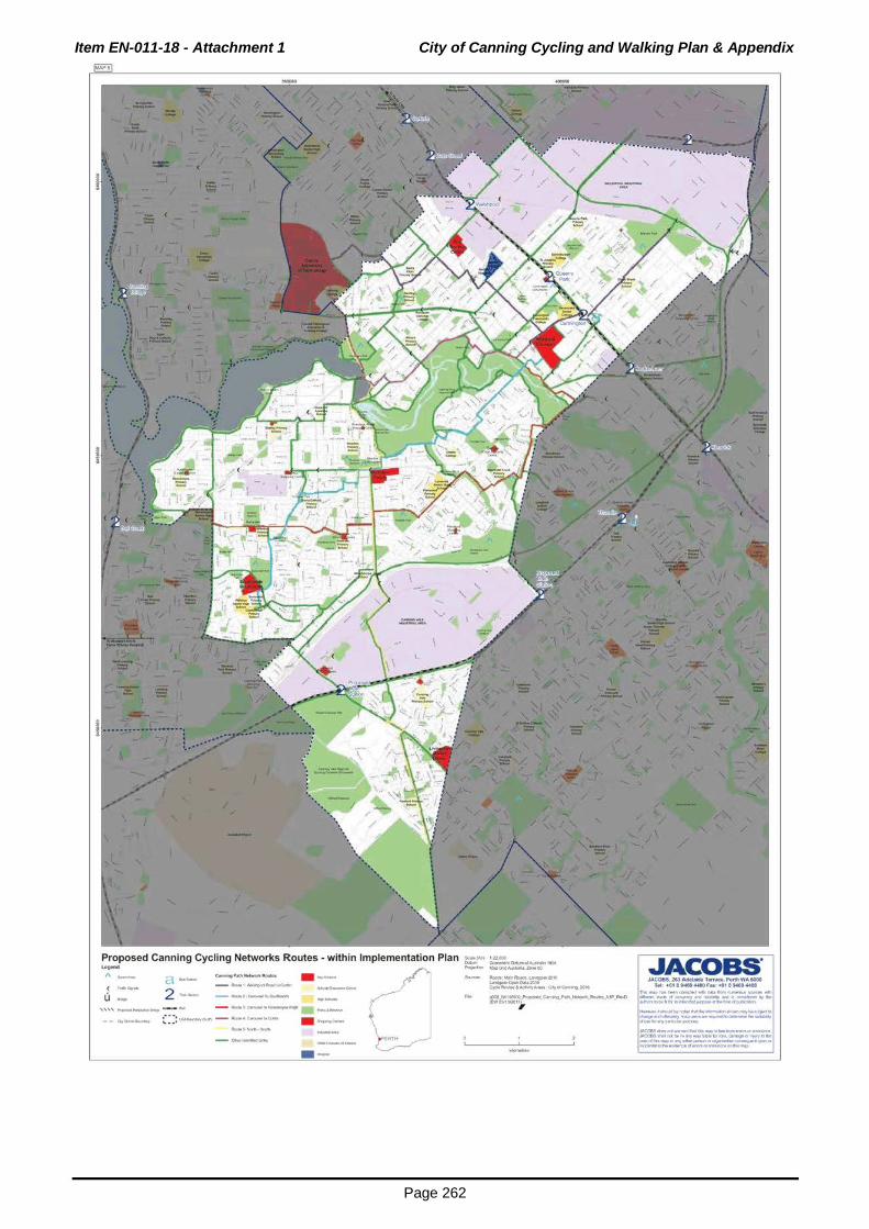
Item EN-011-18 - Attachment 1 City of Canning Cycling and Walking Plan & Appendix
Page 262
Proposed Canning Cycling Networks Routes- within Implementation Plan
~ ~ k_-_ ._,___ . .. - (]..,. _ ,..._,~lloooditC-
( --u .._ - -t. CirlloooooMIII- • --
' ' ' ' ,._.._..,.._ - - - .._,.<;...-,.""-"""""" . ................ --~c-...... ~: :: ""'~,_, - --· e-.t~llloo.- • ~ero---S.---- e....-li'lllo ·-
~(.A.l. 1 21.01)0 Cftlll ~Qfla,.IUII ....... 19M l'\q«<tll'l MliPG'odAIIW .... Zo:wMIIO
"'*-14'1~-~:lOte ~c:JoMOUJOI6C t)cllo~-~~ -C'Irol~ aoM
02111M'IIfi!0)~.~-........ ---"1P_}tl)ro(l ~~1fn01,
.JAcoas·
.J.Ioe08$.20J ....... Tttraet,~W4to00 , .. : •111 .... ...00Fa.:o.61 1 Net4411 ll'lii!Mij) _ _........., ... __ ..__ __
--~----"""'"..._. .... ,._....,fly .... ""'*"'"O!Otlllll' ... ......,.,f'..,_•Nit'fWIOII~
._.l~IM""'l'l'd_..,.,.._..,_~llolo~·
<I'W!F-~.._---.--~ .. ~ d--~,....,..WI>IJN
JIICOBSct..""l'l-'"IIWt. ........ ._..,_.,o...a.. ,liiiOOla$~-IM ... .,...~ ... Ii:o'~~~~~..,..Y~ ... _flf .................. ,.....,.~~<410"10' ~ .... ......._d_tlt,..,.,. ..... .....,.

Item EN-011-18 - Attachment 1 City of Canning Cycling and Walking Plan & Appendix
Page 263
./
f· / -/ = .:._""" ~ // =
Suggested Treatments for Canning Cycling Network - Route 1
.._A ~ _,,~--c....;. · ...,-
( - '""""" 2 """"-u - I --~e-l'lo!o....,. -=-- _u.......,._toor_J _ .._o,.,., ~
~::: I.QO,...._. ....... - - .... -- · -·---
. I
/
/ ,
-· • /
,_.loW\IIIiMIL~:Clll I.Jndi;ll!lltc:Mn01111o1016 C,.citAo.M.&k1M1N.- Ofrd'Cimru 201. tfJil.JW1 WIIIOO~~~.r....e_RI,.411'.""-'rfW!lVI01;20lyt ,
---·
/ ./
,..'Mj)_~......--------.....,. ___ "....., ..... ~~~,- ... ""'" .... iiDt ... ........,.....,_,__ol~
-.t-..abt_,......,.~-~-~.,..._~.._-----~,_........, ., .. ..,~~ .w:atS~"''III---Ihlltt. ......... .__..,._,.,..
.NXle$~ ... - ... ,.,wf>J .. b~ ..... -~-~ ... --.... --.. --~ ... ~--.-...,.... _....ll ... ....._d_l/1_0'1 .. _

Item EN-011-18 - Attachment 1 City of Canning Cycling and Walking Plan & Appendix
Page 264
( --u -
~: I I• _,
~· ~·, .. 'I .. .... .._......., I
SChool ;~ i
-. jl
I
l' I ,.;;. ·~·
r ~-~.-11,.,.- '·-· = \ \ ,_., · lr·
'~-_,~~--- _...._ .........
2 ~-. ............... -----
·'
\ \ \
--..:.-..
\ t
"*"'"""'---~l016 ......... Ope!\0..~1· c,cr.~& ...... A.-.c:.trOICMI"*V.XII&
~ .. ~I*"XX.~-..----.r-,,.,_,.f,.M~ #W~II') , '""" ..... --~--~-..-................ -_.....,..,__,. •• ~br ..
-·e.."lllr*'..._....~-~-ot~
._"oho..oo!!M.-........ ..._._~_,Mo~
.,_,.._~------,.._,_.........., dUIIW.,.,-..CIOII>*l
JoiiCOBI-"'1111---fwllhil .... l!w ..... _ .. _..... ~~....CilO ... ,.,wftj .... bo~ ..... "'P'riOh _,.""_ ...... -..JMIIOII .. .__~~· ~ll> ... ~d-l/1-.-. .... -

Item EN-011-18 - Attachment 1 City of Canning Cycling and Walking Plan & Appendix
Page 265
' /
-· /
/ =,_. . "/I' "" - ~~~-
/ '> / .... /
~ ...... .._,.,~~ LlndgMt(lrleii0...20-M Qr;te~·~- Colr011¢rnt'9to11
=~=r------~-~IU~W_-.o ,
·-
,, /
/
(
i ( --/
~Acoas· Jloe08S. 263 A6etaicM Tttl'aCt, PMt1 WAfOOO
Tel: • l11 ..... ~ho.:o-61 1ND ..... ll'alil'Mjt _________ ..__ __
.............. _ _....,.,......., ..... ~lly""
......,..~ .. rco ... ........,..,,_~.,.l-Wiol~
._.ttbo.odllot,_NIINo...__fll\ooooJI_,M.....,.t>
~lln(l~---....--~ ... ~ diiNb..,....,..""''>QM
.-coes~ .................... "-"-·~ Jlll(:('a$~-~~~~ ... ,.,OOfP.t~lotll)l.<t.~-....-y~ ... _ ............... -........,fl(~--.-...,.,. ~ll ... _ci_tll_ ..... .._.

Item EN-011-18 - Attachment 1 City of Canning Cycling and Walking Plan & Appendix
Page 266
(
• 0\ \ \ \
~6Nd11 nw~! I· I
V'!·· -·-1 -· ....
l
i
Suggested Treatments for Canning Cycling Network - Route 4 ...... A---~ =~ 2 ,......... -~~ ....... -(J .... -~---- ,_, __ .......
~: :: ....... __,..., - ........ eo-
·-
f
.I
--/
•' / .. ./
&.lt(41t 11).0()0 en.... ~O..O.d~l"" f'Wt«iMI M,!pQrod""""",ltirotkJ
~ ......... ~:Jml ~0,..,0.20M e.a.,_,._·~-.CtrdC.WWV.l!h6
/
..
9)21J.]Wl i«<CC_~....._.._~t~-A1P_"'M) l~Ol'IO'lO,#JI
---"'
/
~Acoas· JAC085.263~Tttrac:., ,..,.WA.to00
T-': •611...-uooFa.:<4liNit .... '"'"' ...... -~-..- ..... -...... ___ _ ............ d_,~~ ........... """""""'..,. .. ~IIOillftlibto~.._....,.,.,.,_.fWI_ol~
-·lill'lo.AIIM_Nl,.~~~-~.,..._.,...~-------....r........., d-b~~~
JIICOBS~--------.......... ._.~ JIIIOOIIS~-~~~~ ... _..,.wflj~b~~~"'PY~ ...
----· ... --...-.n,.~~i410'· ~-... ~d-tlt_O'I __

Item EN-011-18 - Attachment 1 City of Canning Cycling and Walking Plan & Appendix
Page 267
--
-~ ('.'= \ l j
Suggested Treatments for Canning Cycling Network - Route 5 .._ A a ... - ... _ ( --u - 2 - ...... -~ ..... --
,,,, .......... ..__. ..... ~- -~-----, ....... -- ~'-..._ ~: :: II.QO,.,.,._.Pj - ...... <>---
......,.. W~Jibdo..lrdloH:ICII&
........ Qrptr\Dille~.e c,d!IA-.&,.._,,._.,CII)' CIIc.nha.~
r::~~~T~...AIP,/W¥0 , ,.,.,...,. __ .....,._ ___ ...___ ... ........,.....,._~.,..,. ...... "" .. ~"' ... ............ lot ... ........,.,,.,_,..,.._ol~
-.ttbo.oollloll'oQIIIId ....... ..__~~-.... -dW!SI&-~ ..... ---.-.~-..._ ... ~ dtMbo..,....,..(VJ>OM
JIIC08& .... _. ................ _._ .. ~ Jiii0Ct$')hlll_llfi ... ~~ .... -ICM.~Ot,...Yirl .... --.............. -..,.....n .. ~--.-..,.,. ~-... ~d...,..lll_ ...... _
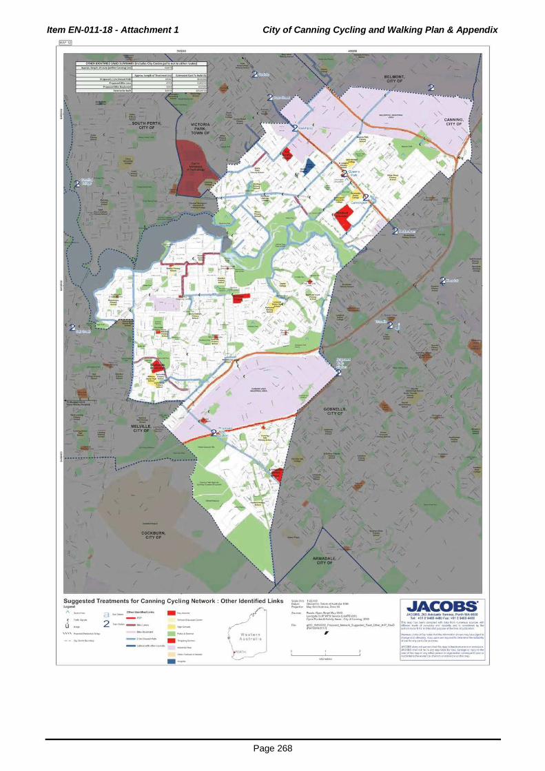
Item EN-011-18 - Attachment 1 City of Canning Cycling and Walking Plan & Appendix
Page 268
Suggested Treatments for Canning Cycling Network : Other Identified Links ........ " ( --u -
'''' .._.._. ......
~--Unb ( --- PSP 2 --- -'-"-
. ... _ ---~ ........... -----~(AitlttoOC Cft.o'lo ~o.u ... ot~ .. ,1191 ~~-O'III.....,...,lmii!IO
~¢pM&hlllt.loii:X11& ~~'AQ~ILOAI!-coet 0.~&-.,-;ClfrOIIc:.-..2006
9(!V:M'1111600~--.~T--0..0.~~....0 (t'wOlitMOm ,
.JAcoas· Jlo(!.(l8S.263A6Maolclt lttract,~WAtoOO
TM• • 61 1S>Mt.WOOh•: .. 11NII!t ......
'NioP'Mj)-~-------..__-.............. -__..."......,"·~llyh -i~tMtlilllt ... ..._...,.,~,.,_-011..,._.. ._.t-..t!M ___ .........,.__&Wji!Notii.Cifld. .,... ... ~.._ _____ __... .. .........., d--~....,..~
JoiiC085dl:. .... _... ............... ._.~ Joi(X)t$"""'-"-"'""""·~-li>oa~lr....,_...ll) .. ~-==-cot;=:=n=-~·

Item
EN
-011-1
8 - A
ttach
men
t 2
Cyclin
g a
nd
Walk
ing
Pla
n S
ch
ed
ule
of S
ub
mis
sio
ns
Page 2
69
No.-I Name
1 I G Mawer
2 DChia
CITY OF CANNING CYCLING AND WALKING PLAN
SCHEDULE OF SUBMISSIONS
Content of Submission I Officer Comments
Fern Road (from Riverton to Castledare) is a nightmare A significant portion of Fern Road is part of proposed Route 4. It during peak hour. This is a combination of too much traffic I is proposed that a 2.5m shared path be constructed to provide cyclists I cars not being able to pass cyclists due to the off road facilities for cyclists. Refer to page 114 Appendix G -islands in the middle of the road I no bike lane. You should Implementation Plan. Route 4 provides a link from Carousel to go and view this (especially when university is on). Curtin University via Wilson. Removing the obstacles in the middle of the road and/or having dedicated bike lanes would greatly improve this.
I do not support any path (walking I bike I dual) out the back The Canning River Regional Park recreational path has been a of Surrey Road (as indicated on the maps below). Any path priority of the City of Canning but completion has been delayed down Surrey Road south or any access from the bottom of due to land ownership issues. Prior to any path construction Surrey to the proposed path would be an absolutely terrible consultation will need to be undertaken with the Department of decision. I don't like rude noisy cyclists or excessive traffic Biodiversity, Conservation and Attractions. (like most people), hence why I bought a home exactly where I did in a cul-de-sac with no footpath, no through roads and generally low density housing.
Lack of smooth footpaths stops me from cycling more often than I choose to. I've cycled down High Road to Canning Vale previously but it's not a particularly easy or comfortable ride.
All new shared paths will be built to Department of Transport standards. Any substandard shared paths that are identified as part of Routes 1-5 will be upgraded to Department of Transport shared path standards.
While I could follow a footpath from Rossmoyne to Curtin all I The widening of the Shelley Bridge will also include the provision the way, it seems like quite a roundabout way because I have of cycling and walking facilities. to go around the Leach Highway bridge. I'd like to think having a separate cycle lane would help people cycle more, or improving the shared paths/walkways. I've seen people cycle on the Leach Highway bridge in peak and non-peak traffic. This seems very dangerous for both the cyclists and drivers on the road, given that it's a proper highway.

Item
EN
-011-1
8 - A
ttach
men
t 2
Cyclin
g a
nd
Walk
ing
Pla
n S
ch
ed
ule
of S
ub
mis
sio
ns
Page 2
70
3 S Walker
I'd like to be able to cycle easily to Carousel shopping centre; I The Cycling and Walking Plan proposes 4 key routes that but the cycle path does seem to end somewhat closer to the connect the Canning City Centre to other parts of the City of shopping centre. Canning.
Why are there no additional cyclist crossings over Roe I Comments noted. The City's Cycling and Walking Plan is Highway and South Street proposed? The Roe Highway consistent with the Perth Transport Plan @ 3.5 million. Beyond interchanges at Nicholson Road, Willeri Drive, and South this plan, future bridges can be considered. Street can get busy. Danger exists not only at morning peak hours, and afternoon peak/evening peak. Currently pedestrians and cyclists are relying on at least two sets of pressed signals at each of the crossings mentioned. Why not plan potential additional cyclist bridge crossings over the Roe Highway corridor and South Street corridor (expect Roe Highway - Vahland Avenue).
These proposed new cyclist crossings would be paid for by the State Government, not City of Canning.
Definitely think a cyclist crossing can be placed between I Comments noted. The City's Cycling and Walking Plan is Willeri Drive- Nicholson Road, possibly with the west end consistent with the Perth Transport Plan @ 3.5 million. Beyond beginning adjacent to the golf course/near Vellgrove Avenue. this plan, future bridges can be considered. The south-east end would terminate on one of the connecting industrial roads, and then continue on to Bannister Road. Then connecting toward the Baile Road proposed pathway.
Consideration can also be given to planning a possible cyclist I Comments noted. The City's Cycling and Walking Plan is bridge from near north end of Arlington Drive over Roe consistent with the Perth Transport Plan @ 3.5 million. Beyond Highway to connect with Catalano Circuit, and lead toward this plan, future bridges can be considered. the Perth City Markets.

Item
EN
-011-1
8 - A
ttach
men
t 2
Cyclin
g a
nd
Walk
ing
Pla
n S
ch
ed
ule
of S
ub
mis
sio
ns
Page 2
71
I note the recent (State Government) announcement of Ranford Road West passenger rail station, and encouraging people to access its proposed passenger rail stations by pathways (walking, cycling). Applying that from the western entry to (Ranford Road West Station), really would require pedestrian bridges to traverse South Street, Bannister Road (possibly road underpass), and possibly (West) Ranford Road as well.
Where is the pedestrian bridge crossings as proposed in the recent Perth Transport @ 3.5m Report? At least plan for the river crossing from Rossmoyne over the Canning River, it really would save cyclists time, and allow people to walk from both sides of the river easier, often without the need for additional use of private motor vehicle.
Yet I do not see any proposed PSP bridge/underpass structures over Roe Highway, or South Street, or Shelley Bridge, or onwards (parallel to Leach Highway) toward Orrong Road.
Clause 1.1 Page 9, 2nd paragraph, correction "Integrated Transport Study". Agree Planning Schemes Provision. Disagree necessity of Travel Smart Officer.
Clause 1.2 Disagree with the prominence of your "two key stakeholder groups". Clear the Report's Author wants to base most of its data on them. Additionally this lends itself to the opinion of shutting citizens out.
Page 10, Chapter 10. 16 years for the program to implement. That is a very long time, could be a long wait.
Comments noted. As the State Government develops the plans for the new Ranford Road Station, consideration will be given to cycling/pedestrian access in accordance with state guidelines.
Comments noted. The Cycling and Walking Plan has been updated to show the Fifth Avenue crossing in accordance with the Perth Transport Plan.
The widening of the Shelley Bridge will also include the provision of cycling and walking facilities.
A Travel Smart Officer is recommended in the Plan to promote community programs to push a mode shift in transportation. There is currently limited work on behaviour change programs in the City of Canning due to a lack of resource.
The key stakeholders provided input into the formulation of the Plan. The wider community was given an opportunity to provide comments on the draft plan. In addition, the community was consulted early in the preparation of the Cycling and Walking Plan which lead to the formulation of the draft Plan.
The timeframe for the completion of the Plan is dependent on the level of funding provided by the City of Canning and State Government. Different timeframes have been provided based on the amount of funding made available over the coming years.

Item
EN
-011-1
8 - A
ttach
men
t 2
Cyclin
g a
nd
Walk
ing
Pla
n S
ch
ed
ule
of S
ub
mis
sio
ns
Page 2
72
Clause 2.1 Major Roads: Welshpool Road, Kewdale Road, Major Roads referenced in Clause 2.1 are State highways and is Nicholson Road, Ranford Road, South Street should all be not meant to be a definitive list but provides examples. named in that sentence.
Clause 3.6 Agree with that entire paragraph. It is a more cost Noted. effective infrastructure, delivering greater benefits.
Clause 4.5 Page 24 table. Do you mean Welshpool Road Clause 4.5 talks about the Principal Shared Path from paths? from Albany Highway to Welshpool Station Welshpool to Beckenham Station and not a path from Welshpool Confusing what Report refers to. Station towards the City (Rutland Avenue).
Clause 4.7 Cycling lmagineering Workshop Report. How The workshop involved Local Government officers along with many City of Canning officers attended, and how many of State Government officers. Many of these agencies/bodies were them worked on this plan? represented in the key stakeholder group. The lmagineering
Report, including attendees, can be accessed online from Bicycle Western Australia website.
Clause 5.1 Key Attractors. Include Murdoch Rail Station. Table 5.1 has been updated to reference Murdoch Train Station.
Clause 5.2 Agree, Cyclists and pedestrians ideally, should Noted. not be able to pick where the local government boundaries are and the infrastructure, when built , should be seamless.
Clause 6.1 Consultation Strategy. Community Groups? Who? Section 6.1 refers to the stakeholders identified by the steering group. Paragraph 6 of Section 6.1 refers to community comments through an online survey. Paragraph 6 relates to the community engagement.
Clause 6.2 Your Key Stakeholder Responses. Two Noted. workshops 21 to 14 participants, a significant reduction. Can you breakdown the three divisions. To answer the question who lost interest. The State Government, neighbouring Local GovernmenUs representatives, or City of Canning staff.

Item
EN
-011-1
8 - A
ttach
men
t 2
Cyclin
g a
nd
Walk
ing
Pla
n S
ch
ed
ule
of S
ub
mis
sio
ns
Page 2
73
Clause 7.5.2 Canning City Centre walking mode share I Jacobs have commented on this previously that targets are in should be set higher. Suggest medium term 25%, long term line with those which may be ambitious yet achievable when 40%. compared to other municipalities proposing similar strategies.
Clause 10.3.4 Assessment, Costing and Prioritisation. Page l in house team of officers from Engineering and Planning 60, City of Canning steering Group mentioned. Who are involved in developing the Cycling and Walking Plan and staff they? Please name. from Jacobs.
Clause 10.3.6 Pedestrian/Cycle Bridge Over Freight Rail The Plan proposes a bridge but notes alternative options for Line. Wrong. Firstly I expected an underpass to be crossing freight line at Ranford Road and Nicholson Road which constructed. This was talked of in the 2015 Integrated would be associated with the development of the passenger rail Transport Study. I thought that was the more cost-effective stations. option. Your Bridge suggestion seems more expensive. At least $6.5m is expensive. If there is an issue with the size, width of an underpass, then why not have two prefabricated concrete underpasses next to each other. One for north, one for south. To avoid collisions. With WA State Government indications that near future works to occur at the freight rail line, then it'd be easier and cheaper to place these structures when they relocate the freight rail lines and/or add passenger rail lines.
Secondly, the new McGowan State Government p:romised all I Noted. Preliminary plans show a high standard path network new passenger rail they construct will have walk pathways, servicing the rail station. and cycle pathways feeding the station areas.
I'd say that heavy rail location is 'in the area'. Therefore if I Noted. major works are to occur at that location, get the State Government to bundle the costs in. I'd expect that, therefore zero cost to City of Canning.
Clause 11.1 TraveiSmart Officer. I'd rather delay it, though I Behavioural issues are important. In order to achieve mode shift the final two bullet pts (Page 64) are worthy of immediate targets, a TraveiSmart Officer is recommended to implement years attention. behaviour change programs.

Item
EN
-011-1
8 - A
ttach
men
t 2
Cyclin
g a
nd
Walk
ing
Pla
n S
ch
ed
ule
of S
ub
mis
sio
ns
Page 2
74
Clause 11 .2 Your Suggestions for reaching various target groups from your Workshop Group (Page 65). Don't like them, waste of local government monies. Yet appropriate signage map ads at train stations alerting to key routes is worthwhile. Currently train stations have maps of the bus routes. It would be worthwhile for Department of Transport to include large map of quality cycle routes.
Clause 11.3.1 TraveiSmart and Your Move. I worry it merely is call centres phoning individual households. Waste of money. Also here is a question, do they phone the renter or the landlord who does not live there? I bet a lot of households 'set their goals', but do they deliver on them?
Clause 11 .5 Not a fan of over-provision of signs. Certainly do not want slogans, as were suggested in the Report Page 67. Also do not want it to be local government branding exercise. Brand the Canning City Centre and Canning River if you want, but not the rest of the local government area. You are only adding more costs that a design team, paint, etc will take from City of Canning.
Clause 11.8 Page 71, Table 11 .2 Bicycle Parking Rates, Table 11.3 Rates for Provision of lockers. Positive of these measures, yet unsure if this aspiration will turn into reality in City of Canning area over near future.
Noted.
Noted.
Wayfinding is necessary to assist with routes through the City.
Bicycling parking and end of trip facilities requirements are being introduced into the City's Town Planning Scheme No. 40 via Scheme Amendment No. 228. This amendment has already been adopted by Council. In addition, the City's Strategic Planners have already liaised with planners at the Department of Planning, Lands and Heritage and agreed on a set of modifications to the amendment. These modifications preserve the requirement for bicycle parking and end of trip facilities. It is likely that this requirement will be present in the Scheme within 4-5 months.

Item
EN
-011-1
8 - A
ttach
men
t 2
Cyclin
g a
nd
Walk
ing
Pla
n S
ch
ed
ule
of S
ub
mis
sio
ns
Page 2
75
Clause 12.2 Recommendations, recommendation 2 is very I Noted. important for the City of Canning. Don't spend money if State Government can include it. Disagree Page 80 Recommendation 4. Should not employ TraveiSmart Officer in 'short term'. Also disagree with this position turning into a 'visit schools liaison' role. Waste of money. Let some other organizations' do that to schools.
Page 86. See Willeri Drive eastern side not considered in the I Noted. Plan. Thought City of Canning planning toward a future.
Page 100, Appendix E. Willeri Drive. Agree recommendation I Noted. for on road cycle lane/s.
Page 100, Appendix E. , Route 3 Why not Liege Street, then I Route 3 proposes to use a new bridge over Albany Highway new cycle bridge over river, onto Metcalf road (south side) approved as part of the Carousel redevelopment and existing past Lynwood shops (Note: you can also add a deviation to bridges over the Canning River. Bannister Creek Primary School}, then continue on Metcalf road (south side -huge verge space) to past Lynwood SHS continue your route. Reason: More direct r·oute from Cannington City Centre over the river, and toward Lynwood Town Centre, and LSHS.
Appendix G. Difficult to read on the computer. I Noted. Every effort has been made to make the maps readable and reproducible at different sizes and in different media formats.
Maps, Overall. Clearly not that many on road 'cycle lanes' As indicated in Figure 12.3 the prov1s1on of cycle lanes is None on Willeri, none on Vahland Avenue, none on dependent on the speed and volume of traffic on a road. In Nicholson Road. Yes I know you might use as an excuse the large, these criteria have been used to guide the proposed 50km and under. Yet I believe they should be made available infrastructure. on Willeri Drive, and Nicholson Road. Both roads are 60km/hr. There are on-road cycle lanes on Garden Street past Canning Vales East and Southern River. If it can work on that road, then City of Canning should follow.

Item
EN
-011-1
8 - A
ttach
men
t 2
Cyclin
g a
nd
Walk
ing
Pla
n S
ch
ed
ule
of S
ub
mis
sio
ns
Page 2
76
Some maps do not show Willeri Drive as a green 'other I Section 10.3.2 of the Plan details the reasoning for route routes'. Also feel entire High Road from Willeri Drive - selection. Nicholson Road should be shown as a key Other Route. And also Nicholson Road as a key other route from High Road-Albany Highway.
Suggestion. Create a cycle route behind Riverton Forum I Section 10.3.2 of the Plan details the reasoning for route Shopping Centre (Golf Road) down Cerberus Ave to Lywood selection. Senior High School. In the form of on-road cycle lanes (linking to Willeri Drive on-road cycle lanes). That could be part of a substitute route instead of cyclists using High Road (Willeri Drive - Metcalf Road. Plus onwards to Golf course/Nicholson Road).
No reference to Cameron Court cycle bridge in Langford. I Cameron Court, Langford is within the City of Gosnells. Plus list it as a route down Cameron Ct.
No mention of South Street bridge from Pine Tree Gully I Additional bridges have been annotated on the Plan. Road. Another bridge similar to that is needed further east along South Street before Roe Highway.
Further discussion needed on Nicholson River bridge so I The southbound Nicholson Road bridge is a City of Gosnells cyclists and pedestrians can cross under (or over) any time. asset. When this timber bridge is replaced the needs of Probably needs timber bridge replacement first, yet their pedestrians and cyclists will be accommodated. needs to be connections on south-eastern side including to future riverside pathways when State Government purchases the riverbank Bush Forever areas.

Item
EN
-011-1
8 - A
ttach
men
t 2
Cyclin
g a
nd
Walk
ing
Pla
n S
ch
ed
ule
of S
ub
mis
sio
ns
Page 2
77
Planning needs to ensure a path on the south-east side when I Noted. the timber bridge is replaced. City of Gosnells has failed the public by having a generally ok quality path beside Nicholson Road Langford, well away from the road. Yet this disappears at the Spencer Road Crossing, leaving a very narrow verge space that people sometimes use to continue despite a recent rebuild of the Kennards Hire business there (Are they on a lease?).
I have said before to City of Canning to plan a new, wider, I Section 10.3.2 of the Plan details the reasoning for route faster cycle bridge over to Ferndale. I think an appropriate selection. Reference is also made to previous technical location would be near the south end of Liege Street. This comments relating to bridges. can turn into part of your Route 3.
I'd expect further connection from your proposed Langford I All locations referenced are within the City of Gosnells. Shopping Centre Route toward Thornlie Station, plus a route alongside Spencer Road from Nicholson Road - Thornlie Station. Plus a connection from your depicted Beckenham/Nicholson Road route toward William Street and Beckenham Station.
Nicholson Road is a 60km/hr road. Why no on road cycle I Section 10.3.2 of the Plan details the reasoning for route lanes? Why no quality wide paths on either side. They would selection. be visible to the public (security), well lit (lighting improvements to that regional road), and the 'tree sheltering' you speak of would definitely improve the amenity of that gateway road near to the homes along it.
There should be a Nicholson road route. Is this due to I Section 10.3.2 of the Plan details the reasoning for route boundary issues with City of Gosnells? Why cannot both selection. local governments agree on it, for the benefit of the region. Especially from Roe Highway- Albany Highway.

Item
EN
-011-1
8 - A
ttach
men
t 2
Cyclin
g a
nd
Walk
ing
Pla
n S
ch
ed
ule
of S
ub
mis
sio
ns
Page 2
78
Concerned your major proposed upgraded preferred routes I Section 10.3.2 of the Plan details the reasoning for route in the area follow current parks, due to their proximity as selection. single line high voltage overhead power corridor. I have had the view (Public Open Space Strategy comment 2015, and Local Housing Strategy Comment 2015) that the power line corridor could be shifted to Nicholson Road median or verge, therefore freeing up that area of Lynwood, and allowing pockets of current lawn space (due to these wooden power poles) being turned into residential housing. Yet how can that reasonable solution happen if you commit to an expensive cyclist path in 2017?
Plan in proposed commuter cyclist path links over Shelley I The Plan considers the implications of the Perth Transport Plan Bridge, down Leach Highway, to link with Orrong Road State and has referred to State Government proposals where they Government (PSP) paths there. The State Government exist. would be required to fund these as it controls Leach Highway and is obliged to provide appropriate regional PSP when upgrading the arterial road. The Report talks of these links, yet fails to show them on enough maps. Draw it in, then you have something to show DoT, and Main Roads WA.
Metcalf Road as a cycle route (Lynwood area). I have said I Section 10.3.2 of the Plan details the reasoning for route before on this. There is enough verge space, plus that selection. Gumtree Way road area to use at the bend.
Additional Planning for cycling/pedestrian bridges over south- I Section 10.3.2 of the Plan details the reasoning for route eastern ends of Albany Highway, in the vicinity of Liege selection. Street, exhibition centre, and between Nicholson Road-William Street (City of Gosnells area).
Additional planning for pedestrian crossings under and over I The Armadale Rail Line currently has a number of pedestrian the Perth-Armadale passenger rail line. Plan them in so the and cyclist crossings. Further crossings will be considered in the communities of East Cannington and Queens Park can feel context of the Metronet project. connected. If the State Government upgrades the line, then get them to bundle these new separated crossings in.

Item
EN
-011-1
8 - A
ttach
men
t 2
Cyclin
g a
nd
Walk
ing
Pla
n S
ch
ed
ule
of S
ub
mis
sio
ns
Page 2
79
Factor of Underground Power. Some streets have had power I Noted. poles interfering with alignments of paths. Some streets have poles close to the kerb/road, while others far from the roads. In some instances the City of Canning has been fortunate in that Western Power had aligned wooden poles so they never conflicted with paths being built. Providing underground power often allows wider pathways to be built on verge spaces, and better street lighting for those pathways.
I must say I do not agree with any current or future plan (by I Lighting will be provided in certain locations to ensure safety of staff) to litter the parks of City of Canning with multiple people using the path. amounts of lantern-style lights along pathways (mostly walk paths). I do not want to see this proliferate, and I fear this Cycling & Walking Plan will trigger it. I believe it to be a waste of limited local government monies that should be spent on other local government areas of operation & projects.
Most of your five routes generally appear worthwhile, though I Noted. that does not mean every piece of each route is correcUoptimal.
In Regards to Appendix G Implementation Plan, the Report I Noted. Recommended timeframes of each individual walk path or cycle path, I have not had the time to examine each therefore I cannot give proper comment here on what time frames should be sooner, and what later. So I would caution City of Canning from accepting 100% of what the Report table states.
In Regards to Public Advertising of the Report: I did visit the I The maps in the Plan have sufficient resolution to allow zooming Administration Centre to view large maps of the routes, and in to specific areas. Officers were available to contact during the possibly larger map of the final Appendix G implementation advertising period to discuss such matters. plan recommendations per streeUpath. There were no larger maps. Merely A4 size. Disappointing. It is difficult to determine most of this, especially off a computer screen including when increasing the font size.

Item
EN
-011-1
8 - A
ttach
men
t 2
Cyclin
g a
nd
Walk
ing
Pla
n S
ch
ed
ule
of S
ub
mis
sio
ns
Page 2
80
4
5
6
7
City of Canning Safe Canning comments
Sustainability Advisory Group
R Allison
P Terkildsen
Reference the City's Community Safety and Crime Prevention Plan 2016-2020, which was approved by Council in November. Goal 1.7 of the Plan is to raise awareness of road safety, and Action 1. 7.4 notes to 'expand the City's TraveiSmart program and endorse the city's Cycling and Walking Plan', and really just shows another related link and our support for any safety related activities in this area.
Comments regarding public bike maintenance equipment. In particular, lessons learnt from other local governments, including:
•Passive surveillance -put them in well-populated areas and if CTV is available that is a bonus.
•Placement - put them where Cyclists already are, so adjacent to high use shared paths, PSPs or well -used bike parking (so a popular destination like a community centre, rec centre or library).
•Maintenance - When put in a public setting there can be some theft and maintenance issues. If you are putting them in a public setting consider upgrading the cabling and the way in which it is fastened into the ground.
The Cycling and Walking Plan has been updated to reference the City's Community Safety and Crime Prevention Plan 2017-2021.
These comments have been noted and the Cycling and Walking Plan updated to comment on bicycle maintenance equipment. In addition, bicycle maintenance facilities have already been installed at the Cannington and Riverton Leisureplex.
Great proposals. Please also look at the footpath on Ferndale I The hazards along Ferndale Crescent will be referred to the Crescent from Chicken Spot. The footpath there is too old City's path maintenance area for action. and too rough. It is impossible for my friends and I to walk our prams around the Ferndale Crescent loop on that path without our babies waking up.
All in all I f ind the plan to be a healthy initiative from the I Noted. These matters predominantly deal with traffic Council's side. management. The Cycling and Walking Plan deals specifically
with cycling and walking infrastructure. I would like to propose that Riverton Drive in Rossmoyne I Shelley might be worthwhile to have some speed humps installed along the length of it - This suggestion for a number of reasons:

Item
EN
-011-1
8 - A
ttach
men
t 2
Cyclin
g a
nd
Walk
ing
Pla
n S
ch
ed
ule
of S
ub
mis
sio
ns
Page 2
81
- To prevent cars and motorcycles speeding
- To prevent some of the large groups of bicycles which move just as fast as many cars and motorcycles and takes up the entire road.
8 Y Seng I think that the draft plan is great but would like to have more Noted. The employment of a TraveiSmart Officer as cycling events held in Canning. recommended in the Cycling and Walking Plan could work to
organise more cycling events.
9 N Elward It looks great, I love the paths here already ye1 I do find Noted. crossing the roads hard as there are little crossings and paths are quite often on only one side of the road. I have found the crossing bridges great and useful and efficient not as easy sometimes with a bike but I feel safer as I don't ride on the roads.
I feel this draft is safer and gives people like myself more protection and confidence to experience their surroundings. I haven't been here long but it looks good
10 M Ambrose Yes, we need more footpaths. Please finish the path that The Plan considers key routes. Other paths can be considered runs along Willeri Drive between Hossack and High Rd. This in light of budgetary availability and competing Council priorities. would be a great start.
11 Grant Important part is a shared path completing a loop around the This route is identified in map 6 as an "Other Identified Link" and river to Castledare from Riverton bridge avoiding Fern Road. in Appendix G. Implementation Plan. We are missing an amazing part of the river to walk/run/cycle.
12 N Hurley-Walker It's great that the City is working on this and I'm really happy Noted. that such an exhaustive investigation has been performed. I also liked some of the attention to detail, such as thinking about shade and the surfaces of the paths. However, I'm worried about various other aspects, particularly the overarching plan for the network, which I've tried to go through in the order in which they appear in the document.

Item
EN
-011-1
8 - A
ttach
men
t 2
Cyclin
g a
nd
Walk
ing
Pla
n S
ch
ed
ule
of S
ub
mis
sio
ns
Page 2
82
Funding levels (section 9) seem low given the extensive I Noted. benefits listed throughout the document, and particularly the economic benefits as listed in Sections 3.6, 3.9, and 3.1 0. 2031 is so far away that aiming to reach -UK levels of funding by that point seems woefully inadequate compared to the aimed-for mode share.
Section 10.2 does not address the problem that many I Noted. The City considers all road users when making existing roads have been treated to reduce the speed of cars modifications to the road network. without considering the impact on cyclists. For instance, narrowing points and central islands (which often do not even double as pedestrian refuges) reduce the width of roads, presumably to slow cars down. This is fine when the road only has cars on it, but if you expect cyclists to use it as well, then some motorists can get very impatient as they are unable to overtake safely where there are islands. Painting an on-road cycle lane only exacerbates the situation, with cars veering into the cycle lane to get around the islands. The most ridiculous are narrowing points where a ramp is provided to remove the cyclist from the road -- these are usually strewn with debris or blocked with bins anyway -- and then launch the cyclist back into the front of a car! (see e.g. the corner of Fern Road and Hollis Road). These treatments need to be revisited. The version in Figure 10.8 is marginally OK, because motorists would be forced to slow more than the cyclists, but they will only work if kept clear of debris.
In the situations in the Netherlands where motorists are I Noted. required to slow down, the roads are built very narrow, such that there is very little gap between two streams of traffic, so in the interest of not having a head-on collision, drivers must slow down and negotiate these roads carefully. Of course, a physical separation between the cycle lane and the road is in that case very useful.

Item
EN
-011-1
8 - A
ttach
men
t 2
Cyclin
g a
nd
Walk
ing
Pla
n S
ch
ed
ule
of S
ub
mis
sio
ns
Page 2
83
Another item that is not discussed is priority at side street I Considering this on selected new proposals. intersections. Good design prioritises through active transport users over motor vehicle traffic queueing to enter the through road. Every single shared path in Perth, and many cycle lanes, take the opposite approach, forcing active transport users to give way to motor vehicle traffic, which can often be waiting there for a long time. A brand new example is the awful Cygnia Cove intersection on Centenary Avenue. This intersection design is not only dangerous, it is frustrating, and the more often a potential cyclist encounters frustrating situations like this, the more likely they are to go back to driving. Will shared paths and cycle lanes take priority over side streets? This is standard design in the Netherlands!
The problem with bicycle boulevards is that they imply that all Comments noted. Bicycle boulevards will consider the most the *other* low-volume side streets do not welcome cyclists. cost effective and appropriate treatment of the road network to Treating the vast number of quiet suburban streets would be achieve the objectives required. It is difficult to restrict vehicles very expensive. A much cheaper solution is to reduce the from areas as this would affect residents and other road users number of entry and exit points to motor vehicle traffic, while and may not always be feasible. maintaining or even improving active transport permeability. This means much less rat-running by impatient motorists, who are the main offenders when it comes to hostile behaviour toward cyclists.
I hope that Figure 10.2 is shown as an example of what NOT I Vahland-Sharba Close identified in the Plan, this location will be to do. I have occasionally cycled along that lane• when I've treated in year 1 (2017-2018). had no alternative, and it's really not fun to be overtaken by high-speed traffic with absolutely no barrier. It is also a complete joke when it connects to Vahland Avenue: there is a path up to Sharba Close which would be useful to cyclists ... if there were a safe crossing, and it didn't have *FIVE* hoop bollards blocking us from using it!

Item
EN
-011-1
8 - A
ttach
men
t 2
Cyclin
g a
nd
Walk
ing
Pla
n S
ch
ed
ule
of S
ub
mis
sio
ns
Page 2
84
The "push policies" listed in section 11.6 are not just I There is a need for a Travel Smart Officer to run education "appropriate", but vital, if you really want cultural change that programs to assist with change in the community. results in more people cycling and fewer people driving. Will the Council proactively engage with the State Government to make these things happen?
The maps are extremely slow to load so I have not looked at I Shared paths exist along most of these roads. Leach Highway them in as much detail as I would like. But I note that needs cycling and walking facilities at Shelley Bridge. Vahland Road, Albany Highway, Leach Highway, and the easternmost and westernmost parts of High Road do not have any provision for cycling planned, despite forming direct, fast connections between activity centres. Are you seriously expecting people who want to get somewhere "directly and conveniently" (see the intro to the plan!) (e.g. Bull Creek Station, Lynwood High School, the shops on High Road, literally any shop along Albany Highway) to use a long round-about route along the Canning River or the· train line? Implementing decent separated cycle infrastructure on exactly the same direct routes that motorists like to use is vital: those roads are major precisely because they connect major destinations. Upgrading all the back streets does nothing for commuters, only leisure riders. Forcing cyclists to dog-leg multiple times through many back streets only leads to frustration. Importantly, we *can already use the backstreets*, and many of us do, so you gain very little for the financial outlay. The major game changer is giving the roads that currently exclude all but the most hardcore of cyclists back to ALL users, including the most vulnerable people on bikes. This emphasis on treating and wayfinding mere backstreets is a serious flaw in the plans as proposed.
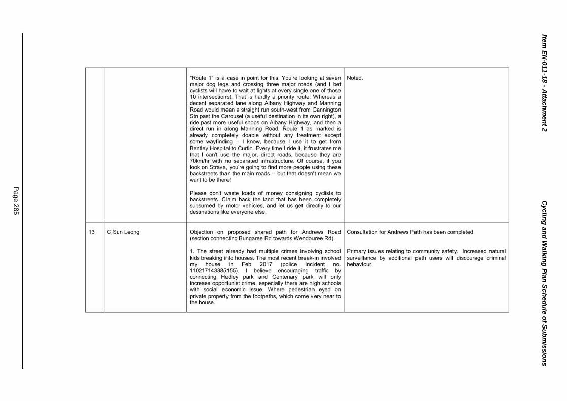
Item
EN
-011-1
8 - A
ttach
men
t 2
Cyclin
g a
nd
Walk
ing
Pla
n S
ch
ed
ule
of S
ub
mis
sio
ns
Page 2
85
13 C Sun Leong
"Route 1" is a case in point for this. You're looking at seven I Noted. major dog legs and crossing three major roads (and I bet cyclists will have to wait at lights at every single one of those 10 intersections). That is hardly a priority route. Whereas a decent separated lane along Albany Highway and Manning Road would mean a straight run south-west from Cannington Stn past the Carousel (a useful destination in its own right), a ride past more useful shops on Albany Highway, and then a direct run in along Manning Road. Route 1 as marked is already completely doable without any treatment except some wayfinding -- I know, because I use it to get from Bentley Hospital to Curtin. Every time I ride it, it frustrates me that I can't use the major, direct roads, because they are 70km/hr with no separated infrastructure. Of course, if you look on Strava, you're going to find more people using these backstreets than the main roads -- but that doesn't mean we want to be there!
Please don't waste loads of money consigning cyclists to backstreets. Claim back the land that has been completely subsumed by motor vehicles, and let us get directly to our destinations like everyone else.
Objection on proposed shared path for Andrews Road I Consultation for Andrews Path has been completed. (section connecting Bungaree Rd towards Wendouree Rd).
1. The street already had multiple crimes involving school I Primary issues relating to community safety. Increased natural kids breaking into houses. The most recent break-in involved surveillance by additional path users will discourage criminal my house in Feb 2017 (police incident no. behaviour. 110217143385155). I believe encouraging traffic by connecting Hedley park and Centenary park will only increase opportunist crime, especially there are high schools with social economic issue. Where pedestrian eyed on private property from the footpaths, which come very near to the house.

Item
EN
-011-1
8 - A
ttach
men
t 2
Cyclin
g a
nd
Walk
ing
Pla
n S
ch
ed
ule
of S
ub
mis
sio
ns
Page 2
86
2. Curtin University is one of the Key Attractor for City of Noted. Canning. Annually thousands of international students came here for higher degree education. Due to the crime statistics, Bentley, St.James, Wilson areas under the City of Canning had already made a poor reputation internationally in this perspective. Having shared paths coming very near to the house is not helping with the crime issues.
3. Waste of resources - there are multiple existing shared Noted. paths connecting the park. i.e. from Manning Road through Clontarf college to centenary park. From Manning road through centenary park via leach highway. It is unnecessary to have additional shared paths through quiet streets.
4. Existing trees, driveways and lawn on the crossover will be Noted. disturbed and uprooted. This is unnecessary waste of public money.
5. Finally if it is the council decision to move forward with the Noted. proposed plan, please ensure waste is cleaned up daily.
14 DChia Thanks for giving notice to this. I live locally in Rossmoyne, Noted. work in Curtin University and shop mostly along High Road. I should cycle to most of these places given it's all within easy cycling distances but i don't do it often at all.
I think your plan has picked up some of the obstacles that face other people in similar circumstances, in that the lack of smooth footpaths stops me from cycling more often than I choose to. I've cycled down High Road to Canning Vale previously but it's not a particularly easy or comfortable ride. While I could follow a footpath f rom Rossmoyne to Curtin all the way, it seems like quite a roundabout way because I have to go around the Leach Highway bridge.

Item
EN
-011-1
8 - A
ttach
men
t 2
Cyclin
g a
nd
Walk
ing
Pla
n S
ch
ed
ule
of S
ub
mis
sio
ns
Page 2
87
15 D Isaac
I'd like to think having a separate cyde lane on the major The Cycling and Walking Plan proposes to improve access for roads would help people cycle more, or improving the shared cyclists and pedestrians. The decision on whether a route uses paths/walkways. I've seen people cycle on the Leach on road or off road infrastructure is guided by Figure 12.3 on Highway bridge in peak and non-peak traffic. This seems page 78 of the Cycling and Walking Plan. very dangerous for both the cyclists and drivers on the road, given that it's a proper highway. It's also beyond the reach of In addition, the Cycling and Walking Plan proposes 4 key routes anyone but the most hard core cyclists. I don't identify as one that service Carousel Shopping Centre and the Canning City of these but i would be more inclined to cycle more if it was Centre in general. more direct.
I'd like to be able to cycle easily to Carousel shopping centre; but the cycle path does seem to end somewhat closer to the shopping centre.
Anyway, good job with the plan, I'm sure there are parts to be I Noted. improved; including looking at how to get occasional cyclists to become more regular commuters on their bicycles. Some spots need more lighting; some paths need to be made smoother; but I'm sure you will work it all out with the best balance of resource allocation and all that.
It's good to see such a comprehensive approach to cycling I Noted. and walking facilities within the City. As someone who cycles to commute between home in Armadale and Curtin University I have some feedback that primarily represents my perspective and experience. Cycling to commute does differ somewhat from cycling for recreation. In most cases a commuter will be looking for the most direct route and this will generally be along the main arterial roads. Cycling over longer distances will generally see the cyclist seeking to maintain higher overall speed and this requires good quality smooth surfaces to ride on. On road cycles lanes serve this purpose very well in the absence of dedicated cycle paths. Many cyclists will prefer to ride on the road where shared paths are of poor quality.

Item
EN
-011-1
8 - A
ttach
men
t 2
Cyclin
g a
nd
Walk
ing
Pla
n S
ch
ed
ule
of S
ub
mis
sio
ns
Page 2
88
16 Curtin University
Where there are marked on-road cycle lanes, these should I Noted. These matters are considered as part of all upgrade wherever possible continue through intersections. More often projects to meet appropriate standards for cycling. than not, these lanes stop just prior to intersections and force cyclists into close proximity to cars. There are a couple of roads that I have encountered where chicanes, islands and other road furniture presumably installed to reduce the speed of motor vehicles also have a similar effect of forcing cars into close proximity to cyclists and this also causes frustration for the motorists because they do not have the opportunity to safely pass cyclists. Examples of this are Fern Road between Bungaree Road and Surrey Road and also Riverton Drive East/Riley Road.
I have looked at the proposed north-south route from I Noted. Cyclists have the option to utilise Willeri Drive in lieu of Canning Vale to Curtin University and my preference would the proposed north-south route. Willeri Drive provides a wider be to see a cycle lane along Willeri Drive rather than a kerb side traffic lane to accommodate cyclists. convoluted route through the back streets of Willetton.
On road cycle lanes also need to be subjected to regular I Noted. sweeping, because a lot of debris from the road tends to accumulate along the curb where cyclists are trying to ride.
I think there should also be some consideration for I This is an action that the recommended TraveiSmart Officer encouragingfpromoting the more widespread adoption of could undertake. electric bicycles as these do allow longer commuting distances and may encourage more people to consider cycling.
Crossing Manning Road is a priority for people travelling to The intersection of Manning Road and Kent Street is not within Curtin University by bike. A signalised crossing for active the City of Canning. Route 5 proposed in the Cycling and transport should be proposed to MRWA. Also the timing of Walking Plan proposes to cross Manning Road at the the lights at Manning RoadfKent Street should be adjusted to intersection of Centenary Avenue and Manning Road. give priority to pedestriansfcyclists.

Item
EN
-011-1
8 - A
ttach
men
t 2
Cyclin
g a
nd
Walk
ing
Pla
n S
ch
ed
ule
of S
ub
mis
sio
ns
Page 2
89
Instead of converting Farnham Street to a Bike Boulevard, McKay Street is currently highlighted as a bike boulevard on the which may not be appropriate and doesn't link with any key Cycling and Walking Plan. Farnham Street is not identified as a destinations, consider McKay Street becoming a sharrow and bike boulevard. providing a link through Canning College to Brand Drive.
Canning College bike parking and end of trip facilities is Noted. Canning College is outside of the City of Canning. The supported. The lack of direct access to Curtin from Canning Cycling and Walking Plan proposes a route (Route 5) to link College needs a separate path or a shared path through the through Canning College. car park. Collaboration with Curtin, Canning College and/or Victoria Park to fix this deficiency is encouraged.
Intersections requiring assessment - Manning Rd/Centenary Noted. Road is supported to link bike path into McKay Street.
Implementation of Manning Road from Hamilton Street to Noted. Centenary Road is supported.
Potential to extend on-road bike lanes on Hill View Terrace A shared path is the preferred treatment. Given the number of beyond Boundary/Jarrah intersection all the way along crossovers it is preferable for the shared path to be located on Marquis Street to McKay Street. the West side which is outside of the City of Canning.
Walpole/Holder Street from Chapman Road to Hill View This is currently identified as an "Other Identified Link" on map 6. Terrace could be an alternative avenue for Route 1 ('bike boulevard?)' linking Welshpool Road to Curtin: it currently has a designated shared use footpath on the north side (albeit narrow) and should have less traffic than Boundary Road.
Should the City pursue re-development of Centenary Park This link is identified as an "Other Identified Link" on map 6 and West, a bike path linking Centenary Avenue Shared Path is currently on the City's budget for construction. with Waterford Conservation Trail Shared Path is encouraged.

Item
EN
-011-1
8 - A
ttach
men
t 2
Cyclin
g a
nd
Walk
ing
Pla
n S
ch
ed
ule
of S
ub
mis
sio
ns
Page 2
90
17
18
General comments from Local I People wanting more cycling and walking paths in the City. Noted. The Cycling and Walking Plan proposes a number of new paths to improve connectivity. Planning Strategy and
Strategic Community Plan consultation. 1----------------------+--------------------------l
Councillor comments
Better connected paths both within the City and to I Noted. The Cycling and Walking Plan is meant to improve neighbouring local government and regionally. connection of the cycling and walking network.
Some people want more separate paths to address conflicts between walkers and cyclists as well as with cars.
The Cycling and Walking Plan suggests the prov1s1on of separate dual use paths in a number of locations to reduce cyclist and car conflict.
People also wanted more facilities to support walking and I The Cycling and Walking Plan recommends that new cycling (i.e end of trip facilities). developments provide bicycle parking and end of trip facilities.
Cycle paths to cater to both commuter and recreational I The Cycling and Walking Plan suggest a number of different cyclists. routes to accommodate recreational and commuter cyclists.
The City appears to have failed to recognise its position as an inner-city municipality (less than 10km from ·our capital city) and the role that we need to play in the creation of an integrated state-wide bicycle network to link communities to Perth CBD.
The second Strategic Issues Briefing on 3 October 2017 was primarily held to address Councillor comments.
The City's current shared path network provides linkages into all adjacent local government authority path networks. Shared paths were constructed to the standard width at the time which were 1.8m in the 1990's; 2.1m in the 2000's; and are currently 2.5m for a local access path, 3.0m for a regional path and 3.5m for a recreational path.
Dual carriageway roads with a B.Om carriageway are marked wi th a 4.5m kerb lane and a 3.5m median lane. Unfortunately bike lanes cannot be marked unless the width of 1.5m for a 60kmfh road and 1.8m for a 70km/h road can be achieved.
It is also important to note that commuter cyclists prefer to ride on the road, in particular the busier roads as they provide a more
1-----------------------1 direct link.
Recommendation 2 of the report, titled "Working with the State and Local Governments:" speaks of the I The Perth Transport Plan identifies four classes of cycle routes

Item
EN
-011-1
8 - A
ttach
men
t 2
Cyclin
g a
nd
Walk
ing
Pla
n S
ch
ed
ule
of S
ub
mis
sio
ns
Page 2
91
appropriateness of liaising with neighbouring local governments, yet I cannot see any evidence that l iaison - at any level, has occurred.
It is my opinion that our plan should have been developed in
as follows:
• Principal Shared Paths (PSP) -This is the highest standard of path which is constructed along the Armadale Railway Line and Roe Highway within the City.
close collaboration with South Perth and Victoria Park, and 1 • Strategic Route - This route can consist of a PSP, a separate bi-directional cycle path (Ashburton Street, John Street and Andrews Road) or a bike boulevard (new to Perth).
that the 3 municipalities should have produced a 'combined' map showing an overlay of bicycle linkages to the CBD from Canning, and passing through Victoria Park and South Perth.
There appears to be little (if any) serious consideration to providing a safe route for Canning's cyclist to Perth, our capital city. Reducing the volume of traffic on our main arterial roads should have been the core objective of this
• Local Routes - This route can consist of on-road cycle lanes (Apsley Road and Burrendah Boulevard), bike boulevards and on-street (roads adjacent to South Street and Leach Highway).
plan, however it appears that far greater weighting was given 1 • Recreational Shared Paths - These paths are to PSP standard and are constructed around the Canning River Regional Park and along the Shelley I Rossmoyne foreshore.
to localised solutions for inner-suburban roads.
Cycle lanes on high volume roads are no longer supported by the Department of Transport and Main Roads WA as they do not result in an increase of cyclists as cyclist do not feel safe in the bike lanes.

Item
EN
-011-1
8 - A
ttach
men
t 2
Cyclin
g a
nd
Walk
ing
Pla
n S
ch
ed
ule
of S
ub
mis
sio
ns
Page 2
92
I was hopeful that our cycling plan would be far more aspirational and discuss planning to bring commuter cyclists from quieter, safer, inner-suburban roads, to centralised 'cycle highways' on main roads such as Willeri Drive, Vahland Avenue, High Road, and Karel Avenue. This portion of the cycling sector is seeking to travel by the most direct route, in the fastest possible time, and greater cycling participation can be encouraged by the provision of better cycling infrastructure.
The verges along many four-lane divided roads within the City are 4m-5m wide and have crossovers, trees and power poles located along them. There is a shared path located along one side of the road approximately 2 m wide and wider kerbside lanes are provided for commuter type cyclists. It would be costly to construct bike lanes or a high standard wider shared path along these roads.
The development of the Cycling and Walking Plan focuses on five key routes that link activity centres within the City. There are also other identified links to improve recreational routes and links outside the City and the Perth CBD.
Adjacent local government authorities and State Government agencies were invited to participate in the workshops. Where there was no representations the City's consultant sources bike plans and made contact with the authorities to ensure that linkages were supported.
The Cycling and Walking Plan will be reviewed every five years.
The map also states that Vahland Ave and Willeri Dr have I Noted. cycle paths? These are simply old pedestrian paths, and aren't conducive to cycling. Just because someone may choose to ride on them, it doesn't mean it's part of "Canning's Cycle Network."

Item
EN
-011-1
8 - A
ttach
men
t 2
Cyclin
g a
nd
Walk
ing
Pla
n S
ch
ed
ule
of S
ub
mis
sio
ns
Page 2
93
It is difficult to understand how any strategic analysis of the future needs of Canning's cycling & walking requirements could not take into account our rapidly aging population.
There is no mention in the report of electric mobility vehicles (gophers), or the escalating trend toward motorised bicycles.
Canning's draft plan does not address the issue of interjurisdictional cycling routes, nor does it address the future needs of commuters to the Perth CBD.
Section 4.6 of the report discusses City of Canning Disability and Inclusion Plan and Section 10.3.6 of the report discusses Considerations for Aged Care Residents and Mobility Scooter Users. The existing and proposed path and shared path networks accommodate these users.
Motorised wheelchairs and other mobility devices used by people with a physical disability fall within the single definition of motorised wheelchair under the Western Australian Road Traffic Code 2000. To be considered a motorised wheelchair the device must be designed so as to be not capable of a speed exceeding 10km/h. People with a physical disability who operate motorised wheelchairs at or below the limit of 10km/h are classified as pedestrians. If your motorised wheelchair is not capable of doing more than 10 km/h, and you have physical disability, you can ride on footpaths and shared paths.
A power-assisted pedal cycle (PAPC) is a bicycle with a motor providing assistance when the rider is pedalling. In Western Australia PAPC can be used by people aged 16 years and older on shared paths with the power engaged. To be compliant, a PAPC can only have a maximum power output of 250 watts.
Adjacent local government authorities and State Government agencies were invited to participate in the workshops. Where there was no representations the City's consultant sourced bike plans and made contact with the authorities to ensure that linkages were supported. The Cycling and Walking Plan will be reviewed every five years.
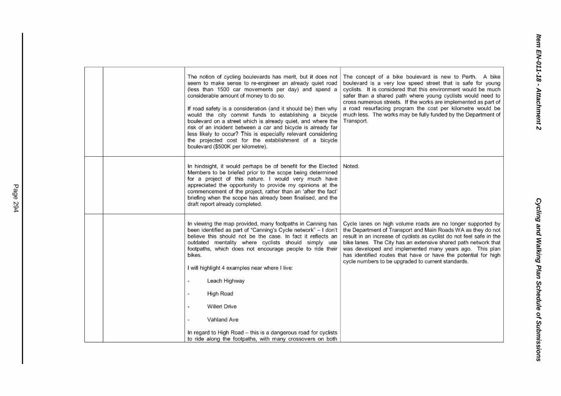
Item
EN
-011-1
8 - A
ttach
men
t 2
Cyclin
g a
nd
Walk
ing
Pla
n S
ch
ed
ule
of S
ub
mis
sio
ns
Page 2
94
The notion of cycling boulevards has merit, but it does not seem to make sense to re-engineer an already quiet road (less than 1500 car movements per day) and spend a considerable amount of money to do so.
If road safety is a consideration (and it should be) then why would the city commit funds to establishing a bicycle boulevard on a street which is already quiet, and where the risk of an incident between a car and bicycle is already far less likely to occur? This is especially relevant considering the projected cost for the establishment of a bicycle boulevard ($500K per kilometre).
In hindsight, it would perhaps be of benefit for the Elected Members to be briefed prior to the scope being determined for a project of this nature. I would very much have appreciated the opportunity to provide my opinions at the commencement of the project, rather than an 'after the fact' briefing when the scope has already been finalised, and the draft report already completed.
In viewing the map provided, many footpaths in Canning has been identified as part of "Canning's Cycle network" - I don't believe this should not be the case. In fact it reflects an outdated mentality where cyclists should simply use footpaths, which does not encourage people to ride their bikes.
I will highlight 4 examples near where I live:
Leach Highway
High Road
Willeri Drive
Vahland Ave
In regard to High Road - this is a dangerous road for cyclists to ride along the footpaths, with many crossovers on both
The concept of a bike boulevard is new to Perth. A bike boulevard is a very low speed street that is safe for young cyclists. It is considered that this environment would be much safer than a shared path where young cyclists would need to cross numerous streets. If the works are implemented as part of a road resurfacing program the cost per kilometre would be much less. The works may be fully funded by the Department of Transport.
Noted.
Cycle lanes on high volume roads are no longer supported by the Department of Transport and Main Roads WA as they do not result in an increase of cyclists as cyclist do not feel safe in the bike lanes. The City has an extensive shared path network that was developed and implemented many years ago. This plan has identified routes that have or have the potential for high cycle numbers to be upgraded to current standards.

Item
EN
-011-1
8 - A
ttach
men
t 2
Cyclin
g a
nd
Walk
ing
Pla
n S
ch
ed
ule
of S
ub
mis
sio
ns
Page 2
95
sides. There is a large number of driveways to access peoples' properties, as well as many cross ove1rs into the Willetton light industrial area. The problem exists on both sides of the road.
While I recognise the cost imposition, High Road is a clear High Road has an existing shared path and a wider kerbside example of a road that needs a dedicated cycle path built- it lane. The widening of the existing path is unlikely to attract any is a strategic road and it's dangerous to ride on both the cycle traffic as cyclists would be required to stop at all footpath and the road - it also links Rossmoyne with intersecting streets. lynwood/langford/Parkwood and wili soon help connect the Nicholson Rd Train station with Leach Highway (which connects to the Bull Creek Train Station).
Over the past 2 months, I have seen cyclists riding along There are existing shared paths and a wider kerbside lane along Leach Highway, High Road and Albany Highway - an Leach Highway, High Road and Albany Highway. Cycle lanes accident waiting to happen. Our plan does not seem to on high volume roads are no longer supported by the consider the need to address High Road, nor Leach Department of Transport and Main Roads WA as they do not Highway. In fact, it is proposed to invest into local roads such result in an increase of cyclists as cyclist do not feel safe in the as Wavel Ave, and Modillion Ave South, but not main arterial bike lanes. roads.
Connectivity to train stations - Leach Highway, High Road Noted. Modifications have been made to Route 5 along Willeri and Willeri Drive are important roads in terms of -connecting Drive. Whilst there are existing shared paths along Leach residents in Riverton, Rossmoyne, Shelley and Willetton to Highway and High Road they are not planned to be upgraded to train stations, and to important cycle routes along the a high standard path as part of this Plan. Kwinana Freeway/Roe Hwy - we have outlined current routes along these roads in the maps; however again they are nothing more than pedestrian paths. They are not cycle routes - and do not encourage anyone to cycle to catch the train.

Item
EN
-011-1
8 - A
ttach
men
t 2
Cyclin
g a
nd
Walk
ing
Pla
n S
ch
ed
ule
of S
ub
mis
sio
ns
Page 2
96
To conclude on this aspect, the creators of this plan has I The Plan wi ll accommodate a link between these destinations. prioritised routes based on current infrastructure, which in my view is seriously questionable. I ask anyone to go to Stockland Riverton, or the Riverton Library (2 activity centres), and tell me what route you would take to go to Rossmoyne SHS or the Bull Creek Train Station - there are no appropriate routes. I have experienced this many times as I live and work in the area.
What on earth is the point of a bicycle boulevard? It's A bike boulevard is a very low speed street that is safe for young recommended to install them along low speed, low volume cyclists. It is considered that this environment would be much streets (less than 1500 vehicles per day). They can involve a safer than a shared path where young cyclists would need to host of road improvements, meaning considerable costs (on cross numerous streets. If the works are implemented as part of average $500,000 per km - double the cost of bicycle lanes), a road resurfacing program the cost per kilometre would be which leads me to ask the pertinent question - why on earth much less. would you spend considerable funds building cycling infrastructure on a quiet road, when you can get more for your dollar (double in fact) building infrastructure where it is needed?
These funds would be more appropriately used improving cycling or pedestrian infrastructure along busy strategic routes. To me, this is nothing more than a feel good PR story about having Bicycle Boulevards within our community. Therefore, the only reason I believe we would create a "Bicycle Boulevard" is if it is totally funded by DoT/State Government.
Serious consideration has to be given where dual use paths Noted. The concept of a separate footpath along the are chosen. While I support the concept, there is plenty of Shelley/Rossmoyne foreshore has previously been raised. friction along the Rossmoyne/Shelley Foreshore, given how Given the narrowness of the reserve the construction of a popular it is. There have been a number of incidents, with separate path has not been supported. bikes/pedestrians/wheelchairs/gofers all using the same path, as well as people walking their dogs. The City of South Perth have separated cyclists along the foreshore due to the clashes. I personally ride along Riverton Drive when on the foreshore due to the difficulty I encounter on the path. It is an ongoing issue along the foreshore - dual use paths are not suitable everywhere.