Attachment 1: MM of JCC
332
Attachment 1: MM of JCC
-
Upload
khangminh22 -
Category
Documents
-
view
3 -
download
0
Transcript of Attachment 1: MM of JCC

Attachment 1: MM of JCC


Attachment 2: Sustainability Plan


FINAL
SUSTAINABILITY PLAN FOR FLOOD DISASTER MANAGEMENT
IN CDEMA PARTICIPATING STATES
Caribbean Disaster Management Project Phase 2
June 2012

Sustainability Plan for Flood Disaster Management in CDEMA Participating States i
TABLE OF CONTENTS
1. BACKGROUND ...................................................................................................................................... 1 1.1 The CADM and CADM2 Projects ...................................................................................................... 1 1.2 Objectives of CADM and CADM2 Projects ....................................................................................... 1 1.3 Outcomes of the Projects .................................................................................................................... 2 1.4 Terminal Evaluation of CADM2 Project ............................................................................................ 2 1.5 Lessons Learnt from the CADM2 Project .......................................................................................... 3
2. BASICS OF SUSTAINABILITY PLAN ................................................................................................. 3 2.1 Definition of Sustainability ................................................................................................................. 3 2.2 General Objectives of the Sustainability Plan ..................................................................................... 3 2.3 Specific Objectives ............................................................................................................................. 4 2.4 The Vision Statement .......................................................................................................................... 4 2.5 The Mission Statement........................................................................................................................ 4 2.6 Conceptual Framework of Sustainability Plan .................................................................................... 4 2.7 Basic Needs for New Sustainability Plan............................................................................................ 6
3. SUSTAINABILITY PLAN ...................................................................................................................... 6 3.1 Needed Activities for Sustainable Flood Management ....................................................................... 6
3.1.1 Activities at Regional Level ......................................................................................................... 6 3.1.2 Activities at State Level ............................................................................................................... 8 3.1.3 Basic Concept of the Activities at State Level ............................................................................. 8 3.1.4 Levels of CBDMP, FEWS and FHM ......................................................................................... 10
4. IMPLEMENTATION SCHEDULE (ACTION PLAN) ......................................................................... 13
5. RECOMMENDATIONS ........................................................................................................................ 15
Annexes:
Annex-1 Project Structure ...................................................................................................................... 16 Annex-2 CBDM Progress Monitoring Form ......................................................................................... 17 Annex-3 Activities to Ensure Human Resources ................................................................................... 18 Annex-4 Activities to Ensure Institution ............................................................................................... 19 Annex-5 Conditions, Roles, Functions and Activities in Each Level of Activities ............................... 21 Annex-6 Necessary Human Resources and Implementation Schedule for Each Item ........................... 24 Annex-7 Tasks and Duties of Each Activity .......................................................................................... 28 Annex-8 Progress Monitoring Matrix of Coverage of Flood Response Committee .............................. 30 Annex-9 Sustainability Plan Matrix ....................................................................................................... 31

Sustainability Plan for Flood Disaster Management in CDEMA Participating States 1
1. BACKGROUND
1.1 The CADM and CADM2 Projects
CADM2 is the abbreviation of the Caribbean Disaster Management Project Phase 2. The Caribbean Disaster Management Project Phase 1 was started in 2002 and ended in 2005. CADM2 is phase 2 of CADM project starting in 2009 and ending in 2012.
Among various natural disasters in the Caribbean region, floods have posed the worst threats to social and economic development stability in the majority of the member states of the Caribbean Disaster Emergency Management Agency (CDEMA) due to the frequency of occurrence and its impact on a large number of low-income people.
In response to the increasing need to avoid and reduce flood disasters, the CADM project was started by CDERA(predecessor of CDEMA) in 2002 and funded by the Japan International Cooperation Agency (JICA).
The overall goal of the CADM project was to mitigate flood damages in CDERA participating states. The project intended to train professionals in flood hazard mapping and flood disaster management planning and to equip the participating countries with flood hazard maps and flood disaster management plans for pilot communities.
At the termination of Phase I of the project in 2005, the continuation of the project was deemed to be necessary both by CDERA and JICA, and the project CADM2 was started in 2009.
1.2 Objectives of CADM and CADM2 Projects
(1) CADM Project
The objectives of the CADM project were to:
1) Strengthen and establish a comprehensive system for Flood Hazard Mapping.
2) Improve the capability of participating states for Community-based Disaster Management Planning.
3) Enhance the capacity of CDERA as a disaster information warehouse/clearing house.
4) Enhance recognition of the importance and usefulness of Hazard Maps and Disaster Management plans among the member states.
(2) CADM2 Project
The objective of the CADM2 project is that the capacity of CDEMA and five pilot states (Belize, Dominica, Grenada, Guyana, and Saint Lucia) for managing the flood risk is increased. The project structure is schematically shown in Annex-1.

Sustainability Plan for Flood Disaster Management in CDEMA Participating States 2
1.3 Outcomes of the Projects
(1) CADM Project
1) Established organization for preparation of hazard maps and community disaster management plans.
2) Hazard map and community disaster management plan prepared in each pilot site.
3) Enhanced capability within Regional Team member organizations for hazard mapping and community disaster management planning.
4) Improved capacity of CDERA as a disaster information warehouse/clearing house.
(2) CADM2 Project
1) Flood hazard maps (FHMs) are prepared, Community-based Disaster Management Plans (CBDMPs) are prepared and implemented, and Flood Early Warning System (FEWS) are established at the pilot sites.
2) Capacity of RT to develop FHM and to establish FEWS is upgraded.
3) Hydrological database is established and functioning at CIMH (Efficient and effective use of the hydrological database becomes possible for flood hazard mapping and FEWS establishment.
1.4 Terminal Evaluation of CADM2 Project
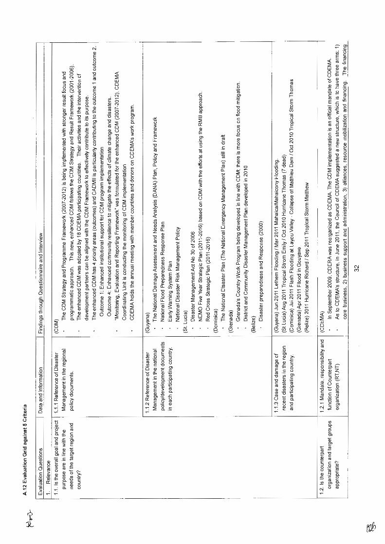
1) Among the 5 criteria for evaluation, relevance is only evaluated as high and others as medium.
2) “Medium” of effectiveness is simply attributed to the delay of output 1. When 3 activities of output 1 progress well, the effectiveness will be improved.
3) Regarding efficiency, the team would like to highlight the request of long-term experts who stay in the project office for the long-term. Shuttle style experts hinder the usual job of staff and flexible assignment is highly appreciated by RT.
4) Impact is mentioned in the achievement of the overall goal. There are a lot of factors and prerequisite conditions in the project. However, if the RT makes a good program for community disaster management with cooperation from other donors, it may be possible to find a way to achieve the overall goal. The evaluation team expects that the RT will prepare such a program in the future.
5) The budget issue is strongly highlighted in sustainability as usual. JICA expected that capacity is embedded in the staff and the organization as knowhow, knowledge and skills. The Team understands that it is the challenge for the RT to implement RT activities with limited budget and embedded capacity.

Sustainability Plan for Flood Disaster Management in CDEMA Participating States 3
1.5 Lessons Learnt from the CADM2 Project
The Regional Team (RT) concluded that the sustainability plan should be further studied from the following aspects:
1) Technical capacity
2) Human resources capacity
3) Institutional capacity
4) Funding capacity
2. BASICS OF SUSTAINABILITY PLAN
2.1 Definition of Sustainability
Sustainability is the long-term responsibility in doing something.
Sustainability here is the long-term responsibility in the flood disaster management for the present and future generations in the CDEMA participating states.
2.2 General Objectives of the Sustainability Plan
The sustainability plan should specify specific elements to be included in the Plan for flood hazard management.
The sustainability plan should make recommendations on steps, including methodologies, actions, and time schedules for each of the elements recommended.
The sustainability plan should clearly identify what needs to be conducted at the Regional and National Levels.
At the regional level, within the Hyogo Action Framework, monitoring the progress of community-based disaster risk reduction at country-level is the responsibility of the international society (see Annex 2).
The sustainability plan should clearly identify what activities to be conducted in view of availability of technical capacity, human resources, financial resources and the institutional background of the states.

Sustainability Plan for Flood Disaster Management in CDEMA Participating States 4
2.3 Specific Objectives
To expand the activities to promote and deliver FHM, FEWS and CBDMP to flood vulnerable communities in CDEMA Participating States other than the project states.
To expand the activities to promote and deliver FHM, FEWS and CBDMP to flood vulnerable communities in the pilot states other than the pilot communities in the CADM2 Project.
2.4 The Vision Statement
Under the following policy, the sustainability plan should be formulated:
To be the foremost promoter of sustainable flood disaster mitigation and preparedness programs for loss reduction at national and local levels in CDEMA Participating States.
What is most important in implementation of the sustainability plan is to protect the people’s lives and properties and to minimize the causalities due to floods in the Caribbean Region. Accordingly the implementation of the sustainability plan should, basically, be conducted by the state responsible for protecting the people.
2.5 The Mission Statement
To enhance and sustain the capacity of CDEMA Participating States to mitigate the impact of floods in their communities, through a collaborative process of coordinated planning and implementation.
2.6 Conceptual Framework of Sustainability Plan
Among CBDMP, FEWS and FHM, a state should undertake a process to establish CBDMP because CBDMP has utmost importance among the three components of the CADM2 by directly affecting the security of the people and their property. A state then should establish FEWS to incorporate into CBDMP to improve the efficiency of the existing CBDMP and FEWS. Establishing FHM follows CBDMP.
Conceptual framework of sustainability plan should consider the following components:
technical capacity;
human resources capacity;
institutional capacity;
funding capacity; and

Sustainability Plan for Flood Disaster Management in CDEMA Participating States 5
action plan.
Four kinds of capacity- technical, human resources, financial and institutional, are the elements
that must be taken into consideration to assess the overall capacity of a state to prepare the CBDMP, FEWS and FHM and to formulate an action plan.
Technical capacity indicates required skills to undertake the necessary tasks. A state can refer to
the technical requirements to identify the gap between the desired set of standard skills and their current technical standard.
Human resources capacity indicates the desired numbers and qualifications of the personnel
required to execute the technical requirement. A state should plan and implement training for its nationals to fulfill the gap between the desired and the current standard.
Financial capacity indicates the funding requirements to prepare CBDMP, FEWS and FHM. It
is important that the NDO has consultation with the stakeholders about financial responsibility on incurring expenditure to implement those activities.
Institutional capacity has paramount importance among four capacity elements. Institutional
capacity indicates the requirements to prepare CBDMP, FEWS and FHM, and to sustain them from the perspectives of institutional arrangement. In other words, it is a goal of institutional arrangement from tentative working group to formal legislation depending on a state’s technical, human resources and financial capacity. A country, on preparing CBDMP, FEWS and FHM must share a common goal of institutional arrangement with the stakeholders, while presenting the current institutional capacity.
While considering an action plan in a state, it is important to identify available in-country
technologies to implement the CADM2 outputs, namely, CBDMP, FEWS and FHM. In case a state does not have legislation or funding support to start implementing the CADM2 outputs, it should start with forming a tentative working group which mobilizes whatever available technical, personnel, financial and institutional resources for a pilot project experiment.
Meantime, a state should identify the technical, human resources, financial and institutional gap to fulfill to fully implement the CADM2 outputs. According to the experience from the CADM2, acquisition of a community facilitator and a skilled hydrologist at state level is of utmost necessity in the pilot states.
Experience and lessons learned from the pilot project must be recorded and referred to when
considering the means to fill the capacity gaps which are identified by the state. The NDO will take a leadership role to encourage each stakeholder to extend their capacity to a requirement level. The stakeholders must discuss financial arrangements which allow the initiative to be sustainable and accountable. Participation of development partners is welcomed if available.

Sustainability Plan for Flood Disaster Management in CDEMA Participating States 6
From the beginning, the desired institutional arrangement must be shared among the stakeholders so that each stakeholder engaged in each activity has a common goal to formalize the CADM2 outputs to legislation. Legislation of the CADM2 needs to match the state’s implementation capacity.
2.7 Basic Needs for New Sustainability Plan
Based on the following basic concept, a new sustainability plan is proposed hereunder:
The global climate change may worsen the situation in the coming future and economic growth may be progressing. The project activities of preparation of community disaster management plans, establishing flood early warning systems and preparation of flood hazard maps should be continued and the outputs should be reviewed in conformity with the strategy and program framework 2007-2012 of CDEMA.
Accordingly the sustainability plan should be prepared for the aims of mitigation of the flood hazard in the region. The plan should be prepared in view of the actual situation of the region, not only from the technical and financial situation but also from the availability of human resources in producing the necessary output and in maintenance and operation of the outputs, and in consideration of the institutional situation.
The new sustainability plan is being prepared for the general CDEMA Participating States where the detailed information related to the disaster mitigation activities is not fully covered and for the pilot states of CADM2 where the said information is obtained in detail.
The new sustainability plan is being prepared under the concept that the basic activities for flood disaster mitigation consist of preparation of community-based disaster management plans (CBDMP), establishment of flood early warning system (FEWS), and preparation of flood hazard maps (FHM).
The technical capacity, human resources, financial resources and the institutional aspects are quite different depending on the state, even in the same region of the Caribbean. Accordingly the sustainability plan should be prepared in consideration of the various situations of states. The details are presented in the following chapter.
3. SUSTAINABILITY PLAN
3.1 Needed Activities for Sustainable Flood Management
3.1.1 Activities at Regional Level
The actual activities for disaster mitigation shall be basically conducted in each state, while the regional stakeholders such as CDEMA-CU, UWI, UG, CIMH, and Civil Society will undertake the flood

Sustainability Plan for Flood Disaster Management in CDEMA Participating States 7
mitigation works at regional level. The necessary activities related to disaster mitigation at the regional level are the following;
1) CDEMA-CU
The tasks of CDEMA-CU are monitoring the works of the related activities of disaster mitigation, coordinating the works for necessary information among the various entities, and dissemination of related information.
At the same time, it is advisable that CDEMA-CU promotes the expansion of the same activities to other states where CADM and CADM2 have not been implemented. In line with this, it is advisable that CDEMA-CU gets an understanding of the overall situation of flood disaster management in CDEMA Participating States.
In addition to this, it is advisable that CDEMA-CU encourages the pilot states of CADM2 to present the outputs of CADM2 at the CDM conference.
A disaster training centre will be established with resources committed from the US Southern Command. This will serve as a training facility for practitioners in the CDEMA Participating States.
2) UWI
The tasks of UWI are mainly the education works related to flood disaster mitigation works.
3) UG
UG provides academic consultation for NT upon request.
4) CIMH
The tasks of CIMH are mainly the education and training works related to hydrological and meteorological works including the instruments.
CIMH should continue to provide the hydrological training course including the flood analysis and continue the support to states in flood analysis for preparation of FHM until the highly qualified hydrologists are built up in the state.
CIMH should give technical advice to the state’s hydro-met office for the installation of gauges for establishing the FEWS.
CIMH maintains and manages the hydrological database that would be the basic data for hydrological analysis for updating the FEWS and FHM.
5) Civil Society
The Civil Society Sub-sector committee of the CDM governance mechanism will make an effort to incorporate the output manuals into the existing manuals.

Sustainability Plan for Flood Disaster Management in CDEMA Participating States 8
3.1.2 Activities at State Level
Regarding the pilot states of CADM2, it is advisable that the NDO gets an understanding of the overall situation of flood disaster management in flood vulnerable areas in the state, to expand the same activities to other communities. This grasp of the overall situation may greatly contribute to the judgment on necessary input. Activities at state level are deemed to be as follows:
1) Technical capacity
Preparation of community-based disaster management plan and implementation of drill.
Establishing flood early warning system
Preparation of flood hazard map
2) Human resources capacity
To secure personnel qualified for conducting the activities shown in Annex-3
To secure community facilitators
3) Institutional capacity
To articulate the related agencies for conducting the needed activities shown in Annex-4
To secure personnel to expand the activities of the CADM2 Project
To prepare the legal basis for continuous cooperation of related agencies for the above activities
4) Financial capacity
When contemplating the level of technical and human resources capacity presently available in a state, it is important to take institutional capacity into consideration as well. A state should decide the amount of funding required to extend and sustain the CADM2 outputs in reference to such a deliberation.
3.1.3 Basic Concept of the Activities at State Level
The basic concept of the project is that a flood disaster at the community level be mitigated through community-based disaster management.
The sustainability of the project must consider sustaining the responsibilities which have been assigned to the organizations and the persons involved.

Sustainability Plan for Flood Disaster Management in CDEMA Participating States 9
The objectives of the Project could be achieved through implementation of the management plan.
Accordingly the community-based disaster management (CBDM) includes the planning process and the implementation of the plan.
Here, the flood hazard map (FHM) and the flood early warning system (FEWS) are the basic inputs that have interface with and must be integrated into the CBDM.
Here, the flood hazard map should be verified with the community-based one on the past community’s experience and accordingly CBDM and FHM should partly overlap in the activities.
The FEWS should also be established based on the community’s opinion regarding setting the warning levels and accordingly the overlap activities between CBDM and FEWS exist.
The FHM should be updated based on the flood record obtained through FEWS monitoring gauges and accordingly the overlap activities between FHM and FEWS exist.
Community-based Disaster Management
Flood Hazard Map Flood Early Warning System
The following are advisable in preparation of CBDMP, FEWS and FHM for expansion of outputs of CADM2:
To prepare CBDMP first, from the viewpoint of disaster mitigation expansion, regarding the communities that are not included in the development plan by development partners at present.
To establish a technically refined FEWS for the communities that already have CBDMP.
To prepare a technically refined FHM for the communities that already have CBDMP and FEWS
Preparation of CBDMP be commissioned to Civil Society and the preparation of High FEWS and FHM be technically supported by CIMH.
Here, a CBDMP should be the topmost priority rather than the FEWS and FHM since without CBDMP, even given FEWS and FHM, the community people will be just as confused as to how and what to do for evacuation from the flood. Then the next one should be FEWS since if the flood takes the community by surprise without warning, the community people will just panic even if the FHM is already disseminated to the residents.

Sustainability Plan for Flood Disaster Management in CDEMA Participating States
10
3.1.4 Levels of CBDMP, FEWS and FHM
In the activities of the CBDMP, FEWS and FHM, there are some conceivable levels of activities to be conducted as to the sustainability of the project. The levels are to be decided by each state depending on the physical conditions, technical capacity of the state, availability of human resources, availability of funding resources and the background of the institutions of the state.
1) Technical aspect
A high amount of initial investment will be needed to introduce the CADM2 system, and accordingly it might be difficult to continue to conduct the activities only with the national budget without obtaining foreign financing. Accordingly it is advisable that the state aims at preparation and practical use of the CBDMP, FEWS and FHM whatever the levels are.
In consideration of the above, the sustainability plan is classified into the following levels in the technical aspect:
Level CBDMP FEWS FHM 5
One
High High 4 High Moderate 3 Moderate Moderate 2a Moderate Non-IT 2b Non-IT Moderate 1 Non-IT Non-IT
The following are the descriptions of the said levels. Conditions, Roles, Functions and Activities in Each Level of Activities are shown in Annex-4.
(1) CBDMP
Basically there should be one level in CBDMP.
(2) FEWS
Basically there are 3 levels of FHM as follows:
Non-IT FEWS:
FEWS is established without any IT equipment. A person in the community monitors the flooding conditions of the river, and under certain situations, the person gives the warnings to the community by shouting or door-to-door knocking.
Mod-FEWS:
FEWS is established with some automatic water level sensors and the detected water-level is made known to the caretaker of the sensor living near the river,

Sustainability Plan for Flood Disaster Management in CDEMA Participating States
11
through a cable connected to the caretaker’s house and the warning would be transmitted to the downstream target community by cellular phone or some other available device.
But the sensor is not equipped with a data logger and modem to transmit the information through radio waves to some designated agencies or personnel. Accordingly the threshold values to give the warning could not be updated since there is no data record.
High-FEWS:
FEWS is established with an automatic water level sensor and the detected water-level information is transmitted directly to NDO and/or downstream target community committee by radio waves.
The devices have a data logger and modem to transmit the information and later on an update of threshold values based on the recorded data could be achieved.
(3) FHM
Basically there are 3 levels of FHM as follows:
Non-IT FHM:
FHM is prepared with the leadership of a facilitator during the community discussions on the past prominent flood hand-drawn on paper. The experienced facilitator to lead the community participants to the flood map of the past is needed here.
Mod-FHM:
FHM is prepared with the use of GPS for collection of location data and the flooding depths at sites of the past prominent flood and the collected data is processed with GIS software for drawing the so-called incidental map.
High-FHM:
FHM is prepared based on the rainfall analysis, runoff calculation and inundation simulation, and accordingly the FHM is prepared for the return period with the use of a computer, software for probability analysis, runoff and inundation simulation and GIS software.
2) Human resources aspect
NDO and related agencies in the Caribbean Region have limitations in personnel size and technical level. Accordingly they need to request the cooperation of CIMH, UWI, and Civil Society for expansion of the activities for CBDMP, FEWS and FHM.

Sustainability Plan for Flood Disaster Management in CDEMA Participating States
12
CIMH has plans to secure the personnel to continue the CADM2 system (FEWS, FHM, HDB) by employing and training the personnel.
Civil Society is an important partner for expansion of CBDMP.
Needed M/M is different depending on the target technical level. Accordingly the following human resources will be needed for each field: Necessary human resources and implementation schedule for each field are shown in Annex-5.
LevelNDO’s overall
responsibilityCBDMP FEWS* FHM Total
5
1.2 2.2
5.0 5.5 13.9 4 5.0 1.5 9.9 3 3.0 1.5 7.9 2a 3.0 0.0 6.4 2b 3.0 1.5 7.9 1 3.0 0.0 6.4
*CIMH support is needed at Level5.
From the viewpoint of disaster management of communities, preparation of CBDMP is the first priority. In the case of preparation of Moderate or Non-IT FEWS, it is needed to conduct flood warning by manpower, and this influences the necessary cost depending on the understanding and cooperation level of the community and influences the sustainability of the activities. Accordingly the education of the people to be engaged in the warning activities is very important. Therefore, it is necessary for NDO to secure the necessary number of personnel inside the governmental agencies to be engaged in the CBDMP activities in view of the number of flood vulnerable communities.
3) Institutional aspect
It is necessary to articulate the mandate of related agencies for introducing and effective operation of the CADM2 system for flood disaster mitigation of communities.
Related agencies are national agencies (NDO, Hydro-met, Land and Survey, etc.), Civil Society, community, private company (mobile phone company), CIMH and others. The mandate of the agencies are as shown in Annex-6. In establishing the cooperation of related agencies, it is necessary to articulate the legislation situation related to disaster mitigation in the state, personnel size, budget and commitment of the agencies and to decide the feasible level of the activities.
Taking the above into consideration, the sustainability plan in the institutional aspect is classified into the following 6 levels: (Responsibilities in each activity are shown in Annex-6).
Level FEWS FHM
5 1. Cooperation of NDO、
Hydromet, Land and Survey, Civil Society, Community
1. Technical support to of CIMH 2. Cooperation of NDO, Hydromet and
Land and Survey

Sustainability Plan for Flood Disaster Management in CDEMA Participating States
13
Level FEWS FHM
4
1. Cooperation of mobile phone company
2. Cooperation of NDO, Hydromet, Land and Survey, Civil Society, Community
1. Cooperation of NDO, Land and Survey, Civil Society, Community
3 1. Cooperation of NDO, Hydromet, Civil Society, Community
1. Cooperation of NDO, Land and Survey, Civil Society, Community
2a 1. Cooperation of NDO, Hydromet, Civil Society, Community
1. Cooperation of NDO, Civil Society, Community
2b 1. Commitment of Community 1. Cooperation of NDO, Land and Survey, Civil Society, Community
1 1. Commitment of Community 1. Cooperation of NDO, Civil Society Community
4) Financial aspect
Initial cost is varies depending on the level in FEWS and FHM and the maintenance cost also varies depending on the level. Accordingly it is necessary to consider the necessary sustainable budget in view of the technical and personnel capacity levels and the institutional level (cooperation of the related agencies).
Level
Initial Cost (USD) Recurrent Cost* (USD)
NDO’s overall
responsibility CBDMP FEWS** FHM Total FEWS
5
725 6,400
24,000 9,300 40,425 4,800 4 24,000 4,500 35,625 4,800 3 8,000 4,500 19,625 31,000 2a 8,000 0 15,125 31,000 2b 200 4,500 11,825 14,000 1 200 0 7,325 14,000
* per a year, **CIMH support is needed at Level5.
A CADM system is the disaster mitigation integrated system of CBDMP, FEWS and FHM. In introducing a CADM system, it is necessary to decide the appropriated level of each component in view of the development level of a national disaster mitigation system.
It is advisable to actively promote to development partners the implementation of flood disaster mitigation projects similar to the CADM system showing the effects of the CADM system.
4. IMPLEMENTATION SCHEDULE (ACTION PLAN)
An action plan should be prepared in consideration of “technical aspect”, “human resources aspect”, “institutional aspect”, and “financial aspect”, in view of the present level of the state, the target level, and the budget. The detailed information including the breakdown of the costs are presented in Annex-8 as the Sustainability Plan Matrix attached hereto.

Sustainability Plan for Flood Disaster Management in CDEMA Participating States
14
For the areal expansion of the activities, the necessary financial input from national budget and development partners by use of a monitoring matrix to promote the activities to communities needs to be considered. Progress Monitoring Matrixes of Coverage of Flood Response Committee are shown in Annex-7.
Among CBDMP, FEWS and FHM, a state should undertake a process to establish CBDMP because CBDMP has utmost importance among the three components of the CADM2 by directly affecting the security of the people and their property. A state should then establish FEWS to incorporate into CBDMP to improve the efficiency of the existing CBDMP. Establishing FHM follows CBDMP and FEWS.
[STEP 1]
It is important to identify available in-country technologies to implement the CADM2 outputs, namely, CBDMP, FEWS and FHM. In case the state does not have legislation or funding support to start implementing the CADM2 outputs, it should start with forming a tentative working group which mobilizes available technical, personnel, financial and institutional resources for a pilot project experiment.
From the beginning, the desired goal of institutional arrangement must be shared among the stakeholders so that each stakeholder engaged in each activity has a common goal to formalize the working relations to legislation in the end. Legislation of CADM2 needs to match the state’s implementation capacity.
[STEP 2]
A state should identify the technical, human resource, financial and institutional gaps to fill in order to fully implement the CADM2 outputs. According to the experience from the CADM2, acquisition of a community facilitator and a qualified hydrologist at state level is of utmost necessity in the pilot states.
NDO should send a hydrologist and GIS expert to CIMH and UWI respectively to undertake training courses provided by regional agencies.
While developing human resources to fill the capacity gaps, the NDO should consider finding available domestic resources from government agencies and private sectors. If the human resources are not available domestically, the NDO should consider searching for regional human resources.
[STEP 3]
Experience and lessons learned from the pilot project must be recorded and referred to while considering the means to fill the capacity gaps which are identified by the state. The NDO will take a leadership role to encourage each stakeholder to extend their capacity to a requirement level. The Stakeholders must discuss financial arrangements to keep sustainability and accountability of operations to achieve the CADM2 outputs. Participation of development partners is welcomed if available.

Sustainability Plan for Flood Disaster Management in CDEMA Participating States
15
[STEP 4] NDO should review the sustainability plan periodically taking into consideration the economic
development of the state, and the impact of global climate change.
5. RECOMMENDATIONS
It is a responsibility of the international society to pursue flood disaster risk reduction. In relation to this, it is in the common interest of the development partners in the Caribbean region to expand the CADM2 system region wide.
In order to expand the CADM2 system, sharing the best practices from the CADM2 on the occasion of a regional conference such as the Caribbean Disaster Management Conference, is the effective approach to disseminate the system established during the project.
Extending non-structural measures, which were established during the CADM2, to the CDEMA Participating States is the highest priority, given the allocated resources for disaster risk reduction in the Caribbean states. However, a state should consider utilizing structural measures in addition to the non-structural measures to seek the most efficient means to reduce the flood risks.
From the viewpoint of long-term sustainability of the activities, educational activities at school level would be an important part. Educational activities in flood disaster management in communities should be conducted and the cost of these activities should be included in the national budget in view that the loss at community level may have a great impact on the national development.

Sust
aina
bilit
y Pl
an fo
r Flo
od D
isas
ter M
anag
emen
t in
CD
EMA
Par
ticip
atin
g St
ates
16
Ann
ex-1
Pro
ject
Str
uctu
re

Sust
aina
bilit
y Pl
an fo
r Flo
od D
isas
ter M
anag
emen
t in
CD
EMA
Par
ticip
atin
g St
ates
17
Ann
ex-2
CB
DM
Pro
gres
s Mon
itori
ng F
orm
Car
ibbe
an R
egio
n Ea
ch st
ate
iden
tifie
s hig
hly
vuln
erab
le c
omm
uniti
es (1
) and
thos
e w
here
CB
DM
has
bee
n im
plem
ente
d* b
y 20
11 (2
); Fo
r the
rem
aini
ng
com
mun
ities
, im
plem
enta
tion
sche
dule
for 2
012-
2016
and
bey
ond
is to
be
prep
ared
acc
ordi
ng to
the
prio
rity
(4).
The
resu
lt is
to b
e su
mm
ariz
ed
regi
onal
ly b
y re
gion
al o
rgan
izat
ions
such
as C
DEM
A (5
) and
glo
bally
by
ISD
R S
ecre
taria
t (6)
, and
show
n on
thei
r res
pect
ive
web
-site
for
info
rmat
ion
shar
ing
by a
ll in
clud
ing
dono
rs.
Reg
ion
Stat
e
(1) T
otal
num
ber
of h
ighl
y vu
lner
able
co
mm
uniti
es
(2) T
he n
umbe
r of
com
mun
ities
w
here
CB
DM
has
be
en im
plem
ente
d by
201
1*
(3) T
he n
umbe
r of
com
mun
ities
w
here
CB
DM
is
still
to b
e im
plem
ente
d
(4) I
mpl
emen
tatio
n sc
hedu
le fo
r com
mun
ities
of (
3)
2012
2013
2014
2015
2016
beyo
nd
Car
ibbe
an
Reg
ion
(CD
EMA
m
embe
r co
untri
es)
Ang
uilla
A
ntig
ua &
Bar
buda
B
aham
as
Bar
bado
s B
eliz
e 26
51
264
16
Cay
man
Isla
nds
Dom
inic
a 9
18
17
1G
rena
da
81
71
Guy
ana
61
51
Hai
ti Ja
mai
ca
Mon
tser
rat
St. K
itts &
Nev
is
St. L
ucia
28
127
115
11St
.Vin
cent
& G
rena
dine
s Tr
inid
ad &
Tob
ago
Turk
s & C
aico
s Isl
ands
V
irgin
Isla
nds
(5) R
egio
nal s
umm
ary
by C
DEM
A
(6) G
loba
l sum
mar
y by
ISD
R S
ecre
taria
t*”
Impl
emen
ted”
mea
ns c
ompl
etio
n of
For
mat
ion
of C
BD
M o
rgan
izat
ion,
Pre
para
tion
of C
BD
MP,
Est
ablis
hmen
t of e
arly
war
ning
syst
em a
nd P
repa
ratio
n of
ha
zard
map
s.

Sustainability Plan for Flood Disaster Management in CDEMA Participating States
18
Annex-3 Activities to Ensure Human Resources
1. NDO’s leadership
2. CBDMP
A community facilitator
(1) Existence of resident community organization with strong leadership to:
(a) Establish CBDMP; and
(b) Integrate FEWS and FHM into the existing CBDMP (2) Three (3) well-trusted community residents per community to be Community Disaster Response Team, who are capable of understanding FEWS and FHM (3) Availability of National Trainers for community facilitating
3. FEWS
(1) Telecommunication Provider's cooperation (at Level 4 and higher) (2) Monitoring personnel or Resident(s) who permanently observe water level of the upstream of the flood-prone rivers (At Level 3 and under) (3) A hydrology technician to:
(a) plan location of the gauges
(b) maintain the equipment
(4) A hydrologist to analyze hydrological data
4. FHM
(1) 4-5 GPS Technicians
(2) A GIS technician
(3) A hydrologist qualiified in hydrological analysis

Sustainability Plan for Flood Disaster Management in CDEMA Participating States
19
Annex-4 Activities to Ensure Institution
1. Overall Responsibilities 1.1 Leading role in NT 1.2 Coordination of stakeholders(maintenance) 1.3 Coordination of stakeholders(new community) 1.4 Addition of new stakeholder 1.5 Arrange necessary budget measures 2. Community Disaster Management Plan (CDMP) 2.1 Maintenance of established Balthazar system 2.2 Arrange necessary budget for maintenance 2.3 Application of CADM2 CDMP to other community 2.4 Arrange necessary general budget for new application 2.5 Arrange necessary budget for facilitator 3. Flood Early Warning System (FEWS) 3.1 Maintenance of existing FEWS 3.2 Improvement of existing FEWS 3.3 General upkeep of monitoring stations 3.4 Correlation analysis 3.5 Telecommunication setup(existing) 3.6 Coordination of stakeholders 3.7 Arrange necessary budget for maintenance/improvement 3.8 Selection of new target community 3.9 Development of FEWS for new communities 3.10 Collection of hydrological data for new communities 3.11 Collection of geological data for new communities 3.12 Correlation analysis for new communities 3.13 Planning of FEWS for new communities 3.14 Decision of specification of hydrological gauges 3.15 Selection of installation sites of hydrological gauges 3.16 Installation of hydrological gauges for new communities 3.17 Operation & maintenance of new monitoring stations 3.18 Operation & maintenance budget 3.19 Monitoring of operation & maintenance works 3.20 Arrangement of general budget for FEWS 4. Flood Hazard Map (FHM) 4.1 Maintenance & improvement of developed FHM 4.2 Selection of new target community 4.3 Planning of FHM for new community 4.4 Field investigation 4.5 Preparation of hand drawn map 4.6 Mapping of field investigation result

Sustainability Plan for Flood Disaster Management in CDEMA Participating States
20
4.7 Arrangement of necessary budget 5. Hydrological Database (HD) 5.1 General upkeep of existing monitoring stations 5.2 Data download 5.3 Data sharing 5.4 Monitoring of download works 5.5 Financial arrangement of data base system

Sustainability Plan for Flood Disaster Management in CDEMA Participating States
21
Annex-5 Conditions, Roles, Functions and Activities in Each Level of Activities
Each intervention is assumed to be made for a new community, while the NT utilizes their current capacity. (1) CBDMP
Community organization should exist to 1) establish CBDMP, and 2) integrate FEWS and FHM into the CBDMP.
The expected costs would be the holding of community workshops to integrate FEWS and FHM in CBDMP, conducting evacuation drills, preparation of public awareness materials such as posters, flyers, and brochures.
(3) High-FEWS
Telecommunication equipment should be provided.
The gauge sites should be covered in the network system.
Automatic gauges for water level and rainfall gauges should be provided and installed.
Operation and maintenance of gauges should be conducted.
Downloaded data on water levels and rainfall should be analyzed for upgrading the warning levels and the relationship between the water level and rainfall in the upstream basin and the water level at the target community.
The expected costs would be the acquisition of equipment, equipment installation, installation of civil works, maintenance and user’s fees.
NDO, CIMH and Hydro-met office should cooperate for the acquisition of gauges.
Participation of community organizations to maintain water level and rainfall gauges at this stage is recommended. Agreement among Hydro-met, NDO and community-based organizations should be sought.
(4) High FHM
Hourly rainfall data should exist for the river basin of the target community.
Topographical map with necessary contour levels should be available.
Rainfall probability analysis, runoff analysis and inundation analysis should be conducted.
Hydrologist qualified in doing the above analysis should be available.
For verification of a prepared FHM, an incidental map should be prepared.

Sustainability Plan for Flood Disaster Management in CDEMA Participating States
22
For preparation of the incidental map, a field survey regarding the past flooding information should be conducted. This needs the use of GPS and accordingly a GPS technician with 4-5 sets of GPS and one computer are also needed.
Expected costs would be for the GPS sets, a computer, GPS technicians, labor costs for conducting the field survey for collecting the past inundation situation, allowances and travel costs for a hydrologist to do the analysis if an in-house hydrologist is not available.
At this time, a state needs the technical assistance of CIMH. The working agreement should include NDO, Hydro-met office, Land & Survey Dept. and CIMH.
(5) Mod FEWS
Telecommunication equipment (cellular network & devices or radio communication) should be provided.
Monitoring site and target community should be covered with the network of cellular phone or radio communication.
Automatic gauges for water level and rainfall should be provided and installed.
A hydrologist should make a plan of the location of the gauges, maintain the gauges and make some hydrological analysis of the data.
The expected costs would be for the acquisition of the gauges for water level and rainfall, and the installation of gauges including the civil works for installation.
Hydro-met should secure the operation and maintenance of gauges and it should be in agreement with NDO.
(6) Mod FHM
For preparation of an incidental map, a field survey regarding the past flooding information should be conducted. This needs the use of GPS and accordingly a GPS technician with 4-5 sets of GPS and one computer are needed.
Based on the collected data, the GIS technician prepares the incidental map by use of GIS software. Accordingly a GIS technician should be available.
The expected costs would be for 4-5 sets of GPS equipment, labor cost for conducting the field survey, and provision of GIS software.
NDO and Land Survey Dept. should cooperate.
(7) Non-IT FEWS
Monitoring personnel should observe the water-level of the river nearby on 24/7 basis.

Sustainability Plan for Flood Disaster Management in CDEMA Participating States
23
Local offices and entities such as schools, clinics, post offices, community development council, agro/fisheries coop, neighborhood organizations, mother’s group and others should cooperate.
(8) Non-IT FHM
All the activities are included in the activities of CBDMPP.
The above cases are schematically shown in the figure below:
Non‐IT Moderate High
Non‐IT
Moderate
High
FEWS
FHM
②‐a
②‐b ④
⑤
③
①

Sustainability Plan for Flood Disaster Management in CDEMA Participating States
24
(For Level 5)NDO's Overall Responsibility 1 2 3 4 5 6 7 8 9 10 11 12 M/M
Coordination of stakeholders 0.5Public Awareness for DisasterRisk Reduction 0.5To collect and keep the FHM tobecome the depository of theFHM
0.2
CBDMPTraining For Community DisasterResponse Team (CDRT) 1.0Community facilitating forCBDMP 1.0Integrating FEWS and FHM inCBDMP 0.2
High-FEWSTelecommunication equipment(Cellular network & modem) 1.0Acquisition & installation ofAutomatic gauge (water level &rainfall)
2.0
Hydrological analysis ofrecorded data 2.0Maintenance of water level /rainfall gauges
High-FHM (Probability Analysis)Baseline Incidental Mapping 1.0(Existing Maps (Land & SurveyDept) Needed) 0.2Baseline data collection 0.5Hourly rainfall data for the riverbasin where community islocated (Hydro-Met)
0.5
Topographical map with highresolution(Land and SurveyDept)
0.2
Rainfall probability analysis 0.7Run-off analysis 0.7Inundation analysis in the targetcommunity 1.0GIS Calibration:To calibrate the inundationcalculation results withincidental map
0.7
Annex-6 Necessary Human Resources and Implementation Schedule for Each Item

Sustainability Plan for Flood Disaster Management in CDEMA Participating States
25
(For Level 4)NDO's Overall Responsibility 1 2 3 4 5 6 7 8 9 10 11 12 M/M
Coordination of stakeholders 0.5Public Awareness for DisasterRisk Reduction 0.5To collect and keep the FHM tobecome the depository of theFHM
0.2
CBDMPTraining For Community DisasterResponse Team (CDRT) 1.0Community facilitating forCBDMP 1.0Integrating FEWS and FHM inCBDMP 0.2
High-FEWSTelecommunication equipment(Cellular network & modem) 1.0Acquisition & installation ofAutomatic gauge (water level &rainfall)
2.0
Hydrological analysis ofdownloaded data 2.0Maintenance of water level /rainfall gauges
Mod-FHM (GPS/GIS)1. Baseline Incidental Mapping(Exsting Maps (Land & SurveyDpt) Needed
1.0
2. GIS Mapping 0.5
(For Level 3)NDO's Overall Responsibility 1 2 3 4 5 6 7 8 9 10 11 12 M/M
Coordination of stakeholders 0.5Public Awareness for DisasterRisk Reduction 0.5To collect and keep the FHM tobecome the depository of theFHM
0.2
CBDMPTraining For Community DisasterResponse Team (CDRT) 1.0Community facilitating forCBDMP 1.0Integrating FEWS and FHM inCBDMP 0.2
Mod-FEWSTelecommunication or Cablecommunication equipment 1.0Acquisition & installation ofautomatic gauge 2.0Opeeration of FEWS
Mod-FHM (GPS/GIS)1. Baseline Incidental Mapping(Exsting Maps (Land & SurveyDpt) Needed
1.0
2. GIS Mapping 0.5

Sustainability Plan for Flood Disaster Management in CDEMA Participating States
26
(For Level 2-a)NDO's Overall Responsibility 1 2 3 4 5 6 7 8 9 10 11 12 M/M
Coordination of stakeholders 0.5Public Awareness for DisasterRisk Reduction 0.5To collect and keep the FHM tobecome the depository of theFHM
0.2
CBDMPTraining For Community DisasterResponse Team (CDRT) 1.0Community facilitating forCBDMP 1.0Integrating FEWS and FHM inCBDMP 0.2
Mod-FEWSTelecommunication or Cablecommunication equipment 1.0Acquisition & installation ofautomatic gauge 2.0Opeeration of FEWS
Non-IT FHM(Included in CBDMP)
(For Level 2-b)NDO's Overall Responsibility 1 2 3 4 5 6 7 8 9 10 11 12 M/M
Coordination of stakeholders 0.5Public Awareness for DisasterRisk Reduction 0.5To collect and keep the FHM tobecome the depository of theFHM
0.2
CBDMPTraining For Community DisasterResponse Team (CDRT) 1.0Community facilitating forCBDMP 1.0Integrating FEWS and FHM inCBDMP 0.2
Non--IT FEWSTelecommunication or Cablecommunication equipment 1.0Acquisition & installation ofautomatic gauge 2.0Opeeration of FEWS
Mod-FHM1. Baseline Incidental Mapping(Exisitng Maps (Land & SurveyDept) needed
1.0
2. GIS Mapping 0.5

Sustainability Plan for Flood Disaster Management in CDEMA Participating States
27
(For Level 1)NDO's Overall Responsibility 1 2 3 4 5 6 7 8 9 10 11 12 M/M
Coordination of stakeholders 0.5Public Awareness for DisasterRisk Reduction 0.5To collect and keep the FHM tobecome the depository of theFHM
0.2
CBDMPTraining For Community DisasterResponse Team (CDRT) 1.0Community facilitating forCBDMP 1.0Integrating FEWS and FHM inCBDMP 0.2
Non--IT FEWSTelecommunication or Cablecommunication equipment 1.0Acquisition & installation ofautomatic gauge 2.0Opeeration of FEWS
Non-IT FHM(Included in CBDMP)

Sustainability Plan for Flood Disaster Management in CDEMA Participating States
28
Annex-7 Tasks and Duties of Each Activity
Agencies related to CADM2
ND
O
Met Services
Survey & M
apping
Com
munity
Red C
ross
CIM
H
DIG
ICEL
1. Overall Responsibilities 1.1 Leading role in NT ○ 1.2 Coordination of stakeholders(maintenance) ○ 1.3 Coordination of stakeholders(new community) ○ 1.4 Addition of new stakeholder ○ 1.5 Arrange necessary budget measures ○ 2. Community Disaster Management Plan (CDMP) 2.1 Maintenance of established Balthazar system ○ ○ ○ ○ ○ 2.2 Arrange necessary budget for maintenance ○ 2.3 Application of CADM2 CDMP to other community ○ ○ ○ ○ ○ 2.4 Arrange necessary general budget for new application ○ ○ 2.5 Arrange necessary budget for facilitator ○ ○ 3. Flood Early Warning System (FEWS) 3.1 Maintenance of existing FEWS ○ ○ ○ ○ ○ 3.2 Improvement of existing FEWS ○ ○ ○ ○ ○ ○ 3.3 General upkeep of monitoring stations ○ ○ 3.4 Correlation analysis ○ ○ ○ ○ 3.5 Telecommunication setup(existing) ○ ○ ○ ○ 3.6 Coordination of stakeholders ○ 3.7 Arrange necessary budget for maintenance/improvement ○ ○ 3.8 Selection of new target community ○ ○ ○ 3.9 Development of FEWS for new communities ○ ○ ○ ○ 3.10 Collection of hydrological data for new communities ○ ○ ○ 3.11 Collection of geological data for new communities ○ ○ ○ 3.12 Correlation analysis for new communities ○ ○ ○ 3.13 Planning of FEWS for new communities ○ ○ ○ ○ ○ ○ ○ 3.14 Decision of specification of hydrological gauges ○ ○ ○ 3.15 Selection of installation sites of hydrological gauges ○ ○ ○ ○ 3.16 Installation of hydrological gauges for new communities ○ ○ ○ ○ ○ 3.17 Operation & maintenance of new monitoring stations ○ ○ 3.18 Operation & maintenance budget ○ ○ ○ 3.19 Monitoring of operation & maintenance works ○ 3.20 Arrangement of general budget for FEWS ○ 4. Flood Hazard Map (FHM) 4.1 Maintenance & improvement of developed FHM ○ ○ ○ ○ ○ 4.2 Selection of new target community ○ ○ ○ ○ 4.3 Planning of FHM for new community ○ ○ ○ ○ ○ ○ 4.4 Field investigation ○ ○ ○ 4.5 Preparation of hand drawn map ○ ○ 4.6 Mapping of field investigation result ○ ○ 4.7 Arrangement of necessary budget ○

Sustainability Plan for Flood Disaster Management in CDEMA Participating States
29
5. Hydrological Database (HD) 5.1 General upkeep of existing monitoring stations ○ ○ ○ 5.2 Data download ○ ○ 5.3 Data sharing ○ ○ 5.4 Monitoring of download works ○ 5.5 Financial arrangement of data base system ○

Sust
aina
bilit
y Pl
an fo
r Flo
od D
isas
ter M
anag
emen
t in
CD
EMA
Par
ticip
atin
g St
ates
30
Ann
ex-8
Pro
gres
s Mon
itori
ng M
atri
x of
Cov
erag
e of
Flo
od R
espo
nse
Com
mitt
ee
Stat
e (E
xam
ple)
R
ef #
Ris
k Le
vel
Floo
d vu
lner
able
co
mm
uniti
es
Targ
et
Yea
r
CB
DM
P FE
WS
FHM
C
ompl
eted
Stat
us*
Partn
er
Stat
us*
Partn
er
Stat
us*
Partn
er
1 A
(2
012-
2015
) A
20
11
Com
plet
edJI
CA
C
ompl
eted
JI
CA
C
ompl
eted
JIC
A
2012
2 B
20
15
Com
plet
edR
ed C
ross
Pi
pelin
ed
Gov
ernm
ent
Pipe
lined
C
DEM
A-
HIP
3 C
20
15
Pipe
lined
W
orld
Ban
kPi
pelin
ed
Wor
ld B
ank
Pipe
lined
W
orld
Ban
k
4 D
20
15
Com
plet
edR
ed C
ross
Pi
pelin
ed
Gov
ernm
ent
Pipe
lined
A
usA
ID
5
E TB
D
TBD
TB
D
TBD
TB
D
TBD
TB
D
6
F TB
D
TBD
TB
D
TBD
TB
D
TBD
TB
D
7
G
TBD
TB
D
TBD
TB
D
TBD
TB
D
TBD
8 H
TB
D
TBD
TB
D
TBD
TB
D
TBD
TB
D
9
I TB
D
TBD
TB
D
TBD
TB
D
TBD
TB
D
10
J TB
D
TBD
TB
D
TBD
TB
D
TBD
TB
D
11
B
(201
5-)
K
TBD
C
ompl
eted
Red
Cro
ssTB
D
TBD
TB
D
TBD
12L
TBD
C
ompl
eted
Red
Cro
ssTB
D
TBD
TB
D
TBD
13M
TB
D
Com
plet
ed R
ed C
ross
TBD
TB
D
TBD
TB
D
14
N
TBD
C
ompl
eted
Red
Cro
ssTB
D
TBD
TB
D
TBD
15O
TB
D
Com
plet
ed R
ed C
ross
TBD
TB
D
TBD
TB
D
16
P TB
D
Com
plet
ed R
ed C
ross
TBD
TB
D
TBD
TB
D
17
Q
TBD
C
ompl
eted
Red
Cro
ssTB
D
TBD
TB
D
TBD
18R
TB
D
Com
plet
ed R
ed C
ross
TBD
TB
D
TBD
TB
D
19
S TB
D
TBD
TB
D
TBD
TB
D
TBD
TB
D
20
T TB
D
TBD
TB
D
TBD
TB
D
TBD
TB
D
21
U
TBD
TB
D
TBD
TB
D
TBD
TB
D
TBD
22V
TB
D
TBD
TB
D
TBD
TB
D
TBD
TB
D
23
W
TBD
TB
D
TBD
TB
D
TBD
TB
D
TBD
24X
TB
D
TBD
TB
D
TBD
TB
D
TBD
TB
D
25
Y
TBD
TB
D
TBD
TB
D
TBD
TB
D
TBD
26Z
TBD
TB
D
TBD
TB
D
TBD
TB
D
TBD
* Pi
pelin
ed, O
pera
tiona
l, C
ompl
eted
, TB
D: T
o be
det
erm
ined

Sust
aina
bilit
y Pl
an fo
r Flo
od D
isas
ter M
anag
emen
t in
CD
EMA
Par
ticip
atin
g St
ates
31
Ann
ex-9
Sus
tain
abili
ty P
lan
Mat
rix
R
esou
rces
Lev
elD
RR
Com
pone
nts
Tec
hnic
alH
uman
Res
ourc
esFi
nanc
ial
Cos
t (U
S$)
Inst
itutio
nal
5
ND
O’s
ove
rall
resp
onsi
bilit
y 1.
Coo
rdin
atio
n of
st
akeh
olde
rs
1. N
DO
’s le
ader
ship
In
-kin
d (N
DO
and
oth
er
NT
mem
bers
) In
-kin
d
ND
O, T
elec
omm
unic
atio
n pr
ovid
ers,
H
ydro
-met
, Lan
d Su
rvey
Dep
t.,
com
mun
ity-b
ased
org
aniz
atio
ns a
nd
Civ
il So
ciet
y
2. T
o co
llect
and
kee
p th
e
FHM
to b
ecom
e th
e de
posit
ory
of th
e FH
M
In-k
ind
(ND
O)
In-k
ind
ND
O, c
omm
unity
-bas
ed o
rgan
izat
ions
an
d C
ivil
Soci
ety
3. P
ublic
Aw
aren
ess f
or
Dis
aste
r Ris
k R
educ
tion
Prin
ting
Cos
ts fo
r pos
ters
, br
ochu
res,
etc
US$
725
ND
O
CB
DM
P
1. T
rain
ing
For
Com
mun
ity
Dis
aste
r R
espo
nse
Team
(C
DR
T)
Thre
e (3
) wel
l-tru
sted
com
mun
ity
resi
dent
s pe
r com
mun
ity to
be
faci
litat
ors,
who
are
cap
able
of
unde
rsta
ndin
g FE
WS
and
FHM
Cos
ts fo
r tra
inin
g C
DR
T U
S$1,
500
ND
O, c
omm
unity
-bas
ed o
rgan
izat
ions
an
d C
ivil
Soci
ety
2. C
omm
unity
faci
litat
ing
A
vaila
bilit
y of
Nat
iona
l Tra
iner
s for
co
mm
unity
faci
litat
ing
Cos
ts fo
r com
mun
ity
faci
litat
ing
US$
3,00
0N
DO
, com
mun
ity-b
ased
org
aniz
atio
ns
and
Civ
il So
ciet
y
3.
Inte
grat
ing
FEW
S an
d FH
M in
CB
DM
P1.
Exi
sten
ce o
f res
iden
t com
mun
ity
orga
niza
tion
to:
ND
O, H
ydro
-Met
, Com
mun
ity-b
ased
O
rgan
izat
ion
and
Civ
il So
ciet
y
(1) E
stab
lish
CB
DM
P; a
nd
Cos
ts fo
r com
mun
ity
wor
ksho
p to
inte
grat
e FE
WS
and
FHM
in
CB
DM
P
US$
400
(2) I
nteg
rate
FEW
S an
d FH
M in
to th
e ex
istin
g C
BD
MP
Cos
ts fo
r Ful
l Sca
le
evac
uatio
n ex
erci
seU
S$1,
500
2.
Stro
ng c
omm
unity
lead
ersh
ipIn
-kin
dIn
-kin
d
Hig
h-FE
WS
(CA
DM
2)
Tele
com
mun
icat
ion
equi
pmen
t (C
ellu
lar
netw
ork
& m
odem
)
Tele
com
mun
icat
ion
Prov
ider
's co
oper
atio
n 1.
Acq
uisi
tion
and
Inst
alla
tion
Cos
ts fo
r Eq
uipm
ent
US$
2,00
0Fo
r War
ning
Tel
ecom
mun
icat
ion:
N
DO
, Tel
ecom
mun
icat
ion
prov
ider
s, H
ydro
-met
, com
mun
ity-b
ased
or
gani
zatio
ns a
nd C
ivil
Soci
ety
2. M
aint
enan
ce &
Use
r’s
Fees
(pe
r yea
r)U
S$2,
400
Acq
uisi
tion
& i
nsta
llatio
n of
A
utom
atic
ga
uge
(w
ater
le
vel &
rain
fall)
A h
ydro
logi
st to
: 1.
A
cqui
sitio
n C
osts
fo
r A
utom
atic
gau
ge
ND
O, C
IMH
and
Hyd
ro-M
et
(1
) pla
n lo
catio
n of
the
gaug
es -
Wat
er L
evel
US$
5,40
0
(2
) mai
ntai
n th
e eq
uipm
ent
- R
ainf
all
US$
4,60
0
(3)
Ana
lyze
hy
drol
ogic
al
data
(C
IMH)
2.
Inst
alla
tion
cost
s fo
r A
utom
atic
gau
geU
S$14
,000
3. L
abor
cos
ts t
o so
urce
a
hydr
olog
ist (
in-k
ind)
In-k
ind
Mai
nten
ance
of
wat
er l
evel
/
rain
fall
gaug
es
Mai
nten
ance
co
sts
of
wat
er-le
vel
gaug
es
and
rain
fall
gaug
es (p
er y
ear)
US$
2,40
0H
ydro
-met
, th
e N
DO
and
com
mun
ity-
base
d or
gani
zatio
ns
Hig
h-FH
M (P
roba
bilit
y A
naly
sis)
1. B
asel
ine
Inci
dent
al
Map
ping
4-
5 G
PS T
echn
icia
ns in
a c
ount
ry
1. 4
-5 S
ets o
f GPS
dev
ices
an
d a
com
pute
r in
a co
untry
US$
3,50
0N
DO
, Lan
d, S
urve
y D
ept.,
Com
mun
ity
Org
aniz
atio
ns a
nd C
ivil
Soci
ety

Sust
aina
bilit
y Pl
an fo
r Flo
od D
isas
ter M
anag
emen
t in
CD
EMA
Par
ticip
atin
g St
ates
32
(Exi
stin
g M
aps (
Land
&
Surv
ey D
ept)
Nee
ded)
2.
Lab
or c
osts
for G
PS
tech
nici
ans p
er c
omm
unity
w
ork
US$
1,00
0
2. B
asel
ine
data
col
lect
ion
A h
ydro
logi
st q
ualif
ied
in h
ydro
logi
cal
anal
ysis
A
llow
ance
an
d Tr
avel
co
sts
for
a hy
drol
ogy
expe
rt U
S$4,
800
ND
O,
Hyd
ro-m
et
and
Land
, Su
rvey
D
ept.
and
CIM
H, U
WI
(1)
Hou
rly r
ainf
all
data
for
th
e riv
er
basi
n w
here
co
mm
unity
is lo
cate
d (H
ydro
-M
et)
(Lab
or C
osts
are
in-
kind
C
oope
ratio
n fr
om
CIM
H
& U
WI
(2)
Top
ogra
phic
al m
ap w
ith
high
re
solu
tion(
Land
an
d Su
rvey
Dep
t)
(3)
Rai
nfal
l pr
obab
ility
an
alys
is
(4)
Run
-off
ana
lysi
s
(5)
Inun
datio
n an
alys
is in
the
targ
et c
omm
unity
3.
GIS
C
alib
ratio
n:To
ca
libra
te
the
inun
datio
n ca
lcul
atio
n re
sults
w
ith
inci
dent
al m
ap
GIS
Tec
hnic
ians
In
-kin
d (L
and
and
Surv
ey
Dep
t)
ND
O, H
ydro
-Met
and
Lan
d an
d Su
rvey
D
ept.
E
stim
ated
Tot
al C
osts
for
the
Lev
el 5
Pac
kage
US$
45,2
25

Sust
aina
bilit
y Pl
an fo
r Flo
od D
isas
ter M
anag
emen
t in
CD
EMA
Par
ticip
atin
g St
ates
33
R
esou
rces
Lev
elD
RR
Com
pone
nts
Tec
hnic
alH
uman
Res
ourc
esFi
nanc
ial (
US$
)C
ost (
US$
)In
stitu
tiona
l
4
ND
O’s
ove
rall
resp
onsi
bilit
y 1.
Coo
rdin
atio
n of
st
akeh
olde
rs
1. N
DO
’s le
ader
ship
In
-kin
d (N
DO
and
oth
er
NT
mem
bers
) In
-kin
d
ND
O, T
elec
omm
unic
atio
n pr
ovid
ers,
H
ydro
-met
, Lan
d Su
rvey
Dep
t.,
com
mun
ity-b
ased
org
aniz
atio
ns a
nd
Civ
il So
ciet
y
2. T
o co
llect
and
kee
p th
e
FHM
to b
ecom
e th
e de
posit
ory
of th
e FH
M
In-k
ind
(ND
O)
In-k
ind
ND
O, c
omm
unity
-bas
ed o
rgan
izat
ions
an
d C
ivil
Soci
ety
3. P
ublic
Aw
aren
ess f
or
Dis
aste
r Ris
k R
educ
tion
Prin
ting
Cos
ts fo
r po
ster
s, br
ochu
res,
etc
US$
725
ND
O
CB
DM
P
1.
Trai
ning
Fo
r C
omm
unity
D
isas
ter
Res
pons
e Te
am (C
DR
T)
Thre
e (3
) wel
l-tru
sted
com
mun
ity
resi
dent
s pe
r com
mun
ity to
be
faci
litat
ors,
who
are
cap
able
of u
nder
stan
ding
FEW
S an
d FH
M
Cos
ts fo
r tra
inin
g C
DR
TU
S$1,
500
ND
O, c
omm
unity
-bas
ed o
rgan
izat
ions
an
d C
ivil
Soci
ety
2. C
omm
unity
faci
litat
ing
Ava
ilabi
lity
of N
atio
nal T
rain
ers f
or
com
mun
ity fa
cilit
atin
gC
osts
for c
omm
unity
fa
cilit
atin
gU
S$3,
000
ND
O, c
omm
unity
-bas
ed o
rgan
izat
ions
an
d C
ivil
Soci
ety
3. I
nteg
ratin
g FE
WS
and
FHM
in C
BD
MP
1. E
xist
ence
of r
esid
ent c
omm
unity
or
gani
zatio
n to
:
N
DO
, Hyd
ro-M
et, C
omm
unity
-bas
ed
Org
aniz
atio
n an
d C
ivil
Soci
ety
(1) E
stab
lish
CB
DM
P; a
nd
Cos
ts fo
r com
mun
ity
wor
ksho
p to
inte
grat
e FE
WS
and
FHM
in
CB
DM
P
US$
400
(2) I
nteg
rate
FEW
S an
d FH
M in
to th
e ex
istin
g C
BD
MP
Cos
ts fo
r Ful
l Sca
le
evac
uatio
n ex
erci
seU
S$1,
500
2.
Stro
ng c
omm
unity
lead
ersh
ipIn
-kin
dIn
-kin
dIn
-kin
d
Hig
h-FE
WS
(CA
DM
2)
Tele
com
mun
icat
ion
equi
pmen
t (C
ellu
lar
netw
ork
& m
odem
)
Tele
com
mun
icat
ion
Prov
ider
's co
oper
atio
n 1.
Acq
uisi
tion
and
Inst
alla
tion
Cos
ts fo
r Eq
uipm
ent
US$
2,00
0Fo
r War
ning
Tel
ecom
mun
icat
ion:
N
DO
, Tel
ecom
mun
icat
ion
prov
ider
s, H
ydro
-met
, com
mun
ity-b
ased
or
gani
zatio
ns a
nd C
ivil
Soci
ety
2. M
aint
enan
ce &
Use
r’s
Fees
(pe
r yea
r)U
S$2,
400
Acq
uisi
tion
& i
nsta
llatio
n of
A
utom
atic
ga
uge
(w
ater
leve
l & ra
infa
ll)
A h
ydro
logi
st to
: 1.
Acq
uisi
tion
Cos
ts f
or
Aut
omat
ic g
auge
N
DO
, CIM
H a
nd H
ydro
-Met
(1
) pla
n lo
catio
n of
the
gaug
es -
Wat
er L
evel
US$
5,40
0
(2) m
aint
ain
the
equi
pmen
t -
Rai
nfal
lU
S$4,
600
(3) A
naly
ze h
ydro
logi
cal d
ata
(CIM
H)
2. I
nsta
llatio
n co
sts
for
Aut
omat
ic g
auge
US$
14,0
00
3. L
abor
cos
ts to
sou
rce
a hy
drol
ogis
t (in
-kin
d)In
-kin
d
Mai
nten
ance
co
sts
of
wat
er-le
vel
gaug
es
and
rain
fall
gaug
es (p
er y
ear)
US$
2,40
0
Mod
-FH
M
(GPS
/GIS
) 1.
Bas
elin
e In
cide
ntal
M
appi
ng
4-5
GPS
Tec
hnic
ians
in a
cou
ntry
1.
4-5
Set
s of G
PS
devi
ces a
nd a
com
pute
r in
a c
ount
ryU
S$3,
500
ND
O, L
and,
Sur
vey
Dep
t., C
omm
unity
O
rgan
izat
ions
and
Civ
il So
ciet
y
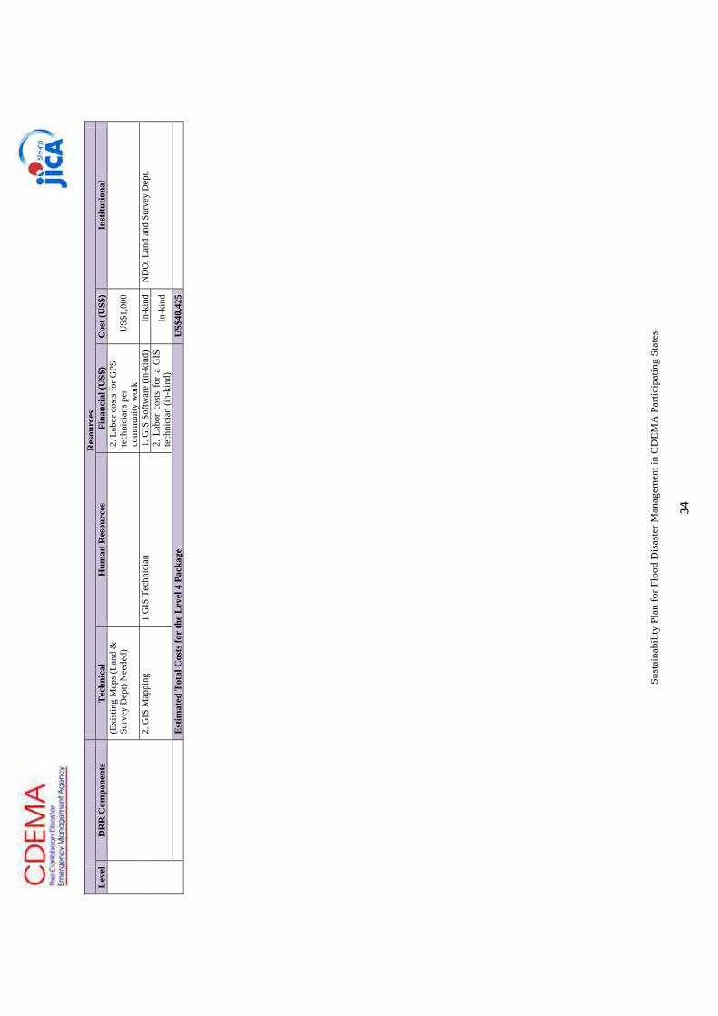
Sust
aina
bilit
y Pl
an fo
r Flo
od D
isas
ter M
anag
emen
t in
CD
EMA
Par
ticip
atin
g St
ates
34
R
esou
rces
Lev
elD
RR
Com
pone
nts
Tec
hnic
alH
uman
Res
ourc
esFi
nanc
ial (
US$
)C
ost (
US$
)In
stitu
tiona
l
(Exi
stin
g M
aps (
Land
&
Surv
ey D
ept)
Nee
ded)
2.
Lab
or c
osts
for G
PS
tech
nici
ans p
er
com
mun
ity w
ork
US$
1,00
0
2.
GIS
Map
ping
1
GIS
Tec
hnic
ian
1. G
IS S
oftw
are
(in-k
ind)
In-k
ind
ND
O, L
and
and
Surv
ey D
ept.
2. L
abor
cos
ts f
or a
GIS
te
chni
cian
(in-
kind
)In
-kin
d
E
stim
ated
Tot
al C
osts
for
the
Lev
el 4
Pac
kage
US$
40,4
25

Sust
aina
bilit
y Pl
an fo
r Flo
od D
isas
ter M
anag
emen
t in
CD
EMA
Par
ticip
atin
g St
ates
35
R
esou
rces
Lev
elD
RR
Com
pone
nts
Tec
hnic
alH
uman
Res
ourc
esFi
nanc
ial (
US$
)C
ost (
US$
)In
stitu
tiona
l
3
ND
O’s
ove
rall
resp
onsi
bilit
y 1.
Coo
rdin
atio
n of
st
akeh
olde
rs
1. N
DO
’s le
ader
ship
In
-kin
d (N
DO
and
oth
er N
T m
embe
rs)
In-k
ind
ND
O, T
elec
omm
unic
atio
n pr
ovid
ers,
H
ydro
-met
, Lan
d Su
rvey
Dep
t.,
com
mun
ity-b
ased
org
aniz
atio
ns a
nd
Civ
il So
ciet
y
2. T
o co
llect
and
kee
p th
e
FHM
to b
ecom
e th
e de
posit
ory
of th
e FH
M
In-k
ind
(ND
O)
In-k
ind
ND
O, c
omm
unity
-bas
ed
orga
niza
tions
and
Civ
il So
ciet
y
3. P
ublic
Aw
aren
ess f
or
Dis
aste
r Ris
k R
educ
tion
Prin
ting
Cos
ts fo
r pos
ters
, br
ochu
res,
etc
US$
725
ND
O
CB
DM
P
1. T
rain
ing
For
Com
mun
ity
Dis
aste
r R
espo
nse
Team
(C
DR
T)
Thre
e (3
) wel
l-tru
sted
com
mun
ity
resi
dent
s pe
r com
mun
ity to
be
faci
litat
ors,
who
are
cap
able
of
unde
rsta
ndin
g FE
WS
and
FHM
Cos
ts fo
r tra
inin
g C
DR
T U
S$1,
500
ND
O, c
omm
unity
-bas
ed
orga
niza
tions
and
Civ
il So
ciet
y
2. C
omm
unity
faci
litat
ing
A
vaila
bilit
y of
Nat
iona
l Tra
iner
s fo
r com
mun
ity fa
cilit
atin
gC
osts
for c
omm
unity
faci
litat
ing
US$
3,00
0N
DO
, com
mun
ity-b
ased
or
gani
zatio
ns a
nd C
ivil
Soci
ety
3.
Inte
grat
ing
FEW
S an
d FH
M in
CB
DM
P1.
Exi
sten
ce o
f res
iden
t com
mun
ity
orga
niza
tion
to:
ND
O, H
ydro
-Met
, Com
mun
ity-b
ased
O
rgan
izat
ion
and
Civ
il So
ciet
y
4. T
erra
in c
ondi
tion:
co
nduc
ive
terr
ain
for
com
mun
ity c
omm
unic
atio
n w
ithin
the
com
mun
ity
(1) E
stab
lish
CB
DM
P; a
nd
Cos
ts fo
r com
mun
ity w
orks
hop
to
inte
grat
e FE
WS
and
FHM
in
CB
DM
P U
S$40
0
(2) I
nteg
rate
FEW
S an
d FH
M in
to
the
exis
ting
CB
DM
PC
osts
for F
ull S
cale
eva
cuat
ion
exer
cise
U
S$1,
500
2.
Stro
ng c
omm
unity
lead
ersh
ipIn
-kin
d In
-kin
dC
omm
unity
-bas
ed o
rgan
izat
ions
Mod
-FEW
S 1.
Te
leco
mm
unic
atio
n or
C
able
co
mm
unic
atio
n eq
uipm
ent
1. A
cqui
sitio
n C
osts
for
Equi
pmen
t
ND
Os,
Hyd
ro-m
et a
nd c
omm
unity
-ba
sed
orga
niza
tions
, Civ
il So
ciet
y (a
nd T
elec
omm
unic
atio
n pr
ovid
ers)
fo
r war
ning
tele
com
mun
icat
ion
(1) I
n ca
se te
leco
mm
unic
atio
n is
av
aila
ble:
Tel
ecom
mun
icat
ion
Uni
ts &
Dev
ices
(Cel
lula
r Pho
nes
& S
IM c
onne
ctio
ns)
US$
800
(i) M
aint
enan
ce &
Use
r’s F
ees
(per
yea
r)
US$
2,40
0
O
R
(2) R
adio
Com
mun
icat
ion
Dev
ices
U
S$40
0
2 A
cqui
sitio
n &
inst
alla
tion
of A
utom
atic
gau
ge
A
hydr
olog
ist
to:
(1)
plan
lo
catio
n of
th
e ga
uges
(2)
mai
ntai
n th
e eq
uipm
ent
(3) A
naly
ze h
ydro
logi
cal d
ata
1.
Acq
uisi
tion
Cos
ts
for
Aut
omat
ic g
auge
ND
O, C
IMH
and
Hyd
ro-M
et
-W
ater
Lev
el $
US$
400
-R
ainf
all
$U
S$40
0
2. In
stal
latio
n co
sts f
or A
utom
atic
ga
uge
US$
6,00
0
3.
Labo
r co
sts
to
sour
ce
a hy
drol
ogis
t (in
-kin
d)In
-kin
d

Sust
aina
bilit
y Pl
an fo
r Flo
od D
isas
ter M
anag
emen
t in
CD
EMA
Par
ticip
atin
g St
ates
36
R
esou
rces
Lev
elD
RR
Com
pone
nts
Tec
hnic
alH
uman
Res
ourc
esFi
nanc
ial (
US$
)C
ost (
US$
)In
stitu
tiona
l
3. O
pera
tion
of F
EWS
(1) M
echa
nica
l mai
nten
ance
of
wat
er-le
vel g
auge
s and
rain
fall
gaug
es
Mec
hani
cal m
aint
enan
ce o
f w
ater
-leve
l gau
ges a
nd ra
infa
ll ga
uges
per
yea
rU
S$60
0N
DO
and
Hyd
ro-M
et
(4)
Mon
itorin
g an
d op
erat
iona
l pe
rson
nel o
n si
te
Four
(4) u
nits
of
Pers
onne
l on
site
on 2
4/7
basi
s per
yea
r (7
mon
ths a
yea
r)
OR
2.
Equ
ival
ent A
llow
ance
or
Gra
tuity
for r
esid
ents
(per
yea
r)
OR
3.
In-k
ind
coop
erat
ion
of th
e re
side
nts
US$
28,0
00
ND
O a
nd H
ydro
-Met
(Com
mun
ity-
base
d O
rgan
izat
ion
and
Civ
il So
ciet
y,
if av
aila
ble)
Mod
-FH
M
(GPS
/GIS
)1.
Bas
elin
e In
cide
ntal
M
appi
ng4-
5 G
PS T
echn
icia
ns in
a c
ount
ry
1. 4
-5 S
ets o
f GPS
dev
ices
and
a
com
pute
r in
a co
untry
US$
3,50
0N
DO
, Lan
d, S
urve
y D
ept.,
C
omm
unity
Org
aniz
atio
ns a
nd C
ivil
Soci
ety
(Exi
stin
g M
aps (
Land
&
Surv
ey D
ept)
Nee
ded)
2. L
abor
cos
ts fo
r GPS
te
chni
cian
s per
com
mun
ity w
ork
US$
1,00
0
2.
GIS
Map
ping
1
GIS
Tec
hnic
ian
1. G
IS S
oftw
are
(in-k
ind)
In-k
ind
ND
O, L
and
and
Surv
ey D
ept.
2.
Labo
r co
sts
for
a G
IS
tech
nici
an (i
n-ki
nd)
In-k
ind
E
stim
ated
Tot
al C
osts
for
the
Lev
el 3
Pac
kage
US$
50,6
25
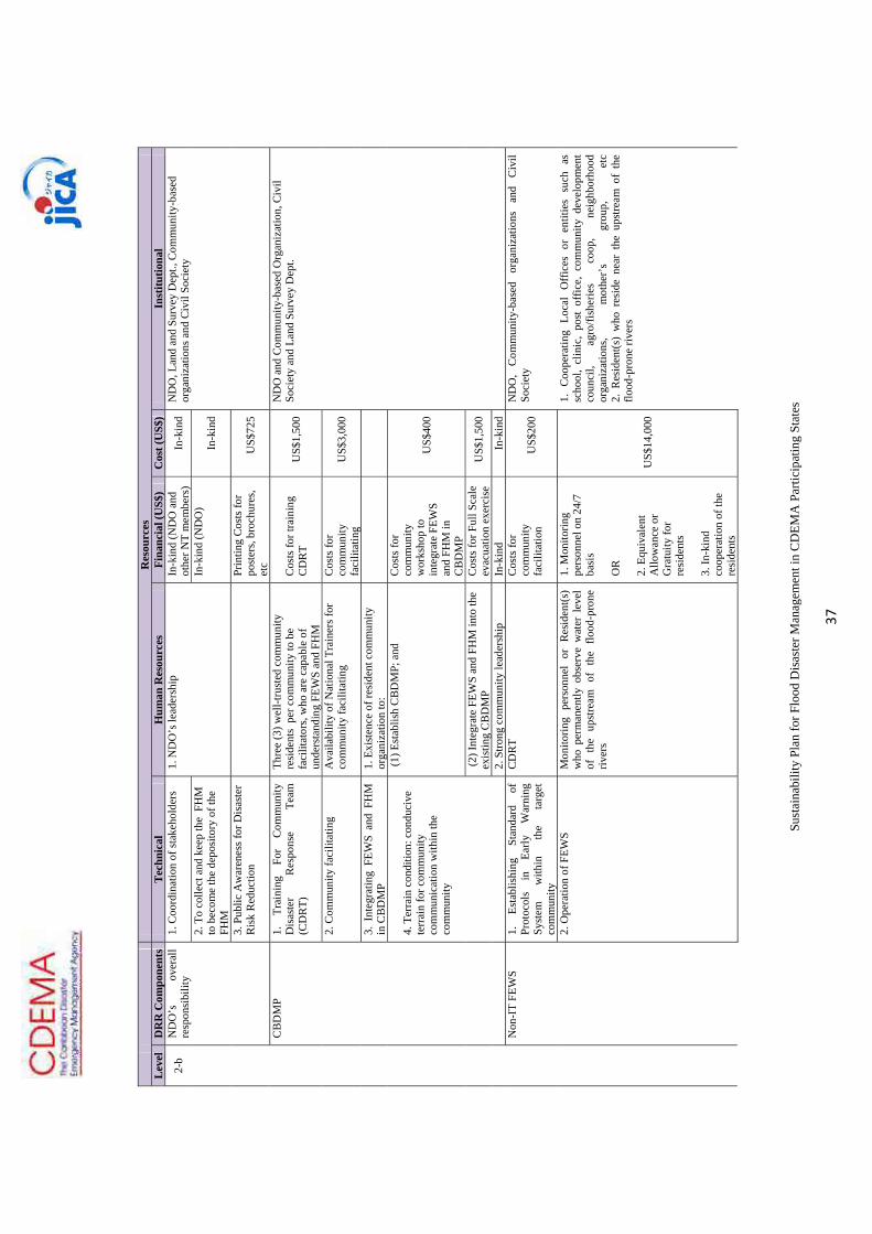
Sust
aina
bilit
y Pl
an fo
r Flo
od D
isas
ter M
anag
emen
t in
CD
EMA
Par
ticip
atin
g St
ates
37
R
esou
rces
L
evel
DR
R C
ompo
nent
s T
echn
ical
Hum
an R
esou
rces
Fina
ncia
l (U
S$)
Cos
t (U
S$)
Inst
itutio
nal
2-b
ND
O’s
ov
eral
l re
spon
sibi
lity
1. C
oord
inat
ion
of st
akeh
olde
rs
1. N
DO
’s le
ader
ship
In
-kin
d (N
DO
and
ot
her N
T m
embe
rs)
In-k
ind
ND
O, L
and
and
Surv
ey D
ept.,
Com
mun
ity-b
ased
or
gani
zatio
ns a
nd C
ivil
Soci
ety
2. T
o co
llect
and
kee
p th
e F
HM
to
bec
ome
the
depo
sito
ry o
f the
FH
M
In-k
ind
(ND
O)
In-k
ind
3. P
ublic
Aw
aren
ess f
or D
isas
ter
Ris
k R
educ
tion
Prin
ting
Cos
ts fo
r po
ster
s, br
ochu
res,
etc
US$
725
CB
DM
P 1.
Tr
aini
ng
For
Com
mun
ity
Dis
aste
r R
espo
nse
Team
(C
DR
T)
Thre
e (3
) wel
l-tru
sted
com
mun
ity
resi
dent
s pe
r com
mun
ity to
be
faci
litat
ors,
who
are
cap
able
of
unde
rsta
ndin
g FE
WS
and
FHM
Cos
ts fo
r tra
inin
g C
DR
T U
S$1,
500
ND
O a
nd C
omm
unity
-bas
ed O
rgan
izat
ion,
Civ
il So
ciet
y an
d La
nd S
urve
y D
ept.
2. C
omm
unity
faci
litat
ing
A
vaila
bilit
y of
Nat
iona
l Tra
iner
s for
co
mm
unity
faci
litat
ing
Cos
ts fo
r co
mm
unity
fa
cilit
atin
g U
S$3,
000
3. I
nteg
ratin
g FE
WS
and
FHM
in
CB
DM
P 1.
Exi
sten
ce o
f res
iden
t com
mun
ity
orga
niza
tion
to:
4. T
erra
in c
ondi
tion:
con
duci
ve
terr
ain
for c
omm
unity
co
mm
unic
atio
n w
ithin
the
com
mun
ity
(1) E
stab
lish
CB
DM
P; a
nd
Cos
ts fo
r co
mm
unity
w
orks
hop
to
inte
grat
e FE
WS
and
FHM
in
CB
DM
P
US$
400
(2) I
nteg
rate
FEW
S an
d FH
M in
to th
e ex
istin
g C
BD
MP
Cos
ts fo
r Ful
l Sca
le
evac
uatio
n ex
erci
seU
S$1,
500
2.
Stro
ng c
omm
unity
lead
ersh
ipIn
-kin
d In
-kin
d
Non
-IT
FEW
S 1.
Es
tabl
ishi
ng
Stan
dard
of
Pr
otoc
ols
in
Early
W
arni
ng
Syst
em
with
in
the
targ
et
com
mun
ity
CD
RT
Cos
ts fo
r co
mm
unity
fa
cilit
atio
n U
S$20
0
ND
O,
Com
mun
ity-b
ased
or
gani
zatio
ns
and
Civ
il So
ciet
y
2.
Ope
ratio
n of
FEW
S M
onito
ring
pers
onne
l or
Res
iden
t(s)
who
per
man
ently
obs
erve
wat
er l
evel
of
the
ups
tream
of
the
flood
-pro
ne
river
s
1. M
onito
ring
pers
onne
l on
24/7
ba
sis
OR
2.
Equ
ival
ent
Allo
wan
ce o
r G
ratu
ity fo
r re
side
nts
3. In
-kin
d co
oper
atio
n of
the
resi
dent
s
US$
14,0
00
1. C
oope
ratin
g Lo
cal
Offi
ces
or e
ntiti
es s
uch
as
scho
ol,
clin
ic,
post
off
ice,
com
mun
ity d
evel
opm
ent
coun
cil,
agro
/fish
erie
s co
op,
neig
hbor
hood
or
gani
zatio
ns,
mot
her’
s gr
oup,
et
c2.
Res
iden
t(s)
who
res
ide
near
the
ups
tream
of
the
flood
-pro
ne ri
vers

Sust
aina
bilit
y Pl
an fo
r Flo
od D
isas
ter M
anag
emen
t in
CD
EMA
Par
ticip
atin
g St
ates
38
R
esou
rces
L
evel
DR
R C
ompo
nent
s T
echn
ical
Hum
an R
esou
rces
Fina
ncia
l (U
S$)
Cos
t (U
S$)
Inst
itutio
nal
3.
Te
rrai
n co
nditi
on
mus
t be
co
nsid
ered
: con
duci
ve te
rrai
n fo
r co
mm
unity
co
mm
unic
atio
n w
ithin
the
com
mun
ity
Mod
-FH
M
(GPS
/GIS
) 1.
Bas
elin
e In
cide
ntal
Map
ping
4-
5 G
PS T
echn
icia
ns in
a c
ount
ry
1. 4
-5 S
ets o
f GPS
de
vice
s and
a
com
pute
r in
a co
untry
US$
3,50
0
ND
O, L
and,
Sur
vey
Dep
t., C
omm
unity
Org
aniz
atio
ns
and
Civ
il So
ciet
y
(Exi
stin
g M
aps (
Land
& S
urve
y D
ept)
Nee
ded)
2.
Lab
or c
osts
for
GPS
tech
nici
ans
per c
omm
unity
w
ork
US$
1,00
0
2. G
IS M
appi
ng
1 G
IS T
echn
icia
n 1.
G
IS
Softw
are
(in-k
ind)
In
-kin
dN
DO
, Lan
d an
d Su
rvey
Dep
t.
2. L
abor
cos
ts f
or a
G
IS t
echn
icia
n (in
-ki
nd)
In-k
ind
E
stim
ated
Tot
al C
osts
for
the
Lev
el 2
-b P
acka
geU
S$25
,825

Sust
aina
bilit
y Pl
an fo
r Flo
od D
isas
ter M
anag
emen
t in
CD
EMA
Par
ticip
atin
g St
ates
39
R
esou
rces
L
evel
DR
R C
ompo
nent
s T
echn
ical
Hum
an R
esou
rces
Fina
ncia
l (U
S$)
Cos
t (U
S$)
Inst
itutio
nal
2-a
ND
O’s
ov
eral
l re
spon
sibi
lity
1. C
oord
inat
ion
of
stak
ehol
ders
1.
ND
O’s
lead
ersh
ip
In-k
ind
(ND
O a
nd o
ther
NT
mem
bers
) In
-kin
dN
DO
, Com
mun
ity-b
ased
org
aniz
atio
ns
and
Civ
il So
ciet
y
2. T
o co
llect
and
kee
p th
e
FHM
to b
ecom
e th
e de
posit
ory
of th
e FH
M
In-k
ind
(ND
O)
In-k
ind
3. P
ublic
Aw
aren
ess f
or
Dis
aste
r Ris
k R
educ
tion
Prin
ting
Cos
ts fo
r pos
ters
, br
ochu
res,
etc
US$
725
CB
DM
P 1.
Tra
inin
g Fo
r Com
mun
ity
Dis
aste
r R
espo
nse
Team
(C
DR
T)
Thre
e (3
) wel
l-tru
sted
com
mun
ity
resi
dent
s pe
r com
mun
ity to
be
faci
litat
ors,
who
are
cap
able
of
unde
rsta
ndin
g FE
WS
and
FHM
Cos
ts fo
r tra
inin
g C
DR
T U
S$1,
500
ND
O a
nd C
omm
unity
-bas
ed
Org
aniz
atio
n, C
ivil
Soci
ety
and
Land
Su
rvey
Dep
t.
2. C
omm
unity
faci
litat
ing
A
vaila
bilit
y of
Nat
iona
l Tra
iner
s for
co
mm
unity
faci
litat
ing
Cos
ts fo
r com
mun
ity fa
cilit
atin
g U
S$3,
000
3. I
nteg
ratin
g FE
WS
and
FHM
in C
BD
MP
1. E
xist
ence
of r
esid
ent c
omm
unity
or
gani
zatio
n to
:
(1) E
stab
lish
CB
DM
P; a
nd
Cos
ts fo
r com
mun
ity w
orks
hop
to
inte
grat
e FE
WS
and
FHM
in
CB
DM
PU
S$40
0
(2) I
nteg
rate
FEW
S an
d FH
M in
to th
e ex
istin
g C
BD
MP
Cos
ts fo
r Ful
l Sca
le e
vacu
atio
n ex
erci
seU
S$1,
500
4. T
erra
in c
ondi
tion:
co
nduc
ive
terr
ain
for
com
mun
ity c
omm
unic
atio
n w
ithin
the
com
mun
ity
2. S
trong
com
mun
ity le
ader
ship
In-k
ind
In-k
ind
Mod
-FEW
S 1.
Te
leco
mm
unic
atio
n or
C
able
co
mm
unic
atio
n eq
uipm
ent
1. A
cqui
sitio
n C
osts
for E
quip
men
t
N
DO
s, H
ydro
-met
and
com
mun
ity-b
ased
or
gani
zatio
ns, C
ivil
Soci
ety
(and
Te
leco
mm
unic
atio
n pr
ovid
ers)
for
war
ning
tele
com
mun
icat
ion
(1) I
n ca
se te
leco
mm
unic
atio
n is
av
aila
ble:
Tel
ecom
mun
icat
ion
Uni
ts
& D
evic
es (C
ellu
lar P
hone
s & S
IM
conn
ectio
ns)
US$
800
(i) M
aint
enan
ce &
Use
r’s F
ees (
per
year
)U
S$2,
400
O
R
(2
) Rad
io C
omm
unic
atio
n D
evic
esU
S$40
0
2 A
cqui
sitio
n &
in
stal
latio
n of
A
utom
atic
ga
uge
A
hydr
olog
ist
to:
(1)
plan
lo
catio
n of
th
e ga
uges
(2)
mai
ntai
n th
e eq
uipm
ent
(3) A
naly
ze h
ydro
logi
cal d
ata
1. A
cqui
sitio
n C
osts
for
Aut
omat
ic
gaug
e
ND
O, C
IMH
and
Hyd
ro-M
et
-W
ater
Lev
el
US$
400
-R
ainf
all
US$
400
2. In
stal
latio
n co
sts f
or A
utom
atic
ga
uge
US$
6,00
0
3.
Labo
r co
sts
to
sour
ce
a hy
drol
ogis
t (in
-kin
d)In
-kin
d

Sust
aina
bilit
y Pl
an fo
r Flo
od D
isas
ter M
anag
emen
t in
CD
EMA
Par
ticip
atin
g St
ates
40
R
esou
rces
L
evel
DR
R C
ompo
nent
s T
echn
ical
Hum
an R
esou
rces
Fina
ncia
l (U
S$)
Cos
t (U
S$)
Inst
itutio
nal
3. O
pera
tion
of F
EWS
(1) M
echa
nica
l mai
nten
ance
of w
ater
-le
vel g
auge
s and
rain
fall
gaug
es
Mec
hani
cal m
aint
enan
ce o
f wat
er-
leve
l gau
ges a
nd ra
infa
ll ga
uges
per
ye
arU
S$60
0N
DO
and
Hyd
ro-M
et
(2)
Mon
itorin
g an
d op
erat
iona
l pe
rson
nel o
n si
te
1. F
our (
4) u
nits
of
Pers
onne
l on
site
on
24/7
bas
is p
er y
ear (
7 m
onth
s a y
ear)
O
R
2. E
quiv
alen
t Allo
wan
ce o
r Gra
tuity
fo
r res
iden
ts (p
er y
ear)
O
R
3. In
-kin
d co
oper
atio
n of
the
resi
dent
s
US$
28,0
00
ND
O a
nd H
ydro
-Met
(Com
mun
ity-b
ased
O
rgan
izat
ion
and
Civ
il So
ciet
y, if
av
aila
ble)
Non
-IT
FHM
In
clud
ed in
CB
DM
PSe
e C
BD
MP
See
CB
DM
P U
S$0
See
CB
DM
P
Est
imat
ed T
otal
Cos
ts fo
r th
e L
evel
2-a
Pac
kage
US$
46,1
25

Sust
aina
bilit
y Pl
an fo
r Flo
od D
isas
ter M
anag
emen
t in
CD
EMA
Par
ticip
atin
g St
ates
41
R
esou
rces
L
evel
DR
R C
ompo
nent
s T
echn
ical
Hum
an R
esou
rces
Fina
ncia
l (U
S$)
Cos
t (U
S$)
Inst
itutio
nal
1 N
DO
’s
over
all
resp
onsi
bilit
y 1.
Coo
rdin
atio
n of
stak
ehol
ders
1.
ND
O’s
lead
ersh
ip
In-k
ind
(ND
O a
nd o
ther
N
T m
embe
rs)
In-k
ind
ND
O, L
and
and
Surv
ey D
ept.,
Com
mun
ity-
base
d or
gani
zatio
ns a
nd C
ivil
Soci
ety
2. T
o co
llect
and
kee
p th
e F
HM
to
bec
ome
the
depo
sito
ry o
f the
FH
M
In-k
ind
(ND
O)
In-k
ind
3. P
ublic
Aw
aren
ess f
or D
isas
ter
Ris
k R
educ
tion
Prin
ting
Cos
ts fo
r po
ster
s, br
ochu
res,
etc
US$
725
CB
DM
P 1.
Tr
aini
ng
For
Com
mun
ity
Dis
aste
r R
espo
nse
Team
(C
DR
T)
Thre
e (3
) wel
l-tru
sted
com
mun
ity
resi
dent
s pe
r com
mun
ity to
be
faci
litat
ors,
who
are
cap
able
of
unde
rsta
ndin
g FE
WS
and
FHM
Cos
ts fo
r tra
inin
g C
DR
TU
S$1,
500
ND
O a
nd C
omm
unity
-bas
ed O
rgan
izat
ion,
C
ivil
Soci
ety
and
Land
Sur
vey
Dep
t.
2. C
omm
unity
faci
litat
ing
A
vaila
bilit
y of
Nat
iona
l Tra
iner
s for
co
mm
unity
faci
litat
ing
Cos
ts fo
r com
mun
ity
faci
litat
ing
US$
3,00
0
3. In
tegr
atin
g FE
WS
and
FHM
in
CB
DM
P 1.
Exi
sten
ce o
f res
iden
t com
mun
ity
orga
niza
tion
to:
(1) E
stab
lish
CB
DM
P; a
nd
Cos
ts fo
r com
mun
ity
wor
ksho
p to
inte
grat
e FE
WS
and
FHM
in
CB
DM
P
US$
400
(2) I
nteg
rate
FEW
S an
d FH
M in
to th
e ex
istin
g C
BD
MP
Cos
ts fo
r Ful
l Sca
le
evac
uatio
n ex
erci
seU
S$1,
500
4. T
erra
in c
ondi
tion:
con
duci
ve
terr
ain
for c
omm
unity
co
mm
unic
atio
n w
ithin
the
com
mun
ity
2. S
trong
com
mun
ity le
ader
ship
In-k
ind
In-k
ind
Non
-IT
FEW
S 1.
Es
tabl
ishi
ng
Stan
dard
of
Pr
otoc
ols
in
Early
W
arni
ng
Syst
em
with
in
the
targ
et
com
mun
ity
CD
RT
Cos
ts fo
r com
mun
ity
faci
litat
ion
US$
200
ND
O,
Com
mun
ity-b
ased
or
gani
zatio
ns
and
Civ
il So
ciet
y
2.
O
pera
tion
of
FEW
S3.
Te
rrai
n co
nditi
on
mus
t be
co
nsid
ered
: con
duci
ve te
rrai
n fo
r co
mm
unity
co
mm
unic
atio
n w
ithin
the
com
mun
ity
Mon
itorin
g pe
rson
nel
or
Res
iden
t(s)
who
per
man
ently
obs
erve
wat
er l
evel
of
th
e up
stre
am
of
the
flood
-pro
ne
river
s
1. M
onito
ring
pers
onne
l on
24/
7 ba
sis (
per y
ear)
O
R
2. E
quiv
alen
t Allo
wan
ce
or G
ratu
ity fo
r res
iden
ts
(per
yea
r)
3. In
-kin
d co
oper
atio
n of
the
resi
dent
s
US$
14,0
00
1. C
oope
ratin
g Lo
cal O
ffic
es o
r ent
ities
suc
h as
sc
hool
, cl
inic
, po
st
offic
e,
com
mun
ity
deve
lopm
ent
coun
cil,
agro
/fish
erie
s co
op,
neig
hbor
hood
or
gani
zatio
ns,
mot
her’
s gr
oup,
et
c 2.
Res
iden
t(s)
who
res
ide
near
the
upst
ream
of
the
flood
-pro
ne ri
vers
Non
-IT
FHM
In
clud
ed in
CB
DM
PSe
e C
BD
MP
See
CB
DM
PU
S$0
See
CB
DM
P
Est
imat
ed T
otal
Cos
ts fo
r th
e L
evel
1 P
acka
geU
S$21
,325


Attachment 3: MOU


DRAFT MEMORANDUM OF UNDERSTANDING
AMONG
NATIONAL TEAM OF BELIZE
ON
INSTITUTIONALIZATION OF NATIONAL TEAM
OF
CARIBBEAN DISASTER MANAGEMENT PROJECT PHASE 2
CDEMA (the Caribbean Disaster Emergency Management Agency) implemented the Caribbean
Disaster Management Project Phase 2 from January 2009 to June 2012, with the contribution of the
regional team comprised of CDEMA, Caribbean Institute for Meteorology and Hydrology, the
University of the West Indies, and the University of Guyana. During the project term, the 3 outputs
of community-based disaster management planning, establishing flood early warning system, and
the flood hazard mapping were developed.
This Memorandum of Understanding (hereinafter referred to as MOU) is to define tasks and
responsibilities of each organization in Caribbean Disaster Management Project Phase 2 (hereinafter
referred to as CADM2) in order to sustain the established Flood Early Warning System (hereinafter
referred to as FEWS) and Community Disaster Management Plan (hereinafter referred to as CDMP),
and to maintain the developed Flood Hazard Map (hereinafter referred to as FHM) for the Crooked
Tree Community and Hydrological Database.
This MOU also aims to apply the CADM2 initiative to other flood vulnerable areas in Belize in the
future.
National Team (hereinafter referred to as NT) and Japan International Cooperation Agency
(hereinafter referred to as JICA) have agreed with the matters referred to in the documents attached
hereto.
DATE: June xx, 2012
PLACE: Belmopan, Belize

Witness For
Japan International Cooperation Agency National Emergency Management Organization,
Belize
Cosigners:
Rep. of National Meteorological Service (Met Service)
Rep. of Land Information Center (LIC)
Rep. of National Association of Village Council (NAVCO)
Rep. of the Crooked Tree Community
Rep. of Belize Red Cross Society (BRC)
Rep. of Caribbean Institute for Meteorology and Hydrology (CIMH)
Rep. of Belize Telemedia Limited (DIGICELL)
Attached Documents
1. Attachment
2. Progress Monitoring Matrix of Coverage of Flood Disaster Management

Attachment
Overall Responsibilities of National Emergency Management Organization
National Emergency Management Organization (hereinafter referred to as NEMO) has played a
leading role in the CADM2 by coordinating with the stakeholders, especially, National
Meteorological Service (hereinafter referred to as Met Service), Land Information Center
(hereinafter referred to as LIC), National Association of Village Council (hereinafter referred to as
NAVCO), the Crooked Tree Community, Belize Red Cross Society (hereinafter referred to as BRC)
and Belize Telemedia Limited (hereinafter referred to as DIGICELL). Upon sustaining the system
which has been built during the CADM2 Project, NEMO will be responsible for coordinating with
the stakeholders related to maintaining and expanding of the system. NEMO will consider holding
periodical and emergency NT meeting. If necessary, the NEMO will positively consider adding a
new organization or an entity to the system. NEMO will take the leading role in securing necessary
budget arrangement for maintaining the established system and expanding of the system to other
areas in Belize.
Community Disaster Management Plan (CDMP) (1) Maintenance of the established Corinth Community Disaster Management System
NEMO, BRC, the Crooked Tree Community, Met Service, LIC, NAVCO and DIGICELL have
agreed to maintain CDMP as well as FEWS and FHM and in case of necessity, they will refer to
CADM2 Community Disaster Management Planning Manual. That is, NEMO will take charge of
maintenance and renewal of FEWS, and LIC will take charge of maintenance and renewal of FHM.
In order to sustain CDMP at the Crooked Tree Community, NEMO will consult with BRC and the
Crooked Tree Community about practical methods such as periodical drill, joint meeting and civic
education. NEMO will take the lead in securing necessary budget for sustaining these activities.
(2) Application of CADM2 CDMP to other Communities
NEMO, NAVCO and BRC will collaborate in implementation of CDMP to other communities as
indicated in the attached “Progress Monitoring Matrix of Coverage of Flood Disaster Management”.
In this joint operation, CADM2 Community Disaster Management Planning Manual shall be
followed. After going through discussion with NEMO, Met Service will take charge of FEWS, and
LIC will take charge of FHM.
In case mobilization of outside facilitator is necessary to carry out whole CDMP program, NEMO
and BRC will discuss and formulate budget arrangement.
Flood Early Warning System (FEWS)

(1) Maintenance and improvement of existing FEWS Established FEWS by CADM2 is a pilot system that is to be maintained and improved by the
NEMO, NAVCO, Met Service, the Crooked Tree Community, BRC and DIGICELL. Met Service
will frequently check the conditions of the monitoring stations and periodically download the hydrological data from the stations. Met Service will maintain general upkeep of the monitoring stations. If any repair or replacement is required, Met Service will notify NEMO immediately and identify cost effective solutions. The correlation analysis among the stations should include the use of graphics so that relatively easy comparison can be made. The correlation analysis should be made every year after the rainfall season or just after flood event. The information determined from the analysis should be used to update the flood early warning system. Met Service will conduct the correlation analysis either every year or after major flood events. If the problem is related to the communication setup at the stations, NEMO will invite DIGICELL, the service provider for consultation and a solution. DIGICELL will consider providing a special privileged package for CADM2 stations to facilitate transmission of alerts. NEMO and concerned stakeholders are urged to investigate a sustainable mechanism for payment of charges related to use of the transmission facility. The water depth warning levels usually consist of 3 levels. In many cases, they are the caution level, warning level and the evacuation level. The decision of revising warning levels will be done by NEMO, Met Service and the Crooked Tree Community. If necessary, NEMO will invite Caribbean Institute for Meteorology and Hydrology (hereinafter referred to as CIMH) to participate in the process. NEMO will be responsible to coordinate with all the stakeholders in keeping CADM2 FEWS operational and in securing necessary budget arrangement. (2) Development of new FEWS at other communities While NEMO will take the lead role in the operations, NEMO, Met Service, DIGICELL and BRC
will make united efforts in selecting new target community.
NEMO will be responsible in securing necessary budget arrangement. (3) Collection of Necessary Data and Material about new target community Met Service will be responsible for collecting hydrological data such as rainfall data and water-level
data.
LIC will collect or provide geological data of the river basin and DEM data as much as possible. LIC
will provide NEMO and BRC of the collected data.

(4) Methodology of Estimate of Flood Information for new community The correlation analysis should be made every year after the rainfall season or just after the one flooding event. Then the early flood warning system will be updated. Met Service will conduct correlations analysis. NEMO will consider inviting CIMH to participate in the process if
necessary.
(5)Establishing Hydrological Observation Network for New Communities NEMO will invite all stakeholders including BRC and the representative from the new community and hold meetings in order to establish hydrological observation network. Met Service will install rainfall and water-level gauges in the new river basin. NEMO will consider inviting CIMH to participate in the process if necessary.
(6) Specifications of Rainfall Gauge for new community Met Service will study specifications of rainfall gauge and decide it. NEMO will consider inviting CIMH to participate in the process if necessary. (7)Specifications of Water-level Gauge for new community Met Service will study specifications of rainfall gauge and decide it. NEMO will consider inviting CIMH to participate in the process if necessary. (8) Selection of Locations of Hydrological Gauges Installation for new communities Met Service in consultation with CIMH will conduct hydrological analysis and decide the locations
of installation of hydrological gauges for the network. NEMO will inform of the locations to BRC
and the community.
(9) Decision of Warning Levels for New Communities Met Service will analyze and decide warning levels. NEMO will consider inviting CIMH to
participate in the process if necessary. NEMO will share the established warning levels with BRC
and the community.
(10) Operation and Maintenance of Gauges for New Communities Met Service will be responsible for periodical inspection, download the record, exchange the battery and other spare parts of the gauge and analysis of the downloaded records, and necessary cost expenditure. NEMO will monitor the operation and maintenance works. NEMO will consider getting close cooperation from the community for appropriate operation and maintenance of the gauges.

(11) Procedural Part
Met Service will conduct the hydrological analysis jointly with technical assistance of CIMH.
(12) Preparatory Stage
NEMO will hold community hearings to share the needs of the community and planned FEWS.
NEMO will invite BRC to the hearings. NEMO will coordinate to establish an optimum FEWS for
the community.
(13) Flow of Information
Met Service will estimate the flood water-level at the community and the flood arrival time to the
community. NEMO will invite CIMH to participate in the process if necessary.
NEMO will invite all stakeholders to discuss and establish information flow framework based on
CADM2 manuals.
Flood Hazard Map (FHM) (1) Selection of Target Community
NEMO will take the initiative in coordinating Met Service, LIC, the Crooked Tree Community and
BRC in selection of new target communities which suffer from habitual floods. BRC will collaborate
with NEMO in selecting new target communities.
NEMO in collaboration with BRC has created the attached “Progress Monitoring Matrix of
Coverage of Flood Disaster Management” that indicates future target communities.
NEMO noted that this is an important database in conducting flood risk reduction management
service. NEMO will review, revise and maintain this matrix in collaboration with all concerned
stakeholders from now on.
(2) Maintenance and improvement of developed FHM for Bathe Estate Community
NEMO will take the lead in maintenance and improvement of developed FEWS.
When it will become necessary to improve the existing FHM, NEMO, Met Service, LIC and the
Crooked Tree Community will discuss procedure including the scope of work each party will
undertake and timeframe for completion of each action. CIMH will consider taking part in the
process when invited by NEMO. NEMO will monitor the whole progress.
NEMO will be responsible in securing necessary budget arrangement.

(3) Development of new FHM
NEMO will convene a task force meeting. The task force meeting will consist of NEMO, Met
Service, LIC, BRC and the Crooked Tree Community. NEMO will invite CIMH to participate in the
meeting if its contribution deemed important.
The task force will decide the kind of FHM, namely FHM through hydrological analysis, FHM of
incidental map through field investigation or hand-drawn FHM through finding the capacity by
holding community meeting.
In CADM2, FHMs were prepared partly through hydrological analysis and partly through field
investigation depending on the availability of necessary map resolution. These are prepared with the
support of CIMH. In consideration of the present situation regarding the availability of maps, human
resources and financial resources of CDEMA Participating States, incidental maps or hand-drawn
maps developed through community meetings are viewed as appropriate. NEMO will be
responsible in securing necessary budget arrangement.
(4) Field investigation for new FHM
Field investigation needs to be conducted in order to develop new FHM. The goals are to collect the
data on the locations and the inundation depths at locations in inundated area in the past target flood.
This may include the need for surveyed river cross-sections. A GPS will be required to accurately
collect geospatial information. Met Service and LIC will provide the GPS equipment. In case of
using hand-drawn map, BRC will take the lead and share the result with NEMO.
(5) Mapping of field investigation results
Mapping of field investigation results needs GIS technology for preparation of FHM. LIC will plot
field investigation results on a map using a GIS approach.
Hydrological Database Met Service will conduct data download periodically from the existing hydrological stations at
Isabella Bank (water level gauge), Big Falls (water level gauge), Banana Banks (water level gauge)
and Sta. Familia (water level and rain gauge). Data will be shared with CIMH. CIMH will monitor
the frequency of data download by Met Service.

Country: BelizeTasks & Duties related to CADM2 Agencies related to CADM2Number of staff for CADM2 5 4 2 1 3N
EM
O
Met S
evice
LIC
NA
VC
O
Crooked Tree C
omm
unit
Red C
orss
CIM
H
DIG
ICE
LL
1. Overall Responsiblities1.1 Leading role in NT ○1.2 Coordination of stakeholders(maintenance) ○1.3 Coordination of stakeholders(new community) ○1.4 Addition of new stakeholder ○1.5 Arrange necessary budget measures ○
2. Community Disaster Management Plan (CDMP)2.1 Maintenance of establsihed Balthazar system ○ ○ ○ ○ ○ ○2.2 Arrange necessary budget for maintenance ○2.3 Application of CADM2 CDMP to other community ○ ○ ○ ○ ○ ○2.4 Arrange necessary general budget for new application ○ ○2.5 Arrange necessary budget for facilitator ○ ○
3. Flood Early Warning System (FEWS)3.1 Maintenance of existing FEWS ○ ○ ○ ○ ○ ○3.2 Improvement of existing FEWS ○ ○ ○ ○ ○ ○3.3 General upkeep of mintoring stations ○ ○3.4 Correlation analysis ○ ○ ○ ○3.5 Telecommuniation setup(existing) ○ ○ ○ ○3.6 Coordination of stakeholders ○3.7 Arrange necessary budget for maintenance/improvement ○ ○3.8 Selection of new target community ○ ○ ○3.9 Development of FEWS for new communities ○ ○ ○ ○3.10 Collection of hydrological data for new communities ○ ○ ○3.11 Collection of geological data for new communities ○ ○ ○3.12 Correlation analysis for new communities ○ ○ ○3.13 Planning of FEWS for new commnities ○ ○ ○ ○ ○ ○ ○3.14 Decision of specification of hydrological gauges ○ ○ ○3.15 Selection of iinstallation sites of hydrological gauges ○ ○ ○ ○3.16 Installation of hydrological gauges for new communities ○ ○ ○ ○ ○3.17 Operation & maintenance of new monitoring stations ○ ○3.18 Operation & maintenance budget ○ ○ ○3.19 Monitoring of operation & manitenance works ○3.20 Arrangement of general budget for FEWS ○
4. Flood Hazard Map (FHM)4.1 Manintenance & improvement of developed FHM ○ ○ ○ ○ ○4.2 Selection of new target community ○ ○ ○ ○4.3 Planning of FHM for new community ○ ○ ○ ○ ○ ○4.4 Field investigation ○ ○ ○4.5 Preparation of hand drawn map ○ ○4.6 Mapping of field investigation result ○ ○4.7 Arrangement of necessary budget ○
5. Hydrological Database (HD)5.1 General upkeep of existing monitoring stations ○ ○ ○5.2 Data download ○ ○5.3 Data sharing ○ ○5.4 Monitoring of dawnload works ○5.5 Financial arrangement of data base system ○

Pro
gres
s M
onito
ring
Mat
rix o
f Cov
erag
e of
Flo
od D
isas
ter M
anag
emen
t (D
raft)
C
ount
ry: B
eliz
e
Ris
k Le
vel
Floo
d vu
lner
able
co
mm
uniti
es/P
roje
ct (T
erm
) Ta
rget
Yea
r C
BD
MP
FH
M
FEW
S C
ompl
eted
in
Sta
tus
Par
tner
S
tatu
s P
artn
er
Sta
tus
Par
tner
1
A (2
012-
2015
)
Cro
oked
Tre
e 20
11
Com
plet
ed
JIC
A C
ompl
eted
JI
CA
Com
plet
ed
JIC
A 20
12
2 Is
abel
la B
anks
(2
015)
C
ompl
eted
B
eliz
e R
ed C
ross
TB
D
TBD
TB
D
TBD
3 R
anch
o D
olor
es
(201
5)
Com
plet
ed
Bel
ize
Red
Cro
ss
TBD
TB
D
TBD
TB
D
4
Flow
ers
Ban
k (2
015)
C
ompl
eted
B
eliz
e R
ed C
ross
TB
D
TBD
TB
D
TBD
5 Le
mon
al
(201
5)
Com
plet
ed
Bel
ize
Red
Cro
ss
TBD
TB
D
TBD
TB
D
6
Map
en
(201
5)
Com
plet
ed
Bel
ize
Red
Cro
ss
TBD
TB
D
TBD
TB
D
7
Sco
tland
Hal
f Moo
n (2
015)
C
ompl
eted
B
eliz
e R
ed C
ross
TB
D
TBD
TB
D
TBD
8 (T
BN
) TB
D
TBD
TB
D
TBD
TB
D
TBD
TB
D
9
(TB
N)
TBD
TB
D
TBD
TB
D
TBD
TB
D
TBD
10
(TB
N)
TBD
TB
D
TBD
TB
D
TBD
TB
D
TBD
11
(TB
N)
TBD
TB
D
TBD
TB
D
TBD
TB
D
TBD
12
(TB
N)
TBD
TB
D
TBD
TB
D
TBD
TB
D
TBD
13
(TB
N)
TBD
TB
D
TBD
TB
D
TBD
TB
D
TBD
14
(TB
N)
TBD
TB
D
TBD
TB
D
TBD
TB
D
TBD
15
(TB
N)
TBD
TB
D
TBD
TB
D
TBD
TB
D
TBD
16
(TB
N)
TBD
TB
D
TBD
TB
D
TBD
TB
D
TBD
17
B (2
015-
2018
) Or C
(201
8-20
20)
(TB
N)
TBD
TB
D
TBD
TB
D
TBD
TB
D
TBD
18
(TB
N)
TBD
TB
D
TBD
TB
D
TBD
TB
D
TBD
19
(TB
N)
TBD
TB
D
TBD
TB
D
TBD
TB
D
TBD
20
(TB
N)
TBD
TB
D
TBD
TB
D
TBD
TB
D
TBD
21
(TB
N)
TBD
TB
D
TBD
TB
D
TBD
TB
D
TBD
22
(TB
N)
TBD
TB
D
TBD
TB
D
TBD
TB
D
TBD
23
(TB
N)
TBD
TB
D
TBD
TB
D
TBD
TB
D
TBD
24
(TB
N)
TBD
TB
D
TBD
TB
D
TBD
TB
D
TBD
25
(TB
N)
TBD
TB
D
TBD
TB
D
TBD
TB
D
TBD
26
(TB
N)
TBD
TB
D
TBD
TB
D
TBD
TB
D
TBD
27
(TB
N)
TBD
TB
D
TBD
TB
D
TBD
TB
D
TBD
28
(TB
N)
TBD
TB
D
TBD
TB
D
TBD
TB
D
TBD
29
(TB
N)
TBD
TB
D
TBD
TB
D
TBD
TB
D
TBD
TBD
: To
be d
eter
min
ed
TBN
: To
be n
amed
- W
here
doe
s th
e G
oS im
plem
ent t
he p
roje
cts?
- W
here
is H
IP fu
nd u
sed?
- W
here
has
RC
bee
n op
erat
iona
l?


DRAFT
MEMORANDUM OF UNDERSTANDING
AMONG
NATIONAL TEAM OF DOMINIA
ON
INSTITUTIONALIZATION OF NATIONAL TEAM
OF
CARIBBEAN DISASTER MANAGEMENT PROJECT PHASE 2
CDEMA (the Caribbean Disaster Emergency Management Agency) implemented the Caribbean
Disaster Management Project Phase 2 from January 2009 to June 2012, with the contribution of the
regional team comprised of CDEMA, Caribbean Institute for Meteorology and Hydrology, the
University of the West Indies, and the University of Guyana. During the project term, the 3 outputs
of community-based disaster management planning, establishing flood early warning system, and
the flood hazard mapping were developed.
This Memorandum of Understanding (hereinafter referred to as MOU) is to define tasks and
responsibilities of each organization in Caribbean Disaster Management Project Phase 2 (hereinafter
referred to as CADM2) in order to sustain the established Flood Early Warning System (hereinafter
referred to as FEWS) and Community Disaster Management Plan (hereinafter referred to as CDMP),
and to maintain the developed Flood Hazard Map (hereinafter referred to as FHM) for Bath Estate
Community and Hydrological Database.
This MOU also aims to apply the CADM2 initiative to other flood vulnerable areas in Dominica in
the future.
National Team (hereinafter referred to as NT) have agreed with the matters referred to in the
documents attached hereto.
DATE: , 2012
PLACE: Roseau, Dominica

Witness For
Japan International Cooperation Agency Office of Disaster Management, Dominica
Cosigners:
Rep. of Meteorological Services
Rep. of Dominica Lands and Surveys Division
Rep. of Bath Estate Community
Rep. of Dominica Red Cross Society
Rep. of Caribbean Institute for Meteorology and Hydrology (CIMH)
Rep. of LIME/DIGICEL
Attached Documents
1. Attachment
2. Progress Monitoring Matrix of Coverage of Flood Disaster Management

Attachment
Office of Disaster Management’s Overall Responsibilities
Office of Disaster Management (hereinafter referred to as ODM) has played a leading role in the
CADM2 by coordinating with the stakeholders, especially, the Meteorological Services, the Lands
and Survey Division, the Bath Estate Community, Dominica Red Cross Society and LIM/DIGICEL.
Upon sustaining the system which has been built during the CADM2, ODM will be responsible for
coordinating with the stakeholders related to maintaining and expanding the system. ODM will
consider holding periodical and emergency NT meeting. If necessary, the ODM will positively
consider adding a new organization or an entity to the system. ODM will take the leading role in
securing necessary budget arrangement for maintaining the established system and expanding of the
system to other areas in Dominica.
Community Disaster Management Plan (CDMP) (1) Maintenance of the established Bath Estate Community Disaster Management System
ODM, Dominica Red Cross Society, Bath Estate Community, Meteorological Services and the
Lands and Surveys Division have agreed to maintain CDMP as well as FEWS and FHM and in case
of necessity, they will refer to CADM2 Community Disaster Management Planning Manual. That is,
ODM will take charge of maintenance and renewal of FEWS, and Lands and Surveys Division will
take charge of maintenance and renewal of FHM. In order to sustain CDMP at Bathe Estate
Community, ODM will consult with Dominica Red Cross Society and Bath Estate Community about
practical methods such as periodical drill, joint meeting and civic education. ODM will take the lead
in securing necessary budget for sustaining these activities.
(2) Application of CADM2 CDMP to other Communities
ODM and Dominica Red Cross Society will collaborate in implementation of CDMP to other
communities as indicated attached “Progress Monitoring Matrix of Coverage of Flood Disaster
Management”. In this joint operation, CADM2 Community Disaster Management Planning Manual
shall be followed. After going through discussion with ODM, Meteorological Services will take
charge of FEWS, and Lands and Surveys Division will take charge of FHM.
In case mobilization of outside facilitator is necessary to carry out whole CDMP program, ODM and
Dominica Red Cross will discuss and formulate budget arrangement.
Flood Early Warning System (FEWS)

(1) Maintenance and improvement of existing FEWS Established FEWS by CADM2 is a pilot system that is to be maintained and improved by the
ODM, LIME/DIGICEL, Meteorological Services and Bathe Estate Community and Dominica Red
Cross Society. Meteorological Services will frequently check the conditions of the monitoring stations and periodically download the hydrological data from the stations. Meteorological Services will maintain general upkeep of the monitoring stations. If any repair or replacement is required, Meteorological Services will notify ODM immediately and identify cost effective solutions. The correlation analysis among the stations should include the use of graphics so that relatively easy comparison can be made. The correlation analysis should be made every year after the rainfall season or just after flood event. The information determined from the analysis should be used to update the flood early warning system. Meteorological Services will conduct the correlation analysis either every year or after major flood events. If the problem is related to the communication setup at the stations, ODM will invite LIME/DIGICEL, the service provider for consultation and a solution. LIME/DIGICEL will consider providing a special low rate post-paid package for CADM2 stations to facilitate transmission of alerts. ODM and concerned stakeholders are urged to investigate a sustainable mechanism for payment of charges related to use of the transmission facility. The water depth warning levels usually consist of 3 levels. In many cases, they are the caution level, warning level and the evacuation level. The decision of revising warning levels will be done by ODM, Meteorological Services and Bath Estate Community. If necessary, ODM will invite Caribbean Institute for Meteorology and Hydrology (hereinafter referred to as CIMH) to participate in the process. ODM will be responsible to coordinate with all the stakeholders for keeping CADM2 FEWS operational and in securing necessary budget arrangement. (2) Development of new FEWS at other communities While ODM will take the lead role in the operations, ODM, Meteorological Services, Lands and
Surveys Division and Dominica Red Cross Society will make united efforts in selecting new target
community. ODM will be responsible in securing necessary budget arrangement. (3) Collection of Necessary Data and Material about new target community Meteorological Services will be responsible for collecting hydrological data such as rainfall data
and water-level data.
Lands and Surveys Division will collect or provide geological data of the river basin and DEM data

as much as possible. Lands and Surveys Division will provide ODM and Dominica Red Cross
Society of the collected data.
(4) Methodology of Estimate of Flood Information for new community The correlation analysis should be made every year after the rainfall season or just after the one flooding event. Then the early flood warning system will be updated. Meteorological Services will conduct correlations analysis. ODM will consider inviting CIMH to participate in the process
if necessary.
(5)Establishing Hydrological Observation Network for New Communities ODM will invite all stakeholders including Dominica Red Cross Society and the representative from the new community and hold meetings in order to establish hydrological observation network. Meteorological Services will install rainfall and water-level gauges in the new river basin. ODM will consider inviting CIMH to participate in the process if necessary.
(6) Specifications of Rainfall Gauge for new community Meteorological Services will study specifications of rainfall gauge and decide it. ODM will consider inviting CIMH to participate in the process if necessary. (7)Specifications of Water-level Gauge for new community Meteorological Services will study specifications of rainfall gauge and decide it. ODM will consider inviting CIMH to participate in the process if necessary. (8) Selection of Locations of Hydrological Gauges Installation for new communities Meteorological Services in consultation with CIMH will conduct hydrological analysis and decide
the locations of installation of hydrological gauges for the network. ODM will inform of the
locations to Dominica Red Cross Society and the community.
(9) Decision of Warning Levels for New Communities Meteorological Services will analyze and decide warning levels. ODM will consider inviting CIMH
to participate in the process if necessary. ODM will share the established warning levels with
Dominica Red Cross Society and the community.
(10) Operation and Maintenance of Gauges for New Communities Meteorological Services will be responsible for periodical inspection, download the record, exchange the battery and other spare parts of the gauge and analysis of the downloaded records,

and necessary cost expenditure. ODM will monitor the operation and maintenance works. ODM will consider getting close cooperation from the community for appropriate operation and maintenance of the gauges.
(11) Procedural Part
Meteorological Services will conduct the hydrological analysis jointly with Lands and Surveys
Division and CIMH.
(12) Preparatory Stage
ODM will hold community hearings to share the needs of the community and planned FEWS. ODM
will invite Dominica Red Cross Society to the hearings. ODM will coordinate to establish an
optimum FEWS for the community.
(13) Flow of Information
Meteorological Services will estimate the flood water-level at the community and the flood arrival
time to the community. ODM will invite CIMH to participate in the process if necessary.
ODM will invite all stakeholders to discuss and establish information flow framework based on
CADM2 manuals.
Flood Hazard Map (FHM) (1) Selection of Target Community
ODM will take the initiative in coordinating Lands and Surveys Division, Bathe Estate Community
and Dominica Red Cross Society in selection of new target communities which suffer from habitual
floods. Dominica Red Cross Society will collaborate with ODM in selecting new target
communities.
ODM in collaboration with Dominica Red Cross has created the attached “Progress Monitoring
Matrix of Coverage of Flood Disaster Management” that indicates future target communities.
ODM noted that this is an important database in conducting flood risk reduction management service.
ODM will review, revise and maintain this matrix in collaboration with all concerned stakeholders
from now on.
(2) Maintenance and improvement of developed FHM for Bathe Estate Community
ODM will take the lead in maintenance and improvement of developed FEWS.
When it will become necessary to improve the existing FHM, ODM, Meteorological Services,

Lands and Surveys Division and Bathe Estate Community will discuss procedure including the
scope of work each party will undertake and timeframe for completion of each action. CIMH will
consider taking part in the process when invited by ODM. ODM will monitor the whole progress.
ODM will be responsible in securing necessary budget arrangement.
(3) Development of new FHM
ODM will convene a task force meeting. The task force meeting will consist of ODM,
Meteorological Services, Lands and Surveys Division, Dominica Red Cross Society and Bathe
Estate Community. ODM will invite CIMH to participate in the meeting if its contribution deemed
important.
The task force will decide the kind of FHM (FHM through hydrological analysis, FHM of incidental
map through field investigation or hand-drawn FHM) through finding the capacity by holding
community meeting.
In CADM2, FHMs were prepared partly through hydrological analysis and partly through field
investigation depending on the availability of necessary map resolution. These are prepared with the
support of CIMH. In consideration of the present situation regarding the availability of maps, human
resources and financial resources of CDEMA Participating States, incidental maps or hand-drawn
maps developed through community meetings are viewed as appropriate. ODM will be responsible
in securing necessary budget arrangement.
(4) Field investigation for new FHM
Field investigation needs to be conducted in order to develop new FHM. The goals are to collect the
data on the locations and the inundation depths at locations in inundated area in the past target flood.
This may include the need for surveyed river cross-sections. A GPS will be required to accurately
collect geospatial information. ODM and Lands and Surveys Division will provide the GPS
equipment. In case of using hand-drawn map, Dominica Red Cross Society will take the lead and
share the result with ODM.
(5) Mapping of field investigation results
Mapping of field investigation results needs GIS technology for preparation of FHM. Lands and
Surveys Division will plot field investigation results on a map using a GIS approach.
Hydrological Database Meteorological Services will conduct data download periodically from the existing hydrological

stations at Freshwater Lake, Morne Prosper and Palm Grove. Data will be shared with CIMH. CIMH
will monitor the frequency of data download by Meteorological Services.

Country: DominicaTasks & Duties related to CADM2 Agencies related to CADM2Number of staff for CADM2 2 1 1 3O
DM
Meteorological Service
Lands & Surveys
Bath Estate Com
munit
Red C
orss
CIM
H
DIG
ICEL/LIM
E
1. Overall Responsiblities1.1 Leading role in NT ○1.2 Coordination of stakeholders(maintenance) ○1.3 Coordination of stakeholders(new community) ○1.4 Addition of new stakeholder ○1.5 Arrange necessary budget measures ○
2. Community Disaster Management Plan (CDMP)2.1 Maintenance of establsihed Balthazar system ○ ○ ○ ○ ○2.2 Arrange necessary budget for maintenance ○2.3 Application of CADM2 CDMP to other community ○ ○ ○ ○ ○2.4 Arrange necessary general budget for new application ○ ○2.5 Arrange necessary budget for facilitator ○ ○
3. Flood Early Warning System (FEWS)3.1 Maintenance of existing FEWS ○ ○ ○ ○ ○3.2 Improvement of existing FEWS ○ ○ ○ ○ ○ ○3.3 General upkeep of mintoring stations ○ ○3.4 Correlation analysis ○ ○ ○ ○3.5 Telecommuniation setup(existing) ○ ○ ○ ○3.6 Coordination of stakeholders ○3.7 Arrange necessary budget for maintenance/improvement ○ ○3.8 Selection of new target community ○ ○ ○3.9 Development of FEWS for new communities ○ ○ ○ ○3.10 Collection of hydrological data for new communities ○ ○ ○3.11 Collection of geological data for new communities ○ ○ ○3.12 Correlation analysis for new communities ○ ○ ○3.13 Planning of FEWS for new commnities ○ ○ ○ ○ ○ ○ ○3.14 Decision of specification of hydrological gauges ○ ○ ○3.15 Selection of iinstallation sites of hydrological gauges ○ ○ ○ ○3.16 Installation of hydrological gauges for new communities ○ ○ ○ ○ ○3.17 Operation & maintenance of new monitoring stations ○ ○3.18 Operation & maintenance budget ○ ○ ○3.19 Monitoring of operation & manitenance works ○3.20 Arrangement of general budget for FEWS ○
4. Flood Hazard Map (FHM)4.1 Manintenance & improvement of developed FHM ○ ○ ○ ○ ○4.2 Selection of new target community ○ ○ ○ ○4.3 Planning of FHM for new community ○ ○ ○ ○ ○ ○4.4 Field investigation ○ ○ ○4.5 Preparation of hand drawn map ○ ○4.6 Mapping of field investigation result ○ ○4.7 Arrangement of necessary budget ○
5. Hydrological Database (HD)5.1 General upkeep of existing monitoring stations ○ ○ ○5.2 Data download ○ ○5.3 Data sharing ○ ○5.4 Monitoring of dawnload works ○5.5 Financial arrangement of data base system ○

Pro
gres
s M
onito
ring
Mat
rix o
f Cov
erag
e of
Flo
od D
isas
ter M
anag
emen
t C
ount
ry: D
omin
ica
R
isk
Leve
l Fl
ood
vuln
erab
le
com
mun
ities
/Pro
ject
(Ter
m)
Targ
et Y
ear
CB
DM
P
FHM
FE
WS
Com
plet
ed in
S
tatu
s P
artn
er
Sta
tus
Par
tner
S
tatu
s P
artn
er
1
A (2
012-
2015
) B
ath
Esta
te
2011
C
ompl
eted
JI
CA
Com
plet
ed
JIC
A
Inco
mpl
ete
Pro
toco
ls a
nd
MO
U to
be
final
ized
JIC
A 20
12
2 LA
YO
U
2012
-13
Tend
er
CD
B
Tend
er
CD
B
Tend
er
CD
B
3 A
NTR
IM
2012
-13
Con
cept
/feas
ibilit
y TB
D
Con
cept
/feas
ibilit
y
Fire
se
rvic
e/R
ed
Cro
ss/L
ocal
G
ov’t
TBD
TB
D
4 P
ICH
ELI
EN
20
12-1
3 C
once
pt/fe
asib
ility
TBD
C
once
pt/fe
asib
ility
Fire
se
rvic
e/R
ed
Cro
ss/L
ocal
G
ov’t
TBD
TB
D
5 B
OIR
I RIV
ER
20
12-1
3 C
once
pt/fe
asib
ility
TBD
C
once
pt/fe
asib
ility
Fire
se
rvic
e/R
ed
Cro
ss/L
ocal
G
ov’t
TBD
TB
D
6 M
ahau
t/Mas
sacr
e 20
12-1
3 C
once
pt/fe
asib
ility
TBD
C
once
pt/fe
asib
ility
Hyd
rom
et/F
ire/
Red
C
ross
/Loc
al
Gov
’t
TBD
H
ydro
met
/TB
D
7 P
orts
mou
th
2012
-13
Con
cept
/feas
ibilit
y TB
D
Con
cept
/feas
ibilit
y
Hyd
rom
et/F
ire/
Red
C
ross
/Loc
al
Gov
’t
TBD
H
ydro
met
/TB
D
8 C
anef
ield
20
12-1
3 C
once
pt/fe
asib
ility
TBD
C
once
pt/fe
asib
ility
Hyd
rom
et/F
ire/
Red
C
ross
/Loc
al
Gov
’t
TBD
H
ydro
met
/TB
D
9
San
Sau
vier
e 20
12-1
5 C
once
pt/fe
asib
ility
TBD
C
once
pt/fe
asib
ility
Hyd
rom
et/F
ire/
Red
C
ross
/Loc
al
Gov
’t
TBD
H
ydro
met
/TB
D
10
B (2
015-
2018
) O
r C
(201
8-20
20)
TBD
11
TB
D
12
TBD
13
TB
D
14
TBD
15
TB
D
Pip
elin
ed
R
emar
ks: N
o.2
Layo
u/R
ed C
ross
has
pre
pare
d an
eva
cuat
ion
rout
e m
ap fo
r the
com
mun
ity.
O
pera
tiona
l C
ompl
eted
TB
D

DRAFT
MEMORANDUM OF UNDERSTANDING
AMONG
NATIONAL TEAM OF GRENADA
ON
INSTITUTIONALIZATION OF NATIONAL TEAM
OF
CARIBBEAN DISASTER MANAGEMENT PROJECT PHASE 2
CDEMA (the Caribbean Disaster Emergency Management Agency) implemented the Caribbean
Disaster Management Project Phase 2 from January 2009 to June 2012, with the contribution of the
regional team comprised of CDEMA, Caribbean Institute for Meteorology and Hydrology, the
University of the West Indies, and the University of Guyana. During the project term, the 3 outputs
of community-based disaster management planning, establishing flood early warning system, and
the flood hazard mapping were developed.
This Memorandum of Understanding (hereinafter referred to as MOU) is to define tasks and
responsibilities of each organization in Caribbean Disaster Management Project Phase 2 (hereinafter
referred to as CADM2) in order to sustain the established Flood Early Warning System (hereinafter
referred to as FEWS) and Community Disaster Management Plan (hereinafter referred to as CDMP),
and to maintain the developed Flood Hazard Map (hereinafter referred to as FHM) for Balthazar
Village and Hydrological Database.
This MOU also aims to apply the CADM2 initiative to other flood vulnerable areas in Grenada in
the future.
National Team (hereinafter referred to as NT) have agreed with the matters referred to in the
documents attached hereto.
DATE: June xx, 2012
PLACE: St. George’s, Grenada

Witness For
Japan International Cooperation Agency National Disaster Management Agency, Grenada
Cosigners:
Rep. of National Water and Sewerage Authority (NAWASA)
Rep. of Land Use Division, Ministry of Agriculture (Land Use)
Rep. of Physical Planning
Rep. of Ministry of works
Rep. of Balthazar Village Community
Rep. of Grenada Red Cross Society (GRC)
Rep. of Caribbean Institute for Meteorology and Hydrology (CIMH)
Rep. of DIGICEL

Attached Documents
1. Attachment
2. Progress Monitoring Matrix of Coverage of Flood Disaster Management

Attachment
Overall Responsibilities of National Disaster Management Agency
National Disaster Management Agency (hereinafter referred to as NaDMA) has played a leading role
in the CADM2 by coordinating with the stakeholders, especially, National Water and Sewerage
Authority (hereinafter referred to as NAWASA), Grenada Land Use Division (hereinafter referred to
as Land Use), Balthazar Village Community, Grenada Red Cross Society (hereinafter referred to as
GRC) and DIGICEL. Upon sustaining the system which has been built during theCADM2, NaDMA
will be responsible for coordinating with the stakeholders related to maintaining and expanding the
system. NaDMA will consider holding periodical and emergency NT meeting. If necessary, the
NaDMA will positively consider adding a new organization or an entity to the system. NaDMA will
take the leading role in securing necessary budget arrangement for maintaining the established
system and expanding of the system to other areas in Grenada.
Community Disaster Management Plan (CDMP) (1) Maintenance of the established Balthazar Village Disaster Management System
NaDMA, GRC, Balthazar Village Community, NAWASA and Land Use have agreed to maintain
CDMP as well as FEWS and FHM and in case of necessity, they will refer to CADM2 Community
Disaster Management Planning Manual. That is, NAWASA will take charge of maintenance and
renewal of FEWS, and Land Use will take charge of maintenance and renewal of FHM. In order to
sustain CDMP at Balthazar Village Community, NaDMA will consult with GRC and Balthazar
Village Community about practical methods such as periodical drill, joint meeting and civic
education. NaDMA will take the lead in securing necessary budget for sustaining these activities.
(2) Application of CADM2 CDMP to other Communities
NaDMA and GRCy will collaborate in implementation of CDMP to other communities as indicated
attached “Progress Monitoring Matrix of Coverage of Flood Disaster Management”. In this joint
operation, CADM2 Community Disaster Management Planning Manual shall be followed as far as
possibly can. After going through discussion with NaDMA, NAWASA will take charge of FEWS,
and Land Use and Physical Planning will take charge of FHM.
In case mobilization of outside facilitator is necessary to carry out whole CDMP program, NaDMA
and GRC will discuss and formulate budget arrangement.
Flood Early Warning System (FEWS)

(1) Maintenance and improvement of existing FEWS Established FEWS by CADM2 is a pilot system that is to be maintained and improved by the
NaDMA, DIGICEL, NAWASA and Balthazar Village Community and GRC. NAWASA will frequently check the conditions of the monitoring stations and periodically download the hydrological data from the stations. NAWASA will maintain general upkeep of the monitoring stations. If any repair or replacement is required, NAWSA will notify NaDMA immediately and identify cost effective solutions. The correlation analysis among the stations should include the use of graphics so that relatively easy comparison can be made. The correlation analysis should be made every year after the rainfall season or just after flood event. The information determined from the analysis should be used to update the flood early warning system. Land Use will conduct the correlation analysis either every year or after major flood events. If the problem is related to the communication setup at the stations, NaDMA will invite DIGICEL, the service provider for consultation and a solution. DIGICEL will consider providing a special low rate post-paid package for CADM2 stations to facilitate transmission of alerts. NaDMA and concerned stakeholders are urged to investigate a sustainable mechanism for payment of charges related to use of the transmission facility. The water depth warning levels usually consist of 3 levels. In many cases, they are the caution level, warning level and the evacuation level. The decision of revising warning levels will be done by NaDMA, NAWASA and Balthazar Village Community If necessary, NaDMA will invite Caribbean Institute for Meteorology and Hydrology (hereinafter referred to as CIMH) to participate in the process. NaDMA will be responsible to coordinate with all the stakeholders for keeping CADM2 FEWS operational and in securing necessary budget arrangement. (2) Development of new FEWS at other communities While NaDMA will take the lead role in the operations, NaDMA, NAWASA, Ministry of Works
and GRC will make united efforts in selecting new target community.
NaDMA will be responsible in securing necessary budget arrangement. (3) Collection of Necessary Data and Material about new target community NAWASA will be responsible for collecting hydrological data such as rainfall data and water-level
data.
Land Use will collect or provide geological data of the river basin and DEM data as much as
possible. Land Use will provide NaDMA and GRC of the collected data.

(4) Methodology of Estimate of Flood Information for new community The correlation analysis should be made every year after the rainfall season or just after the one flooding event. Then the early flood warning system will be updated. Land Use will conduct correlations analysis. NaDMA will consider inviting CIMH to participate in the process if
necessary.
(5)Establishing Hydrological Observation Network for New Communities NaDMA will invite all stakeholders including GRC and the representative from the new community and hold meetings in order to establish hydrological observation network. NAWASA will install rainfall and water-level gauges in the new river basin. NaDMA will consider inviting CIMH to participate in the process if necessary.
(6) Specifications of Rainfall Gauge for new community NAWASA will study specifications of rainfall gauge and decide it. NaDMA will consider inviting CIMH to participate in the process if necessary. (7)Specifications of Water-level Gauge for new community NAWASA will study specifications of rainfall gauge and decide it. NaDMA will consider inviting CIMH to participate in the process if necessary. (8) Selection of Locations of Hydrological Gauges Installation for new communities NAWASA in consultation with CIMH will conduct hydrological analysis and decide the locations of
installation of hydrological gauges for the network. NaDMA will inform of the locations to GRC and
the community.
(9) Decision of Warning Levels for New Communities NAWASA will analyze and decide warning levels. NaDMA will consider inviting CIMH to
participate in the process if necessary. NaDMA will share the established warning levels with GRC
and the community.
(10) Operation and Maintenance of Gauges for New Communities NAWASA will be responsible for periodical inspection, download the record, exchange the battery and other spare parts of the gauge and analysis of the downloaded records, and necessary cost expenditure. NaDMA will monitor the operation and maintenance works. NaDMA will consider getting close cooperation from the community for appropriate operation and maintenance of the gauges.

(11) Procedural Part
Land Use will conduct the hydrological analysis jointly with CIMH.
(12) Preparatory Stage
NaDMA will hold community hearings to share the needs of the community and planned FEWS.
NaDMA will invite GRC to the hearings. NaDMA will coordinate to establish an optimum FEWS
for the community.
(13) Flow of Information
NAWASA will estimate the flood water-level at the community and the flood arrival time to the
community. NaDMA will invite CIMH to participate in the process if necessary.
NaDMA will invite all stakeholders to discuss and establish information flow framework based on
CADM2 manuals.
Flood Hazard Map (FHM) (1) Selection of Target Community
NaDMA will take the initiative in coordinating with Land Use, Physical Planning, Balthazar Village
Community and GRC in selection of new target communities which suffer from habitual floods.
GRC will collaborate with NaDMA in selecting new target communities.
NaDMA in collaboration with GRC has created the attached “Progress Monitoring Matrix of
Coverage of Flood Disaster Management” that indicates future target communities.
NaDMA noted that this is an important database in conducting flood risk reduction management
service. NaDMA will review, revise and maintain this matrix in collaboration with all concerned
stakeholders from now on.
(2) Maintenance and improvement of developed FHM for Balthazar Village Community
NaDMA will take the lead in maintenance and improvement of developed FEWS.
When it will become necessary to improve the existing FHM, NaDMA, NAWASA, Physical
Planning and Balthazar Village Community will discuss procedure including the scope of work each
party will undertake and timeframe for completion of each action. CIMH will consider taking part in
the process when invited by NaDMA. NaDMA will monitor the whole progress.
NaDMA will be responsible in securing necessary budget arrangement.

(3) Development of new FHM
NaDMA will convene a task force meeting. The task force meeting will consist of NaDMA,
NAWASA, Land Use, Physical Planning, GRC and Balthazar Village community. NaDMA will
invite CIMH to participate in the meeting if its contribution deemed important.
The task force will decide the kind of FHM; FHM through hydrological analysis, FHM of incidental
map through field investigation or hand-drawn FHM, through finding the capacity by holding
community meeting.
In CADM2, FHMs were prepared partly through hydrological analysis and partly through field
investigation depending on the availability of necessary map resolution. These are prepared with the
support of CIMH. In consideration of the present situation regarding the availability of maps, human
resources and financial resources of CDEMA Participating States, incidental maps or hand-drawn
maps developed through community meetings are viewed as appropriate. NaDMA will be
responsible in securing necessary budget arrangement.
(4) Field investigation for new FHM
Field investigation needs to be conducted in order to develop new FHM. The goals are to collect the
data on the locations and the inundation depths at locations in inundated area in the past target flood.
This may include the need for surveyed river cross-sections. A GPS will be required to accurately
collect geospatial information. NaDMA, Land Use or Physical Planning will provide the GPS
equipment. In case of using hand-drawn map, GRC will take the lead and share the result with
NaDMA.
(5) Mapping of field investigation results
Mapping of field investigation results needs GIS technology for preparation of FHM. Land Use and
Physical Planning will plot field investigation results on a map using a GIS approach.
Hydrological Database NAWASA will conduct data download periodically from the existing hydrological stations at Grand
Etang, Morne Longue and Castaign Bridge. Data will be lodged at Land Use which will be shared
with CIMH. CIMH will monitor the frequency of data download by NAWASA.

Country: GrenadaTasks & Duties related to CADM2 Agencies related to CADM2Number of staff for CADM2 3 3 2 1 1 3N
aDM
A
NA
WA
SA
Land Use
Physical P
lanning
Ministry of W
orks
Balthazar C
omm
unity
Red C
orss
CIM
H
DIG
ICE
L
1. Overall Responsiblities1.1 Leading role in NT ○1.2 Coordination of stakeholders(maintenance) ○1.3 Coordination of stakeholders(new community) ○1.4 Addition of new stakeholder ○1.5 Arrange necessary budget measures ○
2. Community Disaster Management Plan (CDMP)2.1 Maintenance of establsihed Balthazar system ○ ○ ○ ○ ○2.2 Arrange necessary budget for maintenance ○2.3 Application of CADM2 CDMP to other community ○ ○ ○ ○ ○2.4 Arrange necessary general budget for new application ○ ○2.5 Arrange necessary budget for facilitator ○ ○
3. Flood Early Warning System (FEWS)3.1 Maintenance of existing FEWS ○ ○ ○ ○ ○3.2 Improvement of existing FEWS ○ ○ ○ ○ ○ ○3.3 General upkeep of mintoring stations ○ ○3.4 Correlation analysis ○ ○ ○3.5 Telecommuniation setup(existing) ○ ○ ○ ○3.6 Coordination of stakeholders ○3.7 Arrange necessary budget for maintenance/improvement ○ ○3.8 Selection of new target community ○ ○ ○ ○3.9 Development of FEWS for new communities ○ ○ ○ ○ ○3.10 Collection of hydrological data for new communities ○ ○ ○3.11 Collection of geological data for new communities ○ ○ ○ ○3.12 Correlation analysis for new communities ○ ○3.13 Planning of FEWS for new commnities ○ ○ ○ ○ ○ ○ ○ ○ ○3.14 Decision of specification of hydrological gauges ○ ○ ○3.15 Selection of iinstallation sites of hydrological gauges ○ ○ ○ ○3.16 Installation of hydrological gauges for new communities ○ ○ ○ ○ ○3.17 Operation & maintenance of new monitoring stations ○ ○3.18 Operation & maintenance budget ○ ○ ○3.19 Monitoring of operation & manitenance works ○3.20 Arrangement of general budget for FEWS ○
4. Flood Hazard Map (FHM)4.1 Manintenance & improvement of developed FHM ○ ○ ○ ○ ○4.2 Selection of new target community ○ ○ ○ ○ ○4.3 Planning of FHM for new community ○ ○ ○ ○ ○ ○ ○4.4 Field investigation ○ ○ ○ ○4.5 Preparation of hand drawn map ○ ○4.6 Mapping of field investigation result ○ ○ ○4.7 Arrangement of necessary budget ○
5. Hydrological Database (HD)5.1 General upkeep of existing monitoring stations ○ ○ ○5.2 Data download ○ ○5.3 Data sharing ○ ○ ○5.4 Monitoring of dawnload works ○5.5 Financial arrangement of data base system ○

Pro
gres
s M
onito
ring
Mat
rix o
f Cov
erag
e of
Flo
od D
isas
ter M
anag
emen
t C
ount
ry: G
rena
da
R
isk
Leve
l Fl
ood
vuln
erab
le
com
mun
ities
/Pro
ject
(Ter
m)
Targ
et Y
ear
CB
DM
P
FHM
FE
WS
Com
plet
ed in
S
tatu
s P
artn
er
Sta
tus
Par
tner
S
tatu
s P
artn
er
1 A
(201
2-20
15)
Bal
thaz
ar v
illag
e 20
11
com
plet
ed
JIC
A co
mpl
eted
JI
CA
com
plet
ed
JIC
A 20
12
2 To
wn
of G
renv
ille
TBD
(E
ngin
eerin
g D
rain
age
Stu
dy
com
plet
ed)
(a C
onsu
lting
Fi
rm fr
om
Guy
ana)
TB
D
TBD
TB
D
TBD
3 To
wn
of S
t. G
eorg
e TB
D
TBD
TB
D
TBD
TB
D
TBD
TB
D
4 To
wn
of G
ouya
ve
TBD
(Con
stru
ctio
n of
th
e La
nce
Brid
ge,
Hub
ble
Brid
ge
and
Rev
etm
ent
Wal
l alo
ng th
e Li
ttle
Riv
er th
at
flow
s th
roug
h th
e La
nce)
(Fun
d: W
orld
B
ank
and
Car
ibbe
an
Dev
elop
men
t B
ank)
TBD
TB
D
TBD
TB
D
5 To
wn
of V
icto
ria
TBD
TB
D
TBD
TB
D
TBD
TB
D
TBD
6 M
orne
Rou
ge
TBD
(E
ngin
eerin
g D
rain
age
Stu
dy
com
plet
ed)
(Des
sau
Inc.
from
C
anad
a)
TBD
TB
D
TBD
TB
D
7 R
iver
road
TB
D
(Eng
inee
ring
Dra
inag
e S
tudy
co
mpl
eted
)
(Hal
crow
Gro
up
from
St.
Luci
a an
d G
lean
E
ngin
eerin
g fro
m
Gre
nada
)
TBD
TB
D
TBD
TB
D
8 W
este
rhal
l TB
D
TBD
TB
D
TBD
TB
D
TBD
TB
D
9
TBD
10
TB
D
11
B (2
015-
2018
) Or C
(201
8-20
20)
TBD
12
TB
D
13
TBD
14
TB
D
15
TBD
16
TB
D
17
TBD
18
TB
D
19
TBD
20
TB
D
Pip
elin
ed
FH
M-F
lood
haz
ard
map
O
pera
tiona
l FE
WS
-Flo
od e
arly
war
ning
sys
tem
C
ompl
eted
C
BD
MP
-Com
mun
ity B
ase
Dis
aste
r Man
agem
ent P
lan
TBD

DRAFT
MEMORANDUM OF UNDERSTANDING
AMONG
NATIONAL TEAM OF GUYANA
ON
INSTITUTIONALIZATION OF NATIONAL TEAM
OF
CARIBBEAN DISASTER MANAGEMENT PROJECT PHASE 2
CDEMA (the Caribbean Disaster Emergency Management Agency) implemented the Caribbean
Disaster Management Project Phase 2 from January 2009 to June 2012, with the contribution of the
regional team comprised of CDEMA, Caribbean Institute for Meteorology and Hydrology, the
University of the West Indies, and the University of Guyana. During the project term, the 3 outputs
of community-based disaster management planning, establishing flood early warning system, and
the flood hazard mapping were developed.
This Memorandum of Understanding (hereinafter referred to as MOU) is to define tasks and
responsibilities of each organization in Caribbean Disaster Management Project Phase 2 (hereinafter
referred to as CADM2) in order to sustain the established Flood Early Warning System (hereinafter
referred to as FEWS) and Community Disaster Management Plan (hereinafter referred to as CDMP),
and to maintain the developed Flood Hazard Map (hereinafter referred to as FHM) for Upper
Mahaica Communities and Hydrological Database.
This MOU also aims to apply the CADM2 initiative to other flood vulnerable areas in Guyana in the
future.
National Team (hereinafter referred to as NT) have agreed with the matters referred to in the
documents attached hereto.
DATE: June xx, 2012
PLACE: Georgetown, Guyana

Witness For
Japan International Cooperation Agency Civil Defence Commission, GUYANA
Cosigners:
Rep. of Hydrometeorological Service
Rep. of Guyana Lands and Surveys Commission
Rep. of Upper Mahica Community
Rep. of Guyana Red Cross Society
Rep. of Caribbean Institute for Meteorology and Hydrology (CIMH)
Rep. of Guyana Telephone & Telegraph Company (GT&T)
Attached Documents
1.Attachment
2.Progress Monitoring Matrix of Coverage of Flood Disaster Management

Attachment
Overall Responsibilities of Civil Defence Commission
Civil Defence Commission (hereinafter referred to as CDC) has played a leading role in the CADM2
by coordinating with the stakeholders, especially, the Hydrolometerological Service, the Guyana
Lands and Survey Commission, the Upper Mahaica Community, the Guyana Red Cross Society and
GT&T. Upon sustaining the system which has been built during the CADM2, CDC will be
responsible for coordinating with the stakeholders related to maintaining and expanding the system.
CDC will consider holding periodical and emergency NT meeting. If necessary, the CDC will
positively consider adding a new organization or an entity to the system. CDC will take the leading
role in securing necessary budget arrangement for maintaining the established system and expanding
of the system to other areas in Guyana.
Community Disaster Management Plan (CDMP) (1) Maintenance of the established Upper Mahaica Community Disaster Management System
CDC, Guyana Red Cross Society, Upper Mahaica Community, Hydrometeorological Service and the
Guyana Lands and Surveys Commission have agreed to maintain CDMP as well as FEWS and FHM
and in case of necessity, they will refer to CADM2 Community Disaster Management Planning
Manual. That is, Hydrometeorological Service will take charge of maintenance and renewal of
FEWS, and Guyana Lands and Survey Commission will take charge of maintenance and renewal of
FHM. In order to sustain CDMP at Upper Mahaica Community, CDC will consult with Guyana Red
Cross Society and Upper Mahaica Community about practical methods such as periodical drill, joint
meeting and civic education. CDC will take the lead in securing necessary budget for sustaining
these activities.
(2) Application of CADM2 CDMP to other Communities
CDC and Guyana Red Cross society will collaborate in implementation of CADM2 CDMP to other
communities as indicated attached “Progress Monitoring Matrix of Coverage of Flood Disaster
Management”. In this joint operation, CADM2 Community Disaster Management Planning Manual
shall be followed. After going through discussion with CDC, Hydrometeorological Services will take
charge of FEWS, and Guyana Lands and Survey Commission will take charge of FHM.
In case mobilization of outside facilitator is necessary to carry out whole CDMP program, CDC and
Guyana Red Cross will discuss and formulate budget arrangement.

Flood Early Warning System (FEWS) (1) Maintenance and improvement of existing FEWS Established FEWS by CADM2 is a pilot system that is to be maintained and improved by the
CDC, GT&T, Hydrometeorological Service and the Upper Mahaica Community and Guyana Red
Cross Society. Hydrometeorological Service will frequently check the conditions of the monitoring stations and periodically download the hydrological data from the stations. Hydrometeorological Service will maintain general upkeep of the monitoring stations. If any repair or replacement is required, Hydrometeorological Service will notify CDC immediately and identify cost effective solutions. The correlation analysis among the stations should include the use of graphics so that relatively easy comparison can be made. The correlation analysis should be made every year after the rainfall season or just after flood event. The information determined from the analysis should be used to update the flood early warning system. Hydrometeorological Service will conduct the correlation analysis either every year or after major flood events. If the problem is related to the communication setup at the stations, CDC will invite GT&T, the service provider for consultation and a solution. GT&T will consider providing a special low rate post-paid package for CADM2 stations to facilitate transmission of alerts. CDC and concerned stakeholders are urged to investigate a sustainable mechanism for payment of charges related to use of the transmission facility. The water depth warning levels usually consist of 3 levels. In many cases, they are the caution level, warning level and the evacuation level. The decision of revising warning levels will be done by CDC, Hydrometeorological Service and the Upper Mahica Community. If necessary, CDC will invite Caribbean Institute for Meteorology and Hydrology (hereinafter referred to as CIMH) to participate in the process. CDC will be responsible to coordinate with all the stakeholders for keeping CADM2 FEWS operational and in securing necessary budget arrangement. (2) Development of new FEWS at other communities While CDC will take the lead role in the operations, CDC, Hydrometeorological Service and
Guyana Red Cross Society will make united efforts in selecting new target community.
CDC will be responsible in securing necessary budget arrangement. (3) Collection of Necessary Data and Material about new target community Hydrometeorological Service will be responsible for collecting hydrological data such as rainfall
data and water-level data.
Guyana Lands and Surveys Commission will collect or provide geological data of the river basin and

DEM data as much as possible. Guyana Lands and Surveys Commission will provide CDC and
Guyana Red Cross Society of the collected data.
(4) Methodology of Estimate of Flood Information for new community The correlation analysis should be made every year after the rainfall season or just after the one flooding event. Then the early flood warning system will be updated. Hydrometeorological
Service will conduct correlations analysis. CDC will consider inviting CIMH to participate in the
process if necessary.
(5)Establishing Hydrological Observation Network for New Communities CDC will invite all stakeholders including Guyana Red Cross Society and the representative from the new community and hold meetings in order to establish hydrological observation network. Hydrometeorological Service will install rainfall and water-level gauges in the new river basin. CDC will consider inviting CIMH to participate in the process if necessary.
(6) Specifications of Rainfall Gauge for new community Hydrometeorological Service will study specifications of rainfall gauge and decide it. CDC will consider inviting CIMH to participate in the process if necessary. (7)Specifications of Water-level Gauge for new community Hydrometeorological Service will study specifications of rainfall gauge and decide it. CDC will consider inviting CIMH to participate in the process if necessary. (8) Selection of Locations of Hydrological Gauges Installation for new communities Hydrometeorological Service in consultation with CIMH will conduct hydrological analysis and
decide the locations of installation of hydrological gauges for the network. CDC will inform of the
locations to Guyana Red Cross Society and the community.
(9) Decision of Warning Levels for New Communities Hydrometeorological Service will analyze and decide warning levels. CDC will consider inviting
CIMH to participate in the process if necessary. CDC will share the established warning levels with
Guyana Red Cross Society and the community.
(10) Operation and Maintenance of Gauges for New Communities Hydrometeorological Service will be responsible for periodical inspection, download the record, exchange the battery and other spare parts of the gauge and analysis of the downloaded records,

and necessary cost expenditure. CDC will monitor the operation and maintenance works. CDC will consider getting close cooperation from the community for appropriate operation and maintenance of the gauges.
(11) Procedural Part
Hydrometeorological Service will conduct the hydrological analysis jointly with CIMH.
(12) Preparatory Stage
CDC will hold community hearings to share the needs of the community and planned FEWS. CDC
will invite Guyana Red Cross Society to the hearings. CDC will coordinate to establish an optimum
FEWS for the community.
(13) Flow of Information
Hydrometeorological Service will estimate the flood water-level at the community and the flood
arrival time to the community. CDC will invite CIMH to participate in the process if necessary.
CDC will invite all stakeholders to discuss and establish information flow framework based on
CADM2 manuals.
Flood Hazard Map (FHM) (1) Selection of Target Community
CDC will take the initiative in coordinating Guyana Lands and Surveys Commission, the Upper
Mahaica Community and Guyana Red Cross Society in selection of new target communities which
suffer from habitual floods. Guyana Red Cross Society will collaborate with CDC in selecting new
target communities.
CDC in collaboration with Guyana Red Cross has created the attached “Progress Monitoring Matrix
of Coverage of Flood Disaster Management” that indicates future target communities.
CDC noted that this is an important database in conducting flood risk reduction management service.
CDC will review, revise and maintain this matrix in collaboration with all concerned stakeholders
from now on.
(2) Maintenance and improvement of developed FHM for Upper Mahaica Community
CDC will take the lead in maintenance and improvement of developed FEWS.
When it will become necessary to improve the existing FHM, CDC, Hydrometeorological Service,
Guyana Lands and Surveys Commission and the Upper Mahaica Community will discuss procedure

including the scope of work each party will undertake and timeframe for completion of each action.
CIMH will consider taking part in the process when invited by CDC. CDC will monitor the whole
progress. CDC will be responsible in securing necessary budget arrangement.
(3) Development of new FHM
CDC will convene a task force meeting. The task force meeting will consist of CDC,
Hydrometeorological Service, Guyana Lands and Surveys Commission, Guyana Red Cross Society,
University of Guyana and the Upper Mahaica Community. CDC will invite CIMH to participate in
the meeting if its contribution deemed important.
The task force will decide the kind of FHM (FHM through hydrological analysis, FHM of incidental
map through field investigation or hand-drawn FHM) through finding the capacity by holding
community meeting.
In CADM2, FHMs were prepared partly through hydrological analysis and partly through field
investigation depending on the availability of necessary map resolution. These are prepared with the
support of CIMH. In consideration of the present situation regarding the availability of maps, human
resources and financial resources of CDEMA Participating States, incidental maps or hand-drawn
maps developed through community meetings are viewed as appropriate. CDC will be responsible in
securing necessary budget arrangement.
(4) Field investigation for new FHM
Field investigation needs to be conducted in order to develop new FHM. The goals are to collect the
data on the locations and the inundation depths at locations in inundated area in the past target flood.
This may include the need for surveyed river cross-sections. A GPS will be required to accurately
collect geospatial information. Either CDC or Guyana Lands and Surveys Commission will provide
the GPS equipment. In case of using hand-drawn map, Guyana Red Cross Society will take the lead
and share the result with CDC.
(5) Mapping of field investigation results
Mapping of field investigation results needs GIS technology for preparation of FHM. Guyana Lands
and Surveys Commission will plot field investigation results on a map using a GIS approach.
Hydrological Database Hydrometeorological Service will conduct data download periodically from the existing
hydrological stations at St. Cuthbert’s Mission, Maduni Gate and the Biaboo Health Center. Data

will be shared with CIMH. CIMH will monitor the frequency of data download by
Hydrometeorological Service.

Country: GuyanaTasks & Duties related to CADM2 Agencies related to CADM2Number of staff for CADM2 4 3 2 3C
DC
Hydro-M
et
Survey & Mapping
Upper M
ahaica Com
mu
Red C
orss
CIM
H
DIG
ICEL
1. Overall Responsiblities1.1 Leading role in NT ○1.2 Coordination of stakeholders(maintenance) ○1.3 Coordination of stakeholders(new community) ○1.4 Addition of new stakeholder ○1.5 Arrange necessary budget measures ○
2. Community Disaster Management Plan (CDMP)2.1 Maintenance of establsihed Balthazar system ○ ○ ○ ○ ○2.2 Arrange necessary budget for maintenance ○2.3 Application of CADM2 CDMP to other community ○ ○ ○ ○ ○2.4 Arrange necessary general budget for new application ○ ○2.5 Arrange necessary budget for facilitator ○ ○
3. Flood Early Warning System (FEWS)3.1 Maintenance of existing FEWS ○ ○ ○ ○ ○3.2 Improvement of existing FEWS ○ ○ ○ ○ ○ ○3.3 General upkeep of mintoring stations ○ ○3.4 Correlation analysis ○ ○ ○ ○3.5 Telecommuniation setup(existing) ○ ○ ○ ○3.6 Coordination of stakeholders ○3.7 Arrange necessary budget for maintenance/improvement ○ ○3.8 Selection of new target community ○ ○ ○3.9 Development of FEWS for new communities ○ ○ ○ ○3.10 Collection of hydrological data for new communities ○ ○ ○3.11 Collection of geological data for new communities ○ ○ ○3.12 Correlation analysis for new communities ○ ○ ○3.13 Planning of FEWS for new commnities ○ ○ ○ ○ ○ ○ ○3.14 Decision of specification of hydrological gauges ○ ○ ○3.15 Selection of iinstallation sites of hydrological gauges ○ ○ ○ ○3.16 Installation of hydrological gauges for new communities ○ ○ ○ ○ ○3.17 Operation & maintenance of new monitoring stations ○ ○3.18 Operation & maintenance budget ○ ○ ○3.19 Monitoring of operation & manitenance works ○3.20 Arrangement of general budget for FEWS ○
4. Flood Hazard Map (FHM)4.1 Manintenance & improvement of developed FHM ○ ○ ○ ○ ○4.2 Selection of new target community ○ ○ ○ ○4.3 Planning of FHM for new community ○ ○ ○ ○ ○ ○4.4 Field investigation ○ ○ ○4.5 Preparation of hand drawn map ○ ○4.6 Mapping of field investigation result ○ ○4.7 Arrangement of necessary budget ○
5. Hydrological Database (HD)5.1 General upkeep of existing monitoring stations ○ ○ ○5.2 Data download ○ ○5.3 Data sharing ○ ○5.4 Monitoring of dawnload works ○5.5 Financial arrangement of data base system ○

Pro
gres
s M
onito
ring
Mat
rix o
f Cov
erag
e of
Flo
od D
isas
ter M
anag
emen
t C
ount
ry: G
uyan
a
Ris
k Le
vel
Floo
d vu
lner
able
co
mm
uniti
es/P
roje
ct (T
erm
) Ta
rget
Yea
r C
BD
MP
FH
M
FEW
S C
ompl
eted
in
Sta
tus
Par
tner
S
tatu
s P
artn
er
Sta
tus
Par
tner
1 A
(201
2-20
15)
Upp
er M
ahai
ca (L
ittle
& B
ig
Bia
boo,
Gra
ss H
ook)
20
11
Com
plet
ed
JIC
A C
ompl
eted
JI
CA
Com
plet
ed
JIC
A 20
12
2 M
ara,
Ber
bice
Riv
er
TB
D
Com
plet
ed
Min
istry
of L
ocal
G
over
nmen
t, C
DC
, Can
adia
n R
ed C
ross
TBD
TB
D
TBD
TB
D
3 B
arac
ara,
Can
je C
reek
TB
D
Com
plet
ed
Min
istry
of L
ocal
G
over
nmen
t, C
DC
, Can
adia
n R
ed C
ross
TBD
TB
D
TBD
TB
D
4 P
erth
, Mah
aico
ny R
iver
TBD
C
ompl
eted
Min
istry
of L
ocal
G
over
nmen
t, C
DC
, Can
adia
n R
ed C
ross
TBD
TB
D
TBD
TB
D
5 B
roke
n W
ater
Land
, Upp
er
Mah
aica
TB
D
Com
plet
ed
Min
istry
of L
ocal
G
over
nmen
t, C
DC
, Can
adia
n R
ed C
ross
TBD
TB
D
TBD
TB
D
6 S
traat
hcam
pbel
l-Cha
nce,
M
ahai
cony
Riv
er
TB
D
Com
plet
ed
Min
istry
of L
ocal
G
over
nmen
t, C
DC
, Can
adia
n R
ed C
ross
TBD
TB
D
TBD
TB
D
7 TB
D
8 TB
D
9 TB
D
10
TBD
17
B
(201
5-20
18)
Or C
(201
8-20
20)
TBD
18
TB
D
19
TBD
20
TB
D
21
TBD
22
TB
D
23
TBD
24
TB
D
25
TBD
26
TB
D
27
TBD
28
TB
D
29
TBD
P
ipel
ined
O
pera
tiona
l C
ompl
eted
TB
D (T
o B
e D
eter
min
ed)

DRAFT MEMORANDUM OF UNDERSTANDING
AMONG
CADM2 STAKEHOLDERS OF SAINT LUCIA
OF
CARIBBEAN DISASTER MANAGEMENT PROJECT PHASE 2
CDEMA (the Caribbean Disaster Emergency Management Agency) implemented the Caribbean
Disaster Management Project Phase 2 from January 2009 to June 2012, with the contribution of the
regional team comprised of CDEMA, Caribbean Institute for Meteorology and Hydrology, the
University of the West Indies, and the University of Guyana. During the project term, the 3 outputs
of community-based disaster management planning, establishing flood early warning system, and
the flood hazard mapping were developed.
This Memorandum of Understanding (hereinafter referred to as MOU) is to define tasks and
responsibilities of each organization in Caribbean Disaster Management Project Phase 2 (hereinafter
referred to as CADM2) in order to sustain the established Flood Early Warning System (hereinafter
referred to as FEWS) and Community Disaster Management Plan (hereinafter referred to as CDMP),
and to maintain the developed Flood Hazard Map (hereinafter referred to as FHM) for Corinth
Community and Hydrological Database.
This MOU also aims to apply the CADM2 initiative to other flood vulnerable areas in Saint Lucia in
the future.
CADM2 stakeholders have agreed with the matters referred to in the documents attached hereto.
DATE: June xx, 2012
PLACE: Castries, Saint Lucia
Witness For
Japan International Cooperation Agency National Emergency Management Organization,
Saint Lucia

Cosigners:
Rep. of Water Resources Management Authority (WARMA)
Rep. of Saint Lucia Meteorological Services, Ministry of Infrastructure (Met Services)
Rep. of Survey and Mapping Section, Ministry of Planning (Survey & Mapping Section)
Rep. of the Corinth Community
Rep. of Saint Lucia Red Cross Society (SLRC)
Rep. of Caribbean Institute for Meteorology and Hydrology (CIMH)
Rep. of DIGICEL Saint Lucia Limited (DIGICEL)
Attached Documents
1. Attachment
2. Progress Monitoring Matrix of Coverage of Flood Disaster Management

Attachment
Overall Responsibilities of National Emergency Management Organization
National Emergency Management Organization (hereinafter referred to as NEMO) has played a
leading role in the CADM2 by coordinating with the stakeholders, especially, the Water Resources
Management Authority (hereinafter referred to as WARMA), Saint Lucia Meteorological Services,
Ministry of Infrastructure (hereinafter referred to as Met Services), Survey and Mapping Section,
Ministry of Planning (hereinafter referred to as Survey & Mapping Section), the Corinth Community,
Saint Lucia Red Cross Society (hereinafter referred to as SLRC) and DIGICEL Saint Lucia Limited
(hereinafter referred to as DIGICEL). Upon sustaining the system which has been built during the
CADM2 Project, NEMO will be responsible for coordinating with the stakeholders related to
maintaining and expanding of the system. NEMO will consider holding periodical and emergency
NT meeting. If necessary, the NEMO will positively consider adding a new organization or an entity
to the system. NEMO will take the leading role in securing necessary budget arrangement for
maintaining the established system and expanding of the system to other areas in Saint Lucia.
Community Disaster Management Plan (CDMP) (1) Maintenance of the established Corinth Community Disaster Management System
NEMO, SLRC, the Corinth Community, Met Services and Survey & Mapping Section have agreed
to maintain CDMP as well as FEWS and FHM and in case of necessity, they will refer to CADM2
Community Disaster Management Planning Manual. That is, NEMO will take charge of
maintenance and renewal of FEWS, and Survey and Mapping Section will take charge of
maintenance and renewal of FHM. In order to sustain CDMP at Corinth Community, NEMO will
consult with SLRC and the Corinth Community about practical methods such as periodical drill,
joint meeting and civic education. NEMO will take the lead in securing necessary budget for
sustaining these activities.
(2) Application of CADM2 CDMP to other Communities
NEMO and SLRC will collaborate in implementation of CDMP to other communities as indicated in
the attached “Progress Monitoring Matrix of Coverage of Flood Disaster Management”. In this joint
operation, CADM2 Community Disaster Management Planning Manual shall be followed. After
going through discussion with NEMO, WARMA will take charge of FEWS, and Survey & Mapping
Section will take charge of FHM.
In case mobilization of outside facilitator is necessary to carry out whole CDMP program, NEMO
and SLRC will discuss and formulate budget arrangement.
Flood Early Warning System (FEWS) (1) Maintenance and improvement of existing FEWS Established FEWS by CADM2 is a pilot system that is to be maintained and improved by the
NEMO, DIGICEL, WARMA, Met Services, the Corinth Community and SLRC. WARMA will frequently check the conditions of the monitoring stations and periodically download the hydrological data from the stations. WARMA will maintain general upkeep of the monitoring stations. If any repair or replacement is required, WARMA will notify NEMO immediately and identify cost effective solutions. The correlation analysis among the stations should include the use of graphics so that relatively easy comparison can be made. The correlation analysis should be made every year after the rainfall season or just after flood event. The information determined from the analysis should be used to update the flood early warning system. WARMA will conduct the correlation analysis either every year or after major flood events. If the problem is related to the communication setup at the stations, NEMO will invite DIGICEL, the service provider for consultation and a solution. DIGICEL will consider providing a special privileged package for CADM2 stations to facilitate transmission of alerts. NEMO and concerned stakeholders are urged to investigate a sustainable mechanism for payment of charges related to use of the transmission facility. The water depth warning levels usually consist of 3 levels. In many cases, they are the caution level, warning level and the evacuation level. The decision of revising warning levels will be done by NEMO, WARMA and the Corinth Community. If necessary, NEMO will invite Caribbean Institute for Meteorology and Hydrology (herein after referred to as CIMH) to participate in the process. NEMO will be responsible to coordinate with all the stakeholders in keeping CADM2 FEWS operational and in securing necessary budget arrangement. (2) Development of new FEWS at other communities While NEMO will take the lead role in the operations, NEMO, WARMA, DIGICEL, Met
Services and SLRC will make united efforts in selecting new target community.
NEMO will be responsible in securing necessary budget arrangement. (3) Collection of Necessary Data and Material about new target community WARMA will be responsible for collecting hydrological data such as rainfall data and water-level
data.
Survey & Mapping Section will collect or provide geological data of the river basin and DEM data
as much as possible. Survey & Mapping Section will provide NEMO and SLRC of the collected

data.
(4) Methodology of Estimate of Flood Information for new community The correlation analysis should be made every year after the rainfall season or just after the one flooding event. Then the early flood warning system will be updated. WARMA will conduct correlations analysis. NEMO will consider inviting CIMH to participate in the process if
necessary.
(5)Establishing Hydrological Observation Network for New Communities NEMO will invite all stakeholders including SLRC Society and the representative from the new community and hold meetings in order to establish hydrological observation network. WARMA will install rainfall and water-level gauges in the new river basin. NEMO will consider inviting CIMH to participate in the process if necessary.
(6) Specifications of Rainfall Gauge for new community WARMA will study specifications of rainfall gauge and decide it. NEMO will consider inviting CIMH to participate in the process if necessary. (7)Specifications of Water-level Gauge for new community WARMA will study specifications of rainfall gauge and decide it. NEMO will consider inviting CIMH to participate in the process if necessary. (8) Selection of Locations of Hydrological Gauges Installation for new communities WARMA in consultation with CIMH will conduct hydrological analysis and decide the locations of
installation of hydrological gauges for the network. NEMO will inform of the locations to SLRC and
the community.
(9) Decision of Warning Levels for New Communities WARMA will analyze and decide warning levels. NEMO will consider inviting CIMH to participate
in the process if necessary. NEMO will share the established warning levels with SLRC and the
community.
(10) Operation and Maintenance of Gauges for New Communities WARMA will be responsible for periodical inspection, download the record, exchange the battery and other spare parts of the gauge and analysis of the downloaded records, and necessary cost expenditure. NEMO will monitor the operation and maintenance works. NEMO will consider getting close cooperation from the community for appropriate operation and

maintenance of the gauges.
(11) Procedural Part
WARMA will conduct the hydrological analysis jointly with technical assistance of CIMH.
(12) Preparatory Stage
NEMO will hold community hearings to share the needs of the community and planned FEWS.
NEMO will invite SLRC to the hearings. NEMO will coordinate to establish an optimum FEWS for
the community.
(13) Flow of Information
WARMA will estimate the flood water-level at the community and the flood arrival time to the
community. NEMO will invite CIMH to participate in the process if necessary.
NEMO will invite all stakeholders to discuss and establish information flow framework based on
CADM2 manuals.
Flood Hazard Map (FHM) (1) Selection of Target Community
NEMO will take the initiative in coordinating WARMA, Survey & Mapping Section, the Corinth
Community and SLRC in selection of new target communities which suffer from habitual floods.
SLRC will collaborate with NEMO in selecting new target communities.
NEMO in collaboration with SLRC has created the attached “Progress Monitoring Matrix of
Coverage of Flood Disaster Management” that indicates future target communities.
NEMO noted that this is an important database in conducting flood risk reduction management
service. NEMO will review, revise and maintain this matrix in collaboration with all concerned
stakeholders from now on.
(2) Maintenance and improvement of developed FHM for Bathe Estate Community
NEMO will take the lead in maintenance and improvement of developed FEWS.
When it will become necessary to improve the existing FHM, NEMO, WARMA, Survey & Mapping
Section and the Corinth Community will discuss procedure including the scope of work each party
will undertake and timeframe for completion of each action. CIMH will consider taking part in the
process when invited by NEMO. NEMO will monitor the whole progress.
NEMO will be responsible in securing necessary budget arrangement.

(3) Development of new FHM
NEMO will convene a task force meeting. The task force meeting will consist of NEMO, WARMA,
Survey & Mapping Section, SLRC and the Corinth Community. NEMO will invite CIMH to
participate in the meeting if its contribution deemed important.
The task force will decide the kind of FHM (FHM through hydrological analysis, FHM of incidental
map through field investigation or hand-drawn FHM) through finding the capacity by holding
community meeting.
In CADM2, FHMs were prepared partly through hydrological analysis and partly through field
investigation depending on the availability of necessary map resolution. These are prepared with the
support of CIMH. In consideration of the present situation regarding the availability of maps, human
resources and financial resources of CDEMA Participating States, incidental maps or hand-drawn
maps developed through community meetings are viewed as appropriate. NEMO will be
responsible in securing necessary budget arrangement.
(4) Field investigation for new FHM
Field investigation needs to be conducted in order to develop new FHM. The goals are to collect the
data on the locations and the inundation depths at locations in inundated area in the past target flood.
This may include the need for surveyed river cross-sections. A GPS will be required to accurately
collect geospatial information. WARMA and Survey & Mapping Section will provide the GPS
equipment. In case of using hand-drawn map, SLRC will take the lead and share the result with
NEMO.
(5) Mapping of field investigation results
Mapping of field investigation results needs GIS technology for preparation of FHM. Survey &
Mapping Section will plot field investigation results on a map using a GIS approach.
Hydrological Database WARMA will conduct data download periodically from the existing hydrological stations at Corinth,
Plateau and Grand Riviere. Data will be shared with CIMH. CIMH will monitor the frequency of
data download by WARMA.

Country: St. LuciaTasks & Duties related to CADM2 Agencies related to CADM2Number of staff for CADM2 3 2 2 3N
EMO
Met Services
Survey & Mapping
Corinth C
omm
unity
Red C
orss
CIM
H
DIG
ICEL
1. Overall Responsiblities1.1 Leading role in NT ○1.2 Coordination of stakeholders(maintenance) ○1.3 Coordination of stakeholders(new community) ○1.4 Addition of new stakeholder ○1.5 Arrange necessary budget measures ○
2. Community Disaster Management Plan (CDMP)2.1 Maintenance of establsihed Balthazar system ○ ○ ○ ○ ○2.2 Arrange necessary budget for maintenance ○2.3 Application of CADM2 CDMP to other community ○ ○ ○ ○ ○2.4 Arrange necessary general budget for new application ○ ○2.5 Arrange necessary budget for facilitator ○ ○
3. Flood Early Warning System (FEWS)3.1 Maintenance of existing FEWS ○ ○ ○ ○ ○3.2 Improvement of existing FEWS ○ ○ ○ ○ ○ ○3.3 General upkeep of mintoring stations ○ ○3.4 Correlation analysis ○ ○ ○ ○3.5 Telecommuniation setup(existing) ○ ○ ○ ○3.6 Coordination of stakeholders ○3.7 Arrange necessary budget for maintenance/improvement ○ ○3.8 Selection of new target community ○ ○ ○3.9 Development of FEWS for new communities ○ ○ ○ ○3.10 Collection of hydrological data for new communities ○ ○ ○3.11 Collection of geological data for new communities ○ ○ ○3.12 Correlation analysis for new communities ○ ○ ○3.13 Planning of FEWS for new commnities ○ ○ ○ ○ ○ ○ ○3.14 Decision of specification of hydrological gauges ○ ○ ○3.15 Selection of iinstallation sites of hydrological gauges ○ ○ ○ ○3.16 Installation of hydrological gauges for new communities ○ ○ ○ ○ ○3.17 Operation & maintenance of new monitoring stations ○ ○3.18 Operation & maintenance budget ○ ○ ○3.19 Monitoring of operation & manitenance works ○3.20 Arrangement of general budget for FEWS ○
4. Flood Hazard Map (FHM)4.1 Manintenance & improvement of developed FHM ○ ○ ○ ○ ○4.2 Selection of new target community ○ ○ ○ ○4.3 Planning of FHM for new community ○ ○ ○ ○ ○ ○4.4 Field investigation ○ ○ ○4.5 Preparation of hand drawn map ○ ○4.6 Mapping of field investigation result ○ ○4.7 Arrangement of necessary budget ○
5. Hydrological Database (HD)5.1 General upkeep of existing monitoring stations ○ ○ ○5.2 Data download ○ ○5.3 Data sharing ○ ○5.4 Monitoring of dawnload works ○5.5 Financial arrangement of data base system ○

Pro
gres
s M
onito
ring
Mat
rix o
f Cov
erag
e of
Flo
od R
espo
nse
Com
mitt
ee
Cou
ntry
: Sai
nt L
ucia
R
ef #
R
isk
Leve
l Fl
ood
vuln
erab
le c
omm
uniti
es
Targ
et Y
ear
CB
DM
P
FHM
FE
WS
Com
plet
ed
Sta
tus
Par
tner
S
tatu
s P
artn
er
Sta
tus
Par
tner
1
A (2
012-
2015
) C
orin
th
2011
C
ompl
eted
JI
CA
Com
plet
ed
JIC
A C
ompl
eted
JI
CA
2012
2
New
Dev
elop
men
t (S
oufri
ere)
20
15
Com
plet
ed
SLU
Red
Cro
ss
Pip
elin
ed
GoS
P
ipel
ined
C
DE
MA
-HIP
3 D
enne
ry
2015
P
ipel
ined
W
orld
Ban
k P
ipel
ined
W
orld
Ban
k P
ipel
ined
W
orld
Ban
k
4 C
ul d
e S
ac /
Bex
on
2015
C
ompl
eted
S
LU R
ed C
ross
P
ipel
ined
G
oS
Pip
elin
ed
AU
SAI
D
5
Bea
usej
our (
GI)
TBD
TB
D
TBD
TB
D
TBD
TB
D
TBD
6 M
aris
ule
TBD
TB
D
TBD
TB
D
TBD
TB
D
TBD
7 C
astri
es C
ity
TBD
TB
D
TBD
TB
D
TBD
TB
D
TBD
8 C
anar
ies
Ctrl
TB
D
TBD
TB
D
TBD
TB
D
TBD
TB
D
9
Bru
cevi
lle (V
F)
TBD
TB
D
TBD
TB
D
TBD
TB
D
TBD
10
Tam
azo
(Den
) TB
D
TBD
TB
D
TBD
TB
D
TBD
TB
D
11
R
ichf
ond
TBD
TB
D
TBD
TB
D
TBD
TB
D
TBD
12
Hew
anor
ra A
irpor
t TB
D
TBD
TB
D
TBD
TB
D
TBD
TB
D
13
P
rasl
in
TBD
TB
D
TBD
TB
D
TBD
TB
D
TBD
14
Mal
gret
oute
(M)
TBD
TB
D
TBD
TB
D
TBD
TB
D
TBD
15
Ent
ry to
Gro
s Is
let T
own
TBD
TB
D
TBD
TB
D
TBD
TB
D
TBD
16
Bou
gise
TB
D
Com
plet
ed
SLU
Red
Cro
ss
TBD
TB
D
TBD
TB
D
17
B
(201
5-)
De
Bau
es
TBD
C
ompl
eted
S
LU R
ed C
ross
TB
D
TBD
TB
D
TBD
18
Fore
ster
TB
D
Com
plet
ed
SLU
Red
Cro
ss
TBD
TB
D
TBD
TB
D
19
Fo
nd S
t. Ja
que
TBD
C
ompl
eted
S
LU R
ed C
ross
TB
D
TBD
TB
D
TBD
20
La R
esso
urce
TB
D
Com
plet
ed
SLU
Red
Cro
ss
TBD
TB
D
TBD
TB
D
21
D
eris
seau
x TB
D
Com
plet
ed
SLU
Red
Cro
ss
TBD
TB
D
TBD
TB
D
22
B
el A
ir TB
D
Com
plet
ed
SLU
Red
Cro
ss
TBD
TB
D
TBD
TB
D
23
La
Cro
ix
TBD
O
pera
tiona
l S
LU R
ed C
ross
TB
D
TBD
TB
D
TBD
24
Mar
igot
TB
D
Ope
ratio
nal
S
LU R
ed C
ross
TB
D
TBD
TB
D
TBD
25
La B
oune
TB
D
Ope
ratio
nal
SLU
Red
Cro
ss
TBD
TB
D
TBD
TB
D
26
S
t. Jo
seph
TB
D
Ope
ratio
nal
SLU
Red
Cro
ss
TBD
TB
D
TBD
TB
D
27
B
arr D
e C
haus
see
TBD
O
pera
tiona
l S
LU R
ed C
ross
TB
D
TBD
TB
D
TBD
28
Pla
teau
TB
D
Ope
ratio
nal
SLU
Red
Cro
ss
TBD
TB
D
TBD
TB
D
P
ipel
ined
O
pera
tiona
l C
ompl
eted
TB
D: T
o be
det
erm
ined


Attachment 4: FEWS of Pilot Site

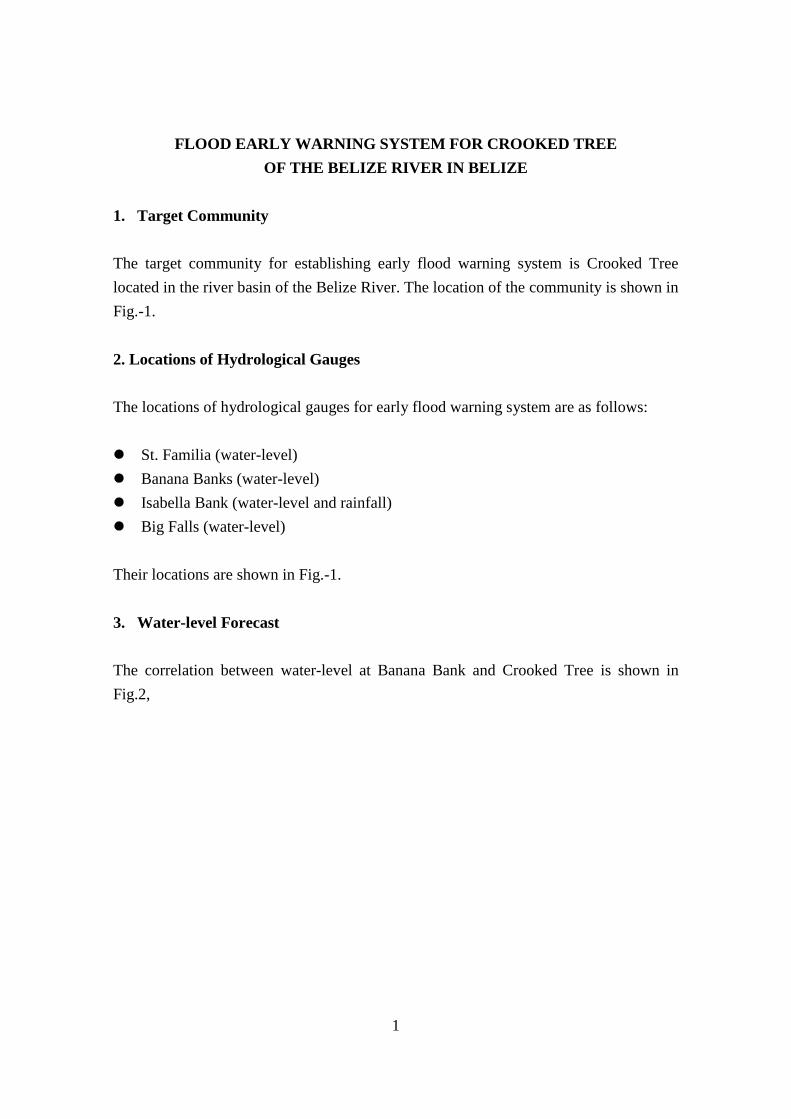
1
FLOOD EARLY WARNING SYSTEM FOR CROOKED TREE OF THE BELIZE RIVER IN BELIZE
1. Target Community The target community for establishing early flood warning system is Crooked Tree located in the river basin of the Belize River. The location of the community is shown in Fig.-1. 2. Locations of Hydrological Gauges The locations of hydrological gauges for early flood warning system are as follows:
St. Familia (water-level) Banana Banks (water-level) Isabella Bank (water-level and rainfall) Big Falls (water-level)
Their locations are shown in Fig.-1. 3. Water-level Forecast The correlation between water-level at Banana Bank and Crooked Tree is shown in Fig.2,

2
Fig. -2 Correlations between Water-level at Banana Banks and Crooked Tree
0.0
2.0
4.0
6.0
8.0
10.0
12.0
14.0
0.00
1.00
2.00
3.00
4.00
5.00
6.00
7.00
0.00 2.00 4.00 6.00 8.00 10.00 12.00 14.00 16.00
Tim
e La
g Be
twee
n B
anan
a B
ank
and
Croo
ked
Tree
(day
)
Wat
er L
evel
at C
rook
ed Tr
ee (m
)
Water Level at Banana Bank (m)
Water Level at Crooked Tree
Time Lag between Banana Bank and Crooked Tree
Based on the above figure, the estimated flood water-level at Crooked Tree will be informed to the residents of Crooked Tree. As shown in the above figure, the time lag between Banana Bank and Crooked Tree is more than 2 days in many cases and the residents of Crooked Tree have rather enough time to do some actions against coming flood. This relationship should be updated based on the newly recorded data by newly installed hydrological gauges. 4. Flood Warning Levels Based on the opinions of the residents of Crooked Tree, the flood warning levels are set as follows:
Warning Level Local Indicator Level 1 1 foot below the surface level of the causeway Level 2 The surface level of the causeway Level 3 1 foot above the surface level of the causeway

3
The above indicators are converted to the elevation above mean sea level as follows:
Warning Level Water-level (foot) Level 1 17.74 feet Level 2 18.04 feet Level 3 18.35 feet
These values should be updated based on the actual experience in the future. Based on the local indicators of the flood warning shown above, the threshold values at Banana Bank should be programmed. 5. Flood Warning Communication System Flood warning communication system in Belize is established as shown in Fig.-3 and 4. 6. Flood Warning Image In addition to the estimated flood water-level at Crooked Tree, the estimated flood inundation map is also transmitted to the flood preparedness team of Crooked Tree with the steps as shown in Fig.-6. A sample of estimated flood prone area to be transmitted to the community is as shown in Fig.-5. The shown flood prone area is tentatively prepared based on the relationship shown in Fig.-2 and the provisional DEM Data of Crooked Tree area. But these are still not final one and these should be updated every year based on the newly recorded data to be obtained with the newly installed hydrological gauges in the river basin.

4
Belm
opan
Sta.
Fam
ilia
(Bel
ize
R.)
( Bel
ize
R.)
Big
Fa
llsD
oubl
e Ru
n
Lem
onal
Cro
oked
Tre
e
Beliz
eCi
ty
05
1015
2025
km
N
(Spa
nish
Cre
ek)
(Mac
al R
.)
(Mop
an R
.)
(Bel
ize
R.)
W: A
lread
y in
stal
led)
W
W
Ban
ana
Ban
ks
Isab
ella
Ban
k
R
W
W
Fig.
-1 T
he L
ocat
ions
of T
arge
t Com
mun
ity a
nd H
ydro
logi
cal G
auge
s

5
Fig.
-3 F
lood
War
ning
Com
mun
icat
ion
Syst
em fo
r C
rook
ed T
ree
in B
eliz
e (1
)
Bel
ize
Rur
al D
istr
ict
Emer
genc
y M
anag
emen
tO
ffice
Cro
oked
Tre
e Vi
llage
Floo
d Pr
epar
edne
ssC
omm
ittee
Info
rmat
ion
from
Wat
er-le
vel G
auge
(s)
Nat
iona
l Em
erge
ncy
Man
agem
ent O
ffice
(NEM
O) B
elm
opan
Hyd
ro-m
eteo
rolo
gica
lAg
ency
Atut
omat
ic m
essa
ge th
roug
h C
ell P
hone
Activ
ate
the
Emer
genc
yO
pera
tion
Cen
ter a
ndC
all a
Mee
etin
g of
the
flood
Pre
pare
dnes
sTe
amfo
r war
ning
leve
l 1

6
Bel
ize
Rur
al D
istr
ict
Emer
genc
y M
anag
emen
tO
ffice
Cro
oked
Tre
e Vi
llage
Floo
d Pr
epar
edne
ssC
omm
ittee
Info
rmat
ion
from
Wat
er-le
vel G
auge
(s)
Nat
iona
l Em
erge
ncy
Man
agem
ent O
ffice
(NEM
O) B
elm
opan
Hyd
ro-m
eteo
rolo
gica
lAg
ency
Atut
omat
ic m
essa
ge th
roug
h C
ell P
hone
Floo
d W
ater
Lev
elM
onio
ring
Team
Anal
yze
the
data
and
deci
de to
rais
e th
ew
arni
ng le
vel
War
ning
Dis
sem
inat
ion
Team
Res
iden
ts o
f Flo
od P
rone
Area
s in
Cro
oked
Tre
e
Radi
o/TV
Sire
n, D
oor t
o D
oor
Wal
kie-
talk
ie
for w
arni
ng le
vel 2
& 3
Fig.
-4 F
lood
War
ning
Com
mun
icat
ion
Syst
em fo
r C
rook
ed T
ree
in B
eliz
e (2
)

7
Fig.
5 S
ampl
e of
Est
imat
ed F
lood
Pro
ne A
rea
of C
rook
ed T
ree
Cau
sew
ay

8
Water-level at Banana Bank reaching threshold values
NEMOEstimate of Inundation Water-level at Crooked Treeby Prepared Correlation Curve in 10 minutes
Land Information Center
Preparation of Estimated Inundaion Map in Crooked Tree in 15 minutes based on DEM data
Crooked Tree Community Committee
NEMO
cellular phone or email at real time
Crooked Tree Residents
telephone at real time
door to door
Fig. 6 Communication Flow on Estimated Flood Prone Area at Crooked Tree

FLOOD EARLY WARNING SYSTEM FOR CORINTH OF THE ROSEAU RIVER BASIN IN DOMINICA
1. Target Community The target community for establishing flood early warning system is Corinth located in the river basin of the Roseau River. The location of the community is shown in Fig. 1.
2. Locations of Hydrological Gauges The locations of hydrological gauges for flood early warning system are as follows: Laudat (rainfall) Morne Prosper (rainfall) Confluence of the Roseau and Claire Rivers (water-level) Their locations are shown in Fig.-1.
3. Flood Warning Levels Based on the opinions of the residents of Corinth, the flood warning levels are set as follows:
Warning Level Local Indicator
Level 1 Top of the piers of Emsall Bridge
Level 2 Surface of the Emsall Bridge
These warning water-levels are converted to the water-level at the confluence of the Roseau and the Claire Rivers as follows:
Warning Level Water-level at the Confluence of the Roseau and the Claire Rivers
Level 1 64.12 m
Level 2 64.50 m
These values are tentatively obtained through hydraulic calculation. These should be updated based on the actual experience in the coming future.

The flood traveling time from the confluence of the Roseau and Claire Rivers to the Emsall Bridge located just upstream side of the Corinth Community is estimated at about 7 minutes. These should be, of course, improved based on the actual experience in the future.
4. Rainfall Warning Levels Rainfall warning levels should be decided based on the actual record to be newly obtained from the installed rainfall gauges in the river basin corresponding to the water-level warning levels presented in the above. According to the provisional hydrological analysis, the 2-hour rainfall peak and the peak water-level at the confluence of the Roseau and the Claire Rivers is around 2 hours.
5. Warning Communication System for Corinth Warning Communication System for Corinth of the Roseau River is established as shown in Fig.-2 and 3.

N
05.0
1.0
1.5
2.0
km
(Tro
is P
itons
Riv
er)
(Riv
er B
lanc
)
(Riv
er C
laire
)
(Ros
eau
R.)
(Riv
er D
ouco
)
Rose
au
(Ros
eau
R.)
CARI
BBEA
NSE
A
W
Papi
lott
e (H
ydro
. pow
er s
ta.)
Du
Mas
Est
ate
Bath
Est
ate
(Tar
get
Com
mun
ity)
Fres
hwat
er L
ake
RLa
udat
Mor
ne P
rosp
erR
Pal
m G
rove
R
: W
ater
Lev
el G
auge
:
WR: Rai
nfal
l Gau
ge
unde
r tes
t ope
ratio
n
unde
r tes
t ope
ratio
n
unde
r tes
t ope
ratio
nw
ithpr
oble
m o
f tr
ansm
issi
on o
d da
ta
Fig.
-1 T
he L
ocat
ions
of T
arge
t Com
mun
ity a
nd H
ydro
logi
cal G
auge
s

Bat
h Es
tate
Emer
genc
y O
pera
tion
Cen
ter
Floo
d Pr
epar
edne
ss T
eam
Mee
ting
Info
rmat
ion
from
Wat
er-le
vel G
auge
(s) a
nd/o
r Rai
n G
auge
Offi
ce o
f Dis
aste
rM
anag
emen
tH
ydro
-met
eoro
logi
cal
Agen
cy
Atut
omat
ic m
essa
ge th
roug
h C
ell P
hone
War
ning
Lev
el 1
Fig.
-2 F
lood
War
ning
Com
mun
icat
ion
Syst
em fo
r C
orin
th in
Dom
inic
a

Bat
h Es
tate
Emer
genc
yO
pera
tion
Cen
ter
Mob
ile P
hone
Ser
vice
Prov
ider
s(D
IGIC
EL/L
IME)
Info
rmat
ion
from
Wat
er-le
vel G
auge
(s) a
nd/o
r Rai
n G
auge
Offi
ce o
f Dis
aste
rM
anag
emen
t
Hyd
ro-m
eteo
rolo
gica
lAg
ency
Atut
omat
ic m
essa
ge th
roug
h C
ell P
hone
War
ning
Lev
el 2
Anal
yze
the
data
and
deci
de to
rais
e th
ew
arni
ng le
vel
Rad
io/T
V
Para
dise
Val
ley
and
RB
C H
ousi
ng
War
ning
team
Wal
kie-
talk
ie
Spec
ial b
road
cast
thro
ugh
mob
ile p
hone
sSi
ren,
Doo
r-to
-Doo
r
Riv
er s
ituat
ion
upst
ream
of B
ath
Esta
te
Fig.
-3 F
lood
War
ning
Com
mun
icat
ion
Syst
em fo
r C
orin
th in
Dom
inic
a


1
FLOOD EARLY WARNING SYSTEM FOR BATHAZAR OF THE GREAT RIVER IN GRENADA
1. Target Community The target community for establishing flood early warning system is Bathazar located in the river basin of the Great River. The location of the community is shown in Fig.1. 2. Locations of Hydrological Gauges The locations of hydrological gauges for flood early warning system are shown in Fig.1. The locations of hydrological gauges for early flood warning system are as follows: Morne Longue (rainfall gauge) Grand Etang (rainfall gauge) Castaign Bridge (water-level gauge) The locations are shown in Fig. -1. 3. Flood Warning Levels Based on the opinions of the residents of Bathazar, the flood warning levels are set as follows:
Warning Level Local Indicator Level 1 2 feet above normal river water level Level 2 2 feet below the river bank. Level 3 1 foot below the river bank
The above local indicators are converted to the water-level at Castaigne Bridge site based on the non-uniform flow calculation as follows:
Warning Level Water-level at Castaigne Bridge Level 1 99.0 m Level 2 110.5 m Level 3 111.5 m

2
These values should be updated based on the actual experience in the coming future. The flood traveling time from Castaign Bridge site to the community site is estimated at about 20 minutes. 4. Warning Rainfall Amount Warning rainfall amount corresponding to the local indicators of water-level will be analyzed based on the rainfall record collected by the newly installed rainfall gauges in the river basin. According to the flood analysis results, though the rainfall record is not that recorded rainfall in the river basin, the time lag is estimated at about 45 minutes from the peak rainfall to the peak water-level at the Castaign Bridge site. 5. Flood Warning Communication System The flood warning communication system for Bathazar Community is established as shown in Fig. 2:

3
Lege
nd
Yello
w o
ne =
Alre
ady
inst
alle
d.
N
00.5
01.0
1.5
2.0
2.5
03.0
3.5
4.0
km
Para
dise
Br.
Gra
nd B
ras
Br.
Bath
azar
Br.
Cas
taig
n B
r.
Gra
nd E
tang
Lake
St. C
loud
Gre
nvi
ll
R
R
Mor
ne
Long
ue
St. M
arga
ret
W
Birc
h G
rove
Br.
Gra
nd
Etan
g
St. C
yr B
ridge
W: P
ropo
sed
Wat
er L
evel
Gau
ge
: Pro
pose
d R
ainf
all G
auge
R
Fig.
1 T
he R
iver
Bas
in o
f the
Gre
at R
iver
and
the
Loc
atio
ns o
f Hyd
rolo
gica
l Gau
ges
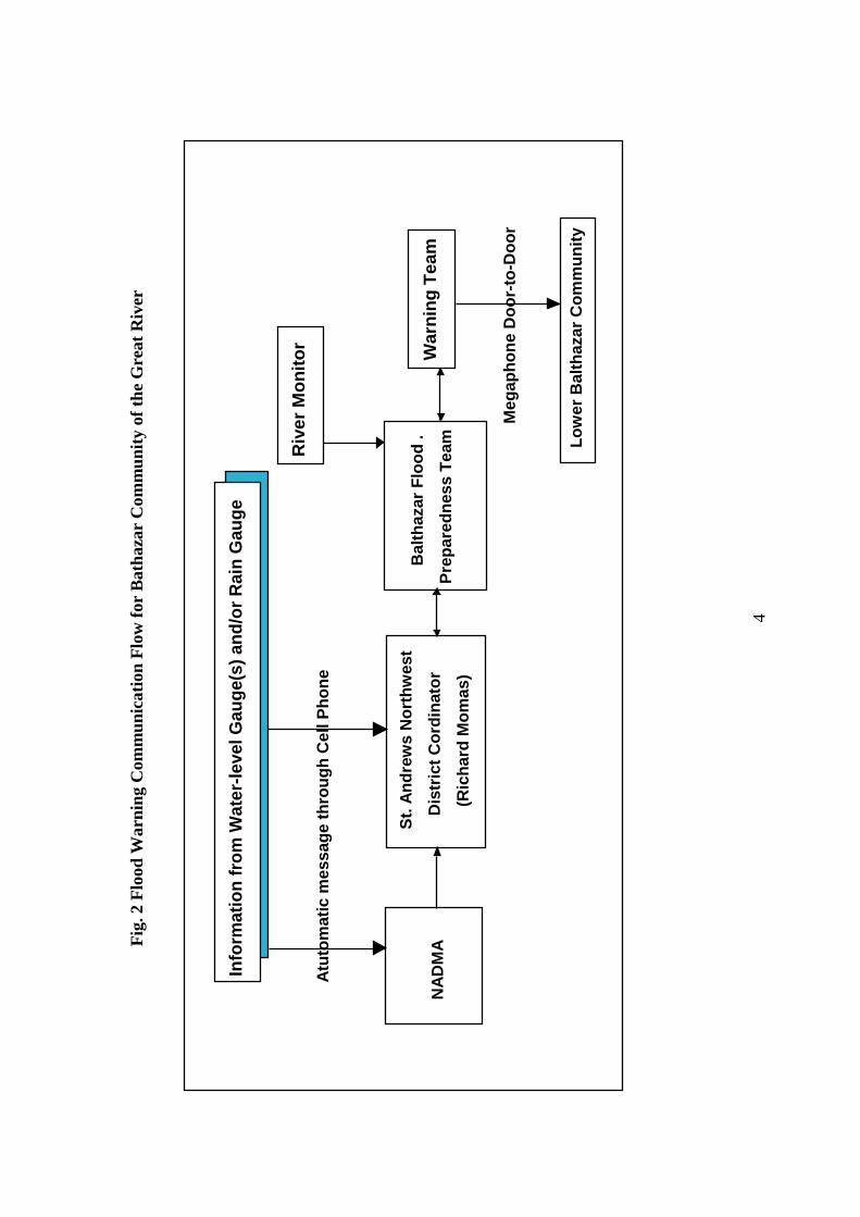
4
War
ning
Tea
m
Info
rmat
ion
from
Wat
er-le
vel G
auge
(s) a
nd/o
r Rai
n G
auge
St.
Andr
ews
Nor
thw
est
D
istr
ict C
ordi
nato
r
(R
icha
rd M
omas
)N
ADM
A
Atut
omat
ic m
essa
ge th
roug
h C
ell P
hone
Meg
apho
ne D
oor-
to-D
oor
B
alth
azar
Flo
od .
Prep
ared
ness
Tea
m
Riv
er M
onito
r
L
ower
Bal
thaz
ar C
omm
unity
Fig.
2 F
lood
War
ning
Com
mun
icat
ion
Flow
for
Bat
haza
r C
omm
unity
of t
he G
reat
Riv
er

1
FLOOD EARLY WARNING SYSTEM FOR BIABOO OF THE MAHAICA RIVER IN GUYANA
1. Target Community The target community of Biaboo is located in the Mahaica River basin. The river basin of the Mahaica River is as shown in Fig.-1. The location of the target community Biaboo is also shown in Fig. -1
2. Locations of Hydrological Gauges The locations of hydrological gauges for flood early warning system are also shown in Fig.-1. The locations of hydrological gauges installed are as follows:
St. Cuthbert (rainfall gauge and water-level gauge) Lama Gate (water-level gauge) Biaboo community (water-level gauge)
The locations are shown in Fig.-1.
3. Flood Warning Levels Based on the opinions of the residents of Biaboo, flood warning levels are set as follows:
Warming Level Local Indicator
Code Orange 2 feet below the river bank
Code Red 8 inches below the river bank
The gauges threshold values based on the above local indicators will be programmed after compilation of the data recorded by the newly installed hydrological gauges since the final installation of the gauges was in April, 2012.
4. Flood Warning Communication System Flood warning communication system for Biaboo is established as shown in Fig.-2 and 3.

2
Fig.-2 Flood Warning Communication System for Code Orange
Information from Water-level Gauge and/or Rain Gauge
CDCGINA
Atutomatic message through Cell Phone
Head of Upper MahaicaFlood Repraredness Team
Radio/TV
Mobile Phone
Farmers with Animals
ShelterManaggement Team
Warning Team
Seven Families
Door-to-DoorDoor-to-Door
Hand-held Radio
for Code Orange
Monitoring Team
Monitoring Site

3
Fig.-3 Flood Warning Communication System for Code Red
Information from Water-level Gauge(s) and/or Rain Gauge
E.D. W. CBiaboo Community
Atutomatic message through Cell Phone
National EmergencyOperation Center
Radio/TV
Farmers with Animalsto Evacuate
ShelterManaggement Team
Evacuation Team
Seven Families tobe Evacuated
Door-to-DoorDoor-to-Door
for Code Red
Warning Team
Residents
Megaphone
CDC Hydrol-metService
General Informationnews Agency

4
Targ
etCo
mm
uniti
es
W
(Lam
a G
ate)
W
(Lam
a G
ate)
①
②
③
④
N
⑤
W R
: W
ater
leve
l gau
ge
: Rai
nfal
l gau
geAt
lant
icO
cean
toG
eorg
etow
n
Dem
erar
aCon
seva
ncy
Dam
(Lam
a R.
)
(Mah
aica
R.)
(Mad
uni R
.)
(Mah
aica
R.)
St. C
uthb
erts
Mis
sion
(Dem
erar
a R.
)
Gat
es:
①M
adun
i Gat
e②
Lam
a G
ate
③Ko
fi G
ate
④La
nd-o
f-Ca
naan
Gat
e⑤
Cunh
a G
ate
05
10
15
20km
③
④
N
⑤
WR
: Pro
pose
d W
ater
Lev
el G
auge
(not
inst
alle
d ye
t)
: Pro
pose
d Rai
nfal
l Gau
ge (
not
inst
alle
d ye
t)
Biab
oo
RW
(Mad
uni G
ate)
Targ
et
Com
mun
ities
(Lam
a G
ate)
W W
Fig.
-1 L
ocat
ion
of R
iver
Bas
in, t
he T
arge
t Com
mun
ity a
nd th
e H
ydro
logi
cal G
auge
s

1
FLOOD EARLY WARNING SYSTEM FOR CORINTH OF THE BOIS D’ORANGE RIVER IN ST. LUCIA
1. Target Community The target community for establishing early flood warning system is Corinth located in the river basin of the Bois d’Orange River. The location of the community is shown in Fig.1. 2. Locations of Hydrological Gauges The locations of hydrological gauges for early flood warning system are shown in Fig.1. The locations of hydrological gauges for flood early warning system are as follows:
Plateau (rainfall gauge) Grand Riviere (water-level gauge) Upper Corinth Bridge (water-level gauge)
Their locations are shown in Fig.-1. 3. Flood Warning Levels Based on the opinions of the residents of Corinth, the flood warning levels are set as follows:
Warning Level Local Indicator Level 1 River bank elevation Level 2 20 cm above the river bank
These are converted to the water-level at Upper Corinth and Grande Riviere as follows:
Warning Level Upper Corinth Grande Riviere Level 1 18.80 m 42.04 m Level 2 19.44 m 42.14 m

2
These are obtained through the hydraulic calculation and accordingly these values should be updated based on the hydrological data to be obtained with newly installed hydrological gauges in coming future. 4. Warning Rainfall Amount The rainfall warning levels should be decided in accordance with the water-level warning levels presented in the above, based on the actual rainfall record and water-level record to be obtained with the newly installed hydrological gauges. According to the provisional flood analysis on the Bios d’Orange River, the time difference between 75 minutes rainfall in the basin and the peak discharge at Upper Corinth would be about 90 minutes. 5. Flood Warning Communication System Flood warning communication system for Corinth is established as shown in Fig.-2.

3
Lege
nd 00.5
1.0
1.5
2.0
km
N
(Boi
s d'
Ora
nge
R.)
Gra
nde
Rivi
ere
CARI
BBEA
NSE
A
Plat
eau
RW
Corin
the
(Tar
get C
omm
unity
)W
W:
Wat
er L
evel
Gau
ge
: Ra
infa
ll G
auge
R
Fig.
1 L
ocat
ions
of C
orin
th a
nd H
ydro
logi
cal G
augi
ng S
tatio
ns

4
Cor
inth
Flo
odPr
epar
edne
ss T
eam
War
ning
Tea
m
Info
rmat
ion
from
Wat
er-le
vel G
auge
(s) a
nd/o
r Rai
n G
auge
Nat
iona
l Em
erge
ncy
Man
agem
ent O
ffice
Hyd
ro-m
eteo
rolo
gica
lAg
ency
Atut
omat
ic m
essa
ge th
roug
h C
ell P
hone
War
ning
Lev
el 1
Fig.
2 F
lood
War
ning
Com
mun
icat
ion
Flow
for
Cor
inth
of B
ois d
’Ora
nge
Riv
er in
St.
Luc
ia (1
)

5
Cor
inth
Flo
odPr
epar
edne
ss T
eam
War
ning
Tea
m
Info
rmat
ion
from
Wat
er-le
vel G
auge
(s) a
nd/o
r Rai
n G
auge
Nat
iona
l Em
erge
ncy
Man
agem
ent O
ffice
Hyd
ro-m
eteo
rolo
gica
lA
genc
y
Atu
tom
atic
mes
sage
thro
ugh
Cel
l Pho
ne
War
ning
Lev
el
2
Riv
er M
onito
r
Res
iden
ts o
f Cor
inth
Meg
apho
ne
D
oor-
to D
oor
Fig.
3 F
lood
War
ning
Com
mun
icat
ion
Flow
of B
ois d
’Ora
nge
Riv
er in
St.
Luc
ia (2
)


Attachment 5: CDMP of Pilot Site


FLOOD PREPAREDNESS PLAN
CROOKED TREE VILLAGE, BELIZE RURAL
May 2012
Crooked Tree Village
Flooded Crooked Tree Road near the Health Center


1
Crooked Tree Flood Preparedness Plan
I. Introduction
Founded in the early 18th century, Crooked Tree may be the oldest village in Belize. Until the 3½-mile causeway from the Northern Highway was constructed in 1983, the only access to Crooked Tree was by boat through the Northern Lagoon. In 2009, another causeway was built West of Crooked Tree towards Blackburn area. This causeway straddles the Western Lagoon and provides access to the farming area in Blackburn. The latest census shows that Crooked Tree population is 985 from 248 families, mostly of Creole descent, who were farming and fishing the area. These families are spread over six areas of Crooked Tree, to wit:
a. Stains b. Breadnut Hill c. Crooked Tree Area d. Pine Ridge e. Crawford Banks Area f. Waterfront Area
A Village Council oversees the administration and development activities within Crooked tree. The Village Council is also the de facto organization leading the Village Emergency Committee, which is tasked to manage all emergencies within Crooked Tree. It is also responsible for immediate response and restoration of basic services after a disaster. The Emergency Committee is composed of 10 Sub-committees with team leaders and members who are tasked to perform the functions of emergency first responders. In addition, village volunteers complement the village committee in flood disaster response and, through the JICA Project, flood preparedness activities. II. Crooked Tree Disaster Context
Crooked Tree is surrounded by Northern Lagoon to the East, Southern Lagoon to the South and Western Lagoon to the West. Because of this setting, Crooked Tree becomes an island cut off from the rest of Belize when the flood water coming from Belize River inundates the Lagoons. The Northern Lagoon is a natural basin that catches flood water from Spanish Creek and Black Creek.

2
Un-documented disasters in Crooked Tree are still remembered by some. The earliest remembered is the 1931 Hurricane (un-named Hurricane) that destroyed almost all of Belize City, including Crooked Tree. Later Hurricanes and floods are as follows:
Year Disaster Cause Major Effects1961 Hurricane Hattie Blown Roofs and uprooted trees1978 Hurricane Greta Damaging Flood occurred and affected
Crooked Tree. The ground floor of the old Baptist Church was inundated.
October 2000 Hurricane Keith Crooked Tree Bridge and Causeway was under 14-16 feet of water on October 6, 2000
May 2008 Hurricane Arthur A tornado took place, ripping roofs from at least five homes - leaving the zinc sheeting curled up - and uprooting huge trees over an area about 10 feet wide and for a span of about 50 yards
October 2008 Tropical Depression #16 TD#16 dropped an estimated 19 inches of rain in western Belize. In Crooked Tree, the causeway was under 6-7 feet of water, some houses were under 2-4 ft of water. Flood lasted 3 months.
The flood boundaries and depth of flood at different points during the October 2008 flood are shown in Figure 1. This map is the basis of the flood evacuation procedures.

3
Figure 1. Map of 2008 Flood in Crooked Tree

4
Flood Risk There are 32 houses located in flood prone areas of which about half experienced flooding inside and outside their houses Of these, three (3) families plan to move to public safe shelters within Crooked Tree. The rest of those who are exposed to flooding either have their houses raised on posts/pillars that render them safe from the rising water or have a second house built as flood proof or could move with relatives and friends located in high areas of the village. A few choose to move outside the village. III. Flood Risk Management
To reduce the impacts of flood, a warning and communication system and evacuation procedures were developed for Crooked Tree. A. Early warning and communication system The Crooked Tree Early Warning and Communication System will be supported by four (4) water level gauges that have been installed in Santa Familia, Big Falls, Banana Banks and Isabella Banks . A rain gauge was also installed. The water level gauges will send warning signals ( SMS or text messages) to pre-programmed telephone ( mobile phones) numbers in Crooked Tree and the national authorities ( NEMO, Hydrometerological agency and others deemed as part of the early warning system). . These warning signals correspond to three warning levels.
Warning Level 1 : Flood is possible but the condition does not pose any imminent danger to the residents. The water level in the northern Lagoon reaches 12 inches below the lowest portion of the causeway ( between the two bridges)
Warning Level 2: it is very likely that the flood may take place. The water level in the northern Lagoon reaches the causeway level at the lowest portion of the causeway ( between the two bridges)
Warning Level 3: Flood is very dangerous for the people. The water level in the northern Lagoon reaches 20 inches above the lowest portion of the causeway ( between the two bridges)

5
A.1
The
war
ning
and
com
mun
icat
ion
flow
dia
gram
for C
rook
ed T
ree
info
rmat
ion
from
w
ater
leve
l ga
uge(
s)
Beliz
e Ru
ral D
istr
ict
Emer
genc
y M
anag
emen
t Off
ice
Hyd
ro-M
eteo
rolo
gica
l A
genc
y
Aut
omat
ic m
essa
ge
thro
ugh
cell
phon
e
Nat
iona
l Em
erge
ncy
Man
agem
ent O
ffic
e (N
EMO
) Bel
mop
an
Croo
ked
Tree
Vi
llage
Flo
od
Prep
ared
ness
Co
mm
ittee
Figu
re 1
. War
ning
Lev
el #
`1
Activ
ate
the
Emer
genc
y O
pera
tion
Cent
er a
nd c
all a
m
eetin
g of
the
Floo
d Pr
epar
edne
ss T
eam

6
Figu
re 2
. Inf
orm
atio
n M
anag
emen
t and
Info
rmat
ion
flow
for W
arni
ng L
evel
s 2 &
3
Wal
kie-
Talk
ie
Sire
n, D
oor
– to
- D
oor
Dis
tric
t Em
erge
ncy
Man
agem
ent
Off
ice
Hyd
ro-M
eteo
rolo
gica
l A
genc
y
NEM
O B
elm
opan
Ana
lyze
the
data
and
de
cide
to
rais
e th
e w
arni
ng le
vel
Radi
o/TV
Resi
dent
s of
Flo
od
Pron
e Ar
eas
in C
rook
ed
Tree
War
ning
D
isse
min
atio
n Te
am
1
2
3
4
5
6 4
2 a
2a
Aut
omat
ic m
essa
ge
thro
ugh
cell
phon
e
info
rmat
ion
from
w
ater
leve
l ga
uge(
s)
Croo
ked
Tree
Vi
llage
Flo
od
Prep
ared
ness
Co
mm
ittee
Floo
d w
ater
le
vel m
onit
orin
g te
am
2 a
7

7
=
da
ta f
rom
the
gaug
es g
o si
mul
tane
ousl
y to
NEM
O. H
ydro
-met
off
ice,
Dis
trict
Em
erge
ncy
Man
agem
ent O
ffic
e an
d
Cro
oked
T
ree
Vill
age
Cou
ncil.
Thi
s trig
gers
obs
erva
tion
of th
e w
ater
leve
l in
Nor
ther
n La
goon
.
=
Hyd
ro-m
et o
ffic
e an
alys
es th
e da
ta fr
om th
e w
ater
leve
l gau
ges a
nd in
put f
rom
the
Nor
ther
n La
goon
=
Wat
er le
vel d
ata
at N
orth
ern
Lago
on is
sent
to th
e H
ydro
-met
off
ice
thro
ugh
the
Vill
age
coun
cil t
o th
e D
istri
ct O
ffic
e
to
NEM
O
= H
ydro
met
Off
ice
reco
mm
ends
to N
EMO
the
rais
ing
of w
arni
ng le
vel b
ased
on
its a
naly
sis
of d
ata
= N
EMO
inc
orpo
rate
s the
reco
mm
enda
tion
of H
ydro
met
Off
ice
and
the
obse
rvat
ion
of th
e w
ater
leve
l in
Nor
ther
n
La
goon
and
upg
rade
s the
war
ning
leve
l to
2 or
3, w
hich
ever
app
lies.
Giv
es th
is w
arni
ng in
form
atio
n si
mul
tane
ousl
y t
t
o th
e ra
dio/
Tv a
nd
the
Bel
ize
Rur
al D
istri
ct E
mer
genc
y M
anag
emen
t Off
ice
B
eliz
e R
ural
Dis
trict
Em
erge
ncy
Man
agem
ent O
ffic
e se
nds t
he w
arni
ng to
Cro
oked
Tre
e V
illag
e C
ounc
il
=
Cro
oked
Tre
e EO
C a
lerts
the
war
ning
dis
sem
inat
ion
team
to
diss
emin
ate
the
war
ning
to th
e re
side
nts o
f flo
od-p
rone
ar
eas o
f C
rook
ed T
ree
= W
arni
ng /t
eam
del
iver
s the
war
ning
mes
sage
dire
ctly
to re
side
nts.
Doo
r-to
-doo
r war
ning
dis
sem
inat
ion
will
be
done
by c
lust
er. O
ne p
erso
n w
ould
be
resp
onsi
ble
for o
ne c
lust
er, i
.e. o
ne fo
r Sta
ins,
one
for B
read
nut H
ill, o
ne fo
r
Cro
oked
Tre
e A
rea,
one
for P
ine
Rid
ge, o
ne fo
r Cra
wfo
rd B
anks
Are
a an
d an
othe
r one
for W
ater
fron
t Are
a.
Pu
blic
Ann
ounc
emen
t sha
ll be
don
e by
usi
ng o
ne tr
uck-
mou
nted
loud
spea
ker a
nd a
noth
er v
ehic
le w
ith th
e w
arni
ng
te
am m
embe
r usi
ng a
meg
apho
ne.
1 2 2a
3 4 5
6
7

8
A.2 The Emergency Operation Center This would be activated when Warning Level #1 is received and will continue in operation until the end of the flood event. B. Plan for Temporary Movement of At-risk Residents B.1 Public Safe shelters Three safe shelters have been designated as the evacuation center: Government building located in the school compound, The House of Nazarene and the Community Center ( also designated as hurricane shelter). These are located within walking distance of families assigned to each place. The evacuation team will take care of the orderly evacuation ensuring that the residents follow these procedures and proceed to the designated safe shelters. The at-risk residents assigned designated safe shelters are: At-risk People* Designated Safe shelters
Violet Moulton Family (4 members)
Government Building in School compound
Pearlene Tillet Family (9 members) House of Nazarene
Lawrence Bonner Family (5 members) Community Center
* Complete list of families to be moved to temporary shelter is in Annex A.

9
B.2 Private Houses Other at-risk residents will, by tradition, move to flood-safe houses within and without Crooked Tree Village. Private homes within Crooked Tree have been identified, to wit: Private Houses (owner) Families to be accommodated
Ms. Becky Crawford Webb Family of Crooked Tree Lodge (4 members)
Sherolyn Webster Verla Jex and Family (3 members)
Green House near the Y owned by Yvette Tillet
Kevin Tillet and Yvette Tillet and Family (7 members)
Suzette Codd's Family (5 members
Delvarene Wade Ronald Jones
Carleta Wade Julia Tillet's Family (4 members)
Yvette Gillette George Tillet's Family (6 members)
Maurice Gillett Calbert Gillett's Family (6 members)
Ms Maxine (Verna Samuel’s Mother) Verna Samuel
2nd house of the Seely’s located in safe area
Randy and Rema Seely's Family (6 members)
2nd house of Mr David Crawford located in safe area
David Crawford and Family (2 members)
Steve Tillet, jr. Family (6 members) Ms Molly ( in the same compound as Steve's house)
Leon Tillet Gwendolyn Tillet
Howell Longsworth Compound

10
B.3 Special Assistance Residents with special needs shall be prioritized during the temporary movement of people. These residents are: Name Condition Special Need
Mr Ronald Jones Difficulty in walking Need transportation to go to his relatives in higher ground
Mr. David Crawford and /wife
Aged Need assistance to go to safe shelter
Ms GwendolynTtillet Aged Need assistance to go to son's house in the same compound
The routes to be taken by at- risk people are shown in Figure 2. The map also shows the location of safe houses and the location of families to move to temporary shelter. The numbers match. For example, family #1 will proceed to safe house #1 and so on. The legend shows which are the safe houses and which are in danger of flooding.

11
Evacuation Route Map of Crooked Tree, Belize
Figure 2. Evacuation Route Map showing the location of safe houses and houses prone to flood

12
C. Procedure for temporary movement of at-risk residents
Stage Situation Actions Level 1 Warning: Alert Stage
First text message received from water level gauges. The water level at the Northern Lagoon reaches 12 inches below the lowest point of the causeway ( between the two bridges)
Village Emergency Committee Chairman Activates the Disaster Preparedness Team and assumes the role of Incident Commander and Leader of the Flood Preparedness Team Public Information Team reminds families about “getting ready” – to organize things to be taken to temporary shelter.
Level 2 Warning: Preparation Stage :
Second text message received from water level gauges. The water level at the Northern Lagoon reaches causeway level at the lowest point of the causeway ( between the two bridges)
Warning Dissemination Team announces Level 2 and reminds people of actions to be taken. People -Ensure safety of the house: test all locks - -Ensure basic needs are safely packed especially baby needs and medicine and needs of residents that require special attention Safety Team: Move Priority People who need special assistance Transportation Team to provide transportation assistance Shelter Manager to check and coordinate with church leaders at the House of Nazarene, the Government bldg in the school compound and prepare the unoccupied houses in Longsworth Compound and the Community Center

13
* Emergency kit content shown in Annex B
Level 3: All at risk residents are required to move to temporary shelter
Third text message received from the water level gauges. The water level at the Northern Lagoon reaches 20 inches above the lowest causeway level (between the two bridges) Incident Commander and Disaster Preparedness Team decide for movement of all at-risk residents to safe shelter
Warning Team: Announces repeatedly warning and instruction for at risk residents to move to temporary shelter People
Lock the house, carry the emergency kit* and proceed to the designated pick up point or proceed directly to the designated safe shelter
Register upon arrival at the
safe shelter
Manage the family members and ensure that nobody strays from the safe shelter
Wait for the “Safe To Go
Home” announcement Shelter Manager and Safety Team coordinate about total number of expected residents in each shelter.

14
D. Crooked Tree Village Emergency Committee The Flood risk reduction plan shall be implemented by a group of people who reside within Crooked Tree and who are given specific roles. The plan shall be implemented by the disaster preparedness team whose team leaders are listed in Annex C and Roles and Responsibilities are listed in Annex D. The organizational Structure of the Emergency Committee is found below.
Public Information Team
Damage and Needs Assessment
Recovery
Incident Commander/Flood Preparedness Chairman
Transportation Medical Team Security Team
Warning Team Safety/Search and Rescue
Shelter Managers/Relief
Logistics and Supply

15
Annex A
List of Families prone to Flooding
Crawford Bank Road 1 David Crawford* 81 M Aged 2 Cecelia Crawford* 71 F Aged 3 Amybell Crawford 41 F 4 Khalid Zuniga 13 5 Harold Zuniga 7 M 6 Lilanie Swasey 3 F 7 Deon Crawford 42 8 Inamae Crawford 33 9 Moesha Crawford 11
10 Shane Crawford 10 F 11 Shawn Crawford 10 M 12 Deon Crawford, Jr 9 M 13 Nicole Crawford 6 F 14 Whitney Crawford 5 F 15 Cody Crawford 2 M 16 Mordant Tillett 72 M 17 Natele Tillett 46 F * 18 Mick Webb* 41 19 Angela Webb* 30 20 Cory Webb* 4 21 Zach Webb* 2 22 Felicia Quilter 39 23 Calvin Quilter 13 24 Malcolm Quilter 10 25 Melvin Quilter 6
Bread Nut Hill 26 Hilda Flowers 72 F 27 Leonard Williams 79 M 28 Maisie Williams 75 F 29 Walter Flowers, Jr M 30 Vero Lauriano 38 F 31 Eric Lauriano 37 M 32 Joanna Lauriano 17 F

16
33 Jasmine Lauriano 13 F 34 Jonathan Lauriano 8 M 35 Sonia Wade 60 F 36 Timothy Jex 20 M 37 Pearlene Tillett* 58 F 38 Susan Tillett* 22 F 39 Caresa Tillett* 17 F 40 Elizabeth Tillett* 21 F 41 Rogah Tillett* 38 M 42 Ashton Tillett* 9 M 43 Amesha Tillett* 4 F 44 Symon Tillett* 2 M 45 Rogah Tillett, Jr* 1 M 46 Verla Jex* 48 F * 47 Janine Tillett* 25 F 48 Alex Jex
Crooked Tree Area 49 Kevin Tillett* 44 M 50 Yvette Banner* 39 F 51 Diandra Tillett* 17 F 52 Tromeisha Tillett* 12 F 53 Keagan Tillett* 9 M 54 Kristan Tillett* 9 M 55 Kameron Tillett* 7 M 56 Aldamee Jex 33 M 57 Carolee Gillett 13 F 58 Shaniah Jex 3 F 59 George Guest 59 M * 60 Shirley Guest F 61 Nadia Lewis* 23 62 Suezette Codd* 46 * 63 Lennisha Gillett* 12 64 Jada Lewis* 1 65 Brandon Lewis* 21 66 Violet Moulton* 42 67 Elsa Moulton* 23 68 Roy Moulton* 20 69 Shiney Moulton* 18 70 Norris Wade 42

17
71 Maria Wade 43 72 Kedor Neal 13 73 Jonathan Wade 11 74 Nathalia Wade 8 75 Nona Wade 3 76 Curtis Wade 14 77 Hessie Codd 65 * 78 Shakira Codd 28 79 Rodwell Conorque 28 80 Zion Conorque 4 81 Icelma Crawford plus 3 children 82 Marlon A Longsworth 35 83 Patricia Longworth 35
84Marlon A Longsworth, jr 13
85 Jasmine Longsworth 10 86 Ismael Longsworth 7 87 Britney Longsworth 5 88 Ronald Jones* 60 89 Margaret Jones 90 Julia Tillett* 40 91 Lincoln Tillett* 19 92 Jerome Tillett* 14 93 Peter Tillett* 41 94 Godwin Westby 76 * 95 Hilda Westby 68 96 Shane Westby 31 97 Daren Westby 17 98 Gwennie Tillet* 77 * Aged
Pine Ridge Area 99 Calvert Gillette 64
100 Lolita Gillette 64101 Steve Tillett , Sr.* 49 102 Ardith Tillett* 42 103 Steve Tillett , Jr.* 20 104 Sherisha Tillett* 18 105 Jair Tillett* 12 106 Sashia Tillett* 9
Stain 107 George Tillett* 46 * 108 Dynnamay Lightburn* 40

18
109 Davina Lightburn* 17 110 Daniella Lightburn* 12 111 Damion Tillett* 8 112 Denna Tillett* 3 113 Calbert Gillett* 58 * 114 Janice Gillett* 60 115 Kathie Gillett* 23 116 Randy Gillett* 25 117 Elric Gillett* 21 118 Loreta Gillett* 16 119 Nigel Tillett 44 120 Marilyn Tillett 39 121 Kelsey Tillett 11 122 Nyvon Tillett 6 123 Mahlon Tillett 4 124 Denvor Gillett 125 Norma Gillett 126 Verna Samuels*
River Waterfront 127 Randy Seely* 44 128 Rema Seely* 39 129 Ryan Seely* 16 130 Ryanna Seely* 9 131 Rahema Seely* 8 132 Renea Seely* 3 133 Vera Bruce
*People who need to move to safe shelters

19
Annex B
Evacuation (Survival Kit)
General Items For Babies For People with special needs
Non-perishable food Baby food/milk formula Medicine
Flashlight with batteries medicine Wheel chair or as needed
Battery operated radio (with batteries)
Change of diapers Sleeping mattress
Clothes Baby clothes, blankets and comfort items
Medicine
Important documents
Mats/sleeping bags
Drinking water
Personal hygiene kit (toothbrush and tooth paste, toilet paper, soap)
Emergency contact list (relatives and doctor)

20
Annex C
Members of the Crooked Tree Village Emergency Committee
Chairman - Village Chairman – George Guest
Warning Team: Team Leader – Paul Quiros
Lagoon Water Level Monitors: To be named
Warning Dissemination: George Reynolds
Safety/Search and Rescue: Team Leader – Albert Wade
Members: to be named ; volunteers
Transportation Team: Team Leader – James Dawson
Members: Jerry Jex and Calvert Gillette
Shelter Manager/Relief: Team Leader – Arlene Tillett Brown
Members: Ava Tillet and Doreen Gillett
Security: Team Leader – Rose Kelly/Florence (Becky) Crawford
Public Information and Education: Team Leader – Steven Perriot
Members: Sherolyn Webster
Medical Team: Team Leader – Antonette Hope-Tillett
Logistics and Supply: Team Leader – Rudy Crawford and Mildred Crawford
Members: Verla Jex; Vero Laureano; Judith Quiroz
Damage and Needs Assessment: Eldon Wade

21
Annex D
Roles and Responsibilities of Crooked Tree Emergency Committee
Incident Commander/ Disaster Preparedness Team Head
1. Establish Emergency Operation Center to command and direct village committee according to their responsibilities.
2. Cooperate with NEMO 3. Cooperate with related organizations 4. Command and conduct warning and evacuation, search and rescue 5. Activate the Team upon receipt of hazardous information that may affect the community 6. Lead the decision-making actions with the participation of the Team members 7. Keep in constant communication with the Team members and to keep updated
information about the situation Warning and Communication
1. Monitor the flood level of the Northern Lagoon and report to the EOC 2. Disseminate warning signals in the area during flood emergency situation to heighten
more awareness of vulnerable population to move from the danger zone to pre-identified safe places.
3. Maintain warning equipment such as Siren (megaphones) and hand-held radios 4. Maintain communication with the EOC regarding the hazard situation
Search and Rescue
1. Search missing residents and take them to the designated safe shelter 2. Coordinate with relief team and shelter managers for an organized search and rescue
effort 3. Update the Shelter Manager and the EOC
22
Safety (Evacuation )
1. Organize temporary movement from at-risk area to the designated safe shelter. 2. Ensure that all people have been moved to safe shelter during emergency situation
3. Coordinate with the shelter managers regarding the movement of people
4. Coordinate with the medical team when medical attention is required
5. Update the EOC on movement and the number of people who moved to temporary shelters from time to time to ensure timely and appropriate reception in the designated safe shelters.
Security
1. Secure the vacated areas and the properties of the residents during their absence from home
2. Maintain peace and order both in vacated areas and in safe shelters
3. Monitor suspicious looking persons and apprehend them when necessary for security
reasons.
4. Ensure that no one is left behind in the at-risk areas once safety team declares completion of movement of residents to safe shelters.
Shelter Management /Relief Team
1. Prepare safe shelters according to plan
2. Coordinate with other teams such as the evacuation team and the medical team 3. Ensure that everyone is safe in the shelter
4. Organize the residents occupying the shelters and engage them into important pursuits

23
Transportation
1. Ensure vehicles are available to move people and in good working condition. 2. Transport people in order of priority in coordination with the safety team 3. Ensure that all women, children, adult and disabled are given special support for their
safety while in the process of moving them to the safe shelters.
Medical/Health Team
1. Provide first aid to those who are injured during movement of people 2. Provide medical attention to the sick and those who are in need of medical care
Public Information and Communication
1. Serve as link between and among the other teams to provide information on the emergency situation
2. Develop and disseminate information on flood preparedness in a timely manner 3. Design and execute awareness-raising campaign on flood preparedness

24
Annex E
Important Contact Numbers
Name Office/Designation Contact Number
Calvert Budd District Emergency Coordinator
Cell: +501-602-8632
George Guest Crooked Tree Village Council Chairman
Cell: +501-607-8096
Landline: +501-225-7046
Eldon Wade Team Leader: Damage and Needs Assessment
Arlene Tillett Brown Team Leader: Shelter Management
Cell: +501-661-1689
James Dawson Team Leader: Transportation
Florence (Becky) Crawford Team Leader: Security Cell:+501-662-3230
Mildred Crawford Team Leader: Logistics & Supply
Cell: +501-665-8140
Steven Perriot Team Leader: Public Information & Communication
Albert Wade Team Leader: Safety/Search & Rescue
Antonette Hope/Tillett Team Leader: Medical Team
Paul Quiros Team Leader: Warning Team

FLOOD WARNING AND EVACUATION PLAN
LOWER BATH ESTATE
April 2012
ODM
BATH ESTATE
DEVELOPMENT
COMMITTEE


1
BATH ESTATE DEVELOPMENODM
I. Introduction In late 1990s, the Commonwealth of Dominica through the Office of Disaster Management started focus on community based disaster preparedness training as a means of empowering communities in the prevention and mitigation of disasters. It is in this context that the Bath Estate Development Committee, with support from the Office of Disaster Management, initiated the preparation of Evacuation and Community Warning Plan. The Plan is a collaboration among the residents of flood prone areas of Lower Bath Estate.
II. Bath Estate Flood Disaster Context
Bath Estate is situated in the valley of Roseau River to the NE of the Botanical Gardens. It is surrounded by mountains from which Roseau River flows unhampered. Bath Estate was formerly an agricultural estate that produced limes. When lime infestation occurred, production was affected and the area was converted into a housing area under various schemes. Bath Estate is classified as an urban area and is part of the capital City of Roseau. Residents of Bath Estate are mostly employed in Roseau City or surrounding areas. Economic activity in Bath Estate is vibrant with shops, restaurants and other services that cater to the needs of the residents. The Roseau Primary School is located at Bath Estate. The Lower Bath Estate was constructed in late 1977 , as a housing scheme, and the people who live there are working middle class people. This was followed by another housing scheme supported by the Royal Bank of Canada in 1979. Low-income housing scheme in a place now called Paradise Valley was developed in 1994. The latest housing scheme located west of the soccer field was constructed as blocks of apartments.
A concrete wall separates the RBC housing from Paradise Valley. There is a storm drain constructed on the periphery of the row of houses on the north side of the street separating the two rows of houses in Paradise Valley.
Bath Estate has a total population of ___________ of which a total of _______ residents of Lower Bath Estate are prone to flooding.
Lower Bath Estate Warning and Evacuation Plan

2
BATH ESTATE DEVELOPMENODM
Hazards brought to Bath Estate by Roseau River Flood Roseau River borders Bath Estate . This River is known to rush through the river channel with raging force during the passage of hurricanes. In August 2007 during Hurricane Dean, the river overflowed at Elmshall Bridge and flooded a few houses in RBC housing and most of the houses in Paradise Valley. The overflow was due in part to the artificial dam brought by blocking of water channel by logs and big debris brought by the river water and in part by the huge volume of water that was brought by the hurricane. As the flood water flowed towards the lower portion of Bath Estate, the wall separating the RBC housing from Paradise Valley collapsed from the force of flood water, same flood water passing through and overflowing the storm drain. The overflow flooded the houses. The flood hazard map shows the extent of flooding experienced. The flood came very quickly with no warning and also receded very quickly. The flood event lasted for a maximum of 10 hours. In August 2009, Bath Estate again experienced flooding, although not as severe as that experienced in 2007. The map below shows the houses in RBC housing and Paradise Valley which suffered from the flood event of August 2007.
Elmsall Bridge

3
BATH ESTATE DEVELOPMENODM
River Bank Erosion The raging waters also erode the river bank such that the river bank is progressively undermined creating another threat to the houses located at the river bank. Some of the houses on the river bank are almost teetering on the brink of the river bank. This poses another threat from the Roseau River.
Houses threatened by river bank erosion

4
BATH ESTATE DEVELOPMENODM
The new development ( the block of apartments near the entrance to Bath Estate) is located at the bend of the river flowing out to town. This location is also prone to flooding and, in fact, has already experienced flood events from the time of its construction. The resultant flood hazard map ( based on 100-year flood) of Lower Bath Estate is shown below. III. Flood Risk Management
To reduce the impacts of flash flood, an evacuation plan and a warning and communication system were developed for Paradise Valley and RBC Housing. A. Early warning and communication system There are two warning levels designed for Bath Estate preceded by an Alert Stage, following that used by the Government of Dominica. Alert Stage : The Flood Preparedness Team is alerted when information is received that there is an approaching hurricane, tropical storm or presence of weather system that will produce heavy rains.

5
BATH ESTATE DEVELOPMENODM
Warning Level 1 ( Preparation Stage): When the Roseau River water level upstream of Bath Estate has reached the first established critical level that might pose a threat to the residents of Lower Bath Estate. In Bath Estate, the Roseau River water level reaches the top of the pier of the Elmsall Bridge. Warning Level 2 ( Mandatory Evacuation Stage): Flood is absolutely dangerous for the people. In Bath Estate, the Roseau River water level overflows the Elmsall Bridge and has reached the top of the bridge and starts to overflow. The warning and communication flow diagram for Lower Bath Estate.
.
information from rain gauge(s) and
water level gaugesBath Estate Executive
Committee ( EOC)
Public Information Team
TV/ Radio
Lower Bath Estate
Meteorological Agency
Information from Office of Disaster management
Automatic message through cell phone
Hand-held radio
Siren, Door – to -Door
DIGICEL
Special broadcast through Digicel phones
Request to broadcast
Flood marker monitor

6
BATH ESTATE DEVELOPMENODM
B. Evacuation Plan Two safe places have been designated as the evacuation center: The Bath Estate Community Resource Center and the Roseau Elementary School. Both are located within walking distance of Paradise Valley, RBC Housing and the apartment block. The at-risk residents are assigned designated evacuation center: At-risk People Designated Evacuation Center
Residents of House nos. 60, 61, 62, 63, 64, 65, 66, 67, 68, 69, 70, 71, 72 and 73 in Paradise Valley
Bath Estate Community Resource Center
Residents of house nos. 55, 56, 57, 58, 59, 74,75,76,77,78 and 79 in Paradise Valley
Bath Estate Community Resource Center
Residents of house nos 11, 12, 13, 14, 15, 16, 17, 18, 19, 20, 21, 22, 23 in RBC Housing
Bath Estate Community Resource Center
Residents with special needs for priority evacuation
Bath Estate Community Resource Center
Residents of the apartment block located near the entrance to Bath Estate ( from town)
Roseau Elementary School
The evacuation team will take care of the orderly evacuation ensuring that the residents follow the evacuation procedures and proceed to the designated evacuation center. The evacuation route map is shown in the following page. Residents with special needs shall be prioritized during evacuation. .

7
BATH ESTATE DEVELOPMENODM
Evacuation Route Map

8
BATH ESTATE DEVELOPMENODM
Alert Stage A forecast of storm, hurricane or heavy rains to affect Dominica
Flood preparedness Team: Head of Disaster Preparedness Team Activates the Paradise Valley-RBC Housing Disaster Preparedness Team and assumes the role of Incident Commander and Leader of the Disaster Preparedness Team . Review the plan and give assignments to the members of the team. Flood Marker Monitoring Team: Start to monitor the flood water level at Roseau River near the Elmsall Bridge. Information Team: Inform the residents of the situation and advise them to be on the alert. Medical Team: Alert the Fire Service and the hospital of the situation and request them to stand by for possible assistance. Alert Transportation team of possible need for vehicle. Residents: Upon receipt of the information from the Team -Ensure safety of the house: Test all locks -Ensure valuable objects and Documents that will be carried when evacuating are packed in evacuation kits
B . Evacuation Procedure

9
BATH ESTATE DEVELOPMENODM
Warning Level 1: Preparation Stage
First text message received by designated recipients from water level gauge and rain gauge Local Indicator: When river water reaches the top of the pier of the Elmsall Bridge but water is not overflowing the bridge
Flood Preparedness Team: Leader of the Flood Preparedness Team: Alert the Fire Department to be on stand-by in case assistance will be needed. Warning Dissemination and Information Team:
- Disseminate the warning to all residents of Paradise Valley and RBC Housing
- Voluntary evacuation of
residents is announced. Evacuation Team/Transportation Team:
- Proceed to the flood prone area and help those who need assistance proceed to the evacuation shelters.
- Evacuate the sick, the
elderly, the physically and mentally challenged and the babies.
- Inform medical team of any medical assistance needed at this time
Shelter Team:
- Proceed to Shelters to receive the first wave of evacuees.

10
BATH ESTATE DEVELOPMENODM
Security Team:
- Proceed to the flood prone area and start patrolling the area.
Residents: -Ensure basic needs are safely packed especially baby needs and medicine and needs of residents that require special attention
Warning Level 2: Mandatory Evacuation Stage
Local Indicator: flood water reaches the top of the Elmsall bridge and starts to overflow.
Incident Commander and Disaster Preparedness Team decide for total evacuation Warning and Information Team:
- Disseminate level 3 warning. Evacuation Team: Assist the residents to evacuate. Residents:
- Lock the house, carry the evacuation kit* and proceed to the designated pick up point or proceed directly to the designated evacuation shelter.
- Register upon arrival at the
evacuation center
- Manage the family members and ensure that nobody strays from the evacuation center
- Wait for the “all clear
signal"

11
BATH ESTATE DEVELOPMENODM
Relief Team: coordinate the feeding of evacuees
Step down Level Rain stops and the flash flood ends Team Leader announces "all clear signal" Shelter Manager prepares the evacuees to leave the shelter Evacuation team/Transportation Team: Helps the most vulnerable to return home. Team to re-assemble to assess the extent of damage and identify needs.

12
BATH ESTATE DEVELOPMENODM
C. Disaster Preparedness Structure The disaster risk reduction plan shall be implemented by a group of people who reside in Paradise Valley and RBC Housing and who are given specific roles. The plan shall be implemented by the disaster preparedness team which is organized as follows:
Incident Commander/Disaster
Preparedness Chairman
Communication and Public Information
Team
Transportation
Medical Team
Security Team
Warning Team
Evacuation/Search and Rescue
Shelter Managers/Relief

13
BATH ESTATE DEVELOPMENODM
Annex A Members of the Paradise Valley-RBC Housing Disaster Preparedness Team
Incident Commander Disaster Committee Chairman
Bath Estate Disaster Committee
AARON PACQUETTE - Chairmam
Communication and Public Information
Team/Warning Dissemination Team
ALICIA GRIFFITH RIAH BRUMANT ATTLEE FREDERICK
Transportation
EGBERT PHILBERT
Medical Team
NURSE FRANK TINA ALFRED CARLENE DAVID LAURA FREDERICK CAROL DEGALLERIE
Security Team
JULIAN PASCAL
VICTORIN AKENEL
CECIL BERTRAND
Warning Monitoring Team
YVONNE HILL WILLIAMS
FRANK NEWTON
Evacuation/Search and Rescue
ATHENE GACHETE
CORNEL CHARLES
CASSANDRA WILLIAMS
DAVINA GEORGE
ELLISA SAMUEL
TADD HENDERSON
IVONIA ISLES
Shelter Managers/Relief
GLORIA WALSH TAMARA ETIENNE ALISHA PHILBERT ANNIKA CYPRIEN KERSHA FLOSSAIC KADEN ETIENNE

14
BATH ESTATE DEVELOPMENODM
Annex B
Roles and Responsibilities of Disaster Preparedness Team
Incident Commander/ Disaster Preparedness Team Head
1. Establishes Emergency Operation Center to command and direct village committee according to their responsibilities.
2. Cooperates with ODM 3. Cooperates with related organizations 4. Commands and conducts warning and evacuation, search and rescue 5. Activates the Team upon receipt of hazardous information that may affect the community 6. Leads the decision-making actions with the participation of the Team members 7. Provides facilities 8. Keeps in constant communication with the Team members and to keep updated
information about the situation 9. Coordinate with the hospital and the Fire Service to transport sick people to the hospital
Warning Monitor
1. Monitor the local indicators (flood marker) 2. Maintains communication contact with the EOC regarding the flood situation
Evacuation /Search and Rescue
1. Organizes evacuation movement from at-risk area to the designated evacuation center. 2. Ensures that all people have been evacuated during emergency situations
3. Updates the EOC on evacuation movement and the number of transported evacuees from time to time to ensure timely and appropriate reception in the designated safe evacuation centers.
4. Searches for unaccounted evacuees and takes them to the designated safe shelter
5. Coordinates with the relief team and the evacuation team for an organized search and rescue effort

15
BATH ESTATE DEVELOPMENODM
Security
1. Secures the vacated areas and the properties of the potential evacuees while in transit to the designated safe evacuation centers.
2. Maintains peace and order both in vacated areas and in the evacuation centers.
3. Monitors suspicious looking persons and apprehend them when necessary for security
reasons.
4. Ensures that no one is left behind in the at-risk areas once the evacuation team declares completion of evacuation target.
Shelter Management /Relief Team
1. Prepares safe evacuation centers according to the evacuation plan.
2. Ensures that everyone is safe in the shelter
3. Organizes the evacuees and engages the evacuees into important pursuits
4. Manages and distributes relief items to those in need during and immediately after the flood.
Transportation
1. Ensures evacuation support vehicles are available and in good working condition. 2. Transports people in order of priority in coordination with the evacuation team 3. Ensures that all would be evacuees particularly the women, children, adult and
disabled are given special support for their safety while in the process of evacuating. 4. Coordinates with the EOC regarding transporting the sick people
Medical/Health Team
1. Provides first aid to those who are injured during evacuation 2. Provides medical attention to the sick and those who are in need of medical care
Public Information and Communication

16
BATH ESTATE DEVELOPMENODM
1. Serves as link between and among the other teams and the residents to provide
information on the emergency situation 2. Develops and disseminates information on disaster preparedness in a timely manner 3. Designs and executes awareness-raising campaign on disaster preparedness

17
BATH ESTATE DEVELOPMENODM
Annex C Evacuation (Survival Kit)
General Items For Babies For People with special needs
Non-perishable food Baby food/milk formula Medicine
Flashlight with batteries medicine Wheel chair or as needed
Battery operated radio (with batteries)
Change of diapers Sleeping mattress
Clothes Baby clothes, blankets and comfort items
Medicine
Important documents
Mats/sleeping bags
Drinking water
Hygiene kit (toothbrush and tooth paste, toilet paper, soap)
Emergency contact list (relatives and doctor)

18
BATH ESTATE DEVELOPMENODM
Annex D
At Risk Population Directory ( To be updated)
Address/location Name of family members
age Position in family
Contact telephone numbers
Special description
74 Paradise Valley Down Stairs
Triston Lewis
20 son 2654528
74 Paradise Valley upstairs
Anousheu alie
28 mother 6123758
74 Paradise Valley up stairs
Sagdro moutoussamy
31 father 6123758
77 Paradise Valley
Anthea Hector
4o mother 6131366
77 Paradise Valley
Tamara morancie,
19 daughter
77 Paradise Valley
Jermiah Morancie
13
Son
77 Paradise Valley
Karen hector 31 daughter 2769185
‘ Trudy hector 11 g/daughter
Jadelle white 14 g/son
Malik Roberts
4 g/son

19
BATH ESTATE DEVELOPMENODM
Rakim Roberts
5 g/son
Richie Rene 10 g/son
Raelina Roberts
3 g/daughter
76 Paradise Valley down stairs
Collin degalary
26 son 4406874
79 Paradise Valley up stairs
Shirley shillingord
70 mother Difficultly in walking
75 Paradise Valley
Fredericka frank
adult mother 4406731
Maury frank Adult father
Jamie frank 4 Daughter
Rae frank 7 Daughter
Xiomarre shillingford
2 Adopted daughter
78 Paradise Valley upstairs
Prince blaize 10 Son
Mary blaize 42 mother 6144950
Jilly blaize 13 Daughter
Tammy bellot
28 Sister
78 Paradise Valley down stairs
Lenny bellot 27 son 2763185
Nigel martin 28 Son
Helen martin 51 Mother

20
BATH ESTATE DEVELOPMENODM
Dawyne bellot
21 Son
72 Paradise Valley up stairs
Julien joseph 30 Son
Achille eli grove
15 Son
a/ rosebud eli 49 mother 6138187
70 Paradise Valley
Gordon Mondasie
60 Head of family
4486764
71 Pardise Valley
Lucille smith Head of family
4485678
18 RBC Housing Catherine Christmas
60t In-law 4488750
Julien Pascal 60t husband 4488750
Mews Pascal 60t wife 4488750
19 RBC Housing Dora Williams
73 Head/mother 448-8442
Mavlyn Joseph
36 daughter 448-8422
Steve Joseph 33 Son-in law 448-8422
Stasha Joseph
11 g/daughter
Sarita joseph 9 g/daughter
Macy Joseph 7 g/daughter
Adela Isaac 10 Adopted
Joan rhyner 45 daughter 448-8422
20 RBC Housing Catherine 53 wife 448-8053

21
BATH ESTATE DEVELOPMENODM
graham
Albert graham
63 husband 448-8053
Francilia graham
19 daughter 448-8053
Bethany moriss
5 g/daughter
15 RBC Housing Merina blanc 74 Head of family
6123046
Kirshena Joseph
18 g/daughter 612-3046
Ellyana Glasgow
10 g/daughter 612-3046
15 Paradise Valley
Aylssa Milton
15 mths
g/daughter Baby
Fortune Milton
15mths g/son Baby
Gloria Anthony
37 daughter 612-3046
Gerald Browne
42 son 612-3046 Mentally ill
55 Paradise Valley upstairs
Renolia larocque
24 Head of family
277-2714
Fitz Charles 20 brother 2252696/3151914
55 Paradise Valley downstairs
Andy john 24 cousin
56 Paradise Valley
Clarita Cuffy 69 Head of home
4487829

22
BATH ESTATE DEVELOPMENODM
Amelia Simon
47 daughter 2776609
Sharie Douglas
27 daughter 4487829
Aminah Simon
24 g/Daughter 2650580
Raenelle Roberts
7 Adopted 2776609
J’Len Bellot 1 Great g/son 2650580 Baby
58 Paradise Valley
Maria Edwards
46 Head of the home
2774456
Mikayah Antonio
11 son 2774456
Jaida Toussaint
7 g/daughter 2774456
57 Paradise Valley Upstairs
Clyma Dublin
49 head 2775339
Nelson Stanford
49 head 2358089
57 Paradise Valley downstairs
Mithere Piere 11 Tenant 2775339
17 RBC Housing Roslyn Fontaine
43 wife 2953601
Earl Fontaine 40 husband 2769247
Earlyn Fontaine
14 daughter 2753601
Ella Laurent 64 mother 2753601 Elderly

23
BATH ESTATE DEVELOPMENODM
Brian Dominique
41 Cousin 615-0490
69 Paradise Valley downstairs
Pontiana Bruno
43 mother 2776290
Yannel Bruno
18 daughter
Yipman Bruno
13 son
59 Paradise Valley downstairs
Andrea philbert
48 wife 2776246
Egbert philbert
50 husband 2779996
Alisha Philbert
18 daughter 2254530
Lester Philbert
22 son 2776746
Josian Fritz 16 niece 2776246
Tahj Irish 6 G/son 2776246
59 Paradise Valley Upstairs
Lisa Philbert 24 Head of house
2771710
Marcus Jon Baptiste
23 boyfriend 2771710
60 Paradise Valley Downstairs
Avril Shillingford
40 Head of home
2765804
Kaderah Jackson
3 daughter 2765804
Kadijah Jackson
14 daughter 2767502

24
BATH ESTATE DEVELOPMENODM
60 Paradise Valley Upstairs
Tarisha Thomas
Head of home
2775280
60 Paradise Valley Upstairs (2)
Mr and Mrs Oweye
Husband and wife
2769963
66 Paradise Valley Upstairs
Erica Ambrose
57 Head of home (mother)
4485384
Sherma Vidal 38 daughter 4485384
65 Paradise Valley upstairs
Sebastian Toussaint
52 husband 2761206
68 Paradise Valley
Frank Newton
50 father 4481906 6120061
63 Paradise Valley upstairs
Judith Nicholls
60+ Mother 4486854 Difficulty in walking
63 Paradise Valley Down stairs
Lora Labad daughter 4486854
64 Paradise Valley
Giselle Gabriel
24 g/daughter 2760441
Phillip Simon 15 g/son 4481684
Marlyn Gabriel
40+ Daughter 4481684
Desiree Gabriel
30+ daughter 4481684
Catherine Faustian
60+ Head of home
4481684
61 Paradise Sherhany 14 daughter 2767791

25
BATH ESTATE DEVELOPMENODM
Valley Upstairs Soanes
JuniorSoanes 20+ father 2767791
62 Paradise Valley Down stairs
Davina Jon Baptist
40+ mother 2654410
Renaldo Reilly
13 son 2775100
Kimran Burk 24 son 2654410
Hugo Rielly 22 son 2774777
65 Paradise Valley Down stairs
Nigel Rivere 38 father 2454734
Nicky Rivere 2 son 2454734
Matlida 29 mom 2454278

26
BATH ESTATE DEVELOPMENODM
Annex D
Important Contact Numbers
Name Office/Designation Contact Number
Office of Disaster Management
Meteorological Agency
Digicel
Princess Margaret Hospital
Ambulance Service
Mr Aaron Pacquette

FLOOD WARNING AND EVACUATION PLAN
BALTHAZAR VILLAGE
ST. ANDREWS, GRENVILLE
May 2012
Community at Lower Balthazar Village


1
FLOOD PREPAREDNESS PLAN LOWER BALTHAZAR VILLAGE
I. Introduction
Balthazar Village is bounded on the South by the Great River which floods very frequently. There is a short bridge called Leste Bridge which overflows and inundates the houses nearby.
Like a typical housing estate, there are different makes of houses.. wood framed and concrete. What is interesting to note is that there are houses which are on pillars ( long and short pillars) while there also remain houses that are constructed close to the ground.
Geographically, Balthazar Village is divided into Upper Balthazar and Lower Balthazar.
Lower Balthazar is closer to the Great River and to the Leste Bridge, thus making Lower Balthazar more prone to flooding. Upper Balthazar is on the uphill section of Balthazar Village.
The section of Balthazar Village that gets flooded is shown in the accompanying map. The houses which are at risk of flood water entering the house are marked in blue.
II. Flood Context
Flash Flood and Associated Hazardhen the Great River rushes down from the mountains, flood water inundates Lower Balthazar Village at a speed that the water comes and goes in an hour or so. There are two main points where the Great River overflows: the Leste Bridge and the stretch of the River by going down by the cricket playing field.
Flash Flood occurs during the passage of a hurricane or when it rains non-stop for a few days. The longest flash flood experienced lasted for one day. Flash flood follows the road and the drains that intersect the road near the community center. Past flash floods did not inundate the community center.

2
Flash flood is a main concern. However, as a result of the raging flash flood, the river bank, at certain points of the Great River, suffer river bank erosion. Progressive river bank erosion will compromise the cricket playing field.
a. Flood History
Flash flood in Balthazar Village were associated with continuous heavy rain and also associated with hurricanes. There are three most remembered flash floods in recent years. These are
b. Flood Risk
Risk assessment shows that 12 houses and the occupants are directly at risk from flash flood from the Great River. The list of occupants who are at risk are attached as Annex A. The other names in the list are located in areas that are affected by flood but the risk is lower because their houses are on pillars and are above the historical flood water.
Further assessment identified other elements of value and which are also at risk. These are:
Date Cause of flood
2007 Continuous rains
2005 Hurricane Emily
2004 Hurricane Ivan

3
1. Pets like dogs and rabbits
2. Kept animals with economic value such as pigs, sheep, goats, chicken
3. Construction materials and building and gardening tools
III. Flood Risk Management
a. Early Warning System
Early Evacuation is one of the risk reduction options. Early Evacuation is triggered by Early Warning and Communication System.
There are four warning levels designed for Balthazar Village As agreed during the planning meeting. Alert Stage : Flood is possible but the condition does not pose any imminent danger to the residents. The Incident Commander convenes the flood preparedness team and activates the emergency operation center. Information should be disseminated to the residents so that they could prepare for evacuation. NO warning is given to the residents. Warning Level 1 (Warning Stage): The River is starting to rise rapidly. People who are doing some activities in the River are in grave danger Incident Commander mobilizes the flood preparedness team. Warning Level 2 ( Preparatory Stage): The river is rising rapidly and poses danger to the community. Flood Preparedness Team advises people to prepare to evacuate in case the river becomes more dangerous. Some people may choose to evacuate although not required at this point. Warning Level 3 ( Evacuation Stage): Flood is absolutely dangerous for the people. Everyone who is at risk to flooding should move to safe shelter.
Level Situation
1
Alert
A forecast of hurricane likely to affect Grenada or continuous intense rainfall

4
b. Early Warning and Communication System of Balthazar Village
Megaphone Door-to-Door
2
Warning Stage
When river water reaches 2 feet above normal river water level . First text message is received from the water level gauge.
3
Preparatory Stage
When river water reaches 2 feet below the river bank. Second text message is received from the water level gauge
4
Evacuation Stage
When the river water reaches 1 ft below the river bank. Third text message is received from the water level gauge.
NADMA
St. Andrews Northwest District Coordinator (Richard Momas)
Balthazar Flood Preparedness Team
Early Warning Information from rain Gauge and River Water Level Gauge
Weather forecast/Hurricane forecast
Warning Team River Monitor
Lower Balthazar Community

5
c. Early Evacuation Plan
Based on current practices, the at-risk population have identified the safe places within Balthazar Village where they could go during the passage of the flash flood. The designated places for each of the at-risk population is shown below.
Family Safe Place
Eden Dowden and Ann Charles Family + 2 Nelson Dumont and Cynthia James House (upstairs section)
Therese George and family (has one baby) Ms. Cynthia James' house ( upstairs section)
Lindann Bescome and family (+4) Uncle Alan’s House
Steven Roche (deaf old man) Nesta Lawrence's House
Yvette Bascombe + 8 members of the family (has one baby)
Lynette King’s House
Lisa and Family - with two children Gordon Bascombe
Joseph Dumont Yolande House
Mrs Fortune and Family Yolande House
Annette (2nd house from the corner) Annette’s mother
Portia Bascombe Ms Audrey Wickham
Mr Martin Bascombe
Silla Grey Cynthia James' house ( upstairs section)
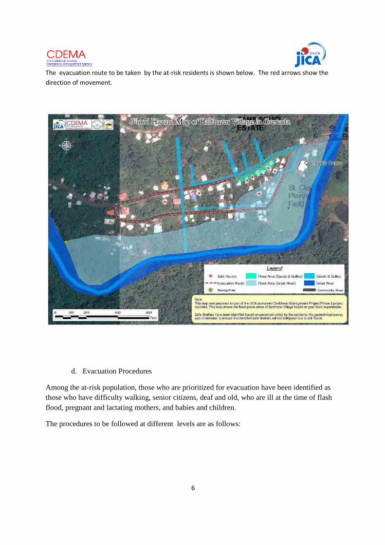
6
The evacuation route to be taken by the at-risk residents is shown below. The red arrows show the direction of movement.
d. Evacuation Procedures
Among the at-risk population, those who are prioritized for evacuation have been identified as those who have difficulty walking, senior citizens, deaf and old, who are ill at the time of flash flood, pregnant and lactating mothers, and babies and children.
The procedures to be followed at different levels are as follows:

7
Stage Situation Actions Level 1: Alert Stage A forecast of hurricane likely to
affect Grenada or continuos intense rainfall upstream of Balthazar Village or experienced at the village.
The Leader activates the Balthazar Village Flood Preparedness Team and identifies an Emergency Operation Center. The Team advises the at-risk residents to: -Ensure safety of the house: test all locks -Ensure valuable objects and documents that will be carried when evacuating are packed in evacuation kits (See Evauation Kit Annex) Team leader assigns monitoring team to monitor the river water level
Level 2 :Warning Stage :
First text message from the water level gauge received by the Flood Preparedness Team When river water reaches 2 ft above normal river water level
The Flood Preparedness Team: Warning and Evacuation Team start working Evacuation Team: - Advise the people who are in
the river, either fishing or washing clothes to immediately leave the river and move to higher grounds
Monitoring Team: - Continue monitor the condition of the Great River at the designated monitoring station.

8
Level 3: Preparation Stage
Second text message is received from the water level gauges When river water reaches 2 feet below the riverbank but not overflowing
Warning Team: - Announces preparation stage
and advises residents to prepare to evacuate.
Evacuation Team: - Evacuate the residents who are prioritized for safe movement
Level 4: Mandatory Evacuation
Third text message is received from the water level gauges. When river water reaches 1 foot below the riverbank but not overflowing but expected to overflow.
The team action Warning Team: - Warn the people to evacuate Evacuation Team: - Assist those who need to
evacuate and ensure that everyone who is at risk to flood moves to safety
Residents Actions: Lock the house, carry the evacuation kit* and proceed to the designated safe place Manage the family members and ensure that nobody strays from the safe house during the flash flood Wait for the “all clear signal”

9
c. Flood Preparedness Structure
The Flood risk management plan shall be implemented by a group of people who reside at Balthazar Village with the majority residing in the flood prone area of Lower Balthazar and who are given specific roles (Annex B). The plan shall be implemented by the disaster preparedness team which is organized as follows: Additional Team members: Yolande Dumont, Terisha Fortune, Tesra Fortune,
Denise Williams, Ann Charles, Andrea Lawrence, Rennet Lawrence, Rosalie Lawrence
Leader
(Thomas James)
Communication and Public Information (Education) Team
(Mirum Bascombe
Lindy Wickham
)
Transportation Team
(Jerry Alexander)
Medical Team*
(Sherry Ann, Andrea
Liquorish,Nesta Lawrence,
Donna Top and Yolande
Lawrence)
Security Team
(Wayne Wickham No. 654, Larry John, Kenneth
Bascombe No. 475)
c/o NaDMA
Warning Team
(Theresa James, Sujine Blair Lynnete King , Germaine
Dumont, Charmain Dumont)
Evacuation Team
(Allan Bascombe, Rodney Wickham and Hendy
Matthew)
Relief Team
(Yolande Dumont, Lisa Bascombe, Lindy Ann
Bascombe)

10
Annex A
No. Name Age Special Information
1 Eden Dowden 69 438-5129
2. Ann Charles 44 419-0809 (Head of Family)
3. Christine Dowden 16
4. Kelsey Dowden 12
Lindyann Bascombe 30 416-7247 (Head of Family)
6. Shakimma Bascombe 10
7. Latisha Bascombe 8
8. Duren Bascombe 4
9. Juydon Bascombe 2
10. Bat 41 Head of Family)
11. Lisa Bascombe 28
12 Paul Bascombe 6
13 Alisha Bascombe 1 yr
14 Dailia Bascombe 25 416-0908 (Head of Family)
15. Muntari Bascombe 2
16. Leslie Bascombe
17. Sujine Blair 33 537-4261 (Head of Family)
18. Matthew Blair 28 (Presently in Caricou working)
19. Jevon Blair 13
20. Theresa George 60
21. Noland George 26
22. Nolana George 23

11
23 Sally Ann George 29 538-5866 (Head of the Family)
24. Lydnis George 22
25. Lois George 20
26 Anthony George 4
27 Kennick George 3
28 Tony 1.5
29 Yvette Bascombe 53 Head of the Family
30 Kenneth Bascombe 29 438-3685
31 Floyd Bascombe 26
32 Karen Bascombe 23
33 Mirium Bascombe 21
34 John Bascombe 19
35 Dave Bascombe 18
36. Tamara Bascombe 1 yr
4 mos
37. Jean Dumont 73
38 Angela Dumont 52 442-6238
39 Yolande Dumont 39 442-6238/403-3777 (Head of the Family)
40. Anil Dumont 13
41 Wavel Dumont 10
42 Shania Dumont 6
43 Joseph Dumont 60 Leaving alone
44 Kendel Panchoo
45 Steven Roche 73 Deaf and old
46 Kechon Charles 25 Can host other families

12
(Head of the Family)
47 Kenrick Charles 20
48 Kenisha Charles 21
49 Mary Charles 20
50 Dorothy Sylvester 49
51 Shannel Sylvester 16
52 Theresa James 47 438-5969 (Head of the Family)
53 Kelon Lawrence 31
54 Lenon Lawrence 23
55 Lenhdon Lawrence 22
56 Che’s Lawrence 19
57 Abbie James 13
58 Keston James 10
59 Lynette King 48 Can host other families
60 Sullivan Date 43
61 Lindy Wickham 30
62 Lily King 11
63 Jamal Gittens 10
64 Lyndon Beegs 2
65 Audrey Wickham 78
66 Stephen Wickham 43
67 Andrew Wickham 50
68 Donna Wickham 44
69 Laurel John 30
70 Larry John 29
71 Rondell Wicham 25

13
72 Donell Wickham 22
73 Kavon Wickham 20
74 Lauren Wickham 18
75 Anika Wickham 13
76 Lorn Wickham 10
77 Leona John 7
78 Latoya John 5
79 Nelson Dumont 76 Can host other families in the upstairs section of the house
80 Cynthia James 72 417-7412
81 Marva Lawrence 40
82 Renate Lawrence 22 (Travelled to the USA)
83 Christopher Henry 25
84 Shumari Lawrence 2
85 Tannel Nelson 4
86 Shaquille Simon 13
87 Ronnie Williams
88 Nadine Williams
89 Jonnie Williams
90 Naudia Lashington
91 Nesta Lawrence 44 536-8118 (Head of the Family)
92 Nisa Lawrence 26
93 Andrea Lawrence 23
94 Donell Lawrence 20
95 Abbie Lawrence 8
96 Ashant Lawrence 7

14
97 Patricia Gibson 49 438-5094/457-4914 (Head of the Family)
98 Ranisha Gibson 5
99 Nyiesha Gibson 8
100 Dwight Bernard 23
101 Aiden Gibson 50
102 Kade Bernard 13
103 Cardell Bernard 19
104 Cardill Bernard 19

15
Annex B
Roles and Responsibilities of Disaster Prevention Team
Flood Preparedness Team Head
1. Establishes Emergency Operation Center to command activates the Team upon receipt of information on floods that may affect the community
2. Coordinates with NaDMA and the District Coordinator 3. Leads the decision-making actions on when to evacuate residents with the
participation of the Team members 4. Keeps in constant communication with the Team members and to keep updated
information about the situation
Responsibilities of each Team
Warning and Communication
1. Provides warning to residents of Lower Balthazar using the agreed warning communication to heighten more awareness of vulnerable population to move from the danger zone to pre-identified safe places.
2. Monitors the water level using the bamboo pole flood marker
Evacuation
1. Ensures that all families who will be affected by flood have evacuated from at-risk area to the designated safe houses, giving priority to people with special needs.
Security
1. Secures the vacated areas and the properties of the evacuees during emergency. 2. Maintains peace and order.
3. Monitors suspicious looking persons and apprehend them when necessary for
security reasons.
4. Ensures that no one is left behind in the at-risk areas once evacuation team declares completion of evacuation target.

16
Transportation
1. Ensures evacuation support vehicles are available and in good working condition. 2. Transports people in order of priority in coordination with the evacuation team
Medical/Health Team
1. Provides first aid to those who are injured during evacuation 2. Provides medical attention to the sick and those who are in need of medical care
Relief Team
1. Coordinates the distribution of immediate assistance to victims of flood disaster
Public Information and Communication Team
1. Conducts awareness raising activities in Balthazar Village so that all residents are aware of the Balthazar Village Evacuation Procedures and Early Warning System
2. Communicates to the residents the meaning of Warning Levels and the appropriate action according to the Plan
3. Monitors the hazard situation that might affect Balthazar Village by listening to the Radio and TV announcements and informing the Leader and the other members of the Team
4. Liaises with NADMA on possible training courses for the community

17
Annex C
List of Contact Persons
NaDMA
District Coordinator
Hospital
Police Station Grenville
Fire Station
Thomas James (Village Disaster Committee Leader)
438-5969
417-7412 (mother’s number)
Theresa James Warning Team Leader 438-5969/535-0715
Sujine Blair Warning Team member 438-4896/438-5129
Ann Charles Evacuation Team Leader 438-5129
Kelon Lawrence Evacuation Team Member 438-5969/534-8877
Yolande Dumont Relief Team Leader 442-6238
Jerry Alexander Transportation Team
Nurse Sherry Ann Medical Team Leader
Nesta Lawrence Medical Team Member 536-8118
Wayne Wickham Security Team Leader 442-9225/404-9488
Kenneth Bascombe Security Team 438-3685
Mirum Bascombe Public Information and Education Team Leader
414-6507/438-3685


FLOOD PREPARENESS PLAN
Upper Mahaica ( Little Biaboo and Big Biaboo)
Guyana
May 2012Community of Little Biaboo Big Biaboo


1
FLOOD PREPAREDNESS PLAN LITTLE BIABOO AND BIG BIABOO
I. Introduction
The villages of Little Biaboo and Big Biaboo are located on the right and left bank of the Mahaica River. Little Baiboo is about 7.5 miles from the beginning of the De Hoop Branch Road. Comparatively, Little Biaboo is the largest village in the Mahaica Creek, with a population of 300 persons and about 75 families. There are approximately 25 elderly and 10 disabled persons. Big Biaboo, on the other hand, has a total population of 81 persons, three of who are handicapped and six are elderly. The residential houses are located on the river bank of the Mahaica River close to the East Demerara Water Conservancy.
The location of Biaboo ( Little Biaboo and Big Baiboo) is shown in the map below. Grass Hook is an extended part of the community of Upper Mahaica River. Houses are clustered along the river bank. Little Biaboo, the larger of the two Biaboos has a health center with a resident nurse, a school which offers from nursery school to secondary level and a community office which was constructed with international funding.
The school was used in the past as the shelter for the residents who needed to evacuate. It is solar-powered and is big enough to accommodate the families who choose to stay at the school.
The residents are farmers who make a living from cash crops, rice cultivation and animal husbandry. Irrigation canals help the farmers raise their crops. However these same canals, if not locked during the heavy rains also become the source of inland inundation.

2
II. Flood Context
a. Flood
Upper Mahaica community experiences slow rising flood that stays for long duration affecting the farm lands, even after the flood water had receded.
Floods in Upper Mahaica are associated with continuous heavy rains. From the residents’ living memory, floods occur every year and sometimes occurring three times a year. The annual flooding lasts for an average of two months spoiling the crops and threatening the animals. In some years, animals died and the farm recovery was very slow. The residential houses, based on the residents’ worst experience, suffer between 2 to 3 feet of water while the farmlands, which are situated lower than the residential areas, suffer from an average of 5 feet of flood water.
The flood of 2005 lasted from December 2005 to January 2006 (total of two months). In this 2005 flood, over 2000 acres of rice was damaged and about Gy$3 Billion worth of cash crops.
The 2008-2009 flood was worse than the others experienced in previous years. The water reached about 3-4 ft and about 7 feet in the agricultural land. Flood Incident map of 2008 is shown in Figure 1.
b. Flood Risk
Risk assessment done in March 2011 shows that 8 houses (5 at Little Baiboo and 3 at Big Biaboo), the occupants and their movable and fixed assets, are directly at risk from flooding from the Mahaica River. Farmers, and their farm lots, have also been identified to be at risk. The list of occupants who are at risk is attached as Annex A. The other names in the list are located in areas that are affected by the flood but the risk is lower because their houses are on pillars and are above the historical flood water.
Further assessment identified other valuable assets and which are also at risk. These are:
Figure 1. Flood Incident Map of Little Biaboo and Big Biaboo

3
1. Ruminants such as cows, goats and sheep
2. Other kept animals with economic value such as chicken, ducks and turkey
3. Crops ( cash crops and annual crops)
III. Flood Risk Management
a. Early Warning System
Early Evacuation is one of the risk reduction options. Early Evacuation is triggered by Early Warning and Communication System.
There are three Phases leading to warning for evacuation designed for Upper Mahaica community, following that used by the Government of Guyana and implemented by the Civil Defense Commission (CDC). Code Yellow – Advisory Phase : Possibility of flooding conditions affecting the community within a 72-hour window exists Code Orange – Watch Phase: it is very likely that the flood may take place. The possibility of flooding exists within 25-48 hour window. Code red –Warning Phase: Flood threat increases and the probability of a flood occurring is greater than 80%. Code Red is activated within 12-24 hour window. During the warning phase , evacuation of all at-risk residents is advised.

4
b. Early Warning and Communication System of Upper Mahaica Community
Mobile Phone
Radio/TV Hand-held Radio
Door-to-door Door-to-door
Information from the Water Level Gauges at St. Cuthbert's, Little Biaboo and Maduni/ Information from rain gauge
NDIA Hydro-meterorological Agency
Demerara Water Conservancy
GINA
CDC National Emergency Operation Center
Meet Farmers with animals to evacuate
Advise families to be evacuated
Little Biaboo Sub-team & Big Biaboo Sub-team
Head of Upper Mahaica Flood Preparedness Team
Shelter Management Team
Prepare the safe shelters initially informing the school authorities and the health center caretaker
Figure 2. Information communication Flow under Code Yellow – Advisory Phase
Logistics/Supply Officer

5
Mob
ile P
hone
Radi
o/TV
Han
d-he
ld R
adio
Doo
r-to
-doo
r Info
rmat
ion
from
the
Wat
er L
evel
Gau
ges
at S
t. C
uthb
ert's
, Li
ttle
Bia
boo
and
Mad
uni/
Info
rmat
ion
from
rain
gau
ge
ND
IA
Hyd
ro-
met
eror
olog
ical
A
genc
y
Dem
erar
a W
ater
Co
nser
vanc
y
GIN
A
CDC
Nat
iona
l em
erge
ncy
Ope
ratio
ns C
ente
r
Hea
d of
Upp
er M
ahai
ca
Floo
d Pr
epar
edne
ss T
eam
Figu
re 3
. Inf
orm
atio
n co
mm
unic
atio
n Fl
ow u
nder
Cod
e O
rang
e (
Wat
ch P
hase
)
Evac
uate
ani
mal
s Litt
le B
iabo
o an
d Bi
g Bi
aboo
sub
-tea
m
Shel
ter
Man
agem
ent T
eam
Rece
ive
the
evac
uees
Evac
uate
the
mos
t vu
lner
able
Rive
r Mon
itor
(war
ning
team
)
Relie
f Tea
m
Med
ical
Tea
m

6
Mob
ile P
hone
Radi
o/TV
Han
d-he
ld R
adio
Doo
r-to
-doo
r
GIN
A
CDC
Nat
iona
l em
erge
ncy
Ope
ratio
ns C
ente
r
Hea
d of
Upp
er M
ahai
ca
Floo
d Pr
epar
edne
ss T
eam
Figu
re 4
. Inf
orm
atio
n co
mm
unic
atio
n Fl
ow u
nder
Cod
e Re
d (
War
ning
Pha
se )
Litt
le B
iabo
o an
d Bi
g Bi
aboo
sub
-tea
m
Shel
ter
Man
agem
ent T
eam
Rece
ive
the
evac
uees
Ev
acua
te th
e m
ost
vuln
erab
le
Rive
r Mon
itor
(war
ning
team
)
Info
rmat
ion
from
the
Wat
er L
evel
Gau
ges
at S
t. C
uthb
ert's
, Li
ttle
Bia
boo
and
Mad
uni/
Info
rmat
ion
from
rai
n ga
uge
ND
IA
Hyd
ro-
met
eror
olog
ical
A
genc
y
Dem
erar
a W
ater
Co
nser
vanc
y
Relie
f Tea
m
Med
ical
Tea
m
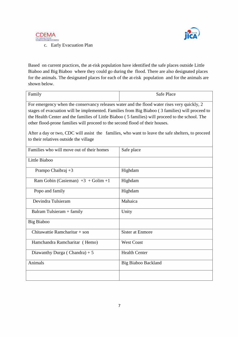
7
c. Early Evacuation Plan
Based on current practices, the at-risk population have identified the safe places outside Little Biaboo and Big Biaboo where they could go during the flood. There are also designated places for the animals. The designated places for each of the at-risk population and for the animals are shown below.
Family Safe Place
For emergency when the conservancy releases water and the flood water rises very quickly, 2 stages of evacuation will be implemented. Families from Big Biaboo ( 3 families) will proceed to the Health Center and the families of Little Biaboo ( 5 families) will proceed to the school. The other flood-prone families will proceed to the second flood of their houses.
After a day or two, CDC will assist the families, who want to leave the safe shelters, to proceed to their relatives outside the village
Families who will move out of their homes Safe place
Little Biaboo
Prampo Chaibraj +3 Highdam
Ram Gobin (Casieman) +3 + Golim +1 Highdam
Popo and family Highdam
Devindra Tulsieram Mahaica
Balram Tulsieram + family Unity
Big Biaboo
Chitawattie Ramcharitar + son Sister at Enmore
Hamchandra Ramcharitar ( Hemo) West Coast
Diawanthy Durga ( Chandra) + 5 Health Center
Animals Big Biaboo Backland

8
d. Evacuation Procedures
Among the at-risk population, those who are prioritized for evacuation have been identified as those who have difficulty walking, senior citizens, disabled, who are ill at the time of flood, pregnant and lactating mothers, and babies and children.
The procedures to be followed at different warning levels are as follows:
Stage Situation Actions Code Yellow: Advisory Stage 49-72 hours before possible flood
Notable increase in river levels and intense rainfall. Water level at the Eastern Demerara Conservancy reaches the critical level resulting to possible release of water should rain persist and levels continue to rise CDC informs the Flood Preparedness Team of the situation at the water level gauge in St. Cuthberts
CDC informs the community leader about the possibility of release of water from the conservancy and flooding Farmers are advised by Ministry of Agriculture to identify safe areas for animals and to start rounding up the animals Team Leader establishes the Emergency Operation Center. Flood Preparedness Team Leader calls a meeting of the Team leaders alerting the Shelter Manager and the Evacuation Team to advise the famers of potential evacuation of animals. Evacuation procedures are reviewed and availability of team members is established.
Code Orange: Watch Stage
Flood threat increases with potential to occur within the next 25-48 hours River water level reaches 2 feet below the river bank in Big Biaboo Second information is received from CDC regarding the situation at St. Cuthberts.
The Flood Preparedness Team: Warning Team - alert the residents to prepare for possible overflow of the Upper Mahaica River and initiate preparedness actions - Monitor the condition of the Upper Mahaica River at the designated monitoring station. Evacuation Team

9
-Starts evacuation of animals to designated safe areas upon the advise of the Ministry of Agriculture. Upon receipt of Code Orange, evacuate the most vulnerable with assistance from the evacuation team Shelter Manager - Inform the relatives who will host some of the evacuees especially the elderly and the disabled to prepare and receive them. -Remind those who need to evacuate to prepare the evacuation kit** The rest of the at-risk residents should: -Ensure safety of the house -Ensure valuable objects and appliances are elevated to be protected from flood water -Ensure basic needs especially baby needs and medicine and needs of residents that require special attention are stocked preparing for the long duration of flood
Code Red: Warning Phase 12-24 hours (Mandatory evacuation)
River water level reaches 8 inches below the river bank in Big Biaboo. The threat of flood is increased prompting the officials to activate the evacuation plan. Police force implements security plan Ministry of Education orders all schools to close and send the students home.
Upon receipt of Code Red, evacuate all with assistance from the evacuation team. Warning Team intensifies the dissemination of evacuation warning to the residents Evacuation Team and Shelter Manager work together to ensure all 9 families from Little Baiaboo and Big Baiaboo evacuate before the flood enters their houses rendering it more difficult to move.

10
CDC sends the third information from St. Cuthberts
Other Team Members stay at the Emergency Operation Center to assist in evacuation and providing the needed assistance.
Closing Down Phase CDC announces it is now safe to return home and orders the closing down of the Emergency Operation Center
Evacuees return home organized and managed by the evacuation team and the shelter manager under the leadership of the Flood Preparedness Team Leader. The response operation is ordered terminated with the closing down of the operation of the Emergency Operation Center.
*Agreed Protection Procedures shown as Annex B ** Content of Evacuation Kit shown as Annex C

11
Figure 5. Evacuation Route Map

12
e. Flood Preparedness Structure The Flood risk management plan shall be implemented by a group of people who reside at Little Biaboo, Big Biaboo, and Grass Hook who are given specific roles (Annex D). The plan shall be implemented by the disaster preparedness team which is organized as follows:
*Responsible for Monitoring the River level and reporting to the Chairperson, Warning the residents of Big Biaboo and evacuating the animals and transporting the at-risk families in Big Biaboo to the Health Center
** Responsible for warning the residents of Little Biaboo, evacuating the animals and transporting the at-risk families to the School.
Flood Preparedness Chairman ( Grace Khan)
Little Biaboo Sub-Team** Coordinator: Deeno Hussain Members: Papo Narayan Haimnaaauth (Randy) David Hussain Rosan Alli Khan
Big Biaboo Sub-Team*
Coordinator: Mr Goutam Persaud ( Mr Balo) Members: Vishal Sandesh Suresh
Shelter TeamZalaika Hussain Brihaspattie Matoora ( Devi) Relief Team Mahadai Parsooram Reetlall Parsooram Medical Team Shivanie Hussain Azrudeem Hussaiin Logistics/Supply Management Reetlall Parsooram Public Information (Teachers: Mahadai, Devi and Randy)

13
Annex A
No. Name Age Special Information
BIG BAIABOO
1 Omawattie 55 Head of the family
2. Ruth 19
3. Sunny Rambarran 74
4. Christopher Modray 16
5. Gotam Persaud 49 Head of the family
6. Bobby Persaud 42
7. Meriadai 18
8. Ramkaran 73 Living alone
9. Harrylall Ramkaran 54 Head of the family
10. Rookminee 51
11. Gopaul Roshan 2
12 Nankumar Ramkaran 54 Head of the family
13 Tarwattie 43
14 Randy 12
15. Mooldeo Tillick 41 Head of the family
16. Drupatie Tillick 37
17. Dashkarran Tillick 18
18. Homiwattie Tillick 15
19. Krishan Tillick 12
20. Kishan Tillick 10
21. Omkar Tillick 10
22. Ramcharran Autar 61 Handicap

14
23 Suckdeo 59
24. Gagdeshar 35
25. Celeshoar 49 Handicap
26 Jageo 35 Head of the family
27 Joylin 31
28 Keme 9
29 Zebida 7
30 Ramesh Ramdess 44 Head of the Family
31 Rupa Ramdess 36
32 Danesh Ramdass 22
33 Anjalee Ramdass 20
34 Hariram Ramkhellawan 64 Head of the family
35 Lackrajie Ramkhellawan 63
36. Tataram Ramkhellawan 32
37. Abinash 14
38 Haripaul Bhagwandeo 42 Head of the family
39 Jasmattie 43
40. Chatterpaul 19
41 Rohanie 18
42 Hero Heralall 25 Head of the family
43 Alexa 22
44 Rachel 2
45 Rebecca 4 months
46 Heralall Living alone
47 Diawanty Durga 40 Head of the family
48 Shani 16

15
49 Shaboo 15
50 Pollie 13
51 Sewehand 12
52 Nirmala 9
53 Savita 8
54 Pitambar Pooran 43 Head of the family
55 Phulmat Durga 48
56 Vivakand 20
57 Hardai 11
58 Padmine 6
59 Rambarran Roopnarine 50 Head of the family
60 Hemwantie 41
61 Pooran 20
62 Eshawer 16
63 Chabiraj 12
64 Kaymattie 8
65 Pratima 6
66 Gogdeshar Tilllick 36 Head of the family
67 Ramcharran 62 Handicap
68 Sheliq 60
69 Celeshoar 50 Handicap
70 Dewan Ramdass 41 Head of the family
71 Dolly 33
72 Dinesh 16
73 Devi 19
74 Pravesh 10

16
75 Pooran 64 Head of the family
76 Deowantie 59
77 Hamchandra Ramcharitar 42 Living alone
78 Chitrawattie Ramcharitar 52 Head of the family
79 Soowresh 22
80 Heera Parsram 58 Living alone
81 Slackie 41 Living alone
82 Deochand Ramcharitar 46 Head of the family
83 Ramcharitar 83
84 Nanda 39
85 Yankaran 15
86 Devica Gurdat 38 Head of the family
87 Sandesh 16
88 Sudesh 15
89 Ramlesh 13
90 Parsuram Khelawan 74 Living alone
91 Jairam Khelawan 50 Living alone
92 Lildhar Makhanlall 43 Head of the family
93 Ormilla 39
94 Narendra 20
95 Navendra 10
96 Sunita 14
97 Totaram Balskun 54 Head of the family
98 Ramdeo 49
99 Sewkumar 31
100 Vishal 4

17
101 Dainel 3
102 Harrylall Mahadeo 63 Head of the family
103 Hansrani 53
104 Ravendra 29
105 Raywattie 23
106 Ranie 20
107 Mahesh 19
108 Balram Pooram 41 Head of the family
109 Padmuttie 34
110 Sujit 18
111 Chandrautie 14
112 Toranie 12
113 Ramnarie Ramotar 47 Head of the family
114 Lalita 36
115 Phagoni 86
116 Amal Dass 54 Head of the family
117 Seeta 50
118 Dasrat Dass 35 Head of the family
119 Natasha 30
120 Omadai 6

18
GRASS HOOK
1 Mr. Premdass 78 Head of the family
2 Mrs. Baby 71
3 Badranauth 31
4 Navin 15
5 Sugrim Sarju 53 Head of the family
6 Sunita 46
7 Subrian 21
8 Parmanand 27
9 Rajesh Bissondyal 36 Head of the family
10 Indera 29
11 Karishma 11
12 Ajay 10
13 Kajol 9
14 Diaram 57 Leaving alone
15 Chabiraj Ramdeen 58 Head of the family
16 Inderdai 50
17 Suresh 26
18 Rajesh 27
19 Navesh 21
20 Kuldeo Indar 44 Head of the family
21 Carmen 38
22 Tularam 16
23 Ghargee 17

19
LITTLE BAIABOO
1 Lakeram Raghunauth 32 Head of the family
2 Premkumarie Ganpat 28
3 Davianie Raghunauth 7
4 Saskia Raghunauth 3
5 Suriypaul Ganpat 56 Head of the family
6 Khaimrajee Ganpat 51
7 Gagat Narine Ganpat 31
8 Mahesh Ganpat 17
9 Chaitram Haimnauth 48 Head of the family
10 Rajkoomarie Haimnauth 44
11 Narayan Haimnauth 18
12 Geetram Haimnauth 25 Head of the family
13 Gaintree Sewsankar 21
14 Devendra Haimhanauth 2
15 Hema Haimhanauth 5 months
16 Haimnauth 72 Elderly living alone (2)
17 Parbati 69
18 Seednauth Haimnauth 51 Head of the family
19 Handai Haimnauth 49
20 Gangaram Haimnauth 27
21 Taranauth 67 Elderly living alone (2)
22 Rattee 64
23 Sertrohan taranauth 37 Head of the family
24 Devika Latchman 36
25 Anand Taranauth 16

20
26 Ramnarine Taranauth 18
27 Kawall John 49 Head of the family
28 Maywattie John 41
29 Sanjay John 22
30 Doodnauth John 20
31 Ramdularie 71 Disabled
32 Porandeo John 41
33 Johnnie Persaud 66 Head of the family
34 Dhanawantie Persaud 63
35 Harrypaul Persaud 40 Head of the family
36 Indermsthe Persaud 37
37 Dhanpaul Persaud 16
38 Rajin Persaud 15
39 Sumeeta Devi Persaud 12
40 Parasram Ganpat 59 Living alone
41 Dasmattee Haricharan 59 Living alone
42 Dhanrajee Budhu 66 Living alone
43 Bhagwandat Matoora 43 Head of the family
44 Kamaldeo Sam 47
45 Rohani Sam 37
46 Brihaspattie Matoora 17
47 Maheshwar Matoora 15
48 Haimraj Matoora 14
49 Yasmin Matoora 12
50 Lilowtie Matoora 10
51 Rampaul Matoora 6

21
52 Chandradial Autaram Living alone
53 Bhowal Autaram 40 Head of the family
54 Gaitree Magesar 28
55 Davekumar Autaram 7
56 Sowaru Autaram 71 Head of the family
57 Donoodmattie Autaram 61
58 Thakoomatieram Autaram 45
59 Bissondyal Samaroo 31 Head of the family
60 Nafeeza Khan 23
61 Deno Hussain 49 Head of the family
62 Kamiza Hussain 41
63 Aleena Hussain 18
64 Rosan Alli Khan 59 Head of the family 656-8967
65 Grace Khan 55
66 Razia Khan 30
67 Shamir Hussain 80 Head of the family 618-3767
68 Zelaika Hussain 77
69 Jagatram Ramcharitar 29 Head of the family 610-1105
70 Nafeeza Soodoo 25
71 Gomat Ramcharitar 3
72 Deodharry Shibsahai 48 Head of the family 621-7332
73 Fazeena Shibsahai 47
74 Rayon Shibsahai 26
75 Trevor Giahan 36
76 Dhanmattie 29
77 Cindy 7

22
78 Celiena 6
79 Tina 5
80 Suraj 2
81 Parbattie Itwaru 59 Living alone
82 Balram Tulsiram 46 Head of the Family
83 Bandawattie 37
84 Karina 4
85 Roopchand 3
86 Arjoon 2
87 Tackur Barry 25 Head of the family
88 Mahadai 18
89 Wazir Mohamed 46 Head of the family 666-4035
90 Ameer 16
91 Fameena 9
92 Bibi Kamrool 69 Head of the family
93 Nazeer Mohamed 37
94 Kayume Mohamed 41 Head of the family
95 Powbattie 37
96 Sahfeek 5
97 Shafeeza 3
98 Shaheeda 1
99
100 Mohamed Shalim 69 Head of the family
101 Najran 61
102 Abdul Rojameer Shalim 39 Head of the family
103 Salma 11

23
104 Devindra Tulsiram 20 Living alone
105 Bhagwar Persaud 46 Head of the family
106 Salima Shariff 46
107 Mirzaad 22
108 Kamal Persaud 53 Living alone
109 Khemraj Persaud 36 Head of the family 688-0535
110 Bibi Bachus 32
111 Chandanie 10
112 Tulsidai 9
113 Deodat Persaud 63 Head of the family
114 Parbattie 59
115 Rikraj Persaud 33 Head of the family 626-1889
116 Debbie 31
117 Randy 8
118 Reya 5
119 Ryan 3
120 Neeranjalall Bissondyal 35 Head of the family
121 Nanda 31
122 Keisha 13
123 Trisha 11
124 Jagatnarine Udai 31 Head of the family
125 Pulmattie 20
126 Avendra 1
127 Mahadeo Udai 67 Head of the family
128 Sahodire 62
129 Reeetlall Parsooram 50 Head of the family 621-5341

24
130 Meendai 42
131 Mahadai 19 649-7245
132 Lachmin 13
133 Ramdass 78
Parsooram Udai 74 Living alone
134 Chaitram Ramdass 35 Head of the family 628-7932
135 Lillawattie 35
136 Kumar 13
137 Tolosram 12
138 Shiram 4
139 Satnarine Udai 36 Head of the family
140 Bhagwantie 33
141 Muneshwar 12
142 Lilodar 10
143 Dhruvesh 7
144 Kenny 1
145 Elvis Hussain 48 Head of the family
146 Eva 44
147 Sharmaine 25
148 Daniel 20
149 David 17
150 Shahabaddin Khan 28 Head of Family
151 Shamdai 22
152 Aamdai 7
153 Azad Hussain 51 Head of the family 638-2100
154 Rohanie 49

25
155 Shivanie 22 641-6497
156 Azhrudeen 19
157 Araf 16
158 Shafeena 11
159 Shafeek 6
160 Azif Hussain 30 Head of the family
161 Shannielle 26
162 Antonio 6
163 Adil 2
164 Kamalodeen Hussain 27 Head of the family
165 Gomattie 22
166 Anmaria 6
167 Ramesh Bipat Head of the family 653-3812
168 Zahaida
169 Kaliam Hussain 56 Head of the family
170 Mahadai 57
171 Zaheer 16
172 Dennis Bermner 38 Head of the family
173 Foyyaadh 12
174 Reyad 9
175 Sadyah 7
176 Latif Soman 54 Head of the family
177 Badora 12
178 Fazal Hussain 53 Head of the family
179 Zulika 50
180 Zaleal Hussain 57 Head of the family

26
Khatoon 51
181 Fizal Kasim 30 Head of the family 642-4100
182 Shafrana Kasim 27 657-6180
183 Ridhwan 7
184 Saahirah 6
185 Naeem Hussain 27 Head of the family
186 Jenny 17
187 Altab Hussain 54 Head of the family
189 Ijaz 21
190 Narisa 16
191 Ameer Hoosain 21 Head of the family
192 Sharda 17
193 Alladeen Hoosain 49 Head of the family
194 Yasmin 45
195 Mohamed Hoosain 90
196 Shamsshundar Ramrup 30 Head of the family
197 Dirya 23
198 Sarita 2
199 Satwantie Ramrup 52
200 Mala 31
201 Videsh 21
202 Hookadebi Chaitu 65 Head of the family
203 Bhagwattie 53
204 Gopaul 17
205 Satish Sookram 30 Head of the family
206 Rafina 24

27
207 Saeed 6
208 Shaahid 4
209 Mohanlall Sukhram 57 Living alone
210 Zameer Hoosain 23 Head of the family
211 Latchmin 25
212 Shivraj 9
213 Vickash 7
214 Annalisa 5
215 Hanoraj Maniram 38 Head of the family
216 Lelawattie 39
217 Doodnauth 15
218 Wakanand 11
219 Ramkedar Maniram 75 Head of the family
220 Ramrattie 69
221 Roopnarine Maniram 41 Head of the family
222 Fazeela 31
223 Haresh 14
224 Michael 12
225 Andrew 10
226 Samuel Phillip Head of the family
227 Patsy
228 Christine
229 Rasheed alli 67 Head of the family
230 Jaitoon 63
231 Surwan autar 25 Head of the family
232 Joy Autar 24

28
233 Khemraj Ghanchand 39 Head of the family
234 Reshma 34
235 Reema 16
236 Odesh 15
237 Safraz Hussain 30 Living alone
238 Airzad Shaffe 18 Head of the family
239 Kumarie 18
240 Yadeo Mangal 55 Head of the family
241 Hardai 49
242 Kormal 28
243 Tulsidai 10
244 Darshanie 8 Disabled
245 Doodnauth Mangal 47 Head of the family
246 Rajmattie 42
247 Amarnauth 19
248 Yogaishaw Singh 45 Head of the family
249 Natasha 36
250 Shandil 15
251 Chandroutie 14
252 Karashme 11
253 Heeral Patesar 49 Living alone
254 Deochand Mulchand 45 Head of the family
255 Sandish 20
256 Mohani 18
257 Rohani 5 months
258 Deonauth Gurdath 36 Head of the family

29
259 Rajmattie 31
260 Narendra 24
261 Chandika 16
262 Bissondyal Singh 42 Head of the family
263 Divindra 13
264 Dharmindra 10
265 Praimraj Patesar 45 Head of the family
266 Lakshme 32
267 Chandanee 13
268 Ramnaresh 11
269 Parmanand Parooram 46 Head of the family
270 Parbattie 45
271 Mohini 27
272 Harischandra 16
273 Chaitram 11
274 Nancoomar tulsi 48 Head of the family
275 Lalita 44
276 Doodmattie 14
277 Vidyawattie 10
278 Leila Singh Pataysar 57 Head of the family
279 Haywattie 51
280 Ramgobin 41 Head of the family
281 Jasmattie 30
282 Nandranie 14
283 Khemraj 9
284 Lakeram Chabiraj 51 Head of the family

30
285 Roopram 22
286 Ganesh 20
287 Homwattie Devi Chabiraj 48 Head of the family
288 Mahesh 20
289 Chandnie 19 months
290 Harryram Head of the family
291 Nalini
292 Motilall 59 Living alone
293 Sylvan Head of the family
294 Golin

31
Annex B
Procedures for protecting the different elements at risk
Elderly and Disabled having special needs
1. Ensure that the elderly and persons with special needs are taken to a safe place, which is warm and dry with ready access to toilet and bath, before the flood occurs. This safe place could be with relatives whose house is located in flood-safe area, a temporary shelter or a safe place inside the house.
2. Organize volunteers to monitor the health conditions of the elderly and persons with special needs.
3. Monitor and ensure the hygiene requirements are met.
Children and Babies
1. Supervise and keep the children in flood-safe place away from flood water to avoid contracting water-borne diseases
2. Ensure the availability of safe drinking water 3. Before the flood, educate the children in “living with flood” – how to behave during
flooding situation
Animals
1. Before the flood occurs, take the animals who cannot survive in water, to higher grounds away from flood.
2. Organize volunteers to gather feeds, take feeds to animals and ensure that animals are safe and animal waste is disposed of properly to avoid contaminating the environment
3. For animals that will remain in flooded area, ensure that the waste is disposed of and not thrown in the flood water to avoid water-bourne disease .
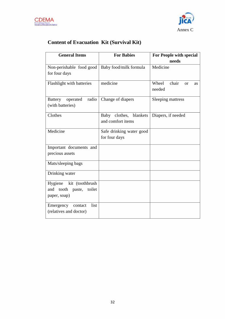
32
Annex C
Content of Evacuation Kit (Survival Kit)
General Items For Babies For People with special needs
Non-perishable food good for four days
Baby food/milk formula Medicine
Flashlight with batteries medicine Wheel chair or as needed
Battery operated radio (with batteries)
Change of diapers Sleeping mattress
Clothes Baby clothes, blankets and comfort items
Diapers, if needed
Medicine Safe drinking water good for four days
Important documents and precious assets
Mats/sleeping bags
Drinking water
Hygiene kit (toothbrush and tooth paste, toilet paper, soap)
Emergency contact list (relatives and doctor)

33
Annex D
Roles and Responsibilities of Flood Preparedness Team
Flood Preparedness Team Head
1. Establishes Emergency Operation Center to command activates the Team upon receipt of information on floods that may affect the community
2. Coordinates with CDC 3. Leads the decision-making actions on when to evacuate residents with the
participation of the Team members 4. Keeps in constant communication with the Team members and to keep updated
information about the situation
Responsibilities of each Team
Warning and Communication
1. Provides warning to residents of Upper Mahaica specifically Little Biaboo, Big Biaboo and Grass Hook using the agreed warning communication to heighten more awareness of vulnerable population to move from the danger zone to pre-identified safe places.
2. Monitors the water level in Upper Mahaica River
Evacuation /Search and Rescue
1. Ensures that all families who will be affected by flood have evacuated from at-risk area to the designated safe houses, giving priority to people with special needs.
2. Ensures that the animals are evacuated on time and that these animals stay in the agreed safe location
Security
1. Secures the vacated areas and the properties of the evacuees for the duration of the flood and while the evacuees are away from home.
2. Ensures that no animal is left behind in flood-prone areas and secures the safety of
animals at the designated safe area
3. Maintains peace and order and ensures the safety of residents for the duration of the flood

34
Transportation
1. Ensures evacuation support vehicles are available and in good working condition. 2. Transports people in order of priority in coordination with the evacuation team
Medical/Health Team
1. Provides medical attention to the sick and those who are in need of medical care 2. Monitors the health and hygiene requirements of the at-risk population
Relief Team
1. Coordinates the distribution of immediate assistance to victims of flood disaster 2. Coordinates the feeding of animals at safe areas, making sure that feeds are available
Shelter Management /Relief Team
1. Prepares safe evacuation centers according to evacuation plan. 1. Ensures that everyone is safe in the shelter 2. Organizes the evacuees and engages the evacuees into important activities while in
the shelter
Public Information and Communication Team
1. Conducts awareness raising activities in Upper Mahaica Village s such as Little Biaboo, Big Biaboo and Grass Hook so that all residents are aware of the Upper Mahaica Flood Protection Procedures and Early Warning System
2. Communicates to the residents the meaning of Warning Levels and the appropriate action according to the Plan
3. Educates the residents on the proper behavior during the flood and how to “live with flood”.

35
Annex E
List of Contact Persons
Civil Defence Commission

36

Warning Communication and Evacuation
Procedures
Corinthe Housing Development
May 2012
Gros Islet Disaster Committee
And
Residents of Corinthe Housing Development


1
Warning Communication and Evacuation Procedure Corinthe Housing Development
Gros Islet, St. Lucia
I. Introduction
The National Emergency Management Organisation, together with the Gros Islet Disaster Committee and the community at Corinthe Housing Development, produced this plan to evacuate the residents and visitors in times of flash flood. Corinthe is a rapidly growing community, located in Gros Islet, a district in the north of Saint Lucia. Lime, the communication company is the biggest company located in the area. Within the Corinthe area a housing development called Corinthe Housing Development, with an estimated 50 families, is located. The area is bounded on the West by Corinthe River, sometimes referred to as the Grand Riviere River. Corinthe Road bounds the community to the East. This plan serves as a guide on what to do when there is a threat of flash flood in the housing development. II. Flood Context a. Flood History
Floods can be caused by continuous heavy rain or rain that accompanies hurricanes. The Corinthe River is not the only source of flood water. Water can also rush down to the housing area from the gullies uphill of the Corinthe Road and spills into Flamboyant Park, choking the drainage canals. When this happens, water overflows and invades the housing area. The area has experienced flooding in recent years. The following shows the flood history of Corinthe Housing Development.
Date Cause of Flood Effect
April 2011 Heavy rain Minimal flooding
October 30, 2010 Rain brought by Hurricane Tomas
Damaging flood
October 2008 Heavy rain brought by Hurricane Omar
Damaging flood

2
b. Flood Risk
There are two kinds of houses built in the housing area: bungalows, elevated houses on pillars and one storey apartments. Some of the owners of elevated houses constructed downstairs apartments. These apartments are rented to tenants although the apartments are prone to flooding.
Five bungalow houses are located in flood-prone area of the housing development and nine upstairs/downstairs houses are affected by flood.
III. Flood Risk Management
a. Early Warning System
Early Evacuation is one of the risk reduction options. Early Evacuation is triggered by Early Warning and Communication System.
Warning Level River conditions
1 ( Alert Stage)
Flood is possible but the condition does not pose imminent danger to the residents
River level at Upper Corinth reaches 18.8 m ( above sea level). River level in Corinth Housing Development reaches 10.0 m ( above sea level). River water level reaches the river bank at the bottom
Two-storey house Apartment ( flat )
Bungalow
Figure 1. Flood Hazard Map of Corinthe Housing Development

3
b. Early Warning Communication Flow
of Flamboyant Park.2 (Evacuation Stage)
Flood is dangerous
River level at Upper Corinth reaches 19.4 m ( above sea level). River level at Corinth Housing Development reaches 10.2 m ( above sea level). Local warning pole shows the water level reaches 1 foot above the river bank.
Corinth FloodPreparedness Team
Information from Water-level Gauge(s) and/or Rain Gauge
National EmergencyManagement Office
Hydro-meteorologicalAgency
Automatic message through Cell Phone
Figure 2. Warning Level No.1 & 2
Gros Islet
Disaster Committee
Evacuation Team River Monitor Warning Dissemination
Residents of Corinth

4
c. Early Evacuation Plan
Family ( Names and location) Safe Place ( name of host families and location)
Flamboyant Drive
1. Patrick Noel and Family Claudia Winnett
2. Therese Charles and Family Nigel Bailey
3. House under renovation Nurse's house ( Suzanne Jolie?)
4. New house with downstairs house developed into two apartments
Upstairs house
5. Jonash and Family ( renters) No identified safe place
Flamboyant Park
1. Darille Jervis &Lyla Rierre ( renters of downstairs apartment)
Eileen Francis ( Upstairs house- landlord)
2. Vivian Smith ( bungalow) Eileen Francis
3. Mary Rose ( downstairs tenant of Marge Jn Baptiste)
Mother in Flamboyant Drive ( elevated house)
4. Dorine Headen (bungalow) Marge Jn Baptiste
5. Downstairs tenants Michelle and Ron Blanchard
6. William Wilson and Family Joseph "Rick" Fata
7. Apartment tenant next to William Joseph " Rick" Fata
8. Downstairs Tenants Jermaine Alexander
9. Rick Fata's downstair's tenants Upstairs section of rented house belonging to Rick Fata
10. Mr Paul Esnar ( landlord) Upstairs tenants Martha and Ingrid
11. Mr Joe Leonce and Wife ( house owner) Upstairs section of house
12. Mr Auguste Wilcott and family ( house owner) Upstairs section of house
13. Apartment tenants of My Wayne Mr Wayne's " Pop" house

5
The evacuation route to be taken by the at-risk residents is shown below. The red arrows show the direction of movement of cars which are taken out of the flood-prone area when there is a possibility of flood. The arrows also show the at-risk families who will move to other houses in the area for safety. The map also shows the location of people ( tenants and owners alike) who will move upstairs to safety.
d. Evacuation Procedures
Warning Level River conditions Actions to be taken by Residents and the Flood Preparedness Team
1 ( Alert Stage)
Flood is possible but the condition does not pose imminent danger to the residents
River level at Upper Corinth reaches 18.8 m.
River level in Corinth Housing Development reaches 10.0 m.
Gros Islet Disaster Committee:
a. Activate the Corinth Flood Preparedness Team
Flood Preparedness Team will:
a. Alert the residents of the situation and remind them to prepare to evacuate if the situation gets worse
b. River monitors proceed

6
to the river to observe the water level and report to the other members of the team and to the Coordinator/Leader of Corinth Flood Preparedness Team.
c. Coordinate with Fire Rescue Department
At risk residents:
a. Prepare to evacuate
b. Move cars to safe area
c. Ensure that the most vulnerable ( babies, sick, elderly and disadvantaged) are prioritized for evacuation.
2 (Evacuation Stage)
Flood is absolutely dangerous
River level at Upper Corinth reaches 19.4 m
River level at Corinth Housing Development reaches 10.2 m.
Flood Preparedness Team Members will:
a. Announce the evacuation warning using megaphones
b. Assist the at-risk residents to move to safe shelter.
At-risk residents should move to safe shelter ( upper section of the house or next door neighbor which is safe from flood)

7
c. Flood Preparedness Structure
The Flood risk management plan shall be implemented by a group of people who reside at the pilot site and who are given specific roles (Annex B). The plan shall be implemented by the disaster preparedness team which is organized as follows:
Members of the Corinth Flood Preparedness Team
Gros Islet Disaster Committee - Jennifer Gaston
Thaddeus Montaut
Team Leader/Coordinator - Claudia Winnette
Flood Marker Monitor - Nigel Fedee
Warning Dissemination- Joseph Fata "Rick" Diane Joseph
Camilla Jn Baptiste Patick Noel
Evacuation Assistance - Joseph Fata "Rick", Diane Joseph, Patrick Noel

8
O
RGA
NIZ
ATIO
NA
L ST
RUCT
URE
OF
FLO
OD
PRE
PARE
DN
ESS
IN C
ORI
NTH
.
Gro
s Is
let D
isas
ter
Com
mitt
ee
Jenn
ifer G
asto
n
Thad
deus
Mon
taut
Cori
nth
Floo
d Pr
epar
edne
ss T
eam
Coor
dina
tor/
Lead
er: C
laud
ia W
inne
tte
Evac
uatio
n A
ssis
tanc
e
Jose
ph F
atal
"Ri
cky"
D
iane
Jose
ph
Patr
ick
Noe
l
Floo
d Le
vel M
onito
ring
Jose
ph F
atal
"Ri
cky"
N
igel
Fed
ee
War
ning
Dis
sem
inat
ion
Jose
ph F
atal
"Ri
cky"
D
iane
Jose
ph
Cam
illa
Jn. B
aptis
te

9
Roles and Responsibilities of Disaster Prevention Team
Flood Preparedness Team Coordinator
1. Activates the Team upon receipt of information on floods that may affect the community
2. Coordinates with NEMO and Gros Islet Disaster Committee 3. Leads the decision-making actions on when to evacuate residents with the
participation of the Team members 4. Keeps in constant communication with the Team members and to keep updated
information about the situation
Responsibilities of each Team
Warning and Communication
1. Provides warning to residents of Corinth Housing Development and Corinth Road using the agreed warning communication to heighten more awareness of vulnerable population to move from the danger zone to pre-identified safe places.
2. Monitors the water level using the flood marker
Evacuation
1. Ensures that all families who will be affected by flood have evacuated from at-risk area to the designated safe houses, giving priority to people with special needs.

10
Annex C
List of Contact Persons
NEMO
Gros Islet Disaster Committee
Jennifer Gaston
Thaddeus Montaut
Angela
Fire Rescue
Claudia Winnett (Corinthe Disaster Committee Leader)
Joseph "ricky" Fatal Member
Patrick Noel Member 450-1688
Camilla Jn. Baptiste Member 450-4583