Arsenic in groundwaters of the Lower Mekong
17
Arsenic in groundwaters of the Lower Mekong Gordon Stanger 1,6 , To VanTruong 2 , K.S. Le Thi My Ngoc 3 , T.V. Luyen 4 & Tuyen Tran Thanh 5 1 Australia-based water resources consultant, currently with the UNDP, Box 551, Sanaa ´, Yemen 2 Sub-Institute for Water Resources Planning, 253A An Duong Vuong, Quan 5, TP Ho Chi Minh, Vietnam 3 Sub Institute of Hydrometeorology of South Vietnam, Phu Trach Tram, Tram Thuc Nghiem, KTTVNN, Dong Bang, Song Cuu Long, Vietnam 4 Centre for Nuclear Techniques, 217 Nguyen Trai St., Quan 1, TP Ho Chi Minh, Vietnam 5 Department of Environmental and Natural Resources Management, Can Tho University, 3/2 Street, TP Can Tho, Vietnam 6 Author for correspondence (e-mail: [email protected]) Received 14 October 2004; Accepted 17 March 2005 Key words: arsenic, arsenicosis, Cambodia, Cuu Long Delta, groundwater, Mekong, Vietnam Abstract Increasing incidence and awareness of arsenic in many alluvial aquifers of South-east Asia has raised concern over possible arsenic in the Lower Mekong Basin. Here, we have undertaken new research and reviewed many previous small-scale studies to provide a comprehensive overview of the status of arsenic in aquifers of Cambodia and the Cuu Long Delta of Vietnam. In general natural arsenic originates from the Upper Mekong basin, rather than from the local geology, and is widespread in soils at typical concentrations of between 8 and 16 ppm (dry weight). Industrial and agricultural arsenic is localised and relatively unimportant compared to the natural alluvial arsenic. Aquifers most typically contain groundwaters of no more than 10 lgL )1 , although scattered anomalous areas of 10 to 30 lgL )1 are also quite common. The most serious, but possibly ephemeral arsenic anomalies, of up to 600 lgL )1 , are associated with iron and organic-rich flood-plain sediments subject to very large flood-related fluctuations in water level, resulting in transient arsenopyrite dissolution under oxidizing conditions. In general, however, high-arsenic groundwaters result from the competing interaction between sorption and dissolution processes, in which arsenic is only released under reducing and slightly alkaline conditions. High arsenic groundwaters are found both in shallow water-tables, and in deeper aquifers of between 100 and 120 m depth. There is no evidence of widespread arsenicosis, but there are serious localised health-hazards, and some risk of low-level arsenic ingestion through indirect pathways, such as through contaminated rice and aquaculture. An almost ubiquitous presence of arsenic in soils, together with the likelihood of greatly increased groundwater extraction in the future, will require continuing caution in water resources development throughout the region. Introduction In recent years, high-profile discussion of the arsenic problems in Bangladesh, West Bengal and Nepal has raised fears of impending arsenic problems in other regions of comparable hydrog- eology. High amongst these concerns is the Cuu Long (Mekong) Delta in Southern Vietnam, and adjacent areas of Cambodia where the Lower Mekong and its tributaries connect with significant alluvial aquifers deposited by the ‘palaeo-MekongÕ and other rivers. The arsenic threat has been recognised since the late 1990s, and many studies have been undertaken by regional and central government departments and concerned NGOs, partly using off-the-shelf test kits, and partly util- ising laboratory facilities in Phnom Penh, Can Tho and Ho Chi Minh Cities. This paper is an attempt Environmental Geochemistry and Health (2005) 27:341–357 Ó Springer 2005 DOI: 10.1007/s10653-005-3991-x
Transcript of Arsenic in groundwaters of the Lower Mekong

Arsenic in groundwaters of the Lower Mekong
Gordon Stanger1,6, To VanTruong2, K.S. Le Thi My Ngoc3, T.V. Luyen4 & Tuyen Tran Thanh51Australia-based water resources consultant, currently with the UNDP, Box 551, Sanaa, Yemen2Sub-Institute for Water Resources Planning, 253A An Duong Vuong, Quan 5, TP Ho Chi Minh, Vietnam3Sub Institute of Hydrometeorology of South Vietnam, Phu Trach Tram, Tram Thuc Nghiem, KTTVNN,Dong Bang, Song Cuu Long, Vietnam4Centre for Nuclear Techniques, 217 Nguyen Trai St., Quan 1, TP Ho Chi Minh, Vietnam5Department of Environmental and Natural Resources Management, Can Tho University, 3/2 Street, TP CanTho, Vietnam6Author for correspondence (e-mail: [email protected])
Received 14 October 2004; Accepted 17 March 2005
Key words: arsenic, arsenicosis, Cambodia, Cuu Long Delta, groundwater, Mekong, Vietnam
Abstract
Increasing incidence and awareness of arsenic in many alluvial aquifers of South-east Asia has raised concernover possible arsenic in the LowerMekongBasin.Here, we have undertaken new research and reviewedmanyprevious small-scale studies to provide a comprehensive overview of the status of arsenic in aquifers ofCambodia and the Cuu LongDelta of Vietnam. In general natural arsenic originates from theUpperMekongbasin, rather than from the local geology, and is widespread in soils at typical concentrations of between 8 and16 ppm (dry weight). Industrial and agricultural arsenic is localised and relatively unimportant compared tothe natural alluvial arsenic. Aquifers most typically contain groundwaters of no more than 10 lg L)1,although scattered anomalous areas of 10 to 30 lg L)1 are also quite common. Themost serious, but possiblyephemeral arsenic anomalies, of up to 600 lg L)1, are associated with iron and organic-rich flood-plainsediments subject to very large flood-related fluctuations in water level, resulting in transient arsenopyritedissolution under oxidizing conditions. In general, however, high-arsenic groundwaters result from thecompeting interaction between sorption and dissolution processes, in which arsenic is only released underreducing and slightly alkaline conditions. High arsenic groundwaters are found both in shallow water-tables,and in deeper aquifers of between 100 and 120 m depth. There is no evidence of widespread arsenicosis, butthere are serious localised health-hazards, and some risk of low-level arsenic ingestion through indirectpathways, such as through contaminated rice and aquaculture. An almost ubiquitous presence of arsenic insoils, together with the likelihood of greatly increased groundwater extraction in the future, will requirecontinuing caution in water resources development throughout the region.
Introduction
In recent years, high-profile discussion of thearsenic problems in Bangladesh, West Bengal andNepal has raised fears of impending arsenicproblems in other regions of comparable hydrog-eology. High amongst these concerns is the CuuLong (Mekong) Delta in Southern Vietnam, andadjacent areas of Cambodia where the Lower
Mekong and its tributaries connect with significantalluvial aquifers deposited by the ‘palaeo-Mekong�and other rivers. The arsenic threat has beenrecognised since the late 1990s, and many studieshave been undertaken by regional and centralgovernment departments and concerned NGOs,partly using off-the-shelf test kits, and partly util-ising laboratory facilities in Phnom Penh, Can Thoand Ho Chi Minh Cities. This paper is an attempt
Environmental Geochemistry and Health (2005) 27:341–357 � Springer 2005DOI: 10.1007/s10653-005-3991-x

to draw together the existing data from numeroussources, supplemented by our own field and lab-oratory work, to ‘fill in the gaps�. The overallfinding is that of a less dire arsenic distributionthan in Bangladesh, Uttar Pradesh, Nepal and theRed River Basin of Northern Vietnam. Neverthe-less, there are localised arsenic ‘hot-spots�, a moregeneral risk of low-level arsenic ingestion (argu-ably sub-clinical in effect), additional potentialpathways of arsenic exposure through the foodchain, and a potential for increasing arsenic con-centrations in groundwater over time. In short,there are a few sites requiring urgent attention, anda generally low-level problem elsewhere. The latterrequires continuing vigilance, but is of relativelyminor importance compared to microbiological,PAH1 and organophosphate pesticide contamina-tion in Cambodia and Vietnam.
Geology, hydrogeology and drainage of the Lower
Mekong
The Lower Mekong in Cambodia and Vietnamnaturally divides into three geologically andphysiographically distinct areas; the main channelarea, the Tonle Sap, and the Cuu Long Delta (i.e.the Mekong Delta).
Between the Lao-Cambodian border andPhnom Penh the flood plain is narrow to com-pletely absent, with heavily forested hills of up to600 m in elevation constricting the Mekong Riveron both banks. These hills are of Triassic age,comprising partly basalts and partly sediments ofthe Lower- to Mid-Indosinias group. In this area,the Indosinias consists of andesitic and daciticlavas with predominantly continental sandstones,silty shales, red shales, marls and conglomerateswith subordinate breccias. Gleyic and ferraliccambisols, or rhodic and humic ferralsols havedeveloped on these sediments and volcanics, withseveral localised low-yielding aquifers beingtapped by shallow wells. Six wells from this envi-ronment were tested but none exhibited significantarsenic concentrations, (i.e. >10 lg L)1). Onlyfurther downstream, where the flood plain beginsto broaden, does significant arsenic begin toappear in groundwaters. This arsenic is restricted
to areas where sedimentary deposition clearlyoriginates from the Mekong.
To the north-west of Phnom Penh the ‘reversibletributary� of the Mekong, the Tonle Sap River,drains into, and out of, the Tonle Sap Lake (the‘Great Lake�). Thirteen other river basins, com-prising some 60% of Cambodia, also drain intothis lake from the highlands which form theperimeter of the north-western provinces(Figure 1). To the south-west of the Great Lakethe four main river basins consist of uninhabitedand densely forested mountains up to 1500 mhigh. The highland headwaters of these catch-ments are of heterogeneous facies comprisingCretaceous to Palaeocene sandstones and con-glomerates of the Upper Indosinias, Triassicsandstones, conglomerates, tuffs and shales of theMid-Indosinias, and Devonian quartzites, shales,schists and gneiss. None of these yield sedimentscontaining arsenic-rich groundwaters. However,the eastern part of the massif is dominated by the‘Aoral granite� and Triassic marine shales. Thelatter are presumed to be marine in origin, andpossibly arsenic-rich, although suspected mine-fields prevented close inspection and sampling.Northward drainage from this area has depositedmore than 150 m of low-lying intercalated iron-rich clays and coarse quartz sands associated withtypical groundwater arsenic concentrations ofabout 20 lg L)1. This anomaly is marked ‘A� inFigure 2. It is a moot point whether the arsenicoriginates from a palaeochannel of the Mekong orfrom arsenious shales in the upper catchment.Perhaps there is intercalation of sediments fromboth sources, but drilling records suggest that arelatively local provenance is more likely.
If this is so, then the ‘Pursat–Kampong Chhn-ang� arsenic anomaly, ‘A�, is the only known caseof natural non-Mekong arsenic throughout Cam-bodia and Southern Vietnam. Of the 40 wells tes-ted in this area the highest arsenic concentrationwas 30 lg L)1.
North-east of the Tonle Sap the hills are rela-tively low, occasionally reaching about 500 melevation, and merge eastwards with the forestedhill country of the Mekong proper. Likewise thegeology is of the more easterly Indosinias facies,comprising quartzite, sandstone and basalt.Groundwater sampling in this area was sparse,and arsenic concentrations were all less than10 lg L)1, with the majority being below the
1 Polycyclic aromatic hydrocarbons, in this case mainly con-
sisting of dioxin residues.
gordon stanger et al.342

detection limit. Red clay and lateritic sedimentsare widespread in this area, providing a potentialsubstrate for arsenic adsorption, but no evidencewas found for high arsenic within or downstreamof these northern hills.
Between the south-western mountains andnorth-eastern hills lies the sedimentary depressionof the Great Lake and surrounding low-lyingalluvium. This basin is partially fault-bounded onits south-western edge, but is of unknown thick-ness. A roughly concentric synclinal pattern ofsedimentation surrounds the lake, with oldercoarser ferruginous silts, sands and grits aroundthe perimeter conformably overlain by younger
red-clayey and silty sediments towards the lake.During the monsoon season, from about June toOctober, flood waters from the Mekong back upinto the lake, which then resumes normal drainageback into the Mekong between November andMarch. This results in a seasonal lake-level fluc-tuation of between 6.7 and 8.5 m in amplitude.Rainfall into and evaporation from the lake areclosely balanced so the dry-season outflow of theTonle Sap closely matches the combined inflow ofthe Tonle Sap and the 13 other circum-lacustrineriver basins. The sediment flux appears to be lesswell balanced, although available data is some-what imprecise. Carbonnel and Guiscafre�s
Fig. 1. Geography, and distribution of actual and potential acid sulphate soils.
arsenic in groundwater 343

estimates (1963) were an inflow of 4.6 milliontonnes of sediment, of which the Tonle Sap Rivercontributed 2.7 million tonnes (58%). A morerecent estimate by the Mekong River Commissioncites an average annual inflow to the ‘Great Lake�of 5.7 million tonnes, of which the Tonle SapRiver remobilises a seasonal outflow of 4.7 milliontonnes (82%), thereby yielding between 0.10 and0.23 mm of deposition per year, depending uponthe degree of compaction and effective area ofdeposition. This compares with Carbonnel and
Guiscafre�s estimates of 0.3 mm of deposition peryear, averaged over the previous 5000 years. Bothestimates indicate a net annual gain of Mekong-derived argillaceous sediment, and hence thepossibility of ‘modern� arsenic importation of far-upstream provenance. However, there is analternative possibility. Tectonic evidencefrom the ‘Golden Triangle� area (of Thailand–Myanmar–Laos) suggests that the Mekong Riverconfiguration has remained stable for about5 million years, prior to which the palaeo-Mekong
Fig. 2. Distribution of arsenic concentrations in groundwater.
gordon stanger et al.344
entered the Gulf of Thailand somewhat to the eastof Bangkok. During the transition from the old tothe new channel configuration it is very likely thatit flowed through the north-west Cambodian/Thaiborder, and thence along the current axis of the‘Great Lake� and into the Cuu Long Delta. Whilstdetails of this palaeo-channel are sparse, itwould explain the low relief along that part of theThai–Cambodian border, the slight arsenicgroundwater anomaly (marked ‘B� on Figure 2),and the distribution of low concentrations ofarsenic throughout sediments of the northwestCambodian provinces.
Further downstream there is no clearly definedapex to the Cuu Long Delta. Rather, the broadfloodplain downstream of Phnom Penh broadensstill further to become the Delta at about theCambodian–Vietnam border. All of the very higharsenic concentrations encountered in this survey,i.e. >100 lg L)1, occur within this floodplain-delta complex.
At 144 to 160 million tonnes per year theMekong has the seventh largest sediment load ofany river (Ta et al. 2002a/b). This heavysedimentary load has been deposited as the CuuLong Delta through numerous cycles of marineregression and transgression, the latter corre-sponding to Pleistocene glacial and interglacialsea-level stands, respectively. Hence, this alluvialflat, the world�s third largest flood-plain delta, isgeologically very young. Little is known of thesub-alluvial topography. Within the floodplain atthe Cambodian–Vietnam border the sediment is aslittle as 40 m deep, whereas it is at least 650 mthick in the Ben Tre area (the outer delta).Attempts to rationalise the available hydrogeo-logical data suggest that there are four accessiblesilty and/or sandy aquifers sandwiched betweenthicker clay-rich aquicludes. These are:
• QR Recent thin shallow to surface sediments.• QIV Holocene, incised river silts and coastal
sand dunes up to 20 m thick.• QII–III Upper to mid Pleistocene, freshwater
to saline, 10–30 m thick, widely used.• QI Lower Pleistocene, freshwater to saline,
underlies about 90% of the delta.
Some arsenic is associated with all four of theseaquifers. Deeper Neogene aquifers exist but areseldom exploited and nothing is known of theirarsenic risk. Neither the extent of lateral aquifer
continuity, nor the effectiveness of verticalhydraulic separation between aquifers areadequately known. Comparison with better-known deltaic environments suggests that thesedimentology is almost certainly more complexthan indicated on the available litho-stratigraphicsections.
The current delta, from the surface to a depth ofbetween )10 and )20 m has all been depositedduring the past 5000 years (Ta et al. 2001; Tanabeet al. 2003). Hence during the last glacial maxi-mum high stand the coast was some 250 kmfurther inland, near the Cambodian border. Priorto this, several cycles of erosion and depositionhave buried subaerial laterites and floodplain siltsin inland areas, together with beach sands andmangrove swamps and incised channels along aprograding shoreline. This has resulted in manylocalised areas of oxidised palaeosols and morewidespread strongly reducing organic clayeysediments, all of which potentially providesubstantial adsorption substrates for arsenic. Anassociation of finely disseminated pyrite within theorganic cambisols and gleysols has facilitated thedevelopment of widespread ferruginous acid-sul-phate soils, which have becoming a problem overmany parts of the delta (Figure 1).
Arsenic in soils
Industrial sources of arsenic in the LowerMekong are trivial in comparison to naturalsources. Huy et al. (2002) noted slightly elevatedarsenic concentrations in sediments of the LuongCanal, which drains the industrial area ofnorthwest Ho Chi Minh City, but their maximumobserved enrichment factor relative to the back-ground concentration was only 8.2 at a singlesampling point. A potential arsenic source is fromfertilisers, since arsenic is readily adsorbed ontophosphate, and much of the phosphate fertiliserused in the Cuu Long Delta is from the RedRiver basin of Northern Vietnam, which isknown to be arsenic-rich. To investigate thepossibility of such artificial arsenic enhancement aset of surface soils from an area of variable fer-tiliser use in rice paddies between O�Mon andCan Tho was analysed by neutron activation. Theresults are plotted in Figures 3 and 4. Apart froma single unexplained phosphorus anomaly, the
arsenic in groundwater 345

lack of any correlation between arsenic andphosphorus suggests that arsenic from fertiliser isnot a significant factor.
A better, albeit still weak relationship, existsbetween total iron and arsenic, Figure 4. Thiscould be related to the natural presence of eitherfinely disseminated arsenious pyrite or to arsenicadsorbtion onto an iron oxy-hydroxide substrate.It is evident from the distribution of arsenic ingroundwater that the source of arsenic is more orless ubiquitous throughout the soils and sedimentsof the region. No primary source of arsenic min-eralization has yet been identified, but we haveanalysed major and trace element concentrations,
by neutron activation, from 129 soils and near-surface sediments, including two modern sus-pended-sediment samples from the Bassac river,the second largest of the eight distributaries of thedelta, (see Figure 1). The geographic distributionof soil-arsenic concentrations within the delta isfairly uniform with no discernible clusters of highconcentrations. The histogram of concentrations isshown in Figure 5.
Arsenic is present in surface or near-surface soilsat concentrations varying from 3 to 47 ppm, butthe great majority of measurements lie within therange of 8–16 ppm. Hence, aside from a few highvalues of >25 ppm, the natural variation only
0.01
0.10
1.00
10.00
5 10 15 20 25 30Arsenic (ppm)
% etah
pso
hP
Fig. 3. Phosphate versus As in surface soils from the O�Mon–Can Tho farming area.
0.0
1.0
2.0
3.0
4.0
5.0
5 10 15 20 25 30Arsenic (ppm)
)%(
eF
Fig. 4. Total iron versus arsenic in surface soils from the O�Mon–Can Tho farming area.
gordon stanger et al.346

exceeds the measurement error by a factor ofabout four. The average inter-sampling distance inthis survey was about 30 km, which yielded nodiscernible pattern of concentration across thedelta. About 35 soil samples were also taken fromnorth-east of the Mekong Delta, in and around HoChi Minh City, where smaller rivers clearly derivetheir sediments more locally (from Binh Phuoc andTay Ninh provinces). These showed a markedcontrast in soil-arsenic concentrations (Table 1).
Between the Mekong Delta sensuo stricto andthe north-eastern river basins lies the ‘Plain ofReeds�, an area strongly affected by the Mekong�sannual flood, but which may partially have derivedsediment from other sources in the past. One of thekey features of the Plain of Reeds is the highprevalence of acid sulphate soils, with water pHsas low as 2.9. The obvious presence of widespreadsulphides, oxidising at or near the surface as partof a jurbanite-acidic-sulphate controlled equilib-rium system2 raises the suspicion that aqueousarsenic might be derived from the dissolution ofarsenious pyrite, and conditionally precipitatedwith jarosite. Acid sulphate soils affect some 41%of the Cuu Long Delta, and contain abundantjarosite, (K,Na)Fe3Æ(SO4)2Æ(OH)6, in which arse-nate anions are known to substitute for sulphate(Savage et al. 2000). However, there is insufficientevidence to conclude that arsenic concentrationsfrom acidic soils are significantly different from
those from non-acidic areas of the delta. Rather, itappears that all of the Mekong sediments, with orwithout pyrite and jarosite, (i.e all parts of theDelta), are naturally arsenic-rich.
With such large inter-sampling distances, thescale of natural variation, and hence of the typi-cality of samples, was considered. To test thisvariation, samples were taken from 18 farms in theO�Mon area near Can Tho City, with an inter-sample distance of about 5 km. Unlike point-sampling from the main survey, composite soilsamples were taken at each farm, from predomi-nantly rice paddies. These samples were homog-enised prior to INAA analysis, to give an averagevalue over tens of hectares.
The results, plotted in Figure 6, are only slightlymore uniform than the main regional sampling.This degree of local variation is probablyinfluenced by differential ‘dilution� with organicmatter in such intensively cultivated top-soils.
0
5
10
15
20
25
30
35
0 to 5 5 to 10 10 to 15 15 to 20 20 to 25 25 to 30 >30
Range (ppm)
)921=
N(latot
fo
egat
ne creP
Fig. 5. Frequency histogram of surface soil arsenic concentrations in the Cuu Long Delta and adjacent alluvial areas, (mg Kg)1
dry weight).
Table 1. Contrast in soil-arsenic concentrations.
Mean sediment
concentrations, total
As ppm
58 samples from the
Mekong Delta
13.8
35 samples from river basins to
the north-east of the delta
4.8
5 samples from the Plain of
Reeds, and downstream
15.0
2 samples of suspended sediment
from the Bassac river
9.52 Jurbanite, Al(SO4)ÆOHÆ5H2O is the phase controlling the
equilibrium water chemistry.
arsenic in groundwater 347
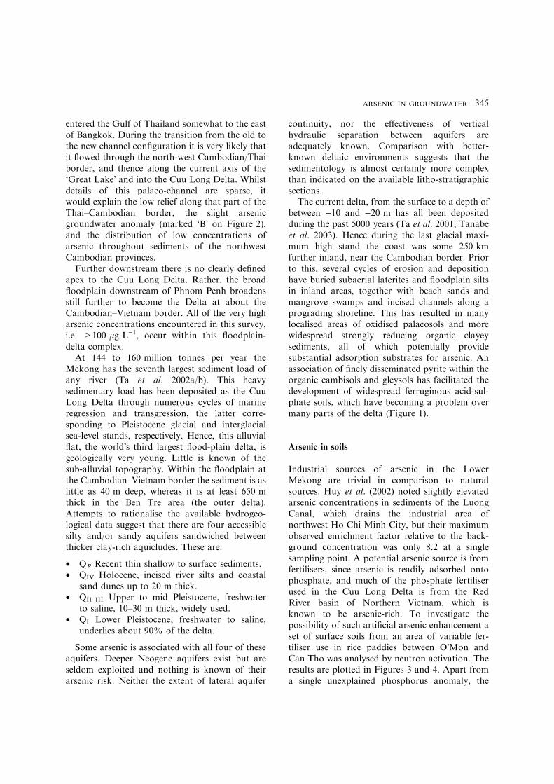
The arsenic distribution map, Figure 2, is basedupon 932 water quality analyses collected between1998 and 2003 as part of 12 different sources andstudies3. Some of these were purely field studiesusing ‘Hach� field test kits, but in most instancessemi-quantitative field indications of greater than10 lg L)1 (‘ppb�) were followed-up by moreaccurate laboratory analysis upon HNO3)spiked,freshly pumped groundwater samples. The classesof groundwater arsenic concentrations depicted inFigure 2 are based upon the WHO revised‘acceptable limit� of 10 lg L)1. This limit arisesmore from the constraints of realistic measurementthan from any proven limit of ‘no-adverse effect�,
although in practice concentrations below thislimit are probably safe.
The sampling distribution was uneven, beingpragmatically based upon the availability ofaccessible dug wells and boreholes. As found innumerous other studies, in Bangladesh, Assamand Nepal, analyses from clusters of wells invillages and towns do not yield consistent orspatially uniform results. Rather, it was commonlyfound that one or two groundwater sampleswould yield greater than 10 lg L)1 total arsenicwithin a local scatter of wells with less thandetectable concentrations4. That is within about1 km2.
There were areas of very low groundwatersampling density within the northern and westernCuu Long Delta (in Vietnam). This is partly due todifficulty of access, but mainly because the abun-dance of surface water, and the expense of sinkingwells, does not yet justify the development ofgroundwater. Consequently there are no existingwells to sample. However, as surface pollution anddry-season water-demand increases, the future
Fig. 6. Variation in soil–arsenic concentrations from the farmed area of O�Mon-Can Tho.
3 These comprise (1) The AusAID-funded Vietnam–Australia
Water Resources Management Assistance Project, Component
3, 2003, (2) NWIS Project (ADB) TA-3758 Cambodia, 2002, (3)
The World Bank-funded SIWRP reconnaissance data for
arsenic in Groundwaters of the CLD, (4) Haskoning and
ARCADIS Euroconsult, Groundwater Study of the Mekong
Delta, (1999). (5) JICA, The Study of Groundwater Develop-
ment in Central Cambodia, 2002, (6–9) Unpublished data from
the Pursat et alMeanchey Departments of Rural Water Supply,
Cambodia, (10) Unpublished data from the Cambodian Min-
istry of Rural Development, (11) the AusAID-funded Cuu
Long Delta Regional WSS Project, and (12) new data collected
and analysed by the authors of this paper.
4 For laboratory analyses the limit of detection was estimated at
1.4 lg L)1. For field kits the limit of detection is subjective, but
approximately 5 lg L)1 total arsenic.
gordon stanger et al.348

demand for groundwater is likely to increase verysubstantially, thus requiring a continuing vigilanceto deal with rising arsenic at an early stage.
In Cambodia there are few deep boreholes apartfrom a few town water supplies although there isan abundance of shallow dug wells in most prov-inces. This has facilitated a reasonably represen-tative spatial sampling throughout the lowlandagricultural areas, and to a lesser extent, along theMekong riparian zone as far north as Kratie. Theonly area with unsatisfactory coverage is in SiemReap, north of the ‘Great Lake�. Overall, theaverage sampling densities were 1 per 101 km2 inthe Cuu Long Delta, and 1 per 111 km2 in theinhabited parts of Cambodia. The total studiedarea was 105 km2.
For the purposes of this reconnaissance study,localities in which at least one sample was greaterthan 10 lg L)1 total arsenic are mapped at thisconcentration, even though the same area mayhave contained a majority of samples at less than10 lg L)1. Three factors, the widespread occur-rence of aqueous arsenic concentrations at close tothe limit of detection, the local soil and ground-water variation in arsenic concentrations, and theconsistency of the fluvial source area, all suggestthat the concentrations of arsenic are governedmore by processes of arsenic mobilisation than byits geochemical availability.
Literature from better known and longer stud-ied areas (BGS, 1999); McArthur et al. 2004) seemto have reached a consensus that there are two
Fig. 7. Distribution of the annual flooding depth of the Mekong–Tonle Sap system.
arsenic in groundwater 349

main processes of arsenic mobilization in shallownon-thermal groundwater environments, namely(a) oxidation of arsenious pyrite from microscopicpyrite/arsenopyrite framboids, and (b) release ofadsorbed arsenic through the process of reductivedissolution of FeOÆOH. In Bangladesh, Bengal,Nepal and the Red River basin of Northern Viet-nam the second of these processes is now regardedas by far the more important (Berg et al. 2001;Smedley 2003; McArthur et al. 2004). In the LowerMekong, however, there is circumstantial evidenceto suggest that oxidation has at least a contribut-ing influence upon the highest arsenic anomalies ingroundwater, measured in hundreds of micro-grams per litre, and may also be a secondaryprocess contributing to the episodic release andcontinuing mobility of arsenic over wide areas atconcentrations of tens of micrograms per litre.
Comparison of Figures 2 and 7 show that thereis some correspondence between the depth ofannual flooding and the occurrence of arsenicgroundwater anomalies. In particular, the annualmonsoonal flood of the Mekong results in a stageamplitude variation of between 8 and 11 m atPhnom Penh, decreasing to about 3 m, some125 km further downstream at Chau Doc, i.e. atthe delta�s apex, just south of the Cambodia-Vietnam border. Typical hydrographs are shownin Figure 8.
In response to this flooding, there is an annualcycle in groundwater levels, which varies from atleast 6 m in some riparian environments, to onlycentimetres in more distant parts of the floodplain.The sediments are mostly organic-rich, originatingfrom both former reeds and mangroves, andmodern cultivation, with anoxic preservation atgreater depth. Therefore, there is likely to be anannual cycle of near-surface oxidising and reduc-ing conditions, more or less corresponding to thedry and wet seasons. The oxidising conditionswould, of course, be consistent with pyrite oxida-tion and partial dissolution. Against this lies twostrands of evidence regarding redox, and potentialsubstrates.
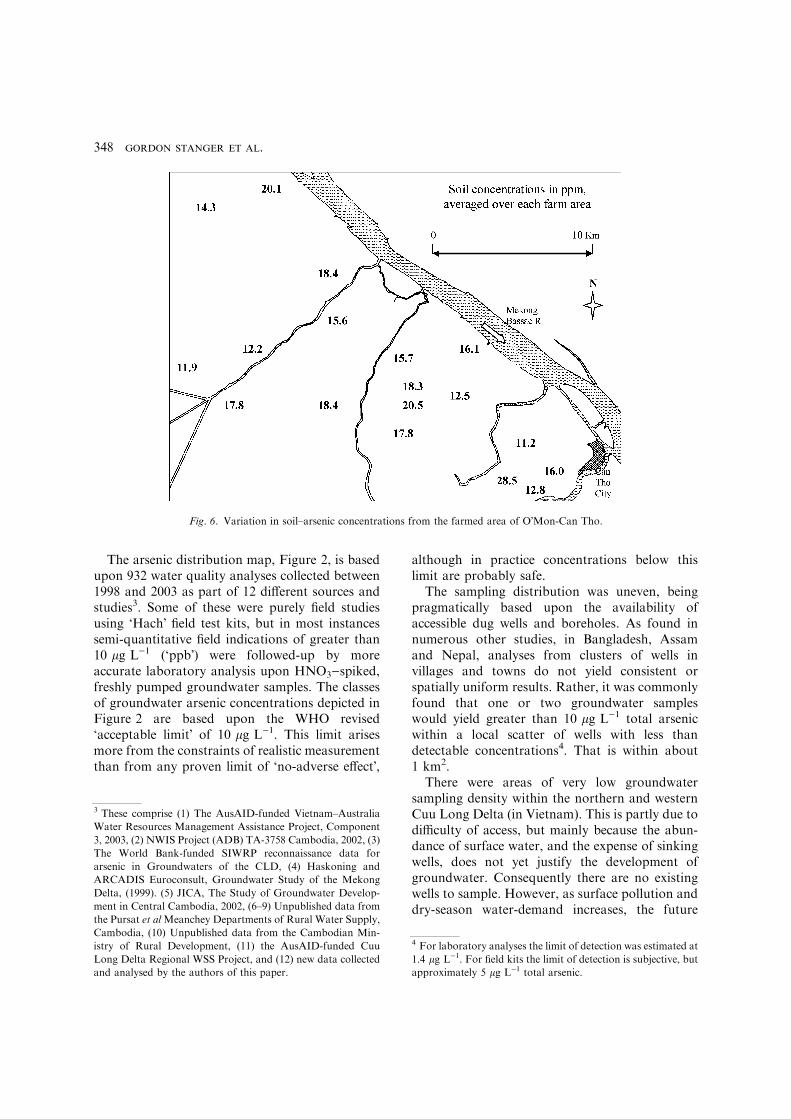
Firstly, Figure 9 illustrates the relationshipbetween redox potential and groundwater arsenicconcentrations. At low concentrations of up to10 lg L)1, the arsenic appears to be stable acrossvirtually the entire redox spectrum – a range ofsome 500 mV. On the other hand, high arsenicconcentrations are obviously dominated byreducing, or only slightly oxidizing conditions.Given the availability of arsenic in virtuallyall soils, Figure 9 suggests that some other majorco-variable is required to mobilise high concen-trations of arsenic. Curiously the iron–redoxrelationship was much less clear-cut, with 1 to10 mg L)1 total iron across the same redox
0.0
1.0
2.0
3.0
4.0
5.0
6.0
1J-an naJ-13
raM-1
rpA-1yaM-1 1
J-un
1luJ-
luJ-13 3
guA-1 3
peS-0
tcO-13-03
oNv
-13D
ce
Month
)sertem( e
gatS
Fig. 8. Typical annual stage hydrographs of the Mekong river at Chau Doc.
gordon stanger et al.350
spectrum – a point which would doubtless beclarified with further iron-species-specific data.
In addition, sulphate concentrations, relative toother major anions, were generally very lowthroughout the flood-plain (mean, 30 and 70& of27, 7 and 0 mg L)1 SO4
2) respectively). Thisstrongly suggests a widespread occurrence ofsulphate reduction, and hence of predominantly
reducing conditions in most groundwaters formost of the time.
Secondly, Figures 10 and 11 show an almostidentical correlation between arsenic-iron andarsenic-aluminium in soils.
Had the arsenic been predominantly associatedwith arsenious pyrite there should be no arsenic-aluminium relationship of any significance.
0
100
200
300
400
500
600
700
-200 -100 0 100 200 300 400
Redox (mV)
)b
pp( ci
nesrA lat
oT
Fig. 9. The redox control upon arsenic in Southern Cambodian groundwaters.
0
5
10
15
20
25
30
35
40
45
50
0 2 4 6 8 10 12 14 16 18 20
Total Iron (%)
)mp
p( cinesrA
Correlation coefficient of main cluster = 0.88
Fig. 10. Arsenic versus total iron in soils of the Cuu Long Delta.
arsenic in groundwater 351

Rather, the aluminium is present either asGibbsite, Al(OH)3, as mixed-layer clays (hydrousalumino-silicates), or as Jurbanite, Al(SO4)Æ(OH)Æ5H2O. Gibbsite would present a potentiallyadsorbing substrate for arsenic (V) anions, aswould the isostructural Goethite, a FeOÆOH. Theclay is not likely to be significant, and there is noavailable data upon Jurbanite adsorption charac-teristics. The aqueous arsenic–pH relationship ofFigure 12 suggests that any large-scale desorption
occurs at a pH of between 6.5 and 7.5. Low aqueousconcentrations of arsenic under acidic conditionsmay be regarded as the corollary of strongly ad-sorbed arsenic at a pH of less than 7. This is pleas-ingly consistent with the arsenic (V) adsorptionschemes upon both ferrihydrite (Pierce & Moore1982), and upon a-Al2O3 (Halter & Pfeifer 2001).
We consider that the most likely explanation forthese relationships is one of competing processes.It is known that finely disseminated sulphide is
0
100
200
300
400
500
600
4 5 6 7 8 9pH
)b
pp(
cinesr
A
Fig. 12. The aqueous arsenic–pH relationship.
0
5
10
15
20
25
30
35
40
45
50
0 5 10 15 20 25 30
Aluminium (Al2O3%)
.mp
p,cinesr
A
Correlation coefficient of main cluster = 0.81
Fig. 11. Arsenic versus aluminium in soils of the Cuu Long Delta.
gordon stanger et al.352

widely dispersed within arsenic- and organic-richsediments, and that these near-surface sedimentsare subject to cycles of oxidation and reduction.Under such circumstances it is hard to see howarsenic mobility through pyritic oxidation and/ordissolution could be unimportant. Once in solu-tion the arsenic either remains mobile in a reducingand neutral to alkaline (pH 6.5–8.0) environment,or undergoes anionic adsorbtion onto a suitablesubstrate, under acid conditions. It is not clearwhat the favoured substrate would be, althoughany iron phase would appear to be ferric ratherthan ferrous. The weakness of anionic sorbtioncould account for the very widespread occurrenceof residual arsenic at low concentrations.
The wet tropical climate of the lower Mekong,combined with an abundance of organic humusare ideal conditions for a strongly biological rolein the soil chemistry. However, the extent to whichthe above processes are mediated by bacterialactivity is currently unclear. More detailed studies(Chapelle 2000); Akai et al. 2004; McArthur et al.2004) have concluded that bacterially mediatednon-equilibrium desorbtion processes are crucialto a full understanding of the observed arsenicdistribution.
An areal comparison of aqueous concentrationranges is summarised by the histograms inFigure 12. To some extent the slightly differing
frequencies of concentration between the CuuLong Delta, North-western Cambodia andSouthern Cambodia may be artefacts of differentanalytical accuracy and slightly varied samplingstrategies in each area. Nevertheless, overall, thereis little difference in the distribution of concen-trations throughout the Lower Mekong, whereasthere is an enormous contrast with much worsegroundwater contamination within the Red Riverand Ganges–Brahmaputra Basins, (of NorthernVietnam and Bangladesh, respectively). Within thelower Mekong only 5.7% of all groundwatersamples exceeded the former WHO standard of50 lg L)1, whilst 12.9% exceeded the morestringent recent limit of 10 lg L)1.
There were insufficient deep wells in Cambodiato discern other than near-surface (water-table)arsenic concentrations. In the Cuu Long Deltanearly 300 boreholes yield the depth versus con-centration relationship shown in Figure 14. Somecaution is needed to interpret this scattergramsince the indicated total depth of the well does notnecessarily correspond to either the most produc-tive horizon, or to the horizon of highest arsenicconcentration. It is quite likely that some near-surface arsenic-rich groundwaters seep throughthe gravel pack into more deeply set well-screens,especially under rapid drawdown conditions at thecommencement of pumping. Nevertheless, two
Fig. 13. Relative distributions of arsenic concentrations (as lg L)1) in the Lower Mekong, and comparisons with the Red river
and Bangladesh arsenic-affected areas.
arsenic in groundwater 353

conclusions are drawn; firstly that arsenic in excessof the 10 lg L)1 acceptable limit can occur at anydepth, and secondly that there are two horizons inwhich arsenic is particularly prevalent. As onemight expect, the upper of these horizons is thewater-table aquifer, QR. The 100–120 m aquifercould correspond with either the Qiv aquifer in theouter delta, or the Qii–iii aquifer further inland.
Temporal variation
Long-term variations in arsenic concentrationshave yet to be monitored, but a seasonal study inTra Vinh province was undertaken in 2003 tocompare the effects of dry- and rainy-seasonarsenic concentrations in 18 shallow wells fromthree contrasting micro-environments: a near-coastal acidic sandy area (Truong Long Hoavillage, Duyen Hai district), a non-acidic oldersedimentary area (Long Son village, Cau Ngangdistrict), and the more inland tidal riparian area ofTra Vinh town. The dry season most typically endsin April, (Figure 15), to be followed by 6 or7 months of heavy rain, during which water tablesin Tra Vinh province typically rise between 2.4 and3.3 m. Hence there is a dry season in which pyriteand organics in the unsaturated zone are exposedto oxidation, followed by a wet season in whichoxidation products enter the saturated zone undermore reducing conditions.
Arsenic concentrations from these environ-ments are shown in Figure 16. In 10 wells thearsenic fluctuations were consistently less than
10 lg L)1 throughout both seasons. In sevenwells there was a substantial decrease in arsenicconcentration from dry to wet season, but in onewell there was 25-fold increase in concentration.The predominant tendency for up to a 20-foldreduction in arsenic concentration in the wetseason is contrary to purely pH–redox basedexpectations. It could be due to simple dilution ofthe near-surface groundwaters by direct recharge,or there may be a sorption-related explanation.Given the sluggish kinetics of arsenic chemistry,the possibility of delayed recharge through theunsaturated zone, and the single case of increas-ing concentration during the wet season, thecausative processes governing the seasonal varia-tions are currently ambiguous. Nevertheless, on apurely empirical basis, these results indicate thatno single sample, in any season, can be guaran-teed to disclose a seasonal or ephemeral arsenicanomaly, but that a mid-to-end of dry seasonsampling regime is more likely to yield higharsenic concentrations than a mid-to-end of wetseason regime.
Health implications
Throughout this survey several hundred ground-water users were superficially observed for signsof chronic arsenicosis, such as skin keratosis(‘raindrop pigmentation�) on hands, face and feet,and corneal ulceration. Such symptoms arecommonly observed in Bangladesh (Milton et al.
Fig. 14. The apparent depth–concentration relationship in aquifers of the Cuu Long Delta.
gordon stanger et al.354

2003; Saha 2003), but no such symptoms wereobserved or reported throughout this study. Afew older people displayed substantial skin spot-ting comparable to incipient keratosis, but this ismore likely to be caused by sun damage as aconsequence of decades of unprotected UVexposure during rice farming. Similarly, therewere no reports of lassitude, as typically experi-enced by arsenicosis victims in Bangladesh.However, it would be prudent to undertake amore detailed health survey in areas of higharsenic concentration, on both sides of theCambodia–Vietnam border.
Complaints about water quality were commonin some areas, but none of the internal symptomsreported were typical of arsenic contamination.Apart from enteric illness, associated with bacte-rially contaminated shallow groundwaters (somewater tables were as shallow as half a metre), themost frequent water quality complaint wasthe bad taste, associated with iron. Throughoutthe delta, in almost all cases of high iron con-centration, (i.e. >5 mg L)1), this iron-taintedgroundwater was exclusively used for non-potablepurposes, such as washing, farming, irrigationand a huge range of small-scale industrial uses. In
Fig. 15. Median monthly rainfall in Tra Vinh province.
Fig. 16. Seasonal sampling from 18 shallow wells in Tra Vinh province.
arsenic in groundwater 355

view of the high iron-arsenic correlation, thispreference for iron-free water has probably pre-vented most, if not all, cases of toxic ingestionfrom high-arsenic waters.
However, the practice of using moderate- tohigh-arsenic groundwater for chicken farming,aquaculture and livestock may, locally, beregarded as cause for concern in view of thepotential for arsenic�s bio-concentration withinthe food chain. In particular, the highest arsenicanomaly in the delta, of 400 lg L)1 total arsenic,was used exclusively for aquaculture comprisingfish and ‘freshwater prawns� (crayfish?) cultiva-tion, for which there appears to be no species-specific data on bio-concentration. Groundwateris seldom used for irrigation in the LowerMekong, so the risk of arsenic accumulation inrice is minimal. A much greater risk occurs fromcooking the rice in contaminated water (Meharg& Rahman 2003). Arsenic concentrations of upto 60 lg L)1 occur in the orchard and mixedfarming areas of Ben Tre and M~y Tho, but nei-ther the extent of groundwater usage in theseareas, nor the bio-accumulation of arsenic infruit, is currently known.
Although low-level arsenic groundwaters arewidespread, in fact almost ubiquitous, throughoutCambodia and the Mekong Delta, the physiologi-cal response to this form of contamination is cur-rently sub-clinical to absent. Nevertheless there is ahigh-risk area, around the apex of the delta, whereparticular care needs to be exercised if any futuregroundwater development is to proceed.
Other forms of water contamination, such asfrom toxic farm pesticides, notably organo-phos-phate pesticides and herbicides, have a muchgreater impact upon health, whilst both arsenicand pesticides pale into insignificance compared tothe health threat from the microbiological con-tamination of surface water.
Conclusions
As a welcome change from much of the gloomyliterature on the Asian arsenic crisis, this studyconcludes that the health threat posed by arsenicin the Lower Mekong is not as great as some hadfeared. There is no evidence of acute arsenicosisoccurring within the Mekong Delta, and thenumber of wells or boreholes in which arsenic
concentrations exceed the new stringent WHOdrinking water standard of 10 lg L)1 is only12.9% of the total. In all such cases the bad tasteof the associated high iron and aluminium con-centrations results in alternative drinking watersupplies, mainly rainwater, being utilised. How-ever, as the rapidly growing population and effectsof increasing coastal salinization both increase, aninevitably increased dependence upon groundwa-ter from the first and second confined aquifers(QIV and QII–III) will occur, and hence the poten-tial for more widespread and higher arsenic con-centrations is real. The geochemical distribution ofhigh arsenic concentrations (>10 ppm) includesvirtually all the fluvial sediments of the Mekongflood plain and delta, as well as some of theMekong�s important tributaries, such as the TonleSap.
Very large seasonal fluctuations in groundwa-ter arsenic concentration betoken serious prob-lems for sampling strategy in more detailedfuture studies, since no single sample can beguaranteed as typical over an inter-seasonalperiod. In particular, mid- to late-rainy seasonsampling is least likely to identify seasonally higharsenic anomalies.
There is a need for an urgent study of the upperpart of the delta and floodplain, on both sides ofthe border, and especially in riparian areas of largestage fluctuations. This would benefit from moredetailed process studies, the collection of moredetailed time-series data, with particular attentionto the indirect ingestion pathways of aquacultureand agriculture.
Acknowledgements
Of the numerous people and organizations whohave assisted this reconnaissance study theauthors would particularly like to thank thefollowing: John Cantor and Graham Jackson (ofdifferent AusAID projects in southern Vietnam),Ha and Hien of the SIWRP, and the Ca Maupeople�s committee for provision of boat trans-port and other very helpful logistical support.
References cited
Akai J. et al. 2004 Mineralogical and geomicrobiological
investigations on groundwater arsenic enrichment in Bangla-
desh. Appl Geochem 19(2), 163–260.
gordon stanger et al.356
Asia Development Bank–Pacific Consultants International
2003 Northwest Irrigation Sector Project. Final Report
Annex A: Climate, Hydrology, Hydrogeology and Hydro-
chemistry .
Berg M. 2001 Arsenic contamination of groundwater and
drinking water in Vietnam: a human health threat. Environ
Sci Technol 35(13), 2621–2626.
British Geological Survey with Mott MacDonald Ltd, (UK).
1999 Groundwater Studies for Arsenic Contamination in
Bangladesh. Phase 1 Final Report, Main Report. 96 pp.
Carbonnel GP, Guiscafre J. 1963 Grand Lac du Cambodge:
Sedimentologie et Hydrologie. Final Report, Paris.
Chapelle FH. 2000 The significance of microbial processes in
hydrogeology and geochemistry. Hydrogeol J (8), 41–46.
Dept. of Geology Mapping Office, (undated) 1:200,000 Geo-
logical Maps of Pursat, Sisophon and Siem Reap. General
Department of Mineral Resources, Toul Kouk, Phnom
Penh.
Halter WE, Pfeifer HR. 2001 Arsenic (V) Adsorption onto
a-Al2O3 between 25 and 70�C. Appl Geochem 16, 793–802.
Haskoning BV. 1999 Consulting Engineers and Architects, in
association with the Division of Hydrogeology and Engi-
neering Geology for the south of Vietnam, and Arcadis
Euroconsult, Binh An Ward. District 2, TP HCM, Viet Nam.
Ground-water Study: Mekong Delta. Assessment of Arsenic
Pollution in Groundwater of (the) Mekong Delta. 28 pp.
Huy NQ, Luyen TV, Phe TM, Mai NV. 2002 Toxic elements
and heavy metals in sediments in Tham Luong Canal, Ho
Chi Minh, Vietnam. Environmen Geol. doi 10.1007/s00254–
002-0699-4.
JICA. 2002 The Study on Groundwater Development in
Central Cambodia, Draft Final Report. Kukusai Kogyo
Co., Ltd.
McArthur J.M., et al, – 13 authors, (2004), Natural organic
matter in sedimentary basins and its relations to arsenic in
anoxic ground water: the example of West Bengal and its
worldwide implications. Appl Geochem 19, 1255–1293.
Meharg AA, Rahman Md M. 2003 Arsenic contamination of
Bangladeshi paddy field soils: implications for rice
contribution to arsenic consumption. Environ Sci Technol
37(2), 229–234.
Milton AH, Hassan Z, Rahman A, Rahman M. 2003 Non
cancer effects of chronic arsenicosis in Bangladesh: Pre-
liminary results. J Environ Sci Health A 38(1), 301–305.
Pierce ML, Moore CB. 1982 Adsorption of Arsenite and
Arsenate on Amorphous Iron hydroxide. Water Res 16,
1247–1253.
MRC/UNDP. 1998 Sectorial Studies Vol. 2, (B), Natural
Resources Based Development Strategy for the Tonle Sap
Area, Cambodia, CMB/95/003. Nedeco/Midas .
Saha KC. 2003 Diagnosis of keratosis. J Environ Sci Health A
38(1), 255–272.
Savage KS, Tingle TN, O�Day PA, Waychunas GA, Bird DK.
2000 Arsenic speciation in pyrite and secondary phases,
Mother Lode Gold District, Tuolumne County, California.
Appl Geochem 15, 1219–1244.
Smedley PL. 2003 Arsenic in Groundwater – South and East
Asia. In Welch AH, Stollenwerk KG (eds).Arsenic in Ground
Water: Geochemistry and Occurrence. Chap. 7. Massachu-
setts, USA: Kluwer Academic Publishers, pp. 179–209.
Tanabe S, Ta TKO, Nguyen Lap Van, Tateishi M, Kobayashi
I, Saito Y 2003. Delta evolution model inferred from the
holocene Mekong Delta Southern Viet Nam, , pp. 175–188
Sidi , Tropical Deltas of Southeast Asia – Sedimentology,
Stratigraphy and Petroleum Geology, Society for Sedimen-
tary Geology, Tulsa, OK USASpecial Publication No 76 Ed.
Book.
Thi Kim Oanh Ta Lap Nguyen Van, Tateishi M, Kobayashi I,
Saito Y, Nakamura T. 2002a Sediment facies and later
holocene progradation of the Mekong River Delta in Bentre
Province, Southern Vietnam: an example of evolution from a
tide-dominated to a tide- and wave-dominated delta. Sedi-
ment Geol 152, 313–325.
Thi Kim Oanh Ta Lap Nguyen Van, Tateishi M, Kobayashi I,
Tanabe S, Saito Y. 2002b Holocene delta evolution and
sediment discharge of the Mekong river, Southern Vietnam.
Quater Sci Rev 21, 1807–1819.
Thi Kim Oanh Ta Lap Nguyen Van, Tateishi M, Kobayashi I,
Saito Y. 2001 Sedimentary facies, diatom and foraminifera
assemblages in a late Pleistocene–holocene incised-valley
sequence from the Mekong River Delta, Bentre province,
Southern Vietnam: the BT2 core. J Asian Earth Sci 20, 83–94.
arsenic in groundwater 357