Architecture Urbanism - Hong Kong University Press
54
Architecture and Urbanism in Modern Korea Inha Jung University of Hawai‘i Press, Honolulu Hong Kong University Press
-
Upload
khangminh22 -
Category
Documents
-
view
3 -
download
0
Transcript of Architecture Urbanism - Hong Kong University Press
Architectureand
U r b a n i s min Modern Korea
Inha Jung
University of Hawai‘i Press, HonoluluHong Kong University Press
© 2013 University of Hawai`i PressAll rights reservedFirst published in North America by University of Hawai‘i PressISBN 978-0-8248-3585-9
Published in China by Hong Kong University PressISBN 978-988-8208-02-9
Printed in Hong Kong, China18 17 16 15 14 13 6 5 4 3 2 1
Th e Korea Foundation has provided fi nancial assistance for the undertaking of this publication project.
Library of Congress Cataloging-in-Publication Data
Chong, In-ha, author Architecture and urbanism in modern Korea / Inha Jung. pages cm. — (Spatial habitus) Includes bibliographical references and index. Published in China by Hong Kong University Press. ISBN 978–0-8248–3585–9 (cloth : alk. paper) 1. Architecture—Korea (South)—History—20th century. 2. Urbanization—Korea (South)—History—20th century. 3. Architecture and society—Korea (South) I. Title. II. Series: Spatial habitus (Series) NA1565.C467 2013 720.95195'09045—dc23 2012048614
Printed on acid-free paper and meets the guidelines for permanence and durability of the Council on Library Resources.Designed by Jennifer Flint
Printed and bound by Paramount Printing Co., Ltd.
Foreword viiAcknowledgments ixIntroduction xi
Part I Modern Life in the Colonial Period 1
1 The First Urbanization 3
2 The Genesis of Urban Housing 23
3 Architecture and the Introduction of New Materials 36
Part II Searching for Identity in the Developmental Period 49
4 Urban Expansion and the Construction Boom 51
5 New Urban Housing 70
6 The Quest for Architectural Identity 81
7 The Semantics of Technology 97
Part III From Modernization to Globalization 109
8 Discovering Reality 111
9 New Paradigms for Urban Design 126
Epilogue: A Correlative Architecture between the Void and the Solid 142
Appendix: Profi les of Korean Architects and Planners 145Notes 153Bibliography 167Index 185
Contents
Th is book traces the transformation of architecture and urban space over the course of the last one hundred tumultuous years of Korea’s history, a time when the built environment changed so fundamentally that it is diffi cult to grasp completely its transfi gurations. Judging from pictures taken by an Australian photographer in 1904, Korea at that time was a land of seclusion and isolation, remote from modern civilization. Th e urban population was barely 3 percent of the total; the population of Seoul, Korea’s bustling urban capital, was less than 200,000. Th e majority of the land was blanketed with rice paddies and farm fi elds, sparsely dotted with thatched roof houses. Within a mere one hundred years, Korea transformed itself into a completely modern society. Today’s population has increased fi vefold, with more than 80 percent of it living in its urban centers. Much of the pastoral landscape has been converted into large, monolithic buildings and labyrinthine networks of streets. Obviously, the process was not easy. Buildings and cities were repeatedly destroyed and rebuilt due to a succession of vehement sociopolitical disturbances. Indeed, the changes were so dramatic that few buildings constructed one hundred or more years ago remain. Th e legacy of the twentieth century in Korea must be regarded as one equally made up of destruction and construction.
Ruptures and Continuities
Although modernization began more than a century later in Korea than it did in the West, it has been the predominant ideology throughout the past century, bringing about radical changes in Korea’s architecture and cities. Th e nature of modernity, which continuously negates what existed in the past, brought with it the complete uprooting of the traditional lifestyle. As a result, the history of Korean architecture and urbanism over the last century has been characterized by discontinuities, ruptures, and transformations. Two thick fault lines are particularly signifi cant: the fi rst sandwiched between liberation (1945) and the Korean War (1950–1953), and the second, between the late 1980s and early 1990s. Although the second fault line, marking a transition in the South from a military regime to a democratic society, was perhaps not as dramatic as the events surrounding the fi rst, it was still the case that architectural and urban discourse changed remarkably in both.
With these ruptures as boundaries, Korean architecture of the twentieth century falls into three distinct periods, with modernity taking on a diff erent meaning in each. Th e fi rst, coinciding with the period of Japanese occupation, was a time of colonial modernism. A particular strand of modern civilization, including some Western technologies, was transplanted to Korea via Japan, and a modern way of life started to take shape for the fi rst time, albeit in a distorted way. Th e second period, extending from 1961 to 1988, was a time of developmental dictatorship when the Korean government presided over a large-scale construction boom, and architects sought to establish a modern identity through traditional means. Th e last period, which began to take shape in the mid-1990s, may be defi ned as a time when Korea’s modernization was not only achieved, but also subsumed in the globalizing trend of the present era.
Because the modernization of Korea was belated, it condensed into a very short time period changes that had taken place over more than two centuries in the West. But while the rapid and radical changes that have occurred are undeniable, of greater signifi cance for this study is the identifi cation of elements that have remained unchanged. In Korea, long-standing relationships between humans and their built environment have formed continuities that are still deeply rooted in the way of life of the Korean people.
Introduction
xii Introduction
For this reason, regionalism exerted a powerful infl uence on Korean architects in the twentieth century, inspiring them to discover formal ideals in the method of organizing outdoor space which they found in old temples; the topological singularities in traditional gardens; the multilayered arrangement of walls in old palaces; and the diff erent types of courtyards in traditional houses, all with a view to projecting them in a modern fashion. It is evident that the practices of Korean architects are deeply associated with the places where they grew up, and by exploring those places, Korean architects have pursued and found a modern identity that can be called their own. For that reason, identifying the elements of continuity and the process of their transformation through the last century is of great importance in this study.
Practicing in a Structured Field
Because it is impossible to consider all of the events related to architecture and urbanism in twentieth-century Korea, we need to be selective in our approach. Th e key task in this book is to identify the practical rules that were applied by architects in the spatial reconfi guration of modern Korea. To this end, our discussion starts with lines that are drawn up on a plan. When a line is drawn for the fi rst time to conceive a building or a city in an empty place, it already contains an extremely complicated signifying system. Th e subjective ideas of the individual architect and the objective structure of society are integrated by the act of drawing a single line, through which theory and practice work together to produce a unique built environment. By clearly understanding the process in which complex built environments are generated, starting from a single line, this book tries to present a comprehensive overview of architectural and urban development in modern Korea. Here both architecture and cities belong to the same discursive plane and are closely interrelated, rather than work as elements with an independent existence.
To develop these ideas eff ectively, we must look at the aforementioned periods as structured fi elds. Th ey constituted the fi elds of possibility in which architects had to act, and the architects’ design activities were a form of practice conditioned by those structured fi elds. When one visits a university campus, where buildings built in diff erent periods are gathered together, one can verify how structured fi elds permeate everything—from the overall design to the individual details of the buildings. Th e majority of buildings built within the same structured fi eld make common use of materials, construction methods, building codes, and design concepts. Th e same is true for urban spaces. Cityscapes, street networks, and even city boundaries change in accordance with the periods when they were planned. Th e urban spaces of the 1930s, 1970s, and 2000s were all conceived in distinctive ways and are endowed with the signifying systems of the practices and structured fi elds they at once embody.
One might well ask in what way a structured fi eld aff ects an architect or planner’s practice. A structured fi eld acts in two ways. First, it acts as an existential horizon. All architects work within an objective social reality, and their designs also take place within a given set of constraints. It is extremely diffi cult to escape those constraints until they are considered inappropriate by most practitioners. To do so, one must accept the burdens of economic ineffi ciency and waste, and ultimately the risk of losing one’s customary relationship with the outside world. In this sense, a structured fi eld is composed of the limitations and constraints that are innate in an architect’s practice. But it can also be productive, giving rise to new forms of activity, rather than simply censoring certain forms of activity. It provides a structure, like the rules of a game, and architects must understand their modus operandi intuitively or logically, and negotiate their course using those procedures. Th e more skillfully they do so, the higher the probability they will successfully compete with other architects, with the commissioning of better projects as the reward for success. But it is also possible for architects to point out the unreasonableness of certain rules rather than simply submitting to them, and in this way the ideas of architects interact with the social structure, aff ecting the process by which a structured fi eld becomes internalized in an architect’s practice.
Introduction xiii
Th ere are many ways that preestablished structures become internalized, since structured fi elds are dependent on natural conditions, laws and institutions, representational methods, production methods, and existent spatial systems. In most cases, they have been formed before an architect starts to work, having been naturally acquired at home or at school. In Korea, residential spaces, in particular, seem to form at an early age as the “proto-scenes” in an architect’s spatial consciousness. Because they were acquired unconsciously, these spatial concepts have appeared repeatedly in the work of Korean architects. When we compare the projects designed by two Korean architects, Hyo-Sang Seung and Kyu Sung Woo, we can see that while their architectural activities stem from completely diff erent professional backgrounds, their design attitude relies on the same spatial consciousness derived from early experience of a form of traditional Korean housing called the urban hanok. Th is experience functions like a latent diagram in the architect’s consciousness, and it repeatedly emerges whenever they come up with an image. Th is process is the reason this book focuses specifi cally on the formation of urban and residential space.
Structured fi elds are dynamic and ever changing, since they can be aff ected by internal as well as external forces. But what makes a structured fi eld disappear, to be replaced in turn by a new one? Th ere may be several factors, but large-scale changes in urban discourse, technological orientation, and regional identity can all play a role. Generational change occurs when architects and planners have to work in conditions completely diff erent from those encountered by the previous generation and, as a result, need to restructure the rules of the game. It is the dynamic interplay between architects and structured fi elds that has consistently served as the driving force changing the practice of designing architecture and cities in Korea.
Th e modern world arrived in Korea in force following Japan’s annexation of the Korean peninsula in 1910. Although Koreans were initially captivated by the prospect of modernity, the occupation soon brought a succession of miseries, causing those sentiments of wonder to be subsumed in feelings of anguish and humiliation. Th e occupation ended in 1945, and it was followed by the outbreak of civil war in 1950. In spite of this troubled history, Koreans have never stopped yearning for modernization. For this reason, recogni-tion of modernity as a primary goal of Korean society must be included in any analysis of Korea’s history in the twentieth century. Th e development of modern architecture and urbanism in Korea can be defi ned as the path taken by intellectual and practical eff orts to construct the country’s built environment in forms appropriate to the transformation of the traditional society upon which Korea’s national identity had been based. To extricate themselves from their historical bonds, Koreans have pursued modernization for over a century.
Colonial Modernism in Korea
When Korea was colonized in 1910, the newly dominant power, Japan, had already undergone its own modernization. Indeed, it had begun this process earlier than its neighbors, and this advantage enabled it to use the norms of a modern society, commonly iden-tifi ed as health, productivity, and effi ciency,1 as tools for dismantling a traditional social order. Th e antagonism that resulted played out in two directions—between Japanese imperialism and Korean nationalism on the one hand, and between modernism and the premodern on the other. Th is confrontation of oppositional forces spawned complicated fault lines that fractured in diff er-ent ways, forming the major themes of the architectural and urban discourse of the colonial period.
Because of this complexity, two contrasting views of the colonial period have been maintained: one is founded on a theory of colonial exploitation (sikminji
sutalron); the other, on a theory of colonial moderni-zation (sikminji geundaehwaron). Despite the emer-gence of postmodern criticism in recent years, the two approaches remain controversial because they are essentially concerned with a historical accounting of the colonial period. As Jonghoe Yang observes, “more nationalistic Korean scholars are prone to reject the colonial modernization theory by pointing to the con-tradictory and exploitative nature of colonial moder-nity. In contrast, more empirically oriented researchers, many of them are foreign experts on Korean history, tend to argue for the positive eff ects of the colonial legacy by analyzing statistical data on colonial indus-trialization.”2 According to these latter scholars, Korea’s transportation and communication infrastructure, together with some of the industrial facilities built in the colonial period, all contributed to Korea’s economic growth aft er liberation.
Th is book gives due weight to the recognition that the modernization of Korean society took place during the period of its colonization. Yet, as many scholars believe, the best conceptual account of the situation may be given from the perspective of Gramsci’s theory of hegemony,3 which provides an analysis of the inten-tion of the ruling class in relation to space.4 Gramsci’s theory reminds us that the ultimate purpose of the policies formed during the occupation was to con-solidate Japanese colonial rule in perpetuity. Although colonial modernism was dependent on cultural control, including control of the built environment, the goal of modernization persuaded many Koreans to believe that Japanese rule was not entirely repressive but produc-tive, allowing them to accept, adopt, and internalize foreign norms and values. Th is was a fundamental limi-tation that led to the fl uctuation that can be observed in various sectors according to the degree of Japanese interest in them. Th e imbalance proved an impediment in the advancement of modernization in Korea.
Notwithstanding this limitation, a modern way of life did begin to emerge in Korea during the colonial period, with attendant impacts on the built environment. In
The First UrbanizationChapter
1

4 Architecture and Urbanism in Modern Korea
the West, the Industrial Revolution had brought about radical changes in the urban landscape. Until this point, most people had resided in villages set in a landscape sparsely dotted with houses, and this pattern of spatial dispersion dictated the forms of everyday life. When migrants from the countryside fl ocked to the cities to pursue employment related to the manufacture and increased availability of consumer goods, the housing that was available was incapable of accommodating the sudden increase in the population. In due course, city dwellers had to accept the prospect of living in large-scale housing complexes and high-rise buildings, a new built environment characterized by enormous invest-ment in infrastructure. Th is built environment could not be constructed in the short term, however, causing many social diffi culties.
Th e fi rst urbanization of Korea occurred during the colonial period, apparently caused by similar factors. Korea’s population doubled, and the increase was largely absorbed in the cities.5 Overall, the urban population rose from approximately 3 percent of the entire popu-lation to 13 percent. In Seoul, the resident population increased approximately fi vefold during the colonial period. In addition, new modes of transportation accel-erated the process. Korea built its fi rst railway in 1899, and railway routes continuously expanded thereaft er. Inland cities such as Daegu, Gwangju, Daejeon, and Pyongyang underwent rapid urbanization during this period. Upon analysis, however, the roots of the urbani-zation of Korea can be seen to lie not in the industriali-zation process per se, as occurred in Western countries, but in Japanese colonial rule. Industrialization did not start in earnest in Korea until the 1930s. Th e main reason for the migration of population from the Korean countryside to the cities was the ruthless exploitation of Korean peasants by the Japanese.6 Th is meant that the increase in urban population did not occur through a typical “push-pull” process in which a growing demand for urban labor coincides with unused labor in the countryside.7 Th e demand for an urban workforce was actually meager, and new immigrants to Korean cities led a hand-to-mouth existence, looking to be hired by the day without prospects of fi nding a permanent job. Moreover, the increase in the urban population was also caused by a large infl ux of new Japanese residents. Th e Japanese colonial government had allotted large tracts of land at subsidized prices to Japanese families wanting to settle in Korea. With this encouragement, landownership among Japanese residents, which in
1916 stood at 36.8 percent, jumped to 52.7 percent by the end of the colonial period. Th ese land distribution policies formed a signifi cant part of the urban planning that took place in Korea during this period.8 In the early 1920s, Japanese residents made up about 30 percent of the urban population. With acute segregation the norm, Japanese residential districts inserted themselves into traditional Korean districts, splitting the urban fabric. Indeed, the most revealing aspect of Korea’s urban planning at this time was its total dependence on Japanese interests. For example, when the colonial gov-ernment designated thirteen cities three years aft er the annexation, only three of those cities corresponded to traditional defi nitions of a city. Th e others were created for economic exploitation. Najin, built in the 1930s, was designed as a logistical and military base for Japan’s ter-ritorial ambitions on the continent of Asia. As a conse-quence, most of the cities that fl ourished in the colonial period did not develop further aft er liberation.
Despite these origins, there can be no doubt that the urban spaces created during this period were forms of colonial modernism. In particular, the street systems of Korean cities and their infrastructure became forma-tive infl uences on subsequent developments. Even with land use plans being continuously deformed as cities continued to grow, the street systems remained largely unchanged. As we review the urban planning of the colonial period, we will have occasion to examine how these street systems were formed.
The Urban Planning of Open Ports
Th e fi rst wave of urbanization in Korea dates back to 1876 when, under pressure from Japan, Korea dropped its long-held policy of isolation. Th e Joseon dynasty, which had ruled Korea for more than fi ve centuries, opened its doors to foreign countries and signed treaties granting them commercial rights and the lease of a certain territory to support consular aff airs and trade. Ten ports in Korea—Busan (1877), Wonsan (1880), Incheon (1883), Mokpo (1897), Jinnampo (1897), Gunsan (1899), Seongjin (1899), Masan (1899), Yongampo (1904), and Cheongjin (1908)—opened in succession, and fi ve inland cities, including Seoul, Pyongyang, and Uiju, opened to trade. Th e opening of these ports brought a new way of life and a need for modern urban planning. Prior to the port openings, Korea’s major urban areas had been located inland. Although there were ports for marine transportation
The First Urbanization 5
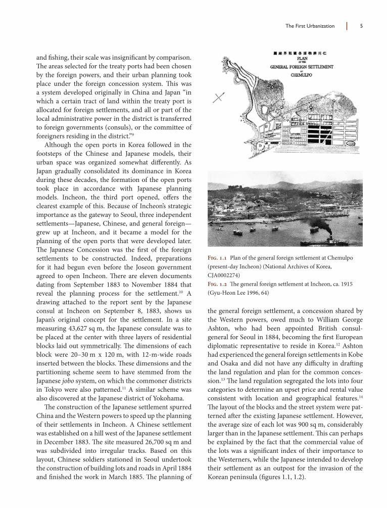
and fi shing, their scale was insignifi cant by comparison. Th e areas selected for the treaty ports had been chosen by the foreign powers, and their urban planning took place under the foreign concession system. Th is was a system developed originally in China and Japan “in which a certain tract of land within the treaty port is allocated for foreign settlements, and all or part of the local administrative power in the district is transferred to foreign governments (consuls), or the committee of foreigners residing in the district.”9
Although the open ports in Korea followed in the footsteps of the Chinese and Japanese models, their urban space was organized somewhat diff erently. As Japan gradually consolidated its dominance in Korea during these decades, the formation of the open ports took place in accordance with Japanese planning models. Incheon, the third port opened, off ers the clearest example of this. Because of Incheon’s strategic importance as the gateway to Seoul, three independent settlements—Japanese, Chinese, and general foreign—grew up at Incheon, and it became a model for the planning of the open ports that were developed later. Th e Japanese Concession was the fi rst of the foreign settlements to be constructed. Indeed, preparations for it had begun even before the Joseon government agreed to open Incheon. Th ere are eleven documents dating from September 1883 to November 1884 that reveal the planning process for the settlement.10 A drawing attached to the report sent by the Japanese consul at Incheon on September 8, 1883, shows us Japan’s original concept for the settlement. In a site measuring 43,627 sq m, the Japanese consulate was to be placed at the center with three layers of residential blocks laid out symmetrically. Th e dimensions of each block were 20–30 m x 120 m, with 12-m-wide roads inserted between the blocks. Th ese dimensions and the partitioning scheme seem to have stemmed from the Japanese jobo system, on which the commoner districts in Tokyo were also patterned.11 A similar scheme was also discovered at the Japanese district of Yokohama.
Th e construction of the Japanese settlement spurred China and the Western powers to speed up the planning of their settlements in Incheon. A Chinese settlement was established on a hill west of the Japanese settlement in December 1883. Th e site measured 26,700 sq m and was subdivided into irregular tracks. Based on this layout, Chinese soldiers stationed in Seoul undertook the construction of building lots and roads in April 1884 and fi nished the work in March 1885. Th e planning of
the general foreign settlement, a concession shared by the Western powers, owed much to William George Ashton, who had been appointed British consul-general for Seoul in 1884, becoming the fi rst European diplomatic representative to reside in Korea.12 Ashton had experienced the general foreign settlements in Kobe and Osaka and did not have any diffi culty in draft ing the land regulation and plan for the common conces-sion.13 Th e land regulation segregated the lots into four categories to determine an upset price and rental value consistent with location and geographical features.14 Th e layout of the blocks and the street system were pat-terned aft er the existing Japanese settlement. However, the average size of each lot was 900 sq m, considerably larger than in the Japanese settlement. Th is can perhaps be explained by the fact that the commercial value of the lots was a signifi cant index of their importance to the Westerners, while the Japanese intended to develop their settlement as an outpost for the invasion of the Korean peninsula (fi gures 1.1, 1.2).
Fig. 1.1 Plan of the general foreign settlement at Chemulpo (present-day Incheon) (National Archives of Korea, CJA0002274)Fig. 1.2 Th e general foreign settlement at Incheon, ca. 1915 (Gyu-Heon Lee 1996, 64)

6 Architecture and Urbanism in Modern Korea
In the wake of the opening of the fi rst three ports, the remaining ports were unilaterally opened by the Korean government, under pressure from Japan, rather than through diplomatic agreements with foreign powers. Regulations for the foreign settlements at Chinnampo (Jinnampo), Mokpo, and Kunsan (Gunsan) were prom-ulgated in October 1897, and regulations for Masampo (Masan) and Songjin (Seongjin) were issued in June 1899. Th ey all had the same form and contents. Th e location of the ports had been determined by Japan’s interests. Japan was intent on establishing its supremacy over Korea aft er its victory in the Sino-Japanese War, and it needed new ports to maximize the economic exploitation of the peninsula. Mokpo and Gunsan were opened to facilitate rice exports from Jeolla province. In the new settlements, the subdivision of urban space followed the precedent set by the general foreign set-tlement in Incheon. Aft er removing all Korean houses within the settlements, the Korean government prepared, fi lled in, laid out, and subdivided the lots, selling them at public auction to the highest bidder. To ensure consistency in the public auctions, the lots were partitioned into grids of the same size. Land was sold in three categories: (a) village, rice-fi eld, or low-lying lots not requiring fi lling in; (b) hill lots; and (c) foreshore lots requiring further fi lling in.15 Th e lots had minimum and maximum sizes: 500–1,000 sq m for Class A and Class C lots, and 1,000–5,000 sq m for Class B lots. In Mokpo and Gunsan, the block size was largely determined by these lot sizes. In Mokpo, there were two block sizes: one was approximately 60 m x 80 m, or 4,800 sq m; the other was approximately 90 m x 90 m, or 8,100 sq m (fi gures 1.3, 1.4). In Gunsan, the block size was 40 m x 60 m (2,400 sq m). Th ese were blocks that were easily rentable if they were subdivided into four parts. Except for restrictions on building access and sanitary facili-ties, land use in the blocks was unregulated. Various buildings began to fi ll the blocks according to their partitioning, including public facilities such as consular buildings, customs offi ces, and warehouses, as well as Japanese-style housing called machiya to accommodate the Japanese who were rushing to the new ports. Th is general pattern became a common way to organize the urban space of treaty ports in Korea (fi gures 1.5, 1.6).
Fig. 1.3 Plan of Mokpo (Seok-Kyu Ko 2004, 58)Fig. 1.4 View of Mokpo, ca. 1930? (Photo courtesy of Sam-Geon Han)Fig. 1.5 Plan of Gunsan, 1902 (Ei-Won Kim 1982, 652)Fig. 1.6 View of Gunsan, ca. 1930? (Photo courtesy of Sam-Geon Han)
The First Urbanization 7
Cheongjin was the last port to open in 1908. When Korea was annexed by Japan in 1910, all of the open ports lost their original function and meaning. Th e Japanese government opened negotiations with the foreign governments over their concessions in Korea and completely abolished the system in 1914. Consequently, the urban planning that took place on the Korean peninsula aft er 1910 assumed a completely diff erent character.
Annexation and the City Ward Improvement Plan
Aft er winning the fi rst Sino-Japanese War (1894–1895), Japan focused its national force on the colonization of Korea. It concluded a treaty for the fi rst Anglo-Japanese Alliance in 1902, which laid out an acknowl-edgement of Japanese interests in Korea. In the peace treaty ending the Russo-Japanese War (1904–1905), a defeated Russian empire acknowledged and hence-forward deferred to Japan’s military, political, and economic interests on the Korean peninsula. A separate agreement, signed in secret by the United States and Japan, recognized both the Japanese interests in Korea and the American interests in the Philippines. With this recognition, the Japanese government sought to formalize its sphere of infl uence by forcing the Korean cabinet to sign the Protectorate Treaty, giving Japan complete responsibility for Korea’s foreign aff airs and placing all trade through Korean ports under Japanese supervision. Th e treaty was signed in November 1905, allowing Japan to set in motion a large number of urban policies aimed at extending its power in Korea. It would only be a matter of time before it seized full control of the apparatus of government.
Railways and Fortress WallsTh e Japanese colonizers consolidated their control of inland cities by constructing railways. Japan had obtained the right to construct railways in the Korean peninsula in 1894 but transferred the license for the Seoul-Incheon rail line to an American businessman, James R. Morse, in 1896, amid soaring anti-Japanese sentiment in the wake of the assassination of the Korean empress the previous year. Two years later, when construction of the line was halted due to fi nancial diffi culties, Morse relinquished the rights to a Japanese fi rm, and the fi rst rail line was opened in September 1899. Japan continued to operate the Seoul-Busan line in 1905 and the Seoul-Sinuiju line in 1906, which served as a stepping-stone for Japan’s
invasions of Korea and Manchuria. As newly con-structed railways and roads became operational, inland Korea began to see how a new transportation system would open a new era of growth. Several new cities arose at the intersection of the newly established railway lines. Daejeon, the sixth largest city in present-day Korea, took form to facilitate the settlement of Japanese workers who took part in the railway construction.16 With the expansion of railway lines, railway stations became new centers of urban growth, triggering a great increase in land prices. One result was the surfacing, in the 1920s, of sharp confl icts between Koreans and Japanese over the relocation of railway stations in Daegu.17
Along with the opening of the railways, the electric streetcar brought great changes to the perception of urban space. In 1898, King Gojong had authorized the creation of a joint venture with two American business-men, Henry Collbran and Harry Rice Bostwick, called the Hanseong Electric Company. Th e new company, of which the king owned 50 percent, was charged with establishing an electrical lighting network in Seoul and an electric streetcar system as well. Hanseong Electric completed its fi rst power plant in 1899 at Dongdaemun, and, by the end of that year, had successfully launched its streetcar service from Seodaemun to Cheongryangri. In later years, the streetcar service was extended into the surrounding suburbs of downtown Seoul, such as Mapo, Ahyeon, and Yongsan.
As the wave of modernization began to overtake traditional urban structures, the demolition of fortress walls became symbolic of the disintegration of premod-ern urban space and the emergence of a new urban order. With new regulations for land and building certifi cation taking eff ect in 1906, making it lawful for Japanese to own land throughout Korea, large numbers of Japanese rushed into Korean cities to form new settlements. Th e resulting tensions intensifi ed with the demolition of the city’s fortress walls. To the Japanese, the walls blocked off not only a smooth stream of traffi c, but also Japanese commercial penetration of the old city. Th ey began to demolish the fortress walls as part of a campaign to construct new roads and improve the urban infrastruc-ture. Th is began in Daegu in 1906, and Jeonju fortress followed in 1907. In Seoul, fortress walls to the left and right of Namdaemun Gate were demolished in 1908. In all, about 140 fortress walls had played an instrumental role in the local administration of the Joseon dynasty, and their demolition marked the death of a traditional spatial order and the birth of a new one.18

8 Architecture and Urbanism in Modern Korea
Military CitiesTh e urban planning undertaken between 1905 and 1910 was closely tied to the Japanese military’s plans to advance into Korea and China. Th e one-sided expan-sion of Seoul amply demonstrates this fact. During the Sino-Japanese War (1894–1895), two divisions of the Japanese army had been stationed on the Korean peninsula, one of them in Yongsan, a southern suburb of Seoul. Ten years later, with Korea falling under its control at the end of the Russo-Japanese War, Japan made Yongsan the headquarters of its occupational forces. It purchased all the land at dirt-cheap prices, installed barracks for Japanese soldiers, and built Yongsan Station as the starting point of the Seoul-Incheon railway line.19 Yongsan, which had been nothing but a sandy plain near the Hangang River, became a place of strategic importance. Two arterial roads from downtown Seoul to Yongsan were con-structed aft er 1906 to improve access to the area, and many residences for military offi cers were established around the base. As a military camp, Yongsan stood in the way of normal urban expansion, and this became a decisive hindrance in Seoul’s development.
Nanam and Jinhae were two new cities built for military purposes. Nanam, located 550 km northeast of Seoul and next to Cheongjin, was surrounded by moun-tains. In 1907, Japan began construction of the new city on an empty site measuring about 3,300 ha, judging the area to be strategically advantageous in several respects. Located 90 km from the borders of China and Russia, it would be ideally located for the rapid mobilization of soldiers following any outbreak of hostilities, and it could facilitate the direct import of war materials from Japan by ship. It remains unclear exactly who initiated the city planning, but well-trained urban experts clearly had a hand in it. Th e planners divided the city into two parts, making the northern sector a site for military barracks and the southern sector an urban area. Th e urban area contained two blocks 150 m wide and 160 m deep, each of which was subdivided into 40 m x 15 m street blocks. A notable feature in the plan was X-shaped avenues with a park placed at the center. Th e Japanese army would later praise Nanam as “a highly civilized example of city planning.”20
Th e planning of Jinhae in 1910 was carried out in a similar manner. Aft er Korea was obliged to become a Japanese protectorate in 1905, the Japanese navy forcibly acquired an enormous tract of land to build a military port and a new city. Little is known about
the men who carried out the planning. However, their methods appear similar to the way the South Manchuria Railway Company (Mantetsu) planned the construc-tion of cities around railway stations in Manchuria.21 Analysis of the urban formats of Changchun and Mukden (Shenyang), and of other Chinese cities planned by the railway company in the fi rst decade of the century, reveals several similarities (fi gures 1.7, 1.8). First, they commonly placed railway stations at the center of urban areas, allotting the front half to public, commercial, and residential areas, and the rear half to factories and warehouses. Second, a regular grid-shaped street network was employed if the ground was fl at, and radial streets were added with railway stations at the center. Th ird, planners attempted to avoid creating an undiff erentiated urbanscape by inserting large-scale buildings around the railway-station squares. Fourth, urban amenities such as parks and water reservoirs were built to be self-contained. Last, the average ratio of road coverage in the entire urban area was never less than 23 percent.22 Th ese formats are signifi cant
Fig. 1.7 Plan of Changchun, 1908 (Kobayashi 1996, 57)Fig. 1.8 Plan of Mukden, 1915 (Kobayashi 1996, 57)

The First Urbanization 9
because Japanese urban technocrats applied them to the planning of Korean cities until the enactment of the Urban District Plan Decree of 1934. Jinhae Railway Station was located at the center of the city, with a frontal area subdivided into grid-shaped blocks 60–80 m long, and radial streets were formed by connecting three urban centers (fi gures 1.9, 1.10). Th e Japanese set-tlement at Pyongyang, planned in the 1910s, shows a similar scheme.
Th e urban planning of the Manchurian railway company was closely associated with the ideas of Goto Shimpei, the fi rst director of the company, who had implemented urban improvement projects as the head of civilian aff airs in Taiwan. Th ese experiences had taught him that the success of colonial rule depended on the establishment of balanced, advanced urban planning, supported by infrastructure built to the standard to which the Japanese had grown accustomed.23 He there-fore emphasized scientifi c and statistical surveys and conducted in-depth research on the urban planning methods of Western countries. Th e predominant urban
planning methods of the time had been developed in Europe and applied to new American and Australian cities since the late nineteenth century. Cerda’s plan of Barcelona showed a typical method of creating a modern urban space. In his network-oriented approach, street layout and grid plans were optimized to accommo-date pedestrians, carriages, horse-drawn trams, urban railway lines, gas supply, and large-capacity sewers to prevent fl ooding without neglecting public and private gardens and other key amenities. Urban planners in the United States, particularly Daniel Burnham, looked to the European models and concentrated on working out an elaborate system of infrastructure rhythmically punctuated by public monuments. Burnham’s plan of Chicago was a typical American example, and the methods he followed provided a template for develop-ments in Manchuria and colonial Korea, albeit with some regional modifi cations. Jinhae exemplifi ed this kind of adaptation.
City Ward Improvement PlanningAft er the annexation of the Korean peninsula in 1910, the Japanese empire implemented new urban policies to strengthen its hold over Korea. It introduced city ward improvement planning to transform the traditional cities of Korea where thatched-roof houses were clus-tered together in a disorienting fashion, separated by snaking alleyways. Historically, the city ward improve-ment plan carried out in Tokyo was the Japanese govern-ment’s fi rst intervention to improve premodern urban structures. Its model was a modernization program in Paris led by Georges-Eugène Haussmann between 1852 and 1870. At that time, Tokyo was already overcrowded. Th e population was close to 1 million and the density of some wards exceeded 500 persons per hectare. Aft er years of studying the issue, the government enacted the Tokyo City Ward Improvement Ordinance (Shiku Kaisei Rei) in 1888. Its contents covered roads, rivers, bridges, railroads, public parks, markets, crematori-ums, and graveyards. Th e project was never carried out, however, because of insuffi cient revenue, and a new scaled-down plan was announced in 1903.24 Th e major achievements of the revised remodeling program included the construction of thirty-two parks, seven canals, new waterworks and sewage systems, and the improvement of 123 roadways up to 1919. Once the program demonstrated its adequacy, it was applied to other cities such as Osaka, Kyoto, Taipei, Seoul, and Pyongyang.25
Fig. 1.9 Plan of Jinhae, 1910 (Ei-Won Kim 1982, 659)Fig. 1.10 View of Jinhae, ca. 1930? (Photo courtesy of Sam-Geon Han)
10 Architecture and Urbanism in Modern Korea
According to Iwao Miake, who published Urban Studies in 1908 aft er surveying the extensive literature on Western urban planning, “the fi rst requirement of the system lies in the widening of roads, and the second in the unifi ed, technical design of an entire street network.”26 His statement pinpointed what the program of city ward improvement entailed. Th e term itself contained strong overtones of urban improvement, a notion oft en allied in England with town planning.27 Accordingly, the goal of city ward improvement was the enhancement of urban functions in old towns rather than the development of new towns, and its most con-spicuous feature was an emphasis on the construction of urban infrastructure, as opposed to a comprehensive account of overall land use.
To ensure eff ective implementation of the program, the Government-General of Joseon (Joseon chong-dokbu in Korean, Chousen soutokuhu in Japanese)28 created a variety of legal and institutional structures. A comprehensive land survey of Korea had been carried out from 1910 to 1918 to systemize land registration and make land—particularly agricultural land—a secure and easily marketable item for anyone, whether Korean or foreign.29 As a result, many Korean farmers were forced to become tenant farmers because they could not produce any documented proof that they owned their land. Together with the land survey, the Government-General of Joseon issued several decrees concerning architecture and development of the cities. Th e Land Expropriation Decree (Toji Suyong Ryeong) and Road Regulations (Doro Gyuchik) were promul-gated on April 17, 1911, as the colonial government’s fi rst steps in the implementation of its urban policies. Th e fi rst decree allowed the government to expropriate, subject to the governor-general’s approval, any estates required to facilitate the construction of military instal-lations, public buildings, educational facilities, railways, roads, and bridges. Th e Road Regulations specifi ed in detail the planning and construction methods of roads, breaking them down into four categories.30 Th e City Ward Improvement Decree (Sigu Gaejeong Ryeong) was issued on October 7, 1912, to regulate the devel-opment of urban areas. It ordered the Korean people to seek permission from the Government-General of Joseon whenever any remodeling or expansion of main urban districts was desired.31 Th is law well illustrated the repressive nature of Japanese urban policies. Th e following month, the Japanese colonial government announced a plan to improve twenty-nine routes in
Seoul. In accordance with the plan, castle walls were demolished and new roads were established in a grid for-mation alien to the existing urban environment. Water supply facilities and sewer systems were also installed at the same time. On February 25, 1913, the Government-General of Joseon made public a set of Regulations for Urban Architecture (Sigaji Geonchuk Chwije Gyuchik) intended to regulate building activities in urban areas.32 Together, these laws served as the basic legal founda-tion for maintaining control of all urban development in Korea until the Urban District Plan Decree (Joseon Sigaji Gyehoek Ryeong) of 1934. On October 10, 1913, the Japanese empire began to implement its “bu” system (buje), enabling local governments to establish a level of expenditure for urban projects in their budgets. Th is meant that a local government could invest part of its fi nances in city ward improvement projects.33 On October 12, 1914, the Government-General of Joseon sent written instructions to provincial governors regarding the authorization of city ward improvement projects.34 From that time on, local governments had the authority to conduct their own city planning in accordance with their fi nancial situation.
Th e Record of Civil Works in Korea (Chousen doboku jigyoushi), published by the Government-General of Joseon in 1928, itemized in detail the con-struction process and expenditures for public works ranging from roads, rivers, harbors, and urban renewal projects to water supply and drainage systems.35 Th e evidence contained in this record verifi es that city ward improvement projects were civil works intended to reorganize the colony’s territory in accordance with Japanese interests. Urban remodeling occurred in thirteen Korean cities from 1913 to the early 1930s with signifi cant transformations at the center of major cities such as Seoul, Daegu, Busan, and Pyongyang.36 In these projects, the colonial government paved the most frequently used roads, making them straight, separated sidewalks from carriageways, and installed the needed infrastructure for water and sewage systems.
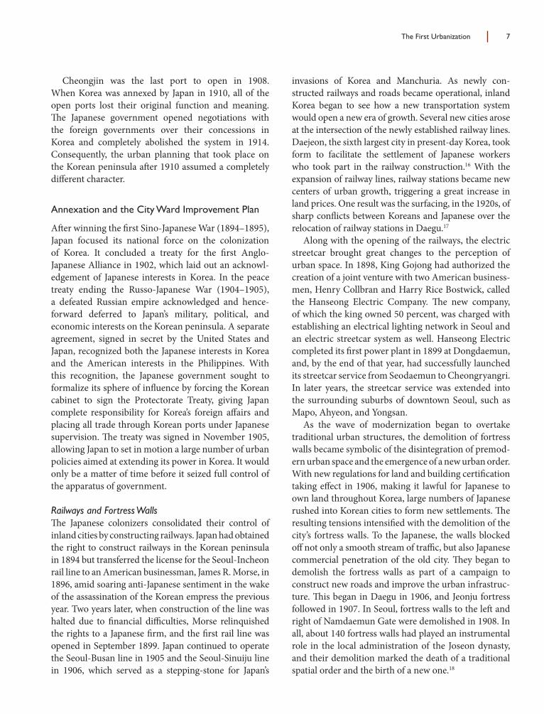
In Seoul, the Government-General of Joseon desig-nated twenty-nine roads as targets for remodeling on November 6, 1912. Th e plan was revised fi ve times until 192837 when its scope was fi nally extended to forty-four roads (fi gure 1.11).38 Yet only twenty-fi ve of the forty-four roads were actually completed before liberation. Prior to the city ward improvement planning, street networks in Seoul had not departed very much from a framework that dated back to their medieval origins.
The First Urbanization 11
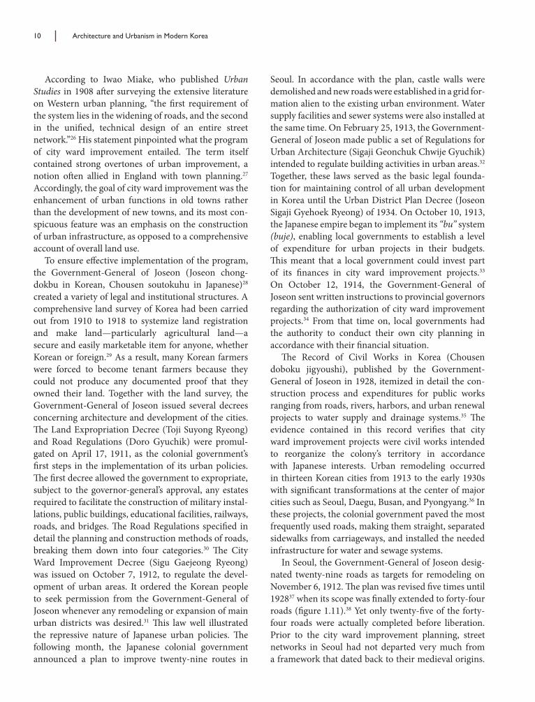
In fact, main roads in old Seoul were never intended to be crossed at right angles, appar-ently for military and geomantic reasons.39 Th e fi rst city improvement plans for Seoul showed an intention on the part of the colonial government to change this closed street system into an open system as part of the city’s transformation into a modern metropolis. Th e city center of Seoul was composed of blocks approximately 200 m to 300 m in size. Th e plan intended to place the Government-General of Joseon’s headquarters at the center of power (fi gure 1.12b), so radial roads were created that led out from the headquarters building, centering the axis of the urban scheme on the building. As a way of expressing political power in urban space, similar schemes had been adopted in Versailles and Washington, D.C. Th e plan was changed, however, when it was decided that the colonial headquarters building should be relocated directly in front of Gyeongbokgung Palace, requiring signifi cant changes in the street system. Th e newly prepared plan of 1919 refl ected these changes. Radial streets moved to the front of Gyeonbokgung Palace, and all the radial streets and plazas at the old building site disappeared (fi gure 1.12c). Th e 1919 plan still maintained a grid-pattern layout of street networks; as in the 1912 plan, minor streets continued to be aligned with the linear patterns of the old streets. Most of the arterial roads in the old center of Seoul were built at that time.
Pyongyang, the present-day capital of North Korea, off ers a glimpse of how old walled towns
Fig. 1.12 Changes in the urban structure of downtown Seoul: (a) city fortress of Seoul before modernization; (b) city ward improvement plan, 1912; (c) city ward improvement plan, 1919; (d) present-day urban structure of downtown Seoul
1. Gyeongbokgung Palace2. Changdeokgung Palace3. Jongmyo (the ancestral shrine of the royal family)4. Gyeonghuigung Palace5. Deoksugung Palace6. Sajik (altar to the state deities)7. Government-General of Joseon headquarters
building before the relocation in front of Gyeongbokgung Palace
Fig. 1.11 Road remodeling in downtown Seoul (Map redrawn from land registration of 1918 and digitized by Sang-Koo Lee)
12 Architecture and Urbanism in Modern Korea
in Korea were transformed into colonial cities through city ward improvement projects. As a place of strategic importance in the northwestern region of the Korean peninsula, Pyongyang had formed its urban core within four layers of fortress walls between the Daedonggang and Botonggang rivers. However, aft er the opening of a railway line between Seoul and Sinuiju in 1906, the old town began to dissolve. In addition, when the construc-tion of Japanese army barracks near Mt. Seogi ignited a Japanese rush to Pyongyang, the city government formulated a plan for a new town to meet the urgent demands of the Japanese settlers. Its design resembled the Chinese cities conceived by the Mantetsu with streets laid out in a grid and arterial roads radiating from a railway station at the town center. It is intriguing to contemplate how the plan also refl ected a traditional urban layout from the sixth century, imitating ancient Chinese urban formats characterized by a clear division into distinct city blocks or wards. Th e size of each block in the new town was 84 m x 84 m. Prior to the construction of a Japanese supply base in 1917, the site to the rear of the station was left empty, existing only in traces on maps. By maintaining the existing layout, Japanese planners had intended to link the new town to the old fortifi ed city of Pyongyang.
Aft erwards, Pyongyang underwent two major changes that prompted the overhaul of its urban struc-ture: the introduction of streetcar service in 1922 and the construction of Daedong Bridge in 1923. Of the two, the construction of Daedong Bridge provided momentum for the expansion of the city’s boundary into the east bank of the Daedonggang River. Until then, both the old and the new town had been contained by the west bank. However, in spite of the rapid popula-tion growth that industrialization brought to the city, the city government had trouble selecting suitable sites for the expansion of urban space because many ancient remains surrounded the city. Th e Government-General of Joseon decided to span the river with a bridge to resolve these problems. Th e construction of the street-car track also had a substantial impact on the urban structure. In 1922, the city government established a fi ve-year plan for the fi rst city ward improvements to meet the new requirements. However, the initial plan to widen and straighten the existing roads in accord-ance with the new traffi c system was not accomplished within the expected timeframe, only reaching its con-clusion in 1927. Th rough these projects, the new town was directly linked to the old town of Pyongyang. Th e
second round of city ward improvements were carried out from 1927 to 1933, remodeling four roads to renovate the old town (fi gures 1.13, 1.14).
Since city ward improvement planning left a lasting infl uence on the urban structure of Korean cities, a look at the historical context of its implementation may be instructive. Above all, there was a signifi cant diff erence in purpose between its development in Japan and its application in Korea twenty-four years later. In Japan its purpose was the remodeling of premodern cities, espe-cially the capital of Japan, into modern ones; in Korea the same program was carried out to extend colonial rule. Th is diff erence can be verifi ed by history. When Haussmann transformed the old center of Paris into a modern city, incorporating wide avenues and open spaces, the population of Paris was more than 2 million, and its density, at a maximum, was 340 persons per hectare.40 Haussmann’s planning was in fact a response to dire urban conditions resulting from overpopulation. In contrast, when the improvement work for 31 routes was undertaken in Seoul, the population of Seoul was 250,000, with a density of only 69 persons per hectare. Th e housing shortage was less than 6 percent. Th erefore, it can be argued that the City Ward Improvement Ordinance was not introduced to solve urban problems but to strengthen colonial rule. Along with a comprehen-sive land survey conducted between 1910 and 1918, the ordinance aimed to establish a strict spatial partitioning of the national territory, and its main purpose was to make an accurate map that could be used to consolidate political power. As Arie Graafl and has pointed out, a perceptual apparatus is never neutral to its observation, but can be used for other purposes.41 In their promo-tion of urbanism, the common aim of Japanese colonial offi cials was to make urban spaces identifi able and more easily governable rather than to solve, like Hausmann, serious urban problems stemming from overcrowding.
City ward improvement planning followed a distinc-tive path in Korea because of its sponsor, the colonial regime. Th at is to say, while the plan focused on improving street networks, it was never part of a com-prehensive urban planning scheme like Haussmann’s renovation of Paris or the initial city ward improvement plan in Tokyo. Because the city ward improvement plan in Korea focused on road works for Japanese new towns, delaying any large-scale intervention into traditional urban tissues, it caused severe imbalances in the urban domain. For example, there was a widespread shortage of access to a water supply. According to a 1925 survey,

The First Urbanization 13
the water supply access rate for Korean households living in Seoul was no more than 28 percent whereas that of Japanese households reached 85 percent. Such disparities accounted for the inadequate sanitation in the areas of Korean residence in the 1920s.42
The Experience of Modernity in Colonial Cities
Subtle signs of change began to appear in the urban dis-course of the early 1920s, for several reasons. First, there was an apparent change in the style of Japanese rule, shift ing from the iron-fi sted domination of the early years to a more cultural approach, because the former was seen to be undermining the long-term stabilization of the colonial society. An uprising on March 1, 1919, expressing a nationwide outcry against the intolerable aggression, oppression, and plundering of the Japanese colonialists, had been a watershed event. In the urban domain, one of its outstanding results was a transfer of power from the Japanese government to local govern-ments. As a result, most urban plans in the 1920s were drawn up by local governments, and planners and civil engineers were usually invited to participate. Th e reason local governments came to the forefront at that time was the necessity of adjusting the confl icting interests of residents before urban projects could be executed. In particular, a sharp confl ict between the Government-General of Joseon and Japanese residents in Seoul over the expansion of Seoul reveals how diff erent segments of the Japanese ruling class took diff ering stances toward urban issues. At that time, the Government-General of Joseon had planned to develop the northern districts of Seoul, where most Koreans lived, in order to secure its command of the entire urban area. But the Japanese, who mainly lived in the southern districts, opposed this plan and insisted on expanding Seoul toward Yongsan and the Hangang River.43 Th is debate sparked a fi erce controversy because the direction of urban develop-ment decisively infl uenced land prices.
Second, technocrats of the colonial government were researching a wide range of urban methodolo-gies and coming to the conclusion that the city ward improvement plan did not eff ectively handle expansion of urban space, because its priority was the renovation of old, degraded urban centers. In this research, diverse urban theories and methodologies were energeti-cally discussed. It was the early 1920s when Ebenezer Howard’s idea of a garden city and Le Corbusier’s urban theory were introduced in Chousen to Kenchiku, the colony’s only architectural magazine.44 Th e urbanism of modern American cities provided an important template. Another signifi cant reason for the appear-ance of diff erent urban perspectives was the infl uence of Japan itself. A huge earthquake struck Tokyo and the surrounding Kanto region in 1923, providing sudden
Fig. 1.14 Th rough road from Sinchangli to Botongmun, the western gate of the old city of Pyongyang, 1923 (National Archives of Korea, CJA0013073)
Fig. 1.13 City ward improvement planning of Pyongyang (Redrawn from a 1915 map of Pyongyang )

14 Architecture and Urbanism in Modern Korea
impetus for the restructuring of Japanese cities and their transformation into modern ones. As it became more feasible to disseminate in-depth studies on new urban theories and methods, the intellectual ferment had a great impact on colonial technocrats.
Attentiveness to urban issues had already led to the formation of the Study Group for Gyeongseong (old Seoul) Urbanism in 1921, organized by colonial tech-nocrats and pro-Japanese collaborators. Th e members of the group agreed on the necessity of drawing up a master plan for a city of 1 million inhabitants. Th e fi rst of three master plans for Seoul was established in 1926 by Takayoshi Honma, director of a newly organized city planning department in Seoul’s city government, who had inspected examples of European urbanism. As soon as the plan was announced, it faced severe criticism for its unrealistic scale, which included both Seoul and Incheon. Aft er a reduction in scope, the second plan was issued in September 1928. Th e major objective of this
plan was the renovation of Seoul’s old downtown area, amounting to about 158 ha, by means of land adjust-ment, including a revolutionary idea to raze the area to the ground and fi ll it with Western-style roadside build-ings (fi gure 1.15).45 Th is idea evidently originated in the Earthquake Recovery Plan established in Japan in 1923 under which land readjustment projects were carried out in the 3,300 ha area destroyed by fi re. Restoration on this scale had never been seen anywhere else in the world: an irregular urban sprawl was cleared away and transformed into precise districts with grid-like streets and pocket parks.46 For Seoul, however, the second plan was at some remove from the actual urban situation, and the colonial government did not have the fi nancial resources to carry out the plan. More realistic methods would be needed aft er the 1930s, when the spatial expansion of Seoul was fi nally undertaken.
What was most remarkable about the 1920s was the appearance of a new generation of urban dwellers who rejoiced in its everyday culture. “Starting at the turn of the century, the urbanizing process stimulated the for-mation of a new sensibility, giving rise to intellectuals and a new kind of human. Th ey accepted the urban way of life as it was, looking at cities as an object of com-mentary and criticism.”47 Th ese so-called modern boys strutted along newly opened streets and experienced for themselves the cold-bloodedness, melancholy, and despair that modern cities engendered. Th e sensibility they expressed produced a great change in the spatial consciousness of colonial intellectuals and artists. To them, the city was both the distillation of modernity and, because it was the essence of the modern, the place where the representation of modernity was embodied. Th e emergence of an avant-garde in Seoul revealed the experience of those who lived in colonial cities from a diff erent perspective. Th e works of the novelist Man-Sik Chae and the poet Sang Yi provide eloquent examples of how the urban avant-garde portrayed modernity in a critical fashion.
A Muddy Stream (Takryu), by Man-Sik Chae (1902–1950), depicted the social life of Gunsan, one of Korea’s open ports, during the 1930s. Th e narrative unfolds in two contrasting areas of the city, capturing the tensions, abhorrence, and proximity of the inhabit-ants of the two areas. Th e Korean district is a shanty-town supplying cheap and plentiful labor to support the colony’s economy. In contrast, the Japanese settle-ment follows a well-defi ned gridiron plan highlighted by imposing buildings. Th is clear dichotomy between
Fig. 1.15 Second master plan for Seoul, 1928, showing the First District (Mugyo-Dong) before and aft er execution of the land adjustment plan (Jung-Mok Sohn 1996a, 153)
The First Urbanization 15
the periphery and the center, the premodern and the modern, the dominated and the dominant structures, enforces a sense of inferiority among the local Koreans. By showing the enormous discord inherent in colonial cities, the author exposes the pretense of colonial mod-ernism for what it truly is—a mask of power. To Man-Sik Chae, it had already become clear that the dominant power in the colonial period was transforming the built environment of the colonized society to make it serve its interests, economic or ideological. A Muddy Stream presented the critical insights of colonial intellectuals who tried to plumb the contradictions and inconsisten-cies underlying the urban space of colonial cities.
Sang Yi (1910–1937) was a graduate of the archi-tecture school at Gyeongseong Engineering College who worked as an assistant engineer in the colonial government for four years. Resigning his post in 1933, he devoted himself to literature and developed a reputa-tion as a controversial poet. His writings, especially his early poems written in Japanese, have been compared to those of Franz Kafk a as forms of “minor literature.”48 Th is poetry marked the impasse felt by colonials who were barred access to the dominant discourse. In depicting the transformation of urban space in Seoul, Yi refused to bow to the architectural and urban dis-course of the Japanese authorities, preferring instead to point out their camoufl aged hypocrisies. Yi’s poetry reveals the emergence of a new subjectivity in Korea, refl ecting a moment when the modern way of life was becoming embedded in the culture. To express the chaotic everyday life of a large city as it evolved, Yi used highly visual forms of language. In this, he shows an affi nity with the perspectives of Charles Baudelaire and Walter Benjamin, who witnessed the urbaniza-tion of their respective cities, Paris and Berlin, and made modern cities, their architecture, and the life of their residents the themes of their work. Moreover, all three believed that understanding modernity required a critical examination of the governing principles of urban life. Th rough their works, they proposed a new vision of the urban landscape, one that has continued to have an impact on architecture. Each of them placed the experience of urban shock, associated with the imper-sonality of crowds of strangers, at the center of their work.49 Moreover, unlike the disinterest and apathy expressed by some, all three confronted the shock of urban life in a combative way, a continued resistance that eventually wore them out. Baudelaire, Benjamin, and Sang Yi were modern writers who battled to their
deaths against the depredations of the urban condition, making their works exemplary fi rst-hand accounts of the turbulence that engulfed their time.
Yi’s best-known poem, “Crow’s-Eye View, Poem No. 1,” clearly expresses the point of view of the contempo-rary urban avant-garde.50 Th e poem uses metaphor to insinuate the author’s spatial consciousness. A bird’s-eye perspective has two underlying meanings. One is the desire to escape from the disorderliness of Seoul so that he can understand its space more clearly; the other is his desire to transcend the bondage of reality. Th e poem also uses two contrasting spatial expressions, an open alley and a dead-end alley, which seem to express Yi’s response to changes in urban space.
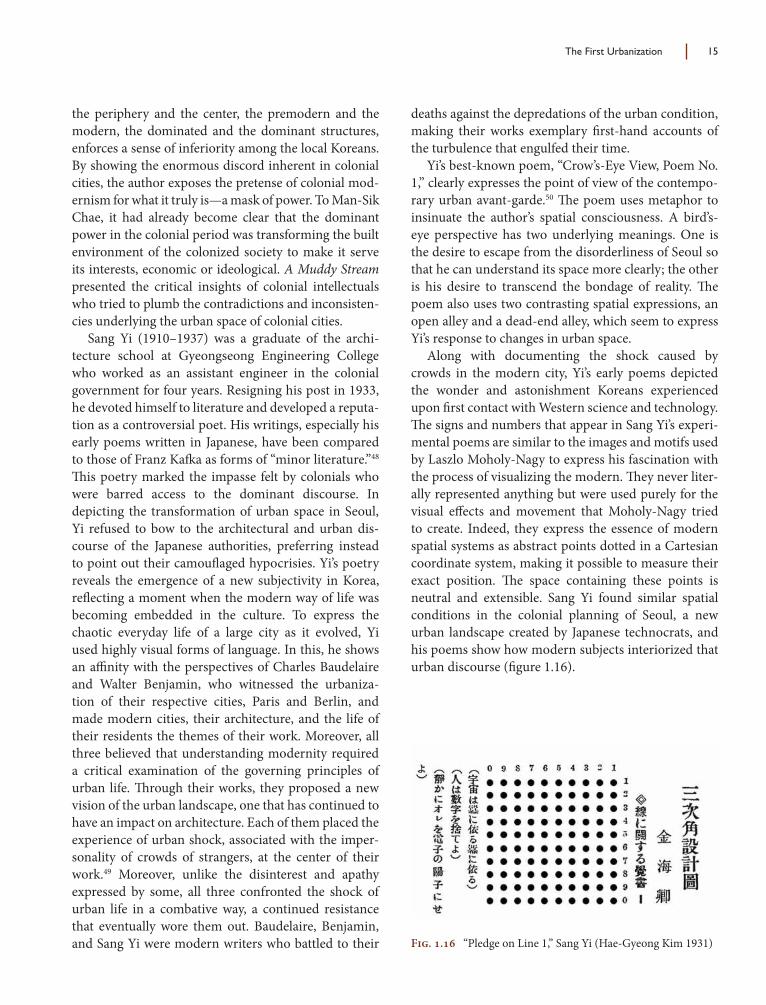
Along with documenting the shock caused by crowds in the modern city, Yi’s early poems depicted the wonder and astonishment Koreans experienced upon fi rst contact with Western science and technology. Th e signs and numbers that appear in Sang Yi’s experi-mental poems are similar to the images and motifs used by Laszlo Moholy-Nagy to express his fascination with the process of visualizing the modern. Th ey never liter-ally represented anything but were used purely for the visual eff ects and movement that Moholy-Nagy tried to create. Indeed, they express the essence of modern spatial systems as abstract points dotted in a Cartesian coordinate system, making it possible to measure their exact position. Th e space containing these points is neutral and extensible. Sang Yi found similar spatial conditions in the colonial planning of Seoul, a new urban landscape created by Japanese technocrats, and his poems show how modern subjects interiorized that urban discourse (fi gure 1.16).
Fig. 1.16 “Pledge on Line 1,” Sang Yi (Hae-Gyeong Kim 1931)
16 Architecture and Urbanism in Modern Korea
Suburbanization and the Land Readjustment Plan
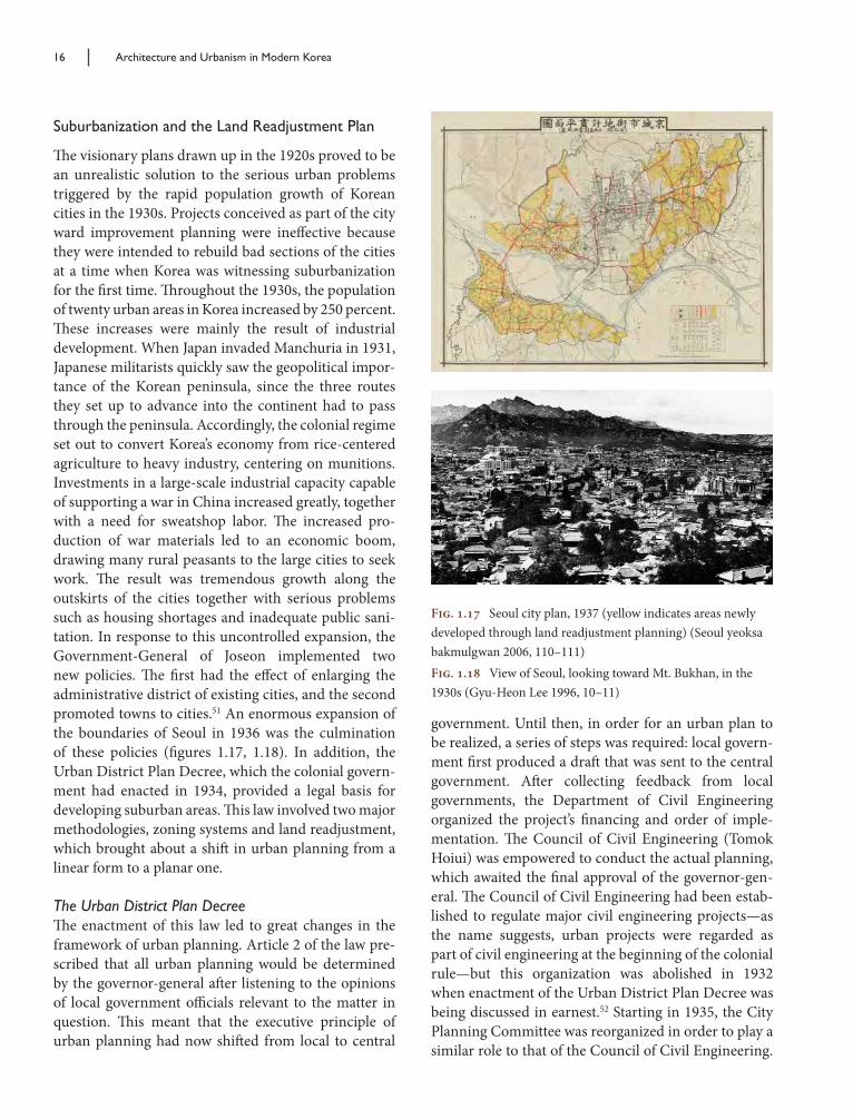
Th e visionary plans drawn up in the 1920s proved to be an unrealistic solution to the serious urban problems triggered by the rapid population growth of Korean cities in the 1930s. Projects conceived as part of the city ward improvement planning were ineff ective because they were intended to rebuild bad sections of the cities at a time when Korea was witnessing suburbanization for the fi rst time. Th roughout the 1930s, the population of twenty urban areas in Korea increased by 250 percent. Th ese increases were mainly the result of industrial development. When Japan invaded Manchuria in 1931, Japanese militarists quickly saw the geopolitical impor-tance of the Korean peninsula, since the three routes they set up to advance into the continent had to pass through the peninsula. Accordingly, the colonial regime set out to convert Korea’s economy from rice-centered agriculture to heavy industry, centering on munitions. Investments in a large-scale industrial capacity capable of supporting a war in China increased greatly, together with a need for sweatshop labor. Th e increased pro-duction of war materials led to an economic boom, drawing many rural peasants to the large cities to seek work. Th e result was tremendous growth along the outskirts of the cities together with serious problems such as housing shortages and inadequate public sani-tation. In response to this uncontrolled expansion, the Government-General of Joseon implemented two new policies. Th e fi rst had the eff ect of enlarging the administrative district of existing cities, and the second promoted towns to cities.51 An enormous expansion of the boundaries of Seoul in 1936 was the culmination of these policies (fi gures 1.17, 1.18). In addition, the Urban District Plan Decree, which the colonial govern-ment had enacted in 1934, provided a legal basis for developing suburban areas. Th is law involved two major methodologies, zoning systems and land readjustment, which brought about a shift in urban planning from a linear form to a planar one.
The Urban District Plan DecreeTh e enactment of this law led to great changes in the framework of urban planning. Article 2 of the law pre-scribed that all urban planning would be determined by the governor-general aft er listening to the opinions of local government offi cials relevant to the matter in question. Th is meant that the executive principle of urban planning had now shift ed from local to central
government. Until then, in order for an urban plan to be realized, a series of steps was required: local govern-ment fi rst produced a draft that was sent to the central government. Aft er collecting feedback from local governments, the Department of Civil Engineering organized the project’s fi nancing and order of imple-mentation. Th e Council of Civil Engineering (Tomok Hoiui) was empowered to conduct the actual planning, which awaited the fi nal approval of the governor-gen-eral. Th e Council of Civil Engineering had been estab-lished to regulate major civil engineering projects—as the name suggests, urban projects were regarded as part of civil engineering at the beginning of the colonial rule—but this organization was abolished in 1932 when enactment of the Urban District Plan Decree was being discussed in earnest.52 Starting in 1935, the City Planning Committee was reorganized in order to play a similar role to that of the Council of Civil Engineering.
Fig. 1.17 Seoul city plan, 1937 (yellow indicates areas newly developed through land readjustment planning) (Seoul yeoksa bakmulgwan 2006, 110–111)Fig. 1.18 View of Seoul, looking toward Mt. Bukhan, in the 1930s (Gyu-Heon Lee 1996, 10–11)

The First Urbanization 17
However, unlike the Council of Civil Engineering, which comprehensively dealt with public works in Korea, the City Planning Committee focused on urban planning projects.53 Th is change indicates that the focus of Japan’s public works shift ed from civil engineering projects, such as the construction of ports, roads, and railways, in the initial phases to urban planning aft er the 1930s.
Based on this law, the Government-General of Joseon established city planning regimes for forty-three cities nationwide, some of which began to publish Explanatory Reports on City Planning Decisions (Sigaji Gyehoek Gyeoljeong Iyuseo) to state the purpose of city planning decisions and the decision-making process.54 An analysis of these reports reveals that all city planning followed the same method. Urban planners would initially predict the population thirty years hence based on the demographic trends of each city. Th e calculation equation varied depending on the city involved. In the case of Seoul, demographic trends from 1916 to 1933 engendered the following equation: N = 18.500T + 401.486 (T: the year of the Showa era, N: the future population). According to this equation, Seoul’s population in 1965 was estimated at 1,141,486 people (table 1.1). Th ere was some consensus that an ideal population density would be 100 sq m for each inhabitant (100 inhabitants per hectare). Th e source of this criterion was not noted, but Ebenezer Howard had suggested the ideal of 75 inhabitants per hectare forty years earlier, and Raymond Unwin had set a norm of 30 dwellings per hectare in his book Town Planning in Practice (1912), arguing that it was cheaper to build in such low densities.55 In addition, the number refl ected the median population density of Japanese cities: 181.9 sq m per inhabitant (55 inhabitants per hectare).56 Aft er fi xing the targeted density of popula-tion, planners set the boundaries of newly extended urban areas, taking into consideration the topography
and the administrative zone. Walking distance also acted as an important factor. Th us the boundaries of a city were normally drawn up within a 5 km radius from downtown, a distance one could easily walk within an hour.
A similarly scientifi c approach was applied to arterial roads. Japanese planners analyzed the geographical features and existing traffi c conditions of each city to design its arterial roads. Th e starting point was the estab-lishment of roads to interconnect the cities. Next, the planners linked these roads to the inner street systems. Th ey approached the design of the inner roads by sub-dividing cities into several wards or subcenters accord-ing to population and topography. In other words, the principal roads in the cities were created by connect-ing downtown areas and the subdivided wards, or the centers of the subcenters. In Seoul, Japanese planners subdivided the entire city into seven subcenters—the old downtown, Yongsan, Cheongryangri, Wangsipri, Hangangri, Mapo, and Yeongdeungpo—and then, placing the city hall at the center, created principal roads to connect them.57 Th e roads had three diff erent widths according to their functions: arterial roads connecting the downtown and subcenters were 24 m, 28 m, and 34 m wide; subarterial roads connecting major places within subcenters were 12 m, 15 m, and 20 m wide; and local roads were less than 12 m wide. Th e height of roadside buildings was limited to assist natural lighting in roads, following the Urban District Plan Decree.
Another remarkable feature of city planning under the Urban District Plan Decree was its awareness of the emergence of automobiles, which became a major consideration in the planning of the street system. Even though the number of cars at the peak traffi c periods was no more than 8,000–10,000 in Korea,58 Japanese planners wanted to factor them into city planning anyway, predicting an increase in their number thirty years later. Th e suggested number was 2.5 cars per 1,000
Table 1.1 Population predictions in the Explanatory Reports on City Planning Decisions
Cities Population and density in 1934 Predicted population and density in 1965 Real population
in 1966Population Habitable area for
each person (m2)
Predicted population Habitable area for
each person (m2)
Seoul 382,491 65 1,141,486 83 3,793,280Busan 163,814 98 400,000 100 1,426,019Daegu 107,657 81 354,807 137 845,189Incheon 75,558 88 184,570 138 525,827Mokpo 55,667 127 138,856 127 162,166

18 Architecture and Urbanism in Modern Korea
persons, based on an analysis of Japanese cities.59 Th is prediction may seem absurd from our perspective, but an accurate picture of the world thirty years hence was not available to Japanese planners. Aft er defi ning princi-pal roads, they designed diverse secondary roads, which remained parallel with the principal roads. Th ese roads were conceived in close relation to land readjustments, a major way of partitioning the newly prepared sites.
Using this approach, a nationwide scheme for urban development, starting with Najin in 1934, led to the planning of forty-three cities. Th is initiative is of great interest for the history of city planning insofar as it introduced a number of design methodologies based on a scientifi c analysis of urban realities. Yet the problem was that the colonial government failed to secure the fi nancial resources needed to carry out its plans, mainly because it excluded the private sector and subsidies from the national coff ers could not meet expectations. Th us, few projects were implemented properly during the period of Japanese occupation. Th e only exception was the urban districts developed according to a land readjustment system. Since this did not require signifi -cant fi nancial outlays, sixty-one districts were planned nationwide, of which thirty-seven were completed.
Land Readjustment ProjectsAft er the planning of forty-three cities, the colonial gov-ernment set forth a comprehensive urban development scheme, designating nationwide sixty-one districts as land readjustment areas. Land readjustment, which has been used as an important tool to design urban space in Korea since the 1930s, produces a particular urban pattern. Unlike the city ward improvements that were linear urban designs focusing on the renovation of roads, land readjustment was a planar development method.
In fact, this system had been used for agricultural land consolidation in Japan during the Tokugawa era and was widespread since the 1880s. In 1899, the Agricultural Land Consolidation Law (Koshi Seiri Ho), modeled aft er the German land consolidation system, was passed to facilitate agricultural land improvement through the grouping of scattered landholdings into larger plots and the building of irrigation systems.60 But unlike Germany, where most of the agricultural land consisted of dry fi elds, Japan had many wet fi elds. Hence, the initial law underwent a sweeping modifi ca-tion that provided the basis of the land readjustment system that was introduced as an essential provision of
the City Planning Act of 1919.61 In this revised system, allowance had to be made for two specifi c provisions deriving from Japan’s own history: fi rst, all landowners contributed a portion of their land—usually about 30 percent—for public use; second, all landowners were required to participate in the project when at least two-thirds of the landowners agreed.
Also known as land consolidation or land pooling, land readjustment became an important tool for urban development in Japan, South Korea, Taiwan, and other countries. Th e process basically worked as follows. Aft er an area was selected for a land readjust-ment project, a development plan was prepared based on the current and projected market conditions and taking into consideration environmental and aesthetic factors. Th e plan disregarded existing lot ownership, however. An area’s parcels of land were pooled into a single entity, and the parcels were then replotted to fi t the development plan. An individual, a private corpora-tion, a landowners’ association, a public corporation, an administrative agency, or another public entity could all implement the development plan. Land for public facilities and land that would be sold to help cover some of the project’s start-up costs were captured through a technique called “land reduction.” Th is system became popular because it was an eff ective method to develop urban fringe areas, converting them from agricul-tural or rural to urban or industrial. In sum, the main approach was to pool the ownership of neighboring lands, build an urban infrastructure, and divide the land into urban plots.
Th e Government-General of Joseon inserted the land readjustment system into its Urban District Plan Decree and detailed the regulations governing land readjustments. According to Article 42, “land readjust-ment is defi ned as the transformation of land parti-tioning through an exchange, division, or annexation of plots and a change in the category of land, or as the creation, transformation, or abolishment of roads, squares, rivers, and parks in a bid to improve the use of land as plots.” Th is system was seen to have many advan-tages in comparison to other methods of development or expropriation; principally, it provided for planned development of land and infrastructure without strain-ing existing fi nancial resources. For this reason, since its initial enactment in Japan, about 30 percent of the urban land supply was developed through its use, and in some places, such as the city of Nagoya, as much as 77 percent of all habitable land was developed through
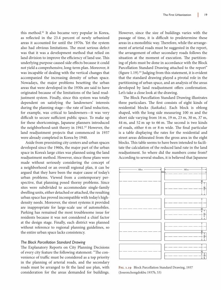
The First Urbanization 19
this method.62 It also became very popular in Korea, as refl ected in the 23.4 percent of newly urbanized areas it accounted for until the 1970s. Yet the system also had obvious limitations. Th e most serious defect was that it was a development method that relied on land division to improve the effi ciency of land use. Th is underlying purpose caused side eff ects because it could not yield a comprehensive, long-term plan. Moreover, it was incapable of dealing with the vertical changes that accompanied the increasing density of urban space. Nowadays, the major problems besetting the urban areas that were developed in the 1930s are said to have originated because of the limitations of the land read-justment system. Finally, since this system was totally dependent on satisfying the landowners’ interests during the planning stage—the rate of land reduction, for example, was critical to landowners—it was very diffi cult to secure suffi cient public space. To make up for these shortcomings, Japanese planners introduced the neighborhood-unit theory in 1941.63 However, the land readjustment projects that commenced in 1937 were already completed in Korea by 1940.
Aside from preexisting city centers and urban spaces developed since the 1960s, the major part of the urban space in Korea’s large cities was planned using the land readjustment method. However, since those plans were made without seriously considering the concept of a neighborhood or an overall regional plan, it can be argued that they have been the major cause of today’s urban problems. Viewed from a contemporary per-spective, that planning posed thorny problems. Since sites were subdivided to accommodate single-family dwelling units, either detached or attached, the resulting urban space has proved incompatible with today’s high-density needs. Moreover, the street systems it provided are inappropriate for large-scale use of automobiles. Parking has remained the most troublesome issue for residents because it was not considered a chief factor at the design stage. Finally, each district was planned without reference to regional planning guidelines, so the entire urban space lacks consistency.
The Block Parcellation Standard DrawingTh e Explanatory Reports on City Planning Decisions of every city feature the following statement: “Th e con-venience of traffi c must be considered as a top priority in the planning of arterial roads, and the secondary roads must be arranged to fi t the land use plan, with consideration for the areas demanded for buildings.
However, since the size of buildings varies with the passage of time, it is diffi cult to predetermine these areas in a monolithic way. Th erefore, while the arrange-ment of arterial roads must be suggested in the report, the arrangement of other secondary roads follows the situation at the moment of execution. Th e partition-ing of plots must be done in accordance with the Block Parcellation Standard Drawing attached to the report” (fi gure 1.19).64 Judging from this statement, it is evident that the standard drawing played a pivotal role in the partitioning of urban space, and an analysis of the areas developed by land readjustment off ers confi rmation. Let’s take a close look at the drawing.
Th e Block Parcellation Standard Drawing illustrates three particulars. Th e fi rst consists of eight kinds of residential blocks (kaikaku). Each block is oblong shaped, with the long side measuring 100 m and the short side varying from 16 m, 19 m, 23 m, 30 m, 37 m, 44 m, and 52 m up to 66 m. Th e second is two kinds of roads, either 6 m or 8 m wide. Th e fi nal particular is a table displaying the rates for the residential and street areas delineated from the gross area in the eight blocks. Th is table seems to have been intended to facili-tate the calculation of the reduced land rate in the land readjustment. So where did the numbers come from? According to several studies, it is believed that Japanese
Fig. 1.19 Block Parcellation Standard Drawing, 1937 (Joseonchongdokbu 1937b, 53)
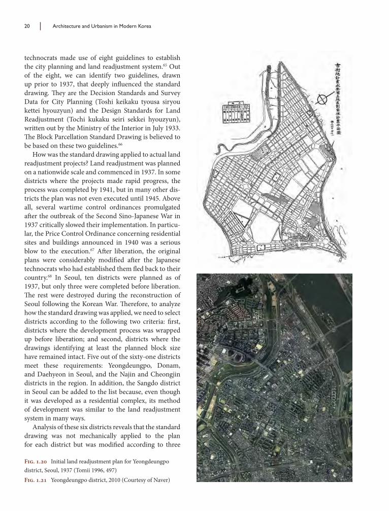
20 Architecture and Urbanism in Modern Korea
technocrats made use of eight guidelines to establish the city planning and land readjustment system.65 Out of the eight, we can identify two guidelines, drawn up prior to 1937, that deeply infl uenced the standard drawing. Th ey are the Decision Standards and Survey Data for City Planning (Toshi keikaku tyousa siryou kettei hyouzyun) and the Design Standards for Land Readjustment (Tochi kukaku seiri sekkei hyouzyun), written out by the Ministry of the Interior in July 1933. Th e Block Parcellation Standard Drawing is believed to be based on these two guidelines.66
How was the standard drawing applied to actual land readjustment projects? Land readjustment was planned on a nationwide scale and commenced in 1937. In some districts where the projects made rapid progress, the process was completed by 1941, but in many other dis-tricts the plan was not even executed until 1945. Above all, several wartime control ordinances promulgated aft er the outbreak of the Second Sino-Japanese War in 1937 critically slowed their implementation. In particu-lar, the Price Control Ordinance concerning residential sites and buildings announced in 1940 was a serious blow to the execution.67 Aft er liberation, the original plans were considerably modifi ed aft er the Japanese technocrats who had established them fl ed back to their country.68 In Seoul, ten districts were planned as of 1937, but only three were completed before liberation. Th e rest were destroyed during the reconstruction of Seoul following the Korean War. Th erefore, to analyze how the standard drawing was applied, we need to select districts according to the following two criteria: fi rst, districts where the development process was wrapped up before liberation; and second, districts where the drawings identifying at least the planned block size have remained intact. Five out of the sixty-one districts meet these requirements: Yeongdeungpo, Donam, and Daehyeon in Seoul, and the Najin and Cheongjin districts in the region. In addition, the Sangdo district in Seoul can be added to the list because, even though it was developed as a residential complex, its method of development was similar to the land readjustment system in many ways.
Analysis of these six districts reveals that the standard drawing was not mechanically applied to the plan for each district but was modifi ed according to three
Fig. 1.20 Initial land readjustment plan for Yeongdeungpo district, Seoul, 1937 (Tomii 1996, 497)Fig. 1.21 Yeongdeungpo district, 2010 (Courtesy of Naver)

The First Urbanization 21
factors: district size, natural conditions, and the pattern of arterial roads. With the size of the sixty-one dis-tricts ranging from approximately 1.5 ha to 512 ha, the average size was approximately 100 ha. Larger districts were usually laid out in a grid whereas medium-size districts placed arterial roads at the center of the plan. Consequently, the six districts under analysis break down into three types: grid, arterial road, and mixed. An example of a large district is Yeongdeungpo, where the land readjustment project ran from March 1937 to March 1940. Th e plan for this district subdivided it into diverse blocks and plots. Large plots allocated to indus-trial facilities were concentrated near the Yeongdeungpo station, an arrangement made possible because the district had been designated as an industrial zone in the planning of Seoul. Other blocks, however, were subdivided in a regular manner following the standard drawing. A block surrounded by arterial roads was 400
m x 240 m in size, and twenty-four residential blocks (kaikaku) were located within it (fi gures 1.20, 1.21).
Donam, Daehyeon, Sangdo, and Cheongjin districts all refl ect a planning method used for medium-size dis-tricts. First, district boundaries were determined by the topography. In addition, major arteries penetrated to the center of the district, and secondary road networks were planned accordingly. Th e width of the arteries was approximately 30 m, and their routing was based on topographical fl ow and the need for access to other districts. Stemming from the major arteries, secondary roads 3 m, 6 m, and 8 m in width were planned, subdi-viding several residential areas (fi gures 1.22, 1.23).
Najin district can be classifi ed as a mixed type. Th is was the fi rst city to implement the Urban District Plan Decree following its announcement in 1934. Although its size of approximately 300 ha was similar to that of Yeongdeungpo, Najin was not laid out in a perfect grid
Fig. 1.22 Initial land readjustment plan for Daehyun district, Seoul, 1937 (Jung-Mok Sohn 1996a, 289)Fig. 1.23 Daehyun district, 2010 (Courtesy of Naver)
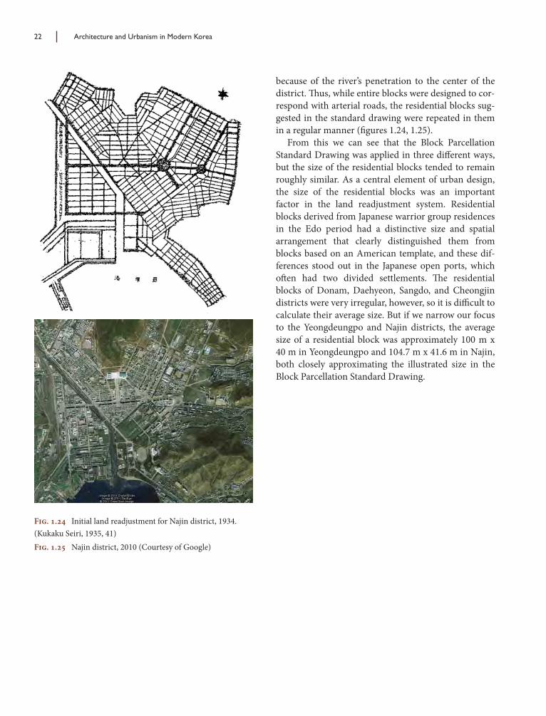
22 Architecture and Urbanism in Modern Korea
because of the river’s penetration to the center of the district. Th us, while entire blocks were designed to cor-respond with arterial roads, the residential blocks sug-gested in the standard drawing were repeated in them in a regular manner (fi gures 1.24, 1.25).
From this we can see that the Block Parcellation Standard Drawing was applied in three diff erent ways, but the size of the residential blocks tended to remain roughly similar. As a central element of urban design, the size of the residential blocks was an important factor in the land readjustment system. Residential blocks derived from Japanese warrior group residences in the Edo period had a distinctive size and spatial arrangement that clearly distinguished them from blocks based on an American template, and these dif-ferences stood out in the Japanese open ports, which oft en had two divided settlements. Th e residential blocks of Donam, Daehyeon, Sangdo, and Cheongjin districts were very irregular, however, so it is diffi cult to calculate their average size. But if we narrow our focus to the Yeongdeungpo and Najin districts, the average size of a residential block was approximately 100 m x 40 m in Yeongdeungpo and 104.7 m x 41.6 m in Najin, both closely approximating the illustrated size in the Block Parcellation Standard Drawing.
Fig. 1.24 Initial land readjustment for Najin district, 1934. (Kukaku Seiri, 1935, 41)Fig. 1.25 Najin district, 2010 (Courtesy of Google)

Bae, Ki-Hyung 배기형 (1917–1979)Born in Gimhae, Gyeongsangnamdo, Ki-Hyung Bae studied at a vocational school in Busan and learned architecture through short courses provided by an institute at Kyushu University. Until the 1945 libera-tion, he worked for the Nishijima Architectural Offi ce in Fukuoka, Japan. During that time, he acquired considerable experience working with steel structures, enabling him to become Korea’s foremost author-ity on structural design.
In 1946, Bae founded his own offi ce, Gujosa, together with fi ve architects and structural engineers, and achieved fame as the designer of a number of factories and offi ces. In particular, his expertise in large-span structures was displayed in his designs for the Paramount Cinema and Piccadilly Cinema in Seoul. He also designed the Jungang building (1965) and the UNESCO building (1966), both still standing in downtown Seoul.
Chung, Guyon 정기용 (1943–2011)Guyon Chung graduated from the Craft s Department at Seoul National University and studied interior design at the École Nationale Supérieur des Arts Décoratifs before changing his major to architecture at the École d’Architecture de Paris La Villette. His academic trajectory was not completed, however, until he studied urbanism at the Université de Paris VIII in 1982 in search of a total human environment embracing small-scale craft s as well as modern urban life. He ran his own offi ce in Paris until 1985, when he returned to Korea to open Guyon Architects.
Experiencing the military dictatorship of the 1980s, Chung became interested in the social role of architects and how they could deepen their engagement in society. He put this idea into practice through a series of projects in Muju county, consisting of thirty works in total, between 1996 and 2005. His initia-tive in Muju caused a nationwide stir, attracting the attention of the reform-minded Moo-Hyun Roh administration. Th rough his relationship with offi cials in the new administration, Chung made eff orts to improve the nation’s architectural and urban planning. He also designed a residence for Roh in the president’s hometown of Bongha, where Roh retired when he left offi ce.
Joh, Sung-Yong 조성룡 (1944–)Sung-Yong Joh was born in Tokyo and educated at Inha University. He is the current principal of Joh Sung-Yong Architects and president of the Seoul School of Architecture. As a member of the 4.3 Group, he has played a leading role in the articulation of Korean architectural discourse since the 1990s.
His designs have won fi rst prize in several notable competitions, including the Athletes’ Village for the Asian Games (1983), the Uijae Museum (1999), Seonyudo Park (2000), and the Seoul Olympic Museum (2000). Th ese buildings were recognized for clearly conveying his major idea: a thorough com-munication with the surrounding environment. Joh has been invited to a number of national and inter-national exhibitions, including Notions of Madang: Th ree Contemporary Korean Architects at Gallery MA in Tokyo in 1989, Metropolis in Transition at Gallery Inspiration in Tokyo in 1991, 4.3 Group Architecture in 1992, and Th e 53 Origins at Gallery Ma in 1995.
Appendix
Profi les of Korean Architects and Planners

146 Appendix
Kim, Chung-Up 김중업 (1922–1988)Born in Pyongyang as the second eldest son of a country magistrate, Chung-Up Kim spent most of his early childhood in several counties of the northeastern region. Th e mountainous landscapes of this area instilled a romantic sensibility in the artistic child. He was fond of composing poems and drawn to Fauvist paintings in high school in Pyongyang, and was persuaded by his painting teacher to enroll at Yokohama National University. Th ere he received a rigorous Beaux-Arts training under the guidance of Professor Junpei Nakamura, who had studied at the École des Beaux-Arts in Paris. Aft er working at the Matsuda-Hirada architectural fi rm for three years, Kim returned to Korea and became an assistant professor at Seoul National University.
In 1952, Kim traveled to Venice as one of fi ve Korean delegates to the First International Conference of Artists sponsored by UNESCO. On this trip, an encounter with Le Corbusier on a coastal passenger ferry proved fateful. Aft er the conference, Kim headed for Paris to ask for a job in Le Corbusier’s offi ce, where he remained for three and a half years. Upon his return to Korea, he opened a studio of his own in Seoul. Initially emulating Le Corbusier, Kim opened a new path with the design of the French embassy in Seoul (1960), a cluster of three buildings set on a hill exemplifying the unity that can be achieved through a harmonious arrangement of forms in a natural setting. Subsequent works such as the head-quarters building of Jeju University (1964) , Seo Obstetrics and Gynecology Clinic (1965), the main gate of the UN memorial cemetery (1966), and the Lee residence (1967) displayed his ability to transform the traditional vocabularies of Korean architecture into a modern poetry of shadows and light.
During this period, Kim continued to criticize the urban policies of the military regime, and in 1971 he was forced to leave for Paris without his family. He attempted to carry on his architectural practice in Europe but was unable to produce meaningful outcomes. He moved to the United States in 1975, where he continued his private practice and served as a design critic at the University of Rhode Island. In 1978, he returned to Korea permanently and conceived several projects such as a new building for the Korean Educational Development Institute (1979), the Korea Military Academy museum (1981), and the World Peace Gate (1987). Th ese later works show a changed attitude toward architectural design with a new emphasis on transparency and simplicity.
Kim, In-Cheurl 김인철 (1947–)Born in Jinhae in South Gyeongsang province, In-Cheurl Kim graduated from Hongik University and began his architectural career as an apprentice in the studio of Duck-Moon Um, where he worked from 1971 to 1985. In 1986, he opened his own practice, renaming it Archium in 1995. As a member of the 4.3 Group that strongly infl uenced the Korean architectural community, Kim’s career fl ourished. He subsequently joined the faculty of the Seoul School of Architecture and currently holds a professorship at Joongang University.
Kim believes that architecture is not a matter of addition but a process that removes unnecessary clutter. Th is tenet is well refl ected in major works such as the Kim Ok-Gil Memorial Hall (1998), Woongjin Th inkbig offi ce (2007), and Urban Hive (2008). His book Shall We Talk about Architecture (2002) was compiled from talks with students in the webzine Archinude.
Kim, Jong-Soo 김정수 (1919–1985)A native of Pyongyang, Jong-Soo Kim moved to Seoul to study architecture at Gyeongseong Engineering College and, upon graduation, took a position in the building and repairs department of the Government-General of Joseon. In 1953, he established Jonghap Architectural Institute with Cheon-Seung Yi, Korea’s fi rst large-scale architectural fi rm. During the postwar period, this partnership contributed signifi cantly to the introduction of advanced Western technologies through projects such as Gukje Cinema (1957), Saint Mary’s Hospital in Seoul (1959), Jongro YMCA (1960), and Jangchung Gymnasium (1960). In 1957, a year-long stay at the University of Minnesota exposed Kim to the work of Mies van der Rohe,

Appendix 147
which became an enormous infl uence on his own designs. He cultivated a mechanical and functionalist approach to architecture in order to express a candid relationship between structure and appearance.
Th e metal curtain wall he designed for Saint Mary’s Hospital in Seoul was the fi rst in Korea, and he subsequently experimented with a precast concrete curtain wall at his own offi ce. Aft er becoming a professor of architecture at Yonsei University, he became fascinated with the Gothic style and the pos-sibility of using a modern approach to transform it. For the Students’ Hall at Yonsei University (1963), he put pointed Gothic arches in a precast concrete curtain wall to complete the façade of the building. Even though Jong-Soo Kim found it diffi cult to realize some of his high-tech aspirations for architecture in Korea, he was able for the most part to overcome the technological limitations of his era.
Kim, Seok-Chul 김석철 (1943–)Seok-Chul Kim studied architecture at Seoul National University before working in the offi ces of two leading architects, Chung-Up Kim and Swoo-Geun Kim, between 1964 and 1969. In 1972, he estab-lished Archiban Seok Chul Kim & Associates. In 1983, his fi rm won an international competition for the design of the Seoul Arts Center, Korea’s premier arts complex, comprising an opera house, concert hall, art museum and archives, calligraphy museum, and performance theater. More recent works include the Jeju Cinema Museum (1991), the Korean Pavilion at the Venice Biennale (1995), and the DBEW Design Center (2003), in addition to the master plan for the World Ceramic Expo of 2001.
An organizer of the Anywise conferences and Aquapolis series of conferences, Kim has also authored Millennium Architecture: Millennium City and Seoul: City of Ethics, City of Nature. He is currently involved in a number of collaborative projects in Europe and China.
Kim, Swoo-Geun 김수근 (1931–1986)Swoo-Geun Kim was a prominent Korean architect, educator, publisher, and patron of the arts. He was born into a family that ran a fi shery business in Cheongjin, North Korea, but soon moved to Seoul, because of his mother’s enthusiasm for education. His interest in architecture was kindled through an accidental contact with an American soldier when he was a high school student. In 1950, Kim entered Seoul National University to major in architecture, but the outbreak of the Korean War forced him to withdraw from the school. He entered Japan surreptitiously and studied modern architecture at Tokyo’s National University of Fine Arts and Music. In 1960, he received a master’s degree in architecture from Tokyo University with a research project on the planning of Olympic stadiums. During his stay in Tokyo, he was greatly infl uenced by Le Corbusier, Kenzo Tange, and Japanese Metabolism.
In 1959, Kim won the design competition for the National Assembly Building of South Korea, but his proposal was not realized, due to the political situation at the time. Aft er opening his own offi ce in Seoul, Kim designed more than two hundred projects both within and outside South Korea. Representative works include the Space Group building (1978), Arko Art Center (1979), the Masan Yangdeok Catholic church (1979), Jinju National Museum (1986), and the Olympic Stadium in Seoul (completed in 1987), all featuring his characteristic style as well as refl ecting the ideals of traditional Korean architecture.
In 1966, Kim began publishing the monthly Space Magazine, South Korea’s fi rst general arts journal and a successful proponent of Korean culture. Kim also built the SPACE Gallery in 1972 and founded Gonggan Sarang in 1978, a small theater inside the Space Group building; both have played an impor-tant role in numerous South Korean cultural campaigns. With his infl uence extending over many genres, Swoo-Geun Kim is regarded as a seminal cultural activist, one who integrated architecture with other modes of artistic expression.
Kim, Tai Soo 김태수 (1937–)Born in Seoul, Tai Soo Kim chose architecture for his profession as a young man. His father, a profes-sor at a medical college, had spent his sabbatical year in the United States and sent him architectural magazines. Inspired by the depiction of Louis Kahn’s works in these magazines, Kim decided to go to the
148 Appendix
United States in 1961 aft er obtaining his bachelor and master’s degrees from Seoul National University. He studied at the Yale School of Architecture under its dean, Paul Rudolph, and took a job in Philip Johnson’s offi ce. In 1970, he cofounded the Hartford Design Group.
Tai Soo Kim’s work has brought him ever-increasing recognition. Designs such as the National Museum of Contemporary Art in Seoul (1986), the Kyobo Life Insurance training facility (1988), the Gray Cultural Center at the University of Hartford (1990), and the LG Research and Development Park (1997) have earned local and national awards and praise in international architectural journals. In these works, Kim crystallized the core values of critical regionalism—namely, a sense of place, geometric clarity, and respect for clients’ needs. In 1986, Kim was honored by the American Institute of Architects for his contributions to architecture and elected to the College of Fellows, FAIA. In 1994, Kim won the Korean Broadcasting Systems’ Overseas Compatriots Prize for his achievements in his fi eld.
Kimm, Jong-Soung 김종성 (1935–)Born in Seoul, Jong-Soung Kimm began his architectural education at Seoul National University in 1954 and completed his undergraduate and graduate studies at the Illinois Institute of Technology (IIT) in Chicago. Aft er graduation, Kimm worked in the offi ce of Mies van der Rohe until 1972, participating in iconic projects such as the Brown Wing of the Museum of Fine Arts in Houston and the Dominique Center in Toronto. Concurrent with this work, Kimm taught design studios at IIT and joined its faculty in 1972. He became the interim dean during his last year at IIT’s College of Architecture, Planning & Design.
In 1978, Kimm returned to Seoul to open an architectural design consultancy, SAC International. He pursued the development of his own concept of space based on a deep understanding of technology and its role in architecture, and used the play of light to explore directionality and centrality in space. Th e fruition of these experiments was the emergence of his own architectural vision, a signifi cant departure from the precedents of his teachers Mies van der Rohe and Louis Kahn.
Kimm’s architectural activities reached their summit in the 1990s. His masterpieces the Seoul Hilton Hotel (1983), the Korea Military Academy library (1982), the Seoul National University museum (1991), Art Sonje Museum in Gyeongju (1991), and the SK Corporation’s headquarters building (1999) were regarded as heralding the new spirit of the time. His precept that an architect can only explore his spatial imagination aft er establishing a tectonic concept of design has had far-reaching implications for Korean architects.
Lee, Hee-Tai 이희태 (1925–1981)Hee-Tai Lee was born into a poor family in Jecheon in North Chungcheong province. Although the family did move to Seoul to seek a more comfortable life, this did little to improve their situation. Unable to attend a secondary school, Lee chose a training course at a vocational school and met a Japanese teacher there who taught architecture. Unlike other Korean architects of the same age, who had studied at Korean or Japanese universities, Lee was self-taught. He opened his offi ce in 1946, a year aft er libera-tion, and began to participate in architectural competitions. With the help of Professor Bal Jang, dean of the College of Fine Arts at Seoul National University, Lee won commissions to design several religious buildings, including the Hyehwadong Catholic church (1960), Jesuit Hall at Sogang University (1963), and the Church of the Martyrs on Mt. Jeoldusan (1967). Th ese projects enabled him to hone his unique talent.
Lee focused on the transformation of traditional Korean architecture and the development of an elaborate proportional system in the façade. Adhering to these principles, he went on to design several cultural centers, including the National Th eater (1967), Gyeongju National Museum (1972), Gongju National Museum (1974), and Busan Municipal Museum (1976). But even with this activity, he found it diffi cult to obtain commissions in the late 1970s. To alleviate these diffi culties, he formed a joint offi ce with architect Duck-Moon Um, but this partnership did not succeed in producing any signifi cant projects. Lee died of cancer in 1981.

Appendix 149
Min, Hyun-Sik 민현식 (1946–)Hyun-Sik Min was born in the small town of Gyeongnam in South Gyeongsang province and received his bachelor’s degree from Seoul National University in 1970. Aft er serving as an offi cer in the Korean navy, he worked in the offi ce of Swoo-Geun Kim and then for the Archiban Architect’s Group, becoming a partner in 1980. Since 1992, he has run his own fi rm, H. Min Architect & Associates.
In 1989, feeling a need to revitalize his practice, Min attended the Architectural Association School of Architecture in London for a year. In 1992, Min participated in the collaborative exhibition of the 4.3 Group formed by young Korean architects to discover new possibilities for Korean architecture; he also exhibited his work at the Venice Biennale of 1996 and 2002. He has been a guest lecturer at Seoul City University and Seoul National University and is currently a professor at the Korea National University of Arts.
Representative works include the Sungyak Presbyterian Church in Uijeougbu (1996), the headquar-ters and Seoul factory of Sindo Ricoh (1997), and the Korea National University of Cultural Heritage (2002).
Park, Byung-Joo 박병주 (1925–)Born in Busan in 1925, Byung-Joo Park studied civil engineering in night school at Kobe Engineering College between 1941 and 1944 while working for a land surveying company during the day. Returning to Busan in 1948, he taught engineering in high schools for nearly ten years before moving to Seoul in 1958 to assume a position as vice-chief of the Housing Technology Offi ce of the International Cooperation Agency (ICA). Th is gave him the opportunity to learn site planning from American experts. Four years later, he joined the Site Planning Bureau of the Korean National Housing Corporation, where he partici-pated in projects including the urban planning of Ulsan (1962) and Masan (1967) and the site planning of Ichondong (1965).
In 1968, Park became an urban planning professor at Hongik University. From that time on, he took charge of the planning for Yeouido Island (1971) and the Jamsil district (1974), which marked the begin-ning of large-scale urban development in Seoul. One of his major contributions was the introduction of the neighborhood unit as an important principle of urban design. He also helped to consolidate the legal foundation for urban planning and participated in the planning of several industrial cities in Korea. His ideas emphasized the communality of urban space, opening the way to the creation of large open spaces.
Park, Dong-Jin 박동진 (1899–1980)Born in Jeongju, Pyeonganbukdo, Dong-Jin Park graduated from Osan high school and enrolled at Gyeongseong Engineering College to major in architecture. But he was forced to abandon his studies when he was charged with involvement in the 1919 independence movement. Following his release from prison, Park reentered the college. Upon completion of his studies, he was hired as a construction engineer working for the Government-General of Joseon.
In 1937, Park designed the headquarters building and library of Korea University and the main building of Jungang high school with the strong support of Seong-Su Kim, the founder of both institu-tions. Th ese buildings confi rmed Park’s ability to deal with stone and classical motifs. In 1938, he began to build a practice of his own, and in 1951 he became a professor of architecture at Cheonggu University in Daegu. Among his major works aft er liberation were Yeongnak Church (1948) and Namdaemun Church (1954).
Park, Gil-Ryong 박길룡 (1898–1943)Gil-Ryong Park was the son of a poor rice dealer in Seoul. Despite the hardships he faced during the colonial period, he became the fi rst Korean graduate of Gyeongseong Engineering College in 1919, and began his career as a building engineer with the Government-General of Joseon in 1920. Over the next decade, his investigation of vernacular houses in Korea sensitized him to housing issues and led to his

150 Appendix
participation in the housing improvement movement of the 1930s. In 1932, he resigned from his govern-ment position and opened his own offi ce in Seoul, registering as the fi rst Korean architect. Among the projects he designed were the headquarters of Gyeongseong University (1928), Joseon Life Insurance (1930), the Namdaemun branch offi ce of Dongil Bank (1931), Hwasin Department Store (1937), and Daedong Engineering College in Pyongyang (1940). In addition to his professional activities, he played a central role in organizing the Korean Invention Society and published an architectural newspaper, Geonchuk Joseon, in 1940. He also taught housing theory at Ehwa Women’s University.
Seung, Hyo-Sang 승효상 (1952–)Born in Busan, Hyo-Sang Seung received his bachelor’s and master’s degrees from Seoul National University and continued his studies at the Technische Universität Wien. Aft er working for Swoo-Geun Kim from 1974 to 1989, he established his own offi ce, Iroje Architects & Planners, in 1989. In the early 1990s, he was a core member of the 4.3 Group and became the managing director of the Seoul School of Architecture. He has won a number of prizes for works such as Sujoldang (1993), Subaekdang (1998), and Welcomm City (1999).
A recent large-scale project involves the master plan and coordination for Paju Book City near Seoul. In 2002, the American Institute of Architects made him an honorary fellow. In the same year, he was the fi rst architect to be named Artist of the Year by the National Museum of Contemporary Art in Gwacheon, the occasion for a grand exhibition. Seung’s writings include Th e Beauty of Poverty (1996), City of Wisdom, Architecture of Wisdom (1999), Signs of Th ought (2004), and Works: 10X2, coauthored with Yung Ho Chang (2004).
Woo, Kyu Sung 우규승 (1941–)Born in Gaeseong, Kyu Sung Woo is a Korean-American architect who received his bachelor of science and master of science degrees at Seoul National University before moving to the United States in 1967 to study architecture at Columbia University. He obtained a master of architecture in urban design degree at Harvard University in 1970 and worked for Jose Luis Sert at Sert, Jackson & Associates from 1970 to 1974. In 1975, he became a senior urban designer in the mayor’s offi ce in New York City and began his private practice in 1978. He served as principal of Woo and Williams from 1979 to 1990, when he formed Kyu Sung Woo Architects, Inc.
Woo’s numerous projects in both Korea and the United States include the Athletes’ Village for the Seoul Olympics (1988), the Whanki Museum (1993), and the Asian Culture Complex in Gwangju (2005). He has taught at MIT’s School of Architecture and Planning, as well as Harvard’s Graduate School of Design, and is a fellow of the American Institute of Architects. Recent works in the United States include the Arts of Korea Gallery at the Metropolitan Museum of Art (1997), Harvard’s Observatory Commons, combining faculty housing and a city library (2008), and the Nerman Museum of Contemporary Art in Overland Park, Kansas (2008).
Woo, Kyung-Kook 우경국 (1946–)Born in Gwangju in Gyeonggi province, Kyung-Kook Woo graduated from Hanyang University with a bachelor’s degree in architecture in 1973. A partner in several fi rms through the 1970s and 1980s, he has worked on his own under the name of Yekong Architects and Planners since 1989. Woo’s interest in architectural education led him to assume the role of design director at Kyonggi University’s School of Architecture in 1992. He is currently an adjunct professor at Hanyang University. His writings have explored the question of modern identity in Korean architecture, developing a relational theory of architecture in which a building is seen as a constitutive element in a total network of human, natural, architectural, and cosmic order.
His representative works include Nam Myung Memorial Hall (1996), Pyeongsimjung House (1999), Voidium in Heyri (2004), and Baik Soon Shil Museum (2005). His monograph, Aesthetics of

Appendix 151
the Relational Phenomenon: Building and Projects 1995–2006, eff ectively illustrates the mature designs accomplished in his career.
Yi, Sang 이상 (1910–1937)Born in Seoul, Hae-Gyeong Kim 김해경, better known by his pen name Sang Yi, was trained as an archi-tect at Gyeongseong Engineering College. Although he worked for the Government-General of Joseon as an engineer for a few years, he resigned from this position in 1933 to devote himself to literature full time. Yi is considered one of the most innovative writers in modern Korean literature. Refl ecting his training in architecture, his writings, particularly his poetry, frequently employed numbers and diagrams to extend the boundaries of linguistic expression. In his masterpieces Samchagak seolgyedo (Design drawing of a cubic corner, 1931), Ogamdo (Crow’s-eye view, 1934), and Nalgae (Wings, 1936), he explored the urban sensibility of Korean intellectuals during the colonial period. In spite of increasing fame, he ended his later life in tragedy. He had been suff ering from tuberculosis for a long time, and died young in Tokyo.
Yoo, Kerl 유걸 (1940–)Kerl Yoo was born in Seoul, the son of a sculpture teacher. Th is heritage appears to have aff ected his attitude toward design, which stresses a “will to form” in architecture. Upon graduation from Seoul National University in 1963, he began his architectural career with Muae Architects and also worked for Swoo-Geun Kim’s Space Group. He emigrated to the United States in 1971 and was hired as a project architect at R.N.L. Architects & Engineers in Denver. During this sojourn, he continually revised his approach. Most notably, he became acutely aware that architecture is not an end but a tool, and its purpose is to serve human needs.
In 1986, he resumed his work in Korea as a coordinator for the construction of the Athletes’ Village for the Seoul Olympics (1988). His subsequent creations include masterworks such as the Miral School (1997), Kangbyun Church (1998), Millennium Community Center (2005), Paichai University’s International Center (2006), and the new Seoul City Hall (2008). Th ese works illustrate Yoo’s conviction that a well-devised envelope can provide a comfortable environment for humans to live in. Internationally recognized, he has received numerous awards, including the AIA Honor award, the Swoo-Geun Kim Award, and the Korean Institute of Architects Award. He is the founding partner of iARC.
1 The First Urbanization1. Rabinow 1984, 20.2. Yang 2004, 2.3. Shin and Robinson 1999, 5.4. Lefebvre 1991, 10–11.5. Levy 1999, 30.6. Kwon 1990, 266–267.7. Hashiya 2004, 58.8. Kwon 1990, 266–267.9. Jung-Mok Sohn 1994, 67.10. Th e eleven documents showing the planning process for Incheon are as follows (Sang-Ho Yang 1993, 69–75):
1. Map of Chemulpo (Jemulpo) just before the port opening.2. Incheon Harbor and plan for the settlement reclamation (Sugimura Tanan, December 1880).3. Map of Chemulpo, scale 1/500.4. Partitioning map of the settlement.5. Locations of the harbor, the reclaimed land, and the breakwater.6. Drawing attached to the report of Kobayashi Tadakazu, Japanese consul at Incheon, sent to Takezoe Sinichi, Japanese
minister to Korea, September 8, 1883. 7. Drawing attached to the Incheon Concession Treaty, signed September 30, 1883.8. Drawing attached to the report of Yoshida Kiyonari, assistant deputy minister of foreign aff airs, sent to the Japanese
consul at Incheon, October 30, 1883. 9. Drawing attached to the report of the assistant deputy minister of foreign aff airs, sent to the Japanese consul at Incheon,
December 21, 1883.10. Drawing attached to the report of the assistant deputy minister of foreign aff airs, sent to the Japanese consul at Incheon,
April 8, 1884.11. Drawing attached to the Land Regulation of Incheon Chemulpo, concluded October 1884.
11. Jinnai 1995, 50–51.12. William George Ashton (1841–1911), a British consular offi cial in Japan and Korea, worked under the famous British
diplomat Harry Parkes (1828–1885) and made a major contribution to the establishment of diplomatic order in East Asia.
13. Jung-Mok Sohn 1994, 153.14. Th e four categories were (a) the lots situated on the south side of the Chinese settlement; (b) the lots situated on the
north side of the Chinese settlement; (c) the lots east of the Japanese settlement; and (d) hill lots. Th e upset prices were ninety dollars per 100 sq m for Class A lots, six dollars per 100 sq m for Class B and C lots,
and three dollars per 100 sq m for Class D lots. Yearly rentals were twenty dollars per 100 sq m for A lots, six dollars per 100 sq m for B and C lots, and two
dollars per 100 sq m for D lots, of which the Korean government retained thirty cents per 100 sq m for rental costs. Th e remainder belonged to the municipal fund. (Land Regulation for the General Foreign Settlement at Chemulpo, preserved in the fi les of the Government-General of Joseon in the National Archives of Korea, Gakguk Georyuji Gwangye Chigeukseo, no. CJA0002274)
Notes

154 Notes to Pages 6–15
15. Regulations for the Foreign Settlement at Chinnampo and Mokpo (signed October 16, 1897) and Regulations for the Foreign Settlement at Kunsan, Masampo, and Songjin (signed June 2, 1899), preserved in the fi les of the Government-General of Joseon in the National Archives of Korea, Gakguk Georyuji Gwangye Chigeukseo, no. CJA0002274.
16. Kue-Jin Song 2002, 204.17. Il-Su Kim 2003, 110.18. Th e number of the fortress walls varied from 122 to 146. Heon-Kyu Kim 2006.19. Hwangbo and Han 2004, 842.20. Jung Mok Sohn 1994, 334.21. Th e South Manchuria Railway Company (Minami Manshū Tetsudō Kabushiki-gaisha, or Mantetsu) was a company
founded in 1906 and operated within China in the Japanese-controlled South Manchuria railway zone. Th e railway itself ran from Lüshun Port at the southern tip of the Liaodong peninsula to Harbin, where it connected to the Chinese Eastern Railway.
22. Koshizawa 2005, 197.23. Ibid., 185.24. Ishida 1987, 81.25. Goto Shimpei, who became the head of civilian aff airs in the Government-General of Taiwan aft er the Sino-Japanese
war, created the City Ward Improvement Committee in 1898, announcing city ward improvement planning for the 115.5 ha area inside the fortress of Taipei. Aft erwards, city ward improvement planning was subsequently imple-mented in Taiwan’s major cities, including Hsinchu, Changhua, Keelung, Kaohsiung, and Tainan, from 1905 to 1911. Huang and Lee 1994, 299.
26. Miake 1908, 37.27. Watanabe 1993, 81.28. In August 1910, Japan formally annexed Korea and established the Government-General of Joseon, headed by the
governor-general. Th is offi cial commanded the army and navy of Korea and had the right to appoint and remove other offi cials and control the courts. Subject only to the Japanese emperor, he exerted administrative, legislative, judicial, and military power in Korea without the overt control of the Japanese government.
29. Gragert 1994, 3.30. Chousen soutokuhu 1910–1945, no. 186, April 17, 1911.31. Ibid., no. 56, October 7, 1912.32. Ibid., no. 169, February 25, 1913.33. Song-Soon Lee 2006a, 228.34. Chousen soutokuhu 1910–1945, no. 369, October 12, 1914.35. Chousen soutokuhu 1928.36. Jung-Mok Sohn 1996a, 112.37. Ki-Ho Kim 1995, 50.38. Startng with twenty-nine in 1912, the number of renovated roads in Seoul increased by two in 1917. In 1919, three
roads were annulled and fi ft een were created. One road was added in 1925, which fi nally led to the planning of forty-four roads.
39. Yum 2004, 198.40. Myeong-Gyoo Lee 1994, 127.41. Graafl and 2012, 5.42. Hashiya 2004, 82.43. Baek-Yung Kim 2005, 106.44. See Kawano 1922, Nakamura 1922, Hagiwara 1922, and Iwai 1923.45. Jung-Mok Sohn 1996a, 150.46. Koshizawa 2001, 19.47. Jin-Song Kim 1999, 254.48. Th e term “minor literature” was proposed by the French philosophers Deleuze and Guattari to describe: (1) the deter-
ritorializations of a major language through a minor literature written in the major language from a marginalized

Notes to Pages 15–19 155
or minoritarian position; (2) the thoroughly political nature of a minor literature; and (3) its collective, enunciative value. Parr 2005, 136.
49. Benjamin 1969, 211.50. Translation by Jung-Yul Yu and James Kimbrell, in Yi, Hahm, and Choi 2002, 5–6.
Crow’s-Eye View, Poem No. 1
13 children rush down a street.(A dead-end alley will suffi ce.)
Th e 1st child says it is terrifying.Th e 2nd child also says it is terrifying.Th e 3rd child also says it is terrifying.Th e 4th child also says it is terrifying.Th e 5th child also says it is terrifying.Th e 6th child also says it is terrifying.Th e 7th child also says it is terrifying.Th e 8th child also says it is terrifying.Th e 9th child also says it is terrifying.Th e 10th child also says it is terrifying.
Th e 11th child says it is terrifying.Th e 12th child also says it is terrifying.Th e 13th child also says it is terrifying.13 children have come together and are terrifying or terrifi ed. (Th e absence of any other condition would have been preferred.)
If one child amongst them is a terrifying child it’s all right.If two children amongst them are terrifying children it’s all right. If two children amongst them are terrifi ed children it’s all right. If one child amongst them is a terrifi ed child it’s all right.
(An open alley will suffi ce.) Th ough 13 children do not rush down the street everything is all right.
51. Jung-Mok Sohn 1996a, 205.52. Seong-Jin Park 2007, 237.53. Song-Soon Lee 2006a, 248.54. Explanatory Reports on City Planning Decisions were not published for all the cities that conducted city planning.
Th e reports for eight cities—Seoul, Busan, Daegu, Incheon, Hamheung, Seongjin, Mokpo, and Sinuiju—have been found so far. Th is study is based on these reports.
55. Berghauser Pont and Haupt 2010, 48–49.56. Chousen soutokuhu 1937d, 16–20.57. Chousen soutokuhu 1937a, 62–65.58. Jung-Mok Sohn 1996b, 358.59. According to the annual of Japanese cities surveyed in 1931 and printed in 1932, the median number of cars in
Japanese cities was as follows: Tokyo, 4.60 cars per one thousand persons; Osaka, 2.53; Kyoto, 2.78; Nagoya, 2.17; Kobe, 2.47. Chousen soutokuhu 1937d, 34–35.
60. Sorensen 2002, 123.61. Ishida 1987, 125–127.62. Economic and Social Commission for Asia and the Pacifi c 1995, 92.

156 Notes to Pages 19–20
63. Th is theory was fi rst introduced in a report on commoners’ housing published by the Architectural Institute of Japan. Nihon kenchiku kakkai 1941, 93.
64. Chousen soutokuhu 1937c, 24.65. Tomii 1996. Th e eight guidelines are as follows: Toshi keikaku kenkyuukai 1928; Nihon naimushou 1933; Nihon
naimushou 1937; Nihon koseishou sikaikyoku 1940; Nihon koseishou sikaikyoku 1941a; Nihon koseishou sikaikyoku 1941b; Nihon kenchiku kakkai 1941; and Shou juutaku chousa iinkai 1941.
66. Th ere are evident similarities between the standard drawing and the two guidelines. Representative instructions in the guidelines are as follows:1. Instructions for the partitioning of residential blocks
a. Th e plots in a standard residential block are arranged in two rows.b. Th e standard residential block is rectangular.c. Th e long side of the standard residential block runs east-west.d. Th e size of residential blocks varies according to the guidelines.
2. Instructions for the planning of street systems, as given in the two guidelinesa. Decision Standards and Survey Data for City Planning
i. Th e creation of roads within a residential site must be allowed except in special cases.ii. Road widths must be over 6 m.iii. Th e arrangement of roads must obey the following rules: roads more than 8 m wide must be arranged at
intervals under 250 m; the roads intersecting arterial roads must be straight.b. Design Standards for Land Readjustment
i. Residential areas – Interior roads must not allow through traffi c and must be systematic, taking into consideration traffi c points
(stations, bus stops), elementary schools (including children’s parks), and connecting roads to shops. – Road widths must be over 6 m. – Dead ends must be restricted to the site securing suffi ciently large open space.
ii. Outside residential areas – In an industrial area, shortcuts to arterial roads, arterial canals, and railway stations must be created, taking
into consideration the convenience of through traffi c. • Shortcuts must be arranged at intervals of more than 200 m.
Table 1.2 Size of residential blocks (Decision Standards and Survey Data for City Planning)Grade Residential area Commercial area Industrial area
Short side Long side Short side Long side Short side Long side
Super Grade 1 60–80 m 160–200 mGrade 1 50–60 m 140–160 m 45–55 m 130–140 m 80–120 m 160–200 mGrade 2 40–50 m 120–140 m 35–45 m 120–130 m 40–80 m 100–160 mGrade 3 30–40 m 100–120 m 25–35 m 100–120 mGrade 4 20–30 m 80–100 m 20–25 m 80–100 m
Table 1.3 Size of residential blocks, long side (Design Standards for Land Readjustment)Grade Residential area Commercial area Industrial area
Super Grade 1 160–200 mGrade 1 140–160 m 130–140 m 120–200 mGrade 2 120–140 m 120–130 m 80–120 mGrade 3 100–120 m 100–120 mGrade 4 80–100 m 80–100 m
Notes to Pages 20–28 157
67. Jung-Mok Sohn 1996b, 294.68. Th e document frequently cited by Korean scholars with regard to land readjustment is the eighth chapter in the Korea
section of the Historical Survey of Japanese Overseas Activities (Nihon okurashou 1947). Even though the document has some problems with numbers, it gives us a relatively accurate picture of the situation because the land readjust-ment process is marked in percentile bands. According to this document, thirty-seven land readjustment projects were 100 percent complete, but it is not clear what “complete” means.
2 The Genesis of Urban Housing1. Schwarzer 1995, 88.2. Se-Kwan Sohn 2000, 245.3. Wang 1989, 6.4. Hur 2001, 21.5. Ko, Dong-Hwan 1994, 3896. Hangukhak jungang yeonguwon Jangseogak 2009b, 231. Jangseogak was established by Wang-jik Yi in 1918 as a
library for Korean studies. Since its opening, the library has housed archives of Korean classics and modern works, as well as the Jangseogak documents that were transferred from the Cultural Heritage Administration of Korea in 1971.
7. Joo 1994, 87.8. Jung-Mok Sohn 1996b, 232.9. Yoshida 2009, 128, and Young-Bae Kim 1991. Th e numbers come from the Gwangmu register (yangan) drawn up by
the Korean government between 1898 and 1903.10. Fujimori 1993, 1:16.11. Seong-Yeon Choe 1959, 163.12. Th e number of Westerners inhabiting Incheon over a fourteen-year period fl uctuated as follows: 1897 (57), 1898 (65),
1899 (67), 1900 (63), 1901 (73), 1902 (75), 1903 (109), 1904 (91), 1905 (88), 1906 (86), 1907 (63), 1908 (60), 1909 (71), 1910 (70). Sang-Ho Yang 1993.
13. Th e number of schools established by the diff erent denominations was as follows: Presbyterians, 501; Methodists, 158; other Protestants, 91; and Catholics, 46. Eun-Kyung Cho 1999.
14. Seung-Tae Kim 1994.15. Ryu 2001, 96.16. Chang-Won Chung 2004, 70.17. Apart from Vories, C. A. Gunn, in Manila, also assisted in Korea. Rhodes 1934, 416.18. Seo 2005, 20.19. Rhodes 1934, 179.20. Yong-Hwan Park 2010, 181–184.21. Th e term tsuzukima literally refers to a “continuous space” or “successive rooms.” Th e tsuzukima of samurai or
wealthy urbanite homes consisted of a series of rooms of similar width whose fusuma walls could be opened up to create one large space for ceremonies and festive occasions. Th e tsuzukima style was adopted in middle-class homes aft er the abolition of class restrictions on architecture in the Meiji period.
22. Genkan are traditional Japanese entryways into a house, apartment, or building—a combination of porch and doormat. Hiroma were large rooms occupying the full-cross section of a building in Edo-period farmhouses.
23. Yong-Hwan Park 1996, 46.24. Taut 1958.25. Tingey 1981, 83.26. Suzuki 1999, 57.27. Funo et al. 2010, 230–231.28. Jun Kim 2007.29. Of the 1,495 houses built in Seoul in 1921, there were 875 Japanese-style houses, half of them offi cial residences.
Donga Ilbo, October 25, 1922.30. Myung-Suk Kim 2003, 24.

158 Notes to Pages 28–38
31. Yoon and Lee 1997.32. Ogura 1927, Komada 1927, Kotaka 1927, and Akagi 1927 describe the offi cial residences in several sectors of the
colonial regime and were all published in the May 1927 issue of Chousen to Kenchiku.33. Aoki, Oka, and Suzuki 2009, 28. 34. Kashiwagi et al. 2001, 27.35. Kim and Lee 2002.36. Shou juutaku chousa iinkai 1941.37. Tomii 1996, 415.38. Seok Jeong 2006, 14.39. Ranky Kim and Yoon 1989, 232.40. Se-Gwon Jeong 1935.41. Ranky Kim 1992, 110.42. Cheol-Jin Park and Jeon 2002, 100.43. Among the sixty-fi ve urban hanok in Pungnamdong, Jeonju, twenty were I-shaped, thirty-four were L-shaped, and
nine were U-shaped. Se-Kwan Sohn et al. 1996, 31.44. Seoul teukbyeolsi 2001, 28.45. In-Ho Song 1990, 121.46. Sang-Hae Lee 1991, 68.47. Th e lifestyle improvement movement (seikatsu kaizen undo) that is usually dated to the second decade of the twen-
tieth century carried echoes from a long-running thread of discourse in Japanese society. Th e growing infl uence of home economics as a science, the eff ects of the postwar recession in 1919–1920 (including the 1918 rice riots), and the urging of infl uential women educators convinced bureaucrats in both the home and education ministries that the application of scientifi c “rationality” to the sphere of daily life could improve lives without increasing expenses, while also off ering a new role for women as leaders within that limited sphere. Partner 2001.
48. Yu-Bang Kim 1923c.49. Fujimori 1993, 2:77.50. Sand 2003, 168.51. Kashiwagi et al. 2001, 46.52. Uchida 1992, 118.53. “Joseon Housing Design Competition,” Chosun Daily Newspaper, March 21, 1929.54. Kim and Park 2008, 38.55. Maki 2008, 153.56. Tomii 1996, 504–507.57. Ibid., 514.
3 Architecture and the Introduction of New Materials1. A number of young Japanese architects spent time in Europe, including Iwao Yamawaki, Bunzo Yamaguchi (1902–
1978), and Chikatada Kurata (1895–1966), who studied in Germany with Bauhaus founder Walter Gropius; and Kunio Maekawa (1901–1986), Junzo Sakakura (1901–1969), and Takamasa Yoshizaka (1917–1980), who worked in the offi ce of Le Corbusier in France. Steward 2002.
2. Kawabata and Tomii 1985, 231–234. 3. Ryul Song 1993, 51.4. Nishizawa 2009, 96.5. Cody 2001, 18–19.6. Rowe and Kuan 2002, 65.7. Il-Joo Yoon 1985.8. Lyon 2003, 46.9. Yamagata 2002, 13.10. Fujimori 1993, 1:30.

Notes to Pages 38–48 159
11. Il-Joo Yoon 1978, 25.12. Young and Young 2004, 110.13. Takjibu was one of seven ministries at the end of the Joseon dynasty; it was responsible for managing the govern-
ment’s fi nances, including accounts, taxation, national bonds, currency, and banking. 14. Munhwajaecheong 2002a, 289.15. Hanguk bangsong tongsin daehak 2005, 57.16. Il-Joo Yoon 1978, 16.17. Jung-Shin Kim 1994, 42.18. Many problems were faced during construction of the cathedral, particularly the supply of bricks. Domestic indus-
tries were incapable of producing the consistent quality needed to raise a large religious building, and although bricks had been imported from China, their use was confi ned to the foreign concessions. Th e French priests tried to solve this problem by erecting their own brick factories near the Hangang River (Hong-Seok Cho 2005, 81). Another chal-lenge was to fi nd skilled bricklayers able to carry out the complicated construction. At fi rst, they employed Chinese workers, but the work was oft en interrupted by the frequent need to replace workers and by their lack of technical ability (Mutel 1986). In the process, they experienced several collapses of the structure. Finally, with the help of Seredin Sabatin, a Russian architect and engineer who had come to Seoul to design the Russian legation, the French priests were able to realize their wish, and a new style of church building was established in Korea.
19. Nishizawa 2009, 138.20. Tai-Young Kim 2003, 29–30.21. Munhwajaecheong 2002c, 297.22. Murphy’s design approach changed according to the location of the site. With commissions for college campuses in
Tokyo, Beijing, Changsa, and Seoul, he faced the diffi cult problem of determining the most appropriate style for these East Asian countries. For St. Paul’s College in Tokyo, he used a modifi ed Gothic style, partially imitating American universities (Cody 2001, 30). For the plan of Yale-in-China, he blended progressive American campus planning with Chinese courtyard confi gurations (Ibid., 37). Th e buildings on this campus were also designed with similar features, as can be seen in the Chinese-infl uenced roof hovering over Western structures. In the case of Seoul, his buildings were based on his research into the functional uses of the buildings and are generally characterized as Gothic revival. In this project, he also placed more emphasis on how best to use the hilly and wooded landscape.
23. Vories was a self-taught American architect who started in Japan as an English teacher but pursued an architectural career when he was commissioned to design the YMCA building in Kyoto.
24. Munhwajaecheong 2004, 33.25. Samoo Architects and Engineers et al. 2009.26. Soung-Won Kang 2008, 46–48.27. When the Busan Customs Building, completed in 1910, was demolished in December 1973, it was confi rmed that the
foundation slab of the internal retaining wall was made of reinforced concrete. It was 64 cm in depth, and reinforcing rods were placed in the concrete every 9.7 cm. Hanguk concrete hakhoe 2002, 32.
28. Fujimoto 2001, 924.29. Iwai 1926, 5.30. Soung-Won Kang 2008, 159.31. Th e National Archives of Korea maintains a collection of 26,483 drawings and building documents that were produced
from 1900 to 1945 by the Takjibu Architectural Bureau and the architecture department of the Government-General of Joseon. Th e United States Army Military Government in Korea (USAMGIK), the offi cial ruling body of the southern half of the Korean Peninsula from September 8, 1945, to August 15, 1948, took control of these documents in 1945 and transferred them to the Korean government in 1948.
32. Gukga girokwon 2008, 21–22.33. Ibid., 59.34. Isozaki 2006, 17.

160 Notes to Pages 52–61
4 Urban Expansion and the Construction Boom1. Ki-Jung Park 1971, 171. 2. Park gained familiarity with town planning concepts from his contact with American consultants. His initial success
came about through a plan for Ulsan, the fi rst industrial city in Korea, which he submitted in 1963. Th e plan intro-duced the concept of the neighborhood unit, and he was invited to participate in the actual planning of Ulsan. He then joined the Korea Housing Agency as a section leader for site planning and designed the Suyuri, Hwagogdong, Yuchondong, and Gurodong areas of Seoul. His plan for the Jamsil district in Seoul was a rigorous application of the neighborhood-unit theory.
3. Rowe 2005, 82.4. Sang-Chul Choe 2003, 531.5. Gu Yi, who had worked in I. M. Pei’s offi ce aft er graduating from MIT, Jang-Sup Yoon, and Hong Seong-cheol were
the fi rst three researchers hired at Nagler’s institute. Th e next to join were Han Kyu-dong, Yu Han, and Woo Kyu-sung. A year aft er it opened, the institute moved to permanent quarters in Euljiro, and the number of researchers increased to 30–40, including Hong-Bin Kang, Jin-Kyoon Kim, and Sin-Kyu Moon.
6. Among the works exhibited were studies by Geumhwa Park of the informal public spaces that had spontaneously appeared in the shantytowns of Hyeonjeo Dong, Seodaemun Gu, and Seoul.
7. Sang-Chul Choe 2003, 522. Th e major principles of the plan for Seoul were used in the planning of other cities as well. For example, the plan for Daejeon, established in 1972, sought balanced development by establishing 1.5 km, 5 km, and 10 km concentric zones with Daejeon rail station and Eunhaengdong at the center (Daejeonsi 1990, 2213). In Daegu, city offi cials worried that the irregular city boundaries left by the expansion of 1957 would make further expansion more diffi cult, so they returned the city to its circular form with the expansion of 1963, allowing concentric expansion to continue and implementation of a ring and radial urban planning system (Daegusi 1995, 23).
8. Seoul teukbyeolsi 1966, 165.9. Jung-Sub Yoon 1970, 20.10. Horwitz 1967, 25-26.11. Doxiadis 1968, 15.12. Tai-Soo Kim 1969,1.13. Seoul teukbyeolsi 1969, 10.14. Doxiadis, op.cit.15. Harvey 2008, 24.16. Koolhaas 1994, 19.17. Seoul teukbyeolsi 2010, 222.18. Interview with Byung-Joo Park, November 7, 2006.19. Two plans had been suggested for the Gangnam area. In 1962, a Korean businessman, Heing-Sik Park, inspired by the
new town of Tama in Japan, proposed a new town in Gangnam to house more than 300,000 people. In 1966, the Seoul municipal government suggested a schematic design to rationalize the construction of the Hannam Bridge. Youn 2009.
20. Hanguk gosokdoro gongsa 2000, 35.21. Seoul yeoksa bakmulgwan 2006, 124.22. http://en.wikipedia.org/wiki/City_block.23. Siksna 1997, 20.24. Ibid., 25.25. Jung and Kang 2012, 192. 26. Th e neighborhood-unit theory was applied to the Gangnam area aft er 1976 when part of the area was designated as
an apartment-house district. Seoul teukbyeolsi 1990.27. Hall 1974, 56.28. Schubert 2000, 118.29. Jung-Mok Sohn 2003, 3:207.30. Daehan jutaek gongsa 1992, 224.

Notes to Pages 61–77 161
31. Seoul teukbyeolsi 1976, 15.32. Article 13 of the enforcement ordinance of the Promotion of Housing Construction Act (October 1979) delegated
to every mayor and county governor the authority for establishing the basic development planning of apartment-house districts. In accordance with this legal foundation, the Seoul Metropolitan Government enacted a municipal ordinance for the Basic Development Planning of Apartment-House Districts. Article 3 of the municipal ordinance includes the cited regulation.
33. Provision for Amenities in Urban Planning, City Planning Act, section 85, subsections 10–11 (May 21, 1979).34. Frey 1999.35. Tafuri 1979, 18.36. Kitayama, Tsukumoto, and Nishizawa 2010, 34.37. Rowe and Koetter 2001, 62.38. Similar phenomena can be found in Tokyo. Kitayama, Tsukukmoto, and Nishizawa 2010.39. Gongdong jutaek yeonguhoe 1999, 127.40. Th e living-zone theory corresponds to a tree structure that Christopher Alexander has identifi ed as a nonoverlapping
structure. Alexander 1965, 58–62.41. In-Ho Kang 2000, 12.42. Paik et al. 2006, 3.43. Lim 1997, 87.44. Ibid.45. Paik et al. 2006, 141.46. Daehan jutaek gongsa 1984, 121.47. Seoul teukbyeolsi 1984a, 35.48. Daehan jutaek gongsa 1988, 45.49. Daehan jutaek gongsa 1997, 65; Hanguk toji gongsa 1997a, 113; Ibid. 1997b, 10.50. Paik et al. 2006, 179–182.51. Hanguk toji gongsa 1997a, 307–309.
5 New Urban Housing1. Gelézeau 2004, 26.2. Th e statistics on construction of spec houses in Seoul come from a report issued by the Housing Statistics and Data
Offi ce (Jutaek tonggye jaryosil) in 1983. Choon-Sik Park 1986, 10.3. Yim 1989, 40.4. Th e legal diff erence between multihousehold and multifamily dwellings must be stated precisely because the two
terms are likely to cause confusion. In spite of very similar regulations on size, height, and number of households, the essential diff erence lies in whether the right of ownership is given to each household or not. In a multihousehold dwelling, each dwelling unit can be separately bought and sold, whereas only renting is possible in a multifamily dwelling. Th is means that multihousehold dwellings are treated as collective housing, like apartment houses, whereas a multifamily dwelling is treated as a single house. For obvious reasons, Koreans prefer multihousehold dwellings on the real estate market, so we focus on that form of collective housing in this book.
5. Th e ratio varied between 300 percent and 400 percent, and fi nally was divided into three levels, at 200, 250, and 300 percent (150, 200, and 250 percent in Seoul), according to the type of residential area. Th e Enforcement Ordinance of the current City Planning Act stipulates that the ratio of building area to site area in a Type 1 residential area must be below 100–200 percent; for Type 2, the limit is 150–250 percent; and for Type 3, it is 200–300 percent.
6. Park and Choi 2003, 76.7. Gukto haeyangbu 2008, 72–74.8. Jun 2009, 24.9. Joon-Mann Kang 2005.10. Jang and Park 2009, 104.11. Zchang 1994, 117.
162 Notes to Pages 78–99
12. Daehan jutaek gongsa 2003.13. Zchang 1994, 180.14. Sherwood 1978, 17.15. Daehan jutaek gongsa 2003.
6 The Quest for Architectural Identity1. Ozhan 2007, 103.2. Canizaro 2007, 20.3. Robertson 1995, 30.4. Speck 2007, 75.5. Habermas 2000, 5.6. Fujimori 1999, 191–193.7. Tange 1970, 120.8. Tange 1960, 44.9. Kim was attentive to Tange’s ideas about tradition, as is attested in his newspaper articles, including “Jeontongui
Changjo” (Creation of a tradition) and “Jeontonggwa Minjung grigo Jakgaui Samgakgwangye” (A three-cornered relationship among architects, people, and tradition). Swoo-Geun Kim 1989, 127–131.
10. Swoo-Geun Kim’s opposition was clearly expressed in a round-table talk with Chung-Up Kim and Gu Yi held on December 22, 1966. Swoo-Geun Kim 1967, 7.
11. Jong-Soo Kim 1967, 4–27.12. Chung-Up Kim 1967, 4–27.13. Anderson 1991, 6.14. Muryangsujeon was constructed as the main hall of Buseoksa Temple during the reign of King Munmu (661–681) of
the Silla dynasty. Th e present building was erected in 1373. With its graceful jusimpo (brackets on columns) style, this hall is regarded as the foremost example of the formality of ancient Buddhist shrines in Korea.
15. Chung-Up Kim 1984, 244.16. Guo 1999, 23.17. Win-Hur Lee 2000, 240.18. Curtis 1987, 192.19. Guo 1999, 84.20. Ibid., 40.21. Joo 1997, 107.22. Wittkower 1971, 45.23. Kepes 1995, 47.24. Kim saw it as a practical alternative to the school of Modern Functionalism, which has continued to ignore environ-
mental issues. Swoo-Geun Kim 1989, 24.25. A similar idea can be found in Japanese landscape, according to Augustin Berque, whose analysis was greatly infl u-
enced by the Japanese philosopher Nishida Kitaro (1870–1945). Berque 2010.26. Mansilla and Tunon 2003, 14–19.27. Young-Joon Kim 2004.28. Seung 2006, 32.
7 The Semantics of Technology1. In September 1954, Seoul National University, while still suff ering from the destruction of the Korean War, agreed
to receive educational and technical support from the University of Minnesota with the support of the International Cooperation Administration under the State Department of the United States.
2. Jung-Sub Yoon 1995, 53–64.3. Yu 1967, 61–62.4. Interview with Jong Soung Kimm, 2001.
Notes to Pages 100–118 163
5. Daehan geonchuk hakhoe 2006, 98.6. Kimm 1990, 86–91.7. Kimm 1985, 90–128.8. Kahn 2003, 252.9. Jung 2009, 45.10. Mainstone 1998, 307.11. Won 1997, 224.12. Inha Jung 2009, 97.13. Jong Soung Kimm 1989, 131 . 14. Ishii 1999, 212–215.15. Rastorfer 1988, 128–135. 16. Shin, Lim, and Han 2008, 15.
8 Discovering Reality1. Modernization is generally defi ned as a bundle of cumulative processes that mutually reinforce the formation of
capital through the mobilization of resources, development of production forces and labor productivity, establish-ment of centralized political power, proliferation of political rights and participation, and secularization of values and norms. Habermas 2000, 2.
2. Since modernity itself encompasses all political, economic, social, and cultural experience, it is virtually impossible to fully specify the consequences of the temporal lag between the modernization process of Korea and that of the West. Close to one hundred years separates the beginning of the periods of most rapid growth in the urban populations of London (1861–1941), Tokyo (1901–1961), and Seoul (1960–1990), and comparable gaps can be seen in the enact-ments of a building code (England, 1844; Japan, 1888; Korea, 1913), the mass production of public housing (England, 1850; Japan, 1923; Korea, 1941), and the planning of new towns (England, 1946; Japan, 1963; Korea, 1989).
3. Th e term developmental dictatorship came into use with reference to developments in East and Southeast Asia, as well as Latin America and Eastern Europe. According to Tokyo University scholar Akira Suehiro, it fi rst appeared in the 1980s in the context of describing economic growth in East and Southeast Asia. Th e term presents a vivid image and quickly gained popularity in the Japanese press as a simple way to describe Ferdinand Marcos’ Philippines, Lee Kuan Yew’s Singapore, and Suharto’s Indonesia—namely, by indicating two leading features of the state so described: it strives for economic development, and is a dictatorship. Suehiro 2008.
4. Rowe 2005, 68.5. Hwang 1995, 59.6. Gukrip jungang bakmulgwan (National Museum of Korea) 1995, 36.7. Lefebvre 1991, 26.8. Guyon Chung 2008a, 8.9. Guyon Chung 1987, 37.10. Th e best example is the rehabilitation of the ZUP Perseigne (1978–1982) in Alencon, where Kroll conceived a housing
complex with the urban tissue of traditional villages. Lucan 2001.11. Guyon Chung 2008b, 79.12. Slessor 1999, 76.13. Frampton 2007, 378.14. Fisher 1999, 9.15. Tai Soo Kim 1995, 51.16. Brenner 1981, 72–79.17. Gukrip hyeondae misulgwan 2006, 8.18. Ibid., 9.19. Ibid., 10. 20. Tai Soo Kim 1999, 104.21. Slatin 1993, 71–77.

164 Notes to Pages 119–134
22. Kyu Sung Woo 1999a, 22.23. Kyu Sung Woo 1999b, 9.24. Ibid.25. Ibid.26. Ibid.27. Kyu Sung Woo 1975, 60.28. Kyu Sung Woo 1976, 51.29. Kyu Sung Woo 1999a, 22.30. Th e key ideas of Christ-Janer’s teachings are well described in Christ-Janer 1980.31. Kerl Yoo 1998, 28.32. Ibid., 166.33. Kerl Yoo 2008, 20–37.34. Maxwell 1982, 5.35. Kyong-Soo Kim 1989, 8.36. Seok-Chul Kim 1997, 341–342.37. Kyong-Soo Kim 1989, 8.38. Young-Sub Kim 2003, 28.
9 New Paradigms for Urban Design1. Rowe 2010, 15–16.2. Sang-Kyung Lee 2004, 2–4.3. Koolhaas 1995, 981.4. OMA 1998.5. Han 2008, 100–101.6. Mortice 2008.7. Ibid.8. Geonseol gyotongbu 2006, 88.9. Haeahn architects 2007, 92.10. Augustin Berque, a French geographer, distinguishes between “a western conception of landscape, pivoted around
the subject, and an eastern conception, which instead focuses on the logic of place” (Brighenti 2011). According to Berque, “this diff erence happened because the term and sense of landscape that fi rst appeared in the 16th century deeply refl ected Europeans’ way of thinking at that time. From the beginning of modern time, Europeans made a clear distinction between the subject and the environment surrounding it, and tried to represent the environment through the subject’s eyes. Th is eff ort led to the discovery of linear perspective by Renaissance artists, which had a great impact on the organization of the western conception of landscape” (Berque 1990, 54). In contrast, the Eastern sensibility allowed for the coexistence of the points of view of diverse subjects, contextualized in places. Th is way of representing landscape was not linear but planar.
11. Th e 4.3 Group was formed on April 3, 1990, and consisted of twelve members: Jay-Whan Kwak, Byung-Yoon Kim, Chang-Whan Do, Jung-Gun Dong, Moon-Ki Baek, Chul-Lin Bang, Hyo-Sang Seung, Kyung-kook Woo, Sung-Gwan Lee, Il-Hoon E, Jong-Sang Lee, and Sung-Yong Joh. Later that year, In-Cheurl Kim and Hyun-Sik Min joined the group, bringing the membership to fourteen.
12. Th e address 11, Gahoidong is located in the Bukchon area. When the regulations governing the Hanok Preservation District were lift ed, Korean architects developed models to suggest how the property might be developed.
13. Sung-Yong Joh 1995, 146–149.14. Beigel 1996, 119.15. Beigel 1997, 40.16. Hyo-Sang Seung 2007.17. Beigel 1996, 121.18. Beigel 1999, 58–60.
Notes to Pages 134–143 165
19. Ibid.20. Seung 2005, 15.21. Ibid., 11.22. Th e Commune by the Great Wall consists of eleven villas designed by twelve famous Asian architects: Suitcase House
by Gary Chang (Hong Kong); Furniture House by Shigeru Ban (Japan); “See” and “Seen” House by Cui Kai (China); Distorted Courtyard House by Rocco Yim (Hong Kong); Airport by Chien Hsueh-Yi (Taiwan); Cantilever House by Antonio Ochoa (China); Bamboo Wall by Kengo Kuma (Japan); Shared House by Kanika R-kul (Th ailand); Th e Twins by Kay Ngee Tan (Singapore); Forest House by Nobuaki Furuya (Japan); Split House by Yung Ho Chang (China); and Clubhouse by Hyo-Sang Seung (South Korea).
23. Seung 2010b, 52–55.24. In-Cheurl Kim 2002, 268.25. In-Cheurl Kim 2007, 112–121.26. Kim and Kim 2002.27. Pinoki 2006.28. Bru 1997, 6.29. FOA 2004, 260.30. Sung-Yong Joh 2002, 94.31. Design Seoul Foundation 2010.32. Hadid 2007, 118.
Epilogue 1. Habermas 2000, 2.2. Latham 2000, 4.3. Appadurai 1996, 32.4. Robertson 1995, 27. 5. Nalbantoglu 1997, 8.6. Bok-Kyu Yum 2005, 23.

Abercrombie, Sir Patrick, 53Agricultural Land Consolidation Law
(Koshi Seiri Ho), 18Ahn, Kun-Hyuck, 68Ahyeon, 7alleyways, 9, 31, 74, 96, 120, 131, 132,
134, 144American Museum of Natural
History, 106Amsa, 56Anglo-Japanese Alliance, 7anheorigok, 86, 87Ansan, 52apartment complexes, 61, 62, 76, 78apartment housing district, 61Apgujeong apartment complex, 77Apgujeong-dong, 58Appadurai, Arjun, 142Arts and Craft s movement, 23Arts Nouveaux, 37ASEM Summit Meeting, 112ASEM Tower, 105Ashton, William George, 5Asia Foundation, 53Asian value, 139avant-garde, 14, 15, 81, 103
Bae, Ki-Hyung, 97, 98, 145; Cheil Sugar Manufacturing, 98; TOP factory for Cheil Industries, 98; UNESCO building, 98
Baejae School, 42Balmori Associates, 130Bank of Korea, 37, 45Banpo, 76Banpo Raemian Firstige, 80Baudelaire, Charles, 15Bauhaus, 23Beaux-Arts style, 36, 37, 103Beigel, Florian, 132–134Belgian consulate, 41, 42Benjamin, Walter, 15Beonsachang, 39Beopjusa Temple, 83
Block parcellation standard drawing, 19, 20, 22
block size, 6, 20, 56, 58, 59, 62, 65, 68, 69; standard block size, 59; superblocks, viii, 59, 60, 62
Bostwick, Harry Rice, 7Botonggang, 12Botta, Mario, 127British legation, 41Brownson, Jacques, 101Building Code, 61, 69, 71, 73, 74, 79;
revision of, 71, 73, 74Bukchon, 31, 32, 131, 132, 134, 137Bulguksa Temple, 83Bundang, 68, 69, 96, 133; row houses,
132bungalow houses, 32, 72Burnham, Daniel, 9Busan, 4, 10, 25, 29, 108, 143; Asian
Games, 112; Haeundae, 68; open port, 4; Seoul-Busan rail line, 7; urban population, 52
Buseok Temple in Yeongju, 117Bu system (buje), 10bye-law housing, 74
Cartesian coordinate system, 15Catholic priests, 25, 40Cerda, Ildefons, 9Chae, Man-Sik, 14, 15Chang, Yung Ho, 133, 139Changchun, 8Changdeokgung Palace, 91, 124, 131Changgyeonggung Palace, 40Changwon, 52Cheolwon, 25Cheonggyecheon stream, 126, 131,
140Cheongjin, 4, 7, 8, 20–22, 29Cheongryangri, 7, 17Cheonho, 56Chicago First Bank building, 105Chinese settlement, 5Chinnampo, 6
Cho, Min-Suk, 133Choheung Bank, headquarters
building of, 98Choi, Ki-Sun, 128Choi, Kwan-Young, 108; International
Pavilion of Daejeon Expo, 108Choi, Moon-Gyu, 133, 141Choi, Soon-Woo, 91Chosun Daily Newspaper, 33Chousen to Kenchiku, 13, 28, 37Christ-Janer, Victor F., 120Chun, Doo-Whan, 117Chung, Guyon, 114, 145City Planning Act of 1919, 18City Planning Committee, 16, 17City Ward Improvement Decree (Sigu
Gaejeong Ryeong), 10, 12city ward improvement planning, 9,
10, 12, 16COEX, 64cold war, 111Collbran, Henry, 7Collegiate Gothic style, 42colonial modernism, xi, 3, 4, 15, 51colonial modernity, 3Confucian belief, 72Confucian household, 93Confucian precepts, 24Confucian tradition, 31correlative architecture, 142Coste, Father Eugène, 40Council of Civil Engineering (Tomok
Hoiui), 16, 17Cret, Paul P., 103Critical Regionalism, 115, 116, 119, 121CRS (Caudill Rowlett Scott), 100cultural houses (munhwa jutaek),
32, 72Curtis, William, 86Customs Construction Agency, 37
Daegu, 4, 7, 10, 25, 26, 37, 46, 52, 108, 143; Suseong, 68
Daehan Empire, 24
Index

186 Index
Daehan Medical Center, 42Daehyeon, 20, 21, 22Daejeon, 4, 7, 26, 46, 108; Daejeon
Expo, 100, 108, 112; Yuseong, 68Daeungjeon, 118debate over tradition, 83Decision Standards and Survey Data
for City Planning, 20de Lalande, George, 46Delirious New York (Rem Koolhaas),
55demilitarized zone (DMZ), 133, 153dentou, 81Deoksugung Palace, 41,
45; Daehanmun, 87; Jeonggwanheon Hall, 38; Seokjojeon, 45
Department of Civil Engineering, 16de Portzamparc, Christian, 114Design Standards for Land
Readjustment, 20Developmental dictatorship, xi, 51, 84developmental period, viii, 49,
53–55, 61, 65, 70, 78, 81, 82–85, 100–113, 115, 116, 126–128, 130, 133, 140, 144
Dogok Rexle Apartment Complex, 80Donam, 20, 21, 22, 31Donga Daily Newspaper building, 46Dongdaemun, 7Dongsipjakak, 86Dongsungdong, 47Doxiadis, Constantinos, 54
Earthquake Recovery Plan, 14École des Beaux-Arts, 37electric streetcar system, 7Ewha Woman’s University, 37,
138–140; Ewha Campus Complex (ECC), 131; Pfeiff er Hall, 42
Explanatory Reports on City Planning Decisions (Sigaji Gyehoek Gyeoljeong Iyuseo), 17, 19
Fathy, Hassan, 114fault line, vii, xi, 3fengshui, 131fi ve-story walk-up apartment, 76, 80foreigners’ apartments, 76Foreign Offi ce Architects (FOA),
139, 141. See also Zaera-Polo, Alejandro
foreign settlement, 5, 6, 25, 38fortress walls, 7, 12Foster, Norman, 123Foucault, Michel, vii, 1114.3 Group, 131, 132, 134, 136, 137Frampton, Kenneth, 116; Critical
Regionalism, 115, 116, 119, 121Francini, Alberto, 139
Gaepo, 56Gaeseong, 46Gahoedong Exhibition, 132Gale International, 128Gangdong Gu, 55Ganghwa Anglican church, 41Gangnam, 53–56, 59–62, 64, 67,
69, 77; Maebong Mountain, 59; plan for, 56, 57; planners, 60; planning for, 58, 61; street system, 58; superblocks, 59
Gangnamdaero Boulevard, 58Gansam Group, 106; Kolon building
in Gwacheon, 106; POSCO center, 106
garden city, 13, 60Geiger, David H., 100, 102, 106, 107Geonyangsa, 33German land consolidation, 18German neoclassical architecture, 47German siding technique, 38Gestaltism, 85Gestalt psychology, 87Geumgang River, 130Geumhwa Park in Seoul, 120Godeok, 68Gojong, King, 7Goldsmith, Myron, 101; Brunswick
building, 102Gongju, 129Gothic Revival, 40Gothic-style churches, 40Goto, Shimpei, 9Gourna, a Tale of Two Villages
(Hassan Fathy), 114Government Employee Pension
Service, 76Government-General of Joseon, 10,
12, 13, 16, 17, 18, 27, 29, 33, 37, 45, 46, 47; headquarters building, 11, 45
governor-general, 10, 16, 27, 38Go-Yang Hong residence in
Sogongdong, 24
Graafl and, Arie, 12Gramsci, Antonio, 3Greater London Plan, 53Great Kanto Earthquake, 13, 45Gropius, Walter, 36Gruen Associates, 128Guggenheim Museum in New York,
118guisoseum, 86Gumi, 52, 53Gunsan, 4, 6, 14, 26, 46, 59; Customs
House, 42Gwacheon New Town, 53, 66, 68Gwanaksan Mountain, 53Gwanghwamun, 56Gwangju, 4, 26, 42, 138, 139, 143Gwangju Daedanji, 52Gwangju stadiums, 108Gyeongbokgung Palace, 11, 45, 131;
Gyeonghoeru Pavilion, 88Gyeongbu Expressway, 53, 56, 58, 61Gyeongseong Courthouse, 47Gyeongseong Engineering College
(GEC), 15, 37Gyeongseong High School, 47Gyeongseong Imperial University
(Gyeongseong Jeguk Daehak) in Seoul, 47
Gyeongseong Superior School of Engineering, 97
Gyeongseong Women’s High School, 47
Hadid, Zaha, 139, 141; Dongdaemun Design Plaza and Park, 138, 141
Haeahn Architects, 130hall-like living room, 34, 35, 79, 144Hangang Mansion Apartments, 76Hangangri, 17Hangang River, 8, 13, 54, 55, 60, 61,
76, 79, 105, 133, 140Hangil Book House, 137Hannam Bridge, 58hanok, 30, 31, 34; anchae, 24;
daecheong, 30, 31, 32, 34, 71, 72, 93; haengnangchae, 24; munganchae, 24; sarangchae, 24, 25. See also urban hanok
Hanseong Electric Company, 7Hanseong Sinbo, 24Harry Jack Gray Center, 117Harvey, David, 55, 129Hashiguchi, Shinsuke, 32
Index 187
Haussmann, Georges-Eugène, 9, 12; planning, 12; renovation of Paris, 12
Hay-on-Wye, 136Heian period, 26Heryoojae Hospital, 95Heyri Art Valley, 127, 133, 136, 137,
138high-density apartments, 61, 77high-tech, 101, 106, 108, 114, 121,
124, 130HOK (Hellmuth, Obata and
Kassabaum), 100Holl, Steven, 141Hong, Nan-Pa, 33Hong Kong, 25, 40, 127, 129Horwitz, Aron B., 54housing improvement movement, 32Housing, Urban, and Regional
Planning Institute (HURPI), 53, 54, 68, 120
Howard, Ebenezer, 13, 17, 60Hwang, Il-In, 108; Jeju World Cup
stadium, 108Hwang, Ki-Won, 134Hyundai Construction, 77
Ichondong, 76iljumun, 118Illinois Institute of Technology (IIT),
101, 103Ilsan, 68, 69; Jeongbal Mountain, 69Incheon, 4, 5, 6, 25, 29, 38, 46; city
government, 128; Yeonsu, 68Incheon Steel, 100Independence Hall of Korea, 84, 114India, 25Industrial cities, 29, 52Industrial Revolution, 4, 23, 111, 112Industrial Training Center, 38, 40inland cities, 4, 7Ise Jingu, 48Iwada, Satsukimaro, 37Iwai, Chozaburo, 37
Jamsil, 53, 56, 60, 62, 64, 65, 66, 69, 76Jangchung-dong, 135Janseogak of the Academy of Korean
Studies, 24Japan, 18; annexation, 3; colonial
government, 4; imperialism, 3; jobo system, 5; surrender of Japan, 51
Japanese Concession, 5Japanese Cultural Center in Bangkok,
48Japanese legation building in Seoul,
38Japanese protectorate, 8, 38Japanese settlement, 5, 9, 14, 26Japanese-style house, 25, 26, 27,
29, 30, 33, 34; chanoma, 26; doritoma, 26; fusuma, 28; genkanhiroma, 26; nakaroka, 26; tsuzukima, 26; uraniwa, 26; zashiki, 26
Japanese technocrats, 9, 15, 20, 45Jeju Island, 87, 93; Jeju City, 87;
Yongduam Rock, 87Jeolla Province, 6Jeonju, 108Ji, Soon. See Gansam GroupJinhae, 8, 9, 26; Post Offi ce, 38Jinju Museum, 90Jinnampo, 4, 6Jipjangsajip, 70, 71Joh, Sung-Yong, 131, 132, 140, 141,
145; Seonyudo Park, 131, 140; Hapjeongdong House, 132
Johnson, Philip, 116Johnston, James, 25Johnston house, 25Jongam apartment complex, 75Jongmyo, 55Joseon dynasty, 4, 7, 24, 31Joseon Housing Agency, 29, 35, 88Joseon Siksan Bank, 46Joseon Urban Planning Decree, 143Jungdong, 68Junglim Architects, 101; National
Museum of Korea, 114
Kafk a, Franz, 15Kahn, Louis, 103–105, 116; Kimbell
Art Museum, 103, 121; Yale Center for British Art, 103
Kang, Hong-Bin, 68Kang, Joon Mann, 75Kang, Yun, 42Kangbyeon Church, 122kan system, 30Katsura Imperial Villa, 48Kim, Chang-Il, 114Kim, Chung-Up, 82, 83, 85, 86, 88,
89, 99, 101, 112, 113, 123, 124, 146; administrative building of
Busan National University, 99; French embassy in Seoul, 85, 86, 87; Jeju National University, 87; Lee residence, 87; roofl ine, 86, 87; Samilro building, 83, 99, 100, 101, 105, 112, 140; Seo Obstetrics and Gynecology Clinic, 87; UN memorial cemetery in Busan, 87
Kim, Hun, 133Kim, Hyun-Ok, 59Kim, In-Cheurl, 136, 146; Kim
Ok-Gil Memorial Hall, 136; Woongjin Th inkbig offi ce in Paju, 136
Kim, Jinai, 68Kim, Jong-Kyu, 133, 137, 138Kim, Jong-Ryang, 33Kim, Jong-Soo, 83, 97, 98, 146;
precast concrete (PC) curtain walls, 98, 99; St. Mary’s hospital in Seoul, 97; Student Hall of Yonsei University, 98
Kim, Jun-Sung, 137Kim, Seok-Chul, 123, 124, 147;
DBEW design center, 124; Jeju Cinema Museum, 124; Myungbo Cinema Jeju, 124; Seoul Art Center, 84, 124
Kim, Seung-Hoy, 133Kim, Swoo-Geun, 53, 54, 55, 82–85,
89–93, 95, 96, 101, 107, 113, 123, 132, 134, 135, 147; Arko Gallery, 94; Buyeo Museum, 83; Cheongju National Museum, 90, 135; Freedom Center, 84; Gongneung Building, 95; gymnastic stadium for the 1988 Seoul Olympics, 107; main stadium for the 1988 Seoul Olympics, 100, 108; plan for Yeouido, 55, 59; Sewoon Commercial Complex, 53
Kim, Tai Soo, 54, 116, 120, 122, 124, 147; Kyobo Corporate Training Center, 116, 118; Middlebury Elementary School, 117; National Museum of Contemporary Art, 115, 116, 117, 118
Kim, Tschang-Yeul, 120Kim, Won, 123Kim, Young-Joon, 95, 96, 133

188 Index
Kim, Young-Sub, 123, 124; Samcheong-dong residence, 124
Kim, Yu-Bang, 32; housing improvement movement, 32
Kimm, Jong-Soung, 99, 101–104, 106, 112, 121, 132, 148; Art Sonjae Center in Gyeongju, 101; Hyosung building, 112; Korea Military Academy Library, 101; SAC (Seoul Architects Consultants), 101; Seoul Hilton Hotel, 101; SK Corporation, Headquarters building of, 102; weightlift ing gymnasium for the 1988 Seoul Olympics, 101, 106
Klee, Paul, 134Kobe, 5Kohn Pedersen Fox Associates (KPF),
100, 128, 129Koolhaas, Rem, 55, 127, 128, 132,
134; Delirious New York, 55; Leeum, 127; Songdo master plan, 128
Korea, vii, viii, xi, 3, 4, 8, 9, 24, 29, 36, 41, 48, 51, 74, 83, 84, 97, 98, 99, 117, 142; annexation, 3, 4, 7, 9, 18, 37; civil war, 3, 51, 75, 142; conglomerates, 100; land survey, 10, 12; liberation, vii, xi, 3, 4, 10, 20, 26, 35, 44, 46, 51, 75; nationalism, 3, 83, 143; outward-looking strategy, 51; population, 4; reconstruction, 20, 51; urban discourse, 126; urban problems, 53
Korea Cultural Heritage Administration, 122
Korea Electric Power Corporation building on Namdaemunno Street, 46
Korea Engineering Consultants Corporation (KECC), 53
Korea Institute of Science and Technology (KIST), 73
Korea-Japan World Cup, 100, 106, 108, 112, 141. See also Busan; Daegu; Daejeon; Gwangju; Incheon; Jeju Island; Jeonju; Seoul; Ulsan
Korea Land Corporation, 133Korea National Housing Corporation,
70, 75, 76Korean Airlines, head offi ce of, 100
Korean Overseas Development Corporation, 95
Korean Pavilion in Venice Biennale, 124
Korean planners, 53, 61, 65, 71Korean Planners Association, 53, 56Korean Research Institute for Human
Settlement, 68Korean War, vii, xi, 20, 70Korea University, 42; main hall, 42Kroll, Lucien, 115Kunieda, Hiroshi, 37Kyoto, 9, 26Kyoto Imperial Palace, 48
Land distribution policies, 4Land Expropriation Decree (Toji
Suyong Ryeong), 10Land readjustment, 14, 16, 18–22, 31,
61, 66Land Readjustment Project,
Yeongdong District, 1, 2, 55, 58, 59, 64
landscaped architecture, viii, 32, 130–134, 136–141, 144
Le Corbusier, 36, 57, 69, 77, 82, 84–88, 91, 103, 116, 124; Algiers plan, 82; architectural promenade, 85; Brasilia plan, 82; Chandigarh, 82, 84, 86; Convent of La Tourette, 103; famous motto, 52; governor’s residence at Chandigarh, 86; offi ce, 86; regionalism, 82; Ronchamp Chapel, 103; urban theory, 13; Villa Shodhan, 87; Ville radieuse, 57
Lee, Hee-Tai, 85, 88, 89, 123, 148; Catholic Church of the Martyrs on Mt. Jeoldusan, 88, 89; Hyehwadong Church, 89; National Museum of Gyeongju, 88; National Th eater of Korea, 84, 88; Sogang University Jesuit Hall, 89
Lee, Myung-Bak, 140Leeum, 127Lefebvre, Henri, 114Lever House, 98LG Twin Towers, 105lilong, 23, 24, 31linear development, 54, 66living-dining (LD), 72
living-dining-kitchen (LDK), 72living zones theory, 65, 66, 68, 143;
large living zone, 65; medium living zone, 65, 66; small living zone, 65, 66
Local Autonomy Law, 114, 126loci-centrism, 91–93, 132, 134
Macao, 40machiya, 6, 26, 27, 34madang, viii, 24, 31, 34, 35, 70, 72, 79,
93, 119, 121, 132, 136, 143, 144Maekawa, Kunio, 48, 82Maki, Fumihiko, 34Manchuria, 7, 8, 9, 16Mannerist ornaments, 38Mantetsu. See South Manchuria
Railway CompanyMapo, 7, 17, 75, 76Mapo apartments complex, 75, 76Masampo, 6Masan, 4, 52Mediterranean houses, 31megastructure, 55Meiji period, 26, 81Melbourne, 59Melun-Senart, 128membrane structure, 105–108Mero structure, 106Miake, Iwao, 10middle-corridor type of house, 26,
28, 29, 34, 35, 42; Euichang, 34Mies van der Rohe, 83, 97, 99–105,
112; Chicago Convention Center, 102; Chicago Federal Center, 101; Crown Hall, 104; glass skyscraper, 105, 112; Krupp administration building in Essen, 101; Lake Shore Drive apartment, 97; Museum of Fine Arts in Houston, 101; National Th eater in Mannheim, 102; Seagram Building, 83, 97, 99, 100, 101; Toronto-Dominion Center, 101
Min, Hyun-Sik, 134, 149minimalist, 102, 116, 121, 130, 136Ministry of Construction, 53Ministry of Culture, 83Mitsubishi Steel in Gyeomipo, 45mixed-use strips, 62Moholy-Nagy, Laszlo, 15Mokdong, 66–69, 132

Index 189
Mokpo, 4, 6, 26, 59Morse, James R., 7Moussavi, Farshid, 139Mt. Namsan, 55, 84, 116Mt. Seogi, 12Muddy Stream (Chae, Man-Sik), 14,
15Mugunghwa-shaped city, 57Muju, 114Mukden (Shenyang), 8multifamily dwellings, 73multihousehold dwellings, 62, 70, 71,
73, 74munhwa jutaek, 32. See also cultural
housesMurphy, Henry K., 37, 42;
Appenzeller Hall, 42; campus plan of Chosun Christian College, 37
Murphy and Dana Architects. See Murphy, Henry K.
Muryangsujeon, 85, 86MVRDV, 95, 141Myeongdong Cathedral, 40;
reorganization of, 138
Nabawi Catholic Church, 41Nagasaki, 25Nagler, Oswald, 53, 54, 120Nagoya, 18Najin, 4, 18, 20, 21, 22nakaroka. See middle-corridor type
of houseNamdaemun Gate, 7Namdaemun Markets, 53Namsan Hanok Village in Seoul, 24Nanam, 8National Archives of Korea, 46National Assembly Building, 56, 84National Museum of Korea, 83, 114neighborhood park, 61, 62neighborhood unit theory, 19, 51, 53,
60–62, 64–66, 76, 126, 143neo-Gothic style, 37new towns around Seoul, 65, 68;
planning for, 68. See also Bundang; Ilsan; Jungdong; Pyeongchon; Sanbon
New York, 42, 51, 59, 74, 98, 106, 118, 127–129; Central Park, 128; garden apartments, 74
Nikken Sekkei, 100, 128Nishizawa, Ryue, 133
Nomura, Ichiro, 37, 46Nonhyeon-dong, 59North Korea, 11, 53Nouvel, Jean, 127
Offi ce for Metropolitan Architecture (OMA). See Koolhaas, Rem
Oh, Se-Hoon, 141Oinarodo, 27oku, 34Omidong gado, 93ondol, 29, 34, 35, 70, 71, 75Onoda Cement, 45open ports, 4, 5, 7, 14, 22, 25, 38,
59. See also Busan; Cheongjin; Gunsan; Incheon; Jinnampo; Masan; Mokpo; Seongjin; Wonsan; Yongampo
Osaka, 5, 9, 37
Pacifi c War, 51Paik Nam-Jun Museum, 131Paju Book City, 127, 132–136, 138Palladian style, 44Paris, 9, 12, 15, 40, 51, 114, 128Park, Byung-Joo, 53–58, 60, 149Park, Choon-Myung, 105; Daehan
Life building, 105Park, Chung-Hee, 52, 58, 83, 143Park, Dong-Jin, 37, 44, 149; Jungang
High School, 44; main hall of Korea University, 42
Park, Gil-Ryong, 33, 37, 149Parliament building, 84Perrault, Dominique, 131, 139, 140;
Ewha campus complex (ECC), 131
Perry, Clarence, 60, 61Philippines, 7, 25pilotis, 74, 86, 89Portland cement, 45POSCO center, 106POSCO E&C, 128Post and Telegraphic Bureau, 38postmodern architecture, 36, 115precast concrete (PC) curtain walls,
98, 99Price Control Ordinance, 20Promotion of Housing Construction
Act, 61, 65Promotion of Housing Site
Development Act, 61, 66Protectorate Treaty, 7
protestant missionaries, 25, 40; American Missionaries, 42; Australia, 25; Canada, 25; missionary houses, 25, 26, 33; missionary station, 25; mission compounds, 25
Provision for Amenities in Urban Planning, 62
pseudo-Western style, 38push-pull process, 4Pyeongchon, 68, 69Pyongyang, 4, 9–12, 29, 45, 47;
city ward improvement planning, 12; Daedong Bridge, 12; Daedonggang River, 12; Japanese settlement, 9
Pyongyang Normal School, 47
Qinghua University, 37
Record of Civil Works in Korea, 10Regionalism, xii, 81, 82, 90, 97, 115,
116, 119, 121, 124Regulations for Urban Architecture
(Sigaji Geonchuk Chwije Gyuchik), 10
reinforced concrete, 38, 40, 42, 44, 45–47, 72, 79, 91, 98
Renaissance: architects, 89; rustication, 38, 44
Residence-General of the protectorate, 41
Residency-General building, 38residential blocks (kaikaku), 19, 21, 22Road Regulations (Doro Gyuchik), 10Roh, Moo-Hyun, 127, 129Roman Catholic, 40Rose of Sharon-shaped city. See
Mugunghwa-shaped cityRossi, Aldo, 119Rudolph, Paul, 116Russian Constructivist, 114Russian legation building, 41Russo-Japanese War, 7, 8Ryu, Choon-Soo, 107, 108, 123;
gymnastic stadium for the 1988 Seoul Olympics, 107; World Cup stadium, Seoul, 108
SAC (Seoul Architects Consultants). See Kimm, Jong-Soung
saenghwalgwon. See living zones theory

190 Index
Sammi Steel, 99Samoo Architects & Engineers, 101Sampoong Department Store, 113,
127Samsung Group, 98Samsung headquarters building, 105Samsung Tower, 102Sanbon, 68, 69Sangdo, 20, 21, 22Sanggye, 67, 68, 69Sangok-dong housing complex in
Bucheon, 35Santa Costanza, Mausoleum of, 104Sasa Keichi, 46Scharoun, Hans, 132Schemel, Kirsten, 131Schlaich, Jörg, 100Sejong Administrative City, 127, 129Sejong Cultural Center, 84Seoan Landscape Architects, 140Seobuk Academy’s Society Hall, 42Seocho, 55, 64Seodaemun, 7Seolleung, 58Seongjin, 4, 6Seongnam, 52Seongsu Bridge, 113, 127Seoul, 4, 7, 9, 10, 29, 37, 53, 58, 143;
apartment complexes, 61, 62, 78; Basic Urban Planning, 53, 54; city government, 52, 55, 58, 60, 61; City Hall, 46; City Hall square, 56; city improvement plans, 11; colonial planning, 15; demographic trends, 17; downtown, 7, 8, 14, 17, 30, 54, 55, 56, 68, 102, 112; expansion, 8, 13, 14, 16, 54; housing shortage, 61, 68, 73; land readjustment projects, 20, 21, 22; master plans, 14; mayor, 52, 56, 140; New Seoul Plan, 56, 57; new towns around Seoul, 65, 68; 1970 map of Seoul, 58; population, xi, 12, 17, 52, 68; public transportation, 52; renovation of old town, 14; suburb, 8; urban housing, 24; Urban Planning Bureau, 55
Seoul Association of Architects (SA), 114
Seoul-Busan rail line, 7Seoul Children’s Grand Park, 53
Seoul-Incheon rail line, 7, 8Seoul Museum of Art, 41Seoul National University, 54, 134Seoul Olympics, 60, 77, 100, 101,
106, 107, 112, 117, 120, 141; Athletes’ village, 77, 120; gymnastic stadium, 107; main stadium, 100, 108; weightlift ing gymnasium, 101, 106
Seoul-Sinuiju rail line, 7, 12Seoul Station, 37, 42, 44; Byzantine
dome, 38, 44Sert, Jose Luis, 53, 120Seung, Hyo-Sang, xiii, 95, 96,
132, 134, 135, 137, 139, 141, 150; Clubhouse villa for the Commune by the Great Wall in China, 135; DMZ Peace-Life Valley in Korea, 135; Humax Village, 96, 134; landscript, 135; Munhwa Gongkan, 134; Subaekdang, 134, 135; Sujoldang, 132; Welcomm City, 134, 135
Sewoon Commercial Complex, 53, 55Shanghai, 23, 25, 31; expansion, 23Shinsegae Department Store building,
46SHoP (Sharples Holden Pasquarelli),
133, 137Showa era, 17Sibeom Apartments, 76, 77siding-wall construction, 38Siksna, Arnis, 59Singapore, 127Sino-Japanese War, 6, 7, 8, 20, 48Sinuiju, 46Siza, Alvaro, 133SK Corporation, headquarters
building of, 101, 102, 105Society of Foreign Missions of Paris,
40Sohn, Jung-Mok, 53, 55SOM (Skidmore, Owings & Merrill),
100, 105Songdo New City, 127, 128; master
plan, 128Songjin, 6Songpa, 55South Gyeongsang province, 27, 117South Jeolla provincial offi ce, 47South Manchuria Railway Company
(Mantetsu), 8, 9, 12
Space Group building (Gonggansaok), 91–95, 101; Konggan small theater, 93
spec houses, 70–73, 77, 79, 144Special Exhibition on Urbanism, 56Speer, Albert, 47Speer Girls’ High School, 42squatter settlements, 52, 66Stadtlandschaft en, 132standard size of dwelling unit, 79Stirling, James, 124structured fi elds, vii, viii, xii, xiiiStudy Group for Gyeongseong (old
Seoul) Urbanism, 14Sungkyunkwan University, 71Suwon, 58, 108; Suwon fortress, 117Switzer, Martha, residence, 26
Taipei, 9Taisho period, 29Taiwan, 9, 18Takayoshi, Honma, 14Takenaka skewed-chord space truss
system, 102, 106Takjibu Architectural Bureau, 37, 38Takjibu Brick Manufacturing Factory,
41Tange, Kenzo, 48, 82, 83, 91; debate
on tradition, 82; plan for Tokyo, 54
tatami, 29, 34, 35Tatsuno, Kingo, 37, 45Taut, Bruno, 26Team X, 79Teheranro, 58, 62theory of colonial exploitation, 3theory of colonial modernization,
viii, 3Th ird Reich, 47Th ree Kingdoms era, 34Tokugawa era, 18Tokyo, 5, 9, 12, 33, 62; City Ward
Improvement Ordinance, 9; housing fair, 33; plan for, 54
Tokyo Station, 45Tongyeong, 26, 27Town Planning Act, 61, 143traditional dwellings in southeast
China, 23traditional East Asian wooden roofs,
39treaty ports, 5, 6Tsukamoto, Yasushi, 37, 45

Index 191
Tsukamoto, Yoshiharu, 62typology, 119, 133, 134, 143, 144
Uiju, 4Ulsan, 52, 53, 60Ulsan Stadium, 108Underwood, H. G., 25University of Tokyo, 37Unwin, Raymond, 17Uprising on March 1 (Samil undong),
13urban corridors, 62, 64urban design, 22, 51, 53, 61, 65, 68,
69, 120, 126, 127, 130, 132, 133, 136; linear urban design, 18; postwar urban design, 62; urban design system, 69
Urban District Plan Decree (Joseon Sigaji Gyehoek Ryeong), 9, 10, 16, 17, 18, 21, 143
urban hanok, xiii, 24, 25, 29–31, 33, 34, 36, 70, 71, 72, 75, 79, 91, 119, 120, 124, 131, 132, 143
urban islands, 64Urban Park Act, 62Urban planning exhibition, 57Urban Renovation Act, 61urban void, 32, 132, 134, 136–138Utzon, Jorn, 129
Vinoly, Rafael, 102Von Klemperer, James, 129Vories, William Merrel, 25, 37, 42,
139; Gyeseong High School, 37, 42; Pfeiff er Hall of Ewha Woman’s University, 42
Wangsipri, 17Watanabe, Setsu, 37Western-style houses, 24, 25, 30, 32,
33, 34Western-style wooden truss, 39Western truss, 39Wilson, Robert M., 26Winsbourgh Hall, 42Won, Chung-Soo, 106Wondoshi Architects, 101; Pohang
University of Science and Technology gymnasium, 107
Wonsan, 4Woo, Kyung-Kook, 132, 137, 150;
Baik Soon Shil Museum, 137, 138; Monghakjae, 132
Woo, Kyu Sung, xiii, 77, 115, 119, 120, 122, 124, 139, 150; Asian Culture complex in Gwangju, 138, 139; Athletes’ Village for the 1988 Seoul Olympics, 77, 120; Cambridge, 119, 120; Kim residence, 119, 120; Korean Gallery in New York’s Metropolitan Museum of Art, 115; Roosevelt Island Housing Competition, 120; Stone Cloud House, 119, 120; Whanki Museum, 115, 119, 120, 121
World Cup stadium, 108Wright, Frank Lloyd, 103, 118
Yahada Steel, 97Yang, Jonghoe, 3yangban, 24Yangjaedong, 58Yeang, Ken, 139
Yenching University, 37Yeongdeungpo, 17, 20, 21, 22, 53,
55, 59Yeongdong District, 55, 58, 59, 64Yeongeon-dong, 47Yeongyeongdang, 93Yeouido, 53, 54, 55, 76, 77, 132;
Square, 53; plan for, 55Yi, Sang, 14, 15, 151; “Crow’s-Eye
View, Poem No. 1,” 15; poems, 15
Yim, Chang-Bok, 71Yokohama, 5, 25Yongampo, 4Yongsan, 7, 8, 13, 17, 53Yonsei University, 25, 42;
Appenzeller Hall, 42; Chosen Christian College, 37, 42; Stimson Hall, 42; Student Hall, 98; Underwood Hall, 42; Underwood House, 25
Yoo, Kerl, 121, 122, 123, 138, 141, 151; Jeongneung residence, 122; Kangbyeon Church, 122; Miral School for Autistic Children, 115, 122; new city hall of Seoul, 122; reorganization of Myeongdong Cathedral complex, 138
Yoon, Il-Joo, 40Yoon, Jung-Sub, 53Yushin Constitution, 83
Zaera-Polo, Alejandro, 133, 138, 139Zeilenbau style, 75Zew, Won, 53zoning systems, 16, 64, 128

Inha Jung is a critic, historian, and professor of architecture at Hanyang University, ERICA Campus.
About the Author