Closed Area (Hong Kong-Zhuhai-Macao Bridge Hong Kong ...
25
Closed Area (Hong Kong-Zhuhai-Macao Bridge Hong Kong Port and Hong Kong Link Road) Order L.N. 162 of 2017 B4663 L.N. 162 of 2017 Closed Area (Hong Kong-Zhuhai-Macao Bridge Hong Kong Port and Hong Kong Link Road) Order Contents Section Page 1. Commencement ..................................................................... B4665 2. Interpretation ......................................................................... B4665 3. Declaration of closed area ..................................................... B4665 Schedule 1 Location Map ............................................................... B4671 Schedule 2 Zones Comprised in Closed Area ................................. B4675 Schedule 3 Maps ............................................................................. B4695
-
Upload
khangminh22 -
Category
Documents
-
view
1 -
download
0
Transcript of Closed Area (Hong Kong-Zhuhai-Macao Bridge Hong Kong ...

Closed Area (Hong Kong-Zhuhai-Macao Bridge Hong Kong Port and Hong Kong Link Road) Order
《禁區 (港珠澳大橋香港口岸及香港連接路 )令》
2017年第 162號法律公告B4662
L.N. 162 of 2017B4663
L.N. 162 of 2017
Closed Area (Hong Kong-Zhuhai-Macao Bridge Hong Kong Port and Hong Kong Link Road) Order
Contents
Section Page
1. Commencement .....................................................................B4665
2. Interpretation .........................................................................B4665
3. Declaration of closed area .....................................................B4665
Schedule 1 Location Map ...............................................................B4671
Schedule 2 Zones Comprised in Closed Area .................................B4675
Schedule 3 Maps .............................................................................B4695
2017年第 162號法律公告
《禁區 (港珠澳大橋香港口岸及香港連接路 )令》
目錄
條次 頁次
1. 生效日期 ................................................................................B4664
2. 釋義 .......................................................................................B4664
3. 禁區的宣布 ............................................................................B4664
附表 1 位置地圖 .......................................................................B4670
附表 2 組成禁區的區域 ...........................................................B4674
附表 3 地圖 ..............................................................................B4694

第 1條
Section 1
Closed Area (Hong Kong-Zhuhai-Macao Bridge Hong Kong Port and Hong Kong Link Road) Order
《禁區 (港珠澳大橋香港口岸及香港連接路 )令》
2017年第 162號法律公告B4664
L.N. 162 of 2017B4665
《禁區 (港珠澳大橋香港口岸及香港連接路 )令》
(由行政長官在徵詢行政會議的意見後根據《公安條例》(第 245章 )第 36(1)條作出 )
1. 生效日期本命令自保安局局長以憲報公告指定的日期起實施。
2. 釋義在本命令中——香港口岸 (Hong Kong Port)指載於附表 1、標題為 “港珠澳
大橋香港口岸及港珠澳大橋香港連接路位置地圖”而編號為 “ISM2670 (位置地圖 )”的地圖上所劃定,並加上深藍色邊線顯示的港珠澳大橋香港口岸;
香港連接路 (Hong Kong Link Road)指載於附表 1、標題為“港珠澳大橋香港口岸及港珠澳大橋香港連接路位置地圖”而編號為 “ISM2670 (位置地圖 )”的地圖上所劃定,並加上紅色邊線顯示的港珠澳大橋香港連接路。
3. 禁區的宣布 (1) 現宣布第 (2)款指明的地區為禁區。
Closed Area (Hong Kong-Zhuhai-Macao Bridge Hong Kong Port and Hong Kong Link Road) Order
(Made by the Chief Executive under section 36(1) of the Public Order Ordinance (Cap. 245) after consultation with the Executive Council)
1. Commencement
This Order comes into operation on a day to be appointed by the Secretary for Security by notice published in the Gazette.
2. Interpretation
In this Order—
Hong Kong Link Road (香港連接路) means the Hong Kong-Zhuhai-Macao Bridge Hong Kong Link Road delineated and shown edged red on the map titled “LOCATION MAP OF HONG KONG-ZHUHAI-MACAO BRIDGE HONG KONG PORT AND HONG KONG-ZHUHAI-MACAO BRIDGE HONG KONG LINK ROAD”, numbered “ISM2670 (LOCATION MAP)” and contained in Schedule 1;
Hong Kong Port (香港口岸) means the Hong Kong-Zhuhai-Macao Bridge Hong Kong Port delineated and shown edged dark blue on the map titled “LOCATION MAP OF HONG KONG-ZHUHAI-MACAO BRIDGE HONG KONG PORT AND HONG KONG-ZHUHAI-MACAO BRIDGE HONG KONG LINK ROAD”, numbered “ISM2670 (LOCATION MAP)” and contained in Schedule 1.
3. Declaration of closed area
(1) The area specified in subsection (2) is declared to be a closed area.

第 3條
Section 3
Closed Area (Hong Kong-Zhuhai-Macao Bridge Hong Kong Port and Hong Kong Link Road) Order
《禁區 (港珠澳大橋香港口岸及香港連接路 )令》
2017年第 162號法律公告B4666
L.N. 162 of 2017B4667
(2) The area referred to in subsection (1) comprises—
(a) the following zones, which are located at the Hong Kong Port—
(i) the pink zone, to the extent of the areas that are located at the Hong Kong Port, described in section 2 of Schedule 2;
(ii) the yellow zone, to the extent of the areas that are located at the Hong Kong Port, described in section 3 of Schedule 2;
(iii) the green zone, to the extent of the areas that are located at the Hong Kong Port, described in section 4 of Schedule 2;
(iv) the blue zone described in section 5 of Schedule 2;
(v) the magenta zone described in section 6 of Schedule 2;
(vi) the dark violet zone described in section 7 of Schedule 2;
(vii) the grey zone described in section 8 of Schedule 2;
(b) the following zones, which are located at or adjacent to the Hong Kong Link Road (other than the section of the Road located within the Hong Kong Port)—
(i) the pink zone, to the extent of the areas that are located at the Hong Kong Link Road, described in section 2 of Schedule 2;
(ii) the yellow zone, to the extent of the area that is located at the Hong Kong Link Road, described in section 3 of Schedule 2;
(2) 第 (1)款所提述的地區由以下區域組成—— (a) 位於香港口岸的以下區域——
(i) 附表 2第 2條所描述的粉紅色區域 (以位於香港口岸的地區為限 );
(ii) 附表 2第 3條所描述的黃色區域 (以位於香港口岸的地區為限 );
(iii) 附表 2第 4條所描述的綠色區域 (以位於香港口岸的地區為限 );
(iv) 附表 2第 5條所描述的藍色區域; (v) 附表 2第 6條所描述的品紅色區域; (vi) 附表 2第 7條所描述的深紫色區域; (vii) 附表 2第 8條所描述的灰色區域;
(b) 位於或毗鄰香港連接路 (該連接路位於香港口岸內的路段除外 )的以下區域——
(i) 附表 2第 2條所描述的粉紅色區域 (以位於香港連接路的地區為限 );
(ii) 附表 2第 3條所描述的黃色區域 (以位於香港連接路的地區為限 );

第 3條
Section 3
Closed Area (Hong Kong-Zhuhai-Macao Bridge Hong Kong Port and Hong Kong Link Road) Order
《禁區 (港珠澳大橋香港口岸及香港連接路 )令》
2017年第 162號法律公告B4668
L.N. 162 of 2017B4669
(iii) the light green zone described in section 9 of Schedule 2;
(iv) the light blue zone described in section 10 of Schedule 2;
(v) the red zone described in section 11 of Schedule 2;
(vi) the orange zone described in section 12 of Schedule 2;
(vii) the dark blue zone described in section 13 of Schedule 2;
(viii) the violet zone described in section 14 of Schedule 2;
(ix) the beige zone described in section 15 of Schedule 2;
(x) the brown zone described in section 16 of Schedule 2; and
(c) the following zones, which are adjacent to the Hong Kong Port and the Hong Kong Link Road—
(i) the pink zone, to the extent of the areas that are located outside the Hong Kong Port and the Hong Kong Link Road, described in section 2 of Schedule 2;
(ii) the yellow zone, to the extent of the areas that are located outside the Hong Kong Port and the Hong Kong Link Road, described in section 3 of Schedule 2;
(iii) the green zone, to the extent of the areas that are located outside the Hong Kong Port and the Hong Kong Link Road, described in section 4 of Schedule 2.
(iii) 附表 2第 9條所描述的淺綠色區域; (iv) 附表 2第 10條所描述的淺藍色區域; (v) 附表 2第 11條所描述的紅色區域; (vi) 附表 2第 12條所描述的橙色區域; (vii) 附表 2第 13條所描述的深藍色區域; (viii) 附表 2第 14條所描述的紫色區域; (ix) 附表 2第 15條所描述的米色區域; (x) 附表 2第 16條所描述的棕色區域;及
(c) 毗鄰香港口岸及香港連接路的以下區域—— (i) 附表 2第 2條所描述的粉紅色區域 (以位於香
港口岸及香港連接路以外的地區為限 ); (ii) 附表 2第 3條所描述的黃色區域 (以位於香港
口岸及香港連接路以外的地區為限 ); (iii) 附表 2第 4條所描述的綠色區域 (以位於香港
口岸及香港連接路以外的地區為限 )。

Closed Area (Hong Kong-Zhuhai-Macao Bridge Hong Kong Port and Hong Kong Link Road) Order
《禁區 (港珠澳大橋香港口岸及香港連接路 )令》
2017年第 162號法律公告B4670
L.N. 162 of 2017B4671
附表 1 Schedule 1
Schedule 1
[s. 2]
Location Map
附表 1
[第 2條 ]
位置地圖

Closed Area (Hong Kong-Zhuhai-Macao Bridge Hong Kong Port and Hong Kong Link Road) Order
《禁區 (港珠澳大橋香港口岸及香港連接路 )令》
2017年第 162號法律公告B4672
L.N. 162 of 2017B4673
附表 1 Schedule 1

Closed Area (Hong Kong-Zhuhai-Macao Bridge Hong Kong Port and Hong Kong Link Road) Order
《禁區 (港珠澳大橋香港口岸及香港連接路 )令》
2017年第 162號法律公告B4674
L.N. 162 of 2017B4675
附表 2第 1條
Schedule 2Section 1
Schedule 2
[s. 3]
Zones Comprised in Closed Area
1. Interpretation
In this Schedule—
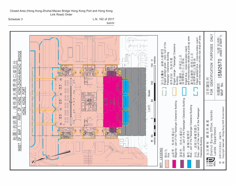
Inset of Map 1 (地圖1的插圖) means the map titled “INSET OF MAP 1 - PART OF HONG KONG-ZHUHAI-MACAO BRIDGE HONG KONG PORT”, numbered “ISM2670 (INSET of MAP 1)” and contained in Schedule 3;
Map 1 (地圖1) means the map titled “MAP 1 - SECTION OF HONG KONG-ZHUHAI-MACAO BRIDGE HONG KONG LINK ROAD, HONG KONG-ZHUHAI-MACAO BRIDGE HONG KONG PORT AND ADJACENT AREAS”, numbered “ISM2670 (MAP 1)” and contained in Schedule 3;
Map 4 (地圖4) means the map titled “MAP 4 - SECTION OF HONG KONG-ZHUHAI-MACAO BRIDGE HONG KONG LINK ROAD”, numbered “ISM2670 (MAP 4)” and contained in Schedule 3;
Map 5 (地圖5) means the map titled “MAP 5 - SECTION OF HONG KONG-ZHUHAI-MACAO BRIDGE HONG KONG LINK ROAD”, numbered “ISM2670 (MAP 5)” and contained in Schedule 3.
2. Pink zone
The pink zone comprises all of the areas each of which is enclosed by—
附表 2
[第 3條 ]
組成禁區的區域
1. 釋義在本附表中——地圖 1 (Map 1)指載於附表 3、標題為 “地圖 1 – 港珠澳大橋
香港連接路路段、港珠澳大橋香港口岸及毗鄰地區”而編號為“ISM2670 (地圖 1)”的地圖;
地圖 1的插圖 (Inset of Map 1)指載於附表 3、標題為 “地圖 1的插圖 – 港珠澳大橋香港口岸部分”而編號為 “ISM2670 (地圖 1的插圖 )”的地圖;
地圖 4 (Map 4)指載於附表 3、標題為 “地圖 4 – 港珠澳大橋香港連接路路段”而編號為“ISM2670 (地圖 4)”的地圖;
地圖 5 (Map 5)指載於附表 3、標題為 “地圖 5 – 港珠澳大橋香港連接路路段”而編號為“ISM2670 (地圖 5)”的地圖。
2. 粉紅色區域由以下界線包圍的每一個地區,共同組成粉紅色區域——
Closed Area (Hong Kong-Zhuhai-Macao Bridge Hong Kong Port and Hong Kong Link Road) Order
《禁區 (港珠澳大橋香港口岸及香港連接路 )令》
2017年第 162號法律公告B4676
L.N. 162 of 2017B4677
附表 2第 3條
Schedule 2Section 3
(a) a horizontal boundary that is the outermost edge line of—
(i) an area located at the Hong Kong Port and shown coloured pink (including any area shown coloured pink cross-hatched black) on Map 1;
(ii) an area located at the Hong Kong Link Road and shown coloured pink on Map 1; or
(iii) an area located outside the Hong Kong Port and the Hong Kong Link Road, and shown coloured pink on Map 1;
(b) an upper vertical boundary set, subject to section 17 of this Schedule, at an elevation of +80 mPD (metres above Hong Kong Principal Datum); and
(c) a lower vertical boundary set at an elevation of –6 mPD (metres below Hong Kong Principal Datum).
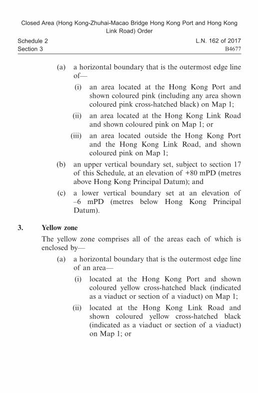
3. Yellow zone
The yellow zone comprises all of the areas each of which is enclosed by—
(a) a horizontal boundary that is the outermost edge line of an area—
(i) located at the Hong Kong Port and shown coloured yellow cross-hatched black (indicated as a viaduct or section of a viaduct) on Map 1;
(ii) located at the Hong Kong Link Road and shown coloured yellow cross-hatched black (indicated as a viaduct or section of a viaduct) on Map 1; or
(a) 地區的平面界線,是以下範圍的最外邊緣線—— (i) 位於香港口岸,並在地圖 1上塗上粉紅色顯示
的範圍 (包括塗上粉紅色綴黑交叉線顯示的範圍 );
(ii) 位於香港連接路,並在地圖 1上塗上粉紅色顯示的範圍;或
(iii) 位於香港口岸及香港連接路以外,並在地圖 1上塗上粉紅色顯示的範圍;
(b) 除本附表第 17條另有規定外,上垂直界線設於標高香港主水平基準以上 80米;及
(c) 下垂直界線設於標高香港主水平基準以下 6米。
3. 黃色區域由以下界線包圍的每一個地區,共同組成黃色區域——
(a) 地區的平面界線,是以下範圍的最外邊緣線—— (i) 位於香港口岸,並在地圖 1上塗上黃色綴黑交
叉線 (標明為高架道路或高架道路路段 )顯示的範圍;
(ii) 位於香港連接路,並在地圖 1上塗上黃色綴黑交叉線 (標明為高架道路或高架道路路段 )顯示的範圍;或

Closed Area (Hong Kong-Zhuhai-Macao Bridge Hong Kong Port and Hong Kong Link Road) Order
《禁區 (港珠澳大橋香港口岸及香港連接路 )令》
2017年第 162號法律公告B4678
L.N. 162 of 2017B4679
附表 2第 4條
Schedule 2Section 4
(iii) located outside the Hong Kong Port and the Hong Kong Link Road, and shown coloured yellow cross-hatched black (indicated as a viaduct or section of a viaduct) on Map 1;
(b) an upper vertical boundary set, subject to section 17 of this Schedule, at an elevation of +80 mPD (metres above Hong Kong Principal Datum); and
(c) a lower vertical boundary set at the bottom surface of the viaduct deck structure.
4. Green zone
The green zone comprises all of the areas each of which is enclosed by—
(a) a horizontal boundary that is the outermost edge line of an area—
(i) located at the Hong Kong Port and shown coloured green cross-hatched black (indicated as the ground surface and at-grade road underneath viaduct) on Map 1; or
(ii) located outside the Hong Kong Port and the Hong Kong Link Road, and shown coloured green cross-hatched black (indicated as the ground surface and at-grade road underneath viaduct) on Map 1;
(b) an upper vertical boundary set at the bottom surface of the viaduct deck structure; and
(c) a lower vertical boundary set at an elevation of –6 mPD (metres below Hong Kong Principal Datum).
(iii) 位於香港口岸及香港連接路以外,並在地圖 1上塗上黃色綴黑交叉線 (標明為高架道路或高架道路路段 )顯示的範圍;
(b) 除本附表第 17條另有規定外,上垂直界線設於標高香港主水平基準以上 80米;及
(c) 下垂直界線設於該高架道路橋面結構的底部表面。
4. 綠色區域由以下界線包圍的每一個地區,共同組成綠色區域——
(a) 地區的平面界線,是以下範圍的最外邊緣線—— (i) 位於香港口岸,並在地圖 1上塗上綠色綴黑交
叉線 (標明為高架道路下面的地面及地面道路 )顯示的範圍;或
(ii) 位於香港口岸及香港連接路以外,並在地圖 1上塗上綠色綴黑交叉線 (標明為高架道路下面的地面及地面道路 )顯示的範圍;
(b) 上垂直界線設於該高架道路橋面結構的底部表面;及
(c) 下垂直界線設於標高香港主水平基準以下 6米。
Closed Area (Hong Kong-Zhuhai-Macao Bridge Hong Kong Port and Hong Kong Link Road) Order
《禁區 (港珠澳大橋香港口岸及香港連接路 )令》
2017年第 162號法律公告B4680
L.N. 162 of 2017B4681
附表 2第 5條
Schedule 2Section 5
5. Blue zone
The blue zone is the area enclosed by—
(a) a horizontal boundary that is the outermost edge line of the area shown coloured blue (indicated as a part of the Passenger Clearance Building) on the Inset of Map 1;
(b) an upper vertical boundary set, subject to section 17 of this Schedule, at an elevation of +80 mPD (metres above Hong Kong Principal Datum); and
(c) a lower vertical boundary set at an elevation of +12 mPD (metres above Hong Kong Principal Datum).
6. Magenta zone
(1) Subject to subsection (2), the magenta zone is the area enclosed by—
(a) a horizontal boundary that is the outermost edge line of the area shown coloured magenta (indicated as a part of the Passenger Clearance Building) on the Inset of Map 1;
(b) an upper vertical boundary set, subject to section 17 of this Schedule, at an elevation of +80 mPD (metres above Hong Kong Principal Datum); and
(c) a lower vertical boundary set at an elevation of –6 mPD (metres below Hong Kong Principal Datum).
(2) The magenta zone does not include the area enclosed by—
(a) a horizontal boundary that is the outermost edge line of the area shown coloured magenta (indicated as a part of the Passenger Clearance Building) on the Inset of Map 1;
5. 藍色區域藍色區域是由以下界線包圍的地區——
(a) 該地區的平面界線,是在地圖 1的插圖上塗上藍色(標明為旅檢大樓部分 )顯示的範圍的最外邊緣線;
(b) 除本附表第 17條另有規定外,上垂直界線設於標高香港主水平基準以上 80米;及
(c) 下垂直界線設於標高香港主水平基準以上 12米。
6. 品紅色區域 (1) 在第 (2)款的規限下,品紅色區域是由以下界線包圍的
地區—— (a) 該地區的平面界線,是在地圖 1的插圖上塗上品紅
色 (標明為旅檢大樓部分 )顯示的範圍的最外邊緣線;
(b) 除本附表第 17條另有規定外,上垂直界線設於標高香港主水平基準以上 80米;及
(c) 下垂直界線設於標高香港主水平基準以下 6米。 (2) 品紅色區域不包括由以下界線包圍的地區——
(a) 該地區的平面界線,是在地圖 1的插圖上塗上品紅色 (標明為旅檢大樓部分 )顯示的範圍的最外邊緣線;

Closed Area (Hong Kong-Zhuhai-Macao Bridge Hong Kong Port and Hong Kong Link Road) Order
《禁區 (港珠澳大橋香港口岸及香港連接路 )令》
2017年第 162號法律公告B4682
L.N. 162 of 2017B4683
附表 2第 7條
Schedule 2Section 7
(b) an upper vertical boundary set at the bottom surface of the floor slab structure of the first floor of the Passenger Clearance Building; and
(c) a lower vertical boundary set at the top surface of the floor slab structure of the ground floor of the Passenger Clearance Building.
7. Dark violet zone
(1) Subject to subsection (2), the dark violet zone comprises all of the areas each of which is enclosed by—
(a) a horizontal boundary that is the outermost edge line of an area shown coloured dark violet (indicated as a part of the Passenger Clearance Building) on the Inset of Map 1;
(b) an upper vertical boundary set, subject to section 17 of this Schedule, at an elevation of +80 mPD (metres above Hong Kong Principal Datum); and
(c) a lower vertical boundary set at an elevation of –6 mPD (metres below Hong Kong Principal Datum).
(2) The dark violet zone does not include the areas each of which is enclosed by—
(a) a horizontal boundary that is the outermost edge line of an area shown coloured dark violet (indicated as a part of the Passenger Clearance Building) on the Inset of Map 1;
(b) an upper vertical boundary set at the bottom surface of the floor slab structure of the mezzanine floor of the Passenger Clearance Building; and
(b) 上垂直界線設於旅檢大樓 1樓樓板結構的底部表面;及
(c) 下垂直界線設於旅檢大樓地下樓板結構的頂部表面。
7. 深紫色區域 (1) 在第 (2)款的規限下,由以下界線包圍的每一個地區,
共同組成深紫色區域—— (a) 地區的平面界線,是在地圖 1的插圖上塗上深紫色
(標明為旅檢大樓部分 )顯示的範圍的最外邊緣線; (b) 除本附表第 17條另有規定外,上垂直界線設於標
高香港主水平基準以上 80米;及 (c) 下垂直界線設於標高香港主水平基準以下 6米。
(2) 深紫色區域不包括由以下界線包圍的每一個地區—— (a) 地區的平面界線,是在地圖 1的插圖上塗上深紫色
(標明為旅檢大樓部分 )顯示的範圍的最外邊緣線; (b) 上垂直界線設於旅檢大樓閣樓樓板結構的底部表
面;及

Closed Area (Hong Kong-Zhuhai-Macao Bridge Hong Kong Port and Hong Kong Link Road) Order
《禁區 (港珠澳大橋香港口岸及香港連接路 )令》
2017年第 162號法律公告B4684
L.N. 162 of 2017B4685
附表 2第 8條
Schedule 2Section 8
(c) a lower vertical boundary set at the top surface of the floor slab structure of the ground floor of the Passenger Clearance Building.
8. Grey zone
The grey zone is the area enclosed by—
(a) a horizontal boundary that is the outermost edge line of the area shown coloured grey (indicated as a part of the main roof of the Passenger Clearance Building) on the Inset of Map 1;
(b) an upper vertical boundary set, subject to section 17 of this Schedule, at an elevation of +80 mPD (metres above Hong Kong Principal Datum); and
(c) a lower vertical boundary set at the bottom surface of the main roof structure of the Passenger Clearance Building.
9. Light green zone
The light green zone comprises all of the areas each of which is enclosed by—
(a) a horizontal boundary that is the outermost edge line of an area shown coloured light green (indicated as a section of the Hong Kong Link Road with box culvert underneath) on Map 1 or Map 5;
(b) an upper vertical boundary set, subject to section 17 of this Schedule, at an elevation of +80 mPD (metres above Hong Kong Principal Datum); and
(c) a lower vertical boundary set at the top surface of the box culvert structure.
(c) 下垂直界線設於旅檢大樓地下樓板結構的頂部表面。
8. 灰色區域灰色區域是由以下界線包圍的地區——
(a) 該地區的平面界線,是在地圖 1的插圖上塗上灰色(標明為旅檢大樓樓頂部分 )顯示的範圍的最外邊緣線;
(b) 除本附表第 17條另有規定外,上垂直界線設於標高香港主水平基準以上 80米;及
(c) 下垂直界線設於旅檢大樓樓頂結構的底部表面。
9. 淺綠色區域由以下界線包圍的每一個地區,共同組成淺綠色區域——
(a) 地區的平面界線,是在地圖 1或地圖 5上塗上淺綠色 (標明為下面有箱形暗渠的香港連接路路段 )顯示的範圍的最外邊緣線;
(b) 除本附表第 17條另有規定外,上垂直界線設於標高香港主水平基準以上 80米;及
(c) 下垂直界線設於該箱形暗渠結構的頂部表面。

Closed Area (Hong Kong-Zhuhai-Macao Bridge Hong Kong Port and Hong Kong Link Road) Order
《禁區 (港珠澳大橋香港口岸及香港連接路 )令》
2017年第 162號法律公告B4686
L.N. 162 of 2017B4687
附表 2第 10條
Schedule 2Section 10
10. Light blue zone
(1) The light blue zone comprises all of the areas each of which is enclosed by—
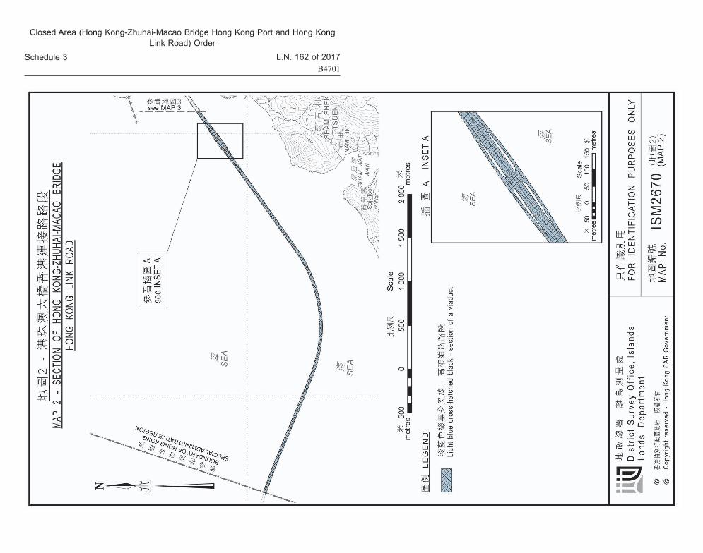
(a) a horizontal boundary that is the outermost edge line of an area shown coloured light blue cross-hatched black (indicated as a section of a viaduct) on Map 2 or Map 3;
(b) an upper vertical boundary set, subject to section 17 of this Schedule, at an elevation of +80 mPD (metres above Hong Kong Principal Datum); and
(c) a lower vertical boundary set at the bottom surface of the viaduct deck structure.
(2) In subsection (1)—
Map 2 (地圖2) means the map titled “MAP 2 - SECTION OF HONG KONG-ZHUHAI-MACAO BRIDGE HONG KONG LINK ROAD”, numbered “ISM2670 (MAP 2)” and contained in Schedule 3;
Map 3 (地圖3) means the map titled “MAP 3 - SECTION OF HONG KONG-ZHUHAI-MACAO BRIDGE HONG KONG LINK ROAD”, numbered “ISM2670 (MAP 3)” and contained in Schedule 3.
11. Red zone
The red zone is the area enclosed by—
(a) a horizontal boundary that is the outermost edge line of the area shown coloured red on Map 4;
(b) an upper vertical boundary set, subject to section 17 of this Schedule, at an elevation of +80 mPD (metres above Hong Kong Principal Datum); and
10. 淺藍色區域 (1) 由以下界線包圍的每一個地區,共同組成淺藍色區域——
(a) 地區的平面界線,是在地圖 2或地圖 3上塗上淺藍色綴黑交叉線 (標明為高架道路路段 )顯示的範圍的最外邊緣線;
(b) 除本附表第 17條另有規定外,上垂直界線設於標高香港主水平基準以上 80米;及
(c) 下垂直界線設於該高架道路橋面結構的底部表面。 (2) 在第 (1)款中——
地圖 2 (Map 2)指載於附表 3、標題為 “地圖 2 – 港珠澳大橋香港連接路路段”而編號為“ISM2670 (地圖 2)”的地圖;
地圖 3 (Map 3)指載於附表 3、標題為 “地圖 3 – 港珠澳大橋香港連接路路段”而編號為“ISM2670 (地圖 3)”的地圖。
11. 紅色區域紅色區域是由以下界線包圍的地區——
(a) 該地區的平面界線,是在地圖 4上塗上紅色顯示的範圍的最外邊緣線;
(b) 除本附表第 17條另有規定外,上垂直界線設於標高香港主水平基準以上 80米;及

Closed Area (Hong Kong-Zhuhai-Macao Bridge Hong Kong Port and Hong Kong Link Road) Order
《禁區 (港珠澳大橋香港口岸及香港連接路 )令》
2017年第 162號法律公告B4688
L.N. 162 of 2017B4689
附表 2第 12條
Schedule 2Section 12
(c) a lower vertical boundary set at an elevation of –6 mPD (metres below Hong Kong Principal Datum).
12. Orange zone
The orange zone is the area enclosed by—
(a) a horizontal boundary that is the outermost edge line of the area shown coloured orange (indicated as a part of the Scenic Hill Tunnel) on Map 4;
(b) an upper vertical boundary set at the top surface of the Scenic Hill Tunnel; and
(c) a lower vertical boundary set at the bottom surface of the Scenic Hill Tunnel.
13. Dark blue zone
The dark blue zone is the area enclosed by—
(a) a horizontal boundary that is the outermost edge line of the area shown coloured dark blue (indicated as a part of the Scenic Hill Tunnel) on Map 5;
(b) an upper vertical boundary set, subject to section 17 of this Schedule, at an elevation of +80 mPD (metres above Hong Kong Principal Datum); and
(c) a lower vertical boundary set at the bottom surface of the Scenic Hill Tunnel.
14. Violet zone
The violet zone is the area enclosed by—
(a) a horizontal boundary that is the outermost edge line of the area shown coloured violet (indicated as a ramp of the Scenic Hill Tunnel) on Map 5;
(c) 下垂直界線設於標高香港主水平基準以下 6米。
12. 橙色區域橙色區域是由以下界線包圍的地區——
(a) 該地區的平面界線,是在地圖 4上塗上橙色 (標明為觀景山隧道部分 )顯示的範圍的最外邊緣線;
(b) 上垂直界線設於觀景山隧道的頂部表面;及 (c) 下垂直界線設於觀景山隧道的底部表面。
13. 深藍色區域深藍色區域是由以下界線包圍的地區——
(a) 該地區的平面界線,是在地圖 5上塗上深藍色 (標明為觀景山隧道部分 )顯示的範圍的最外邊緣線;
(b) 除本附表第 17條另有規定外,上垂直界線設於標高香港主水平基準以上 80米;及
(c) 下垂直界線設於觀景山隧道的底部表面。
14. 紫色區域紫色區域是由以下界線包圍的地區——
(a) 該地區的平面界線,是在地圖 5上塗上紫色 (標明為觀景山隧道斜路 )顯示的範圍的最外邊緣線;

Closed Area (Hong Kong-Zhuhai-Macao Bridge Hong Kong Port and Hong Kong Link Road) Order
《禁區 (港珠澳大橋香港口岸及香港連接路 )令》
2017年第 162號法律公告B4690
L.N. 162 of 2017B4691
附表 2第 15條
Schedule 2Section 15
(b) 除本附表第 17條另有規定外,上垂直界線設於標高香港主水平基準以上 80米;及
(c) 下垂直界線設於觀景山隧道斜路結構的底部表面。
15. 米色區域由以下界線包圍的每一個地區,共同組成米色區域——
(a) 地區的平面界線,是在地圖 5上塗上米色 (標明為香港連接路路段 )顯示的範圍的最外邊緣線;
(b) 除本附表第 17條另有規定外,上垂直界線設於標高香港主水平基準以上 80米;及
(c) 下垂直界線設於標高香港主水平基準以下 6米。
16. 棕色區域棕色區域是由以下界線包圍的地區——
(a) 該地區的平面界線,是在地圖 5上塗上棕色 (標明為下面有維修用隧道的香港連接路路段 )顯示的範圍的最外邊緣線;
(b) 除本附表第 17條另有規定外,上垂直界線設於標高香港主水平基準以上 80米;及
(c) 下垂直界線設於該維修用隧道結構的頂部表面。
(b) an upper vertical boundary set, subject to section 17 of this Schedule, at an elevation of +80 mPD (metres above Hong Kong Principal Datum); and
(c) a lower vertical boundary set at the bottom surface of the ramp structure of the Scenic Hill Tunnel.
15. Beige zone
The beige zone comprises all of the areas each of which is enclosed by—
(a) a horizontal boundary that is the outermost edge line of an area shown coloured beige (indicated as a section of the Hong Kong Link Road) on Map 5;
(b) an upper vertical boundary set, subject to section 17 of this Schedule, at an elevation of +80 mPD (metres above Hong Kong Principal Datum); and
(c) a lower vertical boundary set at an elevation of –6 mPD (metres below Hong Kong Principal Datum).
16. Brown zone
The brown zone is the area enclosed by—
(a) a horizontal boundary that is the outermost edge line of the area shown coloured brown (indicated as a section of the Hong Kong Link Road with maintenance subway underneath) on Map 5;
(b) an upper vertical boundary set, subject to section 17 of this Schedule, at an elevation of +80 mPD (metres above Hong Kong Principal Datum); and
(c) a lower vertical boundary set at the top surface of the maintenance subway structure.

Closed Area (Hong Kong-Zhuhai-Macao Bridge Hong Kong Port and Hong Kong Link Road) Order
《禁區 (港珠澳大橋香港口岸及香港連接路 )令》
2017年第 162號法律公告B4692
L.N. 162 of 2017B4693
附表 2第 17條
Schedule 2Section 17
17. 上垂直界線在特定情況下設於限制高度 (1) 如有關條文就某地區而言所述的上垂直界線,高於適用
於該地區或該地區某部分的限制高度,則該地區或部分的上垂直界線,設於適用於該地區或部分 (視情況所需而定 )的限制高度。
(2) 在第 (1)款中——有關條文 (relevant section) 指本附表第 2、3、5、6(1)、
7(1)、8、9、10(1)、11、13、14、15或 16條;限制高度 (restricted height)就地區或地區的部分而言,指符
合以下說明的高出主要基準面的高度—— (a) 《1997年香港機場 (障礙管制 ) (第 2號 )令》(第
301章,附屬法例 D)第 3(1)條所提述;及 (b) 根據該命令適用於該地區或部分。
17. Upper vertical boundary set at restricted height in particular cases
(1) If an upper vertical boundary mentioned in a relevant section in relation to an area is higher than the restricted height applicable to the area or part of the area, the upper vertical boundary of the area or part is set at the restricted height applicable to the area or part (as the case requires).
(2) In subsection (1)—
relevant section (有關條文) means section 2, 3, 5, 6(1), 7(1), 8, 9, 10(1), 11, 13, 14, 15 or 16 of this Schedule;
restricted height (限制高度), in relation to an area or a part of an area, means the height above the principal datum—
(a) referred to in section 3(1) of the Hong Kong Airport (Control of Obstructions) (No. 2) Order 1997 (Cap. 301 sub. leg. D); and
(b) applicable to the area or part under that Order.

Closed Area (Hong Kong-Zhuhai-Macao Bridge Hong Kong Port and Hong Kong Link Road) Order
《禁區 (港珠澳大橋香港口岸及香港連接路 )令》
2017年第 162號法律公告B4694
L.N. 162 of 2017B4695
附表 3 Schedule 3
附表 3
[附表 2]
地圖
Schedule 3
[Sch. 2]
Maps

Closed Area (Hong Kong-Zhuhai-Macao Bridge Hong Kong Port and Hong Kong Link Road) Order
《禁區 (港珠澳大橋香港口岸及香港連接路 )令》
2017年第 162號法律公告B4696
L.N. 162 of 2017B4697
附表 3 Schedule 3
Closed Area (Hong Kong-Zhuhai-Macao Bridge Hong Kong Port and Hong Kong Link Road) Order
《禁區 (港珠澳大橋香港口岸及香港連接路 )令》
2017年第 162號法律公告B4698
L.N. 162 of 2017B4699
附表 3 Schedule 3
Closed Area (Hong Kong-Zhuhai-Macao Bridge Hong Kong Port and Hong Kong Link Road) Order
《禁區 (港珠澳大橋香港口岸及香港連接路 )令》
2017年第 162號法律公告B4700
L.N. 162 of 2017B4701
附表 3 Schedule 3

Closed Area (Hong Kong-Zhuhai-Macao Bridge Hong Kong Port and Hong Kong Link Road) Order
《禁區 (港珠澳大橋香港口岸及香港連接路 )令》
2017年第 162號法律公告B4702
L.N. 162 of 2017B4703
附表 3 Schedule 3

Closed Area (Hong Kong-Zhuhai-Macao Bridge Hong Kong Port and Hong Kong Link Road) Order
《禁區 (港珠澳大橋香港口岸及香港連接路 )令》
2017年第 162號法律公告B4704
L.N. 162 of 2017B4705
附表 3 Schedule 3

Closed Area (Hong Kong-Zhuhai-Macao Bridge Hong Kong Port and Hong Kong Link Road) Order
《禁區 (港珠澳大橋香港口岸及香港連接路 )令》
2017年第 162號法律公告B4706
L.N. 162 of 2017B4707
附表 3 Schedule 3

Closed Area (Hong Kong-Zhuhai-Macao Bridge Hong Kong Port and Hong Kong Link Road) Order
《禁區 (港珠澳大橋香港口岸及香港連接路 )令》
2017年第 162號法律公告B4708
L.N. 162 of 2017B4709
行政長官林鄭月娥
2017年 9月 27日
Carrie LAMChief Executive
27 September 2017

Closed Area (Hong Kong-Zhuhai-Macao Bridge Hong Kong Port and Hong Kong Link Road) Order
《禁區 (港珠澳大橋香港口岸及香港連接路 )令》
2017年第 162號法律公告B4710
L.N. 162 of 2017B4711
註釋第 1段
Explanatory NoteParagraph 1
註釋
本命令的目的是根據《公安條例》(第 245章 )宣布由以下地區組成的地區為禁區——
(a) 位於或毗鄰港珠澳大橋香港口岸的某些地區,包括旅檢大樓 (大樓地下的某些部分除外 );
(b) 位於或毗鄰港珠澳大橋香港連接路的某些地區。
Explanatory Note
The purpose of this Order is to declare the area comprising the following areas to be a closed area under the Public Order Ordinance (Cap. 245)—
(a) certain areas located at or adjacent to the Hong Kong-Zhuhai-Macao Bridge Hong Kong Port, including the Passenger Clearance Building (other than certain parts at the ground floor of the Building);
(b) certain areas located at or adjacent to the Hong Kong-Zhuhai-Macao Bridge Hong Kong Link Road.