Archaeology of the High Plains
330
BLM LIBRARY 88063689 Buffalo from Ldpez de Gdmara's history, 1554 ARCHAEOLOGY OF THE HIGH PLAINS James H. Gunnerson Bureau of Land Management Colorado Cultural Resource Series • Number 19
-
Upload
khangminh22 -
Category
Documents
-
view
1 -
download
0
Transcript of Archaeology of the High Plains

BLM LIBRARY
88063689
Buffalo from Ldpez de Gdmara's history, 1554
ARCHAEOLOGY OFTHE HIGH PLAINSJames H. Gunnerson
Bureau of Land ManagementColorado
Cultural Resource Series • Number 19


[b:mhdbW
ARCHAEOLOGY OF THE HIGH PLAINS
By James H. Gunnerson
*u
11.
q
•£017
mi
Colorado State Office
Bureau of Land Management
Denver, Colorado
1987

COPIES OF THIS DOCUMENT ARE AVAILABLE FROM:
BUREAU OF LAND MANAGEMENTCANON CITY DISTRICT OFFICE
3170 EAST MAIN STREETCANON CITY, COLORADO 81212
OR
BUREAU OF LAND MANAGEMENTCOLORADO STATE OFFICE2850 YOUNGFIELD STREET
LAKEWOOD, COLORADO 80215
This document is in the public domain and may be quoted. Please credit either the Bureau of Land Management,
the U.S. Forest Service, and/or the author if any portion of this work is quoted or used.
This document is printed in conjunction with the San Luis Valley Resource Management Plan, the Southeast
(Colorado) Planning Analysis Update, the Royal Gorge Resource Area Management Framework Plan, and the
Raton Basin Coal Leasing Project. This volume serves as support for the above plans, and is also an integral
part of the Canon City District Cultural Resource Management Plan (CRMP).
DESIGNED BY: Leigh Wellborn
SERIES EDITOR: Frederic J. Athearn

FOREWORD
This publication presents an overview of the archaeology of the Central
High Plains. The volume provides baseline information about the archaeology
of the Bureau of Land Management's (BLM) Canon City [Colorado] District,
the U.S.D.A. Forest Service's Regions II and III and the BLM's Albuquerque
[New Mexico] District. This work describes the archaeology of portions
of five states and represents a large geographic area ranging from the
Continental Divide to the plains of Kansas and Nebraska.
A major feature of this work is the fact that it is one of the first such
projects that was jointly prepared by the BLM and the Forest Service. Because
much of the land managed by these two agencies is adjoining or is in the
same geographic region, it was logical to create a document that both groups
could use. The Forest Service and BLM also agreed that this database should
cover two BLM states and two Forest Service regions, again making this
project one of the first of its kind.
One of the primary objectives of both the BLM and the Forest Service
is to study and, as needed, preserve significant cultural resources located
on public lands. Evidences of our past cover large areas of the national
forests and the public domain. In order to provide for the orderly and careful
evaluation of these places, this baseline narrative gives our specialists and
our managers information by which to wisely conserve our national cultural
heritage.
This volume will provide our managers and the professional community
with a study that should become the standard reference for this region.
Because of the massive amount of research that went into this work, it
is unlikely that it will be duplicated in the near future. Therefore, I ampleased to share this important volume with you and we hope that both
the BLM and the Forest Service's contribution to the body of archaeology
is both long-lasting and useful to the professional reader as well as to the
general public.
State Director
Bureau of Land Management
Denver, Colorado

TABLE OF CONTENTS
Page
Forward i
Introduction ii
Acknowledgements iii
Prologue 1
Chapter I The Paleolndian Period 7
Chapter II The Archaic Period 26
Chapter III The Early Ceramic Period 41
Chapter IV The Middle Ceramic Period 65
Chapter V The Late Ceramic Period 97
Chapter VI The Historic Period 113
Chapter VII Cultural Summary of the High Plains 117
References Cited 139
Photo Folio 64
Appendix I 261
About the Author 303

INTRODUCTION
In 1982, the U.S. Forest Service and the Bureau of
Land Management (BLM) contracted with Professor
James H.Gunnerson to write an overview of a large
area defined as the Central High Plains, a region
encompassing eastern Colorado, northeastern NewMexico, western Kansas, western Nebraska, the
Texas panhandle, and parts of Oklahoma. Thepurpose of this study was to provide a baseline
narrative for the prehistory in this region in order
to enable land managing agencies like the Forest
Service and the BLM to understand the extent of
prehistoric resources that might be present on these
federal lands. The reason for this interest lies in the
mandates of various federal legislation requiring
agencies to consider cultural values on their lands
prior to actions that might destroy these valuable
resources.
In order to provide a "starting point" for the
consideration of archeologic values, existing data
needed to be gathered, synthesized, and then ana-
lyzed to provide a foundation from which cultural
resources could be managed by the Forest Service
and the BLM. To this end, Professor Gunnersongathered all known literature pertaining to the ar-
cheology of this region; he looked at thousands of
individual site forms, and he complied a detailed
bibliography for the Central High Plains. This has
resulted in a rather massive volume that is probably
the most comprehensive look at the archeology of
this area ever produced.
In addition to a complete view of archeology,
Professor Gunnerson, along with his wife Dolores,
prepared a companion ethnohistory of the plains
that provides the connection between prehistoric
peoples and the coming of European settlement.
The ethnohistory portion of this project will be pub-
lished as a separate volume. Between the archeology
and ethnohistory of the high plains, we now have a
comprehensive view ofsome 10,000 years ofhumanoccupation.
Included in Professor Gunnerson' s study are not
only descriptions of archeological work that has
been done over the year, but also, in a detailed
evolutionary system, he displays the various phases
of human use of this land.
Included in this study are illustrations of point
types, several maps of the region and a truly com-
prehensive bibliography that is general on the onehand and specific to the various states on the other.
The U.S. Forest Service and the BLM are pleased to
have been able to assist in the preparation of a
monumental study of this nature, and we trust
that it will remain the standard for high plains
archeology for years to come. Thanks to Professor
Gunnerson' s exhaustive research, and his dedicated
efforts, this work should stand alone in the field of
plains archeology for decades. A partnership such as
this between the academic community and the
Federal Government has proven that documentsthat are mutually useful can be produced.
In addition, the general public will find Dr.
Gunnerson's work most enjoyable reading. With so
many uses, awork such asJim Gunnerson' s will find
its way onto library shelves throughout the nation,
and we hope that those who choose to read it will doso with the knowledge that this work was prepared
for us all.
Frederic J.Athearn
Bureau of Land Management
J.Steve Sigstad
U.S. Forest Service
Denver, Colorado
1986

ACKNOWLEDGEMENTSWhile preparing this overview of high plains ar-
cheology, I benefited from the assistance of nu-
merous individuals representing a variety of insti-
tutions.
In an attempt to get the feeling for current ac-
tivities in the five states involved, personal visits were
made to many research organizations and infor-
mation was solicited from others by mail.
In a number of institutions more than one divi-
sion, such as aademic departments, museums, or
offices of contract archeology, were visited.
Individuals first consulted often kindly queried
colleagues on behalf of the project until the list of
those who contributed valuable data became un-
wieldy. Therefore, with few exceptions, specific
thanks are limited to institutions.
COLORADO
University of Colorado, BoulderColorado State University, Fort Collins
Northern Colorado University, Greeley
University of Southern Colorado, Pueblo
University of DenverColorado College, Colorado Springs
Adams State College, AlamosaTrinidad Junior College, Trinidad
Otero Junior College, LaJuntaColorado Historical Society, DenverDenver Museum of Natural History
KANSAS
University of Kansas, LawrenceKansas State University, ManhattanWichita State University, Wichita
Kansas State Historical Society, TopekaSanta Fe Trail Center Museum, LarnedKansas Anthropological Association
NEBRASKA
University of Nebraska, Lincoln
Nebraska State Historical Society
NEW MEXICO
University of Texas, Austin
West Texas University, CanyonTexas Tech University, LubbockPanhandle-Plains Museum, CanyonTexas Historical Commission
U.S. GOVERNMENTAL AGENCIES
U.S. National Museum, Smithsonian Institution,
Washington, D.C.
Midwest Archaeological Center, National ParkService, Lincoln
Southwest Cultural Resources Center, National Park
Service, AlbuquerqueDenver Service Center, Archeological Assistance
Division, National Park Service, DenverDenver Service Center, Bureau of Land Manage-
ment, DenverBureau of Reclamation, DenverRocky Mountain Region, U.S. Forest Service, Denver
This document is the end product of a project
sponsored by the U.S. Forest Service and the Bureauof Land Management. It was conceived and steered
by a dedicated committee made up of Dr. Steve
Sigstad, Chair (USFS), Dr. Frederic J. Athearn(BLM), Ms. Chris Kincade (BLM), Mr. Dan Martin
(BLM) and Mr. Joe Tainter. Cynthia Bowsmanserved as research assistant for nearly a year and, in
addition to typing the first draft, did a substantial
portion of the bibliographical compliation and part
of the literature search. Gail Littrell typed the final
draft of the manuscript on a word processor andcarefully read proof on that draft. Maps and figures
were drafted by Marty Haack, Mark Marcuson andLeigh Wellborn (BLM). Dr. Dolores Gunnersoncontributed information on the protohistoric andhistoric periods and edited two drafts of the man-uscript.
Although these institutions and individuals
have contibuted immeasurably to this work, the
shortcoming of the interpretations (that may well
need to be modified later) are solely my resposi-
bility.
University of New Mexico, AlbuquerqueNew Mexico State University, Las CrucesMuseum of New Mexico, Santa FeQuivira Research Center, AlbuquerqueSeton Museum, Philmont Scout Ranch, Cimarron
James H. GunnersonMarch, 1986
OKLAHOMA
University of Oklahoma, NormanOklahoma Historical Society
TEXAS
in


PROLOGUEThis volume presents a synthesis or overview of
the archeology of the Central High Plains. The area
is bounded on the north by 41 latitude, on the east
by the 99th meridian, on the south by 35 latitude in
New Mexico, Texas and Oklahoma and by 37 la-
titude in Colorado, on the west by the Continental
Divide in Colorado and by the eastern foothills of
the Sangre de Cristo Mountains in New Mexico.
Since relatively little archeology has been done in
this area, and most of that on the perimeters, it has
been necessary to draw upon work donejust beyondthe borders to round out a synthesis, and even so,
the treatment of complexes and periods is uneven.
In some cases, enough information is available for a
general summary of a complex. In other instances,
where a complex is represented by limited work at
perhaps only one site, a detailed description of ma-terial recovered is given to provide comparative data
should future workers find similar material. De-
tailed descriptions of diagnostic artifacts, primarily
projectile points and pottery, are included in Ap-pendices and are often copied in their entirety.
Although the bibliography is not exhaustive, it is
extensive, containing many potentially useful items
not cited. In some cases entire bibliographies fromother works, including annotations, have been re-
produced, with credit: references cited are so iden-
tified, although not all of the cited references werepersonally examined (e.g., when they were included
in reproduced tables). The major gap in the bibli-
ography is the absence of reports of contract arche-
ology that were prepared in limited numbers anddeposited only with appropriate agencies. An effort
should be made to compile and publish a list ofsuch
reports.
Some interpretations of cultural relationships,
especially as implied in the correlation chart (Fig. 2),
are speculative and will not meet with universal
agreement. Most of the interpretations, however,
are testable if additional work is done. This volumecan be considered only a first approximation of a
synthesis of a poorly known 400,000 square kilo-
meter area through some 1 5,000 years. Hopefully, it
will serve as a point of departure for further refine-
ments.
The Central Great Plains have been occupied for
at least 1 1,500 years and possibly much longer. Dur-
ing this time, the area experienced radical changes
in climate that resulted in marked changes not only
in the flora and fauna but, to some extent, in the .
topography. Even after the end of glacial times
and the extinction of various Pleistocene species,
there were droughts of great magnitude. The plains
have seen as much environmental fluctuation as any
part of North America and more than most. Themarginal nature of the plains, dictated by the rain
shadow of the Rocky Mountains, is reflected in the
archeological record. This synthesis of the prehis-
tory of the Central High Plains presents a picture of
cultural continuity with variations in response to
changing environment and diffusion of traits fromneighboring areas; migration apparently played a
lesser role. Although various phases in the con-
tinuum can be viewed as climactic, nowhere in the
archeological record do we find cultural climaxes
comparable to those in Mesoamerica, the AmericanSouthwest, the Mississippi valley, or the NorthwestCoast. At best, life on the Central High Plains has
been precarious.
Archeological work in the plains has been going
on for nearly a century and Europeans have obser-
ved Indian life there for nearly four and a half cen-
turies. Systematic professional archeology, however,
is only about a half century old and there are still
many, many gaps in the archeological record. Someofthese will probably never be filled since the area is
large, archeologists few and financial support limi-
ted. Also, archeological remains are being de-
stroyed at an alarming rate. Much of the field workdone in the past has never been adequately reported
and in some cases is not represented in the literature
at all. This is especially true for work done in the
late 1930's under various federally funded "relief'
projects, for salvage work done in the late 1 940' s and1950's ahead of the construction of major federally
funded dams, and for work done by university-
sponsored archeological field schools. Fortunately,
most ofthe collections and field notes, some ofthemvery good, have been preserved. Collections andrelated data that have been reported in print are,
for the most part, available for restudy in the light of
more recent research and analytical methods, andsuch reanalysis and reinterpretation is going on, if
slowly. Because of the broad scope of the present
overview, however, it is based almost entirely oninformation available in the literature, uneven as
it is.
Often, the results ofa single survey do not provide
enough data to serve as the basis for a meaningful
published synthesis although more and more re-
search is being designed to obtain significant results
with very limited data; included are questions of
resource utilization, ecological concerns, stone
working technology, etc., and computerization of
data from numerous surveys is making other kinds
of research feasible. Whereas once it would have
been too time-consuming to glean particular kinds
ofdata from the survey files or even determine if the
data were available, it is now becoming possible to
quickly retrieve, or at least locate, data in particular
categories. Where statistical manipulation is nee-
ded, it can often be achieved at the same time by
means of an appropriate computer program. Onemust be cautious, of course, since there are always
possibilities of erroneous computer entries, andseldom ifever is all the data desirable for a particular
research project available for programming.
Much of the archeological literature consists of
reports of excavations at sites chosen for their rich-
ness or because they were apparently stratified —
1

CENTRAL HIGH PLAINS

choices warranted by promise for substantially
increasing our knowledge concerning the cultural
content of a particular phase or providing the basis
for the chronological ordering of phases in a par-
ticular region. Before World War II, the published
results of regional surveys, such as those carried out
and reported by E.B. Renaud of the University of
Denver (Downing 1981) in the 1930's, were rare.
Renaud provided at least minimal information onall sites found, even where there was very little
cultural material present. Fortunately, the informa-
tion and artifacts obtained during systematic sur-
veys were usually preserved, especially when they
were sponsored by some institution such as a mu-seum or university, although provenience some-
times became confused with the passage of time.
Early surveys concentrated on areas where sites were
expected to be, and incorporated information fromlocal people, such as collectors, farmers and ranch-
ers. In recent years, with the emphasis on historic
preservation and the salvaging of archeological
material prior to projects that would damage sites,
surveys are being carried out even in areas of little
promise. The results of such surveys and the reports
ofmitigation activities at threatened sites frequently
do not receive wide distribution. The same can be
said of surveys, often employing only random sam-
pling, now being conducted on federally ownedlands by the agency responsible for the manage-ment of the lands. Thus a large corpus of the ar-
cheological data being amassed is still underutilized.
The problem of defining archeological units is
complicated by changes in taxonomic systems over
the years and differences between systems used in
different areas. In the 1930's and 1940's, the McKernor Midwest Taxonomic System was commonly em-ployed in the classification of archeological sites, or
rather, the classification of components found at
sites. A componentwas defined as the manifestation
at a single site of its use by people having a particular
cultural affiliation. Components with essentially i-
dentical cultural traits were assigned to a particular
focus, and foci with a high degree of cultural simi-
larity were assigned to a particular aspect (Bell 1 936:
6-8). More inclusive taxa were the phase and basic
culture. This system had the shortcoming of not
including geographical or temporal dimensions,
although often these were discussed when a focus or
an aspect was defined. At one time the term culture
was used for a taxonomic unit that could be equated
with focus or aspect, but in the Midwest TaxonomicSystem, basic culture was the most inclusive taxon.
Two other terms commonly used, although not
strictly taxonomic, that are commonly used are
complex and assemblage. Complex is applied to a
group of cultural traits, usually artifact types, that
recur together. Assemblage is sometimes used in the
same way, but is also used for the group of traits
found in a component. Complexes, especially, are
frequently named as though they were taxonomicunits.
In recent years archeologists working in the plains
have come more and more to apply the terminology
proposed by Willey and Phillips (1958). Their basic
unit is the phase which is on the same order of
magnitude as focus or aspect; more restricted units
are called subphases. Phases and subphases are
defined in terms of cultural content, temporal span,
and geographical distribution. One is tempted to
simply substitute the term phase for focus or aspect
in cases where the units were defined in the Midwes-tern Taxonomic System. The two concepts are suf-
ficiently different, however, that this can not bedone. Hopefully, all of Plains archeology will even-
tually be ordered in terms of the Willey and Phillips
system, but to do so will require a reexamination of
the artifacts and other relevant basic data. For manyunits, whether they be called foci, aspects or phases,
the information available is still inadequate for pre-
cise definitions. For the most part, the terminology
used in the literature cited will be retained in this
overview.
Within the Willey and Phillips scheme, the se-
quence of phases is established both locally andregionally as initial steps in cultural- historical in-
tegration. For broader integration, two additional
units are employed: horizons integrate approx-imately contemporaneous phases within a region
and traditions reflect cultural continuity from phase
to phase through time. Willey and Phillips interpret
New World prehistory in terms of five stages, essen-
tially evolutionary or developmental: Lithic, Archa-
ic, Formative, Classic, and Post-classic. For plains
archeology only the first three of these stages are
applicable, although, as will be seen in the present
overview, temporal subdivisions within the stages
can be identified. Some of these subdivisions of
periods could perhaps be defined in terms of hor-
izons, as Willey and Phillips define them, but such
terminology has not come into common use. Hor-
izon markers in the Plains, with few exceptions, tend
to have such long temporal spans that they really donot fit the criteria.
The tradition concept has been employed spar-
ingly to indicate an integrating unit, but not as pre-
cisely as Willey and Phillips visualized its being
used. The Plains Village Tradition has been the onemost commonly referred to, but it has been applied
so broadly that nearly all Formative phases in the
Plains would be encompassed, including somephases, or at least components, that are not knownto have included villages. Thus, there is not yet, and
may never be, clear distinctions in the plains be-
tween stages, periods, horizons and even traditions.
An important step toward cultural historical inte-
gration in the plains will come with the definition of
phases into which the results of previous research
can be fitted. Given the apparently sudden and
perhaps frequent shifts in centers of gravity of the

plains populations, it will be crucial to develop a
precise chronological framework that is not depen-dent on culture content.
In this synthesis, an interpretation of the culture
history of the Central High Plains will be presented
in terms of eight archeological periods plus a review
of the ethnohistory of the area. There are no sharp
temporal boundaries between these periods since
they grade into one another. (In general, however,
the more recent the period, the more precise the
dating.) Also, the changes that mark the transition
from one period to the next did not necessarily take
place at the same time in all parts ofthe area. Both of
these concerns are aggravated by the imprecision of
the dating methods that have been used and the very
uneven nature of the information available.
The earliest period, called "Paleoindian," starts at
least 11,500 years ago (9500 BC) and lasts until
roughly 6,000 BC. It is a period characterized by the
hunting of large mammals, some of them now ex-
tinct, with spears and/or darts propelled by atlatls.
The mammoth was characteristic of the early part of
the period, followed by bison antiquus which grad-
ually evolved into modern bison bison. During this
period of at least 3500 years, changes took place in
the design of the projectile points and complexes
are distinguished on the basis of these differences.
Through time there was an ever increasing diversity
of point types and hence of named complexes.
The second major period is called the "Archaic,"
with three subperiods often identifiable. The begin-
ning of the Archaic period is marked by a climate
both hotter and dryer than either before or after.
This condition, called the "Altithermal," lasted
through the Early Archaic period. Also, starting with
the Early Archaic, only modern species of animals
were present although their geographical range shif-
ted from time to time. Where it is possible to sub-
divide the Archaic period, the temporal boundaries
are roughly as follows: Early Archaic from 6000 to
3000 BC, the Middle Archaic from 3000 to 500 BCand the Late Archaic from 500 BC to AD 500.
During the entire Archaic period there continued to
be a heavy dependence on hunting with spears or
darts, but with the utilization of a greater variety of
animals and a heavier dependence upon the gather-
ing of plants. The entire Archaic period saw a con-
tinuing diversification of identifiable cultural
complexes which often graded into one another.
Projectile points continued to be the index artifacts
for these complexes. During this period there is
evidence of diffusion of traits, or even migration of
people into the Central High Plains from essentially
all directions. Archaic complexes tended to becomemore restricted in both temporal and geographical
distribution through time.
The "Early Ceramic" period has as its hallmark
the presence, for the first time, ofpottery, and can bedated at approximately 500 BC toAD 900. Incipient
horticulture has been implied for some of the Early
Ceramic complexes and evidence of simple struc-
tures have been found at some of the sites. Huntingand gathering continued to provide the major part
of the diet and, except for the pottery, the artifact
inventory did not differ markedly from that of the
Late Archaic. Toward the end of the Early Ceramicperiod, smaller delicate projectile points suggest the
introduction of the bow and arrow. Early Ceramiccomplexes throughout much of the Central HighPlains appear to reflect influences coming from the
east. In only the southwest corner do the changesappear to reflect innovations from the PuebloSouthwest.
The "Middle Ceramic" period, approximatelyAD 900 to AD 1500, was a time of culture climax
throughout much ofthe plains. The people adoptedthe cultivation of corn, beans and squash, built
substantial earth lodges, made more varied pottery,
and hunted primarily with the bow and arrow.
Hunting, along with gathering, still provided a sub-
stantial part of the diet. Most ofthe cultural changes,
along with the appearance of a new race of corn,
probably came from the Southwest although someideas for pottery decoration and some new religious
beliefs appear to have Southeastern origins. Thepopulation itself, probably Caddoan- speaking, mayhave been unchanged since at least Archaic times.
During the Middle Ceramic period there was ap-
parently a substantial growth in population in the
eastern portion of the Central High Plains, as well as
in the prairies farther east. The dependence onCultivation of plants in this environmentally- mar-
ginal area, however, made the people of this period
vulnerable to local climatic fluctuations, especially
in rainfall. This resulted in shifting populations and,
in the mid 1400's, the depopulation of essentially
the entire Central High Plains.
The "Late Ceramic" period, also called the'Tro-
tohistoric" period, started aboutAD 1500. With the
return of moister conditions, grass on the high
plains again became lush and the bison abundant.
Before the former inhabitants, almost certainly
Caddoan speakers, could reoccupy the area, the
Athabascan-speaking Apaches moved south from
Canada and dominated the Central High Plains
until about 1720. Not only were the Apaches skilled
hunters, even without the horse, they were also
adaptable enough to adopt limited horticulture,
pottery making, and semipermanent settlements
from their sedentary neighbors. The forcing of the
Apaches from the high plains in about 1730 by
Comanches from the west and Pawnees with French
allies and guns from the east essentially marked the
end of the Late Ceramic period. Soon after this the
cultures of the sedentary tribes on the eastern
margin of the Central High Plains started disin-
tegrating under white influence, and especially
new diseases, from the east. Throughout the two
centuries of the Late Ceramic Period, limited infor-
mation about the Indians can be gleaned from

accounts bv literate European observers. From the
middle of the 1700's on, there is sufficient docu-
mentary information available that it can be con-
sidered the : "Historic Period." This was a time of
rapid change leading to continued population de-
cline and the disintegration of aboriginal cultures.
The Comanche domination of the Central HighPlains, especially near the mountains, lasted until
approximated 1800 when there was a rapid andsubstantial influx ofArapahoes, Cheyennes, Kiowas
and Kiowa Apaches from the upper Missouri River
area. The Comanche responded by moving the
center of their activities to northwestern Texas andwere soon followed by the Kiowa and KiowaApache. Other tribes, such as the Crow, Blackfeet
and Dakota Sioux, soon made their appearance
when the colorful but short-lived horse-nomad,
bison-hunting, pan-tribal plains culture was at its
peak. The Pawnee and Wichita, plus various tribes
from the eastern edge of the plains, many ofwhomhad been recently put on reservations there, con-
tinued to hunt on the high plains. During the 1860's,
the flamboyant Plains lifestyle came to an abrupt
end and soon all of the Plains tribes were on re-
servations. Culture history after the mid-1800's is
beyond the scope of this volume.
Environment
The environment of the Central High Plains is
characterized by low precipitation and seasonal
extremes of temperature. In the past 12,000 years,
there have been periods of severe drought affecting
all or portions ofthe area. Periods ofmarkedly lower
average temperatures and higher precipitation than
present appear to have been less common and to
have had less effect on the populations. To a very
large extent, the climate is determined by the flow of
air from the west and the effect on air flow of the
Rocky Mountains at the western edge of the plains.
The relatively low rainfall supports only short grass
over most of the area, with trees restricted to the
water courses. As one gets into the foothills, small
evergreens and scrub become common, with sub-
stantial stands of large conifers at higher elevations.
Elevation at the eastern edge of the Central
High Plains, arbitrarily defined as the 99th meri-
dian, is quite consistently at about 600 m. The Plains
slope gently up to the west, with elevations varying
from 1 ,500 to about 2, 1 00 m at the Rocky Mountainfoothills. The only major break in this gently sloping
plain is the series ofconnected mesas extending east
from the mountains along the New Mexico-Colo-
rado border to the northeastern corner of NewMexico. The northern portion of the Central HighPlains is drained by the Platte and Republican
Rivers, the central part by the Arkansas River andthe southern part by the Dry Cimarron and Cana-dian Rivers. The extreme southwest corner is drained
by the Rio Grande and the Pecos River, which
ultimately joins the Rio Grande. All these majorrivers except for the Republican head in the moun-tains and would rarely have gone completely dry.
Between the major rivers, water is scarce except for
occasional springs, a few ofwhich are very good anddependable, and playas which hold water only in
rainy seasons. Except at the height of droughtperiods, travelers who knew the plains could cross
the area in any direction without serious supply
problems. Presumably routes feasible under vari-
ous conditions were well known to the aborigines,
and were adopted by European colonists and ex-
plorers. Some are reflected in the pattern ofmodernhighways and rail routes.
In good years, the grass on the high plains wasabundant and supported large herds of buffalo anda wide variety of smaller animals. Other wild plant
foods usable by humans, however, were far less
abundant and except for the northeast, southeast
and southwest corners of what is here called the
Central High Plains, the climate did not permit the
growing of corn or other crops, even when the
climate was optimum. And in the southwest corner,
horticulture would have been precarious without
specialized techniques such as irrigation. Through-out the entire area, wherever horticulture was prac-
ticed, it was apparently restricted to bottom lands
along streams. Since, except in the mountains, trees
and permanent water were also restricted to water
courses, permanent and semipermanent settlement
was also found only near streams.
Detailed descriptions of local environment andavailable resources can be found in various of the
references cited in the bibliography. Especially
helpful is Climate and Man, the 1941 Yearbook of
Agriculture published by the U.S. Department of
Agriculture and the Atlas of American Agriculture,
Physical Basis published in 1936, also by the U.S.
Department of Agriculture. The Department of
Agriculture has published Soil Surveys for many of
the counties in the Central High Plains and these
discuss the local environments. The published
records of the Weather Bureau provide local infor-
mation on temperature, precipitation, growing sea-
sons, etc. for numerous stations all over the United
States. Most states have Biological Surveys which
publish lists of plants and animals found in various
parts of the state.


CHAPTER ONE
THE PALEOINDIAN PERIOD
The date of the first peopling of the plains, as of
the New World, is still an open question. Although
the Clovis complex, with a number of sites dated at
9000 to 9500 B.C., is the earliest well-dated, identifi-
able lithic assemblage, there is abundant evidence
that suggests substantially earlier occupation. Theearly dates attributed to the Sandia lithic complex,
found just to the southwest of the Central HighPlains (Hibben 1941; Wormington 1957: 85-91)
have been consistently questioned, and thus far,
other lithic sites that show evidence of being earlier
than about 9500 B.C. ( 1 1,500 B.P.) have not yielded
distinctive diagnostic artifacts. The question of pre-
Clovis (pre-Llano) cultures in the Americas has
recently been considered in a volume edited by
Humphrey and Stanford ( 1979). Mostarcheologists
are now in agreement that man has probably been in
the New World for at least 20,000 years and perhaps
as long as 60,000 years. Evidence for a pre-Clovis
occupation in the Central High Plains will be pre-
sented later as will a discussion of possible origins
for the Clovis complex with its distinctive fluted
dart points.
It is highly probable that the Clovis culture, spe-
cifically its stone-working technology, is ancestral to
all later Paleoindian cultures, with regional tradi-
tions evolving. Although our most reliable dates for
the Clovis complex come from the plains, similar
fluted points have a much wider distribution and it
is possible that fluted points were used elsewhere in
North America earlier than in the plains. By MiddlePaleoindian times, there are distinguishable, but
apparently contemporaneous, complexes in the
northern and southern plains, with a "boundary"between them somewhere in northern Colorado. ByLate Paleoindian times, there seem to be eastern andwestern traditions meeting in eastern Colorado.
Their differences may well be related to environ-
ment since they seem to continue on into historic
times.
During the Paleoindian period, various species of
mammals, especially large ones, became extinct. In
a general way, cultural changes coincided with faunal
changes: e.g., the only diagnostic stone points foundwith the remains ofmammoth are Clovis points. Bythe end of the Paleoindian period, which is the
beginning of the Archaic period, only the remains of
modern animals are found. Paleoindian complexesin general indicate a subsistence pattern based heav-
ily on hunting large animals with darts propelled by
spear throwers (atlatls), or with spears that werethrust. At Paleoindian habitation or camp sites, as
opposed to the much more common kill or butcher-
ing sites, there is evidence that various smaller
animals were also eaten, along with wild plant foods.
Lifeway was highly nomadic, with structures very
simple and apparently uncommon. Both camp andkill sites show evidence of being reoccupied inter-
mittently. Artifacts chipped from stone that can beidentified as to origin indicate travel, or perhaps
trade, over distances of several hundred miles.
Although Paleoindian research continues to at-
tract the attention of archeologists and the public,
there are many gaps in the data. From time to time,
excellent summaries of Paleoindian cultures are
written (e.g., Wormington 1957; Frison 1978) whichsynthesize existing information, point out the needfor additional research, and indicate the direction it
should take.
Pre-Clovis Complexes
The best evidence for pre-Clovis occupation of
the Central High plains, which is also some of the
best for North America, comes from the Selby andDutton sites near Wray, in Yuma County, northeas-
tern Colorado (Stanford 1979). These two sites, 27
km apart, are very much alike and could well be re-
presentative of numerous similar, but as yet un-
detected, sites in the Central High plains. Both Selby
and Dutton were discovered in the course of deep-
ening two "playas", shallow depressions whichsometimes hold water and are commonly called
"buffalo wallows." There are thousands of such
depressions aligned either with structural joints in
the underlying Ogallala formation or with parts of
shallow, ponded, arroyo systems. The depressions
are into Peorian Loess which is overlain by Holo-
cene soils. The upper boundary ofthe Peorian Loess
in Yuma County, Colorado, could be as old as
29,000 B.P. (Stanford 1979: 105, following Ruhe1976). At both the Selby and Dutton sites, at least
one bone level was found well within the Peorian
Loess; in each case the faunal remains contained in
the lower levels included horse, camel, bison, andvarious small mammals, but no mammoth. At the
Selby site, a camel metapodial chopperwas found in
the Peorian Loess, and evidence of butchering was
noted on bones from the loess at both sites.
A limonite band marks the transition from the

Jk. Agate Basin
-±T, Hell Gap
Scottsbluff
i Las Vegas
NEW MEXICO
a Blackwater Draw
Mk IMilnesand
A Plainview
Lubbock Lake
50i i i i i—
r
100 150 200 Miles—
1
I I I I I I
100=fc=
200 Kilometers
SELECTED PALEOINDIAN SITES

Peorian Loess to the lowest unit in the fill of the dep-
ressions. The fill itself consists of lacustrine deposits
made up of interbedded sands, and blocky clays
occur in discontinuous lenses. At both sites, the
lacustrine deposits contain bones of mammoth,horse, camel, bison, sloth, peccary, deer, antelope,
and various small mammals. Most of the bone tools
and flaked bones came from the lacustrine deposits.
No radiocarbon dates are yet available for the lacus-
trine deposits, but Stanford (1979: 102) suggests a
possible age in excess of 15,000 years.
The contact between the lacustrine deposits andthe overlying gleysol is marked by an irregular "flame
structure" characteristic of such contacts. Most of
the gleysol deposit had been removed by construc-
tion work at the Dutton site, but at Selby it contained
poorly preserved mammoth bone and evidence ofa
Clovis occupation. Radiocarbon dates on mam-moth bone collagen from this level are 11,710+ 150
years B.P. and 7880 ± 500 years B.P. (samples SI-
2877 and SI-3541
). Above the gleysol Clovis level is a
dark gray Holocene soil devoid of bones and arti-
facts.
Except for a scraper at the bottom of a rodent run
at the Dutton site, there were no stone tools in the
lacustrine (pre-Clovis) level; however, seven tiny
impact flakes were recovered during screen wash-
ing. It was impossible to determine whether the
scraper had fallen down the rodent run or whether it
was indeed in situ in the lower level, and the rodent
turned laterally when it was encountered. A con-
stellation of other traits, however, leads one to the
conclusion that the evidence in the lacustrine level
does represent human activity even though each of
the bits of evidence alone could be accounted for in
some other way (each in a different way). The evi-
dence (Stanford 1979: 108) is as follows:
1
.
The presence ofapparent 'expediency tools'
made of bone.
2. The presence of flaked bone.
3. The presence of bone apparently processed
for the removal of marrow.4. The presence of stone artifacts.
Bone expediency tools, used for butchering andhide working, have a sharp edge produced by meansof a spiral fracture. They show tiny step fractures,
polish and striations. Four choppers, two madefrom bison tibiae and two from horse tibiae, werefound in the lacustrine unit at the Dutton site. All
were made "to a pattern," i.e., from distal ends, with
the proximal ends of the spiral fractures terminating
on the posterior side of the bone. Polish occurs onthe ridges and especially on the exterior margins of
the spiral fracture where step fractures are also noted.
At Selby, two nearly identical choppers made fromthe distal ends of camel metapodials were found,
one in the lacustrine unit and the other in the
underlying Peorian Loess. Edge damage and polish
are evident on the proximal end of the spiral frac-
ture. A split mammoth rib shows high polish but
only on one end. The proximal end ofa bison radius
shows a spiral fracture with heavy step fracture andpolish on the broken end. Several other bone frag-
ments showed step fracture and polish, presumablyfrom being used as scraping tools.
Flaked mammoth long bone was found in the
lacustrine units of both sites. Cores, produced bymeans of spiral fractures, had striking platforms
prepared by repeated crushing blows. When strik-
ing platforms were properly prepared, long flakes
were removed. Linear striations, presumably result-
ing from the removal of the periosteum to facilitate
flaking, are often observable. Some of the boneflakes, from 4 to 1 6 cm long, show use-damaged andpolished edges, while others show no wear and are
considered debitage.
Impact fractures, often multiple, on long bones of
camel, horse, bison, and mammoth are interpreted
as resulting from preliminaries to marrow removal.
The seven tiny flakes from the lacustrine unit at
the Dutton site could be intrusive; they were foundduring screening, so their exact provenance is not
known. The flakes, however, are sharply in contrast
to the rounded gravel in the deposit, and some hadbeen heat treated. They were probably detachedfrom a chopping tool during use.
Carnivores can and do break and gnaw bones,
and bones can be broken and polished throughtrampling by animals. It seems likely, however, that
the probable bone tools from the Selby and Duttonsites were indeed man-made; the breaking and pol-
ishing is patterned, not random. Only certain bones(e.g., metapodials, tibiae, etc.) were broken andpolished, and those only in particular ways. A per-
sonal examination of several of these specimens left
no doubt in my mind that they were human arti-
facts, deliberately fashioned and used. Stanford
(1979: 119) also points out that some of these bonetools are analogous to ones from younger sites such
as theJones-Miller site (Stanford 1974), the Caspersite (Frison 1974), and the Lubbock Lake site (John-
son 1978), all on the high plains. Similarly modified
camel metapodials were also found in the pre-Codylevel at the Lamb Spring site, just southwest of Den-ver, Colorado, which is dated around 13,000 B.P.
Also, according to Stanford, bone flakes from the
Dutton and Selby sites resemble bone flakes at the
Old Crow site in theYukon (Bonnichsen 1978, 1979;
Harrington, Bonnichsen, and Morlan 1975; Morlan1976, 1978; Irving 1971, 1978). Old Crow is prob-
ably comparable in age to Dutton and Selby. Thefact that the Lamb Spring site (5 DA 83) producedbones of Columbian mammoth, camel, horse, andbison suggests a pre-Clovis occupation there. Also
from this site came Eden-Scottsbluff artifacts dated
at about 8000 years ago (discussed as part of the
Cody complex), but Eden-Scottsbluff is much too
late for the Lamb Spring faunal assemblage. Stan-
ford has recently returned to carry out additional
work at Lamb Spring.

Just to the southeast ofthe Central High Plains, in
Kiowa County, Oklahoma, is another possible pre-
Clovis site. At the Coopertown site, the skeleton of ayoung mammoth was found with bones broken as
though by human activity. No diagnostic artifacts
were found but several rocks were associated that
might have served as hammerstones and an anvil.
The site was dated at 17,000 to 21,000 years ago(Gilbert 1979: 23; Adrian Anderson 1975).
Clovis Complex
The earliest recognized Paleoindian complex in
the plains that contains diagnostic stone artifacts is
the Clovis complex. A few sites to the south and west
have yielded Sandia points, which may be earlier,
but no Sandia points have been found under con-
trolled conditions in the Central High plains (Worm-ington 1957: 85-91) and the possibility of misidentifying points as Sandia is great. Clovis points and/orvery similar fluted points, sometimes associated
with the remains of mammoth, have been foundover much of the eastern two-thirds of the UnitedStates.
Most excavatable sites identified as Clovis are kill
sites where the distinctive large, fluted dart points
have been found with mammoth skeletal remains.
Some mammoth kill and/or butchering sites with-
out the distinctive points have also been tentatively
assigned to Clovis. Often, Clovis sites are at the edgeof what then would have been shallow lakes or
marshy areas, presumably where mired-down mam-moths could have been more easily killed. Wheredated, Clovis sites fall in a short period from 9000 to
9500 B.C. Geologic evidence indicates that the
plains were much wetter at that time (Wormington1957: 43-59).
A list of Clovis sites from all over the United
States, along with radiocarbon dates, was prepared
by Haynes (1970: 79) and is reproduced in table 1.
The Blackwater Draw Locality § 1 , the type site for
the Clovis complex, is located between the towns of
Clovis and Portales in about the middle of the ex-
treme eastern edge of New Mexico, about 150 kmsouth of the southern edge of the Central HighPlains. Work in Blackwater Draw started in 1 932 andhas been continued by various institutions ever
since (Howard 1935a, 1935b; Cotter 1937a, 1938;
Sellards 1952). In 1936 and 1937, Cotter found two
fluted points, in unquestionable association with
mammoth remains, which became the type speci-
mens for Clovis fluted points. At the same time, two
tapering bone cylinders, 7.5 to 10 cm long, with
beveled ends were also found; these are most prob-
ably bone projectile points. Later stratigraphic
studies were undertaken in the area by Evans (1951)
who determined that the Clovis material was in the
lowest cultural level, which in turn rested on a sterile
gravel layer. Above the Clovis level, with its mam-moth bones, was a level producing bison bones and
Folsom points (Sellards 1952; Wormington 1957:
49-50). Still higher stratigraphically were artifacts
that provided the basis for what Sellards (1952)called the Portales complex and is here discussedwith the Firstview complex. In contrast to the very
dry conditions that now exist in the Blackwater Drawvicinity, during Clovis times the area was a lake ormarsh, indicating a generally pluvial period.
In addition to the distinctive fluted dart points,
the Clovis tool kit included: "end scrapers, com-monly spurred; large unifacial side scrapers; keeledscrapers on large blades; flake knives; some backed[dulled on one edge], worked blades, gravers, andperforators; bone points; foreshafts; and shaft
straighteners" (Haynes 1970, 1981). Hester (1966:
130) lists the following specimens, found in the
Clovis complex at Blackwater Draw: Clovis points,
flakes, blades (struck from cores), side scrapers, endscrapers, gravers, unifacial knives, bifacial knives,
flake scrapers, flake knives, hollow edge scrapers
("spokeshaves"), scraper-gravers, scrapers, end-and-
side scrapers, choppers, cores, hammerstones, chan-
nel flakes, burins, grinding stones, bone artifacts,
Enterline side scrapers, projectile point blanks, andpaint stones.
There is still a debate as to whether Clovis culture
developed in North America from some previous,
unspecialized complex or, as Haynes (1970) believes,
had its roots in a Siberian complex that spread
rapidly across North America once there was free
passage from Alaska through glacial ice, possibly
during the Two Creeks glacial retreat. Hester, too
( 1 966), makes a good case for the origin of the Clovis
culture's being in the Upper Paleolithic of the
Old World.From a historical point of view, the Dent site (5
WL 269), 56 km north and a little east of Denver,
Colorado, is significant. Here, in 1932, the associa-
tion of chipped stone projectile points with artic-
ulated mammoth remains was, for the first time,
generally accepted (Figgins 1933; Wormington 1957:
43-44). Two of the points, both found in situ, were
fluted and of the type that since has been known as
Clovis fluted. A third, broken, point was probably of
the same type. A great many stones foreign to the
area were found in the deposit that contained the
remains ofone male and 1 1 female mammoths. Thestratigraphy of the site has been largely destroyed,
but Harold E. Malde, of the U.S. Geological Survey,
who visited the site in 1954, feels that the deposits
date from a glacial or early glacial recessional phase.
Haynes (1964) reports a radiocarbon date for the site
of 1 1,200 ± 500 B.P. (sample 1-622), a date that he
accepts as accurate.
The Dutton site, in the northeast corner of Colo-
rado, best known for its pre-Clovis component, con-
tains a Clovis component as well (Stanford 1979:
105). Mammoth bone collagen from the level im-
mediately below the Clovis component has yielded
dates of 11,170 ± 150 years B.P. and 7880 ± 150
10

Table 1. Clovis Radiocarbon Dates (Haynes 1970: 79)
Site Type Game Deposit
DateYears BP
Dent, Colorado kill mammoth overbank alluvium 11,200+500
(1-622)
Clovis,
New Mexicohunting
campmammothbison
springlaid sand 11,310±240(av.)
Miami, Texas kill mammoth pond clay
Shoop,Pennsylvania camp ? terrace soil
Willianson,
Virginia camp p upland soil
Borax Lake,
California camp p alluvial fan
Ventana Cave,
Arizona* camp p volcanic debris
11,290+1000(A-203)
Naco, Arizona kill mammoth channel alluvium
Lehner, Arizona hunting
campmammothbison
channel alluvium 11,260±360(av.)
Union Pacific (UP),
Wyoming* kill mammoth channel alluvium
11,280±350
(1-449)
Domebo, Oklahoma kill mammoth channel alluvium 11,160+500(av.)
Simon, Idaho cache(?) ? Prairie soil
Leikem, Arizona kill mammoth channel, alluvium
Welling, Ohio quarry
camp? terrace soil
Murray Springs,
Arizonahunting
campmammothbison
channel alluvium 11,230±340(A-805)
Escapule, Arizona kill mammoth channel slope
Wells Creek,
Tennessee camp ? upland soil
Mockingbird Gap,New Mexico camp mammoth channel slope
* Questionable Clovis identification
11

years B.P. (samples SI-2877 and SI-3541) and addi-
tional samples have been submitted. A Clovis point
was found on spoil dirt from the construction activity
that brought the site to Stanford's attention. Adher-ing to the point, and to a flake and a horse tooth
found with it, was soil from the matrix of the as-
sumed Clovis level. Furthermore, the flake was foundto fit on a core later excavated from that level (Stan-
ford 1979: 115-116).
Just to the east of the southeast corner ofthe Cen-tral High plains, Clovis points were found associ-
ated with Mammoth bones at the Domebo site in
Caddo County, Oklahoma (Loenhardy 1966; Gil-
bert 1979; Wilson 1966). Just within the southeast
corner, at least one Clovis point has been reported
(Gilbert 1979: 14).
Goshen Complex
This complex, which falls chronologically be-
tween Clovis and Folsom, has been dated at ca. 9,000
to 8,800 B.C. on the basis ofworkat the Hell Gap site
in east-central Wyoming (Irwin-Williams et al. 1973),
the only place it has been found. The complex has
been accepted by Frison (1978: 30, 83), but Irwin-
Williams et al. (1973: 46) note that Goshen showsmany similarities to Plainview and that the two could
easily be confused. Their description of the Goshencomplex is as follows:
Typical projectile points of the Goshen Com-plex are lanceolate with parallel to slightly con-
vex or concave sides and concave bases. In
overall outline, they resemble the Clovis form.
Flaking technology is excellent, probably exe-
cuted by a combination of percussion and then
pressure flaking. Most flake scars are unifor-
mly directed at right angles to the long axis of
the point. Most points are basally thinned by
the removal of multiple flakes. Specimens are
uniformly very thin and are edge ground along
the lower one-third of their length. Also char-
acteristic of the complex are simple convex-
edged side scrapers and other side scraper
forms; end scrapers with a lateral spur or beak,
and small numbers ofother end scraper types;
spur perforators on small flakes; and utilized
flakes. Also recovered were numerous bifacial
pieces representing early stages in the manu-facture of points and asingle large tear-shaped
bifacial knife. This industry contains the highest
incidence of true blades of any Paleo-Indian
complex at Hell Gap. This technologic feature,
plus various similarities in projectile point
outline and preference for scraper types, sug-
gests parallels between the Plainview and Clovis
complexes. True Clovis materials have beenrecovered from nearby localities, but none oc-
curred in the Hell Gap valley itself. No Carbon-
1 4 date is available for the Goshen Complex at
Hell Gap, but its stratigraphic position indi-
cates a pre-Folsom, post-Clovis placement,about 9000 B.C.
Folsom Complex
This complex, dated at about 10,000 to 11,000years ago, represents a people who hunted large,
now-extinct bison, using distinctive fluted projectile
points. The Folsom complex, most completely rep-
resented at the Lindenmeier site, will be described
in detail in the discussion of that site. The complexreceived its name from the small town of Folsom in
the northeast corner of New Mexico. Near there,
unmistakable artifacts, Folsom points, were first
found in indisputable association with the remainsof an extinct form of animal, Bison antiquus (Cook1927; Figginsl927;Wormington 1957: 23-29). Boneseroding from an arroyo bank were reported to the
Colorado Museum of Natural History (now the
Denver Museum of Natural History) which sent a
party to investigate. When the significance of the site
became evident, various highly qualified archeolo-
gists were called in to observe the association of the
stone artifacts with the articulated skeletons at this
buried kill site. The distinctiveness of the associated
points soon led to the identification of other sites,
including Lindenmeier in northern Colorado, as
belonging to the Folsom complex.
Lindenmeier Site
The Lindenmeier site (5 LR 13), located almost
straight north of Denver and just south of the
Wyoming line, is still, a half-century after its dis-
covery, the site which has provided the most infor-
mation about the Folsom complex. Excavation of
this important site was carried out by the Smithso-
nian Institution between 1934 and 1938. For manyyears, the only information available from this site
was in very brief reports by Roberts (1935a, 1935b,
1936a, 1936b, 1937, 1938, 1939a, 1939b, 1940,
1941) and a report of the geology by Bryan and Ray
(1940). Fortunately, Roberts' notes were sufficiently
detailed that, after his death, the material could beanalyzed and a final report published by Wilmsen(Wilmsen and Roberts 1978). Regrettably, attempts
to get permission to resume work at Lindenmeier
have been largely unsuccessful except for geologi-
cal work by Haynes (Haynes and Agogino 1960).
During the 1935 season, the Colorado Museum of
Natural History also had a small party at the site
under the supervision of John L. Cotter (1938).
Much of the collection made by the discoverers of
the site, C.C. Coffin and R.G. Coffin, is in the local
historical museum in Fort Collins, Colorado.
The Lindenmeier site is located in the RockyMountain Piedmont, in a valley which filled in after
the Folsom occupation. Eventually an arroyo cut
through the valley fill revealing the occupation level.
During Folsom times there were two distinct activity
12

During Folsom times there were two distinct activity
areas: a kill/butchering area and the habitation/
camp area. Higher in the fill was a later and muchless extensive Archaic occupation; late prehistoric
artifacts have been collected from the surface.
Two acceptable radiocarbon dates for the Folsomlevel at the Lindenmeier site are available. One, for a
sample of charcoal collected by Roberts during his
excavation, is 1 1,200 ± 400 B.P. (9250 B.C.) (sample
GX-1282) (Wilmsen and Roberts 1978: 39); the
other, on charcoal collected by Haynes and others in
1959-1960, is 10,780± 135 B.P. (8830 B.C.) (sample
1-141) (Haynes and Agogino 1960: 23; Haynes 1964:
1410; Wilmsen and Roberts 1978: 400). Wilmsenand Roberts (1978: 39-42) discuss in detail other
dates attributed to the Folsom occupation which are
either erroneously attributed or otherwise unaccep-
table, along with certain problems in the interpreta-
tion of the radiocarbon dates. A date of ca 1 1,000
B. P. for the Folsom occupation at the site is generally
accepted.
The Folsom fluted point, probably more than any
other artifact type, has attracted the attention andexcited the interest of professional archeologists,
collectors, and the general public. The classic formis distinctive, easily identified, beautifully made,aesthetically pleasing and known to be of great anti-
quity by American standards. The Folsom point is
described by Wormington (1957: 263).
The question of Folsom point typology is com-plicated by the fact that Folsom fluted points are fre-
quently found in association with points which are
otherwise identical except that they are unfluted.
These are called both unfluted Folsom points andMidland points; this question is discussed further in
the section on the Midland complex. Another varia-
tion that has received much less attention is whatWilmsen and Roberts (1978: 1 1 1-1 12) call pseudo-
fluted points; instead ofa true flute, there is simply a
large flat original flake surface on one or both faces.
Some points have a flute on one face and a pseudo-flute on the other. In general outline these resemble
other Folsom points and make up nearly one fifth of
all finished points at the Lindenmeier site. Folsompoints, like other Paleoindian points, are commonlyresharpened. Some broken points had new bases
chipped on them. Others were reworked to producecutting or scraping tools. Not all were reworked.
Many of the broken points were apparently brokenin the process of manufacture— either split length-
wise or snapped transversely by a hinge fracture.
Other points were apparently broken or even shat-
tered during use. The geographical distribution of
Folsom points is given by Bell (1958) as the high
plains of North America from Texas north to Al-
berta and Saskatchewan.
A second distinctive and diagnostic item in the
Folsom assemblage is the channel flake, the flake
removed in the production of the flute. These are
very thin and show a single flake scar on one face and
multiple flake scars, usually laterally oriented, onthe dorsal face. Out of nearly a thousand channel
flakes from the Lindenmeier site, all but one wasbroken, apparently in the process of manufacture.
In addition to diagnostic points and channelflakes, the Lindenmeier site yielded awide variety of
other stone artifacts (Wilmsen and Roberts 1978).
Apparently there are no categories or types of arti-
facts found at other Folsom complex sites that are
not represented at Lindenmeier, and apparently noother site has all the types found at Lindenmeier,
which, therefore, sets the standards for the complex.
Other bifacially chipped artifacts include: projectile
point preforms, with flutes on one or both sides;
other preforms; small to large bifaces, probably
used as cutting or chopping tools; and elongate
specimens with a shape suggestive of drills, but
without evidence of rotational wear. Unifacial spe-
cimens include unmodified flakes; utilized flakes,
specimens with distal-edge retouch (end scrapers),
specimens with single-edge retouch (side scrapers),
specimens with two edges retouched (double side
scrapers), notched specimens ("spokeshaves"); someof these have two notches and some appear to havesmall graver points as well, and specimens with
definitely chipped tips (gravers). Several specimensresembling classic paleolithic burins and "limace"
are very narrow, much-used scrapers. Other arti-
facts include: cores, choppers or pounders, flat a-
brading stones, slightly concave pigment grinding
stones with hematite adhering, grooved abrading
stones, stones with convex rubbing surfaces, andpieces of hematite and soft limestone showing evi-
"
dence of abrasion. There was a large number of
bone artifacts at the Lindenmeier site including:
awls, bluntly pointed rib sections, needles with andwithout eyes, and a tubular bead. Various pieces of
bone had been decorated by incising, including dis-
coidal specimens with short incisions on the peri-
pheries.
Unfortunately, much of the bone from the site
was not saved so there is no information on whathave come to be recognized as expediency butcher-
ing tools. However, the fauna! remains that werepreserved from the Lindenmeier site can be con-
sidered representative ofthe total inventory. Table 2
shows the total number ofspecimens and minimumnumber of individuals indicated (Wilmsen and Ro-
berts 1978: 46).
Elida Site
Hester (1962) describes materials collected fromwhat was apparently a single-component Folsomsite in east-central New Mexico, just south of the
study area considered here. The site was a blowout,
one of 45 Early Man sites discovered by the collec-
tor in the immediate vicinity, and the collector hadkept everything taken from the Elida site excepting a
few points that were in another private collection.
13

Table 2. Lindenmeir Inventory from Wilmsen and Roberts (1978)
Species No.
Terrapena cf. ornata (Ornate box turtle) 2
Lepus americanus (Snowshoe hare) 1
Lepus townsendii (White-tailed jack rabbit) 35
Cynomys ludovicianus (Black-tailed prairie dog) 1
Canis lupus cf. nubilus (Gray wolf) 9
Canis latrans (Coyote) 4
Velpesfulva (Red fox) 12
Velpes velox (Swift fox) 1
Camelops sp. (Camel) 7
Antilocapra americana (Pronghorn) 10 2
Odocoileus virginianus (White-tailed deer) 6 1
Bison cf. antiquus (Long-horned bison) 524 13
Unidentifiable 128
Total 741
14

Next to Lindenmeier, this site may have yielded the
greatest variety ofartifacts from any Folsom compo-nent and the inventory provides a good approxima-
tion of the entire Folsom tool kit. The number of
specimens in each category are in parentheses: points
fluted both sides (8), points fluted one side (7), un-
fluted points (3), channel flakes (13), knives (15),
flake knives (4), gravers (23), hollow scrapers (spoke-
shaves) (6), end scrapers (31), side scrapers (41),
cores (16), utilized flakes (290) and unused flakes
(116). The fluted points show a great variety of sizes
and base fragments outnumbered tip fragments
three to one. The unnotched points are highly vari-
able and would not seem to represent a type. Chan-nel flakes were all reused as artifacts. Most ofthe endscrapers were made on thick prismatic flakes, tend
to be small and triangular, and often have graver-
like points.
Other Folsom Sites
The Lubbock Lake site, in the northwest edge of
Lubbock, Texas (just south of the Central HighPlains), is a stratified site noted mainly for its Folsomcomponent. Work at this site by Texas Tech Univer-
sity has continued, intermittently, since the 1940's
(Sellards 1952; Black 1974; Johnson and Holliday
1980).
The Blackwater Draw locality (also just south of
the Central High Plains) is in the middle of the eas-
tern edge ofNew Mexico. This site is best known for
its Clovis component, which is stratigraphically
under a level containing the bones of hundreds of
bison (probably of an extinct species) with whichFolsom points were associated (Sellards 1 952; Wor-mington 1957: 49-50). Evidence presented by Wen-dorf (1970) indicates that at both Blackwater Drawand Lubbock Lake there was a period between 8300and 8600 B.C. (during Folsom times) when sum-mers were markedly cooler and precipitation wasmore effective. Wendorf raises the question as to
what cultural changes, if any, there were in the
Folsom complex during this period of a few hun-dred years when there was considerable and rapid
climatic change with corresponding marked changesin the vegetation. Thus far, not enough Folsom sites
have been excavated to provide the basic data ne-
cessary for an answer.
The Lipscomb Bison quarry, located in the north-
east corner of the Texas Panhandle, is interesting
and potentially important, but excavation there has
never been fully reported. In a preliminary article
Schultz (1943) lists 26 stone artifacts, several of
which are illustrated. Included are 18 projectile
points or fragments (of the 10 illustrated, all are
fluted and some conform to the classic Folsomshape), one end scraper, 4 side scrapers, 2 possible
flake knives, and a channel flake. Eleven chips werealso recovered. Bison antiquus remains included 14
articulated skeletons with the bones well fossilized;
detailed measurements are given on one of the lar-
gest male skulls. Charcoal and ash from the site gave
evidence of fire.
Folsom points have been recovered from a num-ber of other sites in the Central High Plains whererelatively little additional information was secured,
or where the information is not yet available in
published form. The Linger site, located in the dunearea on the east side of the San Luis Valley in south-
central Colorado, yielded Folsom points and a few
bison bones, probably of an extinct species (Hurst
1941, 1943;Wormington 1957: 29-30). Other arti-
facts associated included blades, scrapers, 2 atypical
points and a channel flake. The Zapata site, similar
to and a few miles from Linger, yielded a whole anda fragmentary Folsom point, 2 scrapers, a graver anda channel flake associated with bones (Wormington1957: 30). The Powars site, near the small town of
Kersey in northeastern Colorado, produced manyclassic Folsom points and snub-nosed end scrapers.
The site was very sandy and the original deposit wasapparently destroyed by wind action (Roberts 1937;
Wormington 1957: 39). The Johnson site, near LaPorte, Colorado (about 24 km from Lindenmeier)
yielded a few Folsom points, scrapers and workshopdebris (Wormington 1957: 40).
One of the first reports (perhaps the first) of a
stone projectile point in association with the re-
mains of an extinct species was by Williston (1902),
who described a site on Twelve Mile Creek in LoganCounty, west-central Kansas. Although a point wasfound there in direct association with the skeleton of
one, or five, or six extinct bison, it is not clear
whether this was a kill site or whether a small herd
had died of winter exposure including one animal
that had been previously, but not fatally, speared in
the shoulder. The point disappeared soon after its
discovery, but on the basis of the drawing published
by Williston ( 1 902), it appears to be either Folsom or
Clovis. Richard Rodgers, a graduate student at the
University of Kansas, has been able to relocate the
site.
Midland Complex
This complex is essentially the same as the Fol-
som complex except that the points, which are
otherwise identical to Folsom fluted points, are un-
fluted. Midland points were at one time called un-
fluted Folsom points, and it is not uncommon to
find fluted and unfluted points, or even an occasion-
al point with a flute on only one side, at a single site,
either Midland or Folsom. The relationship bet-
ween Folsom and Midland points has been con-
sidered by various authors (e.g., Wormington 1 957;
Agogino 1969; Wendorf and Krieger 1959; Blaine
1968; Perino 1971; Judge 1970; Irwin and Wor-mington 1970). Irwin and Wormington (1970: 27)
state that Midland points "are now regarded as a dis-
tinct type." Agogino (1969) takes the position that
15

some Folsom hunters preferred to flute their points
and others did not, but he too recognizes Midlandpoints as a type. Furthermore, he notes that at the
Scharbauer site, the Midland horizon is below the
Folsom horizon (Wendorf et al. 1 955), while at Hell
Gap, the Midland horizon is above the Folsom hor-
izon (Smith andAgogino 1 966: 20 1-203) . The two com-plexes are generally considered contemporaneous.Although the type site for the Midland complex is
the Scharbauer site ( near Midland, Texas,just east of
the southeast corner ofNew Mexico) , the complex is
best represented at the Hell Gap locality in east-
central Wyoming. The Texas site, however, is fa-
mous for the partial human skeleton (Midland Man)found there and generally accepted as dating fromthe Paleoindian period (Wendorf et al. 1955; Wor-mington 1957: 241-246).
The Midland complex at the Hell Gap locality is
summarized by Irwin-Williams et al. (1973: 47) as
follows:
The characteristic projectile points super-
ficially resemble those of the Folsom assem-
blage [but are not fluted].
Other characteristic tools include numerousconvex side scrapers,double side scrapers,
and a few other side scraper forms, as well
asbeaked and angle-edged end scrapers. Also
recovered were spur perforators, utilized flakes
and retouched flakes, various denticulate forms
of bifaces, and a single large teardrop-shaped
bifacial knife. All these characteristics, with the
exception ofthe relatively large number of side
scrapers, are paralleled in the Folsom assem-
blage.
In addition to the lithic material culture,
Locality II at Hell Gap produced evidence of
two structures defined by circular alignments
of post holes: a small structure, about 2 m in
diameter, and a larger one, about 4 m in dia-
meter. These are the earliest known definite
remains of plains Indian dwellings. The Mid-
land phase is dated by Carbon- 14 at between
8440 and 8740 B.C. at Hell Gap.
Hell Gap Complex
Our information on this complex comes prima-
rily from: several occupation localities in the vicinity
of Hell Gap in east-central Wyoming (Irwin-Wil-
liams etal. 1973); the Casper site, a bison kill in cen-
tralWyoming (Frison 1974a); theJones-Millersite, a
bison kill and butchering site in extreme north-eas-
tern Colorado (Stanford 1974: 29, 1978); and the
Sister's Hill site, an occupation site in northeastern
Wyoming (Agogino and Galloway 1965).
The Hell Gap level at the type locality has not
been directly dated by radiocarbon, but a charcoal
sample from below this level gave a date of about
8300 B.C., and the Hell Gap level at the Sister's Hill
site, dated at about 7700 B.C., led Irwin-Williams et
al. (1973: 48-52) to date the Hell Gap complex at ca.
8000 to 7500 B.C. Agogino (1961) reports a date of8890 B.C. for the level at Kimball Station containingHell Gap points (and underlying an Agate Basinhorizon), but Irwin-Williams and Frison do not
comment on this date.
The only artifact diagnostic of the Hell Gap com-plex is its projectile point. Other artifacts from the
Hell Gap level at the type site are reminiscent of the
Agate Basin complex and include an abundance of
various forms of side scrapers; fewer end scrapers,
principally ones of the angle-edge or beak variety;
large elongate bifacial knives; notched scrapers;
spur perforators; utilized flakes; and one asymmet-rical knife. The latter has a single rounded shoulder,
a tapering convex stem and moderately convexblade edges. Projectile points occur in "unusually
high proportion" and fauna! remains are sparse. Nodwelling remains were found and the occupations
are thought to represent hunting camps used only
briefly.
The Casper site in central Wyoming is a Hell Gapbison kill (Frison 1974). Here a steep-sided, para-
bolic sand dune had served as a trap into whichbison were driven, then killed and partially butch-
ered. A total of 60 separate projectile points or frag-
ments was recovered; except for one Clovis point
found on the surface ofthe sand, all were of the Hell
Gap type. After having been broken, many were
resharpened to be used again as projectile points;
none showed much if any evidence of having beenused as knives or butchering tools. Five other chip-
ped stone tools were found: three were combination
cutting and scraping tools made on large percussion
flakes; the fourth, also a flake tool, had a convex cut-
ting edge and a burin spall; and the last was a blade
tool with nearly straight cutting edges. Of the 308
flakes recovered, 48 had resulted from impact frac-
ture of projectile points, but none from the reshar-
pening ofany ofthe points found at the site. Most of
the debitage appears to have resulted from the shar-
pening of cutting or scraping tools. Twenty river
cobbles from the site are believed to have been used
as hammerstones in the butchering process. Frison
(1974) also included a great deal of insightful com-
ment on bison procurement and butchering and on
projectile point hafting.
The Jones-Miller site, a bison butchering site in
extreme northeast Colorado (Stanford 1974, 1978)
is the only excavated Hell Gap site reported from the
Central High plains as here defined. Judging by the
bones present and their distribution, several kills
had taken place close by, and selected portions of
the animals had been brought to the site for sys-
tematic and near-complete butchering. The various
kills had apparently taken place at different seasons,
but each involved nursery herds, since far fewer
bulls were represented than cows, calves and year-
lings. Among the stone artifacts, projectile points
greatly predominated and several showed impact
16
at the Casper site, many of those from Jones-Millerhad been used as knives in butchering and showedasymmetrical sharpening; the edges of some had
even been backed (deliberately dulled). Other arti-
facts included four side scrapers or cutting tools andtwo plano-convex scrapers; a chopper was found
near a hearth to the west of the bone bed. Several
thousand flakes, many, at least, from resharpening
tools, were found clustered in activity areas. Bonetools, slightly more common than stone, show little
preparation; wear, polish, and striations occur pri-
marily along broken edges. Bones used as tools were
mainly ribs, but also included are metatarsals, meta-
carpals, humeri, and tibiae. Lithic analysis iden-
tified Spanish Diggings quartzite from east-central
Wyoming, Republican Riverjasper from south-cen-
tral Nebraska, and Alibates dolomite from the pan-
handle of Texas.
A highly unusual feature at the Jones- Miller site
was a large post mold surrounded by nonfunctional
artifacts (offerings?) near the center of the bone con-
centration. Stanford (1978: 93-100) suggests this
might have had ceremonial significance compar-able to that of "medicine posts" reported in con-
junction with hunting in historic times (MacDougall1896: 273).
Firstview Complex
The Firstview complex has been defined byWheat (1972, 1978) on the basis of material re-
covered from the Olsen-Chubbuck site, a bison kill
in the extreme east-central part of Colorado, about
16 km south of the town of Firstview in CheyenneCounty. A radiocarbon determination on bone col-
lagen provided a date of 10,150 ± 500 B.P. (8200
B.C.) (A-744) for the site. Originally the projectile
points had been identified as Eden, Scottsbluff andMilnesand(Chubbuck 1959: 4-10; Wheat 1967: 51).
Wheat noted considerable variation, with the points
grading from Eden to Milnesand. Upon further
analysis Wheat (1972: 140) concluded that most of
the points should be assigned to a new type, First-
view points, and the rest classified as SanJon points,
described by Roberts ( 1 942). The type site for these
points is near Sanjon, in northeastern New Mexico,
just south of the Canadian River and nearly at the
Texas border.
Twenty-seven projectile points and fragments
were recovered from the bone beds of the Olsen-
Chubbuck site. Other chipped stone artifacts, not
abundant, included: 3 end scrapers, one of whichhad two concave scraping edges, one on either side
of the convex scraping end; one side scraper; a large
thin flake knife and two used flakes. Chipping debris
consisted of only 3 flakes. A hammerstone-anvil,
three small used cobbles, and a limonite pebblewere also recovered. Worked bone consisted of onewell-made pin, 9.2 cm long, and four pieces ofbonethat showed cutting and/or polishing. Except for the
points, the artifacts are not diagnostic.
Wheat (1972: 152) gives the distribution of First-
view and Sanjon points as follows:
Firstview points are known in moderatequantities in the southern plains, where they
constitute a major type. Their center of dis-
tribution appears to be in the Clovis-Portales
area of New Mexico. They are reported fromthe Clovis Lake beds (Howard 1935a and1935b), Stratum 5 at Blackwater Draw No. 1
(Sellards 1952), and the Torrance County sites
(Haynes 1955). The Olsen-Chubbuck site in
southeastern Colorado is the most northerly
reported occurrence of the type.
Sanjon points are one of the most wides-
pread of all Paleo-Indian projectile points.
They are found in substantial quantities in
Alberta (Wormington and Forbis 1965), in
Montana (Forbis and Sperry 1952), Nebraska(Davis 1962), Wyoming (Finley site, but not
from Cody Complex locus, Satterthwaite
1957: Fig. 5, Fi-y), Colorado (Dick and Moun-tain 1960; Wheat, this volume), and New Mex-ico (Howard 1935a; Roberts 1942; Sellards
1952; Haynes 1955). It may well be that sub-
types will eventually be distinguished in this
wide-ranging form.
After a review of six radiocarbon dates of sites that
include the Firstview complex or sites containing
artifacts of Firstview complex types, Wheat (1972:
156, 164) suggests the time span for the Firstview
complex as extending from 8200 B.C. to 7200 B.C.,
or perhaps 6500 B.C. This span is somewhat earlier
than his suggested range of 7000 B.C. to 6000 B.C.
for the Cody complex to which the Olsen-Chub-buck site was originally assigned. The basis for his
dating of these two complexes is as follows:
There are 3 radiocarbon dates from rela-
tively pure sites which clearly date the Codycomplex. These are:
6650 B.C. ± 600 (1-245), Hell Gap site, Codycomplex level;
6800 B.C. ± 120 (UCLA-697A), Horner site;
6890 B.C. ± 140 (UCLA-697B), Hornersite.
There are 6 radiocarbon dates which date
sites of the Firstview complex or sites con-
taining some Firstview complex types.
These are:
6150 B.C. ± 300 (L-578A), Mac Haffie site-
San Jon points;
6520 B.C. ± 350 (A-512), Blackwater DrawNo. 1 , Unit E/F contact, post Firstview com-plex;
7217 B.C. ±600(0471), Lime Creek, Stra-
tum I-San Jon points;
7930 B.C. ± 670 (C-471, second run), LimeCreek, Stratum I;
7940 B.C. ± 290 (A-489), Blackwater DrawNo. 1, Unit E (Stratum 5);
17

8200 B.C. ± 500 (A-744), Olsen-Chubbucksite.
Although the number of artifacts recovered fromthe Olsen-Chubbuck site was not great, much waslearned of the hunting and butchering activities ofthe people. After a detailed analysis of the data and a
comparison with evidence from some 20 other Paleo-
indian kill sites, Wheat (1972: 164) concludes:
Finally, as a result of the excavation of the
Olsen-Chubbuck site, it can be asserted, with
some degree of certainty, that during the latter
part of the Paleo-Indian occupation of the
Southern plains there were large, well-organ-
ized hunting parties, who had mastered the
basic techniques of exploiting the economicpotential of the great bison herds of the Great
plains. These hunters had developed standard
methods of hunting, of butchering and pre-
serving great quantities of meat, of hide pro-
cessing, and probably of making tailored skin
garments and shelters. The pattern of exploita-
tion observed at the Olsen-Chubbuck site al-
most certainly marks a point in a continuous
development which began with the earliest
bison hunters of late Clovis or early Folsomtimes, became more sophisticated during late
Paleo-Indian times, and changing only in minoraspects through the millennia,constituted the
basic economic pattern of the Plainsmen until
the near extinction of the bison (and the plains
Indians) in the late 1800's.
Other point types very similar to Firstview are
Milnesand, Agate Basin, and Plainview, whichWheat (1972: 148) considers "variations of lanceo-
late points . . . sharing a number of characteristics of
flaking, edge-grinding, basal thinning, and so forth."
The presence of Firstview, Plainview, Milnesand or
Sanjon points in a component ofa site lead Wheat to
consider such a component as being assignable to,
or closely related to, the Firstivew complex. He sees
the Firstview complex as earlier than, and parallel
to, but distinctive from, the Cody complex, wherethe diagnostic artifacts are Eden and Scottsbluff I, II
and III points and Cody knives. Only at the Clay-
pool site does he find any overlap; there, San Jonpoints are found with a Cody complex assemblage.
Wheat considered retaining the name Portales com-plex proposed by Sellards( 1952: 72-74) on the basis
of Stratum 5 at Blackwater Draw No. 1, but con-
cluded that the situation at that site was too am-biguous and chose to name the complex "Firstview",
for a small Colorado town near the Olsen-Chub-
buck site. Thus the Portales complex as manifested
at Blackwater No. 1 would become the Firstview
complex, with perhaps some older and youngerartifacts mixed in.
Since not all archeologists have accepted Wheat's
subsuming the Plainview and Milnesand complexes
under his Firstview complex, these will be described
also.
Plainview Complex
This complex was first described by Sellards( 1 947)
on the basis of material excavated near Plainview,
Texas, which is essentially at the middle of the
southern limit of the Texas Panhandle. Probablv noother Paleoindian complex has been so diversely
interpreted. Some authors have used Plainview as a
general catchall for sites producing parallel- sided
points with concave bases. This usage reflects, at
least in part, the fact that there was considerable
variation in point styles at the type site. Wheat ( 1 972:
148) groups Plainview points, along with Milne-
sand, Agate Basin, and Firstview points as essentially
a single type, "variations of lanceolate points . . .
sharing a number of characteristics of flaking, edge-
grinding, basal thinning, and so forth." He assigns
these four point types, which form a series or con-
tinuum, and also San Jon points, to his Firstview
complex. He does recognize, however, that there
are sites which have produced only Plainview
points.
Johnson and Holliday (1980) agree with Wheatthat the points named above are basically similar,
but these authors concentrate on the Plainview com-plex. One of their chief concerns is distinguishing
between Plainview points and Golondrina points,
which they closely resemble. Their assignment of
sites, most of which are out of our Central HighPlains area, to these two complexes is summarizedin Table 3.
Of special significance for this summary of Cen-tral High Plains archeology is the identification as
Plainview of points from the Lime Creek and RedSmoke sites by Davis ( 1 953a, 1962). These two sites,
located about 0.8 km apart and nearjasper quarries,
are important because they are primarily camp andstone-working sites. Their Plainview identification
has been seriously questioned by Wheat (1972) andrejected byJohnson and Holliday (1980: 104), whosuggest a possible Frederick identification for the so-
called Plainview points found in the upper level (III)
at Lime Creek and in an intermediate level (V) at RedSmoke. Wheat further points out that Davis (1962)
misidentified two points from the lowest level at the
Lime Creek site as Scottsbluff and Milnesand. Ac-
cording to Wheat, these points conform to the de-
scriptions of Sanjon points, although the so-called
Milnesand point was broken in the process of man-ufacture and never finished. Wheat also considers
that the Lime Creek knives are actually preforms.
Thus, to Wheat, the Sanjon points in Level I at the
Lime Creek site indicate the presence of the First-
view complex, which he considers related to Plain-
view even though the levels thought by Davis to be
assignable to Plainview are not. Furthermore, this
change in identification better fits the radiocarbon
dates for the Red Smoke and Lime Creek sites, other-
recent.
The assignment of sites to the Plainview complex
i;

Table 3. Plainview Sites (afterJohnson and Holliday 1980)
Location and Radiocarbon dates
Site comments and comments References
Plainview Southern Texas 9800 + 600 B.P. Broecker andPanhandle. Estimated (old Kulp 1957
Mesa kill of method)over 100 7100+ 160 B.P. Brannon et al.
extinct bison. Not reliable 1957
(old method) Sellards et
al 1947
Knudson 1973
Bonfire Southwest Texas. 10,230+ 160 B.P.
shelter Bone bed 2 Accepted Dibble 1968represents 3 9920+ 150 B.P.
separate kills Accepted Dibble 1970of over 120 10,100 + 300 B.P.
extinct bison. Accepted Dibble 1970
Dibble andLorrain 1968
Lubbock Just south of 9883 + 350 B.P. Libby 1955Lake Texas Panhandle. Estimated
Kill/butchering (old method)site, 6 or more 9960 + 80 B.P. Johnson andbison Accepted Holliday 1980
Sellards 1952
Black 1974
Wheat 1974
Kelley 1974
Green 1962
Johnson 1976
Holliday 1977
Lake Theo Near southeast Harrison andcorner of Texas Killen 1978
Lone WolfCreek
Panhandle. Limited
testing.
West-central Texas. Cook 1927
Riggins 1927
Wermington1957: 110
ackwater Center east edgeDraw of New MexicoLocality
#1
Wheat 1972:
Hester 1972,
1975a: 252,
1975b: 252
Sellards
1952: 74
19

Table 3. Plainview Sites (after Johnson and Holliday 1980)
continued
Site
Location andcomments
St. Marv's
Hall
Central Texas,
camp area
JohnsonHeller
South Texas.
McCann Central Texas.
Acton Central Texas.
PumpkinCreek
Southern Oklahon
Radiocarbon dates
and comments References
Hester 1976,
1977a, 1978
Birmingham andHester 1976
Preston 1969
Blaine et al.
1968
Wykoff andTaylor 1971
Nail Oklahoma Panhandle.
Surface collection.
Baker et al.
1957
Perry
RanchSouthern Oklahoma.
Probably Golondrina.
Saunders 1976
Saunders andPenman 1979
Levi Rockshelter
Red Smoke
Central Texas.
Probably Golondrina.
Southwest Nebraska.
May be Frederick
or Goshen.
Alexander 1963
Davis 1953
Lime Creek Southwest Nebraska.
Wheat (1972: 144)
identifies point
as Frederick.
20

is based on the presence of Plainview points. Thetype description was presented by Krieger (Sellards
et al. 1947: 938-944). The expanded definition,
which appeared in Suhm et al. (1954: 472-473), is
also to be found in Bell (1958: 74-75) and in Wor-mington(1957: 264-265).
Since information on the Plainview complexcomes almost entirely from kill and/or butchering
sites, we probably do not know the full extent of the
artifact inventory. In addition to Plainview points,
there may be one or more of the following types:
Firstview, Milnesand, Agate Basin and San Jon.
There is still some uncertainty as to whether somepoints resembling Meserve (also called Dalton)
points are distinct types or represent resharpened
Plainview or Frederick points. The use of projectile
points for butchering tools and their resharpening
or modification for this purpose is generally accep-
ted (Wheat 1972, 1976; Johnson and Holliday 1980).
Other Plainview tools include a limited number of
unspecialized stone cutting and scraping tools and
bone expediency tools, none diagnostic.
The Pigeon Cliff site, about 19 km north of Clay-
ton in the northeast corner of New Mexico (Steen
1955), had a component that was assigned to the
Archaic period, but which should probably be con-
sidered late Paleoindian with Plainview or Frederick
affiliation. The site was at the edge of an ancient
swamp which apparently attracted hunters sporadi-
cally. In the middle stratum, associated with a large
number of bison bones, were found a large projec-
tile point, stemmed and tanged, a graver, and whatSteen called a firebox. Apparently from a lower level
came what Steen called a reworked Clovis fluted
point (probably a Meserve point) and perhaps a
milling slab and mano. Wendorf (1960) reports a
radiocarbon date of 8280 ± 1000 B.P. for charcoal
from the "firebox." The site was destroyed by con-
struction work.
Two Plainview points and one Meserve point are
reported by Lintz (1978) from the Johnson-Clinesite, an upland dune site in Texas County, the mid-dle county in the Oklahoma Panhandle.
Milnesand Complex
It is uncertain whether the Milnesand complexwill continue to be a useful taxon or whether it
should be subsumed, as Wheat (1972) suggests,
under the Firstview complex, with Milnesand points
being one of the possible points associated with this
later complex. The Milnesand site, a kill or butcher-
ing site, is located in extreme eastern New Mexico a
little south of the middle (Sellards 1955). The diag-
nostic points resemble Plainview points and the type
site was considered by Sellards to be related to the
Portales complex, essentially what Wheat (1972) is
calling the Firstview complex. Wormington (1957)
and Bell (1958: 54) give the distribution of Milne-
sand points as wide-spread over the plains. A "Milne-
sand" point from the Lime Creek site (Davis 196
has since been reidentified as a San Jon point.
Except for the points, there are no traits diagnostic
of the Milnesand complex, which also contains
scraping and cutting tools.
With regard to Milnesand points, Wheat(1972: 146) states:
Milnesand points were first described as a
separate category by Sellards (1955: 339-344),
based on a series of 23 projectiles recovered at
the Milnesand site some 40 miles (64.4 km)south of Portales, New Mexico. This series has
now been considerably augmented by the
publication of 8 1 additional projectile points
by Warnica and Williamson (1968: 16-24). Asfound in both series, Milnesand points are
relatively broad, lanceolate projectile points
with bases which range from slightly concave
to slightly convex.
Agate Basin Complex
This complex is probably related to the Firstview
complex as defined by Wheat (1972) who sees Agate
Basin points, along with Milnesand, Plainview, andFirstview, as all being variations on a commonpattern.
The Agate Basin complex is known primarily
from the northwest plains, but surface finds ofAgate
Basin projectile points are reported from the foot-
hills region in the general vicinity of Denver, Colo-
rado (Irwin-Williams and Irwin 1966: 219). TheAgate Basin site, located in the center ofthe extremeeastern edge ofWyoming, received limited attention
from Roberts ( 1 943, 1 95 1 , 1961) and was thorough-
ly investigated later by Frison (1978: 150-168). AtHell Gap, the best represented complex was Agate
Basin, dated at ca. 8500 to 8000 B.C. (about 10,500
to 1 0,000 years ago) . This dating is apparently accep-
ted by Frison (1978: 23, 31, 32) in spite of a date of
about 7400 B.C. from the Brewster site (in the Agate
Basin locality). If the 7400 B.C. date is also correct,
then there would have been considerable overlap
between the Agate Basin and Hell Gap complexes.
Such an overlap may well have existed, for two de-
terminations on humic acid from the Agate Basin
occupation layer at the Frazier site yielded a date of
9650 ± 130 B.P. (7700 B.C.) and 9550 ± 130 B.P.
(7600 B.C.) (samples SMU-31 and SMU-32, Radio-
carbon 16:373) with an average of9600 B.P. given byWheat (1979: 152).
The Agate Basin site was a bison kill, probably a
box-canyon-like arroyo up which a small herd of
bison was driven until it was trapped at the head. Abutchering/processing area was located up the ar-
royo a short distance from the kill area. Two or three
separate functions of the site are indicated, all,
however, assignable to the Agate Basin complex.
Butchering was thorough, leaving few articulated
units. The ages of the young animals suggest a late
21

winter kill.
Chipped stone artifacts, in addition to points,
from the Agate Basin site appear to have been effec-
tive but not finely finished. Included are a variety of
large cutting and scraping tools, several end scra-
pers and a wide assortment of retouched flakes andblade tools. Broken bones had probably been usedas butchering tools, but bone preservation was not
good enough to permit verification that bones sus-
pected of having been tools had actually been used(Frison 1978: 163-176).
In the Agate Basin complex occupations at Hell
Gap, the characteristic tools, in addition to the pro-
jectile points:
. . . include a large variety of well-madesingle and double sidescrapers, notched flakes,
spur perforators, simple retouched flakes,
and utilized flakes. End scrapers, principally of
the beaked and angle-edged forms, are present
but are less prominent than previously. Thereare also some interesting new tools, including a
very large form of thin elongated bifacial knife.
Bone tools are never common in the Paleo-
Indian complexes at Hell Gap, but a delicate
eyed needle and a notched and flattened im-
plement are among the Agate Basin materials
(Irwin-Williams et al. 1973: 47).
In one Agate Basin occupation at Hell Gap, there
was evidence of three superimposed circular struc-
tures averaging about 2 m in diameter. The circles
consisted of post holes, but no other features were
identifiable (Irwin-Williams et al. 1973: 47).
Cody Complex
The Cody complex is widespread over the high
plains from Alberta and Saskatchewan, Canada,
south into northeastern New Mexico (Wormington1957: 132-134; Wheat 1972: 152). Wormington(1957: 136- 13 7) proposed that the name "Cody" be
applied to the complex characterized by Scottsbluff
and Eden points and Cody knives. It was namedafter the Cody locality in northwestern Wyomingwhere it was found at the Horner site, investigated
byjepsen (1953a). Irwin-Williams et al. (1973: 52)
suggest a date for the Cody complex of ca. 6800 to
6400 B.C.; at the Hell Gap site in southeast Wyom-ing they have a single radiocarbon date for the Codycomplex level of 6650 B.C. (8600 B.P.). Frison
(1978: 33-34) apparendy accepts their dating of
about 8800 to 8400 B.P. but questions a number of
radiocarbon dates from the Finley site, in southwest
Wyoming, and the Horner site. He reports that the
Cody complex is widespread, extending from lower
elevations in the plains and intermountain basins to
timberline, including an extensive level at the
Medicine Lodge Creek site in north- central Wyom-ing (Frison 1976, 1978; Frison and Wilson 1975).
Within the Central High Plains, the Cody com-
plex is best known from the Claypool site in Wash-
ington County, Colorado, about 160 km east ofDenver. Information on this site comes from exten-
sive surface collections made by Bert Mountain andPerry Anderson and from limited controlled exca-
vations by the University of Colorado (Dick andMountain 1960; Malde 1960; Wormington 1957:
128-132). Scottsbluff points have been found as far
southeast as Louisiana, and Eden points as far
northwest as Alaska, but presumably without the
rest of the Cody complex (Wormington 1957: 123-
124).
The diagnostic points of the Cody complex are:
Eden points, plus Scottsbluff I, II and III points,
which Wormington (1957: 136) would classify to-
gether as Cody points although points of the various
types appear to have reas of distribution that extend
beyond that of the Cody complex. According to
Wormington's definition, Cody points are essen-
tially what were once called Yuma points.
The type site for the three varieties of Scottsbluff
points is the Scottsbluff Bison quarry, located in the
extreme west-central Nebraska Panhandle, wherethese points, previously known from surface collec-
tions, were finally found in a kill site (Barbour andSchultz 1932; Schultz and Eiseley 1935). Edenpoints were first excavated at the Finley site, near
Eden, Wyoming, where they were also associated
with bison remains (Howard et al. 1941; Howard1943; Moss et al. 1951; Hack 1943; Frison 1978).
Another Wyoming site, the Horner site, has con-
tributed a great deal of information on the Codycomplex (Frison 1978).
Other artifacts attributed to the Cody complex at
the Hell Gap site (Irwin-Williams et al. 1973: 50)
and/or at the Claypool site (Dick and Mountain
1960) include: ground-bit end scrapers, end scra-
pers on large flat flakes, asymmetrical end scrapers,
end scrapers retouched over the entirety of the ven-
tral surface, side scrapers, raclette scrapers, notched
flakes, spur perforators, denticulates, utilized flakes,
and grooved pieces of sandstone. Chipped stone
drills were found on the surface of the Claypool site.
Some of the points had apparently also been used
as knives.
At Lamb Spring (5 DA 83), just southwest ofDen-
ver, excavations by Wedel produced evidence of an
Eden-Scottsbluff (Cody) occupation (Wedel 1963:
1 4) which provided radiocarbon dates of8870 ± 350
B.P. (6920 B.C.) and 7870 ± 240 B.P. (5920 B.C.)
(samples M-1463, SI-45) (Crane and Griffin 1968:
102; Long 1965: 249).
For a discussion of a similar complex with which
the Cody complex could be confused, see the sec-
tion on the Firstview complex in this overview.
Kersey Complex
The Kersey complex is reported from thejurgens
site (5 WL 53), 65 km northeast of TJenver,
Colorado. The projectile points diagnostic of
22

this complex are considered by Wheat ( 1979: 152) to
be a:
. . . regional development of the stemless
lanceolate projectile point tradition represen-
ted by the Firstview and Milnesand complexes
of the Southern and Central Great plains. In
this tradition, stemming of projectile points
occurs in both Firstview and Kersey points only
onpieces salvaged from broken primary points
by reworking, while broken Milnesand points
were salvaged by a continuous reduction
which maintained the essentially lanceolate
character of the primary point morphology.
A single radiocarbon date from thejurgens site of
9070 ± 90 B.P. (SI-3726) (mistakenly reported as
9070 B.C. by Wheat) is consistent with this inter-
pretation and is consistent with a date of9600 ± 1 30
B.P. (SMU-31 and SMU-32) for the Frazier site, anAgate Basin complex site a kilometer away in the
same (Kersey) terrace, but slightly lower stratigra-
phically (Wheat 1979: 152).
Wheals analysis of the artifactual and other data
from thejurgens site is detailed and excellent. Thenon-reworked Kersey projectile points from the site
are represented by 28 specimens, ofwhich three are
complete or nearly complete, and reworked points
by 33 specimens.
Bifacially-chipped stone knives from the Ker-
sey complex, as classified by Wheat (1979: 84),
include: "Stemmed or Hafted knives . . . aCurvedStemmed knife . . . Lanceolate Stemless knives
and . . . Wide Flat Stemless knives." The stemmedknives resemble large, stemmed projectile points
but are larger, relatively wider and have well-
defined shoulders. Some were resharpened so
often that their original long blades with convexedges were reduced to short triangular blades,
still having, however, the original square bases.
Some knives have serrated edges.
Other chipped stone artifacts in the Kerseycomplex include: preforms, pebble tools, cores
or core-hammerstones, combination tools, den-
ticulates, beaks or gravers, end scrapers (of var-
ious types), double side-and-end scrapers, side
scrapers, double side scrapers, and flake knives.
Ground or pecked stone artifacts include: a stone
tube (perhaps a pipe), grinding slabs, hand-stones, anvil/hammerstones, abrading stones,
grooved shaft- abraders, and various stream peb-bles and cobbles. Bone and antler artifacts in-
clude: antler flaking-hammers, atlatl hooks,bones grooved for breaking, an engraved ulna,
and various bones and bone fragments used as
impromptu tools, probably for butchering.Many of the latter conform to definite patterns in
that particular bones were selected and modified,by breaking, in the same ways.
At thejurgens site, Wheat (1979: 146) notedareas of flaking debris and was able to identify
three different activity areas: a long-term camp or
habitation site, a short-term camp site, and a
butchering or processing site. Each activity leaves
a distinctive assemblage of artifacts and debris.
Apparently the kill site was elsewhere.
Alberta Complex
Sites of this complex apparently have a distribu-
tion to the north of the Central High Plains, but two
sites, Hell Gap in the extreme east of central Wyom-ing (Irwin-Williams et al. 1973) and the Hudson-Meng site in northwestern Nebraska (Agenbroad1973, 1974a, 1974b) are close enough that the com-plex should be mentioned here. Irwin-Williams et
al. (1973) suggest dates of ca 7500 to 7000 B.C. for
thecomplex, dates which Frison( 197 8: 83) apparen-
dy finds acceptable. Alberta points were described
by Wormington(1957) and Bell ( 1 960) and in general
resemble Scottsbluff points.
Frederick Complex
The Frederick complex is defined by Irwin-Williams
et al. (1973: 50-51
) on the basis ofmaterial excavated
at Hell Gap in east-central Wyoming. The complexappears to be closely related to that from the poorly-
knownJimmy Allen site, located near the Coloradoborder, nearly straight south of Laramie, Wyoming(Mulloy 1959; Wormington 1957: 144-146). Thediagnostic points from the two complexes are very
much alike. A radiocarbon date from the JimmyAllen site of 7900 ± 400 years B.P. (sample M-304)(Mulloy 1959), and a Frederick complex date fromHell Gap (sample number not given) suggest dates
of ca. 6400 to 6000 B.C. for the complex (Irwin-
Williams et al. 1973: 51). Perino(1971: 2) gives the
distribution of Allen points as the western plains
and lower flanks of the Rocky Mountains from NewMexico to Alberta; presumably a similar distribu-
tion will be established for Frederick points. Recent-
ly a bison kill/butchering site in the southeast corner
of the Nebraska Panhandle, the Clary Ranch site,
assignable to the Frederick complex, has been tested
in preparation for extensive excavation (Myers, Tan-
ner and Corner 1980). The upper levels at both the
Lime Creek and Red Smoke sites in southwest Ne-
braska may also be assignable to the Frederick com-plex (Wheat 1972; Johnson and Holliday 1980).
Irwin-Williams and Irwin (1966: 219), in a brief
summary of the prehistory of the central foothills of
Colorado (essentially the Denver Basin), state that
Frederick points have been recovered there, but
they do not indicate from which sites nor state the
source of their information. Frison (1978) includes
limited comments on the Frederick complex fromIrwin-Williams et al. (1973) but adds no additonal
data.
The Frederick complex, as manifest at Hell Gap,
is described by Irwin-Williams et al. (1973: 50-51)
as follows:
23

The typical projectile point seems essen-
tially unrelated to the slowly evolving tradition
represented by the Agate Basin-through-Codycontinuum. It has a lanceolate outline with amarkedly concave base and no distinguishable
shoulder or stem. More diagnostic, however, is
the specific technique of oblique parallel pres-
sure-flaking executed with great care in a speci-
fic order from tip to base so that many ofthe
flakes carry over across the mid- section andresult in a thin lenticular cross section. Theseclosely resemble the type termedjimmy Allen,
distinguished principally by a greater degree ofbasal concavity, which may have spatial orchronological implications. Also diagnostic
are bifacial knives made on or similar in formto the Frederick projectile point type. The re-
mainder of the tool kit displays both simila-
rities to and differences from earlier periods.
The scraper class is dominated by end scra-
pers, particularly the ventrally retouched, a-
symmetrical, and ground bit forms. Raclette
scrapers, along with several types of side scra-
pers, are present but are ofsubordinate impor-tance. Spur perforators, notched flakes, re-
touched and utilized flakes, and several rub-
bing stones also occur. The bone industry is
better developed than in the earlier complexesand includes well-made bone awls and several
well-made incised bone beads.
The structure uncovered at Locality I differs
from those in the Agate Basin and Midlandoccupations on the one hand and shows close
parallels to those oflater high plains groups onthe other. Instead ofpost hole circles, the dwel-
ling was defined by a circle of small boulders
similar to those used by historic tribes to hold
down the hide coverings of tipi-like structures.
Preliminary information on faunal remains
from the Frederick occupation indicates a
somewhat more varied use of resources, in-
cluding not only bison, but also deer,numer-
ous small animals, and a few freshwater shell
fish.
Frontier Complex
The Allen site (25 FT 50), in Frontier County,
southwestern Nebraska, is the type site for the Fron-
tier complex. Holder and Wike (1949), who exca-
vated the site, considered this complex Archaic,
although Wedel( 1961: 74-75) discusses it along with
the Early Big Game Hunters, i.e., as part of the
Paleoindian period. The occupation zones at the
Allen site were buried about 6 m below the surface.
The radiocarbon dates from the site are somewhatpuzzling; two reported by Johnson as from the
lower occupational zone are 8274 - 500 B.P. and
10,493- 1500 B.P., while a third sample, which was a
mixture of charcoal from the upper and lower
zones, is 5256 - 350 B.P. (F.Johnson 1951: 5, 14).
The similarity of the artifact assemblages from thetwo zones does not support a several- thousand-yearage differential. Roberts (1951: 21 f.n.) provides the
information that the 1 0,493 B. P. date was for a sam-ple from below the lowest occupational level andhence older than it. Davis (1953) suggests that the
Frontier complex material from the Allen site e-
quates with Zone IV at the nearby Red Smoke site
(25 FT 42). There Zone IV lies below Zones V, VI andVII, the latter dated at 8862 - 230 B.P. (sample C-824) and 7970 - 210 B.P. (sample Tx-333). Davis,
who excavated Red Smoke, feels that the 7970 B.P.
date is closer to accurate (in Deeveyetal. 1967: 451),
in which case the 8274 B.P. date for the Allen site
appears reasonable. Such a date would place the
Frontier complex at essentially the temporal boun-dary between the Paleoindian and the Early Archa-
ic periods.
There is doubt as to whether the points fromStratum V at the Red Smoke site were properly
classified as Plainview by Davis ( 1 953). Wheat ( 1 972:
154), citing some unidentified source, states that
Irwin refers to these points as Meserve. I.Johnsonand Holliday ( 1 980: 1 02, 1 04) do not accept a Plain-
view identification for Red Smoke points and sug-
gest that they may actually be either Frederick or
Goshen. Myers (Myers, Tanner and Corner 1980),
on the basis of his work with the Frederick complexas represented at the Clary Ranch site, considers
Meserve points to be reworked Frederick points.
The Frontier complex, unfortunately, has notruly diagnostic artifacts or traits. At the Allen site,
the quality ofworkmanship on chipped stone tools
was only fair and the total collection not great. Pro-
jectile points were both small and large. The small
ones, about 4 cm long and 2 cm wide, were leaf-
shaped with concave bases. One example was foundin each ofthe two levels, and two possible blanks for
such points were found in the lower level. The large
points, known only from 1 3 fragments and blanks,
were also found in both levels. These points, which
had been about 7 cm long and 2.5 cm wide, are moreparallel- sided than the small ones. The butts are
slighdy constricted and the bases are slightly con-
cave. In outline, the large points are similar to Plain-
view points. The small points are similar to ones
from Signal Butte in the Nebraska Panhandle
(Strong 1935: 233, pi. 25:l:o) and from DeadmanCave near Salt Lake City, Utah (Smith 1941). Scra-
pers of the Frontier complex are generally trape-
zoidal "to the virtual exclusion ofthe familiar plano-
convex or thumbnail scrapers." Five scrapers re-
semble so-called Clear Fork gouges. One thin ovoid
blade and eight larger flat lanceolate blades were
recovered, as were three expanded base drills.
Ground stone artifacts included abrading stones,
possible bolas weights, and hammerstones. Workedbone included needles, awls and a straight "fish-
hook," plus miscellaneous pieces of worked bone
24

scrap. Evidence of 20 campfires or hearths, some of
them heavily burned, were found; none of the
hearths had been prepared. Field identifications of
faunal material included bison, antelope, deer,
coyotes, rabbits, mice, rats and prairie dogs; beaver,
fish, reptiles, amphibia, and birds were rare. Clamshells and mud dauber wasp nests were also found,
the latter burned and broken open. Most of the
faunal remains were found in Level I with only a few
bison bones in Level II (Holder and Wike 1949)
25

CHAPTER TWO
THE ARCHAIC PERIOD
One of the least known periods of plains prehis-tory, commonly called plains Archaic, lasted fromabout 8000 years ago (6000 B.C.) until about 1500years ago. Its beginning is marked by the appear-ance of large notched spear or dart points and endswith the appearance of pottery. Also, there is noevidence in Archaic sites of the fauna, mostly large,
that became extinct at the end of the Pleistocene;only modern forms occur. In his volume Prehistoric
Man on the Great Plains, Wedel ( 1 961 : 86-87) devoteslittle more than one page to theArchaic period oftheCentral plains and bases that primarily on the ex-cavation ofone site on Logan Creek in Burt County,extreme eastern Nebraska. Most ofour informationon the Archaic occupation of the high plains comesfrom the investigation of sites in the foothills and at
high altitudes near Denver, Colorado. For a generalchronological framework, the recent work by Frison(1978: 83) is useful. His three-part division dates theEarly plains Archaic at 6000 B.C. to 3000 B.C., theMiddle plains Archaic at 3000 B.C. to 500 B.C. andthe Late plains Archaic, overlapping with MiddleArchaic, at 1000 B.C. to A.D. 500.
EARLY ARCHAIC
Logan Creek Complex
In the northeastern corner of our Central HighPlains a few Archaic sites assignable to the LoganCreek complex have been reported (Kivett 1962;Carlson and Steinacher 1978; Grange 1980: 12-47).
The Logan Creek Complex was defined by Kivett
(1962) on the basis of excavated material from theLogan Creek site (25 BT 3) located in northeast Neb-raska, well out ofour area ofconcern. The diagnosticartifacts included small to medium-sized, side-
notched triangular points, often with ground bases;
those with concave bases were 20 to 49 mm long andthose with straight bases 1 7 to 35 mm long. A third
but rare type is triangular, unnotched with basalthinning, and 26 to 30 mm long. One concave basesection of a parallel- sided point with smoothed andthinned basal edges had originally been about 55mm long. A common scraper type at the LoganCreek site is plano-convex with side notches, usually
15 to 25 mm long, with one specimen 49 mm long.
Small end scrapers of the usual Central plains typeare rare and up to 24 mm long. Both crude lanceo-
late blades and delicately flaked parallel-sided
blades (represented only by sections) are also pre-
sent but rare. One T-shaped drill was found. Bothmilling slabs and handstones were recovered. Boneartifacts and fragments included spatulate formswith serrated edges made from heavy rib sections,
splinter awls (common), polished bone scrap (com-mon), tubular beads up to 24 mm long, shaft
wrenches (rare), fishhooks (rare), flakers (common),antler drifts and bone needles. Worked musselshells with serrated edges were also found. Radio-carbon dates from charcoal samples are 6633 - 300years B.P. and 7250 - 300 years B.P. (about 6300 and5700 B.C.) (samples M-837 and M-1018). Thesedates place this site and complex in the Early Ar-
chaic. Kivett sees the Logan Creek complex as re-
lated to ones to the east, but extending over much of
Nebraska, where it is known only from sites south
and east of a northeast-southwest diagonal line that
cuts the state in half (Carlson and Steinacher 1978:
Figure 1).
Our best data from a Logan Creek complex site
within the Central High Plains area comes from theSpring Creek site (25 FT 31), a multicomponent site
in Frontier County, southwest Nebraska (Grange1980: 21-47). Because of dam construction timepressure, this extensive site was iittle more thansampled. It had apparently been used repeatedly byArchaic people, who each time left a hearth and aconcentration of bone. The artifact inventory cor-
responds closely to that of the Logan Creek site
except that notched scrapers were not found. Of the
21 projectile points, most were side-notched with afew corner-notched or lanceolate; considerable in-
dividual variation is shown. Scrapers were common,but these also showed considerable variation, withthin unifacial side scrapers made on irregular flakes
dominating. Bifacial knives and core choppers werepresent but not common. One grinding slab andfour manos were recovered. Bone artifacts were sur-
prisingly abundant and included ulna picks, a sca-
pula pick, fleshers, a shaft wrench, bone abraders,
splinter awls, socketed long bones (perhaps diggingimplements), rib flakers, a tubular bone bead andpolished bone fragments. In the faunal remainsmodern bison was by far the most abundant (a min-imum of 12 individuals); other species includedwolf or dog (a minimum of five individuals), swift
fox, deer, antelope, beaver, cottontail, pocket go-
pher, prairie dog, vole, pintail, goose and commoncrow. Nearly all ofthese later species were represen-
26

WYOMING
'Las Vegas
NEW MEXICO Amarillo
Little Sunday
Chalk Hollow
TEXAS
501 I I I l=tZ
100
I I I I I I
100=1=
150—I— 200 Miles—
I
200 Kilometers
SELECTED ARCHAIC COMPLEXES

ted by only one individual. A radiocarbon date on a
combined charcoal sample (M-1364) from six fea-
tures is 5680 - 160 B.P. or 3730 B.C., which, if
recalibrated, would be 4555 B.C. In any case, this
date is considerably later than those from the Logan
Creek site itself, but still within the Early plains
Archaic period.
Three sites (25 FM 4, 25 CN 52 and 25 CN 61)
from the south-western corner ofthe Nebraska Pan-
handle probably date from the Early plains Archaic
period. However, we have no information on these
excepting the observations by Carlson and Stein-
acher (1978: 5) that they have yielded "generalized
side-notched points which may be related to the Bit-
terroot and/or Salmon River types believed by
Reeves (1973) to date to slighdy before 3000 B.C."
The Altithermal
Major problems of the Early plains Archaic in-
volve the question of the Altithermal, described byAntevs ( 1 955) as a period warmer and dryer than the
present, following the period of the Paleoindian big
game hunters. Scientists have presented a variety of
interpretations as to the effect that the Altithermal
had on aboriginal populations. Recently Benedict
(1979), who has worked extensively at sites in the
foothills and mountains of northern Colorado, sum-marized the archeology of that area in relationship
to the Altithermal. His position is that "the Altither-
mal was real, severe, more complex than generally
envisioned, felt in virtually all parts of [the] western
United States, and was the cause of population dis-
locations that affected much of the North Americancontinent" (Benedict 1979a: 3). He sees the Altither-
mal not as a single drought but as two short severe
droughts, one from 7000 to 6500 B.P. and one from6000 to 5500 B.P., separated by an episode of in-
creased effective moisture, probably involving late
winter and spring precipitation.
Benedict also (1979a: 4) reviewed the Early Ar-
chaic sites that were well dated by radiocarbon andnoted that there were peak numbers of sites in the
mountains 5600 and 7000 years ago with minimumnumbers in the plains at 5800 and 6800 years ago.
The peaks on the plains occurred at 7300, 6300 and5300 years ago while the minimums in the moun-tains were at 7300, 6500 and 5300 years ago. This
evidence matches well his postulated drought peri-
ods although it would fit better if his earlier drought
had been dated about 300 years earlier or between
about 7300 and 6800 years ago. A similar but muchless dramatic relationship is shown between the
number of sites in the Great Basin/Colorado Plateau
area and those in the Rocky Mountains, although
there was no marked increase after 5700 years ago.
This pattern supports Benedict's supposition that
there was a movement from the plains into the bet-
ter watered mountains during the two severe
droughts of the Early plains Archaic period, with a
reverse movement as conditions improved.
Mount Albion Complex
The Mount Albion complex is the best known ofthe Early Archaic complexes of northern Colorado(Benedict and Olson 1978a; Benedict 1979). Thetwo excavated sites, the Hungry Whistler and 5 BL70, from which most of the information has beenderived, are located above timberline at elevations
of 3500 and 3465 m, almost on the continental
divide northwest of Denver. The complex is also
known from surface collections representing 22 ad-
ditional, nearby, high-altitude sites, and from exca-
vations at four foothill sites just west of Denver:
Helmer Ranch (Arnold Withers personal com-munication to Benedict, 1977), the Wilbur ThomasShelter (Breternitz 1971), Magic Mountain (Irwin-
Williams and Irwin 1966), and the LoDaisKa site
(Irwin and Irwin 1959).
The type site for the Mount Albion complex is the
Hungry Whistler site (5 BL 67), a hunting and butch-
ering station with an extensive game drive system.
Preliminary reports on this site (Benedict 1970a,
1970b) were followed by a final report (Benedict
1978e). The game drive system consisted of a dry-
laid low stone wall 85 m long, and 17 small stone
cairns arranged in lines apparently connecting "tree
islands." At two nearby sites (5 BL 65 and 5 BL 66)
game drive systems also included rock-rimmed pits
which may have served to conceal the hunters. Mostof the excavation at Hungry Whistler was in the
butchering area where there was abundant charcoal
and hearths in two discrete layers. The lower level
produced reliable radiocarbon dates of 5800 ± 1 25,
5730 ± 1 30, and 5520 ± 1 90 years B.P. (3850 to 3570
B.C.) (samples 1-3267, 1-3817 and 1-9434). A deter-
mination of 5300 ± 130 (3350 B.C.) (sample 1-4418)
may also date this level, or may contain a mixture of
charcoal from the two levels. A fifth date of40 1 ± 90
B.P. (3060 B.C.) (sample 1-97 7 7) is from a hearth that
had been less disturbed by frost action.
The most abundant projectile points (40) from
Hungry Whistler are Mount Albion corner-notched
(Benedict 1978a: 47-54), Four examples of stem-
med points with concave bases were recovered.
Three very fragmentary bases with stems about 10
mm wide were associated with the hearth dated at
4010 B.P. (3060 B.C.) suggesting that by then shafts
were considerably smaller. The fourth, with a stem
width of 14 mm and sloping shoulders, was asso-
ciated with the 5300 B.P. (3350 B.C.) sample, which
was possibly contaminated. Two other stemmedand shouldered points were found on the surface.
Three points recovered are of unique forms.
Other chipped stone artifacts were apparently
designed specifically for butchering and/or hide
preparation. These include stemmed knives, unifa-
cial knives and scrapers, bifacial knives, perforators,
gouges, gravers, utilized core nuclei and micro-tools.
28

Chipping debris, which was quite abundant, consis-
ted almost entirely offlakes detached during reshar-
pening of tools. Milling slab fragments werecommon on the surface and in the excavation; five
handstones were found.
Site 5 BL 70, occupied almost exclusively by peo-
ple of the Mount Albion complex, apparently had a
function very different from the nearby HungryWhistler hunting/butchering site. The major em-phasis at 5 BL 70 was on camping and gathering wild
plant foods, as well as on the completion of partially
finished chipped stone tools and the repair andreplacement of hunting tools (Olson, in Benedict
and Olson 1978: 76-117).
Two radiocarbon dates from hearths at the site,
5650± 145and5350± 130 B. P. (3700 and 3400 B.C.)
(samples 1-3023 and 1-44 1 9) date the Mount Albion
occupation. A date of 7650+190 B.P. (5700 B.C.)
(sample 1-3266), on charcoal from a lower hearth-
like feature which, however, had no artifacts as-
sociated, probably represents a late Paleoindian or
very early Archaic occupation. The 27 Mount Al-
bion corner-notched points from the site corres-
pond well with those from Hungry Whistler but
show somewhat less secondary use as butchering
and hide-processing tools. Four other points, 3 HogBack corner-notched points and a small triangular
side-notched point (found on the surface and in the
loose dirt from a rodent hole) apparently related to a
much later occupation not otherwise represented at
the site. Other chipped stone artifacts assignable to
the Mount Albion occupation include: five ovoid
knives, an irregular bifacial flake scraper, two ir-
regular unifacial flake knives or scrapers, two bac-
ked flake knives or scrapers, an end scraper, a tri-
angular scraper, a perforator, a spokeshave/perfor-
ator, two cores and eight micro-tools. Milling slabs
were represented by 8 1 fragments from at least six
specimens, mostly from the excavations; striations
show a back-and-forth grinding motion. Sevenhandstones show one or two secondary grinding
surfaces intersecting the primary one at 90 to 1 30 . Agreat deal of flaking debris was also recovered, pri-
marily from the fabrication rather than the reshar-
pening of stone tools.
High-altitude sites from which surface collections
have been made include 22 with Mount Albioncomplex components. These are located near the
continental divide in Rocky Mountain National
Park, and just to the south in the Indian Peaks area.
At six of these there are game drive structures pre-
sumably used by Mount Albion people. At one of
these sites (5 BL 147) there are five superposed sys-
tems documenting the evolution of game drive
hunting techniques in the Front Range (Benedict
and Olson 1978: 119-125).
Mount Albion components are identified byBenedict and Olson (1978: 129- 1 32) at several other
excavated sites from along the west side of the
hogback west of Denver. Such an assignment is sug-
gested on the basis of photographs, provided byC.E. Nelson, ofcorner-to-side-notched points fromCherry Gulch. The site has a radiocarbon date of
5730± 220 B.P. (3780 B.C.) (sample UGa-1230), andwas occupied by mountain-oriented people until
later prehistoric times. The Helmer Ranch site
(K: 12: 2) has similar projectile points and a radio-
carbon date of 5780 ± 160 B.P. (3830 B.C.) (sample
W-272).
The easternmost known occurrence ofthe MountAlbion corner-notched points, according to Bene-
dict and Olson (1978: 130-132), is at the WilburThomas shelter, excavated and reported by Breter-
nitz (1971), and discussed in the MiddleArchaic sec-
tion of this work. Mount Albion points were likewise
reported from the Willowbrook shelter (Leach 1966),
which was also excavated and reported under the
name of"L. B. Shelter" by Irwin-Williams and Irwin
(1966: 223-225). Some of these points are smaller
than the ones from Hungry Whistler. Like the ones
from the Van Bibber Creek site (C. Nelson 1969;
Figure 3), they appear to be part of the continuing
Mountain Archaic tradition, but two to three millen-
nia younger than the Mount Albion complexproper.
There are several other excavated sites fromwhich Mount Albion corner-notched points have
been recovered (Benedict and Olson 1978: 1 26-
132). The Ptarmigan site (5 BL 170) is located at an
elevation of 3460 m in the Fourth of July valley
(Benedict 1974). Artifacts are few and fragmentary,
but include the diagnostic points, which are prob-
ably associated with charcoal dated at 4620 ± 95,
4700 ± 95 and 4745 ± 95 B.P. (2670, 2750 and 2795
B.C.) (samples 1-8562, 1-8563 and 1-8280). An older
date of 6450 ± 110 B.P. (4500 B.C.) (1-7458) maydate a Bitterroot side-notched (Logan Creek) point
at this multicomponent site. The corner-notched
points appear to be typologically intermediate be-
tween those at the type site of Hungry Whistler andthose at the most recent site, Coney Lake (5 BL 94), at
which points of the Mount Albion complex have
been found. The main differences involve a reduced
emphasis on basal and notch grinding and a greater
use of cryptocrystalline rock.
Albion Boardinghouse Complex
Near the continental divide, some 55 km west of
and in view of Denver, are sites attributable to three
different Early Archaic populations dating from the
6000-5500 B.P. drought period on the plains. Thereappears to have been very little interaction amongthe groups represented. One archeological assem-
blage is the Albion Boardinghouse complex, near
timberline at 3260 m elevation (Benedict 1975c,
1979). A radiocarbon age for this site is 5730 ± 145
B.P. (3780 B.C.) (sample 1-5020). Twenty-three dart
points of a distinctive form were recovered. Theseare 3.5 to 4 cm long, up to 1.5 times as long as wide,
29

are basically triangular with convex unserrated
blade edges, deeply concave serrated bases, andnarrow, deep side notches about 2/5 of the way upfrom the base. Point preforms and decortication
flakes were found at the site, indicating that the
points were made there, probably from chert whichoccursjust west ofthe Continental Divide near Krem-mling. Other artifacts include thick bifacial knives
and flake end scrapers, along with flakes apparently
detached during the resharpening of butchering
tools. Fragments of burned cobble handstones anda thick sandstone milling slab indicate that plant
food was processed locally. The projectile points are
of a style apparently restricted to the southern andcentral Rocky Mountains, but resemble points from
Sudden Shelter in southeast Utah (Jennings et al.
n.d., cited in Benedict 1979). Such points also occur
at Signal Butte in the western Nebraska Panhandle
(Strong 1 935; Bliss 1 950) and at the Scoggin and Pine
Spring sites in the Wyoming basin (Sharrock 1966;
Lobdell 1973). These sites (Benedict 1979) all date
from between 4670 and 3635 years ago, or one to
two thousand years later than the Albion Boar-
dinghouse complex, leading Benedict (1979: 6) to
suggest that the point style developed in the latter
complex and spread north, west and east from the
mountains at the end of the Altithermal.
Fourth ofJuly Valley Complex
Another Early Archaic complex, located at high
altitudes in the mountainsjust west of Denver, is the
Fourth ofJuly Valley complex (Benedict and Olson
1973; Benedict 1 979). The type site, at an altitude of
3415 m, is covered with snow nine or ten months of
the year, and was at the edge ofa glacier shortly after
it was occupied. Two radiocarbon dates from this
single-component site are 5880+ 120 and 6045 ± 120
B.P. (3930 and 4095 B.C.) (samples 1-6544 and I-
6545). Artifacts from the type site include bifacial
knives, a quartzite chopper, two flake gravers and a
number of flakes detached in resharpening tools.
The 1 9 projectile points and fragments include both
lanceolate and stemmed varieties, some showing
parallel-oblique flaking and alternate edge retouch.
The points are intermediate in size, shape, and tech-
nique of manufacture between such late Paleoin-
dian forms as James Allen and Pryor Stemmedpoints and such Middle Archaic forms as McKeanLanceolate and Duncan points. Benedict (1979: 8)
suggests that "the McKean Complex evolved from
ancestral Paleo-Indian complexes in Altithermal
refuge areas such as the Colorado Front Range, and
that its rapid spread onto the western plains, 5500-
5000 radiocarbon years ago, was made possible by
the beginning of Neoglaciation."
Magic Mountain Complex
Our best information for Early Archaic com-
plexes from along the foothills of the Rocky Moun-tains comes from the deeply stratified MagicMountain site just west of Denver, Colorado (Irwin-
Williams and Irwin 1966). The Magic Mountaincomplex, the earliest at this site, began about 3500B.C. and lasted until sometime after 2500 B.C. Aradiocarbon date of 2980 ± 250 B.C. was obtained
on a sample from about midway through the time
span of this complex. This date also marks the be-
ginning of occupation by people of the Apex cul-
ture, an occupation that continued for some two anda half millennia. Presumably people of two groups,
quite different in their material culture assem-blages, both used the site sporadically.
The Magic Mountain complex has as its diagnos-
tic artifacts four types ofprojectile points: MM 1,2,3
and 4 (Irwin-Williams and Irwin 1966: 67-72).
Although the second and third zones from the
bottom at the Magic Mountain site contain a mix-
ture of Magic Mountain complex and Apex com-plex artifacts, Irwin-Williams and Irwin (1966: 178-
179) feel that they can identify artifacts of the earlier
(MM) points as being of types that occur in decreas-
ing frequency from bottom to top. Also, they note
that Magic Mountain types reflect the generalization
that "The basic distinctive technological mode pre-
vailing in the Magic Mountain complex and influ-
encing its component artifacts is that of producing
prismatic flakes from prepared sub-conical cores."
The complex includes a series of tiny, slightly mod-ified micro-prismatic flakes converted into micro-
scrapers, perforators, knives and other tools. Other
artifacts include various finely made scraping tools
on ends ofprismatic flakes, as well as unusual forms:
i.e., asymmetrical, extremely convex, narrow-bit,
and notched. Also included are specialized unifacial
perforators, drills, bifacial perforators, small ovoid
bifaces, steep well-made scraper-planes on cores,
and several types of bifacial, large, pebble and core
choppers. Ground stone artifacts include numerousforms of grinding slabs.
The relationship ofthe Magic Mountain complex
to other sites and complexes is discussed at length
by Irwin-Williams and Irwin (1966: 182-190). They
have identified seven other sites at which this com-
plex occurs; all are between the type site just west of
Denver, Colorado, and the Wyoming line, and lie at
altitudes of 1800 to 3500 m. To establish distribu-
tion they looked for the distinctive and diagnostic
points of typeMM 3 in numerous collections, madeprimarily by amateurs, from all over Colorado.
SinceMM 3 points represent a very small percentage
of the points examined, they feel that this distribu-
tion is indeed valid for the complex. Also, their
search of the literature failed to disclose the Magic
Mountain complex in other areas, although they
noted a few similarities between this complex and
both Oak Grove material in Oklahoma and Archaic
complexes in the Edwards Plateau and Big Bend
areas of Texas. Perhaps the greatest resemblance,
30

and that not strong, is to the Old Cordilleran cul-
ture, which extends from western Wyoming north
into British Columbia and is apparently con-
siderably older than the Magic Mountain complex.
Their conclusion is that the Magic Mountain com-plex developed in situ in north-central Colorado,
with possible influence from one or more direc-
tions.
Evidence from the Magic Mountain site is viewed
somewhat differently by Benedict and Olson (1978:
127-128) than by Irwin-Williams and Irwin (1966),
whose interpretations are summarized in the sec-
tion of this paper dealing with the Middle plains
Archaic. Benedict and Olson point out that the
lowest level ( F) at Magic Mountain could be contem-
porary with the Mount Albion complex at HungryWhistler, since the radiocarbon date for the bottomof the next higher level at Magic Mountain is 4930
B.P. Furthermore, some, but by no means all, of the
artifacts in the lowest level at Magic Mountain (as-
signed to the Magic Mountain complex) are dup-
licated in the Mount Albion complex, a circum-
stance which leads Benedict and Olson to interpret
the oldest material at Magic Mountain as a mixture
of at least two unrelated complexes, one ofwhich is
Mount Albion. They also see evidence ofan ongoingMountain Archaic complex until 1500 B.P., with aninflux of plains, Great Basin and Southwestern traits
rather than a simple replacement (with overlap) of
the Magic Mountain complex by the Southwest-
affiliated Apex complex.
A burial from Colorado reported by Anderson
(1966) is apparently assignable to the Early Archaic
or Paleoindian period. The site, 4 LR 99, is located
27 km northwest of Fort Collins, in Larimer County,32 km south of the Colorado-Wyoming line. Aradiocarbon age of9700 ± 250 years (7750 B.C.) wasobtained on collagen from human bone (sample
GXO-530); an age of 3540 ± 130 years on the car-
bonate fraction is considered contaminated and too
recent. The bones and associated artifacts were hea-
vily stained with red ocher. The skeleton had beenflexed on its left side. The artifacts, unfortunately,
are not considered diagnostic. A large bifacially
chipped blade and two small blades (one burned)
are thought to be preforms but do not resemble
Folsom preforms. Other artifacts include a smoothstone (pecked to size and ground to shape), a ham-merstone, a broken end scraper, three utilized
flakes, two small cut mammal ribs, a perforated
elk tooth, seven unperforated elk teeth, and a groovedrodent tooth. The overall evidence suggests that anEarly Archaic rather than a Paleoindian assignment
is more probable.
Other Early Archaic Sites
In the foothills of the Rocky Mountains to the
north and west of Trinidad, near the southern bor-
der of Colorado, are nine sites, located by survey,
which Lutz and Hunt (1979: 133) attributed to the
Early Archaic period. It is not obvious why five of
these sites were so assigned, since apparently only
four yielded diagnostic points, one point per site.
In his recent review ofArchaic sites in the panhan-dles of Texas and Oklahoma and in the western
third of Oklahoma, Baugh(1982: 34-37) makes the
point that most such sites are of the Early Archaic
period. As for the Central High Plains, he reports
only the Kenton Caves, Nail, Johnson-Cline andShaller sites and bases most of his summary on sites
farther south and southeast, drawing on the reports
of others: Sellards, Evans and Meade (1947); Willey,
Harrison and Hughes (1978); Harrison and Killen
(1978); Hester, Lundelius and Fryxell (1972);
Johnson and Holliday (1980); Saunders and Pen-
man (1979); Baker, Campbell and Evans ( 1 957); Bell
(1954); Burton and Burton (1971); Hofman (1971);
and Lintz (1978b). Of special interest is the humanskeleton from the Gore Pit site located about 1 50 kmsoutheast of what we are calling the Central HighPlains. The skeleton was deeply buried under allu-
vium and dated at 7100+ B.P. or 5150 B.C. (Baugh1982: 36; Hammatt 1976; Keith and Snow 1976).
With the occurrence ofwell- flaked lanceolate points
characteristic of the Early Archaic period at campand bison kill sites in adjoining areas, the complexesrepresented could be expected to occur throughout
the southeastern part of the Central High Plains.
These complexes appear to have their closest cul-
tural relationships to the southeast.
At the Johnson-Cline site, in Texas County,Oklahoma (the middle county in the OklahomaPanhandle) an Early Archaic occupation is rep-
resented by four projectile points, two Palmillas
points and two of unnamed types (Lintz 1978b).
Lintz concluded that the paucity of Early Archaic
points at the site suggested that (1) the site was not
intensively utilized in Early Archaic times, (2) the
activities were such that few points were left, or (3)
the points were reused and left by later people at this
multicomponent upland dune site. Palmillas points
are described by Bell (1960: 74).
Baugh (1982: 36) sees complexes of "corner-
notched and side-notched spear points, a few grind-
ing stones and grinding basins, and several chipped
stone scrapers, gouges, and knives" at several sites in
northwestern Texas and western Oklahoma. Thesesites include 34 GR 12, Duncan-Wilson shelter,
Johnson-Cline, Shaller, Ross, 24 CD 177, and 34
GR 3 (Leonhardy 1966: 17-32; Burton and Burton
1971: 5-8; Hofman 1971, 1973, 1978b; Lawton1968; Lintz 1978b).
MIDDLE ARCHAIC
McKean Complex
The best known complex of the Middle Archaic
period is the McKean, named for the McKean site in
31

the northeast corner ofWyoming (Mulloy 1954) andextending at least as far south as northeastern Co-lorado (Irwin and Irwin 1959: 135-138; Luebbers1971: 69-74). Frison(1978: 46-50), concerned main-
ly with the northwest plains, where the McKeancomplex centers, includes a series of25 radiocarbon
dates for the Middle Archaic ranging from 3000B.C. to 500 B.C. (5000 to 2500 B.P.) and presents a
concise discussion of McKean which is here sum-marized.
Frison sees the McKean complex as representing
a sudden appearance of people both on the openplains and in the intermountain basins, areas pre-
viously little inhabited. McKean people were moredependent on plant food than earlier populations,
as evidenced by the first appearance of true manosand grinding slabs, and roasting pits. The latter
varied considerably in size and shape; some pits
were lined with stone slabs, and many had beenused repeatedly. Such pits are widespread, and in
the plains their use continued for thousands of
years, well into the Historic period. In addition to an
apparent increase in the utilization ofvegetal foods,
hunting of large game continued. Perhaps econo-
mic activities were seasonal.
In spite of the great variability of projectile points
in the McKean complex, they are still the mostdiagnostic artifacts. Mulloy (1954: 444) recognized
the variation, but concluded that "all variants
appear so closely connected by intergrades that the
writer prefers to regard them as variants of a single
norm." The full range has been found at sites other
than McKean, but at some sites, such as bison kills,
only one variant has been recovered. Some of the
variants have been described as separate types, Mc-Kean Lanceolate, Duncan and Hanna, by Wheeler
( 1 952, 1 954). Some points have long, shallow, lateral
constrictions and others have true side notches.
Bases may be concave, deeply indented or have true
basal notches. A variant of McKean Lanceolate is a
large heart- shaped variety. Rarely are stems or blade
edges ground. Another form, also found in Level 1
at Signal Butte in the western panhandle of Neb-
raska, and named "the Mallory Point" by Forbis, is
"wide, very thin, with deep side notches placed well
forward, and with either straight, slightly concave,
or deeply indented base. Sometimes the addition of
a deep, narrow basal notch is seen" (Frison 1978:
50). Points range in length from 1.5 to 7 cm. Duncanand Hanna points are reported by Perino (1971: 26,
44) from Saskatchewan and Alberta in Canada andfrom the states of Montana, the Dakotas, Wyoming,Colorado, Kansas, Nebraska, and Oklahoma. TheDuncan points Perino illustrates are from Morganand Weld Counties, Colorado and two ofthe Hannapoints he illustrates are from Morgan and CarbonCounties, Colorado. Bell (1958: 50) indicates that
McKean Lanceolate points are found over much of
the western United States, notjust Montana, Wyom-ing, South Dakota and Nebraska as indicated by
Wheeler (1952).
Lister (1953: 264-265) suggested that stemmed,indented-base points might be a time marker in the
western United States. In addition to the points fromthe McKean site, he includes in this category suchnamed types as Pinto points, Rio Grande points,
Pedernales Indented and Brazos River types, andadds to their area of distribution California, Ari-
zona, Utah, Montana, Nevada, Colorado, NewMexico and Texas. However, his suggested horizon,
between Folsom and recent, is quite broad.
Other chipped stone artifacts reported by Mulloy
(1954) from the type site include plano-convexsnub-nosed end scrapers; spokeshaves (for dressing
shafts upwards of 19 mm in diameter); bifacially
chipped knives; crude, percussion- flaked cores; andflake scrapers or knives. One complete metate fromthe lower level of the site consisted of a sandstone
slab clearly roughened by pecking on each face,
although only one face had been used; a lon-
gitudinal trough showed the results ofgrinding with
a mano in a reciprocating manner. Manos and frag-
ments of metates, all of the same type, were muchmore common in the upper level than in the lower.
A bone awl and a fragment of a grooved maul were
also found in the upper level. Worked Unio shell wascommon in the lower, but absent from the upper,
level. Hearths were common in both levels. Somewere unprepared with fires having been built on the
ground surface. Others consisted of pits—hemisphe-
rical, straight-sided or irregular — and unlined or
lined with stones. Most were small, but one was over
1.5 m in diameter. Two probable storage pits were
also found.
Frison (1978: 51) attributes some of the numer-ous stone circles or tipi rings commonly found in the
Plains to Middle and Late Archaic peoples as well as
to later populations. Since artifacts are rare at such
rings, which probably represent the locations of
otherwise perishable structures, there is apparently
no way to establish age for most such sites.
At the LoDaisKa site, a rock shelterjust southwest
of Denver, Colorado, Cultural Complex C resem-
bles the McKean and Signal Butte I complexes (Ir-
win and Irwin 1959: 135-140). The identification of
this complex is based primarily on artifact typology,
since there had been mixing of the various cultural
levels. The most numerous points (24) at LoDaisKa
are shouldered, concave-base, stemmed dart points
which Irwin and Irwin ( 1 959: 22-24, 136) call "Type
A" and identify as Duncan points. Two of these
(their type A2) could probably be better identified as
Hanna points since they have expanding stems with
concave bases. They also point out that the largest
LoDaisKa points resemble, and are equal in length
to,the smallest McKean Lanceolate points from the
type site, but correspond more closely to points
from Signal Butte I. End scrapers are also assigned
to Complex C. Prismatic flakes modified into gra-
vers, cutting tools and possibly scrapers, and all pre-
32

sumably struck from prepared cores, constitute
another trait shared with McKean, although these
flakes, too, are larger at the type site. Also found in
the same levels as Complex C were milling slabs androck- filled hearths. Other artifacts which may have
been associated with this complex are: leaf-shaped
and triangular knives; end-and-side scrapers, dis-
coidal and serrated scrapers, an expanded base
drill, perforators, ovoid bifaces, utilized flakes, chop-
per/hammerstones, a tubular bone bead, paint
stones, bone awls, both headed and splinter, and a
bone knife.
On the basis of radiocarbon determinations, Lo-
DaisKa Complex C has been dated at 1600 to 1000
B.C. (3550 to 1450 B.P.) (Irwin and Irwin 1961;
Irwin-Williams and Irwin 1966: 216). Such a date fits
well with those for late McKean complex and the last
third of the Middle Plains Archaic as defined byFrison(1978: 83).
At the Wilbur Thomas shelter straight north of
Denver, Colorado, almost on the Wyoming line,
both upper and lower McKean complexes were iden-
tified on the basis oftypology. Mixing, however, wassuch that Woodland artifacts were found even in the
lower McKean level (Luebbers 1971: 69-74). Six
points attributed to the lower McKean complex con-
form nicely to the description ofDuncan points, but
those attributed to the upper-level McKean com-plex show considerable variety, including one Han-na point, two corner-notched points, and three
unnotched specimens. Other chipped stone artifacts
included scrapers, graver/scrapers, perforators, bi-
facially chipped oval knives, and choppers. A manowas found, but no metates.
The Spring Gulch site (5 LR 252) is northwest of
Fort Collins, Colorado, and nearly on the Wyomingborder. The lower levels of Locality I producedpoints of the Duncan, Hanna and McKean Lanceo-
late types (Kainer 1974) along with large corner-
notched and side-notched points probably attri-
butable to Plains Archaic. The upper levels showedevidence ofWoodland occupation and various non-diagnostic artifacts were found throughout the de-
posit (Kainer 1974).
LoDaisKa Complex D
The earliest Archaic complex at the LoDaisKarock shelter has been designated Complex D anddates from 3000 B.C. to 1500 B.C. (5000 to 3500B.P.) (Irwin and Irwin 1959, 1961), a time spanwhich places it at the beginning of the Middle Plains
Archaic period. Complex D is represented in rea-
sonably pure form in the lower meter ofthe deposit,
and mixed, in decreasing proportion, with Com-plex C artifacts in the next higher 0.6 m. The ap-
parent mixing may be mechanical, representing
disturbance of the fill by the most recent occupants,or it may represent use by two culturally distinct
groups over a period of years.
Complex D is considered by the Irwins to be mostclosely related to the Desert Culture, found through-
out the Great Basin, but perhaps best known from
work at Danger Cave in extreme western Utah (Jen-
nings 1957). Similarities also exist between Com-plex D, materials from Ventana Cave in extreme
southern Arizona (Haury 1950), and the Uncom-pahgre complex of southwestern Colorado (Wor-
mington and Lister 1956).
The projectile points from Complex D suggesting
the strongest connection with the Desert Culture are
those Irwin and Irwin (1959: 22, 141) designate as
Class D points and describe as follows: "Blade tri-
angular, length three to four times the width, edge
sinuous; tapering from barb to center, expanding
toward point, then tapering off; stem expanding,
narrower than blade, base concave or straight"
Other traits which Irwin and Irwin (1959: 140)
attribute to Complex D include: triangular chipped
stone knives, a few flake knives, a variety of scrapers-
side, discoidal, Uncompahgre, and (rarely) endscrapers. Also present are drills, perforators, utilized
flakes, choppers, hammerstones, paint stones, boneawls (both splinter forms and ones with heads, es-
pecially some very large forms), a notched rib, used
bone splinters, antler flakers, undecorated gamingpieces, tubular bone beads, a tooth pendant, a lime-
stone pendant, worked mica, one quartz ball, andone clay ball. Many of these traits are shared with the
Danger Cave assemblage, as are one-hand manosand slab milling stones. A four-plane mano attri-
buted to Complex D is not reported from DangerCave and the reverse holds for abrading stones.
Apex Complex
The Apex complex, a Middle Archaic complexwith southwestern roots found at the Magic Moun-tain site (Irwin-Williams and Irwin 1966: 216 ff), is
dated at about 3000 B.C. (5000 B.P.) to about 500B.C. (2500 B.P.). The traits diagnostic of Apex are
the projectile points, which increase in frequency as
ones goes up through three zones, starting with the
next to the bottom zone, at the Magic Mountain site.
Within the Apex complex some traits are consistent
through time while others exhibit stylistic variation
and reflect temporal development (Irwin-Williams
and Irwin 1966: 72-89, 190-193).
Limited information on Apex burials (Irwin-
Williams and Irwin 1966: 196) suggests that graves
were located in living areas, contained small amountsof utilitarian goods, and were covered with cairns of
medium size stones, including milling slabs. Manybones are missing, suggesting possible secondary
burial.
The relationships of the Apex complex beyondthe Magic Mountain site are discussed in detail byIrwin Williams and Irwin (1966: 196-205). Their
conclusion is that this component is the extreme
northeastern manifestation of the complex ances-
33

tral to Pueblo cultures, called the "ElementarySouthwestern Culture," by Daifuku (1952) and the
Picosa Culture by Irwin-Williams (1967). There is
little evidence of interaction between the Apex peo-
ple and those of Complex D at LoDaisKa, 10 kmaway, even though they overlap in time for about1500 years. The two complexes had a few similar
artifacts, but these were ofsuch a general nature that
there is no need to suggest interaction. Occupationof both sites was intermittent during the long time
period indicated, and it is quite possible that the twogroups exploited the Denver basin according to
such different patterns that intergroup contact wasrare. The same can probably be said about people ofthe Magic Mountain complex and the Apex complex, both of whom utilized the Magic Mountainsite intermittendy for some 500 to 800 years. Fur-
thermore, Irwin-Williams and Irwin saw no evidence
ofinteraction between the Apex people and the Late
McKean complex people who were their neighbors
at the LoDaisKa site for 500 years following the
Complex D occupation of the site.
As mentioned earlier, Benedict and Olson (1978:
127-129) do not interpret the evidence from MagicMountain and LoDaisKa as showing this degree of
uniqueness and isolation, but see long, on-going
use by people following a Mountain Archaic tradi-
tion, beginning with visits of Mount Albion com-plex people as early as 4840 B.P. (2890 B.C.) andshowing influence from various directions.
Picosa Culture
The Central High Plains area is on the extreme
eastern edge ofthe northern sector ofthe Picosa cul-
ture as defined by Irwin-Williams (1967). ThePicosa culture, essentially synonomous with the
"Elementary Southwestern Culture" as defined by
Daifuku (1952), is seen as a Middle Archaic com-plex, with three regional variants, that gave rise to
the various Pueblo traditions. As mentioned, Irwin-
Williams and Irwin ( 1 966: 1 96-205) suggest that the
Apex culture found in the Denver area is the north-
easternmost manifestation of the Picosa culture.
Irwin-Williams (1967: 442-444) characterizes the
Picosa culture as representing a sparse population
that exploited seasonal food resources by making a
"seasonal round," in the course of which they re-
turned sporadically or regularly to specific sites,
including rock shelters, where the deposits demon-strate repeated reoccupation. In addition to hunting
and gathering, subsistence activities included sim-
ple horticulture, which became increasingly impor-
tant. Characteristic artifacts include flake side scra-
pers, thicker end scrapers, flat or shallow basin mill-
ing slabs, handstones, bone awls, coiled baskets and
various other artifacts of perishable materials not
commonly found in the plains. Chipped stone pro-
jectile points show regional and temporal variation,
but are dominated by stemmed, indented-base types.
The only complex within the Central High Plains
assigned to the Picosa culture by Irwin-Williams
(1967) is the Apex culture, previously discussed.
However, there are sites in Colorado with related
manifestations located in the San Luis Valley, in
Sand Dunes National Monument, near Saguache,
and in the mountains west of Trinidad (Swancara
1955; Huscher 1941). The sites in the San Luis Valley
are at essentially the northern end of Renaud's
(1942) Upper Rio Grande complex, which is also
subsumed as part of the Picosa culture.
Farther south, in northeastern New Mexico, Glas-
sow (1980: 71) identified only two sites as Archaic
out of the 300 sites he found in the canyons of the
Sangre de Cristo Mountains near Cimarron. Ofthese sites he states:
Only slightly more evidence exists for Ar-
chaic [than Paleoindian] occupation in the
Cimarron district. This comes from a rock
shelter in Cimarron Canyon at the mouth of
Bear Canyon (site no. CI-42), and from an-
other probable shelter in Middle Ponil Canyonat the mouth of Horse Canyon (MP- 17) . . .
[about eight miles west and ten miles [13-16
km] northwest ofCimarron, respectively]. Fromthe lower levels of the test pit in the apron of
midden debris in front of the Bear Canyonshelter, below ceramic-bearing levels came a
collection ofcomparatively large, often heavily
patinated hornfels and basalt chipped-stone
tools in association with large projectile points.
Projectile points of the same size and form
have also come from an eroded bank next to a
road cut in front of the Horse Canyon shelter,
in association with sparse lithics which include
an alibates chert "tear-drop" endscraper. Theseveral projectile points (or fragments) from
these two sites are similar in size and form to
the straight-stemmed, indented-based points
described by Irwin-Williams as being pre-
dominant during the late Archaic in the nor-
thern sector of the Southwest (Irwin-Williams
1967: 452). Other forms of large projectile
points have also been reported by residents of
Cimarron, including several from site MP- 19.
However, the general impression is that Ar-
chaic occupation was sparse in the Cimarron
district.
At high elevations, about 3,350 m, in the southern
Sangre de Cristo mountains immediately to the west
of the southwest corner of our study area, Wendorfand Miller (1959) report eight Archaic sites. Al-
though there is evidence oflimited Pueblo use ofthe
high area about A. D. 1500, presumably for hunting,
the main use was apparently by Archaic peoples.
"Over halfofthe identifiable projectile points are . .
.
thin, leaf-shaped blades with deep, diagonal corner
notches." These were predominant at five of the
eight sites and are similar to points from near Tesu-
que, New Mexico, dated by radiocarbon at 2330 ±
34

250 years ago. Other points from the high-altitude
sites are seen by Wendorf and Miller (1959: 48) as
resembling ones from near Santa Ana Pueblo dated
by radiocarbon at between 2180 ± 250 B.C. and3300+700 B.C. (Agogino and Hibben 1958). Manyof the points from the high-altitude sites havenotched or bifurcated bases and are said to resemble
ones reported by Renaud ( 1 942) from the Upper Rio
Grande near the New Mexico-Colorado line. Alarge, heavy stemmed point from the easternmost
part ofthe site is considered unique byWendorfandMiller ( 1 959: 50), who suggest that its origin may lie
to the east.
Other Middle Archaic Sites
A hunting blind connected with Archaic gameprocurement was the most probable function of a
rock ring 2 m in diameter reported at the Blue Lake
Valley site (5 BL 1 41
) about 48 km northwest ofDen-ver, Colorado, at an elevation of 3370 m (Benedict
1979b). Associated with the ring, which had apparen-
dy served to conceal hunters along a game drive,
were flakes left from tool resharpening. A projectile
point found on the surface 3 m away was probably
associated with the ring, and is similar to ones fromPorcupine Peak site (5 ST 98) in Summit County,
west of Denver, Colorado, and also to ones from the
Medicine Lodge Creek site, north-central Wyoming(Frison 1978: Figure 5.40 h, i) where they have beendated at 3020 ± 140 B. P. and 31 10 ± 170 B. P. (1070and 1160 B.C.) (samples RL-96 and RL-559). Awood charcoal sample from near the center of the
rock ring at the Blue Lake Valley site gave a date of
3215 ± 90 B.P. (1265 B.C.) (sample I- 8281).
Moomaw ( 1 954) speculated that stone walls foundnear timberline in the Rocky Mountains might havebeen connected with game drives, but rejected the
idea because he thought there would be better loca-
tions than many chosen. He also suggested that
Indians might have resorted to hunting in the
mountains when drought on the plains made hunt-
ing there unprofitable.
Occupation from at least the Middle Archaic on is
documented in the 1 .9 m of deposit in Draper Cave(5 CR 1) (Hagar 1976). The cave, at an elevation of
2,000 m, is on a southern tributary of the ArkansasRiver, about 40 km straight west of Pueblo, south-
central Colorado. Radiocarbon dated samples fromdepths of 7 1 and 1 26 cm were 3520 ±70 and 3480 ±65 B.P. (1570 and 1530 B.C.) (samples UGa-736 andUGa-737). Included in the substantial collection of
projectile points from the site is a variety ofArchaicpoints. Some are stemmed, with expanding orparallel-sided stems; others are corner-notched;
some have concave bases. There are specimens with
straight, convex, or serrated blade edges. Stems andbases may be ground or unground, and point length
ranges up to 6 cm. The McKean complex is well rep-
resented by variants of Duncan points, but a ma-
jority ofthe points would be assignable to Benedict's
Mountain complex. Two cobble-lined hearths and
one lined with slabs were found, in addition to nu-
merous concentrations of charcoal not in prepared
hearths. A semi-flexed burial, lm deep, was accom-
panied by 38 leaf-shaped chert knives up to 10 cmlong. There was a prepared hearth 20 cm directly
above the top of the burial pit and 60 cm below the
surface that established the burial as belonging to an
Archaic occupation. Some of the projectile points
could be of Woodland authorship, but no pottery
was reported. Block metates and fragments were
common; some were extensively used. The humanskeleton, which was poorly preserved, was de-
scribed by Finnegan (1976). He compares the Draper
Cave skeleton with one of about the same radiocar-
bon age from the Witkin Burial site (Swedlund andGoodman 1966), and to the Woodland/Archaic(?)
skeleton from site 1 4 TO 30 1 in Trego County, west-
central Kansas (Finnegan 1974). He finds these
Plains Archaic skeletons "comparable" to ones froma series ofArchaic skeletons found in Alabama, but
draws no conclusions as to possible relationships
(Finnegan 1976: 28-29). A chemical analysis of the
deposits at Draper Cave is presented by Kane ( 1 976)
and the flora was analyzed by Lyons (1976).
Two other sites in Colorado, better known for
their Paleoindian components, have remains of
Archaic occupations in their upper levels. The Lin-
denmeier site, famous for the Folsom camp, also has
an Archaic component dated at 3065 B.C. (5015
B.P.) (Haynes and Agogino 1960: 20-21). Wedel andMetcalf ( 1 962) and Wedel ( 1 963) report material of
similar age from the Lamb Spring site just south of
Denver, Colorado.
In the foothills ofthe Rocky Mountains to the west
and north of Trinidad, in extreme southern Colo-
rado, are 1 4 sites and two isolated finds attributed byLutz and Hunt (1979: 133) to the Middle Archaic
period. Each site or find yielded a single diagnostic
artifact assignable to one ofseven types. The projec-
tile point descriptions are by Lutz and Hunt (1979:
102-103, 127) .
On the Chaquaqua Plateau, in southern Colo-rado just north of the New Mexico line, and abouthalfway between the Rocky Mountain foothills andthe Kansas line, Campbell (1976: 49) reports find-
ing evidence of Early Archaic components at seven
sites. Five ofthem also contained later material, while
one contained earlier. In terms of the time periods
being used in this study, Campbell's Early Archaic
components could better be classified as MiddleArchaic. Points represented are assignable to three
large stemmed types, Trinity, Pandale and Travis, all
of which are found in Texas and the latter two in
Oklahoma. Leaf-shaped points identified as of the
unnotched Abasolo type may have served as knives.
The known distribution ofthese is in Texas and NewMexico (Bell 1958). Other artifacts from these sites
include: bifacially flaked blades and ovates, small
35

rectangular side scrapers, utilized blades and asym-metrical flakes, unpreformed mortars, one handunifacial loafmanos, polishers, hammerstones, andbone awls. Most of the sites were surface camps in
upper parts of canyons.
In western Oklahoma and the panhandle ofTex-
as there are fewer known Middle Archaic sites than
Early Archaic sites in spite of the fact that the earlier
period was probably less hospitable climatically
(Baugh 1982: 36; Dillehay 1974: 185-187).
LATE ARCHAIC
Frison's (1978: 56-62) review of the Late Archaic
in the northwestern plains is relevant to our study.
At about 1000 B.C., according to this authority, the
points of the McKean complex gave way to large
corner-notched or expanding stemmed points such
as those ofthe Pelican Lake type. These have straight
to slightly convex blade margins and straight to con-
vex bases. The marked corner notches meet the
blade margins at angles ranging from definitely
acute to ones approaching 90. Length typically is
between 3 and 6 cm with widths ranging from 1/3 to
2/3 the length, the shorter points being the relatively
broader ones (Perino 1971: 72). On the basis of a
series of 24 radiocarbon dates, Frison dates the Late
Archaic in the northwest plains at 1000 B.C. to A. D.
500 (about 3000 to 1500 B.P.).
Magic Mountain Complex B
Following the Late Apex complex at MagicMountain was Zone B, with contents designated as
Complex B, which lasted from about 500 B.C. until
about A.D. 800 (2500 to 1150B.P.). Occupation was
much less intensive and only 13 projectile points
were recovered. Complex B is most similar to late
preceramic Basketmaker complexes in the South-
west and can probably be best interpreted as reflect-
ing greatly reduced use of the site by descendants of
Apex complex people.
Salvage archeology at site 5 JF 10 on Van Bibber
Creek near Golden, just west of Denver, disclosed
an Archaic occupation there (Nelson 1969). Six pro-
jectile points with expanding stems, lateral or corner
notches, and straight to convex blade edges, as well
as three end scrapers were recovered from Zone C.
A radio- carbon determination on a sample from
this zone provided a date of 190 ± 250 B.C. (2140
B.P.). Four of the six points resemble type MM 20
from Magic Mountain, which is attributed to the
Apex complex and continues into Zone B (Complex
B). The radiocarbon date of 190 B.C. (2140 B. P.) falls
in the early part of the range for Complex B (Irwin-
Williams and Irwin 1966: 216).
Other Late Archaic Sites in Colorado
An Archaic occupation level was found at the
Willowbrook site (5 JF 6), a stratified rock shelter
near Morrison, south-southwest of Denver, Colo-
rado (Leach 1966). Level 3, which is characterized
by the presence of Archaic projectile points, wasdated at 2215 ± 75 years B.P. (265 B.C.) on the basis
of a charcoal sample contaminated with small root-
lets and moisture. The next lower level, whichyielded no diagnostic artifacts, was dated at 2040
B.P. (90 B.C.) on the basis of similar samples. This
apparent reversal suggests that the two levels are
essentially the same age. Two hearths, both outlined
with rocks, were found in the Archaic level. One hadamaximum diameter of36 cm and a depth of 1 cm;the other had a maximum diameter of 89 cm and a
depth of 36 cm. The 10 projectile points from this
level are small to medium sized, rather crudely
made, with expanding stems. Leach classifies themas "side-notched" but except for one aberrant point,
they could be better described as corner-notched.
Other chipped stone artifacts include four more or
less triangular crude blades and a crude scraper;
manos, 10 cm or so in diameter, are essentially
round, some having been used on one surface andsome on two. Metates are shallow milling slabs with
a shallow oval depression on only one surface:there
was no evidence of pecking. Ceramics, absent from
the Archaic level, occur in the upper level where
they are attributed to a Woodland occupation. Also
found along with Woodland points in the upper
level are specimens that Leach considers Duncan-
Hanna and McKean points.
According to preliminary reports of excavations,
sites 5 JF 12, 5 JF 51 and 5 JF 52, near Denver,
Colorado, have Archaic components, but no basis
for such an assignment is given (Medina 1974;
Richardson 1974; Stieghorst and Bennett 1973).
In his reports of surveys in the potential TwoForks Reservoir area, some 48 km southwest ofDen-
ver, Colorado, Windmiller (1974a, 1974b, 1975)
reports at least eight sites showing evidence of
Archaic occupation. Precise identification of com-
plexes was not determined, but the sites are thought
to include both Early and Late Archaic manifesta-
tions.
A burial of Archaic age was found during con-
struction in southeast Denver at the Witkin Burial
site (5 AH 6) (Swedlund and Goodman 1966). The
burial was in a flexed, semi-sitting position in a pit. It
was accompanied by two chipped stone blades, each
about 7 cm long and generally oval, a scraper or
smoothing tool made from part ofa deer skull, and a
grooved and split deer metapodial. A radiocarbon
date of 1240 ± 80 B.C. (3190 B.P.) (sample GXO-725) obtained for a sample of human bone is too
early for the burial to have had Woodland affilia-
tions, even though other evidence would permit
such an assignment.
The Running Pit House site, located about 1 3 kmwest ofTrinidad, about 8 km up a north tributary of
the Purgatoire River in extreme southern Colorado,
36

was excavated in 1954 by Dick(1974). The structure
consisted of four connected pits, more or less cir-
cular, and a "bench" adjacent to three of them.
Perhaps no more than two rooms were occupied at
any one time since two of the rooms appeared to
have been deliberately filled. The entire structure,
very irregular in outline, measures about 6 x 12 mand the pits were about 1 m deep. Twelve posts, in
no particular pattern, were found in the rooms andon the benches; many of the posts had been prop-
ped up rather than set in holes.
Other artifacts included drills with expandedbases; triangular and elliptical bifacial knives;
scrapers; gravers; metates with a trough, basin, or
flat grinding surface; manos; worked graphite; a
stone pendant; bone heads made from deer pha-
langes or long bones ofsmall mammals; bone splin-
ter awls and worked shell.
No potterywas found at this site, but the pit house
and the resemblance ofthe points to those from Bas-
ketmaker sites in New Mexico suggest some sort of
relationship with Basketmaker complexes. A date of
A.D. 100 to 400 seems reasonable.
A survey in the foothills of the Rocky Mountainsin extreme southern Colorado revealed 1 7 sites that
may be related to Basketmaker complexes in NewMexico and Arizona (Lutz and Hunt 1979: 133).
The relationship seems to be postulated solely onthe basis of four point types.
About 65 km east of Trinidad, Colorado, is
Trinchera Cave, which has received the attention of
various archeologists, most ofwhom worked out of
Trinidad Statejunior College (Wood-Simpson 1976).
Her report, however, is based on her excavation in
1974 and does not incorporate the results of earlier
work. The oldest levels at Trinchera yielded large
corner-notched points similar to Ellis points of
Texas, and also to points of the assemblage found in
Zone B at the Magic Mountain site near Denver.
These lower levels at Trinchera are of late Archaic
age.
On the Chaquaqua Plateau, in southeastern Colo-
rado, Campbell (1976: 49) found Late Archaicmaterials at ten sites of which he excavated three.
The diagnostic points are mainly small to medium,with expanding stems or corner notches, and are
assignable to Yarbrough, Ellis, Edgewood, Palmillas
and Marcos types. Also found were Shumla points,
which are medium sized with edges and stems moreor less straight, and with barbs. All of these types
have been reported from Texas and Oklahoma (Bell
1 958; 1 960). All the points are ofa size that indicates
the use of an atlatl or spear. Other artifacts include:
bifacial flake triangulates and blades, utilized ovate
and asymmetrical flakes, small triangular side scra-
pers, one-face loafmanos, biface manos, shell beadsand bone beads. Most of the sites were found in the
canyons and some of the sites were rock shelters.
Bones of both small and large mammals were re-
covered, with small mammals predominating. Oli-
vella shells indicate trade to the west.
Little Sunday Complex
Although many Archaic sites exist in the Texas
Panhandle and contiguous portions of adjoining
states, there has been little systematic concern local-
ly with problems of the Archaic period. Hughes
(1976), in a thorough review (reprinted in 1978),
suggested that most of the Archaic sites in the area
probably date from Late Archaic times. And on the
basis of his work at the Litde Sunday site, about 25
km east of Canyon, Texas, just south ofwhat we are
defining as the Central High Plains, Hughes has
proposed a Little Sunday complex. Undoubtedly,
additional work will provide the basis for defining
additional complexes, but, for now, our purposes
will be best served by quoting extensively fromHughes (1976):
Reviews. Archaeological work in the Pan-
handle, or in the Llano Estacado portion of it,
has been reviewed at intervals through the
years by various writers, including Krieger
(1946), Suhm et al. (1954), Kelley (1964),
Hughes (1968), Collins (1971), and Hughesand Willey (in press). These reviews have beenable to record very litde progress for inves-
tigations of the Archaic, since what litde workhas been done remains largely unpublished.
Surveys. During more than half a century,
beginning after his work as a student with
Eyerly (1907) at the Wolf Creek Ruins, the late
Floyd V. Studer(1931a, 1931b, 1955) recorded
scores of sites in the Panhandle, including
dozens of Archaic sites. In his archaeological
survey ofTexas, Sayles ( 1 935) recorded a num-ber of sites in the Panhandle, including someArchaic sites. The survey initiated by Studer
was continued beginning in 1952 by Hughesfor the Panhandle-Plains Historical Museum,and beginning in 1968 by Harrison for the
Museum and by Hughes for West Texas State
University. More than 1,000 sites have beenrecorded, including hundreds ofArchaic sites.
During the last two decades, scores ofArchaic
sites have been revealed by an increasing num-ber of reservoir and other special surveys, as
reported by Hughes (1959), [W.] Davis (1962),
Moore (1966), Sharp (1969), Malone (1970),
Hughes ( 1 973a), Hughes and Willey (in press),
Marmaduke (in preparation), Hughes et al.
(1974), Guffee and Hughes (1974), Hughesand Hood (1975), Katz and Katz (in press)
[1976], and Willey and Hughes (1975).
These surveys indicate that Archaic camp-sites occur mainly on the rims and terraces of
playas, valleys, and canyons, especially the lat-
ter, and that some of the deepest and richest
sites occur at water sources near canyon heads.
Many more sites have been recorded in the
37

canyons and breaks of the Red River drainage,
and in the Canadian breaks, than along the
valleys and around the playas on the HighPlains. The campsites are usually marked byquantities of hearth stones and boiling peb-bles, and often possess rock hearths of various
kinds. Bedrock mortar holes are sometimesassociated with the sites, especially in the Palo
Duro and tributary canyons and in the Cana-dian breaks. Sites that appear to be later are
characterized mainly by corner- indented andcorner- notched dart points, ovate to triangu-
loid knives, thick end scrapers, small manos,and thin grinding slabs. Although influences
from various directions are discernible, affili-
ations may lie mainly northward. Seeminglyearlier sites are characterized by limited num-bers ofvariable dart points, and an abundanceofClear Fork gouges, choppers, and hammers.The gouges are much more common in the
Red River breaks than elsewhere in the Pan-
handle.
Open Camps. Several open campsites with
Archaic components have been investigated
by Hughes ( 1 955[a]), Green ( 1 967), Thompson(in preparation), Hughes (in preparation, b),
Pearson (1974, in preparation), Wedel (1975
[a]), and Hughes and Willey (in press [1978]).
Except for Green's site, which is on the Cana-dian, all of the sites are in Palo Duro andtributary canyons. All of the Archaic com-ponents appear to be late or transitional into
Neo-Indian, although the sites of Thompson,Pearson (in preparation) , and Wedel are deeply
stratified. On the basis ofa site on Little SundayCanyon, Hughes (1955[a]) proposed a Little
Sunday complex. Until more of the reports are
completed and published, little else can be said
about these sites.
Rock Shelters. A few rock shelters with
Archaic components have been explored byHughes (in preparation, a), Hughes (in press),
Harrison (in preparation), and Hughes andWilley (in press [1978]). Tests have indicated
the presence ofArchaic components at several
other shelters. As with the open camps, most of
the rock shelters are in the Palo Duro Canyoncomplex, and the Archaic components appear
to be late or transitonal into Neo-Indian. Mostrock shelters in the Panhandle do not appear to
be much older geologically than the Neo-In-
dian stage.
Bison Kills. Investigations at several Archaic
bison kills have been reported by Tunnell and
Hughes (1955), Collins (1968), and D. Hughes(in preparation [1977?]). More than a dozen of
the kills have been recorded, three have been
tested, and one has been excavated. Most ofthe
kills are in the Red River breaks and are very
similar in character. The animals appear to
have been trapped in large numbers at the
heads ofarroyos, slain with a distinctive type ofbroad-bladed, broad-stemmed dart point (Fig.
2), and only partially dismembered. The kills
appear to have occurred near the end ofthe last
major episode of arroyo-cutting before the
present one, and the points resemble speci-
mens from Bonfire Shelter that have beendated at about 2645 B.P. (Dibble and Lorrain
1968).
Flint Quarries. The famous Alibates quar-
ries, although exploited mainly during the
Neo-Indian stage, were also utilized duringtheearlier stages. The Alibates material is an agate
of Permian age. Although little investigated,
these quarries have amassed a substantial li-
terature, including Bryan (1950), Green[J.]
(1955), Shaeffer(1958), Hertner (1963, 1964),
Mewhinney (1965), Kendrick (1966), Hughes(1973b and 1974), Bousman (1974), andHughes and Taylor (1975). Thanks mainly to
the efforts of Studer and Hertner, the Alibates
quarries and nearby ruins became a national
monument in 1 966— the only one in Texas, andthe only one of its kind in the nation. In
Alibates National Monument and the adjoin-
ing Lake Meredith Recreation Area, the Na-tional Park Service has recorded and is pro-
tecting hundreds of sites, including manyArchaic sites.
The Tecovas quarries, although less well
known, were also much exploited, especially
during the Archaic stage along the Prairie DogTown Fork ofRed River and its tributaries. TheTecovas material is ajasper ofTriassic age. Also
little investigated, these quarries-and other
flint sources in the Panhandle—have beentreated by Hughes (1955[a]), Green and Kelley
(1960), and in various subsequent reports by
Hughes and others. Fortunately, several of the
Tecovas quarries are located in or near Palo
Duro Canyon State Park and the new CaprockCanyons (Lake Theo) State Park.
Flint Caches. A good many flint caches,
some ofwhich may be Archaic, have been dis-
covered in and around the Panhandle, and a
few these have been reported by Witte (1942)
and[J.]
Green (1955).
Rock Art. Since the pioneer work ofWhipple
(1865), rock art sites in the Panhandle have
been described by [A.] Jackson (1938), Kirk-
land (1942), Kirkland and Newcomb (1967),
and Upshaw (1972). Rock art is not common in
the Panhandle, and most of it appears to be
post-Archaic.
Burials. Possible Archaic burials have been
reported by Witte (1 947, 1955), Tunnell( 1964),
and Jokerst (1972). Many burials of probable
Archaic age have been investigated but have
not been reported. Generally in or near camp-
38

sites, the skeletons are usually flexed in small
shallow oval graves, and are often covered with
grinding slabs. Other accompaniments are
rare. The skulls are usually long.
Miscellaneous. Local occurrences ofvarious
artifacts, some of which may be Archaic, have
been reported by Wright (1940), Hesse (1943),
[].] Green (1955), Carter (1959), and others.
Space-time distributional studies of manytypes ofArchaic artifacts and features are muchneeded.
Archaeological research on the Archaic
stage in the Texas Panhandle has not yet pro-
duced an adequate cultural-chronological foun-
dation on which to construct a towering pro-
cessual edifice of the kind now fashionable in
some areas. What seems to be most needed for
now is a lot more old-fashioned writing and
digging, probably in that order.
Two archaic sites which have been excavated andreported just south of the present study area are
worthy of mention. Both are near or in tributaries of
Palo Duro Canyon, about 25 km east of Canyon,
Texas. The first, the Little Sunday site, was excavated
by Hughes (1955). In a 60 cm thick zone, artifacts,
chips, fire-darkened hearth rocks and heat-cracked
rocks, presumably from stone boiling, were re-
covered. Included among the artifacts were 30 endscrapers, 1 9 side scrapers, eight flake scrapers, seven
concave scrapers, five disk scrapers, five gravers,
and two Clear Fork gouges. Projectile points of six
tvpes were recovered: nine Ellis, seven Refugio, two
Palmillas, one Lange and one Folsom. Except for
the much older Folsom point, all are either stem-
med with parallel-sided or expanding stems, or
stemless and notchless. Other stone artifacts in-
cluded triangular knives, blades, drills, choppers,
seven subrectangular manos and five milling stones.
Fragments ofa conch shell pendant were also found.
Hughes suggests a dateof2000 B.C. toA.D. lOOOfor
the site.
The second Archaic site in the Palo Duro Canyonarea is Chalk Hollow, excavated by Wedel (1975a).
Here there were two midden zones separated by a
sterile zone. The older, dated by radiocarbon at ca.
1650 to 400 B.C., was characterized as having large,
heaw, corner-notched points identified, with someuncertainty, as Marcos, Castroville, Williams, andPalmillas types, following descriptions presented bySuhm, Krieger, and Jelks ( 1954). Also found in this
layer were bifacial cutting or chopping tools, boneawls, bone gaming pieces, abundant milling stone
and mano fragments, stone slab hearths, but no pot-
ten'. Bison bone was especiallv common in aboutthe middle of this lower level.
The upper level, dated by radiocarbon at ca. A.D.400 to 850, yielded small stemmed or corner-notched
points generally in the Scallorn category, plano-
convex end scrapers, bifacial chipped knives, mill-
ing slabs and manos, bone gaming pieces and oc-
casional pot sherds of a plain brown ware, probablynot of local manufacture. Chipped stone included
Alibates dolomite, Tecovas flint, Edwards Plateau
chert and obsidian. Bones of a wide variety of large
and small mammals were recovered.
Since there are a few bison kill sites in the TexasPanhandle that date from the very end ofthe Archaic
period, it is not surprising that similar sites occur in
northwestern Oklahoma. Baugh (1982: 36) iden-
tifies these as the Twilla, Bell, Strong and Colloer
sites (D. Hughes 1977; Tunnell and Hughes 1955),
"characterized by buried beds of bison bones that
contained chipped stone butchering tools, flake
debris, and occasional spearpoints. The latter are
typically large ovate to triangular forms with corner
notches". These date from about 1800 years ago
(Baugh 1982: 36).
Out of nearly 100 sites reported by AdrienneAnderson (1975: 1 32) from the upper Dry Cimarrondrainage in northern Colfax County, New Mexico,
only one site was considered by her to be Archaic.
Here "two Marcos-like projectiles and a basalt
point" were recovered. These she states are similar
to one discovered near Folsom, New Mexico byHonea(1964).
Salvage in the Ute Creek Dam and Reservoir area
on the Canadian River in eastern New Mexico(Hammack 1965) located one stratified site (LA 5573)
which yielded small corner-notched points in the
upper level. The middle and lower levels yielded
large stemmed and corner-notched points that "re-
semble the Texas point typology, especially the Ellis,
Edgewood, and Williams point types" (Hammack1965: 46). A date between 3000 B.C. and A.D. 1000
is suggested. Similar large points were not found in
surface collections from other sites in the reservoir.
In the extreme northeast corner of New Mexicoand northwestern Oklahoma, Renaud excavated
several rock shelters in volcanic formations knownas fumaroles (Renaud 1930, 1947:115-118). Depos-its, up to 2 m thick, yielded material probably of the
Archaic period that he assigned to a "FumaroleCulture." Substantial beds of charcoal and ash sug-
gested prolonged occupation. Faunal remains in-
cluded bones of bison, deer, elk, jackrabbit, cotton-
tail, coyote, wolf, fox, badger, skunk, prairie dog,
various rodents and eagle. Artifacts included nu-
merous metates in the upper two levels, with the
most recent ones the larger; all had pecked oval
troughs. Bone artifacts included tubular beads andwhistles. The chipped stone artifacts were almost
exclusively of quartzite, fabricated by percussion
and unifacially chipped. These included various
crude choppers, or cleavers, faceted pounders, dis-
coidal pieces, large scrapers, thick blades and point-
ed flakes utilizable as borers. Certainly a great deal
ofadditional information is needed before this com-plex, if such it is, can be dated or understood. As-
signing it here to the Late Archaic period is com-pletely arbitrary.
39
Renaud also excavated three dry caves near Ken-ton, Oklahoma, in which were preserved a great deal
of perishable material (Renaud 1930, 1947: 119-
125). This complex he called the Basketmaker cul-
ture because of similarities, especially in perishable
materials, to Basketmaker manifestations in the
Southwest. Of special interest is the presence of
maize. Two grass bundles enclosed shell maize, anda prairie dog-skin bag contained ears of maize. Also
found were many cobs, some of them small andthin, numerous kernels of maize, and husk. Othervegetal foods recognized included wild seeds, a-
corns, wild fruit, and berries; squash was represen-
ted by seeds and pieces of rind. Three cakes or disks
made of acorns mixed with plums or cherries were
recovered. These had a small central hole, pre-
sumably for hanging, and weighed up to .75 kg.
Faunal remains represented bison, deer, elk, ante-
lope, jackrabbit, cottontail, coyote, wildcat, badger,
rodents, birds (including eagle and wild turkey)
and turtle.
Metates had pecked oval depressions and manoswere of the one-hand type. Chipped stone artifacts,
mostly of quartzite, included "a good many points
of all sizes," knives, many scrapers ofvarious forms,
including end scrapers and concave scrapers, plus
knives and borers. These items are characterized
as "serviceable artifacts, but not belonging to a
beautiful type or an advanced technique." A thin,
finely made selenite pendant was also found. Boneartifacts included tubular beads and awls "some flat
with many parallel marks . . . suggesting use in
basket-making." Wooden artifacts consisted of a
knife-like object, perhaps also a basket-making tool,
a spear thrower, a dart foreshaft, a tube, a fire drill,
and parts of triangular snares. Other artifacts in-
cluded: woven yucca-leaf sandals of two types; frag-
ments of three or four kinds of baskets, including
coiled; pieces and knots of cord and string; and bits
of rabbit fur attached to a cord, suggesting a wovenfur robe. Renaud also excavated caves on the T.O.
Ranch, 45 km east of Raton in northeastern NewMexico. These yielded artifact assemblages very
similar to those found at the Kenton Caves and wereattributed to the same culture. One of the T.O.Ranch caves yielded the flexed skeleton of awomanaccompanied by three metates and many tubular
bone beads. Some of the corn cobs found there werestuck on opposite ends of a short stick, a trait also
found in prehistoric Pueblo and Fremont Culture
(Utah) sites.
Lintz (1980: 4) lists the Kenton Cave sites underthe heading of both Woodland and Archaic. Since
all these sites lack pottery, I am inclined to consider
them Late Archaic.
40

CHAPTER THREE
THE EARLY CERAMIC PERIOD
The Early Ceramic period, commonly called
Woodland or Plains Woodland throughout much of
the plains region, is represented by numerous small
sites widely distributed over the Central High Plains.
Since very few of the westernmost sites investigated
and reported upon show intensive occupation, a gen-
eral summary description must consist largely of
inferences based on what is known from the eastern,
or prairie lands, of the Central Plains.
The Early Ceramic period, which started in the
Central High Plains at about the time of Christ, or
perhaps slightly earlier, brought several important
changes in Indian culture. For the archeologist the
most significant innovation was the appearance of
tall, cord- roughened pottery vessels with pointed
bottoms. Although there are various identifiable
plains subtypes, pottery of this period closely resem-
bles contemporary and earlier Woodland pottery
found over much of the eastern United States. Ofnearly equal value for identifying "Woodland" sites
was the appearance of small, delicate, stemmed(corner-notched) projectile points of a size that
could have been used on arrows. Other changesincluded a less nomadic life style and, in at least the
eastern Central High Plains, simple semipermanentdwellings, more elaborate burial practices and prob-
ably rudimentary horticulture. Subsistence, how-ever, continued to be based heavily on gathering
and hunting, utilizing a wide variety of resources.
Basically, lifeway in the Early Ceramic period did
not differ markedly from that in the preceding Late
Archaic, from which culture it apparently evolved
under eastern influences.
Projectile points from Woodland sites are pre-
dominantly stemmed or corner-notched, but within
this broad classification thev show considerable varia-
tion. Most are from 25 to 80 mm long and ofpoor to
fair workmanship; a few show fine workmanship.The margins of the blades are straight to markedly-
convex and the bases are usually straight to strongly
convex. A few are slightly concave, but not notched.
Point length varies from equal to the width to three
times the width. Rarely is the maximum width ofthe
stem less than % the maximum width of the blade.
Some of the smaller, finer points are deeply corner-
notched so as to leave a pronounced barb along eachside of the base as well as an expanding stem. A fewof the more delicate points have serrated edges.
Some of the cruder points could almost be called
side-notched instead of corner-notched, in which
case the expanding stem may be almost as wide as
the maximum width of the blade. Many of these,
especially the larger ones, are indistinguishable
from certain Archaic points. An occasional point or
blade is unnotched, and some of the larger notched
points could have served as knives rather than as
projectile points. Since the smaller points could
have been, and probably were, arrow points, wemay well have reflected here, in the Early Ceramicperiod, the first appearance in the plains of the bowand arrow, used along with spears and/or darts. Theintroduction of this new weapon may account for
the heterogeneity, or lack of standardization, of
points. Rarely if ever would one mistake a Wood-land point for one made during the Middle or Late
Ceramic periods by Upper Republican, Great Bendor Dismal River people, for example.
Other chipped stone tools from Plains Woodlandcomplexes are not diagnostic and do not reflect a
very great variety of basic types. End scrapers are
reasonably common, of indifferent workmanshipand of average size by Plains standards. They are
roughly round to oval and usually plano-convex,
but some have both the dorsal and ventral faces flat.
Some flakes were used as scrapers and/or knives.
Well-made chipped stone knives vary from small to
medium sized and grade into crude small celts or
choppers. The distinctive alternately-beveled dia-
mond-shaped knives, so characteristic of the late
Upper Republican complex, have yet to be reported
from Woodland sites. Objects of ground or peckedstone include irregular sandstone grooved abraders,
shallow-basin milling slabs and cobble hammer-stones.
Bone artifacts include awls, made from deermetapodials or splinters of bison(?) bones, a pos-
sible digging stick point made from a bison leg
bone, serrated fleshing tools made of deer or ante-
lope (not bison) leg bones, and needles. Con-spicuously missing are bison scapulae hoes andfishhooks common in Upper Republican sites.
Much of the information on Plains Woodlandmanifestations, especially in Nebraska, reflects the
workand continued interest ofMarvin F. Kivett. Thefirst general summary (Hill and Kivett 1941) reports
the excavation by the Nebraska State Historical So-
ciety of a village, 25 VY 1, in Valley County, Neb-raska, some 40 km north of the northeast corner of
the present study area. This remains the best-repor-
ted Woodland site in the state. In addition to report-
41

WYOMING
NEW MEXICO
50-1—1-100
1 .1 1 I I I
100
150—I—
200 Miles—
I
200 Kilometers
SELECTED EARLY CERAMIC COMPLEXES

ing this site, Hill and Kivett describe in lesser detail
39 other Woodland sites distributed over Nebraska.
Photographs of restored potter)' vessels and sherds
from many of these sites makes this publication
especially useful. In 1949 Kivett (1949a: 282-283)
published a concise and useful summary descrip-
tion ofWoodland village sites excavated in the Medi-
cine Creek Reservoir area in southwestern Nebraska.
He also reported work at five other Woodland vil-
lages in various parts of the state, two of which are in
the present study area (Kivett 1952). Immediately
following this, he published an excellent report onthe important and thoroughly excavated Woodruff"shell-bead" ossuary, located in Phillips County,
northwestern Kansas, virtually on the Nebraska state
line. The shell-bead ossuary complex is apparently
restricted to a small area that centers near Alma,
Nebraska (Kivett 1953). More recently, Kivett(1970)
has provided a summary of Plains Woodland cul-
ture focusing on environmental adaptations, which
he had touched on earlier (Kivett 1948).
Kivett was neither the first nor the only archeolo-
gist to be concerned with Woodland (Early Ceramic)
cultures in the Central High Plains. Among the first
to recognize that there had been pottery-making
people on the plains prior to those who lived in well-
constructed earth lodges was Fred Sterns (1915a,
1915b), who reported a deeply buried occupation
level in extreme eastern Nebraska. Strong (1933:
281; 1935: 184-196) summarized information regard-
ing the "Sterns Creek" site and suggested it be as-
signed to a Woodland culture with northeastern
affiliations, perhaps related to Algonkians. Strong
also recognized Woodland pottery from the Ne-braska Sandhills as distinctive, but at the time con-
sidered it a variant of Dismal River pottery (Strong
1935: 270). He discerned differences between the
Graham ossuarv, which he assigned to the UpperRepublican complex, and the nearby Marshall os-
suary, now attributed to a Woodland complex;however, he did not recognize the significance ofthe
differences. Wedel (1935a: 188-190) demonstratedconsiderable insight with regard to Plains Wood-land ceramics. He described a large, broken pottery
vessel from the floor of House 2 at the Red Cloud 3
site (on the Republican River in southern Nebraska,
just east of the area considered here) as "intrusive"
and markedly different from the Upper Republicanpotten- from the site. This conical-bottom vessel,
estimated as having been about 30 cm in diameter
and 46 cm tall, he noted as resembling vessels fromSterns Creek as well as chance finds from southeas-
tern Nebraska. A few sherds from the Red Willow 1
site he also recognized as different from the usual
type; from his description, they, too, were apparen-
tly of Woodland authorship. Of possible signifi-
cance for discussion elsewhere in this work, the twohouses at Red Cloud 3 were highly aberrant as com-pared with those at known Upper Republican sites.
Excavation at Ash Hollow Cave (Champe 1946)
clearly demonstrated that Woodland pottery wasstratigraphically below Upper Republican, which in
turn was below Dismal River pottery.
Woodland occupation in Kansas was well sum-
marized by Wedel in 1 959, but at that time he could
report only four Kansas sites in the Central High
Plains:the Woodruff ossuary on the Kansas-Ne-
braska line, already mentioned (Kivett 1953), the
Young Burial site (14 SC 2) in Scott County, west-
central Kansas (Wedel 1959: 468-475), Occupation
BatthePottorffsite(14 LA 1) in Lane County, west-
central Kansas, and Coal-Oil Canyon in Logan Coun-ty in northwestern Kansas (Bowman 1959a-c,
1 960a-c). Other reports ofWoodland sites in Kansas
just to the east of the present study area are included
in publications by Bass, McWilliams and Jones
( 1 967), Reynolds ( 1976, 1 979) and Witty ( 1 966), with
a recent summary by O'Brien (1980). Althoughthere have now been several foci defined within
Plains Woodland (Early Ceramic ofthe Plains), all of
the sites in the western half of Kansas are thus far
assigned to the Keith focus, a situation which maywell reflect paucity of field work rather than cultural
homogeneity. Actually, there is general agreementamong those active in the area that Woodland sites
are numerous in western Kansas; Earl Monger (per-
sonal communication) estimates that there are 100
in Pawnee County, west-central Kansas, alone.
Woodland habitation sites in the northeastern
Central High Plains are commonly situated on low
terraces along small streams—one or two terraces
below where one expects to find Upper Republican
sites. Other Woodland sites, however, are on ridges.
Detritus and black stain from occupation is often
relatively thick, up to 1.2 to 1.5 m. The occupation
levels are sometimes buried beneath several deci-
meters of sterile alluvial and/or aeolian deposit.
Within the occupation zone, pits of various sizes,
presumably for storage, are commonly found, andbroad, shallow basins, apparently representing ha-
bitations, are sometimes present. Subsistence wasbased on hunting and gathering. Although there is
no direct evidence, the Plains Woodland people in
southwest Nebraska may have practiced limited hor-
ticulture as did their contemporaries to the east.
There is more published information on Early
Ceramic period sites in Colorado than in western
Kansas, a fact which may reflect the sampling. In the
1930s, Renaud collected Woodland or Woodland-like pottery from various sites in eastern Colorado,but it is not possible, on the basis of his descriptions,
to distinguish these wares from other Plains pottery.
More recent work, which will be summarized later,
has identified some 50 components that are prob-
ably assignable to the Early Ceramic period andwhich appear to show affiliation with, or influence
from, Woodland manifestations farther east. Thegeneral picture now emerging is that the resemblan-ces to more eastern (e.g., Mississippi Valley) Wood-land complexes are so attenuated that to call sites of
43
eastern Colorado "Woodland" is to expand that
tax-on to an absurd limit—unless we are seeing onlv
camps of Woodland peoples from much farther east
who were coming into the area temporarily. Thusfar, no sites showing long, near-continuous village
occupation have been reported between the 102
meridian and the Rocky Mountain foothills. Withinthis High Plains area, artifacts diagnostic of the
Woodland complex are essentially restricted to oc-
casional thick, cord-roughened potsherds and small
corner-notched projectile points. However, since
the term "Woodland" is so embedded in the litera-
ture, I will be using it frequently, along with "Early
Ceramic"; hopefully, when more work is done, ter-
minology will sort itself out.
J. Wood has provided a summary description of
Early Ceramic period habitation sites in northeas-
tern Colorado, along with reports of his own inves
tigationsat several of these(J.Wood 1967: 601-618,
passim). Sites occur both in the open and in rock
shelters. Occupation of these sites appears to havebeen intermittent, possiblv seasonal, rather than
long-continuing. However, the fact that a few sites
were used repeatedly for burial indicates continuity
in at least that type of use. Burial sites, for the mostpart, have not been assigned to particular phases
because pottery, the primary criterion for phaseassignment, is not found with most of the inter-
ments.
Valley Focus
Although current knowledge leaves it unclear as
to whether Valley Focus sites are found in the area
we here define as the Central High Plains, it seemslikely that they do exist there, since the type site, 25
VY 1 , is only about 40 km northeast ofour area. This
site, excavated and reported by the Nebraska State
Historical Society (Hill and Kivett 1941) has essen-
tially become the standard bv which all other Wood-land sites in Nebraska have been compared. Data
from this site were utilized heavily in the general
description of Plains Woodland culture presented in
this study, as well as in earlier generalizations (e.g.,
Wedel 1961 : 90-92). For our purposes, the most dis-
tinctive traits of the Valley focus are those relating to
the villages, structures, and pottery.
Eight or possibly 10 structures were excavated at
25 VY 1 (Hill and Kivett 1 941
). These were all quite
simple and for the most part close together. Appar-ently not all were in use at the same time, for somehad been filled with refuse after abandonment. In
one instance, the building of a structure had des-
troyed half of another. The structures consisted of
oval basins ranging from 3 . 4 by 4. 3 to 6. 1 by 7 . 3 m in
diameter, excavated 30 to 60 cm into the subsoil;
basin depth (from the occupation surface) could not
be determined, but could have been as much as 1 .2
m. Near the center of eight of the 10 basins was a
hearth about 60 cm in diameter consisting of hard-
burned earth covered with ash. The hearths were in
no way specially prepared. Post holes were found in
one structure, but no pattern was discernible. In
other structures rodent activity could have obliter-
ated post holes. No clues were found as to the natureof entrances, nor was there evidence, such as char-
red logs or burned daub, to suggest a substantial
superstructure. Hill and Kivett (1941: 188) con-
cluded that the structures were flimsy, probablyconsisting of skins or mats supported by light poles
and props, and that 25 VY 1, a small, compact site,
had been long occupied since an occupational level
of 0.4 to 1.0 m oi debris had accumulated. The site
appeared to have been used year-round rather than
seasonally.
Several kinds ofWoodland pottery from the plains
have been formally established as types. One of the
most widespread was described in detail by Hill andKivett (1941: 173-181) and later named "Valley
Cord-roughened" by Kivett (1949b), the type site
being 25 VY 1 . This type, characteristic of the Valley
focus, was defined on the basis of 3,384 sherds, of
which 256 were rim sherds. Standards for body formwere based on five restored vessels and several size-
able large sections.
Keith Focus
The Keith focus has never been described fully or
formally. The designation was apparently first ap-
plied to two Woodland sites in Frontier County,
southwest Nebraska, by Kivett ( 1 949a: 282-284) wholater (1952: 63) published the following brief des-
cription:
A second variant of the Woodland pattern
which is characterized by a cord roughenedtype of ware has been designated the Keith
focus. The pottery type believed characteristic
of this focus is the Harlan Cord Roughenedwhich lacks the elaborate rim decorations found
on many vessels ofthe Valley Cord Roughenedtype. In addition this ware is often fabric im-
pressed or cord roughened on the interior sur-
faces. There is also sufficient divergence in the
remainder ofthe complex to warrant its assign-
ment to a separate focus. Various shell-bead
ossuaries which occur along the Republican
River in Nebraska and Kansas are believed
attributable to this focus.
The geographical distribution of the Keith focus
is given by Wedel (1961: 90) as "central and western
Nebraska, western Kansas, and eastern Colorado."
There is a growing feeling that the Keith focus has
become something of a catch-all because of the
paucity of detailed information from much of this
area. Once additional work is done in western Kan-
sas and eastern Colorado, it may be necessary to
divide and/or redefine the focus.
Kivett (1949a: 282), in summarizing his excava-
tions at two Keith focus Woodland sites in the Medicine
44

Creek. Reservoir in Frontier County, southwestern
Nebraska, says:
Habitation areas are in some cases marked by a
circular to oval basin, excavated to a depth of
12 to 18 inches [30-45 cm] into the sterile soil
below the village accumulation. Near the cen-
ter of almost every basin is usually a rather
poorly defined fireplace on the same general
level as the basin floor . . . Post molds and shal-
low pits often containing refuse occur without
regard to a discernible pattern both within the
basins and throughout the general village
area.
A similar description is provided by Wedel(1953a: 14) specifically for site 25 FT 14, one of the
Woodland sites upon which Kivett based his gen-
eralization. Radiocarbon dates from these sites
are: Site 25 FT 18, A.D. 370 ± 100, and A.D. 820 ±200 (samples SI- 126, M-841); Site25 FT70, A.D. 690
± 80 and A.D. 880 ± 70 (samples SI-197, SI-50).
These dates suggest a Woodland occupation along
Medicine Creek spanning some 500 years, although
the relatively small amount of detritus is not consis-
tent with an intensive or even continuous occupa-
tion for such a long period.
Harlan Cord Roughened pottery, not yet for-
mally defined, is diagnostic of the Keith focus.
Sherds are described by Kivett ( 1 953: 131-134) as:
characteristically thick; have over-all cordroughening with cord impressions vertical andparallel on the vessel; and are tempered with
crushed calcite, with an occasional inclusion of
hematite or fine sand. For convenience, I have
designated this type of pottery Harlan CordRoughened. Superficially, it resembles the
Valley Cord Roughened type, which charac-
terizes the Valley Focus of the Woodland pat-
tern (Hill and Kivett 1941: 173-181). It appears,
however, to be somewhat less well made and to
lack the various rim and lip decorations of the
Valley Cord Roughened type.
Kivett (1953: 131-134) reports the occurrence of
this distinctive Harlan calcite tempered ware frommuch of Nebraska, including sites in the following
counties: Harlan, Webster, Franklin, Frontier, Sher-
man, Buffalo, Hooker, Richardson, and Platte, as
well as from Phillips and presumably Geary Coun-ties in Kansas. Wedel (1959: 553) reports it fromLane, Logan, and Scott Counties in Kansas andstates that "Western Kansas, and perhaps parts of
eastern Colorado, thus appear to lie within the range
of Keith Focus material." At one site (25 SM 2) onDavis Creek in Sherman County, Nebraska, sherds
of both Harlan Cord Roughened and Valley CordRoughened were excavated from a single burial.
However, at sites in Harlan, Buffalo, and ShermanCounties, Nebraska, pottery of the two types did not
occur at the same site, but did occur at neighboringsites. A restorable vessel of Harlan Cord Roughenedwas found on the floor of an Upper Republican
house at 25 FR 8 (Red Cloud 3) in Franklin County,
Nebraska (Wedel 1935a: 188-189) but the signifi-
cance of this association cannot be assessed.
Four other pottery types from two Keith focus
sites in Hitchcock County, southwest Nebraska,
have been described by Kivett (1952). Although
these are represented only by small samples at the
type sites, they may well be more abundant at other
sites. One of these Hitchcock County sites, the Car-
mody site (25 HK 7) (Kivett 1952: 24-32), is situated
on a ridge dividing the Republican River from a
tributary, Elm Creek, near its mouth. Bottom land
suitable for simple horticulture is nearby. Zone Bcontained evidence of Woodland occupation, per-
haps intermittent. Three areas showed firing: one a
circular area outlined with stones, one a rectangular
area outlined with sandstone slabs on edge (perhaps
a kiln for firing pottery) and an unlined simple
hearth or the bottom of a burned pit. Two trash-
filled pits were attributed to this occupation as well
as three (or more) badly disturbed burials. Prior to
salvage archeology much of the site had been des-
troyed by construction connected with dam build-
ing. Artifacts from Zone B included corner-notched
projectile points (rare), end scrapers, side scrapers,
and a blade fragment, in addition to two categories
of pottery.
At the Massacre Canyon site (25 HK 13), also in
Hitchcock County, Kivett (1952: 11-12) interpreted
as a probable structure a basin 2.6 x 2. 1 m. Its depth
could not be determined because of erosion, but
was at least 0.5 m. He suggested that another basin,
1.2 by 1.5 m, might also have been a structure.
Neither basin contained post holes or showed evi-
dence of fire. There may have been other structures
at the site that were not detected since the builders
might have excavated into village detritus, but not
deeplv enough to penetrate clean subsoil. However,no hearths were found within village detritus. Fourunprepared hearths found at the bottom of accum-ulated village detritus could simply represent fires
made on the original ground surface, or could havebeen hearths in structures dug through village det-
ritus, but only to the pre-occupation surface. Nearone hearth were two post holes, possibly the re-
mains of some sort of structure. One radiocarbon
determination on shell from this site indicated a
date of 122 B.C. ± 250 (2072 B.P.) (sample M-181)which is probably too early; since it was on shell it
should be rejected in any case. The site can probablybe assigned to the Keith focus.
Seven burials were excavated within the Wood-land village at the Massacre Canyon site. All werefound in a fairly restricted area; each was in anindividual pit. Five were flexed and of these only
three had grave goods. There were chipped stone
tools, a paint stone and a shell bead with one; a neck-
lace of 75 shell-disk beads with the second; andtubular-bone and large shell-disk beads with the
third. The skeleton of a child had probably been
45

Table 4. Faunal Remains at Doyle Site.
(Grange 1980: 125)
Species
Minimum Numberof Individuals
Bison
Deer
Antelope
Jackrabbit
Cottontail
Badger
Beaver
Raccoon
Prairie Dog
Pocket Gopher (G)
Pocket Gopher (T)
Prairie Vole
Coyote
Frog
Painted Turtle
Canada Goose
Eagle
Rough-legged Hawk
Marsh Hawk
Greater Prairie Chicken
Common Raven
Great Horned Owl
Turkey
Teal
Mallard
1
1
1
5
6
1
2
1
3
3
2
1
2
46

scattered by rodents. The seventh burial was secon-
dary, partially cremated, and without grave goods.
The Doyle site (25 RW 28) in Red Willow County,
southwestern Nebraska, contained one Keith focus
Woodland structure that had probably been rebuilt
several times (Grange 1980: 108-1 10). Only half of
this structure was excavated by Grange, but it hadapparently consisted of an irregular circular basin
about 3.8 m in diameter surrounded by a low rim
some 5.5 m in diameter. The rim probably rep-
resented the fill excavated from the basin, which wasabout 0.3 m deep. The floor ofthe basin was covered
by 1.4 to 1.5 m of refuse. In the center of the floor
was a fireplace. In the fill above the floor wereseveral other hearths which had probably been onfloors of later basins dug into accumulated refuse.
Grange suggests that there had been five or six
house floors distributed vertically in 1 m of fill, but
because of mixing and lack of contrast, the floors
could not be detected except by the presence of
hearths and one concentration of rocks.
Artifacts from the Woodland component at the
Doyle site included several types of pottery: Harlan
Cord Roughened, Massacre Canyon Variety A (re-
sembles Harlan Cord Roughened but with sand
rather than calcite tempering), and unidentified
sherds resembling Valley or Feye Cord Roughenedbut probably a variation on Massacre Canyon Vari-
ety A. Only three projectile points were found: tri-
angular unnotched, corner-notched and a triangular
side-notched, perhaps intrusive. Other chippedstone artifacts include a bifacial drill, plano-convexdrills, knives of various shapes, end and side scra-
pers of various forms, graver- perforators, a chop-per, and worked flakes. Manos, hammerstones andabraders comprised the ground stone artifacts. Boneartifacts include flakers, awls, a scapula digging tool,
socketed tool handles(?), bone beads, a worked hu-
man fibula, a shell-disk bead, a shell gorget, shell
pendants and 22 shells which had been used as
scrapers (Grange 1980: 113-124).
Table 4 lists the species represented among the
faunal remains (Grange 1980: 125).
Four Woodland habitation sites are reported fromsouth-central Nebraska by Philips (1963) who car-
ried out limited testing at each. These are located in
Dawson, Frontier, and Gosper Counties, and helpconfirm Woodland occupation in the area.
One probable Woodland structure was excavated
at site 14 NT 1 1 in Norton County, northwest Kan-sas (Blasingham 1963: 28). It consisted of a pit 3.6 mlong, 1.6 m wide and 38 cm deep. In the center weretwo possible post holes but no evidence of fire.
Another pit, filled with trash, was 2.1 by 2.4 m and0.6 m deep but Blasingham did not suggest that this
might be a structure.
One of the most thoroughly reported Woodlandsites in the Central High Plains, the Woodruff os-
suary in northwestern Kansas (Kivett 1953), makesthe mortuary practices the best known traits of the
Keith focus. Strong (1935) had previously reported
both Upper Republican and Woodland ossuaries a
few kilometers away in Nebraska, but because of the
paucity of diagnostic artifacts with the latter, he hadnot been able to identify either as Woodland. TheWoodruff ossuary (14 PH 4), located in Phillips
County, Kansas, only meters south of the Nebraska
border, is situated on the edge ofa terrace overlook-
ing Prairie Dog Creek, just above the limits of the
Harlan County Reservoir. Draws, cut into the terrace
on either side of the ossuary, leave it on a point.
Some 9 m below the site is a narrow flood plain ofthe
creek. The ossuary consisted ofa cluster ofat least 1
4
pits up to 2 m deep, with some intersecting others.
Subsequently, a more or less oval basin some 6 macross was dug, removing the tops of nearly all ofthe
smaller pits. The fill of both the pits and the larger
basin contained disarticulated human bones. Theone articulated skeleton was that of an adolescent
buried in a flexed position and draped with numer-ous strands ofbeads. It had been placed at the south
edge ofthe basin on its floor, which was 0.9 m belowthe surface of the ground. Although there had been
fires in various parts of the ossuary, and some ofthe
artifacts and human bones showed evidence of hav-
ing been exposed to fire, the articulated skeleton
and its accompanying artifacts showed no such evi-
dence.
Portions of at least 60 disarticulated skeletons
were recovered. In a few cases a part of a skeleton
had still been articulated when buried. Bones, for
the most part, had been thrown in at random, prob-
ably after having been either exhumed from a pre-
vious burial or collected after disintegration of an
exposed corpse. There was no evidence of bundleburials. Skulls were rare and generally poorly pre-
served. There was no suggestion of cremations in
situ.
Except for thousands ofshell beads, artifacts werenot abundant. Pottery, a total of ten sherds, camefrom various parts of the excavation and probably
represents several vessels but only one type. Theouter surface of the pottery was cord roughened,with the impressions ranging from fine to coarse.
Thickness is from 9 to 13 mm and the calcite tem-
pering was in pieces ranging from fine up to 7 mmacross. This ware has been named "Harlan CordRoughened" by Kivett (1953: 132) and assigned to
the Keith focus. Thus far, Harlan Cord Roughenedis the only pottery found at any of the several os-
suaries which contain large numbers of shell beads.
This fact suggests that the practice of including nu-
merous shell beads may be restricted to the Keith
focus, although the burial traits of other Plains
Woodland groups are very poorly known.The thousands of disk beads from the Woodruff
ossuary occurred on the surface and scattered
through the fill either at random or in alignments
showing that they were strung at time of deposit.
The torso of the articulated skeleton had been wrap-
47

ped with numerous strands. The beads, of fresh-
water mussel shell, represented every stage of the
manufacturing process, which had involved break-
ing the shells into roughly round pieces, drilling a
central hole, usually from the inside only, and grind-
ing the outer surface smooth and flat. The blanks
were then strung and the string ofbeads ground and
polished as a unit. Strings of up to 30 beads, all of
uniform size, were found still in alignment. Diame-
ters ranged from 6 to 1 8 mm with the majority 9 mmor less. It is interesting that unfinished beads, even
undrilled blanks, were included with Woodlandburials, while only finished (and far fewer) beads
were included with Upper Republican burials.
A much less common form of shell ornament (9
complete plus 14 fragments) is a crescent-shaped
pendant 6.2 to 1 2.5 cm long and 1 .2 to 1 .5 cm wide,
cut from the ventral margin of a freshwater bivalve,
the size reflecting the size of the shell. A hole was
drilled in each end. Other pendants, also made from
freshwater bivalve shells, are either rectangular with
rounded corners or triangular, 4 to 10 cm in max-
imum dimension, with two perforations. One tri-
angular pendant was cut from a much heavier shell,
perhaps a Gulf Coast conch. The stem of such a
conch shell, 5.5 cm long, had been drilled from
either end to form a tubular bead. Shorter beads, up
to 30 mm long and 24 mm in diameter, were prob-
ably also made from conch stems.
Olivella shells (21) with the spire cut off and dril-
led lengthwise were also recovered. Such shell beads
occur in a variety of other complexes in the Plains,
including Upper Republican and Dismal River. Arather unusual form ofshell bead is represented by 8
specimens from the Woodruff ossuary. These are
essentially cylindrical with one flat side, about 1
1
mm long and 6 mm in maximum diameter. A hole
drilled into the flat side intersects, at a right angle,
one drilled from an end. Strong ( 1 935: 1 20) reports a
single example from the Marshall ossuary.
Other ornaments found at the Woodruff ossuary
are tubular bone beads, probably fashioned from
bird bones. Most of these (28) are from 9 to 14 mmlong and 3 to 6 mm in diameter; one is 30 mm long
and 1 1 mm in diameter. Most have rounded ends
and polished sides; none are decorated. A bone
tube, 1 9 cm long, was made from a deer metapodial
by removing the distal end, drilling a hole through
the proximal articular surface and removing the
cancellous portion. Three possible shaft wrenches
were made by drilling a hole through the proximal
end of deer metapodials from which the distal ends
had been removed. One broken bone awl and se-
veral cylinders of ander were also recovered from
the site. A large number of unmodified rabbit teeth
were found in one area.
Chipped stone artifacts from the Woodruff ossu-
ary were made from the locally available red to
yellow jasper. Two complete large crude projectile
points and three small delicately chipped ones were
recovered. All have expanding stems and are shoul-
dered and barbed. The small points are nearly tri-
angular and have straight to slightly convex edges
with concave to convex bases; the large points have
markedly convex sides and bases. The edges of one
broken point are finely serrated. Six end scrapers,
six small crude celts, 35 flakes with retouched edges,
two chipped knives and several knife fragments were
recovered.
Elsewhere in Phillips County, Kansas, a burial
was found washed out ofwhat had once been a small
Keith focus Woodland occupation site in the Kirwin
Reservoir (Witty 1966). The site had been on a very
low terrace along the North Fork of the SolomonRiver, so low in fact that layers of silt were directly on
top of the occupation level. Also recovered from the
sitewere sherds ofHarlan Cord Roughened pottery,
characteristic of the Keith focus. Chipped stone ar-
tifacts included:small, delicate, corner-notched tri-
angular points with an expanding stem and convex
or concave bases (one had serrated edges); small,
unnotched triangular points with convex bases;
blades or knives of various shapes, choppers, and
used flakes. Ground stone artifacts included grooved
abraders, milling slabs and mullers or grinding
stones. A tubular bone bead and a section of an awl
were also recovered. The limited human skeletal
material, consisting of skull and bone fragments
from at least two individuals, is described and dis-
cussed by Bass and Grubbs (1966). Another frag-
mentary burial, associated with a Keith focus oc-
cupation in a rock shelter in Lincoln County, Kan-
sas, is also known (Witty 1962; Bass 1962).
A Woodland burial has been reported from Trego
County, west-central Kansas, by Finnegan and Wit-
ty(1977). At the site (14 TO 301), a burial was found
eroding out of a pit where it had been interred in a
flexed sitting position. Associated was a limestone
boatstone or atlad weight. Similar artifacts have been
found associated with Woodland burials elsewhere
(Neuman 1967). The skeletal material is very similar
to that of both Plains Woodland and Plains Ar-
chaic.
The Woodland occupation at the Pottorff site ( 1
4
LA l)(Wedel 1959: 381-416), in the extreme north-
west corner of Lane County in west-central Kansas,
was separated by several centimeters of sterile fill
from the overlying Upper Republican stratum. Al-
though the latter contained the remains of two
houses, the only structural feature attributable to
the Woodland occupation was a small basin con-
taining much charcoal and burned earth. Pottery
from the Woodland component included mainly
Harlan Cord Roughened sherds, with a few sherds
very similar except that they were tempered with
sand rather than calcite. One sherd closely resem-
bles Hopewell pottery from the Kansas City area
(Wedel 1 943: 29-41
) in that there was an area decor-
ated by rocker stamping set off from the underr-
ated area by an incised line. Bone and shell artifacts
48

were rare and nondiagnostic. Chipped stone arti-
facts included projectile points with corner notches
and well defined shoulders, an unnotched point anda point (probably intrusive) with a straight stem andbackward-curving barbs. Two heavy stemmed points
were found on the surface. Both end and side scrapers
were recovered, but they, too, were uncommon.In Scott County, west-central Kansas, Wedel ( 1 959:
468-475) excavated five burials which he feels are
probably Woodland, although no truly diagnostic
artifacts were associated with them and no Wood-land occupation site could be found in the vicinity.
The burials were on a prominent ridge, known lo-
cally as Buzzard Knob, and the bones were for the
most part poorly preserved. One flexed skeleton,
accompanied by a piece of tortoise shell and two
incomplete freshwater mussel shells, had been par-
tially covered with boulders. A burial of an infant
contained a fragmentary mussel shell pendant, 30or more tubular bone beads, and toe bones of a dogor wolf. The third burial was that ofan adult, loosely
flexed; at the right elbow was the worked carapace of
a terrapin. Underneath the skeleton, as though they
had been contained in a bag, werea bone awl, 50 or
60 undecorated tubular bone beads, a large stem-
med projectile point, several scraper-like flints andfour spalls; at the left knee or elbow was another sec-
tion of a terrapin carapace and a perforated musselshell; a bone bead was at the left wrist. A second
infant burial contained two broken freshwater mus-sel shells. The deepest burial was that of an adult
female, flexed on clean white sand, and accom-panied by three chipped stone artifacts: a drill, knife
and scraper.
Other reported occurrences of Woodland occu-
pation in Kansas include Coal-Oil Canyon (14 LO1), a stratified rock shelter in Logan County, north-
western Kansas (Bowman 1959 a-c, 1960 a-c). In
Morton and Stevens Counties, extreme southwest
Kansas, one or two Woodland sherds were found at
each of four sites during an archeological survey
(Brown 1976). I have been taken to an extensive
Woodland site about 3 km west of Larned, in Paw-nee County, west-central Kansas, by Earl Monger.
Ash Hollow Focus
Champe (1946), in his report of excavations at
Ash Hollow Cave (25 GD 2), a stratified site in Gar-den County in the southeast corner of the NebraskaPanhandle, indicated that Woodland pottery waslower in the fill than Upper Republican pottery. Onrather tenuous interpretations of dendrochrono-logicaldata, Champe (1946: 52) estimated the age of
the Woodland occupation as A.D. 1000 to 1150,
dates now considered too recent by perhaps several
centuries. Although there was mixing between the
various strata, stemmed, corner-notched points
were shown to be associated with theWoodland pot-
tery, and were replaced by small, side-notched tri-
angular points in the later strata.
Kivett (1952: 63), in his review of various Wood-land complexes in Nebraska, had the following to
say about the Woodland pottery from Ash HollowCave:
Certain thick cord roughened sherds fromLens D in Ash Hollow Cave have been de-
scribed as similar to the ware of the Valley
Focus. A reexamination of this material in the
light ofnew data suggests that this pottery can-
not be assigned to either the Valley CordRoughened or Harlan Cord Roughened types
but probably represents an unnamed variety
which occurs rather commonly throughoutthe western Nebraska area, particularly in the
Sandhills. In many respects this ware from AshHollow Cave compares more closely with the
Harlan Cord Roughened type than with the
Valley Cord Roughened type. The remainderof the complex, however, suggests that a dif-
ferent focus may be represented.
A detailed description ofAsh Hollow Cord Rough-ened, is provided by Kivett (1952: 36-37).
The Kelso site (25 HO 23), located in HookerCounty, west- central Nebraska (Kivett 1952: 33-40),
is about 1 00 km north ofwhat we have defined as the
Central High Plains, and well toward its eastern
limits. The occupation level, 18 to 64 cm thick, wasoverlain by 30 to 45 cm of sterile sand. Two concentrations of charcoal and burned earth were appar-
ently the remains of hearths. Except for pottery,
which was relatively abundant, artifacts were few
and nondiagnostic. The pottery, however, including
six restorable vessel sections and 13 rims from at
least eight different vessels, provided the basis for
Kivett' s much more detailed type description ofAshHollow Cord Roughened.The Ash Hollow focus of the Plains Woodland
pattern was formally proposed by Irwin and Irwin
(1957: 30) following an earlier suggestion by Kivett
(1952: 66) that Woodland manifestations such as
Ash Hollow Cave and the Kelso site were similar to
one another but differed from previously established
foci. The Irwins would also include componentsfrom sites at Agate Bluff, straight north of Denver,
nearly to the Colorado-Wyoming border. J. Wood(1967: 610) endorses an Ash Hollow focus, to whichhe would also assign Component B at the Hatch site,
in northeastern Colorado. Thus components heassigned to the Ash Hollow phase (focus) are listed
in Table 6.
Other artifacts from the Woodland componentsat Agate Bluff (Irwin and Irwin 1957: 23) include
numerous projectile points, predominantly of ex-
panding stem varieties with straight bases and shoul-
ders, some having barbs. Also present were triangular
points with straight or concave bases, for the mostpart unnotched. Side-notched points, usually asso-
ciated with Late Ceramic complexes, might have
been intrusive into the Woodland deposits but they
49

Table 5. Components Assigned to Ash Hollow Phase (Focus),
(Wood 1967).
Ash Hollow Cave, Lens D (Champe 1946)
Kelso site (Kivett 1952: 33-40) A.D. 800 ± 200
Agate Bluff, Site IV (Irwin & Irwin 1957)
Hatch site, Component B (Wood 1967: 384-417)
50

have been reported before (rarely) from Woodlandsites (Kivett 1952: 18). There is the possibility that
delicate triangular points with side notches and some-
times with a basal notch make their first appearance
in Early Ceramic times, but I am inclined to con-
sider them intrusive until they are clearly demon-strated to be in association with Woodland com-plexes. Other chipped stone artifacts from the
Woodland components at Agate Bluff include side
scrapers, end scrapers, ovoid knives, triangular
knives and utilized flakes. Ground stone artifacts
include milling slabs and grooved abraders. Boneartifacts include tubular beads made from small
mammal bones, a bone disk bead, and splinter awls.
Fragments of six arrow shafts ranging from 2 to 10
mm in diameter were recovered. Three had spiral
impressions around them, presumably from sinew
wrapping; the others had irregular longitudinal
grooves. All had had the bark peeled off. A fragment
of yucca fiber rope was also recovered.
Sherds of Agate Cord-marked, similar to andperhaps includable in Ash Hollow Cord Roughen-ed, were found evenly divided (10 and 9 each) be-
tween the two levels at site IV. I n the upper level were1 1 sherds of what the Irwins called Owl Creek Fine
Cord-marked, which is probably a Middle Ceramicperiod type. The fact that projectile points signifi-
cantly outnumbered potsherds strongly suggests
that Agate Bluff had been a hunting camp.The Hatch site (5 WL 38) in Weld County, in the
northern tier of northeastern Colorado counties, is
also a stratified site, with two rock rings from a His-
toric occupation overlying an occupation represen-
ted primarily by cord-roughened sherds(J.Wood
1967: 284-417). In his general summary,J. Wood
(1967: 610) concludes that the closest ceramic rela-
tionships of Hatch site pottery are with the AshHollow phase.
A sizeable ossuary, almost certainly Woodland,was found in 1932 at Scottsbluff in the extreme wes-
tern part of the Nebraska panhandle. In the course
of digging a potato cellar on the Henry Bisterfeldt
property, workmen encountered human bones,
some of which were salvaged by interested ama-teurs. In 1941 information from this excavation wasrecorded by personnel of the Scottsbluff National
Monument and a resulting manuscript (Mattes 1 965)
was eventually published, along with comments byBreternitz and Wood (1965). The site, situated on a
low ridge, contained the skeletons of 32 adults andfive infants in four pits. Two ofthe adult burials wereflexed, and one infant burial was probably also
primary; the latter, in a pit by itself, had been wrap-ped with over 700 tubular bone beads from 1 2 to 25
mm long. One of the flexed adult skeletons, with anassociated shell pendant, was in a pit with the skele-
tons of 1 9 other individuals, presumably secondaryburials. The other flexed burials, accompanied bythree shell ornaments, were in a pit with fragmentsoftwo charred skeletons and the disarticulated parts
offour other adults. Another pit contained the other
nine skeletons, presumably also disarticulated. Ap-parently a number of artifacts had been found in the
various pits, but most of them were taken away byvisitors. Artifacts recorded from the site include:
three projectile points of Woodland types, an endscraper, two possible atlatl weights ("boatstones"), a
flake knife, a bone awl and three shell ornaments.
Northeastern Colorado
Woodland occupation strategies for northernColorado were discussed by Scott (1973) who con-
sidered only those sites that contained pottery iden-
tifiable as Colorado "Plains Woodland." Sites that
were non-ceramic but otherwise typologically Wood-land were excluded because of the strong possibility
that they might represent late Archaic occupation.
Scott (1973: 2) followed the definition ofWoodlandpresented by Withers (1954) and J. Wood (1967:
603-604):
In essence, the material culture of the Colo-
rado Plains Woodland is described as follows:
large to small triangular diagonal notched pro-
jectile points with serrated and unserrated
blades, a few small lateral notched points,
ovate blades, ovate scrapers, various forms of
flakes with marginal retouch, hammerstones,bifacial and unifacial handstones and milling
stones, expanded base flake drills, splinter awls
made from deer metapodials, bone and shell
beads, and shell pendants. The pottery is sandand grit tempered, 5-6 millimeters thick, about4 on the Moh hardness scale; exteriors are cord
impressed in parallel, vertical to diagonal rowswith occasional overlapping of cord impres-
sions. Rims are direct and unthickened.
In the northeastern quarter of Colorado, Scott
(1973) identified 42 sites that conform to his criteria.
He drew his data on three of these from published
reports, on four from an unpublished M.A. thesis,
and on the other 35 from collections and files at the
University of Colorado, Denver University andColorado State University. Some of these latter sites
have since been reported in print. All of the Wood-land sites included are in the drainage of the South
Platte River and those on the plains are in the wes-
tern two-thirds of the Colorado High Plains. This
distribution probably reflects the paucity of survey
activity in extreme eastern Colorado, for there are
Woodland sites in south western Nebraska within a
few kilometers of the Colorado line. In fact, Kivett
(1947: 2-3) reported a Woodland site (5 YM 1) near
Wray, Colorado, on the Republican Riverjust a few
kilometers from the Nebraska border. This he con-
sidered one of the most important sites in the area.
Scott ( 1973) notes that most of the 23 sites in the
Plains and Foothills are located on south-facing
slopes, or on or near the tops of hills or other
eminences, situations probably selected for protec-
51

tion from the weather or a commanding view of sur-
rounding hunting territories. The site 8 km west of
Wray reported by Kivett (1947) is on a low terrace
near the Republican River, in a position commonfor Woodland sites farther east where incipient hor-
ticulture may have been practiced. Elevations of
Scott's Plains and Foothills sites range from 1200 to
1900 m.
The next most common location for Woodlandsites in the area surveyed by Scott is in rock shelters,
1 3 in number, and ranging in elevation from 1 200 to
2100 m. Most of these open to the south or south-
west, presumably to take advantage of winter sun.
Four Woodland manifestations are classified as
Mountain sites, tend to be near travel routes or
passes, and are at elevations from 2400 to 3500 m.The two Woodland burials described fit the open-site pattern. All of the sites are near water sources,
but not on the main river (South Platte), and appearto be better situated for hunting or gathering than
for horticulture.
Parker Focus
The Parker focus, a taxonomic unit that apparently
still has validity, was defined by Withers (1954: 1):
The earliest [horticultural and pottery-mak-
ing peoples had a culture that] belonged to the
Woodland Pattern. We have defined two foci of
this Pattern, both belonging to the Late Wood-land period of the Middle West. A small scat-
tering of sherds has been found which mayindicate an earlier Woodland occupation in
eastern Colorado, but no definition of these
materials seems possible at this time.
One of these Woodland foci has been de-
signated the Parker Focus. This focus is dis-
tinguished by cordmarked pottery vessels which
have conoidal bases and straight or incurving
rims. The associated projectile points are me-dium to large and usually corner-notched. Thegreatest concentration of Parker Focus mater-
ials is in the Denver Basin and along the South
Platte River and its tributaries, but they extend
south and west as far as the Rio Grande drain-
age in Alamosa County.
J. Wood (1967: 603-61 1) suggests that the com-ponents listed in Table 6, all in the Denver Basin, are
assignable to, or closely related to, the Parker phase.
Dates in Table 6 are from Breternitz (1969) andWood (1967).
J. Wood (1967: 603) points out that Withers
(1954), in his definition of the Parker focus, desig-
nated a larger geographical area for this focus than is
represented by sites in the Denver Basin and north-
east Colorado. It is unclear whether this reflects a
lack of work in the remainder of Withers' area or
whether the geographical limits need to be rede-
fined.
J. Wood (1967: 604-611) provides us with a de-
scription of Parker phase (focus) pottery, represen-
ted by four known varieties. Although he does notname the type, the varieties are designated by letters.
Wood (1967: 603-604) summarizes the nonce-ramie artifacts of the Parker phase as follows:
large to small triangular diagonal-notched
projectile points with serrated and unserrated
blades; a few triangular lateral-notched points;
ovate blades; end scrapers; various forms offlakes with marginal retouch; hammerstones;unifacial and bifacial handstones and milling
stones; expanded base flake drills; splinter awls
made from deer metapodials; and bonebeads. . .Most of these traits are shared in com-mon with other Early Ceramic Period com-ponents in the Western and Central Plains.
Pottery, however, exhibits some regional vari-
ations.
Evidence of corn from Woodland components is
reported by Irwin and Irwin: a cob from a popcorn-like, sixteen-rowed maize from LoDaisKa, and dent
corn from sites in the Morrison, Colorado, area
(Galinatl959: 103; Irwin and Irwin 1959: 11 2). Theydo not assign these sites to a particular focus or
phase but Wood (1967: 605) indicates that they are
Parker phase. Although there is the possibility of
mixing between levels in a stratified site such as
LoDaisKa, similar popcorn-like maize has also beenfound in a very definite Woodland context at the
Lawson site (25 PT 12), in Platte County, east-central
Nebraska, and the kernels, although charred, wereindependently identified as maize by George F. Will
and Paul C. Mangelsdorf (Kivett 1952: 57-58).
Four of the sites with components assigned to the
Parker focus (table 6) are of special interest. The Uhlsite (5WL 32) is an extensive stratified site in the Bat-
tle Canyon area in Weld County, northeastern
Colorado (Wood 1967: 57-189). Zone D, the next to
the bottom zone, is marked by the appearance of
cord-roughened pottery in an artifact assemblage
that otherwise is essentially the same as that found in
the lowest level. Wood interprets this as evidence of
cultural continuity. Charcoal from this zone gave a
radiocarbon date of A.D. 195 ± 95 (sample GXO-319).
The Woodland component, Complex B, at the
LoDaisKa site just southwest of Denver, Colorado,
was seen by Irwin and Irwin ( 1 959: 1 32- 1 34) as being
most closely related to the Ash Hollow focus but
with some traits more closely resembling those of
the Keith focus. Irwin-Williams and Irwin (1966:
210-211) point out similarities and differences be-
tween the Woodland manifestations at Magic Moun-tain and LoDaisKa, and seem to be suggesting
Parker focus affiliation for both. Wood (1967: 603-
611) assigns both to the Parker focus. At LoDaisKa,
and several single-component sites of the samecomplex excavated, but not reported, Irwin and
Irwin ( 1 959: 1 32) report artifacts characteristic ofthe
Parker focus. Four radiocarbon dates for the Wood-
52

Table 6. Radiocarbon dates for Parker Phase,
(from Breternitz (1969) and J. Wood (1967))
LoDaisKa, Zone B Irwin & Irwin 1959)
Willowbrook, Level 4
Magic Mountain, Zone A
Hall-Woodland Cave
Uhl site, Zone D
Hackberry Canyon site
McEndaffer Rock shelter,
Complex A
Biggs site, Stratum VI
(Loc. II)
Biggs site, Stratum lie
(Loc. I)
Kasper site, Complex A
Michaud site
A.D. 150 ± 110
5 WL 43 ?
5 WL 44 ?
5 LO 7 ?
5 LO 9 ?
5 MR 1 ?
(Leach 1966)
(Irwin-Williams &
Irwin 1966)
(Nelson 1967b)
(Wood 1967: 54-189)
(Wood 1967: 189-213)
(Wood 1967: 283-340)
(Wood 1967: 340-383)
(Wood 1967: 340-383)
(Wood 1967: 478-500)
(Wood 1967: 611)
(Wood 1967: 417)
(Wood 1967: 456-461)
(Wood 1967: 474-477)
(Wood 1967: 509)
(Wood 1967: 509-510)
A.D. 690 ± 150, 800
± 150, 800+ 150,
980 ± 150
A.D. 660 ± 100
A.D. 195 + 95
A.D. 550 ± 90
53

Table 7.
Early and Middle Ceramic Period Radiocarbon Dates From
Northeastern and East-Central Colorado
(from Butler 1980)
Bayou Gulch(5DA 265)
800±50 BP(AD 1150)
DIC-1503Charcoal
Late Woodland Gooding 1980a
Feat 20, 40 cm b.s.
Bayou Gulch(5DA265)
Spring Gulch(5LR252)
Jarre CreekColo: K: 12: 9
(5DA541)
T-W Diamond(4LR200)
Spring Gulch(5LR200)
Boyou Gulch(5DA265)
LoDaisKa
(5JF142)
Murray Site
(5BL65)
870+55 BP(AD 1080)
DIC-1507Charcoal
880±180BP(AD 1070)
UGa-1051Charcoal
900±250 BPW-1018Charcoal
930±230 BP(AD 1020)
A-1273Charcoal
935±140BP(AD 1015)
UGa-1050Charcoal
950±60 BP(AD 1000)
DIC-1440Charcoal
970±150 BP(AD 980)
M-1003Charcoal
970±100 BP(AD 980)
M-1542Charcoal
Late Woodland
Middle Ceramic(Hog Back Phase)
Franktown Focus-
Transitional
Woodland to UpperRepublican
Late Prehistoric
Middle Ceramic(Franktown Focus,
Hog Back Phase)
Late Woodland
LoDaisKa ComplexB - "Woodland"
Late Prehistoric
(Hog Back Phase)
Gooding 1980a
Feat 12
Kainer 1976: 31,215ff
Level IL Locality III
Scott 1963: 48
Flayharty & Morris
1974: 168
Kainer 1976: 31, 215ff
Level II, UpperLocality I
Gooding 1980a
Feat 3, Fire basin
Irwin and Irwin 1961: 114
Benedict 1975: 16
High Altitude Game Drive
54

Table 7. (continued)
Van Bibber
Creek
(5JF10)
1050±250 BP(AD 900)
W-616Charcoal
Woodland(Parker Focus(?)
Rubin & Alexander1960: 156; Nelson
1969: 105 Zone A
Bayou Gulch
(5DA265)
1050±55 BP(AD 900)
W-1438Charcoal
Late Woodland Gooding 1980aFeat 1
Spring Gulch
(5LP252)
1075+135 BP(AD 875)
UGa-664Charcoal
Middle Ceramic(Franktown Focus,
Hog Back Phase)
Kainer 1976: 31, 215ff
Level II, UpperLocality I
Peavy RockShelter
(5L01)
1 145+155 BP(AD 805)
GX-03 1
8
Charcoal
Upper Republican
(Middle Ceramic)
Wood 1967: 226, 282
Fill of Feat 5
Parker- Hunt 1150±150 BP Woodland Hunt 1954: 114
LoDaisKa
(5JF142)
1150±150 BP(AD 800)
M-1008Charcoal
LoDaisKa ComplexB - Woodland
Irwin & Irwin 1961: 114
Intrusive from ComplexB levels
LoDaisKa
(5JF142)
1150+150 BP(AD 800)
M-1005Charcoal
LoDaisKa ComplexB - Woodland
Irwin & Irwin 1961: 114
Uhl Site
(5WL32)1210+150 BP(AD 800)
GX-0324Mammal bone
Middle Ceramic(Upper Republican)
Wood 1967: 182
LoDaisKa
(5JF142)
1260+150 BP(AD 690)
M-1002Charcoal
LoDaisKa ComplexB - Woodland
Irwin 8c Irwin 1961: 114
Scratching
Deer(5BL69)
1260±95 BP(AD 690)
1-3265
Charcoal
Late Prehistoric
(Hog Back Phase)
Benedict 1975: 272High Altitude Camp
Bayou Gulch(5DA265)
1270+95 BP(AD 680)
DIC-1439Charcoal
Woodland Gooding 1980a
A/B Horizon (Strati-
graphic level date)
Happv Hollow(5WL10T)
1270±80 BP(AD 660)
Gak-1303Charcoal
Upper Republican Steege 1967
Too early - see W. R.
Wood 1971
55
Table 7. (continued)
Willobrook
( 5JF6)
1290±100 BP(AD 660)
GX-0526Charcoal
Upper Republican Leach 1966: 46
Site called "L. B.
Shelter" in Irwin &Irwin-Williams 1966
HazehineHeights
(5AM3
1305±100 BP(AD 645)
1-885
Human bone
Woodland Buckles, et al.
1963: 27, 31
Burial 6
Spring Gulch
(5LR252)
1315±135 BP*(AD 635)
UGa-675Charcoal
Early Ceramic(Franktown Focus)
Kainer 1976: 31, 215ff
Level III, UpperLocality I
Bavou Gulch(5DA265)
1350±65 BP(AD 600)
DIC-1505Charcoal
Woodland Gooding 1980a
Feat 18
Bavou Gulch(5DA265)
1520±50 BP(AD 430)
DIC-1504Charcoal
Woodland Gooding 1980a
Feat 10
T-W Diamond(5LR200)
1550±340 BP(AD 400)
A-1272Charcoal
Late Prehistoric Flayharty & Morris
1974: 168
Too early
Bavou Gulch(5DA265)
1660±55 BP(AD 290)
DIC-1469Charcoal
Woodland Gooding 1980a
Feat 5, 16S/2W
Lykins Valley
(5LR263)'
1675+85 BP(AD 275)
UGa-818Charcoal
Late Prehistoric? Ohr, Kvamme & Morris
1979: 20, 52
Hearth B, 110 cm b.s.
Metate Cave(5LA211)
1680±95 BP(AD 270)
GX-0718Charcoal
Middle Woodlandor Early Ceramic(Graneros Focus ?)
Campbell 1969: 188, 345
Spring Gulch(5LR252)
1705+70 BP(AD 245)
UGa-673Charcoal
Earlv Ceramic(Franktown Focus
Kainer 1976: 31, 215ff
Level III, MiddleLocalitv I
Uhl Site
(5WL32)
17.55+95 BP(AD 195)
GX-0319Charcoal
Early Ceramic(Woodland)
Wood 1967: 78, 178, 183
Fill of Feat 2
56

Table 7. (continued)
Krebs-Klein
(5WL47)1780+130 BP
-150(AD 170)
1-188
Bone
Plains Woodland Scott 1979
Secondary Burials
Michaud Site A(5AH2)
1800+110 BP(AD 150)
GX-0529Human Bone
"Woodland" Wood 1967: 615Burial 1
Rainbow CreekColo: K: 12: 7
(5DA124)
1360±200 BP(AD 590)
W-290Charcoal
Woodland(Parker Focus)
Rubin & Suess 1954: 446Scott 1963: 48
Lykins Vallev
(5LR263)1370+175 BP(AD 580)
UGa-812Charcoal
Late Prehistoric
(?)
Ohr, Kvamme & Morris
1979: 20, 52
Hearth A, 198 cm b.s.
Biggs Site
(5WL27)1400+90 BP(AD 550)
GX-0565Mammal bone
Early Ceramic(Woodland)
Wood 1967: 349, 381
Bayou Gulch(5DA265)
1440+55 BP(AD 510)
DIC-1502Charcoal
Woodland Gooding 1980aStained Area XU136N/50W52-58 cm b.s.
Spring Gulch(5LP252)
1485+70 BP**(AD 465)
UGa-1049Charcoal
Early Ceramic(Franktown Focus)
Kainer 1976: 31, 215ff
Level III, UpperLocality I
Helmer RanchColo I: 12: 6
(5DA123)
1490+160 BP(AD 460)
W-289Charcoal
Woodland(Parker Focus?)
Rubin & Suess 1954: 446Scott 1963: 46
Belwood Site
(5PE278)
1500+55 BP(AD 450)
GX-0325Charcoal
WoodlandGraneros Focus
See Withers 1954: 1-2;
Hunt 1975
Bell-shaped pit of
dwelling. This is
Graneros Canyon Z: 1: 11
of Withers 1954.
HutchesonBurial
(5LR97)
1805+105 BP(AD 145)
GX-0531Human bone
"Woodland" Wade 1966: 80
Burial 3
* ± 70 (RC)** ±130(RC)
57

land occupation at the LoDaisKa site are: 980 ± 150
B.P. (A.D. 989), 1150± 150 B.P. (A.D. 800), 1150±150 B.P. (A.D. 800), and 1260 ± 150 B.P. (A.D.
690)(samples M-1003, M-1008, M-1005, and M-1002).
At the Magic Mountain site, just west of Den-ver, the uppermost zone, A, contained evidence ofa
Woodland occupation much more extensive a reallv
than any of the earlier components and unusuallv
large as compared to other nearby Woodland sites
(Irwin-Williams and Irwin 1966: 207-219). Althoughthe excavators see similarities to both the Ash Hol-
low focus and the Keith focus, they conclude that
Zone A should probablv be assigned to the Parker
focus. In addition to the characteristic cord-rough-
ened pottery, other artifact tvpes support this as-
signment, and distinguish the Woodland componentfrom earlier ones at Magic Mountain. Burials assign-
able to the Woodland occupation at Magic Moun-tain are supine or flexed in shallow graves, or seated
in a bell- shaped pit. The former were accompaniedwith mainly utilitarian grave offerings, occasionally'
with more exotic items such as shell ornaments or a
big-horned sheep skull made into a headdress--the
latter with minimal grave goods.
The Woodland component in the WillowbrookRock shelter (5 JF 6), just south of Denver, lies abovethe stratum containing the Archaic component; the
two deposits are stratigraphically as well as cultural-
ly different (Leach 1966). The diagnostic artifacts
from the Woodland component are projectile points
and ceramics. Since few good descriptions ofWood-land pottery from the foothills are available. Five
hearths are attributed to the Woodland occupation.
All are excavated pits, 36 to 41 cm in maximumdiameter and 25 to 36 cm deep; some are rock-fil-
led.
Other Possible Parker Focus Sites
Several other sites in Colorado are reported in the
literature for which a Woodland assignment is pro-
posed, sometimes highly tentatively; in most of
these cases no phase is suggested. In the area that is
generally dominated by the Parker focus, several
sites should be mentioned. The Wilbur Thomasshelter (5 WL 45) (Bretemitz 1971; Gillio 1971; Lueb-
bers 1971 and Zimmerman 1971) is located just
south of the Wyoming border, straight south of
Denver. Four levels are postulated, but clear stra-
tigraphy could not be demonstrated. At site 5JR 10,
on Van Bibber Creek in the foothills west of Denver,
C. Nelson (1969) reports both Woodland pottery
and possible non-Woodland pottery, along with
typical stone artifacts from the upper level. Stieg-
horst and Bennet (1973) suggest a possible Wood-land affiliation for site 5 JF 1 2 in Golden, Colorado.
An occupation in Bison Hump shelter (5 DA 1 98) 56
km southeast ofDenver was attributed to Woodlandpeoples by Hollingsworth (1976). Two hearths at the
Lykins Valley site (5 LR 263) were dated by radiocar-
bon at A.D.580 ± 175 and A.D. 275 ± 85, but nodiagnostic artifacts were associated (Ohr, Kyammeand Morris 1979).
Several burial sites which could be Early Ceramicor Archaic, but which lacked diagnostic artifacts
have been reported from northeastern Colorado.
These include the Grahagan-Lipe site (5 MR 3) lo-
cated 80 km northeast of Denver (Scott and Birkedal
1972; Wood 1967: 612); the Hutchinson Burial site
(5 LR97) in Larimer County with a radiocarbon date
ofA. D. 1 45 ± 1 05 (Wade 1 966, Bretemitz and Wood1965); a burial near Golden (Nickens 1977); and the
Hazelton Heights site (5 AM 3), 19 km north ofDen-ver, with a radiocarbon date ofA.D. 645 (Buckles et
al. 1963; Bretemitz 1972).
Other possible Parker focus sites are located in
southeast Colorado, well outside the area wheresuch sites are concentrated, but not far out of the
range originally defined for the focus by Withers
(1954). On the Chaquaqua Plateau, about halfwaybetween the Rocky Mountains and the Kansas line
and not far north of the New Mexico line, Campbell(1976: 51) sees evidence that the earliest Woodlandcomplex evolved out of the local Archaic complex.
At six sites, or components, there was evidence of
Plains Woodland traits in addition to a high percen-
tage of Archaic materials, e.g., Woodland pottery
associated with Archaic points. Campbell ( 1976: 51)
states that "the cultural materials of this stage mayapproximate those defined by A.M. Withers as the
Parker focus ( 1 954: 3)." The dominant point type is
the small triangular to leaf-shaped Catan point. Ellis
and Yarbrough points continue. Kent points, which
resemble crude Yarbrough points, and the small
stemmed or side-notched Scallorn points are also
found, the latter suggesting the bow and arrow for
the first time. Other artifacts include:
"bifacial triangular, ovate, blade, and asymmetrical flakes; a bifacial chopper; a unifacial
chopper; unifacial asymmetrical flakes; gra-
vers; utilized triangulate, ovate, and asymmet-
rical flakes; and small rectangular, triangular,
and oval-shaped side scrapers . . . tapering flan-
ged drill(s), . . . unifacial metates, one-hand,
bifacial, loaf manos . . . [and] a two-handed,
unifacial, loaf mano."A few deeply cord-marked Woodland sherds
occurred at two ofthe six sites. Hunting ofboth large
and small mammals continued.
The earliest radiocarbon date that Campbell
(1976: 45) obtained for a site with a Woodland com-
ponent was A.D. 270 ± 95 from Metate Cave (LA
21 1), although it is not clear whether this compo-
nent was one of those tentatively assigned to the
Parker focus.
Hog Back Phase
C. Nelson (1971: 11) proposed a new Woodland
58

phase on the basis of data recovered from excava-
tions at the George W. Lindsay Ranch site and other
sites in the foothills near Denver. This, the Hog Back
Phase, is characterized by:
(1) seasonally occupied hunting camps are
indicated; (2) the cultural affiliation is 'Wood-land'; (3) the dates are approximately A. D. 600to 1 000 (see Breternitz 1 969); (4) sites occupiedinclude small rock shelters and overhangs andopen sites on prominences; and (5) diagnostic
artifacts that include small corner-notched pro-
jectile points with a high incidence ofserration,
ovoid knives or projectile point preforms/-
blanks, cord-marked Woodland pottery, al-
though not particularly abundant, and na-
turally 'polished stones' which are not indigen-
ous to the area but do occur in cultural de-
posits.
For some reason the trait that distinguishes the
Lindsay Ranch site most conspicuously from other
Woodland manifestations, structures outlined with
large irregular pieces of rock, is not included in the
description. Other components that Nelson sees as
representative of the Hog Back phase occur at Lo-
DaisKa, Magic Mountain, Hall-Woodland Cave,
Willowbrook, Van Bibber Creek and possibly the
Rainbow Creek site. These components are gener-
ally assigned to the Parker phase and Nelson recog-
nized the possibility that the Hog Back phase mightbe included within the Parker phase.
Benedict (1975a: 172) accepts the idea of a
Hog Back phase but concludes:
I am less certain than Irwin-Williams andIrwin (1966: 2 10), Nelson (1971: 1 1), and others,
that the Hog Back Phase was a variant of the
Plains Woodland Culture, although I do not
doubt that it was influenced by contact with
neighboring Woodland complexes. The dis-
tribution of Hog Back Phase components sug-
gests a strong mountain orientation, andseasonal transhumance westward from the
Front Range foothills. From an ecological per-
spective, it would have been easier for moun-tain-adapted Shoshonean people to acquire
cord-marked ceramics by trade than for Plains
Woodland potters to adapt to the unfamiliar
environment and resources ofthe Rocky Moun-tain crest.
It remains to be seen how viable the concept oftheHog Back phase will be and how it will eventually bedefined. This may be the first step in cutting outfrom the more inclusive "Woodland" taxon many ofthe Early Ceramic period sites found in eastern
Colorado and even western Kansas. As mentionedearlier, to call these sites "Woodland" with the im-plied close cultural relationship to contem-poraneous sites found throughout the eastern half
of the United States, probably stretches the conceptbeyond a reasonable limit.
The George W. Lindsay Ranch site (5 JF 11), 11
km northwest of Denver, is situated on a rocky ridge
at an elevation of 1900 m (Nelson 1971). The struc-
tures, each 3.8 m square, are 1.2 m apart. The walls,
about 30 cm high, are made up of irregular pieces of
rock up to 45 kg in size, crudely laid. A use-stained
surface, 8 cm below ground level, had apparently
been partially prepared by leveling. One room with
walls on three sides, had a basin-shaped fire pit; the
other room, completely enclosed, had three rock-
filled fire pits and a possible storage basin 20 cmdeep and 36 cm in diameter. There had probablybeen a superstructure of perishable materials. Theartifacts included 27 Woodland pottery sherds; 44projectile points, all small, triangular and corner-
notched, - many serrated, and 1 .5 to 2 times as long
as wide; seven ovoid knives or point preforms, three
flake end scrapers, 19 utilized flakes, and one manoor metate fragment.
Two high-altitude sites northwest of Denver,Colorado, were investigated by Benedict (1975a,
1975b) who assigned them to the Early Ceramicperiod, Hog Back phase. The Murray site (5 BL 65) is
a tundra game drive on the east slope, near the sum-mit of Mount Albion in Boulder County at an alti-
tude of 3,600 to 3,720 m. It consists of 13 dry-laid
stone walls, 483 cairns, and 1 6 circular to oval rock-
walled pits, used in conjunction with steep cliffs andnatural corridors. Nearly all the artifacts and the
dated charcoal came from the pits, which were 1 . 5 to
2. 7 m in diameter and up to 1 . 1 m deep. Three ofthe
pits yielded a total of 22 small corner-notched pro-
jectile points, one side-notched point, a multi-
notched point, an ovate bifacial knife and a triangu-
lar side-and-end scraper plus 197 flakes. Radiocar-
bon dates from the site are: 970 ± 1 00 B.P. and 670±150 B.P. (samples M-1532 and SI-301). The morerecent date could be related to the occupation rep-
resented by the side-notched points. Primarily onthe basis of the small, triangular, corner-notched
points, many of which were delicately serrated, the
site can be assigned to the Hog Back phase.
The second high-altitude site, the Scratching
Deer site (5 BL 69) described by Benedict ( 1 975b), is
located at the upper fringes of the subalpine forest
northwest of Denver, Colorado. The site, a single-
component camp site, was probably occupied byhunters. Two unlined, shallow-basin hearths con-
tained an abundance of charcoal. The six projectile
points from the site were small, ovate to triangular,
corner-notched and both unserrated and serrated.
A preform, a biface fragment, chipping debris andfragments of a milling slab were also recovered. Thepoints were somewhat larger than, but closely re-
sembled, those from the Murray site, and on the
basis of the points, both sites were assigned to the
Hog Back phase. A radiocarbon date of 1260 ± 95
B.P. (sample 1-3265) agrees well with other lines
of evidence.
Rock alignments of unknown function occur in
the Front Range of Colorado. Husted (1963), draw-
59

ing heavily on Moomaw ( 1 954), describes one site in
Rocky Mountain National Park where, at 3,500 melevation, two lines nearly come together at a right
angle. One arm is 73 m long and the other 155 mlong. The walls are only about 30 cm high and wouldnot appear to have been suitable for any sort ofgamedrive. Perhaps some of these could be assignable to
the Hog Back phase, but many are likely to beArchaic in age.
Graneros Focus
This focus was defined by Withers (1954) as fol-
lows:
The other defined unit ofWoodland materi-
als has been called the Graneros Focus. Thepottery of this focus is cordmarked. The bases
of the vessels are conoidal and the rims are
straight or slightly outcurved with sometimes a
smoothed area around the rim. The projectile
points are commonly corner-notched and range
from very small to large. Two houses of the
Graneros Focus have been excavated. One is a
circular structure about eighteen feet [5.4 m] in
diameter and had eight support posts set in the
floor near the wall. Dry laid masonry extendedaround the base ofthe wall for about two thirds
of the house. The hearth was centrally located,
but the four central support posts characteris-
tic of later plains earth lodges are lacking. Theother structure is a small pithouse, roughly
oval in shape, with a covered entrance passage
to the east. Some of the ceramic and lithic traits
of the Graneros Focus may indicate that it is
slightly later in time than the Parker Focus, but
it, too, must be placed in a Late Woodlandhorizon. So far Graneros focus materials have
been found only along the Arkansas and its
tributaries in Southern Colorado.
Unfortunately, there is very little information in
the literature on sites attributable to this focus.
Breternitz ( 1 969: 1 1 8) published a radiocarbon date
of A.D. 450 ± 55 for a Graneros Canyon site (Colo.
Z: 1: 11) just southwest of Pueblo, Colorado, that is
apparently the type site. Also, Wood (1967: 649)
states that this date is for the site from which Withers
(1954: 1-2) reports two structures.
Campbell (1976: 52) suggests that most Wood-land sites on the Chaquaqua Plateau, 125 km south-
east ofPueblo, Colorado, are local manifestations of
the Graneros focus and divide the complex there
into three unnamed temporal horizons. He dates
the initial horizon, to which he assigns 20 sites, at
A.D. 450 to 750 which fits well with the radiocarbon
date for the type site. In the initial horizon arrow
points and dart points are equally represented. Arrowpoints are usually corner-notched, but a few are
unnotched and dart points were largely of the Catan
type. Other chipped stone tools were primarily of
types found in the earlier complexes, but small end
scrapers occur in the later horizon. Uniface slab
metates and one-hand loaf manos continue; manosmay have either one or two faces. Cord-markedsherds, even though found in only three of the 20sites, are more common than before. Large mam-mals were more important than small ones andthere is indirect evidence of maize horticulture,
perhaps the growing ofChapalote-Reventador. Manysimple stone enclosures were constructed and oc-
cupied. Most consisted of single circular units 2.4 to
4.6 m in diameter, with low, horizontally placed,
dry-laid slab foundations surrounding saucer-shapedfloors. A few sites had three rooms and in one case a
room was partitioned. Campbell comments on the
similarity of these structures to those of the LosPinos phase (A.D. 1-400) of the upper Sanjuan River
valley, which were followed by Sambrito Phase Bas-
ketmaker III pithouses with antechambers (Dittert
et al. 1963). Campbell feels that Los Pinos archi-
tecture could have inspired the partitioning of
Graneros structures. There are perhaps even greater
similarities between the Initial Graneros structures
and those ofthe contemporaneous and much closer
Vermejo phase of the Cimarron area (Glassow 1 980:
71), which is discussed later.
The Middle Graneros horizon, represented at 20
sites on the Chaquaqua Plateau, is presumed to date
at A.D. 750-1000. There were few major innovations
during this period, but the cultural pattern becamemore varied. Arrow points are much more commonthan dart points, with Scallorn points dominating;
unnotched points gained in frequency. A new race
of maize entered the area and evidence of horticul-
ture is certain. Both single-room and contiguous-
room stone structures are present. In addition,
barrier or defensive walls are found at many sites.
Late Graneros culture, the final stage ofthe Plains
Woodland horizon (A.D. 900-1050) on the Chaqua-
qua Plateau is represented at 13 sites: campsites,
rock shelters, and stone enclosures. Enclosures with
vertically placed slabs may have appeared at this
time, and pottery with shallow cord-marking that
resembles Borger Cord-marked began appearing,
in addition to Woodland pottery. Other traits con-
tinued much as before.
On the basis ofrather minimal evidencej. Ander-
son (1976) assigns three additional sites from south-
eastern Colorado to a Woodland complex. These
three, 5 PE 15, 5 PE 29 and 5 PE 79, are located on
the Red Top Ranch about 55 km southeast of Pueblo,
Colorado. The first, an open site, consisted of 10
stone enclosures at least some of which contained
hearths. One unnotched triangular projectile point
was recovered. The second site, a rock shelter, had
been occupied twice, and contained a wall that had
been built during the early occupation. Diagnostic
artifacts recovered included small corner-notched
projectile points and cord-marked pottery. There
are petroglyphs of snakes and deer(?) on the east
wall. The third site, an open site without structures,
60

yielded a fairly large corner-notched point and small,
triangular, corner-notched or unnotched points.
Much of Anderson's report is devoted to a detailed
analysis of flaking technology.
Woodland Sites in Texas and Oklahoma
About 32 km northeast of Borger, Texas, in the
north-central Panhandle, is the Lake Creek site, a
Woodland site excavated by Hughes (1962). Theoccupation layer extended for 30 to 60 cm below the
surface. From the limited excavation, two kinds of
pottery were recovered, the more common being
cord-roughened. For the most part the cord mark-
ings were indistinct, but in a few cases they weredeep, coarse and widely spaced; on some the cord
marks crossed, forming an open-mesh pattern.
These predominantly gray sherds were temperedwith coarse angular particles of limestone and quartz
grains. The curvature of the sherds suggested a large
vessel with a slightly constricting neck. Hughes sug-
gests that this ware from Lake Creek belongs to the
same general ceramic tradition as Borger Cord-marked, an Antelope Creek focus (Panhandle as-
pect) type, but that the Lake Creek sherds themselves
probably belong to an earlier, unnamed Woodlandtype. A minority pottery type had a plain brown to
black surface, abundant feldspar temper, compacthomogeneous paste, and closely resemblesJornadabrown ware (Jelinek 1967: 47-49) of the middlePecos River valley in eastern New Mexico.The association here ofJornada brown ware, a
Pueblo type, with cord-roughened Woodland pot-
tery is an interesting clue to Plains-Pueblo contact
that should be investigated further. The occurrenceof these types together in surface collections is com-mon in the Panhandle according to Jack Hughes(personal communication). The fact that the chip-
ped stone artifacts from Lake Creek are of local
material led Hughes to conclude that the site rep-
resents an indigenous population, not a group that
was passing through the area. Jornada brown ware,
however, apparently has not been found at the later
Panhandle aspect sites (Hughes 1 962: 82); the Pueb-lo trade pottery from Panhandle aspect sites wasapparently all from farther north from the general
Santa Fe area (Krieger 1946: 47). On the basis of thevery limited work done at Woodland sites in the
Texas Panhandle, it is not yet obvious what influ-
ence resulted from contact with Pueblo peoplesfrom southeastern New Mexico.
Most of the projectile points from the Lake CreekWoodland component are small and thin and con-sidered to be arrow points. Included are ovate, tri-
angular, side-notched and corner-notched forms.Two heavy corner-notched points, probably dart
points, were recovered, as was a fragment of acorner- notched point of medium weight. A frag-
ment of a diamond-shaped, alternate-bevel knife
typical of later Panhandle aspect sites was recovered,
as were parts of plain chipped knives and flake knives.
Scrapers were common and included snub-nosedend scrapers, thin-bitted end scrapers, side scrapers
and flake scrapers. Three gravers were found. Also
common were manos:oval, rectanguloid, beveled
and wedge-shaped. Thin grinding slabs from the
site resemble ones from nonceramic sites in the
area; all are of hard dolomite. Thick grinding slabs
of Alibates dolomite resemble those of the Panhan-
dle Aspect. Although the sample is small and someof the specimens were from the surface, Hughesconcluded that the Lake Creek focus is probably a
late Plains Woodland complex dating from well
before A.D. 1300, primarily on the basis of the
brown-ware trade sherds and similarities to Wood-land manifestations farther north. Hughes (1962:
84) is probably correct when he says, "The general
character of the pottery, the light triangular points,
and certain other traits indicate that the Lake CreekFocus ultimately may be shown to have a place
somewhere in the genealogy of the Panhandle As-
pect."
From Texas County, the middle county in the
Oklahoma Panhandle, Lintz (1978b: 131) reports a
Plains Woodland stage at theJohnson-Cline site, in
upland dunes. The Woodland occupation is rep-
resented by nine corner-notched Scallorn points
and perhaps by 20 large corner- notched projectile
points within the Marcos-Marshall series. These lat-
ter could just as easily be from a Late Archaic oc-
cupation at the site, which also shows evidence ofPaleoindian, Early Archaic, and Middle Ceramicperiod occupations.
Although they are out of the area of the Central
High Plains or are only minimally reported, several
references to Woodland sites in western Oklahomashould be mentioned. Lintz (197 6a: 9) indicates that
there are numerous Plains Woodland sites and re-
fers to the "Pruitt site (Barr 1966), Brewer site (Duf-
field 1953), Freeman and Hudsonpillar sites (Bastian
1969), Duncan-Wilson sites (Lawton 1968), andVon Elm site in Oklahoma (Hartley 1974)." Lintz
(1978b: 114) tabulated the radiocarbon dates for
Plains Woodland sites on the southern plains in
Oklahoma (table 8).
Vermejo Phase
The foothills and canyons of the Sangre de Cristo
Mountains in the vicinity of Cimarron, New Mex-ico, are archeologically peripheral to the Taos area
and less extensively investigated. Nevertheless, sites
that have been excavated near Cimarron include
some that are apparently earlier than any dug in the
Taos area. These sites are comparable to both early
and late Basketmaker sites found elsewhere in the
Southwest.
Glassow, who has reported some 300 sites on andnear the large Philmont Scout Ranch which nearly
surrounds Cimarron, New Mexico (1972, 1980), has
61

Table 8. Radiocarbon dates for Plains Woodland Sites in Oaklahoma(Lintz 1978b: 114)
Site Dates B.P. AD/BC Lab No. Reference
Pruitt 1260±90 690 A.D. (GaK-899) Wyckoff 1968
1 140+90 810 A.D. (GaK-900) Wyckoff 1968
Von Elm 1360±60 590 A.D. (Tx-1908) Hartley 1974
1750±80 200 A.D. (Tx-1907) Hartley 1974
1740±60 210 A.D. (Tx-1909) Hartley 1974
1470±50 480 A.D. (Tx-1910) Hartley 1974
Vickery 1520±80 430 A.D. (Tx-1911) Hartley 1974
Duncan-Wilson 1430+170 520 A.D. (Sm-772) Lawton 1968
918+195 1032 A.D. (S.m-693) Lawton 1968
NCE3-RS1 1390±150 560 A.D. Nowak n.d.
62

assigned 17 to 21 of these to a Vermejo phase which
he dates from A. D. 400-700. He sees sites of the Ver-
mejo phase as comparable to early Basketmaker
components in the San Juan drainage.
Vermejo Phase sites are generally on high terraces
or bluffs along canyons, and usually consist of onecircular structure of horizontally laid masonry about
1 m high and rarely more than 5 m in diameter. In
one structure excavated, there was evidence of up-
right support posts. Midden deposits are thin andcontain no pottery. Remains of corn are found, but
manos and metates are rare; shallow-depression
milling slabs are more common than open-endtrough metates. Points, of a small corner-notched
type also found in later phases in the Cimarron area,
are rare at Vermejo phase sites, as are other artifacts.
Two excavated sites assigned to this phase weredated by radiocarbon: one at A. D. 510 and the other
at A. D. 1095. Glassow (1980: 72) considers the later
date too recent, but points out that the site is some-what aberrant for the phase.
Pedregoso Phase
The next phase in the Cimarron, New Mexicoarea is labeled the Pedregoso, and is dated at A.D.
700-900 on the basis ofradiocarbon. Glassow ( 1 980:
72) describes one site included in this phase (NP 1 E)
as follows:
The approximately 100-foot-square [30-
meter-square] excavation of this componentrevealed a variety of structural features, includ-
ing several varieties of firepits; bottle-shaped
roastingand storage pits ofvarying sizes; dense
scatters of fist-sized, fire-reddened hunks of
sandstone; linear alignments of sandstoneblocks; scattered post holes; two peculiar 18-
inch-deep [46 cm] trenches; and a broad, flat-
tened activity area, created by digging into the
slope of the terrace, upon which several inches
of gray, friable midden deposits were encoun-tered. About a dozen sherds of very crude,
thick, oxidized pottery came from this middendeposit. It also contained the densest concen-
tration of most other classes of artifacts andfaunal remains, including a few maize cobfragments (Glassow 1980: 72).
Kirkpatrick and Ford (1977: 260) confirmed that
there were at least two shallow pit houses at this site,
as Glassow suspected. Most metates were of the one-
open-end trough type, but grinding slabs were also
present. Botanical materials from this component(NP1E) and from site MP 4 (assigned to the earlier
Basketmaker Vermejo phase), were analyzed byKirkpatrick and Ford (1977: 262-264) and found to
contain a wide variety ofwild plant species, many of
which were possible sources offood. Ofeven greater
interest are their statements:
Corn (a chapalote derivative of Zea mays)
and beans (Phaseolus vulgaris) were recovered
from MP 4 and NP IE. Corn and bean size
variability suggests a wide range of growing
conditions and a lack of selection for specific
seed type. The presence of a nubbin cob sug-
gests that all growing corn, even tillers, mayhave been utilized . . . Five of the wild plants
represented, lamb's-quarters, pigweed, RockyMountain beeweed, sunflowers, and marshelder are common pioneer plants. Today they
grow in farm fields, along roads, irrigation
ditches, streambeds, and other areas disturbed
by nature or man. Prehistorically the plants
would have grown around houses, trash areas,
fields, and naturally disturbed areas.
Summary
The Early Ceramic period on the Central HighPlains was a millenium in which the transition took
place from a strictly hunting and gathering life wayinto one in which the growing of plant foods pro-
vided a significant part of the diet. Other cultural
innovations included the introduction of the bowand arrow, pottery, more substantial dwellings, andthe beginning of semipermanent villages. The pop-
ulations were apparently a continuation of the pre-
vious Archaic groups. The cultural innovations,
however, most probably had their roots elsewhere.
Throughout most of the Central High Plains the
Early Ceramic complexes can be seen as an exten-
sion ofWoodland traits and complexes from farther
east, that became more and more attenuated as they
moved west to and beyond the limits of simple hor-
ticulture. In the extreme southwestern corner of the
Central High Plains, in the foothills of northeastern
New Mexico, the Early Ceramic complexes appear
to have had their roots in the Southwest with inci-
pient horticulture possibly preceding pottery mak-ing in the area. The end ofthe Early Ceramic period,
a thousand years ago, saw a relatively abrupt transi-
tion, probably triggered by innovations from the
Southwest, to a horticultural, small village way of
life, but with no significant movements of people.
63


Figure 1. The Red Smoke site (25 FT 42), western Nebraska. The main occupation levels wereabout a meter above the heads of the figures. University of Nebraska State Museum excavation.
Photo by author.
Figure 2. The Lindenmeier site, northeastern Colorado, about 50 years after excavation by the
Smithsonian Institution. The occupation level was buried in this terrace. Photo by author.

Figure 3. The Clary Ranch site (25 GD 106), western Nebraska. The occupation level, partly
exposedjust above creek level to the left, extends into the terrace to the right. University ofNebraskaState Museum excavation and photograph.
Figure 4. The Signal Butte site (25 SB 2), western Nebraska, during reexcavation in 1950. Note the well-defined
cultural levels. John L. Champe photograph.

Figure 5. The Woodruff Ossuary
(14 PH 4), northwestern Kansas. This
heavily beaded adolescent skeleton
was the principal burial in this Wood-land ossuary. Nebraska State His-
torical Society photograph.
Figure 6. The Larned site ( 1 4 PA 307), western Kansas. Note the closely spaced occupational levels,
each ofwhich was associated with a Great Bend house floor. Excavation supervised by Earl Monger, in
photograph. Photo by author.

Figure 7 . Woodland pottery vessel
from the Schultz site (25 VY 1), cen-
tral Nebraska. The Valley focus, for
which this is the type site, is the best
known Plains Woodland complex.
Nebraska State Historical Society
excavation and photograph.
Figure 8. Upper Republican phase
pottery vessel from the Reams Creek
site (25 FR 8), southern Nebraska^
Note the distinctive cord roughened
surface. Nebraska State Historical
Society excavation and photograph.

Figure 9. Upper Republican phase pottery vessel from the
Rebecca Creek site (25 FR 6), southern Nebraska. The well-
defined collared rim is characteristic of many Upper Republi-
can vessels. Nebraska State Historical Society excavation, andphotograph.
1*
Figure 10. Pawnee pottery vessel from the Linwood site (25
BU 1), central Nebraska. The decoration on the shoulder area
and tall rims and the multiple handles are common on Pawneepottery. Nebraska State Historical Society excavation andphotograph.

Figure 11. DismalRiverApachepotteryvesselfromtheLovittsite(25 CH 1)
south-western Nebraska. The simple stamped surface treatment is characteris-
tic of various protohistoric Plains complexes. Nebraska State Historical Society
excavation, John L. Champe photograph.
Figure 12. Iron trade axe from White Cat Village (25 HN 37), southern Nebraska.This was
found driven into the hearth of a burned house which had been occupied near the end of the
Dismal River aspect. University of Nebraska Laboratory of Anthropology excavation. Photo
by author.

<. Jp»
Figure 13L. Apishapa phase ruin at the Cramer site (5 PE 484), southeastern Colorado (panorama con-
tinued on opposite page) . Note the massive walls ofvertically set rock slabs. University of Nebraska excava-
tion and photograph.
Figure 14. Apishapa phase ruins at theJuan Baca site (5 LA 1085), southeastern Colorado. Themost common sites contain 2 to 4 circular rock structures. University of Nebraska State Museumsurvey and photograph.
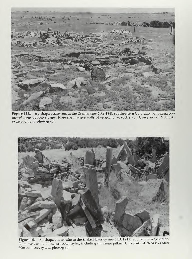
*ur* ** » j*.
•** X '»*•<»'«.,
;;rp«l
Figure 13R. Apishapa phase ruin at the Cramer site (5 PE 484), southeastern Colorado (panorama con-
tinued from opposite page). Note the massive walls of vertically set rock slabs. University of Nebraska
excavation and photograph.
Figure 15. Apishapa phase ruins at the Snake Blakesley site (5 LA 1247), southeastern Colorado.
Note the variety of construction styles, including the stone pillars. University of Nebraska State
Museum survey and photograph.

Figure 16. Upper Republican phase earth lodge at site 25 HN44, southern Nebraska. University ofNebraska Laboratory ofAnthro-pology excavation and photograph.
Figure 17. Upper Republican phase earth lodge at site 25 HN44, southern Nebraska. This is the largest reported Upper Republicanearth lodge and is also unusual in that it has six, unusually large cen-ter posts. University ofNebraska Laboratory ofAnthropology exca-vation and photograph.

Figure 18. Pawnee earth lodge at the Hill site (25 WT 1), southern Nebraska. Note the
circular shape and the eight center posts which distinguish Pawnee from prehistoric earth
lodges. Nebraska State Historical Society excavation and photograph.
•:•'. V1 1 -v**r
> -v
38
Figure 19. The Dismal River Apache house floor at White Cat Village (25 HN 37), southern
Nebraska. Dismal River houses are distinctive on the Plains in that they have five main support
posts plus two entrance posts. University ofNebraska Laboratory ofAnthropology excavation
and photograph.

Figure 20. Apache tipi ring, 1 7th century, at the Chapman site (29 SM 32), northeastern New Mexico. This
site, with its more than 200 tipi rings, probably was a stopping place for Apaches going to Pecos pueblo to
trade. Northern Illinois University Anthropology Museum excavation. Photo by author.
Figure 2 1 . Apache pit house, ca. AD 1 700, at the Sammis site (29 CX 68), northeas-
tern New Mexico. This was one of several styles of houses reported by the Spanish for
the ancestors of thejicarilla at this period. Northern Illinois University AnthropologyMuseum excavation. Photo bv author.

Figure 22. Apache pueblo, ca. AD 1700, at the Glassrock site (29 Mo 20), northeastern New Mexico. This
style of architecture was obviously borrowed from the Pueblo Indians with whom the Apaches had extensive
contact. Northern Illinois University Anthropology Museum excavation. Photo by author.
Figure 23. Ruins of ajicarrilla Apache structure at thejohn Alden site (29 SM 72), northeastern
New Mexico. This site was probably occupied only during the winter of 1849-1850 by Chacon's
band. Northern Illinois University Anthropology Museum excavation. Photo by author.

Figure 24. Petroglyphs, probably Apishapa phase, on the terrace below the Cramer site (5 PE484), southern Colorado. University of Nebraska State Museum survey and photograph.

-A
i *.
V ^ "
$k m.kM
Figure 25. Petroglyphs, probably Apishapa phase,near the mouth of the Apishapa Canyon,
southeastern Colorado. University of Nebraska State Museum survey and photograph.
CHAPTER FOUR
THE MIDDLE CERAMIC PERIOD
At the beginning of the Middle Ceramic period
marked changes appeared in the cultures of the
plains Indians. Whereas people of the Early Ceram-ic period had onlv incipient horticulture and simple
structures, Middle Ceramic people were producingsubstantial amounts of corn and living in well-con-
structed dwellings that conformed to set patterns. It
seems highly probable that the Middle Ceramicarcheological complexes of the Central High Plains
represent development, in situ, from Earlv Ceramiccomplexes. The changes in subsistence economyand type of habitation may well reflect the introduc-
tion ofa new race ofmaize with a low row number as
postulated by Galinat and Gunnerson (1963). Thenew maize produced substantially higher yields
than previous races and was easier to grind. Theapparent population increase during the MiddleCeramic probablv reflects this more abundant food.
The idea of structures built over shallow pits with
four-post roof supports probably diffused, along
with the new maize, into the plains from the South-
west. In the extreme southwest corner of the Central
High Plains there is a comparable and simultaneous
cultural fluorescence, but with a definite Pueblobase and character.
Other cultural changes documented in the arche-
ological record include the appearance of small tri-
angular projectile points, commonly with side
notches and sometimes with a basal notch as well.
These are good time markers and may have evolved
from the Avonlea point as suggested by Kehoe andMcCorquodale( 1961). However, theroute(s) of dif-
fusion is not clear. The small points were undoub-tedly used on arrows propelled by bows, weaponrythat seems to have appeared on the plains and in the
Southwest during the Early Ceramic period.
Excepting the clearly Pueblo manifestations, the
Middle Ceramic complexes of the Central HighPlains are affiliated with the plains village pattern;
however, the farther west the site, the less completethe assemblage. Influence from the northeast is re-
flected in the elaboration of pottery decoration anddiffusion from the southeast is evident in certain
traits of the Southern (Death) Cult. The change in
vessel shape from tall, pointed-bottom pots, to
more nearly spherical forms could be attributed
to influence from the East, but more probably came,along with the new maize, from the Southwest. Pot-
tery transitional between the Early and MiddleCeramic periods is apparently represented in the
Franktown and possibly the Apishapa phases ofeas-
tern Colorado, in the Custer Phase of western Ok-lahoma, in some of the most aberrant Upper Re-
publican sites in southern Nebraska, in several
unexcavated sites in west-central Kansas and pos-
sibly in the Smoky Hill phase of south-central
Kansas.
During the Middle Ceramic period, there wasclimatic fluctuation, as demonstrated by tree rings,
of a magnitude that would have jeopardized mar-ginal horticulture. As drought hit one sub-area after
another, there were apparently concomitant pop-
ulation shifts within the Central High Plains and at
the end of the Middle Ceramic period there pro-
bably were especially severe droughts that resulted
in marked depopulation of the region.
Upper Republican Aspect
The Upper Republican aspect, perhaps the mostdistinctive cultural climax in the Central HighPlains, is best represented in its northeast corner.
Here, between about A.D. 1000 and 1450, there
developed a sedentary culture based on a combina-tion of horticulture and hunting. It was charac-
terized by distinctive cord-roughened pottery andsemisubterranean earth lodges, located either singlv
or in small clusters. Initially, Strong (1935) wasinclined to call this complex "Prehistoric Paw-
nee." His guess was probably correct, but Wedel's
suggested designation, "Upper Republican" aspect,
was more acceptable because it was free of inter-
pretation and it soon became established. ManyUpper Republican aspect (phase) sites have beenexcavated, but relatively little of this work has beenreported in the literature. Enough information is
available, however, to permit valid generalizations.
In spite of several efforts to define temporal
and geographic subdivisions of Upper Republican,
there is still no generally agreed-upon taxonomicscheme for classifying its manifestations. The vari-
ous taxa mentioned in the literature include the
term "Aksarben aspect," which has been proposedto subsume both the Upper Republican aspect and,
to the east of the Central High Plainsthe Nebraska
Culture (aspect). A slightly more inclusive taxon, the
Central Plains phase (or tradition), would include
the Smoky Hill phase of Kansas in addition. The"Plains Village pattern" would include all the above
plus the Apishapa, Custer, Washita and Panhandle
65

NEW MEXICO
501 I I
100
1 i i I I I
100
150 200 Miles
200 Kilometers
SELECTED MIDDLE CERAMIC COMPLEXES

aspects to the south, and those Middle Ceramicperiod villages farther north along the Middle Mis-
souri River. There is some resistance, however, to
extending the Plains Village pattern west into the
High Plains, where, at most, there are isolated earth
lodges and not the clusters of dwellings that the
name "village" brings to mind. Since these western
manifesations are apparendy peripheral expressions
of the Central Plains phase and the Plains Village
pattern, rather than independent cultural complexes,
one can better understand the cultural dynamicsinvolved by considering them along with those
broad taxa.
Proposed divisions within the Upper Republicanaspect (phase) are even less generally accepted. Theassignment to the Smoky Hill aspect of sites in
north-central Kansas once classified as Upper Re-
publican, has gained support. The separation of the
remaining Kansas and Nebraska sites into an early
(Solomon River) phase; a middle (Classic UpperRepublican) phase; and a late (Loup River) phase(which corresponds closely to what was once called
the Sweetwater focus) shows promise but is less well
accepted. Two foci have been proposed for UpperRepublican aspect sites in Colorado:the Buick fo-
cus, in the drainages of the Republican and Platte
Rivers, which appears to correspond to at least
Classic Upper Republican, and the Franktown focus,
southeast of Denver, which may be transitional bet-
ween Early and Middle Ceramic complexes and, if
so, might correspond to the Solomon River phasefarther east. Unfortunately, very little work has beendone at Middle Ceramic sites in Colorado north of
the Arkansas River. As will be seen later, one of the
big problems in establishing temporal divisions is
the apparent inaccuracy of and inconsistency in
radiocarbon dates for the past two millennia. Unfor-
tunately there are very few dendrochronology dates
from the plains.
This discussion of Middle Ceramic complexes in
the northern Central High Plains will focus on the
Classic Upper Republican phase, since that rep-
resents the sites for which the literature is richest.
Much ofwhat is presented will also be applicable to
those other complexes in Nebraska and Kansas that
were originally included in the Upper Republicanaspect. Limited information on the Loup River,
Solomon River and Smoky Hill phases will also bepresented even though these taxa may eventually
prove invalid. The Buick and Franktown phases of
Colorado (if these are valid taxa) apparently repre-
sent quite different cultural activities than those
going on in the Classic Upper Republican hear-
tland; thus the generalizations do not extend to
them. The Buick phase is used as something of a
catchall for Middle Ceramic sites north of the Ar-
kansas River in Colorado. The poorly known Pratt
complex of south-central Kansas is dealt withseparately even though is it apparendy in some wayrelated to the Upper Republican aspect.
History of Investigations
Strong (1933) originally defined the Upper Re-
publican culture, later to be renamed the UpperRepublican aspect, and presented a list of its distinc-
tive traits. He suggested that it was prehistoric Paw-
nee and distinguished it from the "NebraskaCulture," which had been described by Gilder ( 1 926)
and most extensively investigated by Sterns (1915a,
1915b). Strong's brief article in the American Anthro-
pologist (1933) presented a summary of two longer
monographs then still unpublished by Wedel ( 1 936)
and Strong (1935).
In 1933, the Nebraska State Historical Society
initiated an archeological survey of south-central
Nebraska (Wedel 1934a,b,; 1935a,b) in the course of
which excavation was carried out at a number of
Upper Republican sites. A few ofthese liejust east of
the present study area, but most are within it. In all,
thirteen houses were excavated representing nine
sites. Of these, nine were rectangular; the others
were circular or oval. Most of the circular structures
were at sites east of the present study area and the
most anomalous houses had fewest diagnostic
artifacts.
Also in 1933, the Nebraska State Historical Soci-
ety excavated at three Upper Republican sites along
Medicine Creek, a few kilometers south of Stock-
ville, Nebraska (Wedel 1934b). Here, at the Gam-mill- Phillips site, one small, nearly round earth lodge
with four center posts was excavated. The housefound at the Thompson site was nearly square but
again had four center posts. Remnants of two houses
ofuncertain shape, and ofa square house with roun-
ded corners were investigated at the Owens site. Thelatter is unusual in that there were 12 center posts
forming essentially a circle; a well-defined entrance
extended to the east.
Wedel (1935a) alludes to numerous Upper Re-
publican villages in Franklin and Harlan Counties,
Nebraska. Strong ( 1 935: 74- 1 03) reports two square
earth lodges from the Lost Creek site in Franklin
County. Hill and Metcalf (1942: 159) merely men-tion extensive tests in an Upper Republican site onthe Frenchman River, presumably in Chase County,
Nebraska.
As part of salvage operations prior to the con-
struction of the Medicine Creek Dam in Frontier
County, Nebraska, the Nebraska State Historical
Society and the Missouri River Basin Survey exca-
vated 42 earth lodges at 12 Upper Republican sites
(Kivett 1949a). Kivett gives a good general summaryof the data recovered, but does not provide a de-
tailed house-by-house description; all houses, how-ever, were reported as rectangular. More recently,
an additional rectangular house from this same area
was excavated and reported in detail (W.R. Wood1969a).
As part of salvage operations in the late
1940s and early 1950s, the University of Nebraska
67

Laboratory of Anthropology excavated all or parts
of five Upper Republican houses at three sites in the
Harlan County (Nebraska) Reservoir area. One, at
25 HN 44, was unusual in that it was (and still is) the
largest ever excavated; the rectangle formed by the
outer posts was 1 1 by 1 4.6 m and contained six very
large center posts. The other house at25HN44,alsowith six foundation posts, was 10.7 x 11 m (Wedel
1953b: 92-93; Cooper 1955: 94-96; Roll 1968: 60-
65).
In 1961-1962, the Nebraska State Historical Soci-
ety conducted salvage archeology in the Red Willow
Reservoir area, primarily in Frontier County, Neb-raska. The one square Upper Republican houseexcavated was reported by Grange (1980: 49-70,
155). He states that most of the 30 Upper Republi-
can sites in the Reservoir area were "earth lodge
hamlet or village sites."
The one Upper Republican site within the pre-
sent study area at which structures have been foundand reported on is the Pottorff site in the extremewestern part of Lane County, Kansas (Wedel 1959:
784-788). The structures here had four center posts
but were small and poorly defined. Pottorff is con-
sidered by Witty ( 1 97 8) to be the westernmost UpperRepublican site with structures in Kansas, and byWedel (1959: 569) to be the southernmost UpperRepublican site.
Sites in western Kansas presumed to be campsrather than villages have also been assigned to the
Upper Republican aspect. Bowman (1959a-c, 1960a-
c) reports an Upper Republican component at the
Coal Oil Canyon rock shelter (14 LO 1), located in
extreme western Logan County, southeast of Wal-
lace, Kansas. An Upper Republican occupation wasalso reported from site 14 SC 302, in the mouth of
Timber Canyon at the north end of Scott CountyState Park (Witty 1975: 4). From site 14 SC 3 (Wedel
1959: 476), at the extreme southern edge of Scott
County, have come Upper Republican sherds, along
with various other types. Some of the sherds appar-
ently resemble the orange cord-roughened pottery
that Wedel attributes to the Smoky Hill aspect. Nearthis site, known as Pony Mound, are depressions or
playas which may have been the attraction for the
diverse groups that frequented the area. TheSchmalzried site (14 LA 305) occupies a hilltop in
Lane County, Kansas (Stein 1978); nearby is anundrained depression that becomes a playa in wetyears. Another hilltop site (14 GL 417), this one in
Greeley County, extreme western Kansas (Cheney
1977), has yielded pottery that is either Upper Re-
publican or an unnamed type that appears to beintermediate between Upper Republican andWoodland. A wide variety of points apparently rang-
ing in time from Archaic to Late Prehistoric have
been found at the site.
The known distribution of Upper Republicanvillages almost certainly reflects a biased sample.
Numerous sites have been excavated along the Re-
publican River and its tributaries in south-central
Nebraska, but apparently only one Upper Republi-
can earth lodge site has been reported from that por-
tion ofKansas which lies within the study area. Some48 km east of the study area in northern Kansasanother concentration ofUpper Republican villages
has been investigated and reported. Witty (1978)
alludes to Upper Republican sites in northwestern
Kansas, but apparently none has been excavated
and reported in the literature. Although the aspect
was defined on the basis of work done by the Neb-raska State Historical Society and the University of
Nebraska in the 1930s, most of the excavation of
Upper Republican earth lodges in both Nebraskaand Kansas has come about through later salvage
projects prior to the construction of dams.
Subsistence
The Upper Republican subsistence pattern has
long been recognized as about equally composed of
cultivation (corn, beans and squash) and hunting
and gathering, with an emphasis on bison but with a
wide variety of plants and animals utilized. Grange
(1980: 67) calculated that 98.396 of the meat con-
sumed at 25 FT 32 was from bison with only five
other species represented. Falk (1969), however,
reports 33 species from 25 FT 35. He did not try to
calculate the percentage ofusable meat represented
by each species, but bison was clearly the most a-
bundant. Deer was also very well represented; rab-
bits were the most common small mammal. Re-
mains offreshwater mussels and various game birds
are frequently present, as are fish bones and fish-
hooks.
Of the vegetal materials recovered from UpperRepublican sites, several are clearly cultigens. For
the Medicine Creek area, Kivett (1949: 280-282)
reports that "charred corn kernels were plentiful at
all of the sites and some short cobs bearing 6 to 12
rows ofkernels were found. Other charred materials
include sunflower seeds, charred nuts, and squash
or melon seeds." Cutler and Blake ( 1 969: 61
) report
cobs with 10, 12 and 14 rows from Medicine Creek
and corn grains from 8-, 10- and 12-row ears from
Glen Elder (Kansas) Upper Republican sites. Sites
excavated by Wedel ( 1 935: 1 85) yielded quantities of
charred corn, including a few six-row cobs, and at
one site beans and fragments of squash rind and
stem were recovered.
Without quantitative information, the impor-
tance ofsmaller animals in the diet ofUpper Repub-lican people is hard to assess. Nor does the presence
of a particular animal in the inventory necessarily
mean it was used for food. Table 9 lists species rep-
resented at various sites.
Settlement Pattern
The settlement pattern of the Upper Republican
68

Table 9. Upper Republican Subsistence
Specimens from Various Sites
25FT35 Lost Various Pottorff Red Willow Glen Elder Harlan Co.
(Falk Creek Nebr. (Wedel reservoir reservoir reservoir
1969: (Strong (Wedel 1959: (Grange (Roll (Roll
43-51) 1936: 1935: 37) 1980: 1968: 1968:
100) 185-203) 165-173 135) 135)
Bison
Pronghorn X X X
Deer X X X
Elk (Wapiti) X X
Canid X X X
Fox
Raccoon X
X
X
Badger
Otter
Beaver
x
X X
Small
Mammals(General)
Rats &Mice
Muskrat
KangarooRat
Rabbit
(General)
Jackrabbit
Cottontail x
gopher
Prairie
Dog
69

Table 9, (continued)
25FT35 Lost
CreekVariousNebr.
Pottorff Red Willowreservoir
Glen Elder
reservoir
Harlan Co.
reservoir
Birds
(General)
Goose(General)
CanadaGoose
Duck(General)
Mallard
Gadwall
HoodedMerganser
Teal
Turkey
Ruffled
Grouse
Prairie
Chicken
Hawk
Owl
Turtle
x
X
Snake
Lizard X
Frog c
Fish
(General) X
Catfish X
Crayfish X
Mollusca X
70

aspect, particularly the Classic Upper Republicanphase, is one ofwidely dispersed houses on terraces
overlooking easilv tillable bottom lands along small
permanent streams. One or a few houses may occur
within tens of meters ofone another, but be separated
bv a few hundred meters from the next house or
groups of houses. Houses found at the same site
may or may not have been occupied at the sametime; there is no clear evidence in the literature of
contemporaneity in such situations. Sites are often
on second or third terraces and may be several hun-
dred meters from a stream. Thev are never in a loca-
tion where thev would be threatened by flood.
There is no evidence ofstockades or other defensive
features and no suggestion that sites were selected
for their defensibility. Krause (1970) has suggested
that Upper Republican sites can be characterized as
either "hamlets" or "homesteads," each tvpe oc-
cupying a somewhat different kind of terrain andshowing a chronological or evolutionary dimensionthat differentiates it from the other. However, this
interpretation does not seem to be generally
accepted.
At Upper Republican sites outside the classic area,
one finds some differences in settlement pattern. In
the Loup River drainage (Ludwickson 1978) sites
also occupy ridge tops, reminiscent of some Neb-raska aspect sites. At least one site, 25 HW 6, where22 houses were excavated, was a much larger village
reminiscent of the later nearby Lower Loup aspect
and of Pawnee villages. Large villages are also foundin central Kansas at the Minneapolis and Whitefordsites, which Wedel once considered Upper Repub-lican, but has more recently (1959) placed in the
Saline focus of the Smoky Hill aspect. There is still
doubt as to whether Smoky Hill should be con-
sidered a separate aspect (phase) or be lumped with
Upper Republican. In any case, within Classic UpperRepublican, the most houses excavated or recorded
at any one site is apparently eight, at 25 FT 1 3 (Wedel1953a: 14).
Houses
Of more than 130 excavated houses assigned to
Upper Republican or closely related complexesonly 16 are described in print in any detail and of
these 16, only two have been reported since 1935.
The houses that remain undescribed have all beenexcavated since 1935; about half have been excava-
ted since World War II.
Upper Republican houses were earth-covered,
built on the surface or over shallow pits, rarely morethan .5 m deep and up to 14 m across. These struc-
tures were square to rectangular, usually with all
four corners square, but occasionally with the twoback corners rounded. A long (up to 5 m) coveredentrance extending from the middle of one of the
sides was commonly oriented more or less to the
south or east, away from the prevailing winter wind,
and/or downhill if the site had a significant slope. In
contrast to later Pawnee lodge floors, which werecovered with puddled clay fired before the posts
were set, Upper Republican floors were not thus
prepared. In the center of the floor was an unlined
fire basin or hearth, up to .3 m deep and 0.6 to 1 .0 min diameter. Rarely, two hearths are found in a
house. A smoke hole was left in the roofdirectly over
the hearth. Usually four center posts, but occasion-
ally six and rarely more, stood about halfway be-
tween the hearth and the corners of the lodge andprovided the main support for the roof. The walls
and the entrance passage were defined by smaller
and more closely spaced vertical posts. The center
posts werejoined by stringers which in turn suppor-
ted rafters that extended to the walls. The roof con-
sisted of small poles and grass, with a covering layer
of earth or sod. Excavation of burned lodges has
produced large quantities ofpole-and-grass impres-
sed burned daub. In addition to the basic four or six
center posts and wall and entrance posts, one usu-
ally finds miscellaneous holes for posts whose func-
tion is not obvious. Occasionally posts were doubled,
presumably to provide extra support for a heavy
roof. Rebuilding ofan old lodge, or the building ofa
new house where an earlier one has stood, leads to
confusing post patterns.
Other common features found in Upper Repub-lican earth lodges are storage pits dug into the floor.
These are bell-shaped, up to 1.5 m in depth andmaximum diameter, and occasionally have a second
(secret?) pit dug into the bottom. The basic function
of these "cache" pits was storage, presumably for
corn and/or other foodstuffs, but they were some-times used later for the disposal of trash. Cache pits
are found between houses as well as inside them.
Middens are commonly found just outside lodge
entrances.
There have been attempts to correlate house size
and/or shape with chronological status but none has
been very successful. This may in part reflect the
inaccuracy of radiocarbon dating, which has gener-
ally been used to provide time dimension. Further-
more, the time span for Upper Republican culture is
probably less than 400 years, so that with standard
deviations of up to 100 years on dates, radiocarbon
dating is not really precise enough; it is not uncom-mon to have multiple dates from a single structure
that differ by a few hundred years.
Upper Republican Pottery
The most thorough description of Upper Repub-lican pottery is that by Sigstad (1969). Althoughbased on pottery from a single site, his description
can be considered representative because UpperRepublican pottery is very homogeneous from site
to site. Furthermore, for present purposes, it is for-
tunate that Sigstad's site, the Mowry Bluff site onMedicine Creek in southern Nebraska, is not only
71

within the limits of the present study area but is in
that portion where by far the greatest concentration
of Upper Republican sites occurs.
Other Artifacts
General descriptions of artifacts are presented byWedel ( 1 959: 95-97) for the aspect as a whole and byKivett (1949: 280-282) for sites in the MedicineCreek Reservoir. More detailed descriptions of arti-
facts from specific sites can be found in Strong
(1935), Wood (1969), and Grange (1980).
Upper Republican chipped stone artifacts showreasonable skill. The projectile points are small, thin
and delicately chipped. Typically they are triangu-
lar, with straight to slightly convex edges andstraight bases, and with side notches about Vi to lA of
the length from the base. There may be, in addition,
a single small basal notch. Some points have nonotches; rarely, there are two notches on each side
and one in the base. Occasionally, points toward the
larger end of the size range have only small corner
notches. Most projectile points measure between1.5 to 4 cm in length. The length/width ratio ranges
from little more than 1 for some ofthe shorter points
to nearly 2.5 for some of the longer ones. The pro-
jectile points show a marked contrast to the deeply
corner-notched (stemmed) points of roughly the
same size and proportions found at Early Ceramicperiod sites, but Upper Republican points are indis-
tinguishable from those of various protohistoric
complexes.
The question of the chronological and cultural
position of the small delicate triangular projectile
points with straight to slightly concave bases is a
significant one. Ofspecial concern is the presence or
absence of side and basal notches. These points
were classified by Strong (1935: 88) as types NBa,NBal, NBa2, NBa3, NBa4, NBb, NBbl, and NBb2,designations commonly found in the older litera-
ture. Points of these NB types are characteristic of
the Middle Ceramic period where, in Upper Repub-lican assemblages, for example, they showed great-
est variety. Points of the Early Ceramic period are
characteristically small to medium-sized expand-
ing-stem or corner-notched varieties, but triangular
unnotched or side-notched types may have madetheir first appearance then. Triangular side-notched
points of small to medium size found in the north-
west Plains have been named Avonlea points by
Kehoe and McCorquodale (1961), who see them as
time markers. They consider these points the earli-
est small points in the northwest Plains, appearing
there by A.D. 460. Avonlea points are cruder, and
tend to be larger and stubbier, than the delicate
triangular points of the Middle Ceramic period of
the Central Plains, but they could conceivably be the
type out ofwhich these later points evolved. Another,
earlier, Archaic type of small side-notched point, in
this case with basal notches also, is well represented
in Signal Butte I (Strong 1935: 233, Plate 25-1-e).
Such points seem out of place in this early context
(1000-1500 B.C.) and appear to have no more than a
coincidental resemblance in general outline to the
Middle Ceramic period points.
Small, delicate, triangular points persist into the
Late Ceramic period. Great Bend (protohistoric
Wichita) points are commonly triangular and un-
notched, secondarily side-notched. Occasionally a
basal notch occurs with side notches (Wedel 1959:
265, 314, 576). In Lower Loup (protohistoric Paw-
nee), on the other hand, unnotched points are typi-
cal (Dunlevey 1936: 194). These persist as a minority
type into historic Pawnee, where notched points
become typical even as stone points become un-
common (Wedel 1936: 75, 1938). The Dismal River
aspect (protohistoric Apache) had both unnotchedand side-notched points, indistinguishable fromthose of Upper Republican and Great Bend (Gun-
nerson 1960, 1968; Wedel 1959; Hill and Metcalf
1942). Strong (1935: 90, citing A.T. Hill) attributes
points with both side and basal notches to Dismal
River, but this occurrence has yet to be confirmed.
One of the more distinctive chipped stone tools
found in the Upper Republican complex is a dia-
mond-shaped, alternately beveled knife also foundin the Great Bend, Lower Loup, Custer, Washita
River, Panhandle, and Pratt complexes. These are
often referred to in earlier literature as "Haraheyknives" (Harahey being a phonetic rendition of the
Pawnee name for themselves). When first made they
are commonly as much as 15 cm long and 8 cmwide. After repeated resharpening, and before be-
ing discarded, they are sometimes half their original
length and so narrow that they resemble double-
pointed drills. These knives, like those ofa variety of
less distinctive shapes (triangular, rectangular, oval)
are relatively thin, well-made and bifacially chip-
ped. Presumably also used for hide working were
small plano-convex, snub-nosed end and side
scrapers comparable to those found at Lower Loupand Great Bend sites. These are more carefully
made and tend to be smaller than those found at
Dismal River sites. Chipped stone drills are "T"-
shaped, have expanded bases, or are made from the
base portion of projectile points. Drills are not com-mon at Upper Republican sites. Other chipped
stone artifacts include chipped celts or axes andlarge, thick bifaces. Miscellaneous flakes show signs
of retouch and/or use.
Ground stone artifacts commonly found at Up-per Republican sites include shaft smoothers almost
always made from Dakota (red) sandstone and pre-
sumably always used in pairs. These are rectangular,
with somewhat convex sides and a longitudinal U-
shaped groove in one face. Some are well-finished
on all surfaces. At one time these were called "nail
buffer" shaft smoothers because of similarity in
shape to devices commonly used by women in the
1920s and 1930s for polishing fingernails. Also
72

commonly found are irregular pieces of sandstone
or other gritty stone with grooves worn in them, pre-
sumably from sharpening, shaping or smoothingother artifacts of stone, bone, wood, antler, etc.
Metates or milling slabs, with either a shallow basin
or a trough open at one end, and manos, usually a
conveniently shaped cobble, occur in the southwes-
tern portion of the Upper Republican area, perhaps
reflecting availability of suitable stone and/or prox-
imity to the Pueblo Southwest. Upper Republican
and related people to the northeast probably used
wooden mortars and pestles for corn grinding:
some "post holes" between the hearth and entrance
of earth lodges have been interpreted as mortarholes. Battered river cobbles appear to have served
as hammerstones. Ground and polished celts,
grooved axes and grooved mauls were apparently
not produced by Upper Republican people.
Among the more finely made ground stone ar-
tifacts are pipes, usually elbow. Sometimes the distal
end of the stem or base portion extends beyond the
bowl to form something of a pointed prow. Bowlsand stems are round to rectangular in cross-section,
and in some cases the outside diameter ofthe bowl is
greater at the top than where it is attached to the
stem portion. Occasionally pipes are decorated with
incised lines; only rarely is the bowl in the form ofan
effigy, e.g., a bird. Pipes made of clay, although not
as common as ones of stone, are generally the sameform (equal-armed elbow) and size (about 5 to 8
cm long).
Highly characteristic of the Upper Republican
artifact assemblage is the bison scapula hoe with the
spine and sometimes the glenoid cavity removed.
Hoes made from a section ofbison skull with part of
the horn core attached, and bone tips for digging
sticks, both found in contemporaneous complexesin the Southern Plains, are rare or missing in the
Central Plains except at the southern edge. Otherbone tools include various types of awls, eyed nee-
dles, fishhooks, shaft wrenches made from long
bones or bison ribs, picks made from bison ulnae,
sections of bison rib slotted to serve as handles for
stone knife blades, perforated deer toe bones whichpresumably served as ornaments or plume holders,
deer or antelope mandibles probably used as sickles
or corn shellers, beamers or dehairing tools madefrom spines of bison vertebrae, and knives madefrom sections of scapulae. Tubular bone beads are
also found.
Shell, presumably local, was made into biconical-
ly drilled disk beads. Such beads sometimes accom-pany Upper Republican burials but in nowherenear the number sometimes found with Woodlandburials. Strong (1935: 111-114) reports pendants or
ear ornaments made from Gulf Coast conch shells,
cylindrical shell beads, presumably also from Gulf
conch, and Olivella shell beads.
From the ossuary containing these ornaments of
foreign shell, Strong (1935: 111) also recovered a
bracelet or bow guard made from a flat section of a
large antler. An outspread hand with a circle (eye?)
on the palm was incised at each end. There werelines that could be interpreted as bracelets on the
wrists. The "hand and eye" design on this bracelet
clearly reflects influence from the Southern DeathCult; the bracelet and Gulf Conch ornaments to-
gether suggest that a complex ofSouthern Cult traits
had diffused to Upper Republican.
Other antler artifacts more common in UpperRepublican sites are cylinders, clubs, small flat
pieces that may have been parts of bracelets, awls,
possible handles for stone tools, possible stone flak-
ing tools, and shaft wrenches.
Burials
Upper Republican people used at least twomethods for disposal of the dead: individual pri-
mary (flesh) interments and ossuary burials. Various
bits of information indicate that there were also
ceremonies involving the dead that were related to
the Southern Death Cult.
About 13 km southeast ofAlma, Nebraska, Strong
(1935: 103-114) excavated the Graham site, an
Upper Republican ossuary. Here a pit of about 8 msquare and 1.15m deep had been dug into the top of
a prominent hill overlooking the confluence of
Prairie Dog Creek and the Republican River. Into it
had been thrown the disarticulated skeletons of
many individuals and a variety of artifacts. Many of
the bones had been lightly burned, perhaps from
having been exposed to prairie fires prior to burial.
There was no evidence that the burning had taken
place in the pit, although specks of charcoal were
found throughout the fill. With the exception of two
articulated infant skeletons, the bones revealed noindication of order, either anatomical or artificially
imposed. Numerous rocks ofvarious sizes were also
found in the fill; these were foreign to the hilltop andtheir function in the ossuary was not obvious. Morethan 900 potsherds were recovered from the pit,
nearly all of them matching the pottery from an
Upper Republican house a few kilometers away.
Other artifacts found included a small elbow pipe of
white stone, broken sandstone shaft polishers, six
small, delicate projectile points (five side-notched
and one unnotched), two small well-made endscrapers, a bone shaft wrench, a well-made boneawl, and two bone beads. All ofthese are characteris-
tic of Upper Republican sites in general. Several
other specimens are of special interest in that they
are rare or unique in this complex and indicate con-
nections with the Southern Death Cult. Amongthem is an antler bracelet or bow guard, previously
described, with the hand and eye motif. Ornamentsof Gulf coast conch shell included two long pen-
dants and 1 1 smaller pendants; 85 cylindrical beads
were probably also made from conch shell. Another
piece ofworked conch shell may have been the bowl
73

of a spoon. Two perforated copper disks were ap-
parendy coverings from decayed wooden ear spools.
Extensive trenching on this and a nearby hill failed
to locate any additional pits.
Wedel (1935a: 174-175) reported five burial pits
at the Holdrege 5 site a few kilometers from the
Graham ossuary. Two of the pits had apparently
contained two individuals each, whose remains hadsince been removed; two contained partial skeletons
representing flexed burials, and the fifth, a small
ossuary, contained the jumbled bones of several
individuals and numerous shell beads. The pits
were from 0.8 to 1.5 m in diameter and 0.5 to 1.1 mdeep. Presumably the skeletons had been buried
intact at time ofdeath and later transferred, in ajum-ble, to the ossuary pit. The flexed primary burial ofa
young child was found at the Gammill-Phillips site
on Medicine Creek (Wedel 1934b: 148).
In spite of extensive work carried out in the
Medicine Creek Reservoir (Kivett 1949), only oneskeleton probably attributable to the Upper Repub-lican occupation was discovered. This, an extended
flesh burial ofan adult male on a hilltop, was accom-panied by a few artifacts such as were found at a
nearby Upper Republican village. Scattered humanbones were occasionally found in houses, storage
pits and middens.
Wedel (1961a: 96) makes the general statement
concerning the Upper Republican aspect that in
both the Republican and Loup valleys bodies were
first exposed and then the bones were gathered upand placed in large communal pits on bluffs over-
looking the village sites.
Loup River Phase
A concentration of Upper Republican village
sites, centering along the Loup Rivers just to the
northeast of the present study area, has been assig-
ned by Krause (1969: 90-91) and by Ludwickson
(1975, 1978) to the Loup River phase to distinguish
these sites from those of the Classic Upper Repub-lican phase and the Solomon River phase (Krause
1969: 90-91). The Loup River phase includes sites
once assigned to the Sweetwater focus by Wedel(1935a: 252) and to the Loup River focus by Strong
( 1 935: 2) and Champe ( 1 936: 283). Although almost
all of those Upper Republican aspect sites assigned
to the Loup River phase lie just beyond the present
study area, it is essential to take note of them in con-
sidering the overall Upper Republican problem.
Ludwickson (1978: 96) summarizes data from 56
excavated houses representing 20 sites. Data onthree of the earth lodges had been published pre-
viously (Champe 1 936), 1 2 had been reported in anunpublished MA thesis (Ludwickson 1975), 33 hadbeen described in an unpublished manuscript by
the late George Metcalf (n.d.), one is mentioned by
Kivett (1952: 44) and information on seven camefrom field notes. According to Ludwickson (1978)
Loup River phase houses share with Classic UpperRepublican houses the four-center-post pattern,
but there is a higher incidence ofround houses, andthese tend to be smaller and deeper than those of
Classic Upper Republican. He does not point out,
however, that within the Classic Upper Republicanarea there are more round and deep houses in the
eastern part than farther west.
Unfortunately, there are very few dates available
for Loup River phase sites. A date ofA. D. 1 1 30 ± 200
years for a large structure on Coufal Ridge in the
Davis Creek locality is rejected by Ludwicksonbecause it was determined by the solid carbonmethod, has a large standard deviation, and comesfrom a structure that he does not consider assign-
able to the Loup River phase. Site 25 BF 210 on the
Wood River in Buffalo County, Nebraska, con-
sidered by Ludwickson (1978: 102-103) to be arche-
typical of the Loup River phase, has three radio-
carbon dates of A.D. 1330, 1480, and 1530, whichhe accepts, and one ofA. D. 1 060, which he does not;
all are from a single house. A nearby house at 25 BF1 45 he assigns to the Upper Republican phase. It has
yielded two dates of A.D. 1150, which he accepts,
and one of A.D. 690 which he rejects. Ludwicksonsuggests that the Loup River phase is transitional
between Classic Upper Republican to the immedi-
ate south and the Lower Loup phase (protohistoric
Pawnee) a little way down the Loup River to the east.
This possibility had been recognized by Strong
(1932, 1935), Wedel (1935a- 174) and Champe (1936:
282) although Wedel (1978: 160) emphasizes that
the Loup River phase is much closer to UpperRepublican than it is to Lower Loup.
Solomon River Phase
Another concentration of village sites related to
Classic Upper Republican lies in a neighboring
area. In north-central Kansas, in the Glen Elder
Reservoir on the Solomon River, 1 5 Upper Republi-
can houses were excavated in the mid- 1 960's by the
University of Nebraska (Krause 1970; Lippincott
1978). Houses were the typical square earth lodges,
built on the surface, or with only the sod removedfrom the area within. House floors ranged in size
from 30 to 112 square meters. Entrances ranged
from 0.5 to about 5 m in length.
Ofthese 1 5 Solomon River phase houses, 1 2 were
described briefly by Carlson (1971) who was mainly
concerned with ordering them chronologically by
means of seriation. Lippincott (1978) presents ad-
ditional information and points out that the houses,
although varying considerably in size and detail of
post arrangement, in general represent the standard
square earth lodge, and that site location and settle-
ment pattern are typical for Upper Republican sites.
He, too, presents the results of site seriation, but on
the basis of pottery rim form and lip-rim motifs (in
this case computer assisted) as well as a series of
74

radiocarbon dates. Lippincott concludes that the
sites were occupied from approximately A.D. 800-
850 to A. D. 1 200- 1 250, that there was not a shift in
settlement pattern from hamlets to isolated houses,
as Krause (1970) had suggested in a preliminary
report of work at these sites. Rather, he notes that
both patterns were found throughout the UpperRepublican occupation of the Glen Elder area. Also,
Lippincott found that house size was randomly dis-
tributed through time rather than decreasing in size
through time, as suggested by A. Johnson (1973).
Two small Upper Republican houses of the Sol-
omon River phase were excavated at site 1 4 JW 30 1
,
on Buffalo Creek in Jewell County, north-central
Kansas, by the Kansas State Historical Society
(Witty, personal communication). A radiocarbon
date (GaK-593) for this site is A.D. 910 ± 100, mak-ing it one of the earliest dated Upper Republican
sites, and supporting the idea that the SolomonRiver phase may be the earliest Upper Republican
phase.
Excavation at the Root site (14 LC 301), on the
Saline River in Russell County, central Kansas,
yielded one house, square with rounded corners
and about 7.3 m across. The site was originally re-
corded by Solecki (1952: 9) and its excavation is
reported by Witty (1962). A radiocarbon date (sam-
ple 1-509) for the site is A.D. 987 ± 100 (Witty 1962:
30). Witty identifies the pottery as a variety of Riley
Cord Roughened described by Wedel (1959: 183-
184) on the basis of pottery from theGriffingsite(14
RY 21) in northeastern Kansas, which he assigns to
the Smoky Hill aspect.
In the reservoir area containing the Root site,
Witty ( 1 962) excavated three other sites having Cen-tral Plains phase and Woodland occupations. Oneof these, 1 4 LC 302, was a rock shelter, and the Cen-tral Plains component was assigned to the Aksarben
(Upper Republican?) aspect. The other two, 14 RU302 and 14 RU 303, were open sites; post holes,
hearths and pits were found but no houses could
be detected.
From the Glen Elder Reservoir area Krause (1970:
107) reports one Upper Republican cemetery on the
same terrace as one of the hamlets. Two clusters of
burial pits, most ofthem devoid ofbones except for
toe and finger bones, were spread around a com-mon burial chamber which contained the disar-
ticulated skeletons of 50 to 60 individuals and two
complete pottery vessels. One of the small pits con-
tained the flexed skeleton of an elderly male.
Smoky Hill Aspect
Wedel (1959: 563-565), who defined the SmokyHill aspect, included in it sites near Minneapolis andSalina, Kansas, which had once been assigned to the
Upper Republican aspect. On the basis of admit-
tedly limited data, he has suggested that the SmokyHill aspect might be ancestral to the Upper Repub-
lican and Nebraska aspects and that it may havebeen influenced by Plains Woodland cultures.
Much of his argument is based on the facts that
Smoky H ill vessels are taller and less often decoratedthan classic Upper Republican pots. He notes the
occurrence ofdistinctive orange-browncord- rough-ened pottery, which has a strong tendency to spal-
land occurs over southeastern Kansas and south
into Oklahoma. He also reports Spiro focus pottery,
presumably from eastern Oklahoma, associated
with Smoky Hill burials, and notes similarities bet-
ween Early and Middle Spiro component housesand Central Plains earth lodges. The possibility that
Smoky Hill grew out of a local Woodland complexshould be seriously considered.
On the Solomon River, in Ottawa County, Kan-sas, Wedel (1935: 218-225) excavated at Min-neapolis 1 , which he described as one of several
large prehistoric villages in the area. The three
houses uncovered were square, the largest being 1
6
m across with an entrance 5.2 m long and 1.2 mwide. Six cache pits had been dug through the floor.
The floors of all three houses at Minneapolis 1 wereat or just below the original surface.
A burial pattern quite different from that of
Classic Upper Republican is found at a site near
Salina, in central Kansas, about 160 km east of the
present study area. This, the Whiteford site, has
been excavated privately, leaving the burials in
place, and developed as a tourist attraction. Here, a
low mound, surrounded by the alluvial bottom land
of the Smoky Hill River, has yielded some 140
human skeletons of all ages, both male and female.
All apparently had been flesh burials, partially or
completely flexed. Most had been placed on their
right sides, heads to the south and facing east. Arti-
facts found in this mass burial parallel those from a
nearby village where numerous earth lodges hadprobably once been present (Wedel 1 959: 5 1 2-523).
The burials and the village complex, which close-
ly resembles the Minneapolis 1 site about 30 km to
the north (Wedel 1934: 218), have been assigned to
the Smoky Hill aspect (Wedel 1959: 535).
The Lamed site ( 1 4 PA 307), just within our study
area at the confluence of Pawnee Creek and the
Arkansas River in west central Kansas, had as its
lowest component a Smoky Hill aspect camp (Mon-ger 1970). It was overlain by Pratt focus, Great
Bend aspect and Lamed Fine-Line components, in
that order, each well separated stratigraphically
from the next. The Pratt and Great Bend occupa-
tions took place at times when there were repeated
floodings, each represented by a silt lens, and fol-
lowed by a reoccupation of the site. However, there
is no indication of flooding during either the SmokyHill occupation or the period immediately follow-
ing when 60 cm of fill built up, but apparently not
through alluviation. Monger's detailed description
of the sedimentation suggests that the Smoky Hill
component rested on a well-developed soil, and that
75

following this occupation, but prior to the Pratt
occupation, there had been two stable periods whenfirst a thin soil and then later a thick soil had formed.
The Pratt occupation was on top of the thick soil.
Although Monger does not so speculate, it seemsvery probable that we have reflected here two majordroughts in the 1400s, perhaps ones recorded in the
tree-ring history of Nebraska for A.D. 1439-1454
and 1459-1468 (H. Weakly 1946, 1962; W. Weakly1961). The second indication of drought at the
Lamed site might date from the 1500s, but this
seems highly unlikely since above it are the Pratt andGreat Bend occupations, the latter ofwhich, at least,
dates from the 1500s and occurs in a context of wet
years (repeated flooding).
A simple, unprepared hearth was found in the
Smoky Hill zone at the Larned site, but no other
structural features. Near the hearth were three areas
of chert chips, identified as work areas, three boneconcentrations, and a limited amount of other det-
ritus. Artifacts are described by Monger (1970: 12) as
follows:
One pottery vessel, broken and scattered
about the area, was gathered and restored. Thevessel was completely cord-roughened. Someof the cord marks were obliterated on the bot-
tom and lower sides, and a narrow band, on the
shoulder where it joins the neck, had beensmoothed and showed polish. The vessel is
sherd tempered and the paste is compact andhard. The base of the vessel is almost pointed,
the body straight to cone-shaped, the shoulder
is rounded and flattens before it joins the neck.
The rim is out-flaring and plain.
The pointed base and cone-shaped body suggest
that this ware had recently evolved out of a Wood-land ware, paralleling what appears to have hap-
pened in the Franktown focus farther west.
Other artifacts, not abundant, included small tri-
angular side-notched projectile points, a fragment
ofa chipped knife, a fragment ofa side scraper and a
pointed section of a rib, possibly a piercing tool. All
the evidence points to a small temporary Smoky Hill
phase hunting camp, probably among trees that
bordered Pawnee Creek.
Franktown Focus
The Franktown focus was defined by Withers
(1954: 2) as follows:
A third group of materials has been namedthe Franktown Focus. This focus seems to be
concentrated in an area southwest ofDenver in
the timbered uplands along the southern Trib-
utaries of the South Platte River. The com-monest variety of Franktown pottery consists
of wide-mouthed, cord-marked jars with con-
oidal bases and incurving rims. The cord
markings are almost always partially smoothed.
A few sherds show a slight thickening of the
rim. The associated projectile points are usual-
ly side-notched and small to medium in size.
The entire lithic complex of the FranktownFocus seems closely related to that described
for the Upper Republican Aspect. The pottery,
too, seems quite like Upper Republican in
every characteristic except for the striking dif-
ference in vessel form. It may be possible to
interpret the Franktown Focus as representing
a transitional development from Woodland to
Upper Republican in the western Plains.
Apparently the material from Cliff Swallow Cave,
about 55 km southeast of Denver, is assignable to
this focus (Morton 1954). An analysis of the projec-
tile points from the Franktown Cave was carried out
by Pustmueller (1977).
In addition to unquestionably Upper Republican
pottery, other similar cord-roughened pottery has
been found over much of the High Plains of Colo-
rado and the panhandle of Nebraska. This seems to
occur in small amounts, lacks the distinctive col-
lared and braced Upper Republican rims, and in
general resembles Woodland pottery as much as it
does Upper Republican. There have apparently
been no published reports of investigations of sites
which yield this ware. Although the pottery could
represent a marginal variant of Upper Republican,
it more probably represents a transition fromWoodland to Upper Republican. Such ware mayalso occur farther east but with the abundance of
other cord-roughened pottery it could well have
gone unnoticed. This ware, like that of the Frank-
town focus, has been tentatively called "transitional,"
and may be related to it. Any manifestations that
show promise for bridging the apparent hiatus be-
tween Woodland and Upper Republican deserve
close attention.
A possible Franktown focus component at the
Spring Gulch site (5 LR 252) was suggested byKainer(1976: 196). This site is located almost at the
Wyoming border, approximately straight north of
Denver, Colorado. Since the site is stratified, andthere is some mixing between levels, it is not certain
which other artifacts belong with this component,
but both corner-notched and side-notched projec-
ile points appear to be associated.
The Franktown focus may also be represented at
thejarre Creek site, just southwest of Denver, which
has been dated by radiocarbon at A.D. 1050 ± 250
(G. Scott 1963: 48).
Buick Focus
The Buick focus, apparently a local manifestation
of the Upper Republican aspect, was defined by
Withers (1954: 2) as follows:
Other materials related to the Upper Re-
publican Aspect in eastern Colorado arrange
themselves into two foci. In the South Platte
and Republican River drainages occurs the
76

Buick Focus. These materials lap over into the
Arkansas drainage in some localities. The com-monest pottery is in the form of squat, round-
bottomed jars which are cord-marked andhave an out-curved rim. Frequently the rim is
thickened to form a "collar," and incised geo-
metric designs were placed on these. Plain
bowl and "seed jar" forms occur more rarely.
Small to medium side-notched projectile
points are normally found on these sites. Theonly architectural remains so far discovered
amount to little more than floor areas with
hearths.
W.R. Wood (1971) described materials excavated
from two Upper Republican sites near Limon in eas-
tern Colorado and called attention to other UpperRepublican sites in the High Plains west of the wes-
ternmost known Upper Republican earth lodge vil-
lages. These sites are in northeastern Colorado,
southeastern Wyoming, the southern part of the
Nebraska Panhandle, and the extreme southwest
corner of Nebraska. Prior to Wood's article very few
of these sites had been reported in the published
literature, although seven of the Colorado sites had
been described byj J. Wood ( 1 967) in his Ph.D. dis-
sertation, and all (seven) of the Wyoming sites by
Reher ( 1 97 1 ) in his MA thesis. W.R. Wood (1971) in
his study of collections at the University of Colo-
rado, Denver University and the Nebraska State
Historical Society, reported eight radiocarbon dates
for Upper Republican occupations, having obtain-
ed his information from Breternitz ( 1 969: 1 20- 121),
J.J. Wood (1967) and Steege (1967). These dates (cor-
rected) range from A.D. 660 to A.D. 1260 with plus
or minus factors. Because of the homogeneity of the
Upper Republican materials recovered, W.R. Wood(1971) favors an occupation of the area betweenabout A.D. 1200 and 1300.
The Smiley Rock shelter (5 EL 9) is located just
east of the tip of Cedar Point, north of Limon in
Elbert County, Colorado. In 1952 Herbert Dick
directed excavation in this shelter which had appar-
ently been occupied almost exclusively by UpperRepublican people. W.R. Wood classified the ma-jority of the pottery (four rim sherds from four
vessels and 25 body sherds) as Cambridge and Fron-
tier Ware, both of Upper Republican affiliation,
after Sigstad ( 1 969). Two sherds from the surface of
the site resembled those excavated from the nearby
Cedar Point village (5 EL 8), which can probably be
assigned to plains Apaches. Other artifacts fromSmiley Shelter are all typical of the Upper Republi-
can complex:small triangular projectile points with
lateral notches (2), end scrapers (2), triangular biface
(1), alternate-bevel biface (1), retouched flakes,
mano (1), bone awls (2), and bone beads (2). Field
notes indicated that bone was common at the site.
The Buick Camp site (5 EL 1), located not far
northeast of Smiley shelter, is the type site for the
Buick focus of the Upper Republican aspect defined
by Arnold Withers ( 1 954). Withers dug at the site in
1949 and Herbert Dick in 1954. W.R. Wood (1971)
reports only the material excavated by Dick and this
apparently represents an Upper Republican occu-
pation almost exclusively. The site is a middenabout an 0.4 ha in extent and up to 30 cm thick, just
under the escarpment of Cedar Point. The middencontained a large amount of bison bone, some of it
burned, and Dick excavated a hearth at the base of
the refuse. The pottery examined by Wood con-
tained 31 rim sherds representing about 24 vessels,
and 145 body sherds which he assigned to UpperRepublican wares: predominantly Frontier Warewith one Cambridge Ware rim. Eight body sherds,
some cord-roughened and some smooth, could not
be identified and were considered as intrusive. Therest of the artifacts described are typical of UpperRepublican complexes: small, triangular projectile
points, unnotched, side-notched, side- and base-
notched and two with corner notches; end scrapers;
a graver; a drill; large beveled bifaces including
diamond-shaped; various other forms of bifaces;
manos; bone awls; and a bone bead. It is probablv
significant that at neither of these two sites in Elbert
County were found bison scapula hoes, so commonat Upper Republican earth lodge villages farther
east. This strongly supports the probability that,
rather than being horticultural villages, these wes-
tern sites were temporary camps on a travel route
from permanent villages to the east.
Upper Republican earth lodge villages are ap-
parently all east of the hundred and first meridian,
the westernmost being reported from the RedWillow Reservoir in Nebraska and the Pottorff site in
Kansas. West of these villages, however, are campsites and rock shelters which have yielded UpperRepublican pottery. These are either erratically dis-
tributed in parts of Wyoming, Nebraska and Colo-
rado, from the North Platte River south to the
southern edge of the Republican River drainage, or
discoveries have been erratic. Except along the
extreme northern edge of Colorado and southeast
Wyoming, these sites seem to be no closer than
about 80 km to the foothills of the Rocky Mountains
(W.R. Wood 1971).
It is generally assumed that these western UpperRepublican sites served as temporary camps associ-
ated with some activity such as bison hunting.
Whereas Upper Republican villages farther east are
always in close proximity to good horticultural
lands, no such relationship is noticeable to the west.
Some of the sites, such as Signal Butte near Scotts-
bluff, Nebraska, would have served well as lookout
points for detecting herds ofgame. Rock shelters, of
course, were highly desirable temporary habitations
for people traveling or exploiting some local resource
over short periods of time. If these Upper Republi-
can sites west of the one-hundred-first meridian
were satellites of permanent villages in this western
area, then such permanent villages have yet to be
77

found. Furthermore, this western High Plains area
would not have been well suited for the riverine
farming that constituted a significant portion of the
subsistence activities of the Upper Republican peo-
ple. Hence, permanent occupation of the area
would have involved a subsistence pattern quite dif-
ferent from that found farther east and one wouldnot expect in such cases the marked similarity in
artifacts that is found.
Other Middle Ceramic Sites
in Northern Colorado
The Middle Ceramic period in northeastern Colo-
rado is known primarily from the survey and exca-
vations carried out byJJ. Wood (1967). He foundthat evidence of occupation for this period camealmost exclusively from rock shelters, with no in-
stances of permanent habitations. Unfortunately,
those rock shelters most used had also been mostbadly disturbed by several decades of vandalism.
And the components yielding the largest collection
of pottery (5 WL 37 and 5 WL 43) could not provide
radiocarbon dates. The radiocarbon datesJ J. Wood(1967: 628) did get fall in the Middle^Ceramicperiod, but the sites (Uhl, Peavy Rocky shelter, Biggs
and Kasper) for the most part presented problems of
interpretation. Diagnostic artifacts were lacking, or
few, or mixed, and strata 82 were thin. Only at the
Peavy Rock shelter was there reasonably clear as-
sociation of the radiocarbon sample and diagnostic
Middle Ceramic period artifacts. Some componentswere assigned to the Middle Ceramic period solely
on the basis of the radiocarbon dates. Wood's data
strongly suggest that northeastern Colorado wasoccupied by Middle Ceramic period people, but
only sparsely and intermittently.
A stone ring site from northern Colorado appar-
ently dates from the Middle Ceramic period, but
does not suggest Upper Republican affiliation (Flay-
harty and Morris 1974). The T-W-Diamond site (4
LR 200) consists of 47 stone "tipi" rings, 4.3 to 5.8
m in diameter. Of these 1 7 were excavated or tested.
The only diagnostic stone artifacts were small tri-
angular projectile points, unnotched, side-notched
or with side and basal notches. Sherds from onecrude, flat-bottomed pottery vessel resemblingmodern Shoshone ware were also found. Threeradiocarbon dates determined on charcoal were
A.D. 1020 ± 230, 1 170 ± 220, and 400 ± 340. Thefirst two are compatible with the projectile point
types but the latter should be rejected because it is
much too early (Flayharty and Morris 1974).
The sites most comparable to the T-W-Diamondsite thus far reported are two groups of tipi rings, the
Piney Creek sites (48 JO 311 and 48 JO 312) in
Johnson County, northeastern Wyoming (Frison
1967). These sites are considerably richer in artifacts
than the T-W-Diamond site, which in turn is richer
than most Plains tipi ring sites. Except for the dif-
ference in artifact yield, the inventories of the three
sites are quite comparable. However, the limited
amount of pottery from the Wyoming sites is thought
to have Mandan-Hidatsa affiliations, whereas the
best guess on the Colorado pottery is Shoshone. Thebuffalo butchering and camp sites on Piney Creekhave been dated by radiocarbon at A. D. 1580+ 1 00and A. D. 1610+ 1 00, dates entirely compatible with
the chronological status of the small delicate trian-
gular projectile points, most of which had side
notches (half had basal notches also). Similar points
were found by Frison (1970) in the upper level ofthe
Kobold site (24 BH 406), a deeply stratified buffalo
jump in southeastern Montana.
Upper Republican Discussion
Of the various Middle Ceramic Period com-plexes known in the Central High Plains, the
most thoroughly investigated and reported is the
Upper Republican phase. There is enough informa-
tion available, especially if all of the excavated but
still unpublished sites were included, for a thorough
synthesis. The major questions not yet answeredconcern the external relationships of the UpperRepublican phase to: the Nebraska phase, the
Smoky Hill aspect, the Washita River phase, the
Panhandle aspect and the various complexes in eas-
tern Colorado that are apparently closely related.
More and more it appears that these various com-plexes grade into one another and that even though
their definitions are of use to archeologists, they donot necessarily reflect linguistic or cultural entities
that would have been meaningful to the people
themselves. All, most probably, were Caddoanspeakers ancestral to modern Ankara, Pawnee and
Wichita.
At one time, the Upper Republican aspect was
interpreted as representing a new group of people
who moved into the Central Plains and replaced the
earlier Woodland people. The idea is now generally
accepted that Upper Republican culture, along with
that of the closely related taxa mentioned above,
evolved, more or less in situ, from earlier local
Woodland cultures. Some archeologists, especially
Hughes (1974b), sees culture continuity starting at
least as early as the Archaic period. It is perhaps
significant that in the Upper Republican heartland
there has not been a complex clearly identifiable as
transitional between Woodland and Upper Repub-
lican, such as the Graneros focus in southeastern
Colorado or the Custer Phase in western Oklahoma.
The Smoky Hill aspect, just to the south of the
Upper Republican territory, has been suggested by
Wedel (1959: 565) as possibly ancestral to UpperRepublican. The idea should be seriously con-
sidered that some of the traits that distinguish the
Central Plains tradition from the earlier Woodlandpattern entered the Central High Plains from the
Southwest, were integrated first into the nearest
78

Middle Ceramic Period
Table 10. Eastern Colorado Radiocarbon Dates
(Butler 1980: Table 2)
Site
Dates B.P.
(B.C./A.D.)
SampleNumber
Type of
Sample Reference
Site 5 LO 6 545 ± 150 BP
(AD 1405)
GX-0564 Charcoal Wood 1967: 466
Kasper 655 ± 250 BP GX-0560 Charcoal Wood 1967:
(5 LO 4) (AD 1295) 482, 501
Biggs 695 ± 110 BP GX-0566 Mammal Wood 1967:
(5 WL27) (AD 1255) bone 348, 356
Happy Hollow 780 ± 90 BP Gak-1304 Charcoal Steege 1967
(5WL 101) (AD 1170)
Biggs 735 ± 105 BP GX-0567 Mammal Wood 1967:
(5WL27) (AD 1215) Bone 348-354
Peavy Rock 810 ± 125 BP GX-03 1 7 Charcoal Wood 1967:
Shelter (AD 1140) 225, 282
(5 LO 1)
Jarre Creek 900 ± 250 BP W-1018 Charcoal Scott 1963: 48
Colo: K: 12: 9
(5 DA 541)
(AD 1050)
T-W Diamond 900 ± 230 BP A-1273 Charcoal Flayharty &
(4 LR 200) (AD 1020) Morris
Spring Gulch
(5 LR 252)
Uhl
(5 WL 32)
935 ± 140 BP
(AD 1015)
1210 ± 220 BP
(AD 740)
UCa-1050
GX-0324
Charcoal
Mammal
bone
1974: 168
Kainer 1976:
31,215 ff.
Wood 1967:
182
79
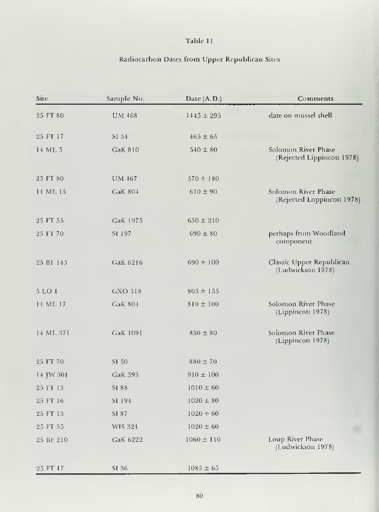
Table 1
1
Radiocarbon Dates from Upper Republican Sites
Site Sample No. Date(A.D.) Comments
25 FT 80 UM 468 1445 ± 295 date on mussel shell
25 FT 17 SI 34 465 ± 65
14 ML5 GaK810 540 ± 80 Solomon River Phase
(Rejected Lippincott 1978)
25 FT 80 UM 467 570 ± 180
14 ML 15 GaK 804 610 ± 90 Solomon River Phase
(Rejected Loppincott 1978)
25 FT 35 GaK 1975 630 ± 210
25 FT 70 SI 197 690 ± 80 perhaps from Woodlandcomponent
25 BF 145 GaK 6216 690 ± 100 Classic Upper Republican
(Ludwickson 1978)
5 LO 1 GXO 318 805 ± 155
14 ML 17 GaK 804 810 ± 100 Solomon River Phase
(Lippincott 1978)
14 ML371 GaK 1091 830 ± 80 Solomon River Phase
(Lippincott 1978)
25 FT 70 SI 50 880 ± 70
14JW301 GaK 593 910 ± 100
25 FT 13 SI 88 1010 ± 60
25 FT 16 SI 194 1020 ± 80
25 FT 13 SI 87 1020 ± 60
25 FT 35 WIS 324 1020 ± 60
25 BF210 GaK 6222 1060 ± 110 Loup River Phase
(Ludwickson 1978)
25 FT 17 SI 36 1085 ± 65
80

Table 1 1. (continued)
Site Sample No. Date (A. D. Comments
14 ML 15 GaK 1089 1090 ± 80 Solomon River Phase
(Lippincott 1978)
25 FT 70 SI 53 1 105 rt 65
25 FT 17 SI 32 1 120 ± 65
25 FT 17 SI 73 1130 ± 50
5 FT 1 GXO 317 1140+ 125
25 FT 36 SI 193 1150 ± 100
25 FT 145 GaK 6215 1150+ 100 Classic Upper Republican
(Ludwickson 1978)
25 FT 145 GaK 6217 1150+ 100 Classic Upper Republican
(Ludwickson 1978)
25 FT 70
25 FT 35
25 FT 17
25 FT 35
14 FT 16
SI 47
WIS 318
I 585
WIS 319
GaK 638
1 160 ± 65
1160+55
1170+ 125
1180+ 55
1190+90 Solomon River Phase
(Lippincott 1978)
25 FT 36 SI 192 1200 ± 80
25 FT 39 SI 56 1200 + 65
25 HN 36 I 642 1200+ 100
25 FT 16 I 583 1235+ 125
25 FT 17 SI 40 1240+ 65
5 WL 101 GaK 1304 1240+ 90
5WL27 GXO 566 1255+ 110
25 FT 39 SI 196 1280+ 120
5 FT4 GXO 560 1290 + 250
25 FT 54 SI 70 1310+ 50
81

Table 11. (continued)
Site Sample No. Date(A.D. Comments
25 BF210 GaK6221 1330 ± 100 Loup River Phase
(Ludwickson 1978)
14 ML 306 GaK 803 1330 ± 90 Solomon River Phase
(Ludwickson 1978)
14 ML 306 GaK 803 1330 ±90 Solomon River Phase
(Ludwickson 1978)
14 ML5 GaK 639 1340 ± 100 Solomon River Phase
Rejected (Ludwickson 1978)
25 FT 32
5 FT 6
25 FT 13
25 FT 70
25 FT 35
25 FT 2 1
M 1365
GXO 564
I 584
M 844
GaK 1676
GaK 6223
1385+ 100
1405 ± 150
1440 ± 100
1450 + 200
1480+ 120
1480 ± 100 Loup River Phase
(Ludwickson 1978)
14 FT8 GaK 637 1495 + 90 Solomon River Phase
(Lippincott 1978)
25 FT 80
25 FT210
SI 72
GaK 6220
1510 ± 40
1530 ± 100 Loup River Phase
(Ludwickson 1978)
25 FT 35
14 FT5
GaK 1674
GaK 640
1630 ± 90
1720 + 90 Solomon River Phase
(Rejected Lippincott 1978^
25 FT 16 SI 195 Modern
82

complexes, such as the Franktown focus, and then
spread rapidly into the Upper Republican heart-
land. Wedel (1978) suggests that the Central Plains
Tradition started in the 8th century and apparently
accepts Hofman's (1978) ca. A.D. 800 beginning
date for the Custer Phase.
There appears to be some basis for dividing
Upper Republican into three phases, with the ear-
liest, called the Solomon River phase, being farthest
south and having a suggested beginning date at A. D.
800to850(Lippincott 1978). If the three phase divi-
sion is valid, the second, called Classic UpperRepublican, would have overlapped considerably
with the Solomon River phase, beginning between
A.D. 900 and 1000. The earlier dates (and latest) for
Upper Republican sites (Table 1 1) have been rejec-
ted by various authors, to be discussed later. With as
many radiocarbon dates as are now available, we can
be reasonably certain that the Upper Republican
occupation of southern Nebraska was vital fromabout A.D. 1000 to sometime between 1350 and1450. Sites assigned to late Upper Republican, the
Loup River phase in east central Nebraska (Lud-
wickson 1978), may have still been occupied after
A.D. 1450. It is an open question as to whether these
sites were direcdy transitional between Classic Up-per Republican and Lower Loup (protohistoric
Pawnee). In any case, there were almost certainly
shifts in the centers of gravity of the Upper Repub-lican population, along with fusion and fission in-
volving other Central Plains Tradition complexes,
during the A.D. 950-1450 period.
Ludwickson (1975: 143) tabulated 36 radiocar-
bon dates (with MASCA corrections) for Upper Re-
publican sites. The statistical nature of such dates
indicates that the true age of 1 1 of the 36 samples
could fall outside the reported dates ± one standard
deviation. Ludwickson (1975: 59-61) reasoned that
the extreme dates are the most apt to be in error so
he rejected the five earliest and the six latest. He also
notes that "The number of dates rises rapidly bet-
ween A.D. 1030 and 1110, levels off for 100 years,
and falls less abruptly from A.D. 1 220 to 1 390. This
pattern suggests that a reasonable estimate of the
span of this phase would be from A.D. 1050 to
1350." Among the early dates rejected by Ludwick-son are two from 25 FT 70, A.D. 720 ± 100and915±85, although other dates from this site are A. D. 11 30
±90, 1 170 ±75, and 1425 ± 180. Ludwickson notes
that the two early samples:
. . . .may have originated from a componentreported to have a ceramic assemblage with upto 90 percent unthickened rims (Kivett 1961:
22). The true cultural affiliation may well becloser to the Solomon River Phase than the
Classic Upper Republican Phase; and if this is
true, only 34/)fthe 36 dates originate in the lat-
ter culture and two other dates, presumablyearly dates, should be chosen for statistical
rejection.
This latter argument obviously hinges on the
validity of dividing the Upper Republican aspect
into three sequential phases: from early to late, the
Solomon River phase, the Upper Republican phaseand the Loup River phase. It should be noted that
Kivett does not identify the site(s) in the MedicineCreek Reservoir where the high incidence of unthic-
kened rims occur; 25 FT 70 was, however, one ofthe
largest villages (nine house floors excavated) in the
reservoir and did contain a small Woodland compo-nent (Wedel 1953a: 15; Kivett and Wedel, 1948).
Another of the rejected dates is the A.D. 505 ± 85
date from site 25 FT 1 7 for which five other, accep-
ted, dates are reported: A. D. 1 1 1 ± 80, 1 1 80 ± 1 20,
11 40 ±80, 11 50 ±70, and 1255 ±55. Uncovered at
this site was the major part of one entire village:
eight house floors, 25 storage pits and five middens(Kivett and Wedel 1948: 1) so the span of dates, with
the highly aberrant early one rejected, looks quite
reasonable.
The early date of A.D. 440-880 for site 25FT 36
was also rejected byWood ( 1 969: 1 4), who excavated
the single house at this site. Furthermore, Ludwick-
son (1975: 144) rejected two dates ofA.D. 1425 ±80and 1535 ± 105 from this house as being too late;
whileWood rejects only the most recent. This leaves
three dates accepted bv Ludwickson for this house:
A.D. 1040 ± 60, 1 160 ± 70, and 1 175 ± 65. Com-parison of the dates given by these two authors is
somewhat confusing, since Ludwickson uses the
MASCA correction of Ralph, Michael, and Han(1973).
The fifth date rejected by Ludwickson as being
too early is one ofA.D. 1 050 ± 90 from site 25 FT 16,
which was located on the same terrace as, and about
70 m from, 25 FT 17 (Kivett 1949a: 278-281), so
close that they could reasonably have been con-
sidered one site. One other date from this small
(three house) site (Kivett and Wedel 1948: 2) is an
acceptable A.D. 1230 ± 120.
Also rejected by Ludwickson as being too recent is
a date A.D. 1385 ± 60 for site 25 FT 13, a large site
(eight excavated houses) a short distance upstream
from sites 25 FT 16 and 17 (Kivett and Wedel 1948:
2). The two other dates from this site ofA. D. 1 030 ±complexes, such as the Franktown focus, and then
spread rapidly into the Upper Republican heart-
land. Wedel (1978) suggests that the Central Plains
Tradition started in the 8th century and apparently
accepts Hofman's (1978) ca. A.D. 800 beginning
date for the Custer Phase.
There appears to be some basis for dividing
Upper Republican into three phases, with the ear-
liest, called the Solomon River phase, being farthest
south and having a suggested beginning date at A. D.
800to850(Lippincott 1978). If the three phase divi-
sion is valid, the second, called Classic UpperRepublican, would have overlapped considerably
with the Solomon River phase, beginning between
A. D. 900 and 1 000. The earlier dates (and latest) for
83

Upper Republican sites (Table 1 1) have been rejec-
ted by various authors, to be discussed later. With as
many radiocarbon dates as are now available, we can
be reasonably certain that the Upper Republican
occupation of southern Nebraska was vital fromabout A.D. 1000 to sometime between 1350 and1450. Sites assigned to late Upper Republican, the
Loup River phase in east central Nebraska (Lud-
wickson 1978), may have still been occupied after
A. D. 1 450. It is an open question as to whether these
sites were directly transitional between Classic Up-per Republican and Lower Loup (protohistoric
Pawnee). In any case, there were almost certainly
shifts in the centers of gravity of the Upper Repub-lican population, along with fusion and fission in-
volving other Central Plains Tradition complexes,
during the A.D. 950-1450 period.
Ludwickson (1975: 143) tabulated 36 radiocar-
bon dates (with MASCA corrections) for Upper Re-
publican sites. The statistical nature of such dates
indicates that the true age of 1 1 of the 36 samples
could fall outside the reported dates ± one standard
deviation. Ludwickson ( 1975: 59-61) reasoned that
the extreme dates are the most apt to be in error so
he rejected the five earliest and the six latest. He also
notes that "The number of dates rises rapidly bet-
ween A.D. 1030 and 1110, levels off for 100 years,
and falls less abruptly from A.D. 1220 to 1390. This
pattern suggests that a reasonable estimate of the
span of this phase would be from A.D. 1050 to
1350." Among the early dates rejected by Ludwick-
son are two from 25 FT 70, A.D. 720+ 100and915±85, although other dates from this site are A.D. 1 130
±90, 1170+75, and 1425+ 180. Ludwickson notes
that the two early samples:
. . . .may have originated from a componentreported to have a ceramic assemblage with upto 90 percent unthickened rims (Kivett 1961:
22). The true cultural affiliation may well becloser to the Solomon River Phase than the
Classic Upper Republican Phase; and if this is
true, only 34 of the 36 dates originate in the lat-
ter culture and two other dates, presumably
early dates, should be chosen for statistical
rejection.
This latter argument obviously hinges on the
validity of dividing the Upper Republican aspect
into three sequential phases: from early to late, the
Solomon River phase, the Upper Republican phase
and the Loup River phase. It should be noted that
Kivett does not identify the site(s) in the Medicine
Creek Reservoir where the high incidence ofunthic-
kened rims occur; 25 FT 70 was, however, one of the
largest villages (nine house floors excavated) in the
reservoir and did contain a small Woodland compo-nent (Wedel 1953a: 15; Kivett and Wedel 1948).
Another of the rejected dates is the A.D. 505 + 85
date from site 25 FT 1 7 for which five other, accep-
ted, dates are reported: A. D. 1 1 1 ± 80, 1 1 80 ± 1 20,
1 1 40 ± 80, 1 1 50 ± 70, and 1 255 ± 55. Uncovered at
this site was the major part of one entire village:
eight house floors, 25 storage pits and five middens(Kivett and Wedel 1948: 1) so the span of dates, with
the highly aberrant early one rejected, looks quite
reasonable.
The early date of A.D. 440-880 for site 25FT 36
was also rejected byWood ( 1 969: 1 4), who excavated
the single house at this site. Furthermore, Ludwick-son (1975: 144) rejected two dates ofA.D. 1425 ±80and 1535 ± 105 from this house as being too late;
whileWood rejects only the most recent. This leaves
three dates accepted by Ludwickson for this house:
A.D. 1040 ± 60, 1 160 ± 70, and 1175 ± 65. Com-parison of the dates given by these two authors is
somewhat confusing, since Ludwickson uses the
MASCA correction of Ralph, Michael, and Han(1973).
The fifth date rejected by Ludwickson as being
too early is one ofA.D. 1050± 90 from site 25 FT 16,
which was located on the same terrace as, and about
70 m from, 25 FT 17 (Kivett 1949a: 278-281), so
close that they could reasonably have been con-
sidered one site. One other date from this small
(three house) site (Kivett and Wedel 1948: 2) is an
acceptable A.D. 1230 ± 120.
Also rejected by Ludwickson as being too recent is
a date A.D. 1385 ± 60 for site 25 FT 13, a large site
(eight excavated houses) a short distance upstreamfrom sites 25 FT 16 and 1 7 ( Kivett and Wedel 1948:
2). The two other dates from this site ofA.D. 1030 ±60 and 1 040 ± 60 are the two earliest dates not rejec-
ted by Ludwickson (1975: 143), and if he were to
reject two more on the basis that two of the early
dates might represent the Solomon River phase
rather than the Upper Republican phase, he wouldbe rejecting all radiocarbon dates for site 25 FT 1 3. It
would be especially interesting to determine what
ceramic complexes were associated with the sam-
ples that yielded these radiocarbon dates. The other
dates rejected as being too late are single dates for
sites: A. D. 1 430 ± 20 for 25 FT 80, 1 440 ± 60 for 1
4
ML 8, and 1340 ± 80 for 25 FT 13.
Lippincott (1978) presented 10 radiocarbon
dates for Upper Republican sites in the Glen Elder
Reservoir area. Ofthe ten dates, three were rejected,
and on the basis of the others he provides corrected
dates ofA. D. 800-850 to 1 200- 1 250 with the sugges-
tion ofa rapid decrease in population during the last
50 years. He also presents the results of two com-puter-assisted seriations ofvarious sections of the 1
5
sites excavated. There is not good agreement be-
tween his two seriations and the radiocarbon dates.
Furthermore, if one compares the sequence of all
the units that Carlson (1971) included in his pre-
ferred sedation with all the units presented by Lip-
pincott (1978) in his two seriations and radiocarbon
sequence, the correspondence is very poor; in fact
there would be a better match if Carlson's sequence
were reversed. If, however, one compares the tem-
poral orderings of the ten houses that both Lippin-
84

cott (1978: 91) and Carlson (1971: 92) use tor
interpretive graphs, the correspondence of the se-
quences is amazingly close for all but one site (14
ML 376). This strongly suggests that samples taken
from specific houses are much more apt to repre-
sent a short time span than samples taken fromother provenience units or features. It is not entirely
clear, however, how Lippincott arrived at the overall
ordering of the 1 6 houses, considering the inconsis-
tencies in his three independent sequences.
Other radiocarbon dates of relevance include
one of A.D. 910 ± 100 (presumably uncorrected)
reported by Witty (1965: 9) from site 14JW 301, "a
small Upper Republican village located on Buffalo
Creek, south of Mankato, Kansas. During the spring
of 1 964 the writer [Witty] excavated an earth lodge at
this site." The charcoal dated came from a pit in the
floor of House 1.
An unusual house at site 14 BT 420, BartonCounty, Kansas, assigned to the Smoky Hill aspect
(Graves and Button 1 964), had a prepared clay floor
and lacked the usual center posts. A burned timber
from the floor of this house yielded a date of A.D.
1480 ± 80, presumably uncorrected (Witty 1965: 9).
The date is much too late ifSmokv Hill is ancestral to
Upper Republican. The prepared floor might re-
flect contact with Antelope Creek where plastered
floors are the rule (Krieger 1946: 43) and the date
would be appropriate.
Tree ring dates for Upper Republican sites are
very rare. At Ash Hollow Cave, near the southeast
corner of the panhandle of Nebraska, the tree ring
sequence from the level associated with Upper Re-
publican material extends for 205 years from A.D.
1 3 1 3 to 1 5 1 7 (H . Weakly 1 946; W. Weakly 1961: 20-
21), with the occupation taking place from aboutA.D. 1340 to 1517. The Dooley site, 25 FR 3, along
the Republican River just east of the study area,
yielded two datable samples with a terminal date of
A.D. 1333 (W. Weakly 1961: 21, citing H. Weaklypersonal communication). Other dates from other
Central Plains tradition sites are: A.D. 1473 from the
Lynch site, 25 BD 1 , in extreme northeast Nebraska;
A.D. 1441 for the Wolfe Creek component of the
Crow Creek site, 39 BF 1 1 , in Buffalo County, SouthDakota; and A.D. 1468 for the lower component at
the Black Partizan site, 39 LM 218, in LymanCounty, South Dakota (W. Weakly 1961: 21-22).
Although the evidence for dating Upper Repub-lican and closely related sites is very limited, espe-
cially for sites outside the classic area, there seems to
be a trend for these sites to become more recent as
one moves from south to north, but with nearly all
the dates falling between A.D. 800 and 1500.
Carlson (1971) attempted to provide a chrono-logical ordering of 14 Upper Republican sites (Sol-
omon River phase) from the Glen Elder, Kansas,
area on the basis ofpottery seriation, using a methodthat allowed for only three categories. He initially
concerned himself with four primary categories
based on rim form and decoration: undecoratedcollared, decorated collared, undecorated unthic-
kened, and decorated unthickened. After consider-
ing the various combinations (taking three at a time)
he found that he got the best results by disregarding
the undecorated unthickened rims. He concludedthat decoration became more common (and moreelaborate) through time on both collared and un-
thickened rims, and that near the end of the se-
quence decorated unthickened rims had reachedtheir peak and were losing popularity. In comparingUpper Republican sites from various localities, hefound that the closer the localities, the greater the
similarity. Thus it is not clear as to which is the mostimportant variable: time, space, or other. Theredoes seem to be some kind of break at about the
South Platte-Platte River line, with sites north of this
line contrasting with those south of it in terms of fre-
quencies of pottery rim types. Unfortunately, as
stated previously, the seriation method chosen byCarlson would allow for only three types. It might beinformative, for broader comparisons, to also con-
sider undecorated unthickened rims, which are prob-
ably most common as one moves toward the south-
west across the area of the Plains Village pattern.
There is no doubt but that there was a very dry
period immediately after the Upper Republicansites in southern Nebraska were abandoned, andWedel (1941a: 25, 1959: 571) has argued convin-
cingly that worsening (dryer) climatic conditions
substantially contributed to, if they did not cause,
the abandonment ofUpper Republican sites. Majordroughts in the area have been identified and dated
from the tree ring record at A.D. 1439-1454 andA.D. 1539-1564, with a lesser, intermediate dry
period at A.D. 1459-1468 (H. Weakly 1946, 1962;
W. Weakly 1961). Wedel points out that abandon-ment as a result of the drought in the 1500s wouldnot have given these people time to leave southern
and central Nebraska, change their culture signifi-
cantly and return to the Loup Valley as Lower Louppeople. Grange (1980: 117-130), after careful con-
sideration of various lines of evidence, places the
beginning of the Lower Loup sequence at between
A.D. 1500 and 1550. A termination of Upper Re-
publican by the 1439-1454 drought, or this com-bined with the 1459-1468 drought, favored byWedel (1959: 571), would better fit with Grange's
dates, and would also provide time for the UpperRepublican people to leave central and southern
Nebraska and return to central Nebraska as LowerLoup people. Even if Ludwickson (1978) is correct
that there was a transition in situ from the LoupRiver phase of Upper Republican to the LowerLoup phase, the earlier terminal date for at least the
Classic Upper Republican phase would better fit the
situation, since there are marked differences be-
tween the two complexes in such things as surface
treatment of pottery, dominant house shape, anddominant burial pattern. These differences promp-
85

ted Wedel (1978: 160) to question Ludwickson'sproposed reconstruction. If, as Ludwickson (1975:
59-60; 1978: 102) suggests, the western componentsof the Upper Republican phase, at least, terminated
before A.D.I 350, then none of the three documen-ted droughts in the 1400s and 1500s would have
contributed to its demise. IfUpper Republican endedin this area a century earlier, it is conceivable that the
depressions left by the collapse of earth lodges did
not fill in until the time of the droughts indicated bytree rings, so that the thick mantles of aeolian
deposit generated by these could still conform to the
concavities. As Wedel points out, however, the LoupRiver phase is typologically still much closer to the
er Republican phase than to Lower Loup-Pawnee.
Ludwickson (1978) suggests a time-span for the
Upper Republican phase (Classic Upper Republi-
can) ofA.D. 800- 1 350, and for the Loup River phase
of A.D. 1250-1450 with the possibility that someClassic Upper Republican sites lower down on the
Republican River, e.g., in Webster County, mighthave survived later than A.D. 1350.
Grange (1968) in his painstaking study of LowerLoup and Pawnee pottery, apparently made com-parisons with all ceramic complexes with whichsimilarities could be expected. It becomes clear
from his archeological comparisons (1968: 121-127)
that there are indeed far more similarities betweenLower Loup pottery and wares to the north, as far
north as central South Dakota, at least, than to pot-
tery occurring in any other direction. In general, his
conclusions support the idea advanced as early as
1940 by Strong (1940: 382-383), championed later
by Spaulding (1956: 110) and followed by manyarcheologists since, that the Arzberger site in central
South Dakota would be a good candidate for a site
transition between Upper Republican and LowerLoup. If there was continuous occupation of the
Loup River drainage by the Upper Republican-re-
lated, Loup River-phase people into historic times,
as Ludwickson (1978) proposes, then there wouldhave been a marked and sudden change in ceramics,
as well as house pattern, at the time that these people
abandoned the Loup River phase sites and moved a
few kilometers east to establish the early LowerLoup phase sites. Ludwickson notes that Loup River
phase pottery shows a great deal more variation in
decoration than does Classic Upper Republican, a
change in the direction of Lower Loup, although
there is apparently no appearance of simple stamp-
ing, a hallmark of Lower Loup pottery, on any
Upper Republican ware. Also, Grange feels that the
few cord-roughened sherds found at Lower Loupsites are intrusive. Ludwickson reports a larger pro-
portion of round houses and smaller houses fromLoup River phase sites than from Classic UpperRepublican sites. Presumably, all Lower Louphouses are round. Also, the Loup River phase site
with the largest number of houses (22) is significant-
ly larger than the Classic Upper Republican site
with the largest number of houses (10). Some LowerLoup sites have even more houses, e.g., the Burkett
site, with over 50. Although Wedel (1978) is reluc-
tant to accept Ludwickson's hypothesis, I feel that it
is too early to reject it out of hand, and concur with
Ludwickson that itwould be highly desirable to havedetailed analyses and reports on the great number of
excavated but unreported (in print) Central Plains
tradition sites from along Medicine Creek and fromthe Loup River Drainage. Also, detailed com-parison of Loup River phase pottery with that of
complexes to the north and east would certainly becalled for. A companion hypothesis that should beconsidered and tested is that Nebraska phase (cul-
ture) is ancestral to the Ankara, perhaps through anArzberger phase transition. This relationship is sug-
gested by the evidence from comparative humanosteology according to Richard McWilliams (per-
sonal communication).
Thus, the typological, temporal and spatial dis-
tributions of Upper Republican sites can lead, andhave led, to a variety of interpretations. Perhaps the
most widely held is that the entire Upper Repub-lican area was occupied more or less at the sametime, and that with worsening climatic conditions in
the 1400s, the Upper Republican people movednorth to live along the Missouri River, where their
culture changed before they returned to east-central
Nebraska as Lower Loup people, that is, protohis-
toric Pawnee. A variation of this model would have
the Upper Republican people abandoning at least
the western part of their area more than once before
withdrawing to the north to return as Lower Louppeople. Another variation would have Upper Re-
publican people abandoning sites farther southwest
and moving into the Loup River drainage, staying
there while they changed into protohistoric Pawnee.
Yet another model, to be discussed later, would have
the Upper Republican people moving into the pan-
handles ofOklahoma and Texas to become the Pan-
handle aspect people, and later returning to east-
central Nebraska as protohistoric Pawnee.
I suggest a "fusion and fission" model combiningvarious elements of the above. It would have various
Plains village tradition local groups in the Central
and Southern Plains evolving from indigenous
Woodland local groups, along more or less parallel
lines, but with local variations, while maintaining
communication among themselves and with people
to the east. As climatic conditions deteriorated in
one limited area, there would be constriction of
territory through dispersion and amalgamation;
then as conditions improved in a particular area
there would be expansion and reoccupation. Dur-
ing the A.D. 1000-1500 period there were numer-
ous droughts of varying duration that could have
triggered such changes in population centers. Dur-
ing the severe droughts of the 1 400s, there was radi-
cal displacement ofpeople, with the center ofgravity
of Upper Republican population shifting to the
86

north and east, with at least part of the Panhandle
aspect peoplejoining with Upper Republican groups
to become protohistoric Pawnee in north-central
and northeast Nebraska; at this time the Washita
River aspect people also moved north to become the
protohistoric Wichita.
Panhandle Aspect(Antelope Creek Focus)
The Panhandle aspect dominated the northern
halfofthe Texas panhandle, the Oklahoma panhan-
dle and west-central Oklahoma between A. D. 1200
to 1450, during the Middle Ceramic period. At onetime two foci were defined with essentially those
sites in the panhandles being assigned to the An-telope Creek focus and those in west-central Okla-
homa to the Optima focus. Additional work led to
dropping the Optima taxon and including its sites in
the Antelope Creek focus. More recently Campbell
(1976) assigned the Apishipa focus, found on the
Chaquaqua Plateau in southeastern Colorado, to
the Panhandle aspect. Lintz (1978c questioned this
assignment and limited his discussion of the Pan-
handle aspect to those cultural manifestations in-
cluded in the Antelope Creek focus. To save con-
fusion and to beg the question of Apishipas tax-
onomic status, the term Panhandle aspect is here
used essentially as a synonym for Antelope Creekfocus. Although the Apishipa focus is probably
related to the Antelope Creek focus, it appears to be
peripheral to the development leading to the dis-
tinctive Antelope Creek culture and will be dis-
cussed separately.
The Panhandle aspect has attracted the attention
of archeologists since the 1920s. Unfortunately,
much of the work done on the Panhandle aspect has
never been published; in fact, there is apparently nothorough published description of the results of a
single major excavation. The selected and annota-
ted bibliography of 1 50 items on the Antelope Creekfocus by Lintz (1978d, revised 1980b) contains re-
ferences, including a large number of unpublished
manuscripts on 48 Antelope Creek focus sites out of
an estimated several hundred sites. Hughes (197 7b)
also has prepared a useful chronological bibliography
ofPanhandle Archeology. In recent years there have
been a number ofarticles reporting and interpreting
radiocarbon dates, but the apparent discrepancies
among the dates lead to quite different inter-
pretations and create confusion. One still gets the
impression, however, that Antelope Creek is a very
extensive and intricate, with hundreds of sites, com-plex on which we have relatively little and very
spotty basic information. This is not to fault the
various early investigators, for their contributions
are solid considering the state of the art and the
resources available to them at the time. Because of
extensive site destruction since the 1930s, much of
the information they collected can probably not be
duplicated today. Also, there is no way that arche-
ologists could get the same amount of information
for the same number of dollars, actual or effective.
The early work, along with continuing research, has
served to identify problems on which attention
should be focused. The same applies to many other
archeological complexes, but the status ofAntelopeCreek focus archeology is especially relevant for this
study since it appears to be the most obvious climax
culture in the Southern High Plains.
The sites of the Antelope Creek focus have been of
special interest to archeologists because of its stone
structures, some of which contained many rooms(Eyerly 1907a, 1907b, 1910; Moorehead 1921, 1931;
Mason 1929; Haynes 1932; Holden 1929, 1933).
This architecture, which superficially resembles that
of the Southwestern Pueblos, led to the assumptionthat the sites were related to the Pueblos; an inter-
pretation strengthened by the presence of somePueblo potsherds at Antelope Creek sites. One early
writer, Moorehead (1921), even suggested that the
Panhandle culture was ancestral to Pueblo culture,
an idea entirely without merit. Architecture aside,
the artifact inventory closely resembles that of con-
temporaneous late prehistoric farmers and hunters
who lived farther north.
A number ofAntelope Creek sites are mentionedfrequently in the literature and provide much of the
basic information available on this complex. Ap-parently the first sites to be reported in the literature
by an archeologist resulted from Moorehead's (1921)
survey, which proceeded westward from Oklaho-
ma. Thus, the first sites with stone ruins that he
encountered were on Wolf Creek, in central Ochil-
tree County, Texas, whereas most Antelope Creek
focus sites are located in the valley of the CanadianRiver. Along the Canadian, in the north-central
Texas Panhandle, Moorehead reported other ruins
on the Archie King Ranch, and on Cottonwood,Tarbox, Antelope and Dixon Creeks.
Tarbox Creek Ruin B was investigated by Holden
(1929), who reported that it measured 21 by 1 1 mand consisted of 12 to 15 rooms of various shapes.
He also noted that one wall was 4 1 cm thick and con-
sisted of vertical- slab masonry plus horizontal cours-
ing. Moorehead (1931: 1 06- 1 1 3) presents additional
observations on the Tarbox Ruin and quotes exten-
sively from Holden.
The Alibates Ruin was visited by Mason ( 1 929); he
was taken there by Floyd Studer of Amarillo whohad located many of the Antelope Creek ruins. This
ruin, on a hill overlooking the Canadian nearly
straight north ofAmarillo, was characterized as hav-
ing dozens of rings and a few rectangles made of
stone laid flat or placed on edge. Several of the
rooms were excavated and in some it was noted that
the structure had been rebuilt several times, with
one clay floor above another to a depth of 1 m. Therooms originally were semisubterranean.
The Antelope Creek Ruin, sometimes called "A-
87

C," was investigated in 1930 for Texas Tech byHolden(1931). This multiroom structure was 50 by16 m with walls constructed in the style found at
many Antelope Creek focus sites; stone slabs are set
on edge in parallel rows about 1 m apart and the
space between filled with earth. The walls, built of
four or five successive courses, were about 1.5 mhigh, and tapered from about 1 m thick at their bases
to about 30 cm at the top. Many of the corners were
square and the structure had been quite regularly
laid out. Evidence ofan older occupation was foundunder this large multiroom structure. Additional
work was done at the site under the WPA (Baker andBaker 1 939, 1 94 1 a,b) and it was mentioned by C.S.
Johnson (1939), Lowery (1932), and Moorehead(1921, 1931).
Saddle-Back Ruin continues to be referred to
although there is no extensive report of work donethere. Holden (1931, 1933) and Haynes (1932) des-
cribed excavations at the site, which included a 33-
room structure. Studer (1931b) provides the in-
formation that this site showed evidence of long
occupation, with four superimposed floors in oneroom. Apparently also from this site came South-
western sherds identified as Glaze I and Biscuit A.
Coetas Ruin (Ruin 55) was described by Studer
( 1 934) in an article in which he proposed the nameof "Texas Panhandle Culture Ruins." In this article
he also described the great variety of architecture at
sites assignable to this proposed complex.
The Handley Ruins (which include the GouldRuin) are along Wolf Creek, in the northeastern cor-
ner of the Texas Panhandle, and hence away fromthe main concentration of Antelope Creek sites
along the Canadian River. They were investigated
by Moorehead ( 1 931
) and received further attention
from Ellzey (1966). The Gould Ruin consisted of a
large rectangular structure within which secondary
burials were found.
A detailed summary of the results of inves-
tigations at various of the Antelope Creek focus sites
is to be found in Krieger(1946). More recently Lintz
( 1978e) has presented an excellent synthesis includ-
ing new data, primarily radiocarbon dates. Thefollowing summary ofAntelope Creek focus arche-
ology has drawn heavily on Lintz's descriptions.
Most of the excavated Antelope Creek focus sites
are in the Stanford Reservoir area, on the CanadianRiver in the north-central Texas Panhandle, a very
limited sample geographically that may be giving us
a somewhat distorted picture. Sites are frequently
on first or second terraces above broad flood plains.
Some are on steep-sided mesas, suggesting concern
for defensibility. Many of the sites are on small
tributaries or near upland playas, but these have
received little attention. In addition there are manyeven smaller outlying sites, probably hunting camps.
Occasional sherds of Borger Cord-marked pottery,
the type associated with the Antelope Creek focus,
have been found here and there all over the plains of
northeastern New Mexico and into the Pueblo area
as far west as Santa Fe.
Antelope Creek focus sites have been dated byboth radiocarbon and Southwestern trade sherds
(Lintz 1978e: 42-43). Radiocarbon dates, corrected
according to Damon et al. (1974), range from A.D.
1150 ± 70 to 1590 ± 150. In analyzing the dates
Bryson, Baerreis and Wendlund ( 1970: 69) state that
with considerable statistical certainty one can say
that the people were not there (in the Panhandle)
between A.D. 1180 and 1200, and were there byA. D. 1 220. Baerreis and Bryson ( 1 966) state that the
dates for the Antelope Creek focus cluster between1200 and 1450, dates that are generally accepted.
The 1 Southwestern trade sherd types all fall within
this 250-year period and essentially span it (Lintz
1978e: 43).
The Antelope Creek focus shares various artifact
types with farming-hunting complexes of the Cen-tral Plains tradition: diamond-shaped alternate-
bevel chipped stone knives (which after many re-
sharpenings look like drills), commonly 1 3 cm long
and 5 cm wide; various other types of stone knives;
small side-notched, delicately chipped projectile
points, 2.5 cm or so long; expanded-base drills;
well-made end scrapers; sandstone arrow shaft
smoothers; stone elbow pipes; bison scapula hoes or
digging tools; bone shaft wrenches; bone awls andbone beads. The pottery at Antelope Creek focus
sites is predominantly Borger Cord-marked. Lintz
( 1 978e: 45) describes the ceramic complex as follows:
"Ceramic items include perforated sherd discs,
straight "cloud blower" pipes (rare), and a pottery
type characterized almost exclusively by globular-
shaped, cordmarked or smoothed-over cord-
marked vessels." In addition, the Antelope Creek
inventory includes bison tibia digging stick tips,
manos and metates and notched bone rasps. Arti-
facts not found in the Antelope Creek inventory but
present in Upper Republican (with which Antelope
Creek is commonly compared) include bone beam-
ers, bone gorgets, antler bow guards or bracelets,
bone fishhooks and pottery elbow pipes. Most of
these artifacts are not especially common in UpperRepublican, and perhaps their absence in Antelope
Creek represents a sampling error. The absence of
manos and metates in Upper Republican could
reflect, in part, the scarcity of suitable raw material.
The most distinctive feature of Antelope Creek
focus sites is the architecture. Although highly vari-
able, it is characterized by the utilization of stone
slabs in the walls. Site size ranges from single
isolated rooms to villages of up to 35 room-units.
Large sites may be comprised of numerous single
free-standing rooms and/or multiroom structures.
In either case, rooms may be round or square, al-
though as might be expected, multiroom structures
with round rooms appear to be rare. Sites consisting
entirely of isolated units are most common, and at
them structures are divided about equally between
88

round and square rooms. Room sizes range from 9
to 130 square meters. The large square rooms fre-
quently have a long low entrance or ventilator to the
east, an east-west channel about a third of the width
of the house in the floor, four or six major support
posts at the edges of the channel and, at the west endof the channel, a massive clay altar either extending
into the room or set in a niche in the wall. Sometimessmall rooms flank the entrance. Walls, or wall bases,
frequently consist of a single or double row of stone
slabs set on edge in adobe, with higher rows set
within lower rows so as to produce a progressively
thinner wall. Occasionally, walls are rubble-filled,
and some walls are of adobe with post reinforce-
ments. Lintz was unable to establish any temporal
or geographical boundaries for the variation in
Antelope Creek focus architecture, except that in a
few cases structures which incorporated stone in the
walls were stratigraphically above structures with-
out stone in the walls. The early dichotomy of foci
(Antelope Creek focus and Optima focus) was based
on apparent differences in architectural style be-
tween the sites in the central Panhandle ofTexas andthose in west-central Oklahoma. Lintz has demon-strated that this distinction is not valid, but the
possibility that architectural variation represents
differences in function between rooms and betweensites needs to be further explored.
The many small sites that probably represent
hunting camps or travel way stations are found not
only well away from the major sites, but even far
beyond the core area of the Panhandle aspect. Study
of these small sites, often far from water sources,
could well provide a better understanding of both
the dynamics and history of the aspect.
The presence of Panhandle aspect sites in the
vicinity ofLas Vegas, New Mexico, was first reported
by Holden (1931: 44) apparently on the basis of
hearsay evidence and, I am certain, wishful think-
ing. He states, "A number of slab-stone ruins of the
single room Panhandle type were found, somewithin ten miles [16 km] of Las Vegas. Mr. William
Elfield[sic] of that place was instrumental in locating
these. Time did not permit of the excavation of anyof this type of ruin in the Las Vegas vicinity." Thereseems to be no evidence that Holden ever visited the
sites and reports of later field work in the area havefailed to confirm the presence of Panhandle sites
there. On the basis of Holden's report Wendorf( 1 960), and Wedel ( 1 96 1 a: 1 49) citing Wendorf, have
perpetuated the idea that the Panhandle aspect
extended into the Las Vegas area. Incidentally, Wen-dorf incorrectly cites Holden (1930) instead of (1931)
as the source. Occasional cord-roughened sherds
have been found as far west as just south of Santa Fe
where they were excavated from a large Pueblo site
(S. Peckham, personal communication). Holden(1931) excavated at Tecolote Pueblo 16 km south-
southwest of Las Vegas in hopes of finding a Puebloancestor for the Panhandle aspect but concluded
"The present indications however do not establish
any relationship between the slab-house culture of
the Panhandle and the Pueblo Culture ofNew Mex-ico." (Holden 1931: 52-53).
Apishapa Focus
TheApishapafocus(A.D. 1000 to 1400), a local-
ized manifestation of the Plains Village pattern,
appears to have developed in situ in the brokencanyon-land of the Chaquaqua Plateau. Of the
nearly 1200 sites that Campbell (1976) recordedwithin some 5000 sq. km. on the Chaquaqua Pla-
teau, he attributes 68 to the Apishapa horizon. Prior
to Campbell's work in the 1960s this complex wasknown but had received little attention. The pres-
ence of cord-roughened pottery associated with
stone structures had suggested a relationship be-
tween Chaquaqua Plateau sites, the Upper Repub-lican aspect, and/or the Panhandle aspect. Campbell(1976: 96-97) has suggested that the Apishapa focus
is ancestral to the Antelope Creek focus with sometraits in the latter, however, coming from the Cus-
ter-Washita area. Lintz (1978: 36) convincingly re-
futes this possibility and even questions assigning
the Apishapa focus to the Panhandle aspect; he does
acknowledge a relationship between them.
Apishapa focus sites are usually located close to
both water and canyon bottomland. Many are onisolated mesas or on walled-off, steep-sided points.
A concern for defensibility seems obvious. Houseswere either within or within sight of a defensible
area. In one situation, a series of "forts" were so
located that signals could be relayed from one to
another for 1 1 km along a canyon. At those sites that
had structures, the number of rooms ranged fromone to 37. For the most part architectural units con-
sisted of only a single room, usually circular. Somewere oval or semi-circular; square rooms were very
rare. Some sites had rows of contiguous rooms andone site had random clusters. Nineteen of the sites
were rock shelters, and of these seven contained
barrier walls. Walls and masonry structures were
built almost entirely with vertical slabs. Structures
were built on the surface of the ground and frequen-
tly there was so little fill over bedrock that excavation
would have been impossible.
Apishapa focus artifacts generally resemble those
of the Woodland complex that preceded it in the
area. The bow and arrow was important, but darts,
represented by both points and atlatl weights, were
still present. Side-notched points were the domi-
nant type and cane arrow foreshafts have been found.
Bifacial and unifacial knives and cutting tools are
common but distinctive alternate-bevel diamond-shaped knives are absent. Snub-nosed end scrapers
are common but small side scrapers, flake scrapers,
core scrapers and scraper knives are also found.
Other stone tools include gravers, unifacial chop-
pers, bifacial hand axes and several types of drills.
89

Manos, metates, and arrowshaft smooters wereused. Bone artifacts included awls. Scapula hoes
were not found even though maize was cultivated,
apparently with digging sticks. Pottery, which wasnot abundant, is identified as Borger Cordmarkedwith a few sherds more deeply cord marked. Arti-
facts of vegetal material include twined basketry,
probably coiled basketry, woven matting, yucca-
fiber cordage and twined rabbit-fur cordage.
Campbell reports that beans and five varieties of
maize were cultivated but that gathering wild plants
and hunting small as well as large mammals con-
tinued to be important.
Emphasis on defense and large villages suggests
that warfare was common. Campbell mentions the
possibility of internecine conflict resulting fromcompetition for farmland due to a great population
explosion, and perhaps also to deteriorating cli-
matic conditions. He also suggests the possibility of
conflict with Pueblo people to the west or with
Athapaskan invaders from the north, but itwould be
difficult to make a strong case for either. Evidence of
trade can be seen in the occurrence of Alibates
dolomite from the Panhandle of Texas and Medi-
cine Creek jasper from southern Nebraska, obsi-
dian (presumably from New Mexico), corrugated
sherds from perhaps as close as Trinidad, Colorado,
and Olivella shells presumably from the Pacific
Ocean.
Burials were flexed, individual (rarely in pairs)
and located in open areas, in rock shelters, or underhouse floors.
Campbell (1976: 62-63) sees no evidence of the
Apishapa focus on the Chaquaqua Plateau after
A.D. 1400, and notes a decrease in the occupation
during the 1300s. During this terminal century, he
notes a replacement of cord-roughened pottery
resembling Borger Cordmarked with a smudgedware that most closely resembles the Upper Repub-lican ware found in the Colorado Piedmont. Thedominant projectile points were triangular and side-
notched. He postulates that surviving Apishapapeople finally moved outright to the east, but that a
few may have returned occasionally to hunt. Tworock shelters and an open site suggest such spor-
adic use.
An Apishapa focus/Panhandle aspect affiliation
for a site about 7 km south of Las Vegas, New Mex-ico, has been suggested by Wiseman (1972, 1975).
This site, Sitio Creston (LA4939), is characterized by12 rock enclosures roughly circular and 2 to 4 m in
diameter on the inside, clustered on top of a narrowridge or creston. The walls consist of irregular rock
available locally, either roughly piled or dry-laid onsurfaces which had been somewhat leveled or
cleared of sand. The similarity of the structures to
ones reported from the Chaquaqua Plateau (Camp-bell 1969) provides the main basis for suggesting
their relationship to the Apishapa focus. The pottery
from Sitio Creston, however, more closely resem-
bles Taos Gray, with only one sherd out of 6 1 2 cord-
roughened, whereas Apishapa focus pottery is
predominantly cord-roughened. The projectile
points from Sitio Creston are of a type called
Scallorn, predominantly corner- notched. Only onepoint was assigned by Wiseman to the Washita type,
the preponderant type in the Apishapa focus, and of
the points illustrated from Sitio Creston, none con-
forms to the Washita type. Furthermore, the endscrapers so common at Apishapa sites are missing at
Sitio Creston. A comparison of this material fromnear Las Vegas with that from Escritores and Ponil
sites about 160 km to the northeast (Glassow 1980:
73-74) will probably show greater similarity to the
latter than to the Apishapa focus or Panhandleaspect.
Custer Phase
The cultural position of the Custer phase,
especially its relationship to the Washita River
phase, has been subjected to much discussion.
The various positions have been (1) that they hadseparate origins and that similarities represented
borrowing; (2) that they were contemporaneous,should be considered as belonging to a single
focus, and that differences reflected only geographi-
cal separation; and (3) that Washita River evolved
out of Custer which, in turn, evolved out of local
Woodland complexes. Hofman (1975, 1978b) has
carefully reviewed the history of these various inter-
pretations and has argued convincingly for the third
interpretation. Previously, Bell (1973) had proposedthe Custer-Washita River continuum and Richards
(1971) the Woodland origin ofCuster. The advent of
radiocarbon dating provided the main impetus for
the continuum interpretation. The Washita River
phase is, in turn, a very likely ancestor of the Great
Bend aspect which is generally accepted as protohis-
toric Wichita.
Custer phase sites, for the most part, are concen-
trated in or near Custer County, Oklahoma, which
is located in the middle of the state north and south
and about 80 km east of the western border of the
non-panhandle portion of the state. Other Custer
phase sites are located near the center of Oklahomaand in the North Canadian drainage; some mayeven occur in southern Kansas (Hofman 1978b: 15,
18). Most, however, are in the drainage of the
Washita River.
Bell (1973: 185) and Hofman (1975: 47; 1978b:
17-18) report the following four uncorrected radio-
carbon dates for Custer phase sites:
Site Date (A.D.) Sample No.
Edwards II (Bk 44) 810 + 70 Tx807
Edwards II (Bk44) 850 + 80 Wis 123
Mouse (Cu 25) 950+ 100 M 1091
Edwards II 970 + 70 Tx808
90

The Mouse site is in Custer County, Oklahoma andthe Edwards II site is in Beckman County, about 50
km southwest of the main concentration of Custerphase sites. These dates, from A.D. 810 to 970, fit
nicely with the accepted dates from the WashitaRiver phase which range from A.D. 1000 to 1375, all
with ± figures, of course.
Among the sites assigned to the Custer phase,
which can be viewed as transitional between a Plains
Woodland lifeway and that of a fully developedPlains village complex, there are differences attri-
butable to the cultural changes that were taking
place. A comparison of artifacts that could be con-
sidered horticultural implements supports the idea
that the Custer phase was becoming more depen-dent on horticulture. Woodland sites in the area
produced few such artifacts and those found consis-
ted of perforated shell hoes. Of the seven Custer
phase sites considered by Hofman( 1978b: 14) four
produced scapula hoes and/or bone digging stick
tips (a total of five each) and none yielded bison horncore hoes. On the other hand, the 13 Washita River
phase sites he considered averaged 23 bison scapula
hoes (0 to 1 17 per site), 12.8 bone digging stick tips (0
to 66 per site), and 3.5 bison horn core hoes (0 to 12
per site) with only two ofthe 1 3 sites yielding none of
any type. Other bone and shell artifacts, neither
common nor diagnostic, from Custer phase sites
include: shaft wrenches, bone awls, scored ribs,
shell disk beads, Olivella beads, and bone beads.
The absence at Custer phase sites of deer mandiblesickles and bone beamers is interesting and signifi-
cant since both are rather common at many WashitaRiver phase sites.
Custer Phase pottery (Hofman 1978b) is basically
globular, without shoulders and with direct vertical
to slightly flaring rims. The percentage of cor-
dmarked pottery at Custer phase sites ranges from25% to 10096 and averages 6696 of the total. Plains
Woodland pottery is virtually all cord roughened,whereas most Custer phase sites have some smoothpottery. In contrast, only 396 ofWashita River Phasepottery is cord marked and no site has as much as
1596. Decorated sherds from Custer Phase sites are
very rare; handles are also rare and are restricted to
smooth vessels. Flat bases are reported only for
smooth vessels and pointed bases only for cord-
marked vessels. The presence of calcite temperingwas at one time thought to be useful in distinguish-
ing between Washita River and Custer pottery, but it
now appears to reflect availability of material.
Also of use in distinguishing Custer phase fromWashita River phase sites are projectile points ( Hof-man 1978b: 18-19). Custer phase sites have anaverage of 2896 corner-notched or stemmed, 35%side-notched and 37% triangular unnotched points
whereas Washita River phase sites average only 7%corner-notched or stemmed, 4 1 % side-notched and52% triangular unnotched.
Detailed descriptions and/or tabulations of other
artifacts from Custer phase sites are provided byBrighton (1951), Eighmy (1970), Gallaher (1951)
and Hofman (1978b). Both snub-nosed end scra-
pers and side scrapers are common. Chipped knives
are of various shapes including the alternately-be-
veled, diamond-shaped type. Chipped drills also
occur. Ground stone artifacts include Plains-style
sandstone arrow shaft smoothers and simple mill-
ing or grinding stones. Stone elbow pipes are rare
and celts are absent.
Custer phase structures are poorly known. Bell
and Baerreis (1951: 81) describe them as beingsquare to rectangular, with four central supportposts and a central fireplace. The abundance ofburned clay suggested some sort ofwattle and daubwalls and/or roof. Cache pits, irregularly placedwithin the structures and scattered about the vil-
lages, are round to oval and 1 to 1.5 m deep. Theywere presumably intended for storage; howevermany were later filled with refuse. The few burials
that have been found were flexed in round to oval
pits. Hofman (1978b: 18) states that Custer phasevillages "may have been composed of a small num-ber of structures scattered along a section of river
terrace" and that "Small hamlets and single housesites are apparently represented."
Washita River Phase
The Washita River focus was described in con-
siderable detail in a functional or social-anthropo-
logical way by R. Bell (1973). Hofman (1975) com-pared the Washita River and Custer foci and later
(1978b) defined and compared the Washita River
and Custer phases. In the latter paper, he assigned
four sites previously considered as Custer focus to
the Washita River phase. His reason for doing so is
sound and enables us to deal with the two com-plexes in a much more meaningful way. Since,
except for geographical distribution, the addition of
these four sites to the Washita River phase does not
invalidate Bell's summary for that complex, one can
view his summary as pertaining to the Washita River
phase. Both Bell and Hofman had access to radio-
carbon dates, none of which came from the reas-
signed sites. The reassignment affects the Custer
phase in that it demonstrates more sharply the dif-
ferences between it and Washita River.
As indicated above, the Washita River phase wasvery probably a direct outgrowth of the Custer
phase with the Washita River people becomingmore heavily committed to horticulture and par-
ticipating fully in the Plains Village tradition. Aswould be expected, there is evidence of trade andcultural influence from Caddoan neighbors to the
east.
The geographical distribution of the Washita
River phase has not been fully determined, but is
known to center along the Washita River in the wes-
91

tern half of Oklahoma with a few sites on the Cana-dian River (Bell 1973: 172; Hofman 1978b: 7). Thearea of the Washita River phase essentially includes
that of the Custer phase, but, in addition, extends
much farther east and perhaps north. Witty (1969)
has suggested a Washita River assignment for onesite in extreme south-central Kansas. Its location
would not be surprising if at least some of the Great
Bend (protohistoric Wichita) aspect stemmed fromthe Washita River phase. Much more work needs to
be done in northern Oklahoma and southern Kan-
sas on this problem.
The following six radiocarbon dates, all uncor-
rected, are from Washita River phase sites:
Site Date (A.D.) Sample No. Comments
McLemore (Wa 5) 1000+ 1 50 C 1245
Lacy ( Gv 5) 1 150 + 70 M 820
Brown (Gd 1) 1250 + 70 Wis 123
McLemore (Wa 5) 1320 + 55 R 829/2
McLemore (Wa 5) 1375 + 50 R 829/2
Lee(Gv3) 1425 + 50 Tx 524On corn, probablytoo recent
Hofman (1975: 47; 1978b: 17) considers all but
the most recent one (A.D. 1425) reasonable,
and it is suspect because it is based on corn.
The earliest date (A.D. 1000) may be too early,
since it is more than 300 years earlier than the
other two dates from the McLemore site. Howeverthis, the earliest Washita River phase date (dis-
regarding the standard deviations), is still slightly
more recent than the most recent date of A.D. 970
for a Custer phase site, and is the only Washita River
phase date for which the standard deviation over-
laps with that ofa Custer phase date. The number of
dates for both phases is, of course, quite small. Areasonable estimate for the span of the Washita
River phase would be A.D. 1000-1400.
As stated in the section on the Custer phase, the
Washita River phase is distinguished from it pri-
marily by differences in numbers or percentages of
certain artifacts or attributes. Ceramic traits that are
much more common at Washita River sites include:
smooth surface finish (97%), flat bottoms, shoulders,
handles, rim tabs and decoration, including appli-
ques. Horticultural tools that are absent from or
rare at Custer phase sites but common in the
Washita River phase include: bison scapula hoes,
bison tibia digging stick tips, bison frontal bone(horn core) hoes and milling stones or metates. Also,
corn has been recovered from Washita River phase
sites. Tools probably used in construction andfound only at Washita River sites are celts (for cut-
ting posts?) and deer mandible sickles (for cutting
thatch?). Hunting and the processing of hides mayhave increased in the Washita River period, since
bone beamers, absent at Custer sites, are common.Also, the average number of several other hunting
and hide working tools increased from Custer to
Washita times: scrapers from 43 to 125, bone awls
from 2 to 19, shaft wrenches from. 6 to 3. 2 and arrowpoints from 24 to 78. A change in types of arrowpoints probably reflects the time dimension morethan a functional dimension. The percentage of
unnotched and side-notched triangular points in-
creased from 39% to 56% and 32% to 36% respec-
tively, while corner-notched or stemmed points
decreased from 29% to 8%. The change in average
number of artifacts per site could also reflect larger
populations and/or longer occupation as well as
increased hunting and hide working activity.
Washita River houses were substantial structures
but few have been excavated (Bell 1973: 176; Hof-man 1978b: 8-9). They were apparently rectangular
or square, 6 to 9 m across, with a central hearth. Theroof was supported by large center posts and the
walls consisted of smaller posts set vertically .5 to 1
m apart. The spaces between were filled with smaller
poles or canes and plastered with clay. The roofs
were probably made of grass thatch placed over
poles since burned grass has been found. Mis-
cellaneous post holes and storage pits are foundinside the structures. Apparently the entrance wasnot a simple aperture. Houses were grouped in twos
or threes up to perhaps a dozen, in small villages or
hamlets dispersed along streams, primarily the
Washita River. Villages are sometimes several kilo-
meters apart. Burials are found in the villages andare usually flexed, although a few are extended. Thehead is commonly oriented to the east. Grave goodsare sometimes associated with the burials and a few
individuals appear to have died violently.
Pratt Complex
The Pratt focus is of special interest since it
appears to be transitional between middle cera-
mic village complexes centering in western Ok-lahoma and the late ceramic Great Bend aspect
(protohistoric Wichita). The Pratt focus is best
known from two sites in Kansas, but is represen-
ted at other sites as well. The Pratt site (14 PT 1)
(Wedel 1959) is on the north bank of the Ninnes-
cah River, just west of Pratt in south-central Kan-
sas, and the Larned site ( 1 4 PA 307) (Monger 1970)
is at the confluence of Pawnee Creek and the
Arkansas River in the edge of Larned, central
Kansas. The Larned site, the westernmost Pratt
focus site known, is just barely within the area
here defined as the Central High Plains, but is
especially significant in that the Pratt componentis clearly separated stratigraphically from both
the earlier Smoky Hill component and the later
Great Bend component. Also, the Larned site
provides our only information on Pratt complex
structures. Witty (1978: 63) mentions a probable
Pratt complex site on Walnut Creek in RushCounty, Kansas, perhaps the northwesternmost
site of the complex.
92

Within the 12 by 12m excavation at the Larnedsite (Monger 1970), the remains of six Pratt focus
houses were found separated vertically from oneanother by layers of silt 2.5 to 7.5 cm thick, indicat-
ing that the site was occupied for more than a short
time. Perhaps annual floods each left one silt layer,
but flooding was probably much less frequent. Thesame pattern of rebuilding after floods is found in
the higher Great Bend aspect zone where more than
30 complete or partial structures were represented
in the same 12 by 12 m excavation. The Pratt andGreat Bend houses were very much alike. The Pratt
houses all had four center posts, each located about
1.5 mfrom the center of the house. The perimeter of
one house which had burned was outlined by 51
posts forming almost a circle, perhaps better des-
cribed as a square with rounded, braced corners andconvex sides. In the center was a fire basin; four
"cache basins" were found within the house peri-
meter. The basins contained artifacts, ash, and char-
coal. Fire basins and burned areas were also foundoutside the houses. There was no suggestion that the
houses were built over pits, or that they had hadcovered entrances. Some historic Wichita houses
had center posts; others did not. The protohistoric
Great-Bend Wichita houses at Larned had none. If
the Pratt focus is proved to be ancestral to at least
some manifestations of Great-Bend Wichita, the
evidence from the Larned site will suggest that the
trend was away from using center posts.
Information from the Pratt site is based primarily
on collections and observations made by local infor-
mants and relayed to Wedel(1959: 503-512). Thereare suggestions that the site may have been occupiedsuccessively by groups with different artifact assem-
blages although one component, called the Pratt
complex by Wedel, seems to be the major one. Dis-
mal River potsherds (Ware D) could represent an
Apache component (village or temporary camp) or
trade with Dismal River people. The most abundantpottery (Ware A) is cord-roughened, moderatelyhard, and tempered with rounded sand. Medium-sized jars are suggested, with decoration restricted
to incisions on rounded lips. Monger (1970: 9)
found similar pottery in the Pratt Focus componentat the Larned site and provided a more detailed des-
cription. Wedel's ware B from the Pratt site is like
Ware A but lacks the cord roughening. Ware C is
plain with a homogeneous, compact paste tem-
pered with an abundance offine sand; these sherds
reminded Wedel of ones from Paint Creek, a Great
Bend site in central Kansas. Ware E, represented by
one sherd, about a third of the rim of a small vessel,
is smooth, with a fine compact paste thickly tem-
pered with flakes of shell. The lip has diagonal in-
cisions and four pinched pellets are appliqued onthe neck. This ware is comparable to Geneseo andCowley (Great Bend) wares. Southwestern trade
sherds include one Bandelier Black-on-gray, dated
at ca. A.D. 1424-1550, and three Glaze C, dated at
ca. 1 450- 1475. These dates are especially interesting
in that they fall immediately after the suggested ter-
minal date for the Washita River phase and just
before the apparent beginning of the Great Bendaspect. Also, the pottery from the Pratt complexshows similarities to that of both Washita River andGreat Bend. Wedel had previously suggested that
the earlier of two components at the Pratt site had its
ties to the south and a strong case can be made for a
developmental sequence from the Custer phasethrough the Washita River and Pratt phases into the
Great Bend aspect, which is generally accepted as
protohistoric Wichita.
Chipped stone tools from the Pratt Site include
projectile points, scrapers, drills and knives madefrom a variety of materials including, among others,
obsidian (probably from New Mexico) and Alibates
dolomite from just north of Amarillo, Texas. Thepoints are small, bifacially chipped, and basically
triangular with straight to concave bases and straight
to convex edges. They are either unnotched or side-
notched, with one of the latter having a basal notch
as well. Scrapers are plano-convex. One pipe drill,
with one pointed and one rounded end, and two
expanded-base drills with unworked bases are des-
cribed. Also included are two diamond-shaped, al-
ternate-bevel knives and four knives with two beveled
blades and variously shaped butts. Ground stone
artifacts include shaft smoothers ofDakota sandstone
and of limestone, a fragment of a (tubular?) pipe
made from a fine-grained red stone, milling slabs,
mullers, grooved mauls and five small pieces of
worked turquoise.
Digging stick tips or points made from the distal
portion of bison tibiae are common at the Pratt site.
In the process of manufacture, the shaft had been
cut diagonally so as to produce a beveled, chisel-like
point that was ground down and smoothed but
never serrated. From the distal articular surface a
hole 20 to 25 mm in diameter was drilled into the
cavity of the bone to provide a socket for hafting.
Wedel knows ofno other tools of this type from Kan-
sas, although the method of hafting is similar to that
for bison scapula hoes found in some Great Bendsites. Such bison-tibia digging-stick heads have been
reported from Late Prehistoric and Protohistoric
sites in Oklahoma and Texas, however, and two
specimens are known from South Dakota. In gen-
eral, the basic Plains agricultural tools used south of
Kansas would appear to be bison scapula hoes,
bison frontal hoes and bone tipped digging sticks,
while the bison scapula hoe prevails in and north
of Kansas.
According to Monger (1970), the chipped stone
artifacts from the Pratt component at the Larned site
resemble closely those found in the Great Bendcomponent, but are better finished. The projectile
points are small, triangular with straight or concave
bases, and either unnotched or side-notched, with
an occasional basal notch. Knives are oppositely
93

beveled with two or four edges; a few of the two-
edged knives are stemmed. Both end scrapers andside scrapers (with either one or two scraping edges)
are common. Drills, which have expanding bases,
are either carefully worked or on unmodified flakes.
Ground stone artifacts from the Pratt complex in-
clude sandstone shaft smoothers, a grooved maul,
and a small turquoise bead. Bone artifacts include
awls made from split long bones, ribs, or neural
spines; transversely scored rib rasps, rib fragments
with rounded ends, and rasps made from deer man-dibles. Fragments of two clay pipes and pieces of
worked shell were also found. Monger notes that
none of the horticultural tools found at the Pratt site
are represented in the Pratt component of the Larned
site. This led him to interpret the latter as a hunting
camp rather than as a permanent horticultural vil-
lage, although he does note that the structures were
reasonably substantial.
Elsewhere in the present volume, in the section
on the Smokv Hill component at the Larned site,
there is a discussion of what appears to be evidence
of two drought periods (possibly corresponding to
two droughts of the 1400s known elsewhere in the
Plains) between the Smoky Hill zone and the Pratt
focus zone. This evidence is in marked contrast with
that for abundant moisture suggested by the Pratt
and Great Bend zones showing repeated flooding of
the site.
Sopris Phase
In the foothills of extreme southern Colorado
near Trinidad, the Sopris phase, the only phase of
the Upper Purgatoire complex, dates at A.D. 1000-
1225 and appears to represent an indigenous pop-
ulation strongly influenced by Pueblo culture andtrade from the Upper Rio Grande. Although these
sites seem to be related to ones near Taos, a rela-
tionship to sites in the Piedra district of southwes-
tern Colorado (Roberts 1930) might also be worth
considering. There are also indications of a lesser
influence from, or at least modest trade with, the
Plains. Thus far, a transition to Sopris from the
earlier Archaic, "Basketmaker," or Woodland com-plexes has not been demonstrated. Although Sopris
sites contain substantial architecture and locally
made pottery, C. Wood and Bair (1980: 227) see
them as manifestations of a basically hunting andgathering subsistence economy, with only incipient
horticulture. Sparse as direct evidence of Sopris hor-
ticulture is, however, I strongly suspect that there
was essentially a balance between gardening andhunting/gathering.
Baker's (1964) earlier suggestion that the UpperPurgatoire complex contained another, earlier,
phase, which he called the St. Thomas, has nowbeen abandoned. However, the Sopris phase has
been divided into three temporal subphases by C.
Wood and Bair (1980: 227): Initial, Early and Late.
The Initial phase, A.D. 1000- 1 1 00, "is characterized
by the construction ofsemisubterranean pit houses,
Jacal structures, and campsites which may or maynot have been associated with a Jacal or brush su-
perstructure." The ceramics are thought to consist
ofboth Taos Gray and a locally made variety, Sopris
Plain, which are virtually indistinguishable fromone another. With regard to other artifacts, basin
metates predominate over slab and trough metates,
corner-notched points are slightly more abundantthan side-notched and stemmed ones, and elbowpipes, which continue throughout the phase, are
present. Dating is based on three archeomagneticdates as well as dates attributed to Taos Gray at Pot
Creek, near Taos, New Mexico.
The Early Sopris phase, A.D. 1 100-1 150, "is char-
acterized by the construction ofadobe houses. Jacal
construction incorporated with the basic adobestructure appears to be transitional between Initial
and Early phases" (Wood and Bair 1980: 229).
According to Lang ( 1 977: 6), adobe andjacal surface
structures appear during late Pueblo II times on the
Northern Rio Grande. At the earliest Sopris site with
adobe construction, one structure has adobe foot-
ings to help hold posts for a jacal superstructure,
apparently a transitional form. Ceramics continue
to be predominantly Taos Gray-Sopris Plain, but
incised wares, presumably both Taos Incised, tra-
ded from the Upper Rio Grande, and a locally madeimitation, appear during Early Sopris. Some cor-
dmarked pottery, polished wares, and corrugated
wares are present, along with occasional Taos Black-
on-White and Red Mesa Black-on-White. Other ar-
tifacts include trough metates — which replace basin
metates -- shell and stone disk beads, turquoise, andthe other artifacts found in Initial Sopris. Maize is
present but hunting and gathering apparendy still
predominated. Chronology is based on archeomag-netic dates and datable trade sherds.
The Late Sopris phase, A.D. 1 1 50-1225+, is char-
acterized by architecture consisting ofunfaced, hor-
izontally laid, unmortared sandstone slab masonry,
which replaced adobe construction. Corners are
curved and posts are occasionally incorporated in
the walls, presumably as roof supports (Wood andBair 1980: 231). During this phase Taos Gray In-
cised with herringbone motifs predominates, but
Taos Gray-Sopris Plain is abundant. Cordmarkedand polished wares are less common than in the pre-
vious phase. Red Mesa Black-on-white also dec-
reases, while Taos Black-on-white increases. Reex-
amination of sherds originally identified as Santa Fe
Black-on-white proved that identification to be in
error. Since Santa Fe Black-on-white became com-
mon in the Upper Rio Grande area about A.D. 1250,
essentially replacing Taos Black-on-white, it seems
likely that this change would be reflected in the
Trinidad area if the Pueblo-related complexes there
had lasted much beyond A.D. 1225. Changes in
other artifacts include the appearance of grooved
94

mauls and the replacement of trough metates bv
slab metates. One archeomagnetic date is available
for Late Sopris.
No archeological complex in the Trinidad area
dated between A.D. 1225 and the earlv 1500s has
been linked archeologicallv and/or ethnohis-
toricallvwith Apacheans. However, on the basis ofa
dental anomalv, three roots on the first mandibularpermanent molar, Turner (1980) suggests the pos-
sibility- that the Sopris phase people may have beenAthabascans. Onlv three individuals out of 13
showed this trait. Its distribution in the plains is not
known and it does occur, at a lower frequencv, in
southwestern and western groups. Therefore, the
identification of the Upper Purgatoire complex as
Athabascan should be considered with utmost cau-
tion.
The second oldest level at Trinchera Cave, about
100 km east of Trinidad, Colorado, is characterized
bv the presence ofTaos Gray and Santa Fe Black-on-
white sherds, and a higher percentage of corner-
notched points than ocurs in the upper level
(Wood-Simpson 1976). This second level could date
from about A.D. 1 100-1350, although ifthe two pot-
tery types represent a single occupation, a date in the
1200s would be suggested. The other artifacts, in-
cluding unnotched points, would not be out ofplace
either in contemporaneous Southwestern com-plexes or in the Panhandle aspect, but in general the
second level reflects ties to the Southwest, while the
upper level has Panhandle relationships.
In the upper level was found the remains of ajacal
structure which may also have incorporated caliche
slabs. On the basis of Stamper Cordmarked pottery
(curiously unfired), and various artifacts characteris-
tic of the Antelope Creek focus, occupation of the
upper level was identified as Panhandle aspect.
Anasazi-Related Phases in
Northeastern New Mexico
In prehistoric times there appear to have beenmovements of Pueblo culture and probably people
into northeastern New Mexico from two centers
farther west. The southern thrust, from the Santa Fe
area, is well known from the lower levels at Pecos
Pueblo and the nearby ancestral Forked Lightning
site. This complex is also represented bv numeroussmaller sites along the Pecos River, between where it
leaves the mountains near Anton Chico and Pecos
and from the once-large and now nearly destroyed
Tecolote site about 1 6 km south ofLas Vegas. Other,
mainly small, sites are found along the eastern foot-
hills of the Sangre de Cristo mountains along streams
that drain into the Pecos River, with at least one site
near Watrous (Lister 1948) on the Mora River, a
tributary of the Canadian. The Pueblo sites farther
north along the foothills, all in the Canadian River
drainage, have their closest relationship to sites in
the Taos area.
Evidence of Anasazi occupation in northeastern
New Mexico has long been noted (Bandelier 1890-
1892, Moorehead 1931, Holden 1931, Mera 1935)
but only in recent years has the large number of sites
east of the Sangre de Cristos been realized, partly as
a result ofwork done bv Glassow (1972, 1 980), wholocated some 300 sites in southwestern ColfaxCounty and carried out extensive excavation of a
limited number of these sites on the Philmont BoyScout Ranch, as a part of its archeological program.Glassow has defined seven phases, three Anasazi-
related, for the Cimarron, New Mexico area. Heassigned about half the sites recorded to one or
more of his temporal phases, and admits that mostof the assignments are rather tentative, especially
where he suspects two or more phases to be re-
presented at a single site. I agree with Cordell (1978:
35) that the definition and dating of these phases is
still open to question. It is based on an extension,
through ceramic similarities and trade sherds, of the
chronology from the Taos area, which is itself opento question. Although Glassow' s phases can, at best,
be considered tentative, they provide a beginning
for the ordering of Anasazi prehistory in the area.
The dynamics of Pueblo culture development in
the Upper Rio Grande area are far from being well
understood, and the situation in the Cimarron area,
which apparently has its strongest ties with the Taosarea some 65 km to the west, is even more of a puz-
zle. In order to understand Cimarron area prehis-
tory, there must be (1) extensive excavation at sites
where each of the proposed phases is represented,
(2) extension of dendrochronology into the area,
and (3) a detailed analysis of the pottery found there
to determine (a) which is locally made and (b) the
source of trade sherds.
The earliest archeological complex in the Cimar-
ron area with a well-defined ceramic tradition has
been defined by Glassow ( 1 980: 73) as the Escritores
phase, for which he suggests a date ofA.D. 900-1 100
based on the presence of sherds identified as Kia-
tuthlanna and/or Red Mesa Black-on-White. This
dating is seriously questioned by Cordell (1978).
The associated utility ware is a "coarse sand-tem-
pered, often neck-banded gray ware which is similar
or identical to Kana's Gray." The only structure
known for this phase is a deep circular pit house with
four center posts, a collared fireplace, and a ven-
tilator shaft toward the east.
Following the Escritores phase is the Ponil phase
dated at A.D. 1 100-1250 on the basis of associated
Taos or Kwahe's Black-on-white, Taos Incised, and/
or punctated sherds (Glassow 1980: 74). Although
three of the four excavated sites assigned to this
phase are rock shelters, the fourth included a three-
room surface structure incorporating stone slabs in
the walls. In addition to the pottery and stone ar-
tifacts found in thick middens at open sites, rock
shelters have yielded yucca-leaf sandals, basketry, a
rodent-skin bag, maize cobs and husks, and cucur-
95

bit seeds.
The final Anasazi phase in the Cimarron area has
been designated the Cimarron phase and dated
A.D. 1200-1300 (Glassow 1980: 74-75). Earlier,
Baker (1964) had included these sites in the Ponil
phase as he originally defined it. It is during this
period that the largest sites in the area were occupiedand the mouths of Cimarron and Ponil canyons
densely settled. The ceramics of this phase continue
to be dominated by plain gray ware, often with
incised or punctated decorations on the upper half
of the vessels. Glassow has proposed a new pottery
type, Cimarron Plain, for the utility ware of the
Cimarron phase, but the difference between this
and the very similar preceding pottery, Taos Plain
and Taos Incised, which are described as cruder, is
not at all clear. In fact, the plain gray pottery of the
still earlier Escritores phase, identified as Kana's
Gray by Glassow, is also virtually the same if the
neck-banded portion of a vessel does not happen to
be in the sample. Another distinction made is that
Black-on-white sherds with organic paint (Santa Fe
Black-on-white) appear at sites of the Cimarronphase for the first time. Mineral paint types (e.g.,
Taos Black-on-white) continue. Other pottery types,
including indented corrugated and basketry im-
pressed, appear in the Cimarron area in small num-bers as well as in the Taos area (Wetherington 1 968:
48; Herold 1968: 26).
The structures of the Cimarron phase are sub-
stantial. In the middle Ponil canyon one masonrystructure measures 1 7 by 6 m, with a masonry parti-
tion lengthwise through the middle. One of the tworooms thus formed was excavated and found to beitself divided into four rooms with coursed adobepartitions (Glassow 1980). Along the CimarronRiver, just below the mouth of the canyon, are stone
wall bases of small multiroom structures on whichadobe walls were presumably built. A 5 km section
of the lower Ponil canyon apparently contained the
most dense settlement of the phase. Limited excava-
tion in three of seven closely spaced house moundsrevealed coursed adobe walls forming rectangular
surface rooms of varying sizes. One room can best
be interpreted as a rectangular above-ground kiva.
Another structure had been at least two stories high
(Gunnerson n.d.). In the limited testing done nointerna] support posts, such as were found at Pot
Creek Pueblo in the Taos area (Wetherington 1968),
were iound.
96

CHAPTER FIVE
THE LATE CERAMIC PERIOD
A date of ca. A.D. 1500 marks another change in
the culture history of the plains. At about this date,
there was a cultural adjustment to more normalclimatic conditions after much of the Central HighPlains had been subjected to severe droughts with a
concomitant depopulation. Also, starting shortly
after A.D. 1500, there are written documents that
mention the Indians of the Plains and help identify
archeological complexes with particular tribes.
Athabascan speakers appeared from the north andfor the next two centuries dominated the Central
High Plains where Caddoan speakers had once beenthe only occupants. Not many vears after the arrival
of the Apaches from the north, Spaniards thrust
from the south into New Mexico and then eastward
into the Central Plains. There, beyond the Apachebuffalo hunters, they found Caddoan villagers whocontinued to present a nearly solid block immedi-ately to the east of the High Plains until it was penet-
rated by first Siouan and later Algonquin speakers
from farther east. By the mid- 1 700s there was con-
siderable turmoil throughout the plains with Sho-
shonean speakers coming in from the west as well.
The next century saw accelerated decline of older
Plains cultures and the rise of the pantribal, horse-
oriented, culture that quickly vanished in the mid-
1800s with White settlement of the plains. A date of
about A.D. 1750 would be a reasonable terminal
date for the period called "Late Ceramic" for soonafter that date pottery-making started to decline as
village complexes became decadent. What is here
called the Late Ceramic period, also commonlyreferred to as the Protohistoric, is followed by a fully
historic period.
Within the Late Ceramic period, we will be con-
cerned with the limited evidence of Shoshoneanarcheology along the foothills of the Rockies, the
Dismal River aspect (protohistoric Plains Apache)which dominated the Central High Plains, the
White Rock aspect (probably Siouan) which is on the
eastern edge of the Central High Plains later in the
Late Ceramic period, the Great Bend aspect (pro-
tohistoric Wichita) immediately to the east and the
Lower Loup aspect (protohistoric Pawnee) imme-diately to the northeast of the Central High Plains.
Shoshonean Archeology
Shoshone occupation is demonstrated in the
Colorado foothills at a site near Tiny Town, some 1
6
km southwest of Denver. Here a flat-bottomedceramic vessel is reported from the Graeber Cavesite, 5 JF 8 (Nelson and Graeber 1966). The cave,
which opens to the south, overlooks Turkey Creek,
which provides an easy route between the Denverbasin and South Park. In the occupation level of the
cave there was a rock-ringed hearth and a few chip-
ped stone artifacts in addition to the sherds, ap-
parently all from a single vessel. One point wastriangular and unnotched, about 3 cm long. Theother, also triangular and about the same size, wascorner-notched leaving a parallel-sided stem about0.8 cm wide; blade edges were serrated. Two point
fragments and an end scraper were also recovered.
The pottery, the first Shoshone pottery vessel
reported from Colorado, resembles Intermountain
Tradition ware found in Wyoming which has beenreported by Wedel ( 1 954: 404), Mulloy ( 1 958: 197)
and Frison (1971, 1978: 64).
There is no direct dating of the flat-bottomed
Shoshone ware, but the authors feel that it dates
from about A.D. 1500. If this is the case, as they
point out, the corner-notched point probably rep-
resents another, earlier occupation ofthe cave, since
it is of a type that would predate A.D. 1000.
White Rock Aspect
The White Rock aspect, comprised of the Glen
Elder and Blue Stone foci, has seemed something of
an anomaly in plains archeology. This complex has
been known and described in print for nearly 50
years, since Wedel (1935b: 227-229) reported his
Beloit 2 site near Glen Elder, Kansas. He noted close
similarities between the material from Beloit 2 andmaterial from a site on nearby White Rock Creek,
Jewell County, Kansas, that was in the A.T. Hill
collection in the Hastings, Nebraska Museum. Per-
haps this latter site is the Warne site (25 JW 1)
referred to by Wedel (1959: 534-535). In 1937 a
party from the Nebraska State Historical Society
excavated two sites on White Rock Creek, Kansas,
and carried out limited excavations at a site on the
Solomon River at Glen Elder, Kansas (Hill andCooper 1937: 245). This work was reported byRusco (1960: 44-71) who, strangely, does not men-tion Wedel's 1935 work and does not cite the
publication by Hill and Cooper ( 1 937) whose workshe reports. Smith (1949a) visited the Beloit 2 site,
designating it 1 4 ML 1 , and also noted a similar site
97

100 200 Kilometers1 l I I l I \ I I
SELECTED LATE CERAMIC COMPLEXES

(14 JW 1) upon which a George Warne lived, near
where Kansas Highway 14 crosses White RockCreek. In 1951 and 1952 parties from the Missouri
River Basin Survey visited these sites, but con-
tributed no additional information regarding them.
In 1950-1952, the University of Nebraska Labor-
atory' of Anthropology excavated at the Blue Stone
(25 HN 44) and Green Plum (25 HN 39) sites that
were to be flooded bv the construction of the Harlan
Countv, Nebraska dam. Mention of this work wasmade by Cummings (1953) and a full report waspublished by Rusco ( 1 960). A tree ring date of A.D.
1614 from an outside ring ( near bark) was arrived at
by Harry Weaklv ( 1962: 142). This is apparentlv the
onlv tree ring date for any of the White Rock as-
pect sites.
Wedel ( 1 935b: 229) recognized the Beloit 2 site as
different from others in the area and suggested a
relationship to some sites in central Kansas. Kiehl
( 1 953) assigned sites 1 4 ML 1 and 1 4JW 1 to the GlenElder focus of the White Rock aspect. Stephenson
(1954), reporting the consensus of a committee,
agreed on these focus assignments and tentatively
added site 1 4JW 2 to the Glen Elder focus. The com-mittee was undecided as to whether these foci should,
in turn, be assigned to the Oneota aspect or to a newWhite Rock aspect. Wedel ( 1 959: 534-535) was em-phatic that these sites "are not Oneota, though they
clearly share some traits with that aspect."
The following summary of the White Rock aspect
is based on Rusco (1960) who describes and tabu-
lates traits from four sites: two from the Glen Elder
focus in north-central Kansas and two from the Blue
Stone focus in south-central Nebraska. For the mostpart, artifacts from one of the Kansas sites were not
accessible to her, but notes she cited indicated that
they were similar to those from the other Glen Elder
focus site.
The sites of the two foci apparently had different
functions. Those in Kansas were situated on ridges
well above stream bottoms, and showed evidence of
semipermanent occupation in the form of houses
and bell-shaped storage pits, not found at the Ne-braska sites. The latter were situated on low land
along a stream and one was subject to near annual
flooding; the other was on a low terrace just abovethe flood plain. The remains of two houses wereexcavated at 14JW Lboth were more or less square
with rounded corners and measured 8 and 6.7 macross. The floor of one was about 30 cm deep andthe other just below the plow zone. In the center of
each was a shallow basin-shaped hearth surrounded
by four post holes roughly forming a square. Onehad six additional post holes which formed no par-
ticular pattern and the other had one additional post
hole and an inside storage pit. No evidence of
entrances is reported. Site 14 ML 1 may also have
had house structures, but this is not certain. Scat-
tered about all four sites were shallow basin- shapedpits, containing a limited amount of detritus.
The artifact assemblages from the two foci were
very much alike except that grooved mauls, boat-
shaped shaft smoothers, scoria abraders, catlinite
pipes and bone tools were reported from the GlenElder focus and not from the Blue Stone focus. This
may reflect, at least in part, the fact that the Kansas
sites were semipermanent horticultural villages
while the Nebraska sites were temporary camps,even though they did cover extensive areas.
Projectile points were predominantly small andtriangular, with straight or concave bases and with-
out notches; a few were side-notched. Stemmed(corner-notched) points were very rare. Knives werefour-sided (diamond-shaped) with alternate-bevel
edges, but a few oval and triangular specimens werealso found. Plate jasper knives were common in
Nebraska and absent in Kansas. Keeled and flat endscrapers, crude scrapers or choppers bifacially shar-
pened, and numerous modified flakes were found.
Bone artifacts, found only in Kansas, included: bison
scapula hoes with unmodified articular ends, bison
scapula knives, a bone awl or flaker, a bird bone awl,
a possible beamer made from a worked rib, workedcancellous bone, and shell beads. Faunal remains
included bison (by far the most common), rabbit,
elk(?), canid, turtle, mollusk and unidentified mam-mal. The nonceramic inventory would be compat-
ible with that of almost any early historic or proto-
historic plains complex; it is the pottery that is dis-
tinctive and diagnostic. Although the sample from
the Blue Stone focus is smaller, the variation is
slightly greater, so the description of Blue Stone pot-
tery will suffice for the aspect. The vast majority of
sherds from the aspect are classified as
"Walnut Decorated Lip" which was described by
Rusco (1960: 30-33) A few aberrant sherds, includ-
ing one with shell tempering and trailed-line de-
coration, are probably intrusive.
Although Wedel resisted assignment of the White
Rock sites to the Oneota aspect, there are enoughsimilarities for the idea to have been considered.
The nearest Oneota site, the Fanning site in north-
east Kansas (Wedel 1959:131-170) and the Leary site
in southeastern Nebraska (Hill and Wedel 1936), are
located essentially straight east of the White Rock
sites. The Oneota aspect, tentatively attributed to
the Chiwere Siouans, is comparable in age to the
White Rock aspect for which a Kansa (Dheghia
Siouan) authorship has been suggested but not pro-
ven. Wedel (1959: 600-615) discusses this problem
rather thoroughly.
Lower Loup Focus
No Lower Loup (protohistoric Pawnee) sites are
known from the Central High Plains, but the very
absence of these probable descendants of UpperRepublican peoples is of interest for our reconstruc-
tion of High Plains culture history. Their sites, all
substantial villages, lie in a very limited area near the
99

mouth of the Loup River in east-central Nebraska.
In spite of repeated extensive excavations at various
of these, there is no substantial site report or
thorough overall synthesis. No attempt will be madehere either to present such a synthesis or to provide
an exhaustive bibliography for this key complex. Byfar the most thorough treatment of any part of the
complex is Grange's (1968) Pawnee and Lower Loup
Pottery. The most extensive general treatment of the
complex is still that presented by Dunlevy (1936).
Wedel (1961a: 108-111) provides a good brief sum-
mary and earlier did much to establish the relation-
ship between Upper Republican, Lower Loup and
Pawnee (Wedel 1936, 1938). Strong (1935: 55-68,
1940) also dealt with this relationship. There is
general agreement that Lower Loup developed into
at least some bands of Pawnee in the Lower Louparea. Most plains archeologists support the idea that
Upper Republican people moved north to the Mis-
souri River in southern South Dakota, perhaps to
the Arzberger site, for example (Spaulding 1956),
and returned to eastern Nebraska as proto historic
Pawnee. As pointed out earlier, Ludwickson (1975,
1978) has suggested that the Loup River phase of
Upper Republican is the immediate ancestor of the
Lower Loup focus, an idea that has not yet gained
general acceptance.
Lower Loup sites are particularly numerousalong the north bank of the Loup River a few kilo-
meters in either direction from Genoa, Nebraska.
Villages of 6 to 40 ha occupy high terraces or bluffs
overlooking. These communities consisted ofmanyround earth lodges, 8 to 15 m in diameter, with
floors 30 to 65 cm deep. Surrounding a central fire
basin and about half way between it and the wall
were four substantial center posts. A second series of
8 to 1 6 smaller posts was located about 1 m from the
wall, and a third series of closely spaced small posts
was set either at the edge of the floor or on the
ground surface just beyond the edge of the house
pit. A long covered entrance extended away from
the prevailing wind, often to the east. Cache pits
were dug into the house floors and there was com-monly a raised altar against the wall opposite the
entrance.
Pottery, very abundant at Lower Loup sites, is
grit-tempered, well-made and varied in form. Themost distinctive feature is the presence of manyclosely-spaced handles around the rim, giving a
"cloistered" effect. The surface is usually simple
stamped and incised decoration is common on the
upper body. Designs are commonly a series of tri-
angles filled in with parallel lines. The decoration
suggests influence from complexes occurring on or
near the Missouri River in South Dakota. LowerLoup pottery has been found at Great Bend sites in
Kansas, and vice versa (Wedel 1959: 576, 586).
Other artifacts include small triangular projectile
points, stone knives, scrapers, drills, L-shaped elk-
horn scraper handles for stone blades, toothed
bison metapodial fleshers, bison scapula diggingtools, bone needles, bone paint brushes, and cadinite
ornaments and pipes. These artifacts are all charac-
teristic of various protohistoric plains complexes.Stone metates and manos are conspicuously scarce;
corn was probably ground in wooden mortars.
Lower Loup subsistence was based on a combina-tion of hunting and horticulture which, judging bythe many large cache pits, must have been highly
productive. Single flesh burials have been found in
and near the villages. A few items of non-Indianmanufacture occur at Lower Loup sites, but noSouthwestern sherds or turquoise artifacts have beenreported. On the basis of archeological and histori-
cal evidence Grange (1968: 127) dates the LowerLoup focus from A. D. 1500or 1550 to 1750 or 1775.
By 1775 historical documents permit the identifica-
tion of individual sites as Pawnee.
Great Bend Aspect
One ofthe richest complexes in the Central Plains
is the Great Bend aspect, representing the protohis-
toric Wichita. Known sites are almost entirely onthose tributaries of the Arkansas River coming into
it from the left (north or east side) in central andsouth-central Kansas. Only the two westernmost
Great Bend sites, those at Larned, Kansas, are in the
areawe have defined as the Central High Plains, and
these two only by about 4 km. As one would expect
on the periphery ofan area, these sites are very small
by Great Bend standards, but one is especially im-
portant because of the information it has provided
on houses. No Great Bend sites have been reported
from north of the Smoky Hill River or from south of
Kansas although it is probable that some will be
found in northern Oklahoma.Archeological investigation of the Great Bend
complex began in the late 1800s with the work of
Udden (1900). Since 1940, Wedel has furthered
knowledge of the aspect greatly through systematic
and repeated excavation at Great Bend sites for the
Nebraska State Historical Society (Wedel 1 935c) and
for the Smithsonian Institution (Wedel 1940a, 1941b,
1942, 1949, 1950, 1959, 1961a, 1967, 1968a, 1968b,
1970b, 1970c, 1975, 1976, 1977; Wedel and Wedel
1976). The University of Kansas (Smith 1949a, 1949c)
and the Kansas Anthropological Association (Mon-
ger 1970) have contributed important additional
information. The most extensive and detailed treat-
ment is to be found in Wedel (1959). It, along with
the publications of Wedel in 1949 and Monger in
1970, provides the basis for this summary.
A very distinctive structural feature of the Little
River focus of the Great Bend aspect is known from
five nearby sites near the divide between the drain-
ages of the Arkansas and Smoky Hill Rivers. These
earthworks, generally called "council circles" are
probably of a calendrical and/or ceremonial nature
(Wedel 1959, 1967, 1968c, 1977). I n general the pat-
100

tern consists oftwo concentric elliptical depressions
30 to 60 in in maximum diameter, surrounding a
low central mound 18 to 27 m in diameter. Theouter depression represents a broad continuous
ditch whil the inner depression is made up of four
elongate curved basins which had apparently beenroofed over in some manner. Near the center of the
circle is evidence of a substantial fire, and cache pits
are sometimes associated. Usually the fill of the
basins contains disarticulated and partiallv articu-
lated human skeletons; an occasional articulated
skeleton appears to be of a bodv that was thrown into
the pit with no concern for position or orientation.
Also in the fill is evidence of a superstructure, con-
sisting of charred beams, fired pole-impressed clay,
and pieces of sandstone up to 100 kg. Some of the
detritus apparently represents material that was in
the structures when they burned, as well as general
village refuse. Numerous large (up to 2.5 m deep)
cache pits are found at these sites but no evidence of
domestic architecture. The alignment of some of
these sites suggests solstice observation points, andWedel suggests that the skeletons might represent
human sacrificial victims, although many are clearly
secondary burials. The bodies or skeletons wereapparently not in the structures when thev burned.
These "council circles" are in marked contrast to
the dwellings of the Great Bend aspect. Archeologi-
cal evidence of such structures has been reported byMonger (1970) from a site in the edge of Larned,
Kansas, at the extreme western limit of Great Benddistribution and just barely within what we have
defined as the Central High Plains. The Larned site
(14 PA 307) is located at the confluence of PawneeCreek and the Arkansas River, in an area that floods
occasionally even now and that flooded repeatedlv
during the periods of occupation. After each flood-
ing, which left a layer of silt, new houses were built.
The lowest zone is assignable to the Smoky Hill
aspect. The second zone from the bottom, attribu-
ted to the Pratt focus, was separated from the SmokyHill occupation by 60 cm of nearly sterile fill. Thethird zone, representing the Great Bend aspect, wasseparated from the second by 45 cm of layered fill
that contained artifacts and detritus but no struc-
tures. Within the 52 cm-thick Great Bend zone werethree occupation levels, each with structures. In the
upper 34 cm of fill was a fourth component, of
unknown cultural affiliation, characterized by a pot-
tery type called by Monger "Larned Fine Line".
Within the Great Bend zone Monger uncoveredthe remains of 5 structures in the upper layer, 3 in
the middle layer and 3 in the lower level. In addition
to these 1 1 complete patterns, he found sections of
about 22 others that lay primarily in adjoining,
unexcavated, portions of the site, ofwhichthe 12 by12 m section excavated probably represents only a
small portion. The three houses in the lower level
had been only about a meter apart, and had burned,
probably at the same time. All 1 1 Great Bend houses
conform to much the same pattern. They are cir-
cular to slightly elliptical with maximum diameters
of 3 to 5.5 m. The perimeters are represented bysmall conical post holes:49 in the case of a 5.5 mhouse; 21, 23, and 23 in the cases of 3, 4, and 5 mhouses, respectively. Found in at least some of the
houses were molds of small pegs which had beendriven in beside the posts, presumably to lash the
grass-covered structure to the ground. In the center
of each house was a simple fire basin, to the east of
which was often a post hole thought to represent a
crane post. Other post holes were sometimes pre-
sent, and in one case an apparentlv flimsy structure
had been rebuilt or strengthened with additional
posts. In one house, gaps in the post ring suggested
entrances to the north and south.
There is little doubt that these structures corres-
pond to the grass-covered domed structures des-
cribed by Coronado( Hammond and Rev 1940) andOnate (Hammond and Rev 1953) in 1541 and 1601
for the Quivira Indians and known ethnographicallv
for the historic Wichita (Bushnell 1922: 179-181;
Fletcher 1907; Douglas 1932). Furthermore, their
location in the bottomlands, which were subject to
flooding, would put them in and among the gar-
dens, the situation recorded bv the sixteenth cen-
tury Spanish explorers. The need to conserveprecious bottomland could account for the houses
being so close together. The artifact inventory fromthe Great Bend zone at the Larned site corresponds
well with that described by Wedel for the complex as
a whole, although no artifacts of non-Indian manu-facture were recovered.
Pottery
Descriptions of the four major Great Bend pot-
tery types, Cowley Plain, Geneseo Plain, GeneseoRed Filmed and Geneseo Simple Stamped (Wedel
1949) In addition to
these types, there is a small but consistent occur-
rence of cord-roughened sherds described byWedel ( 1 959: 242) as thin, hard, and "characterized
by a fine compact dark-gray paste, with somewhatcoarser and less abundant gravel inclusions than are
found in the non-cord impressed wares; the sherds
are 3.5 to 7 mm thick, and hardness is 4.5 to 5.5.
Medium to fine cord impressions, often much wornor rubbed down, cover exterior surfaces. "Except
for the cord roughening, the sherds are not easily
distinguished from Geneseo gray wares.
Other Artifacts
Chipped stone tools are well made and abundant
at Great Bend sites. Carefully fashioned small to
medium-sized plano-convex end scrapers contrast
markedly with the crude end scrapers of other con-
temporaneous cultures. Almost equally commonare side scrapers, usually with a single scraping edge,
101

in a variety offorms. Projectile points are small, deli-
cate and basically triangular. They are of the typical
late prehistoric and protohistoric form except that
unnotched points greatly outnumber side-notched.
A few points of other, widely varied forms are also
found. Bifacially chipped knives include alternately
beveled forms with two or four edges and unbeveled
forms in a variety of shapes; a few are notched for
hafting. Some drills have expanding bases, others
are medium to heavy plain-shafted forms, and someare stemmed. Large crudely flaked choppers, somewith shallow notches for hafting, are found but not
especially common.Ground and pecked stone artifacts are also abun-
dant. Grooved mauls occur in a wide variety of sizes
and forms; some are very carefully fashioned, with
flanged grooves, while others are partially grooved
cobbles. Metates or milling slabs may have either
elliptical depressions or troughs indicating to-and-
fro grinding. Both one- and two-hand manos are
found. There are grooved sandstone arrow-shaft
smoothers of the type used in pairs, plus abraders of
various shapes used for sharpening or shaping other
artifacts. The typical stone pipe is L-shaped, with a
tall cylindrical or bulbous bowl and a short stem.
Other pipes have low bowls and still others are sim-
ple tubes. Some pipes are of catlinite, some are of
another red stone, and a few are of steatite. Per-
forated and unperforated sandstone disks, up to 7.6
cm in diameter, are of unknown function. The cat-
linite documents trade connections to the Min-nesota area, painted pottery and turquoise indicate
contacts with the Southwest; a green stone of un-
known source was made into celts, and quartzite
apparently came from northeastern Kansas.
Bone artifacts include numerous bison scapula
digging tools. In the Little River focus of central
Kansas, the articular end (the glenoid fossa) is com-monly removed, while in the Lower Walnut focus of
south-central Kansas, it is commonly socketed, or a
groove is cut into the dorsal surface for purposes of
hafting. This socketing approach is reminiscent of
the way bone tips are attached to digging sticks as
well as to scapula digging tools in earlier Oklahomaand Texas complexes. Bone awls have flat, round, or
triangular cross sections and are made from edges of
bison ribs or neural spines. Arrow-shaft straighten-
ers are made from bison ribs in the Little River area
and deer tibia on the Lower Walnut. Other boneartifacts include transversely scored ribs ("musical
rasps" or "tallies"), paint applicators and hide pro-
cessors, both ofcancellous bone, and tubular beads.
The serrated bison metapodial flesher, common to
most protohistoric complexes of the Central Plains,
is known only from a single surface find at a Great
Bend site near Lamed, and that site is only 1.6 kmfrom a site assignable to the Dismal River aspect, of
which such fleshers are characteristic. Four-sided or
cylindrical stemmed and pointed bone artifacts
were probably projectile points. Additional bone
artifacts of types not previously reported for the Lit-
tle River focus came from the Tobias site (Wedel1968b: 57). These include: deer leg-bone shaft
wrenches, metapodial digging stick tips, deer mand-ible sickles or graters, incised mammal bone tubes,
and single-stop bird bone whistles. The first four of
these are well known from the Washita River, Custer
and Antelope Creek complexes of Oklahoma andTexas. Antler artifacts include socketed, conical
projectile points, scoop-like tines, grooved knife
handles (?), and eyed needles (?). Shell artifacts
include disk beads, pendants, and spoons or scrapers.
Artifacts of non-Indian manufacture from Little
River focus sites include fragments ofchain mail, aniron axe, a large iron knife blade, double-pointediron awls, rolled sheet copper or brass beads, andglass beads. The beads, described in greater detail
by Wedel (1968a: 373), are all ofa single type:a" pea-
sized blue or aquamarine bead, sometimes showingdeep weathering in cross-section and often with tiny
air bubbles present." Smaller glass beads have beenfound on the surface, but these pea-sized beadshave been found at four sites, some in situ.
Larned Fine Line Complex
This material is reported from the topmost zoneat the Larned (Kansas) site(14 PA 307). The complexis defined almost entirely on the basis ofthe pottery,
called "Larned Fine Line," which was stratigra-
phically above, and not mixed with, the Great Bendaspect material at the site. Decoration includes in-
cised lines on the shoulders, tool impressions on the
lip, pinch marks on the lip, and pinch marks on the
rim about halfway between the lip and neck. Theexterior of the vessels shows well defined simple
stamping, sometimes an unusually wide groovedpaddle. Monger, who has handled a great deal of
pottery from central Kansas, has seen this ware at
only one other site, 14 PA 301 (located about 1 kmsoutheast of the Larned site) where it was apparently
associated with Geneseo Simple Stamped (Great
Bend) pottery and "Rio Grande pottery which dated
1525 to 1575" (Monger 1970: 3, 15). Larned Fine
Line bears some resemblance to Lower Loup pot-
tery from Nebraska. The artifacts associated with
this pottery at the Larned site are not described.
Dismal River Aspect
As will be discussed in the Ethnohistory section,
Apacheans are known to have been on the Central
Plains in the early 1500s, the probable time of their
arrival from farther north as bison hunting, dognomads. Although Apachean sites of the 1 500s have
not yet been identified, they are certain to exist.
Thus far, sites identified as Apachean in the Central
Plains are those assigned to the Dismal River aspect,
which represents a semisedentary, horticultural,
pottery using phase that apparently postdates the
102

time when the Apaches were friendly with Caddoanfarmers and could live near them in the winter andtrade for corn. Direct dating, based on den-drochronology and associated Southwestern trade
pottery, places Dismal River at about 1675-1725(J.
Gunnerson 1960, 1968), although documentaryevidence, to be discussed later, indicates that this
way of life was probably established by about 1640.
The Dismal River aspect received its name fromthe Dismal River, a very pleasant stream in the SandHills of northwestern Nebraska, where distinctive
artifacts of the complex were first found. During the
early 1930s, W.D. Strong(1932, 1935), W.R. Wedel(1935) and A.T. Hill identified components of this
aspect at various sites in western Nebraska and sug-
gested an Apache authorship as one possibility. In
1939 the Nebraska State Historical Society excava-
ted Ash Hollow Cave in west-central Nebraska andfound Dismal River pottery in the uppermost layer,
stratigraphically later than Upper Republican(Champe 1946). The sameyear, excavation was car-
ried out in Chase County, southwestern Nebraska at
the Lovitt site (25 CH 1), probably the largest of the
known Dismal River villages, and at the nearby
Nichols site (25 DN 1). This work (Hill and Metcalf
1942) greatly increased the Dismal River artifact
inventory, especially with regard to structures. Also
in 1939 Wedel( 1 940a; 1959: 422-468), of the U.S.
National Museum, excavated at the Scott CountyPueblo site in west-central Kansas and recognized
that, except for the seven-room pueblo itself, mostofthe material could be assigned to the Dismal River
aspect. The pueblo had been excavated previously,
in 1898, by H.T. Martin, who had eventually con-
cluded that it had been built by refugee Taos or
Picuris Indians in the mid- or late 1600s (Williston
1899; Williston and Martin 1900; Martin 1909).
In 1948 the University of Nebraska started hold-
ing its summer archeological field schools at WhiteCat Village (25 HN 37), a Dismal River site in HarlanCounty, south-central Nebraska (Champe 1949; J.
Gunnerson 1960). In 1949 the Nebraska State His-
torical Society excavated at three Dismal River sites,
the Humphrey site (25 HO 21) and two smaller
ones, in Hooker County, northern Nebraska not far
from the original sites on the Dismal River(J.
Gun-nerson 1960). Dismal River pit houses were exca-
vated in the 1950s by the University of Colorado at
Cedar Point Village near Limon, Colorado (Wood1971).
In 1964 Gunnerson conducted a reconnaissance
in central and western Kansas and excavated at
selected Dismal River sites the following year(J.
Gunnerson 1968). The Wells site (14 BT 404) near
Great Bend, previously tested by members of the
Kansas Anthropological Association (Anonymous1961), had been occupied mainly by Great Bendpeople but had a Dismal River component. A single,
Dismal River house was uncovered at the Reed site
( 1 4 PA 304) near Larned. Testing around the Pueblo
(14 SC 1) in Scott County failed to disclose anyApache structures, but, about 0.5 km to the north,
one was excavated at the Ledbetter site (14 SC 111)
and one at the Coffin site ( 1 4 SC 106). Witty (1971a,
1971b) re-excavated the Scott County Pueblo andreconstructed the original wall bases for the KansasState Historical Society.
General discussions of the Dismal River aspect
have been published by J. Gunnerson (1960, 1968)
and by Wedel (1959:' 589-599). D. Gunnerson(1974) established that ca. 1730 many of the DismalRiver people eventuallyjoined thejicarilla Apache,to become their Llanero band, and suggested that
others probably joined the Lipan. Gunnerson andGunnerson (1971: 19) postulated that the northern-
most Dismal River people, those of the Sand Hills
and Badlands, probably represented by sites as far
north as the Black Hills, became the so-called KiowaApaches. The end of the Apache domination of the
Central Plains (and the end of the Dismal River
aspect) in the late 1 720s was brought about by hos-
tile pressure, primarily from the Pawnee on the
northeast, and Comanche to the west and southwest
(D. Gunnerson 1974).
Distribution and Subsistence
Dismal River sites are found between the RockyMountains and the 99th meridian and from the
Black Hills south to the Oklahoma Panhandle. Thevillages, however, are nearly all in the eastern half of
this area, probably reflecting conditions more favor-
able for horticulture. However, the average rainfall
is only about 50 cm per year even at the majorvillages. The western sites may have been occupied
only temporarily, probably in connection with non-
horticultural activities.
The main resource of the Dismal River area wasgrass pasture for the great herds of bison that the
Apacheans utilized with such consummate skill. In
the eastern half of the area bottomlands along small
permanent streams provided garden plots, and it is
in such places that Dismal River villages are situated.
At the Scott County, Kansas Pueblo site, there wasevidence of irrigation ditches, probably Apache,
leading from an unusually productive spring.
Subsistence was based primarily on hunting, with
horticulture a secondary, perhaps mainly gustatory,
consideration. Bison was the main animal hunted,
but deer, beaver, turtles and dogs are represented in
the faunal assemblage and were presumably eaten.
Bird bones and mollusk shells are rare and evidence
of fish has yet to be found, perhaps reflecting the
once-common Apache fish taboo. Seeds of wild
plums and chokecherries as well as black walnut
shells have been recovered. Corn and squash or
gourds, represented by charred remains, were pre-
sumably cultivated. The apparent low row numbersof the limited corn samples
(J.Gunnerson 1968:
185) suggests that it was probably of a plains rather
103

than southwestern origin (cf. Galinat and Gunner-
son 1963).
Villages and Structures
Dismal River villages covered as much as 185 ha.
Houses are scattered, perhaps tending to be group-
ed in small clusters, but with no apparent concern
for defense. The typical Dismal River house consis-
ted of an unprepared floor at or just below ground
level, and some sort of pole and earth roof. The lat-
terwas supported by five center posts set vertically in
a circle 3 to 4 m in diameter. These base posts were
presumably joined by stringers against which small
wall poles were leaned, enclosing an area with a
diameter about twice that demarcated by the center
posts. In some cases two additional posts set on this
outer circle at the east side probably supported an
entrance, perhaps dormer-like. The five base-post
pattern was dominant at White Cat Village, was rep-
resented bv one of two houses at the Lovitt site, and
by the one house at the Ledbetter site. One house at
White Cat had six center posts. The houses at the
Reed and Coffin sites each had four center posts.
The pattern of one house at the Lovitt site is uncer-
tain, perhaps due to rebuilding.
The five base-post pattern, in Plains archeology
unique to Dismal River, is probably related to the
five-post pattern of the old style forked-stick Navajo
hogan (Mindeleff 1898) although the structures
were quite different. The Dismal River house was
perhaps similar to the conical structures, such as the
Mandan and Hidatsa eagle trapping lodges (Wilson
1934), found also at various Ankara sites (Lehmer
1971: 113). They may have been influenced by the
Plains earth lodge such as that built by the contem-
poraneous Lower Loup Pawnee, or by the Wichita
grass house, or both. In any case one might describe
the Dismal River dwelling as a Navajo forked-stick
hogan with the five religiously prescribed posts set
vertically and used like the center posts of a plains
earth lodge, thus giving more space inside.
Characteristic of most Dismal River villages, and
especially common at the Lovitt site, are irregular
trash-filled pits, perhaps originally borrow pits for
earth to cover houses. Cache pits, used by all other
plains village groups for storage of corn, have not
been found at Dismal River sites.
Bell-shaped baking pits, in the plains diagnostic
of Dismal River, are found at villages in southern
Nebraska and Kansas and at a nonceramic site in
southwest South Dakota. In the Southwest, how-
ever, they are found not only at Apache and Navajo
sites, but at Pueblo sites as well(J.
Gunnerson 1968:
175). They were used until recently by thejicarilla
Apaches for cooking green corn. These pits, heavily
burned and about 1 m in depth and maximumdiameter, constrict at the mouth. At one Dismal
River site in Scott County, Kansas, a baking pit con-
tained a burial(J.
Gunnerson 1969a) as did one in
southwestern South Dakota (Hughes 1949: 275) andothers at a Navajo site in northern New Mexico (Car-
lson 1965: 24-25).
Except for the burials in baking pits, (which maynot be those of Apaches) no skeletons have beenfound that can be attributed to Dismal River people.
Isolated burials at a distance from villages would bein keeping with Apache fear of the dead.
Pottery
Although Dismal River pottery is nondescript, it
is diagnostic. The earliest attempt at classification
was that by Metcalf (1949) who described three types.
The most common, Lovitt Plain and Lovitt Simple
Stamped, are distinguished only on the basis of sur-
face treatment and both can be found on a single
vessel. Wedel's Scott Plain (Wedel 1959: 592) is ap-
parently indistinguishable from these two types ex-
cept by its very low incidence ofsimple stamping. Assuggested elsewhere (Gunnerson and Gunnerson
1971), the surface treatment ofApachean pottery in
general closely reflects that of their neighbors, and
the pottery at Dismal River villages most closely
resembles that of the nearest large-village tribe:
Mandan, Ankara, Pawnee, or Wichita. Metcalf s
third type, Lovitt Mica Tempered, is probably the
same as Wedel's (1959: 593) Scott Micaceous. Mi-
caceous sherds are definitely in the minority at Dis-
mal River sites and most are probably trade sherds
from northeastern New Mexico of a type called
Ocate Micaceous and made by Jicarilla Apaches
until c. 1750 (J.Gunnerson 1969b: 26-27).
The only other artifacts of clay are tubular smok-
ing pipes which may have been patterned after the
Pueblo "cloud blowers." In fact, one pipe from the
Reed site certainly and some of the pipes recovered
in Scott County by Wedel ( 1959: 488) probably were
imports from New Mexico.
Stone Artifacts
Most of the stone artifacts found at Dismal River
sites, although generally cruder, are much like those
found at other protohistoric sites in the plains. Pro-
jectile points are mainly small, delicately chipped
and triangular, either side-notched or unnotched,
with concave to straight bases. Points of miscella
neous shapes and sizes found at Dismal River sites
may have been picked up by the Apaches. Well-
made knives are rare, but crude cutting tools are
common. The latter include large flakes which
required very little modification, pieces of tabular
chalcedony (where available) upon which a cutting
edge had been chipped, or, where there was an
abundance of raw material, large crudely chipped
bifacial choppers.
End scrapers and side scrapers are common, but
rarely was an effort made to finish any part except
the scraping edge. Some end scrapers also have
104

graver points and these are diagnostic of DismalRiver. Other combination tools are end scraper-
spokeshaves and end-side scrapers. A few flakes
were made into gravers or spokeshaves with a
minimum of work.
Expanded-base drills, with onlv the bit portion
well worked, are common. Plain-shafted drills are
less so. One uncommon but diagnostic Dismal
River artifact is the so-called "double bitted drill."
These resemble two plain-shafted drills joined base
to base, with one, two, or four lugs (projections) near
the middle. The function of these is not obvious
since they are often made of stone too soft for use in
drilling and are often found broken.
The most common ground stone tools are arrow
shaft smoothers -- rectangular pieces of sandstone
grooved along the long axis on one face and pre-
sumably used in pairs.
Metates of two types have been found. Small thin
milling slabs, sometimes carefully shaped, with a
shallow round to oval depression are the mostwidespread. Very distinctive specimens, known thus
far in the plains only from Scott County, Kansas andLincoln County, Colorado have been found at two
Apache sites in northeastern New Mexico(J.
Gun-nerson 1969b) and are known ethnographically for
thejicarilla. They are about 30 cm long, two to three
times as long as wide, relatively thin, and rec-
tangular with rounded corners and convex sides.
The grinding surface is concave along the long axis
and slightlv convex or flat along the short axis.
Manos are the same shape as the metates except for
being relatively thicker and considerably smaller.
Bone Artifacts
Awls were usuallv made from splinters of bonewith only the point well finished, but some were
triangular or square in cross section and carefully
finished all over. Tools similar to the latter, but with
a blunt end, have been called flakers or punches.
Carefully made and well finished bone projectile
points, square in cross section with a basal tang for
hafting, and socketed antler projectile points have
been found at the Humphrey site in HookerCounty, Nebraska. Bison ribs with holes drilled
through them presumably were used as wrenches
for straightening arrow shafts. Serrated bison meta-
podial fleshers, a good time marker for the protohis-
toric period in the Plains, have been found at mostDismal River villages. Often the cluster of foot
bones, including the calcaneum, was left attached to
form a handle. Antler tine flakers are common;some from the Lovitt site have a flattened area at the
top and were apparently handles for end scrapers.
Bison scapula hoes or digging tools have been foundat most Dismal River villages. All have had the spine
removed and some have had the articular endremoved also. Others have a groove cut across the
lips of the articular surface, presumably to facili-
tate hafting.
In addition to tools, bone was used for aesthetic
expression. Tubular beads were made by cutting off
the ends of small cylindrical bones. What appear to
have been curved arm bands or wrist guards have
been found in northern Nebraska and western Kan-sas. Bone whistles and scored ribs, possibly musical
rasps, are the onlv musical instruments recovered.
Paint was apparently applied with spatula-like bonetools and with sections of bones cut so as to exposethe cancellous inner portion. Both have been foundstained with red pigment.
Trade Items
Ocate Micaceous is the most common trade pot-
tery. All the painted sherds identified from Dismal
River sites have been Tewa Red-on-buff or TewaPolychrome. A few7 sherds ofa type tentatively called
Mora Punctated, probably from New Mexico but of
uncertain cultural affiliation, have been found at a
number of Dismal River sites(J.
Gunnerson 1968:
179). Obsidian, a few pieces of turquoise, a few
Olivella shell beads and two Pueblo style shaft straigh-
teners probably also came from New Mexico.
Items ofEuropean manufacture are rare. An iron
trade ax found embedded in the fireplace of a
burned house at White Cat Village may have beenleft there by a Pawnee raiding partv. Two gun flints,
one apparently homemade, came from the samesite. A few scraps of sheet brass or copper, conical
sheet metal jinglers, and rusted pieces of iron, someofwhich may have been awls, have also been found.
The nature and amount of European trade material
is compatible with the location and dating of the
Dismal River aspect, and with the material poverty
of its main source of European goods-SpanishNew Mexico.
Identification
The identification of the Dismal River aspect with
the Plains Apache was established by Champe(1949) and subsequent work has continued to sup-
port this position (Gunnerson and Gunnerson1971, D. Gunnerson 1974). Documentary and car-
tographic evidence shows Plains Apaches to have
occupied the area during the period covered by the
Dismal River aspect, and written accounts suggest a
culture such as that revealed by the archeology.
Also, increasingly, archeological work in northeas-
tern New Mexico(J.
Gunnerson 1969b, Gunnersonand Gunnerson 1971) is showing connections and
similarities between Apache sites there and Dismal
River sites.
Of the various bands ofApaches, the Cuartelejos
and Palomas are almost certainly represented by the
Dismal River villages thus far excavated. The region
of El Cuartelejo included much of what is now wes-
tern Kansas, far eastern Colorado, and western Neb-
105

raska south of the Platte River. The Paloma mostprobably occupied the Dismal River villages farther
noth in western Nebraska and extended into south-
western South Dakota. The Carlana Apaches, in
contact with both thejicarilla of northeastern NewMexico and the Cuartelejo, were probably respons-
ible for the Dismal River sites in southeastern Colo-
rado.
Semisedentary Apaches seem to have been es-
tablished in the region called El C uartelejo by about1 640. At that date Apaches living on the "frontier of
Quivira" (Wichita villages) were described as "peo-
ple of El Cuartelejo" (Hackett 1923-1937 III: 263-
264; Forbes 1960: 268) and the term cuartelejo wasused in the 1600s to refer to an area containing
semisedentary, hut-dwelling western Apaches (Ty-
ler and Taylor 1958: 306; Gunnerson and Gunner-son 197 1: 11). Escalante, writing in 1778 about an
event that probably took place in 1 640, and using as
his source of information New Mexico lore of his
own time, provides an explanation of the origin of
the name "El Cuartelejo":
. . .in the middle of the last century somefamilies of Christian Indians of the nation andpueblo of Taos rebelled, withdrew to the buf-
falo plains and fortified themselves at a place
which afterwards on this account was called El
Cuartelejo (Twitchell 1914 II: 268).
Apparently no contemporary detailed account
has survived of this flight which probably followed
the Taos rebellion of 1 640, nor of the return ofsomeof the Taos to New Mexico in about 1662 underorders of Governor Diego Penalosa (Hackett 1923-
1 937 II: 263-264). Escalante's account has probably
done a great deal to lead later writers to think of El
Cuartelejo as a place rather than as a region and the
presumed main village, in Scott County, Kansas,
continues to be called by the same name. None of
the datable material, however, is as early at 1640.
Fortunately, there are first-hand descriptions of
El Cuartelejo by members of Ulibarri's party which,
in 1706, went to the Plains to bring back refugee
Picuris and Tewa (mainly Santa Clara) Indians whohad fled to the plains in 1696 (Thomas 1935: 59-77).
Ulibarri stayed at the main Cuartelejo village, whichhe named Santo Domingo, but his men visited at
least four others, the most remote of which wassome 40 leagues (250 km) away. The Picuris living at
Santo Domingo occupied "huts or little houses," the
Apaches lived in "huts" arranged around a plaza,
but Ulibarri did not mention a substantial mul-tiroomed structure. Jose Naranjo, who was with the
party, did, however, find "excellent quarters" at
another Cuartelejo village called in Apachean "Sana-
sesli." Fourteen years later Tenorio,another of Uli-
barri's men, testified that he had seen in the region
of El Cuartelejo "some ruins, which, according to
the reports, were made a long time ago by the Taostribe."He did not, however, say where in the region
he saw the ruins, nor even that they were at an
Apache village (Thomas 1935: 158). Another ofUlibarri's men says the Picuris were living in "res-
tored" Taos houses. An in an account attributed to
Escalante by Espinosa, Ulibarri's party is said to
have found Picuris living in a restored house orblock of houses built originally by Taos Indians(Thomas 1935: 262-264). This statement should beconsidered with caution since Escalante would havebeen writing some 70 years after Ulibarri's expedi-tion and he does include some erroneous informa-tion. Ulibarri did comment that the land was fertile,
the climate good, and various crops were raised.
There are apparently no first- hand accounts ofvisits
to Paloma Apache villages which were "on the mostremote borderlands ofthe Apaches" (Thomas 1 935:
132).
One line of evidence used initially to support anApache identification ofthe Dismal River aspect wasthe belief that the seven-room pueblo containing
mainly Dismal River artifacts in Scott County, Kan-sas. It was assumed that the structure, being of
Pueblo style, had been the one said to have beenbuilt by the Taos, or another built by Picuris andTewa refugees, while they, lived among the Cuar-telajo Apaches. Archeology done outside the struc-
ture by Wedel (1959: 424-468) yielded artifacts
dating only from the late 1 600s or early 1 700s, com-patible with a 1 696- 1 706 occupation by Picuris andTewa Indians. He found no material indicative ofanearlier Taos occupation of the mid 1600s. Witty's
(1971a, 1971b) re-excavation of the house block
revealed that a pueblo wall had been built over a
Dismal River baking pit, and hence that at least part
of the Apache occupation was earlier. He also dis-
covered that no previous excavation of the houseblock had been complete. The Tewa Polychromesherds Witty recovered inside the house block wereidentified by Helene Warren of the Museum ofNewMexico as dating from 1700-1720, and probably
near the end of this period—too late for even the
1696 Picuris refugees to have left them there. Witty
also discovered a row of post holes just to the south
ofthe pueblo suggesting a "portal" or porch. Such a
feature was apparently not used by Taos, Picuris or
Tewa Indians of the period, but was common in
Spanish (Mexican) architecture. This new evidence,
along with the puzzling scarcity of Pueblo artifacts,
even inside the rooms, suggests that the structure
may have been built as a Spanish trading post after
Ulibarri brought back the Picuris in 1 706. Construc-
tion by Pueblo auxiliaries would account for Pueb-
lo-style fireplaces, corn grinding bins and the Tewasherds. That such a trading post, although illegal,
may have existed in El Cuartelejo is hinted at by
several Spanish documents (Thomas 1935: passim).
This explanation better accounts for all of the evi-
dence than does the one that it was built by seven-
teenth centurv Pueblo refugees. There is no doubt
concerning the Scott County site's being a Cuar-
telejo Apache village, however, and it is still the best
106

candidate for the main village, called by Ulibarri
Santo Domingo.
Southern Plains Apache Archeology
Relatively little work has been done in Texas at
sites attributable to Apachean groups, although his-
torical sources (Thomas 1935: 82) clearly indicate
that Apaches called Faraons by the Spaniards once
occupied what is now northwestern Texas. Surface
collections in the Panhandle-Plains Museum at
Canyon, Texas, suggest that small Apache sites are
fairly common in the central part of the Texas Pan-
handle. At one site near Stinnett, Texas, probable
Faraon Apache sherds were found around three
rock circles suggestive of structures. Just south
of the Panhandle, in Floyd County, Texas, the
Southern Plains Archeological Society excavated the
Montgomery site (Word 1965) which probably has
some bearing on the Apache problem since most of
the pottery was of Southwestern origin and somewas dated as late as the 1600s. Micaceous pottery
recovered might be of Jicarilla manufacture, andApaches may have been responsible for bringing
the later Pueblo (glaze) wares to the area. Themajority ofthe stone and bone artifacts would not beout of place in a Plains Apache assemblage.
Burned rock middens from about 1 15 km east of
Trinidad in southeastern Colorado were reported in
Greer (1966). One excavated, the Louden site(CO-
1), consisted ofan accumulation ofburned rock andashy soil located on a very slight hill. It was roughly
circular with diameters of 5.5 and 9.5 m. A shallow
central depression, filled with ash, was 3.5 m in
diameter. The outer ring was composed of fire-
cracked rock with a maximum height of 34 cm. Acobble hearth about 1.2 m in diameter was foundbetween the central depression and the outer ring.
In the middle ofthe shallow central depression was a
basin into bedrock up to 18 cm deep and 2.7 m in
diameter. This was partially lined with rock slabs set
at an angle to effectively "deepen" the basin. Pre-
sumably the basin had been used for pit cooking
and the ring resulted from burned rock, ash, etc.
being repeatedly cleaned out of the basin. Greer
points out that elsewhere such pits are used for pre-
paring mescal and sotol and suggests that cholla
(cactus) buds or possibly meat might have beencooked at the Louden site. Associated artifacts in-
clude a small end scraper, a crude bifacial blade,
several flakes, a metate fragment, and a mano; un-
fortunately none is diagnostic. A tipi ring, 4.3 macross and located 1 1 m from the midden ring, mayhave been associated. A radiocarbon date (sample
TX-290) is 515 ± 65 B.P. or A.D. 1435. A possible
Apache authorship is suggested for the site.
Greer (1965) discusses types and distribution of
similar manifestations and finds that they occur
sporadically throughout the Southwest but are mostcommon in southeast New Mexico and west Texas.
Ethnographically, they are attributed to various
Apache bands and numerous other tribes.
On the Chaquaqua Plateau in southeast Colo-
rado, the Apishapa focus is followed by sites with
earth rings, sometimes surrounded by spaced rocks,
suggesting habitations, perhaps the locations of
earth banked tipis (Campbell 1976: 62-63). Theseaverage about 3.7 m in diameter, which would be a
reasonable size for tipis small enough to have beentransported by dogs. Cultural material associated
with these rings is sparse and consists of a few
corner-notched points, leaf-shaped and blade knives,
gravers, large and small side scrapers, utilized flakes,
slab metates and one-hand loaf manos. Chippedstone was almost entirely from local sources with a
few flakes of Alibates but no obsidian. Pottery wasabsent. One ofthese sites yielded a radiocarbon date
of A.D. 1435 ± 65 (Campbell 1976: 26, 64). Except
for the presence of corner-notched, instead of tri-
angular unnotched and side-notched points, these
sites could represent early Apache occupation onthe Chaquaqua Plateau, especially if the calendar
date is closer to the more recent one-sigma range. Byearly in the 1500s Apaches would certainly have
been in the area since Coronado's party in 1541
encountered them a little farther south where they
had apparently arrived 1 6 years before (D. Gunner-son 1956).
Apache occupation of the 1600s and early 1700s
on the Chaquaqua Plateau is thought to be re-
presented at 10 sites that yielded thin micaceouspottery. Eight were open and two were rock shelters.
Six were located on and the others near level flood
plains with arable land. The most common projec-
tile points are small elongate unnotched triangular
points, but side-notched triangular points were also
popular. Small and large side and end scrapers were
found, as were various bifacial blades, utilized flakes
and scraper knives. Unifacial metates and groundstone slabs were found so presumably manos werealso used. Bones of a wide variety of large and small
mammals were recovered. No structures were lo-
cated for this period. Rings of spaced stones, pre-
sumably tipi rings, occur, and are thought to be of
more recent historic age although associated arti-
facts are too meager to identify the rings with any
particular complex. Metal points from some indi-
cate a late historic date.
Jicarilla Apache micaceous sherds, both Ocate
Micaceous (1600?- 1750) and Cimarron Micaceous
(1750-1900), have been found at sites along the
Upper Purgatoire River west ofTrinidad, Colorado,
but no structures were associated (C. Wood and Bair
1980). Ocate Micaceous sherds were found in the
upper level ofTrinchera Cave, and a few thin sherds,
similar to Perdido Plain (probably a Faraon Apacheware) were found at a site near Walsenburg. Dismal
River- like, sherds were collected from a site on the
Apishapa straight west of La Junta. Dismal River
pottery has also been found at sites in the canyon of
107

the Dry Cimarron River south of Kim, Colorado,
just barely over the state line into New Mexico(J.
Gunnerson field notes). These sites are in territory
occupied c. 1700 by Carlana Apache farmers androamed over until the late 1800s byjicarillas.
Northeastern New Mexico Apache Archeology
Many of the Apache sites in northeastern NewMexico can be attributed to the Jicarillas, or to
groups known originally to the Spaniards underother names who eventually became part of the
Jicarillas. Notable exceptions are a few sites pro-
visionally assigned to the Faraon Apaches, whomay have been assimilated c. 1 800 by the Mescaleros.
The period for which we have the most data onApache occupation is the late 1 600s and early 1 700s.
Good documentary evidence (Thomas 1935), in-
cluding references to Apache villages existing along
the eastern edge of the Sangre de Cristos in the early
1 700s, suggested this area as a logical starting point
for Apache archeological studies(D. Gunnerson1956;}. Gunnerson 1959, 1969b). Also, it was in this
area and during this period that the Jicarillas andrelated Apacheans achieved a cultural climax as
semi-horticulturists.
In 1599 Onate was told that Apaches lived in
pueblos like those ofthe Tewas. However, there is as
yet no archeological verification of this statement,
unless by "pueblo" he meant "community" or"set-
tlement" in general. Our best historical descriptions
are those resulting from Ulibarri's journey of 1 706
and Valverde's expedition of 1719 (Thomas 1935:
62-64, 1 10-133, 263). Both expeditions set out fromTaos Pueblo, crossed the Sangre de Cristos andreached Apache villages in the foothills near Cimar-
ron, New Mexico. Valverde's account is especially
rich and describes small Apache settlements, of
from one to eight adobe houses, and irrigated fields.
In the mid- 1700s pressure from hostile Indians,
especially Comanches and Utes, forced these foot-
hills Apaches to abandon their adobe-house vil-
lages. The Jicarillas shifted most of their farming
activities westward over the mountains into the Rio
Grande valley and into canyons between Taos andPicuris. However, they continued to frequent the
country east of the mountain crests until they were
placed on their reservation in 1887.
The remains of an Apache pueblo (the Glasscock
site) about 57 km southwest of Cimarron have beenexcavated
(J.Gunnerson 1969: 24-30). This site is
located in the broad sheltered valley of Ocate Creeknear its confluence with a major, dependable tribu-
tary. Although the elevation is about 2280 m, gar-
dening and farming is currently successful in the
area and was almost certainly practical when the site
was occupied. Irrigation from the stream wouldhave been easy, and the occupants had ready access
to the resources of the mountains on the west and to
those of the plains on the east. The only structure
found at the site consisted of seven rectangular
rooms, six forming a rectangle, with the seventh,
attached to one side, forming an L. The overall
dimensions were 7.3 by 9.8 m. Walls about 25 cmthick were made of layers of adobe apparently laid
wet, since no evidence of adobe bricks could be
detected. There was no evidence of doors or other
openings through the walls, but only the wall bases
remained. Charred wood and pieces of hard adobewith impressions of logs, probably vigas, werefound within the structure. One room contained
two partially superposed hearths, both D-shapedand built against an inside wall. A firepit was foundin the sheltered area formed by the L ofthe building.
Near the structure was a bell-shaped baking pit of
the sort found at Plains Apache and Navajo sites.
The predominant pottery (96 percent) from the
Glasscock site is Ocate Micaceous, a very thin hard
ware with deep striations on the exterior surface.
Thinning was apparently accomplished by using a
corn cob both as a paddle and as a scraping tool,
which left the striations. The paste contains a great
deal of finely divided mica and angular grit, both
apparently inclusions in the clay which was very
probably taken from deposits near present-day
Picuris Pueblo. Decoration is very rare and appen-
dages are absent. The two known complete vessels
of Ocate Micaceous, neither from this site, have
heights significantly greater than the maximumdiameter, rounded to somewhat pointed bottoms,
slightly constricted necks, nearly vertical to mod-eratelv flaring rims, and simple lips. Association
elsewhere with painted Pueblo pottery suggests a
time span for Ocate Micaceous from perhaps the
late 1500s to about 1750.
Other pottery at the Glasscock site includes Pecos
glaze ware and plain Pueblo culinary ware similar to
some from Pecos. Fragments ofclay pipes, probably
all tubular and undecorated, were also recovered.
Sherds of blue and white Puebla (Mexico) majolica
from the site were dated by E. Boyd as being from
the early 1 700s with two sherds possibly as late as the
1740s. The combined evidence for dating suggests
that the Glasscock site was occupied in the first few
decades of the 1700s, during which time, according
to Spanish documents, Apaches were living in a-
dobe structures in that general area. And there are
no references to Indians other than Apaches living
in the area at that time.
The chipped stone artifacts are limited but varied.
Projectile points, small, delicate, and well made, are
commonly triangular and either side-notched or
unnotched. Other chipped stone tools include end
scrapers, knives, and small crude "double bitted
drills."
Most ofthe metates found at the Glasscock site are
of a distinctive "Jicarilla" type also represented in
thejicarilla museum at Dulce, New Mexico by spe-
cimens relinquished only recently byjicarillas. Onecomplete metate representative of the type is about
108

30 cm long, 13 cm wide, and 5 cm thick. Suchmetates are quadrilateral with rounded corners andslightly convex sides and ends. They are distinctive
in that the grinding surface is slightlv concave along
the long axis and straight to slightly convex along the
short axis. The manos are similarly shaped, but
smaller and relatively thicker. Neither the metates
nor manos are well finished on the non-grinding
surfaces. The site also yielded shallow basin metates
as well as cobble manos that could have been used
with them. Other ground stone artifacts included
abraders and "Plains type" sandstone arrow shaft
smoothers.
Bone artifacts, not numerous at the Glasscock
site, consisted of tubular bone beads, awls, eagle
wing bone whistles, a probable beamer (for working
hide) and antler tine flakers (?).
The Sammis site, of approximately the same age
as the Glasscock site but with a very different type of
structure, is located about 8 km north of Cimarron,
New Mexico(J.
Gunnerson 1969: 30-31). The site is
on the floor of Ponil Canyon above the reach of
floods and about 5 km from the canyon mouth.Nearby farmland could be (and is) irrigated from
Ponil Creek, which has permanent water. Elevation
is 2000 m and the mountains to the north and west
deflect cold winds. To the east of the Cimarron area
lie the plains, and to the west are passes to Taos,
Picuris, and the Rio Grande valley.
At the Sammis site an ovoid pit about 3 by 3.7 mand 60 cm deep had been surrounded by a ring or
low wall of small rocks and roofed over with poles,
bark, and probably earth, but no post holes could
be found either in or around the pit. The super-
structure had probably been conical and braced by
the rocks, but no clue as to the nature ofthe entrance
could be detected. Pieces of bark, presumably from
the roof, occurred in the fill. There was a shallow
basin-shaped hearth near the center of the floor.
The fill ofthe pit contained both Ocate Micaceoussherds and intrusive Pueblo sherds, presumablyderived from nearby Pueblo structures dating fromthe 1100s or 1200s. Also in the fill was a turquoise
bead, a "Plains-type," "snub nosed" end scraper, a
drill fragment, and a broken "double bitted drill."
From the floor of this pit structure came more Ocate
Micaceous sherds, a bone awl, and a sherd of blue
and white majolica dating from the early 1 700s. Thescraper is especially significant since it also had a
chipped graver point. No evidence for contem-poraneity of the Apache and Pueblo occupations
was found during the excavation of all or part offour
of the nearby Pueblo structures.
Apache sites of about A. D. 1700 (as well as later)
were commonly located on benches or terraces 9 to
30 m above the floor of Ponil Canyon, but within a
few hundred meters of the stream. Several of these
sites were investigated in both the lower Ponil
Canyon (Gunnerson 1969: 32-35) and on the Phil-
mont Scout Ranch in the Upper Ponil Canyon (Glas-
sow, 1980: 76). Structures were amorphous, built
on the surface or over shallow depressions, some-times surrounded by a few rocks, and often showingevidence of having been destroyed by fire. Cultural
remains, consisting mainly of Ocate Micaceoussherds and stone chips, are sparse at these sites.
In the mouths of other canyons near Cimarronand on the plains for a few kilometers out from the
Sangre de Cristo Mountains are other archeological
sites(J.
Gunnerson 1959; Schroeder 1959: 8, 33).
Some, which could be of Apache authorship, are
"dpi ring" sites without pottery, but other cultural
material is so sparse that they cannot be dated, even
roughly.
The Faraon Apaches were known under a variety
of names and by the late 1600s and early 1700s
roamed over a large area from the Sandia Mountainseast well into the plains. Their villages, some with
mud-plastered wood (jacal ?) houses, were reported
to the Spaniards in 1 7 1 5 (Thomas 1 935: 24, 82). Pre-
cise locations were not given, but they were prob-
ably on the Canadian River in the panhandle of
Texas, where probable Faraon sites have beenfound in the Palo Duro near Canyon and on the
Canadian near Stinnett. These sites yield pottery
similar to that from a large "tipi-ring" site on the
plains about 50 km northeast of Las Vegas, NewMexico. This site, Ojo Perdido (Gunnerson andGunnerson 1970: 3; 1971: 10), is unusual because of
the large number of tipi rings (well over 200) andbecause pottery, although not abundant, is asso-
ciated with many of the rings. The dominant pot-
tery, Perdido Plain, is a thin undecorated warethat resembles a Pecos Plain ware of the 1600s and1700s, although it is thinner. Associated glaze
sherds from both Pecos and Picuris suggest a date in
the mid- 1 600s for the site. Excavation in and aroundrings failed to reveal any subsurface evidence of
occupation, not even evidence of hearths, but the
site may have been deflated.
The function of the Ojo Perdido site is uncertain,
although the presence of what had been a goodspring was an obvious attraction. The paucity of cul-
tural remains suggests temporary occupation or
occupations. The most plausible explanation is that
the place frequently served as a camp, perhaps only
overnight, for Faraon Apaches are known to have
traveled often between the plains and the pueblos of
Pecos and Picuris, especially the former.
Pecos Pueblo was frequented not only by the
Faraons, but also, especially in the mid- 1700s, by
allied Carlanas, Palomas, and Cuartelejos, as well as
Jicarilla Apache groups. In some instances Apachevisitors lived at (even in) the pueblo for periods up to
several months (Thomas 1940: 124). Recon-naissance in the immediate vicinity of Pecos Pueblo
disclosed several areas that may have been occupied
by Apaches (Gunnerson and Gunnerson 1970). Aburned pole and earth structure was excavated that
had been about 3.7 m in diameter and built on the
109

surface of the ground or over a very shallow pit.
Associated items were a small Ocate Micaceous pot,
a plain black Pueblo olla, and a Pueblo red warebowl, all crushed when the house fell in. Also on the
floor were burned corn, burned beans, a tubular
clay smoking pipe (Pecos style), a copper cone,
triangular stone projectile points, the tip ofwhat hadprobably been an iron awl and scraps of iron andbrass. Of special interest was a sherd of blue andwhite Chinese porcelain probably dating, according
to E. Boyd, from the mid- 1600s. A similar date is
suggested by the Pueblo vessels associated with
the structure.
In summary, then, starting at about A.D. 1550,
evidently soon after Apacheans appeared in the
Southwest, the life-way of those settling in northeas-
tern New Mexico began to change. They arrived as
nomadic hunters, but eventually, probably grad-
ually, adopted horticulture, semipermanent villages
and pottery making. The association of OcateMicaceous at a site on the North Ponil with a section
of a Sankawi Black-on-cream bowl (Glassow 1980:
76), a type that was "developing by 1550" (Lang
1982: 183), suggests that Ocate Micaceous might
have been made by the mid- or late 1500s. Other
Pueblo trade sherds date from the early 1600s. Apre- 1600 date for Apache pottery is not unreason-
able, since in 1599 Onate(Hammond and Rey 1953:
245, 484) described some Apaches as "pueblo"dwellers, indicating at least semipermanent set-
tlements. Other Apache sites yielding Ocate Mica-
ceous and Perdido Plain pottery have been dated
between about 1 650 and 1 750. These sites include a
wide variety of structures: a multiroom adobe house,
a rock- ringed pit structure, surface structures with
brush roofs and walls (with or without encircling
rocks), and "dpi rings." Settlements consisted of
scattered camps and farmsteads, the latter situated
near good irrigable farmland in the mouths of
canyons. The resources of both the plains and the
mountains could be exploited from such bases andhunting may have continued to be the main subsis-
tence activity. The artifact inventory, especially
items related to hunting, strongly resembles that of
the Plains (Dismal River) Apaches(J.
Gunnerson1960; 1968). Included are the diagnostic "double
bitted drills" and combination end scrapers-gravers.
The "foothills" Apaches of the Sangre de Cristos
possessed distinctive metates and manos also found
archeologically at Apache sites in western Kansas
and used until recent times by modern Jicarillas.
Contact at c. 1700 with the Pueblos, especially
Tewas, is indicated by the presence of Pueblo pot-
tery at most sites. Limited amounts of Mexicanmajolica, Chinese porcelain, and metal attest to
contacts with the Spaniards. The interaction of
northeastern New Mexico Apaches with other In-
dians of the Plains and Southwest and with the
Spaniards is also substantiated by the historical
sources. During the second quarter of the 1700s,
mounting pressure from other Indians, especiallyComanches and southern Utes, made it useless forApaches to attempt to maintain adobe villages, butthey apparently continued to tend crops from less
permanent structures, and certainly continued tolive in the area or visit it frequendy.
Edwards Complex
This complex, located in west-central Oklahomajust beyond the southeastern corner of the CentralHigh Plains, may prove to be critical to an under-standing of the Late Ceramic (Protohistoric) periodof the Central and Southern Plains. At least threesites have been assigned to the complex but thus far
it is represented in the literature almost entirely bythe detailed description (Baugh 1982) of surfacecollections from the type site, Edwards I (34 BK 2). Adate of A.D. 1550-1650 has been suggested for thecomplex. Except for the paucity, even the absence,ofEuropean trade goods in the Edwards complex, it
is apparently nearly identical to the Wheeler Com-plex which is dated at A. D. 1 650- 1 7 50 and includeslimited amounts of trade goods. Baugh sees theEdwards Complex as essentially a continuation ofthe Washita River Phase except for differences in
the pottery.
The most distinctive part of the Edwards inven-tory is the pottery, most ofwhich closely resembleseither Lovitt Plain or Perdido Plain, both types
attributed to Plains Apaches. Also attributed to the
complex is Little Deer ware, both plain and decor-ated, that is associated with the Wheeler complexand resembles Lindsay Plain, a Washita River Phasetype, from which it may have evolved. Trade pottery
of several southwestern and southeastern types pro-
vides the main basis for dating the Edwards com-plex as protohistoric; the paucity ofEuropean trade
material is the basis for suggesting a pre-1650date.
Baugh (1982: 186) summarizes the lithic andbone assemblage of the Edwards complex as fol-
lows:
Lithic artifacts attest to a continuation fromthe Washita River phase with only minorchanges. Unnotched triangular points (Fresno)
are the most common form followed by side-
notched and/or basally- notched points (Wa-
shita, Harrell, and Garza respectively). Otherimplements which increase in frequency in-
clude end scrapers, ensiform shaped pipedrills, and reamers. A greater variety of flake
knives, scrapers, adzes, and expanding base
drills may also be associated with the Edwardscomplex. Agatized dolomites from the Texaspanhandle (Alibates and Tecovas) continue to
be the predominate lithic material in use but
the quantities of Edwards and Kay Countychert as well as obsidian increase substantially.
The most distinctive bone implement is the
110

serrated flesher. Bison scapula hoes may have con-
tinued into this period although in somewhat fewer
numbers (Hofman 1979).
None of these artifacts is truly diagnostic of the
Washita River Phase and all can be found in various
other late prehistoric and/or protohistoric com-plexes of the Central and Southern Plains. There is a
strong possibility for confusion as to what does com-prise the Edwards complex, since at the type site
there apparently was also a Washita River Phase
component. There also appears to be a substantial
Apache representation at the Edwards I site. Exten-
sive interaction with Pueblo peoples, especially of
the Upper Rio Grande, and peoples to the southeast
is indicated by a wide variety of trade pottery.
One very interesting feature of the type site (34 Bk
2) is an encircling trench that can only be interpreted
as defensive, and one other Edwards complex site
had apparently been fortified. At Edwards I, the
main concentration of detritus was apparently out-
side the area enclosed by the ditch. The site is also
interesting in that it is unusually large and mul-
ticomponent, which can be explained by the pre-
sence of good sweet springs there and salt springs
not far away. The wide variety of trade pottery, fromboth the Southeast and the Southwest, suggests the
possibility that Edwards I was an important trading/
rendezvous site. The publication of the results of the
excavations there by the University of Oklahomashould help clarify the function(s) and affiliation(s)
of this site and should make possible the definition
of the Edwards Complex; as mentioned before, the
Edwards complex is now defined primarily on the
basis of surface material from this multicompo-nent site.
The ethnic affiliation of the Edwards complexpresents an interesting problem. The similarity of
the majority of the ceramics to pottery identified
elsewhere as Apache supports such an identification
for the complex. Baugh (1982: 217) favors an iden-
tification ofEdwards with the "Teya" , whom he con-
siders ancestral to the Wichita, although a better
case can be made for the Teya to have been Apache.
Hofman (1978b), on the other hand, feels that the
Wheeler complex, which is almost identical to the
Edwards complex except for having more Euro-
pean trade material, is not protohistoric Wichita.
The rest of the artifact assemblages would not be out
of place as either Apache or Wichita.
plexes appear to be essentially identical except that
Wheeler has a small amount of European trade
goods while the Edwards complex apparently has
none. Also, Wheeler has a higher percentage of
unnotched projectile points and a lower percentage
of Alibates dolomite than does Edwards. Like the
type site for the Edwards complex, Little Deer wasmulticomponent and contained evidence of a light
use in the Archaic and a modest Custer or WashitaRiver Phase occupation. This makes the precise
definition of the Wheeler complex impossible. Theartifact assemblages of the Edwards and Wheelercomplexes are apparently much alike and differ lit-
tle from that ofWashita River except for the addition
oftoothed bone fleshers and, in the case ofWheeler,
the presence of limited European material.
One interpretation of the Edwards and Wheelercomplexes was that they represented a developmentout of the Washita River phase with a possible
admixture from the Panhandle aspect. At one time it
was thought that the Wheeler complex at the Little
Deer site represented a Wichita occupation, an idea
that Hofman (1978b) rejected, apparently because
of differences between it and material found at the
Deer Creek site which is a little later and well do-
cumented as Wichita. A possible Apache affiliation
was suggested for the Little Deer site. Baugh (1982:
217), as mentioned before, favors a Teya identifica-
tion for the Edwards complex and considers the
Teya as ancestral to the Wichita. By extension, this
would again suggest a Wichita or ancestral Wichita
identification for the Wheeler complex. If the Tewawere Apaches, as seems more likely, the Edwardsand Wheeler complexes could have Apache affi-
liation.
Wheeler Complex
This complex has been defined primarily on the
basis of surface collections from the Little Deer site
(34 CU 10), located just beyond the southeastern
corner of the Central High Plains (Hofman 1978b).
The complex has been dated at A. D. 1650 to 1725 or
1 750. It is apparently a continuation of the Edwardscomplex which is located in the same area and is
dated at 1550-1650 (Baugh 1982). The two corn-
Ill


CHAPTER SIX
THE HISTORIC PERIOD
The division between the Protohistoric and the
Historic periods in the plains is somewhat arbitrary.
The first European contact with plains Indians for
which we have written reports was that of the Cor-
onado party in 1540-1542 (Hammond and Rey
1940; Winship 1896). The information from this
expedition, a temporally isolated penetration of the
Pueblo area and the Central Plains not to be equal-
led for sixty years, until Onate's entrada of 1598-
1601, is useful in the interpretation of archeological
manifestations and in the reconstruction of culture
history. However, identifications of plains groups
mentioned are interpretations in themselves. Notuntil about 1 700 was enough information recorded
so that one can be certain of the identification of
some specific archeological sites with settlements
described in the documents, and not until the mid-
to late- 1 7 00s did enough information become avail-
able for the identification of other sites. Many later
sites, especially the less substantial,mentioned in
written records may never be located and identified
with certainty. This is as true for sites attributable to
occupations or events involving Europeans as for
those related to Indians. Although the Historic pe-
riod begins earlier in certain other sections of the
United States, for the Central High Plains a date of
ca. 1750 is reasonable. In the northern portion of
this region, few of the known historic sites related to
Indian activities have been investigated archeo lo-
gically. Furthermore, we are not apt to find manysuch sites, for we can be reasonably certain, on the
basis of historical documents, that there were nopermanent villages in the area, and the temporary
camps would not normally yield material diagnostic
of particular groups.
Pawnee
For the Central High Plains, the Pawnee and their
ancestors form a base line for chronology and a stan-
dard for comparison. During the protohistoric pe-
riod the Pawnee, along with their close linguistic
relatives, the Wichita to the south, provided a strong
and stable bloc immediately to the east of the Cen-tral High Plains. In late protohistoric times the Wi-
chita abandoned their homeland in central Kansas
under pressure from Siouans, but the Pawnee con-
tinued to occupy permanent villages in east-central
and south-central Nebraska and north-central Kan-
sas. Their perimeters, however, were constricting
before 1876, when they were moved to their reserva-
tion in Oklahoma. Pawnee archeology and history
have been dealt with by Wedel (1936, 1938, 1956,
1959, 1961), Strong (1935), Witty (1967), Weltfish
(1965), Grange (1968), and Hyde (1934a,b, 1951), to
cite but a few authors.
The northeastern part of the Central High Plains
was part of the Pawnee hunting territory, and withinit one can expect to find their camps. If no pottery
was left at these sites, however, it would be difficult
to identify them as Pawnee. No historic Pawneevillage existed as far west as the eastern edge of the
Central High Plains.
The Carmody Site
The Carmody site (25 HK 7), located in HitchcockCounty, extreme southwestern Nebraska, has twoWoodland occupations and one attributed to Paw-nee of ca. 1750 (Kivett 1952: 27-28; Grange 1968:
20). Although the site is near Massacre Canyon,where a crucial battle took place between someSioux and Pawnee in 1873, the Pawnee componentat the Carmody site is not related to the massacreand can best be interpreted as a hunting camp. Theonly artifacts from the site attributable to the Pawneeare 23 sherds, most of which were surface finds.
However, one sherd appeared to be associated with
a simple hearth and two were excavated. A few Paw-nee sherds have also been found in the extremenortheast corner of Colorado (S. Sigstad, personal
communication). For a much more complete de-
scription of Pawnee (and Lower Loup) pottery, see
Grange (1968).
There is apparently a historic component at site
14 PA 301, at the edge of Larned, Kansas (Monger1974), which in 1839 was identified by a traveler,
Matthew C. Field, as a Pawnee hunting camp of the
year before. The house remains described by Field,
however, sound far less substantial than Pawneeearth lodges, and this historic component at the site
has apparently never been isolated archeologically.
The same site has yielded nineteenth century pueb-lo pottery, identified as Acoma and "Rio Grande,"but since the site was a favorite camping place on the
Santa Fe Trail, the chances are very good that the
Pueblo pottery was carried by people using the trail.
In any case, the presence of historic Pawnee sherds
far from their villages at what appear to be huntingcamps gives hope that additional hunting camps, if
113

found, can be identified on the basis of ceramics.
Cheyenne
One of the best documented Cheyenne sites in-
vestigated archeologically is in southeast NessCounty, Kansas, on the south side of the PawneeRiver (Creek), 52 km west of Fort Larned (Miller
1977: 82; Millbrook 1973; Earl Monger, personalcommunication). Here, in 1867, General Winfield
S. Hancock, burned a large Cheyenne tipi village
which the Indians had hastily abandoned, leaving
most of their possessions behind. Limited excava-
tion in a field thought to be the site of the Cheyennevillage uncovered great amounts of burned mate-rial. Additional excavation would probably be re-
warding even though much material was apparently
salvaged after the destruction of the camp.
J. Wood (1967: 648) suggests that the most recent
component, represented by tipi rings, at the Hatchsite (5 WL 38) in Weld County, northeastern Colo-rado, may be Cheyenne or Arapaho, primarily be-
cause of a radiocarbon date of 160 B.P. (sample
GXO-562).
Historic Jicarilla Apache Archeology
Thus far, no sites dated in the late 1 700s or early
1800s and attributable to the Jicarillas have beenthoroughly investigated. By about 1750, Jicarillas
had moved to the Rio Grande valley and settled
mainly near Ranchos de Taos, where they were re-
ported in the mid-1700s by Bishop Tamaron(Adams 1953: 215) and others (D. Gunnerson 1974:
216-222, 238-239). In this area, now badly eroded,
are a number of sites vielding Cimarron Micaceous
(J.Gunnerson 1 969), a pottery thicker than the ear-
lier Ocate Micaceous. Jicarilla pottery in various
museums, made and collected ethnographically in
the late 1800s and early 1900s, could probably also
be assigned to Cimarron Micaceous. Since the mid-
1 800s there developed a marked resemblance in the
pottery of the Taos, Picuris andjicarilla, all ofwhomused micaceous clay from the same or neighboring
deposits and influenced one anothers' ceramics ex-
tensively. The outer and usually the surface of the
pottery of all these groups still shows striations fromsmoothing with corn cobs, and encircling fillets onthe rims are common. One diagnostic trait of Ci-
marron Micaceous is a marked thickening or splay-
ing of the flattened lip ofmany ollas such as is found
on some Plains (Dismal River) Apache pottery(J.
Gunnerson 1960: 164) of about 1675-1725. Since
thejicarillas were firstjoined by some of the Dismal
River people about 1 730 (Adams 1 953: 223-224; D.
Gunnerson 1974: 212, 281-282, 290), and rejoined
by these same groups (as the Llanero Band of the
Jicarilla ca. 1798), these Plains Apaches could have
introduced the flattened and thus thickened lip as a
Jicarilla ceramic trait.
Reconnaissance along the Rio Grande in the Ve-larde- Pilar area has revealed sites that can be attri-
buted to thejicarillas of post 1750(J.
Gunnerson1964 field notes). Again, historical documents sum-marized by D. Gunnerson (1974: 240-246) had in-
dicated that there should be sites dating from the1760s in this vicinity. The sites located through sur-
vey are situated on high benches along the river as if
they had been selected with concealment or defensein mind. One of the largest, however, is on a low flat
near a good spring. Apache sites, probably campsites of visitingjicarillas, have also been found nearPicuris Pueblo
(J.Gunnerson 1969: 35-36).
Jicarillas were still living and hunting in the Ci-
marron area during the mid- and late- 1800s (Kele-
her 1 964: 45-64) and their sites of this period can beidentified by the presence of Cimarron Micaceouspottery. Two such sites have been excavated. At oneof these, the Chase Bench site
(J.Gunnerson 1969:
32-35), a vantage point which also had an earlier
Apache occupation (supra), there were seven rock
rings 3.7 to 5.5 m in diameter. In the middle of eachring was a burned area or hearth. In addition to
sherds ofCimarron Micaceous, the site yielded a lit-
tle evidence of stone flaking and moderate amountsof metal and glass. Metal items include barrel hoopfragments (one made into a serrated fleshing tool
blade), a spoon, parts ofa harmonica, square nails, a
conical jingle, and what was probably a tin can lid.
The glass included bottle fragments and small
beads. The Clinging Cactus site (Kuhman 1968),
located about 1.6 km north of Cimarron, yielded
Cimarron Micaceous sherds, a glass bead, metal
and glass fragments, and a U.S. military button that
was too badly deteriorated for exact dating. A burn-
ed area and a possible use surface were the only
indications of a structure.
Surface reconnaissance has located various other
sites with similar artifact inventories along the eas-
tern foothills of the Sangre de Cristos from near
Raton south to about Anton Chico. In some cases it
is difficult to distinguish Jicarilla sites from those of
Spanish Americans, since thejicarillas deliberately
camped near Spanish villages and the Hispanostraded for Jicarilla pots. At many of these Jicarilla
and/or Spanish American sites of the 1800s, there
are sherds of polished Tewa red and/or black pot-
tery.
The John Alden site (Gunnerson 1979: 168), ax.
1850 Jicarilla Apache community, is located on a
mesa east of San Miguel and north of Villanueva,
New Mexico; within sight to the east is Starvation
Peak. The north edge of the mesa drops steeply andoverlooks the old Santa Fe trail. Five crude dry-laid
rock structures were excavated out of a hundredreported to be on this 40 km2 mesa top. Walls about
1 m high, to judge by the amount of fallen rock, had
been laid around slight depressions. Most struc-
tures tended to be round, about 3 m in diameter,
with evidence of a hearth in the middle. One ap-
114

peared to have had three small irregular rooms. Thebest preserved structure was L-shaped, with the
main portion 0.9 by 2.7 m and the extension 0.6 by
0.9 m. A Spanish-style corner fireplace was near the
entrance at the top of the L. Trash was sparse, sug-
gesting a brief occupation. The dominant pottery
from the site, a previously unreported type, is un-
decorated and tempered with crushed micaceous
schist. It is like Cimarron Micaceous except that it is
not made from the micaceous clay characteristic of
the latter. Associated with this pottery were a num-ber of sherds of Powhoge Polychrome from NambePueblo and dated at 1760-1850 (Harlow 1970: 8).
Also ofinterest for dating is a U.S. Dragoon uniform
button, of a type made only from 1840 until 1849,
that probably did not arrive in New Mexico before
1846, when the U.S. Army took over. Thus a date of
close to 1850 is indicated for the site.
Stone artifacts and animal bones were present but
not common. Other items of European or Ameri-
can manufacture included a fine-tooth-comb of
bone, fragments of yellow and white English china,
also representing a ca. 1 850 date, a steel arrowhead,
part of an iron spoon, scraps of metal and two other
less easily datable buttons.
Considering (1) the presence of a majority ware
closely resembling Jicarilla Apache pottery found
elsewhere, (2) the presence of trade pottery fromNambe, a pueblo with which thej icarillas had muchcontact (Bandelier 1890: 261), (3) the ca. 1850 date,
and (4) the site's location near the town of San Mi-
guel, there is little doubt that it can be attributed to
thejicarilla band thatjames C. Calhoun (Abel 1915:
350) said was in that specific area in 1851 under the
leadership of Chief Chacon. Also, no other Indian
groups were mentioned in Calhoun's detailed re-
ports as being near San Miguel at that time.
Thus, although gaps remain in thejicarilla ar-
cheological record, excavations reported represent
a sampling of the historical continuum from as early
as perhaps 1550 to at least 1887, when thejicarillas
were moved to their present reservation. The year
1887 did not mark the end ofJicarilla use of north-
eastern New Mexico, however, for a group left the
reservation at Dulce and lived briefly in the general
vicinity of Mora, New Mexico (Russell 1898). Hunt-ing parties continued to visit the C imarron area until
well after 1 900.
115


CHAPTER SEVEN
CULTURAL SUMMARY OF THE HIGH PLAINS
The following summary looks at cultural devel-
opments within ten subareas of the Central HighPlains. At no time was any one of these subareas
completely isolated from its neighbors so the boun-daries are somewhat arbitrary. Each of the subareas,
however, does have a separate cultural identity, espe-
cially during the Middle Ceramic period when there
was the greatest cultural diversity and intensity in
the Central High Plains. The subareas also tend to
have environmental differences which have helped
shape political and cultural disparity, even to the
establishing of some of the modern state lines. De-
fining the subareas in terms of state lines is con-
venient for quick reference and also reflects the fact
that much of the archeological work has been doneby institutions who have at least implicit obligations
to their own states. This provincialism has led to the
possibility that manifestations of the same complexin adjoining states may have been assigned to dif-
ferent phases. More serious, it has led to distortions
in descriptions of areal distribution of complexes in
that the amount of field work done in adjoining
states or even different parts of the same state varies
widely. Since the perimeters of the area here called
the Central H igh Plains were rather arbitrarily drawn,
several of the complexes mentioned in this work are
represented only by peripheral sites, which can best
be understood by drawing on information fromtheir core areas published elsewhere.
Within the Central High Plains we see on the
Paleoindian and Archaic levels as much cultural
diversity as one could find in any other area of com-parable size in North America. Even so, the Clovis,
Folsom and Firstview complexes have distributions
covering the entire area. Starting with Late Paleoin-
dian, there is a pattern of ever-increasing diver-
sitywith more and more local complexes emerginguntil a maximum is reached at the end of the MiddleCeramic period. Before most of the Late Ceramicperiod complexes were really well established, indi-
genous cultural developments were truncated byEuropean exploration and settlement, first indirec-
tly and later directly. In spite of the diversity men-tioned above, there is a basic cultural unity throughout
the entire Central High Plains except for the south-
west corner where there was a strong Pueblo influ-
ence during the Middle Ceramic Period, which wasa period of culture climax in both the plains andSouthwest. The Pueblo influence, although not con-
spicuous, was probably also basic to some of the
marked changes that distinguish the Middle fromthe Early Ceramic complexes throughout the Cen-tral High Plains. Even though much of the Central
and Southern Plains was apparently dominated byCaddoan-speaking peoples from at least Archaic
times onward, significant cultural changes markedthe beginning of each of the Periods.
For the most part, the summaries of the ten sub-
areas ofthe Central H igh Plains are not documentedsince each is described in greater detail elsewhere in
this volume. The order in which the summaries are
presented is generally northeast to southwest with
an attempt to have each subarea followed by the
neighbor with which it has the most similarities.
Since we are dealing with two-dimensional data in a
one-dimension presentation, this arrangement is
not completely satisfactory. For example, northeas-
tern Colorado has much in common with southwes-
tern Nebraska, but the two summaries are separated.
Within the summary for each subarea, the arrange-
ment is chronological.
SOUTHWESTERN NEBRASKA
This 30,000 square kilometer subarea, forming
the northeast corner of the Central High Plains, is
bounded on the south and west by Kansas and Colo-
rado, respectively; on the north essentially by the
Platte River; and on the east by a north-south line
through Kearney, Nebraska. The rolling short-grass
plains are drained primarily by the Republican River
and its tributaries, along which were modest stands
of deciduous trees in the bottom-lands. There has
been more archeological work done here than in
any other part ofthe Central High Plains ofcompar-able size. Even so, information is not even with
regard to quantity or quality, and additional workneeds to be done. Much of the additional work,
however, should consist of the analysis and publish-
ing of unreported field work done in the past.
Localities explored in Southwestern Nebraskahave been determined largely by need for salvage
behind dams constructed in the Republican drain-
age in the 1940s and 1950s rather than chosen as a
result of problem-oriented planning. An earlier sur-
vey carried out in the Republican drainage in the
1930s by the Nebraska State Historical Society, while
productive, reflected to a large extent the interests of
A.T. Hill, the Society's Museum Director.
The differences in the number of sites excavated
117

in the various localities probably also reflects real
differences in the number of large or conspicuoussites, all ofwhich are related to horticulture. The eas-
tern edge of the area, the 99th meridian, is essen-
tially the eastern border of the High Plains and the
western limits of dependable dry farming. The limi-
ting factor is rainfall, especially effective precipita-
tion, and this has fluctuated markedly during the
Holocene. There have apparently been shifts in rain-
fall patterns throughout the plains that would either
favor or preclude horticulture in particular sections
of this marginal area.
Paleoindian sites dating from essentially the full
time range can be expected in Southwest Nebraska,
even though few have been excavated. Probable
pre-Clovis occupation has been reported from twosites near Wray, just over the boundary in Colorado,
and there is no obvious reason why such sites should
not be found farther east. A major problem will bethe detection of human activity at such sites, since
inconspicuous expediency bone tools were com-monly used in butchering and, although stone tools
were probably also used, no diagnostic stone artifacts
have been identified as part of the complex. Anyconcentrations of late Pleistocene faunal remains
should be carefully scrutinized for subtle evidence
of human activity.
Clovis (Llano) complex sites can also be expected,
since distinctive fluted Clovis points are known fromchance finds. The remains of mammoths, whichwere common prey for Clovis hunters, have beenfound widely scattered over Nebraska. Thus any
mammoth remains found should be carefully
examined for evidence of human activity, or arti-
facts, especially if the bones are found in a context
suggesting boggy conditions or shallow lakes at the
time the bones were deposited or if the bones appear
to have been stacked in some orderly manner. Ofspecial importance would be the locating and ex-
cavation of Clovis camp sites, since our knowledgeofthe culture ofClovis people thus far comes almost
entirely from kill and butchering sites.
Apparently evolving from Clovis was the Folsomcomplex that immediately succeeded it. The fluted
points diagnostic of Folsom are much more finely
chipped than Clovis points. Unfluted specimenscalled Midland points, which otherwise closely
resemble Folsom points, are commonly found in
association with Folsom and may represent the samecomplex. At kill and butchering sites, these points
are found with the remains of bison antiquus, anextinct species that was considerably larger than
modern bison. No site with a Folsom componenthas been professionally excavated in southwest Ne-braska, but the presence of Folsom is documentedby chance finds of points, and Folsom sites have
been excavated to both the south and west. Although
the complex is named for a kill site near the town of
Folsom in northeastern New Mexico, the most infor-
mation comes from the Lindenmeier site near the
foothills of northern Colorado, where both a living
area and a kill/butchering areawere excavated. Herethe artifact inventory, including scrapers, cutting
tools and ornaments, was much more complete. It
would be highly desirable to find and excavate
another occupation/camp site to provide an even
broader basis for the description of the complex.
For some three millennia following Folsom times,
we have on the Plains several cultural complexessuch as the Cody, Agate Basin, Kersey, Hell Gap,
Firstview and Fredrick complexes that are probably
all represented in Southwestern Nebraska. Each has
diagnostic spear or dart points with some types grad-
ing into one another. The points all tend to be lan-
ceolate and unnotched, but some have shoulders.
Chipping is frequently excellent and very well con-
trolled. At the end of the late Paleoindian period
there is a marked decline in the craftsmanship as
seen, for example, in the points of the Frontier com-plex. Other artifacts include end and side scrapers
and cutting tools of several forms. Projectile points
were often reused as cutting or butchering tools andrepeated sharpening markedly changed their oudine.
Bison continued to be the predominant animal
hunted: species range from the large, extinct, bison
antiquus into modern bison bison. Remains of various
other animals are found. Sites tend to be located
along streams and are sometimes buried under sub-
stantial alluvial and/or aeolian deposits. Occasional-
ly evidence such as post holes, apparently representing
simple structures, is found. Within these late Paleo-
indian complexes there appear to be regional varia-
tions that meet in the western Kansas/eastern
Colorado/southwestern Nebraska area.
The Archaic period in Southwestern Nebraska is
perhaps the most poorly known, although sites are
probably numerous. Archaic complexes are non-
ceramic and only modern species of animals are
present in the faunal remains. The most commondiagnostic artifacts are large, notched dart or spear
points of several types; however, some of the points
are as small as some arrow points. Many of the
Archaic point types continue into the Early Ceramic
or Woodland period. Less common, but perhaps
more diagnostic, are atlatl (spear thrower) weights
commonly called "boat stones" because of their
general resemblance to canoes; these, too, continue
into the Early Ceramic period. Ground stone artifacts,
such as milling slabs and hand stones, are morecommon in the Archaic period than before and con-
tinue into later periods. Archaic complexes in South-
western Nebraska have their closest affiliations with
complexes to the east and southeast. However, these
complexes extend west essentially to the foothills of
the Rocky Mountains, where they apparently meet
other complexes that have affiliations to the south-
west, west, and northwest. Subsistence was based on
hunting and gathering, but people apparendy utilized
a much broader spectrum of resources than did the
Paleoindians. This latter distinction mav be more
118

apparent than real, reflecting more complete andbetter preserved samples.
The Early Ceramic complexes of Southwestern
Nebraska apparently evolved out of indigenous
Archaic complexes with the introduction, fromfarther east, of pottery making, and possibly hor-
ticulture. For nearly a millenium this way of life did
not change significantly. Then, about a thousand
years ago, the Early Ceramic complexes evolved,
apparently in situ, into Middle Ceramic complexeswith the introduction of new traits, probably from
the Pueblo Southwest. A diligent search should bemade for sites dating from the transitional periods at
the beginning and end of the Early Ceramic period
in an attempt to test this postulated version of HighPlains culture process.
The Early Ceramic period in southwestern Ne-braska is known from several excavations there. Thehallmark of complexes of this period is the thick,
cord-roughened, tall, pointed-bottom pottery vessels
showing marked similarities to Woodland pottery
found throughout most ofthe eastern United States,
where it is usually associated with evidence of inci-
pient horticulture. The artifact assemblage is essen-
tially a continuation ofthat of the Late Archaic period,
with the addition of pottery and small stemmed or
corner notched projectile points that probably tipped
arrows propelled by a bow. Structures are represen-
ted by irregular shallow pits that had apparently
been roofed over with perishable material; storage
pits are also found. Burial practices, more elaborate
than in earlier periods, involve both primary andossuary interment. Bodies are often accompaniedby shell ornaments and beads, sometimes in great
numbers. There is no question about the eastern
Woodland influence in early ceramic complexes in
most ofSoutheastern Nebraska, but by the time onereaches the western boundary of the state the com-plexes are so attenuated that calling them "Wood-land" is perhaps not justified. Subsistence continued
to be based primarily on gathering and hunting,
especially of animals smaller than bison, and there
could have been modest attempts at plant cultiva-
tion. Some of the sites show prolonged occupation,
probably year around, but there is little direct evi-
dence of horticulture. The most common location
for villages is on low terraces along small, perma-nent streams, although ridges were also utilized,
especially for burials. Occupation levels, especially
on low terraces, are frequently buried a few cen-
timeters to a meter or so under alluvium and some-times also under aeolian deposits dating fromsubsequent drought periods.
What is here called the Middle Ceramic Period is
included by some authors in the Late CeramicPeriod, a designation here reserved for what is also
called Protohistoric. Sites of the Ceramic period in
Southwestern Nebraska belong to the Upper Repub-lican Aspect, a western manifestation of the Plains
Village pattern which, with regional variations, is
found in the eastern halves of South Dakota, Ne-braska, and Kansas, in western Oklahoma and in the
Texas Panhandle. In Nebraska, complexes of this
pattern are commonly assigned to the Central Plains
tradition to distinguish them from the Middle Mis-
souri tradition to the north.
Upper Republican villages or hamlets are charac-
terized by one to a few earthlodges which, for the
most part, conform to a common pattern. Square to
rectangular pits, sometimes with two or four roun-
ded corners, were excavated 30 to 60 cm into the
ground and were up to about 1 5 m across. A rampedentrance extended for a few meters from the middle
of one side, usually to the south or to the east, or
down hill, or away from the prevailing wind. In the
middle of the floor, which was not specially pre-
pared, was a simple pit that served as a hearth.
About midway between the hearth and each of the
four corners was set a substantial roof support post.
Around the perimeter of the floor were smaller,
more closely spaced support posts which also flan-
ked the entrance ramp. The whole structure wascovered with poles, grass, and earth, leaving a cen-
tral smoke hole. Storage or cache pits are commonlyfound both inside and outside the structures. Villages
are located on high terraces or ridges near bottomland easy to farm. Both primary burials and secon-
dary (ossuary) burials are found, often on even higher
terraces or ridges.
Upper Republican pottery vessels were cord rough-
ened with some smoothing, and globular with a
constricted neck. A significant proportion of the
rims were thickened (braced) and commonly decor-
ated with incised or cord impressed lines forming
simple geometric patterns. Projectile points are pre-
dominantly small, delicate and triangular with nonotches, or with side notches, or with side notches
and a basal notch. The bow and arrow apparently
had completely replaced the atlatl and dart. Other
chipped stone artifacts include various forms of
knives, including the alternately beveled diamondshaped variety, numerous well made end and side
scrapers, drills with expanding bases, gravers andspokeshaves. Common bone artifacts include bison
scapula hoes, shaft wrenches, awls ofvarious forms,
and tubular beads. A rare but culturally significant
antler artifact is a broad, thin bracelet or bow guard
decorated with an incised hand-and-eye motif dis-
tinctive of the Southern Death Cult. Other Death
Cult traits include copper ear spools, bird effigy
stone pipes, worked human bone and possibly
cannibalism.
Subsistence was based on a combination of corn-
bean-squash horticulture plus hunting a great var-
iety of animals, fishing, and gathering. It seems
likely that much of the cultural fluorescence in the
plains during this period, as in the Southwest, re-
flects the introduction, via Mesoamerica, of a newkind of low-row-number maize which gave goodyields and was easily milled. The idea of globular
119

pottery vessels and earth-covered pit structures
probably also entered the plains from the Southwest
at this time. Surface manipulation as a technique of
pottery decoration more likely entered the plains
from the east, and certain ceremonial traits are an
expression ofthe Death Cult ofthe Southeast. Otherceremonial traits that are known ethnographically
and appear to have come from the Southwest mayalso have entered the plains at this time, but without
leaving any conspicuous archeological evidence.
The end of the Middle Ceramic period on the
high plains was marked by extensive and substantial
population displacement, apparently broughtabout by worsening climatic conditions—droughts
disastrous for horticulture in this marginal environ-
ment. At least some of the people from southwes-
tern Nebraska moved to the northeast and somemay have moved south before moving east.
An interesting climatological/archeological pic-
ture is emerging for the Middle Ceramic period.
There appear to be marked shifts of population
centers-of-gravity in the Central High Plains in res-
ponse to changes in the patterns of precipitation
postulated by Reid Bryson and coworkers. But in-
stead of a model of major migrations, as has been
suggested before, a pattern offusion and fission with
rather fluid boundaries between social groups, such
as bands, would probably be closer to reality. This
would also have been accompanied by changes in
utilization of large areas, for example, a shift from
emphasis on horticulture to hunting, as climate andcenters of gravity of populations changed. Areas
would have been used more or less intensively,
rather than being abandoned, until about A.D . 1 400
when severe drought apparently forced virtually
complete abandonment of the Central High Plains
west of the 99th meridian. There is obviously a needfor locating and testing a large sample of MiddleCeramic sites and for the development of dating
techniques as precise as dendrochronology to test
and refine this "fusion and fission" model.
The late Ceramic Period, also called the Protohis-
toric, started at about the time of first Spanish con-
tact with the plains in 1541 and lasted until about
1775 when enemy pressures and disease, brought
about primarily by western movement of the fron-
tier of European settlement, led to cultural disin-
tegration. Indian tribes from farther east werepushed into the plains ahead of actual white settle-
ment and tribes from the Great Basin, once they
acquired horses, moved onto the plains to hunt buf-
falo. Just before the Late Ceramic period, Athabas-
can speaking hunters moved south along the plains
as the region was recovering from the severe
drought that had essentially depopulated it, andbefore the former inhabitants returned. During the
1500s, 1600s and early 1700s the tall-grass prairie
area immediately to the east and northeast ofSouth-
western Nebraska saw a return to lifeways not too
unlike those of the Middle Ceramic period, with the
development ofthe Lower Loup (protohistoric Paw-nee) complex. Subsistence still depended on a com-bination of hunting, gathering and horticulture.
Settlement pattern changed to clusters of dwellings
in moderately large villages. Pawnee houses con-tinued to be earth lodges but were round instead of
square as previously. Artifacts were much as before
with the most obvious change being in the surface
treatment of pottery where cord roughening gaveover to simple stamping with a fair amount ofsmoothing, plus subtle differences in rimform,decoration and appendages.
Southwestern Nebraska was dominated by Plains
Apaches from the early 1 500s through the first quar-
ter of the 1 700s. Sometime during this period, pro-
bably in the early 1600s, the Apaches, who hadarrived from Canada as hunters, took up limited
horticulture and started building semipermanentdwellings clustered in small to medium-sized vil-
lages. The archeological complex representing this
semisedentery phase of Plains Apache culture his-
tory is called the Dismal River aspect. Tree-ring
dates from Dismal River components extend fromthe late 1600s through 1728, but there is documen-tary evidence suggesting that the complex was in
existence by 1640.
Dismal River houses are distinctive in that they
typically had five center posts forming a circle about
4 m in diameter, surrounded by a circle of leaning
poles about 6 m in diameter forming the wall. Often
there were two posts on this outer circle opposite
one side of the pentagon, apparently part of the
entrance. A simple hearth was centrally located.
Storage (cache) pits are absent but bell-shaped bak-
ing pits are found. Shallow trash-filled pits are also
common.Pottery, although not unusually distinctive, is one
of the more diagnostic artifacts. It is tempered with
fine grit or mica. Vessels are globular or have slightly
pointed bottoms with slightly flaring, straight rims.
Surfaces are either smooth or simple stamped, anddecoration, when present, is restricted to tooling of
the lip. Hemispherical bowls also occur. Diagnostic,
but rare, are double-pointed, drill-shaped artifacts
with one to four lateral projections centrally located.
End scrapers, usually very crude, frequently have
graver points or spokeshaves somewhere on them.
Side scrapers and side-end scrapers are crude andcommon. Points are small and delicately made:they are triangular, with or without side notches.
Crude choppers, knives, drills, and gravers are also
found. Ground stone artifacts include paired sand-
stone shaft smoothers, a diagnostic milling slab,
handstones and balls of caliche.
Bone and antler artifacts include various forms of
awls, serrated bison metapodial fleshers, bison scapu-
la hoes, stemmed and socketed projectile points,
arm bands, tubular beads, flakers, scraper handles,
"punches," "spatulas" and shaft wrenches. Tur-
quoise ornaments, painted Tewa Polychrome pot-
120

tery, and Pueblo clay pipes, all rare, are trade items
from the Southwest. European trade goods, also
rare, include an iron axe, awls (?), sheet metal cones
and gunflints.
Dismal River pottery in Nebraska, and perhaps
also Apache houses, show influence, but not direct
borrowing, from cultures to the east, probablyAnkara and Pawnee. Although the artifact assem-
blage is much like that of these contemporary Cad-doan tribes, the Dismal River complex had a distinc-
tive character, probably reflecting a different cultur-
al tradition and a lesser dependence on horticulture.
After the Apaches, most probably Cuartelejo
Apaches, were forced out of southwestern Ne-braska, the area saw mainly Comanche and Pawneehunting parties until about 1800. During the first
half of the 1800s, the center of Comanche activity
moved farther south and the valley of the Republican
River, which drains essentially all of southwestern
Nebraska, became a favorite hunting territory ofthe
Kiowa, Kiowa Apache, Arapaho and Cheyenne, as
well as Pawnee. By the middle of the 1800s Sioux
were coming into the area from the north and the
Kiowa and Kiowa Apaches were centering their hunt-
ing farther south.
WESTERN KANSAS
This subarea comprises the western 40% of the
state of Kansas and includes 90,000 square kilome-
ters ofvirtually flat short grass high plains west ofthe
99th meridian. The north half of the area is drained
by the Republican and Smoky Hill Rivers, the south
half by the Arkansas and Dry Cimarron Rivers. Bycomparison to the areas to the immediate north,
east and south, western Kansas is very poorly knownarcheologically which may well reflect, at least in
part, a paucity of conspicuous sites in much of this
area. Fortunately, a systematic archeological survey
of western Kansas has recently been started by the
Kansas State Historical Society.
Although western Kansas was subjected to clima-
tic fluctuations, it should have supported substan-
tial numbers of large herbivores during much of the
Paleoindian Period. The flat land is dotted with
numerous playas that are now dry most of the time
but fill during wet years. Immediately to the west,
where similar playas were deepened to collect irriga-
tion water, is found some of the best evidence for
pre-Clovis occupation in the Central High Plains.
Apparendy mammoths as well as other large animals
were attracted to these water holes, which have since
been nearly filled with loess. Perhaps mammothswere deliberately driven into these marshy areas byhjnters who could then more easily kill them. Since
western Kansas should have been at least as lush as
eastern Colorado, any occurrence of bones of Pleis-
tocene animals should be carefully examined for
evidence of human activity that might suggest pre-
Clovis or later complexes. One should not only
watch for obvious stone and bone tools but also
expediency bone tools, evidence of butchering onbones and arrangements of skeletal elements that
would be unlikely to occur naturally.
Following the extinction of mammoths about
11,000 years ago, the large herbivore most com-monly hunted was bison antiquus, considerably larg-
er than modern bison. The people who huntedthem made distinctive fluted points of much finer
workmanship than before; their points and culture
were named after the discovery site near Folsom,
New Mexico. Interestingly, in 1902 the association
ofbison bones with a point, probably either Folsomor Clovis, was reported from near the middle ofwes-
tern Kansas. Although the site has been relocated,
the point disappeared soon after it was found andonly a drawing survives. Apparendy no other Folsomsite has been excavated professionally in western
Kansas although there are points from the area in
private collections.
The best information on the Folsom complex as a
whole comes from the Lindenmeier site just east of
the mountains in northern Colorado. Included in
the inventory there were a variety of stone cutting
and scraping tools, including distinctive end scrapers
with graver spurs on them; channel flakes removedwhen the flutes were formed are also diagnostic. Fre-
quendy points identical to the typical Folsom points
but without flutes, and called Midland points, are
found associated; some points are fluted on only
one side. That various animals in addition to bison
were hunted is attested by the presence of their
bones at the Lindenmeier site and milling slabs
found there indicate the use of plant foods, prob-
ably seeds.
Following the Folsom complex and perhaps evolv-
ing out of it were a number of complexes charac-
terized by lanceolate points, with basal grinding andsometimes with shoulders. Most were carefully
flaked. Some complexes had more than one type of
point and all had a variety ofother scraping and cut-
ting tools. Frequently the projectile points wererepeatedly resharpened as they were being used as
butchering and cutting tools. Various of these com-plexes, known from areas to the northwest, west,
and southwest ofwestern Kansas, can be expected to
occur there as well. The Firstview complex, charac-
terized by Firstview and Sanjon points, is one of the
more widespread. Plainview, Milnesand, and Agate
Basin points may be part ofthis complex or may rep-
resent distinct complexes. Diagnostic of the Codycomplex, which centers farther north than the First-
view but may also be represented in western Kansas,
are: Scottsbluff I, II, and III and Eden points, plus
Cody knives. The Hell Gap complex, known from
Wyoming and the extreme northeast corner of Colo-
rado, is less apt to be found at sites in Kansas. There
is a good chance that the Frontier and Fredrick com-
plexes will be found there.
Archaic complex sites, with large, notched pro-
121

jectile points, spear thrower weights and seed grind-
ing stones, are certain to be found over most of
western Kansas. The Archaic people hunted a widevariety of animals, all ofmodern species, and utilized
most available wild plant foods. Except where local
situations were especially attractive, they apparently
seldom reused camps. Therefore their sites are not
likely to be rich. Bison kill sites, however, may befound. Unfortunately, this critical period at the endof glacial times has received very little attention
throughout the Central High Plains, and western
Kansas is no exception.
Early Ceramic Period sites, according to one well-
informed amateur, are abundant in at least the east-
central part of western Kansas. Also, the mostspectacular Woodland burial from the entire Cen-tral High Plains was excavated in the extreme north-
east corner ofwestern Kansas, just a few feet south of
the Nebraska border. Here, at the WoodruffOssuary,the disarticulated skeletons ofmany individuals werefound in over- lapping pits along with the articulated
skeleton of an adolescent covered with alignments
of thousands of shell beads, obviously once strung.
Various ornaments made from Gulf conch shells
were also included. It seems highly probable that
additional ossuaries and Woodland hamlets will befound in Kansas along the Prairie Dog Creek andother southern tributaries of the Republican River
in northwestern Kansas. A few other Woodland sites
and burials which may be either Woodland or
Archaic have been found in various parts of the
region. There has been a tendency to assign all of
these to the Keith focus, but as additional work is
done the manifestations in the southern part mayprove to be distinctive. Contact with Woodlandpeoples farther east is documented by the rare occur-
rence of Hopewell sherds at sites in western Kansas.
This area is especially crucial to an understanding
of the Middle Ceramic Period in the Central HighPlains, but unfortunately very little work has beendone there. It has been postulated that some of the
traits that distinguish the Upper Republican culture
from the earlier Plains Woodland culture came fromthe Southwest and, if so, they would probably have
crossed western Kansas. Second, dates for UpperRepublican sites in Kansas apparendy cluster earlier
than those in Nebraska and it has been suggested
that the Smoky Hill Phase is ancestral to UpperRepublican. And finally, there is a strong possibility
that at least some ofthe M iddle Ceramic period Pan-
handle aspect and Washita River phase peoples
moved north and eastwhen their respective occupa-
tions in Texas and western Oklahoma came to anend. There is also a general feeling that a few Pan-
handle, Custer and Washita River sites do occur in
the southernmost part of western Kansas.
Along the eastern edge of central and northern
western Kansas are sites that have been variously
classified as Smoky Hill, Upper Republican andSolomon River phase of Upper Republican. The
sites are small permanent or semipermanent earth
lodge villages on terraces close to tillable bot-
tomlands along streams. Subsistence was based on a
combination of hunting, gathering and horticulture
with surpluses, presumably primarily of maize,stored in bell-shaped cache pits. Pottery is cord-
roughened, sometimes partially smoothed over;
vessels were globular, with decoration, when pre-
sent, restricted to the lips, rims, or collars. Projectile
points are small and triangular without notches, or
with side notches, or with side notches and a basal
notch. Cutting tools include various forms with the
alternately beveled diamond-shaped knives the mostdistinctive. End scrapers and chipped drills are com-mon. Bison scapula hoes were apparently the mainhorticultural implement.
One site, in the edge of Larned, Kansas, is of spe-
cial significance in that the lowest component, assign-
able to Smoky Hill, is overlain by a Pratt Focuscomponent in turn covered by several Great Bendhouse floors, all separated from one another byalluvium deposited by the Arkansas River at the
mouth of Pawnee Creek. In the lower levels of this
very important stratified site are two strata whichprobably reflect major drought periods during the
Middle Ceramic Period. Additional work at the
Larned site, and at similar sites ifthey can be located,
should be undertaken to learn more from these
climatic clues as well as more about the apparent
developmental sequence from Smoky Hill through
Pratt to Great Bend. It has also been suggested that
the Pratt Focus, which is best represented along the
southern part of the eastern border ofwestern Kan-
sas, evolved out of the Washita River phase of wes-
tern Oklahoma. On the basis of very limited data,
the Pratt focus appears to be a very reasonable tran-
sition between Washita River and Great Bend (pro-
tohistoric Wichita).
During the Late Ceramic or protohistoric period
in western Kansas, the Great Bend Aspect dominated
the south half of the extreme eastern edge and the
Dismal River aspect dominated most, if not all, of
the rest of this subarea. In fact, the Larned site just
mentioned might be the only Great Bend site west of
the 99th meridian, and it by only 8 km. Contem-porary Dismal River sites extend only 25 km east of
the 99th meridian.
The Great Bend Aspect (protohistoric Wichita) is
perhaps the richest complex of the Central Plains as
evidenced both by archeology and by descriptions
of Spanish explorers of the 1500s and 1600s. TheGreat Bend people were first called people of Quivira
by the Spanish and later Jumanos. They lived in
grass-covered houses situated among their bot-
tomland fields which produced abundant crops of
corn, beans and squash. So-called "council circles"
on higher ground were apparendy ceremonial struc-
tures located so as to serve as solstice registers. Pot-
tery was globular with smooth or simple stamped
surface treatment and tempered with either shell or
122

grit. The rest of the artifacts continued much as in
the past, consisting of small triangular projectile
points, diamond-shaped knives, bison scapula hoes,
etc. In addition, painted pottery documents trade
with the Pueblo Southwest and limited metal, includ-
ing fragments ofchain mail, was ofEuropean origin.
Subsistence continued to be based on hunting,
gathering and horticulture.
Virtually all of western Kansas was dominated by
Plains Apaches during the Late Ceramic period.
They arrived from Western Canada around A.D.
1500 as bison-hunting dog-nomads at a time whenthe high plains were apparently unpopulated. Their
16th-century lifeway in western Kansas is knownfrom ethnohistorical sources, but the earliest archeo-
logical sites attributable to them date from the mid-
1600s. By then, the Apaches had acquired fromtheir neighbors to the east, primarily Caddoanspeakers, the rudiments of horticulture and pottery
making, as well as the idea of semi-sedentary villages.
Archeologically, the Plains Apache complex ofwes-
tern Kansas in the late 1600s and early 1700s is
known as the Dismal River Aspect, which extends
into Colorado and western Nebraska. The mainknown concentration ofDismal River sites in Kansas
is in Scott County, near the middle of western Kan-
sas. Most of the Dismal River artifact inventory re-
sembles that of their neighbors to the east. Pottery is
globular with a rounded to pointed bottom, slightly
constricted necks and simple rims sometimes decor-
ated on the lip and with no appendages. Surface
treatment is sometimes simple stamped but morecommonly smoothed. Other diagnostic artifacts are
end scrapers with spoke shaves and/or graver points
and/or side scrapers present, and so-called double-
bitted drills. Structures are distinctive in that they
most commonly have five support posts; bell-shapedbaking pits occur. Subsistence was based on hunt-
ing, gathering and horticulture. Micaceous sherds
represent contact with their Jicarilla relatives, andpainted sherds attest trade with the Tewa Pueblos,
both in New Mexico. In the 1 730s the Dismal River
people were forced to leave the Central Plains bypressure from other tribes; some ultimately settled
in Texas and others in New Mexico.
After the Cuartelejo Apaches were forced to leave
western Kansas in about 1730, the Comanchesdominated the area for the rest of the century,
although the Pawnee and Wichita continued to huntthere. After about 1800 the Comanches centered
their activities farther south and the Arapahos andCheyennes dominated western Kansas, with the
Kiowa and Kiowa Apaches not infrequently getting
into the area. In the early 1800s the Kansa andOsage, who had permanent villages farther east, also
hunted in western Kansas. In the mid- 1800s, the
Santa Fe Trail, which cut diagonally across the south-
western quarter of Kansas, and such military instal-
lations as Fort Zarah, Fort Larned and Fort Atkinson,
near theTrail, attracted many bands ofIndians since
the military had to deal officially with them. In the
mid- 1800s reservations in eastern Kansas had beenestablished by the government for members of such
diverse tribes as the "Oto, Missouri, Iowa, Sac, Fox,
Kickapoo, Delaware, Shawnee, Chippewa, Ottawa,
Peoria, Kaskaskia, Weas, Piankeshaw, Pottawatomi,
Miami, Wyandot, Cherokee, and New York Iro-
quois" (Wedel 1959: 47). Some ofthese Indians wereoccasionally represented in hunting parties in wes-
tern Kansas. By the late 1 800s the last of the Indians
that had frequented western Kansas had been put
on reservations, none of which were within the area.
NORTHWESTERN OKLAHOMA
The portion ofthe Central High Plains here called
northwestern Oklahoma includes a strip 80 km east-
west by 200 km north-south adjoining the panhan-dle ofTexas to the west and Kansas to the north but
excludes the Panhandle of Oklahoma. The greatest
amount ofavailable archeological information comesfrom the southern portion which is drained by the
Washita River and by tributaries of the Red. Evenhere much of the culture history, for the preceramic
periods, especially, must be inferred from sur-
rounding areas. The panhandle of Oklahoma is
dealt with along with the panhandle of Texas.
There is no reason why one should not expect to
find important Paleoindian sites in Northwestern
Oklahoma since chance finds of diagnostic points
have been made there and a wide range of Paleoin-
dian sites have been investigated in neighboring
areas. Just east of northwestern Oklahoma a poss-
ible Preclovis site has been excavated. Sites includ-
ing Clovis, Folsom, Firstview, Plainview and other
Paleoindian complexes have been investigated within
a radius of 250 km, for the most part to the west.
Since climatic conditions in Northwestern Oklahomaduring the Paleoindian period should have been as
favorable as in the adjoining areas for the large her-
bivores, the lack of reported sites probably reflects
the limited work done. In the course of the Paleoin-
dian period, the kinds ofanimals hunted did change
with particular species apparently being favored.
During the Clovis and, presumably, pre-Clovis
periods the mammoth was the most conspicuous
animal hunted although there is evidence that other
now extinct species such as the horse, camel andsloth were also hunted. Starting with the Folsom
people and extending on into the Archaic periods,
bison were the main animals hunted, first the large
extinct Bison antiquus followed by progressively smal-
ler forms until, at the end of the Paleoindian period,
the bison were strictly of the modern species. All
through the Paleoindian period smaller animals
and various plant foods were certainly also eaten,
but these are less conspicuous in the archeological
record since a large proportion of the investigated
sites are kill sites where the hunting of large animals
required the cooperation of several individuals. The
123

smaller animals are known from remains found in
the rare camp sites that have beenanymore such habitation sites need to be found andexcavated. By the end of Paleoindian times, the
animals of the Central High Plains were all of mod-ern species. It is still an open question as to what part
man played in the extinction of various late Pleis-
tocene forms.
In northwestern Oklahoma, the Archaic period is
known primarily from chance finds of diagnostic
artifacts and by extension ofwhat is known from sur-
rounding areas. The picture emerging is that Early
Archaic sites are far more numerous than are Mid-
dle or Late Archaic sites. Since this subarea wasapparently subjected to the hot, dry conditions of
the Altithermal during the Middle Archaic period, it
is not surprising that sites from that period should
be sparse here. In any case, the Archaic period wasone of adjustment to modern conditions, even if
changes did not progress smoothly. Perhaps the
stress produced by the environment helped precon-
dition the people for horticulture by making themmore dependent on seeds and other plant foods.
This would be compatible with the idea that there
was population continuity of Caddoan-speakingpeoples in the Central Plains starting with late Archaic
peoples. It is not certain, however, that there are any
terminal Archaic sites in Northeastern Oklahoma.It is perhaps significant that no Woodland sites
have been reported in the western half of Oklahoma,but more likely this reflects the paucity of work.
Farther west, in the Panhandle ofTexas, the earliest
pottery was apparently Jornado brown ware fromsouth-central New Mexico, which is found at somesites with Woodland pottery. To the east, in central
Oklahoma, are found Woodland sites with cord-
roughened pottery similar to that found even farther
east in the Mississippi valley. Since the Custer phase
of western Oklahoma and the Panhandle aspect of
Texas apparently developed out of indigenous
Woodland complexes with eastern roots, one wouldexpect such complexes to exist in northwestern
Oklahoma also.
With cultural continuity from Custer Phase through
Washita River into Great Bend (protohistoric Wichita)
highly plausible, the Woodland antecedents of the
Custer phase become an enigma. Perhaps the com-plex, once it is identified, will resemble the Keith
focus found to the north in a comparable environ-
ment that is also marginal to horticulture. Consider-
ing the geographical closeness between the Custer-
Washita River area and the Panhandle Aspect area,
these complexes could be expected to share a com-mon Woodland ancestor. The differences in archi-
tecture of these middle ceramic complexes probably
masks basic and extensive similarities.
Crucial to the understanding of the developmentof sedentary, semi-horticultural societies in the
southern Plains is the Custer Phase, known primarily
from a restricted area in west-central Oklahoma.
The Custer phase, dated by radiocarbon at ca. A.D.800- 1 100, appears to be transitional between Plains
Woodand and Plains Village lifeways and there is
general agreement that it is ancestral to the WashitaRiver phase which is found in the same general area.
The idea should be seriously considered that it is
also ancestral to the Panhandle aspect of the pan-
handles of Texas and Oklahoma even though, onthe basis of published information, the areas of dis-
tribution do not overlap. Custer phase sites are small
with simple watde and daub structures, refuse pits
and occasional burials. Subsistence was based in
part on horticulture as evidenced by bison tibia dig-
ging stick tips and bison scapula hoes. Distinctive of
the complex is the predominance of cordmarkedpottery (Lindsay Cordmarked), and corner-notched
projectile points. Other artifacts include: various
forms of chipped stone knives, end scrapers, side
scrapers, arrowshaft smoothers, grinding stones,
stone L-shaped pipes, bone and shell beads andbone awls.
The Washita River Phase was more dedicated to a
sedentary, horticultural lifeway. Sites were larger,
more varied and more numerous than before. In
addition to substantial wattle and daub structures,
sites contain numerous storage pits, small burial
plots and large cemeteries. Charred remains of corn,
beans and gourds have been found in addition to
bones of various hunted animals; gathering also
continued. Most of the Washita River pottery was
smooth with a small percentage cordmarked (Lindsay
Plain and Cordmarked). Projectile points were tri-
angular, either unnotched, side notched or side andbasal notched traits useful in distinguishing Washita
River from Custer sites. Also, Washita River phase
pottery was often tempered with crushed shell. Other
artifacts were much like those found in the earlier
Custer phase sites. Pottery, stone ear spools andmarine shells were apparently traded in from Mis-
sissippian sites to the east.
The fate of the Washita River phase people is not
entirely clear, although a commonly held idea is that
they were probably ancestral to at least some of the
Great Bend aspect people (protohistoric Wichita). If
there are Great Bend Aspect sites in western Okla-
homa, they have not been reported in the literature.
The movement of people from western Oklahomato south-central Kansas, where the closest reported
Great Bend sites are located, would not have been
one ofgreat distance. In fact, the cultural inventories
of Washita River and Great Bend are quite similar
and there would seem to be less than a hundred year
gap between them. The Pratt complex of south-
central Kansas would fit nicely as transitional.
Furthermore, a movement of Plains village people
to the northeast at the end of the Middle Ceramic
period in the southern plains would follow the pat-
tern postulated for the rest of the Central Plains.
The question of Late Ceramic period occupation
in western Oklahoma has received attention in re-
124

cent years (Bell and Bastian 1967; Hofman 1978;
Baugh 1982). Just beyond the southeastern corner
of what is here called Northwestern Oklahoma are
the Wheeler and Edwards complexes that apparen-
dy form a continuum from about A. D. 1550 to 1750.
Both have been defined primarily on the basis of
surface collections from two multicomponent sites
and have been attributed variously to a continuation
of the Washita River phase, to the protohistoric
Wichita, to some non-Wichita group, to Apaches, to
the Teya (identified both as Protohistoric Wichita
and as Apaches) . Some ofthe Edwards complex sites
are large with a fortification ditch and have yielded a
substantial amount of trade pottery from both the
Southwest and the Southeast, suggesting that they
were trading or rendezvous sites.
Further excavation at these sites is badly needed.
There is the unlikely possibility that historic Wichita
villages may be found in Northwestern Oklahoma.In western Oklahoma, the Comanches essentially
replaced the Apaches before the middle of the 1 700s
and continued to frequent the area until they were
put on a reservation. The area also continued to beincluded in the hunting territory of the Wichita.
Early in the 1 800s there was an influx of tribes fromfarther north, especially Kiowa and Kiowa Apaches,although the Arapaho and Cheyenne received the
most attention in the mid- 1 800s. With the establish-
ment of"Indian Territory" and reservations in Okla-
homa for many diverse tribes, as in Kansas, hunting
parties from these assorted tribes were occasionally
found in the western part of the state. One of the
major attacks by U.S. troops on Indians was the bat-
de of the Washita River in 1868, where primarily
Cheyennes, but also many Arapahos, Kiowas andothers were killed. The Cheyennes were under the
leadership ofBlack Kettle, the Kiowas under Satan ta
and the Arapahos under Little Raven.
TEXAS/OKLAHOMA PANHANDLES
This high plains area, essentially a northwardcontinuation of the Llano Estacado, or Staked Plain,
is drained by the Canadian proper and the NorthFork of the Canadian river. Included are the pan-
handle of Oklahoma and the northern half of the
Texas panhandle. For convenience, it will be refer-
red to as the Panhandles Area. Culturally, it wasmost distinctive during the Middle Ceramic period
when it was dominated by the Panhandle Aspect
(Antelope Creek Focus).
Although relatively few Paleoindian sites have
been excavated in the Panhandles, the area was pro-
bably as heavily populated then as any other part of
the Central High Plains. The type site for the Clovis
complex is located less than 100 km south of the
southwest corner and the Folsom type site is less
than 100 km to the west. To the south are the Plain-
view, Lubbock Lake and Sanjon sites. In the north-
east corner of the Texas Panhandle are the
inadequately reported excavations at the LipscombSite, a Folsom bison kill. Surface finds of distinctive
Paleoindian projectile points attest to the presence
in the Panhandles of essentially the full range of
paleo-complexes found in the Southern Plains.
During the lush times 1 1,000 years ago, the Pan-
handles were much wetter and had enough vegeta-
tion to support substantial numbers of mammoth.Hunters using spears or darts tipped with distinctive
fluted points pursued these large beasts. The mostcommon approach, apparently, was to maneuverthe animals into marshy areas, perhaps at the edgeof lakes, where they were less able to move anddefend themselves. Sometimes Clovis points are
found associated with mammoth bones and some-times the bones are found stacked in a way that
would indicate human agency.
The Panhandles area is in the heart of Folsomcountry. These hunters specialized in the hunting of
large, now extinct, Bison antiquus although they
also hunted various other animals and gathered
wild plant foods. The Folsom complex, which al-
most certainly evolved out of Clovis, is characterized
by points much better made than the latter. Folsompoints, also fluted, are the most distinctive of all
Paleoindian points. Frequently associated are points
identical but unfluted (called Milnesand points).
Other Folsom artifacts include end scrapers, often
with a spur or graver point, and various cutting andpiercing tools. Seeds were ground on simple milling
stones and ornaments were made of bone. Much of
our information about the non-hunting aspects of
Folsom culture comes from the extensive excavated
Lindenmeier site in northeastern Colorado. It wouldbe highly desirable to locate and excavate similar
sites in the Panhandles.
Following Folsom, and probably evolving out of
it, were a number of different Paleoindian com-plexes, each with diagnostic projectile points. TheFirstview complex, as defined by Wheat, should be
well represented in the Panhandles since it centers
just to the southwest in the Blackwater Draw/Clovis
area, is strong in eastern Colorado and at least part
ofthe complex extends on into Canada. It is dated at
about 9,000 to 1 0,000 years ago, has as its distinctive
point types Plainview, Milnesand, Firstview, andSanjon, the first two of which Wheat (1972) wouldconsider variants of Firstview points. Firstview is
essentially what Sellards called the Portales com-plex. Some sites have yielded only Plainview points.
In any case, one can expect to find sites in the Pan-
handles yielding well-chipped lanceolate points with
edge grinding and basal thinning as well as other less
diagnostic scraping and cutting tools.
The Golondrina complex, with Plainview-like
points, may also occur in the area; it apparently cen-
ters to the southeast One would also expect to find
Cody sites in the Panhandles. In addition to Codyknives, this complex is characterized by Scottsbluff
and Eden points, which Wormington would sub-
125

sume under Cody points. The rest of the complexdoes not differ greatly from that called Firstview.
The Archaic period in the Panhandles is poorly
known, as it is in the rest of the Central High Plains.
Sites are very numerous but, perhaps because manyare small and artifacts are not abundant, few have
been thoroughly investigated. This is an important
period for the understanding of Plains culture his-
tory, however, since it is a time when plants andanimals of only modern kinds were present. Forced
to exploit a wide range of food resources, Archaic
people were being preadapted for a dependence oncultigens. Also, the Archaic period was a time of
marked climatic changes which caused substantial
population displacements in the High Plains.
Hughes summarized the information available
on the Archaic of the Texas panhandle, including a
great deal ofunpublished survey data. He noted that
sites occur mainly on the rims and terraces ofplayas,
valleys, and canyons and that some of the canyon
sites near water sources are deep and rich. Sites maybe open camps, rock shelters, bison kills, flint quar-
ries, rock art or burials. Many camps have large
quantities ofburned rocks. Artifacts include various
forms of dart points, many corner notched andbroad bladed; Clear Fork gouges, and various forms
of knives, choppers, hammerstones and milling
slabs. Two Archaic sites have been excavated in the
Texas panhandle just south of our study area. Onthe basis of his work at one of these, Hughes de-
scribed what he calls the Little Sunday complex.
The Early Ceramic Period in the Panhandles is as
poorly known as the Archaic. Much ofwhat is knownis based on unpublished survey information (Hughes,
personal communication).Apparently the earliest
pottery found isJornada brown ware from the mid-
dle Rio Grande area of southeast New Mexico. This
is sometimes found alone and sometimes with cord-
marked pottery. On the basis of his work at the
Lake Creek site, near the center of the Panhandles,
Hughes defined the Lake Creek focus. Both kinds of
pottery were recovered and he suggested that the
cordmarked pottery was in the general tradition of
Borger Cordmarked, the dominant ware of the Pan-
handle aspect, but somewhat earlier. The projectile
points were slim, small corner notched forms suit-
able for use on arrows. Two larger corner-notched
dart points and several forms of knives, including
the distinctive diamond-shaped, alternate beveled
variety, were also recovered. Scrapers were com-mon. Grindingwas done on stone slabs with any ofa
variety of shapes of manos. Hughes suggests that
this complex might be ancestral to the Panhandle
aspect, an idea that sounds reasonable and deserves
testing with additional work.
The Middle Ceramic is the best known period in
the Panhandles. At the sites, conspicuous stone wall
bases ofstructures are concentrated along the Cana-
dian River in the middle of the north half of the
Texas Panhandle and on the North Fork of the
Canadian in the eastern Oklahoma panhandle.Rooms are round or square, isolated or in blocks of
contiguous rooms. A common pattern is a large liv-
ing room with two attached storage(?) rooms flank-
ing the entrance. Often the floor has a broadeast-west trough through the center, leaving some-thing of a bench on either side. There was a central
hearth, and four center posts supported the roof; a
raised altar against the west wall was a common fea-
ture. Walls were commonly constructed of doublerows of vertical slabs with the space between filled
with earth. Higher rows ofwall stones were similarly
placed on top of the lower ones with the space be-
tween the rows of slabs getting progressively smal-
ler. There is no obvious correlation between detail
of structure and either time or geographical loca-
tion. The use ofstone in the structures gives the Pan-
handle aspect a Southwestern Pueblo flavor butthere is no obvious donor complex for the specific
architectural techniques involved. The most prob-
able explanation is that we have here a local devel-
opment utilizing available materials in what is basi-
cally a Plains Village Pattern complex. Perhaps the
idea of masonry construction and contiguous roomsdid come from the Southwest, but the complex can
not be considered an extension of Pueblo culture
onto the Plains. Repeated rebuilding ofstructures at
some sites indicates successful adaptation to the
area.
The artifact inventory of the Panhandle aspect is
clearly comparable to other late plains ceramic com-plexes that were dependent jointly on horticulture,
hunting and gathering. Noteworthy among hor-
ticultural tools are bison scapula hoes and bison
tibiae digging stick tips, which are more commonthan the hoes. Projectile points are small and triang-
ular, either side notched or unnotched. Other boneand stone artifacts are less diagnostic and include
various forms of awls, beads, scrapers, knives anddrills. Pottery (Borger cordmarked) is globular with
the cordmarked exteriors sometimes partially
smoothed over. Decoration is restricted almost
entirely to the lip and rim areas which are usually
simple and direct. Cambered and collared rims
occur in small numbers and are much less commonthan at Upper Republican sites. Unfortunately, very
little numerical information is available on ceramic
traits. There is more evidence of trade, especially in
pottery, with Southwest Pueblo groups than is
found in other complexes of the Central Plains Tra-
dition. Burials are most commonly in hilltop ceme-
teries, but some are found in the villages. A few
skeletons have been found in houses, suggesting
violence.
There are apparently no complexes in the Pan-
handles ofTexas and Oklahoma that can be attribu-
ted to the descendants of the Panhandle aspect or
the Washita River phase people. Presumably, at the
end of the Middle Ceramic period, the population
migrated or dispersed to the northeast or east to
126

become, along with others, one or more of the
Wichita bands known in historic times. There could
have been virtually a depopulation of the area for a
half centurv or more. By 1541, however, the Pan-
handles were occupied by nomadic bison hunters
known to Coronado's party as Teyas and Querechos,
identifiable as Apaches. No archeological sites have
been definitely assigned to these Apaches, but likely
candidates are sites in the area that have painted
Pueblo sherds from the 1 500s or early 1 600s, little or
no utility pottery, a generalized plains artifact inven-
torv and tipi rings. By the mid to late 1600s some
Apaches were living in more permanent structures,
practicing a little horticulture and making thin, plain
gray pottery. Sites of this sort are known from the
Texas Panhandle on the basis of surveys.
By the mid- 1700s the Panhandles of Oklahoma
and Texas became the domain of the Comanches
who forced the Apaches out. The Comanches took
over the trade in bison products to Pueblo people
and Spanish villagers. Eventually there emerged
traders called Comancheros, who had Pueblo In-
dian guides. By the early 1800s Kiowas and Kiowa
Apaches were also frequently in the panhandles and
occasionally Cheyennes and Arapahos would ven-
ture into the area on raids, although their territory
was generally north of the Arkansas river.
Since various tribes hunted bison in the Panhan-
dles in historic times, there must be evidence oftheir
camp sites, but at present, there is apparently no way
to assign the meager evidence at any site to a par-
ticular tribe. Presumably some tipi rings date from
the Historic period, but artifacts providing such a
date are rare. The Panhandle Plains Museum has
excavated the ruins ofAdobe Walls, near the Cana-
dian River north of Amarillo, Texas. This trading
post was visited by Indians in the 1800s but can not
be considered an Indian archeological site.
The Alibates flint, or dolomite, quarries deserve
special mention. This distinctive material with its
numerous shades of red, purple and white was used
by many different groups during most ofthe archeo-
logical sequence. The quarries are in a limited area
along the Canadian River in about the middle of the
Texas panhandle, but flakes and chunks, as well as
artifacts made from this material, have been found
widely in the Central High Plains. The distribution
probably represents a combination of intertribal
trade and visits to the quarries by diverse groups.
The Alibates quarries have been made into a
National Monument.
NORTHEASTERN NEW MEXICO
This area is bounded on the north and east byColorado, Oklahoma and Texas, on the south by anarbitrary line at the southern border of San Miguel
County, and on the west by the foothills of the
Sangre de Cristos, but does not include the foothills.
The area, essentially a square 200 km on a side, is
nearly all high plains broken by occasional mesasand by the canyon of the Canadian River which is
deeply entrenched by the time it reaches the middleof this square. Unfortunately, very little archeology
has been done in most of the plains of northeast
New Mexico. The archeology of the foothills of the
Sangre de Cristos will be treated separately.
There should be many Paleoindian sites in North-
eastern New Mexico and some are known to
amateur collectors. Blackwater Draw, well knownespecially as the type locality for the Clovis complex,is less than 100 km south of the southeast corner of
the area. Also found at this site, and stratigraphically
higher, is a Firstview occupation level for which the
name "Portales" was originally suggested. Includedin it are SanJon points, named for the nearby town,
and Firstview points. In the northcentral part of
Northeastern New Mexico is the Folsom complextype site near the town of the same name. Sandia
Cave is about 1 00 km west ofthe southwest corner of
the area, while sites yielding Plainview points are
found in the northeast corner as well as just to the
southeast. In brief, virtually every Paleoindian com-plex known in the Central and Southern plains is
known from, or very close to, northeast NewMexico.
In addition, pre-Clovis sites are as likely to occur
in northeastern New Mexico as elsewhere on the
High Plains. Such occupation could be indicated bysubde evidence ofhuman activity such as bone expe-
diency tools for butchering, unnatural arrangements
of skeletal elements and butchering marks on the
bones. The Clovis complex is known primarily frommammoth kill sites. These often appear to havebeen marshy areas where large animals were driven
to partially immobilize them, making them easier to
kill. The distinctive fluted Clovis points would have
been hafted on spears or darts. Hopefully, Clovis
camp or occupation sites will be found so that morecan be learned of the complex.
Folsom, which followed and probably evolved
out of Clovis, is also known primarily from kill sites
where the finely made fluted points are found associa-
ted with the skeletons of the large ancestor (bison
antiquus) to modern bison. Fortunately, a great deal
was learned about the rest of the complex from the
excavation of the Lindenmeier site in northern Colo-
rado. There, near a kill site, was an extensive occupa-
tion area from which were secured various cutting,
scraping and piercing tools, stones for grinding
seeds and a few ornaments. The Elida site, just south
of northeastern New Mexico, had been a similar
Folsom camp. After it was defalted, an amateurcollected the artifacts and made them available for
study. It would be highly desirable for archeologists
to find and excavate additional Folsom camp sites to
learn more about other artifacts used and other food
resources exploited.
Late Paleoindian sites of the Firstview, Cody, andperhaps other complexes can be expected to yield
127

variants of lanceolate points with broad parallel-
sided stems, basal grinding and very well controlled
chipping. Associated tools do not differ markedlyfrom those ofthe Folsom complex. The main animals
hunted were bison, somewhat larger than modernbison, and various other animals of modern size.
Again, most ofour information comes only from kill
sites.
The Archaic period in northeastern New Mexicoand surrounding areas is poorly known. It seemslikely that the region was virtually depopulated at
least once during the Archaic at a time when climatic
conditions were very hot and dry. On the basis of
limited information, the Archaic sites appear to bemost closely related to complexes on the east andsoutheast rather than to the Picosa phase to the west,
for example. An examination of private collections
would be a good way to quickly test this impression.
Also, there may still be undisturbed deposits with
Archaic components in some of the caves or rock
shelters along the Canadian River where it is deeply
entrenched. In the extreme northeastern corner of
New Mexico, dry cave deposits were excavated byRenaud some 50 years ago. These have generally
been considered of Archaic age, but the dating is
poor. Hopefully, additional caves can be found there
and investigated under controlled conditions.
The Early Ceramic period is even less well knownthan the Archaic in northeastern New Mexico. Small
sites have yielded a few sherds of either smooth or
cordmarked pottery that might be from this period
but are probably ofMiddle Ceramic age. Apparent-
ly these represent temporary camps rather than
anything approaching permanent settlement. Thelack of significant reconnaissance, however, makesspeculation fruitless.
The few sherds resembling Taos gray and Borger
cordmarked found suggest limited use of the area in
Middle Ceramic times. One small site in HardingCounty on a mesa near Ute Creek appears to be a pit
house village of this period, and there is probably a
later occupation present as well. One would expect
other small villages near permanent water; for exam-ple, in the canyon of the Canadian River.
Late Ceramic sites have been found in the canyon
of the Dry Cimarron River in the extreme northern
part ofnortheastern New Mexico and at places with-
in sight of the Sangre de Cristos, but a few miles out
onto the plains. It seems certain that other Late
Ceramic (protohistoric) sites are distributed over
northeast New Mexico:there is ample documentaryevidence that Apaches and, later, other tribes such
as the Comanches frequently hunted on the plains.
M any "tipi ring" sites, most ofthem without pottery,
are reported by local collectors and ranchers. These
probably date from either the Late Ceramic or His-
toric period, and most will probably show evidence
of only brief, but perhaps repeated, occupation. In
well-watered localities, there should be semiperma-
nent Apache villages, since Spanish documents ofthe early 1700s mention Carlana Apaches farmingin the area. Unexcavated sites along the Dry Cimar-ron have yielded what appears to be both Jicarilla
and Dismal River pottery, the most southwesterly
occurrence known of the latter.
By the middle of the 1700s the Comanches hadessentially taken over the plains of northeastern
New Mexico. Jicarilla and Pueblo hunters con-
tinued to venture out into the area until the late
1800s. The late 1700s and early 1800s saw a newphenomenon— the Comancheros. These wereSpaniards and/or Pueblo Indians who went to the
plains with crude carts carrying bread and other
items to trade to the Comanches for products of the
bison. Later in the 1800s much of this trade wasreplaced by Ciboleros, Spanish buffalo hunters, of-
ten with Pueblo auxiliaries. In the mid- 1 800s, Kiowaand Kiowa Apaches were also commonly found in
northeastern New Mexico and Indians from as far
away as the upper Missouri River would cross the
area on their way to trade in Taos and Santa Fe. TheOld North Trail, which followed the eastern foot-
hills of the Rockies, was used by such Indians as the
Crow and Blackfeet on trips as far south as Mexico.
SOUTHEASTERN COLORADO
This area is bounded on the south and east byNew Mexico and Kansas, on the north by the north
side of the Arkansas River valley and on the west bythe foothills of the Sangre de Cristos, which are
essentially a southern extension ofthe Rocky Moun-tains. Except for the southeast part of this area, with
nearly level plains, the terrain is dissected by the
Purgatoire River and its tributaries. Between the
deep canyons are level plains or plateaus. Along the
New Mexico border are Raton Mesa, including
Johnson Mesa and Mesa de Maya, which form a con-
tinuous east-west series that still presents a formid-
able barrier to north-south travel. Much of our
information on the archeology of this area comesfrom the published work of Robert Campbell. Par-
ties from Trinidad Junior College and ColoradoCollege have worked in the western and eastern
parts of the area respectively. However, there is still
rhuch to be learned.
Published reports of Paleoindian sites in south-
eastern Colorado are surprisingly few. Clovis andFolsom points have been reported, but often from
sites that have at least one other component, so it is
always possible that they were carried in by later
Indians. Such points did occur at open grassland
rather than canyon localities, however. Late Paleo-
indian points are somewhat more common and dooccur also at sites in canyons suggesting the exploita-
tion of a greater variety of resources. One wouldexpect at least a moderate number of sites assign-
able to Firstivew/Plainview/Milnesand complexes,
128

and probably some of the Cody complex. Althoughthere are deep canyons in the northern part of this
area, there are no natural barriers that would keep
bison from entering the plateau country from the
east.
Archaic sites, early to late, are relatively com-mon in southeastern Colorado and include both
open sites and components in rock shelters. Many of
the Archaic sites are located in or near canyons, pre-
sumably to facilitate the exploitation of varied re-
sources. Hunting was done with spears or darts
tipped with points of types suggesting affiliation
with Archaic complexes to the southeast. The pre-
sence of milling slabs and manos attest to a utiliza-
tion of vegetal foods as well. Faunal remains repre-
sented primarily small mammals. Various cutting,
scraping and piercing tools are included in the arti-
fact assemblages as well as bone and shell beads.
Campbell interprets the evidence from the Cha-
quaqua Plateau as demonstrating an in situ develop-
ment from Late Archaic into Early Ceramic complexes
with the selective acceptance of Woodland traits,
(primarily cord-roughened pottery, shallow roundhouses with crude dry-laid masonry walls, and small
stemmed projectile points) while retaining mostArchaic traits. Animals hunted included more large
mammals than was characteristic in Archaic times.
He assigns the Early Ceramic sites to the Graneros
focus, with three temporal divisions.
Campbell considers the most numerous and con-
spicuous sites as belonging to the Apishapa focus, a
Middle Ceramic complex that presumably evolved
in situ. His assignment of the Apishapa focus to the
Panhandle aspect, however, is not generally accep-
ted in spite of their many similarities. On the other
hand, there is little doubt that the Apishapa focus is
assignable to the Central Plains Tradition because of
its cord-roughened pottery, small triangular projec-
tile points, practice of both hunting and [pre-
sumably] horticulture, and small settlements that
are considered at least semipermanent.Apishapa focus houses were characteristically
stone slab enclosures, usually round or oval, andbuilt on the surface ofthe ground or on bed rock. Noclues have been found as to the nature of the en-
trance, and hearths were usually outside. Somestructures had several contiguous rooms, but single
rooms were far more common. Settlements included
up to 37 rooms; many sites were on steep-sided but-
tes or mesa points and fortified (?) by means ofa wall
across the point. All sites were near potential farmland. Rock shelters continued to be utilized. Pet-
roglyphs are common in areas with a concentration
of Apishapa focus sites. Contact with other areas is
documented by the presence of flint from the Texaspanhandle and southwest Nebraska, obsidian fromNew Mexico and Pueblo-like sherds, presumablyfrom near Trinidad, Colorado. The style ofmany of
the artifacts is that found in contemporary plains
sites to the east, although the alternately-beveled
diamond-shaped knives and bison scapula hoeshave not been found.
Occupation of southeastern Colorado during the
Late Ceramic period was apparently far less inten-
sive than in the Middle Ceramic (Apishapa focus)
which came to an end before A.D.I 400. Earth rings,
and circles ofspaced rocks may date from the 1 400s,
but artifacts and evidence for dating are minimal.
On the basis of documentary evidence, Apachescould have been in the area by about A.D. 1500.
Some tipi rings, especially the smaller ones, maydate from this time, but they could also date from as
late as the 1800s. Artifacts, especially diagnostic
ones, are consistently lacking or very rare. Limited
amounts of pottery have been found in southeast
Colorado that support the ethnohistorical evidence
for settlements of Apaches engaged in limited hor-
ticulture. Other artifacts, such as small triangular
projectile points, end scrapers, side scrapers andcrude cutting and chopping tools recovered fromsome of the small, sparse sites can reasonably beattributed to Apaches.
Southeastern Colorado was the home of various
bands of Apaches in the 1500s, 1600s and early
1700s. During the latter part of this period, the prin-
cipal bands were the Penxayes and Carlanas, also
called Sierra Blancas. When the Cuartelejos wereforced to leave western Kansas and southwestern
Nebraska, they joined the Carlanas briefly before
the combined group was forced to abandon the
area, some joining the Jicarillas in foothills of the
Sangre de Cristos in northeastern New Mexico andothers joining the Lipan Apaches in western Texas.
During the 1 700s the Comanches took over south-
eastern Colorado and were frequently joined there
by their Ute relatives. By the 1 790s Indians from the
north began to appear and in the early 1800s they
became more numerous. Although the Kiowascame first, with the Kiowa Apaches, the Arapahos,
under chief Bear's Tooth, became a dominantgroup. Soon they werejoined by Cheyennes. Crows,
Shoshonis and Blackfeet were also seen. After the
Louisiana Purchase in 1804, there was a markedincrease in American exploration and travel along
the Arkansas River, following what was to becomethe Santa Fe Trail. Charles Bent built a substantial
fort near Las Animas, Colorado and was licensed to
trade with the Indians of the area. It was the concen-
tration of Indians there that had attracted Bent andhis fort attracted more and more Indians. TheArkansas River was established as the boundary be-
tween New Mexico and the United States and well
before the mid- 1800s it was more or less the "boun-
dary" between the Comanches, Kiowa and KiowaApaches to the south and the Cheyennes andArapahos to the north. Large rendezvous along the
Arkansas River, both below and above Bents Fort,
attracted large numbers of Indians from diverse
tribes as well as Spanish, French and Anglo traders.
129

NORTHEASTERN COLORADO
This section of high, rolling, short-grass plains
consists of 80,000 square kilometers bounded onthe north by Wyoming and Nebraska, on the east
by Nebraska and Kansas, on the west by the foot-
hills of the Rocky Mountains and on the south bythe north side of the Arkansas River valley. Thenorthern part is drained by the South Platte
River, the middle by the Republican and SmokyHill, and the south by the Arkansas. Archeologi-
cal work has been very spotty, and concentrated,
mainly in the northern part except for a far-
ranging reconnaissance nearly fifty years ago byE.B. Renaud of Denver University.
In northeastern Colorado, Paleoindian com-plexes are better known than are later complexes.This could represent the great abundance ofsuchsites in the area, but it probably also reflects other
factors. During the drought years of the 1930s
there was much wind erosion resulting in manyblowouts. These rewarded the efforts of numer-ous artifact collectors who were especially in-
terested in Paleoindian points. During the sameperiod gullies were being cut, exposing other
buried occupation levels. Since then, the popula-tion has been keenly aware of the possibility of
Paleoindian sites in the area and local peoplehave brought a number of important sites to the
attention ofprofessional archeologists in time for
them to be scientifically investigated.
The best evidence for pre-Clovis occupation in
the Central High Plains came to the attention of
the Smithsonian Institution in just such a waywhen, in the process of deepening two playas in
northeastern Colorado, bones were uncoveredand reported. The two components thus dis-
covered, at the Dutton and Selby sites, could be as
old as 29,000 B.P. Retouch flakes, apparentlyfrom a pre-Clovis occupation, suggest the use of
flaked stone artifacts although none was found.
The presence ofbone butchering tools, however,is indicated by specimens which show convincingevidence of use. These were found with the bonesof various now extinct animals which showedevidence of butchering. Geological evidenceshows that the levels containing detritus repre-
sent ancient playas, or at least wet conditions.
Hopefully, other pre-Clovis sites will be foundthat include camp or living areas with a morecomplete artifact inventory.
Clovis fluted points have been found widely
scattered over eastern Colorado, primarily on the
surface. At the Dutton site, just mentioned, a
Clovis occupation occurs stratigraphically abovethe earlier, bone-tool, occupation. The Dent site,
about 50 km northeast of Denver, Colorado, is
important in the history ofarcheology since it washere that the first generally accepted find of pro-
jectile points (Clovis) with mammoth bones was
made. Relatively little has been learned about the
culture of the Clovis people other than that they
hunted mammoths with spears or darts tippedwith rather crude fluted points, and that the fa-
vorite hunting technique was to attack the mam-moths when they were at least partially mireddown in boggy areas. Several Clovis componentshave been dated by radiocarbon; their ages fall
within an amazingly short span of about 500years, 11,000 to 11,500 years ago. The Cloviscomplex has no obvious ancestor in North America,and archeologists are coming more and more to
believe that it came from Siberia some 11,500
years ago and spread rapidly over much of NorthAmerica. Not only should localities producingmammoth bones be carefully investigated for
evidence of Clovis occupation, but Clovis sites
should be tested for possible earlier components,and northeastern Colorado is a likely area for
both.
Following Clovis, and probably evolving fror
it, is the Folsom Complex, noted for its well
made fluted projectile points with which large,
now extinct, bison were hunted. The Folsomcomplex is known from surface finds of the dis-
tinctive points over much of northeastern Colo-
rado. Furthemore, the Lindenmeier site, whichhas given us more information on the Folsomcomplex than any other, is located at the western
edge of the plains in extreme northern Colorado.
Many ofthe dart or spear points found at Folsomsites have long, broad flutes expertly producedby the removal of a single flake from each side of
the point; other flaking on the points is equally
well controlled. Some points were fluted on only
one side, and others, of the same shape, but left
unfluted, are called Midland points and probablyshould be assigned to the Folsom complex. Equal-
ly diagnostic of this complex are the channel
flakes, often broken, that were removed from the
points and sometimes used as cutting tools.
Other chipped stone artifacts include a variety of
cutting, scraping and perforating tools. Of spe-
cial interest are end scrapers with a graver point
somewhere on the artifact. These do not appearin ceramic period sites excepting those ofthe Dis-
mal River aspect (protohistoric Plains Apache),
where they are also common. The best explana-
tion for this similarity is that they represent a
similar response to shared problems.
During the three millennia (ca. 10,500 to 7,500
years ago) following the Folsom period, there was
a proliferation of complexes and a divergence of
point types in the high plains. Some ofthese com-plexes are widespread, and others, on the basis of
present evidence, appear to be limited to a small
area. There appears to have been an especially
large number of complexes in northeastern Colo-
rado and southeastern Wyoming during this
period. Their presence may reflect concentrated
130

field work in the area, or the convergence there of
eastern and western traditions, and possibly
northern and southern traditions as well. Projec-
tile points of late Paleoindian complexes, with-
out flutes and without notches, tend to be lanceo-
late in shape: stems, when present, are parallel-
sided with ground edges, and workmanship is
generally of high quality. Points were commonlyused not only on darts or spears, but as butcher-
ing and cutting tools. The basic shapes of the lat-
ter were markedly altered by progressive reshar-
pening. Broken points were commonly reworked
either for reuse as projectiles or for use as tools of
some other kind. Other chipped stone tools in-
cluded various forms for cutting, scraping andperforating. Sandstone abraders were apparently
used for shaping or sharpening bone and woo-den artifacts, and milling slabs and hand stones
were presumably used for grinding seeds. Bison
were commonly hunted, with bison antiquus giving
way through transitional forms to modern bison
bison. Post-Folsom Paleoindian complexes repor-
ted from northeastern Colorado or nearby areas
include: Agate Basin, Hell Gap, Alberta, Cody, Ker-
sey, Firstview (including Milnesand and Plainview),
Frederick, and Frontier. Some of these include a
number of different named point types. Not sur-
prisingly, there is no general agreement on the defi-
nitions of all late Paleoindian complexes.
The Archaic Period in northeastern Colorado is
only sketchily known, and here again there is gener-
al lack of agreement both on the definition of com-plexes and the assignment of sites to the complexesthat have been proposed. Most of the archaic sites
investigated in Colorado are in either the DenverBasin or the mountains to the west and north of
Denver. Investigation of high altitude sites north
and west of Denver supports the concept of anAltithermal in early Archaic times, with two periods
of increased occupation in the mountains at times
when there was a decrease in population on the
plains. Presumably, during these periods there wasmore effective precipitation and hence more abun-
dant game at higher altitudes than on the plains.
Low altitude sites in northeastern Colorado tend to
provide minimal information.
The Archaic peoples depended more heavily ongathering than did the Paleoindians but hunting wasstill very important. There is no evidence of the
hunting of any but modern forms of animals al-
though species not in the immediate area today are
represented at some sites. The main hunting wea-
pons were spears and darts used with atlatls. Points
range from large to medium-small with notchedforms becoming common toward the end of the
Archaic. Various cutting, scraping, piercing andgrinding tools are also found. Many of the artifact
types continued into the Early Ceramic period,
making it difficult to assign some sites, such as
burials, to either the Archaic or Early Ceramic. A
great deal of additional work needs to be done at
Archaic sites, since it was then that cultures wereadjusting to modern climate, plants, and animals
while at the same time responding to marked cli-
matic fluctuations. Furthermore, during the late
Archaic period we see the beginnings of specific
cultural traditions that lead to historically knowntribes.
In northeastern Colorado complexes of the Early
Ceramic period are not much better known than
those of the Archaic. Early Ceramic (Woodland)complexes farther east closely resemble those of the
late Archaic, with pottery and minimal horticulture
added. It is not surprising that people in the process
of developing a semi-sedentary life way are poorly
represented west of the limit for effective dry-land
farming. In northeastern Colorado cord-roughened
pottery resembling Woodland pottery from Ne-braska and Kansas is occasionally found, but thus
far no sites suggest permanent or long-term occupa-
tion. A few possible exceptions are sites in the foot-
hills of the Rockies, where gardening might have
been possible along streams rising in the moun-tains. Most Early Ceramic sites, however, can best
be interpreted as camps of people from farther east
who were in or going through the area for hunting,
trading or other purposes. The diagnostic artifacts
for this period are thick, cord-roughened pottery
with simple rims and long pointed bodies, and small
to medium-sized triangular projectile points with a
stem or corner notches. The rest of the inventory is
essentially that of the archaic, although many of the
other artifacts also closely resemble those found in
later complexes. Some burials have been assigned to
this period because the mortuary practices seem to
resemble, in an attenuated form, ones found to the
east, such as placing several burials in a very limited
area and the inclusion of shell beads.
Middle Ceramic complexes in northeastern Colo-
rado are also poorly known but could prove to be
very important in the interpretation of plains cul-
ture history. Much of the rather meager sample of
cord-roughened pottery from the area is not clearly
of either Woodland or Central Plains affiliation andcould possibly be transitional. There is convincing
evidence that a new race ofmaize entered the plains
from the Southwest at the beginning of the Middle
Ceramic period, possibly, even probably, accom-panied by the ideas of globular pottery vessels andearth-covered shallow pit structures. A deliberate
effort should be made to find and carefully excavate
sites that could be transitional. Accurate tree-ring
chronology is badly needed, since other methods of
dating are not sufficiently precise. Radiocarbon dat-
ing seems to be especially erratic during this period.
As for typological differentiation, where pottery is
not highly diagnostic, the assignment of sites to
periods can also be based on projectile point types.
Small stemmed or corner-notched points occur in
the Early Ceramic period and small triangular
131

points without notches or with side notches and a
basal notch are diagnostic of the Middle and Late
Ceramic periods. By Late Ceramic times cord-rough-
ened pottery was apparently no longer being
made.One Middle Ceramic site near Limon in the
middle of the eastern half of Colorado is especially
interesting in that the pottery is identical to that
found at Upper Republican sites in southwestern
Nebraska. The rims, many ofwhich are braced anddecorated, contrast markedly with the much plainer
rims found at other Middle Ceramic sites in eastern
Colorado. It is perhaps significant that this site near
Limon is at the head ofa major branch ofthe Repub-lican River which could have served as a convenient
travel route from the Upper Republican aspect
heartland. Even here, however, there is no indica-
tion that the site contained horticultural tools or the
substantial earth lodges found farther east. Except
for possibly a few sites near the foothills of the RockyMountains, the Middle Ceramic period sites of
northeastern Colorado, like Woodland sites, can be
best interpreted as temporary camps occupied by
people from farther east while crossing the area for
hunting or trading. Other than pottery and projec-
tile points, few if any of the artifacts found at these
sites are diagnostic.
During the Late Ceramic period, northeastern
Colorado was dominated by Plains Apaches whoprobably arrived about A.D. 1500 and were forced
out by the mid- 1 700s. By the middle of this two-and-
a-half century occupation, the Apaches in the eas-
tern part of the Central High Plains had adoptedpottery making, limited horticulture and villages of
semi-permanent dwellings; archeologically this
complex is known as the Dismal River aspect. Dis-
mal River pottery, distinguished by its general plain-
ness, with occasional sherds containing finely di-
vided mica and/or having a simple-stamped(grooved) surface treatment, occurs sparsely over
Colorado east of the Rocky Mountains. Apparently
only one Dismal River village, with small pit houses,
is known in eastern Colorado, and that occurs as a
second component at the anomalous sites near
Limon in the middle ofthe eastern halfofColorado.
Twentieth century climatic maps show greater pre-
cipitation here than to the north, west, or south, a
circumstance that, if true earlier, could account for
the village. Stone artifacts of the Dismal River com-ponent, other than the very well-made small projec-
tile points, are quite crude, but basically resemble
those ofother Late and Middle Ceramic Plains com-plexes. Apache end scrapers are interesting in that
many have graver points and/or other scraping
edges as well as the snub-nose; tiaits also found in
some Paleoindian complexes. Another diagnostic
stone artifact is "cigar" shaped, resembles a double-
pointed drill, and has one to four centrally- located
projections; these objects, however, have not yet
been reported from Colorado. One small, well-
made, portable metate, of a type known only fromDismal River and Jicarilla archeological sites andethnographically from the Jicarilla Apaches, is
known from near the middle of eastern Colorado.
Dismal River houses, with a distinctive five-center-
post pattern are also unreported from Colorado.
Plains Apache complexes of the 1500s have not yet
been identified. Throughout their occupation the
Apaches remained primarily hunters.
From the 1500s until about 1730, northeastern
Colorado was the hunting territory of Paloma andCuartelejo Apaches who may have had a few semi-
permanent villages there. A few Shoshonis probably
got into the area also. The Comanches (and possibly
Shoshonis) forced the Apaches out of the area about1730 and became the dominant group there until
the end ofthe 1 700s, although the Pawnees and, to a
lesser extent, Wichita, went on hunting expeditions
into northeastern Colorado. Shortly after 1800 the
balance of power in that area had shifted to the
Arapahos, Cheyennes, Kiowas and Kiowa Apaches,with the Comanches centering their activities far-
ther south. Other tribes from the north, such as the
Shoshoni, Blackfeet, Crow and Sioux, also huntedover much of northeastern Colorado. By the mid-
1800s the Kiowa and Kiowa Apaches had also shif-
ted their activities farther south, but they and the
Comanches continued to be observed north of the
Arkansas River as well, until all were placed on reser-
vations. There were no well-defined boundaries be-
tween the hunting territories of these various
nomadic tribes. Many Indians and whites crossed
northeastern Colorado on their way to major ren-
dezvous in the foothills of the Rockies. One of the
most notorious attacks by American troops, the
Sandy Creek Massacre, took place on the Big Sandy
near its big bend.
NORTHERN COLORADO FOOTHILLS
The area here called the northern Colorado Foot-
hills extends north from Colorado Springs to the
Wyoming border and is drained primarily by the
South Platte River. The plains abruptly meet the
mountains, which can be seen from many miles to
the east.Preceramic complexes have received the
most archeological attention in the area, which pro-
bably reflects the greater abundance of preceramic.
During the Paleoindian period, there were appar-
ently as many different complexes to the east of the
foothills in the plains of northeastern Colorado as
anywhere else in the Central High Plains. Essentially
meeting there were complexes that had their centers
to the north, south, east and west. One could expect
to find sites of any of these up to the Front Range,
but since they all specialized in hunting large plains
herbivores, sites of Paleoindians are probably quite
rare in the rough country at higher elevations. In-
cluded in the plains just to the east of the mountains
are Preclovis (?), Clovis, Goshen (?), Folsom, Mid-
132

land, Firstview (including Plainview and Milne-
sand), Hell Gap, Kersey, Cody, and Fredrick (?).
Each was characterized bv particular tvpes of spear
or dart points, some of which graded into oneanother to form a continuum. All had a variety of
cutting and scraping tools and the points were often
used as knives for butchering and were resharpened
repeatedly. Large animals constituted a major part
of the diet and were probably hunted cooperatively.
First mammoth, probablv plus camel and horse,
then the large Bison antiquus and, later, pro-
gressively smaller bison, but ones still larger than
the modern form.
Two Paleoindian sites in the northern Coloradofoothills are of special significance. Just south of
Denver is the Lamb Spring site which may have hada Preclovis occupation, although additional work at
the site has made this questionable. There wasclearly an assemblage of extinct fauna dating fromPreclovis times at the site, but evidence of associated
human activity is unclear. There was, however, a
later Cody Complex occupation at Lamb Spring,
and the site did demonstrate that conditions wereright in the Denver Basin for various species of nowextinct mammals during Clovis times and probably
for several millenia before. Thus, this would be a
likely locality for very early Paleoindian occupation
and any manifestation of late Pleistocene age that
yields faunal materials should be carefully examinedfor tools, especially inconspicuous expediency tools
made from broken bones, and for butchering markson the bones, as well asany other evidence that sug-
gests human activity.
The Lindenmeier site, located essentially in the
Colorado Foothills just south of the Wyoming bor-
der, has provided us with more information on the
Folsom Complex than has any other. The site, ex-
cavated in the 1930s primarily by the Smithsonian
Institution, consisted of both a bison kill area and a
large living or camp area. This is still the only large
Folsom habitation site to be professionally excava-
ted.
Faunal remains from the Lindenmeier site in-
cluded not only bones of Bison antiquus but also of a
large variety of smaller animals. Milling slabs sug-
gested that seeds played a significant part in the diet.
The carefully made fluted points diagnostic of the
complex were abundant and identical, but unfluted
specimens, called Midland points, were also recov-
ered; some points were fluted on only one side.
Numerous flakes removed from the points in the
fluting process were recovered and showed evidence
of having been used as knives. Given the large sam-
ple, and points at various stages of manufacture,
much was learned about the flint knapping techni-
ques employed. In addition to stone and bone tools,
several beads or ornaments were also found.
In contrast to the general situation, the Archaic is
the period most thoroughly investigated in the nor-
thern Colorado foothills. Most notable has been the
work at the Magic Mountain and LoDaisKa sites
near Denver and at various high altitude sites north
and west of Denver. It is fortunate that interest has
developed here since several different Archaic com-plexes, with their centers to the southeast, south-
west, west and north, appear to meet or at least occur
here. Also, the high altitude sites appear to represent
population movements to climatically more favor-
able spots when the hot, dry Altithermal periods
resulted in depopulation of the plains.
The Logan Creek complex is apparently present
but poorly represented in the Foothills. The MountAlbion complex, which is known primarily fromhigh altitude sites, has been more completely des-
cribed than any other Early Archaic complex in
northern Colorado. The more spectacular and in-
formative of the many sites attributed to this com-plex are extensive game drives at 3500 m elevation,
well above timberline almost to the continental
divide. These sites have long dry-laid rock walls,
numerous cairns, concealment pits, and camp/butchering areas. In addition to the diagnostic
Mount Albion projectile points, the artifact inven-
tory includes various cutting, scraping and piercing
tools. Radiocarbon dates cluster around 5700 years
ago, during the Altithermal period. Other similar
but more recent Early Archaic complexes are the
Albion Boarding House and the Fourth of JulyValley complexes.
The deeply stratified Magic Mountain site, just
west of Denver, was interpreted by Irwin-Williams
and Irwin as having been occupied sporadically by
two groups of Archaic people who had quite dif-
ferent artifact assemblages. The earlier of the two
they called the Magic Mountain complex and the
later, Middle Archaic, complex which overlapped
considerably in time with it, the Apex complex. In
spite of the overlap, they suggested little interaction
between the two groups, whose artifact assemblages
were sorted out on the basis of typology. The Magic
Mountain complex, distinctive in that many of the
tools were apparently composite, utilizing small
prismatic flakes, has a distribution along the foot-
hills from Denver north to the Wyoming line. Bene-
dict interprets the oldest material at the MagicMountain site as a mixture ofMount Albion artifacts
with those of some other complex. One burial from
the foothills is of Early Archaic age but none of the
associated artifacts were diagnostic.
As for the Middle Archaic period, at least three
different complexes have been proposed for the
northern Colorado foothills. The McKean complex,
with its highly variable points, probably extended
this far south. The validity or uniqueness of the
other two, Apex and LoDaisKa D, has been ques-
tioned on the basis of later work in the area. It has
been suggested that the Apex complex is the nor-
thernmost manifestation of the Picosa or Elemen-
tary Southwestern Culture considered to be ancestral
to Pueblo cultures. Another interpretation is that
133

there was a single complex centering in the Foothills
that lasted through both the Early and MiddleArchaic periods. Other sites of probable MiddleArchaic age have been reported from the Foothills
but not assigned to particular complexes; included
are Archaic components at the Lindenmeier andLamb Spring Paleoindian sites.
The Late Archaic period is characterized by the
appearance of large corner-notched or broad ex-
panding stem points. The number of Archaic sites
on the plains apparendy increased while the occupa-
tion of the foothills of northern Colorado de-
creased, at least relatively. At the Magic Mountain site
this period is represented by Complex B which is
above the late Apex material and is dated at about2000 years ago. A few other sites in the Denver Basin
and along the Foothills are also of Late Archaic age,
but in general they have contributed little additional
information.
Sites, or more commonly components at sites,
attributed to the Early Ceramic period are mod-erately common in the northern Colorado foothills.
Nearly all, however, appear to have been occupied
only briefly. Assignment is based on a few cord-
roughened sherds, small corner notched or stem-
med projectile points, or on radiocarbon dates.
Most ofthe sites are rock shelters where the evidence
is found in the upper layer if the deposit was stra-
tified. Three phases have been suggested although
many sites are unassigned. In the northern Foothills
and extending on into the plains, the sites are mostcommonly assigned to the Ash Hollow Phase whichis best known from the panhandle of Nebraska. In
the northern foothills in general, sites are most com-monly seen as having Parker Phase affiliation. Both
of these phases would seem to be western exten-
sions, perhaps temporary camps related to Wood-land complexes centering much farther east;
similarities to Keith focus have been mentioned.
The third phase, to which the name Hog Back has
been applied, is of special interest in that it seems to
be mountain rather than plains oriented and sites
range in elevation up to the tundra zone. It has beensuggested that the Hog Back phase might represent
Shoshonean peoples who secured a little cor-
dmarked pottery from Woodland affiliated people
to the east. One of the sites contained two structures
with crude rock walls or wall bases. Some ofthe high
altitude sites assigned to this phase have game drive
features consisting of stone walls and cairns. A HogBack phase affiliation has been proposed for several
sites once considered to be Parker phase.
Middle Ceramic period sites in the northern Colo-
rado foothills appear to be neither large nor numer-ous. Withers suggested that the Franktown focus,
which he defined, could be transitional between the
Woodland (Parker focus) and Upper Republican
(Buick focus), an idea that should not be discarded.
Unfortunately, there is very litde in the literature onthe Franktown focus which presumably occurs all
along the northern foothills of Colorado; it is un-clear how far east it extends. Except along theWyoming border, there are apparently no knownUpper Republican sites closer than 80 km from the
foothills. Even the sites farther out appear to besmall temporary camps, often in rock shelters. Somesites lacking diagnostic artifacts have been assigned
to the Middle Ceramic period solely on the basis of
radiocarbon dates.
During the Late Ceramic (protohistoric) period,
the northern Colorado foothills were utilized byboth Apachean and Shoshonean peoples for hunt-
ing and gathering. No indication of even semi-per-
manent settlements has been reported for either.
Dismal River (Plains Apache) sherds have beenfound at various sites, probably left there by parties
from farther east during the late 1600s and early
1700s, but earlier nonceramic Apache sites havealmost certainly gone unidentified. Flat-bottomed
pottery ofa type associated with Shoshonean peoplefarther west and north has been found in one cave
just southwest of Denver.
During the historic period and probably long
before, the foothills of the Rocky Mountains pro-
vided a major north-south travel route extending
from Mexico north into Canada. This was "The OldNorth Trail" ofthe Blackfeetwhich later became the
route of cattle drives and is now followed for muchof its distance by Interstate Highway 25. Rivers fromthe east and mountain passes from the west pro-
vided feeders to this corridor. Three major rendez-
vous locations existed in the foothills of northeastern
Colorado. One was on Cherry Creek where Denveris now located. Not far north of Denver, Ceran St.
Vrain established a trading post, essentially a satel-
lite of Bent's Fort on the Arkansas, which served as a
second rendezvous. A third was near the Platte a lit-
tle farther north. From the 1 500s until near the mid-
dle of the 1700s plains Apaches were the mainIndians in the foothills, but they were replaced byComanches. Shoshones and Utes also got into the
area. Starting with the very early 1800s the Arapahosand Cheyennes became numerous, along with
Kiowas and Kiowa Apaches. Blackfeet, Crows andSioux were probably the next most common.
SOUTHCENTRAL COLORADO
This area includes the eastern foothills of the
Rocky Mountains that are drained by the Arkansas
River plus all ofColorado drained by the Rio Grande.
It extends from Colorado Springs south to the NewMexico border and west to the continental divide;
the San Luis Valley makes up much of the area.
South-central Colorado can be best characterized
archeologically as showing unquestionable influ-
ence from the Pueblo Southwest. Except for the
Trinidad area, however, there is relatively little in-
formation in the literature about the archeology of
this area of some 40,000 sq. km. although work is
134

continuing there.
The only Paleoindian site that has attracted muchattention is the Linger site, a Folsom manifestation
in the San Luis Valley, and very little has been pub-
lished on it. There is no obvious reason why Clovis
or even Preclovis sites and additional Folsom sites
should not be found there. Certainly, any occur ren-
ces ofbones of late Pleistocene fauna should be care-
fully examined for evidence of human activity. Onthe Late Paleoindian level, one would also expect to
find Firstview/Plainview/Milnesand complex sites
and probably Cody complex sites as well. Each com-plex has diagnostic projectile points plus a variety of
other cutting and scraping tools which are not
diagnostic. Bison were the large herbivores hunted
by each group, but smaller animals also apparently
contributed to the diet as did various plants. Hunt-
ingwas probably a communal orjoint effort for each
group.
Both Early Archaic and Middle Archaic sites have
been reported from northwest of Trinidad, Colo-
rado on the basis of survey data. The evidence,
however, is very sparse, averaging less than onepoint per site. The Picosa complex, presumed to be
ancestral to the Pueblo cultures, extends at least into
the San Luis Valley. Since high altitude Archaic sites
have been reported from both north and south of
southcentral Colorado, one would expect them to
occur there as well. More research is needed on the
Archaic of this area since it is here that the plains andthe Southwest culture areas meet. Also, it is the
beginning of essentially modern environmental
times.
An Early Ceramic complex, the Graneros focus,
could prove to be very important in the reconstruc-
tion of plains culture history. Graneros sites are
known only from the Arkansas drainage in southern
Colorado, with the type site occurring at the edge of
the foothills. Pottery from the complex is pointed
bottomed with simple rims and a cord-roughened
surface treatment, reminiscent ofWoodland pottery
from the eastern High Plains. The projectile points
are small and corner notched or stemmed, also like
Woodland points. One of the two known structures
is a small oval pithouse with a covered entrance way.
The other is round with eight support posts set near
the wall and partially surrounded by dry-laid ma-sonry.
Along the Purgatoire River in the foothills of
extreme southern Colorado, the Late Ceramic peri-
od is represented by the Sopris Phase. This can best
be interpreted as part of an indigenous tradition
which was strongly influenced by Pueblo culture of
the Upper Rio Grande in New Mexico, especially in
ceramics and architecture. The structures are of
adobe but without a set style. Some of the pottery
seems to be a local imitation of Pueblo pottery,
which occurs as trade material. Subsistence wasapparently based on a combination of hunting,
gathering and horticulture. The relationship of the
Sopris phase to other indigenous complexes needsto be worked out. The occurrence of Pueblo pottery
in the San Luis Valley has been noted, but the nature
of the occupation has not been established in the
literature.
The only Late Ceramic complex identified in
southcentral Colorado can be attributed to Plains
Apaches, probably representing the western thrust
of the Dismal River aspect from western Kansas andNebraska. At some of these sites, Jicarilla pottery
from northeastern New Mexico has been recovered.
Perhaps there are semipermanent villages along the
foothills, but this has not yet been demonstrated.
Earlier identification of sherds from the San Luis
Valley as Dismal River was in error.
The intermontane area ofsouth-central Coloradowas Ute territory. It is essentially the area drained bythe Rio Grande, plus the parks farther north drained
by tributaries of the Arkansas. By 1706 Comancheswere getting into the area from their homeland in
Wyoming.Jicarilla Apaches and Navajos also entered
the area but apparently not frequently or in large
numbers. Passes from the Plains to the San Luis
Valley provided access to the Upper Rio Grande,
which, in turn, provided routes for Indians andwhites who were going to and from Taos and Santa
Fe in New Mexico. In the eastern foothills of the
southern Colorado Rockies, semisedentary Apacheswere early (c. 1720) displaced by Comanches, whoby the late 1 700s essentially had a stronghold there.
Their flamboyant chief, Greenhorn, was an effective
leader who was finally crushed by New Mexico's
even more effective governor,Juan Bautista De Anza,who, in a very short-lived endeavor, tried to settle
the Yupe Comanches in a permanent village at San
Carlos, on the Arkansas. The Old North Trail, as
stated elsewhere, followed the foothills here and the
main branch of the Santa Fe Trail went over Raton
Pass. One important rendezvous area was near
Pueblo, Colorado where the Arkansas River leaves
the foothills. The most famous, however, was at
Manitou Springs or Boiling Springs on Fountain
Creek just west of Colorado Springs, probably
because of the unusual nature of the springs. Thevicinity was essentially held sacred by the tribes that
came here to trade with one another as well as with
French, Anglo and Spanish traders. The Arapahowas the tribe that apparently felt most attached to
the Manitou Springs area in the mid- 1800s.
NEW MEXICO FOOTHILLS
The area here dealt with includes a narrow bandsome 200 km north and south where the short-grass
plains abruptly meet the Sangre de Cristos. It ex-
tends from Raton, New Mexico, just south of the
Colorado border, to the southern edge of the Cen-
tral High Plains, some 50 km south of Las Vegas,
New Mexico. Archeologically, the most con-
spicuous difference between the New Mexico foot-
135

hills and northeastern New Mexico is the presence
in the foothills ofpermanent villages that have unmis-
takable affiliations with the Pueblo occupations to
the west. Canyon mouths are fertile and well-wa-
tered by streams that head in the Sangre de Cristos.
They are also close to the diverse natural resources
provided by both the mountains and the plains.
Although the elevation is about 2100 m, limited
horticulture is possible and still commonly prac-
ced.
In the Cimarron, New Mexico, area Glassow has
defined a series of archeological phases on the basis
of extensive survey and limited excavation. Evi-
dence of Paleoindian and Archaic occupation is very
scant. Corn horticulture appears to have come in
about 400 to 700 A D along with simple circular sur-
face structures outlined with horizontal rock slabs.
After an apparently very sparse earlier population,
sites with pithouses and pottery similar to Pueblo I
pottery elsewhere in the Southwest are reported.
During the 1 1 00 to 1 250 period, especially after the
midpoint, there was a marked population increase
with multiroomed surface structures, some includ-
ing rectangular kivas, and ceramics that show simi-
larities to contemporary wares in the Taos area, with
many of the culinary vessels showing broad-line
incised decoration. Throughout the development of
the Pueblo occupation, corrugated ware was rare
and painted trade sherds were varied but not com-mon. The Cimarron manifestations differ enoughfrom those in the Taos area that they should be con-
sidered separately and notjust an extension over the
mountains from the Taos area. Strangely enough,
there is little or no evidence of plains contact at the
Pueblo sites in the Cimarron area even though they
were the Pueblo sites closest to the major plains pop-
ulations. By about A.D. 1300 the Cimarron area
appears to have been completely depopulated until
the appearance of Apaches in the early or mid-
1500s.
Farther south along the foothills, near Las Vegas,
New Mexico, a wide variety of Paleoindian points
and a few archaic points are represented in private
collections, most from badly deflated sites. Nopublished reports of professionally excavated sites,
however, are available. There are numerous Pueblo
sites a little way back into the foothills along the
Pecos River and its tributaries which have broad
valleys. All of these have their cultural ties with the
Santa Fe-Galisteo Area. Especially rich in ruins is the
Pecos vallev itself, from Pecos Pueblo to a little waybelow Anton Chico and along Tecolote creek from a
little way above Tecolote to the mouth of the creek.
Along the foothills north of Las Vegas, however, the
number and size of the sites are greatly reduced, the
largest being at Watrous, New Mexico. This latter is
anomolous in that it is in the drainage of the Cana-
dian but has ties to the Santa Fe-Galisteo Area.
Apparently all other foothill Pueblo sites in the
Canadian drainage have their cultural ties with the
Taos area. There are probably earlier Pueblo sites in
the Las Vegas area but the ones noted thus far
apparently date from after about 1000 or 1100.
Excepting Pecos Pueblo, ruins which date from after
about 1250 or 1300 are rare.
Apache archeology is well represented in the
foothills ofnortheastern New Mexico. Sites that maybe Apache of the late 1500s and early 1600s havebeen located in both the Las Vegas and Cimarronareas. These have a few glaze-paint sherds, apparen-
tly all from Pecos, but little or no utility ware. Lithics
include a substantial proportion of Alibates dolo-
mite from the panhandle of Texas, as well as obsi-
dian. A site near Anton Chico has several small tipi
rings with associated glaze waxes of the mid- 1500s.
A large tipi ring site near Las Vegas has an abun-dance of utility ware, probably Apache, and glaze
sherds from both Pecos and Picuris that date it in the
mid to late- 1 600s. Most numerous, especially in the
Cimarron area, are sites of circa 1700 with distinc-
tive thin Ocate Micaceous pottery ofApache manu-facture, a Plains-like artifact assemblage, and limited
amounts of white trade material and painted Tewasherds. Structures excavated include a seven-roomadobe walled pueblo, a small pit house, a rec-
tangular structure with adobe and pole wall con-
struction, baking pits and storage or cache pits.
Spanish accounts of ca. 1 700 report numerousJica-
rilla sites in the area with a variety of house types,
irrigation and abundant crops. Apache sites of the
last halfof the 1 700s and early 1 800s, after the Com-anches drove thejicarillas from the east side of the
mountains, have not been found. Sites with tipi
rings or small crude stone structures, thick mica-
ceous pottery, more abundant white trade goods
and Pueblo pottery have been identified as Apachesites of the mid- to late 1800s.
Ethnohistorical information is relatively rich for
the foothills of northeastern New Mexico. We learn
from the Coronado documents that Apaches (Teyas
and Querechos) had reached the southern plains
and the pueblo area at about 1525 and from the
Onate documents that Apaches were living in
"pueblos" northeast of Taos circa 1600. Detailed
accounts of 1 706 and 1 7 1 9 by Ulibari and Valverde
describe Apache villages near Cimarron. The Faraon
Apaches were frequenting the Las Vegas area andPecos Pueblo. Increasing Comanche pressure, start-
ing in the early 1700s, forced thejicarillas to movewest to the Rio Grande valley by 1750. For the last
half of the 1700s Comanches dominated the foot-
hills. In the early 1800s Arapahos, Cheyennes,
Kiowas and Kiowa Apaches moved south into the
Upper Arkansas River area, where Spaniards went
to trade with them. The Comanches by then were
centering their activities in western Texas. Through-
out most of the 1 800s both bands ofjicarillas, often
in the company of Southern Utes, were still ventur-
ing into the foothills area to hunt. Starting by at least
the early 1 700s, the Spanish and later the Americans
136

were using several well-established trails from the
Rio Grande vallev across the Sangre de Cristos into
the foothills. These fed into what was to become the
best known of all, the Santa Fe Trail, the mountainroute ofwhich followed the foothills from Raton to
Las Vegas and on to Pecos pueblo and Santa Fe.
137


REFERENCES CITED
Abel, Annie H., ed.
1915 The official correspondence of James S. Calhoun. Washington: U.S. Government Print-
ing Office.
Abel, Annie H.
1939 Tabeau's narrative of Loisel's expedition to the upper Missouri. University of OklahomaPress, Norman.
1 94
1
Indian affairs in New Mexico under the administration ofWilliam Carr Lane, from thejour-
nal ofJohn Ward. New Mexico Historical Review, vol. 16, pp. 206-232.
Abert,J.J.
1846 Communicating a report of an expedition led by Lieutenant Abert, on the upper Arkansas
and through the country of the Comanche Indians in the fall of the year 1845. Senate Doc,20th Cong., 1st Sess.; no. 438.
Adams, E.B.
1953 Notes and documents concerning Bishop Crespo's visitation, 1730. New Mexico Historical
Review, vol. 28, pp. 222-233.
Agenbroad, L.D.
1973 A Paleo-Indian bison kill in the panhandle of Nebraska. Transactions of the NebraskaAcademy of Science, vol. 2, pp. 57-61.
1 974a The Hudson-Meng site: an Alberta bison kill in the Nebraska high plains. Paper presented at
the Thirty-second Annual Plains Conference at Laramie, Wyoming.1974b Results of the third field season: Hudson-Meng Paleo-Indian bison kill, northwestern Ne-
braska. Paper presented at the Thirty-ninth Annual Meeting of the Society for AmericanArchaeology at Washington, D.C.
Agogino, George A.
1961 A new point type from Hell Gap valley, eastern Wyoming. American Antiquity, vol. 26, pp.558-560. (Paleolndian)
1 969 The Midland complex: is it valid? American Anthropologist, vol. 7 1 , pp. 1117-1118.
Agogino, George, and James Duguid1963 The Plainview point: a brief summary. Southwestern Lore, vol. 29, no. 2, pp. 37-39.
Agogino, George A., and Eugene Galloway1965 The Sister's Hill site. A Hell Gap site in north-central Wyoming. Plains Anthropologist, vol.
10, pp. 190-195.
Agogino, George A., and Frank C. Hibben1958 Central New Mexico Paleo-Indian cultures. American Antiquity, vol. xxiii, no. 4, pt. 1.
Allen, Paul (editor)
1814 History of the expedition under the command of Lewis and Clark. ...2 vols. Philadelphia.
Anderson, Adrienne Barbara
1975 "Least cost" strategy and limited activity site location, upper Dry Cimarron River valley,
northeastern New Mexico. Ph.D. dissertation. University of Colorado, Department of An-thropology.
Anderson, Adrian D.
1975 The Coopertown mammoth: an early man bone quarry. Great PlainsJournal, vol. 14, no. 2,
pp. 130-173. Lawton, OK.Anderson, Duane C.
1966 The Gordon Creek burial. Southwestern Lore, vol. 32, no. 1, pp. 1-9.
Anderson,J.
1976 A techno-functional analysis of the flaked lithic materials from three Woodland period sites
on the high plains, southeastern Colorado. MS on file, Department ofAnthropology, Univer-
sity of Colorado. Also on file, National Park Service, Midwest Archeological Center, Lin-
coln, Nebraska.
Anonymous1961 Newly designated sites: 14BT-404. Kansas Anthropological Association Newsletter, vol. 16,
no. 2, pp. 1-3.
Antevs, Ernest
1955 Geologic-climatic dating in the west. American Antiquity, vol. 20, pp. 317-332.
139

Atkinson, Henry1 826 . . .Expedition up the Missouri: letter from the Secretary ofWar, transmitting information. .
.
respecting the movements of the expedition which lately ascended the Missouri River. . .
House Doc. [U.S.], 19th Cong., 1st Sess., no. 1 17. Washington.Aver, Mrs. Edward E., translator
1916 xhe memorial of Fray de Benevides, 1630. Privately printed. Chicago.Baerreis, David A. and Reid A. Bryson
1966 Dating the panhandle aspect cultures. Bulletin of the Oklahoma Anthropological Society,
vol. 14, pp. 105-116.
Baker, Ele M. and Jewell A. Baker
1939 Final report W.P.A. -- west Texas archaeological project 9249. Manuscript on file at Panhan-dle-Plains Historical Society Museum, Canyon, Texas.
Baker, Ele M. and Jewell A. Baker
1941a Final report Archaeological Survey - O.P. 665-66-3-404, State Application 30976. Manus-cript on file at Panhandle-Plains Historical Society Museum, Canyon, Texas.
1941b Archaeological excavations of Antelope Creek ruins and Alibates ruins, panhandle aspect,
1938-1941. Ms on file at Panhandle-Plains Historical Museum, Canyon, TX.Baker, Galen R.
1964 The archaeology of the park plateau in southeastern Colorado. Southwestern Lore, vol. 30,
no. 1, pp. 1-18.
Baker, William E., Tom N. Campbell, and Glen L. Evans1957 The Nail site: evidence of early man in the Oklahoma panhandle. Bulletin of the Oklahoma
Anthropological Society, vol. 5, pp. 1-20. Oklahoma City.
Bandelier, Adolph F.
1 890 Investigations among the Indians of the southwestern United States, carried on mainly in the
years from 1880-1885. Papers of the Archaeological Institute of America, American Series
III, part 1. Peabody Museum of American Archaeology and Ethnology, Harvard Univer-
sity, Cambridge.1 892 Final report ofinvestigations among the Indians ofthe southwestern United States, carried on
mainly in the years from 1880- 1885. Papers of the Archaeological Institute ofAmerica, series
IV, part II. Peabody Museum of American Archaeology and Ethnology, Harvard Univer-
sity, Cambridge.Bannon, John F., editor
1964 Bolton and the Spanish borderlands. University of Oklahoma Press, Norman.Barbour, E.H., and C. Bertrand Schultz
1932 An evaluation of Recent Nebraska finds sometimes attributed to the Pleistocene. Wisconsin
Archaeologist, New Series, vol. 13, no. 3, pp. 49-70.
Barr, Thomas1966 The Pruitt site: a late plains Woodland manifestation in Murray County, Oklahoma. Okla-
homa River Basin Survey, Archaeological Site Report 5.
Barry, Louise
1972 The beginning of the west, annals of the Kansas gateway to the American west, 1540-1854.
Kansas State Historical Society, Topeka.
Bass, William M.1962 Human skeletal material from 14LC301 and 14LC302, Lincoln County, Kansas. Kansas State
Historical Society. Anthropological Series number 1.
Bass, William M., and Patricia A. Grubbs1966 Human skeletal material from a Keith focus plains Woodland site, 14PH 10, Kirwin Reser-
voir, Phillips County, Kansas. Plains Anthropologist, vol. 1 1, no. 32, pp. 135-143. In: The
West Island site, 14PH 10, a Keith focus plains Woodland site in Kirwin Reservoir, Phillips
County, Kansas, Thomas A. Witty, Jr., 1 964. Report on file, National Park Service, Midwest
Archeological Center, Lincoln, Nebraska.
Bass, William M., and Paul Kutsche
1963 A human skeleton from Pueblo County, Colorado. Southwestern Lore, vol. 29, pp. 40-
43.
Bass, W.M.,J. McWilliams and B.A.Jones
1967 Archaeological investigations of five sites in Lyon, Jefferson and Phillips counties, Kansas.
Transactions of the Kansas Academy of Science, vol. 7, no. 4, pp. 471-478. Topeka.
140

Bastian, Tyler
1969 The Hudsonpiller and Freeman sites, northcentral Oklahoma. Oklahoma River Basin Sur-
vey, Archaeological Site Report 14.
Baugh, Timothy G.
1982 Edwards I (34 BK 2): southern plains adaptations in the Protohistoric period. OklahomaArchaeological Survev, Studies in Oklahoma's Past, no. 8. Norman.
Beckwith, E.G.
1855 Report of exploration of a route for the Pacific railroad, near the 38th and 39th parallels of
latitude, from the mouth of the Kansas to Sevier River in the Great Basin. U.S. War Depart-
ment Report, 33rd Congress, 1st Session, House Ex. Doc. 129. Washington.Beidleman, Richard G.
1958 A partial, annotated bibliography of Colorado ethnology. The Colorado College Studies,
Fall, no. 2.
Bell, Earl H. and Robert E. Cape1936 The rock shelters ofwestern Nebraska. In Chapters in Nebraska Archeology, edited by Earl
H. Bell, vol. 1, no. 5.
Bell, John R.
1957 Thejournalof Captainjohn R. Bell, official journalist for the Stephen H. Long expedition to
the Rocky Mountains, 1820. H.M. Fuller and L.R. Hafen, editors, Far West and Rockies
Series, vol. VI. Glendale, Calif.
Bell, Robert E.
1954 Projectile points from west-central Oklahoma: Dan Base Collection. Oklahoma Anthropo-logical Society Bulletin no. 2, pp. 11-18.
1958 Guide to the identification of certain American Indian projectile points. Oklahoma Anthro-
pological Society, Special Bulletin 1.
1960 Guide to the identification of certain American Indian projectile points. Oklahoma An-thropological Society, Special Bulletin 2.
1969 Oklahoma archaeology, an annotated bibliography. University of Oklahoma Press. Nor-
man.1973 The Washita River focus of the southern plains, in Variations in anthropology: Essays in
honor ofjohn C. McGregor, edited by D.W. Lathrap andj. Douglas. Illinois Archaeological
Survey, pp. 171-187, Urbana.
Bell, Robert E. and David E. Baerreis
1951 A survey ofOklahoma archaeology. Bulletin of the Texas Archaeological and Paleontological
Society, vol. 22, pp. 7-100.
Bell, Robert E. and Tyler Bastian
1967a Preliminary report upon excavations at the Longest site, Oklahoma. In: Bell,Jelks and New-comb 1967: 54-118.
1967b Survey ofpotential Wichita archeological remains in Oklahoma. In: Bell,Jelks and Newcomb1967: 119-127.
Bell, Robert E., Edward B. Jelks and W.W. Newcomb1967 A pilot study of Wichita Indian archeology and ethnohistory. National Science Foundation,
final report.
1974 Wichita Indians: Wichita Indian archaeology and ethnology, a pilot study. Garland Publish-
ing Inc., New York & London.Benedict, J. B.
1970a Downslope soil movement in a Colorado alpine region: rates, processes and climatic sig-
nificance. Arctic and Alpine Research, vol. 2, no. 3, pp. 165-226.
1970b Altithermal occupation of the front range alpine region. Abstracts, First Meeting AmericanQuaternary Association, Bozeman: 8.
1974 Prehistoric man and environment in the Colorado front range: fieldwork during the summerof 1974. MS to U.S. Forest Service and Smithsonian Institution.
1975a The Murray site: a late prehistoric game drive system in the Colorado Rocky Mountains.
Plains Anthropologist, vol. 20, no. 69, pp. 161-174.
1975b Scratching Deer: a late prehistoric campsite in the Green Lakes valley, Colorado. Plains
Anthropologist, vol. 20, no. 70, pp. 267-278.
1975c The Albion Boardinghouse site: archaic occupation of a high mountain valley. Southwestern
Lore, vol. 41, no. 3, pp. 1-12.
141

1978a Excavations at the Hungry Whistler site. In The Mount Albion complex: a study of prehis-
toric man and the altithermal. Center for Mountain Archeology, Research Report no. 1,
James B. Benedict and Byron L. Olson, pp. 1-75.
1978b The Mount Albion complex: review and summary. In The Mount Albion complex: a study ofprehistoric man and the altithermal, James B. Benedict and Byron L. Olson. Center for
Mountain Archeology, Research Report no. 1, pp. 1 18-138.
Benedict, J. B.
1978c The Mount Albion complex and the altithermal. In The Mount Albion complex: a study ofprehistoric man and the altithermal, James B. Benedict and Byron L. Olson. Center for
Mountain Archeology, Research Report no. 1, pp. 139-180.
1978d Getting away from it all: a study of man, mountains, and the two-drought altithermal. Paperprepared for Symposium on Colorado Archeology, Plains Anthropological Association, 36thannual meeting, Denver.
1979a Getting away from it all: A study of man, mountains, and the two-drought altithermal.
Southwestern Lore, vol. 45, no. 3, pp. 1-12.
1 979b Excavations at the Blue Lake Valley site, front range, Colorado. Southwestern Lore, vol. 45,
no. 4, pp. 7-17.
Benedict, James B. and Bvron L. Olson1973 Origins of the McKean complex: evidence from timberline. Plains Anthropologist, vol. 18,
no. 62, pp. 323-327. Reprint on file, Office of the State Archaeologist, Colorado Heritage
Center, Denver.
1978 The Mount Albion complex: a study of prehistoric man and the altithermal. Center for
Mountain Archeology, Research Report no. 1.
Berthrong, Donald J.
1963 The southern Cheyennes. University of Oklahoma Press, Norman.Birmingham, William W. and Thomas R. Hester
1976 Late Pleistocene archaeological remains from the Johnston-Heller site, Texas coastal plain.
In: Papers on Paleo-Indian archaeology in Texas. Center for Archaeological Research,
University of Texas at San Antonio, Special Report, vol. 3, pp. 15-33.
Black, Craig C, editor
1974 History and prehistory of the Lubbock Lake site. The Museum Journal 15. Lubbock: WestTexas Museum Association.
Blaine, Jay C.
1 968 A preliminary report of an early man site in west Texas. Transactions of the Third Regional
Archaeological Symposium for Southeastern New Mexico and Western Texas, pp. 1-11.
South Plains Archaeological Society, Lubbock.Blaine, Jay C, R.K. Harris, Wilson W. Crook, Jr., and Joel Shiner
1968 The Acton site: Hood County, Texas. Bulletin of the Texas Archaeological Society, vol. 30,
pp. 45-94. Dallas.
Blasingham, EmilyJ.1963 Appraisal of the archaeological resources of the Norton Reservoir, Norton County, Kansas.
Report on file, National Park Service, Midwest Archeological Center, Lincoln, Nebraska.
Bliss, Wesley L.
1 950 Early and late lithic horizons in the plains. Proceedings ofthe Sixth Plains Archeological Con-
ference ( 1 948), edited byjesse D.Jennings. University ofUtah Publications in Anthropology,
vol. 11, pp. 108-116.
Bolton, Herbert E.
1913 New light on Manuel Lisa and the Spanish fur trade. Southwestern Historical Quarterly,
Texas State Historical Association, vol. XVII, no. 1, pp. 61-66.
1913b Guide to the material for the history of the United States in the principal archives of Mexico.
Carnegie Institution of Washington Publication 163.
Bolton, Herbert E.
1914 Athanase de Mezieres and the Louisiana-Texas frontier 1768-1780, 2 volumes. The Arthur
H. Clark Company, Cleveland.
1915 Texas in the middle eighteenth century. In: University of California Publications in History,
vol. Ill, H.M. Stephens and H.E. Bolton, editors, Berkeley.
1917 Archaeological sites in Custer County, Oklahoma. Bulletin of the Texas Archeological and
Paleontological Society, vol. 22, pp. 164-187, Lubbock, TX.
Broecker, W.S. and J.L. Kulp
1957 Lamant natural radiocarbon measurements IV. Science, vol. 126, no. 3287, pp. 240-247.
142

Broilo, Frank
1971 An investigation of surface collected Clovis, Folsom, and Midland projectile points from
Blackwater Draw and adjacent localities. Unpublished Master's Thesis, Department of An-
thropology, Eastern New Mexico University, Portales.
Brown, Kenneth1976 Prehistoric cultural resources of the Cimarron National Grassland, Morton and Stevens
counties, Kansas. Report submitted to U.S.D.A., Forest Service, Cimarron National Grass-
land District, Elkhart, Kansas.
Brugge, David M.1 965 Some plains Indians in the church records ofNew Mexico. Plains Anthropologist, vol. 1 0, no.
29, pp. 181-189.
Brugge, David M.1968 Navajos in the Catholic church records ofNew Mexico 1694-1875. The Navajo Tribe, Parks
and Recreation Department, Research Report no. 1. Window Rock.
1979 Navajo prehistory and history to 1850. Volume 10. Handbook of North American Indians
(William C. Sturtevant, General Ed.).
Bryan, Francis T.
1857 Exploration from Fort Riley to Bridger's Pass. In House Ex. Doc. 35 Cong., 1st Sess., no. 2,
pp. 455-520, Washington.
Bryan, K. and L.L. Ray1 940 Geologic antiquity of the Lindenmeier site in Colorado. Smithsonian Miscellaneous Collec-
tions, vol. 99, no. 2.
Bryan, Kirk
1 950 Flint quarries — the source of tools and, at the same time, the factories ofthe American Indian.
Papers of the Peabody Museum of the American Archaeology and Ethnology, vol. 17, no.
3.
Bryson, Reid A., David A. Baerreis, and Wavne M. Wendland1970 The character of late-glacial and post-glacial climatic changes. In: Pleistocene and Recent
environments of the central Great Plains. Wakefield Dort,Jr., andj. KnoxJones,Jr., editors.
Department of Geology, University of Kansas, Special Publication 3, pp. 53-74.
Buck, Arthur Dewey, Jr.
1959 The Custer focus of the southern plains. Bulletin of the Oklahoma Anthropological Society,
vol. 7, pp. 1-31. Oklahoma City.
Buckles, William G, G.H. Ewing, Nancy Buckles, GJ. Armelagos, J.J. Wood, J. D. Haug and J.H. Mc-Cullough
1963 The excavations of the Hazeltine Heights site. Southwestern Lore, vol. 29, no. 1, pp. 1-
36.
Burton, Robert J. and Susan S. Burton
197 1 An archeological survey of the Lake Altus shoreline, Greer and Kiowa counties. OklahomaRiver Basin Survey, General Survey Report no. 12, Norman.
Bushnell, David I., Jr.
1 922 Villages of the Algonquian, Siouan, and Caddoan tribes west of the Mississippi. Smithsonian
Institution, Bureau of American Ethnology, Bulletin 77.
Butler, P.M. and G.G. Lewis
1846 Report of Messrs. Butler & Lewis, Commissioners to treat with the Camanchers and other
prairie Indians, under instructions from the War Department. Washington.Butler, William B.
1980 Comments on a research design for the state historic preservation plan: eastern Colorado.
Paper presented at the March 1980 meeting of the Colorado Council of Professional Ar-
cheologists in a Symposium on Research Design and State Historic Preservation Plan.
Campbell, Robert G.
1976 The Panhandle aspect of the Chaquaqua plateau. Texas Tech University Graduate Studies
no. 11.
Campbell, T.N.
1 960 Texas archeology: a guide to the literature. Bulletin of the Texas Archeological Society, vol.
29, pp. 177-254.
Carleton,J. Henry1943 The prairie logbooks, dragoon campaigns to the Pawnee villages in 1844, and to the Rocky
Mountains in 1845. (Originally published anonymously in Spirit of the Times, New York,
1844-1846). The Claxton Club, Chicago.
143

Carlson, G.F.
1971 A local sequence for Upper Republican sites in the Glen Elder Reservoir locality, Kansas.Unpublished M.A. Thesis, Department of Anthropology, University of Nebraska.
Carlson, Gayle F., and Terry L. Steinacher
1978 A preliminary culture-historical sequence for the Plains Archaic period in Nebraska. Paperpresented at the Symposium "Migration and Extinction in the Great Plains", Institute for
Tertiary-Quaternary Studies, Lincoln, Nebraska.Carlson, Roy L.
1965 Eighteenth century Navajo fortresses of the Gobernador District. University of ColoradoStudies, Series in Anthropology 10. Boulder.
Carroll, H.B. andJ.V. Haggard1942 Three New Mexico chronicles. Quivira Society Publication no. 1 1.
Carroll, John M.1973 The Sand Creek massacre: a documentary history. New York.
Carter, Dick
1959 A catalog of Indian artifact collectors in the Golden Spread. Norpan Archeological Soci-
ety.
Champe, John L.
1936 The Sweetwater culture complex. In Chapters in Nebraska Archaeology, edited by Earl H.Bell, vol. 1, no. 3, pp. 249-297. Lincoln.
1946 Ash Hollow Cave: a study of stratigraphic sequence in the central Great Plains. University of
Nebraska Studies, New Series, no. 1, 1949 White Cat village. American Antiquity, vol. 14, no.
4, pp. 285-292.
Chavez, Fray Angelico
1950 Some original New Mexico documents in California libraries. New Mexico Historical Review
vol. 25, pp. 244-253.
Cheney, Nadine1977 Report and summary of site 14GL417, Greeley County, Kansas. Kansas Anthropological
Association Newsletter, vol. 22, no. 8.
Chronic, John1964 Geologic history and fossil record of the Boulder area. In: Natural History of the Boulder
area, Hugo Rodeck, ed. University of Colorado Museum, Boulder. Leaflet 13, pp. 9-24.
Chronic, John and Halka Chronic1972 Prairie, peak and plateau: a guide to the geology of Colorado. Colorado Geological Survey
Bulletin 32.
Chubbuck, Jerry
1959 The discovery and exploration of the Olsen-Chubbuck site (CH-3). Southwestern Lore, vol.
25, no. 1, pp. 4-10.
Clark, S.J.V., P.J. Webber, V. Komarkova and W.A. Webern.d. Map ofmixed prairie grassland vegetation, Rocky Flats, Colorado. Unpublished manuscript
on file at University of Colorado, INSTAR.Clark, Tim W.
1 969 Some petroglyphs from the Black Mesa area ofCimarron County, Oklahoma. Proceedings of
the Oklahoma Academy of Sciences, 1 38- 141.
Clements, Forest E.
1945 Historical sketches of Spiro Mound. Contributions from the Museum of the American
Indian, Heye Foundation, vol. 14, pp. 48-68.
Clements, Frederick E. and Edith S. Clements1928 Rocky Mountain Flowers.H.W. Wilson Company, New York.
Clements, F.E., and R.W. Chaney1937 Environment and life in the Great Plains. Carnegie Institution ofWashington Supplementary
Publications, no. 24 (rev. ed.).
Clements, Frederick E.
1938 Climatic cycles and human populations in the Great Plains. Scientific Monthly, vol. XLVII,no. 3, pp. 193-210.
Clisby, K.H. and P.B. Sears
1956 San Augustine Plains- Pleistocene climatic changes. Science, vol. 124, pp. 537-539. Wash-
ington.
144

Collins, Michael B.
1968 A note on broad corner-notched projectile points used in bison hunting in western Texas.
The Bull Roarer, Newsletter of the University ofTexas Anthropological Society, vol. 3, no. 2,
pp. 13-14, Austin.
1971 A review ofLlano Estacado archaeology and ethnohistory. Plains Anthropologist, vol. 1 6, no.
52, pp. 85-104.
Cook, H.J.
1927 New geological and paleontological evidence bearing on the antiquity of mankind in
America. Natural History, vol. 7, no. 3, pp. 240-247. New York.
Cooper, Paul A.
1936 Archaeology of certain sites in Cedar County, Nebraska. In Chapters in Nebraska Archaeol-
ogy, edited by Earl H. Bell, vol. 1, no. 1, pp. 11-146. Lincoln.
Cooper, Paul L.
1955 The archeological and paleontological salvage program in the Missouri Basin, 1950-1951.
Smithsonian Miscellaneous Collections, vol. 126, no. 2.
Cordell, Linda S.
1978 A cultural resources overview of the middle Rio Grande valley, New Mexico. For Albuquer-
que District Bureau of Land Management, Carson National Forest, Cibola National Forest,
Santa Fe National Forest. U.S.D.A. Forest Service.
Cotter, John Lambert1937a The occurrence offlints and extinct animals in pluvial deposits nearClovis, New Mexico, pt.
IV. Report on the excavations at the gravel pit in 1936. Proceedings Philadelphia AcademyNatural Sciences, vol. 89, pp. 2-16.
1937b The significance of Folsom and Yuma artifact occurrences in the light of typology and dis-
tribution. Twentv- fifth Anniversary Studies, PhiladelphiaAnthropological Society, vol. 1 , pp.22-35.
1 938 The occurrence offlints and extinct animals in pluvial deposits near Clovis, New Mexico, pt.
VI. Report on field season of 1 937. Proceedings Philadelphia Academy Natural Sciences, vol.
90, pp. 113-117.
Coues, Elliott, editor
1 895 The expedition ofZebulon Montgomery Pike to headwaters ofthe Mississippi River, through
Louisiana Territory and New Spain, during the years 1805-6-7. New York.
1 965 History of the expedition under the command of Lewis and Clark in three volumes. (Repub-
lication of the Francis P. Harper 1893 edition). Dover Publications, Inc. New York.
1970 The journal ofJacob Fowler. University of Nebraska Press, Lincoln.
Crane, H.R. and James B. Griffin
1968 University of Michigan radiocarbon dates XII. Radiocarbon, vol. 10, no. 1, pp. 61-114.
Cummings, Thomas S.
1 953 A preliminary report on the Blue Stone focus, White Rock aspect. Abstract. In: Proceedings of
the Nebraska Academy of Sciences, May 1.
Cutler, Hugh C, and Leonard W. Blake
1 969 Corn. In: Two house sites in the central plains: an experiment in archaeology, edited by W.Raymond Wood. Plains Anthropologist, vol. 14, no. 44, pt. 2, pp. 61-62.
Daifuku, Hiroshi
1952 A new conceptual scheme for prehistoric cultures in the southwestern United States.
American Anthropologist, vol. 54, no. 2, pp. 199-200.
Damon, P.E., C.W. Ferguson, A. Long, and E.I. Wallick
1974 Dendrochronologic calibration of the radiocarbon time scale. American Antiquity, vol. 39,
pp. 350-356.
Davis, E. Mott
1953a Recent data from two Paleo-Indian sites on Medicine Creek, Nebraska. American Antiquity,
vol. 18, no. 4, pp. 380-386.
1953b Report of investigations by the University of Nebraska State Museum in the Medicine CreekReservoir area in 1952. Report on file. National Park Service, Midwest Archeological Center,
Lincoln, Nebraska.
1962 Archeology of the Lime Creek site in southwestern Nebraska. University of Nebraska State
Museum Special Publication no. 3.
Davis, William A.
1 962 Appraisal ofthe archaeological resources ofSanford Reservoir, Hutchinson, Moore, and Pot-
ter counties, Texas. Manuscript on file, Southwestern Regional Office, National Park Service,
Santa Fe.
145

Deevey, Edward S., Richard Foster Flint, and Irving Rouse, editors
1967 Radiocarbon, volume 9. American Journal of Science, Yale University, New Haven, Conn.Dibble, David S.
1968 The archaeology. In: David S. Dibble and Dessamae Lorrain, Bonfire Shelter: a stratified
bison kill site, Val Verde County, Texas. Texas Memorial Museum Miscellaneous Papers, vol.
1, pp. 1-76.
1970 On the significance of additional radiocarbon dates from Bonfire Shelter, Texas. Plains
Anthropologist, vol. 15, no. 50, pp. 251-254.
Dibble, David and Dessamae Lorrain
1968 Bonfire Shelter: a stratified bison kill site, Val Verde County, Texas. Texas Memorial MuseumMiscellaneous Papers, vol. 1.
Dick, Herbert
1953 The status of Colorado archaeology, with a bibliographic guide. Southwestern Lore, vol. 18,
pp. 53-77.
1974 The Running Pit House site. In: Trinidad Reservoir salvage archaeology, 1972 by Stephen K.
Ireland, pp. 163-177. On file, National Park Service, Midwest Archeological Center, Lin-
coln.
Dick, Herbert W. and Bert Mountain1960 The Clavpool site: a Codv complex site in northeastern Colorado. American Antiquity, vol.
26, pp. 223-235. Salt Lake City.
Dillehay, Tom D.
1974 Late Quaternary bison population changes on the southern plains. Plains Anthropologist,
vol. 19, pp. 180-196.
Dittert, A.E., Jr., F.W. Eddy, and B.L. Dickey
1963 Evidences of earlv ceramic phases in the Navaho Reservoir district. El Palacio, vol. 70,
pp. 2-9.
Dodge, Henry1834 [Journal of Colonel Dodge's expedition from Fort Gibson to the Pawnee Pict Village.] Senate
Doc, 23rd Cong, 2nd Sess. no. 1. Washington.
1836 . . .Colonel Dodge's journal . . .report to the Secretary of War. . .transmitting a report of the
expedition of the Dragoons, under the command of Colonel Henry Dodge, to the Rocky
Mountains during the summer of 1835. House Doc. [U.S.] 24th Cong., 1st Sess.; no. 181.
Washington.
Douglas, F.H.
1 932 The grass house ofthe Wichita and Caddo. Denver Art Museum, Indian Leaflet Series, no. 42,
pp. 1-4.
Downing, BarbaraJ.1 98
1
A reappraisal of old archaeological collections: the Renaud collection. M.A. Thesis, University
of Denver.
Duffield, Lathal F.
1 953 The Brewer site: a preliminary report. Bulletin ofthe Oklahoma Anthropological Society, vol.
1, pp. 61-68.
1 965 The Taovayas village of 1 759: in Texas or Oklahoma? Great PlainsJournal, vol. 4, no. 2, pp.
39-48. Lawton.
Du Lac, Perrin
1807 Travels through the two Louisianas, 1801, 1802, 1803. London.
Dunbar, John B.
1835 Extracts from thejournal of Mr. Dunbar. The Missionary Herald for 1835, vol. 31, pp. 343-
349, 376-381, 417-421.
1880 The Pawnee Indians: their history and ethnology. Magazine ofAmerican History, vol. 4, no.
4, pp. 241-281.
Dunbar, John B.
1911 Missionary life among the Pawnee. Collections of the Nebraska State Historical Society, vol.
XVI, pp. 268-287. Albert Watkins, editor.
Dunlevy, Marion Lucile
1936 A comparison of the cultural manifestations of the Burkett (Nance County) and the Gray-
Wolfe (Colfax County) sites. In Chapters in Nebraska Archaeology, edited by Earl H. Bell,
vol. 1, no. 2, pp. 147-248. The University of Nebraska. Lincoln.
146

Eighmy, Jeff
1970 Edwards II: report ofan excavation in western Oklahoma. Plains Anthropologist, vol. 15, no.
50, pt. 1, pp. 255-281.
Ekirch, Arthur A., Jr.
1974 Cheyenne and Arapaho Indians. American Indian Ethnohistory, Plains Indians, Arapaho-
Cheyenne Indians. Garland Publishing Co. New York and London.
Ellzey, Tom S.
1966 A panhandle aspect site (preliminary report). Midland Archaeological Society Special Bul-
letin no. 1, pp. 59-65. Handley Ruins.
Emory, W.H.1848 Notes of a military reconnaissance from Fort Levenworth, in Missouri to San Diego, in
California, including part of the Arkansas, Del Norte, and Gila river's. Senate Ex. Doc. 30th
Cong. 1st Sess.; no. 7.
Espinosa, J. Manuel1942 Crusaders of the Rio Grande. Institute ofJesuit History Publications. Chicago.
Evans, Glen L.
1951 Prehistoric wells in eastern New Mexico. American Antiquity, vol. 17, no. 1, pt. 1, pp. 1-
8.
Ewers, John C.
1958 The Blackfeet: raiders of the northwestern plains. University of Oklahoma Press, Norman.Ewers, John C, and Stuart Cuthbertson
1939 A preliminary bibliography on the American fur trade. Report on file, National Park Service,
Midwest Archeological Center, Lincoln, Nebraska.
Eyerly, T.L.
1907a Archaeological work in the Texas panhandle. Bulletin of the Texas Academy (not exam-ined).
1907b The buried city of the panhandle. Transactions of Kansas Academy of Science, vol. 21, pt. 1,
pp. 219-228.
1907c The Wolf Creek expedition. The Student, vol. 2.
1910 The Indian remains of the Canadian River valley. The Archaeological Bulletin, vol. 1, no. 3,
Hico, Texas, pp. 77-80.
Falk, Carl R.
1969 The faunal evidence. In Wood 1969: Plains Anthropologist, vol. 14, no. 44, p. 102.
Field, Mathew C.
1957 Prairie and mountain sketches. Edited by K. Gregg andJ.
McDermott. University of Ok-lahoma Press, Norman.
1960 Matt Field on the Santa Fe trail. John E. Sunder, editor. University of Oklahoma Press,
Norman.Figgins, Jesse D.
1927 The antiquity of man in America. Natural History, vol. 27, no. 3, pp. 220-239.
1933 A further contribution to the antiquity of man in America. Proceedings Colorado MuseumNatural History, vol. 12, no. 2.
Finnegan, Michael
1974 The human skeleton from feature 2, site 14TO301, Trego County, Kansas. MS, Report to the
State Archaeologist, Topeka.1976 Archaic human skeletal material from the Draper Cave site, 5CR1 , Custer County, Colorado.
Southwestern Lore, vol. 42, no. 3, pp. 24-32.
1 98
1
Archaic skeletal remains from the central plains: demography and burial practices. In: Pro-
gress in skeletal biology of plains populations. R.L. Jantz and D.H. Ubelaker, eds. Plains
Anthropologist, Memoir 17, pp. 85-92.
n.d. Analysis of the human skeletal material from site 5JF211, Jefferson County, Colorado.Unpublished Report of the Denver Chapter of the Colorado Archaeological Society.
Finnegan, Michael and Tom Witty
197 7 A seated burial and associated boatstone from northwestern Kansas. Plains Anthropologist,vol. 22, no. 75, pp. 23-35.
Fisher, William (compiler)
1812 New travels among the Indians ofNorth America: being a compilation, taken partly from the
communications already published, of Captains Lewis and Clark, to the President of the
United States, and partly from other authors who travelled among various tribes of In-
dians. . .Philadelphia.
147

Fitzgerald, James E.
1849* An examination of the character and proceedings of the Hudson's Bay Company, with
reference to the grant of Vancouver's Island. London.
Fitzpatrick, Thomas1848 [Report, as Indian Agent to the Superintendent of Indian Affairs.] In U.S. President 1845-
1849 (Polk). Message Dec. 7, 1847 Appendix, pp. 237-249. Washington. Also: Senate Exec.
Doc. U.S. 30th Cong., 1st Sess., no. 1, Serial 503, pp. 237-249.
Flayharty, R.A. and Elizabeth Ann Morris
1974 T-W-Diamond, a stone ring site in northern Colorado. Plains Anthropologist, vol. 19, no. 65,
pp. 161-172.
Fletcher, Alice C.
1907 Grass houses. In Handbook ofAmerican Indians, Bulletin 30, Bureau ofAmerican Ethnol-
ogy, pt. 1 . Washington.
Folmer, Henri1939 The Mallet expedition of 1739 through Nebraska, Kansas and Colorado to Santa Fe. The
Colorado Magazine, vol. XVI (September) pp. 1-13.
1 939 French expansion towards New Mexico in the eighteenth century. Unpublished M.A. Thesis,
University of Denver.
1 953 Franco-Spanish rivalry in North America. Spain in the West, vol. VII. Arthur H. Clark Co.,
Glendale, California.
Forbes, Jack D.
1960 Apache, Navajo and Spaniard. University of Oklahoma Press, Norman.
Forbis, Richard G. and John D. Sperry
1952 An early man site in Montana. American Antiquity, vol. 18, pp. 127-133.
Foreman, Grant
1926 Pioneer davs in the early southwest. Arthur H. Clark Co., Cleveland.
1 933 Advancing'the frontier, 1830- 1 860. University of Oklahoma Press, Norman.
Foreman, Grant (editor)
1937 Adventure on Red River. Report of the exploration of the headwaters of the Red River by
Captain Randolph B. Marcy and Captain G.B. McClellan. University of Oklahoma Press,
Norman.Fremont, John C. ii.ni
1 843 A report of an exploration of the country lying between the Missouri River and the Rocky
Mountains on the line of the Kansas and Great Platte rivers. . .U.S. 27th Cong., 3rd Sess.,
Senate Doc. 243. Washington.
1 845 Report of the exploring expedition to the Rockv Mountains in the year 1 842 and to Oregon
and north California in the years 1843-1844. U.S. 28th Cong., 2nd Sess., Senate Ex. Doc.
174. Washington.
1887 Memoirs of my life. Including in the narrative five journeys of western exploration, during
the years 1842, 1843-44, 1845-46-47, 1848-49, 1853-54. Chicago and New York.
Frison, George C. .
1967 The Piney Creek sites, Wyoming (48 JO 311 and 312). University ofWyoming Publications,
vol. 33, no. 1, pp. 1-92.
1970 The Kobold site, 24BH406: a post-altithermal record of buffalo-jumping lor the northwes-
tern plains. Plains Anthropologist, vol. 15, no. 47, pp. 1-35.
1971 Shoshonean antelope procurement in the upper Green River basin, Wyoming. Plains An-
thropologist, vol. 16, no. 54, pt. 1, pp. 258-284.
Frison, George C, editor.
.
1974a The Casper site, a Hell Gap bison kill on the high plains. Academic Press, New York.
Frison, George C, editor . .
1974b The archeology ofthe Casper site. In: The Casper site: a Hell Gap bison kill on the high plains.
G. Frison, ed. New York: Academic Press.
1 974c Concluding summary. In: The Casper site: a Hell Gap bison kill on the high plains, edited by
George C. Frison, pp. 241-243.
Frison, George C, and Michael Wilson
1975 An introduction to Bighorn Basin archaeology. Twenty-seventh Annual Field Conference,
1975 Wyoming Geological Association Guidebook, vol. 19, no. 35.
Frison, G.C., editor. c,-;^~»
1976 Cultural activity associated with prehistoric mammoth butchering and processing. Science,
vol. 194, pp. 728-730.
148

Frison, G.C.
1978 Prehistoric hunters of the high plains. Academic Press, New York.
Frison, George C. and George M. Zeimens1 980 Bone projectile points: an addition to the Folsom cultural complex. American Antiquity, vol.
45, no. 2, pp. 231-237.
Frost, Lawrence1960 Battle of the Washita. In: Great western Indian fights by members of the Potomac Corral of
the Westerners, pp. 175-181. Garden City, N.Y.
Fuller, H.M. and L.R. Hafen, editors
1957 Thejournal of CaptainJohn R. Bell. . .1820. The Far West and Rockies Series, vol. VI, Glen-
dale, California.
Galinat, Walton C.
1959 Plant remains from the LoDaisKa site. In: Excavations at the LoDaisKa site in the Denver,
Colorado area by H.J. and C.C. Irwin. The Denver Museum of Natural History, Proceedings
no. 8, pp. 104-113.
Galinat, Walton C. and James H. Gunnerson1963 Spread of eight-rowed maize from the prehistoric southwest. Botanical Museum Leaflets,
Harvard University vol. 20, no. 5, pp. 117-160.
Gallaher, Art
1951 The Goodman I site, Custer County, Oklahoma. Bulletin of the Texas Archeological andPaleontological Society, vol. 22, pp. 188-216, Lubbock, TX.
Gardner, Hamilton1963 Philip St. George Cooke and the Apache, 1854. New Mexico Historical Review, vol. 28, pp.
115-132.
Ghent, W.J.
1936 The early far west, a narrative outline. Tudor Publishing Co., New York.
Gilbert, Claudette Marie1979 Mammoth hunters: the Domebo site. Prehistoric Peoples ofOklahoma no. 4, The University
of Oklahoma Stovall Museum of Science and History and Oklahoma Archeological Sur-
vey, Norman.Gilder, Robert F.
1926 The Nebraska culture man. Omaha: Henry F. Kieser.
Gillio, David A.
1971 Ceramics. In: Archaeological investigations at the Wilbur Thomas shelter, Carr, Colorado,
assembled and edited by David A. Breternitz. Southwestern Lore, vol. 36, no. 4, pp. 83-
84.
Glassow, Michael A.
1972 The evolution of early agricultural facilities systems in the northern southwest. UnpublishedPhD dissertation, Department of Anthropology, University of California, Los Angeles.
Glassow, Michael A.
1 980 Prehistoric agricultural development in the northern southwest; a study in changing patterns
of land use. Ballena Press Anthropological Papers, no. 16. New Mexico.Goddard, Pliny E.
191
1
Jicarilla Apache texts. American Museum of Natural History Anthropological Papers 8.
Gooding, John (editor)
1980a The Bayou Gulch site (5 DA 265). Colorado State Highway Department. Highway Salvage
Report no. 22.
Grange, Roger T., Jr.
1968 Pawnee and lower Loup pottery. Nebraska State Historical Society, Publications in An-thropology, no. 3, Lincoln.
1979 An archeological view of Pawnee origins. Nebraska History, vol. 60, no. 2, pp. 134-160.
1 980 Salvage archeology in the Red Willow Reservoir, Nebraska. Nebraska State Historical Society,
Publications in Anthropology, no. 9.
Grant, Blanche C.
1934 When old trails were new, the story of Taos. The Press of the Pioneers, New York.Graves, O.L. and Robert Button
1 964 Archeological investigations of site 1 4BT420, Barton County, Kansas. Kansas Anthropologi-cal Association Newsletter, vol. 9, no. 7.
149

Green, F.E.
1962 The Lubbock Reservoir site. The Museum Journal, vol. 6, pp. 83-123.1967 Archaeological salvage in the Sanford Reservoir area. Manuscript on file at Southwestern
Regional Center National Park Service, Santa Fe. (Footprint, Arrowhead Peak, MO-7, PT-8).
Green, F.E. andJ.H. Kelley
1960 Comments on Alibates flint. American Antiquity, vol. 25, no. 3, pp. 413-414.Green, Joe H.
1955 Some flint caches, the Alibates quarrv, and a stone pestle. Panhandle-Plains HistoricalReview, vol. 28, pp. 78-81, Canyon, TX.
Greer, John W.1965 A typology of midden circles and mescal pits. Southwestern Lore, vol. 31, no. 3, pp. 41-
55.
1966 The Louden site (CO-1), Las Animas County, Colorado. Southwestern Lore, vol. 32, no. 3,
pp. 57-65.
Greiser, Sally Thompson1977 Micro-analysis ofwear-patterns on projectile points and knives from thejurgens site, Kersey,
Colorado. Plains Anthropologist, vol. 22, no. 76, pt. 1, pp. 107-116.
Grinnell, G.B.
1915 The fighting Cheyennes. New York.
1956 The fighting Cheyennes. (Published in 1915 by Charles Scribner's Sons.) University of
Oklahoma Press, Norman.Guffee, Eddie, and Jack T. Hughes
1974 An archeological survey in the Running Water Draw watershed, report submitted to the Soil
Conservation Service by the Archeological Research Laboratory, Killgore Research Center,
West Texas State University, Canyon.Gunnerson, D.
1 956 The southern Athabascans: their arrival in the southwest. El Palacio, vol. 63, nos. 11-12, pp.346-365.
Gunnerson, D.
1972 Man and bison on the plains in the Protohistoric period. Plains Anthropologist, vol. 1 7, no.
55, pp. 1-1-.
1974 The Jicarilla Apaches: a studv in survival. Northern Illinois University Press, DeKalb.Gunnerson, Dolores A.
1984a Indian "Nations of the North" on the New Mexico Spanish frontier. Paper presented at the
1984 Nebraska Academy of Sciences. Lincoln.
1984b Padoucas: Apaches of the Paddocks. Paper presented at the annual meeting of the New Mex-ico Archeological Council, Cimarron. New Mexico.
Gunnerson, James H.
1959 Archaeological survey in northeastern New Mexico. El Palacio, vol. 66, no. 5, pp. 145-154.
Santa Fe.
1960 An introduction to Plains Apache archeology— the Dismal River aspect. Anthropological
Paper No. 58, Smithsonian Institution, Bureau of American Ehtnology, Bulletin 173, pp.129-260. Washington.
1968 Plains Apache archeology: a review. Plains Anthropologist, vol. 13, no. 41, pp. 167-189.
1 969a A human skeleton from an Apache baking pit. Plains Anthropologist, vol. 1 4, no. 43, pp. 46-
56.
1 969b Apache archeology in northeastern New Mexico. American Antiquity, vol. 34, no. 1 , pp. 23-
39.
1973 Field notes.
1979 Southern Athapaskan archeology. In: Handbook ofNorth American Indians, vol. 9, pp. 162-
169. Smithsonian Institution, Washington, D.C.
Gunnerson, James H.
1984 Documentary clues and northeastern New Mexico archeology. Paper presented at the 1984
annual meeting of the New Mexico Archeological Conference (in press).
Gunnerson, James H. and Dolores A. Gunnerson1970 Evidence of Apaches at Pecos. El Palacio, vol. 76, pp. 1-6.
1971 Apachean culture: a study in unity and diversity. In: Apachean culture history and ethnology,
Keith H. Basso and Morris E. Opler, eds., pp. 7-27. Tucson: Anthropological Papers of the
University of Arizona 21.
150

Gussow, Zachary
1974 Cheyenne and Arapaho aboriginal occupation. In: American Indian ethnohistory, plains
Indians, Arapaho-Cheyenne Indians. New York and London.
Hack, John T.
1943 Antiquity of the Finley site. American Antiquity, vol. 8, no. 3, pp. 235-241.
Hackett, Charles W., ed. and trans.
1923- Historical documents relating to New Mexico, Nueva Vizcaya and approaches thereto, to
1937 1773, 3 vols. Carnegie Institution of Washington Publication 330. Washington.
Hackett, Charles W., editor
1934- Pichardo's Treatise on the limits of Louisiana and Texas. 4 vols. University of Texas
1946 Press, Austin.
Hafen, LeRoy R. and Ann W. Hafen (editors)
1 955- Relations with the Indians of the plains, 1857-1861. The Far West and the Rockies Historical
1961 Series, vol. IX. Arthur H. Clark Co. Glendale, California.
Hafen, LeRoy R. (editor)
1966 The mountain men and the fur trade of the far west. 8 vols. Glendale, California.
Hafen, LeRoy R.
1974 Historical development of the Arapaho-Cheyenne land area. American Indian ethnohistory.
Plains Indians, Arapaho-Cheyenne Indians. New York and London.198
1
Broken Hand: the life ofThomas Fitzpatrick, mountain man, guide and Indian agent. (Rep-
rint of 1931 publication). University of Nebraska Press, Lincoln.
Hagar, Ivol K.
1976 5CR1 - Draper Cave excavation and research report. Southwestern Lore, vol. 42, no. 3, pp. 1-
13.
Hale, Kenneth1958 Internal diversity in Uto-Aztecan: I. International Journal ofAmerican Linguistics, vol. 24,
no. 2, pp. 101-107.
Hammack, Laurens C.
1 965 Archaeology of the Ute dam and reservoir. Papers in Anthropology, no. 1 4. Museum ofNewMexico Press. Santa Fe.
Hammatt, Hallett H.1976 The Gore Pit site: an archaic occupation in southwestern Oklahoma and a review of the
archaic stage in the southern plains. Plains Anthropologist , vol. 21, no. 74, pp. 245-277.
Lincoln.
Hammond, George P. and Agapito Rey1928 Obregons history of the 16th century explorations in western America. Wetzel Publishing
Co. Inc., Los Angeles.
1940 Narratives of the Coronado expedition, 1540-1542. Coronado Historical Series, vol. 2.
University of New Mexico.Hammond, George P. and Agapito Rey
1 953 DonJuan de Onate colonizer ofNew Mexico 1 595- 1 628. 2 vols. Albuquerque: University of
New Mexico Press.
1966 The rediscovery of New Mexico, 1580-1594. University of New Mexico Press, Albuquerque.Harlow, Francis H.
1970 Historic Pueblo Indian pottery: painted jars and bowls of the period 1600-1900. Santa Fe:
Museum of New Mexico Press.
Harrington, C.R., R. Bonnichsen, and R.E. Morlan1975 Bones say man lived in Yukon 27,000 years ago. Canadian Geographicaljournal, vol. 91, pp.
42-48.
Harrington, J. P.
1940 Southern peripheral Athapaskawan origins, divisions, and migrations. Smithsonian Mis-
cellaneous Collections, vol. 100, pp. 503-532.
Harrison, Billy R.
in Untitled— a report on the Blue Spring shelter in Palo Duro Canyon in Randall County,prep Texas.
Harrison, Billy R., and Kay L. Killen
1978 Lake Theo: a stratified early man bison butchering and camp site, Briscoe County, Texas.
Panhandle- Plains Historical Museum, Special Archeological Report No. 1. Canyon, Texas.
Hartley, John D.
1974 The Von Elm site: an early plains Woodland complex in northcentral Oklahoma. OklahomaRiver Basin Survey, Archaeological Site Report 28. Norman.
151

Hartley, John D. and A.F. Miller
1977 Archaeological investigations at the Bryson- Paddock site, an early contact period site on the
southern plains. Oklahoma River Basin Survey, Archaeological Site Report No. 32. Norman.Haury, E.W.
1950 The stratigraphy and archaeology ofVentana Cave, Arizona. University ofArizona, Univer-sity of New Mexico Presses. Tucson and Albuquerque.
Haynes, C.V.,Jr.
1955 Evidence of early man in Torrance Countv, New Mexico. Texas Archeological Society,
Bulletin 26, pp. 144-164.
1964 Fluted projectile points: their age and dispersion. Science, vol. 145, no. 3639, pp. 1408-
1413.
1970 Geochronology ofman-mammoth sites and their bearing on the origin ofthe Llano complex.In: Pleistocene and Recent environments of the central Great Plains. Wakefield Dort,Jr., and
J. KnoxJones,Jr., editors. Department of Geology, University of Kansas, Special Publication
3, pp. 77-92.
1975 Pleistocene and Recent stratigraphy. In: Late Pleistocene environments of the southern high
plains, edited by Fred Wendorf andjamesj. Hester. Fort Burgwin Research Center Publica-
tion 9, pp. 57-96.
Haynes, C. Vance, Jr., and George Agogino1960 Geologic significance ofa new radiocarbon date from the Lindenmeier site. Denver Museum
of Natural History, Proceedings No. 9.
Haynes, Guy H.1932 A report on the excavations at Saddleback ruin. M.A. thesis. Texas Tech University, Lub-
bock.
Hazlitt, Ruth, editor
1934 The journal of Francois Antoine Larocque from the Assiniboine River to the Yellowstone -
1805. Historical Reprints, Sources of Northwest Historv No. 20. State University of Mon-tana, Missoula.
Herold, Laurance C.
1968 An archaeological-geographical survey of the Rio Grande de Ranchos. Papers on Taos
Archaeology. Fort Burgwin Research Center, No. 7, pp. 9-42.
Hertner, Henry E., editor
1963 Alibates flint quarries, a national monument. Potter County Historical Survey and Panhan-
dle Geological Society, 1 . Amarillo, TX.Hertner, Henry E.
1964 Alibates flint quarries, a national monument. Potter County Historical Survey Committeeand Panhandle Geological Society. Supplement 2.
Hesse, Curtis J.
1943 Some archeological material in the Museum of the A & M College of Texas. Bulletin of the
Texas Archaeological and Paleontological Society, vol. 15, pp. 80-91.
Hester, J.J.
1962 A Folsom lithic complex from the Elida site, Roosevelt County, New Mexico. El Palacio, vol.
69, no. 2, pp. 92-113.
1966 Origins of the Clovis culture. XXXVI Congreso Internacional de Americanistas, Espana,
1964, Actas y Memorias, vol. 1, pp. 129-142.
Hester, J.J. , E.L. Lundelius, Jr., and R. Frycell
1972 Blackwater locality no. 1, a stratified early man site in eastern New Mexico. Fort Burgwin
Research Center Publication no. 8.
Hester, Thomas R.
1976 Late Pleistocene aboriginal adaptations in Texas. In: Papers on Paleo-Indian archaeology in
Texas. Center for Archaeological Research, University of Texas at San Antonio, Special
Report, vol. 3, pp. 1-14.
1977 Excavations at St. Mary's Hall (4 1 BX 229): a buried Plainview campsite in southcentral Texas.
Paper presented at the annual meeting of the Texas Archeological Society, Arlington.
1978 Early human occupations in southcentral and southwestern Texas: preliminary papers on
the Baker Cave and St. Mary's Hall sites. Center for Archaeological Research. University of
Texas at San Antonio.
Hibben, F.C.
1941 Evidence of early occupation in Sandia Cave, New Mexico and other sites in the Sandia-
Manpano region. Smithsonian Miscellaneous Collections, vol. 99, no. 23.
152

Hill, A.T., and Paul Cooper1937 The archeological campaign of 1937. Nebraska History Magazine, vol. 18, no. 4, pp. 243-
359.
Hill, A.T., and Marvin Kivett
1941 Woodland-like manifestations in Nebraska. Nebraska History, vol. 21, no. 3, pp. 146-
243.
Hill, A.T., and George Metcalf
1 942 A site of the Dismal River Aspect in Chase County, Nebraska. Nebraska History, vol. 22, no.
2, pp. 158-226.
Hill, A.T., and Waldo R. Wedel1936 Excavations at the Leary Indian village and burial site, Richardson County, Nebraska. Ne-
braska History Magazine, vol. 17, no. 1, pp. 2-73.
Hodge, F.W., editor
1907- Handbook of American Indians north of Mexico. Bureau of American Ethnology Bulletin
1910 30, 2 parts. Washington.
Hodge, F.W., G.P. Hammond, and A. Rey1945 Fray Alonso de Benevides' revised memorial of 1634. University of New Mexico Press,
Albuquerque.Hofman, Jack L.
1971 A surface survey of the Ross site, Cd-69, Caddo County, Oklahoma. Oklahoma Anthro-
pological Society Bulletin vol. 20, pp. 101-114.
1973 Cd-177: a small archaic camp in westcentral Oklahoma. Oklahoma Anthropological Society
Bulletin, vol. 22, pp. 171-206.
1975 A study of Custer-Washita River foci relationships. Plains Anthropologist, vol. 20, no. 67, pp.41-52.
1978a An alternative view of some southern plains archaic stage characteristics. Plains Anthro-
pologist, vol. 23, no. 82, pp. 311-317.
1978b The development and northern relationships of two archaeological phases in the southern
plains subarea. In (Donald J. Blakeslee ed.) The central plains tradition: internal develop-
ment and external relationships. Office of the State Archeologist, Iowa, Report No. 1 1, pp. 6-
35.
1979 The western Protohistoric: a summary of the Edwards and Wheeler complexes. UnpublishedManuscript cited by Baugh 1982.
Hoijer, Harry1938 The southern Athapaskan languages. American Anthropologist, vol. 40, pp. 74-76.
1 956 The chronology of the Athapaskan languages. InternationalJournal ofAmerican Linguistics,
vol. 22:no. 4, pp. 219-232.
1971 The position oftheApachean languages in the Athapaskan stock. Pp. 3-6 in Apachean culture
history and ethnology. Keith H. Basso and Morris E. Opler, eds. Anthropological Papers of
the University of Arizona 21. Tucson.
Holden, W.C.1 929 Some recent explorations and excavations in northwest Texas. Bulletin of the Texas Archae-
ological and Paleontological Society, vol. 1, no. 7, pp. 23-35.
1931 The Texas Tech archaeological expedition, summer 1 930. Texas Archaeological and Paleon-
tological Society-Bulletin, vol. 3, pp. 43-53. (Tierra Blanca).
1933 Excavation of Saddleback ruin. Bulletin of the Texas Archeological and Paleontological
Society, vol. 5, pp. 39-52.
Holder, Preston, and Joyce Wike1949 The Frontier culture complex, a preliminary report on a prehistoric hunters' camp in
southwestern Nebraska. American Antiquity, vol. 14, no. 4, pp. 260-266.
Holliday, Vance T.
1977 Cultural chronology of the Lubbock Lake site. Unpublished Master's Thesis, Texas TechUniversity, Lubbock.
Hollingsworth, Alma1976 Bison hump shelter. Southwestern Lore, vol. 42, nos. 1-2, pp. 27-32.
Honea, K.H.
1964 A late archaic horizon site near Folsom, New Mexico. An archaeological salvage project con-
ducted by the Museum ofNew Mexico and the State Highway Department. Museum ofNewMexico. MS.
153

Hopkins, David M. et al
1982 Paleoecology of Beringia. Academic Press, New York.Hotz, Gottfried
1960 Indianische Ledermalerein. Verlag von Dietrich Reimer, Berlin.
1970 Indian skin paintings from the American southwest. University ofOklahoma Press, Norman.(Translation of Hotz 1960.)
Howard, E.B.
1935a Evidence of early man in North America. University Museum, University of Pennsylvania,Journal 24.
1935b Early human remains in the southwest. Report of XVI International Geological Congress,Washington, 1933.
Howard, E.B., Linton Satterthwaite, Jr., and Charles Bache1941 Preliminary report on a buried Yuma site in Wyoming. American Antiquity, vol. 7, pp.
70-74.
1 943 The Finley site: discovery ofYuma points, in situ, near Eden, Wyoming. American Antiquity,
vol. 8, pp. 224-234.
Hughes, David T.
1977a Analysis of certain prehistoric bison kills in the Texas panhandle and adjacent areas. MAthesis, University of Arkansas, Fayetteville.
Hughes, Jack T.
1949 Investigations in western South Dakota and northeastern Wyoming. American Antiquity,
vol. 14, no. 4, pp. 266-277.
1955a Little Sunday: an archaic site in the Texas panhandle. Bulletin of the Texas Archaeological
Society, vol. 26, pp. 55-74.
Hughes, Jack T.
1955b Guest editor, Panhandle-Plains Historical Review, prehistory issue, vol. 28, Canyon, TX.1 959 Archeological survey ofGreenbelt Reservoir, Donlev County, Texas. Report submitted to the
National Park Service by the Panhandle-Plains Historical Museum, Canyon, TX.1962 Lake Creek: a Woodland site in the Texas panhandle. Bulletin of the Texas Archeological
Society, vol. 32, pp. 65-84. Austin, Texas.
1968 Prehistory of Caddoan-speaking peoples. PhD dissertation, Columbia University.
1973a Archeology, pp. 2-26 to 2-86, in Environmental inventory and assessment of areas VI, IX,
XIII, XIV, and XV, Red River chloride control project, Oklahoma and Texas, report submit-
ted to the U.S. Army Corps of Engineers by West Texas State University, Canyon.
1973b Data for archeology section of environmental impact statement on Blue West and Bates
Canyon area, Lake Meredith Recreation Area, Texas, report submitted to Ecology Audits,
Inc.,' Dallas, TX.1974a An archeological survey of a proposed pipeline route in Alibates National Monument, report
submitted to the National Park Service and Colorado Interstate Gas Company, Amarillo,
TX.
1974b Prehistory of the Caddoan-speaking tribes. Garland Publishing Inc., New York, NY.
1976 The panhandle archaic. In The Texas archaic: a symposium, edited by Thomas R. Hester,
Center for Archaeological Research, the University ofTexas at San Antonio, Special Report
No. 2, pp. 28-38.
197 7 A chronological bibliography of panhandle archeology. Archeological Research Labora-
tories, West Texas State University, Canyon.
Hughes, Jack T. and H. Charles Hood1975 An archeological survey in the Lakeview watershed. West Texas State University. Report sub-
mitted to the Soil Conservation Service.
Hughes, Jack T. and Kim E. Taylor
1975 Archeological salvage at pipeline construction in Alibates National Monument, report sub-
mitted to the National Park Service and Colorado Interstate Gas Company, Amarillo, TX.
Hughes, Jack T., Harlan C. Hood, and Billy Pat Newman1974 Preliminary report on an archeological survey of the Red Deer Creek watershed, report sub-
mitted to the National Park Service by the ARL. West Texas State University, Canyon.
Hughes, Jack T., and Patrick S. Willey
1978 Archeology at Mackenzie Reservoir. Texas Historical Commission, Archeological Survey
Report No. 24. Austin.
154

Humphrey, Robert L. and Dennis Stanford, editors
1979 Pre-Llano cultures ofthe Americas: paradoxes and possibilities. The Anthropological Society
of Washington.
Hunt, C.B.
1 954 Pleistocene and Recent deposits in the Denver area, Colorado. United States Geological Sur-
vey, Bulletin 996-C, pp. 91-140.
Hunt, Grant O.
1975 The archaeology of the Belwood site. M.A. Thesis, Department ofAnthropology, University
of Denver, Denver.
Hurst, C.T.
1941 A Folsom location in the San Luis valley, Colorado. Southwestern Lore, vol. 7, no. 2.
1943 A Folsom site in a mountain valley of Colorado. American Antiquity, vol. 7, pp. 70-74.
Huscher, Betty and Harold Huscher1943 The hogan builders of Colorado. Southwestern Lore, vol. 9, no. 2.
Huscher, H.
1941 Grant no. 557. Continuation of archaeological survey of southern and western Colorado.
Yearbook, American Philosophical Society, pp. 226-227.
Husted, Wilfred M.1963 A rock alignment in the Colorado front range. Plains Anthropologist, vol. 8, no. 22, pp. 221-
224.
Hvde, George E.
1934a The Pawnee Indians, part one, 1500-1680. The Old West Series, no. 4. Denver.
1934b The Pawnee Indians, part two, 1680-1770. The Old West Series, no. 5. Denver.
1951 Pawnee Indians. The University of Denver Press, Denver.
Indian Claims Commission1957 Findings, Cheyenne-Arapahoe tribes of Indians, etc., et al vs. the United States of America.
(1955-1961). American Indian Ethnohistory, Plains Indians, Arapaho-Cheyenne Indians,
pp. 229-342. New York and London.Irving, J.T.
1835 Indian sketches. 2 vols. Philadelphia.
1955 Indian sketches taken during an expedition to the Pawnee tribes. University of OklahomaPress, Norman.
Irving, W.N.1971 Recent early man research in North America. Arctic Anthropology, vol. 8, no. 2, pp. 68-
82.
Irving, W.N.1978 Pleistocene archaeology in eastern Beringia, In Early man in America: from acircum-Pacific
perspective. A. L. Bryan, ed. Pp. 96-101. Occasional Papers No. 1, Department ofAnthropol-
ogy, University of Alberta. Edmonton: Archaeological Researches International.
Irwin, Cynthia and Henry Irwin
1957 The archeology of the Agate Bluff area, Colorado. Plains Anthropologist, no. 8, pp. 15-
38.
Irwin-Williams, Cynthia1967 Picosa: the elementary southwestern culture. American Antiquity, vol. 34, no. 4, pp. 441-
456.
Irwin-Williams, Cynthia and Henry Irwin
1966 Excavations at Magic Mountain: a diachronic study of plains southwest relations. DenverMuseum of Natural History, Proceedings 12. Denver. (General overview, especially relevant
for the Archaic.)
Irwin-Williams, Cynthia, Henry Irwin, George Agogino, and C. Vance Haynes1973 Hell Gap: Paleo-Indian occupation on the high plains. Plains Anthropologist, vol. 18, no. 59,
pp. 40-53.
Irwin, H.J. and Cynthia Irwin
1959 Excavations at the LoDaisKa site. Denver Museum of Natural History Proceedings, no. 8.
1 96
1
Radiocarbon dates from the LoDaisKa site, Colorado. American Antiquity, vol. 27, no. 1 , pp.114-115.
Irwin, H., and H.M. Wormington1970 Paleo-Indian tool types in the Great Plains. American Antiquity, vol. 35, no. 1, pp. 24-34.
155

Jablow, Joseph1950 The Cheyenne in plains Indian trade relations 1795-1840. Monographs of the American
Ethnological Society, no. XIX. New York.
Jackson, A.T.
1938 Picture-writing of Texas Indians. The University of Texas Publication no. 3809, Austin.
Jackson, Donald, editor
1966 The journals of Zebulon Montgomery Pike. With letters and related documents. Twovolumes. University of Oklahoma Press, Norman.
James, Edwin, comp.1822- Account of an expedition from Pittsburgh to the Rockv Mountains, performed in the years1823 1819 and 1820, by order of the Hon.J.C. Calhoun, Sec'y. of War: under the command of
Major Stephen H. Long. . .2 volumes and atlas, Philadelphia.
James, Thomas1916 Three years among the Indians and Mexicans. Edited by Walter B. Douglas. Missouri Histori-
cal Society, St. Louis.
Jefferson, Thomas1 806 Message from the President of the United States communicating discoveries made in explor-
ing the Missouri, Red River and Washita, by Captains Lewis and Clark, Doctor Sibley, andMr. Dunbar; with a statistical account of the countries adjacent. Washington, D.C.
Jelinek, A.J.
1967 A prehistoric sequence in the middle Pecos valley, New Mexico. Universitv of Michigan,Museum of Anthropology, Anthropological Papers no. 31, Ann Arbor.
Jennings, Jesse D., A.R. Schroedl, and R.N. Holmern.d. Sudden shelter. University of Utah Anthropological Papers 101.
Jennings, J. D.
1957 Danger Cave. Memoirs of the Society for American Antiquity, no. 14. Salt Lake City.
Jepsen, Glenn L.
1953a Ancient buffalo hunters of northwestern Wvoming. Southwestern Lore, vol. 19, pp. 19-
25.
1953b Ancient buffalo hunters. Princeton Alumni Weeklv, vol. 53, no. 25, pp. 10-12.
Jett, Stephen C.
1964 Pueblo Indian migrations: an evaluation of the physical and cultural determinants. AmericanAntiquity, vol. 29, no. 3, pp. 281-300.
John, Elizabeth A.H.1975 Storms brewed in other men's worlds; the confrontation of Indians, Spanish, and French in
the Southwest, 1540-1795. Texas A&M University Press, College Station.
Johnson, Alfred E.
1973 Archaeological investigations at the Budenbender site, Tuttle Creek Reservoir, north-central
Kansas, 1957. Plains Anthropologist, vol. 18, no. 62, pp. 271-299.
Johnson, C. Stewart
1934 Report to the anthropology department of the University of Oklahoma concerning the
fieldwork carried on in the Slab-House site on the Stamper Ranch, south of Optima, Ok-lahoma in the summer of 1 934. Manuscript on file at Stovall Museum, Norman, and Panhan-
dle Plains Historical Museum.1 939 A report on the Antelope Creek ruin. Bulletin of the Texas Archaeological and Paleontologi-
cal Society, vol. 1 1, pp. 190-202.
Johnson, Eileen
1976 Investigations into the zooarchaeology of the Lubbock Lake site. Unpublished Ph.D. disser-
tation, Texas Tech University, Lubbock.
1978 Paleo-Indian bison procurement and butchering patterns on the Llano Estacado. Plains
Anthropologist, vol. 23, no. 82, pt. 2, pp. 98-105.
Johnson, Eileen and Vance T. Holliday
1980 A Plainview kill/butchering locale on the Llano Estacado - the Lubbock Lake site. Plains
Anthropologist, vol. 25, no. 88, pp. 89-111.
Johnson, Frederick, assembler
1951 Table ofradiocarbon dates. In: Radiocarbon dating. American Antiquity, vol. XVII, no. 1, pt.
2, Memoirs, pp. 5-19.
Jokerst, Carol O.
1972 A floodplain burial in Randall County, Texas. Lower Plains Archeological Society Bulletin
no. 2 (for 1971), pp. 1-4, Midland, TX.
156

judge, W.j.
1970 Systems analysis and the Folsom-Midland question. SouthwesternJournal ofAnthropology,
vol. 26, no. 1.
Kainer, Ronald E.
1974 A brief descriptive summary of the Spring Gulch site, Larimer County, Colorado. Southwes-
tern Lore, vol. 40, nos. 3-4, pp. 37-41.
1976 Archaeological investigations at the Spring Gulch site (5LR252). MA thesis, Department of
Anthropology, Colorado State University, Fort Collins.
Kane, Allen E.
1976 Chemical analysis of a stratigraphic column from Draper Cave, Custer County, Colorado.
Southwestern Lore, vol. 42, no. 3, pp. 14-23.
Katz, Susanna R. and Paul R.
1976 Archeological investigations in lower Tule Canyon, Briscoe County, Texas. Office ofthe State
Archeologist, Archeological Survey Report 16, Austin.
Kehoe, Thomas F., and Bruce A. McCorquodale1 96
1
The Avonlea point, horizon marker for the northwestern plains. Plains Anthropologist, vol.
6, no. 13, pp. 179-188.
Keith, Kenneth D. and Clyde C. Snow1976 The Gore pit skeleton: earliest dated human burial from Oklahoma. Plains Anthropologist,
vol. 21, no. 74, pp. 283-290.
Keleher, William A.
1964 Maxwell land grant. New York: Argosy-Antiquarian Ltd.
Kelley, Jane Holden1964 Comments on the archeology of the Llano Estacado. Bulletin of the Texas Archeological
Society, vol. 35, pp. 1-18.
1974 A briefresume of artifacts collected at the Lubbock Lake site prior to 1961. In: Craig C. Black
(ed.), History and prehistory of the Lubbock Lake site, The Museumjournal, vol. 15, pp. 43-
78.
Kendrick, Judson1 966 The Alibates National Monument. In: West Texas State University Geological Society Guide-
book for 1 966 Southwestern Association of Student Geological Societies Annual Field Trip,
pp. 53-57, Canyon.Kenner, Charles L.
1969 A history of New Mexican-Plains Indian relations. University of Oklahoma Press, Norman.Kiehl, Mary
1 953 The Glen Elder and White Rock sites in north-central Kansas. Abstract. In: Proceedings ofthe
Nebraska Academy of Sciences, May 1.
King, James T.
1963 War Eagle, a life of General Eugene A. Carr. University of Nebraska Press, Lincoln.
Kirkland, Forrest
1942 Indian pictographs and petroglyphs in the panhandle region ofTexas. Bulletin of the TexasArchaeological and Paleontological Society, vol. 14, pp. 9-26.
Kirkland, Forrest, and W.W. Newcomb, Jr.
1967 The rock art of the Texas Indians. The University of Texas Press, Austin.
Kirkpatrick, David T. and Richard I. Ford1977 Basketmaker food plants from the Cimarron district, northeastern New Mexico. The Kiva,
vol. 42, nos. 3-4, pp. 257-269.
Kivett, Marvin F.
1947 Preliminary appraisal of the archeological and paleontological resources ofWray Reservoir,
Yuma County, Colorado. Report on file, National Park Service, Midwest Archeological Cen-ter, Lincoln, Nebraska.
1948 Archeological investigations in Medicine Creek Reservoir, Nebraska. Report on file, Na-tional Park Service, Midwest Archeological Center, Lincoln, Nebraska.
1949a Archaeological investigations in Medicine Creek Reservoir, Nebraska. American Antiquity,
vol. 14, no. 4, pp. 278-284.
Kivett, Marvin F.
1949b A Woodland pottery type from Nebraska. Proceedings of the Fifth Plains Conference for
Archeology. University of Nebraska, Laboratory of Anthropology, Notebook no. 1, pp. 67-
69.
157

1952 Woodland sites in Nebraska. Nebraska State Historical Society, Publications in Anthropol-ogy, no. 1. Lincoln.
1953 The Woodruff ossuary, a prehistoric burial site in Phillips County, Kansas. Bureau of
American Ethnology Bulletin 154, River Basin Survey Paper no. 3, pp. 109-142.
1961a An archaic horizon? Plains Archeological Conference News Letter, vol. Ill, Reprint, pp. 46-
49.
1961b Preliminary appraisal of the archeological resources of the Red Willow Reservoir, Hayes,Frontier, and Red Willow counties, Nebraska. MS on file, Midwestern Archeological Center,
National Park Service, Lincoln.
1962 Archaeological field report 1961. In: Salvage Archaeology in the Plains, Robert L. Stephen-son, Chairman, Plains Anthropologist, vol. 7, no. 16, p. 77.
1970 Early ceramic environmental adaptations. In: Pleistocene and Recent environments of the
central Great Plains. Wakefield Dort, Jr., andj. Knoxjones, Jr., editors. Department ofGeol-
ogy, University of Kansas, Special Publication 3, pp. 93-102.
Kivett, Marvin F., and Waldo R. Wedel1948 Memorandum report on archeological investigations at Medicine Creek Reservoir, Ne-
braska, by the River Basin Surveys, Smithsonian Institution, March 29-August 20, 1948.
Report on file, National Park Service, Midwest Archeological Center, Lincoln, Nebraska.
Knudson, Ruthann1973 Organizational variability in late Paleo-Indian assemblages. Ph.D. dissertation, Washington
State University, Pullman.
Krause, Richard A.
1969 Correlation of phases in central plains prehistory. In: Two house sites in the central plains: an
experiment in archaeology, edited by W.R.Wood, Plains Anthropologist, Memoir 6, pp. 82-
96.
1970 Aspects of adaptation among upper Republican subsistence cultivators. In: Pleistocene andRecent environments of the central Great Plains. Wakefield Dort, Jr., and J. Knoxjones, Jr.,
editors. Department of Geology, University of Kansas, Special Publication 3, pp. 103-116.
Krieger, Alex
1946 Culture complexes and chronology in northern Texas. University of Texas Publication no.
4640. Austin.
1947 Certain projectile points of the early American hunters. Bulletin of the Texas Archaeological
and Paleontological Society, vol. 18, pp. 7-27.
Kuhman, Gary L.
1968 A preliminary report on the clinging cactus site, Colfax County, New Mexico. (MS in
Anthropology Laboratories, Northern Illinois University, DeKalb.)
Lang, Richard W.1977 The prehistoric pueblo cultural sequence in the northern Rio Grande. School ofAmerican
Research. Paper presented at the 1977 Pecos Conference. Santa Fe.
1982 Transformation in white ware pottery of the northern Rio Grande. In: Southwestern
ceramics: a comparative view. The Arizona Archaeologist, no. 15, pp. 153-200.
Lavender, David1954 Bent's Fort. University of Nebraska Press, Lincoln.
Lawton, Sherman P.
1968 The Duncan-Wilson bluff shelter: a stratified site of the southern plains. Oklahoma An-
thropological Society Bulletin no. 16, pp. 1-94.
Leach, Larry L.
1966 Excavations at Willowbrook: a stratified site near Morrison. South-western Lore, vol. 32, no.
2, pp. 25-46.
Lehmer, DonaldJ.
197
1
Introduction to middle Missouri archeology. National Park Service, Anthropological Papers
no. 1.
Leonhardy, Frank C.
1 966 Test excavations in the Mangum Reservoir area ofsouthwestern Oklahoma. Contributions of
the Museum of the Great Plains, no. 2, Lawton.
Leonhardy, Frank C. (ed.)
1966 Domebo: a Paleo-Indian mammoth kill on the prairie-plains. Contributions of the Museumof the Great Plains, no. 1, Lawton, OK.
158

Lewis, Meriwether
1814 History of the expedition under the command of Captains Lewis and Clark, to the sources of
the Missouri, thence across the Rocky Mountains and down the river Columbia to the Pacific
Ocean. Performed during the years 1804-1805-1806. Prepared for the press by Paul Allen,
esquire. 2 vols. Philadelphia and New York.
Lewis, M., and Wm. Clark
1904 Original journals of the Lewis and Clark expedition, 1804-1806. Edited by R.G. Thwaits.
New York.
Lewis, Sol
1973 The Sand Creek Massacre, a documentary history. "First published as a report of the joint
committee on the conduct of the war, massacre of the Cheyenne Indians, 38th Congress,
Second Session, Washington, 1965 (sic); and report of the Secretary of War, 39th Congress,
Second Session, Senate Executive Document no. 26, Washington, 1867. The edition includes
the reply of Governor Evans of the Territory of Colorado, 1865." New York.
Libby, Willard R.
1955 Radiocarbon dating. 2nd edition, University of Chicago Press.
Lintz, Christopher R.
1976a The McGrath site of the panhandle aspect. Bulletin of the Oklahoma Anthropological
Society, vol. 25, pp. 1-110.
1976b Test excavations at the Kenton bison kill site (Ci-81), Cimarron County, Oklahoma. Ok-lahoma Anthropological Society Newsletter, vol. 24, no. 7, pp. 2-7.
1978a Architecture and radiocarbon dating of the Antelope Creek focus: a test of Campbell's
model. Plains Anthropologist, vol. 23, no. 82, pp. 319-328.
1978b Thejohnson-Cline site (Tx-40), an upland dune site in the Oklahoma panhandle. Bulletin of
the Oklahoma Anthropological Society, vol. 27, pp. 1 1 1-140.
1978c Review of R. G. Campbell's The Panhandle Aspect of the Chaquaqua Plateau. Plains
Anthropologist, vol. 23, no. 82, pp. 341-344.
1978d Selected bibliography of the Antelope Creek focus of Texas and Oklahoma (with revisions).
MS, 19 pp. and 2 p. addendum added in June, 1980.
Lintz, Christopher R.
1978e The panhandle aspect and its early relationship with upper Republican. In (Blakeslee ed.)
The Central Plains Tradition: Internal Development and External Relationships. Office of
the State Archaeologist, report 11, University of Iowa, pp. 36-55.
1979a The southwestern periphery ofthe plains Caddoan area. Nebraska History, vol. 60, no. 2, pp.161-182.
1979b Radiocarbon and archaeomagnetic dates from the Two Sisters site, 34Tx-32, Texas County,Oklahoma. Oklahoma Anthropological Society Newsletter, vol. 27, no. 6, pp. 1-9.
1980a Selected bibliography of the Antelope Creek focus of Texas and Oklahoma. First prepared
1978, and 2 p. addendum added in June, 1980. MS, 19 pp.1980b An archaeological bibliography of the Oklahoma panhandle. MS.
Lippincott, K.A.
1978 Solomon River upper Republican ecology. In The Central Plains Tradition: Internal
Development and External Relationships, edited by D.J. Blakeslee, pp. 8 1-93. The University
of Iowa, Office of the State Archaeologist, report no. 1 1. Iowa City.
Lister, R.H.
1 948 Notes on the archaeology ofWatrous Valley, New Mexico. El Palacio, vol. 55, pp. 35-41, Santa
Fe.
1 953 The stemmed indented base point, a possible horizon marker. American Antiquity, vol. 1 8,
no. 3, pp. 264-265. Salt Lake City.
Lobdell,J.E.
1973 The Scoggin site: an early middle period bison kill. Wyoming Archeologist, vol. 16, nos. 3-4,
pp. 1-17.
Lombardy, Frank1 966 Domebo: a Paleo-Indian mammoth kill on the prairie-plains. Contributions of the Museum
of the Great Plains, no. 1. Lawton.Long, Austin
1965 Smithsonian Institution radiocarbon measurements II. Radiocarbon, vol. 7, pp. 245-256.Loomis, Noel M. and Abraham P. Nasatir
1967 Pedro Vial and the roads to Santa Fe. University of Oklahoma Press, Norman.
159

Lowery, E.J.
1932 The archaeology of the Antelope Creek ruin. M.A. thesis, Texas Technical College, Lub-bock, Texas.
Lowery, Woodbury1912 The Lowery collection, a descriptive list ofmaps ofthe Spanish possessions within the present
limits of the United States, 1502- 1820. Washington.Ludwickson, John
1975 The Loup River phase and the origins of Pawnee culture. M.A. thesis, University of Ne-braska, Lincoln.
1978 Central plains tradition settlements in the Loup River basin: the Loup River phase. Pp. 94-
105 in The Central Plains Tradition: Internal Development and External Relationships,
edited by Donald J. Blakeslee. Report no. 11, Office of the State Archaeologist, Iowa City.
Luebbers, Roger197
1
Tool analysis. In: Archaeological investigations at the Wilbur Thomas shelter, Carr, Colorado,
assembled and edited by David A. Breternitz. Southwestern Lore, vol. 36, no. 4, pp. 66-
79.
Luttig, John C.
1964 Journal of a fur-trading expedition on the upper Missouri 1812-1813. Edited by Stella A.
Drumm. Artosy-Antiquarian Ltd., New YorkLutz, Bruce and William J. Hunt, Jr.
1979 -Models for patterns and change in prehistoric settlement-subsistence systems of the Purga-
toire and Apishapa highlands. Report on file, I nteragencyArcheological Services, U.S. Dept.
of the Interior, Denver.
Lyons, Ray D.
1976 Floral analysis, 5CR1, Draper Cave, Colorado. Southwestern Lore, vol. 42, no. 3, pp. 33-
37.
McCall, Geo. A.
1851 Report of the Secretary of War, communicating, in compliance with a resolution of the
Senate, Colonel McCalPs reports in relation to New Mexico, February 10, 1851. Senate Ex.
Doc. - 31st Cong., 2d Sess., no. 26. Washington.
McClintock, Walter
1968 The old north trail, or live, legends and religion of the Blackfeet Indians. University of Ne-
braska Press, Lincoln. (Originally published in 1910 in London).
McDermott, John F.
1965 The French in the Mississippi valley. University of Illinois Press, Urbana.
McDermott, John F. (editor)
1974 The Spanish in the Mississippi valley 1762-1804. University of Illinois Press, Urbana.
MacDougall, John1896 Saddle, sled and snowshoe: pioneering on the Saskatchewan in the sixties. Ryerson Press,
Toronto.
Malde, Harold E.
1960 Geological age of the Claypool site, northeastern Colorado. American Antiquity, vol. 26, no.
2, pp. 236-243.
Malone, James M.1970 Archaeological reconnaissance in the MacKenzie Reservoir areaofTule Canyon. Texas State
Historical Survey Committee and Texas Water Development Board, Archaeological Survey
Report no. 8.
Marcy, Randolph B.
1853 Exploration of the Red River of Louisiana in the year 1852. Senate Exec. Doc. [U.S.] 32nd.
Cong., 2d Sess., no. 54. Washington.
1856 . . .The report and maps of Captain Marcy of his explorations of the Bi Wichita and head-
waters of the Brazos Rivers. Senate Exec. Doc. [U.S.] 34th Cong., 1st Sess., no. 60.
Margry, Pierre
1875- Decouveretes et etablissements des Francais dans l'ouest de dans le sud de l'Amerique sep-
1886 tentrionale (1614-1754) Memoires et Doucements originaux, 6 vols. Paris.
Marmaduke, Bill
in Untitled - a report on an archeological survey of the Alamosa Creek area in Oldhamprep. County, Texas.
160

Martin, H.T.
1 909 Further notes on the Pueblo ruins ofScott County. Kansas University Science Bulletin, vol. 5,
no. 2, pp. 11-12.
Mason, J. Alden1929 The Texas expedition. University of Pennsylvania Museum Journal, vol. 20, nos. 3-4, pp.
318-338.
Mattes, MerrillJ.
1965 Archaeology of the Bisterfeldt Potato Cellar site. Southwestern Lore, vol. 31, no. 3, pp.
56-61.
Medina, Douglas M.1974 Excavations at Ken Caryl Ranch, 1973 and 1974, report on Bradford house III. Southwestern
Lore, vol. 40, nos. 3-4, pp. 46-48.
Mera, H.P.
1935 Ceramic clues to the prehistory of north-central New Mexico. Laboratory ofAnthropology
Technical Series Bulletins, no. 8. Santa Fe.
Metcalf, George1 949 Three pottery types from the Dismal River aspect. Proceedings of the Fifth Plains Conference
for Archeology, University of Nebraska, Laboratory of Anthropology, Notebook no. 1, pp.73-78. Lincoln.
1952 A preliminary study of the pottery from seven upper Republican sites in central Nebraska.
Address delivered at the 1 1th Plains Conference (mimeographed). Lincoln.
n.d. Draft of report on 1939 excavations at Davis Creek, Nebraska. MS, 170 pages.
Mewhinney, H.
1965 Alibates flint quarry. Texas Parks and Wildlife, vol. 23, no. 8, pp. 20-25.
Millbrook, Minnie Dubbs1973 Custer's first scout in the West. Kansas Historical Quarterly, vol. 39, pp. 75-95.
Miller, E.O. and Edward B. Jelks
1952 Archaeological excavations at the Belton Reservoir, Coryell County, Texas. Texas Archae-
ological and Paleontological Society Bulletin 23, pp. 168-217.
Miller, Nyle H.1977 The annual meeting, report of the Executive Director, year ending Oct. 19, 1976. The Kansas
Historical Quarterly, vol. 43, no. 1, pp. 78-98.
Mindeleff, Cosmos1898 Navaho houses. Bureau of American Ethnology, annual report, vol. 17, pp. 475-517.
Washington.
Minge, Ward Alan
1979 Efectos del pais: a history of weaving along the Rio Grande. In: Spanish textile tradition of
New Mexico and Colorado, pp. 8-28. Museum of International Folk Art, Santa Fe.
Monger, E.
1970 A preliminary report of the Lamed site. Kansas Anthropological Association Newsletter, vol.
15, no. 8, pp. 1-15.
1974 Site 1 4PA30 1 , an interpretation. Kansas Anthropological Association Newsletter, vol. 20, no.
3, pp. 1-6.
Moomaw, Jack C.
1954 Ancient stone "walls" in the Colorado Rockies. Southwestern Lore, vol. 20, no. 1, pp. 5-
6. Boulder.
Mooney, James1896 The ghost-dance religion and the Sioux outbreak of 1890. Bureau of American Ethnology,
annual report, no. 14, part 2. Washington.1898 Calendar history of the Kiowa Indians. Bureau of American Ethnology, annual report, no.
17, part 1, pp. 129-445.
Moore, Ray1966 Archeology of Palo Duro Canyon in WTSUGS guidebook for 1966 SASGS annual field trip,
pp. 35-37, Canyon.Moorehead, Warren K.
1921 Recent explorations in northwestern Texas. American Anthropologist, vol. 23, no. 1, pp. 1-
11.
1931 The archaeology of the Arkansas River valley. Andover Press, Andover.
161

Morlan, R.E.
1976 The Yukon refugium project, 1975 field season. Quaternary Research in Canada, vol. 7, pp.49-57.
1978 Early man in northern Yukon territory: perspectives as of 1977. In Early man in America:from a circum-Pacific perspective. A. L. Bryan, ed. Pp. 78-95, Occasional Papers, Departmentof Anthropology, University of Alberta, no. 1. Edmonton: Archaeological ResearchesInternational.
Morse, Jedidiah
1822 A report to the Secretary ofWar of the United States, on Indian affairs, comprising a narrative
of a tour performed in the summer of 1820. New Haven.Morton, Harry C.
1954 Excavation of a rock shelter in Elbert County, Colorado. Southwestern Lore, vol. 20, no. 3,
pp. 30-41.
Moss, John H., in collaboration with Kirk Bryan, G. William Holmes, Linton Satterthwaite, Jr., Henry P.
Hansen, C. Bertrand Schultz, and W.D. Frankforter
1951 Early man in the Eden valley. The University Museum, University of Pennsylvania, MuseumMonographs 6.
Moulton, Gary E.
1 983 Atlas ofthe Lewis and Clark expedition. Thejournal ofthe Lewis and Clark expedition, vol. 1
.
University of Nebraska Press, Lincoln.
Mulloy, William T.
1 954 The McKean site in northeastern Wyoming. SouthwesternJournal ofAnthropology, vol. 1 0,
no. 4, pp. 432-460.
1958 A preliminary historical outline for the northwestern plains. University of WyomingPublications, vol. 22, pp. 1-235.
1959 TheJames Allen site, near Laramie, Wyoming. American Antiquity, vol. 25, no. 1, pp. 1 12-
116.
Murdock, George Peter and TimothyJ. O'Leary1975 Ethnographic bibliography of North America, volume 5 - plains and southwest. (4th Edi-
tion). HRAF Press, New Haven.Murray, Charles Augustus
1839 Travels in North America during the years 1834, 1835 and 1836: including a summersresidence with the Pawnee tribe of Indians... 2 vols., London.
Myers, Thomas P., Lloyd G. Tanner, and R. George Corner1 980 A new Paleoindian site in western Nebraska. UNL News - Museum Notes, University of Ne-
braska State Museum and Planetarium, Lincoln, vol. 60, no. 19. Museum Notes, no. 69.
Nasatir, A. P.
1952 Before Lewis and Clark, documents illustrating the history of the Missouri 1785- 1 804. 2 vols.
St. Louis Historical Documents Foundation.
1974 More on Pedro Vial in upper Louisiana. In: The Spanish in the Mississippi valley 1762-1804.
F.J. McDermott, editor, pp. 100-119. University of Illinois Press, Urbana.
Nelson, Charles E.
1967b The archaeology of Hall-Woodland Cave. Southwestern Lore, vol. 33, pp. 1-13.
1969 Salvage archaeology on Van Bibber Creek, site5JF10. Southwestern Lore, vol. 34, no. 4, pp.
85-106.
1971 The George W. Lindsay ranch site, 5JF11. Southwestern Lore, vol. 37, no. 1, pp. 1-14.
Nelson, Charles E., and Jessie E. Graeber1966 Excavation of Graeber Cave, North Turkey Creek. Southwestern Lore, vol. 32, no. 2, pp. 47-
55.
Neuman, Robert W.1962 An archaeological bibliography: the central and northern Great Plains prior to 1930. Plains
Anthropologist, vol. 7, no. 15, pp. 43-57.
1967 Atlatl weights from certain sites on the northern and central Great Plains. American Anti-
quity, vol. 32, no. 1, pp. 36-53.
1968 Additional annotated references: an archeological bibliography of the central and northern
Great Plains prior to 1930. Plains Anthropologist, vol. 13, no. 40, pp. 100-102.
Newcomb, W.W.1961 The Indians of Texas from prehistoric to modern times, University of Texas Press, Austin.
162

Nickens, Paul R.
1977 An isolated human burial of probable Woodland association from Golden Gate canyon,
Colorado. Plains Anthropologist, vol. 22, no. 76, pt. 1, pp. 117-122.
O'Brien, PatriciaJ.
1980 Kansas archeology. Kansas State University.
Oehler, Gottlieb and David Smith
1 85
1
Description of ajourney and visit to the Pawnee Indians, April 22- May 18, 1851. The Mora-
vian Church Miscellany, 1851-52.
1914 Description of a journey and visit to the Pawnee Indians. New York.
Ohr, N. Ted, Kenneth L. Kvamme, and Elizabeth Ann Morris
1979 The Lykins valley site (5LR263): a stratified locality on Boxelder Creek, Larimer County,
Colorado. Report on file, National Park Service, Midwest Archeological Center, Lincoln,
Nebraska.
Olson, Byron L.
1978 Excavations at site 5BL70. In The Mount Albion complex: a study ofprehistoric man and the
altithermal, James B. Benedict and Byron L. Olson. Center for Mountain Archeology,
Research Report no. 1, pp. 76-117.
Opler, Morris E.
1938 Myths and tales of the Jicarilla Apache Indians. American Folklore Society Memoir 31.
Otto, W.T. et al
1867 Letter ofthe Secretary ofthe I nterior communicating. . . information touching the origin andprogress of Indian hostilities on the frontier. Senate Exec. Doc. [U.S.] no. 13, 40th Congress,
1st Sess. [Contains numerous letters and documents requested by the Committee onIndian Affairs.]
Parks, Douglas R.
1979 The northern Caddoan languages: their subgroupingand time depth. Nebraska History, vol.
60, no. 2, pp. 197-213.
Peabody Museum1963 Catalog of the library of the Peabody Museum of Archaeology and Ethnology, Harvard
University (53 volumes). Plus 1970 and 1971 supplements (17 volumes). G.K. Hall andCo., Boston.
Pearson, Emerson L.
1974 Soil characteristics of an archeological deposit: Randall County, Texas. Bulletin of the TexasArcheological Society, vol. 45, pp. 151-189.
in Untitled - a report on sites on North cita Canyon in Randall County, Texas,
prep.
Perino, Gregory1971 Guide to the identification of certain American Indian projectile points. Oklahoma An-
thropological Society, Special Bulletin 4.
Perrin du Lac, Francois Marie1805- Voyage dans les deux Louisiianes, etchez les nations sauvages du Missouri.. .en 1801, 1802 et
1 807 1 803... a Lyon. Travels through the two Louisianas, and among the savage nations of the Mis-
souri.. .in 1801, 1802 & 1803. ..Tr. from the French. London.Philips, Robert E.
1963 Four Woodland sites in south-central Nebraska. Plains Anthropologist, vol. 8, no. 21, pp.176-179.
Pope, John1855 Report of exploration of a route for the Pacific railroad, near the thirty-second parallel of
latitude, from the Red River to the Rio Grande. House Ex. Doc. 129, 33rd Cong., 1st
Sess.
Preston, Nolan E.
1969 The McCann site. Bulletin of the Texas Archeological Society, vol. 40, pp. 167-192.
Pustmueller, Helen M.1977 Notched projectile points from Franktown cave: classification and traditional and statistical
analyses. MA thesis. 123 pp. University of Denver.Raczka, Paul M.
1 972 Traditions ofnorthern plains raiders in New Mexico. El Corral de Santa Fe westerners, BrandBook 1973. Pp. 49-53. Santa Fe.
Ralph, E.K., H.N. Michael, and M.C. Han1973 Radiocarbon dates and reality. MASCA Newsletter, vol. 9, no. 1.
163

Rathjen, Fredrick W.1973 The Texas panhandle frontier. University of Texas Press, Austin and London.
Reeves, B.
1973 The concept of an altithermal cultural hiatus in northern plains prehistory. AmericanAnthropologist, vol. 75, no. 5, pp. 1221-1253.
Reher, Charles A.
1971 A survey of ceramic sites in southeastern Wyoming. Unpublished MA thesis, Department of
Anthropology, University of Wyoming, Laramie.
Reid, Russell
1965 Verendrye'sjourney to North Dakota in 1738. North Dakota History, vol. 32, no. 2, The State
Historical Society, Bismarck, North Dakota.
Renaud, E.B.
1930 Prehistoric cultures of the Cimarron valley, northeastern New Mexico and western Ok-lahoma. Colorado Scientific Society Proceedings, vol. 12, no. 5, pp. 1 13-150. Denver.
Renaud, E.B.
1942 Reconnaissance work in the upper Rio Grande valley, Colorado and New Mexico. University
of Denver, Department of Anthropology, Archeological Series, 3rd Pap., Denver.
1947 Archaeology of the high western plains, 17 years of archaeological research. Denver.
Reynolds, J. D.
1976 The Grasshopper Falls phase: a newly defined plains Woodland cultural-historical integra-
tion in the central plains. Paper read at the 34th Annual Plains Conference, Minneapolis,
Minnesota.1979 ' The Grasshopper Falls phase of the plains Woodland. Kansas State Historical Society An-
thropological Series no. 7. Topeka.Richards, Michael K.
1971 The Lee site - a late prehistoric manifestation in Garvin County, Oklahoma. Bulletin of the
Oklahoma Anthropological Society, vol. 20, pp. 1-82.
Richardson, Charles
1974 Summary of excavations at the Ken Caryl ranch, 1973. Southwestern Lore, vol. 40, nos. 3-4,
pp. 48-49.
Roberts, Frank H.H., Jr.
1930 Early pueblo ruins in the Piedra district, southwestern Colorado. Smithsonian Institution,
Bureau of American Ethnology Bulletin 96.
1935a A Folsom camp site and workshop. Explorations and field-work of the Smithsonian Institu-
tion in 1934, pp. 61-64.
1 935b A Folsom complex: preliminary report on investigations at the Lindenmeier site in northern
Colorado. Smithsonian Miscellaneous Collections, vol. 94, no. 4, pp. 1-35.
Roberts, Frank H.H., Jr.
1 936a Additional information on the Folsom complex: report on the second season's investigations
at the Lindenmeier site in northern Colorado. Smithsonian Miscellaneous Collections, vol.
95, no. 10, pp. 1-38.
1936b Further investigations at a Folsom campsite in northern Colorado. Explorations and field-
work of the Smithsonian Institution in 1935, pp. 69-74.
1937 New developments in the problem of the Folsom complex. Explorations and field-work of
the Smithsonian Institution in 1936, pp. 69-74.
1 938 The Lindenmeier site in northern Colorado contributes additional data on the Folsom com-plex. Explorations and field-work of the Smithsonian Institution in 1937, pp. 115-118.
1939a On the trail of ancient hunters in the western United States and Canada. Explorations and
field-work of the Smithsonian Institution in 1938, pp. 103-1 10.
1939b The Folsom problem in American archeology. Smithsonian Institution Annual Report for
1938, pp. 531-546.
1940 Excavations at the Lindenmeier site contribute new information on the Folsom complex.
Explorations and field-work of the Smithsonian Institution in 1939, pp. 87-92.
1941 Latest excavations at the Lindenmeier site add to information on the Folsom complex.
Explorations and field-work of the Smithsonian Institution in 1940, pp. 79-82.
1942 Archaeological and geological investigations in San Jon district, eastern New Mexico. In
Smithsonian Miscellaneous Collection, vol. 103, no. 4, Washington.
Roberts, Frank H.H., Jr.
1943 A new site. American Antiquity, vol. 8, no. 3, p. 300.
164

1 95
1
Radiocarbon dates and earlv man. Radiocarbon dating, Memoirs of the Society forAmerican
Archaeology, American Antiquity, vol. 17, no. 1, pt. 2, July, pp. 20-22.
1961 The Agate Basin complex. In Homenaje a Pablo Martinez del Rio. Instituto Nacional de
Antropologia y Historia, Mexico.
Roll, Thomas E.
1968 Upper Republican cultural relationships. Master's Thesis, Department of Anthropology,
University of Nebraska.
Rubin, M. and H.E. Suess
1954 United States geological survey radiocarbon dates III. Science, vol. 123, no. 3194, pp. 442-
448.
Rubin, M. and C. Alexander
1960 United States geological survey radiocarbon dates V. Radiocarbon, vol. 2, pp. 156-157.
Ruhe, R.V.
1976 Stratigraphy ofthemidcontinent loess, U.S.A. In Quaternary Stratigraphy ofNorth America.
W.C. Mahaney, ed. Pp. 197-21 1. Strodsburg: Dowden, Hutchinson and Ross.
Rusco, M.K.1960 The white rock aspect. Notebook no. 4, Laboratory of Anthropology, University of Ne-
braska.
Russell, Frank
1898 Myths of the Jicarilla Apaches. Journal of American Folklore, vol. 11, pp. 253-271.
Rutter, N.W. and C.E. Schweger (editors)
1 980 The ice-free corridor and peopling of the New World. Proceedings of the Fifth Biennial Con-ference of the American Quaternary Assn., Edmonton: University of Alberta.
Sage, Rufus B.
1965 Scenes in the Rocky Mountains and in Oregon, California, New Mexico, Texas, and the
Grand Prairies. Reprinted in Far West and Rockies Series, LeRoy R. and Ann W. Haffen,
editors, vols. 4, 5. Glendale, California.
Satterthwaite, Linton
1 957 Stone artifacts at and near the Finley site, near Eden, Wyoming. University Museum, Univer-
sity of Pennsylvania, Museum Monographs.Saunders, Roger S.
1976 A radiocarbon date from the Perry Ranch site, Jackson County, Oklahoma. OklahomaAnthropological Society Newsletter, vol. 24, no. 6, pp. 3-6.
Saunders, Roger S., and John T. Penman1979 Perry Ranch: aPlainviewbison kill on the southern plains. Plains Anthropologist, vol. 24, no.
83, pp. 51-65.
Sayles, E.B.
1935 An archaeological survey of Texas. Medallion Papers no. 17, Gila Pueblo, Globe, Arizona.
Schlesier, Karl H.1972 Rethinking the Dismal River aspect and the plains Athapaskans, A.D. 1692-1728. Plains
Anthropologist, vol. 17, no. 56, pp. 101-133.
Schofield,J.M. et al
1869 Letter ofthe Secretary ofWar, communicating.. .information in relation to the late Indian bat-
tle on the Washita River. Senate Ex. Doc. [U.S.] 40th Cong., 3rdSess., no. 18. [Includes letters
and reports from various military officers, and others, regarding the defeat of Black Kettle's
band of Cheyenne.]Schroeder, Albert H.
1959 A study of the Apache Indians. Part II, the Jicarilla Apaches. Mimeographed. Santa Fe,
New Mexico.
Schultz, C.B.
1943 Some artifact sites of early man in the Great Plains and adjacent areas. American Antiquity,
vol. 8, no. 3, pp. 242-249.
Schultz, C. Bertrand and L.C. Eiseley
1935 Paleontological evidence of the antiquity of the Scottsbluff bison quarry and its associated
artifacts. American Anthropologist, vol. 37, no. 2, pp. 306-318.Scott, Douglas D.
1973 Preliminary analysis of location strategies of plains Woodland sites in northern Colorado.Southwestern Lore, vol. 39, no. 3, pp. 1-12.
165

1979 A new note on Colorado plains Woodland mortuary practices. Southwestern Lore, vol. 45,
no. 3, pp. 13-24.
Scott, D.D. and T.G. Birkedal
1972 The archaeology and physical anthropology of the Gahagan-Lipe site with comments onColorado Woodland mortuary practices. Southwestern Lore, vol. 38, no. 3, pp. 1-18.
Scott, G.
1963 Quaternary geology and geomorphic history of the Yassler quadrangle, Colorado. UnitedStates Geological Survey Professional Paper, 421 -A.
Sellards, E.H., G.L. Evans, and G.E. Meade1947 Fossil bison and associated artifacts from Plainview, Texas, with descriptions of artifacts by
A.D. Krieger. Bulletin of the Geological Societv of America, vol. 58, pp. 927-954.
Sellards, E.H.
1952 Early man in America: a studv of prehistory . The University of Texas Press, Austin.
1955 Fossil bison and associated artifacts from Milnesand, New Mexico. American Antiquity, vol.
20, pp. 336-344.
Shaeffer.J.B.
1958 The Alibates flint quarry, Texas. American Antiquity, vol. 24, no. 2, pp. 189-191.
Sharp, J av W.1969 Archaeology and the southeast corner of the Texas panhandle. Midland Archeological
Society Newsletter, Mav, unpaginated, Midland, TX.Sharrock, F.W.
1 966 Prehistoric occupation patterns in southwest Wyoming and cultural relations with the Great• Basin and plains culture areas. Anthropological Papers, University of Utah, no. 77.
Sheridan, P.H.
1869 [Report to General W.T. Sherman of Action of the Military Division of Missouri, Chicago,
Illinois, November 1, 1869]
1872 U.S. Army. Militarv division of the Missouri. Outline description of the posts in the military
division of the Missouri. .accompanied by tabular lists of Indian superintendencies, agencies
and reservations... Chicago. [A second edition was published in 1876 under the same title, but
apparentlv did not include a map.]
Sheridan, P.H.
1882 Record ofengagements with hostile Indians within the militarv division of the Missouri, from
1868 to 1882. Chicago, 111.
Siblev, John, and others
1 803? An account of Louisiana: being an abstract of documents, in the offices of the departments of
state, and of the treasury. Washington. A compilation made by direction of President Jeffer-
son from information furnished by Dr. John Siblev and others; transmitted to Congress by
Jefferson November 14, 1803.
Sigs tad, John1969 Mowry Bluff artifacts, potterv in two house sites in the central plains: an experiment in
archeology. W.R. Wood, editor. Plains Anthropologist, Memoir 6, vol. 14, no. 44, pt. 2, pp.
17-23.
Simmons, Mark1973 The mysterious A tribe of the southern plains. Corral de Santa Fe Westerners, Brandbook
1972. Pp. 73-89. Santa Fe.
Smith, Carlyle S.
1 949a Archeological research at the University of Kansas, 1946-1947. Proceedings of the Fifth Plains
Conference for Archeology, Notebook 1, pp. 29-30. Laboratory of Anthropology, the
University of Nebraska. Lincoln.
1949b Two pottery collections from the state of Kansas. Proceedings of the Fifth Plains Conference
for Archeology, Notebook 1, pp. 81-84. Laboratory ofAnthropology, the University of Neb-
raska. Lincoln.
1949c Archeological investigations in Ellsworth and Rice counties, Kansas. American Antiquity,
vol. 14, pt. 1, pp. 292-300.
Smith, Elmer R.
1941 Archaeology of Deadman Cave, Utah. Bulletin University of Utah, vol. 32, no. 4.
Smith, Shirley and George Agogino1966 A comparison ofwhole and fragmentary Paleo-Indian points from Blackwater Draw. Plains
Anthropologist, vol. 33, no. 1 1, pp. 201-203.
166

Solecki, Ralph
1952 Appraisal of the archeological resources of the Wilson reservoir, Russell County, Kansas,
supplement. Missouri Basin Project, Smithsonian Institution, Lincoln.
Spaulding, Albert C.
1956 The Arzberger site, Hughes County, South Dakota. Occasional Contributions from the
Museum of Anthropology, University of Michigan, no. 16. Ann Arbor.
Stanford, D.
1974 Preliminary report of the excavation of the Jones-Miller site, Yuma County, Colorado.
Southwestern Lore, vol. 40, pp. 29-37.
1978 The Jones-Miller site: an example of Hell Gap bison procurement strategy. Plains An-thropologist, vol. 23, no. 82, pt. 2, pp. 90-97. Memoir 14.
Stanford, Dennis1979 The Selby and Dutton sites: evidence for a possible pre-Clovis occupation of the high plains.
In Pre-Llano cultures of the Americas: paradoxes and possibilities. The Anthropological
Society of Washington, Robert L. Humphrey and Dennis Stanford, editors, pp. 101-123.
Steege, Lou C.
1967 Happy Hollow rock shelter. The Wyoming Archaeologist, vol. 10, no. 2, pp. 11-23.
1968 Happy Hollow rock shelter. The Wyoming Archaeologist, vol. 10, no. 3, pp. 11-23.
Steen, C.R.
1955 A survey of archeology and history in the Arkansas-White-Red River basins, National
Park Service.
Stein, Martin
1978 A surface survey of the Schmalzried site-14LA305. Kansas Anthropological Association
Newsletter, vol. 24, nos. 4-5, pp. 1-11.
Stephenson, Robert L.
1 954 Taxonomy and chronology in the central plains—middle Missouri River area. In: The Plains
Anthropologist, no. 1, May, pp. 15-21.
Sterns, F.H.
1915a A stratification of cultures in eastern Nebraska. American Anthropologist, N.S., vol. 17, pp.121-127.
1915b The archeology of eastern Nebraska with special reference to the culture of the rectangular
earth lodges. Two volumes. Ph.D. thesis on file, Harvard University.
Steward, Julian H.1936 Pueblo material culture in western Utah. Anthropological series vol. 3, no. 1, University of
New Mexico Bulletin 287. Albuquerque.Stieghorst, Junann J. and Betty Bennett
1973 Salvage archaeology at Golden site 5JF12. Southwestern Lore, vol. 39, no. 1, pp. 12-17.
Stockton, Charles W., and David M. Meko1975 A long-term history of drought occurrence in western United States as inferred from tree
rings. Weatherwise, vol. 28, no. 6, pp. 244- 249.
Strong, W.D.1932 An archeological reconnaissance in the Missouri valley. Explorations and field-work of the
Smithsonian Institution in 1931, pp. 151-158.
1933 The plains culture area in the light of archaeology. American Anthropologist, vol. 35, no. 2,
pp. 271-287.
1935 An introduction to Nebraska archeology. Smithsonian Miscellaneous Collections, vol. 93,
no. 10.
1940 From history to prehistory in the northern Great Plains. In: Essays in Historical Anthropol-ogy of North America. Smithsonian Miscellaneous Collections, vol. 100, pp. 353-394.
Studer, Floyd V.
193 1 a Archaeological survey ofthe north panhandle ofTexas. Bulletin of the Texas Archaeological
and Paleontological Society, vol. 3, pp. 70-75. (General summary of the types of sites found in
the panhandle.)
1931b Some field notes and observations concerning the Texas panhandle ruins. In (Moorehead ed.)
Archaeology of the Arkansas River Valley. Pp. 131-142. Phillips Academy, Andover, Mass.1931c Discovering the panhandle. Panhandle-Plains Historical Review, vol. 4, pp. 7-23.
1934 Texas panhandle culture ruin no. 55. Texas Archaeological and Paleontological Society-
Bulletin, vol. 6, pp. 80-96. (Coetas Ruin)
167

1955 Archaeology of the Texas panhandle. Panhandle-Plains Historical Review, vol. 28, pp.87-95.
Sudbury, Byron1976 Ka-3, the Deer Creek site, an eighteenth-century French contact site in Kay County,
Oklahoma. Oklahoma Anthropological Society Bulletin, vol. 24: 1-135.
Suhm, Dee Ann and Alex D. Krieger, with the collaboration of Edward B. Jelks1954 An introductory handbook of Texas archaeology. Bulletin of the Texas Archeological
Society, vol. 25, Austin.
Sunder, John E., ed.
1960 Matt Field on the Santa Fe trail. Collected by Clyde and Mae Reed Porter. University ofOklahoma Press, Norman.
Swancara, Frank, Jr.
1955 The archaeology of the Great Sand Dunes National Monument, a preliminary survey.
Southwestern Lore, vol. 20, no. 4, pp. 53-56.
Swanton, John R.
1952 The Indian tribes of North America. Bureau ofAmerican Ethnology Bulletin 145. Smithso-nian Institution, Washington, D.C.
Swedlund, Alan and Linda Goodman1966 TheWitkin burial site. Southwestern Lore, vol. 32, no. 3, pp. 70- 75.
Taylor, William Z.
1911 The last battle of the Pawnee with the Sioux. Collections of the Nebraska State Historical
Society, vol. XVI, pp. 165-167.
Temple, Wayne C.
1975 Indian villages of the Illinois country, part I, atlas, supplement. Illinois State Museum Scien-
tific Papers, vol. I, part 1, supplement. Springfield.
Thomas, Alfred B.
1931 The first Santa Fe expedition 1792-1793. Chronicles of Oklahoma, vol. 9, pp. 195-208.
Thomas, Alfred B., editor
1 929 Documents bearingupon the northern frontier ofNew Mexico, 1818-1819. The New MexicoHistorical Review, vol. LV, no. 2, the Historical Society of New Mexico, Santa Fe.
1929 San Carlos on the Arkansas River, 1787. Colorado Magazine, vol. VI, May, pp. 79-92.
1 932 Forgotten frontiers: a study ofthe Spanish I ndian policy ofDonjuan Bautista deAnza Gover-
nor of New Mexico 1777-1787. University of Oklahoma Press, Norman.1935 After Coronado: Spanish exploration northeast of New Mexico, 1696-1727. Norman:
University of Oklahoma Press.
1940 The plains Indians and New Mexico, 1751-1778, Coronado Historical Series, vol. XI. Univer-
sity of New Mexico Press, Albuquerque.1941 Teodoro de Croix and the northern frontier of New Spain, 1776-1783. University of Ok-
lahoma Press, Norman.Thompson, Ray
in Untitled—a report on the Dye site on a tributary ofMulberry Canyon in Armstrong County,prep. Texas.
Tiller, Veronica E. Velarde1983 The J icarilla Apache tribe, a history, 1846-1970. University of Nebraska Press, Lincoln.
Trenholm, Virginia C. and Maurine Carley
1964 The Shoshonis, Sentinels of the Rockies. University of Oklahoma Press, Norman.Trenholm, Virginia
1970 The Arapahoes, our people. University of Oklahoma Press, Norman.Tucker, Sara Jones
1942 Indian villages of the Illinois country, part I, atlas. Illinois State Museum Scientific Papers,
vol. II. Springfield.
Tunnell, Curtis D., and Jack T. Hughes1955 An archaic bison kill in the Texas panhandle. Panhandle-Plains Historical Review, vol. 28,
pp. 63-70, Canyon, TX.
1 964 Two burials from thejim Arnold site in northwest Texas. Bulletin ofthe Texas Archeological
Society, vol. 35, pp. 83-94.
Turner, Christy G., II
1980 Appendix I: suggestive dental evidence for Athabascan affiliation in a Colorado skeletal
series. In: Trinidad Lake Cultural Resource Study, part II. Caryl E. Wood and Gerald A. Bair.
Trinidad Lake Project.
168

Twitchell, Ralph E.
1914 The Spanish archives of New Mexico. 2 vols. Cedar Rapids: the Torch Press.
Tyler, S. Lyman and H. Darrel Taylor
1 958 The report of Fray Alonso de Posada in relation to Quivira and Teguayo. New Mexico His-
torical Review, vol. 33, no. 4, pp. 285-314.
Udden,J.A.1900 An old Indian village. Augustana Library Publication, no. 2. U.S. Army, Corps of Topo-
graphical Engineers
1857 [Exploration from Fort Riley to Bridger's Pass.] House Ex. Doc, 35th Cong., 1 st Sess., no. 2.
Pp. 455-520. Washington.
U.S. Bureau of Indian Affairs
1867 ...Letters of the Secretary of the Interior communicating... information touching on origin
and progress of Indian hostilities on the frontier. Senate Ex. Doc, 40th Cong., 1st Sess., no.
13. (128 pp.), Washington.
1 880 Letter from the Secretary of the Interior transmitting... correspondence concerning the Ute
Indians of Colorado. Senate Ex. Doc 46th Cong., 2nd Sess., no. 31 (274 pp.), Washington.
U.S. Department of Agriculture
1941 Climate and man. Yearbook of Agriculture. Washington, D.C.
Upshaw, Emily
1972 Palo Duro rock art: Indian petroglyphs and pictographs. M.A. thesis, West Texas State
University, Canyon.Wade, W.D.
1966 The Hutcheson burial site. Southwestern Lore, vol. 31, no. 4, pp. 74-80.
1971 Burial 1 from Michaud site A. Plains Anthropologist, vol. 16, no. 54, pt. 1, pp. 321-323.
Ware, Captain Eugene F.
1960 The Indian war of 1864. University ofNebraska Press, Lincoln. (Originally published in 191
1
by Crane & Company.)Warnica, James, and Ted Williamson
1968 The Milnesand site-revisited. American Antiquity, vol. 33, pp. 16- 24.
Warren, G.K.
[1858] Exploration in Nebraska; preliminary report of Lieut. G.K. Warren, Topographical En-
gineers, to Captain A.D. Humpherys, Topographical Engineers, in charge of Office of
Explorations and Surveys, War Department. Washington, D.C. November 24, 1858. In
Report of Secretary ofWar. 35th Cong., 2nd Sess., Senate Exec. Doc. no. 1 , Serial 975-76, pp.620-747.
1875 Preliminary report of explorations in Nebraska and Dakota, in the years 1855-'56-'57.
Washington. [Reprint of 1858 report.]
Watson, Virginia
1950 The Optima focus of the panhandle aspect: description and analysis. Bulletin of the TexasArchaeological and Paleontological Society, vol. 21, pp. 1-68.
Weakly, Harry E.
1946 A preliminary report on the Ash Hollow charcoal. In Champe, 1946, pp. 105-110.
1962 Dendrochronology and archeology in Nebraska. Plains Anthropologist, vol. 7, no. 16, pp.138-146.
Weakly, Ward1 96
1
Tree-rings and archeology in the central plains. Master's Thesis, Department ofAnthropol-ogy, University of Nebraska, Lincoln.
Weber, DavidJ.
1971 The Taos trappers: the fur trade in the far southwest, 1540-1846. University of OklahomaPress, Norman.
Wedel, Mildred M.1972- Claude-Charles Dutisne: a review of his 1719 journeys. Great Plains Journal, vol. 12, pp.1973 4-25, 146-173.
Wedel, Mildred M.1974 The Benard de la Harpe historiography on French Colonial Louisiana. Louisiana Studies,
vol. XIII, no. 1, pp. 9-67.
1979 The ethonohistoric approach to plains Caddoan origins. Nebraska History, vol. 60, no. 2,
pp. 183-196.
1981 The Deer Creek site, Oklahoma: a Wichita village sometimes called Ferdinandina, anethnohistorian's view. Oklahoma Historical Society, Series in Anthropology 5.
169

1982 The Wichita Indians in the Arkansas river basin. In: Plains Indian studies, D.H. Ubelake^and H.J. Viola, editors. Smithsonian Contributions to Anthropology, no. 30, pp. 118-
134.
Wedel, Waldo R.
1934 Preliminary notes on the archaeology of Medicine Valley in southwestern Nebraska. Ne-braska History Magazine, vol. XIV, no. 3, pp. 145-166.
1935a Contributions to the archaeology of the upper Republican Valley, Nebraska. NebraskaHistory Magazine, vol. 15, no. 3, pp. 133-209.
1935b Minneapolis 1: a prehistoric village site in Ottawa County, Kansas. Nebraska HistoryMagazine, vol. 15, no. 3, pp. 210-237. Lincoln.
1935c Salina 1: a protohistoric village site in McPherson County, Kansas. Nebraska HistoryMagazine, vol. XV, no. 3, pp. 239-250.
1935d Reports on field work by the archeological survey of the Nebraska State Historical So-
ciety, 1934. Nebraska History Magazine, vol. 15, no. 3, pp. 133-250.
1936 An introduction to Pawnee archeology. Bureau of American Ethnology, Bulletin 112.
Washington.1938 The direct historical approach to Pawnee archeology. Smithsonian Miscellaneous Collec-
tions, vol. 97, no. 7. Washington.Wedel, Waldo R.
1940a Archeological explorations in western Kansas. Explorations and field-work of the Smith-sonian Institution in 1939, pp. 83-86.
1940b Culture sequences in the central Great Plains. Smithsonian Miscellaneous Collections,
vol. 100, pp. 291-352. Reprinted in Plains Anthropologist, vol. 17, no. 57, pp. 291-352.
1972.
1941a Environment and native subsistence economies in the central Great Plains. Smithsonian
Miscellaneous Collections, vol. 101, no. 3, pp. 1-29.
1941b In search of Coronado's "Province of Quivira". Exploration and field-work of the Smith-
sonian Institution in 1940, pp. 71-74.
1942 Archeological remains in central Kansas and their possible bearing on the location of
Quivera. Smithsonian Miscellaneous Collections, vol. 101, no. 7.
1943 Archaeological investigations in Platte and Clay counties, Missouri. U.S. National Mu-seum Bulletin 183: 1-244.
1949 Some central plains sherd types from Kansas. Proceedings of the Fifth Plains Conference
for Archeology. University of Nebraska, Laboratory of Anthropology, Notebook no. 1,
pp. 86-90. Lincoln.
1950 Missouri River basin survey 1948 season. Proceedings of the Sixth Plains Archeological
Conference (1948). University of Utah, Department of Anthropology, Anthropological
Papers, no. 1 1, pp. 3-8.
1953a Prehistory and the Missouri Valley development program: summary report on the Mis-
souri River basin archeological survey in 1948. Bulletin of the Bureau of American Eth-
nology, 154, River Basin Survey Paper 1, pp. 1-60.
Wedel, Waldo R.
1953b Prehistory and the Missouri Valley development program: summary report on the Mis-
souri River basin archeological survey in 1949. Bulletin of the Bureau of American Eth-
nology, 154, River Basin Survey Paper 2, pp. 65-102.
1954 Earthenware and steatite vessels from northwestern Wyoming. American Antiquity, vol.
19, no. 4, pp. 403-409.
1956 Changing settlement patterns in the Great Plains. In: Prehistoric settlement patterns in
the New World, G.R. Willey, editor. Viking Fund Publications in Anthropology, no. 23,
pp. 81-92.
1959 An introduction to Kansas Archaeology. Bureau of American Ethnology, Bulletin 174.
1961a Prehistoric man on the Great Plains. University of Oklahoma Press.
1961b Archeological fieldwork in the Missouri River basin in 1948. Plains Archeological Con-
ference Newsletter, vol. 1, Reprint, pp. 94-96.
1963 Cultural stratification at the Lamb Spring site, Colorado. In Abstracts of Papers, Society
for American Archaeology, 32nd Annual Meeting. University of Colorado. Boulder.
1967 The council circles of central Kansas: were they solstice registers? American Antiquity,
vol. 32, no. 1, pp. 54-63.
1968a After Coronado in Quivira. Kansas Historical Quarterly, vol. 34, no. 4, pp. 369-385.
170

1968b Some thoughts on central plains-southern plains archaeological relationships. Great Plains
Journal, vol. 7, no. 2, pp. 53-62. Lawton.
Wedel, Waldo R.
1970a Some environmental and historical factors of the Great Bend aspect. In: Pleistocene andRecent environments of the central Great Plains. Wakefield Dort, Jr., and J. Knox Jones,
Jr., editors. Department of Geology, University of Kansas, Special Publications 3, pp.131-140.
1970b Coronado's route to Quivira, 1541. Plains Anthropologist, vol. 15, no. 49, pp. 161-168.
1975a Chalk Hollow: culture sequence and chronology in the Texas panhandle. Actas del XLICongreso Internacional de Americanistas, vol. 1, pp. 271-278, Mexico, D.F.
1975b Chain mail in plains archeology. Plains Anthropologist, vol. 20, no. 69, pp. 187-196.
1977 Native astronomy and the plains Caddoans. In Native American Astronomy, Anthony F.
Aveni, Austin University of Texas Press.
1978 Commentary. In: The central plains tradition, internal development and external relation-
ships. Donald J. Blakeslee, editor. Report no. 11, Office of the State Archaeologist. TheUniversity of Iowa. Iowa City.
1979 Some reflections on plains Caddoan origins. Nebraska History, vol. 60, no. 2, pp. 272-
293.
1982 Further notes on Puebloan-central plains contacts in light of archaeology. In: Pathways to
plains prehistory, D.G. Wyckoff and J.L. Hofman, editors. Oklahoma Anthropological
Society Memoir 3. Norman.Wedel, Waldo R., and Marvin F. Kivett
1956 Additional data on the Woodruff ossuary, Kansas. American Antiquity, vol. 21, no. 4, pp.414-416.
Wedel, W.R. and George Metcalf
1 962 Excavations near Littleton, Colorado, 1 96 1 . In Paleo-Indian and Archaic Traditions, Robert
E. Bell, Chairman. Plains Anthropologist, vol. 7, no. 16, pp. 89.
Wedel, Waldo R. and Mildred M. Wedel1976 Wichita archeology and ethnohistory . I n Kansas and the west: bicentennial essays in honor of
Nyle H. Miller, Forrest Blackburn et al, editors, Kansas State Historical Society.
Weltfish, Gene1965 The lost universe. Basic Books, Inc., New York.
Wendorf, Fred
1960 The archaeology of northeastern New Mexico. El Palacio, vol. 67, no. 2, pp. 55-65.
1970 The Lubbock subpluvial. In: Pleistocene and Recent environments of the central Great
Plains. Wakefield Dort,Jr., andj. Knoxjones,Jr., editors. Department ofGeology, University
of Kansas, Special Publication 3, pp. 23-26.
Wendorf, Fred, Alex D. Krieger, Claude C. Albritton and T.D. Stewart
1955 The Midland discovery. University of Texas Press, Austin.
Wendorf, Fred and John P. Miller
1 959 Artifacts from high mountain sites in the Sangre de Cristo range, New Mexico. El Palacio, vol.
66, no. 2, pp. 37-52.
Wendorf, Fred and Alex D. Krieger
1959 New light on the Midland discovery. American Antiquity, vol. 25, no. 1, pp. 66-78. Salt
Lake City.
Wetherington, Ronald K.
1 968 Excavations at Pot Creek pueblo. Fort Burgwin Research Center Report no. 6. Fort BurgwinResearch Center, Taos.
Wheat, Carl I.
1 957 Mapping the transmississippi west 1 540- 1861.5 vols. Institute ofHistorical Cartography, SanFrancisco.
Wheat, Joe Ben1967 A Paleo-Indian bison kill. Scientific American, vol. 216, no. 1, pp. 44-52.
1972 The Olsen-Chubbuck site: a Paleo-Indian bison kill. Society for American Archaeology,
Memoir 26. On file, Office of the State Archaeologist, Colorado Heritage Center, Denver.1976 Artifact life histories: cultural templates, typology, evidence and inference. Primitive Art and
Technology, pp. 7-15. Archaeological Association, Department of Archaeology, University
of Calgary, Calgary, Alberta, Canada.
171

1978 Olsen-Chubbuck and Jurgens sites: four aspects of Paleo-Indian economy. Plains Anthro-pologist, vol. 23, no. 82, pt. 2, pp. 84-89.
1979 The Jurgens site. Plains Anthropologist, vol. 24, no. 84, part 2, Memoir 15.
Wheeler, Richard P.
1952 The pre-ceramic subsistence patterns in the Great Plains. Report on file, National Park Ser-
vice, Midwest Archeological Center, Lincoln, Nebraska.1954 Selected projectile point types of the Unites States: II. Bulletin of the Oklahoma Anthro-
pological Society, vol. 2, pp. 1-6.
1957 Duncan and Hanna points. Plains Anthropologist, vol. 1, pp. 7-14.
Whetmore, Alphonso1 832 Alphonso Whetmore's report, in Message from the President of the United States. ..concern-
ing the fur trade, and inland trade to Mexico. [Senate Doc.-U.S.] 22nd Cong., 1 st Sess., no. 90.
Pp. 30-41.
Whipple, A.W.1855? Report of explorations for a railway route, near the thirty-fifth parallel of latitude from the
Mississippi River to the Pacific Ocean. House Ex. Doc, 33rd Cong., 1st Sess., no. 129.
Washington.
1865 Reports of explorations ... vol. 3. Senate Ex. Doc. 78, 33rd Congress, 2nd Session, Wash-ington, D.C.
Willey, Patrick S., and Jack T. Hughes1975 An archeological survey ofan isolated section in LakeTheo State Park, Briscoe County, Texas,
report submitted to the Texas Parks and Wildlife Department by the Archeological Research
Laboratory, West Texas State University, Canyon.Willey, P.S., B.R. Harrison and J.T. Hughes
1978 ' The Rex Rodgers site. In: Archeology at MacKenzie Reservoir, edited byJ.T. Hughes and P.S.
Willey, pp. 51-114. Texas Historical Commission, Office of the State Archeologist, Ar-
cheological Survey Report no. 24.
Williston, S.W.
1899 Some prehistoric ruins in Scott County, Kansas. Kansas University Quarterly, Series B, vol. 7,
no. 4, pp. 109-114.
1902 An arrowhead found with bones of bison occidentalis Lucas, in western Kansas. AmericanGeologist, vol. 30, pp. 313-315.
Williston, S.W., and H.T. Martin
1900 Some pueblo ruins in Scott County, Kansas. Kansas Historical Collections, vol. 6, pp. 124-
130.
Wilmsen, Edwin N. and Frank H.H. Roberts, Jr.
1978 Lindenmeier, 1934-1974: concluding report on investigations. Smithsonian Contributions
to Anthropology, no. 24.
Wilson, Gilbert L.
1934 The Hidatsaearthlodge. American Museum ofNatural History, Anthropological Papers, vol.
33, pt. 5. New York.
Wilson, L.R.
1966 Palynology of the Domebo site. In Domebo: a Paleolndian mammoth kill in the prairie-
plains, Frank C. Leonhardy, ed.,pp. 44-50. Contributions of the Museum of the Great Plains
no. 1, Lawton.
Windmiller, Ric
1974a Archaeological investigations in the Two Forks Reservoir area, Colorado, first progress
report. Report on file, Midwest Archeological Center, National Park Service, Lincoln, NE.
1974b Archaeological investigations in the upper South Platte River drainage, Colorado. Southwes-
tern Lore, vol. 40, nos. 3-4, pp. 87-97.
1975 Archaeological investigations in the Two Forks Reservoir area, Colorado, second progress
report. Report on file, Midwest Archeological Center, National Park Service, Lincoln,
Nebraska.
Winship, George P.
1 896 The Coronado expedition, 1 540- 1 542. Bureau ofAmerican Ethnology, Annual Report, vol.
14, pp. 329-613.
Wiseman, R.N.
1972 The Puerto del Sur Project: archaeologist salvage excavations along Interstate 25 near Las
Vegas, New Mexico. Museum of New Mexico, Laboratory of Anthropology Notes, no. 70,
Santa Fe.
172

1975 Sitio Creston (LA 4939), a stone enclosure site near Las Vegas, New Mexico. Plains An-
thropologist, vol. 20, no. 68, pp. 81-104.
Withers, A.M.1954 University of Denver archaeological fieldwork. Southwestern Lore, vol. 19, no. 4, pp. 1-3.
Witte, Adolph H.1942 Certain caches of flints from the north Texas area. Bulletin of the Texas Archaeological and
Paleontological Society, vol. 14, pp. 72-76.
1 947 Certain archaeological notes on the high plains ofTexas. Bulletin ofthe Texas Archaeological
and Paleontological Society, vol. 18, pp. 76-82.
1955 A double Indian burial from Donley County, Texas. Panhandle-Plains Historical Review,
vol. 28, pp. 82-86, Canyon, TX.
Witty, T.A.,Jr.
1962 Archaeological investigations of the Hell Creek valley in Wilson Reservoir, Russell and Lin-
coln counties, Kansas. Kansas State Historical Society Anthropological Series no. 1. Topeka.
1965 Ten additional radiocarbon dates from archeological sites in Kansas. Kansas Anthropological
Association Newsletter, vol. 10, nos. 7-9, pp. 9-10.
1966 The West Island site, 14 PH 10, a Keith focus plains Woodland site in Kirwin Reservoir,
Phillips County, Kansas. Plains Anthropologist, vol. 11, no. 32, pp. 127-135.
1967 1966 excavations at the Kansas Monument site, 14RP1. Plains Anthropologist, vol. 12, no. 36,
p 218. Lincoln.
1969 The Caldwell dig. Kansas Anthropological Association Newsletter, vol. 15, no. 2, pp. 1-3.
1971a Archeology and early history of the Scott Lake State Park area. Kansas Anthropological
Association Newsletter, vol. 16, no. 5, pp. 1-5.
1971b Reconstruction of the Scott County pueblo ruins. Kansas Anthropological Association New-sletter, vol. 16, no. 8, pp. 1-3.
Witty, T.A.,Jr.
1975 Report of the 1975 Lake Scott Kansas Anthropological Association dig and Kansas archeol-
ogy training school activities. Kansas Anthropological Association Newsletter, vol. 2 1 , nos. 1-
2, pp. 1-9.
1978 Along the southern edge: the central plains tradition in Kansas. In The central plains tradi-
tion: internal development and external relationships, edited by D.J. Blakeslee, pp. 56-66.
The University of Iowa, Office of the State Archaeologist, report no. 1 1. Iowa City.
Wood, Caryl E., and Gerald A. Bair
1980 The prehistoric occupation of the upper Purgatoire River valley, southeastern Colorado.
Trinidad Lake Cultural Resource Study, part II. Trinidad Lake Project.
Wood, John J.
1964 Excavations at two Woodland sites in Arapahoe County, Colorado. Unpublished MS, De-partment of Anthropology, University of Colorado, Boulder.
Wood, J.J.
1967 Archeological investigations in northeastern Colorado. MS, PhD dissertation, University of
Colorado, Boulder. Report on file, Office ofthe State Archaeologist, Colorado Heritage Cen-ter, Denver.
197
1
Excavations at two Woodland sites in Arapahoe County, Colorado. Plains Anthropologist,
vol. 16, no. 54, pp. 311-320.
Wood, W. Raymond1969a Two house sites in the central plains: an experiment in archaeology. Plains Anthropologist,
vol. 14, no. 44, pt. 2 (Memoir 6).
1969b The Mowry Bluff site, 25 FT 35: architecture. In: Two house sites in the central plains: anexperiment in archaeology, edited by W. R. Wood, pp. 6- 1 0. Plains Anthropologist, Memoir6. Lawrence.
Wood, W. Raymond1 969c A contrastive statement on upper Republican and Nebraska: Ethnographic reconstructions.
In: Two house sites in the central plains: an experiment in archaeology, edited byW. R. Wood,pp. 102-108. Plains Anthropologist, Memoir 6. Lawrence.
1 969d Conclusions. In: Two house sites in the central plains: an experiment in archaeology, edited
by W.R. Wood, pp. 109-1 1 1. Plains Anthropologist, Memoir 6. Lawrence.1971 Pottery sites near Limon, Colorado. Southwestern Lore, vol. 37, no. 3, pp. 53-85.
Wood-Simpson, Caryl
1976 Trinchera Cave: a rock shelter in southeastern Colorado. Unpublished MA thesis, Depart-
173
ment of Anthropology, University of Wyoming. On file, Office of the State Archaeologist,
Colorado Heritage Center, Denver.
Word, James H.
1965 The Montgomery site in Floyd County, Texas. South Plains Archeological Society Bulletin,
vol. 2, pp. 55-102, Floydada, TX.Wormington, H.M.
1957 Ancient man in North America. 4th edition, Denver Museum of Natural History, Popular
Series no. 4. Denver, CO.Wormington, H.M. and Richard Forbis
1 965 An introduction to the archaeology ofAlberta, Canada. Denver Museum of Natural History,
Proceedings no. 1 1
.
Wormington, H.M. and R.H. Lister
1956 Archaeological investigations on the Uncompahgre plateau in west-central Colorado. Pro-
ceedings no. 2, Denver Museum of Natural History. Denver.
Wright, Welty
1940 The type, distribution, and occurrence of flint gravers in Texas. Bulletin of the Texas
Archaeological and Paleontological Society, vol. 12, pp. 31-48.
Wyckoff, Don G. and Lyonel Taylor
1971 The Pumpkin Creek site: an early archaic camp on the southern plains border. Plains
Anthropologist, vol. 16, no. 51, pp. 20-51. Lincoln.
Zimmerman, Jorn1971 Projectile point provenience. In: Archaeological investigations at the WilburThomas shelter,
Carr, Colorado, assembled and edited by David A. Breternitz. Southwestern Lore, vol. 36,
no. 4, pp. 80-82.
174

The following bibliographies, by no means exhaustive for the central High Plains, includes items ofpoten-
tial use of archeologists working in the area. Most of the items were not examined by the present author but
were gleaned from the bibliographies of references used, and from lists provided by various archeologists
who have worked in the area. The assignment of items to the various categories has been based primarily onthe title, which in some cases could be misleading.Obviously, some items could be included in several
categories, but have been put in what would seem to be the most useful one for archeologists. Hopefully, this
ordering will facilitate locating and using the references. Items in REFERENCES CITED, nearly all ofwhich
are used in the text, are not included in the Supplemental Bibliographies.
COLORADO ARCHEOLOGICAL REPORTS
Adams, E. Charles, Jenny L. Adams and David A. Breternitz
1974- Archaeological Survey for the proposed Hayden-Ault 345 KV right ofway. Vol. 1. Report on1975 file, National Park Service, Midwest Archeological Center, Lincoln, Nebraska. Vol. 2 -Tests of
2 sites along the proposed route. Vol. 3 - sketch maps of locations. Report on file, Office ofthe
State Archaeologist, Colorado Heritage Center, Denver.
Adkins, Frank
1978 Review of The Mount Albion Complex: a study of prehistoric man and the altithermal by
James Benedict and Byron Olson. All Points Bulletin, Denver Chapter Colorado Archae-
ological Society, vol. 15, no. 9, pp. 2-7.
Agogino, George A. and Al Parrish
1971 The Fowler- Parrish site: a Folsom campsite in eastern Colorado. Plains Anthropologist, vol.
16, no. 52, pp. 111-116.
Anderson, Jane1972 Red Top Ranch - high plains: southeastern Colorado: archaeological survey and testing pro-
gram - a techno-functional analysis of the flaked lithic materials from Woodland period sites.
Report on file, Office of the State Archaeologist, Colorado Heritage Center, Denver.
197 7 Broomfield water treatment facility. Proposed settling lagoons. Cultural Resource Inventory
Report. Report on file, Office of the State Archaeologist, Colorado Heritage Center, Denver.
1977 Proposed #6 chair lift for the Clear Creek Skiing Corporation. Cultural Resource Inventory
Report for Pioneer Archaeological Consultants, Longmont, Colorado.
1979 Breckenridge- Malta 230kV transmission line for Public Service Co. of Colorado: 15 pro-
posed tower locations. Archaeological Survey- Report on file, Office of the State Archae-
ologist, Colorado Heritage Center, Denver.
1980 Basalt-Malta transmission line: Cultural Resource Inventory (Lake, Pitkin and Eagle coun-
ties). Report on file, Office of the State Archaeologist, Colorado Heritage Center, Denver.
Anderson, Jane L. and Joseph J. Lischka
1979 Dawson Park, Longmont, Colorado: Archaeological Survey. Pioneer Archaeological Con-sultants. Report on file, Office of the State Archaeologist, Colorado Heritage Center, Denver.
1979 Spangler Park, Longmont, Colorado: Archaeological Survey. Pioneer Archaeological Con-sultants. Report on file, Office of the State Archaeologist, Colorado Heritage Center, Denver.
Anderson, Jane L. et al
1979 Heil Ranch, C & M Industries: cultural resource inventory of portions of, Pioneer Archae-
ological Consultants. Report on file, Office of the State Archaeologist, Colorado Heritage
Center, Denver.
Anderson, Morris
1975 Bennett Creek timber sale, Upper Jacks Gulch Timber Sale. MS on file, Office of the State
Archaeologist of Colorado, Denver.
1975 Elk Creek timber sale, Arapaho- Roosevelt National Forest. Preliminary Cultural ResourceInventory Report for Office of the State Archaeologist of Colorado, Denver.
1975 Kaufman Creek timber sale. MS on file, Office of the State Archaeologist of Colorado,
Denver.
1975 Little King land exchange, Arapaho National Forest. Preliminary Cultural Resource Inven-
tory Report for the Office of the State Archaeologist of Colorado, Denver.1975 North Webber timber sale, Roosevelt National Forest. MS on file, Office of the State Ar-
chaeologist of Colorado, Denver.
1975 Willow Creek Pass timber sale. MS on file, Office of the State Archaeologist of Colorado,Denver.
1975 Winter Park land exchange, Arapaho National Forest. Preliminary Cultural Resource Inven-
tor)' Report for the Office of the State Archaeologist of Colorado, Denver.
175

Anderson, Morris and K. Kranzush1975 Vasquez Creek timber sale, Arapaho- Roosevelt National Forest. Preliminary Cultural Inven-
tory Report for the Office of the State Archaeologist of Colorado, Denver.Anderson, Morris K. and Burton D. Williams
1975 Joe Wright Reservoir, Arapaho National Forest. Final Report of Cultural Resource Inven-
tory, an impact report submitted to the city of Fort Collins, Colorado and to the U.S.
Forest Service.
Anderson, Morris R. and David M. Hall
1977 A reconnaissance survey of archeological and historical site densities in six alternative flood
control closures on Fountain Creek, Pueblo County, Colorado.Anderson, Morris R., David M. Hall and Gerald A. Bair
1977 Fountain Creek flood control project: reconnaissance survey of archaeological and historical
site densities in six alternative flood control closures on Fountain Creek. MS on file at
Environmental Research Section, Albuquerque District Corps of Engineers. Also on file,
Office of the State Archaeologist, Colorado Heritage Center, Denver.
Anonymous1959 Excerpts from geology report on Red Willow Dam. MS on file, Bureau of Reclamation,
Region 7, McCook, Nebraska. Provided by Charles Osborne,
n.d. Archaeological survey of state highway 50 east of Canon City. Report on file, Office of the
State Archaeologist, Colorado Heritage Center, Denver.
Army Corps of Engineers and Bureau of Land Management1979 Spinney Mountain Reservoir water supply project regulatory permits: Draft Environmental
Statement. Report on file, Office of the State Archaeologist, Colorado Heritage Center,
Denver.Arthur, Christopher, Gregory Holmes, Ronald Kainer, Kevin Jones, and Calvin Jennings
1979 Archaeological reconnaissance of the west-east natural gas pipeline, Rio Blanco, Moffat,
Routt, Grand and Summit counties, Colorado. Reports ofthe Laboratory of Public Archaeol-
ogy no. 27, Colorado State University, Fort Collins.
Bair, Gerald A.
1980 Trinidad Reservoir report. In preparation for the Interagency Archeological Services-
Denver.
Bair, Gerald A., Morris R. Anderson, David M. Hall, and M. Carla Latuda
n.d. The prehistoric occupation of the upper Purgatoire River, southeastern Colorado. (Part II
in preparation.)
Baker, Galen R.
1 967 Excavations in the Trinidad Flood Water Reservoir, 1 963-65. MS on file, National Park Ser-
vice, Midwest Region, Lincoln,
n.d. Pasture 1 2-Pipeline and 30' tank and pasture #24 and square overflow pit: Pike and San Isabel
National Forests: Comanche National Grassland. Cultural Resource Survey Report. Report
on file, Office of the State Archaeologist, Colorado Heritage Center, Denver.
Baker, Steven G.
1976 Mill Switch timber sale (selected portions): Gunnison National Forest. Preliminary Cultural
Resource Inventory. Report on file, Office of the State Archaeologist, Colorado Heritage
Center, Denver.
1979 Amax Exploration, Inc.: Quartz Creek exploratory drill site, San Juan National Forest:
Cultural Resource Inventory. Report on file, Office of the State Archaeologist, Colorado
Heritage Center, Denver.
Beaubien, Paul
1 93
1
Archaeology of the high plains in Colorado. Master's Thesis, University of Denver, Denver,
Colorado. On file, National Park Service, Midwest Archeological Center, Lincoln, Nebraska.
Benedict, James B.
1 969 Grant no. 4935-Penrose Fund ( 1 968), $ 1 500. Aerial photography and mapping of the Rollins
Pass site, Colorado. Yearbook of the American Philosophical Society, pp. 504-506.
1970 Prehistoric man and environment in the Colorado front range: excavations during the 1970
field season. MS on file at U.S.D.A. Forest Service, Boulder.
1972 Prehistoric man and environment in the Colorado front range: excavations during the 1971
field season. Progress Report to the U.S. Forest Service, on file at U.S.D.A. Forest Service,
Boulder.
1972 Prehistoric man and environment in the Colorado front range: field work during the summer of
1972. Progress Report to the U.S. Forest Service, on file at U.S.D.A. Forest Service, Boulder.
176

1973 Prehistoric man and climate: the view from timberline. Abstract submitted to the IX Inter-
national Quaternary Congress, Christchurch, New Zealand.
1973 Prehistoric man and environment in the Colorado front range: field work, during the summerof 1973. Progress Report to the U.S. Forest Service, on file at U.S.D.A. Forest Service,
Boulder.
1974 Earlv occupation of the Caribou Lake site, Colorado front range. Plains Anthropologist, vol.
19, no. 63, pp. 1-4.
1975 Prehistoric man and climate: the view from timberline. In Quaternary Studies, edited by R.P.
Suggate and M.M. Cresswell, pp. 67-74. The Royal Society of New Zealand, Wellington.
Benedict, James B.
n. d. Earlv occupation of the Caribou Lake site, Colorado front range. MS submitted to Plains
Anthropologist, 1973.
Benedict, James B., and Bvron L. Olson
n.d. Origin of the McKean Complex: evidence from timberline. MS submitted to Plains An-thropologist, 1973.
Berthoud, E.
1872 Ancient remains in Colorado. In Annual Report of the Board of Regents of the Smithsonian
Institution, 1867, pp. 403-404. U.S. Government Printing Office, Washington, D.C.
1873 Antiquities on the Cache la Poudre River, Weld County, Colorado Territory. In AnnualReport of the Board of Regents of the Smithsonian Institution, 1871, pp. 402-403. U.S.
Government Printing Office, Washington, D.C.
Biggs, Robert W.197 7 Dike mountain unit #5-19, proposed, Atlantic Richfield: Cultural Resources Survey. Report
on file, Office of the State Archaeologist, Colorado Heritage Center, Denver.
Blair, Barbara A.
1980 West ofTrinidad reservoir: the proposed widening and realignment ofColorado highway 1 2.
Colorado Dept. of Highways, Highway Salvage Report #34.
Bourdeau, Alex et al
1980 Bear Creek Lake area: cultural overview - draft report. Report on file, Office of the State
Archaeologist, Colorado Heritage Center, Denver.
Boyd, RebeccaJ.1979 Chatfield dam and lake: cultural resources survey of a proposed erosion control project.
Report on file, Office of the State Archaeologist, Colorado Heritage Center, Denver.
Brechtel, James M.1979 Maysville mining district: historic sites survey. Report on file, Office of the State Archae-
ologist, Colorado Heritage Center, Denver.
1979 Natural Gas Pipeline Co. of America: high plains pipeline (proposed). Cultural Resource
Investigation. Powers Elevation Co. Archaeological Division. Report on file, Office of the
State Archaeologist, Colorado Heritage Center, Denver.
Breternitz, David A.
1969 Archaeological appraisal of proposed West Bijou, East Bijou, and Big Muddy reservoirs,
Arapahoe and Adams counties, Colorado. Report on file: National Park Service, Midwest
Archeological Center, Lincoln, Nebraska; Office of the State Archaeologist, ColoradoHeritage Center, Denver.
1970 Archaeological appraisal of proposed Agate dam and reservoir, Elbert County, Colorado.
Report submitted to National Park Service, Midwest Region, Omaha. Report on file, Office of
the State Archaeologist, Colorado Heritage Center, Denver.
Breternitz, David A., Terje G. Birkedal, Daniel W. Martin, and Douglas D. Scott
1970 Archaeological tests at four sites within the proposed West Bijou, East Bijou, and Big Muddyreservoirs, Arapahoe and Adams counties, Colorado. Report on file, National Park Service,
Midwest Archeological Center, Lincoln, Nebraska.
Breternitz, D.A., A.C. Swedlund, and D.C. Anderson1971 An early burial from Gordon Creek, Colorado. American Antiquity, vol. 36, pp. 170-182.
Breternitz, David A., et al
1973- Bureau of Land Management lands along the front range (Larimer, Boulder, Gilpin, Clear
1974 Creek and Jefferson counties): archaeological reconnaissance. Memorandum: final report,
1974. Report on file, Office of the State Archaeologist, Colorado Heritage Center, Denver.
Buckles, William G.
1968 Archaeology in Colorado: historic tribes. Southwestern Lore, vol. 34, no. 3, pp. 53-67.
177

197 1 The Uncompahgre complex: historic Ute archaeology and prehistoric archaeology on the
Uncompahgre plateau in west-central Colorado. Unpublished Ph.D. dissertation, Depart-ment of Anthropology, University of Colorado, Boulder.
1973 Archaeological salvage for the Fryingpan-Arkansas project in Lake, Chaffee and Pitkin coun-ties, Colorado in 1972. Report on file, National Park Service, Midwest Archeological Center,Lincoln, Nebraska. Report on file, Office of the State Archaeologist, Colorado Heritage Cen-ter, Denver.
1974 The 1973 archaeological survey of the proposed alignment of the Fountain Valley conduit,
Fryingpan-Arkansas project, Bureau of Reclamation in Fremont and El Paso counties,
Colorado. Report on file, National Park Service, Midwest Archeological Center, Lincoln,
Nebraska. Also on file, Office of the State Archaeologist, Colorado Heritage Center, Denver.Buckles, William G.
1975 Mt. Elbert-Poncha transmission line, Fryingpan-Arkansas project: 1973 archaeologicalinvestigations of the proposed alignment. Report on file, Office of the State Archaeologist,
Colorado Heritage Center, Denver.
1975 Archaeological survey of the proposed Mt. Elbert-Malta transmission line, Fryingpan-Arkansas project in Lake County, Colorado. Report on file, National Park Service, MidwestArcheological Center, Lincoln, Nebraska.
1975 Archaeological investigations in 1973 in the proposed alignment of the Mt. Elbert-Ponchatransmission line project, Bureau of Reclamation in Lake and Chaffee counties, Colorado.MS, Laboratory of Anthropology, Southern Colorado State College. Pueblo.
1975 Nash land exchange: archaeological surveys in Fremont and Park counties. Also BLM land in
Chaffee County, and alignment for Thatcher pipeline in Pueblo County. Report on file,
Office of the State Archaeologist, Colorado Heritage Center, Denver.
1975 Ordway (city of): water treatment system and related features: cultural resources recon-
naissance. Report on file, Office of the State Archaeologist, Colorado Heritage Center,
Denver.
1978 General American Oil Co.: drill site federal #1-6 and access road: cultural resource survey.
Report on file, Office of the State Archaeologist, Colorado Heritage Center, Denver.
1979 Huerfano County airport: proposed runway expansion: cultural resource investigations.
Report on file, Office of the State Archaeologist, Colorado Heritage Center, Denver.
Buckles, William G.
1979 San Luis: emergency flood control features in the vicinity: archaeological survey and recom-mendations concerning cultural resources discovered. Report on file, Office of the State
Archaeologist, Colorado Heritage Center, Denver,
n.d. Archaeological investigations in 1973 in the proposed alignment of the Mt. Elbert-Poncha
transmission line project, Bureau of Reclamation in Lake and Chaffee counties, Colorado.
MS, Laboratory of Anthropology, Southern Colorado State College, Pueblo,
n.d. 1973 archaeological survey of the Fountain Valley conduit, Fryingpan-Arkansas project,
Bureau of Reclamation in Fremont and El Paso counties, Colorado. MS, Laboratory of
Anthropology, Southern Colorado State College, Pueblo.
Buckles, William G., ed.
1978 Fryingpan-Arkansas project: anthropological investigations near the crest of the continent,
1975-1978. Report on file, Office of the State Archaeologist, Colorado Heritage Center,
Denver.
Buckles, William G., Bruce R. Miller and Mary P. Rossillon
1976 24th streetextension: between Pueblo Blvd. and the Atchison, Topeka and Santa Fe railroad:
cultural resource survey. For Nelson Haley, Patterson and Quirk. Report on file, Office of the
State Archaeologist, Colorado Heritage Center, Denver.
Bureau of Reclamation
1978 Fountain Valley conduit: Fryingpan-Arkansas project. Supplement to the final environmen-
tal statement. Report on file, Office of the State Archaeologist, Colorado Heritage Center,
Denver.
Burgess, RobertJ.1977 Owl Canyon pinyon grove: study of age and archaeology. Report on file, Office of the State
Archaeologist, Colorado Heritage Center, Denver.
Burgh, Robert F.
1947 Preliminary report on archeological and paleontological remains in reservoir areas of the
Colorado-Big Thompson project, northern Colorado. Report on file, National Park Service,
Midwest Archaeological Center, Lincoln, Nebraska.
178

Burney, Michael S., Thomas J. Lennon and Mark E. Sullivan
1978 Highlands Ranch: vol. 1 - cultural resource inventory. Report on file, Office of the State
Archaeologist, Colorado Heritage Center, Denver. 1978 Kit Carson County airport (site 1)
(proposed), Burlington Co.: Cultural resource inventory for the city of Burlington and the
county of Kit Carson. Report on file, Office of the State Archaeologist, Colorado Heritage
Center, Denver.
Burney, Michael S. and Thomas J. Lennon1979 Amax, Inc. Mount Emmons project area: Amax utility corridor project study area. Vol. 1
-
Identification of cultural resource information report. Vol. 2 - Appendix 1. Report on file,
Office of the State Archaeologist, Colorado Heritage Center, Denver.
Burney, Michael, Carol Coe, Collette Colle, and Thomas Lennon1979 An archaeological study of aboriginal sites within the Windy Gap dam reservoir and pipeline
project near Granby, Grand County, Colorado. Final Report (2 vols.), Western Cultural
Resource Management, Inc., Boulder.
Burns, John E.
1 968 Rollins Pass: evaluation ofproposal by the I nstitute ofArctic and Alpine Research, University
of Colorado, Boulder, to conduct archaeological excavations. Multiple use survey prepared
byjohn E. Burns. Reporton file, OfficeoftheStateArchaeologist, Colorado Heritage Center,
Denver.
Campbell, Robert G1963 Test excavation ofMedina rock shelter, Chacuaco Creek canyon. Southwestern Lore, vol. 29,
no. 3, pp. 53-60.
1969 Prehistoric panhandle culture on the Chaquaqua plateau, southeast Colorado. Ph.D. disser-
tation, University of Colorado.
1969 Dating prehistoric rock art of southeastern Colorado. Southwestern Lore, vol. 35, no. 1, pp.1-10.
Cannon, George
1878 Antiquities ofjefferson and Clear Creek counties, Colorado. In Annual Report to the Boardof Regents of the Smithsonian Institution, 1877, pp. 236-238. U.S. Government Printing
Office, Washington, D.C.
Carmack, Harry D.
1979 Missouri Hill timber sale: Pike and San Isabel National Forest. Archeological reconnaissance
report. Report on file, Office of the State Archaeologist, Colorado Heritage Center, Denver.
1979 Miller Gulch timber sale (proposed), Pike and San Isabel National Forest: South Platte dis-
trict. Archaeological reconnaissance report. Report on file, Office of the State Archaeologist,
Colorado Heritage Center, Denver.
Cartledge, Thomas R.
1976 Horsetooth reservoir: off-road vehicle area: cultural resource survey. Report on file, Office of
the State Archaeologist, Colorado Heritage Center, Denver.
Cassells, E. Steve
1978 Archuleta Creek drainage: 5 archaeological surface sites, Gunnison National Forest, Cebolla
district. Report on file, Office of the State Archaeologist, Colorado Heritage Center, Denver.
1978 Divide timber sale, Gunnison National Forest: Cebolla district. Cultural resource survey.
Report on file, Office of the State Archaeologist, Colorado Heritage Center, Denver.
1979 Loveland: Winona recreation property: cultural resource survey for Dept. of Parks and Rec-
reation, Colorado. Report on file, Office of the State Archaeologist, Colorado Heritage Cen-ter, Denver.
1979 Rock}' Flats Co. plant property: cultural resource survey (for Joe Lischka). Report on file,
Office of the State Archaeologist, Colorado Heritage Center, Denver.
Colle, Collette
1978 Arkansas canyon: two quarry sites (project no. C3 1-0050-02, highway salvage report no. 23):
Archaeological test (forJohn D. Gooding). Report on file, Office of the State Archaeologist,
Colorado Heritage Center, Denver.
Colorado Dept. of Highways and Federal Highway Adm.1978 Centennial Parkway project IXFCU 470-1(1) (C-470: 1 25 W and N. to Jet. 1 70: Arapahoe,1980 Denver, Douglas and Jefferson counties. Draft and final environmental impact statements.
On file, Office of the State Archaeologist, Colorado Heritage Center, Denver.
Colorado Department of Highways1979 Parker road, south (SH 83), from SH 88 to Franktown: (project FC 083-1(7) cultural resource
179

report for historical resources. Report on file, Office of the State Archaeologist, ColoradoHeritage Center, Denver.
1980? 1-25 east (project FC 014-2 (3)). Cultural resources report for historical resources. For the
Federal Highway Administration. Report on file, Office of the State Archaeologist, ColoradoHeritage Center, Denver.
Colorado OSAC and U.S. Forest Service
1976 Gunnison National Forest. Cultural resource inventories (preliminary) for: Dyke Creek small
sale, Mill Switch timber sale (selected portions), Power Line small sale, Upper Red Creek sale.
Site reports. On file, Office of the State Archaeologist, Colorado Heritage Center, Denver.Colorado Resource Conservation and Development Project
1979 SangredeCristo resource conservation and development area: plan of action 1980FY. USDASoil Conservation Service. Report on file, Office of the State Archaeologist, ColoradoHeritage Center. Denver.
Colorado Springs Planning Department1978 The Shooks Run inventory of historic sites. Report on file, Office of the State Archaeologist,
Colorado Heritage Center, Denver.
Dangler, Terry, Marilyn Armagast, and Vince Spero197 7 Rio Grande National Forest: cultural resource inventory, 1975-1976. USDA Forest Service.
Report on file, Office of the State Archaeologist, Colorado Heritage Center, Denver.Dick, Herbert W.
1954 Trinidad State Junior College archeological fieldwork, 1952-1953. Southwestern Lore, vol.
19, no. 1, pp. 4-5.
1963 Preliminary report: Trinidad reservoir, Las Animas County, Colorado. MS on file, National
Park Service, midwest region, Lincoln, Nebraska.
1974 Surface survey of Indian camps on the Blanca Wildlife Habitat-San Luis Valley, Colorado,
Fish and Wildlife Service. Report on file, Office ofthe State Archaeologist, Colorado Heritage
Center, Denver.
1976 Road cut: Rio Grande National Forest; archaeological survey, for Davis Engineering Service,
Inc. Report on file, Office of the State Archaeologist, Colorado Heritage Center, Denver.
Dondelinger, N.W. and R.M. Tatum1942 Preliminarvsurvev of sites in Las Animas Countv, Colorado. Southwestern Lore, vol. 8, no. 1,
pp. 2-6.
1944 Stone images in southern Colorado. American Antiquity, vol. 10, no. 1, pp. 59-64.
Eddy, Frank W.1975 Two Forks reservoir area: archaeological inventory, and investigations. First quarterly pro-
gress report, and second progress report. Reports on file, Office of the State Archaeologist,
Colorado Heritage Center, Denver.
Eddy, F.W., A.I. Gerstle, T.J. Lennon, M.E. Sullivan, J.W. Ware and R. Windmiller1975 An archaeological study of aboriginal settlements and land use in the Colorado foothills. MS
on file, National Park Service, Denver, Interagency Archeological Services Division.
Eddy, Frank and Ric Windmiller
1975 Two Forks: an archaeological study of settlement and land use in the Colorado foothills.
Paper delivered at the 40th annual meeting, Society of American Archaeology, Dallas,
Texas.
Edson, Joe and Don Gabriel
1979 Clark site (5M R389) - preliminary site report. Report on file, Office of the State Archaeologist,
Colorado Heritage Center, Denver.
Engleman, Craig A. and Sandy Shea1980 North Sheridan Blvd. expansion project along the Jefferson-Adams county line. Vol. 1
-
cultural resource inventory report. Report on file, Office of the State Archaeologist, Colorado
Heritage Center, Denver.
Fay, George E.
1969 Weld County: archaeology survey. Museum of Anthropology of Colorado State College.
Report on file, Office of the State Archaeologist, Colorado Heritage Center, Denver.
Federal Highway Administration and Colorado Division of Highways1979 Parker road (project FC 083-1(7): SH83 from SH88 to Franktown, Arapahoe and Douglas
counties. Draft environmental impact statement. On file, Office of the State Archaeologist,
Colorado Heritage Center, Denver.
1979- Centennial Parkway project (IXFCU 470-1(1): cultural and recreational resources plan: sec-
1980 tion 4(f) statement (C-470: 1 25 W. and N. tojct. 1-70): Arapahoe, Denver, Douglas andjeffer-
180

son counties. Report on file, Office of the State Archaeologist, Colorado Heritage Center,
Denver.
Fenenga, Franklin
1951 Appraisal of the archeological and paleontological resources of the Narrows Reservoir,
Morgan County, Colorado. Report on file, National Park Service, Midwest Archeological
Center, Lincoln, Nebraska.
Flayharty, R.A.
1972 T-W-Diamond, a tipi ring site in northern Colorado. Unpublished Master's thesis, Colorado
State University.
Flayharty, R.A. and Elizabeth A. Morris
1972 Abstract of the T-W-Diamond site, a stone ring locality in north-central Colorado. Abstracts
of Papers, p. 22. 37th annual meeting, Society for American Archaeology, Bal Harbour,
Florida.
Foster, Michael
1976 Final report of cultural resource inventories, Arapaho- Roosevelt National Forests. Fort
Collins, Colorado, fiscal years 1975, 1976. Colorado State Historical Society and U.S.D.A.
Forest Service. Report on file, Office of the State Archaeologist, Colorado Heritage Center,
Denver.
Freedman, Matthew S.
1977 Archaeological reconnaissance of six oil well locations. Laboratory of Public Archaeology,
Colorado State University.
Fritz, W.C. and Bernice Fritz
1940 Evidence of the Folsom culture in the sand dunes of western Texas. Bulletin of the Texas
Archeological and Paleontological Society, vol. 12, pp. 217-222. Abilene.
Gebhard, P.H.
1943 The excavation of an archaeological site on the Purgatoire River. Papers of the Excavators'
Club, vol. 2, no. 2. Cambridge.Gebhard, Paul H.
1949 An archaeological survey of the blowouts ofYuma County, Colorado. American Antiquity,
vol. 15, no. 2, pp. 132-143.
Gillio, David A., Douglas D. Scott and E. Charles Adams1973 Spinney Mountain project. Army Corps of Engineers. Vol. I,2and3. Report on file, Office of
the State Archaeologist, Colorado Heritage Center, Denver.
Gooding, John D.
1977 The archaeological survey of the proposed Powers Boulevard corridor in Colorado Springs.
Colorado Division of Highways project number M-7 780(1). Highway salvage report no. 18.
Report on file, Office of the State Archaeologist, Colorado Heritage Center, Denver.
Gooding, John D. and O.D. Hand1977 Archaeological survey of the Arkansas Canyon (between Canon City and Coaldale). Salvage
report # 17. Report on file, Office of the State Archaeologist, Colorado Heritage Center,
Denver.
Gooding, John D. and Susan Kreuser
1980 An archaeological survey of forest highway 7. Colorado Department of Highways, Highwaysalvage report no. 31. Report on file, National Park Service, Midwest Archeological Center,
Lincoln, Nebraska.
Gordon, E.K.
1975 Archaeological inventory of Crystal Lakes land transfer, Roosevelt National Forest. Office of
the State Archaeologist of Colorado, Denver.
1976 A lift area, Union Bowl, Copper Bowl, 1-1 lift are and extension O lift area, 17 Glade, 37 Glade,
22-33-27 area. Cultural resource inventory report for Gordon and Kranzush Archaeological
Consultants, Inc., Boulder.
Gordon, E. Kinzie
1978 Crystal Exploration and Production Co. well #32-13 federal location and access roads:
cultural resource inventory. Bureau of Land Management. On file, Office of the State
Archaeologist, Colorado Heritage Center, Denver.1979 Nederland municipal water distribution system renovation and improvement project. Gor-
don and Kranzush Archaeological Consultants, Inc., Boulder.
Gordon, E.K. and K.J. Kranzush1975 Northfield line rebuild for city of Colorado Springs, Dept. of Public Utilities, electric transmis-
181

sion and distribution division: cultural resource inventory report. On file, Office of the State
Archaeologist, Colorado Heritage Center, Denver.1976 Allenspark water distribution system for Wright-McLaughlin engineers. Cultural resource
inventory report for Gordon and Kranzush Archaeological Consultants, Inc., Boulder.
1977 Bronco Creek archaeological survey. Gordon and Kranzush Archaeological Consultants,
Inc., Boulder.
1977 Chicken Park timber sale and Chicken Park extension timber sale, Redfeather District
Roosevelt National Forest. Cultural resource inventory report for Gordon and KranzushArchaeological Consultants, Inc., Boulder. Report on file, Office of the State Archaeologist,
Colorado Heritage Center, Denver.
1977 Cow Creek timber sale, Redfeather District Roosevelt National Forest. Cultural resource
inventory report for Gordon and Kranzush Archaeological Consultants, Inc., Boulder.
1977 Giggey Ranch timber sale. Gordon and Kranzush Archaeological Consultants, Inc., Boulder.
Gordon, E.K. and K.J. Kranzush1977 Neighborhood treatment plant site "E", neighborhood treatment plant site "M", Lagoon
site, sewage interceptor route, Three Lakes water and sanitation district. Cultural resource
inventory report for Gordon and Kranzush Archaeological Consultants, Inc., Boulder.
1977 Sommerville Table archaeological survey and assessment (SF 18-CO-050-77-2). Site inven-
tory record. Report on file, Office of the State Archaeologist, Colorado Heritage Center,
Denver.
1977 Storm Mountain timber sale: cultural resource survey. Roosevelt National Forest. Report onfile, Office of the State Archaeologist, Colorado Heritage Center, Denver.
1978 Evaluation of 5LR549 Dunraven Glade road, Roosevelt National Forest. Gordon and Kran-
zush Archaeological Consultants, Inc., Boulder. Report on file, Office of the State Archae-
ologist, Colorado Heritage Center, Denver.
1978 Upland Industries land exchange, Redfeather District, Roosevelt National Forest. Gordonand Kranzush Archaeological Consultants, Inc., Boulder.
Gordon and Kranzush, Archaeological Consultants
1977 Boxelder Creek Watershed project, structure B-2 area: cultural resource inventory report.
Report on file, Office of the State Archaeologist, Colorado Heritage Center, Denver.
Gordon and Kranzush, Inc.
1979 Cyprus Mines Corporation: Hansen project. Archaeological survey. Paleontological report
by Paleontological Associates, Inc. Report on file, Office of the State Archaeologist, Colorado
Heritage Center, Denver.
Gordon, E. Kinzie, Kris J. Kranzush and Michael Nowak1975 Amity Watershed project: Amity canal - 2 sections in Prowers County: Cultural resource
inventory. Report on file, Office of the State Archaeologist, Colorado Heritage Center,
Denver.
1975 Sedwick-Sand Draws Watershed project: cultural resource inventory report. Site reports.
USDA Soil Conservation Service. Report on file, Office of the State Archaeologist, Colorado
Heritage Center, Denver.
Grant, Marcus1977 Elkhorn Creek site preliminary survey and recommendations. MS on file, U.S.D.A. Forest
Service, Fort Collins, Colorado.
1978 A general overivew of the archeology of the Cache la Poudre river, northern Colorado front
range, Arapaho-Roosevelt National Forest land use planning office. MS on file at U.S.D.A.
Forest Service, Fort Collins, Colorado.
1978 Preliminary reconnaissance of threatened archaeological resources in the Lower Poudre
canyon, Larimer County, Colorado. Prepared for the Office of the State Archaeologist of
Colorado and the U.S. Forest Service. MS on file at U.S.D.A. Forest Service, Fort Collins.
Report on file, Office of the State Archaeologist, Colorado Heritage Center, Denver.
1980 Test excavations at Starlite Ridge site: the proposed expansion of the Crosby gravel pit.
Colorado Department of Highways. Colorado Highway Salvage Report #32.
1980 Pawnee National Grasslands: Arapahoe and Roosevelt National Forests. Prehistoric and his-
toric settlement and cultural ecology. Western cultural resource management, Inc. USDAForest Service. Report on file, Office of the State Archaeologist, Colorado Heritage Cen-
ter, Denver.
Greiser, Sally T.
1977 Adams, Arapahoe, Morgan, Washington counties: archaeological and historic resource sum-
182

mary. Harmon, O'Donnell and Henninger Associates, Inc. Report on tile, Office of the State
Archaeologist, Colorado Heritage Center, Denver.
Greiser, T. Weber1976 Homestakes Mining Company, uranium division: pitch uranium project. Gunnison Na-
tional Forest: Archaeological survey. Report on file, Office of the State Archaeologist, Colorado
Heritage Center, Denver.
Guthrie, Mark1978 Cultural resource inventory of specified area within Shadow Mountain recreation area,
Colorado. Report on file, National Park Service, Midwest Archeological Center, Lincoln,
Nebraska.
1979 Four Mile historic park: a proton magnetometer survey of a specified area within. Report onfile, Office of the State Archaeologist, Colorado Heritage Center, Denver.
Halasi, Judith A.
1978 Wyoming Mineral Corporation: Keota( Buckingham- Keota) uranium solution mine project:
environmental report. Vol. 1 : technical report. Vol. 2: appendices. Archaeological Associates,
Inc. On file, Office of the State Archaeologist, Colorado Heritage Center, Denver.
1979 Wheatridge, Colorado: northwest Lakewood sanitation district project on Clear Creek:
cultural resources inventory. Report on file, Office of the State Archaeologist, ColoradoHeritage Center, Denver.
Halasi, Judith A. and Hannah Huse1978 Buckingham-Keota uranium solution mining project (proposed): inventory of the archaeo-
logical and historical resources. Archaeological Associates, Inc. for Wyoming Mineral Cor-
poration. Site reports. USDA Forest Service. 2 vols. On file, Office of the State Archaeologist,
Colorado Heritage Center, Denver.
Halla, Michael E.
1980 Fort Carson, Co.: draft environmental impact statement training land acquisition. Report onfile, Office of the State Archaeologist, Colorado Heritage Center, Denver.
Hand, O.D.1977 Present status of the archeological and historic site survey within the Corps of Engineers
Trinidad Lake flood control project, Las Animas County, Colorado. MS on file with In-
teragency Archaeological Services/Denver. Report on file, Office of the State Archaeologist,
Colorado Heritage Center, Denver.
Hand, O.D., Carla Latuda, and Gerald A. Bair
1977 Trinidad Lake cultural resource study, part 1 . An evaluative survey ofhistoric and archeologi-
cal sites within the Corps of Engineers Trinidad Lake flood control project, Las AnimasCounty, Colorado. MS on file, Laboratory of Contract Archeology, Trinidad State JuniorCollege, Trinidad Colorado. Also on file, Office of the State Archaeologist, Colorado Her-.
itage Center, Denver.
Haug, James D.
1968 Prehistoric eastern Colorado, 10,000 B.C. to 1 A.D. Southwestern Lore, vol. 34, no. 1, pp. 1-
10.
Henss, Ruth and Jane L. Anderson1979 A cultural resource inventory of an access road in Gilpin County, Colorado. Pioneer Ar-
chaeological Consultants, Longmont. (Alternative D) (for Ron R. Hooson and J.E.Kurczodyna) Report on file, Office of the State Archaeologist, Colorado Heritage Center,
Denver.
Hester, James J.
1974 Archaeology in Colorado: 1974. Southwestern Lore, vol. 40, nos. 3-4, pp. 1-6.
Hibbets, Barry N.
1976 Kenney Flats reforestation project: SanJuan National Forest: Pagosa district. Archaeological
survey. Report on file, Office of the State Archaeologist, Colorado Heritage Center, Denver.
1977 A- Block timber sale: SanJuan National Forest: Pagosa district: archaeological survey. Reporton file, Office of the State Archaeologist, Colorado Heritage Center, Denver.
Hibbets, Barry N. and William G. Reed1977 Indian Creek timber sale: archaeological survey. Site reports. Report on file, Office of the
State Archaeologist, Colorado Heritage Center, Denver.Hillier, Laura E.
1979 Highlands Ranch: archaeological survey and test excavations of 3 sites. Highway salvage
report no. 29 (for John D. Gooding). Report on file, Office of the State Archaeologist,
Colorado Heritage Center, Denver.
183

Hollenback, Jim F.
1979 Comanche National Grassland: Pike and San Isabel National Forests: range improvementprojects. Archeological reconnaissance reports, USDA Forest Service. Report on file, Office
of the State Archaeologist, Colorado Heritage Center, Denver.Horner, Susan and Charles Horner
1974 Progress report for sites 5 JF 57 and 5 JF 60. Southwestern Lore, vol. 40, nos. 3-4, pp. 47-
48.
Hoyt, Steven D.
1979 Archaeological investigations of Torres Cave (5 LA 1310), Las Animas County, Colorado,1977. Southwestern Lore, vol. 45, nos. 1-2, pp. 1-21.
Hunt, Alice P.
1961 Artifacts associated with Pleistocene deposits in the Denver area, Colorado. Plains Archeo-logical Conference News Letter, vol. Ill, reprint, pp. 43-44.
Hunt, William J., Jr.
1979 Rawhide energy project. Stage II survey, subsurface testing, and analysis ofStage I and II data.
Part 1, site reports. Report on file, Office of the State Archaeologist, Colorado Heritage Cen-ter, Denver.
Hurst, Blanche H.1957 A comparative study ofthe peripheral excavations of C.T. Hurst. Southwestern Lore, vol. 23,
no. 2, pp. 15-31.
Hurst, C.T.
1939 A Ute shelter in Saguache County, Colorado. Southwestern Lore, vol. 5, pp. 57-64. Boulder.
Hurst, C.T.
1946 Colorado's old-timers: the Indians back to 25,000 years ago. Southwestern Lore, vol. 7, pp.18-26.
Huscher, B.H. and HA. Huscher1941 Continuation of archaeological survey of southern and western Colorado. Year Book of the
American Philosophical Society, 1941, pp. 226-229.
1 942 Athapascan migration via the intermontane region. American Antiquity, vol. 8, no. 1 , pp. 80-
88. 1943 The hogan builders of Colorado. Southwestern Lore, vol. 9, no. 2. Gunnison,
Colorado.
Husted, Wilfred
1965 Early occupation of the Colorado front range. American Antiquity, vol. 30, no. 4, pp. 494-
498.
1970 Altithermal occupation ofthe northern Rocky Mountains by early plains hunting peoples. In:
Abstracts for papers presented at the first meeting of the American Quaternary Association,
p. 69. Bozeman, Montana.1974 Prehistoric occupation of the alpine zone in the Rocky Mountains. In Arctic and alpine
environments, edited byJ.D. Ives and R.G. Barry. Methuen and Co., Ltd., London,n.d. A rock alignment in the Colorado front range. Report on file, National Park Service, Midwest
Archeological Center, Lincoln, Nebraska.
Hutchinson, Daniel J.
1972 Archaeology of the upper Arkansas river- Canon City to Buena Vista, Colorado. MS, Bureau
of Land Management. Canon City, Colorado.
Iannacito, E.
1976 Ptarmigan: a high-altitude site. Denver chapter, Colorado Archaeological Society, All Points
Bulletin, vol. 13, no. 12, pp. 1-3.
International Engineering Company, Inc.
1973 Environmental study, upper South Platte unit, Colorado. United States Department of the
Interior, Bureau of Reclamation.
1973 Appendix to environmental study, upper South Platte unit, Colorado. United States Depart-
ment of the Interior, Bureau of Reclamation.
Ireland, Stephen K.
1968 Five Apishapa focus sites in the Arkansas valley, Colorado. MA Thesis. 107 pp.
1970 Purgatoire River reservoir salvage archeology, 1969: sites TC:C9: 4andTC:C9:9. MSonfile,
National Park Service, Midwest Region, Lincoln, Nebraska.
1971 The upper Purgatoire complex - a reappraisal. Southwestern Lore, vol. 37, no. 2, pp. 37-
51.
1973- Trinidad reservoir salvage archaeology. Trinidad Statejunior College. National Park Service.
1974
184

3 vols, reporting for 1970, 1971, 1972 projects. Report on file, Office of the State Archae-
ologist, Colorado Heritage Center, Denver.
1974 Archaeological survey of state highway 50 east of Canyon City. Salvage report no. 7. Report
on file, Office of the State Archaeologist, Colorado Heritage Center, Denver.
1974 Trinidad reservoir salvage archeology, 1972. MS on file, National Park Service, Midwest
Region, Lincoln, Nebraska.
1974 Trinidad reservoir salvage archeology, 1967. MS on file, National Park Service, Midwest
Region, Lincoln, Nebraska.
Ireland, Stephen K.
1974 Trinidad reservoir salvage archeology: 1 963- 1 965. MS on file, National Park Service, Midwest
Region, Lincoln, Nebraska.
1974 Trinidad reservoir salvage archeology, 1968. MS on file, National Park Service, Midwest
Region, Lincoln, Nebraska.
1974 Trinidad reservoir: salvage work summary. Report on file, Office of the State Archaeologist,
Colorado Heritage Center, Denver,
n.d. The upper Purgatoire complex — a re-appraisal. Report on file, National Park Service, Mid-
west Archaeological Center, Lincoln, Nebraska.
Ireland, Stephen K. and Caryl E. Wood1973 Trinidad reservoir salvage archeology: siteTC:C9:20. MS on file with the National Park Ser-
vice, Midwest Region, Lincoln.
1973 Trinidad reservoir salvage archeology, 1970, sites TC:C9:9B,TC:C9:23,TC:C9:24,TC:C9:302.MS on file, National Park Service, Midwest Region, Lincoln, Nebraska.
Irwin, Cynthia and Henry Irwin
1958 Archaeology of the Agate Bluff area. Plains Anthropologist no. 7.
Ives, R.L.
1942 Early human occupation of the Colorado headwaters region: an archaeological recon-
naissance. Geographical Review, vol. 32, pp. 448-462.
Jameson, D.A.
1969 General description of the Pawnee site. Technical report no. 1, grasslands biome, U.S. Inter-
national Biological Program, natural resources ecology laboratory, Colorado State Uni-
versity.
Jennings, Calvin H.
1973 The archaeological impact of four minor construction projects in Rocky Mountain National
Park and Shadow Mountain National Recreation Area, Colorado. Report on file, National
Park Service, Midwest Archaeological Center, Lincoln, Nebraska.
1977 Wolcott- Malta electrical transmission line: preliminary archaeological reconnaissance. Report
on file, Office of the State Archaeologist, Colorado Heritage Center, Denver.
Jennings, Calvin H. and Elizabeth Ann Morris
1974 Fort Collins-Auk 230 KV transmission line: cultural resources survey. Colo. State Univ. for
Tri-State Generation and Transmission, Inc. Report on file, Office ofthe State Archaeologist,
Colorado Heritage Center, Denver.
Jennings, Calvin H. and Richard P. Taylor
n.d. Green Mountain Inc. subdivision; preliminary archaeological reconnaissance report.
Site reports. Report on file, Office of the State Archaeologist, Colorado Heritage Center,
Denver.
Johnson, Ann M.1977 Lebanon Mill/Mine complex: excavations, 1977. Report on file, Office of the State Ar-
chaeologist, Colorado Heritage Center, Denver.
Johnson, C. Ralph1972 A study of north park tipis. Southwestern Lore, vol. 37, no. 4, pp. 93-101.
Jones, Kevin T.
1977 Archaeological test excavations at the Blanca Wildlife Refuge in the San Luis Valley,
Colorado. Reports of the Laboratory of Public Archaeology, no. 12. Fort Collins, Colorado.
Karlson, Jamie A.
1 980 Alamosa/Monte Vista National Wildlife Refuge expansion project: cultural resource survey.
Negative report, U.S. Fish and Wildlife Service. Report on file, Office of the State Ar-
chaeologist, Colorado Heritage Center, Denver.King, Dale Stuart
1931 Archaeology of the central highlands of eastern Colorado. MA Thesis. 128 pp.Kingsbury, Lawrence A. and Michael Nowak
1980 Carrizo Ranches, Inc.; archaeological investigation reports: vol. 4 - 1974-1979. Report onfile, Office of the State Archaeologist, Colorado Heritage Center, Denver.
185

Kivett, Marvin F.
1947 Preliminary appraisal of the archeological and paleontological resources of Cherry Creekreservoir, Arapahoe County, Colorado. Report on file, National Park Service, MidwestArcheological Center, Lincoln, Nebraska.
Kranzush, KrisJ.
1978 Maidand Road: Roosevelt National Forest: cultural resource reconnaissance. Report on file,
Office of the State Archaeologist, Colorado Heritage Center, Denver.Kranzush, K., and M. Anderson
1975 Hideaway Park water system Vasquez Creek construction for Grand County water and sanita-
tion district hideaway park water system. Cultural resource inventory report requested byU.S. Forest Service, Arapaho National Forest. On file at U.S.D.A. Forest Service, Fort Collins.
Kranzush, K.J., E.K. Gordon and Michael Nowak1975 Pankratz- Ramseyer access road: San Isabel National Forest. Cultural resource inventory
report. Report on file, Office of the State Archaeologist, Colorado Heritage Center, Denver.Kranzush, Kris
J. and E. Kinzie Gordon1977 Sterling (city of) - "20 1
" facilities plan: cultural resource inventory for Nelson, Haley, Patter-
son and Quirk, Inc. Report on file, Office of the State Archaeologist, Colorado Heritage Cen-ter, Denver.
1978 Sterling (city of) - "201" facilities plan - segment II: cultural resource inventory report for CEMaguire, Inc. Report on file, Office of the State Archaeologist, Colorado Heritage Center,
Denver.
Kvamme, Kenneth L.
1978 Beaver Creek - Sterling 230 KV project: archaeological and historic resources of portions of
Logan, Morgan and Washington counties. Reports of the Laboratory of Public Archaeology,no. 23. Report on file, Office of the State Archaeologist, Colorado Heritage Center, Denver.
1979 Settlement variability on the high plains of northeastern Colorado: the South Platte River.
Southwestern Lore, vol. 45, no. 4, pp. 18-28.
Kvamme, Kenneth L. and Elizabeth A. Morris
1978 Archaeological and historic resources of the Beaver Creek-Sterling 230 Kv project, portions
of Logan, Morgan and Washington counties, Colorado. Public Service Company of
Colorado, Denver.
Lavine-Lischka, Leslie
1976 Black Canyon land exchange (proposed). Pike National Forest: archaeological recon-
naissance and cultural resource survey. Report on file, Office of the State Archaeologist,
Colorado Heritage Center, Denver.
Lavine-Lischka, Leslie
1976 Johns Gulch timber sale: Pike National Forest (Manitou experimental forest): cultural resource
survey. USDA Forest Service. Report on file, Office of the State Archaeologist, Colorado
Heritage Center, Denver.
Lazio, Joseph1976 Cultural resource inventory, Beaver Creek M.P.B. timber sale, Sulphur district. U.S.D.A.
Forest Service, Arapaho National Forest. MS on file at U.S.D.A. Forest Service, Fort Collins.
1976 Cultural resource inventory, Crown Point timber sale, Poudre district. U.S.D.A. Forest Ser-
vice, Roosevelt National Forest. MS on file at U.S.D.A. Forest Service, Fort Collins.
1976 Cultural resource inventory, Deadman Road timber sale, Red Feather district, U.S.D.A.
Forest Service, Roosevelt National Forest. MS on file at U.S.D.A. Forest Service, Fort Collins.
1976 Cultural resource inventory, Glacier View land exchange, Red Feather district. U.S.D.A.
Forest Service, Roosevelt National Forest. MS on file at U.S.D.A. Forest Service, Fort Collins.
1976 Cultural resource inventory, Kyle Gulch timber sale, Poudre district. U.S.D.A. Forest Service,
Roosevelt National Forest. MS on file at U.S.D.A. Forest Service, Fort Collins.
1976 Cultural resource inventory, Long Draw timber sale, Red Feather district. U.S.D.A. Forest
Service, Roosevelt National Forest. MS on file at U.S.D.A. Forest Service, Fort Collins.
1976 Cultural resource inventory, Mineral Springs timber sale, Poudre district. U.S.D.A. Forest
Service, Roosevelt National Forest. MS on file at U.S.D.A. Forest Service, Fort Collins.
Lazio, Joseph1976 Cultural resource inventory, Mulstay timber sale, Sulphur district. U.S.D.A. Forest Service,
Arapaho National Forest. MS on file at U.S.D.A. Forest Service, Fort Collins.
1976 Cultural resource inventory, Pingree Park land exchange, Poudre district. U.S.D.A. Forest
Service, Roosevelt National Forest. MS on file at U.S.D.A. Forest Service, Fort Collins.
186

1976 Cultural resource inventory, Upper Willow Creek, timber sale, Sulphur district. U.S.D.A.
Forest Service, Arapaho National Forest. MS on file at U.S.D.A. Forest Service, Fort Collins.
1976 Cultural resource survey, Lady Moon timber sale, Red Feather District, U.S.D.A. Forest Ser-
vice, Roosevelt National Forest. MS on file at U.S.D.A. Forest Service, Fort Collins.
1978 Cultural resource inventory, Bronco Creek, timber sale, Sulphur district. U.S.D.A. ForestSer-
vice, Arapaho National Forest. MS on file at U.S.D.A. Forest Service, Fort Collins.
1978 Cultural resource inventory, Bull Mountain timber sale, Red Feather district. U.S.D.A. Forest
Service, Arapaho National Forest. MS on file at U.S.D.A. Forest Service, Fort Collins.
1978 Cultural resource inventory, Cottonwood timber sale, Sulphur district. U.S.D.A. Forest Ser-
vice, Arapaho National Forest. MS on file at U.S.D.A. Forest Service, Fort Collins.
1978 Cultural resource inventory, Panhandle timber sale, Red Feather district. U.S.D.A. Forest
Service, Roosevelt National Forest. MS on file at U.S.D.A. Forest Service, Fort Collins.
Lennon, Thomas J.,Michael S. Burney and Mark E. Sullivan
1978 Maysville project area: road and drill construction sites: cultural resource inventory of the
Rocky Mountain Precambrian project. Site reports. Report on file, Office of the State
Archaeologist, Colorado Heritage Center, Denver.
Lennon, Thomas J. and Mark E. Sullivan
1978 Highlands Ranch: vol. 2 - Re-evaluation of mitigation recommendations. Report on file,
Office of the State Archaeologist, Colorado Heritage Center, Denver.
Leopold, Estella B. and Joe Ben Wheat1972 Palvnology of the Olsen-Chubbucksite. Society for American Archaeology, Memoir 26, pp.
178-180.
Lincoln, Thomas R.
1978 Archeological reconnaissance. Rocky Mountain National Park. Report on file, National Park
Service, Midwest Archeological Center, Lincoln, Nebraska. Report on file, Office ofthe State
Archaeologist, Colorado Heritage Center, Denver.
1980 Twin Lakes test excavations. Water and power resources service. Report on file, Office ofthe
State Archaeologist, Colorado Heritage Center, Denver.
Lippincott, Kerry A.
1978 Uranium drill holes (proposed): cultural resource survey. Report on (79)? file, Office of the
State Archaeologist, Colorado Heritage Center, Denver.Lischka, Joseph J.
1977 Cotter Corporation uranium mill site. Cultural resource inventory and evaluation. Report onfile, Office of the State Archaeologist, Colorado Heritage Center, Denver.
Lischka, Joseph J.
1978 Johnstown (city of): cultural resource inventory of 2 areas nearJohnstown to be affected byproposed construction of sewage ponds. University of Colorado, for Ecology Consultants,
Inc. Report on file, Office of the State Archaeologist, Colorado Heritage Center, Denver.Lischka, Joseph J. and Jane Anderson
1976 Dike Mountain unit 1-10 drilling site and proposed access roads: cultural resource inventory
report for Atlantic Richfield Co. Site reports. Report on file, Office of the State Archaeologist,
Colorado Heritage Center, Denver.1976 Tri-State Generation and Transmission Assn., Inc. Burlington gas turbine installation site:
archaeological reconnaissance. Report on file, Office of the State Archaeologist, ColoradoHeritage Center, Denver.
1978 Wray airport project-property addition: cultural resources inventory, for Harmon Engineer-
ing Services. Federal Aviation Administration. Report on file, Office of the State Archae-ologist, Colorado Heritage Center, Denver.
Lischka, Joseph J., Gary L. Moore, Nancy Wade and David McGuire1979 Stone and Webster Engineering Corporation: 3 proposed power plant sites in Bent and Otero
counties. Cultural resources inventory and evaluation. Report on file, Office of the State
Archaeologist, Colorado Heritage Center, Denver.Longmont (City of)
1977 Archaeological survey of Park North residential development, Longmont. Report on file,
Office of the State Archaeologist, Colorado Heritage Center, Denver.Louden, Willard C. and Stephen K. Ireland
1974 Holly and Granada flood protection projects: archaeological site survey. Report on file,
Office of the State Archaeologist, Colorado Heritage Center, Denver.
187

Lutz, Bruce
1974 Preliminary report on site 5 WL 48. Southwestern Lore, vol. 40, nos. 3-4, pp. 42-45.
1975 Denver Shoshone 1 15 kv transmission lines: Henderson phase 3 and the Keystone reroute.
Archaeological survey. Report on file, Office of the State Archaeologist, Colorado Heritage
Center, Denver.
1976 Bruff Creek timber sale: cultural resource inventory, San Isabel National Forest: SpanishPeaks district. Report on file, Office of the State Archaeologist, Colorado Heritage Center,
Denver.
1976 Pawnee National Grasslands: archaeological reconnaissance. University of Northern Colo-rado, for Power Resources Corporation. USDA Forest Service. Report on file, Office of the
State Archaeologist, Colorado Heritage Center, Denver.
1976 Pole Creek timber sale: cultural resource inventory. Report on file, Office of the State
Archaeologist, Colorado Heritage Center, Denver.
1977 Drill hole sites (16). Archaeological survey for Power Resources, Inc. Report on file, Office of
the State Archaeologist, Colorado Heritage Center, Denver.
1977 Meadows Industries property: Midway site: sewage treatment transmission and treatment
plant. Cultural resource management survey. On file, Office of the State Archaeologist,
Colorado Heritage Center, Denver.
Lutz, Bruce J.
1977 Rawhide energy project: an archaeological-historical survey. Site reports. Report on file,
Office of the State Archaeologist, Colorado Heritage Center, Denver.
1978 Cleverock Energy Corporation: Greenwood federal 7-14 proposed drill hole site. Archae-
ological survey report. Report on file, Office of the State Archaeologist, Colorado Heritage
Center, Denver.
1978 Wildcat Creek: test excavations of sites 5 MR 347 and 5 MR 360, for Riverside Irrigation Dis-
trict and Public Service Co. Report on file, Office of the State Archaeologist, Colorado
Heritage Center, Denver.
1978 A literature review of cultural resources of 12 sections of land in Morgan County. Report onfile, Office of the State Archaeologist, Colorado Heritage Center, Denver.
1978 Report of archaeological survey on the Pawnee National Grassland for Tri-State Generation
and Transmission, Inc. Office of Public and Contract Archaeology, University of Northern
Colorado, Greeley.
1978 Wildcat Reservoir (proposed) for the Riverside Irrigation District and Public Service Co. of
Colorado: cultural resource inventory. Report on file, Office of the State Archaeologist,
Colorado Heritage Center, Denver,
n.d. Archaeological reconnaissance within the Pawnee National Grasslands, Weld County,
Colorado. Office of Public and Contract Archaeology, University of Northern Colorado,
Greeley.
Lutz, Bruce J. and Cheryl L. Muceus1978 South Platte River- Chatfield Dam to Denver: cultural resource reconnaissance. Report on
file, Office of the State Archaeologist, Colorado Heritage Center, Denver.
Lutz, Bruce and Brian O'Neil
1976 Archaeological sample design and reconnaissance within the Pawnee National Grasslands,
Weld County, Colorado. Office of Public and Contract Archaeology, University of Northern
Colorado, Greeley.
Lutz, Bruce J.,Gregory Williams and Roberta Nerison
1977 Greeley (city of): archaeological survey of proposed building site. University of Northern
Colorado. General Service Administration. Report on file, Office of the State Archaeologist,
Colorado Heritage Center, Denver.
Lyons, Ray D.
1976 Harriman Park subdivision, Lakehurst West, filing #3 and Stony Creek development lands:
archaeological reconnaissance. Report on file, Office of the State Archaeologist, Colorado
Heritage Center, Denver.
1977 Archaeological reconnaissance ofopen space lands: Means Meadow, Alderfer Ranch, Wyant- 3 Sisters tract. Prepared forjefferson County Open Space. Report on file, Office of the State
Archaeologist, Colorado Heritage Center, Denver.
1979 Floral resources of the Torres Cave(5LA1310) vicinity. Southwestern Lore, vol. 45, nos. 1-2,
pp. 43-47.
188

Malde, Harold E.
1972 Geology of the Olsen-Chubbuck site. Society for American Archaeology, Memoir 26, pp.171-177.
Marquart, Cynthia
1 968 Basic data on early sites in Colorado and adjacent regions. Southwestern Lore, vol. 34, no. 1
,
pp. 21-30.
McCabe, Helen M.1973 The settlement system of five prehistoric pueblo sites of the Upper Purgatoire Complex.
Southwestern Lore, vol. 39, no. 3, pp. 12-29.
McNamara, Anne P.
1978 Archaeological reconnaissance of the climax land exchange. Laboratory of Public Archaeol-
ogy, Colorado State University.
1978 Uranium test hole locations: 6 proposed: archaeological reconnaissance. Prepared forAmer-ican Nuclear Corp. and the Tenn. Valley Authority. Report on file, Office of the State
Archaeologist, Colorado Heritage Center, Denver.
1979 Archaeological reconnaissance ofthe selected USFS lands, climax land exchange. Laboratory
of Public Archaeology, Colorado State University.
1979 An archaeological reconnaissance of a pipeline alignment and three oil well locations, Jack-
son County, Colorado. Reports ofthe Laboratory ofPublic Archaeology, no. 3 1 . Fort Collins,
Colorado.
1979 Archaeological reconnaissance of three seismographic exploration lines in Jackson County,
Colorado. Reports of the Laboratory of Public Archaeology, no. 30. Fort Collins, Colorado.
1979 Archaeological reconnaissance of one section injackson County, Colorado. Reports of the
Laboratory of Public Archaeology, no. 32. Fort Collins, Colorado.
1980 Archaeological reconnaissance of two seiscom delta exploration seismograph lines, JacksonCounty, Colorado. Reports of the Laboratory of Public Archaeology, no. 35. Fort Collins,
Colorado.
McNamara, Anne P. and Calvin H.Jennings1978 Colorado Interstate Gas Company: proposed natural gas pipeline alignment in Weld and
Adams counties, archaeological reconnaissance. Colorado State University (LOPA). 2 vol.
On file, Office of the State Archaeologist, Colorado Heritage Center, Denver.
Marcotte, James, Daniel Mayo, and Elizabeth A. Morris
1978 Archaeological surveillance during construction activities at the Argentine Pass site, SummitCounty, Colorado. Reports of the Laboratory of Public Archaeology no. 19. ColoradoState University.
Martin, Curtis W.1975 U.S. Highway 24 from Buena Vista to Granite: archaeological salvage. Inventory sheets.
Highway salvage report #13.
1976 Archaeological survey of 1-470, southwest circumferential. Highway salvage report 14. (for
John D. Gooding) Report on file, Office of the State Archaeologist, Colorado Heritage Cen-ter, Denver.
Maxey, Debra E.
1980 Public fuelwood areas 1-80 and 2-80: Pike and San Isabel National Forest. Cultural resource
reports. Report on file, Office of the State Archaeologist, Colorado Heritage Center, Denver.
Mayo, Dan1978 Four Mile Historic Park: preliminary report on excavations. Report on file, Office of the State
Archaeologist, Colorado Heritage Center, Denver.Metcalf, Michael
1973 Archaeological excavations at Dipper Gap, northeastern Colorado. Unpublished Master's
Thesis, Colorado State University, Fort Collins.
1974 Archaeological excavations at Dipper Gap: a stratified butte top site in northeastern
Colorado. M.A. Thesis, Department of Anthropology, Colorado State University, Fort
Collins.
1978 Anadarko 1 JMR Federal "A", archaeological survey report. Powers Elevation Co., Inc.
Addendum, Feb., 1979, 2nd Addendum, Mar., 1979. Report on file, Office of the State
Archaeologist, Colorado Heritage Center, Denver.Metcalf, Michael D.
1979 Amoco seismic line QRF 1-6, archaeological survey. Powers Elevation Co., Inc. Report onfile, Office of the State Archaeologist, Colorado Heritage Center, Denver.
189

1979 Samson Oil Company Rawlins- Rutherford 1A20 well pad and access; archaeological sur-
vey report. Report on file, Office of the State Archaeologist, Colorado Heritage Center,
Denver.
Metcalf, Michael D., and Elizabeth Ann Morris1973 Abstracts ofExcavations at Dipper Gap: a McKean complex campsite, Logan Co., Colorado.
Abstracts of Papers, p. 45. 38th Annual Meeting ofthe Society for American Archaeology, SanFrancisco,
n.d. Archaeological survey in the Rawah Wilderness Area, northern Colorado. M .S. in possession
of the author.
Meydrech, Lee
1975 No Name timber sale: Pike and San Isabel National Forests, South Park District. Archeologi-
cal reconnaissance report. Report on file, Office of the State Archaeologist, ColoradoHeritage Center, Denver.
1978 Al Spring road: Pike and San Isabel National Forests: archaeological reconnaissance report.
Report on file, Office of the State Archaeologist, Colorado Heritage Center, Denver.
1978 Black Forest Recreation Site, proposed permit, Pike and San Isabel National Forests:
archaeological reconnaissance report. Report on file, Office of the State Archaeologist,
Colorado Heritage Center, Denver.
1978 Colorado trail on the Salida district- 3 segments: Pike and San Isabel National Forests: Salida
district: archaeological reconnaissance report. Report on file, Office of the State Archaeologist,
Colorado Heritage Center, Denver.
Meydrech, Lee F.
1978 Drought related wildlife habitat improvement projects on the Comanche National Grass-
land: Pike and San Isabel National Forest: Comanche National Grassland. Archaeological
vey. Report on file, Office of the State Archaeologist, Colorado Heritage Center, Denver.
1978 Electric power transmission line: range improvement: Pike and San Isabel National Forests:
Comanche National Grassland district: archaeological reconnaissance report. Report on file,
Office of the State Archaeologist, Colorado Heritage Center, Denver.
1978 Foote land exchange: Pike and San Isabel National Forests: Salida district. Archaeological
reconnaissance report. Report on file, Office of the State Archaeologist, Colorado Heritage
Center, Denver.
1978 Lone Rock Reservoir (proposed): Pike and San Isabel National Forests: Comanche National
Grassland district: archaeological reconnaissance report. Report on file, Office of the State
Archaeologist, Colorado Heritage Center, Denver.
1978 Range improvements (non-structural) - pitting, seeding and contouring. Pike and San Isabel
National Forests: Comanche National Grassland: archaeological reconnaissance report.
Report on file, Office of the State Archaeologist, Colorado Heritage Center, Denver.
1978 Stockwater well in pasture 26: range improvement: Pike and San Isabel National Forest:
Comanche National Grassland district: archaeological reconnaissance report. Report on file,
Office of the State Archaeologist, Colorado Heritage Center, Denver.
Meydrech, Lee F.
1978 Underground water pipeline projects (# 167 through #172): range improvement: Pike and
San Isabel National Forests: Comanche National Grassland Timpas district: archaeological
reconnaissance report. Report on file, Office of the State Archaeologist, Colorado Heritage
Center, Denver.
1978 Water impoundment projects (# 161 through 166): range improvement: Pike and San Isabel
National Forests: Comanche National Grasslands Timpas district. Archaeological recon-
ssance report. Report on file, Office of the State Archaeologist, Colorado Heritage Cen-
ter, Denver.
1979 Chimney timber sale: Park and San Isabel National Forests, South Park district. Archaeologi-
cal reconnaissance report. Report on file, Office of the State Archaeologist, Colorado Heritage
Center, Denver.
1979 Range fence project: (near Aspen Ridge, north of Salida): Pike and San Isabel National
Forests. Archaeological reconnaissance report. Report on file, Office of the State Archae-
ologist, Colorado Heritage Center, Denver.
Meyer, J. Steven
1978 Alamosa National Wildlife Refuge: proposed project 5 Chicago lateral ditch: Alamosa and
Costilla counties. Cultural resources survey. Report on file, Office of the State Archaeologist,
Colorado Heritage Center, Denver.
190

Meyers, Harry Christopher, Jr.
1950 The archaeology of the San Luis valley. MA thesis. 102 pp.1950 Platoro reservoir site: preliminary appraisal of the archeological resources. River basin sur-
veys, Smithsonian Institute. Report on file, Office of the State Archaeologist, Colorado
Heritage Center, Denver.
Miller, Mark and Kathleen Wasson Fiero
1977 Archaeological survey of the proposed Parker Road expansion between state highway 88 andFranktown. Highway salvage report 19. Report on file, Office of the State Archaeologist,
Colorado Heritage Center, Denver.
Missouri Valley Project
1947 Archaeological and paleontological resource of Cherry Creek reservoir. River basin surveys;
Smithsonian Institution for Missouri River Basin Recreation Survey, region 1 1 , National Park
Service. Report on file, Office of the State Archaeologist, Colorado Heritage Center, Denver.
Moomaw, Jack C.
1955 Rubbing stones found in northeastern Colorado. Southwestern Lore, vol. 2 1 , no. 1 ,pt. 1 , pp.
9-11.
1957 Aborigines of the Colorado highlands. Southwestern Lore, vol. 23, no. 3, pp. 35-37.
1960 The "Ring Makers". Southwestern Lore, vol. 25, no. 4, pp. 5-9.
Morris, Elizabeth A.
1974 Preliminary report on the archaeological survey of the Narrows project on the South Platte
River, Morgan and Weld counties, Colorado. Southwestern Lore, vol. 40, nos. 3-4, pp.83-86. Boulder.
1976 The Colorado mountains: an aboriginal refuge during periods ofclimatic fluctuation. Abstracts
ofthe fourth biennial meeting ofthe American Quaternary Association, p. 154. Arizona State
University. Tempe.1976 Abstract of Contribution to symposium on high country adaptations. 1976 Plains Con-
ference, Minneapolis.
Morris, Elizabeth A.
1977 Abstract of "Prehistoric subsistence and settlement in northern Colorado." Contributed
papers of the 43rd AAAS annual meeting, section H (Anthropology), Denver.
1977 Abstract of"Preliminary report on the archaeology of the Lightning Hill site (5LR284), in the
foothills ofnorthern Colorado. Abstracts ofpapers, p. 60, 42nd annual meeting ofthe Society
for American Archaeology, New Orleans.
1978 Abstract of"Comments on five high-altitude Paleo-Indian sites in north-central Colorado."
Abstracts of the fifth biennial meeting, p. 224, American Quaternary Association. Edmon-ton, Alberta.
1978 Abstract of Prehistoric boulder structures in northeastern Colorado. Conference on mega-liths to medicine wheels: boulder structures in archaeology. University of Calgary,
Calgary, Alberta.
1978 Archaeological survey of the proposed Briar Rose and Mine Shaft ski runs, Breckenridge,
Colorado. Department of Anthropology, Colorado State University.
1978 Archaeological reconnaissance of the proposed Rustic-Manhattan powerline. Report for the
Poudre Valley Rural Electric Association, Department of Anthropology, Colorado State
University.
1979 Abstract of Archaeological research strategy and results in the South Platte River drainage,
northeastern Colorado. International Congress of Americanists, p. 89. Vancouver.1980 Abstract ofLykins Valley: a historic Indian archaeological site in north-central Colorado. The
Journal of the Colorado-Wyoming Academy of Sciences, vol. 12, no. 1, p. 10. Denver.Morris, Elizabeth A.
In Prehistoric boulder structures in northeastern Colorado. Papers presented at the 1978
Press Department of Archaeology Conference, University of Calgary.
In Mountain-plains interaction patterns in the South Platte River drainage, northeastern Colo-
Press rado. Papers presented at the 1979 Department of Archaeology Conference, University of
Calgary.
Morris, Elizabeth Ann, Jeffrey L. Eighmy and Daniel F. Mayo1979 Beaver Creek - Sterling 230 kV project: archaeological survey of 7 miles of the west end.
Colorado State University, Public Service of Colorado. Report on file, Office of the State
Archaeologist, Colorado Heritage Center, Denver.
191

Morris, Elizabeth Ann and Calvin H.Jennings1974 An archaeological survey of the cultural resources of the Ft. Collins-Ault 230 Dv transmission
line. Environmental impact statement of Tri-State Generation and Transmission Associa-
tion, Inc. Denver.Morris, Elizabeth Ann and Ronald E. Kainer
1975 The Merino site (5LG122), a disturbed bison kill on the South Platte River, northeastern
Colorado. Southwestern Lore, vol. 41, no. 1, pp. 1-14.
1978 Abstracts of Summary of northeastern Colorado prehistory. Program of 1978 Plains Con-ference, pp. 68-69. Denver.
Morris, Elizabeth Ann and Kenneth L. Kvamme et al
1979 Archeology of the Boxelder project: a water control project, north-central Colorado, 1972-
1979. Report on file, Office of the State Archaeologist, Colorado Heritage Center, Denver.Morris, Elizabeth A., and TimothyJ. Kloberdanz
1975 Archaeological survey of the proposed Narrows unit project on the South Platte River,
northeastern Colorado. Abstracts of the 88th Annual Research Conference, Colorado State
University, p. 86. Fort Collins.
1976 Archaeological reconnaissance of the proposed Narrows Unit project on the South Platte
River, northeastern Colorado. Abstracts of the Colorado-Wyoming Academy of Science,
47th Annual Meeting. P. 3, Boulder.
Morris, Elizabeth Ann, Bruce J. Lutz, N. Ted Ohr, TimothyJ. Kloberdanz, Kenneth L. Kvamme, andClark Pool
1975 Archaeological survey of the Narrows Unit project, Morgan and Weld counties, northeastern
Colorado. Report on file, National Park Service, Midwest Archeological Center, Lincoln,
Nebraska.
Morris, Elizabeth and James Marcotte
1975 Archaeological reconnaissance of the Cabin Creek-East Dillon line rebuild project, Clear
Creek and Summit counties, Colorado. Laboratory of Public Archaeology, Colorado State
University. Report on file, Office of the State Archaeologist, Colorado Heritage Center,
Denver.
1976 Abstract of Preliminary report on the archaeology of the Lightning Hill site (5LR284) in the
foothills of northern Colorado. 1976 Plains Conference, Minneapolis.
1976 Archaeological investigations in theJoe Wright Reservoir project, a high altitude locality in
northern Colorado, cultural resources management report 7 . Laboratory of Public Archaeol-
ogy, Colorado State University. 32 pp.Morris, Elizabeth and James Marcotte
1977 Archaeological survey of the Dillon-Breckenridge segment of the proposed Dillon-Malta 230
kv electric transmission line, Summit County, Colorado. Report for the Colorado Public Ser-
vice, Denver. Department of Anthropology, Colorado State University.
1977 Abstract of Excavations at the Lightning Hill site (5LR284) in the foothills of north-central
Colorado. Program and Abstracts of the 35th Plains Conference, p. 23, Lincoln.
1977 Archaeological survey of the proposed solid waste disposal plant in the Red Feather Lakes
area, Larimer County Engineer's Office. Department of Anthropology, Colorado State
University.
Morris, Elizabeth A., and Daniel R. Mayo1978 Archaeological survey of the proposed North Star ski run, Breckenridge, Summit County,
Colorado. Department of Anthropology, Colorado State University.
1979 Abstract of current research at the Lightning Hill site (5LR284), north-central Colorado.
Society for American Archaeology, Vancouver.
Morris, E.A. and Michael Metcalf
1972 Preliminary report on an archaeological reconnaissance of proposed reservoir areas in the
Boxelder Creek watershed, Larimer County, Colorado. M.S. submitted to the U.S. National
Park Service, Lincoln.
Morris, Elizabeth A., Michael D. Metcalf, and Howard Davidson
1974 Final report on the 1972-1973 archaeological reconnaissance of proposed reservoir areas in
the Boxelder Creek watershed, Larimer Co., Colorado. 60 pp. U.S. National Park Service
Research Report, Lincoln. Report on file, Office of the State Archaeologist, Colorado Heritage
Center, Denver.
Mosier, Ross E.
1979 Comanche Reservoir trail, Fish Creek access trail and parking lot: Roosevelt National Forest.
Archeological reconnaissance report. Report on file, Office of the State Archaeologist,
192

Colorado Heritage Center, Denver.
1979 Pearl Creek timber sale: Arapaho- Roosevelt National Forests; Archeological reconnaissance
report. Report on file, Office of the State Archaeologist, Colorado Heritage Center, Denver.
1979 Wintersteen Park prescribed burn, Arapaho- Roosevelt National Forests; Archeological recon-
naissance report. Report on file, Office of the State Archaeologist, Colorado Heritage Cen-
ter, Denver.
Mutel, Cornelia Fleischer
1976 From grassland to glacier, an ecology of Boulder County, Colorado. Land Grant Publishing
Co., Boulder.
Nelson, Charles E.
1967 Prehistoric pottery trails of Colorado - II. Southwestern Lore, vol. 32, pp. 77-78.
1970 Chamber Cave. Southwestern Lore, vol. 36, no. l,pp. 1-1 1. Reprint on file, Office ofthe State
Archaeologist, Colorado Heritage Center, Denver.
Nelson, Charles E., Steven D. Emslie and Richard Van Horn1980 Cherry Gulch site - 5JF63. Southwestern Lore (in press).
Nelson, Charles E. and Bruce G. Stewart
1973 Cherokee Mountain rock shelter. Plains Anthropologist, vol. 18, no. 62, pts. 1-2, pp. 328-
335.
Nelson, Sarah M.1979 Chatfield Reservoir project: archaeological investigations. Report on file, Office of the State
Archaeologist, Colorado Heritage Center, Denver.
1980 South Table Mountain, Golden, Colorado: historic and prehistoric resources survey. Report
on file, Office of the State Archaeologist, Colorado Heritage Center, Denver.
Nickens, Paul R.
1973 Blanca Wildlife Refuge - proposed construction site: archaeological reconnaissance. Bureauof Land Management. Report on file, Office of the State Archaeologist, Colorado Heritage
Center, Denver.
Nissley, Claudia
1977 Four Mile House: 1976 archaeological investigations. Final report. On file, Office ofthe State
Archaeologist, Colorado Heritage Center, Denver.
Nowak, Michael
1975 San Isabel National Forest - land transferal: cultural resource inventory report. Report on file,
Office of the State Archaeologist, Colorado Heritage Center, Denver.
1975 Trinchera watershed project: cultural resource inventory report. Report on file, Office of the
State Archaeologist, Colorado Heritage Center, Denver.
1977 Carrizo Ranches, Inc.: archaeological investigation reports: vol. 1 - 1974 excavations. Report
on file, Office of the State Archaeologist, Colorado Heritage Center, Denver.Nowak, Michael and Alison Ickes
1977 Carrizo Ranches, Inc.: archaeological investigation reports: vol. 2- 1975 excavations. Reporton file, Office of the State Archaeologist, Colorado Heritage Center, Denver.
Nowak, Michael and Jeff Indeck1977 Carrizo Ranches, Inc.: archaeological investigation reports: vol. 3 - 1976 excavations. Report
on file, Office of the State Archaeologist, Colorado Heritage Center, Denver.Nowak, Michael and Lawrence A. Kingsbury
1979 Carrizo Ranches, Inc.: archaeological investigation reports: vol. 5 - 1978 archaeological
investigations. Report on file, Office of the State Archaeologist, Colorado Heritage Cen-ter, Denver.
Ohr, N. Ted, Bruce J. Lutz, Elizabeth A. Morris, Timothy J. Kloberdanz, Kenneth L. Kvamme, andClark Pool
1975 Archaeological survey of the Narrows Unit project, Morgan and Weld counties, northeastern
Colorado. 315 pp. U.S. National Park Service Research Report. Lincoln.
Ohr, N. Ted, K. L. Kvamme, Michael D. Metcalf, Elizabeth A. Morris, Howard M. Davidson, Ronald E.
Kainer, and RobertJ. Burgess
1 979 The archaeology of the Boxelder project: a water control project in Larimer County, north-
central Colorado. Interagency Archeology Service, Denver.Ohr, N. Ted, and Elizabeth Ann Morris
1980 Abstract of A historic Indian campsite in north-central Colorado. Program and Abstracts,
1980 meetings of the Society for American Archaeology, p. 80. Philadelphia.
Olson, Alan P., Arnold M. Withers and Steven Ireland
1968 Fryingpan-Arkansas project, 1966: archaeological salvage (Pueblo and Lake counties). Report
193

on file, Office of the State Archaeologist, Colorado Heritage Center, Denver.Olson, A. P., R.O. Roland, and T.G. Bridge
1974 An archaeological assessment of Florissant Fossil Beds National Monument. Report on file,
National Park Service, Midwest Archeological Center, Lincoln, Nebraska.Olson, Bvron
1967 Report of preliminary investigations on Rollins Pass. MS on file at U.S.D.A. Forest Ser-
vice. Denver.
1967 Outline of proposed excavations on Rollins Pass. MS on file at U.S.D.A. Forest Service,
Denver.
1968 Report of preliminary investigations and outline of proposed excavations. Rollins Pass:
evaluation ofproposal bv the Institute ofArctic and Alpine Research, University ofColorado,
Boulder, to conduct archaeological excavations. Multiple use survey prepared by John E.
Burns. Report on file, Office of the State Archaeologist, Colorado Heritage Center, Denver.
Olson, Bvron and James Benedict
1970 Fieldwork at the Rollins Pass sites, 1969. Report to the U.S. Forest Service and the Smithso-
nian Institution. On file at U.S.D.A. Ranger Station, Boulder.
Parks and Recreation Dept.
1976 Four Mile House: archaeological and historical surveys. Report on file, Office of the State
Archaeologist, Colorado Heritage Center, Denver.
Patterson, F.A.
1977 Erie water and sanitation district: cultural resource survey of selected portions. Report on file,
Office of the State Archaeologist, Colorado Heritage Center, Denver.
Patterson, F.A., and Betsy L. Tipps
1978 A cultural resource survey of the Denver Federal Center. Report on file, National Park Ser-
vice, Midwest Archeological Center, Lincoln, Nebraska.
1978 Denver Federal Center: cultural resource survey. Report on file, Office of the State Ar-
chaeologist, Colorado Heritage Center, Denver.
Potts, Bob, H.L. Potts, Mrs. Roberts of Hartsel, and Mr. Eyer of Fairplay
1934 South Park region: archaeological reconnaissance. Report on file, Office of the State Ar-
chaeologist, Colorado Heritage Center, Denver.
Price-McPherson, PennyJ. and Howard M. Davidson
1979 Colorado Interstate Gas Co. (CIG): Flank storage field: preliminary report of cultural resour-
ces. Report on file, Office of the State Archaeologist, Colorado Heritage Center, Denver.
Raymond, Terri
1979 Golden Gate Canyon State Park: cultural resources inventory of 4 miles ofthe northern boun-
dary. Report on file, Office of the State Archaeologist, Colorado Heritage Center, Denver.
Reed, Alan D.
1977 A culture history ofWeld County, Colorado. (Paper for Professor Bruce Rippeteau). On file,
Office of the State Archaeologist, Colorado Heritage Center, Denver.
Reed, Alan D. and Steven G. Baker
1979 Homestake Mining Co.: uranium division: 6 prehistoric sites in Hale Gulch, in the pitch
uranium project area, Gunnison National Forest. Archaeological evaluation. Centuries
Research, Inc. USDA Forest Service. Report on file, Office of the State Archaeologist,
Colorado Heritage Center, Denver.
Renaud, E.B.
1 930 Exploration archeologique du Colorado Oriental. Journal de la Societe des Americanistes,
vol. XXIII, pp. 397-399. Paris.
1930 Les plus anciennes cultures prehistoriques du sud-ouest Americain. L'Anthropologie, vol.
40, no. 3, pp. 233-258. Paris.
1930 An unique Indian pictograph from southeastern Colorado. El Palacio, vol. XXX, pp. 175-
179. Santa Fe.
1946 Archaeology of the Upper Rio Grande basin in southern Colorado and northern New Mex-
ico. Archaeological series. Sixth paper, University ofDenver. January, 1946. On file, National
Park Service, Midwest Archeological Center, Lincoln, Nebraska; Office of the State Ar-
chaeologist, Colorado Heritage Center, Denver.
Riches, Susan M.1978 Florence, Colorado: cultural resource survey in the vicinity. Report on file, Office of the State
Archaeologist, Colorado Heritage Center, Denver.
Rippeteau, Bruce, Marcia Tate, James Brechtel et al
1980 Tri-state Generation and Transmission Association: Big Sandy-Burlington 115 kv transmis-
194

sion line (proposed route): cultural resource investigation. Report on file, Office of the State
Archaeologist, Colorado Heritage Center, Denver.
Robinson, Christine K. and Bruce Benz1978 North Table Mountain: Western Paving Construction Co. lands. Cultural Resource Inven-
tory. Report on file, Office of the State Archaeologist, Colorado Heritage Center, Denver.
Sands, Anne W.1979 Crown Hill open space: cultural resources inventory forJefferson County open space coun-
cil. Report on file, Office of the State Archaeologist, Colorado Heritage Center, Denver.
Schaafsma, Curtis and John D. Gooding1974 Archaeological survey of state highway 50 from Salida to Coaldale. Highway salvage report
#6. Report on file, Office of the State Archaeologist, Colorado Heritage Center, Denver.
1974 U.S. Highway 24 from Buena Vista to Granite: archaeological survey, salvage report #9.
Report on file, Office of the State Archaeologist, Colorado Heritage Center, Denver.
Scott, Douglas D. and David A. Gillio
1973 Foothills treatment plant area; tests at 2 archaeological sites. Report on file, Office of the State
Archaeologist, Colorado Heritage Center, Denver.
Shafer, Judv Ann1978 Wolf Creek Pass East: vol. 1 - an archaeological survey. Site reports. Highway salvage report
#26, Colorado Department of Highways, vol. 2 - cultural resource report for historical
resources: US 160 from South Fork to Wolf Creek pass. Report on file, Office of the State
Archaeologist, Colorado Heritage Center, Denver.
Shaw, Leslie
1978 Pawnee National Grassland Survey. MS on file at the U.S.D.A. Forest Service, Fort Collins.
Shields, Lane1980 Preliminary investigations at the McEndree Ranch site. Southwestern Lore, vol. 46, nos. 1 &
2. (in press)
Sigstad, Steve
1976 Pearl Lakes Trout Club land exchange: cultural resource inventory Rio Grande Nat. Forest.
Site report. On file, Office of the State Archaeologist, Colorado Heritage Center, Denver.
Sigstad, John S.
1979 An archeological resurvey of the proposed route of Cities Service Gas Company pipeline onthe Pawnee National Grassland, Colorado. Report prepared for the Arapaho- RooseveltNational Forests, U.S.D.A. Forest Service. On file at U.S.D.A. Forest Service, Fort Collins. Onfile, Office of the State Archaeologist, Colorado Heritage Center, Denver.
1979 Cultural resource overview for the Arapaho- Roosevelt Forest Management Plan. U.S. Forest
Service, Rocky Mountain region, Denver.
Smith, Jack E.
1972 Denver urban renewal area: proposal to Dept. of Housing and Urban Development for
Archaeological Investigations of the Prehistory and History. On file, Office of the State
Archaeologist, Colorado Heritage Center, Denver.
Stanford, Dennis1978 The archeology of the Dutton/Selby sites. Paper presented to the 1978 Plains Conference,
Denver.
1978 Dutton-Selby excavation and Lamb Springs excavation: grant proposal, Smithsonian In-
stitute. On file, Office of the State Archaeologist, Colorado Heritage Center, Denver.Stewart, Bruce
1970 Park Point. Southwestern Lore, vol. 36, no. 2, pp. 21-23.
Stransky, William E.
1978 Rincon La Osa trail relocation: Sanjuan National Forest: Pine district: archaeological recon-
naissance report summary. Report on file, Office of the State Archaeologist, ColoradoHeritage Center, Denver.
Sullivan, Mark1974 Louisville, Colorado: preliminary archaeological reconnaissance and survey area. Boulder
County Planning Commission. Report on file, Office of the State Archaeologist, ColoradoHeritage Center, Denver.
1976 Fanny Canyon timber sale and Duckett timber sale. Archaeological survey. Report on file,
Office of the State Archaeologist, Colorado Heritage Center, Denver.1977 Cottonwood Pass timber sale: cultural resource inventory. Report on file, Office of the State
Archaeologist, Colorado Heritage Center, Denver.
195

Sullivan, Mark1977 Cultural resource reconnaissance and inventory report, Colorado front range vegetative
management pilot project. Archaeological survey and research group. MS on file at U.S.D.A.Forest Service, Fort Collins.
Sullivan, Mark, Tom Lennon, and Mike Burney1976 Williams Creek timber sale; Pike and San Isabel National Forest: Spanish Peaks district:
archaeological (level IV) survey. University ofColorado, USDA Forest Service. Report on file,
Office of the State Archaeologist, Colorado Heritage Center, Denver.Tate, Marcia
1977 Prehistory of the Cache la Poudre River. Office of the State Archaeologist of Colorado,Colorado Historical Society.
1978 A synopsis of Colorado prehistory. Denver Chapter, Colorado Archaeological Society, All
Points Bulletin, vol. 15, no. 6, pp. 2-11.
Tate, Marcia
1979 Roxborough State Park: cultural resource inventory. Report on file, Office of the State
Archaeologist, Colorado Heritage Center, Denver.
Tate, MarciaJ., Lloyd J. Glasier, Robert P. Ryan, and David R. Stuart
1979 Twelve Mile House: archaeological investigation. Report on file, Office of the State Ar-
chaeologist, Colorado Heritage Center, Denver.Taylor, Richard P.
1976 Archaeological reconnaissance of the Intermountain Rural Electric Association's proposedunderground electrical transmission line. Laboratory of Public Archaeology, ColoradoState University.
Tipton, Richard B.
1967 A burial from the Chubbuck-Olsen site. Southwestern Lore, vol. 33, no. 1, pp. 14-21.
Trujillo, John S.
1978 Big Springs shrub treatment: Rio Grande National Forest: Saguache dist. Cultural resource
inventory report. Report on file, Office of the State Archaeologist, Colorado Heritage Cen-ter, Denver.
1978 Kline Place aspen treatment, Rio Grande National Forest: Saguache Dist. Cultural Resource
Inventory Report. USDA Forest Service. Report on file, Office of the State Archaeologist,
Colorado Heritage Center, Denver.
1978 Royal Gulch aspen treatment, Rio Grande National Forest: Saguache dist. Cultural Resource
Inventory Report. USDA Forest Service. Report on file, Office of the State Archaeologist,
Colorado Heritage Center, Denver.
Trujillo, John S.
1978 South Carnero road outside ROW: (no. 675): Rio Grande National Forest: Saguache dist.
Cultural Resource Inventory Report. USDA Forest Service. Report on file, Office of the State
Archaeologist, Colorado Heritage Center, Denver.
1978 South Park Range improvement projects: Rio Grande National Forest: Saguache dist.
Cultural Resource Inventory Report. 1. Fl Big Dry Drift Fence, 2. F2 Spring Gulch Drift
Fence, 3. F3 South Park Drift Fence, 4. W2 Upper-Lower South Park Water Line. On file,
Office of the State Archaeologist, Colorado Heritage Center, Denver.
1979 Taylor Canyon 8 and 9, Rio Grande National Forest, Saguache dist.: Archeological Recon-
naissance Report. On file, Office of the State Archaeologist, Colorado Heritage Center,
Denver.
U.S. Department of Agriculture
1974 Draft environmental statement for timber management plan for the Arapaho National
Forest. U.S.D.A. Forest Service, Rocky Mountain region.
1976 Boulder-Grand Divide unit draft environmental statement. U.S.D.A. Forest Service, Rocky
Mountain region.
1978 Draft environmental statement for Williams Fork land management. U.S.D.A. Forest Service,
Rocky Mountain region.
1978 Colorado state supplement to U.S.D.A. Forest Service environmental statement. Roadless
area review and evaluation II (RARE II). U.S.D.A. Forest Service-WO.
Vest, Stephen R.
1980 Goose Creek timber sale, Pike National Forest: archeological reconnaissance report. Report
on file, Office of the State Archaeologist, Colorado Heritage Center, Denver.
196

Watts, Howard1971 Archaeology of the Avery Ranch site on Turkey Creek, southeastern Colorado. Master's
Thesis, Department of Anthropology, University of Denver. Denver, Colorado.
Weber, David and C. Jan Anderson1977 LovelandDam- pipeline and power plant site: archaeological reconnaissance. Report on file,
Office of the State Archaeologist, Colorado Heritage Center, Denver.
Wedel, Waldo R.
1 939 Archeological reconnaissance in southeastern Colorado. Explorations and Field-work of the
Smithsonian Institution in 1938, pp. 91-94.
1 964 Primitive man in the Boulder area. In Natural History of the Boulder Area edited by Hugo G.
Rodeck, pp. 90-96. University of Colorado Museum leaflet no. 13, Boulder.
Wheat, J. B.
1 97
1
The Olsen-C hubbuck site: a Paleoindian bison site in eastern Colorado. Society forAmericanArchaeology, Memoir no. 34.
1977 Technology, typology, and use patterns at thejurgens site. In Paleoindian Lifeways, edited byEileen Johnson, pp. 126-139. The Museum Journal 17. Lubbock: West Texas MuseumAssociation.
Wheeler, Charles W.1979 Wood Bros. Homes, Inc.: Archeological survey in eastern Jefferson County, by Charles W.
Wheeler, Western Cultural Resource Management, Inc. Report on file, Office of the State
Archaeologist, Colorado Heritage Center, Denver.
White, Theodore E.
1 953 Appraisal of the paleontological resources ofnine reservoirs in the Missouri River basin: sup-
plement. A project ofthe Interagency Archaeological and Paleontological Program. Missouri
Basin Project, Smithsonian Institute. Report on file, Office of the State Archaeologist,
Colorado Heritage Center, Denver.
Windmiller, Ric and Frank W. Eddy1975 Two Forks archaeological project: archaeological study of aboriginal settlements and land
use in the Colorado foothills. Report on file, Office of the State Archaeologist, Colorado
Heritage Center, Denver.
1975 An archaeological study of aboriginal settlements and land use in Colorado foothills. Pre-
pared for National Park Service contract no. CX-1595-4B-038.Withers, Arnold M. and Frank H.H. Roberts, Jr.
1948 Blue River-South Platte project: preliminary survey of the archaeological resources. River
Basin Surveys, Smithsonian Institute. Report on file, Office of the State Archaeologist,
Colorado Heritage Center, Denver.
Withers, Arnold M.1 949 Preliminary survey of the archeological resources in the Gunnison-Arkansas project, Colorado,
east of the mountains. Report on file, National Park Service, Midwest Archeological Center,
Lincoln, Nebraska.
1949 Preliminary survey of the archeological resources of the Blue River-South Platte project,
Colorado. Report on file, National Park Service, Midwest Archeological Center, Lincoln,
Nebraska.
Withers, Arnold1950 Survey in eastern Colorado - University of Denver. Proceedings of the Sixth Plains Ar-
cheological Conference, 1948. Anthropological Papers no. 11, pp. 10-11.
Withers, Arnold, and Thomas Huffman1956 Archaeological survey of the Pueblo Reservoir, Colorado. Report on file, National Park Ser-
vice, Midwest Archeological Center, Lincoln, Nebraska. Vol. 1 . Also on file, Office ofthe State
Archaeologist, Colorado Heritage Center, Denver.Withers, Arnold M.
1964 Archaeological survey of the Reudi Reservoir, Colorado. Unpublished report submitted bythe University of Denver to the National Park Service, Midwest Region. Omaha.
1 964 An archaeological survey of Northwestern Pueblo County, Colorado. National Park Service.
Report on file, National Park Service, Midwest Archeological Center, Lincoln, Nebraska.
1 964 Archaeological survey ofNorthwestern Pueblo County and adjacent parts of El Paso and Fre-
mont County to be appropriated for Ft. Carson. Report on file: National Park Service, Mid-west Archeological Center, Lincoln, Nebraska; Office of the State Archaeologist, ColoradoHeritage Center, Denver.
197

1965 Archaeological survey of the Sugarloaf, Twin Lakes, and Pueblo Reservoirs, Colorado.Report on file, National Park Service, Midwest Archeological Center, Lincoln, Nebraska.
Report on fde, Office of the State Archaeologist, Colorado Heritage Center, Denver.
1 968 Archaeological survey of the Chatfield Reservoir, Colorado. Report on fde, Office of the State
Archaeologist, Colorado Heritage Center, Denver.
Withers, Arnold1972 Archaeological survey of the Chatfield Reservoir, Colorado, 1968. Report on file, National
Park Service, Midwest Archeological Center, Lincoln, Nebraska.Wood, Caryl
1974 Excavations at Trinchera Cave, 1974. Southwestern Lore, vol. 40, nos. 3-4, pp. 53-56.
Wood, W. Raymond1972 Archeological interpretive report: Pueblo Reservoir, eastern Colorado. Report on file, National
Park Service, Midwest Archeological Center, Lincoln, Nebraska. Vol. 2. Also on file, Office of
the State Archaeologist, Colorado Heritage Center, Denver.
Wormington, H.M.1 948 Report of a survey conducted by the Denver Museum of Natural History in the Cherry Creek
Reservoir area, Arapahoe County, Colorado. Report on file, National Park Service, MidwestArcheological Center, Lincoln, Nebraska.
Yelm, Mary1935 Archaeological survey of Rocky Mountain National Park-eastern foothill districts. Master's
thesis, University of Denver.
Zalucha, L. Anthony1976 Archeological survey, Dunes Picnic area, Great Sand Dunes National Monument. Report on
file, National ParkService, Midwest Archeological Center, Lincoln, Nebraska. Report on file,
Office of the State Archaeologist, Colorado Heritage Center, Denver.
KANSAS ARCHEOLOGICAL REPORTS
Bass, William M., Dick McWilliams and Bruce A. Jones1964 Archeological investigations at five sites in Lyon, Jefferson, and Phillips counties, Kansas.
Report on file, National Park Service, Midwest Archeological Center, Lincoln, Nebraska.
1966 Archeological investigations at five sites in Lyon, Jefferson, and Phillips counties, Kansas.
Report on file, National Park Service, Midwest Archeological Center, Lincoln.
Bliss, Wesley L.
1948 Preliminary appraisal of the archeological and paleontological resources of the proposed
reservoirs in the Smoky Hill Sub-Basin Kansas. Report on file, National Park Service, Midwest
Archeological Center, Lincoln, Nebraska.
Brown, Kenneth L.
1979 Late prehistoric settlement patterns in southwestern Kansas. Plains Anthropologist, vol. 24,
no. 85, pp. 191-206.
Brown, Lionel A.
1 964 An appraisal of the archeological and paleontological resources of six reservoir areas in Kan-
sas and Nebraska. Report on file, National Park Service, Midwest Archeological Center, Lin-
coln, Nebraska.
Bussen, Jerome S.
1 962 Some stone tipi rings in western Kansas. Kansas Anthropological Association Newsletter, vol.
8, no. 3.
1963 The Theis Bluff site: 14WC402. Kansas Anthropological Association Newsletter, vol. 8,
no. 6.
Calabrese, Francis A.
1967 A Keith focus woodland component at the Curry site, 14GR301. Kansas Anthropological
Association Newsletter, vol. 12, no. 8.
Cooprider, Kevin, and Brian O'Neill
1978 An archaeological survey of the proposed Sunflower electric power plant site near Holcomb,
Kansas. Submitted to Sunflower Electric Cooperative, Inc.
Gumming, Robert B., Jr.
1958 Archeological investigations at the Tuttle Creek dam, Kansas. River Basin Surveys Papers, no.
10, Bureau of American Ethnology, Bulletin 169. Washington.
Elcock, David1980 An archeological survey of the proposed power line from Holcomb, Kansas to Spearville,
198

Elcock, David
1980 An archeological survey of the proposed power line from Holcomb, Kansas to Spearville,
Kansas. Submitted to Sunflower Electric Cooperative. Sponsored by the Finney County His-
torical Society. Prepared under the supervision of Dr. Patricia J. O'Brien, Kansas State
University.
1980
An archeological survey ofthe proposed power line from Mingo, Kansas to the Nebraska bor-
der. Submitted to Sunflower Electric Cooperative. Sponsored by the Finney County Histori-
cal Society. Prepared under the supervision of Dr. Patricia J.O'Brien, Kansas State University.
Emerson, A.M.1976 Evidence for floodplain settlement in the Great Bend aspect ofMarion, Kansas. Unpublished
M.A. thesis, Department of Anthropology, Wichita State University.
Feagins, Jim D.
1976 J. Mett Shippee's personal field notes, Scott County, Kansas, 1939. Kansas Anthropological
Association Newsletter, vol. 21, nos. 8-9, pp. 1-11.
Graves, O.L.
1963 Preliminary archeological survey of Barton County, Kansas. Kansas Anthropological As-
sociation Newsletter, vol. 8, no. 7.
Graves, O.L. and Robert Button
1965 Bissell point mound, Barton County, Kansas. Kansas Anthropological Association Newslet-
ter, vol. 10, no. 5, pp. 1-n. p.
Jones, Bruce A.
1975 Puebloan pottery sherds from the major site, 14RC2. Kansas Anthropological Association
Newsletter, vol. 21, no. 4.
1976
Recent archeological investigations in Lake Scott State Park. Kansas Anthropological Associa-
tion Newsletter, vol. 22, nos. 1-2, pp. 1-5.
Jones, Bruce A. and Thomas A. Witty, Jr.
1980 The Gilligan site. In: Salvage archeology of the John Redmond Lake, Kansas, edited byThomas A. Witty, Jr. Kansas State Historical Society Anthropological Series, no. 8, pp. 67-
125.
Kelley,J.H.
1966 Archaeological investigations in the Tuttle Creek Reservoir area. MS, Midwest Archeological
Center, National Park Service. Lincoln.
Kivett, Marvin F.
1947 Preliminary appraisal of the archeological and paleontological resources of Cedar Bluff
Reservoir, Trego County, Kansas. Report on file, National Park Service, MidwestArcheologi-cal Center, Lincoln, Nebraska.
1947
Preliminary appraisal ofthe archeological and paleontological resources ofKirwin Reservoir,
Phillips County, Kansas. Report on file, National Park Service, Midwest Archeological Cen-ter, Lincoln, Nebraska.
Kivett, Marvin F.
n.d. The Woodruff ossuary, a prehistoric burial site in Phillips County, Kansas. Report on file,
National Park Service, Midwest Archeological Center, Lincoln, Nebraska.Lippincott, K.A.
1976 Settlement ecology of Solomon River Upper Republican sites in north central Kansas.
Unpublished Ph.D. dissertation, Department of Anthropology, University of Missouri.
Manion, Norman R.
1 966 Cup-shaped object made from the right parietal ofa human skull, A. Kansas AnthropologicalAssociation Newsletter, vol. 12, no. 1.
Marshall, James O.
1972 The archaeology of the Elk City Reservoir. Kansas State Historical Society Anthropological
Series no. 6.
Metcalf,John W.1975 The Trexler site and others along Coon Creek in Graham County, Kansas. Kansas Anthro-
199

pological Association Newsletter, vol. 21, no. 3, pp. 1-11.
Munsell, Marvin R.
1961 Anthony: a Kansas-Oklahoma border site. Plains Anthropologist, vol. 6, no. 12, pt. 2, pp.112-114. Norman.
Neuman, Robert W.1 963 Archeological salvage investigations in the Lovewell Reservoir area, Kansas. River Basin sur-
veys papers, no. 32. Smithsonian Institution, Bureau of American Ethnology, bulletin 185,
pp. 258-306.
Reichart, Milton
1975 Timber Canyon. Kansas Anthropological Association Newsletter, vol. 21, nos. 1-2.
Reynolds, John D.
1977 Preliminary report of archeological investigations at site 14ML307, the range mound, GlenElder, Kansas. Kansas Anthropological Association Newsletter, vol. 23, nos. 2-3, pp. 1-11.
Richards, Dorothy1 956 Petroglyphs of Kansas and Colorado. Kansas Anthropological Association Newsletter, vol. 1
,
no. 9.
Rohn, Arthur H., and Cherie A. Rohn1973 Inventory of recorded archaeological sites in the proposed Weld Seward pipeline area, Kan-
sas. Report on file, National Park Service, Midwest Archeological Center, Lincoln, Ne-braska.
Rohn, Arthur H., and Barry G. Williams
1974 Assessment of possible archaeological resources in the proposed Kinsley local protection
project area, Kansas. Report on file, National Park Service, Midwest Archeological Center,
Lincoln, Nebraska.
Rucker, Marc D.
1971 Additional puebloan sherd dates from Kansas. Kansas Anthropological Association Newslet-
ter, vol. 17, no. 4.
Schmits, Larry J.
1980 The Williamson, Salb and Dead Hickory sites. In Salvage Archeology of theJohn RedmondLake, Kansas, edited by Thomas A. Witty, Jr. Kansas State Historical Society Anthropological
Series, no. 8, pp. 13-66, 126-132, 133-162.
Schultz, Ray S.
1969 Allison's Ranch. Kansas Anthropological Association Newsletter, vol. 15, no. 4, pp. 1-8.
Shock, Jack M.1965 Hunting camp in Logan County, Kansas, 14L08, A. Kansas Anthropological Association
Newsletter, vol. 10, nos. 7-9.
Smith, Carlyle S.
1950 Climate and archaeology in Kansas. Proceedings of the Sixth Plains Archeological Con-ference (1948). Anthropological Papers no. 1 1, pp. 98-99. Dept. ofAnthropology, University
of Utah.
1961
Fieldwork in Kansas, 1949. In: Plains Archeological Conference Newsletter, vol. 2 (reprint),
1948-1949, pp. 38-40.
Smith, H.T.U.
1938 Geomorphic evidence relating to the antiquity of man in north-central Kansas. Abstract of
the Geological Society of America Bulletin, vol. 49, p. 1901.
Solecki, Ralph1952 Appraisal of the archeological resources of the Webster Reservoir, Rooks County, Kansas.
Report on file, National Park Service, Midwest Archeological Center, Lincoln, Nebraska.
1952
Appraisal of the archeological resources of the Glen Elder Reservoir, Mitchell and Osborne
counties, Kansas. Report on file, National Park Service, Midwest Archeological Center, Lin-
coln, Nebraska.
1952
Appraisal of the archeological resources of the Kirwin Reservoir, Phillips County, Kansas,
Supplement. Report on file, National Park Service, Midwest Archeological Center, Lin-
coln, Nebraska.
Sperry, James E.
1965 Cultural relationships of the Miller and Rush Creek archaeological sites on the Lower
200

Republican River of Kansas. Unpublished M.A. thesis, Department of Anthropology, Uni-
versity of Nebraska, Lincoln.
Terry, Kenneth, and Ina Terry
1 96
1
Chain mail and other exotic materials from south-central Kansas. Plains Anthropologist, vol.
6, no. 12, pt. 2, pp. 126-129.
Vehik, Susan
1976 The Great Bend aspect: a multivariate investigation of its origins and southern plains re-
lationship. Plains Anthropologist, vol. 21, no. 73, pt. 1, pp. 199-206.
Wedel, Waldo R.
1934 Salina 1: a protohistoric village site in McPherson County, Kansas. Nebraska History Ma-gazine, vol. 15, no. 3, pp. 251-255.
Williston, S.W.1905 On the occurrence of an arrowhead with bones of an extinct bison. Transaction of the 13th
Session International Congress of Americanists, pp. 335-337.
Wilmsen, Edwin N.
1974 Lindenmeier: a Pleistocene hunting society. New York: Harper and Row.Witty, Thomas A., Jr.
1961 Newly designated sites: 14 BT 404. Kansas Anthropological Association Newsletter, vol. 7,
no. 2.
1961
Newly designated sites: 14GL401. Kansas Anthropological Association Newsletter, vol. 7, no.
1.
1962
Newly designated sites: 14RU401. Kansas Anthropological Association Newsletter, vol. 7,
no. 5.
1962
Preliminary report on the Morris site, 14M0314. Kansas Anthropological Association New-sletter, vol. 7, no. 5.
1963
The Woods, Avery and Streeter archaeological sites, Milford Reservoir,Kansas. Kansas State
Historical Society Anthropological Series no. 2. Topeka.Witty, Thomas A., Jr.
1964 The West Island site, 14PH10, a Keith focus plains woodland site in Kirwin Reservoir, Phillips
County, Kansas. Report on file, National Park Service, Midwest Archeological Center, Lin-
coln, Nebraska.
1966
Larned field school. Kansas Anthropological Association Newsletter, vol. 11, no. 8, pp. 7-
8.
1969
The Allison Ranch dig. Kansas Anthropological Association Newsletter, vol. 14, no. 9, pp. 1-
3.
1970
K.A.A. fall dig 1970. Kansas Anthropological Association Newsletter, vol. 16, no. 3, pp.1-3.
1974
K.A.A. dig, 1973; the Minneapolis site, one more time. Kansas Anthropological Association
Newsletter, vol. 19, no. 5, pp. 1-4.
1978
The Penokee Stone Indian. Kansas Anthropological Association Newsletter, vol. 23, no. 6,
pp. 6-9.
1980
Salvage archeology of the John Redmond Lake, Kansas. Kansas State Historical Society
Anthropological Series, no. 8.
Yaple, Dennis D.
1968 Preliminary research on the Paleoindian occupation of Kansas. Kansas Anthropological
Association Newsletter, vol. 13, no. 7, pp. 1-9.
NEBRASKA ARCHEOLOGICAL REPORTS
201

Agenbroad, Larrv D.
1978 The Hudson-Meng site: an Alberta bison kill in the Nebraska high plains. Plains Anthro-pologist, vol. 23, no. 82, pt. 2, pp. 128-131.
Bauxar,J.J., W.L. Bliss, and T.E. White
1 948 Preliminary appraisal of the archeological and paleontological resources of certain proposedreservoirs in the Republican River sub-basin. Report on file, National Park Service, MidwestArcheological Center, Lincoln, Nebraska.
Bleed, Peter
1973 A report on 1973 archaeological investigations in the Wood River valley, Buffalo County,Nebraska. Report on file, National Park Service, Midwest Archeological Center, Lincoln,Nebraska.
1978
Supplemental data subsurface testing program midstate irrigation project. Report on file,
National Park Service, Midwest Archeological Center, Lincoln, Nebraska.Brodnicki, Edward Casimir
1979 Archeological reconnaissance within a proposed flood control project; city of Ravenna, Buf-
falo County, Nebraska. Report on file, National Park Service, Midwest Archeological Center,
Lincoln, Nebraska.
Carlson, Gayle F., and Richard E.Jensen1973 Archeological salvage and survey in Nebraska. Nebraska State Historical Society Publications
in Anthropology, no. 5. Lincoln.
Champe, John L.
1950 Archeological investigations in the Harlan County Reservoir. Report on file, National ParkService, Midwest Archeological Center, Lincoln, Nebraska.
Cumming, Robert B., Jr.
1953 Appraisal of the archeological and paleontological resources of the lower Platte basin, Ne-braska: supplement. Report on file, National Park Service, Midwest Archeological Center,
Lincoln, Nebraska.
Davis, E. Mott1 95
1
Investigations by the University of Nebraska State Museum in the Medicine Creek Reservoir
area in 1950. Report on file, National Park Service, Midwest Archeological Center, Lin-
coln, Nebraska.
1 952 Archeological investigations in 1951 in the Medicine Creek Reservoir area by the University
of Nebraska State Museum. Report on file, National Park Service, Midwest Archeological
Center, Lincoln, Nebraska.
1954 Final salvage work at the Red Smoke site, excavations by the University of Nebraska State
Museum in the Medicine Creek Reservoir area in 1 953. Report on file, National Park Service,
Midwest Archeological Center, Lincoln, Nebraska.
Davis, E. Mott and C. Bertrand Schultz
1950 Progress report of archeological investigations in the Medicine Creek Reservoir area by the
University of Nebraska State Museum in the autumn of 1950. Report on file, National Park
Service, Midwest Archeological Center, Lincoln, Nebraska.
1952 The archaeological and paleontological salvage program at the Medicine Creek Reservoir,
Frontier County, Nebraska. Science, vol. 115, no. 2985, pp. 288-290.
Figgins,J.D.
1931 An additional discovery of the association of a Folsom artifact and fossil mammal remains.
Proceedings of the Colorado Museum of Natural History, vol. X, no. 4, pp. 23-24.
Garrett, John W.1965 The Birdwood culture of the west-central Plains. American Antiquity, vol. 31, no. 1, pp. 74-
80.
Grange, Roger T., Jr.
1 962 Preliminary report, excavations in the Red Willow Reservoir, Nebraska, 1961. Report on file,
National Park Service, Midwest Archeological Center, Lincoln, Nebraska.
1979 An archeological view of Pawnee origins. Nebraska History, vol. 60, no. 2, pp. 134-160.
1979 Salvage archaeology in the Red Willow Reservoir. MS submitted to the Nebraska State His-
torical Society, Lincoln.
Gunnerson, James H., and Dolores A. Gunnerson1 949 Further notes on the Dismal River aspect. MS presented at Seventh Plains Archeological Con-
ference, Lincoln, Nebraska. November.
202
1952 Appraisal of the archeological and paleontological resources of the Lower Platte Basin, Ne-
braska, supplement. Report on file, National Park Service, Midwest Archeological Center,
Lincoln, Nebraska.
Henning, Dale R.
1978 Archaeological investigations in the proposed midstate irrigation project. Report on file,
National Park Service, Midwest Archeological Center, Lincoln, Nebraska.
Hill, A.T.
1 934 Archeology explorations in Nebraska in 1 933. Nebraska History Magazine, vol. 1 4, no. 3, pp.174-177.
1939 The archeological exploration of 1938. Nebraska History, vol. 20, no. 2, pp. 91-151.
King, N. Steven
1976? The Lapp site -25 FT 139. Report on file, National Park Service, Midwest Archeological Cen-ter, Lincoln, Nebraska.
Kivett, Marvin F.
1947 Preliminary appraisal of the archeological and paleontological resources of Enders Reser-
voir, Chase County, Nebraska. Report on file, National Park Service, Midwest Archeological
Center, Lincoln, Nebraska.
1947 Preliminary appraisal of the archeological and paleontological resources of the Harlan
County Reservoir, Nebraska. Report on file, National Park Service, Midwest Archeological
Center, Lincoln, Nebraska.
1947 Preliminary appraisal of the archeological and paleontological resources ofMedicine CreekReservoir, Frontier County, Nebraska. Report on file, National Park Service, MidwestArcheological Center, Lincoln, Nebraska.
1951 Archeological investigations, Swanson Lake project, Hitchcock County, southwestern Ne-braska in 1950. Report onfile, National Park Service, MidwestArcheological Center, Lincoln,
Nebraska.
1962 Logan Creek complex. 20th Plains Archeological Conference.
n.d. The Harlan County Reservoir technological report (1st draft). Report on file, National Park
Service, Midwest Archeological Center, Lincoln, Nebraska.
Kivett, Marvin F. and A.T. Hill
1949 Archeological investigations along Medicine Creek. Proceedings of the Fifth Plains Con-ference for Archeology. University of Nebraska, Laboratory ofAnthropology, Note Book no.
1, pp. 25-26.
Kivett, M.F. and Preston Holder1949? Report of paleontological and archaeological investigations during 1948 by the University of
Nebraska State Museum in the reservoir areas of Republican River drainage. Report on file,
National Park Service, Midwest Archeological Center, Lincoln, Nebraska.Kivett, Marvin F. and J.T. Hughes
1947 Preliminary appraisal of the archeological and paleontological resources ofcertain proposedreservoir areas in the Lower Platte sub-basin Nebraska. Report on file, National Park Service,
Midwest Archeological Center, Lincoln, Nebraska.Lewis, Rhoda Owen
1978 Use of opal phytoliths in paleo-environmental reconstruction at the Hudson-Meng site: anAlberta bison kill in the Nebraska high plains, by Larry D. Agenbroad, Appendix III, pp. 211-
215. Washington: University Press of America.Ludwickson, John
1978 Artifact descriptions, midstate survey. Report on file, National Park Service, Midwest Ar-
cheological Center, Lincoln, Nebraska.Mundell, Raymond L.
1974 Vertebrate faunal materials from archeological investigations, Red Willow Reservoir, Ne-braska. Report on file, National Park Service, Midwest ArcheologicalCenter, Lincoln, Ne-braska.
Renaud, E.B.
1934 Archaeological survey ofwestern Nebraska. University ofDenver. Department ofAnthropol-ogy. May. On file, National Park Service, Midwest Archeological Center, Lincoln, Ne-braska.
Schultz, C. Bertrand and L.C. Eiseley
1936 An added note on the Scottsbluff. American Anthropologist, vol. 38, no. 3, pp. 521-524.
203

Schultz, C. Bertrand and W.D. Frankforter
1949 The Lime Creek sites. Proceedings of the Fifth Plains Conference for Archeology. University
of Nebraska, Laboratory of Anthropology, Note Book no. 1, pp. 132-134.
Toohey, Loren1 948 Report of paleontological and archaeological investigations during 1 948 by the University of
Nebraska State Museum in the reservoir areas of Republican River drainage. Report on file,
National Park Service, Midwest Archeological Center, Lincoln, Nebraska.
Toom, Dennis1978 An assessment of cultural resources in the impact areas of dams 1, 2, 3 of the proposed
Wauneta flood control project, Chase County, Nebraska. Report on file, National Park Ser-
vice, Midwest Archeological Center, Lincoln, Nebraska.
University of Nebraska State Museum1949 Annual report of field work in federal reservoir areas in the Republican River drainage in
Nebraska. Report on file, National Park Service, Midwest Archeological Center, Lincoln,
Nebraska.
1950 Medicine Creek Reservoir area, Frontier County, Nebraska (Republican River). Report onfile, National Park Service, Midwest Archeological Center, Lincoln, Nebraska.
Wedel, Waldo R.
n.d. Prehistoric farmers and hunters of Medicine Creek. Report on file, National Park Service,
Midwest Archeological Center, Lincoln, Nebraska.
Wedel, Waldo R.
1933 Preliminary notes on the archaeology of Medicine Valley in south-western Nebraska. Neb-
raska History Magazine, vol. 14, no. 3, pp. 145-166.
Wu, Shi-kuei and Charles A. Jones1978 Molluscs from the Hudson-Meng site. In The Hudson-Meng site: an Alberta bison kill in the
Nebraska high plains by Larry D. Agenbroad, Appendix II, pp. 193-210. Washington:
University Press of America.
NEW MEXICO ARCHEOLOGICAL REPORTS
Agogino, George A. and James Hester
1953 The Santa Ana pre-ceramic sites. El Palacio, vol. 60, no. 4, pp. 131-140.
Agogino, George A.
1968 Archaeological excavations at Blackwater Draw locality no. 1, New Mexico 1963-1964.
National Geographic Society Research Reports on 1963 Projects: 1-7.
Agogino, George A., David K. Patterson, and Deborah E. Patterson
1976 Blackwater Draw locality no. 1, south bank: report for the summer of 1974. Plains An-
thropologist, vol. 21, no! 73, pt. 1, pp. 213-223.
Alpers, Frank H.
1963 Surface surveys of prehistoric Ponil River sites. El Palacio, vol. 70, no. 4, pp. 35-43.
Berman, Maryjane1979 Cultural resources overview ofSocorro, New Mexico. Report for Cibola National Forest, Gila
National Forest, Socorro District Bureau of Land Management. USDA Forest Service.
Blakeslee, Donald J.
1978 Assessing the central plains tradition in eastern Nebraska: content and outcome. Pp. 134-143
in The Central Plains Tradition: Internal Development and External Relationships, edited by
Donald J. Blakeslee. Report no. 1 1, Office of the State Archaeologist, Iowa City.
Blakeslee, Donald J. and Warren W. Caldwell
1979 The Nebraska phase: an appraisal. Reprints in Anthropology, vol. 18.
Bryan, K.
1937 Geology of Folsom deposits in New Mexico and Colorado. Pan American Geologist, vol. 67,
pp. 373-374.
Buge, D.E.
1971 Pollen analysis of the Folsom type locality: preliminary report. Palynology Laboratory,
Department of Anthropology, Arizona State University, Tempe. MS.
204

Bullard, William Rotch, Jr.
1 962 The Cerro Colorado site and pithouse architecture in the southwestern United States prior to
A. D. 900. Papers of the Peabody Museum ofArchaeology and Ethnology, Harvard Univer-
sity XL1V (2). Cambridge.
Dawson, Jerry and James Judge1969 Paleo Indian sites and topography in the middle Rio Grande valley of New Mexico. Plains
Anthropologist, vol. 14, no. 44, pp. 149-163.
Dick, Herbert W.1 953 River basin survey papers, no. 5, the Hodges site, 1 . Two rock shelters near Tucumcari, New
Mexico. In Bulletin of the Bureau of American Ethnology, no. 154, pp. 271-284. Wash-
ington.
Ellis, Florence Hawley1 964 Archaeological history of Nambe Pueblo, 1 4th century to the present. American Antiquity,
vol. 30, no. 1, pp. 34-42.
Ellis, Florence Hawley and J.J. Brody1964 Ceramic stratigraphy and tribal history at Taos Pueblo. American Antiquity, vol. 29, no. 3,
pp. 316-327.
Ham mack, L.C.
1966 The Tunnard site. Museum of New Mexico Research Records, no. 3. Santa Fe.
Haynes, C. Vance, Jr. and George Agogino1966 Prehistoric springs and geochronology of the Clovis site, New Mexico. American Antiquity,
vol. 31, no. 6, pp. 812-821.
Holden, W.C.1 932 Excavations at Tecolote during the summer of 1 93 1 . Bulletin ofthe Texas Archaeological and
Paleontological Society, vol. 4, pp. 25-28.
Jeancon, J.A.
1 929 Archeological investigations in the Taos valley, New Mexico, during 1 920. Smithsonian Mis-
cellaneous Collection, vol. 81, no. 12.
Jelinek, Arthur
1960 An archaeological survey of the Middle Pecos River and the adjacent Llano Estacado. Doc-
toral dissertation, University of Michigan, Ann Arbor.
Judge, W.James1973 The Paleolndian occupation of the central Rio Grande valley, New Mexico. Albuquerque:
University of New Mexico Press.
Judson, Sheldon1 953 Geology of the Hodges site, Quay County, New Mexico. Bulletin of the Bureau ofAmerican
Ethnology 154, River Basin Survey Paper no. 5, part II, pp. 285-302.
Kidder, Alfred V.
1916 The Pueblo of Pecos. Archaeological Institute ofAmerica, Papers of the School ofAmericanResearch, no. 33, Santa Fe.
1917 The old north pueblo of Pecos, the condition of the main Pecos ruin. Archaeological Institute
of America, Papers of the School of American Research, no. 38, Santa Fe.
1 924 An introduction to the study of southwestern archaeology, with a preliminary account of the
excavations at Pecos. Papers of the Phillips Academy Southwestern Expedition, no. 1.
New Haven.
1925 Pecos explorations in 1924. Archaeological Institute of America, Papers of the School of
American Research, new ser. no. 1 1. Santa Fe.
1 926 Early Pecos ruins in the Forked Lightning Ranch. Archaeological Institute ofAmerica, Papers
of the School of American Research, new ser. no. 16. Santa Fe.
1 926 The excavations at Pecos in 1 925. Archaeological Institute ofAmerica,Papers ofthe School of
American Research, new ser. no. 14. Santa Fe.
1958 Pecos, New Mexico: archaeological notes. Papers of Robert S. Peabody Foundation for
Archaeology, no. 5. Andover.Kirkpatrick, David T.
1976 Archaeological investigations in the Cimarron district, northeastern New Mexico: 1929-
1975. AWANYU, vol. 4, no. 3, pp. 6-15.
1976 The prehistory ofnortheastern New Mexico. New Mexico Geological Society 27th Field Con-ference, Vermejo Park. Rodney C. Ewing and Barry S. Kues, eds., pp. 77-82.
1977 Preliminary archaeological survey of Ponil Park, New Mexico. MS submitted to Mr. Robert
U. Haslanger, Vermejo Park, Raton, new Mexico.
205

Levine, Frances and Charles M. Moblev1976 Archeological resources at Los Esteros Lake, New Mexico. Department of Anthropology,
Institute for the Study of Earth and Man, Southern Methodist University. Dallas.Luebben, Ralph A.
1968 Site TA 32: a deep pit house and surface manifestation in north-central New Mexico. In:
Harold and Luebben, Papers on Taos Archaeology. Fort Burgwin Research Center Reportno. 7.
Lutes, Eugene1 959 A marginal prehistoric culture of northeastern New Mexico. El Palacio,vol. 66, no. 2, pp. 59-
68. Santa Fe.
Mera, H.P.
1 938 Some aspects of the Largo cultural phase, northern New Mexico. American Antiquity, vol. 3,
no. 3, pp. 236-243.
1 940 Population changes in the Rio Grande glaze paint area. Laboratory ofAnthropology Techni-cal Series 9. Santa Fe.
1944 Jaritas rock shelter, northeastern New Mexico. American Antiquitv, vol. 9, no. 3, pp. 294-
301.
Morris, E.A.
1970 High altitude archeological sites in Arizona and New Mexico. In: Abstracts for Papers Presen-
ted at the First Meeting of the American Quaternary Association, p. 96. Bozeman, Mon-tana.
Murphy, Lawrence R.
1972 Philmont, a history of New Mexico's Cimarron country. Albuquerque: University of NewMexico Press.
Oakes, Yvonne Rove, and Timothv D. Maxwell1980 The Overlook site: an archeological clearance survey near Las Vegas, New Mexico. Labor-
atory of Anthropology Note no. 170. Santa Fe.
Peckham, S.L. and E.K. Reed1963 Three sites near Ranchos de Taos, New Mexico. Highway Salvage Archaeology, vol. 4,
Museum of New Mexico and the New Mexico State Highway Department, Santa Fe.
Price, W. Armstrong1944 The Clovis site: regional physiographv and geology. American Antiquity, vol. 9, no. 4, pp.
401-407.
Renaud, E.B.
1937 Northeastern New Mexico. University of Denver, Department of Anthropology, The Ar-
cheological Survey of the High Western Plains, 9th Rep. Denver.
1 937 The archaeological survey of the high western plains. Ninth report. Northeastern New Mex-ico. University of Denver. Department of Anthropology. February.
1938 Archaeological survey series, eleventh report, Petroglyphs of north-central New Mexico.
Report on file, National Park Service, Midwest Archeological Center, Lincoln, Nebraska.
1938 The snake among the petroglyphs from northcentral New Mexico. South-western Lore, vol.
4, no. 3. December.1939 Petroglyphs of northcentral New Mexico. Archaeological Survey Series. Eleventh report.
University of Denver, Denver, Colo. November 1938, February 1939.
Skinner, S. Alan1964 Lizard cave: a rock shelter in northeastern New Mexico. El Palacio, vol. 71, no. 3, pp. 22-
29.
1965 Lizard cave: a rock shelter in northeastern New Mexico. El Palacio, vol. 72, no. 1, pp. 5-
24.
Steen, Charlie R.
1955 The Pigeon Cliffs site: a preliminary report. In: El Palacio, vol. 62, nos. 5 and 6, Santa Fe.
Thorns, Alston
1976 Review of northeastern New Mexico archaeology. Awanyu, vol. 4, pp. 8-36.
Tierney, G.D.
1972 Some notes and observations on the Sitio Creston site (LA 4939). Museum of New Mexico,
Laboratory of Anthropology notes no. 62, Santa Fe.
Wendorf, Fred, and James J. Hester, editors
1975 Late Pleistocene environments of the southern high plains, Fort Burgwin Research Center
Publication 9, Ranchos de Taos, NM.
206

OKLAHOMA ARCHEOLOGICAL REPORTS
Ahshapanek, Don C. and Robert D. Burns
1960 Mammals associated with prehistoric people of Oklahoma. Oklahoma Academy of Science
Proceedings, vol. 40, pp. 16-19. Weatherford.
Anon1968 Basketmaker mummy unearthed near Kenton. Boise City News Historical Edition, page 10,
section D.
1976 Age of Mankind. First Annual Old Timers News Year Book, Keyes, Oklahoma, pp. 1 1-13.
1976 Prehistoric man on the high plains. First Annual Old Timers Year Book, Keyes, Oklahoma,
pp. 60-61.
Baker, William E. and A.V. Kidder1937 A spear thrower from Oklahoma. American Antiquity, vol. 3, no. 1, pp. 51-52. Menasha.
Bareis, Charles John1959 Ecology and subsistence in prehistoric eastern Oklahoma. Oklahoma Anthropological
Society Newsletter, vol. 8, no. 3, pp. 8-9. Norman.
Barr, Thomas P.
1966 Archaeological survey of the upper Elk Creek watershed, Washita, Beckham, and Kiowacounties, Oklahoma. Oklahoma River Basin Survey Project, General Survey Report no. 7, pp.86-108. Norman.
Bell, Robert E.
1953 Basket-maker cave of Cimarron County, Oklahoma. Oklahoma Anthropological Society
Newsletter, vol. 2, no. 1, pp. 3-4. Norman.
Benton, Jennie Rose1968 County Indian relics predate Christian era. Boise City News Historical Edition, p. 2,
Section D.
Burchardt, Bill
1 958 Black Mesa. Oklahoma Today Magazine, vol. 9, no. 1 , pp. 2, 28-29. 1975 Ancient irrigation.
Oklahoma Today Magazine, vol. 26, no. 1.
Campbell, Robert G.
1973 An archaeological survey of the Dry Cimarron, northeast New Mexico and western Ok-lahoma. Abstracts of Papers, Archaeological Society ofNew Mexico, Annual Meeting, April,
1973, Santa Fe.
Cutler, Hugh1 959 Plant materials from six Oklahoma sites. Oklahoma Anthropological Society Newsletter, vol.
8, no. 3, pp. 4-7. Norman.
Dale, Vincent
n.d. The McGrath site. MS on file at Stovall Museum, Norman, Oklahoma, 7 pp.n.d. Tx-20, Texas County, Oklahoma. MS on file at Stovall Museum, Norman, Oklahoma, 16
pp.1973 A unique vessel from the Oklahoma panhandle. Bulletin of the Oklahoma Anthropological
Society, vol. 21, pp. 187-190.
207

1976 A belated report on corner tanged knives from Texas County. Oklahoma AnthropologicalSociety Newsletter, vol. 25, no. 7, pp. 8-10.
1977 The Boatstone site (Tx-60) in Texas County, Oklahoma. Bulletin of the Oklahoma An-thropological Society, vol. 26, pp. 99-103.
Dick, Herbert W.1965 Salvage operations at Picuris Pueblo, N.M. MS on file, National Park Service, Southwest
Region, Santa Fe.
Duffield, L., and E.E. Pillaert
1967 Modern bison appeared on the southern plains 750 AD. Oklahoma Anthropological Society
Newsletter, vol. 15, p. 1.
Duncan, Kelley C. and Mary Lou Frickle
1979 An archaeological assessment of the cultural resources of the Englewood Lake project area.
Archaeological Research Associates, Research Report 20, Tulsa.
Evans, O.F.
1957 Related problems of archaeology and geology. Bulletin of the Oklahoma Anthropological
Society, vol. 5, pp. 21-22. Oklahoma City.
Getrys, J. Marshall
1976 Paleo-Indian and early Archaic occupations in Oklahoma. Papers in Anthropology, vol. 17,
no. 1, pp. 51-74. Norman.Gilbert, Claudette Marie
1980 Prehistoric Oklahomans. University of Oklahoma, Stovall Museum and the OklahomaArchaeological Survey.
Hay, O.P. and H.J. Cook1930 Fossil vertebrates collected near or in association with human artifacts at localities near
Colorado, Texas; Frederick, Oklahoma; and Folsom, New Mexico. Proceedings of the
Colorado Museum of Natural History, vol. 9, no. 2, pp. 4-40. Denver.
Holmes, Mary Ann1972 The Black Mesa survey. Oklahoma Anthropological Society Newsletter, vol. 20, no. 9, p.
2.
Johnson, Leonard1950 Preliminary appraisal of the archaeological resources of the Optima Reservoir. Manuscript
on file at Dept. ofAnthropology, Oklahoma University and at Archaeological Research andManagement Center, Norman.
Katchell, Harold S.
n.d. Prehistory and history (of the Optima Lake area). MS on file at the Oklahoma Archaeological
Survey, Norman, 9 pp.Kay County Chapter
1963 The Fred Loomis site, a small group burial near Freedom, Oklahoma. Bulletin of the
Oklahoma Anthropological Society, vol. 1 1, pp. 123-132.
Lawton, Sherman P.
1962 Petroglyphs and pictographs in Oklahoma: an introduction. Plains Anthropologist, vol. 7,
no. 17, pp. 189-193. Lincoln.
1966 Progress report upon radiocarbon dates from Duncan Wilson shelter. Oklahoma Anthro-
pological Society Newsletter, vol. 14, no. 8.
1966 Pueblo influences in Oklahoma. Bulletin of the Oklahoma Anthropological Society, vol. 14,
pp. 93-104.
Lees, William B.
1977 Investigations at Tx-33, Old Hardesty, Texas County, Oklahoma. Report on file, National
Park Service, Midwest Archeological Center, Lincoln, Nebraska.
Lintz, Christopher
n.d. Antelope Creek focus. In (Robert E. Bell, ed.) Prehistory of Oklahoma. MS.
1972 The 1972 O. U. field school. Oklahoma Anthropological Society Newsletter, vol. 20, no. 6,
pp. 8-9.
1973 A possible chipped axe from the Texas panhandle. Oklahoma Anthropological Society New-
sletter, vol. 21, no. 7, pp. 2-5.
1973 A preliminary report ofthe Two Sisters site, a panhandle aspect site from Oklahoma. Manus-
cript 31st Plains Conference, Columbia, Mo., on file at Oklahoma Archaeological Survey,
Norman.
208

1974 An analysis of the Custer focus and its relationship to the Plains village horizon in Oklahoma.Papers in Anthropology, University of Oklahoma, vol. 15, no. 2, pp. 1-72.
Lintz, Christopher R.
1976 The Panhandle aspect and its early relationship with the upper Republican phase, paper read
at a symposium on the Central Plains tradition: internal dynamics and external relationships,
at the joint Plains-Midwest Anthropological Conference, October 20-22, Minneapolis, MN.Lintz, Christopher and Bill (Ralph) White
1980 A chipped stone digging implement from the Oklahoma Panhandle. Oklahoma Anthro-
pological Society Newsletter, vol. 28, no. 3, pp. 3-6.
Lopez, David and Kenneth Keith (editors)
1980 Highway archaeological reconnaissance program: 1972-1979. Oklahoma Highway Archae-
ological Survey, Papers in Highway Archaeology, no. 6 in press).
Muto, Guy R. and Roger S. Saunders
1978 Cimarron County, Oklahoma: a summary of historic and prehistoric cultural resources. MSon file at the State Historic Preservation Office, Oklahoma Historical Society, OklahomaCity.
Nowak, Michael and Kristing Kranzushn.d. Report on excavations conducted in Cimarron County, Oklahoma in the fall of 1973 by
Colorado College. MS on file at the Oklahoma Archeological Survey, 8 pp.
Oakes,John Underhill
1 953 The Lacy site, Garvin County, Oklahoma. Bulletin ofthe OklahomaAnthropological Society,
vol. 1, pp. 17-24. Oklahoma City.
Payne, R.W. and E.M. Payne
1976 Kokopelli. Oklahoma Today Magazine, vol. 26, no. 3, p. 34.
Pillaert, Elizabeth
1963 The McLemore site of the Washita River focus. Bulletin of the Oklahoma Anthropological
Society, vol. 1 1, pp. 1-1 13. Oklahoma City.
Ray, Max A.
1961 A resurvey ofOklahoma archaeology (part I). OklahomaAnthropological Society Newsletter,
vol. 9, no. 8, pp. 1-7.
1961 A resurvey of Oklahoma archaeology (part II). Oklahoma Anthropological Society Newslet-
ter, vol. 9, no. 9, pp. 6-11.
1961 A resurvey of Oklahoma archaeology (part III). Oklahoma Anthropological Society Newslet-
ter, vol. 10, nos. 2 and 3, pp. 1-16. Norman.Renaud, E.B.
1 929 Archaeological research in northeastern New Mexico and western Oklahoma. El Palacio, vol.
27, nos. 23 and 24. Santa Fe.
1929 Basketmakers in Oklahoma. El Palacio, vol. 27, pp. 187-188.
1 929 A summer's expedition to northeastern New Mexico and western Oklahoma. El Palacio, vol.
27, pp. 247-248. Santa Fe.
1930 Colorado Museum. El Palacio, vol. 29, no. 2, pp. 146-148. Santa Fe.
1930 A summary of the prehistoric cultures of the Cimarron Valley. El Palacio, vol. 29, pp. 123-
129. Santa Fe.
Rucker, Alvin
1929 Cavern holds evidence of early tribes. The Daily Oklahoman, July 25, 1929, p. 14.
Saunders, Roger S.
n.d. The Kenton caves: examples of cultural resources in the western Oklahoma panhandle. MSon file at the Department of Anthropology, Norman, 10 pp.
Saunders, Roger S. and Kenneth E. Saundersn.d. Distribution and density patterns of lithic materials in Cimarron County, Oklahoma. MS on
file at the Oklahoma Archaeological Survey, 23 pp.Saunders, Roger
1973 The Zimm's site, a late prehistoric house site in western Oklahoma. Oklahoma Anthro-pological Society Newsletter, vol. 21, no. 6.
1978 Archaeological resources of Black Mesa State Park, Cimarron County, Oklahoma. Okla-
homa Archaeological Survey, Archaeological Resource Report, no. 7.
Sayles, E.B.
n.d. Excavation notes at Antelope Creek-with conjectural evolution of the slab house of the pan-
handle. Manuscript. Texas Tech University Museum, Lubbock.
209

Schmitt, Karl
1950 The Lee site, Gv-3, of Garvin County, Oklahoma. Bulletin of the Texas Archeological andPaleontological Society, vol. 21, pp. 69-89. Lubbock.
Schmitt, Karl and Raymond Toldan, Jr.
1 953 The Brown site, Gd- 1 , Grady County, Oklahoma. Bulletin ofthe Texas Archeological Society,
vol. 24, pp. 141-176. Austin.
Schneider, Frederick
1965 Map of Stamper Found. Oklahoma Anthropological Society Newsletter, vol. 13, no. 8, p.
1.
1969 The Roy Smith site (Bv-14), Beaver County, Oklahoma. Bulletin of the Oklahoma Anthro-pological Society, vol. 18, pp. 119-179.
Shaeffer, James B.
1965 The Rhoton site, Tx-29. In: Salvage archaeology in Oklahoma, vol. 1. Papers of the Ok-lahoma Archaeological Salvage Project. Archives of Archaeology, no. 9, University of Wis-
consin Press, Madison. Reprinted in Bulletin ofthe Oklahoma Anthropological Society, vol.
13, pp. 147-149.
Sharrock, Floyd W.1959 Preliminary report on the Van Schuyver site, Pottawatomie County, Oklahoma. Bulletin of
the Oklahoma Anthropological Society, vol. 7, pp. 33-40. Oklahoma City.
Spencer, William H.1980 Cultural resources of a proposed pipeline from Texas-Oklahoma state line to the Oklahoma-
Kansas state line. Report prepared by Southern Archaeological Research Inc., Baton Rouge,LA, for Phillips Petroleum.
Tainter, Joseph A.
1979 A functional analysis of the Croton Creek lithic scatter, Rogers Mills County, Oklahoma.Bulletin of the Oklahoma Anthropological Society, vol. 28, pp. 137-146.
Thoburn, Joseph B.
1926 Progress report on Oklahoma. Oklahoma Academy of Sciences Proceedings, vol. 6, pp. 369-
371.
1929 The prehistoric cultures of Oklahoma. The Chronicles of Oklahoma, vol. 7, no. 3, pp. 211-
241.
1930 Professor Thoburn still digging. The Oklahoma Engineer, pp. 6-7.
1 93
1
Ancient irrigation ditches on the plains. The Chronicles ofOklahoma, vol. 9, no. 1 , pp. 56-62.
Oklahoma City.
Thoburn, Joseph B.
1931 The prehistoric cultures in Oklahoma. In Archaeology of the Arkansas River valley, W.K.Moorehead, compiler, Andover Press, Andover, Mass, pp. 53-82. 1 93 1 Prehistoric irrigation
works. Professional Engineer, vol. 16, no. 2, pp. 7-8.
1934 Excavation of an earthen mound on the Whisenhunt place, two miles north of Gate, Beaver
County, Oklahoma. MS, Narrative Report to F.E.R.A. of W.P.A., Washington.
1935 Report of an archaeological exploration of a portion of the Cimarron River valley in Beaver
County, Oklahoma and ofthe ancient village site on Sharp's Creek in the southwestern part of
the same county. MS on file in Thoburn's papers, Oklahoma Historical Society, OklahomaCity, 1 1 pp.
Wallace, Benny J.
1962 Prehistoric house patterns ofOklahoma. Bulletin of the Oklahoma Anthropological Society,
vol. 10, pp. 27-68. Oklahoma City.
White, Ralph W.197
1
A corner tanged knife from near Guymon, Oklahoma. Oklahoma Anthropological Society
Newsletter, vol. 19, no. 5, pp. 1 1.
Winters, Joseph C.
1975 Maize remains from two western Oklahoma sites. MS on file at the Oklahoma Archaeological
Survey, 3 pp.Wright, Muriel H. (editor)
1958 Oklahoma historical sites survey. The Chronicles of Oklahoma, vol. 36, no. 3, pp. 282-
314.
210

TEXAS ARCHEOLOGICAL REPORTSAdams, Tom
1970 A Clovis point ofAlibates flint. Midland Archeological Society Newsletter, vol. 4, no. 1, p. 2,
Midland, TX.
Alexander, Herbert L.,Jr.
1963 The Levi site. A paleoindian campsite in central Texas. American Antiquity, vol. 28, no. 4, pp.
510-528.
Anderson, Bruce A.
1976 Overview ofbison remains from the Plum Creek area, Lake Meredith Recreation area, Texas,
National Park Service, Southwest Cultural Resources Center, Santa Fe, NM.Anon
1966 Texas Alibates flint quarries declared a national monument. LapidaryJournal, vol. 19, no.
10, pp. 1117-1131.
Anthony, E.D.,Jr., editor
1963 Alibates flint quarries. Panhandle Geological Society Field Trip Guide Book, September 14,
Amarillo, TX.Bandy, Philip A.
1977 A review of archaic cultures ofthe Texas panhandle. In: Transactions ofthe Twelfth Regional
Archeological Symposium for Southeastern New Mexico and western Texas, El Paso, TX, pp.15-25.
Bousman, C. Britt
1974 Archaeological assessment of Lake Meredith Recreation Area. Archaeological Research Pro-
gram, Southern Methodist University.
Bryant, Vaughn M., Jr. and Harry J. Shafer
1977 Late Quaternary paleoenvironment of Texas: a model for the Archaeologist. Bulletin of the
Texas Archeological Society, vol. 48, pp. 1-26.
Carter, Richard L. and Mary Ruth Carter
1958 The Pickett ruin in Hutchinson County, Texas. Manuscript on file at the Panhandle-Plains
Historical Museum, Canyon, Texas.
Collins, Michael B.
1968 The Andrews Lake locality: new archeological data from the southern Llano Estacado, TexM.A. Thesis on file, University of Texas at Austin.
Corbyn, Ronald C.
1967 Archaeological-geomorphic survey of Big Canyon-Canadian River confluence. Manuscript
on file Sanford Recreation Area, Sanford, Texas.
1967 BigCanyon bunal, site84, ParkService. Manuscript on file at Sanford Recreational Area, San-
ford, Texas.
Cummings, Calvin R.
1 969 Archaeological site survey for Bugbee Canyon access road right-of-way, Sanford Recreation
Area, Texas. Manuscript on file at Sanford Recreation Area, Sanford, Texas.
1969 Alibates development outline. MS on file at Sanford Recreation Area, Sanford, Texas.
Davis, E.M.1965 Alibates: an archaeological national monument in Texas. Texas Archeology, the Newsletter
of the Texas Archeological Society, no. 9, p. 5.
Duffield, L.F.
1962 Archeology of the Sanford Reservoir in the Texas panhandle. Plains Anthropologist, vol. 7,
no. 16, p. 79.
1964 Three panhandle aspect sites at Sanford Reservoir, Hutchinson County, Texas. Bulletin ofthe Texas Archeological Society, vol. 35, pp. 19-81.
Duffield, L.F.
1970 Some panhandle aspect sites in Texas: their vertebrates and paleo-ecology. PhD dissertation,
University of Wisconsin, Madison.Etchieson, Gerald Meeks
1978 A preliminary report on excavations at the South Ridge site, Lake Meredith Recreation Area,
Hutchinson County, Texas. Report submitted to the National Park Service by the ARL, KRC,WTSU. Canyon.
1979 Archeological testing at the South Ridge site, Lake Meredith Recreation Area, HutchinsonCounty, Texas. Report submitted to the National Park Service, Southwest Region.
211

n.d. A preliminary report on excavations at the Ozier site, Lake Meredith Recreation Area, MooreCounty, Texas. Report submitted to the National Park Service by the ARL, KRC, WTSU.Canyon.
Etchieson, Gerald Meeks, Roberta D. Speer, and Jack T. Hughes1977 An archeological survey of certain tracts in and near Caprock Canyons State Park in eastern
Briscoe County, Texas. Report submitted to the Texas Parks and Wildlife Department by theARL, KRC, WTSU, Canyon.
Eyerly, T.L.
1907 The buried city ofthe panhandle. The Student, Annual of the Canadian Academy, pp. 29-36,
Canadian, TX.1912 The buried city ofthe panhandle. The Archaeological Bulletin, vol. 3, no. 1, Hico, Texas, pp.
1-5.
Glasscock, Keith and Alma1955 A preliminary report on CR-1, an Indian campsite in Moore County, Texas. Panhandle-
Plains Historical Review, vol. 28, pp. 96-106.
Green, Donald Edmund1969 The irrigation frontiers of the Texas high plains, 1910-1960. Ph.D. dissertation, Univer-
sity of Oklahoma.Green, Donald Edmund
1973 Land of the underground rain: irrigation on the Texas high plains 1910-1970. University of
Texas Press.
Greer, John W.1968 Notes on excavated ring midden sites, 1963-1968. Bulletin of the Texas Archeological
Society, vol. 38, pp. 39-44.
Guffee, Eddie J.
1976 The Merrell-Taylor Village site: an archeological investigation of pre-Anglo, Spanish-Mex-ican occupation on Ojuitaque Creek in Floyd County, Texas. Report submitted to the TexasHistorical Foundation by the Archeological Research Laboratory, Llano Estacado Museum,Wayland Baptist College, Plainview, TX.
1979 The Plainview site: relocation and archeological investigation of a late Paleolndian kill site in
Hale County, Texas. Archeological Research Laboratory, Llano Estacado Museum. Plain-
view, Texas.
Harrison, Billy R., and Bob T. Griffin
1973 An infant burial in the Texas panhandle. Bulletin of the Texas Archeological Society, vol. 44,
pp. 61-68.
Harrison, Billy R., and Henry C. Smith1975 A test excavation of the Lake Theo site, Briscoe County, Texas. Panhandle-Plains Historical
Review, vol. 48, pp. 70-106. Canyon, TX.Hester, Thomas R.
1972 An artifact ofAlibates dolomite from the Rio Grande plain. TexasJournal of Science, vol. 24,
no. 1, pp. 99-101.
Hester, James J.,and Fred Wendorf
1975 Paleoarchaeology of the Llano Estacado. In Late Pleistocene Environments of the southern
high plains. Fort Burgwin Research Center Publication, no. 9, pp. 247-278. Southern Meth-
odist University, Dallas.
Hester, Thomas R.
1977b The current status of Paleoindian studies in southern Texas and north-eastern Mexico. In:
Eileen Johnson (ed.), Paleoindian Lifeways. The Museum Journal, vol. 17, pp. 187-197.
in Early human populations of south and southwest Texas. Archaeology.
press
Hobbs, Hulda R.
1941 Two Texas panhandle ruins. El Palacio, vol. 48, no. 6, pp. 121-129.
Hofman, Jack1974 The Hodge site Cu-40: a late prehistoric site on the southern plains. In (Hofman and others)
Reports of the ARKLA salvage project. Oklahoma Archaeological Survey, Contract Archae-
ology Series no. 1, pp. 22-68.
1977 A Caddoan pipe from the Shawyer site in western Oklahoma. Oklahoma Anthropological
Society Newsletter, vol. 25, no. 7, pp. 7-11.
212

Holden, W.C.1930 The Canadian valley expedition of March, 1930. Bulletin of the Texas Archeological and
Paleontological Society, vol. 2, pp. 21-32.
1932 Recent archaeological discoveries in the Texas panhandle. South-western Social Science
Quarterly, vol. 13, no. 3, pp. 287-293.
Holmes, Mary Ann and Claudette Marie Gilbert
1979 Prehistoric panhandle farmers: the Rov Smith site. Oklahoma Archaeological Survey, Prehis-
toric People of Oklahoma Series, no. 3.
Hood, H. Charles, and Jack T. Hughes1975 An archeological survey in the Lakeview watershed, report submitted to the Soil Conserva-
tion Service by the ARL, KRC, WTSU, Canyon.Hughes, Jack T.
1952 An elephant hunt on the Merchant Ranch. Panhandle- Plains Historical Review, vol. 25, pp.91-99, Canyon, TX.
1959 In Notes and News. American Antiquity, vol. 24, no. 4, p. 454.
Hughes, Jack T1969 The Canyon City club cave, Randall County, Texas, report submitted to the Texas Historical
Commission by West Texas State University, Canyon.1972 Archeology, pp. 2-30 to 2-45, in Ark- Red chloride control part I, areas VII, VIII, and X, Texas,
report submitted to the U.S. Army Corps of Engineers by West Texas State University,
Canyon.1976 Progress report on archeological survey and testing in the Red Deer Creek watershed, report
submitted to the National Park Service by the ARL, KRC, WTSU, Canyon.1977 Assessment of the cultural resources of certain tracts in north-western Texas and eastern New
Mexico, report submitted to South-western Public Service Company, Amarillo, TX.1977 Preliminary report on an archeological survey of certain tracts in and near Caprock Canyons
State Park in eastern Briscoe County, Texas, report submitted to the Texas Parks and Wildlife
Department by the ARL, KRC, WTSU, Canyon.1977 study of the cultural resources of five candidate sites for a nuclear power plant in the Texas
panhandle, report submitted to Southwestern Public Service Company, Amarillo, TX.1977 Archeology of Palo Duro Canyon, MS submitted to the Panhandle-Plains Historical Review,
Canyon, TX.Hughes, Jack T, and Eddie J. Guffee
1976 Summary report on backhoe testing in the lower running water draw watershed, Hale andCastro counties, Texas, report submitted to the Soil Conservation Service.
Hughes, Jack T., and H. Charles Hood1976 Archeological testing in the Lakeview watershed, Hall County, Texas, report submitted to the
Soil Conservation Service by the ARL, KRC, WTSU, Canyon.Hughes, Jack T, and Patrick S. Willey
1975 Assemblers, archeological salvage at Mackenzie Reservoir, report submitted to the Texas
Historical Commission by the ARL, KRC, WTSU, Canyon.Hughes, Jack T., H. Charles Hood, Billy Pat Newsman, and Pollyanna B. Hughes
1977 Final report on an archeological survey of the Red Deer Creek watershed in Gray, Roberts,
and Hemphill counties, Texas, submitted to the National Park Service by the ARL, KRC,WTSU, Canyon.
Hughes, Jack T.
1979 Cultural resources. In An environmental profile of the Palo Duro Creek basin, pp. V-l toV-
1 17. Report submitted to the U.S. Army Corps of Engineers by Killgore Research Center,
West Texas State University. Canyon.Johnson, Eileen
1974 Zooarchaeology and the Lubbock Lake site. In History and prehistory of the Lubbock Lake
site, edited by Craig C. Black. The Museumjournal, vol. 15, pp. 107-122. Texas Tech Univer-
sity, Lubbock.
Johnson, Eileen, Vance T. Holliday, Michael J. Kaczor and Robert Stuckenrath
197 7 The Garza occupation at the Lubbock Lake site. Bulletin of the Texas Archeological Society,
vol. 48, pp. 84-109.
Keller, John Esten
1975 The Black Dog village site, a panhandle aspect manifestation in Hutchinson County, Texas.
Texas Highway Department Publications in Archaeology, report no. 5. Austin.
213

Kelley, CharlesJ.
1959 The desert cultures and the Balcones phase: archaic manifestations in tne Southwest andTexas. American Antiquity, vol. 24, no. 3, pp. 276-288.
Kiser, Edwin L.
1977 There-examination of Pedro deCastaneda's bone bed by geological investigations, MS sub-
mitted to the Bulletin of the Texas Archeological Society.
Krieger, A.D.
1947 Description of artifacts. Fossil bison and associated artifacts from Plainview, Texas. (Sellards,
Evans and Meade). Bulletin, Geological Society of America, vol. 58, pp. 927-954. Wash-ington.
Leighton, M.M.1936 Geological aspects of the findings of primitive man, near Abilene, Texas. Medallion Papers,
no. 24. Gila Pueblo, Globe, Arizona.
Mason,J. Alden
1935 The place of Texas in pre-Columbian relationships between the United States and Mexico.
Texas Archaeological and Paleontological Society-Bulletin, vol. 7, pp. 29-46.
Mitchell, Jimmy L.
1975 Archaeological materials from the Palo Duro Creek area ofHansford County, Texas. Bulletin
of the Texas Archaeological and Paleontological Society, vol. 46, pp. 217-231.
1976 An Alibates dolomite scraper from Wilson County, Texas. Journal of the Southern Texas
Archaeological Association, vol. 3, no. 4, pp. 16-20, San Antonio.
1976 The Panhandle aspect and Apishapa focus of the southern plains, MS submitted to the
Plains Anthropologist.
Moorehead, Warren K.
1 933 The importance ofTexas as an archaeological field. Texas Archaeological and Paleontologi-
cal Society Bulletin, vol. 5, pp. 9-13.
1 938 The importance ofTexas as an archeological field. Bulletin of the Texas Archaeological andPaleontological Society, vol. 10, pp. 9-13.
Nance, C.R.
1972 Cultural evidence for the altithermal in Texas and Mexico. South-western Journal of An-thropology, vol. 28, pp. 169-192.
National Park Service
1964 Sanford National Recreation Area, Texas; a proposal; a recreation planning report.
1975
National park service concerns and objectives for Alibates flint quarries and Texas panhandlepueblo culture national monument, paper prepared for public workshop, Frank Phillips
College, May 29, Borger, TX.Newman, Billy Pat
1976 The archeological project of the Youth Conservation Corps at the Lake Meredith Recreation
Area during the summer of 1 976, report submitted to the National Park Service by the ARL,KRC, WTSU, Canyon.
Newman, John H.,Jr.
1974 Llano Estacado heritage: towards a regional cultural-development interpretive system, mas-
ter's thesis, Texas Tech University, Lubbock.Parvin, Bob
1976 Prehistoric Pittsburg. Texas Highways, vol. 23, no. 10, pp. 34-38.
Patterson, J.T.
1 936 The comer-tang flint artifacts ofTexas. The University ofTexas Bulletin no. 36 18, Bureau of
Research in the Social Sciences, Study no. 18, Anthropological Papers, vol. 1, no. 4.
Patterson, J.T.
1 937 Supplementary notes on the corner-tang artifact. The University ofTexas Bulletin, no. 3734.
Bureau of Research in the Social Sciences, Study no. 25, Anthropological Papers, vol. 1,
no. 5.
Patterson, Leland W.1973 Some Texas blade technology. Bulletin of the Texas Archeological Society, vol. 44, pp. 89-
111.
Pearce, W.M.1936 A survey of the sand-hill camp sites of Lamb and Bailey counties. Bulletin of the Texas
Archaeological and Paleontological Society, vol. 8, pp. 184-186.
214

Randall, Mark E.
1970 The archaeology of the Lamb County, Texas area. Lower Plains Archeological Society
Bulletin no. 1, pp. 43-53, Midland, TX.Rathbun, Fred C.
1979 Archaeological geology ofTorres cave (5 LA 1310), Las Animas County, Colorado. Southwes-tern Lore, vol. 45, nos. 1-2, pp. 22-35.
Reed, Erik K.
1 936 Special report on archeological work at Palo Duro canyon. Manuscript on file at Panhandle-
Plains Historical Museum, Canyon, TX.1947 Review of culture complexes and chronology in northern Texas, by Alex D. Krieger. Bulletin
of the Texas Archeological and Paleontological Society, vol. 18, pp. 157-159.
Sharp, Jay W.1969 An Indian burial. This is West Texas, West Texas Chamber of Commerce, vol. 3, no. 4, pp.
18-22.
Slesick, L.M.
1977 A lithic tool cache in the Texas panhandle. Paper read at the annual meeting of the TexasArcheological Society, October 28-30, Arlington.
Smith, VictorJ.
1936 The pottery horizons of Texas. Texas Archaeological and Paleontological Society-Bulletin,
vol. 8, pp. 94-112.
1938 A survey of Indian life in Texas, Circular no. 5. West Texas Historical and Scientific So-
ciety, Alpine.
Sollberger, J.B. and Thomas R. Hester
1972 The Strohacker site: a review of pre-Archaic manifestations in Texas. Plains Anthropologist,
17 (58) part 1, pp. 326-344. Lincoln.
Sorrow, William M.1968 The Devil's Mouth site: the third season— 1967. Papers of the Texas Archeological Salvage
Project, vol. 14, pp. 1-70.
Speer, Roberta D.
1975 Bison remains from the Rex Rodgers site. The Compass of Sigma Gamma Epsilon, vol. 52,
no. 3, pp. 49-55. 1975 Fossil bison remains from the Rex Rodgers site, Briscoe County, Texas,
M.S. thesis, West Texas State University, Canyon.1976 Bison remains from the Rex Rodgers site, MS submitted to the Plains Anthropologist.
1978 Bison remains from the Rex Rodgers site. Plains Anthropologist, vol. 23, no. 82, pt. 2, pp.113-127. Memoir 14.
Stephenson, Robert L.
1950 Culture chronology in Texas. American Antiquity, vol. 16, no. 2, pp. 151-157.
Studer, Floyd V.
1939 Report on Dept. of Archaeology and Paleontology to annual meeting of Panhandle- Plains
Historical Society at Canyon, Texas, May 12, 1939. Panhandle-Plains Historical Review, vol.
12, pp. 91-95.
1952 Pueblo ruins in the Texas panhandle. In Handbook of Texas. Texas State Historical As-
sociation.
Suhm, Dee Ann, and Edward B.Jelks
1962 Handbook of Texas archeology: type descriptions. Texas Archeological Society Special
Publication 1 and Texas Memorial Museum Bulletin 4, Austin.
Sutro, Livingston D.
1977 The archeological project of the Youth Conservation Corps at the Lake Meredith Recreation
area during the summer of 1977, report submitted to the National Park Service by the ARL,KRC, WTSU, Canyon.
Watts, W.C.1963 Distribution of pottery in surface sites on the south plains ofTexas.South Plains Archeologi-
cal Society Bulletin, vol. 1, pp. 1-25, Lubbock, TX.
1939 Lake sites of the south plains ofTexas. Bulletin of the Texas Archaeological and Paleontologi-
cal Society, vol. 11, pp. 77-91.
Weehler, Karen1974 Trade theories concerning the people of the Antelope Creek focus as indicated by the disper-
sal of Alibates flint. Lower Plains Archaeological Society Bulletin, vol. 4, pp. 1-5.
215

Weisendanger, Martin
1975 Beneath optima earth. Oklahoma Today Magazine, vol. 25, no. 4, pp. 6-8.
Wheat, Joe Ben1974 First excavations at the Lubbock Lake site. In: Craig C. Black (eel.), History and Prehistory of
the Lubbock Lake Site. The Museum Journal, vol. 15, pp. 15-42.
Willey, Patrick S. and Jack T. Hughes1978 The Deadman Shelter site. In Hughes and Willey, 1978, pp. 149-190.
Willey, Patrick S., Billy R. Harrison, and Jack T. Hughes1978 The Rex Rodgers site. In Hughes and Willey, 1978, pp. 51-68.
1978 The Sand Pit site. In Hughes and Willey, 1978, pp. 233-253.
Word, James H.
1963 FlovdadaCountrv Club site, 41-FL-l. South Plains Archeological Societv Bulletin, vol. 1, pp.37-63, Lubbock, TX.
Word, James H. and Charles L. Douglas1970 Excavations at Baker Cave, Val Verde County, Texas. Texas Memorial Museum Bulletin, vol.
16, pp. 1-151.
Word, James H. and Anne Fox1975 The Cogdell burial in Flovd Countv, Texas. Bulletin of the Texas Archeological Societv, vol.
46, pp. 1-63.
Word, James H.
1977 Site locations and functions of the eastern central Llano Estacado and adjacent rolling plains.
South Plains Archeological Societv' Bulletin, vol. 3, pp. 25-36, Lubbock, TX.
WYOMING ARCHEOLOGICAL REPORTS
Agogino, G.A. and W.D. Frankforter
1 960 The Brewster site: an Agate Basin Folsom multiple component site in eastern Wyoming. TheMasterkey, vol. 34, no. 3, pp. 102-107.
Albanese, John1974 Geology of the Casper Archeological site. In: The Casper Site, a Hell Gap Bison Kill on the
High Plains, edited by George C. Frison, pp. 173-190.
Bedord,Jean Newman1974 Morphological variation in bison metacarpals and metatarsals. In: The Casper Site, a Hell
Gap Bison Kill on the High Plains, edited by George C. Frison, pp. 199-240.
Beiswenger, Jane1974 Pollen report on the Casper site. In: The Casper Site: a Hell Gap Bison Kill on the High Plains,
edited by George C. Frison, pp. 247-249, Appendix II.
Frison, George C.
1965 A preliminary report on two sites at Piney Creek, Wyoming 48J031 1 and 48J0312. Plains
Anthropologist, vol. 10, no. 30, pp. 240-249.
1970 The Glenrock buffalo jump, 48CO304. Plains Anthropologist, Memoir 7.
1973 TheWardell buffalo trap 48SU301: communal procurement in theupperGreen River basin,
Wyoming. University of Michigan, Anthropological Papers no. 48.
Frison, George C, Michael Wilson and DianeJ. Wilson1974 The Holocene stratigraphic archaeology ofWyoming: an introduction. In Applied Geology
and Archaeology: the Holocene History of Wyoming, edited by Michael Wilson, pp. 108-
127.
Frison, George C.
1977 Paleoindian sites and economic orientations in the Big Horn basin. In Paleoindian Lifeways,
edited by Eileen Johnson, pp. 97-116. The Museum Journal 17. Lubbock: West Texas
Museum Association.
Haynes, C. Vance, H. Irwin, C. Irwin-Williams and G. Agogino1965 The Hell Gap site. VII INQUA Congress, Field Conference E Guidebook. Colorado Univer-
sity Press, Boulder.
Haynes, C. Vance, Jr., and Donald C. Grey1 965 The Sister's Hill site and its bearing on the Wyoming postglacial alluvial chronology. Plains
Anthropologist, vol. 10, no. 29, pp. 196-203.
Irwin, H., C. Irwin-Williams, and G. Agogino1965 The Hell Gap site: archaeological sketch. The Wyoming Archaeologist, vol. 8, no. 2, pp. 35
39.
216
Reher, Charles A.
1974 Population study of the Casper site bison. In The Casper Site, a Hell Gap Bison Kill on the
High Plains, edited by George C. Frison, pp. 1 13-124.
Renaud, E.B.
1 936 The archaeological survey ofthe high western plains. Seventh report. Southern Wyoming andSouthwest South Dakota. University of Denver. Department of Anthropology. January.
1938 The archaeological survey of the high western plains. Tenth report. Black's Fork Culture of
Southwest Wyoming. University of Denver. Department of Anthropology. January.
1 940 The archaeological survey of the high western plains, twelfth report, further research work in
the Black's Fort Basin, Southwest Wyoming, 1938-39. Report on file, National Park Service,
Midwest Archeological Center, Lincoln, Nebraska.
Wedel, Waldo, Wilfred M. Husted and John H. Moss1968a Mummy cave: prehistoric record from the Rocky Mountains ofWyoming. Science, vol. 160,
pp. 184-186.
Wilson, Michael
1974 The Casper local fauna and its fossil bison. In: The Casper Site, a Hell Gap Bison Kill on the
High Plains, edited by George C. Frison, pp. 125-171.
Zeimens, George and Sandy Zeimens1974 Volumes of Bison astragali. In: The Casper Site: a Hell Gap Bison Kill on the High Plains,
edited by George C. Frison, Appendix I, pp. 245-246.
Zeimans, George M. et al.
1978 The 1977 archeological program on the Big Horn, Shoshone and Medicine Bow National
Forests. Office of the Wyoming State Archaeologist, University of Wyoming.
ARCHEOLOGY, GENERAL
Agenbroad, Larry D.
1978 Cody knives and the Cody complex in plains prehistory. A reassessment. Plains Anthro-pologist, vol. 23, no. 80, pp. 159-161.
Agogino, George and James Duguid1963 Scottsbluff-Eden points and the Cody complex. Southwestern Lore, vol. 28, no. 4, pp.
73-75.
Aikens, C. Melvin
1966 Fremont—promontory-plains relationships in northern Utah. University of Utah Anthr-logical Papers no. 82. September.
Baker, William E.
1929 The first of the plains men. Southwest Wilds and Water.
Bell, Robert E.
1961 Relationships between the Caddoan area and the plains. Texas Archaeological and Paleon-
tological Society Bulletin, vol. 31, pp. 53-64.
1962 Paleo-Indian and archaic traditions. Plains Anthropologist, vol. 7, no. 16, pp. 89-92.
1962 Precolumbian prairie settlements in the Great Plains. Great Plains Journal, vol. 2, no. 1, pp.22-28. Lawton.
Brown, Lionel A.
1966 Temporal and spatial order in the central plains. Plains Anthropologist, vol. 11, pp. 294-
301.
Bryan, Kirk
1941 Geologic antiquity of man in America. Science, vol. 93, pp. 505-541.1 950 Geological interpretation ofthe deposits. In Haury, E., Ventana Cave,pp. 75- 1 26. University
of New Mexico and University of Arizona Press. Albuquerque and Tucson.Campbell, Robert G.
1978 Southern high plains and upper Rio Grande prehistory. Bulletin of the South Plains Ar-chaeological Society, vol. 4, pp. 7-18. Lubbock.
Castetter, E.F., W.H. Bell, and A. Grove1 938 The early utilization and the distribution of agave in the American Southwest. Ethnobiologi-
cal Studies in the American Southwest 6. University of New Mexico Bulletin 335, Biological
Series, vol. 5, no. 4, Albuquerque.Coffin, Roy C.
1960 What we know of Folsom man. Southwestern Lore, vol. 26, no. 3, pp. 56-59.
217

Dixon, Keith A.
1964 The acceptance and persistence of ring vessels and stirrup spout-handles in the Southwest.American Antiquity, vol. 29, no. 4, pp. 455-460.
Drew, Darrell L.
1979 Early early man in North America and where to look for him: geomorphic contexts. Plains
Anthropologist, vol. 24, no. 86, pp. 269-282.
Dutton, Bertha P.
1964 Las Madres in the light of Anasazi migrations. American Antiquity, vol. 29, no. 4, pp. 449-
454.
Forbis, R.G.
1956 Early man and fossil bison. Science, vol. 123, pp. 327-328. Washington.Griffin, James B.
1946 Cultural change and continuity in eastern United States archaeology. In (Frederickjohnsoned) Man in northeastern North America. Papers of the Robert S. Peabody Foundation for
Archaeology, vol. 3, pp. 37-95.
Gunnerson, James H.
1956 Plains-promontory relationships. American Antiquity, vol. 22, pp. 69-72.
Haury, Emil W.1943 The stratigraphy of Ventana Cave, Arizona. American Antiquity, vol. 8, no. 3, pp. 218-
223.
Hughes, Jack T.
1977 The southwestern periphery of plains Caddoans, in Mini-Symposium on Plains CaddoanOrigins, edited by Waldo R. Wedel, pp. 92-105, Smithsonian Institution, Washington,DC.
Irwin, Henry1968 The Itama: early late-Pleistocene inhabitants of the plains of the United States and Canada
and the American southwest. Ph.D. dissertation, Harvard University, Cambridge.1971 Developments in early man studies in western North America, 1 960- 1970. Arctic Anthropol-
ogy, vol. 8, no. 2, pp. 42-67.
Irwin-Williams, Cynthia
n.d. Paleo-Indian and archaic cultural systems in the southwestern United States. (MS prepared
for the Handbook of North American Indians, Southwest Volume. Alfonso A. Ortiz, ed.)
1965 Preceramic origins of the Anasazi culture. El Palacio.
1973 The Oshara tradition: origins of Anasazi culture. Eastern New Mexico University Con-tributions in Anthropology, vol. 5, no. 1. Eastern New Mexico University, Paleolndian
Institute, Portales.
1977 Black boxes and multiple working hypotheses: reconstructing the economy of early south-
west hunters. The Kiva, vol. 42, nos. 3-4, pp. 285-299.
Jennings, Jesse D.
1947 An atlas of archeological sites within the reservoir located in the Missouri River basin. Report
on file, National Park Service, Midwest Archeological Center, Lincoln, Nebraska.
1 947 Outline of the prehistoric and historic Indian cultures ofcentral Nebraska and Kansas. A sup-
plement to the reconnaissance reports, recreational resources of the basins of the lower Platte
River, Nebraska, the Republican River, Nebraska, and the Smoky Hill River, Kansas. Report
on file, National Park Service, Midwest Archeological Center, Lincoln, Nebraska.
Jennings, Jesse D.
1948 Plainsmen of the past, a review of the prehistory of the plains. Report on file, National Park
Service, Midwest Archeological Center, Lincoln, Nebraska.
1955 The archeology of the plains: an assessment. Report on file, National Park Service, Midwest
Archeological Center, Lincoln, Nebraska.
Jennings, Jesse D. and others
1956 The American southwest: a problem in cultural isolation. In (Wauchope ed.) Seminars in
Archaeology Society for American Archaeology no. 1 1, pp. 61-127.
Jennings, J. D.
1964 The desert west. In Prehistoric man in the new world, edited by J. D.Jennings and Edward
Norbeck, pp. 149-174. University of Chicago Press, Chicago.
1974 Prehistory of North America (2nd ed.). McGraw-Hill, New York.
Johnson, Eileen and Vance T. Holliday
1979 Prehistoric life on the southern high plains of Texas. Archaeology, vol. 32, no. 2, pp. 60-
61.
218

Jordan, Julia Anne1960 Prehistory of the southern plains. Papers in Anthropology, University of Oklahoma, vol. 1,
no. 1.
Keller, Gordon N.
1961 The changing position of the southern plains in the late prehistory of the Great Plains. PhDdissertation, University of Chicago.
Kivett, Marvin F.
1950 An archaic horizon? Plains Archeological Conference Newsletter, vol. 3, no. 2, pp. 46-48.
Krieger, Alex D.
1949 The southern limits of the central plains culture complexes. Proceedings of the Fifth Plains
Archaeological Conference. Notebook 1, Laboratory of Anthropology, University of Ne-braska.
Laughlin, W.S.
1 967 Human migration and permanent occupation in the Bering Sea area. Pages 409-450 in D.M.Hopkins, editor, The Bering Land Bridge. Stanford: Stanford University Press.
Lehmer, DonaldJ.1954 Archeological investigations in the Oahe Dam area, South Dakota, 1950-51. Smithsonian
Institution, Bureau of American Ethnology Bulletin 158, River Basin Surveys Papers, no.
7.
Lehmer, Donald and Warren Caldwell
1966 Horizon and tradition in the northern plains. American Antiquity, vol. 31, pp. 511-516.
Lister, Robert H.
1 96
1
Twenty-five years ofarchaeology in the greater southwest. American Antiquity, vol. 27, no. 1
,
pp. 39-45.
Mallery, Garrick
1883 Pictographs of the North American Indians. Bureau ofAmerican Ethnology Annual Report,
1882-83, Washington, DC.Malouf, Carling
1960 Tipi rings. Southwestern Lore, vol. 25, no. 4, pp. 3-5.
Marshall,J. O.
1967 The Glen Elder focus. Unpublished MA thesis, Department of Anthropology, University
of Nebraska.
Mason,J. Alden
1 930 Archaeological field work in North America during 1 929. American Anthropologist, vol. 32,
no. 2, pp. 361-362, 370-371.
Moorehead, Warren K.
1920 The origin and development of the pueblo cliff dweller culture etc. Phillips Academy,Andover, Mass.
Mulloy, William
1960 Late Prehistoric stone circles. Southwestern Lore, vol. 25, no. 4, pp. 1-5.
Neuman, Robert W.1963 Check-stamped pottery on the northern and central Great Plains. American Antiquity, vol.
29, no. 1, pp. 17-26.
1965 Atlatl weights. Report on file, National Park Service, Midwest Archeological Center, Lin-
coln, Nebraska.
Olsen, StanleyJ.
1 967 The importance of fragmentary vertebrate remains in archaeological collections. Southwes-
tern Lore, vol. 32, no. 4, pp. 82-84.
Poteet, Sybil
1 938 The occurrence and distribution of beveled knives. Bulletin of the Texas Archaeological andPaleontological Society, vol. 10, pp. 245-262.
Schmid, Elisabeth
1969 Cave sediments and prehistory. In Brothwell and Higgs, eds., Science in Archaeology,
Second Edition, Praeger, New York, pp. 151-166.
Scott, Douglas Dowell1977 Historic fact vs. archaeological reality-a test in environmental reconstruction. Ph.D. disserta-
tion, Department of Anthropology, University of Colorado. On file, National Park Service,
Midwest Archeological Center, Lincoln, Nebraska.
219

Sellards, E.H.
1 938 Artifacts associated with fossil elephant. Bulletin ofthe Geological Society ofAmerica, vol. 49,
pp. 999-1010.
Spaulding, Albert C.
1 949 Cultural and chronological classification in the plains area. Plains Archeological ConferenceNews Letter, vol. 2, no. 2, pp. 13-16.
1949 The Middle Woodland period in the central plains. Proceedings of the Fifth Plains Con-ference for Archeology, University of Nebraska Laboratory ofAnthropology Notebook no. 1
,
pp. 105-111.
Spencer, Robert F. and Jesse D.Jennings et. al.
1965 The native Americans: prehistory and ethnology of the North American Indian. Harper andRow, N.Y.
Stephenson, Robert L.
1965 Quaternary human occupation of the Plains. In The Quaternary of the United States, edited
by H.E. Wright, Jr., and D.G. Frey, pp. 685-696. Princeton University Press, Princeton.
Troike, Rudolph C.
1955 Anthropological theory and plains archeology. Bulletin of the Texas Archaeological andPaleontological Society, vol. 26, pp. 1 13-143.
Wauchope, Robert (editor)
1956 Seminars in archaeology, 1955. Memoirs of the Society for American Archeology, no. 1 1.
Wedel, Waldo R.
1934 Appendix: preliminary classification for Nebraska and Kansas cultures.Nebraska History
Magazine, vol. 15, no. 3, pp. 251-255.
1935 Preliminary classification for Nebraska and Kansas cultures. Nebraska History Magazine,vol. 15, pp. 251-255.
1936 Some historical and ethnic aspects of Nebraska archeology. Ph.D. dissertation, University
of California.
1 947 Culture chronology in the Central Great Plains. American Antiquity, vol. 1 2, no. 3, pt. 1 , pp.148-156.
1949b Some provisional correlations in Missouri basin archaeology. American Antiquity, vol. 14,
no. 4, pt. 1, pp. 328-339.
1949c A summary of recent field work in central plains archeology. In: Proceedings of the Fifth
Plains Conference for Archeology, Notebook 1, pp. 3-5. Laboratory of Anthropology. TheUniversity of Nebraska, Lincoln.
1 950 Notes on some plains-southwestern contacts in light of archaeology. In (Read and King eds.)
For the Dean: Essays in Anthropology in Honor of Bryon Cummings. Southwestern Mon-uments Association.
1 956 Changing settlement patterns in the Great Plains. Viking Fund Publications in Anthropology,
no. 23. New York.
1 96
1
Land ofsun and wind and grass. In Prehistoric Man on the Great Plains, Waldo R. Wedel, pp.20-45. University of Oklahoma Press.
1961 Some archeological problems in the Great Plains. Great Plains Journal, vol. 1, pp. 6-19.
1961 The Great Plains. In: Prehistoric Man in the New World, edited by Jesse D.Jennings and
Edward Norbeck, pp. 193-222. University of Chicago Press.
Wedel, Waldo R.
1961 Plains archaeology, 1935-1960. American Antiquity, vol. 27, no. 1, pp. 24-32.
1962 Note. American Antiquity, vol. 27, pp. 448. Salt Lake City.
1964 The Great Plains. In Prehistoric Man in the New World, edited by Jesse D. Jennings and
Edward Norbeck. University of Chicago Press, pp. 193-220.
1978a Plains archeology in 1977. Great Plains Journal, vol. 17, pp. 25-39.
1979 House floors and native settlement populations in the central plains. Plains Anthropologist,
vol. 24, no. 84, pt. 1, pp. 85-98.
Wheat, Joe Ben1971 Lifeways of early man in North America. Arctic Anthropology, vol. 8, pp. 22-31.
Willey, Gordon R.
1 958 Archaeological perspective on Algonkian-Gulf linguistic relationships.Southwesternjournal
of Anthropology, vol. 14, no. 3, pp. 265-272.
1966 An introduction to American archaeology, vol. 1, North and Middle America. Prentice-
Hall.
220

Wilmsen, Edwin N.
1968 Paleo-Indian site utilization. In Anthropological Archaeology in the Americas, edited byBetty J. Meggers, pp. 22-40. The Anthropological Society of Washington.
Wood, W. Raymond1 952 The square earth lodges of the central Great Plains. Plains Archaeological Conference New-
sletter, vol. 5, no. 1, pp. 5-18. Reprinted in 1961, in Plains Archeological Conference NewsLetter, vols. 5-6, no. 1, pp. 5-17.
Wood, W. Raymond1956 The Redbird focus. MS, master's thesis, University of Nebraska, Lincoln.
1968 Preliminary report on archeological work in the Medicine Creek valley, Nebraska. Report onfile, National Park Service, Midwest Archeological Center, Lincoln, Nebraska.
Wormington, H.M.1964 Ancient man in North America, fifth edition. Denver: The Denver Museum of Natural
History.
1966 When did man come to North America? In: Ancient Hunters of the Far West, edited byRichard F. Pourade, pp. 109-124. The Union-Tribune Publishing Company, San Diego.
Wyckoff, Don G.
1961 The question of the origin of the central plains complex. Papers in Anthropology, vol. 3, no.
1, pp. 1-16. Norman.
TYPOLOGY
Annand, Richard E.
1967 A description and analysis of surface collected pottery from the Collbran region, Colorado.
Southwestern Lore, vol. 33, no. 2, pp. 47-60.
Baker, William E.
1 939 Flint artifacts relating to cultures on the Great Plains. The Oklahoma Prehistorian, vol. 2, no.
2, pp. 2-7.
Baker, William E. and T.N. Campbell1 959 Metal projectile points from the Oklahoma panhandle and vicinity. Bulletin ofthe Oklahoma
Anthropological Society, vol. 7, pp. 51-54. Oklahoma City.
1960 Artifacts from pre-ceramic sites in northeastern and southern New Mexico. El Palacio, vol.
70, pp. 78-86.
Bell, Robert E., and Roland Scott Hall
1953 Selected projectile point types of the United States. Bulletin of the Oklahoma Anthropologi-
cal Society, vol. 1, pp. 1-16.
Bell, Robert E.
1955 Projectile points from the Oklahoma panhandle. Oklahoma Anthropological Society New-sletter, vol. 3, no. 7, pp. 4-5. Norman.
1957 Clear fork gouges in Oklahoma. Bulletin of the Texas Archaeological Society, vol. 28, pp.282-288. Austin.
Burgh, Robert F.
1 96
1
White rock cord-marked pottery. Plains Archeological Conference News Letter, vol. 1 , Rep-
rint, pp. 26-27.
Champe, John L.
1949 The Sweetwater and Ash Hollow ceramic types re-examined. Proceedings of the Fifth Plains
Conference for Archeology. University ofNebraska, Laboratory ofAnthropology, Notebookno. 1, pp. 43-44.
Costello, Julia Garvin1972 A cluster analysis of projectile points from the Colorado central front range. MA thesis.
34 pp.Crabb, Martha Lewis
1968 Some puebloan trade pottery from Panhandle aspect sites. Bulletin ofthe Texas Archaeologi-cal and Paleontological Society, vol. 38, pp. 83-89.
Dale, Vincent
n.d. The metal arrowpoints found in Texas County, Oklahoma and additional notes on metal
arrowpoints. MS on file at Stovall Museum, Norman, Oklahoma, 27 pp.1967 The Garcia Plainview. Oklahoma Anthropological Society Newsletter, vol. 15, no. 3, p. 4.
221

Dick, Herbert W.1968 Six historic pottery types from Spanish sites in New Mexico. Collected Papers in Honor of
Lyndon Hargrave, B.H. Schroeder, ed., Papers of the Archeological Society ofNew Mexico,no. 1, Museum of New Mexico, Santa Fe.
Ellwood, P.B.
1975 Pottery distribution east ofthe Rockies in Colorado. Denver Chapter, Colorado Archaeologi-cal Society, All Points Bulletin, vol. 12, no. 2, pp. 3-10.
Epstein, Jeremiah F.
1960 Burins from Texas. American Antiquity, vol. 26, no. 1, pp. 93-97.
Figgins, J. D.
1934 Folsom and Yuma artifacts. Proceedings of the Colorado Museum of Natural History, vol.
XIII, no. 2, pp. 1-8.
1 935 Folsom andYuma artifacts, part II. Proceedings ofthe Colorado Museum ofNatural History,
vol. XIV, no. 2, pp. 1-12.
Fischel, Hans E.
1939 Folsom and Yuma culture finds. American Antiquity, vol. 4, no. 3, pp. 232-264.
Hawley, Florence M.1936 Field manual of prehistoric southwestern pottery types. The University of New Mexico
Bulletin, Whole Number 291, Anthropological Series, vol. 1, no. 4. Revised November 1,
1950.
Honea, Kenneth1973 The technology of eastern puebloan pottery on the Llano Estacado. Plains Anthropologist,
vol. 18, no. 59, pp. 73-88.
Hughes, Jack T., editor
1972 Projectile point types of Texas and bordering states (chart). West Texas State University
Anthropological Society, Canyon.Hughes, Jack T.
1975 Some early and northerly occurrences of the clear fork gouge, paper read at the ReunionSobre Aspectos de Arqueologia e Historia del Noreste, April 23-26, Monterrey, Mexico.
Husted, Wilfred M.n.d. Pueblo pottery from northern Colorado. Report on file, National Park Service, Midwest
Archeological Center, Lincoln, Nebraska.
1962 A proposed archaeological chronology for Rocky Mountain National Park based on projec-
tile points and pottery. Master's Thesis, University of Colorado, Boulder.
1964 Pueblo pottery from northern Colorado. Southwestern Lore, vol. 30, no. 2, pp. 21-25.
Kidder, A.V.
1932 The artifacts of Pecos. Papers of the Phillips Academy Southwestern Expedition, no. 6.
New Haven.Kidder, A.V. and A.O. Shepard
1936 The pottery of Pecos, Vol. II: the glaze-paint, culinary, and other wares. Papers of the
Southwest Expedition, no. 7. Phillips Academy, Andover, Yale University Press.
Klippel, W.E.1969 A contrastive statement on Upper Republican and Nebraska: chipped stone. In: Two house
sites in the central plains: an experiment in archaeology, edited by W.R. Wood, pp. 99-101.
Plains Anthropologist, Memoir 6. Lawrence.
Lahren, Larry A. and Robson Bonnichsen
1974 Bone foreshafts from a Clovis burial in southwestern Montana. Science no. 186, pp. 147-
150.
Lobdell, John E.
1974 The Scoggin site: a study in McKean typology. Plains Anthropologist, vol. 19, no. 64, pp. 123-
128.
Perino, Gregory1968 Guide to the identification of certain American Indian projectile points. Oklahoma An-
thropological Society, Special Bulletin 3.
Renaud, E.B.
1931 Prehistoric flaked points from Colorado and neighboring districts. Proceedings of the Col-
orado Museum of Natural History, vol. X, no. 2, pp. 1-19.
1932 Yuma and Folsom artifacts (new material). Proceedings of the Colorado Museum of Natural
History, vol. XI, no. 2. Denver, November.
222

1934 The first thousand Yuma-Folsom artifacts. University of Denver. Department ofAnthropol-
ogy. October. Report on file, National Park Service, Midwest Archeological Center, Lin-
coln, Nebraska.
1935 Arrowhead types of Colorado. Southwestern Lore, vol. 1, pp. 4-6.
Renaud, E.B.
1937 Folsom and Yuma points. Bulletin of the Texas Archaeological and Paleontological Society,
vol. 8, pp. 74-88. September.
1937 Les pointes Americaines de Folsom et de Yuma. Bulletin de la Societe Prehistorique Fran-
caise, no. 10. Paris. October.
Rhoton, Charles, Jr.
1954 Outlines of projectile points found in western Oklahoma. Oklahoma Anthropological So-
ciety Newsletter, vol. 2, no. 8, p. 4.
1955 Projectile points from the Oklahoma panhandle. Oklahoma Anthropological Society New-sletter, vol. 3, no. 7, pp. 4-5.
Runyan, John W., and John A. Hedrick
1973 Pottery types of the SWFAS area, in Transactions of the Eighth Regional Archeological Sym-posium for Southeastern New Mexico and western Texas. Lea County Archeological Society,
pp. 19-45, Hobbs, NM.Sigstad, John S.
1969 Nuzum site artifacts: pottery. Plains Anthropologist, vol. 14, no. 44, Memoir 6: 69-73.
Wedel, W.R.1970 Antler tine scraper handles in the central plains. Plains Anthropologist, vol. 1 5, no. 47, pp. 36-
45. Lawrence.
Wormington, H.M.1949 A proposal for distributional studies of fluted and parallel flaked points in North America.
Plains Archeological Conference Newsletter, vol. 2, no. 2, pp. 20-21.
TECHNOLOGY
Anon.1964 Alibates flint quarries: the panhandle's prehistoric Pittsburg. The Shamrock (Shamrock Oil
and Gas Co.) Spring issue, pp. 8-11.
Asquith, George B.
1975 Origin of the dolomite and chert, in archeological salvage at pipe-line construction in
Alibates National Monument, byJackT. Hughes and Kim E. Taylor, report submitted to the
National Park Service and Colorado Interstate Gas Company, Amarillo, TX.Bandy, Phillip
1976 Lithic technology: a reconstruction of a northern Texas panhandle archaeological assem-
blage. M.A. thesis, Texas Tech University (41PT-8).
1977 The analysis of stone chipping technology: reconstruction by replication. Paper read at the
annual meeting of the Western Social Science Association, April 21-23, Denver, CO.Bowers, R.L., and D.F. Reaser
1974 Local chert occurrence in Alibates dolomite, Alibates National Monument vicinity, northern
panhandle of Texas. Geological Society of America, Abstracts with Programs, Southcentral
Meeting, vol. 5, p. 96.
Bradley, Bruce1974 Comments on the lithic technology of the Casper site materials. In: The Casper Site, a Hell
Gap Bison Kill on the High Plains, edited by George C. Frison, pp. 191-197.
Dale, Vincent
1973 An experiment in ceramics. Bulletin of the Oklahoma Anthropological Society, vol. 22, pp.217-222.
Davis, Michael K.
1965 A study of wear on Washita River focus buffalo scapula tools. Bulletin of the OklahomaAnthropological Society, vol. 13, pp. 153-158. Oklahoma City.
Flenniken,J. Jeffrey
1978 Reevaluation of the Lindenmeier Folsom: a replication experiment in lithic technology.
American Antiquity, vol. 43, no. 3, pp. 473-480.
Frison, George C.
1968 A functional analysis of certain chipped stone tools. American Antiquity, vol. 33, pp. 149-
155.
223
Gould, C.N.1921 Where did the Indians of the Great Plains get their flint? Proceedings of the Oklahoma
Academy of Sciences, vol. 1, pp. 71-76.
Grange, Roger T., Jr.
1974 Pawnee potsherds revisited: formula dating of a non-European ceramic tradition. Con-ference on Historic Sites Archaeology Papers 1972, vol. 7, pp. 318-336. University of SouthCarolina, Columbia.
Green, F. Earl, and Jane Holden Kelley
1960 Comments on Alibates flint. American Antiquity, vol. 25, no. 3, pp. 413-414.
Gunnerson, James H.
1961 A technique of pottery decoration. Plains Archeological Conference News Letter, vol. Ill,
Reprint, p. 35.
Hughes, Jack T.
1976 A review of some references to flint sources in the Texas panhandle, MS on file at the ARL,KRC, WTSU, Canyon.
Kvamme, Kenneth L.
1977 Aboriginal sandstone quarries in the foothills ofnortheastern Colorado. Southwestern Lore,
vol. 43, no. 3, pp. 22-26.
Lopez, David and Roger Saunders1973 Current lithic studies in Oklahoma. Oklahoma Anthropological Society Newsletter, vol. 21,
no. 9, pp. 1-4.
Moomaw, Jack1960 Indian gesso. Southwestern Lore, vol. 25, no. 4, p. 21.
Renaud, E.B.
1939 The Clactonian flake technique in the western United States. Bulletin of the Texas Arche-
ological Society, vol. 1 1, pp. 129-138. Abilene.
Sollburger, J.B.
1971 A technological study of beveled knives. Plains Anthropologist, vol. 16, no. 53, pp. 209-
218.
Toll, H. Wolcott
1978 Quartzite qua lithic material in archaeology: qualities and quandaries with special reference
to use-wear. Plains Anthropologist, vol. 23, no. 79, pp. 47-67.
Wilmsen, Edwin N.
1970 Lithic analysis and cultural inference, a paleo-indian case. Anthropological Papers of the
University of Arizona, no. 16.
ETHNOHISTORY
Adams, E.B.
1953- Bishop Tamaron's visitation of New Mexico, 1760. New Mexico Historical Review, vol. 28,
1954 pp. 81-114, 192-221, 291-315; vol. 29, pp. 41-47.
Blakeslee, Donald John1975 The plains interband trade system: an ethnohistoric and archeological investigation. Ph.D.
thesis, Department ofAnthropology, University ofWisconsin-Milwaukee. On file, National
Park Service, Midwest Archeological Center, Lincoln, Nebraska.
Bolton, Herbert E.
1949 Coronado: knight of pueblos and plains. University of New Mexico Press, Albuquerque.
Bowman, Peter W.1968- Some observations on Ulibarri's route and the location of Santo Domingo of El Cuartelejo.
1969 Kansas Anthropological Association Newsletter, vol. 14, nos. 4-5, pp. 1-23.
Duffield, Lathel F.
1965 TheTaovayas village of 1759: In Texas or Oklahoma? Great PlainsJournal, vol. 4, no. 2, pp.
39-48. Lawton.
Forbes, Jack D.
1960 Apache Navajo and Spaniard. Norman: University of Oklahoma Press.
Hammond, George P. and Agapito Rey1966 The rediscovery of New Mexico, 1580-1594. Albuquerque: University of New Mexico Press.
Kenner, Charles L.
1969 A history of New Mexico-Plains Indian relationships. University of Oklahoma Press.
224
Matson, Daniel S. and Albert H. Schroeder
1957 Cordero's description of the Apache-1796. In: New Mexico Historical Review, vol. 32,
no. 4. Albuquerque.Newcomb, W.W. and W.T. Field
1967 An ethnohistoric investigation of the Wichita Indians in the southern plains. In (Bell, Jelks
and Newcomb, eds.) A pilot study of Wichita Indian archaeology and ethnohistory N.S.F.
final report, grant GS-964, pp. 240-395.
Newcomb, W.W., Jr.
1970 Summary ofKiowa-Apache history and culture. Bulletin ofthe Texas Memorial Museum, 1 7,
pp. 1-28.
Reichart, Milton
1977 On the trail ofBourgmont, a personal bicentennial project. Kansas Anthropological Associa-
tion Newsletter, vol. 23, nos. 4 and 5, pp. 1-79.
Schroeder, Albert H.
1960 A study of the Apache Indians, part 1: the Apaches and their neighbors, 1540-1700.
Santa Fe.
1962 A reanalysis of the routes of Coronado and Onate into the Plains in 1541 and 1601. Plains
Anthropologist, vol. 7, no. 15, pp. 2-23.
1965
A brief history of the southern Utes. Southwestern Lore, vol. 30, no. 4, pp. 53-78.
Secoy, Frank R.
1951 The identity of the "Padouca"; an ethnohistorical analysis. American Anthropologist, vol.
53, no. 4, pt. 1, pp. 525-542.
Shine, Father Michael A.
1915 The Nebraska aborigines as they appeared in the eighteenth century. Nebraska Academy of
Sciences Publications, vol. 9, no. 1, pp. 13-22.
Thomas, Alfred Barnaby1958 The Jicarilla Apache Indians, a history (1598-1888). University ofAlabama, Birmingham.
Wedel, Mildred M.n.d. Ethnohistoric approach to plains Caddoan origins. In Mini-symposium on Plains Caddoan
Origins. Symposium Smithsonian Institution, November 16, 1976. Manuscript.
1979 The ethnohistoric approach to plains Caddoan origins. Nebraska History, vol. 60, no. 2, pp.183-196.
Winship, George Parker
1 893 The Coronado expedition, 1 540- 1 542. Bureau ofAmerican Ethnology, 1 4th Annual Report,
1892-1893, Washington, DC.
ETHNOGRAPHY
Beals, Dr. Ralph L.
1935 Ethnology of Rocky Mountain National Park: the Ute and Arapaho. National Park Service.
Berkeley, California. On file, National Park Service, Midwest Archeological Center, Lin-
coln, Nebraska.
Carlson, G.G, and V.H.Jones1940 Some notes on uses of plants by the Comanche Indians. Papers of the Michigan Academy of
Science, Arts, and Letters, vol. 25, pp. 517-542.
Castetter, Edward F.
1935 Uncultivated native plants used as sources of food. University of New Mexico, Biological
Series, vol. 4, no. 1.
Dorsey, George A.
1904 Mythology of the Wichita. Carnegie Institution of Washington, Publication 21.
1906 The Pawnee: mythology. Carnegie Institution of Washington, Publication 59.
Driver, Harold E. and William C. Massey1957 Comparative studies of North American Indians. Transactions of the American Philosophi-
cal Society, New Series, vol. 47, pt. 2. Philadelphia.
1961 Indians of North America. University of Chicago Press.
Ewers, John C.
1980 Climate, acculturation, and costume, a history ofwomen's clothing among the Indians ofthe
southern plains. Plains Anthropologist, vol. 25, no. 87, pp. 63-82.
225

Gilmore, M.R.1913 The aboriginal geography of the Nebraska country. Proceedings, Mississippi Valley Histori-
cal Association, vol. 6, pp. 317-331.
1919
Uses of plants by the Indians of the Missouri River region. Bureau ofAmerican EthnologyThirty-third Annual Report, pp. 43-154.
Howbert, Irving
1970 Indians of the Pikes Peak region. The Rio Grande Press, Inc., Glorieta, New Mexico.Kroeber, A.L.
1 939 Cultural and natural areas of native North America. University of California, Publications in
American Archaeology and Ethnology, vol. 38.
Lowie, Robert H.1954 Indians of the plains. Anthropological Handbook No. 1 , American Museum of Natural His-
tory, pp. 2-9, fig. 2.
McAllister, J. Gilbert
1970 Daveko, Kiowa-Apache medicine man. Bulletin oftheTexas Memorial Museum, 17, pp. 31-
61.
Newcomb, W.W., Jr.
1960 Indian tribes of Texas. Bulletin of the Texas Archeological Society, vol. 29 (for 1958), pp. 1-
34.
1961 The Indians of Texas from prehistoric to modern times. The University of Texas Press,
Austin.
Olin, Caroline
1979 Recording the roots of Navajo culture. Exxon USA, vol. 19, no. 2, pp. 26-31.
Parks, Douglas R.
n.d. Linguistic contribution to northern Caddoan prehistory. In Mini-symposium on Plains Cad-doan Origins. Symposium Smithsonian Institution, November 16, 1975. MS.
Renaud, E.B.
1927 The Indians of Colorado. University of Colorado semicentennial publications, 1887-1927,
vol. IV. Colorado: short studies of its past and present. Chapter 2, November, 1927. Boul-
der, Colorado.
Vestal, Paul A., and Richard E. Schultes
1939 The economic botany of the Kiowa Indians. Cambridge, Botanical Museum.Wheat, Joe Ben
1954 Kroeber's formulation of the southwestern culture area. University of Colorado Studies
Series in Anthropology, no. 4, pp. 23-44.
Wissler, Clark
1931 The American Indian. (2nd ed.) New York, pp. 2 1 8-22 1 , fig. 59.
Witty, Thomas A., Jr. and Wendell P. Frantz
1964 Historic uses of dogs among the plains Indians. Kansas Anthropological Association News-
letter, vol. 9, nos. 4-5.
Wright, Gary A.
1978 The Shoshonean migration problem. Plains Anthropologist, vol. 23, no. 80, pp. 1 13-137.
PHYSICAL ANTHROPOLOGY
Bass, William M.1961 A preliminary survey ofhuman skeletal material from archaeological sites in Nebraska. Plains
Anthropologist, vol. 6, no. 12, pt. 2, pp. 108-109.
1961 The variation in physical types of the prehistoric plains Indians. Ph.D. dissertation, Univer-
sity of Pennsylvania. On file, National Park Service, Midwest Archeological Center, Lin-
coln, Nebraska.
1 964 The variation in physical types ofthe prehistoric plains Indians. Plains Anthropologist, vol. 9,
no. 24, Memoir I, pp. 65-145.
Bass, William M. and James H. Head1 980 Human skeletal material from a late archaic site in Kansas. In Salvage archeology ofthejohn
Redmond Lake, Kansas, edited by Thomas A. Witty, Jr. Kansas State Historical Society,
Anthropological Series, no. 8, pp. 174-185.
226

Doran, Glen H. and Robert M. Malina
1975 Skeletal material from the Cogdell burial in Floyd County, Texas. Bulletin of the Texas
Archeological Society, vol. 46, pp. 65-69.
Figgins,J.D.
1935 New world man. Proceedings of the Colorado Museum of Natural History, vol. XIV, no. 1,
pp. 1-9.
Finnegan, Michael
1978 Human skeletal remains from Bradford House III, site 5JF 52, Jefferson County, Colorado.
Plains Anthropologist, vol. 23, no. 81, pp. 221-234.
Jantz, Richard L., Douglas W. Owsley, and P. Willey
1978 Craniometric relationships of central plains populations. Pp. 144-156 in The Central Plains
Tradition: Internal Development and External Relationships, edited by DonaldJ. Blakeslee.
Report no. 1 1, Office of State Archaeologist, Iowa City.
Johnson, Jerry and K. Richard McWilliams1978 Physical evidence on the origins ofthe panhandle aspect. Paper read at 88th Annual Nebraska
Academy of Sciences.
McKern, Thomas W.1 964 Indian skeletal material from thejim Arnold site. Bulletin of the Texas Archeological Society,
vol. 35, pp. 95-100.
McWilliams, K. Richard and Jerry L.Johnsonn.d. Physical evidence on the origins of the panhandle aspect people. Plains Anthropologist
(in press).
1979 Physical evidence on the origin and fate of the panhandle aspect people. Plains Anthro-
pologist, vol. 24, no. 85, pp. 249-253.
Patterson, David K.
1974 An analysis of human skeletal materials from the Antelope Creek focus of northern Texas.
M.A. thesis, Eastern New Mexico University, Portales.
Patterson, Deborah E.
1974 Dental variation among the panhandle aspect populations. M.A. thesis, Eastern New MexicoUniversity, Portales.
Stewart, T.D.
1959 Description of the skeletal remains from Doniphan and Scott counties, Kansas. In AnIntroduction to Kansas Archeology, by Waldo R. Wedel. Smithsonian Institution, Bureau of
American Ethnology, Bulletin 174, pp. 669-693.
Turner, Kenneth R. and William M. Bass
1970 A human skeleton from 14BT467, Barton County, Kansas. Kansas Anthropological Associa-
tion Newsletter, vol. 15, no. 5.
Ubelaker, D.H. and R.L. Jantz
1979 Plains Caddoan relationships: the view from craniometry and mortuary analysis. NebraskaHistory, vol. 60, no. 2, pp. 249-259.
Willey, Patrick S. and William M. Bass
1969 A study ofaKansa child from the Doniphan site, 14DP2, Doniphan County, Kansas. KansasAnthropological Association Newsletter, vol. 15, no. 1, pp. 1-7.
Willey, P. and D.H. Ubelaker
1976 Notched teeth from the Texas panhandle. Journal of the Washington Academy of Science,
vol. 66, no. 4, pp. 239-246. Washington, DC.
HUMAN ECOLOGY
Antevs, Ernst
1937 Climate and early man in North America. Early Man, J.B. Lippincott and Co., Philadel-
phia.
Aschmann, Homer1958 Great Basin climates in relation to human occupance. University of California Archeological
Survey, Report 42, pp. 23-40.
Baumhoff, M.A. and R.F. Heizer
1965 Postglacial climate and archaeology in the desert west. In The Quaternary of the United
States, edited by H.E. Wright, Jr. and D.G. Frey, pp. 697-707. Princeton University Press,
Princeton.
227

Butzer, Karl W.1964 Environment and archaeology. Aldine, Chicago.1971 Environment and archaeology: an ecological approach to prehistory. Aldine, Chicago.
Carter. G.F.
1 945 Plant geography and culture history in the American southwest. Viking Fund Publications in
Anthropology, no. 5, New York.
Dasmann, R.
1959 Environmental limiting factors. Environmental Conservation, Random House, N.Y.
Don, Wakefield, Jr. and J. Knox Jones, Jr., editors
1970 Pleistocene and Recent environments of the central Great Plains. Department of Geology,
University of Kansas, Special Publication 3. Lawrence: The University Press of Kansas.
Fitting, J.E.
1968 Environmental potential and the postglacial readaptation in eastern North America. Amer-ican Antiquity, vol. 33, no. 4, pp. 441-445.
Frison, George C.
1975 Man's interaction with Holocene environment on the plains. Quaternary Research, vol. 5,
no. 2, pp. 289-300.
1978 Animal population studies and cultural inference. In: Bison Procurement and Utilization: a
svmposium, edited bv Leslie B. Davis and Michael Wilson, pp. 44-52. Plains Anthropologist,
Memoir 14.
Glassow, Michael A.
1972 Changes in the adaptations of the southwestern basketmakers: a systems perspective. In:
Contemporary Archaeology, MarkP. Leone, ed., pp. 289-301 . Carbondale: Southern Illinois
University Press.
Gorman, Frederick
1972 The Clovis hunters: an alternate view of their environment and ecology. In ContemporaryArchaeology, edited bv Mark P. Leone, pp. 206-221. Carbondale: Southern Illinois Univer-
sity Press.
Hambridge. Gove (editor)
1942 Climate and man. In Yearbook of Agriculture, 1941, pp. 798-808, 1011-1024. U.S. Depart-
ment of Agriculture, Washington, D.C.
Harris, Arthur H.
1977 Biotic environments of the Paleoindian. In Paleoindian Lifeways, edited by Eileenjohnson,
pp. 1-12. The Museum Journal 17. Lubbock: West Texas Museum Association.
Haynes, C. Vance1971 Time, environment and early man. Arctic Anthropology, vol. 8, no. 2, pp. 3-14.
Helm, June1 962 The ecological approach in Anthropology. The AmericanJournal ofSociology, vol. 67, no. 6,
pp. 630-639.
Hester, J.J.
1 968 The agency ofman in animal extinctions. In: Pleistocene Extinctions: the Search for a Cause,
edited by P.S. Martin and H.E. Wright, Jr., pp. 155-168, Yale University Press.
Hornaday, W.L.1889 The extermination ofthe American bison. Smithsonian Institution Annual Report, 1887, vol.
II, pp. 367-548.
Hughes, Jack1950 Archeology and environment in the western Great Plains. Proceedings of the Sixth Plains
Archeological Conference (1948). Anthropological Papers no. 11, pp. 100-104. Dept. of
Anthropology, University of Utah.
Hurt, W.R.1966 The altithermal and the prehistory of the northern plains. Quaternaria, vol. 8, pp. 101-
114.
Irwin-Williams, Cynthia and C. Vance Haynes1970 Climatic change and early population dynamics in southwestern United States. Quaternary
Research, 1, pp. 59-71.
228

Jclinek, A.J.
1957 Pleistocene faunas and early man. Michigan Academy of Science Papers, vol. 42, pp. 225-
237.
1967 Man's role in the extinction of Pleistocene faunas. Pages 193-200 in P.S. Martin and H.E.
Wright, Jr., editors, Pleistocene Extinctions: the Search for a Cause. New Haven. Yale Univer-
sity Press.
Johnson, Eileen
197 7 Animal food resources of paleoindians. In Paleoindian Lifeways, edited by Eileen Johnson,
pp. 65-7 7. The Museum Journal 17. Lubbock: West Texas Museum Association.
Johnson, Willard D.
1901- The high plains and their utilization. U.S. Geological Survey Annual Reports, vol. 21, pt. 4,
1902 pp. 601-741; vol. 22, pt. 4, pp. 631-669.
Johnston, Alexander
1969 Man's utilization of the flora of the northwest plains. Post Pleistocene man and his environ-
ment on the northern plains. The Student Press, University of Calgary, Alberta.
Johnston, W.A.1933 Quaternary geology of North America in relation to the migrations of man. In D. Jenness
The American Aborigines, Their Origin and Antiquity, Fifth Pacific Science Congress, pp. 9-
45.
Kincer, J.B.
1923 The climate of the Great Plains as a factor in their utilization. Annals of the Association of
American Geographers, vol. 13, no. 2.
Kirkpatrick, David T.
1975 Basketmaker food plants from the Cimarron district, northeastern New Mexico. M.A. re-
search paper, Department of Anthropology, Washington State University, Pullman.
Kivett, Marvin F.
1950 Archeology and climatic implications in the central plains. Proceedings of the Sixth Plains
Archeological Conference (1948). Anthropological Papers, no. 1 1, pp. 88-89. Dept. of An-thropology, University of Utah.
Knudson, Ruthann1970 Hypsithermal cultures on the high plains: a suggested model. Paper presented at the Thirty-
fifth Annual Meeting of the Society for American Archaeology at Mexico City, May.Lehmer, Donald
J.
1970 Climate and culture history in the middle Missouri valley, in Pleistocene and Recent Environ-
ments of the Central Great Plains, edited by W. Don, jr. and J. Knox Jones, Jr. University
Press of Kansas, Lawrence. Mackintosh, W.A.1934 Prairie settlement, the geographic setting. Canadian Frontiers of Settlement, vol. 1.
Malde, H.E.
1964 Environment and man in arid America. Science, vol. 145, pp. 123-129.
Mather, John R.
1954 The effect of climate on the new world migration of primitive man. Southwestern Journal of
Anthropology, vol. 10, no. 3, pp. 304-321.
Oldfield, F.E. and James Schoenwetter
1964 Late Quaternary environments and early man on the southern high plains. Antiquity, vol. 38,
no. 151, pp. 226-229. Gloucester, England.Quimby, George I., Jr.
1954 Cultural and natural areas before Kroeber. American Antiquity, vol. 19, no. 4, pp. 317-
331.
Sauer, Carl O.
1944 A geographic sketch of early man in America. Geographical Review, vol. 34, no. 4, pp. 529-
573.
1948 Environment and culture during the last deglaciation. American Philosophical Society Pro-
ceedings, vol. 92, no. 1, pp. 65-77.
Schoenwetter, James1970 Archaeological pollen studies of the Colorado plateau. American Antiquity, vol. 35, no. 1,
pp. 35-48.
Schroeder, Albert H.
1967 Themes of environmental adaptation and response in southwestern national park systemareas. Southwestern Lore, vol. 33, no. 2, pp. 37-46.
229

Sears, Paul B.
1951 Climate and culture: new evidence. Science, vol. 114, no. 2950, pp. 46-47.
Sears, Paul B.
1958 Environment and culture in retrospect. In Climate and Man in the Southwest, edited byTerah L. Smiley, University of Arizona Bulletin, vol. 28, no. 4, Program in Geochronology,Contribution no. 6. Tucson.
Thornthwaite, C. Warren1 94
1
Climate and settlement in the Great Plains. Yearbook, ofAgriculture 1941: Climate and Man,Washington, pp. 177-187.
Trewartha, Glenn T.
1941 Climate and settlement of the subhumid lands. In Climate and Man, pp. 167-176. Yearbookof Agriculture, 1941. Washington.
United States Department of Agriculture
1938 Soil and men. United States Department of Agriculture, Yearbook of Agriculture 1938.
Washington.
Wedel, Waldo R.
n.d. Holocene cultural adaptations in the Republican River basin. In: The Great Plains, Environ-
ment and Culture, edited by Brian W. Blouet and Frederick C. Luebke. University of Ne-braska Press for the Center for Great Plains Studies. Lincoln.
1 947 Prehistory and environment in the central Great Plains. Transactions of the Kansas Academyof Science, vol. 50, no. 1, pp. 1-18.
1953 Some aspects of human ecology in the central plains. American Anthropologist, vol. 55, pp.499-514.
1957 The central North American grassland: man-made or natural? Studies in Human Ecology,
pp. 39-69. Social Science Monographs, III.
1963 The high plains and their utilization by the Indian. American Antiquity, vol. 29, no. l,pp. 1-
16.
Wendland, Wayne M.1978 Holocene man in North America: the ecological setting and climatic background. Plains
Anthropologist, vol. 23, no. 82, pt. 1, pp. 273-287.
Wendorf, D.F.
1 96
1
An interpretation of late Pleistocene environments of the Llano Estacado. In Paleoecology of
the Llano Estacado, assembled by D.F. Wendorf, pp. 115-1 33. Fort Burgwin Research Center
Publication 1.
Wendorf, Fred (editor)
1961 Paleoecology of the Llano Estacado. Fort Burgwin Research Center Publication 1, Ranchos
de Taos, NM, pp. 1-144.
Wendorf, Fred and James Hester
1962 Early man's utilization of the Great Plains environment. American Antiquity, vol. 28, no. 2,
pp. 159-171.
1970 Paleoecology ofthe Llano Estacado. Publications ofthe Fort Burgwin Research Center, vol. 2,
in press.
Wilson, Michael
1978 Archaeological kill site populations and the Holocene evolution of the genus Bison. In Bison
Procurement and Utilization: a Symposium, edited by Leslie B. Davis and Michael Wilson,
pp. 9-22. Plains Anthropologist, Memoir 14.
Wissler, Clark
1926 The relation of nature to man in aboriginal America. New York.
Woodbury, Richard B.
1961 Climatic changes and prehistoric agriculture in the southwestern United States. New York
Academy of Sciences, Annals, vol. 95, Article 1. New York.
MODERN ENVIRONMENT, GENERAL
Bailey, Vernon1913 Life zones and crop zones of New Mexico. North American Fauna, no. 35, U.S. Dept. of
Agriculture, Washington.
Bastin, Edson S. and James M. Hill
1917 Economic geology ofGilpin County and adjacent parts of Clear Creek and Boulder counties,
Colorado. U.S. Geological Survey, "Professional Paper", no. 94, Washington.
230

Marr. J.W. and R.E. Marr1973 Environment and phenology in the forest-tundra ecotone, front range, Colorado. Arctic and
Alpine Research, vol. 5, no. 3, pt. 2, pp. A65-A66.
McComb, A.L. and W.E. Loomis1944 Subclimax prairie. Bulletin, Torrey Botany Club, vol. 41, pp. 46-76.
Moenke, Helen1971 Ecology of Colorado mountains to Arizona deserts. Denver Museum of Natural History,
Museum Pictorial no. 20.
Ramaley, Francis and W.W. Robbins1926 Colorado. In Naturalist's guide to the Americas, edited by Victor Shelford. Ecological Society
of America.
Reher, Charles A.
1978 Buffalo population and other deterministic factors in a model of adaptive process on the
shortgrass plains. In Bison Procurement and Utilization: a Symposium, edited by Leslie B.
Davis and Michael Wilson, pp. 23-39. Plains Anthropologist, Memoir 14.
Rodeck, Hugo C. (ed.)
1964 Natural history of the Boulder area. University of Colorado Museum Leaflet number 13.
Boulder.
Shelford, Victor E.
1963 The ecology of North America. University of Illinois Press, Urbana.
Stewart, Omer C.
1953 Why the Great Plains are treeless. Colorado Quarterly, vol. 2, no. 1, pp. 40-50.
Strong, William D.
1935 The environmental setting. In An Introduction to Nebraska Archeology. Smithsonian Mis-
cellaneous Collections, vol. 93, no. 10, pp. 30-39.
Tannehill, I.R.
1947 Drought, its causes and effects. Princeton University Press.
Thornthwaite, C. Warren1936 The Great Plains. In Goodrich, Carter, Allin, Bushrod W., Thornthwaite, C. Warren, and
others, Migration and Economic Opportunities, the Report ofthe Study ofPopulation Redis-
tribution, pp. 202-250. Philadelphia and London.Tomanek, G.W. and G.K. Hulett
1970 Effects of historical droughts on grassland vegetation in the central Great Plains: in Pleis-
tocene and Recent Environments in the Central Great Plains, eds. W. Dort,Jr. andj. K.Jones,
Jr., pp. 203-210. Department ofGeology, University of Kansas Special Publication 3. Univer-
sity of Kansas Press, Lawrence.
U.S. Department of Agriculture
1936 Atlas ofAmerican agriculture. Physical basis including land relief, climate, soils, and natural
vegetation of the United States, Bureau of Agricultural Economics.Webb, W.P.
1931 The Great Plains. Boston, Ginn and Company, pp. 1-9.
Wolcott, R.H.
1926 In Shelford, Victor E.: Naturalist's Guide to the Americas. Baltimore. Pp. 519-524.
Yocum, Charles, William Weber, Richard Beidleman and Donald Malik
1969 Wildlife and plants ofthe southern Rocky Mountains. Healdsburgh, California: NaturegraphPublishers.
MODERN CLIMATE
Baerreis, David A. and Reid A. Bryson1965 Historical climatology and the southern plains: a preliminary statement. Bulletin of the
Oklahoma Anthropological Society, vol. 13, pp. 69-75.
Barry, Roger1 972 Climatic environment of the east slope of the Colorado front range. Occasional paper no. 3,
Institute of Arctic and Alpine Research.
1973 A climatological transect on the east slope of the front range, Colorado. Arctic and AlpineResearch, vol. 5, no. 2, pp. 89-1 10.
Bates, C.G.
1935 Climatic characteristics of the plains region. In Possibilities of Shelterbelt Planting in the
Plains Region, U.S. Forest Service, pp. 82-1 10.
231

Becker Clarence F. and John D. Alyea1964 Temperature probabilities in Wyoming. University of Wyoming, Agricultural Experiment
Station Bulletin 415. Laramie.1964 Precipitation probabilities in Wyoming. University of Wyoming, Agricultural Experiment
Station Bulletin 415. Laramie.Berry, Joseph W.
1959 Climates of the states - Colorado. In Climatography of the United States, no. 60-65. U.S.
Department of Commerce, Environmental Services Administration, Environmental DataService. Washington, D.C.
1 968 The climate ofColorado. Climatography of the United States no. 60-5. United States Depart-
ment of Commerce, Environmental Data Service, Washington, D.C.1978 Climate ofColorado. In Climates ofthe States, edited byjames A. Ruffner,pp. 153-175. Gale
Research Co., Detroit.
Bertolin, Gary1970 A climatology ofthe Pawnee National Grasslands. Unpublished M.S. thesis, Colorado State
University, Fort Collins.
Blumenstock, David I. and C. Warren Thornthwaite1941 Climate and the world pattern. In: Climate and Man, Yearbook of Agriculture, 1941. USDA.
Borchert,J.R.
1950 The climate ofthe central North American grassland. Annals of the Association ofAmericanGeographers, vol. XL, no. 1, pp. 1-39.
Bowman, Peter W.1972 Weather in the west central plains and its significance in archeology. Kansas Anthropological
Association Newsletter, vol. 18, nos. 1-2.
Capulin Mountain National Monument1966- Weather reports. Capulin Mountain National Monument, New Mexico. MS.1972
County Information Service, State of Colorado1976 Douglas County, climate. Office ofthe Director, Cooperative Extension Service, Community
Resource Development Project, Colorado State University, Fort Collins, microfiche 493.
Flora, Snowden D.
1948 Climate of Kansas. Reports of the Kansas State Board of Agriculture, vol. 67, no. 285.
Topeka.
Fritts, H.1965 Tree-ring evidence for climatic changes in western North America. MonthlyWeather Review,
vol. 93, pp. 421-443.
Gittings, Edwin1941 Climate of Colorado. In Climate and Man, Yearbook of Agriculture, pp. 798-808. Wash-
ington.
Hardy, Earle L.
1941 New Mexico climatic summary. In Climate and Man, Department ofAgriculture Yearbook,
pp. 1011-1024. Washington, D.C.
Haurwitz, B. and J. Austin
1944 Climatology. McGraw-Hill, New York.
Jenkins, Merle T.
1 94
1
Influence ofclimate and weather on growth ofcorn. In Climate and Man, U.S. Department of
Agriculture, Yearbook of Agriculture, 1941, pp. 308-320.
Kendrew, W.G. and B.W. Currie
1955 The climate of central Canada. Ottawa.
National Oceanic and Atmospheric Administration
1972 Colorado annual summary climatological data 77, no. 13, U.S. Department of Commerce,Environmental Data Service. Asheville, North Carolina: National Climate Center.
1970- Colorado annual summary of climatological data. Vols. 75-79, no. 13. Asheville, North Car-
1974 olina: U.S. Department of Commerce, Environmental Data Service, National Climate
Center.
Orton, Robert B.
1976 Climate, In Stringer, Billy R.: Soil Survey of Hutchinson County, Texas. U.S. Department of
Agriculture, Soil Conservation Service.
232

Paddock, Mark W.1 964 The climate and topography of the Boulder region. In Natural History of the Boulder area,
Hugo G. Rodeck (ed.), University of Colorado Museum Leaflet - number 13, pp. 25-33.
Boulder.
Schulman, E.
1938 Nineteen centuries of rainfall in the southwest. Bulletin of the American Meteorological
Society, vol. 19, no. 5, pp. 51-55.
Schulman, E.
1953 Tree-ring evidence for climatic change. In Climatic Change: Evidence, Causes and Effects,
edited by Harlow Shapley, pp. 209-219. Harvard University Press.
1956 Dendroclimatic changes in semiarid America. University of Arizona Press, Tucson.
Shapley, H. (editor)
1953 Climatic change: evidence, causes, and effects. Cambridge, Harvard University Press.
Thornthwaite, C. Warren1931 The climates of North America according to a new classification. Geographic (?) Review, vol.
21, pp. 633-655.
1941 Atlas of climatic types in the United States, 1900-1939. U.S. Department ofAgriculture Mis-
cellaneous Publications, no. 421.
1 948 An approach toward a rational classification ofclimate. Geographical Review, vol. 38, pp. 55-
94.
Tuan, Yi-Fu, Cyril E. Everard, Jerold G. Widdison, and Iven Bennet
1973 The climate of New Mexico. New Mexico State Planning Office, Santa Fe.
United States Department of Commerce, Weather Bureau1955 Weather bureau climatic summary of the United States, supplement for 1931 through 1952.
Washington, D.C.
1965 Climatic summary of the United States: New Mexico, supplement for 1951-1960.
1965 Climatography of the United States no. 60, Climates of the United States. Washington, D.C.
1953- Climatological data for the U.S. by section. New Mexico section. Washington, D.C.
1966
U.S. Department of Commerce1907- Climatological data, Colorado. Washington, D.C.
1974
Von Eachen, G.F.
1961 The climate ofNew Mexico. Business Information Series, no. 37. University ofNew Mex-ico, Albuquerque.
Wernstedt, Frederick L.
1972 World climatic data. Climatic Data Press.
Will, G.F.
1 950 Dendrochronology, climate, and prehistory on the upper Missouri. Proceedings of the Sixth
Plains Archeological Conference (1948). Anthropological Papers no. 11, pp. 95-97. Dept. of
Anthropology, University of Utah.
MODERN FLORA
Aikman, J.M.1935 Native vegetation of the region. In Possibilities of Shelterbelt Planting in the Plains Region.
U.S. Forest Service, pp. 155-174.
Arp,J.1972 Checklist of the flora from Folsom, New Mexico. University of Colorado Museum,
Boulder, MS.Ashton, Ruth
1933 Plants of the Rocky Mountain National Park. Washington, Government Printing Office.
Barnes, C.P.
1948 Environment of natural grassland. In Grass: the yearbook of agriculture, 1948, edited byAlfred Stefferud, Dept. of Agriculture.
Bruner, W.E.1931 The vegetation of Oklahoma. Ecological Monographs 1, no. 2, pp. 101-186.
Castetter, Edward1955 Vegetation in New Mexico. In New Mexico Quarterly, vol. 26.
233

Costello, David F.
1954 Manual of the plants of Colorado, edited by H.D. Harrington, Denver.Coulter, John and Aven Nelson
1909 New manual of botanv of the central Rocky Mountains. The American Book Co., NewYork.
Craighead, John J., Frank C. Craighead, Jr. and RayJ. Davis1963 A Field Guide to Rocky Mountain Wild Flowers. Houghton Mifflin Co., Boston.
Daubenmire, R.F.
1943 Vegetational zonation in the Rocky Mountains. Botanical Revue, vol. 9, pp. 325-393.
Dodge, Natt N.
1963 100 desert wildflowers. Popular series no. 10, Southwestern Monuments Association. W.A.Krueger Co., Phoenix.
Elmore, F.H.
1976 Shrubs and trees of the southwest uplands. Southwest Parks and Monuments Association,
Globe, Arizona.
Fowells, H.A. (compiler)
1 965 Silvics of forest trees of the United States. Agriculture Handbook number 271, United States
Department of Agriculture, Forest Service, Washington.Gates, F.C.
1937 Grasses in Kansas. Reports ofthe Kansas State Board ofAgriculture, vol. 55, no. 220-A, pp. 1-
349.
1940 Flora of Kansas. Kansas State Collections, Contr. Department of Botany, no. 391.
Gleason, H.A.
1922 The vegetational history of the middle west. Annals of the Association of American Ge-ographers, vol. 12, pp. 39-85.
Harrington, Harold David1954 Manual of the plants of Colorado. Sage Books, Denver.
1967 Edible native plants of the Rocky Mountains. University ofNew Mexico Press, Albuquerque.
392 pp.Hitchcock, A.S.
1950 Manual of the grasses of the United States. 2nd edition revised by Agnes Chase. Departmentof Agriculture, Washington, D.C. Miscellaneous publication no. 200, U.S. GovernmentPrinting Office.
Inglis, J.M.1964 A history of vegetation on the Rio Grande plain. Bulletin, Texas Parks and Wildlife, no.
45. Austin.
Jones, C.B.
1967 Checklist of the flora of Capulin Mountain National Monument, New Mexico. Capulin
Mountain National Monument, New Mexico. MS.Kansas State Board of Agriculture
1929 Corn in Kansas. Report of the Kansas State Board of Agriculture, vol. 48, no. 191. Topeka.
Kellogg, Royal S.
1905 Forest belts ofwestern Kansas and Nebraska. U.S. Department ofAgriculture, Forest Service,
Bulletin 66.
Kirk, D.R.
1970 Wild edible plants of the western United States. Naturegraph, Healdsburg.
Kuchler, A.W.1964 The potential natural vegetation of the conterminous United States. American Geographical
Society, Special Research Publication 36.
1967 Vegetational mapping. The Ronald Press, New York.
1974 A new vegetation map for Kansas. Ecology, vol. 55, no. 3, pp. 586-604 and supplement.
Little, Elbert L.,Jr.
1950 Southwestern trees: a guide to the native species ofNew Mexico and Arizona. United States
Department of Agriculture Handbook no. 9.
McKean, William T. (ed.)
1956 Winter guide to native shrubs of the central Rocky Mountains, with summer key. State of
Colorado, Department of Game and Fish, Denver, Colorado.
Maberry, J.O.1973 Vegetation map ofthe Parker Quad., Arapahoe and Douglas counties, Colorado. USGS Map
1-770-N.
234

Marr,J.W.1964 Vegetational distribution. In: Natural History of the Boulder area. University of Colorado
Museum, Leaflet no. 13.
Nelson, Ruth Ashton1969 Handbook of Rocky Mountain plants. Tucson, Arizona: Dale Stuart King Publications.
Plant Information Network (PIN)
1978 Plants of Adams County, Colorado. Unpublished data. Department of Botany and Plant
Pathology, Colorado State University, Fort Collins.
Plant Information Network (PIN)
1978 Plants of Huerfano County, Colorado. Unpublished data. Department of Botany and Plant
Pathology, Colorado State University, Fort Collins.
197 8 Plants ofJackson County, Colorado. Unpublished data. Department of Botany and Plant
Pathology, Colorado State University.
1978 Plants of Weld County, Colorado. Unpublished data. Department of Botany and Plant
Pathology, Colorado State University, Fort Collins.
Pool, RJ.1919 Handbook of Nebraska trees. The Botanical Survey of Nebraska, new series, 3, Lincoln.
Porter, C.L.
1962 Vegetation zones ofWyoming. University ofWyoming Publications, vol. 27, no. 2, pp. 6-12.
Laramie, Wyoming.Potter, L.D. and J. Rowley
1960 Pollen rain and vegetation, San Augustin Plains, New Mexico. The Botanical Gazette, vol.
122, pp. 1-25.
Ramaley, Francis
1909 Wild flowers and trees of Colorado. A.A. Greenman.1927 Colorado plant life. University of Colorado.
R.A.P.I.C.
n.d. Rapid Access Plant Information Center. Department of Botany, Colorado State University,
Fort Collins, Colorado.
Rogers, CM.1953 The vegetation of the Mesa de Maya region of Colorado, New Mexico and Oklahoma.
Lloydia, vol. 16, pp. 257-290.
1954 Some botanical studies in the Black Mesa region of Oklahoma. Rhodora, vol. 56, pp. 205-
212.
Rydberg, P.A.
1922 Flora of the Rocky Mountains and adjacent plains (2nd ed.). Published by the author.
Sargent, Charles Sprague1926 Manual of the trees of North America, exclusive of Mexico. Houghton Mifflin Co., Boston
and New York.
Scott, C.A.
1 938 Kansas trees and their uses. Reports ofthe Kansas State Board ofAgriculture, vol. 47, no. 1 86-
A, pt. 1, pp. 15-147.
Sears, P.B.
1961 A pollen profile from the grassland province. Science, vol. 134, pp. 2038-2040.Shantz, H.L.
1923 The natural vegetation of the Great Plains region. Annals of the Association of AmericanGeographers, vol. 13, pp. 67-80.
Shantz, H.L. and R. Zon1 924 The natural vegetation of the United States. Atlas ofAmerican Agriculture, pt. 1 , the physical
ew,03basis; natural vegetation. U.S. Department of Agriculture, Bureau of Agricultural
Economics.Sweet, Muriel
1962 Common edible and useful plants of the west. Naturegraph Company, Healdsburg, Calif.
Thornton, B.J., H.D. Harrington and R.L. Zimdahl1974 Weeds of Colorado. Bulletin 514-S revised, experiment station, Colorado State University,
Fort Collins, Colorado.
U.S. Department of Agriculture-Soil Conservation Service
1966a Pinyon-juniper. Technical Guide, section IIF.
1966b Ponderosa pine. Technical Guide, section IIF.
235

U.S. Department of Agriculture-Soil Conservation Service
1976 Douglas-fir. Technical Guide, section HE.Ward, R.T., W. Slauson and R.L. Dix
1974 The natural vegetation in the landscape of the Colorado oil shale region. In Surface re-
habilitation of land disturbances resulting from oil shale development (C.W. Cook, coor-
dinator): Fort Collins, Colorado State University Environmental Resources Center, Tech-
nical Report Series no. 1, pp. 30-66.
Weaver, J. E. and F.W. Albertson
1956 Grasslands of the Great Plains: their nature and use. Johnson Publishing Co., Lincoln.
Weaver, J. E.
1965 Native vegetation of Nebraska. University of Nebraska Press, Lincoln.
1 968 Prairie plants and their environment: a fifty-year study in the mid-west. Lincoln, University of
Nebraska Press.
Weber, William A.
1972 Rockv Mountain flora. Boulder: Colorado Associated University Press.
Wells, P.V.
1970 Historical factors controlling vegetation patterns and floristic distributions in the central
plains region of North America. In: Pleistocene and Recent Environments of the Central
Great Plains, eds. W. Don, Jr., and J. D. Jones, Jr., pp. 211-224. Department of Geology,
University of Kansas Special Publication 3. University of Kansas Press, Lawrence.
1970 Post glacial vegetational history of the Great Plains. Science, vol. 167, pp. 1574-1582.
MODERN FAUNA
American Ornithologists' Union1957 Check list of North American birds. American Ornithologists' Union, Baltimore.
Anthony, H.E.
1928 Field book of North American mammals. New York.
Armstrong, David M.1972 Distribution ofmammals in Colorado. Monograph ofthe Museum ofNatural History, no. 3.
University of Kansas, Lawrence.
Bailey, A.F. and R.J. Neidrach
1967 Pictorial checklist of Colorado birds. Denver Museum of Natural History, Denver.
Bailey, Florence
1902 Handbook of birds of the western United States. New York: Houghton, Mifflin and Com-pany.
Bailey, Vernon1931 Mammals of New Mexico. Washington, D.C.
1971 Mammals ofthe southwestern United States. North American Fauna 53. Bureau ofBiological
Survey, U.S. Dept. of Agriculture.
Beckman, William C.
1953 Guide to the fishes of Colorado. University of Colorado Museum, Leaflet no. 1 1.
Burt, W.H. and R.P. Grossenheider
1964 A field guide to mammals. Houghton Mifflin Co., Boston.
Cahalane, Victor H.
1947 Mammals of North America. New York.
Cary, M.1911 A biological survey of Colorado. North American Fauna, vol. 33, pp. 1-256.
Cockerell, Theodore D.A.
1927 Zoology of Colorado. Boulder, University of Colorado.
Cockrum, E.L.
1952 Mammals of Kansas. University of Kansas Publications of the Museum of Natural History,
vol. 7, no. 1, pp. 1-303.
Cooke, W.W.1897 The birds ofColorado. State Agricultural College ofColorado Experimental Station Bulletin,
no. 37. Technical Series no. 2, Denver, CO.Dary, David
1973 The buffalo in Kansas. The Kansas Historical Quarterly, vol. 39, no. 3, pp. 305-344.
236
Degenhardt, W.G. and J.L. Christiansen
1974 Distribution and habits of turtles in New Mexico. Southwestern Naturalist, vol. 19, pp.
21-46.
Duck, Lester and H.L. Fletcher
1945 A summary of game and furbearing animals in Oklahoma. Pittman-Robertson Series 11,
State Bulletin 3: 1-140. PoncaCity, Oklahoma.Ellis, M. andHJ. Ellis
1913 The amphibia and reptilia of Colorado. University of Colorado.
Findley, J.S., A.H. Harris, D.E. Wilson, and C.Jones1975 Mammals of New Mexico. University of New Mexico Press, Albuquerque.
Finley, R.B.
1959 The woodrats of Colorado: distribution and ecology. Museum of Natural History, vol. 10,
pp. 213-552. Lawrence, Kansas: University of Kansas.
Garretson, M.S.
1938 The American bison. New York.
Gilbert, P.F., O.C. Wallmo, and R.B. Gill
1970 Effect of snow depth on mule deer in Middle Park, Colorado. Journal of Wildlife Manage-ment, vol. 34, no. 1, pp. 15-23.
Grinnell, George Bird
1904 The bison. In Musk-ox, bison, sheep, and goat, edited by Caspar Whitney, New York.
Guthrie, Mark R.
1979 Mammal, bird, amphibian, and reptile bone from the Torres Cave site (5 LA 1310), southeas-
tern Colorado. Southwestern Lore, vol. 45, nos. 1-2, pp. 36-42.
Hall, E.R., and R.R. Kelson
1959 The mammals of North America. Ronald Press, New York.
Henderson,J.
1924 Mollusca of Colorado, Utah, Montana, Idaho, and Wyoming. University of ColoradoStudies, vol. 13, pp. 65-223.
Jones, C.B.
1968 Checklist of birds of Capulin Mountain National Monument, New Mexico. Capulin Moun-tain National Monument, New Mexico. MS.
1970a Checklist of the mammals of Capulin Mountain National Monument, Capulin MountainNational Monument, New Mexico. MS.
1970b Checklist of snakes, lizards, and amphibians of Capulin Mountain National Monument,Capulin Mountain National Monument, New Mexico. MS.
Kingery, H. and WD. Graul (eds.)
1978 Colorado bird distribution latilong study. Colorado Division of Wildlife.
Kortright, Francis H.1953 The ducks, geese and swans of North America. The Stackpole Co., Harrisburg, Pennsyl-
vania.
Lechleitner, R.R.
1969 Wild mammals of Colorado. Pruett Publishing Co., Boulder.
Lewis, Robert B.
1952 A faunistic study of mammal distribution in Colorado. Master's thesis, University of
Colorado, Boulder.
Lincoln, Frederick C.
1952 Migration of birds. Doubleday & Company, Inc. Garden City, New York.
Mecham,J.S., M.J. Littlejohn, R.S. Oldham, L.E. Brown, andJ.R. Brown1973 A new species of leopard frog (Rana pipiens complex) from the plains of the central United
States. Texas Tech University Museum Occasional Papers 18.
Merriam-Bailey, F.A.
1928 Birds of New Mexico. New Mexico Department of Game and Fish, Santa Fe.
Peterson, Roger T.
1961 A field guide to western birds. Second edition. Houghton Mifflin Company, Boston.
1963 A field guide to the birds of Texas and adjacent states. Houghton Mifflin Co., Boston.
Pilsby, H.A.
1948 Landmollusca of North America(north ofMexico). PhiladelphiaAcademy ofNatural Scien-
ces Monograph, vol. 3, no. 2, pp. 521-1 1 13.
237

Quick, Horace1964 Survey of the mammals. In: Natural History of the Boulder Area, Hugo G. Rodeck, ed.
University of Colorado Museum, Boulder, Leaflet 13, pp. 81-89.
Raun, G.G. and F.R. Gehl1972 Amphibians and reptiles in Texas. Dallas Museum of National History Bulletin 2.
Rodeck, Hugh G.
1967 Guide to the mammals of Colorado. University of Colorado Museum, Boulder.Roe, F.G.
1951 The North American buffalo, a critical study of the species in its wild state. University ofToronto Press.
Schmidt, K.P. and D.D. Davis
1941 Field book of snakes of the United States and Canada. G.P. Putnam's Sons, New York.Scott, William
1937 A history of land mammals in the western hemisphere. The Macmillan Co., New York.
Smith, Baxter L.
1935 The zoology of Rocky Mountain National Park. U.S. Department of the Interior, National
Park Service, Field Division of Education. Berkeley.
Smith, H.M.1946 Handbook of lizards. Comstock Publishing Co., Ithaca.
Snow, F.H.
1872 Catalogue of the birds of Kansas. Transactions of the Kansas Academy of Science, vol. 1, pp.21-29.
Stebbins, Robert C.
1954 Amphibians and reptiles of western North America. New York: McGraw-Hill Book Com-pany.
Warren, Edward R.
1910 Mammals of Colorado. Knickerbocker Press, N.Y.
1942 The mammals of Colorado, their habits and distribution (2nd ed.). University of OklahomaPress, Norman.
GEOLOGY AND GEOGRAPHY OF COLORADO
Bailey, R.W.1 935 Epicycles of erosion in the valleys of the Colorado plateau. Journal ofGeology, vol. 43, no. 4,
pp. 337-355. Chicago.
Behrendt, John C, Peter Popenoe, and Robert E. Mattick
1 969 A geophysical study ofNorth Park and the surrounding ranges, Colorado. Geological Society
of America Bulletin, vol. 80, no. 8, pp. 1523-1537.
Benedict, James1967 Recent glacial history of an alpine area in the Colorado front range, U.S.A. I. Establishing a
lichen-growth curve. Journal of Glaciology, vol. 7, pp. 77-87.
1 968 Recent glacial history ofan alpine area in the Colorado front range, U.S.A. II. Dating the gla-
cial deposits. Journal of Glaciology, vol. 7, pp. 77-87.
1970 Frost cracking in the Colorado front range. Geografiska Annaler, 52A, no. 2, pp. 87-93.
1976 Frost creep and gelifluction features: a review. Quaternary Research, vol. 6, pp. 55-76.
in- Fossil ice-wedge polygons in the Colorado front range: origin and significance. Geological
press Society of America Bulletin.
Boettcher, Arnold J.
1964 Geology and ground-water resources in eastern Cheyenne and Kiowa counties, Colorado.
U.S. Geological Survey Water-Supply Paper 1779-N.
Brooks, L.R., J.F. Duds, Depue Falck, et al.
1933 Land classification of western Colorado. U.S. Dept. of the Interior Geological Survey.
Coash, John Russell
1 949 Sedimentary study ofthe Pennsylvanian-Permian section in the Howard-Wellsville area, Fre-
mont County, Colorado. Unpublished MA. Thesis. University of Colorado, Boulder.
Coffin, Donald L.
1 967 Geology and ground-water resources of the Big Sandy Creek valley, Lincoln, Cheyenne, and
Kiowa counties, Colorado. U.S. Geological Survey Water-Supply Paper 1843.
238

Curtis, Bruce F.
1 960 Major geologic features of Colorado. In Guide to the Geology ofColorado, R.J. Weimer and
J.D. Haun, eds. Denver: The Rocky Mountain Association of Geologists.
Dahlem, D.H.1966 Geology of the Lookout Mountain area. Dissertation Abstracts, vol. 26, no. 11, p. 6758.
Duce, Jason T.
1924 Geology of Las Animas, Otero and Bent counties, Colorado. Colorado Geological Survey
Bulletin, vol. 27, pp. 74-102.
Duchrow, Linda L.
1974 Geologic history of Colorado. Typescript, University of Colorado at Denver.
Emmons, Samuel Franklin, Whiteman Cross and George Homans1896 Geology of the Denver basin in Colorado. U.S. Government Printing Office, Washington.
Monographs of the U.S.G.S., vol. 27.
Fahey, B.D.
1973 An analysis of diurnal freeze-thaw and frost heave cycles in the Indian Peaks region of the
Colorado front range. Arctic and Alpine Research, vol. 5, no. 3, pt. 1, pp. 269-281.
Fahey, B.D.
1975 Nonsorted circle development in a Colorado alpine location. GeografiskaAnnaler, 57A, nos.
3-4, pp. 153-164.
Galbraeth, Edwin C.
1953 A contribution to the Tertiary geology and paleontology of northeastern Colorado. Univer-
sity of Kansas (Topeka) Paleontological Contributions, Vertebrata, article 13.
Gardner, Maxwell E.
1967 Quaternary and engineering geology of the Orchard, Weldona, and Fort Morgan quad-
rangles, Morgan County, Colorado. Doctoral dissertation, Colorado School of Mines, Gol-
den.
Gerhard, Lee C.
1967 Paleozoic geologic development of the Canon City embayment. American Association of
Petroleum Geologists Bulletin, vol. 51, no. 1 1, pp. 2260-2280.
Gilbert, G.K.
1896 The underground water of the Arkansas valley in eastern Colorado. U.S. Geological Survey,
17th Annual Report, pt. 2, pp. 557-601. Washington.
Grose, L. Trowbridge1960 Geologic formations and structure of Colorado Springs area, Colorado. In: Guide to the
Geology of Colorado, R.J. Weimer and J.D. Haun, eds. Denver: The Rocky MountainAssociation of Geologists, pp. 188-195.
Grose, L.T. and Robert M. Hutchinson1 960 Leadville to Trout Creek. Tectonics and economic geology of central Colorado. In: Guide to
the Geology ofColorado, Weimer and Haun, eds. Denver: The Rocky Mountain Association
of Geologists, pp. 155-156.
Grose, L.T.
1972 Geologic formations and structure of the Colorado Springs area, Colorado. In: Energy andMineral Resources of the Southern Rocky Mountains, Mt. Geol., vol. 9, pp. 229-237.
Hail, WilliamJ., Jr.
1965 Geology of northwestern North Park, Colorado. Geological Survey Bulletin, no. 1188, p.
133.
Henderson, Junius1910 Extinct and existing glaciers in Colorado. University of Colorado.
Hill, D.R., andJ.M. Tompkin1 953 General and engineering geology of the Wray area, Colorado and Nebraska. U.S. Geological
Survey, Bulletin 1001.
Hunt, C.B. and V.P. Sokoloff
1 950 Pre-Wisconsin soil in the Rocky Mountain region, a progress report. U.S. Geological Survey,
Professional Paper 221-G, pp. 109-123.
Hunt, Charles B.
1 953 Pleistocene-Recent boundary in the Rocky Mountain region. Geological Survey Bulletin 996-
A, U.S. Government Printing Office, Washington, D.C.Ives, R.L.
1 953 Later Pleistocene glaciation in the Silver Lake valley, Colorado. Geographical Review, vol. 43,
pp. 229-252.
239

Johnson, D.L. and K..L. Hansen1974 The effects of frost-heaving on objects in soils. Plains Anthropologist, vol. 19, no. 64, pp. 81-
98.
Johnson, D.L., D.R. Muhs, and M.L. Bamhardt1977 The effects of frost- heaving on objects in soils, II: laboratory experiments. Plains Anthro-
pologist, vol. 22, no. 76, pt. 1, pp. 133- 147.
Johnson, Ross B.
1 967 The great sand dunes of southern Colorado. U.S. Geological Survey Professional Paper 575-
C: C-177 toC-183.Knight, S.H.
1964 The geologic background of the Boulder area. In Natural story of the Boulder Area, HugoRodeck, ed. University of Colorado Museum, Boulder. Leaflet 13, pp. 1-8.
Lee, W.T.1917 Geology of Raton Mesa and other regions in Colorado and New Mexico. United States
Geological Survey Professional Paper 101, pp. 1-221.
Levings, W.S.
1951 Erosional history of the Raton Mesa region. Colorado School of Mines Quarterly, vol. 46,
pp.3.Lindvall, Robert M.
1976 Preliminary geologic map of the Fort Logan quadrangle, Jefferson, Denver, and Arapahoecounties, Colorado. U.S.G.S. Miscellaneous Field Studies Map, MF-831, Fort Logan,Quad., Colorado.
Lipman, P.W., T.A. Stevens, R.G. Luedke and W.S. Burbank1973 Revised volcanic history of the San Juan, Uncompahgre, Silverton and Lake City calderas in
the western San Juan mountains, Colorado. United States Geologic Survey Journal of Re-
search, vol. 1, no. 6, pp. 627-642.
Lovering, T.S.
1 929 Geologic history of the front range, Colorado. Colorado Scientific Society Proceedings, vol.
12, no. 4, pp. 59-111.
Maberry, J.O.1972 Geologic map of the Parker quad., Arapahoe and Douglas counties, Colo. U.S.G.S. Map 1-
770-A.
Mallory, William W.1972 Geologic atlas of the Rocky Mountain region. Denver: Rocky Mountain Association of Pe-
troleum Geologists.
McGinnes, C.J. (ed.)
1956 A brief description of the physiography of the Raton basin, Colorado: In Guidebook to the
Geology of the Raton Basin, Colorado, pp. 10-13. Rocky Mountain Association of Geol-
ogists, Denver.
McLaughlin, Thad G1946 Geology and ground-water resources of parts of Lincoln, Elbert, and El Paso counties,
Colorado. Colorado Water Conservation Board, Ground Water Series, Bulletin 1.
1955 Geology and ground water resources of Baca County, Colorado. United States Geological
Survey Water Supply Paper, 1256. Middleton, M.D.1974 A comparison of the sedimentary framework of the Denver and Dawson formations of the
Colorado front range. Unpublished MS.Moore, Fred E.
1960 Guide to the geology of Colorado. In The Rocky Mountain Association of Geologists, pp.217-222. Denver.
Oborne, H.W. and W.A. Fischer
1960 Stratigraphy of Colorado Springs-Canon City area. In: Guide to the Geology of Colorado.
R.J.WeimerandJ.D. Haun, eds. Denver: The Rocky Mountain Association ofGeologists, pp.
252-256.
Richardson, G.B.
1915 Geology of the Castle Rock quadrangle. United States Geological Survey, Paper no. 198.
Richmond, Gerald M.1960 Glaciation of the east slope of Rocky Mountain National Park, Colorado. Bulletin of the
Geological Society of America, vol. 71, pp. 1371-1382.
1 965 Glaciation of the Rocky Mountains. In The Quaternary ofthe United States (H.E. Wright, Jr.,
and D.G. Frey, eds.) Princeton Univ. Press, Princeton, New Jersey, pp. 217-230.
240

Rocky Mountain Association of Geologists
1972 Geologic atlas of the Rocky Mountain region, United States of America. A. B. Hirschfeld
Press, Denver.
Rold, John Wesley1950 The structure and pre-Pennsylvanian stratigraphy of the Wellsville area, Colorado. 1948.
Unpublished M.A. thesis. University of Colorado, Boulder.
Salotti, Charles A.
1 96
1
Geology and petrology of the Cotopaxi-Howard area. Dissertation Abstracts, vol. 2 1 , no. 1 2,
pp. 3805.
Scott, Glenn1960 Subdivision of the Quaternary alluvium of the front range near Denver, Colorado. Geologi-
cal Society of America Bulletin, vol. 71.
Scott, Glenn1962 Geology of the Littleton quadrangle, Jefferson, Douglas, and Arapahoe counties, Colorado.
U.S. Geological Survey Bulletin 1 121-L.
1965 Nonglacial Quaternary geology of the southern and middle Rocky Mountains. In TheQuaternary of the United States, edited by H.E. Wright, Jr., and David G. Grey. Princeton,
New Jersey: Princeton University Press.
1 965 Quaternary sequence east of the front range near Denver, Colorado. In: Guidebook for one-
day field conferences: Boulder area, Colorado. VI I th Congress, International Association for
Quaternary Research.
1968 Geologic and structure contour map of the La Junta quadrangle, Colorado and Kansas.
United States Geological Survey Map 1-560.
1969 General and engineering geology of the northern part of Pueblo, Colorado. Geological Sur-
vey Bulletin 1262. United States Government Printing Office, Washington, D.C.
1975 Cenozoic surfaces and deposits in the southern Rocky Mountains. In Bruce Curtis, ed.,
Cenozoic History of the Southern Rocky Mountains. Geological Society ofAmerica Memoir144, pp. 227-248.
1960 Quaternary sequence east ofthe front range near Denver, Colorado. In Guide to the Geologyof Colorado. Geological Society ofAmerica, Rocky Mountain Association of Geologists, andColorado Scientific Society, pp. 206-212.
Scott, G.R. and Wobus, R.A.
1973 Reconnaissance geologic map of Colorado Springs and vicinity, Colorado. U.S.G.S. mapMF-482.
Stegner, Wallace (editor)
1962 U.S. geographical and geological survey of the Rocky Mountain region. Cambridge, Mass.:
Harvard University Press.
Steven, T.A., et al
1972 Upper Cretaceous and Cenozoic igneous rocks. In: Geologic Atlas of the Rocky Mountainregion. Rocky Mountain Association of Geologists, pp. 229-232.
Stockton, Charles W.1965 Hydrogeology of the upper Boxelder valley, Larimer County, Colorado. Unpublished Mas-
ter's thesis, Colorado State University.
Stone, G.W. (editor)
1935 Geologic map of Colorado. Prepared by the United States Geologic Survey in cooperation
with Colorado State Geological Survey Board and Colorado Metal Mining Fund. Compiledby W.S. Burbank, T.S. Lovering, E.N. Goddard, and E.B. Eckel. Williams and Heintz MapCorporation, Washington, D.C.
Tweto, Ogden and J.E. Chase1972 Gravity and magnetic features as related to geology in the Leadville 30 minute quadrangle,
Colorado. Geological Survey Professional Paper 726-C. Washington, D.C: U.S. GovernmentPrinting Office.
U.S. Geological Survey
1935 Geologic map of Colorado. Reprinted 1959.
U.S. Department of the Interior, Geological Survey
1976 Mountains and plains, Denver's geologic settings. U. S. Government Printing Office, 1976 -
211 - 345/71.
Van Diest, P.H.
1 890 Report on the geological conditions ofArtesian basins in eastern Colorado and New Mexico.U.S. 51st Congress, 1st session, Senate Executive Document 222, pp. 87-97. Washington.
241

Van Horn, Richard
1957 Bedrock geology of the Golden quadrangle, Colorado. Map U.S.G.S.Wahlstrom, E.E.
1947 Cenozoic physiographic history of the front range, Colorado. Bulletin of the Geological
Society of America, vol. 59.
GEOLOGY AND GEOGRAPHY OF KANSAS
Adams, George I.
1902 Physiographic divisions of Kansas. Bulletin of the American Geographical Society, vol. 34,
no. 2, pp. 89-104.
Bradley, Edward, and Carlton R.Johnson1957 Ground-water resources of the Ladder Creek area in Kansas. State Geological Survey of Kan-
sas, Bulletin 126.
Bureau of Reclamation
1949 The geography of Kansas. Transactions of the Kansas Academy of Science, vol. 52, no. 3,
September.
Frye,j.C.
1951 Soil-forming intervals evidenced in the Kansas Pleistocene. Soil Science, vol. 71, no. 6, pp.403-408. Baltimore.
Frye,John C. and A.B. Leonard1949 Geology and ground-water resources of Norton County and northwestern Phillips County,
Kansas. The University of Kansas, State Geological Survey of Kansas, Bulletin 81.
1952 Pleistocene geology of Kansas. State Geological Survey of Kansas, Bulletin 99. Lawrence.
Haworth, Erasmus1897 Physiography of western Kansas. Kansas University Geological Survey, vol. 2, pp. 1 1-49.
Hibbard, C.W.1955 The Jinglebob interglacial (Sangamon?) fauna from Kansas and its climatic significance.
University of Michigan, Contributions to the Museum of Paleontology, vol. 12, pp. 179-
288.
Lohman, S.W. and J. Frye
1940 Geology and groundwater resources of the "Equus Beds" area in southcentral Kansas.
Economic Geology, vol. 35.
Schoewe, Walter H.1949 The geography of Kansas. Transactions of the Kansas Academy of Science, vol. 52, no. 3,
Lawrence.
1949 The geography of Kansas, pt. 2 -physical geography. Transactions of the Kansas Academy of
Science, vol. 52, no. 3, pp. 261-333.
1951 The geography of Kansas, pt. 3 -hydrogeography. Transactions of the Kansas Academy of
Science, vol. 54, no. 3, pp. 263-329.
Smith, H.T.U.1940 Geologic studies in southwestern Kansas. Kansas Geological Survey, Bulletin 34.
Williston, S.W.
1897 The Pleistocene of Kansas. University Geological Survey of Kansas, vol. 2, pp. 299-308.
Topeka.
1898 The Pleistocene of Kansas. Transactions of the Kansas Academy of Science, vol. 15, pp.
90-94.
GEOLOGY AND GEOGRAPHY OF NEBRASKA
Adams, George I.
1 902 Geology and water resources of the Patrick and Goshen Hole quadrangles in eastern Wyom-ing and western Nebraska. U.S. Geological Survey, Water-Supply and Irrigation Papers, no.
70. Washington.
Aughey, Samuel1876 The superficial deposits of Nebraska. Annual Report of the United States Geological and
Geographical Survey ofthe Territories embracing Colorado and parts of adjacent territories,
pp. 241-269.
1880 Sketches of the physical geography and geology of Nebraska. Omaha. 326 pp.
242

Burchett, Raymond Richard
1970 Guidebook to the geology along the Missouri River bluffs ofsoutheastern Nebraska and adja-
cent areas. Lincoln: Nebraska Geological Surveys.
Condra, E.C.
1906 Geography of Nebraska. Lincoln.
Condra, George Evert
1911 Geography of Nebraska. University Publishing Company. Lincoln.
Condra, George E., E.C. Reed and E.D. Gordon1947 Correlation of the Pleistocene deposits of Nebraska. Nebraska Geological Survey Bulletin,
series 2, no. 15.
Darton, N.H.1 899 Preliminary report on the geology and water resources of Nebraska west of the 1 03rd meri-
dian. U.S. Geological Survey, 19th Annual Report, pt. 4, pp. 719-785.
Keech, C.F. and Ray Bentall
1971 Dunes on the plains-the sand hills region ofNebraska. Conservation and Survey Division, the
University of Nebraska, Lincoln.
Lueninghoener, Gilbert
1 934 A lithologic study ofsome typical exposures ofthe Ogallala Formation in western Nebraska.
(M.S. Thesis), University of Nebraska Library, Department of Geology, University of Ne-braska, 7-191934.
1947 The post-Kansan geologic history of the lower Platte valley area. University of NebraskaStudies, n.s., no. 2.
Lueninghoener, G.C., C.B. Schultz, and W.D. Frankforter
1950 The Pleistocene terraces of the central Great Plains. Proceedings of the Sixth Plains Ar-
cheological Conference (1948). Anthropological Papers, no. 1 1, p. 60. Dept. of Anthropol-
ogy, University of Utah.
Lugn, A.L.
1934 Outline of Pleistocene geology of Nebraska. Nebraska State Museum, vol. 1, bulletin 41,
part I.
1935 The Pleistocene geology of Nebraska. Nebraska Geological Survey, Bulletin no. 10.
1939 Nebraska in relation to the problems of Pleistocene stratigraphy. American Journal of
Science, vol. 237, pp. 851-884.
MacClintock, P., E.H. Barbour and A.L. Lugn1936 A Pleistocene lake in the White River valley. The American Naturalist, vol. 70, no. 729, pp.
346-360.
Reed, E.C.
1 950 Wind erosion, loess deposits and ground water. Proceedings ofthe Sixth Plains Archeological
Conference (1948). Anthropological Papers, no. 11, pp. 64-66. Dept. of Anthropology,University of Utah.
1969 Groundwater map of Nebraska. Nebraska Geological Survey.
Reed, E.C. and V.H. Dreeszen1965 Revision ofthe classification ofthe Pleistocene deposits ofNebraska. Bulletin ofthe Nebraska
Geological Survey, vol. 23, pp. 165.
Reed, E.C, V.H. Dreeszen, C.K. Bayne, and C.B. Schultz
1965 The Pleistocene in Nebraska and Kansas. In The Quaternary of the United States (H.E.
Wright, Jr., and D.G Frey, eds.), Princeton Univ. Press, Princeton, New Jersey, pp. 187-
202.
Schreurs, R.L.
1956 Geology and ground water resources of Buffalo County and adjacent areas, Nebraska.
Geological Survey Water Supply Paper 1358. United States Printing Office, Washington.Schultz, C. Bertrand, Gilbert C. Lueninghoener, and W.D. Frankforter
1 948 Preliminary geomorphological studies of the Lime Creek area. Bulletin of the University of
Nebraska State Museum, vol. 3, pp. 31-42.
1951 A graphic resume of the Pleistocene of Nebraska (with notes on the fossil mammalianremains). Bulletin of the University of Nebraska State Museum, vol. 3, no. 6.
Schultz, C. Bertrand and Thompson M. Stout
1945 Pleistocene loess deposits of Nebraska. American Journal of Science, vol. 242, pp. 231-
244.
243

Smith, H.T.U.
1 965 Dune morphology and chronology in central and western Nebraska.Journal ofGeology, vol.
73, pp. 557-577.'
GEOLOGY AND GEOGRAPHY OF NEW MEXICO
Baldwin, B. and W.R. Muehlberger1959 Geologic studies of Union County, New Mexico. State Bureau of Mines and Mineral Resour-
ces, Bulletin 63. New Mexico Institute of Mining and Technology, Socorro.Baltz, E.H. and G.O. Bachman
1956 Notes on the geology of the southeastern Sangre de Cristos mountains. In: New MexicoGeological Society, 7th Field Conference Guidebook, pp. 96-108.
Bryan, Kirk and Franklin T. McCann1943 Sand dunes and alluvium near Grants, New Mexico. American Antiquity, vol. 8, no. 3, pp.
281-295.
Darton, N.H.1928 Geologic map of New Mexico. U.S. Geological Survey. Washington,
D.C. Denny, C.S.
1940 Tertiarv geology of the San Acacia area, New Mexico. Journal of Geology, vol. 48, no. 1, pp.73-106!
Dinwiddie, G.A. andJ.B. Cooper1966 Water-bearing characteristics ofthe rocks ofeastern Colfax and western Union counties, New
Mexico: In New Mexico Geological Society, Guidebook of Taos-Raton-Spanish Peaks coun-
try, New Mexico and Colorado, eds. S.A. Northrop and C.B. Read, pp. 76-79. Seventeenth
Field Conference, New Mexico Geological Society.
Dorroh, J.H., Jr.
1946 Certain hydrologic and climatic characteristics of the southwest. University of New Mexico,
Publications in Engineering 1. University of New Mexico Press, Albuquerque.Fitzsimmons, J.P.
1959 The structure and geomorphology of west-central New Mexico. In: Guidebook of west-
central New Mexico, pp. 112-116. Tenth Field Conference, New Mexico Geological So-
ciety, Socorro.
Foreman, F.
1956 San Augustin Plains - the sediments. Science, vol. 124, pp. 259.
Griggs, R.L. and G.E. Hendrickson1951 Geology and ground-water resources of San Miguel county, New Mexico. Groundwater
Report 2, New Mexico Bureau of Mines and Mineral Resources, Socorro.
Gruner, J.W.1 920 Geological reconnaissance of the southern part ofTaos range, New Mexico. Journal of Geol-
ogy, vol. 28, pp. 731-742.
Hewett, Edgar Lee, Junius Henderson, and W.W. Robbins1913 The physiography of the Rio Grande valley, New Mexico, in relation to Pueblo culture.
Bureau of American Ethnology, Bulletin 54. Washington.
Leopold, L.B., W.W. Emmett, and R.M. Myrick
1966 Channel and hillslope processes in a semiarid area, New Mexico. Geological Survey Pro-
fessional Paper, 352-G. Washington.
Lessard, Robert H., and Waldemore Bejnar
1976 Geology of the Las Vegas area. In Guidebook of Vermejo Park. New Mexico Geological
Society,' Guidebook 27, pp. 103-108.
Miller, J. P., A. Montgomery, and P.K. Sutherland
1963 Geology of part of the southern Sangre de Cristo mountains, New Mexico. New Mexico State
Bureau of Mines and Mineral Resources Memoir 1 1.
Montgomery, A.
1 953 Pre-Cambrian geology ofthe Picuris range, north-central New Mexico. New Mexico Institute
of Mining and Technology, State Bureau of Mines and Mineral Resources, Bulletin 30.
Muehlberger, W.R., B. Baldwin, and R.W. Foster
1965 High plains: northeastern New Mexico. Scenic Trips to the Geologic Past 7. State Bureau of
Mines and Mineral Resources, New Mexico Institute of Mining and Technology, Socorro.
244
Nichols, R.L.
1934 Quaternary geology of the SanJose valley, New Mexico. Geological Society ofAmerica, Pro-
ceedings for 1933, p. 453.
Richmond, G.M.1962 Correlation of some glacial deposits in New Mexico. United States Geological Survey, Pro-
fessional Paper 450E, No. 213, pp. E121-E125.
Robinson, G.D., A. A. Wanek, W.H. Hayes and M.E. McCallum1964 Philmont country. U. S. Geological Survey, Professional paper 505.
Sutherland, P.K.
1972 Pennsylvanian stratigraphy, southern Sangre de Cristo mountains, New Mexico. In Geologic
Atlas of the Rocky Mountain region, edited by Rocky Mountain Association ofGeologists, pp.139-142. A.B. Hirschfield Press, Denver.
Tatum, R.M.1946 Geology of the Trinidad region. Southwestern Lore, Denver.
Wood, G.H., Jr., S.A. Northrop, and R.L. Griggs
1953 Geology and stratigraphy of Koehler and Mount Laughlin quadrangles and parts of Abbott
and Springer quadrangles, eastern Colfax County, New Mexico. United States Geological
Survey Oil and Gas Investigations, Map OM 141.
GEOLOGY AND GEOGRAPHY OF OKLAHOMA
Branson, Carl C.
1966 Patterns of Oklahoma prairie mounds. Oklahoma Geology Notes, vol. 26, no. 1 1, pp. 263-
273.
Norman. Gould, C.N. et al.
1908 Oklahoma Geological Survey. Bulletin no. 1, Norman.Gould, Charles N.
1909 Geography of Oklahoma. Ardmore.Schoff, Stuart L.
1939 Geology and ground water resources of Texas County,Oklahoma. Oklahoma Geological
Survey, Bulletin 59.
Snider, L.C.
1917 Geography of Oklahoma. Oklahoma Geological Survey, Bulletin27.
GEOLOGY AND GEOGRAPHY OF TEXAS
Albritton, Claude C. and Kirk Bryan1939 Quaternary stratigraphy in the Davis Mountains, TransPecos, Texas. Bulletin Geological
Society of America, vol. 50, pp. 1423-1474.
Baker, C.L.
1915 Geology and underground waters of the northern Llano Estacado. University of Texas,
Bulletin, no. 15.
Bureau of Economic Geology1969 Geologic atlas of Texas, Amarillo sheet. The University ofTexas at Austin.
Cummins, William F.
1891 Report on the geology of northwestern Texas. Texas Geological Survey, Annual Reportno. 2. Austin.
Curtis, Neville M., Jr., and William E. Ham1972 Geomorphic provinces of Oklahoma. Oklahoma Geological Survey, Geology and Earth
Resources of Oklahoma. Educational Publication 1, p. 3. Norman.Evans, Glen L., and Grayson E. Meade
1 945 Quaternary geology of the Texas high plains. The University ofTexas Publication, no. 4401
,
pp. 485-556. Austin.
Gould, Charles N.
1906 The geology and water resources of the eastern portion of the panhandle ofTexas. U.S.
Geological Survey, Water-Supply Paper no. 154. Washington, D.C.
1907 The geology and water resources of the western portion of the panhandle ofTexas. U.S.
Geological Survey Water-Supply and Irrigation Paper no. 191, Washington, D.C.Gould, Charles N. and John T. Lonsdale
1926 Geology ofTexas County, Oklahoma. Oklahoma Geological Survey Bulletin 37.
245

Green, F.E.
n.d. Geology and stratigraphy of the sand hills of the southern high plains. MS.Harrington, J. P.
1957 Sinkholes, bottomless lakes, and the Pecos River. Scientific Monthly, vol. 84, pp. 302-308.Hill, R.T.
1899 Physical geography of the Texas region. U.S. GeologicalSurvey Topographic Folio 3.
Huffington, R.M. and C.C. Albritton, Jr.
1 94
1
Quaternary sands on the southern high plains ofwestern Texas. Americanjournal ofScience,vol. 239, pp. 325-338.
Hughes, Jack T.
1976 Remarks on the geology of the Canyon Lakes area, report submitted to the Department ofAnthropology, Texas Tech University, Lubbock.
Kennedy, William
1844 Texas; its geography, natural history and topography. New York, 1844.
Melton, F.A.
1929 Natural mounds of northeastern Texas, southern Arkansas and northern Louisiana. Ok-lahoma Academy of Science, Proceedings, vol. 9, p. 90. Norman.
1940 A tentative classification of sand dunes. Its application to dune history in the southern highplains. Journal of Geology, vol.48, no. 2, pp. 113-174.
Oetking, Philip F.
1959 Geological highway map of Texas. Dallas Geological Society,Dallas.
Patton, Leroy T.
1923 The geology of Pottery County. The University of Texas Bulletin 2330. Austin.
Reed, Lyman C. and Oscar M. Longnecker, Jr.
1932 The geology of Hemphill County, Texas. The University of Texas Bulletin 3231. Austin.
Sellards, E.H., W.S. Adkins, and F.B. Plummer1933 Geologic map of Texas. Bureau of Economic Geology, Report of Investigations, no. 20.
Austin.
Simonds, Frederic William
1905 The geography of Texas, physical and political. Boston, 1905.
GEOLOGY AND GEOGRAPHY, GENERAL
Alden, W.C.1924 Physiographic development of the northern Great Plains. Bulletin, Geological Society of
America, vol. 35, pp. 385-423.
Antevs, Ernst
1 925 On the Pleistocene history ofthe Great Basin. Carnegie Institution ofWashington Publication
352, pp. 53-1 14. Washington, D.C.1928 The last glaciation with special reference to the ice retreat in northeastern North America.
American Geographical Society,Research Series no. 17.
1 929 Maps ofthe Pleistocene glaciations. Bulletin of the Geological Society ofAmerica, vol. 40, pp.631-720.
1 934 Climaxes of the last glaciation in North America. Americanjournal of Science, vol. 28, series
5, pp. 304-311.
1948 The great basin with emphasis on glacial and post-glacial times: climatic changes and pre-
white man. University of Utah Bulletin,vol. 38, no. 20, pp. 168-191.
Antevs, Ernst
1950 Conditions of deposition and erosion by streams in dry regions of the Great Plains. Pro-
ceedings of the Sixth Plains Archeological Conference (1948). Anthropological Papers, no.
11. Dept. of Anthropology, University of Utah, pp. 42-45.
1950 Reply to Dr. Benjamin H. Burma. Proceedings of the Sixth Plains Archeological Conference
(1948). University of Utah, Department of Anthropology, Anthropological Papers, no. 1 1,
pp. 56-59.
1952 Arroyo cutting and filling. Journal of Geology, vol. 60, no. 4, pp. 375-385.
1952 Cenozoic climates of the Great Basin. Geologische Rundschau, Bd. 40, Heft 1, pp. 94-
108. Stuttgart.
Atwood, W.W.1940 The physiographic provinces of North America. Ginn and Co., pp. 1535. New York.
246

Birkeland, P.W. and R.R. Shroba1974 The status of the concept of Quaternary soil-forming intervals in the western United Stales.
In: Quaternary Environments: Proceedings of a Symposium, W.C. Mahaney, ed., York
University, Geographical Monographs, no. 5, pp. 241-276.
Brown, R.W.
1943 The Cretaceous-Tertiary boundary in the Denver basin, Colorado. G.S.A. Bulletin, vol. 54,
pp. 65-86.
Bryan, Kirk
1940 Erosion in the valleys of the southwest. New Mexico Quarterly, vol. 10, pp. 227-232. Al-
buquerque.
Bryan, Kirk and C.C. Albritton
1943 Soil phenomena as evidence of climatic changes. American Journal of Science, vol. 241, pp.469-490.
Burma, Benjamin H.
1950 Erosion and sedimentation in the Great Plains: a criticism of Dr. Antevs' conference papers.
Proceedings ofthe Sixth Plains Archeological Conference^ 1 948). University of Utah, Depart-
ment of Anthropology, Anthropological Papers, no. 1 1, pp. 52-55.
Cone, A.E.
1963a Vertical migration of particles in front of a moving freezing plane. U.S. Army, Cold Regions
Research and Engineering Laboratory, Research Report 105, 8 pp.1963b Particle sorting by repeated freezing and thawing. Science, vol. 142, no. 3591, pp. 499-
501.
Darton, N.H.1905 Preliminary report on the geology and underground water resources of the central Great
Plains. U.S. Geological Survey professional paper 32. U.S. Government Printing Office,
Washington, D.C.Denton, G.H., and S.C. Porter
1970 Neoglaciation. Scientific American, vol. 222, no. 6, pp. 101-110.
Dunbar, Carl O.
1949 Historical geology. New York, John Wiley and Sons, Inc., pp. 406-417.
Embleton, Clifford and Cuchlaine A.M. King1968 Glacial and periglacial geomorphology. Edinburgh: R. and R. Clark.
Epis, Rudy C. and Charles E. Chapin1975 Geomorphic and tectonic implications of the post-Laramide, late Eocene erosion surface in
the southern Rocky Mountains. Geological Society of America Memoir 144, pp. 45-74.
Eschman, Donald F.
1955 Glaciation of the Michigan River basin, North Park, Colorado. Thejournal of Geology, vol.
63, no. 3, pp. 197-213.
Fenneman, N.M.1928 Physiographic divisions of the United States. Annals of the Association of American Ge-
ographers, vol. 18, no. 4, pp. 261-353.
1931 Physiography of western United States. New York, McGrawHill Book Company.1938 Physiography of eastern United States. New York, McGrawHill Book Company.1946 Physical divisions of the United States. U.S. Geological Survey 1:7,000,000 sheet.
Flint, R.F.
1947 Glacial geology and the Pleistocene epoch. New York, 1947.
1953 The Ice Age in arctic North America. Annual Report, Smithsonian Institution for 1952, pp.243-260.
1957 Glacial and Pleistocene geology. John Wiley and Sons, Inc., New York.
1957 Glacial geology of the Pleistocene epoch. Wiley and Sons. New York.
1971 Glacial and Quaternary geology. John Wiley and Sons, Inc., New York.
Frye.J.C. and H.B. Willman1960 Classification of the Wisconsin stage in the Lake Michigan glacial lobe. Circular 285, Illinois
State Geological Survey, Springfield.
Frye,J.C, H.B. Willman, M. Rubin, and R.F. Black
1968 Definition of the Wisconsinian stage. U. S. Geological Survey. Bulletin 1274-E.Gilluly, James, Aaron C. Waters and A.O. Woodford
1968 Principles of geology. W.H. Freeman, San Francisco.
247

Grose, L. Trowbridge1972 Tectonics. In: Geologic Atlas of the Rocky Mountain Region. Rocky Mountain Associa-
tion of Geologists.
Ham, W.E. andJ.L. Wilson1 967 Paleozoic epeirogenv and orogeny in the central United States. AmericanJournal of Science,
vol. 265, pp. 332-407.
Hay, R.
1 895 Water resources of a portion of the Great Plains. U.S. Geological Survey, 1 6th Annual Report,
pt. 2, pp. 535-588. Washington.Hopkins, D.M.
1959 Cenozoic history' of the Bering Land Bridge. Science, vol. 129, pp. 1519-1528.
Hunt, Charles B.
1950 Progress in mapping Late Pleistocene and Recent deposits in the Denver area. Plains Ar-
chaeological Conference News Letter, vol. 3, no. 2, p. 10.
1961 Progress in mapping Late Pleistocene and Recent deposits in the Denver area. Plains Ar-
chaeological Conference News Letter, vol. Ill, Reprint, pp. 35-36.
1967 Physiography of the United States. San Francisco and London: W.H. Freeman and Co.Karlstrom, Thor N.V.
1956 The problem of the Cochrane in Late Pleistocene chronology. Geological Survey Bulletin
1021-J.
U.S. Government Printing Office, Washington, D.C.Kay, G.F.
1931 Classification and duration of the Pleistocene period. Bulletin of the Geological Society of
America, vol. 42, pp. 425-466.
Kottlowski, Frank E., M.E. Cooley, and R.V. Ruhe1965 Quaternary geology of the southwest. In The Quaternary of the United States, edited by H.E.
Wright and D.G. Frey, pp. 287-298. Princeton University Press, Princeton.
Leighton, M.M.1933 The naming of the subdivisions of the Wisconsin glacial age. Science, n.s. vol. 77, p. 168.
1957 The Cary-Mankato-Valders problem. Journal of Geology, vol. 65, pp. 108-1 1 1.
1 960 The classification of the Wisconsin glacial stage of northcentral United States. Thejournal of
Geology, vol. 68, pp. 529-552. University of Chicago Press, Chicago.
Leverett, Frank, and Frederick W. Sardeson
1932 Quaternary geology of Minnesota and parts of adjacent states. U.S. Geological Survey, Pro-
fessional Paper 161, pp. 1 19-146.
Lobeck, A.K.
1922 Physiographic diagram of the United States. Wisconsin Geographical Press.
1939 Geomorphology. New York.
1948 Physiographic provinces of North America. The Geographical Press, New Jersey.
1957 Physiographic diagram of the United States. The Geographical Press, Maplewood, NJ.
Long, Clarence Sumner, Jr.
1966 Basal Cretaceous strata, southeastern Colorado. PhD thesis, Department ofGeological Scien-
ces. University of Colorado, Boulder.
MacClintock, Paul
1937 Pleistocene glacial stratigraphy in North America. In Early Man, pp. 327-340. Philadelphia.
Malde, H.E.
1955 Surficial geology of the Louisville quadrangle, Colorado. U.S. Geological Survey, Bulletin
996-E, pp. 217-259.
Matthes, F.E.
1942 Report of committee on glaciers, 1941-1942. Transactions of the American Geophysical
Union.
McGookey, Donald P., et al
1972 Cretaceous system. In: Geological atlas of the Rocky Mountain region. Rocky Mountain
Association of Geologists, pp. 190-228.
Nye,J.F.
1952 The mechanics of glacier flow. Journal of Glaciology, vol. 2, pp. 81-93.
Price, W.A.1943 Greater American deserts. Texas Academy of Science, Proceedings and Transactions, pp.
163-169.
248

Ray, L.L.
1 940 Glacial chronology of the southern Rocky Mountains. Geological Society ofAmerica Bulletin
51, no. 14, part 1: 1851-1917.
Reiche, Parry ^1950 A survey of weathering processes and products. University of New Mexico Publications in
Geology, no. 3.
Riggs, E.A.
1960 Map: major basins and structural features of the United States. Geographical Press, Maple-
wood, N J.Sears, Paul B.
1935 Deserts on the march. Norman, University of Oklahoma Press.
Thornbury, William D.
1965 Regional geomorphology of the United States. New York: John Wiley and Sons, Inc.
Thornthwaite, C.W. and C.F.S. Sharpe and E.F. Doseh1942 Climate and accelerated erosion in the arid and semi-arid southwest. U.S. Department of
Agriculture Technical Bulletin 808.
Thorp, James, W.M.Johnson, and E.C. Reed1 95
1
Some post-Pliocene buried soils ofcentral United States.Journal ofSoil Science, vol. 2, pp. 1-
19.
U.S. Geological Survey
1970 The National Atlas of the United States of America. Department of the Interior, Wash-ington, D.C.
1971 National Atlas of the United States of America. United States Geological Survey, Wash-ington.
Washburn, A.L.
1973 Periglacial processes and environments. St. Martin's Press, New York. 320 pp.Wright, H.E., and D.G. Frey (editors)
1965 The Quaternary of the United States. Princeton University Press, Princeton.
Zeuner, F.E.
1 945 The Pleistocene period, its climate, chronology and faunal successions. Ray Society for 1 942-
1943, vol. 130. London.
PALEOCLIMATE
Antevs, Ernst
1954 Climate ofNew Mexico during the last glacio-pluvial. Journal of Geology, vol. 62, no. 2, pp.182-191.
1962 Late Quaternary climates in Arizona. American Antiquity, vol. 28, no. 2, pp. 193-198, Salt
Lake City.
Bachuber, Frederick W.197
1
Paleoclimatology of Lake Estancia, New Mexico. Unpublished PhD dissertation, University
of New Mexico, Albuquerque.Brackenridge, G.R.
1978 Evidence for a cold, dry full-glacial climate in the American southwest. Quaternary Research,
vol. 9, no. 2, pp. 22-40.
Brooks, C.E.P.
1949 Climate through the ages: a study of the climatic factors and their variations. McGraw-Hill,New York.
1951 Geological and historical aspects of climatic change. In T.F. Malone's Compendium ofMeteorology, pp. 1004-1018.
Bryan, Alan L. and Ruth Gruhn1964 Problems relating to the neothermal climatic sequence. American Antiquity, vol. 29, no. 3,
Salt Lake City.
Bryson, R.A. and W.M. Wendland1967 Tentative climatic patterns for some late glacial and postglacial episodes in central North
America. In: Life, Land and Water, ed. by W.J. Mayer-Oakes, Occasional Papers, Depart-
ment of Anthropology, University of Manitoba.Bryson, R.A.
1974 A perspective on climatic change. Science, vol. 184, pp. 573-760.
249

Cully, A.
1977 Paleoclimatic variability in the north middle Rio Grande, New Mexico. In Archeologicalinvestigations in Cochiti Reservoir, New Mexico vol. I: a survey of regional variability, edited
by J. Biella and R. Chapman, Office of Contract Archaeology, University of New Mexico,Albuquerque.
Deevey, Edward S.,Jr.
1953 Paleolimnology and climate. In Harlow Shapley, ed., Climatic Change, ch. 22. HarvardUniversity Press, Cambridge.
Deevey, E.S., Jr., and R.F. Flint
1957 Postglacial hypsithermal interval. Science, vol. 125, no. 3240, pp. 182-184.
Dillon, L.S.
1956 Wisconsin climate and life zones in North America. Science, vol. 123, no. 3188, pp. 167-
176.
Don, Wakefield, Jr.
1970 Recurrent climatic stress on Pleistocene and Recent environments. In: Pleistocene andRecent Environments of the Central Great Plains, Wakefield Dort, Jr., andj. KnoxJones,Jr.,editors. Department of Geology, University of Kansas, Special Publication 3, pp. 3-8.
Douglass, A.E.
1936 Climatic cycles and tree growth. Publications, Carnegie Institution of Washington, no. 289,
vol. III.
Graham, Russell W.1979 Paleoclimates and late Pleistocene faunal provinces in North America. In Pre- Llano Cultures
ofthe Americas: Paradoxes and Possibilities, Robert L. Humphrey and Dennis Stanford. TheAnthropological Society of Washington, pp. 49-69.
Hafsten, U.
1961 Pleistocene development of vegetation and climate on the southern high plains as evidenced
by pollen analysis. In: Paleoecology of the Llano Estacado, edited by F. Wendorf, pp. 59-91.
Fort Burgwin Research Center Publication 1.
Leonard, A.B., and J.C. Frye
1 954 Ecological conditions accompanying loess deposition in the Great Plains region ofthe United
States. Journal of Geology, vol. 62, pp. 299-404.
Leopold, L.B.
1951 Pleistocene climate in New Mexico. American Journal of Science, vol. 249, pp. 152-168.
Reeves, C.C., Jr.
1965 Pleistocene climate of the Llano Estacado. Journal of Geology, vol. 73, pp. 181-189.
Russell, Richard Joel
1941 Climatic change through the ages. USDA Climate and Man, Yearbook of Agriculture, 1941,
pp. 67-97.
1950 Some problems in Pleistocene climate. Proceedings of the Sixth Plains Archeological Con-
ference (1948). Anthropological Papers, no. 1 1. Department ofAnthropology, University of
Utah, pp. 39-41.
Van Royen, Willem1937 Prehistoric droughts in the central Great Plains. Geographical Review, vol. 27, no. 4, pp. 637-
650.
Webb, Thompson III and Reid A. Bryson
1972 Late- and postglacial climatic change in the northern midwest, USA: quantitative estimates
derived from fossil pollen spectra by multivariate statistical analysis. Quaternary Research,
vol. 2, no. 1, pp. 70-115.
PALEONTOLOGY
Allen, Glover M.1942 Extinct and vanishing mammals of the western hemisphere. American Committee for Inter-
national Wildlife Protection, Special Publication no. 1 1
.
Allen, J.A.
1876 The American bisons, living and extinct. Mem. Geological Survey of Kentucky, vol. 1, pt.
2.
1877 History of the American bison. Ninth Annual Report of the U.S. Geological and Geographi-
cal Survey of the territories, embracing Colorado and parts of adjacent territories, for the
year 1875.
250

Anderson, Elaine
1974 A survey ofthe late Pleistocene and Holocene mammal fauna ofWyoming. In Applied Geol-
ogy and Archaeology: the Holocene History of Wyoming, edited by Michael Wilson. Geo-
logical Survey ofWyoming, Report of Investigations no. 10.
Barbour, E.H. and C.B. Schultz
1936 Palaeontologic and geologic considerations of early man in Nebraska. The Nebraska State
Museum, vol. I, bull. 45, pp. 431-450, April.
Barbour, E.H. and C.B. Schultz
1937 Pleistocene and post-glacial mammals ofNebraska. In: EarlyMan, pp. 185-192, Philadelphia
and New York.
1941 A new fossil bovid from Nebraska, with notice of a new bison quarry in Texas. Bulletin ofthe
University of Nebraska State Museum, vol. 2, no. 7, pp. 63-68. Lincoln.
Eiseley, Loren C.
1 943 Archaeological observations on the problem of post-glacial extinction. American Antiquity,
vol. 8, no. 3, pp. 209-217.
Evans, Glen L.
1 950 Late Quaternary faunal succession in the southern high plains (abstract). Geological Society
of America Bulletin, vol. 61, no. 12, pt. 2, pp. 1457-1458.
Gazin, C.L.
1941 Paleocene mammals from the Denver basin, Colorado. Washington Academy of Science
Journal, vol. 31, pp. 289-295.
Hibbard, C.W., and D.W. Taylor
1960 Two late Pleistocene faunas from southwestern Kansas. Contributions from the Museum of
Paleontology, University of Michigan, 16.
Hibbard, C.W.1963 A late Illinoian fauna from Kansas and its climatic significance. Michigan Academy of
Science, Arts and Letters Papers, vol. 48, pp. 187-221.
Leonard, A.B.
1 952 - Illinoisan and Wisconsinan molluscan faunas in Kansas. University of Kansas Paleontological' Contributions, Mollusca, article 4. Topeka.
Lundelius, E.L., Jr.
1967 Late-Pleistocene and Holocene faunal history of central Texas. In: Pleistocene Extinctions:
the Search for a Cause, edited by P.S. Martin and H.E. Wright, Jr., pp. 287-320. Yale Univer-
sity Press.
1974 The last fifteen thousand years of faunal change in North America. In: Craig C. Black (ed.),
History and Prehistory of the Lubbock Lake site. The Museum Journal, vol. 15, pp. 141-
160.
Schultz, C. Bertrand and W.D. Frankforter
1946 The geologic history of the bison in the Great Plains (a preliminary report). Bulletin of the
University of Nebraska State Museum, vol. 3, pp. 1-10.
Schultz, C.B. and T.M. Stout
1948 Pleistocene mammals and terraces in the Great Plains. Geological Society of America,Bulletin 59, pp. 553-588.
Schultz, C. Bertrand and W.D. Frankforter
1949 Bison as index fossils. Proceedings of the Fifth Plains Conference for Archeology. University
of Nebraska, Laboratory of Anthropology, note book no. 1, pp. 131-132.
Schultz, C.B., W.D. Frankforter, and Loren Toohey1950 The Pleistocene mammals of the Great Plains and their bearing on the problems of human
antiquity. Proceedings of the Sixth Plains Archeological Conference ( 1 948). AnthropologicalPapers, no. 11, p. 70. Department of Anthropology, University of Utah.
Schultz, C.B., L.D. Martin, and L.G. Tanner1970 Mammalian distribution in the Great Plains and adjacent areas from 14,000 to 9,000 years
ago. In: Abstracts for papers presented at first meetings of the American Quaternary Associa-
tion, pp. 119120. Bozeman, Montana.Schultz, Gerald E. and Elmer P. Cheatum
1970 Bison occidentalis and associated invertebrates from the late Wisconsin of Randall County,Texas. Journal of Paleontology, vol. 44, no. 5, pp. 836-850.
251

PALEOBOTANY
Beetle, Alan A.
1974 Holocene changes in Wyoming vegetation. In Applied geology and archaeology: the Hol-ocene history of Wyoming, edited by Michael Wilson, pp. 71-73.
Bemabo, J.C. and T. Webb, III
1977 Changing patterns in the Holocene pollen record ofnorthern America: a mapped summary.Quaternary Research, vol. 8, no. 1, pp. 64-96.
Bessey, C.E.
1896 Were the sandhills of Nebraska formerly covered with forests? Publications of the NebraskaAcademy of Science, Proceedings for 1894-1895, p. 7.
Bryant, Vaughn M., Jr.
1969 Late full-glacial and postglacial pollen analysis of Texas sediments. Unpublished Ph.D. dis-
sertation, University of Texas, Austin.
King, James E.
1977 Holocene vegetational history of the midwest (abstract). Program and Abstracts, 35th Plains
Conference, no. 13, Lincoln.
Krausel, Richard
1961 Palaeobotanical evidence of climate. In Descriptive palaeoclimatology, edited by A.E.M.Nairn, pp. 227-254. Interscience Publishers.
Martin, P.S.
1958 Pleistocene ecology and biogeography of North America. In: Zoogeography, edited by C.L.
Hubbs, American Association for the Advancement of Science, no. 51, pp. 375-420.
1963 The last 10,000 years: a fossil pollen record of the American southwest. University of
Arizona Press.
Martin, P.S. and P.J. Mehringer, Jr.
1965 Pleistocene pollen analysis and biogeography of the southwest. In: The Quaternary of the
United States, ed. by H.E. Wright and D.G. Frey, pp. 433-451. Princeton University Press,
Princeton.
Sears, Paul B.
1950 Forest sequence and climatic changes in northeastern North America since early Wisconsin
times. Proceedings of the Sixth Plains Archeological Conference (1948). Anthropological
Papers, no. 1 1, pp. 67-68. Department of Anthropology, University of Utah.
Wright, H.E.,Jr.
1970 Vegetational history ofthe Central Plains. In Pleistocene and Recent environments ofthe cen-
tral Great Plains, edited by W. Dort,Jr.,andJ.K.Jones,Jr., pp. 157-172. Lawrence: University
Press of Kansas.
MINERALS
Bowers, Roger Lee
1975 Petrography and petrogenesis of rhe Alibates dolomite and chert (Permian), northern pan-
handle of Texas, M.S. thesis, the University of Texas at Arlington.
Cooper, C.L. (editor)
1926 Bulletin no. 4, Coal in Oklahoma. Oklahoma Geological Survey, Norman.
Elston, W.E.1967 Summary ofmineral resources of Bernalillo, Sandoval, and Santa Fe counties, N.M., bulletin
8 1 . Bureau of Mines and Mineral Resources, New Mexico Institute of Mining and Technol-
ogy, Socorro.
Fenneman, Nevin M.1906 The Yampa coal fields, Routt county, Colorado. Washington, D.C.: Government Printing
Office.
George, R.D.
1 927 Geology and natural resources of Colorado. University of Colorado.
Harbour, R.L. and G.H. Dixon
1959 Coal resources of theTrinidad-Aguilar area, Las Animas and Huerfano counties, Colorado.
Geological Survey Bulletin 1072-G, pp. 445489.
Howard, E.V.
1967 Metalliferous occurrences in New Mexico. New Mexico State Planning Office, Santa Fe.
Johnson, K.S.
1 969 Mineral map ofOklahoma (exclusive of oil and gas fields). Oklahoma Geological Survey Map
GM- 15, scale 1:750,000.252

Johnson, K.S. et al
1972 Geology and earth resources of Oklahoma-an atlas of maps and cross sections. Oklahoma
Geological Survey Educational Publication 1.
Kelley, V.C.
1972 Outcropping permian shelfformations ofeastern New Mexico. In Guidebook ofeast-central
New Mexico, ed. by V.C. Kelley and F.D. Trauger, pp. 72-78. New Mexico Geological
Society.
Larsen, E.S.,Jr., and W. Cross
1 9.56 Geology and petrology of the San Juan region, southwest Colorado. Geological Survey Pro-
fessional Paper 258.
Northrop, Stuart A.
1 944 Minerals of New Mexico. Albuquerque, University of New Mexico Press.
Osterwald, Frank W., and Doris B. Osterwald
1952 Wyoming mineral resources. Geological Survey of Wyoming Bulletin 45.
Schilling, John H.
1 960 Mineral resources ofTaos County, New Mexico. State Bureau of Mines and Mineral Resour-
ces, Bulletin 71, Socorro.
Shannon, C.W.1916 Handbook on the natural resources of Oklahoma. Norman. Oklahoma Geological Survey.
Six, Ray L.
1930 Beaver, Texas, and Cimarron counties. Oklahoma Geological Survey Bulletin, no. 40-W.Snider, L.C.
1913 The gypsum and salt of Oklahoma. Oklahoma Geological Survey Bulletin no. 1 1, pp. 203-
205.
Snow. E.P.
1 895 The Hartville iron ore deposits in Wyoming. Engineering and MiningJournal, vol. LX, pp.320-321.
Taylor, OH.1915 Granites of Oklahoma. Oklahoma Geological Survey Bulletin 20. U.S. Geological Survey
1965 Mineral and water resources of New Mexico. New Mexico Bureau of Mines and Mineral
Resources, Bulletin 87, New Mexico Institute of Mining and Technology, Socorro.
Van Alstine, Ralph E.
1969 Geology and mineral deposits of the Poncha Springs NE quadrangle, Chaffee County,
Colorado. Geological Survey Professional Paper 626. Washington, D.C.: U.S. GovernmentPrinting Office.
SOILS
Bacon, S.R., E.H. Tyner, W.L. Bruce, David Franzen, and D.B. Dodson1 939 Soil survey of Frontier County, Nebraska. U.S. Department ofAgriculture, Bureau ofChem-
istry and Soils, series 1935, no. 9.
Bailey, Oran F. and Richard D. Graft
1961 Soil survey ofJackson County, Oklahoma. United States Department of Agriculture. Series
1958, no. 4.
Buol, S.W., F.D. Hole, and R.J. McCraken1973 Soil genesis and classification. Iowa State University Press, Ames.
Cornwall, I.W.
1958 Soils for the archaeologist. Macmillan Company, New York.
Elder, John A.
1969 Soils of Nebraska. Resource Report no. 2, University of Nebraska- Conservation and SurveyDivision, Lincoln.
Gray, Fenton and H.M. Galloway
1959 Soils of Oklahoma. Oklahoma State University Experiment Station, Miscellaneous Publi-
cations, no. 56. Stillwater.
Hayes, F.A., W.J. Moran, S.R. Bacon, R.L. Gemmell, H. Otte, B.J. Abashkin, and E.A. Nieschmidt1930 Soil survey of Hitchcock County, Nebraska. No. 8, series 1930. U.S. Department of Agricul-
ture, Bureau of Chemistry and Soils.
Johnstone, James G., Sutherams Ramanatham, and David Richards
1962 The soils of eastern Colorado: their origin, distribution and engineering characteristics.
Quarterly of the Colorado School of Mines, vol. 57, pp. 1-71.
253

Kellogg, Charles E.
1941 Climate and soil. In Climate and man: yearbook of agriculture, 1941, edited l>\ G. Hain-bidge, Dept. of Agriculture.
Marbut, C.F.
1935 Soils of the United States. In Atlas of American Agriculture, pt. 3, USDA.Meinder, Hadley C, Maurice Mitchell, Edward Grover, and Jimmie Frie
1961 Soil survey, Texas County, Oklahoma. U.S.D.A. Series 1958, Bulletin no. 6.
Mobley, H.L. and R.C. Brinlee
1967 Soil survey of Comanche County, Oklahoma. U.S.D.A. Soil Conservation Service, U.S.
Government Printing Office, Washington.Moran, W.J., R. Covell, and B.J. Abashkin
1930 Soil survey of Harlan County, Nebraska. U.S. Department ofAgriculture, Bureau ofChemis-try and Soils (Soil Survey Re.), ser. 1930, no. 12.
Soil Conservation Survev
1972 General survey map of Adams County, Colorado. U.S. Department of Agriculture, Port-
land, Oregon.Soil Conservation Survev
1972 General survey map of Huerfano County, Colorado. U.S. Department of Agriculture.
1972 General survey map of Weld County, Colorado. U.S. Department of Agriculture, Port-
land, Oregon.1972 Soil survey of Lane Countv, Kansas. United States Department of Agriculture, Washing-
ton, D.C.
Stringer, Billy R.
1976 Soil survev ofHutchinson Countv, Texas. U.S. Department ofAgriculture, Soil Conservation
Service.
Thorp, James1 950 Soil studies and their implications for archeology. Proceedings of the Sixth Plains Archeologi-
cal Conference (1948). University of Utah, Department of Anthropology, Anthropological
Papers, no. 1 1, pp. 73-77.
United States Department of Agriculture
1957 Soil. United States Department of Agriculture, Yearbook of Agriculture 1957. Washington.
U.S. Department of Agriculture -Soil Conservation Service
1975 Loamy foothill. Technical Guide, section HE.Williams, Jack C. and AnthonvJ. Welker
1966 Soil survey of Grav County, Texas. U.S. Soil Conservation Service. Temple, TX.
Williams, Jack C, AnthonvJ. Welker, Frankie F. Wheeler, and Harry F. McEwen1974 Soil survey of Hemphill County, Texas. U.S. Soil Conservation Service. Temple, TX.
Wolfanger, Lewis A. and R.F. Rogers
1917 Soil survey for Chase County, Nebraska.
DATING
Afton, Jean197 7 Techniques for determining dates derived from a Cheyenne Indian sketchbook. Southwes-
tern Lore, vol. 43, no. 2, pp. 11-31.
Antevs, Ernst
1 950 Postglacial climatic history of the Great Plains and dating the records of man. Proceedings of
the Sixth Plains Archeological Conference (1948). Anthropological Papers no. 1 1. Dept. of
Anthropology, University of Utah, pp. 46-50.
1953 Geochronology of the deglacial and neothermal ages. Journal of Geology, vol. 61, no. 3, pp.
195-230.
1 954 Geochronology of the deglacial and neothermal ages: a reply.Journal ofGeology, vol. 62, no.
5, pp. 516-521.
Bastian, Tyler
1964 Radiocarbon date for an archaic site in southwestern Oklahoma. Oklahoma Anthropological
Society Newsletter, vol. 12, no. 9, pp. 1-4.
Bell, Robert E.
1968 Dating the prehistory of Oklahoma. Great Plains Journal, vol. 7, no. 2, pp. 42-52. Lawton.
254

Bender, Margaret, Reid Bryson, and David Baerreis
1966 University of Wisconsin radiocarbon dates II. Radiocarbon, vol. 8, pp. 522-533.
1967 University of Wisconsin radiocarbon dates III. Radiocarbon, vol. 9, pp. 530-544.
1971 University of Wisconsin radiocarbon dates IX. Radiocarbon, vol. 13, no. 2, pp. 476-479.
Benedict, James1973 Chronology ofcirque-glaciation, Colorado front range.Journal ofQuaternary Research, vol.
3, pp. 584-599.
Breternitz, David A.
1966 An appraisal of tree-ring dated pottery in the southwest. Anthropological Papers of the
University of Arizona, no. 10.
Bryan, K.
1925 Date of channel trenching (arroyo cutting) in the arid southwest. Science, vol. 62, pp. 338-
344.
Campbell, T.N.
1961 A list ofradiocarbon dates from archeological sites in Texas. Bulletin ofthe Texas Archeologi-
cal Society, vol. 30, pp. 31 1-320.
Crane, H.R. and James B. Griffin
1962 University of Michigan radiocarbon dates VII. Radiocarbon, vol. 4, pp. 183-203.
Frye, J.C. and A.B. Leonard1959 Correlation of the Ogallala Formation (Neogene) in western Texas with type localities in Ne-
braska. The University ofTexas, Bureau ofEconomic Geology, Report of Investigations, no.
39. Austin.
Haynes, C.V., Jr.
1966 Geochronology of late Quaternary alluvium. Interim Research Report, no. 10. Geochronol-
ogy Laboratories, University of Arizona, Tucson.
1967 Carbon- 14 dates and early man in the new world. In Pleistocene extinctions, edited by P.S.
Martin and H.E. Wright, Jr., pp. 267-286. Yale University Press, New Haven.1968 Geochronology of late Quaternary alluvium. In: Means of correlation of Quaternary suc-
cessions, edited by R.B. Morrison and H.E. Wright, Jr. Salt Lake City: University of UtahPress, pp. 591-631.
Hester, J.J.
1960 Pleistocene extinction and radiocarbon dating. American Antiquity, vol. 26, no. 1, pp.58-77.
Husted, Wilfred Marston1962 A proposed archeological chronology for ROMO. Master's Thesis, Department of Anthro-
pology, University of Colorado. On file, National Park Service, Midwest Archeological Cen-ter, Lincoln, Nebraska.
Krieger, Alex1947 The eastward extension of Puebloan datings toward cultures of the Mississippi valley. Amer-
ican Antiquity, vol. 12, no. 3, pp. 141-148. Menasha.Kulp, J.L., L.E. Tryon, W.R. Eckelman, and W.A. Snell
1952 Lamont natural radiocarbon measurements, II. Science, vol. 116, pp. 409-414.
Leopold, Luna B. and John P. Miller
1954 A postglacial chronology for some alluvial valleys in Wyoming. U.S. Geological Survey, WaterSupply Paper 1261.
Lougee, Richard
1953 A chronology of postglacial time in eastern North America. The Scientific Monthly, vol. 76,
no. 5, pp. 259-276. Lancaster, Pennsylvania.Miller, John P. and Fred Wendorf
1958 Alluvial chronology of the Tesuque valley, New Mexico. The Journal of Geology, vol. 66,
no. 2.
Muehlberger, W.R.1955 Relative age of Folsom man and Capulin mountain eruption, Colfax and Union counties,
New Mexico (abstract). Geological Society of America, Bulletin, vol. 66, pp. 1600-1601.Neuman, R.W.
1967 Radiocarbon-dated archaeological remains on the northern and central Great Plains. Amer-ican Antiquity, vol. 32, no. 4, pp. 471-486. Salt Lake City.
Pearson, F.J., et al
1965 The University of Texas radiocarbon dates III, Radiocarbon, vol. 7, pp. 296-314.
255

Pearson, F.J., E. Mott Davis, and Alejandra Varela
1977 University of Texas at Austin, radiocarbon dates XI. Radiocarbon, vol. 19, no. 2, pp. 280-
325.
Roper, Donna1976 A trend surface analysis of central plains radiocarbon dates. American Antiquity, vol. 41, no.
2, pp. 181-189.
Skinner, Hubert C.
1 960 Tentative correlations ofOklahoma Quaternary deposits with the alluvial chronology. Papersin Anthropology, vol. 1, no. 1, pp. 35-42. Norman.
Smiley, Terah L., Stanley A. Stubbs and Bryant Bannister
1953 A foundation for the dating of some late archaeological sites in the Rio Grande area, NewMexico, based on studies in tree- ring methods and pottery analysis. University of Arizona,
Laboratory Bulletin of Tree Ring Research, no. 6. Tucson.Smiley, Terah L. (ed.)
1955 Geochronology with special reference to southwestern United States. Physical Science Bul-
letin, no. 2, University of Arizona Bulletin Series, vol. 26, no. 2, pp. 1-200. Tucson.Suess, H.E.
1956 Absolute chronology of the last glaciation. Science, vol. 123, no. 3192, pp. 355-357.
Valastro, S., Jr., F.J. Pearson, Jr., and E. Mott Davis
1967 University of Texas radiocarbon dates V. Radiocarbon, vol. 9, pp. 439-453.
Valastro, S., E. Mott Davis, Alejandra Varela
1977 University of Texas at Austin radiocarbon dates XI. Radiocarbon, vol. 19, no. 2, pp. 280-
325.
Weakly, Harry E.
n.d. Dendrochronology and archeology in Nebraska. MS on file, Midwest Archeological Center,
National Park Service. Lincoln.
1940 Tree-rings as a record of precipitation in western Nebraska. TreeRing Bulletin, vol. 6, no. 3,
pp. 18-19.
1943 A tree- ring record of precipitation in western Nebraska. Journal of Forestry, vol. 4 1 , no. 1 1
,
pp. 816-819.
1949 Dendrochronology in Nebraska. Proceedings of the Fifth Plains Conference for Archeology.
University of Nebraska, Laboratory of Anthropology Note Book no. 1 , pp. 111-114.
1950 Dendrochronology and its climatic implications in the central plains. Proceedings of the
Sixth Plains Archeological Conference (1948). Anthropological Papers, no. 1 1, pp. 90-94.
Dept. of Anthropology, University of Utah.
Weakly, Ward F.
1964 Dendrochronology in the central plains. Kansas Anthropological Association Newsletter,
vol. 10, no. 2.
Wendland, W.M. and R.A. Bryson
1974 Dating climatic episodes of the Holocene. Quaternary Research, vol. 4, pp. 9-24.
Zeuner, F.E.
1946 Dating the past, an introduction to geochronology. London.
HISTORY
Albright, John and Douglas D. Scott
1974 Historic furnishing study, historical and archeological data, Fort Larned National Historic
Site, Kansas. Report on file, National Park Service, Midwest Archeological Center, Lin-
coln, Nebraska.
Applegarth, John S.
1978 Analysis of archaeofaunal remains recovered by Douglas C. Comer from Barrow pit dumpsat Bent's Old Fort. Report on file, National Park Service, Midwest Archeological Center, Lin-
coln, Nebraska.
Athearn, Frederic J.
1985 Land of contrast: a history of southeast Colorado. Denver: Bureau of Land Management,
Cultural series 17.
Barr, Thomas P.
1967 Fort Hays archeology, 1967. Kansas Anthropological Association News letter, vol. 13, no. 2,
pp. 7-9.
256

1970 Field season at Old Fort Hays, 1 969. Kansas Anthropological Association Newsletter, vol. 1 5,
no. 7.
Calabrese, Francis A.
1 966 Summary of the excavation of the Sutler's Store, Fort Hays, Kansas. Kansas Anthropological
Association Newsletter, vol. 12, no. 3, pp. 13.
Campbell, R.G.
1970 Hispano ethnobotany in the southern plains. Twenty-eighth Plains Anthropological Con-
ference, Abstracts of Papers, Tulsa.
Cheedle, Nancy Sue1972 Hamill House: restoration and preservation: a study in historical archaeology. Report on file,
Office of the State Archaeologist, Colorado Heritage Center, Denver.
Colorado Historial Society
1977 Bent's Old Fort. Colorado Magazine, vol. 54, no. 4. Copy on file, Office of the State Archae-
ologist, Colorado Heritage Center, Denver.
Ervine, Alicia
1955 The story of Fort Lupton. Southwestern Lore, vol. 21, no. 3, pp. 4143.
Fenn, Dennis B. and John R. Deck1978 Mud plaster preservation research, Bent's Old Fort National Historic Site. Third report.
Report on file, National Park Service, Midwest Archeological Center, Lincoln, Nebraska.
Fenn, Dennis B., John R. Deck, Walter P. Herriman, and John R. Vincent
1979 Chemical stabilization methods research at Chaco Canyon National Monument and Bent's
Old Fort National Historic Site. Report on file, National Park Service, Midwest Archeological
Center, Lincoln, Nebraska.
Freed, Elaine and David Barber
1977 Historic sites and structures, El Paso County, Colorado. On file, Office of the State Archae-
ologist, Colorado Heritage Center, Denver.
Fritz, Percy
1941 Colorado: the centennial state. Prentice- Hall, New York.
Hafen, LeRoy..( editor)
1948 Colorado and its people: a narrative and topical history of the centennial state (2 vol.). Lewis
Historical Publishing Co., New York.
Haley, J. Evetts
1949 Charles Goodnight; cowman and plainsman. Great Plains Journal, vol. 2, no. 1, pp. 22-
28.
Hall, Frank
1889 History of the state of Colorado (4 vol.). The Blakely Printing Co., Chicago.
Hayden, F.V. (editor)
1 869 Geological report of the exploration of the Yellowstone and Missouri rivers, under the direc-
tion of Captain W.F. Raynolds, Corps of Engineers, 1859-1860. Washington.1867- U. S. geologic survey of the territories annual report. lst-12th. 1867-1878. Washington:1883 Government Printing Office.
Holden, W.C.1 944 Coronado's route across the staked plains. West Texas Historical Association Year Book, vol.
20, pp. 3-20, Lubbock.Ireland, Stephen K.
1973 Penitente architecture at the mouth of Long Canyon, Las Animas County, Colorado. Reporton file, National Park Service, Midwest Archeological Center, Lincoln, Nebraska.
Ireland, Stephen K. and Ruth H. Henritze1973 Penitente architecture at the mouth ofLong Canyon. Trinidad Statejunior College, National
Park Service. Report on file, Office of the State Archaeologist, Colorado Heritage Center,
Denver.
Jones, Bruce A.
1977 The crossing on the Little Arkansas: individuals and events in Kansas history. KansasAnthropological Association Newsletter, vol. 23, nos. 2-3, pp. 13-28.
Kelso, Gerald K.
1976 Pollen analysis of samples from two trash dumps at Bent's Old Fort. Report on file, National
Park Service, Midwest Archeological Center, Lincoln, Nebraska.
257

Leonard, Robert W., Jr.
1978 Archaeological surveillance and excavations. Bent's Old Fort National Historic Site, Lajunta,Colorado. Report on file. National Park Service, Midwest Archeological Center, Lincoln,
Nebraska.
Mehls, Steven F.
1984 The new empire of the rockies: A history of northeast Colorado. Denver: Bureau of LandManagement. Cultural Series 16
Midgorden, J. Scott
1970 Some additional information on the trading house at the walnut crossing. Kansas Anthro-pological Association Newsletter, vol. 16, no. 4.
Mills, John E.
1953 Excavations at Camp Kirwan, Kansas. Report on file. National Park Service, Midwest Arche-ological Center, Lincoln, Nebraska.
Monger, Earl W.1976 A report on the archaeological salvage ofthe various projects at Fort Larned National Historic
site of 1976. Report on file. National Park Service, Midwest Archeological Center, Lin-
coln, Nebraska.
Moore, Jackson W., Jr., Dwight E. Stinson, Jr., and Fov L. Young1965 Historic structures report, part 2, reconstruction of Bent's Old Fort National Historic Site.
Report on file, National Park Service. Midwest Archeological Center, Lincoln, Nebraska.Moore, Jackson W., Jr.
1967 Archeology of Bent's Old Fort. Report on file, National Park Service, Midwest Archeological
Center, Lincoln, Nebraska.
Morris, Elizabeth Ann, David McComb and James R. Marcotte
197 7 Fort Collins old city dump: archaeological excavations. Colo. State Univ. for the city of Fort
Collins. Report on file, Office of the State Archaeologist, Colorado Heritage Center, Denver.
Murray, Robert A.
1978 A historv ofthe Raton basin: Las Animas, Huerfano and Custer -three Colorado counties on a
cultural frontier. Bureau of Land Management, Cultural Resource series 6. On file, Office of
the State Archaeologist, Colorado Heritage Center, Denver.
Nelson, Sarah M.1979 Four Mile historic park: 1979 excavations. Report on tile. Office of the State Archaeologist,
Colorado Heritage Center, Denver.
Nickel, R.K.
1976 Archeological survey Bent's Old Fort National Historic Site and adjacent lands. Report onfile, National Park Service, Midwest Archaeological Center, Lincoln, Nebraska.
Peters, Bette
1976 Four Mile house (1864-1976) historical research. Report on file, Office of the State Archae-
ologist, Colorado Heritage Center, Denver.
Rathjen, Frederick W.1973 The Texas panhandle frontier. The University of Texas Press, Austin.
Scott, Douglas Dowell1973 The archeology of Fort Larned National Historic Site, Kansas. Masters thesis, Department of
Anthropology, University of Colorado. Report on file, Natl. Park Service, Midwest Arche-
ological Center, Lincoln, NE.Scott, Douglas Dowell
1974 Archeological salvage during the enlisted barracks restoration at Fort Larned National His-
toric Site. Report on file, National Park Service, Midwest Archeological Center, Lincoln,
Nebraska.
1975 A report on the archeological salvage of the north sideofHS 1, Fort Larned National Historic
Site. Report on file, National Park Service, Midwest Archeological Center, Lincoln, Ne-
braska.
Spears, W. Steven
1978 Archeological investigation of historic building 3, Fort Larned National Historic Site, Kansas.
Report on file, National Park Service, Midwest Archeological Center, Lincoln, Nebraska.
Taylor, Morris F.
1966 Trinidad, Colorado territory. Trinidad State Junior College, Trinidad, Colorado.
Thoburn, Joseph B. and Muriel Wright
1929 Oklahoma: a history. Lewis Historical Publishing Company, New York.
258

Ubbelohde, Carl, Maxine Benson, and Duane Smith
1976 A Colorado history. Pruett Publishing Co., Boulder.
Weymouth, John W.1978 A magnetic survey at Fort Larned National Historic Site. Report on file, National Park Service,
Midwest Archeological Center, Lincoln, Nebraska.
Wilson, Rex L.
1964 The place of the outdoor privy in historic site archeology. Report on file, National Park Ser-
vice, Midwest Archeological Service, Lincoln, Nebraska.
Zalucha, L. Anthony and Danny E. Olinger
1977 Archeological investigations, Fort Larned National Historic Site, Kansas. Report on file,
National Park Service, Midwest Archeological Center, Lincoln, Nebraska.
PROGRAMS AND PROCEDURES
Adair, Mary and Kenneth Brown1977 Prehistoric cultural resources in Kansas: some problem areas. Kansas Anthropological
Society Newsletter, vol. 22, no. 9, pp. 1-13.
Cultural Properties Review Committee1971 Historic preservation a plan for New Mexico. New Mexico State Planning Office, Santa
Fe.
1973 The historic preservation program for New Mexico. New Mexico State Planning Office,
Santa Fe.
1973 The historic preservation program for New Mexico, volume II: the inventory. New Mexico
State Planning Office, Santa Fe.
Eddy, Frank W.1974 Resource management and locational strategies of certain prehistoric sites in central Texas.
Plains Anthropologist, vol. 19, no. 64, pp. 99-106.
Gooding, John D.
1974 The highway salvage program in Colorado. Southwestern Lore, vol. 40, nos. 3-4, pp. 7-
" 11.
History Division, National Park Service
1953 Report on the inter-agency salvage program. Report on file, National Park Service, MidwestArcheological Center, Lincoln, Nebraska.
King, Thomas, Patricia Hickman, and Gary Berg
1977 Anthropology in historic preservation: caring for culture's clutter. Academic Press, NewYork.
Oklahoma Historical Society
1976? Annual preservation program for 1976-1977: historic preservation, a plan for Oklahoma.Oklahoma City, Oklahoma.
Roberts, Frank H.H., Jr.
n.d. The inter-agency archeological and paleontological salvage program. Report on file, National
Park Service, Midwest Archeological Center, Lincoln, Nebraska.
Roberts, Frank H.H., Jr. (editor)
1963 River basin surveys papers: inter-agency archeological salvage program, numbers 26-32.
Smithsonian Institution, Bureau of American Ethnology, bulletin 185.
Stephenson, Robert L., Chairman1962 Salvage archaeology in the plains. Plains Anthropologist, vol. 7, no. 16, pp. 77-81.
Stout, Carol
1977 Cultural resources literature and information search for U.S. Fish and Wildlife, region two
refuges, lower Colorado River, Arizona, New Mexico, Oklahoma and Texas. MS on file at
U.S. Fish and Wildlife Office, Albuquerque, and Oklahoma Archaeological Survey, Norman.Wedel, Waldo R.
n.d. Salvage archeology in the Missouri River basin. Report on file, National Park Service, Mid-west Archeological Center, Lincoln, Nebraska.
Williams, Lance Robert
1977 Vandalism to cultural resources of the Rocky Mountain West. Master's thesis, Colorado State
University, Fort Collins, Colorado. On file, National Park Service, Midwest Archeological
Center, Lincoln, Nebraska.
259


APPENDIX I
POINT TYPES
261


-1800
-1700
•1600
-1500
Cheyenne," rapaho, etc.
From E
From E
From E
6,000
7,000
c8,000 ro
T3
9,000 §CD
10,000 ro
Q_
From E
Culture Historyof the
Central High Plains
(Highly Speculative)

CLASSIFICATION CHART FOR CHIPPED POINTS
Not
NAa NAbi NAb2 NAb3 NAb4, , NBa NBal N6a2
A. Leaf-shaped B. Triangular
NBa3 NB34 NBb NBbl N8b2 NBc, , NC NCa
C. Diamond -shaped
r\ a
Stemmed D Straight -sided E.O»oid
1 1
A. Contracting Sttm B. Parallel- sided
s
SBc ,,SCai SCa2 SCa3 SCbi SC b2 SCbs S(c ,
Stemmed stem C. Expanding Stem
Fie. ".—Form classification for chipped points
(Strong 1935:88)

ABASOLO
Plate 1
From: Bell (1958) Courtesy: Oklahoma Anthropological Society

AGATE BASIN
/',/;, m
mm
From: Perino (1968) Courtesy: Oklahoma Anthropological Society

ALBERTA
B
Plate 1
From: Bell (1960) Courtesy: Oklahoma Anthropological Society

ALLEN
m$$
twm., ; .. f <
, t<.
WW® {-.V;, A i 7,^.1
* v.VC
D
Courtesy: Oklahoma Anthropological Society CPerino 1971:3)

AVONLEA
H
Plate 3
From: Penno iisob; Courtesy: Oklahoma Anthropological Society

CLOVIS
Plate 8
From: Bell (1958) Courtesy: Oklahoma Anthropological Society

DALTON
Plate 9
From: Bell (1958) Courtesy: Oklahoma Anthropological Society

DUNCAN
B
D
G H
Courtesy: Oklahoma Anthropological Society (Perino 1971:27)

EDEN
UV\
1'pei
1
JOT
MlttBM
B
W3MB*
fcwS
D
•V
to
•ass?**
RaBBKS
mtma*
v'pfm
mm
Courtesy: Oklahoma Anthropological Society (Perino 1971:31)

EDGEWOOD
H
Plate 10
From: Bell (1958) Courtesy: Oklahoma Anthropological Society

ELLIS
B
H
Plate 16
From: Bell (1960) Courtesy: Oklahoma Anthropological Society

FOLSOM
^Sfifete*
Plate 13
From: Bell (1958) Courtesy: Oklahoma Anthropological Society

FRESNO
B
H M N
U
Plate 22
From: Bell (1960) Courtesy: Oklahoma Anthropological Society

GARZA
H
Plate 11
From: Perino (1968) Courtesy: Oklahoma Anthropological Societ

GOLONDRINA
fir4
(is-
B
At
^7 -:/ :. :?>V
D
:i-«/7J
"W*
^ >.•;> ;«
Courtesy: Oklahoma Anthropological Society (Perino 1971:41)

HANNA
B
fcWvym
D
pi;''
^
mm
H
A$k
I
Courtesy: Oklahoma Anthropological Society

HELL GAP
B
'Ikm•VJmmm
D E
Courtesy: Oklahoma Anthropological Society CPerino 1971:4 9)

LATE WOODLAND
Oi&a
3
m
Mm
L
H
M N
li' :i
Courtesy: Oklahoma Anthropological Society

MARCOS
H ' J
Plate 21
From: Bell (1958) Courtesy: Oklanoma Anthropological bounty

McKEAN
Plate 25
From: Bell (1958) Courtesy: Oklahoma Anthropological Society

MESERVE
Plate 26
From: Bell (1958) Courtesy: Oklahoma Anthropological Society

V MS <I
S." i-iv-*/.1
MIDLAND
B
^ s
r>
iv 7-.'»v; '/l:t.i
5*
H
Courtesy: Oklahoma Anthropological Society CPerino 1971:63)

MILNESAND
Plate 27
From: Bell (1958) Courtesy: Oklahoma Anthropological Society

PALMILLAS
B
H
Plate 37
From: Bell (1960) Courtesy: Oklahoma Anthropological Society

PANDALE
B
H
Plate 35
From: Bell (1958) Courtesy: Oklahoma Anthropological Society

PEDERNALES
Plate 36
From: Bell (1958) Courtesy: Oklahoma Anthropological Society

PLAINVIEW
Plate 37
From: Beii paob) Courtesy: Oklanoma Anthropological Society

RIO GRANDE
D
Plate 39
From: Perino (1968) Courtesy: Oklahoma Anthropological Society

SANDIA I
Plate 40
From: bell (195ti) Courtesy: Ukianuma Anthropological Society

SAND1A II
Plate 41
From: Bell (1958) Courtesy: Oklahoma Anthropological Society

SCALLORN
B
Plate 42
From: Bell (1960) Courtesy: Oklahoma Anthropological Society

SCOTTSBLUFF
F
Plate 43
From: Bell (1958) Courtesy: Oklahoma Anthropological Society
k

TRAVIS
H
I J K
Plate 47
From: Bell (1958) Courtesy: Oklahoma Anthropological Society

TRINITY
M
Plate 48
From: Bell (1958) Courtesy: Oklahoma Anthropological Society

WASHITA
H
M N
Plate 49
From: Bell (1958) Courtesy: Oklahoma Anthropological Society

WILLIAMS
B
G
Plate 48
From: Bell (1960) Courtesy: Oklahoma Anthropological Society
H

YARBROUGH
B
H
K M
Plate 49
From: Bell (1960) Courtesy: Oklahoma Anthropological Society


ABOUT THE AUTHOR
James H. Gunnerson was born in Nebraska where he was exposed early to archeology and to anthropol-
ogy in general. After completing his undergraduate degree in Chemistry at the University of Nebraska in
1949, and his Masters degree in Anthropology there the following year, he went to Harvard University
where he earned his Ph.D in Anthropology in 1963. He has been professionally employed at the University
of Utah, Northern Illinois University, and the University of Nebraska, Lincoln. Since 1974 he has been Pro-
fessor and Curator of Anthropology in the University of Nebraska State Museum, ofwhich he was a direc-
tor from 1974 to 1982. During this entire period, he has also been a Professor in the Anthropology
Department. His research interests have centered in the Plains, the Southwest, and Great Basin with special
concern for the interactions of cultures between these areas during the past thousand years. Although from
time to time he has done research on other problems, he has continued to return to the archeology and
ethnohistory of the Apaches of the plains, a research interest which he shares with his wife, Dr. Dolores A.
Gunnerson. His research has resulted in numerous professional publications in journals and monographseries.
303

00>
.»<,