Soils of the Indo-Gangetic Plains - CORE
18
Soils of the Indo-Gangetic Plains: a pedogenic response to landscape stability, climatic variability and anthropogenic activity during the Holocene Pankaj Srivastava a, ⁎, Dilip Kumar Pal b , K. Manini Aruche a , Suhas P. Wani b , Kanwar L. Sahrawat b a Department of Geology, University of Delhi, Delhi 110007, India b Resilient Dry land Systems, International Crops Research Institute for the Semiarid Tropics (ICRISAT), Patancheru 502 324, Andhra Pradesh, India abstract article info Article history: Received 31 January 2014 Accepted 31 October 2014 Available online 7 November 2014 Keywords: Indo-Gangetic Plains (IGP) Soil-geomorphology Climate change Neotectonics Anthropogenic activity Natural degradation Bound by the Himalaya in the north and the Craton in the south, the Indo-Gangetic Plains (IGP) is one of the larg- est fluvial plains of the world. The IGP is monotonously flat with a spread of surface soils in hot arid conditions of Rajasthan in west to per-humid conditions in West Bengal. The soil-geomorphology of the IGP detailed during the last few decades is useful in determining the interrelationship among the pedogenesis, the climate, and the landscape evolution during the Holocene. These studies demonstrate that the IGP soils developed on five geo- morphic surfaces with varying degree of development. Soils occurring on older geomorphic surfaces (N 2.5 ka) are polygenetic with a distinct record of climatic changes and neotectonics. The present synthesis is based on recent developments in pedology achieved through macro- and micro- morphology, clay mineralogy, pedogenic calcrete, and polygenetic pedogenic features of the IGP soils. A critical evaluation of the IGP soils has helped to comprehend the subtle nuances of the pedogenic processes that were also influenced by anthropogenic activities and cultivation over this vast agricultural tract during the Holocene. We provide state-of-the-art information on the pedology, polygenesis, and soil degradation (natural and anthropogenic) over the last 10 ka. The review has potential as a reference for critical assess- ment of the pedosphere for health and quality in different parts of the world. In addition, it facilitates devel- oping a suitable management practices for the food security in the 21st century. © 2014 Elsevier B.V. All rights reserved. Contents 1. Introduction . . . . . . . . . . . . . . . . . . . . . . . . . . . . . . . . . . . . . . . . . . . . . . . . . . . . . . . . . . . . . . . 55 2. Soil-geomorphology of the IGP . . . . . . . . . . . . . . . . . . . . . . . . . . . . . . . . . . . . . . . . . . . . . . . . . . . . . . . 56 2.1. QIG1 geomorphic surface and soils . . . . . . . . . . . . . . . . . . . . . . . . . . . . . . . . . . . . . . . . . . . . . . . . . . 57 2.2. QIG2 geomorphic surface and soils . . . . . . . . . . . . . . . . . . . . . . . . . . . . . . . . . . . . . . . . . . . . . . . . . . 58 2.3. QIG3 geomorphic surface and soils . . . . . . . . . . . . . . . . . . . . . . . . . . . . . . . . . . . . . . . . . . . . . . . . . . 58 2.4. QIG4 geomorphic surface and soils . . . . . . . . . . . . . . . . . . . . . . . . . . . . . . . . . . . . . . . . . . . . . . . . . . 61 2.5. QIG5 geomorphic surface and soils . . . . . . . . . . . . . . . . . . . . . . . . . . . . . . . . . . . . . . . . . . . . . . . . . . 61 2.6. Significance of the geomorphic surfaces of the IGP . . . . . . . . . . . . . . . . . . . . . . . . . . . . . . . . . . . . . . . . . . . 61 2.7. Soil-geomorphic groups of the IGP . . . . . . . . . . . . . . . . . . . . . . . . . . . . . . . . . . . . . . . . . . . . . . . . . . 61 2.7.1. Ravi-Ghagghar Plains (RGP) . . . . . . . . . . . . . . . . . . . . . . . . . . . . . . . . . . . . . . . . . . . . . . . . . 61 2.7.2. Ghagghar-Yamuna Plains (GYP) . . . . . . . . . . . . . . . . . . . . . . . . . . . . . . . . . . . . . . . . . . . . . . . 61 2.7.3. Yamuna-Ganga Interfluve (YGI) . . . . . . . . . . . . . . . . . . . . . . . . . . . . . . . . . . . . . . . . . . . . . . . 61 2.7.4. Ganga-Ghaghara Interfluve (GGI) . . . . . . . . . . . . . . . . . . . . . . . . . . . . . . . . . . . . . . . . . . . . . . 61 2.7.5. Ghaghra-Rapti Plains (GRP) . . . . . . . . . . . . . . . . . . . . . . . . . . . . . . . . . . . . . . . . . . . . . . . . . 62 2.7.6. Gandak Megafan (GMF). . . . . . . . . . . . . . . . . . . . . . . . . . . . . . . . . . . . . . . . . . . . . . . . . . . 62 2.7.7. Gandak-Kosi Interfan (GKI) . . . . . . . . . . . . . . . . . . . . . . . . . . . . . . . . . . . . . . . . . . . . . . . . . 62 2.7.8. Kosi Megafan (KMF) . . . . . . . . . . . . . . . . . . . . . . . . . . . . . . . . . . . . . . . . . . . . . . . . . . . . 62 2.7.9. Mahananda-Tista Plains (MTP) . . . . . . . . . . . . . . . . . . . . . . . . . . . . . . . . . . . . . . . . . . . . . . . 62 2.7.10. Barind Tract (BT) . . . . . . . . . . . . . . . . . . . . . . . . . . . . . . . . . . . . . . . . . . . . . . . . . . . . . 62 Earth-Science Reviews 140 (2015) 54–71 ⁎ Corresponding author. E-mail address: [email protected] (P. Srivastava). http://dx.doi.org/10.1016/j.earscirev.2014.10.010 0012-8252/© 2014 Elsevier B.V. All rights reserved. Contents lists available at ScienceDirect Earth-Science Reviews journal homepage: www.elsevier.com/locate/earscirev brought to you by CORE View metadata, citation and similar papers at core.ac.uk provided by ICRISAT Open Access Repository
-
Upload
khangminh22 -
Category
Documents
-
view
1 -
download
0
Transcript of Soils of the Indo-Gangetic Plains - CORE

Earth-Science Reviews 140 (2015) 54–71
Contents lists available at ScienceDirect
Earth-Science Reviews
j ourna l homepage: www.e lsev ie r .com/ locate /earsc i rev
brought to you by COREView metadata, citation and similar papers at core.ac.uk
provided by ICRISAT Open Access Repository
Soils of the Indo-Gangetic Plains: a pedogenic response to landscapestability, climatic variability and anthropogenic activity during the Holocene
Pankaj Srivastava a,⁎, Dilip Kumar Pal b, K. Manini Aruche a, Suhas P. Wani b, Kanwar L. Sahrawat b
a Department of Geology, University of Delhi, Delhi 110007, Indiab Resilient Dry land Systems, International Crops Research Institute for the Semiarid Tropics (ICRISAT), Patancheru 502 324, Andhra Pradesh, India
⁎ Corresponding author.E-mail address: [email protected] (P. Srivastava).
http://dx.doi.org/10.1016/j.earscirev.2014.10.0100012-8252/© 2014 Elsevier B.V. All rights reserved.
a b s t r a c t
a r t i c l e i n f oArticle history:Received 31 January 2014Accepted 31 October 2014Available online 7 November 2014
Keywords:Indo-Gangetic Plains (IGP)Soil-geomorphologyClimate changeNeotectonicsAnthropogenic activityNatural degradation
Bound by theHimalaya in the north and the Craton in the south, the Indo-Gangetic Plains (IGP) is one of the larg-est fluvial plains of the world. The IGP is monotonously flat with a spread of surface soils in hot arid conditions ofRajasthan in west to per-humid conditions in West Bengal. The soil-geomorphology of the IGP detailed duringthe last few decades is useful in determining the interrelationship among the pedogenesis, the climate, and thelandscape evolution during the Holocene. These studies demonstrate that the IGP soils developed on five geo-morphic surfaces with varying degree of development. Soils occurring on older geomorphic surfaces (N2.5 ka)are polygenetic with a distinct record of climatic changes and neotectonics.The present synthesis is based on recent developments in pedology achieved through macro- and micro-morphology, clay mineralogy, pedogenic calcrete, and polygenetic pedogenic features of the IGP soils. Acritical evaluation of the IGP soils has helped to comprehend the subtle nuances of the pedogenic processesthat were also influenced by anthropogenic activities and cultivation over this vast agricultural tract duringthe Holocene. We provide state-of-the-art information on the pedology, polygenesis, and soil degradation(natural and anthropogenic) over the last 10 ka. The review has potential as a reference for critical assess-ment of the pedosphere for health and quality in different parts of the world. In addition, it facilitates devel-oping a suitable management practices for the food security in the 21st century.
© 2014 Elsevier B.V. All rights reserved.
Contents
1. Introduction . . . . . . . . . . . . . . . . . . . . . . . . . . . . . . . . . . . . . . . . . . . . . . . . . . . . . . . . . . . . . . . 552. Soil-geomorphology of the IGP . . . . . . . . . . . . . . . . . . . . . . . . . . . . . . . . . . . . . . . . . . . . . . . . . . . . . . . 56
2.1. QIG1 geomorphic surface and soils . . . . . . . . . . . . . . . . . . . . . . . . . . . . . . . . . . . . . . . . . . . . . . . . . . 572.2. QIG2 geomorphic surface and soils . . . . . . . . . . . . . . . . . . . . . . . . . . . . . . . . . . . . . . . . . . . . . . . . . . 582.3. QIG3 geomorphic surface and soils . . . . . . . . . . . . . . . . . . . . . . . . . . . . . . . . . . . . . . . . . . . . . . . . . . 582.4. QIG4 geomorphic surface and soils . . . . . . . . . . . . . . . . . . . . . . . . . . . . . . . . . . . . . . . . . . . . . . . . . . 612.5. QIG5 geomorphic surface and soils . . . . . . . . . . . . . . . . . . . . . . . . . . . . . . . . . . . . . . . . . . . . . . . . . . 612.6. Significance of the geomorphic surfaces of the IGP . . . . . . . . . . . . . . . . . . . . . . . . . . . . . . . . . . . . . . . . . . . 612.7. Soil-geomorphic groups of the IGP . . . . . . . . . . . . . . . . . . . . . . . . . . . . . . . . . . . . . . . . . . . . . . . . . . 61
2.7.1. Ravi-Ghagghar Plains (RGP) . . . . . . . . . . . . . . . . . . . . . . . . . . . . . . . . . . . . . . . . . . . . . . . . . 612.7.2. Ghagghar-Yamuna Plains (GYP) . . . . . . . . . . . . . . . . . . . . . . . . . . . . . . . . . . . . . . . . . . . . . . . 612.7.3. Yamuna-Ganga Interfluve (YGI) . . . . . . . . . . . . . . . . . . . . . . . . . . . . . . . . . . . . . . . . . . . . . . . 612.7.4. Ganga-Ghaghara Interfluve (GGI) . . . . . . . . . . . . . . . . . . . . . . . . . . . . . . . . . . . . . . . . . . . . . . 612.7.5. Ghaghra-Rapti Plains (GRP) . . . . . . . . . . . . . . . . . . . . . . . . . . . . . . . . . . . . . . . . . . . . . . . . . 622.7.6. Gandak Megafan (GMF). . . . . . . . . . . . . . . . . . . . . . . . . . . . . . . . . . . . . . . . . . . . . . . . . . . 622.7.7. Gandak-Kosi Interfan (GKI) . . . . . . . . . . . . . . . . . . . . . . . . . . . . . . . . . . . . . . . . . . . . . . . . . 622.7.8. Kosi Megafan (KMF) . . . . . . . . . . . . . . . . . . . . . . . . . . . . . . . . . . . . . . . . . . . . . . . . . . . . 622.7.9. Mahananda-Tista Plains (MTP) . . . . . . . . . . . . . . . . . . . . . . . . . . . . . . . . . . . . . . . . . . . . . . . 622.7.10. Barind Tract (BT) . . . . . . . . . . . . . . . . . . . . . . . . . . . . . . . . . . . . . . . . . . . . . . . . . . . . . 62
55P. Srivastava et al. / Earth-Science Reviews 140 (2015) 54–71
2.7.11. Deltaic Plains (DP) . . . . . . . . . . . . . . . . . . . . . . . . . . . . . . . . . . . . . . . . . . . . . . . . . . . . 622.7.12. Tista-Brahmaputra Plains (TBP) . . . . . . . . . . . . . . . . . . . . . . . . . . . . . . . . . . . . . . . . . . . . . . 62
2.8. Field characteristics of soils across the IGP . . . . . . . . . . . . . . . . . . . . . . . . . . . . . . . . . . . . . . . . . . . . . . 622.9. Soil Ages of the IGP. . . . . . . . . . . . . . . . . . . . . . . . . . . . . . . . . . . . . . . . . . . . . . . . . . . . . . . . . 62
3. Holocene climatic fluctuations and pedogenic response of IGP soils . . . . . . . . . . . . . . . . . . . . . . . . . . . . . . . . . . . . . . 624. Neotectonics and pedogenic response of IGP soils . . . . . . . . . . . . . . . . . . . . . . . . . . . . . . . . . . . . . . . . . . . . . . 635. Soils of the IGP: climatic variability, pedogenic processes, and taxonomic classes . . . . . . . . . . . . . . . . . . . . . . . . . . . . . . . . 64
5.1. Climatic variability and soils of the IGP . . . . . . . . . . . . . . . . . . . . . . . . . . . . . . . . . . . . . . . . . . . . . . . . 645.2. Pedogenic processes and taxonomic classes of soils in IGP . . . . . . . . . . . . . . . . . . . . . . . . . . . . . . . . . . . . . . . 655.3. Mineralogical Class of soils in IGP . . . . . . . . . . . . . . . . . . . . . . . . . . . . . . . . . . . . . . . . . . . . . . . . . . 68
6. Anthropogenic activities and soils of the IGP. . . . . . . . . . . . . . . . . . . . . . . . . . . . . . . . . . . . . . . . . . . . . . . . . 686.1. Origin and dispersal of agriculture and its impact on soils of IGP . . . . . . . . . . . . . . . . . . . . . . . . . . . . . . . . . . . . 686.2. Natural and anthropogenic degradations and management intervention in IGP soils . . . . . . . . . . . . . . . . . . . . . . . . . . . 69
7. Conclusions . . . . . . . . . . . . . . . . . . . . . . . . . . . . . . . . . . . . . . . . . . . . . . . . . . . . . . . . . . . . . . . 69Acknowledgements . . . . . . . . . . . . . . . . . . . . . . . . . . . . . . . . . . . . . . . . . . . . . . . . . . . . . . . . . . . . . . . 70References . . . . . . . . . . . . . . . . . . . . . . . . . . . . . . . . . . . . . . . . . . . . . . . . . . . . . . . . . . . . . . . . . . . 70
1. Introduction
The Indo-Gangetic Plains (IGP) is a “foredeep” depression be-tween the Indian Peninsula to the south and the Himalaya in thenorth (Wadia, 1966). Geological studies, geophysical surveys anddeep drillings by the Oil and Natural Gas Commission of India revealthat the IGP is a vast asymmetric trough with maximum thickness ofabout 10 km in the foothills to the north and a minimum of few me-ters in the south towards craton (Wadia, 1966; Sastri et al., 1971;Rao, 1973; Raiverman et al., 1983; Parkash and Kumar, 1991). Originof the foredeep is linked to the Himalayan orogeny caused by the col-lision of Indian and Tibetan plates at ca 50 Ma (Klootwijk et al., 1992;Gaina et al., 2007; Kumar et al., 2007; Kent and Muttoni, 2008). TheIndian Plate is still moving at the rate of 2–5 cm/y towards thenorth and the compression generated throughout the plate ensuresthat it is continuously under stress providing the basic source ofstrain in the fractured zones (Gaur, 1994).
The fluvial deposits and landforms of the IGP have been influ-enced by the neotectonics during the Holocene. The major rivers ofthe IGP have changed their courses and, at present, are flowing to-wards southeast and easterly directions with convexity towardsthe southwest under the influence of major thrusts bordering theIGP (Parkash et al., 2000). The IGP is mainly drained by HimalayanRivers such as the Indus, the Yamuna, the Ganga, the Ramganga,the Ghaghara, the Rapti, the Gandak, the Bhagirathi, the Silai, the Da-modar, the Ajay, the Kosi, and the Brahmaputra rivers and also by therivers originating in the Craton from the south such as the Chambal,the Betwa, and the Son rivers (Fig. 1). The overall topography of theIGP is remarkably flat with a gradient of b0.02% from the Punjab(300 m msl) in the west to the eastern delta of West Bengal (1.5–9.0 m msl) (Fig. 2).
The IGP is one of the most extensive fluvial plains of the worldwith an aerial extent of about 5.0 x 10⁵ km2. It accounts for the onethird cultivable lands and a major contributor of the food supplyfor the Indian population. The evidence from many archaeologicalsites of the IGP show considerable changes from incipient agricultur-al activities to well developed agricultural practices in the IGP duringthe last 10,000 years (Sharma et al., 1980; Kumar et al., 1996; Misra,2001; Fuller, 2006; Saxena et al., 2006; Williams et al., 2006). Agri-culture was the mainstay of the people of ancient India and the agri-culturists were aware of variations in productivity of different typesof soils (Raychaudhuri, 1975; Velayutham and Pal, 2004). Archaeo-logical lines of evidence further indicate that western parts of theIGP were the ancient agricultural centres (~10 ka) from where dis-persal of domestication and anthropogenic activities took place to-wards the eastern and the southern parts of India (Fuller, 2006;Chen et al., 2010).
The surface soil remains the firm foundation of human life thrivingon it. However, modern use and abuse of soils has made it one of themost degraded and least understood ecosystems in terms of its relation-shipwith people. The knowledge of the IGP soils is important for under-standing the long-term human interactions (Williams and Clarke, 1984,1995; Williams et al., 2006; Gibling et al., 2008). The ancient literatureof India (‘Vishnu Purana’ from the first century C.E.) suggests that theearly farmers had the knowledge of soils, landforms, erosion, flooding,sedimentation, vegetation, land use, water and human health(McNeill andWiniwarter, 2004;Wasson, 2006). Scientific characteriza-tion of the the IGP soils can be traced back to the first half of 19th cen-tury when the Geological Survey of India started studying the soilsand the underlying strata in 1846 (Raychaudhuri, 1975; Velayuthamet al., 2002). The IGP soils were defined as one of the four major soilsgroups in India (Voelcker, 1893; Leather, 1898). Wadia et al. (1935)note that soil group boundaries were nearly co-incident with themajor lithotectonic boundaries. During the past five decades varioussoil-forming processes such as calcification, leaching, lessivage, saliniza-tion and alkalinization, gleization and homogenization have been iden-tified in the IGP (Shankarnarayana and Sarma, 1982). These processeslead to the formation of a variety of soils in the IGP that representmain-ly three soil orders – Entisols, Inceptisols and Alfisols (Shankarnarayanaand Sarma, 1982). Recent studies, however, indicate that Mollisols,Aridisols, and Vertisols are also present in the IGP (Bhattacharyyaet al., 2004; Ray et al., 2006).
The intimate relationship of soils and landforms forms the soundbasis for the use of soils in geological studies (Ruhe, 1956, 1960,1964; Richmond, 1962; Morrisson, 1964, 1965). The critical factorsthat influence soil-formation are climate, biotic activity, relief, par-ent material, and the age of the geomorphic surface (Jenny, 1941).The application of soils in geomorphic research is now a well-established approach as “soil-geomorphology” for understandingthe genetic relationships between the soils and the landscape ele-ments (Birkeland, 1990; McFadden and Knuepfer, 1990). It is dueto the fact that soils form an essential component of any landscapeand the history of any landscape evolution is intimately tied withthe history of soil development (Birkeland, 1990). The applicationof a soil geomorphic approach to soil landscape studies has led to amore quantitative evaluation of the geomorphic processes operatingover different time scales ranging from 103 to 105 years (Ritter,1986). Soil-geomorphic studies over the last three decades havedemonstrated that soil development “functions” help in determiningthe interrelationship among time, climate, landscape developmentand the soil-forming processes (Birkeland, 1990; Harden, 1990;McFadden and Knuepfer, 1990).
The soil-chronosequences are potentially useful to estimate ratesof soil development and landscape evolution over different time

Fig. 1. Soil-geomorphic map of the IGP extending from Ravi River in the west to the Deltaic Plains in the east. The 62 soil-geomorphic units identified in the IGP stand for: 1.Ravi-BeasInterfluve I, 2. Ravi-Beas Interfluve II, 3. Sutluj-Beas Piedmont, 4. Sutluj-Beas Interfluve I, 5. Sutluj-Beas Interfluve II, 6. Sutluj-Beas Interfluve III, 7. Sutluj-Ghagghar Piedmont I, 8.Sutluj-Ghagghar Piedmont II, 9. Sutluj-Ghagghar Interfluve I, 10. Sutluj-Ghagghar Interfluve II, 11. Sutluj-Ghagghar Interfluve III, 12. Ghagghar-Yamuna Interfluve I, 13. Ghagghar-YamunaInterfluve II, 14. Ghagghar-Yamuna Interfluve III, 15. Ghagghar-Yamuna Interfluve IV, 16. Old Yamuna Plains, 17. Aeolian Plains I, 18. Aeolian Plains II, 19. Young Piedmont Plains, 20. OldPiedmont Plains I, 21. Old Piedmont Plains II, 22. Yamuna-Ganga Interfluve I, 23. Yamuna-Ganga Interfluve II, 24. Yamuna-Ganga Interfluve III, 25. Old Piedmont Plain II, 26. Old PiedmontPlain I, 27. Young Piedmont Plain, 28. Kosi-Gola Plains, 29. Ganga-Ramganga Interfluve, 30. Old Ganga Plains, 31. YoungGanga Plains, 32. Deoha Plains, 33. Ganga-Ghaghara Interfluve I, 34.Ganga-Ghaghara Interfluve II, 35. Old Ghaghara Plains I, 36. Young Sihali-Kandra Piedmont, 37. Old Sihali-Kandra Piedmont, 38. Old Ghaghara Plains II, 39. Young Ghaghara Plains, 40.Rapti-Ghaghara Interfluve I, 41. Rapti-Ghaghara Interfluve II, 42. Gholia-Dhobania Piedmont, 43. Old Rapti Plains, 44. Oldest Gandak Plain, 45. Older Gandak Plain, 46. Young GandakPlain, 47. Gandak-Kosi Piedmont I, 48. Gandak-Kosi Piedmont II, 49. Gandak-Kosi Interfan I, 50. Gandak-Kosi Interfan II, 51. Kosi Megafan, 52.Mahananda-Tista Plains, 53a. Barind Tract1, 53b. Barind Tract II, 54. Old Ganga Plain, 55. Red Soil Uplands, 56. Ajay-Damodar-Silai Plains, 57. Hugali-Ganga Plains, 58. Tista-Mansai Plains, 59. Mansai-Sankosi Plains, 60. Sankosi-Manas Piedmont I, 61. Sankosi-Manas Piedmont II, 62. Sankosi-Manas Piedmont I. The soil profiles marked as solid circles represent pedons from the earlier studies (Mohindra et al.,1992; Srivastava et al., 1994; NBSSLUP, 1995a,b; Kumar et al., 1996; Singh et al., 1998; Sinha and Friend, 1999; NBSSLUP, 2002) and the open circles represent new data on 60 pedons.
56 P. Srivastava et al. / Earth-Science Reviews 140 (2015) 54–71
scales (Harden, 1990; Huggett, 1998). Amongst the four types of soil-chronosequences, the post-incisive soil chronosequences are the mostcommonly studied chronosequences that result in a sequence ofprogressively younger surfaces in which soils formation may begin(Vreeken, 1975; Huggett, 1998). For a systematic soil-geomorphic in-vestigation dealingwith soil genesis and landscape evolution the proce-dures by Birkeland (1974, 1999) provides the critical framework andstaple reference. In India, the soil-geomorphic approach using pedolog-ical and geomorphic methods was applied to decipher the soil geomor-phic history of different parts of the IGP (Singhai et al., 1991; Mohindraet al., 1992; Srivastava et al., 1994; Kumar et al., 1996; Singh et al., 1998;Khan et al., 2005).
A comprehensive synthesis of the subtle nuances of pedogenic pro-cesses in response to climate change, neotectonics and anthropogenicactivities in the entire IGP is, however, lacking. As the IGP is also drainedby rivers of the Indian Craton to the south, the role of cratonic flux (sed-iments from gneissic and basaltic rocks as source) in genesis of the IGPsoils with vertic characters requires an adequate attention (Tandonet al., 2008; Pal et al., 2012a). There is an obvious need for critical assess-ment of the soils in the IGP for understanding the pedogenic response toclimate change and neotectonics during the Holocene time. The synthe-sis of the IGP soils is significant because of the unique position of theIndian subcontinent and the rising Himalayas that influence monsoon,landscapes and vegetation at both regional and global scales. In additionto the existing information, new data from 60 pedons spread fromwestto east of the IGP, are also included in the synthesis presented in this ar-ticle. The assessment of the IGP soils establishes the contemporary
pedogenic processes as well as polygenetic pedogenic history from dif-ferent geomorphic surfaces.
2. Soil-geomorphology of the IGP
The research on soil-geomorphology in India was initiated in the1980’s by a group of researchers from the University of Roorkee nowknown as Indian Institute of Technology Roorkee. Their investigationscovered almost 40% of the IGP and laid down the foundation of soil geo-morphic studies in India (Singhai et al., 1991; Mohindra et al., 1992;Srivastava et al., 1994; Kumar et al., 1996; Singh et al., 1998; Khanet al., 2005). An integrated approach using pedological and geomorphicmethods was applied to decipher Holocene soil-geomorphic history indifferent parts of the IGP. It is now established that the vast andflat Gan-getic Plains are characterized by more than two geomorphic surfacesand the Holocene climate changes are recorded in polygenetic soils(Srivastava et al., 1994; Srivastava and Parkash, 2002).
In this article, we give comprehensive information on soil-geomorphic features in the entire IGP extending from the RaviRiver in the west to deltaic plains in the east (Fig. 1). The soil-geomorphology of the IGP is described in terms of soil-geomorphicunits, degree of soil development, geomorphic surfaces, and soil-geomorphic groups. Based on synthesis of published soil-geomorphicwork and new data from 60 pedons, we have identified 62 soil geomor-phic units and 12 soil-geomorphic groups in the entire IGP. Degree ofdevelopment and duration of pedogenesis in each soil-geomorphicunit suggests origin and stabilisation of five geomorphic surfaces over
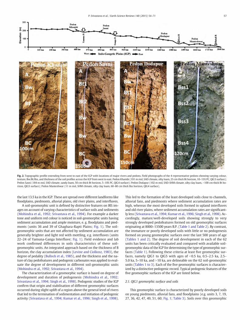
Fig. 2. Topographic profile extending from west to east of the IGP with locations of major rivers and pedons. Field photographs of the 4 representative pedons showing varying colour,texture, Bw/Bt/Bss, and thickness of the soil profiles across the IGP fromwest to east. Pedon Khambi (191mmsl, SAD climate, silty loam, 25 cm thick Bt horizon, 10–15% PC, QIG3 surface);Pedon Sasni (184 mmsl, SAD climate, sandy loam, 50 cm thick Bt horizon, 5–10% PC, QIG4 surface); Pedon Dodapur (102 mmsl, SAD-SHM climate, silty clay loam, N100 cm thick Bt ho-rizon, QIG5 surface); Pedon Manteshwar (11 m msl, SHM climate, silty clay loam, 60–80 cm thick Bss horizon, QIG4 surface).
57P. Srivastava et al. / Earth-Science Reviews 140 (2015) 54–71
the last 13.5 ka in the IGP. These are spread over different landforms likefloodplains, piedmonts, alluvial plains, old river plains, and interfluves.
A soil-geomorphic unit is defined by distinctive features on IRS im-ages on account of varying characteristics of surface soils and sediments(Mohindra et al., 1992; Srivastava et al., 1994). For example a darkertone and uniform red colour is noticed in soil-geomorphic units havingsediment accumulation and ample moisture, e. g. floodplains and pied-monts (units 36 and 39 of Ghaghara-Rapti Plains; Fig. 1). The soil-geomorphic units that are not affected by sediment accumulation aregenerally brighter and light red with mottling, e.g. interfluves (units22–24 of Yamuna-Ganga Interfluve; Fig. 1). Field evidence and labwork confirmed differences in soils characteristics of these soil-geomorphic units. An integrated approach based on the thickness of Bhorizon, the clay accumulation index (Levine and Ciolkosz, 1983), thedegree of pedality (Bullock et al., 1985), and the thickness and the na-ture of clay pedofeatures and pedogenic carbonateswas applied to eval-uate the degree of development in different soil-geomorphic units(Mohindra et al., 1992; Srivastava et al., 1994).
The characterization of a geomorphic surface is based on degree ofdevelopment and duration of pedogenesis (Mohindra et al., 1992;Srivastava et al., 1994; Singh et al., 1998). Pedogenic studies of the IGPconfirm that origin and stabilisation of different geomorphic surfacesoccurred during slight uplift of a region above the general level of riversthat led to the termination of sedimentation and initiation of pedogenicactivity (Srivastava et al., 1994; Kumar et al., 1996; Singh et al., 1998).
This led to the formation of the least developed soils close to channels,alluvial fans, and piedmonts where sediment accumulation rates arehigh, whereas the most developed soils formed in upland interfluvesand old river plains, where sediment accumulation rates are significant-ly less (Srivastava et al., 1994; Kumar et al., 1996; Singh et al., 1998). Ac-cordingly, mature/well-developed soils showing strongly to verystrongly developed pedofeatures formed on old geomorphic surfacesoriginating at 8000–13500 years B.P. (Table 1 and Table 2). By contrast,the immature or poorly developed soils with little or no pedogenesisformed on young geomorphic surfaces over the last 500 years of age(Tables 1 and 2). The degree of soil development in each of the 62units has been critically evaluated and compared with available soil-geomorphic data of the IGP for determining the type of geomorphic sur-faces (Table 1). Following these criteria at least five geomorphic sur-faces, namely QIG1 to QIG5 with ages of b0.5 ka, 0.5–2.5 ka, 2.5–5.0 ka, 5–10 ka, and N10 ka, are delineable on the 62 soil-geomorphicunits (Tables 1 to 3). Each of the five geomorphic surfaces is character-ized by a distinctive pedogenic record. Typical pedogenic features of thefive geomorphic surfaces of the IGP are listed below.
2.1. QIG1 geomorphic surface and soils
This geomorphic surface is characterized by poorly developed soilson young piedmonts, alluvial fans, and floodplains (e.g. units 3, 7, 19,27, 36, 42, 47, 49, 51, 60; Fig. 1; Table 3). Soils over this geomorphic

Table 1Criteria for determining relative maturity of the soils and geomorphic surfaces of the IGP (after Srivastava et al., 1994; Kumar et al., 1996; Singh et al., 1998).
Geomorphic surface,Age (ka)
Representative soil-geomorphic units Typical features of a Pedon (after Srivastavaet al., 1994)
Degree of soil development
Horizonation, B horizon thickness, Structure,Texture, Pedogenic carbonate (PC),Classification
QIG1 (b0.5 ka) Units 36, 42 in floodplains and piedmonts(Fig. 1)
Ap/C, 0–15 cm, Massive, Sandy loam, 2–4% PCin lower horizons, Typic Ustorthent
Little or no pedogenesis in youngestgeomorphic surface
QIG2 (0.5–2.5 ka) Units 28, 37,39 in young river plains andremnant piedmonts (Fig. 1)
Ap/Bw//BC, 20–50 cm, Weak subangularblocky, Sandy and silty loam, 2–5% PC in Bwhorizons, Typic Ustochrept
Weakly developed soils with thin 20–30 μmthick clay pedofeatures
QIG3 (2.5–5 ka) Units 22, 32,35 in old river plains and upperinterfluves (Fig. 1)
Ap/Bw/Bt/BC, 50–85 cm, Moderatesubangular blocky, Silty loam, 2–10% PC inBw/Bt horizons, Typic Ustochrept and TypicHaplustalfs
Moderately developed soils with 50–60 μmthick clay pedofeatures
QIG4 (5–8 ka) Units 10, 23, 33, 40 in middle parts ofinterfluves (Fig. 1)
Ap/Bw/Bt/BC, 80–100 cm, Strong subangularblocky, Silty clay loam, little or no PC, TypicHaplustalfs
Strongly developed soils with 80–100 μmthick clay pedofeatures
QIG5 (N10 ka) Interfluves Units 5, 8,11, 20,24,34 in lowerparts of interfluves and oldest piedmonts(Fig. 1)
Ap/Bw/Bt/BC, 100–130 cm, Very strongsubangular blocky, Silty clay loam, 2–5% PC inBt horizons, Typic Haplustalfs
Very strongly developed soils with 100–200 μm thick clay pedofeatures
58 P. Srivastava et al. / Earth-Science Reviews 140 (2015) 54–71
surface are usually characterized by A/C profiles rarely with thin (15–20 cm) Bw horizons. Micromorphology of the soils from this geomor-phic surface showed apedal to weakly developed subangular blockystructure, fresh to weakly alteredmineral grains, lithorelicts, and undif-ferentiated b-fabrics (Srivastava and Parkash, 2002). Pedogenic carbon-ate as micritic nodules is common only in piedmont soils of the west,but a rare feature in floodplain soils. Tentative age of this geomorphicsurface is assigned as b0.5 ka on account of little or no pedogenesis(Mohindra et al., 1992; Srivastava et al., 1994).
2.2. QIG2 geomorphic surface and soils
It is defined by weakly developed soils on remnant piedmonts, riverplains, and alluvial fans that were stabilised during 0.5 ka to 2.5 ka (e. g.units 12–15, 17, 18, 20, 25, 28, 31, 37, 39, 46, 48, 52, 54, 58, 61, 62; Fig. 1;Table 3). Soils over this geomorphic surface are characterized by 25–
Table 2Soil ages based on C14, TL, Archaeological, and Historical evidences.
Soil Geomorphic unit(Fig. 1)
Geomorphic surface C14, TL/OSL, Archaeological, His
11 QIG 5 C14 age data: Sambhar Lake, Ra2.8 m: 8300 ± 135 yrs; 1.9 m:4510 ± 135 yrs)
15 QIG 2 C14 age data: Rewasa, Bhiwani,3640 ± 90 yrs)
12–15 QIG 2 Archaeological evidence and sh• Early Harrapan (2500–1700BCYamuna tributaries to Ghagghar• Late Harrapan (1700–1000 BC)tributaries to Ghagghar shifted
23 QIG 4 • C14 age of calcrete (6500 BP)• TL date (8300 BP)
22 QIG 3 • Hub of Ochre Pottery Culture (• TL dates of 4 unpaired terracesand T2: 2500 BP and 1600 BP)
34 QIG 5 • C14 age of calcretes (11000 BP• TL date (13600 BP)
44–46 QIG 2-QIG4 Historical evidence of eastwardthe last 5000 yrs)
49–50 QIG 1-QIG3 C14 ages (2.0 m: 2400 ± 45 yrs0.5 m: 765 ± 45 yrs BP)
54 QIG 2 TL age (1.5 ka)57 QIG 3 TL age (3.5 ka)56 QIG 4 TL age (5.4–6.5 ka)55 QIG 5 Early-Middle Pleistocene (Later
45 cm thick Bw horizons that show weak-moderate pedality andsubangular blocky structures (Mohindra et al., 1992; Srivastava et al.,1994; Kumar et al., 1996; Singh et al., 1998). Thin (20–30 μm) illuvialclay pedofeatures are common but b1% in the Bw horizon of thesesoils. Coarse mineral grains show weak alteration defined by bleachingand exfoliation of biotite and formation of clay minerals after feldspars.It is characterized by weak to moderate cross striated b-fabrics. Pedo-genic carbonate as diffused nodules of micrite is common feature withextensive dissolution and reprecipitation features in soils over westernand central parts of the IGP (Mohindra et al., 1992; Srivastava et al.,1994; Kumar et al., 1996).
2.3. QIG3 geomorphic surface and soils
This geomorphic surface is defined by moderately-to-strongly de-veloped soils in old river plains and upper parts of interfluves that
torical evidence Reference
jasthan (3.2 m: 9250 ± 130 yrs;6235 ± 315 yrs; 1.4 m:
Singh et al. (1974)
Holocene lake, Haryana (1.2 m: Bhatia and Singh (1988)
ifting of paleochannels): wet climate; Sutluj and
: Dry climate; Sutluj and Yamunatowards present course
Pal et al. (1980); Singh (1971); Singh et al.(1974)
Kumar et al. (1996); Das (1993); Srivastavaet al. (1994)
1900 BC–1000 BC)(T0-T3) above Solani River (T3
Misra (1984), Kumar et al. (1996); Vohra(1987)
–9000 BP) Rajagopalan (1992); Das (1993); Srivastavaet al. (1994)
shift of Gandak river (80 km over Mathur (1969); Mohindra et al. (1992)
BP, 1.5 m: 1100 ± 45 yrs BP, Sinha et al. (1996)
Singh et al. (1998)Singh et al. (1998)Singh et al. (1998)
itic uplands) Singh et al. (1998)

Table 3A summarised account of soil-geomorphology of the entire IGP. The 62 soil-geomorphic units (1–62) are detailed in the Fig. 1 and its legend. Five geomorphic surfaces (QIG1 to QIG5) indicate degree of development and duration of pedogenesis. The12 soil-geomorphic groups of the IGP contain various soil-geomorphic units and geomorphic surfaces and are defined in Section 2.7 of the article. The climatic zones (HA to PH) are detailed in legend of the Fig. 5.
Soil Geo- morphicunit no
Climate (MAR mm) Degree of soildevelopment
Geo morphic surface Soil Age Dominant Soil Order Reference (125 pedons marked as darkcircles in Fig. 1; after referred works)
New data (60 pedons marked as open circles inFig. 1; after Pal et al., 2010; Aruche, 2014)
Estimate after Srivastava et al., 1994; Kumar et al., 1996;Singh et al., 1998
Ravi-Ghagghar Plains (RGP)1 HA-SAD (450) Moderate QIG 3 2.5–5 ka Inceptisols, Alfisols Sehgal, 1974; NBSSLUP 1995a -2 HA-SAD (450) Strong QIG 4 5–10 ka Alfisols -do- -3 SAD (675) Very weak QIG 1 b0.5 ka Entisols -do -4 SAD (675) Strong QIG 4 5–10 ka Alfisols -do- -5 SAD (500) Very strong QIG 5 N10 ka Vertic Haplustalfs -do- Dhadde, Jagitpur6 HA-SAD (400) Strong QIG 4 5–10 ka Alfisols -do- -7 SAM-SHD (875) Very weak QIG 1 b0.5 ka Entisols -do- -8 SAM-SHD (905) Very strong QIG 5 N10 ka Oxyaquic Haplustalfs -do- Berpura9 SAD (674) Moderate QIG 3 2.5–5 ka Typic Ustipsamments,
Inceptic Haplustalfs-do- Bhanra, Fatehpur
10 SAD (674) Strong QIG 4 5–10 ka Oxyaquic Haplustalfs -do- Phaguwala11 HA (265) Very strong QIG 5 N10 ka Torrifluventic Haplustalfs,
Aridic Haplustalfs-do- Masitwali, Nihalkhera, Jodhpur Ramana
Ghagghar-Yamuna Plains (GYS)12 SAM-SHD (875) Weak QIG 2 0.5–2.5 ka Inceptisols Singhai et al., 1991; NBSSLUP 1995b -13 SAD (625) Weak QIG 2 0.5–2.5 ka Inceptisols -do- -14 SAD (625) Weak QIG 2 0.5–2.5 ka Inceptisols - Maham15 SAD (625) Weak QIG 2 0.5–2.5 ka Inceptisols - Nonand, Bahadurgarh16 SAD 720 Moderate QIG 3 2.5–5 ka Typic Natrustalfs, Inceptisols Singhai et al., 1991; NBSSLUP 1995b; Zarifa Viran, Khambi, Bamnikhera, Singhu,
Jatikalan, Alipur17 HA (400) Weak, QIG 2 0.5–2.5 ka Inceptisols Singhai et al., 1991; NBSSLUP 1995b -18 SAD (550) Weak, QIG 2 0.5–2.5 ka Inceptisols Singhai et al., 1991; Kumar et al., 1996 IGI, Shanticolony
Yamuna-Ganga Interfluve (YGI)19 SHM, (1250) Very weak QIG 1 b0.5 ka Entisols Kumar et al., 1996 -20 SHM, (1250) Very Strong QIG 5 N10 ka Alfisols -do- -21 SHM, (1250) Weak QIG 2 0.5–2.5 ka Inceptisols -do- -22 SAD (675) Moderate, QIG 3 2.5–5 ka Inceptisols, Alfisols -do- -23 SAD (650) Strong QIG 4 5–10 ka Alfisols -do- Hirapur, Sakit, Jattari, Lodha, Sasni24 SAD-SHM (875) Very strong QIG 5 N10 ka Alfisols -do- Pawasgaon, Hanumanta
Ganga-Ghaghara Interfluve (GGI)25 SAD-SHM (875 Weak QIG 2 0.5–2.5 ka Inceptisols Kumar et al., 1996 -26 SHM (1252) Very strong QIG 5 N10 ka Typic Haplustalfs -do- Haldi27 SHM (1250) Very weak QIG 1 b0.5 ka Entisols Srivastava et al., 1994 -28 SAD-SHM (875) Weak QIG 2 0.5–2.5 ka Inceptisols -do- -
(continued on next page) 59P.Srivastava
etal./Earth-ScienceReview
s140
(2015)54
–71

Table 3 (continued)
Soil Geo- morphicunit no
Climate (MAR mm) Degree of soildevelopment
Geo morphic surface Soil Age Dominant Soil Order Reference (125 pedons marked as darkcircles in Fig. 1; after referred works)
New data (60 pedons marked as open circles inFig. 1; after Pal et al., 2010; Aruche, 2014)
Estimate after Srivastava et al., 1994; Kumar et al., 1996;Singh et al., 1998
29 SAD-SHM (875) Very strong QIG 5 N10 ka Alfisols Kumar et al., 1996 -30 SAD-SHM (875) Moderate, QIG 3 2.5–5 ka Inceptisols, Alfisols -do- -31 SAD-SHM (875) Weak QIG 2 0.5–2.5 ka Inceptisols -do- -32 SAM-SHD (1052) Moderate, QIG 3 2.5–5 ka Typic Haplustalfs Srivastava et al., 1994 Simiri33 SAD-SHM (875) Strong QIG 4 5–10 ka Alfisols -do- -34 SAD-SHM (875) Very strong QIG 5 N10 ka Alfisols -do- Hakimkheda, Naryanpur, Gangaganj, Bhajakheda,
Gaurwa, Bikapur, Dodapur, Bhetrigaon35 SHM (1250) Moderate, QIG 3 2.5–5 ka Inceptisols, Alfisols -do- -
Ghaghara-Rapti Plains36 SHM (1250) Very weak QIG 1 b0.5 ka Entisols Srivastava et al., 1994 -37 SHM (1250) Weak QIG 2 0.5–2.5 ka Inceptisols -do- -38 SHM (1250) Moderate, QIG 3 2.5–5 ka Inceptisols, Alfisols -do- -39 SHM (1250) Weak QIG 2 0.5–2.5 ka Inceptisols -do- -40 SHM (1250) Strong QIG 4 5–10 ka Alfisols -do- -41 SHM (1250) Very strong QIG 5 N10 ka Alfisols -do- -
Gandak Megafan42 SHM (1250) Very weak QIG 1 b0.5 ka Entisols Srivastava et al., 1994 -43 SHM (1250) Moderate, QIG 3 2.5–5 ka Inceptisols, Alfisols Mohindra et al., 1992 -44 SHM (1250) Strong QIG 4 5–10 ka Alfisols -do- -45 SHM (1250) Moderate, QIG 3 2.5–5 ka Inceptisols, Alfisols -do- -46 SHM (1250) Weak QIG 2 0.5–2.5 ka Inceptisols -do- -
Gandak-Kosi Interfan47 SHM (1250) Very weak QIG 1 b0.5 ka Entisols Mohindra et al., 1992 -48 SHM (1250) Weak QIG 2 0.5–2.5 ka Inceptisols -do- -49 SHM (1250) Very weak QIG 1 b0.5 ka Entisols Mohindra et al., 1992 -50 SHM (1250) Moderate, QIG 3 2.5–5 ka Fluvenitc Endoquepts, Typic
Endoaqualfs, EntisolsSinha and Friend, 1999 Nanpur, Gaupur
Kosi Megafan51 SHM (1250) Very weak QIG 1 b0.5 ka Entisols Singh et al., 1993 -
Mahnanda-Tista Plains52 HM (1750) Weak QIG 2 0.5–2.5 ka Inceptisols Singh et al., 1998 -
Barind Tract53a HM (1583) Moderate, QIG 3 2.5–5 ka Inceptisols, Alfisols Singh et al., 1998 Alampur53b HM (1750) Strong QIG 4 5–10 ka Alfisols -do- -
Deltaic Plains54 HM (1750) Weak QIG 2 0.5–2.5 ka Inceptisols Singh et al., 1998 Jodipur55 HM (1750) Very strong QIG 5 N10 ka Alfisols -do- -56 SHM (1404) Strong QIG 4 5–10 ka Vertic Endoaqualfs,
ChromicVertic Endoaqualfs-do- Tirula, Kondal Mauza, Manteshwar, Nasigram,
Hangram, Konapara, Madhpur, Sasanga57 SHM (1583) Moderate, QIG 3 2.5–5 ka Typic Endoaquerts Pal et al., 2010 Chunchura
Tista-Brahamputra Plains58 PH (2000) Weak QIG 2 0.5–2.5 ka Inceptisols Aruche, 2014 -59 PH (3292) Moderate, QIG 3 2.5–5 ka Typic Endoaqualfs Pal et al., 2010 Seoraguri60 PH (N2500) Very weak QIG 1 b0.5 ka Entisols Aruche, 2014 -61 PH (N2500) Weak QIG 2 0.5–2.5 ka Inceptisols -do- -62 PH (N2500) Weak QIG 2 0.5–2.5 ka Inceptisols -do- -
60P.Srivastava
etal./Earth-ScienceReview
s140
(2015)54
–71

61P. Srivastava et al. / Earth-Science Reviews 140 (2015) 54–71
were stabilised during 2.5–5 ka (e.g. Units 1, 9, 16, 22, 30, 32, 35, 38, 43,45, 50, 53a, 57, 59; Fig. 1; Table 3). These are characterized by 50–80 cmthick Bw/Bt horizons. Thin sections of these soils show strongly devel-oped subangular blocky structure, moderate to strong pedality, appre-ciable alteration of biotite and feldspar grains, and strongly developedcross-striated b-fabrics (Srivastava and Parkash, 2002). There is appre-ciable increase of illuvial clay with depth, occurring as thick (50–60 μm) clay coatings that accounts for N1% in many soils (Srivastavaand Parkash, 2002). Pedogenic carbonate commonly occurs as irregularshaped nodules of micrite in lower parts of the soils from western andcentral parts of the IGP. Soils of this geomorphic surface followInceptisols and Alfisols characteristics (Srivastava et al., 1994).
2.4. QIG4 geomorphic surface and soils
This geomorphic surface is defined by lower and middle parts of themajor interfluves, old surfaces of mega fans, old river plains (units 2, 4,6, 10, 23, 33, 40, 44, 53b, 56; Fig. 1; Table 3). Age of these soils suggeststabilisation of this surface occurred during 5–8 ka (Tables 1 and 2).The soils occurring over this surface are very mature with 75–100 cmthick Bt horizons. Thin section of these soils show strong pedality,strong alteration of mineral grains, and extensive domains of crossand reticulate striated b-fabrics (Srivastava and Parkash, 2002). Illuvialclay pedofeatures constitute N1% of the thin sections and are 80–100 μm thick and microlaminated in nature. Pedogenic carbonate iscommon in soils of the interfluves as densemicritic nodules with disso-lution and reprecipitation features. These soils belong to Alfisols charac-teristics (Table 3).
2.5. QIG5 geomorphic surface and soils
This geomorphic surface is defined by the most strongly devel-oped soils of the IGP in interfluves, oldest piedmonts and old riverplains (e.g. units 5, 8, 11, 24, 26, 29, 34, 41, 55; Fig. 1; Table 3). Ageof this surface is assigned as 10–13.5 ka on the basis of C14 and OSLdates (Table 2). This geomorphic surface is marked by N100 cmthick Bt horizons with very strongly developed pedofeatures(Srivastava et al., 1994; Singh et al., 2006). Thin sections of thesoils showed very strong pedality and extensive illuvial claypedofeatures (N1%) and pedogenic carbonate features of differentphases. The clay pedofeatures are marked by thick 100–200 μmmicrolaminated clay coatings along the voids. Coarse mineral grainsshow strong alteration of biotite and feldspar grains. It is marked byvery strong cross and reticulate striated b-fabrics. These soils belongto Alfisols characteristics (Srivastava et al., 1994).
2.6. Significance of the geomorphic surfaces of the IGP
The geomorphic surfaces identified over the entire IGP are similar tothe geomorphic surfaces in interfluves of the Greenfield Quadrangle,Iowa defined by Ruhe (1956, 1969). Accordingly a geomorphic surfaceis defined as a portion of the landsurface comprising both erosionaland depositional elements, having continuity in time and space. Itmay occupy appreciable part of the landscape and may include manylandforms. It is established when a stable surface is first presentedsubaerial weathering and soil development (Ruhe, 1969). The geomor-phic surfaces of the IGP are comparable to the post-incisive soilchronosequences marked by a sequence of progressively younger sur-faces in which soils formation may begin (Vreeken, 1975; Mohindraet al., 1992; Srivastava et al., 1994; Huggett, 1998). The geomorphic sur-faces are potentially useful to comprehend the pedogenic response ofthe IGP soils to climate change, neotectonics, and factors of the soil for-mation (cf. Sections 3–5).
2.7. Soil-geomorphic groups of the IGP
A soil-geomorphic group consists of several soil-geomorphic unitsthat occur adjacent to each other within a region bound by different riv-ers or other landforms. In field, a soil-geomorphic group could be identi-fied as grouping of distinctly different soils on different components of alandform or the adjacent landforms bound bymajor rivers. For example,the Ganga-Ghaghara Interfluve (GGI) is a group of 11 soil-geomorphicunits (i.e. Units 25–35; Fig. 1; Table 3). Based varying pedogenic develop-ment in these units five geomorphic surfaces (QIG1–QIG5) are identifiedin the GGI (Table 3). Following this criteria, the 62 soil-geomorphic unitsof the IGP are organised in to 12 soil-geomorphic groups that are definedas: (1) Ravi-Ghagghar Plains (RGP), (2) Ghagghar-Yamuna Plains(GYP), (3) Yamuna-Ganga Interfluve (YGI), (4) Ganga-GhagharaInterfluve (GGI), (5) Ghaghara-Rapti Plains (GRP), (6) GandakMegafan (GMF), (7) Gandak-Kosi Interfan (GKI), (8) Kosi Megafan(KMF), (9) Mahananda-Tista Plains (MTP), (10) Barind Tract (BT),(11) Deltaic Plains (DP), and (12) Tista-Brahmaputra Plains (TBP). Asynthesis of the soils for the entire IGP spread over 62 soil-geomorphic units and the 12 soil-geomorphic groups is presented inTable 3. A brief description of the 12 soil-geomorphic groups with dif-ferent geomorphic surfaces (QIG1–QIG5) is presented below. It high-lights the role of soil development on different geomorphic surfaces inresponse to climate change and neotectonics.
2.7.1. Ravi-Ghagghar Plains (RGP)This soil-geomorphic group defines the western most part of the
IGP, between the Ravi River and the Ghagghar River and is marked bywesterly drainage. The RGP includes eleven soil-geomorphic units(Units 1–11, Fig. 1; Table 3) dominated by well-developed soilsthat belong to QIG4–QIG5 surfaces (5.0–10 ka, N10 ka) for mostparts of the RGP. The RGP is also marked by few weakly and moder-ately developed soils (QIG1: e.g. units 3 and 7, QIG3: e.g. unit 9;Table 3) in the areas of active sedimentation like floodplains, pied-monts, and interfluves (Fig. 1). The dominance of Alfisols andInceptisols in the RGP indicates moderate-strong degree of develop-ment on QIG3-QIG5 surfaces (Sehgal, 1974; Pal et al., 2009b, 2010).
2.7.2. Ghagghar-Yamuna Plains (GYP)The GYP is themajor geomorphic divide that separates fluvial plains
with westerly drainage (Ravi, Beas, Sutluj, and Ghagghar Rivers) fromeasterly drainage (Yamuna, Ganga, Ghaghara Rivers) systems. It is char-acterized by weakly developed soils (QIG2: Inceptisols; 0.5–2.5 ka) thatalso forms an important soil-geomorphic divide between the well-developed soils (QIG4-QIG5: 5–10 ka: Alfisols) on either sides of theGYP (Fig. 1). Seven soil-geomorphic units identified over the GYPoccur on uplands between theGhagghar andYamuna rivers, theAeolianPlains, and the Old Yamuna Plains (units 12–17; Fig. 1; Table 3). Soils intheGYP are characterized byweakly developed profileswith Inceptisolsin N90% of the area (Singhai et al., 1991; Pal et al., 2010; Aruche, 2014).
2.7.3. Yamuna-Ganga Interfluve (YGI)The YGI occurs to the immediate east of the soil-geomorphic divide,
the GYP. It is one of the largest soil-geomorphic groups with upland in-terfluve between the Ganga and the Yamuna rivers (Fig. 1). It consistsof six soil-geomorphic units that are dominated by well developed soilswith predominance of Alfisols on QIG3–QIG5 surfaces (units 19–24;Fig. 1; Table 3). The northern most part of the YGI is characterized by in-cised piedmonts and the oldest soil on QIG5 surface (Kumar et al., 1996).
2.7.4. Ganga-Ghaghara Interfluve (GGI)Similar to the YGI, the interfluve between the Ganga and the Gha-
ghara Rivers comprises a very large part of the IGP. It is made up of 11soil-geomorphic units (units 25–35; Fig. 1; Table 3). More than N50%of the soils in the GGI occur on the oldest geomorphic surface (QIG5:N10 ka). In the northernmost part of the GGI, immediately below the

62 P. Srivastava et al. / Earth-Science Reviews 140 (2015) 54–71
foothills, it is marked by young soils on alluvial fans and fluvial plains(QIG1-QIG3 surfaces: Srivastava et al., 1994; Singh et al., 2006). Amajor part of the GGI, approximately 60–80% is dominated byAlfisols (Srivastava et al., 1994; Pal et al., 2010).
2.7.5. Ghaghra-Rapti Plains (GRP)The GRP occurs to the east of GGI and it is marked by upland inter-
fluve, fluvial plains and piedmonts between the Ghaghara and theRapti Rivers (Srivastava et al., 1994). About 40–50% of the GRP is cov-ered by young soils on QIG1-QIG3 surfaces and 50–60% old the soilson QIG4-QIG5 surfaces (Srivastava et al., 1994). The northern partof the GRP is characterized by incised piedmont with QIG1 andQIG2 surfaces and numerous paleochannels of the Ghaghara Riverwith QIG1 soils (Srivastava et al., 1994).
2.7.6. Gandak Megafan (GMF)The GMF is one of the largest wet alluvial fans of the world that
occurs in central part of the IGP. It is marked by an 80 km shift ofthe Gandak River over the last 5 ka (Mohindra et al., 1992). It consistsof five soil-geomorphic units that show an increase in the degree ofsoil development from east towest with oldest soils on QIG4 surfaces(units 42–46; Fig. 1; Table 3).
2.7.7. Gandak-Kosi Interfan (GKI)The GKI is a geomorphic low with active sedimentation between
the Gandak megafan in the west and the Kosi megafan in the east.Four soil-geomorphic units, making up the GKI, contain predomi-nantly weakly developed soils on QIG1-QIG2 surfaces (units 47 and48; Fig. 1; Table 3). Some of the soils in themiddle part of the interfanshow moderate development on QIG3 surface (units 49 and 50;Fig. 1; Table 3).
2.7.8. Kosi Megafan (KMF)The tear drop shaped KMF is the largest wet alluvial fan in the world
with a diameter of about 120 km and area of ~16,000 km2. It is markedby N110 km westward shifting of the Kosi River channel over the last220 years (Wells and Dorr, 1987; Singh et al., 1993). Facies analysis ofthe KMF shows rapid sedimentation (Singh et al., 1993). It mainly con-sists of very weakly developed soils that correspond to QIG1 surface ofthe IGP (Singh et al., 1993).
2.7.9. Mahananda-Tista Plains (MTP)TheMTP lying immediately in the east of the Kosi megafan is limited
by piedmont in the north and fluvial plains of Mahananda and Tista Riv-ers in the south. Soils of theMTP are characterized byweakly developedsoils as Entisols and Inceptisols on the QIG1–QIG2 surfaces (NBSSLUP,1992; Singh et al., 1998).
2.7.10. Barind Tract (BT)The BT is marked by uplifted region in the south of Mahananda-
Tista Plains. This is associated with an east–west trending uplandwith its major portion in Bangladesh. At least three topographiclevels with height ranging from 5 to 25 m above the adjoining flood-plains occur on the Barind Tract (Singh et al., 1998). The associatedsoils shows predominance of Inceptisols and Alfisols developed onQIG3-QIG4 surfaces (units 53–54; Fig. 1; Table 3).
2.7.11. Deltaic Plains (DP)The deltaic plains (DP) are marked by the uplands of the
Chhotanagpur-Rajmahal Hills (35–120 m msl) and the old and youngfluvial plains (Units 54–56; Fig. 1; Table 3). The landscape is very gentlysloping to undulating with dendritic and annular drainage and red soils(Singh et al., 1998). Soils of the upland show strong pedogenic develop-ment with dominance of ferruginous Alfisols on the QIG5 surfaces(Singh et al., 1998; Aruche, 2014). The Old fluvial/deltaic Plains, locatedto the east of the upland area, are levelled with ferruginous soils. The
plains include the Bhagirathi-Ajay Plains, the Ajay-Silai Plains andDamodar-Deltaic Plain that contain weak to moderately developedInceptisols, Alfisols, and Vertisols (Singh et al., 1998; Pal et al., 2010;Aruche, 2014).
2.7.12. Tista-Brahmaputra Plains (TBP)The TBP demarcates the eastern most part of the IGP with piedmont
and fluvial plains (units 58–62; Fig. 1; Table 3). It is marked by west-ward flowing braided channel of the Brahmaputra River and numeroussmall alluvial fans and piedmonts below the foothills (Fig. 1). Activesedimentation over this area shows the dominance of only weakly de-veloped soils as Entisols and Inceptisols on QIG1 and QIG2 surfacesand moderately developed soils on QIG3 surfaces (units 58–62; Fig. 1;Table 3).
2.8. Field characteristics of soils across the IGP
Field characteristics of the 4 representative pedons across the IGPare distinguishable by soil texture, Bw/Bt horizon thickness, andpedogenic carbonates (Fig. 2). The soils over the western part ofthe IGP beyond the Yamuna river show coarse texture, thin Bw/Bthorizon with large amount of pedogenic carbonates (e.g. PedonKhambi, Fig. 2), but the soils over the central parts in interfluve re-gions are marked by sandy to silty clay loam with thick Bt horizonsand less pedogenic carbonates (e.g. Pedons Sasni and Dodapur,Fig. 2). The soils over the eastern most part in the deltaic region aremarked by fine silty clay to clayey texture, vertic features, and ab-sence of pedogenic carbonates (e.g. Pedon Manteshwar, Fig. 2).
2.9. Soil Ages of the IGP
The IGP was considered to consist of an older and a younger alluvi-um. Marked by a higher degree of pedogenesis, the older alluviumwas assigned a lower Pleistocene age (Wadia, 1966; Bhattacharya andBanerjee, 1979) or a minimum age of 120 ka (Singh, 1988). Recentsoil-geomorphic studies demonstrate the presence of more than twogeomorphic surfaces in the IGP (Mohindra et al., 1992; Srivastavaet al., 1994, 1998; Kumar et al., 1996; Singh et al., 1998). Age of theIGP soils that formed on five geomorphic surfaces range from b0.5 kato 13.5 ka (Tables 1 and 2). The soil ages are based on radiocarbon, ther-moluminescence (TL), archaeological, and historical data from the IGP(Table 2). The TL dates are greater than the radiocarbon dates ofcalcretes (Table 2). This is due to the fact that TL dates give the timeof deposition and start of pedogenesis, whereas calcrete takes time toform and it is also affected by dissolution and reprecipitation withinthe soil profile (Srivastava et al., 1994; Singh et al., 1998). TL dates areconsidered here as approximate maximum ages of soils. The `LateriticUpland` (unit 55, Fig. 1) with red soils of Early to Middle Pleistoceneage is the oldest soil of the IGP (Singh et al., 1998).
3. Holocene climatic fluctuations and pedogenic response of IGPsoils
The soil-geomorphic research during the last two decades hashelped in delineating the paleoclimatic record of the IGP during the Ho-locene. It also establishes the use of micromorphology, clay minerals,isotope geochemistry of pedogenic carbonates, and polygenetic pedo-genic features as important proxies for Holocene climate changes(Srivastava et al., 1998; Srivastava, 2001; Srivastava and Parkash,2002). Information from these proxies indicates two humid phases dur-ing soil formation over the IGP, one between 13.5 ka and 11.0 ka and theother between 6.5 ka and 4.0 ka. The intervening period witnessed thedry climate (Srivastava et al., 1998; Pal et al., 2000a; Srivastava, 2001;Srivastava and Parkash, 2002).
Micromorpholological studies reveal that soils of the IGP are polyge-netic (Srivastava and Parkash, 2002). The QIG5 soils on uplands are

63P. Srivastava et al. / Earth-Science Reviews 140 (2015) 54–71
marked by degraded illuvial clay pedofeatures of an early humid phase(13.5 ka–11.0 ka) and thick (150–200 μm) microlaminated claypedofeatures of a later humid phase (6.5–4.0 ka). The earlier claypedofeatures show degradation as bleaching, loss of preferred orienta-tion, development of a coarse speckled appearance and fragmentation,whereas those of the later phase are thick, smooth and strongly birefrin-gent microlaminated clay pedofeatures (Srivastava and Parkash, 2002).The illuviation was more extensive during the later phase, as indicatedby enrichment of groundmass as discrete pedofeatures of clayintercalations.
The dry phases of climate (early Holocene to 6.5 ka and after 4.0 ka)show dominance of the pedogenic carbonate (PC) formation and theirdissolution-reprecipitation in the subsequent wetter conditions(Srivastava, 2001; Srivastava and Parkash, 2002). Clay mineralogicalstudies of IGP soils show that biotite weathered to trioctahedral vermic-ulite and smectite during the semiarid-arid conditions and it trans-formed to interstratified smectite-kaolin (Sm/K) during the warm andhumid conditions (Srivastava et al., 1998). The relatively dry climatessince 4.0 ka lead to the preservation of vermiculite, smectite, and Sm/K assemblages in older soils of the IGP (Srivastava et al., 1998). The Car-bon and Oxygen isotope studies on the pedogenic carbonates from theolder soils (8–10 ka) reveal a relative depletion of 13C in comparisonwith younger soils (b2.5 ka), indicating low soil-respiration and drierconditions during the early Holocene (Srivastava, 2001). The paleocli-matic changes inferred through pedogenic carbonate of the IGP soilsare consistent with those reflected by the paleovegetation record(Gupta, 1978; Srivastava, 2001). The Holocene paleovegetation infor-mation from the IGP indicates the spread of Chenopodium and Typhaangustata biomass during the semiarid-arid climate that changed toAnogeissus and Tecomella spp. in warm and humid phase of climate(Gupta, 1978).
4. Neotectonics and pedogenic response of IGP soils
The tectonic framework of the vast and flat IGP can be organisedas basement and surface structural features. The basement structuralfeatures of the IGP extend as major transverse faults, ridges, and
Fig. 3. Basement structural features of the IGP (after Fuloria, 1969; Sastri et al., 1971; Valdiya, 1trending Aravalli-Delhi massif, Faizabad Ridge after Bundelkhand massif, Munger-Saharsa Ridgbasement faults as: NE trending faults along Delhi-Hardwar ridge, Sohna-Sonipat fault, MoradDepression and Munger-Saharsa ridge, Dubri Fault between Assam Plateau and Bengal basin, a
depressions (Fig. 3). The surface structural features are the faultsand tectonic blocks that are deciphered by mapping of soil-geomorphic units and the drainage pattern in the IGP (Fig. 4).Some of the surface faults are related to the basement and thesehave been active over the last 10 ka. These faults in the IGP are con-sidered analogues to the growth faults in the deltaic regions(Mohindra et al., 1992; Srivastava et al., 1994; Singh et al., 1998).The neotectonic structures are marked as surface ruptures as normalfaults and thrust splays that show topographic breaks up to ~20 m(Srivastava et al., 1994; Parkash et al., 2000; Pati et al., 2012). Devel-opment of the surface structural features in the IGP is mainly due tothemovement of the Indian Plate, causing compressive stresses fromthe S55°W direction (Srivastava et al., 1994; Parkash et al., 2000).
The pedogenic response of the IGP to neotectonics is described here.In the western part of the IGP, soils on two sides of the Ghagghar Riverare very different in terms of degree of soil development. In its westernside, the soils aremarked bywell developed features onQIG3-QIG5 sur-faces in the Punjab, while on eastern side it is marked by weakly devel-oped soils on QIG2 surface in the Haryana. The contrasting nature of thesoils on two sides of theGhagghar River is due to the presence of a trans-verse fault along the Ghagghar River (Fig. 4; Singhai et al., 1991). Theupland in west of the Ghagghar river is related to shifting of Sutlujriver with many paleochannels (Pal et al., 1980). The Yamuna River isrelated to a fault along its course due to down warping in its west andreactivation of a major fault, i.e. Sohna-Sonipat fault (Garlapuri, 1984).Kumar et al. (1996) mapped this fault based on soil geomorphic devel-opment and contrasting soils on either sides and interpreted that thisfault represents a fault system with convexity towards southwest(Fig. 4). Similarly, the Ganga River in middle part of the IGP runs alonga fault system with convexity towards west (Srivastava et al., 1994;Kumar et al., 1996). This fault system is also demarcated by contrastingsoils on either side of the Ganga River (Srivastava et al., 1994; Kumaret al., 1996). The Yamuna Fault and the Ganga Fault merge in thesouth with similar upland soils on either side (e.g. QIG5 soils in units24 and 34; Fig. 4). The Ghaghara fault system demarcates boundariesbetween upland interfluve in the east and the west of the river(Srivastava et al., 1994).
976). Basement ridges as extension of peninsular parts as: Delhi-Hardwar Ridge after NEe after Satpura massif (shaded with cross), Sarda and Gandak depressions (shaded), andabad fault as extension of Great Boundary Fault (GBT), Patna fault as boundary of Gandaknd growth faults of the Bengal basin.

Fig. 4. Surface structural features of the IGP as longitudinal and transverse faults and tectonic blocks (after, Singhai et al., 1991; Mohindra et al., 1992; Srivastava et al., 1994; Kumar et al.,1996; Singh et al., 1998).
64 P. Srivastava et al. / Earth-Science Reviews 140 (2015) 54–71
Two transverse faults, the Lucknow and the Amethi faults, broadlycoincide with the Faizabad basement ridge (Figs. 3 and 4). The twofaults have resulted in segmentation of the interfluves over this region(Srivastava et al., 1994). The Gandak River has shifted ~80 km to eastin the last 5 ka due to tilting of the megafan (Mohindra et al., 1992).Contrasting soils on either side of the Gandak megafan are due toRapti and Gandak Faults that are unrelated to any basement feature ofthe region (Mohindra et al., 1992). The interfan between Gandakmegafan and Kosi megafan is marked by muddy sequences with rapidsedimentation (0.7–1.5 mm/a) and weakly developed soils (Sinha andFriend, 1999). The fault along the Kosi River is a sinistral fault that off-sets the Siwalik sediments for about 20 km. It broadly coincides with amajor transverse fault with down warping in the west (Raivermanet al., 1983). The soils over the deltaic region of the IGP occur withinBengal Sedimentary Basin bordering cratonic rocks (unit 55, Fig. 1).Singh et al. (1998) mapped soil-landscapes of the area and delineatedthree transverse faults, Chhotanagpur foothill fault (CFF), Medinapur-Farakka fault (MFF), and Damodar fault (DF) bounding tectonic blocks(Fig. 4). The landforms over the three tectonic blocks are marked by25 m, 20 m, and 6 m topographic relief with a down-throw towardseast (Singh et al., 1998). In an earlier study, a series of N-S trendingbasement faults were reported as Basin Margin Faults in this region(Sen-Gupta, 1966).
The pedogenic response to the neotectonics in the IGP can be ex-plained by tectonic movement of the fault bounded blocks (Srivastavaet al., 1994). Uplift of the blocks above the general level of rivers led tothe termination of sedimentation and initiation of pedogenic activity.Soils formed on the uplifted blocks, therefore, preserve the climate re-cord. The uplift of different blocks at different times provides a sequenceof soils that preserve signatures of the climate and the extent of soil de-velopment. The older soils are also modified by the later climate show-ing polygenetic features (Srivastava and Parkash, 2002). In view of theneotectonics of the IGP, following features within soils and geomorphicunits need to be highlighted: (i) Nearly 50% of the IGP is covered by up-land region with well developed soils on QIG4 – QIG5 surfaces in
western part of the Ghagghar, upland interfluves of the Yamuna-Ganga, Ganga-Ghaghara, Ghaghara-Rapti interfluves and some uplandregions of the deltaic plains (unit 55–56, Fig. 1). It implies strong pedo-genic activity since ~10 ka over these stable upland regions and activesedimentation in the remaining parts of the IGP with poorly developedsoils (Srivastava et al., 1994; Kumar et al., 1996; Singh et al., 1998). (ii)Sagging or down warping of large geomorphic surfaces or tectonicblocks bounded by faults resulted in greater sinuosity of the streamssuch as, the Gomti, Sai, Rapti and Sarju rivers in units 34, 401, 41;(Figs. 1 and 4 after Srivastava et al., 1994). (iii) The compressive forcesfrom SW, most likely played a key role in modifying the otherwise flatterrain to micro-low (0.5–1.0 m) and micro-high. It also influenced pe-dogenesis with dominance of highly sodic soils (Natrustalfs/Natraqualfs) in micro-low and less sodic soils over micro-high areas(Pal et al., 2003a).
5. Soils of the IGP: climatic variability, pedogenic processes, andtaxonomic classes
5.1. Climatic variability and soils of the IGP
Soils of the IGP are spread across the seven climatic zones varyingfrom hot-arid in the west to per humid conditions in the east (Fig. 5;Table 3). The soils in the western part of the IGP with hot-arid climateare marked by sandy loam texture and low organic carbon (OC).These soils are calcareous and moderately alkaline nature but notsodic due to less leaching and aridity (e.g. 4 benchmark soils; Table 3;Pal et al., 2010). Further east, the soils in semi-arid dry (SAD) climateare characterized by loam to sandy clay texture, low OC, calcareous,and neutral to moderate alkaline nature (e.g. 9 benchmark soils;Table 3; Pal et al., 2010). Some of the SAD soils are also sodic in nature(Pal et al., 2010). In the central and eastern part of the IGP with sub-humid dry (SHD) and sub-humid moist (SHM) climate, the soils arecharacterized by silty loam to silty clay loam texture, low OC, moderatealkanity, and less calcareous nature (e.g. 14 benchmark soils; Table 3;

Fig. 5.Map showing climatic variability across the IGPwith hot arid climate over thewestern part and per humid climate in the easternmost part in deltaic region (rainfall data after IMD,2009). The climatic zones stand for: HA-hot arid, SAD-semiarid dry, SAM-semiarid moist, SHD-sub humid dry, SHM-sub humid moist, HM- humid moist, PH- per humid.
65P. Srivastava et al. / Earth-Science Reviews 140 (2015) 54–71
Pal et al., 2010). In the southernmost part of the deltaic plainswith humidmoist (HM) climate, the soils are marked by silty clay to silty clay loamtexture, high OC, and saline-alkaline nature (e.g. 1 benchmark soil;Table 3; Pal et al., 2010). Soils over the Tista-Brahmaputra Plains (TBP)are characterized by per humid climate (PH), silty clay loam to sandyclay loam texture, high OC, slight acidity, and no pedogenic CaCO3 (e.g.2 benchmark soils; Table 3; Pal et al., 2010). The prevailing climatic vari-ability across the entire IGP plays a key role in the contemporary pedo-genesis. It also influenced soils on older geomorphic surfaces withpolygenetic features (Srivastava and Parkash, 2002; Pal et al., 2010).
5.2. Pedogenic processes and taxonomic classes of soils in IGP
Themajor pedogenic processes in soils of the IGP are addition anddepletion of organic carbon (OC), formation of pedogenic CaCO3
(PC), illuviation of clay particles, and argilli-pedoturbation duringthe Holocene (Pal et al., 2000a,b, 2003b; Srivastava, 2001). The ped-ogenic processes resulted in formation of Entisols, Inceptisols,Alfisols and Vertisols with varying climate and parent materialacross the IGP. The PC occurring as powdery to large nodules (Fig.6a–h), is marked by a general decrease in subsoils from hot arid tosub humid climates (Pal et al., 2000a; Srivastava, 2001). The PC iseven absent in soils of per humid regions (e.g. Seoraguri soils, unit59, Fig. 1). In western part of the IGP, the soils with Entisols andInceptisols characteristics formed on QIG1 and QIG2 surfaces withlarge amount of PC in the soil profiles due to aridity. The Alfisols com-monly occur in all climatic zones and correspond to QIG4 and QIG5geomorphic surfaces of the IGP. In hot-arid and semiarid dry climatessuch soils are highly alkaline and mostly sodic in nature (Haplargidic/Typic/Vertic Natrustalfs), whereas in SAM, SHD, SAM and PH climates,the soils becomemildly alkaline, neutral-acidic, and non-sodic in nature(Oxyaquic/Typic Haplustalfs, Aeric/Vertic/Typic/Umbric Endoaqualfs)(Pal et al., 2010). The increasedflux of cratonic origin enrichedwith pla-gioclase and smectitic clay as its weathering product has resulted verticfeatures in many soils over western and eastern parts of the IGP(Figs. 6g, h) (Pal et al., 2010; Aruche, 2014).
Most of the IGP soils, except than those with vertic characters, aremarked by weathering of biotite on a large scale (Pal et al., 1994,
2003a; Srivastava et al., 1998; Srivastava and Parkash, 2002). Insteadof pure void argillans, impure clay pedofeatures (Figs. 7a–f) with im-pairment of parallel orientation of clay platelets along the voids are typ-ical of these soils (Pal et al., 1994, 2003b, 2009a, 2010). The presence ofclay pedofeatures in soils with vertic characters (Fig. 7g, h) implies thatclay illuviation is an important pedogenic process even in soils withshrink-swell pehenomena (Pal et al., 2009a, 2012b). Presence of illuvialclay features together with PC in soils indicates that illuviation of clayparticles, especially in dry climates occurred under a favourable pH con-dition. That was favoured by higher than the zero point of charge re-quired for complete dispersion of clay caused by the precipitation ofsoluble Ca2+ ions as CaCO3 (Eswaran and Sys, 1979). This discountsany role of soluble Ca2+ ions and the presence of CaCO3 in preventingthe movement and the accumulation of clay particles. Thus the forma-tion of illuvial clay pedofeatures and the pedogenic carbonates aretwo pedogenetic processes that occurred simultaneously during the for-mation of the IGP soils. The two contemporary pedogenetic events thatcause concomitant development of soil sodicity exemplify the pedogen-ic threshold in dry climates during the Late Holocene (Pal et al., 2003b,2009a, 2012b).
The Holocene climatic changes caused polypedogenesis in soils thatformed on QIG 4 and QIG5 surfaces of the IGP (Srivastava and Parkash,2002). Such soils over the western part with arid and semi arid climaticzones are marked by several episodes of pedogenic carbonates featurestogether with illuvial features (Srivastava and Parkash, 2002). By con-trast, the polypedogenic features in soils of the sub-humid to humidcentral and eastern parts of the IGP are dominated by the illuvial fea-tures over the pedogenic carbonates of different phases (Srivastavaand Parkash, 2002).
The reclamation and amelioration practices have caused notablechanges in the soil characteristics of the IGP. For example, the Sakitsoils which were sodic (Murthy et al., 1982); following reclamationwith gypsum and rice as first crop the soils now qualify as Haplustalfs(unit 23; Table 3). However, two soils, namely, Zarifa Viran and Hirapurstill remain as sodic soils (Natrustalfs: unit 23 and 13; Table 3). Similar-ly, Haldi soils which were Mollisols (Murthy et al., 1982); after abouttwo-and-half decades of agricultural practices qualify as TypicHaplustalfs (Unit 27; Table 3).

Fig. 6. Pedogenic carbonate (PC) in soils of IGP, (a) part of a large pedogenic carbonate with dense micrite and dissolution features with floating mineral grains in the groundmass fromMaham soils (SAD climate, Unit 14, QIG2), (b) powdery to soft nodule of pedogenic carbonate of micrite with diffused boundary in the groundmass and adjacent impure clay pedofeaturemarked by arrow from Jatikalan soils (SAD climate, Unit 15, QIG2), (c) part of large densemicritic nodule of pedogenic carbonatewith diffused boundary togetherwith impure clay coatingalong void marked by arrow from Pawasgaon soils (SAD-SHM climate, Unit 24, QIG5), (d) dense micritic to sparitic pedogenic carbonate nodule with floating coarse mineral grains anddiffused boundary from Bhetrigaon soils (SAD-SHM climate, Unit 24, QIG5), (e) pedogenic carbonate along a large void showing dissolution and coarsening along with floating mineralgrains from Bhetrigaon soils (SAD-SHM climate, Unit 34, QIG5), (f) pedogenic carbonate along a void showing dissolution and coarsening in soils with vertic characters from Jodipursoils (HM climate, unit 54, QIG2), (g) fresh water shell with growth of pedogenic carbonate and fragmentation due to shrink-swell stresses in soils with vertic characters from Jodipursoils (HM climate, Unit 54, QIG2), (h) dissolution-coarsening of PC caught in a large void in soils with vertic characters from Jodipur soils (HM climate, Unit 54, QIG2).
66 P. Srivastava et al. / Earth-Science Reviews 140 (2015) 54–71

Fig. 7. Illuvial clay pedofeatures in soils of IGP, (a) thick illuvial clay along a void and clay enriched groundmass (arrow) from Maham soils (SAD climate, Inceptisol, Unit 14, QIG2),(b) impure clay coating (arrow) along a large irregular void from Nonand soils (SAD climate, Inceptisol, Unit 15, QIG2), (c) impure clay coatings along voids (arrow) from Jattari soils(SAD climate, Alfisol, Unit 23, QIG4), (d) large amount of impure clay intercalations in the groundmass marked by arrow from Hanumanta soils (SAD-SHM climate, Unit 24, QIG5),(e) impure clay coating along a large void from Narayanpur soils (SAD-SHM moist climate, Unit 34, QIG5), (f) thick impure clay coating along a large void from Atardihan soils (SHD-SHMclimate, Alfisols Unit 34, QIG5), (g) illuvial clay coatings along planar voids of the soilswith vertic characters fromAlampur soils (SHMclimate, Unit 54, QIG2), (h) illuvial clay coatingsalong planar voids of the soils with vertic characters from Tirula soils (SHM climate, Unit 56, QIG4).
67P. Srivastava et al. / Earth-Science Reviews 140 (2015) 54–71

Fig. 8. Representative XRD pattern of the total clay fractions of a benchmark soil from semi arid dry climate (Zarifa Viran pedon, Typic Natrustalfs). Sm= smectite (HCS), V= vermiculite(HIV), Ch = chlorite (PCh), M= mica, K = kaolin, Ca = Ca-saturated; Ca-EG = Ca-saturated and glycolated; K25o/110o/300o/550 °C = K-saturated and heated (after Pal et al., 2010).
68 P. Srivastava et al. / Earth-Science Reviews 140 (2015) 54–71
5.3. Mineralogical Class of soils in IGP
Majority of the IGP soils havemicaceousmineralogy (e.g. Fig. 8; ZarifaViran Pedon, unit 16), whereas the soils with the vertic character aresmectitic. It is observed that smectitic Vertisols and its vertic intergradesappear not to have originated from the micaceous minerals (units 5and 56; Fig. 1; Table 3). Had micas weathered to so much amount ofsmectite in these soils, all other non-vertic soils should also have smectiticmineralogy. The formation of the vertic characters in the soils of the IGPcan be explained in view of the non micaceous sedimentary flux ofcratonic origin (Pal et al., 2012a). Micromorphological and mineralogicalinvestigations indicate that dominance of the cratonic flux enrichedwith plagioclase and smectitic clay contributed to the vertic charactersin these soils (Singh et al., 1998; Pal et al., 2010; Srivastava et al., 2010;Aruche, 2014). The alluvium of the Himalayan origin contains consider-ably less smectite as compared to that of the craton (Pal et al., 2012a).These soils, therefore, contain less amount of fine clay smectite (15–20%) as compared to 25–36% fine clay smectite in vertic intergrades andVertisols (Pal et al., 2010). They are formed in the alluvium broughtdown from the Himalayan hinterland that contains b2% plagioclase(Srivastava and Parkash, 2002; Srivastava et al., 2010; Pal et al., 2012a).Smectite in these soils is the alteration product of plagioclase duringearlier humid climate in the source area as the formation of smectitefrommica is improbable in humid climate (Pal et al., 2012a,b).
6. Anthropogenic activities and soils of the IGP
6.1. Origin and dispersal of agriculture and its impact on soils of IGP
The archaeological lines of evidence indicate the agriculture origi-nated and dispersed from southwest Asia into South Asia (Fuller,
2006; Chen et al., 2010). The earliest phase of cultivation, wheat andbarly, traces back to 11,000 BC-9000 BC from Euphrates River Valley,Syria, southwest Asia (Garrard, 2000; Hillman et al., 2001; Willcox,2005; Fuller, 2006). The cereals recovered from Mehrgarh site (7000BC), south Asia mark the introduction of cultivation from the West(Costantini, 1983). Further east beyond the Indus valley, the earliest re-cord of cultivation from northern Gujrat has been placed at 3500 BC(Patel, 1999; Meadow and Patel, 2003). In the Gangetic Plains, the ear-liest agriculture dates back to early Harrapan period (2800 BC) withboth summer and winter crops (e.g. site Kunaal; Fuller, 2006). It is,therefore, evident that the monsoonal crops were already available forcultivation over western parts of the IGP during the Harrapan period.This practice subsequently spread further east into the Gangetic Plains.The period after 2000 BC is marked by agricultural village settlementover a wider region, covering landscapes with agriculturists and seden-tary settlements (Fuller, 2006).
It is crucial to understand the impact of climatic transition toaridification during 4th and 3rd millennium BC on cultivation overthe IGP. Prior to the transition, rainfall in the Indus Valley was prob-ably more than double the amount received now. Such a high rainfallfacilitated the flourishing both agriculture and forestry (Randhawa,1945). The aridification set in during 4th and 3rd millennium BC pos-sibly caused the end of the great Harrapan civilization. The adverseclimatic conditions induced precipitation of CaCO3, thereby depriv-ing the soils of Ca2+ ions on the soil exchange complex with aconcomitant development of sodicity in the subsoils. The subsoilsodicity impairs the hydraulic conductivity of soils. Therefore, theimpairment of percolative moisture regime provides an example ofa soil where gains exceed losses. This self-terminating process(Yaalon, 1983) leads to the formation of sodic soils with exchange-able sodium percentage (ESP) decreasing with depth. It has beenopined that formation of pedogenic carbonate (PC) initiates the

69P. Srivastava et al. / Earth-Science Reviews 140 (2015) 54–71
development of sodicity in such soils as a basic and natural process ofsoil degradation (Pal et al., 2000a). The semi-arid climatic episodes dur-ing Holocene favoured the formation PC in subsoils of the IGP. The rateof formation of PC is faster and of the order of 0.86 mg/100 g of soil/y inthe first 100 cm of the profile at present (Pal et al., 2000a).
The canal irrigation introduced during the end of the 19th centu-ry in the north-western part of the IGP, is the other important factorthat affects the IGP soils. It was introduced to minimize the problemof aridity and to stabilize crop yields. Although it resulted in the ex-pansion of the cultivable area in the IGP, the practice of irrigationduring the dry climate without the provision of drainage led to soilsalinization and alkalinisation within a few years, due to rise in thegroundwater table containing high proportion of sodium relative todivalent cations and/or high residual alkalinity (Abrol, 1982). In ad-dition, the application of groundwater with high sodicity for irriga-tion also increased sodic soils in the IGP (Abrol, 1982).
6.2. Natural and anthropogenic degradations and management interven-tion in IGP soils
The IGP covers approximately 1/3 cultivable area of India andproduces nearly 50% of the country`s food grains for its population.Most of the land in the IGP has been cultivated using traditionalmixed cropping methods until the middle of the 19th century. Dur-ing the last 3–4 decades the agriculturists of the IGP have successful-ly increased food grain production by introducing high-inputtechnologies to meet the demands of the exponentially growingpopulation. The strategies andmeasures adopted to achieve this suc-cess included, among others, (i) the spread of high-yielding varieties,(ii) expansion of irrigated area, (iii) increased use of fertilizers, (iv)plant protection chemicals, (v) strengthening of marketing infra-structure, and (vi) introduction of subsidies (Abrol et al., 2002).
The IGP soils of HA, SAD, SAM, SHD climates are deficient in or-ganic carbon due to high rate of decomposition. The adverse climat-ic conditions have caused the precipitation of CaCO3 with aconcomitant development of sodicity in the subsoils (e.g. Hirapur,Ghabdan, Sakit and Zarifa Viran soils, units 16 and 23; Table 3).The management interventions of the National Agricultural Re-search Systems (NARS) have resulted in depletion of soil organiccarbon in erstwhile Mollisols (e.g. Haldi soils, unit 26, Table 3). Inaddition, the rate of dissolution of PC during 30 months` culturalpractice with gypsum in Zarifa Viran soils (Natrustalfs) has been es-timated to be 254 mg/100 g soil in the top 1 m of the profile. This in-dicates a much higher rate of dissolution than its rate of formation(0.86 mg/100 g soil/year) in the top 1 m profile (Pal et al., 2000a,2009c). This is important as soil inorganic carbon (SIC) is morethan double of the soil organic carbon (SOC) stock in the first150 cm depth, which remains hidden and helps improve the drain-age, establishment of vegetation, and sequestration of OC in soils(Bhattacharyya et al., 2004). The continuing agronomic practicesby the NARS can provide the most important Ca2+ ions in both solu-tion and exchange sites of soil. Such chemical environment wouldnot allow Haplustalfs to transform to any other soil order so longCaCO3 continues to serve as a soil modifier (Pal et al., 2012c).
In addition to the impairment of drainage by sodicity some of thenon-sodic soils are also marked by low hydraulic conductivity (sHCb10 mm/h) (Pal, 2012). Impairment of hydraulic conductivity insuch soils is attributed to an increase in bulk density (BD) in the sub-soils (Pal, 2012). The increase in BD in subsoils is due to compactioncaused bymodern agricultural implements used tomeet the high de-mand of rice, wheat and potato crops. This situation however, mayhelp in maintain yield of rice in rainy season and also in sequesteringmore soil organic carbon under sub-merged condition (Sahrawat,2004; Sahrawat et al., 2005). However, the yield of the subsequentcrop, such as wheat, is either plateauing or declining (Dhillon et al.,2010). A comparison of the 1980 and 2005 soil data reveals an
overall increase in SOC stock in these soils under agricultural landuse despite the increase in soil inorganic carbon (SIC)(Bhattacharyya et al., 2007; Pal et al., 2009b). The soil degradationin terms of development of sodicity, increase in SIC and BD, despitethe positive balance of OC sequestration, is a matter of concern. Inview of the vast area of the IGP, new research initiatives are neededfor development of the historical soil-climate-crop databank. Sucha databank will not only help in fine-tuning the existing NARS man-agement interventions, but also make the future projections on thesustainability of the cropping system in the IGP (Dhillon et al., 2010).
7. Conclusions
This review provides state-of-art information on recent develop-ments in the IGP soils. It uses additional new data from 60 pedonsspread along the west hot arid climate to per-humid climate in theeast, for understanding the pedogenic response to neotectonics, cli-matic fluctuations, and anthropogenic activities. The synthesis pro-vides the following salient features of the IGP soils.
(i) Basedondegree of development,five geomorphic surfaces, QIG1 toQIG5with soil ages 0.5 ka, 0.5–2.5 ka, 2.5–5.0 ka, 5.0–10 ka, N10 karespectively, are mappable in the IGP. These soil-geomorphicsurfaces also correspond to the post-incisive chronosequencesthat evolved in response to interplay of fluvial processes, climaticfluctuations, and neotectonics during the Holocene.
(ii) The polygenetic attributes, illuvial clay pedofeatures, pedogeniccarbonates, claymineralogy, and stable isotope geochemistry, sug-gest the evolution of the IGP soils witnessed two humid phases(13.5–11.0 ka and 6.5–4.0 ka) with intervening dry climatic condi-tions.
(iii) Activation of the major faults, uplifting, sagging, and tilting of tec-tonic blocks due to the movement of the Indian Plate resulted inconvexity of the major rivers towards west, widening-narrowingof the floodplains, increased sinuosity and shifting of streams. Thepedogenic response to the neotectonics suggests upliftment ofblocks caused break in the sedimentation and initiation of pedo-genic activity under prevailing climate. Episodic uplift of differentblocks resulted in a sequence of soils with varying degree of devel-opment.
(iv) Soils of the IGP across the topographic gradient (b0.02%) withvarying climate from hot-arid to per humid belong to Entisols,Inceptisols, Alfisols, and Vertisols orders. Some of the sodic soils(Natrustalfs) changed to Haplustalfs, and the Mollisols changedto Typic Haplustalfs after two decades of reclamation and agricul-ture. The major pedogenic processes in soils of the IGP during theHolocene are the addition and depletion of OC, formation pedo-genic CaCO3, illuviation of clay particles and argilli-pedoturbation.
(v) The IGP soils are, in general, micaceous, but some of the soils withthe vertic characters are smectitic. The soils with micaceous andsmectitic mineralogy were formed in alluviums derived from theHimalayas and Cratonic rocks respectively.
(vi) The archaeological lines of evidence indicate that the crops wereoriginated and dispersed from southwest Asia into the GangeticPlains in the east. The beginning of agricultural activity over thesouthwest Asia is represented by the site of Mehrgarh at 7000 BCwith further dispersal eastward over the upper and middle Gan-getic Plains occurred around 2000 BC. Deforestation and cultiva-tion of the IGP for over several millenniums has influenced thepedogenesis of the IGP.
(vii) The natural and anthropogenic degradation of the IGP soils are thepotential threats that cause enhancement of the SIC and soil BD.These challenges require appropriate management interventionsfor restoring andmaintaining soil health for sustainable agricultur-al production.
(viii) It is hoped that this reviewwould be potentially useful as guideline

70 P. Srivastava et al. / Earth-Science Reviews 140 (2015) 54–71
formanagement of the IGP soils based on abetter understanding oftheir pedology and their linkage to climate change, landscape sta-bility, and anthropogenic activity. There is an urgent need to createhistorical soil–climate-crop data source that can be used in fine-tuning ofmanagement interventions. It will help systemmodellersto make future projections on sustainability of productivity in theIGP.
Acknowledgements
PSwould like to acknowledge DST support (SR/S4/ES-21/Ganga Plain/P2, SR/S4/ES-8/2003, DU/DST-PURSE grant 2009) for paleopedogenic/pedogenic investigation of the Himalayan foreland. We thank Manoj,Spandana, Priscella, Shubendu, Naushad, and Ajay for their contributionin acquiring the new data in the field and in the laboratory. The authorswould like to acknowledge previous workers: S.K. Singhai, S. Kumar, R.Mohindra, L. P. Singh and several researchers from NBSSLUP, Nagpur,for their contribution in IGP soils. This manuscript benefitted from thethoughtful reviews by Steven G. Driese and an anonymous reviewer.
References
Abrol, I.P., 1982. Reclamation and management of salt-affected soils. Review of Soil Re-search in India, Part II, 12th International Congress Soil Science, ISSS, IARI, NewDelhi, pp. 635–654.
Abrol, Y.P., Sangwan, S., Dadhwal, V.K., Tiwari, M., 2002. Land use/land cover in Indo-Gangetic Plains – history of changes, present concerns and future approaches. In:Abrol, Y.P., Sangwan, S., Tiwari, M. (Eds.), Land Use-historical perspectives – focuson indo-gangetic plains. Allied Publishers Pvt. Ltd., New Delhi, pp. 1–28.
Aruche, K.M., 2014. Soil geomorphic variations of Gangetic Plains in response to the LateQuaternary Climatic Changes(Ph.D. thesis) University of Delhi, Delhi (258 pp.).
Bhatia, S.B., Singh, N., 1988. Middle Holocene paleoclimatic and paleoenvironmentalevents in southern Haryana. Bull. Indian Natl. Sci. Acad. 54, 574–584.
Bhattacharya, T., Banerjee, S.N., 1979. Quaternary geology and geomorphology of theAjay–Bhagirathi Valley, Birbhum and Murshidabad districts. Indian J. Earth Sci. 6,91–102.
Bhattacharyya, T., Pal, D.K., Chandran, P., Mandal, C., Ray, S.K., Gupta, R.K., Gajbhiye, K.S.,2004. Managing soil carbon stocks in the Indo-Gangetic Plains, India. Rice–wheatconsortium for the Indo-Gangetic Plains, New Delhi, p. 44, (http://www.rwc-prism.cgiar.org and http://www.cimmyt.org).
Bhattacharyya, T., Chandran, P., Ray, S.K., Pal, D.K., Venugopalan, M.V., Mandal, C., Wani,S.P., 2007. Changes in levels of carbon in soils over years of two important food pro-duction zones of India. Curr. Sci. 93, 1854–1863.
Birkeland, P.W., 1974. Pedology, weathering and geomorphological research. Oxford, NewYork (285 pp.).
Birkeland, P.W., 1990. Soil development on stable landforms and implications for land-scape studies. Geomorphology 3, 207–224.
Birkeland, P.W., 1999. Soils and geomorphology. Oxford, New York (448 pp.).Bullock, P., Fedoroff, N., Jongerious, A., Stoops, G., Tursina, T., 1985. Handbook of soil thin
section description. Waine Research Publication, (152 pp.).Chen, S., Lin, B., Baig, M., Mitra, B., Lopes, R.J., Santos, A.M., Magee, D.A., Azevedo, M.,
Tarroso, P., Sasazaki, S., Ostrowski, S., Mahgoub, O., Chaudhuri, T.K., Zhang, Y., Costa,V., Royo, L.J., Goyache, F., Luikart, G., Boivin, N., Fuller, D.Q., Mannen, H., Bradley,D.G., Beja-Pereira, A., 2010. Zebu cattle are an exclusive legacy of the South Asia Neo-lithic. Mol. Biol. Evol. 27, 1–6.
Costantini, L., 1983. The beginning of agriculture in the Kachi Plain: The evidence ofMehrgarh. In: Allchin, B. (Ed.), South Asian Archaeology. Cambridge UniversityPress, Cambridge, pp. 29–33.
Das, P., 1993. Thermoluminescence dating of soils of thewestern Gangetic Plains(M. Tech.Thesis) University of Roorkee, Roorkee (28 pp.).
Dhillon, B.S., Kataria, P., Dhillon, P.K., 2010. National food security vis-à-vis sustainabilityof agriculture in high crop productivity regions. Curr. Sci. 98, 33–36.
Eswaran, H., Sys, C., 1979. Argillic horizon in LAC soils formation and significance to clas-sification. Pédologie 29, 175–190.
Fuller, D.Q., 2006. Agricultural origins and frontiers in South Asia: A working synthesis. J.World Prehistory 20, 1–86.
Fuloria, R.C., 1969. Geological framework of Ganga Basin. In: Bhattacharyya, S.N., Sastri,V.V. (Eds.), Selected lectures on Petroleum Exploration. Institute of Petroleum Explo-ration, Dehradun, pp. 170–186.
Gaina, C., Muller, R.D., Brown, B., Ishihara, T., 2007. Breakup and early seafloor spreadingbetween India and Antarctica. Geophys. J. Int. 170, 151–169.
Garlapuri, V.N., 1984. Geomorphology of Haryana state. Proceedings 5th Asian Conferenceon Remote Sensing, Kathmandu, pp. 8.1–8.9.
Garrard, A., 2000. Charting the emergence of cereal and pulse domestication in South-West Asia. Environ. Archaeol. 4, 67–86.
Gaur, V.K., 1994. Evaluation of seismic hazard in India towards minimizing earthquakerisk. Curr. Sci. 67, 324–329.
Gibling, M.R., Sinha, R., Roy, N.G., Tandon, S.K., Jain, M., 2008. Quaternary fluvial and eoliandeposits on the Belan River, India: paleoclimatic setting of Paleolithic to Neolithic ar-chaeological sites over the past 85,000 years. Quat. Sci. Rev. 27 (3–4), 392–411.
Gupta, H.P., 1978. Holocene Palynology from meander lake in the Ganga Valley, districtPartapgarh, Uttar Pradesh. Palaeobotonist 25, 109–119.
Harden, J., 1990. Soil development on stale landforms and implications for landscapestudies. Geomorphology 3, 391–397.
Hillman, G.C., Hedges, R., Moore, A.M.T., Colledge, S., Pettitt, P., 2001. New evidence of LateGlacial cereal cultivation at Abu Hureyra on the Euphrates. The Holocene 11, 383–393.
Huggett, R.J., 1998. Soil chronosequences, soil development, and soil evolution: a criticalreview. Catena 32, 155–172.
IMD, 2009. Normal Annual rainfall map of India. http://www.imd.gov.in/.Jenny, H., 1941. Factors of soil formation: A system of quantitative pedology. McGraw-
Hill, New York (281 pp.).Kent, D.V., Muttoni, G., 2008. Equatorial convergence of India and early Cenozoic climate
trends. Proc. Natl. Acad. Sci. 105, 16065–16070.Khan, M.S.H., Parkash, B., Kumar, S., 2005. Soil-landform development of a part of the fold
belt along the eastern coast of Bangladesh. Geomorphology 71, 310–327.Klootwijk, C.T., Gee, J.S., Peirce, J.W., Smith, G.M., McFadden, P.I., 1992. An early India-Asia
contact: paleomagnetic constraints from ninety east ridge, ODP leg 121. Geology 20,395–398.
Kumar, S., Parkash, B., Manchanda, M.L., Singhvi, A.K., Srivastava, P., 1996. Holocene land-form and soil evolution of the western Gangetic Plains: implications of neotectonicsand climate. Z. Geomorphol. (Suppl. 103), 283–312.
Kumar, P., Yuan, X., Kumar, M.R., Kind, R., Li, X., Chadha, R.K., 2007. The rapid drift of theIndian Tectonic Plate. Nature 449, 894–897.
Leather, J.W., 1898. On the composition of Indian soils. Agric. Ledger 4, 81–164.Levine, E.L., Ciolkosz, E.J., 1983. Soil development in tillites of various ages in northern
Pennsylvania. Quat. Res. 19, 85–99.Mathur, V.K., 1969. Aithasic Sthanavali, Scientific and Technical Terminology Commission.
Education Ministry, New Delhi (1040 pp.).McFadden, L.D., Knuepfer, P.L.K., 1990. Soil geomorphology: the linkage of pedology and
surficial processes. Geomorphology 3, 197–205.McNeill, J.R.,Winiwarter, V., 2004. Breaking the SOD: humankind, history and soil. Science
304, 1627–1629.Meadow, R., Patel, A.K., 2003. Prehistoric pastoralism in North-western South Asia from
the Neolithic through the Harappan period. In: Weber, S.A., Belcher, W.R. (Eds.),Indus ethnobiology. Lexington Books, Lanham, New perspectives from the field,pp. 65–94.
Misra, V.N., 1984. Climate, a factor in rise and fall of the Indus Civilisation – evidence fromRajasthan and beyond. In: Lal, B.B.S., Gupta, S.P., Asthana, S. (Eds.), Frontiers of theIndus Civilisation.- Sir Mortimer Commem. Vol. Ind. Archael. Soc. And Ind. Hist. andCult. Soc. (461-490 pp.).
Misra, V.N., 2001. Prehistoric human colonization of India. J. Biosci. 26, 491–531.Mohindra, R., Parkash, B., Prasad, J., 1992. Historical geomorphology and pedology of the
Gandak Megafan, Middle Gangetic Plains, India. Earth Surf. Process. Landf. 17,643–662.
Morrisson, R.B., 1964. Lake Lahonton: Geology of southern Carson Desert, Nevada. U. S.Geolological Survey Professional Paper 401 (156 pp.).
Morrisson, R.B., 1965. Lake Bonneville: Quaternary stratigraphy of eastern Jordan Valley,south of Salt Lake city, Utah. U.S. Geolological Survey Professional Paper 477 (80 pp.).
Murthy, R.S., Hirekerur, L.R., Deshpande, S.B., Venkat Rao, B.V. (Eds.), 1982. BenchmarkSoils of India. National Bureau of Soil Survey and Land Use Planning, Nagpur, India(374 pp.).
National Bureau of Soil Survey and Land Use Planning (NBSSLUP), 2002. Soils of India. 81-85460-72-8, (NBSS Publication 94).
National Bureau of Soil Survey and Land Use Planning (NBSSLUP), 1992. Soils of WestBengal. 81-85460-12-4, (NBSS Publication 27b).
National Bureau of Soil Survey and Land Use Planning (NBSSLUP), 1995a. Soils of Punjab.81-85460-26-4, (NBSS Publication 45b).
National Bureau of Soil Survey and Land Use Planning (NBSSLUP), 1995b. Soils of Harya-na. 81-85460-24-8, (NBSS Publication 44b).
Pal, D.K., 2012. Pedogenic thresholds in benchmark soils under rice-wheat cropping sys-tem in a climosequence of the Indo-Gangetic alluvial plains. Indian Society of Soil Sur-vey and Land Use Planning, NagpurSpecial Publication. Isslup, pp. 35–52.
Pal, Y., Sahai, B., Sood, R.K., Agarwal, D.P., 1980. Remote sensing of the lost Saraswati River.Proc. Indian Acad. Sci. Earth Planet. Sci. 89, 317–331.
Pal, D.K., Kalbande, A.R., Deshpande, S.B., Sehgal, J.L., 1994. Evidence of clay illuviation insodic soils of north-western part of the Indo-Gangetic Plains since the Holocene. SoilSci. 158, 465–473.
Pal, D.K., Bhattacharyya, T., Deshpande, S.B., Sarma, V.A.K., Velayutham, M., 2000a. Signif-icance of minerals in soil environment of India, NBSS Review Series 1. NBSS & LUP,Nagpur.
Pal, D.K., Dasog, G.S., Vadivelu, S., Ahuja, R.L., Bhattacharyya, T., 2000b. Secondary calciumcarbonate in soils of arid and smei-arid regions of India. In: Lal, R., Kimble, J.M.,Eswaran, H., Stewart, B.A. (Eds.), Global climate change and pedogenic carbonates.Lewis Publishers, Boca Raton, Fl, pp. 149–185.
Pal, D.K., Srivastava, P., Durge, S.L., Bhattacharyya, T., 2003a. Role of microtopography inthe formation of sodic soils in the semi-arid part of the Indo-Gangetic Plains, India.Catena 51, 3–31.
Pal, D.K., Srivastava, P., Bhattacharyya, T., 2003b. Clay illuviation in calcareous soils of thesemi-arid part of the Indo-Gangetic Plains, India. Geoderma 115, 177–192.
Pal, D.K., Bhattacharyya, T., Chandran, P., Ray, S.K., 2009a. Tectonics-climate-linked naturalsoil degradation and its impact in rainfed agriculture: Indian experience. In: Wani,S.P., Rockstroem, J., Oweis, T. (Eds.), Rainfed agriculture unlocking the potential.CABI International, Oxfordshire, U.K., pp. 54–72.
71P. Srivastava et al. / Earth-Science Reviews 140 (2015) 54–71
Pal, D.K., Bhattacharyya, T., Chandran, P., Ray, S.K., Satyavathi, P.L.A., Durge, S.L., Raja, P.,Maurya, U.K., 2009b. Vertisols (cracking clay soils) in a climosequence of PeninsularIndia: Evidence for Holocene climate changes. Quat. Int. 209, 6–21.
Pal, D.K., Bhattacharyya, T., Srivastava, P., Chandran, P., Ray, S.K., 2009c. Soils of the Indo-Gangetic Plains: their historical perspective and management. Curr. Sci. 96,1193–1201.
Pal, D.K., Lal, Sohan, Bhattacharyya, T., Chandran, P., Ray, S.K., Satyavathi, P.L.A., Raja, P.,Maurya, U.K., Durge, S.L., Kamble, G.K., 2010. Pedogenic thresholds in Benchmarksoils under rice-wheat cropping system in a climosequence of the Indo-Gangetic Al-luvial Plains. Final Project Report, Division of Soil Resource Studies. NBSS & LUP, Nag-pur (193 pp.).
Pal, D.K., Bhattacharyya, T., Sinha, R., Srivastava, P., Dasgupta, A.S., Chandran, P., Ray, S.K.,Nimje, A., 2012a. Clay minerals record from Late Quaternary drill cores of the GangaPlains and their implications for provenance and climate change in the HimalayanForeland. Palaeogeogr. Palaeoclimatol. Palaeoecol. 356–357, 27–37.
Pal, D.K., Wani, S.P., Sahrawat, K.L., 2012b. Vertisols of tropical Indian environments: Pe-dology and edaphology. Geoderma 189–190, 28–49.
Pal, D.K., Bhattacharyya, T., Wani, S.P., 2012c. Formation andmanagement of cracking claysoils (Vertisols) to enhance crop productivity: Indian experience. In: Stewart, B.A., Lal,R. (Eds.), World soil resources. Francis and Taylor, pp. 317–343.
Parkash, B., Kumar, S., 1991. Indo-Gangetic Basin. In: Tandon, S.K., Pant, C.C., Kashyap, S.M.(Eds.), Sedimentary Basins of India, Tectonic Context, Gyanodaya Prakashan, Nainital(147-170 pp.).
Parkash, B., Kumar, S., Rao, M.S., Giri, S.C., Kumar, C.S., Gupta, S., Srivastava, P., 2000. Ho-locene tectonic movements and stress field in the Western Gangetic Plains. Curr. Sci.79, 438–449.
Patel, A.K., 1999. New radiocarbon determinations from Loteshwar and their implicationsfor understanding settlement and subsistence in North Gujarat and adjoining areas.Paper presented in the Fifteenth International Conference on South Asian Archaeolo-gy, Leiden University, July 5–9, p. 1999.
Pati, P., Parkash, B., Awasthi, A.K., Jakhmola, R.P., 2012. Spatial and temporal distributionof inland fans/terminal fans between the Ghaghara and Kosi rivers indicate eastwardshift of neotectonic activities along the Himalayan front. A study from parts of theupper and middle Gangetic plains, India. Earth-Sci. Rev. 115, 201–216.
Raiverman, V., Kunte, S., Mukherjee, A., 1983. Basin geometry, Cenozoic sedimentationand hydrocarbon prospects in northwestern Himalaya and Indo-Gangetic Plains.Pet. Asia J. 6, 67–92.
Rajagopalan, G., 1992. Radiocarbon ages of carbonate materials from Gangetic alluvium.In: Singh, I.B. (Ed.), Gangetic Plains: Terra Incognita. Lucknow University, Lucknow,pp. 45–48.
Randhawa, M.S., 1945. Progressive desiccations of northern India in historical times. J.Bombay Nat. Hist. Soc. 45, 558–565.
Rao, M.B.R., 1973. The subsurface geology of Indo-Gangetic Plains. J. Geol. Soc. India 14,217–242.
Ray, S.K., Bhattacharyya, T., Chandran, P., Sahoo, A.K., Sarkar, D., Durge, S.L., Raja, P.,Maurya, U.K., Pal, D.K., 2006. On the formation of cracking clay soils (Vertisols) inWest Bengal. Clay Res. 25, 141–152.
Raychaudhuri, S.P., 1975. Evolution of classification of soils of India. Indian Agric. 19,163–173.
Richmond, G.M., 1962. Quaternary Stratigraphy of the La Sal Mountains, Utah. U.S. Geo-logical Survey Professional Paper 334 (135 pp.).
Ritter, D.F., 1986. Process geomorphology. Wm. C. Brown, Dubuque Iowa (603 pp.).Ruhe, R.V., 1956. Geomorphic surfaces and the nature of soils. Soil Sci. 82, 441–455.Ruhe, R.V., 1960. Elements of soil landscape. Seventh International Congress, Soil Science,
Maidson. Reprint Transactions 4, pp. 165–169.Ruhe, R.V., 1964. Landscape morphology and alluvial deposits in southern Mexico. Ann.
Assoc. Am. Geogr. 54, 147–159.Ruhe, R.V., 1969. Quaternary landscapes in Iowa. Iowa State University Press, Ames
(255 pp.).Sahrawat, K.L., 2004. Organic matter accumulation in submerged soils. Adv. Agron. 81,
169–201.Sahrawat, K.L., Bhattacharyya, T.,Wani, S.P., Chandran, P., Ray, S.K., Pal, D.K., Padmaja, K.V.,
2005. Long-term lowland rice and arable cropping effects on carbon and nitrogen sta-tus of some semi-arid tropical soils. Curr. Sci. 89, 2159–2163.
Sastri, V.V., Venkatachala, B.S., Bhandari, L.L., Raju, A.T.R., Datta, A.K., 1971. Tectonic frame-work and subsurface stratigraphy of the Ganga Basin. J. Geol. Soc. India 12, 222–233.
Saxena, A., Prasad, V., Singh, I.B., Chauhan,M.S., Hasan, R., 2006. On the Holocene record ofphytoliths of wild and cultivated rice from Ganga Plain: evidence for rice-based agri-culture. Curr. Sci. 90, 1547–1552.
Sehgal, J.L., 1974. Classification and distribution of the soils of Punjab. Proc. Indian Natl.Sci. Acad. 40, 404–419.
Sen-Gupta, S., 1966. Geological and geophysical studies in western part of Bengal Basin,India. Am. Assoc. Pet. Geol. Bull. 50, 1001–1018.
Shankarnarayana, H.S., Sarma, V.A.K., 1982. Soils of India. In: Murthy, R.S., et al. (Eds.),Benchmarks soils of India – morphology, characteristics and classification for re-source management. NBSS & LUP, Nagpur, pp. 41–69.
Sharma, G.R., Misra, V.D., Mandal, D., Misra, B.B., Pal, J.N., 1980. Beginning of agriculture.Avinash Prakashan, Allahabad, pp. 133–200.
Singh, G., 1971. The Indus Valley Culture. Archaeology and Physical Anthropology in Oce-ania 6, pp. 177–189.
Singh, I.B., 1988. Geological evolution of Gangetic Plains –Whatwe know andwhatwe donot know? Workshop on Gangetic Plains – Terra Incognita. Lucknow University,Lucknow (Abstract volume).
Singh, G., Joshi, R.D., Chopra, S.K., Singh, A.B., 1974. Late Quaternary history of vegetationand climate of the Rajasthan desert, India. Philos. Trans. Royal Soc. Lond. 267,467–501.
Singh, H., Parkash, B., Gohain, K., 1993. Facies analysis of the Kosi megafan deposits. Sed-iment. Geol. 85, 87–113.
Singh, L.P., Parkash, B., Singhvi, A.K., 1998. Evolution of the lower Gangetic Plain land-forms and soils in West Bengal, India. Catena 33, 75–104.
Singh, S., Parkash, B., Rao, M.S., Arora, M., Bhosle, B., 2006. Geomorphology, pedology andsedimentology of the Deoha/Ganga-Ghghara Interfluve, Upper Gangetic Plains (Hi-malayan Foreland Basin) – extensional tectonic implications. Catena 67, 183–203.
Singhai, S.K., Parkash, B., Manchanda, M., 1991. Geomorphological and Pedological evolu-tion of Haryana state. Bulletin Oil and Natural Gas Commission 28, pp. 37–60.
Sinha, R., Friend, P.F., 1999. Pedogenic alteration in the overbank sediments, north BiharPlains. J. Geol. Soc. India 53, 163–171.
Sinha, R., Friend, P., Switsur, V.R., 1996. Radiocarbon dating and sedimentation rates in theHolocene alluvial sediments of the northern Bihar Plains, India. Geol. Mag. 133,85–90.
Srivastava, P., 2001. Paleoclimatic implications of pedogenic carbonate in Holocene soilsof the Gangetic Plains. Palaeogeogr. Palaeoclimatol. Palaeoecol. 172, 207–259.
Srivastava, P., Parkash, B., 2002. Polygenetic soils of the north- central part of the GangeticPlains: a micromorphological approach. Catena 46, 243–259.
Srivastava, P., Parkash, B., Sehgal, J.L., Kumar, S., 1994. Role of neotectonics and climate indevelopment of the Holocene geomorphology and soils of the Gangetic Plains be-tween Ramganga and Rapti rivers. Sediment. Geol. 94, 119–151.
Srivastava, P., Parkash, B., Pal, D.K., 1998. Clay minerals in soils as evidence of Holoceneclimatic change, central Indo-Gangetic Plains, north-central India. Quat. Res. 50,230–239.
Srivastava, P., Rajak, M.K., Sinha, R., Pal, D.K., Bhattacharyya, T., 2010. A high resolutionmicromorphological record of the Late Quaternary Paleosols from Ganga-Yamuna In-terfluve: Stratigraphic and Paleoclimatic implications. Quat. Int. 227, 127–142.
Tandon, S.K., Sinha, R., Gibling, M.R., Dasgupta, A.S., Ghazanfari, P., 2008. Late Quaternaryevolution of the Ganga Plains: myths and misconceptions, recent developments andfuture directions. Golden Jubilee Memoir of the Geological Society of India 66, pp.259–299.
Valdiya, K.S., 1976. Himalayan transverse faults and folds and their parallelism with sub-surface structures of north Indian Plains. Tectonophysics 32, 353–386.
Velayutham, M., Pal, D.K., 2004. Soil classification, India. Encyclopedia of soil science. Mar-cel Dekker, New York (1–3 pp.).
Velayutham, M., Pal, D.K., Bhattacharyya, T., Srivastava, P., 2002. Soils of the Indo-GangeticPlains, India – the historical perspective. In: Abrol, Y.P., Sangwan, S., Tiwari, M. (Eds.),Land Use – historical perspectives – focus on Indo-Gangetic Plains. Allied Publishers,New Delhi, pp. 61–70.
Voelcker, J.A., 1893. Improvement of Indian agriculture. Report submitted to Famine Com-mission of 1880. Imperial and Provincial Agricultural Department, India.
Vohra, M.S., 1987. Thermoluminescence dating of fluvial terraces: A feasibility study(M.Tech. Thesis) University of Roorkee, Roorkee.
Vreeken, W.J., 1975. Principal kind of soil chronosequences and their significance in soilhistory. J. Soil Sci. 26, 378–390.
Wadia, D.N., 1966. Geology of India, 6th ed. McMillan, London (531 pp.).Wadia, D.N., Krishnan, M.S., Mukherjee, P.N., 1935. Introductory note on the geological
formation of the soils of India. Rec. Geol. Surv. India 68, 369–391.Wasson, R.J., 2006. Human interaction with soil-sediment systems in Australia. In:
McNeil, J.R., Winiwarter, V. (Eds.), Towards a world environmental history of soils.Oregon State University Press, Cambridge, pp. 243–272.
Wells, N.A., Dorr Jr., J.A., 1987. Shifting of the Kosi River, northern India. Geology 15,204–207.
Willcox, G., 2005. The distribution, natural habitats and availability of wild cereals in re-lation to their domestication in the Near East: multiple events, multiple centres.Veg. Hist. Archaeobot. 14, 534–541.
Williams, M.A.J., Clarke, M.F., 1984. Late Quaternary environments in North-Central India.Nature 308, 633–635.
Williams, M.A.J., Clarke, M.F., 1995. Quaternary geology and prehistoric environments inthe Son and Belan valleys, north central India. Mem. Geol. Soc. India 32, 282–308.
Williams, M.A.J., Pal, J.N., Jaiswal, M., Singhvi, A.K., 2006. River response to Quaternary cli-matic fluctuations: evidence from the Son and Belan valleys, north-central India.Quatern. Sci. Rev. 25, 2619–2631.
Yaalon, D.H., 1983. Climate, time and soil development. In: Wilding, L.P., Smeck, N.E., Hall,G.F. (Eds.), Pedogenesis and Taxonomy, I. Concepts and Interactions. Elsevier,Amsterdam.