Archaeological Excavations at 9PM201, Putnam County, Georgia
210
ABSTRACT This is the excavation report for site 9PM201, an Early Archaic to Late Mississippian period site located along the banks of the Oconee River, now under Lake Oconee, in Putnam County, Georgia. Anne Rogers, now at Western Carolina University, excavated the site in 1977 as part of the Wallace Reservoir Project. The artifacts and features from the site indicate short term occupations dating from the Early Archaic period to the Late Mississippian period. Features are indistinct and distributed across the excavated area. Several artifact concentrations indicate either repeated occupation or more-than-temporary occupation of the same area. Napier Complicated Stamp pottery of the Late Woodland period was clustered in several places with over half of the sherds occurring in one location. Nearly all of the ceramics were Napier Complicated Stamped or associated plain sherds making 9PM201 one of the few sites in which the Late Woodland pottery is almost entirely Napier in style.
-
Upload
independent -
Category
Documents
-
view
0 -
download
0
Transcript of Archaeological Excavations at 9PM201, Putnam County, Georgia

ABSTRACT
This is the excavation report for site 9PM201, an Early Archaic to Late Mississippian
period site located along the banks of the Oconee River, now under Lake Oconee, in Putnam
County, Georgia. Anne Rogers, now at Western Carolina University, excavated the site in 1977
as part of the Wallace Reservoir Project. The artifacts and features from the site indicate short
term occupations dating from the Early Archaic period to the Late Mississippian period.
Features are indistinct and distributed across the excavated area. Several artifact concentrations
indicate either repeated occupation or more-than-temporary occupation of the same area. Napier
Complicated Stamp pottery of the Late Woodland period was clustered in several places with
over half of the sherds occurring in one location. Nearly all of the ceramics were Napier
Complicated Stamped or associated plain sherds making 9PM201 one of the few sites in which
the Late Woodland pottery is almost entirely Napier in style.

ARCHAEOLOGICAL EXCAVATIONS AT 9PM201, PUTNAM COUNTY, GEORGIA
By
Christopher James Webster
B.A., University of North Dakota, Grand Forks, 2005
A Research Project Submitted to the Graduate Faculty of the University of Georgia in Partial Fulfillment of the Requirements for the Degree
Master of Science
Athens, Georgia
2010
ACKNOWLEDGEMENTS
Writing this report and completing this program has been an academically enriching and
personally rewarding exercise. I feel that by achieving this goal I am better equipped to enter
into the management side of the cultural resource management field and that I’ll be a better
archaeologist for it.
I’d first like to thank Dr. Lisa Paciulli of the University of West Georgia for introducing
me to this program. I met Dr. Paciulli while studying for my B.A. at the University of North
Dakota, Grand Forks. We went our separate ways but stayed in touch. In December of 2008 I
contacted her to see if she could write me a letter of recommendation for another program.
That’s when she told me about this new program at the University of Georgia that she thought I
would be perfect for. I looked into it and agreed. After a flurry of paperwork and a rush to meet
the deadline I finally finished everything and was accepted. Dr. Paciulli’s intuition and letter of
recommendation are directly responsible for my success here.
I’d also like to thank my advisor Dr. Mark Williams. He gently guided me at every step
and used his considerable experience and wisdom to point me in the right direction. Without Dr.
Williams’s expansive knowledge of Georgia archaeology and his amazing memory as it
pertained to the Wallace Reservoir project this report would not have been complete.
The other members of my committee, Dr. Ervan Garrison and Dr. Stephen Kowalewski,
provided me with sound advice and nudged me in the right direction when I had questions on
how to proceed. Their comments throughout this process were invaluable.
ii

Dr. Anne Rogers, the original archaeologist on this site, reached deep into her memory
when I asked her to and helped fill in some of the details that I needed to write this report. Jerald
Ledbetter was instrumental in helping me to identify some of the lithic tools in the collection.
Additionally, I’d like to thank the other members of the 2009-2010 Masters program:
Gretchen Eggiman, Randy Heath, Richard Moss, and Dylan Woodliff. Together, we learned how
to help each other and manage our time. Our collected experience was helpful when it came to
working through problems.
Finally I need to thank my partner, Rachel Roden. She has supported me throughout this
last year both emotionally and financially. It’s nearly impossible to participate in this program
while continuing to work. Rachel took up that burden without complaint. Without her
encouragement and support I would have had a hard time completing this project.
iii
TABLE OF CONTENTS
.........................................................................................................................Acknowledgements ii
..................................................................................................................................List of Tables vi
................................................................................................................................List of Figures vii
Chapter
..........................................................................................................................1. Introduction 1
..........................................................................................................2. Environmental Setting 5
.....................................................................................................................3. Cultural Setting 8
..........................................................................................................................4. Excavation 17
............................................................................................................ Background 17
.................................................................................................................. Methods 20
................................................................................................................................5. Results 30
......................................................................................................... Provenience 1 30
......................................................................................................... Provenience 2 32
......................................................................................................... Provenience 3 36
........................................................................................................ Lithics 37
................................................................................ Non-Diagnostic Tools 43
.................................................................................................... Ceramics 55
........................................................................................... Artifact Photos 61
...................................................................................................... Features 66
....................................................................... Diagnostic Projectile Points 99
iv

....................................................................................................... Provenience 4 114
........................................................................................................................6. Discussion 115
.......................................................................................................... Conclusions 122
..........................................................................................................................References Cited 123
........................................................................................Appendix A: 1977 Lab analysis form 127
.............................................................................Appendix B: Provenience 1 Artifact Catalog 131
.............................................................................Appendix C: Provenience 2 Artifact Catalog 132
...............................................................................Appendix D: Provenience 3 Lithic Catalog 134
...........................................................................Appendix E: Provenience 3 Ceramic Catalog 180
........................................................................Appendix F: Provenience 3 Soapstone Catalog 189
..............................................................Appendix G: Provenience 3 Diagnostic Tools Catalog 190
.............................................................................Appendix H: Provenience 4 Artifact Catalog 191
..............................................................................Appendix I: Site Charcoal Sample Catalog 192
v
LIST OF TABLES
................................................................Table 1: Cultural chronology for Georgia prehistory 10
................................................Table 2: Provenience 1 positive Post Hole Tests by lot number 32
...............................................................Table 3: Provenience 2, Test Pits 1 and 2 Artifact list 35
.........................................................................................Table 4: Provenience 3 pottery types 55
.................................................................................................Table 5: Provenience 4 artifacts 65
..............................................Table 6: Feature types and quantities recorded in Provenience 3 66
....................................................................................................Table 7: Feature 6 artifact list 74
..................................................................................................Table 8: Feature 16 artifact list 82
..................................................................................................Table 9: Feature 17 artifact list 83
..................................................................................Table 10: Feature 18 artifact list (Lot 354) 84
..................................................................................Table 11: Feature 18 artifact list (Lot 417) 85
..................................................................................................Table 12: Feature 19 artifact list 85
............................................................................................Table 13: Feature 20 list of samples 87
..................................................................................................Table 14: Feature 20 artifact list 88
..................................................................................................Table 15: Feature 24 artifact list 91
..................................................................................................Table 16: Feature 25 artifact list 92
..................................................................................................Table 17: Feature 26 artifact list 94
..................................................................................................Table 18: Feature 30 artifact list 98
.......................................................................................Table 19: Diagnostic projectile points 101
vi

LIST OF FIGURES
.............................................................................................Figure 1: The Wallace Reservoir 2
............................................................................................................Figure 2: Site Location 3
............................................................................Figure 3: Physiographic regions of Georgia 6
.........................................................Figure 4: Range of Late Woodland Pottery in Georgia 15
.................................................................Figure 5: South Wall Profile of DePratter test pit 18
..................................................................Figure 6: DePratter’s Feature 3 plan view sketch 19
.........................................................................Figure 7: Some of the field crew at 9PM201 20
...................................................................................................Figure 8: Rough site sketch 21
.................................................................................Figure 9: Provenience 3 block diagram 24
..................................................................Figure 10: Provenience 1 Post Hole Test Diagram 31
..............................................................................................................Figure 11: Test Unit 1 34
..............................................................................................................Figure 12: Test Unit 2 34
.............................................................................Figure 13: Provenience 3 surface elevation 38
...........................................................Figure 14: Provenience 3 Level 1 artifact density map 40
...........................................................Figure 15: Provenience 3 Level 2 artifact density map 41
...........................................................Figure 16: Provenience 3 Level 3 artifact density map 42
...........................................................Figure 17: Provenience 3 Level 4 artifact density map 44
...........................................................Figure 18: Provenience 3 Level 5 artifact density map 45
...........................................................Figure 19: Provenience 3 Level 6 artifact density map 46
....................................................................................Figure 20: Provenience 3 axe artifacts 48
.......................................................................................................Figure 21: Greenstone axe 47
vii

................................................................Figure 22: Provenience 3 bifacial tool density map 49
...............................................................Figure 23: Provenience 3 groundstone density map 51
..............................................................Figure 24: Provenience 3 hammerstone density map 52
.....................................................................Figure 25: Provenience 3 core tool density map 53
..............................................................Figure 26: Provenience 3 unifacial tool density map 54
...........................................................Figure 27: Provenience 3 Level 1 special density map 56
...........................................................Figure 28: Provenience 3 Level 2 special density map 58
...........................................................Figure 29: Provenience 3 Level 3 special density map 59
........................................................................................Figure 30: Lamar Incised rim sherd 61
..............................................................Figure 31: Swift Creek Complicated Stamped sherd 61
................................................................................................Figure 32: Pipe bowl fragment 62
..................................................................................Figure 33: Narrow neck plain rim sherd 62
................................................................Figure 34: Napier Complicated Stamped rim sherd 63
...................................................Figure 35: Large Napier Complicated Stamped body sherd 63
................................................................................Figure 36: Lamar Bold Incised rim sherd 64
................................................................Figure 37: Napier Complicated Stamped rim sherd 64
...................................................................................................Figure 38: Plain body sherds 65
...............................................................................................Figure 39: Soapstone rim sherd 65
.....................................................................................Figure 40: Provenience 3 feature map 67
.....................................................................................Figure 41: Feature 1 plan view sketch 68
................................................................................Figure 42: Feature 1 western wall profile 68
...............................................................................Figure 43: Feature 1 northern wall profile 69
viii

.....................................................................................Figure 44: Feature 2 plan view sketch 70
.....................................................................................Figure 45: Feature 3 plan view sketch 71
.....................................................................................Figure 46: Feature 4 plan view sketch 71
.....................................................................................Figure 47: Feature 5 plan view sketch 72
.....................................................................................Figure 48: Feature 6 plan view sketch 73
................................................................................................Figure 49: Feature 7 plan view 74
.....................................................................................Figure 50: Feature 8 plan view sketch 75
.....................................................................................Figure 51: Feature 9 plan view sketch 76
...................................................................................Figure 52: Feature 10 plan view sketch 77
...................................................................................Figure 53: Feature 11 plan view sketch 77
...................................................................................Figure 54: Feature 12 plan view sketch 78
...................................................................................Figure 55: Feature 13 plan view sketch 79
...................................................................................Figure 56: Feature 14 plan view sketch 80
...................................................................................Figure 57: Feature 15 plan view sketch 81
...................................................................................Figure 58: Feature 16 plan view sketch 82
...................................................................................Figure 59: Feature 17 plan view sketch 82
...................................................................................Figure 60: Feature 18 plan view sketch 84
...................................................................................Figure 61: Feature 19 plan view sketch 85
...................................................................................Figure 62: Feature 20 plan view sketch 86
.................................................................Figure 63: Feature 20 northern wall profile sketch 87
...................................................................................Figure 64: Feature 21 plan view sketch 88
...................................................................................Figure 65: Feature 22 plan view sketch 89
ix
...................................................................................Figure 66: Feature 23 plan view sketch 90
...................................................................................Figure 67: Feature 24 plan view sketch 91
...................................................................................Figure 68: Feature 25 plan view sketch 92
.................................................................Figure 69: Feature 25 southern wall profile sketch 93
...................................................................................Figure 70: Feature 26 plan view sketch 94
...................................................................................Figure 71: Feature 27 plan view sketch 95
...................................................................................Figure 72: Feature 28 plan view sketch 96
...................................................................................Figure 73: Feature 29 plan view sketch 96
...................................................................................Figure 74: Feature 30 plan view sketch 97
...........................................................................Figure 75: Diagnostic projectile point map 100
..........................................................................................Figure 76: Quartz stemmed point 102
..........................................................................................Figure 77: Quartz stemmed point 102
........................................................................Figure 78: Rounded stemmed base fragment 103
..........................................................................................Figure 79: Quartz stemmed point 103
....................................................................................Figure 80: Quartz stemmed pre-form 104
.........................................................................Figure 81: Reworked quartz stemmed point 104
......................................................................................Figure 82: Chert concave base stem 105
..........................................................................................Figure 83: Quartz stemmed point 105
......................................................................................Figure 84: Chert side notched point 106
..................................................................................................Figure 85: Quartz lanceolate 106
...............................................................................................Figure 86: Concave base stem 107
..................................................................Figure 87: Bifacially serrated side notched point 107
x

......................................................................................Figure 88: Chert rounded base stem 108
.............................................................................Figure 89: Quartz rounded base leaf stem 108
................................................................................................Figure 90: Chert side notched 109
..............................................................................Figure 91: Chert concave base triangular 109
............................................................................................Figure 92: Chert corner notched 110
............................................................................................................Figure 93: Chert stem 110
....................................................................................................Figure 94: Chert lanceolate 111
..................................................................................................Figure 95: Quartz triangular 111
............................................................................................................Figure 96: Chert stem 112
.........................................................................................Figure 97: Quartz reworked point 112
..........................................................................................................Figure 98: Quartz stem 113
...............................................................................................Figure 99: Chert serrated stem 113
xi

1. INTRODUCTION
The Wallace Reservoir, now called Lake Oconee, is located along the Oconee and
Appalachee Rivers in Greene, Morgan, Putnam, and Hancock Counties, Georgia. It was created
in 1979 as the result of the construction of Wallace Dam. The lake stretches over 50 km north of
the dam and over 16 km upstream on the Appalachee River (Figure 1). It covers over 18,000
acres along the Oconee and Appalachee Rivers and their tributaries. The lake flooded the lower
reaches of Beaverdam, Double, Lick, Sandy, Sugar, and Town Creeks. DePratter (1976)
estimated that 3,000 acres of shoreline would be affected by the presence of the reservoir (Figure
1). Georgia Power Company, Inc. managed and funded the project (DePratter 1976).
This report concerns site 9PM201 (Figure 2). It was excavated in 1977 by University of
Georgia graduate student Anne Rogers. A final excavation report was never generated for this
site. The artifacts and field records for 9PM201 are currently curated at the University of
Georgia’s Laboratory of Archaeology in the Riverbend North Building. There are 55 boxes of
artifacts, field notes, files, and maps for 9PM201. The field notes indicate that at least eight rolls
of film were taken during the excavation. I was unable to locate any of the photographs or
negatives at the Laboratory of Archaeology. Included with the files are: a preliminary report
completed by Anne Rogers, feature forms for 31 features, field notes, and lab analysis sheets for
448 artifact Lot numbers.
Site 9PM201 was situated on a high, broad levee ridge approximately 125 m south of the
mouth of Sugar Creek (Figure 2). The levee began approximately 100 m south of Sugar Creek
and extended down the western bank of the Oconee River. Reaching a height of approximately 3
m above the flood plain was the flat summit of the levee that extended more than 30 m across. A
1

2
Figure 1. The Wallace Reservoir. The black line around the rivers and creeks represents the shoreline of Lake Oconee.

3
Figure 2. Site Location. The line representing the site is not to scale and is for illustration purposes only.

low, swampy floodplain was to the west of the levee (DePratter 1976:235).
Rogers developed three research questions based on the excavations of 9PM201. First,
she wanted to, “determine the functional character of a sequence of Archaic occupations located
on a topographic feature (river levee) not considered in Coe’s (1964) model of Archaic
settlement in the North Carolina Piedmont” (Rogers 1978). She also wanted to examine the
spatial arrangements of cultural features and artifacts on the site in an attempt to discern more
information regarding the Archaic social organization. Finally, Rogers wanted to recover
subsistence and chronological data from the stratified deposits at 9PM201. None of these goals
were achieved as the report for the site was never written. Subsistence data might have been
recovered from the site, however, neither a palynological study nor a residue analysis were
performed on material recovered from the site.
The field work for 9PM201 was completed on October 4, 1977. In the Preliminary
Report for the site Rogers stated that 9PM201 was one of a few instances of stratified Archaic
deposits in the Georgia Piedmont and therefore should be considered for inclusion on the
National Register of Historic Places (Rogers 1978).
4

2. ENVIRONMENTAL SETTING
Putnam County is located within the Piedmont physiographic region of Georgia (Figure
3). The Piedmont is bordered in the north by the mountainous Blue Ridge and Ridge and Valley
regions and in the south by the Coastal Plain region. The project area was situated on a natural
levee on the western bank of the Oconee River, just south of Sugar Creek. Topographic relief
near the project area is characterized by high to moderate relief that is drained by numerous
ephemeral streams and gullies that eventually drain into the Oconee River (Figure 2). Elevations
range from approximately 96 m AMSL (above mean sea level) near the Fall Line to about 319 m
AMSL in the Blue Ridge foothills (Wood, et al. 1986). Discontiguous floodplains and lengthy
shoals are also features of the piedmont region (Hally and Rudolph 1986). The floodplain to the
west of the levee was a wet, somewhat marsh-like environment. The Oconee River joins with
the Ocmulgee River to form the Altamaha River. The Altamaha River drains to the Atlantic
Ocean (Figure 3).
The underlying rock beds of the Piedmont are Precambrian and early Paleozoic igneous
and metamorphic (Espenshade, et al. 1994). Soils near the project area consist of light tan to
dark brown sandy/silty clay loams. These are underlain by red to red-orange clays that formed
by weathering of the underlying bedrock. Excavations at the project site never reached this clay
level. Soils on the levee had aggregated to a level high enough such that a test unit excavated to
150 cmbd did not reach the underlying clay. It is not known how deep the soils on the levee go
before reaching the clay sub-soil.
For the last 4,000 years the vegetation in the Piedmont was characterized by thinned
deciduous forests (Hally and Rudolph 1986). The thinning is attributed to increased land use by
5

6
Figure 3. Physiographic regions of Georgia.
Altamaha River
native Americans and by European colonization (Page and Butler 2007). The palynological
record shows a decreasing emphasis on hickory and gums and an increasing emphasis on alder
and ragweed species. An overall increase in pine species was observed during this time and was
an important resource to inhabitants of the area.
Much of the mid-latitudes of the world experienced a general warming trend during the
mid-Holocene known as the Hypsithermal or Altithermal period. Warm temperatures brought
increased precipitation and higher sea levels. The climate in the southeastern United States was
characterized by monsoonal rains with highly seasonal precipitation patterns. Weather patterns
in the Piedmont are classified as being part of the Warm Temperate Subtropical Zone which is
characterized by hot, humid summers and cold, short winters. Precipitation is heaviest in the
winter and midsummer with light rains during the other parts of the year. Severe droughts occur
every 10 to 15 years. Based on an annual rainfall of 115.6 cm the growing season lasts from
April to October or approximately 200 days per year (Wood, et al. 1986).
An abundance of lithic resources was available due to the convergence of the rocks
underlying the Piedmont and the Cenozoic sediments of the Coastal Plain (Espenshade, et al.
1994). Familiarity with local lithic resources was required for survival throughout the prehistory
of the region. Coastal Plain and Ridge and Valley cherts were utilized as well as locally
available quartz and quartzite, metavolcanics, and soapstone. Soapstone, or steatite, outcrops
were recorded across the Wallace Reservoir project area (Elliott 1981). Soapstone was widely
used in the Archaic and Early Woodland periods.
7

3. CULTURAL SETTING
Archaic (9950 - 2950 BP)
The Archaic period (Table 1) was originally developed to differentiate between
prehistoric American Indian groups that produced pottery and those that did not. This
concept applied to the groups living in the eastern United States. James A. Ford and
Gordon R. Willey (1941) defined the Archaic period in their five stages of cultural
development, with the Archaic being the first stage. By the 1940’s sites lacking pottery
were recorded all over the Southeast and the term Archaic became widely adopted
(Stanyard 2003). The Archaic period was marked by higher population densities and
more advanced lithic technology than the preceding Paleoindian period. Large lanceolate
projectile points evolved into smaller, more finely crafted, corner and side-notched
varieties (Coe 1964). Sites were selected based upon resource availability and access.
Common resources included lithic materials, prey species, and wild plants (Page and
Butler 2007). Small groups may have sought out some of these resources in a type of
seasonal round that occurred across the Piedmont and Coastal Plain regions (Caldwell
1958; Coe 1964; Page and Butler 2007). The vast quantities of sites located near the Fall
Line suggest a desire to cross rivers where they were most shallow to maintain the
seasonal round between the Piedmont and Coastal Plain ecotonal regions. There are three
recognized sub-periods within the Archaic: the Early Archaic, Middle Archaic, and Late
Archaic.
8

Early Archaic (9950 - 7750 BP)
By 9950 BP the environmental conditions in the southeastern United States were
similar to those encountered by early European explorers in the sixteenth century
(Stanyard 2003). The megafauna of the Pleistocene were extinct and modern prey
species such as large and small mammals, aquatic mammals, and a variety of bird species
became the focus of hunting efforts. Climatic change brought with it a moister and
warmer environment and an oak-hickory forest was established (Page 2007). A wide
variety of plant and animal species were available. The Early Archaic has been
characterized as a time when early people adapted to the warming, post-glacial Holocene
environment.
The stone tool technology during the Early Archaic reflected a shift from large
lanceolate projectile points to smaller corner or side-notched types (Page 2007). By
approximately 9450 BP corner-notching had largely replaced side-notching. These points
are generally referred to as the Palmer-Kirk series (Stanyard 2003). Hafted end scrapers
were also in use. Various cherts were the preferred raw material, however, locally
outcropping materials were also in use.
The settlement pattern of the Early Archaic populations of the Georgia Piedmont
consisted of seasonally stable base camps and some smaller sites (O’Steen 1983). Early
Archaic groups relied on procuring plants and animals from the surrounding environment
for subsistence. This practice was termed “primary forest efficiency” (PFE) by Joseph
Caldwell (1958). Caldwell believed primary forest efficiency reached its zenith in the
Late Archaic, however, evidence suggests it was in practice as far back as the Early
9

Archaic (O'Steen 1986). Horticultural practices and long-term storage had not yet been
developed.
Middle Archaic (7750 - 4950 BP)
The Middle Archaic in Georgia is characterized by an increase in population. An
increase in more permanent settlement is recognized along with a dramatic increase in the
use of local lithic materials, namely quartz (Page 2007). The Early Archaic pattern of
10
Table 1. Cultural chronology for Georgia prehistory. Dates are presented in years before present (1950). Adapted from Espenshade (1994).
PERIOD DATE RANGE
Archaic 9950 - 2950 BP
Early Archaic 9950 - 7750 BP
Middle Archaic 7750 - 4950 BP
Late Archaic 4950 - 2950 BP
Preceramic 4950 - 4150 BP
Stallings Island 4150 - 2950 BP
Woodland 2950 - 1150 BP
Early Woodland 2950 - 1950 BP
Middle Woodland 1950 - 1500 BP
Late Woodland 1500 - 1150 BP
Mississippian 1150 - 280 BP
Early Mississippian 1150 - 700 BP
Middle Mississippian 700 - 575 BP
Late Mississippian 575 - 280 BP

seasonality and continual seasonal rounds was continued within restricted territories.
Similar to the Early Archaic, the groups living during the Middle Archaic were adapting
to the changing climatic conditions associated with the mid-Holocene warming trend,
sometimes referred to as the Hypsithermal or Altithermal period (Bryson 1994). The
period was characterized by warmer summers and colder winters.
Raw material use has been used to explain the decreased mobility of groups
during this sub-period. Most, if not all, Middle Archaic projectile points were made of
local materials. The Stanly square-stemmed hafted biface replaced the Kirk stemmed
points in much of the southeast (Stanyard 2003). The most common hafted biface in use
was the stemmed Morrow Mountain point. Guilford points, with straight, rounded, or
slightly incurvate bases were also in use and were often made of locally available raw
material, usually quartz.
An emphasis on the use of plant resources is suggested by the presence of ground
stone tools such as manos and metates. It has been suggested that the introduction of
indirect soapstone cooking technology in the form of soapstone nodules took place during
the latter part of the Middle Archaic (Stanyard 2003). This is an early step in the
development of soapstone cooking technology culminating in perforated slabs during the
Late Archaic (Elliott 1981). The increased use of plant resources, ground stone tools, and
soapstone cooking technology reflected a general trend toward sedantism and decreased
mobility. Caldwell’s (1958) imputed primary forest efficiency reached it’s height during
this period. The PFE theory states that groups became less mobile because they learned
11

when and where plant and animal species were going to be plentiful and learned to adapt
to those patterns.
Late Archaic (4950 - 2950 BP)
The Late Archaic is defined by technological innovation, localized adaptation,
increased sedantism, and interregional trade (Page 2007). Long term habitation sites may
be indicative of later village sites. The period is generally divided into two sub-periods:
the preceramic and the Stallings Island (Table 1).
The preceramic period of the Late Archaic was characterized by large, stemmed
projectile points and the use of soapstone slabs for cooking. A continuing trend toward
localized adaptation and sedantism accompanied the development of interregional trade.
Long term habitation sites, possibly the precursors of later village sites, became common
(Wauchope 1966).
The development of fiber-tempered pottery distinguishes the Late Archaic from
earlier periods and represents the start of its second sub-period. While subsistence
systems changed little during the Late Archaic sedantism increased. The manufacture
and use of pottery, including soapstone cooking slabs and vessels, resulted in the
prolonged occupation of certain sites. The acquisition of soapstone would have been
more easily accomplished by sedentary societies due to the heavy and difficult to
transport nature of the material (Elliott 1981). Elliott (1981) addressed the distribution of
soapstone vessels in the Wallace Reservoir area calling attention to the fall-off rate as a
function of distance from prime quarry locations.
12

The Savannah River point is the biface most commonly associated with the Late
Archaic period (Stanyard 2003). These types are large with a straight or slightly
contracted stem, a straight or sometimes slightly indented base, and a triangular blade.
Other points in use during this period follow the general morphology of the Savannah
River type with the major difference being a reduction in size (Stanyard 2003).
Woodland (2950 - 1150 BP)
The Woodland period was characterized by the widespread adoption of ceramic
vessels, increased sedentism, and subsistence focus on domesticated resources (Page and
Butler 2007). The Woodland period is subdivided into the Early, Middle, and Late
periods with various phases within each.
Early Woodland (2950 - 1950 BP)
In the Piedmont, the Early Woodland is marked by the the appearance of fabric-
impressed pottery and some simple stamped types (Espenshade, et al. 1994). Subsistence
began to focus on locally grown crops. Increased sedantism could have lead to higher
rates of reproductive fertility and slight population increases (Page and Butler 2007).
Larger populations increased the social diversity within groups.
Lithic technology in the Early Woodland generally consisted of small, square,
contracting stemmed projectile points such as the Badin and Yadkin types. Copper
spearheads and tubular stone pipes have also been identified with this period. The Early
Woodland also saw the development and spread of the bow and arrow.
13
Intensive adaptation to local resources is one characteristic of the Early Woodland
period. Caldwell’s (1958) afore mentioned “primary forest efficiency” concept details
this process. This concept gives a suggestion as to why there wasn’t a shift towards large
scale agriculture. Instead, the exploitation of wild game, nuts, and other plant resources
was continued and diversified. The earliest village sites were located along narrow
bottom lands close to streams to allow access to resources.
Middle Woodland (1950 - 1500 BP)
The Middle Woodland is characterized by a time of population growth and
increased cultural complexity. During this period, site sizes increased, groups
constructed large earthen mounds, the practice of horticulture began to develop, and
complex ceremonialism began to take place. There was also the development of a large,
complex, inter-regional trade network. These characteristics are related to the
Hopewellian traditions in Ohio.
Artifacts in the Middle Woodland period were similar to those of the Early
Woodland. Medium to large stemmed projectile points were slowly replaced by
triangular, possibly arrow, points. Stone celts and shale hoes also appear during this time
(Coe 1964). Cartersville simple stamped pottery was prevalent with Swift Creek
complicated stamped also appearing.
14

Late Woodland (1500 - 1150 BP)
The Late Woodland is a difficult period to define because it represents a mixing of
influences from northern Georgia and southern Georgia (Espenshade, et al. 1994; Page
and Butler 2007). Local trade begins to dominate during this period. The bow and arrow
and small projectile points, apparently designed for arrows, are common.
Late Woodland ceramics are split into six regions (Figure 4), each approximately
100 km in diameter (Williams 2005). These include Napier/Woodstock, B Complex
Swift Creek, Averett, Vining, Weeden Island, and Wilmington/Ocmulgee. According to
Williams, (2005:184) Napier pottery was in use in the northwestern corner of Georgia
with some overlap into north-central Georgia.
Figure 4. Range of Late Woodland ceramics (Williams 2005).
15

Mississippian (1150 - 280 BP)
The Mississippian Period saw the development of regional chiefdoms and towns
associated with particular river valleys and extensive trade networks throughout the
southeastern United States. These chiefdoms were powerful and dominated the lives of
the people that lived during those times. Massive earthen mounds were constructed and
used for religious purposes and to demonstrate the power of the local chief.
16
4. EXCAVATION
Background
Four archaeological surveys were conducted in the Wallace Reservoir prior to the
excavation of 9PM201. The first survey was conducted by the University of Georgia’s
Department of Anthropology in 1971. It was a twelve week survey of the project area funded by
Georgia Power Company, Inc. The survey was conducted by Archie Smith. Smith recorded a
total of 62 sites, 58 of which were recorded for the first time. He also visited the large mound
sites of Dyer and Cold Springs. All 62 of the sites Smith recorded were flooded by the Wallace
Reservoir.
During the summer of 1973 the Department of Anthropology conducted a second survey
of Greene Hancock, Morgan, and Putnam Counties. That survey was funded by the Georgia
Historical Commission. The survey was not completed and ended that summer. One year later
the survey resumed (this is the third survey) with Department of Anthropology funding. These
surveys were all reconnaissance surveys looking for prehistoric and historic sites within the
proposed area of potential effect for the Wallace Reservoir area.
Chester DePratter began the most comprehensive survey of the Wallace Reservoir in
October of 1974. It was a nine month effort undertaken by the University of Georgia’s
Department of Anthropology with funding provided by Georgia Power Company, Inc. Field
work continued until July 10, 1975 (DePratter 1976).
Due to the densely forested levee and floodplain where 9PM201 was eventually located
post hole testing was employed in an attempt to locate sites. Post Hole Test (12) was placed 35
m from the northern end of the levee and 12 m from the bluff adjacent to the river. The first
17

artifacts were recorded at a depth of 130 cm below the surface. They included a quartz flake,
one chert flake, and 754 g of fire cracked rock (DePratter 1976:235-236)
DePratter felt that further investigation of the levee was justified by the presence of
artifacts recovered from Post Hole (12). A 2.5 m square test pit was centered on the Post Hole
test and excavated to a depth of just over 2 m from the ground surface (Figure 5).
The excavation yielded three distinct periods of occupation. An Etowah pottery sherd
recovered from a depth of 60-145 cmbs (cm below surface) indicated a Mississippian period
Figure 5. South Wall Profile of DePratter test pit. An elevation datum was nailed to a nearby tree and assigned an arbitrary depth of 100 m. This translated to a surface elevation of -99.90 cmbd (cm below datum). (Adapted from DePratter (1976) Figure 89)
18

occupation. At a depth of 145-155 cmbs a Stallings Island period occupation was indicated.
Finally, a middle to late Archaic projectile point was recorded below the Stallings Island
component. A feature (designated Feature 3 in the DePratter report) was uncovered between 115
and 125 cmbs. It contained a large amount of fire cracked rock (Figure 6). The fire cracked rock
continued throughout the remaining levels in diminishing quantities (DePratter 1976:235).
Figure 6. DePratter’s Feature 3 plan view sketch (adapted from Depratter (1976) Figure 90).
19
Methods
Field Methods, 1977
On September 12, 1977 the four-week long excavation was begun by then anthropology
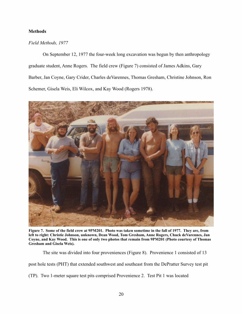
graduate student, Anne Rogers. The field crew (Figure 7) consisted of James Adkins, Gary
Barber, Jan Coyne, Gary Crider, Charles deVarennes, Thomas Gresham, Christine Johnson, Ron
Schemer, Gisela Weis, Eli Wilcox, and Kay Wood (Rogers 1978).
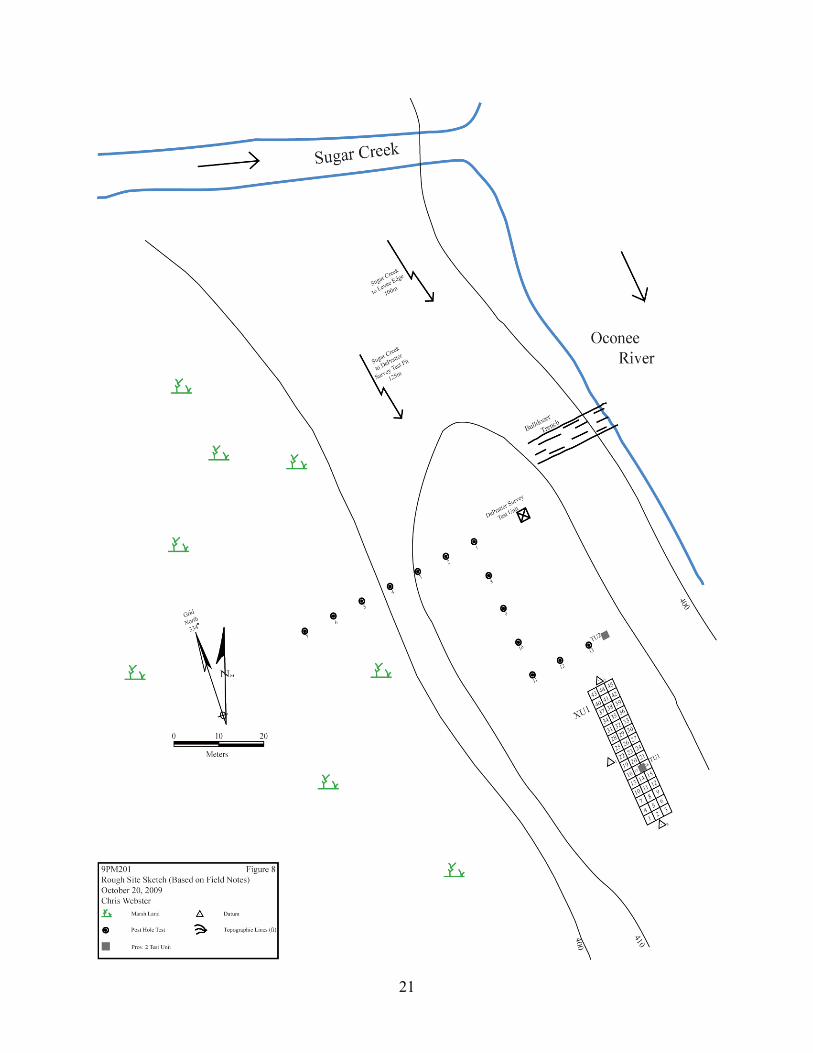
The site was divided into four proveniences (Figure 8). Provenience 1 consisted of 13
post hole tests (PHT) that extended southwest and southeast from the DePratter Survey test pit
(TP). Two 1-meter square test pits comprised Provenience 2. Test Pit 1 was located
Figure 7. Some of the field crew at 9PM201. Photo was taken sometime in the fall of 1977. They are, from left to right: Christie Johnson, unknown, Dean Wood, Tom Gresham, Anne Rogers, Chuck deVarennes, Jan Coyne, and Kay Wood. This is one of only two photos that remain from 9PM201 (Photo courtesy of Thomas Gresham and Gisela Weis).
20
21

approximately 30 m south-southwest of PHT 13. Test Pit 2 was located approximately 30 cm
north of PHT 13. A large block excavation was designated Provenience 3 and consisted of 45 2
m squares aligned in a rectangle of three squares by fifteen squares. The long axis was aligned to
grid north at 334° (magnetic) which corresponded to the angle of the levee and the Oconee River.
A general surface collection on the site and artifacts from the profile cleaning of a bulldozer cut
north of the DePratter Survey test pit were designated as Provenience 4. The excavated material
from the four proveniences was screened through 6.2 mm (quarter-inch) mesh hardware cloth.
Provenience 1
The post hole tests were used to determine the limits of the site and to find areas with
high artifact concentration and features. All of the PHTs were excavated to at least 100 cm
below the ground surface, with the deepest PHT reaching a depth of 210 cm. The test pits of
Provenience 2 and the Provenience 3 block excavation were probably located to the south of the
PHTs, on the levee ridge, in the hope that similar artifacts would be found.
Provenience 2
The test pits of Provenience 2 both measured 1 x 1 m square. TP 1 was located in what
became squares 17 and 18 of the Provenience 3 block. It was excavated first in one level down
to 86 cm below ground surface and then in 10 cm arbitrary levels to a depth of 146 cmbs.
Artifacts were recovered from every level. Test Pit 2 was located 30 cm north of PHT 13. The
test pit was excavated in four levels with artifacts recovered from each level. The excavation
22
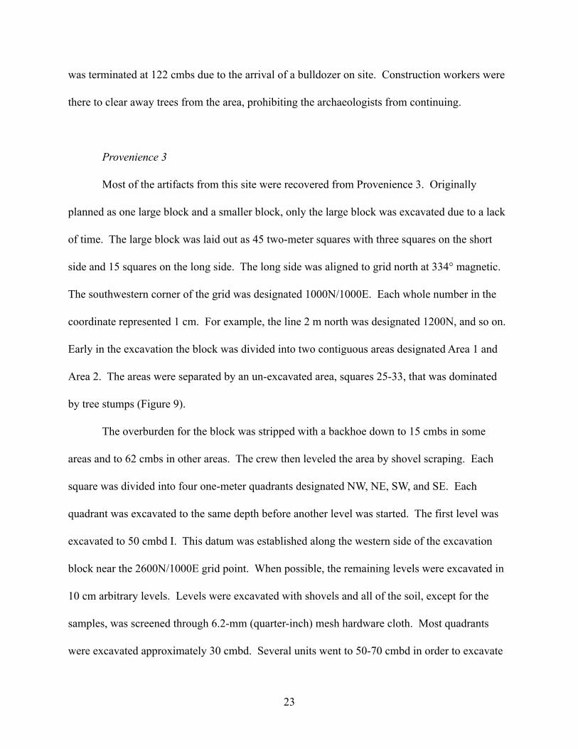
was terminated at 122 cmbs due to the arrival of a bulldozer on site. Construction workers were
there to clear away trees from the area, prohibiting the archaeologists from continuing.
Provenience 3
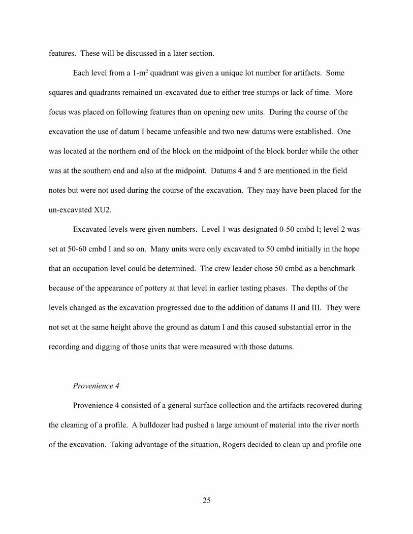
Most of the artifacts from this site were recovered from Provenience 3. Originally
planned as one large block and a smaller block, only the large block was excavated due to a lack
of time. The large block was laid out as 45 two-meter squares with three squares on the short
side and 15 squares on the long side. The long side was aligned to grid north at 334° magnetic.
The southwestern corner of the grid was designated 1000N/1000E. Each whole number in the
coordinate represented 1 cm. For example, the line 2 m north was designated 1200N, and so on.
Early in the excavation the block was divided into two contiguous areas designated Area 1 and
Area 2. The areas were separated by an un-excavated area, squares 25-33, that was dominated
by tree stumps (Figure 9).
The overburden for the block was stripped with a backhoe down to 15 cmbs in some
areas and to 62 cmbs in other areas. The crew then leveled the area by shovel scraping. Each
square was divided into four one-meter quadrants designated NW, NE, SW, and SE. Each
quadrant was excavated to the same depth before another level was started. The first level was
excavated to 50 cmbd I. This datum was established along the western side of the excavation
block near the 2600N/1000E grid point. When possible, the remaining levels were excavated in
10 cm arbitrary levels. Levels were excavated with shovels and all of the soil, except for the
samples, was screened through 6.2-mm (quarter-inch) mesh hardware cloth. Most quadrants
were excavated approximately 30 cmbd. Several units went to 50-70 cmbd in order to excavate
23

24
Figure 9. Provenience 3 Block Diagram. Major grid lines are spaced 2 m apart. “1200N” represents 1,200 cm. The triangles represent the three datum stakes from which elevations were measured during the excavation. The heavy black lines enclose the excavated areas. Area 1 is in the southern half and Area 2 is in the northern half. Numbers 1 through 45 on the diagram represent the square numbers that are referred to throughout the report for provenience information.
features. These will be discussed in a later section.
Each level from a 1-m2 quadrant was given a unique lot number for artifacts. Some
squares and quadrants remained un-excavated due to either tree stumps or lack of time. More
focus was placed on following features than on opening new units. During the course of the
excavation the use of datum I became unfeasible and two new datums were established. One
was located at the northern end of the block on the midpoint of the block border while the other
was at the southern end and also at the midpoint. Datums 4 and 5 are mentioned in the field
notes but were not used during the course of the excavation. They may have been placed for the
un-excavated XU2.
Excavated levels were given numbers. Level 1 was designated 0-50 cmbd I; level 2 was
set at 50-60 cmbd I and so on. Many units were only excavated to 50 cmbd initially in the hope
that an occupation level could be determined. The crew leader chose 50 cmbd as a benchmark
because of the appearance of pottery at that level in earlier testing phases. The depths of the
levels changed as the excavation progressed due to the addition of datums II and III. They were
not set at the same height above the ground as datum I and this caused substantial error in the
recording and digging of those units that were measured with those datums.
Provenience 4
Provenience 4 consisted of a general surface collection and the artifacts recovered during
the cleaning of a profile. A bulldozer had pushed a large amount of material into the river north
of the excavation. Taking advantage of the situation, Rogers decided to clean up and profile one
25

wall of the bulldozer cut to examine the site stratigraphy. The surface collection was given lot
numbers 001 and 002. The bulldozer cut profile was assigned lot number 003.
Photography
According to the field notes and the feature forms, at least eight rolls of photographs were
taken. These photographs were not found stored with the other forms for this site at the
Laboratory of Archaeology in Athens. Currently, no photographs of the excavation are available
to the author of this report and, as such, will not be discussed further.
Samples
During the course of the excavation three types of samples were taken. Soil samples
were taken in some units and in most features. The soil was then processed through a floatation
system. Current floatation practices would separate the light fraction and the heavy fraction of
organic material in the sample for later analysis. There is no evidence in the field notes that this
was done and no material remains in the artifact collections. Pollen samples were taken from
most of the features. The samples are in padded paper envelopes and are curated with the artifact
collection. It doesn’t appear that any analysis has been performed on the pollen. A total of 263
charcoal samples were taken from Provenience 3 and placed in small plastic viles. It seems that
samples were taken anytime charcoal or charcoal flecks were uncovered during the excavation.
None of the charcoal has been dated or otherwise analyzed.
26
Lab Methods, 1977-1978
All artifacts were bagged in the field according to lot number. A lot number was a unique
number that identified the location of the artifacts within a provenience. All artifacts were
washed at the University of Georgia’s Department of Anthropology’s Laboratory of Archaeology
in Athens, Georgia. The artifacts were then sorted into logical categories and recorded on special
Wallace Reservoir analysis forms (Appendix A). The primary categories were ceramics and
lithics. In the early 1980s a researcher gathered all of the ceramics from the collection and
placed them in one box. Attempts at reconstructing some of the pottery were made and some of
the pieces are still glued together. The ceramics were labeled with a provenience and lot number
but were never reintroduced back into the collection.
The lithics were sorted into several categories, including: angular pebbles (termed
“excess” on the analysis forms), biface, debris, fire-cracked chert, fire-cracked rock (FCR), flake,
groundstone, hammerstone, projectile point, soapstone, shaped stone, and spheroid pebble. The
flakes were usually sorted first according to material (i.e. chert, quartz) and then by color. For
example, “dark” chert and “light” chert were bagged separately.
Various attributes were recorded on the analysis forms in regards to the lithic collection.
Flakes were counted, sorted by material, color, and type, and the level of cortex was evaluated.
Types of flakes were: percussion flake, retouch flake, unidentified debris, and other. The cortex
options were: non, partial, and complete. Both chert and quartz flakes were analyzed for their
level of cortex. The debris, pebbles (spheroid and angular), FCR, and fire-cracked chert were all
weighed and recorded, in ounces, on the analysis forms.
27
There were a few other materials bagged or analyzed in the lab that were not re-visited in
this report. Charcoal was collected in small plastic containers and placed in boxes according to
lot number. A small amount of burned, unidentified, ceramics were bagged and eventually were
placed with the other ceramics during the early 1980s reorganization. There is a box of pollen
samples and a box of soil samples as well. None of these items were analyzed for this report due
to time and funding.
Lab Methods, 2009-2010
For this report it was decided that only the ceramics and the lithics would be reanalyzed.
There are several reasons for this. First, the analysis techniques used in the original analysis
have been updated and modified over the past three decades. For example, it is not possible to
record the level of cortex on quartz flakes. The lab technicians in 1977-1978 gave a designation
of 100% cortex, partial cortex, and no cortex to all quartz flakes. Second, I could not replicate
the recorded weights of some of the artifacts and decided to re-weigh everything using a digital
lab scale.
As stated above, the ceramics were aggregated into one collections box in the early 1980s
by a researcher doing a study on the Napier pottery from the site. All of the sherds were marked
with a provenience and lot number. I recorded several attributes which included: decoration,
portion (i.e. body, rim), rim type, temper, and type. Many of the sherds were glued together
during a past study and had since broken apart. When possible, these sherds were again refitted
and were bagged together. All other sherds were re-bagged but were not resorted into the
collection.
28
The lithic collection comprised the bulk of the re-analysis effort. The attributes that were
analyzed included: artifact type, material, region (i.e. coastal plain chert), stage of reduction, and
weight. For “stage of reduction” the level of cortex on on the dorsal surface of the chert flakes
was analyzed. Flakes with no cortex were called tertiary, flakes with some cortex were called
secondary, and flakes with 100% cortex were called primary. Most quartz flakes were not given
a stage of reduction attribute due to the eroded nature of the flakes. In most cases it was not
possible to determine the stage of reduction. When it could be determined the stage of reduction
was recorded. For debris, FCR, fire-cracked chert, and pebbles, only the weight was recorded.
All of the above artifacts were weighed on a My Weight i1200 digital scale with an accuracy of
0.1 grams.
Projectile points and bifaces were re-analyzed and recorded. Recorded attributes
included: base type, material, measurements (length, width, thickness), notching, portion, type,
and weight. All of the diagnostic projectile points were photographed.
A small amount of soapstone was recovered and analyzed from this site. The decoration
or modification of the surface, portion, rim type (when applicable), thickness, and weight were
recorded. Some of the soapstone sherds were re-fit together and bagged together.
Groundstone from the site included abraders, hammerstones, and various shaped stone.
For these pieces usually only the type and weight were recorded. When applicable the ground
surface was also noted.
29

5. RESULTS
Provenience 1
Thirteen post hole tests (PHT) were excavated (Figure 8). The crew was trying to
determine the most optimal areas to dig and at what levels artifacts could be found. Seven of the
13 post hole tests were positive. These included post hole tests 1-2, 8, 10, and 12-13. Artifacts
included flaked stone, pottery sherds, fire modified rock, and quartz pebbles. With the exception
of PHT 2, the positive shovel tests contained artifacts deeper than 100 cm below ground surface
(cmbs). PHT 2 contained artifacts between 75-100 cm below ground surface. All of the positive
shovel tests were located on the levee ridge that paralleled the Oconee River.
The crew recorded the depths of stratigraphic soil changes and the soil colors in the field
notes (Figure 10). No standardized color charts were used to determine color. As a result, some
of the colors that were recorded might actually represent the same soils. Figure 10 illustrates the
relative depths of the stratigraphic changes represented in the field notes and the depths of the
artifact bearing strata. Artifact depths were recorded in the field notes for some of the PHTs
(Table 2). Most of the artifacts form the block excavation also came from these depths.
Table 2 shows the artifacts recovered, organized by lot number. Where a depth or level
could not be found in either the field notes or on the artifact bags “n.d.” is written to represent
“no data”. In total, one biface, 3 cobbles, 22 flakes (1 chert, 21 quartz), and six sherds
(soapstone) were found. In addition, 92.8 g of debris, 378.0 g of pebbles, and 5,359.1 g of FCR
were recovered. Debris was defined during the 1970s analysis as uncategorized rock fragments.
The fragments do not appear to have been modified by cultural activity.
30

31
Figu
re 1
0. P
rove
nien
ce 1
Pos
t Hol
e Te
st st
ratig
raph
y an
d ar
tifac
t bea
ring
leve
ls.
Shad
ed a
reas
rep
rese
nt
leve
ls th
at w
ere
repo
rted
to c
onta
in a
rtifa
cts.

Provenience 2
Two 1 m square test pits were excavated based on the results of the post hole testing
(Figure 8). Test Pit 1 was located south of the post hole tests on the levee and contained Feature
1, a possible hearth (not to be confused with Feature 1 in Provenience 3). The block excavation
was eventually centered on this test pit. I believe the location was chosen based on the
assumption that if all of the positive post hole tests were on the levee, other artifacts could be
associated with the levee. This point was never alluded to or stated in the field notes but seems
likely. The field notes indicated that Test Pit 1 was given level designations from A (highest) to
Table 2. Provenience 1 positive Post Hole Tests organized by lot number. In the event that a level or depth could not be found either in the field notes or on the artifact bags “n.d.” meaning “no data” was inserted into the table.
Lot PHT # Level Depth(cmbs) Artifact Type Quantity Material Weight (g) Notes
001 PHT 1 4/5 115-150 Flakes 3 quartz 36.3001 PHT 1 3 110 Flakes 1 quartz 17.3001 PHT 1 4/5 115-150 Pebbles - quartz 299.6 Angular quartz001 PHT 1 4/5 115-150 Sherd 3 soapstone 71.7 Body001 PHT 1 4/5 115-150 Sherd 3 soapstone 71.7 Body002 PHT 2 4 105 Biface 1 quartz 60.8 End002 PHT 2 4 75-105 Flakes 2 quartz 1.2002 PHT 2 4 90 Pebbles - quartz 20.5 Angular quartz008 PHT 8 n.d. n.d. FCR - quartz 1910.6008 PHT 8 n.d. n.d. Flakes 1 quartz 4.3008 PHT 8 n.d. n.d. Flakes 1 quartz 2.2010 PHT 10 n.d. n.d. Pebbles - - 22.2 Rounded010 PHT 10 n.d. n.d. Pebbles - quartz 12.7 Angular quartz011 PHT 11 n.d. n.d. FCR - quartz 448.1011 PHT 11 n.d. n.d. Flakes 2 quartz 2.7011 PHT 11 n.d. n.d. Flakes 1 chert 0.5 Tertiary Flake011 PHT 11 n.d. n.d. Pebbles - - 9.7 Rounded012 PHT 12 n.d. n.d. Debris - - 39.9012 PHT 12 n.d. n.d. FCR - quartz 329.5012 PHT 12 n.d. n.d. Flakes 5 quartz 27.4012 PHT 12 n.d. n.d. Pebbles - quartz 1.2 Angular quartz013 PHT 13 4 90 Cobbles 3 quartz 205.9013 PHT 13 n.d. n.d. Debris - - 52.9013 PHT 13 n.d. n.d. FCR - quartz 2670.9013 PHT 13 n.d. n.d. Flakes 2 quartz 0.6013 PHT 13 n.d. n.d. Flakes 4 quartz 10.1013 PHT 13 n.d. n.d. Pebbles - - 12.1 Rounded
32

G (lowest) while Test Pit 2 was not given any level designations (Figure 11). To help tabulate
the data I assigned Test Pit 2 levels A-F.
Test Pit 1 was excavated in seven levels to a depth of 146 cmbs. The first level was
excavated to 86 cmbs with each successive level proceeding in 10-cm increments. The soil
profile was poorly described as compared to the post hole tests. Figure 11 shows the levels and
soil colors as they are described in the field notes. As with the PHTs no standardized color chart
was used to describe the soil.
Level A contained the highest number of artifacts (Table 3). Most of the flakes in level A
were quartz. The numbers of all artifacts decreased after the first level. Level G contained very
few artifacts. The floor of level A was reported in the field notes to contain a concentration of
fire-cracked rock and a fiber tempered sherd. No such sherd was found in the artifact collection,
however. A hammerstone was found in each of levels A and B. FCR was recovered from levels
A through D with the highest concentration occurring in level A.
Feature 1 is described on the feature form as a, “possible hearth...associated with fire-
cracked rock.” The feature was exposed at a depth of 86 cmbs and measured 43 cm east/west by
75 cm north/south. It was located in the northwestern corner of the unit. The soil in the feature
was characterized as a dark brown sand. As is indicated on the feature form, the crew excavated
Feature 1 with the rest of the test pit. It was associated with levels B, C, D, and E. The feature
measured 30 cm thick and reached a maximum depth of 116 cmbs.
Test Pit 2 (Figure 12) was located 30 cm north of PHT 13. Again, no reason is given for
this location, however, the test pit was located on the artifact rich levee and was very near a
positive post hole test (13) that contained, among other artifacts, FCR, indicating the possibility
33

34
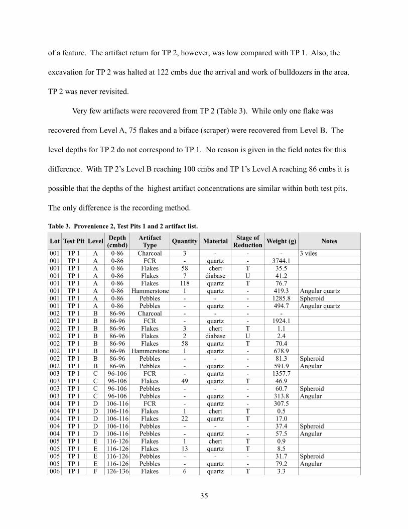
of a feature. The artifact return for TP 2, however, was low compared with TP 1. Also, the
excavation for TP 2 was halted at 122 cmbs due the arrival and work of bulldozers in the area.
TP 2 was never revisited.
Very few artifacts were recovered from TP 2 (Table 3). While only one flake was
recovered from Level A, 75 flakes and a biface (scraper) were recovered from Level B. The
level depths for TP 2 do not correspond to TP 1. No reason is given in the field notes for this
difference. With TP 2’s Level B reaching 100 cmbs and TP 1’s Level A reaching 86 cmbs it is
possible that the depths of the highest artifact concentrations are similar within both test pits.
The only difference is the recording method.
Lot Test Pit Level Depth(cmbd)
Artifact Type Quantity Material Stage of
Reduction Weight (g) Notes
001 TP 1 A 0-86 Charcoal 3 - - - 3 viles001 TP 1 A 0-86 FCR - quartz - 3744.1001 TP 1 A 0-86 Flakes 58 chert T 35.5001 TP 1 A 0-86 Flakes 7 diabase U 41.2001 TP 1 A 0-86 Flakes 118 quartz T 76.7001 TP 1 A 0-86 Hammerstone 1 quartz - 419.3 Angular quartz001 TP 1 A 0-86 Pebbles - - - 1285.8 Spheroid001 TP 1 A 0-86 Pebbles - quartz - 494.7 Angular quartz002 TP 1 B 86-96 Charcoal - - - -002 TP 1 B 86-96 FCR - quartz - 1924.1002 TP 1 B 86-96 Flakes 3 chert T 1.1002 TP 1 B 86-96 Flakes 2 diabase U 2.4002 TP 1 B 86-96 Flakes 58 quartz T 70.4002 TP 1 B 86-96 Hammerstone 1 quartz - 678.9002 TP 1 B 86-96 Pebbles - - - 81.3 Spheroid002 TP 1 B 86-96 Pebbles - quartz - 591.9 Angular003 TP 1 C 96-106 FCR - quartz - 1357.7003 TP 1 C 96-106 Flakes 49 quartz T 46.9003 TP 1 C 96-106 Pebbles - - - 60.7 Spheroid003 TP 1 C 96-106 Pebbles - quartz - 313.8 Angular004 TP 1 D 106-116 FCR - quartz - 307.5004 TP 1 D 106-116 Flakes 1 chert T 0.5004 TP 1 D 106-116 Flakes 22 quartz T 17.0004 TP 1 D 106-116 Pebbles - - - 37.4 Spheroid004 TP 1 D 106-116 Pebbles - quartz - 57.5 Angular005 TP 1 E 116-126 Flakes 1 chert T 0.9005 TP 1 E 116-126 Flakes 13 quartz T 8.5005 TP 1 E 116-126 Pebbles - - - 31.7 Spheroid005 TP 1 E 116-126 Pebbles - quartz - 79.2 Angular006 TP 1 F 126-136 Flakes 6 quartz T 3.3
35
Table 3. Provenience 2, Test Pits 1 and 2 artifact list.

Lot Test Pit Level Depth(cmbd)
Artifact Type Quantity Material Stage of
Reduction Weight (g) Notes
006 TP 1 F 126-136 Pebbles - - - 13.6 Spheroid006 TP 1 F 126-136 Pebbles - quartz - 27.1 Angular007 TP 1 G 136-146 Flakes 1 chert T 0.1007 TP 1 G 136-146 Flakes 3 diabase U 3.4007 TP 1 G 136-146 Flakes 2 quartz T 0.4007 TP 1 G 136-146 Pebbles - - - 43.4 Spheroid007 TP 1 G 136-146 Pebbles - quartz - 4.1 Angular008 TP 2 A 0-45 Flakes 1 chert T 0.2008 TP 2 A 0-45 Pebbles - - - 86.1 Spheroid008 TP 2 A 0-45 Pebbles - quartz - 27.7 Angular009 TP 2 B 45-100 Biface 1 quartz - 76.0 Scraper009 TP 2 B 45-100 Charcoal 2 - - - 2 viles009 TP 2 B 45-100 FCR - quartz - 3341.1009 TP 2 B 45-100 Flakes 9 chert T 2.4009 TP 2 B 45-100 Flakes 1 diabase U 1.7009 TP 2 B 45-100 Flakes 65 quartz T 79.6009 TP 2 B 45-100 Pebbles - - - 245.9 Spheroid009 TP 2 B 45-100 Pebbles - quartz - 659.6 Angular009 TP 2 B 45-100 Soapstone 1 soapstone - 13.7 Fragment010 TP 2 C 100-120 Charcoal - - - -010 TP 2 C 100-120 FCR - quartz - 435.4010 TP 2 C 100-120 Flakes 1 chalcedony T 0.2010 TP 2 C 100-120 Flakes 1 chert S 0.2010 TP 2 C 100-120 Flakes 17 quartz T 10.2010 TP 2 C 100-120 Pebbles - - - 141.6 Spheroid010 TP 2 C 100-120 Pebbles - quartz - 196.6 Angular010 TP 2 C 100-120 Uniface 1 quartz - 4.4 Possible011 TP 2 D 120-122 Flakes 1 chert T 0.2011 TP 2 D 120-122 Flakes 1 quartz T 7.6011 TP 2 D 120-122 Pebbles - - - 3.5 Spheroid011 TP 2 D 120-122 Pebbles - quartz - 7.5 Angular
Provenience 3
Provenience 3 was originally set up as two excavation units designated XU1 and XU2.
XU2 was going to be an 11 square grid resembling a trench. It would have measured 2 m x 22
m. For reasons that can not be determined by examining the field notes XU2 was never
excavated. It is likely that the crew simply ran out of time and money.
The excavation of the Provenience 3 block started around September 19, 1977 and
proceeded for approximately 3.5 weeks. The exact start and end dates are unclear from the field
notes. As the excavation proceeded, the block was separated into two areas designated Area 1
36
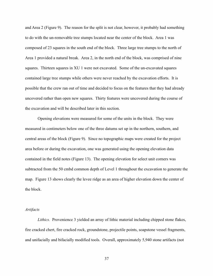
and Area 2 (Figure 9). The reason for the split is not clear, however, it probably had something
to do with the un-removable tree stumps located near the center of the block. Area 1 was
composed of 23 squares in the south end of the block. Three large tree stumps to the north of
Area 1 provided a natural break. Area 2, in the north end of the block, was comprised of nine
squares. Thirteen squares in XU 1 were not excavated. Some of the un-excavated squares
contained large tree stumps while others were never reached by the excavation efforts. It is
possible that the crew ran out of time and decided to focus on the features that they had already
uncovered rather than open new squares. Thirty features were uncovered during the course of
the excavation and will be described later in this section.
Opening elevations were measured for some of the units in the block. They were
measured in centimeters below one of the three datums set up in the northern, southern, and
central areas of the block (Figure 9). Since no topographic maps were created for the project
area before or during the excavation, one was generated using the opening elevation data
contained in the field notes (Figure 13). The opening elevation for select unit corners was
subtracted from the 50 cmbd common depth of Level 1 throughout the excavation to generate the
map. Figure 13 shows clearly the levee ridge as an area of higher elevation down the center of
the block.
Artifacts
Lithics. Provenience 3 yielded an array of lithic material including chipped stone flakes,
fire cracked chert, fire cracked rock, groundstone, projectile points, soapstone vessel fragments,
and unifacially and bifacially modified tools. Overall, approximately 5,940 stone artifacts (not
37
38
Figure 13. Provenience 3 surface elevation.

including bulk collections of pebbles, fire cracked rock, etc.) were recovered with an
approximately weight of 543 kg. A full accounting of all recovered artifacts is listed in
Appendices D-G.
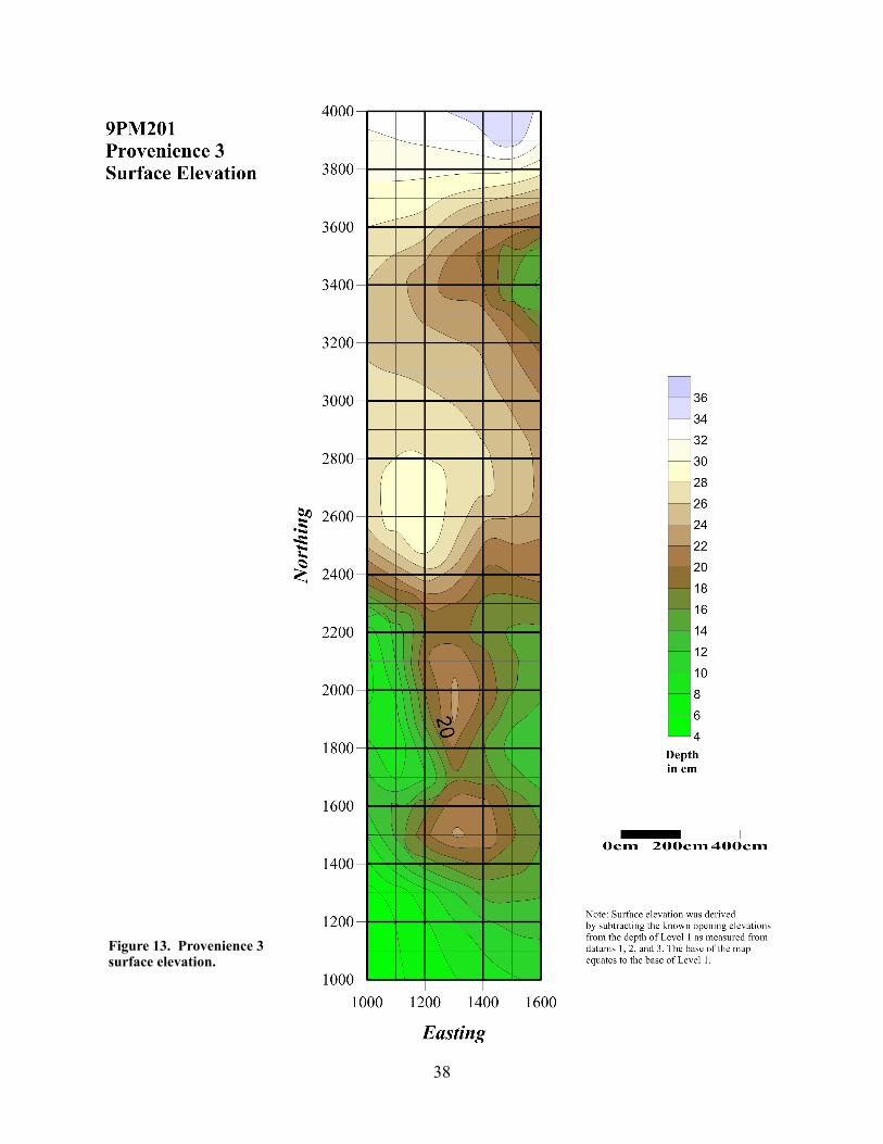
Level 1 was excavated across the block from the surface down to 50 cmbd I. Datums 2
and 3 were calibrated to reach the same depth. Figure 14 shows the relative artifact densities of
four artifact types including pottery, flakes, fire cracked rock, and fire cracked chert. In Area 1,
the flakes, fire cracked rock and fire cracked chert were concentrated near Feature 1 around
2550N/1400E. Area 2 showed slight density increases of flakes near the eastern and northern
edges of the excavation. Fire cracked rock and fire cracked chert were virtually non-existent in
Area 2.
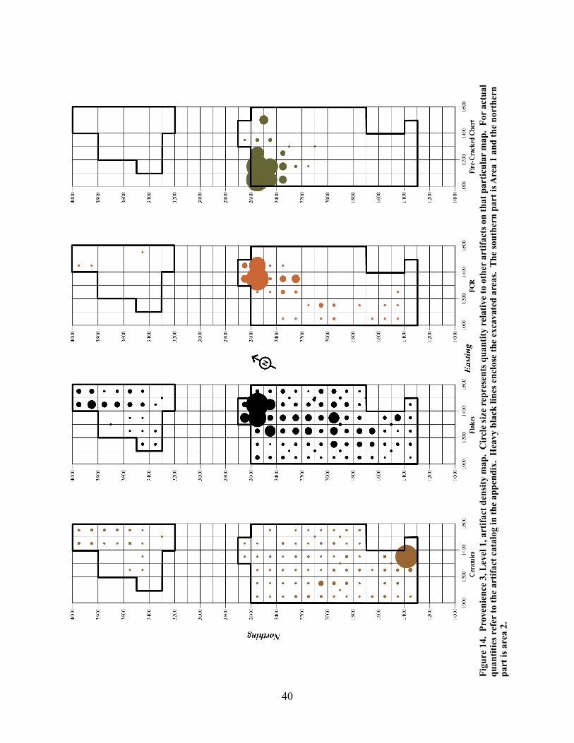
Flake density remained high in the northern end of Area 1 for Level 2 (50-60 cmbd I).
However, an increase can be seen in the central portion of the area where there is also a
concentration of features including Features 13, 14, 18, 26, 27, 29, and 30 (Figure 15). Fire
cracked rock concentration dropped to near zero in the northern end of Area 1 but saw an
increase in the southern end near Features 15 and 19. Fire cracked chert concentrations remained
high in the same location as in Level 1, the northwestern corner of Area 1.
Area 2 of Level 2 saw an increase in flake concentrations in the northern edge of Area 2.
Slightly more fire cracked rock was observed as compared to Level 1 but was spread throughout
the area. No fire cracked chert was observed in Area 2’s Level 2.
Level 3 (60-70 cmbd I) saw an overall decrease in flakes and fire cracked rock in Area 1.
Fire cracked chert, however, remained high and in the same location as the previous two levels
(Figure 16). As with Level 2, no fire cracked chert was observed in Area 2. A heavy
39
40
Figu
re 1
4. P
rove
nien
ce 3
, Lev
el 1
, art
ifact
den
sity
map
. C
ircl
e si
ze r
epre
sent
s qua
ntity
rel
ativ
e to
oth
er a
rtifa
cts o
n th
at p
artic
ular
map
. Fo
r ac
tual
qu
antit
ies r
efer
to th
e ar
tifac
t cat
alog
in th
e ap
pend
ix.
Hea
vy b
lack
line
s enc
lose
the
exca
vate
d ar
eas.
The
sout
hern
par
t is A
rea
1 an
d th
e no
rthe
rn
part
is a
rea
2.
41
Figu
re 1
5. P
rove
nien
ce 3
, Lev
el 2
, art
ifact
den
sity
map
. C
ircl
e si
ze r
epre
sent
s qua
ntity
rel
ativ
e to
oth
er a
rtifa
cts o
n th
at p
artic
ular
map
. Fo
r ac
tual
qu
antit
ies r
efer
to th
e ar
tifac
t cat
alog
in th
e ap
pend
ix.
Hea
vy b
lack
line
s enc
lose
the
exca
vate
d ar
eas.
The
sout
hern
par
t is A
rea
1 an
d th
e no
rthe
rn
part
is A
rea
2.

42
Figu
re 1
6. P
rove
nien
ce 3
, Lev
el 3
, art
ifact
den
sity
map
. C
ircl
e si
ze r
epre
sent
s qua
ntity
rel
ativ
e to
oth
er a
rtifa
cts o
n th
at p
artic
ular
map
. Fo
r ac
tual
qu
antit
ies r
efer
to th
e ar
tifac
t cat
alog
in th
e ap
pend
ix.
Hea
vy b
lack
line
s enc
lose
the
exca
vate
d ar
eas.
The
sout
hern
par
t is A
rea
1 an
d th
e no
rthe
rn
part
is A
rea
2.
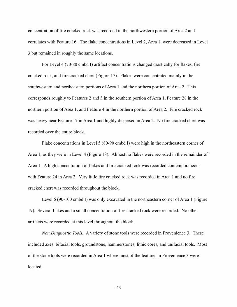
concentration of fire cracked rock was recorded in the northwestern portion of Area 2 and
correlates with Feature 16. The flake concentrations in Level 2, Area 1, were decreased in Level
3 but remained in roughly the same locations.
For Level 4 (70-80 cmbd I) artifact concentrations changed drastically for flakes, fire
cracked rock, and fire cracked chert (Figure 17). Flakes were concentrated mainly in the
southwestern and northeastern portions of Area 1 and the northern portion of Area 2. This
corresponds roughly to Features 2 and 3 in the southern portion of Area 1, Feature 28 in the
northern portion of Area 1, and Feature 4 in the northern portion of Area 2. Fire cracked rock
was heavy near Feature 17 in Area 1 and highly dispersed in Area 2. No fire cracked chert was
recorded over the entire block.
Flake concentrations in Level 5 (80-90 cmbd I) were high in the northeastern corner of
Area 1, as they were in Level 4 (Figure 18). Almost no flakes were recorded in the remainder of
Area 1. A high concentration of flakes and fire cracked rock was recorded contemporaneous
with Feature 24 in Area 2. Very little fire cracked rock was recorded in Area 1 and no fire
cracked chert was recorded throughout the block.
Level 6 (90-100 cmbd I) was only excavated in the northeastern corner of Area 1 (Figure
19). Several flakes and a small concentration of fire cracked rock were recorded. No other
artifacts were recorded at this level throughout the block.
Non Diagnostic Tools. A variety of stone tools were recorded in Provenience 3. These
included axes, bifacial tools, groundstone, hammerstones, lithic cores, and unifacial tools. Most
of the stone tools were recorded in Area 1 where most of the features in Provenience 3 were
located.
43

44
Figu
re 1
7. P
rove
nien
ce 3
, Lev
el 4
, art
ifact
den
sity
map
. C
ircl
e si
ze r
epre
sent
s qua
ntity
rel
ativ
e to
oth
er a
rtifa
cts o
n th
at p
artic
ular
map
. Fo
r ac
tual
qu
antit
ies r
efer
to th
e ar
tifac
t cat
alog
in th
e ap
pend
ix.
Hea
vy b
lack
line
s enc
lose
the
exca
vate
d ar
eas.
The
sout
hern
par
t is A
rea
1 an
d th
e no
rthe
rn
part
is A
rea
2.

45
Figu
re 1
8. P
rove
nien
ce 3
, Lev
el 5
, art
ifact
den
sity
map
. C
ircl
e si
ze r
epre
sent
s qua
ntity
rel
ativ
e to
oth
er a
rtifa
cts o
n th
at p
artic
ular
map
. Fo
r ac
tual
qu
antit
ies r
efer
to th
e ar
tifac
t cat
alog
in th
e ap
pend
ix.
Hea
vy b
lack
line
s enc
lose
the
exca
vate
d ar
eas.
The
sout
hern
par
t is A
rea
1 an
d th
e no
rthe
rn
part
is A
rea
2.
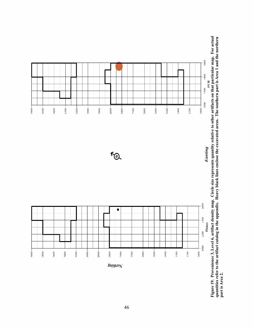
46
Figu
re 1
9. P
rove
nien
ce 3
, Lev
el 6
, art
ifact
den
sity
map
. C
ircl
e si
ze r
epre
sent
s qua
ntity
rel
ativ
e to
oth
er a
rtifa
cts o
n th
at p
artic
ular
map
. Fo
r ac
tual
qu
antit
ies r
efer
to th
e ar
tifac
t cat
alog
in th
e ap
pend
ix.
Hea
vy b
lack
line
s enc
lose
the
exca
vate
d ar
eas.
The
sout
hern
par
t is A
rea
1 an
d th
e no
rthe
rn
part
is A
rea
2.

Axes. Three axes were recorded (Figure 20). Both were in Area 1 with two in Level 1
and one in Level 2. One of the axes was a polished green stone with flakes removed from the
hafting end. The cutting end was very polished and still has a definable edge (Figure 21). No
other artifacts were made out of this material and no other axes were recorded that resembled this
one. The artifact is an anomaly and is not likely to be contemporaneous with any of the
occupations on this site.
Bifaces. Bifacial tool concentrations were scattered throughout Area1 and were recorded
in Levels 1 through 5 (Figure 22). Five tools were recorded in the northwestern corner of Area
1’s Level 1. Bifaces were also recorded in several other locations in Area 1. With the abundance
of features in this area it is difficult to discern a relationship between the tools and the features.
Figure 21. Greenstone axe. Flakes were removed from the hafting area.
47

48
Figure 20. Provenience 3 axe artifacts. Heavy black lines enclose the excavated areas with Area 1 in the southern half and Area 2 in the northern half.

49
Figure 22. Provenience 3 bifacial tool density map. Heavy black lines enclose excavated areas. Area 1 is in the southern half and Area 2 is in the northern half.

The high concentration does, however, roughly correspond with the high concentrations of
flakes, fire cracked rock, and chert for Level 1 (Figure 14). No bifaces were recorded in Area 2’s
Level 1 but they were recorded in Levels 2, 3, and 4.
Groundstone. Groundstone concentrations were highest for Level 1 in Area 1 (Figure
23). Only one groundstone fragment was recorded in Area 2 (Level 5). While there was a
moderate density of groundstone in Level 2 of Area 1, virtually no groundstone was recorded in
deeper levels. The concentrations observed in Level 1 correspond with recorded features
throughout the Area.
Hammerstone. Nineteen tools were classified as hammerstones. All but two were
located in Area 1 (Figure 24). A small concentration of four hammerstones were recovered from
Level 3 in Area 1. This corresponds to the location of Feature 18. Five of the hammerstones
were located in the northeastern corner of Area 1 and span six levels. The hammerstone
distribution across the block and across the levels was relatively random and inconsistent.
Core. Many lithic cores were recovered from the northeastern corner of Area 1 across
Levels 1-4 (Figure 25). A total of seven cores were located in a 5 m2 area. A high density of
flakes was recorded in that same area for Levels 1-5. Also, Features 1 and 28 were recorded in
Levels 1 and 3, respectively. As with the other stone tools, only a few (n=3) tools were recorded
in Area 2. Area 1 seems to contain the dominant area of activity across the block.
Tools were categorized as unifacial if they exhibited evidence of flaking on one side of
the tool. In most cases the tool was more of a utilized flake than a more formal tool. A total of
26 unifacially worked tools were identified over the course of the excavation and analysis
(Figure 26). The highest density of tools (n=8) occurred in Level 1 of Area 1 between 2000N
50

51
Figure 23. Provenience 3 groundstone tool density map. Heavy black lines enclose the excavated areas. Area 1 is in the southern half and Area 2 is in the northern half.

52
Figure 24. Provenience 3 hammerstone tool density map. Heavy black lines enclose excavated areas. Area 1 is in the southern half and Area 2 is in the northern half.
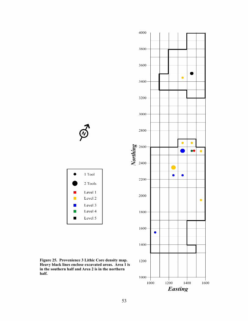
53
Figure 25. Provenience 3 Lithic Core density map. Heavy black lines enclose excavated areas. Area 1 is in the southern half and Area 2 is in the northern half.

54
Figure 26. Provenience 3 unifacial tool density map. Heavy black lines enclose excavated areas. Area 1 is in the southern half and Area 2 is in the northern half.

and 2500N and between 1000E and 1300E. The majority of the tools were located in Area 1
with only four tools located in Area 2.
Ceramics. Table 4 represents the major types of ceramic pottery that were recovered on
this site. Napier complicated stamped was the most represented type. Much of the plain pottery
resembles the Napier in temper, color, and thickness. Many of the Napier and similar plain
sherds were recovered from the southeastern portion of Area 1, Level 1 (Figure 27). Lot 144 at
1380N/1350E yielded 215 Napier sherds alone. A number of plain sherds were recovered in this
area as well, however, a high concentration was also found near 2350N/1250E in Area 1. Lot
144 was associated with Level 1 and was actually excavated from 34-50 cmbd I. Level 1 in Area
1 saw the rest of the Napier and Plain sherds scattered across the excavated area. There were
Table 4. Provenience 3 pottery types. Much of the Napier and Plain were located in the southern portion of Area 1. Sherds categorized as UID were unidentifiable due to either small fragment size or severe burning. The other category represents several under-represented types including Averett (n=3), Carrabelle (n=1), Ocmulgee Fields (n=5), and Weeden Island (n=1).
0
100
200
300
400
500
600
Napier Plain UID Lamar Other Stallings Swift Creek
561023
182
367
509
Provenience 3 Pottery Types
55

56
Figu
re 2
7. P
rove
nien
ce 3
, Lev
el 1
, spe
cial
den
sity
map
. O
nly
Nap
ier
and
Plai
n po
ttery
are
rep
rese
nted
for
cera
mic
s. C
ircl
e si
ze r
epre
sent
s qua
ntity
re
lativ
e to
oth
er a
rtifa
cts o
n th
at p
artic
ular
map
. Fo
r ac
tual
qua
ntiti
es r
efer
to th
e ar
tifac
t cat
alog
in th
e ap
pend
ix.
Hea
vy b
lack
line
s enc
lose
the
exca
vate
d ar
eas.
The
sout
hern
par
t is A
rea
1 an
d th
e no
rthe
rn p
art i
s Are
a 2.

small concentrations in the eastern and northeastern corner of Area 2. When compared to the
density maps for flakes, fire cracked rock, and fire cracked chert the Napier/Plain concentration
appears opposite the other lithic concentrations. When measured from the centers of the
concentrations approximately 12 m separates them. Although no post holes were identified
during the excavation it is possible that the pottery concentration was inside a structure (possibly
the rear of the structure) and that the other concentrations were located near a fire pit outside of
the structure. This, however, is just an hypothesis.
Ceramic concentrations remain relatively high in Level 2 with the major difference taking
place in Area 2. Virtually no ceramics were recovered in Area 2 (Figure 28). Another change
with Level 2 was the lack of scattered ceramics. The density map for Level 1 shows ceramics
scattered across Area 1. Upon reaching Level 2, the ceramics become more focused and
concentrated with almost no scattering of sherds. This is possibly the result of historic plowing
or the action of major flood events.
By Level 3 all traces of Napier pottery are gone (Figure 29). Small concentrations of
plain pottery were found in Area 1, but could not be associated with the Napier pottery found in
upper levels. As in the previous level, few sherds were recorded in Area 2 and Area 1 showed
little scattering of sherds.
Level 4 shows a change in ceramic concentrations with almost no sherds appearing in
Area 1 (Figure 17). A small concentration can be seen in Area 2 but this is a relative density and
represents few pottery sherds. Level 5 contained very few sherds with no sherd concentrations
(Figure 18). No pottery was discovered in deeper levels.
57

58
Figu
re 2
8. P
rove
nien
ce 3
, Lev
el 2
, spe
cial
den
sity
map
. O
nly
Nap
ier
and
plai
n po
ttery
are
rep
rese
nted
for
cera
mic
s. C
ircl
e si
ze r
epre
sent
s qua
ntity
re
lativ
e to
oth
er a
rtifa
cts o
n th
at p
artic
ular
map
. Fo
r ac
tual
qua
ntiti
es r
efer
to th
e ar
tifac
t cat
alog
in th
e ap
pend
ix.
Hea
vy b
lack
line
s enc
lose
the
exca
vate
d ar
eas.
The
sout
hern
par
t is A
rea
1 an
d th
e no
rthe
rn p
art i
s Are
a 2.

59
Figu
re 2
9. P
rove
nien
ce 3
, Lev
el 3
, spe
cial
den
sity
map
. C
ircl
e si
ze r
epre
sent
s qua
ntity
rel
ativ
e to
oth
er a
rtifa
cts o
n th
at p
artic
ular
map
. Fo
r ac
tual
qu
antit
ies r
efer
to th
e ar
tifac
t cat
alog
in th
e ap
pend
ix.
Hea
vy b
lack
line
s enc
lose
the
exca
vate
d ar
eas.
The
sout
hern
par
t is A
rea
1 an
d th
e no
rthe
rn
part
is A
rea
2.

Figures 30-39 represent a sample of the types of sherds and stamp designs that were
recovered on this site. A pipe bowl fragment and a soapstone rim sherd are also represented.
60
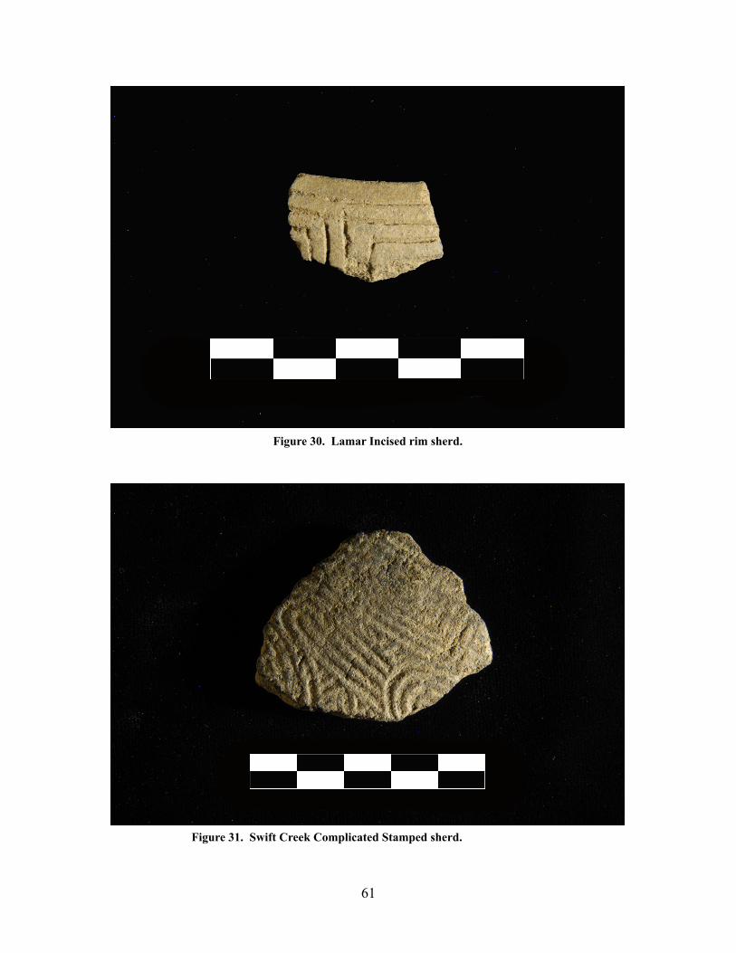
Figure 30. Lamar Incised rim sherd.
Figure 31. Swift Creek Complicated Stamped sherd.
61

Figure 32. Lamar pipe bowl fragment. The only such artifact recovered from the
Figure 33. Narrow neck plain rim sherd.
62
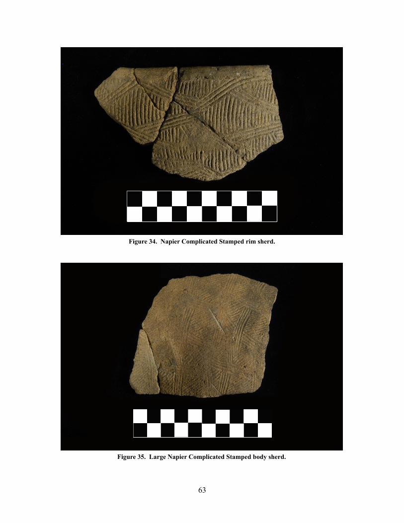
Figure 34. Napier Complicated Stamped rim sherd.
Figure 35. Large Napier Complicated Stamped body sherd.
63

Figure 36. Lamar Bold Incised rim sherd.
Figure 37. Napier Complicated Stamped rim sherd. This design represents the highest quantity of sherds.
64
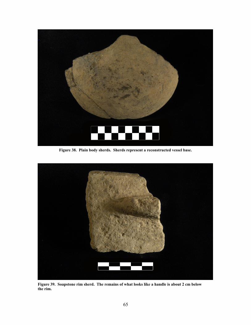
Figure 38. Plain body sherds. Sherds represent a reconstructed vessel base.
Figure 39. Soapstone rim sherd. The remains of what looks like a handle is about 2 cm below the rim.
65

Provenience 3 Features
The features in Provenience 3 fell into five
different categories: hearth, pit, tree, house floor,
and other (Table 6). Twenty-three features were
uncovered in Area 1, while only seven features
were uncovered in Area 2 (Figure 40).
Physiographically, Areas 1 and 2 are similar,
however, Area 1 is 2.77 times larger than Area 2.
This might account for the difference in the
number of recorded features.
Features with dark stains and fire-cracked
rock were designated “hearths” by the field crew. Sometimes these features also contained
artifacts, including flakes and pottery. Feature 6 was labeled a “pit”. This pit contained charcoal
flecks and had a basin shape in profile. The “tree” designation was used on two features
(Features 12 and 30) and more than likely applies to several of the “other” features as well. The
crew identified one feature as a possible “house floor” (Feature 29) based on its “definite shape”
and by the presence of a projectile point on its surface. The feature, however, was not excavated.
Feature 1
Feature 1 was described as a hearth and was located in the center of XU 1, at the northern
end of Area 1 (Figure 40). It was recorded in Squares 23, 24, 26, and 27. The center point of the
feature was in square 23 at 2585N/1385E (Figure 41). The feature measured 95 cm E-W by 100
66
A1 A2 Totals
Hearth
Pit
Tree
House Floor
Other
Totals
11 3 14
1 0 1
1 1 2
1 0 1
9 3 12
23 7 30
Table 6. Feature types and quantities recorded in Provenience 3. Area 1 was in the southern half of the block while Area 2 was in the northern half. The category “other” was used when the excavators and the report’s author could not determine the type of feature that was presented.

67
Figure 40. Provenience 3 feature map.

cm N-S and had a depth of at least 60 cm. The portion of the feature that extended into the
northwestern corner of square 24 was excavated. In profile two layers of fire cracked rock could
be seen within gray-stained sand (Figures 42 and 43). The first layer of fire cracked rock started
68
Figure 42. Feature 1 western wall profile. Western wall of Square 24’s north-western corner.
Figure 41. Feature 1 plan view sketch.
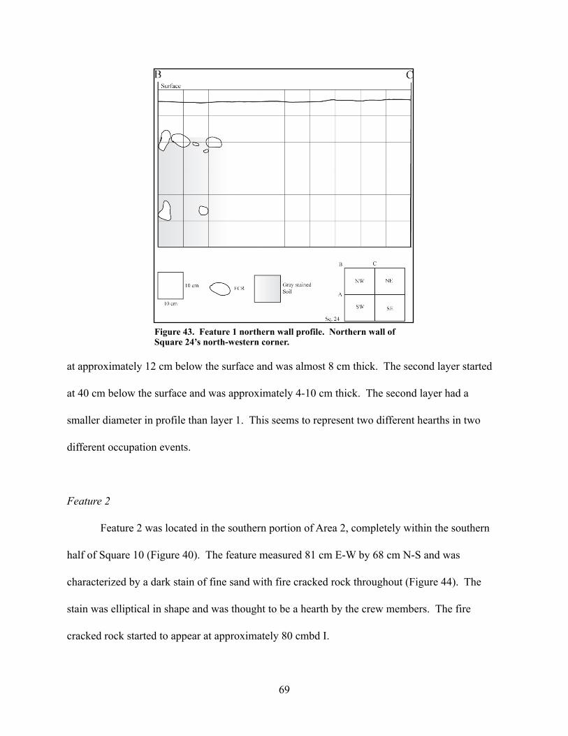
at approximately 12 cm below the surface and was almost 8 cm thick. The second layer started
at 40 cm below the surface and was approximately 4-10 cm thick. The second layer had a
smaller diameter in profile than layer 1. This seems to represent two different hearths in two
different occupation events.
Feature 2
Feature 2 was located in the southern portion of Area 2, completely within the southern
half of Square 10 (Figure 40). The feature measured 81 cm E-W by 68 cm N-S and was
characterized by a dark stain of fine sand with fire cracked rock throughout (Figure 44). The
stain was elliptical in shape and was thought to be a hearth by the crew members. The fire
cracked rock started to appear at approximately 80 cmbd I.
69
Figure 43. Feature 1 northern wall profile. Northern wall of Square 24’s north-western corner.

The artifacts for Feature 2 were not bagged separately from the southwestern and
southeastern quadrants of Square 10. The feature comprised less than 24% of the total area of
the south half of Square 10. For this reason it would be difficult to separate the artifacts in Lot
numbers 041 (southwestern quadrant) and 043 (southeastern quadrant) from the artifacts in the
feature. It is a fairly good assumption, however, that the 2,500.8 g of fire cracked rock that was
recorded in those two lots were removed from the feature since the presence of fire cracked rock
is one attribute the field crew used to define a feature. One charcoal sample was taken with Lot
041, but was not analyzed.
Feature 3
Feature 3 was located in the southwestern quadrant of Square 10 in Area 1 and extended
out from the western wall to approximately 54 cm directly east (Figure 40). The feature was a
dark stain that contained small rocks and pebbles in fine sand. It was located approximately 80
cmbd I (35 cmbs) and measured 54 cm E-W by 28 cm N-S (Figure 45). The feature was most
70
Figure 44. Feature 2 plan view.

likely the result of a group of decayed tree roots that silted in during a flooding event. Artifacts
found within the feature were bagged with Lot 041, which included a portion of Feature 2 and
artifacts from the southwestern quadrant of Square 10.
Feature 4
Feature 4 was a possible hearth located in
Area 2 (Figure 40). It was a dark sandy stain that
measured 23 cm E-W by 85 cm N-S and first
appeared 124 cmbd II (63 cmbs) (Figure 46).
The feature contained fire cracked rock. Any
other artifacts were not bagged separately from
the unit excavation. The feature was not
excavated further due to lack of time.
71
Figure 45. Feature 3 plan view sketch.
Figure 46. Feature 4 plan view sketch.

Feature 5
Feature 5 was located in the northern half of Area 2 in the center of Square 20 (Figure
40). The midpoint of the feature was recorded as 2300N/1320E. The feature was buried 37
cmbd I (8 cmbs), measured 55 cm E-W by 30 cm N-S, and had a vertical depth of approximately
13 cm (Figure 47). The only artifacts noted for this feature were fire cracked rocks. The
artifacts for Square 20 were bagged under Lot Numbers 073, 074, 075, and 076. Some artifacts
from the feature may be located within those lots. Charcoal samples were taken and associated
with Lots 073 (one sample) and 075 (two samples). There was no soil description in the field
notes or on the feature forms. The feature was not excavated due to lack of time.
Feature 6
Feature 6 was located near the center of Area 1, close to the eastern wall, and had a center
point of 2106N/1486E (Figure 40). The crew believed that this was a pit feature. It was
characterized by a dark stain with charcoal flecks. The fill was mostly river gravels but included
72
Figure 47. Feature 5 plan view sketch.

some carbonized material. Burned pottery (Lot 396) from the southwestern quadrant of Square
21, at the 60-70 cmbd I level, was thought to possibly be associated with Feature 6. The feature
was distinct and surrounded by yellow sand. Feature 6 was oval in shape and measured 55 cm
E-W by 85 cm N-S and had a depth of 14 cm (Figure 47). The feature was uncovered at 68
cmbd I. No pottery or diagnostic tools were found in the feature fill (Table 7). An unidentifiable
quartz biface end fragment was recovered as well as 11 flakes. Two charcoal samples were
taken. One came from the feature fill and the other was taken from the flotation sample. The
crew wrote on the feature form that no samples were taken due to burning nearby on the day the
feature was exposed. It is not clear why samples would have been taken anyway. A pollen
sample as well as a soil sample were also taken. The artifacts from Lot 443 were recovered
when the exposed wall of the feature was cleaned for drawing and photographing. No diagnostic
artifacts were recovered, although, 3926.5 g of fire cracked rock were collected from the wall.
73
Figure 48. Feature 6 plan view sketch.
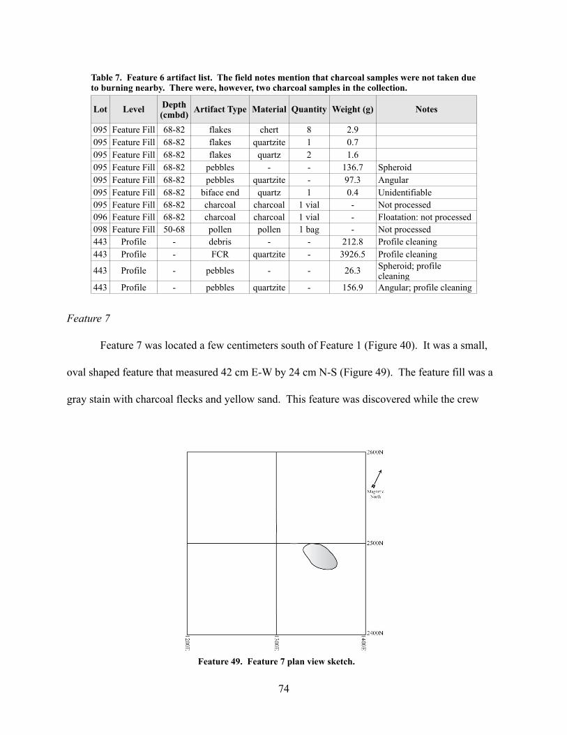
Feature 7
Feature 7 was located a few centimeters south of Feature 1 (Figure 40). It was a small,
oval shaped feature that measured 42 cm E-W by 24 cm N-S (Figure 49). The feature fill was a
gray stain with charcoal flecks and yellow sand. This feature was discovered while the crew
74
Feature 49. Feature 7 plan view sketch.
Lot Level Depth(cmbd) Artifact Type Material Quantity Weight (g) Notes
095 Feature Fill 68-82 flakes chert 8 2.9095 Feature Fill 68-82 flakes quartzite 1 0.7095 Feature Fill 68-82 flakes quartz 2 1.6095 Feature Fill 68-82 pebbles - - 136.7 Spheroid095 Feature Fill 68-82 pebbles quartzite - 97.3 Angular095 Feature Fill 68-82 biface end quartz 1 0.4 Unidentifiable095 Feature Fill 68-82 charcoal charcoal 1 vial - Not processed096 Feature Fill 68-82 charcoal charcoal 1 vial - Floatation: not processed098 Feature Fill 50-68 pollen pollen 1 bag - Not processed443 Profile - debris - - 212.8 Profile cleaning443 Profile - FCR quartzite - 3926.5 Profile cleaning
443 Profile - pebbles - - 26.3 Spheroid; profile cleaning
443 Profile - pebbles quartzite - 156.9 Angular; profile cleaning
Table 7. Feature 6 artifact list. The field notes mention that charcoal samples were not taken due to burning nearby. There were, however, two charcoal samples in the collection.
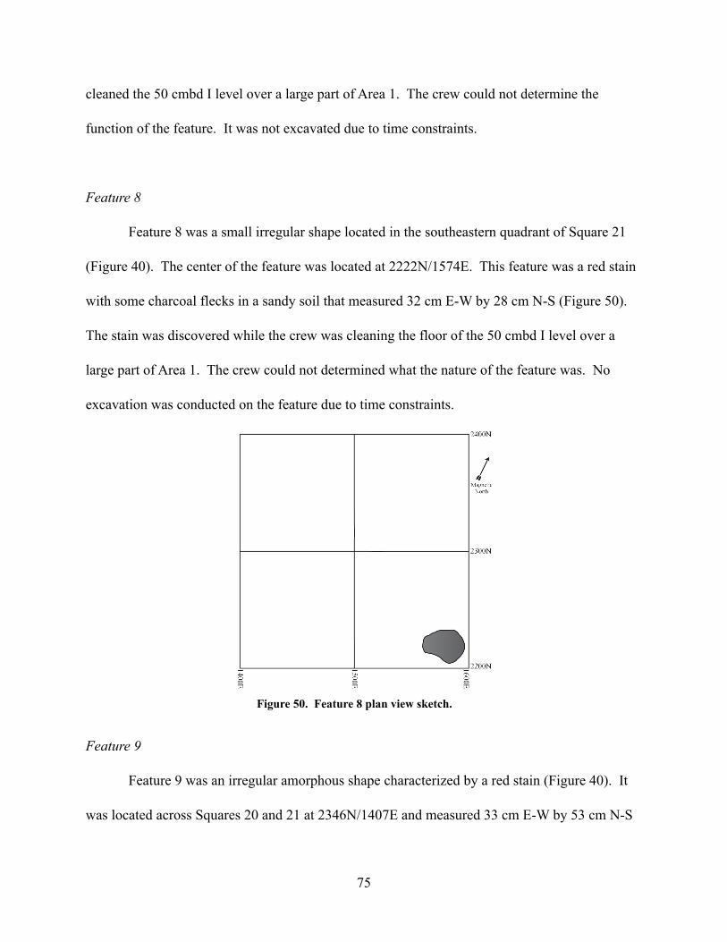
cleaned the 50 cmbd I level over a large part of Area 1. The crew could not determine the
function of the feature. It was not excavated due to time constraints.
Feature 8
Feature 8 was a small irregular shape located in the southeastern quadrant of Square 21
(Figure 40). The center of the feature was located at 2222N/1574E. This feature was a red stain
with some charcoal flecks in a sandy soil that measured 32 cm E-W by 28 cm N-S (Figure 50).
The stain was discovered while the crew was cleaning the floor of the 50 cmbd I level over a
large part of Area 1. The crew could not determined what the nature of the feature was. No
excavation was conducted on the feature due to time constraints.
Feature 9
Feature 9 was an irregular amorphous shape characterized by a red stain (Figure 40). It
was located across Squares 20 and 21 at 2346N/1407E and measured 33 cm E-W by 53 cm N-S
75
Figure 50. Feature 8 plan view sketch.

(Figure 51). The red stain contained very few charcoal flecks. The stain was discovered during
the cleaning of the 50 cmbd I floor over a large part of Area 1. The crew was unable to
determine the nature of the feature and no excavation was conducted due to a lack of time.
Feature 10
Feature 10 was a small semi-circular shape extending out of the eastern wall of the
southeastern quadrant of Square 36 in the southeastern portion of Area 2 (Figure 40). The
feature fill was described as a reddish brown sandy soil with charcoal flecks. The feature
measured 43 cm E-W by 49 cm N-S (Figure 52). No artifacts were recovered from the feature
fill. Only spheroid pebbles and angular quartz rocks were recovered in the surrounding matrix of
the southeastern quadrant of Square 36. The recovered material was designated Lot 134. A
pollen sample (Lot 138) and a soil sample (Lot 139) were taken from the 54-77 cmbd II level,
but were not analyzed. One charcoal sample was taken and associated with Lot 134. The crew
was unable to determine the nature of the feature. The feature was not excavated.
76
Figure 51. Feature 9 plan view sketch.
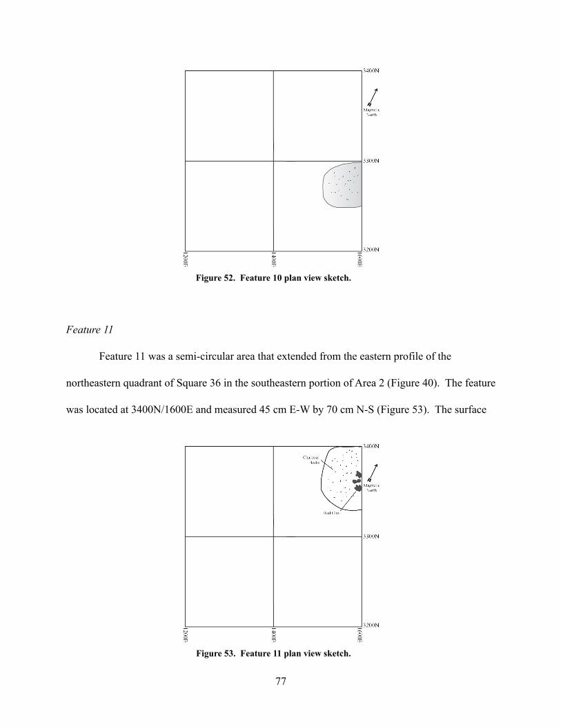
Feature 11
Feature 11 was a semi-circular area that extended from the eastern profile of the
northeastern quadrant of Square 36 in the southeastern portion of Area 2 (Figure 40). The feature
was located at 3400N/1600E and measured 45 cm E-W by 70 cm N-S (Figure 53). The surface
77
Figure 53. Feature 11 plan view sketch.
Figure 52. Feature 10 plan view sketch.

of the feature appeared at approximately 77 cmbd II. The soil consisted of patches of red clay
and flecks of charcoal in a matrix of reddish brown sand. No artifacts were recovered from this
feature. The crew was unable to determine the nature of this feature and did not excavate it due
to time constraints.
Feature 12
Feature 12 was located in the southwestern portion of Area 2 and crossed over the
junction of Squares 34, 35, 37, and 38 (Figure 40). The center point was located at 3370N/
1200E and it measured 97 cm E-W by 69 cm N-S with a maximum thickness of 10 cm (Figure
54). The soil was characterized as an area of red clay intermixed with brown sand. The crew
believed this feature was the remains of a tree stump that had decayed and silted-in during a
flooding event. No artifacts were associated with this feature.
78
Figure 54. Feature 12 plan view sketch.

Feature 13
Feature 13, a small elliptical shape, was located in the southwestern quadrant of Square
13 in the southern half of Area 1 (Figure 40). The soil was characterized as a reddish-gray stain
that first appeared at about 50 cmbd I. The center point of the feature was located at 1858N/
1078E. With a vertical thickness of 10 cm, the feature measured 38 cm E-W by 25 cm N-S
(Figure 55). The only artifacts recovered from the excavation were rock debris, angular quartz
pebbles, and spheroid river pebbles. They were bagged under Lot 248. A pollen sample (Lot
257) and a soil sample (Lot 258) were also taken, but not analyzed. The stain that defined the
feature was very indistinct and, as a result, the crew was unable to determine the nature of the
feature.
Feature 14
This feature was a small, circular, reddish gray stain, that was similar to Feature 13 and
was uncovered only 4-6 cm to the south of it (Figure 40). The feature’s center point was located
79
Figure 55. Feature 13 plan view sketch.

at 1817N/1081E (Figure 56). The measurements of Feature 14 were 30 cm E-W by 30 cm N-S
with a maximum depth of 9 cm. No artifacts were associated with this feature. A pollen sample
(Lot 259) and a soil sample (Lot 260) were taken from the southern half of the feature, but were
not analyzed. Although the feature was bisected, excavated (northern half), and profiled (no
sketch was apparent on the feature forms), the stain was too indistinct for the crew to give a
determination on its purpose or type.
Feature 15
Feature 15 was located at the junction of Squares 5 and 8 in the southern portion of Area
1 (Figure 40). It consisted of a concentration of fire cracked rock in a sandy matrix. The feature
measured 36 cm E-W by 36 cm N-S and had a vertical thickness of 10 cm (Figure 57). The
feature was centered around 1385N/1300E. The fire cracked rock was bagged under Lot 261.
No other artifacts were found and no samples were taken. The crew believed that this feature
could possibly be a hearth due to the presence of the fire cracked rock.
80
Figure 56. Feature 14 plan view sketch.

Feature 16
Feature 16 was a possible hearth located in the northwestern corner of Area 2 in the
northwestern corner of Square 41 (Figure 40). It was characterized by a faint reddish stain in a
matrix of tan sandy soil. No charcoal was observed, however, a large quantity of fire cracked
rock was recorded and recovered. The feature (Figure 58) measured 60 cm E-W by 46 cm N-S
81
Figure 58. Feature 16 plan view sketch.
Figure 57. Feature 15 plan view sketch.
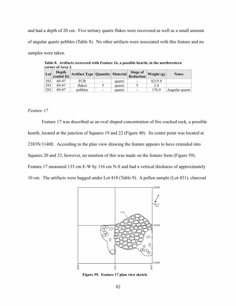
and had a depth of 20 cm. Five tertiary quartz flakes were recovered as well as a small amount
of angular quartz pebbles (Table 8). No other artifacts were associated with this feature and no
samples were taken.
Feature 17
Feature 17 was described as an oval shaped concentration of fire cracked rock, a possible
hearth, located at the junction of Squares 19 and 22 (Figure 40). Its center point was located at
2383N/1140E. According to the plan view drawing the feature appears to have extended into
Squares 20 and 23, however, no mention of this was made on the feature form (Figure 59).
Feature 17 measured 135 cm E-W by 116 cm N-S and had a vertical thickness of approximately
10 cm. The artifacts were bagged under Lot 418 (Table 9). A pollen sample (Lot 431), charcoal
82
Figure 59. Feature 17 plan view sketch.
Lot Depth (cmbd II) Artifact Type Quantity Material Stage of
Reduction Weight (g) Notes
293 89-97 FCR - quartz - 8215.9293 89-97 flakes 5 quartz T 2.4293 89-97 pebbles - quartz - 176.9 Angular quartz
Table 8. Artifacts recovered with Feature 16, a possible hearth, in the northwestern corner of Area 2.

sample (Lot 418), and two soil samples (Lot 427) were collected for the overall square area. The
evidence for this feature being a hearth was overwhelming to the field crew. Over 36 kg of fire
cracked rock was recorded in a relatively small area. The large number of spheroid pebbles was
also an indication that a fire, and possibly cooking, was taking place in this spot. Spheroid river
pebbles were sometimes used as heat sinks in cooking pots.
Feature 18
Feature 18 was an amorphous, dark gray stain situated over the junction of Squares 13
and 16 near the center of Area 1 (Figure 40). The feature was specifically located at 2026N/
1110E. It measured 137 cm E-W by 112 cm N-S and had a vertical depth of 35 cm (Figure 60).
The dark gray stain was situated in sandy soil with cobbles and fire cracked rock. Another dark
stain was uncovered in the southeastern quadrant of Square 13. It was thought that this could be
associated with the feature. A soil sample was collected from the southeastern quadrant of the
feature (Lot 416). One charcoal sample was taken with Lot 354. The crew was unable to
determine the nature of the feature based on the given information.
83
Lot Depth (cmbd I) Artifact Type Quantity Material Stage of
Reduction Weight (g) Notes
418 70-73 cobbles 11 quartzite - 2022.9 Spheroid418 70-73 cobbles 3 quartzite - 452.8 Angular418 70-73 cobbles - quartz - 1579.9 Sub-angular418 70-73 debris - - - 2189.7418 70-73 FCR - quartzite - 27288.7418 70-73 FCR - quartz - 9624.6418 70-73 fire cracked chert - chert - 0.5418 70-73 flakes 1 quartz T 1.1418 70-73 pebbles - - - 462.5 Spheroid418 70-73 pebbles - quartzite - 19.4 Angular
Table 9. Artifacts recovered from Feature 17, a possible hearth. Note the large amount of FCR that was recorded and recovered.

Table 10 is a listing of artifacts from the database that was created during the 2009-2010
lab analysis. The artifacts were listed on the bags for Lot 354 as coming from Feature 18. There
is no mention of this, however, on the feature form or in the field notes. Lot 354 in the field
notes is listed as the southwestern corner of square 16 which does cover a portion of the feature.
Regardless, the artifacts in Table 10 represent either artifacts from the feature or artifacts from
very near the feature. Table 11 contains a listing of artifacts from Lot 417 which was noted on
the feature form as containing artifacts from Feature 18.
84
Table 10. Artifacts from the collection listed as being associated with Feature 18. See text for details.
Lot Depth (cmbd I)
Artifact Type Quantity Material Stage of
Reduction Weight (g) Notes
354 60-70 debris - - - 803.7354 60-70 FCR - quartzite - 1524.3354 60-70 flakes 1 chert S 1.7354 60-70 flakes 4 chert T 1.2354 60-70 flakes 3 diabase U 3.4354 60-70 flakes 1 quartz P 27.3354 60-70 flakes 9 quartz T 18.8354 60-70 pebbles - - - 55.6 Rounded
Figure 60. Feature 18 plan view sketch.

Feature 19
Feature 19 was a large feature situated in the southwestern corner of Area 1 (Figure 40).
It was located near the center of Square 17 at 1118N/1123E and measured 70 cm E-W by 58 cm
N-S with a vertical depth of 10 cm (Figure 61). No dark stain was observable in the feature fill.
It was, however, comprised of a tan, sandy, loam and fire cracked rock (Table 12). No soil or
pollen samples were taken. One charcoal sample was taken (Lot 335). The crew believed that
this feature was a possible hearth.
85
Figure 61. Feature 19 plan view sketch.
Lot Depth (cmbd I) Artifact Type Quantity Material Stage of
Reduction Weight (g) Notes
417 70-95 debris - - - 6.9417 70-95 FCR - quartz - 294.5417 70-95 flakes 1 chert T 0.4417 70-95 pebbles - - - 0.6 Rounded
Table 11. Artifacts recovered from Feature 18.
Lot Depth (cmbd I) Artifact Type Quantity Material Stage of
Reduction Weight (g) Notes
335 68-78 debris - - - 2051.2335 68-78 FCR - quartz - 1389.6335 68-78 flakes 3 quartz T 0.7335 68-78 pebbles - - - 31.0 Spheroid
Table 12. Artifacts listed as being associated with Feature 19.

Feature 20
Feature 20 was a dark black/gray stain in a sandy loam situated in the northern end of
Area 2 (Figure 40). The center point of the feature was located at 3662N/1350E. It measured 70
cm E-W by 50 cm N-S and had a vertical depth of 53 cm (Figure 62). The feature initially
presented itself as three large rocks in what the crew members described as an elliptical shape.
The shape soon took the form more resembling an oval and had a deep basin or pit-like profile.
The fill was described on the feature form as being “exceptionally dark”. Three bands of brown
sand are noted on the profile drawing (Figure 63). Soil samples were taken from both halves of
the feature. Pollen samples were taken from three different levels (Table 13). The half of the
feature they were taken from was not noted.
The field crew was unable to determine the nature of the feature based on the evidence
that was excavated. It is possible that this feature is some sort of midden that had a good deal of
86
Figure 62. Feature 20 plan view sketch.
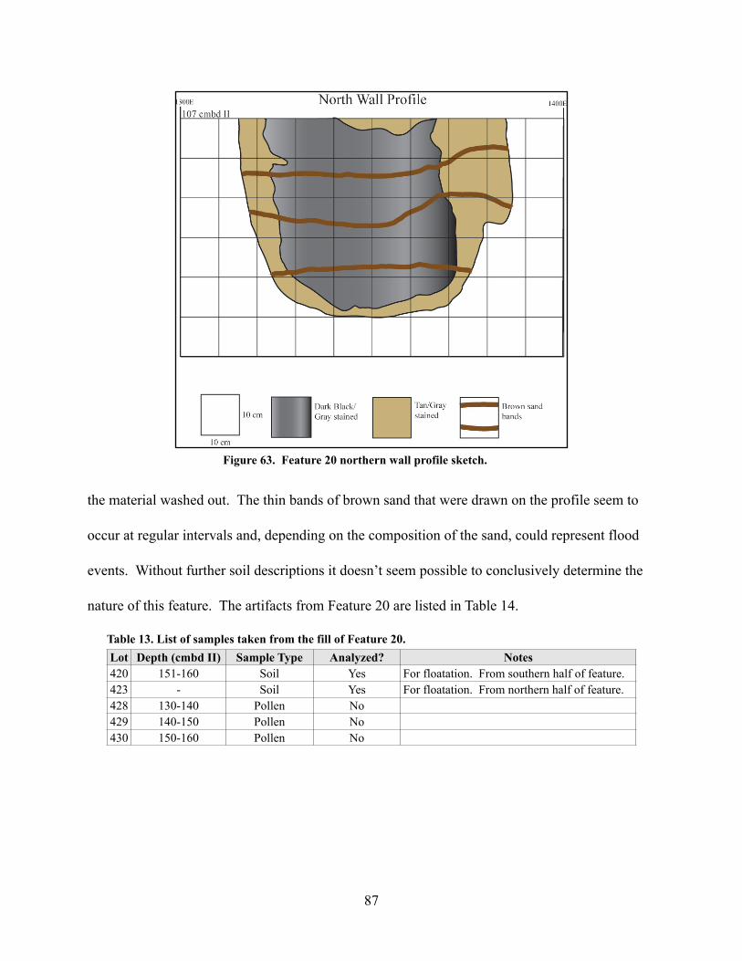
the material washed out. The thin bands of brown sand that were drawn on the profile seem to
occur at regular intervals and, depending on the composition of the sand, could represent flood
events. Without further soil descriptions it doesn’t seem possible to conclusively determine the
nature of this feature. The artifacts from Feature 20 are listed in Table 14.
87
Lot Depth (cmbd II) Sample Type Analyzed? Notes420 151-160 Soil Yes For floatation. From southern half of feature.423 - Soil Yes For floatation. From northern half of feature.428 130-140 Pollen No429 140-150 Pollen No430 150-160 Pollen No
Table 13. List of samples taken from the fill of Feature 20.
Figure 63. Feature 20 northern wall profile sketch.
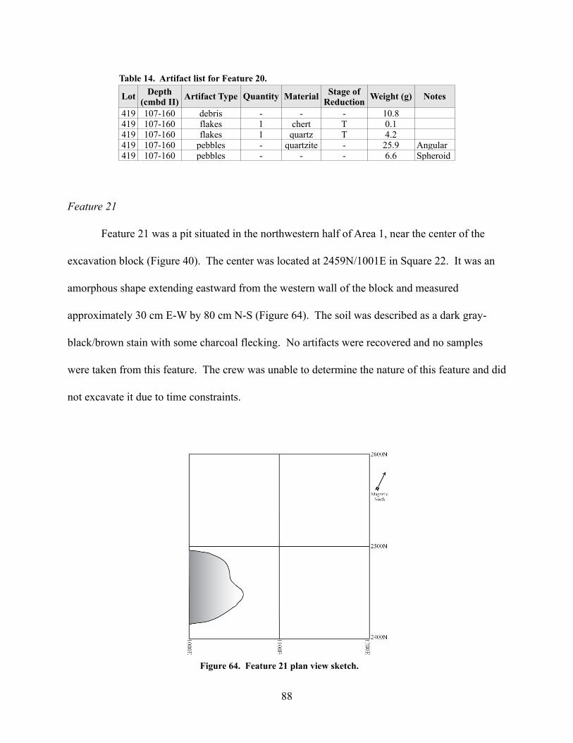
Feature 21
Feature 21 was a pit situated in the northwestern half of Area 1, near the center of the
excavation block (Figure 40). The center was located at 2459N/1001E in Square 22. It was an
amorphous shape extending eastward from the western wall of the block and measured
approximately 30 cm E-W by 80 cm N-S (Figure 64). The soil was described as a dark gray-
black/brown stain with some charcoal flecking. No artifacts were recovered and no samples
were taken from this feature. The crew was unable to determine the nature of this feature and did
not excavate it due to time constraints.
88
Lot Depth (cmbd II) Artifact Type Quantity Material Stage of
Reduction Weight (g) Notes
419 107-160 debris - - - 10.8419 107-160 flakes 1 chert T 0.1419 107-160 flakes 1 quartz T 4.2419 107-160 pebbles - quartzite - 25.9 Angular419 107-160 pebbles - - - 6.6 Spheroid
Table 14. Artifact list for Feature 20.
Figure 64. Feature 21 plan view sketch.

Feature 22
Feature 22 was situated in the northwestern quadrant of Square 22, roughly 50 cm north
of Feature 21 (Figure 40). The feature was a possible hearth characterized by a cluster of fire
cracked rock. It appeared to extend northward into the wall of the unit. The feature was
centered on the north wall at 2600N/1057E. The width on the wall was 35 cm E-W and it
extended south for 18 cm (Figure 65). The only soil description provided for the feature stated
that no dark stain was associated with the FCR concentration. No artifacts were associated with
this feature but a soil sample was taken near the end of the excavation and assigned to Lot 358.
The crew was unable to determine the nature of the feature and did not excavate it.
Feature 23
This feature was possibly an extension of Feature 21 (Figure 40). It was characterized as
a dark, black and brown stain that was oval in shape. The feature was less than 10 cm northeast
of Feature 21 at 2482N/1078E. The area between this feature and Feature 21 was described on
89
Figure 65. Feature 22 plan view sketch.

the feature form as “somewhat hazy”. Feature 23 measured 31 cm E-W by 26 cm N-S (Figure
66). No artifacts were associated with this feature and no samples were taken. The crew was
unable to determine a unique function for this feature and refrained from excavating it due to a
lack of time.
Feature 24
This large feature was located in the southern portion of Area 2, primarily in Square 39
(Figure 40). The center point was located at 3462N/1464E. Feature 24 measured 111 cm E-W
by 160 cm N-S and had a vertical depth of 24 cm at its deepest point (Figure 67). The soil was
characterized as a dark gray stain with some charcoal flecks. A charcoal sample was taken and
assigned to Lot 413 with the recovered artifacts (Table 15). A soil sample for flotation (Lot 410)
was taken as well as two pollen samples (Lots 412 and 442). The field crew noted that quartz
flakes were found among the FCR and cobbles. These artifacts extended beyond the area of the
dark stain and were situated at a shallower depth. The field notes describe a bag of “rocks” that
90
Figure 66. Feature 23 plan view sketch.

comprised a second layer, below the primary layer, and were assigned to Lot 436. Lot 436,
however, was not in the artifact collection and might be the result of a clerical error. The
charcoal flecks and the high amount of FCR led the field crew to conclude that this feature was a
hearth.
91
Lot Depth (cmbd II) Artifact Type Quantity Material Stage of
Reduction Weight (g) Notes
413 107-128 cobbles - quartzite - 5138.1413 107-128 core 1 quartz unidirectional 128.0413 107-128 debris - - - 1225.2413 107-128 FCR - quartz - 7405.0413 107-128 FCR - quartzite - 13491.5413 107-128 flakes 9 chert T 2.8413 107-128 flakes 1 chert S 4.3413 107-128 flakes 1 diabase U 4.6413 107-128 flakes 26 quartz T 58.3413 107-128 flakes 4 quartzite T 2.0413 107-128 pebbles - quartz - 1741.1 Angular413 107-128 pebbles - quartzite - 1067.2 Angular413 107-128 pebbles - - - 173.7 Spheroid
Table 15. Artifact list for Feature 24.
Figure 67. Feature 24 plan view sketch.
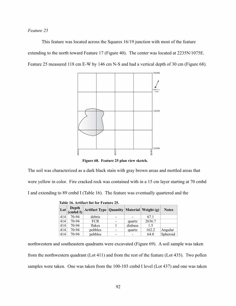
Feature 25
This feature was located across the Squares 16/19 junction with most of the feature
extending to the north toward Feature 17 (Figure 40). The center was located at 2235N/1075E.
Feature 25 measured 118 cm E-W by 146 cm N-S and had a vertical depth of 30 cm (Figure 68).
The soil was characterized as a dark black stain with gray brown areas and mottled areas that
were yellow in color. Fire cracked rock was contained with in a 15 cm layer starting at 70 cmbd
I and extending to 89 cmbd I (Table 16). The feature was eventually quartered and the
northwestern and southeastern quadrants were excavated (Figure 69). A soil sample was taken
from the northwestern quadrant (Lot 411) and from the rest of the feature (Lot 435). Two pollen
samples were taken. One was taken from the 100-103 cmbd I level (Lot 437) and one was taken
92
Figure 68. Feature 25 plan view sketch.
Lot Depth (cmbd I) Artifact Type Quantity Material Weight (g) Notes
414 70-94 debris - - 67.1414 70-94 FCR - quartz 2636.7414 70-94 flakes 1 diabase 1.5414 70-94 pebbles - quartz 162.2 Angular414 70-94 pebbles - - 64.0 Spheroid
Table 16. Artifact list for Feature 25.
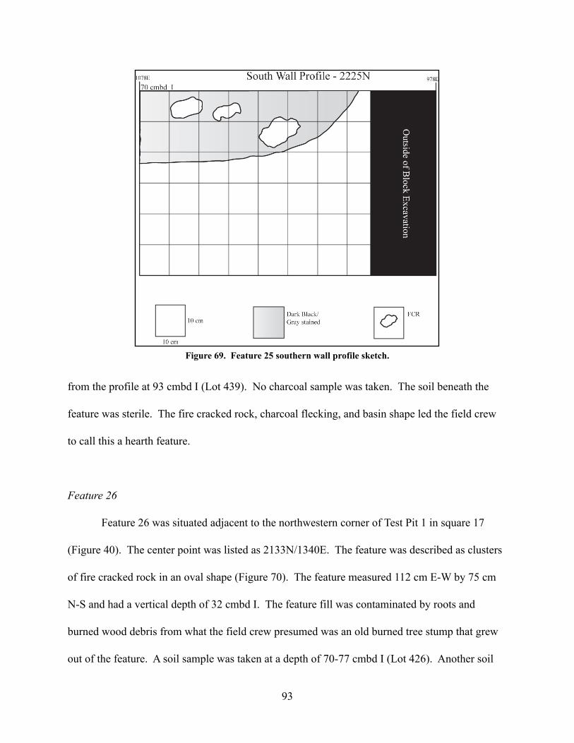
from the profile at 93 cmbd I (Lot 439). No charcoal sample was taken. The soil beneath the
feature was sterile. The fire cracked rock, charcoal flecking, and basin shape led the field crew
to call this a hearth feature.
Feature 26
Feature 26 was situated adjacent to the northwestern corner of Test Pit 1 in square 17
(Figure 40). The center point was listed as 2133N/1340E. The feature was described as clusters
of fire cracked rock in an oval shape (Figure 70). The feature measured 112 cm E-W by 75 cm
N-S and had a vertical depth of 32 cmbd I. The feature fill was contaminated by roots and
burned wood debris from what the field crew presumed was an old burned tree stump that grew
out of the feature. A soil sample was taken at a depth of 70-77 cmbd I (Lot 426). Another soil
93
Figure 69. Feature 25 southern wall profile sketch.

sample was taken from the feature and designated Lot 444. Two pollen samples were taken: one
from 82-92 cmbd I (Lot 440) and one from 92-112 cmbd I (Lot 441). One charcoal sample was
taken and assigned to Lot 421, with the artifacts from the feature (Table 17). The crew
determined that based on the quantity of fire cracked rock and charcoal, Feature 26 was a hearth.
Feature 27
This feature was situated approximately 80 cm south of Feature 26 in Square 14 of Area 1
(Figure 40). The center point was located at 1965N/1317E. The feature measured 58 cm E-W
94
Lot Depth (cmbd I) Artifact Type Quantity Material Stage of
Reduction Weight (g) Notes
421 70-73 cobbles 1 quartzite - 179.8421 70-73 FCR - quartzite - 12544.8421 70-73 pebbles - - - 19.6 Spheroid421 70-77 debris - - - 40.2421 70-77 flakes 4 chert T 0.5421 70-77 flakes 3 quartz T 6.9421 70-77 pebbles - quartzite - 217.9 Angular421 70-77 pebbles - - - 29.1 Spheroid
Table 17. Artifact list for Feature 26.
Figure 70. Feature 26 plan view sketch.

by 53 cm N-S (Figure 71). The feature was defined by a cluster of fire cracked rock. The fire
cracked rock was not given a unique lot number by the field crew. The field crew concluded that
the feature was a hearth but did not excavate it due to time constraints.
Feature 28
Feature 28 was situated under the northeastern quadrant of Feature 1 (Figure 40). Its
center was located at 2630N/1371E. The feature measured 75 cm E-W by 100 cm N-S (Figure
72). The soil was described as a dark gray/black stain with small cobbles of fire cracked rock.
The crew thought that this feature might be an extension of Feature 1. It was also thought that
this could be a much older hearth that was not associated with Feature 1. The question could not
be settled since the feature was not excavated due to a lack of time.
95
Figure 71. Feature 27 plan view sketch.

Feature 29
Feature 29 was a unique feature located primarily in the western half of Square 15
(Figure 40). It was described as a dark stain with no definable shape and a mottled look. The
center was located at 1888N/1434E. The feature measured approximately 94 cm E-W by 98 cm
N-S (Figure 73). The base of a projectile point was uncovered on the surface of the feature. No
96
Figure 73. Feature 29 plan view sketch.
Figure 72. Feature 28 plan view sketch.

evidence of the projectile point currently exists. It is not mentioned on the feature form or in the
field notes. No projectile points were recorded from the lot numbers associated with the
northwestern and southwestern quadrants of Square 15. The crew noted the existence of tree
roots at the 70 cmbd I level and the fact that these roots existed at this level in other areas of the
excavation. The field crew thought this might represent a house floor although it is unclear what
evidence supports this conclusion.
Feature 30
Feature 30 was situated under Feature 26, a hearth (Figure 40). It was characterized as a
dark black/gray stain, irregular in shape, with tan mottling. There were some charcoal flecks in
the feature fill. One plain pottery sherd was recovered but thought to be from Feature 26 (Table
18). The center of the feature was located at 2170N/1370E. Feature 30 measured 36 cm E-W by
43 cm N-S and had a vertical depth of 22 cm (Figure 74). One charcoal sample was taken from
97
Figure 74. Feature 30 plan view sketch.
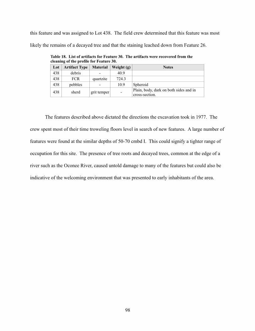
this feature and was assigned to Lot 438. The field crew determined that this feature was most
likely the remains of a decayed tree and that the staining leached down from Feature 26.
The features described above dictated the directions the excavation took in 1977. The
crew spent most of their time troweling floors level in search of new features. A large number of
features were found at the similar depths of 50-70 cmbd I. This could signify a tighter range of
occupation for this site. The presence of tree roots and decayed trees, common at the edge of a
river such as the Oconee River, caused untold damage to many of the features but could also be
indicative of the welcoming environment that was presented to early inhabitants of the area.
98
Lot Artifact Type Material Weight (g) Notes438 debris - 40.9438 FCR quartzite 724.3438 pebbles - 10.9 Spheroid
438 sherd grit temper - Plain, body, dark on both sides and in cross-section.
Table 18. List of artifacts for Feature 30. The artifacts were recovered from the cleaning of the profile for Feature 30.

Provenience 3 Diagnostic Projectile Points
The block excavation uncovered 119 tools. There were a total of 62 bifaces, 24 unifaces,
and 33 projectile point/knives (ppk). The 2009-2010 lab analysis faced several challenges. First,
a number of the tools were placed only in plastic baggies during the 1977 analysis. In many
cases no identification tag was inserted into the bag. The only indication of provenience was the
lot number written in permanent marker on the outside of the bag. Time and wear wore off most
or all of the lot number on many of the bags. Through a thorough analysis of the field notes
every attempt was made to determine the provenience of the tools that were in question.
Regardless of provenience, every tool was analyzed using the same parameters.
Several attributes were used to analyze the tools. The first attribute recorded was the
portion. The different “portion” labels were base, complete, end, fragment, margin, and mid-
section. The shape of the base was then described as either concave, stem, etc. If the tool had a
base, the type of notching, if present, was noted. Also, material and a common name were
determined. Measurements were taken with a standard set of calipers. The measurements
included length (L), width (W), and thickness (T). When the tool contained a base or tip the
length was meadured end to end, even if the tool was wider than it was long. Weight was
measured using a My Weight i1200 digital scale accurate to 0.1 g.
A total of 24 diagnostic tools were identified (Figure 75). Photographs were taken of the
diagnostic tools using a Nikon D100 digital camera with a Nikon IF Aspherical Macro (1:2) lens
mounted on an adjustable frame. The program, Nikon Cameral Control Pro 2, Version 2.7.0, was
used for computer control of the camera.
99

100
Figure 75. Diagnostic projectile point map. Twenty-four projectile points are mapped. Lot numbers correspond to the Diagnostic Tools Catalog (Appendix G).
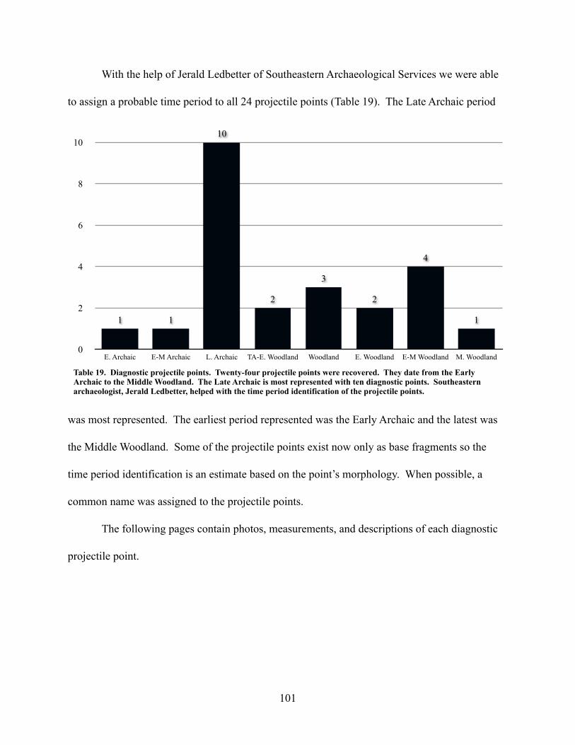
With the help of Jerald Ledbetter of Southeastern Archaeological Services we were able
to assign a probable time period to all 24 projectile points (Table 19). The Late Archaic period
was most represented. The earliest period represented was the Early Archaic and the latest was
the Middle Woodland. Some of the projectile points exist now only as base fragments so the
time period identification is an estimate based on the point’s morphology. When possible, a
common name was assigned to the projectile points.
The following pages contain photos, measurements, and descriptions of each diagnostic
projectile point.
Table 19. Diagnostic projectile points. Twenty-four projectile points were recovered. They date from the Early Archaic to the Middle Woodland. The Late Archaic is most represented with ten diagnostic points. Southeastern archaeologist, Jerald Ledbetter, helped with the time period identification of the projectile points.
0
2
4
6
8
10
E. Archaic E-M Archaic L. Archaic TA-E. Woodland Woodland E. Woodland E-M Woodland M. Woodland
1
4
2
3
2
10
11
101

Provenience 3
Lot 021
Photograph NumberP3L021A1
DescriptionQuartz stemmed point
PeriodLate Archaic3000 - 5000 BP
NotesTapering rounded stem. Similar to Gary stemmed from Ledbetter (2009).Similar to Gary stemmed from Ledbetter (2009). L: 4.61 cm - W: 3.62 cm - T: 1.27 cm - Weight: 20.2 g
Figure 76
Provenience 3
Lot 030
Photograph NumberP3L030A1
DescriptionQuartz stemmed point
PeriodWoodland1200 - 3000 BP
NotesPossibly re-worked Woodland Spike (Whatley 2002).Woodland Spike (Whatley 2002). L: 3.34 cm - W: 1.80 cm - T: 0.78 cm - Weight: 4.1 g
Figure 77
102

Provenience 3
Lot 031
Photograph NumberP3L031A1
DescriptionRounded stem base fragment
PeriodLate Archaic3000 - 5000 BP
NotesLedbetter (personal communication 2010).communication 2010).
L: 1.64 cm - W: 3.25 cm - T: 1.11 cm - Weight: 3.5 g
Figure 78
Provenience 3
Lot 043
Photograph NumberP3L043A1
DescriptionQuartz stemmed point
PeriodLate Archaic3000 - 5000 BP
NotesCommon name: Gary(Ledbetter, et al. 2009).(Ledbetter, et al. 2009).
L: 4.94 cm - W: 3.51 cm - T: 1.02 cm - Weight: 13.0 g
Figure 79
103

Provenience 3
Lot 046
Photograph NumberP3L046A1
DescriptionQuartz stemmed preform
PeriodLate Archaic3000 - 5000 BP
NotesLedbetter (personal communication 2010).
NotesLedbetter (personal communication 2010).
L: 7.05 cm - W: 4.22 cm - T: 2.01 cm - Weight: 56.0 g
Figure 80
Provenience 3
Lot 046
Photograph NumberP3L046A2
DescriptionReworked quartz stem
PeriodLate Archaic3000 - 5000 BP
NotesLedbetter (2009).NotesLedbetter (2009).
L: 5.57 cm - W: 3.51 cm - T: 1.51 cm - Weight: 24.8 g
Figure 81
104
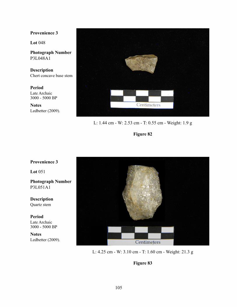
Provenience 3
Lot 048
Photograph NumberP3L048A1
DescriptionChert concave base stem
PeriodLate Archaic3000 - 5000 BP
NotesLedbetter (2009).NotesLedbetter (2009).
L: 1.44 cm - W: 2.53 cm - T: 0.55 cm - Weight: 1.9 g
Figure 82
Provenience 3
Lot 051
Photograph NumberP3L051A1
DescriptionQuartz stem
PeriodLate Archaic3000 - 5000 BP
NotesLedbetter (2009).NotesLedbetter (2009).
L: 4.25 cm - W: 3.10 cm - T: 1.60 cm - Weight: 21.3 g
Figure 83
105
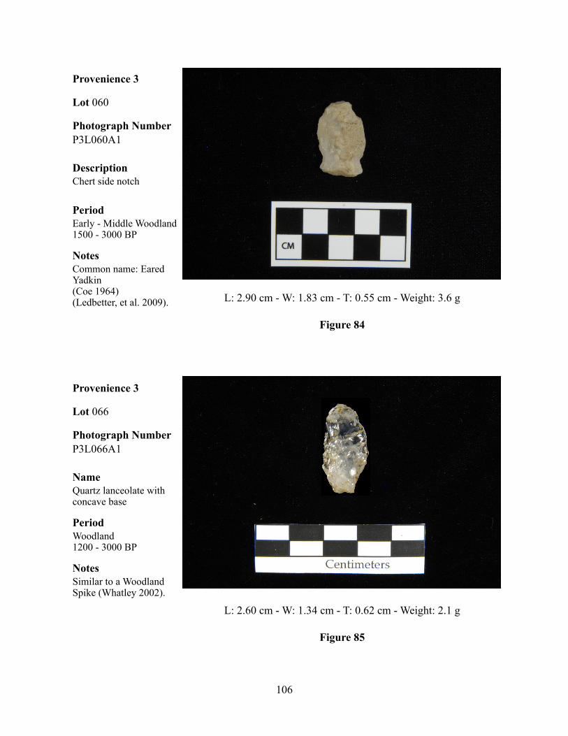
Provenience 3
Lot 060
Photograph NumberP3L060A1
DescriptionChert side notch
PeriodEarly - Middle Woodland1500 - 3000 BP
NotesCommon name: Eared Yadkin(Coe 1964)(Ledbetter, et al. 2009).
NotesCommon name: Eared Yadkin(Coe 1964)(Ledbetter, et al. 2009). L: 2.90 cm - W: 1.83 cm - T: 0.55 cm - Weight: 3.6 g
Figure 84
Provenience 3
Lot 066
Photograph NumberP3L066A1
NameQuartz lanceolate with concave base
PeriodWoodland1200 - 3000 BP
NotesSimilar to a Woodland Spike (Whatley 2002).
NotesSimilar to a Woodland Spike (Whatley 2002).
L: 2.60 cm - W: 1.34 cm - T: 0.62 cm - Weight: 2.1 g
Figure 85
106

Provenience 3
Lot 091
Photograph NumberP3L091A1
DescriptionConcave base stem
PeriodEarly Woodland3000 - 2000 BP
NotesPossibly a Yadkin. Chert is called “457 material” (Ledbetter, is called “457 material” (Ledbetter, personal communication 2010).
L: 3.47 cm - W: 2.99 cm - T: 0.82 cm - Weight: 7.7 g
Figure 86
Provenience 3
Lot 113
Photograph NumberP3L113A1
DescriptionBifacially serrated side notched
PeriodEarly Archaic9500 - 9900 BP
NotesBig Sandy/Taylor (Whatley 2002).(Whatley 2002).
L: 3.83 cm - W: 2.16 cm - T: 0.82 cm - Weight: 5.6 g
Figure 87
107

Provenience 3
Lot 113
Photograph NumberP3L113A2
DescriptionChert rounded base stem
PeriodEarly - Middle Woodland1500 - 3000 BP
NotesCould be a preform with an un-finished base (Ledbetter, personal an un-finished base (Ledbetter, personal communication 2010). L: 4.51 cm - W: 1.86 cm - T: 1.02 cm - Weight: 6.4 g
Figure 88
Provenience 3
Lot 115
Photograph NumberP3L115A1
DescriptionQuartz rounded base leaf stem
PeriodEarly - Middle Archaic10000 - 5000 BP
NotesLedbetter (personal communication 2010).communication 2010).
L: 5.93 cm - W: 2.63 cm - T: 1.09 cm - Weight: 16.7 g
Figure 89
108

Provenience 3
Lot 117
Photograph NumberP3L117A1
DescriptionChert, possibly re-worked, side-notched
PeriodEarly Woodland3000 - 2000 BP
NotesLedbetter (personal communication 2010),Whatley (2002).communication 2010),Whatley (2002). L: 2.82 cm - W: 2.46 cm - T: 0.66 cm - Weight: 3.7 g
Figure 90
Provenience 3
Lot 193
Photograph NumberP3193A1
DescriptionChert concave base triangular
PeriodLate Early to Middle Woodland2500 - 1500 BP
NotesLedbetter (personal Ledbetter (personal communication 2010).Whatley (2002).
L: 2.19 cm - W: 2.50 cm - T: 0.86 cm - Weight: 3.7 g
Figure 91
109

Provenience 3
Lot 282
Photograph NumberP3L282A1
DescriptionChert corner-notch
PeriodTerminal Archaic - Early Woodland3400 - 2400 BP
NotesEspenshade (1994),Ledbetter (personal Ledbetter (personal communication 2010). L: 3.97 cm - W: 1.14 cm - T: 0.65 cm - Weight: 6.5 g
Figure 92
Provenience 3
Lot 299
Photograph NumberP3L299A1
DescriptionChert stem
PeriodTerminal Archaic - Early Woodland3400 - 2400 BP
NotesLedbetter (personal communication 2010).communication 2010).
L: 3.86 cm - W: 2.38 cm - T: 0.71 cm - Weight: 5.5 g
Figure 93
110

Provenience 3
Lot 302
Photograph NumberP3L302A1
DescriptionChert lanceolate
PeriodMiddle Woodland2000 - 1500 BP
NotesLedbetter (2009),Whatley (2002).
NotesLedbetter (2009),Whatley (2002).
L: 29.4 cm - W: 1.52 cm - T: 0.61 cm - Weight 2.8 g
Figure 94
Provenience 3
Lot 310
Photograph NumberP3L310A1
DescriptionQuartz triangular
PeriodWoodland3000 - 1200 BP
NotesLedbetter (personal communication 2010).
NotesLedbetter (personal communication 2010).
L: 2.55 cm - W: 3.26 cm - T: 0.68 cm - Weight: 5.7 g
Figure 95
111

Provenience 3
Lot 365
Photograph NumberP3L365A1
DescriptionChert stem
PeriodLate Archaic5000 - 3000 BP
NotesLedbetter (personal communication 2010).communication 2010).
L: 5.58 cm - W: 3.36 cm - T: 1.00 cm - Weight: 16.0 g
Figure 96
Provenience 3
Lot 385
Photograph NumberP3L385A1
DescriptionQuartz, re-worked
PeriodEarly - Middle Woodland3000 - 1500 BP
NotesYadkin (Ledbetter, et al. 2009; Whatley 2002).2009; Whatley 2002).
L: 1.61 cm - W: 2.38 cm - T: 0.58 cm - Weight: 1.5 g
Figure 97
112
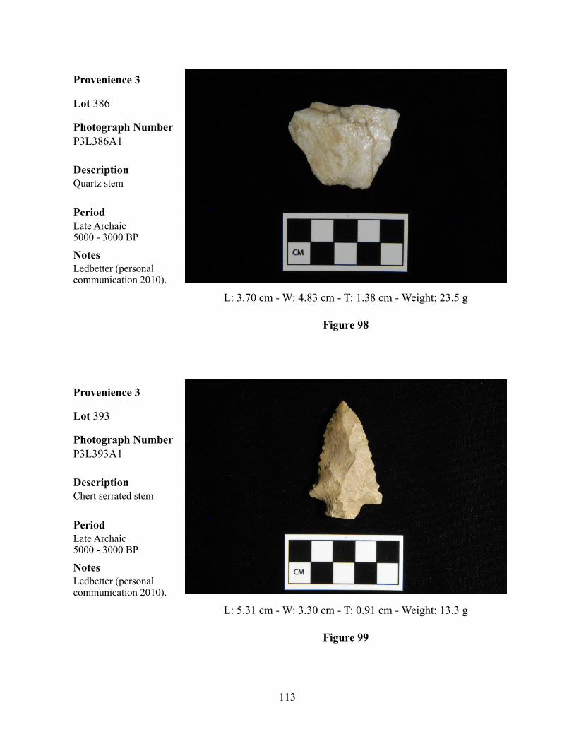
Provenience 3
Lot 386
Photograph NumberP3L386A1
DescriptionQuartz stem
PeriodLate Archaic5000 - 3000 BP
NotesLedbetter (personal communication 2010).communication 2010).
L: 3.70 cm - W: 4.83 cm - T: 1.38 cm - Weight: 23.5 g
Figure 98
Provenience 3
Lot 393
Photograph NumberP3L393A1
DescriptionChert serrated stem
PeriodLate Archaic5000 - 3000 BP
NotesLedbetter (personal communication 2010).communication 2010).
L: 5.31 cm - W: 3.30 cm - T: 0.91 cm - Weight: 13.3 g
Figure 99
113

Provenience 4
Provenience 4 was the last provenience designated on the site. The general surface
collection consisted of lot numbers 001 and 002 (Table 5). The profile cleaning at the bulldozer
cut north of the original test pit from the DePratter survey of 1974 and 1975 was designated lot
number 003.
A total of eight quartz flakes were found on the surface around the site. Also, a projectile
point and a biface were recovered. The profile cleaning yielded soapstone debris, FCR and two
quartz flakes.
Table 5. Provenience 4 artifacts.
Lot Location Artifact Type Quantity Material Stage of Reduction Weight (g) Notes
001 Surface Flakes 3 quartz T 10.1001 Surface Projectile Point 1 quartz - 14.7 Base and mid-section002 Surface Biface 1 quartz - 4.5 Margin002 Surface Flakes 5 quartz T 15.7003 Profile Cobbles 2 quartz - 706.3003 Profile Debris 1 soapstone - 15.1003 Profile FCR - quartz - 377.9003 Profile Flakes 2 quartz T 9.8
114
6. DISCUSSION
Several of the Late Archaic stemmed projectile points and the Napier Complicated
Stamped pottery definitively place 9PM201 within two main time periods: the Late Archaic and
the Late Woodland periods. Over 300 charcoal samples were collected. Some were collected
over the course of the excavation and some were collected in the lab from soil samples.
Unfortunately, the collection methods are not clear and it would be difficult to obtain reliable
dates from the samples. A large number of samples would have to be dated, at great expense, in
order to get an average date range. Another analytical method that was not employed during the
analysis of this site was the palynological study. Soil samples were collected for palynological
analysis, however, these samples remain untouched in the collections room at the Laboratory of
Archaeology at the University of Georgia.
This discussion will touch on the Late Archaic component but will focus on the Napier
component. The Late Archaic component was difficult to analyze due to the lack of reliable
dates as well as problems with the field notes. The features were not dated and were poorly
described, with few stratigraphic profile drawings and no soil descriptions. The Napier
component was somewhat easier to describe due to the large number of sherds that were
recovered, however, the problems with the field notes affect this area also.
The excavator of this site, Anne Rogers, also excavated a Late Archaic site in the
southern end of the Wallace Reservoir Project area, 9PM205 (Rogers 1982). Many of the
conclusions that she came to from that site are applicable to the Late Archaic component of
9PM201.
115

Chipped stone and charcoal-stained features were found throughout the excavation of
Provenience 3 of 9PM201. There were few concentrations of lithic material, however, as had
been the case at 9PM205 (Rogers 1982), the material was largely quartz with little chert. It’s
possible that 9PM201 was visited many times over several thousand years. There is no clear
evidence of long term occupation anywhere on 9PM201. The following paragraphs are in
support of that hypothesis.
The sizes of chipped stone flakes recovered from the site supports the temporary nature
of occupations during the Late Archaic and beyond. Most of the recovered lithic material was
classified as either secondary or tertiary, with most flakes exhibiting little or no cortex. This
indicates that lithic tools were likely brought to the site in a completed or nearly completed form.
It seems that no major cobble processing was taking place in the excavated areas, since few cores
were recovered. Quartz cobbles can be found in the rivers of the Piedmont but were not
extensively utilized for stone tools by occupants of the 9PM201 levee. This is shown by the lack
of primary flakes (determined in quartz by either a rounded dorsal surface and/or the presence of
a surface “rind” that can be seen in quartz river cobbles) recovered from the site. For these
reasons, all lithic material found on the site were presumed to have been brought there
intentionally and in some already worked form that needed little modification.
There were large, angular, quartz pieces recovered at Provenience 3. These were not used
for the manufacture of stone tools. They were likely used to line hearths or as heating stones.
Angular fire cracked rock was recovered from nearly every excavation unit within Provenience
3. The fire cracked rock was likely obtained from locally occurring outcrops. Quartz cobbles
can be found in the Oconee River, however, none of the recovered fire cracked rock contained
116

evidence of rounding on the exterior surfaces. Such evidence would have been indicative of a
riparian origin.
The chert flakes from 9PM201 seemed to represent a mixture of different sources ranging
from the Ridge and Valley area to the Coastal Plain. A concentration of what the field crew in
1977 called “fire cracked chert” was located in the northern end of Area 1 in Provenience 3. This
concentration remained at the same density and in the same location throughout several levels.
All of the fragments are small, angular pieces that were light gray to dark blue in color. None of
the fragments appear to be flakes. There are a few pieces that exhibit evidence of bifacial
flaking, though. There are roughly 1-2 of these in each lot of fire cracked chert. It seems that the
pieces were knapped prior to being heat treated to the point of cracking. This is the reverse of
how the heat treating of chert normally works. Usually, chert is heat treated to make it fracture
more favorably for the manufacture of stone tools (Goad 1979). The field notes do not indicate
whether the fire cracked chert concentration was part of a feature or not. An examination of the
density maps suggests that the chert was placed there during a single event or locus of activity. It
is doubtful that the same group came back to the same spot time after time and performed the
same activity that created this concentration. It is more likely that the flakes simple descended
through the sand over time through various site formation processes.
More evidence that this site represented short term occupations can be seen in the lithic
tool assemblage. Many of the unifacial and bifacial tools recovered were broken in some way.
Lithic tools are either broken during manufacture, during resharpening, or through use. The
ubiquity of small, tertiary and secondary, flakes at the site lead to the conclusion that the
117

manufacture of tools from preforms or the resharpening of existing tools was taking place. A
short term hunting camp would likely exhibit this kind of activity.
The final artifact types that date to the Late Archaic, or even the Terminal Archaic to
Early Woodland periods (Ledbetter, et al. 2009), are the soapstone vessel fragments. All of the
fragments that had a ground surface resembled vessel fragments, as opposed to heating slabs.
They were slightly curved and one had the remnants of a handle. Soapstone vessels were in use
during the Terminal Archaic and the Early Woodland periods. The small amount of soapstone
recovered on the site is also indicative of short term occupation. Soapstone is heavy and requires
a large expenditure of energy to manufacture and transport. It is not something that would have
likely been transported long distances very frequently.
Soapstone was available locally, however (Elliott 1981). Elemental analysis of the
soapstone fragments could determine the source, however, this technique is not reliable due to
the variability in the quantity of the minerals that comprise a piece of soapstone. Pieces within
the same outcrop could have different mineral compositions. Soapstone vessel use does not
necessarily define the Late Archaic and it does not predate the inception of pottery (Sassaman
2006) as some believe (Truncer 2004).
Aside from several projectile points (see the Diagnostic Tool section, page 99), there is
little evidence for the occupation of the site between the end of the Late Archaic/Early Woodland
and the beginning of the Late Woodland period. Lithic material was located throughout the
excavation in all levels, as was fire cracked rock. The next major occupation is shown by the
high quantity of Napier Complicated Stamped pottery of the Late Woodland period.
118
Napier pottery was first named and identified at 9BI9 near Macon, Georgia by the late A.
R. Kelly in the 1930s (Garrow 2009). The site was found during the excavations at what became
the Ocmulgee National Monument when a flood eroded part of a levee on the Ocmulgee River,
revealing a concentration of Napier ceramics. According to Garrow (2009), 9BI9 and 9PM201
are the only “pure” Napier sites in existence.
Napier pottery has been found as far east as the Savannah River and as far west as the
Chattahoochee River (Garrow 2009). The latest research places the range of this type, using
uncorrected radiocarbon dates, from A.D. 600 to A.D. 750. This is not considered a “Napier
Period”. Napier did not dominate as a stylistic design anywhere it has been found so is not
ubiquitous enough to be considered a period (Williams 2005), although some would disagree
(Garrow 2009). The Napier design faded out around A.D. 750 as it evolved into other styles.
Some believe that it evolved into the Woodstock type in the east (Garrow 2009) and into the
Etowah type in the west (Markin 2007). Both are variations of rectilinear complicated stamp
designs.
Most of the sites that have contained Napier ceramics also contained other types of
ceramics. Usually, these were either Swift Creek Complicated Stamp or Swift Creek B Complex
Complicated Stamp. It is thought that the curvilinear Swift Creek design was replaced by the
combined curvilinear/rectilinear B Complex, and then by the rectilinear Napier Complicated
Stamp (Rudolph 1988). The picture is not clear, though, since all of these Late Woodland types
overlap each other in time in most areas. The stratigraphic relationship of Napier over Swift
Creek was observed at the Swift Creek type site (Rudolph 1988). The 1988 work by Rudolph
listed 92 sites with Napier pottery in northern Georgia. A total of 34 sherds was reported for
119

9PM201. It isn’t clear how her analysis would have changed had she known that 9PM201
actually contained over 500 Napier Complicated Stamped sherds and over 350 plain sherds that
are similar in paste and thickness to the stamped sherds. No other site in Georgia has yielded
more Napier pottery than 9PM201.
One structure and one possible mound have been recorded and thought to be associated
with Napier pottery. The structure was rectangular and found on the summit of the Annewakee
Mound (9DO2) in Douglas County, Georgia (Garrow 2009). The possible mound site was tested
by the University of Georgia’s Department of Anthropology Field School in 1999 (Williams
1999). Known as the Kenimer Site (9WH68), two mounds were recorded. Mound A resembled
more of a shaped topographic feature than a mound constructed from a flat surface. Testing
yielded 14 Napier Complicated Stamped sherds and plain sherds of similar paste and thickness.
Williams believed that Mound A was constructed as a single event and used for a few decades at
most. Mound B was smaller and did not yield many artifacts. The other Napier sites that have
been recorded across the state are either short term occupation sites similar to 9PM201 or were
part of a village site with other pottery types as the primary type.
As with the Late Archaic component, there is nothing to suggest that the Late Woodland
component at 9PM201 was anything other than a short term occupation. Of the over 500 Napier
Complicated Stamped sherds identified during the analysis many (n=215) were recorded under
one lot number (157). They were excavated from the southern end of Area 1 in Provenience 3.
The sherds all exhibit the same rectilinear design and have similar paste and thickness. In fact,
most of the Napier sherds shared similar designs. Very few curvilinear designs were recorded.
The fact that they were spread across the site in small numbers could simply be a product of
120

either flooding and erosion on the levee or historic plowing. After Level 1, the concentrations
are more pronounced with the highest concentration occurring around Lot 157. Some of the
sherds from this lot have been partially reconstructed, but the vessel form is uncertain.
I firmly believe that the Napier component at 9PM201 represents a single occupation
event of short duration. All 508 stamped sherds are of a similar design, paste, and thickness.
Most of them were recovered from Levels 1 and 2. The artifact distribution pattern for Levels 1
and 2 appear, at first glance, to show a concentration of sherds in the southern end of Area 1 and
concentrations of flaked stone and fire cracked rock, along with fire cracked chert, 10-12 m away
in the northern end of Area 1. Hypothetically, the presence of a structure could help explain this
distribution. The sherds would have been inside of the structure, if kept there for storage, and the
lithic material would have been outside of the structure, most likely near a fire pit or hearth. The
evidence at 9PM201 does not seem to support this theory, however. The features are scattered in
an apparently random distribution, indicating short term occupations, and none of them even
closely resemble posts. However, many of the features were indistinct and difficult to discern
(Thomas Gresham, personal communication 2010). If there was a Napier structure on the site,
then no direct evidence for it was recovered.
While 9PM201 is important because of the shear quantity of Napier potter that was
found, I don’t believe that it helps to shed much light on the people that designed the pottery and
used it. The question of where does Napier fit chronologically cannot be settled without
obtaining dates in association with the sherds. As was stated in a previous chapter, the charcoal
samples are probably not going to be a reliable source of datable material. There is, however, a
new technique that could be utilized to directly date the pottery. It is called rehydroxylation rate
dating (Wilson, et al. 2009). This technique was developed by an engineering firm in the U.K.
121

and essentially measures the amount of molecular water that has accumulated in the clays that
make up the pottery. The water accumulates at a predictable rate and is not affected by curation
conditions and artifact washing methods. The paper’s authors tested the method on well dated
Roman bricks and received confirmatory results. The equipment to conduct this test is
expensive, however, and no labs in the United States are currently performing this type of
analysis.
Conclusions
The Wallace Reservoir was an important project for the archaeological record of Georgia.
Between the large-scale survey by DePratter (1976) and the Wallace Mitigation Survey by
Gresham (1987), nearly 2,000 sites were located. The time periods that these sites represent
range from the Early Archaic to the Historic period. It’s unfortunate that 9PM201 had to wait so
long before it was afforded it’s proper place in the archaeological record of this area. Still, I feel
that much more information could be learned from careful study of the Napier sherds and by
possibly using some new dating techniques. An analysis could be made of the stamp patterns
and designs to determine if multiple paddles, or one paddle, was used in the creation of the
design. This might help to explain whether these sherds are really part of the same event or not.
That, I believe, is the ultimate question that 9PM201 can answer: when were the Napier sherds
used and how does that change the way we think of the Late Woodland in the central Piedmont?
This, however, will have to be answered by future researchers. I hope to continue some of the
research at 9PM201 by analyzing the stamp designs on the Napier pottery in an attempt to
compare the designs to those found at other Napier sites.
122

REFERENCES CITED
Bryson, Reid 1994 On Integrating Climate Change and Culture Change Studies. Human Ecology 22
(1):115-128.
Caldwell, Joseph Ralston 1958 Trend and tradition in the prehistory of the eastern United States. American
Anthropological Association, Memoir. Menasha, WI.
Coe, Joffre Lanning 1964 The formative cultures of the Carolina Piedmont. Transactions of the American
Philosophical Society 54:1-130. Philadelphia.
DePratter, Chester B. 1976 The 1974-1975 Archaeological Survey in the Wallace Reservoir, Green, Hancock,
Morgan and Putnam Counties, Georgia. Department of Anthropology, Laboratory of Archaeology, University of Georgia, Athens. Submitted to Georgia Power Co., Inc. On file at the Georgia Site Files, Laboratory of Archaeology, University of Georgia, Athens.
Elliott, Daniel T. 1981 Soapstone Use in the Wallace Reservoir: A Tool for Interpreting Prehistory.
Wallace Reservoir Project Contribution Number 5. Laboratory of Archaeology, University of Georgia, Athens.
Espenshade, Christopher T., John Foss, and Linda Kennedy 1994 Furman Shoals in Prehistory: Archaeological Data Recovery at Site 9BL169,
Lake Sinclair Project, Baldwin County, Georgia: Final Report. Brockington And Associates, Inc. On file at the Georgia Site Files, Laboratory of Archaeology, University of Georgia, Athens.
Ford, James A. and Gordon R. Willey 1941 An Interpretation of the Prehistory of the United States. American Anthropologist
43:325-363.
Garrow, Patrick H. 2009 The Woodland Period North of the Fall Line: A Summary of Investigations from
1975 to 2000. Early Georgia 37:25-52.
Goad, Sharon I. 1979 Chert Resources in Georgia. Laboratory of Archaeology Series Report Number
21. Laboratory of Archaeology, University of Georgia, Athens.
123

Gresham, Thomas H. 1987 The Wallace Mitigation Survey: An Overview. Wallace Reservoir Project
Contribution Number 32. Laboratory of Archaeology, University of Georgia, Athens.
Hally, David J. and James L. Rudolph 1986 Mississippi Period Archaeology of the Georgia Piedmont. University of Georgia
Laboratory of Archaeology Series Report Number 24. Laboratory of Archaeology, University of Georgia, Athens.
Ledbetter, Jerald, Lisa D. O'Steen, and Scott Jones 2009 The Late Archaic to Early Woodland Transition in Northwest Georgia: Evidence
for Terminal Archaic (ca. 1100 - 600 B.C.) Period Occupation in the Region. Occasional Papers in Cultural Resource Management Number 14. Georgia Department of Transportation, Atlanta.
Markin, Julie 2007 Woodstock: The Rise of Political Complexity in North Georgia. Unpublished
Ph.D. dissertation, Department of Anthropology, University of Georgia, Athens.
O'Steen, Lisa D. 1986 Early Archaic Settlement Patterns in the Wallace Reservoir: An Inner Piedmont
Perspective. Manuscript on file, Laboratory of Archaeology, University of Georgia, Athens.
Page, James M. and Scott Butler 2007 Cultural Resources Survey of the Reynoldsboro Study Area (Port Armor North
and Carey Station East Tracts) Greene County, Georgia. Brockington and Associates, Inc. Submitted to Reynolds Plantation, LLC. Copies available from Georgia Site Files, Laboratory of Archaeology, University of Georgia, Athens.
Rogers, Anne 1977 Original field notes from 9PM201. On file, Laboratory of Archaeology,
University of Georgia, Athens.
1978 A Preliminary Report for Archaeological Salvage Undertaken at 9PM201. On file, Laboratory of Archaeology, University of Georgia, Athens.
1982 An Interpretation of a Late Archaic Period Site in Piedmont Georgia. Wallace Reservoir Project Contribution Number 17. Laboratory of Archaeology, University of Georgia, Athens.
124

Rudolph, Teresa P. 1988 Swift Creek and Napier in North Georgia. On file, Laboratory of Archaeology,
University of Georgia, Athens.
Sassaman, Kenneth E. 2006 Dating and Explaining Soapstone Vessels: A Comment on Truncer. American
Antiquity 71:141-156.
Stanyard, William F. 2003 Archaic Period Archaeology of North Georgia. Laboratory of Archaeology Series
Report No. 38. Laboratory of Archaeology, University of Georgia, Athens.
Truncer, James 2004 Steatite Vessel Age and Occurrence in Temperate Eastern North America.
American Antiquity 69:487-513.
Wauchope, Robert 1966 Archaeological Survey of Northern Georgia. Society for American Archaeology,
Memoir 21. Salt Lake City.
Whatley, John S. 2002 An Overview of Georgia Projectile Points and Selected Cutting Tools. Early
Georgia 30:7-133.
Williams, Mark 1999 Archaeological Testing at the Kenimer Site, 9WH68. Lamar Institute Publication
44. Lamar Institute, Athens, Georgia.
2005 4000 Years at a Glance: Patterns of Ceramic Style Distribution over Georgia. Early Georgia 33:181-189.
Williams, Mark and Victor Thompson 1999 A Guide to Georgia Indian Pottery Types. Early Georgia 27:1-167.
Wilson, Moira A., Margaret A. Carter, Christopher Hall, William D. Hoff, Ceren Ince, Chaun D. Savage, Bernard Mckay and Ian M. Betts
2009 Dating Fired-Clay Ceramics Using Long-Term Power Law Rehydroxylation Kinetics. Proceedings of the Royal Society A published online:1-9.
125

Wood, W. Dean, Daniel T. Elliott, Teresa P. Rudolph, and Dennis B. Blanton 1986 Prehistory in the Richard B. Russell Reservoir: The Archaic and Woodland
Periods of the Upper Savannah River. Southeastern Wildlife Services, Inc. Copies available from Georgia Site Files, Laboratory of Archaeology, University of Georgia, Athens.
126

APPENDIX A
Wallace Reservoir Lab Analysis Forms - 1977
127

128

129
130

131
Appendix B: Provenience 1 Artifact Catalog
Lot Post Hole Test # Level Depth(cmbs)
Artifact Type Quantity Material Weight (g) Notes001 1 4/5 115-150 flakes 3 quartz 36.3001 1 3 110 flakes 1 quartz 17.3001 1 4/5 115-150 pebbles - quartz 299.6 Angular quartz001 1 4/5 115-150 sherd 3 soapstone 71.7 Body002 2 4 105 biface 1 quartz 60.8 End002 2 4 75-105 flakes 2 quartz 1.2002 2 4 90 pebbles - quartz 20.5 Angular quartz008 8 n.d. n.d. FCR - quartz 1910.6008 8 n.d. n.d. flakes 1 quartz 4.3008 8 n.d. n.d. flakes 1 quartz 2.2010 10 n.d. n.d. pebbles - - 22.2 Rounded010 10 n.d. n.d. pebbles - quartz 12.7 Angular quartz011 11 n.d. n.d. FCR - quartz 448.1011 11 n.d. n.d. flakes 2 quartz 2.7011 11 n.d. n.d. flakes 1 chert 0.5 Tertiary flake011 11 n.d. n.d. pebbles - - 9.7 Rounded012 12 n.d. n.d. debris - - 39.9012 12 n.d. n.d. FCR - quartz 329.5012 12 n.d. n.d. flakes 5 quartz 27.4012 12 n.d. n.d. pebbles - quartz 1.2 Angular quartz013 13 4 90 cobbles 3 quartz 205.9013 13 n.d. n.d. debris - - 52.9013 13 n.d. n.d. FCR - quartz 2670.9013 13 n.d. n.d. flakes 2 quartz 0.6013 13 n.d. n.d. flakes 4 quartz 10.1013 13 n.d. n.d. pebbles - - 12.1 Rounded
Note. Some artifact bags were missing level and depth information. The initials “n.d.” represent the missing data.

132
Appendix C: Provenience 2 Artifact Catalog
Lot Test Pit Level Depth(cmbd)
Artifact Type Quantity Material Stage of
Reduction Weight (g) Notes
001 1 A 0-86 charcoal 3 - - - Three vials001 1 A 0-86 FCR - quartz - 3744.1001 1 A 0-86 flakes 58 chert T 35.5001 1 A 0-86 flakes 7 diabase U 41.2001 1 A 0-86 flakes 118 quartz T 76.7001 1 A 0-86 hammerstone 1 quartz - 419.3 Angular quartz001 1 A 0-86 pebbles - - - 1285.8 Spheroid001 1 A 0-86 pebbles - quartz - 494.7 Angular quartz002 1 B 86-96 charcoal - - - -002 1 B 86-96 FCR - quartz - 1924.1002 1 B 86-96 flakes 3 chert T 1.1002 1 B 86-96 flakes 2 diabase U 2.4002 1 B 86-96 flakes 58 quartz T 70.4002 1 B 86-96 hammerstone 1 quartz - 678.9002 1 B 86-96 pebbles - - - 81.3 Spheroid002 1 B 86-96 pebbles - quartz - 591.9 Angular003 1 C 96-106 FCR - quartz - 1357.7003 1 C 96-106 flakes 49 quartz T 46.9003 1 C 96-106 pebbles - - - 60.7 Spheroid003 1 C 96-106 pebbles - quartz - 313.8 Angular004 1 D 106-116 FCR - quartz - 307.5004 1 D 106-116 flakes 1 chert T 0.5004 1 D 106-116 flakes 22 quartz T 17.0004 1 D 106-116 pebbles - - - 37.4 Spheroid004 1 D 106-116 pebbles - quartz - 57.5 Angular005 1 E 116-126 flakes 1 chert T 0.9005 1 E 116-126 flakes 13 quartz T 8.5005 1 E 116-126 pebbles - - - 31.7 Spheroid005 1 E 116-126 pebbles - quartz - 79.2 Angular006 1 F 126-136 flakes 6 quartz T 3.3
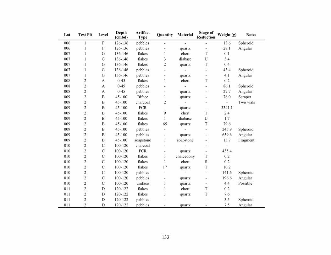
133
Lot Test Pit Level Depth(cmbd)
Artifact Type Quantity Material Stage of
Reduction Weight (g) Notes
006 1 F 126-136 pebbles - - - 13.6 Spheroid006 1 F 126-136 pebbles - quartz - 27.1 Angular007 1 G 136-146 flakes 1 chert T 0.1007 1 G 136-146 flakes 3 diabase U 3.4007 1 G 136-146 flakes 2 quartz T 0.4007 1 G 136-146 pebbles - - - 43.4 Spheroid007 1 G 136-146 pebbles - quartz - 4.1 Angular008 2 A 0-45 flakes 1 chert T 0.2008 2 A 0-45 pebbles - - - 86.1 Spheroid008 2 A 0-45 pebbles - quartz - 27.7 Angular009 2 B 45-100 Biface 1 quartz - 76.0 Scraper009 2 B 45-100 charcoal 2 - - - Two vials009 2 B 45-100 FCR - quartz - 3341.1009 2 B 45-100 flakes 9 chert T 2.4009 2 B 45-100 flakes 1 diabase U 1.7009 2 B 45-100 flakes 65 quartz T 79.6009 2 B 45-100 pebbles - - - 245.9 Spheroid009 2 B 45-100 pebbles - quartz - 659.6 Angular009 2 B 45-100 soapstone 1 soapstone - 13.7 Fragment010 2 C 100-120 charcoal - - - -010 2 C 100-120 FCR - quartz - 435.4010 2 C 100-120 flakes 1 chalcedony T 0.2010 2 C 100-120 flakes 1 chert S 0.2010 2 C 100-120 flakes 17 quartz T 10.2010 2 C 100-120 pebbles - - - 141.6 Spheroid010 2 C 100-120 pebbles - quartz - 196.6 Angular010 2 C 100-120 uniface 1 quartz - 4.4 Possible011 2 D 120-122 flakes 1 chert T 0.2011 2 D 120-122 flakes 1 quartz T 7.6011 2 D 120-122 pebbles - - - 3.5 Spheroid011 2 D 120-122 pebbles - quartz - 7.5 Angular
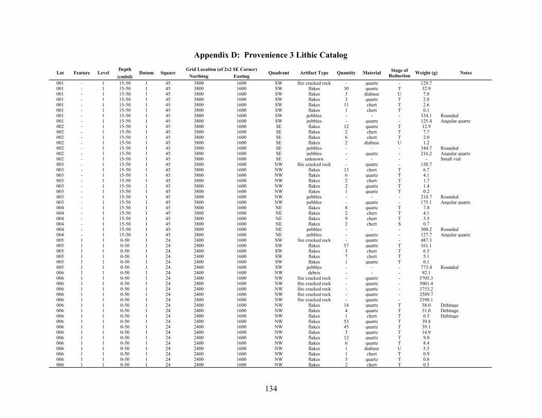
134
Appendix D: Provenience 3 Lithic Catalog
Lot Feature LevelDepth(cmbd)
Datum SquareGrid Location (of 2x2 SE Corner)Grid Location (of 2x2 SE Corner)
Quadrant Artifact Type Quantity Material Stage of Reduction Weight (g) NotesLot Feature Level
Depth(cmbd)
Datum SquareNorthing Easting
Quadrant Artifact Type Quantity Material Stage of Reduction Weight (g) Notes
001 - 1 15-50 1 45 3800 1600 SW fire cracked rock - quartz - 129.7001 - 1 15-50 1 45 3800 1600 SW flakes 30 quartz T 32.9001 - 1 15-50 1 45 3800 1600 SW flakes 3 diabase U 7.8001 - 1 15-50 1 45 3800 1600 SW flakes 3 quartz T 2.8001 - 1 15-50 1 45 3800 1600 SW flakes 11 chert T 2.6001 - 1 15-50 1 45 3800 1600 SW flakes 1 chert T 0.1001 - 1 15-50 1 45 3800 1600 SW pebbles - - - 334.1 Rounded001 - 1 15-50 1 45 3800 1600 SW pebbles - quartz - 125.4 Angular quartz002 - 1 15-50 1 45 3800 1600 SE flakes 12 quartz T 12.9002 - 1 15-50 1 45 3800 1600 SE flakes 2 chert T 7.7002 - 1 15-50 1 45 3800 1600 SE flakes 6 chert T 2.0002 - 1 15-50 1 45 3800 1600 SE flakes 2 diabase U 1.2002 - 1 15-50 1 45 3800 1600 SE pebbles - - - 344.7 Rounded002 - 1 15-50 1 45 3800 1600 SE pebbles - quartz - 216.2 Angular quartz002 - 1 15-50 1 45 3800 1600 SE unknown - - - - Small vial003 - 1 15-50 1 45 3800 1600 NW fire cracked rock - quartz - 150.7003 - 1 15-50 1 45 3800 1600 NW flakes 13 chert T 6.7003 - 1 15-50 1 45 3800 1600 NW flakes 6 quartz T 4.1003 - 1 15-50 1 45 3800 1600 NW flakes 2 chert T 1.7003 - 1 15-50 1 45 3800 1600 NW flakes 2 quartz T 1.4003 - 1 15-50 1 45 3800 1600 NW flakes 1 quartz T 0.2003 - 1 15-50 1 45 3800 1600 NW pebbles - - - 218.7 Rounded003 - 1 15-50 1 45 3800 1600 NW pebbles - quartz - 175.1 Angular quartz004 - 1 15-50 1 45 3800 1600 NE flakes 8 quartz T 7.8004 - 1 15-50 1 45 3800 1600 NE flakes 2 chert T 4.1004 - 1 15-50 1 45 3800 1600 NE flakes 9 chert T 3.5004 - 1 15-50 1 45 3800 1600 NE flakes 2 chert S 0.7004 - 1 15-50 1 45 3800 1600 NE pebbles - - - 300.2 Rounded004 - 1 15-50 1 45 3800 1600 NE pebbles - quartz - 127.7 Angular quartz005 1 1 0-50 1 24 2400 1600 SW fire cracked rock - quartz - 487.3005 1 1 0-50 1 24 2400 1600 SW flakes 57 quartz T 161.1005 1 1 0-50 1 24 2400 1600 SW flakes 3 chert T 6.5005 1 1 0-50 1 24 2400 1600 SW flakes 7 chert T 5.1005 1 1 0-50 1 24 2400 1600 SW flakes 1 quartz T 0.1005 1 1 0-50 1 24 2400 1600 SW pebbles - - - 773.4 Rounded006 1 1 0-50 1 24 2400 1600 NW debris - - - 92.1006 1 1 0-50 1 24 2400 1600 NW fire cracked rock - quartz - 5705.3006 1 1 0-50 1 24 2400 1600 NW fire cracked rock - quartz - 5001.4006 1 1 0-50 1 24 2400 1600 NW fire cracked rock - quartz - 3753.2006 1 1 0-50 1 24 2400 1600 NW fire cracked rock - quartz - 2589.7006 1 1 0-50 1 24 2400 1600 NW fire cracked rock - quartz - 2398.1006 1 1 0-50 1 24 2400 1600 NW flakes 14 quartz T 58.0 Debitage006 1 1 0-50 1 24 2400 1600 NW flakes 4 quartz T 31.0 Debitage006 1 1 0-50 1 24 2400 1600 NW flakes 1 chert T 0.5 Debitage006 1 1 0-50 1 24 2400 1600 NW flakes 53 quartz T 39.8006 1 1 0-50 1 24 2400 1600 NW flakes 45 quartz T 39.1006 1 1 0-50 1 24 2400 1600 NW flakes 3 quartz T 14.9006 1 1 0-50 1 24 2400 1600 NW flakes 12 quartz T 9.0006 1 1 0-50 1 24 2400 1600 NW flakes 6 quartz T 8.4006 1 1 0-50 1 24 2400 1600 NW flakes 1 diabase U 5.5006 1 1 0-50 1 24 2400 1600 NW flakes 1 chert T 0.9006 1 1 0-50 1 24 2400 1600 NW flakes 3 quartz T 0.8006 1 1 0-50 1 24 2400 1600 NW flakes 2 chert T 0.5

135
Lot Feature LevelDepth(cmbd)
Datum SquareGrid Location (of 2x2 SE Corner)Grid Location (of 2x2 SE Corner)
Quadrant Artifact Type Quantity Material Stage of Reduction Weight (g) NotesLot Feature Level
Depth(cmbd)
Datum SquareNorthing Easting
Quadrant Artifact Type Quantity Material Stage of Reduction Weight (g) Notes
006 1 1 0-50 1 24 2400 1600 NW flakes 1 chert S 0.4006 1 1 0-50 1 24 2400 1600 NW flakes 1 quartz T 0.3006 1 1 0-50 1 24 2400 1600 NW flakes 1 chert T 0.3006 1 1 0-50 1 24 2400 1600 NW flakes 1 quartz T 0.2006 1 1 0-50 1 24 2400 1600 NW flakes 1 chert T 0.1006 1 1 0-50 1 24 2400 1600 NW flakes 1 chert P 0.1006 1 1 0-50 1 24 2400 1600 NW pebbles - - - 331.6 Rounded006 1 1 0-50 1 24 2400 1600 NW pebbles - - - 91.0 Rounded006 1 1 0-50 1 24 2400 1600 NW pebbles - - - 43.3 Rounded006 1 1 0-50 1 24 2400 1600 NW pebbles - - - 40.0 Rounded006 1 1 0-50 1 24 2400 1600 NW pebbles - quartz - 191.4 Angular quartz006 1 1 0-50 1 24 2400 1600 NW pebbles - quartz - 458.6007 - 1 0-50 1 24 2400 1600 SE debris - - - 325.9007 - 1 0-50 1 24 2400 1600 SE flakes 7 quartz T 4.3007 - 1 0-50 1 24 2400 1600 SE flakes 4 chert T 3.7007 - 1 0-50 1 24 2400 1600 SE flakes 1 quartz T 0.5007 - 1 0-50 1 24 2400 1600 SE pebbles - - - 2532.1 Rounded008 - 1 0-50 1 24 2400 1600 NE flakes 11 quartz T 15.4008 - 1 0-50 1 24 2400 1600 NE flakes 4 chert T 0.8008 - 1 0-50 1 24 2400 1600 NE pebbles - - - 522.2 Rounded008 - 1 0-50 1 24 2400 1600 NE pebbles - quartz - 451.4 Angular quartz009 - 1 34-50 1 10 1600 1200 SW fire cracked rock - quartz - 185.3009 - 1 34-50 1 10 1600 1200 SW flakes 6 quartz T 3.4009 - 1 34-50 1 10 1600 1200 SW flakes 2 quartz T 1.5009 - 1 34-50 1 10 1600 1200 SW pebbles - - - 220.3 Rounded009 - 1 34-50 1 10 1600 1200 SW pebbles - quartz - 206.7 Angular quartz010 - 1 0-50 1 10 1600 1200 NW flakes 2 diabase U 23.8010 - 1 0-50 1 10 1600 1200 NW flakes 10 quartz T 18.0010 - 1 0-50 1 10 1600 1200 NW flakes 1 diabase U 2.0010 - 1 0-50 1 10 1600 1200 NW flakes 1 quartz T 1.2010 - 1 0-50 1 10 1600 1200 NW flakes 1 chert T 1.1010 - 1 0-50 1 10 1600 1200 NW pebbles - - - 204.7 Rounded010 - 1 0-50 1 10 1600 1200 NW pebbles - quartz - 248.2 Angular quartz011 - 1 0-50 1 10 1600 1200 SE debris - - - 118.7011 - 1 0-50 1 10 1600 1200 SE flakes 4 diabase U 8.2011 - 1 0-50 1 10 1600 1200 SE flakes 11 quartz T 6.7011 - 1 0-50 1 10 1600 1200 SE flakes 1 quartz T 1.2011 - 1 0-50 1 10 1600 1200 SE flakes 4 chert T 0.5011 - 1 0-50 1 10 1600 1200 SE flakes 1 quartz T 0.3011 - 1 0-50 1 10 1600 1200 SE pebbles - - - 965.9 Rounded012 - 1 48-50 1 10 1600 1200 NE cobbles 3 quartz - 769.1 Angular quartz012 - 1 48-50 1 10 1600 1200 NE fire cracked rock - quartz - 299.9012 - 1 48-50 1 10 1600 1200 NE flakes 17 quartz T 9.5012 - 1 48-50 1 10 1600 1200 NE flakes 3 diabase U 7.6012 - 1 48-50 1 10 1600 1200 NE flakes 5 chert T 2.2012 - 1 48-50 1 10 1600 1200 NE pebbles - - - 278.1 Rounded012 - 1 48-50 1 10 1600 1200 NE pebbles - quartz - 387.0 Angular quartz013 1 2 50-60 1 24 2400 1600 SW fire cracked rock - quartz - 2188.8013 1 2 50-60 1 24 2400 1600 SW flakes 12 quartz T 5.1013 1 2 50-60 1 24 2400 1600 SW flakes 5 chert T 4.0013 1 2 50-60 1 24 2400 1600 SW flakes 4 chert T 2.6013 1 2 50-60 1 24 2400 1600 SW pebbles - - - 81.5 Rounded013 1 2 50-60 1 24 2400 1600 SW pebbles - quartz - 169.7 Angular quartz014 1 2 50-60 1 24 2400 1600 NW flakes 40 quartz T 19.2014 1 2 50-60 1 24 2400 1600 NW flakes 6 chert T 17.8014 1 2 50-60 1 24 2400 1600 NW pebbles - - - 74.0 Rounded

136
Lot Feature LevelDepth(cmbd)
Datum SquareGrid Location (of 2x2 SE Corner)Grid Location (of 2x2 SE Corner)
Quadrant Artifact Type Quantity Material Stage of Reduction Weight (g) NotesLot Feature Level
Depth(cmbd)
Datum SquareNorthing Easting
Quadrant Artifact Type Quantity Material Stage of Reduction Weight (g) Notes
014 1 2 50-60 1 24 2400 1600 NW pebbles - quartz - 460.2 Angular quartz015 - 2 50-60 1 24 2400 1600 SE cobbles 2 quartz - 633.3 Angular quartz015 - 2 50-60 1 24 2400 1600 SE fire cracked rock - quartz - 366.3015 - 2 50-60 1 24 2400 1600 SE flakes 18 quartz T 16.6015 - 2 50-60 1 24 2400 1600 SE flakes 3 chert - 5.2015 - 2 50-60 1 24 2400 1600 SE flakes 3 diabase U 4.4015 - 2 50-60 1 24 2400 1600 SE pebbles - - - 119.1 Rounded015 - 2 50-60 1 24 2400 1600 SE pebbles - quartz - 59.9 Angular quartz016 - 2 50-60 1 24 2400 1600 NE fire cracked rock - quartz - 220.2016 - 2 50-60 1 24 2400 1600 NE flakes 12 quartz U 28.0016 - 2 50-60 1 24 2400 1600 NE flakes 4 chert T 1.7016 - 2 50-60 1 24 2400 1600 NE pebbles - - - 163.3 Rounded016 - 2 50-60 1 24 2400 1600 NE pebbles - quartz - 154.9 Angular quartz017 - 2 50-60 1 10 1600 1200 SW flakes 11 quartz T 9.0017 - 2 50-60 1 10 1600 1200 SW flakes 1 quartz T 2.0017 - 2 50-60 1 10 1600 1200 SW flakes 4 chert T 0.6017 - 2 50-60 1 10 1600 1200 SW pebbles - - - 79.8 Rounded017 - 2 50-60 1 10 1600 1200 SW pebbles - quartz - 274.1 Angular quartz018 - 2 50-60 1 10 1600 1200 NW flakes 3 diabase U 5.3018 - 2 50-60 1 10 1600 1200 NW flakes 3 quartz U 5.0018 - 2 50-60 1 10 1600 1200 NW flakes 9 quartz U 2.9018 - 2 50-60 1 10 1600 1200 NW pebbles - - - 10.9 Rounded018 - 2 50-60 1 10 1600 1200 NW pebbles - quartz - 221.3 Angular quartz019 - 2 50-60 1 10 1600 1200 SE flakes 1 quartz T 3.0019 - 2 50-60 1 10 1600 1200 SE flakes 15 quartz T 11.5019 - 2 50-60 1 10 1600 1200 SE flakes 7 diabase U 10.4019 - 2 50-60 1 10 1600 1200 SE flakes 4 chert T 0.9019 - 2 50-60 1 10 1600 1200 SE pebbles - - - 43.8 Rounded019 - 2 50-60 1 10 1600 1200 SE pebbles - quartz - 93.1 Angular quartz020 - 2 50-60 1 10 1600 1200 NE fire cracked rock - quartz - 525.5020 - 2 50-60 1 10 1600 1200 NE flakes 32 quartz T 19.4020 - 2 50-60 1 10 1600 1200 NE flakes 3 diabase U 7.7020 - 2 50-60 1 10 1600 1200 NE flakes 5 chert T 3.0020 - 2 50-60 1 10 1600 1200 NE flakes 1 quartz T 0.6020 - 2 50-60 1 10 1600 1200 NE flakes 1 chert T 0.1020 - 2 50-60 1 10 1600 1200 NE pebbles - - - 19.4 Rounded020 - 2 50-60 1 10 1600 1200 NE pebbles - quartz - 207.2 Angular quartz021 - 2 50-60 1 45 3800 1600 SW cobbles 1 quartz - 359.4 Angular quartz021 - 2 50-60 1 45 3800 1600 SW flakes 1 quartz T 10.4021 - 2 50-60 1 45 3800 1600 SW flakes 1 quartz T 0.2021 - 2 50-60 1 45 3800 1600 SW flakes 1 chert T 0.2021 - 2 50-60 1 45 3800 1600 SW flakes 1 chert T 0.1021 - 2 50-60 1 45 3800 1600 SW pebbles - - - 60.9 Rounded021 - 2 50-60 1 45 3800 1600 SW pebbles - quartz - 258.5 Angular quartz022 - 2 50-60 1 45 3800 1600 NW fire cracked rock - quartz - 947.3022 - 2 50-60 1 45 3800 1600 NW flakes 6 quartz T 12.8022 - 2 50-60 1 45 3800 1600 NW flakes 1 chert S 6.7022 - 2 50-60 1 45 3800 1600 NW flakes 10 chert T 5.7022 - 2 50-60 1 45 3800 1600 NW flakes 7 quartz T 5.6022 - 2 50-60 1 45 3800 1600 NW flakes 7 chert T 1.7022 - 2 50-60 1 45 3800 1600 NW flakes 4 quartz T 1.5022 - 2 50-60 1 45 3800 1600 NW flakes 4 chert T 1.5022 - 2 50-60 1 45 3800 1600 NW flakes 2 chert T 1.2022 - 2 50-60 1 45 3800 1600 NW flakes 1 quartz T 0.2022 - 2 50-60 1 45 3800 1600 NW flakes 1 chert T 0.2022 - 2 50-60 1 45 3800 1600 NW pebbles - - - 76.4 Rounded

137
Lot Feature LevelDepth(cmbd)
Datum SquareGrid Location (of 2x2 SE Corner)Grid Location (of 2x2 SE Corner)
Quadrant Artifact Type Quantity Material Stage of Reduction Weight (g) NotesLot Feature Level
Depth(cmbd)
Datum SquareNorthing Easting
Quadrant Artifact Type Quantity Material Stage of Reduction Weight (g) Notes
022 - 2 50-60 1 45 3800 1600 NW pebbles - quartz - 309.6 Angular quartz023 - 2 50-60 1 45 3800 1600 SE flakes 2 diabase U 9.9023 - 2 50-60 1 45 3800 1600 SE flakes 1 quartz T 9.3023 - 2 50-60 1 45 3800 1600 SE flakes 1 quartz T 4.0023 - 2 50-60 1 45 3800 1600 SE flakes 2 quartz T 2.1023 - 2 50-60 1 45 3800 1600 SE flakes 4 chert T 1.4023 - 2 50-60 1 45 3800 1600 SE flakes 4 chert T 0.7023 - 2 50-60 1 45 3800 1600 SE flakes 2 chert T 0.5023 - 2 50-60 1 45 3800 1600 SE flakes 1 quartz T 0.3023 - 2 50-60 1 45 3800 1600 SE pebbles - quartz - 119.2 Angular quartz024 - 2 50-60 1 45 3800 1600 NE flakes 2 quartz T 5.7024 - 2 50-60 1 45 3800 1600 NE flakes 1 diabase U 4.2024 - 2 50-60 1 45 3800 1600 NE flakes 10 chert T 3.6024 - 2 50-60 1 45 3800 1600 NE flakes 8 quartz T 2.9024 - 2 50-60 1 45 3800 1600 NE flakes 12 chert T 2.6024 - 2 50-60 1 45 3800 1600 NE flakes 2 chert T 2.6024 - 2 50-60 1 45 3800 1600 NE flakes 1 diabase U 1.9024 - 2 50-60 1 45 3800 1600 NE flakes 2 chert T 0.8024 - 2 50-60 1 45 3800 1600 NE pebbles - - - 30.8 Rounded024 - 2 50-60 1 45 3800 1600 NE pebbles - quartz - 268.3 Angular quartz025 - 3 60-70 1 24 2400 1600 SW cobbles 1 quartz - 1198.0025 - 3 60-70 1 24 2400 1600 SW fire cracked rock - quartz - 1344.8025 - 3 60-70 1 24 2400 1600 SW flakes 5 quartz T 45.7025 - 3 60-70 1 24 2400 1600 SW flakes 4 quartz T 33.4025 - 3 60-70 1 24 2400 1600 SW flakes 3 chert T 3.4025 - 3 60-70 1 24 2400 1600 SW flakes 1 chert T 0.3025 - 3 60-70 1 24 2400 1600 SW flakes 1 quartz T 0.2025 - 3 60-70 1 24 2400 1600 SW pebbles - - - 120.6 Rounded025 - 3 60-70 1 24 2400 1600 SW pebbles - quartz - 821.9 Angular quartz026 1 3 60-70 1 24 2400 1600 NW flakes 9 quartz T 14.2026 1 3 60-70 1 24 2400 1600 NW flakes 4 diabase U 5.8026 1 3 60-70 1 24 2400 1600 NW flakes 2 chert T 5.1026 1 3 60-70 1 24 2400 1600 NW pebbles - - - 72.5 Rounded026 1 3 60-70 1 24 2400 1600 NW pebbles - quartz - 261.7 Angular quartz027 - 3 60-70 1 24 2400 1600 SE flakes 5 diabase U 15.4027 - 3 60-70 1 24 2400 1600 SE flakes 8 quartz T 4.7027 - 3 60-70 1 24 2400 1600 SE flakes 1 diabase U 2.9027 - 3 60-70 1 24 2400 1600 SE flakes 1 quartz T 0.4027 - 3 60-70 1 24 2400 1600 SE flakes 3 chert T 0.3027 - 3 60-70 1 24 2400 1600 SE pebbles - - - 48.1 Rounded027 - 3 60-70 1 24 2400 1600 SE pebbles - quartz - 233.9 Angular quartz028 - 3 60-70 1 24 2400 1600 NE flakes 4 chert T 3.0028 - 3 60-70 1 24 2400 1600 NE pebbles - - - 37.0 Rounded028 - 3 60-70 1 24 2400 1600 NE pebbles - quartz - 540.6 Angular quartz029 - 4 70-80 1 24 2400 1600 SW fire cracked rock - quartz - 1303.2029 - 4 70-80 1 24 2400 1600 SW flakes 8 quartz T 19.3029 - 4 70-80 1 24 2400 1600 SW flakes 5 chert T 3.6029 - 4 70-80 1 24 2400 1600 SW flakes 3 quartz T 1.5029 - 4 70-80 1 24 2400 1600 SW flakes 1 chert T 0.1029 - 4 70-80 1 24 2400 1600 SW pebbles - - - 113.8 Rounded029 - 4 70-80 1 24 2400 1600 SW pebbles - quartz - 1228.0030 1 4 70-80 1 24 2400 1600 NW cobbles 1 quartz - 515.4030 1 4 70-80 1 24 2400 1600 NW debris - - - 1143.7030 1 4 70-80 1 24 2400 1600 NW fire cracked rock - quartz - 4153.1030 1 4 70-80 1 24 2400 1600 NW fire cracked rock - quartz - 2233.9030 1 4 70-80 1 24 2400 1600 NW fire cracked rock - quartz - 2095.7
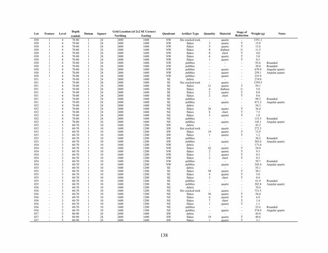
138
Lot Feature LevelDepth(cmbd)
Datum SquareGrid Location (of 2x2 SE Corner)Grid Location (of 2x2 SE Corner)
Quadrant Artifact Type Quantity Material Stage of Reduction Weight (g) NotesLot Feature Level
Depth(cmbd)
Datum SquareNorthing Easting
Quadrant Artifact Type Quantity Material Stage of Reduction Weight (g) Notes
030 1 4 70-80 1 24 2400 1600 NW fire cracked rock - quartz - 1551.1030 1 4 70-80 1 24 2400 1600 NW flakes 3 quartz T 15.8030 1 4 70-80 1 24 2400 1600 NW flakes 5 quartz T 13.6030 1 4 70-80 1 24 2400 1600 NW flakes 8 diabase U 11.5030 1 4 70-80 1 24 2400 1600 NW flakes 8 chert T 4.0030 1 4 70-80 1 24 2400 1600 NW flakes 6 quartz T 3.0030 1 4 70-80 1 24 2400 1600 NW flakes 1 quartz T 0.3030 1 4 70-80 1 24 2400 1600 NW pebbles - - - 93.6 Rounded030 1 4 70-80 1 24 2400 1600 NW pebbles - - - 38.0 Rounded030 1 4 70-80 1 24 2400 1600 NW pebbles - quartz - 670.9 Angular quartz030 1 4 70-80 1 24 2400 1600 NW pebbles - quartz - 259.1 Angular quartz030 1 4 70-80 1 24 2400 1600 NW pebbles - quartz - 235.9031 - 4 70-80 1 24 2400 1600 SE debris - - - 274.0031 - 4 70-80 1 24 2400 1600 SE fire cracked rock - quartz - 1559.5031 - 4 70-80 1 24 2400 1600 SE flakes 31 quartz T 59.1031 - 4 70-80 1 24 2400 1600 SE flakes 4 diabase U 5.8031 - 4 70-80 1 24 2400 1600 SE flakes 2 quartz T 0.8031 - 4 70-80 1 24 2400 1600 SE flakes 2 chert T 0.6031 - 4 70-80 1 24 2400 1600 SE pebbles - - - 99.3 Rounded031 - 4 70-80 1 24 2400 1600 SE pebbles - quartz - 871.2 Angular quartz032 - 4 70-80 1 24 2400 1600 NE debris - - - 54.3032 - 4 70-80 1 24 2400 1600 NE flakes 26 quartz T 36.4032 - 4 70-80 1 24 2400 1600 NE flakes 8 chert T 7.5032 - 4 70-80 1 24 2400 1600 NE flakes 3 quartz T 1.9032 - 4 70-80 1 24 2400 1600 NE pebbles - - - 115.3 Rounded032 - 4 70-80 1 24 2400 1600 NE pebbles - quartz - 145.1 Angular quartz033 - 3 60-70 1 10 1600 1200 SW debris - - - 43.2033 - 3 60-70 1 10 1600 1200 SW fire cracked rock - quartz - 272.3033 - 3 60-70 1 10 1600 1200 SW flakes 19 quartz T 13.9033 - 3 60-70 1 10 1600 1200 SW flakes 1 quartz T 1.2033 - 3 60-70 1 10 1600 1200 SW pebbles - - - 30.2 Rounded033 - 3 60-70 1 10 1600 1200 SW pebbles - quartz - 303.6 Angular quartz034 - 3 60-70 1 10 1600 1200 NW debris - - - 171.0034 - 3 60-70 1 10 1600 1200 NW flakes 42 quartz T 24.0034 - 3 60-70 1 10 1600 1200 NW flakes 2 quartz T 9.3034 - 3 60-70 1 10 1600 1200 NW flakes 1 quartz T 0.3034 - 3 60-70 1 10 1600 1200 NW flakes 2 chert T 0.2034 - 3 60-70 1 10 1600 1200 NW pebbles - - - 59.7 Rounded034 - 3 60-70 1 10 1600 1200 NW pebbles - quartz - 345.4 Angular quartz035 - 3 60-70 1 10 1600 1200 SE debris - - - 55.1035 - 3 60-70 1 10 1600 1200 SE flakes 50 quartz T 30.1035 - 3 60-70 1 10 1600 1200 SE flakes 4 quartz T 5.8035 - 3 60-70 1 10 1600 1200 SE flakes 3 chert T 0.4035 - 3 60-70 1 10 1600 1200 SE pebbles - - - 61.9 Rounded035 - 3 60-70 1 10 1600 1200 SE pebbles - quartz - 382.8 Angular quartz036 - 3 60-70 1 10 1600 1200 NE debris - - - 70.4036 - 3 60-70 1 10 1600 1200 NE fire cracked rock - quartz - 731.5036 - 3 60-70 1 10 1600 1200 NE flakes 56 quartz T 54.4036 - 3 60-70 1 10 1600 1200 NE flakes 6 quartz T 6.9036 - 3 60-70 1 10 1600 1200 NE flakes 7 chert T 1.4036 - 3 60-70 1 10 1600 1200 NE flakes 1 quartz T 1.1036 - 3 60-70 1 10 1600 1200 NE pebbles - - - 53.6 Rounded036 - 3 60-70 1 10 1600 1200 NE pebbles - quartz - 574.9 Angular quartz037 - 5 80-90 1 24 2400 1600 SW debris - - - 45.0037 - 5 80-90 1 24 2400 1600 SW flakes 19 quartz T 49.6037 - 5 80-90 1 24 2400 1600 SW flakes 1 quartz T 3.1

139
Lot Feature LevelDepth(cmbd)
Datum SquareGrid Location (of 2x2 SE Corner)Grid Location (of 2x2 SE Corner)
Quadrant Artifact Type Quantity Material Stage of Reduction Weight (g) NotesLot Feature Level
Depth(cmbd)
Datum SquareNorthing Easting
Quadrant Artifact Type Quantity Material Stage of Reduction Weight (g) Notes
037 - 5 80-90 1 24 2400 1600 SW flakes 1 chert T 0.5037 - 5 80-90 1 24 2400 1600 SW pebbles - - - 112.1 Rounded037 - 5 80-90 1 24 2400 1600 SW pebbles - quartz - 358.9 Angular quartz038 - 5 80-90 1 24 2400 1600 NW debris - - - 38.6038 - 5 80-90 1 24 2400 1600 NW fire cracked rock - quartz - 1702.4038 - 5 80-90 1 24 2400 1600 NW flakes 20 quartz T 63.7038 - 5 80-90 1 24 2400 1600 NW flakes 2 quartz T 1.5038 - 5 80-90 1 24 2400 1600 NW flakes 1 quartz T 0.7038 - 5 80-90 1 24 2400 1600 NW flakes 1 chert T 0.4038 - 5 80-90 1 24 2400 1600 NW pebbles - - - 215.1 Rounded038 - 5 80-90 1 24 2400 1600 NW pebbles - quartz - 167.7 Angular quartz039 - 5 80-90 1 24 2400 1600 SE debris - - - 54.7039 - 5 80-90 1 24 2400 1600 SE fire cracked rock - quartz - 2148.2039 - 5 80-90 1 24 2400 1600 SE flakes 17 quartz T 91.9039 - 5 80-90 1 24 2400 1600 SE flakes 8 diabase U 17.3039 - 5 80-90 1 24 2400 1600 SE flakes 2 quartz T 7.5039 - 5 80-90 1 24 2400 1600 SE flakes 2 chert T 1.6039 - 5 80-90 1 24 2400 1600 SE flakes 1 quartz T 0.2039 - 5 80-90 1 24 2400 1600 SE pebbles - - - 150.4 Rounded039 - 5 80-90 1 24 2400 1600 SE pebbles - quartz - 292.8 Angular quartz040 - 5 80-90 1 24 2400 1600 NE debris - - - 80.2040 - 5 80-90 1 24 2400 1600 NE fire cracked rock - quartz - 852.3040 - 5 80-90 1 24 2400 1600 NE flakes 14 quartz T 11.6040 - 5 80-90 1 24 2400 1600 NE flakes 1 diabase U 6.9040 - 5 80-90 1 24 2400 1600 NE flakes 10 chert T 4.1040 - 5 80-90 1 24 2400 1600 NE flakes 1 chert T 0.3040 - 5 80-90 1 24 2400 1600 NE pebbles - - - 71.3 Rounded040 - 5 80-90 1 24 2400 1600 NE pebbles - quartz - 256.9 Angular quartz041 - 4 70-80 1 10 1600 1200 SW cobble 1 quartz - 616.5041 - 4 70-80 1 10 1600 1200 SW debris - - - 118.9041 - 4 70-80 1 10 1600 1200 SW fire cracked rock - quartz - 1424.8041 - 4 70-80 1 10 1600 1200 SW flakes 32 quartz T 19.6041 - 4 70-80 1 10 1600 1200 SW flakes 1 diabase U 1.7041 - 4 70-80 1 10 1600 1200 SW flakes 3 chert T 0.6041 - 4 70-80 1 10 1600 1200 SW flakes 3 diabase U 0.5041 - 4 70-80 1 10 1600 1200 SW pebbles - - - 93.2 Rounded041 - 4 70-80 1 10 1600 1200 SW pebbles - quartz - 213.2 Angular quartz042 - 4 70-80 1 10 1600 1200 NW debris - - - 36.9042 - 4 70-80 1 10 1600 1200 NW fire cracked rock - quartz - 1819.3042 - 4 70-80 1 10 1600 1200 NW flakes 60 quartz T 43.0042 - 4 70-80 1 10 1600 1200 NW flakes 2 chert T 0.2042 - 4 70-80 1 10 1600 1200 NW pebbles - - - 21.9 Rounded042 - 4 70-80 1 10 1600 1200 NW pebbles - quartz - 345.2 Angular quartz043 - 4 70-80 1 10 1600 1200 SE debris - - - 14.0043 - 4 70-80 1 10 1600 1200 SE fire cracked rock - quartz - 1076.0043 - 4 70-80 1 10 1600 1200 SE flakes 18 quartz T 13.6043 - 4 70-80 1 10 1600 1200 SE pebbles - - - 48.0 Rounded043 - 4 70-80 1 10 1600 1200 SE pebbles - quartz - 144.3 Angular quartz044 - 4 70-80 1 10 1600 1200 NE debris - - - 126.3044 - 4 70-80 1 10 1600 1200 NE fire cracked rock - quartz - 980.5044 - 4 70-80 1 10 1600 1200 NE flakes 28 quartz T 25.4044 - 4 70-80 1 10 1600 1200 NE flakes 1 chert T 0.1044 - 4 70-80 1 10 1600 1200 NE pebbles - - - 70.1 Rounded044 - 4 70-80 1 10 1600 1200 NE pebbles - quartz - 203.6 Angular quartz045 - 3 60-70 1 45 3800 1600 SW debris - - - 20.1045 - 3 60-70 1 45 3800 1600 SW fire cracked rock - quartz - 2485.1

140
Lot Feature LevelDepth(cmbd)
Datum SquareGrid Location (of 2x2 SE Corner)Grid Location (of 2x2 SE Corner)
Quadrant Artifact Type Quantity Material Stage of Reduction Weight (g) NotesLot Feature Level
Depth(cmbd)
Datum SquareNorthing Easting
Quadrant Artifact Type Quantity Material Stage of Reduction Weight (g) Notes
045 - 3 60-70 1 45 3800 1600 SW flakes 31 quartz T 13.6045 - 3 60-70 1 45 3800 1600 SW flakes 1 diabase U 2.2045 - 3 60-70 1 45 3800 1600 SW flakes 8 chert T 1.4045 - 3 60-70 1 45 3800 1600 SW pebbles - - - 62.4 Rounded045 - 3 60-70 1 45 3800 1600 SW pebbles - quartz - 216.0 Angular quartz046 - 3 60-70 1 45 3800 1600 NW debris - - - 109.4046 - 3 60-70 1 45 3800 1600 NW fire cracked rock - quartz - 2135.6046 - 3 60-70 1 45 3800 1600 NW flakes 24 quartz T 17.4046 - 3 60-70 1 45 3800 1600 NW flakes 13 chert T 5.9046 - 3 60-70 1 45 3800 1600 NW flakes 4 diabase U 2.7046 - 3 60-70 1 45 3800 1600 NW flakes 1 diabase U 0.8046 - 3 60-70 1 45 3800 1600 NW flakes 1 chert S 0.6046 - 3 60-70 1 45 3800 1600 NW flakes 1 chert T 0.1046 - 3 60-70 1 45 3800 1600 NW pebbles - - - 130.6 Rounded046 - 3 60-70 1 45 3800 1600 NW pebbles - quartz - 264.6 Angular quartz047 - 3 60-70 1 45 3800 1600 SE debris - - - 15.3047 - 3 60-70 1 45 3800 1600 SE fire cracked rock - quartz - 1970.5047 - 3 60-70 1 45 3800 1600 SE flakes 31 quartz T 25.0047 - 3 60-70 1 45 3800 1600 SE flakes 7 chert T 3.0047 - 3 60-70 1 45 3800 1600 SE flakes 2 chert S 2.1047 - 3 60-70 1 45 3800 1600 SE pebbles - - - 64.4 Rounded047 - 3 60-70 1 45 3800 1600 SE pebbles - quartz - 94.9 Angular quartz048 - 3 60-70 1 45 3800 1600 NE debris - - - 22.1048 - 3 60-70 1 45 3800 1600 NE fire cracked rock - quartz - 975.6048 - 3 60-70 1 45 3800 1600 NE flakes 20 quartz T 7.9048 - 3 60-70 1 45 3800 1600 NE flakes 5 diabase U 5.2048 - 3 60-70 1 45 3800 1600 NE flakes 9 chert T 2.8048 - 3 60-70 1 45 3800 1600 NE flakes 2 chert S 1.0048 - 3 60-70 1 45 3800 1600 NE pebbles - - - 78.4 Rounded048 - 3 60-70 1 45 3800 1600 NE pebbles - quartz - 137.8 Angular quartz049 - 4 70-80 1 45 3800 1600 SW debris - - - 123.1049 - 4 70-80 1 45 3800 1600 SW fire cracked rock - quartz - 2983.5049 - 4 70-80 1 45 3800 1600 SW flakes 38 quartz T 24.2049 - 4 70-80 1 45 3800 1600 SW flakes 3 chert T 1.6049 - 4 70-80 1 45 3800 1600 SW flakes 3 diabase U 1.5049 - 4 70-80 1 45 3800 1600 SW pebbles - quartz - 390.7049 - 4 70-80 1 45 3800 1600 SW pebbles - - - 146.3050 - 4 70-80 1 45 3800 1600 NW debris - - - 25.2050 - 4 70-80 1 45 3800 1600 NW fire cracked rock - quartz - 147.0050 - 4 70-80 1 45 3800 1600 NW flakes 6 chert T 2.9050 - 4 70-80 1 45 3800 1600 NW pebbles - - - 76.3 Rounded050 - 4 70-80 1 45 3800 1600 NW pebbles - quartz - 99.3 Angular quartz051 - 4 70-80 1 45 3800 1600 SE debris - - - 28.4051 - 4 70-80 1 45 3800 1600 SE fire cracked rock - quartz - 327.2051 - 4 70-80 1 45 3800 1600 SE flakes 22 quartz T 29.0051 - 4 70-80 1 45 3800 1600 SE pebbles - - - 91.6 Rounded051 - 4 70-80 1 45 3800 1600 SE pebbles - quartz - 255.9 Angular quartz052 - 4 70-80 1 45 3800 1600 NE debris - - - 83.6052 - 4 70-80 1 45 3800 1600 NE fire cracked rock - quartz - 152.7052 - 4 70-80 1 45 3800 1600 NE flakes 45 quartz T 23.4052 - 4 70-80 1 45 3800 1600 NE flakes 7 chert T 3.8052 - 4 70-80 1 45 3800 1600 NE flakes 1 diabase U 0.4052 - 4 70-80 1 45 3800 1600 NE pebbles - quartz - 653.4052 - 4 70-80 1 45 3800 1600 NE pebbles - - - 53.6053 - 1 22-50 1 23 2400 1400 SW debris - - - 35.2053 - 1 22-50 1 23 2400 1400 SW fire cracked rock - quartz - 85.3
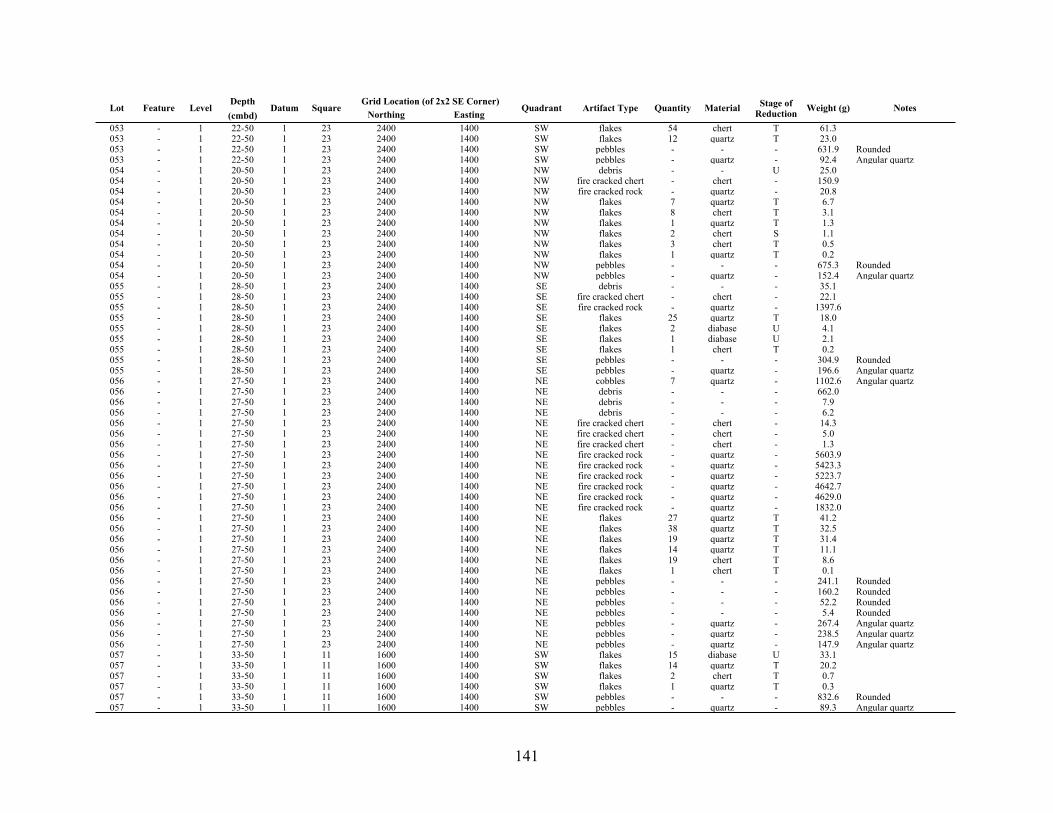
141
Lot Feature LevelDepth(cmbd)
Datum SquareGrid Location (of 2x2 SE Corner)Grid Location (of 2x2 SE Corner)
Quadrant Artifact Type Quantity Material Stage of Reduction Weight (g) NotesLot Feature Level
Depth(cmbd)
Datum SquareNorthing Easting
Quadrant Artifact Type Quantity Material Stage of Reduction Weight (g) Notes
053 - 1 22-50 1 23 2400 1400 SW flakes 54 chert T 61.3053 - 1 22-50 1 23 2400 1400 SW flakes 12 quartz T 23.0053 - 1 22-50 1 23 2400 1400 SW pebbles - - - 631.9 Rounded053 - 1 22-50 1 23 2400 1400 SW pebbles - quartz - 92.4 Angular quartz054 - 1 20-50 1 23 2400 1400 NW debris - - U 25.0054 - 1 20-50 1 23 2400 1400 NW fire cracked chert - chert - 150.9054 - 1 20-50 1 23 2400 1400 NW fire cracked rock - quartz - 20.8054 - 1 20-50 1 23 2400 1400 NW flakes 7 quartz T 6.7054 - 1 20-50 1 23 2400 1400 NW flakes 8 chert T 3.1054 - 1 20-50 1 23 2400 1400 NW flakes 1 quartz T 1.3054 - 1 20-50 1 23 2400 1400 NW flakes 2 chert S 1.1054 - 1 20-50 1 23 2400 1400 NW flakes 3 chert T 0.5054 - 1 20-50 1 23 2400 1400 NW flakes 1 quartz T 0.2054 - 1 20-50 1 23 2400 1400 NW pebbles - - - 675.3 Rounded054 - 1 20-50 1 23 2400 1400 NW pebbles - quartz - 152.4 Angular quartz055 - 1 28-50 1 23 2400 1400 SE debris - - - 35.1055 - 1 28-50 1 23 2400 1400 SE fire cracked chert - chert - 22.1055 - 1 28-50 1 23 2400 1400 SE fire cracked rock - quartz - 1397.6055 - 1 28-50 1 23 2400 1400 SE flakes 25 quartz T 18.0055 - 1 28-50 1 23 2400 1400 SE flakes 2 diabase U 4.1055 - 1 28-50 1 23 2400 1400 SE flakes 1 diabase U 2.1055 - 1 28-50 1 23 2400 1400 SE flakes 1 chert T 0.2055 - 1 28-50 1 23 2400 1400 SE pebbles - - - 304.9 Rounded055 - 1 28-50 1 23 2400 1400 SE pebbles - quartz - 196.6 Angular quartz056 - 1 27-50 1 23 2400 1400 NE cobbles 7 quartz - 1102.6 Angular quartz056 - 1 27-50 1 23 2400 1400 NE debris - - - 662.0056 - 1 27-50 1 23 2400 1400 NE debris - - - 7.9056 - 1 27-50 1 23 2400 1400 NE debris - - - 6.2056 - 1 27-50 1 23 2400 1400 NE fire cracked chert - chert - 14.3056 - 1 27-50 1 23 2400 1400 NE fire cracked chert - chert - 5.0056 - 1 27-50 1 23 2400 1400 NE fire cracked chert - chert - 1.3056 - 1 27-50 1 23 2400 1400 NE fire cracked rock - quartz - 5603.9056 - 1 27-50 1 23 2400 1400 NE fire cracked rock - quartz - 5423.3056 - 1 27-50 1 23 2400 1400 NE fire cracked rock - quartz - 5223.7056 - 1 27-50 1 23 2400 1400 NE fire cracked rock - quartz - 4642.7056 - 1 27-50 1 23 2400 1400 NE fire cracked rock - quartz - 4629.0056 - 1 27-50 1 23 2400 1400 NE fire cracked rock - quartz - 1832.0056 - 1 27-50 1 23 2400 1400 NE flakes 27 quartz T 41.2056 - 1 27-50 1 23 2400 1400 NE flakes 38 quartz T 32.5056 - 1 27-50 1 23 2400 1400 NE flakes 19 quartz T 31.4056 - 1 27-50 1 23 2400 1400 NE flakes 14 quartz T 11.1056 - 1 27-50 1 23 2400 1400 NE flakes 19 chert T 8.6056 - 1 27-50 1 23 2400 1400 NE flakes 1 chert T 0.1056 - 1 27-50 1 23 2400 1400 NE pebbles - - - 241.1 Rounded056 - 1 27-50 1 23 2400 1400 NE pebbles - - - 160.2 Rounded056 - 1 27-50 1 23 2400 1400 NE pebbles - - - 52.2 Rounded056 - 1 27-50 1 23 2400 1400 NE pebbles - - - 5.4 Rounded056 - 1 27-50 1 23 2400 1400 NE pebbles - quartz - 267.4 Angular quartz056 - 1 27-50 1 23 2400 1400 NE pebbles - quartz - 238.5 Angular quartz056 - 1 27-50 1 23 2400 1400 NE pebbles - quartz - 147.9 Angular quartz057 - 1 33-50 1 11 1600 1400 SW flakes 15 diabase U 33.1057 - 1 33-50 1 11 1600 1400 SW flakes 14 quartz T 20.2057 - 1 33-50 1 11 1600 1400 SW flakes 2 chert T 0.7057 - 1 33-50 1 11 1600 1400 SW flakes 1 quartz T 0.3057 - 1 33-50 1 11 1600 1400 SW pebbles - - - 832.6 Rounded057 - 1 33-50 1 11 1600 1400 SW pebbles - quartz - 89.3 Angular quartz

142
Lot Feature LevelDepth(cmbd)
Datum SquareGrid Location (of 2x2 SE Corner)Grid Location (of 2x2 SE Corner)
Quadrant Artifact Type Quantity Material Stage of Reduction Weight (g) NotesLot Feature Level
Depth(cmbd)
Datum SquareNorthing Easting
Quadrant Artifact Type Quantity Material Stage of Reduction Weight (g) Notes
058 - 1 33-50 1 11 1600 1400 NW flakes 23 quartz T 64.9058 - 1 33-50 1 11 1600 1400 NW flakes 3 quartz T 4.0058 - 1 33-50 1 11 1600 1400 NW flakes 1 quartz T 3.6058 - 1 33-50 1 11 1600 1400 NW flakes 1 quartz T 0.4058 - 1 33-50 1 11 1600 1400 NW flakes 1 chert T 0.3058 - 1 33-50 1 11 1600 1400 NW pebbles - - - 696.5 Rounded058 - 1 33-50 1 11 1600 1400 NW pebbles - quartz - 397.4 Angular quartz059 - 1 34-50 1 11 1600 1400 NE flakes 4 quartz T 1.5059 - 1 34-50 1 11 1600 1400 NE flakes 2 quartz T 1.5059 - 1 34-50 1 11 1600 1400 NE flakes 2 chert T 0.3059 - 1 34-50 1 11 1600 1400 NE pebbles - - - 709.7 Rounded059 - 1 34-50 1 11 1600 1400 NE pebbles - quartz - 318.1 Angular quartz060 - 1 34-50 1 11 1600 1400 NE flakes 15 quartz T 15.3060 - 1 34-50 1 11 1600 1400 NE flakes 1 chert S 0.5060 - 1 34-50 1 11 1600 1400 NE pebbles - - - 1001.4 Rounded060 - 1 34-50 1 11 1600 1400 NE pebbles - quartz - 265.3 Angular quartz061 - 1 0-50 1 42 3600 1600 SW flakes 10 quartz T 23.7061 - 1 0-50 1 42 3600 1600 SW flakes 15 quartz T 12.3061 - 1 0-50 1 42 3600 1600 SW flakes 2 quartz T 3.3061 - 1 0-50 1 42 3600 1600 SW pebbles - - - 197.7 Rounded061 - 1 0-50 1 42 3600 1600 SW pebbles - quartz - 388.6 Angular quartz062 - 1 0-50 1 42 3600 1600 NW flakes 19 quartz T 15.5062 - 1 0-50 1 42 3600 1600 NW flakes 6 chert T 1.7062 - 1 0-50 1 42 3600 1600 NW flakes 2 quartz T 1.4062 - 1 0-50 1 42 3600 1600 NW pebbles - - - 266.2 Rounded062 - 1 0-50 1 42 3600 1600 NW pebbles - quartz - 382.8 Angular quartz063 - 1 0-50 1 42 3600 1600 SE flakes 5 quartz T 2.8063 - 1 0-50 1 42 3600 1600 SE flakes 2 quartz T 1.2063 - 1 0-50 1 42 3600 1600 SE flakes 1 chert T 0.4063 - 1 0-50 1 42 3600 1600 SE flakes 1 chert T 0.2063 - 1 0-50 1 42 3600 1600 SE pebbles - - - 417.6 Rounded063 - 1 0-50 1 42 3600 1600 SE pebbles - quartz - 410.7 Angular quartz064 - 1 0-50 1 42 3600 1600 NE flakes 2 quartz T 2.1064 - 1 0-50 1 42 3600 1600 NE flakes 1 quartz T 0.3064 - 1 0-50 1 42 3600 1600 NE flakes 1 chert T 0.1064 - 1 0-50 1 42 3600 1600 NE pebbles - - - 212.5 Rounded064 - 1 0-50 1 42 3600 1600 NE pebbles - quartz - 418.6 Angular quartz065 - 1 25-50 1 14 1800 1400 SW flakes 13 quartz T 20.6065 - 1 25-50 1 14 1800 1400 SW flakes 6 quartz T 9.1065 - 1 25-50 1 14 1800 1400 SW pebbles - - - 403.6 Rounded065 - 1 25-50 1 14 1800 1400 SW pebbles - quartz - 581.2 Angular quartz066 - 1 30-50 1 14 1800 1400 NW cobbles 1 quartz - 268.9066 - 1 30-50 1 14 1800 1400 NW flakes 33 quartz T 37.8066 - 1 30-50 1 14 1800 1400 NW flakes 7 diabase U 28.2066 - 1 30-50 1 14 1800 1400 NW flakes 3 chert T 0.8066 - 1 30-50 1 14 1800 1400 NW pebbles - - - 685.7 Rounded066 - 1 30-50 1 14 1800 1400 NW pebbles - quartz - 514.7 Angular quartz067 - 1 30-50 1 14 1800 1400 SE flakes 18 quartz T 17.8067 - 1 30-50 1 14 1800 1400 SE flakes 1 chert S 0.5067 - 1 30-50 1 14 1800 1400 SE pebbles - - - 558.2 Rounded067 - 1 30-50 1 14 1800 1400 SE pebbles - quartz - 125.9 Angular quartz068 - 1 29-50 1 14 1800 1400 NE cobbles 1 quartz - 1629.0068 - 1 29-50 1 14 1800 1400 NE flakes 53 quartz T 53.6068 - 1 29-50 1 14 1800 1400 NE flakes 12 chert T 11.2068 - 1 29-50 1 14 1800 1400 NE pebbles - - - 815.8 Rounded068 - 1 29-50 1 14 1800 1400 NE pebbles - quartz - 300.1 Angular quartz

143
Lot Feature LevelDepth(cmbd)
Datum SquareGrid Location (of 2x2 SE Corner)Grid Location (of 2x2 SE Corner)
Quadrant Artifact Type Quantity Material Stage of Reduction Weight (g) NotesLot Feature Level
Depth(cmbd)
Datum SquareNorthing Easting
Quadrant Artifact Type Quantity Material Stage of Reduction Weight (g) Notes
069 - 1 0-50 1 21 2200 1600 SW debris - - - 116.2069 - 1 0-50 1 21 2200 1600 SW flakes 5 chert T 2.1 Debitage069 - 1 0-50 1 21 2200 1600 SW flakes 10 quartz T 19.1069 - 1 0-50 1 21 2200 1600 SW pebbles - - - 1171.0 Rounded070 - 1 33-50 1 21 2200 1600 NW fire cracked rock - quartz - 345.6070 - 1 33-50 1 21 2200 1600 NW flakes 11 quartz T 13.1070 - 1 33-50 1 21 2200 1600 NW flakes 5 chert T 3.8070 - 1 33-50 1 21 2200 1600 NW pebbles - - - 656.3 Rounded070 - 1 33-50 1 21 2200 1600 NW pebbles - quartz - 407.4 Angular quartz071 - 1 35-50 1 21 2200 1600 SE flakes 7 quartz - 3.7071 - 1 35-50 1 21 2200 1600 SE flakes 1 chert T 0.3071 - 1 35-50 1 21 2200 1600 SE pebbles - - - 2090.4 Rounded071 - 1 35-50 1 21 2200 1600 SE pebbles - quartz - 69.3 Angular quartz072 - 1 29-50 1 21 2200 1600 NE flakes 12 quartz T 19.1072 - 1 29-50 1 21 2200 1600 NE flakes 7 chert T 3.6072 - 1 29-50 1 21 2200 1600 NE pebbles - - - 3777.9 Rounded072 - 1 29-50 1 21 2200 1600 NE pebbles - quartz - 277.1 Angular quartz073 5 1 0-50 1 20 2200 1400 SW fire cracked rock - quartz - 1321.5073 5 1 0-50 1 20 2200 1400 SW flakes 10 chert T 24.8073 5 1 0-50 1 20 2200 1400 SW flakes 25 quartz T 18.0073 5 1 0-50 1 20 2200 1400 SW pebbles - - - 1194.1 Rounded073 5 1 0-50 1 20 2200 1400 SW pebbles - quartz - 155.7 Angular quartz074 5 1 0-50 1 20 2200 1400 NW fire cracked chert - chert - 44.0074 5 1 0-50 1 20 2200 1400 NW fire cracked rock - quartz - 2782.3074 5 1 0-50 1 20 2200 1400 NW flakes 23 quartz T 104.0074 5 1 0-50 1 20 2200 1400 NW pebbles - - - 1319.1 Rounded074 5 1 0-50 1 20 2200 1400 NW pebbles - quartz - 91.9 Angular quartz075 5 1 0-50 1 20 2200 1400 SE fire cracked rock - quartz - 3128.2075 5 1 0-50 1 20 2200 1400 SE fire cracked rock - quartz - 2748.1075 5 1 0-50 1 20 2200 1400 SE fire cracked rock - quartz - 2352.2075 5 1 0-50 1 20 2200 1400 SE flakes 18 quartz T 15.7075 5 1 0-50 1 20 2200 1400 SE flakes 2 quartz T 4.8075 5 1 0-50 1 20 2200 1400 SE flakes 3 chert T 3.5075 5 1 0-50 1 20 2200 1400 SE flakes 8 quartz T 2.9075 5 1 0-50 1 20 2200 1400 SE flakes 1 chert S 1.3075 5 1 0-50 1 20 2200 1400 SE flakes 2 chert T 0.4075 5 1 0-50 1 20 2200 1400 SE flakes 1 chert T 0.2075 5 1 0-50 1 20 2200 1400 SE pebbles - - - 837.8 Rounded075 5 1 0-50 1 20 2200 1400 SE pebbles - - - 51.5 Rounded075 5 1 0-50 1 20 2200 1400 SE pebbles - quartz - 396.2 Angular quartz075 5 1 0-50 1 20 2200 1400 SE pebbles - quartz - 22.0 Angular quartz076 5 1 0-50 1 20 2200 1400 NE fire cracked rock - quartz - 3440.0076 5 1 0-50 1 20 2200 1400 NE fire cracked rock - quartz - 2417.1076 5 1 0-50 1 20 2200 1400 NE flakes 24 quartz T 17.9076 5 1 0-50 1 20 2200 1400 NE flakes 6 chert T 5.7076 5 1 0-50 1 20 2200 1400 NE flakes 1 chert P 5.0076 5 1 0-50 1 20 2200 1400 NE flakes 1 quartz T 1.3076 5 1 0-50 1 20 2200 1400 NE pebbles - - - 322.4 Rounded076 5 1 0-50 1 20 2200 1400 NE pebbles - quartz - 154.6 Angular quartz077 - 1 36-50 1 15 1800 1600 SW flakes 15 quartz T 12.1077 - 1 36-50 1 15 1800 1600 SW flakes 4 quartz T 7.7077 - 1 36-50 1 15 1800 1600 SW flakes 1 chert T 0.3077 - 1 36-50 1 15 1800 1600 SW pebbles - - - 566.4 Rounded077 - 1 36-50 1 15 1800 1600 SW pebbles - quartz - 350.2 Angular quartz078 - 1 0-50 1 15 1800 1600 NW flakes 23 quartz T 13.0078 - 1 0-50 1 15 1800 1600 NW flakes 6 chert T 1.3
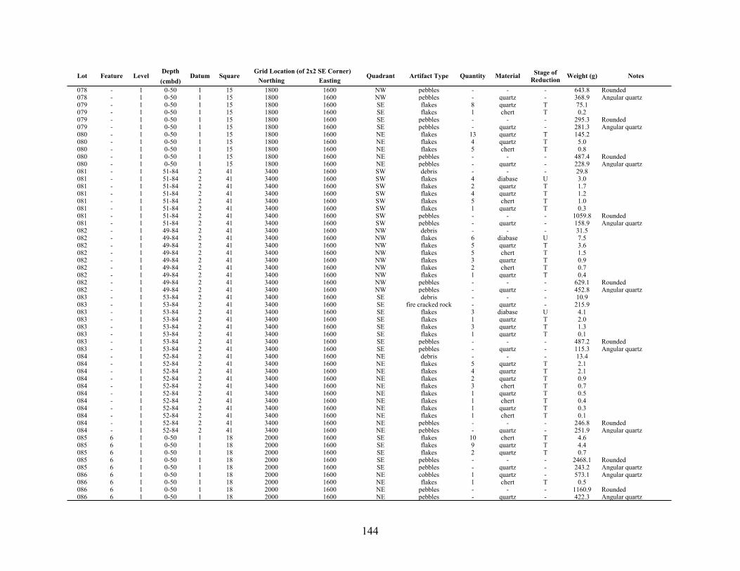
144
Lot Feature LevelDepth(cmbd)
Datum SquareGrid Location (of 2x2 SE Corner)Grid Location (of 2x2 SE Corner)
Quadrant Artifact Type Quantity Material Stage of Reduction Weight (g) NotesLot Feature Level
Depth(cmbd)
Datum SquareNorthing Easting
Quadrant Artifact Type Quantity Material Stage of Reduction Weight (g) Notes
078 - 1 0-50 1 15 1800 1600 NW pebbles - - - 643.8 Rounded078 - 1 0-50 1 15 1800 1600 NW pebbles - quartz - 368.9 Angular quartz079 - 1 0-50 1 15 1800 1600 SE flakes 8 quartz T 75.1079 - 1 0-50 1 15 1800 1600 SE flakes 1 chert T 0.2079 - 1 0-50 1 15 1800 1600 SE pebbles - - - 295.3 Rounded079 - 1 0-50 1 15 1800 1600 SE pebbles - quartz - 281.3 Angular quartz080 - 1 0-50 1 15 1800 1600 NE flakes 13 quartz T 145.2080 - 1 0-50 1 15 1800 1600 NE flakes 4 quartz T 5.0080 - 1 0-50 1 15 1800 1600 NE flakes 5 chert T 0.8080 - 1 0-50 1 15 1800 1600 NE pebbles - - - 487.4 Rounded080 - 1 0-50 1 15 1800 1600 NE pebbles - quartz - 228.9 Angular quartz081 - 1 51-84 2 41 3400 1600 SW debris - - - 29.8081 - 1 51-84 2 41 3400 1600 SW flakes 4 diabase U 3.0081 - 1 51-84 2 41 3400 1600 SW flakes 2 quartz T 1.7081 - 1 51-84 2 41 3400 1600 SW flakes 4 quartz T 1.2081 - 1 51-84 2 41 3400 1600 SW flakes 5 chert T 1.0081 - 1 51-84 2 41 3400 1600 SW flakes 1 quartz T 0.3081 - 1 51-84 2 41 3400 1600 SW pebbles - - - 1059.8 Rounded081 - 1 51-84 2 41 3400 1600 SW pebbles - quartz - 158.9 Angular quartz082 - 1 49-84 2 41 3400 1600 NW debris - - - 31.5082 - 1 49-84 2 41 3400 1600 NW flakes 6 diabase U 7.5082 - 1 49-84 2 41 3400 1600 NW flakes 5 quartz T 3.6082 - 1 49-84 2 41 3400 1600 NW flakes 5 chert T 1.5082 - 1 49-84 2 41 3400 1600 NW flakes 3 quartz T 0.9082 - 1 49-84 2 41 3400 1600 NW flakes 2 chert T 0.7082 - 1 49-84 2 41 3400 1600 NW flakes 1 quartz T 0.4082 - 1 49-84 2 41 3400 1600 NW pebbles - - - 629.1 Rounded082 - 1 49-84 2 41 3400 1600 NW pebbles - quartz - 452.8 Angular quartz083 - 1 53-84 2 41 3400 1600 SE debris - - - 10.9083 - 1 53-84 2 41 3400 1600 SE fire cracked rock - quartz - 215.9083 - 1 53-84 2 41 3400 1600 SE flakes 3 diabase U 4.1083 - 1 53-84 2 41 3400 1600 SE flakes 1 quartz T 2.0083 - 1 53-84 2 41 3400 1600 SE flakes 3 quartz T 1.3083 - 1 53-84 2 41 3400 1600 SE flakes 1 quartz T 0.1083 - 1 53-84 2 41 3400 1600 SE pebbles - - - 487.2 Rounded083 - 1 53-84 2 41 3400 1600 SE pebbles - quartz - 115.3 Angular quartz084 - 1 52-84 2 41 3400 1600 NE debris - - - 13.4084 - 1 52-84 2 41 3400 1600 NE flakes 5 quartz T 2.1084 - 1 52-84 2 41 3400 1600 NE flakes 4 quartz T 2.1084 - 1 52-84 2 41 3400 1600 NE flakes 2 quartz T 0.9084 - 1 52-84 2 41 3400 1600 NE flakes 3 chert T 0.7084 - 1 52-84 2 41 3400 1600 NE flakes 1 quartz T 0.5084 - 1 52-84 2 41 3400 1600 NE flakes 1 chert T 0.4084 - 1 52-84 2 41 3400 1600 NE flakes 1 quartz T 0.3084 - 1 52-84 2 41 3400 1600 NE flakes 1 chert T 0.1084 - 1 52-84 2 41 3400 1600 NE pebbles - - - 246.8 Rounded084 - 1 52-84 2 41 3400 1600 NE pebbles - quartz - 251.9 Angular quartz085 6 1 0-50 1 18 2000 1600 SE flakes 10 chert T 4.6085 6 1 0-50 1 18 2000 1600 SE flakes 9 quartz T 4.4085 6 1 0-50 1 18 2000 1600 SE flakes 2 quartz T 0.7085 6 1 0-50 1 18 2000 1600 SE pebbles - - - 2468.1 Rounded085 6 1 0-50 1 18 2000 1600 SE pebbles - quartz - 243.2 Angular quartz086 6 1 0-50 1 18 2000 1600 NE cobbles 1 quartz - 573.1 Angular quartz086 6 1 0-50 1 18 2000 1600 NE flakes 1 chert T 0.5086 6 1 0-50 1 18 2000 1600 NE pebbles - - - 1160.9 Rounded086 6 1 0-50 1 18 2000 1600 NE pebbles - quartz - 422.3 Angular quartz

145
Lot Feature LevelDepth(cmbd)
Datum SquareGrid Location (of 2x2 SE Corner)Grid Location (of 2x2 SE Corner)
Quadrant Artifact Type Quantity Material Stage of Reduction Weight (g) NotesLot Feature Level
Depth(cmbd)
Datum SquareNorthing Easting
Quadrant Artifact Type Quantity Material Stage of Reduction Weight (g) Notes
087 6 1 0-50 1 18 2000 1600 SW flakes 5 quartz T 5.5087 6 1 0-50 1 18 2000 1600 SW flakes 12 chert T 5.1087 6 1 0-50 1 18 2000 1600 SW flakes 3 quartz T 1.5087 6 1 0-50 1 18 2000 1600 SW pebbles - - - 1718.5 Rounded087 6 1 0-50 1 18 2000 1600 SW pebbles - quartz - 689.9 Angular quartz088 6 1 0-50 1 18 2000 1600 NW flakes 9 chert T 3.9088 6 1 0-50 1 18 2000 1600 NW flakes 3 quartz T 2.4088 6 1 0-50 1 18 2000 1600 NW flakes 2 quartz T 2.0088 6 1 0-50 1 18 2000 1600 NW flakes 3 chert T 2.0088 6 1 0-50 1 18 2000 1600 NW pebbles - - - 1235.8 Rounded088 6 1 0-50 1 18 2000 1600 NW pebbles - quartz - 884.3 Angular quartz089 - 1 35-50 1 12 1600 1600 NW debris - - - 37.3089 - 1 35-50 1 12 1600 1600 NW flakes 3 chert T 1.9089 - 1 35-50 1 12 1600 1600 NW flakes 1 quartz T 1.7089 - 1 35-50 1 12 1600 1600 NW flakes 2 quartz T 1.4089 - 1 35-50 1 12 1600 1600 NW flakes 1 quartz T 0.4089 - 1 35-50 1 12 1600 1600 NW pebbles - - - 402.0 Rounded089 - 1 35-50 1 12 1600 1600 NW pebbles - quartz - 296.3 Angular quartz090 - 1 38-50 1 12 1600 1600 NE flakes 2 quartz T 0.6090 - 1 38-50 1 12 1600 1600 NE flakes 1 chert T 0.5090 - 1 38-50 1 12 1600 1600 NE flakes 1 quartz T 0.4090 - 1 38-50 1 12 1600 1600 NE pebbles - - - 473.0 Rounded090 - 1 38-50 1 12 1600 1600 NE pebbles - quartz - 294.2 Angular quartz091 - 1 38-50 1 13 1800 1200 SW cobbles 3 quartz - 887.2 Sub-Angular quartz091 - 1 38-50 1 13 1800 1200 SW flakes 9 quartz T 2.7091 - 1 38-50 1 13 1800 1200 SW flakes 1 chert T 0.2091 - 1 38-50 1 13 1800 1200 SW flakes 1 chert T 0.1091 - 1 38-50 1 13 1800 1200 SW pebbles - - - 160.3 Rounded091 - 1 38-50 1 13 1800 1200 SW pebbles - quartz - 311.1 Angular quartz092 - 1 44-50 1 13 1800 1200 NW debris - - - 8.3092 - 1 44-50 1 13 1800 1200 NW fire cracked rock - quartz - 1073.3092 - 1 44-50 1 13 1800 1200 NW flakes 1 diabase U 4.3092 - 1 44-50 1 13 1800 1200 NW flakes 2 quartz T 0.6092 - 1 44-50 1 13 1800 1200 NW flakes 2 quartz T 0.4092 - 1 44-50 1 13 1800 1200 NW flakes 1 quartz T 0.2092 - 1 44-50 1 13 1800 1200 NW pebbles - - - 66.2 Rounded092 - 1 44-50 1 13 1800 1200 NW pebbles - quartz - 202.5 Angular quartz093 - 1 39-50 1 13 1800 1200 SE flakes 2 diabase U 9.5093 - 1 39-50 1 13 1800 1200 SE flakes 2 quartz T 3.9093 - 1 39-50 1 13 1800 1200 SE flakes 4 quartz T 2.0093 - 1 39-50 1 13 1800 1200 SE flakes 3 chert T 1.6093 - 1 39-50 1 13 1800 1200 SE flakes 3 chert T 1.5093 - 1 39-50 1 13 1800 1200 SE flakes 1 chert S 0.8093 - 1 39-50 1 13 1800 1200 SE pebbles - - - 200.8 Rounded093 - 1 39-50 1 13 1800 1200 SE pebbles - quartz - 243.4 Angular quartz094 - 1 40-50 1 13 1800 1200 NE cobbles 2 quartz - 703.5094 - 1 40-50 1 13 1800 1200 NE fire cracked rock - quartz - 1302.1094 - 1 40-50 1 13 1800 1200 NE flakes 9 diabase U 35.3094 - 1 40-50 1 13 1800 1200 NE flakes 20 quartz T 28.6094 - 1 40-50 1 13 1800 1200 NE flakes 2 quartz T 2.5094 - 1 40-50 1 13 1800 1200 NE flakes 4 chert T 0.5094 - 1 40-50 1 13 1800 1200 NE pebbles - - - 229.0 Rounded094 - 1 40-50 1 13 1800 1200 NE pebbles - quartz - 589.5 Angular quartz095 6 1 68-82 1 18 2000 1600 Feature 006 flakes 8 chert T 2.9095 6 1 68-82 1 18 2000 1600 Feature 006 flakes 2 quartz T 1.6095 6 1 68-82 1 18 2000 1600 Feature 006 flakes 1 quartz T 0.7
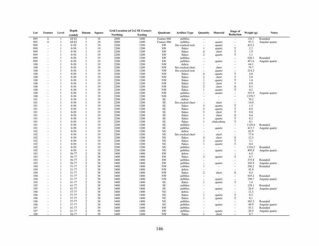
146
Lot Feature LevelDepth(cmbd)
Datum SquareGrid Location (of 2x2 SE Corner)Grid Location (of 2x2 SE Corner)
Quadrant Artifact Type Quantity Material Stage of Reduction Weight (g) NotesLot Feature Level
Depth(cmbd)
Datum SquareNorthing Easting
Quadrant Artifact Type Quantity Material Stage of Reduction Weight (g) Notes
095 6 1 68-82 1 18 2000 1600 Feature 006 pebbles - - - 136.7 Rounded095 6 1 68-82 1 18 2000 1600 Feature 006 pebbles - quartz - 97.3 Angular quartz099 - 1 0-50 1 19 2200 1200 SW fire cracked rock - quartz - 423.2099 - 1 0-50 1 19 2200 1200 SW flakes 1 quartz T 2.2099 - 1 0-50 1 19 2200 1200 SW flakes 4 chert T 1.9099 - 1 0-50 1 19 2200 1200 SW flakes 2 quartz T 1.1099 - 1 0-50 1 19 2200 1200 SW pebbles - - - 620.1 Rounded099 - 1 0-50 1 19 2200 1200 SW pebbles - quartz - 451.6 Angular quartz100 - 1 0-50 1 19 2200 1200 NW debris - - - 64.1100 - 1 0-50 1 19 2200 1200 NW fire cracked chert - chert - 79.7100 - 1 0-50 1 19 2200 1200 NW fire cracked rock - quartz - 214.2100 - 1 0-50 1 19 2200 1200 NW flakes 6 quartz T 4.8100 - 1 0-50 1 19 2200 1200 NW flakes 2 chert T 2.0100 - 1 0-50 1 19 2200 1200 NW flakes 1 quartz T 1.8100 - 1 0-50 1 19 2200 1200 NW flakes 2 chert T 0.9100 - 1 0-50 1 19 2200 1200 NW flakes 2 chert S 0.3100 - 1 0-50 1 19 2200 1200 NW flakes 1 quartz T 0.2100 - 1 0-50 1 19 2200 1200 NW pebbles - quartz - 351.9 Angular quartz100 - 1 0-50 1 19 2200 1200 NW pebbles - - - 1378.7101 - 1 0-50 1 19 2200 1200 SE debris - - - 70.2101 - 1 0-50 1 19 2200 1200 SE fire cracked chert - chert - 14.0101 - 1 0-50 1 19 2200 1200 SE flakes 3 quartz T 1.5101 - 1 0-50 1 19 2200 1200 SE flakes 2 quartz T 0.9101 - 1 0-50 1 19 2200 1200 SE flakes 3 chert T 0.8101 - 1 0-50 1 19 2200 1200 SE flakes 1 chert S 0.4101 - 1 0-50 1 19 2200 1200 SE flakes 1 quartz T 0.2101 - 1 0-50 1 19 2200 1200 SE flakes 1 chalcedony T 0.1101 - 1 0-50 1 19 2200 1200 SE pebbles - - - 1129.4 Rounded101 - 1 0-50 1 19 2200 1200 SE pebbles - quartz - 413.7 Angular quartz102 - 1 0-50 1 19 2200 1200 NE debris - - - 82.9102 - 1 0-50 1 19 2200 1200 NE fire cracked chert - chert - 77.6102 - 1 0-50 1 19 2200 1200 NE flakes 4 chert S 12.3102 - 1 0-50 1 19 2200 1200 NE flakes 3 quartz T 3.1102 - 1 0-50 1 19 2200 1200 NE flakes 1 quartz T 0.4102 - 1 0-50 1 19 2200 1200 NE pebbles - - - 1324.2 Rounded102 - 1 0-50 1 19 2200 1200 NE pebbles - quartz - 495.8 Angular quartz103 - 1 56-77 2 38 3400 1400 SW debris - - - 6.9103 - 1 56-77 2 38 3400 1400 SW flakes 2 quartz T 0.7103 - 1 56-77 2 38 3400 1400 SW pebbles - - - 375.8 Rounded103 - 1 56-77 2 38 3400 1400 SW pebbles - quartz - 102.9 Angular quartz104 - 1 51-77 2 38 3400 1400 NW cobbles 1 - - 296.2 Rounded104 - 1 51-77 2 38 3400 1400 NW debris - - - 45.9104 - 1 51-77 2 38 3400 1400 NW flakes 2 chert S 0.5104 - 1 51-77 2 38 3400 1400 NW pebbles - - - 835.2 Rounded104 - 1 51-77 2 38 3400 1400 NW pebbles - quartz - 198.7 Angular quartz105 - 1 61-77 2 38 3400 1400 SE flakes 1 quartz T 1.4105 - 1 61-77 2 38 3400 1400 SE pebbles - - - 158.1 Rounded105 - 1 61-77 2 38 3400 1400 SE pebbles - quartz - 26.9 Angular quartz106 - 1 57-77 2 38 3400 1400 NE debris - - - 12.3106 - 1 57-77 2 38 3400 1400 NE flakes 1 quartz T 0.3106 - 1 57-77 2 38 3400 1400 NE flakes 1 quartz T 0.1106 - 1 57-77 2 38 3400 1400 NE pebbles - - - 302.2 Rounded106 - 1 57-77 2 38 3400 1400 NE pebbles - quartz - 49.9 Angular quartz107 - 1 61-77 2 39 3400 1600 SW pebbles - - - 53.1 Rounded107 - 1 61-77 2 39 3400 1600 SW pebbles - quartz - 20.5 Angular quartz108 - 1 56-77 2 39 3400 1600 NW flakes 1 chert - 0.7

147
Lot Feature LevelDepth(cmbd)
Datum SquareGrid Location (of 2x2 SE Corner)Grid Location (of 2x2 SE Corner)
Quadrant Artifact Type Quantity Material Stage of Reduction Weight (g) NotesLot Feature Level
Depth(cmbd)
Datum SquareNorthing Easting
Quadrant Artifact Type Quantity Material Stage of Reduction Weight (g) Notes
108 - 1 56-77 2 39 3400 1600 NW pebbles - - - 214.3 Rounded108 - 1 56-77 2 39 3400 1600 NW pebbles - quartz - 50.7 Angular quartz109 - 1 65-77 2 39 3400 1600 SE flakes 1 quartz T 1.2109 - 1 65-77 2 39 3400 1600 SE pebbles - - - 255.3 Rounded109 - 1 65-77 2 39 3400 1600 SE pebbles - quartz - 61.1 Angular quartz110 - 1 57-77 2 39 3400 1600 NE pebbles - - - 90.5 Rounded110 - 1 57-77 2 39 3400 1600 NE pebbles - quartz - 28.3 Angular quartz111 - 1 39-50 1 7 1400 1200 SW debris 4 quartz U 8.2 Unidentifiable cobbles111 - 1 39-50 1 7 1400 1200 SW fire cracked rock - quartz - 6.0111 - 1 39-50 1 7 1400 1200 SW pebbles - - - 313.4 Rounded111 - 1 39-50 1 7 1400 1200 SW pebbles - quartz - 97.5 Angular quartz112 - 1 39-50 1 7 1400 1200 NW debris - - - 2.3112 - 1 39-50 1 7 1400 1200 NW fire cracked rock - quartz - 240.9112 - 1 39-50 1 7 1400 1200 NW flakes 1 chert T 0.4112 - 1 39-50 1 7 1400 1200 NW flakes 1 quartz T 0.3112 - 1 39-50 1 7 1400 1200 NW pebbles - - - 431.5 Rounded112 - 1 39-50 1 7 1400 1200 NW pebbles - quartz - 58.4 Angular quartz113 - 1 32-50 1 7 1400 1200 SE debris - - - 21.3113 - 1 32-50 1 7 1400 1200 SE fire cracked rock - quartz - 127.9113 - 1 32-50 1 7 1400 1200 SE flakes 7 quartz T 2.1113 - 1 32-50 1 7 1400 1200 SE flakes 2 chert T 1.9113 - 1 32-50 1 7 1400 1200 SE flakes 1 quartz T 0.6113 - 1 32-50 1 7 1400 1200 SE pebbles - - - 907.4 Rounded113 - 1 32-50 1 7 1400 1200 SE pebbles - quartz - 302.6 Angular quartz114 - 1 33-50 1 7 1400 1200 NE fire cracked rock - quartz - 390.5114 - 1 33-50 1 7 1400 1200 NE flakes 6 quartz T 19.5114 - 1 33-50 1 7 1400 1200 NE flakes 1 rhyolite P 13.2114 - 1 33-50 1 7 1400 1200 NE flakes 1 chert S 2.1114 - 1 33-50 1 7 1400 1200 NE flakes 1 diabase U 1.4114 - 1 33-50 1 7 1400 1200 NE flakes 1 chert T 1.2114 - 1 33-50 1 7 1400 1200 NE pebbles - quartz - 417.1 Angular quartz114 - 1 33-50 1 7 1400 1200 NE pebbles - - - 1038.3115 - 1 40-50 1 16 2000 1200 SW debris - - - 3.7115 - 1 40-50 1 16 2000 1200 SW fire cracked rock - quartz - 268.8115 - 1 40-50 1 16 2000 1200 SW flakes 2 chert T 0.7115 - 1 40-50 1 16 2000 1200 SW flakes 1 quartz T 0.3115 - 1 40-50 1 16 2000 1200 SW pebbles - - - 186.9 Rounded115 - 1 40-50 1 16 2000 1200 SW pebbles - quartz - 134.4 Angular quartz116 - 1 44-50 1 16 2000 1200 NW debris - - - 126.4116 - 1 44-50 1 16 2000 1200 NW flakes 5 quartz T 2.3116 - 1 44-50 1 16 2000 1200 NW flakes 1 chert T 0.3116 - 1 44-50 1 16 2000 1200 NW pebbles - quartz - 173.1 Angular quartz116 - 1 44-50 1 16 2000 1200 NW pebbles - - - 112.9117 - 1 33-50 1 16 2000 1200 SE debris - - - 598.8117 - 1 33-50 1 16 2000 1200 SE fire cracked rock - quartz - 3178.7117 - 1 33-50 1 16 2000 1200 SE flakes 5 quartz T 5.6117 - 1 33-50 1 16 2000 1200 SE flakes 5 chert T 2.3117 - 1 33-50 1 16 2000 1200 SE flakes 1 diabase U 1.2117 - 1 33-50 1 16 2000 1200 SE flakes 1 quartz - 0.2117 - 1 33-50 1 16 2000 1200 SE pebbles - - - 193.4 Rounded117 - 1 33-50 1 16 2000 1200 SE pebbles - quartz - 264.6 Angular quartz118 - 1 34-50 1 16 2000 1200 NE fire cracked chert - chert - 1.3118 - 1 34-50 1 16 2000 1200 NE fire cracked rock - quartz - 37.1118 - 1 34-50 1 16 2000 1200 NE flakes 7 quartz T 5.7118 - 1 34-50 1 16 2000 1200 NE flakes 4 chert T 2.4118 - 1 34-50 1 16 2000 1200 NE flakes 1 chert T 0.1
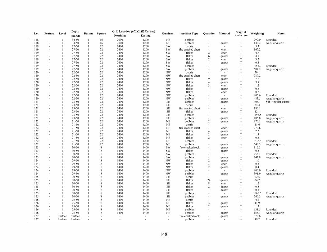
148
Lot Feature LevelDepth(cmbd)
Datum SquareGrid Location (of 2x2 SE Corner)Grid Location (of 2x2 SE Corner)
Quadrant Artifact Type Quantity Material Stage of Reduction Weight (g) NotesLot Feature Level
Depth(cmbd)
Datum SquareNorthing Easting
Quadrant Artifact Type Quantity Material Stage of Reduction Weight (g) Notes
118 - 1 34-50 1 16 2000 1200 NE pebbles - - - 292.0 Rounded118 - 1 34-50 1 16 2000 1200 NE pebbles - quartz - 140.2 Angular quartz119 - 1 27-50 1 22 2400 1200 SW debris - - - 5.3119 - 1 27-50 1 22 2400 1200 SW fire cracked chert - chert - 167.2119 - 1 27-50 1 22 2400 1200 SW flakes 2 chert T 4.7119 - 1 27-50 1 22 2400 1200 SW flakes 6 quartz T 4.1119 - 1 27-50 1 22 2400 1200 SW flakes 2 chert T 3.2119 - 1 27-50 1 22 2400 1200 SW flakes 1 quartz T 0.4119 - 1 27-50 1 22 2400 1200 SW pebbles - - - 1052.0 Rounded119 - 1 27-50 1 22 2400 1200 SW pebbles - quartz - 504.2 Angular quartz120 - 1 22-50 1 22 2400 1200 NW debris - - - 50.1120 - 1 22-50 1 22 2400 1200 NW fire cracked chert - chert - 280.2120 - 1 22-50 1 22 2400 1200 NW flakes 9 quartz T 7.6120 - 1 22-50 1 22 2400 1200 NW flakes 4 quartz T 3.9120 - 1 22-50 1 22 2400 1200 NW flakes 3 chert T 1.2120 - 1 22-50 1 22 2400 1200 NW flakes 1 quartz T 0.6120 - 1 22-50 1 22 2400 1200 NW flakes 1 chert T 0.2120 - 1 22-50 1 22 2400 1200 NW pebbles - - - 905.6 Rounded120 - 1 22-50 1 22 2400 1200 NW pebbles - quartz - 483.5 Angular quartz121 - 1 23-50 1 22 2400 1200 SE cobbles 1 quartz - 306.7 Sub-Angular quartz121 - 1 23-50 1 22 2400 1200 SE debris - - - 34.4121 - 1 23-50 1 22 2400 1200 SE fire cracked chert - chert - 186.1121 - 1 23-50 1 22 2400 1200 SE flakes 1 quartz T 12.1121 - 1 23-50 1 22 2400 1200 SE pebbles - - - 1496.5 Rounded121 - 1 23-50 1 22 2400 1200 SE pebbles - quartz - 405.8 Angular quartz122 - 1 21-50 1 22 2400 1200 NE cobbles 2 quartz - 970.1 Angular quartz122 - 1 21-50 1 22 2400 1200 NE debris - - - 11.6122 - 1 21-50 1 22 2400 1200 NE fire cracked chert - chert - 270.6122 - 1 21-50 1 22 2400 1200 NE flakes 4 quartz T 2.2122 - 1 21-50 1 22 2400 1200 NE flakes 2 quartz T 1.3122 - 1 21-50 1 22 2400 1200 NE flakes 2 chert T 0.3122 - 1 21-50 1 22 2400 1200 NE pebbles - - - 1232.8 Rounded122 - 1 21-50 1 22 2400 1200 NE pebbles - quartz - 540.5 Angular quartz123 - 1 30-50 1 8 1400 1400 SW fire cracked rock - quartz - 115.3123 - 1 30-50 1 8 1400 1400 SW flakes 1 quartz T 0.5123 - 1 30-50 1 8 1400 1400 SW pebbles - - - 756.1 Rounded123 - 1 30-50 1 8 1400 1400 SW pebbles - quartz - 247.8 Angular quartz124 - 1 29-50 1 8 1400 1400 NW flakes 2 quartz T 1.0124 - 1 29-50 1 8 1400 1400 NW flakes 3 chert T 0.5124 - 1 29-50 1 8 1400 1400 NW flakes 2 quartz T 0.4124 - 1 29-50 1 8 1400 1400 NW pebbles - - - 806.0 Rounded124 - 1 29-50 1 8 1400 1400 NW pebbles - quartz - 391.9 Angular quartz125 - 1 30-50 1 8 1400 1400 SE debris - - - 22.5125 - 1 30-50 1 8 1400 1400 SE flakes 24 quartz T 24.7125 - 1 30-50 1 8 1400 1400 SE flakes 8 chert T 1.2125 - 1 30-50 1 8 1400 1400 SE flakes 2 quartz T 0.5125 - 1 30-50 1 8 1400 1400 SE flakes 1 quartz T 0.3125 - 1 30-50 1 8 1400 1400 SE pebbles - - - 1060.5 Rounded125 - 1 30-50 1 8 1400 1400 SE pebbles - quartz - 240.3 Angular quartz126 - 1 25-50 1 8 1400 1400 NE debris - - - 4.1126 - 1 25-50 1 8 1400 1400 NE flakes 12 quartz T 11.9126 - 1 25-50 1 8 1400 1400 NE flakes 2 quartz T 1.3126 - 1 25-50 1 8 1400 1400 NE pebbles - - - 631.5 Rounded126 - 1 25-50 1 8 1400 1400 NE pebbles - quartz - 156.1 Angular quartz127 - Surface Surface - - - - - fire cracked rock - quartz - 870.6127 - Surface Surface - - - - - pebbles - - - 49.2 Rounded
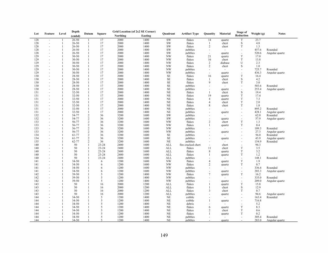
149
Lot Feature LevelDepth(cmbd)
Datum SquareGrid Location (of 2x2 SE Corner)Grid Location (of 2x2 SE Corner)
Quadrant Artifact Type Quantity Material Stage of Reduction Weight (g) NotesLot Feature Level
Depth(cmbd)
Datum SquareNorthing Easting
Quadrant Artifact Type Quantity Material Stage of Reduction Weight (g) Notes
128 - 1 26-50 1 17 2000 1400 SW flakes 14 quartz T 23.7128 - 1 26-50 1 17 2000 1400 SW flakes 1 chert S 4.8128 - 1 26-50 1 17 2000 1400 SW flakes 2 chert T 1.3128 - 1 26-50 1 17 2000 1400 SW pebbles - - - 457.6 Rounded128 - 1 26-50 1 17 2000 1400 SW pebbles - quartz - 520.6 Angular quartz129 - 1 30-50 1 17 2000 1400 NW flakes 21 quartz T 17.0129 - 1 30-50 1 17 2000 1400 NW flakes 16 chert T 13.8129 - 1 30-50 1 17 2000 1400 NW flakes 2 diabase U 2.3129 - 1 30-50 1 17 2000 1400 NW flakes 2 chert S 1.0129 - 1 30-50 1 17 2000 1400 NW pebbles - - - 725.7 Rounded129 - 1 30-50 1 17 2000 1400 NW pebbles - quartz - 436.3 Angular quartz130 - 1 28-50 1 17 2000 1400 SE flakes 16 quartz T 16.4130 - 1 28-50 1 17 2000 1400 SE flakes 1 chert S 4.2130 - 1 28-50 1 17 2000 1400 SE flakes 9 chert T 3.0130 - 1 28-50 1 17 2000 1400 SE pebbles - - - 503.6 Rounded130 - 1 28-50 1 17 2000 1400 SE pebbles - quartz - 253.4 Angular quartz131 - 1 32-50 1 17 2000 1400 NE flakes 1 chert S 19.4131 - 1 32-50 1 17 2000 1400 NE flakes 19 quartz T 17.4131 - 1 32-50 1 17 2000 1400 NE flakes 4 quartz T 7.3131 - 1 32-50 1 17 2000 1400 NE flakes 4 chert T 2.0131 - 1 32-50 1 17 2000 1400 NE flakes 8 chert T 1.8131 - 1 32-50 1 17 2000 1400 NE pebbles - - - 895.2 Rounded131 - 1 32-50 1 17 2000 1400 NE pebbles - quartz - 428.1 Angular quartz132 - 1 54-77 2 36 3200 1600 SW pebbles - - - 62.0 Rounded132 - 1 54-77 2 36 3200 1600 SW pebbles - quartz - 57.9 Angular quartz133 - 1 56-77 2 36 3200 1600 NW flakes 2 chert T 1.3133 - 1 56-77 2 36 3200 1600 NW flakes 1 quartz T 0.4133 - 1 56-77 2 36 3200 1600 NW pebbles - - - 109.3 Rounded133 - 1 56-77 2 36 3200 1600 NW pebbles - quartz - 27.3 Angular quartz134 - 1 61-77 2 36 3200 1600 SE pebbles - - - 56.0 Rounded134 - 1 61-77 2 36 3200 1600 SE pebbles - quartz - 43.9 Angular quartz135 - 1 62-77 2 36 3200 1600 NE pebbles - - - 154.9 Rounded140 - 1 50 1 23-24 2400 1600 ALL fire cracked chert - chert - 94.3140 - 1 50 1 23-24 2400 1600 ALL flakes 11 chert T 3.5140 - 1 50 1 23-24 2400 1600 ALL flakes 8 quartz T 3.2140 - 1 50 1 23-24 2400 1600 ALL flakes 1 quartz T 1.2140 - 1 50 1 23-24 2400 1600 ALL pebbles - - - 148.1 Rounded141 - 1 34-50 1 6 1200 1600 NW flakes 4 quartz T 1.9141 - 1 34-50 1 6 1200 1600 NW flakes 2 quartz T 0.7141 - 1 34-50 1 6 1200 1600 NW pebbles - - - 336.4 Rounded141 - 1 34-50 1 6 1200 1600 NW pebbles - quartz - 203.3 Angular quartz142 - 1 39-50 1 5 1200 1400 NW flakes 7 quartz T 16.2142 - 1 39-50 1 5 1200 1400 NW pebbles - - - 335.0 Rounded142 - 1 39-50 1 5 1200 1400 NW pebbles - quartz - 209.0 Angular quartz143 - 1 50 1 16 2000 1200 ALL flakes 1 quartz T 15.8143 - 1 50 1 16 2000 1200 ALL flakes 1 chert S 12.9143 - 1 50 1 16 2000 1200 ALL flakes 3 chert T 0.7143 - 1 50 1 16 2000 1200 ALL pebbles - quartz - 94.6 Angular quartz144 - 1 34-50 1 5 1200 1400 NE cobble - - - 163.4 Rounded144 - 1 34-50 1 5 1200 1400 NE cobble 1 quartz - 716.8144 - 1 34-50 1 5 1200 1400 NE debris - - - 5.2144 - 1 34-50 1 5 1200 1400 NE flakes 6 quartz T 8.3144 - 1 34-50 1 5 1200 1400 NE flakes 2 chert T 0.6144 - 1 34-50 1 5 1200 1400 NE flakes 1 quartz T 0.2144 - 1 34-50 1 5 1200 1400 NE pebbles - - - 305.4 Rounded144 - 1 34-50 1 5 1200 1400 NE pebbles - quartz - 283.0 Angular quartz

150
Lot Feature LevelDepth(cmbd)
Datum SquareGrid Location (of 2x2 SE Corner)Grid Location (of 2x2 SE Corner)
Quadrant Artifact Type Quantity Material Stage of Reduction Weight (g) NotesLot Feature Level
Depth(cmbd)
Datum SquareNorthing Easting
Quadrant Artifact Type Quantity Material Stage of Reduction Weight (g) Notes
145 - 1 50 1 21 2200 1600 ALL flakes 3 chert T 1.1145 - 1 50 1 21 2200 1600 ALL pebbles - - - 114.7 Rounded145 - 1 50 1 21 2200 1600 ALL pebbles - quartz - 57.3 Angular quartz146 - 1 50 1 18 2000 1600 ALL flakes 4 quartz T 0.8146 - 1 50 1 18 2000 1600 ALL flakes 2 chert T 0.4146 - 1 50 1 18 2000 1600 ALL pebbles - - - 98.5 Rounded147 - 1 50 1 12 1600 1600 ALL flakes 1 quartz T 1.0147 - 1 50 1 12 1600 1600 ALL pebbles - quartz - 52.0 Rounded148 - 1 50 1 15 1800 1600 ALL flakes - diabase U 9.4148 - 1 50 1 15 1800 1600 ALL flakes 5 quartz T 6.2148 - 1 50 1 15 1800 1600 ALL flakes 3 chert T 0.5148 - 1 50 1 15 1800 1600 ALL pebbles - - - 38.9 Rounded148 - 1 50 1 15 1800 1600 ALL pebbles - quartz - 85.4 Angular quartz149 - 1 77 2 36 3200 1600 ALL flakes 2 quartz T 0.8149 - 1 77 2 36 3200 1600 ALL pebbles - - - 28.6 Rounded149 - 1 77 2 36 3200 1600 ALL pebbles - quartz - 17.5 Angular quartz150 - 1 77 2 38 3400 1400 ALL pebbles - - - 90.1 Rounded150 - 1 77 2 38 3400 1400 ALL pebbles - quartz - 8.3 Angular quartz151 - 1 50 1 11 1600 1400 ALL debris - - - 6.4151 - 1 50 1 11 1600 1400 ALL pebbles - - - 41.4 Rounded151 - 1 50 1 11 1600 1400 ALL pebbles - quartz T 34.1 Angular quartz152 - 1 80 2 41 3600 1400 ALL flakes 1 chert T 0.7152 - 1 80 2 41 3600 1400 ALL pebbles - - - 21.3 Rounded152 - 1 80 2 41 3600 1400 ALL pebbles - quartz - 87.4 Angular quartz153 - 1 77 2 39 3400 1600 ALL pebbles - - - 26.5 Rounded153 - 1 77 2 39 3400 1600 ALL pebbles - quartz - 9.6 Angular quartz154 - 1 50 1 13 1800 1200 ALL flakes 5 quartz T 4.7154 - 1 50 1 13 1800 1200 ALL pebbles - - - 17.7 Rounded154 - 1 50 1 13 1800 1200 ALL pebbles - quartz - 137.8 Angular quartz155 - 1 50 1 20 2200 1400 ALL fire cracked chert - chert - 1.7155 - 1 50 1 20 2200 1400 ALL pebbles - - - 31.6 Rounded155 - 1 50 1 20 2200 1400 ALL pebbles - quartz - 48.8 Angular quartz156 - 1 50 1 14 1800 1400 ALL flakes 8 quartz T 2.7156 - 1 50 1 14 1800 1400 ALL flakes 2 chert T 0.8156 - 1 50 1 14 1800 1400 ALL pebbles - - - 33.0 Rounded156 - 1 50 1 14 1800 1400 ALL pebbles - quartz - 243.0 Angular quartz159 - 1 50 1 17 2000 1400 ALL fire cracked chert - chert - 0.8159 - 1 50 1 17 2000 1400 ALL pebbles - - - 29.0 Rounded159 - 1 50 1 17 2000 1400 ALL pebbles - quartz - 57.9 Angular quartz160 - 1 50 1 19 2200 1200 ALL flakes 2 chert S 0.8160 - 1 50 1 19 2200 1200 ALL pebbles - - - 71.0 Rounded160 - 1 50 1 19 2200 1200 ALL pebbles - quartz - 46.1 Angular quartz161 - 1 44-50 1 4 1200 1200 NW flakes 2 quartz T 0.8161 - 1 44-50 1 4 1200 1200 NW pebbles - - - 649.5 Rounded161 - 1 44-50 1 4 1200 1200 NW pebbles - quartz - 381.2 Angular quartz162 - 1 40-50 1 4 1200 1200 NE flakes 4 quartz T 4.4162 - 1 40-50 1 4 1200 1200 NE flakes 3 chert T 1.1162 - 1 40-50 1 4 1200 1200 NE flakes 1 chert T 0.3162 - 1 40-50 1 4 1200 1200 NE flakes 1 chert T 0.1162 - 1 40-50 1 4 1200 1200 NE pebbles - - - 467.5 Rounded162 - 1 40-50 1 4 1200 1200 NE pebbles - quartz - 276.3 Angular quartz163 - 2 96 2 42 3600 1600 ALL pebbles - - - 28.1 Rounded164 - 1 84 2 41 3600 1400 ALL flakes 1 chert T 0.7164 - 1 84 2 41 3600 1400 ALL flakes 1 chert S 0.3164 - 1 84 2 41 3600 1400 ALL pebbles - - - 40.1 Rounded165 - 1 0-50 1 26 2600 1400 SE cobbles - - - 3332.2

151
Lot Feature LevelDepth(cmbd)
Datum SquareGrid Location (of 2x2 SE Corner)Grid Location (of 2x2 SE Corner)
Quadrant Artifact Type Quantity Material Stage of Reduction Weight (g) NotesLot Feature Level
Depth(cmbd)
Datum SquareNorthing Easting
Quadrant Artifact Type Quantity Material Stage of Reduction Weight (g) Notes
165 - 1 0-50 1 26 2600 1400 SE cobbles 5 quartz - 3040.0165 - 1 0-50 1 26 2600 1400 SE cobbles 4 quartz - 2370.8165 - 1 0-50 1 26 2600 1400 SE fire cracked chert - chert - 1.2165 - 1 0-50 1 26 2600 1400 SE fire cracked rock - quartz - 2940.2165 - 1 0-50 1 26 2600 1400 SE fire cracked rock - quartz - 1578.5165 - 1 0-50 1 26 2600 1400 SE fire cracked rock - quartz - 1347.3165 - 1 0-50 1 26 2600 1400 SE fire cracked rock - quartz - 1280.9165 - 1 0-50 1 26 2600 1400 SE flakes 44 chert T 38.7165 - 1 0-50 1 26 2600 1400 SE flakes 5 quartz T 3.0165 - 1 0-50 1 26 2600 1400 SE flakes 3 quartz T 1.2165 - 1 0-50 1 26 2600 1400 SE flakes 2 chert T 0.5165 - 1 0-50 1 26 2600 1400 SE pebbles - - - 549.7 Rounded165 - 1 0-50 1 26 2600 1400 SE pebbles - quartz - 746.2 Angular quartz166 - 1 24-50 1 27 2600 1600 SW cobbles 3 quartz - 722.6166 - 1 24-50 1 27 2600 1600 SW fire cracked rock - quartz - 3096.7166 - 1 24-50 1 27 2600 1600 SW fire cracked rock - quartz - 1617.5166 - 1 24-50 1 27 2600 1600 SW flakes 8 chert T 4.9166 - 1 24-50 1 27 2600 1600 SW flakes 6 quartz T 3.7166 - 1 24-50 1 27 2600 1600 SW flakes 2 chert T 1.4166 - 1 24-50 1 27 2600 1600 SW flakes 4 chert T 1.3166 - 1 24-50 1 27 2600 1600 SW flakes 3 quartz T 0.9166 - 1 24-50 1 27 2600 1600 SW flakes 1 quartz T 0.2166 - 1 24-50 1 27 2600 1600 SW pebbles - - - 376.7 Rounded166 - 1 24-50 1 27 2600 1600 SW pebbles - - - 29.3 Rounded166 - 1 24-50 1 27 2600 1600 SW pebbles - quartz - 443.7 Angular quartz167 - 1 0-77 2 35 3200 1400 NW flakes 5 quartz T 1.6167 - 1 0-77 2 35 3200 1400 NW pebbles - - - 89.4 Rounded167 - 1 0-77 2 35 3200 1400 NW pebbles - quartz - 58.0 Angular quartz169 - 2 50-60 1 22 2400 1200 SW debris - - - 202.3169 - 2 50-60 1 22 2400 1200 SW fire cracked chert - chert - 253.1169 - 2 50-60 1 22 2400 1200 SW fire cracked rock - quartz - 746.9169 - 2 50-60 1 22 2400 1200 SW flakes 5 quartz T 4.1169 - 2 50-60 1 22 2400 1200 SW flakes 7 chert T 2.0169 - 2 50-60 1 22 2400 1200 SW flakes 4 chert T 1.4169 - 2 50-60 1 22 2400 1200 SW flakes 1 quartz T 0.2169 - 2 50-60 1 22 2400 1200 SW pebbles - - - 75.4 Rounded170 - 2 50-60 1 22 2400 1200 NW fire cracked chert - chert - 355.3170 - 2 50-60 1 22 2400 1200 NW fire cracked rock - quartz - 458.0170 - 2 50-60 1 22 2400 1200 NW flakes 1 quartz T 2.4170 - 2 50-60 1 22 2400 1200 NW flakes 7 chert T 1.9170 - 2 50-60 1 22 2400 1200 NW flakes 2 quartz T 1.5170 - 2 50-60 1 22 2400 1200 NW flakes 1 chert T 0.5170 - 2 50-60 1 22 2400 1200 NW flakes 1 quartz T 0.3170 - 2 50-60 1 22 2400 1200 NW pebbles - - - 115.7 Rounded170 - 2 50-60 1 22 2400 1200 NW pebbles - quartz - 286.3 Angular quartz171 - 2 50-60 1 22 2400 1200 SE fire cracked chert - chert - 210.6171 - 2 50-60 1 22 2400 1200 SE flakes 3 quartz T 4.6171 - 2 50-60 1 22 2400 1200 SE flakes 12 chert T 3.8171 - 2 50-60 1 22 2400 1200 SE flakes 1 quartz T 0.4171 - 2 50-60 1 22 2400 1200 SE pebbles - - - 34.2 Rounded171 - 2 50-60 1 22 2400 1200 SE pebbles - quartz - 587.9 Angular quartz172 - 2 50-60 1 22 2400 1200 NE fire cracked chert - chert - 422.8172 - 2 50-60 1 22 2400 1200 NE flakes 2 quartz T 7.3172 - 2 50-60 1 22 2400 1200 NE flakes 2 quartz T 0.5172 - 2 50-60 1 22 2400 1200 NE flakes 1 quartz T 0.3172 - 2 50-60 1 22 2400 1200 NE flakes 1 chert T 0.2

152
Lot Feature LevelDepth(cmbd)
Datum SquareGrid Location (of 2x2 SE Corner)Grid Location (of 2x2 SE Corner)
Quadrant Artifact Type Quantity Material Stage of Reduction Weight (g) NotesLot Feature Level
Depth(cmbd)
Datum SquareNorthing Easting
Quadrant Artifact Type Quantity Material Stage of Reduction Weight (g) Notes
172 - 2 50-60 1 22 2400 1200 NE flakes 1 chert T 0.1172 - 2 50-60 1 22 2400 1200 NE pebbles - quartz - 351.0 Angular quartz173 - 2 50-60 1 21 2200 1600 SW debris - - - 141.2173 - 2 50-60 1 21 2200 1600 SW flakes 7 quartz T 3.8173 - 2 50-60 1 21 2200 1600 SW flakes 1 quartz T 2.7173 - 2 50-60 1 21 2200 1600 SW flakes 3 chert T 1.1173 - 2 50-60 1 21 2200 1600 SW flakes 1 quartz T 0.5173 - 2 50-60 1 21 2200 1600 SW flakes 1 diabase U 0.4173 - 2 50-60 1 21 2200 1600 SW pebbles - - - 63.0 Rounded173 - 2 50-60 1 21 2200 1600 SW pebbles - quartz - 125.8 Angular quartz174 - 2 50-60 1 21 2200 1600 NW debris - - - 22.3174 - 2 50-60 1 21 2200 1600 NW fire cracked chert - chert - 4.3174 - 2 50-60 1 21 2200 1600 NW fire cracked rock - quartz - 51.5174 - 2 50-60 1 21 2200 1600 NW flakes 2 diabase U 1.6174 - 2 50-60 1 21 2200 1600 NW flakes 2 chert T 1.4174 - 2 50-60 1 21 2200 1600 NW flakes 1 quartz T 1.0174 - 2 50-60 1 21 2200 1600 NW flakes 2 quartz T 0.9174 - 2 50-60 1 21 2200 1600 NW pebbles - - - 72.5 Rounded174 - 2 50-60 1 21 2200 1600 NW pebbles - quartz - 57.6 Angular quartz175 - 2 50-60 1 21 2200 1600 SE debris - - - 49.9175 - 2 50-60 1 21 2200 1600 SE flakes 4 quartz T 2.7175 - 2 50-60 1 21 2200 1600 SE flakes 3 chert T 0.9175 - 2 50-60 1 21 2200 1600 SE flakes 1 chert T 0.8175 - 2 50-60 1 21 2200 1600 SE pebbles - - - 166.9 Rounded175 - 2 50-60 1 21 2200 1600 SE pebbles - quartz - 194.5 Angular quartz176 - 2 50-60 1 21 2200 1600 NE debris - - - 66.5176 - 2 50-60 1 21 2200 1600 NE flakes 1 quartz T 0.9176 - 2 50-60 1 21 2200 1600 NE flakes 1 diabase U 0.7176 - 2 50-60 1 21 2200 1600 NE flakes 2 chert T 0.3176 - 2 50-60 1 21 2200 1600 NE pebbles - - - 85.4 Rounded176 - 2 50-60 1 21 2200 1600 NE pebbles - quartz - 91.1 Angular quartz177 - 1 50 1 7 1400 1200 ALL flakes 4 quartz T 1.3177 - 1 50 1 7 1400 1200 ALL pebbles - - - 32.0 Rounded177 - 1 50 1 7 1400 1200 ALL pebbles - quartz - 10.5 Angular quartz178 - 1 50 1 8 1400 1400 ALL flakes 5 quartz T 11.4178 - 1 50 1 8 1400 1400 ALL flakes 2 chert T 0.5178 - 1 50 1 8 1400 1400 ALL pebbles - - - 17.4 Rounded178 - 1 50 1 8 1400 1400 ALL pebbles - quartz - 22.7 Angular quartz179 12 1 0-77 2 37 3400 1200 SE flakes 3 chert T 1.8179 12 1 0-77 2 37 3400 1200 SE flakes 3 quartz T 1.7179 12 1 0-77 2 37 3400 1200 SE flakes 2 quartz T 0.3179 12 1 0-77 2 37 3400 1200 SE pebbles - - - 524.4 Rounded179 12 1 0-77 2 37 3400 1200 SE pebbles - quartz - 161.9 Angular quartz180 - 2 50-60 1 23 2400 1400 SW debris - - - 133.2180 - 2 50-60 1 23 2400 1400 SW fire cracked chert - chert - 164.3180 - 2 50-60 1 23 2400 1400 SW fire cracked rock - quartz - 211.5180 - 2 50-60 1 23 2400 1400 SW flakes 2 chert T 4.9180 - 2 50-60 1 23 2400 1400 SW flakes 4 quartz T 3.6180 - 2 50-60 1 23 2400 1400 SW flakes 3 chert T 0.5180 - 2 50-60 1 23 2400 1400 SW pebbles - - - 97.6 Rounded180 - 2 50-60 1 23 2400 1400 SW pebbles - quartz - 98.0 Angular quartz181 - 2 50-60 2 23 2400 1400 NW debris - - - 31.0181 - 2 50-60 2 23 2400 1400 NW fire cracked chert - chert - 253.9181 - 2 50-60 2 23 2400 1400 NW flakes 4 quartz T 13.6181 - 2 50-60 2 23 2400 1400 NW flakes 2 chert S 5.2181 - 2 50-60 2 23 2400 1400 NW flakes 2 diabase U 1.1

153
Lot Feature LevelDepth(cmbd)
Datum SquareGrid Location (of 2x2 SE Corner)Grid Location (of 2x2 SE Corner)
Quadrant Artifact Type Quantity Material Stage of Reduction Weight (g) NotesLot Feature Level
Depth(cmbd)
Datum SquareNorthing Easting
Quadrant Artifact Type Quantity Material Stage of Reduction Weight (g) Notes
181 - 2 50-60 2 23 2400 1400 NW flakes 4 chert T 0.9181 - 2 50-60 2 23 2400 1400 NW pebbles - - - 79.9 Rounded181 - 2 50-60 2 23 2400 1400 NW pebbles - quartz - 188.7 Angular quartz182 - 2 50-60 1 23 2400 1400 SE debris - - - 50.8182 - 2 50-60 1 23 2400 1400 SE fire cracked chert - chert - 81.8182 - 2 50-60 1 23 2400 1400 SE flakes 1 quartz T 9.7182 - 2 50-60 1 23 2400 1400 SE flakes 5 chert T 1.3182 - 2 50-60 1 23 2400 1400 SE pebbles - - - 65.3 Rounded182 - 2 50-60 1 23 2400 1400 SE pebbles - quartz - 338.7 Angular quartz183 - 2 50-60 1 23 2400 1400 NE fire cracked chert - chert - 70.2183 - 2 50-60 1 23 2400 1400 NE fire cracked rock - quartz - 283.1183 - 2 50-60 1 23 2400 1400 NE flakes 6 diabase U 9.0183 - 2 50-60 1 23 2400 1400 NE flakes 9 quartz T 7.1183 - 2 50-60 1 23 2400 1400 NE flakes 7 chert T 5.1183 - 2 50-60 1 23 2400 1400 NE flakes 3 chert T 2.2183 - 2 50-60 1 23 2400 1400 NE flakes 3 chert S 1.1183 - 2 50-60 1 23 2400 1400 NE pebbles - - - 80.9 Rounded183 - 2 50-60 1 23 2400 1400 NE pebbles - quartz - 166.6 Angular quartz184 - 2 50-60 1 7 1400 1200 SW debris - - - 26.5184 - 2 50-60 1 7 1400 1200 SW flakes 2 chert T 0.7184 - 2 50-60 1 7 1400 1200 SW flakes 1 chert S 0.6184 - 2 50-60 1 7 1400 1200 SW flakes 2 quartz T 0.4184 - 2 50-60 1 7 1400 1200 SW pebbles - - - 69.0 Rounded184 - 2 50-60 1 7 1400 1200 SW pebbles - quartz - 124.6 Angular quartz185 - 2 50-60 1 7 1400 1200 NW debris - - - 185.2185 - 2 50-60 1 7 1400 1200 NW fire cracked rock - quartz - 208.7185 - 2 50-60 1 7 1400 1200 NW flakes 4 chert T 0.7185 - 2 50-60 1 7 1400 1200 NW flakes 2 chert T 0.4185 - 2 50-60 1 7 1400 1200 NW pebbles - - - 143.4 Rounded185 - 2 50-60 1 7 1400 1200 NW pebbles - quartz - 94.1 Angular quartz186 - 2 50-60 1 7 1400 1200 SE debris - - - 118.4186 - 2 50-60 1 7 1400 1200 SE flakes 1 diabase U 2.2186 - 2 50-60 1 7 1400 1200 SE flakes 4 quartz T 1.3186 - 2 50-60 1 7 1400 1200 SE flakes 1 quartz T 0.6186 - 2 50-60 1 7 1400 1200 SE flakes 1 quartz T 0.6186 - 2 50-60 1 7 1400 1200 SE flakes 1 quartz T 0.1186 - 2 50-60 1 7 1400 1200 SE pebbles - - - 25.7 Rounded186 - 2 50-60 1 7 1400 1200 SE pebbles - quartz - 85.1 Angular quartz187 - 2 50-60 1 7 1400 1200 NE debris - - - 104.2187 - 2 50-60 1 7 1400 1200 NE flakes 4 chert T 0.6187 - 2 50-60 1 7 1400 1200 NE pebbles - - - 39.4 Rounded187 - 2 50-60 1 7 1400 1200 NE pebbles - quartz - 47.9 Angular quartz188 - 2 77-87 2 35 3200 1400 NW flakes 4 quartz T 0.6188 - 2 77-87 2 35 3200 1400 NW pebbles - - - 111.4 Rounded188 - 2 77-87 2 35 3200 1400 NW pebbles - quartz - 12.8 Angular quartz189 - 2 77-87 2 34 3200 1200 NE fire cracked rock - quartz - 48.5189 - 2 77-87 2 34 3200 1200 NE flakes 15 quartz T 5.3189 - 2 77-87 2 34 3200 1200 NE flakes 1 chert T 0.5189 - 2 77-87 2 34 3200 1200 NE pebbles - - - 129.8 Rounded189 - 2 77-87 2 34 3200 1200 NE pebbles - quartz - 110.5 Angular quartz190 - 2 77-87 2 37 3400 1200 SE debris - - - 2.4190 - 2 77-87 2 37 3400 1200 SE flakes 4 quartz T 6.4190 - 2 77-87 2 37 3400 1200 SE flakes 3 diabase U 3.2190 - 2 77-87 2 37 3400 1200 SE flakes 3 chert T 0.4190 - 2 77-87 2 37 3400 1200 SE flakes 1 chert T 0.2190 - 2 77-87 2 37 3400 1200 SE pebbles - - - 36.5 Rounded

154
Lot Feature LevelDepth(cmbd)
Datum SquareGrid Location (of 2x2 SE Corner)Grid Location (of 2x2 SE Corner)
Quadrant Artifact Type Quantity Material Stage of Reduction Weight (g) NotesLot Feature Level
Depth(cmbd)
Datum SquareNorthing Easting
Quadrant Artifact Type Quantity Material Stage of Reduction Weight (g) Notes
190 - 2 77-87 2 37 3400 1200 SE pebbles - quartz - 60.4 Angular quartz191 - 2 50-60 1 20 2200 1400 SW debris - - - 100.2191 - 2 50-60 1 20 2200 1400 SW fire cracked chert - chert - 9.0191 - 2 50-60 1 20 2200 1400 SW fire cracked rock - quartz - 500.0191 - 2 50-60 1 20 2200 1400 SW flakes 1 chert T 0.3191 - 2 50-60 1 20 2200 1400 SW flakes 1 quartz T 0.2191 - 2 50-60 1 20 2200 1400 SW pebbles - - - 67.4192 - 2 50-60 1 20 2200 1400 NW debris - - - 191.9192 - 2 50-60 1 20 2200 1400 NW fire cracked chert - chert - 46.8192 - 2 50-60 1 20 2200 1400 NW fire cracked rock - quartz - 242.2192 - 2 50-60 1 20 2200 1400 NW flakes 4 quartz T 3.2192 - 2 50-60 1 20 2200 1400 NW flakes 1 diabase U 1.9192 - 2 50-60 1 20 2200 1400 NW flakes 5 chert T 0.9192 - 2 50-60 1 20 2200 1400 NW pebbles - - - 62.8 Rounded192 - 2 50-60 1 20 2200 1400 NW pebbles - quartz - 220.7193 - 2 50-60 1 20 2200 1400 SE debris - - - 51.8193 - 2 50-60 1 20 2200 1400 SE flakes 5 quartz T 5.1193 - 2 50-60 1 20 2200 1400 SE flakes 1 diabase U 2.0193 - 2 50-60 1 20 2200 1400 SE flakes 2 chert T 0.7193 - 2 50-60 1 20 2200 1400 SE pebbles - - - 49.8 Rounded193 - 2 50-60 1 20 2200 1400 SE pebbles - quartz - 121.4 Angular quartz194 - 2 50-60 1 20 2200 1400 NE debris - - - 29.4194 - 2 50-60 1 20 2200 1400 NE fire cracked rock - quartz - 576.9194 - 2 50-60 1 20 2200 1400 NE flakes 4 quartz T 6.7194 - 2 50-60 1 20 2200 1400 NE flakes 2 diabase U 4.2194 - 2 50-60 1 20 2200 1400 NE flakes 3 quartz T 2.0194 - 2 50-60 1 20 2200 1400 NE flakes 3 chert T 0.5194 - 2 50-60 1 20 2200 1400 NE pebbles - - - 100.4 Rounded194 - 2 50-60 1 20 2200 1400 NE pebbles - quartz - 128.4 Angular quartz195 - 2 77-87 2 38 3400 1400 SW flakes 3 chert T 0.7195 - 2 77-87 2 38 3400 1400 SW pebbles - - - 66.3 Rounded195 - 2 77-87 2 38 3400 1400 SW pebbles - quartz - 357.5196 - 2 77-87 2 38 3400 1400 NW flakes 6 quartz T 5.4196 - 2 77-87 2 38 3400 1400 NW flakes 1 diabase U 1.3196 - 2 77-87 2 38 3400 1400 NW flakes 2 chert T 0.6196 - 2 77-87 2 38 3400 1400 NW pebbles - - - 42.4 Rounded196 - 2 77-87 2 38 3400 1400 NW pebbles - quartz - 72.0 Angular quartz197 - 2 77-87 2 38 3400 1400 SE flakes 1 diabase U 1.9197 - 2 77-87 2 38 3400 1400 SE pebbles - - - 15.8 Rounded197 - 2 77-87 2 38 3400 1400 SE pebbles - quartz - 13.9 Angular quartz198 - 2 77-87 2 38 3400 1400 NE flakes 1 chert T 1.5198 - 2 77-87 2 38 3400 1400 NE pebbles - - - 38.8 Rounded198 - 2 77-87 2 38 3400 1400 NE pebbles - quartz - 55.8199 - 2 50-60 1 4 1200 1200 NW debris - - - 67.2199 - 2 50-60 1 4 1200 1200 NW fire cracked rock - quartz - 238.4199 - 2 50-60 1 4 1200 1200 NW flakes 4 quartz T 3.5199 - 2 50-60 1 4 1200 1200 NW flakes 1 chert T 0.4199 - 2 50-60 1 4 1200 1200 NW pebbles - - - 103.8 Rounded199 - 2 50-60 1 4 1200 1200 NW pebbles - quartz - 78.9 Angular quartz200 - 2 50-60 1 4 1200 1200 NE debris - - - 29.2200 - 2 50-60 1 4 1200 1200 NE fire cracked rock 1 quartz - 134.4200 - 2 50-60 1 4 1200 1200 NE flakes 8 quartz T 3.7200 - 2 50-60 1 4 1200 1200 NE flakes 2 chert T 2.2200 - 2 50-60 1 4 1200 1200 NE flakes 1 diabase U 0.5200 - 2 50-60 1 4 1200 1200 NE pebbles - - - 23.4 Rounded200 - 2 50-60 1 4 1200 1200 NE pebbles - quartz - 40.4 Angular quartz

155
Lot Feature LevelDepth(cmbd)
Datum SquareGrid Location (of 2x2 SE Corner)Grid Location (of 2x2 SE Corner)
Quadrant Artifact Type Quantity Material Stage of Reduction Weight (g) NotesLot Feature Level
Depth(cmbd)
Datum SquareNorthing Easting
Quadrant Artifact Type Quantity Material Stage of Reduction Weight (g) Notes
201 15 2 50-60 1 8 1400 1400 SW debris - - - 127.4201 15 2 50-60 1 8 1400 1400 SW fire cracked rock - quartz - 92.0201 15 2 50-60 1 8 1400 1400 SW flakes 4 quartz T 7.6201 15 2 50-60 1 8 1400 1400 SW flakes 1 diabase U 2.0201 15 2 50-60 1 8 1400 1400 SW flakes 2 diabase U 1.7201 15 2 50-60 1 8 1400 1400 SW flakes 4 chert T 0.7201 15 2 50-60 1 8 1400 1400 SW flakes 1 diabase U 0.6201 15 2 50-60 1 8 1400 1400 SW pebbles - - - 52.9 Rounded201 15 2 50-60 1 8 1400 1400 SW pebbles - quartz - 69.9 Angular quartz202 - 2 50-60 1 8 1400 1400 NW debris - - - 21.7202 - 2 50-60 1 8 1400 1400 NW fire cracked rock - quartz - 150.9202 - 2 50-60 1 8 1400 1400 NW flakes 1 diabase U 12.5202 - 2 50-60 1 8 1400 1400 NW flakes 4 diabase U 3.5202 - 2 50-60 1 8 1400 1400 NW flakes 9 quartz T 3.3202 - 2 50-60 1 8 1400 1400 NW flakes 4 chert T 0.5202 - 2 50-60 1 8 1400 1400 NW flakes 1 diabase U 0.3202 - 2 50-60 1 8 1400 1400 NW flakes 1 chert T 0.1202 - 2 50-60 1 8 1400 1400 NW pebbles - - - 93.8 Rounded202 - 2 50-60 1 8 1400 1400 NW pebbles - quartz - 64.2 Angular quartz203 15 2 50-60 1 8 1400 1400 SE debris - - - 71.8203 15 2 50-60 1 8 1400 1400 SE flakes 13 quartz T 11.8203 15 2 50-60 1 8 1400 1400 SE flakes 2 diabase U 2.1203 15 2 50-60 1 8 1400 1400 SE flakes 1 quartz T 0.8203 15 2 50-60 1 8 1400 1400 SE flakes 3 Chert T 0.5203 15 2 50-60 1 8 1400 1400 SE pebbles - - - 67.6 Rounded203 15 2 50-60 1 8 1400 1400 SE pebbles - quartz - 106.3204 - 2 50-60 1 8 1400 1400 NE debris - - - 10.5204 - 2 50-60 1 8 1400 1400 NE flakes 8 quartz T 4.3204 - 2 50-60 1 8 1400 1400 NE flakes 1 diabase U 2.5204 - 2 50-60 1 8 1400 1400 NE flakes 2 chert T 1.8204 - 2 50-60 1 8 1400 1400 NE flakes 2 diabase U 0.9204 - 2 50-60 1 8 1400 1400 NE flakes 2 chert T 0.3204 - 2 50-60 1 8 1400 1400 NE pebbles - - - 89.1 Rounded204 - 2 50-60 1 8 1400 1400 NE pebbles - quartz - 96.4 Angular quartz205 - 2 50-60 1 19 2200 1200 SW debris - - - 276.9205 - 2 50-60 1 19 2200 1200 SW fire cracked chert - Chert - 8.3205 - 2 50-60 1 19 2200 1200 SW fire cracked rock - quartz - 241.3205 - 2 50-60 1 19 2200 1200 SW flakes 8 quartz T 4.8205 - 2 50-60 1 19 2200 1200 SW flakes 6 chert T 1.3205 - 2 50-60 1 19 2200 1200 SW flakes 2 chert T 0.4205 - 2 50-60 1 19 2200 1200 SW flakes 1 chert T 0.1205 - 2 50-60 1 19 2200 1200 SW pebbles - - - 89.7 Rounded205 - 2 50-60 1 19 2200 1200 SW pebbles - quartz - 158.8206 - 2 50-60 1 19 2200 1200 NW debris - - - 38.3206 - 2 50-60 1 19 2200 1200 NW fire cracked chert - chert - 45.4206 - 2 50-60 1 19 2200 1200 NW fire cracked rock - quartz - 709.2206 - 2 50-60 1 19 2200 1200 NW flakes 2 diabase U 5.0206 - 2 50-60 1 19 2200 1200 NW flakes 1 quartz T 2.0206 - 2 50-60 1 19 2200 1200 NW flakes 3 chert T 0.6206 - 2 50-60 1 19 2200 1200 NW flakes 1 quartz T 0.2206 - 2 50-60 1 19 2200 1200 NW flakes 1 quartz T 0.2206 - 2 50-60 1 19 2200 1200 NW flakes 1 chert T 0.2206 - 2 50-60 1 19 2200 1200 NW pebbles - - - 73.2 Rounded206 - 2 50-60 1 19 2200 1200 NW pebbles - quartz - 269.3 Angular quartz207 - 2 50-60 1 19 2200 1200 SE debris - - - 66.3207 - 2 50-60 1 19 2200 1200 SE fire cracked chert - chert - 5.9

156
Lot Feature LevelDepth(cmbd)
Datum SquareGrid Location (of 2x2 SE Corner)Grid Location (of 2x2 SE Corner)
Quadrant Artifact Type Quantity Material Stage of Reduction Weight (g) NotesLot Feature Level
Depth(cmbd)
Datum SquareNorthing Easting
Quadrant Artifact Type Quantity Material Stage of Reduction Weight (g) Notes
207 - 2 50-60 1 19 2200 1200 SE fire cracked rock - quartz - 531.5207 - 2 50-60 1 19 2200 1200 SE flakes 1 quartz T 12.7207 - 2 50-60 1 19 2200 1200 SE flakes 1 diabase U 2.1207 - 2 50-60 1 19 2200 1200 SE flakes 1 quartz T 0.7207 - 2 50-60 1 19 2200 1200 SE flakes 2 chert T 0.3207 - 2 50-60 1 19 2200 1200 SE pebbles - - - 112.7 Rounded207 - 2 50-60 1 19 2200 1200 SE pebbles - quartz - 77.5 Angular quartz208 - 2 50-60 1 19 2200 1200 NE cobbles 1 - - 378.1 Rounded208 - 2 50-60 1 19 2200 1200 NE debris - - - 122.5208 - 2 50-60 1 19 2200 1200 NE fire cracked chert - chert - 80.9208 - 2 50-60 1 19 2200 1200 NE fire cracked rock - quartz - 771.3208 - 2 50-60 1 19 2200 1200 NE flakes 1 chert S 21.0208 - 2 50-60 1 19 2200 1200 NE flakes 5 quartz T 3.5208 - 2 50-60 1 19 2200 1200 NE flakes 5 quartz T 3.1208 - 2 50-60 1 19 2200 1200 NE flakes 2 quartz T 2.5208 - 2 50-60 1 19 2200 1200 NE flakes 3 chert T 2.2208 - 2 50-60 1 19 2200 1200 NE flakes 2 chert T 0.5208 - 2 50-60 1 19 2200 1200 NE pebbles - - - 94.4 Rounded208 - 2 50-60 1 19 2200 1200 NE pebbles - quartz - 241.3 Angular quartz209 - 2 77-87 2 39 3400 1600 SW debris - - - 2.2209 - 2 77-87 2 39 3400 1600 SW flakes 5 quartz T 6.4209 - 2 77-87 2 39 3400 1600 SW pebbles - - - 43.5 Rounded209 - 2 77-87 2 39 3400 1600 SW pebbles - quartz - 25.5 Angular quartz210 - 2 77-87 2 39 3400 1600 NW debris - - - 4.1210 - 2 77-87 2 39 3400 1600 NW fire cracked rock - quartz - 162.3210 - 2 77-87 2 39 3400 1600 NW flakes 1 chert T 0.4210 - 2 77-87 2 39 3400 1600 NW pebbles - - - 76.1 Rounded210 - 2 77-87 2 39 3400 1600 NW pebbles - quartz - 13.3 Angular quartz211 - 2 77-87 2 39 3400 1600 SE flakes 1 diabase U 1.2211 - 2 77-87 2 39 3400 1600 SE pebbles - - - 182.8 Rounded211 - 2 77-87 2 39 3400 1600 SE pebbles - quartz - 67.3 Angular quartz212 - 2 77-87 2 39 3400 1600 NE debris - - - 202.9212 - 2 77-87 2 39 3400 1600 NE pebbles - - - 203.7 Rounded212 - 2 77-87 2 39 3400 1600 NE pebbles - quartz - 55.6 Angular quartz213 - 2 50-60 1 16 2000 1200 SW debris - - - 604.1213 - 2 50-60 1 16 2000 1200 SW fire cracked rock - quartz - 2090.3213 - 2 50-60 1 16 2000 1200 SW flakes 6 chert T 0.8213 - 2 50-60 1 16 2000 1200 SW flakes 3 chert T 0.8213 - 2 50-60 1 16 2000 1200 SW flakes 1 diabase U 0.7213 - 2 50-60 1 16 2000 1200 SW flakes 1 chert T 0.3213 - 2 50-60 1 16 2000 1200 SW pebbles - - - 69.7 Rounded213 - 2 50-60 1 16 2000 1200 SW pebbles - quartz - 318.4 Angular quartz214 - 2 50-60 1 16 2000 1200 NW debris - - - 333.3214 - 2 50-60 1 16 2000 1200 NW fire cracked rock - quartz - 544.9214 - 2 50-60 1 16 2000 1200 NW flakes 2 diabase U 4.8214 - 2 50-60 1 16 2000 1200 NW flakes 1 quartz T 4.3214 - 2 50-60 1 16 2000 1200 NW flakes 8 quartz T 2.5214 - 2 50-60 1 16 2000 1200 NW flakes 1 chert T 0.7214 - 2 50-60 1 16 2000 1200 NW flakes 1 chert T 0.3214 - 2 50-60 1 16 2000 1200 NW pebbles - - - 72.8 Rounded214 - 2 50-60 1 16 2000 1200 NW pebbles - quartz - 70.3 Angular quartz215 - 2 50-60 1 16 2000 1200 SE debris - - - 246.6215 - 2 50-60 1 16 2000 1200 SE fire cracked rock - quartz - 3044.3215 - 2 50-60 1 16 2000 1200 SE flakes 4 quartz T 13.4215 - 2 50-60 1 16 2000 1200 SE flakes 3 diabase U 3.9215 - 2 50-60 1 16 2000 1200 SE flakes 3 diabase U 2.1

157
Lot Feature LevelDepth(cmbd)
Datum SquareGrid Location (of 2x2 SE Corner)Grid Location (of 2x2 SE Corner)
Quadrant Artifact Type Quantity Material Stage of Reduction Weight (g) NotesLot Feature Level
Depth(cmbd)
Datum SquareNorthing Easting
Quadrant Artifact Type Quantity Material Stage of Reduction Weight (g) Notes
215 - 2 50-60 1 16 2000 1200 SE flakes 6 quartz T 1.8215 - 2 50-60 1 16 2000 1200 SE flakes 4 chert T 1.1215 - 2 50-60 1 16 2000 1200 SE flakes 2 chert T 1.1215 - 2 50-60 1 16 2000 1200 SE flakes 5 quartz T 0.8215 - 2 50-60 1 16 2000 1200 SE flakes 4 chert T 0.5215 - 2 50-60 1 16 2000 1200 SE flakes 1 quartz T 0.2215 - 2 50-60 1 16 2000 1200 SE pebbles - - - 107.5 Rounded215 - 2 50-60 1 16 2000 1200 SE pebbles - quartz - 904.6 Angular quartz216 - 2 50-60 1 16 2000 1200 NE debris - - - 74.1216 - 2 50-60 1 16 2000 1200 NE fire cracked rock - quartz - 676.5216 - 2 50-60 1 16 2000 1200 NE flakes 2 diabase U 5.9216 - 2 50-60 1 16 2000 1200 NE flakes 4 chert T 1.2216 - 2 50-60 1 16 2000 1200 NE flakes 2 chert T 0.5216 - 2 50-60 1 16 2000 1200 NE flakes 1 chert T 0.1216 - 2 50-60 1 16 2000 1200 NE flakes 1 chert S 0.1216 - 2 50-60 1 16 2000 1200 NE pebbles - - - 86.4 Rounded216 - 2 50-60 1 16 2000 1200 NE pebbles - quartz - 140.5 Angular quartz217 15 2 50-60 1 5 1200 1400 NW cobbles 1 quartz - 394.1 Angular quartz217 15 2 50-60 1 5 1200 1400 NW debris - - - 64.2217 15 2 50-60 1 5 1200 1400 NW flakes 2 diabase U 4.1217 15 2 50-60 1 5 1200 1400 NW flakes 4 quartz T 2.8217 15 2 50-60 1 5 1200 1400 NW flakes 4 chert T 1.1217 15 2 50-60 1 5 1200 1400 NW pebbles - - - 111.7 Rounded217 15 2 50-60 1 5 1200 1400 NW pebbles - quartz - 238.3 Angular quartz218 15 2 50-60 1 5 1200 1400 NE debris - - - 21.8218 15 2 50-60 1 5 1200 1400 NE flakes 8 quartz T 14.4218 15 2 50-60 1 5 1200 1400 NE pebbles - - - 49.7 Rounded218 15 2 50-60 1 5 1200 1400 NE pebbles - quartz - 648.8 Angular quartz219 - 2 50-60 1 6 1200 1600 NW debris - - - 16.9219 - 2 50-60 1 6 1200 1600 NW fire cracked rock - quartz - 372.7219 - 2 50-60 1 6 1200 1600 NW flakes 3 chert T 0.4219 - 2 50-60 1 6 1200 1600 NW pebbles - - - 198.5 Rounded219 - 2 50-60 1 6 1200 1600 NW pebbles - quartz - 71.3 Angular quartz220 6 2 50-60 1 18 2000 1600 SW debris - - - 4.0220 6 2 50-60 1 18 2000 1600 SW flakes 12 quartz T 9.7220 6 2 50-60 1 18 2000 1600 SW flakes 12 chert T 4.5220 6 2 50-60 1 18 2000 1600 SW flakes 5 chert T 2.5220 6 2 50-60 1 18 2000 1600 SW pebbles - - - 25.5 Rounded220 6 2 50-60 1 18 2000 1600 SW pebbles - quartz - 135.3 Angular quartz221 6 2 50-60 1 18 2000 1600 NW debris - - - 7.2221 6 2 50-60 1 18 2000 1600 NW flakes 10 quartz T 4.4221 6 2 50-60 1 18 2000 1600 NW flakes 1 diabase U 1.2221 6 2 50-60 1 18 2000 1600 NW flakes 4 chert T 0.9221 6 2 50-60 1 18 2000 1600 NW pebbles - - - 82.4 Rounded221 6 2 50-60 1 18 2000 1600 NW pebbles - quartz - 117.1 Angular quartz222 6 2 50-60 1 18 2000 1600 SE debris - - - 13.9222 6 2 50-60 1 18 2000 1600 SE fire cracked rock - quartz - 62.6222 6 2 50-60 1 18 2000 1600 SE flakes 7 quartz T 12.7222 6 2 50-60 1 18 2000 1600 SE flakes 9 chert T 1.7222 6 2 50-60 1 18 2000 1600 SE flakes 2 chert T 0.5222 6 2 50-60 1 18 2000 1600 SE pebbles - - - 47.8 Rounded222 6 2 50-60 1 18 2000 1600 SE pebbles - quartz - 103.9 Angular quartz223 6 2 50-60 1 18 2000 1600 NE debris - - - 56.7223 6 2 50-60 1 18 2000 1600 NE flakes 11 quartz T 16.5223 6 2 50-60 1 18 2000 1600 NE flakes 6 chert T 1.3223 6 2 50-60 1 18 2000 1600 NE pebbles - - - 193.0 Rounded

158
Lot Feature LevelDepth(cmbd)
Datum SquareGrid Location (of 2x2 SE Corner)Grid Location (of 2x2 SE Corner)
Quadrant Artifact Type Quantity Material Stage of Reduction Weight (g) NotesLot Feature Level
Depth(cmbd)
Datum SquareNorthing Easting
Quadrant Artifact Type Quantity Material Stage of Reduction Weight (g) Notes
223 6 2 50-60 1 18 2000 1600 NE pebbles - quartz - 217.6 Angular quartz224 - 2 77-87 2 36 3200 1600 SW debris - - - 3.5224 - 2 77-87 2 36 3200 1600 SW fire cracked rock - quartz - 85.0224 - 2 77-87 2 36 3200 1600 SW pebbles - - - 70.0 Rounded224 - 2 77-87 2 36 3200 1600 SW pebbles - quartz - 17.9 Angular quartz225 - 2 77-87 2 36 3200 1600 NW fire cracked rock - quartz - 52.2225 - 2 77-87 2 36 3200 1600 NW flakes 6 diabase U 3.5225 - 2 77-87 2 36 3200 1600 NW pebbles - - - 79.3 Rounded225 - 2 77-87 2 36 3200 1600 NW pebbles - quartz - 24.3 Angular quartz226 - 2 77-87 2 36 3200 1600 SE pebbles - - - 289.5 Rounded226 - 2 77-87 2 36 3200 1600 SE pebbles - quartz - 61.9 Angular quartz227 - 2 77-87 2 36 3200 1600 NE debris - - - 2.3227 - 2 77-87 2 36 3200 1600 NE fire cracked rock - quartz - 4.1227 - 2 77-87 2 36 3200 1600 NE flakes 4 quartz T 0.8227 - 2 77-87 2 36 3200 1600 NE pebbles - - - 156.2 Rounded227 - 2 77-87 2 36 3200 1600 NE pebbles - quartz - 32.8 Angular quartz228 - 2 50-60 1 17 2000 1400 SW debris - - - 78.1228 - 2 50-60 1 17 2000 1400 SW flakes 6 chert T 2.2228 - 2 50-60 1 17 2000 1400 SW flakes 4 quartz T 1.1228 - 2 50-60 1 17 2000 1400 SW flakes 1 chert T 0.6228 - 2 50-60 1 17 2000 1400 SW flakes 1 diabase U 0.4228 - 2 50-60 1 17 2000 1400 SW pebbles - - - 54.2 Rounded228 - 2 50-60 1 17 2000 1400 SW pebbles - quartz - 654.0 Angular quartz229 - 2 50-60 1 17 2000 1400 NW debris - - - 40.5229 - 2 50-60 1 17 2000 1400 NW flakes 11 chert T 4.1229 - 2 50-60 1 17 2000 1400 NW flakes 3 quartz T 2.6229 - 2 50-60 1 17 2000 1400 NW pebbles - - - 75.2 Rounded229 - 2 50-60 1 17 2000 1400 NW pebbles - quartz - 316.4 Angular quartz230 - 2 50-60 1 17 2000 1400 SE debris - - - 6.4230 - 2 50-60 1 17 2000 1400 SE fire cracked rock - quartz - 191.7230 - 2 50-60 1 17 2000 1400 SE flakes 1 chert S 6.8230 - 2 50-60 1 17 2000 1400 SE flakes 10 quartz T 5.9230 - 2 50-60 1 17 2000 1400 SE flakes 1 diabase U 1.5230 - 2 50-60 1 17 2000 1400 SE flakes 2 chert T 0.7230 - 2 50-60 1 17 2000 1400 SE flakes 2 chert T 0.5230 - 2 50-60 1 17 2000 1400 SE pebbles - - - 17.5 Rounded230 - 2 50-60 1 17 2000 1400 SE pebbles - quartz - 40.5 Angular quartz231 - 2 50-60 1 17 2000 1400 NE debris - - - 31.2231 - 2 50-60 1 17 2000 1400 NE flakes 4 quartz T 1.3231 - 2 50-60 1 17 2000 1400 NE flakes 3 quartz T 1.2231 - 2 50-60 1 17 2000 1400 NE flakes 1 chert T 1.1231 - 2 50-60 1 17 2000 1400 NE flakes 1 chert S 0.5231 - 2 50-60 1 17 2000 1400 NE flakes 2 chert T 0.4231 - 2 50-60 1 17 2000 1400 NE flakes 1 chert T 0.3231 - 2 50-60 1 17 2000 1400 NE pebbles - - - 43.0 Rounded231 - 2 50-60 1 17 2000 1400 NE pebbles - quartz - 158.9 Angular quartz232 - 2 50-60 1 15 1800 1600 SW debris - - - 30.7232 - 2 50-60 1 15 1800 1600 SW fire cracked rock - quartz - 455.7232 - 2 50-60 1 15 1800 1600 SW flakes 1 diabase U 4.1232 - 2 50-60 1 15 1800 1600 SW flakes 1 quartz T 0.5232 - 2 50-60 1 15 1800 1600 SW flakes 3 chert T 0.4232 - 2 50-60 1 15 1800 1600 SW pebbles - - - 12.8 Rounded232 - 2 50-60 1 15 1800 1600 SW pebbles - quartz - 97.3 Angular quartz233 - 2 50-60 1 15 1800 1600 NW debris - - - 22.6233 - 2 50-60 1 15 1800 1600 NW fire cracked rock - quartz - 934.0233 - 2 50-60 1 15 1800 1600 NW flakes 2 quartz T 2.9

159
Lot Feature LevelDepth(cmbd)
Datum SquareGrid Location (of 2x2 SE Corner)Grid Location (of 2x2 SE Corner)
Quadrant Artifact Type Quantity Material Stage of Reduction Weight (g) NotesLot Feature Level
Depth(cmbd)
Datum SquareNorthing Easting
Quadrant Artifact Type Quantity Material Stage of Reduction Weight (g) Notes
233 - 2 50-60 1 15 1800 1600 NW flakes 6 quartz T 2.2233 - 2 50-60 1 15 1800 1600 NW flakes 1 chert T 1.9233 - 2 50-60 1 15 1800 1600 NW flakes 2 chert T 0.7233 - 2 50-60 1 15 1800 1600 NW pebbles - - - 34.8 Rounded233 - 2 50-60 1 15 1800 1600 NW pebbles - quartz - 303.7 Angular quartz234 - 2 50-60 1 15 1800 1600 SE debris - - - 21.4234 - 2 50-60 1 15 1800 1600 SE flakes 1 quartz T 3.5234 - 2 50-60 1 15 1800 1600 SE flakes 1 diabase U 2.3234 - 2 50-60 1 15 1800 1600 SE flakes 4 quartz T 0.9234 - 2 50-60 1 15 1800 1600 SE flakes 2 quartz T 0.9234 - 2 50-60 1 15 1800 1600 SE flakes 2 quartz T 0.7234 - 2 50-60 1 15 1800 1600 SE pebbles - - - 36.7 Rounded234 - 2 50-60 1 15 1800 1600 SE pebbles - quartz - 274.6 Angular quartz235 - 2 50-60 1 15 1800 1600 NE debris - - - 37.7235 - 2 50-60 1 15 1800 1600 NE flakes 1 diabase U 4.4235 - 2 50-60 1 15 1800 1600 NE flakes 3 quartz T 2.1235 - 2 50-60 1 15 1800 1600 NE flakes 1 quartz T 1.8235 - 2 50-60 1 15 1800 1600 NE flakes 3 quartz T 1.6235 - 2 50-60 1 15 1800 1600 NE flakes 5 quartz T 1.5235 - 2 50-60 1 15 1800 1600 NE flakes 1 chert T 0.9235 - 2 50-60 1 15 1800 1600 NE flakes 2 chert T 0.3235 - 2 50-60 1 15 1800 1600 NE pebbles - - - 26.1 Rounded235 - 2 50-60 1 15 1800 1600 NE pebbles - quartz - 376.1 Angular quartz236 13/14 2 50-60 1 13 1800 1200 SW debris - - - 25.2236 13/14 2 50-60 1 13 1800 1200 SW pebbles - - - 19.0 Rounded236 13/14 2 50-60 1 13 1800 1200 SW pebbles - quartz - 48.9 Angular quartz237 - 2 50-60 1 13 1800 1200 NW debris - - - 23.9237 - 2 50-60 1 13 1800 1200 NW flakes 7 quartz T 3.5237 - 2 50-60 1 13 1800 1200 NW flakes 7 chert T 2.8237 - 2 50-60 1 13 1800 1200 NW flakes 2 diabase U 1.7237 - 2 50-60 1 13 1800 1200 NW flakes 2 quartz T 1.6237 - 2 50-60 1 13 1800 1200 NW flakes 1 quartz T 0.1237 - 2 50-60 1 13 1800 1200 NW pebbles - - - 33.0 Rounded237 - 2 50-60 1 13 1800 1200 NW pebbles - quartz - 1142.1 Angular quartz238 - 2 50-60 1 13 1800 1200 SE debris - - - 64.6238 - 2 50-60 1 13 1800 1200 SE flakes 3 diabase U 19.5238 - 2 50-60 1 13 1800 1200 SE flakes 3 diabase U 13.3238 - 2 50-60 1 13 1800 1200 SE flakes 4 diabase U 9.6238 - 2 50-60 1 13 1800 1200 SE flakes 2 quartz T 3.0238 - 2 50-60 1 13 1800 1200 SE flakes 3 quartz T 2.1238 - 2 50-60 1 13 1800 1200 SE flakes 3 chert T 1.6238 - 2 50-60 1 13 1800 1200 SE flakes 1 quartz T 0.3238 - 2 50-60 1 13 1800 1200 SE flakes 2 chert T 0.3238 - 2 50-60 1 13 1800 1200 SE pebbles - - - 28.4 Rounded238 - 2 50-60 1 13 1800 1200 SE pebbles - quartz - 402.5 Angular quartz239 - 2 50-60 1 13 1800 1200 NE cobbles 1 - - 532.0 Rounded239 - 2 50-60 1 13 1800 1200 NE debris - - - 200.0239 - 2 50-60 1 13 1800 1200 NE fire cracked rock - quartz - 2321.2239 - 2 50-60 1 13 1800 1200 NE flakes 1 quartz P 53.5239 - 2 50-60 1 13 1800 1200 NE flakes 5 diabase U 24.2239 - 2 50-60 1 13 1800 1200 NE flakes 8 quartz T 2.9239 - 2 50-60 1 13 1800 1200 NE flakes 3 quartz T 2.3239 - 2 50-60 1 13 1800 1200 NE flakes 1 diabase U 1.0239 - 2 50-60 1 13 1800 1200 NE flakes 2 quartz T 0.3239 - 2 50-60 1 13 1800 1200 NE flakes 1 quartz T 0.2239 - 2 50-60 1 13 1800 1200 NE pebbles - - - 65.1 Rounded

160
Lot Feature LevelDepth(cmbd)
Datum SquareGrid Location (of 2x2 SE Corner)Grid Location (of 2x2 SE Corner)
Quadrant Artifact Type Quantity Material Stage of Reduction Weight (g) NotesLot Feature Level
Depth(cmbd)
Datum SquareNorthing Easting
Quadrant Artifact Type Quantity Material Stage of Reduction Weight (g) Notes
239 - 2 50-60 1 13 1800 1200 NE pebbles - quartz - 144.1 Angular quartz240 - 2 84-87 2 41 3600 1400 SW flakes 1 diabase U 2.5240 - 2 84-87 2 41 3600 1400 SW flakes 1 quartz T 0.5240 - 2 84-87 2 41 3600 1400 SW flakes 1 chert T 0.4240 - 2 84-87 2 41 3600 1400 SW pebbles - - - 6.1 Rounded240 - 2 84-87 2 41 3600 1400 SW pebbles - quartz - 123.6 Angular quartz241 - 2 84-87 2 41 3600 1400 NW debris - - - 84.2241 - 2 84-87 2 41 3600 1400 NW fire cracked rock - quartz - 385.6241 - 2 84-87 2 41 3600 1400 NW flakes 2 chert T 0.3241 - 2 84-87 2 41 3600 1400 NW pebbles - - - 3.9 Rounded241 - 2 84-87 2 41 3600 1400 NW pebbles - quartz - 19.9 Angular quartz242 - 2 84-87 2 41 3600 1400 SE debris - - - 7.0242 - 2 84-87 2 41 3600 1400 SE fire cracked rock - quartz - 108.7242 - 2 84-87 2 41 3600 1400 SE flakes 2 chert T 0.9242 - 2 84-87 2 41 3600 1400 SE flakes 1 quartz T 0.4242 - 2 84-87 2 41 3600 1400 SE flakes 1 diabase U 0.3242 - 2 84-87 2 41 3600 1400 SE flakes 1 quartz T 0.2242 - 2 84-87 2 41 3600 1400 SE flakes 1 quartz T 0.1242 - 2 84-87 2 41 3600 1400 SE pebbles - - - 17.1 Rounded242 - 2 84-87 2 41 3600 1400 SE pebbles - quartz - 35.4 Angular quartz243 - 2 84-87 2 41 3600 1400 NE debris - - - 29.9243 - 2 84-87 2 41 3600 1400 NE fire cracked rock - quartz - 290.4243 - 2 84-87 2 41 3600 1400 NE flakes 3 diabase U 6.2243 - 2 84-87 2 41 3600 1400 NE flakes 1 chert T 0.2243 - 2 84-87 2 41 3600 1400 NE pebbles - - - 25.2 Rounded243 - 2 84-87 2 41 3600 1400 NE pebbles - quartz - 18.8 Angular quartz244 - 2 50-60 1 11 1600 1400 SW debris - - - 128.9244 - 2 50-60 1 11 1600 1400 SW fire cracked rock - quartz - 422.0244 - 2 50-60 1 11 1600 1400 SW flakes 6 quartz T 4.8244 - 2 50-60 1 11 1600 1400 SW flakes 2 diabase U 1.7244 - 2 50-60 1 11 1600 1400 SW flakes 1 quartz T 1.0244 - 2 50-60 1 11 1600 1400 SW flakes 2 chert T 0.4244 - 2 50-60 1 11 1600 1400 SW flakes 1 chert S 0.2244 - 2 50-60 1 11 1600 1400 SW pebbles - - - 19.1 Rounded244 - 2 50-60 1 11 1600 1400 SW pebbles - quartz - 191.4 Angular quartz245 - 2 50-60 1 11 1600 1400 NW debris - - - 15.3245 - 2 50-60 1 11 1600 1400 NW fire cracked rock - quartz - 140.5245 - 2 50-60 1 11 1600 1400 NW flakes 1 quartz P 128.6245 - 2 50-60 1 11 1600 1400 NW flakes 8 quartz T 28.2245 - 2 50-60 1 11 1600 1400 NW flakes 4 diabase U 1.9245 - 2 50-60 1 11 1600 1400 NW flakes 3 chert T 1.0245 - 2 50-60 1 11 1600 1400 NW pebbles - - - 75.2 Rounded245 - 2 50-60 1 11 1600 1400 NW pebbles - quartz - 83.2 Angular quartz246 - 2 50-60 1 11 1600 1400 SE debris - - - 8.3246 - 2 50-60 1 11 1600 1400 SE fire cracked rock - quartz - 58.5246 - 2 50-60 1 11 1600 1400 SE flakes 7 quartz T 9.0246 - 2 50-60 1 11 1600 1400 SE flakes 3 diabase U 7.7246 - 2 50-60 1 11 1600 1400 SE flakes 2 chert T 0.3246 - 2 50-60 1 11 1600 1400 SE flakes 1 chert T 0.3246 - 2 50-60 1 11 1600 1400 SE pebbles - - - 53.5 Rounded246 - 2 50-60 1 11 1600 1400 SE pebbles - quartz - 26.5 Angular quartz247 - 2 50-60 1 11 1600 1400 NE cobbles 1 - - 1373.0 Rounded247 - 2 50-60 1 11 1600 1400 NE debris - - - 31.6247 - 2 50-60 1 11 1600 1400 NE fire cracked rock - quartz - 235.1247 - 2 50-60 1 11 1600 1400 NE flakes 8 quartz T 10.2247 - 2 50-60 1 11 1600 1400 NE flakes 3 chert T 2.8

161
Lot Feature LevelDepth(cmbd)
Datum SquareGrid Location (of 2x2 SE Corner)Grid Location (of 2x2 SE Corner)
Quadrant Artifact Type Quantity Material Stage of Reduction Weight (g) NotesLot Feature Level
Depth(cmbd)
Datum SquareNorthing Easting
Quadrant Artifact Type Quantity Material Stage of Reduction Weight (g) Notes
247 - 2 50-60 1 11 1600 1400 NE flakes 3 diabase U 1.2247 - 2 50-60 1 11 1600 1400 NE flakes 2 chert T 0.4247 - 2 50-60 1 11 1600 1400 NE pebbles - - - 83.2 Rounded247 - 2 50-60 1 11 1600 1400 NE pebbles - quartz - 122.5 Angular quartz248 13 2 60 1 13 1800 1200 SW debris - - - 0.3248 13 2 60 1 13 1800 1200 SW pebbles - - - 7.7 Rounded248 13 2 60 1 13 1800 1200 SW pebbles - quartz - 59.6 Angular quartz249 - 2 50-60 1 14 1800 1400 SW debris - - - 27.9249 - 2 50-60 1 14 1800 1400 SW fire cracked rock - quartz - 72.5249 - 2 50-60 1 14 1800 1400 SW flakes 14 quartz T 27.6249 - 2 50-60 1 14 1800 1400 SW flakes 5 chert T 1.4249 - 2 50-60 1 14 1800 1400 SW flakes 2 chert T 0.6249 - 2 50-60 1 14 1800 1400 SW pebbles - - - 31.0 Rounded249 - 2 50-60 1 14 1800 1400 SW pebbles - quartz - 91.3 Angular quartz250 - 2 50-60 1 14 1800 1400 NW debris - - - 39.7250 - 2 50-60 1 14 1800 1400 NW flakes 17 quartz T 13.0250 - 2 50-60 1 14 1800 1400 NW flakes 4 diabase U 8.5250 - 2 50-60 1 14 1800 1400 NW flakes 2 chert T 1.4250 - 2 50-60 1 14 1800 1400 NW flakes 1 chert T 0.3250 - 2 50-60 1 14 1800 1400 NW pebbles - - - 18.0 Rounded250 - 2 50-60 1 14 1800 1400 NW pebbles - quartz - 226.3 Angular quartz251 - 2 50-60 1 14 1800 1400 SE debris - - - 24.9251 - 2 50-60 1 14 1800 1400 SE flakes 12 quartz T 7.8251 - 2 50-60 1 14 1800 1400 SE flakes 2 diabase U 7.7251 - 2 50-60 1 14 1800 1400 SE flakes 1 chert T 0.1251 - 2 50-60 1 14 1800 1400 SE pebbles - - - 30.7 Rounded251 - 2 50-60 1 14 1800 1400 SE pebbles - quartz - 577.7 Angular quartz252 - 2 50-60 1 14 1800 1400 NE debris - - - 55.1252 - 2 50-60 1 14 1800 1400 NE fire cracked rock - quartz - 3148.6252 - 2 50-60 1 14 1800 1400 NE flakes 24 quartz T 22.5252 - 2 50-60 1 14 1800 1400 NE flakes 1 diabase U 5.3252 - 2 50-60 1 14 1800 1400 NE flakes 1 chert T 0.2252 - 2 50-60 1 14 1800 1400 NE pebbles - - - 28.6 Rounded252 - 2 50-60 1 14 1800 1400 NE pebbles - quartz - 304.3 Angular quartz253 - 3 90-97 2 42 3600 1600 SW debris - - - 32.5253 - 3 90-97 2 42 3600 1600 SW flakes 1 quartz T 0.5253 - 3 90-97 2 42 3600 1600 SW flakes 1 chert S 0.4253 - 3 90-97 2 42 3600 1600 SW pebbles - - - 33.3 Rounded253 - 3 90-97 2 42 3600 1600 SW pebbles - quartz - 519.7 Angular quartz254 - 3 90-97 2 42 3600 1600 NW fire cracked rock - quartz - 424.4254 - 3 90-97 2 42 3600 1600 NW flakes 5 diabase U 15.8254 - 3 90-97 2 42 3600 1600 NW flakes 5 quartz T 5.1254 - 3 90-97 2 42 3600 1600 NW flakes 5 chert T 1.6254 - 3 90-97 2 42 3600 1600 NW pebbles - - - 21.6 Rounded254 - 3 90-97 2 42 3600 1600 NW pebbles - quartz - 14.8 Angular quartz255 - 3 90-97 2 42 3600 1600 SE pebbles - quartz - 110.2 Angular quartz256 - 3 90-97 2 42 3600 1600 NE debris - - - 15.4256 - 3 90-97 2 42 3600 1600 NE flakes 1 quartz T 0.6256 - 3 90-97 2 42 3600 1600 NE flakes 3 chert T 0.6256 - 3 90-97 2 42 3600 1600 NE pebbles - - - 39.5 Rounded256 - 3 90-97 2 42 3600 1600 NE pebbles - - - 18.0 Rounded256 - 3 90-97 2 42 3600 1600 NE pebbles - quartz - 139.2 Angular quartz256 - 3 90-97 2 42 3600 1600 NE pebbles - quartz - 50.3 Angular quartz261 15 2 60 1 5/8 1385 1300 N fire cracked rock - - - 3651.5261 15 2 60 1 5/8 1385 1300 N fire cracked rock - quartz - 3548.5262 - 2 50-60 1 12 1600 1600 NW debris - - - 52.5
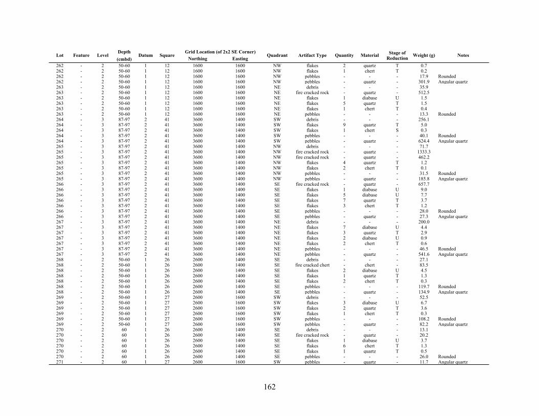
162
Lot Feature LevelDepth(cmbd)
Datum SquareGrid Location (of 2x2 SE Corner)Grid Location (of 2x2 SE Corner)
Quadrant Artifact Type Quantity Material Stage of Reduction Weight (g) NotesLot Feature Level
Depth(cmbd)
Datum SquareNorthing Easting
Quadrant Artifact Type Quantity Material Stage of Reduction Weight (g) Notes
262 - 2 50-60 1 12 1600 1600 NW flakes 2 quartz T 0.7262 - 2 50-60 1 12 1600 1600 NW flakes 1 chert T 0.2262 - 2 50-60 1 12 1600 1600 NW pebbles - - - 17.9 Rounded262 - 2 50-60 1 12 1600 1600 NW pebbles - quartz - 301.9 Angular quartz263 - 2 50-60 1 12 1600 1600 NE debris - - - 35.9263 - 2 50-60 1 12 1600 1600 NE fire cracked rock - quartz - 512.5263 - 2 50-60 1 12 1600 1600 NE flakes 1 diabase U 1.5263 - 2 50-60 1 12 1600 1600 NE flakes 5 quartz T 1.5263 - 2 50-60 1 12 1600 1600 NE flakes 1 chert T 0.4263 - 2 50-60 1 12 1600 1600 NE pebbles - - - 13.3 Rounded264 - 3 87-97 2 41 3600 1400 SW debris - - - 256.1264 - 3 87-97 2 41 3600 1400 SW flakes 9 quartz T 5.0264 - 3 87-97 2 41 3600 1400 SW flakes 1 chert S 0.3264 - 3 87-97 2 41 3600 1400 SW pebbles - - - 40.1 Rounded264 - 3 87-97 2 41 3600 1400 SW pebbles - quartz - 624.4 Angular quartz265 - 3 87-97 2 41 3600 1400 NW debris - - - 71.7265 - 3 87-97 2 41 3600 1400 NW fire cracked rock - quartz - 1333.3265 - 3 87-97 2 41 3600 1400 NW fire cracked rock - quartz - 462.2265 - 3 87-97 2 41 3600 1400 NW flakes 4 quartz T 1.2265 - 3 87-97 2 41 3600 1400 NW flakes 2 chert T 0.1265 - 3 87-97 2 41 3600 1400 NW pebbles - - - 31.5 Rounded265 - 3 87-97 2 41 3600 1400 NW pebbles - quartz - 185.8 Angular quartz266 - 3 87-97 2 41 3600 1400 SE fire cracked rock - quartz - 657.7266 - 3 87-97 2 41 3600 1400 SE flakes 1 diabase U 9.0266 - 3 87-97 2 41 3600 1400 SE flakes 5 diabase U 7.7266 - 3 87-97 2 41 3600 1400 SE flakes 7 quartz T 3.7266 - 3 87-97 2 41 3600 1400 SE flakes 3 chert T 1.2266 - 3 87-97 2 41 3600 1400 SE pebbles - - - 28.0 Rounded266 - 3 87-97 2 41 3600 1400 SE pebbles - quartz - 27.3 Angular quartz267 - 3 87-97 2 41 3600 1400 NE debris - - - 200.0267 - 3 87-97 2 41 3600 1400 NE flakes 7 diabase U 4.4267 - 3 87-97 2 41 3600 1400 NE flakes 3 quartz T 2.9267 - 3 87-97 2 41 3600 1400 NE flakes 2 diabase U 0.9267 - 3 87-97 2 41 3600 1400 NE flakes 2 chert T 0.6267 - 3 87-97 2 41 3600 1400 NE pebbles - - - 46.5 Rounded267 - 3 87-97 2 41 3600 1400 NE pebbles - quartz - 541.6 Angular quartz268 - 2 50-60 1 26 2600 1400 SE debris - - - 27.1268 - 2 50-60 1 26 2600 1400 SE fire cracked chert - chert - 83.5268 - 2 50-60 1 26 2600 1400 SE flakes 2 diabase U 4.5268 - 2 50-60 1 26 2600 1400 SE flakes 1 quartz T 1.3268 - 2 50-60 1 26 2600 1400 SE flakes 2 chert T 0.3268 - 2 50-60 1 26 2600 1400 SE pebbles - - - 119.7 Rounded268 - 2 50-60 1 26 2600 1400 SE pebbles - quartz - 134.9 Angular quartz269 - 2 50-60 1 27 2600 1600 SW debris - - - 52.5269 - 2 50-60 1 27 2600 1600 SW flakes 3 diabase U 6.7269 - 2 50-60 1 27 2600 1600 SW flakes 2 quartz T 3.6269 - 2 50-60 1 27 2600 1600 SW flakes 1 chert T 0.3269 - 2 50-60 1 27 2600 1600 SW pebbles - - - 108.2 Rounded269 - 2 50-60 1 27 2600 1600 SW pebbles - quartz - 82.2 Angular quartz270 - 2 60 1 26 2600 1400 SE debris - - - 13.1270 - 2 60 1 26 2600 1400 SE fire cracked rock - quartz - 20.2270 - 2 60 1 26 2600 1400 SE flakes 1 diabase U 3.7270 - 2 60 1 26 2600 1400 SE flakes 6 chert T 1.3270 - 2 60 1 26 2600 1400 SE flakes 1 quartz T 0.5270 - 2 60 1 26 2600 1400 SE pebbles - - - 26.0 Rounded271 - 2 60 1 27 2600 1600 SW pebbles - quartz - 11.7 Angular quartz

163
Lot Feature LevelDepth(cmbd)
Datum SquareGrid Location (of 2x2 SE Corner)Grid Location (of 2x2 SE Corner)
Quadrant Artifact Type Quantity Material Stage of Reduction Weight (g) NotesLot Feature Level
Depth(cmbd)
Datum SquareNorthing Easting
Quadrant Artifact Type Quantity Material Stage of Reduction Weight (g) Notes
271 - 2 60 1 27 2600 1600 SW pebbles - - - 9.7272 - 2 60 1 22 2400 1200 ALL fire cracked chert - chert - 41.8272 - 2 60 1 22 2400 1200 ALL flakes 1 diabase U 4.7272 - 2 60 1 22 2400 1200 ALL flakes 2 quartz T 0.9272 - 2 60 1 22 2400 1200 ALL pebbles - - - 11.6 Rounded272 - 2 60 1 22 2400 1200 ALL pebbles - quartz - 509.3 Angular quartz273 - 2 60 1 23 2400 1400 ALL debris - - - 7.9273 - 2 60 1 23 2400 1400 ALL fire cracked chert - chert - 19.9273 - 2 60 1 23 2400 1400 ALL flakes 4 quartz T 12.8273 - 2 60 1 23 2400 1400 ALL pebbles - - - 16.9 Rounded273 - 2 60 1 23 2400 1400 ALL pebbles - quartz - 42.2 Angular quartz274 - 3 60-70 1 26 2600 1400 SE debris - - - 119.9274 - 3 60-70 1 26 2600 1400 SE fire cracked chert - chert - 30.1274 - 3 60-70 1 26 2600 1400 SE flakes 8 diabase U 32.9274 - 3 60-70 1 26 2600 1400 SE flakes 3 chert T 0.4274 - 3 60-70 1 26 2600 1400 SE pebbles - - - 344.4 Rounded274 - 3 60-70 1 26 2600 1400 SE pebbles - quartz - 473.5 Angular quartz275 - 2 60 1 19 2200 1200 ALL debris - - - 77.8275 - 2 60 1 19 2200 1200 ALL fire cracked chert - chert - 7.2275 - 2 60 1 19 2200 1200 ALL fire cracked rock - quartz - 25.8275 - 2 60 1 19 2200 1200 ALL flakes 5 quartz T 1.3275 - 2 60 1 19 2200 1200 ALL flakes 2 chert T 0.4275 - 2 60 1 19 2200 1200 ALL pebbles - - - 19.9 Rounded275 - 2 60 1 19 2200 1200 ALL pebbles - quartz - 18.6 Angular quartz277 - 2 60 1 21 2200 1600 ALL debris - - - 3.0277 - 2 60 1 21 2200 1600 ALL fire cracked rock - quartz - 3.5277 - 2 60 1 21 2200 1600 ALL flakes 3 quartz T 2.5277 - 2 60 1 21 2200 1600 ALL flakes 1 diabase U 1.8277 - 2 60 1 21 2200 1600 ALL flakes 1 chert T 1.1277 - 2 60 1 21 2200 1600 ALL pebbles - - - 27.3 Rounded277 - 2 60 1 21 2200 1600 ALL pebbles - quartz - 2.7 Angular quartz278 - 2 60 1 16 2000 1200 ALL debris - - - 8.8278 - 2 60 1 16 2000 1200 ALL fire cracked chert - chert - 4.1278 - 2 60 1 16 2000 1200 ALL fire cracked rock - quartz - 32.1278 - 2 60 1 16 2000 1200 ALL flakes 1 diabase U 3.3278 - 2 60 1 16 2000 1200 ALL flakes 1 quartz T 0.7278 - 2 60 1 16 2000 1200 ALL flakes 2 chert T 0.3278 - 2 60 1 16 2000 1200 ALL pebbles - - - 25.3 Rounded278 - 2 60 1 16 2000 1200 ALL pebbles - quartz - 28.2 Angular quartz279 - 2 60 1 17 2000 1400 ALL pebbles - - - 4.1 Rounded279 - 2 60 1 17 2000 1400 ALL pebbles - quartz - 28.2 Angular quartz280 - 2 60 1 18 2000 1600 ALL debris - - - 4.4280 - 2 60 1 18 2000 1600 ALL flakes 6 quartz T 2.2280 - 2 60 1 18 2000 1600 ALL pebbles - - - 11.3 Rounded280 - 2 60 1 18 2000 1600 ALL pebbles - quartz - 19.7 Angular quartz281 - 2 60 1 13 1800 1000 ALL debris - - - 0.9281 - 2 60 1 13 1800 1000 ALL fire cracked rock - quartz - 58.8281 - 2 60 1 13 1800 1000 ALL flakes 1 chert T 0.1281 - 2 60 1 13 1800 1000 ALL pebbles - - - 25.3 Rounded281 - 2 60 1 13 1800 1000 ALL pebbles - quartz - 28.4 Angular quartz282 - 2 60 1 14 1800 1600 ALL debris - - - 13.5282 - 2 60 1 14 1800 1600 ALL flakes 1 quartz T 0.3282 - 2 60 1 14 1800 1600 ALL pebbles - quartz - 63.5 Angular quartz283 - 2 60 1 15 1800 1600 ALL flakes 1 diabase U 1.3283 - 2 60 1 15 1800 1600 ALL flakes 3 quartz T 1.1283 - 2 60 1 15 1800 1600 ALL flakes 1 chert T 0.2

164
Lot Feature LevelDepth(cmbd)
Datum SquareGrid Location (of 2x2 SE Corner)Grid Location (of 2x2 SE Corner)
Quadrant Artifact Type Quantity Material Stage of Reduction Weight (g) NotesLot Feature Level
Depth(cmbd)
Datum SquareNorthing Easting
Quadrant Artifact Type Quantity Material Stage of Reduction Weight (g) Notes
283 - 2 60 1 15 1800 1600 ALL pebbles - - - 8.2 Rounded283 - 2 60 1 15 1800 1600 ALL pebbles - quartz - 111.3 Angular quartz284 - 3 60-70 1 27 2600 1600 SW debris - - - 89.2284 - 3 60-70 1 27 2600 1600 SW flakes 1 chert T 0.3284 - 3 60-70 1 27 2600 1600 SW flakes 1 chert S 0.3284 - 3 60-70 1 27 2600 1600 SW pebbles - - - 239.1 Rounded284 - 3 60-70 1 27 2600 1600 SW pebbles - quartz - 246.6 Angular quartz285 - 2 60 1 11 1600 1400 ALL pebbles - - - 6.8 Rounded285 - 2 60 1 11 1600 1400 ALL pebbles - quartz - 9.9 Angular quartz286 - 2 60 1 12 1600 1600 N pebbles - quartz - 34.6 Angular quartz287 - 2 60 1 7 1400 1200 ALL pebbles - quartz - 19.4 Angular quartz288 - 2 60 1 8 1400 1400 ALL debris - - - 3.9288 - 2 60 1 8 1400 1400 ALL flakes 1 chert T 0.1288 - 2 60 1 8 1400 1400 ALL pebbles - quartz - 7.8 Angular quartz289 - 2 60 1 4 1200 1200 N debris - - - 3.4289 - 2 60 1 4 1200 1200 N pebbles - quartz - 9.4 Angular quartz290 - 2 60 1 5 1200 1400 N debris - - - 5.2290 - 2 60 1 5 1200 1400 N flakes 2 quartz T 1.6290 - 2 60 1 5 1200 1400 N pebbles - - - 2.8 Rounded290 - 2 60 1 5 1200 1400 N pebbles - quartz - 5.4 Angular quartz291 - 2 60 1 6 1200 1600 NW pebbles - - - 12.4 Rounded291 - 2 60 1 6 1200 1600 NW pebbles - quartz - 8.1 Angular quartz292 - 1 0-77 2 34 3200 1200 NE debris - - - 7.2292 - 1 0-77 2 34 3200 1200 NE flakes 6 quartz T 3.8292 - 1 0-77 2 34 3200 1200 NE pebbles - - - 270.0 Rounded292 - 1 0-77 2 34 3200 1200 NE pebbles - quartz - 97.4 Angular quartz293 16 3 89-97 2 41 3600 c NW fire cracked rock - quartz - 3042.1293 16 3 89-97 2 41 3600 1400 NW fire cracked rock - quartz - 2600.0293 16 3 89-97 2 41 3600 1400 NW fire cracked rock - quartz - 2573.8293 16 3 89-97 2 41 3600 1400 NW flakes 3 quartz T 1.7293 16 3 89-97 2 41 3600 1400 NW flakes 2 quartz T 0.7293 16 3 89-97 2 41 3600 1400 NW pebbles - quartz - 66.5 Angular quartz293 16 3 89-97 2 41 3600 1400 NW pebbles - quartz - 61.5 Angular quartz293 16 3 89-97 2 41 3600 1400 NW pebbles - quartz - 48.9 Angular quartz295 - 3 87-97 2 38 3400 1400 SW debris - - - 29.7295 - 3 87-97 2 38 3400 1400 SW flakes 2 quartz T 1.3295 - 3 87-97 2 38 3400 1400 SW flakes 2 chert T 0.9295 - 3 87-97 2 38 3400 1400 SW pebbles - - - 31.4 Rounded295 - 3 87-97 2 38 3400 1400 SW pebbles - quartz - 278.9 Angular quartz296 - 3 87-97 2 38 3400 1400 NW debris - - - 20.0296 - 3 87-97 2 38 3400 1400 NW flakes 6 quartz T 1.9296 - 3 87-97 2 38 3400 1400 NW flakes 4 chert T 0.6296 - 3 87-97 2 38 3400 1400 NW pebbles - - - 29.8 Rounded296 - 3 87-97 2 38 3400 1400 NW pebbles - quartz - 412.5 Angular quartz297 - 3 87-97 2 38 3400 1400 SE debris - - - 9.6297 - 3 87-97 2 38 3400 1400 SE flakes 5 diabase U 10.6297 - 3 87-97 2 38 3400 1400 SE flakes 1 diabase U 6.8297 - 3 87-97 2 38 3400 1400 SE flakes 5 quartz T 4.4297 - 3 87-97 2 38 3400 1400 SE pebbles - - - 24.7 Rounded297 - 3 87-97 2 38 3400 1400 SE pebbles - quartz - 55.4 Angular quartz298 - 3 87-97 2 38 3400 1400 NE debris - - - 287.9298 - 3 87-97 2 38 3400 1400 NE flakes 3 quartz T 28.9298 - 3 87-97 2 38 3400 1400 NE flakes 5 diabase U 10.7298 - 3 87-97 2 38 3400 1400 NE flakes 4 chert T 1.7298 - 3 87-97 2 38 3400 1400 NE pebbles - - - 17.2 Rounded298 - 3 87-97 2 38 3400 1400 NE pebbles - quartz - 65.0 Angular quartz

165
Lot Feature LevelDepth(cmbd)
Datum SquareGrid Location (of 2x2 SE Corner)Grid Location (of 2x2 SE Corner)
Quadrant Artifact Type Quantity Material Stage of Reduction Weight (g) NotesLot Feature Level
Depth(cmbd)
Datum SquareNorthing Easting
Quadrant Artifact Type Quantity Material Stage of Reduction Weight (g) Notes
299 - 3 62-70 1 7 1400 1200 SW debris - - - 45.2299 - 3 62-70 1 7 1400 1200 SW flakes 4 quartz T 7.8299 - 3 62-70 1 7 1400 1200 SW flakes 2 chert T 0.8299 - 3 62-70 1 7 1400 1200 SW pebbles - - - 26.9 Rounded299 - 3 62-70 1 7 1400 1200 SW pebbles - quartz - 152.9 Angular quartz300 - 3 61-70 1 7 1400 1200 NW debris - - - 836.3300 - 3 61-70 1 7 1400 1200 NW fire cracked rock - quartz - 303.4300 - 3 61-70 1 7 1400 1200 NW flakes - quartz T 1.1300 - 3 61-70 1 7 1400 1200 NW flakes 1 diabase U 0.6300 - 3 61-70 1 7 1400 1200 NW flakes 3 chert T 0.2300 - 3 61-70 1 7 1400 1200 NW pebbles - - - 82.7 Rounded301 - 3 61-70 1 7 1400 1200 SE debris - - - 144.6301 - 3 61-70 1 7 1400 1200 SE flakes 1 quartz T 0.1301 - 3 61-70 1 7 1400 1200 SE pebbles - - - 46.8 Rounded301 - 3 61-70 1 7 1400 1200 SE pebbles - quartz - 152.7 Angular quartz302 - 3 62-70 1 7 1400 1200 NE debris - - - 31.4302 - 3 62-70 1 7 1400 1200 NE flakes 5 quartz T 3.4302 - 3 62-70 1 7 1400 1200 NE flakes 1 chert T 0.1302 - 3 62-70 1 7 1400 1200 NE pebbles - - - 63.1 Rounded302 - 3 62-70 1 7 1400 1200 NE pebbles - quartz - 384.7 Angular quartz303 - 3 87-97 2 39 3400 1600 SW debris - - - 8.0303 - 3 87-97 2 39 3400 1600 SW flakes 9 quartz T 8.8303 - 3 87-97 2 39 3400 1600 SW flakes 1 quartz T 4.2303 - 3 87-97 2 39 3400 1600 SW flakes 2 diabase U 3.5303 - 3 87-97 2 39 3400 1600 SW pebbles - quartz - 73.8 Angular quartz304 - 3 87-97 2 39 3400 1600 NW debris - - - 34.5304 - 3 87-97 2 39 3400 1600 NW flakes 8 quartz T 4.5304 - 3 87-97 2 39 3400 1600 NW flakes 1 chert S 2.3304 - 3 87-97 2 39 3400 1600 NW flakes 3 chert T 2.0304 - 3 87-97 2 39 3400 1600 NW flakes 2 quartz T 0.5304 - 3 87-97 2 39 3400 1600 NW flakes 1 chert T 0.3304 - 3 87-97 2 39 3400 1600 NW pebbles - - - 9.3 Rounded304 - 3 87-97 2 39 3400 1600 NW pebbles - quartz - 109.1 Angular quartz305 - 3 87-97 2 39 3400 1600 SE debris - - - 6.5305 - 3 87-97 2 39 3400 1600 SE flakes 6 quartz T 6.7305 - 3 87-97 2 39 3400 1600 SE pebbles - - - 42.6 Rounded305 - 3 87-97 2 39 3400 1600 SE pebbles - quartz - 132.9 Angular quartz306 - 3 87-97 2 39 3400 1600 NE debris - - - 19.0306 - 3 87-97 2 39 3400 1600 NE fire cracked rock - quartz - 53.1306 - 3 87-97 2 39 3400 1600 NE flakes 1 quartz T 1.9306 - 3 87-97 2 39 3400 1600 NE flakes 2 chert T 0.3306 - 3 87-97 2 39 3400 1600 NE pebbles - - - 60.7 Rounded307 - 3 60-70 1 23 2400 1400 SW debris - - - 29.3307 - 3 60-70 1 23 2400 1400 SW fire cracked rock - quartz - 1273.0307 - 3 60-70 1 23 2400 1400 SW flakes 60 chert T 37.3307 - 3 60-70 1 23 2400 1400 SW flakes 31 quartz T 29.1307 - 3 60-70 1 23 2400 1400 SW flakes 5 quartz T 28.0307 - 3 60-70 1 23 2400 1400 SW flakes 3 quartz T 26.8307 - 3 60-70 1 23 2400 1400 SW flakes 8 chert T 3.7307 - 3 60-70 1 23 2400 1400 SW flakes 2 diabase U 2.6307 - 3 60-70 1 23 2400 1400 SW pebbles - - - 87.8 Rounded307 - 3 60-70 1 23 2400 1400 SW pebbles - quartz - 526.6 Angular quartz308 - 3 60-70 1 23 2400 1400 NW debris - - - 74.4308 - 3 60-70 1 23 2400 1400 NW fire cracked chert - chert - 67.3308 - 3 60-70 1 23 2400 1400 NW flakes 8 quartz T 4.1308 - 3 60-70 1 23 2400 1400 NW flakes 1 chert T 0.5

166
Lot Feature LevelDepth(cmbd)
Datum SquareGrid Location (of 2x2 SE Corner)Grid Location (of 2x2 SE Corner)
Quadrant Artifact Type Quantity Material Stage of Reduction Weight (g) NotesLot Feature Level
Depth(cmbd)
Datum SquareNorthing Easting
Quadrant Artifact Type Quantity Material Stage of Reduction Weight (g) Notes
308 - 3 60-70 1 23 2400 1400 NW flakes 2 chert T 0.3308 - 3 60-70 1 23 2400 1400 NW pebbles - - - 71.8 Rounded308 - 3 60-70 1 23 2400 1400 NW pebbles - quartz - 295.6 Angular quartz309 - 3 60-70 1 23 2400 1400 SE debris - - - 46.5309 - 3 60-70 1 23 2400 1400 SE fire cracked chert - chert - 12.4309 - 3 60-70 1 23 2400 1400 SE fire cracked chert - chert - 3.1309 - 3 60-70 1 23 2400 1400 SE flakes 1 diabase U 9.6309 - 3 60-70 1 23 2400 1400 SE pebbles - - - 68.9 Rounded309 - 3 60-70 1 23 2400 1400 SE pebbles - quartz - 1385.3 Angular quartz310 - 3 60-70 1 23 2400 1400 NE debris - - - 141.1310 - 3 60-70 1 23 2400 1400 NE fire cracked chert - chert - 52.7310 - 3 60-70 1 23 2400 1400 NE fire cracked rock - quartz - 345.1310 - 3 60-70 1 23 2400 1400 NE flakes 13 chert T 14.8310 - 3 60-70 1 23 2400 1400 NE flakes 10 quartz T 2.4310 - 3 60-70 1 23 2400 1400 NE flakes 7 chert T 2.1310 - 3 60-70 1 23 2400 1400 NE flakes 3 diabase U 1.9310 - 3 60-70 1 23 2400 1400 NE flakes 3 chert S 1.3310 - 3 60-70 1 23 2400 1400 NE pebbles - - - 106.9 Rounded311 - 3 87-97 2 36 3200 1600 SW debris - - - 46.5311 - 3 87-97 2 36 3200 1600 SW debris - - - 3.7311 - 3 87-97 2 36 3200 1600 SW flakes 5 quartz T 8.2311 - 3 87-97 2 36 3200 1600 SW flakes 3 chert T 4.3311 - 3 87-97 2 36 3200 1600 SW flakes 2 diabase U 3.4311 - 3 87-97 2 36 3200 1600 SW flakes 2 quartz T 2.2311 - 3 87-97 2 36 3200 1600 SW flakes 1 quartz T 1.5311 - 3 87-97 2 36 3200 1600 SW flakes 2 quartz T 1.2311 - 3 87-97 2 36 3200 1600 SW flakes 2 diabase U 1.1311 - 3 87-97 2 36 3200 1600 SW flakes 1 chert P 0.4311 - 3 87-97 2 36 3200 1600 SW flakes 1 chert T 0.2311 - 3 87-97 2 36 3200 1600 SW flakes 1 quartz T 0.1311 - 3 87-97 2 36 3200 1600 SW pebbles - - - 35.1 Rounded311 - 3 87-97 2 36 3200 1600 SW pebbles - - - 33.8 Rounded311 - 3 87-97 2 36 3200 1600 SW pebbles - quartz - 145.8 Angular quartz311 - 3 87-97 2 36 3200 1600 SW pebbles - quartz - 1190.3312 - 3 87-97 2 36 3200 1600 NW debris - - - 6.7312 - 3 87-97 2 36 3200 1600 NW debris - - - 5.5312 - 3 87-97 2 36 3200 1600 NW fire cracked rock - quartz - 248.3312 - 3 87-97 2 36 3200 1600 NW flakes 9 diabase U 8.8312 - 3 87-97 2 36 3200 1600 NW flakes 5 diabase U 5.2312 - 3 87-97 2 36 3200 1600 NW flakes 8 quartz T 4.9312 - 3 87-97 2 36 3200 1600 NW flakes 6 quartz T 3.3312 - 3 87-97 2 36 3200 1600 NW flakes 2 quartz T 0.7312 - 3 87-97 2 36 3200 1600 NW flakes 2 chert T 0.7312 - 3 87-97 2 36 3200 1600 NW flakes 2 chert T 0.5312 - 3 87-97 2 36 3200 1600 NW flakes 1 chert T 0.1312 - 3 87-97 2 36 3200 1600 NW pebbles - - - 29.0 Rounded312 - 3 87-97 2 36 3200 1600 NW pebbles - - - 24.7 Rounded312 - 3 87-97 2 36 3200 1600 NW pebbles - quartz - 753.9 Angular quartz312 - 3 87-97 2 36 3200 1600 NW pebbles - quartz - 153.5 Angular quartz313 - 3 87-97 2 36 3200 1600 SE flakes 3 quartz T 1.7313 - 3 87-97 2 36 3200 1600 SE flakes 3 quartz T 1.1313 - 3 87-97 2 36 3200 1600 SE flakes 1 diabase U 0.2313 - 3 87-97 2 36 3200 1600 SE pebbles - - - 25.1 Rounded313 - 3 87-97 2 36 3200 1600 SE pebbles - - - 24.1 Rounded313 - 3 87-97 2 36 3200 1600 SE pebbles - quartz - 157.9 Angular quartz313 - 3 87-97 2 36 3200 1600 SE pebbles - quartz - 54.6 Angular quartz

167
Lot Feature LevelDepth(cmbd)
Datum SquareGrid Location (of 2x2 SE Corner)Grid Location (of 2x2 SE Corner)
Quadrant Artifact Type Quantity Material Stage of Reduction Weight (g) NotesLot Feature Level
Depth(cmbd)
Datum SquareNorthing Easting
Quadrant Artifact Type Quantity Material Stage of Reduction Weight (g) Notes
314 - 3 87-97 2 36 3200 1600 NE flakes 1 quartz T 1.5314 - 3 87-97 2 36 3200 1600 NE pebbles - - - 50.2 Rounded314 - 3 87-97 2 36 3200 1600 NE pebbles - - - 14.1 Rounded314 - 3 87-97 2 36 3200 1600 NE pebbles - quartz - 176.3 Angular quartz314 - 3 87-97 2 36 3200 1600 NE pebbles - quartz - 41.4 Angular quartz315 - 4 97-107 2 42 3600 1600 SW debris - - - 245.0315 - 4 97-107 2 42 3600 1600 SW flakes 5 diabase U 7.1315 - 4 97-107 2 42 3600 1600 SW flakes 2 quartz T 1.1315 - 4 97-107 2 42 3600 1600 SW flakes 2 quartz T 0.5315 - 4 97-107 2 42 3600 1600 SW flakes 1 quartz T 0.5315 - 4 97-107 2 42 3600 1600 SW flakes 1 chert T 0.1315 - 4 97-107 2 42 3600 1600 SW pebbles - - - 64.7 Rounded315 - 4 97-107 2 42 3600 1600 SW pebbles - quartz - 973.8 Angular quartz316 - 4 97-107 2 42 3600 1600 NW debris - - - 70.1316 - 4 97-107 2 42 3600 1600 NW debris - - - 4.5316 - 4 97-107 2 42 3600 1600 NW fire cracked rock - quartz - 619.5316 - 4 97-107 2 42 3600 1600 NW fire cracked rock - quartz - 556.4316 - 4 97-107 2 42 3600 1600 NW flakes 7 diabase T 13.9316 - 4 97-107 2 42 3600 1600 NW flakes 2 diabase U 7.2316 - 4 97-107 2 42 3600 1600 NW flakes 7 quartz T 4.5316 - 4 97-107 2 42 3600 1600 NW flakes 1 diabase U 2.5316 - 4 97-107 2 42 3600 1600 NW flakes 3 quartz - 1.7316 - 4 97-107 2 42 3600 1600 NW flakes 1 quartz T 0.7316 - 4 97-107 2 42 3600 1600 NW flakes 1 chert T 0.2316 - 4 97-107 2 42 3600 1600 NW flakes 1 chert T 0.2316 - 4 97-107 2 42 3600 1600 NW pebbles - - - 16.5 Rounded316 - 4 97-107 2 42 3600 1600 NW pebbles - - - 13.6 Rounded316 - 4 97-107 2 42 3600 1600 NW pebbles - quartz - 445.6 Angular quartz316 - 4 97-107 2 42 3600 1600 NW pebbles - quartz - 249.3 Angular quartz317 - 4 97-107 2 42 3600 1600 SE debris - - - 38.5317 - 4 97-107 2 42 3600 1600 SE fire cracked rock - quartz - 259.9317 - 4 97-107 2 42 3600 1600 SE flakes 1 diabase U 5.5317 - 4 97-107 2 42 3600 1600 SE flakes 4 quartz T 2.4317 - 4 97-107 2 42 3600 1600 SE flakes 4 chert T 1.2317 - 4 97-107 2 42 3600 1600 SE pebbles - - - 27.7 Rounded318 - 4 97-107 2 42 3600 1600 NE debris - - - 20.7318 - 4 97-107 2 42 3600 1600 NE flakes 3 quartz T 6.8318 - 4 97-107 2 42 3600 1600 NE flakes 4 chert T 1.7318 - 4 97-107 2 42 3600 1600 NE flakes 1 chert T 0.2318 - 4 97-107 2 42 3600 1600 NE pebbles - - - 15.6 Rounded318 - 4 97-107 2 42 3600 1600 NE pebbles - quartz - 279.6 Angular quartz319 - 3 60-70 1 22 2400 1200 SW debris - - - 189.4319 - 3 60-70 1 22 2400 1200 SW fire cracked chert - chert - 72.7319 - 3 60-70 1 22 2400 1200 SW fire cracked rock - quartz - 2443.7319 - 3 60-70 1 22 2400 1200 SW flakes 4 chert T 0.8319 - 3 60-70 1 22 2400 1200 SW pebbles - - - 62.4 Rounded319 - 3 60-70 1 22 2400 1200 SW pebbles - quartz - 224.9 Angular quartz320 - 3 60-70 1 22 2400 1200 NW cobbles 1 - - 357.7 Rounded320 - 3 60-70 1 22 2400 1200 NW debris - - - 27.7320 - 3 60-70 1 22 2400 1200 NW fire cracked chert - chert - 118.9320 - 3 60-70 1 22 2400 1200 NW fire cracked rock - quartz - 224.1320 - 3 60-70 1 22 2400 1200 NW pebbles - - - 119.2 Rounded320 - 3 60-70 1 22 2400 1200 NW pebbles - quartz - 893.1 Angular quartz321 - 3 60-70 1 22 2400 1200 SE debris - - - 34.0321 - 3 60-70 1 22 2400 1200 SE fire cracked chert - chert - 100.8321 - 3 60-70 1 22 2400 1200 SE fire cracked rock - quartz - 719.5

168
Lot Feature LevelDepth(cmbd)
Datum SquareGrid Location (of 2x2 SE Corner)Grid Location (of 2x2 SE Corner)
Quadrant Artifact Type Quantity Material Stage of Reduction Weight (g) NotesLot Feature Level
Depth(cmbd)
Datum SquareNorthing Easting
Quadrant Artifact Type Quantity Material Stage of Reduction Weight (g) Notes
321 - 3 60-70 1 22 2400 1200 SE flakes 22 quartz T 16.2321 - 3 60-70 1 22 2400 1200 SE flakes 3 chert T 1.0321 - 3 60-70 1 22 2400 1200 SE pebbles - - - 52.6 Rounded321 - 3 60-70 1 22 2400 1200 SE pebbles - quartz - 640.6 Angular quartz322 - 3 60-70 1 22 2400 1200 NE cobbles - - - 273.7 Rounded322 - 3 60-70 1 22 2400 1200 NE debris - - - 76.3322 - 3 60-70 1 22 2400 1200 NE fire cracked chert - chert - 100.3322 - 3 60-70 1 22 2400 1200 NE fire cracked rock - quartz - 597.8322 - 3 60-70 1 22 2400 1200 NE pebbles - - - 40.9 Rounded322 - 3 60-70 1 22 2400 1200 NE pebbles - quartz - 82.4 Angular quartz323 - 3 60-70 1 4 1200 1200 NW debris - - - 11.3323 - 3 60-70 1 4 1200 1200 NW flakes 1 quartz T 0.2323 - 3 60-70 1 4 1200 1200 NW flakes 1 chert T 0.2323 - 3 60-70 1 4 1200 1200 NW pebbles - - - 76.4 Rounded323 - 3 60-70 1 4 1200 1200 NW pebbles - quartz - 265.1 Angular quartz324 - 3 60-70 1 4 1200 1200 NE debris - - - 127.0324 - 3 60-70 1 4 1200 1200 NE fire cracked rock - quartz - 157.3324 - 3 60-70 1 4 1200 1200 NE flakes 9 quartz T 5.9324 - 3 60-70 1 4 1200 1200 NE flakes 1 chert T 0.3324 - 3 60-70 1 4 1200 1200 NE pebbles - - - 27.3 Rounded324 - 3 60-70 1 4 1200 1200 NE pebbles - quartz - 219.4 Angular quartz329 - 4 97-107 2 41 3600 1400 SW debris - - - 23.7329 - 4 97-107 2 41 3600 1400 SW flakes 11 quartz T 4.5329 - 4 97-107 2 41 3600 1400 SW flakes 2 chert T 0.7329 - 4 97-107 2 41 3600 1400 SW pebbles - quartz - 643.0329 - 4 97-107 2 41 3600 1400 SW pebbles - - - 65.6330 - 4 97-107 2 41 3600 1400 NW debris - - - 64.4330 - 4 97-107 2 41 3600 1400 NW fire cracked rock - quartz - 2165.1330 - 4 97-107 2 41 3600 1400 NW flakes 14 quartz T 11.3330 - 4 97-107 2 41 3600 1400 NW pebbles - - - 101.3 Rounded330 - 4 97-107 2 41 3600 1400 NW pebbles - quartz - 147.6 Angular quartz331 - 4 97-107 2 41 3600 1400 SE cobbles 1 quartz - 1284.2331 - 4 97-107 2 41 3600 1400 SE debris - - - 93.8331 - 4 97-107 2 41 3600 1400 SE fire cracked rock - quartz - 1144.9331 - 4 97-107 2 41 3600 1400 SE flakes 8 quartz T 3.5331 - 4 97-107 2 41 3600 1400 SE pebbles - - - 32.0 Rounded331 - 4 97-107 2 41 3600 1400 SE pebbles - quartz - 153.3 Angular quartz332 - 4 97-107 2 41 3600 1400 NE debris - - - 65.3332 - 4 97-107 2 41 3600 1400 NE fire cracked rock - quartz - 716.7332 - 4 97-107 2 41 3600 1400 NE flakes 3 diabase U 12.0332 - 4 97-107 2 41 3600 1400 NE flakes 5 quartz T 5.8332 - 4 97-107 2 41 3600 1400 NE flakes 8 diabase U 5.4332 - 4 97-107 2 41 3600 1400 NE flakes 1 chert T 0.2332 - 4 97-107 2 41 3600 1400 NE pebbles - - - 42.1 Rounded333 - 3 60-70 1 5 1200 1400 NW debris - - - 52.7333 - 3 60-70 1 5 1200 1400 NW fire cracked rock - quartz - 509.3333 - 3 60-70 1 5 1200 1400 NW flakes 5 quartz T 23.2333 - 3 60-70 1 5 1200 1400 NW flakes 2 chert T 0.1333 - 3 60-70 1 5 1200 1400 NW pebbles - - - 42.9 Rounded334 - 3 60-70 1 5 1200 1400 NE cobbles 1 quartz - 171.7334 - 3 60-70 1 5 1200 1400 NE debris - - - 17.4334 - 3 60-70 1 5 1200 1400 NE flakes 10 quartz T 3.3334 - 3 60-70 1 5 1200 1400 NE flakes 1 quartz T 1.9334 - 3 60-70 1 5 1200 1400 NE flakes 9 chert T 1.2334 - 3 60-70 1 5 1200 1400 NE pebbles - - - 18.8 Rounded334 - 3 60-70 1 5 1200 1400 NE pebbles - quartz - 172.9 Angular quartz
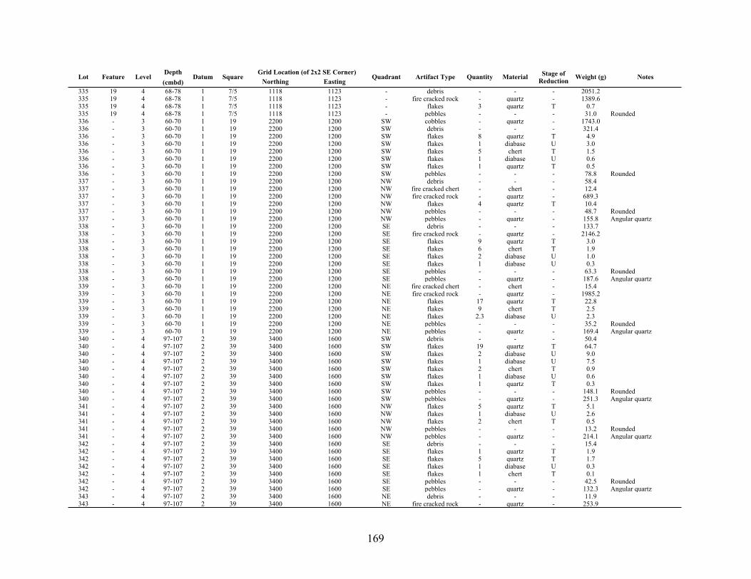
169
Lot Feature LevelDepth(cmbd)
Datum SquareGrid Location (of 2x2 SE Corner)Grid Location (of 2x2 SE Corner)
Quadrant Artifact Type Quantity Material Stage of Reduction Weight (g) NotesLot Feature Level
Depth(cmbd)
Datum SquareNorthing Easting
Quadrant Artifact Type Quantity Material Stage of Reduction Weight (g) Notes
335 19 4 68-78 1 7/5 1118 1123 - debris - - - 2051.2335 19 4 68-78 1 7/5 1118 1123 - fire cracked rock - quartz - 1389.6335 19 4 68-78 1 7/5 1118 1123 - flakes 3 quartz T 0.7335 19 4 68-78 1 7/5 1118 1123 - pebbles - - - 31.0 Rounded336 - 3 60-70 1 19 2200 1200 SW cobbles - quartz - 1743.0336 - 3 60-70 1 19 2200 1200 SW debris - - - 321.4336 - 3 60-70 1 19 2200 1200 SW flakes 8 quartz T 4.9336 - 3 60-70 1 19 2200 1200 SW flakes 1 diabase U 3.0336 - 3 60-70 1 19 2200 1200 SW flakes 5 chert T 1.5336 - 3 60-70 1 19 2200 1200 SW flakes 1 diabase U 0.6336 - 3 60-70 1 19 2200 1200 SW flakes 1 quartz T 0.5336 - 3 60-70 1 19 2200 1200 SW pebbles - - - 78.8 Rounded337 - 3 60-70 1 19 2200 1200 NW debris - - - 58.4337 - 3 60-70 1 19 2200 1200 NW fire cracked chert - chert - 12.4337 - 3 60-70 1 19 2200 1200 NW fire cracked rock - quartz - 689.3337 - 3 60-70 1 19 2200 1200 NW flakes 4 quartz T 10.4337 - 3 60-70 1 19 2200 1200 NW pebbles - - - 48.7 Rounded337 - 3 60-70 1 19 2200 1200 NW pebbles - quartz - 155.8 Angular quartz338 - 3 60-70 1 19 2200 1200 SE debris - - - 133.7338 - 3 60-70 1 19 2200 1200 SE fire cracked rock - quartz - 2146.2338 - 3 60-70 1 19 2200 1200 SE flakes 9 quartz T 3.0338 - 3 60-70 1 19 2200 1200 SE flakes 6 chert T 1.9338 - 3 60-70 1 19 2200 1200 SE flakes 2 diabase U 1.0338 - 3 60-70 1 19 2200 1200 SE flakes 1 diabase U 0.3338 - 3 60-70 1 19 2200 1200 SE pebbles - - - 63.3 Rounded338 - 3 60-70 1 19 2200 1200 SE pebbles - quartz - 187.6 Angular quartz339 - 3 60-70 1 19 2200 1200 NE fire cracked chert - chert - 15.4339 - 3 60-70 1 19 2200 1200 NE fire cracked rock - quartz - 1985.2339 - 3 60-70 1 19 2200 1200 NE flakes 17 quartz T 22.8339 - 3 60-70 1 19 2200 1200 NE flakes 9 chert T 2.5339 - 3 60-70 1 19 2200 1200 NE flakes 2.3 diabase U 2.3339 - 3 60-70 1 19 2200 1200 NE pebbles - - - 35.2 Rounded339 - 3 60-70 1 19 2200 1200 NE pebbles - quartz - 169.4 Angular quartz340 - 4 97-107 2 39 3400 1600 SW debris - - - 50.4340 - 4 97-107 2 39 3400 1600 SW flakes 19 quartz T 64.7340 - 4 97-107 2 39 3400 1600 SW flakes 2 diabase U 9.0340 - 4 97-107 2 39 3400 1600 SW flakes 1 diabase U 7.5340 - 4 97-107 2 39 3400 1600 SW flakes 2 chert T 0.9340 - 4 97-107 2 39 3400 1600 SW flakes 1 diabase U 0.6340 - 4 97-107 2 39 3400 1600 SW flakes 1 quartz T 0.3340 - 4 97-107 2 39 3400 1600 SW pebbles - - - 148.1 Rounded340 - 4 97-107 2 39 3400 1600 SW pebbles - quartz - 251.3 Angular quartz341 - 4 97-107 2 39 3400 1600 NW flakes 5 quartz T 5.1341 - 4 97-107 2 39 3400 1600 NW flakes 1 diabase U 2.6341 - 4 97-107 2 39 3400 1600 NW flakes 2 chert T 0.5341 - 4 97-107 2 39 3400 1600 NW pebbles - - - 13.2 Rounded341 - 4 97-107 2 39 3400 1600 NW pebbles - quartz - 214.1 Angular quartz342 - 4 97-107 2 39 3400 1600 SE debris - - - 15.4342 - 4 97-107 2 39 3400 1600 SE flakes 1 quartz T 1.9342 - 4 97-107 2 39 3400 1600 SE flakes 5 quartz T 1.7342 - 4 97-107 2 39 3400 1600 SE flakes 1 diabase U 0.3342 - 4 97-107 2 39 3400 1600 SE flakes 1 chert T 0.1342 - 4 97-107 2 39 3400 1600 SE pebbles - - - 42.5 Rounded342 - 4 97-107 2 39 3400 1600 SE pebbles - quartz - 132.3 Angular quartz343 - 4 97-107 2 39 3400 1600 NE debris - - - 11.9343 - 4 97-107 2 39 3400 1600 NE fire cracked rock - quartz - 253.9

170
Lot Feature LevelDepth(cmbd)
Datum SquareGrid Location (of 2x2 SE Corner)Grid Location (of 2x2 SE Corner)
Quadrant Artifact Type Quantity Material Stage of Reduction Weight (g) NotesLot Feature Level
Depth(cmbd)
Datum SquareNorthing Easting
Quadrant Artifact Type Quantity Material Stage of Reduction Weight (g) Notes
343 - 4 97-107 2 39 3400 1600 NE flakes 5 quartz T 4.0343 - 4 97-107 2 39 3400 1600 NE flakes 1 chert S 1.0343 - 4 97-107 2 39 3400 1600 NE flakes 2 chert T 0.7343 - 4 97-107 2 39 3400 1600 NE pebbles - - - 12.6 Rounded343 - 4 97-107 2 39 3400 1600 NE pebbles - quartz - 136.5 Angular quartz344 - 4 46-60 3 6 1200 1600 NW flakes 4 quartz T 5.9344 - 4 46-60 3 6 1200 1600 NW pebbles - - - 20.5 Rounded344 - 4 46-60 3 6 1200 1600 NW pebbles - quartz - 226.0 Angular quartz345 - 4 46-60 3 8 1400 1400 SW debris - - - 6.3345 - 4 46-60 3 8 1400 1400 SW flakes 5 diabase U 125.8345 - 4 46-60 3 8 1400 1400 SW flakes 4 quartz T 5.7345 - 4 46-60 3 8 1400 1400 SW flakes 2 quartz T 0.7345 - 4 46-60 3 8 1400 1400 SW flakes 1 chert T 0.2345 - 4 46-60 3 8 1400 1400 SW pebbles - - - 7.7 Rounded345 - 4 46-60 3 8 1400 1400 SW pebbles - quartz - 113.1 Angular quartz346 - 4 46-60 3 8 1400 1400 NW debris - - - 103.3346 - 4 46-60 3 8 1400 1400 NW fire cracked rock - quartz - 143.5346 - 4 46-60 3 8 1400 1400 NW flakes 8 quartz T 3.8346 - 4 46-60 3 8 1400 1400 NW flakes 2 quartz T 2.7346 - 4 46-60 3 8 1400 1400 NW flakes 5 diabase U 1.3346 - 4 46-60 3 8 1400 1400 NW flakes 1 diabase U 0.4346 - 4 46-60 3 8 1400 1400 NW flakes 2 chert T 0.3346 - 4 46-60 3 8 1400 1400 NW pebbles - - - 46.8 Rounded347 - 4 46-60 3 8 1400 1400 SE debris - - - 73.0347 - 4 46-60 3 8 1400 1400 SE flakes 2 diabase U 6.5347 - 4 46-60 3 8 1400 1400 SE flakes 4 quartz T 2.5347 - 4 46-60 3 8 1400 1400 SE flakes 1 chert T 0.1347 - 4 46-60 3 8 1400 1400 SE pebbles - - - 39.5 Rounded347 - 4 46-60 3 8 1400 1400 SE pebbles - quartz - 82.4 Angular quartz348 - 4 46-60 3 8 1400 1400 NE debris - - - 6.4348 - 4 46-60 3 8 1400 1400 NE fire cracked rock - quartz - 26.3348 - 4 46-60 3 8 1400 1400 NE flakes 2 diabase U 10.2348 - 4 46-60 3 8 1400 1400 NE flakes 6 quartz T 2.9348 - 4 46-60 3 8 1400 1400 NE flakes 2 chert T 0.3348 - 4 46-60 3 8 1400 1400 NE flakes 1 chert T 0.1348 - 4 46-60 3 8 1400 1400 NE pebbles - - - 32.4 Rounded348 - 4 46-60 3 8 1400 1400 NE pebbles - quartz - 234.6 Angular quartz349 - 3 97 2 39 3400 1600 ALL debris - - - 15.3349 - 3 97 2 39 3400 1600 ALL flakes 5 diabase U 7.4349 - 3 97 2 39 3400 1600 ALL flakes 9 quartz T 4.1349 - 3 97 2 39 3400 1600 ALL flakes 4 chert T 0.9349 - 3 97 2 39 3400 1600 ALL pebbles - - - 14.4 Rounded349 - 3 97 2 39 3400 1600 ALL pebbles - quartz - 346.3 Angular quartz350 - 4 97-107 2 38 3400 1400 SW debris - - - 120.7350 - 4 97-107 2 38 3400 1400 SW fire cracked rock - quartz - 253.8350 - 4 97-107 2 38 3400 1400 SW flakes 11 quartz T 5.2350 - 4 97-107 2 38 3400 1400 SW flakes 1 diabase U 1.2350 - 4 97-107 2 38 3400 1400 SW flakes 1 chert T 0.5350 - 4 97-107 2 38 3400 1400 SW flakes 2 chert T 0.3350 - 4 97-107 2 38 3400 1400 SW pebbles - - - 43.3 Rounded350 - 4 97-107 2 38 3400 1400 SW pebbles - quartz - 30.2 Angular quartz351 - 4 97-107 2 38 3400 1400 NW flakes 7 diabase U 17.2351 - 4 97-107 2 38 3400 1400 NW flakes 2 chert T 0.2351 - 4 97-107 2 38 3400 1400 NW pebbles - - - 14.6 Rounded351 - 4 97-107 2 38 3400 1400 NW pebbles - quartz - 93.2 Angular quartz352 - 4 97-107 2 38 3400 1400 SE debris - - - 3.3

171
Lot Feature LevelDepth(cmbd)
Datum SquareGrid Location (of 2x2 SE Corner)Grid Location (of 2x2 SE Corner)
Quadrant Artifact Type Quantity Material Stage of Reduction Weight (g) NotesLot Feature Level
Depth(cmbd)
Datum SquareNorthing Easting
Quadrant Artifact Type Quantity Material Stage of Reduction Weight (g) Notes
352 - 4 97-107 2 38 3400 1400 SE fire cracked rock - quartz - 211.2352 - 4 97-107 2 38 3400 1400 SE flakes 14 diabase U 24.4352 - 4 97-107 2 38 3400 1400 SE flakes 16 quartz T 13.6352 - 4 97-107 2 38 3400 1400 SE flakes 2 quartz T 1.6352 - 4 97-107 2 38 3400 1400 SE flakes 1 diabase U 0.6352 - 4 97-107 2 38 3400 1400 SE pebbles - - - 70.3 Rounded352 - 4 97-107 2 38 3400 1400 SE pebbles - quartz - 414.2 Angular quartz353 - 4 97-107 2 38 3400 1400 NE debris - - - 26.1353 - 4 97-107 2 38 3400 1400 NE flakes 6 diabase U 35.2353 - 4 97-107 2 38 3400 1400 NE pebbles - - - 33.0 Rounded353 - 4 97-107 2 38 3400 1400 NE pebbles - quartz - 398.1 Angular quartz354 18 3 60-70 1 16 2000 1200 SW debris - - - 803.7354 18 3 60-70 1 16 2000 1200 SW fire cracked rock - quartz - 1524.3354 18 3 60-70 1 16 2000 1200 SW flakes 1 quartz P 27.3354 18 3 60-70 1 16 2000 1200 SW flakes 8 quartz T 17.5354 18 3 60-70 1 16 2000 1200 SW flakes 3 diabase U 3.4354 18 3 60-70 1 16 2000 1200 SW flakes 1 chert S 1.7354 18 3 60-70 1 16 2000 1200 SW flakes 1 quartz T 1.3354 18 3 60-70 1 16 2000 1200 SW flakes 3 chert T 0.8354 18 3 60-70 1 16 2000 1200 SW flakes 1 chert T 0.4354 18 3 60-70 1 16 2000 1200 SW pebbles - - - 55.6 Rounded355 - 3 60-70 1 16 2000 1200 NW debris - - - 105.8355 - 3 60-70 1 16 2000 1200 NW fire cracked rock - quartz - 824.6355 - 3 60-70 1 16 2000 1200 NW flakes 5 quartz T 1.7355 - 3 60-70 1 16 2000 1200 NW flakes 3 chert T 1.0355 - 3 60-70 1 16 2000 1200 NW flakes 1 chert S 0.3355 - 3 60-70 1 16 2000 1200 NW pebbles - - - 95.2 Rounded355 - 3 60-70 1 16 2000 1200 NW pebbles - quartz - 371.1 Angular quartz356 18 3 60-70 1 16 2000 1200 SE fire cracked rock - quartz - 1276.9356 18 3 60-70 1 16 2000 1200 SE flakes 14 quartz T 6.4356 18 3 60-70 1 16 2000 1200 SE flakes 2 diabase U 5.7356 18 3 60-70 1 16 2000 1200 SE flakes 2 chert T 0.6356 18 3 60-70 1 16 2000 1200 SE pebbles - - - 62.4 Rounded356 18 3 60-70 1 16 2000 1200 SE pebbles - quartz - 100.6 Angular quartz357 - 3 60-70 1 16 2000 1200 NE debris - - - 152.8357 - 3 60-70 1 16 2000 1200 NE fire cracked rock - quartz - 1439.8357 - 3 60-70 1 16 2000 1200 NE flakes 10 quartz T 13.4357 - 3 60-70 1 16 2000 1200 NE flakes 2 chert T 0.5357 - 3 60-70 1 16 2000 1200 NE pebbles - quartz - 494.1 Angular quartz357 - 3 60-70 1 16 2000 1200 NE pebbles - - - 23.1363 - 3 60-70 1 20 2200 1400 SW debris - - - 513.6363 - 3 60-70 1 20 2200 1400 SW fire cracked rock - quartz - 90.2363 - 3 60-70 1 20 2200 1400 SW flakes 4 quartz T 1.7363 - 3 60-70 1 20 2200 1400 SW flakes 1 rhyolite S 1.2363 - 3 60-70 1 20 2200 1400 SW flakes 1 chert S 1.2363 - 3 60-70 1 20 2200 1400 SW flakes 1 quartz T 1.0363 - 3 60-70 1 20 2200 1400 SW flakes 1 chert T 0.3363 - 3 60-70 1 20 2200 1400 SW flakes 2 chert S 0.3363 - 3 60-70 1 20 2200 1400 SW flakes 1 chert T 0.1363 - 3 60-70 1 20 2200 1400 SW pebbles - - - 66.3 Rounded363 - 3 60-70 1 20 2200 1400 SW pebbles - quartz - 560.0364 - 3 60-70 1 20 2200 1400 NW debris - - - 81.6364 - 3 60-70 1 20 2200 1400 NW fire cracked chert 13 chert - 14.0364 - 3 60-70 1 20 2200 1400 NW fire cracked rock - quartz - 829.4364 - 3 60-70 1 20 2200 1400 NW flakes 11 quartz T 19.2364 - 3 60-70 1 20 2200 1400 NW flakes 2 quartz T 3.8

172
Lot Feature LevelDepth(cmbd)
Datum SquareGrid Location (of 2x2 SE Corner)Grid Location (of 2x2 SE Corner)
Quadrant Artifact Type Quantity Material Stage of Reduction Weight (g) NotesLot Feature Level
Depth(cmbd)
Datum SquareNorthing Easting
Quadrant Artifact Type Quantity Material Stage of Reduction Weight (g) Notes
364 - 3 60-70 1 20 2200 1400 NW flakes 3 chert T 0.5364 - 3 60-70 1 20 2200 1400 NW pebbles - - - 59.7 Rounded364 - 3 60-70 1 20 2200 1400 NW pebbles - quartz - 451.0 Angular quartz365 - 3 60-70 1 20 2200 1400 SE debris - - - 118.9365 - 3 60-70 1 20 2200 1400 SE fire cracked rock - quartz - 2203.3365 - 3 60-70 1 20 2200 1400 SE flakes 12 quartz T 18.7365 - 3 60-70 1 20 2200 1400 SE flakes 2 diabase U 12.9365 - 3 60-70 1 20 2200 1400 SE flakes 6 diabase U 10.6365 - 3 60-70 1 20 2200 1400 SE flakes 3 chert T 1.5365 - 3 60-70 1 20 2200 1400 SE flakes 1 quartz T 1.2365 - 3 60-70 1 20 2200 1400 SE pebbles - - - 116.1 Rounded366 - 3 60-70 1 20 2200 1400 NE debris - - - 49.9366 - 3 60-70 1 20 2200 1400 NE fire cracked rock - quartz - 455.6366 - 3 60-70 1 20 2200 1400 NE flakes 10 quartz T 5.6366 - 3 60-70 1 20 2200 1400 NE flakes 3 chert T 0.7366 - 3 60-70 1 20 2200 1400 NE pebbles - - - 81.8 Rounded366 - 3 60-70 1 20 2200 1400 NE pebbles - quartz - 1135.8 Angular quartz367 - 2 50-60 2 11 1600 1400 SW debris - - - 68.5367 - 2 50-60 2 11 1600 1400 SW flakes 4 diabase U 8.1367 - 2 50-60 2 11 1600 1400 SW flakes 2 quartz T 0.6367 - 2 50-60 2 11 1600 1400 SW flakes 3 chert T 0.2367 - 2 50-60 2 11 1600 1400 SW pebbles - - - 40.8 Rounded367 - 2 50-60 2 11 1600 1400 SW pebbles - quartz - 163.0 Angular quartz368 - 2 50-60 2 11 1600 1400 NW debris - - - 262.4368 - 2 50-60 2 11 1600 1400 NW fire cracked rock - quartz - 90.3368 - 2 50-60 2 11 1600 1400 NW flakes 6 quartz T 3.2368 - 2 50-60 2 11 1600 1400 NW flakes 2 quartz T 1.8368 - 2 50-60 2 11 1600 1400 NW flakes 4 chert T 0.4368 - 2 50-60 2 11 1600 1400 NW flakes 1 chert T 0.1368 - 2 50-60 2 11 1600 1400 NW pebbles - - - 46.0 Rounded368 - 2 50-60 2 11 1600 1400 NW pebbles - quartz - 422.9 Angular quartz369 - 2 50-60 2 11 1600 1400 SE debris - - - 12.6369 - 2 50-60 2 11 1600 1400 SE debris - soapstone - 5.0369 - 2 50-60 2 11 1600 1400 SE flakes 6 quartz T 12.7369 - 2 50-60 2 11 1600 1400 SE flakes 1 diabase U 7.0369 - 2 50-60 2 11 1600 1400 SE pebbles - - - 41.2 Rounded369 - 2 50-60 2 11 1600 1400 SE pebbles - quartz - 133.3 Angular quartz370 - 2 50-60 2 11 1600 1400 NE debris - - - 209.6370 - 2 50-60 2 11 1600 1400 NE fire cracked rock - quartz - 437.7370 - 2 50-60 2 11 1600 1400 NE flakes 5 quartz T 13.2370 - 2 50-60 2 11 1600 1400 NE flakes 2 chert T 0.3370 - 2 50-60 2 11 1600 1400 NE pebbles - - - 139.6 Rounded370 - 2 50-60 2 11 1600 1400 NE pebbles - quartz - 111.2 Angular quartz371 - 2 50-60 2 14 1800 1400 SW debris - - - 28.7371 - 2 50-60 2 14 1800 1400 SW fire cracked rock - quartz - 124.1371 - 2 50-60 2 14 1800 1400 SW flakes 10 diabase U 34.2371 - 2 50-60 2 14 1800 1400 SW flakes 9 quartz T 22.2371 - 2 50-60 2 14 1800 1400 SW flakes 3 diabase U 21.0371 - 2 50-60 2 14 1800 1400 SW flakes 2 chert T 0.4371 - 2 50-60 2 14 1800 1400 SW flakes 1 quartz T 0.1371 - 2 50-60 2 14 1800 1400 SW pebbles - - - 26.2 Rounded371 - 2 50-60 2 14 1800 1400 SW pebbles - quartz - 159.7 Angular quartz372 - 2 50-60 2 14 1800 1400 NW debris - - - 26.8372 - 2 50-60 2 14 1800 1400 NW flakes 2 diabase U 1.2372 - 2 50-60 2 14 1800 1400 NW pebbles - - - 35.9 Rounded372 - 2 50-60 2 14 1800 1400 NW pebbles - quartz - 604.3 Angular quartz
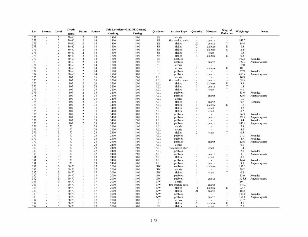
173
Lot Feature LevelDepth(cmbd)
Datum SquareGrid Location (of 2x2 SE Corner)Grid Location (of 2x2 SE Corner)
Quadrant Artifact Type Quantity Material Stage of Reduction Weight (g) NotesLot Feature Level
Depth(cmbd)
Datum SquareNorthing Easting
Quadrant Artifact Type Quantity Material Stage of Reduction Weight (g) Notes
373 - 2 50-60 2 14 1800 1400 SE debris - - - 61.1373 - 2 50-60 2 14 1800 1400 SE fire cracked rock - quartz - 143.7373 - 2 50-60 2 14 1800 1400 SE flakes 20 quartz T 14.4373 - 2 50-60 2 14 1800 1400 SE flakes 2 diabase U 8.3373 - 2 50-60 2 14 1800 1400 SE flakes 3 diabase U 2.4373 - 2 50-60 2 14 1800 1400 SE flakes 4 chert T 1.3373 - 2 50-60 2 14 1800 1400 SE flakes 1 diabase U 0.5373 - 2 50-60 2 14 1800 1400 SE pebbles - - - 102.1 Rounded373 - 2 50-60 2 14 1800 1400 SE pebbles - quartz - 329.7 Angular quartz374 - 2 50-60 2 14 1800 1400 NE debris - - - 82.0374 - 2 50-60 2 14 1800 1400 NE debris 1 diabase U 18.1374 - 2 50-60 2 14 1800 1400 NE pebbles - - - 27.9 Rounded374 - 2 50-60 2 14 1800 1400 NE pebbles - quartz - 655.4 Angular quartz375 - 4 107 2 36 3200 1600 ALL debris - - - 10.9375 - 4 107 2 36 3200 1600 ALL fire cracked rock - quartz - 68.3375 - 4 107 2 36 3200 1600 ALL flakes 2 diabase U 3.9375 - 4 107 2 36 3200 1600 ALL flakes 1 quartz T 1.3375 - 4 107 2 36 3200 1600 ALL flakes 1 chert T 0.1375 - 4 107 2 36 3200 1600 ALL pebbles - - - 33.6 Rounded375 - 4 107 2 36 3200 1600 ALL pebbles - quartz - 52.6 Angular quartz376 - 4 107 2 38 3400 1400 ALL debris - - - 1.0376 - 4 107 2 38 3400 1400 ALL flakes 1 quartz T 0.7 Debitage376 - 4 107 2 38 3400 1400 ALL flakes 1 diabase U 1.8376 - 4 107 2 38 3400 1400 ALL flakes 2 chert T 0.2376 - 4 107 2 38 3400 1400 ALL flakes 1 chert T 0.2376 - 4 107 2 38 3400 1400 ALL pebbles - - - 26.3 Rounded376 - 4 107 2 38 3400 1400 ALL pebbles - quartz - 29.5 Angular quartz377 - 4 107 2 39 3400 1600 ALL pebbles - - - 8.4 Rounded377 - 4 107 2 39 3400 1600 ALL pebbles - quartz - 143.4 Angular quartz379 - 3 70 1 26 2600 1600 ALL debris - - - 7.8379 - 3 70 1 26 2600 1400 ALL debris - - - 4.2379 - 3 70 1 26 2600 1400 ALL flakes 2 chert T 0.3379 - 3 70 1 26 2600 1600 ALL pebbles - - - 27.3 Rounded379 - 3 70 1 26 2600 1400 ALL pebbles - - - 4.7 Rounded379 - 3 70 1 26 2600 1400 ALL pebbles - quartz - 12.6 Angular quartz380 - 3 70 1 22 2400 1600 ALL debris - - - 0.6380 - 3 70 1 22 2400 1600 ALL fire cracked chert - chert - 1.4380 - 3 70 1 22 2400 1600 ALL pebbles - - - 2.1 Rounded380 - 3 70 1 22 2400 1600 ALL pebbles - quartz - 8.6 Angular quartz381 - 3 70 1 23 2400 1400 ALL flakes 3 chert T 0.8381 - 3 70 1 23 2400 1400 ALL pebbles - - - 14.4 Rounded381 - 3 70 1 23 2400 1400 ALL pebbles - quartz - 9.7 Angular quartz382 - 3 60-70 1 17 2000 1400 SW cobbles 1 diabase - 182.5382 - 3 60-70 1 17 2000 1400 SW debris - - - 29.2382 - 3 60-70 1 17 2000 1400 SW flakes 1 chert T 0.6382 - 3 60-70 1 17 2000 1400 SW pebbles - - - 33.9 Rounded382 - 3 60-70 1 17 2000 1400 SW pebbles - quartz - 1435.3 Angular quartz383 - 3 60-70 1 17 2000 1400 NW debris - - - 19.1383 - 3 60-70 1 17 2000 1400 NW fire cracked rock - quartz - 1649.9383 - 3 60-70 1 17 2000 1400 NW flakes 11 diabase U 72.7383 - 3 60-70 1 17 2000 1400 NW flakes 21 quartz T 18.2383 - 3 60-70 1 17 2000 1400 NW pebbles - - - 100.0 Rounded383 - 3 60-70 1 17 2000 1400 NW pebbles - quartz - 354.8 Angular quartz384 - 3 60-70 1 17 2000 1400 SE debris - - - 21.7384 - 3 60-70 1 17 2000 1400 SE flakes 2 diabase U 3.1384 - 3 60-70 1 17 2000 1400 SE flakes 4 chert T 2.5
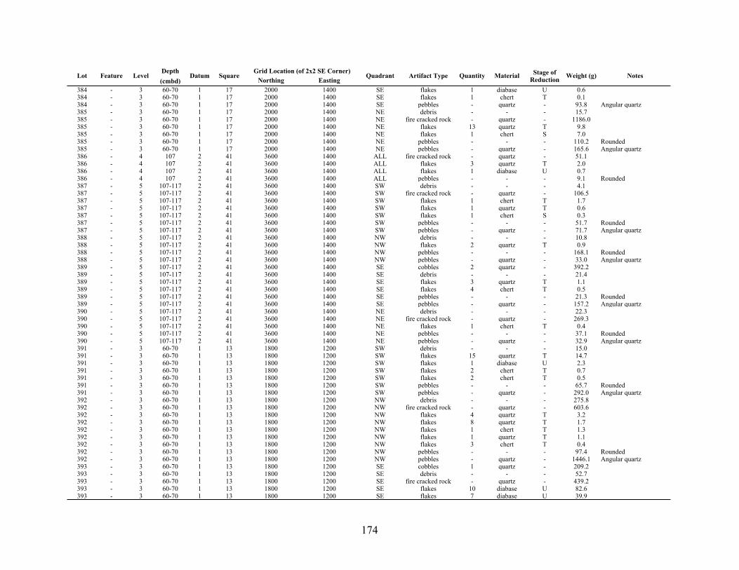
174
Lot Feature LevelDepth(cmbd)
Datum SquareGrid Location (of 2x2 SE Corner)Grid Location (of 2x2 SE Corner)
Quadrant Artifact Type Quantity Material Stage of Reduction Weight (g) NotesLot Feature Level
Depth(cmbd)
Datum SquareNorthing Easting
Quadrant Artifact Type Quantity Material Stage of Reduction Weight (g) Notes
384 - 3 60-70 1 17 2000 1400 SE flakes 1 diabase U 0.6384 - 3 60-70 1 17 2000 1400 SE flakes 1 chert T 0.1384 - 3 60-70 1 17 2000 1400 SE pebbles - quartz - 93.8 Angular quartz385 - 3 60-70 1 17 2000 1400 NE debris - - - 15.7385 - 3 60-70 1 17 2000 1400 NE fire cracked rock - quartz - 1186.0385 - 3 60-70 1 17 2000 1400 NE flakes 13 quartz T 9.8385 - 3 60-70 1 17 2000 1400 NE flakes 1 chert S 7.0385 - 3 60-70 1 17 2000 1400 NE pebbles - - - 110.2 Rounded385 - 3 60-70 1 17 2000 1400 NE pebbles - quartz - 165.6 Angular quartz386 - 4 107 2 41 3600 1400 ALL fire cracked rock - quartz - 51.1386 - 4 107 2 41 3600 1400 ALL flakes 3 quartz T 2.0386 - 4 107 2 41 3600 1400 ALL flakes 1 diabase U 0.7386 - 4 107 2 41 3600 1400 ALL pebbles - - - 9.1 Rounded387 - 5 107-117 2 41 3600 1400 SW debris - - - 4.1387 - 5 107-117 2 41 3600 1400 SW fire cracked rock - quartz - 106.5387 - 5 107-117 2 41 3600 1400 SW flakes 1 chert T 1.7387 - 5 107-117 2 41 3600 1400 SW flakes 1 quartz T 0.6387 - 5 107-117 2 41 3600 1400 SW flakes 1 chert S 0.3387 - 5 107-117 2 41 3600 1400 SW pebbles - - - 51.7 Rounded387 - 5 107-117 2 41 3600 1400 SW pebbles - quartz - 71.7 Angular quartz388 - 5 107-117 2 41 3600 1400 NW debris - - - 10.8388 - 5 107-117 2 41 3600 1400 NW flakes 2 quartz T 0.9388 - 5 107-117 2 41 3600 1400 NW pebbles - - - 168.1 Rounded388 - 5 107-117 2 41 3600 1400 NW pebbles - quartz - 33.0 Angular quartz389 - 5 107-117 2 41 3600 1400 SE cobbles 2 quartz - 392.2389 - 5 107-117 2 41 3600 1400 SE debris - - - 21.4389 - 5 107-117 2 41 3600 1400 SE flakes 3 quartz T 1.1389 - 5 107-117 2 41 3600 1400 SE flakes 4 chert T 0.5389 - 5 107-117 2 41 3600 1400 SE pebbles - - - 21.3 Rounded389 - 5 107-117 2 41 3600 1400 SE pebbles - quartz - 157.2 Angular quartz390 - 5 107-117 2 41 3600 1400 NE debris - - - 22.3390 - 5 107-117 2 41 3600 1400 NE fire cracked rock - quartz - 269.3390 - 5 107-117 2 41 3600 1400 NE flakes 1 chert T 0.4390 - 5 107-117 2 41 3600 1400 NE pebbles - - - 37.1 Rounded390 - 5 107-117 2 41 3600 1400 NE pebbles - quartz - 32.9 Angular quartz391 - 3 60-70 1 13 1800 1200 SW debris - - - 15.0391 - 3 60-70 1 13 1800 1200 SW flakes 15 quartz T 14.7391 - 3 60-70 1 13 1800 1200 SW flakes 1 diabase U 2.3391 - 3 60-70 1 13 1800 1200 SW flakes 2 chert T 0.7391 - 3 60-70 1 13 1800 1200 SW flakes 2 chert T 0.5391 - 3 60-70 1 13 1800 1200 SW pebbles - - - 65.7 Rounded391 - 3 60-70 1 13 1800 1200 SW pebbles - quartz - 292.0 Angular quartz392 - 3 60-70 1 13 1800 1200 NW debris - - - 275.8392 - 3 60-70 1 13 1800 1200 NW fire cracked rock - quartz - 603.6392 - 3 60-70 1 13 1800 1200 NW flakes 4 quartz T 3.2392 - 3 60-70 1 13 1800 1200 NW flakes 8 quartz T 1.7392 - 3 60-70 1 13 1800 1200 NW flakes 1 chert T 1.3392 - 3 60-70 1 13 1800 1200 NW flakes 1 quartz T 1.1392 - 3 60-70 1 13 1800 1200 NW flakes 3 chert T 0.4392 - 3 60-70 1 13 1800 1200 NW pebbles - - - 97.4 Rounded392 - 3 60-70 1 13 1800 1200 NW pebbles - quartz - 1446.1 Angular quartz393 - 3 60-70 1 13 1800 1200 SE cobbles 1 quartz - 209.2393 - 3 60-70 1 13 1800 1200 SE debris - - - 52.7393 - 3 60-70 1 13 1800 1200 SE fire cracked rock - quartz - 439.2393 - 3 60-70 1 13 1800 1200 SE flakes 10 diabase U 82.6393 - 3 60-70 1 13 1800 1200 SE flakes 7 diabase U 39.9

175
Lot Feature LevelDepth(cmbd)
Datum SquareGrid Location (of 2x2 SE Corner)Grid Location (of 2x2 SE Corner)
Quadrant Artifact Type Quantity Material Stage of Reduction Weight (g) NotesLot Feature Level
Depth(cmbd)
Datum SquareNorthing Easting
Quadrant Artifact Type Quantity Material Stage of Reduction Weight (g) Notes
393 - 3 60-70 1 13 1800 1200 SE flakes 1 diabase U 10.7393 - 3 60-70 1 13 1800 1200 SE flakes 7 quartz T 7.5393 - 3 60-70 1 13 1800 1200 SE flakes 4 chert T 1.0393 - 3 60-70 1 13 1800 1200 SE flakes 3 chert T 0.4393 - 3 60-70 1 13 1800 1200 SE flakes 1 quartz T 0.2393 - 3 60-70 1 13 1800 1200 SE flakes 1 chert T 0.2393 - 3 60-70 1 13 1800 1200 SE pebbles - - - 82.6 Rounded393 - 3 60-70 1 13 1800 1200 SE pebbles - quartz - 139.0 Angular quartz394 - 3 60-70 1 13 1800 1200 NE debris - - - 29.4394 - 3 60-70 1 13 1800 1200 NE fire cracked rock - quartz - 434.3394 - 3 60-70 1 13 1800 1200 NE flakes 34 Quartz T 13.2394 - 3 60-70 1 13 1800 1200 NE flakes 2 diabase U 8.8394 - 3 60-70 1 13 1800 1200 NE pebbles - - - 219.9 Rounded394 - 3 60-70 1 13 1800 1200 NE pebbles - quartz - 360.5 Angular quartz396 - 3 60-70 1 21 2200 1600 SW debris - - - 139.4396 - 3 60-70 1 21 2200 1600 SW fire cracked rock - quartz - 2331.4396 - 3 60-70 1 21 2200 1600 SW flakes 11 quartz T 10.5396 - 3 60-70 1 21 2200 1600 SW flakes 3 diabase U 3.3396 - 3 60-70 1 21 2200 1600 SW flakes 5 chert T 1.7396 - 3 60-70 1 21 2200 1600 SW flakes 1 quartz T 0.9396 - 3 60-70 1 21 2200 1600 SW flakes 1 quartz T 0.2396 - 3 60-70 1 21 2200 1600 SW pebbles - - - 93.9 Rounded396 - 3 60-70 1 21 2200 1600 SW pebbles - quartz - 136.3 Angular quartz397 - 3 60-70 1 21 2200 1600 NW debris - - - 48.2397 - 3 60-70 1 21 2200 1600 NW fire cracked rock - quartz - 44.7397 - 3 60-70 1 21 2200 1600 NW flakes 7 quartz T 6.3397 - 3 60-70 1 21 2200 1600 NW flakes 5 chert T 0.5397 - 3 60-70 1 21 2200 1600 NW pebbles - - - 124.5 Rounded397 - 3 60-70 1 21 2200 1600 NW pebbles - quartz - 326.7 Angular quartz398 - 3 60-70 1 21 2200 1600 SE debris - - - 17.9398 - 3 60-70 1 21 2200 1600 SE fire cracked rock - quartz - 142.8398 - 3 60-70 1 21 2200 1600 SE flakes 1 chert S 1.3398 - 3 60-70 1 21 2200 1600 SE flakes 2 quartz T 0.8398 - 3 60-70 1 21 2200 1600 SE flakes 1 quartz T 0.8398 - 3 60-70 1 21 2200 1600 SE flakes 3 chert T 0.7398 - 3 60-70 1 21 2200 1600 SE pebbles - - - 74.0 Rounded398 - 3 60-70 1 21 2200 1600 SE pebbles - quartz - 92.0399 - 3 60-70 1 21 2200 1600 NE debris - - - 21.8399 - 3 60-70 1 21 2200 1600 NE flakes 1 diabase U 2.3399 - 3 60-70 1 21 2200 1600 NE flakes 1 chert S 1.7399 - 3 60-70 1 21 2200 1600 NE flakes 4 chert T 1.1399 - 3 60-70 1 21 2200 1600 NE flakes 4 quartz T 0.9399 - 3 60-70 1 21 2200 1600 NE pebbles - - - 31.9 Rounded399 - 3 60-70 1 21 2200 1600 NE pebbles - quartz - 111.9 Angular quartz400 - 3 60-70 1 15 1800 1600 SW debris - - - 139.3400 - 3 60-70 1 15 1800 1600 SW fire cracked rock - quartz - 160.8400 - 3 60-70 1 15 1800 1600 SW flakes 8 quartz T 10.1400 - 3 60-70 1 15 1800 1600 SW flakes 3 quartz T 0.9400 - 3 60-70 1 15 1800 1600 SW pebbles - - - 59.2 Rounded400 - 3 60-70 1 15 1800 1600 SW pebbles - quartz - 750.9 Angular quartz401 - 3 60-70 1 15 1800 1600 NW debris - - - 34.0401 - 3 60-70 1 15 1800 1600 NW fire cracked rock - quartz - 301.2401 - 3 60-70 1 15 1800 1600 NW flakes 4 diabase U 19.8401 - 3 60-70 1 15 1800 1600 NW flakes 15 quartz T 8.3401 - 3 60-70 1 15 1800 1600 NW flakes 1 chert T 0.3401 - 3 60-70 1 15 1800 1600 NW pebbles - - - 64.9 Rounded
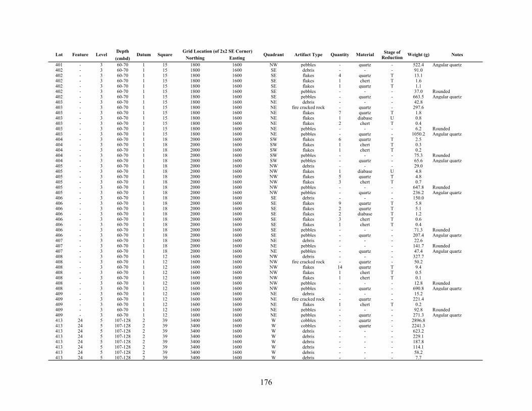
176
Lot Feature LevelDepth(cmbd)
Datum SquareGrid Location (of 2x2 SE Corner)Grid Location (of 2x2 SE Corner)
Quadrant Artifact Type Quantity Material Stage of Reduction Weight (g) NotesLot Feature Level
Depth(cmbd)
Datum SquareNorthing Easting
Quadrant Artifact Type Quantity Material Stage of Reduction Weight (g) Notes
401 - 3 60-70 1 15 1800 1600 NW pebbles - quartz - 522.4 Angular quartz402 - 3 60-70 1 15 1800 1600 SE debris - - - 91.0402 - 3 60-70 1 15 1800 1600 SE flakes 4 quartz T 13.1402 - 3 60-70 1 15 1800 1600 SE flakes 1 chert T 1.6402 - 3 60-70 1 15 1800 1600 SE flakes 1 quartz T 1.1402 - 3 60-70 1 15 1800 1600 SE pebbles - - - 37.0 Rounded402 - 3 60-70 1 15 1800 1600 SE pebbles - quartz - 663.5 Angular quartz403 - 3 60-70 1 15 1800 1600 NE debris - - - 42.8403 - 3 60-70 1 15 1800 1600 NE fire cracked rock - quartz - 297.6403 - 3 60-70 1 15 1800 1600 NE flakes 7 quartz T 1.8403 - 3 60-70 1 15 1800 1600 NE flakes 1 diabase U 0.8403 - 3 60-70 1 15 1800 1600 NE flakes 2 chert T 0.4403 - 3 60-70 1 15 1800 1600 NE pebbles - - - 6.2 Rounded403 - 3 60-70 1 15 1800 1600 NE pebbles - quartz - 1050.2 Angular quartz404 - 3 60-70 1 18 2000 1600 SW flakes 6 quartz T 2.5404 - 3 60-70 1 18 2000 1600 SW flakes 1 chert T 0.3404 - 3 60-70 1 18 2000 1600 SW flakes 1 chert T 0.2404 - 3 60-70 1 18 2000 1600 SW pebbles - - - 75.3 Rounded404 - 3 60-70 1 18 2000 1600 SW pebbles - quartz - 65.6 Angular quartz405 - 3 60-70 1 18 2000 1600 NW debris - - - 29.0405 - 3 60-70 1 18 2000 1600 NW flakes 1 diabase U 4.8405 - 3 60-70 1 18 2000 1600 NW flakes 5 quartz T 4.8405 - 3 60-70 1 18 2000 1600 NW flakes 3 chert T 0.7405 - 3 60-70 1 18 2000 1600 NW pebbles - - - 647.8 Rounded405 - 3 60-70 1 18 2000 1600 NW pebbles - quartz - 236.2 Angular quartz406 - 3 60-70 1 18 2000 1600 SE debris - - - 150.0406 - 3 60-70 1 18 2000 1600 SE flakes 9 quartz T 5.8406 - 3 60-70 1 18 2000 1600 SE flakes 2 quartz T 5.1406 - 3 60-70 1 18 2000 1600 SE flakes 2 diabase T 1.2406 - 3 60-70 1 18 2000 1600 SE flakes 3 chert T 0.6406 - 3 60-70 1 18 2000 1600 SE flakes 1 chert T 0.4406 - 3 60-70 1 18 2000 1600 SE pebbles - - - 71.3 Rounded406 - 3 60-70 1 18 2000 1600 SE pebbles - quartz - 207.4 Angular quartz407 - 3 60-70 1 18 2000 1600 NE debris - - - 22.6407 - 3 60-70 1 18 2000 1600 NE pebbles - - - 141.7 Rounded407 - 3 60-70 1 18 2000 1600 NE pebbles - quartz - 47.4 Angular quartz408 - 3 60-70 1 12 1600 1600 NW debris - - - 327.7408 - 3 60-70 1 12 1600 1600 NW fire cracked rock - quartz - 50.2408 - 3 60-70 1 12 1600 1600 NW flakes 14 quartz T 9.4408 - 3 60-70 1 12 1600 1600 NW flakes 1 chert T 0.5408 - 3 60-70 1 12 1600 1600 NW flakes 1 chert T 0.1408 - 3 60-70 1 12 1600 1600 NW pebbles - - - 12.8 Rounded408 - 3 60-70 1 12 1600 1600 NW pebbles - quartz - 690.8 Angular quartz409 - 3 60-70 1 12 1600 1600 NE debris - - - 15.2409 - 3 60-70 1 12 1600 1600 NE fire cracked rock - quartz - 221.4409 - 3 60-70 1 12 1600 1600 NE flakes 1 chert T 0.2409 - 3 60-70 1 12 1600 1600 NE pebbles - - - 92.8 Rounded409 - 3 60-70 1 12 1600 1600 NE pebbles - quartz - 271.3 Angular quartz413 24 5 107-128 2 39 3400 1600 W cobbles - quartz - 2896.8413 24 5 107-128 2 39 3400 1600 W cobbles - quartz - 2241.3413 24 5 107-128 2 39 3400 1600 W debris - - - 623.2413 24 5 107-128 2 39 3400 1600 W debris - - - 229.1413 24 5 107-128 2 39 3400 1600 W debris - - - 187.8413 24 5 107-128 2 39 3400 1600 W debris - - - 114.1413 24 5 107-128 2 39 3400 1600 W debris - - - 58.2413 24 5 107-128 2 39 3400 1600 W debris - - - 7.7

177
Lot Feature LevelDepth(cmbd)
Datum SquareGrid Location (of 2x2 SE Corner)Grid Location (of 2x2 SE Corner)
Quadrant Artifact Type Quantity Material Stage of Reduction Weight (g) NotesLot Feature Level
Depth(cmbd)
Datum SquareNorthing Easting
Quadrant Artifact Type Quantity Material Stage of Reduction Weight (g) Notes
413 24 5 107-128 2 39 3400 1600 W debris - - - 5.1413 24 5 107-128 2 39 3400 1600 W fire cracked rock - quartz - 3887.8413 24 5 107-128 2 39 3400 1600 W fire cracked rock - quartz - 3861.2413 24 5 107-128 2 39 3400 1600 W fire cracked rock - quartz - 3715.4413 24 5 107-128 2 39 3400 1600 W fire cracked rock - quartz - 3689.6413 24 5 107-128 2 39 3400 1600 W fire cracked rock - quartz - 3641.9413 24 5 107-128 2 39 3400 1600 W fire cracked rock - quartz - 1461.2413 24 5 107-128 2 39 3400 1600 W fire cracked rock - quartz - 339.4413 24 5 107-128 2 39 3400 1600 W fire cracked rock - quartz - 300.0413 24 5 107-128 2 39 3400 1600 W flakes 4 quartz T 21.8413 24 5 107-128 2 39 3400 1600 W flakes 7 quartz T 18.3413 24 5 107-128 2 39 3400 1600 W flakes 2 quartz T 7.8413 24 5 107-128 2 39 3400 1600 W flakes 1 diabase U 4.6413 24 5 107-128 2 39 3400 1600 W flakes 1 chert S 4.3413 24 5 107-128 2 39 3400 1600 W flakes 3 quartz T 4.1413 24 5 107-128 2 39 3400 1600 W flakes 2 quartz T 2.4413 24 5 107-128 2 39 3400 1600 W flakes 4 quartz T 2.2413 24 5 107-128 2 39 3400 1600 W flakes 7 chert T 2.1413 24 5 107-128 2 39 3400 1600 W flakes 4 quartz T 2.0413 24 5 107-128 2 39 3400 1600 W flakes 4 quartz T 1.7413 24 5 107-128 2 39 3400 1600 W flakes 1 chert T 0.5413 24 5 107-128 2 39 3400 1600 W flakes 1 chert T 0.2413 24 5 107-128 2 39 3400 1600 W pebbles - - - 134.3 Rounded413 24 5 107-128 2 39 3400 1600 W pebbles - - - 35.0 Rounded413 24 5 107-128 2 39 3400 1600 W pebbles - - - 4.4 Rounded413 24 5 107-128 2 39 3400 1600 W pebbles - quartz - 1631.2 Angular quartz413 24 5 107-128 2 39 3400 1600 W pebbles - quartz - 109.9 Angular quartz413 24 5 107-128 2 39 3400 1600 W pebbles - quartz - 1063.0 Angular quartz413 24 5 107-128 2 39 3400 1600 W pebbles - quartz - 4.2 Angular quartz414 25 5 70-94 1 16/19 2200 1200 NW debris - - - 39.7414 25 5 70-94 1 16/19 2200 1200 NW debris - - - 27.4414 25 5 70-94 1 16/19 2200 1200 NW fire cracked rock - quartz - 1383.4414 25 5 70-94 1 16/19 2200 1200 NW fire cracked rock - quartz - 1253.3414 25 5 70-94 1 16/19 2200 1200 NW flakes 1 diabase U 1.5414 25 5 70-94 1 16/19 2200 1200 NW pebbles - - - 34.3 Rounded414 25 5 70-94 1 16/19 2200 1200 NW pebbles - - - 29.7 Rounded414 25 5 70-94 1 16/19 2200 1200 NW pebbles - quartz - 162.2 Angular quartz417 18 5 70-95 1 13 1800 1200 - debris - - - 6.9417 18 5 70-95 1 13 1800 1200 - fire cracked rock - quartz - 294.5417 18 5 70-95 1 13 1800 1200 - flakes 1 chert T 0.4417 18 5 70-95 1 13 1800 1200 - pebbles - - - 0.6 Rounded418 17 4 70-72 1 19/22 2300 1200 - cobbles - quartz - 796.9 Sub-Angular quartz418 17 4 70-72 1 19/22 2300 1200 - cobbles - quartz - 783.0 Sub-Angular quartz418 17 4 70-72 1 19/22 2300 1200 - cobbles 5 quartz - 753.8 Rounded418 17 4 70-72 1 19/22 2300 1200 - cobbles 2 quartz - 526.4 Rounded418 17 4 70-72 1 19/22 2300 1200 - cobbles 3 quartz - 521.5 Rounded418 17 4 70-72 1 19/22 2300 1200 - cobbles 1 - - 221.2 Rounded418 17 4 70-72 1 19/22 2300 1200 - cobbles 3 quartz - 452.8 Angular quartz418 17 4 70-72 1 19/22 2300 1200 - debris - - - 1477.0418 17 4 70-72 1 19/22 2300 1200 - debris - - - 613.8418 17 4 70-72 1 19/22 2300 1200 - debris - - - 65.0418 17 4 70-72 1 19/22 2300 1200 - debris - - - 18.6418 17 4 70-72 1 19/22 2300 1200 - debris - - - 15.3418 17 4 70-72 1 19/22 2300 1200 - fire cracked chert - chert - 0.5418 17 4 70-72 1 19/22 2300 1200 - fire cracked rock - quartz - 3778.4418 17 4 70-72 1 19/22 2300 1200 - fire cracked rock - quartz - 3472.1

178
Lot Feature LevelDepth(cmbd)
Datum SquareGrid Location (of 2x2 SE Corner)Grid Location (of 2x2 SE Corner)
Quadrant Artifact Type Quantity Material Stage of Reduction Weight (g) NotesLot Feature Level
Depth(cmbd)
Datum SquareNorthing Easting
Quadrant Artifact Type Quantity Material Stage of Reduction Weight (g) Notes
418 17 4 70-72 1 19/22 2300 1200 - fire cracked rock - quartz - 3330.0418 17 4 70-72 1 19/22 2300 1200 - fire cracked rock - quartz - 3150.2418 17 4 70-72 1 19/22 2300 1200 - fire cracked rock - quartz - 3019.8418 17 4 70-72 1 19/22 2300 1200 - fire cracked rock - quartz - 3019.0418 17 4 70-72 1 19/22 2300 1200 - fire cracked rock - quartz - 2973.8418 17 4 70-72 1 19/22 2300 1200 - fire cracked rock - quartz - 2860.0418 17 4 70-72 1 19/22 2300 1200 - fire cracked rock - quartz - 2812.8418 17 4 70-72 1 19/22 2300 1200 - fire cracked rock - quartz - 2653.1418 17 4 70-72 1 19/22 2300 1200 - fire cracked rock - quartz - 2651.0418 17 4 70-72 1 19/22 2300 1200 - fire cracked rock - quartz - 1682.7418 17 4 70-72 1 19/22 2300 1200 - fire cracked rock - quartz - 1510.4418 17 4 70-72 1 19/22 2300 1200 - flakes 1 quartz T 1.1418 17 4 70-72 1 19/22 2300 1200 - pebbles - - - 306.6 Rounded418 17 4 70-72 1 19/22 2300 1200 - pebbles - - - 146.3 Rounded418 17 4 70-72 1 19/22 2300 1200 - pebbles - - - 9.6 Rounded418 17 4 70-72 1 19/22 2300 1200 - pebbles - quartz - 1.4 Angular quartz418 17 4 70-72 1 19/22 2300 1200 - pebbles - quartz - 18.0 Angular quartz419 20 - - 2 41 3600 1400 SE debris - - - 10.8419 20 - - 2 41 3600 1400 SE flakes 1 quartz T 4.2419 20 - - 2 41 3600 1400 SE flakes 1 chert T 0.1419 20 - - 2 41 3600 1400 SE pebbles - - - 6.6 Rounded419 20 - - 2 41 3600 1400 SE pebbles - quartz - 25.9 Angular quartz421 26 4 70-73 1 17 2000 1400 NE cobbles 1 quartz - 179.8421 26 4 70-77 1 17 2000 1400 NE debris - - - 40.2421 26 4 70-73 1 17 2000 1400 NE fire cracked rock - quartz - 3427.0421 26 4 70-73 1 17 2000 1400 NE fire cracked rock - quartz - 3373.1421 26 4 70-73 1 17 2000 1400 NE fire cracked rock - quartz - 3338.7421 26 4 70-73 1 17 2000 1400 NE fire cracked rock - quartz - 2406.0421 26 4 70-77 1 17 2000 1400 NE flakes 2 quartz T 4.6421 26 4 70-77 1 17 2000 1400 NE flakes 1 quartz T 2.3421 26 4 70-77 1 17 2000 1400 NE flakes 4 chert T 0.5421 26 4 70-77 1 17 2000 1400 NE pebbles - - - 29.1 Rounded421 26 4 70-73 1 17 2000 1400 NE pebbles - - - 19.6 Rounded421 26 4 70-77 1 17 2000 1400 NE pebbles - quartz - 217.9 Angular quartz422 - 5 90 1 24 2400 1600 ALL debris - - - 13.9422 - 5 90 1 24 2400 1600 ALL fire cracked rock - quartz - 885.8422 - 5 90 1 24 2400 1600 ALL flakes 3 diabase U 3.3422 - 5 90 1 24 2400 1600 ALL pebbles - - - 47.8 Rounded422 - 5 90 1 24 2400 1600 ALL pebbles - quartz - 20.0 Angular quartz424 - 6 90-100 1 24 2400 1600 SE debris - - - 25.3424 - 6 90-100 1 24 2400 1600 SE fire cracked chert - chert - 1.3424 - 6 90-100 1 24 2400 1600 SE fire cracked rock - quartz - 445.4424 - 6 90-100 1 24 2400 1600 SE flakes 5 diabase U 15.2424 - 6 90-100 1 24 2400 1600 SE flakes 2 quartz T 1.2424 - 6 90-100 1 24 2400 1600 SE flakes 5 chert T 1.2424 - 6 90-100 1 24 2400 1600 SE flakes 1 quartz T 0.6424 - 6 90-100 1 24 2400 1600 SE flakes 1 quartz T 0.2424 - 6 90-100 1 24 2400 1600 SE pebbles - - - 190.8 Rounded424 - 6 90-100 1 24 2400 1600 SE pebbles - quartz - 114.5 Angular quartz425 - 7 100-110 1 24 2400 1600 SE debris - - - 17.7425 - 7 100-110 1 24 2400 1600 SE fire cracked rock - quartz - 527.5425 - 7 100-110 1 24 2400 1600 SE flakes 7 chert T 3.7425 - 7 100-110 1 24 2400 1600 SE flakes 1 quartz T 3.4425 - 7 100-110 1 24 2400 1600 SE pebbles - - - 305.2 Rounded425 - 7 100-110 1 24 2400 1600 SE pebbles - quartz - 5.0 Angular quartz432 - 8 110-120 1 24 2400 1600 SE debris - - - 33.2

179
Lot Feature LevelDepth(cmbd)
Datum SquareGrid Location (of 2x2 SE Corner)Grid Location (of 2x2 SE Corner)
Quadrant Artifact Type Quantity Material Stage of Reduction Weight (g) NotesLot Feature Level
Depth(cmbd)
Datum SquareNorthing Easting
Quadrant Artifact Type Quantity Material Stage of Reduction Weight (g) Notes
432 - 8 110-120 1 24 2400 1600 SE flakes 4 quartz T 16.1432 - 8 110-120 1 24 2400 1600 SE flakes 1 chert T 0.3432 - 8 110-120 1 24 2400 1600 SE pebbles - - - 502.5 Rounded432 - 8 110-120 1 24 2400 1600 SE pebbles - quartz - 553.4 Angular quartz433 - 9 120-130 1 24 2400 1600 SE debris - - - 55.8433 - 9 120-130 1 24 2400 1600 SE fire cracked rock - quartz - 212.4433 - 9 120-130 1 24 2400 1600 SE flakes 4 quartz T 18.1433 - 9 120-130 1 24 2400 1600 SE pebbles - - - 62.5 Rounded434 - 10 130-140 1 24 2400 1600 SE debris - - - 12.8434 - 10 130-140 1 24 2400 1600 SE pebbles - - - 7.9 Rounded438 30 3-5 70-92 1 17 2000 1400 NE debris - - - 40.9438 30 3-5 70-92 1 17 2000 1400 NE fire cracked rock - quartz - 724.3438 30 3-5 70-92 1 17 2000 1400 NE pebbles - - - 10.9 Rounded443 26 3-6 70-102 1 17 2000 1600 NE debris - - - 212.8443 26 3-6 70-102 1 17 2000 1600 NE fire cracked rock - quartz - 3926.5443 26 3-6 70-102 1 17 2000 1600 NE pebbles - quartz - 156.9 Rounded443 26 3-6 70-102 1 17 2000 1600 NE pebbles - - - 26.3 Rounded

180
Appendix E: Provenience 3 Ceramic CatalogLot Level Depth Datum Square Northing Easting Quadrant Type Quantity Portion Rim Type Decoration Temper Notes
001 1 15-50 1 45 3850 1450 SW Lamar Fine Incised 1 body roughly parallel lines, wide spacing grit001 1 15-50 1 45 3850 1450 SW Plain 1 body grit001 1 15-50 1 45 3850 1450 SW Plain 1 body grit Glued to P3L061 and P3L083001 1 15-50 1 45 3850 1450 SW Plain 4 body grit001 1 15-50 1 45 3850 1450 SW Plain 1 rim rounded grit001 1 15-50 1 45 3850 1450 SW Plain 3 body grit002 1 15-50 1 45 3850 1550 SE Lamar 1 rim folded, pinched grit
002 1 15-50 1 45 3850 1550 SE Napier Comp. Stamp 1 body combination curvilinear/rectilinear multiple line bands grit
002 1 15-50 1 45 3850 1550 SE Plain 1 rim flattened sand002 1 15-50 1 45 3850 1550 SE Plain 8 body grit002 1 15-50 1 45 3850 1550 SE Plain 1 body grit003 1 15-50 1 45 3950 1450 NW Lamar Incised 1 rim square rectilinear003 1 15-50 1 45 3950 1450 NW Plain 10 body grit003 1 15-50 1 45 3950 1450 NW Plain 1 rim rounded grit
004 1 15-50 1 45 3950 1550 NE Napier Comp. Stamp 1 body combination curvilinear/rectilinear multiple line bands grit
004 1 15-50 1 45 3950 1550 NE Plain 8 body grit006 1 0-50 1 24 2550 1450 NW Plain 1 rim folded, rounded sand006 1 0-50 1 24 2550 1450 NW UID 1 - ceramic Body - plain - course grit007 1 0-50 1 24 2450 1550 SE Plain 2 body grit
009 1 34-50 1 10 1650 1050 SW Napier Comp. Stamp 1 body multiple sinuous lines with perpendicular, parallel line fillers grit
009 1 34-50 1 10 1650 1050 SW Napier Comp. Stamp 4 body curving multiple parallel lines with parallel line filler grit
009 1 34-50 1 10 1650 1050 SW Plain 1 body sand
010 1 0-50 1 10 1750 1050 NW Napier Comp. Stamp 1 body curving multiple parallel lines with parallel line filler grit
012 1 48-50 1 10 1750 1150 NE Napier Comp. Stamp 1 body multiple parallel lines with perpendicular and slanted line fillers grit
012 1 48-50 1 10 1750 1150 NE Napier Comp. Stamp 2 body curving multiple parallel lines with parallel line filler grit
012 1 48-50 1 10 1750 1150 NE Plain 1 body grit012 1 48-50 1 10 1750 1150 NE UID Plain 1 body grit014 2 50-60 1 24 2550 1450 NW Plain 1 body fiber014 2 50-60 1 24 2550 1450 NW Plain 1 body grit
020 2 50-60 1 10 1750 1150 NE Napier Comp. Stamp 1 body curving multiple parallel lines with parallel line filler grit
031 4 70-80 1 24 2450 1550 SE Plain 2 body fiber032 4 70-80 1 24 2550 1550 NE Plain 1 body fiber037 5 80-90 1 24 2450 1450 SW Plain 1 body fiber038 5 80-90 1 24 2550 1450 NW Plain 1 body grit038 5 80-90 1 24 2550 1450 NW Plain 1 body grit
045 3 60-70 1 45 3850 1450 SW Plain 1 body Impressions on outer surface possibly from setting piece on the ground while the clay was wet grit
045 3 60-70 1 45 3850 1450 SW Stallings Punctate 1 body stab and drag fiber047 3 60-70 1 45 3850 1550 SE Plain 1 body grit053 1 22-50 1 23 2450 1250 SW Lamar Bold Incised 1 body rectilinear incision sand 3 pieces fit together, 1 in P3L118053 1 22-50 1 23 2450 1250 SW Lamar Bold Incised 1 rim folded, rounded rectilinear incision sand 3 pieces fit together, 1 in P3L118053 1 22-50 1 23 2450 1250 SW Plain 1 body grit054 1 20-50 1 23 2550 1250 NW Plain 1 body grit054 1 20-50 1 23 2550 1250 NW UID comp Stamp 1 body wide spaced parallel lines grit055 1 28-50 1 23 2450 1350 SE Plain 4 body grit055 1 28-50 1 23 2450 1350 SE Plain 1 rim pinched grit
056 1 27-50 1 23 2550 1350 NE Napier Comp. Stamp 3 body combination curvilinear/rectilinear multiple line bands grit 3 sherds (L056) glued to P3L166
056 1 27-50 1 23 2550 1350 NE Plain 1 rim flattened grit056 1 27-50 1 23 2550 1350 NE Plain 2 body grit
057 1 33-50 1 11 1650 1250 SW Napier Comp. Stamp 1 body curving multiple parallel lines with parallel line filler grit

181
Lot Level Depth Datum Square Northing Easting Quadrant Type Quantity Portion Rim Type Decoration Temper Notes
057 1 33-50 1 11 1650 1250 SW Plain 1 body grit
058 1 33-50 1 11 1750 1250 NW Napier Comp. Stamp 1 rim folded curving multiple parallel lines with parallel line filler grit
058 1 33-50 1 11 1750 1250 NW Plain 1 body grit058 1 33-50 1 11 1750 1250 NW Plain 1 body grit058 1 33-50 1 11 1750 1250 NW Plain 5 body grit059 1 34-50 1 11 1750 1350 NE Plain 1 body grit060 1 34-50 1 11 1750 1350 NE Plain 1 body grit061 1 0-50 1 42 3650 1450 SW Plain 1 rim rounded grit Glued to P3L083 and P3L001061 1 0-50 1 42 3650 1450 SW Plain 2 body grit
061 1 0-50 1 42 3650 1450 SW Swift Creek Comp Stamp 1 body multiple curvilinear lines with parallel lines, zigzags, chevrons, and UID lines. grit
062 1 0-50 1 42 3750 1450 NW Pipe 1 rim Dual band, fine, square, stab and drag fine sand062 1 0-50 1 42 3750 1450 NW Plain 1 body grit062 1 0-50 1 42 3750 1450 NW Plain 2 body grit063 1 0-50 1 42 3650 1550 SE Plain 2 body sand063 1 0-50 1 42 3650 1550 SE Plain 5 body grit064 1 0-50 1 42 3750 1550 NE Plain 1 body grit064 1 0-50 1 42 3750 1550 NE Plain 1 body grit064 1 0-50 1 42 3750 1550 NE Plain 6 body grit 2 pieces fit together
065 1 25-50 1 14 1850 1250 SW Napier Comp. Stamp 4 body curving multiple parallel lines with parallel line filler grit
065 1 25-50 1 14 1850 1250 SW Plain 4 body grit 3 pieces fit together065 1 25-50 1 14 1850 1250 SW Plain 2 rim rounded grit
066 1 30-50 1 14 1950 1250 NW Napier Comp. Stamp 6 body multiple parallel lines with perpendicular and slanted line fillers grit
066 1 30-50 1 14 1950 1250 NW Napier Comp. Stamp 2 body multiple parallel lines with perpendicular and slanted line fillers grit
066 1 30-50 1 14 1950 1250 NW Napier Comp. Stamp 2 body curving multiple parallel lines with parallel line filler grit
067 1 30-50 1 14 1850 1350 SE Lamar Bold Incised 1 body rectilinear (two lines) grit067 1 30-50 1 14 1850 1350 SE Plain 1 body sand067 1 30-50 1 14 1850 1350 SE Plain 1 body grit067 1 30-50 1 14 1850 1350 SE Plain 1 body sand067 1 30-50 1 14 1850 1350 SE Plain 1 body grit067 1 30-50 1 14 1850 1350 SE Plain 9 body grit 4 pieces re-fit067 1 30-50 1 14 1850 1350 SE Plain 1 UID grit
068 1 29-50 1 14 1950 1350 NE Napier Comp. Stamp 1 body multiple parallel lines with perpendicular and slanted line fillers grit
068 1 29-50 1 14 1950 1350 NE Napier Comp. Stamp 1 body curving multiple parallel lines with parallel line filler grit
068 1 29-50 1 14 1950 1350 NE Plain 2 body grit068 1 29-50 1 14 1950 1350 NE UID incised 1 body sand069 1 0-50 1 21 2250 1450 SW Plain 1 body grit069 1 0-50 1 21 2250 1450 SW Plain 1 body sand070 1 33-50 1 21 2350 1450 NW Lamar 1 body nested triangles grit Broken in storage. Currently two pieces, taped.070 1 33-50 1 21 2350 1450 NW Plain 1 body sand070 1 33-50 1 21 2350 1450 NW Plain 1 body grit070 1 33-50 1 21 2350 1450 NW Plain 2 body grit070 1 33-50 1 21 2350 1450 NW Plain 1 body grit071 1 35-50 1 21 2250 1550 SE UID Check Stamp 1 body possible check stamp...very weathered grit073 1 0-50 1 20 2250 1250 SW Plain 1 body grit073 1 0-50 1 20 2250 1250 SW UID comp Stamp 2 body wide spaced parallel lines grit073 1 0-50 1 20 2250 1250 SW UID comp Stamp 1 rim folded, rounded parallel lines converging on rim at a shallow angle grit Weathered; taped to P3L101
074 1 0-50 1 20 2350 1250 NW Napier Comp. Stamp 3 body curving multiple parallel lines with parallel line filler grit
075 1 0-50 1 20 2250 1350 SE UID comp Stamp 4 body parallel lines with perpendicular parallel connecting lines grit
076 1 0-50 1 20 2350 1350 NE UID comp Stamp 1 body wide spaced parallel lines sand
076 1 0-50 1 20 2350 1350 NE Weeden Is. Punctated 1 rim flattened plain, maybe brushed sand One row of lobate punctations beneath about 2 cm of plain/brushed
077 1 36-50 1 15 1850 1450 SW Plain 1 body grit078 1 0-50 1 15 1950 1450 NW Lamar 1 rim folded, flattened grit
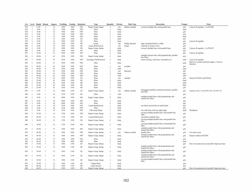
182
Lot Level Depth Datum Square Northing Easting Quadrant Type Quantity Portion Rim Type Decoration Temper Notes
078 1 0-50 1 15 1950 1450 NW Napier Comp. Stamp 1 rim folded, rounded crossed, multiple lines with parallel lines grit 2 pieces fit together, 1 in P3L080078 1 0-50 1 15 1950 1450 NW Plain 1 body sand078 1 0-50 1 15 1950 1450 NW Plain 2 body grit078 1 0-50 1 15 1950 1450 NW Plain 2 body grit078 1 0-50 1 15 1950 1450 NW Plain 1 body sand079 1 0-50 1 15 1850 1550 SE Plain 1 body grit079 1 0-50 1 15 1850 1550 SE Plain 3 body grit 2 pieces fit together080 1 0-50 1 15 1950 1550 NE Lamar 1 rim folded, pinched edge of pinched band is visible grit080 1 0-50 1 15 1950 1550 NE Lamar Bold Incised 1 rim simple small lip on inside of rim grit080 1 0-50 1 15 1950 1550 NE Napier Comp. Stamp 1 body crossed, multiple lines with parallel lines grit 2 pieces fit together, 1 in P3L078080 1 0-50 1 15 1950 1550 NE Plain 2 body grit081 1 51-84 2 41 3450 1450 SW Plain 2 body grit 2 pieces fit together
082 1 49-84 2 41 3550 1450 NW Napier Comp. Stamp 3 body multiple sinuous lines with perpendicular, parallel line fillers grit
082 1 49-84 2 41 3550 1450 NW Ocmulgee Fields Incised 2 body minor incising, wide lines, smoothed over sand 2 pieces fit together
082 1 49-84 2 41 3550 1450 NW Plain 1 body sand Half of a circular mend hole approx. 9 mm in diameter.
082 1 49-84 2 41 3550 1450 NW Plain 1 rim rounded grit082 1 49-84 2 41 3550 1450 NW Plain 1 body sand082 1 49-84 2 41 3550 1450 NW Plain 1 rim flattened grit082 1 49-84 2 41 3550 1450 NW Plain 5 body grit082 1 49-84 2 41 3550 1450 NW Plain 1 UID UID083 1 53-84 2 41 3450 1550 SE Plain 1 rim rounded grit Glued to P3L061 and P3L001084 1 52-84 2 41 3550 1550 NE Plain 1 body sand084 1 52-84 2 41 3550 1550 NE Plain 1 body sand084 1 52-84 2 41 3550 1550 NE Plain 1 body fiber084 1 52-84 2 41 3550 1550 NE Plain 3 body grit
085 1 0-50 1 18 2050 1550 SE Napier Comp. Stamp 1 rim folded, rounded Zigzagging multiline, diamond enclosure, parallel line filler grit 4 pieces re-fit, 1 in lot P3L126, 2 in P3L114
086 1 0-50 1 18 2150 1550 NE Plain 1 UID grit
087 1 0-50 1 18 2050 1450 SW Napier Comp. Stamp 6 body multiple parallel lines with perpendicular and slanted line fillers grit
087 1 0-50 1 18 2050 1450 SW Plain 1 body grit087 1 0-50 1 18 2050 1450 SW Plain 2 body grit088 1 0-50 1 18 2150 1450 NW Lamar Bold Incised 1 body one linear incised line on small sherd grit088 1 0-50 1 18 2150 1450 NW Plain 1 body grit088 1 0-50 1 18 2150 1450 NW UID comp Stamp 1 body two wide lines with one right angle sand Weathered
089 1 35-50 1 12 1750 1450 NW Napier Comp. Stamp 1 body curving multiple parallel lines with parallel line filler grit
090 1 38-50 1 12 1750 1550 NE Lamar Bold Incised 1 body curvilinear multiple lines grit
090 1 38-50 1 12 1750 1550 NE Napier Comp. Stamp 2 body curving multiple parallel lines with parallel line filler grit
090 1 38-50 1 12 1750 1550 NE Napier Comp. Stamp 3 body curving multiple parallel lines with parallel line filler grit
091 1 38-50 1 13 1850 1050 SW Napier Comp. Stamp 1 body multiple parallel lines with perpendicular and slanted line fillers grit
092 1 44-50 1 13 1950 1050 NW Napier Comp. Stamp 2 rim folded, rounded parallel lines grit Two pieces join
092 1 44-50 1 13 1950 1050 NW Napier Comp. Stamp 1 body multiple parallel lines with perpendicular and slanted line fillers grit Glued to sherd in P3L094
092 1 44-50 1 13 1950 1050 NW Plain 1 body grit092 1 44-50 1 13 1950 1050 NW Plain 1 body sand093 1 39-50 1 13 1850 1150 SE Napier Comp. Stamp 1 body grit Part of reconstruction of possible Napier pot base
093 1 39-50 1 13 1850 1150 SE Napier Comp. Stamp 1 body multiple parallel lines with perpendicular and slanted line fillers grit
093 1 39-50 1 13 1850 1150 SE Napier Comp. Stamp 5 body multiple parallel lines with perpendicular and slanted line fillers grit
093 1 39-50 1 13 1850 1150 SE Napier Comp. Stamp 3 body multiple parallel lines with perpendicular and slanted line fillers grit
093 1 39-50 1 13 1850 1150 SE Napier Comp. Stamp 1 body curving multiple parallel lines with parallel line filler grit
093 1 39-50 1 13 1850 1150 SE Napier Plain 1 body grit094 1 40-50 1 13 1950 1150 NE Lamar Incised 1 body grit094 1 40-50 1 13 1950 1150 NE Napier Comp. Stamp 1 body grit Part of reconstruction of possible Napier pot base

183
Lot Level Depth Datum Square Northing Easting Quadrant Type Quantity Portion Rim Type Decoration Temper Notes
094 1 40-50 1 13 1950 1150 NE Napier Comp. Stamp 15 body multiple parallel lines with perpendicular and slanted line fillers grit
094 1 40-50 1 13 1950 1150 NE Napier Comp. Stamp 1 body multiple parallel lines with perpendicular and slanted line fillers grit Glued to sherd in P3L092
099 1 0-50 1 19 2250 1050 SW Napier Comp. Stamp 5 body multiple parallel lines with perpendicular and slanted line fillers grit Design is “roughened”. Design is visible but either
weathered or rubbed over.
099 1 0-50 1 19 2250 1050 SW Napier Comp. Stamp 4 body multiple parallel lines with perpendicular and slanted line fillers grit Decoration has been weathered or smoothed over.
Pieces are glued together.099 1 0-50 1 19 2250 1050 SW Plain 1 body grit
100 1 0-50 1 19 2350 1050 NW Napier Comp. Stamp 3 body multiple parallel lines with perpendicular and slanted line fillers grit
101 1 0-50 1 19 2250 1150 SE UID comp Stamp 1 rim folded, rounded parallel lines converging on rim at a shallow angle grit Weathered; taped to P3L073101 1 0-50 1 19 2250 1150 SE UID comp Stamp 2 body nested chevrons grit Weathered
101 1 0-50 1 19 2250 1150 SE UID comp Stamp 1 rim folded, rounded wide spaced parallel lines converging on rim at shallow angle sand Weathered
102 1 0-50 1 19 2350 1150 NE Carrabelle Punctated 1 rim rounded plain from rim to punctate row, incised beneath grit102 1 0-50 1 19 2350 1150 NE Plain 2 body grit Sherds fit together103 1 56-77 2 38 3450 1250 SW Plain 1 body grit103 1 56-77 2 38 3450 1250 SW Plain 1 rim folded, rounded sand104 1 51-77 2 38 3550 1250 NW Plain 1 body sand105 1 61-77 2 38 3450 1350 SE Plain 1 body sand106 1 57-77 2 38 3550 1350 NE UID 1 - ceramic Plain pearlware sherd107 1 61-77 2 39 3450 1450 SW UID 1 - ceramic Course grit108 1 56-77 2 39 3550 1450 NW Plain 1 body grit110 1 57-77 2 39 3550 1550 NE Plain 1 body grit111 1 39-50 1 7 1450 1050 SW Plain 1 rim flattened grit111 1 39-50 1 7 1450 1050 SW Plain 1 body grit112 1 39-50 1 7 1550 1050 NW Plain 9 body grit Associated with Lamar Bold Incised.
113 1 32-50 1 7 1450 1150 SE Napier Comp. Stamp 5 rim/body folded curving multiple parallel lines with parallel line filler grit
113 1 32-50 1 7 1450 1150 SE Napier Comp. Stamp 3 body curving multiple parallel lines with parallel line filler grit
114 1 33-50 1 7 1550 1150 NE Lamar Bold Incised 1 rim square Wide-line incised, curvilinear scrolls and some rectilinear features sand
114 1 33-50 1 7 1550 1150 NE Napier Comp. Stamp 2 rim folded, rounded Zigzagging multiline, diamond enclosure, parallel line filler grit 4 pieces re-fit, 1 in lot P3L85, 1 in P3L126
114 1 33-50 1 7 1550 1150 NE Napier Comp. Stamp 4 body curving multiple parallel lines with parallel line filler grit
114 1 33-50 1 7 1550 1150 NE Plain 1 body grit114 1 33-50 1 7 1550 1150 NE Plain 1 body grit114 1 33-50 1 7 1550 1150 NE Plain 1 body sand114 1 33-50 1 7 1550 1150 NE Plain 1 body grit114 1 33-50 1 7 1550 1150 NE UID 1 body grit Weathered115 1 40-50 1 16 2050 1050 SW Napier Comp. Stamp 6 body grit Part of reconstruction of possible Napier pot base
115 1 40-50 1 16 2050 1050 SW Napier Comp. Stamp 2 body multiple parallel lines with perpendicular and slanted line fillers grit
115 1 40-50 1 16 2050 1050 SW Plain 4 body sand115 1 40-50 1 16 2050 1050 SW UID comp Stamp 1 body two parallel lines incised. Look like tool marks. grit116 1 44-50 1 16 2150 1050 NW Napier Comp. Stamp 6 body grit Part of reconstruction of possible Napier pot base
116 1 44-50 1 16 2150 1050 NW Napier Comp. Stamp 4 body multiple parallel lines with perpendicular and slanted line fillers grit
116 1 44-50 1 16 2150 1050 NW Plain 3 body tool marks (shovel?)116 1 44-50 1 16 2150 1050 NW Plain 1 body grit116 1 44-50 1 16 2150 1050 NW Plain 1 body sand116 1 44-50 1 16 2150 1050 NW Plain 1 body sand
116 1 44-50 1 16 2150 1050 NW UID comp Stamp 1 rim folded, rounded wide spaced parallel lines converging on rim at shallow angle sand Weathered
117 1 33-50 1 16 2050 1150 SE Napier Comp. Stamp 2 body grit Part of reconstruction of possible Napier pot base
117 1 33-50 1 16 2050 1150 SE Napier Comp. Stamp 2 rim folded, rounded zigzagging multiline, diamond enclosure, parallel line filler grit 2 pieces fit together
117 1 33-50 1 16 2050 1150 SE Napier Comp. Stamp 8 body multiple parallel lines with perpendicular and slanted line fillers grit
117 1 33-50 1 16 2050 1150 SE Napier Comp. Stamp 1 rim folded, rounded multiple parallel lines with perpendicular and slanted line fillers grit
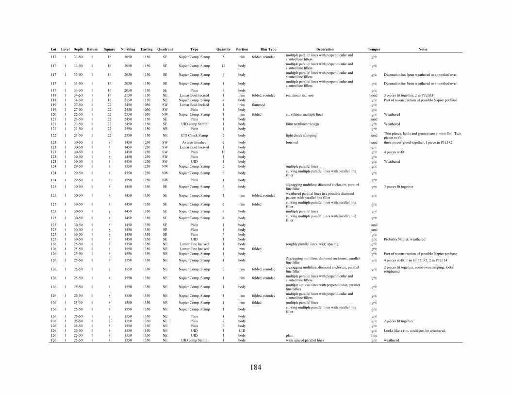
184
Lot Level Depth Datum Square Northing Easting Quadrant Type Quantity Portion Rim Type Decoration Temper Notes
117 1 33-50 1 16 2050 1150 SE Napier Comp. Stamp 5 rim folded, rounded multiple parallel lines with perpendicular and slanted line fillers grit
117 1 33-50 1 16 2050 1150 SE Napier Comp. Stamp 12 body multiple parallel lines with perpendicular and slanted line fillers grit
117 1 33-50 1 16 2050 1150 SE Napier Comp. Stamp 4 body multiple parallel lines with perpendicular and slanted line fillers grit Decoration has been weathered or smoothed over.
117 1 33-50 1 16 2050 1150 SE Napier Comp. Stamp 1 body multiple parallel lines with perpendicular and slanted line fillers grit Decoration has been weathered or smoothed over.
117 1 33-50 1 16 2050 1150 SE Plain 3 body grit118 1 34-50 1 16 2150 1150 NE Lamar Bold Incised 1 rim folded, rounded rectilinear incision sand 3 pieces fit together, 2 in P3L053118 1 34-50 1 16 2150 1150 NE Napier Comp. Stamp 4 body grit Part of reconstruction of possible Napier pot base119 1 27-50 1 22 2450 1050 SW Lamar Bold Incised 1 rim flattened grit119 1 27-50 1 22 2450 1050 SW Plain 1 body grit120 1 22-50 1 22 2550 1050 NW Napier Comp. Stamp 1 rim folded curvilinear multiple lines grit Weathered121 1 23-50 1 22 2450 1150 SE Plain 1 body sand121 1 23-50 1 22 2450 1150 SE UID comp Stamp 1 body faint rectilinear design grit Weathered122 1 21-50 1 22 2550 1150 NE Plain 1 body grit
122 1 21-50 1 22 2550 1150 NE UID Check Stamp 2 body light check stamping sand Thin pieces, lands and grooves are almost flat. Two pieces re-fit
123 1 30-50 1 8 1450 1250 SW Averett Brushed 2 body brushed sand three pieces glued together, 1 piece in P3L142123 1 30-50 1 8 1450 1250 SW Lamar Bold Incised 1 body grit123 1 30-50 1 8 1450 1250 SW Plain 10 body grit 4 pieces re-fit123 1 30-50 1 8 1450 1250 SW Plain 1 body grit123 1 30-50 1 8 1450 1250 SW UID 1 body grit Weathered124 1 29-50 1 8 1550 1250 NW Napier Comp. Stamp 2 body multiple parallel lines grit
124 1 29-50 1 8 1550 1250 NW Napier Comp. Stamp 6 body curving multiple parallel lines with parallel line filler grit
124 1 29-50 1 8 1550 1250 NW Plain 1 body grit
125 1 30-50 1 8 1450 1350 SE Napier Comp. Stamp 3 body zigzagging multiline, diamond enclosure, parallel line filler grit 3 pieces fit together
125 1 30-50 1 8 1450 1350 SE Napier Comp. Stamp 1 rim folded, rounded weathered parallel lines in a possible diamond pattern with parallel line filler grit
125 1 30-50 1 8 1450 1350 SE Napier Comp. Stamp 2 rim folded curving multiple parallel lines with parallel line filler grit
125 1 30-50 1 8 1450 1350 SE Napier Comp. Stamp 2 body multiple parallel lines grit
125 1 30-50 1 8 1450 1350 SE Napier Comp. Stamp 4 body curving multiple parallel lines with parallel line filler grit
125 1 30-50 1 8 1450 1350 SE Plain 1 body sand125 1 30-50 1 8 1450 1350 SE Plain 1 body sand125 1 30-50 1 8 1450 1350 SE Plain 3 body grit125 1 30-50 1 8 1450 1350 SE UID 1 body grit Probably Napier, weathered126 1 25-50 1 8 1550 1350 NE Lamar Fine Incised 1 body roughly parallel lines, wide spacing grit126 1 25-50 1 8 1550 1350 NE Lamar Fine Incised 1 rim folded grit126 1 25-50 1 8 1550 1350 NE Napier Comp. Stamp 1 body grit Part of reconstruction of possible Napier pot base
126 1 25-50 1 8 1550 1350 NE Napier Comp. Stamp 1 body Zigzagging multiline, diamond enclosure, parallel line filler grit 4 pieces re-fit, 1 in lot P3L85, 2 in P3L114
126 1 25-50 1 8 1550 1350 NE Napier Comp. Stamp 2 rim folded, rounded zigzagging multiline, diamond enclosure, parallel line filler grit 2 pieces fit together, some overstamping, looks
roughened
126 1 25-50 1 8 1550 1350 NE Napier Comp. Stamp 1 rim folded, rounded multiple parallel lines with perpendicular and slanted line fillers grit
126 1 25-50 1 8 1550 1350 NE Napier Comp. Stamp 1 body multiple sinuous lines with perpendicular, parallel line fillers grit
126 1 25-50 1 8 1550 1350 NE Napier Comp. Stamp 1 rim folded, rounded multiple parallel lines with perpendicular and slanted line fillers grit
126 1 25-50 1 8 1550 1350 NE Napier Comp. Stamp 1 rim folded multiple parallel lines grit
126 1 25-50 1 8 1550 1350 NE Napier Comp. Stamp 1 body curving multiple parallel lines with parallel line filler grit
126 1 25-50 1 8 1550 1350 NE Plain 1 body grit126 1 25-50 1 8 1550 1350 NE Plain 7 body grit 2 pieces fit together126 1 25-50 1 8 1550 1350 NE Plain 6 body grit126 1 25-50 1 8 1550 1350 NE UID 1 UID grit Looks like a rim, could just be weathered.126 1 25-50 1 8 1550 1350 NE UID 1 body plain fine126 1 25-50 1 8 1550 1350 NE UID comp Stamp 1 body wide spaced parallel lines grit weathered

185
Lot Level Depth Datum Square Northing Easting Quadrant Type Quantity Portion Rim Type Decoration Temper Notes
127 1 0 - - - - - Napier Comp. Stamp 2 body grit Part of reconstruction of possible Napier pot base. Shovel scraping surface collection.
127 1 0 - - - - - Napier Comp. Stamp 1 body multiple sinuous lines with perpendicular, parallel line fillers grit Shovel scraping surface collection.
127 1 0 - - - - - Plain 1 body grit Shovel scraping surface collection.128 1 26-50 1 17 2050 1250 SW Plain 1 body grit129 1 30-50 1 17 2150 1250 NW Plain 1 body sand
129 1 30-50 1 17 2150 1250 NW UID comp Stamp 1 rim folded, rounded nested triangles with parallel lines converging on rim at shallow angle grit Weathered
130 1 28-50 1 17 2050 1350 SE Lamar 1 rim folded, pinched 8 mm wide pinched band grit130 1 28-50 1 17 2050 1350 SE Plain 1 body sand
131 1 32-50 1 17 2150 1350 NE Napier Comp. Stamp 1 body curving multiple parallel lines with parallel line filler grit
131 1 32-50 1 17 2150 1350 NE Swift Creek Comp Stamp 2 rim folded, rounded multiple curvilinear lines with parallel lines, zigzags, chevrons, and UID lines. grit 4 pieces re-fit, 2 in P3L131
131 1 32-50 1 17 2150 1350 NE Swift Creek Comp Stamp 2 body multiple curvilinear lines with parallel lines, zigzags, chevrons, and UID lines. grit 4 pieces re-fit, 2 in P3L131
131 1 32-50 1 17 2150 1350 NE UID comp Stamp 2 body wide spaced parallel lines grit Weathered142 1 39-50 1 5 1350 1250 NW Averett Brushed 1 body brushed sand Three pieces glued together, 2 pieces in P3L123142 1 39-50 1 5 1350 1250 NW Lamar Bold Incised 1 body curvilinear multiple lines grit142 1 39-50 1 5 1350 1250 NW Lamar Incised 1 body grit Glued to sherd in P3L144
142 1 39-50 1 5 1350 1250 NW Napier Comp. Stamp 2 body zigzagging multiline, diamond enclosure, parallel line filler grit 2 pieces fit together, some overstamping
142 1 39-50 1 5 1350 1250 NW Napier Comp. Stamp 1 rim folded curving multiple parallel lines with parallel line filler grit
142 1 39-50 1 5 1350 1250 NW Napier Comp. Stamp 4 body curving multiple parallel lines with parallel line filler grit
142 1 39-50 1 5 1350 1250 NW Plain 22 body grit 2 pairs of sherds re-fit144 1 34-50 1 5 1350 1350 NE Lamar Incised 1 body grit Glued to sherd in P3L142
144 1 34-50 1 5 1350 1350 NE Napier Comp. Stamp 1 rim folded curving multiple parallel lines with parallel line filler grit
144 1 34-50 1 5 1350 1350 NE Napier Comp. Stamp 1 rim folded curving multiple parallel lines with parallel line filler grit
144 1 34-50 1 5 1350 1350 NE Napier Comp. Stamp 12 body curving multiple parallel lines with parallel line filler grit
144 1 34-50 1 5 1350 1350 NE Napier Comp. Stamp 13 body curving multiple parallel lines with parallel line filler grit
144 1 34-50 1 5 1350 1350 NE Plain 1 body grit144 1 34-50 1 5 1350 1350 NE UID 3 UID grit146 1 50 1 18 2100 1500 All Plain 1 body sand
146 1 50 1 18 2100 1500 All UID Comp Stamp 1 body lines perp. to incised line underneath. Comp stamp on about 3 mm of one edge. Rest of sherd is plain. grit
148 1 50 1 15 1900 1500 All Napier Comp. Stamp 1 body multiple parallel lines grit148 1 50 1 15 1900 1500 All Plain 2 body grit
149 1 77 2 36 3300 1500 All Napier Comp. Stamp 1 body combination curvilinear/rectilinear multiple line bands grit
154 1 50 1 13 1900 1100 All Napier Comp. Stamp 1 body multiple parallel lines with perpendicular and slanted line fillers grit Decoration has been weathered or smoothed over.
156 1 50 1 14 1900 1300 All Napier Comp. Stamp 1 body multiple parallel lines with perpendicular and slanted line fillers grit
156 1 50 1 14 1900 1300 All Plain 2 body grit Sherds fit together156 1 50 1 14 1900 1300 All UID 1 UID sand
157 1 48-50 1 5 1380 1350 NE Napier Comp. Stamp 1 rim folded, rounded multiple parallel lines with perpendicular and slanted line fillers grit
157 1 48-50 1 5 1380 1350 NE Napier Comp. Stamp 3 rim/body folded curving multiple parallel lines with parallel line filler grit
157 1 48-50 1 5 1380 1350 NE Napier Comp. Stamp 2 rim folded curving multiple parallel lines with parallel line filler grit
157 1 48-50 1 5 1380 1350 NE Napier Comp. Stamp 2 body folded w/clay overlay multiple parallel lines grit
A clay layer was laid over the rim covering the inside and outside of the sherd. Stamping can be seen underneath the outside layer on the original surface.
157 1 48-50 1 5 1380 1350 NE Napier Comp. Stamp 1 body curving multiple parallel lines with parallel line filler grit

186
Lot Level Depth Datum Square Northing Easting Quadrant Type Quantity Portion Rim Type Decoration Temper Notes
157 1 48-50 1 5 1380 1350 NE Napier Comp. Stamp 1 UID grit 44.8 grams of broken sherd fragments from a box of Napier Comp. Stamp sherds.
157 1 48-50 1 5 1380 1350 NE Napier Comp. Stamp 215 body curving multiple parallel lines with parallel line filler grit
157 1 48-50 1 5 1380 1350 NE Plain 1 body sand157 1 48-50 1 5 1380 1350 NE Plain 2 body grit Sherds fit together
161 1 44-50 1 4 1350 1050 NW Napier Comp. Stamp 1 body multiple sinuous lines with perpendicular, parallel line fillers grit
161 1 44-50 1 4 1350 1050 NW Plain 1 body grit161 1 44-50 1 4 1350 1050 NW Plain 1 body grit165 1 0-50 1 26 2650 1350 SE Plain 3 base grit Three sherds glued together165 1 0-50 1 26 2650 1350 SE UID Comp Stamp 1 body Some parallel lines, rest is too weathered grit
166 1 24-50 1 27 2650 1450 SW Napier Comp. Stamp 1 body combination curvilinear/rectilinear multiple line bands grit Glued to three sherds in P3L056
172 2 50-60 1 22 2550 1150 NE Plain 2 body grit174 2 50-60 1 21 2350 1450 NW Plain 2 body sand175 2 50-60 1 21 2250 1550 SE Plain 1 body grit176 2 50-60 1 21 2350 1550 NE UID comp Stamp 1 body wide lines grit Weathered
178 1 50 1 8 1500 1300 All Napier Comp. Stamp 1 body curving multiple parallel lines with parallel line filler grit
180 2 50-60 1 23 2450 1250 SW Plain 3 body grit181 2 50-60 2 23 2550 1250 NW Plain 3 body grit183 2 50-60 1 23 2550 1350 NE Plain 2 body grit184 2 50-60 1 7 1450 1050 SW Plain 1 rim rounded None grit184 2 50-60 1 7 1450 1050 SW Plain 5 body grit191 2 50-60 1 20 2250 1250 SW UID comp Stamp 1 body wide spaced parallel lines grit Weathered192 2 50-60 1 20 2350 1250 NW Plain 1 body sand192 2 50-60 1 20 2350 1250 NW Plain 7 UID sand Burned194 2 50-60 1 20 2350 1350 NE Plain 1 body sand196 2 77-87 2 38 3550 1250 NW Plain 1 body sand198 2 77-87 2 38 3550 1350 NE Plain 1 body grit199 2 50-60 1 4 1350 1050 NW Ocmulgee Fields Incised 3 body linear incising, smoothed over and faint grit 3 pieces fit together
201 2 50-60 1 8 1450 1250 SW Napier Comp. Stamp 2 rim folded curving multiple parallel lines with parallel line filler grit
202 2 50-60 1 8 1550 1250 NW Napier Comp. Stamp 2 body curving multiple parallel lines with parallel line filler grit
202 2 50-60 1 8 1550 1250 NW Napier Comp. Stamp 1 body curving multiple parallel lines with parallel line filler grit
203 2 50-60 1 8 1450 1350 SE Napier Comp. Stamp 1 rim folded multiple parallel lines grit203 2 50-60 1 8 1450 1350 SE Napier Comp. Stamp 1 body multiple parallel lines grit
203 2 50-60 1 8 1450 1350 SE Napier Comp. Stamp 3 body curving multiple parallel lines with parallel line filler grit
203 2 50-60 1 8 1450 1350 SE Plain 1 body sand203 2 50-60 1 8 1450 1350 SE Plain 1 body sand204 2 50-60 1 8 1550 1350 NE Napier Comp. Stamp 1 body parallel lines, maybe a diamond shape grit Weathered
205 2 50-60 1 19 2250 1050 SW Napier Comp. Stamp 1 body multiple parallel lines with perpendicular and slanted line fillers grit
207 2 50-60 1 19 2250 1150 SE UID comp Stamp 1 body wide spaced parallel lines grit Weathered210 2 77-87 2 39 3550 1450 NW Plain 1 body grit
217 2 50-60 1 5 1350 1250 NW Napier Comp. Stamp 4 body curving multiple parallel lines with parallel line filler grit
217 2 50-60 1 5 1350 1250 NW Napier Comp. Stamp 2 body curving multiple parallel lines with parallel line filler grit
217 2 50-60 1 5 1350 1250 NW Plain 1 body grit217 2 50-60 1 5 1350 1250 NW Plain 1 body sand217 2 50-60 1 5 1350 1250 NW Plain 2 body grit
218 2 50-60 1 5 1350 1350 NE Napier Comp. Stamp 1 rim folded curving multiple parallel lines with parallel line filler grit
218 2 50-60 1 5 1350 1350 NE Napier Comp. Stamp 8 body curving multiple parallel lines with parallel line filler grit
218 2 50-60 1 5 1350 1350 NE Napier Comp. Stamp 2 body curving multiple parallel lines with parallel line filler grit
219 2 50-60 1 6 1350 1450 NW Napier Comp. Stamp 1 rim folded multiple parallel lines grit219 2 50-60 1 6 1350 1450 NW Napier Comp. Stamp 1 body multiple parallel lines grit

187
Lot Level Depth Datum Square Northing Easting Quadrant Type Quantity Portion Rim Type Decoration Temper Notes
220 2 50-60 1 18 2050 1450 SW UID 2 UID sand Burned221 2 50-60 1 18 2150 1450 NW UID 3 UID sand Burned222 2 50-60 1 18 2050 1550 SE UID 2 UID sand Burned223 2 50-60 1 18 2150 1550 NE UID 10 UID sand Burned229 2 50-60 1 17 2150 1250 NW UID comp Stamp 1 body wide spaced parallel lines grit Weathered231 2 50-60 1 17 2150 1350 NE UID comp Stamp 1 body rectilinear grit Weathered232 2 50-60 1 15 1850 1450 SW Plain 1 body sand232 2 50-60 1 15 1850 1450 SW Stallings Punctate 1 body one circular indentation observed fiber233 2 50-60 1 15 1950 1450 NW UID 1 UID sand Burned234 2 50-60 1 15 1850 1550 SE Plain 1 body grit234 2 50-60 1 15 1850 1550 SE Plain 3 body grit235 2 50-60 1 15 1950 1550 NE UID 7 UID sand Burned
250 2 50-60 1 14 1950 1250 NW Napier Comp. Stamp 1 body multiple parallel lines with perpendicular and slanted line fillers grit
250 2 50-60 1 14 1950 1250 NW Napier Comp. Stamp 3 body curving multiple parallel lines with parallel line filler grit
250 2 50-60 1 14 1950 1250 NW Plain 1 body grit251 2 50-60 1 14 1850 1350 SE Plain 1 body grit251 2 50-60 1 14 1850 1350 SE Plain 3 body grit Very weathered255 3 90-97 2 42 3650 1550 SE UID Plain 1 body rough plain sand268 2 50-60 1 26 2650 1350 SE Plain 3 body fiber284 3 60-70 1 27 2650 1450 SW Plain 1 body fiber286 2 60 1 12 1750 1500 N Plain 1 body grit294 3 60-64 1 15 1989 1564 NE UID 33 UID sand Burned
297 3 87-97 2 38 3450 1350 SE Stallings Plain 1 rim square, flattened plain fiber Fiber is large and left many grooves all over the piece
300 3 61-70 1 7 1550 1050 NW Plain 4 body grit301 3 61-70 1 7 1450 1150 SE Plain 1 body grit302 3 62-70 1 7 1550 1150 NE Plain 1 body grit308 3 60-70 1 23 2550 1250 NW UID 1 UID ceramic Plain - body311 3 87-97 2 36 3250 1450 SW Plain 1 body fiber315 4 97-107 2 42 3650 1450 SW Plain 2 body sand317 4 97-107 2 42 3650 1550 SE UID Plain 4 body rough plain sand318 4 97-107 2 42 3750 1550 NE Plain 1 body grit320 3 60-70 1 22 2550 1050 NW Plain 1 body fiber321 3 60-70 1 22 2450 1150 SE Plain 1 body sand322 3 60-70 1 22 2550 1150 NE Plain 1 body grit328 4 105 2 42 3682 1519 SE Plain 2 body weathered grit328 4 105 2 42 3682 1519 SE Plain 1 rim rounded weathered grit328 4 105 2 42 3682 1519 SE UID Plain 16 body rough plain sand 2 pieces fit together in, separate bag331 4 97-107 2 41 3650 1350 SE Stallings Punctate 1 body stab and drag fiber346 4 46-60 3 8 1550 1250 NW UID 1 UID grit350 4 97-107 2 38 3450 1250 SW Plain 1 body grit352 4 97-107 2 38 3450 1350 SE Stallings Punctate 1 body stab and drag fiber356 3 60-70 1 16 2050 1150 SE Plain 1 body sand368 2 50-60 2 11 1750 1250 NW UID 1 UID ceramic Fiber-Temper body369 2 50-60 2 11 1650 1350 SE Plain 1 body sand372 2 50-60 2 14 1950 1250 NW Plain 1 body sand373 2 50-60 2 14 1850 1350 SE Plain 3 body grit385 3 60-70 1 17 2150 1350 NE UID comp Stamp 1 body rectilinear over stamping sand Weathered
394 3 60-70 1 13 1950 1150 NE Napier Comp. Stamp 1 body curving multiple parallel lines with parallel line filler grit
395 Napier Comp. Stamp 1 body multiple parallel lines with perpendicular and slanted line fillers grit In back dirt pile
395 Napier Comp. Stamp 2 body multiple parallel lines with perpendicular and slanted line fillers grit In back dirt pile. Pieces conjoin.
396 3 60-70 1 21 2250 1450 SW Plain 10 body sand Burned398 3 60-70 1 21 2250 1550 SE UID 1 UID sand Burned401 3 60-70 1 15 1950 1450 NW Plain 1 body grit401 3 60-70 1 15 1950 1450 NW UID 1 UID sand Ceramic nodule, daub?402 3 60-70 1 15 1850 1550 SE Plain 1 body grit405 3 60-70 1 18 2150 1450 NW UID 15 UID sand Burned
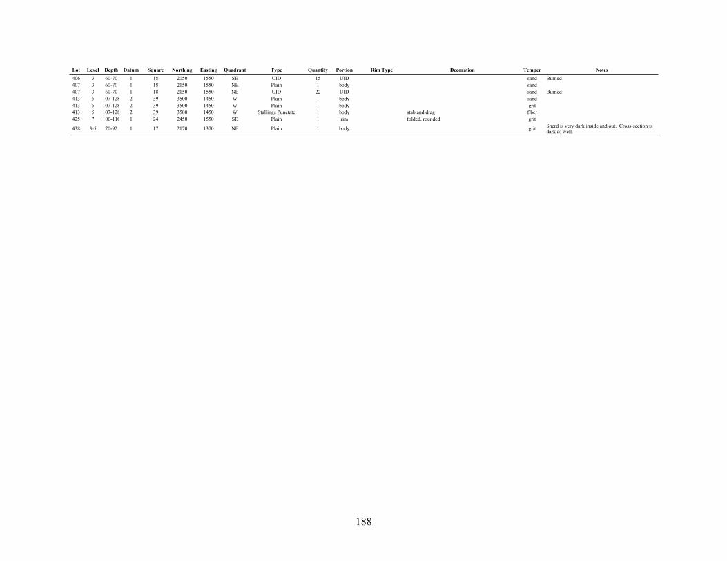
188
Lot Level Depth Datum Square Northing Easting Quadrant Type Quantity Portion Rim Type Decoration Temper Notes
406 3 60-70 1 18 2050 1550 SE UID 15 UID sand Burned407 3 60-70 1 18 2150 1550 NE Plain 1 body sand407 3 60-70 1 18 2150 1550 NE UID 22 UID sand Burned413 5 107-128 2 39 3500 1450 W Plain 1 body sand413 5 107-128 2 39 3500 1450 W Plain 1 body grit413 5 107-128 2 39 3500 1450 W Stallings Punctate 1 body stab and drag fiber425 7 100-110 1 24 2450 1550 SE Plain 1 rim folded, rounded grit
438 3-5 70-92 1 17 2170 1370 NE Plain 1 body grit Sherd is very dark inside and out. Cross-section is dark as well.

189
Appendix F: Provenience 3 Soapstone Catalog
Lot Level Depth Datum Square Northing Easting Quadrant Quantity Portion Decoration Description Thickness (mm) Notes
002021038073094
174
191191202215
216
229
237237247
251
252264264
269
299
301
304
309311312314315330331336354356356393
398
408
1 15-50 1 45 3800 1600 SE 1 body Plain 13.12 50-60 1 45 3800 1600 SW 1 body Plain 15.55 80-90 1 24 2400 1600 NW 1 body Tool marks Varied marks 15.01 0-50 1 20 2200 1400 SW 1 body Plain 12.41 40-50 1 13 1800 1200 NE 1 body Linear tool marks. Not parallel Approx. 0.7 mm peak to trough 7.5 shallow incised grooves
2 50-60 1 21 2200 1600 NW 1 UID UID - Soapstone fragment. No modified surface.
2 50-60 1 20 2200 1400 SW 1 body Incised 2.92 50-60 1 20 2200 1400 SW 1 body Incised 142 50-60 1 8 1400 1400 NW 1 body Parallel tool marks Approx. 1.5 mm peak to trough 14.92 50-60 1 16 2000 1200 SE 1 body Parallel tool marks Approx. 1.2 mm peak to trough 15.3
2 50-60 1 16 2000 1200 NE 1 body UID 12.9 Outer surface is too small to see decoration
2 50-60 1 17 2000 1400 NW 1 body Various tool marks slightly converging lines, just off parallel 15.3
2 50-60 1 13 1800 1200 NW 1 body Pitted 14.42 50-60 1 13 1800 1200 NW 1 body Parallel tool marks Approx. 0.6 mm peak to trough 6.22 50-60 1 11 1600 1400 NE 1 body Plain 13.9
2 50-60 1 14 1800 1400 SE 1 UID UID - Soapstone fragment. No modified surface.
2 50-60 1 14 1800 1400 NE 1 body Weathered 15.23 87-97 2 41 3600 1400 SW 1 UID UID - Small fragment3 87-97 2 41 3600 1400 SW 1 body Plain weathered pits on both surfaces 14.6
2 50-60 1 27 2600 1600 SW 1 UID UID Looks like a cylinder, could be due to weathering 16.9
3 62-70 1 7 1400 1200 SW 1 body Plain 7.3
3 61-70 1 7 1400 1200 SW 1 rim Plain surface with horizontal projection (handle)
Handle is 21.9 mm thick at break and tapers to 0. 38.6 mm from break to start of handle.
16.0
3 87-97 2 39 3400 1600 NW 1 body Parallel tool marks Tool marks approx. 1.1 mm peak to trough 15.7
3 60-70 1 23 2400 1400 SE 1 body Parallel tool marks Approx. 0.9 mm peak to trough 16.43 87-97 2 36 3200 1600 SW 1 body Plain Varying thickness across sherd 11.4 Measured at maximum thickness.3 87-97 2 36 3200 1600 NW 1 rim Plain Rounded rim 10.13 87-97 2 36 3200 1600 NE 1 body UID Weathered 14.33 97-107 2 42 3600 1600 SW 1 body Plain 17.94 97-107 2 41 3600 1400 NW 1 UID Tool marks Varied marks 10.8 Small weathered piece.4 97-107 2 41 3600 1400 SE 1 body Plain 16.73 60-70 1 19 2200 1200 SW 1 UID UID Small fragment.3 60-70 1 16 2000 1200 SW 1 body Linear tool marks. Not parallel Approx. 0.8 mm peak to trough 13.83 60-70 1 16 2000 1200 SE 1 UID UID - Small fragment.3 60-70 1 16 2000 1200 SE 1 body UID 11.63 60-70 1 13 1800 1200 SE 1 rim Pitted 17.4
3 60-70 1 21 2200 1600 SE 1 rim Parallel tool marks. Approx. 0.9 mm peak to trough; square rim 15.9
3 60-70 1 12 1600 1600 NW 1 body 12.3

190
Appendix G: Provenience 3 Diagnostic Tools
Lot Level Depth Datum Square Northing Easting Quadrant Portion Base Notching Material Length Width Thickness Weight Photo Number Notes
021030031043046046048051060066091113113115117193282299302310365385386393
2 50-60 1 45 3800 1600 SW base and mid-section contracting quartz 4.61 3.62 1.27 20.2 P3L021A14 70-80 1 24 2400 1600 NW complete contracting quartz 3.34 1.80 0.78 4.1 P3L030A1 Feature 14 70-80 1 24 2400 1600 SE base contracting chert 1.64 3.25 1.11 3.5 P3L031A14 70-80 1 10 1600 1200 SE complete contracting quartz 4.94 3.51 1.02 13.0 P3L043A1 Small portion of base snapped off3 60-70 1 45 3800 1600 NW complete stem quartz 7.05 4.22 2.01 56.0 P3L046A1 Rose colored3 60-70 1 45 3800 1600 NW complete contracting quartz 5.57 3.51 1.51 24.8 P3L046A2 Offset base3 60-70 1 45 3800 1600 NE base expanding concave chert 1.44 2.53 0.55 1.9 P3L048A14 70-80 1 45 3800 1600 SE base and mid-section contracting quartz 4.25 3.10 1.60 21.3 P3L051A11 34-50 1 11 1600 1400 NE complete expanding stem side notch chert 2.90 1.83 0.55 3.6 P3L060A11 30-50 1 14 1800 1400 NW complete contracting lancoelate quartz 2.60 1.34 0.62 2.1 P3L066A11 38-50 1 13 1800 1200 SW base and mid-section expanding stem 457 material457 material 3.47 2.99 0.82 7.7 P3L091A11 32-50 1 7 1400 1200 SE missing half base side notch chert 3.83 2.16 0.82 5.6 P3L113A1 Serrated1 32-50 1 7 1400 1200 SE complete rounded chert 4.51 1.86 1.02 6.4 P3L113A2 Could be preform1 40-50 1 16 2000 1200 SW complete rounded quartz 5.93 2.63 1.09 16.7 P3L115A1 Leaf shaped1 33-50 1 16 2000 1200 SE complete rounded side chert 2.82 2.46 0.66 3.7 P3L117A12 50-60 1 20 2200 1400 SE base expanding basal chert 2.19 2.50 0.86 3.7 P3L193A12 60 1 15 1800 1600 ALL base and mid-section expanding corner chert 3.97 1.14 0.65 6.5 P3L282A13 62-70 1 7 1400 1200 SW mid-section and tip chert 3.86 2.38 0.71 5.5 P3L299A13 62-70 1 7 1400 1200 NE base and mid-section expanding side chert 29.4 1.52 0.61 2.8 P3L302A13 60-70 1 23 2400 1400 NE base expanding concave quartz 2.55 3.26 0.68 5.7 P3L310A13 60-70 1 20 2200 1400 SE margin chert 5.58 3.36 1.00 16.0 P3L365A13 60-70 1 17 2000 1400 NE base contracting quartz 1.61 2.38 0.58 1.5 P3L385A14 107 2 41 3600 1400 ALL base contracting stem basal quartz 3.70 4.83 1.38 23.5 P3L386A13 60-70 1 13 1800 1200 SE mid-section and tip stem chert 5.31 3.30 0.91 13.3 P3L393A1 Serrated, missing portion of base
Note. Refer to the diagnostic tool section in the text for dating information.
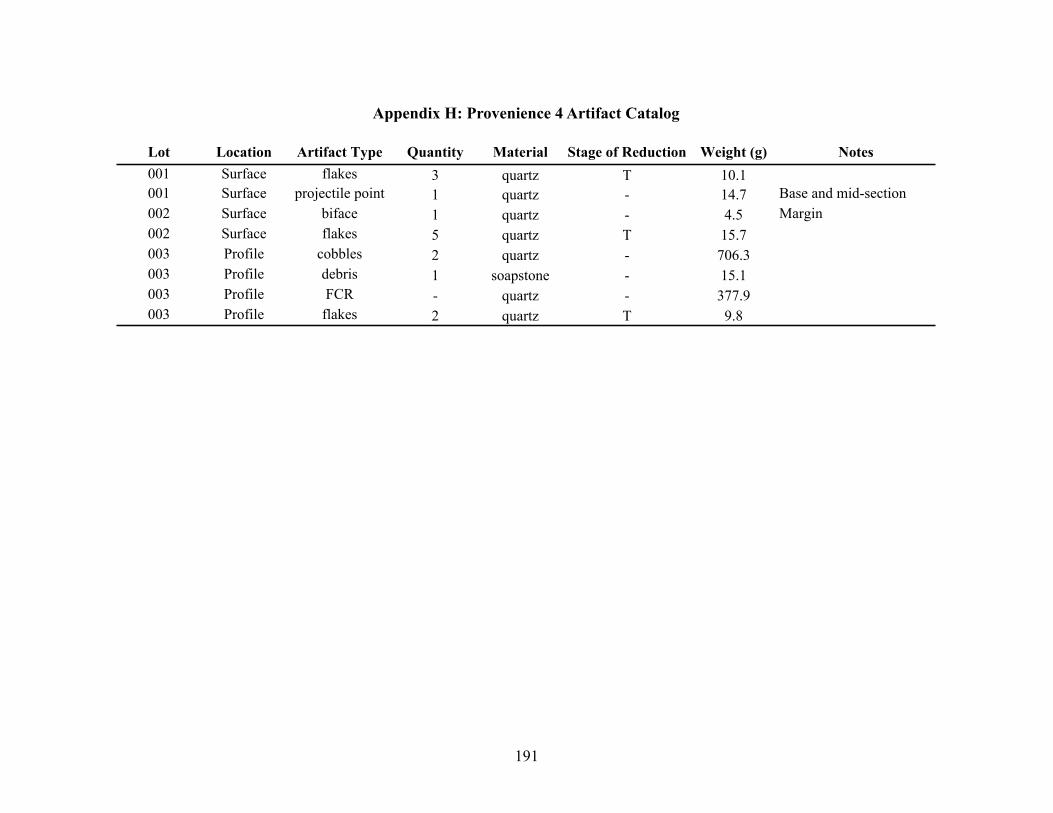
191
Appendix H: Provenience 4 Artifact Catalog
Lot Location Artifact Type Quantity Material Stage of Reduction Weight (g) Notes001 Surface flakes 3 quartz T 10.1001 Surface projectile point 1 quartz - 14.7 Base and mid-section002 Surface biface 1 quartz - 4.5 Margin002 Surface flakes 5 quartz T 15.7003 Profile cobbles 2 quartz - 706.3003 Profile debris 1 soapstone - 15.1003 Profile FCR - quartz - 377.9003 Profile flakes 2 quartz T 9.8

192
Appendix I: Site Charcoal Sample Catalog
Prov. Lot Feature Level Depth Datum Square Northing Easting Quadrant
2 001 Test Unit 1 A 0-76 surface - - - -2 001 Test Unit 1 A 0-76 surface - - - -2 002 Test Unit 1 B 86-96 surface - - - -2 005 Test Unit 1 E 116-126 surface - - - -2 009 Test Unit 2 B 45-100 Surface - - - -2 009 Test Unit 2 B 45-100 Surface - - - -2 010 Test Unit 2 C 100-120 Surface - - - -3 001 - 1 15-50 1 45 3800 1600 SW3 002 - 1 15-50 1 45 3800 1600 SE3 003 - 1 15-50 1 45 3800 1600 NW3 004 - 1 15-50 1 45 3800 1600 NE3 005 1 1 0-50 1 24 2400 1600 SW3 006 1 1 0-50 1 24 2400 1600 NW3 006 1 1 0-50 1 24 2400 1600 NW3 006 1 1 0-50 1 24 2400 1600 NW3 007 - 1 0-50 1 24 2400 1600 SE3 008 - 1 0-50 1 24 2400 1600 NE3 009 - 1 34-50 1 10 1600 1200 SW3 010 - 1 0-50 1 10 1600 1200 NW3 011 - 1 0-50 1 10 1600 1200 SE3 012 - 1 48-50 1 10 1600 1200 NE3 014 1 2 50-60 1 24 2400 1600 NW3 015 - 2 50-60 1 24 2400 1600 SE3 017 - 2 50-60 1 10 1600 1200 SW3 018 - 2 50-60 1 10 1600 1200 NW3 019 - 2 50-60 1 10 1600 1200 SE3 020 - 2 50-60 1 10 1600 1200 NE3 021 - 2 50-60 1 45 3800 1600 SW3 022 - 2 50-60 1 45 3800 1600 NW3 023 - 2 50-60 1 45 3800 1600 SE3 024 - 2 50-60 1 45 3800 1600 NE3 025 - 3 60-70 1 24 2400 1600 SW3 027 - 3 60-70 1 24 2400 1600 SE3 029 - 4 70-80 1 24 2400 1600 SW3 032 - 4 70-80 1 24 2400 1600 NE3 033 - 3 60-70 1 10 1600 1200 SW3 034 - 3 60-70 1 10 1600 1200 NW3 035 - 3 60-70 1 10 1600 1200 SE

193
Prov. Lot Feature Level Depth Datum Square Northing Easting Quadrant
3 036 - 3 60-70 1 10 1600 1200 NE3 037 - 5 80-90 1 24 2400 1600 SW3 038 - 5 80-90 1 24 2400 1600 NW3 039 - 5 80-90 1 24 2400 1600 SE3 040 - 5 80-90 1 24 2400 1600 NE3 041 - 4 70-80 1 10 1600 1200 SW3 045 - 3 60-70 1 45 3800 1600 SW3 047 - 3 60-70 1 45 3800 1600 SE3 048 - 3 60-70 1 45 3800 1600 NE3 049 - 4 70-80 1 45 3800 1600 SW3 050 - 4 70-80 1 45 3800 1600 NW3 051 - 4 70-80 1 45 3800 1600 SE3 052 - 4 70-80 1 45 3800 1600 NE3 053 - 1 22-50 1 23 2400 1400 SW3 054 - 1 20-50 1 23 2400 1400 NW3 055 - 1 28-50 1 23 2400 1400 SE3 056 - 1 27-50 1 23 2400 1400 NE3 056 - 1 27-50 1 23 2400 1400 NE3 060 - 1 34-50 1 11 1600 1400 NE3 061 - 1 0-50 1 42 3600 1600 SW3 062 - 1 0-50 1 42 3600 1600 NW3 063 - 1 0-50 1 42 3600 1600 SE3 064 - 1 0-50 1 42 3600 1600 NE3 065 - 1 25-50 1 14 1800 1400 SW3 066 - 1 30-50 1 14 1800 1400 NW3 067 - 1 30-50 1 14 1800 1400 SE3 068 - 1 29-50 1 14 1800 1400 NE3 069 - 1 0-50 1 21 2200 1600 SW3 070 - 1 33-50 1 21 2200 1600 NW3 071 - 1 35-50 1 21 2200 1600 SE3 072 - 1 29-50 1 21 2200 1600 NE3 073 5 1 0-50 1 20 2200 1400 SW3 075 5 1 0-50 1 20 2200 1400 SE3 075 5 1 0-50 1 20 2200 1400 SE3 077 - 1 36-50 1 15 1800 1600 SW3 078 - 1 0-50 1 15 1800 1600 NW3 079 - 1 0-50 1 15 1800 1600 SE3 080 - 1 0-50 1 15 1800 1600 NE3 081 - 1 50-84 2 41 3400 1600 SW3 082 - 1 49-84 2 41 3400 1600 NW

194
Prov. Lot Feature Level Depth Datum Square Northing Easting Quadrant
3 083 - 1 53-84 2 41 3400 1600 SE3 084 - 1 52-84 2 41 3400 1600 NE3 085 6 1 0-50 1 18 2000 1600 SE3 086 6 1 0-50 1 18 2000 1600 NE3 087 6 1 0-50 1 18 2000 1600 SW3 088 6 1 0-50 1 18 2000 1600 NW3 089 - 1 35-50 1 12 1600 1600 NW3 090 - 1 38-50 1 12 1600 1600 NE3 091 - 1 38-50 1 13 1800 1200 SW3 092 - 1 44-50 1 13 1800 1200 NW3 093 - 1 39-50 1 13 1800 1200 SE3 094 - 1 40-50 1 13 1800 1200 NE3 095 6 1 68-82 1 18 2000 1600 Feature 63 096 6 1 68-82 1 18 2000 1600 From flotation3 099 - 1 0-50 1 19 2200 1200 SW3 100 - 1 0-50 1 19 2200 1200 NW3 101 - 1 0-50 1 19 2200 1200 SE3 102 - 1 0-50 1 19 2200 1200 NE3 103 - 1 56-77 2 38 3400 1400 SW3 104 - 1 51-77 2 38 3400 1400 NW3 105 - 1 61-77 2 38 3400 1400 SE3 106 - 1 57-77 2 38 3400 1400 NE3 106 - 1 57-77 2 38 3400 1400 NE3 107 - 1 61-77 2 39 3400 1600 SW3 108 - 1 56-77 2 39 3400 1600 NW3 109 - 1 65-77 2 39 3400 1600 SE3 110 - 1 57-77 2 39 3400 1600 NE3 111 - 1 39-50 1 7 1400 1200 SW3 112 - 1 39-50 1 7 1400 1200 NW3 113 - 1 32-50 1 7 1400 1200 SE3 115 - 1 40-50 1 16 2000 1200 SW3 116 - 1 44-50 1 16 2000 1200 NW3 117 - 1 33-50 1 16 2000 1200 SE3 118 - 1 34-50 1 16 2000 1200 NE3 119 - 1 27-50 1 22 2400 1200 SW3 119 - 1 27-50 1 22 2400 1200 SW3 121 - 1 23-50 1 22 2400 1200 SE3 122 - 1 21-50 1 22 2400 1200 NE3 125 - 1 30-50 1 8 1400 1400 SE3 128 - 1 26-50 1 17 2000 1400 SW

195
Prov. Lot Feature Level Depth Datum Square Northing Easting Quadrant
3 129 - 1 30-50 1 17 2000 1400 NW3 130 - 1 28-50 1 17 2000 1400 SE3 131 - 1 32-50 1 17 2000 1400 NE3 132 - 1 54-77 2 36 3200 1600 SW3 133 - 1 56-77 2 36 3200 1600 NW3 134 - 1 61-77 2 36 3200 1600 SE3 140 - 1 50 1 23/24 2400 1600 ALL3 141 - 1 34-50 1 6 1200 1600 NW3 144 - 1 34-50 1 5 1200 1400 NE3 145 - 1 50 1 21 2200 1600 ALL3 146 - 1 50 1 18 2000 1600 ALL3 147 - 1 50 1 12 1600 1600 ALL3 150 - 1 77 2 38 3400 1400 ALL3 152 - 1 80 2 41 3600 1400 ALL3 153 - 1 77 2 39 3400 1600 ALL3 161 - 1 44-50 1 4 1200 1200 NW3 162 - 1 40-50 1 4 1200 1200 NE3 162 - 1 40-50 1 4 1200 1200 NE3 167 - 1 0-77 2 35 3200 1400 NW3 167 - 1 0-77 2 35 3200 1400 NW3 170 - 2 50-60 1 22 2400 1200 NW3 171 - 2 50-60 1 22 2400 1200 SE3 172 - 2 50-60 1 22 2400 1200 NE3 175 - 2 50-60 1 21 2200 1600 SE3 178 - 1 50 1 8 1400 1400 ALL3 179 12 1 0-77 2 37 3400 1200 SE3 181 - 2 50-60 2 23 2400 1400 NW3 182 - 2 50-60 1 23 2400 1400 SE3 183 - 2 50-60 1 23 2400 1400 NE3 185 - 2 50-60 1 7 1400 1200 NW3 186 - 2 50-60 1 7 1400 1200 SE3 192 - 2 50-60 1 20 2200 1400 NW3 193 - 2 50-60 1 20 2200 1400 SE3 194 - 2 50-60 1 20 2200 1400 NE3 201 15 2 50-60 1 8 1400 1400 SW3 203 15 2 50-60 1 8 1400 1400 SE3 204 - 2 50-60 1 8 1400 1400 NE3 205 - 2 50-60 1 19 2200 1200 SW3 206 - 2 50-60 1 19 2200 1200 NW3 207 - 2 50-60 1 19 2200 1200 SE

196
Prov. Lot Feature Level Depth Datum Square Northing Easting Quadrant
3 209 - 2 77-87 2 39 3400 1600 SW3 212 - 2 77-87 2 39 3400 1600 NE3 213 - 2 50-60 1 16 2000 1200 SW3 214 - 2 50-60 1 16 2000 1200 NW3 216 - 2 50-60 1 16 2000 1200 NE3 219 - 2 50-60 1 6 1200 1600 NW3 220 6 2 50-60 1 18 2000 1600 SW3 221 6 2 50-60 1 18 2000 1600 NW3 222 6 2 50-60 1 18 2000 1600 SE3 223 6 2 50-60 1 18 2000 1600 NE3 226 - 2 77-87 2 36 3200 1600 SE3 227 - 2 77-87 2 36 3200 1600 NE3 231 - 2 50-60 1 17 2000 1400 NE3 232 - 2 50-60 1 15 1800 1600 SW3 233 - 2 50-60 1 15 1800 1600 NW3 234 - 2 50-60 1 15 1800 1600 SE3 235 - 2 50-60 1 15 1800 1600 NE3 236 13/14 2 50-60 1 13 1800 1200 SW3 238 - 2 50-60 1 13 1800 1200 SE3 239 - 2 50-60 1 13 1800 1200 NE3 244 - 2 50-60 1 11 1600 1400 SW3 245 - 2 50-60 1 11 1600 1400 NW3 246 - 2 50-60 1 11 1600 1400 SE3 247 - 2 50-60 1 11 1600 1400 NE3 253 - 3 90-97 2 42 3600 1600 SW3 254 - 3 90-97 2 42 3600 1600 NW3 263 - 2 50-60 1 12 1600 1600 NE3 264 - 3 87-97 2 41 3600 1400 SW3 265 - 3 87-97 2 41 3600 1400 NW3 266 - 3 87-97 2 41 3600 1400 SE3 274 - 3 60-70 1 26 2600 1400 SE3 279 - 2 60 1 17 2000 1400 ALL3 282 - 2 60 1 14 1800 1600 ALL3 284 - 3 60-70 1 27 2600 1600 SW3 285 - 2 60 1 11 1600 1400 ALL3 292 - 1 0-77 2 34 3200 1200 NE3 298 - 3 87-97 2 38 3400 1400 NE3 300 - 3 61-70 1 7 1400 1200 NW3 301 - 3 61-70 1 7 1400 1200 SE3 302 - 3 62-70 1 7 1400 1200 NE
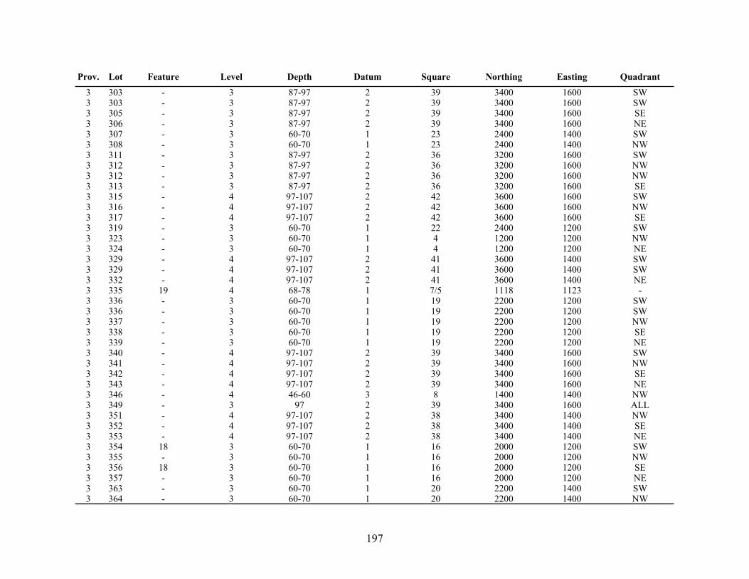
197
Prov. Lot Feature Level Depth Datum Square Northing Easting Quadrant
3 303 - 3 87-97 2 39 3400 1600 SW3 303 - 3 87-97 2 39 3400 1600 SW3 305 - 3 87-97 2 39 3400 1600 SE3 306 - 3 87-97 2 39 3400 1600 NE3 307 - 3 60-70 1 23 2400 1400 SW3 308 - 3 60-70 1 23 2400 1400 NW3 311 - 3 87-97 2 36 3200 1600 SW3 312 - 3 87-97 2 36 3200 1600 NW3 312 - 3 87-97 2 36 3200 1600 NW3 313 - 3 87-97 2 36 3200 1600 SE3 315 - 4 97-107 2 42 3600 1600 SW3 316 - 4 97-107 2 42 3600 1600 NW3 317 - 4 97-107 2 42 3600 1600 SE3 319 - 3 60-70 1 22 2400 1200 SW3 323 - 3 60-70 1 4 1200 1200 NW3 324 - 3 60-70 1 4 1200 1200 NE3 329 - 4 97-107 2 41 3600 1400 SW3 329 - 4 97-107 2 41 3600 1400 SW3 332 - 4 97-107 2 41 3600 1400 NE3 335 19 4 68-78 1 7/5 1118 1123 -3 336 - 3 60-70 1 19 2200 1200 SW3 336 - 3 60-70 1 19 2200 1200 SW3 337 - 3 60-70 1 19 2200 1200 NW3 338 - 3 60-70 1 19 2200 1200 SE3 339 - 3 60-70 1 19 2200 1200 NE3 340 - 4 97-107 2 39 3400 1600 SW3 341 - 4 97-107 2 39 3400 1600 NW3 342 - 4 97-107 2 39 3400 1600 SE3 343 - 4 97-107 2 39 3400 1600 NE3 346 - 4 46-60 3 8 1400 1400 NW3 349 - 3 97 2 39 3400 1600 ALL3 351 - 4 97-107 2 38 3400 1400 NW3 352 - 4 97-107 2 38 3400 1400 SE3 353 - 4 97-107 2 38 3400 1400 NE3 354 18 3 60-70 1 16 2000 1200 SW3 355 - 3 60-70 1 16 2000 1200 NW3 356 18 3 60-70 1 16 2000 1200 SE3 357 - 3 60-70 1 16 2000 1200 NE3 363 - 3 60-70 1 20 2200 1400 SW3 364 - 3 60-70 1 20 2200 1400 NW

198
Prov. Lot Feature Level Depth Datum Square Northing Easting Quadrant
3 365 - 3 60-70 1 20 2200 1400 SE3 366 - 3 60-70 1 20 2200 1400 NE3 367 - 2 50-60 2 11 1600 1400 SW3 370 - 2 50-60 2 11 1600 1400 NE3 374 - 2 50-60 2 14 1800 1400 NE3 376 - 4 107 2 38 3400 1400 ALL3 382 - 3 60-70 1 17 2000 1400 SW3 385 - 3 60-70 1 17 2000 1400 NE3 390 - 5 107-117 2 41 3600 1400 NE3 392 - 3 60-70 1 13 1800 1200 NW3 396 - 3 60-70 1 21 2200 1600 SW3 397 - 3 60-70 1 21 2200 1600 NW3 398 - 3 60-70 1 21 2200 1600 SE3 399 - 3 60-70 1 21 2200 1600 NE3 401 - 3 60-70 1 15 1800 1600 NW3 402 - 3 60-70 1 15 1800 1600 SE3 406 - 3 60-70 1 18 2000 1600 SE3 408 - 3 60-70 1 12 1600 1600 NW3 409 - 3 60-70 1 12 1600 1600 NE3 413 24 5 107-128 2 39 3462 1464 -3 418 17 4 70-72 1 19/22 2383 1140 -3 421 26 4 70-77 1 17 2133 1340 -3 424 - 6 90-100 1 24 2400 1600 SE3 425 - 7 100-110 1 24 2400 1600 SE3 438 30 3-5 70-92 1 17 2170 1370 NE