ARCHAEOLOGICAL EVALUATION AT THE SITE OF THE NEW BROADFORD MEDICAL CENTRE, HIGH ROAD, ISLE OF SKYE...
131
West Coast Archaeological Services Ross & Cromarty Archaeological Services ARCHAEOLOGICAL EVALUATION AT THE SITE OF THE NEW BROADFORD MEDICAL CENTRE, HIGH ROAD, ISLE OF SKYE DATA STRUCTURE REPORT Tel: 01381 600726 Mobile: 07867 651886 Email: [email protected] National Grid Reference NGR NG 64133 23915 (Centred) Site Code BMC11 Authors Steven Birch Report # 026/BMC/12 Client NHS Highland Date 15/03/2012 Ref Oasis Ref: 10/03029/FUL Westcoas1 - 121332
Transcript of ARCHAEOLOGICAL EVALUATION AT THE SITE OF THE NEW BROADFORD MEDICAL CENTRE, HIGH ROAD, ISLE OF SKYE...

West Coast Archaeological Services Ross & Cromarty Archaeological Services
ARCHAEOLOGICAL EVALUATION AT THE SITE OF
THE NEW BROADFORD MEDICAL CENTRE, HIGH ROAD, ISLE OF SKYE
DATA STRUCTURE REPORT
Tel: 01381 600726
Mobile: 07867 651886
Email: [email protected]
National Grid Reference NGR NG 64133 23915 (Centred)
Site Code BMC11 Authors Steven Birch Report # 026/BMC/12
Client NHS Highland Date 15/03/2012 Ref
Oasis Ref: 10/03029/FUL
Westcoas1 - 121332

Broadford Medical Centre Site, Skye: BMC11 – Data Structure Report
- 2 - West Coast Archaeological Services Report Number 026/BMC/12
West Coast Archaeological Services Ross and Cromarty Archaeological Services Anderson Archaeology (Scotland) March 2012
Developer Funded by: NHS Highland NHS Highland Estates Department John Dewar Building Inverness Retail & Business Park Highlander Way Inverness IV2 7GE
Broadford Medical Centre High Road, Strath, Isle of Skye (NGR NG 64133 23915)
Archaeological Evaluation at the Site of the New Broadford Medical Centre
Data Structure Report – 026/BMC/12
Author: Steven Birch West Coast Archaeological Services Contributors: Mary Peteranna Ross & Cromarty Archaeological Services Lynn Fraser Ross & Cromarty Archaeological Services David Anderson Anderson Archaeology (Scotland)
West Coast Archaeological Services The Salmon Bothy
Shore Street Cromarty
Ross-shire IV11 8XL Tel: 01381 600726 (home)
Tel: 07867 651886 (mobile) Email: [email protected]

Broadford Medical Centre Site, Skye: BMC11 – Data Structure Report
- 3 - West Coast Archaeological Services Report Number 026/BMC/12
CONTENTS Summary 8
1. Introduction 8
1.1 General 8 1.2 Site Location 9 1.3 Archaeological and Historical Background 9 1.4 Objectives 11 1.5 Acknowledgements 11
2. Methods 11 2.1 General 12 2.2 Assessment of Desk Based Sources 12 2.3 Walkover Survey and Watching Brief 12 2.4 Excavation and Sample Processing 12 2.5 Site Recording 12
2.6 Archaeological Data Analysis 13 3. Results 13 3.1 General 13 3.2 Assessment of Desk Based Sources 13 3.3 Walkover Survey and Watching Brief 17 3.4 Excavation 27 3.4.1 Feature [024] – Stone-Lined Grave/Cist 27 3.4.2 Feature [025] – Stone-Lined Souterrain 32
3.4.3 Feature [027] – Grain-Drying Kiln Complex and Grain Storage Pit [059] 42
3.4.4 Features [026] and [035] – Grain Storage Pits 47 3.4.5 Feature [037] – Possible Denuded Cairn and Associated Features 51 3.4.6 Isolated Pits and Post-Holes 57 3.4.7 Evidence for Potential Woodland Clearance 60 3.5 Discussion 63 4. Small Finds 63 5. Post-Excavation Requirements 64 5.1 General 64 5.2 Small Finds 65 5.3 Sediment Samples – Palaeoenvironmental Analysis of the Ecofacts 65 5.4 Bone 65 5.5 Charcoal 65 5.6 Radiocarbon Dating Programme 65

Broadford Medical Centre Site, Skye: BMC11 – Data Structure Report
- 4 - West Coast Archaeological Services Report Number 026/BMC/12
6. Publication and Dissemination of Information 66 7. Discussion 66 8. Timetable for Post-Excavation Analysis and Reporting 68 9. References 71 Appendix 1 – List of Contexts 72 Appendix 2 – List of Features 93 Appendix 3 – List of Drawings 100 Appendix 4 – Digital Images Register 108 Appendix 5 – Finds Register 124 Appendix 6 – Samples Register 127 Figures 1 – Location of site and area of archaeological watching brief 10 2 – Liveras, Corry Lodge and Broadford Pier by W. Daniell 14 3 – Location of major archaeological features within area of watching brief 19 4 – Pre-excavation plan of major features within development area 24 5 – Plan of stone-lined grave / cist feature [024] showing section line M-N 28 6 – SW facing section through cist feature [024] showing location of Beaker SF.34 30 7 – Souterrain [025], associated features and storage pit F26 showing section lines 33 8 – Trench E (SE facing O-P) and B (ESE facing Q-R) sections through souterrain [025] 35 9 – Trench A (SSE facing S-T) and D (SSE facing U-V) sections in souterrain [025] 37 10 – Plan of grain-drying kiln complex [027] 43 11 – Section drawing C-D through grain storage pit [059] and grain drying kiln 46 12 – Section A-B through grain storage pit [026] 48 13 – Section drawing on E-F through grain storage pit [035] 51

Broadford Medical Centre Site, Skye: BMC11 – Data Structure Report
- 5 - West Coast Archaeological Services Report Number 026/BMC/12
Figures 14 – Plan of possible robbed cairn [037] and drain lintels [054] 52 15 – Sections through drain feature [054] 55 16 – Post-excavation plan of major features within the development site 58
Plates 1 - Cover – Souterrain and grain-storage pit looking SE; cist [024] looking NE and AOC Beaker - 2 – Liveras chambered cairn viewed from the SSW 16 3 – Boundary wall Feature [013] running up the NW side of High Road 18 4 – Boundary wall Feature [012] bounding the SE side of High Road 18
5 – Splayed entrance Feature [001] viewed from the NW 18
6 – Splayed entrance Feature [001] viewed from the NW 18
7 – View SW over the development site before the start of the watching brief 18
8 – Stone-filled field drains [007] and [011] looking SE 20
9 – ESE facing section through field drain [007] and pit feature [015] 20 10 – Amorphous shaped pits [008] and [009] with black fills 21 11 – Pit feature [010] after section excavation showing homogenous fill 21 12 – View N up the development site after topsoil stripping 22 13 – View WSW over site showing spread of possible robbed cairn feature [037] 23 14 – Cist feature [024] looking SE 25 15 – Stone-lined souterrain feature [025] looking ESE 25 16 – Grain-drying kiln complex feature [027] looking NW 26 17 – Grain storage pit feature [026] looking SW 26 18 – Cist [024] after removal of capstone (067) looking SW 27 19 – Mid-excavation image showing collapsed capstones in base of cist [024] 27

Broadford Medical Centre Site, Skye: BMC11 – Data Structure Report
- 6 - West Coast Archaeological Services Report Number 026/BMC/12
Plates 20 – Crushed remains of AOC Beaker emerging from (069) in feature [024] 29 21 – Cist feature [024] after removal of collapsed capstones (169) looking SE 29 22 – Crushed AOC Beaker in base of cist [024] looking NE 29 23 – Cist feature [024] looking NE showing exposed degraded second Beaker 30 24 – Closer view of degraded Beaker looking NW 30 25 – Cist feature [024] after removal of basal deposits (079) and Beaker’s 31 26 – The cut (156) for cist [024] after removal of the structure and deposits 31 27 – View SSE over souterrain [025] during section excavation 34 28 – Ramped entrance of souterrain [025] after section excavation looking SE 36 29 – ESE end of souterrain [025] showing possible earlier phases of construction 39 30 – View ESE through Trench F in souterrain [025] showing remains ceramic vessel 40 31 – Vertical image onto SW wall-head of [025] showing close fitting of stone to cut 40 32 – Post-excavation image of souterrain [025] looking NNW 41 33 – Phase 3 grain-drying kiln feature [065] within grain storage pit [059] 44 34 – Kin complex [027] looking NNW with fire-pit in foreground 45 35 – Close view of burnt grain deposits in feature [060] - (kiln complex F27) 46 36 – View NE over storage pit [026] during section excavation 48 37 – Grain storage pit [026] showing primary deposits of peat ash and burnt grain 49 38 – Souterrain [025] truncating grain storage pit [035] 49 39 – Section E-F through grain storage pit [035] and souterrain wall [025] 50 40 – View NW over [037] and lintel slabs of drain [054] showing section lines 53 41 – View NNW over feature [037] and drain [054] showing excavated sections 54 42 – Post-hole features uncovered below the cairn material of feature [037] 54 43 – Post-hole features uncovered below the cairn material of feature [037] 54

Broadford Medical Centre Site, Skye: BMC11 – Data Structure Report
- 7 - West Coast Archaeological Services Report Number 026/BMC/12
44 – Image of sections through drain [054] and associated deposits (see Fig.15) 56 45 – Image taken during excavation of feature [046] facing NNW 59 46 – Image taken during excavation of feature [046] facing NW 59 47 – Amorphous-shaped feature [017] with black fill deposit 61 48 – Section through amorphous-shaped pit [017] showing black fill and variable depth 62 49 – Amorphous-shaped features after removal of overlying cairn material [037] 62 50 – AOC Beaker SF.015 from cist [024] 64 51 – View from above storage pit [035] showing truncation by souterrain wall [025] 67 52 – Lynn Fraser excavating cist feature [024] 69
53 – Dave Anderson excavating in grain-drying kiln complex [027] 69
54 – Martin Wildgoose and Steven Birch recording souterrian feature [025] 70 55 – Mary Peteranna, Steph Glover and Steven Birch excavating on site 70
Note: The contexts numbers used within the text of this report are enclosed in brackets - for example (122), while on the drawn plans these are shown without brackets. On the drawn plans and within the text, the cut number for features is shown in enclosed brackets – for example (107).
Within the Features Register (see Appendix 2) all features are numbered from 001 to 067. However, please note that on the drawn plans and sections feature numbers are depicted in a closed box and the pre-fix zero element of the number is removed – for example feature number 041 is shown as 41. Within the text of the document the same feature number would be depicted as [041] – the enclosing brackets indicating a feature.

Broadford Medical Centre Site, Skye: BMC11 – Data Structure Report
- 8 - West Coast Archaeological Services Report Number 026/BMC/12
Summary
An archaeological evaluation including a watching brief and excavation was carried out at the site of the new Broadford Medical Centre at High Road, Broadford, Isle of Skye, between the 25 July and 20 August 2011. The evaluation recovered a wide range of features including a possible cairn, a stone-lined grave/cist, grain storage pits, a grain-drying kiln and a souterrain. Additional prehistoric features included pits and post-holes and potential evidence for early forest clearance, while stone-filled field drains and a drystone wall bordering High Road relate to later agricultural improvements and the formal layout of the road leading to the MacKinnon Memorial Hospital (see Figure 3). The excavation of the prehistoric features at the site produced organic residues, sediment samples and small finds including ceramics and stone tools that will require specialist analysis. The post-excavation analysis of these materials is on-going and results will be included in a final publication.
1. INTRODUCTION
1.1 General
1.1.1 An archaeological watching brief was conducted at the Broadford Medical Centre site between the 25 July and 28 July 2011 (see Figure 1). The watching brief was required due to the location of the proposed development within an area of high archaeological potential. A suite of important prehistoric archaeological features were uncovered during the work including a possible cairn, a stone-lined grave or cist, grain storage pits, a grain-drying kiln and a souterrain, and after consultation with the Highland Council Historic Environment Team (HET) and representatives from NHS Highland, it was decided to evaluate the features further using invasive investigation techniques including excavation. Additional archaeological features relating to later agricultural improvements at the site included stone-filled field drains, while drystone revetment walls along each side of High Road and a splayed entrance leading into the field where the excavations took place, relate to the formal layout of the grounds surrounding the MacKinnon Memorial Hospital.
1.1.2 The archaeological features were fully excavated between the 28 July and 20 August
2011 in order to minimise delays to the developments on site, and the evaluation of these features produced organic residues, sediment samples and small finds including ceramics and stone tools. The resulting samples and finds are now undergoing specialist analysis and the results of this work will be included in a final publication relating to the site works. A proposal for post-excavation work on these materials including costs for analyses and estimates to take the project forward to final publication has been published and circulated to the client and the Historic Environment Team.

Broadford Medical Centre Site, Skye: BMC11 – Data Structure Report
- 9 - West Coast Archaeological Services Report Number 026/BMC/12
1.2 Site Location
1.2.1 The site proposed for development is located at national grid reference NG 64133 23915, to the southeast of High Road, Broadford, Isle of Skye (see Figure 1). The site is a green field site and is bounded to the northwest by High Road, by a post and wire fence and existing housing to the southwest, and by the boundaries of the MacKinnon Memorial Hospital to the northeast. The highest elevation of the field reaches 20 metres above Ordnance Datum and the ground falls away gradually to the southeast towards the shores of Broadford Bay. The site commands excellent views over the wide sweep of Broadford Bay and to the Skye and Mainland hills beyond.
1.2.2 The underlying geology of the area comprises Jurassic Limestone along with later intrusive igneous rocks, which has given rise to relatively fertile soils that have provided a focus for settlement over a considerable period of time. The area surrounding the development site comprises green fields that are now generally set-aside from pastoral activities, with the land rising to the northwest, culminating in Cnoc na Cachaille (102m). The shoreline to the southeast includes sections of low-lying reef, interspersed with pebble beaches that would have formed good landing sites. The rocky peninsula of Rubh’ an Eireanhaich (Irishman’s Point) provides some shelter to the inner reaches of Broadford Bay and the main pier for the area is located 380 metres to the northeast of the development site.
1.3 Archaeological and Historical Background
1.3.1 The fertile soils surrounding Broadford Bay have attracted settlement over a significant period of time, settlement that is displayed by a wide range of archaeological sites and monuments. The bay also provides access to Strath Suardal, a relatively low-lying valley that provides a good communication route to Loch Slapin, a sea-loch with access to the sea routes on the south side of the island of Skye. The remains of at least four chambered cairns, of probable Neolithic age, have been identified around Broadford Bay, while early references to the area suggest that others have been destroyed and robbed of their stone in the past (Gregory, 1841).
1.3.2 Lying to the southeast side of the development site at Liveras are the remains of one
of the better-preserved cairns (HER site references MHG6271/MHG13995). Although robbed of much of its stone structure and covered in mature trees, the cairn is still a very imposing monument in the landscape. The hexagonal chamber of the monument was entered by local people in, or around 1832, and revealed a stone cist and human skeletal remains, along with an amber bead and a stone wrist guard. It is possible that the cist and the contents described relate to a secondary inhumation within the cairn dating to the Early Bronze Age (Gregory, 1841: 34). A similar wrist guard was said to have been recovered from the shore to the northeast of the cairn (HER reference MHG13994). During the construction of the road to the pier at a later date, removal of some of the cairn material from the east side of the monument revealed a second stone cist relating to a secondary burial. This was found to contain an urn and other archaeological material (Lamont, 1913: 159-60).

Broadford Medical Centre Site, Skye: BMC11 – Data Structure Report
- 10 - West Coast Archaeological Services Report Number 026/BMC/12
Figure 1 – Location of site and area of archaeological watching brief
Liveras Cairn

Broadford Medical Centre Site, Skye: BMC11 – Data Structure Report
- 11 - West Coast Archaeological Services Report Number 026/BMC/12
1.4 Objectives
The purpose of the desk based assessment, walkover survey, archaeological watching brief and excavation was to identify and record any features or objects of archaeological importance that could be damaged or destroyed by this development, while minimising any delays or disruption to the development project. The Scottish Planning Policy 2010 describes how archaeology should be managed when there is any impact on the historic environment.
1.4.2 The specific objectives were:
• To establish the presence or absence of archaeological remains within the proposed development area
• To remove by machine excavator and hand any overburden in order to expose any archaeological deposits
• To excavate, sample and record any features or structures exposed by the development works
• Submit any material recovered from the site to specialists for post-excavation analysis
• Produce a report detailing the results of the archaeological evaluation 1.5 Acknowledgements
1.5.1 West Coast Archaeological Services would like to thank John Hornby and Heather Cameron of NHS Highland for commissioning the work at the Broadford Medical Centre site, Global Construction for their assistance on site and with baseline survey data, and Andrew Puls and Kirsty Cameron of the Highland Council Historic Environment Team for their support and assistance throughout the project. I would also like to acknowledge at this stage the advice and preliminary interpretations from Alison Sheridan at National Museums Scotland regarding the Beaker finds from the stone-lined grave/cist. The excavations carried out on site were undertaken in a thorough and professional manner and I would like to thank the project team Mary Peteranna, Lynn Fraser, Martin Wildgoose, Dave Anderson, Stephanie Glover and Andy Hendry.
2. METHODS
2.1 General
2.1.1 The objectives of the project were achieved using both non-invasive and invasive archaeological methods. All archaeological work was undertaken in accordance with the brief and Development Guidance from the Highland Council Historic Environment Team and to the standards and guidance as set out by the Institute for Archaeologists ‘Code of Conduct’ and ‘Standards and Guidance’, guidance from Historic Scotland and the Burra Charter, which outlines the importance of working in places of cultural significance.

Broadford Medical Centre Site, Skye: BMC11 – Data Structure Report
- 12 - West Coast Archaeological Services Report Number 026/BMC/12
2.2 Assessment of Desk Based Sources 2.2.1 Prior to the fieldwork commencing, a check of all relevant archaeological and
historical records, maps and aerial photographs was undertaken. This included searches of the Highland Historic Environment Record (HHER), the Highland Council Archives, the National Monuments Record of Scotland (NMRS), the National Library of Scotland, and any other available records or online resources about the site.
2.3 Walkover Survey and Watching Brief 2.3.1 The area covered by the development was walked over in order to establish the
presence, or otherwise, of any visible archaeological features including any earthworks.
2.3.2 The entire area of the development site including the widening of High Road, any
proposed services, work’s compounds, borrow pits or other ancillary works, were subject to a watching brief by the contracted archaeologist. The ground was initially cleared using a back-acting machine excavator with a straight-edged bucket, and was monitored by the on-site archaeologist. The topsoil was removed to the surface of the subsoil or to the first archaeological horizon; whichever was first identified. The area was further cleaned back using a draw-hoe, where this was deemed necessary. Hand cleaning of cleared areas of the site was also undertaken where archaeological features were uncovered in order to establish, as far as possible, their nature, extent and state of preservation.
2.4 Excavation and Sample Processing 2.4.1 Open area excavation was conducted at the site after archaeological features had been
identified during the watching brief phase of work. This focused on identified archaeological features and deposits and all excavation proceeded according to standard stratigraphic principles. Excavations were undertaken by hand and context records created using the standard context recording method.
2.4.2 Artefacts were collected manually by hand and appropriate bulk samples of ecofacts
and sediments taken. All finds and samples were recorded by trench number, context and feature where applicable.
2.5 Site Recording 2.5.1 Recording on site followed standard archaeological methods and included record
taking, drawing and photography. The principal site records comprised context, feature, drawing, small finds, samples and photographic registers. A site plan was drawn to an appropriate scale and individual features were planned both prior to, and following, excavation including plans and section drawings.
2.5.2 The site works and any identified archaeological features and deposits were recorded
using high resolution digital photography. Individual features were also photographed both prior to, and following, excavation.

Broadford Medical Centre Site, Skye: BMC11 – Data Structure Report
- 13 - West Coast Archaeological Services Report Number 026/BMC/12
2.5.3 All archaeological features were plotted with GPS technology with sub-metre accuracy using ArcPad software on a handheld mobile Windows-based computer, while additional positional accuracy was achieved using a robotic total station operated by the Global Construction site engineer, Michael Spence.
2.6 Archaeological Data Analysis 2.6.1 The project work consists of a collection of identifiable tasks, each of which informs
the others. Post-excavation analysis will be undertaken following completion of the fieldwork phase and will include:
• Stratigraphic analysis • Specialists assessment and appropriate conservation of small finds • Processing and analysis of environmental samples by specialists • Preparation and submission of samples for radiocarbon dating • Cataloguing of all finds, samples, drawings, photographs and other site records • Preparation of illustrations and digitised field drawings
2.6.2 The post-excavation work will include economic analysis and reconstruction where
possible, in order to inform our interpretations and final reporting on the site.
3. RESULTS 3.1 General 3.1.1 The desk-based assessment and archaeological evaluation at the Broadford Medical
Centre site produced a wide range of results. These are set out below under the relevant section headings.
3.2 Assessment of Desk Based Sources
A desk-based assessment was carried out in advance of the walkover survey and field evaluation in order to assess the archaeological potential of the area for development and to locate any historical documentation relating to known sites in the immediate area.
3.2.1 Cartographic Sources
Mapping held at the National Library of Scotland in Edinburgh was checked on-line (NLS 2011) and produced the following results.
3.2.1.1 First Edition OS Six-inch to the mile map (Inverness-shire, Isle of Skye, Sheet
XL – Published 1881)
The Ordnance Survey was carried out in 1876 and the map published in 1881 shows no archaeological features within the development site. The tree-lined avenue of High Road is shown, along with Liveras Cairn to the southeast, with annotation reading ‘Stone Cist and Urn found here A.D.1835’.

Broadford Medical Centre Site, Skye: BMC11 – Data Structure Report
- 14 - West Coast Archaeological Services Report Number 026/BMC/12
Figure 2 – Liveras, Corry Lodge and Broadford Pier by W. Daniell (c.1814: RCAHMS DP009317)
3.2.1.2 Second Edition OS Six-inch to the mile map (Inverness-shire, Isle of Skye, Sheet XL – Published 1901 and Revised 1903)
This map shows no additional features within the area of the development.
3.2.1.3 First and Second Editions OS 25-inch to the mile (Inverness-shire, Isle of Skye,
Sheet XL – Published 1881 and 1903)
Both of these detailed maps, for which the survey data was gathered between 1876 and 1903, show no features of archaeological interest within the development area.
3.2.1.4 First, Second and Third Editions OS One-inch to the mile (Glenelg, Sheet 71 –
Published 1885, 1895 and 1905)
These maps provide no additional detail with regards to archaeological features within the development area.
3.2.2 Highland Historic Environment Record (HHER)
A full search of the Highland Historic Environment Record (HHER) produced the following results relating to known archaeological sites within and around the survey areas:

Broadford Medical Centre Site, Skye: BMC11 – Data Structure Report
- 15 - West Coast Archaeological Services Report Number 026/BMC/12
3.2.2.1 MHG54040 High Road, Broadford Wall NGR NG 64065 23937
A dry stone wall was photographed by staff of NHS Highland in association with a proposed development at Broadford Medical Centre, Skye. In parts the dry stone wall has been replaced by a post and wire fence. It survives to a maximum of four courses high (up to c.0.40m high). Parts of the wall are to be demolished as part of the proposed development.
3.2.2.2 MHG6271 Liveras Chambered Cairn NGR NG 64160 23780
A Hebridean type chambered cairn, probably originally round, but heavily robbed although it is still a large, steep-sided, grass-covered mound bearing trees. It measures about 77ft by 55ft by 13ft in height. The chamber was discovered in 1832 when part of it collapsed, and a partial exploration produced, among other finds, a wrist-guard of fine grey-green stone.
The capstone of the chamber, said to have been broken in 1832, still leans against the base of the mound on the N side. It is 8ft long, 5ft in maximum width and 1ft thick. A small flat slab lies nearby. Lying to the southeast of the development site, the chambered cairn of Liveras comprises one of the better-preserved cairns in Skye. Although robbed of much of its stone structure and covered in mature trees, the cairn is still a very imposing monument in the landscape. The hexagonal chamber of the monument was entered by local people in, or around 1832, and revealed a stone cist and human skeletal remains, along with an amber bead and a stone wrist guard. It is possible that the cist and the contents described relate to a secondary inhumation within the cairn dating to the Early Bronze Age (Gregory, 1841: 34).
3.2.2.3 MHG41557 Liveras Cist NGR NG 64160 23780
At least one cist was discovered when a small part of the E side of the chambered cairn (MHG6271) was removed in making the road. This is probably the "stone coffin and an urn" which Lamont (1913) mentions as having been found subsequently to the discovery of the chamber.
3.2.2.4 MHG13994 Liveras Find Spot – Wrist Guard NGR NG 64200 23800
Ornament of polished green stone similar to that found in the chambered cairn (MHG6271), about 3 1/2 in’s in length and about an inch wide at the centre, but tapering to about 1/2 in at each end, where a small hole is drilled. Found on the shore of Broadford Bay near the chambered cairn.
3.2.3 Other Documentary Sources 3.2.3.1 In an article written for the Gentleman’s Magazine in 1841 (Gregory, 1841), Gregory
mentions place names in the area surrounding Broadford Bay including individual field names surrounding the chambered cairn at Liveras. One of the names refers to the field in which the development took place and although the name may refer to the chambered cairn at Liveras and any associated secondary burials, the label Achadh

Broadford Medical Centre Site, Skye: BMC11 – Data Structure Report
- 16 - West Coast Archaeological Services Report Number 026/BMC/12
nan Carn (or Field of the Cairns) may also refer to cairns that were once visible within this field and that have subsequently been robbed away.
Plate 2 – Liveras chambered cairn viewed from the SSW 3.2.3.2 The use of the wider landscape during the historic period is represented by settlement
remains relating to the post-medieval period and a range of buildings and laid-out grounds relating to the estate of Corry Lodge (c.1790), the former home of Clan Chief Lachlan MacKinnon, after the move from the old family house at nearby Coirechatachan. This includes various early 19th century structures relating to the extensive cattle breeding and fishing interests of the tacksman/ merchant and sheriff including the pier, a fish processing and packing station (later converted to stables and steadings). Other ancillary buildings relating to Corry Lodge include a boat and coach house, while the former Campbell’s Temperance Hotel (c.1800) stands at the head of the pier.
3.2.4 Aerial Imagery 3.2.4.1 Satellite imagery was consulted online using ArcGIS Desktop online imagery (Bing
and World Imagery layers). No features of archaeological interest were visible within the area of the development site.
Broadford Medical Centre Site, Skye: BMC11 – Data Structure Report
- 17 - West Coast Archaeological Services Report Number 026/BMC/12
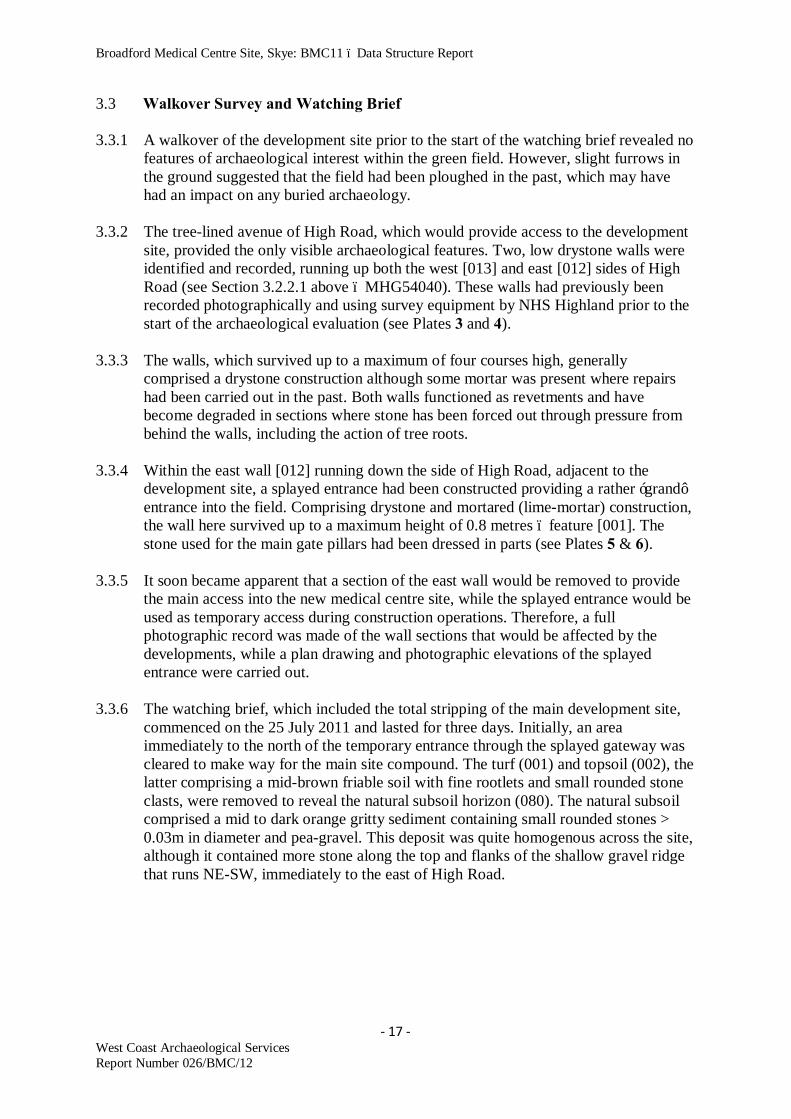
3.3 Walkover Survey and Watching Brief 3.3.1 A walkover of the development site prior to the start of the watching brief revealed no
features of archaeological interest within the green field. However, slight furrows in the ground suggested that the field had been ploughed in the past, which may have had an impact on any buried archaeology.
3.3.2 The tree-lined avenue of High Road, which would provide access to the development
site, provided the only visible archaeological features. Two, low drystone walls were identified and recorded, running up both the west [013] and east [012] sides of High Road (see Section 3.2.2.1 above – MHG54040). These walls had previously been recorded photographically and using survey equipment by NHS Highland prior to the start of the archaeological evaluation (see Plates 3 and 4).
3.3.3 The walls, which survived up to a maximum of four courses high, generally
comprised a drystone construction although some mortar was present where repairs had been carried out in the past. Both walls functioned as revetments and have become degraded in sections where stone has been forced out through pressure from behind the walls, including the action of tree roots.
3.3.4 Within the east wall [012] running down the side of High Road, adjacent to the
development site, a splayed entrance had been constructed providing a rather ‘grand’ entrance into the field. Comprising drystone and mortared (lime-mortar) construction, the wall here survived up to a maximum height of 0.8 metres – feature [001]. The stone used for the main gate pillars had been dressed in parts (see Plates 5 & 6).
3.3.5 It soon became apparent that a section of the east wall would be removed to provide
the main access into the new medical centre site, while the splayed entrance would be used as temporary access during construction operations. Therefore, a full photographic record was made of the wall sections that would be affected by the developments, while a plan drawing and photographic elevations of the splayed entrance were carried out.
3.3.6 The watching brief, which included the total stripping of the main development site,
commenced on the 25 July 2011 and lasted for three days. Initially, an area immediately to the north of the temporary entrance through the splayed gateway was cleared to make way for the main site compound. The turf (001) and topsoil (002), the latter comprising a mid-brown friable soil with fine rootlets and small rounded stone clasts, were removed to reveal the natural subsoil horizon (080). The natural subsoil comprised a mid to dark orange gritty sediment containing small rounded stones > 0.03m in diameter and pea-gravel. This deposit was quite homogenous across the site, although it contained more stone along the top and flanks of the shallow gravel ridge that runs NE-SW, immediately to the east of High Road.

Broadford Medical Centre Site, Skye: BMC11 – Data Structure Report
- 18 - West Coast Archaeological Services Report Number 026/BMC/12
Plate 3 (left) – Feature [013] boundary wall running up the NW side of High Road; and
Plate 4 (right) boundary wall Feature [012] bounding the SE side of High Road
Plate 5 & 6 (above) – Splayed entrance Feature [001] viewed from the NW
Plate 7 – View SW over the development site before the start of the watching brief

Broadford Medical Centre Site, Skye: BMC11 – Data Structure Report
- 19 - West Coast Archaeological Services Report Number 026/BMC/12
Figure 3 – Location of major archaeological features within area of watching brief

Broadford Medical Centre Site, Skye: BMC11 – Data Structure Report
- 20 - West Coast Archaeological Services Report Number 026/BMC/12
Plate 8 – Stone-filled field drains [007] and [011] looking SE (left); and Plate 9 – ESE
facing section through field drain [007] and pit feature [015] 3.3.7 Within this area a series of stone-filled field drains were revealed - features [002],
[003], [004], [005], [006], [007] and [011], generally running in a NW-SE direction. The cuts for the drains varied in width from 0.2 to 0.5 metres, while they achieved a maximum depth of 0.3 metres. The drains had been cut into the natural subsoil/gravel (080) and were filled with sub-angular stone clasts > 0.1 metres across, which had most likely been imported into the site. It is notable that field drains were only found in the NE sector of the development site, on the higher ground. No drains were uncovered on the lower ground at the SW end of the development, where drainage would have been more of a problem.
3.3.8 Three amorphous-shaped features [008], [009] and [010] were uncovered close to the
southern boundary of the development site, containing black gritty sediment fills with what appeared to be burnt fragments of stone - contexts (005), (006) and (010). Excavation of the features revealed homogenous fills with no small finds or visible charcoal samples. Bulk samples were taken however for further analysis.

Broadford Medical Centre Site, Skye: BMC11 – Data Structure Report
- 21 - West Coast Archaeological Services Report Number 026/BMC/12
Plate 10 – Amorphous shaped pits [008] and [009] with black fills in the south sector of
the site before excavation
Plate 11 – Pit feature [010] after section excavation showing homogenous fill
Broadford Medical Centre Site, Skye: BMC11 – Data Structure Report
- 22 - West Coast Archaeological Services Report Number 026/BMC/12
3.3.9 As the ground was cleared to the N and NW of these three features, more amorphous-shaped dark stains were revealed. Some of these appeared to be quite large spreads of material, especially in the SW corner of the site and along the summit of the gravel ridge south of the temporary entrance into the development site. The features were marked for future investigation, while the final clearance of the site took place along the gravel ridge.
3.3.10 All of the major features uncovered at the Broadford Medical Centre development site
were revealed in a distinct cluster towards the highest section of the gravel ridge, immediately south of the temporary entrance. The excavator bucket started to contact larger stones, some of which were located just below the turf (001), so we started to remove the overburden in shallow spits. A large spread of boulders and smaller stone was revealed on the summit of the gravel ridge, adjacent to the temporary entrance [037], which had a mid-brown sediment matrix (060) containing a few sherds of modern ceramic and glass. Large, amorphous-shaped areas of dark black sediment were uncovered surrounding the feature, the sediment make-up looking similar in appearance and texture to the potential features identified to the south (see Section 3.3.8 and 3.3.9 above). The dark staining became more fragmented and formed more distinct features moving off the summit of the gravel ridge and away from the spread of stone forming feature [037].
3.3.11 Moving south from the stone and soil spread forming feature [037], several more
distinct features were identified including a large circular pit [026] with a fill containing fire-cracked stone, stone and charcoal (074); an large amorphous-shaped feature [027] with a fill containing some larger stone, fire-cracked stone and charcoal (072); an oval setting of thin upright stone slabs with a central capstone slab - feature [024], context (067), with a dark brown loam matrix (068) containing some charcoal and burnt bone; and a long linear feature aligned NNW-SSE comprising a cut into the natural subsoil (080) around 1.2m wide and lined with stone - feature [025]. Feature [025] was slightly curved, had rounded ends and contained a mixed mid-brown sediment (002) and (054) containing some larger stone clasts, fragments of fire-racked stone and a few charcoal flecks.
Plate 12 – View N up the development site after topsoil stripping towards the site entrance and location of the major features

Broadford Medical Centre Site, Skye: BMC11 – Data Structure Report
- 23 - West Coast Archaeological Services Report Number 026/BMC/12
Plate 13 – View WSW over site showing spread of possible robbed cairn feature [037] 3.3.12 After a primary clean of the features using a draw-hoe and trowel, we could almost be
certain that feature [024] was the remains of a stone-lined grave or cist of possible Early Bronze Age date, while the linear feature [025] was a backfilled souterrain from which the stone lintels had already been robbed away (unless the structure had possibly had a wooden roof). The identification of these important archaeological features, along with the other potential pits, spreads of black residues and the larger spread of stone and sediment [037], suggested that we now had a find of major importance. We therefore contacted Andrew Puls of Highland Council’s Historic Environment Team and the client, NHS Highland, to seek further guidance and a way forward with the project work.
3.3.13 A site visit by Andrew Puls of the Historic Environment Team and John Hornby and
Heather Cameron of NHS Highland resulted in a decision to fully excavate and evaluate the archaeological features identified at the Broadford Medical Centre development site. Therefore, additional fieldworkers were contracted in to undertake the excavations, which took place between the 29 July and 20 August 2011.
3.3.14 All of the major features were initially cleaned of overburden to provide a clear
outline of their full extent and were planned at a scale of 1:20. This provided a master

Broadford Medical Centre Site, Skye: BMC11 – Data Structure Report
- 24 - West Coast Archaeological Services Report Number 026/BMC/12
plan of the site, to which smaller additional features and detail were annotated as the project progressed. The individual features were also recorded with high-resolution digital cameras. The locations of the major features are shown in Figure 4, while digital images are also included below of the features prior to excavation proceeding. Details relating to the excavation of the individual features, including plan and section drawings, can be found in Section 3.4 of this report.
Figure 4 – Pre-excavation plan of major features within development area

Broadford Medical Centre Site, Skye: BMC11 – Data Structure Report
- 25 - West Coast Archaeological Services Report Number 026/BMC/12
Plate 14 – Cist feature [024] looking SE
Plate 15 – Stone-lined souterrain feature [025] looking ESE

Broadford Medical Centre Site, Skye: BMC11 – Data Structure Report
- 26 - West Coast Archaeological Services Report Number 026/BMC/12
Plate 16 – Grain-drying kiln complex feature [027] looking NW
Plate 17 – Grain storage pit feature [026] looking SW

Broadford Medical Centre Site, Skye: BMC11 – Data Structure Report
- 27 - West Coast Archaeological Services Report Number 026/BMC/12
3.4 Excavation
The excavations at the development site of the new Broadford Medical Centre were carried out in mixed weather conditions including fine, dry and sunny days, and some very wet and windy days. Pre-excavation cleaning of all features took place and a detailed plan drawing was carried out at a scale of 1:20, covering the main areas of the site (Areas 1 and2). Features were then labelled with plastic tags and a full photographic record made of the site. The following sections provide details relating to the individual excavated features.
3.4.1 Feature [024] – Stone-Lined Grave/Cist 3.4.1.1 When first revealed during the watching brief phase of works this feature appeared to
be an undisturbed cist, complete with a capstone tilting at a slight angle to the east. However, the capstone rested completely within the upright side slabs, with no part of the capstone resting on the side slabs. The cut (156) for the feature could be clearly seen and some upright thin slabs (067) could be seen protruding through the upper fill (068). A few fragments of burnt bone and charcoal were recovered from the surface of the context.
3.4.1.2 After cleaning the feature and recording the visible stone components and contexts,
we lifted the small, flat capstone (067). This did not reveal a void below, but rested directly on a gravel fill (069). This upper fill of the cist appeared remarkably sterile and clean, and this was removed to reveal a lower gravel deposit with a dark brown silt matrix (079) and what appeared to be collapsed capstone or corbelling slabs.
Plate 18 (left) – Cist [024] after removal of capstone (067) looking SW; Plate 19 (right) – Mid-excavation image showing collapsed capstones (169) in base of cist [024] overlying fill (079) looking SW

Broadford Medical Centre Site, Skye: BMC11 – Data Structure Report
- 28 - West Coast Archaeological Services Report Number 026/BMC/12
Figure 5 – Plan of stone-lined grave / cist feature [024] mid-excavation showing collapsed capstones (169) and location of section line M-N 3.4.1.3 Removal of the collapsed slabs and context (079) produced the first finds from the
cist, several fragments of All Over Cord Beaker including a rim fragment. However, with the careful removal of a thin spit of context (079), the more substantial remains of what appeared to be an in-situ broken Beaker appeared, in a central position towards the NE end of the cist. The matrix within the gravel context also became darker, possibly indicating the completely decayed remains of a body and, or organic

Broadford Medical Centre Site, Skye: BMC11 – Data Structure Report
- 29 - West Coast Archaeological Services Report Number 026/BMC/12
grave goods. Therefore, it was decided to lay out a grid within the interior of the cist using 0.2m squares, to assist with the control of 100% bulk sampling of the lower cist fill. This would also allow a more controlled approach during the post-excavation phase of the project work.
Plate 20 – Crushed remains of AOC Beaker emerging from (069) in feature [024] (left); Plate 21 (right) – Cist [024] after removal of collapsed capstones (169) looking SE
Plate 22 – Crushed AOC Beaker in base of cist [024] looking NE

Broadford Medical Centre Site, Skye: BMC11 – Data Structure Report
- 30 - West Coast Archaeological Services Report Number 026/BMC/12
Figure 6 – SW facing section through cist [024] showing location of Beaker SF.34
Plate 23 (left) – Cist feature [024] looking NE showing exposed degraded second Beaker overlying basal gravel (108); Plate 24 (right) – Closer view of degraded Beaker looking NW, lying adjacent to side slabs of feature [024]

Broadford Medical Centre Site, Skye: BMC11 – Data Structure Report
- 31 - West Coast Archaeological Services Report Number 026/BMC/12
3.4.1.4 The AOC Beaker was revealed with the removal of context (079), but the gravel content of the context did not allow the lifting of the vessel in a block of sediment. Therefore, the Beaker was raised complete with the accompanying fill, wrapped securely in acid-free paper and aluminium foil, and was then placed in a plastic box. No additional grave goods were found associated with the vessel, or any human bone, with the exception of one fragment of worked pumice (SF.023). However, with the removal of more of the fill from the base of the cist, the very- degraded remains of a second ceramic vessel were revealed – located at the NW side of cist. The vessel, the potential remains of a second Beaker, had been severely crushed, possibly by one of the collapsed capstones. The vessel also appears to have been poorly fired.
3.4.1.5 A close scrutiny of the contexts suggested that both pots had been placed on the basal
deposit of the cist (108), although their deposition may not have been contemporary. The vessel was raised in a block of gravel sediment and was then packaged for safe keeping.
3.4.1.6 After the final deposits of context (079) and (108) - the basal deposits in the cist - had
been removed, the cist was recorded before marking and dismantling of the upright side slabs took place. The marking of the slabs was undertaken with the long-term view of reconstructing the cist in the car park or foyer of the new medical centre building. The upright slabs had been fitted tightly up against the cut (156) of the original pit to house the cist, with a minimal amount of sediment (068) filling the gap between the slabs and the cut.
Plate 25 (left) – Cist feature [024] after removal of basal deposits (079) and Beaker’s; and Plate 26 (right) – The cut (156) for cist [024] after removal of the structure and all associated deposits

Broadford Medical Centre Site, Skye: BMC11 – Data Structure Report
- 32 - West Coast Archaeological Services Report Number 026/BMC/12
3.4.2 Feature [025] – Stone-Lined Souterrain 3.4.2.1 The preliminary cleaning of this feature during the end of the watching brief phase of
the site works revealed a slightly curved cut (053)/(167), aligned NNW-SSE, with intermittent alignments of stone within the cut (stone wall-heads). The SSE end of the feature had a stone-lined rounded end – feature [067], while the NNW end had a tapered appearance with no stone visible (see Figure 4). The upper fill (002) and (062) comprised a mid to dark brown friable sediment containing some medium stone clasts, charcoal flecks and the odd fragment of fire-cracked stone. Small finds from this deposit included several sherds of relatively modern pottery, a small whetstone (also fairly recent in date) and one sherd of possible prehistoric pottery. This deposit was most likely contemporary with the robbing of the lintels from the roof of the structure and backfilling that followed.
3.4.2.2 After cleaning and pre-excavation recording of the souterrain had taken place, section
lines were set out across the width of the feature dividing it into six trenches (Trenches 25A to 25F). Trenches 25A and 25B were excavated through the feature to the natural subsoil to provide an initial assessment of the fills and any occupation horizons that may have survived. The trenches also allowed a preliminary assessment to be made to investigate the depth and integrity of side walls of the souterrain and any possible associated features. Trenches C, D, E and F were excavated longitudinally down the approximate centre-line of the souterrain, with half of the fill of the trench being removed, sections drawn, after which the remaining half of the deposits were removed. This methodology allowed sections to be recorded across the width of the feature and along most of its centre-line, providing information relating to floor horizons and the manner in which the structure was backfilled.
3.4.2.3 As would be expected for such a complex feature such as a souterrain, the individual
trench sections displayed stratigraphy that varied along the width and length of the structure. However, it was possible to identify two distinct ‘floor’ horizons and episodes of silting and backfilling, all of which contained a spread of small finds including ceramics, coarse pebble tools and one snapped flint blade.
3.4.2.4 After removal of the mixed plough-soil and backfill deposits from the top of the
souterrain (002) and (062), a backfill horizon was encountered comprising a mid to dark brown loam with loosely compacted gravel and some medium to large stone clasts (063)/(094) and (166). The stone and associated deposits in these contexts may relate to the robbing of the lintels from the souterrain. Larger stone (165) was uncovered protruding through the base of these contexts and along with the associated sediments (054) proved to be a major backfilling event that took place when the structure was finally abandoned. These backfill deposits were concentrated towards the centre section of the souterrain and at the SSE end within terminal cell feature [067] - (Trenches A, D and F). Context (054) consisted of mid-brown sediments with gravel inclusions and charcoal lumps and flecks, while the associated stone clasts (165) included individual boulders and slabs of basalt up to 0.7 metres across.
3.4.2.5 Archaeological deposits that were most likely associated with this major backfilling
event also included contexts (064), (065) and (093b), which were only identified in Trenches F, B and E (within the NNW half of the structure). The matrix of the contexts comprised a dark brown to black silt with gravel inclusions, small stone

Broadford Medical Centre Site, Skye: BMC11 – Data Structure Report
- 33 - West Coast Archaeological Services Report Number 026/BMC/12
clasts > 0.1 metres across and a significant amount of fire-cracked stone. Charcoal lumps and flecks were also present, although these inclusions were most concentrated towards the NNW end of the souterrain. Several sherds of possible prehistoric pottery were recovered from this horizon along with a cobble tool.
Figure 7 – Souterrain [025], associated features and storage pit [026] showing section
lines 3.4.2.6 Below contexts (054) and (165) in Trench D, within the SSE terminal of the
souterrain, layers of stone slabs (121) were revealed along with an associated mid-brown silt containing charcoal flecks (122). The stone slabs are the remains of corbelling and potential roof structure from the terminal cell of the souterrain [067], while the matrix relates to silting around the stones. These deposits were found directly overlying a mid-to dark brown sediment (123) containing numerous charcoal flecks and gravel inclusions. To the NNW, below contexts (054), (165), (064), (065) and (093b), this deposit continued (055)/(071)/(093a)/(096) forming what appeared to be an upper floor horizon in the structure. The floor horizon and associated deposits produced numerous sherds of Iron Age pottery, some of which was decorated with

Broadford Medical Centre Site, Skye: BMC11 – Data Structure Report
- 34 - West Coast Archaeological Services Report Number 026/BMC/12
applied roundels, especially within the NNW terminal of the structure (Trench C) and within Trenches E and B. Charcoal and fire-cracked stone was also present in large quantities with the ceramics (093a) and (096), while at least three cobble tools were also recovered. Lying on the floor horizon in Trench F and directly underlying a large basalt boulder (165), the substantial remains of a large globular pot with a flared everted rim and two applied cordons were found. Although the pottery from the site awaits a full analysis at the National Museums Scotland by Dr. Ann MacSween, on typological grounds and dated examples from the excavated settlement of Eilean Olabhat in North Uist, in the Western Isles of Scotland, the pot dates to between the 5th and 7th centuries AD (Armit, 2008:72-4; Armit, 2006:126-7).
Plate 27 – View SSE over souterrain [025] during section excavation

Broadford Medical Centre Site, Skye: BMC11 – Data Structure Report
- 35 - West Coast Archaeological Services Report Number 026/BMC/12
Figure 8 – Trench E (SE facing O-P) and B (ESE facing Q-R) sections through souterrain [025]
3.4.2.7 Below the upper floor horizon, another series of backfill deposits was identified (056)/070)/(097), generally comprising loosely compacted gravel with an orange to brown silt matrix. Unlike the major backfilling event discussed in Section 4.4.2.4 above, these deposits generally formed a layer of material that was quite even in depth, although some tip and silting lines were recognised. The context became more compact towards its base and several sherds of Iron Age pottery were recovered,

Broadford Medical Centre Site, Skye: BMC11 – Data Structure Report
- 36 - West Coast Archaeological Services Report Number 026/BMC/12
although these most likely relate to the interface with the primary floor deposits below.
3.4.2.8 The primary floor deposits identified in the base of the souterrain including contexts
(057)/(073)/(098)/(125), consisted of gravels with a mid to dark brown silt matrix and also including a few charcoal flecks. The deposit was quite worn and degraded, with the darker silt grading out with depth to clean basal gravels below (080). At the ESE end of the souterrain, several features were identified that most likely relate to the Phase 1 structure, some of which had been robbed away – most likely prior to the extending of the souterrain to the ESE with the construction of the corbelled cell feature [067]. The features included a pillar stone measuring 0.7 metres high - feature [047] adjacent to the SW wall of the souterrain in Trench D, a single row of paving slabs (124) extending from the ESE wall of the terminal cell to the pillar stone, and an alignment of three upright boulders - feature [066] set into the souterrain basal deposits adjacent to the NE wall of the souterrain at the transition between Trenches A and D. The features may relate to an original entrance at the ESE end of the souterrain, prior to the construction of the terminal corbelled cell [067]. A close examination and recording of the upstanding walls of the structure support this interpretation, the terminal cell displaying a quite different and improved construction technique than the side walls of the Phase 1 souterrain recorded elsewhere [025]. Ceramics were recovered from Trench A and B, while a group of ceramic sherds most likely originating from one vessel were found on the paving (124) at the ESE end of the terminal cell [067].
Plate 28 – The ramped entrance of souterrain [025] after section excavation looking SE
showing the wall configuration at the ramped entrance

Broadford Medical Centre Site, Skye: BMC11 – Data Structure Report
- 37 - West Coast Archaeological Services Report Number 026/BMC/12
Figure 9 – Trench A (SSE facing S-T) and D (SSE facing U-V) sections through
souterrain [025] 3.4.2.9 During the initial recording of the souterrain, an additional widening of the cut (081)
and associated fill (058) suggested a possible modification to the structure, or a potential former, blocked entrance on the NE side. A part of the souterrain wall adjacent to the feature also suggested a possible blocked entrance with two ‘butt’ joints clearly visible approximately 0.6 metres apart. Excavation of the feature including a section through the NE wall of the souterrain showed that the construction of the passage had truncated an earlier grain storage pit (see Section 3.4.4) – feature [035]. The combination of the location of the pit and alignment of the souterrain,

Broadford Medical Centre Site, Skye: BMC11 – Data Structure Report
- 38 - West Coast Archaeological Services Report Number 026/BMC/12
along with the section of souterrain wall that resembled a ‘blocked’ entrance, presents many avenues of potential interpretation.
3.4.2.10 After a full recording of the excavated souterrain had been carried out, including
wall elevations and a detailed post-excavation plan, sections were taken through the souterrain walls and associated cuts and fills at various locations. The cuts for the Phase 1 (053) and Phase 2 (167) souterrain into the natural gravels (080) were almost vertical and the walls of the structure had been fitted tightly against them. Where a fill or silting deposit could be identified (133)/(168), this comprised a mid to light brown silt matrix within gravel. The time lapse between the cutting of the trench for the souterrain and the construction of the side walls must have been minimal, as the natural gravel deposits (080) would have been prone to collapse and run-in.
3.4.2.11 The profile of the excavated souterrain floor starts with a shallow, scooped entrance
at the NNW end, after which two sloping steps had been cut into the basal gravels. These steps would have been necessary to provide the height required to access the structure below the lintel slabs. However, even with the steps, the maximum height of the passage at the entrance could not have been more than 0.7 to 0.9 metres, necessitating a crouched entry. The floor then gradually fell away traversing the passage to the ESE to attain a maximum height of approximately 1.3 metres in the central section of the structure; or towards what may have been the original entrance at the ESE end of the Phase 1 souterrain before construction of the terminal cell [067]. The side walls of the terminal cell extend to a maximum height of 0.9 metres, but we cannot be sure what the corbelled roof of the cell looked like, or to what height it extended.
3.4.2.12 With regards to the initial construction of the souterrain, in particular the cut for the
foundation trench into which the walls would be constructed, the shape and form of the shallow, scooped entrance at the NNW end deserves further comment. In plan, digital images and the drawing showing this feature indicate a possible re-cutting of an earlier feature – possibly a pit. Such a feature would provide a useful existing cut into which the souterrain entrance could be located. Unfortunately, due to the sub-soil/gravel deposits (080) into which both features would have been cut, it was impossible to see any actual re-cuts or associated fills in section. Therefore, this possible interpretation for the re-cutting of an earlier feature remains speculative.
3.4.2.13 With the initial backfilling of the souterrain and formation of the upper floor
horizon, the internal space and height within the structure would have become even more limited. The height in the deepest section of the passage would have been reduced to between 0.6 and 0.8 metres, although the ‘crawl’ through such a passage may have emerged into the more spacious corbelled cell at the ESE terminal. A full and detailed analysis of the ceramics recovered from the souterrain along with a series of radiocarbon dates from the primary and secondary floor horizons should provide us with the necessary chronology to allow a more detailed interpretation for the function of the structure to be put forward.

Broadford Medical Centre Site, Skye: BMC11 – Data Structure Report
- 39 - West Coast Archaeological Services Report Number 026/BMC/12
Plate 29 – ESE end of souterrain [025] showing possible earlier phases of construction
including pillar stone [047], alignment of four foundation stones [066] and paving [124]; plus later terminal cell [067]

Broadford Medical Centre Site, Skye: BMC11 – Data Structure Report
- 40 - West Coast Archaeological Services Report Number 026/BMC/12
Plate 30 – View ESE through Trench F in souterrain [025] showing remains of large
ceramic vessel below blocking infill on upper floor horizon
Plate 31 – Vertical image of SW wall-head of [025] showing close fitting of stone to cut

Broadford Medical Centre Site, Skye: BMC11 – Data Structure Report
- 41 - West Coast Archaeological Services Report Number 026/BMC/12
Plate 32 – Post-excavation image of souterrain [025] looking NNW

Broadford Medical Centre Site, Skye: BMC11 – Data Structure Report
- 42 - West Coast Archaeological Services Report Number 026/BMC/12
3.4.3 Feature [027] – Grain-Drying Kiln Complex and Grain Storage Pit F059 3.4.3.1 Feature [027] is a complex group of intercutting and recut pits, some of which can be
assigned functions by nature of their form, structure and contents, and some of which remain enigmatic, resisting definitive interpretation (see Figure 10).
3.4.3.2 The earliest feature in the group is a circular pit [059] that has been cut into the
natural gravel (080) and is 1.4m in diameter with near vertical sides and a flat base – cut (155). Basal residues in the pit (154) include burnt organics with possible barley grain. The pit had been cut to a maximum of 0.8 metres deep. The upper fill of the pit including contexts (151)/(152)/(153) includes a dark brown loam with traces of peat ash and charcoal lumps and flecks. Stones within the fill, some of them large (up to 25 kilos), and the presence of many voids between these stones indicates that the fill was essentially a single event rather than a gradual silting, where voids would not occur. The presence of different contexts in the fill suggests that possibly more than one person took part in the back-filling process - probably from different sides of the pit - and that the fill itself came from more than one source.
3.4.3.3 Phase 1 of the grain drying kiln is formed by a deep cut (162) into the upper fill of the
storage pit [059], which has been filled with a bedding matrix (115)/(150) into which substantial flat-faced stones (117) have been set to form the stone bowl for the drying chamber for the kiln – feature [063]. The outer stones appear to have been bedded on edge to form sides to the chamber – one at the east survives in situ, while the neighbouring stone to the south appears to have toppled inwards. At the SSE end of the bowl, a clay blocking collar (109) runs across the bowl. Small stones (110) are set into this to consolidate the clay until it hardened from heating in use. Finally a mid-brown silty loam soil deposit (116) is inserted as packing between the outer edge of the structural stones (117) and the edge of the cut (162). Although a later cut (160) of feature [062] has eradicated much of the evidence for the Phase 1 kiln fire-pit, it seems clear that the circular cut 0.5m in diameter in feature [062] is the lower part of the original fire-pit. This is deeper and 0.5m to the SSE of the clay collar, further removed from the drying chamber than would be usual. This may have been an attempt by the designers to reduce the risk of fire spreading to the drying chamber. It may also provide a clue to the reason for the multi-phase nature of the overall feature.
3.4.3.4 Evidence for the Phase 2 grain drying kiln [064] consists of the apparent removal of
stones (117) from the base of the Phase 1 kiln at the end of the drying bowl nearest to the fire-pit, to form a fresh cut (163) extending northwards to meet fire-cracked stones (117) that remain in situ. Subsequent deposits laid down sequentially including contexts (107), (105) and (104) contain varying amounts of charcoal and peat ash. Context (104) has significant quantities of peat ash and a clear lens of charcoal rich material within the context, which could be seen in section. The latest context in the feature, (126), is a thin layer of carbonised grain trapped between context (104) and the clay blocking collar of the Phase 3 kiln [065]. It appears that the contexts in the Phase 2 kiln result from active use of the feature and may result from the difficulty of cleaning out an earth-cut rather than a stone-lined drying bowl. As there is no evidence for a Phase 2 fire-pit, it seems likely that the Phase 1 fire-pit was still in use at this time and that Phase 2 was an attempt to make the existing kiln work more efficiently. Faced with a kiln which is working inefficiently, there are two options for

Broadford Medical Centre Site, Skye: BMC11 – Data Structure Report
- 43 - West Coast Archaeological Services Report Number 026/BMC/12
improvement – do something about the fire, or do something about the drying chamber.
Figure 10 – Plan of grain-drying kiln complex [027] and section line (see Figure 11) 3.4.3.5 A shallow pit feature [062] extending SSE of the kiln re-cuts (160) the drying
chamber of the Phase 1 and 2 kilns, as well as removing most of the fire-pit associated with these phases. The pit has a single homogeneous fill (101)/(113) comprising a mid-brown loam containing charcoal lumps and flecks, peat ash, burnt grain and pottery fragments, at least one of which appeared to be Bronze Age (Beaker). However, no evidence was obvious as to the source of the fill, so this may not be significant. It is notable that the fill is also the same as the fire-pit (within [062]) and that it does contain some carbonised grain. The stone found at the base of the fire-pit and the stones (161) set into the top of the fill (101) have the same characteristics as

Broadford Medical Centre Site, Skye: BMC11 – Data Structure Report
- 44 - West Coast Archaeological Services Report Number 026/BMC/12
the stones (117) forming the drying bowl of kiln feature [063]. They may represent robbed stones from the drying bowl being used respectively to symbolically close the Phases 1 and 2 fire-pits and to provide a working surface on top of context (101) to allow operation of the Phase 3 kiln.
3.4.3.6 There is no proof of an actual cut between the Phase 2 kiln [064] and Phase 3 kiln
[065], but the clay blocking collar (103) provides a clear separation above (126) and (104) of [064] and the cut (164) of the Phase 3 kiln. This phase represents a major reduction of scale in the grain drying operation in the complex, including bringing the fire-pit within the former drying chamber with a small clay blocking collar across the centre of the former chamber. To the north of the blocking collar the layer of peat ash (102) presumably dates from use of the kiln, but layer (095) above that appears to be an abandonment deposit comprising a peat ash and charcoal-rich sediment. The fire-pit, such as it is, lies to the south of the clay and has been scoured out after use and primary deposits removed.
Plate 33 – Phase 3 grain-drying kiln feature [065] within grain storage pit [059] 3.4.3.7 Additional features comprising the kiln complex include a shallow pit [061] which is
defined to the west by cut (159), while the eastern edge of the pit has been lost due to the cutting of feature [062]. The pit contained a single homogenous fill (100) comprising a dark brown silt containing fragments of burnt stone and some charcoal lumps. The pit has no known function. A second shallow pit feature [060] was located to the west of feature [061], by which it had been partially removed; while the west side of the feature was defined by cut (158). The pit contained a single fill (099)

Broadford Medical Centre Site, Skye: BMC11 – Data Structure Report
- 45 - West Coast Archaeological Services Report Number 026/BMC/12
comprising a dark brown to black, charcoal-rich sediment containing significant quantities of burnt grain. Although the function of the feature remains unknown, the fill including burnt grain suggests it was at least connected in some way with the processes associated with the grain drying kiln.
3.4.3.8 After the abandonment of the kiln complex, a levelling layer of material (072) was
spread over all of the features with the exception of the vertical-sided fire-pit. The deposit comprised a brown to black loam containing stone clasts, burnt stone, peat ash, charcoal and carbonised grain in large quantities. The small finds recovered from the deposit included daub and a number of pottery sherds, including at least one fragment from a Beaker (AOC?). The deposit most likely originated from a spoil heap resulting from active use of the kiln complex. Survival of this layer shows that subsequent ploughing has not truncated any of the features in the kiln complex.
3.4.3.9 Finally, a shallow pit feature [045] with cut (157) was found to cut deposit (072) at
the west end of complex F027. The pit was not connected stratigraphically to any other feature in the complex, making any functional link with the kiln complex difficult. The single fill of charcoal rich soil (114) contained small stone clasts. It is possible that the feature may have comprised a later fire-pit, or was merely a useful receptacle for kiln waste.
Plate 34 – Kin complex [027] looking NNW with fire-pit in foreground and drying chamber top-right. Shallow pit features [060], [061] and [062] have been partially excavated at bottom left

Broadford Medical Centre Site, Skye: BMC11 – Data Structure Report
- 46 - West Coast Archaeological Services Report Number 026/BMC/12
Plate 35 – Close view of burnt grain deposits in feature [060] (kiln complex [027])
Figure 11 – Section drawing C-D through grain storage pit [059] and grain drying kiln complex [063], [064] and [065]

Broadford Medical Centre Site, Skye: BMC11 – Data Structure Report
- 47 - West Coast Archaeological Services Report Number 026/BMC/12
3.4.4 Features [026] and [035] – Grain Storage Pits
3.4.4.1 In addition to the grain storage pit [059] that had been used in a later phase to house the bowl of the grain-drying kiln complex [027], two further grain storage pits were identified and excavated at the site. Pit feature [026] was located just 1.2m to the E of the cut for the souterrain and 1.4m to the NE of storage pit [035], which had been truncated by the cut and construction of the souterrain [025] – see Figure 4.
3.4.4.2 Feature [026] appeared after preliminary cleaning as a sub-circular cut (075) into the
natural sub-soil/gravel (080), with a mixed fill including (074) – an brown, charcoal-rich sediment containing fire-cracked stone, some un-burnt stone clasts and burnt bone fragments; and (076) – a dark brown to black sediment containing fire-cracked stone, some un-burnt stone and charcoal lumps and flecks. In the centre of the pit was a larger basalt stone.
3.4.4.3 After preliminary cleaning and recording of feature [026] sections lines were laid out
in a cross and opposing quadrants were initially excavated. The excavation showed that context (076) was only present as a distinct patch of material within the SE sector of the upper fill of the pit and context (074) comprised the main fill of the feature. Stone content varied throughout this fill, the main concentration of larger, un-burnt basalt boulders and medium-sized stones within the N, NW and W sector of the pit. Removal of context (074) including the associated stone fill (074b) revealed several large stones, some of which showed evidence for burning (074c), and abutting and surrounding these stones was a dense and thick deposit of bright orange peat ash (077a).
3.4.4.4 At the very base of the pit, below contexts (074c) and (077a), and overlying the cut of
the pit (075), was a thin black primary silt deposit containing charcoal flecks and lumps, burnt grain (primarily barley) and other burnt organic residues (077b). This deposit is possibly the only material relating to the actual use of the pit for storage, or may be associated with the final closure of the feature at the end of its use. Upon completion of the excavation of feature [026], the resulting cut for the pit in the sub-soil/gravel base (080) was circular in plan (approximately 1.5 metres in diameter) and had steep sides with a fairly flat base (up to 0.9 metres deep).
3.4.4.5 Storage pit feature [035] had been truncated by the cut (053) and construction of the
souterrain wall, feature [025]. After preliminary cleaning the cut for the pit (081) appeared as a sub-circular arc to the SE of the souterrain measuring 1.6 metres NW-SE, and had a fill comprising a mid to dark brown charcoal-rich fill (058) with some flecks of peat ash, fire-cracked stone and some un-burnt stone. This fill abutted the souterrain wall [025] and appeared to be a mixed deposit resulting from a secondary fill of the pit and backfill deposits within the construction cut for the souterrain wall.
3.4.4.6 Context (058) directly overlay a light brown silt (131) containing some gravel,
charcoal flecks and fragments of heavily burnt or cremated bone. This context became more mixed at its base where it ran over the cut for the souterrain wall, possibly representing slumping of this deposit during the construction of the souterrain wall [025]. A halo of peat ash was observed between this deposit and the cut (081) of the pit, but this became less distinct with depth.

Broadford Medical Centre Site, Skye: BMC11 – Data Structure Report
- 48 - West Coast Archaeological Services Report Number 026/BMC/12
Figure 12 – Section A-B through grain storage pit [026]
Plate 36 – View NE over storage pit [026] during section excavation showing the various
fill deposits

Broadford Medical Centre Site, Skye: BMC11 – Data Structure Report
- 49 - West Coast Archaeological Services Report Number 026/BMC/12
Plate 37 – Grain storage pit [026] showing primary deposits of peat ash and burnt grain
Plate 38 – Souterrain [025] truncating grain storage pit [035] – also showing what
appeared to be a blocked entrance in the souterrain wall (right of pole)

Broadford Medical Centre Site, Skye: BMC11 – Data Structure Report
- 50 - West Coast Archaeological Services Report Number 026/BMC/12
Plate 39 – Section E-F through grain storage pit [035] and souterrain wall [025] 3.4.4.7 At the base of the pit, the primary fill comprised a dark brown to black charcoal-rich
deposit, which became darker towards the base of the fill overlying the cut (081). The fill contained some charcoal lumps and flecks, and a few fragments of heavily burnt or cremated bone. At the interface with the cut, the deposit also became more compact and contained burnt grain (barley) and other burnt organic residues. This material may relate to the function of the pit for storage, or may have been associated with the final closing of the pit feature [035] at the termination of its use. The cut for the construction trench for the souterrain (053) could be clearly seen in section through this context. The sides of pit feature [035] were almost vertical and up to 0.7 metres deep, while the base sloped gently down to the SW.
3.4.4.8 Although this feature had almost certainly been used as a grain storage pit at some
stage in its history, with evidence for burnt barley grain in the primary fill as with storage pits [026] and [059], the shape of pit [035] appeared to be more elongated NW-SE and was slightly shallower in depth. Therefore, there is always a possibility that this feature may originally have been a cut for a grave of similar age to the stone-lined grave feature [024]. This is merely speculation at this stage and we will have to await analysis on the recovered sediment samples and the fragments of heavily burnt or cremated bone from the fill of the feature.
3.4.4.9 One other interesting fact to note with regards to pit [035] is the manner in which the
souterrain walls [025] had been constructed where they had truncated this earlier feature (see Section 3.4.2.9). Adjacent to the pit, the walls displayed two vertical butt-joints around 0.6 metres apart, which appeared to represent a former, blocked entrance to the souterrain. However, the excavation of pit [035] and the wall of the souterrain at this point showed that this was not the case. Therefore, did the ‘blocked’

Broadford Medical Centre Site, Skye: BMC11 – Data Structure Report
- 51 - West Coast Archaeological Services Report Number 026/BMC/12
entrance form a symbolic doorway to a feature of the past and used by the ancestors – whether this original feature was remembered as a former burial, or merely an earlier form of storage unit?
Figure 13 – Section drawing on E-F through grain storage pit [035] and wall of souterrain [025] 3.4.5 Feature [037] – Possible Denuded Cairn and Associated Features 3.4.5.1 One of the most enigmatic and difficult features to interpret at the Broadford Medical
Centre site is feature [037], which originally appeared as a large, amorphous-shaped mound of stone located on the highest part of the gravel ridge within the investigated site (see Figure 14). The medium to large sized rounded and angular boulders (061) were first encountered during the machine-excavator stripping of the ground, within the turf line (001). The stones were generally surrounded by a mid-brown soil (060),

Broadford Medical Centre Site, Skye: BMC11 – Data Structure Report
- 52 - West Coast Archaeological Services Report Number 026/BMC/12
which appeared to be the same deposit as the topsoil encountered on site (002). Fragments of modern pottery and glass were recovered from this deposit.
Figure 14 – Plan of possible robbed cairn [037] and drain lintels [054] 3.4.5.2 After preliminary cleaning of loose soil and stone deposits over and around the
feature, the resulting spread of stone measured approximately 8.5 metres long (NW-SE) by 6.2 metres wide (NE-SW), while the stone and associated sediments stood up to 0.6 metres high. However, random boulders and spreads of stone appeared to the W and NW of the main concentration of stone, suggesting that there may have been robbing of stone from the site or disturbance through ploughing. Indeed, conversations with local people and friends of the farmer who used to work the field, suggested that this area had always caused problems during ploughing and that a significant amount of stone had been removed in the past. Therefore, it appeared that the feature had been heavily disturbed and what we had on the ground were the severely truncated remains of a potentially early, more substantial structure.
3.4.5.3 There appeared to be no shape or form to feature [037], although some larger angular
basalt boulders appeared to form an arc on the NNW side. However, within the main spread of stone several distinct deposits of material were identified including areas of more compact mid-brown loam with small angular stone and fire-cracked stone
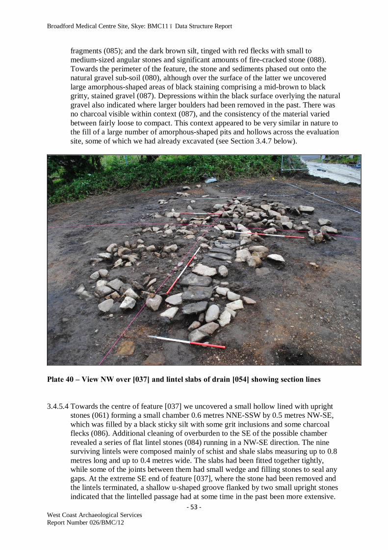
Broadford Medical Centre Site, Skye: BMC11 – Data Structure Report
- 53 - West Coast Archaeological Services Report Number 026/BMC/12
fragments (085); and the dark brown silt, tinged with red flecks with small to medium-sized angular stones and significant amounts of fire-cracked stone (088). Towards the perimeter of the feature, the stone and sediments phased out onto the natural gravel sub-soil (080), although over the surface of the latter we uncovered large amorphous-shaped areas of black staining comprising a mid-brown to black gritty, stained gravel (087). Depressions within the black surface overlying the natural gravel also indicated where larger boulders had been removed in the past. There was no charcoal visible within context (087), and the consistency of the material varied between fairly loose to compact. This context appeared to be very similar in nature to the fill of a large number of amorphous-shaped pits and hollows across the evaluation site, some of which we had already excavated (see Section 3.4.7 below).
Plate 40 – View NW over [037] and lintel slabs of drain [054] showing section lines 3.4.5.4 Towards the centre of feature [037] we uncovered a small hollow lined with upright
stones (061) forming a small chamber 0.6 metres NNE-SSW by 0.5 metres NW-SE, which was filled by a black sticky silt with some grit inclusions and some charcoal flecks (086). Additional cleaning of overburden to the SE of the possible chamber revealed a series of flat lintel stones (084) running in a NW-SE direction. The nine surviving lintels were composed mainly of schist and shale slabs measuring up to 0.8 metres long and up to 0.4 metres wide. The slabs had been fitted together tightly, while some of the joints between them had small wedge and filling stones to seal any gaps. At the extreme SE end of feature [037], where the stone had been removed and the lintels terminated, a shallow u-shaped groove flanked by two small upright stones indicated that the lintelled passage had at some time in the past been more extensive.

Broadford Medical Centre Site, Skye: BMC11 – Data Structure Report
- 54 - West Coast Archaeological Services Report Number 026/BMC/12
Plate 41 – View NNW over feature [037] and drain [054] showing excavated sections and underlying features (white tags)
Plates 42 & 43 – Post-hole features uncovered below the cairn material of feature [037] 3.4.5.5 Section lines were laid out across feature [037] on a NE-SW and NW-SE axis, and
opposing quadrants were excavated down to the natural sub-soil base (080). The resulting sections showed that the remaining stone and sediment deposits did not exceed 0.5 metres in depth, while the stone did not indicate any form of structure. The random nature of the stone and interspersed areas of more compact material including fire-cracked stone fragments (085)/(088) suggested an heavily disturbed feature, possibly the remains of an heavily denuded prehistoric cairn or platform. Most of the larger stones comprising the feature were pressed down into the underlying deposits

Broadford Medical Centre Site, Skye: BMC11 – Data Structure Report
- 55 - West Coast Archaeological Services Report Number 026/BMC/12
comprising the areas of black staining (087) and the natural sub-soil/gravel base (080), indicating that at some stage a significant amount of weight had applied pressure from above – possibly a larger weight of overlying cairn material that had subsequently been robbed away during more recent field clearance, ploughing and general agricultural improvements.
Figure 15 – Sections through drain feature [054]] - (G-H facing SE; I-J>NW; K-L>NW) 3.4.5.6 Three sections were also excavated across the stone-lintelled feature [054] to provide
evidence of potential function and to collect material suitable for palaeobotanical analysis and radiocarbon dating. The lintels had at first suggested a possible covered entrance into the potential cairn, but the excavations soon ruled this out and indicated the function to be that of a drain. The lintel slabs had been erected on small upright stones (061) that lined the drain throughout most of its course, although in some areas the slabs directly overlay the compacted deposit containing fire-cracked stone fragments (088). One of the sections in particular (S56) suggested two possible phases to feature [054]. Stones (061) set on edge some 1.0 metres apart may have formed a wider, earlier feature. This had been partially filled on the W side by the compacted deposit (088) to form a narrower channel. The lintel slab (084) had then been set directly on the surface of (088) and on the fill of the drain channel (127) to the E, which comprised a mid to dark brown silty loam with some small charcoal flecks. The

Broadford Medical Centre Site, Skye: BMC11 – Data Structure Report
- 56 - West Coast Archaeological Services Report Number 026/BMC/12
channel for the drain had been cut through the black-stained deposit (087) and into the natural sub-soil/gravel base (080), and generally formed a shallow u-shaped cut (130). The continuation for the cut of the channel to the SE (130), beyond the visible limits of the possible cairn, was indicated by a continuation of the shallow channel, partially filled with context (127) measuring some 1.7 metres long.
3.4.5.7 Removal of the potential cairn stone and associated deposits revealed the black-
stained context (087) below. However, under the cairn stone within the SE, W and NW sectors of feature [037] a number of small, ephemeral negative features were found cut into the natural sub-soil/gravel (080). Features [048], [049], [052], [055], [056] and [057] appear to be the remains of small post and stake-holes, some of which contain small vertically-placed packing stones. The post-holes range in size from 0.25m to 0.30m in diameter and between 0.15m and 0.35m deep. The fills of the features generally comprised dark brown silts with charcoal flecks and lumps. Additional features in this group include [051], a sub-circular pit containing a large flat stone slab in its base; and [058], a possible truncated post-hole containing a charcoal-rich fill (135). The features to the W of the drain [054] appear to form a slight arc, while those to the E of the drain also respect this general pattern. With the exception of one piece of flint, an un-diagnostic flake, no other small finds were recovered from feature [037] and the associated contexts and underlying features.
Plate 44 – Image of sections through drain [054] and associated deposits (see Fig.15)

Broadford Medical Centre Site, Skye: BMC11 – Data Structure Report
- 57 - West Coast Archaeological Services Report Number 026/BMC/12
3.4.5.8 Although it is possible that the amorphous-shaped stone spread comprising feature [037] are the very degraded and robbed-out remains of a prehistoric cairn, the presence of the potential drain [054] remains enigmatic. The feature housing the drain is located on the crest of the gravel ridge – possibly the best-drained area within the evaluation site. No modern field drains were uncovered in this area, which suggests that drainage was not an issue. Therefore, why was a drain necessary within feature [037]? The alignment of the drain (NW-SE) is also intriguing, as this respects the alignment of many chambered tombs in this area of Scotland – the mid-winter sunrise. The alignment of the feature also respects, to some extent, that of the souterrain [025]. Therefore, it is possible that this feature may have had a more ‘symbolic’ function, within what may have been a funerary monument with extensive views over Broadford Bay and the Mainland mountains beyond. The lack of small finds associated with the potential cairn does not assist us with our interpretation of this feature, although charcoal samples recovered from the underlying features should provide secure dates, while analysis of the fill from the drain (127) and other contexts within the cairn material may provide additional evidence relating to function.
3.4.6 Isolated Pits and Post-Holes 3.4.6.1 A number of isolated features including pits and possible post-holes were identified
and excavated at the Broadford Medical Centre site, most of which appeared to be associated with the main cluster of features already described on the gravel ridge. The most significant of these are described individually below, while descriptions of all features can be found in the Features Register (see Appendix 2).
3.4.6.2 Feature [015] – amorphous-shaped pit cut by later field drain [007], measures 1.8
metres long NW-SE by 0.95 metres wide and up to 0.25 metres deep. The pit has shallow sides and an undulating base and contains two fills – (016) is a dark brown silt containing small gravel and (019), a dark black silt containing degraded sandstone/stone fragments. The function of the pit is unknown.
3.4.6.3 Feature [019] – sub-circular pit measures 1.05 metres long NE-SW by 0.98 metres
wide and up to 0.35 metres deep. The pit has steeply-sloping sides, but the deepest section of the feature has vertical sides and is 0.42 metres diameter. The feature contains a single fill comprising dark brown silts containing small gravel and may have functioned as a post-hole.
3.4.6.4 Feature [023] – oval-shaped pit with shallow-angled sides is up to 0.26 metres deep
and measures 1.10 metres long NE-SW by 0.62 metres wide. The pit contains three fills. The primary fill (039) is dark brown silts containing gravel; the secondary fill (036) is a light brown to orange sediment containing gravel; and the upper fill (035) comprises black, charcoal-rich sediments containing angular stones > 0.12 metres across. The function of the pit is unknown.
3.4.6.5 Feature [029] – sub-circular pit with shallow-angled sides and up to 0.18 metres deep
measures 0.95 metres long NW-SE by 0.82 metres wide. The pit contains a single fill (037) comprising a dark brown loam with small stone and gravel inclusions. The function of the pit is unknown.

Broadford Medical Centre Site, Skye: BMC11 – Data Structure Report
- 58 - West Coast Archaeological Services Report Number 026/BMC/12
Figure 16 – Post-excavation plan of major features within the development site 3.4.6.6 Feature [030] – oval pit measures 0.90 metres long NE-SW by 0.68 metres wide, and
has sloping sides reaching a maximum depth of 0.24 metres deep. The base of the pit is undulating and the feature contains a single fill (041) comprising a dark brown sediment generally containing small angular stone clasts, although the stone content is more concentrated towards the top of the fill. The function of the pit is unknown.
3.4.6.7 Feature [040] – sub-circular pit with shallow sides is up to 0.13 metres deep and
measures 0.62 metres long NE-SW by 0.52 metres wide. The pit, of unknown function, contains a single fill (089) comprising a mid-brown loam with gravel inclusions and charcoal flecks. The charcoal becomes more concentrated towards the

Broadford Medical Centre Site, Skye: BMC11 – Data Structure Report
- 59 - West Coast Archaeological Services Report Number 026/BMC/12
base of the context. The pit contained one larger stone in the upper section of the fill 0.22 metres long.
Plates 45 & 46 – Images taken during excavation of feature [046] - (45=NNW; 46=NW)

Broadford Medical Centre Site, Skye: BMC11 – Data Structure Report
- 60 - West Coast Archaeological Services Report Number 026/BMC/12
3.4.6.8 Feature [041] – sub-oval pit measures 0.82 metres long N-S by 0.75 metres wide, and
has shallow sides and an undulating base. The pit is a maximum of 0.15 metres deep and contained a single fill (111) comprising a homogenous black charcoal-rich sediment. A few stone clasts present in the fill > 0.15 metres across, with some fragments of fire-cracked stone in the upper part of the fill. A single coarse cobble tool was also recovered from the surface of the feature (find number 041). The function of the pit is unknown, although part of the fill appears to be waste material similar to that seen in the backfill of the souterrain [025] and the grain-drying kiln complex [027].
3.4.6.9 Feature [046] – amorphous-shaped pit has steep sides and is up to 0.28 metres deep.
The feature measures 1.10 metres long NW-SE by 0.78 metres wide and after initial cleaning displayed a fill comprising a dark brown loam with small gravel inclusions (118), and numerous angular stones from 0.05 metres to 0.42 metres across – some of which had been burnt. In the NW arc of the pit, several thin slabs appeared to be set on edge, tight to the cut (119) of the feature. Removal of the upper stone deposits and associated matrix revealed a flat slab of stone that had been set horizontally and which was partially surrounded by thin upright stones. This formed a setting that was open to the SW, although the upright stone on this side may have been truncated by ploughing. Removal of context (118) at the SE end of the feature revealed a second flat slab of stone that was partially covered by the flat slab to the NW. The two slabs had been set flat and underpinned by small flat chocking stones. No small finds were recovered from the feature, so it is difficult to assign a possible date to it. Regarding potential function, when first excavated it resembled a small cist with the small flat slab at the base and small upright slabs set on edge. However, this interpretation cannot be backed up with further evidence.
3.4.6.10 It is difficult to assign function or a potential date to the features described above,
although the types of fill and their stratigraphic relationship to adjacent features would suggest that they are all prehistoric in origin. Hopefully, analysis of sediments recovered from the features will help us with our final interpretations and reporting.
3.4.7 Evidence for Potential Woodland Clearance 3.4.7.1 During the archaeological evaluations at the Broadford Medical Centre site, we
identified a significant number of amorphous-shaped features, some of which merged together to form larger spreads of material, that contained black silt deposits including small gritty inclusions. The small inclusions appeared burnt and degraded, although sampling of the deposits failed to recover any visible lumps of charcoal. These deposits were found primarily along the crest of the slight gravel ridge that runs NE-SW across the site adjacent to High Road.
3.4.7.2 Concentrated spreads of these deposits were also found underlying and surrounding
the possible cairn feature [037] and at the SW end of the gravel ridge, adjacent to the SW boundary of the evaluation site. Isolated amorphous-shaped features containing the same material were also identified peripheral to these major spreads. Where spreads of the material occurred, it was usually found that hard cleaning back with a

Broadford Medical Centre Site, Skye: BMC11 – Data Structure Report
- 61 - West Coast Archaeological Services Report Number 026/BMC/12
draw-hoe produced more visible isolated negative features, within the sub-soil/gravels.
3.4.7.3 After initial cleaning and recording of these features (see Features Register –
Appendix 2 for details), a sample from across the site were selected for full excavation. Section excavation, followed by the complete emptying of the features, revealed ‘cuts’ into the underlying natural sub-soil/gravel (080) of varying morphology. Some of the features revealed ‘classic’-shaped pits varying in depth between 0.050 metres to 0.35 metres, while others resembled the ripped out roots and boles of trees.
Plate 47 – Amorphous-shaped feature [017] with black fill deposit 3.4.7.4 The majority of the features selected for excavation contained a single homogenous
fill comprising a dark brown to black gritty silt, and inclusions of gravel and larger rounded and angular stone clasts between 0.040 metres and 0.15 metres in size. With the exception of a few degraded flecks, no charcoal was visible in the fill of the features. We also recovered no small finds from any of the features excavated.
3.4.7.5 All of the negative cut features excavated on the site including the drain within cairn
[037], grain storage pits [026], [035] and [059], souterrain [025] and the post-holes and pits discussed in Sections 3.4.5 and 3.4.6, cut through these dark brown to black spreads of material and the amorphous-shaped negative features containing this deposit. Therefore, it was clear that whatever formed these features and deposits, the activity pre-dated the construction of the major structures on site.
3.4.7.6 Although we have to wait for the analysis of samples recovered from these features
and deposits to gain a clearer understanding of what they contain, the amorphous and

Broadford Medical Centre Site, Skye: BMC11 – Data Structure Report
- 62 - West Coast Archaeological Services Report Number 026/BMC/12
unusual shape of the cuts into the underlying sub-soil/gravel appear to represent the clearance of woodland from the site. The dark brown to black gritty residues may therefore be all that remains of the residues relating to the burning of the felled trees and shrubs. If the features relate to forest clearance during prehistory, then these activities took place before any of the identified monuments and structures was built.
Plate 48 – Section through amorphous-shaped pit [017] showing black fill and variable depth
Plate 49 – Amorphous-shaped features after removal of overlying cairn stone - [037]

Broadford Medical Centre Site, Skye: BMC11 – Data Structure Report
- 63 - West Coast Archaeological Services Report Number 026/BMC/12
3.5 Discussion 3.5.1 The wide range of features excavated at the Broadford Medical Centre site represent
the potential use of this piece of landscape overlooking Broadford Bay over several Millennia. Excavation at the site included the complete removal of the features in advance of major developments on site, which enabled construction techniques to be thoroughly investigated along with phasing.
3.5.2 Although small finds were generally limited to ceramics and coarse cobble tools (see
Section 4 below), the analysis of the former group of finds in conjunction with a robust radiocarbon dating programme, should allow us to build a detailed chronology of the features on site and fit them into the wider prehistoric landscapes of South Skye and the western seaboard of Scotland.
4. Small Finds 4.1 Small finds recovered from the site generally comprised ceramics and coarse cobble
tools and the Finds Register (see Appendix 5) provides details including feature number, content number and a brief description.
4.2 With the exception of two degraded sherds of possible prehistoric pottery, burnt daub
or furnace-lining fragments and two cobble tools, the ‘modern’ finds of pottery, glass and a whetstone all derived from the plough-soil context (002). All of the remaining small finds were recovered from secure contexts, primarily from the stone-lined grave/cist [024], the grain-drying kiln complex [027] and the souterrain [025].
4.3 Of particular interest are the two Beakers recovered from the grave [024], their
deposition potentially suggesting an early date in the sequence for this type of burial (around 2500BC – Sheridan pers comm). The sherds of Beaker pottery from the grain-drying kiln complex [027] are also intriguing, although these must relate to secondary deposition – possibly from a destroyed cist, or cists, on site.
4.4 Iron Age ceramics were recovered from the souterrain [025], both from the primary
and secondary floor horizons. Including plain and decorated fragments, it is possible that the ceramics from the primary floor horizon relate to the use of the structure during the Middle Iron Age. The ceramics were found in two main concentrations – within the scooped entrance of the souterrain and within the end of the terminal chamber. However, the significant remains of a large globular pot with flared everted rim and two applied decorative cordons retrieved from the secondary floor horizon may date to between the 5th and 7th centuries AD (see Section 3.4.2.6).
4.5 All of the coarse cobble tools were recovered from the souterrain [025], with the
exception from one tool from pit feature [041] and one tool from the plough-soil (002) overlying the cairn feature [037]. The remaining finds included daub, most of which was recovered from the kiln complex [027], one piece of pumice from the stone-lined grave [024], a broken flint blade from the souterrain [025] and a second piece of flint from the cairn feature [037]. Most of these finds appear to relate to secondary deposition in features, possibly at the end of their use.

Broadford Medical Centre Site, Skye: BMC11 – Data Structure Report
- 64 - West Coast Archaeological Services Report Number 026/BMC/12
Plate 50 – AOC Beaker SF.015 from cist [024] - (courtesy National Museums Scotland) 5. Post-Excavation Requirements 5.1 General 5.1.1 This Data Structure Report is interim in nature and provides a preliminary discussion
of the archaeological results and materials recovered from the Broadford Medical Centre site. The implementation of specialist work which includes the analysis of all finds, both ecofacts and artefacts is on-going, the results of which will be included in a final report.

Broadford Medical Centre Site, Skye: BMC11 – Data Structure Report
- 65 - West Coast Archaeological Services Report Number 026/BMC/12
5.2 Small Finds 5.2.1 It is necessary for all of the ceramic and stone finds (pebble tools, flint and pumice) to
be analysed by specialists, including the production of a full catalogue and reporting on the finds. This should also include analysis of adhering and absorbed organic residues on the ceramics to provide details on what the pots may have been used for before deposition on site. This is particularly important in respect of the two Beaker pots deposited in the stone-lined cist [024]. Consolidation and refitting of the substantially complete small Beaker and the large globular vessel recovered from the souterrain [025] is also recommended. This will allow long-term curation of the vessels and possible display. Illustration of the small finds including the two Beakers, both Iron Age pots, additional later prehistoric pottery sherds, the cobble tools, pumice fragment and flint blade are also recommended. Such illustrations would be used in the final publication of the site record, while they could also be used in local displays – such as suggested in the foyer of the new medical centre building.
5.3 Sediment Samples – Palaeoenvironmental Analysis of the Ecofacts 5.3.1 Sediment samples were recovered from all of the excavated features on site and these
have now been reviewed and selected for the potential information that they can reveal about the function of the archaeological features, economic data and local palaeoenvironmental data. The analysis of these samples would include flotation and sorting, phosphate and pollen analysis (including archaeological interpretation of the pollen results), palaeobotanical identification and reporting, and loss-on-ignition analysis of a selection of samples to indicate evidence of burning on site – in particular, to confirm what we have so far interpreted as early forest clearance and burning at the site before any of the monuments/structures were built.
5.4 Bone 5.4.1 Several small samples of un-burnt and burnt bone were recovered from the souterrain
and grain storage pits, and these should be identified as to whether they comprise animal or human bone.
5.5 Charcoal 5.5.1 Samples of charcoal were recovered from all of the major features on site and these
should be analysed for species/identification and for any tooling marks. 5.6 Radiocarbon Dating Programme 5.6.1 Samples of charcoal and other burnt plant remains (such as burnt grain), will be
selected from specific features and related contexts for submission for radiocarbon dating.
5.6.2 Samples selected from specific features and contexts on site will be submitted to the
Scottish Universities Research Facility at East Kilbride (SUERC) for radiocarbon dating. Combined with the detailed recording of site features and their related contexts, this will allow a detailed chronology to be formulated for the suite of features excavated at the Broadford Medical Centre site.

Broadford Medical Centre Site, Skye: BMC11 – Data Structure Report
- 66 - West Coast Archaeological Services Report Number 026/BMC/12
6. Publication and Dissemination of Information 6.1 West Coast Archaeological Services will compile and analyse all data from the
watching brief, excavation and specialists' reports. A digital report will be produced containing the conclusions of the fieldwork and initial analysis of materials from the site (Data Structure Report). This report, with photographs and site plans, will be disseminated to the contractor/developer in hard and digital copy form, while copies will also be submitted to the Highland Council Planning and Buildings Standard Department, Highland Council Historic Environment Team and the Royal Commission on the Ancient and Historical Monuments of Scotland. A digital report will also be submitted to OASIS and a submission of the work submitted to Discovery & Excavation in Scotland. These are standard requirements of the archaeological brief.
6.2 Finally, the full results from the Broadford Medical Centre site will be published,
most likely in the Proceedings of the Society of Antiquaries of Scotland. This would comprise an academic report, complete with digital images, site plans and sections.
6.3 West Coast Archaeological Services will liaise with Scottish Treasure Trove about the
materials recovered from the site and will be accountable for the eventual deposition of the artefacts under Treasure Trove Law.
7. Discussion 7.1 The evaluation and complete excavation of the archaeological features and associated
deposits at the Broadford Medical Centre site has resulted in a wide range of structures being identified relating to the use of the site from the Neolithic/Early Bronze Age Transition through to the recent past, when agricultural improvements were in progress.
7.2 The preliminary analysis of the two Beaker vessels from the stone-lined grave/cist
feature [024] suggest a potentially early date for this type of burial (Sheridan, pers comm), at some time between 2500 and 2400BC. The location of the grave, which is just off the crest of the gravel ridge that runs NE-SW across the site, overlooks Liveras chambered cairn and the wide expanse of Broadford Bay. Although a Hebridean-type chambered tomb of Neolithic date, the secondary cist discovered to the E of the cairn during road widening is potentially of contemporary age, along with the possible cist identified in the chamber of the tomb (see Section 1.3.2). The sherds of Beaker recovered from secondary deposits within the grain-drying kiln complex [027] may also derive from other contemporary graves on the gravel ridge. Potential features that may have once housed graves include [035], which was subsequently used as a grain-storage pit, and the scooped entrance to the souterrain [025], which may originally have been the cut for a cist.
7.3 If the location on the gravel ridge was originally used for funerary activities, then did
the stone-lined cist [024] and other potential graves focus on what is most likely the remains of an heavily robbed and denuded cairn (feature 037)? If so, then the drain feature [054] in the cairn is unusual – that is if it was ever intended as a drain. The stones of the possible cairn directly overlie the black residues that most likely relate to

Broadford Medical Centre Site, Skye: BMC11 – Data Structure Report
- 67 - West Coast Archaeological Services Report Number 026/BMC/12
forest clearance at the site, which may have been preparation for such funerary activities. The place-name evidence for the evaluation site, Achadh nan Carn (or Field of the Cairns) may also refer to monuments that were once visible within this field, and that were subsequently robbed of their stone during later developments and re-use of the site, including agricultural improvements.
Plate 51 – View from above grain storage pit [035] showing truncation by souterrain cut
053) and wall [025] - (after removal of inserted wall section) 7.4 At some stage during the history of the site, most likely during the Late Bronze Age
or Iron Age periods, the overall function changed from one of burial to that of grain processing and storage. However, the storage of grain during prehistory held many symbolic metaphors, including the links between life and death, and the agricultural cycle (Bradley, 2005: 209-10). He suggests that granaries and other forms of grain storage in prehistory were more than simple agricultural facilities. Indeed, at Iron Age sites such as Danebury and Gussage All Saints, human and animal burials have been found in the base of grain storage pits – most likely deposited during the closure of these structures.
7.5 At some time after the closure of storage pit [059] at the Broadford site, the grain-
drying kiln was constructed and this complex [027] was modified on several occasions. It appears likely that at some stage during the use of this structure the souterrain [025] was also built, including within its construction a former grain storage pit [035] – a feature that may originally have functioned as a Bronze Age grave.

Broadford Medical Centre Site, Skye: BMC11 – Data Structure Report
- 68 - West Coast Archaeological Services Report Number 026/BMC/12
7.6 Some of the features discovered and excavated at the site are unique to the archaeological record in the west of Scotland, in particular the grain drying kiln and the storage pits. The proposed post-excavation analysis including radiocarbon dates and a thorough analysis of the sediment and environmental samples recovered from the site, will hopefully allow us to understand and interpret these important features in some detail. The on-going investigations will allow us to understand the features within the wider settlement history of Skye and enhance our understanding with regards to the development of funerary, ritual and agricultural practices through time.
8. Timetable for Post-Excavation Analysis and Reporting 8.1 A timetable for the post-excavation analysis and reporting phase of the project work is
set out below. Depending on specialist’s workloads and other uncontrollable factors, it is possible that these deadlines will have to be amended.
The following order of completion of project elements is recommended:
Within 3 months (end of April 2012)
• Environmental and palaeobotanical analysis • Preparation and submission of samples for radiocarbon dating • Submission of Data Structure Report, OASIS and DES Entries
Within 5 months (end of June 2012)
• Radiocarbon dating of charcoal and burnt plant remains • Production of finds catalogue • Cleaning, consolidation and re-fitting of small finds • Illustrations
Within 7 months (end of August 2012)
• Residue analysis of ceramics • Full reporting of small finds assemblage
Within 9 months (end of October 2012)
• Completion of final report for the Proceedings of the Society of Antiquaries of
Scotland • Submission of site archive to the Royal Commission in Edinburgh

Broadford Medical Centre Site, Skye: BMC11 – Data Structure Report
- 69 - West Coast Archaeological Services Report Number 026/BMC/12
Plate 52 – Lynn Fraser excavating cist feature [024]
Plate 53 – Dave Anderson excavating in grain-drying kiln complex [027]

Broadford Medical Centre Site, Skye: BMC11 – Data Structure Report
- 70 - West Coast Archaeological Services Report Number 026/BMC/12
Plate 54 – Martin Wildgoose and Steven Birch recording souterrain feature [025]
Plate 55 – Mary Peteranna, Stephanie Glover and Steven Birch excavating on site

Broadford Medical Centre Site, Skye: BMC11 – Data Structure Report
- 71 - West Coast Archaeological Services Report Number 026/BMC/12
9. References Armit, I. 2006 Anatomy of an Iron Age Roundhouse: The Cnip Wheelhouse Excavations, Lewis. Society of Antiquaries of Scotland, Edinburgh. Armit, I. 2008 ‘Excavation of an Iron Age, Early Historic and medieval settlement and metalworking site at Eilean Olabhat, North Uist. Proc Soc Antiq Scot 138, 27-104. Bradley, R. 2005 Ritual and Domestic Life in Prehistoric Europe, Routledge. Gregory, D. 1841 Cairn in the Isle of Skye. The Gentleman’s Magazine, Vol.169, pp.33-37.
Gregory, D. 1857 ‘Notes regarding various remains of antiquity, both of the Earlier and Middle Ages, observed during a recent visit to the Hebrides’, Archaeol. Scot. Vol. 4, pp.362-5
Henshall, A.S. 1972 The Chambered Tombs of Scotland, Vol. 2, pp.484-5, SKY 6, Edinburgh
Highland Council Historic Environment Team. Highland Historic Environment Record (HHER). Http://her/highland.gov.uk Highland Council Historic Environment Team. Development Guidance. Http://www.highland.gov.uk/yourenvironment/conservation/archaeology/developmentguidance.htm. Highland Council Historic Environment Team. Specification for an archaeological watching brief, IN-06-787: Dec 2010. Highland Council. 2001. The Highland Structure Plan: Section 2.15, Built and Cultural Heritage. Institute for Archaeologists. By-laws of the Institute for Archaeologists: Code of Conduct. Reading, IFA: 2010. Lamont, D. 1913 Strath: in Skye pp.159-60.
National Library of Scotland. Http://www.nls.uk
The Scottish Government 2010. Scottish Planning Policy. Http://www.scotland.gov.uk/Resource/Doc/300760/0093908.pdf
The Scottish Government 2011. Planning Advice Notice (PAN) 2/2011: Planning and Archaeology. Http://www.scotland.gov.uk/Publications/2011/08/04132003/0

Broadford Medical Centre Site, Skye: BMC11 – Data Structure Report
72 West Coast Archaeological Services Report Number 026/BMC/12
Appendix 1 Contexts Register
BROADFORD MEDICAL CENTRE 2011: CONTEXT REGISTER Context Number Type Description Fill of Filled
by Under Over Feature Finds Samples Plans- Sections Interpretation
001 Turf and grass - - - 002 - - - - N/A
002 Deposit Mid-brown topsoil - - 001 - - 001, 002 - - Topsoil/plough soil
003 Structure Drystone walling, some lime mortar with shell - - - - 001,
012 - - 1 Boundary wall and splayed entrance
004 Structure Drystone revetment walling to W of road - - - - 013 - - - Revetment wall
005 Deposit
Dark brown to black gritty silt with small cobbles/round stones; rootlets and degraded charcoal flecks
006 - 002 - 008 005 1 S01 Fill of pit
006 Cut Subcircular, shallow cut for [8] - 005 - - 008 - - 02, S01 Pit
007 Deposit Same as 005 009 - 002 008 009 - 2 S02 Fill of pit
008 Deposit
Mid-brown silt with degraded charcoal flecks and small rounded cobbles > 50%; fine rootlets
009 - 007 - 009 - - S02 Basal fill of pit
009 Cut Cut for teardrop-shaped 'double' pit - 007,
008 - - 009 - - 02 Pit

Broadford Medical Centre Site, Skye: BMC11 – Data Structure Report
73 West Coast Archaeological Services Report Number 026/BMC/12
Context Number Type Description Fill of Filled
by Under Over Feature Finds Samples Plans- Sections Interpretation
010 Deposit Same as 005 011 - 002 - 010 - 3 S03 Fill of pit
011 Cut Cut for sub-oval, sub-circular pit - 010 - - 010 - - 02 Pit
012 Fill Charcoal-rich gravelly soil 013 - 002 013 014 - - 03, 08-
B, S04 Fill of pit
013 Cut Amorphous, shallow pit - 012 012 - 014 - - 03, 08-B, S04 Pit
014 Fill Dark brown-black sandy-gravelly soil with small amount of charcoal
015 - 002 015 021 - - 08-C, S05 Fill of pit
015 Cut Amorphous, shallow cut for a pit - 014 014 - 021 - - 08-C,
S05 Pit of unknown use
016 Fill Dark brown gravel 017 - 002 - 019 - 5 08-C, S08 Fill of pit
017 Cut Cut for pit - 016 016 - 019 - - 06, 08-C, S08 Pit
018 Fill Degraded sandstone mixed with brown gravel 020 - 002 - 015 - - 04, 08-
A, S06 Fill of pit
019 Fill Degraded sandstone mixed with black matrix (wet)
020 - 002 020 015 - - 04, 08-A, S06 Fill of pit
020 Cut Cut for pit - 018 019
018 019 - 015 - - 04, 08-
A, S06 Pit of unknown use
021 Fill Mixed angular and broken stones 022 - 002 - 007 - - 04, 08-
A, S06 Fill of field drain
022 Cut Cut for stone field drain - 021 021 - 007 - - 04, 08-A, S06 Field drain
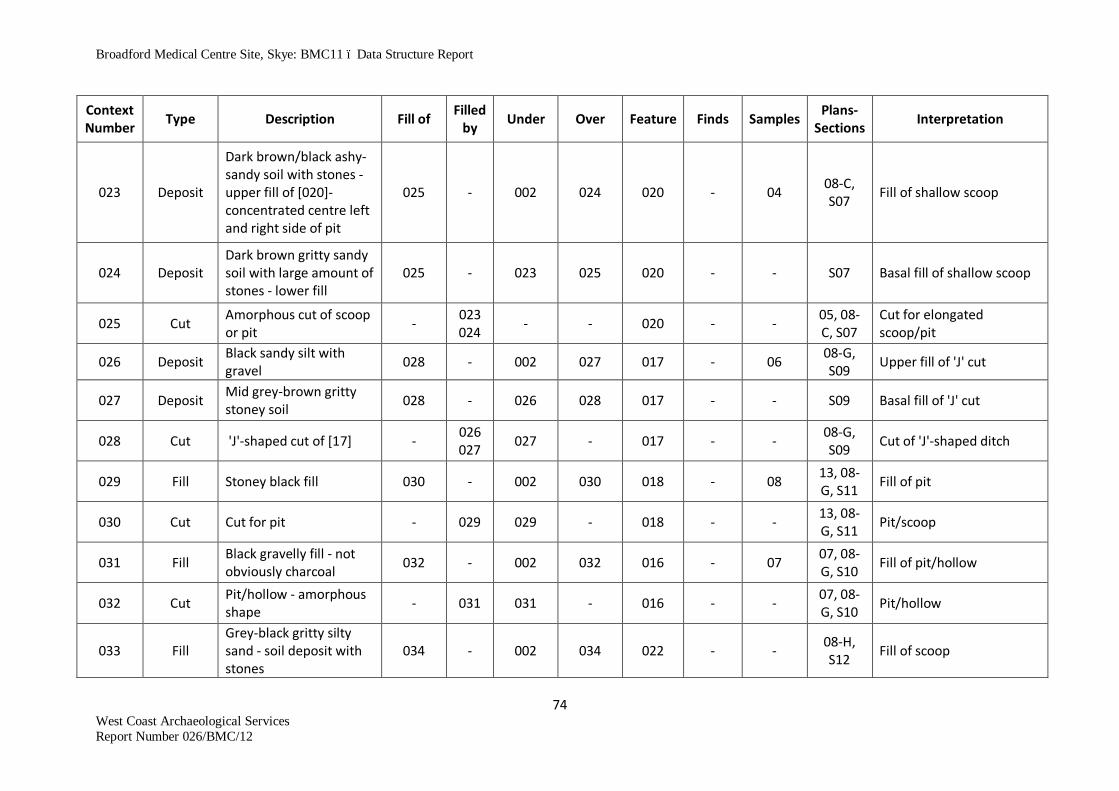
Broadford Medical Centre Site, Skye: BMC11 – Data Structure Report
74 West Coast Archaeological Services Report Number 026/BMC/12
Context Number Type Description Fill of Filled
by Under Over Feature Finds Samples Plans- Sections Interpretation
023 Deposit
Dark brown/black ashy-sandy soil with stones - upper fill of [020]- concentrated centre left and right side of pit
025 - 002 024 020 - 04 08-C, S07 Fill of shallow scoop
024 Deposit Dark brown gritty sandy soil with large amount of stones - lower fill
025 - 023 025 020 - - S07 Basal fill of shallow scoop
025 Cut Amorphous cut of scoop or pit - 023
024 - - 020 - - 05, 08-C, S07
Cut for elongated scoop/pit
026 Deposit Black sandy silt with gravel 028 - 002 027 017 - 06 08-G,
S09 Upper fill of 'J' cut
027 Deposit Mid grey-brown gritty stoney soil 028 - 026 028 017 - - S09 Basal fill of 'J' cut
028 Cut 'J'-shaped cut of [17] - 026 027 027 - 017 - - 08-G,
S09 Cut of 'J'-shaped ditch
029 Fill Stoney black fill 030 - 002 030 018 - 08 13, 08-G, S11 Fill of pit
030 Cut Cut for pit - 029 029 - 018 - - 13, 08-G, S11 Pit/scoop
031 Fill Black gravelly fill - not obviously charcoal 032 - 002 032 016 - 07 07, 08-
G, S10 Fill of pit/hollow
032 Cut Pit/hollow - amorphous shape - 031 031 - 016 - - 07, 08-
G, S10 Pit/hollow
033 Fill Grey-black gritty silty sand - soil deposit with stones
034 - 002 034 022 - - 08-H, S12 Fill of scoop

Broadford Medical Centre Site, Skye: BMC11 – Data Structure Report
75 West Coast Archaeological Services Report Number 026/BMC/12
Context Number Type Description Fill of Filled
by Under Over Feature Finds Samples Plans- Sections Interpretation
034 Cut Scoop, amorphous containing shallow deposit
- 033 033 - 022 - - 11, 08-H, S12 Cut for shallow scoop
035 Fill Black charcoal rich fill with angular stones 10-20cm
040 - 002 036 023 - 10 08-D, 08-E, S14
Fill of cut
036 Fill Orangey brown gravelly soil 040 - 035 039 023 - - S14 Fill of cut
037 Fill Dark brown loam with small stone and gravel inclusions
038 - 002 038 029 - 09 12, S13 Fill of cut
038 Cut Sub-circular pit - 037 037 - 029 - - 12, 14, S13 Pit of unknown use
039 Fill Dark brown gravelly soil 040 - 036 040 023 - - 15, 08-D, 08-E,
S14 Fill of cut
040 Cut Cut for pit - 035, 036, 037
039 - 023 - - 15, 08-D, 08-E,
S14 Pit of unknown use
041 Fill Dark brown stoney upper fill 042 - 002 042 030 - 11 08-H Fill of pit
042 Cut Cut for pit - 041 041 - 030 - - 16, 08-H, S15 Pit of unknown use
043 Fill Black/dark brown loam and gravel 044 - 002 044 031 - - S16 Fill of pit
044 Cut Arc-shaped pit - 043 043 - 031 - - S16 Arc-shaped pit/hollow of unknown use

Broadford Medical Centre Site, Skye: BMC11 – Data Structure Report
76 West Coast Archaeological Services Report Number 026/BMC/12
Context Number Type Description Fill of Filled
by Under Over Feature Finds Samples Plans- Sections Interpretation
045 Fill Black charcoal rich loam 047 - 002 046 032 - - S17 Fill of pit 046 Fill Dark brown gravel 047 - 045 047 032 - - S17 Fill of pit
047 Cut Cut for pit - 045, 046 046 - 032 - - S17 Cut of pit
048 Fill Black charcoal rich soil 050 - 002 049 033 - - S18 Fill of pit 049 Fill Brown gravel 050 - 048 050 033 - - S18 Fill of cut
050 Cut Sub-oval shallow cut - 048 049 049 - 033 - - S18 Cut of pit
051 Fill Dark brown/black loam and gravel mix 052 - 002 052 034 - - S19 Fill of cut
052 Cut Shallow scoop - 051 051 - 034 - - S19 Cut of scoop
053 Cut Cut of souterrain - with stone-lined walls - - 002 - 025 - -
08-I, S20, S21,
S25, S26
Cut in basal gravel for construction trench
054 Fill Upper fill of souterrain passage in Tr.25A - mid-brown sediment
053 165 002 055 025A - - 08-I, S20
Upper fill - lintel removal phase and silting episode - like (063)
055 Fill Mid-level fill of souterrain in Tr.25A - dark brown silt
053 - 054 056 025A 005 - 08-I, S20, S21
Silting/final use of passage?
056 Fill Lower infill of souterrain Tr.25A - orange/brown gravel
053 - 055 057 025A
006, 042, 043, 049
112, 113
08-I, S20, S21
Lower infill of passage - like (063)
057 Fill Floor horizon of souterrain passage 053 - 056 Nat. 025A 007 12, 129 08-I,
S21 Light black to dark brown silt

Broadford Medical Centre Site, Skye: BMC11 – Data Structure Report
77 West Coast Archaeological Services Report Number 026/BMC/12
Context Number Type Description Fill of Filled
by Under Over Feature Finds Samples Plans- Sections Interpretation
058 Fill Mid to dark brown charcoal rich fill in widening of cut
081 - 002 - 025A 035 - - 08-I Upper fill of truncated
storage pit
059 Structure Stone blocking in former entrance of [025] 053 - 002 - 025A - - Blocking (stone) of
entrance
060 Deposit Same as topsoil, overlying cairn - - 002 061 037 008 13, 14 08-L-Q
S51 Topsoil, like (002)
061 Structure Cairn stones - - 060 - 037 - - 08-L-Q S51-4 Cairn
062 Deposit
Mid-dark brown stoney soil with <1% charcoal, 10% small-medium stones, 1 small piece blue/white pot
053 - 002 063 025B - 15, 16 08-I-J, S20,
S25, S26
Transition between uppermost souterrain backfill and topsoil Tr.25B
063 Deposit
Mid-dark brown loosely compact gravelly loam - more stone and more compact at base over large slabs
053 166 062 064, 065 025B 010 18, 19,
78 S25, S26 Souterrain backfill - like (054) and (056)
064 Deposit
Very stoney and gravelly loosely compact mid-dark brown soil; fire-cracked stone; some charcoal
053 - 063 065 025B - 20, 21, 33, 76 S25, S26 Souterrain backfill
065 Deposit Tipped layer underlying blocking stones to N side of section 2
053/082 - 063/064 - 025B 009 24 S26 Souterrain backfill

Broadford Medical Centre Site, Skye: BMC11 – Data Structure Report
78 West Coast Archaeological Services Report Number 026/BMC/12
Context Number Type Description Fill of Filled
by Under Over Feature Finds Samples Plans- Sections Interpretation
066 Structure Souterrain structure stones - flat and rounded cobbles
053 - 062 - 025 - - S25 Souterrain
067 Structure Cist side slabs and capstone 156 - 002
069 (capstone
only) 024 - -
18, 19, S22,
S46, S47 Cist
068 Deposit
Dark brown loam; scant charcoal and burnt bone; small stone inclusions
067 - 002 069 024 - 22 18 Fill around capstone
069 Fill Gravel fill underlying capstone 067 - 068 079 024 015 23 19, S22 Upper fill of cist
070 Deposit
Gravel sandy soil orange/brown layer; below tipped layer; with grey gravelly clay at centre; moderately loosely compact
053 - 064, 065
071, 073 025B 016 29, 32 S26 Souterrain backfill - lots of
charcoal
071 Deposit Moderately hard compact gravelly mid-dark brown gritty silt
053 - 070 073 025B - 30, 131 S25
Souterrain backfill

Broadford Medical Centre Site, Skye: BMC11 – Data Structure Report
79 West Coast Archaeological Services Report Number 026/BMC/12
Context Number Type Description Fill of Filled
by Under Over Feature Finds Samples Plans- Sections Interpretation
072 Fill
Black/brown loamy fill with stone, burnt stone, ash, charcoal and carbonised grain in large quantities. Finds included daub and pottery including Beaker
F027 - 002 095, 161 027
013, 014, 017, 018, 019, 020, 022, 024, 028, 032, 037, 044
28, 43, 44, 47, 48, 70, 71, 98
08-K, S35, S33, S37,
S38, S44
Spread deposit over grain-dying kiln complex
073 Deposit
Mid brown/orange loosely compact gravel with some silty soil - basal deposit in souterrain
053 - 071 Nat. 025B - 31 S26 Basal deposit in 2nd souterrain section
074 Fill
Charcoal rich brown with fire-cracked stones, charcoal and bone fragments
075 - 002 - 026 - 17 08-I-J Fill in quad 1 of pit [26] - same as (076)
074b Fill Small to large basalt stones and boulders - unburnt
074 - 002 and within
074
074c, 077a 026 - - 08-I-J Stone fill within 074
074c Fill
Large burnt and unburnt boulders and stones at base of context 074
074 - 074, 074b
077a, 077b 026 - - 08-I-J Stone fill at base of 074

Broadford Medical Centre Site, Skye: BMC11 – Data Structure Report
80 West Coast Archaeological Services Report Number 026/BMC/12
Context Number Type Description Fill of Filled
by Under Over Feature Finds Samples Plans- Sections Interpretation
075 Cut Cut of circular pit - 074, 076, 077
- - 026 - - 08-I-J Cut of pit
076 Fill
Charcoal rich upper fill with compacted fire-cracked stones and charcoal. Lower fill, large heat affected stones.
075 - 002 077 026 - 25, 26 08-I-J, S24
Fill in quad 2 of pit [26] - same as (074)
077a Fill Basal deposit of peat ash and charcoal 075 -
074, 074b, 074c
077b 026 - 27 S23 Basal fill of peat ash in pit
077b Deposit
Basal deposit of black charcoal-rich silt containing burnt grain and organic residues
075 - 074, 074c, 077a
075 026 - - S23 Basal fill of charcoal-rich
silt containing burnt grain and organic residues
079 Fill Dark brown gravel 067 - 069 108 (and
abuts it) 024
015, 023, 034
35-42 52-61 63, 64, 80, 82, 85, 86, 89, 90, 93, 94,
97
19, S22 Burial layer
080 Natural
Orange/red/black natural shingle/gravel; mixed small grit/pea gravel; small rounded stones
- - - - - - - - Natural

Broadford Medical Centre Site, Skye: BMC11 – Data Structure Report
81 West Coast Archaeological Services Report Number 026/BMC/12
Context Number Type Description Fill of Filled
by Under Over Feature Finds Samples Plans- Sections Interpretation
081 Cut
A widening of the souterrain cut on NE side - exposed in 1st section
- 058 058 - 035
(part of 025)
- - 08-I Grain storage pit truncated by construction of souterrain [025]
082 Cut
An elongated sloping cut above souterrain wall to NE; widening of souterrain cut; 2nd section
- 065 - - 025 - - 08-J Secondary cut in souterrain cut
083 Cut Elongated amorphous pit, N of W end of souterrain
- 072 - - 027 - - 08-K
084 Structure Lintel slabs (9) at E side of cairn - - 060 -
054 (part of
037) - - 08, S56,
S57, S61 Lintelled passage, part of cairn
085 Deposit
Mid-brown compact silty loam with small-medium angular stones, some fire-cracked stones, roots; with orange-flecked stones
- - 060 086/087 088 037 - - 08, S52 Compact deposit in cairn
086 Deposit
Black, sticky silty soil with some grit - at centre of cairn with charcoal
- - 060, 085 - 037 - - 08 Black deposit at centre of
cairn

Broadford Medical Centre Site, Skye: BMC11 – Data Structure Report
82 West Coast Archaeological Services Report Number 026/BMC/12
Context Number Type Description Fill of Filled
by Under Over Feature Finds Samples Plans- Sections Interpretation
087 Deposit
Dark brown/black silty/gritty stained gravel with no visible charcoal; loosely compact in parts but elsewhere moderately compact
- - 002, 060, 085
- - - 132, 137
08, S53, S56,
S57, S58
Amorphous, very black stoney patches scattered throughout knoll area - surface around site
088 Deposit
Very compact dark brown/red silt with small-medium angular stones, roots and a lot of fire-cracked stone
- - 085 080 037 - - 08, S52,
S54, S56, S57
Re-deposited layer within stones in central area of possible cairn feature [037]
089 Fill Mid brown loam; gravel inclusions; charcoal rich 090 - 002 080 040 - 46 21, S28 Fill of pit
090 Cut Sub-circular shallow pit - 089 089 - 040 - - 21, 22, S28 Cut of pit
091 Cut Cut of shallow pit - 092 092 080 039 - - 23A, S30 Cut of pit
092 Fill Brown/black charcoal rich silty soil 91 - 002 091 039 - 49 S30 Fill of pit
093 Deposit
Deposit at WNW end of souterrain; dark brown/black sandy soil; intense charcoal and fire-cracked stone
053 - 002 - 025 025, 026, 027
50, 62 23, S31 Possible hearth feature?

Broadford Medical Centre Site, Skye: BMC11 – Data Structure Report
83 West Coast Archaeological Services Report Number 026/BMC/12
Context Number Type Description Fill of Filled
by Under Over Feature Finds Samples Plans- Sections Interpretation
094 Deposit
Mid-brown sandy loam with large stone (possible tumble of souterrain backfill)
053 166 002 096 025 - 66, 68 23, S31, S32
Upper fill and boulder backfill E of (093) in section C1-C2
095 Deposit Peat ash and charcoal rich fill of [027] F027 - 072 102 027 - 51 S35, S44
Abandonment deposit of kiln waste forming levelling layer across kiln complex [027]
096 Deposit Mid grey/brown silty soil with charcoal, small stone, pot fragments
053 - 094 097 025C 030, 031, 036
67 S32, S36 Underlying rubble layer in Tr.25C
097 Deposit Mid brown/orange gritty soil with some small gravel
053 - 096 098 025 - 75, 77 S32, S36 Primary floor deposit in souterrain
098 Deposit Mid brown/grey silt 053 - 097 - 025 - - S32, S36 Staining within basal gravels below primary floor of souterrain
099 Deposit Black, charcoal filled sediment with burnt grain
060, 027 - 159 158 060,
027 -
069, 106, 109, 110
25, S37, S41
Rake-out material from phase 2 grain-drying kiln
100 Fill
Dark brown silty sediment with some burnt stone and charcoal lumps
F061, F027 - 160 159 061,
027 - - 25, S37 Fill of shallow pit of unknown function

Broadford Medical Centre Site, Skye: BMC11 – Data Structure Report
84 West Coast Archaeological Services Report Number 026/BMC/12
Context Number Type Description Fill of Filled
by Under Over Feature Finds Samples Plans- Sections Interpretation
101 Fill/ Deposit
Dark brown humus with charcoal lumps and flecks, peat ash, burnt grain and Bronze Age pottery fragments - same as (113)
F062, F027 - 161 160 063,
027 035, 048
101, 121
25, 31, S33, S37, S38,
S44, S59
Homogenous fill covering area to S and W of grain-drying kiln
102 Fill Layer of peat ash below (095) in [065] F065 - 095 103 065 - 114 S35, S44 Residues relating to last
use of Phase 3 kiln
103 Structure Clay F065 - 102 164 065 - 115 S35, S44 Blocking band of clay between fire-pit and Phase 3 kiln
104 Fill
Mid brown silty loam mottled with peat ash, plus lens of charcoal-rich deposit
F064 - 126 105 064 - 117 S35, S44 Deposits resulting from use of Phase 2 grain-drying kiln
105 Fill Mid brown silty loam with minimal peat ash F064 - 104 107 064 - 118 S35, S44
Deposits resulting from use of Phase 2 grain-drying kiln
106 Fill Lower fill of [026]- brown, gravelly 075 - 074 077 026 - 74 - Interface between (074)
and (076)
107 Fill Dark brown silty loam containing small stone clasts
F064 - 105 163 064 - 79, 119 S35, S44 Lowest deposits within Phase 2 kiln may represent levelling layer after recut
108 Fill Dark yellow/orange silty loam with small stone/gravel inclusions
067 - 079 080 024 -
81, 83, 84, 87, 88, 91, 92, 95,
96
S22 Basal fill of cist

Broadford Medical Centre Site, Skye: BMC11 – Data Structure Report
85 West Coast Archaeological Services Report Number 026/BMC/12
Context Number Type Description Fill of Filled
by Under Over Feature Finds Samples Plans- Sections Interpretation
109 Fill Semi-fired clay at E end Phase 1 kiln F063 - 116 117 063 - 120 31, S44
Blocking between fire pit and drying chamber of Phase 1 kiln in kiln complex [027]
110 Fill Stones in (109) F063 - 109 109 063 - - 31, S44 Part of Phase 1 kiln structure with clay (109)
111 Fill Homogenous black charcoal rich loam 112 - 002 112 041 41 105 S39 Fill of pit
112 Cut Shallow pit - 111 - - 041 - - 26, S39 Cut of pit
113 Fill Mid brown loam fill same as 101 F062 - 161 160 062 - 121 S44 Fill of possible fire pit in
kiln complex F027
114 Fill/ Deposit
Black/dark brown charcoal-rich silt with small stone clasts
F045, F027 - 002 157 045,
027 - - 25, 31, S41
May be fill of fire-pit, or waste material from kiln complex
115 Fill
Mid brown loam containing stones, including fire-cracked material - same as (150)
F063 - 117 162 063 - 122 S44 Fill of Phase 1 kiln bowl providing bedding layer for construction
116 Fill Mid-brown silty loam extends around edges of kiln complex [027]
F063 - 163 109 063 - 123 31, S35, S44
Packing material used between edge of pit [059] and cut (162) of [063] - Phase 1 kiln
117 Structure Structural stones F063 - 109 115 063 - - 31, S35, S44
Structural stones forming sides and base of Phase 1 grain-drying kiln
118 Fill Dark brown loam with gravel like inclusions 119 - 002 119 046 - 125-128 29, 30,
S42 Fill of pit

Broadford Medical Centre Site, Skye: BMC11 – Data Structure Report
86 West Coast Archaeological Services Report Number 026/BMC/12
Context Number Type Description Fill of Filled
by Under Over Feature Finds Samples Plans- Sections Interpretation
119 Cut Steep-sided oval pit - 118 118 080 046 -
29, 30, S42 Cut of pit
120 Fill Buff-brown silty gravel derived from pit sides 083 - 101 080 027 - - - Collapsed pit sides
121 Structure Collapsed corbelling of end cell - souterrain - - 054 122,
123 025D - - S40 Collapsed corbelling slabs
122 Fill Mid-brown silt with charcoal flecks 121 - 054,
121 121, 123 025D - - S40 Silting around corbelling
slabs
123 Fill Mid to dark brown fill under corbelling slabs 053 -
055, 121, 122
056 025D - - S40 Fill below corbel slabs in end cell
124 Structure Paving slabs run up to pillar stone in souterrain - - 056 125 025D - - S40 Paving within SE end
souterrain
125 Fill Basal silt/gravel in base of souterrain passage 053 - 057,
124 Nat. 025D - 130 S40 Gravel fill with some charcoal flecks
126 Deposit
Twin layers of carbonised grain trapped between (105) and (104)
F064 - 164 104 064 - 116 S35, S44 Waste from use of kiln
127 Fill
Mid-dark brown silty loam with some charcoal, some large stones - no gravel
130 - 084 - 054
(part of 037)
- 133, 134
37, S56, S57 Drain fill
128 Fill Mid brown silty soil 129 - 002 - 044 - - No drawing
Upper fill of amorphous pit - stone hole, soil filled
129 Cut Elongated/oval cut for pit - 128 - - 044 - - No
drawing
Cut through black surface (087) - stone hole, soil filled
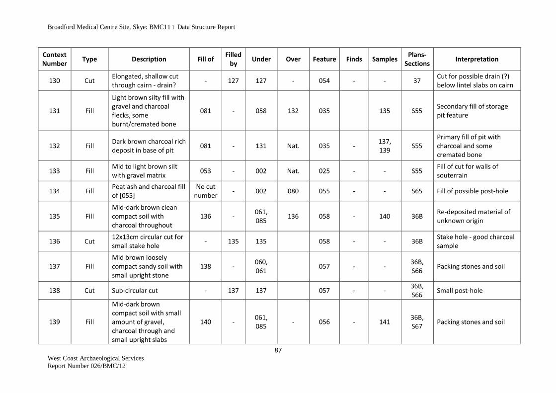
Broadford Medical Centre Site, Skye: BMC11 – Data Structure Report
87 West Coast Archaeological Services Report Number 026/BMC/12
Context Number Type Description Fill of Filled
by Under Over Feature Finds Samples Plans- Sections Interpretation
130 Cut Elongated, shallow cut through cairn - drain? - 127 127 - 054 - - 37 Cut for possible drain (?)
below lintel slabs on cairn
131 Fill
Light brown silty fill with gravel and charcoal flecks, some burnt/cremated bone
081 - 058 132 035 135 S55 Secondary fill of storage pit feature
132 Fill Dark brown charcoal rich deposit in base of pit 081 - 131 Nat. 035 - 137,
139 S55 Primary fill of pit with charcoal and some cremated bone
133 Fill Mid to light brown silt with gravel matrix 053 - 002 Nat. 025 - - S55 Fill of cut for walls of
souterrain
134 Fill Peat ash and charcoal fill of [055]
No cut number - 002 080 055 - - S65 Fill of possible post-hole
135 Fill Mid-dark brown clean compact soil with charcoal throughout
136 - 061, 085 136 058 - 140 36B Re-deposited material of
unknown origin
136 Cut 12x13cm circular cut for small stake hole - 135 135 058 - - 36B Stake hole - good charcoal
sample
137 Fill Mid brown loosely compact sandy soil with small upright stone
138 - 060, 061 057 - - 36B,
S66 Packing stones and soil
138 Cut Sub-circular cut - 137 137 057 - - 36B, S66 Small post-hole
139 Fill
Mid-dark brown compact soil with small amount of gravel, charcoal through and small upright slabs
140 - 061, 085 - 056 - 141 36B,
S67 Packing stones and soil

Broadford Medical Centre Site, Skye: BMC11 – Data Structure Report
88 West Coast Archaeological Services Report Number 026/BMC/12
Context Number Type Description Fill of Filled
by Under Over Feature Finds Samples Plans- Sections Interpretation
140 Cut Circular cut, against cairn stone to SE - 139 139 - 056 - 36B,
S67 Small post-hole
141 Fill
Mid-dark brown clean compact soil with charcoal through - like (135)
142 - 061, 085 142 052 - 143 36, S68 Charcoal-rich fill of stake
hole
142 Cut Circular cut - 141 142 - 052 - - 36, S68 Small stake hole
143 Fill Mid-brown sandy soil with small amounts of charcoal
145 - 061, 085 - 051 - - 36, S69 Stone hole
144 Fill Mid brown-orange loosely compact gravel with stones
145 - 143 145 051 - - 36, S69 Fill of stone hole
145 Cut Sub-oval cut containing loose gravel fill and slab - 144 144 051 - - 36, S69 Stone hole
146 Fill
Mid brown moderately compact soil with some small stones, upright small slabs
133 - 061, 085 132 049 - 144 36, S71 Small post-hole
147 Cut Circular cut for small post-hole - 132 132 049 - - 36, 39,
S71 Small post-hole
148 Fill
Dark brown gritty gravel with a sticky consistency and moderately compact soil with charcoal
149 - 061, 085 080 048 - 145,
146 36, S70 Fill of small post-hole
149 Cut Sub-circular deep cut for post-hole - 148 148 080 048 - - 38, S70 Post-hole
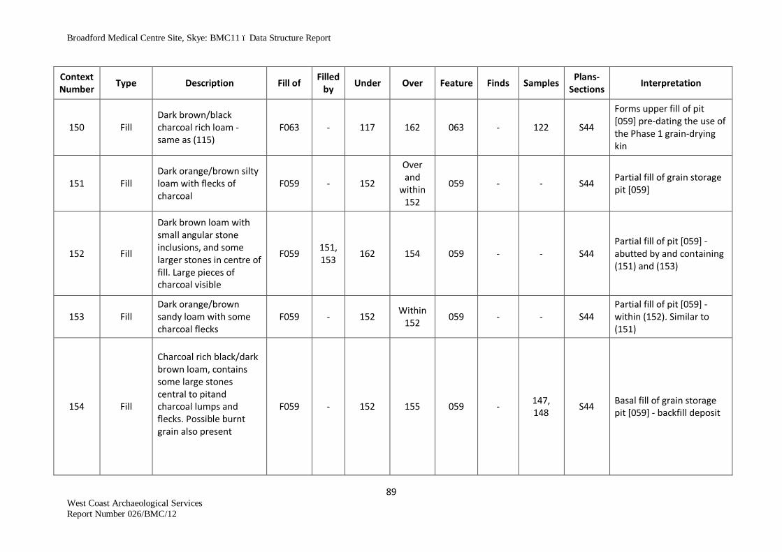
Broadford Medical Centre Site, Skye: BMC11 – Data Structure Report
89 West Coast Archaeological Services Report Number 026/BMC/12
Context Number Type Description Fill of Filled
by Under Over Feature Finds Samples Plans- Sections Interpretation
150 Fill Dark brown/black charcoal rich loam - same as (115)
F063 - 117 162 063 - 122 S44
Forms upper fill of pit [059] pre-dating the use of the Phase 1 grain-drying kin
151 Fill Dark orange/brown silty loam with flecks of charcoal
F059 - 152
Over and
within 152
059 - - S44 Partial fill of grain storage pit [059]
152 Fill
Dark brown loam with small angular stone inclusions, and some larger stones in centre of fill. Large pieces of charcoal visible
F059 151, 153 162 154 059 - - S44
Partial fill of pit [059] - abutted by and containing (151) and (153)
153 Fill Dark orange/brown sandy loam with some charcoal flecks
F059 - 152 Within 152 059 - - S44
Partial fill of pit [059] - within (152). Similar to (151)
154 Fill
Charcoal rich black/dark brown loam, contains some large stones central to pitand charcoal lumps and flecks. Possible burnt grain also present
F059 - 152 155 059 - 147, 148 S44 Basal fill of grain storage
pit [059] - backfill deposit

Broadford Medical Centre Site, Skye: BMC11 – Data Structure Report
90 West Coast Archaeological Services Report Number 026/BMC/12
Context Number Type Description Fill of Filled
by Under Over Feature Finds Samples Plans- Sections Interpretation
155 Cut
Large, deep, steep-sided circular pit, is grain storage pit. Grain drying kiln built into top of pit
-
151, 152, 153, 154
152, 154 080 059 - - S44 Cut of grain storage pit
156 Cut Steep-sided cut into natural subsoil housing the cist structure
- 108 108, 068 080 024 - - 18, 19,
S46, S47 Cut for cist/stone-lined grave
157 Cut
Cut of shallow pit approx. 0.65m diameter by 0.1m deep, with angled sides and convex base
F045, F027 114 114 072 045,
027 - - 25, 31, S41
Cut of shallow pit post-dating the kiln complex
158 Cut
Cut of shallow, flat-based pit 0.1m deep and 0.85m NW-SE by 0.7 NE-SW
060, 027 099 099 080 060,
027 - - 25, 31, S37, S41
Pit filled with waste and rake-out material from Phase 2 grain-drying kiln
159 Cut
Cut of shallow pit of unknown function is steep-sided to W and shallow to N
F061, F027 100 100 099 061,
027 - - 25, 31, S37
Cut of pit of unknown function
160 Cut
Cut of shallow pit includes a vertically-sided hole 0.5m in diameter.
F062, F027 101 101 109 063,
027 - -
25, 31, S33, S37, S38,
S44, S59
May be a fire-pit relating to Phase 2 grain-drying kiln,

Broadford Medical Centre Site, Skye: BMC11 – Data Structure Report
91 West Coast Archaeological Services Report Number 026/BMC/12
Context Number Type Description Fill of Filled
by Under Over Feature Finds Samples Plans- Sections Interpretation
161 Deposit
Four large stones may be fire-cracked remnants of Phase 1 kiln [063] - possibly same as (117)
101 - 072 101 063 - - 31 Part of dismantled kiln infrastructure F063
162 Cut Cut underlying re-deposited fill (150/115), within pit feature [059]
F059 - 150/115 152 059 - - S44 Cut forms base of Phase 1 grain-drying kiln bowl
163 Cut Recut into south end of [063] forms base of bowl for kiln
-
104, 105, 107, 126
107 116 064 - - S35, S44 Cut for bowl of Phase 2 kiln
164 Cut Shallow cut forming bowl for Phase 3 grain-drying kiln
- 103 103 161 065 - - S35 S44 Bowl of Phase 3 kiln
165 Deposit
Medium to large, angular to rounded stone clasts within (054). Vary from 0.1m to 0.7m across
F025, F067 -
002, 062, 063
055, 122 but within
054
025, 067 - -
S25, S26, S43, S20, S21,
S40, S36
Stone backfill above upper floor horizon and collapsed corbelled cell [067]
166 Deposit
Medium to large, angular to rounded stone clasts within (054). Vary from 0.1m to 0.5m across
F025, F067 - 002,
062
054, 064, 093b
025, 067 - -
S25, S26, S43, S20, S21,
S40, S36
Stone backfill within (063)/(094), in features [025] and [067]

Broadford Medical Centre Site, Skye: BMC11 – Data Structure Report
92 West Coast Archaeological Services Report Number 026/BMC/12
Context Number Type Description Fill of Filled
by Under Over Feature Finds Samples Plans- Sections Interpretation
167 Cut
Cut for terminal corbelled cell of Phase 2 souterrain is vertical-sided with walls of [067] fitting close to cut.
F067 168 002, 062 080 067 - - 33, S64
Vertical-sided cut for terminal cell modification/addition to souterrain [025] - Phase 2
168 Fill
Mid to dark brown silty fill with the odd charcoal fleck and some small stone clasts
167 - 002, 062 167 067 - - 33, S64
Silt/sediment fill packing between construction cut (167) and souterrain terminal cell side walls [067]
169 Structure Collapsed cist slabs/capping stones 156 -
069 (and
within) 069
079 024 - - 19, S22
Flat slabs lying within base of cist of primary fill/context (079) including Beaker pots
170 Fill Fill of cut for cist is a dark to mid-brown silt with gravel inclusions
156 - 068 156 024 - - 19, S22 Fill between cut of cist and side/end slabs, from construction phase

Broadford Medical Centre Site, Skye: BMC11 – Data Structure Report
93 West Coast Archaeological Services Report Number 026/BMC/12
Appendix 2 Features Register
BROADFORD MEDICAL CENTRE 2011: Features Register
Feature Number Contexts Finds Samples
Plans and Section
Drawings Description and Notes Initials Date
001 003 - - 01 Splayed entrance in drystone boundary wall; stone-built, some lime/shell mortar SB 25/07/2011
002 - - - - Stone field drain, 20cm wide, filled with medium-sized stones, WNW-ESE aligned LF 26/07/2011
003 - - - - Large stone-filled field drain, 50cm wide, large stones and boulder fill, NW-SE aligned LF 26/07/2011
004 - - - - Stone field drain, 20cm wide, runs between [3] and [5], N-S aligned LF 26/07/2011
005 - - - - Stone field drain, 30cm wide, filled with medium-sized stones, NNW-SSE aligned LF 26/07/2011
006 - - - - Stone field drain, 25cm wide, WNW-ESE aligned LF 26/07/2011
007 021, 022 - - 08-A Stone field drain, 25cm wide, filled with small-medium sized stones, NW-SE aligned LF 26/07/2011
008 005, 006 - 1 02, S01 Sub-circular pit SB 27/07/2011 009 - - 2 02, S02 Tear-drop shaped pit - 'double pit' SB 27/07/2011 010 010 - 3 02, S03 Sub-oval pit SB 27/07/2011
011 - - - - Stone field drain, 50cm wide, filled with large stones 20-50cm long, NNW-SSE aligned LF 26/07/2011
012 003 - - 01 Drystone boundary wall along site edge SB 25/07/2011
013 004 - - - Revetment wall to W of road, stands to a max. of 1m high (drystone), partially disturbed by tree root
SB 27/07/2011

Broadford Medical Centre Site, Skye: BMC11 – Data Structure Report
94 West Coast Archaeological Services Report Number 026/BMC/12
Feature Number Contexts Finds Samples
Plans and Section
Drawings Description and Notes Initials Date
014 012, 013 - - 03, 08-B, S4 Small shallow pit with charcoal rich gravel fill SG 01/08/2011
015 018, 019, 020 - - 08-A
Amorphous pit cut by [7]; filled with degraded sandstone and gravel to S side and degraded sandstone and black matrix to N side LF 01/08/2011
016 031, 032 - 7 07, 10, 08-G, S10 Amorphous pit NE of [17] LF 02/08/2011
017 026, 027, 028 - 6 08-G, S09 J' shaped ditch with black upper fill, 1m SW of [16] MKP 02/08/2011
018 029, 030 - 8 08-G, S11 Sub-circular pit SE of [17], black stoney fill SG 02/08/2011
019 016, 017 - 5 06, 08-C, S08 Sub-circular pit - possible post-hole - N of [20] SG 02/08/2011
020 023, 024, 025 - 4 05, 08-C,
S07 Elongated, amorphous shallow pit/scoop with dark brown-black gravelly and stoney soil fill
MKP 01/08/2011
021 014, 015 - - 08-C Amorphous shallow pit MKP 02/08/2011
022 033, 034 - - 08-H, 11, S12
Grey gritty stoney amorphous spread with dark brown-black sandy soil in centre - SE of [28] MKP 02/08/2011
023 035, 036, 039, 040 - 10 08-D,
08-E, S14 Elongated amorphous pit/scoop with black charcoal rich stoney fill SG 02/08/2011
024 067, 068, 069, 079, 108, 156
15, 23, 34
22, 23, 35-42, 52-65, 72, 73, 80-97
18, 19, 20, 32,
S22, S46, S47
Cist/stone-lined grave LF 08/08/2011

Broadford Medical Centre Site, Skye: BMC11 – Data Structure Report
95 West Coast Archaeological Services Report Number 026/BMC/12
Feature Number Contexts Finds Samples
Plans and Section
Drawings Description and Notes Initials Date
025
002, 053, 054, 055, 056, 057, 059, 062, 063,064, 066, 070, 071, 073, 093, 094, 096, 097, 098, 121, 122, 123, 124, 125
5, 6, 7, 9, 10,
16, 25-27, 30, 36, 38-40, 42, 43, 45, 46, 49-
52
12, 15, 16, 18, 19-21, 24, 29, 30-33, 50, 66-68, 75-78, 100,
102, 106, 112, 113,
129-131
08-I, 08-J, 23, 27, 28, 33,
S20, S21, S25, S26, S31, S32, S36, S40, S43, S45, S48, S49, S50, S60, S62, S63, S64, S68
Stone-lined souterrain aligned NNW-SSE. Lintels removed and feature backfilled. May represent a second phase of construction/modification.
SB 03/08/2011
026
074, 074b, 074c, 075, 076, 077a,
077b
-
17, 25, 26, 27,
34, 45,74,
99, 103, 104, 107, 108, 111
08-I, 08-J, 24, S23, S24, S27, S29, S34
Circular pit with black fill, fire-cracked stone and other stone; N of souterrain; large stone at centre. Burnt grain and other organic residues in base, with most likely function being a grain storage pit
SG 09/08/2011

Broadford Medical Centre Site, Skye: BMC11 – Data Structure Report
96 West Coast Archaeological Services Report Number 026/BMC/12
Feature Number Contexts Finds Samples
Plans and Section
Drawings Description and Notes Initials Date
027
See Features
F045, F059, F060, F061, F062, F063,
F064, F065
- - - Grain-drying kiln complex - N of W end of souterrain including associated pits (including grain storage pit [059]) and deposits MW/DA 09/08/2011
028 NOT FEATURE - - Small sub-circular feature with black upper fill - NW of [22] -
excavated but not a feature SG 02/08/2011
029 037, 038 - 9 08-G Sub-circular pit with stone and dark brown fill
030 041, 042 - 11 08-H, 16, S15 Small sub-circular feature with dark brown stoney upper fill SG 03/08/2011
031 043, 044 - - S16 Fairly shallow arc-shaped 'pit' filled with black/dark brown loam and gravel LF 03/08/2011
032 045, 046, 047 - - S17 Shallow scoop filled with black and dark brown gravel SG 03/08/2011
033 048, 049, 050 - - S18 Shallow oval pit with black/brown soil and gravel SG 03/08/2011
034 051, 052 - - S19 Shallow, amorphous scoop filled with dark brown/black loam and gravel mix LF 03/08/2011
035 058, 081, 131, 132 -
135-137, 139
08-I, 33, 34, S40 Grain storage pit truncated by construction of souterrain SB 04/08/2011
036 056, 057 - - S21 Earlier phase wall of souterrain within trench 25-A SB 04/08/2011

Broadford Medical Centre Site, Skye: BMC11 – Data Structure Report
97 West Coast Archaeological Services Report Number 026/BMC/12
Feature Number Contexts Finds Samples
Plans and Section
Drawings Description and Notes Initials Date
037 060, 061, 084, 085,
088 008 13, 14,
132-134
08-L, 08-M, 08-N, 08-O, 08-P, 08-Q
Amorphous-shaped spread of boulders and stone may be the denuded remains of a cairn. The structure also incorporates a stone-lintelled drain [054] and overlies an earlier suite of post and stake-holes
MKP 05/08/2011
038 - - - 08- SE end of souterrain - later insertion? MKP 05/08/2011
039 091, 092 - 49 08-M, 08-N
Possible pit with black fill and degraded schist boulder Shallow pit with black fill and degraded mudstone
MKP DA
5/8/11 10/8/11
040 089, 090 - 46 21, 22, S28 Circular pit with dark brown gravelly fill - SW of souterrain MKP 05/08/2011
041 111, 112 41 105 08-K, 26, S39
Sub-oval cut with dark brown/black fill, stones (pebble tool); W of souterrain end MKP 05/08/2011
042 NOT FEATURE - - 08-L, 08-
M Sub-rectangular pit with orange/brown gritty gravel fill with roots, compact fill; S of cairn MKP 10/08/2011
043 Not excavated - - 08-N, 08-
Q Elongated, curving cut through black surface (087), containing mid brown stoney fill and tree roots - SW side of cairn MKP 10/08/2011
044 128, 129 - - 08-O Amorphous-shaped possible pit containing brown soil and loosely compact stone - E of cairn MKP 10/08/2011
045 114, 157 - - 25, 31, S41 Vertical sided fire pit within Kiln Complex F027 MW 15/08/2011
046 118, 119 - 124-128 29, 30, S42 Oval cut topped with stones with horizontally-laid slabs in fill LF 15/08/2011
047 054, 055, 056, 057,
125 - - 27, 28,
S40 Stone pillar/post lies within SE end of souterrain [25] tr. D and is associated with paving (124). Possible former entrance? SB 18/08/2011
048 148, 149 - 145, 146
36A, 38, S70 Possible post-hole; lies within W quad of [37] SG 17/08/2011

Broadford Medical Centre Site, Skye: BMC11 – Data Structure Report
98 West Coast Archaeological Services Report Number 026/BMC/12
Feature Number Contexts Finds Samples
Plans and Section
Drawings Description and Notes Initials Date
049 146, 147 - 144, 149
36A, 39, S71 Possible post-hole; lies within W quad of [37] SG 17/08/2011
050 NOT FEATURE - - 36 Possible pebble cache; lies within W quad of [37] SG 17/08/2011
051 143, 144, 145 - - 26, S69 Feature of unknown use (pit?) containing a large slab; lies within W
quad of [37] SG 17/08/2011
052 141, 142 - 143 36, S68 Possible stake-hole in W quad of [37] SG 17/08/2011
053 RE-LABELLED - - - - - -
054 084, 127, 130 - 138
37, S56, S57, S58,
S61
Elongated narrow ditch cut through cairn and black surface underlying lined slabs in cairn - possible 'drain' MKP 19/08/2011
055 134 - 142, 150 36, S65 Possible post-hole; lies within W quad of [37] SG 19/08/2011
056 139, 140 - 141 36, S67 Possible small post-hole with small upright stones; 22 x 24cm MKP 20/08/2011 057 137, 138 - 36, S66 Possible small post-hole with small upright stones; 20 x 22cm MKP 20/08/2011
058 135, 136 - 140 36 Small circular patch with charcoal; 12 x 13cm, 3cm deep may be truncated stake-hole MKP 20/08/2011
059 151, 152, 153, 154, 155, 162
- 147, 148 S44
Steep sided pit containing a mixed backfill deposit including burnt grain may be grain storage pit. Kiln complex F027 cut into top of pit and associated deposits
MW/DA 20/02/2012
060 099, 158 - - 25, 31, S37, S41
Shallow pit filled with waste deposits from kiln complex F027 including burnt barley grains and organics MW/DA 20/02/2012
061 100, 159 - - 25, 31, S37,
Shallow pit of unknown function located above F060 and below F062, forms a part of the kiln complex F027 MW/DA 20/02/2012

Broadford Medical Centre Site, Skye: BMC11 – Data Structure Report
99 West Coast Archaeological Services Report Number 026/BMC/12
Feature Number Contexts Finds Samples
Plans and Section
Drawings Description and Notes Initials Date
062 101, 161, 160
035, 048
101, 121
25, S33, S37, S38, S44, S59
Shallow pit feature with single fill including burnt grain and pottery sherds forms a part of the kiln complex F027 MW/DA 20/02/2012
063
109, 110, 115, 117, 116, 150,
162
- 120, 122, 123,
31, S35, S44
Deep cut into grain storage pit F059 for insertion of Phase 1 of grain-drying kiln, including stone-lined bowl of grain-drying chamber and clay blocking collar separating chamber from the fire chamber
F062
DA 20/02/2012
064 104, 105, 107, 126,
163 -
79, 116, 117, 118, 119,
31, S35, S44
Phase 2 of grain-drying kiln includes cutting of feature F063 and removal of basal stones from Phase 1 kiln, and continued use of fire-pit from Phase 1
DA 20/02/2012
065 095, 102, 103, 164 -
051, 114, 115
S35, S44 Phase 3 of grain-drying kiln includes shallow cut into feature F064 and associated residues and deposits DA 20/02/2012
066 054, 055, 056 - - 33, S48,
S68
Three vertically-set boulders along the NE side of the souterrain possibly relate to the original Phase 1 construction, along with [047] and (124). Boulders set into basal gravel (080)/(125)
SB 20/02/2012
067 167, 168 - - 33, S48 Phase 2 terminal corbelled cell of souterrain [025] SB 20/02/2012

Broadford Medical Centre Site, Skye: BMC11 – Data Structure Report
100 West Coast Archaeological Services Report Number 026/BMC/12
Appendix 3 List of Drawings
Plan Number
Section Number
Feature Number Contexts Date Initials Scale Direction
(facing) Comments
01 - 001 - 25/07/2011 SB 1:20 - Splayed wall access to field (development)
02 - 008, 009, 010
005, 006, 007, 008, 009, 010,
011
27/07/2011 SB 1:20 - Plan of relationship of pit features (watching brief)
- S01 008 005, 006 27/07/2011 SB 1:10 SE Section through small pit feature
- S02 009 007, 008, 009 27/07/2011 SB 1:10 S Section through pit feature
- S03 010 010, 011 27/07/2011 SB 1:10 S Section through small pit feature 03 - 014 012, 013 01/08/2011 SG 1:20 - Pre-ex plan - S04 014 012, 013 01/08/2011 SG 1:10 ENE ENE facing section - S05 021 014, 015 01/08/2011 MKP 1:10 E E facing section of unknown pit
04 - 007, 015 018, 019, 020, 021,
022 01/08/2011 LF 1:20 - Pre-ex plan
- S06 007, 015 018, 019, 020, 021,
022 01/08/2011 LF 1:10 ESE Section through pit and field drain
- S07 020 023, 024, 025 01/08/2011 MKP 1:10 S S facing section through feature
- S08 019 016 02/08/2011 SG 1:10 E E facing section through feature 05 - 020 025 02/08/2011 MKP 1:20 - Post-ex plan 06 - 019 016 02/08/2011 SG 1:20 - Post-ex plan
- S09 017 026, 027, 028 02/08/2011 MKP 1:10 N N facing section A-B

Broadford Medical Centre Site, Skye: BMC11 – Data Structure Report
101 West Coast Archaeological Services Report Number 026/BMC/12
Plan Number
Section Number
Feature Number Contexts Date Initials Scale Direction
(facing) Comments
07 - 016 031, 032 02/08/2011 LF 1:20 - Pre-ex plan - S10 016 031, 032 02/08/2011 LF 1:10 E E facing section through feature
08A-Q -
7, 14, 15, 16, 17, 18, 19, 20, 21, 22, 23, 25, 26, 27, 29, 30, 37, 41,
44
see individual features
03/08/2011 SB 1:20 - Pre-ex plan of Area 1
- S11 018 029, 030 02/08/2011 SG 1:10 E E facing section A-B 09 - 017 028 02/08/2011 LF 1:20 - Post-ex plan 10 - 016 032 02/08/2011 LF 1:20 - Post-ex plan 11 - 022 034 02/08/2011 MKP 1:20 - Post-ex plan - S12 022 033, 034 02/08/2011 MKP 1:10 E E facing section through feature
12 - 029 037 02/08/2011 LF 1:20 - Pre-ex plan 13 - 018 029 02/08/2011 SG 1:20 - Post-ex plan - S13 029 037, 038 02/08/2011 LF 1:10 NE NE facing section through feature
14 - 029 038 02/08/2011 LF 1:20 - Post-ex plan
- S14 023 035, 036, 039, 040 02/08/2011 SG 1:10 S S facing section A-B
15 - 023 040 02/08/2011 LF 1:20 - Post-ex plan - S15 030 041, 042 03/08/2011 SG 1:10 E E facing section through feature
16 - 030 042 03/08/2011 SG 1:20 - Post-ex plan - S16 031 043, 044 03/08/2011 LF 1:10 S S facing section through feature
- S17 032 045, 046,
047
03/08/2011 SG 1:10 SW SW facing section through feature

Broadford Medical Centre Site, Skye: BMC11 – Data Structure Report
102 West Coast Archaeological Services Report Number 026/BMC/12
Plan Number
Section Number
Feature Number Contexts Date Initials Scale Direction
(facing) Comments
- S18 033 048, 049, 050 03/08/2011 SG 1:10 W W facing section through feature
- S19 034 051, 052 03/08/2011 LF 1:10 SSW SSW facing section through feature
17 A-E - Most not numbered - 03/08/2011 LF 1:40 Plan of main features in Area 2 - pre-ex
- S20 025 054, 055, 056, 057 04/08/2011 SB 1:10 SSE Trench 25A SSE facing section
- S21 025 054, 055, 056, 057 04/08/2011 SB 1:10 NNW Trench 25A NNW facing section
18 - 024 067, 068, 156 08/08/2011 LF 1:10 - Pre-ex plan of cist
- S22 024 067, 068, 069, 079, 108, 156
08/08/2011 LF 1:10 SW SW facing section through feature
- S23 026 074, 077 09/08/2011 SG 1:10 NW NW facing section, Quad 2 A-B
19 - 024 067, 069, 156 09/08/2011 LF 1:10 - Mid-ex plan of cist
- S24 026 074, 077 09/08/2011 SG 1:10 NW Section C-D, Quad 1
- S25 025 053, 062, 063, 064,
071 09/08/2011 MKP 1:10 ESE ESE facing section in Tr. 25B
- S26 025 053, 062, 064, 065, 070, 073
09/08/2011 MKP 1:10 WNW WNW facing section in Tr.25B
20 - 024 pots lying in 079 09/08/2011 LF 1:10 - Schematic plan of grid system in base of cist showing
pot position
- S27 026 074, 079, 077 10/08/2011 SG 1:10 N Section Quad 2, A-B

Broadford Medical Centre Site, Skye: BMC11 – Data Structure Report
103 West Coast Archaeological Services Report Number 026/BMC/12
Plan Number
Section Number
Feature Number Contexts Date Initials Scale Direction
(facing) Comments
21 - 040 089, 090 10/08/2011 LF 1:20 - Pre-ex plan - S28 040 089, 090 10/08/2011 LF 1:10 WSW WSW facing section through feature
22 - 040 090 10/08/2011 LF 1:20 - Post-ex plan
23 - 025 053, 093, 094 10/08/2011 MKP 1:20 - Plan of area WNW of C1, C2
- S29 026 074, 075 11/08/2011 SG 1:10 NW Nw facing section, Quad 4 C-D - S30 039 091, 092 11/08/2011 DA 1:10 NNE NNE facing section post-ex
23A - 039 091 11/08/2011 DA 1:20 - Post-ex plan - S31 025 093, 094 11/08/2011 MKP 1:10 NE Tr. 25C longitudinal section
24 - 026 074, 077 11/08/2011 SG 1:20 - Mid-ex plan
- S32 025 094, 096, 097, 098 11/08/2011 MKP 1:10 W W facing section through feature
- S33 027 072, 101 12/08/2011 MW 1:10 SW Initial section - then moved 200mm to NE
25 - 027 099, 100, 101, 114 12/08/2011 MW 1:20 - Overlay - position of sections
- S34 026 074, 077 12/08/2011 SG 1:10 - Running section; A-B
- S35 027
072, 095, 102, 103, 104, 105, 107, 116
12/08/2011 DA 1:10 NE NE facing temporary section
- S36 025 063, 064, 096, 097,
098 12/08/2011 MKP 1:10 NE Tr.25E, C5-C6
- S37 027 072, 099, 100, 101 15/08/2011 MW 1:10 SSE Quad 2
- S38 027 072, 101 15/08/2011 MW 1:10 SW Quad 2 26 - 041 112 15/08/2011 LF 1:20 - Post-ex plan - S39 041 111, 112 15/08/2011 LF 1:10 SE SE facing section

Broadford Medical Centre Site, Skye: BMC11 – Data Structure Report
104 West Coast Archaeological Services Report Number 026/BMC/12
Plan Number
Section Number
Feature Number Contexts Date Initials Scale Direction
(facing) Comments
27 - 025 056 18/08/2011 SB 1:20 - Plan of pillar stone location and collapsed corbelling/walling in end cell
- S40 040 054, 055, 056 15/08/2011 SB 1:10 NE NE section in trench 'D' - souterrain
- S41 027; 045 072, 099, 114 15/08/2011 MW 1:10 SW Quad 2
28 - 025 D 057 16/08/2011 SB 1:20 - Showing paving and pillar stone 29 - 046 118, 119 15/08/2011 LF 1:20 - Pre-ex plan 30 - 046 119 16/08/2011 LF 1:20 - Mid-ex plan showing large flat stone - S42 046 118, 119 16/08/2011 LF 1:10 W W facing section through feature
31 - 027 109, 110, 116, 117 16/08/2011 DA 1:20 - Mid-ex plan showing stones (110) and (117) and partial
removal (116)
- S43 025 062, 063 17/08/2011 SB 1:10 NE Standing longitudinal section through souterrain in trench 'F'
- S44 027
072, 095, 103, 104, 105, 107, 109, 110, 113, 116, 117, 126, 150, 151, 152, 153, 154, 155
17/08/2011 DA/LF 1:10 NE NE facing section through feature
- S45 elevation 025 - 17/08/2011 MW 1:10 NE 1 : south end souterrain, SW side
- S46 024 067, 156 17/08/2011 LF 1:10 SW SW facing section and elevation of cist (short axis) - S47 024 067, 156 17/08/2011 LF 1:10 NW NW facing section and elevation of cist (long axis)

Broadford Medical Centre Site, Skye: BMC11 – Data Structure Report
105 West Coast Archaeological Services Report Number 026/BMC/12
Plan Number
Section Number
Feature Number Contexts Date Initials Scale Direction
(facing) Comments
32 - 024 156 17/08/2011 LF 1:20 - Post-ex plan of cist
33 - 025 053, 058, 081, 18/08/2011 SB 1:20 - Post-ex plan of souterrain - 2 pages
- S48 elevation 025 - 18/08/2011 MW 1:10 - 1 : elevation, south end of souterrain, NE side, 0 - 3m
- S49 elevation 025 - 18/08/2011 MW 1:10 - 2 : elevation, north end of souterrain, NE side wall of
souterrain, 3 - 6.5m
- S50 elevation 025 - 18/08/2011 MW 1:10 - 3 : elevation, north end, NE side wall, 6.5 - 9.2m
- S51 037 060, 061 18/08/2011 MKP 1:10 NW N quad section through cairn
- S52 037 060, 061, 088 18/08/2011 MKP 1:10 SE Section through cairn, S quad
- S53 037 060, 061, 087, 088 18/08/2011 MKP 1:10 NE Section through cairn, N quad
- S54 037 061, 088 18/08/2011 MKP 1:10 SW Section through cairn, S quad
- S55 035 053, 058, 081, 131 19/08/2011 SB 1:10 E Section through pit cut by souterrain
- S56 054
061, 068, 080, 084, 087, 088, 127, 130
19/08/2011 MKP 1:10 SE 1st section through [54] A-B
- S57 054
061, 080, 084, 087, 088, 127,
130
19/08/2011 MKP 1:10 NW 1st section through [54] C-D

Broadford Medical Centre Site, Skye: BMC11 – Data Structure Report
106 West Coast Archaeological Services Report Number 026/BMC/12
Plan Number
Section Number
Feature Number Contexts Date Initials Scale Direction
(facing) Comments
- S58 054 061, 080, 087, 088 19/08/2011 MKP 1:10 NE 1st section through [54] D-A
- S59 027 101 19/08/2011 AH 1:10 NNW Section across possible fire-pit
- S60 elevation 025 - 19/08/2011 MW 1:10 - 2 : elevation of west wall face of souterrain, 2.6 - 6.3m
- S61 054 061, 084, 087, 088,
127 19/08/2011 LF 1:10 SE 2nd section through [54] A-B
34 - 035 053, 081 19/08/2011 SB 1:20 - Post-ex plan of pit and relationship to souterrain wall
- S62 elevation 025 - 19/08/2011 MW 1:10 - 3 : elevation, west wall of souterrain, 6.3 -8.5m
35 - 024, 040 - 20/08/2011 MKP sketch - Plan showing location of features on baseline
36 A-B - 048, 049, 050, 051, 052, 055
- 20/08/2011 MKP 1:20 - Plan showing features below cairn (2 pages)
- S63 025 - 20/08/2011 MW 1:10 - Section through souterrain walls SW-NE - S64 025 - 20/08/2011 MW 1:10 - Section through round S end of souterrain wall
- S65 055 134 (no cut
number assigned)
20/08/2011 SG 1:10 S Section A-B of [55] in W quad of [37]
- S66 057 137, 138 20/08/2011 MKP 1:10 SE Section plan of post-hole - S67 056 139, 140 20/08/2011 MKP 1:10 ESE Section plan of post-hole
- S68 025
025, 053, 133 (not
marked on drawing)
20/08/2011 SB 1:10 SE and NW Sections through souterrain walls and support stones
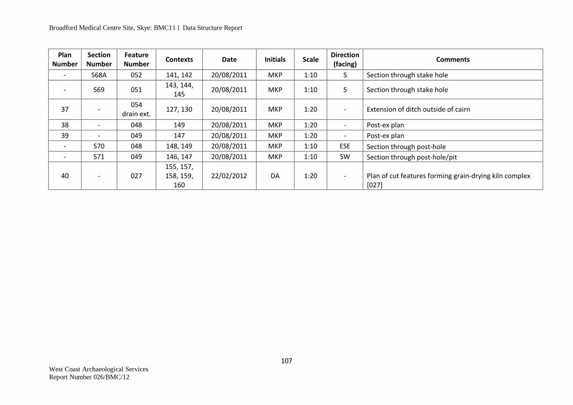
Broadford Medical Centre Site, Skye: BMC11 – Data Structure Report
107 West Coast Archaeological Services Report Number 026/BMC/12
Plan Number
Section Number
Feature Number Contexts Date Initials Scale Direction
(facing) Comments
- S68A 052 141, 142 20/08/2011 MKP 1:10 S Section through stake hole
- S69 051 143, 144, 145 20/08/2011 MKP 1:10 S Section through stake hole
37 - 054 drain ext. 127, 130 20/08/2011 MKP 1:20 - Extension of ditch outside of cairn
38 - 048 149 20/08/2011 MKP 1:20 - Post-ex plan 39 - 049 147 20/08/2011 MKP 1:20 - Post-ex plan - S70 048 148, 149 20/08/2011 MKP 1:10 ESE Section through post-hole - S71 049 146, 147 20/08/2011 MKP 1:10 SW Section through post-hole/pit
40 - 027 155, 157, 158, 159,
160 22/02/2012 DA 1:20 - Plan of cut features forming grain-drying kiln complex
[027]

Broadford Medical Centre Site, Skye: BMC11 – Data Structure Report
108 West Coast Archaeological Services Report Number 026/BMC/12
Appendix 4 Digital Images Register
BROADFORD MEDICAL CENTRE 2011: Index of Photographs
No. Direction
Facing Feature Description Taken
By Date 1 E N end of new entrance SB 25/07/2011 2 E New entrance - working south SB 25/07/2011 3 E New entrance- working south SB 25/07/2011 4 E New entrance- working south SB 25/07/2011 5 E New entrance - working south SB 25/07/2011 6 E New entrance - working south SB 25/07/2011 7 E New entrance - working south SB 25/07/2011 8 E New entrance - working south SB 25/07/2011 9 E New entrance - working south SB 25/07/2011
10 E New entrance - working south SB 25/07/2011 11 E New entrance - working south SB 25/07/2011 12 E New entrance - working south SB 25/07/2011 13 E New entrance - working south SB 25/07/2011 14 E New entrance - working south SB 25/07/2011 15 SSW General shot towards Beinn Suardal SB 25/07/2011 16 SW Over site towards Strath Suardal SB 25/07/2011 17 N Over development site SB 25/07/2011 18 NNE Over main site SB 25/07/2011 19 ESE Edge of main site looking NE (?) SB 25/07/2011 20 NE Over main site SB 25/07/2011 21 E Mosaic view from site SB 25/07/2011 22 arcing Mosaic view from site SB 25/07/2011 23 round Mosaic view from site SB 25/07/2011 24 to Mosaic view from site SB 25/07/2011 25 S Mosaic view from site SB 25/07/2011 26 ESE 001 Original entrance into field (splayed) SB 25/07/2011 27 ESE 001 S end of entrance SB 25/07/2011 28 S 001 (Down) N pillar base of entrance SB 25/07/2011
29 images W wall of road (to be destroyed) S end (images overlap moving N) SB 25/07/2011
30 move W wall of road (to be destroyed) S end (images overlap moving N)
SB 25/07/2011
31 to W wall of road (to be destroyed) S end (images overlap moving N)
SB 25/07/2011
32 N W wall of road (to be destroyed) S end (images overlap moving N)
SB 25/07/2011
33 by W wall of road (to be destroyed) S end (images overlap moving N)
SB 25/07/2011

Broadford Medical Centre Site, Skye: BMC11 – Data Structure Report
109 West Coast Archaeological Services Report Number 026/BMC/12
No. Direction
Facing Feature Description Taken
By Date
34 image W wall of road (to be destroyed) S end (images overlap moving N)
SB 25/07/2011
35 49 W wall of road (to be destroyed) S end (images overlap moving N)
SB 25/07/2011
36 W wall of road (to be destroyed) S end (images overlap moving N)
SB 25/07/2011
37 W wall of road (to be destroyed) S end (images overlap moving N)
SB 25/07/2011
38 W wall of road (to be destroyed) S end (images overlap moving N)
SB 25/07/2011
39 W wall of road (to be destroyed) S end (images overlap moving N)
SB 25/07/2011
40 W wall of road (to be destroyed) S end (images overlap moving N)
SB 25/07/2011
41 W wall of road (to be destroyed) S end (images overlap moving N)
SB 25/07/2011
42 W wall of road (to be destroyed) S end (images overlap moving N)
SB 25/07/2011
43 W wall of road (to be destroyed) S end (images overlap moving N)
SB 25/07/2011
44 W wall of road (to be destroyed) S end (images overlap moving N)
SB 25/07/2011
45 W wall of road (to be destroyed) S end (images overlap moving N)
SB 25/07/2011
46 W wall of road (to be destroyed) S end (images overlap moving N)
SB 25/07/2011
47 W wall of road (to be destroyed) S end (images overlap moving N)
SB 25/07/2011
48 W wall of road (to be destroyed) S end (images overlap moving N)
SB 25/07/2011
49 W wall of road (to be destroyed) S end (images overlap moving N) - runs behind concrete drain
SB 25/07/2011
50 SW General shot down wall SB 25/07/2011 51 ENE Splayed entrance SB 25/07/2011 52 SSE Splayed entrance SB 25/07/2011 53 ESE Beginning topsoil strip LF 26/07/2011 54 ESE 002 Stone field drain LF 26/07/2011 55 NW 003 Stone field drain LF 26/07/2011 56 N 004 Stone field drain LF 26/07/2011 57 NNW 005 Stone field drain LF 26/07/2011 58 ESE 006 Stone field drain LF 26/07/2011 59 NNE Post topsoil strip LF 26/07/2011 60 WNW Post topsoil strip LF 26/07/2011

Broadford Medical Centre Site, Skye: BMC11 – Data Structure Report
110 West Coast Archaeological Services Report Number 026/BMC/12
No. Direction
Facing Feature Description Taken
By Date 61 SE Post topsoil strip LF 26/07/2011 62 SE 007 Stone field drain LF 26/07/2011 63 NW 008, 009 Dark stains in ground - pits for posts SB 27/07/2011 64 NW 008 Possible post-hole or pit from above SB 27/07/2011 65 NE 009 Possible pit feature/dark stain SB 27/07/2011 66 SE 010 Possible pit feature/dark stain SB 27/07/2011 67 NW 008 SE facing section through [8] SB 27/07/2011 68 N 009 S facing section through [9] SB 27/07/2011 69 NNE 010 SSW facing section through [10] SB 27/07/2011 70 WNW 008 Post-ex image from above SB 27/07/2011 71 NW 009 Post-ex image from above SB 27/07/2011 72 NNW 010 Post-ex image from above SB 27/07/2011 73 SSE 025 Souterrain emerging (wall heads) SB 28/07/2011 74 SSE 025 Overall view of souterrain SB 28/07/2011 75 SSE 025 Overall view of souterrain SB 28/07/2011 76 SE 024 View of cist from above SB 28/07/2011 77 S 037 Area of possible cairn SB 28/07/2011 78 S 037 Area of possible cairn SB 28/07/2011 79 SE 037 Area of possible cairn SB 28/07/2011 80 NW 037 Area of possible cairn SB 28/07/2011 81 WNW 014 Pre-ex image of possible pit feature SG 01/08/2011 82 SW Overall landscape and cleaned back Area 1 MKP 01/08/2011 83 to Overall landscape and cleaned back Area 1 MKP 01/08/2011 84 NW Overall landscape and cleaned back Area 1 MKP 01/08/2011 85 Overall landscape and cleaned back Area 1 MKP 01/08/2011 86 Overall landscape and cleaned back Area 1 MKP 01/08/2011 87 Overall landscape and cleaned back Area 1 MKP 01/08/2011 88 Overall landscape and cleaned back Area 1 MKP 01/08/2011 89 Overall landscape and cleaned back Area 1 MKP 01/08/2011 90 Overall landscape and cleaned back Area 1 MKP 01/08/2011 91 Overall landscape and cleaned back Area 1 MKP 01/08/2011 92 Overall landscape and cleaned back Area 1 MKP 01/08/2011 93 Overall landscape and cleaned back Area 1 MKP 01/08/2011 94 Overall landscape and cleaned back Area 1 MKP 01/08/2011 95 Overall landscape and cleaned back Area 1 MKP 01/08/2011 96 WNW 014 ENE facing section SG 01/08/2011 97 SSW 015 Pre-ex image LF 01/08/2011 98 W 015 Pre-ex image LF 01/08/2011 99 N 021 Pre-ex image MKP 01/08/2011
100 N 021 Pre-ex image MKP 01/08/2011 101 SSW 014 Post-ex image SG 01/08/2011 102 NW 020 Pre-ex image SG 01/08/2011 103 E 020 Pre-ex image SG 01/08/2011

Broadford Medical Centre Site, Skye: BMC11 – Data Structure Report
111 West Coast Archaeological Services Report Number 026/BMC/12
No. Direction
Facing Feature Description Taken
By Date 104 NW 019 Pre-ex image SG 01/08/2011 105 N 020 Post section image MKP 01/08/2011 106 N 020 Post section image MKP 01/08/2011 107 WNW 015 Section - post-ex LF 01/08/2011 108 WNW 015 Section - post-ex LF 01/08/2011 109 NW 020 Post-ex image MKP 02/08/2011 110 NNW 016 Pre-ex image MKP 02/08/2011 111 NW 019 Post section image SG 02/08/2011 112 N 017 Pre-ex image MKP 02/08/2011
113 N 016, 017, 018 Pre-ex image MKP 02/08/2011
114 W 018 Pre-ex image MKP 02/08/2011 115 NNW 022, 028 Pre-ex image MKP 02/08/2011 116 E 022, 028 Pre-ex image MKP 02/08/2011 117 NW 019 Post-ex image MKP 02/08/2011 118 NW 019 Post-ex image SG 02/08/2011 119 W 017 Post section image MKP 02/08/2011 120 S 017 Post section image MKP 02/08/2011 121 NE 017 Post-ex image MKP 02/08/2011 122 W 016 Post-ex image LF 02/08/2011 123 NW 022 E facing section MKP 02/08/2011 124 W 018 E facing section SG 02/08/2011 125 NW 029 Pre-ex image MKP 02/08/2011 126 W 018 Post-ex image SG 02/08/2011 127 SW 029 NE facing section LF 02/08/2011 128 SW 028 Post-ex image SG 02/08/2011 129 SE 023 Pre-ex image SG 02/08/2011 130 NW 029 Post-ex image LF 02/08/2011 131 NW 023 Post-ex image LF 02/08/2011 132 E 030 E facing section A-B SG 03/08/2011 133 E 030 Post-ex image SG 03/08/2011 134 SW Area 2 Post cleaning photo of Area 2 LF 03/08/2011 135 SW Area 2 Southern end of Area 2 LF 03/08/2011 136 NE Area 2 General photo of Area 2 S LF 03/08/2011 137 NNE Area 2 General photo of Area 2 LF 03/08/2011
138 NE Not numbered SW facing section; Area 2 SG 03/08/2011
139 N 031 S facing section LF 03/08/2011
140 E Not numbered W facing section; Area 2 SG 03/08/2011
141 NNE Not numbered SSW facing section LF 03/08/2011
142 S 025A Tr.25A in souterrain (partially excavated) showing possible lintel infill
SB 03/08/2011

Broadford Medical Centre Site, Skye: BMC11 – Data Structure Report
112 West Coast Archaeological Services Report Number 026/BMC/12
No. Direction
Facing Feature Description Taken
By Date
143 S 025A Tr.25A in souterrain (partially excavated) showing possible lintel infill
SB 03/08/2011
144 N 025A Tr.25A in souterrain (partially excavated) showing possible lintel infill
SB 03/08/2011
145 N 025A Tr.25A in souterrain (partially excavated) showing possible lintel infill
SB 03/08/2011
146 NW 037 Staring to clean back on the cairn LF 03/08/2011 147 SE 037 Staring to clean back on the cairn LF 03/08/2011 148 Overall site shots and pre-ex of major features MKP 04/08/2011 149 Overall site shots and pre-ex of major features MKP 04/08/2011 150 Overall site shots and pre-ex of major features MKP 04/08/2011 151 Overall site shots and pre-ex of major features MKP 04/08/2011 152 Overall site shots and pre-ex of major features MKP 04/08/2011 153 Overall site shots and pre-ex of major features MKP 04/08/2011 154 Overall site shots and pre-ex of major features MKP 04/08/2011 155 Overall site shots and pre-ex of major features MKP 04/08/2011 156 024 Cist - pre-ex MKP 04/08/2011 157 024 Cist - pre-ex MKP 04/08/2011 158 024 Cist - pre-ex MKP 04/08/2011 159 025 Souterrain after 1st section MKP 04/08/2011 160 025 Souterrain after 1st section MKP 04/08/2011 161 025 Souterrain after 1st section MKP 04/08/2011 162 025 Souterrain after 1st section MKP 04/08/2011 163 025 Souterrain after 1st section MKP 04/08/2011 164 026 Large pit - pre-ex MKP 04/08/2011 165 025 Souterrain after 1st section MKP 04/08/2011 166 027 Grain drying kiln - pre-ex MKP 04/08/2011 167 SE Overall site and cairn, black surface MKP 05/08/2011 168 ESE 037 Overall site and cairn, black surface MKP 05/08/2011 169 SE 037 Overall site and cairn, black surface MKP 05/08/2011 170 SE 037 Overall site and cairn, black surface MKP 05/08/2011 171 SE 037 Overall site and cairn, black surface MKP 05/08/2011 172 SE 037 Overall site and cairn, black surface MKP 05/08/2011 173 SSE 025 General - souterrain, kiln and cist MKP 05/08/2011 174 SE 037 General - cairn MKP 05/08/2011 175 SE 037 General - cairn MKP 05/08/2011 176 SE 037 General - cairn MKP 05/08/2011 177 NW 037 Central 'passage' in cairn MKP 05/08/2011 178 W 037 Lintels and cairn MKP 05/08/2011 179 WNW 037 Lintels and cairn MKP 05/08/2011 180 NW 037 Lintels and cairn MKP 05/08/2011 181 N 025 Block entrance in 1st souterrain section MKP 05/08/2011 182 SE 025 NW facing section of souterrain fill MKP 05/08/2011

Broadford Medical Centre Site, Skye: BMC11 – Data Structure Report
113 West Coast Archaeological Services Report Number 026/BMC/12
No. Direction
Facing Feature Description Taken
By Date 183 SE 025 NW facing section of souterrain fill MKP 05/08/2011 184 NE 038 SE end of souterrain MKP 05/08/2011 185 NW 039 Pre-ex image MKP 05/08/2011 186 SW 026 Pre-ex image SG 08/08/2011 187 NE 024 Cist - pre-ex LF 08/08/2011 188 SW 024 Cist - pre-ex LF 08/08/2011 189 SE 024 Cist - pre-ex LF 08/08/2011 190 NW 024 Cist - pre-ex LF 08/08/2011 191 SE 024 Cist - pre-ex LF 08/08/2011 192 E 024 Lifting of capstone MKP 08/08/2011 193 E 024 Lifting of capstone MKP 08/08/2011 194 E 024 Lifting of capstone MKP 08/08/2011 195 E 024 Lifting of capstone MKP 08/08/2011 196 E 024 Lifting of capstone MKP 08/08/2011 197 E 024 Lifting of capstone MKP 08/08/2011 198 E 024 Lifting of capstone MKP 08/08/2011 199 SSW 024 Feature after capstone removal MKP 08/08/2011 200 SSW 024 Feature after capstone removal MKP 08/08/2011 201 SSW 024 Feature after capstone removal MKP 08/08/2011 202 NNE 025 Showing backfill in cut in section 2 (065) MKP 08/08/2011
203 NE 024 Mid-ex showing upright slabs in N end 'floating' and fallen slabs
LF 09/08/2011
204 S 024 Mid-ex cist LF 09/08/2011 205 NW 024 Mid-ex cist LF 09/08/2011 206 SE 024 Mid-ex cist LF 09/08/2011 207 NNE 024 Mid-ex cist LF 09/08/2011 208 NNE 024 Mid-ex cist LF 09/08/2011 209 NE 024 Mid-ex of cist showing large slabs (fallen?) LF 09/08/2011 210 SE 024 Mid-ex of cist showing large slabs (fallen?) LF 09/08/2011 211 NW 024 Mid-ex of cist showing large slabs (fallen?) LF 09/08/2011 212 SSW 024 Mid-ex of cist showing large slabs (fallen?) LF 09/08/2011 213 SW 026 Mid-ex quads 1 and 2 SG 09/08/2011 214 N 026 Mid-ex quad 2 SG 09/08/2011 215 S 026 Mid-ex quad 1 SG 09/08/2011 216 024 Beaker pot (on hand) MKP 09/08/2011 217 027 Thumb-impressed pot fragment (on hand) MKP 09/08/2011 218 SE 024 Beaker pot in situ MKP 09/08/2011 219 SE 024 Beaker pot in situ MKP 09/08/2011 220 SE 024 Beaker pot in situ MKP 09/08/2011 221 SE 024 Beaker pot in situ MKP 09/08/2011 222 SE 024 Beaker pot in situ MKP 09/08/2011 223 SE 024 Beaker pot in situ MKP 09/08/2011 224 SE 024 Beaker pot in situ MKP 09/08/2011

Broadford Medical Centre Site, Skye: BMC11 – Data Structure Report
114 West Coast Archaeological Services Report Number 026/BMC/12
No. Direction
Facing Feature Description Taken
By Date 225 NE 024 Cist during excavation of fill MKP 09/08/2011 226 SW 024 Cist during excavation of fill MKP 09/08/2011 227 N 025B Section 2 of souterrain MKP 09/08/2011 228 N 025B Section 2 of souterrain MKP 09/08/2011 229 NW 025 Souterrain, after 2 sections MKP 09/08/2011 230 NW 025 Section 2 of souterrain ESE-facing section MKP 09/08/2011 231 NW 025 Section 2 of souterrain ESE-facing section MKP 09/08/2011 232 NW 025 Section 2 of souterrain ESE-facing section MKP 09/08/2011 233 N 025 NE wall of souterrain in Tr.25B MKP 09/08/2011 234 N 025 NE wall of souterrain in Tr.25B MKP 09/08/2011 235 ESE 025 WNW-facing section of section 2 Tr. 25B MKP 09/08/2011 236 ESE 025 WNW-facing section of section 2 Tr. 25B MKP 09/08/2011 237 SW 025 SW wall of souterrain in section 2 Tr. 25B MKP 09/08/2011 238 SW 025 SW wall of souterrain in section 2 Tr. 25B MKP 09/08/2011 239 SE 025 Souterrain post-ex of 2 sections MKP 09/08/2011 240 NE 037 Cairn MKP 09/08/2011 241 SSE 024 Pot in cist LF 09/08/2011 242 SSE 024 Pot in cist LF 09/08/2011 243 SSE 024 Pot in cist LF 09/08/2011 244 N 024 Pot in cist LF 09/08/2011 245 N 024 Pot in cist LF 09/08/2011 246 NE 024 Pot in cist LF 09/08/2011 247 NE 024 Pot in cist LF 09/08/2011 248 NW 027 Carbonated grain in kiln MKP 10/08/2011 249 NW 027 Carbonated grain in kiln MKP 10/08/2011 250 NW 027 Carbonated grain in kiln MKP 10/08/2011 251 NW 027 Carbonated grain in kiln MKP 10/08/2011 252 027 Section of Martin's end - which quad MKP 10/08/2011 253 NNE 040 Pre-ex image MKP 10/08/2011 254 NNE 040 Pre-ex image MKP 10/08/2011 255 ESE 040 WSW facing section LF 10/08/2011 256 ESE 040 Post-ex image LF 10/08/2011 257 NE 026 Section SG 10/08/2011 258 N 025 During section C1-C2, Tr.25C; (093) and (094) MKP 10/08/2011 259 NNE 025 During section C1-C2, Tr.25C; (093) and (094) MKP 10/08/2011 260 NW 025 During section C1-C2, Tr.25C; (093) and (094) MKP 10/08/2011 261 N 025 During section C1-C2, Tr.25C; (093) and (094) MKP 10/08/2011 262 SE 025 During section C1-C2, Tr.25C; (093) and (094) MKP 10/08/2011 263 NW 037 Pre-ex of cairn MKP 11/08/2011 264 NW 037 Pre-ex of cairn MKP 11/08/2011 265 NW 037 Pre-ex of cairn MKP 11/08/2011 266 NW 037 Pre-ex of cairn MKP 11/08/2011 267 NW 037 Pre-ex of cairn MKP 11/08/2011

Broadford Medical Centre Site, Skye: BMC11 – Data Structure Report
115 West Coast Archaeological Services Report Number 026/BMC/12
No. Direction
Facing Feature Description Taken
By Date 268 NW 037 Pre-ex of cairn MKP 11/08/2011 269 NW 037 Pre-ex of cairn MKP 11/08/2011 270 NNE 039 Post-ex DA 11/08/2011
271 NE 024 Excavating grid within cist - 2nd pot emerging above N arrow and to left of scale
LF 11/08/2011
272 NE 024 Excavating grid within cist - 2nd pot emerging above N arrow and to left of scale
LF 11/08/2011
273 SW 026 Mid-ex SG 11/08/2011 274 SE 026 Mid-ex SG 11/08/2011 275 NE 026 Mid-ex SG 11/08/2011 276 SW 025 Tr.25C, post half section of 3rd section MKP 11/08/2011 277 N 025 NE facing section Tr.25C MKP 11/08/2011 278 SW 025 NE facing section Tr.25C MKP 11/08/2011 279 SW 025 NE facing section Tr.25C - showing location of pottery MKP 11/08/2011 280 NE 024 Mid-ex of 2nd squashed pot in cist LF 11/08/2011 281 NE 024 Mid-ex of 2nd squashed pot in cist LF 11/08/2011 282 NW 024 Mid-ex of 2nd squashed pot in cist LF 11/08/2011 283 NW 024 Mid-ex of 2nd squashed pot in cist LF 11/08/2011 284 NW 024 Mid-ex of 2nd squashed pot in cist LF 11/08/2011 285 024 2nd pot, decorated sherd in situ MKP 11/08/2011 286 024 2nd pot, decorated sherd in situ MKP 11/08/2011 287 SE 025 3rd section, Tr.25C, C3-C4 section MKP 11/08/2011 288 SE 025 3rd section, Tr.25C, C3-C4 section MKP 11/08/2011 289 SE 025 3rd section, Tr.25C, C3-C4 section MKP 11/08/2011 290 SE 025 3rd section, Tr.25C, C3-C4 section MKP 11/08/2011 291 SE 025 3rd section, Tr.25C, C3-C4 section MKP 11/08/2011 292 SE 025 3rd section, Tr.25C, C3-C4 section MKP 11/08/2011
293 SE 025 3rd section, Tr.25C, C3-C4 section - showing location of (030) and (031)
MKP 11/08/2011
294 SE 025 3rd section, Tr.25C, C3-C4 section - showing location of (030) and (031)
MKP 11/08/2011
295 NW 024 2nd pot prior to lifting LF 11/08/2011 296 NW 024 2nd pot prior to lifting LF 11/08/2011 297 SW 026 Mid-ex SG 11/08/2011 298 SE 026 Mid-ex SG 11/08/2011 299 NE 026 Mid-ex SG 11/08/2011 300 SE Overall site shot MKP 12/08/2011 301 SE Overall site shot MKP 12/08/2011 302 SE Overall site shot MKP 12/08/2011 303 SE Overall site shot MKP 12/08/2011 304 SE Overall site shot MKP 12/08/2011 305 SE Overall site shot MKP 12/08/2011 306 SE Overall site shot - stitched image MKP 12/08/2011

Broadford Medical Centre Site, Skye: BMC11 – Data Structure Report
116 West Coast Archaeological Services Report Number 026/BMC/12
No. Direction
Facing Feature Description Taken
By Date 307 SE Overall site shot MKP 12/08/2011 308 SE Overall site shot MKP 12/08/2011 309 SE Overall site shot MKP 12/08/2011 310 SE Overall site shot MKP 12/08/2011 311 SE 027, 062 Record shot during section MKP 12/08/2011 312 SE 027, 062 Record shot during section MKP 12/08/2011 313 NNE 027, 062 Post-ex shot LF 12/08/2011 314 NE 027, 062 Initial section (072) and (101) quad 2 SG 12/08/2011 315 NE 027, 062 Initial section close up SG 12/08/2011 316 NE 024 Cist after basal layer removed LF 12/08/2011 317 NE 024 Cist after basal layer removed LF 12/08/2011 318 SW 024 Cist after basal layer removed LF 12/08/2011 319 NE 024 Post-ex of cist LF 12/08/2011 320 NE 024 Post-ex of cist LF 12/08/2011 321 SE 026 Base of pit (076) SG 12/08/2011 322 026 Close-up SG 12/08/2011 323 NE 024 Post-ex of cist LF 12/08/2011 324 NE 024 Post-ex of cist LF 12/08/2011
325 SW 027, 063, 064, 065 Post-ex of NE facing temporary section
DA 12/08/2011
326 NNE 041 Pre-ex shot LF 15/08/2011
327 NNW 027, 060, 061, 062 SSE facing section in quad 2
LF 15/08/2011
328 NNW 027, 060, 061, 062 Detail of SSE section E end quad 2
LF 15/08/2011
329 NW 041 SE facing section LF 15/08/2011 330 NNE 041 Post-ex shot LF 15/08/2011 331 NNE 041 Post-ex shot LF 15/08/2011 332 NW 026 NW facing mid-ex section (077) SG 15/08/2011 333 NW 026 NW close-up mid-ex section SG 15/08/2011
334 N 027, 063, 064, 065
Mid-ex shot to show clay blocking layers during removal. Foreground clay (109) with stones (110); mid-ground clay (103).
DA 15/08/2011
335 NW 025 Tr.D showing collapsed corbelling walling and pillar stone/post
SB 15/08/2011
336 SE 025 Tr.D showing collapsed corbelling walling and pillar stone/post
SB 15/08/2011
337 NW 025 Lower-level view of pillar stone/post SB 15/08/2011 338 SE 026 Mid-ex photo of fibrous sample <107> SG 15/08/2011 339 SE 026 In-situ shot of fibrous sample <107> SG 15/08/2011 340 SE 046 Pre-ex shot LF 15/08/2011 341 NE 027, 045 Section 41 MW 15/08/2011 342 ESE 046 Mid-ex shot LF 16/08/2011
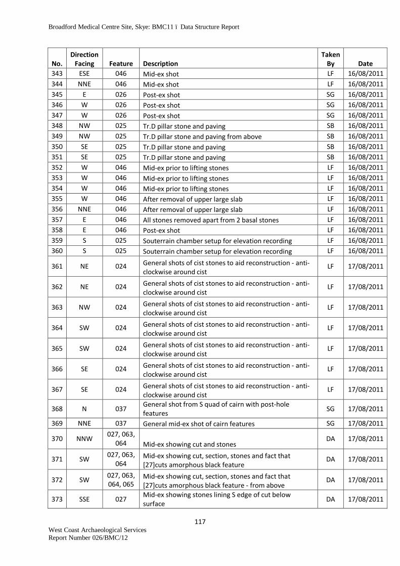
Broadford Medical Centre Site, Skye: BMC11 – Data Structure Report
117 West Coast Archaeological Services Report Number 026/BMC/12
No. Direction
Facing Feature Description Taken
By Date 343 ESE 046 Mid-ex shot LF 16/08/2011 344 NNE 046 Mid-ex shot LF 16/08/2011 345 E 026 Post-ex shot SG 16/08/2011 346 W 026 Post-ex shot SG 16/08/2011 347 W 026 Post-ex shot SG 16/08/2011 348 NW 025 Tr.D pillar stone and paving SB 16/08/2011 349 NW 025 Tr.D pillar stone and paving from above SB 16/08/2011 350 SE 025 Tr.D pillar stone and paving SB 16/08/2011 351 SE 025 Tr.D pillar stone and paving SB 16/08/2011 352 W 046 Mid-ex prior to lifting stones LF 16/08/2011 353 W 046 Mid-ex prior to lifting stones LF 16/08/2011 354 W 046 Mid-ex prior to lifting stones LF 16/08/2011 355 W 046 After removal of upper large slab LF 16/08/2011 356 NNE 046 After removal of upper large slab LF 16/08/2011 357 E 046 All stones removed apart from 2 basal stones LF 16/08/2011 358 E 046 Post-ex shot LF 16/08/2011 359 S 025 Souterrain chamber setup for elevation recording LF 16/08/2011 360 S 025 Souterrain chamber setup for elevation recording LF 16/08/2011
361 NE 024 General shots of cist stones to aid reconstruction - anti-clockwise around cist
LF 17/08/2011
362 NE 024 General shots of cist stones to aid reconstruction - anti-clockwise around cist
LF 17/08/2011
363 NW 024 General shots of cist stones to aid reconstruction - anti-clockwise around cist
LF 17/08/2011
364 SW 024 General shots of cist stones to aid reconstruction - anti-clockwise around cist
LF 17/08/2011
365 SW 024 General shots of cist stones to aid reconstruction - anti-clockwise around cist
LF 17/08/2011
366 SE 024 General shots of cist stones to aid reconstruction - anti-clockwise around cist
LF 17/08/2011
367 SE 024 General shots of cist stones to aid reconstruction - anti-clockwise around cist
LF 17/08/2011
368 N 037 General shot from S quad of cairn with post-hole features SG 17/08/2011
369 NNE 037 General mid-ex shot of cairn features SG 17/08/2011
370 NNW 027, 063, 064 Mid-ex showing cut and stones
DA 17/08/2011
371 SW 027, 063, 064
Mid-ex showing cut, section, stones and fact that [27]cuts amorphous black feature
DA 17/08/2011
372 SW 027, 063, 064, 065
Mid-ex showing cut, section, stones and fact that [27]cuts amorphous black feature - from above
DA 17/08/2011
373 SSE 027 Mid-ex showing stones lining S edge of cut below surface DA 17/08/2011

Broadford Medical Centre Site, Skye: BMC11 – Data Structure Report
118 West Coast Archaeological Services Report Number 026/BMC/12
No. Direction
Facing Feature Description Taken
By Date 374 SSE 025 Lintel exposed in souterrain fill SB 17/08/2011 375 SSE 025 Lintel exposed in souterrain fill SB 17/08/2011 376 SSE 025 Lintel in souterrain fill from above SB 17/08/2011 377 NNE 024 Cist after removal of lining stones LF 17/08/2011 378 NNE 024 Cist after removal of lining stones LF 17/08/2011 379 NE 025 Broken pot in top of (071) Tr.F SB 17/08/2011 380 NE 025 Close-up of broken pot Tr.F SB 17/08/2011 381 NE 025 Close-up of broken pot Tr.F SB 17/08/2011 382 SW 025 Close-up of broken pot Tr.F SB 17/08/2011 383 SW 025 Close-up of broken pot Tr.F SB 17/08/2011 384 SE 025 Close-up of broken pot Tr.F SB 17/08/2011 385 SE 025 Broken pot in top of (071) Tr.F SB 17/08/2011 386 N 037 General mid-ex shot of W quad SG 17/08/2011 387 NE 037 General mid-ex shot of W quad SG 17/08/2011 388 025 Souterrain MKP 18/08/2011 389 025 Souterrain MKP 18/08/2011 390 025 Souterrain MKP 18/08/2011 391 025 Souterrain MKP 18/08/2011 392 025 Souterrain MKP 18/08/2011 393 025 Souterrain MKP 18/08/2011 394 025 Souterrain MKP 18/08/2011 395 025 Souterrain MKP 18/08/2011 396 025 Souterrain MKP 18/08/2011 397 025 Souterrain MKP 18/08/2011 398 025 Souterrain MKP 18/08/2011 399 025 Souterrain MKP 18/08/2011 400 025 Souterrain MKP 18/08/2011 401 025 Souterrain MKP 18/08/2011 402 025 Souterrain MKP 18/08/2011 403 025 Souterrain MKP 18/08/2011 404 025 Souterrain MKP 18/08/2011 405 025 Souterrain MKP 18/08/2011 406 Stitch 025 Souterrain MKP 18/08/2011 407 Stitch 025 Souterrain MKP 18/08/2011 408 025 Souterrain MKP 18/08/2011 409 025 Souterrain MKP 18/08/2011 410 025 Souterrain MKP 18/08/2011 411 025 Souterrain MKP 18/08/2011 412 025 Souterrain MKP 18/08/2011 413 025 Souterrain MKP 18/08/2011 414 025 Souterrain MKP 18/08/2011 415 025 Souterrain MKP 18/08/2011 416 025 Souterrain MKP 18/08/2011

Broadford Medical Centre Site, Skye: BMC11 – Data Structure Report
119 West Coast Archaeological Services Report Number 026/BMC/12
No. Direction
Facing Feature Description Taken
By Date 417 025 Souterrain MKP 18/08/2011 418 025 Souterrain MKP 18/08/2011 419 025 Souterrain MKP 18/08/2011 420 025 Souterrain MKP 18/08/2011 421 025 Souterrain MKP 18/08/2011 422 025 Souterrain MKP 18/08/2011 423 025 Souterrain MKP 18/08/2011 424 025 Souterrain MKP 18/08/2011 425 025 Souterrain MKP 18/08/2011 426 025 Souterrain MKP 18/08/2011 427 025 Souterrain MKP 18/08/2011 428 025 Souterrain MKP 18/08/2011 429 025 Souterrain MKP 18/08/2011 430 025 Souterrain MKP 18/08/2011 431 037 Cairn MKP 18/08/2011 432 025 Souterrain MKP 18/08/2011 433 025 Souterrain MKP 18/08/2011 434 025 Souterrain MKP 18/08/2011 435 025 Souterrain MKP 18/08/2011 436 025 Souterrain MKP 18/08/2011 437 025 Souterrain MKP 18/08/2011 438 025 Souterrain MKP 18/08/2011 439 025 Souterrain MKP 18/08/2011 440 025 Souterrain MKP 18/08/2011 441 025 Souterrain MKP 18/08/2011 442 025 Souterrain MKP 18/08/2011 443 025 Souterrain MKP 18/08/2011 444 025 Souterrain MKP 18/08/2011 445 025 Souterrain MKP 18/08/2011 446 025 Souterrain MKP 18/08/2011 447 025 Souterrain MKP 18/08/2011 448 025 Souterrain MKP 18/08/2011 449 025 Souterrain MKP 18/08/2011 450 025 Souterrain MKP 18/08/2011 451 025 Souterrain MKP 18/08/2011 452 025 Souterrain MKP 18/08/2011 453 025 Souterrain MKP 18/08/2011 454 025 Souterrain MKP 18/08/2011 455 025 Souterrain MKP 18/08/2011 456 025 Souterrain MKP 18/08/2011 457 025 Souterrain MKP 18/08/2011 458 025 Souterrain MKP 18/08/2011 459 025 Souterrain MKP 18/08/2011

Broadford Medical Centre Site, Skye: BMC11 – Data Structure Report
120 West Coast Archaeological Services Report Number 026/BMC/12
No. Direction
Facing Feature Description Taken
By Date 460 025 Souterrain MKP 18/08/2011 461 025 Souterrain MKP 18/08/2011 462 025 Souterrain MKP 18/08/2011 463 025 Souterrain MKP 18/08/2011 464 025 Souterrain MKP 18/08/2011 465 025 Souterrain MKP 18/08/2011 466 025 Souterrain MKP 18/08/2011 467 025 Souterrain MKP 18/08/2011 468 025 Souterrain MKP 18/08/2011 469 025 Souterrain MKP 18/08/2011 470 025 Souterrain MKP 18/08/2011 471 025 Souterrain MKP 18/08/2011 472 025 Souterrain MKP 18/08/2011
473 N 027, 064 To show structural stones and cut of pit, also stones to SW and fire-pit
DA 18/08/2011
474 N 027, 064 As above, omitting fire-pit DA 18/08/2011 475 N 027, 064 As above, detail on kiln and pit DA 18/08/2011 476 S 027, 064 As above DA 18/08/2011 477 037 Cairn and surrounds MKP 18/08/2011 478 037 Cairn and surrounds MKP 18/08/2011 479 037 Cairn and surrounds MKP 18/08/2011 480 037 Cairn and surrounds MKP 18/08/2011 481 037 Cairn and surrounds MKP 18/08/2011 482 Stitch 025 Souterrain MKP 18/08/2011 483 Stitch 025 Souterrain MKP 18/08/2011 484 Stitch 025 Souterrain MKP 18/08/2011 485 Stitch 025 Souterrain MKP 18/08/2011 486 Stitch 025 Souterrain MKP 18/08/2011 487 Stitch 025 Souterrain MKP 18/08/2011 488 Stitch 025 Souterrain MKP 18/08/2011 489 Stitch 025 Souterrain MKP 18/08/2011 490 Stitch 025 Souterrain MKP 18/08/2011 491 Stitch 025 Souterrain MKP 18/08/2011 492 Stitch 025 Souterrain MKP 18/08/2011 493 W 035 Section through feature with souterrain wall SB 19/08/2011 494 W 035 Showing wall cut of souterrain (053) SB 19/08/2011 495 N 044 Pre-ex shot MKP 19/08/2011 496 N 044 Pre-ex shot MKP 19/08/2011 497 N 044 Pre-ex shot MKP 19/08/2011 498 N 054 S facing section showing drain fill/lintels MKP 19/08/2011 499 N 054 S facing section showing drain fill/lintels MKP 19/08/2011 500 S 054 N facing section showing drain fill/lintels MKP 19/08/2011 501 W 054 E facing section showing cairn and black surface MKP 19/08/2011

Broadford Medical Centre Site, Skye: BMC11 – Data Structure Report
121 West Coast Archaeological Services Report Number 026/BMC/12
No. Direction
Facing Feature Description Taken
By Date 502 W 054 1st section through drain MKP 19/08/2011 503 W 054 1st section through drain MKP 19/08/2011
504 NW 035 Section through pit [035] and relationship to souterrain wall SB 19/08/2011
505 N 035 Relationship between [035] and [025] wall section SB 19/08/2011 506 N 035 Relationship between [035] and [025] wall section SB 19/08/2011 507 N 044 Post-ex non feature MKP 19/08/2011 508 NW 054 Drain sections showing deposits MKP 19/08/2011 509 S - Upright stone set into black MKP 19/08/2011 510 SW _ Upright stone set into black MKP 19/08/2011 511 S 054 Section through drain, NW facing, post re-sectioning MKP 19/08/2011 512 E 054 Section through drain, NW facing, post re-sectioning MKP 19/08/2011 513 ESE 054 Section through drain, NW facing, post re-sectioning MKP 19/08/2011
514 SW 035 Plan image showing pit 035 with grain deposit at base and souterrain wall
SB 19/08/2011
515 SW 035 Plan image showing pit 035 with grain deposit at base and souterrain wall
SB 19/08/2011
516 NW 054 2nd section through drain LF 19/08/2011 517 NW 054 2nd section through drain LF 19/08/2011 518 NW 025 Image showing cut for souterrain SB 19/08/2011 519 NW 025 Image showing cut for souterrain SB 19/08/2011 520 W? 053 059 Post-ex shot of the large pit below grain drying kiln DA 19/08/2011
521 S, SE and SW 037 Cairn and overall site photo MKP 20/08/2011
522 S, SE and SW 037 Cairn and overall site photo MKP 20/08/2011
523 S, SE and SW 037 Cairn and overall site photo MKP 20/08/2011
524 S, SE and SW 037 Cairn and overall site photo MKP 20/08/2011
525 S, SE and SW 037 Cairn and overall site photo MKP 20/08/2011
526 S, SE and SW 037 Cairn and overall site photo MKP 20/08/2011
527 S, SE and SW 037 Cairn and overall site photo MKP 20/08/2011
528 S, SE and SW 037 Cairn and overall site photo MKP 20/08/2011
529 S, SE and SW 037 Cairn and overall site photo MKP 20/08/2011
530 S, SE and SW 037 Cairn and overall site photo MKP 20/08/2011

Broadford Medical Centre Site, Skye: BMC11 – Data Structure Report
122 West Coast Archaeological Services Report Number 026/BMC/12
No. Direction
Facing Feature Description Taken
By Date
531 S, SE and SW 037 Cairn and overall site photo MKP 20/08/2011
532 NE 055 Pre-ex shot SG 20/08/2011 533 NNW 056 Pre-ex photo of possible stake/post-hole MKP 20/08/2011 534 N 056 Pre-ex photo of possible stake/post-hole MKP 20/08/2011 535 N 057 Pre-ex photo of possible stake/post-hole MKP 20/08/2011 536 NNW 058 Pre-ex photo of possible stake/post-hole MKP 20/08/2011 537 NW 055 Pre-ex photo of possible stake/post-hole SG 20/08/2011 538 NNW 057 Post section of post-hole MKP 20/08/2011 539 NNW 056 Post section of post-hole MKP 20/08/2011 540 NNW 056 Post section of post-hole MKP 20/08/2011 541 NW 025 Section 63 across souterrain wall and cut (SW side) SB 20/08/2011 542 NW 025 Section 63 across souterrain wall and cut (NE side) SB 20/08/2011 543 SE 025 Section 68 across souterrain wall and cut (E side) SB 20/08/2011 544 NW 025 Section 68 across souterrain wall and cut (W side) SB 20/08/2011 545 SE 025 Section 64 across souterrain wall and cut (S end) SB 20/08/2011 546 Above 025 Section 63 souterrain wall and cut (NE side) SB 20/08/2011 547 Above 025 Section 63 souterrain wall and cut (SW side) SB 20/08/2011 548 Above 025 Section 64 showing south wall and cut SB 20/08/2011 549 Above 025 Section 68 (E side) showing south wall and cut SB 20/08/2011 550 W 054 Plan view of drain fill continuation MKP 20/08/2011 551 NW 052 Pre-ex shot MKP 20/08/2011 552 NNW 051 Pre-ex shot MKP 20/08/2011 553 NW 048, 049 [48] to left, [49] to right, pre-ex shot MKP 20/08/2011 554 NE 048, 049 Features [48], [49], [50], [51], [52] - pre-ex at cairn MKP 20/08/2011 555 NNE 048, 049 Features [48], [49], [50], [51], [52] - pre-ex at cairn MKP 20/08/2011 556 NE 048, 049 Features [48], [49], [50], [51], [52] - pre-ex at cairn MKP 20/08/2011 557 NNW 055 Post section SE facing MKP 20/08/2011 558 NNW 055 Post section SE facing MKP 20/08/2011 559 NNE 052 Post section SSW facing MKP 20/08/2011 560 NW 052 Post section SSW facing MKP 20/08/2011 561 N 051 Post section S facing MKP 20/08/2011 562 NW 051 Post section S facing MKP 20/08/2011 563 NW 055 Post section SG 20/08/2011
564 SW 027, 059, 063 Post section NE facing LF 20/08/2011
565 SW 027, 059, 063 Post section NE facing LF 20/08/2011
566 SW 027, 059, 063 Post section NE facing LF 20/08/2011
567 NW 049 Post section SW facing MKP 20/08/2011

Broadford Medical Centre Site, Skye: BMC11 – Data Structure Report
123 West Coast Archaeological Services Report Number 026/BMC/12
No. Direction
Facing Feature Description Taken
By Date 568 NW 049 Post section SW facing MKP 20/08/2011 569 NW 048 Post section ENE facing MKP 20/08/2011 570 NW 048 Post section ENE facing MKP 20/08/2011 571 NW 049 Post -ex MKP 20/08/2011 572 N 048, 049 Post-ex MKP 20/08/2011 573 NW 055 Post-ex NE facing SG 20/08/2011 574 NW 055 Post-ex NE facing SG 20/08/2011

Broadford Medical Centre Site, Skye: BMC11 – Data Structure Report
124 West Coast Archaeological Services Report Number 026/BMC/12
Appendix 5 Small Finds Register
BROADFORD MEDICAL CENTRE 2011: FINDS REGISTER
NUMBER DATE CONTEXT FEATURE DESCRIPTION
001 27/07/2011 002 Topsoil General topsoil collection of pottery and glass 002 27/07/2011 002 General collection with possible stone tool 003 03/08/2011 002 Area 1 - cairn Cobble tool - light wear 004 03/08/2011 002 Area 1 - cairn Possible burnt daub or furnace lining 005 03/08/2011 055 25A Cobble tool 006 03/08/2011 056 25A Whetstone fragment 007 03/08/2011 057 25A Pottery sherd 008 04/08/2011 060 37, topsoil General collection 009 08/08/2011 065 25, 2nd section Large, basalt cobble tool, fired 010 08/08/2011 063 25, 2nd section Possible small pebble tool 011 VOID - - - 012 VOID - - - 013 09/08/2011 072 27, quad 2 Pottery 014 09/08/2011 072 27, quad 2 6 x fragments of pot; thumb impression on 1 015 09/08/2011 069 24 Beaker pot fragments; linear circumference decoration
016 09/08/2011 070 25 Undecorated body sherd from 25B (souterrain); orange outer face, black/brown inner face
017 09/08/2011 072 27, quad 2 Pottery - rim sherd, 3 fragments 018 09/08/2011 072 27, quad 2 Pottery - base sherd 019 09/08/2011 072 27, quad 2 Pottery - 3 sherds

Broadford Medical Centre Site, Skye: BMC11 – Data Structure Report
125 West Coast Archaeological Services Report Number 026/BMC/12
NUMBER DATE CONTEXT FEATURE DESCRIPTION
020 09/08/2011 072 27, quad 2 Pottery - 5 sherds 021 VOID - - - 022 09/08/2011 072 27, quad 1 Beaker potsherd 023 09/08/2011 079 24, G2 Pumice 024 09/08/2011 072 27, quad 2 Pot base 025 10/08/2011 093 25C Cobble tool 026 10/08/2011 093 25C Pot fragment 027 11/08/2011 093 25C Decorated potsherds - circular decoration 028 11/08/2011 072 27, quad 2 Fragment of daub 029 VOID - - -
030 11/08/2011 096 25C Undecorated pot - 2 x rim sherds, 7 x body sherds - orange outer face, light brown inner face
031 11/08/2011 096 25C Flint blade, snapped 032 11/08/2011 072 27, quad 2 1 x fragment of daub 033 VOID - - - 034 11/08/2011 079 24 Pottery - some degraded 035 12/08/2011 101 27 Pottery 036 12/08/2011 096 25E Decorated body sherds (3 bags), 1 x rim sherd 037 12/08/2011 072 27, quad 2 Pottery 038 12/08/2011 055 25D Pottery - base and body sherds 039 12/08/2011 055 25D Pottery - body sherds 040 15/08/2011 055 25D 2 x pottery sherds 041 15/08/2011 41 Cobble tool 042 16/08/2011 056 25D 3 x pottery sherds 043 16/08/2011 056 (base) 25D Pottery - body sherds 044 16/08/2011 072 27, NW quad Pottery - Beaker body sherd 045 18/08/2011 062 25F Modern whetstone

Broadford Medical Centre Site, Skye: BMC11 – Data Structure Report
126 West Coast Archaeological Services Report Number 026/BMC/12
NUMBER DATE CONTEXT FEATURE DESCRIPTION
046 18/08/2011 062 25F 1 x pottery sherd 047 18/08/2011 085 37, W quad Flint 048 19/08/2011 101 27 Pottery sherds 049 20/08/2011 056 25F Animal bone - MOVED TO SAMPLES 050 20/08/2011 071 25F Pottery (large pot) 051 20/08/2011 071 25F Pottery (large pot) 052 20/08/2011 071 25F Pottery (large pot)

Broadford Medical Centre Site, Skye: BMC11 – Data Structure Report
127 West Coast Archaeological Services Report Number 026/BMC/12
Appendix 6 Samples Register
BROADFORD MEDICAL CENTRE 2011: SAMPLE REGISTER
NO. DATE CONTEXT DESCRIPTION REASON / COMMENT
1 27/07/2011 005 Dark charcoal-rich fill of pit [8] C14/env 2 27/07/2011 007 Dark charcoal-rich fill of pit [9] C14/env 3 27/07/2011 010 Dark charcoal-rich fill of pit [10] C14/env 4 01/08/2011 023 Sediment sample of pit fill [20] Env. Sample 5 02/08/2011 016 Sediment sample of pit fill [19] Env. Sample 6 02/08/2011 026 Sediment sample of pit fill [17] Env. Sample 7 02/08/2011 031 Sediment sample of pit fill [16] Env. Sample 8 02/08/2011 029 Sediment sample [18] Env. Sample 9 02/08/2011 037 Sediment sample of pit fill [29] C14/env
10 02/08/2011 035 Sediment sample of pit [23] Env. Sample 11 03/08/2011 041 Sediment sample of pit [30] Env. Sample
12 04/08/2011 057 Charcoal from floor horizon of souterrain [25] C14/env
13 04/08/2011 060 Small amount of burnt bone [37] ID 14 04/08/2011 060 Charcoal from cairn [37] ID/Dating 15 08/08/2011 062 Uppermost fill of souterrain [25] Env. Sample
16 08/08/2011 062 Charcoal from uppermost fill of souterrain [25] ID
17 08/08/2011 074 Charcoal from [26] C14/env 18 08/08/2011 063 Charcoal from [25] ID/Dating
19 08/08/2011 063 Sediment sample with small amount of burnt bone from souterrain [25] Env. Sample
20 08/08/2011 064 Sediment sample from souterrain fill [25] Env. Sample
21 08/08/2011 064 1 x charcoal fragment; 1 x burnt bone fragment [25] ID/Dating
22 08/08/2011 068 Sediment sample from cist - soil around capstone [24] Env. Sample
23 08/08/2011 069 Sediment sample of gravelly cist fill [24] Env. Sample
24 08/08/2011 065 Sediment sample from tipped layer in souterrain [25] Env. Sample 2nd section
25 09/08/2011 076 Charcoal from upper fill Quad 2 [26] C14/env 26 09/08/2011 076 Charcoal from lower fill Quad 2 [26] C14/env
27 09/08/2011 077 Peat ash and charcoal from lower fill Quad 2 [26] C14/env
28 09/08/2011 072 Upper fill of [27] C14/env 29 09/08/2011 070 Grab sample - basal fill [25] Tr. 25b - env.

Broadford Medical Centre Site, Skye: BMC11 – Data Structure Report
128 West Coast Archaeological Services Report Number 026/BMC/12
NO. DATE CONTEXT DESCRIPTION REASON / COMMENT
30 09/08/2011 071 Grab sample - basal fill [25] Tr. 25b - env. 31 09/08/2011 073 Grab sample - basal fill [25] Tr. 25b - env. 32 09/08/2011 070 Charcoal from lower fill [25] ID/Dating 33 09/08/2011 064 Charcoal from upper fill [25] ID/Dating 34 09/08/2011 074 Charcoal from upper fill Quad 3 [26] C14/env 35 09/08/2011 079 Grab sample from around pot [24] Env/phosphate 36 09/08/2011 079 100% sample G1 [24] Env/phosphate 37 09/08/2011 079 100% sample G2 [24] Env/phosphate 38 09/08/2011 079 100% sample G3 [24] Env/phosphate 39 09/08/2011 079 100% sample G4 [24] Env/phosphate 40 09/08/2011 079 100% sample G5 [24] Env/phosphate 41 09/08/2011 079 100% sample G6 [24] Env/phosphate 42 09/08/2011 079 100% sample G7 [24] Env/phosphate 43 09/08/2011 072 Charcoal Quad 1 [27] ID/Dating 44 09/08/2011 072 Charcoal Quad 2 [27] ID/Dating 45 10/08/2011 074 Sediment Quad 3 [26] Env. Sample
46 10/08/2011 089 Sediment sample from charcoal rich fill of pit [40] C14/env
47 10/08/2011 072 Carbonised grain [27] C14/env
48 10/08/2011 072 Bulk sample of deposit incl. carbonised grain [27] C14/env
49 10/08/2011 092 Dark brown fill [39] Env. Sample 50 10/08/2011 093 Charcoal [25] C14/env 51 11/08/2011 095 Peat ash rich [27] Env. Sample 52 11/08/2011 079 100% sample G7 [24] Env/phosphate 53 11/08/2011 079 100% sample G8 [24] Env/phosphate 54 11/08/2011 079 100% sample G9 [24] Env/phosphate 55 11/08/2011 079 100% sample G10 [24] Env/phosphate 56 11/08/2011 079 100% sample G11 [24] Env/phosphate 57 11/08/2011 079 100% sample G12 [24] (2 bags) Env/phosphate 58 11/08/2011 079 100% sample G13 [24] (2 bags) Env/phosphate 59 11/08/2011 079 100% sample G14 [24] (2 bags) Env/phosphate 60 11/08/2011 079 100% sample G15 [24] Env/phosphate 61 11/08/2011 079 100% sample G16 [24] Env/phosphate
62 11/08/2011 093 Charcoal assoc. with pot - from lower half of deposit [24] ID/Dating
63 11/08/2011 079 100% sample G17 [24] Env/phosphate 64 11/08/2011 079 100% sample G18 [24] Env/phosphate
65 11/08/2011 079 Charcoal from inside 2nd (incised) pot - G8 [24] ID/Dating
66 11/08/2011 094 Sediment sample (grab) [25] Env. Sample 67 11/08/2011 096 Charcoal from lower part of fill [25] ID/Dating 68 11/08/2011 093 Sediment sample lower fill [25] Env. Sample

Broadford Medical Centre Site, Skye: BMC11 – Data Structure Report
129 West Coast Archaeological Services Report Number 026/BMC/12
NO. DATE CONTEXT DESCRIPTION REASON / COMMENT
69 11/08/2011 099 Sediment incl. burnt grain from Quad 2 [27] ID/Dating
70 11/08/2011 072 Charcoal (large) from Quad 2 [27] ID/Dating 71 11/08/2011 072 Charcoal (large) from Quad 2 [27] ID/Dating
72 11/08/2011 079 Matrix from around and within SF34 (pot) in [24] Env/phosphate
73 11/08/2011 079 Matrix left from lifting SF34 (pot) in [24] Env/phosphate
74 12/08/2011 074-076 transition Interface of (074) and (076) [26] Env. Sample
75 12/08/2011 097 Charcoal from mixed orange/brown Tr. 25E ID/Dating
76 12/08/2011 064 Sediment sample from Tr.25E Env. Sample
77 12/08/2011 097 Sediment sample from mixed orange/brown fill Tr.25E Env. Sample
78 12/08/2011 063 Sediment sample from upper fill Tr.25E Env. Sample
79 12/08/2011 107 Charcoal from basal fill [27] ID/Dating 80 12/08/2011 079 100% basal layer G1 [24] Env/phosphate 81 12/08/2011 108 100% basal layer G2 [24] Env/phosphate 82 12/08/2011 079 100% basal layer G3 [24] Env/phosphate 83 12/08/2011 108 100% basal layer G4 [24] Env/phosphate 84 12/08/2011 108 100% basal layer G5 [24] Env/phosphate 85 12/08/2011 079 100% basal layer G6 [24] Env/phosphate 86 12/08/2011 079 100% basal layer G7 [24] Env/phosphate 87 12/08/2011 108 100% basal layer G8 [24] Env/phosphate 88 12/08/2011 108 100% basal layer G9 [24] Env/phosphate 89 12/08/2011 079 100% basal layer G10 [24] Env/phosphate 90 12/08/2011 079 100% basal layer G11 [24] Env/phosphate 91 12/08/2011 108 100% basal layer G12 [24] Env/phosphate 92 12/08/2011 108 100% basal layer G13 [24] Env/phosphate 93 12/08/2011 079 100% basal layer G14 [24] Env/phosphate 94 12/08/2011 079 100% basal layer G15 [24] Env/phosphate 95 12/08/2011 108 100% basal layer G16 [24] Env/phosphate 96 12/08/2011 108 100% basal layer G17 [24] Env/phosphate 97 12/08/2011 079 100% basal layer G18 [24] Env/phosphate 98 12/08/2011 072 Charcoal [27] ID/Dating 99 12/08/2011 077 Burnt bone [26] ID/Dating
100 12/08/2011 098 Sediment sample from base of souterrain Tr.25E Env. Sample
101 12/08/2011 101 Burnt grain [27] ID/Dating

Broadford Medical Centre Site, Skye: BMC11 – Data Structure Report
130 West Coast Archaeological Services Report Number 026/BMC/12
NO. DATE CONTEXT DESCRIPTION REASON / COMMENT
102 15/08/2011 055 Bulk sample (pottery context) in souterrain Tr.25D Env. Sample
103 15/08/2011 077 Charcoal matrix from basal fill [26] ID/Dating 104 15/08/2011 077 Charcoal [26] ID/Dating 105 15/08/2011 111 Sediment sample [41] C14/env 106 15/08/2011 099 Charcoal [27] ID/Dating 107 15/08/2011 077 Fibrous matter [26] ID/Dating 108 15/08/2011 077 Charcoal [26] ID/Dating 109 15/08/2011 099 Charcoal [27] ID/Dating 110 15/08/2011 099 Burnt grain/soil [27] ID/Dating 111 15/08/2011 077 Sediment sample [26] ID/Dating
112 15/08/2011 056 Interface between base of (056) and top of (057) Tr.25D Env. Sample
113 15/08/2011 056 Charcoal from base of context Tr.25D ID/Dating 114 15/08/2011 102 Peat ash layer [27] Env. Sample 115 15/08/2011 103 Clay blocking band [27] Env and ID/C14
116 15/08/2011 126 Small amount of carbonised grain sealed between (103) and (104) [27] Env and ID/C14
117 15/08/2011 104 Brown ash rich fill [27] Env sample 118 15/08/2011 105 Brown fill - minimal ash [27] Env sample 119 15/08/2011 107 Dark brown silty loam [27] Env sample 120 15/08/2011 109 Clay rich blocking layer [27] Env sample 121 15/08/2011 113 Mid-brown loam [27] Env and ID/C14 122 16/08/2011 115 Mid-brown bottom of pit [27] Env and ID/C14 123 16/08/2011 116 Mid-brown silty loam [27] Env and ID/C14 124 15/08/2011 118 Burnt bone - unstratified [46] 125 15/08/2011 118 Upper fill of [46] Env and ID/C14 126 15/08/2011 118 Upper fill of [46] Env and ID/C14 127 16/08/2011 118 Fill beneath upper slab [46] Env and ID/C14 128 16/08/2011 118 Basal layer [46] Env and ID/C14 129 16/08/2011 057 Lower fill/walkway horizon Tr.25D Env and ID/C14
130 16/08/2011 125 Charcoal from lower fill of souterrain [25] Env and ID/C14
131 18/08/2011 071 Fill from around broken pot in Tr.25F Env and ID/C14 132 18/08/2011 087 Black surface below slab, N quad [37] Env sample 133 18/08/2011 127 Middle of drain fill [37] ID/C14 134 18/08/2011 127 Sediment sample [37] Env sample
135 19/08/2011 058 Sediment sample with charcoal and cremated bone [35] Env and ID/C14
136 19/08/2011 131 Secondary fill of pit [35] Env and ID/C14 137 19/08/2011 132 Primary fill of pit [35] Env and ID/C14
138 19/08/2011 087 Black smeared surface below cairn material [54] Env sample

Broadford Medical Centre Site, Skye: BMC11 – Data Structure Report
131 West Coast Archaeological Services Report Number 026/BMC/12
NO. DATE CONTEXT DESCRIPTION REASON / COMMENT
139 19/08/2011 132 Grain fill from base of pit [35] Env and ID/C14 140 20/08/2011 135 Charcoal from stake hole [58] ID/C14 141 20/08/2011 139 Charcoal from posthole [56] ID/C14 142 20/08/2011 134 Charcoal from posthole [55] ID/C14 143 20/08/2011 141 Charcoal from stake hole [52] ID/C14 144 20/08/2011 146 Charcoal from posthole [49] ID/C14 145 20/08/2011 148 Charcoal from posthole [48] ID/C14 146 20/08/2011 148 Soil sample from posthole [48] Env sample 147 20/08/2011 154 Basal layer incl. charcoal [27] Env and ID/C14 148 20/08/2011 154 Basal layer incl. charcoal/grain [27] Env and ID/C14
149 20/08/2011 Charcoal [49] NB re-numbered from <124> ID/C14
150 20/08/2011 Peat ash/charcoal [55] NB re-numbered from <125> ID/C14