LIFE and endangered plants: Conserving Europe's threatened ...
Upload
independentCategory
view
1download
0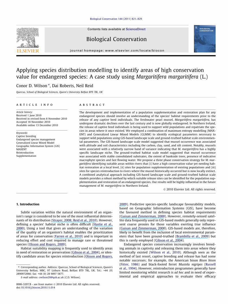
Biological Conservation 144 (2011) 821–829
Contents lists available at ScienceDirect
Biological Conservation
journal homepage: www.elsevier .com/ locate /biocon
Applying species distribution modelling to identify areas of high conservationvalue for endangered species: A case study using Margaritifera margaritifera (L.)
Conor D. Wilson ⇑, Dai Roberts, Neil ReidQuercus, School of Biological Sciences, Queen’s University Belfast BT9 7BL, UK
a r t i c l e i n f o a b s t r a c t
Article history:Received 1 June 2010Received in revised form 8 November 2010Accepted 18 November 2010Available online 13 December 2010
Keywords:Captive breedingEndangered species managementGeneralized Linear Mixed ModelGeographic Information System (GIS)MAXENTReintroductionSupplementation
0006-3207/$ - see front matter � 2010 Elsevier Ltd. Adoi:10.1016/j.biocon.2010.11.014
⇑ Corresponding author. Address: Quercus, School oUniversity Belfast, MBC, 97 Lisburn Road, Belfast2890972066; fax: +44 (0) 28 9097 5877.
E-mail address: [email protected] (C.D. Wilson
The development and implementation of a population supplementation and restoration plan for anyendangered species should involve an understanding of the species’ habitat requirements prior to therelease of any captive bred individuals. The freshwater pearl mussel, Margaritifera margaritifera, hasundergone dramatic declines over the last century and is now globally endangered. In Northern Ireland,the release of captive bred individuals is being used to support wild populations and repatriate the spe-cies in areas where it once existed. We employed a combination of maximum entropy modelling (MAX-ENT) and Generalized Linear Mixed Models (GLMM) to identify ecological parameters necessary tosupport wild populations using GIS-based landscape scale and ground-truthed habitat scale environmen-tal parameters. The GIS-based landscape scale model suggested that mussel occurrence was associatedwith altitude and soil characteristics including the carbon, clay, sand, and silt content. Notably, musselswere associated with a relatively narrow band of variance indicating that M. margaritifera has a highlyspecific landscape niche. The ground-truthed habitat scale model suggested that mussel occurrencewas associated with stable consolidated substrates, the extent of bankside trees, presence of indicativemacrophyte species and fast flowing water. We propose a three phase conservation strategy for M. mar-garitifera identifying suitable areas within rivers that (i) have a high conservation value yet needing hab-itat restoration at a local level, (ii) sites for population supplementation of existing populations and (iii)sites for species reintroduction to rivers where the mussel historically occurred but is now locally extinct.A combined analytical approach including GIS-based landscape scale and ground-truthed habitat scalemodels provides a robust method by which suitable release sites can be identified for the population sup-plementation and restoration of an endangered species. Our results will be highly influential in the futuremanagement of M. margaritifera in Northern Ireland.
� 2010 Elsevier Ltd. All rights reserved.
1. Introduction
Subtle variation within the natural environment of an organ-ism’s range is considered to be one of the most influential determi-nants of its distribution (Strayer, 2008; Reid et al., 2010). However,defining a species’ habitat niche is often difficult (Hastie et al.,2000). Using a tool that gives an understanding of the variationof the quality of an organism’s habitat enables the prioritizationof areas for conservation (Farren et al., 2010) and is important inreducing effort and cost required to manage rare or threatenedspecies (Olsson and Rogers, 2009).
Habitat suitability mapping is frequently used to identify areasin need of restoration or preservation (Gibson et al., 2004), or iden-tify candidate areas for species reintroduction (Olsson and Rogers,
ll rights reserved.
f Biological Sciences, Queen’sBT9 7BL, UK. Tel.: +44 (0)
).
2009). Predictive species-specific landscape favourability models,based on Geographic Information Systems (GIS), have becomethe favoured method in defining species habitat requirements(Guisan and Zimmerman, 2000). However, remotely-sensed satel-lite data frequently used in GIS-based models generally only repre-sent coarse proxies for those variables exerting true influence(Guisan and Zimmerman, 2000). GIS-based models are, therefore,likely to benefit from the inclusion of local environmental param-eters that have been ground-truthed (Brambilla et al., 2009) butthis is rarely employed (Gibson et al., 2004).
Endangered species conservation increasingly involves breed-ing animals in captivity and releasing them into areas where theyhistorically existed (Wilson et al., 2010). Although seen as themethod of last resort, captive breeding and release has had somenotable successes; for example, the American bison Bison bison(Fitter, 1986) and black-footed ferret Mustela nigripes (Russellet al., 1994). However, reintroduction programmes generally havelimited monitoring whilst research is ad hoc and in need of exper-imental and empirical approaches to evaluate their efficacy
822 C.D. Wilson et al. / Biological Conservation 144 (2011) 821–829
(Seddon et al., 2007). A clear understanding of species-specific hab-itat niche allows the identification of potential release sites withthe maximum chance of post-release survival often demonstratinga need for habitat restoration prior to reintroduction. Consequentlyconservationists are increasingly emphasizing the integration ofdistribution models with reintroduction and population augmen-tation programmes (Seddon et al., 2007; Sergio et al., 2007).
A rule of thumb in biogeography is that a species is most abun-dant at the centre of the range of environmental gradients alongwhich it occurs (Hochberg and Ives, 1999); this is the ‘abundantcentre’ distribution model (Sagarin and Gaines, 2002). Chronicchanges in environmental conditions are likely to have greater im-pact on those individuals at the edges of a species range than thoseat the centre. Consequently, although it could be argued that hab-itat suitability models might be biased if they are developed whena species is no longer found throughout its historic range, theyshould indicate key elements of its niche that can be used to in-form conservation strategies during reintroductions (Gibsonet al., 2004).
Populations of the freshwater pearl mussel Margaritifera margar-itifera (Linnaeus, 1758) declined substantially during the 20th cen-tury throughout most of its holarctic range (Bauer, 1988; Wilsonand Roberts, 2010). The principal causes were pearl fishing, declin-ing water quality, lack of fish hosts and siltation (Beasley et al., 1998;Hastie and Young, 2003; Skinner et al., 2003; Preston et al., 2007).Consequently, the species is now listed as endangered by the IUCN(Mollusc Specialist Group, 1996). M. margaritifera has a complex lifecycle; it has glochidial larvae that are parasitic on the gills of youngsalmonids, which remain on the gills of the host overwinter afterwhich they excyst and fall to the riverbed (Young and Williams,1984; Bauer, 1987; Skinner et al., 2003). Excysted mussels requireoxygen rich interstitial spaces in the hyporheic zone of gravelsubstrate where they remain for up to 4 years (Skinner et al.,2003; Österling et al., 2008). Modern agricultural practices anddeforestation increases river silt loads blocking interstitial spacesand generally degrades habitat quality for mussel recruitment(Österling et al., 2008; Geist and Auerswald, 2007). Moreover, flood-ing events increase environmental stress on mussels, most notably
a
b
c
d
e
f
i
j
k
Fig. 1. Rivers in Northern Ireland with extant mussel populations: (a) Ballinderry, (b)mussel populations: (g) Upper Bann, (h) Bush, (i) Colebrooke, (j) Moyola, (k) Mourne/St
juveniles, which are at increased risk of being dislodged from theriverbed (Hastie et al., 2001) and translocated downstream intounsuitable habitat (Österling et al., 2008).
Conservation strategies aimed at slowing or halting the declineof M. margaritifera throughout Europe recommend supplementingremnant populations and extending the species’ current range tosites were it existed historically but is now locally extinct (Araujoand Ramos, 2001; Anonymous, 2005). Consequently, there hasbeen much interest in captive breeding of M. margaritifera to gen-erate stocks for population restoration (Buddensiek, 1995; Prestonet al., 2007; McIvor and Aldridge, 2008).
The influence of environmental parameters on M. margaritiferadistribution has been examined at varying spatial scales (Beasleyand Roberts, 1999; Hastie et al., 2000, 2003; Morale et al., 2004).However, most historic and contemporary attempts to characterisefreshwater pearl mussel habitat have gone untested (Strayer,2008). In Northern Ireland, the species declined dramatically inthe last century and remains extant in only six rivers restrictedto the west of the country in Counties Fermanagh and Tyrone(Fig. 1). Estimates that M. margaritifera may be extinct in NorthernIreland within 80 years (Beasley et al., 1998) prompted the initia-tion of an ex situ captive breeding programme in 1998 (Prestonet al., 2007). This programme came to fruition during 2009 whenapproximately 350, 8–10 year old captive-bred juvenile musselswere released into the wild to supplement an existing populationin the Ballinderry River, Co., Tyrone (Wilson et al., 2010). Becausethe release of captive-bred animals is a measure of last resort, itis important that release sites are selected carefully. Initial releasesites in Northern Ireland were chosen primarily because they sup-ported living mussels. Further releases of captive-bred mussels relyon identifying suitable reintroduction rather than population sup-plementation sites, contingent with the Species Action Plan for thefreshwater pearl mussel in Northern Ireland. However, the land-scape and habitat requirements of the species are evidently com-plex and poorly understood.
The present study aimed to develop GIS-based landscape andground-truthed habitat models that explain the current distribu-tion of M. margaritifera in Northern Ireland. These models will
g
h
Owenkillew, (c) Owenreagh, (d) Swanlinbar, (e) Tempo, (f) Waterfoot and historicrule.
C.D. Wilson et al. / Biological Conservation 144 (2011) 821–829 823
provide objective criteria to identify areas within rivers that: (a)have a high conservation value yet need habitat restoration at a lo-cal level, (b) sites for population supplementation of existing pop-ulations and (c) sites for species reintroduction to rivers where thespecies historically occurred but is now locally extinct. Thesemethods are widely applicable to other species of conservationconcern and are likely to be highly useful for other reintroductionprogrammes, especially where individuals being released are froman endangered species.
2. Materials and methods
2.1. Species records
The entire distribution of M. margaritifera in Northern Irelandwas surveyed during 2009. On each of the six rivers where the spe-cies remains extant, point transect surveys for species presencewere conducted every 500 m between the most upstream anddownstream points from which the species was known. Musselpresence was determined using a bathyscope and a zig-zag surveydesign across the width of the river 10 m above and below eachsurvey point. All surveys were conducted during low water.
2.2. Landscape parameterization
ArcGIS v9.3 (ESRI, California, USA) was used to extract habitatvariables on a landscape scale resampled to a common pixel sizeof 250 m throughout Northern Ireland. Altitude and the range ofslope (in degrees) were taken as topographic descriptors, soil typewas characterised by percentage carbon, clay, sand, and silt whilsthabitat variables were chosen intuitively; broad-leaved woodlandand coniferous plantations were deemed likely to alter the watercycle and affect ground runoff, sedimentation and water acidificat-ion whilst urban areas were considered likely sources of water con-taminant pollution (Table 1).
Table 1Description of variables extracted at two spatial scales (a) landscape parameters extractedsurveys every 500 m along rivers used in the biogeographical modelling of M. margaritifer
Spatial scale Variable name Unit Description
(a) Landscape parameters250 m Raster
pixelsAltitude Metres Mean elevation above sea level d
Broad-leavedwoodland
% Percentage coverage of broad-lea
Coniferousplantations
% Percentage coverage of coniferou
Slope range Index The difference between the steepElevation Model for Northern Ire
Soil carboncontent
% The mean percentage content ofSurvey data
Soil claycontent
% The mean percentage content of
Soil sandcontent
% The mean percentage content of
Soil silt content % The mean percentage content ofUrban % Percentage coverage of urban an
(b) Habitat parametersSurvey points
every 500 mFlow regime Categorical Presence or absence of (a) broke
flowMacrophytes Categorical Presence or absence of (a) subm
liverworts/mosses/lichens, (e) emRiparian trees Categorical Presence or absence of (a) banks
trees, (e) large woody debris, (f)Substratemobility
Categorical Classed as either consolidated or
Substrate type Categorical Classed as (a) bedrock, (b) bould
Water quality was excluded from the current study for a num-ber of reasons. Firstly, there are many measures of quality includ-ing physical (pH), chemical (N2, P, DO, etc.) and biological (forexample, invertebrate scores such as BMWP) metrics. Secondly,whilst water quality is monitored throughout Northern Irelandsampling points frequently focus on areas such as commerciallyimportant fishing rivers or areas designated for some aspect oftheir biodiversity. Some stretches of river have not been surveyedand it is impossible to interpolate values across the landscape forthe purposes of species modelling as metrics vary not only be-tween-catchments but within-catchments; unidirectionally down-stream from any source of pollutant. Moreover, pollution eventscan be stochastic resulting in a temporal reduction in water qualitybefore rapidly returning to background levels, Consequently, re-sampling water quality metrics at a common pixel size of 250 mmay well have been meaningless. Thirdly, M. Margaritifera islong-lived and the effect of variance in water quality may have dif-ferential effects on adults and juveniles as well as the fish popula-tions on which they depend. Availability of suitable densities offish hosts for the parasitic larvae of M. margaritifera is also likelyto be a limiting factor in their distribution but electrofishing datadid not cover all potential sites and suffered from similar problemsto that of water quality and has also been excluded from analyses.Whilst we acknowledge the importance of water quality and fishdensities it would be difficult to incorporate any metric at a usefulscale into a species favourability model. Consequently, we focushere exclusively on landscape and habitat metrics, some of whichmay, themselves, be proxies for water quality or fish density. As aresult we explicitly deal with any shortcomings in our model inSection 4.
2.3. Habitat parameterization
Point transect surveys were used to ground-truth local habitatfeatures. A modified River Habitat Survey (RHS, 2003) was usedto collect data on the presence and absence of habitat features
from 250 m raster pixels and (b) habitat parameters recorded during point transecta occurrence.
erived from a Digital Elevation Model for Northern Ireland
ved woodland derived using the Land Cover Map 2000
s forest derived using the Land Cover Map 2000
est and gentlest slope in degrees in each 250 m raster pixel derived from a Digitallandsoil within that was classified organic (carbon) using the Northern Ireland Soil
soil that was classified clay using the Northern Ireland Soil Survey data
soil that was classified sand using the Northern Ireland Soil Survey data
soil that was classified silt using the Northern Ireland Soil Survey datad suburban plus rural development derived using the Land Cover Map 2000
n standing waves, (b) unbroken standing waves, (c) rippled flow or (d) smooth
erged fine leaved, (b) submerged linear leaved, (c) submerged broadleaved, (d)ergent reeds/sedges/rushes/grasses/horsetails or (f) filamentous algae
ide tree cover, (b) exposed bankside roots, (c) underwater tree roots, (d) fallenshading of channel or (g) overhanging boughsmobile substrate
er, (c) cobble, (d) earth/peat, (e) gravel/pebble, (f) sand or and (g) silt
824 C.D. Wilson et al. / Biological Conservation 144 (2011) 821–829
10 m above and below each survey point. These included charac-terisation of flow regime, description of macrophyte communities,extent of riparian trees, substrate type, and mobility (Table 1).
Swanlin
bar
Waterfo
ot
Tempo
Owenrea
gh
Ballind
erry
Owenkill
ew
Mus
sel d
ensi
ty (m
-2)
0.0
0.2
0.4
0.6
0.8
1.0
% o
ccur
renc
e
0
20
40
60
80
100Mussel density % occurrence
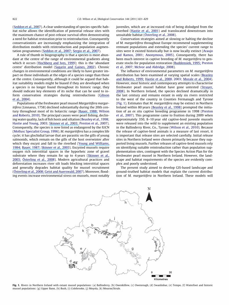
Fig. 2. Percentage occurrence and density of M. margaritifera across six rivers inNorthern Ireland ± bootstrapped 95 confidence intervals.
(21.6)(21.6)
(13.9)
(13.2)
(10.5)(9.1)(4.7)
(3.8)
(1.5)
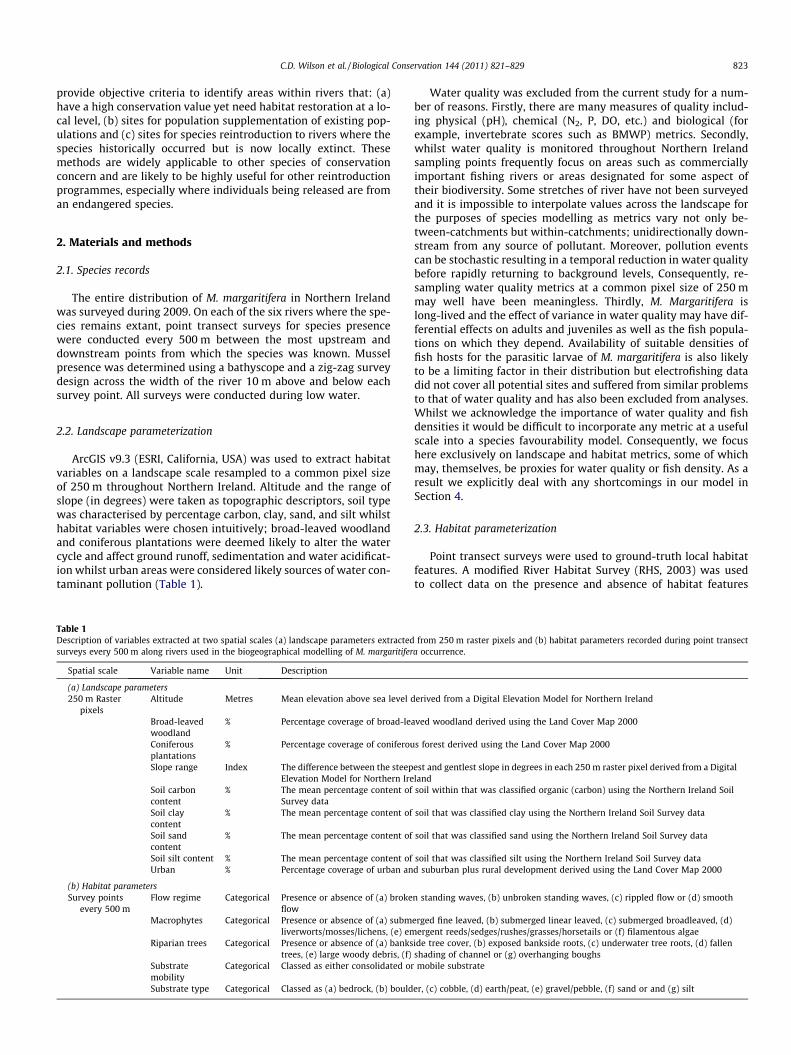
% test gain0.0 0.5 1.0 1.5 2.0
UrbanSlope
Coniferous plantationsSoil silt content
Soil carbon contentSoil sand content
Broad-leaved woodlandSoil clay content
Altitude
Fig. 3. Jackknife analyses of the importance of environmental variables in maxi-mum entropy modelling of M. margaritifera occurrence. A heuristic estimate of therelative contribution of each variable to the global model is given in parentheseswhilst variables are listed in descending order of importance. Grey bars show theperformance of the global model (known as test gain) without each variable andblack bars show the influence of each variable in isolation (derived from aunivariate model only).
2.4. Statistical analyses
Ninety-five percentage confidence intervals were calculated forthe percentage occurrence of mussels within each site using 1000iteration re-sampling bootstrapping conducted by the ‘‘ResamplingStats for Excel RSXL add-in v.4.0’’.
Whilst every effort was made to survey the entire range of M.margaritifera, it remained possible that the species occurred onother tributaries or river basins not surveyed. Therefore, a pres-ence-only modelling approach was used to predict landscapefavourability for the species throughout Northern Ireland. Emerg-ing literature suggests that maximum entropy modelling hasgreater predictive success than more traditional presence–absencemodelling techniques such as general linear modelling (GLM), gen-eral additive modelling (GAM) or boosted regression trees, mostnotably using small sample sizes (Hernandez et al., 2006).
Maxent 3.2.1 (Phillips et al., 2006; Phillips and Dudlk, 2008) wasused to predict the probability of species occurrence at a pixel sizeof 250 m, ensuring the spatial exclusivity of each 500 m point tran-sect. Due to the restricted range of M. margaritifera it was hypoth-esised that the species’ habitat associations would occupy a narrowband of tolerance and, therefore, not display linear relationships.Consequently, model flexibility was by maximised by consideringquadratic, product, threshold, hinged and discrete functions forall landscape parameters (Phillips and Dudlk, 2008). Jackknife re-sampling analysis was used to determine a heuristic estimate ofthe relative contribution of each variable based on the performanceof the global model (known as test gain) without the variable ofinterest compared to the influence of that variable in isolation (de-rived from a univariate model only). Global model performancewas judged using the area under the receiver operating character-istic (ROC) curve (Liu et al., 2005). Marginal response curves of thepredicted probability of species occurrence were graphed for eachexplanatory variable that contributed substantially to the globalmodel. A map of landscape favourability for M. margaritifera wasgenerated to reflect the predicted probability of species occurrenceusing ArcGIS 9.3�.
The proximate determinants of species occurrence at the localscale were examined using a true presence–absence approach.Type II errors (false negatives) were minimised by the fact the en-tire range of the species was surveyed within each river. Conse-quently, a Generalized Linear Mixed Model (GLMM) assuming abinomial error distribution and a logit link function was used toexamine species occurrence in relation to ground-truthed habitatfeatures. Principal Components Analysis (PCA) was used to reducepresence–absence data for aspects of flow regime, macrophytecommunities and riparian trees into independent, intuitivelyappealing and biologically relevant variables. The latter were fittedas covariates; substrate type and mobility were fitted as fixed fac-tors and river ID was fitted as a random factor. Model selection fol-lowed an information-theoretic approach (Burnham and Anderson,2002). The Akaike Information Criterion (AIC; Akaike, 1983) wasused to rank all possible model combinations. The Akaike weight(wi) of each model is the relative likelihood of that model beingthe best within a set of n models, and was determined within thosemodels with a DAIC(Di) 6 2 (Burnham and Anderson, 2002). Mul-timodel inference was used to determine the averaged effect size(b coefficient) of each variable across the top set of models (Burn-ham and Anderson, 2002). GLMM analysis was performed usingprocedure lmer from the lme4 library in the open-source statisticalpackage R (www.cran.r-project.org).
3. Results
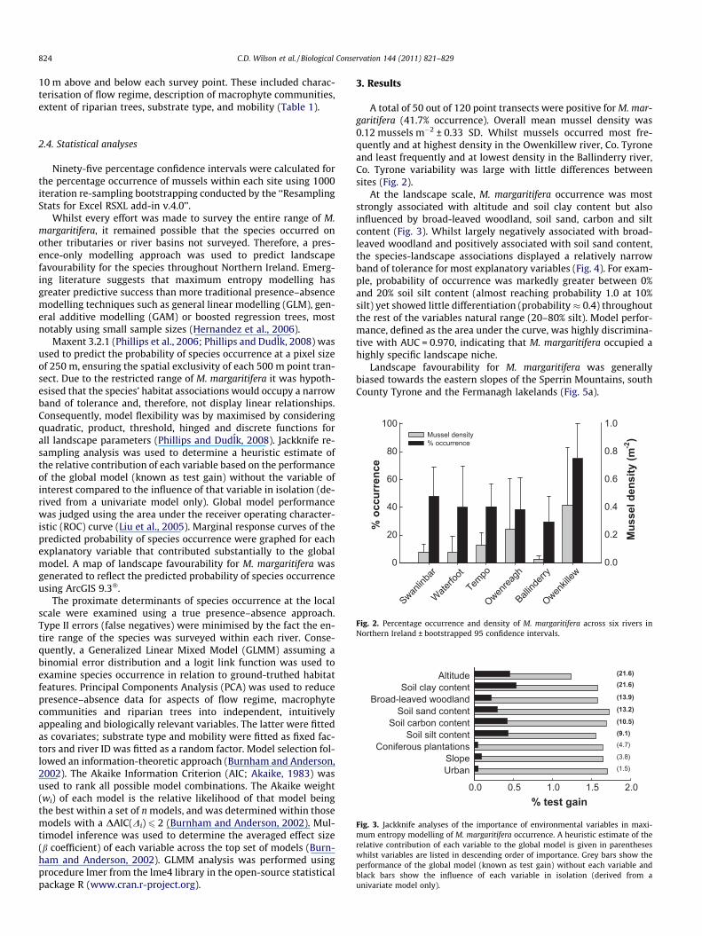
A total of 50 out of 120 point transects were positive for M. mar-garitifera (41.7% occurrence). Overall mean mussel density was0.12 mussels m�2 ± 0.33 SD. Whilst mussels occurred most fre-quently and at highest density in the Owenkillew river, Co. Tyroneand least frequently and at lowest density in the Ballinderry river,Co. Tyrone variability was large with little differences betweensites (Fig. 2).
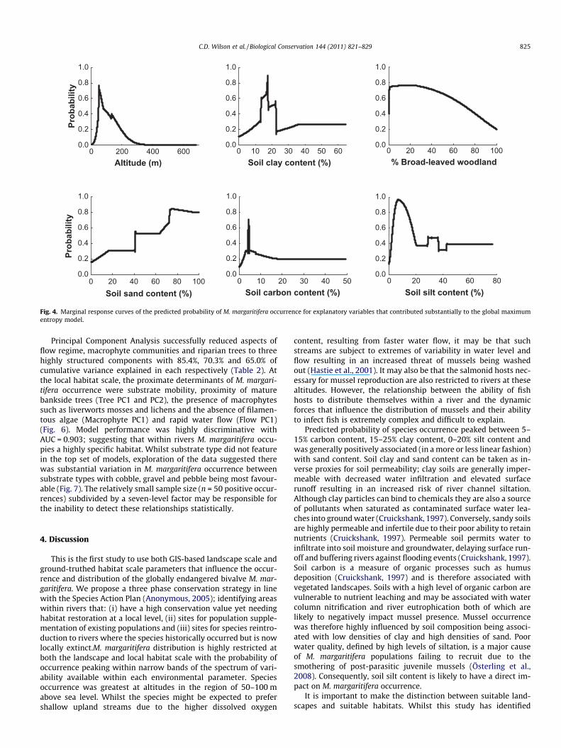
At the landscape scale, M. margaritifera occurrence was moststrongly associated with altitude and soil clay content but alsoinfluenced by broad-leaved woodland, soil sand, carbon and siltcontent (Fig. 3). Whilst largely negatively associated with broad-leaved woodland and positively associated with soil sand content,the species-landscape associations displayed a relatively narrowband of tolerance for most explanatory variables (Fig. 4). For exam-ple, probability of occurrence was markedly greater between 0%and 20% soil silt content (almost reaching probability 1.0 at 10%silt) yet showed little differentiation (probability � 0.4) throughoutthe rest of the variables natural range (20–80% silt). Model perfor-mance, defined as the area under the curve, was highly discrimina-tive with AUC = 0.970, indicating that M. margaritifera occupied ahighly specific landscape niche.
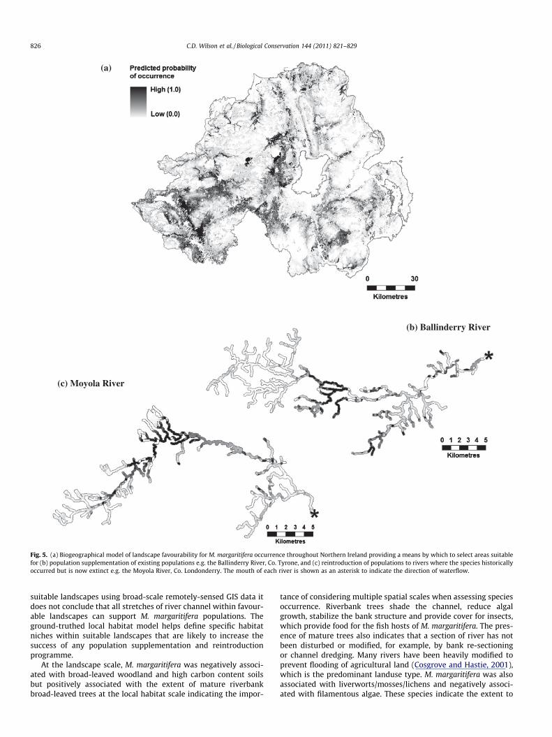
Landscape favourability for M. margaritifera was generallybiased towards the eastern slopes of the Sperrin Mountains, southCounty Tyrone and the Fermanagh lakelands (Fig. 5a).
Soil carbon content (%)0 10 20 30 40 50
0.0
0.2
0.4
0.6
0.8
1.0
Soil silt content (%)0 20 40 60 80
0.0
0.2
0.4
0.6
0.8
1.0
Soil sand content (%)0 20 40 60 80 100
Prob
abili
ty
0.0
0.2
0.4
0.6
0.8
1.0
Altitude (m)0 200 400 600
Prob
abili
ty
0.0
0.2
0.4
0.6
0.8
1.0
% Broad-leaved woodland0 20 40 60 80 100
0.0
0.2
0.4
0.6
0.8
1.0
Soil clay content (%)0 10 20 30 40 50 60
0.0
0.2
0.4
0.6
0.8
1.0
Fig. 4. Marginal response curves of the predicted probability of M. margaritifera occurrence for explanatory variables that contributed substantially to the global maximumentropy model.
C.D. Wilson et al. / Biological Conservation 144 (2011) 821–829 825
Principal Component Analysis successfully reduced aspects offlow regime, macrophyte communities and riparian trees to threehighly structured components with 85.4%, 70.3% and 65.0% ofcumulative variance explained in each respectively (Table 2). Atthe local habitat scale, the proximate determinants of M. margari-tifera occurrence were substrate mobility, proximity of maturebankside trees (Tree PC1 and PC2), the presence of macrophytessuch as liverworts mosses and lichens and the absence of filamen-tous algae (Macrophyte PC1) and rapid water flow (Flow PC1)(Fig. 6). Model performance was highly discriminative withAUC = 0.903; suggesting that within rivers M. margaritifera occu-pies a highly specific habitat. Whilst substrate type did not featurein the top set of models, exploration of the data suggested therewas substantial variation in M. margaritifera occurrence betweensubstrate types with cobble, gravel and pebble being most favour-able (Fig. 7). The relatively small sample size (n = 50 positive occur-rences) subdivided by a seven-level factor may be responsible forthe inability to detect these relationships statistically.
4. Discussion
This is the first study to use both GIS-based landscape scale andground-truthed habitat scale parameters that influence the occur-rence and distribution of the globally endangered bivalve M. mar-garitifera. We propose a three phase conservation strategy in linewith the Species Action Plan (Anonymous, 2005); identifying areaswithin rivers that: (i) have a high conservation value yet needinghabitat restoration at a local level, (ii) sites for population supple-mentation of existing populations and (iii) sites for species reintro-duction to rivers where the species historically occurred but is nowlocally extinct.M. margaritifera distribution is highly restricted atboth the landscape and local habitat scale with the probability ofoccurrence peaking within narrow bands of the spectrum of vari-ability available within each environmental parameter. Speciesoccurrence was greatest at altitudes in the region of 50–100 mabove sea level. Whilst the species might be expected to prefershallow upland streams due to the higher dissolved oxygen
content, resulting from faster water flow, it may be that suchstreams are subject to extremes of variability in water level andflow resulting in an increased threat of mussels being washedout (Hastie et al., 2001). It may also be that the salmonid hosts nec-essary for mussel reproduction are also restricted to rivers at thesealtitudes. However, the relationship between the ability of fishhosts to distribute themselves within a river and the dynamicforces that influence the distribution of mussels and their abilityto infect fish is extremely complex and difficult to explain.
Predicted probability of species occurrence peaked between 5–15% carbon content, 15–25% clay content, 0–20% silt content andwas generally positively associated (in a more or less linear fashion)with sand content. Soil clay and sand content can be taken as in-verse proxies for soil permeability; clay soils are generally imper-meable with decreased water infiltration and elevated surfacerunoff resulting in an increased risk of river channel siltation.Although clay particles can bind to chemicals they are also a sourceof pollutants when saturated as contaminated surface water lea-ches into ground water (Cruickshank, 1997). Conversely, sandy soilsare highly permeable and infertile due to their poor ability to retainnutrients (Cruickshank, 1997). Permeable soil permits water toinfiltrate into soil moisture and groundwater, delaying surface run-off and buffering rivers against flooding events (Cruickshank, 1997).Soil carbon is a measure of organic processes such as humusdeposition (Cruickshank, 1997) and is therefore associated withvegetated landscapes. Soils with a high level of organic carbon arevulnerable to nutrient leaching and may be associated with watercolumn nitrification and river eutrophication both of which arelikely to negatively impact mussel presence. Mussel occurrencewas therefore highly influenced by soil composition being associ-ated with low densities of clay and high densities of sand. Poorwater quality, defined by high levels of siltation, is a major causeof M. margaritifera populations failing to recruit due to thesmothering of post-parasitic juvenile mussels (Österling et al.,2008). Consequently, soil silt content is likely to have a direct im-pact on M. margaritifera occurrence.
It is important to make the distinction between suitable land-scapes and suitable habitats. Whilst this study has identified
(a)
(b) Ballinderry River
(c) Moyola River
Fig. 5. (a) Biogeographical model of landscape favourability for M. margaritifera occurrence throughout Northern Ireland providing a means by which to select areas suitablefor (b) population supplementation of existing populations e.g. the Ballinderry River, Co. Tyrone, and (c) reintroduction of populations to rivers where the species historicallyoccurred but is now extinct e.g. the Moyola River, Co. Londonderry. The mouth of each river is shown as an asterisk to indicate the direction of waterflow.
826 C.D. Wilson et al. / Biological Conservation 144 (2011) 821–829
suitable landscapes using broad-scale remotely-sensed GIS data itdoes not conclude that all stretches of river channel within favour-able landscapes can support M. margaritifera populations. Theground-truthed local habitat model helps define specific habitatniches within suitable landscapes that are likely to increase thesuccess of any population supplementation and reintroductionprogramme.
At the landscape scale, M. margaritifera was negatively associ-ated with broad-leaved woodland and high carbon content soilsbut positively associated with the extent of mature riverbankbroad-leaved trees at the local habitat scale indicating the impor-
tance of considering multiple spatial scales when assessing speciesoccurrence. Riverbank trees shade the channel, reduce algalgrowth, stabilize the bank structure and provide cover for insects,which provide food for the fish hosts of M. margaritifera. The pres-ence of mature trees also indicates that a section of river has notbeen disturbed or modified, for example, by bank re-sectioningor channel dredging. Many rivers have been heavily modified toprevent flooding of agricultural land (Cosgrove and Hastie, 2001),which is the predominant landuse type. M. margaritifera was alsoassociated with liverworts/mosses/lichens and negatively associ-ated with filamentous algae. These species indicate the extent to
Table 2Principal components analyses describing (a) macrophytes, (b) riparian trees and (c) flow regime present at point transects surveyed for M. margaritifera.
Principal component Variables Components
PC1 PC2 PC3
(a) Macrophytes Liverworts, mosses and lichens �0.738 �0.020 �0.306Emergent reeds, sedges, rushes, grasses and horsetails 0.165 0.629 0.476Submerged linear leaved �0.010 �0.051 0.847Submerged fine leaved �0.014 0.879 �0.180Filamentous algae 0.807 0.065 �0.218
Cumulative% explained 24.5 48.0 70.3
(b) Riparian trees Extent of riverbank trees 0.375 0.368Shading of bank 0.834 0.081Overhanging boughs 0.758 0.146Exposed bank side roots 0.865 0.107Underwater tree roots 0.775 0.034Fallen trees 0.306 0.880Large woody debris 0.090 0.891
Cumulative% explained 40.0 65.0
(c) Flow regime Broken standing waves 0.906 0.194Unbroken standing waves 0.907 0.187Rippled flow 0.161 0.910Smooth flow �0.220 �0.982
Cumulative% explained 43.0 85.4
Cumulative Akaike weight0.0 0.2 0.4 0.6 0.8 1.0
Inde
pend
ent v
aria
ble Consolidated
Tree PC1Macrophytes PC1
Trees PC2Flow PC1
Macrophytes PC2Macrophytes PC3
Flow PC2Substrate
0.889 ± 0.297
-0.594 ± 0.303
0.321 ± 0.197
-0.234 ± 0.169
0.031 ± 0.071
0.009 ± 0.032
-0.005 ± 0.033
Factorial
Factorial
Fig. 6. The relative importance of habitat parameters in explaining variance in M. margaritifera presence at point transect surveys. Variables were ranked in order of the sumof their Akaike weights (Rwi) within the top set of models, i.e. models with DAIC 6 2. Variables that were retained in the single best approximating model (i.e. that with thelowest AIC value) are in black and variables in grey are those that were included in all other models within the top set. The strength of the slopes for each covariate isindicated by the notation to the right and SE (mean b value and SE from top models).
Bedroc
k
Boulde
r
Cobble
Gravel/
Pebble
Sand Silt
Earth/P
eat
% o
ccur
renc
e
0
5
10
15
20
25
30
35
Fig. 7. Percentage occurrence ± bootstrapped 95% confidence intervals of M.margaritifera in different substrate types.
C.D. Wilson et al. / Biological Conservation 144 (2011) 821–829 827
which the river is shaded by adjacent trees and the levels of watereutrophication from agricultural runoff.
Earlier studies have placed a great deal of emphasis on theimportance of flow regime to M. margaritifera (Hastie et al.,2003), whereas results of the present study suggest that speciespresence was negatively related to stretches of river that weretoo fast, as determined by the presence of both broken and unbro-ken standing waves. Dynamism in flow regime may make riversubstrate unstable increasing the risk of mussels being washedout. The negative relationship with slope is similar to a findingby Arbuckle and Downing (2002) in relation to mussel densityand species richness in the Mississippi River basin.
Previous authors have suggested that one of the most impor-tant local features for M. margaritifera is the type and mobility ofsubstratum (Beasley and Roberts, 1999; Cope et al., 2003; Hastieet al., 2003). Consolidated substrata enable mussels to remainburrowed during flooding events lessening the likelihood ofbecoming dislodged and washed into unsuitable habitat (Hastieet al., 2000). The importance of cobble substrata stabilised byfine sands and gravels to M. margaritifera has also been observed(Beasley and Roberts, 1999; Hastie et al., 2003). The present
828 C.D. Wilson et al. / Biological Conservation 144 (2011) 821–829
study also suggested that cobble and gravel/pebble substrata arepreferred by M. margaritifera over other substratum types(Fig. 7). However, the substratum type was not identified inthe habitat model as a significant factor; this may be a statisticalartefact of a small sample size subdivided by a seven-levelfactor.
The IUCN (1998) recommends that the cause of a species’ declinebe removed before any attempt at reintroduction is undertaken.Pearl fishing was a major threat to M. margaritifera in NorthernIreland during the 19th and 20th centuries (Anonymous, 2005)but is now illegal and largely in decline or absent. The NorthernIreland Government must ensure that rivers meet European WaterFramework Directive standards in terms of water quality being‘‘good’’ or ‘‘very good’’ which has lead to a demonstrable increasein the conservation status of many rivers throughout the province(Anonymous, 2009). Economic benefits from tourism have alsoincreased the prevalence of salmonid aquaculture throughoutNorthern Ireland for game fishing and angling, increasing the den-sity of potential hosts for glochidial M. margaritifera. Consequently,the majority of direct causes of M. margaritifera are in the process ofbeing mitigated.
The Northern Ireland M. margaritifera Species Action Plan(Anonymous, 2005) aims to (i) maintain the range of existingpopulations, (ii) increase the size of each of the extant popula-tions by 50% by 2010, (iii) re-establish a population in oneformer known locality for the species by 2015 and (iv) re-establish a population in a further suitable site by 2020. Ourresults highlight the importance of understanding the landscapeand habitat niche of any species of conservation concern prior totranslocation or reintroduction from captive breeding pro-grammes. However, it must be remembered that species model-ling is merely a tool for simplifying relationships with the highlycomplex environment of the wild. The current study excludedmeasures of water quality and host fish populations due to thedifficulty of incorporating explanatory measures at a suitablescale (both spatially and temporally). However, water qualitymust be of a high standard if M. margaritifera is to reproducein the wild (Bauer, 1988; Skinner et al., 2003). Thus identifyingreintroduction sites for this species is contingent on identifyinghigh water quality, even within those areas identified as poten-tially suitable within our model. Moreover, fish host densitiesare integral in mussel recruitment (Ziuganov et al., 1994; Hastieand Young, 2003; Skinner et al., 2003; Österling et al., 2008).Although Geist et al. (2006) rarely observed a link between alack of juvenile freshwater pearl mussels and a lack of suitablehost fish, Ziuganov et al. (1994) suggests that long-term M. mar-garitifera maintenance depends upon a critical minimum salmo-nid host density of 0.2 fish per m2. Therefore, more work isrequired to verify suitable densities of host fish (via electrofish-ing) at sites deemed suitable for reintroduction. Landscapesidentified as favourable for M. margaritifera should be surveyedto ground-truth local suitability prior to any translocations orreintroductions. Local suitability, based on our findings, shouldbe based on the appropriate flow regime, tree lined banks andconsolidated gravel or cobble substrata, while making sure toavoid sites where macrophytes indicative of eutrophication arepresent.
Single species recovery is contingent on identifying, protectingor restoring areas of high conservation value. As a growing numberof species restoration programmes involve captive breeding andrelease, a greater understanding of the landscape and habitat nicheis required (Seddon et al., 2007). Moreover, restoration pro-grammes are often contingent on re-establishing a species withinits historic range (Anonymous, 2005), emphasizing the importanceof the techniques used here in developing endangered speciesmanagement.
Acknowledgements
We thank Dr. Jane Preston and David McCann for assistance inthe field and Dr. Mathieu Lundy for advice on statistics and GIS.This project was funded by the Ballinderry Fish Hatchery (BFH) un-der a competitively-won tender from the Northern Ireland Envi-ronment Agency (NIEA). We would also like to thank twoanonymous reviewers for comments on an earlier version of thismanuscript.
References
Akaike, H., 1983. Information measure and model selection. Bulletin of theInternational Statistical Institute 50, 277–291.
Anonymous, 2005. Northern Ireland Species Action Plan – Freshwater Pearl MusselMargaritifera margaritifera.
Anonymous, 2009. <http://www.ni-environment.gov.uk/gqa_chemmaps2004to2007.pdf>.
Araujo, R., and Ramos, M.A., 2001. Action Plans for Margaritifera auricularia andMargaritifera margaritifera in Europe. Nature and Environment, No. 117.
Arbuckle, K.E., Downing, J.A., 2002. Freshwater mussel abundance and speciesrichness: GIS relationships with watershed land use and geology. CanadianJournal of Fisheries and Aquatic Science 59, 310–316.
Bauer, G., 1987. The parasitic stage of the freshwater pearl mussel (Margaritiferamargaritifera (L.)) 2. Susceptibility of brown trout. Archiv Fur Hydrobiologie 76,403–412.
Bauer, G., 1988. Threats to the freshwater pearl mussel Margaritifera margaritifera incentral Europe. Biological Conservation 45, 239–253.
Beasley, C.R., Roberts, D., 1999. Towards a strategy for the conservation of thefreshwater pearl mussel Margaritifera margaritifera in County Donegal, Ireland.Biological Conservation 89, 275–284.
Beasley, C.R., Roberts, D., Mackie, T.G., 1998. Does the freshwater pearl mussel,Margaritifera margaritifera L., face extinction in Northern Ireland? AquaticConservation: Marine and Freshwater Ecosystems 8 (2), 265–272.
Brambilla, M., Casale, F., Valentina, B., Crovetto, G.M., Falco, R., Negri, I., Siccardi, P.,Bogliani, G., 2009. GIS-models work well, but are not enough: habitatpreferences of Lanius collurio at multiple levels and conservation implications.Biological Conservation 142, 2033–2042.
Buddensiek, V., 1995. The culture of juvenile freshwater pearl mussels Margaritiferamargaritifera L. in cages: a contribution to conservation programmes and theknowledge of habitat requirements. Biological Conservation 74, 33–40.
Burnham, K.P., Anderson, D.R., 2002. Model Selection and Multimodel Inference: APractical Information-Theoretic Approach, second ed. Springer, New York.
Cope, W.G., Hove, M.C., Walker, D.L., Hornbach, D.J., Bartsch, M.R., Cunningham, L.A.,Dunn, H.L., Kapuscinski, A.R., 2003. Evaluation of relocation of unionid musselsto in situ refugia. Journal of Molluscan Studies 69, 27–34.
Cosgrove, P.J., Hastie, L.C., 2001. Conservation of threatened freshwater pearl musselpopulations: river management, mussel translocation and conflict resolution.Biological Conservation 99, 183–190.
Cruickshank, J.G., 1997. Soil and The Environment: Northern Ireland. Agriculturaland Environmental Science Division, DANI and The Agricultural andEnvironmental Science Department, The Queen’s University of Belfast.
Farren, A., Prodöhl, P.A., Laming, P., Reid, N., 2010. Distribution of the commonlizard (Zootoca vivipara) and landscape favourability for the species in NorthernIreland. Amphibia-Reptilia 31, 387–394.
Fitter, R., 1986. Wildlife for Man: How and Why We should Conserve Our Species.William Collins Sons and Co. Ltd., London.
Geist, J., Auerswald, K., 2007. Physicochemical stream bed characteristics andrecruitment of the freshwater pearl mussel (Margaritifera margaritifera).Freshwater Biology 52, 2299–2316.
Geist, J., Porkka, M., Kuehn, R., 2006. The status of host fish populations and fishspecies richness in European freshwater pearl mussel (Margaritiferamargaritifera) streams. Aquatic Conservation: Marine and FreshwaterEcosystems 16 (3), 251–266.
Gibson, L.A., Wilson, B.A., Cahill, D.A., Hill, J., 2004. Spatial prediction of rufousbristlebird habitat in a coastal heathland: a GIS-based approach. Journal ofApplied Ecology 41, 213–223.
Guisan, A., Zimmerman, N.E., 2000. Predictive habitat distribution models inecology. Ecological Modelling 135, 147–186.
Hastie, L.C., and Young, M.R., 2003. Conservation of the Freshwater Pearl Mussel 2.Relationship with Salmonids. Conserving Natura 2000 Rivers ConservationTechniques Series No.3. English Nature, Peterborough.
Hastie, L.C., Boon, P.J., Young, M.R., 2000. Physical microhabitat requirements offreshwater pearl mussels Margaritifera margaritifera (L.). Hydrobiologia 429,59–71.
Hastie, L.C., Boon, P.J., Young, M.R., Way, S., 2001. The effects of a major flood on anendangered freshwater mussel population. Biological Conservation 98, 107–115.
Hastie, L.C., Cooksley, S.L., Scougall, F., Young, M.R., Boon, P.J., Gaywood, M.J., 2003.Characterization of freshwater pearl mussel (Margaritifera margaritifera)riverine habitat using River Habitat Survey data. Aquatic Conservation:Marine and Freshwater Ecosystems 13 (3), 213–224.
C.D. Wilson et al. / Biological Conservation 144 (2011) 821–829 829
Hernandez, P.A., Graham, C.H., Master, L.L., Albert, D.L., 2006. The effect of samplesize and species characteristics on performance of different species distributionmodeling methods. Ecography 29 (5), 773–785.
Hochberg, M.E., Ives, A.R., 1999. Can natural enemies enforce geographical rangelimits? Ecogeography 22, 268–276.
IUCN, 1998. IUCN Guidelines for Reintroductions. Prepared by the IUCN/SSCReintroduction Specialist Group. IUCN, Gland, Switzerland and Cambridge,UK, 10pp.
Liu, A.Y., Schisterman, E.F., Wu, C.Q., 2005. Nonparametric estimation and hypothesistesting on the partial area under receiver operating characteristic curves.Communications in Statistics Theory and Methods 34 (9–10), 2077–2088.
McIvor, A., and Aldridge, D., 2008. The Cultivation of the Freshwater Pearl Mussel,Margaritifera margaritifera. CCW Contract Science Report No: 849. CountrysideCouncil for Wales/Environment Agency, Bangor.
Mollusc Specialist Group, 1996. Margaritifera margaritifera. In: IUCN Red List ofThreatened Species. Version 2010.1. <http://www.iucnredlist.org/>.
Morale, J.J., Negro, A.I., Lizana, M., Martinez, A., Palacios, J., 2004. Preliminary studyof the endangered populations of pearl mussel Margaritifera margaritifera (L.) inthe River Tera (north–west Spain): habitat analysis and managementconsiderations. Aquatic Conservation: Marine and Freshwater Ecosystems 14,587–596.
Olsson, O., Rogers, D.J., 2009. Predicting the distribution of a suitable habitat for thewhite stork in Southern Sweden: identifying priority areas for reintroductionand habitat restoration. Animal Conservation 12, 62–70.
Österling, E.M., Greenberg, L.A., Arvidsson, B.A., 2008. Relationship of biotic andabiotic factors to recruitment patterns in Margaritifera margaritifera. BiologicalConservation 141, 1365–1370.
Phillips, S.J., Dudlk, M., 2008. Modelling of species distributions with Maxent: newextensions and a comprehensive evaluation. Ecography 31, 161–175.
Phillips, S.J., Anderson, R.P., Schapire, R.E., 2006. Maximum entropy modelling ofspecies geographic distributions. Ecological Modelling 190, 231–259.
Preston, S.J., Keys, A., Roberts, D., 2007. Culturing freshwater pearl musselMargaritifera margaritifera: a breakthrough in the conservation of an
endangered species. Aquatic Conservation: Marine and FreshwaterEcosystems 17, 539–549.
Reid, N., McDonald, R.A., Montgomery, W.I., 2010. Homogeneous habitat can fulfilthe discrete and varied resource requirements of hares but may set anecological trap. Biological Conservation 143, 1701–1706.
Russel, W.C., Thorne, E.T., Oakleaf, R., Ballou, J.D., 1994. The genetic basis of black-footed ferret reintroduction. Conservation Biology 8 (1), 263–266.
Sagarin, R.D., Gaines, S.D., 2002. The ‘abundant centre’ distribution: to what extentis it a biogeographical rule? Ecology Letters 5, 137–147.
Seddon, P.J., Armstrong, D.P., Maloney, R.F., 2007. Developing the science ofreintroduction biology. Conservation Biology 21, 303–312.
Sergio, C., Figueira, R., Draper, D., Menezes, R., Sousa, A.J., 2007. Modellingbryophyte distribution based on ecological information for extent ofoccurrence assessment. Biological Conservation 135, 341–351.
Skinner, A., Young, M., and Hastie, L., 2003. Ecology of the Freshwater Pearl Mussel.Conserving Natura 2000 Rivers, Ecology Series No. 2. English Nature,Peterborough.
Strayer, D.L., 2008. Freshwater Mussel Ecology: A Multifactor Approach toDistribution and Abundance. Freshwater Ecology Series, University ofCalifornia Press, Berlin.
Wilson, C.D., Roberts, D., 2010. Modelling distributional trends to developmanagement strategies for endangered species. Diversity and Distributions.doi:10.1111/j.1472-4642.2010.00723.
Wilson, C.D., Arnott, G., Reid, N., Roberts, D., 2010. The pitfall with PIT tags: markingfreshwater bivalves for translocation induces short-term behavioural costs.Animal Behaviour. doi:10.1016/j.anbehav.2010.10.003.
Young, M., Williams, J., 1984. The reproductive biology of the freshwater pearlmussel Margaritifera margaritifera (Linn.) in Scotland 1. Field studies. Archiv FurHydrobiologie 99, 405–422.
Ziuganov, V., Zotin, A., Nezlin, L., Tretiakov, V., 1994. The Freshwater Pearl Musselsand Their Relationships with Salmonid Fish. VNIRO, Russian Federal ResearchInstitute of Fisheries and Oceanography, Moscow. pp. 104.
Copyright © 2022 FDOKUMEN