Appendix I - Minnesota Department of Commerce logo
39
Appendix I Archaeological and Historic Property Information Hayward Solar LLC Docket No. IP-7053/GS-21-113 May 2021
-
Upload
khangminh22 -
Category
Documents
-
view
1 -
download
0
Transcript of Appendix I - Minnesota Department of Commerce logo

Appendix I
Archaeological and Historic Property Information
Hayward Solar LLC Docket No. IP-7053/GS-21-113 May 2021

Appendix I-1
Tribal Outreach
Hayward Solar Project Site Permit Application
Freeborn County, Minnesota

Glen Mathiason Chairman Freeborn County
Board of Commissioners 411 Broadway South Albert Lea MN 56007 [email protected]
Jim Nelson Vice Chair Freeborn CountyBoard of Commissioners 411 Broadway South Albert Lea MN 56007
Dan Belshan Commissioner Freeborn CountyBoard of Commissioners 411 Broadway South Albert Lea MN 56007 [email protected]
Christopher Shoff Commissioner Freeborn County
Board of Commissioners 411 Broadway South Albert Lea MN 56007 [email protected]
Mike Lee Commissioner Freeborn CountyBoard of Commissioners 411 Broadway South Albert Lea MN 56007 [email protected]
Philip Wacholz
County Engineer/Director of Public Works Freeborn County 3300 Bridge Avenue Albert Lea MN 56007 [email protected]
Rachel Wehner
Environmental Health Coordinator Freeborn County 411 Broadway South Albert Lea MN 56007 [email protected] wetlands LGU contact
Brenda Lageson District Manager
Freeborn County SWCD 1400 West Main Street Albert Lea MN 56007 [email protected]
Local
Keith Iverson Chair Hayward Township 18896 820th Avenue Hayward MN 56043Township-Officers---Terms-2020 (freeborn.mn.us) Note his term ends in 2020.
Mike Hansen Mayor City of Hayward 20532 810th Avenue Hayward MN [email protected] and [email protected]
Dr. Mike Funk Superintendent
Albert Lea Area Schools 211 W Richway Drive Albert Lea MN 56007 [email protected]
Andy Henschel Administrator
Shell Rock River Watershed District 214 West Main Street Albert Lea MN 56007 [email protected]
Tribes
Cheyanne St. John THPO
Lower Sioux Indian Community
Tribal Historic Preservation Office 39527 Highway 1 Morton MN 56270 [email protected]
Samantha Odegard THPO Assistant
Upper Sioux Community
Tribal Historic Preservation Office PO Box 147 Granite Falls MN 56241 [email protected]
Noah White THPOPrairie Island Indian Community
Tribal Historic Preservation Office
5636 Sturgeon Lake Road Welch MN 55089 [email protected]
Leonard Wabasha
Director of Cultural Resources
Shakopee Mdewakanton Sioux Community 2330 Sioux Trail NW Prior Lake MN 55372
[email protected]@shakopeedakota.org
Bill Latady THPOBois Forte Band of Chippewa
Tribal Historic Preservation Office 5344 Lake Shore Drive PO Box 16 Nett Lake MN 55772 [email protected]
ARPitti
Text Box
ARPitti
Stamp
ARPitti
Stamp

Tetra Tech Inc. 2001 Killebrew Drive, Suite 141, Bloomington, MN 55425
Tel 612-643-2200 Fax 612-643-2201 tetratech.com
December 16, 2020 (SAMPLE)
RepresentativeAgencyAddress
RE: Request for Comments on Hayward Solar Energy Project in Freeborn County, Minnesota
Dear Representative:
Tetra Tech Inc., on behalf of Hayward Solar LLC (Hayward Solar), is gathering information and requesting agency comments for the proposed Hayward Solar Energy Project (Project) in Freeborn County, Minnesota (Figure 1). The purpose of this letter is to inform your organization of the proposed Project, seek your input regarding any permits or approvals that may be required, and identify interests your organization may have in the Project Area (herein described) or surrounding vicinity.
The Project has a proposed nameplate energy generation capacity of up to 150 megawatts (MW) alternating current (AC). An area of about 1,642 acres is being evaluated for siting the Project (Project Area). The Project Area is located in portions of Sections 2 and 11 through 14 in Township 102 North, Range 20 West (Hayward Township) in Freeborn County, MN. A map of the Project Area location and boundary is enclosed for your reference (Figure 1).
Land use within the Project Area is currently row-crop agriculture.
The Project’s facilities will include:
• Solar modules, inverters, and racking;• Fencing;• Access roads;• Operations and Maintenance (O&M) building;• Project substation;• Power transformer;• Overhead transmission line;• On-site electrical collection lines; and• Ancillary equipment or buildings as necessary.
The proposed Project solar array layout and other facilities’ locations have not been finalized at this time. Foundations for the solar arrays will be driven steel piles. Fencing will consist of an appropriately sized fence and material. Gates will be secured with lock boxes. Access will be controlled by the Project owner with access provided to local emergency response officials as needed. Access roads will be installed as necessary to allow access to Project facilities for O&M of the Project. Road design includes stripping the surface vegetation root zone for the width of the road and placing compacted aggregate over the stabilized subgrade. Mechanical stabilization, such as geotextile reinforcement, may also be employed on top of compacted subgrade before

Hayward Solar Energy Project Freeborn County, Minnesota
December 16, 2020
2 TETRA TECH
aggregate placement. The O&M building, Project substation and switching station are currently planned to be located together at the north end of the Project Area with access via County Highway 46 (Figure 1).
The switching station (to be owned, permitted and constructed by Southern Minnesota Municipal Power Agency [SMMPA]) will be used to interconnect the Project to an existing transmission line (point of interconnection or POI). The electrical collection lines between the solar arrays/inverters and Project substation will be 34.5 kilovolt (kV) and may be installed aboveground or direct buried in a trench at a reasonable and standard industry practice depth. Directional boring may be used to install collectors at some portions of the Project.
A short (approximately 200-foot) 161 kV overhead electrical transmission (gen-tie) line will be installed between the Project substation and the switching station.
Hayward Solar will seek a Certificate of Need (CON) and Site Permit (SP) from the Minnesota Public Utilities Commission (PUC) for the Project. The proposed transmission line for the Project will not require a Route Permit from the PUC because it does not exceed applicable rules that require PUC approval. However, transmission facilities will be included and described in the applications for the CON and SP. Hayward Solar plans to submit the CON and SP applications to the PUC in Spring 2021. Construction of the Project is anticipated to begin after issuance of the CON and SP, which would likely be during Summer 2022. Hayward Solar plans to construct the Project on a schedule that facilitates an in-service date in 2023.
We welcome any comments your agency may have at this time and throughout the PUC CON and SP application processes. Please provide comments within 30 days of receipt of this letter. Any written agency comments provided in response to this letter will be incorporated into the PUC’s review of the SP Application that will be submitted in early 2021.
If you require further information or have questions regarding this matter, please contact me at 612-643-2237 or at [email protected].
Sincerely,
Adam Holven Project Manager Tetra Tech Inc. 2001 Killebrew Drive, Suite 141 Bloomington, Minnesota 55425
Enclosure: Figure 1 - Hayward Solar Project Location
!(
!(
!(
!(
!(
!(
!(
!(
!(
!(
!(
!(
!(
!(
!(
!(
!(
!(
!(
!(!(
!(!( !(
!( !(!(
!(
!(
!(
!(
!(
!(!(
!(!(
!(!(
!(!(
!(!(
!(
!(
!(
!(
!(
!(
!(
!(
!(
!(
!(
!(!(
!(
!(
!(
!(
!(
!(
!(
!(
!(
!(
!(
!(
!(
30 2925 2826272829
36 31 3335 323332 34
61 5 42345
71211 8 9108
9
17 16181314151617
20 21192423222120
29302526 28272829
32 3336 3135343332
T103
R19
WT1
03 R
20W
T103 R19WT102 R19W
T103 R20WT102 R20W
T102
R19
WT1
02 R
20W
§̈¦90
GH41
GH19
GH46
GH30GH26County Ditch Number Twelve
Peter Lund Creek
Count
y Ditc hNu
mbe
rThirtytwo
Woodbury Creek
Mud Lake Creek
Count
y Ditch
Nu
mber Twelve
Peter Lund CreekCounty Ditch Number Fortyseven
±
Project FeaturesProject AreaApproximate ProposedO&M Building, Substation,and Switchyard LocationsHayward POI
InfrastructureInterstate HighwayCounty Highway
!( Transmission LineRailroad
Water FeatureMajor Waterway
Public Land SurveyTownshipSection
Figure 1Hayward Solar
Project LocationHayward Township
Freeborn County, Minnesota
Source: Map adapted from 2019 NAIP; USGS NHD, MNDOT Highways, and Project data by Hayward Solar LLC. Scale: 1:50,000. Date: 12/8/2020
0 0.25 0.5 0.75 1Miles
Hayward

1
Bellrichard, Kathy
From: Samantha Odegard <[email protected]>Sent: Thursday, March 25, 2021 11:29 AMTo: Holven, Adam; Bellrichard, KathySubject: RE: Hayward Solar Energy Project Request for Comments
CAUTION: This email originated from an external sender. Verify the source before opening links or attachments. Thank you for the quick reply, the update is appreciated.
Samantha Odegard Tribal Historic Preservation Officer Upper Sioux Community PO Box 147 Granite Falls, MN 56241 samanthao@uppersiouxcommunity‐nsn.gov Office Phone: 320‐564‐6334
From: Holven, Adam <[email protected]> Sent: Thursday, March 25, 2021 11:24 AM To: Samantha Odegard <samanthao@uppersiouxcommunity‐nsn.gov>; Bellrichard, Kathy <[email protected]> Subject: RE: Hayward Solar Energy Project Request for Comments Good morning Samantha, Thanks for the follow‐up. The Project is in the process of acquiring some more land we are preparing some additional surveys with a revised report to be distributed to interested parties. I anticipate that the revised report should be ready to send out in May. Thanks, Adam
From: Samantha Odegard <samanthao@uppersiouxcommunity‐nsn.gov> Sent: Thursday, March 25, 2021 11:21 AM To: Bellrichard, Kathy <[email protected]> Cc: Holven, Adam <[email protected]> Subject: RE: Hayward Solar Energy Project Request for Comments
CAUTION: This email originated from an external sender. Verify the source before opening links or attachments. Good Morning, I’m just following up on this project. We’ve had some technical troubles with emails and right now it is only showing the original request from your company and my original follow up on 2/5/21. Was there additional correspondence that followed?
Samantha Odegard Tribal Historic Preservation Officer Upper Sioux Community

2
PO Box 147 Granite Falls, MN 56241 samanthao@uppersiouxcommunity‐nsn.gov Office Phone: 320‐564‐6334
From: Samantha Odegard Sent: Friday, February 5, 2021 9:27 AM To: Bellrichard, Kathy <[email protected]> Cc: Holven, Adam <[email protected]> Subject: RE: Hayward Solar Energy Project Request for Comments Good Morning, Thank you for following up. I have reviewed the project locations and while we have no known sites within the direct APE we know of sites in the area. Was there any archaeological work down for this project and if so can I see the report? Thank you,
Samantha Odegard Tribal Historic Preservation Officer Upper Sioux Community PO Box 147 Granite Falls, MN 56241 samanthao@uppersiouxcommunity‐nsn.gov Office Phone: 320‐564‐6334
From: Bellrichard, Kathy <[email protected]> Sent: Tuesday, February 2, 2021 1:53 PM To: Samantha Odegard <samanthao@uppersiouxcommunity‐nsn.gov> Cc: Holven, Adam <[email protected]> Subject: RE: Hayward Solar Energy Project Request for Comments Dear Samantha Odegard, We sent you a letter and email about 45 days ago on behalf of Hayward Solar LLC requesting comments regarding the proposed Hayward Solar Energy Project in Freeborn County, Minnesota. We have not received a response from you and would like to invite you again to provide input on this project. A copy of the project notification letter and map are attached again here for your reference. Please let us know if you have any questions or would like additional information. We look forward to hearing from you. Sincerely, Kathy Bellrichard | Environmental Scientist | Tetra Tech Direct (612) 643-2233 | [email protected]
This message, including any attachments, may include privileged, confidential and/or inside information. Any distribution or use of this communication by anyone other than the intended recipient is strictly prohibited and may be unlawful. If you are not the intended recipient, please notify the sender by replying to this message and then delete it from your system.
From: Bellrichard, Kathy Sent: Friday, December 18, 2020 10:52 AM To: samanthao@uppersiouxcommunity‐nsn.gov Cc: Holven, Adam <[email protected]> Subject: Hayward Solar Energy Project Request for Comments

3
Dear Samantha Odegard, Tetra Tech Inc., on behalf of Hayward Solar LLC, is gathering information and requesting agency comments for the proposed Hayward Solar Energy Project in Freeborn County, Minnesota. Please see the attached letter and map for additional information. A hard copy of this letter and map have also been sent to you, but this electronic copy is being provided in the event that you do not currently have access to your office due to COVID-19 restrictions. Please direct all questions and comments to: Adam Holven, Project Manager Tetra Tech Inc. 2001 Killebrew Drive, Suite 141 Bloomington, MN 55425 [email protected] 612-643-2237 Thank you Tetra Tech | Leading with Science® 2001 Killebrew Drive, Suite 141 | Bloomington, MN 55425 | tetratech.com This message, including any attachments, may include privileged, confidential and/or inside information. Any distribution or use of this communication by anyone other than the intended recipient is strictly prohibited and may be unlawful. If you are not the intended recipient, please notify the sender by replying to this message and then delete it from your system.
Please consider the environment before printing. Read more

Appendix I-2
SHPO File Review Summary
Hayward Solar Project Site Permit Application
Freeborn County, Minnesota

MINNESOTA STATE HISTORIC PRESERVATION OFFICE
50 Sherburne Avenue ▪ Administration Building 203 ▪ Saint Paul, Minnesota 55155 ▪ 651-201-3287
mn.gov/admin/shpo ▪ [email protected]
AN EQUAL OPPORTUNITY AND SERVICE PROVIDER
January 21, 2021 Adam Holven Tetra Tech Inc. 2001 Killebrew Drive, Suite 141 Bloomington, MN 55425 RE: Hayward Solar Energy Project Hayward Twp, Freeborn County SHPO Number: 2021-0679 Dear Mr. Holven: Thank you for the opportunity to comment on the above project. Information received on December 22, 2020 has been reviewed pursuant to the responsibilities given the State Historic Preservation Office by the Minnesota Historic Sites Act (Minn. Stat. 138.666). According to your submittal, Hayward Solar is proposing to develop a 150 MW Solar Energy Facility in Hayward Township, Freeborn County, Minnesota. The proposed project would include the installation of solar modules and associated equipment, fencing, access roads, Operations and Maintenance Building, project substation, overhead transmission line, on-site electrical collection lines and other ancillary buildings as necessary. Due to the nature and location of the proposed project, we recommend that a Phase I archaeological survey be completed. The Phase I survey must meet the requirements of the Secretary of the Interior's Standards for Identification and Evaluation and should include an evaluation of National Register eligibility for any properties that are identified. For a list of consultants who have expressed an interest in undertaking this type of research and archaeological surveys, please visit the website http://www.mnhs.org/shpo/preservation-directory, and select “Archaeologists, Contract” in the “Specialties” box. A Phase Ia literature review and assessment should be completed as well to take into account not only the direct impacts of the project, but any potential indirect impacts as well. This would include the introduction of visual, atmospheric, or audible elements that may have an effect on any historic structures that are listed in the National or State Register of Historic Places, as well as any changes to a historic property’s use. The resulting cultural resources report should include a map with clearly defined project areas including the location of the solar panels and associated equipment, any laydown yards, collector lines, access roads, and any other above-ground equipment structures (i.e. substation, O&M building, transmission line, etc) in relation to any identified cultural resources (architectural properties and archaeological sites). The report should discuss ways in which the project will avoid impacting, both directly and indirectly, any cultural resources that are identified.

Please note that this comment letter does not address the requirements of Section 106 of the National Historic Preservation Act of 1966 and 36 CFR § 800. If this project is considered for federal financial assistance, or requires a federal permit or license, then review and consultation with our office will need to be initiated by the lead federal agency. Be advised that comments and recommendations provided by our office for this state-level review may differ from findings and determinations made by the federal agency as part of review and consultation under Section 106.
If you have any questions regarding our review of this project, please contact me at [email protected].
Sincerely,
Kelly Gragg-Johnson Environmental Review Specialist

Appendix I-3
Phase I Archaeological Reconnaissance Survey Report
Hayward Solar Project Site Permit Application
Freeborn County, Minnesota

Phase I Cultural Resources Survey
Hayward Solar County Highway 30 Freeborn County, Minnesota
September 15, 2020
PRESENTED TO PRESENTED BY
Hayward Solar LLC
10 East 53rd Street, 17th Floor New York, New York 10022
Tetra Tech, Inc. 2001 Killebrew Drive, Suite 141 Bloomington, Minnesota 55425 (612) 643-2200

Phase I Cultural Resources Survey
ii Hayward Solar
MANAGEMENT SUMMARY
This report presents the findings of a Phase I Cultural Resource Survey for the proposed Hayward Solar Project
(the Project) located off County Highway 30, approximately 8 miles (12.9 kilometers) east of the city of Albert Lea
in Freeborn County, Minnesota. At this location, Hayward Solar LLC (Hayward) proposes to develop an
approximately 150-megawatt solar facility on a 1,490-acre (603-hectare) site (Project Area). The Project Area
encompasses primarily agricultural fields within Sections 2, 11, 12, 13, and 14 of Township 102 North, Range 20
West.
The Project will need a Site Permit from the Minnesota Public Utilities Commission (PUC). Typically, as part of the
permit conditions, the Project must analyze potential impacts and propose mitigative measures to cultural and
archaeological resources under Minnesota Administrative Rules Chapter 7854.0500 Subp. 7 Environmental
Impacts and consult with the Minnesota State Historic Preservation Office (SHPO) and Office of the State
Archaeologist (OSA) in the event that a cultural or archaeological resource is encountered. The Site Permit also
will likely specify that Hayward shall make every effort to avoid impacts to identified archaeological and historical
resources when constructing the Project.
This investigation was conducted to meet the standards of the PUC Site Permit. The investigation included: (1) a
file review of the Study Area (i.e., the Project Area plus a 1-mile [1.6 kilometer] buffer) to identify any National
Register of Historic Places (NRHP) listed or eligible archaeological or architectural resources that are present, and
(2) a pedestrian survey to assess the presence or absence of cultural resources on the surface within the Project
Area.
Due to the COVID-19 pandemic, the SHPO was closed and an in-person manuscript search of the Study Area was
unable to be completed. The SHPO file review and a review of the OSA archaeological site portal failed to identify
any previously documented archaeological sites within the Project Area or Study Area. No previously inventoried
architectural resources were identified within the Project Area; however, one previously inventoried architectural
resource was identified within the Study Area. The architectural resource, Petran Farms (FE-HRD-001), is located
immediately northwest of the Project Area and is currently unevaluated for listing in the NRHP. Since Petran Farms
(FE-HRD-001) is currently unevaluated for listing in the NRHP, no additional assessment activities are
recommended.
Prior to the pedestrian survey, Tetra Tech conducted a historic document review and a review of environmental
information, including a 1-meter (3.2-foot) resolution digital elevation model (DEM) within the Project Area. Based
on this review, Tetra Tech concluded that the that the majority of the Project Area was historically within the interior
of a large, shallow wetland. It is Tetra Tech’s opinion there is a decreased likelihood for Precontact cultural
resources to be present within the interior of this former wetland. Because of the decreased likelihood for Precontact
cultural resources to be present throughout most of the Project Area, Tetra Tech developed an Archaeological
Survey Model to refine survey efforts within the Project Area. The Archaeological Survey Model included slightly

Phase I Cultural Resources Survey
iii Hayward Solar
elevated portions of the Project Area that may have been margins of the former wetland, identified during the review
of the DEM as well as the former locations of historic structures identified within the Project Area during the historic
document review. Together, the areas identified in the Archaeological Survey Model were designated the Survey
Corridor and consist of approximately 287 acres (116 hectares), or 19 percent, of the Project Area.
The pedestrian survey failed to identify any archaeological sites within the Survey Corridor. No further work is
recommended. An unanticipated discoveries plan has been developed to accommodate any archaeological
materials that may be unearthed during the construction of the Project.

Phase I Cultural Resources Survey
iv Hayward Solar
TABLE OF CONTENTS
1.0 INTRODUCTION ..................................................................................................................................................1
1.1 Regulatory Requirements ..............................................................................................................................1
1.2 Organization of the Report .............................................................................................................................1
2.0 METHODS ............................................................................................................................................................2
2.1 Background Research....................................................................................................................................2
2.2 Survey Corridor ..............................................................................................................................................2
2.3 Field Methods .................................................................................................................................................3
2.3.1 Pedestrian Survey ................................................................................................................................3
2.3.2 Site Delineation ....................................................................................................................................3
2.3.3 Assigning Temporal Affiliation ..............................................................................................................4
3.0 ENVIRONMENTAL BACKGROUND ...................................................................................................................4
3.1 Landforms ......................................................................................................................................................4
3.2 Soils................................................................................................................................................................5
3.3 Hydrology .......................................................................................................................................................6
4.0 CULTURAL BACKGROUND ...............................................................................................................................6
4.1 Precontact and Contact Period ......................................................................................................................6
4.1.1 Early Prehistoric Period (10,000 – 3,000 B.C.) ....................................................................................7
4.1.2 Middle Prehistoric Period (3,000 B.C. – A.D. 900) ...............................................................................8
4.1.3 Late Prehistoric Period (A.D. 900 – 1650) ............................................................................................9
4.1.4 Contact Period (A.D. 1650s – 1830s) ...................................................................................................9
4.2 Post-Contact Period .......................................................................................................................................9
4.2.1 Early Period (1830s-1850s) ..................................................................................................................9
4.2.2 Settlement Period (1853 to Present) ................................................................................................. 10
4.2.3 Hayward Township and the City of Hayward .................................................................................... 11
5.0 RESULTS OF LITERATURE REVIEW ............................................................................................................. 11
5.1 Previous Archaeological Investigations ...................................................................................................... 11
5.2 Previously Documented Cultural Resources .............................................................................................. 11
5.3 Historic Document Review .......................................................................................................................... 12
5.3.1 1854 GLO Plats ................................................................................................................................. 12
5.3.2 1874 A.T. Andreas Atlas .................................................................................................................... 12
5.3.3 1895 Union Publishing Company Atlas ............................................................................................. 12
5.3.4 1913 Webb Publishing Company Atlas ............................................................................................. 13
5.3.5 1938 Aerial Photograph ..................................................................................................................... 14
5.3.6 1951 Aerial Photograph ..................................................................................................................... 14
5.3.7 1982 USGS Topographic Map .......................................................................................................... 14
5.3.8 2017 Aerial Photograph ..................................................................................................................... 15
Phase I Cultural Resources Survey
v Hayward Solar
5.4 Archaeological Survey Model Development ............................................................................................... 15
6.0 RESULTS OF THE ARCHAEOLOGICAL SURVEY ........................................................................................ 16
6.1 Results of the Pedestrian Survey ................................................................................................................ 16
7.0 CONCLUSIONS ................................................................................................................................................ 16
8.0 REFERENCES CITED ...................................................................................................................................... 17
LIST OF TABLES
Table 1. Historic Resources Reviewed within the Study Area. ..................................................................................2
Table 2. Soil Map Units in the Project Area ................................................................................................................5
Table 3. Landowners and Structures on the 1895 Union Publishing Company Atlas ............................................. 13
Table 4. Landowners and Structures on the 1913 Webb Publishing Company Atlas ............................................. 13
APPENDICES
APPENDIX A. FIGURES
Figure 1. Project Location
Figure 2. Digital Elevation Model
Figure 3. Results of Literature Review
Figure 4. Archaeological Survey Model
APPENDIX B. HISTORICAL MAPS
APPENDIX C. PHOTO LOG
APPENDIX D. UNANTCIPATED DISCOVERIES PLAN

Phase I Cultural Resources Survey
1 Hayward Solar
1.0 INTRODUCTION
This report presents the findings of a Phase I Cultural Resources Survey for the proposed Hayward Solar Project
(the Project) located off County Highway 30, approximately 8 miles (12.9 kilometers) east of the city of Albert Lea
in Freeborn County, Minnesota (Appendix A, Figure 1). At this location, Hayward Solar LLC (Hayward) proposes
to develop an approximately 150-megawatt solar facility on a 1490-acre (603-hectare) site (Project Area). The
Project Area encompasses primarily agricultural fields within Sections 2, 11, 12, 13, and 14 of Township 102 North,
Range 20 West.
1.1 REGULATORY REQUIREMENTS
The Project will need a Site Permit from the Minnesota Public Utilities Commission (PUC). Typically, as part of the
permit conditions, the Project must analyze potential impacts and propose mitigative measures to cultural and
archaeological resources under Minnesota Administrative Rules Chapter 7854.0500 Subp. 7 Environmental
Impacts and consult with the Minnesota State Historic Preservation Office (SHPO) and Office of the State
Archaeologist (OSA) in the event that a cultural or archaeological resource is encountered. The Site Permit will
likely specifiy that Hayward shall make every effort to avoid impacts to identified archaeological and historical
resources when constructing the Project.
The Project is also subject to the Minnesota Historic Sites Act (MS 138.661-138.669), which requires that state
agencies consult with the SHPO to determine appropriate treatments and to seek ways to avoid and mitigate any
adverse effects on state or federal designated or listed historic properties.
Under the Minnesota Private Cemeteries Act (MS 307.08) and the conditions of the Site Permit from the Minnesota
PUC, if human remains are encountered during construction, construction at that location must be halted
immediately and local law enforcement and OSA must be contacted. Construction cannot proceed at that location
until authorized by local law enforcement and the OSA.
1.2 ORGANIZATION OF THE REPORT
This report details the research methods, environmental background, results of the literature review, survey model
development, archaeological field survey results, and conclusions. Mr. Adam Holven served as Principal
Investigator, Mr. Grant Kvendru served as lead author, and the field crew consisted of Mr. Grant Kvendru, Mr. Mike
Straskowski, Mr. Brett Tanselle, and Ms. Laura Holt. Supporting documentation for this investigation includes:
Appendix A. Figures; Appendix B. Historical Maps; Appendix C. Photo Log; and Appendix D. Unanticipated
Discoveries Plan.

Phase I Cultural Resources Survey
2 Hayward Solar
2.0 METHODS
All work was conducted in accordance with Minnesota SHPO Manual for Archaeological Survey Projects (Anfinson
2005), and the Secretary of the Interior’s Standards and Guidelines for Archeology and Historic Preservation [48
Federal Register 44716-44740] (National Park Service [NPS] 1983).
2.1 BACKGROUND RESEARCH
The Study Area (i.e., the Project Area plus a 1-mile [1.6 kilometer] buffer) was investigated through a file review
received from SHPO on February 19, 2020 and a review of the OSA archaeological site portal. Tetra Tech reviewed
this data for archaeological and architectural resources that (1) are potentially eligible for listing on the NRHP or (2)
may be deemed culturally sensitive. Due to the COVID-19 pandemic, the SHPO was closed and an in-person
manuscript search of the Study Area was unable to be completed.
The background research also included a review of historic sources including county atlases, a county history, aerial
photographs, and topographic maps (Table 1). These documents were examined to identify historic structures,
railroads, roads, and trails that might have been within the Project Area and encountered during the field survey as
well as notable citizens of the area that may have been associated with the Project Area.
Table 1. Historic Resources Reviewed within the Study Area.
Type Year Reference
U.S. Department of the Interior General Land Office (GLO) Plats
1854 GLO Records
Atlas 1974 A.T. Andreas
Atlas 1895 Union Publishing Company
Atlas 1913 Webb Publishing Company
7.5-minute Topographic Map 1982 U.S. Geological Survey (USGS)
Aerial Photograph 1938 University of Minnesota – John R. Borchert Library
Aerial Photograph 1951 USGS Earth Explorer
Aerial Photograph 2017 Google Earth Pro
2.2 SURVEY CORRIDOR
Prior to the pedestrian survey, Tetra Tech conducted a historic document review and a review of environmental
information, including a 1-meter (3.2-foot) resolution digital elevation model (DEM) within the Project Area. Based
on this review, Tetra Tech concluded that the majority of the Project Area was historically within the interior of a
large, shallow wetland (Sections 3.1 and 5.3; Appendix A, Figures 1 and 2). It is Tetra Tech’s opinion that there is
a decreased likelihood for Precontact cultural resources to be present within the former wetland, and that survey of
the entire Project Area was not necessary.

Phase I Cultural Resources Survey
3 Hayward Solar
As a result, Tetra Tech developed an Archaeological Survey Model to refine survey efforts within the Project Area.
The Archaeological Survey Model included slightly elevated portions of the Project Area that may have been
margins of the former wetland identified during the review of the DEM, as well as the former locations of historic
structures identified within the Project Area during the historic document review. Together, the areas identified in
the Archaeological Survey Model were designated the Survey Corridor and consist of approximately 287 acres (116
hectares), or 19 percent, of the Project Area (Section 5.4).
2.3 FIELD METHODS
The Phase I archaeological field survey was conducted in accordance with Minnesota SHPO Manual for
Archaeological Survey Projects (Anfinson 2005). The purpose of the pedestrian survey was to identify the presence
or absence of previously undocumented archaeological resources within the Survey Corridor.
2.3.1 Pedestrian Survey
A systematic pedestrian surface survey at 50-foot (15.2-meter) interval transects was conducted in the Survey
Corridor to determine the presence of artifacts or features on the surface. An EOS Arrow 100 GNSS GPS receiver
coupled with an Apple iPad unit was used to navigate the Project Area. Surveyors flagged site boundaries and
recorded locations with ESRI Survey123. The locations of temporally or culturally diagnostic artifacts and features
were also recorded. The pedestrian survey also documented land use, ground cover, and surface visibility.
Observations and photographic documentation of field conditions are on record at the Tetra Tech office in
Bloomington, Minnesota.
2.3.2 Site Delineation
If single artifacts, artifact scatters, or features were identified during the pedestrian survey, an intensive surface
survey of the area was conducted at 10-foot (3.0-meter) interval transects to delineate the site’s surficial boundaries.
During this intensive pedestrian survey, the boundaries were flagged and then the locations recorded with the GPS
unit operating ESRI Survey123. The locations of temporally or culturally diagnostic artifacts and features were also
recorded with the GPS.
In Minnesota, a site consists of “a discrete original location containing or once containing evidence of past human
activity that holds significance for most archaeologists” (OSA 2009). A Precontact period1 site is assigned an official
number if it meets two conditions: an official site form has been correctly filled out and an archaeologist or reliable
informant has observed an artifact or feature at a specific, original location (OSA 2009). A Post-contact period2 site
needs to meet the two criteria for a Precontact period site and be at least 50 years old, have field documented
1 The Precontact period dates roughly from 11,450 to 300 years Before Present (B.P.). 2 The Post-contact period dates from roughly 300 B.P. to Present.

Phase I Cultural Resources Survey
4 Hayward Solar
artifacts and/or features with the potential to yield significant information about the past, and the site cannot be
better classified as a building, structure, or object according the NRHP’s criteria (OSA 2009).
2.3.3 Assigning Temporal Affiliation
During the field survey, identified archaeological sites were recorded, described, and mapped, and cultural affiliation
was assigned when possible. Clear temporal affiliation was assigned to site types such as lithic scatters
(Precontact) and abandoned farmsteads (Post-contact), if identified. If sites contained features or artifacts of
indeterminate temporal affiliation or contained both Precontact and Post-contact components, this information was
also noted.
3.0 ENVIRONMENTAL BACKGROUND
A brief overview of environmental conditions within the Project Area provides a foundation for understanding human
subsistence and settlement patterns in the region over time. Understanding how environmental variables (e.g.
availability of food, water, fuel, and tool materials) affected past decision making allows for a greater awareness of
a region’s potential archaeological resources.
3.1 LANDFORMS
The Project Area is located within the Oak Savanna Subsection of the Minnesota and Northeast Iowa Morainal
Section of the Eastern Broadleaf Forest Province (Minnesota Department of Natural Resources [MN DNR] 2020).
The Oak Savannah Subsection is characterized by a rolling plain of loess-mantled ridges over sandstone and
carbonate bedrock and till. Greater topographic relief is provided by moraine ridges in the southwestern section of
the subsection, which also acted as a partial barrier to prairie fires. Prior to Euro-American settlement, vegetation
was predominately bur oak savanna intermixed with areas of tallgrass prairie and maple-basswood forest (MN DNR
2020).
A review of the 1982 USGS 7.5-minute series Hayward, Minnesota Topographic Quadrangle revealed that
landforms within the Project Area are level to gently rolling with greater topographic variation present in the southern
and northwest portions of the Project Area. A review of a 1-meter (3.2-foot) resolution DEM (USGS 2019) for the
Project Area revealed elevation within the Project Area ranges from 379 meters to 382 meters (1,243 feet to 1,253
feet) above mean sea level (Appendix A, Figure 2). The majority of the Project Area appears to be located within
the interior of a large, shallow depression in the location of a former wetland, as depicted on the 1854 GLO plats
and the 1874 A.T. Andreas atlas (Sections 5.3.1 and 5.3.2). The margins of the former wetland are visible
approximately 0.5 miles (0.8 kilometers) to the north, east, and west of the Project Area while the south margin of
is not well-defined. The northwestern, southern, and southeastern portions of the Project Area appear to be part of
a slightly elevated area that was part of the boundary of the former wetland. Additionally, the current location of the

Phase I Cultural Resources Survey
5 Hayward Solar
channelized Peter Lund Creek appears to have served as the original drainage of the wetland, connecting it to Lake
Albert Lea approximately 3.2 miles (5.1 kilometers) west of the Project Area.
Based on the DEM, Tetra Tech identified slightly elevated areas within the Project Area that may represent former
margins of the wetland due to fluctuating water levels. These areas were included in the Archaeological Survey
Model (Section 5.4), totaling approximately 282 acres (114 hectares).
3.2 SOILS
The soil map units encompassing the Project Area include 22 soil map units (U.S. Department of Agriculture-Natural
Resources Conservation Service [USDA-NRCS] 2020a) (Table 2). The parent materials for these soil map units
include glacial outwash, glacial till, lacustrine sediments, and organics materials overlying lacustrine sediments
(USDA-NRCS 2020b). The majority of the soils belong to the Klossner, Wacousta, and Spicer series. The parent
materials for the Klossner and Okoboji series may be alluvial or lacustrine; however, based on the landforms in the
Project Area the parent materials are assumed to be lacustrine.
Table 2. Soil Map Units in the Project Area
Soil Map Unit Description
Biscay Loamy and sandy glacial outwash on glacial outwash plains, till plains, terraces, and floodplains
Caniesto Loamy till on rims of depressions and on depressions and flats on moraines and till plains
Cylinder Loamy alluvium overlaying sand and gravel outwash on stream terraces and outwash plains
Dakota Loamy alluvium and underlying sandy outwash on outwash plains, stream terraces, and valley trains
Dassel Sandy and loamy glacial outwash in shallow depressions and drainages on outwash plains, stream terraces, valley trains, and deltas
Dundas Loamy calcareous till on moraines
Fieldon Loamy and sandy glacial outwash or deltaic sediments on glacial lake and outwash plains
Glencoe Loamy sediments from glacial till in closed depressions on moraines
Hanska Loamy sediments and underlying sandy glacial outwash or lacustrine sediments on glacial outwash plains, lake plains, and valley trains
Hayfield Silty or loamy sediments and underlying sandy and gravelly outwash on linear or concave slopes on outwash plains, valley trains, and risers on stream terraces
Klossner Well decomposed organic material overlying loamy or silty lacustrine deposits, slope alluvium or till on depressions on moraines, till plains, lake plains, flood plains, and seeps
Lemond Loamy and sandy glacial outwash sediments on rims of depressions and broad flats on glacial outwash and lacustrine plains
Le Sueur Calcareous, loamy glacial till on moraines
Linder Sandy and gravelly glacial outwash sediments on outwash plains, till plains, and stream terraces
Madelia Calcareous silty lacustrine sediments on glacial lake plains and moraines

Phase I Cultural Resources Survey
6 Hayward Solar
Soil Map Unit Description
Marshan Loamy sediments and the underlying sandy and gravelly outwash along narrow drainageways on outwash plains, valley trains, and stream terraces
Maxcreek-Barbert
Loess or silty sediments and the underlying calcareous loamy glacial till on linear or concave slopes on ground moraines
Mayer Loamy mantle and underlying sandy and gravelly glacial outwash on glacial outwash plains, till plains, and stream terraces
Okoboji Alluvium or lacustrine sediments in closed depressions on till plains and moraines
Spicer Silty glacial lacustrine sediments or loess on glacial lake plains and loess-mantled uplands
Wacousta Silty lacustrine sediments in broad depressions and swales on till plains, moraines, and stream terraces
Webster Glacial till or local alluvium derived from till in depressions or flats on till plains or moraines
Source: USDA-NRCS 2020b
3.3 HYDROLOGY
The 1982 USGS 7.5-minute series Hayward, Minnesota Topographic Quadrangle (Appendix A, Figure 3) illustrates
several intermittent and channelized drainages within the Project Area. The channelized drainages were created
to drain the former wetland within the Project Area; based on a review of historic documents, some of the
channelized drainages were likely created prior to 1895, as structures and roads within the former extent of the
wetland were present on the 1895 atlas (Section 5.3). The current location of the channelized Peter Lund Creek,
located approximately 1.6 miles (2.6 kilometers) southwest of the Project Area, appears to have served as the
drainage for the wetland formerly within the Project Area. Peter Lund Creek eventually flows into the area’s closest
significant body of water, Lake Albert Lea, approximately 3.2 miles (5.1 kilometers) west of the Project Area. On a
regional scale, the Project Area is within the Shell Rock Watershed of the Upper Mississippi-Iowa-Skunk-
Wapsipinicon Subregion of the Upper Mississippi Water Resource Region (USGS 2020a). based
4.0 CULTURAL BACKGROUND
This section provides a summary of the known cultural resources within the region. Similar to Section 2.0
(Environmental Background), a general understanding of a region’s cultural resources is necessary for
interpretations of newly documented sites. The Project Area lies within the Prairie Lakes (2e) Archaeological
Region. The Archaeological Regions are used for Precontact and Post-contact archaeological site studies and
management in the state.
4.1 PRECONTACT AND CONTACT PERIOD
Precontact cultures within the Prairie Lakes Archaeological Region are divided into three periods: Early Prehistoric,
Middle Prehistoric, and Late Prehistoric (Anfinson 1997). These periods are based largely on technological
innovations that can be observed in the archaeological record. These innovations include changes in the forms of

Phase I Cultural Resources Survey
7 Hayward Solar
projectile point styles and the development and decoration of pottery. Behavioral adaptations such as changing
subsistence and mobility patterns also serve as points of reference in determining the transition from one tradition
to another. The following descriptions were compiled from the Southwestern Minnesota Archaeology: 12,000 Years
in the Prairie Lakes Region (Anfinson 1997) and Archaeology of Minnesota (Gibbon 2012).
4.1.1 Early Prehistoric Period (10,000 – 3,000 B.C.)
The Early Prehistoric Period in Minnesota includes two traditions: the Paleoindian Tradition and the Prairie Archaic
Tradition. These traditions are poorly understood in south-central and southwestern Minnesota since most
archaeological evidence for them are from surface sites. Populations in the Early Prehistoric Period within the
Prairie Lakes Archaeological Region of Minnesota typically relied on bison as their primary form of subsistence.
This Period is also marked by environmental stress as the climate became warmer and drier.
4.1.1.1 Paleoindian Tradition (10,000 – 6,000 B.C.)
The Paleoindian Tradition is characterized by hunting and gathering adaptations with a notable concentration on
now-extinct big game animals. The beginning of the Paleoindian Tradition focused attention on Pleistocene fauna
such as mammoths and camelops; later focus was on species of bison intermediate in size between late Pleistocene
and modern forms. Other characteristics of the Paleoindian Tradition include (1) geographically extensive
interaction networks between social groups (Hayden 1981), and (2) distinctive lanceolate projectile point styles by
which the various Paleoindian cultural complexes are identified. Cultural complexes represented in south-central
and southwestern Minnesota from oldest to youngest include the Clovis, Folsom, and Plano complexes (Anfinson
1997). Within Freeborn County, points from the Folsom and Plano complexes have been identified. The best-
known Paleoindian site in the Prairie Lakes Archaeological Region is the Browns Valley Site (21TR0005) in west-
central Minnesota. The Goodrich Site (21FA0036) is a site with Paleoindian components in Faribault County,
immediately west of Freeborn County.
4.1.1.2 Prairie Archaic Tradition (5,500 – 3,000 B.C.)
The Prairie Archaic Tradition coincides with the peak of the Altithermal, a warm, dry climactic episode (Anfinson
1997). In the archaeological record, the Prairie Archaic Tradition is marked by a shift in lithic tool technologies to a
wider variety of projectile point styles and the emergence of ground stone tools (Anfinson 1997; Benchley et al.
1997; Gibbon 2012). In the Prairie Lakes Archaeological Region, populations focused on bison as a primary source
for subsistence and tended to live near major drainages and lakes (Anfinson 1997). The best-dated Prairie Archaic
site is the Granite Falls Bison Kill Site (21YM0047), a bison processing site in west-central Minnesota. In addition
to its identified Paleoindian component, the Goodrich Site (21FA0036) also contained a component dating to the
Prairie Archaic Tradition, which included ground stone axes and mauls, projectile points, scrapers, and bison bone.
At the end of the Prairie Archaic Period, the climate became wetter and cooler, and a wider range of subsistence
strategies appear, as evidence by changing lithic technology, suggesting foraging was increasingly important
(Anfinson 1997).

Phase I Cultural Resources Survey
8 Hayward Solar
4.1.2 Middle Prehistoric Period (3,000 B.C. – A.D. 900)
The Middle Prehistoric Period in southwestern Minnesota includes three phases: the Mountain Lake Phase, the
Fox Lake Phase, and the Lake Benton Phase. As climatic trends from the end of the Prairie Archaic Tradition
continued, bison herds shifted west while lakes and the wooded areas that surrounded them in southwestern
Minnesota expanded. Aquatic resources less readily available during the Prairie Archaic Tradition flourished in the
wetter and cooler climate of the Middle Prehistoric Period and became as equally essential for subsistence as bison.
Prior to being drained, the Project Area could have provided a setting similar to archaeological sites associated with
this Period.
4.1.2.1 Mountain Lake Phase (3,000 – 200 B.C.)
The Mountain Lake Phase in the Prairie Lakes Archaeological Region is marked by a shift in human occupation to
island lake and peninsula sites. Bison hunting is still an important subsistence strategy, but lacustrine resources
are also essential to the diet. The Mountain Lake Phase is not as well understood as other phases in the Middle
Prehistoric Period due to component mixing in excavated sites. However, there is no evidence of early agriculture
or intensive use of seeds and nuts, as in other part of Minnesota during this period (Anfinson 1997). The type site
for this phase is the Mountain Lake Site (21CO0001) in Cottonwood County. The Pedersen (21LN0002) and Fox
Lake (21MR0002) sites, in Lincoln and Martin Counties, respectively, also have evidence of this phase of
occupation. All three sites are located in southwestern Minnesota.
4.1.2.2 Fox Lake Phase (200 B.C – A.D. 700)
The Fox Lake Phase in the Prairie Lakes Archaeological Region coincides with the spread of ceramic technology
throughout Minnesota and the development of distinctive material cultural components, analogous to contemporary
populations throughout the Mid-Continent (Justice and Kudlaty 1999; Gibbon 2012). Geographic variation in
occupation setting during this period reflects refinements of cultural lifeways in response to local physical and social
environments. The Fox Lake Phase is more strongly influenced by the western Plains traditions than other parts of
Minnesota (Gibbon 2012). Artifacts associated with this Phase include incised-over-cordmarked Fox Lake ceramics
and chipped stone tools with a wide variety of morphological characteristics. Most Fox Lake Phase sites are found
along lake, stream, and river margins (Gibbon 2012). Well-known habitation sites with Fox Lake components
include the Fox Lake site (21MR0002) in Martin County, the Big Slough site (21MU0002) in Murray County, and the
Mountain Lake site (21CO0001) in Cottonwood County, all of which are in southwestern Minnesota, and the Arthur
site (13DK0027) in northern Iowa. Site 21FA006 in Faribault County, located approximately 30 miles west of the
Project Area, is also considered to be a Fox Lake Phase site. Burial mounds do not appear in the Prairie Lakes
Archaeological Region until the end of the Middle Prehistoric Period (Gibbon 2012).
4.1.2.3 Lake Benton Phase (A.D. 700 – 1200)
The Lake Benton Phase in the Prairie Lakes Archaeological Region is defined by a shift in ceramic technology and
mortuary practices (Anfinson 1997). Subsistence and settlement patterns for this phase are nearly identical to the
Fox Lake phase. Changes in ceramic manufacture during the Lake Benton Phase include using crushed rock

Phase I Cultural Resources Survey
9 Hayward Solar
instead of sand temper, increased use of surface smoothing, and thinner vessel walls (Anfinson 1997). Burial
mounds are increasingly used by populations in the region, tend to be located on lake shores, and tend to not have
a habitation site associated with them. The largest Lake Benton Phase mound group in the region is Site 21LN001
located on the north shore of Lake Benton in southwestern Minnesota and includes 26 mounds. The type site for
the Lake Benton Phase is the Pedersen Site (21LN002) in Lincoln County. Site 21FA006 also has evidence of
Lake Benton Phase habitation.
4.1.3 Late Prehistoric Period (A.D. 900 – 1650)
In the Prairie Lakes Archaeological region, the Late Prehistoric Periods is characterized by the Plains Village
Tradition. Unlike earlier cultural traditions, the Plains Village Tradition relied heavily on horticulture and, to a lesser
extent, on hunting and gathering (Steinacher and Carlson 1998). Cultigens in use at this time included maize,
beans, squash, sunflowers, gourds, and tobacco. Archaeological evidence from the Plains Village Tradition in
southwestern Minnesota dates from approximately A.D. 900 to 1650, after which Native American populations were
decimated by exposure to European diseases. Archaeological evidence such as semi-subterranean lodges with
multiple cache pits suggests that the key element in Plains Village adaptive strategies was the production of a
dependable, storable surplus food supply, primarily in the form of dried corn. Stored surpluses of food facilitated
the formation of larger, more permanently situated residential village communities. Several cultural complexes
including Great Oasis, Cambria, Over Focus, and Mill Creek are categorized under the Plains Village Tradition in
eastern South Dakota, southern Minnesota, and northern Iowa (Alex 2000; Anfinson 1997).
4.1.4 Contact Period (A.D. 1650s – 1830s)
At the time of European contact, Siouan groups (Dakota) were the predominant Native American groups
represented in the southern portion of Minnesota and within Freeborn County. European contact with the Dakota
began with French fur-trading expeditions, and interactions between Native American groups and Europeans
became more frequent between 1750 and 1800. The French had the largest non-native presence in the region
until the British began controlling the fur trade, following the French and Indian War in 1760 (Zimmerman 1985).
The British maintained control of the fur trade until the United States purchased the Louisiana Territory in 1803.
During the Contact Period, Native American populations declined due largely to warfare and disease. European
expansion also affected Native American settlement patterns as groups in the eastern portion of the United States
were pushed west by the increasing European population. This frequently led to conflict between the different
Native American groups. No recorded evidence of direct contact occurred within present-day Freeborn County.
4.2 POST-CONTACT PERIOD
4.2.1 Early Period (1830s-1850s)
While exploration of the region occurred during the early 1800s, the first recorded exploration within present-day
Freeborn County was not until 1835, when a detachment of the United States Dragoons ventured into the area
during their return expedition to Fort Des Moines in Iowa from the present site of Winona (Curtiss-Wedge et al.

Phase I Cultural Resources Survey
10 Hayward Solar
1911). Attached to the party was topographer Lieutenant Albert Miller Lea, who mapped the topography, lakes,
and streams encountered by the expedition. During their return to Fort Des Moines, the Dragoons were reported
to have camped approximately 1.5 miles north of the current location of the city of Hayward (Curtiss-Wedge et al.
1911). One of the lakes mapped by Lea during the expedition, a lake he dubbed “Fox Lake”, was later named Lake
Albert Lea in his honor by Joseph Nicollet (Neill 1882; Upham 1920). During the years following this expedition,
very little Euro-American activity occurred within present-day Freeborn County aside from various hunting and
trapping expeditions. Much of southern Minnesota, along with present-day Freeborn County, was ceded to the
United States government by the Dakota in 1851 (approved in 1853) as part of the Traverse des Sioux and Mendota
treaties (Minnesota Historical Society 2020). Following these treaties, the first Euro-American settlers began to
enter the area.
4.2.2 Settlement Period (1853 to Present)
The earliest recorded Euro-American settlers arrived near the Project Area in 1853 along the Shell Rock River,
approximately 7 miles southwest of the Project Area, and additional Euro-American settlers arrived shortly thereafter
(Neill 1882; Curtiss-Wedge et al. 1911). The initial settlement in present-day Freeborn County originated from Iowa;
it was rather sparse and was not limited to one particular location as early settlers located their homesteads near
the numerous lakes, rivers, and streams throughout region. Settlements founded by 1855 included Albert Lea,
Freeborn, Geneva, and Moscow (Neill 1882). Early settlers were primarily immigrants that originally hailed from
Norway or Germany, as well as Americans migrating from the east.
Freeborn County was officially established in 1855 and was named for Minnesota Territorial Legislator William
Freeborn (Upham 1920). Settlement within the county rose sharply after it was officially established and the
county’s population continued to grow throughout the late 1800s (Curtiss-Wedge et al. 1911). Settlement within
Freeborn County was not greatly affected by the U.S.–Dakota War in 1862, as no actions associated with the
conflict occurred there. Albert Lea was chosen as the temporary county seat in 1857 and was made the permanent
county seat in 1860 (Curtiss-Wedge et al. 1911). The first railroad within the county, the Southern Minnesota
Railroad, was operational by 1869 and connected Freeborn County to the Mississippi River Valley (Curtiss-Wedge
et al. 1911). Albert Lea, its growth fueled by the Southern Minnesota Railroad, was incorporated as a city in 1878
and grew to become the center of population, commerce, and industry within the county (Upham 1920). The
population of the county, just 3,000 in 1860, grew to 22,000 by 1900, and reaching 38,000 inhabitants in 1970.
Since then, the population has slowly decreased to approximately 30,000.
Agriculture was the primary economy of the county during the late 1800s and early 1900s and continues to be the
primary economy in the rural portions of the county. During the late 1800s, wheat was the principal crop grown in
the county, with production often tripling or quadrupling the amounts of the next most common crops, corn and
barley (Neill 1882; Curtiss-Wedge et al. 1911). Livestock, particularly cattle and sheep, were also important to the
early economy of Freeborn County (Neill 1882; Curtiss-Wedge et al. 1911). Currently, grains (including corn and
wheat) oilseeds, dry beans, and dry peas are the primary crop but corn and soybeans are also prominent. Livestock

Phase I Cultural Resources Survey
11 Hayward Solar
production also remains a key industry but has primarily shifted to hogs (USDA– National Agricultural Statistics
Service [NASS] 2017).
4.2.3 Hayward Township and the City of Hayward
Hayward Township was organized in 1859 and was named for David Hayward, an early settler who had arrived in
the area in 1856; however, he ultimately vacated his settlement by 1858 (Neill 1882; Upham 1920). Early permanent
settlers of the township include Peter Lund and Endre Gilbrandson, both immigrants from Norway, Olson and James
Andrews, and Pennsylvania Germans William Newcomb and John Murphy, all of whom settled in 1856. By the late
1880s, Norwegians and Bohemians were the predominant ethnic groups within the township; Americans settlers
also made up a sizeable proportion of the population. During this time, the township primarily consisted of prairie
with a large marsh present in the location of the Project Area, covering all of Sections 12 and 14, and portions of
Sections 11, 13, 15, 22, and 23 (Neill 1882). The township was and remains largely agricultural, and crops and
livestock produced in the township follow the trends that occurred throughout Freeborn County.
The first post office was established within in the township in 1863 at the home of M.W. Campbell in Section 4 (Neill
1882). Hayward Village was platted in 1869 by H.C. Lacy in Section 9, and by the next year a railroad depot along
the Southern Minnesota Railroad and a store were built within the village (Neill 1882; Curtiss-Wedge et al. 1911).
During this time, the post office was transferred to the village and operated from the store, owned by Oliver Nelson.
Hayward served as the nexus of business within the township in the following years and by 1882 included a store,
two blacksmith shops, two warehouses, two residences, a boarding house, and a wind-powered grist mill (Neill
1882). The Village of Hayward was incorporated as a city in 1925 and its population has remained relatively
constant since 1950.
5.0 RESULTS OF LITERATURE REVIEW
The purpose of the file review is to provide a general understanding of the cultural resources identified within the
Study Area and to provide a general overview of land use change within the Project Area.
5.1 PREVIOUS ARCHAEOLOGICAL INVESTIGATIONS
Due to the COVID-19 pandemic, the SHPO was closed and an in-person manuscript search of the Project Area
and Study Area was unable to be completed.
5.2 PREVIOUSLY DOCUMENTED CULTURAL RESOURCES
The file review failed to identify any previously documented archaeological sites within the Project Area or Study
Area (Appendix A, Figure 3). No previously inventoried architectural resources were identified within the Project
Area; however, one previously inventoried architectural resource was identified within the Study Area. The

Phase I Cultural Resources Survey
12 Hayward Solar
architectural resource, Petran Farms (FE-HRD-001), is located immediately northwest of the Project Area and is
currently unevaluated for listing in the NRHP.
5.3 HISTORIC DOCUMENT REVIEW
Tetra Tech reviewed historic atlases, topographic quadrangles, and aerial photographs to identify the presence of
structures, towns, trails, roads, railroads, and other manmade features that could be included in the Archaeological
Survey Model (Section 4.4). Tetra Tech georeferenced the plat maps, plotted all structures and potentially sensitive
features on the plat maps, topographic quadrangles, and historic aerial photographs, then recorded structures and
features that were no longer visible on modern aerial photography. This was done to identify the location of non-
extant structures and features over 50 years old, the minimum age for qualification as an historic resource. Extant
structures are not classified as archaeological resources and are not considered for inclusion in the Archaeological
Survey Model.
5.3.1 1854 GLO Plats
A review of the 1854 GLO plats for Township 102 North, Range 19 West and Township 102 North, Range 20 West
(1855) revealed that the majority of the Project Area was illustrated within a swamp (Appendix B, Map 1). A small
portion of the northwest corner of the Project Area and the southern portion of the Project Area were illustrated
outside the swamp; these areas are considered to be high potential and were included in the Archaeological Survey
Model (Section 5.4). No historic features were illustrated in the Project Area or the surrounding area.
5.3.2 1874 A.T. Andreas Atlas
A review of the 1874 A.T. Andreas atlas for Freeborn County revealed that the Project Area was located in Hayward
Township (Appendix B, Map 2). The majority of the Project Area was again illustrated within a swamp. No historic
features were illustrated within the Project Area. An east-west trending railroad labeled the Southern Minnesota
Railroad was illustrated immediately north of the Project Area. A portion of an east-west trending road was
illustrated approximately 800 feet (243.8 meters) northwest of the Project Area. Hayward Station and Post Office
was illustrated approximately 1.8 miles (2.9 kilometers) west of the Project Area. Structures, including farmsteads
and schools, and additional roads were illustrated in the sections surrounding the Project Area
5.3.3 1895 Union Publishing Company Atlas
A review of the 1895 Union Publishing Company atlas revealed that the Project Area was located in a rural area of
Hayward Township on land owned by 8 landowners (Table 3; Appendix B, Map 3). The swamp within the Project
Area was no longer illustrated and historic features were illustrated within the location of the former swamp in the
southern portion of the Project Area. One structure, Structure S1, was illustrated in the southeastern portion of the
Project Area on land owned by C.O. Nelson. A north-south trending road in the location of 840th Avenue and an
east-west trending road in the location of 200th Street were illustrated intersecting the Project Area. An additional
structure (Structure S2) was illustrated on land owned by Gilbert Nelson in the southeast quarter of Section 14,

Phase I Cultural Resources Survey
13 Hayward Solar
immediately west and south of the Project Area. The railroad illustrated immediately north of the Project Area was
labeled the Chicago, Milwaukee, and St. Paul Railroad. Hayward was illustrated approximately 1.6 miles (2.9
kilometers) west of the Project Area.
Table 3. Landowners and Structures on the 1895 Union Publishing Company Atlas
Landowner Parcel Location Structure Illustrated in Project Area
Ole P. Bothum SW ¼ of Section 2 No
J.R. Hall (Cresent Hay Farm) Section 11 No
John W. Rutledge W ½ of Section 12 No
Abbie Crane SW ¼ of Section 12 NW ¼ of Section 13 E ½ of Section 13
No No No
C.O. Nelson NW ¼ of Section 13 SW ¼ of Section 13
No Yes (S1)
L.O Green SW ¼ of Section 13 SE ¼ of Section 13
No No
Gilbert Nelson SW ¼ of Section 13 SE ¼ of Section 14
No (S2 immediately west) No (S2 immediately south)
W.T. Hall NE ¼ of Section 14 No
5.3.4 1913 Webb Publishing Company Atlas
A review of the 1913 Webb Publishing Company Atlas revealed that the Project Area was located on land owned
by 5 landowners (Table 4; Appendix B, Map 4). No structures were illustrated within the Project Area; however, the
only structures illustrated on the atlas were schools and churches and individual residences did not appear to be
depicted. Multiple north-south and east-west trending drainage ditches were illustrated within the Project Area,
including the east-west trending Ditch No. 12. No other significant changes were illustrated on the atlas.
Table 4. Landowners and Structures on the 1913 Webb Publishing Company Atlas
Landowner Parcel Location Structure Illustrated in Project Area
Ole P. Bothum SW ¼ of Section 2 No
Lyman D. Baird
Section 11 NW ¼ of Section 14
No No
P.M Rindesbacker W ½ of Section 12 E ½ of Section 13
No No
Gilbert Nelson NW ¼ of Section 13 SW ¼ of Section 13 SE ¼ of Section 14
No No No
L.O. Greene SE ¼ of Section 13 No

Phase I Cultural Resources Survey
14 Hayward Solar
5.3.5 1938 Aerial Photograph
A review of the 1938 aerial photograph (University of Minnesota – John R. Borchert Library 2015) revealed that the
majority of the Project Area was located in agricultural cropland (Appendix B, Map 5). Two farmsteads and an
isolated outbuilding were visible within the Project Area. The isolated outbuilding, Structure S3, was visible in the
northwest portion of the Project Area. One farmstead, Structure S4, was illustrated in the central portion of the
Project Area. A portion of the farmstead at Structure S2 was illustrated in the southern portion of the Project Area.
Additionally, a wooded area plus two areas of ground disturbance were visible in the approximate location of
Structure S1, illustrated on the 1895 atlas. Roads in the approximate locations of 840th Avenue and 200th Street
were observed intersecting the Project Area. The Project Area was bounded to the east by a road in the
approximate location of County Highway 30 (850th Avenue) and to the west by a road in the approximate location
of 830th Avenue. A road in the approximate location of County Highway 46 and a railroad in the approximate location
of the Chicago, Milwaukee, and St. Paul Railroad were observed immediately north of the Project Area. A railroad
spur with three structures was observed in the location of the inventoried architectural property Petran Farms
(FE-HRD-001). A farmstead was visible immediately northwest of the Project Area and another farmstead was
visible surrounded by the eastern portion of the Project Area. Additional farmsteads and roads were observed in
the surrounding area.
5.3.6 1951 Aerial Photograph
A review of the 1951 aerial photograph (USGS Earth Explorer 2020b) revealed that Structure S3 and Structure S4
were no longer visible (Appendix B, Map 6). Multiple dark-colored linear features that appeared to be drainage
ditches were visible within the Project Area, often adjacent to roads. Additionally, hand-written notes from prior to
the digitization of the aerial photograph were present. No other significant changes were visible on the aerial
photograph.
5.3.7 1982 USGS Topographic Map
A review of the 1982 USGS 7.5-minute Hayward, Minnesota Topographic Quadrangle revealed that the only
structure illustrated within the Project Area was an outbuilding associated with Structure S2 (Appendix A, Figure 4).
A northwest-southeast trending pipeline was illustrated intersecting the northern portion of the Project Area and an
east-west trending transmission line was illustrated intersecting the southern portion of the Project Area. The
Project Area surrounded a farmstead illustrated in the eastern portion of the Project Area. Petran was illustrated
immediately northwest of the Project Area. Linear intermittent drainages in alignment with drainage ditches were
illustrated within the Project Area. County Drainage Ditch 12 was illustrated along a road in the approximate
locations of 830th Avenue and 200th Street and County Drainage Ditch 47 was illustrated immediately south of the
Project Area. Interstate Highway 90 was illustrated immediately north of the Project Area. An occupied structure
was located in the location of the inventoried property Petran Farms; however, the railroad spur was not illustrated.
Phase I Cultural Resources Survey
15 Hayward Solar
5.3.8 2017 Aerial Photograph
A review of the 2017 aerial photograph (Google Earth 2020) revealed no significant changes within the Project Area
(Appendix A, Figure 5). Approximately four structures associated with Structure S2 were visible within the Project
Area and the farmstead was occupied. Additional linear features in alignment with National Hydrography Dataset
(NHD) flowlines were observed crossing the Project Area. These linear features are most likely additional drainage
ditches.
5.4 ARCHAEOLOGICAL SURVEY MODEL DEVELOPMENT
The majority of the Project Area appears to have been a large, shallow wetland prior to Euro-American settlement
and subsequent drainage of the area. Based on the evidence from the DEM, elevation differences within the Project
Area are minimal, ranging from 379 meters to 382 meters (1,243 feet to 1,253 feet) above mean sea level. The
small variation in elevation within the Project Area would indicate that during periods of drought, the wetland may
have dried-up. Additionally, Lake Albert Lea, a larger waterbody, would have been a more reliable source of water
and resources. During the Precontact Period, the shallow wetland may have been used for hunting and gathering
activities opposed to long-term habitation. Those activities would likely be concentrated on the higher elevation
areas around the wetland. Therefore, it is Tetra Tech’s opinion there is an increased likelihood of finding evidence
of the hunting and gathering activities on the elevated landforms in the southern and southeastern portion of the
Project Area and the northwest corner of the Project Area. The level basin in the interior of the former wetland is
considered to have a decreased potential to contain Precontact period archaeological sites.
The historic document review revealed that historically three farmsteads and one isolated outbuilding were present
within the Project Area. Two of these farmsteads and the outbuilding are no longer extant and the remaining
farmstead is extant and occupied. Areas with an increased potential for archaeological resources associated with
the non-extant structures are based on the extent of the farmsteads and outbuilding on the 1938 aerial photograph.
Using the information gathered during the environmental and historic document review, Tetra Tech created an
Archaeological Survey Model of areas determined to have an increased potential to contain archaeological
resources (Appendix A, Figure 4). This Archaeological Survey Model included:
• Elevated landforms along the margins of the former wetland within the Project Area, totaling approximately
282 acres (114 hectares); and
• The locations of three former farmsteads and one former outbuilding within agricultural cropland, totaling
approximately 5 acres (2 hectares).
The total acreage of the Archaeological Survey Model, which served as the Survey Corridor, was 287 acres (116
hectares), or 19 percent of the Project Area (Appendix A, Figure 4). If artifacts scatters were identified at any of
these locations, they would be fully delineated beyond the extent of the Survey Corridor, if necessary.

Phase I Cultural Resources Survey
16 Hayward Solar
6.0 RESULTS OF THE ARCHAEOLOGICAL SURVEY
The pedestrian survey of the Survey Corridor was conducted by Tetra Tech archaeologists May 1 and May 6, 2020.
6.1 RESULTS OF THE PEDESTRIAN SURVEY
Land use within the Survey Corridor at the time of survey was largely agricultural cropland; small vegetated areas
were also present (Appendix C, Photographs 1 through 5). Within the agricultural cropland areas, surface visibility
often ranged from 50 to 100 percent, depending on the amount of crop chaff left remaining following the tilling and
replanting of the fields. A portion of the Survey Corridor was not tilled following the previous harvest and ground
surface visibility ranged from 25 to 50 percent there. Within the vegetated areas ground surface visibility ranged
from 0 to 25 percent. The pedestrian survey failed to identify any archaeological sites.
7.0 CONCLUSIONS
The file review failed to identify any previously documented archaeological sites within the Project Area or Study
Area. One previously inventoried architectural resource was identified within the Study Area. Petran Farms (FE-
HRD-001) is located immediately northwest of the Project Area and is currently unevaluated for listing in the NRHP.
Since Petran Farms (FE-HRD-001) is currently unevaluated for listing in the NRHP, no additional assessment
activities are recommended.
The pedestrian survey failed to identify any archaeological sites. No further work is recommended. An
unanticipated discoveries plan has been developed to accommodate any archaeological materials or human
remains that may be unearthed during the construction of the Project (Appendix D).

Phase I Cultural Resources Survey
17 Hayward Solar
8.0 REFERENCES CITED
Alex, L. 2000 Iowa’s Archaeological Past. University of Iowa Press, Iowa City, Iowa. Andreas, A.T. 1874 Illustrated Historical Atlas of the State of Minnesota. A.T. Andreas, Chicago, Illinois. Anfinson, S. 1997 Southwestern Minnesota Archaeology: 12,000 Years in the Prairie Lake Region. Minnesota Historical
Society, St. Paul, Minnesota. 2005 SHPO Manual for Archaeological Projects in Minnesota. Minnesota State Historic Preservation Office,
Saint Paul. Benchley, E. D., B. Nansel, C.A. Dobbs, S.M. T. Myster, and B.H. O’Connell 1997 Archaeology and Bioarchaeology of the Northern Woodlands: A Volume in the Central and Northern
Plains Archaeological Overview. Arkansas Archaeological Survey Research Series No. 52, Arkansas Archaeological Survey, Fayetteville.
Curtiss-Wedge, F., et al. 1911 History of Freeborn County, Minnesota. H.C. Cooper & Co., Chicago, Illinois. Available online
https://babel.hathitrust.org/cgi/pt?id=wu.89072937824&view=1up&seq=23, accessed May 6, 2020. Gibbon, G. 2012 Archaeology of Minnesota: The Prehistory of the Upper Mississippi River Region. University of Minnesota
Press, Minneapolis, Minnesota. Hayden, B. 1981 Research and Development in the Stone Age: Technological Transitions among Hunter-gatherers.
Current Anthropology 22:519-548. Justice, N. and S. Kudlaty 1999 Projectile Points of the Midwest: A Field Guide. First Indiana University Press, Bloomington, Indiana. Minnesota Department of Natural Resources (MN DNR) 2020 Ecological Classification System. Electronic document, http://www.dnr.state.mn.us/ecs/index.html,
accessed on May 7, 2020. Minnesota Historical Society 2020 The US-Dakota War of 1862: Minnesota Treaty Interactive. Available online
https://www.usdakotawar.org/history/treaties/minnesota-treaty-interactive, accessed September 1, 2020. National Park Service (NPS) 1983 Secretary of the Interior’s Standards and Guidelines for Archeology and Historic Preservation [48 Federal
Register 44716-44740]. Electronic document, https://www.nps.gov/history/local-law/arch_stnds_0.htm, accessed August 6, 2019.
Neill, E. 1880 Freeborn County; Including Explorers and Pioneers of Minnesota, and Outline History of the State of
Minnesota. Minnesota Historical Company, Minneapolis, Minnesota. Available online at https://babel.hathitrust.org/cgi/pt?id=loc.ark:/13960/t6154x62t&view=1up&seq=7.
Office of the State Archaeologist (OSA) 2009 Minnesota Archaeological Site Form Instructions. Office of the State Archaeologist, St. Paul, Minnesota.

Phase I Cultural Resources Survey
18 Hayward Solar
Steinacher, T., and G. F. Carlson 1998 The Central Plains Tradition. In Archaeology on the Great Plains, edited by W. Raymond Wood, pp. 308-
344. University of Kansas Press, Lawrence, Kansas. United States Department of Agriculture – National Agricultural Statistics Service (USDA-NASS) 2017 2017 Census of Agriculture County Profile: Freeborn County, Minnesota. Electronic document,
https://www.nass.usda.gov/Publications/AgCensus/2017/Online_Resources/County_Profiles/Minnesota/cp27047.pdf, accessed May 6, 2020.
United States Department of Agriculture - Natural Resources Conservation Service (USDA-NRCS) 2020a Web Soil Survey. Electronic document, http://websoilsurvey.nrcs.usda.gov/app/WebSoilSurvey.aspx,
accessed May 7, 2020. 2020b Official Soil Series Descriptions. Electronic document, https://soilseries.sc.egov.usda.gov/, accessed May
7, 2020.
U.S. Department of the Interior General Land Office Records
1854a Township 102 North, Range 19 West, 5th Mer. Electronic document
https://resources.gisdata.mn.gov//pub/data/basemaps/glo/Freeborn/LowResolution/t102r19w5fi01.pdf,
accessed May 7, 2020.
1854b Township 102 North, Range 20 West, 5th Mer. Electronic document
https://resources.gisdata.mn.gov//pub/data/basemaps/glo/Freeborn/LowResolution/t102r20w5fi01.pdf,
accessed May 7, 2020.
U.S. Geological Survey (USGS)
2019 The National Map. Data download, https://viewer.nationalmap.gov/basic/, accessed June 3, 2019.
2020a Science in Your Watershed. Electronic document, http://water.usgs.gov/wsc/map_index.html, accessed
May 7, 2020.
2020b Earth Explorer. Electronic document, https://earthexplorer.usgs.gov/, accessed May 7, 2020.
Union Publishing Company
1895 Plat Book of Freeborn County, Minnesota. Union Publishing Company, Philadelphia, Pennsylvania.
University of Minnesota – John R. Borchert Map Library
2015 Minnesota Historical Aerial Photographs Online. Electronic document,
https://www.lib.umn.edu/apps/mhapo/, accessed April 8, 2020.
Upham, W.
1920 Minnesota Geographic Names: Their Origin and Significance. Collections of the Minnesota Historical
Society. Vol. 17. Minnesota Historical Society, St. Paul, Minnesota. Available online at
https://archive.org/details/minnesotageogra00uphagoog/page/n9/mode/2up.
Webb Publishing Company
1913 The Farmers Atlas and Directory, Freeborn County Minnesota. Webb Publishing Co., St. Paul, Minnesota.
Zimmerman, L.
1985 Prehistoric Peoples of South Dakota. University of Nebraska Press, Lincoln, Nebraska.

APPENDIX A. FIGURES

¯
6/2/20
20
S:\Pro
jects\
Capita
l Dyna
mics\
Midw
estSol
arDevC
o\Hayw
ardSol
arLLC\
GIS\H
ayward
_CRM
Repo
rt_Fig
ure1_0
6022
020.m
xd s
usan.m
ayer
Project AreaFigure 1: Project Location
Hayward SolarFreeborn County, Minnesota
Source: Map adapted from ArcGIS USA Topo Map Server 24K: 1982 Hayward, Minnesota 7.5-minute Topographic Quadrangle; Project Data by Hayward Solar LLC (02/2020).
0 0.25 0.5 0.75 1Miles1:24,000
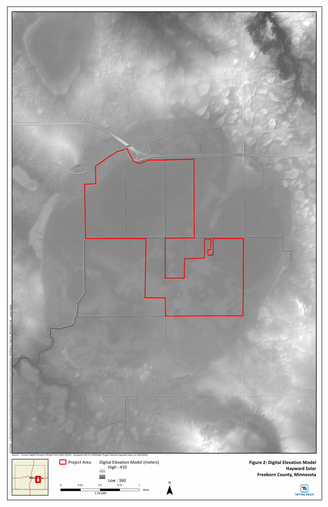
¯
6/2/20
20
S:\Pro
jects\
Capita
l Dyna
mics\
Midw
estSol
arDevC
o\Hayw
ardSol
arLLC\
GIS\H
ayward
_CRM
Repo
rt_Fig
ure2_0
6022
020.m
xd s
usan.m
ayer
Project Area Digital Elevation Model (meters)High : 410
Low : 360
Figure 2: Digital Elevation ModelHayward Solar
Freeborn County, Minnesota
Source: 1-meter Digital Elevation Model from USGS (2019) - displayed with 0.1 hillshade; Project Data by Hayward Solar LLC (02/2020).
0 0.25 0.5 0.75 1Miles1:24,000