Appendix F - Elkhart County Highway Department
175
Elkhart Local Trax - Des. No. 1801913 (LEAD) Appendix F Water Resources
-
Upload
khangminh22 -
Category
Documents
-
view
1 -
download
0
Transcript of Appendix F - Elkhart County Highway Department

Elkhart Local Trax - Des. No. 1801913 (LEAD)
Appendix F Water Resources

��������������� �������������������������� ��������������������������������������������� ��!� ���!���������"# ��#�����$�������#��!�����%%�$���&'()*+,-�������$���$������$�� ���.�����������$���$������$��/����$� 0����.������%����$��/����$�0����.�����0�������������/����$�0����.�����1$� ���2����"�3���$�4�$��56��57587 79: 8795: %�7 79;: 89:796;: �%8�5<�<;8
����������.�������������������/#�%���������$���/����$���#$3�$����=�/#>�����%������?����$�������?���$���$��9�����!��0�����$��/�����?�����3�������$������$������?����������������������$�$����?�����������������.$�$������%��9�����.����$�������������������������������$�������$���.��������������%��������?�$��$�����/����$����������.�������9
Des. 1801913 Appendix F Page F-1
J Port
Callout
General study area location
J Port
Polygon

Des. 1801913 Appendix F Page F-2
J Port
Polygon
J Port
Callout
General study area location

Environmental Assessment - Clear Path 465 Des. 1400075 1
Waters of the U.S. Report Elkhart Local Trax Grade Separation Des. 1801913 (Lead), 1900836, 2001723, & 2001724
Elkhart County, Indiana
Prepared for: Indiana Department of Transportation and Federal Highway Administration
March 24, 2021
Parsons • 101 West Ohio Street, Suite 2121 • Indianapolis, Indiana 46204 • (317) 616-1000
Des. 1801913 Appendix F Page F-3
J Port
Text Box
Excerpts

Waters of the U.S. Report – Elkhart Local Trax Grade Separation Des. 1801913 (Lead) 2
WATERS OF THE U.S. REPORT
ELKHART LOCAL TRAX GRADE SEPARATION Elkhart County, Indiana
INDOT Designation (Des.) Numbers 1801913 (Lead), 1900836, 2001723, & 2001724
Prepared By: Benjamin K. Blocher, Environmental Planner, PWS
March 24, 2021
I. PROJECT INFORMATION
FIELDWORK DATES:
Fieldwork for this report was conducted on June 23-24, August 25, and October 21, 2020.
CONTRIBUTORS:
Greg Moushon, PWS, Senior Environmental Planner Eric Jagger, Associate Environmental Planner Keaton Veldkamp, Associate Environmental Planner
PROJECT LOCATION:
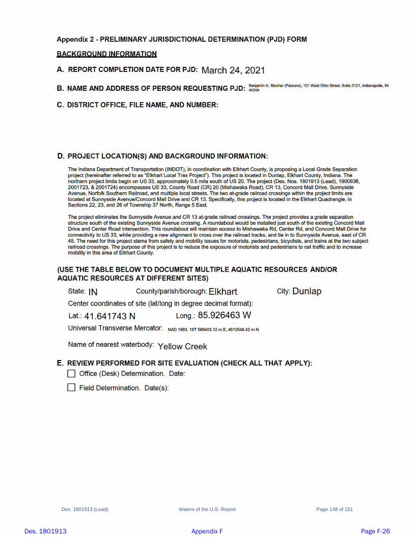
Elkhart Quadrangle Sections 22, 23, and 26 of Township 37 North, Range 5 East US 33 Reference Post (RP) 93+0.79 to 93+0.38 New construction on Sunnyside Avenue from County Road (CR) 20 (Mishawaka Road) to CR 13, and on Concord Mall Drive from CR 20 to US 33 Elkhart County, Indiana Latitude/Longitude: 41.642508 North and 85.927749 West
PROJECT DESCRIPTION:
The Indiana Department of Transportation (INDOT), in coordination with Elkhart County, is proposing a Local Grade Separation project (hereinafter referred to as “Elkhart Local Trax Project”). This project is located in Dunlap, Elkhart County, Indiana. The northern project limits begin on US 33, approximately 0.5 mile south of US 20. The project (Des. Nos. 1801913 (Lead), 1900836, 2001723, & 2001724) encompasses US 33, County Road (CR) 20 (Mishawaka Road), CR 13, Concord Mall Drive, Sunnyside Avenue, Norfolk Southern Railroad, and multiple local streets. The two at-grade railroad crossings within the project limits are located at Sunnyside Avenue/Concord Mall Drive and CR 13. Specifically, this project is located in the Elkhart Quadrangle, in Sections 22, 23, and 26 of Township 37 North, Range 5 East. The project eliminates the Sunnyside Avenue and CR 13 at-grade railroad crossings. The project provides a grade separation structure south of the existing Sunnyside Avenue crossing. A roundabout would be installed just south of the existing Concord Mall Drive and Center Road intersection. This roundabout will maintain access to Mishawaka Rd, Center Rd, and Concord Mall Drive for connectivity to US 33, while providing a new alignment to cross over the railroad tracks, and tie in to Sunnyside Avenue, east of CR 45.
4/6/2021
Des. 1801913 Appendix F Page F-4

Waters of the U.S. Report – Elkhart Local Trax Grade Separation Des. 1801913 (Lead) 3
The need for this project stems from safety and mobility issues for motorists, pedestrians, bicyclists, and trains at the two subject railroad crossings. The trains typically run through these crossings 80 to 90 times a day. Furthermore, the trains regularly stop on the tracks, restricting traffic for extended periods of time, and delaying emergency vehicle access to the communities north of the tracks. Existing crash data indicates a high rate of crashes for these types of crossings. The purpose of this project is to reduce the exposure of motorists and pedestrians to rail traffic and to increase mobility in this area of Elkhart County.
METHODOLOGY:
The study area was based on the design alternatives evaluated for the National Environmental Policy Act (NEPA) document. The study area was approximately 50.6 acres in size. A desktop review of the study area was conducted to identify potential waterways (streams, wetlands, ponds, etc.). This included a review of historic and recent aerial photography for any areas with a water signature or a sharp change in vegetation. Any such areas were flagged for follow-up field reconnaissance. United States Geological Survey (USGS) topographic mapping, National Wetlands Inventory (NWI) mapping, National Hydrography Dataset (NHD) mapping, floodplain mapping, Natural Resources Conservation Service (NRCS) mapped soil units, and historic drainage mapping were also reviewed. Any noted items were flagged for follow-up field reconnaissance.
AERIAL PHOTOGRAPHY:
During review of current and historical aerial photography, several areas were identified within the study area that displayed potential wetland signatures associated with water ponding, darkened soils, and/or shifts in vegetation. Several areas were noted within or adjacent to the study area. Each flagged area was investigated during field reconnaissance.
USGS MAPPING:
During review of USGS 7.5-minute series topographic mapping (page 13), one perennial stream (blue-line stream) was noted within the study area. This corresponded to Yellow Creek flowing to the northwest through the study area.
NWI AND FLOODPLAIN MAPPING:
During review of NWI and floodplain mapping (pages 15 to 25), one wetland polygon and one wetland line were noted within or near the study area. One NWI-mapped stream, Yellow Creek, was noted within the study area. The 100-year floodplain associated with Yellow Creek is mapped within the study area.
MAPPED SOIL UNITS AND NHD MAPPING:
The NRCS classifies soil types as follows: hydric (100%), predominantly hydric (66-99%), partially hydric (33-65%), predominantly non-hydric (1-32%), and not-hydric (0%). According to the Soil Survey Geographic (SSURGO) Database for Elkhart County, Indiana, the study area is comprised of partially hydric and not hydric soil types (pages 26 to 36). The mapped soil unit within the study area is summarized in the Mapped Soil Units within the Study Area table (Table 1, page 10). NHD was mapped on the soils background (pages 26 to 36). Ten potential drainage features were identified within the study area. Four roadside ditches (RSDs) were noted along County Road 45 within the study area. These areas were investigated during the field reconnaissance.
Des. 1801913 Appendix F Page F-5

Waters of the U.S. Report – Elkhart Local Trax Grade Separation Des. 1801913 (Lead) 4
HISTORIC DRAINAGE:
The Elkhart County Soil Survey (USDA, 1974) was reviewed for historic drainage features within the study area. One drainage feature was identified within the study area. One perennial stream, Yellow Creek, was identified within the study area (pages 37 to 38). WATERSHED: The study area is located within two hydrologic unit code 12-digit (HUC 12) watersheds: Headwaters Yellow Creek (040500011903) and Goshen Dam Pond-Elkhart River (040500011904).
II. FIELD RECONNAISSANCE
METHODOLOGY:
Parsons conducted field investigations on June 23-24, August 25, and October 21, 2020 to determine the presence of waterways, including streams, wetlands, lakes, and ponds, within the study area. The entire study area was reviewed for resources via a walking survey. All areas flagged during desktop review were investigated and documented. A resource map showing all identified features is attached for reference (pages 39 to 49). The ordinary high-water mark (OHWM) of each stream was determined using a measuring tape. A hand-held GPS unit (Trimble Geo 7 Series) was used to collect the location of each identified stream. The upstream drainage area for each stream was calculated using StreamStats Version 4.3.0 (USGS, 2019), if available. Qualitative assessments of stream quality were done within the study area. Quantitative assessments were conducted based on each stream’s drainage area using the guidelines for either the Headwater Habitat Evaluation Index (HHEI) (Ohio EPA, 2012) or Qualitative Habitat Evaluation Index (QHEI) (Ohio EPA, 2006). Mitigation is anticipated for this project; therefore, the QHEI form was included in this document. Vegetation, soil, and hydrology data were collected using the methods described in the Regional Supplement to the Corps of Engineers Wetland Delineation Manual: Northcentral and Northeast Region (Version 2.0) (USACE, 2010). Wetland indicator statuses for plants were obtained from the National Wetland Plant List (Lichvar, 2016). A hand-held GPS unit (Trimble Geo 7 Series) was used to collect the boundary of each identified wetland, as well as all data points. Data forms for each data point are included in this report for reference (pages 113 to 146). The area for each wetland and its length (measured along its centerline) were calculated. A qualitative assessment of each wetland’s quality was conducted, which included grading them (poor, average, or excellent) based on ecological function, size, species diversity, invasive species prevalence, and amount of disturbance. Photographs were taken throughout the study area. This included photographs of each feature identified within the study area (pages 62 to 112). A photograph orientation map is included for additional reference (pages 51 to 61).
STREAMS:
Field investigations resulted in the identification of one likely jurisdictional stream (Yellow Creek) totaling 564 linear feet within the study area. These features are summarized in the Stream Summary Table (Table 2, page 10). No other features exhibiting an OHWM were observed within the study area. Yellow Creek is not listed as a Federal Wild and Scenic River, a State Natural, Scenic, and Recreational River, or on the Indiana Register’s listing of Outstanding Rivers and Streams, nor is it located within two miles of any such resources.
Des. 1801913 Appendix F Page F-6

Waters of the U.S. Report – Elkhart Local Trax Grade Separation Des. 1801913 (Lead) 5
Yellow Creek
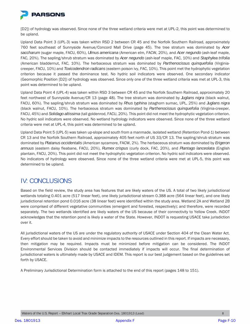
Concord Mall Drive passes over Yellow Creek within the study area. This stream originates southeast of the Concord Mall Drive bridge and flows to the northwest (pages 42 and 43). It exhibited a 30-foot wide and a 20-inch deep OHWM (page 43). Approximately 564 linear feet of this stream over 0.388 acre lies within the study area. USGS StreamStats lists its upstream drainage area as approximately 32.4 square miles. Yellow Creek has a narrow riparian corridor width along the west bank and a moderate riparian corridor width along the east bank throughout the study area. It is forested along the east side of Yellow Creek, while the west side is predominantly urban or industrial. The substrate consisted of gravel and sand. Pools and riffles were observed. The stream exhibited high overhead canopy cover and minor erosion. Based on these observations, Yellow Creek was classified as an average-quality stream. This was supported by its QHEI score of 53.5 (pages 146 to 147). Yellow Creek is shown on USGS 7.5-minute topographic mapping as a perennial stream (page 13). This was confirmed based on field observations. Yellow Creek is a tributary of the St. Joseph River, a traditionally navigable waterway, which flows to Lake Michigan. Because of this connectivity and the presence of an OHWM, this stream is likely a water of the US.
WETLANDS:
Sampling locations were determined by the presence or absence of hydrophytic vegetation and hydrology indicators. A total of two likely jurisdictional wetlands totaling 0.401 acre (517 linear feet) were identified within the study area. Wetland 2 was comprised of different vegetative communities (emergent and forested); and therefore, each community was recorded separately. The two wetlands identified are likely waters of the US because of their connectivity to Yellow Creek. The Wetland Summary Table (Table 4, page 11) and Data Point Summary Table (Table 5, page 11) summarize the data collected on these features. INDOT will seek concurrence on the jurisdiction of all wetlands from the US Army Corps of Engineers (USACE) and the Indiana Department of Environmental Management (IDEM). A Preliminary Jurisdictional Determination form is attached for reference (pages 148 to 151). Wetland 1
Data Point 1 IN (DP-1-IN) was evaluated because it exhibited hydrophytic vegetation. The herbaceous stratum was dominated by Phalaris arundinacea (reed canary grass, FACW, 90%). This point met the hydrophytic vegetation criterion because it passed the rapid test, dominance test, and prevalence index. The soil profile met the hydric soil criterion because it exhibited the Redox Dark Surface (F6) indicator. Two primary indicators (Sediment Deposits [B2] and Drift Deposits [B3]) and four secondary indicators (Drainage Patterns [B10], Crayfish Burrows [C8], Geomorphic Position [D2], and FAC-Neutral Test [D5]) of hydrology were observed. Since all three wetland criteria were met at DP-1-IN, this area was identified as Wetland 1. The area associated with Data Point 1 OUT (DP-1-OUT) was taken up-slope and northeast from DP-1-IN. The tree stratum was dominated by Rhus typhina (staghorn sumac, UPL, 5%). The sapling/shrub stratum was dominated by Ulmus americana (American elm, FACW, 5%). The herbaceous stratum was dominated by Solidago altissima (tall goldenrod, FACU, 50%) and Phalaris arundinacea (reed canary grass, FACW, 40%). The woody vine stratum was dominated by Vitis riparia (river-bank grape, FAC, 5%). DP-1-OUT met the hydrophytic vegetation criterion because it passed the dominance test. No hydric soil indicators were observed. No wetland hydrology indicators were observed. Since only one of the three wetland criteria was met at DP-1-OUT, this point was determined to be upland. This data point helped establish the boundary of Wetland 1, which was determined based on changes in vegetation and topography. Wetland 1 is an emergent wetland that is approximately 0.007 acre (25 linear feet) in size. It is located along the northeast terrace of Yellow Creek along the north side of the Concord Mall Drive bridge, approximately 0.06 mile southwest of US 33 (page 42). Wetland 1 is a poor-quality wetland due to invasive hydrophytic vegetation (Phalaris arundinacea, reed canary grass) being the dominant vegetation. Wetland 1 lies adjacent to and is directly abutting Yellow Creek (a perennial stream). Therefore, it is likely a water of the US.
Des. 1801913 Appendix F Page F-7

Waters of the U.S. Report – Elkhart Local Trax Grade Separation Des. 1801913 (Lead) 6
Wetland 2
Wetland 2 is comprised of contiguous, but different vegetative communities (emergent and forested) totaling 0.394 acre (492 linear feet). Therefore, during field investigations, each community was delineated separately to aide in the permitting process (Wetland 2A and Wetland 2B, respectively). Wetland 2A
The area associated Data Point 2A IN (DP-2A-IN) was evaluated because it exhibited hydrophytic vegetation. The tree stratum was dominated by Platanus occidentalis (American sycamore, FACW, 5%), Fraxinus pennsylvanica (green ash, FACW, 5%), and Acer negundo (ash-leaf maple, FAC, 5%). The sapling/shrub stratum was dominated by Fraxinus pennsylvanica (green ash, FACW, 3%) and Sambucus nigra (black elder, FACW, 2%). The herbaceous stratum was dominated by Rudbeckia laciniata (green-head coneflower, FACW, 40%) and Phalaris arundinacea (reed canary grass, FACW, 30%). This point met the hydrophytic vegetation criterion because it passed the dominance test and prevalence index. The soil profile met the hydric soil criterion because it exhibited the Redox Dark Surface (F6) indicator. Two primary indicators (Sediment Deposits [B2] and Drift Deposits [B3]) and three secondary indicators (Crayfish Burrows [C8], Geomorphic Position [D2], and FAC-Neutral Test [D5]) of hydrology were observed. Since all three wetland criteria were met at DP-2A-IN, this area was identified as Wetland 2A. Data Point 2A OUT (DP-2A-OUT) was taken up-slope and east from DP-2A-IN. The tree stratum was dominated by Fraxinus pennsylvanica (green ash, FACW, 5%) and Ulmus americana (American elm, FACW, 5%). The sapling/shrub stratum was dominated by Sambucus nigra (black elder, FACW, 15%) and Rosa multiflora (rambler rose, FACU, 5%). The herbaceous stratum was dominated by Rudbeckia laciniata (green-head coneflower, FACW, 35%) and Solidago altissima (tall goldenrod, FACU, 20%). The woody vine stratum was dominated by Vitis riparia (river-bank grape, FAC, 10%). This point met the hydrophytic vegetation criterion because it passed the dominance test. No hydric soil indicators were observed. No wetland hydrology indicators were observed. Since only one of the three wetland criteria was met at DP-2A-OUT, this point was determined to be upland. This data point helped establish the boundary of Wetland 2A, which was determined based on changes in vegetation and topography. Wetland 2A is an emergent wetland that is approximately 0.023 acre (47 linear feet) in size. It is located on the southeast terrace of Yellow Creek along the south side of the Concord Mall Drive bridge, approximately 0.006 mile southwest of US 33 (page 42). Wetland 2A had high species diversity. Because of this, it was classified as an average-quality wetland. Wetland 2A lies adjacent to and is directly abutting Yellow Creek (a perennial stream). Therefore, it is likely a water of the US. Wetland 2B
The area associated with Data Point 2B IN (DP-2B-IN) was evaluated because it exhibited hydrophytic vegetation. The tree stratum was dominated by Populus deltoides (eastern cottonwood, FAC, 50%), Salix nigra (black willow, OBL, 40%), and Celtis occidentalis (common hackberry, FAC, 5%). The sapling/shrub stratum was dominated by Lonicera maackii (Amur honeysuckle, UPL, 25%) and Acer negundo (ash-leaf maple, FAC, 20%). The herbaceous stratum was dominated by Ageratina altissima (white snakeroot, FACU, 5%), Toxicodendron radicans (eastern poison ivy, FAC, 5%), Packera aurea (golden groundsel, FACW, 5%), Alliaria petiolata (garlic-mustard, FACU, 5%), Laportea canadensis (Canadian wood-nettle, FACW, 5%), and Fraxinus pennsylvanica (green ash, FACW, 5%). The woody vine stratum was dominated by Vitis riparia (river-bank grape, FAC, 15%). This point met the hydrophytic vegetation criterion because it passed the dominance test and the prevalence index. The soil profile met the hydric soil criterion because it exhibited the Redox Dark Surface (F6) indicator. Two primary indicators (Sediment Deposits [B2] and Drift Deposits [B3]) and two secondary indicators (Geomorphic Position [D2] and FAC-Neutral Test [D5]) of hydrology were observed. Since all three wetland criteria were met at DP-2B-IN, this area was identified as Wetland 2B. Data Point 2B OUT (DP-2B-OUT) was taken up-slope and east from DP-2B-IN. The tree stratum was dominated by Populus deltoides (eastern cottonwood, FAC, 30%) and Salix nigra (black willow, OBL, 10%). The herbaceous stratum was dominated by Rubus idaeus (common red raspberry, FAC, 20%). The woody vine stratum was dominated by Vitis riparia (river-bank
Des. 1801913 Appendix F Page F-8

Waters of the U.S. Report – Elkhart Local Trax Grade Separation Des. 1801913 (Lead) 7
grape, FAC, 70%). This point met the hydrophytic vegetation criterion because it passed the dominance test. No hydric soil indicators were observed. One secondary indicator (FAC-Neutral Test [D5]) of hydrology was observed. Since only one of the three wetland criteria was met at DP-2B-OUT, this point was determined to be upland. This data point helped establish the boundary of Wetland 2B, which was determined based on changes in vegetation and topography. Wetland 2B is a forested wetland that is approximately 0.371 acre (445 linear feet) in size. It is located along the east side of Yellow Creek south of the Concord Mall Drive bridge, approximately 0.06 mile southwest of US 33 (pages 42 and 43). Wetland 2B had high species diversity. Because of this, it was classified as an average-quality wetland. Wetland 2B lies adjacent to and is directly abutting Yellow Creek (a perennial stream). Therefore, it is likely a water of the US.
OTHER JURISDICTIONAL FEATURES:
Retention Pond-1
Retention Pond-1 (RP-1) was noted as likely being a manmade body of surface water created by excavating dry land to collect and retain water for or incidental to commercial, industrial, or aesthetic purposes. A review of historical (2011) aerial imagery shows that the basin did not exist in 2011 (page 50) and later. After additional development and expansion of the adjacent parking lot, it can be seen on aerial imagery from 2016 (page 49). The Other Jurisdictional Features Summary Table (Table 3, page 10) summarize the data collected on this feature. RP-1 is approximately 0.016 acre (38 linear feet) in size. It is located along the east side of CR 13, approximately 0.07 mile north of US 33 (page 49). RP-1 was created between 2011 and 2016, and it was approximately 4-foot deep at the time of the field visit. RP-1 is a manmade drainage control structure recently constructed in an upland area. INDOT acknowledges that this feature is likely a water of the State. However, we are requesting USACE take jurisdiction over it.
NON-JURISDICTIONAL FEATURES:
Drainage Features
Four RSDs, totaling approximately 1,301 linear feet within the study area, were investigated for potential water resources. Those that contained wetlands or UNTs were discussed earlier in this report. The remaining sections of the RSDs lacked either an OHWM or wetland characteristics. Therefore, they were considered to be non-jurisdictional features. RSD 1 is located on the northeast side of the Sunnyside Avenue/Concord Mall Drive and Norfolk Southern Railroad crossing and runs for approximately 213 linear feet. RSD 2 is located on the southeast side of the Sunnyside Avenue/Concord Mall Drive and Norfolk Southern Railroad crossing and runs for approximately 856 linear feet. RSD 3 is located on the northwest side of the CR 13 and Norfolk Southern Railroad crossing and runs for approximately 78 linear feet. RSD 4 is located on the northeast side of the CR 13 and Norfolk Southern Railroad crossing and runs for approximately 154 linear feet. Additional Data Points
Five additional data points were investigated within the study area. The sample areas surrounding these data points were further investigated to confirm or deny the presence of hydrophytic vegetation, hydric soils, and/or wetland hydrology. Upland Data Point 1 (UPL-1) was taken within an undeveloped parcel south of the Concord Mall Drive and Center Drive intersection (page 41). The herbaceous stratum was dominated by Poa pratensis (Kentucky blue grass, FACU, 60%) and Ambrosia artemisiifolia (annual ragweed, FACU, 30%). This point did not meet the hydrophytic vegetation criterion. No hydric soil indicators were observed. No wetland hydrology indicators were observed. Since none of the three wetland criteria were met at UPL-1, this point was determined to be upland.
Upland Data Point 2 (UPL-2) was taken within RSD 2 on the southeast side of the Sunnyside Avenue/Concord Mall Drive and Norfolk Southern Railroad crossing (page 42). The tree stratum was dominated by Acer saccharum (sugar maple, FACU, 25%) and Acer negundo (ash-leaf maple, FAC, 20%). The sapling/shrub stratum was dominated by Prunus serotina (black cherry, FACU, 5%), Fraxinus pennsylvanica (green ash, FACW, 5%), Celtis occidentalis (common hackberry, FAC, 5%), Lonicera maackii (Amur honeysuckle, UPL, 5%), and Rhus typhina (staghorn sumac, UPL, 5%). This point did not meet the hydrophytic vegetation criterion. No hydric soil indicators were observed. One secondary indicator (Geomorphic Position
Des. 1801913 Appendix F Page F-9
Waters of the U.S. Report – Elkhart Local Trax Grade Separation Des. 1801913 (Lead) 8
[D2]) of hydrology was observed. Since none of the three wetland criteria were met at UPL-2, this point was determined to be upland.
Upland Data Point 3 (UPL-3) was taken within RSD 2 between CR 45 and the Norfolk Southern Railroad, approximately 760 feet southeast of Sunnyside Avenue/Concord Mall Drive (page 45). The tree stratum was dominated by Acer saccharum (sugar maple, FACU, 60%), Ulmus americana (American elm, FACW, 20%), and Acer negundo (ash-leaf maple, FAC, 20%). The sapling/shrub stratum was dominated by Acer negundo (ash-leaf maple, FAC, 10%) and Staphylea trifolia (American bladdernut, FAC, 10%). The herbaceous stratum was dominated by Parthenocissus quinquefolia (Virginia-creeper, FACU, 10%) and Toxicodendron radicans (eastern poison ivy, FAC, 10%). This point met the hydrophytic vegetation criterion because it passed the dominance test. No hydric soil indicators were observed. One secondary indicator (Geomorphic Position [D2]) of hydrology was observed. Since only one of the three wetland criteria was met at UPL-3, this point was determined to be upland.
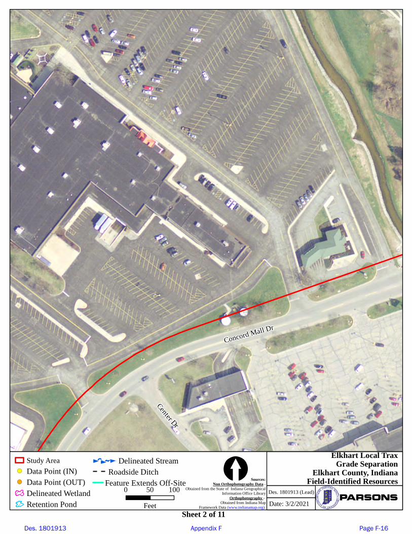
Upland Data Point 4 (UPL-4) was taken within RSD 3 between CR 45 and the Norfolk Southern Railroad, approximately 20 feet northwest of Sunnyside Avenue/CR 13 (page 48). The tree stratum was dominated by Juglans nigra (black walnut, FACU, 60%). The sapling/shrub stratum was dominated by Rhus typhina (staghorn sumac, UPL, 25%) and Juglans nigra (black walnut, FACU, 10%). The herbaceous stratum was dominated by Parthenocissus quinquefolia (Virginia-creeper, FACU, 45%) and Solidago altissima (tall goldenrod, FACU, 20%). This point did not meet the hydrophytic vegetation criterion. No hydric soil indicators were observed. No wetland hydrology indicators were observed. Since none of the three wetland criteria were met at UPL-4, this point was determined to be upland.
Upland Data Point 5 (UPL-5) was taken up-slope and south from a manmade, isolated wetland (Retention Pond-1) between CR 13 and the Norfolk Southern Railroad, approximately 405 feet north of US 33/CR 13. The sapling/shrub stratum was dominated by Platanus occidentalis (American sycamore, FACW, 2%). The herbaceous stratum was dominated by Erigeron annuus (eastern daisy fleabane, FACU, 20%), Rumex crispus (curly dock, FAC, 20%), and Plantago lanceolata (English plantain, FACU, 20%). This point did not meet the hydrophytic vegetation criterion. No hydric soil indicators were observed. No indicators of hydrology were observed. Since none of the three wetland criteria were met at UPL-5, this point was determined to be upland.
IV: CONCLUSIONS Based on the field review, the study area has features that are likely waters of the US. A total of two likely jurisdictional wetlands totaling 0.401 acre (517 linear feet), one likely jurisdictional stream 0.388 acre (564 linear feet), and one likely jurisdictional retention pond 0.016 acre (38 linear feet) were identified within the study area. Wetland 2A and Wetland 2B were comprised of different vegetative communities (emergent and forested, respectively); and therefore, were recorded separately. The two wetlands identified are likely waters of the US because of their connectivity to Yellow Creek. INDOT acknowledges that the retention pond is likely a water of the State. However, INDOT is requesting USACE take jurisdiction over it. All jurisdictional waters of the US are under the regulatory authority of USACE under Section 404 of the Clean Water Act. Every effort should be taken to avoid and minimize impacts to the resources outlined in this report. If impacts are necessary, then mitigation may be required. Impacts must be minimized before mitigation can be considered. The INDOT Environmental Services Division should be contacted immediately if impacts will occur. The final determination of jurisdictional waters is ultimately made by USACE and IDEM. This report is our best judgement based on the guidelines set forth by USACE. A Preliminary Jurisdictional Determination form is attached to the end of this report (pages 148 to 151).
Des. 1801913 Appendix F Page F-10

Waters of the U.S. Report – Elkhart Local Trax Grade Separation Des. 1801913 (Lead) 9
V. REFERENCESCowardin, L.M, V. Carter, F.C. Golet, and E.T. LaRoe. 1979. Classification of Wetlands and Deepwater Habitats of the United States. US Department of the Interior, Fish and Wildlife Service, Washington DC.
Lichvar, R.W., D.L. Banks, W.N. Kirchner, and N.C. Melvin. 2016. The National Wetland Plant List: 2016 Wetland Ratings. Phytoneuron 2016-30: 1-17. Published 28 April 2016. ISSN 2153 733X
Ohio EPA. 2012. Field Evaluation Manual for Ohio’s Primary Headwater Habitat Streams. State of Ohio Environmental Protection Agency, Division of Surface Water.
Ohio EPA. 2006. Methods for Assessing Habitat in Flowing Waters: Using the Qualitative Habitat Evaluation Index (QHEI). State of Ohio Environmental Protection Agency, Division of Surface Water.
United States Army Corps of Engineers. 2012. Regional Supplement to the Corps of Engineers Wetland Delineation Manual: Northcentral and Northeast Region (Version 2.0). US Army Engineer Research and Development Center, Washington DC.
United States Army Corps of Engineers, Waterway Experiment Station, Environmental Laboratory. 1987. Wetlands Delineation Manual (as amended). Wetlands Research Program Technical Report Y-87-1.
United States Department of Agriculture, Soil Conservation Service. 1974. Soil Survey of Elkhart County, Indiana.
United States Geological Service. March 2019. StreamStats, Version 4.3.0.
VI. ACKNOWLEDGEMENTSThis report has been prepared based on the best available information, interpreted in the light of the investigator’s training, experience, and professional judgement in conformance with the 1987 Corps of Engineers Wetlands Delineation Manual, the appropriate regional supplement, the USACE Jurisdictional Determination Form Instructional Guidebook, and other appropriate agency guidelines.
3/24/2021
Benjamin K. Blocher Environmental Planner, PWS Parsons
Des. 1801913 Appendix F Page F-11

Waters of the U.S. Report – Elkhart Local Trax Grade Separation Des. 1801913 (Lead) 10
Table 1: Mapped Soil Units within the Study Area
Soil Name Soil Unit Classification
Urban land-Gilford complex, 0 to 1 percent slopes UeqA Partially Hydric (33-65%) Psamments Pxo Not Hydric (0%) Urban land-Tyner complex, 1 to 5 percent slopes UgvB Not Hydric (0%) Urban land-Bristol complex, 0 to1 percent slopes UdpA Not Hydric (0%) Urban land-Bristol complex, 1 to 5 percent slopes UdpB Not Hydric (0%)
Table 2: Stream Summary Table
Name Photograph Number(s)
Latitude/ Longitude
OHWM Width
(ft)
OHWM Depth
(in)
Length (ft) and acres
(ac.)
USGS Blue-Line (Y/N)
Riffles/ Pools (Y/N)
Typical Substrate Quality*
Likely Water of the US (Y/N)
Yellow Creek 34, 41, 43, 45, 79, 86-87
41.611681 / -85.929337 30 20 564
0.388 (ac.) Y Y/Y Gravel and Sand Average Y
Totals 564 ft 0.388 (ac.)
*Quality was based on qualitative observations within and immediately adjacent to the study area.
Table 3: Other Jurisdictional Features Summary Table
Name Photograph Number(s)
Latitude/ Longitude
Waters Type
Area (acre)
Length (linear feet) Quality
Likely Water of the U.S.
(Y/N)
Retention Pond-1 197-198 41.63717/-85.921225 Palustrine 0.016 38 Poor Y
Totals 0.016 38
Des. 1801913 Appendix F Page F-12

Waters of the U.S. Report – Elkhart Local Trax Grade Separation Des. 1801913 (Lead) 11
Table 4: Wetland Summary Table
Name Photograph Number(s)
Latitude/ Longitude
Wetland Type*
(Palustrine)
Area (acre)
Length (linear feet) Quality
Likely Water of the U.S.
(Y/N)
Isolated (Y/N) and Class I, II or III
Likely Exempt Isolated Wetland
(Y/N)
Wetland 1 41-42, 45-47 41.641796/ -85.929269 Emergent 0.007 25 Poor Y N N
Wetland 2A 33-38, 79 41.641566/ -85.929119 Emergent 0.023 47 Average Y N N
Wetland 2B 33, 79, 81-84, 86-87
41.640966/ -85.928761 Forested 0.371 445 Average Y N N
Totals 0.401 517 *Quality was based on qualitative observations within the study area.
Table 5: Data Point Summary Table
Data Point Name Hydrophytic Vegetation (Y/N)
Hydric Soils (Y/N)
Wetland Hydrology (Y/N)
Wetland (Y/N)
DP-1-IN Y Y Y Y DP-1-OUT Y N N N DP-2A-IN Y Y Y Y
DP-2A-OUT Y N N N DP-2B-IN Y Y Y Y
DP-2B-OUT Y N N N UPL-1 N N N N UPL-2 N N N N UPL-3 Y N N N UPL-4 N N N N UPL-5 N N N N
Des. 1801913 Appendix F Page F-13

!(
!(
!(
!(
!(
!(
!(
!(!(
!(
!(
DP-2B-IN
DP-1-IN
DP-2A-IN
DP-2B-OUT
UPL-2
UPL-5
UPL-1
DP-1-OUT
DP-2A-OUT
UPL-3
UPL-4
Yellow Creek
Wetland 2BForestedExtends Off-Site
Wetland 1Emergent
Extends Off-Site
Wetland 2AEmergent
Sheet 2
Sheet 1
Sheet 3
Sheet 4
Sheet 5
Sheet 6
Sheet 7
Sheet 8
Sheet 9
Sheet 10
Sheet 11
Retention Pond-1
Date: 3/2/2021
Des. 1801913 (Lead)
Elkhart Local TraxGrade Separation
Elkhart County, IndianaIndexSources:
Non Orthophotography Data -Obtained from the State of Indiana Geographical
Information Office LibraryOrthophotography -
Obtained from Indiana MapFramework Data (www.indianamap.org)
0 300 600
Feet [Study AreaIndex Sheet
!( Data Point (IN)!( Data Point (OUT)
Delineated Wetland
Retention PondDelineated Stream
Roadside DitchFeature Extends Off-Site
Des. 1801913 (Lead) Waters of the U.S. Report Page 14 of 151
Certain graphics intentionally omitted. Refer to Appendix B.
Des. 1801913 Appendix F Page F-14

Elmhurst Dr
Conco
rd Mall
Dr
PineR
idgeP
kwy
")20
Date: 3/2/2021Des. 1801913 (Lead)
Elkhart Local TraxGrade Separation
Elkhart County, IndianaField-Identified ResourcesSources:
Non Orthophotography Data -Obtained from the State of Indiana Geographical
Information Office LibraryOrthophotography -
Obtained from Indiana MapFramework Data (www.indianamap.org)
0 50 100Feet
[Sheet 1 of 11
Study Area!( Data Point (IN)!( Data Point (OUT)
Delineated WetlandRetention Pond
Delineated StreamRoadside Ditch
Feature Extends Off-Site
Des. 1801913 Appendix F Page F-15
Concord Mall Dr
Center Dr
Date: 3/2/2021Des. 1801913 (Lead)
Elkhart Local TraxGrade Separation
Elkhart County, IndianaField-Identified ResourcesSources:
Non Orthophotography Data -Obtained from the State of Indiana Geographical
Information Office LibraryOrthophotography -
Obtained from Indiana MapFramework Data (www.indianamap.org)
0 50 100Feet
[Sheet 2 of 11
Study Area!( Data Point (IN)!( Data Point (OUT)
Delineated WetlandRetention Pond
Delineated StreamRoadside Ditch
Feature Extends Off-Site
Des. 1801913 Appendix F Page F-16

!(
")20
Conco
rdMall
Dr
Elmhurst Dr
E Mishawaka Rd
CenterDr
UPL-1
Date: 3/2/2021Des. 1801913 (Lead)
Elkhart Local TraxGrade Separation
Elkhart County, IndianaField-Identified ResourcesSources:
Non Orthophotography Data -Obtained from the State of Indiana Geographical
Information Office LibraryOrthophotography -
Obtained from Indiana MapFramework Data (www.indianamap.org)
0 50 100Feet
[Sheet 3 of 11
Study Area!( Data Point (IN)!( Data Point (OUT)
Delineated WetlandRetention Pond
Delineated StreamRoadside Ditch
Feature Extends Off-Site
Des. 1801913 Appendix F Page F-17

!(
!(
!(
!(
!(
£¤33
")45
Concord Mall Dr
Sunnys
ideAve
S Main St
Himebaugh Ave
DP-1-IN
DP-2A-IN
UPL-2
DP-1-OUT
DP-2A-OUT
Wetland 1EmergentExtends Off-Site
Wetland 2AEmergent
Wetland 2BForestedExtends Off-Site
Yellow Creek
RSD 1
RSD 2
Date: 3/2/2021Des. 1801913 (Lead)
Elkhart Local TraxGrade Separation
Elkhart County, IndianaField-Identified ResourcesSources:
Non Orthophotography Data -Obtained from the State of Indiana Geographical
Information Office LibraryOrthophotography -
Obtained from Indiana MapFramework Data (www.indianamap.org)
0 50 100Feet
[Sheet 4 of 11
Study Area!( Data Point (IN)!( Data Point (OUT)
Delineated WetlandRetention Pond
Delineated StreamRoadside Ditch
Feature Extends Off-Site
Des. 1801913 Appendix F Page F-18

!(!(
£¤33
S Main StDP-2B-IN
DP-2B-OUT
Wetland 2BForestedExtends Off-Site
Yellow Creek
Date: 3/2/2021Des. 1801913 (Lead)
Elkhart Local TraxGrade Separation
Elkhart County, IndianaField-Identified ResourcesSources:
Non Orthophotography Data -Obtained from the State of Indiana Geographical
Information Office LibraryOrthophotography -
Obtained from Indiana MapFramework Data (www.indianamap.org)
0 50 100Feet
[Sheet 5 of 11
Study Area!( Data Point (IN)!( Data Point (OUT)
Delineated WetlandRetention Pond
Delineated StreamRoadside Ditch
Feature Extends Off-Site
Des. 1801913 Appendix F Page F-19
B Blocher
Oval
B Blocher
Callout
Ordinary High Water Mark Sample Location

Florence Ave
Himebaugh Ave
Helen
St
Kend
all St
Date: 3/2/2021Des. 1801913 (Lead)
Elkhart Local TraxGrade Separation
Elkhart County, IndianaField-Identified ResourcesSources:
Non Orthophotography Data -Obtained from the State of Indiana Geographical
Information Office LibraryOrthophotography -
Obtained from Indiana MapFramework Data (www.indianamap.org)
0 50 100Feet
[Sheet 6 of 11
Study Area!( Data Point (IN)!( Data Point (OUT)
Delineated WetlandRetention Pond
Delineated StreamRoadside Ditch
Feature Extends Off-Site
Des. 1801913 Appendix F Page F-20

!(
")45
Sunnyside Ave
Cole St
Kend
all St
Helen
St
Nora StAm
y Ave
UPL-3
RSD 2
Date: 3/2/2021Des. 1801913 (Lead)
Elkhart Local TraxGrade Separation
Elkhart County, IndianaField-Identified ResourcesSources:
Non Orthophotography Data -Obtained from the State of Indiana Geographical
Information Office LibraryOrthophotography -
Obtained from Indiana MapFramework Data (www.indianamap.org)
0 50 100Feet
[Sheet 7 of 11
Study Area!( Data Point (IN)!( Data Point (OUT)
Delineated WetlandRetention Pond
Delineated StreamRoadside Ditch
Feature Extends Off-Site
Des. 1801913 Appendix F Page F-21
")13
Sunnyside Ave
Florence Ave
Greenwood Blvd
Date: 3/2/2021Des. 1801913 (Lead)
Elkhart Local TraxGrade Separation
Elkhart County, IndianaField-Identified ResourcesSources:
Non Orthophotography Data -Obtained from the State of Indiana Geographical
Information Office LibraryOrthophotography -
Obtained from Indiana MapFramework Data (www.indianamap.org)
0 50 100Feet
[Sheet 8 of 11
Study Area!( Data Point (IN)!( Data Point (OUT)
Delineated WetlandRetention Pond
Delineated StreamRoadside Ditch
Feature Extends Off-Site
Des. 1801913 Appendix F Page F-22

")13
Springriver Dr
Nora St
Cole St
Nora St
Sunnyside Ave
Date: 3/2/2021Des. 1801913 (Lead)
Elkhart Local TraxGrade Separation
Elkhart County, IndianaField-Identified ResourcesSources:
Non Orthophotography Data -Obtained from the State of Indiana Geographical
Information Office LibraryOrthophotography -
Obtained from Indiana MapFramework Data (www.indianamap.org)
0 50 100Feet
[Sheet 9 of 11
Study Area!( Data Point (IN)!( Data Point (OUT)
Delineated WetlandRetention Pond
Delineated StreamRoadside Ditch
Feature Extends Off-Site
Des. 1801913 Appendix F Page F-23

!(
")13")45
Linden Dr
UPL-4
RSD 3
Date: 3/2/2021Des. 1801913 (Lead)
Elkhart Local TraxGrade Separation
Elkhart County, IndianaField-Identified ResourcesSources:
Non Orthophotography Data -Obtained from the State of Indiana Geographical
Information Office LibraryOrthophotography -
Obtained from Indiana MapFramework Data (www.indianamap.org)
0 50 100Feet
[Sheet 10 of 11
Study Area!( Data Point (IN)!( Data Point (OUT)
Delineated WetlandRetention Pond
Delineated StreamRoadside Ditch
Feature Extends Off-Site
Des. 1801913 Appendix F Page F-24

!(
")45
")13
£¤33
Walnut St
UPL-5
RSD 4
Retention Pond-1
Date: 3/2/2021Des. 1801913 (Lead)
Elkhart Local TraxGrade Separation
Elkhart County, IndianaField-Identified ResourcesSources:
Non Orthophotography Data -Obtained from the State of Indiana Geographical
Information Office LibraryOrthophotography -
Obtained from Indiana MapFramework Data (www.indianamap.org)
0 50 100Feet
[Sheet 11 of 11
Study Area!( Data Point (IN)!( Data Point (OUT)
Delineated WetlandRetention Pond
Delineated StreamRoadside Ditch
Feature Extends Off-Site
Des. 1801913 Appendix F Page F-25
Des. 1801913 (Lead) Waters of the U.S. Report Page 148 of 151
Des. 1801913 Appendix F Page F-26

Site NumberLatitude (decimal degrees)
Longitude (decimal degrees)
Estimated amount of aquatic resource in review area
(acreage and linear feet, if applicable)
Type of aquatic resource (i.e., wetland vs. non-wetland
waters)
Geographic authority to which the aquatic resource "may be"
subject (i.e., Section 404 or Section 10/404)
Yellow Creek 41.611681 -85.929337 0.388 acre (564 linear feet) non-wetland waters Section 404Wetland 1 41.641796 -85.929269 0.007 acre (25 linear feet) Wetland Section 404
Wetland 2A 41.641566 -85.929119 0.023 acre (47 linear feet) Wetland Section 404Wetland 2B 41.640966 -85.928761 0.371 acre (445 linear feet) Wetland Section 404
Retention Pond-1 41.63717 -85.921225 0.016 acre (38 linear feet) Man-made Retention Pond Section 404
TABLE OF AQUATIC RESOURCES IN REVIEW AREA WHICH "MAY BE" SUBJECT TOREGULATORY JURISDICTION.
Des. 1801913 (Lead) Waters of the U.S. Report Page 149 of 151
Des. 1801913 Appendix F Page F-27

Des. 1801913 (Lead) Waters of the U.S. Report Page 150 of 151
Des. 1801913 Appendix F Page F-28

Des. 1801913 (Lead) Waters of the U.S. Report Page 151 of 151
Des. 1801913 Appendix F Page F-29

Elkhart Local Trax - Des. No. 1801913 (LEAD)
Appendix G Public Involvement

Office: +1 317.616.1000 / Fax: +1 317.616.1033101 W. Ohio Street, Suite 2121| Indianapolis, IN 46204
«OWNER_NAME» «OWNER_STREET_ADDRESS» «OWNER_CITY», «OWNER_STATE» «OWNER_ZIP»
RE: Des. No. 1801913 and 1900836 Elkhart Local Trax Railroad Grade Separation Sunnyside Ave over Norfolk Southern Railroad (NSRR) Elkhart County, Indiana
NNotice of Entry for Survey or Investigations
June 2, 2020
Dear Property Owner, Our information indicates that you own property near the above proposed transportation project. Representatives of the Indiana Department of Transportation will be conducting engineering and/or environmental surveys of the project area in the near future. It may be necessary for the INDOT Representatives to enter onto your property to complete this work. This is permitted by Indiana Code § 8-23-7-26. Anyone performing this type of work has been instructed to identify him or herself to you, if you are available, before they enter your property. If you no longer own this property or it is currently occupied by someone else (i.e. rental, sharecrop), please let us know the name of the new owner or occupant so that we can contact them about the survey. Please read the attached notice to inform you of what the “Notice of Entry for Survey or Investigation” means. The design and environmental surveys are needed for the proper planning and design of this part of the Elkhart Local Trax Railroad Grade Separation improvement project. Engineering survey work would include mapping the location of features such as trees, buildings, fences, drives, ground elevations, etc. Environmental survey work may include the identification and mapping of wetlands, architectural surveys, archaeological investigations (which may involve the survey, testing, or excavation of identified archaeological sites), and various other environmental studies. It is our sincere desire to cause you as little inconvenience as possible during this survey. At this stage we generally do not know what effect, if any, our project may eventually have on your property. If we determine later that your property is involved, we will contact you with additional information. If any problems occur, please contact the field crew or one of the following: Daniel J. Miller Sean Porter Harry S. Nikides Environmental Lead/Project Manager Project Manager Indiana Regional Manager Parsons Parsons ASC Group, Inc. 101 West Ohio Street, Suite 2121 101 West Ohio Street, Suite 2121 9376 Castlegate Drive Indianapolis, IN 46204 Indianapolis, IN 46204 Indianapolis, IN 46256 (317) 616-4663 (317) 616-1001 (317) 915-9300 x100 [email protected] [email protected] [email protected] Please be aware that IC 8-23-7-27 and 28 provides that you may seek compensation from INDOT for damages occurring to your property (land or water) that result from INDOT’s entry for the purposes mentioned above in IC 8-23-7-26. In this case, a basic procedure that may be followed is for you and/or an INDOT employee or representative to present an account of the damages to one of the above named INDOT staff. They will check the information and forward it to the appropriate person at INDOT who will contact you to discuss the situation and compensation.
Des. 1801913 Appendix G Page G-1
J Port
Text Box
Sample Notice of Entry letter. Mailed to adjoining land owners June 2, 2020.

In the event that property damage occurs as a result of work performed during survey, the LPA Manager of Special Programs or Parson’s Project Manager can provide you with a form to request compensation for damages. You may contact:
Jason Holder Sean Porter LPA Manager of Special Programs Project Manager LPA/MPO Grant Administration INDOT Parsons 100 N Senate Ave., N955-LPA 101 West Ohio Street, Suite 2121 Indianapolis, IN 46204 Indianapolis, IN 46204 (317) 233-3427 (317) 616-1001 [email protected] [email protected]
After filling out the form, you can return it to the LPA Manager of Special Programs or Parsons Project Manager for consideration. Please contact either of the representatives above if you have questions regarding the matter, rights, and procedures. If you are not satisfied with the compensation that INDOT determines is owed to you, Indiana Code 8-23-7-8 provides the following:
The amount of damages shall be assessed by the county agricultural extension educator of the county in which the land or water is located and two (2) disinterested residents of the county, one (1) appointed by the aggrieved party and one (1) appointed by the department. A written report of the assessment of damages shall be mailed to the aggrieved party and the department by first class United States mail. If either the department or the aggrieved party is not satisfied with the assessment of damages, either or both may file a petition, not later than fifteen (15) days after receiving the report, in the circuit or superior court of the county in which the land or water is located.
Thank you in advance for your cooperation in this matter. Sincerely,
Daniel J. Miller Project Manager Parsons 101 W. Ohio St., Suite 2121 Indianapolis, IN 46204 [email protected] Attachment
Des. 1801913 Appendix G Page G-2
Public Involvement Plan – Elkhart Local Trax - Des. Nos. 1801913 (Lead) Updated July 2021 Page 1
Public Involvement Plan Elkhart Local Trax Railroad Grade Separation Sunnyside Avenue over Norfolk Southern Railroad (NSRR) in Elkhart County Des. Nos. 1801913 (Lead)
Updated July 2021
Des. 1801913 Appendix G Page G-3

Public Involvement Plan – Elkhart Local Trax - Des. Nos. 1801913 (Lead) Updated July 2021 Page 2
Introduction This Public Involvement Plan has been developed for the proposed Elkhart Local Trax Railroad Grade Separation, Sunnyside Avenue over Norfolk Southern Railroad (NSRR) in Elkhart County project, Des. Nos. 1801913 (Lead) (hereinafter referred to as “Elkhart Local Trax Project”) by the consulting firm Parsons Transportation Group (“Parsons”), on behalf of the Indiana Department of Transportation (INDOT) and Elkhart County. The purpose of this plan is to establish the goals and strategies for engaging with the public and key stakeholders in accordance with the current INDOT Project Development Public Involvement Procedures Manual. Successful public involvement establishes communication between the public and INDOT in order to integrate the views, community concerns, transportation needs, and environmental considerations of the public into the transportation decision-making process.
Project Description This Elkhart Local Trax Project is located within an unincorporated area known as Dunlap, in Elkhart County, Indiana. A portion of the project area lies within the City of Elkhart. The northern project limits begin on US 33, approximately 0.5 mile south of US 20. The project area encompasses US 33, County Road (CR) 20 (Mishawaka Road), CR 13, CR 45, Concord Mall Drive, Sunnyside Avenue, NSRR, and multiple local streets. The two at-grade railroad crossings within the project limits are located at Sunnyside Avenue / Concord Mall Drive and CR 13. The need for this project stems from safety and mobility issues for motorists, pedestrians, bicyclists, and trains at the two subject railroad crossings. The Norfolk Southern trains typically run through these crossings 80 to 90 times a day. Furthermore, the trains regularly stop on the tracks, restricting traffic for extended periods of time, and delaying emergency vehicle access to the communities north of the tracks. Existing crash data indicates a high rate of crashes for these types of intersections. The purpose of this project is to reduce the exposure of motorists and pedestrians to rail traffic, and to increase mobility in this area of Elkhart County. The proposed project would eliminate the two at-grade crossings and provide a single, grade-separated crossing. Several alternatives are under consideration. The current recommended alternative would include a grade-separated crossing at Sunnyside Avenue, and a roundabout near the existing Concord Mall Drive and Center Road intersection. This alternative would require several relocations, currently estimated to be two commercial businesses and three residences. The amount of right-of-way required is estimated to be 14 acres of permanent and less than 1 acre of temporary. An analysis of environmental impacts is underway. Currently, the project is anticipated to require a Categorical Exclusion, Level 4 (CE-4) environmental document as part of the National Environmental Protection Act (NEPA) process. Anticipated findings related to public involvement include, but are not limited to, the following:
Based on the current Section 106 Effect Finding, approved by INDOT Cultural Resources Office (CRO) on June 21, 2021, the finding is “No Historic Properties Affected” (pursuant to comment period ending July 27, 2021).
Based on the initial Traffic Noise Impact Analysis, noise abatement has not been found to be “feasible and reasonable”.
Based on coordination with INDOT and local officials, impacts to Section 4(f) resources are likely to be limited to temporary occupancy of the Mapleheart Trail.
Based on the Environmental Justice (EJ) Analysis dated July 22, 2021, there does not appear to be disproportionately high and adverse impacts to EJ populations in or near the project area.
Des. 1801913 Appendix G Page G-4

Public Involvement Plan – Elkhart Local Trax - Des. Nos. 1801913 (Lead) Updated July 2021 Page 3
Goals for the Public Involvement Plan
INDOT recognizes that local residents and business owners play an important role in shaping the transportation decisions that will affect their community. They count on a safe and reliable transportation network to travel throughout the community and the state. Residents depend upon this network to reach their workplaces, leisure destinations, and to return home safely. Businesses require an efficient and safe transportation network to transport products and materials to their production facilities, clients, and customers. In addition to being users of the transportation network, these community members have a stake in transportation decisions because they are taxpayers. As INDOT makes decisions on transportation improvement projects, it must incorporate:
Input from the public Input from local governmental agencies, including local and regional transportation/transit agencies
whose facilities and routes may be impacted by the project Input from resource agencies, such as federal and state agencies, that are responsible for
environmental resources, such as historic resources, air quality, and endangered species Input from local business owners
The goals established for this Public Involvement Plan are:
Effectively communicating the project’s benefits and schedule Responding quickly and clearly to community and user concerns Identifying potential project stakeholders, such as local officials and community members impacted
by the project Establishing an inclusive and collaborative relationship with the various community members and key
stakeholders throughout the public involvement process Developing partnering activities that assist with gathering information from stakeholders Adequately evaluating potential levels of controversy to address specific concerns and developing
context sensitive solutions Working together to develop a transportation solution that has broad public support Providing productive forums for members of the public to provide comments
The Public Involvement Process Open communication between local officials, key stakeholders, the public, and the Project Management Team (Team) is essential for developing a transportation plan that aligns with the needs of the community. The Team leading public involvement efforts for this project consists of the INDOT Fort Wayne District Customer Service, Elkhart County Officials, Compass Outreach Solutions, Weintraut & Associates Inc., and Parsons. This Team will manage the public involvement activities outlined in this document and coordination with agency stakeholders. The public involvement process begins with coordination between the Team, local officials, and other stakeholders that will be involved with the project. Initial coordination meetings with local officials will include information on the scope and schedule of the project, as well as an opportunity to discuss potential project impacts as they relate to their jurisdiction. The process continues by providing information to these same stakeholders and keeping them informed of the project’s direction. The use of virtual public involvement methods to broaden public participation and promote safe and prudent practices, particularly during emergencies, in a manner that meets all federal and state public involvement requirements.
Des. 1801913 Appendix G Page G-5

Public Involvement Plan – Elkhart Local Trax - Des. Nos. 1801913 (Lead) Updated July 2021 Page 4
Stakeholders Stakeholders are people and organizations that may be affected by the project, and agencies with jurisdiction related to project activities. Throughout the public involvement process, the Team will need to engage, educate, communicate, and coordinate with various categories of stakeholders. While such meetings are intended to focus on concerns related to a specific group of individuals, they are open to the public but will not be advertised. The Team will prepare the agenda and necessary handouts for all such meetings. Team members will also have numerous contacts with stakeholders throughout the project and will answer any questions and address comments throughout the project via e-mail and by telephone. Different outreach tools and engagement activities will need to be implemented depending on the targeted group of stakeholders. The stakeholder categories for the Elkhart Local Trax Project include:
Elected officials Federal, local, and regional transportation
agencies Public safety and emergency responders Federal, state, and local resource agencies General public Potentially affected property owners,
businesses and residents
Major businesses and employers in the project area
Community, neighborhood, and non-profit groups, including churches
Historical/archeological consulting parties Native American Tribes
Stakeholder Communication Strategies The groups of stakeholders described below will be coordinated with at different phases of the public involvement process. The phases of the process, and the level of stakeholder involvement at each phase, are as follows:
Communication Phases
Date Phase Description August/September 2020
Early Coordination Letters (Resource Agencies August 17, 2020; Section 106 September 16, 2020)
August 2020 Virtual Public Meeting (via webinar), August 10, 2020 Public Open House, Concord Junior High School, August 25, 2020
January 2021-present
Kitchen Table Meetings with landowners that may be impacted by right-of-way acquisition
June 2021 Section 106 Public Notice for Effect Finding of “No Historic Properties Affected” (Comment period ends July 27, 2021)
Fall 2021 Public Hearing: Following release of the CE-4 document for public involvement, the public will have the opportunity to comment on the findings of the environmental document. An in-person Public Hearing and online virtual presentation are proposed.
Elected Officials The Team will conduct outreach via email or by telephone to inform elected officials about the project. Elected officials will be informed about road closures and detours during the early coordination phase. The Team will conduct meetings with elected officials at their request. The PIP will be updated as appropriate to reflect any changes in the following offices.
Des. 1801913 Appendix G Page G-6

Public Involvement Plan – Elkhart Local Trax - Des. Nos. 1801913 (Lead) Updated July 2021 Page 5
Elected Officials
Name Office
Governor Eric Holcomb Governor of Indiana Mayor Rob Roberson Mayor of Elkhart Mayor Jeremy Stutsman Mayor of Goshen Senator Mike Braun U.S. Senator Senator Todd Young U.S. Senator Representative Jackie Walorski U.S. Congress 2nd District of Indiana State Senator Blake Doriot Senate District 12 State Representative Timothy Wesco House District 21
Charles Cheek, Trustee Elkhart County Elkhart Township James Weeber, Trustee Elkhart County Concord Township John Letherman, President Elkhart County Council at Large David Hess, Vice President Elkhart County Council District 4 Councilman Darryl Riegsecker Elkhart County Council District 3 Commissioner Frank Lucchese Elkhart County Commissioner District 1 Commissioner Mike Yoder Elkhart County Commissioner District 2 Commissioner Suzanne Weirick Elkhart County Commissioner District 3 Councilman Dwight Fish Elkhart City Common Council District 4 Councilman Brent Curry Elkhart City Common Council, President
Federal, Local, and Regional Transportation Agencies The federal transportation agency with authority over the project is the Federal Highway Administration (FHWA). Local and regional transportation agencies and providers include:
INDOT, Central Office INDOT, Rail Programs Office INDOT, Fort Wayne District Michiana Area Council of Governments (local MPO) Elkhart County Highway Department Elkhart Street Department Interurban Trolley-City of Elkhart and Goshen NSRR Concord Community Schools
Interurban Trolley provides public transit service in Elkhart and Goshen, Indiana. The Michiana Area Council of Governments has administered a five-route system in Elkhart and Goshen area since 1999. Concord Community Schools manage transportation services for students within the project area. NSRR owns the railroad that crosses Sunnyside Avenue and CR 13. These organizations will need more coordinated efforts since their own facility usage, projects, and construction schedules will be ongoing during the local trax project.
Des. 1801913 Appendix G Page G-7

Public Involvement Plan – Elkhart Local Trax - Des. Nos. 1801913 (Lead) Updated July 2021 Page 6
Public Safety and Emergency Responders Public safety and emergency responders must be able to effectively respond to incidents in the Elkhart area. Public safety and emergency response agencies within this jurisdiction include:
Elkhart Police Department Indiana State Police Elkhart Fire Department Concord Township Fire Department Elkhart County, Emergency Management Elkhart County Sheriff
Each of these organizations requires specific coordination efforts to solicit input on how their response routes and response times may be impacted by the project. Meetings between the Team and these agencies will occur during the planning and environmental phase.
Major Businesses and Employers The major employers in Dunlap and Elkhart include:
Concord Mall Elkhart and Concord Community Schools Mishawaka Concrete Asphalt Thor Industries Forest River, Inc. Lippert Components, Inc. Patrick Industries Beacon Health System Goodwill Community Career Center Norfolk Southern
The Team will reach out via email or by telephone to determine each of these organizations’ interest in the project. Organizations’ participation as stakeholders will be voluntary.
Neighborhoods, Community Non-Profits, and Religious Organizations The Team will coordinate with the County of Elkhart and the City of Elkhart throughout the project, including the initial public open house. Various types of neighborhood associations, nonprofit community development corporations, and other community nongovernmental organizations operate within the project area. The nature of their work generally consists of community outreach programs, community and neighborhood development, and advocacy. The Team will coordinate with these organizations during the public involvement process. Coordination may involve outreach via email or by telephone. At the organizations’ requests, the Team may hold a meeting to discuss how the project may affect the work they do, and how the specific communities they interact with may be affected.
Des. 1801913 Appendix G Page G-8

Public Involvement Plan – Elkhart Local Trax - Des. Nos. 1801913 (Lead) Updated July 2021 Page 7
Neighborhoods and Community Non-Profits
Name Association Type
Greater Elkhart Chamber of Commerce Chamber of Commerce for metro-area
Elkhart Neighborhood Action Strategy Umbrella organization of neighborhood associations and community development corporations
Elkhart Redevelopment Commission Community Improvement Nonprofit
Community Foundation of Elkhart County Community Nonprofit
Elkhart County Convention and Visitors Bureau Tourism Association
Economic Development Corporation of Elkhart County Community Development Corporations
Housing Authority of the City of Elkhart Community Groups
Elkhart County Community Baptist Church Sunnyside Mennonite Church Grace Brethren Church Apostolic Full Gospel Church Elkhart Valley Church Brethren Dunlap United Methodist Church
Churches/religious institutions
Homer Neighborhood Association, Elkhart Residential communities
General Public Engagement with the general public will occur during the initial public information meeting/open house and public hearing. Throughout the project, INDOT’s website, traditional media, and social media will be used to communicate with the public. This is discussed in greater detail below.
Community Advisory Committee (CAC) A community advisory committee (CAC) is not proposed for this project. Community stakeholders will be invited to public open houses. If it is determined that a CAC is required, it is the County’s responsibility to meet these requirements.
Environmental Justice Outreach Federal law, including Title VI of the Civil Rights Act of 1964, the Federal Highway Act of 1973, and the Age Discrimination Act of 1975, prohibits discrimination on the basis of race, color, national origin, gender, and age. Furthermore, Executive Order 12898, titled “Federal Actions to Address Environmental Justice in Minority Populations and Low-Income Populations,” obligates Federal actions (those receiving federal funding) to avoid or minimize and mitigate adverse impacts to low-income and minority populations and to assure that disproportionately high and adverse impacts on these populations are identified and addressed.
In accordance with these regulations, INDOT policy requires that EJ populations be identified and provided an opportunity for meaningful participation in the process. Based on the preliminary review of US Census data and the US Department of Housing and Urban Development (USHUD) Resource Locator mapping tool (https://resources.hud.gov/), potential EJ populations are present within the project area. Additional analyses and information will be gathered to identify potential EJ populations. Community contacts and any organizations serving these populations will be added to the project mailing list and informed of relevant public involvement activities and project milestones. Based on the July 22, 2021 approved EJ Analysis, targeted outreach, such as meetings with specific communities, is not required. However, this does not preclude efforts to reach out to these communities with project information and notices of public meetings.
Des. 1801913 Appendix G Page G-9

Public Involvement Plan – Elkhart Local Trax - Des. Nos. 1801913 (Lead) Updated July 2021 Page 8
Public Informational Meeting/Open House Two public informational meetings, one held “virtually” (via webinar) and one held in-person, was conducted to gather input from the full range of project stakeholders. Typically, on projects of this type and magnitude, the open house format is most effective, as it provides the public flexibility on time and provides for one-on-one discussion between stakeholders and the Team. A summary of the public meetings will be included in the environmental document. Public meetings will be advertised on the project’s website and in local media outlets, and notices will be sent to all members of the project mailing list. As appropriate, meeting notices will be placed in neighborhood and/or non-English publications, foreign language materials and translators will be provided, and, to the extent possible, meeting locations will be transit accessible. To ensure compliance with the Americans with Disabilities Act (ADA), all public meetings will be held in places that are accessible to individuals in wheelchairs, and meeting notices will include a contact person for requests for accommodation for hearing or sight-impaired individuals (e.g., sign language interpreter, telecommunications device for the deaf, etc.).
Resource Agency Coordination The NEPA of 1969 calls for an examination and consideration of impacts of a proposed action on sensitive resources for a project of this scale. These resources include, but are not limited to, floodplains, wetlands, endangered species, historic and archaeological sites, parks, air quality, wildlife habitat, etc. There also are the transportation needs that must be fulfilled and socio-economic impacts that require consideration. Because of impacts to resources, socio-economic impacts, and needed transportation improvements, there is a balanced decision-making process that considers a range of factors of both impacts to the resources and the transportation needs. To produce better environmental decisions, agencies with special expertise or jurisdiction by law are included in the study process. This resource agency involvement begins early in the study to identify important issues related to the proposed action and continues throughout the study to avoid conflict later, ensuring full input from the various agencies. These agencies will receive early coordination letters. Individual meetings will occur as-needed. A resource agency meeting is not currently scoped for this project. Resource agencies invited to consult on this project will include:
US Army Corps of Engineers (USACE) US Fish and Wildlife Service (USFWS) Natural Resource Conservation Service (NRCS) US Environmental Protection Agency (EPA) Sole Source Aquifer Specialist in the Ground Water Branch National Park Service (NPS) US Department of Housing and Urban Development (USHUD) Indiana Department of Natural Resources (IDNR), Division of Fish and Wildlife (DFW) Indiana Geological and Water Survey (IGWS) Indiana Department of Environmental Management (IDEM) Elkhart County Surveyor Elkhart County Planning and Development Elkhart County Parks Elkhart County Stormwater Board City of Elkhart Planning and Zoning Department City of Elkhart Public Works and Utilities Department
Des. 1801913 Appendix G Page G-10

Public Involvement Plan – Elkhart Local Trax - Des. Nos. 1801913 (Lead) Updated July 2021 Page 9
Indiana Michigan Power
Section 106 Consulting Party Coordination Congress set forth the importance of historic and archaeological resources upon the fabric of American life as a part of the National Historic Preservation Act (1966) (NHPA), which states that “the historical and cultural foundations of the Nation should be preserved as part of our community life and development in order to give a sense of orientation to the American people.” As a result of the NHPA, federal agencies are required to take into account the impact of federal undertakings upon historic properties in the area of the undertaking. Historic properties include buildings, structures, sites, objects, and/or districts within the Area of Potential Effects (APE). This consulting party involvement begins early in the study to identify important issues related to the proposed action and continues throughout the study to avoid conflict later, ensuring full input from the various agencies. A full list of cultural resource consulting parties will be developed as part of the Section 106 process. Consulting agencies will include:
INDOT CRO IDNR Division of Historic Preservation and Archeology (DHPA) Elkhart County City of Elkhart Historic and Cultural Preservation Commission Indiana Landmarks Native American Tribes with jurisdiction
Project Website To provide the public with access to the most current project information available, the Team will provide project-related information to Elkhart County, who will be responsible for maintaining the project’s website, hosted at www.elkcohwy.org/projects. Information that will be available on this website includes, but is not limited to:
Project News and Updates Specific Project Information Such As:
o Project Schedules o Listings of Project Meetings o Copies of Various Project-Related Documents
Contact information for providing comments Project Maps
News Releases News releases are the County’s responsibility. The County will provide news releases during the study process. The releases will be distributed to regional media, social media, and will be posted on the Elkhart County and INDOT web sites at key project milestones. This will be the primary method for informing and involving a wide public audience.
Des. 1801913 Appendix G Page G-11

Public Involvement Plan – Elkhart Local Trax - Des. Nos. 1801913 (Lead) Updated July 2021 Page 10
Noise Study Information Meeting
Based on the results of the initial Traffic Noise Impact Analysis, noise abatement has not been found to be “reasonable and feasible”. Therefore, the views of the public regarding noise impacts and noise abatement measure(s) will be sought during the proposed public hearing. The final decision on the installation of any abatement measure(s) will be made upon the completion of the project’s final design and the public involvement
Public Hearing The Public Hearing is an opportunity for the public to make formal statements of their views on the project immediately before project decision-making. The Public Hearing will be held once preliminary plans have been developed and a draft environmental document has been approved by INDOT. The Public Hearing will be advertised via public notice that will be run twice in the legal notice section of at least two local newspapers (including the Elkhart County newspapers: Elkhart Truth and Goshen News). The first notice will be published at least 15 days before the hearing. The second notice will be published 7 days before the hearing. The notice will also be made on the project website, as well as a press release distributed to local media. This notice will specify the date, time, place, and purpose of the hearing. It will include a brief project description and announce the locations where the environmental document is available for viewing (website and local repositories). The notice will include contact information for requesting assistance for persons with disabilities or communication barriers. Local repositories are anticipated to be the Elkhart County Highway Department office and the Dunlap Branch Public Library (subject to local restrictions). The Public Hearing will be held at a place and time generally convenient for people affected by or interested in the project. The hearing location will be accessible in order to accommodate people with disabilities. At the hearing, the Team will have an Open House session prior to the formal presentation. This Open House session will allow the public and stakeholders to interact directly with the Team to ask them project related questions. Various large display boards will be on view, as well as handouts with project information, copies of the draft environmental document, and design plans. Following the Open House session, there will be a formal presentation by the Team, which will include the following information:
The project’s purpose and need The schedule of the project, including major milestones, phasing, and anticipated construction start
and end dates Estimated construction cost The Maintenance of Traffic plan The project’s alternatives and major design features The social, economic, environmental, and other impacts of the project The availability of the environmental document Procedures for the public to make verbal and written statements about the project
INDOT is committed to providing a Public Hearing format that allows full public participation. After the formal presentation, there will be a Question & Answer session, so the Team can answer any project related questions. An online virtual presentation is proposed a few days before the Hearing. The presentation will allow the public and other stakeholders the opportunity to receive the above-discussed formal presentation and meeting materials (handouts, etc.) in an online, webinar type format.
Des. 1801913 Appendix G Page G-12

Public Involvement Plan – Elkhart Local Trax - Des. Nos. 1801913 (Lead) Updated July 2021 Page 11
The public and other stakeholders will then have an opportunity to make a formal comment about the project in the following ways:
Public statements at the hearing Verbal comments made privately during the meeting to a recording device Written comments will be accepted in person at the public hearing 30-day public comment period following the hearing - the public and other stakeholders, including
stakeholders who did not attend the public hearing, may submit comments to the Team via mail or email
A transcript will be made of all verbal statements and comments made at the public hearing. The transcript will include copies of all written statements from the public, both those submitted at the public hearing and during the 30-day public comment period following the hearing. A summary of the public hearing proceedings and responses to all substantive comments will be included in the final environmental document for the project.
Des. 1801913 Appendix G Page G-13

www.in.gov/dot/An Equal Opportunity Employer
100 North Senate AvenueRoom N642Indianapolis, Indiana 46204
PHONE: (317) 233-3427FAX: (317) 462-7031EMAIL:
Eric Holcomb, Governor
Joe McGuinness, Commissioner
DES. #: 1801913 & 1900863NOTICE
OF PUBLIC MEETING
Des. 1801913 Appendix G Page G-14
J Port
Text Box
Sent to project stakeholders and as a press release on August 4, 2020.

Des. 1801913 Appendix G Page G-15

Sunnyside Avenue/Concord Mall Drive
Crossing
County Road 13 Crossing
¹º»¼
¹º»¼
Indiana Department of Transportation
Elkhart Local Trax - Project Overview
³1 inch = 300 feet
¹º»¼ Railroad CrossingNorfolk Southern RailroadRoadwayStream
£¤33
£¤20
£¤33
")20
")45
")13
")13
Concord Mall
ConcordHigh School
Yellow Creek
N.S.R.R.
Conco
rdMall Drive
Sunnyside Avenue
East Mishawaka Road
Des. 1801913 Appendix G Page G-16
J Port
Text Box
Sent with Notice of Public Meeting 8/2/2020

INDOT and Elkhart County are hosting a virtual open house: • Monday, August 10, 2020, 5 p.m.• The presentation will be broadcast on
WebEx. To access the link, go to:https://bit.ly/3jNrsPu and use access code 146 248 9487 or call
752-1090 toll-free and use thesame access code. If promp ed for apassword, enter HfJPY3K2R*3.
• Handouts and the presentation will beposted to www.elkcohwy.org/projectsby August 10.
An in-person public open house is being planned for late August or early September. The date, time and location of that meeting will be available at www.elkcohwy.org/projects as soon as details are available.
Please join us
A Local Trax Project is Moving Forward Near You
PUBLIC OPEN HOUSEJoin us for an open house or online presentation Tuesday, August 4 (see reverse for details).
www.elkcohwy.org/projects
Local Trax Project Area, Dunlap
To address safety and mobility issues, the Indiana Department of Transportation (INDOT) and Elkhart County are partnering to study, design and construct the Local Trax Railroad Grade Separation at Sunnyside Avenue/Concord Mall Drive and County Road (CR) 13.
Several alternatives are being considered to eliminate the two at-grade crossings and replace them with an overpass to
INDOT and Elkhart County are providing residents with two opportunities to learn about the proposed alternatives and provide feedback before the environmental study and design advance (see reverse).
A Local Trax Project is Moving Forward Near You
Des. 1801913 Appendix G Page G-17
Cedric Diefenbaugh
Text Box
Postal routes used to distribute: 46516-C061 (795 residential and 2 businesses) and 46517-C051 (505 residential and 153 businesses) Mailed on August 4, 2020
J Port
Text Box
Postcard example

A Local Trax Project is Moving Forward Near YouTo address safety and mobility issues, the Indiana Department of Transportation (INDOT) and Elkhart County are partnering to study, design and construct the Local Trax Railroad Grade Separation Project, which will replace the at-grade locations at Sunnyside Avenue/Concord Mall Drive and County Road (CR) 13 with an overpass.INDOT and Elkhart County are providing residents any opportunity to learn about the proposed alternatives and provide feedback before the environmental study and design advance.
INDOT and Elkhart County are hosting a public open house:
When: Tuesday, August 25, 2020, 5 to 7 p.m.(Presentations at 5:30 and 6:30 p.m.)
Where: Concord Intermediate School Cafeteria59197 CR 13, Elkhart, Indiana 46517
Additional project details are available at www.elkcohwy.org/projects.
Please join us
Local Trax Project Area, Dunlap
Des. 1801913 Appendix G Page G-18
Cedric Diefenbaugh
Text Box
Posted on Project website and sent to Elkhart County Highway listserve.

10/16/2020
1
Elkhart Local Trax Railroad Grade SeparationDES. 1801913
Public Information MeetingAugust 25, 2020
Presentation Agenda
• Introductions
• Presentation
• Questions
• Presentation/Exhibits Available
• Provide comments in‐person, mail, or email
1
2
Des. 1801913 Appendix G Page G-19
J Port
Text Box
Presentation slides for both the August 10, 2020 Virtual Meeting (webinar) and in-person August 25, 2020 Public Information meeting.

10/16/2020
2
Project History
• Elkhart County began discussions in 2012
• Federal Funding awarded in 2017
• Engineering Study completed in 2018, which evaluated 16 plus alternatives and variations
• State funded TRAX Grant opportunity in 2018Photo credit: Roger W Schneider
TRAX/Funding • High priority grade separations, crossing closures, and safety
enhancements at railroad intersections with local roads
• $125 million available
• 22 applications, 12 projects selected
• Elkhart County was awarded $20,088,000
• Total Project Cost: $29.8M (planning, design, right‐of‐way, utilities, and construction)
• Support from Norfolk Southern Railroad, Elected Local and State Officials, MACOG and others
3
4
Des. 1801913 Appendix G Page G-20
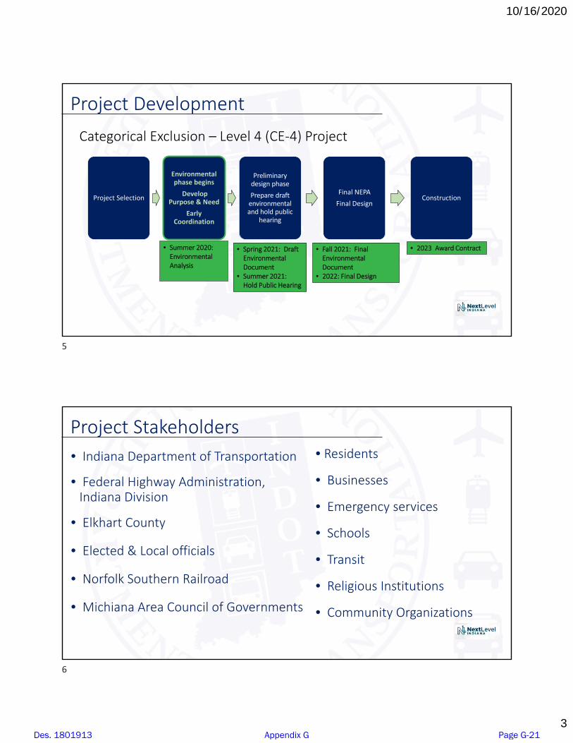
10/16/2020
3
Project Development
Project Selection
Environmental phase begins
Develop Purpose & Need
Early Coordination
Preliminary design phase
Prepare draft environmental and hold public
hearing
Final NEPA
Final DesignConstruction
• Summer 2020: Environmental Analysis
• Spring 2021: Draft Environmental Document
• Summer 2021: Hold Public Hearing
• Fall 2021: Final Environmental Document
• 2022: Final Design
• 2023 Award Contract
Categorical Exclusion – Level 4 (CE‐4) Project
Project Stakeholders • Indiana Department of Transportation
• Federal Highway Administration, Indiana Division
• Elkhart County
• Elected & Local officials
• Norfolk Southern Railroad
• Michiana Area Council of Governments
• Residents
• Businesses
• Emergency services
• Schools
• Transit
• Religious Institutions
• Community Organizations
5
6
Des. 1801913 Appendix G Page G-21

10/16/2020
4
Reasons for the Project (Need)
• Safety – There have been 45 total accidents at these two crossings in the last three years with 17 train/vehicle accidents including three fatalities since 1976.
• Norfolk Southern trains typically run through these crossings 80 times a day which delay traffic and emergency vehicles access to the communities north of the tracks.
• Delays – trains regularly stop on the tracks creating congestion and excessive delays.
Project Purpose• The purpose of the Local Trax Railroad Grade Separation Project
is to improve the safety and mobility issues for motorists, pedestrians, bicyclists, and trains at the two at‐grade railroad crossings at Sunnyside Avenue/Concord Mall Drive and CR 13.
7
8
Des. 1801913 Appendix G Page G-22
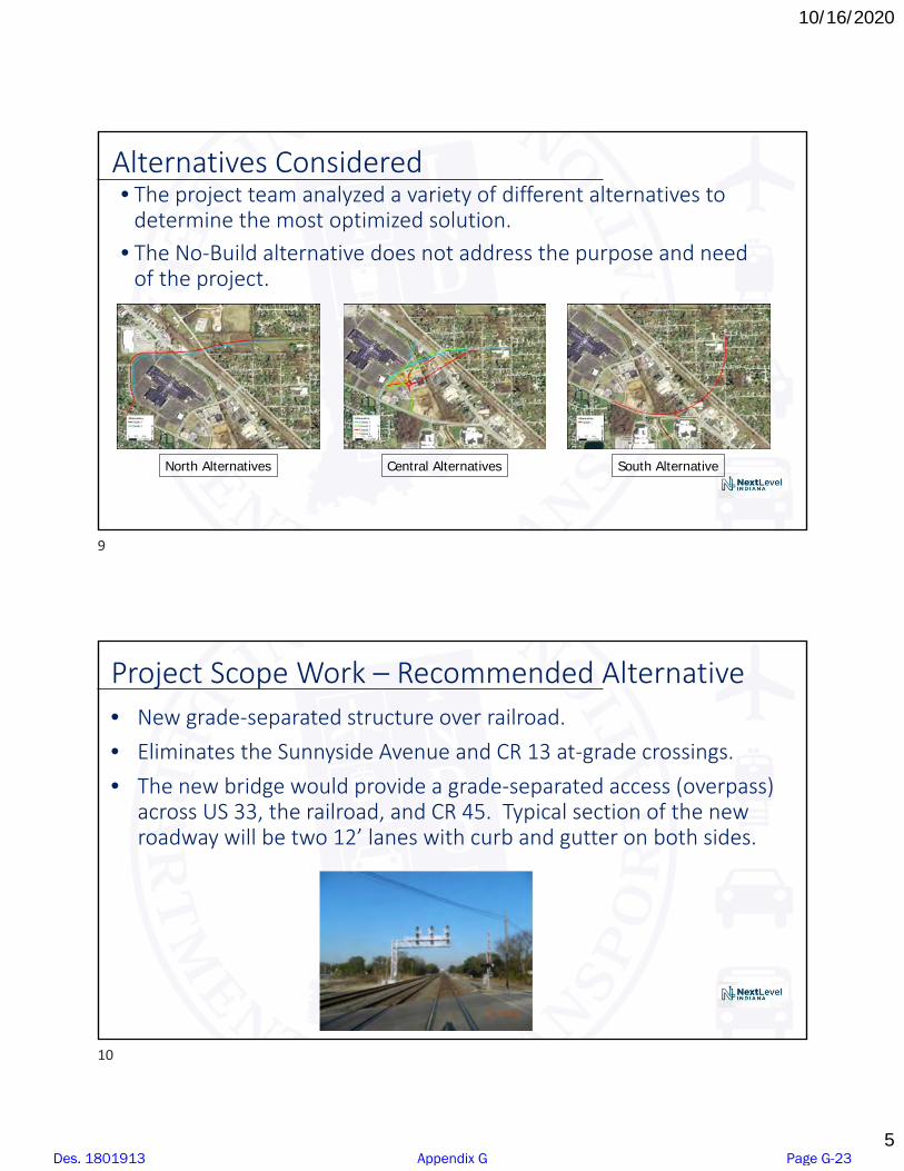
10/16/2020
5
Alternatives Considered• The project team analyzed a variety of different alternatives to
determine the most optimized solution. • The No‐Build alternative does not address the purpose and need
of the project.
South AlternativeNorth Alternatives Central Alternatives
Project Scope Work – Recommended Alternative• New grade‐separated structure over railroad.• Eliminates the Sunnyside Avenue and CR 13 at‐grade crossings.• The new bridge would provide a grade‐separated access (overpass)
across US 33, the railroad, and CR 45. Typical section of the new roadway will be two 12’ lanes with curb and gutter on both sides.
9
10
Des. 1801913 Appendix G Page G-23

10/16/2020
6
Project Scope Work – Recommended Alternative
• Streams, Wetlands, and Other Waters
• Floodplains
• Endangered and Threatened Species
• Cultural Resources (Historical and Archaeological)
• Parks, Trails and Recreational Lands
• Air Quality
• Right‐of‐way/Relocations
• Noise
• Community Impacts
• Environmental Justice (EJ): Low Income & Minority Populations
• Hazardous Materials
• Permits
• Mitigation
• Public Involvement
Environmental Analysis
11
12
Des. 1801913 Appendix G Page G-24

10/16/2020
7
• Project kickoff
• Alternative screening report/alternative refinement
• Noise studies
• Historic properties (Section 106)
• Environmental Analysis (NEPA)
• Public involvement
Project Status
Future stakeholder & public meetings
• Resource agency coordination (e.g., US Army Corps of Engineers, Indiana Department of Environmental Management, and Elkhart County)
• Upcoming public involvement: stakeholder outreach and cultural resource consulting parties
• Public Hearing (Summer 2021)
Next Steps
13
14
Des. 1801913 Appendix G Page G-25

10/16/2020
8
Contact Us
Please mention “Elkhart Local Trax” in your comments.
• Comment form send via email or postal mail.
Postal address: ATTN: INDOT, c/o Dan MillerParsons101 W Ohio St, Suite 2121Indianapolis, IN 46204
Email: [email protected]
Thank You
Please mention “Elkhart Local Trax Project” in your comments.
Elkhart County Highway [email protected]
15
16
Des. 1801913 Appendix G Page G-26

Elkhart Local Trax Railroad Grade Separation Project
Virtual Public Open House August 10, 2020, 5 p.m.
Attendees*:
Alex Lee Jim Weeber Jason Holder Charlie McKenzie Dan Miller Adam Bobby Loncar Jeanne Bowen Jill Joe Schrock Lou Giordano Marietta Comer Larry Wegrecki Marvin Porter Pauline Arnold Piedra Viva Scott Puckett Shawn miller Tuffy Nelson Angela Nicholson B. Pitz Doug Burgess Cendric Diefenbaugh Charlie Christopher Kocher Christy Dale Shenk Geri Welch Heather Erin Pipkin J. Long
Jane Jason Kaiser Jason Springer Jeremy Lay Jerry Barrett John and Mary Jordan Fouts Joyce Parker Katrina Kay House-Clark Kimberly Martin Kyle M. M. Cason Marlo Kauffman Martha Cook Matt Yarian Matthew Witt Michael Mascola Peter Graber Robert Kessler Ruth Stoltzfus Sandra Yoder T. Noffsinger Tim Jackson Todd Johnson Chief Sumpter Sean Porter Tom Heustis
*Note – Attendees were recorded as they signed into the virtual presentation. Several additional attendees dialed in by phone.
Des. 1801913 Appendix G Page G-27
J Port
Text Box
Contacts added to project stakeholder list (if mailing and/or email addresses were provided).

Des. 1801913 Appendix G Page G-28
J Port
Text Box
Contacts added to project stakeholder list (if mailing and/or email addresses were provided).
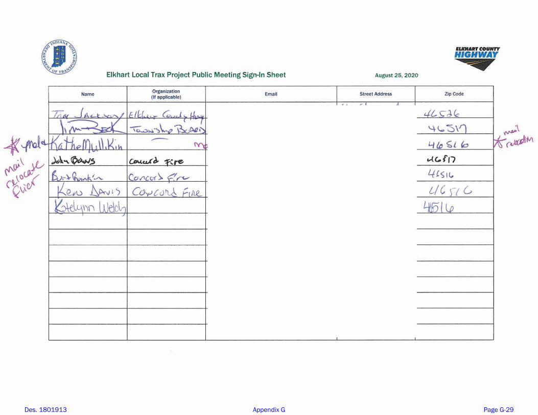
Des. 1801913 Appendix G Page G-29

Des. 1801913 Appendix G Page G-30

Elkhart Local Trax Railroad Grade Separation
DES# 1801913
www.elkcohwy.org/projects
Introduction
To address safety and mobility issues, the Indiana Department of Transportation (INDOT) and Elkhart County are partnering to study, design and construct the Local Trax Railroad Grade Separation at Sunnyside Avenue/Concord Mall Drive and County Road (CR) 13 in Elkhart County.
Project Purpose and Need
The purpose of the Local Trax Railroad Grade Separation Project is to improve the safety and mobility issues for motorists, pedestrians, bicyclists and trains at the two at-grade railroad crossings at Sunnyside Avenue/Concord Mall Drive and CR 13. Norfolk Southern trains typically run through these crossings 80 times a day
vehicles access to the communities north of the tracks. The needs of the project include:• Improving Safety – There have been
45 accidents at these two crossings in the last three years with 17 train/vehicle accidents, including three fatalities, since 1976.
• Reducing Delays – Trains regularly stop on the tracks creating congestion and excessive delays.
Project Scope
Several alternatives were considered to determine the best solution. Those alternatives were highlighted in the 2018 Engineer’s Report.
The project team determined that Central Alternative 3,
at-grade crossings at Sunnyside Avenue and CR 13, warrants further study. The new bridge provides an overpass across US 33, the railroad and CR 45. The new roadway includes two 12-foot lanes with curbs and gutters on both sides.
The impacts of this alternative on people and the natural environment will be documented in a Categorical Exclusion - Level 4, as required under the National Environmental Policy Act (NEPA).
Elkhart Local Trax Project Area
Des. 1801913 Appendix G Page G-31
J Port
Text Box
Public Meeting handout
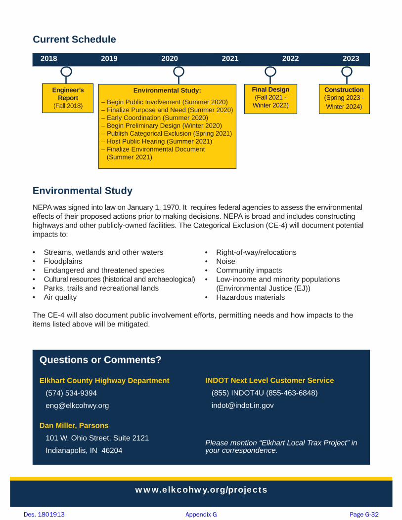
Current Schedule
Questions or Comments?
Elkhart County Highway Department(574) [email protected]
Dan Miller, Parsons 101 W. Ohio Street, Suite 2121 Indianapolis, IN 46204
2018 2019 2020 2021 2022 2023
Engineer’s Report
(Fall 2018)
Environmental StudyNEPA was signed into law on January 1, 1970. It requires federal agencies to assess the environmental highways and other publicly-owned facilities. The Categorical Exclusion (CE-4) will document potential impacts to: • Streams, wetlands and other waters• Floodplains• Endangered and threatened species• Cultural resources (historical and archaeological)• Parks, trails and recreational lands• Air quality
items listed above will be mitigated.
• Right-of-way/relocations• Noise• Community impacts• Low-income and minority populations
(Environmental Justice (EJ))• Hazardous materials
INDOT Next Level Customer Service (855) INDOT4U (855-463-6848)[email protected]
Please mention “Elkhart Local Trax Project” in your correspondence.
Final Design (Fall 2021 -
Winter 2022)Construction (Spring 2023 - Winter 2024)
www.elkcohwy.org/projects
Environmental Study:– Begin Public Involvement (Summer 2020)– Finalize Purpose and Need (Summer 2020)– Early Coordination (Summer 2020)– Begin Preliminary Design (Winter 2020)– Publish Categorical Exclusion (Spring 2021)– Host Public Hearing (S 2021)– Finalize Environmental Document
(Summer 2021)
Des. 1801913 Appendix G Page G-32

¹º»¼
Cole St
John St
Dahlia Ct
Kulp Ave
Am
y Ave
Ken
dall
St
Sunnyside Ave
Nora St
Con
cord
ia C
t
Hel
en S
t
Mary St
Himebaugh Ave
Florence Ave
CenterDr
Concord Mall Dr
£¤33
")20
")45
")13
Yellow Creek
Indiana Department of Transportation
Elkhart Local Trax - Alternatives
³1 inch = 200 feet
Existing RoadwayNorfolk Southern Railroad
¹º»¼ Railroad CrossingStream
¹º»¼
¹º»¼
Yellow Creek
Hel
en S
t
Ken
dall
St
Cole St
John St
Elmhurst Dr
Belmar Dr
SpringriverDr
Walnut St
Lew
isSt
MinutemanW
ay
Am
y Ave
Cry
stal
Ct
Tenn
esse
e St
Mer
rimac
Ln
Sunnyside Ave
Nora St
Linden Dr
Mary St
Nora St
Sunnyside Ave
Jewel Ct
Center Dr
Concord Mall Dr
£¤33
")22
")13
")13
")45
¹º»¼
¹º»¼
£¤33
")22
")45
")13
")13
Yellow Creek
Tenn
e sse
eSt
Cole St
Linden Dr
John St
Elmhurst Dr
Walnut St
Belmar Dr
Nora St
Sunnyside Ave
Greenwood Blvd
SpringriverDr
MinutemanW
ay
Am
y Ave
Ken
dall
St
Jaso
n C
t
Hel
en S
t
Merrimac Ln
Sunnyside Ave
Nora St
Mary St
Himebaugh Ave
Center Dr
Conc
ord M
allDr
North Alternatives
Central Alternatives
South AlternativeSouth 1
North 1North 2
Central 1Central 2Central 3Central 4
Des. 1801913 Appendix G Page G-33
J Port
Text Box
Poster board displayed at public open house
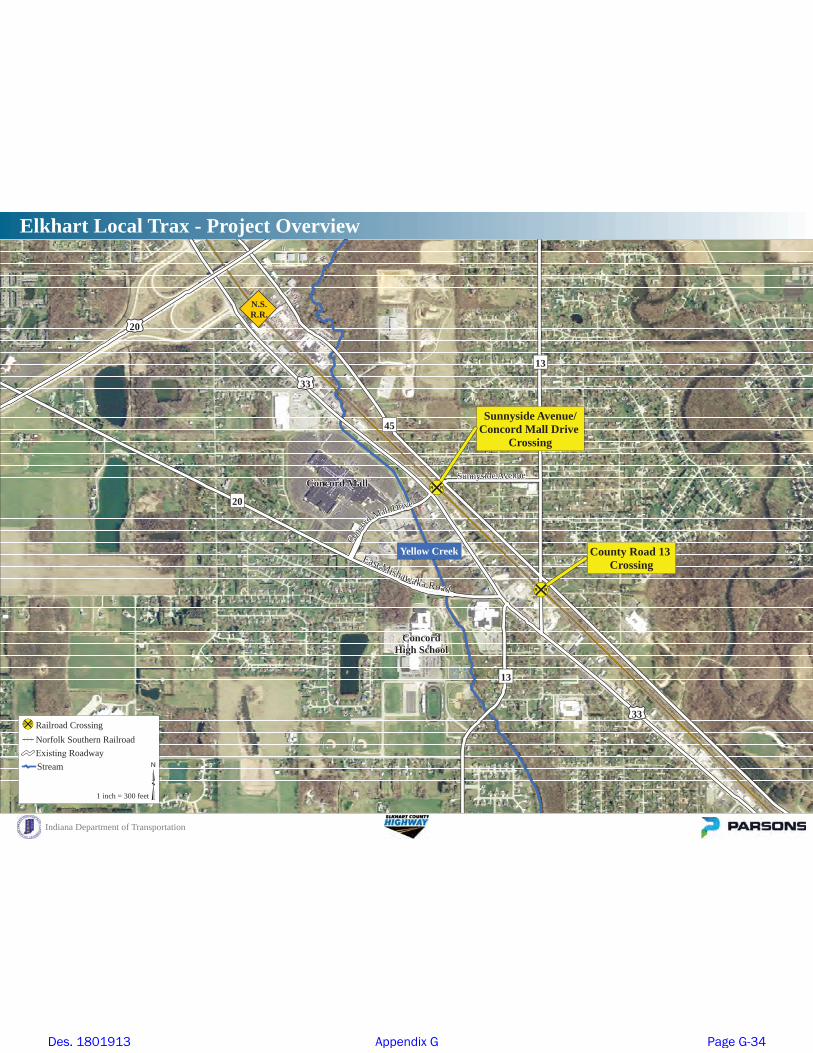
Sunnyside Avenue/Concord Mall Drive
Crossing
County Road 13 Crossing
¹º»¼
¹º»¼
Indiana Department of Transportation
Elkhart Local Trax - Project Overview
³1 inch = 300 feet
¹º»¼ Railroad CrossingNorfolk Southern Railroad
RoadwayStream
£¤33
£¤20
£¤33
")20
")45
")13
")13
Concord Mall
ConcordHigh School
Yellow Creek
N.S.R.R.
Conco
rdMall Drive
Sunnyside Avenue
East Mishawaka Road
Des. 1801913 Appendix G Page G-34
J Port
Text Box
Poster board displayed at public open house

¹º»¼
¹º»¼
Linden Dr
Tenn
esse
e St
Walnut St
Cole St
John St
Elmhurst Dr
Nora St
Sunnyside Ave
Greenwood Blvd
Belmar Dr
Springriver Dr
Minuteman W
ay
Am
y Ave
Ken
dall
St
Mer
rimac
Ln
Nora StH
elen
St
Pine
Rid
ge P
kwy
Mary St
Himebaugh Ave
Florence Ave
Center Dr
Sunnyside Ave
Conc
ord
Mall
Dr
Indiana Department of Transportation
Elkhart Local Trax - Recommended Alternative
³1 inch = 100 feet
Proposed PavementProposed SidewalkExisting Roadway
¹º»¼ Railroad CrossingNorfolk Southern RailroadStream
£¤33
£¤33
")20
")45
")13
")13
Concord Mall
ConcordHigh School
Yellow Creek
N.S.R.R.
Des. 1801913 Appendix G Page G-35
J Port
Text Box
Poster board displayed at public open house
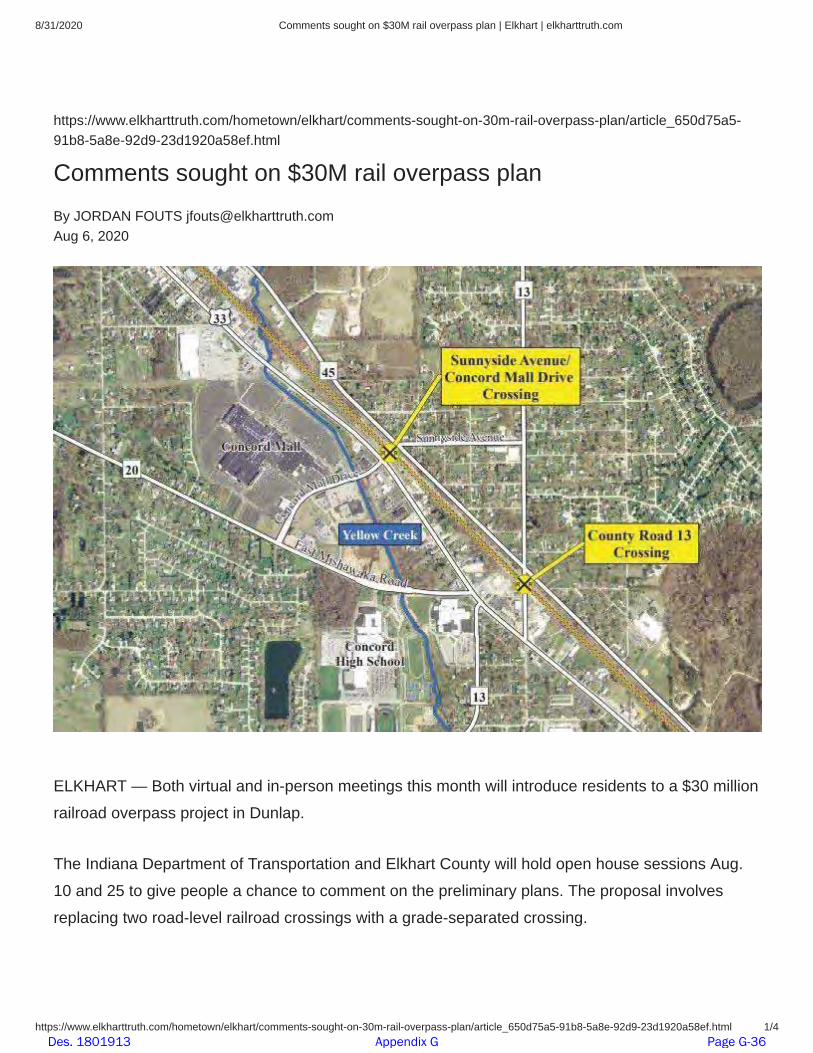
8/31/2020 Comments sought on $30M rail overpass plan | Elkhart | elkharttruth.com
https://www.elkharttruth.com/hometown/elkhart/comments-sought-on-30m-rail-overpass-plan/article_650d75a5-91b8-5a8e-92d9-23d1920a58ef.html 1/4
https://www.elkharttruth.com/hometown/elkhart/comments-sought-on-30m-rail-overpass-plan/article_650d75a5-91b8-5a8e-92d9-23d1920a58ef.html
Comments sought on $30M rail overpass planBy JORDAN FOUTS [email protected] 6, 2020
ELKHART — Both virtual and in-person meetings this month will introduce residents to a $30 millionrailroad overpass project in Dunlap.
The Indiana Department of Transportation and Elkhart County will hold open house sessions Aug.10 and 25 to give people a chance to comment on the preliminary plans. The proposal involvesreplacing two road-level railroad crossings with a grade-separated crossing.
Des. 1801913 Appendix G Page G-36

Des. 1801913 Appendix G Page G-37

Des. 1801913 Appendix G Page G-38

Des. 1801913 Appendix G Page G-39

��������� ���� �������������������������������������������������������������������� ��!
�����"��### ����������� ��!�������$���������%� ������%��������%���������%��%����%����������$����&���%&&'&%(��)%�'**%����*���+)�& ��! ���
�����"��### ����������� ��!�������$���������%� ������%��������%���������%��%����%����������$����&���%&&'&%(��)%�'**%����*���+)�& ��!
���� ��������������������������������������
,��-.�/01�2.345�6)����7����������� ��!
0�����8�����
/3190:�;�����������#���������)����))�����<�����������������#�������)� �����������)������������� ��������������� ���������������
=�����
:�����������������>���!����������������������6������������������������������#����������)���!���������+��������=���������� �4���
������������������ ����)�����?������/�����!�����)�4������������8�������������������@��#���/�����!�����������6����������)�!�:������
4�������������A����
4����!��)��������6������������ ������� �������������/����������� ��������������������������������������3 5 ���8������������!��� ����)�������
�������#����!���)���������������� �4���)� �����������#����������� �������������8��������#�������� � �+(����������������������=��/� �
����5��������0 ����
4���� �������#������ �����#�����������������)�����������������������������#�������#����������)����!�������� ����������������#�����
!���8�����/���=��8���������������#���:������ �4������������������������������������������)���������=������������=������������
�� ���#���������#�� ������
4����<�����������%� ��������������5��������0 ������������� � ����#������������
Des. 1801913 Appendix G Page G-40

��������� ���� �������������������������������������������������������������������� ��!
�����"��### ����������� ��!�������$���������%� ������%��������%���������%��%����%����������$����&���%&&'&%(��)%�'**%����*���+)�& ��! ���
,-������������)���������)���.�������!��!���#������������������������.������� ������������� ���������� �/��������������)������#����%�����
��������� ������������������)����������0���.1�2������ �,3���������.�������������� ������.����4��������������� ������������������������
����������������������������#�����!���)�����������&����������������������������������� 1
-���2��5� �%6�������������!������������������������)��!������)��������*������#�������������.�����-�������������2������������
2�7��8� �9����!��#���������������������������������.������!������)����������#�������������������������������������)������ �����������
��������������������������������������
-��������)�����)������)����������0��������:���!���-��;�������)��!�<=5>- �2�7��8����������������4��:���!��������������������������
-�����;������������������� ���!���������������������������������.�)�����������������������������������������������+ �2�������������
�����))�����������������#����������4�������������������������>?<5%�&������!�����������������))�����#����!��� ��
9����� � �!���
2�����)��������������������������������������������������))�����������.���#�������������!���#��������))����������#����������� �����
��������������.���!������������)����������#���������������� ��������������������������������
��������-�#�����-�������@!�3������������������#�!�����������0����#������������������)���������-�#����� �������������������)�����������
A������������������!������������������)���#�����������������#��������#�������������4�������!���������� � �!�����������������
,-������ �������)������������B���5�����!����#�������������#�����������������������)��������0���.1�3��������� �,A�#� ��.����#����4������
�������������)�����������!����))�������#�����������������8�������!������������������������������������������������ 1
2����������))�������������!�0���������)������������������ �A�������������������#��� ��!���������� � �!����)��!������������.�������
����%�����������������/�� ��(
,3��#�����).�#���������������������#������������!�.�)���������������#�� �-������ �����������!��������� �����������������������
����.1�2������ �,C����������.������������������������.�#��#������������������ ����������������� � �!����)��!��������������������
������������ ����������� � �!��� �/���))������������������������������������)������� ���!������������ �C�����.������#�������������)�
�� ���!���������!����)��8��.�#�������#��� ����������������)��������������������)��������������� ����������������)������������������
��������������������)����#�4�����#������)��8�������� ���!���������!���������)��8����������� 1
2�7��8�������������������������)������)�#��� ���������)����������������!���������!!����������
7!�����2����.��������� ���)�������������!!�����6�����.�����������������������������������������������#�������#���������������))������
)�������������������
A�������������������������������������� ����������������������������������������%�����������%�))��!��
,<��� ���������#�����<4 ������������������ ���.������#����!������������������������������������������������������������������ �������������
���������������.1������� �,A������#����������0���.�!��� ��������)������������������.������������)�������������)��!��� �����������������
������.�#�!��� ������� ���������������������������!������������� 1
-������!�������������������)� �����������4������)������������������!�����������������������������!������������;��)�#������.�����������������
#������������������.�������������#��������������!����������#������������������������������#�����������������
@�����A����.�����-��;�������!�!������.��������������������������!�����������#���� ��������!!�����)���������� �A�������������������4�
���0��������!����������������� ����������������������������-��;��������������
,-����4��������)���������������������������!���������)����.������#�#��������������������.���#������������������������ �����)����!�������
����� � �=�����)��������))���������������������.1������� �,5�)�������!�����������#�4����������������������#�����������#���� ������)��
����������.�������!�����������)����26.�)��������������.������������D����)����������������������������������������#�4����������������#�� 1
/����������������������������������)���/�� ��(�)��!�(����'�� ! ������������<����!������6����.�(&�&+�� � ���.������� �-����%�������������
#�)��#�<������5�����!�����)�A������������.��������!���.�����8��������������������������!����
Des. 1801913 Appendix G Page G-41

8/31/2020 Federal funds in place for railroad overpass project in Dunlap - Indiana Economic Digest
https://indianaeconomicdigest.com/Content/Most-Recent/Infrastructure/Article/Federal-funds-in-place-for-railroad-overpass-project-in-Dunlap/31/67/92… 1/2
Login Signup
GOSearch
Advanced Search
Brought to You By
Resources
A CAR crosses the railroad tracks along C.R. 13 in Dunlap in thisJanuary 2017 le photo. Sta photo by Roger Schneider
Federal funds in place for railroad overpass project in DunlapAimee Ambrose, Goshen News
Saturday, May 12, 2018 7:57 AM
ELKHART — Tra ic will likely go over, not under, the NorfolkSouthern railroad tracks along U.S. 33 in Dunlap as plans for anew crossing chug forward.
Elkhart County Transportation Manager Je Taylor gave aprogress report on the developing project during the 2018Elkhart County Leadership Summit at the Matterhorn Banquetand Conference Center in Elkhart Friday.
Speaking to members of the county council, countycommissioners and department heads, Taylor said plans nowcall for building an overpass to cross the tracks with two possible locations selected. He didn’t identify the locationsas preliminary planning is still underway.
With federal funds now committed, the department is budgeting, roughly, for a $36 million project. So far, the federalmoney would cover $15 million of the cost, and the other $21 would come from local economic development incometax funds, Taylor said.
The highway department is also looking to apply for state funds via a Local Trax grant through the IndianaDepartment of Transportation. The program creates partnerships between INDOT and communities to help pay forlocal railroad overpass projects.
“We think we’ve got a really good shot at getting this grant,” Taylor said.
If the county is chosen for a grant later this year, the state would cover 80 percent of right-of-way, utilities andconstruction costs, while the county would put up a 20 percent match. INDOT would also fund the design andconstruction inspection fees, Taylor said.
But, he cautioned, INDOT would manage the project, including seeking consultants to begin design work, whichcould limit the county’s input on the project.
Taylor hopes to include results of a recent study into the rail overpass project by engineering design firm DLZ Corp.with the Trax application as a way to try and keep plans aligned.
He didn’t identify the two locations the highway department is considering as the project is still in preliminary stages.He said one location could lead to about a $20 million price tag, while the other could lead to about $35 million, andINDOT could have the final say on where to build an overpass if the county wins a Trax grant.
U.S. 33’s close proximity to the railroad tracks creates a major design challenge as engineers would have to create anew crossing that isn’t too steep for vehicles, Taylor said. He’s pushing for a grade of about 5 percent, if possible.
The highway department is pursuing an overpass since a study found an underpass project would encounter toomuch groundwater.
The next stages in planning include discussions with the county council and commissioners on input and to begintackling right-of-way issues.
Plans for a new railroad overpass in Dunlap have been in the works for years amid complaints the frequent traintra ic on the three-track rail line blocks creates congestion at crossings. About 100 trains on average travel the lineeach day.
Taylor also updated Leadership Summit attendees on other major upcoming road projects.
Home Story Index ▼ About IED Coronavirus Coverage ▼
Sign Up for Email Updates
RSS Feeds
Contributing Newspapers
Des. 1801913 Appendix G Page G-42

8/31/2020 Federal funds in place for railroad overpass project in Dunlap - Indiana Economic Digest
https://indianaeconomicdigest.com/Content/Most-Recent/Infrastructure/Article/Federal-funds-in-place-for-railroad-overpass-project-in-Dunlap/31/67/92… 2/2
They include widening C.R. 38 from Goshen’s east side to Ind. 13 to create buggy lanes with the first phase to run fromC.R. 31 to C.R. 35.
“You have a dangerous mix of buggies, bicycles, RV tra ic, semi tra ic, cars and who knows what else driving up anddown through there at very high speeds,” Taylor said, describing the area as having been overlooked for too long.
Another project would add a buggy lane on C.R. 40 from Ind. 119 in Wakarusa to C.R. 7 following requests to build onethere. Plans also call for wrapping up work on C.R. 38 in Goshen from Ind. 15 to C.R. 17.
EDIT funds would be used to pay for the projects.
© 2020 Community Newspaper Holdings, Inc.
HOME
Editor, John C. DePrez Jr.; Executive Editor, Carol Rogers; Publishers: IBRC and IAR
So ware © 1998-2020 1up! So ware, All Rights Reserved
Des. 1801913 Appendix G Page G-43

��������������������������������������������������
������������������������������������
������������������������������������� �
������� ������������������������������������� �
�������������������������������������
���
����������� �
Des. 1801913 Appendix G Page G-44

�����������������������
���������������������������������������� �����������������������������������
���������������������������������������������������������������������������������������
�������������������������������� ����������� ���������������������
����������������������������������������������������������������������������������
������������������������������������������������������������������������������
�����������������������������������������������������������������������������������������
��������������������
��������������������������������������������������������������������������������������
������������������������������������������
�����������������������������������������������������������������������������������������
������������������������������������� ������������������������������������������
�������������������� ��������������������������������������������������������������
��������������������������������������������������������������������
��������������������
���������������������������� ������������������������
Des. 1801913 Appendix G Page G-45

������������������������������������������� ��������������������������������
�������������
��������������������������������������������������������������������
����������������������������������������������
�� �������������������������������������������������������������������
����������������������
�������������������������������������������������������������
��� ������������������������������������������������������������������
������������������
�������������������������������������������������������� ������������������
� ������������������������������������������������������������������
���������������������
���������������������������������������������������� ������������������
�������������������������������������������������������������������
�������������������������������� �������������������������������������������
������������������������������������������������������ ��������������������
����������������������
�����������������
�������������������������������
Des. 1801913 Appendix G Page G-46
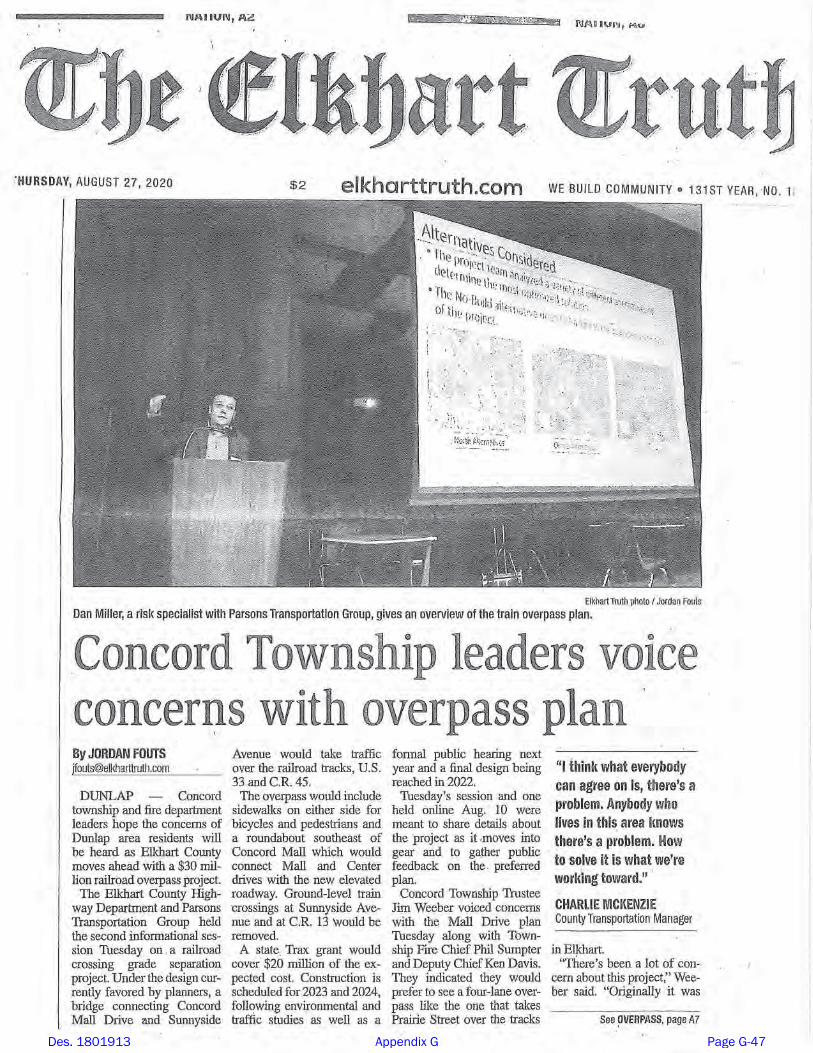
Des. 1801913 Appendix G Page G-47
Des. 1801913 Appendix G Page G-48
Overpass could be built at dangerous Elkhart County railroad crossing
by Max Lewis, WSBT 22 Reporter Wednesday, August 26th, 2020 2:18 clip: https://wsbt.com/news/local/overpass-could-be-built-at-dangerous-elkhart-county-railroad-crossing
An overpass could be coming to a busy and dangerous intersection in Elkhart County.
The Indiana Department of Transportation and the Elkhart County Highway Department revealed plans Tuesday night to build that bridge just across from the Concord Mall.
A common occurrence at the intersection of Sunnyside Avenue and US 33 in Elkhart County. Around 80 times each day, the train crossing barriers come down and cars have to wait – sometimes 10, 20, even 30 minutes.
But plans are moving forward to make this experience a thing of the past.
"We've heard a lot of feedback about 'Oh I get stuck by trains all the time there'...'I'm a Concord student and I get stuck, we need to do this,’” said Charlie McKenzie with the Elkhart County Highway Department.
INDOT and Elkhart County's Highway Department revealed initial plans to get rid of the crossing and build an overpass instead.
The plans would also call for the nearby County Road 13 crossing to be blocked as well so all traffic goes above the trains.
In the past 3 years there have been 45 accidents at this crossing alone, 17 of them involving the trains.
"Frequently stopping causes a massive amount of delay, so it's safety and efficiency,” said McKenzie.
Des. 1801913 Appendix G Page G-49

On Tuesday night officials held a public forum to get feedback from nearby residents, many telling us they feel out of the loop.
“It's going to inconvenience a lot of people,” said Katelynn Weldy, whose house could be demolished. "Right now we just kind of feel stuck.”
Weldy's home lies right in the path of where that overpass is set to go. She says she not so much concerned about losing the house as she is the communication.
"You can't really make plans. We had hopes to do some renovations to the house, but we knew with that you're not going to get your money back so we've kind of just had to pause on all those things."
And it's the same story next door.
"I've been waiting for years and years not doing any fixing up on it because I'm afraid,” said Dave Fendley. “Why invest money into it if they're going to tear it down and bulldoze it?”
The project is being paid for mostly by a grant from INDOT, about a third of the bill is being picked up by local funding.
There are still a lot of steps including public hearings before they even could begin construction. It's expected to be completed sometime in 2025.
Des. 1801913 Appendix G Page G-50

Number Date Received Summary Type Category Name
1 10/5/2020Mr. Neilson, owner of Tuffy Tire and Auto Service Center inquired about potential right-of-way impacts /relocations of the Goodyear and Pizza Hut properties.
Phone callRight-of-way /
relocations
Tuffy Tire and Auto Services Center
Owner
2 8/25/2020I Ronny Baltimore have not been reveiving any information on this
My address is 23959 CR 4
Written comment Mailing list Ronny Baltimore
3 8/25/20201. The Dunlap area is needed before Hively!2. Understand concerns of only 2 lanes. Certain times of day lot of backup of traffic with factories & school dismissal.3. Make sure roundabout works for long buses & long fire trucks.
Written comment General /
TrafficN/A
4 8/25/2020
1. Need left hand turn and stop light at center CR 20!2. Do not close CR 13 crossing!3. Need 4 lane over pass. Do not under build!
Written comment
Intersection / Crossing
TrafficC.W.
5 8/25/2020
Please mail us notices. Havent revieved any so far! Written comment
Mailing list Mel & Kathe Mullikin
6 8/25/2020There is a RR underpass off of 45 and 33 by main muffler that has been there over 100 years. The north bay should be looked at for a possible 2 lane road from 45 and 33 to county road 45, yes you would have to have to make it work. It should be at least looked at.
Written comment Alignment Lorell Nihent
7 9/6/2020
We have read with much interest the proposed plan for the Concord Overpass. Much to our dismay we are not excited about this current plan. We agree with Concord Township Trustee Jim Weeber that this overpass should be 4 lanes. If the current plan stands and the CR 13 crossing is closed, with only one way to get across the tracks, and all traffic is all moved to this overpass the amount of traffic will be huge. It already is a problem with both Sunnyside and CR 13 crossings open. There is a lot of traffic that goes up and down CR 13. It is a main thoroughfare. Back ups will become the norm. Heaven forbid a fire truck, ambulance, or police/sheriff needing to get across quickly, but won’t be able to because there is nowhere for traffic to move over because there wouldn’t be a second lane. Also, closing CR 13 is a mistake. Having the overpass clear down by the Concord Mall causes many drivers to have to back track to go towards Goshen. Many vehicles will choose to go down to the crossing by Meijer which will in turn cause major traffic at that crossing, that intersection/crossing was poorly designed.This plan has taken years to get going and if it finally is going to happen then it better be done right because there won’t be a second chance to correct what would be a nightmare of a crossing.
Traffic / Alignment / Emergency
Vehicles
Bruce and Jennifer Hardy
Des. 1801913 Appendix G Page G-51
J Port
Text Box
PUBLIC COMMENT LOG
J Port
Text Box
Elkhart Local Trax, Des 1801913 Prepared October 26, 2020
J Port
Highlight
J Port
Rectangle
J Port
Rectangle
J Port
Text Box
sent 9/4/2020
J Port
Text Box
sent 9/4/2020
J Port
Text Box
Contacts added to project stakeholder lists (if mailing and/or email addresses were provided).

Des. 1801913 Appendix G Page G-52

Des. 1801913 Appendix G Page G-53

Des. 1801913 Appendix G Page G-54

Des. 1801913 Appendix G Page G-55

Des. 1801913 Appendix G Page G-56

From: Lee, AlexanderTo: Diefenbaugh, CedricCc: Miller, Daniel JSubject: Elkhart Local TraxDate: Monday, October 5, 2020 10:49:54 AMAttachments: image001.png
Cedric,Please log this.
I received a call from Mr. Neilson, owner of Tuffy Tire and Auto Service Center (3703 S. Main Street,
Elkhart, IN). 804-464-1198 (call received October 5th, 2020 at 10:15 am). He wanted to know if we were going to take the Goodyear and Pizza Hut properties. I told him thatthe meetings that we held five weeks ago discussed the recommended alternative (not thepreferred) and the alignment does show the Goodyear building in the way of the new overpass. ThePizza Hut which is behind the Tuffy Service Center is currently show as not being the alignment. Ishared with him the schedule that we discussed at the virtual and the public information meeting.He thanked me and said he will probably call me in five or six weeks. Alexander Lee, AICPSenior Environmental Planner
101 West Ohio Street, Suite 2121 - Indianapolis, IN [email protected] – P: 317-616-1011 M: 571-294-4555
PARSONS - Envision Morewww.parsons.com | LinkedIn | Twitter | Facebook
'NOTICE: This email message and all attachments transmitted with it may contain privileged and confidentialinformation, and information that is protected by, and proprietary to, Parsons Corporation, and is intendedsolely for the use of the addressee for the specific purpose set forth in this communication. If the reader of thismessage is not the intended recipient, you are hereby notified that any reading, dissemination, distribution,copying, or other use of this message or its attachments is strictly prohibited, and you should delete thismessage and all copies and backups thereof. The recipient may not further distribute or use any of theinformation contained herein without the express written authorization of the sender. If you have received thismessage in error, or if you have any questions regarding the use of the proprietary information containedtherein, please contact the sender of this message immediately, and the sender will provide you with furtherinstructions.'
Des. 1801913 Appendix G Page G-57

To: Charlie McKenzie <[email protected]>
FYI. ---------- Forwarded message ---------From: Bruce Hardy <[email protected]>Date: Sun, Sep 6, 2020 at 10:49 AMSubject: Concord OverpassTo: <[email protected]>
We have read with much interest the proposed plan for the Concord Overpass. Much to our dismaywe are not excited about this current plan. We agree with Concord Township Trustee Jim Weeber that this overpass should be 4 lanes. If thecurrent plan stands and the CR 13 crossing is closed,with only one way to get across the tracks, and all traffic is all moved to this overpass the amount oftraffic will be huge. It already is a problem with both Sunnyside and CR 13 crossings open. There is a lot of traffic thatgoes up and down CR 13. It is a main thoroughfare.Back ups will become the norm. Heaven forbid a fire truck, ambulance, or police/sheriff needing toget across quickly, but won’t be able to becausethere is nowhere for traffic to move over because there wouldn’t be a second lane. Also, closing CR 13 is a mistake. Having the overpass clear down by the Concord Mall causes manydrivers to have to back track to go towards Goshen.Many vehicles will choose to go down to the crossing by Meijer which will in turn cause major trafficat that crossing, that intersection/crossing was poorly designed. This plan has taken years to get going and if it finally is going to happen then it better be done rightbecause there won’t be a second chanceto correct what would be a nightmare of a crossing. Sincerely,Bruce and Jennifer Hardy
'NOTICE: This email message and all attachments transmitted with it may contain privileged and confidentialinformation, and information that is protected by, and proprietary to, Parsons Corporation, and is intendedsolely for the use of the addressee for the specific purpose set forth in this communication. If the reader of thismessage is not the intended recipient, you are hereby notified that any reading, dissemination, distribution,copying, or other use of this message or its attachments is strictly prohibited, and you should delete thismessage and all copies and backups thereof. The recipient may not further distribute or use any of the
Des. 1801913 Appendix G Page G-58

From: Miller, Daniel JTo: Port, Juliet; Diefenbaugh, CedricCc: Lee, AlexanderSubject: FW: [EXTERNAL] Fwd: Trax Project - Comments/Questions from PIMDate: Wednesday, August 26, 2020 9:46:23 AM
Cedric,Please log this in the project file. From: Charles McKenzie <[email protected]> Sent: Wednesday, August 26, 2020 9:44 AMTo: Porter, Sean <[email protected]>; Lee, Alexander <[email protected]>;Miller, Daniel J <[email protected]>Subject: [EXTERNAL] Fwd: Trax Project - Comments/Questions from PIM Alex, See below summary from Tom Rushlow's questions he received at his station last night. Thanks,
Charlie P. McKenzie, P.E.Manager of TransportationElkhart County Highway DepartmentOffice: [email protected]
---------- Forwarded message ---------From: Tom Rushlow <[email protected]>Date: Wed, Aug 26, 2020 at 7:49 AMSubject: Trax Project - Comments/Questions from PIMTo: Charles McKenzie <[email protected]>Cc: Timothy Jackson <[email protected]>
Hi Charlie, Here is a short summary of comments/questions received at my station last night- 1. The traffic volume going to US 33 from the overpass is going to triple or quadruple. How are weever going to get out on US 33? (be prepared with the model data at the public hearing) 2. How does the fire department get across if a crash on the bridge closes it?
Des. 1801913 Appendix G Page G-59

(with this line of thinking why would they ever construct the fire station on a two-lane road? Whywould they construct the fire station 700' from an existing 2-lane bridge across the Elkhart River?) 3. There is an existing railroad bridge over Yellow Creek across from the Concord Mall that would beideal for an underpass. (NIC did a project there about 9 years ago using micro-piles because of the low clearance under thebridge. I got to see them install a micro-pile so I have been under that bridge and I do not rememberit being too tall. I will check it and get actual clearance measurements.) -- Tom Rushlow, P.E.Elkhart County Highway610 Steury AvenueGoshen, IN 46528574.534.9394 Ext. 244
'NOTICE: This email message and all attachments transmitted with it may contain privileged and confidentialinformation, and information that is protected by, and proprietary to, Parsons Corporation, and is intendedsolely for the use of the addressee for the specific purpose set forth in this communication. If the reader of thismessage is not the intended recipient, you are hereby notified that any reading, dissemination, distribution,copying, or other use of this message or its attachments is strictly prohibited, and you should delete thismessage and all copies and backups thereof. The recipient may not further distribute or use any of theinformation contained herein without the express written authorization of the sender. If you have received thismessage in error, or if you have any questions regarding the use of the proprietary information containedtherein, please contact the sender of this message immediately, and the sender will provide you with furtherinstructions.'
Des. 1801913 Appendix G Page G-60

Des. 1801913 Appendix G Page G-61

OWNER initial callDated
ScheduledConducted Owners in Attendance Notes from Meeting Follow UP Follow Up Addressed
AGUILAR BERNABE M
LOWE MATTHEW A & DAWN A LOWE H&W
3/10/2021 Matt and Dawn
Parsons staff met with the Lowes in their home. Showed them the plans and discussed the ROW process. Gave them the FHWA acquisition brochure. We shared the project schedule. We went outside and visually showed them the probable new ROW area and the edge of curb. They were concerned about cul-de-sac as it takes most of their front yard. They shared they just purchased the home and were not informed of the project impact. We shared that we couldn't speak to the real estate transaction.
Disussed the implications of moving the cul-de-sac with the county. County approved. Design changed.
BRISCOE JEREMIAH
CBI BUILDINGS LLC
COMER ERIC J & MARIETTA C CO-TRUSTEES
1/8/2021 1/13/2021 1/13/2021 Mr and Mrs Comer
Parsons staff met with Mr and Mrs Comer at the Martins store training room. Shared the project aerials and schedule. Gave them the FHWA Acquisition brochure and shared the ROW process. They had no concerns with the project nor the proposed ROW acquisition. In discussions, they shared they have fiber in yard longitudinally along CR 13.
CONCORD COMMUNITY SCHOOLS 1/12/2021
ELKHART COUNTY COMMUNITY BAPTIST CHURCH
1/8/2021 3/10/2021 Pastor and Elder
Parsons staff met with the Pastor and one of the church elders in the church office. We shared the project aerials, project schedule, and the proposed affect in front of the church. We gave them the FHWA Acquisition brochure and explained the ROW process. They were very much in favor of the project and shared no concerns after sharing the project details.
FROWNFELTER TERRELL L1/12/21 LM
GANGER DOUGLAS L & THERESA L GANGER JT TEN & (LF E MAX G GANGER & JANICE E GANGER H&W)
GRUBERT HEINZ & JILL GRUBERT H&W
3/10/2021 Heinz and Jill
Parsons staff met with the Gruberts in their home. We shared the project aerials, schedule, and impacts to their multiple parcels. Mrs Grubert was concerned about the impacts especially to their property. We discussed alternative designs were limited due to the requirements of the geometrics and drainage.
Emailed copies of the project plans pertaining to their land. Parsons staff took calls the next few days from Mrs Grubert asking if changes could be made or what the offer would be. We shared that the valuations will be completed upon NEPA approval.
HARRIS CHRISTINE M
1/8/2021 1/13/2021 Christine Harris
Parsons staff met Ms Harris at the Martins Store. Shared the project aerial, project schedule, and the impact to her front yard. Gave her the FHWA Acquisition brochure. After sharing the ROW process, she had no questions or concerns. n/a
HEART CITY PROPERTIES LLC
Des. 1801913 KTM Log Page 1 of 4
Des. 1801913 Appendix G Page G-62
J Port
Text Box
Kitchen Table Meeting (KTM) Log
J Port
Text Box
KTMs are in-progress. Blank spaces are intentional and will be completed as meetings are conducted.

OWNER initial callDated
ScheduledConducted Owners in Attendance Notes from Meeting Follow UP Follow Up Addressed
INDIANA MICHIGAN POWER CO
KIEL FRED J & ERLINDA S POLLOCK JT TEN
Kruis, transferred to Norfolk Southern, title erros reflect owned by NS
LIN DONNIE FAI & WENJIE ZHANG H&W
MANCEWICEZ MARK & EMILY KANE & KATY SOLOVEWICZ TEN COM
MARTIN PHILLIP A & KIMBERLY J
1/13/2021 1/13/2021 Mr and Mrs Martin
Parsons staff met Mr and Mrs Martin at the Martins store training room. Shared the project aerials and schedule. Gave them the FHWA Acquisition brochure and explained the ROW process. She is bus driver for Concord schools and doesn't like the proposed Roundabout as it will be difficult to navigate. We explained the ROW process and the potential impact to their yard. They had no concerns at all with those impacts or the process.
MCLAIN BRADLEY J
MILLER STEPHEN J & SHERRY MILLER H&W
MIRABAL RICARDO T & ELVIRA
MOORE PAULA SLM 1/9/21
MSM HOLDCO LLC C/O SPARTAN NASH COMPANY
MULLIKIN MELFORD & KATHLEEN
1/13/2021 1/13/2021 Mel and Kathy
Parsons staff met the Mullikans at the Martins Store Training room. Shared the project aerials and showed them that their property was proposed as a total acquisition. Shared the project schedule. Explained the ROW process. They initially wanted to discuss adjusting the alignments and we explained the engineering and NEPA process which resulted in the acquisition of their home. We shared with them the FHWA ROW Acquisition and Relocation brochures and those processes in general. Listened to their concerns about replacement housing. Shared the proposed schedule of the ROW process. They were concerned and somewhat frustrated but they were grateful for the information and time. We gave them a business card and encouraged any follow up questions.
Mrs Mullikan left phone message on 6-23-21 asking for updates on the project
Called and left a message informing the project was still on schedule for NEPA late this year, buying to follow, CN in 23 to begin
NOSS DORSEY L JR & BONNIE M
PRECEPT PROPERTIES LLC
Des. 1801913 KTM Log Page 2 of 4
Des. 1801913 Appendix G Page G-63
J Port
Text Box
KTMs are in-progress. Blank spaces are intentional and will be completed as meetings are conducted.

OWNER initial callDated
ScheduledConducted Owners in Attendance Notes from Meeting Follow UP Follow Up Addressed
PRICE DARREL W
QUAD CITY INVESTMENT CORP
1/28/2021 Virtual
Parson staff spoke with Mr Neilson via a Teams call because he was out of town. Sent project information and parcel GIS info after by mail. During the Teams call, we showed the entire project, shared with him the NEPA process and that a public hearing would be held in the future. We showed him his parcel and the proposed impact. Discussed the project schedule, the ROW process and the ROW schedule. Noted that we would make the offer after NEPA. Encouraged any follow up questions and concerns.
Emailed aerials and his parcel information.
STETTLER REAL ESTATE LLC
LM 1/9/21 1/13/2021 1/13/2021 Mark Stetler
Parsons staff met Mark Stetler at the Martins store training room. Shared the project aerial and schedule. Provided the FHWA Acquisition brochure. Explained the impacts to his properties and the schedule of the ROW process and the overall project. He asked if we can buy the garage and land along Kendall too. We advised that was not likely as it wasn't property needed for the project. Encouraged follow up questions.
STORCO INC
Met with Dustin and other team members. Showed the project alignment and the impact to their parcel. Dustin indicated they had planned to build on the vacant area so the project is a significant impact to their future. We shared the FHWA acquisition brochure, the ROW schedule, and how acquisition works. Parsons staff shared contact information and offered to answer any future questions. They had none at this time.
STOVER DORIS A c/o MANSELL, KIMBERLY
STRINGFELLOW NICOLE J
STRUBLE SANDRA K
SUNNYSIDE MENNONITE CHURCH
1/13/2021 1/13/2021
Parsons staff met with four members of the church on a Teams Virtual meeting. Shared the project aerials, the schedule, and shared the impacts proposed to the church property. They shared that they have a septic on east side of he church building. They shared they will need to pave the gravel parking area if we move the entrance and replace handicap parking, They don’t want to connect the two parking areas (north and south parking lots) to avoid public drive throughs. They shared that the historic tornado left a lot of debris in the ground in the general area. We discussed how cost to cures are to address items such as signs for handicap parking areas. They offered to meet in the field with surveyors.
Surveyor did meet with the church but septic fingers were not located specifically. If impacts to the church’s entrance or accessible parking are identified, a cost to cure would be determined as part of the acquisition process.
SWEAZY JEFFREY S & NANCY J
LM 1/9/21 LM 3/6/21 3/10/2021 Jeff and Nancy Sweazy
Parsons staff met with the Sweazy's in their home. Showed them the project aerials, shared the schedule, and likely impacts to their home. Left the FHWA Acquisition brochure with them. They discussed the closing of the two existing crossings but had no other questions. They were in favor of the project.
T O DOUBLE D PROPERTIES LLC
Des. 1801913 KTM Log Page 3 of 4
Des. 1801913 Appendix G Page G-64
J Port
Text Box
KTMs are in-progress. Blank spaces are intentional and will be completed as meetings are conducted.

OWNER initial callDated
ScheduledConducted Owners in Attendance Notes from Meeting Follow UP Follow Up Addressed
TON REAL ESTATE INVESTMENTS X LLC
12/14/2020Dan Olswang, John ThomasFrank Tolbert
Parsons staff met the owner, Frank Tolbert, and Dan Olswang in their offices in Chicago. Shared the project aerials, the project schedule, and the areas of impact to their properties. Shared that this was preliminary information pending the NEPA approval. Shared the FHWA acquisition and relocation brochures. Suggested that we will need to coordinate impacts to their privately owned utilities in addition to acquisition, We shared that offers will come after NEPA. We shared that we needed copies of lease agreeements for Acquisition purposes. They shared a recent land survey document. They have limited to no knowledge of the private utilities.
They shared a copy of a the new extension of their lease with Chase Bank.
VAZUEZ BRYAN MENDEZ
WELDY CHAD A
1/8/2021 1/13/2021 1/13/2021 Chad, Katie, Chad's sister
Parsons staff met with the Weldys and their family member (sister) who is a real estate agent. Shared the project aerials, schedule, and ROW process. Although the proposed acquisition of their property is very small in the back corner. They are concerned about project impacts to property, including drainage, and the value of their property with a bridge in view. We left the FHWA brochure about right-of-way acquisition.
Asked designers about drainage but no change seems justified with the current information
WELTY MARILYN S
1/13/2021 Arlen Welty
Parsons staff met with Mr Arlen Welty, because mom in assisted care. We shared the project aerials, schedule, and ROW process. The proposed take is a total acquisition. He said the family is ok with selling, they may put a tenant in the home for now. I left the FHWA Acquisition and Relocation brochures.
Request early acquisition of INDOT and received approval. Started the process. Notified Mr Welty that we would do an early acquisition in lieu of them pursuing tenants and having to rush to move personal property out.
WHITTAKER DEBORA S
WILLIS ARNOLD LAVON
3/10/2021 Tara
Parsons staff met Ms Willis in her home. Shared the project aerials and schedule. Gave her the FHWA Acquisition brochure. Shared the potential impacts to her property. We discussed traffic flow, how the project would address traffic and her routing to work during construction. She had no other concerns after sharing the project details.
WILLIS ARNOLD LAVON
WILSON THOMAS D & LINDA K
3/10/2021 Mr and Mrs Wilson
Parsons staff shared the project aerials, the project schedule, and the probable impacts to their street and parcel. They are in favor of the project, no concerns. Left the FHWA Acquisition brochure.
Messick, Becky SMet with Mr and Mrs Messick. Shared the project aerials and the schedule. Gave them a copy of the FHWA Acquisition brochure. They had concerns that the project will eliminate quick access with the Kendall culdesac and closures of existing grade crossings.
Des. 1801913 KTM Log Page 4 of 4
Des. 1801913 Appendix G Page G-65
J Port
Text Box
KTMs are in-progress. Blank spaces are intentional and will be completed as meetings are conducted.
Page 1
DES. # 1801913 LEGAL NOTICE OF PUBLIC HEARING
Proposed Elkhart Local Trax Railroad Grade Separation, Sunnyside Avenue over Norfolk Southern Railroad (NSRR) in Elkhart County
Elkhart County and the Indiana Department of Transportation (INDOT) will host a public hearing on Wednesday, October 13, 2021 at Concord High School, 59117 Minuteman Way, Elkhart, IN 46517, the hearing will begin at 6:00 p.m. The purpose of the public hearing is to offer all interested persons an opportunity to comment on current preliminary design plans for the Elkhart Local Trax Railroad Grade Separation project at Sunnyside Avenue and County Road (CR) 13 in Elkhart County. Doors will open at 5:00 p.m. and project team members will be available before and following the formal hearing procedure. Project limits are along Sunnyside Avenue from US 33/Main Street to CR 13; along Concord Mall Drive from CR 20/Mishawaka Road to US 33/Main Street; along CR 13 from Greenwood Boulevard to 280 feet north of US 33/Main Street; and, along Center Drive from CR 20/Mishawaka Road to Concord Mall Drive. The need for the project stems from safety and mobility issues for motorists, pedestrians, bicyclists, and trains at two at-grade railroad crossings over NSRR, at Sunnyside Avenue and CR 13. Trains typically run through these crossings 80 to 90 times a day, and they regularly stop on the tracks. Crash data indicates a high rate of crashes for these types of crossings. Additionally, there are no pedestrian facilities on Sunnyside Avenue, CR 13, and Concord Mall Drive. The purpose of the project is to reduce the exposure of motorists and pedestrians to rail traffic, and to increase mobility in this area of Elkhart County. The proposed project will eliminate the two existing at-grade railroad crossings at Sunnyside Avenue and CR 13, and provide a single, grade-separated crossing, as well as a roundabout near the existing Concord Mall Drive and Center Drive intersection. Sunnyside Avenue will be realigned to cross US 33/Main Street approximately 0.06 mile southeast of Concord Mall Drive. County Bridge 148, a new 4-span concrete beam bridge, will provide grade-separated access across US 33/Main Street, NSRR, and CR 45 (bypass bridge). The bypass bridge will be approximately 409.5 feet long, with a width of 43.1 feet, and a vertical clearance over the railroad of 23.5 feet. The bridge and roadway typical section will be similar, including two 12-foot wide travel lanes, one in each direction, and 6-foot wide sidewalks on both sides. Additionally, the existing Concord Mall Drive bridge over Yellow Creek will be replaced, and a second bridge will be constructed on Sunnyside Avenue over Yellow Creek. East of the new bypass bridge, the re-aligned Sunnyside Avenue will tie into the existing alignment near the current intersection with Kendall Street. A two-way left turn lane is proposed from approximately Amy Street to the CR 13 intersection. A stop light will be added at the intersection of Sunnyside Avenue and CR 13. Several streets will terminate in cul-de-sacs: Sunnyside Avenue east of CR 45, Amy Avenue, Kendall Street, and John Street. Additionally, several private drives will be extended to continue access. A four-way single lane roundabout is proposed to reconfigure the intersections of Concord Mall Drive with Center Drive and the re-aligned Sunnyside Avenue. The roundabout will have a diameter of 121 feet with a single 16-foot wide lane, roll curb, and a 12-foot wide truck apron. Concord Mall Drive, Center Drive, and the roundabout will have sidewalks and pedestrian crossings. The west side of the roundabout will connect to CR 20/Mishawaka Road at the existing Concord Mall Drive and Pineridge Parkway intersection. The south side of the roundabout will connect to CR 20/Mishawaka Road via the existing Center Drive intersection. The CR 13 at-grade railroad crossing will be eliminated. South of the railroad, CR 13 will terminate at a cul-de-sac. North of the railroad, CR 13 will be realigned to create a 90-degree stop-controlled intersection with CR 45, approximately 400 feet northwest of the existing intersection. The CR 13 typical section includes two 12-foot wide travel lanes, a two-way left turn lane, and 6-foot wide sidewalks on each side.
Des. 1801913 Appendix G Page G-66
J Port
Text Box
Sent to project stakeholders on September 28, 2021

Page 2
Construction is anticipated to begin in Spring 2023 and occur year-round for at least two years. The proposed maintenance of traffic (MOT) will include full roadway closures, and detours will be provided. The proposed detours in the western project area will utilize CR 20/Mishawaka Road, Concord Mall Drive, and US 33/Main Street. The detours within the eastern project area will utilize CR 13, CR 45, and Cole Street. MOT details will be presented during the public hearing. Access to all properties will be maintained during construction. Elkhart County and INDOT will coordinate with emergency services, local school corporation officials and project stakeholders to ensure potential disruptions and impacts are minimized as much as possible. The preferred alternative will require two commercial relocations, three residential relocations, approximately 13.83 acres of new permanent right-of-way, and approximately 0.91 acre of temporary right-of-way. This project will permanently alter traffic patterns in this part of Elkhart County. This project will impact approximately 21.77 acres of the St. Joseph Sole Source Aquifer, approximately 145 linear feet of Yellow Creek, approximately 0.087 acre of wetlands, approximately 0.25 acre of forested floodplain, and approximately 8.92 acres of terrestrial habitat, including approximately 3.14 acres of trees plus maintained lawn. Additionally, there are temporary occupancy impacts to the abutting public park, the Mapleheart Trail, which will remain open as much as feasible during construction. No historic properties will be affected. Noise impacts will occur; however, noise abatement has not been found to be “feasible and reasonable”. Federal, state, and local funds are proposed to be used for construction of this project. INDOT and the Federal Highway Administration (FHWA) have agreed that this project poses minimal impact to natural environment. A Categorical Exclusion (CE) environmental document has been prepared for the project. The environmental documentation and preliminary design information is available to view prior at the following locations:
1. Elkhart Public Library, Pierre Moran Branch, 2400 Benham Avenue Elkhart, IN 46517 2. Elkhart County Highway Department, 610 Steury Ave, Goshen, IN 46528 3. INDOT District Office, 5333 Hatfield Road, Fort Wayne, IN 46808 4. Elkhart County website: www.elkcohwy.org/projects/ 5. Project documents can be mailed upon request. Call Dan Miller at (317) 616-4663 or call INDOT Toll Free at
855-INDOT4U (463-6848) Project information, including a copy of the project boards and presentation, are available on Elkhart County Highway’s website at www.elkcohwy.org/projects/. An online presentation will be held prior to the hearing on Tuesday, October 12, 2021 at 6:00 p.m. online via WebEx Event; please register in advance here: https://bit.ly/2XHwgA4.
Public statements for the record will be taken as part of the public hearing procedure. All verbal statements recorded during the public hearing and all written comments submitted prior to, during and for a period of two (2) weeks following the hearing date, will be evaluated, considered and addressed in subsequent environmental documentation. Written comments may be submitted prior to the public hearing and within the comment period to: Dan Miller, Parsons, 101 W Ohio Street, Suite 2121, Indianapolis, IN 46204. E-Mail: [email protected]. INDOT respectfully requests comments be submitted by Thursday, October 28, 2021. With advance notice, INDOT will provide accommodations for persons with disabilities with regards to participation and access to project information as part of the hearings process including arranging auxiliary aids, interpretation services for the hearing impaired, services for the sight impaired and other services as needed. In addition, INDOT will provide accommodations for persons of Limited English Proficiency (LEP) requiring auxiliary aids including language interpretation services and document conversion. Should accommodation be required please contact Alex Lee, Parsons at (317) 616-1011, or email: [email protected]. This notice is published in compliance with: 1) Code of Federal Regulations, Title 23, Section 771 (CFR 771.111(h)(1) stating, “Each State must have procedures approved by the FHWA to carry out a public involvement/public hearing program.”; 2) 23 CFR 450.210(a)(1)(ix) stating, “Provide for the periodic review of the effectiveness of the public involvement process to ensure that the process provides full and open access to all interested parties and revise the process, as appropriate.”; and 3) The 2021 INDOT Project Development Public Involvement Procedures Manual approved by the FHWA.
Des. 1801913 Appendix G Page G-67

èèé
èèéèèé
èèé
èèé
"!"$
Cole St
John St
Sunnyside Ave
Minutem
anWay
Hel
en S
t
Ken
dall
St
Am
y Av
e
Nora St
Linden Dr
Springriver Dr
Nora St
Sunnyside Ave
Greenwood Blvd
Mary St
E Mishawaka Rd
Himebaugh Ave
Belmar Dr
Center Dr
S Main St
Conc
ord
Mal
l Dr
Norfolk Southern Railroad
£¤33
")45
")13
")20
")13
Mapleheart Trail
ConcordIntermediate SchoolConcord
High School
Concord Mall
Yellow Creek
Elkhart Local Trax Grade Separation Project
Pavement Edge
Proposed Pavement
Proposed Sidewalk
Proposed Bridge
èèé Stoplight
"!"$ Stop Sign
Vegetated Infiltration Basin
Trail
Stream ´0 200 400
Feet
Des. 1801913 Appendix G Page G-68
J Port
Text Box
This figure was mailed with Legal Notices and presented as a poster board at the hearing.

Des. 1801913 Appendix G Page G-69

Des. 1801913 Appendix G Page G-70

Des. 1801913 Appendix G Page G-71

Des. 1801913 Appendix G Page G-72

Des. 1801913 Appendix G Page G-73

Des. 1801913 Appendix G Page G-74

Des. 1801913 Appendix G Page G-75

Des. 1801913 Appendix G Page G-76
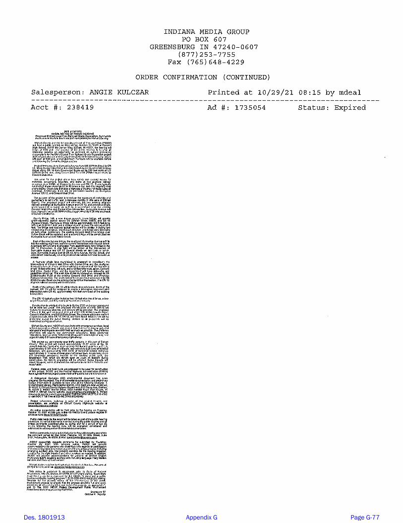
Des. 1801913 Appendix G Page G-77

1
Jagger, Eric
From: Jagger, EricSent: Tuesday, September 28, 2021 4:48 PMTo: Abby Wiles; Amy Kratzer; Brett Weddell; Bruce & Jennifer Hardy; Charles Cheek; Charles McKenzie;
Charles Uhlarik; Chris Snyder; Christie Stanifer; Darrel Neilson; Denise Seger; Diane Hogan; Doug Miller; Doug Nisley; [email protected]; [email protected]; Eldridge Chambers; Elizabeth McCloskey; Eric Trotter; [email protected]; Frank Lucchese; Gilberto Perez; [email protected]; Harry Welles Jr; HeartCityProperties; [email protected]; James Turnwalk; James Weeber; Jane and Stan Hunsberger; Jason Holder; Jason Springer; Jeanne Bower; Jeannine Martin; Jeff Siegel; Jennifer Toby; Jeremiah Cox; Jeremy Stutsman; Jerry Adkins; Jim McKee; Jim Smith; JoeSchrock; John Heiliger; Jon Hunsberger; Julia King; Karen Novak; Kari Carmany-George; Katelynn Weldy; Kimberly Martin; Linda Rogers; MarilynWelty; MarkStettler; Mary Jo Weyrick; Matt Schrock; Megan Eichorn; Mike Machlan; Mike Szucs; Natasha Kauffmann; [email protected]; Patrick Carpenter; Paul Allerding; Paul Lehmann Lehmann; Phil Sumpter; Philip Barker; Rick Neilson; Rod Roberson; Ron Bales; Steve Kamp; Steven Aufdenkampe; TaraWillis; Tim Jackson; Travis Snider; Valerie Bosscher; Venetta Keefe; Victoria Heath
Subject: Elkhart Local Trax Railroad Grade Separation Public HearingAttachments: Elkhart Local Trax Notice of Public Hearing.pdf
Elkhart Local Trax Grade SeparationElkhart CountyDes. No. 1801913
Good afternoon,
We are sending you the attached legal notice of public hearing on behalf of the Indiana Department of Transportation(INDOT), which is scheduled for October 13th, 2021.
Best regards,
Eric JaggerAssociate Environmental Planner 101 W Ohio St., Suite 2121Indianapolis, IN 46204 He/Him/[email protected]
PARSONS - Envision More www.parsons.com | LinkedIn | Twitter | Facebook
Mailing List - Notice of Public Hearing Emails
y ; ; ; g ;y; [email protected]; [email protected];
r; [email protected]; g ; @
;s; [email protected];
; g ;[email protected];
Des. 1801913 Appendix G Page G-78
J Port
Text Box
Redacted - a complete Mailing List is on file: ERMS system Content ID: DOT_6734973
KRUIS HERMAN J C/O STEVE KRUIS 650 COLUMBIA ST UNIT 410 SAN DIEGO, CA 92101
CONCORD MALL PROPERTIES LTD MARVIN F POER & CO 2211 York Rd Ste 222 Oak Brook, IL 60523
FENDLEY DAVID L 24034 Sunnyside Ave Elkhart, IN 46516
AMC THEATERS INC 11500 Ash Street, Leawood, KS 66211 Leawood, KS 66211
CONCORD MALL PROPERTIES LLC MARVIN F POER & CO 2211 York Rd Ste 222 Oak Brook, IL 60523
DKJR LLC Elkhart 4015 Augusta Ln Elkhart, IN 46517
HEART CITY PROPERTIES LLC 3702 E Mishawaka Rd Elkhart, IN 46517
JNC CONCORD PROPERTIES LLC 3718 E Mishawaka Rd Elkhart, IN 46517
CONCORD MALL PROPERTIES LLC 3701 S Main St Elkhart, IN 46517
MCHENRY BETTY L & DIANA L SURFUS JT TEN 3984 W 1050 N Milford, IN 46542
BARRON SANTOS 24486 County Road 20 Elkhart, IN 46517
BAILEY MARSHALL W & JEAN L 24466 County Road 20 Elkhart, IN 46517
COOK MARTHA L 24369 ELMHURST DR ELKHART, IN 46517
SANCHEZ LUIS E & LAURA AGUILAR H&W 58914 Pine Ridge Pkwy Elkhart, IN 46517
GOODENOUGH DONALD R & DOROTHY K AS CO TRUSTEES 854 W Cooley Dr Gilbert, AZ 85233
BURLESON DUANE A & THOMASINE A TRUSTEES LIV TRUST( 24275 Elmhurst Dr Elkhart, IN 46517
MARTINS SUPER MARKETS INC ATTN PAM SMITH PO Box 2709 South Bend, IN 46680
KAMIOTIS GEORGE 3709 S Main St Elkhart, IN 46517
QUAD CITY INVESTMENT CORP 3319 BREWTON WAY MIDLOTHIAN, VA 23113
INDIANA MICHIGAN POWER CO P.O. Box 16428 Columbus, OH 43216
METROPOLITAN SCHOOL DIST OF CONCORD CON TWP ELKHAR 59040 Minuteman Way Elkhart, IN 46517
NORFOLK SOUTHERN RAILWAY COMPANY C/O NORFOLK SOUTHERN CORP 3 COMMERCIAL PLACE Norfolk, VA 23510
ELKHART PUBLIC LIBRARY ATTN: JANE GAROUTTE BUSINESS MGR/TREASURER 300 S SECOND ST ELKHART, IN 46514
CHARLES AERO S 58484 COUNTY RD 13 ELKHART, IN 46516
SANCHEZ RAMON FERNANDEZ 58504 COUNTY RD 13 ELKHART, IN 46516
WELTY LARRY E & MARILYN S 23970 Sunnyside Ave Elkhart, IN 46516
COTREL BARBARA 23949 County Road 45 Elkhart, IN 46516
SUNNYSIDE HOLDINGS LLC PO BOX 253 GOSHEN, IN 46527
MULLIKIN MELFORD & KATHLEEN PO Box 361 Bristol, IN 46507
MAURER LEIBERT J & RACHEL P TRUSTEES 24972 COUNTY ROAD 38 GOSHEN, IN 46526
Des. No. 1801913 (Lead) Page 1 of 7
Mailing List - mailed Notice of Public Hearing on September 28, 2021
2211 York Rd Ste 222
2211 York Rd Ste 222
3718 E Mishawaka Rd
Elkhart, IN 46517 24466 County Road 20 24486 County Road 20
Elkhart, IN 465173984
58914 Pine Ridge Pkwy Elkhart, IN 46517
S 854 W Cooley Dr Gilbert, AZ 85233
58504 COUNTY RD 13
GOSHEN, IN 46527 Bristol, IN 46507
DR
24275 Elmhurst Dr
3319 BREWTON WAY MIDLOTHIAN, VA 23113
650 COLUMBIA ST UNIT 410 24034 Sunnyside Ave
4015 Augusta Ln 11500 Ash Street, Leawood, KS 66211
3702 E Mishawaka Rd
W 1050 N
24369 ELMHURST
PO Box 2709 3709 S Main St
58484 COUNTY RD 13
23949 County Road 45 23970 Sunnyside Ave
24972 COUNTY ROAD 38
Des. 1801913 Appendix G Page G-79
J Port
Text Box
Redacted - a complete Mailing List is on file: ERMS system Content ID: DOT_6734973

STETTLER REAL ESTATE LLC 1919 Greenleaf Blvd Elkhart, IN 46514
RODRIGUEZ EUSTOLIA 58702 Amy Ave Elkhart, IN 46516
FROWNFELTER TERRELL L 58702 Amy Ave Elkhart, IN 46516
STRANGE ALEX & CHELSEA STRANGE 58551 COUNTY RD 13 ELKHART, IN 46516
WILLIS ARNOLD LAVON 58611 County Road 13 Elkhart, IN 46516
SWIHART MICHAEL G & BEVAN L 9022 S W 8TH TERRACE MIAMI, FL 33174
KOCHER CHRISTOPHER & HEATHER L KOCHER H&W & SCOTT KOCHER & GLADYS M KOCHER H&W JT TEN 58539 COUNTY RD 13 ELKHART, IN 46516
WILLIS ARNOLD LAVON 58611 County Road 13 Elkhart, IN 46516
MOORE PAULA S 58635 County Road 13 Elkhart, IN 46516
ELKHART COUNTY COMMUNITY BAPTIST CHURCH INC 23805 Sunnyside Ave Elkhart, IN 46516
SUNNYSIDE MENNONITE CHURCH TRUSTEES OF 23786 Sunnyside Ave Elkhart, IN 46516
COMER ERIC J & MARIETTA C CO-TRUSTEES 58731 County Road 13 Elkhart, IN 46516
STRUBLE SANDRA K 58755 County Road 13 Elkhart, IN 46516
EVERETT KELLY J 58528 County Road 13 ELKHART, IN 46516
BORJA EVERARDO 58538 COUNTY RD 13 ELKHART, IN 46516
HARNESS SHEILA A C/O ANGUS STANLEY 58548 COUNTY RD 13 ELKHART, IN 46516
NOFFSINGER JAMES P JR & TAMILA J NOFFSINGER H&W 23765 Greenwood Blvd ELKHART, IN 46516
NOFFSINGER JAMES P JR & TAMILA J NOFFSINGER H&W 23765 GREENWOOD BLVD ELKHART, IN 46516
STOVER DORIS A c/o MANSELL, KIMBERLY 56280 Strathmore Dr Elkhart, IN 46516
WILSON THOMAS D & LINDA K 23739 Sunnyside Ave Elkhart, IN 46516
SWEAZY JEFFREY S & NANCY J 58660 County Road 13 Elkhart, IN 46516
MARTIN PHILLIP A & KIMBERLY J 58714 County Road 13 Elkhart, IN 46516
GANGER DOUGLAS L & THERESA L GANGER JT TEN & (LF E 23713 Cole St Elkhart, IN 46516
DAX PROPERTIES LLC PO BOX 62 GOSHEN, IN 46527
FLAVOR FREEZE CORPORATION 64877 COUNTY ROAD 21 GOSHEN, IN 46526
BOARD OF COMMISSIONERS OF COUNTY OF ELKHART 117 N 2nd St Goshen, IN 46526
INDIANA MICHIGAN POWER CO PO Box 16428 Columbus, OH 43216
KEY TRUST COMPANY OF INDIANA C/O KEYCORP MANAGEMENT CO PO BOX 560807 DALLAS, TX 75356
MDK CORPORATION IND CORP 415 New St Goshen, IN 46528
STRINGFELLOW NICOLE J 58781 County Road 13 Elkhart, IN 46516
Des. No. 1801913 (Lead) Page 2 of 7
58702 Amy Ave
58611 County Road 1
58731 County Road 13
58755 County Road 13 58528 County Road 13 58538 COUNTY RD 13
23765 GREENWOOD BLVD 23765 Greenwood Blvd58548 COUNTY RD 13
56280 Strathmore Dr23739 Sunnyside Ave 58660 County Road 13
GOSHEN, IN 4652723713 Cole St58714 County Road 13
415 New St 58781 County Road 13
DALLAS, TX 75356
1919 Greenleaf Blvd 58702 Amy Ave
58551 COUNTY RD 13 9022 S W 8TH TERRACE
58611 County Road 13
58539 COUNTY RD 13
58635 County Road 13
Des. 1801913 Appendix G Page G-80

MILLER STEPHEN J & SHERRY MILLER H&W 58795 COUNTY ROAD 13 ELKHART, IN 46516
MIRABAL RICARDO T & ELVIRA 23781 John St Elkhart, IN 46516
RIEHL SAMUEL 160 N 600 W Lagrange, IN 46761
NOSS DORSEY L JR & BONNIE M 58847 County Road 13 Elkhart, IN 46516
Heinz and Jill Grubert 58899 County Road 13 Elkhart, IN 46516
MCLAIN BRADLEY J & PEGGY D 58937 County Road 13 Elkhart, IN 46516
GRUBERT HEINZ & JILL GRUBERT 58899 County Road 13 Elkhart, IN 46516
BOARD OF COMMISSIONERS OF THE COUNTY OF ELKHART IN 117 N 2nd St Rm 101 Goshen, IN 46526
LIN DONNIE FAI & WENJIE ZHANG H&W 23725 SPRING RIVER DR ELKHART, IN 46516
LANG BRADLEY 58858 County Road 13 Elkhart, IN 46516
HAMOOD ROBERT D 67777 County Road 23 New Paris, IN 46553
KNAFEL CHRISTOPHER & RACHEL KNAFEL H&W 58892 Spring Creek Trl Elkhart, IN 46516
CHUPP SARAH A 1801 YORK ST Elkhart, IN 46516
NICHOLS W JOEL TRUSTEE OF W JOEL NICHOLS TRUST 17431 County Road 22 Goshen, IN 46528
MYERS CYNTHIA R 58872 County Road 13 Elkhart, IN 46516
STETTLER REAL ESTATE LLC 1919 Greenleaf Blvd Elkhart, IN 46514
T O DOUBLED PROPERTIES LLC 804 S 7th St Goshen, IN 46526
NORFOLK SOUTHERN RAILWAY COMPANY C/O NORFOLK SOUTHERN CORP 3 COMMERCIAL PLACE Norfolk, VA 23510
CONCORD COMMUNITY SCHOOLS BUILDING CORP 59040 Minuteman Way ELKHART, IN 46517
KING-EVANS GEORGIA 51275 Aqua Dr Elkhart, IN 46514
POWELL BILLY R & INGRID E ATTN FORMAL AFFAIRS 23797 US Highway 33 Elkhart, IN 46517
MANCEWICEZ MARK & EMILY KANE & KATY SOLOVEWICZ TEN COM 19030 COUNTY ROAD 8 BRISTOL, IN 46507
R & S JENKINS PROPERTY LLC 152 W Walnut St NAPPANEE, IN 46550
A & M PETROLEUM INC 23719 US 33 ELKHART, IN 46516
STUTZMAN WILLARD A PO Box 2232 NEW SMYRNA, FL 32170
PANCHOS LAND DEVELOPMENT LLC 17431 County Road 22 GOSHEN, IN 46528
STANTON JAMES & MELODY 23752 US 33 ELKHART, IN 46517
SYNERGETIC LLC 15723 COUNTY RD 129 BRISTOL, IN 46507
WATSON ERIK N & SHELBI N YESBERGER JT TEN W/ ROS 59141 LEWIS AVE ELKHART, IN 46517
FIZER JOHNIE & ROBIN K 23714 US Highway 33 ELKHART, IN 46517
Des. No. 1801913 (Lead) Page 3 of 7
58795 COUNTY ROAD 1323781 John St 160 N 600 W
58937 County Road 13 58899 County Road 13 58847 County Road 13
County Road 13588999 23725 SPRING RIVER DR
58892 Spring Creek Trl 67777 County Road 2358858 County Road 13
1801 YORK ST 17431 County Road 22
58872 County Road 13
804 S 7th St 1919 Greenleaf Blvd
51275 Aqua Dr Elkhart, IN 46514 23797 US Highway 33
19030 COUNTY ROAD 8 152 W Walnut St NAPPANEE, IN 46550
23719 US 33
23752 US 33PO Box 2232 17431 County Road 22
23714 US Highway 3359141 LEWIS AVE
15723 COUNTY RD 129
Des. 1801913 Appendix G Page G-81

STORCO INC IND CORP PO Box 227 ELKHART, IN 46515
NICHOLS W JOEL TRUST 17431 County Road 22 GOSHEN, IN 46528
INDIANA MICHIGAN POWER CO c/o TAX DEPT P.O. Box 16428 Columbus, OH 43216
DUNLAP UNITED METHODIST CHURCH 23674 US 33 ELKHART, IN 46517
FINNIGAN LE ANN 23810 John Street Elkhart, IN 45616
EBY GARY D & LINDA S EBY 59203 Park Shore Drive Elkhart, IN 46517
TON REAL ESTATE INVESTMENTS X LLC 910 W. Van Buren St., Ste. 500 Chicago, IL 60607
CEPIN DANIEL J ABREU 24057 SUNNYSIDE AVE Elkhart, IN 46517
SMITH CARLA TRUST 24043 SUNNYSIDE AVE Elkhart, IN 46516
BECK EMILEE A & JAKOB RYAN HOSTETLER TEN COM 24025 SUNNYSIDE AVE Elkhart, IN 46516
HARRINGTON KEITH NELSON JR 23995 SUNNYSIDE AVE Elkhart, IN 46516
DULANEY ELAINE M 23975 SUNNYSIDE AVE Elkhart, IN 46516
WILLIAMS MICHAEL K 23940 HIMEBAUGH AVE Elkhart, IN 46516
VAZUEZ BRYAN MENDEZ 23873 SUNNYSIDE AVE Elkhart, IN 46516
PRICE DARREL W 23875 SUNNYSIDE AVE Elkhart, IN 46516
GUSHWA JASON A 23835 SUNNYSIDE AVE Elkhart, IN 46516
HARRIS CHRISTINE M 23823 SUNNYSIDE AVE Elkhart, IN 46516
BRISCOE JEREMIAH 58649 COUNTY RD 13 Elkhart, IN 46516
TON REAL ESTATE INVESTMENTS X LLC 5 CENTER DR Elkhart, IN 46517
HEART CITY PROPERTIES LLC 3702 MISHAWAKA RD Elkhart, IN 46517
CBI BUILDINGS LLC 102 CONCORD MALL DR Elkhart, IN 46517
QUAD CITY INVESTMENT CORP 3703 S MAIN ST Elkhart, IN 46517
WELTY MARILYN S 23970 SUNNYSIDE AVE Elkhart, IN 46516
WELDY CHAD A 24002 SUNNYSIDE AVE Elkhart, IN 46516
VELAZQUEZ RODOLFO ALEXANDER & ROSALBA ALEXANDER CUEVAS TEN COM 24002 SUNNYSIDE AVE Elkhart, IN 46516
SUNNYSIDE MENNONITE CHURCH 23874 SUNNYSIDE AVE Elkhart, IN 46516
SUNNYSIDE MENNONITE CHURCH TTEES 23786 SUNNYSIDE AVE Elkhart, IN 46516
LOWE MATTHEW A & DAWN A LOWE H&W 58630 KENDALL ST Elkhart, IN 46516
ELKHART COUNTY COMMUNITY BAPTIST CHURCH 23805 SUNNYSIDE AVE Elkhart, IN 46516
MOORE PAULA S 58635 COUNTY RD 13 Elkhart, IN 46517
Des. No. 1801913 (Lead) Page 4 of 7
PO Box 227 17431 County Road 22
23810 John Street 59203 Park Shore Drive
24043 SUNNYSIDE AVE 24057 SUNNYSIDE AVE 910 W. Van Buren St., Ste. 500
24025 SUNNYSIDE AVE 23995 SUNNYSIDE AVE 23975 SUNNYSIDE AVE
23875 SUNNYSIDE AVE 23873 SUNNYSIDE AVE
23835 SUNNYSIDE AVE
23940 HIMEBAUGH AVE
23823 SUNNYSIDE AVE 58649 COUNTY RD 13
102 CONCORD MALL DR 3702 MISHAWAKA RD5 CENTER DR
3703 S MAIN ST 23970 SUNNYSIDE AVE 24002 SUNNYSIDE AVE
24002 SUNNYSIDE AVE
58630 KENDALL ST 58635 COUNTY RD 13
Des. 1801913 Appendix G Page G-82

WILLIS ARNOLD LAVON 58611 COUNTY RD 13 Elkhart, IN 46516
WILSON THOMAS D & LINDA K 23739 SUNNYSIDE AV Elkhart, IN 46516
COMER ERIC J & MARIETTA C CO-TRUSTEES 58731 COUNTY RD 13 Elkhart, IN 46516
STORCO INC 59058 LEWIS AVE Elkhart, IN 46517
MANCEWICEZ MARK & EMILY KANE & KATY SOLOVEWICZ TEN COM 59029 COUNTY RD 13 Elkhart, IN 46516
ST R & S JENKINS PROPERTY LLC 59045 COUNTY RD 13 Elkhart, IN 46516
KAMIOTIS GEORGE 3709 S MAIN ST Elkhart, IN 46517
REINALT THE A THOMAS CORP HALLE PROPERTIES LLC 3711 S MAIN ST Elkhart, IN 46517
T O DOUBLE D PROPERTIES LLC 58938 COUNTY RD 13 Elkhart, IN 46516
MARTIN PHILLIP A & KIMBERLY J 58714 County Rd 13 Elkhart, IN 46516
LIN DONNIE FAI & WENJIE ZHANG H&W 23725 SPRINGRIVER DRIVE Elkhart, IN 46516
PRECEPT PROPERTIES LLC 23724 SPRINGRIVER DRIVE Elkhart, IN 46516
CHUPP SARAH A 58834 COUNTY RD 13 Elkhart, IN 46516
GRUBERT HEINZ & JILL GRUBERT H&W 58899 COUNTY RD 13 Elkhart, IN 46516
STRINGFELLOW NICOLE J 58781 County Rd 13 Elkhart, IN 46516
NOSS DORSEY L JR & BONNIE M 58847 COUNTY RD 13 Elkhart, IN 46516
MILLER STEPHEN J & SHERRY MILLER H&W 58795 COUNTY RD 13 Elkhart, IN 46516
MIRABAL RICARDO T & ELVIRA 23781 JOHN ST Elkhart, IN 46516
MCLAIN BRADLEY J 58937 COUNTY RD 13 Elkhart, IN 46516
FINNIGAN, LE ANN 23810 JOHN ST Elkhart, IN 46516
MEJIA JOSE & ADRIANA VEGA 58550 KENDALL STREET Elkhart, IN 46516
DANIELS DAVID L II 23899 HIMEBAUGH AVE Elkhart, IN 46516
WALDEN RONALD & TERRY ANN 23919 HIMEBAUGH AVE Elkhart, IN 46516
IZAK DAVID F 23902 HIMEBAUGH AVE Elkhart, IN 46516
DSP REALTY LLC 3700 MISHAWAKA RD Elkhart, IN 46517
MSM HOLDCO LLC C/O SPARTAN NASH COMPANY 850 76th St SW Byron Center, MI 49315
JNC CONCORD PROPERTIES LLC 3718 MISHAWAKA RD Elkhart, IN 46517
Des. No. 1801913 (Lead) Page 5 of 7
58611 COUNTY RD 13 23739 SUNNYSIDE AV
59058 LEWIS AVE 58731 COUNTY RD 13
59029 COUNTY RD 13
STOVER DORIS A c/o MANSELL, KIMBERLY 8 GREENWOOD GREENWOOD BLVDBLVD Elkhart, IN 46516
STRUBLE SANDRA K 5587558755 COUNT COUNTYY RD 13 RD 13 Elkhart, IN 46516
MESSICK BECKY S 5858458584 K KEENDNDALLALL Elkhart, IN 46516
59045 COUNTY RD 13
58938 COUNTY RD 13 3711 S MAIN ST
3709 S MAIN ST
58714 County Rd 13 23725 SPRINGRIVER DRIVE 23724 SPRINGRIVER DRIVE
58899 COUNTY RD 13 58781 County Rd 13 58834 COUNTY RD 13
58847 COUNTY RD 1358795 COUNTY RD 13
23781 JOHN ST
58550 KENDALL STREET 23810 JOHN ST58937 COUNTY RD 13
23899 HIMEBAUGH AVE 23919 HIMEBAUGH AVE 23902 HIMEBAUGH AVE
3718 MISHAWAKA RD850 76th St SW
3700 MISHAWAKA RD
Des. 1801913 Appendix G Page G-83

Indiana Department of Environmental Management 100 N. Senate Avenue Indianapolis, IN 46204
National Park Service 601 Riverfront Drive Omaha, Nebraska 68102
Elkhart County Planning and Development Office Chris Godlewski 4230 Elkhart Road Goshen, IN 46526
Elkhart County Health Department 4230 Elkhart Road Elkhart, IN 46516
Elkhart Housing Authority 1396 Benham Ave Elkhart, IN 46516
Concord Community Schools Denise Seger 59040 Minuteman Way Elkhart, IN 46516
Concord Schools Scott Kovatch 59040 Minuteman Way Elkhart, IN 46517
Ivy Tech Community College 22531 CR 18 Goshen, IN 46528
Elkhart Christian Academy Brian Crouse 25943 COUNTY ROAD 22 Elkhart, IN 46517
Norfolk Southern Railway 29626 CR 20 West Elkhart, IN 46517
Thor Industries, Corporate Office 601 East Beardsley Avenue Elkhart, IN 46514
Forest River, Corporate Office 900 CR 1 Elkhart, IN 46514
Lippert Components, Coporate Office 3501 CR 6 East Elkhart, IN 46514
Beacon Health System 615 N. Michigan St South Bend, IN 46601
Patrick Industrices, Inc 107 W Franklin Street P.O. Box 638 Elkhart, IN 46515
Goodwill Community Career Center 3808 E Mishawaka Road Elkhart, IN 46517
Elkhart Housing Authority 1396 Benham Avenue Elkhart, IN 46516
State of Indiana Eric Holcomb Office of the Governor Statehouse Indianapolis, Indiana 46204
U.S. Senate Mike Braun 115 North Pennsylvania Suite 100 Indianapolis, Indiana 46204
U.S. Senate Todd Young 46 East Ohio Street Suite 462 Indianapolis, Indiana 46204
U.S. Congress Indiana 2nd District Jackie Walorski Mishiwaka District Office 202 Lincolnway East Suite 101 Mishawaka, Indiana 46544
Elkhart County Council Doug Graham 117 North Second St Goshen, Indiana 46526
Elkhart County Council Randall Yohn 117 North Second St Goshen, Indiana 46526
Elkhart County Council Darryl Riegsecker 117 North Second St Goshen, Indiana 46526
Elkhart County Council David Hess 117 North Second St Goshen, Indiana 46526
Elkhart County Council Adam Bujalski 117 North Second St Goshen, Indiana 46526
Elkhart County Council Thomas Stump 117 North Second St Goshen, Indiana 46526
Elkhart County Council Tina Wenger 117 North Second St Goshen, Indiana 46526
Elkhart City Common Council Aaron Mishler 229 South Second St Elkhart, Indiana 46516
Elkhart City Common Council Brian Thomas 229 South Second St Elkhart, Indiana 46516
Des. No. 1801913 (Lead) Page 6 of 7
Des. 1801913 Appendix G Page G-84

Elkhart City Common Council David Henke 229 South Second St Elkhart, Indiana 46516
Elkhart City Common Council Dwight Fish 229 South Second St Elkhart, Indiana 46516
Elkhart City Common Council H. Brent Curry229 South Second StElkhart, Indiana 46516
Elkhart City Common Council Tonda Hines 229 South Second St Elkhart, Indiana 46516
Elkhart City Common Council Mary Olson 229 South Second St Elkhart, Indiana 46516
Elkhart City Common Council Arvis Dawson 229 South Second St Elkhart, Indiana 46516
Elkhart City Common Council Kevin Bullard 229 South Second St Elkhart, Indiana 46516
BRIARWOOD VILLAGE 1000 Portsmouth Dr Elkhart, IN 46517
CARRIAGE HOUSE ELKHART 1200 Burr Oak Ct Elkhart, IN 46517
ASHTON PINES PHASE I 4353 BALSAM FIR LN Elkhart, IN 46517
Dunlap United Methodist Church 23674 U.S. 33 Elkhart, IN 46516
Elkhart County Community Baptist 23805 Sunnyside Ave Elkhart, IN 46516
Jehovah's Witnesses - South 25448 Co Rd 22 Elkhart, IN 46517
Elkhart Valley Church of the Brethren 24955 Co Rd 24 Elkhart, IN 46517
Grace Brethren Church 24775 CR 20 Elkhart, IN 46517
Apostolic Full Gospel Church 58385 CR 111 Elkhart, IN 46517
Elkhart County Minority Health Coalition P.O. Box 218 Elkhart, IN 46515
Northern Indiana Hispanic Health Coalition 444 Nappanee Street Elkhart, IN 46514
Tuffy Tire and Auto Services Center 3703 S Main Street Elkhart, IN 46517
Ronny Baltimore 23959 CR 45 Elkhart, IN 46516
C.W.58700 Fawn River CourtElkhart, IN 46516
Mel & Kathe Mullikin P.O. Box 361 Bristol, IN 46507
Lorell Nihent 25807 Lake Drive Elkhart, IN 46514
Rebecca Nelson 57896 8th Street Elkhart, IN 46517
Jim Beck 60655 Ashton Elkhart, IN 46517
Kevin and Janet O'Brien 56581 CR 13 Elkhart, IN 46516
Merrett and Eric Comer 58731 CR 13 Elkhart, IN 46516
QUAD CITY INVESTMENT CORP ATTN DARREL J NEILSON - PRES 3703 S MAIN ST Elkhart, IN 46517
NORTHERN INDIANA PUBLIC SERVICE COMPANY LLC 135 N Pennsylvania, Ste 1610 Indianapolis, IN 46204
STORCO INC 59058 LEWIS AVE Elkhart, IN 46517
Des. No. 1801913 (Lead) Page 7 of 7
58700 Fawn River Court23959 CR 45
P.O. Box 361 25807 Lake Drive 57896 8th Street
58731 CR 1356581 CR 13 60655 Ashton
3703 S MAIN ST
Des. 1801913 Appendix G Page G-85

INDOT and Elkhart County are hosting a public hearing.
When:• Wednesday, October 13, 2021• Doors open at 5 p.m. The hearing will
begin at 6 p.m.Where:• Concord High School,
59117 Minuteman WayElkhart, Indiana 46517
Project information, including a copy of the draft environmental document, is available at www.elkcohwy.org/projects/.
An online presentation will be held prior to the hearing on Tuesday, October 12, 2021, at 6 p.m. online via WebEx Event; please register at: https://bit.ly/2XHwgA4.
Please join us
Des. 1801913 Appendix G Page G-86
J Port
Text Box
Postcard - Mailed to the following Postal Codes on October 1, 2021: 46516-C042 (697 properties) 46516-0061 (799 properties) 46517-C051 (671 properties) 46517-C048 (863 properties)

A Local Trax Project is Moving Forward Near You
PUBLIC OPEN HOUSEJoin us for an open house or online presentation Tuesday, August 4 (see reverse for details).
www.elkcohwy.org/projects
Local Trax Project Area, Dunlap
To address safety and mobility issues, the Indiana Department of Transportation (INDOT) and Elkhart County are partnering to study, design and construct the Local Trax Railroad Grade Separation at Sunnyside Avenue/Concord Mall Drive and County Road (CR) 13.
The purpose of the project is to reduce the exposure of motorists and pedestrians to rail traffic, and to increase mobility in this area of Elkhart County.
The draft environmental document has been published, and INDOT and Elkhart County are providing residents with two opportunities to learn about the current preliminary design plans and provide feedback before design advances.
A Local Trax Project is Moving Forward Near You
Des. 1801913 Appendix G Page G-87
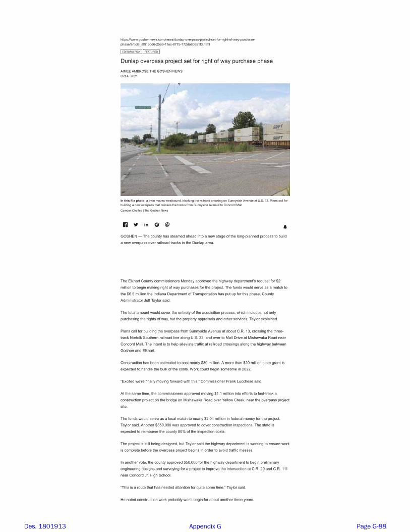
��������������������� �������������������������� ����������������������� �����
���������� ������� ����� ������ �!"" ��"���!�� ��#�����
$%&'()*+,-&./,0$1'2)$%
%�����,�������,���� �,���,��,����,�,���,��� ����,�����
1&3$$,134)(+$,'5$,6(+5$7,7$8+
( �,9:,����
;<,=>?@,A?BC,D>E=EF,�,�����,����,����G���:,G� H��,���,�������, �����,�,+��������,1�����,��,2�+�,##�,-����, ���,��
G������,�,���,�������,����, �����,���,��� H�,���,+��������,1�����,�,.� ��,3���
.�����,.������,I,'��,6����,7���
, , , ,
6(+5$7,J,'��, ����,���,�������,�����,���,�,���,����,�,���,����������,�� ���,�,G����
�,���,�������,���,�������,��� H�,��,���,%�����,�����
������������ ������������������������������������������������������ ��������
����������������������������������� ��������������� ��!������ ������ �������������������
����"!#������������$�������%�������������������������� � ��������������&��� ��
'���������(��������������!
����������� ���� �������������������������� �������������&����������� �����������
� ����������������������&�� �����������������������������������&��������)�������!
*�������������� ����������������������+ ��������'��� ������� ��!,!�-.&���������������/
����0������+� ����������������������1!+!�..&����������������%����������������,�������
�����������!����������������������������������������������������������������������������
2���������������!
���� �����������������������������������.3��������!�'�����������3�������������������
�)������������������� �������������!�4����� ���������������������3��!
5�)��������������������������������������&6�������������7����8 �����������!
'������������&���������������������������������-!-������������������������/�����
���� ������� ����������������������������,��������9����������&������������������ ��
���!
����� ������ ����������������������������������!3:��������������������������������� ��&
����������!�'������.#3&333������������������������ ���������������!�����������
�)������������ �������� ���;3<���������������������!
������ �������������������������&�� ���������������������������������������������� �����
������������������������������ �������������������������������������!
$�����������&������ ������������#3&333����������������������������������������
������������������������ �������������� ����������������������������!,!��3������!,!�---
�����������(!�=����+�����!
5����������� ��������������������������� �����������&6�����������!
=����������� ���������������������������������� ���������������!
Des. 1801913 Appendix G Page G-88

��������������� �� ����������������������������� �� ������ ������ ������ ����������������� ��!��"���#�����$������%�����&������&��& �� ���&�� ����&� ����'()'*&+',--.��&��/&�0��1)23,4&5&'�&6������&1�� ����&��&' ����� ������&7621.'8&���&9��� �&%����:&��&����&���!��&�� ���&��&���� &��!��&������&��&����&�� &�& �� ���&�� �����'����&:��&�� & �����;4��&��&��/&� &����&��&�� &�&��&�������&���&�� ����&�&��!�� ������&��&�������& ������
1�� �&���&��&�&����&���&��&��!��&�� ���&!����&��&�&����&<�����:/&.���&�#/&��&%���� �&*���+�����&'�&�� ���&��&����&��&��� &��:��&��� ���&��&���� �����:&��&������&��&� ����� :�����&����&�� &��&9��� �&3���&' �=&(�� ���&> ��&+�� �����&� ����&��&+���:���&,���&���%�(�&�#�?@AB&CD EFA&GB
Des. 1801913 Appendix G Page G-89
J Port
Text Box
Excerpt

��������������� ������������������������������ ��!����!��"�#�$%&'()*�+,-�,.,+$%&/�+,0123456�0�78)�9:;<=:=�1)>=*&?):&�'@7*=:A>'*&=&<':�B931$7C�=:;�DEF8=*&�G'H:&I�J<EE8'A&�=�>H(E<%�8)=*<:K�&'�K=&8)*�>H(E<%�%'??):&�':>E=:A�@'*�=�*=<E*'=;�'L)*>=AA/1''*A�'>):�=&�M�>/?/�=:;�&8)�>H(E<%�8)=*<:K()K<:A�=&�N�>/?/�O);:)A;=I-�$%&/�+P-�=&�G':%'*;Q<K8�R%8''E/�78)�8)=*<:K�<A�?)=:&�&'�'S)*�=:I':)<:&)*)A&);�=:�'>>'*&H:<&I�&'�%'??):&�':>*)E<?<:=*I�;)A<K:�>E=:A�@'*�&8)�DEF8=*&�4'%=E�7*=TU=<E*'=;�V*=;)�R)>=*=&<':�>*'W)%&�=&�RH::IA<;)5L):H)�=:;�G/U/�+P/ XYZ[\][
__abcd
e���f�g�����e����h�i��j
k��lm���no�m�p������o�q��������l�ln�l�r��p��qm��o�o�m�pm���p�ms��n���oo�����r�oonm�o�� ��m��m�ntrms��m��pmtt��nu��vr�n��p���w������trm�n�u�o�or���n�l��np���pmtt��n�lxyzy{|y�}~~��{y���{�~��}����y����}������y��������{��|}�|����}���}|~��|���������{~����}~y������=8''�3)JA���?<:�*)=;��|�~�{�����{y|y����zy||���z���~|�zz�}��y������y���|�{���}�~�}�}�~|��{���3)T&R8=*F�+�?<:�*)=;��{����}���|}�|��y��}|�~�y}~y���~���}���~��z���|�y|�y�~�������}���x}�|��{y~�����y�y�|�}z~y���y{���93R91DU�,�?<:�*)=;��~yy{}�y���{��y�}|�����|�����y��y�{����~�������{������y�����y}�|}������y|��{�|y��{��x ¡�}����y{~��93R91DU�,�?<:�*)=;¢}��������|}�|�|~}{��{��{y�~�~�����|��y�|���~���{�~�y�|y~��z���y{�y�|£�¤{��}�y���}�y�����93R91DU�,�?<:�*)=;
�¥¦§¨ §©ª« ¬ ® ª¬©¬° ®±¦²³® ¬³²³©ª¬§ ¬³ «ª¨ ®¥¦±±ª¬ µ©¥¦¦�±«¶® §¦² ···mw��m������¹��mm�º�wo��rr»��{��{ �¼}��½y�| » ¢���~��| ¾���� �¿�¡xÀÁ ����}~y���}{�y ¿����{}�| �y}�~� »��y{�y ¢���}|~|
Des. 1801913 Appendix G Page G-90

������������� ������������������������������������� ������������ !�"#$ �#�%&�'"��(!%"#�#�%��( �#�#)�(�*+,, #����#�-./.0/1.1-�-.2..�34�5�' 6�7��8�#"%+*, �7� 9��8�#)�(� $��,:�;� 9��#��(���< *�!�8 =����������>?����@� ��A�B�C�����D ����B����������D����C���>?��������������E�������F�����G���������D�������5HI63J'K��L��M�') ���������� !�"#$ �#�%&�'"��(!%"#�#�%��N�L�O'P�����5,Q)�"#�R%+�#S�9�,,�)%(#��!+*,�T�) �"��8�%��< �� (��SK�OT#%* "�-UK�1.1-K�#%�%&& "��,,���# " (# ��! "(%�(����%!!%"#+��#S�#%T%$$ �#�%��T+"" �#�!" ,�$���"S�� (�8��!,��(�&%"�#) �5,Q)�"#�H%T�,�'"�V�J��,"%���W"�� �X !�"�#�%�!"%Y T#��#�X+��S(�� �37 �+ �����R%+�#S�J%���NRJP�-U����5,Q)�"#�R%+�#S=B�C�CZ��L�O'�����5,Q)�"#�R%+�#S���������������[��Z�\+*,�T�) �"��8�&%"�5,Q)�"#�H%T�,�'"�V�!"%Y T#�����+�,�![��Z�< �� (��SK�OT#%* "�-UK�1.1-�������������%%"(�%! ���#�]�!=$=�) �"��8�9�,,�* 8����#�0�!=$=������������\"%Y T#�# �$�$ $* "(�9�,,�* ��7��,�*, �* &%" �����&%,,%9��8�#) �&%"$�,�) �"��8�!"%T �+" =�[���Z�R%�T%"��6�8)�XT)%%,K�R%$$+��#S�H �"���8�J%%$�]_--�4��+# $���<�SK�5,Q)�"#K��������a0]-��������������3## �� (�()%+,��!�"Q�� �"����� �# "��%%"�-03��%�,�� �!" ( �#�#�%��9�,,�* �) ,��!"�%"�#%�#) �) �"��8�%��'+ (��SK�OT#%* "�-1K�1.1-K��#�0�!=$=�7��< *5V�57 �#=�3## �� (�()%+,��" 8�(# "������7��T �) " 2�)##!(2//*�#=,S/1b6983a=\"%Y T#�,�$�#(��" ��,%�8�X+��S(�� �37 �+ �&"%$�cX�UU/4����X#" #�#%�RJ�-U��,%�8�R%�T%"��4�,,�"�7 �&"%$�RJ�1./4�()�9�Q��J%���#%�cX�UU/4����X#" #��,%�8�RJ�-U�&"%$�W" �9%%��d%+, 7�"��#%1e.�& #��%"#)�%&�cX�UU/4����X#" #����K��,%�8�R �# "��"�7 �&"%$�RJ�1./4�()�9�Q��J%���#%�R%�T%"�4�,,��"�7 =�') �!+"!%( �%&�#) �!"%Y T#��(�#%�" �+T �#) � V!%(+" �%&�$%#%"�(#(�����! � (#"���(�#%�"��,#"�&&�TK�����#%���T" �( �$%*�,�#S����#)�(��" ��%&�5,Q)�"#�R%+�#S=�') �!" & "" ���,# "��#�7 �9�,,�" f+�" �#9%�T%$$ "T��,�" ,%T�#�%�(K�#)" �" (�� �#��,�" ,%T�#�%�(K�!!"%V�$�# ,S�-U=eU��T" (�%&�� 9�! "$�� �#�"�8)#M%&M9�SK������!!"%V�$�# ,S�.=_-��T" �%&�# $!%"�"S"�8)#M%&M9�S=3�R�# 8%"�T�,�5VT,+(�%��NR5P� �7�"%�$ �#�,��%T+$ �#�)�(�* ��!" !�" ��&%"�#) �!"%Y T#=�') �7�"%�$ �#�,��%T+$ �#�#�%������!" ,�$���"S�� (�8����&%"$�#�%���(��7��,�*, ��#25,Q)�"#�\+*,�T�H�*"�"SK�\� "" �4%"���d"��T)K�1a..�d �)�$�37 �+ �5,Q)�"#K��L�a0]-5,Q)�"#�R%+�#S�6�8)9�S�� !�"#$ �#K�0-.�X# +"S�37 K�W%() �K��L�a0]1e�L�O'���(#"�T#�O&&�T K�]UUU�6�#&� ,��J%��K�g%"#�<�S� K��L�a0e.e5,Q)�"#�R%+�#S�9 *(�# 2� ,QT%)9S=%"8/!"%Y T#(/\"%Y T#��%T+$ �#(�T���* �$��, ��+!%��" f+ (#=�R�,,�����4�,, "��#�NU-P�0-0Ma00U�%"�T�,,�L�O'�'%,,�g" ��#�e]]M�L�O'ac�Na0UM0eaeP=\"%Y T#���&%"$�#�%�K���T,+���8���T%!S�%&�#) �!"%Y T#�*%�"�(�����!" ( �#�#�%�K��" ��7��,�*, �%��5,Q)�"#R%+�#S�6�8)9�Sh(�9 *(�# ��#�999= ,QT%)9S=%"8/!"%Y T#(/=<�#)���7��T ��%#�T K��L�O'�9�,,�!"%7�� ��TT%$$%��#�%�(�&%"�! "(%�(�9�#)���(�*�,�#� (�����H�$�# �5�8,�()�\"%&�T� �TS��(�!�"#�%&�#) �) �"��8(�!"%T ((=�X)%+,���TT%$$%��#�%��* �" f+�" ��!, �( T%�#�T#�3, V�H K�\�"(%�(��#�NU-P�0-0M-.--K�%"� $��,2��, V��� "=, i!�"(%�(=T%$=G��A������j����4%#%"�(#(����L%"#) �(#���������T���$%��#%"�"%���T,%(+" (K�"%���T%���#�%�(K�����#"�&&�T��, "#(���S�#�$ 7��2 g�T *%%Q2�&�T *%%Q=T%$/�L�O'L%"#) �(#
G �C��������� �����C����j���������������j����������C���������5$��,�3��" (( =8=��$ i V�$!, =T%$X+*(T"�* G����k ����
Des. 1801913 Appendix G Page G-91

11/4/21, 4:41 PM Webex
https://parsons.webex.com/mw3300/mywebex/report/sessiondetail.do?siteurl=parsons&ifReSearch=false&isPrint=true&pageNum=1&confID=2061586… 1/7
Session Detail ReportSession detail for 'Elkhart Local Trax Public Presentation @6:00 p.m. EST':
*Attention to Duration ratio: Attentiveness based on total duration of the event.**Attention to Attendance ratio: Attentiveness based on how long participant was in the event.
All sessions in Eastern Daylight Time (Indiana, GMT-04:00)
Client Participant 1
Name:Jon &Kauffmann-Kennel
Email: [email protected]
Invited: No Registered: Yes
Date: 10/12/21 Start time: 6:30 pm
End time: 6:35 pm Duration: 6 mins
Attention to Duration ratio: *9% Attention to Attendance ratio: **100%
Company: Title:
Phone Number: +15746125875Address 1: 58321 County Road 111
Address 2: City: Elkhart
State/Province: IN Country/region: United States of America
ZIP/Postal Code: 46517 Network joined from: External
Internal Participant: N/A
Audio types used: VoIP
Client Participant 2Name: J Sonam Email: [email protected]
Invited: No Registered: Yes
Date: 10/12/21 Start time: 5:58 pm
End time: 6:35 pm Duration: 38 mins
Attention to Duration ratio: *65% Attention to Attendance ratio: **100%
Company: Title:
Phone Number: Address 1:
Address 2: City:
State/Province: Country/region: United States of America
ZIP/Postal Code: Network joined from: External
Internal Participant: N/A
Audio types used:
Client Participant 3Name: Mark Stanley Email: [email protected]
Invited: No Registered: Yes
Date: 10/12/21 Start time: 5:59 pm
End time: 6:35 pm Duration: 36 mins
Attention to Duration ratio: *62% Attention to Attendance ratio: **100%
Company: Title: Researcher
Phone Number: +15054705655Address 1: 23231 Spring Creek Trl
Address 2: City: Elkhart
State/Province: IN Country/region: United States of AmericaZIP/Postal Code: 46516 Network joined from: External
Participant Names (as signed-in): Jon & Kauffmann-Kennel J Sonam Mark Stanley Alex Lee Erin Pipkin Jordan Fouts Margie Stankoven Daniel J Miller Joyce Parker Tim Quist Keaton Veldkamp Charles McKenzie Eric Jagger Jessica Miller Brian Hendsbee Ken Fervida Lyn Bradley Leslie Shoemaker *Plus 3 call-in users (no name provided)
October 12, 2021
Des. 1801913 Appendix G Page G-92

Des. 1801913 Appendix G Page G-93

Des. 1801913 Appendix G Page G-94

Des. 1801913 Appendix G Page G-95

Des. 1801913 Appendix G Page G-96

Des. 1801913 Appendix G Page G-97

Des. 1801913 Appendix G Page G-98

1
Elkhart Local Trax Railroad Grade SeparationDES. 1801913
Public HearingOctober 13, 2021
Agenda
• Introductions
• Presentation
• Verbal Public Statements
• Open House
• Team members will be available to answer questions
Public Comment Period Ends October 28, 2021.
1
2
Des. 1801913 Appendix G Page G-99
J Port
Text Box
The same information was presented at the October 12, 2021 online public presentation.
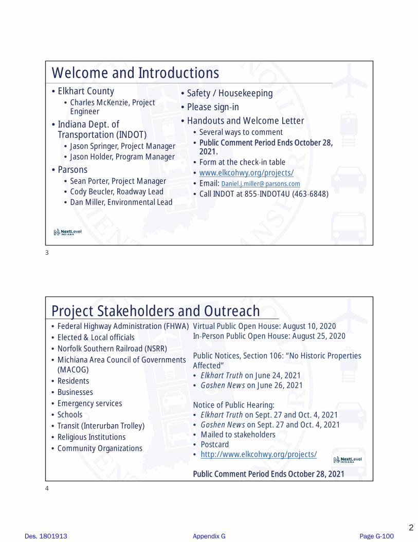
2
• Elkhart County• Charles McKenzie, Project
Engineer
• Indiana Dept. ofTransportation (INDOT)
• Jason Springer, Project Manager• Jason Holder, Program Manager
• Parsons• Sean Porter, Project Manager• Cody Beucler, Roadway Lead• Dan Miller, Environmental Lead
• Safety / Housekeeping• Please sign in• Handouts and Welcome Letter
• Several ways to comment• Public Comment Period Ends October 28,
2021.• Form at the check in table• www.elkcohwy.org/projects/• Email: [email protected]
• Call INDOT at 855 INDOT4U (463 6848)
Welcome and Introductions
Project Stakeholders and Outreach• Federal Highway Administration (FHWA)• Elected & Local officials• Norfolk Southern Railroad (NSRR)• Michiana Area Council of Governments
(MACOG)• Residents• Businesses• Emergency services• Schools• Transit (Interurban Trolley)• Religious Institutions• Community Organizations
Virtual Public Open House: August 10, 2020In Person Public Open House: August 25, 2020
Public Notices, Section 106: “No Historic PropertiesAffected”• Elkhart Truth on June 24, 2021• Goshen News on June 26, 2021
Notice of Public Hearing:• Elkhart Truth on Sept. 27 and Oct. 4, 2021• Goshen News on Sept. 27 and Oct. 4, 2021• Mailed to stakeholders• Postcard• http://www.elkcohwy.org/projects/
Public Comment Period Ends October 28, 2021
3
4
Des. 1801913 Appendix G Page G-100

3
Study Area
Project Development
Project Selection
Environmentalphase begins
Develop Purpose& Need
EarlyCoordination
Preliminarydesign phasePrepare draft
environmentaland hold public
hearing
Final NEPAFinal Design
Construction
• Summer 2020:EnvironmentalAnalysis
• Early Fall 2021:Draft EnvironmentalDocument
• Fall 2021: HoldPublic Hearing
• Fall 2021: FinalEnvironmentalDocument
• 2022: Final Design
• 2023 Award Contract
Categorical Exclusion – Level 4 (CE 4) Project
Right of way acquisition follows finaldecision and approval of the finalNEPA document.
5
6
Des. 1801913 Appendix G Page G-101

4
Purpose and Need (Summary)• Safety: High rate of crashes
• Mobility: Trains typically run 80 to 90 times a day, and often stop onthe tracks
• Lack of Sidewalks: Sunnyside Avenue, CR 13, Concord Mall Drive, andCenter Drive do not have pedestrian facilities
The purpose of this project is to reduce the exposure of motoristsand pedestrians to rail traffic, and to increase mobility in this area ofElkhart County.
Alternatives Considered• Analyzed a variety of alternatives• No Build does not address the purpose and need
South AlternativeNorth Alternatives Central Alternatives
7
8
Des. 1801913 Appendix G Page G-102

5
Preferred AlternativeKey Features:• New bypass bridge across US 33/Main St, Norfolk
Southern Railroad, and CR 45/Mapleheart Trail• Eliminates Sunnyside Ave and CR 13 at grade crossings• Re aligns intersection of CR 13 and CR 45• Roundabout• Designed for first responders, school buses• Sidewalks
Preferred Alternative
9
10
Des. 1801913 Appendix G Page G-103

6
Bypass Bridge Typical SectionTwo 12 ft travel lanes and 6 ft sidewalks
Capacity Analysis:One lane in each direction issufficient for the bridge.• Volumes projected to future
design year• Traffic redistributed to revised
street network• Volumes coordinated with
MACOG and their regionalmodel
• Improved emergency access.(For emergencies, options atHively Avenue/1.7 miles north)
Sunnyside Ave Bypass Bridge
• Roundabout• Re aligned streets with sidewalks• New bridges• Upgraded traffic signals/ intersections
• Concord Mall Dr/Sunnyside Ave & US 33/Main St• Concord Mall Dr & CR 20/Mishawaka Rd• Center Run Dr & CR 20/Mishawaka Rd• CR 13 & Sunnyside Ave.
• Drainage basin• Turn lanes• All businesses maintain access• Two commercial relocations
Commercial Area
11
12
Des. 1801913 Appendix G Page G-104
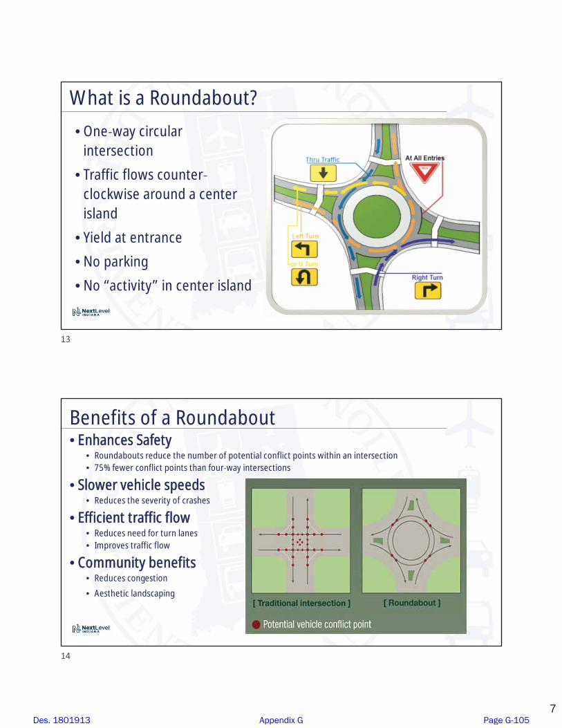
7
What is a Roundabout?
• One way circularintersection
• Traffic flows counterclockwise around a centerisland
• Yield at entrance
• No parking
• No “activity” in center island
Benefits of a Roundabout• Enhances Safety
• Roundabouts reduce the number of potential conflict points within an intersection• 75% fewer conflict points than four way intersections
• Slower vehicle speeds• Reduces the severity of crashes
• Efficient traffic flow• Reduces need for turn lanes• Improves traffic flow
• Community benefits• Reduces congestion
• Aesthetic landscaping
13
14
Des. 1801913 Appendix G Page G-105

8
Roundabouts Enhance SafetyU.S. DOT FHWA Statistics
• Compared to traditional intersections roundabouts:
• Reduce fatalities and injuries by 82% – FHWA• Reduce total crashes by 44% – FHWA
Link to RULES OF THE ROUNDABOUT video by FHWA
For more information:http://safety.fhwa.dot.gov/intersection/innovative/roundabouts/
Roundabout Typical Section
Roundabout• One 16 ft travel
lane
• Speed: 20 25 mph
• Truck apron forbuses & trucks
• Sidewalk / crossings
• Lighting
Roundabout
15
16
Des. 1801913 Appendix G Page G-106

9
• New traffic signal at Sunnyside Ave/CR 13• Re aligned Sunnyside Ave/CR 45• Two way left turn lanes along Sunnyside Ave
and CR 13• Sidewalks and pedestrian crossings• Cul de sacs
• CR 13, John St, Kendall St, Sunnyside Ave• Extensions/Other Changes
• Linden Dr, Mary St, Kendall Dr, Amy Ave• Driveways
• Drainage basins• Three residential relocations
Residential Area
Roadway Typical Section
CR 13 and Sunnyside Ave
• Two 12 ft travellanes
• Added two way leftturn lanes fordriveways &churches
• Sidewalks &Crosswalks
CR 13 and Sunnyside Ave
17
18
Des. 1801913 Appendix G Page G-107
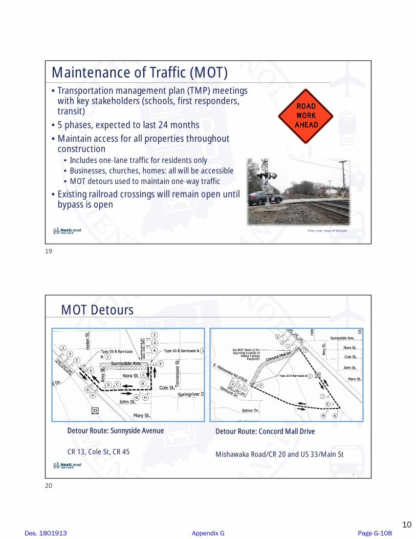
10
Maintenance of Traffic (MOT)• Transportation management plan (TMP) meetings
with key stakeholders (schools, first responders,transit)
• 5 phases, expected to last 24 months• Maintain access for all properties throughout
construction• Includes one lane traffic for residents only• Businesses, churches, homes: all will be accessible• MOT detours used to maintain one way traffic
• Existing railroad crossings will remain open untilbypass is open
Photo credit: Roger W Schneider
Detour Route: Sunnyside Avenue
CR 13, Cole St, CR 45
Detour Route: Concord Mall Drive
Mishawaka Road/CR 20 and US 33/Main St
20
MOT Detours
19
20
Des. 1801913 Appendix G Page G-108

11
Detour Route: Center Drive
Mishawaka Road/CR 20 and US 33/Main St
MOT (cont.)
Mapleheart Trail will remain open, except shortterm closure (up to one month) will be required
Mapleheart Trail along CR 45
Environmental Analysis PhaseNational Environmental Policy Act (NEPA)
• Requires INDOT to analyze and evaluate the impacts of a proposedproject
• NEPA is a decision making process• Purpose and Need• Alternatives Screening• Preferred Alternative
NEPA Document, “CE 4”, released for public involvement – September 22, 2021
Impacts analyzed, evaluated, and described in the CE 4 Document• What are the impacts this project might have on the community?• How can impacts be avoided?• Can impacts be minimized?• Mitigation for impacts?
21
22
Des. 1801913 Appendix G Page G-109

12
• Relocations: 2 commercial and 3 residential
• Right of way:• 13.83 acres of new permanent
• 0.91 acre of temporary
• Permanent alteration of traffic patterns
• St. Joseph Sole Source Aquifer: 21.77 acres• Close coordination with USEPA to reduce and minimize
potential impacts
• Section 106: No historic properties affected
• Section 4(f) Temporary Occupancy: Mapleheart Trail willremain open except for short term closures
Environmental Impacts Summary
• Yellow Creek: 145 linear feet• Wetlands: 0.087 acre• Floodplain: 0.25 acre of forested• Terrestrial habitat: 8.92 acres
• 3.14 acres of trees plus maintained lawn• Noise impacts/ no noise abatement is proposed• Endangered/threatened bat species: “May
Affect, Not Likely to Adversely Affect – withAvoidance and Minimization Measures (AMMs)”
• Environmental Justice populations are presentbut no disproportionate impacts
• Also evaluated community impacts, publicservices, air quality, hazardous materials, etc.
Environmental Impacts (cont.)
Yellow Creek from Concord Mall Dr
23
24
Des. 1801913 Appendix G Page G-110

13
Real Estate
"Uniform Act of 1970"• All federal, state and local governments
must comply• Requires an offer for just compensation
Acquisition Process• Appraisals• Review Appraisals• Negotiations
•Project Real Estate Team is workingwith impacted property owners
• Kitchen Table Meetings
Right of way• Permanent ROW: 13.83 Acres
• Permanent ROW is land, oncepurchased from legal land owner,becomes land owned by County
• Temporary ROW 0.91 acre• Temporary ROW is land required
during the construction of a projectand is used for the purposes ofconstruction related activity
• INDOT/County pays legal landowner afee for land use during construction
Real Estate Acquisition Process
25
26
Des. 1801913 Appendix G Page G-111
14
• Public and project stakeholder input• Submit comments via options described in the information packet
• INDOT review of public comments• All comments are given full consideration during decision making process
• Finalize/approve environmental process, complete project design
• Communicate a decision• INDOT will notify project stakeholders of decision
• Work through local media, social media outlets, paid legal notice
• Make project documents accessible via repositories
• Questions? INDOT Next Level Customer Service
Next Steps
• Submit public comments:• Public Comment Form
• Via e mail ([email protected]) or postal mail (address on next slide)
• Participate during public comment session following formal presentation
• Call 855 INDOT4U (855 463 6848)
• Public comment period ends Thursday, October 28, 2021
• All comments submitted are included in the public hearings transcript andmade part of the public record
• Comments are reviewed, evaluated, and given full consideration duringdecision making process
Submit Public Comments
27
28
Des. 1801913 Appendix G Page G-112

15
Contact Us
Please mention “Elkhart Local Trax” in your comments.
• Comment form – front table, or send via email or postal mail.
Postal address: ATTN: INDOT, c/o Dan MillerParsons101 W Ohio St, Suite 2121Indianapolis, IN 46204
Email: [email protected]
Thank YouElkhart County Highway [email protected]
Please visit with the Project Team following the presentation and comment session.
Please mention “Elkhart Local Trax” in your comments.
29
30
Des. 1801913 Appendix G Page G-113

�
�� �
������������ ������������ ����� ���� ���������������������������������������������� ����������������������� ��!�" #$��%�&'�(�#')�*+,-.+.�/01.2340+3�56�72.+81523.3-5+98�:*;/<7=�1>?@-A�B0.2-+C�$�D#$)E'D�F$�G�H�)�!�" #$��I��#��J$#K�L#E�$�#)�M$#)��N�G#$#�E�'O�N&''(HE)��PQ�'&���Q�$�R�$S��"�N�&� �$'�L#E�$�#)�TRNLLU�E'�!�" #$��%�&'�(V��WX��YZ�Y ��� ���X���YZ�����X�����[����� � ��������������������Y��� ������ YY ��Z������ �� ������ ���Z����������[��Y����������X����\�� ��������� �Z������ ���X���Y� ]�����������_aba�cba�daeabcf�gchd�hijb�killamnd�lch�oa�pbadamnaq�nrd�aeamrms�cmq�tiffigrms�nimrsnud�pjofrk�acbrmsv��w Z������Z������ �����������X��� �� x��[�������y�� �� %��G�������� ������� ����������Z������� ����z{|W�}�~X����� Z���� ��Y� ]�����������Y���������\����������[��X��YZ�����X�����[��� ������� ���������\������������X����[������������������ �����Z�������� Z����� ����� ��Y��~�������� �� F#$�E�EG#���cd�dpac�ab�qjbrms�na�killamn�daddrim�tiffigrms�nimrsnud�pbadamncnrim��}��X��Y��~���[�����X�����������Z����� ����Z����\��� ���X������ YY ��Z������ ��Y��~��� � ��� !��#E��� �������� ������ y������]�������Y��� ��� ������ �#E��� �������� �|�����������������cbdimdu�ittrka�cn�������X� ���������Z���������z������Y ����z{���������� �EHE��xxx��~� Xx� �[�Y� ]������ �������� ����� Z���X���Y� ]����� �� N&��E��� �������� ��X�\��� �������Y �����~�������������$���O�����V��� �������x���������\��x�������� ������������Y���� ��z{|W�cmq��f�cbn��ijmnhud������� ����~��[�Y� �������� �&�H�E�'H��� ������z{|W��Z�� �������\�������������z{|W���������������������� �������|�����������������������������WX��Y� Y ����Y� ]����x���������������X���x ��������[����[���������� ����� ����[������Z���������\��Z����������������Y� \���������[���[�������Y��������� ����[����x���������� Z���� Z��������X���������[�� �� ��������|��\�������������|��\������������ ���Z���������\��Z��x������������[����� ��� ����������������������YY� ������������������� Z�X����� ��� �� ��������|��\��� Z��������[����������x����Y���� ����������������[��x����Y� \����[�������Y����������������� ���������������������{�����������������Y��������[���WX����Y��������[��x��������YY� ����������� �������� �[�x��X���x���X� �����������������\������������������ \����X������� ��� �����������WX������[������� ��x�����Y���������� ��x�������������������Z���[��x ����� ��x�������\��������� ���������X�������� ��������� ��x��������x��~�� ��� �X������������� �������X���������[�� �� ��������Des. 1801913 Appendix G Page G-114

�������������������� ������� ����������������������������������� ��������������������������������������������� ���������������������� ���������������������������������������������� ����������������� ����������!��������������������������������� ����"������������������ � ������������������������������!����� �!�������!����������������#�$%������������������������� ��������������������������������������������������������#�$%������������������ �������!��������������������&��������������������������#�'(���!����������"�������������������)����������������������������������������������� �������� ���������������������������������� ����������������������������������������������������������������������*���������� �����������������������������������������������������+������������ ��������������!�������$,$������ ������������$-���� ��������������������������$,���� ����������������������*������������������������������������������ ������������� �����������������������������+��� ������������������������ ��������������#�,./*���� ����#����������� ������������*��������������0��������0��� ����������������+���������������������������� ��������������#�,./*���� ����#������������ ����������������������������������+����#�$%������������������������ ����������!�����������������������������#�$%� �������!�����������������������1��������������������#�$%� ���������������������������2.�������������������������������� �����#�'(������ �!������'..���������� ����������� �������������������+����#�$%�������������������������� �$,���� ��������������������� � �����������������������-���� �������� ���������������������345678�9:;<7=>�?>:=@;�(���!��A���������������B�������!�����������������C��������-���!��A�D�!������������������� ����!!������������������������!!�����������E&%.���!��A�F��������B���������!�!�!����� ���������������������� ��������� ���C��������������������������!!����������������������������������� ��������������������� ����������������������������������� ������ �����������C�������B�������!���������+������!�������� ����������������������������������������������������������������������������B������������������������ �������������������������������� �����������������������������GH:�I<JK:8L�L:;M�N766�5:�;O;76;56:�7=�LH:�@7PI6;Q�;<:;�LJ�:RI6;7=�I<JK:8L�@:L;76P�;=@�;@@<:PP�S4:PL7J=P�I<7J<�LJ�;=@�TJ66JN7=>�LH:�I45678�H:;<7=>U���������������� �������V��W�������!���������!�������������������������������B�����+���������!���������!�����������������!����������������!���������������������������� ����������&�� X���������0������Y��������0������*�����,'..�Z����!�����������������[1�'-($E��X���������������F�� ���������!�����-$.�������������\������[1�'-(,]�X�[1� +�����������������(%%%�F��������#����D���_������[1�'-].]�X��������������� ������&� ������ ���/��B����/��0�B�������!������������!������������C���������������*���������V%$EW�-$-�'--%��������[1� +�+���D�������]((�[1� +'�V'-%�-]']W���abcde�fgh�igj�ckkldmndo�kgdnobkpq�rhstnu�blcjndov��Des. 1801913 Appendix G Page G-115
J Port
Text Box
Comment form and overview map of preferred alternative (Appendix G-68) were attached.

Elkhart Local Trax Railroad Grade Separation Des. 180913
Public Comment and Response Log
No Date First Last Type Public Comments Categories Response
1 10/4/21 Tim Koontz email
Subject: ELKHART LOCAL TRAX RAILROAD GRADE SEPARATION AT SUNNYSIDE AVE./CONCORD MALL DR. AND CR 13; My family just got the mailer about this project and we couldn't be more excited. I have lived in the Concord area my whole life and have always seemed to be "on the wrong side" of the tracks. I hope this goes through smoothly and you can't break ground soon enough! Thanks!
Supports preferred alternative Thank you for your comment.
2 10/4/21 Chris Godlewski email
Subject: Dunlap Overpass; To whom it may concern, Daniel, Elkhart County Planning & Development is in full support of the Dunlap Overpass project as presented. It not only removes cars from traversing a rail crossing but it also allows for another pedestrian and bike access across US 33 (and the rail tracks) where few exist. This makes everybody safer. One question – who maintains the 6-foot sidewalk on the bridge when it snows out? I would believe this will be a path in all seasons which includes school children. Just asking how it would be maintained during inclement weather. Thanks! Best of luck navigating the process with this project.
Supports preferred alternative, sidewalk maintenance (snow removal)
Thank you for your comment. Regarding sidewalk maintenance, Elkhart County will maintain the sidewalks and streets for this project. This includes snow removal and deicing for the roadways. Residents and businesses are responsible for clearing the sidewalks in front of their properties.
3 10/13/21 Ryan CulpHearing - Written
At least (please) put a pedestrian crossing at the CR 13 crossing (or keep crossing open). Thanks! CR 13 pedestrian bridge, does not support closing CR 13 crossing
A 10-foot wide, multi-use pedestrian bridge along CR 13 over the railroad was considered. This structure would need to meet the minimum vertical clearance over the railroad, which is 23 feet. In order to achieve that height with a path of acceptable grades (i.e., not too-steep), the structure would either need long approaches, or sufficient footprints to accommodate switch-backs. The estimated cost to design and construct a sufficient pedestrian structure would be approximately $3,000,000 to 5,000,000 (plus right-of-way (ROW) costs). Therefore, it was dismissed from further consideration. Regarding leaving the CR 13 at-grade railroad crossing open, that was evaluated as part of the no build alternative, which was dismissed from further consideration because it would not meet the purpose and need for the project (discussed further in the Other Alternatives Considered section of the environmental document).
4 10/13/21 Carolyn GoddardHearing - Written
Mobility and Safety Issues. Mobility would be maximized most only if both crossings - Sunnyside and CR 13 were left open and the roundabout was put in. There are not many pedestrians from CR 13 onto Sunnyside and across to the mall at the train crossing. Even though the angle of the intersection at CR 13 is awkward - eternal vigilance is the price of freedom. In other words, look both ways twice before crossing. Safety, is not soley the government's responsibility, it is the individual's. If fire engines and/or tankers were needed from the CR 18 fire station to assist on the south side of the tracks - 3 ways would be open if the roundabout was constructed and both crossings were left open.
Does not support closing CR 13, pedestrian use, safety, CR 13/CR 45 intersection
Regarding keeping both crossings open, as discussed in the project's Purpose and Need, the current crossings are dangerous and the trains limit first responder's response times. Leaving both crossings open was evaluated as part of the No Build alternative in the Other Alternatives section of the environmental document. The No Build alternative was dismissed because it would not meet the project's purpose and need. Regarding current pedestrian usage, currently Sunnyside Avenue, Concord Mall Drive, Center Drive, and CR 13 lack pedestrian facilities, which likely impacts current pedestrian use. This project includes the installation of pedestrian facilities, which should improve pedestrian mobility. Regarding the CR 13 and CR 45 intersection realignment, the existing intersection has a skew angle of approximately 45 degrees. This type of acute angle restricts vehicular turning movements, as well as the driver’s line of sight. Per current design guidance (IDM 46-1.02), the angle of intersection should be within 20 degrees of perpendicular. The preferred alternative will improve safety by providing an intersection that meets current design criteria.
5 10/13/21 David PreheimHearing - Written
I am in support of this project as designed. While expensive, it is deperately needed. The sooner it can done, the better!
Supports preferred alternative Thank you for your comment.
Des. 1801913 Appendix G Page G-116
J Port
Text Box
*Duplicate comment from same individual as No. 15.

No Date First Last Type Public Comments Categories Response
6 10/13/21 William KidderHearing - Written
My concern is the trains sitting on tracks and leaking fluids in the water aquifer. Aquifer/ well water impacts This project is working with the U.S. Environmental Protection Agency (USEPA) and Indiana Department of Environmental Managment (IDEM) regarding protecting the St. Joseph Sole Souce Aquifer and the community's private and public drinking water wells that use that resource. The preferred alternative includes the vegetated drainage basins that are part of the storm water design, which will be signed "Well Water Area" and "No Dumping No Spraying". Elkhart County has a Groundwater Protection Ordinance designed to further protect the area's drinking water resources, including spills. Further discussion is in the Drinking Water section of the environmental document.
7 10/13/21Name Not Provided
Hearing - Written
Why is the bridge not lighted? What is the reason for not extending the sidewalk to connect both sides of the bridge? Why are there no higher barriers between pedestrians, sidewalk and roadway?
Bridge lighting, sidewalk location, sidewalk safety
Regarding lighting, currently there are no plans to light the bypass bridge. There will be street lights near the Concord Mall Bridge as well as the Sunnyside Avenue over Yellow Creek bridge. Lighting can create unintended environmental and human impacts. When the lighting is on elevated structures near trees, there can be negative impacts to federally-protected bat species including the endangered Indiana bat and the threatened northern long-eared bat, which have habitat within and adjacent to the project area. Indiana state law requires all motor vehicles and bicycles to be self-illuminated from dusk to dawn; therefore, lighting is not required. Additionally, lighting incurs added design, construction, and maintenance costs. Regarding sidewalks, all three of the project bridges will have sidewalks on each side of the roadway, including the bypass bridge. Regarding barriers, the sidewalks on the bridges will be raised from the roadway with the use of an 8-inch vertical curb. The sidewalks on the roadway will be separated by traditional curb and gutter in conjunction with a grass strip buffer.
8 10/13/21 Jill Grubert Hearing - Written
Why not leave CR 13 alone? How is this bettering CR 13 & CR 45? 28 accidents at 13 & 45 in 5 years; 3 accidents at CR 13 and 45 last year. Still lots of accidents at CR 17 and 18 with them bettering the intersection. Didn't ask residents/taxpayers if we think this will better intersection. We are the ones affected. Will retention ponds have fences?....be mowed?....will trees be cut down when grow up? Our new driveway will allow water to flow into garage. We couldn't even look for property/house as no one will give us an amount. I was reminded Sunday to be content in every situation. It's sad when I know it is a "battle" against my own tax money! Will roundabout be empty in center? Get names of Hwy Board/Pic.
Does not support the preferred alternative, general project opposition, CR 13/CR 45 intersection, purpose and need, CR 17 and CR 18, storm water / drainage basins, roundabout center design
Regarding the CR 13 and CR 45 intersection realignment, the existing intersection has a skew angle of approximately 45 degrees. This type of acute angle restricts vehicular turning movements, as well as the driver’s line of sight. Per current design guidance (IDM 46-1.02), the angle of intersection should be within 20 degrees of perpendicular. The preferred alternative will improve safety by providing an intersection that meets current design criteria. Regarding the driveway drainage, all of the storm water from the new roadways will be diverted to the drainage basins via inlets and curb/gutter. Elkhart County will maintain the basins, including regular mowing which should control tree growth. Fences are not proposed for the basins. CR 17 and CR 18 are not within the project area. Regarding the roundabout design, the current plan is to have a maintained, grassy center island.
Des. 1801913 Appendix G Page G-117

No Date First Last Type Public Comments Categories Response
9 10/13/21 Ricardo MirabalHearing - Verbal
First of all I’d like to thank everybody for giving me the opportunity to express myself. First of all, I think my personal opinion is that it’s an expensive disaster. I think it’s too complicated, too expensive to support this kind of project. If you look at the picture you have in your hands and you please follow me. Sadly look Mishawaka Road A at the corner of Main and 3. And then look across the train track where the stop sign is. Think for a moment about how simple it would be to bring together traffic from Mishawaka Road to cut across [CR] 13 by just doing two different things that can be done in the same area. Think for a moment about what they did at Indiana Avenue and all that and how easy and simple and cheap it was to get done. And then traffic moved very efficiently. And then look also back in time when in Goshen when they built that overpass many years ago and how easy, how practical for traffic to flow from downtown Goshen to cut across 13. That’s an overpass that is really practical. Cheap. Efficient. I propose that that’s the kind of idea that could be recommended on this area. If you look carefully at what I mentioned over here; if you put together Mishawaka Road with CR 13, on both sides of the train track, you have plenty of space to branch out left and right. And let traffic flow straight from one road to another and also branch out in both directions on both sides of the train tracks. I think this would be an idea that’s a lot cheaper, more practical, more efficient and would do the job and would affect the environment a lot less than this whole idea that is pictured over here. Okay? The second thing, and last, I want to mention is, right there on the corner of Johns Street and CR 13, that’s my house right there. See this. There is a cul-de-sac right there. I would like to invite these people to save the money. Please, don’t build the cul-de-sac right in front of my house. I don’t need that. I’m pretty sure my neighbors don’t like that kind of thing over there. A cul-de-sac. Why? Because right there on that corner is where we make the left or right to go to work. Why do you want to make me now that I have to drive 10 or 5 more minutes to ruin the environment just because you are closing, keeping me from having access to cut around CR 13? It’s a waste of money. It’s a waste of money. I don’t agree with having a cul-de-sac right there. Not just because it’s my house, just because it’s inefficient. It doesn’t do anything. It doesn’t add any value to the neighborhood, and I think we should just forget about having a cul-de-sac over there. Leave the road open so we can have access to it. The way now, that’s no money to do. That’s all I wanted to say. Thank you.
Does not support preferred alternative, general project opposition, cost, supports South alternative, cul-de-sac concern
Regarding an alignment along Mishawaka Road to CR 13, this was evaluated as the "South" Alternative, and is discussed in the Other Alternatives Considered section in the environmental document. The South alternative would meet the purpose and need of the project. However, it would have more residential relocations, greater impacts to water resources and suitable summer habitat, hazardous material (hazmat) concerns (gas station relocation), impacts to schools during construction, and it had a higher cost estimate compared to the preferred alternative. Therefore, the South alternative was discarded from further consideration. The preferred alternative proposes a cul-de-sac on John Street because the proposed improvements (re-alignment of CR13 and drainage basin) would create a sight distance safety concern. Since there is a well-developed grid of streets the cul-de-sac was selected as part of the design to avoid the safety concern.
10 10/13/21 George Kamiotes Hearing - Verbal
Well good evening, everybody. This is the first time that I’m here to express my true opinions about the project that you guys are going to build. I don’t understand for what purpose. It’s not helping the community. It’s a disaster. I don’t know who are the engineers that believe they can afford this project. To me it’s like a labyrinth like we call in my country. Which means you’re going to get lost out there. It’s a disaster. It’s not going to help the pedestrians from CR 13 to come all the way to Concord. And it affects me too. I’m a small business operator and I’ve been here in this area for 33 years and I’m helping the community and everything else. Back in 2007 and 2011, if I remember correctly, we took part of my property on the road to build a better sidewalk. I don’t know for what; nobody uses it. Unless if you, now that we have the drive. And it took me about two-and-a-half years to collect $40,380. But I lost thousands and thousands and thousands of dollars in revenues. And every year the traffic goes up and up and up. And I striving a day, especially after COVID-19, to stay open. And here we have engineers from different states coming to Elkhart County to hear their ideas about how they’re going to save and create what? $30 million project? To do what? So we can destroy the Concord Mall? Concord Mall was beautiful when I came here. Now we destroy everything. This is the management. I thought the Martins moved 40 feet down from where it they was, I don’t know the reason. And JoAnn Fabrics going to take over, but before they knew the inside information, the building right next to me, they went here. First they bought it, then they introduced themselves, “Oh yeah, we want to be neighbors.” And then they painted and they disappeared. Why? Because they got the inside information that they’re going to get some money from the government, whoever is building this project. So they disappeared. Everybody’s disappearing. Very soon we’re not going to have any restaurants around here. I want you guys to understand. We’re going to have ghosts on the highways and you’re going to have, of course, not money, because they tried to eliminate that. But it’s a disaster. I don’t want this project.
General project opposition, does not support the preferred alternative, purpose and need, relocations
We appreciate your comments. The purpose and need of the project is detailed in the environmental document (Purpose and Need section). The need for the project stems from safety and mobility issues for motorists, pedestrians, bicyclists, and trains at the two subject at-grade railroad crossings, the Sunnyside Avenue crossing, and the CR 13 crossing. Trains typically run through these crossings 80 to 90 times a day. Furthermore, the trains regularly stop on the tracks, restricting traffic for extended periods of time and delaying emergency vehicle access to the communities north of the tracks. Existing crash data indicates a high rate of crashes for these types of crossings. Additionally, the area lacks pedestrian facilities. There are no existing sidewalks along Sunnyside Avenue, Concord Mall Drive, nor CR 13. The purpose of this project is to reduce the exposure of motorists and pedestrians to rail traffic, and to increase mobility in this area of Elkhart County. Regarding relocations, the preferred alternative's proposed relocations does not include the Concord Mall, nor the current Martin's Supermarket. The two proposed commercial relocations are vacant buildings that were Goodyear Tire and a strip center south of Concord Mall Drive, the former Martin's Supermarket location.
Des. 1801913 Appendix G Page G-118

No Date First Last Type Public Comments Categories Response
11 10/13/21 Heinz Grubert Hearing - Verbal
Hello neighbors. I’m very much concerned about groundwater contamination and these retention ponds, especially that are going to be around my property. They’re taking, I’m not really sure exactly, but they’re going to be taking quite a few square feet of my property. I own on the other side of Mary Street; I’m right there on CR 13. I don’t know if you’ve noticed the lots have been getting cleaned up over there. And now they’re going to come in and take possession of it. And I see these great big retention ponds and I’m concerned about all the wells that are in that area of groundwater contamination. You guys are concerned about the aquifer. I want to know what assessments have been done about people’s wells and the groundwater contamination. It’s bad enough when they come in and they say, “We’re going to take possession of your property.” When you get cautioned by them as well to not, really don’t protest, because it could get too financially straining on you if you try to litigate something like this. And the old saying is, “You can’t fight City Hall.” The wisdom, I can understand making some bicycle paths and making pedestrian traffic along here because it is a concerning thing when people are riding their bikes along there and people are traveling from there to go to the park, to go to the bikeway. Those are reasonable considerations. Moving traffic across and maybe making an overpass somewhere. I agree with my neighbors that it should be considered somewhere else. I agree with Ricardo that the cul-de-sacs; how many decades has Sunnyside been there since it was built? And there’s been no need for cul-de-sacs. And through traffic, if people are on that road. The one consideration that we could give is maybe closing down that crossing and then you can turn right and you can turn left. And I know you folks might not know Bob Lamude who lived on the corner of Linden and CR 13 on the northeast corner. Well, he wanted to liquidate all his property. And water collects right there at Linden on the northeast corner of Linden, and they could put retention ponds there and Bob would have been happy to liquidate his property to them. I don’t know if all these things have been considered carefully and these things concern me. And, as far as compensation, we’re in the dark. We don’t know what we’re going to be compensated. We don’t know if it’s going to be fair and equitable. We just don’t know. We heard that, “Yeah, it was will be fair and equitable.” I’ve had some assurances from Kenny Franklin. And he’s a believable man. He’s a kind man. He’s a gentle man. But I still haven’t heard anyone coming around say when these things are going to be reached. I’m still not really sure when these subjects are going to be breached. Thank you.
Aquifer /well water impacts, does not support preferred alternative, supports adding sidewalks, cul-de-sac concern, storm water/ drainage basins, right-of-way
The project team has been working with the USEPA and IDEM regarding protecting the St. Joseph Sole Souce Aquifer and the community's private and public drinking water wells that use that resource. Please refer to the Drinking Water Resources and Hazardous Materials sections of the CE document, as well as the related Appendices (Appendices C-54 to C-71, and E-1 to E-25) for details on the studies that have been conducted. The proposed minimization measures are expected to limit the project's potential to impact the aquifer and related drinking water users. Regarding cul-de-sacs, they are proposed in locations where they are needed due to grade changes and/or to avoid unsafe sight-distance issues. Regarding storm water conerns, the preferred alternative includes the installation of storm water management system which should improve conditions within the residential area where there is no existing storm water management. Regarding the right-of-way process, once the final decision is made on the preferred alternative, and the final environmental document is issued, then the process can proceed and more information (e.g., costs, timing) will be developed and shared.
12 10/13/21 Jill Grubert Hearing - Verbal
My main question is, “Why can’t you just leave 13 alone?” Close the crossing. Make a left-hand turn and a right-hand turn lane. Linden is a joke and that’s going to be a through road? Because there’s a 90-degree turn as you’re going down toward Oxbow School and Oxbow told us at one time one year, in winter, we couldn’t even go down that because it’s so narrow. And people, residents, said their mailboxes were being hit. I don’t know how this is bettering CR 13 and 45. You said there was a high rate of crashes....How many would that be? Do you have a number? Do you have a number for those highway crashes that you said there were? I have down that there were three last year. To me that’s not a high rate. There’s still lots of accidents at CR 17 and 18, with them even bettering that intersection. So I don’t know if this is going to better 13 or 45.The retention ponds. Will they have fences? Will they be mowed? Will the trees be cut down? Mosquitoes in the summertime? Our new driveway is said to be put on Old 13 because a retention pond is going to be where our driveway is now. So that means water, when it rains, will come down the driveway right into our garage. And what ticks me off is that you guys don’t even live here. We couldn’t even look for property because those in authority have not said what we can expect from our property. Will the roundabout be empty in the center? Or will there be construction of some kind? Do you know that? Some of them have things in the center and you can’t see through it. So that would be a concern.
General project opposition, does not support the preferred alternative, CR 13/CR 45 intersection, Linden Drive, purpose and need, storm water/drainage basins, round about center design
Regarding the CR 13 and CR 45 intersection realignment, the existing intersection has a skew angle of approximately 45 degrees. This type of acute angle restricts vehicular turning movements, as well as the driver’s line of sight. Per current design guidance (IDM 46-1.02), the angle of intersection should be within 20 degrees of perpendicular. The preferred alternative will improve safety by providing an intersection that meets current design criteria. Regarding Linden Drive, it will not become a through-road. Linden Drive will be extended north along existing CR 13 to tie into the new CR 13 alignment. Regarding crash data, since 1987, there have been seven train/vehicle accidents, including one fatality at the Sunnyside Avenue crossing. Since 1976, there have been nine train/vehicle accidents, including two fatalities, at the CR 13 crossing. Furthermore, from 2016 to 2019, the intersections of US 33/Main Street and Sunnyside Avenue, CR 45 and Sunnyside Avenue, and the Sunnyside Avenue crossing had a total of 45 accidents. Regarding the storm water basins, they will be maintained, including regular mowing, by Elkhart County. No fencing is proposed. Based on percolation tests, the basins are not expected to hold water except during heavy rain events; therefore, mosquito control issues are not anticipated. Regarding the driveway/garage concern and storm water, all of the stormwater from the new roadways will be diverted to the drainage basins via stormwater inlets and curb/gutter.
Des. 1801913 Appendix G Page G-119

No Date First Last Type Public Comments Categories Response
13 10/13/21 Jim WeeberHearing - Verbal
Good evening, ladies and gentlemen. This thing was bungled from early on when property that was already owned by the county was transferred to the school system for the bus barn. And unfortunately it has resulted in a Rube Goldberg situation. So at this point I guess I just have questions about this situation. You said two, 12-foot lanes and then you would have aprons on either side for pedestrian traffic and I assume bicycles. Is there anything that protects them from the vehicular traffic on your bridge that you will be constructing? So there’s a question. What are you going to do with the snow? The roundabout, you mentioned 55-foot vehicles. The standard semi trailer is now 53 feet. And another thing you’re doing, my previous fire chief was solicited by the engineering firm to write a letter in support of this particular choice, but you will be taking all of the hazardous materials that normally traverse our major roads into a residential area. And there’s a number of semis and large trucks that serve Wilden Avenue. I have no idea how many large trucks a day make it down Wilden Avenue, but it’s a high number. And, you know, whatever’s in those trucks, some of those are dangerous, hazardous materials. Another issue, Concord Fire Paramedic Service in the month of September, made 187 calls in the Concord Township area. Approximately 80 percent of our calls are medical calls. That means 149 of these calls were likely medical. It’s really important that we get where we want to go when we need to get there. The American Heart Association will tell you that today with the technology that we have in a paramedic ambulance, seconds count. And I hope that you never have to spend time in the back of one of those. But I’m telling you, there’s a lot of things that happen in that ambulance between the scene of whatever happened and the hospital. So it’s pretty important we get where we want to go when we want to get there. This situation, an accident plus this, and then we have to go around to wherever we have to go to get around it. Now we do have that situation with the railroad now, I’ll give you that. But so far we’ve been able to navigate those situations at this point. Now furthermore, if it’s a serious accident, it will be shut for hours.And another question, you know your studies indicate two lanes will handle this. But right now there’s five lanes here that are functioning and you’re going to put all that traffic on two lanes.The other night, when I was crossing the railroad, there were a group probably from the high school. Is cross country running now? Ok a group came from Concord School, were pedestrians at the CR 13 crossing, probably going to Oxbow. Maybe they were going to run on the bike trail, I never see that though. I think they were going to Oxbow. The fact that you have not decided that you’re going to put a pedestrian elevated walkway across the railroad here is a big disservice to this community. This needs to go to your engineering people.
General project opposition, does not support preferred alternative, sidewalk safety, snow removal, roundabout safety, capacity, CR 13 pedestrian bridge
Regarding bicycle and pedestrian safety, the sidewalks on the bridges will be raised from the roadway with the use of an 8-inch vertical curb. The sidewalks on the roadway will be separated by traditional curb and gutter in conjunction with a grass strip buffer. Regarding snow removal, Elkhart County is responsible for deicing and snow removal along the roadways and bridges. Regarding hazardous materials (hazmat) vehicles, the preferred alternative is designed to accommodate full-size vehicles, including first responders, school buses, and semi-trailers. Furthermore, potential spills on the roadway will be captured via the proposed storm water system, which includes drainage basins that will be signed "Well Water Area - No Dumping No Spraying". Regarding emergency vehicles response times, this project is intended to improve the response times by eliminating the at-grade railroad crossings and providing an overpass bridge. Regarding capacity, based on the approved Traffic Operations and Analysis Report, for both the current and design years (2043), two lanes on the overpass bridge (one in each direction) is sufficient. Furthermore, portions of Sunnyside Avenue and CR 13 will have an added left-turn only lane, which can be used to accommodate first responders and will also help prevent back-ups from motorists turning in and out of churches, side streets, and private drives. Regarding a pedestrian crossing at CR 13, a 10-foot wide, multi-use pedestrian bridge for CR 13 over the railroad was considered. This structure would need to meet the minimum vertical clearance over the railroad, which is 23 feet. In order to achieve that height with a path of acceptable grades (i.e., not too-steep), the structure would either need long approaches, or sufficient footprints to accomodate switch-backs. The estimated cost to design and construct a sufficient pedestrian structure would be on the order of $3,000,000 to $5,000,000 (plus ROW costs). Therefore, it was dismissed from further consideration.
14 10/13/21 Paul HapnerHearing - Verbal
I noticed today that you put down your counters for traffic there at CR 45 and Sunnyside and I’m thinking...you haven’t done a study of the traffic in this area? Just like the gentleman said, you’re going to put traffic coming from Elkhart on SR 33; the businesses and all the traffic coming from Goshen on SR 33 onto two lanes of traffic, all this traffic going down to CR 13 into a stoplight. Whereas right now they can go across Sunnyside, across CR 13, and get to where they’re going. That stoplight’s going to create a huge traffic jam from all the traffic going in and out of the subdivisions and neighborhoods. And they’re going to be backed up all the way to the bypass because it’s not going to be enough to handle everybody. Right now the traffic from CR 45 services partially from Walmart, and Meijer’s, and Lowe’s and those businesses; that brings it down to CR 13 and they go into their neighborhoods. The other way comes from Elkhart on CR 45 they turn on Sunnyside to go down and it’s stop-and-go, but traffic moves. CR 13, once you cross the railroad tracks, it’s stop-and-go but traffic moves. When you combine all that traffic onto just two lanes in one spot, traffic is not going to go. It’s going to come to a standstill. I would suggest that either build a roundabout at Sunnyside and CR 13 or make it a three-way stop sign and not a stop light so the traffic can keep flowing. And I would suggest you leave the CR 13 crossing the way it is so that we can cross there coming from Walmart, Meijer’s, Harden’s and all those businesses and then navigate Sunnyside when we get there. That would be my suggestion. Leave it open and then when the trains, and this is convenient for the railroad; don’t let anyone fool you; they can park their trains there day after day after day. And it’s inconvenient for the citizens in that area that if CR 13 crossing remains where it is, we could go. And if the train is there to block it we can use the bypass. I think it’s a good idea.
Capacity, does not support preferred alternative, does not support closing CR 13 crossing
The referenced traffic counters are not associated with this project. This project's Traffic Operations and Analysis Report is based on existing traffic data and regional model maintained by the Michiana Area Council of Governments (MACOG), the local metropolitan planning organization. Traffic volumes were projected for the redistributed network for the current and design years (2043), which showed the preferred alternative should be sufficient and improve access for first responders. Leaving the CR 13 crossing open was evaluated under the No Build alternative in the environmental document. Since the No Build alternative does not meet the purpose and need of the project, it was dismissed from further consideration.
Des. 1801913 Appendix G Page G-120

No Date First Last Type Public Comments Categories Response
15 10/13/21 Carolyn GoddardHearing - Verbal
I’d like to address mobility and safety issues. Mobility can be maximized the most only if both crossings at Sunnyside and CR 13 were left open and a roundabout was put in. There are not many pedestrians from CR 13 onto Sunnyside and across to the mall at the train crossing, so I don’t think a sidewalk is necessary there. Even though the angle at the intersection at CR 13 is awkward, eternal vigilance is priceless freedom. In other words, look both ways twice before crossing on foot, on bicycle or whatever vehicle. Safety is not solely the government’s responsibility; it is an individual’s. If the fire engines, and/or tankers were needed from the CR 18 fire station in the north to assist on the south side of the tracks, three ways would be left open if the roundabout was constructed and both crossings were left open. Thank you.
Does not support closing either crossing, sidewalk location, safety
Thank you for your verbal comment. Your written comment was addressed above - see No. 4
16 10/13/21 Lauren WhalenHearing - Verbal
I am of the benefit that I live in the River Manor area and I’m a little north of this so it’s not as important, obviously, as people whose wells and property that is affected. However, I am a Concord parent. I have a child that goes to the high school, and I’ve seen every day, kids that walk to the high school, kids that walk to CIS and to be honest, this is not a path that they can take to get to school. They are not going to. I mean that is a long way out of the way to walk to school. We do have some busing, but it doesn’t work for everybody. This whole area pushes everything so far away from our school that I don’t understand why you wouldn’t have a pedestrian bridge just for the kids to get to school. Because really, closing all these streets along CR 45 only benefits the railroad. Purely the railroad. We have no benefit from that. I was under the understanding that Hively was going to get an underpass/overpass, whatever they decide there and then we weren’t going to touch CR 13 or Sunnyside. So I’m actually finding out today that now we’re closing off all of our access here and the part about that that actually has the most residential. Like it’s great for Hively, that’s Elkhart City. That’s not us. For down here, in our residences, we need to be able to get across. There are hundreds and hundreds and hundreds of homes here that have children that go to Oxbow, go to CIS, go to the high school. And, I guess as a parent of a teenage driver who just hit somebody’s mailbox (we replaced it), but I am concerned for my child to come out here and go around this roundabout. There’s a lot of confusing things and now we’re throwing semis in with it because the traffic on Wilden is a problem with the semis because they always cross on Sunnyside. This becomes a danger for younger kids. And I can absolutely see this becoming a one-way bottleneck if an accident happens. Because this is going to freeze over in the winter too. So when this gets bottlenecked here; how high is this going to be as well? Is this going to be like in Goshen where they did the 33 overpass? Because I feel like that ruined the aesthetic of the community. It cut it apart. Like I don’t want that for our community. This is a really nice, tight, residential community. We don’t have a lot of businesses here. That’s why we have referendum issues too. But we’re mostly residential and our first concern should be for the kids, the safety of the kids and making sure that our public works can get to where they need to be. Thank you.
General project opposition, does not support the preferred alternative, CR 13 pedestrian bridge, roundabout safety, capacity
A 10-foot wide, multi-use pedestrian bridge along CR 13 over the railroad was considered. This structure would need to meet the minimum vertical clearance over the railroad, which is 23 feet. In order to achieve that height with a path of acceptable grades (i.e., not too-steep), the structure would either need long approaches, or sufficient footprints to accomodate switch-backs. The estimated cost to design and construct a sufficient pedestrian structure would be on the order of $3,000,000 to $5,000,000 (plus ROW costs). Therefore, it was dismissed from further consideration. Regarding roundabout safety, this project is designed to accomodate first responders and trucks. As discussed during the hearing, roundabouts improve traffic flow and reduce fatalities and injuries by 82% compared to traditional intersections. Regarding bottlenecks (traffic capacity), based on the approved Traffic Operations and Analysis Report, for both the current and design years (2043), two lanes on the roadways and overpass bridge (one in each direction) is sufficient. Regarding the bridge height and appearance, the top of the bridge deck will be approximately 31 feet above ground level at the railroad. The bridge will have a concrete bridge railing, topped with standard protective fencing (chain-link) extending up to 40 feet above ground level. This project will improve safety by eliminating the at-grade railroad crossings, adding sidewalks and pedestrian crossings, and improving the intersection of CR 13 and CR 45.
17 10/13/21 Jerry BarrettHearing - Verbal
My concern is that you’re going to close Sunnyside crossing. You’re going to close the CR 13 crossing. And then you’re going to put a two-lane road down Sunnyside and across everything there. You’re diverting two crossings; you’re going to be diverting all this extra traffic over a two-lane road there. And I think it should be a lot wider than just two lanes crossing. That’s all I have to say.
Does not support closing either crossing, capacity
Based on the approved Traffic Operations and Analysis Report, for both the current and design years (2043), two lanes on Sunnyside Avenue (one in each direction) are sufficient. Furthermore, portions of Sunnyside Avenue and CR 13 will have added left-turn only lanes, which will help alleviate back-ups from motorists turning in and out of churches, side streets, and private drives.
Des. 1801913 Appendix G Page G-121
J Port
Text Box
*Duplicate comment from same individual as No. 4.

No Date First Last Type Public Comments Categories Response
18 10/13/21 Doug BechtelHearing - Verbal
I have to agree with a lot of you people that’s made comments tonight. And I tell you what, I’ve lived out here my entire life. I’ve lived on both sides of the tracks and I’ll tell you what, this is the biggest joke that’s ever been created. I mean, you cannot, …I live up in River Manor like a lot of the other people here and I’ll tell you what, there’s mornings that you can sit there forever trying to get out of the subdivision because traffic’s backed up. You come down there and you can’t go down Sunnyside because there’s a train there. You can’t go down CR 45 because you can’t get to it. So I think you need to relook at everything that you’ve done. The traffic problem here is just as bad as it was in Goshen. And I tell you, I’ve rode that overpass in Goshen there and that’s a big joke, especially in the morning. Traffic’s backed up both ways. You’ve got the school there and we’re going to have the same thing going on out here. People are not going to be able to move where they need to go and where they need to be. Talk about water contamination? I used to own a house right next to Bontrager Pools and I know what contamination is. I had 98 parts/billion of benzene and [inaudible] in my water there. And I got ahold of the county and the state and nobody would do anything about it. So you people that are worried about this, I tell you, you’ve got a big problem coming because it is out there. And it’s going to happen because you’re going to have the runoff going in there off the vehicles and everything else. Oil and gas and somebody sitting there and it’s dripping out of the bottom of their tank on their car, their oil, whatever, it’s going to contaminate the ground. And then what are you going to have to do? You’ll have to join the City of Elkhart so that we have water, just like the school did. Over there where they put that bus depot, that’s a big waste. You know they needed to have that thing come straight down Mishawaka Road but oh, we can’t do that because we’ve got people that think they’ve got better ideas than what we do out here. That’s lived out here our entire life. They talk about what you’re going to get. You’ll probably get a nice, big goose egg on a lot of that. My mom lived on 33 and they allowed her so much money, very little for the property. They took 15 foot off the front one time, then they came back and took another 15 foot and got very little. So you people that’s worried about what’s going to happen to you, it’s going to happen. And it’s time to stand up and yell at the county and the state about what’s happened here. It’s over and done with. That’s all there is to it. That’s all I’ve got to say.
General project opposition (supports no build), does not support preferred alternative, capacity, aquifer/ well water impacts, right-of-way
Regarding traffic capacity, based on the approved Traffic Operations and Analysis Report, for both the current and design years (2043), two lanes on the overpass bridge is sufficient. Furthermore, portions of Sunnyside Avenue and CR 13 will have an added left-turn only lane, which will alleviate back-ups from motorists turning in and out of churches, side streets, and private drives. Regarding contamination, the project team has been working with the USEPA and IDEM to protect the St. Joseph Sole Souce Aquifer and the community's private and public drinking water wells that use that resource. Please refer to the Drinking Water Resources and Hazardous Materials sections of the CE document, as well as the related Appendices (Appendices C-54 to C-71, and E-1 to E-25) for details on the studies that have been conducted. The proposed minimization measures are expected to limit the project's potential to impact the aquifer and related drinking water users. Regarding right-of-way, the acquisition process follows the Uniform Act of 1970, which requires just compensation based on appraisals and negotiations.
19 10/13/21 Stan MillerHearing - Verbal
Good evening. Generally, I’m in favor of roundabouts. I think it moves traffic. It is safer as noted in bureau statistics. Speeds are decreased. I don’t know if any of you are familiar with Carmel, Indiana. I have a couple of kids living in Carmel and I think they move a lot of traffic very efficiently. My concern with this roundabout is pedestrian safety. We seem to be funneling all of our pedestrians over the overpass into this roundabout. And as noted, there are pedestrian crossings, but I don’t think they’re very safe. Because I go into a roundabout, and I’ve worried about traffic coming from the left. And I’m worried about getting bashed from the rear. The last thing I’m thinking about is a pedestrian walking, crossing my path a little ways away from the actual circle. And so I would really appeal for some safety consideration for pedestrians, especially in that area. Thank you.
Sidewalk safety, roundabout safety
Pedestrian crossings within the roundabout will meet current design standards which are intended to enhance safety. Pedstrians manuever along the outside of the intersection, and should never enter the roundabout. The pedestrian crossings will be set-back from the vehicle's entrances and exits to allow for better sight lines and avoid conflicts with merging traffic. There will also be pedestrian refuges on the splitter islands so pedestrians will only cross one direction/lane of traffic at a time. Additionally, a flashing beacon is proposed at the westbound leg approach of the roundabout.
Des. 1801913 Appendix G Page G-122

No Date First Last Type Public Comments Categories Response
20 10/13/21 Jim WeeberHearing - Verbal
A couple of short items and then I’ll leave you alone. I believe when I was cut off I was talking about the pedestrian elevated walkway across the railroad tracks. I think if you’re going to go this way, that’s very necessary. To cut our kids off from getting to Oxbow Park for various activities is not a good idea. Additionally, occasionally I’m out running the road at night, being trustee of the township, and kind of looking over what I’m responsible for, it’s not uncommon to see pedestrians on CR 13 and you know they cross the railroad tracks. You really want them scooting under the railroad cars that are parked there? One of the reasons you folks aren’t getting a lot of satisfaction here is this [Local] Trax money is about shutting those railroad crossings so that they can extend the yard southeast of Elkhart. Now, Warren Buffett does not own the railroad tracks, but he is majority interest of many of those trains that go down the tracks. And there are many vested interests involved here, but I think the interests of the people in Concord Township and Elkhart County have to be the major priority here. Now the last thing I’ll say, and I know the folks at Bontrager Pools and NAPA work hard. They pay a lot of taxes. But probably the only way to fix this thing now, and only if they’d be agreeable to being bought out, is to go straight down CR 13. You make the apex of the construction far enough to the north that you can get the slope that you want to get down US 33. And you have left- and right-hand turn lanes and the straight lanes. And I realize that’s likely not going to happen, but I was completely appalled when the bus barn was built where it is at because that’s where it should have went. And a lot of the property was already owned to do it. So I realize the construction firms pocket a lot of money here. The engineering is 10-15% of the project and the more I learn about politics, the more put out I am. But I think that’s all I’ve got to say for now for what it’s worth. But I think you ought to take some of these comments pretty seriously. And the folks in Sunnyside, there’s some of you here old enough to remember it. They were blown away during the Palm Sunday tornadoes. They’ve paid their dues. Now you’ve got this coming along hammering on some of the prodigy of those folks. And this isn’t funny. I’ve been through this eminent domain thing big time twice and I know what happens when you can’t defend yourself. So I’m urging Frank Lucaise to make sure these people are treated properly. And there’s books about that, that people who are taken by eminent domain, there was a big study done that they should have 150% of what’s considered to be the fair market value of the take. And I think they really ought to happen. Thank you.You know you should not talk when people are speaking eloquently and properly. Because this is a deviated version of divide and conquer, which is as old Caesar. So that’s all I’ve got to say. Thank you very much folks.
CR 13 pedestrian bridge, supports the southern alternative, right-of-way
The comment regarding CR 13 pedestrian bridge was addressed above under your first comments (see No. 13). Regarding an alignment along Mishawaka Road to CR 13, this was evaluated as the "South" alternative, and is discussed in the Other Alternatives Considered section in the environmental document. The South alternative would meet the purpose and need of the project. However, it would have more residential relocations, greater impacts to water resources and suitable summer habitat, hazmat concerns (gas station relocation), impacts to schools during construction, and it had a higher cost estimate compared to the preferred alternative. Therefore, the South alternative was discarded from further consideration. Regarding right-of-way, the aquisition process follows the Uniform Act of 1970, which requires just compensation based on appraisals and negotiations.
21 10/15/21Marvin and Penny
Olson email
My family lives on Sunnyside Ave. east of CR 13. My question is: How do the folks who live on East Sunnyside Ave. east of CR 13, have access to CR 13 if a stoplight is put at Sunnyside Ave. and CR 13? Sunnyside jogs to the north when it crosses CR 13. There is no room for us to make a left turn into CR 13 with a light there. Traffic is horrendous on CR 13 now. How on earth are we supposed to turn south or go left on CR 13 with a traffic light only a few feet from East Sunnyside Ave? There has to be a better design. Seems like the Sunnyside area has always got the short end of the stick. Traffic will move from being jammed up at the present 2 railway crossings to the end of my street on CR 13!
Intersection of CR 13 and Sunnyside (new light)
The proposed timing of the new stop light at Sunnyside Avenue and CR 13 is 60 seconds, which should allow traffic to move through the intersection, based on the approved Traffic Operations and Analysis Report. The reconstructed CR 13 and Sunnyside Avenue will have added left-turn only lanes, including at this intersection, which should further promote traffic flow by allowing motorists to safely enter and exit side streets and private drives without impacting through-traffic. Additionally, there is a grid of side streets east of CR 13, which could be used to avoid the new traffic light and/or left turns.
Des. 1801913 Appendix G Page G-123

No Date First Last Type Public Comments Categories Response
22 10/15/21 Jim Unknown email
Im just writing to you about the proposed overpass in Dunlap/Elkhart Indiana. Im wondering a couple of things. Why wouldn't CR15/Oxbow Road be a better option? Have you reached out to Norfolk Southern to see if they would contribute, if it is a crossing that benefits them also?? I think Sunnyside is a terrible location and will have a steep grade and be dangerous in the winter. Comming off of 33 by Oxbow Park at a angle you would have more options, for a round about or traffic stops. Thanks, Jim
Does not support the preferred alternative, funding
The alternatives analyses conducted for this project did not evaulate a grade-separated railroad crossing at Ferndale Drive, the entrance to Oxbow Park. Ferndale Drive, which is the next at-grade crossing over the railroad between CR 45 and US 33/Main Street, is located approximately 1-mile southeast of the project area (CR 13 crossing). Based on distance, a grade-separated crossing at that location would not meet the purpose of this project, which is to reduce the exposure of motorists and pedestrians to rail traffic, and to increase mobility in this area of Elkhart County [known as Dunlap]. Furthermore, Oxbow Park is a public park that falls under Section 4(f) of the U.S. Department of Transportation Act of 1966, which prohibits the use of certain public and historic lands for federally funded transportation facilities unless there is no feasible and prudent alternative. The law applies to significant publicly owned parks, recreation areas, wildlife / waterfowl refuges, and certain historic properties regardless of ownership. Lands subject to this law are considered Section 4(f) resources. Since this alternative would not meet the purpose and need of the project and would impact a Section 4(f) resource, it was dismissed from further consideration. Regarding funding and Norfolk Southern Railroad, this project is coordinating closely with the railroad. Project funds are a mixutre of local, state and federal sources.
23 10/19/21 Lawrence Burns email
Dear Mr. Miller I attended the October 13, 2021 INDOT presentation at Concord High School in Elkhart. Please find below my feedback to the presentation. Comments to the Elkhart Local Trax Grade Separation Project Concord Mall Proposal My comments are focused on two areas of concern: 1. Safety 2. EnvironmentalSafety - A tall physical barrier between sidewalk pedestrians on the bridge and roadway traffic is not included in the engineering plans. A barrier will mitigate pedestrian injuries from vehicles which may go out of control on rain or snow slickened travel lanes. What governmental agency will be tasked to clear snow and ice off the bridges’ sidewalks? Currently, lights are not planned for the bridge over US 33. In my opinion, this is a safety hazard for pedestrians or bicyclists who may traverse the bridge after dark. Additionally, it is a potential hazard for motorists who may have to fix a flat on a dark, ice slickened bridge.Environmental - Drainage from the newly constructed bridge and roadway is designed to be collected in the proposed retention ponds. There were no plans expressed to monitor the effect of this surface water on the quality of local groundwater. Best Regards.
Sidewalk safety, snow removal, bridge lighting, aquifer/well water impacts
Regarding barriers, the sidewalks on the bridges will be raised from the roadway with the use of an 8-inch vertical curb. The sidewalks on the roadway will be separated by traditional curb and gutter in conjunction with a grass strip buffer. Regarding sidewalk snow removal, area residents and businesses will be responsible for removing snow/ice on the sidewalk along their lots. Elkhart County will be responsible for roadway and sidewalk maintenance, and will provide deicing and snow removal services for the roadways. Regarding lighting, currently there are no plans to light the bypass bridge. There will be street lights near the Concord Mall Bridge as well as the Sunnyside Avenue over Yellow Creek bridge. Lighting can create unintended environmental and human impacts. When the lighting is on elevated structures near trees, there can be negative impacts to federally-protected bat species including the endangered Indiana bat and the threatened northern long-eared bat, which have habitat within and adjacent to the project area. Indiana state law requires all motor vehicles and bicycles to be self-illuminated from dusk to dawn; therefore, lighting is not required. Additionally, lighting incurs added design, construction, and maintenance costs. Regarding contamination, the project team has been working with the USEPA and IDEM to protect the St. Joseph Sole Souce Aquifer and the community's private and public drinking water wells that use that resource. The vegetated drainage basins are some of the proposed minimization measures that are expected to limit the project's potential to impact the aquifer and related drinking water users. Water quality monitoring is not proposed. See the Drinking Water section of the environmental document for further discussion.
Des. 1801913 Appendix G Page G-124
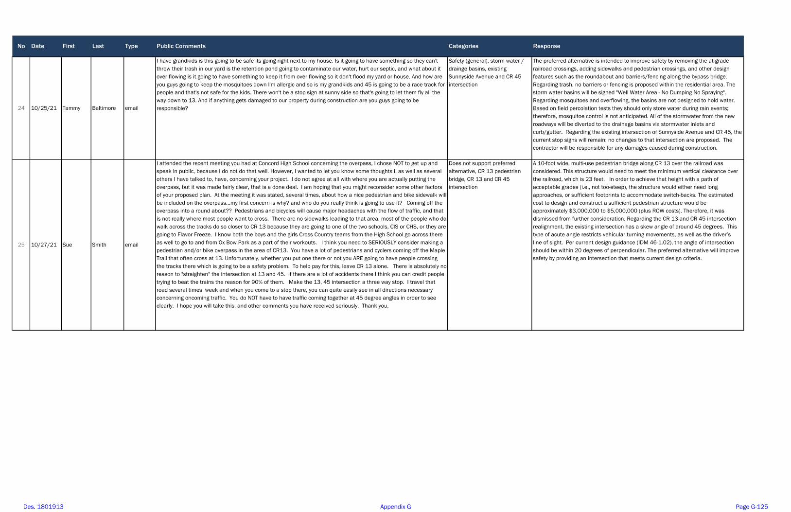
No Date First Last Type Public Comments Categories Response
24 10/25/21 Tammy Baltimore email
I have grandkids is this going to be safe its going right next to my house. Is it going to have something so they can't throw their trash in our yard is the retention pond going to contaminate our water, hurt our septic, and what about it over flowing is it going to have something to keep it from over flowing so it don't flood my yard or house. And how are you guys going to keep the mosquitoes down I'm allergic and so is my grandkids and 45 is going to be a race track for people and that's not safe for the kids. There won't be a stop sign at sunny side so that's going to let them fly all the way down to 13. And if anything gets damaged to our property during construction are you guys going to be responsible?
Safety (general), storm water / drainge basins, existing Sunnyside Avenue and CR 45 intersection
The preferred alternative is intended to improve safety by removing the at-grade railroad crossings, adding sidewalks and pedestrian crossings, and other design features such as the roundabout and barriers/fencing along the bypass bridge. Regarding trash, no barriers or fencing is proposed within the residential area. The storm water basins will be signed "Well Water Area - No Dumping No Spraying". Regarding mosquitoes and overflowing, the basins are not designed to hold water. Based on field percolation tests they should only store water during rain events; therefore, mosquitoe control is not anticipated. All of the stormwater from the new roadways will be diverted to the drainage basins via stormwater inlets and curb/gutter. Regarding the existing intersection of Sunnyside Avenue and CR 45, the current stop signs will remain; no changes to that intersection are proposed. The contractor will be responsible for any damages caused during construction.
25 10/27/21 Sue Smith email
I attended the recent meeting you had at Concord High School concerning the overpass, I chose NOT to get up and speak in public, because I do not do that well. However, I wanted to let you know some thoughts I, as well as several others I have talked to, have, concerning your project. I do not agree at all with where you are actually putting the overpass, but it was made fairly clear, that is a done deal. I am hoping that you might reconsider some other factors of your proposed plan. At the meeting it was stated, several times, about how a nice pedestrian and bike sidewalk will be included on the overpass...my first concern is why? and who do you really think is going to use it? Coming off the overpass into a round about?? Pedestrians and bicycles will cause major headaches with the flow of traffic, and that is not really where most people want to cross. There are no sidewalks leading to that area, most of the people who do walk across the tracks do so closer to CR 13 because they are going to one of the two schools, CIS or CHS, or they are going to Flavor Freeze. I know both the boys and the girls Cross Country teams from the High School go across there as well to go to and from Ox Bow Park as a part of their workouts. I think you need to SERIOUSLY consider making a pedestrian and/or bike overpass in the area of CR13. You have a lot of pedestrians and cyclers coming off the Maple Trail that often cross at 13. Unfortunately, whether you put one there or not you ARE going to have people crossing the tracks there which is going to be a safety problem. To help pay for this, leave CR 13 alone. There is absolutely no reason to "straighten" the intersection at 13 and 45. If there are a lot of accidents there I think you can credit people trying to beat the trains the reason for 90% of them. Make the 13, 45 intersection a three way stop. I travel that road several times week and when you come to a stop there, you can quite easily see in all directions necessary concerning oncoming traffic. You do NOT have to have traffic coming together at 45 degree angles in order to see clearly. I hope you will take this, and other comments you have received seriously. Thank you,
Does not support preferred alternative, CR 13 pedestrian bridge, CR 13 and CR 45 intersection
A 10-foot wide, multi-use pedestrian bridge along CR 13 over the railroad was considered. This structure would need to meet the minimum vertical clearance over the railroad, which is 23 feet. In order to achieve that height with a path of acceptable grades (i.e., not too-steep), the structure would either need long approaches, or sufficient footprints to accommodate switch-backs. The estimated cost to design and construct a sufficient pedestrian structure would be approximately $3,000,000 to $5,000,000 (plus ROW costs). Therefore, it was dismissed from further consideration. Regarding the CR 13 and CR 45 intersection realignment, the existing intersection has a skew angle of around 45 degrees. This type of acute angle restricts vehicular turning movements, as well as the driver’s line of sight. Per current design guidance (IDM 46-1.02), the angle of intersection should be within 20 degrees of perpendicular. The preferred alternative will improve safety by providing an intersection that meets current design criteria.
Des. 1801913 Appendix G Page G-125
J Port
Text Box
* Note - The duplicate comment (Nos. 4 and 15) was counted once. Therefore, a total of 24 comments were received.
Proposed Elkhart Local Trax Railroad Grade Separation Project Sunnyside Avenue over Norfolk Southern Railroad, Elkhart County, Des. No. 1801913
Public Testimony October 13, 2021
Ricardo Mirabal (0:00) First of all I’d like to thank everybody for giving me the opportunity to express myself. First of all, I think my personal opinion is that it’s an expensive disaster. I think it’s too complicated, too expensive to support this kind of project. If you look at the picture you have in your hands and you please follow me. Sadly look Mishawaka Road A at the corner of Main and 3. And then look across the train track where the stop sign is. Think for a moment about how simple it would be to bring together traffic from Mishawaka Road to cut across [CR] 13 by just doing two different things that can be done in the same area. Think for a moment about what they did at Indiana Avenue and all that and how easy and simple and cheap it was to get done. And then traffic moved very efficiently. And then look also back in time when in Goshen when they built that overpass many years ago and how easy, how practical for traffic to flow from downtown Goshen to cut across 13. That’s an overpass that is really practical. Cheap. Efficient. I propose that that’s the kind of idea that could be recommended on this area. If you look carefully at what I mentioned over here; if you put together Mishawaka Road with CR 13, on both sides of the train track, you have plenty of space to branch out left and right. And let traffic flow straight from one road to another and also branch out in both directions on both sides of the train tracks. I think this would be an idea that’s a lot cheaper, more practical, more efficient and would do the job and would affect the environment a lot less than this whole idea that is pictured over here. Okay? The second thing, and last, I want to mention is, right there on the corner of Jonas Street and CR 13, that’s my house right there. There is a cul-de-sac right there. I would like to invite these people to save the money. Please, don’t build the cul-de-sac right in front of my house. I don’t need that. I’m pretty sure my neighbors don’t like that kind of thing over there. A cul-de-sac. Why? Because right there on that corner is where we make the left or right to go to work. Why do you want to make me now that I have to drive 10 or 5 more minutes to ruin the environment just because you are closing, keeping me from having access to cut around CR 13? It’s a waste of money. It’s a waste of money. I don’t agree with having a cul-de-sac right there. Not just because it’s my house, just because it’s inefficient. It doesn’t do anything. It doesn’t add any value to the neighborhood, and I think we should just forget about having a cul-de-sac over there. Leave the road open so we can have access to it. The way now, that’s no money to do. That’s all I wanted to say. Thank you. George Kamiotes (3:54) Well good evening, everybody. This is the first time that I’m here to express my true opinions about the project that you guys are going to build. I don’t understand for what purpose. It’s not helping the community. It’s a disaster. I don’t know who are the engineers that they afford this project. To me it’s like a labyrinth like we call in my country. Which means you’re going to get lost out there. It’s a disaster. It’s not going to help the pedestrians from CR 13 to come all the way to Concord. And it affects me too. I’m a small business operator and I’ve been here in this area for 33 years and I’m helping the community and everything else. Back in 2011, if I remember correctly, we took part of my property on the road to build a better sidewalk. I don’t know for what; nobody uses it. Unless if you, now that we have the drive. And it took me about two-and-a-half years to collect $40,380. But I lost thousands and thousands and thousands of dollars in revenues. And every year the traffic goes up and up and up. And I striving a day, especially after COVID-19, to stay open. And here we have engineers from different states coming to Elkhart County to hear their ideas about how they’re going to save and create what? $30 million project? To do what? So we can destroy the Concord Mall? Concord Mall was beautiful when I came here. Now we destroy everything. This is the management. I thought the Martins moved 40 feet down from where it they was, I don’t know the reason. And JoAnn Fabrics going to take over, but before they knew the inside information, the building right next to me, they went here. First they bought it, then they introduced themselves, “Oh yeah, we want to be neighbors.” And then they painted and they disappeared. Why? Because they got the inside information that they’re going to get some money from the government, whoever is building this project. So they disappeared. Everybody’s disappearing. Very soon we’re not going to have any restaurants around here. I want you guys to understand. We’re going to have ghosts on the highways and you’re going to have, of course, not money, because they tried to eliminate that. But it’s a disaster. I don’t want this project.
Des. 1801913 Appendix G Page G-126

Page 2
Heinz Grubert (7:40) Hello neighbors. I’m very much concerned about groundwater contamination and these retention ponds, especially that are going to be around my property. They’re taking, I’m not really sure exactly, but they’re going to be taking quite a few square feet of my property. I own on the other side of Mary Street; I’m right there on CR 13. I don’t know if you’ve noticed the lots have been getting cleaned up over there. And now they’re going to come in and take possession of it. And I see these great big retention ponds and I’m concerned about all the wells that are in that area of groundwater contamination. You guys are concerned about the aquifer. I want to know what assessments have been done about people’s wells and the groundwater contamination. It’s bad enough when they come in and they say, “We’re going to take possession of your property.” When you get cautioned by them as well to not, really don’t protest, because it could get too financially straining on you if you try to litigate something like this. And the old saying is, “You can’t fight City Hall.” The wisdom, I can understand making some bicycle paths and making pedestrian traffic along here because it is a concerning thing when people are riding their bikes along there and people are traveling from there to go to the park, to go to the bikeway. Those are reasonable considerations. Moving traffic across and maybe making an overpass somewhere. I agree with my neighbors that it should be considered somewhere else. I agree with Ricardo that the cul-de-sacs; how many decades has Sunnyside been there since it was built? And there’s been no need for cul-de-sacs. And through traffic, if people are on that road. The one consideration that we could give is maybe closing down that crossing and then you can turn right and you can turn left. And I know you folks might not know Bob Lamude who lived on the corner of Linden and CR 13 on the northeast corner. Well, he wanted to liquidate all his property. And water collects right there at Linden on the northeast corner of Linden, and they could put retention ponds there and Bob would have been happy to liquidate his property to them. I don’t know if all these things have been considered carefully and these things concern me. And, as far as compensation, we’re in the dark. We don’t know what we’re going to be compensated. We don’t know if it’s going to be fair and equitable. We just don’t know. We heard that, “Yeah, it will be fair and equitable.” I’ve had some assurances from Kenny Franklin. And he’s a believable man. He’s a kind man. He’s a gentle man. But I still haven’t heard anyone coming around say when these things are going to be reached. I’m still not really sure when these subjects are going to be breached. Thank you. Jill Grubert (11:10) My main question is, “Why can’t you just leave 13 alone?” Close the crossing. Make a left-hand turn and a right-hand turn lane. Linden is a joke and that’s going to be a through road? Because there’s a 90-degree turn as you’re going down toward Oxbow School and Oxbow told us at one time one year, in winter, we couldn’t even go down that because it’s so narrow. And people, residents, said their mailboxes were being hit. I don’t know how this is bettering CR 13 and 45. You said there was a high rate of crashes? How many would that be? Do you have a number? Do you have a number for those highway crashes that you said there were? I have down that there were three last year. To me that’s not a high rate. There’s still lots of accidents at CR 17 and 18, with them even bettering that intersection. So I don’t know if this is going to better 13 or 45. The retention ponds. Will they have fences? Will they be mowed? Will the trees be cut down? Mosquitoes in the summertime? Our new driveway is said to be put on Old 13 because a retention pond is going to be where our driveway is now. So that means water, when it rains, will come down the driveway right into our garage. And what ticks me off is that you guys don’t even live here. We couldn’t even look for property because those in authority have not said what we can expect from our property. Will the roundabout be empty in the center? Or will there be construction of some kind? Do you know that? Some of them have things in the center and you can’t see through it. So that would be a concern. Jim Weeber (14:44) Good evening, ladies and gentlemen. This thing was bungled from early on when property that was already owned by the county was transferred to the school system for the bus barn. And unfortunately it has resulted in a Rube Goldberg situation. So at this point I guess I just have questions about this situation. You said two, 12-foot lanes and then you would have aprons on either side for pedestrian traffic and I assume bicycles. Is there anything that protects them from the vehicular traffic on your bridge that you will be constructing? So there’s a question. What are you going to do with the snow? The roundabout, you mentioned 55-foot vehicles. The standard semi trailer is now 53 feet. And another thing you’re doing, my previous fire chief was solicited by the engineering firm
Des. 1801913 Appendix G Page G-127

Page 3
to write a letter in support of this particular choice, but you will be taking all of the hazardous materials that normally traverse our major roads into a residential area. And there’s a number of semis and large trucks that serve Wilden Avenue. I have no idea how many large trucks a day make it down Wilden Avenue, but it’s a high number. And, you know, whatever’s in those trucks, some of those are dangerous, hazardous materials. Another issue, Concord Fire Paramedic Service in the month of September, made 187 calls in the Concord Township area. Approximately 80 percent of our calls are medical calls. That means 149 of these calls were likely medical. It’s really important that we get where we want to go when we need to get there. The American Heart Association will tell you that today with the technology that we have in a paramedic ambulance, seconds count. And I hope that you never have to spend time in the back of one of those. But I’m telling you, there’s a lot of things that happen in that ambulance between the scene of whatever happened and the hospital. So it’s pretty important we get where we want to go when we want to get there. This situation, an accident plus this, and then we have to go around to wherever we have to go to get around it. Now we do have that situation with the railroad now, I’ll give you that. But so far we’ve been able to navigate those situations at this point. Now furthermore, if it’s a serious accident, it will be shut for hours. And another question, you know your studies indicate two lanes will handle this. But right now there’s five lanes here that are functioning and you’re going to put all that traffic on two lanes. The other night, when I was crossing the railroad, there were a group of girls, probably from the high school. Is cross country running now? Ok a group of girls, probably the cross country team came from Concord School, were pedestrians at the CR 13 crossing, probably going to Oxbow. Maybe they were going to run on the bike trail, I never see that though. I think they were going to Oxbow. The fact that you have not decided that you’re going to put a pedestrian elevated walkway across the railroad here is a big disservice to this community. This needs to go to your engineering people. Paul Hapner (19:38) I noticed today that you put down your counters for traffic there at CR 45 and Sunnyside and I’m thinking, “You haven’t done a study of the traffic in this area?” Just like the gentleman said, you’re going to put traffic coming from Elkhart on SR 33; the businesses and all the traffic coming from Goshen on SR 33 onto two lanes of traffic, all this traffic going down to CR 13 into a stoplight. Whereas right now they can go across Sunnyside, across CR 13, and get to where they’re going. That stoplight’s going to create a huge traffic jam from all the traffic going in and out of the subdivisions and neighborhoods. And they’re going to be backed up all the way to the bypass because it’s not going to be enough to handle everybody. Right now the traffic from CR 45 services partially from Walmart, and Meijer’s, and Lowe’s and those businesses; that brings it down to CR 13 and they go into their neighborhoods. The other way comes from Elkhart on CR 45 they turn on Sunnyside to go down and it’s stop-and-go, but traffic moves. CR 13, once you cross the railroad tracks, it’s stop-and-go but traffic moves. When you combine all that traffic onto just two lanes in one spot, traffic is not going to go. It’s going to come to a standstill. I would suggest that either build a roundabout at Sunnyside and CR 13 or make it a three-way stop sign and not a stop light so the traffic can keep flowing. And I would suggest you leave the CR 13 crossing the way it is so that we can cross there coming from Walmart, Meijer’s, Harden’s and all those businesses and then navigate Sunnyside when we get there. That would be my suggestion. Leave it open and then when the trains, and this is convenient for the railroad; don’t let anyone fool you; they can park their trains there day after day after day. And it’s inconvenient for the citizens in that area that if CR 13 crossing remains where it is, we could go. And if the train is there to block it we can use the bypass. I think it’s a good idea.
Des. 1801913 Appendix G Page G-128
Page 4
Carolyn Goddert (23:25) I’d like to address mobility and safety issues. Mobility can be maximized the most only if both crossings at Sunnyside and CR 13 were left open and a roundabout was put it. There are not many pedestrians from CR 13 onto Sunnyside and across to the mall at the train crossing, so I don’t think a sidewalk is necessary there. Even though the angle at the intersection at CR 13 is awkward, eternal vigilance is priceless freedom. In other words, look both ways twice before crossing on foot, on bicycle or whatever vehicle. Safety is not solely the government’s responsibility; it is an individual’s. If the fire engines, and/or tankers were needed from the CR 18 fire station in the north to assist on the south side of the tracks, three ways would be left open if the roundabout was constructed and both crossings were left open. Thank you. Lauren Whalen (24:40) I am of the benefit that I live in the River Manor area and I’m a little north of this so it’s not as important, obviously, as people who wells and property that is affected. However, I am a Concord parent. I have a child that goes to the high school, and I’ve seen every day, kids that walk to the high school, kids that walk to CIS and to be honest, this is not a path that they can take to get to school. They are not going to. I mean that is a long way out of the way to walk to school. We do have some busing but it doesn’t work for everybody. This whole area pushes everything so far away from our school that I don’t understand why you wouldn’t have a pedestrian bridge just for the kids to get to school. Because really, closing all these streets along CR 45 only benefits the railroad. Purely the railroad. We have no benefit from that. I was under the understanding that Hively was going to get an underpass/overpass, whatever they decide there and then we weren’t going to touch CR 13 or Sunnyside. So I’m actually finding out today that now we’re closing off all of our access here and the part about that that actually has the most residential. Like it’s great for Hively, that’s Elkhart City. That’s not us. For down here, in our residences, we need to be able to get across. There are hundreds and hundreds and hundreds of homes here that have children that go to Oxbow, go to CIS, go to the high school. And, I guess as a parent of a teenage driver who just hit somebody’s mailbox (we replaced it), but I am concerned for my child to come out here and go around this roundabout. There’s a lot of confusing things and now we’re throwing semis in with it because the traffic on Wilden is a problem with the semis because they always cross on Sunnyside. This becomes a danger for younger kids. And I can absolutely see this becoming a one-way bottleneck if an accident happens. Because this is going to freeze over in the winter too. So when this gets bottlenecked here; how high is this going to be as well? Is this going to be like in Goshen where they did the 33 overpass? Because I feel like that ruined the aesthetic of the community. It cut it apart. Like I don’t want that for our community. This is a really nice, tight, residential community. We don’t have a lot of businesses here. That’s why we have referendum issues too. But we’re mostly residential and our first concern should be for the kids, the safety of the kids and making sure that our public works can get to where they need to be. Thank you. Jerry Barrett (28:20) My concern is that you’re going to close Sunnyside crossing. You’re going to close the CR 13 crossing. And then you’re going to put a two-lane road down Sunnyside and across everything there. You’re diverting two crossings; you’re going to be diverting all this extra traffic over a two-lane road there. And I think it should be a lot wider than just two lanes crossing. That’s all I have to say. Doug Bechtel (29:41) I have to agree with a lot of you people that’s made comments tonight. And I tell you what, I’ve lived out here my entire life. I’ve lived on both sides of the tracks and I’ll tell you what, this is the biggest joke that’s ever been created. I mean, you cannot, 13….I live up in River Manor like a lot of the other people here and I’ll tell you what, there’s mornings that you can sit there forever trying to get out of the subdivision because traffic’s backed up. You come down there and you can’t go down Sunnyside because there’s a train there. You can’t go down CR 45 because you can’t get to it. So I think you need to relook at everything that you’ve done. The traffic problem here is just as bad as it was in Goshen. And I tell you, I’ve rode that overpass in Goshen there and that’s a big joke, especially in the morning. Traffic’s backed up both ways. You’ve got the school there and
Des. 1801913 Appendix G Page G-129

Page 5
we’re going to have the same thing going on out here. People are not going to be able to move where they need to go and where they need to be. Talk about water contamination? I used to own a house right next to Bontrager Pools and I know what contamination is. I had 98 parts/billion of benzene and [inaudible] in my water there. And I got ahold of the county and the state and nobody would do anything about it. So you people that are worried about this, I tell you, you’ve got a big problem coming because it is out there. And it’s going to happen because you’re going to have the runoff going in there off the vehicles and everything else. Oil and gas and somebody sitting there and it’s dripping out of the bottom of their tank on their car, their oil, whatever, it’s going to contaminate the ground. And then what are you going to have to do? You’ll have to join the City of Elkhart so that we have water, just like the school did. Over there where they put that bus depot, that’s a big waste. You know they needed to have that thing come straight down Mishawaka Road but oh, we can’t do that because we’ve got people that think they’ve got better ideas than what we do out here. That’s lived out here our entire life. They talk about what you’ve going to get. You’ll probably get a nice, big goose egg on a lot of that. My mom lived on 33 and they allowed her so much money, very little for the property. They took 15 foot off the front one time, then they came back and took another 15 foot and got very little. So you people that’s worried about what’s going to happen to you, it’s going to happen. And it’s time to stand up and yell at the county and the state about what’s happened here. It’s over and done with. That’s all there is to it. That’s all I’ve got to say. Stan Miller (32:54) Good evening. Generally, I’m in favor of roundabouts. I think it moves traffic. It is safer as noted in bureau statistics. Speeds are decreased. I don’t know if any of you are familiar with Carmel, Indiana. I have a couple of kids living in Carmel and I think they move a lot of traffic very efficiently. My concern with this roundabout is pedestrian safety. We seem to be funneling all of our pedestrians over the overpass into this roundabout. And as noted, there are pedestrian crossings, but I don’t think they’re very safe. Because I go into a roundabout, and I’ve worried about traffic coming from the left. And I’m worried about getting bashed from the rear. The last thing I’m thinking about is a pedestrian walking, crossing my path a little ways away from the actual circle. And so I would really appeal for some safety consideration for pedestrians, especially in that area. Thank you. Unknown (34:42) When will our comments be answered? Facilitator: We will stay here and answer everyone’s questions. We will also answer everyone’s questions and respond to everyone’s comments in writing in the document. Jim Weeber (34:57) A couple of short items and then I’ll leave you alone. I believe when I was cut off I was talking about the pedestrian elevated walkway across the railroad tracks. I think if you’re going to go this way, that’s very necessary. To cut our kids off from getting to Oxbow Park for various activities is not a good idea. Additionally, occasionally I’m out running the road at night, being trustee of the township, and kind of looking over what I’m responsible for, it’s not uncommon to see pedestrians on CR 13 and you know they cross the railroad tracks. You really want them scooting under the railroad cars that are parked there? One of the reasons you folks aren’t getting a lot of satisfaction here is this [Local] Trax money is about shutting those railroad crossings so that they can extend the yard southeast of Elkhart. Now, Warren Buffett does not own the railroad tracks, but he is majority interest of many of those trains that go down the tracks. And there are many vested interests involved here, but I think the interests of the people in Concord Township and Elkhart County have to be the major priority here. Now the last thing I’ll say, and I know the folks at Bontrager Pools and NAPA work hard. They pay a lot of taxes. But probably the only way to fix this thing now, and only if they’d be agreeable to being bought out, is to go straight down CR 13. You make the apex of the construction far enough to the north that you can get the slope that you want to get down US 33. And you have left- and right-hand turn lanes and the straight lanes. And I realize that’s likely not going to happen, but I was completely appalled when the bus barn was built where it is at because that’s where it should have went. And a lot of the property was already owned to do it. So I realize the construction firms pocket a lot of money here. The engineering is 10-15% of the project and the more I learn about politics, the more put out I am. But I think that’s all I’ve got to say for now for what it’s worth. But I think you ought to take some of these comments pretty seriously.
Des. 1801913 Appendix G Page G-130

Page 6
And the folks in Sunnyside, there’s some of you here old enough to remember it. They were blown away during the Palm Sunday tornadoes. They’ve paid their dues. Now you’ve got this coming along hammering on some of the prodigy of those folks. And this isn’t funny. I’ve been through this eminent domain thing big time twice and I know what happens when you can’t defend yourself. So I’m urging Frank Lucaise to make sure these people are treated properly. And there’s books about that, that people who are taken by eminent domain, there was a big study done that they should have 150% of what’s considered to be the fair market value of the take. And I think they really ought to happen. Thank you. You know you should not talk when people are speaking eloquently and properly. Because this is a deviated version of divide and conquer, which is as old Caesar. So that’s all I’ve got to say. Thank you very much folks.
Des. 1801913 Appendix G Page G-131
1
From: Miller, Daniel JSent: Tuesday, October 5, 2021 8:03 AMTo:Subject: Fwd: [EXTERNAL] ELKHART LOCAL TRAX RAILROAD GRADE SEPARATION AT SUNNYSIDE
AVE./CONCORD MALL DR. AND CR 13
From: Tim Koontz < Date: October 4, 2021 at 9:16:16 PM EDT To: "Miller, Daniel J" <[email protected]> Subject: [EXTERNAL] ELKHART LOCAL TRAX RAILROAD GRADE SEPARATION AT SUNNYSIDE AVE./CONCORD MALL DR. AND CR 13
My family just got the mailer about this project and we couldn't be more excited. I have lived in the Concord area my whole life and have always seemed to be "on the wrong side" of the tracks. I hope this goes through smoothly and you can't break ground soon enough!
Thanks!
Tim Koontz
'NOTICE: This email message and all attachments transmitted with it may contain privileged and confidential information, and information that is protected by, and proprietary to, Parsons Corporation, and is intended solely for the use of the addressee for the specific purpose set forth in this communication. If the reader of this message is not the intended recipient, you are hereby notified that any reading, dissemination, distribution, copying, or other use of this message or its attachments is strictly prohibited, and you should delete this message and all copies and backups thereof. The recipient may not further distribute or use any of the information contained herein without the express written authorization of the sender. If you have received this message in error, or if you have any questions regarding the use of the proprietary information contained therein, please contact the sender of this message immediately, and the sender will provide you with further instructions.'
Des. 1801913 Appendix G Page G-132

1
Port, Juliet
From: Miller, Daniel JSent: Tuesday, October 5, 2021 8:03 AMTo: Lee, Alexander; Port, Juliet; Jagger, EricSubject: Fwd: [EXTERNAL] Dunlap Overpass
Sent from my iPhone
Begin forwarded message:
From: Chris Godlewski <[email protected]> Date: October 4, 2021 at 1:33:32 PM EDT To: "Miller, Daniel J" <[email protected]>, Charlie McKenzie <[email protected]> Subject: [EXTERNAL] Dunlap Overpass
To whom it may concern,
Daniel, Elkhart County Planning & Development is in full support of the Dunlap Overpass project as presented. It not only removes cars from traversing a rail crossing but it also allows for another pedestrian and bike access across US 33 (and the rail tracks) where few exist. This makes everybody safer.
One question – who maintains the 6’ sidewalk on the bridge when it snows out? I would believe this will be a path in all seasons which includes school children. Just asking how it would be maintained during inclement weather. Thanks!
Best of luck navigating the process with this project.
Chris Godlewski Elkhart County Plan Director 4230 Elkhart Road Goshen, In 46526 574‐971‐4579 (o) [email protected] www.elkhartcountyplanninganddevelopment.com [elkhartcountyplanninganddevelopment.com]
Des. 1801913 Appendix G Page G-133
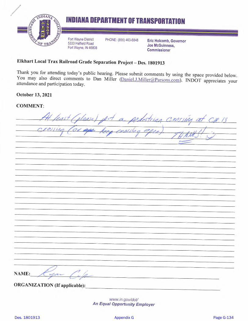
Des. 1801913 Appendix G Page G-134

Des. 1801913 Appendix G Page G-135

Des. 1801913 Appendix G Page G-136

Des. 1801913 Appendix G Page G-137

Des. 1801913 Appendix G Page G-138

Des. 1801913 Appendix G Page G-139

From:To:Subject: [EXTERNAL] Re: Sunnyside overpassDate: Friday, October 15, 2021 6:57:53 AM
My family lives on Sunnyside Ave, east of CR 13. My question is: How do the folks who live on East Sunnyside Ave, east of CR 13, have access to CR 13 if a stoplight is put at Sunnyside Ave and CR 13? Sunnyside jogs to the north when it crosses CR 13. There is no room for us to make a left turn into CR 13 with a light there. Traffic is horrendous on CR 13 now. How on earth are we supposed to turn south or go left on CR 13 with a traffic light only a few feet from East Sunnyside Ave? There has to be a better design. Seems like the Sunnyside area has always got the short end of the stick. Traffic will move from being jammed up at the present 2 railway crossings to the end of my street on CR 13!
Sincerely,
Marvin and Penny Olson
Elkhart, IN 46516
Des. 1801913 Appendix G Page G-140
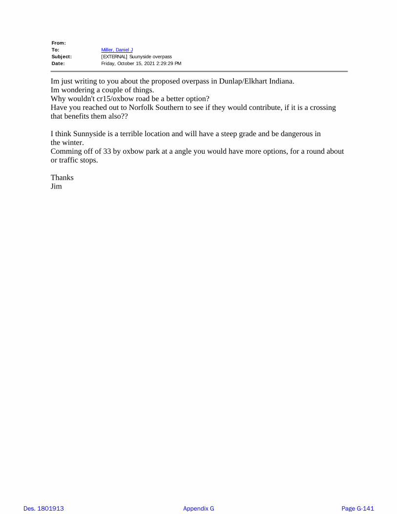
From:To:Subject:Date:
Miller, Daniel J[EXTERNAL] Suunyside overpass Friday, October 15, 2021 2:29:29 PM
Im just writing to you about the proposed overpass in Dunlap/Elkhart Indiana.Im wondering a couple of things. Why wouldn't cr15/oxbow road be a better option?Have you reached out to Norfolk Southern to see if they would contribute, if it is a crossingthat benefits them also??
I think Sunnyside is a terrible location and will have a steep grade and be dangerous inthe winter.Comming off of 33 by oxbow park at a angle you would have more options, for a round aboutor traffic stops.
Thanks Jim
Des. 1801913 Appendix G Page G-141

From:To:Subject:Date:
Miller, Daniel J[EXTERNAL] Elkhart Local Trax Grade Separation Project Tuesday, October 19, 2021 10:25:55 AM
Dear Mr. Miller
I attended the October 13, 2021 INDOT presentation at Concord High School in Elkhart. Please findbelow my feedback to the presentation.
Comments to the Elkhart Local Trax Grade Separation Project Concord Mall Proposal
My comments are focused on two areas of concern:1. Safety2. Environmental
SafetyA tall physical barrier between sidewalk pedestrians on the bridge and roadway traffic is not included in the engineering plans. A barrier will mitigate pedestrian injuries from vehicles which may
go out of control on rain or snow slickened travel lanes. What governmental agency will be tasked to
clear snow and ice off the bridges’ sidewalks?Currently, lights are not planned for the bridge over US 33. In my opinion, this is a safety hazard for pedestrians or bicyclists who may traverse the bridge after dark. Additionally, it is a potential hazard
for motorists who may have to fix a flat on a dark, ice slickened bridge.
EnvironmentalDrainage from the newly constructed bridge and roadway is designed to be collected in the
proposed retention ponds. There were no plans expressed to monitor the effect of this surface
water on the quality of local groundwater.
Best RegardsLawrence Burns
Elkhart, Indiana 46517
Sent from XXX for Windows
Des. 1801913 Appendix G Page G-142

From:To:Subject:Date:
tammy baltimore Miller, Daniel J[EXTERNAL] elkhart rr separation,sunnyside ave over norfolk Monday, October 25, 2021 7:52:53 PM
i have grandkids is this going to be safe its going right next to my house.is it going tohave something so they cant throw their trash in our yard is the retention pond goingto contaminate our water,hurt our septic,and what about it over flowing is it going tohave something to keep it from over flowing so it dont flood my yard or house.andhow are you guys going to keep the mosquitoes down im allergic and so is mygrandkids.and 45 is going to be a race track for people and thats not safe for the kidstheir wont be a stop sgin at sunny side so thats going to let them fly all the way downto 13. and if anything gets damaged to our property during construction are you guysgoing to be responsible
Des. 1801913 Appendix G Page G-143
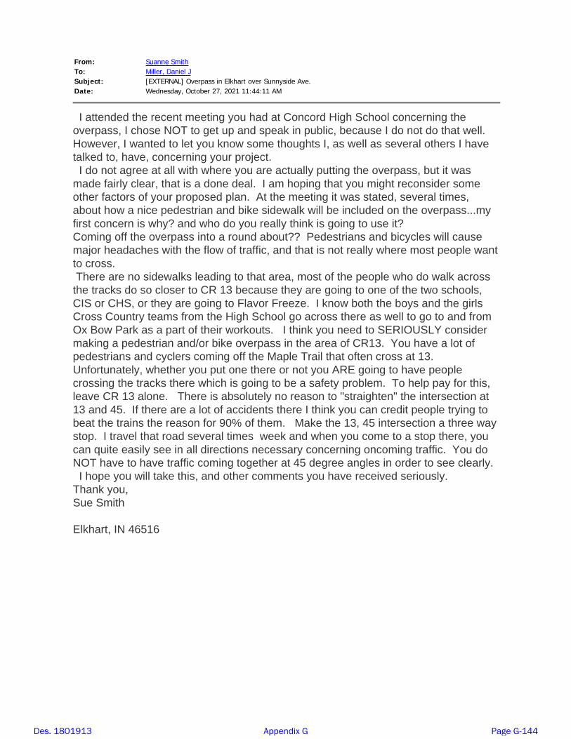
From:To:
Suanne Smith Miller, Daniel J
Subject: [EXTERNAL] Overpass in Elkhart over Sunnyside Ave.Date: Wednesday, October 27, 2021 11:44:11 AM
I attended the recent meeting you had at Concord High School concerning the overpass, I chose NOT to get up and speak in public, because I do not do that well. However, I wanted to let you know some thoughts I, as well as several others I have talked to, have, concerning your project. I do not agree at all with where you are actually putting the overpass, but it was made fairly clear, that is a done deal. I am hoping that you might reconsider some other factors of your proposed plan. At the meeting it was stated, several times, about how a nice pedestrian and bike sidewalk will be included on the overpass...my first concern is why? and who do you really think is going to use it? Coming off the overpass into a round about?? Pedestrians and bicycles will cause major headaches with the flow of traffic, and that is not really where most people want to cross. There are no sidewalks leading to that area, most of the people who do walk across the tracks do so closer to CR 13 because they are going to one of the two schools, CIS or CHS, or they are going to Flavor Freeze. I know both the boys and the girls Cross Country teams from the High School go across there as well to go to and from Ox Bow Park as a part of their workouts. I think you need to SERIOUSLY consider making a pedestrian and/or bike overpass in the area of CR13. You have a lot of pedestrians and cyclers coming off the Maple Trail that often cross at 13. Unfortunately, whether you put one there or not you ARE going to have people crossing the tracks there which is going to be a safety problem. To help pay for this, leave CR 13 alone. There is absolutely no reason to "straighten" the intersection at 13 and 45. If there are a lot of accidents there I think you can credit people trying to beat the trains the reason for 90% of them. Make the 13, 45 intersection a three way stop. I travel that road several times week and when you come to a stop there, you can quite easily see in all directions necessary concerning oncoming traffic. You do NOT have to have traffic coming together at 45 degree angles in order to see clearly. I hope you will take this, and other comments you have received seriously. Thank you, Sue SmithElkhart, IN 46516
Des. 1801913 Appendix G Page G-144