appendix c: borderlands wind project plan of development
466
Borderlands Wind Project Final EIS and Proposed RMP Amendment March 2020 Appendix C: Borderlands Wind Project Plan of Development APPENDIX C: BORDERLANDS WIND PROJECT PLAN OF DEVELOPMENT
-
Upload
khangminh22 -
Category
Documents
-
view
2 -
download
0
Transcript of appendix c: borderlands wind project plan of development

Borderlands Wind Project Final EIS and Proposed RMP Amendment March 2020 Appendix C: Borderlands Wind Project Plan of Development
APPENDIX C: BORDERLANDS WIND PROJECT PLAN OF DEVELOPMENT

Borderlands Wind Project Final EIS and Proposed RMP Amendment March 2020 Appendix C: Borderlands Wind Project Plan of Development
Page Left Intentionally Blank

Borderlands Wind Project Plan of Development
Submitted to
Bureau of Land Management Socorro Field Office
Submitted by
Borderlands Wind, LLC
March 2020

BORDERLANDS WIND PROJECT PLAN OF DEVELOPMENT
Submitted to
Bureau of Land Management Socorro Field Office
901 South Old U.S. Highway 85 Socorro, New Mexico 87801
Project Case File: NMNM136976
Submitted by
Borderlands Wind, LLC 700 Universe Boulevard (E5E/JB)
Juno Beach, Florida 33408
March 2020 (rev)

Borderlands Wind Project Plan of Development
POD-i
CONTENTS ACRONYMS AND ABBREVIATIONS ....................................................................................... POD-iv
1 PROJECT DESCRIPTION ....................................................................................................... POD-1 1.1 Introduction ........................................................................................................................... POD-1
1.1.1 Project Location ......................................................................................................... POD-2 1.2 Purpose and Need of the POD ............................................................................................... POD-2
1.2.1 Project Objectives ...................................................................................................... POD-3 1.3 General Facility Description ................................................................................................. POD-3
1.3.1 Alternatives ................................................................................................................ POD-4 1.3.2 Number and Size of Wind Turbines ........................................................................ POD-14 1.3.3 Ancillary Facilities ................................................................................................... POD-17 1.3.4 Related Facilities ...................................................................................................... POD-24 1.3.5 Disturbance Estimates by Alternative ...................................................................... POD-25
1.4 Additional Design Criteria and Mitigation Measures ......................................................... POD-27 1.5 Other Federal, State, and Local Agency Permit Requirements ........................................... POD-28 1.6 Financial and Technical Capacity of the Applicant ............................................................ POD-29 1.7 Preconstruction Activities ................................................................................................... POD-29
1.7.1 Geotechnical Studies ................................................................................................ POD-29 1.7.2 Site Preparation, Surveying, and Staking ................................................................ POD-30
2 CONSTRUCTION OF FACILITIES ..................................................................................... POD-30 2.1 Site Clearing and Grading ................................................................................................... POD-31 2.2 Access Road Improvement .................................................................................................. POD-31 2.3 Construction Laydown Area ............................................................................................... POD-34
2.3.1 Concrete Batch Plant ............................................................................................... POD-34 2.4 Component Delivery ........................................................................................................... POD-35 2.5 Tower Foundation Excavation and Installation ................................................................... POD-36 2.6 Tower Assembly ................................................................................................................. POD-38 2.7 Tower Erecting and Installation .......................................................................................... POD-39 2.8 Installing Underground Collection Lines ............................................................................ POD-43 2.9 Installing Meteorological Towers ....................................................................................... POD-45 2.10 Constructing Electrical Substation and Switchyards ........................................................... POD-45 2.11 Constructing the Operations and Maintenance Building ..................................................... POD-46
2.11.1 Constructing the Septic Tank ................................................................................... POD-46 2.11.2 Construction the Water Well ................................................................................... POD-46
2.12 Constructing the Distribution Line ...................................................................................... POD-47 2.13 Inspecting the Facilities ....................................................................................................... POD-47 2.14 Site Stabilization, Protection, and Reclamation Practices ................................................... POD-47 2.15 Additional Construction Considerations ............................................................................. POD-47
2.15.1 Construction Workforce Numbers, Vehicles, Equipment, and Time Frames .......... POD-47 2.15.2 Water Usage, Amounts, Sources ............................................................................. POD-48 2.15.3 Erosion Control and Stormwater Drainage .............................................................. POD-49 2.15.4 Vegetation Restoration and Weed Management ...................................................... POD-49 2.15.5 Health and Safety ..................................................................................................... POD-49 2.15.6 Aviation Lighting ..................................................................................................... POD-51 2.15.7 Construction Design Criteria and Mitigation Measures .......................................... POD-52

Borderlands Wind Project Plan of Development
POD-ii
3 OPERATIONS AND MAINTENANCE ................................................................................ POD-55 3.1 Operations and Facility Maintenance Needs ....................................................................... POD-55
3.1.1 Maintenance Activities, including Road Maintenance ............................................ POD-55 3.1.2 Operations Workforce, Equipment, and Ground Transportation ............................. POD-55
3.2 Operations Design Criteria and Mitigation Measures ......................................................... POD-56
4 PROJECT DECOMMISSIONING ........................................................................................ POD-56
5 ENVIRONMENTAL CONSIDERATIONS .......................................................................... POD-56 5.1 General Description of Site Characteristics and Potential Environmental Concerns .......... POD-56
5.1.1 Land Use .................................................................................................................. POD-57 5.1.2 Biological Resources ............................................................................................... POD-57 5.1.3 Cultural Resources ................................................................................................... POD-61 5.1.4 Noise ........................................................................................................................ POD-61 5.1.5 Air Quality ............................................................................................................... POD-62 5.1.6 Jurisdictional Waters and Wetlands ......................................................................... POD-64 5.1.7 Visual Quality .......................................................................................................... POD-64
6 LITERATURE CITED ............................................................................................................ POD-65

Borderlands Wind Project Plan of Development
POD-iii
Appendices
The appendix documents are not included herein, but can be viewed and downloaded at: https://eplanning.blm.gov/epl-front-office/eplanning/planAndProjectSite.do?methodName=dispatchTo PatternPage¤tPageId=171852
Appendix A. Site Plans Appendix B. Legal Descriptions Appendix C. Alternatives Considered by Borderlands Wind Appendix D. Stormwater Pollution Prevention Plan Appendix E. Integrated Reclamation Plan Appendix F. Health and Safety Plan, including:
• Attachment 1: Emergency Action Plan• Attachment 2: Waste and Hazardous Materials Management Plan• Attachment 3: Fire Protection and Prevention Plan
Appendix G. Spill Prevention, Control, and Countermeasure Plan Appendix H. Design Criteria Appendix I. Blasting Plan Appendix J. Road Design, Traffic and Transportation Plan Appendix K. Flagging, Fencing, and Signage Plan Appendix L. Decommissioning Plan Appendix M. Bird and Bat Conservation Strategy, including Eagle Management Plan Appendix N. Cultural Properties Treatment Plan Appendix O. Dust Control and Air Quality Plan Appendix P. Environmental Construction Compliance Monitoring Program
• Attachment 1: Certification of Completion of Worker Environmental Awareness Program• Attachment 2: Monitoring Report Cover Page Form• Attachment 3: Monitoring Report Form• Attachment 4: Variance Request Form• Attachment 5: Agency Compliance Monitor Weekly / Monthly Report• Attachment 6: Key Compliance Contacts• Attachment 7: Variance Acreage Table• Attachment 8: Borderlands Wind Compliance Plan Variance Determination Matrix And
Variance Examples• Attachment 9: Wildlife Trenching Plan

Borderlands Wind Project Plan of Development
POD-iv
Figures
Figure 1. Proposed Action alternative boundary.................................................................................. POD-7 Figure 2. Land ownership of the Proposed Action alternative. ............................................................ POD-8 Figure 3. Proposed locations for the wind turbine generators and ancillary facilities under the
Proposed Action. ....................................................................................................................... POD-9 Figure 4. Alternatives 1 and 2 project boundary. ............................................................................... POD-10 Figure 5. Land ownership of Alternatives 1 and 2. ............................................................................ POD-11 Figure 6. Proposed locations for the wind turbine generators and ancillary facilities under
Alternative 1. ........................................................................................................................... POD-12 Figure 7. Proposed locations for the wind turbine generators and ancillary facilities under
Alternative 2. ........................................................................................................................... POD-13 Figure 8. Typical pad-mounted transformer. ..................................................................................... POD-15 Figure 9. Schematic and dimensions of a GE 2.3-MW turbine. ........................................................ POD-15 Figure 10. Schematic and dimensions of a GE 2.5-MW turbine. ...................................................... POD-16 Figure 11. Schematic and dimensions of a GE 3.0-MW turbine. ...................................................... POD-16 Figure 12. Typical collection lines. .................................................................................................... POD-18 Figure 13. Typical substation. ............................................................................................................ POD-19 Figure 14. Type of distribution line pole to be installed. ................................................................... POD-20 Figure 15. Typical O&M building. .................................................................................................... POD-21 Figure 16. Typical monopole meteorological tower. ......................................................................... POD-22 Figure 17. Typical storage/staging/laydown area during construction. ............................................. POD-23 Figure 18. Typical temporary concrete batch plant. .......................................................................... POD-24 Figure 19. Typical borrow pit. ........................................................................................................... POD-25 Figure 20. Proposed U.S. 60 and Bill Knight Gap Road intersection improvement.......................... POD-32 Figure 21. Turbine tower delivery truck. ........................................................................................... POD-36 Figure 22. Excavating foundation hole. ............................................................................................. POD-37 Figure 23. Excavated foundation area. ............................................................................................... POD-37 Figure 24. Foundation rebar and bolt cage. ....................................................................................... POD-38 Figure 25. Typical spread-footing foundation. .................................................................................. POD-38 Figure 26. Turbine erection. ............................................................................................................... POD-39 Figure 27. Aerial view of preparations to erect a wind turbine tower. .............................................. POD-40 Figure 28. Wind turbine nacelle installation. ..................................................................................... POD-40 Figure 29. Rotor assembly. ................................................................................................................ POD-41 Figure 30. Installation of a rotor on a General Electric 1.5-MW wind turbine. ................................. POD-41 Figure 31. Wind turbine generator component staging dimensions for GE 2.3 and 2.5 machines.
Note: dotted areas are temporary impacts. .............................................................................. POD-42 Figure 32. Wind turbine generator component staging dimensions for GE 3.0 machines. Note:
dotted areas are temporary impacts ......................................................................................... POD-43 Figure 33. Typical underground collector cable trench. .................................................................... POD-44 Figure 34. Typical junction box. ........................................................................................................ POD-45 Figure 35. Typical pad-mounted transformer under construction...................................................... POD-50

Borderlands Wind Project Plan of Development
POD-v
Figure 36. ADLS specifications—Option 1. ...................................................................................... POD-53 Figure 37. ADLS specifications—Option 2. ...................................................................................... POD-54 Figure 38. Southwestern Mountains-Augustine Plains Air Quality Control Region 156. ................. POD-63
Tables
Table 1. Anticipated Milestones for Construction of the Borderlands Wind Project .......................... POD-2 Table 2. Proposed Action Location: Township, Range, Section ......................................................... POD-4 Table 3. Alternative 1 Location: Township, Range, Section ............................................................... POD-5 Table 4. Proposed Number and Size of Wind Turbine Generators by Alternative ............................ POD-14 Table 5. Proposed Wind Turbine Generator Options – Turbine Characteristics ............................... POD-14 Table 6. Facility Components and Estimated Acreage – Temporary Disturbance ............................ POD-26 Table 7. Facility Components and Estimated Acreage – Permanent Disturbance ............................. POD-27 Table 8. Proposed Project Permit/Authorizing Responsibilities ........................................................ POD-28 Table 9. Construction Use Areas and Activities ................................................................................ POD-48 Table 10. National Vegetation Classification Standard Vegetation within the Project Area ............. POD-60 Table 11. Southwestern Mountains-Augustine Plains Air Quality Control Region 156 Compliance
with NAAQS ........................................................................................................................... POD-62

Borderlands Wind Project Plan of Development
POD-vi
ACRONYMS AND ABBREVIATIONS
ABC aggregate base-course
ACEC Area of Critical Environmental Concern
ADLS Aircraft Detection Lighting System
BLM Bureau of Land Management
BMP best management practice
Borderlands Wind Borderlands Wind, LLC
COD commercial operation date
EIS environmental impact statement
EPA U.S. Environmental Protection Agency
ESA Endangered Species Act
FAA Federal Aviation Administration
GE General Electric
HDPE high-density polyethylene
IM Instruction Memorandum
kV kilovolt(s)
MBTA Migratory Bird Treaty Act
met meteorological
mph miles per hour
MW megawatt(s)
NAAQS National Ambient Air Quality Standards
NEPA National Environmental Policy Act
NHPA National Historic Preservation Act
NMAC New Mexico Administrative Code
NMDGF New Mexico Department of Game and Fish
NMDOT New Mexico Department of Transportation
NMED New Mexico Environment Department
NMSA New Mexico Statutes Annotated
NMSLO New Mexico State Land Office
O&M operations and maintenance
OSHA Occupational Safety and Health Administration
PM particulate matter
POD Plan of Development
project Borderlands Wind Project

Borderlands Wind Project Plan of Development
POD-vii
PTC Production Tax Credit
RMP Resource Management Plan
ROW right-of-way
SCADA Supervisory Control and Data Acquisition
SODAR sonic detection and ranging
SPCC Spill Prevention, Control, and Countermeasure
SWCA SWCA Environmental Consultants
SWPPP Stormwater Pollution Prevention Plan
TEP Tucson Electric Power
U.S. 60 U.S. Route 60
USACE U.S. Army Corps of Engineers
USFWS U.S. Fish and Wildlife Service
USGS U.S. Geological Survey
WTG wind turbine generator

Borderlands Wind Project Plan of Development
POD-1
1 PROJECT DESCRIPTION
1.1 Introduction Borderlands Wind, LLC (Borderlands Wind), is proposing to develop the Borderlands Wind Project (project or proposed project), a commercial wind energy project in Catron County, New Mexico, on lands managed by the Bureau of Land Management (BLM), the New Mexico State Land Office (NMSLO), and private landowners. The project as initially proposed consisted of 2.5-megawatt (MW) General Electric (GE) wind turbine generators (WTGs) and/or 3.0-MW GE WTGs, depending on the alternative. The project is scheduled to come online in 2021 and as a result, the primary WTG technology available is the 3.0-MW GE WTGs with four 2.5-MW WTGs. The project will deliver up to 100 MW of electricity to the electrical transmission grid in the southwestern United States. The Point of Interconnect would be located adjacent to the existing Tucson Electric Power (TEP) Springerville to Greenlee 345-kilovolt (kV) transmission line that currently traverses the project area.
Borderlands Wind submitted an SF-299 and Plan of Development (POD) for a project of up to 100 MW in May 2017. The BLM assigned the project case file number NMNM136976. This POD reflects updated project details, including a more refined (via micrositing) turbine array and ancillary facilities, and a description of alternatives.
When permanently constructed, project features would include • WTGs and associated pad-mounted transformers at the base of each turbine;• new and improved access roads;
• an underground electrical collection system and associated aboveground junction boxes;
• an electrical interconnection switchyard and substation;• an operations and maintenance (O&M) facility;• one well for use for the O&M facility;• up to two permanent meteorological towers; and• a distribution line from the existing Socorro Electric Cooperative, Inc., line to the substation.
The temporary features that will be necessary for construction include • three construction laydown areas;• one concrete batch plant; and• high-density polyethylene (HDPE) water lines.
Additional temporary related features that would be required for the proposed project construction, but would be permitted, built, and operated by a separate entity include
• one borrow pit (Alternatives 1 and 2 only); and• one construction water well.
Construction is expected to begin in September to October 2020, and to continue for 11 to 12 months with a commercial operation date (COD) being achieved by September 1, 2021. This commercial operation date is needed for two specific reasons. First, the customer (TEP) is planning on this power being available in 2021 and has already reported this availability to their regulatory bodies. Grid studies already incorporate this power being readily available. Second, for Borderlands Wind to maximize the Production

Borderlands Wind Project Plan of Development
POD-2
Tax Credit (PTC) that would be available, COD must occur before the end of the year 2020. If the COD date becomes delayed after 2021, the PTC drops 20 percent. A schedule for the project is presented below in Table 1. The proposed project requires a new right-of-way (ROW) grant from the BLM for long-term commercial wind energy development. This POD is a required component of the accompanying commercial ROW grant application, and describes how the project would be built, operated, and decommissioned in a manner consistent with federal and state laws and regulations and BLM policy. The POD is a living document that will continue to be refined during BLM’s evaluation of this application.
Table 1. Anticipated Milestones for Construction of the Borderlands Wind Project
Activity Date
ROW Grant issued August 2020
Mobilize to site/Construction start October 1, 2020
Turbine deliveries October 2020 – May 2021
Main transformer (GSU) delivery May 1, 2021
Backfeed power June 1, 2021
Commercial Operation Date September 1, 2021
1.1.1 Project Location The project is located on lands south of U.S. Route 60 (U.S. 60) in Catron County near Quemado, New Mexico, and the Arizona/New Mexico border. For all alternatives, the project area (including all ancillary facilities) consists of public lands administered by the BLM Socorro Field Office, the State of New Mexico, and by private landowners.
1.2 Purpose and Need of the POD The purpose of the proposed project is to construct, manage, and maintain the energy-generating infrastructure sufficient to provide up to 100 MW of renewable wind energy to the electrical transmission grid in the Southwest. The project is needed in order to meet the renewable energy demand recommendations by various federal and state policies and regulations.
The National Energy Policy recommended that the federal government work to increase renewable energy production on federal lands (National Energy Policy Development Group 2001). Based on these recommendations and Executive Order 13212, the BLM established a Wind Energy Development Program on BLM-administered lands in the western United States. This program is meant to support wind energy development on public lands and establish policies regarding the processing of wind energy development ROW authorization applications (BLM 2005). Therefore, the proposed project needs to be addressed and processed in accordance with the program.
Additionally, the Energy Policy Act of 2005 (Public Law 109-58) Section 211 states, “It is the sense of the Congress that the Secretary of the Interior should, before the end of the 10-year period beginning on the date of enactment of this Act, seek to have approved non-hydropower renewable energy projects located on the public lands with a generation capacity of at least 10,000 megawatts of electricity.”
The Socorro Resource Management Plan (RMP) states that renewable energy may be proposed in the Socorro Field Office’s jurisdiction and that applications will follow the guidance outlined in the Wind

Borderlands Wind Project Plan of Development
POD-3
Energy Development Program (BLM 2010a). Therefore, the Socorro Field Office needs to address the proposed project and process the ROW application in accordance with the Wind Energy Development Program guidance.
The project would comply with policies, processes (including the National Environmental Policy Act [NEPA]), and best management practices (BMPs) outlined in the Final Programmatic Environmental Impact Statement on Wind Energy Development on BLM-Administered Lands in the Western United States (BLM 2005) and Instruction Memorandum (IM) 2017-096, Acreage Rent and Megawatt Capacity Fees (Years 2016-2021) for Solar and Wind Energy ROW Grants and Leases. Entities seeking to develop a wind energy project on BLM-administered public lands shall develop a project-specific POD that incorporates all BMPs and, as appropriate, the requirements of other existing and relevant BLM mitigation guidance. Additional mitigation measures will be incorporated into the POD and into the ROW authorization as project stipulations, as needed, to address site-specific and species-specific issues. The POD will include a site plan showing the locations of turbines, roads, power lines, other infrastructure, and other areas of short- and long-term disturbance.
1.2.1 Project Objectives The objective of the proposed project is to respond to a TEP proposal for a wind project that is directly interconnected to their transmission system that can generate up to 100 MW of power for their customers. This proposal is in response to market demands, which have caused retirements of coal generating facilities along transmission lines that deliver power to the Four Corners region (Arizona, New Mexico, Colorado, and Utah) and an increased interest in renewable energy to replace this power generation. Due to New Mexico’s high capacity to generate wind power, Borderlands Wind considered sites along TEP transmission lines in New Mexico. An additional consideration was to avoid areas that have existing congestion in the transmission network (such as sites surrounding Albuquerque, New Mexico). An additional site in Arizona near the Arizona/New Mexico border was also considered but dropped from consideration. This site contained numerous environmental constraints including many eagle nests within the site boundary and within 10 miles of the site. Furthermore, this site was located near highly sensitive cultural resources and Native American tribes expressed serious concerns about the development of this site. Based on the considerations and the objectives of the TEP proposal described above, Borderlands Wind ultimately selected the proposed project boundary due to the high quality of wind resource available, the proximity to existing TEP transmission lines, the limited impact to cultural resources (compared to other potential sites), and the compatibility of the proposed project with the existing land uses within the project boundary, which is predominantly cattle grazing.
1.3 General Facility Description Borderlands Wind is proposing a 100-MW wind energy facility consisting of wind turbines, which would provide renewable energy to the electrical transmission grid in the southwestern United States. The proposed project requires a new ROW grant from the BLM for long-term commercial wind energy development. Borderlands Wind is requesting a 35-year ROW grant based on electrical demand, maintenance, and the expected life of the project facilities and major components. Technology initially considered by Borderlands Wind included a combination of WTGs, including 2.3-MW, 2.5-MW, and/or 3.0MW machines depending on the alternative. The project is scheduled to come online in 2021, and as a result, the primary WTG technology available is the 3.0-MW GE WTGs with four 2.5-MW WTGs. Maximum turbine height (with turbine blades) may reach up to 192 meters (630 feet) for the 3.0-MW WTGs. The proposed project would interconnect into the existing TEP Springerville to Greenlee 345-kV transmission line within the boundaries of the project area. Current interconnection details are being finalized with TEP.

Borderlands Wind Project Plan of Development
POD-4
WTGs and ancillary facilities would be placed in locations that would maximize energy production while minimizing environmental impacts. Safety during construction, operations, and maintenance is also considered during siting. The following sections provide additional supporting detail on specific components of the project. Detailed Site Plans (Appendix A) and Legal Description (Appendix B) are provided for Alternative 2.
1.3.1 Alternatives The proposed project includes three alternatives:
• Proposed Action• Alternative 1• Alternative 2
All three alternatives would meet project objectives and the purpose and need of the POD, however, please note that the project is scheduled to come online in 2021 and as a result, the primary WTG technology available is the 3.0-MW GE WTGs with four 2.5-MW WTGs. Additionally, all alternatives are similar in ancillary facility description (see Section 1.3.3 in this POD), design criteria and mitigation measures (see Section 1.4), and permit requirements (Section 1.5), except where noted. All alternatives would follow the same general construction process (Section 2), operations and maintenance procedures (Section 3), and project decommissioning (Section 4). Therefore, these sections are not discussed by alternative. Over the course of project development, Borderlands Wind considered many different alternatives to the proposed alternatives that were not considered in detail (Appendix C).
PROPOSED ACTION
Under the Proposed Action, Borderlands Wind would construct the proposed project within a boundary that encompasses 40,348 acres of lands, with 28,989 acres being public lands administered by the BLM Socorro Field Office as described in the Notice of Intent to Prepare a Resource Management Plan Amendment and Environmental Impact Statement for the Borderlands Wind Project in Catron County, New Mexico (BLM 2018) (Figures 1 and 2). The remaining lands in the project area are managed by the State of New Mexico (5,185 acres) and by private landowners (6,246 acres).
Legal Land Description
The following legal description is for the Proposed Action (federal and non-federal lands), which includes all planned project components. The Proposed Action can be found on the U.S. Geological Survey (USGS) Nelson Reservoir NE (1968), Cow Springs (1963), Red Hill (1951), Jones Creek (1981), and Black Peak (1990) quadrangles. The Proposed Action falls within all or part of the sections listed in Table 2.
Table 2. Proposed Action Location: Township, Range, Section
Township/Range Sections
T1S, R20W 1–5, 13, 14, 20–36
T1S, R21W 25, 26, 35, 36
T2S, R19W 4–8, 17–19
T1S, R19W 8–10, 15–22, 28–33
T2S, R21W 1, 2, 12
T2S, R20W 1–18, 20–29, 32–36

Borderlands Wind Project Plan of Development
POD-5
Wind Turbine and Ancillary Facility Configuration and Layout
A layout of the Proposed Action alternative including wind turbine locations and ancillary facilities is shown in Figure 3. The Proposed Action includes 46 WTGs; six of these are alternative turbine locations. Only 40 WTGs would be constructed, once permitted. A comparison of the number, size, and disturbance of the wind turbine and ancillary facilities by alternative is discussed in Sections 1.3.2 and 1.3.5.
ALTERNATIVE 1
Under Alternative 1, Borderlands Wind would construct the proposed project within a boundary that encompasses 16,650 acres of lands, with 13,861 acres being public lands administered by the BLM Socorro Field Office (Figures 4 and 5). The remaining lands in the project area are managed by the State of New Mexico (1,168 acres) and by private landowners (1,621 acres). Alternative 1 would reduce the total project boundary acreage by 23,698 acres, with 15,128 acres being reduced from public lands administered by the BLM, 4,017 acres being reduced from the State of New Mexico–managed lands, and 4,625 acres being reduced from private landowners. Alternative 1 would reduce the impacts that the Proposed Action would have on some of the environmental consideration resources, which are described in greater detail in the environmental impact statement (EIS).
Alternative 1 would consist of a total of 44 turbines as detailed in Section 1.3.2. The ancillary facilities including the laydown yards, batch plant, O&M building, and substation locations would all remain the same as the Proposed Action. Alternative 1 slightly shifts the locations of some of the project infrastructure (turbines, roads, collections) to better avoid sensitive environmental resources. Alternative 1 also considers the construction of a borrow pit for sourcing materials needed for concrete and road construction as a related activity. For the Proposed Action, these materials would have been brought in from an off-site Department of Transportation (DOT) approved location.
Legal Land Description
The following legal description is for Alternative 1 (federal and non-federal lands), which includes all planned project components. Alternative 1 can be found on the U.S. Geological Survey (USGS) Nelson Reservoir NE (1968), Cow Springs (1963), Red Hill (1951), Jones Creek (1981), and Black Peak (1990) quadrangles. Alternative 1 falls within all or part of the sections listed in Table 3.
Table 3. Alternative 1 Location: Township, Range, Section
Township/Range Sections
T1S, R19W 10, 15, 21, 22, 28, 33
T1S, R20W 34
T2S, R19W 3–9, 17–20, 30
T2S, R20W 1–3, 10–18, 21–27, 35
Wind Turbine and Ancillary Facility Configuration and Layout
A preliminary layout of proposed locations for the wind turbine generators and ancillary facilities for Alternative 1 is shown in Figure 6. The Alternative 1 includes 44 WTGs; four of these are alternative turbine locations. Only 40 WTGs would be constructed, once permitted. A comparison of the number, size, and disturbance of the wind turbine and ancillary facilities by alternative is discussed in Sections 1.3.2 and 1.3.5.

Borderlands Wind Project Plan of Development
POD-6
ALTERNATIVE 2
Alternative 2 has the same project boundary as Alternative 1 (see Figures 4 and 5), therefore, the legal description for Alternative 2 is the same as described under Alternative 1. Under Alternative 2, Borderlands Wind would use the same collection line system and access road system as Alternative 1. This alternative is the preferred alternative of Borderlands Wind. The impacts of Alternative 2 are described in detail in the proposed project’s EIS.
Wind Turbine and Ancillary Facility Configuration and Layout
A layout of Alternative 2 turbine location and ancillary facilities is shown in Figure 7. Alternative 2 includes 44 WTGs; 10 of these are alternative turbine locations. Only 34 WTGs would be constructed, once permitted. A comparison of the number, size, and disturbance of the wind turbine and ancillary facilities by alternative is discussed in Sections 1.3.2 and 1.3.5.

Borderlands Wind Project Plan of Development
POD-7
Figure 1. Proposed Action alternative boundary.

Borderlands Wind Project Plan of Development
POD-8
Figure 2. Land ownership of the Proposed Action alternative.

Borderlands Wind Project Plan of Development
POD-9
Figu
re 3
. Pro
pose
d lo
catio
ns fo
r the
win
d tu
rbin
e ge
nera
tors
and
anc
illar
y fa
cilit
ies
unde
r the
Pro
pose
d A
ctio
n.

Borderlands Wind Project Plan of Development
POD-10
Figure 4. Alternatives 1 and 2 project boundary.

Borderlands Wind Project Plan of Development
POD-11
Figure 5. Land ownership of Alternatives 1 and 2.

Borderlands Wind Project Plan of Development
POD-12
Figu
re 6
. Pro
pose
d lo
catio
ns fo
r the
win
d tu
rbin
e ge
nera
tors
and
anc
illar
y fa
cilit
ies
unde
r Alte
rnat
ive
1.

Borderlands Wind Project Plan of Development
POD-13
Fig
ure
7. P
ropo
sed
loca
tions
for t
he w
ind
turb
ine
gene
rato
rs a
nd a
ncill
ary
faci
litie
s un
der A
ltern
ativ
e 2.

Borderlands Wind Project Plan of Development
POD-14
1.3.2 Number and Size of Wind Turbines The number and size of WTGs to be constructed depends on the alternative, which are detailed in Table 4.
Table 4. Proposed Number and Size of Wind Turbine Generators by Alternative
Alternative GE 2.3-MW WTGs GE 2.5-MW WTGs GE 3.0-MW WTGs Alternative Turbine Locations
Proposed Action 4 36 0 6
Alternative 1 4 36 0 4
Alternative 2 0 4 30 10
Alternative turbine locations would be evaluated in case that proposed WTG locations are not viable. Details of when turbine locations are not viable can only be determined during construction activities, therefore, the alternative turbine locations are considered in disturbance estimates. Details of the construction of the WTGs are presented in Section 2.
Table 5 identifies the characteristics of the different proposed WTG types including tower/hub height, rotor radius, rotor diameter, ground clearance, and maximum overall height. Figures 9–11 depict the tower/hub height, rotor radius, ground clearance, and maximum overall height.
Table 5. Proposed Wind Turbine Generator Options – Turbine Characteristics
GE 2-MW Platform 2.3 MW GE 2-MW Platform 2.5 MW GE 3-MW Platform 3.0 MW
meters feet meters feet meters feet
Tower/hub height 80 262 90 295 98–117 322--384
Rotor radius 58 190 58 190 70 230
Rotor diameter 116 380 116 381 140 459
Ground clearance 22 72 24.5 84 28–47 92–154
Maximum overall height 138 453 152 499 up to 192 up to 630
Note: Technical data represent the maximum worst-case design characteristics for each model, based on available manufacturer specifications (GE 2018).
Additionally, each WTG would have pad-mounted transformers at the base (Figure 8). This equipment is approximately 10 feet in length, 8 feet in width, and 7 feet in height. The transformer box housing the circuitry would be mounted on a pad or vault developed from concrete or fiberglass. Each transformer box would transport the electricity to a substation by means of electrical collection system (see Section 1.3.3). The transformer on each WTG would increase the voltage for efficiency.

Borderlands Wind Project Plan of Development
POD-15
Figure 8. Typical pad-mounted transformer.
Figure 9. Schematic and dimensions of a GE 2.3-MW turbine.

Borderlands Wind Project Plan of Development
POD-16
Figure 10. Schematic and dimensions of a GE 2.5-MW turbine.
Figure 11. Schematic and dimensions of a GE 3.0-MW turbine.

Borderlands Wind Project Plan of Development
POD-17
1.3.3 Ancillary Facilities The project’s permanent facilities under all alternatives would include WTGs and associated pad-mounted transformers, access roads, an underground collection system, the project substation and switchyard, an O&M building, the distribution line and meteorological (met) tower(s). The project’s temporary facilities under all alternatives include the construction laydown yards, the concrete batch plant, met tower(s), and for the laydown yard in the eastern area of the site, HDPE piping for conveyance of construction water from a private well to the batch plant. Additionally, a related activity of drilling a new well on private lands would occur for all alternatives. This water would be purchased by Borderland Wind (see Section 2.15.2 for more detail). A borrow pit would also be constructed as a related activity under Alternatives 1 and 2 on private land. Borderlands Wind would purchase the minerals from the private landowner (see Section 1.3.4).
A brief description and purpose of each ancillary facility for all alternatives is provided below. The locations and disturbance estimates of these ancillary facilities varies by alternative and is presented in Section 1.3.5. Detailed information on the construction of these ancillary facilities is provided in Section 2.
ACCESS ROADS
The main access point for the project will be the intersection of U.S. 60 and Bill Knight Gap Road/Country Road/FR-19. This main access point would be used to accommodate construction and maintenance of the project, including the turning-radius needed for turbine delivery. Currently, the proposed access point would not accommodate the proposed project construction and maintenance requirements. Borderlands Wind has proposed to improve this access point and accommodate the proposed project construction and maintenance requirements (see Section 2.2 for more detail regarding the proposed improvements).
An additional network of access roads would be needed to facilitate construction and maintenance of the wind turbines, as well as provide access to the substation, the switchyard, and the project’s O&M facility. These roads would have an all-weather aggregate base-course (ABC) surface and would be acceptable to support the size and weight of maintenance vehicles. Included in this network of access roads is a secondary access road (Hooper Ranch Road), which would run from the intersection of U.S. 60 south to the O&M building. This secondary access road would serve as a potential access road for emergency services if they are required. A portion of this secondary access road (approximately 1.8 miles) between the utility pole and substation would need to be improved to allow safe construction of the distribution line. Only emergency access and construction/operation traffic associated with distribution line would be permitted on the secondary access road between the utility pole and the substation. Only emergency access would be permitted between the utility pole and U.S. 60 on the secondary access road.
COLLECTION LINES
Each wind turbine would be connected to the project substation by underground power and communication cables, called the collection lines. The collection system would consist of underground collecting cables connecting each WTG transformer box together and conducting the electricity to the substation and switchyard (Figure 12). These collection lines would be co-located with the access road footprints when possible to minimize ground disturbance. Where underground collection lines and access roads are co-located, trenching would occur adjacent to the proposed roadbed, an average of 2 to 4 feet from the roadbed. Junction boxes would be installed as part of the collection lines (see Section 2.9 for more detail).

Borderlands Wind Project Plan of Development
POD-18
Figure 12. Typical collection lines.
SUBSTATION AND SWITCHYARD
The project substation is where all underground electrical collection lines would terminate. No overhead collection lines are anticipated to be constructed to the substation. The purpose of the project substation would be to step up the electricity generated by the project to the voltage necessary to transmit it across the transmission system. The substation would include a power transformer, breakers, feeder breakers, switches, an equipment enclosure, and a substation superstructure (Figure 13). Exterior lighting at the substation would be required for safety and would be downshielded. No motion-activated lighting is proposed for this facility. The project substation would collect the electricity and interconnect to the nearby switchyard via aboveground transmission poles. The final footprint of the project substation would be 1 acre. This would be fenced with a 9-foot-tall chain-link security fence (the fence would be 8 feet tall with 1 foot of three-strand barbed wire, for a total of 9 feet).

Borderlands Wind Project Plan of Development
POD-19
Figure 13. Typical substation.
The proposed switchyard would be connected to the project substation and would located adjacent to the project substation. The purpose of the switchyard would be to integrate the electricity generated by the project onto the existing high-voltage overhead transmission system. The proposed switchyard may include circuit breakers, overhead electrical work, switches and controls, and an equipment enclosure building. The switchyard would occupy approximately 7 acres adjacent to the 1-acre project substation. Like the substation, all components of the switchyard would be enclosed inside an 9-foot-tall chain-link security fence (the fence would be 8 feet tall with 1 foot of three-strand barbed wire, for a total of 9 feet). The fencing would have a maximum depth of 4 inches and surround the substation (0.1 acres of the 7-acre facility).
Distribution Line
Electricity would be needed for the substation, which would be brought into the area via a distribution line. This would involve tapping the distribution line located near Cow Springs west of the project and constructing a new line east into the substation. The proposed 1.8-mile distribution line would be an approximately 12-kV, single-phase line. The distribution poles would be made of wood, and like the Socorro Electric Cooperative, Inc., poles currently located in the area (Figure 14). The poles would be 45 feet high and approximately 8 inches in diameter. Approximately 38 to 40 poles spaced approximately 250 feet apart would be needed. The proposed distribution line would be designed and constructed to minimize avian electrocutions and collisions (Avian Power Line Interaction Committee 2006, 2012).

Borderlands Wind Project Plan of Development
POD-20
Figure 14. Type of distribution line pole to be installed.
OPERATIONS AND MAINTENANCE FACILITY
The project requires an O&M facility that would include the 2,500-square foot (0.1-acre) O&M building and associated outside areas, for a total 5-acre facility. The O&M building is a pre-manufactured building assembled on a concrete slab foundation that is used by construction and operations personnel for the proposed project (Figure 15). The O&M building would contain offices, restrooms, a kitchen/breakroom, a room to house the control system for the WTGs, and a warehouse area that would store spare parts, tools, maintenance equipment, etc. Outside the O&M building would be a gravel parking area and outdoor storage. Electricity to the O&M facility would be supplied by the same distribution line as the substation (see above). The water for the O&M facility during operations would be obtained by digging a new well completely within the 5-acre facility (see Section 2.15.2 for further information).

Borderlands Wind Project Plan of Development
POD-21
Figure 15. Typical O&M building.
METEOROLOGICAL TOWERS
The purpose of a met tower is to profile the wind by measuring the scattering of sound waves by atmospheric turbulence. These systems are used to measure wind speed at different heights aboveground and the thermodynamic structure of the lower atmosphere (Figure 16). During pre-construction, meteorological collection instruments are needed to study the wind resource in the area. A met tower and sonic detection and ranging (SODAR) units have been placed on the study area and may remain through construction and potentially a couple months into operation of the facility. The SODAR on BLM land was permitted under a separate action. The met tower is on private land and was also permitted under a separate action. These pre-construction meteorological collection instruments are not considered or depicted in any of the alternatives. For all alternatives, three to four met tower locations would be considered (see Figures 3, 6, and 7); however, only one or two permanent met towers would be needed during operations. The locations of these met towers would be alternative-dependent. Borderlands Wind anticipates that the met towers will be monopole (i.e., non-guyed). Should guyed-wire met towers be required, Borderlands Wind would consider these locations when conducting post-construction fatality monitoring as detailed in the Bird and Bat Conservation Strategy (Appendix M). Met towers would be lighted as required by the Federal Aviation Administration (FAA). If the project can use an Aircraft Detection Lighting System (ADLS) lighting system, the met towers would be part of that system such that lights on the towers (met towers as well as wind turbines) would automatically come on when aircraft is detected in the area.

Borderlands Wind Project Plan of Development
POD-22
Figure 16. Typical monopole meteorological tower.
CONSTRUCTION LAYDOWN AREAS
Three temporary construction laydown areas would be required during construction. One laydown area on the eastern side of the site would be approximately 31.3 acres and would contain the mobile trailers for construction management/staff and parking areas for construction workers. An equipment laydown area on the eastern side of the site would be approximately 20 acres and would be used for materials storage and a 2-acre concrete batch plant facility. The third laydown area would be on the western side of the site near the substation and switchyard and would be approximately 9.5 acres. This facility would also be used for materials storage. Any power needed for the construction laydown yards would be supplied through generators (Figure 17).

Borderlands Wind Project Plan of Development
POD-23
Figure 17. Typical storage/staging/laydown area during construction.
Concrete Batch Plant
The location of the project is remote, and a nearby concrete batch plant does not exist. Therefore, the project would require the use of a temporary concrete batch plant on-site that would be co-located within a construction laydown area on the eastern side of the site (see Figures 3, 6, and 7 for location). The plant would be responsible for supplying the concrete needed for applicable project components, including the WTG foundations and pads, and distribution line pole foundations.
Temporary concrete batch plant facilities typically consist of loading bays, hoppers and mixing equipment, cement and admixture silos, concrete truck loading areas, aboveground water storage tanks, and bins for aggregate and clean sand storage (Figure 18). The height and color of the batch plant equipment will vary depending on the equipment ultimately selected. Generally, facilities will have heights ranging from 30 to 50 feet. A washout area would be located within the laydown/staging area, with the concrete removed and reclaimed when the washout area is no longer needed. The water needed for the concrete batch plant would be supplied from the well located on private property through HDPE piping that would run overland along approximately 1.5 miles of access road to the laydown area/concrete batch plant (see Section 2.15.2 for more detail).

Borderlands Wind Project Plan of Development
POD-24
Figure 18. Typical temporary concrete batch plant.
1.3.4 Related Facilities The proposed project may require up to two related facility actions to be constructed. Under all alternatives, a new well may be constructed to meet the water supply needs of construction activities and a new borrow pit may be constructed under Alternatives 1 and 2. Details of these related facility actions are described below, however, both facility actions would be permitted separately and are not considered part of the proposed project.
BORROW PIT
A new temporary borrow pit may be required during construction to supply the raw earthen materials needed for the on-site concrete batch plant and road construction for Alternatives 1 and 2 only (Figure 19). This borrow pit would be located on private land and disturbance would be limited to approximately 35 acres. During operations, typical construction equipment used at a borrow pit includes excavators, dozers, tipper trucks, graders, water trucks, and lowbed trucks. This borrow pit would be constructed, operated, maintained, and reclaimed by another private entity on private land and is considered a separate action. The proposed borrow pit potential environmental impacts will be detailed in the Environmental Assessment for the project. It is anticipated that construction for the proposed borrow pit, if approved, would begin around the same time as the proposed project construction, in June 2020. If approved, Borderlands Wind would purchase the mineral materials excavated from the borrow pit to use for the proposed project. Since Borderlands Wind would supply the equipment that would haul the material from the borrow pit location to the on-site concrete batch plant, the access road leading to the borrow pit is considered temporary disturbance, but not permanent disturbance.
Under the Proposed Action, raw earthen materials would be supplied through a Department of Transportation (DOT)-certified borrow pit. A DOT-certified borrow pit may also be used under Alternatives 1 and 2 if the anticipated borrow pit to be constructed is not approved.

Borderlands Wind Project Plan of Development
POD-25
CONSTRUCTION WATER WELL
Under all alternatives, a new well may be required during construction to supply the water needed for construction and would likely be supplied by leasing water from the on-site landowner at market rate. The on-site landowner would be responsible for the permit authorization for the existing well to be used for this type of activity. Borderlands Wind has agreed to perform any necessary new construction associated with the existing well that has been agreed upon by the on-site landowner. This well would have a capacity of 110 acre-feet and would have a 16-inch casing. This well has been approved and permitted through the New Mexico Office of the State Engineer (Permit No. G-3218 POD1 and File No. G-03218).
Under all alternatives, if Borderlands Wind is unable to get construction water supplied from this well or it is unable to produce enough water to meet construction water supply needs, then water would be brought in from off-site to meet construction water supply needs.
Figure 19. Typical borrow pit.
1.3.5 Disturbance Estimates by Alternative Following is a description of the facility components for the proposed project by alternative. Table 6 describes the potential temporary disturbance from each of the facility components by alternative, which would occur during the construction period of the project (11 to 12 months). Table 7 describes the potential permanent disturbance by alternative, which would occur during the life expectancy of the project (35 years). Construction details of these components are presented in Section 2. Temporary and permanent disturbances would be less than listed below due to the final design.

Borderlands Wind Project Plan of Development
POD-26
Table 6. Facility Components and Estimated Acreage – Temporary Disturbance
Facility Components Proposed Action Alternative 1 Alternative 2
Wind turbines and pad-mounted transformers
46 turbines permitted, 40 constructed 1.6 acres/turbine – 36 GE 2.5– 4 GE 2.3– 6 alternatives73.6 acres
44 turbines permitted, 40 constructed 6.5 acres/turbine for 42 locations 7.1 acres for 1 location* 7.3 acres for another location* – 36 GE 2.5– 4 GE 2.3– 4 alternatives287.4 acres
44 turbines permitted, 34 constructed 6.5 acres/turbine for 42 locations 7.1 acres for 1 location* 7.3 acres for another location* – 30 GE 3.0– 4 GE 2.5– 10 alternatives287.4 acres
Access roads 48 miles total 41.2 miles of new roads 150 feet wide 872.7 acres
47.9 miles total 36.8 miles of new roads 100–150 feet wide 845 acres
Same as Alternative 1
Underground electrical collection system and communication lines
29.7 miles 60 feet wide 213.7 acres
30.4 miles 60 feet wide 203.5 acres 11 junction boxes 0 acres Will be contained within the access road disturbance No new disturbance
Same as Alternative 1
O&M facility 5 acres Same as the Proposed Action Same as the Proposed Action
Electrical interconnection switchyard and substation
7 acres Same as the Proposed Action Same as the Proposed Action
Laydown/staging area for construction
61 acres Same as the Proposed Action Same as the Proposed Action
Concrete batch plant for construction
2 acres needed for concrete batch plant, completely within laydown/staging area
Same as the Proposed Action Same as the Proposed Action
Meteorological towers 14 acres Same as the Proposed Action Same as the Proposed Action
Distribution line 1.8 miles 100 feet wide 22.7 acres
Same as the Proposed Action Same as the Proposed Action
HDPE water lines 1.5 miles Will follow access road disturbance No new disturbance
Same as Proposed Action Same as Proposed Action
ADLS radar units and associated server rack houses
0 acres Will be contained within the access road disturbance No new disturbance
Same as Proposed Action Same as Proposed Action
Total (acres) 1,269.7 1,445.6 1,445.6
Related Activities
Borrow pit N/A 35 acres Same as Alternative 1
Note: All values are approximations. These values may change slightly during final engineering design.
N/A = not applicable. The facility component would not be present for that alternative. * These locations have an “offset” larger temporary disturbance area to avoid cultural resource impacts.

Borderlands Wind Project Plan of Development
POD-27
Table 7. Facility Components and Estimated Acreage – Permanent Disturbance
Facility Components Proposed Action Alternative 1 Alternative 2
Wind turbines and pad-mounted transformers
46 turbines permitted, 40 constructed 0.2 acres/turbine – 36 GE 2.5– 4 GE 2.3– 6 alternatives9.2 acres
44 turbines permitted, 40 constructed 0.1 acres/turbine – 36 GE 2.5– 4 GE 2.3– 4 alternatives4.4 acres
44 turbines permitted, 34 constructed 0.1 acres/turbine – 30 GE 3.0– 4 GE 2.5– 10 alternatives4.4 acres
Access roads 48.0 miles total 40.2 miles of new roads 1 mile of Bill Knight reroute 16 feet wide for most roads 24 feet wide for Bill Knight Gap Road (6.8 miles) 101 acres
47.1 miles total 36.8 miles of new roads 1 mile of Bill Knight reroute 16 feet wide for most roads 24 feet wide for Bill Knight Gap Road (6.3 miles) 97 acres
Same as Alternative 1
Underground electrical collection system and communication lines
0 acres All temporary areas would be reclaimed
0.1 acre for junction boxes All other areas would be reclaimed
Same as Alternative 1
O&M facility 5 acres Same as the Proposed Action Same as the Proposed Action
Electrical interconnection switchyard and substation
7 acres Same as the Proposed Action Same as the Proposed Action
Laydown/staging area for construction
0 acres All temporary areas would be reclaimed
Same as the Proposed Action Same as the Proposed Action
Concrete batch plant for construction
0 acres All temporary areas would be reclaimed
Same as the Proposed Action Same as the Proposed Action
Permanent meteorological towers
0.1 acres Same as the Proposed Action Same as the Proposed Action
Distribution line 1.8 miles 100 feet wide 22.7 acres
Same as the Proposed Action Same as the Proposed Action
HDPE water lines 0 acres All HDPE water lines would be removed following construction
Same as the Proposed Action Same as the Proposed Action
ADLS radar units and associated server rack houses
0.1 acres Same as the Proposed Action Same as the Proposed Action
Total (acres) 145.1 136.4 136.4
Related Facilities
Borrow pit N/A 0 acres All temporary areas would be reclaimed
Same as Alternative 1
Note: All values are approximations. These values may change slightly during final engineering design. N/A = not applicable. The facility component would not be present for that alternative.
1.4 Additional Design Criteria and Mitigation Measures A set of general design criteria (proponent constraints and mitigation measures) would be implemented through each phase of the proposed project. A list of these criteria can be found in Appendix H, Design Criteria.

Borderlands Wind Project Plan of Development
POD-28
1.5 Other Federal, State, and Local Agency Permit Requirements
Federal, state, and local agencies have jurisdiction over certain aspects of the project. Federal and state agencies and their respective permit/authorizing responsibilities that are anticipated to be required for the project are listed in Table 8. Since the POD is a living document, this table will be updated as additional permits are identified.
Table 8. Proposed Project Permit/Authorizing Responsibilities
Triggering Action Permit/Approval Agency / Authority
Federal
The proposed project and associated facilities (access road, transmission line, and other associated facilities) located on BLM-administered lands. The BLM is the lead agency for NEPA purposes.
ROW grant BLM
To comply with NEPA and the Endangered Species Act (ESA), BLM will consult with the U.S. Fish and Wildlife Service (USFWS) on the effects of the proposed project on species listed or critical habitat designated under the ESA.
ESA Section 7 compliance USFWS
If project activities (i.e., grading, trenching or other construction) may have potential to have adverse effects to historic properties
Native American Section 106 consultation as part of the NHPA compliance
BLM
The project will have a transmission line interconnection point
Interconnection approval TEP
Potential pollutant discharge during construction, operations, maintenance, and decommissioning
Spill Prevention Control and Countermeasure Plan
U.S. Environmental Protection Agency (EPA)
Potential discharge of dredged or fill material into waters of the U.S. (including wetlands and washes)
Clean Water Act, Section 404 Permit (individual or nationwide)
U.S. Army Corps of Engineers
Structures exceeding 200 feet Determination of No Hazard to air navigation and operations
FAA
Required lighting on turbines Tower lighting FAA
State
Project construction General Construction Permit
New Mexico Regulation and Licensing Department- Construction Industries and Manufactured Housing Division
If project activities (i.e., grading, trenching or other construction) may have potential to have adverse effects to historic properties
National Historic Preservation Act (NHPA) compliance
New Mexico State Historic Preservation Division
Required for potential discharge of stormwater from an industrial site
National Pollutant Discharge Elimination System
New Mexico Environment Department (NMED)
The proposed project and associated facilities (access road, transmission line, and other associated facilities) located on NMSLO-administered lands
ROW grant NMSLO
Displacement or removal of regulated native plant species as a result of construction activities
Native plant survey NMSLO
Air pollutant emissions during construction Clean Air Act NMED and EPA

Borderlands Wind Project Plan of Development
POD-29
Triggering Action Permit/Approval Agency / Authority
Project activities (i.e., grading, trenching, or other construction) may have potential to impact fish and wildlife
Coordination with New Mexico Department of Game and Fish (NMDGF) regarding impacts to fish and wildlife
NMDGF
Project activities that require oversized commercial delivery and construction of project access on public right-of-way
Commercial Driveway Permit, Approval to construct access on public right-of-way, Traffic Control / Roadway Work Permit
NMDOT
Project activities will use water Ground Water and Surface Water Filing Forms
New Mexico Office of the State Engineer
1.6 Financial and Technical Capacity of the Applicant NextEra Energy Resources, LLC, is a wholly owned subsidiary of NextEra Energy Inc. NextEra Energy Inc. is a leader in clean energy with 2016 revenues of more than $16.2 billion, approximately 45,900 MW of generating capacity, and more than 15,000 employees in 30 states and Canada.
Borderlands Wind is a wholly owned subsidiary of NextEra Energy Resources, LLC. Additionally, NextEra Energy Resources, LLC, a wholly owned subsidiary of NextEra Energy Capital Holdings, Inc., owns, develops, constructs, manages, and operates primarily domestic electric generating facilities that sell power into the wholesale energy markets. NextEra Energy Capital Holdings, Inc., provides full energy and capacity requirements services primarily to distribution utilities in certain markets.
1.7 Preconstruction Activities Prior to the start of construction, Borderlands Wind would conduct geotechnical studies and site preparation, surveying, and staking. Each of these activities is described in detail below.
1.7.1 Geotechnical Studies The BLM issued Borderlands Wind a 3-year temporary right-of-way grant (Serial Number NMNM 139677) to conduct geotechnical investigations. Additional information regarding the geotechnical investigation can be found in the Borderlands Wind Project Geotechnical Investigations Plan of Development (Exhibit B of the executed temporary right-of-way grant).
A geotechnical investigation was conducted and included standard penetration test borings at proposed turbine sites to visually characterize the soils and to obtain samples for laboratory testing. This survey informs the preliminary engineering for the turbine foundations, substation/switchyard locations, O&M building location, etc. This investigation consists of using appropriate equipment (such as a small vehicle or all-terrain vehicle-mounted drill rig) that bores to the required depths to identify the subsurface soil and rock types and strength properties by sampling and lab testing. This included 68 deep borings at the turbine locations (one boring at each location), substation (18 borings), met towers (four borings), and the O&M building (one boring) at a depth of 40 feet. Additionally, 13 shallow borings were conducted along the access road locations at a depth of 2 feet. Soil samples were collected at each boring location and laboratory tests of the samples included in-situ electrical resistivity tests and bulk samples for thermal resistivity testing. Electrical resistivity testing measures how well the soil conducts electricity. This is primarily used in the design of the grounding grids, which are used to dissipate electricity into the ground. Thermal resistivity testing measures how well heat is dissipated into the soil. This is primarily used in the

Borderlands Wind Project Plan of Development
POD-30
design of the underground collection circuits to ensure that the heat generated by the cables does not exceed the cable’s specification. Corrosion testing measures how corrosive the soils are to concrete and metallic conduits or materials. This is primarily used in specifying the cement type in concrete and corrosion mitigation.
The geotechnical investigation confirmed the surface and subsurface features and determined that the proposed project can be feasibly built. The biggest challenge identified was the shallow depth to bedrock.
1.7.2 Site Preparation, Surveying, and Staking Limitations of areas to be disturbed would be clearly defined prior to construction of roads, collection system, and turbine location. Limits would be staked or flagged, and other methods for construction staking would be used for the road alignment and turbine construction. Limits of the ROW would also be flagged, where necessary. Construction activities would be confined to these areas, preventing effects on sensitive areas. These temporary and permanent disturbance limits are discussed in Section 1.3.5 by alternative for each facility component. Flagging and stakes that are damaged during construction would be repaired or replaced prior to resuming construction. When construction and restoration are complete, stakes and flagging would be removed. A Flagging, Fencing, and Signage Plan (Appendix K) further details the site preparation, surveying, and staking.
2 CONSTRUCTION OF FACILITIES The actions necessary to construct the project are described below. This section of the POD presents a general description of the construction steps for the major components, activities, and construction methods of the project as they are currently anticipated and in the order they are anticipated. It is anticipated that construction would occur in phases and would take approximately 11 to 12 months. All facilities would be constructed in accordance with the National Electrical Safety Code and Occupational Safety and Health Administration (OSHA) standards. The following major steps are currently anticipated to construct the proposed project:
• Site clearing and grading• Access road improvement• Constructing laydown areas (including installing the concrete batch plant)• Component delivery• Tower foundation excavation and installation• Tower assembly
• Tower erecting and installation
• Installing underground collection lines• Installing meteorological towers• Constructing electrical substations• Constructing interconnection switchyard• Constructing the O&M building• Constructing the distribution line• Inspecting the facilities• Site stabilization, protection, and reclamation

Borderlands Wind Project Plan of Development
POD-31
The construction of the proposed project would occur in phases. After project engineering and preconstruction activities, construction mobilization would begin. Civil improvements would be the first part of construction, including temporary laydown areas for turbine and tower deliveries, trenching for electrical cabling, access roads, turbine foundation, and crane pads to erect the towers. The second phase of construction would include construction of the switchyard, installation of the electrical hardware, O&M building, project substation, and construction of the turbines. The final construction phase would include the substation and switchyard, mechanical finalization of all turbines, and other facilities followed by commissioning and testing each turbine, restoration of all temporary disturbed areas, utility interconnection, and testing of the electrical system. Specific dates for the various project tasks have not been established but would be dictated by weather, site conditions, and delivery schedule.
2.1 Site Clearing and Grading Clearing and grading of project site components and ancillary facilities would be required and would be limited to those areas identified previously (see Table 6). Borderlands Wind anticipates that clearing and grading would occur in the following areas: the access road network (including the U.S. 60 and Bill Knight Gap Road intersection), the O&M facility, WTG pads, the substation and switchyard, the construction laydown areas, and the underground collection system. Additional site clearing and grading would occur at the met tower locations; however, this is expected to be minimal. Bulldozers, road graders, or other standard earth-moving equipment would be used for clearing and grading. The land clearing and grading process would be performed in accordance with BLM policies and a State-approved Stormwater Pollution Prevention Plan (Appendix D).
The total acreage to be temporary cleared and graded, and the acreage to remain permanently disturbed during operations and maintenance, varies by alternative and is presented in Tables 6 (for temporary disturbance) and 7 (for permanent disturbance). Disturbance acreage by project component is also presented in Tables 6 and 7 for temporary and permanent disturbance, respectively.
2.2 Access Road Improvement As stated previously, the main access point for the proposed project is the U.S. 60 and Bill Knight Gap Road intersection. To determine how to sufficiently improve the access point, Borderlands Wind consulted with the New Mexico Department of Transportation (NMDOT), which is acting on behalf on the Federal Highway Administration. During this consultation, Borderlands Wind and NMDOT agreed that the access point should be improved by construction of a 1,000-foot, permanent left-turn lane off U.S. 60 and a permanent gravel turn-off (Figure 20).

Borderlands Wind Project Plan of Development
POD-32
Figure 20. Proposed U.S. 60 and Bill Knight Gap Road intersection improvement.

Borderlands Wind Project Plan of Development
POD-33
The proposed project would require an access road network, which would consist of several components: Bill Knight Gap Road, internal access roads, and a secondary access road. Each of these components is discussed in detail below.
The proposed project main access point is Bill Knight Gap Road at the U.S. 60 intersection. Improvements to the U.S. 60 and Bill Knight Gap Road intersection would be required as described above. During construction, Bill Knight Gap Road would be temporarily widened to 150 feet (i.e., the limit of construction disturbance) and an alignment change would occur. Due to the proximity of cultural resources, the temporary limits of construction disturbance would shift in the 150-foot-wide corridor to avoid or minimize impacts to cultural resources when possible. These shifts could include limiting construction disturbance to a particular side of the construction disturbance (i.e., construction disturbance would be limited to the east side). The alignment shift would be located near the northern portion of Bill Knight Gap Road and would be modified in the area where known flooding occurs. This alignment change is located on private property and has been discussed and agreed to with the county and the landowner given the extensive flooding that occurs on Bill Knight Gap Road in this section (see Figures 3, 6, and 7). Following construction, Bill Knight Gap Road would be reclaimed to a permanent width of 24 feet. The modified alignments would continue to be used and would be reclaimed to 24 feet as well. The mileage, location, and construction of this component would be the same under all alternatives.
The internal access roads are those roads depicted (see Figures 3, 6, and 7) that are not Bill Knight Gap Road or those that have been identified as a secondary access road. All internal access roads would total between 100 and 150 feet in width during construction (i.e., the limit of construction disturbance). Following construction and during operations, almost all of these roads would be reclaimed and maintained to a 16-foot width. The only portion of the internal access roads that would be reclaimed and not used during operations is the access road leading from Bill Knight Gap Road to the borrow pit (up to 0.8 miles, or 13.2 acres; the reclamation effort on this road is to be determined through consultation with the landowner). The remaining internal access road routes used during construction would continue to be used during operations and maintenance. Although internal access roads would be constructed under all alternatives as described above, the locations and mileage of the internal access roads would vary by alternative as described and shown previously (see Tables 6 and 7, see Figures 3, 6, and 7). If internal access roads intersect with grazing allottee fences, new gates will be constructed.
For both Bill Knight Gap Road and internal access roads, local landowners would be consulted and the roads would be developed in accordance with local building requirements where the roads intersect with public roads. All roads would require engineering surveys and would be required to meet or exceed the BLM’s Surface Operating Standards and Guidelines for Oil and Gas Development – The Gold Book (BLM 2007a). Additionally, all roads have been designed to avoid or minimize impacts to known cultural and natural resources.
The secondary access road would require no widening or modifications during construction or operations, except for 1.8 miles between a utility pole and substation (see Figures 3, 6, and 7). This is required for the safe construction of the distribution line. For this segment, the access road would be widened to a total of 150 feet during construction. Following construction and during operations, this segment of the road would be reclaimed and maintained to a 16-foot width. This segment of the secondary access road would continue to be used during operations and maintenance. The mileage, location, and construction of this component would be the same under all alternatives.
As project engineering progresses, identification of the other areas for culverts or other drainage crossings will be considered. All access roads (except for the non-improved secondary access road) would be graded, include sufficient drainage, and be surfaced with an aggregate surface material. Surface material

Borderlands Wind Project Plan of Development
POD-34
may include gravel, caliche, or other locally sourced gravel-like material. Borderlands Wind anticipates no asphalt/paving on any of the access road network, except for the main access point improvement.
2.3 Construction Laydown Area As stated above, the proposed project would require three temporary construction laydown areas during construction. One laydown area on the eastern side of the site would be approximately 31.3 acres and would contain the mobile trailers for construction management/staff and parking areas for construction workers. An equipment laydown area on the eastern side of the site would be approximately 20 acres and would be used for materials storage and a 2-acre concrete batch plant facility. The third laydown area would be on the western side of the site near the substation and switchyard and would be approximately 9.5 acres. This facility would also be used for materials storage. Any power needed for the construction laydown yards would be supplied through generators (see Figure 17). All areas would be cleared and graded during construction. The concrete batch area is expected to compact soil. Following construction, the soils in this area will be recompacted, recontoured and reclaimed. The other laydown areas will also be reclaimed following construction. The location and acreage of construction laydown areas would be the same under all alternatives. The concrete batch plant would be in the same construction laydown area under all alternatives. All mobile trailers for the construction laydown area would be delivered via delivery trucks, any equipment to be delivered to the construction laydown area would be delivered appropriately (see Section 2.4). Concrete components of the project would be hauled to the on-site batching plant from the borrow pit. Construction of the concrete batch plant is described below.
2.3.1 Concrete Batch Plant During project construction, it is estimated that a 2-acre on-site concrete batch plant would operate through the duration of the project (location depicted in Figures 3, 6, and 7). Approximately 18,000 cubic yards of concrete is expected to be required for construction that would be produced by the on-site concrete batch plant. The batch plant would have capacity to produce approximately 800 cubic yards of concrete each day. These details would be confirmed as a result of geotechnical exploration. The processing area and materials stockpiling area would be located at the batch plant. To produce the necessary materials, the batch plant would require water and power during construction. Water would be delivered via 2-inch HDPE pipes from a well located on private land to the concrete batch plant. The well would be constructed separately and would be operated by the on-site landowner and water would be leased to Borderlands Wind (see Section 1.3.4 for more information). The 2-inch HDPE pipes would follow existing access roads, would be aboveground, and would not create any additional disturbance. The concrete batch plant water needs are included in the total water needs for the entire construction period (see Section 2.15.2), and fuel/power for the batch plant would be stored in an aboveground storage tank with secondary containment spill prevention.
Stockpiles for aggregate and sand would be constructed near the batch plant in a manner that would minimize wind exposure. A screw conveyor would transport cement discharge into a storage silo. Construction managers and crews would use BMPs and standard operating procedures to keep the batch plant site, stockpile, and storage areas clean.
Washout operations for concrete would be co-located with the batch plant. A small depression would be made within the batch area, and concrete chutes would be washed into the depression. Residual concrete from washing operations would be crushed and cleared for disposal at a nearby landfill or buried in place at the discretion of the landowner.

Borderlands Wind Project Plan of Development
POD-35
Preparation of the concrete batch plant site and operation of the batch plant during project construction would be covered under the National Pollutant Discharge Elimination System General Storm Water Construction Permit.
Construction and improvements on roads would require the use of a rock crusher for aggregate fill and road base. It is anticipated that sources of aggregate would be supplied through on-site aggregate by purchasing these minerals from a nearby borrow pit (see Section 1.3.4). One of the proposed construction staging areas would have a portable rock crusher with a crushing capacity of roughly 20,000 tons per day (this will be confirmed as a result of geotechnical exploration). The rock crusher would be used through the duration of construction (11 to 12 months).
The batch plant and any excess concrete elements would be removed after the concrete placing phase and could be recycled or used on other projects.
2.4 Component Delivery Delivery vehicles would be directed to a single point of access exiting U.S. 60 at the Bill Knight Gap Road intersection. The vehicle would then be directed to one of the turbine locations or temporary project laydown areas. On-site speed would be limited to 25 miles per hour (mph) to control for safety and minimize fugitive dust; signage indicating speed would be provided during construction. The project is estimated to generate a peak of approximately 500 trips per day on U.S. 60 (based on 160 construction personnel leaving and entering and 50 delivery trucks leaving and entering the project site). A Road Design, Traffic and Transportation Plan is included in Appendix J.
Generally, heavy equipment would not pose any unique transportation considerations. Heavy equipment required for the proposed project construction includes bulldozers, graders, excavators, front-end loaders, compactors, semi-trucks, and dump trucks (Figure 21; see summary in Section 2.15). The equipment would be delivered to the site by flatbed combination truck, and most equipment would remain on-site until construction is finalized. Construction materials that would be transported to the project site may include gravel, rock, sand, and water, which usually are locally available.

Borderlands Wind Project Plan of Development
POD-36
Figure 21. Turbine tower delivery truck.
2.5 Tower Foundation Excavation and Installation The areas identified for the WTG tower foundations would be cleared and graded as described in Section 2.1. The areas would then be excavated with a backhoe in order to prepare each area for a concrete foundation. The topsoil element for the turbine excavation would be spread evenly around the base of the turbine to blend with present grades. If the subsurface is too hard to excavate, blasting would be conducted. The Blasting Plan (Appendix I) would be in place from the general contractor before any blasting takes place. Blasting would be about 1.5 seconds, two to four times per day, over a 40- to 50-day period. Once excavated, a seal slab is poured at the bottom of the foundation hole prior to rebar placement. Forms are set in place, and then reinforced with steel and anchor bolts, and conduit is placed into the foundation hole. Once completed, an aluminum tube and bolt cage would be installed and concrete would be placed into the hole (Figures 22–24). The foundation design of the wind turbine would be prepared by a Registered Professional Engineer licensed in the state of New Mexico. The final design parameters of the foundations are dictated by turbine tower load specifications, geotechnical surveys, and cost considerations. The supporting foundations are usually octagonal and would be approximately 60 feet in diameter at the base (Figure 25). Two different foundation types are under investigation depending on the geotechnical investigations for the GE 2.3 and 2.5 machines. For these GE 2.3 and 2.5 machines, foundation type 1 (i.e., a spreadfoot foundation) would extend up to 65 feet in diameter and 15 feet below the ground surface, and foundation type 2 (i.e., a P&H foundation) would extend up to 20 feet diameter and 35 feet below the ground surface. The foundation being considered for the GE 3.0 machines would extend up to 62 feet in diameter and 10 feet below the ground surface, with only 18 feet in diameter exposed aboveground. Temporary and permanent disturbance of each WTG is presented in Tables 6 and 7, respectively. After curing, the foundation would be ready to receive the turbine tower and ground control grids are installed.

Borderlands Wind Project Plan of Development
POD-37
Additional excavated material would be recycled for road construction or disposed of in accordance with all applicable regulations and permit conditions. Any concrete spoil would be disposed of by the contractor at a licensed waste facility off-site.
Figure 22. Excavating foundation hole.
Figure 23. Excavated foundation area.

Borderlands Wind Project Plan of Development
POD-38
Figure 24. Foundation rebar and bolt cage.
Figure 25. Typical spread-footing foundation.
2.6 Tower Assembly After road and turbine pad preparation, the individual WTG components would be assembled on-site. Nacelle, hub, tower sections, and rotor blades would be delivered to the construction site using special delivery trailers for components of each wind turbine as needed. Components for each turbine would be

Borderlands Wind Project Plan of Development
POD-39
transported directly to each turbine site and unloaded. When unloading at an individual site is not feasible, the components would be unloaded at a laydown yard until the turbine site is ready for installation.
2.7 Tower Erecting and Installation The lifting equipment to erect the towers and for nacelle and rotor installation would be the same. Cranes would operate in the planned area around each turbine location (Figures 26–28). The cranes would move between tower locations via the roads constructed for the project. Typically, gravel and rock would need to be placed and compacted on the areas around the planned tower locations to support the crane’s weight, provide all-weather access in the areas that the crane would operate, and provide a level surface. The beauty ring area (i.e., the permanent limit of disturbance) would be 40 feet in diameter and the foundation pedestal would be 20 feet in diameter, which in total would encompass 0.2 acres per WTG for the GE 2.3 and 2.5 machines (Figure 31). The beauty ring area would be 40 feet in diameter and the foundation pedestal would be 18 feet in diameter, which in total would encompass 0.1 acres per WTG for the GE 3.0 machines (Figure 32). The beauty ring also connects each turbine to an associated access road. Crane mats may also be used for added stability and weight distribution. Project towers would arrive on-site in segments and would be bolted/welded together as the tower is built. The free-standing tubular wind turbine towers would be connected to an underground concrete foundation via anchor bolts. The nacelle would contain a drive train already assembled, and the hub and blades would be installed on it (Figures 29–30). All internal cabling is then connected and terminated. It is likely that household quantities of paints, lubricants, and grease may be used during construction. The tower, nacelle, and rotors would be finished in white paint.
After commission finalization, the turbine pads would be graded to repair any damages caused by construction and ensure proper drainage of stormwater away from the foundation.
Figure 26. Turbine erection.

Borderlands Wind Project Plan of Development
POD-40
Figure 27. Aerial view of preparations to erect a wind turbine tower.
Figure 28. Wind turbine nacelle installation.

Borderlands Wind Project Plan of Development
POD-41
Figure 29. Rotor assembly.
Figure 30. Installation of a rotor on a General Electric 1.5-MW wind turbine.

Borderlands Wind Project Plan of Development
POD-42
Figure 31. Wind turbine generator component staging dimensions for GE 2.3 and 2.5 machines. Note: dotted areas are temporary impacts.

Borderlands Wind Project Plan of Development
POD-43
Figure 32. Wind turbine generator component staging dimensions for GE 3.0 machines. Note: dotted areas are temporary impacts
2.8 Installing Underground Collection Lines Underground collection lines would be installed as part of this project, which would consist of a buried cable in trenches that are approximately 3 feet deep by 4 feet wide and would follow access roads as much as possible. The permanent and temporary disturbance of the collection lines varies and is described and depicted by alternative (see Tables 6 and 7; see Figures 3, 6, and 7). Excavation of the trenches would be completed by trencher and backhoe and would follow the New Mexico Department of Game and Fish Trenching Guidelines (2003) to minimize impacts to wildlife resources (Figure 33). Each proposed linear disturbance would be limited to a short-term, temporary ROW and disturbance area of approximately 60 feet wide. Trenches would be filled with compacted material, and any disturbance associated with the trench would be reclaimed. If there is any remaining trench space not filled by excavated material, clean fill would be placed around the cables and excavated material immediately after construction. No disposal of excavated material would be required.
Horizontal directional drilling would be used to minimize impacts at locations where collection lines would cross features like surface-water drainages. Underground cable would have to connect to an

Borderlands Wind Project Plan of Development
POD-44
overhead collection system if the distance to another substation is excessive or where obstacles may be created by the terrain.
Underground lines would be marked by a buried warning tape placed close to the surface to warn personnel of the presence of underground lines. The warning tape would also be used to avoid accidental excavation of the lines in the future. No overhead collection lines are proposed as they would be economically unfeasible.
Additionally, junction boxes would be required throughout the proposed project. A junction box is where all electrical wires meet, connect, and are protected before being routed to other locations in the proposed project. Each junction box location is estimated to be 6 feet long, 4 feet wide, 4 feet deep below the surface, and would be visible as a 3 × 3–foot square aboveground (Figure 34). Additionally, each junction box would have a 1-foot gravel ring around it as there is some grounding copper buried under and around the box.
Figure 33. Typical underground collector cable trench.

Borderlands Wind Project Plan of Development
POD-45
Figure 34. Typical junction box.
2.9 Installing Meteorological Towers The proposed project would require installation of temporary met towers before construction and permanent met tower(s) during construction for operations of the project. The met towers would be no more than 361 feet (110 meters) tall with side guy wires spanning 300 feet from the tower on four sides. Borderlands Wind is also considering a monopole tower that would not require guy wires. Alternative met tower(s) are proposed under some of the alternatives in case the proposed location(s) is/are not viable. The met towers would be installed on gently sloping sites (less than 5-degree slope), with the tower laid out downwind of the baseplate. Any low-lying brush around the baseplate, guy wire areas, and anchors sites would need to be cleared to allow for safe installation of the tower(s). The tower(s) would require 3 to 5 days for installation once the anchors have been installed. After the construction of the met tower(s), all installation equipment would be removed from the site. It is anticipated that personnel would visit the met tower(s) one or two times a year to perform routine maintenance.
2.10 Constructing Electrical Substation and Switchyards In order to construct the project substation and switchyard, the following equipment would be delivered to the project site: the equipment enclosure, electrical breakers, a 345-kV transformer, overhead electrical bus, and pole structures. Additionally, bulk materials would need to be delivered such as conductor, electrical boxes, conduit, switches, meters, relays, and all other substation-related equipment, as needed. Voltage at the substation would be increased from 34.5 kV to the interconnection voltage of 345 kV. The project substation capacity would be dependent on the number of wind turbines supplying power.
A conductor or bus would be required for the project to carry power from the substation to the interconnection switchyard, where power would be transferred to the electrical power grid.

Borderlands Wind Project Plan of Development
POD-46
The switchyard and substation facility would be fenced off and graveled, and would total roughly 7 acres, with a parking area and electrical devices. To provide a redundant way to communicate with the switchyard, the telecommunications line to the O&M building would be extended from the O&M building to the switchyard. System studies would determine the location for the interconnection with an existing transmission line. The transmission line would be the same voltage as the power line to which it interconnects.
Construction for the switchyard and substation would consist of site clearing and grading (see Section 2.1), concrete equipment foundation forming and pouring, crane-placed electrical and structural equipment, ground grid trenching, underground and overhead cabling and cable termination, erection of equipment enclosure, and installation of all the equipment for the associated systems. For the substation facility, a fence would be constructed around the perimeter that would consist of an 8-foot-tall chain-link structure with three-strand barbed wire on top (1 foot), resulting in a total height of 9 feet.
2.11 Constructing the Operations and Maintenance Building The O&M facilities would be built near the electrical substation and interconnection switchyard (see Figure 6). The building itself would be approximately 2,500 square feet and would be a premanufactured building on a 5-acre site. Construction of the O&M building would consist of clearing and grading the site (see Section 2.1), constructing the associated septic tank, pouring the concrete slab foundation, delivering the O&M building via a semi-truck, and placing the premanufactured building on the concrete slab. Power to the O&M building would be provided via the newly constructed distribution line from the Cow Springs distribution pole to the substation/O&M area (see Section 2.12 below). The 5-acre O&M facility would be enclosed by a 6-foot-tall chain-link fence with 1 foot of barbed wire on top, for a total height of 7 feet. Exterior lighting at the O&M facility is required for safety and would be downshielded to minimize impacts to the dark-sky nature of the project area.
2.11.1 Constructing the Septic Tank Borderlands Wind proposes to construct a septic tank for the proposed project. Construction would consist of installing a septic tank with a 1,000-gallon capacity and a percolation rate of approximately 18 minutes per inch. The design flow would be approximately 130 gallons per day. The design flow and percolation rate are subject to change based on field investigations of the O&M site location. For comparison purposes, the proposed septic tank would be like those built for residential use. Should the construction of a septic tank not be possible, a holding tank near the O&M building would be constructed that would be pumped periodically. If a holding tank cannot be constructed, portable toilets (porta-potties) would be placed near the O&M building.
2.11.2 Construction the Water Well Borderlands Wind proposes to construct a new water well near the O&M building to supply operations and maintenance water needs for the proposed project. It is estimated that operations and maintenance water use would be 140,800 gallons per year. This water use would be met entirely through the construction of a water well that would consist of installing a new well until water is hit (depth unknown) that would produce 5 to 6 gallons per minute. It is anticipated that this well would be approved and permitted through the New Mexico Office of the State Engineer before operations and maintenance activities occur.

Borderlands Wind Project Plan of Development
POD-47
2.12 Constructing the Distribution Line The proposed project would require construction of a distribution line that would involve tapping the distribution line located near Cow Springs west of the project and constructing a new line east into the substation. The existing distribution line (operated by Socorro Electric Cooperative, Inc.) is 14.4 kV with a maximum span of 280 feet. The proposed distribution line would be an approximately 12-kV, single-phase line that would be made of wooden poles that are approximately 8 inches in diameter and 45 feet tall. The poles would be placed every approximately 250 feet for approximately 1.8 miles. Construction activities include site clearing and grading (see Section 2.1), excavating structure foundations, assembling and erecting structures, wire stringing, and site reclamation (see Section 2.14).
2.13 Inspecting the Facilities After project construction is complete, the project would be commissioned. Detailed inspection procedures and testing procedures would be provided after final turbine commissioning. Once construction activities are finalized, temporary construction areas would be revegetated and restored according to the Integrated Reclamation Plan (Appendix E).
2.14 Site Stabilization, Protection, and Reclamation Practices
After project construction is finalized, the site would be cleaned up and restored to facilitate only operational activities. Waste, debris, and equipment used during construction would be removed from the site. After project completion, any visible waste on the project site would be removed. Requirements for site restoration would be cited in the project’s construction and operation permits and in the project’s Integrated Reclamation Plan. Revegetation and habitat restoration would occur on all major staging and laydown areas, although a few sites may remain for long-term use of maintenance and parts storage. The project’s roadway footprint would be reduced by reducing the width of most construction roadways, and any areas disturbed during construction but not retained for operations would be revegetated. Construction limits of disturbance for internal project roadways would be 150 feet. These roadways would be reclaimed to 16 feet for the operations of the project. Construction limits of disturbance on Bill Knight Gap Road would also be 150 feet. Bill Knight Gap Road would be reclaimed to 24 feet for the operations of the project. Borderlands Wind developed an Integrated Reclamation Plan for the project (Appendix E).
2.15 Additional Construction Considerations 2.15.1 Construction Workforce Numbers, Vehicles, Equipment, and
Time Frames Project construction is anticipated to last 11 to 12 months, with the majority of the construction activity taking place in a 6 to 8-month period. General project construction activities initiate with fewer workers and minimal deliveries as only limited activities (examples include civil improvements such as temporary laydown areas for turbine and tower deliveries, access roads, etc.) can and must occur before other construction activities can occur. Once these are completed, project construction activities increase and require more workers and deliveries (examples include construction of the switchyard, installation of the electrical hardware, O&M building, project substation, and construction of the turbines). This can be thought of as the peak construction activity period. After these main construction events, construction

Borderlands Wind Project Plan of Development
POD-48
activities decrease that require fewer workers and deliveries (examples include mechanical finalization of all turbines, and other facilities followed by commissioning and testing each turbine, restoration of all temporary disturbed areas, utility interconnection, and testing of the electrical system) until the project ultimately enters the operational phase.
At project construction initiation and conclusion, construction activities would require at least 50 to 70 workers at any given time, and the maximum of 250 workers would be required during peak construction. Typically and depending on the weather, construction crews would work 8- to 12-hour workdays for approximately 6 days per week during the entire construction period (11 to 12 months). The project team would consist of qualified contractors and subcontractors employing trained, competent personnel. Numerous tasks would be subcontracted out from the general contractor where necessary. Local contractors would include surveyors, clearing and grubbing, all trucking, water supply, rock crushing, etc. The general contractor would also hire local employees (e.g., laborers, concrete workers, and operators). The construction-phase vehicles are listed below in Table 9.
Table 9. Construction Use Areas and Activities
Vehicles Use Areas Activities
Bulldozers and excavators Turbine locations and major earthwork locations
Clearing, grading, excavating, and moving large quantities of soil
Crane and forklifts Turbine locations, operations and maintenance, and substation/switchyard
Lifting and erecting turbine components and unloading and placement of equipment and materials
Graders Access roads, operations and maintenance, turbine locations, and substation/switchyard
Clearing, finish grading, and moving small amounts of soil
Trenchers and backhoes Turbine locations and collection system Small area and trench excavation and backfill
Delivery trucks and semi-trucks Access roads and all major construction areas and the concreate batch plant
Delivery of finished concrete, aggregate, cement, water, steel, cable, and other bulk construction items
Pick-up trucks and sport-utility vehicles
Access roads and all construction areas Worker and small equipment transport
2.15.2 Water Usage, Amounts, Sources Construction would require approximately 26 million gallons of water, assuming standard dust control mitigation measures. Construction activities that may require water use include but are not necessarily limited to: dust control measures, on-site concrete batch plant, cleaning of trucks entering project site to minimize the spreading of noxious weeds, and for WTG pad foundation construction. All permits or authorizations concerning water use would be obtained from the New Mexico Office of the State Engineers prior to the start of construction, in addition to landowner authorization. Water would be required temporarily for on-site mixing of concrete and for dust control. A source of water needed for construction would likely be supplied by leasing water from an existing well owned by an on-site landowner at market rate. The on-site landowner would be responsible for the permit authorization for the existing well to be used for this type of activity. Borderlands Wind has agreed to perform any necessary new construction associated with the well and this has been agreed upon by the on-site landowner. This well would have a capacity of 110 acre-feet and would have a 16-inch casing. This well has been approved and permitted through the New Mexico Office of the State Engineer (Permit No. G-3218 POD1 and File No. G-03218). If Borderlands Wind is unable to get construction water supplied from this well, then water would be brought in from off-site to meet construction water supply needs.

Borderlands Wind Project Plan of Development
POD-49
Borderlands Wind proposes to construct a new water well near the O&M building to supply operations and maintenance water needs for the proposed project. It is estimated that operations and maintenance water use would be 140,800 gallons per year. This water use would be met entirely through the construction of a water well that would consist of installing a new well until water is hit (depth unknown) that would produce 5 to 6 gallons per minute. It is anticipated that this well would be approved and permitted through the New Mexico Office of the State Engineer before operations and maintenance activities occur.
2.15.3 Erosion Control and Stormwater Drainage A Stormwater Pollution Prevention Plan (SWPPP) was developed to control off-site migration of sediment and to control erosion during construction of the project (Appendix D). Construction practices would comply with the SWPPP to ensure appropriate drainage and sediment control measures are in place during construction and during operations of the facility.
2.15.4 Vegetation Restoration and Weed Management Borderlands Wind would follow herbicide application guidelines as described by BLM policies and procedures (i.e., Final Vegetation Treatments Using Herbicides Programmatic Environmental Impact Statement [BLM 2007b]) when treating noxious or invasive vegetation.
Temporarily disturbed areas would be revegetated using seed mixtures and techniques approved by the BLM Socorro Field Office. Borderlands Wind developed an Integrated Reclamation Plan (Appendix E). The plan defines success criteria and monitoring protocols to assess how successful revegetation efforts have been and determine whether additional reclamation efforts are needed.
To minimize the introduction of undesirable plant species into the project area, specific control measures may be implemented as described in Appendix E.
2.15.5 Health and Safety Borderlands Wind developed a site-specific Health and Safety Program, which includes a Health and Safety Plan (Appendix F) to avoid and mitigate the potential for injuries, where feasible, and protect the project and the general public.
The Health and Safety Plan addresses waste and hazardous materials management and spill prevention, as well as fire protection (Appendix F). These are briefly described below.
WASTE AND HAZARDOUS MATERIALS MANAGEMENT AND SPILL PREVENTION
No extremely hazardous materials are expected to be produced, used, stored, transported, or disposed of as a result of the project. Potentially hazardous materials used in the operations and maintenance of the project would be stored in the O&M facility in approved, aboveground containers with appropriate spill containment features.
One potential hazard is turbine lubricants used in the turbine gearboxes. To prevent lubricant leakage, the gearboxes would be sealed. Lubricant from the gearboxes would be tested periodically and samples would confirm whether the lubricating properties are adequate. The gearboxes would be drained and new lubricant would be added when the lubricants have degraded to the point where they no longer contain the required lubricating properties.

Borderlands Wind Project Plan of Development
POD-50
Additionally, transformers contain oil for heat dissipation; therefore, transformers would be sealed and contain no moving parts. The oil for the transformer does not need periodic inspection and would not need to be replaced (Figure 35).
Figure 35. Typical pad-mounted transformer under construction.
To minimize leaks of motor oils, hydraulic fluids, and fuels, construction equipment and O&M vehicles would be appropriately managed. During construction, maintenance and refueling for vehicles that are permitted for highway travel would be performed off-site at an appropriate facility. A specially designed vehicle-maintenance truck would be on the project site to service construction vehicles that are not highway authorized. O&M vehicles would be serviced and fueled at the O&M building or at an off-site location during operations.
The SPCC Plan (Appendix G) describes any measure needed to reduce the risk associated with the use, storage, transportation, production, and disposal of hazardous materials, oil, and oil products during construction and operation of the facility.
Solid non-hazardous waste and hazardous waste management would be implemented for the project. The waste would be disposed of off-site at a properly licensed facility. Any project wastewater would be disposed of in accordance with federal, state, and county regulations.
FIRE PROTECTION
There is potential for on-site, human-caused fires to occur during the construction and operations phases of the project due to hot machinery or exhaust, on-site equipment fueling, storage of flammable liquids, and smoking. In order to prevent fire emergencies and deal with them quickly and effectively, all workers would be appropriately trained. Workers would have fire prevention equipment and consult with the local fire department and BLM when fire dangers are high.
The height, complexity, and physical dimensions of WTGs may present difficulties for local emergency service providers and fire department to respond to emergencies. There is also potential fire danger from flammable components, electrical-generating equipment, and electrical cables, along with various lubricants used.

Borderlands Wind Project Plan of Development
POD-51
Components of the project generate the potential for fire or medical emergency due to use and storage of diesel fuels, lubricating oils, and hydraulic fluids. These substances would be used and stored at each substation, in electrical transmission structures, at staging area(s), or other on-site facilities.
Borderlands Wind has documented safety procedures to manage work situations where fire presents a safety hazard and developed an Emergency Action Plan and Fire Protection and Prevention Plan (Attachments 1 and 3 of the Health and Safety Plan, respectively) to prevent and manage fire during construction. Borderlands Wind or its contractors would perform safety audits regularly throughout construction.
During operations, workers would ensure that there are sufficient fire extinguishers and other safety devices available in the bases and nacelles of the wind turbine generators, at substations, and other on-site structures.
PROPOSED SITE SECURITY AND FENCING
The only areas of the project to be fenced include the O&M facility and the substation/switchyard area (see Sections 2.10 and 2.11 for fencing details). No individual turbine locations would be fenced. Facility fence gates would be locked when the facility is unattended. During construction activities, temporary gates or signs would be installed on access roads. Consultation with the BLM would determine the necessary control needed to manage public access to the site for safety reasons. Private landowners and BLM-permitted uses would have access preserved but would be limited during construction.
2.15.6 Aviation Lighting All structures taller than 200 feet are required by the FAA to have aircraft warning markings. Wind turbine generators and met towers constructed for this project would be more than 200 feet in height and would trigger a review from the FAA. After project layout is completed, Borderlands Wind would develop a Lighting Plan with guidance from FAA Technical Note: Development of Obstruction Lighting Standards for Wind Turbine Farms (Patterson 2005). Borderlands Wind is committed to using Aircraft Detection Lighting System (ADLS). These ADLS systems have been developed to allow for automatic obstruction lighting activation for aviation obstructions such as wind turbines, high-voltage transmission lines, and communication towers. Borderlands Wind is evaluating the DeTect Intelligent Sensors HARRIER ADLS system, which provides reliable, continuous 360-degree radar surveillance of the airspace around the wind farm from ground level to above aircraft flight altitudes. Lights on turbines are automatically illuminated when aircraft are detected at a defined outer perimeter. The HARRIER system meets or exceeds all regulatory requirements of the FAA (DeTect Intelligent Sensors 2019). This system would require two radar units and associated server rack houses. These radar and server rack house units would be located inside the temporary road disturbance areas. This system would require no new temporary disturbance outside the temporary disturbance for the access road and each system would require no more than 0.1 acres of permanent disturbance. The radar units would be no more than 33 feet tall and the server rack house units would be no more than 6 feet tall (Figures 36 and 37). It is anticipated that the ADLS system would minimize visual impacts during the night (and therefore minimize impacts to dark skies) compared to traditional lighting systems required on wind farms (i.e., continuous, medium-intensity red strobe lights).
Once final turbine locations are locked, Borderlands Wind would also submit a Notice of Proposed Construction or Alteration (Form 7460.1) to the FAA for each tower to ensure compliance with FAA regulations (including lighting regulations) and to avoid potential safety issues associated with air navigation. The FAA would issue a determinative notice assessing the hazard potential of the wind energy facility. Additionally, the FAA would determine when notification of actual construction is required.

Borderlands Wind Project Plan of Development
POD-52
Currently, Borderlands Wind has obtained Determination of No Hazards (DNHs) on the turbine siting (No. ASN 2019-WTW-5844-OE). Borderlands Wind is in the process of obtaining approval from the FAA to use the ADLS system.
2.15.7 Construction Design Criteria and Mitigation Measures To minimize impacts during construction, design criteria (proponent constraints and mitigation measures) would be implemented; these are provided in Appendix H.

Borderlands Wind Project Plan of Development
POD-53
Figure 36. ADLS specifications—Option 1.

Borderlands Wind Project Plan of Development
POD-54
Figure 37. ADLS specifications—Option 2.

Borderlands Wind Project Plan of Development
POD-55
3 OPERATIONS AND MAINTENANCE Once construction is finalized, on-site personnel would operate and maintain the wind energy facility. The facility would be consistent with existing permitted land uses to include grazing and dispersed recreation. Public access is not expected to be restricted unless vandalism becomes an important issue or there is a threat to public safety. During project operations and maintenance, all permanent facilities (see Table 7) would be visible and maintained accordingly. The remainder of the project facilities and areas would be stabilized, protected, and reclaimed (see Section 2.14).
3.1 Operations and Facility Maintenance Needs When the initial startup period has concluded, the WTGs would be serviced at regular intervals. Overhaul maintenance service would also need to be performed annually; servicing would be on-site. Typically, the routine would consist of inspecting and testing safety systems, inspecting component wear and tear, mechanical systems lubrication, electronic diagnostic performance on control systems, and an overall inspection of the structural components. Occasional blade cleaning may be necessary and may be required if debris reduces the WTG aerodynamic performance. Water would be used to spray-wash the blades using a high-pressure sprayer.
Routine O&M work would be conducted by the O&M staff on the project site. If specialized equipment or expertise is required, Borderlands Wind would subcontract with an appropriate contractor. Personnel would be on-site from the WTG supplier as needed to perform warranty maintenance and operations servicing while under warranty. Personnel may work off-site in an office in a nearby local community. Borderlands Wind anticipates that most of the O&M activities would be conducted by on-site staff, with most of the necessary materials and supplies to be stored in the O&M building.
3.1.1 Maintenance Activities, including Road Maintenance All access roads for the project would be graded periodically and compacted to maintain their integrity, safety, and environmental requirements for the life of the project. Maintenance of cut-and-fill slopes, culverts, grade separations, and drainage areas would be performed as needed to control and correct erosion issues and manage functionality of drainage structures. Additionally, new gravel may periodically be needed to maintain the integrity of the roads. Borderlands Wind would be responsible for clearing all construction debris and maintaining the appearance of all project roads and ROWs in association with appropriate parties.
A single point of access to the proposed project would continue to be U.S. 60 at the Bill Knight Gap Road intersection.
3.1.2 Operations Workforce, Equipment, and Ground Transportation
Up to five full-time workers would be employed to operate and manage the project on-site. Staff would be working at various times and days for the life of the project. O&M staff would be responsible for system operations, routine performance checks, troubleshooting malfunctions, WTG system checks, shutdown and restart of facilities, and security. Staff would be headquartered at the O&M facility and travel around the site when necessary. Typical operations may involve deploying up to three crews of two technicians around the site and up to three personnel in the office. Staff might not be present all 24 hours per day, but operations would be monitored continually through the Supervisory Control and Data Acquisition (SCADA) system from a Borderlands Wind–operated remote location. Training would be provided to

Borderlands Wind Project Plan of Development
POD-56
each staff regularly regarding best practices of health, safety, and environmental protection services. Additionally, any equipment used during project operations would be maintained and regularly inspected by authorized and trained personnel. A complete schedule would be developed prior to starting operations.
During site operations, four to six service vehicles may be used, as crews would work and travel in pairs. Vehicles would be kept on-site, and personnel would travel to the site in personal vehicles. Carpooling would be encouraged.
3.2 Operations Design Criteria and Mitigation Measures To minimize impacts during operations, design criteria (proponent constraints and mitigation measures) would be implemented; these are provided in Appendix H.
4 PROJECT DECOMMISSIONING The project has a life expectancy of 35 years, based on electrical demand, maintenance, and the expected life of the project facilities and major components. If there is continued demand for the electricity generated by the project, outdated or worn facility components could be replaced or upgraded to “repower” the project and keep it operational. Repowering is now a common occurrence in the wind industry for aging facilities. If continued operation of the project becomes no longer cost-effective, then the project would be decommissioned and the existing equipment would be removed.
If the project is decommissioned, all facilities that make up the project would be dismantled and removed in accordance with applicable county, state, and federal laws.
Post-operation reclamation of the site would occur in areas disturbed by project decommissioning and/or long-term operations and maintenance activities. An Integrated Reclamation Plan is included in Appendix E. A Decommissioning Plan is included in Appendix L, which further details project decommissioningmethods.
To minimize impacts during decommissioning, design criteria (proponent constraints and mitigation measures) would be implemented; these are provided in Appendix H.
5 ENVIRONMENTAL CONSIDERATIONS The following sections identify preliminary potential environmental considerations associated with development of the project for the largest project area (the Proposed Action project boundary). The affected environment and impacts of the proposed project on the environment will be discussed in greater detail in the project EIS.
5.1 General Description of Site Characteristics and Potential Environmental Concerns
The proposed wind energy facility is in Catron County, New Mexico, and is partially located on lands managed by the BLM, NMSLO, and private landowners. BLM lands are administered by the New Mexico BLM Socorro Field Office and managed for multiple uses under the Socorro Resources Management Plan (BLM 2010a). Land in the project area is dominated by shrub/scrub and

Borderlands Wind Project Plan of Development
POD-57
grassland/herbaceous ground cover, and its primary use is for livestock grazing. The area is a part of the high desert, ranging in elevation from roughly 7,000 to 8,300 feet (2,100 to 2,500 m) above mean sea level.
5.1.1 Land Use The project area is located just south of U.S. 60, 3 miles east of the Arizona–New Mexico state border. The closest community is Quemado, New Mexico. There are no incorporated areas or Catron County–designated community nodes within the project area. The Gila National Forest is located directly south of the project area.
The project area includes several existing transmission lines. Within and adjacent to the west side of the project area are the El Paso Electric Springerville-Luna 345-kV transmission line and TEP’s Willow-Greenlee-Springerville 345-kV transmission lines.
Lands, including private lands in the project area, are primarily undeveloped, low-density population rural lands. There are two developed rural residences with associated storage/agricultural buildings in the project area. There are three BLM Socorro Field Office special designation areas located more than 3 miles northeast of the project area, including the Cerro Pomo Area of Critical Environmental Concern (ACEC), Zuni Salt Lake ACEC, and the Eagle Peak and Mesita Blanca Wilderness Study Areas. The protection objectives for these areas are as follows:
• Cerro Pomo ACEC: manage to protect unique geological features, paleontological resources, culturalresources, and high scenic quality while preserving appropriate recreation opportunities
• Zuni Salt Lake ACEC: manage to protect cultural resources, sacred sites, and hydrologic resources
• Eagle Peak and Mesita Blanca Wilderness Study Areas: areas under study for possible inclusion aswilderness areas in the National Wilderness Preservation System
BLM lands in the project area are primarily used for grazing. There are six BLM grazing allotments (Red Hill South [10038], Red Hill North [10062], Florenio Orona [00099], Vevarosa [10011], Heavenly Acres (10073], and Cow Springs [01126]) in the project area (BLM 2016a). Additionally, there are two cancelled oil and gas leases in the project area located on NMSLO-administered lands (Cotton Wood Canyon Units #009 and #010) (New Mexico Oil Conservation District 2018). State lands in the project area include both surface and subsurface estate and lands, and there are active agricultural leases on all the State land surface estates (NMSLO 2018). No other lease types exist on the State lands in the project area (NMSLO 2018).
5.1.2 Biological Resources
MIGRATORY BIRDS
The regulatory framework for protecting birds includes the Endangered Species Act (ESA), the Migratory Bird Treaty Act of 1918 (MBTA) (which includes any part, nest, or egg), the Bald and Golden Eagle Protection Act, and Executive Order 13186, Responsibilities of Federal Agencies to Protect Migratory Birds (issued 2001). In addition to migratory birds, this section also addresses raptors and eagles. Additionally, BLM IM 2010-156, Bald and Golden Eagle Protection Act – Golden Eagle National Environmental Policy Act and Avian Protection Plan Guidance for Renewable Energy states that consideration of golden eagles must be incorporated into the NEPA process (BLM 2010b).

Borderlands Wind Project Plan of Development
POD-58
All birds categorized as sensitive, as well as most other bird species that are likely to occur in the project area, are protected by the MBTA. The MBTA prohibits the take of migratory birds and does not include provisions for allowing unauthorized take. Although it is not possible for the U.S. Fish and Wildlife Service (USFWS) to absolve individuals, companies, or agencies from liability, the USFWS and Department of Justice have not focused their prosecutorial efforts on those who have made good-faith efforts to avoid take of migratory birds (USFWS 2003). A good-faith effort is best shown through the development of a Bird and Bat Conservation Strategy that generally follows the final USFWS Land-Based Wind Energy Guidelines (USFWS 2012). To develop this strategy, developers of wind project sites generally conduct preconstruction surveys to determine the extent of use by bird and bats. Avian use surveys for the project area were initiated in March 2017 and concluded in March 2019. The Year One survey consisted of visiting 12 points twice per month for 1 hour to document any avian species observed. The Year Two surveys consist of eight additional points for a total of 20 points, all surveyed twice a month for 1 hour. These points all represent the site spatially and by habitat condition and were micro-sited in the field to maximize views of the surrounding airspace. Bat surveys were initiated in September 2017 and concluded in February 2019. The bat surveys consisted of two bat acoustic stations, one low microphone near a water feature and one high microphone attached to a met tower. Any bat species that passed were recorded with a SongMeter acoustic detector, which records full-spectrum data. The results of these surveys have been used to help inform a project-specific Bird and Bat Conservation Strategy (Appendix M).
The Bald and Golden Eagle Protection Act is similar to the MBTA in that it prohibits the take of bald and golden eagles. The USFWS issued final Eagle Conservation Plan Guidance (USFWS 2013) that outlines a process for eagle avoidance, minimization, and mitigation. Developers of wind project sites generally conduct preconstruction surveys to determine the extent of use by eagles. These surveys were initiated in March 2017, and continued through March 2019. The Year One survey consisted of visiting 12 points twice per month for 1 hour to document any eagles observed. The Year Two surveys consisted of eight additional points for a total of 20 points, all surveyed twice a month for the 1 hour. These points all represent the site spatially and by habitat condition and were micro-sited in the field to maximize views of the surrounding airspace. Based on the results of these surveys, an Eagle Management Plan (Appendix M).
The BLM may coordinate with the USFWS on eagles in order to follow IM 2017-040, Bald and Golden Eagle Protection Act – Eagle Incidental Take Permit Guidance for Renewable Energy Development. The memorandum provides guidance on the processing of ROW applications for wind and solar energy development projects that have the potential to result in mortalities to eagle(s). If the USFWS has determined that take of eagles at a project is likely, the BLM will require stipulations to monitor the project regularly for fatalities. Based on the USFWS assessment, the ROW applicant must inform the BLM of its planned approach to address potential eagle take so that the BLM can incorporate the information as it prepares the draft NEPA document. Since a take permit is not being pursued for the project, the BLM will require implementation of mitigation measures to protect eagles based on level of risk. The Eagle Management Plan provides a review of the project’s potential risk to eagles, and outlines project-specific avoidance, minimization, and mitigation measures. The BLM will coordinate with the USFWS to analyze the applicant’s proposed measures and will seek input from the USFWS on the need for additional design features to further avoid or minimize the project’s impacts on eagles.
The project area does not contain Important Bird Area designation, and is not a Ramsar Convention site or Western Hemisphere Shorebird Reserve Network site. Although not present within the project area, designated critical habitat for the Mexican spotted owl is within 5 miles of the southern boundary of the project area.

Borderlands Wind Project Plan of Development
POD-59
The potential for migratory birds and eagles to occur within the project area, and any potential impacts to them, will be analyzed and documented during the NEPA process.
SPECIAL-STATUS SPECIES
Special-status species in this document collectively refers to threatened or endangered species protected under the ESA, as well as species given special status in New Mexico’s State Wildlife Action Plan (New Mexico Department of Game and Fish 2016), and by the New Mexico BLM as BLM sensitive. This section describes special-status species that have the potential to occur in the project area.
The purpose of the ESA is to protect species in danger of extinction due to low population levels and other environmental hazards. The project area includes federal land; therefore, ESA Section 7 consultation with the USFWS will occur if take of an ESA-listed species would be anticipated. Bald and golden eagles are protected under both the MBTA and the Bald and Golden Eagle Protection Act, and are discussed above.
The New Mexico BLM maintains a list of sensitive species specific to BLM lands, which can be found on the BLM New Mexico website (BLM 2012, 2016b). Rare plant species are protected at the State level under the New Mexico Endangered Plant Species Act (New Mexico Statutes Annotated [NMSA] 75-6-1 and New Mexico Administrative Code [NMAC] 19.21) and managed by the State Forestry Division of the New Mexico Energy, Minerals and Natural Resources Division. Animal species are protected at the State level under the Wildlife Conservation Act (NMSA 17-2-37 and NMAC 19.33) and managed by the New Mexico Department of Game and Fish.
SWCA Environmental Consultants (SWCA) completed a site evaluation and characterization report in March 2018, which followed the USFWS’s Land-Based Wind Energy Guidelines Tiers 1 and 2, and Eagle Conservation Plan Guidance Stage 1. This report provided an initial (pre-NEPA analysis) assessment of special-status wildlife and plant species that are known to or that may occur in the project area. The assessment included evaluation of species occurrence data within 10 miles of the project provided to SWCA by Natural Heritage New Mexico (2017) and official project-specific species and critical habitats via the USFWS Information for Planning and Consultation (IPaC) system (USFWS 2017), among other resources. Ongoing Tier 3 wildlife surveys, initiated in March 2017 and continuing through March 2019, provide an in-depth knowledge of the site’s habitat associations and documentation of relevant species.
As the lead agency, the BLM will initiate Section 7 ESA consultation with the USFWS as part of the NEPA process, if impacts to ESA-listed species are anticipated. In addition, a Biological Assessment may be needed to evaluate the effects of the project on ESA-protected species. The USFWS Land-Based Wind Energy Guidelines (USFWS 2012) recommend a higher-level site characterization be completed to determine which of these species may be affected by the proposed project, and whether those species use the project area. Coordination with the BLM, and the New Mexico Department of Game and Fish if they are a cooperating agency, is required to ensure that specific concerns are addressed. Though BLM sensitive species have no specific legal protection, the BLM is to manage BLM sensitive species to minimize the likelihood of and need for listing of these species under the ESA (BLM 2008). Therefore, the agency may require additional surveys to determine species presence/absence in the project area and potential impacts.
The potential of special-status species to occur within the project area, and any potential associated impacts to these species, will be analyzed and documented during the NEPA process.

Borderlands Wind Project Plan of Development
POD-60
VEGETATION
In accordance with IM 2013-111, The National Vegetation Classification and Associated Mapping Standards for Bureau of Land Management Planning Documents and Assignment of State-Level Vegetation Classification Data Stewards, the existing vegetation within the project area was classified using the National Vegetation Classification Standard that is found within the USGS Gap Analysis Project Land Cover Data (USGS 2011). Classifications of vegetation are provided below (Table 10). Acreages and potential impacts will be analyzed and documented during the NEPA process.
Table 10. National Vegetation Classification Standard Vegetation within the Project Area
Class Formation Macrogroup Ecological System
Forest and Woodland
Cool Temperate Forest and Woodland
Southern Rocky Mountain Lower Montane Forest
Southern Rocky Mountain Ponderosa Pine Woodland
Intermountain Singleleaf Pinyon-Utah Juniper – West Juniper Woodland
Inter-Mountain Basins Juniper Savanna
Southern Rocky Mountain and Colorado Plateau Two-needle Pinyon – One-seed Juniper Woodland
Colorado Plateau Pinyon-Juniper Woodland
Shrub and Herb Vegetation
Temperate Grassland and Shrubland Southern Rocky Mountain Montane Shrubland Rocky Mountain Gambel Oak-
Mixed Montane Shrubland
Salt Marsh Warm and Cool Desert Alkali-Saline Marsh, Playa and Shrubland
Inter-Mountain Basins Playa
Desert and Semi-Desert
Cool Semi-Desert Scrub and Grassland
Great Basin-Intermountain Trail Sagebrush Steppe and Shrubland
Inter-Mountain Basins Big Sagebrush Shrubland
Great Basin-Intermountain Dry Shrubland and Grassland
Inter-Mountain Basins Semi-Desert Grassland
Inter-Mountain Basins Semi-Desert Shrub Steppe
Intermountain Basins Cliff, Scree and Badlands Sparse Vegetation
Colorado Plateau Mixed Bedrock Canyon and Tableland
Open Rock Vegetation
Temperate and Boreal Cliff, Scree and Other Rock Vegetation
Western North American Temperate Cliff, Scree and Rock Vegetation
Rocky Mountain Cliff, Canyon and Massive Bedrock
Open Water Open Water Open Water Open Water (Fresh)
Noxious Weeds
Nearly all noxious species in New Mexico are found on rangelands and wildlands. Noxious species of weeds may result in reductions in available forage for wildlife and livestock. The New Mexico Department of Agriculture is directed by the Noxious Weeds Management Act to create a noxious weed list for the state, educate the public about these noxious weeds, and identify methods of control for specific species. The New Mexico Department of Agriculture coordinates with local, state, and federal land managers, as well as private landowners, about weed management practices.
Noxious weeds were not found in the initial site survey. However, there is potential for noxious weed seed transport and establishment during project construction activities. Vehicles traverse lands lacking noxious weeds after driving through lands containing noxious weeds. This could lead to potential noxious weed establishment. An Integrated Reclamation Plan, which includes an Integrated Weed and Pest Management Plan, is included in Appendix E.

Borderlands Wind Project Plan of Development
POD-61
5.1.3 Cultural Resources Cultural resources include prehistoric and historic resources, which are protected by federal and state laws. If a project requires a federal permit, license, or approval, the federal agency must comply with Section 106 of the National Historic Preservation Act, which requires that all cultural items found within the area of potential effects must be recorded and assessed for National Register of Historic Places eligibility. Cultural resources refer to both human-made and natural physical features significant to Native identity and, in most cases, are finite, unique, fragile, and nonrenewable. Cultural resources that meet the eligibility criteria for listing in the National Register of Historic Places are considered “significant” resources and must be taken into consideration during the planning of federal projects.
Cultural Resources in the Project Area
A cultural resources survey was be completed in coordination with the BLM. Results of the survey are presented in the report A Class III Cultural Resources Survey for the Borderlands Wind Project, Catron County, New Mexico (NMCRIS_140961) that was submitted to the BLM for review. Results of the survey, coordination with Tribes (including with the Zuni tribe), and an analysis of impacts to cultural resources will be discussed in greater detail in the EIS.
5.1.4 Noise The nearest sensitive noise receivers are four developed rural residences located within or near the vicinity of the project area. These residences are approximately 0.8 mile (unknown residence), 2.0 miles (Houston residence), 2.6 miles (Hooper residence), and 6.4 miles (Chavez residence) away from the nearest turbine. The communities of Red Hill and Quemado are the closest communities and are 4.9 miles and more than 20 miles from the project, respectively. These communities (sensitive receivers) are not expected to be affected by project-related noise due to the distance from the proposed project. There are no incorporated areas or Catron County–designated community nodes in the project area. An analysis of noise impacts to the sensitive noise receivers and communities will be discussed in the EIS.
Construction Noise
During construction, which is expected to last approximately 11 to 12 months, short-term noise would be generated by on-site construction and by the transportation of workers and equipment. Temporarily elevated noise levels can be expected in the project ROW and along the roads to and from the ROW.
The project is estimated to generate a peak of approximately 420 trips per day on U.S. 60 during the 6 to 8-month peak construction period (based on 160 construction personnel leaving and entering and50 delivery trucks leaving and entering the project site). However, as described in Section 2.15, thenumber of trips associated with project during project initiation and conclusion are likely to besignificantly less than the peak number of trips. The highest noise levels typically occur with earthmovingequipment (bulldozers, excavators, backhoes, etc.) and road-building equipment (compactors, scrapers,graders, etc.). Typical operating cycles may involve 1 or 2 minutes at full-power operation, followed by3 or 4 minutes at lower power settings. If required, blasting may be an additional source of noise duringconstruction. Blasting times would be limited to the hours between 6 a.m. and 8 p.m., and nearbyresidents would be notified in advance if blasting needs to occur. The amount of blasting required, if any,is unknown at this time. Should blasting be required, the Blasting Plan (Appendix I) would beimplemented.

Borderlands Wind Project Plan of Development
POD-62
Operational Noise
During commercial operation, the WTGs would generate a swooshing sound as the blades pass through the air. The level of this sound diminishes with distance. For a typical configuration, the sound of the WTGs is barely audible for residences at 1,500 feet (0.3 mile) from the WTG under most atmospheric conditions.
Federal codes, and primarily the Occupational Safety and Health Act of 1970, regulate worker exposure to noise levels, and these would apply during construction and maintenance of the project. These codes limit worker exposure to noise levels of 85 decibels or lower over an 8-hour period. The project would comply with all federal, state, and local requirements with respect to noise levels during construction and operation.
5.1.5 Air Quality The project site is in the Southwestern Mountains-Augustine Plains Air Quality Control Region 156. The region covers over 20,000 square miles of the western portion of New Mexico, and includes Catron County, Socorro County, portions of McKinley County, and portions of Valencia County. The region is located between Sections 1 and 1, Township 7 North, Range 2 West; then southerly on section lines to the Socorro/Valencia County line at Sections 11–14, Township 5 North, Range 2 West (Figure 38).
The Clean Air Act established six pollutants as National Ambient Air Quality Standards (NAAQS): particulate matter (PM), sulfur dioxide, nitrogen dioxide, carbon monoxide, ozone, and lead. Compliance with NAAQS for the project area is shown in Table 11.
Table 11. Southwestern Mountains-Augustine Plains Air Quality Control Region 156 Compliance with NAAQS
Constituent Status
Ozone–1-hour Compliant
Ozone–8-hour Compliant
PM10 Minor Source 08/04/1978
PM2.5 Compliant
Carbon monoxide Compliant
Nitrogen dioxide None
Sulfur dioxide Minor Source 08/04/1978
Lead particulates None
Notes: PM10 = particulate matter less than 10 microns in aerodynamic diameter PM2.5 = particulate matter less than 2.5 microns in aerodynamic diameter

Borderlands Wind Project Plan of Development
POD-63
Figure 38. Southwestern Mountains-Augustine Plains Air Quality Control Region 156.

Borderlands Wind Project Plan of Development
POD-64
Exhaust from construction equipment may result in short-term emissions of nitrogen oxides and reactive organic compounds. Soil disturbance, mobile-source exhaust emissions, travel on unpaved roads, and on-site concrete batch may contribute to PM emissions during construction.
Additionally, the project would involve staff of up to five workers on-site during operations. These workers would need to monitor WTG and system operations, troubleshoot malfunctions, perform routine instructions, shut down and restart turbines, and provide security; therefore, workers would travel on-site. Project operations may require the use of a forklift to unload parts and other on-site support equipment.
Additionally, diesel-powered backup generators may be used during operations; therefore, a diesel-powered fire pump may be necessary. Workers driving on-site would create exhaust and on-site support equipment would result in small portions of long-term emission of nitrogen oxides and reactive organic compounds. Workers driving on unpaved roads would also contribute to some long-term emissions of PM10. A Dust Control and Air Quality Plan (Appendix O) further details project-specific air quality and dust control methods.
5.1.6 Jurisdictional Waters and Wetlands The U.S. Army Corps of Engineers (USACE) has jurisdiction over dredge or fill impacts to waters of the U.S., which include wetlands, as well as permanent, intermittent, and ephemeral drainages under Section404 of the Clean Water Act.
The project area is in hydrologic basin HUC #15020003 and ranges in elevation from 7,100 to 8,100 feet (USFWS 2016; USGS 2016). A jurisdictional determination for waters of the U.S. would be necessary to determine the presence and extent of water of the U.S. subject to Section 404 of the Clean Water Act. The project would avoid impacts to waters of the U.S. to the extent practicable. If crossings over or borings under potentially jurisdictional features are needed, as the project engineering is finalized, Borderlands Wind would submit a wetland delineation report to the USACE and request a jurisdictional determination and obtain necessary permits from the USACE (i.e., Nationwide 12 or Nationwide 14).
5.1.7 Visual Quality Wind turbines can be visible from as far away as 30 miles, depending on the height of the turbines, atmospheric conditions, and lines of sight toward the project from the surrounding landscape.
Potential visual resource impacts from the project would depend on the degree to which it would substantially affect a scenic vista, alter the existing visual character of the area, or be a new source of light and glare in the area. The degree to which project components would appear as new features in the landscape would dictate the extent of potential visual impacts.
Visual impacts that would result from the project are currently undetermined. The BLM will undertake a Visual Impact Analysis in the EIS.

Borderlands Wind Project Plan of Development
POD-65
6 LITERATURE CITED Avian Power Line Interaction Committee (APLIC). 2006. Suggested Practices for Avian Protection on
Power Lines: The State of the Art in 2006. Available at: https://www.aplic.org/uploads/files/ 2643/SuggestedPractices2006(LR-2).pdf. Accessed April 2019.
———. 2012. Reducing Avian Collisions with Power Lines: The State of the Art in 2012. Available at: https://www.aplic.org/uploads/files/15518/Reducing_Avian_Collisions_2012watermarkLR.pdf. Accessed April 2019.
Bureau of Land Management (BLM). 2005. Final Programmatic Environmental Impact Statement on Wind Energy Development on BLM-Administered Lands in the Western United States. Washington, D.C.: U.S. Department of the Interior, Bureau of Land Management. Available at: http://www.windeis.anl.gov/documents/fpeis/index.cfm. Accessed March 2018.
———. 2007a. Surface Operating Standards and Guidelines for Oil and Gas Development – The Gold Book. 4th ed. Available at: https://www.blm.gov/programs/energy-and-minerals/oil-and-gas/operations-and-production/the-gold-book. Accessed March 2018.
———. 2007b. Final Vegetation Treatments Using Herbicides on Bureau of Land Management Lands in 17 Western States Programmatic Environmental Impact Statement. FES 07-21. Reno, Nevada, and Washington, D.C.: U.S. Department of the Interior, Bureau of Land Management. Available at: https://eplanning.blm.gov/epl-front-office/projects/nepa/70300/93119/112218/Final_PEIS_Vol_II_Report_Cover_Pages.pdf. Accessed March 2018.
———. 2008. Manual 6840- Special Status Species Management. Available at: https://www.blm.gov/ sites/blm.gov/files/uploads/mediacenter_blmpolicymanual6840.pdf. Accessed March 2019.
———. 2009. BLM Wind Energy Development Program Policies and Best Management Practices (BMPs). Appendix C in Searchlight Wind Energy Project Final Environmental Impact Statement. Available at: https://www.energy.gov/sites/prod/files/EIS-0413-FEIS_Appendix%20C_BLM %20Wind%20Energy%20BMPs.pdf. Accessed March 2018.
———. 2010a. Socorro Resource Management Plan. Socorro, New Mexico: U.S. Department of the Interior, Bureau of Land Management, Socorro Field Office. Available at: https://eplanning.blm.gov/epl-front-office/eplanning/planAndProjectSite.do?methodName= dispatchToPatternPage¤tPageId=74876. Accessed March 2018.
———. 2010b. Instruction Memorandum 2010-156: Bald and Golden Eagle Protection Act – Golden Eagle National Environmental Policy Act and Avian Protection Plan Guidance for Renewable Energy. Available at: https://www.blm.gov/policy/im-2010-156. Accessed March 2018.
———. 2012. NM - BLM Special Status Plant Species List. January. Available at: https://www.blm.gov/style/medialib/blm/nm/programs/more/wildlife/wildlife_documents.Par.22237.File.dat/NM_BLM_Sensitive%20Species%20List_Plants.pdf. Accessed December 7, 2016.
———. 2016a. BLM New Mexico Statewide Spatial Data. Available at: http://blm-egis.maps.arcgis.com/apps/webappviewer/index.html?id=dea6e3c9f3734e55be5a047f834b9c9d. Accessed March 2018.

Borderlands Wind Project Plan of Development
POD-66
———. 2016b. New Mexico BLM Sensitive Animal Species List (Final). August. Available at: https://www.blm.gov/sites/blm.gov/files/documents/files/Programs_FishandWildlife_BLMNM%20Special%20Status%20Species.pdf. Accessed May 17, 2017.
———. 2018. Notice of intent to prepare a Resource Management Plan Amendment and Environmental Impact Statement for the Borderlands Wind Project in Catron County, New Mexico; and notice of public lands segregation. Federal Register 83(218):56097–56099. November 9.
DeTect Intelligent Sensors. 2019. Aircraft Detection Lighting Systems. Available at: https://detect-inc.com/aircraft-detection-lighting-systems/. Accessed February 2019.
General Electric (GE). 2018. 2.0-2.5 Wind Turbines Overview. Available at: https://www.gerenewableenergy.com/wind-energy/turbines. Accessed March 2018.
New Mexico Department of Game and Fish. 2003. Trenching Guidelines. Available at: http://www.wildlife.state.nm.us/download/conservation/habitat-handbook/project-guidelines/Trenching-Project-Guidelines.pdf. Accessed March 2019.
———. 2016. State Wildlife Action Plan for New Mexico. Available at: http://www.wildlife.state.nm.us/ download/conservation/swap/New-Mexico-State-Wildlife-Action-Plan-SWAP-Final-2017.pdf. Accessed March 2019.
National Energy Policy Development Group. 2001. National Energy Policy. Available at: https://www.wtrg.com/EnergyReport/National-Energy-Policy.pdf. Accessed May 2018.
Natural Heritage New Mexico. 2017. Sensitive species spatial data provided to SWCA Environmental Consultants by Natural Heritage New Mexico: personal communication with Mitchell East, Assistant Data Manager, June 13, 2017.
New Mexico Oil Conservation District. 2018. Oil and Gas Map. Available at: http://www.emnrd.state.nm.us/OCD/ocdgis.html. Accessed July 2018.
New Mexico State Land Office (NMSLO). 2018. General Land Status. Available at: http://www.nmstatelands.org/interactive-maps.aspx. Accessed July 2018.
Patterson, J.W., Jr. 2005. FAA Technical Note: Development of Obstruction Lighting Standards for Wind Turbine Farms. DOT/FAA/AR-TN05/50. U.S. Department of Transportation, Federal Aviation Administration. Springfield, Virginia: National Technical Information Service.
U.S. Fish and Wildlife Service (USFWS). 2003. Interim Guidelines to Avoid and Minimize Wildlife Impacts from Wind Turbines. Available at: http://www.fws.gov/habitatconservation/wind.pdf. Accessed March 2018.
———. 2012. U.S. Fish and Wildlife Service Land-Based Wind Energy Guidelines. Available at: http://www.fws.gov/ecological-services/es-library/pdfs/WEG_final.pdf. Accessed March 2018.
———. 2013. Eagle Conservation Plan Guidance. U.S. Fish and Wildlife Division of Migratory Bird Management.
———. 2016. National Wetlands Inventory. Wetlands Mapper. NWI Dataset for HUC 15020003. Available at: http://www.fws.gov/wetlands/Data/Mapper.html. Accessed November 29, 2016.

Borderlands Wind Project Plan of Development
POD-67
———. 2017. IPaC – Information for Planning and Consultation. Available at: http://ecos.fws.gov/ipac/. Accessed June 2017.
U.S. Geological Survey (USGS). 2011. GAP/LANDFIRE National Terrestrial Ecosystems 2011. Available at: http://gapanalysis.usgs.gov/gaplandcover/. Accessed July 2018.
———. 2016. National Hydrography Dataset (NHD) for HU8-15020003. NHD Data Viewer. Available at: http://viewer.nationalmap.gov/basic/. Accessed November 29, 2016

APPENDIX A
Site Plans

BORDERLANDS WIND PROJECT APPENDIX A SITE PLANS
Submitted to
Bureau of Land Management Socorro Field Office
901 South Old U.S. Highway 85 Socorro, New Mexico 87801
Project Case File: NMNM136976
Submitted by
Borderlands Wind, LLC 700 Universe Boulevard (E5E/JB)
Juno Beach, Florida 33408
March 2020

Borderlands Wind Project Appendix A: Site Plans
POD-A-i
Figures Figure 1a. Alternative 2 Site Plan (Map 1 of 12) ............................................................................. POD-A-1 Figure 1b. Alternative 2 Site Plan (Map 2 of 12) ............................................................................. POD-A-2 Figure 1c. Alternative 2 Site Plan (Map 3 of 12) ............................................................................. POD-A-3 Figure 1d. Alternative 2 Site Plan (Map 4 of 12) ............................................................................. POD-A-4 Figure 1e. Alternative 2 Site Plan (Map 5 of 12) ............................................................................. POD-A-5 Figure 1f. Alternative 2 Site Plan (Map 6 of 12) ............................................................................. POD-A-6 Figure 1g. Alternative 2 Site Plan (Map 7 of 12) ............................................................................. POD-A-7 Figure 1h. Alternative 2 Site Plan (Map 8 of 12) ............................................................................. POD-A-8 Figure 1i. Alternative 2 Site Plan (Map 9 of 12) ............................................................................. POD-A-9 Figure 1j. Alternative 2 Site Plan (Map 10 of 12) ......................................................................... POD-A-10 Figure 1k. Alternative 2 Site Plan (Map 11 of 12) ......................................................................... POD-A-11 Figure 1l. Alternative 2 Site Plan (Map 12 of 12) ......................................................................... POD-A-12

Borderlands Wind Project Appendix A: Site Plans
POD-A-1
Figure 1a. Alternative 2 Site Plan (Map 1 of 12)

Borderlands Wind Project Appendix A: Site Plans
POD-A-2
Figure 1b. Alternative 2 Site Plan (Map 2 of 12)

Borderlands Wind Project Appendix A: Site Plans
POD-A-3
Figure 1c. Alternative 2 Site Plan (Map 3 of 12)

Borderlands Wind Project Appendix A: Site Plans
POD-A-4
Figure 1d. Alternative 2 Site Plan (Map 4 of 12)

Borderlands Wind Project Appendix A: Site Plans
POD-A-5
Figure 1e. Alternative 2 Site Plan (Map 5 of 12)

Borderlands Wind Project Appendix A: Site Plans
POD-A-6
Figure 1f. Alternative 2 Site Plan (Map 6 of 12)

Borderlands Wind Project Appendix A: Site Plans
POD-A-7
Figure 1g. Alternative 2 Site Plan (Map 7 of 12)

Borderlands Wind Project Appendix A: Site Plans
POD-A-8
Figure 1h. Alternative 2 Site Plan (Map 8 of 12)

Borderlands Wind Project Appendix A: Site Plans
POD-A-9
Figure 1i. Alternative 2 Site Plan (Map 9 of 12)

Borderlands Wind Project Appendix A: Site Plans
POD-A-10
Figure 1j. Alternative 2 Site Plan (Map 10 of 12)

Borderlands Wind Project Appendix A: Site Plans
POD-A-11
Figure 1k. Alternative 2 Site Plan (Map 11 of 12)

Borderlands Wind Project Appendix A: Site Plans
POD-A-12
Figure 1l. Alternative 2 Site Plan (Map 12 of 12)

APPENDIX B
Legal Description

BORDERLANDS WIND PROJECT APPENDIX B
LEGAL DESCRIPTION
Submitted to
Bureau of Land Management Socorro Field Office
901 South Old U.S. Highway 85 Socorro, New Mexico 87801
Project Case File: NMNM136976
Submitted by
Borderlands Wind, LLC 700 Universe Boulevard (E5E/JB)
Juno Beach, Florida 33408
March 2020

Borderlands Wind Project Appendix B: Legal Description
POD-B-1
BORDERLANDS BLM LEASE LEGAL DESCRIPTION ALL THAT LAND LOCATED IN TOWNSHIP 1 SOUTH, RANGE 19 WEST, AND TOWNSHIP 1 SOUTH, RANGE 20 WEST, AND TOWNSHIP 2 SOUTH, RANGE 19 WEST, AND TOWNSHIP 2 SOUTH, RANGE 20 WEST, ALL OF THE NEW MEXICO PRINCIPAL MERIDIAN, COUNTY OF CATRON, STATE OF NEW MEXICO, BEING MORE PARTICULARLY DESCRIBED AS FOLLOWS: TOWNSHIP 1 SOUTH, RANGE 19 WEST SECTION 10 ALL OF THE NORTHWEST, NORTHEAST AND SOUTHEAST QUARTERS OF THE NORTHWEST QUARTER LYING SOUTH OF STATE HIGHWAY 60, AND THE NORTHEAST, AND SOUTHEAST QUARTERS OF THE SOUTHWEST QUARTER, ALL IN SECTION 10; SECTION 21 THE NORTHEAST QUARTER OF THE SOUTHEAST QUARTER, AND SOUTHEAST QUARTER OF THE SOUTHEAST QUARTER, ALL IN SECTION 21; SECTION 22 THE NORTHWEST QUARTER OF THE SOUTHWEST QUARTER IN SECTION 22; SECTION 33 THE SOUTHWEST QUARTER, THE SOUTHEAST QUARTER OF THE NORTHWEST QUARTER, THE NORTHEAST QUARTER OF THE NORTHWEST QUARTER, THE SOUTHWEST QUARTER OF THE NORTHWEST QUARTER, THE SOUTHWEST QUARTER OF THE NORTHEAST QUARTER, THE NORTHWEST QUARTER OF THE SOUTHEAST QUARTER, AND THE SOUTHWEST QUARTER OF THE SOUTHEAST QUARTER, ALL IN SECTION 33; TOWNSHIP 2 SOUTH, RANGE 19 WEST ALL OF SECTIONS 18 AND 19; SECTION 4 GOVERNMENT LOTS 2 AND 3, THE SOUTHWEST QUARTER OF THE NORTHWEST QUARTER, THE SOUTHEAST QUARTER OF THE NORTHWEST QUARTER, AND THE SOUTHWEST QUARTER, ALL IN SECTION 4; SECTION 5 GOVERNMENT LOT 1, THE SOUTHEAST QUARTER OF THE NORTHEAST QUARTER, AND THE SOUTHEAST QUARTER, ALL IN SECTION 5; SECTION 6 GOVERNMENT LOTS 10, 11, 14, 15, 16 AND 17, ALL IN SECTION 6; SECTION 7 GOVERNMENT LOTS 6, 7, 8, 9, 10, 11, 12, 13, 14, 15, 16, 17, 18, 19 AND 20, ALL IN SECTION 7;

Borderlands Wind Project Appendix B: Legal Description
POD-B-2
SECTION 8 GOVERNMENT LOTS 1, 2, 5, 7, 8, 9, 10, 11, 12, 13, 14, 15, 16, 17, 18, 19 AND 20, ALL IN SECTION 8; SECTION 9 THE NORTHWEST QUARTER, AND THE NORTHEAST QUARTER, ALL IN SECTION 9; SECTION 17 THE NORTHWEST QUARTER OF THE SOUTHEAST QUARTER, THE NORTHEAST QUARTER, GOVERNMENT LOTS 1, 2, 3, AND 4, AND THE SOUTHWEST QUARTER, ALL IN SECTION 17; SECTION 20 GOVERNMENT LOTS 1, 2, 3, 4 AND 5, ALL IN SECTION 20; SECTION 30 GOVERNMENT LOTS 3, 5, 6, 7, 8, 9, 10, 11, 13, 14, THE NORTHEAST QUARTER OF THE SOUTHWEST QUARTER, AND THE SOUTHEAST QUARTER OF THE SOUTHWEST QUARTER, ALL IN SECTION 30; TOWNSHIP 1 SOUTH, RANGE 20 WEST SECTION 34 GOVERNMENT LOTS 2 AND 3, BOTH IN SECTION 34; TOWNSHIP 2 SOUTH, RANGE 20 WEST ALL OF SECTIONS 11, 12, 13, 14, 15, 22, 23, 24, 25, AND 26;
SECTION 1 GOVERNMENT LOTS 3, 4, 8, AND 9, THE SOUTHWEST QUARTER OF THE NORTHWEST QUARTER, AND THE SOUTHEAST QUARTER OF THE NORTHWEST QUARTER, ALL IN SECTION 1; SECTION 3 GOVERNMENT LOTS 2 AND 3, THE SOUTHEAST QUARTER OF THE NORTHWEST QUARTER, THE SOUTHWEST QUARTER OF THE NORTHEAST QUARTER, THE NORTHWEST QUARTER OF THE SOUTHWEST QUARTER, THE NORTHEAST QUARTER OF THE SOUTHWEST QUARTER, THE SOUTHEAST QUARTER OF THE SOUTHWEST QUARTER, THE NORTHWEST QUARTER OF THE SOUTHEAST QUARTER, THE SOUTHWEST QUARTER OF THE SOUTHEAST QUARTER, AND THE SOUTHEAST QUARTER OF THE SOUTHEAST QUARTER, ALL IN SECTION 3; SECTION 10 THE SOUTHEAST QUARTER OF THE SOUTHWEST QUARTER, ALL IN SECTION 10; SECTION 17 GOVERNMENT LOTS 5, 6, 7, AND 8, THE SOUTHWEST QUARTER OF THE NORTHWEST QUARTER, THE SOUTHEAST QUARTER OF THE NORTHWEST QUARTER, THE NORTHWEST QUARTER OF THE SOUTHWEST QUARTER, AND THE NORTHEAST QUARTER OF THE SOUTHWEST QUARTER, ALL IN SECTION 17;

Borderlands Wind Project Appendix B: Legal Description
POD-B-3
SECTION 18 THE SOUTHEAST QUARTER OF THE NORTHEAST QUARTER, AND THE NORTHEAST QUARTER OF THE SOUTHEAST QUARTER, ALL IN SECTION 18;
SECTION 21 THE NORTHWEST QUARTER OF THE NORTHWEST QUARTER, THE NORTHEAST QUARTER OF THE NORTHWEST QUARTER, THE NORTHWEST QUARTER OF THE NORTHEAST QUARTER, THE NORTHEAST QUARTER OF THE NORTHEAST QUARTER, THE SOUTHEAST OF THE NORTHEAST QUARTER, AND THE NORTHEAST QUARTER OF THE SOUTHEAST QUARTER, ALL IN SECTION 21;
SECTION 27 GOVERNMENT LOTS 1, 2, 3, 8, AND 9, ALL IN SECTION 27;
SECTION 35 THE NORTHEAST QUARTER OF THE NORTHWEST QUARTER, THE SOUTHEAST QUARTER OF THE NORTHWEST QUARTER, THE NORTHWEST QUARTER OF THE NORTHEAST QUARTER, AND THE SOUTWEST QUARTER OF THE NORTHEAST QUARTER, ALL IN SECTION 35;
CONTAINING 13,920 ACRES, MORE OR LESS.

APPENDIX C
Alternatives Considered by Borderlands Wind

BORDERLANDS WIND PROJECT APPENDIX C
ALTERNATIVES CONSIDERED BY BORDERLANDS WIND
Submitted to
Bureau of Land Management Socorro Field Office
901 South Old U.S. Highway 85 Socorro, New Mexico 87801
Project Case File: NMNM136976
Submitted by
Borderlands Wind, LLC 700 Universe Boulevard (E5E/JB)
Juno Beach, Florida 33408
March 2020

Borderlands Wind Project Appendix C: Alternatives Considered By Borderlands Wind
POD-C-1
The following alternatives were considered by Borderlands Wind for the Borderlands Wind Project, but are not analyzed in detail in this POD.
1 VRM CLASS IV TURBINE ARRAY LAYOUT Under this alternative, all 40 wind turbine generators (WTGs) would be located within the designated Visual Resource Management (VRM) Class IV areas that are in the southern end of the project area near U.S. Forest Service–administered lands. The alternative would concentrate the “high” degree of impacts to visual resources in VRM Class IV areas, where such impacts can occur. Additionally, placing all turbines in the VRM Class IV area would minimize impacts to the potential eagle nest located in the northeastern corner of the project area, which is in VRM Class II (10 miles away from the VRM Class IV area). However, this alternative does not provide the standard amount of land and spacing required for commercial energy projects of this size. Therefore, fewer WTGs would be used for the project, and the project would not be able to output the 100 megawatts (MW) required to satisfy the Power Purchase Agreement (PPA) between Tucson Electric Power and NextEra Energy Resources, LLC.
2 VRM CLASS II TURBINE ARRAY LAYOUT Under this alternative, some of the 40 WTGs would be located within the designated VRM Class II areas located in the northern portion of the project area that follows U.S. Route 60. This alternative would create a “high” degree of impacts to visual resources in VRM Class II areas, where such impacts cannot occur. This alternative would require a plan amendment to the Socorro RMP and approval by the BLM for impacts to occur in VRM Class II areas. Additionally, this alternative would minimize potential impacts to an eagle nest located in the northeastern corner of the project area by moving WTGs away from that area. Since the number of WTGs is the same as the Proposed Action, the terms of the PPA would be met.
3 250-MW TURBINE ARRAY LAYOUT Under this alternative, the proposed project would deliver up to 250 MW of electricity. This could be achieved by either increasing the size or number of turbines, or a combination of both. The layout of this alternative would likely increase the size of some of the turbines and increase the overall number of WTGs within the project area. No WTGs would occur in VRM Class II areas within the project area. This alternative would increase the impacts to many affected resources within the project area. A site-specific layout would determine the affected resources and extent of impacts. Since the number of WTGs is at least as many as under the Proposed Action, the terms of the PPA would be met.

APPENDIX D
Stormwater Pollution Prevention Plan

BORDERLANDS WIND PROJECT APPENDIX D
STORMWATER POLLUTION PREVENTION PLAN
Submitted to
Bureau of Land Management Socorro Field Office
901 South Old U.S. Highway 85 Socorro, New Mexico 87801
Project Case File: NMNM136976
Submitted by
Borderlands Wind, LLC 700 Universe Boulevard (E5E/JB)
Juno Beach, Florida 33408
March 2020

Borderlands Wind Project Appendix D: Stormwater Pollution Prevention Plan
POD-D-i
CONTENTS 1 INTRODUCTION .................................................................................................................. POD-D-1
2 PURPOSE ............................................................................................................................... POD-D-1
3 NOTIFICATION .................................................................................................................... POD-D-2 3.1 Project Modifications ...................................................................................................... POD-D-3 3.2 Design Criteria (Proponent Constraints and Mitigation Measures) ................................. POD-D-3
4 MITIGATION MAINTENANCE, INSPECTION, REPAIR, AND MONITORING ...... POD-D-3
5 TRAINING .............................................................................................................................. POD-D-4
6 POSTCONSTRUCTION STORMWATER MANAGEMENT ......................................... POD-D-4

Borderlands Wind Project Appendix D: Stormwater Pollution Prevention Plan
POD-D-1
1 INTRODUCTION Borderlands Wind, LLC (Borderlands Wind), is proposing to develop the Borderlands Wind Project (project or proposed project), a commercial wind energy project in Catron County, New Mexico, on lands managed by the Bureau of Land Management (BLM), the New Mexico State Land Office (NMSLO), and private landowners. The project as initially proposed consisted of 2.5-megawatt (MW) General Electric (GE) wind turbine generators (WTGs) and/or 3.0-MW GE WTGs, depending on the alternative. The project is scheduled to come online in 2021 and as a result, the primary WTG technology available is the 3.0-MW GE WTGs with four 2.5-MW WTGs. The project will deliver up to 100 MW of electricity to the electrical transmission grid in the southwestern United States. The Point of Interconnect would be located adjacent to the existing Tucson Electric Power (TEP) Springerville to Greenlee 345-kilovolt (kV) transmission line that currently traverses the project area.
Borderlands Wind submitted an SF-299 and Plan of Development (POD) for a project of up to 100 MW in May 2017. The BLM assigned the project case file number NMNM136976. A Stormwater Pollution Prevention Plan (SWPPP) is a required component of the POD accompanying the BLM ROW grant.
In compliance with criteria in the U.S. Environmental Protection Agency's (EPA’s) Clean Water Act (CWA), all construction site operators engaged in clearing, grading, and excavating activities that disturb 1 acre or more, must obtain a National Pollutant Discharge Elimination System (NPDES) permit for stormwater discharges (40 Code of Federal Regulations 122 and 123).
NPDES Construction General Permits are issued by the EPA in New Mexico. This permit is issued only after submittal of a Notice of Intent (NOI) for construction activities, and preparation of a SWPPP that describes how erosion and sediment transport to adjacent water bodies would be minimized. Measures to ensure construction activities comply with State and EPA requirements for stormwater management to be incorporated into the SWPPP are outlined in this plan framework.
A project specific SWPPP will be developed by the appropriate party and will obtain coverage under the appropriate Construction General Permit by filing an NOI and appropriate fee in accordance with the NOI instructions.
2 PURPOSE The purpose of a SWPPP for the proposed project is to identify and implement stormwater pollution prevention measures to reduce the quantity of impacted runoff and to deal with runoff in a manner minimizing environmental impacts during construction of the project.
A SWPPP is needed to minimize the volume of contaminated runoff, including sediment runoff, and to implement the applicable Design Criteria (Proponent Constraints and Mitigation Measures) in a manner minimizing environmental impacts. The SWPPP will also spell out design features for environmental protection specific to storing and handling fuel and oil, cement mix, and other materials that may contaminate stormwater. Temporary stabilization methods (silt-fences, straw bales, etc.) are not guaranteed or fail-safe measures without regular maintenance and field inspection throughout construction activities. In addition to conventional methods of erosion control, there are numerous new and improved products and the construction contractor(s) is encouraged to review these progressive or improved materials in the development and implementation of a SWPPP. The proper implementation of Best Management Practices (BMPs) associated with a SWPPP is imperative during all construction activities. A list of BMPs will be developed in the final SWPPP.

Borderlands Wind Project Appendix D: Stormwater Pollution Prevention Plan
POD-D-2
Development and implementation of the SWPPP, and maintenance of the BMPs and other stipulations presented in the SWPPP, will provide the construction contractor(s) with the mechanisms for reducing soil erosion and minimizing pollutants in stormwater during construction. These activities will be conducted in an environmentally sensitive and responsible manner so no discharge of sediment or contaminants may be conveyed directly or indirectly to wetlands, waters of the U.S., or to waters of New Mexico.
3 NOTIFICATION Before construction begins, Borderlands Wind will develop a SWPPP and will obtain coverage under the NPDES 2017 Construction General Permit by filing an NOI and appropriate fee with the New Mexico Environment Department (NMED) in accordance with NOI instructions. The construction contractor(s) will be responsible for implementing a site-specific SWPPP and will be required to perform routine inspections, recordkeeping, and any reporting throughout the duration of construction activities.
For the project, the main source of potential stormwater contamination would be erosion of soils from construction activities. The primary intent of the erosion and sediment control measures identified in the SWPPP is to control and minimize erosion at the source. The primary means to avoid erosion of soil from a construction site is to keep the amount of disturbed area to an absolute minimum. It will be the responsibility of the construction contractor(s) to implement erosion control measures where necessary to minimize pollutants in stormwater and to keep the project in compliance with the NMED regulations.
There are no impaired or outstanding waters identified in the project area. If during the environmental impact statement (EIS) analysis impaired or outstanding water are identified, within 0.25 mile of a disturbance area, the SWPPP must be submitted to NMED for review and approval and must include a sampling and analysis plan for analytical monitoring, unless the construction contractor(s) can clearly demonstrate there is no reasonable potential for construction activities to be a source of the identified pollutant.
A copy of the SWPPP shall remain at the construction site, and be readily available while the transmission line and substations are under construction, from the start of construction activities until completion of final stabilization for the project. The SWPPP is meant to be a controlled document that identifies potential impacts through inspections and maintenance and also serves as a measure of final site stabilization as part of the general permit requirements. Once construction is complete and final stabilization has been accomplished, the responsible party must file a notice of termination.
The identified responsible party must retain a copy of the SWPPP with copies of all inspections performed over the duration of project construction, and a set of construction site maps for the duration of project construction and for 3 years after the Notice of Termination, that delineate the following items:
• Areas of soil disturbance that have been stabilized
• Areas to be graded along with a time schedule
• Areas of potential soil erosion where control practices will be implemented
• Types of control practices and time schedule for implementation
• Locations of any postconstruction projects

Borderlands Wind Project Appendix D: Stormwater Pollution Prevention Plan
POD-D-3
3.1 Project Modifications The identified responsible party shall maintain an up-to-date SWPPP and shall amend the SWPPP whenever there is a change in construction or operations that may affect the discharge of pollutants to surface waters. The SWPPP shall also be amended if it is in violation of the Construction General Permit, or has not achieved the general objective of eliminating pollutants in stormwater discharges, or if the NMED requires amendments. The SWPPP shall be amended, implemented, and changes communicated to relevant on-site construction personnel in a timely manner, but in no case more than 14 days after it has been determined the SWPPP is inadequate. All amendments will be dated and directly attached to the SWPPP.
3.2 Design Criteria (Proponent Constraints and Mitigation Measures)
Borderlands Wind has developed design criteria (proponent constraints and mitigation measures) to be incorporated as part of the project. The goal of these design critieria is to reduce or avoid potential environmental impacts resulting from project-related activities. The following design criteria will be implemented in the final SWPPP:
• Borderlands Wind will undertake restoration as soon as possible after completion of construction activities to minimize disruption of water flow regimes.
• Borderlands Wind will utilize erosion controls that comply with county, state, and federal standards practices such as jute netting, silt fences, and check dams will be applied near disturbed areas.
• Maintenance of cut-and-fill slopes, culverts, grade separations, and drainage areas would be performed as needed to control and correct erosion issues and manage functionality of drainage structures.
• Borderlands Wind will design roads so that changes to surface water runoff are avoided and erosion is not initiated.
4 MITIGATION MAINTENANCE, INSPECTION, REPAIR, AND MONITORING
The construction contractor(s) will be required to conduct routine maintenance and emergency repair on any structural controls, including the maintenance of erosion and sediment control measures and any required subsequent reporting. As part of the SWPPP, the construction contractor will be required to develop an inspection schedule and conduct routine inspections to identify conditions that could lead to discharges of chemicals or sediment. Schedules will be established for regular inspections of equipment and areas. Inspections of the construction site shall occur in accordance with the general permit applicable to each state to identify areas contributing to a stormwater discharge and to evaluate whether erosion control measures and BMPs are in place and functioning properly. During inspections, the construction contractor will also determine if erosion control measures and BMPs identified in the SWPPP are adequate and whether additional control practices are needed. All monitoring and inspection records produced in association with this SWPPP will be retained for a period of at least 3 years.

Borderlands Wind Project Appendix D: Stormwater Pollution Prevention Plan
POD-D-4
5 TRAINING The construction contractor(s) will be responsible for the SWPPP implementation. The construction contractor(s) and/or the identified responsible party shall be responsible for amendments and revisions to the SWPPP. On-site construction personnel will be responsible for installation and maintenance of on-site erosion control measures and BMPs. Properly trained personnel are more capable of preventing spills, responding safely and effectively to accidents, and recognizing situations that could lead to stormwater contamination. The construction contractor will be responsible for familiarizing their personnel with the information contained within the SWPPP. Training meetings will need to be held for new personnel who join the project after the initial training has been provided. The purpose of these meetings will be to review the proper installation methods and maintenance of all erosion control measures to be used for the project. The monitoring/inspection program and all required maintenance and repair will be conducted by trained personnel.
6 POSTCONSTRUCTION STORMWATER MANAGEMENT BMPs used to reduce pollutants in stormwater discharges after all construction phases have been completed at the sites will take into account local postconstruction stormwater management requirements, policies, and guidelines, as well as site-specific and seasonal conditions. Post-construction BMPs will be assessed during future maintenance. During maintenance, any areas disturbed by project installation that are observed to be eroding sediment into drainages will be assessed for the appropriate permanent mitigation measure to control sediment movement off the disturbed area. Disturbed areas will also be reclaimed as described in the Integrated Reclamation Plan (Appendix E).

APPENDIX E
Integrated Reclamation Plan

BORDERLANDS WIND PROJECT APPENDIX E
INTEGRATED RECLAMATION PLAN
Submitted to
Bureau of Land Management Socorro Field Office
901 South Old U.S. Highway 85 Socorro, New Mexico 87801
Project Case File: NMNM136976
Submitted by
Borderlands Wind, LLC 700 Universe Boulevard (E5E/JB)
Juno Beach, Florida 33408
March 2020

Borderlands Wind Project Appendix E: Integrated Reclamation Plan
POD-E-i
CONTENTS ACRONYMS AND ABBREVIATIONS ..................................................................................... POD-E-ii 1 INTRODUCTION .................................................................................................................. POD-E-1
1.1 Project Description .......................................................................................................... POD-E-1 1.2 Regulatory Authority ....................................................................................................... POD-E-1 1.3 Statement of Responsibility ............................................................................................. POD-E-1 1.4 Reclamation Plan Purpose ............................................................................................... POD-E-2 1.5 Biological Resources Considered .................................................................................... POD-E-2
1.5.1 Special Status Plant and Wildlife Species.............................................................. POD-E-2 1.6 Plan Variances ................................................................................................................. POD-E-3
2 RECLAMATION IMPLEMENTATION ............................................................................ POD-E-3 2.1 Areas of Disturbance ....................................................................................................... POD-E-3 2.2 Reclamation Goals and Objectives .................................................................................. POD-E-4
2.2.1 Interim Reclamation .............................................................................................. POD-E-5 2.2.2 Final Reclamation .................................................................................................. POD-E-5 2.2.3 Reclamation Success Criteria ................................................................................ POD-E-6
2.3 Project Activities ............................................................................................................. POD-E-7 2.3.1 Reclamation Standards .......................................................................................... POD-E-7 2.3.2 Pre-Construction/Construction Activities ............................................................ POD-E-10 2.3.3 Operations and Maintenance Activities ............................................................... POD-E-11 2.3.4 Decommissioning Activities ................................................................................ POD-E-11
2.4 Monitoring and Contingency Measures ......................................................................... POD-E-12 2.4.1 Reclaimed Area Monitoring ................................................................................ POD-E-13 2.4.2 Adaptive Management ......................................................................................... POD-E-15
3 INTEGRATED WEED AND PEST MANAGEMENT PLAN ........................................ POD-E-15 3.1 Federal and New Mexico State Noxious Weeds ........................................................... POD-E-15 3.2 Noxious Weed Inventory ............................................................................................... POD-E-16
3.2.1 Leafy spurge (Euphorbia esula) ........................................................................... POD-E-19 3.3 Noxious Weed Species Monitoring ............................................................................... POD-E-19
3.3.1 Weed Identification .............................................................................................. POD-E-20 3.4 Weed Management Measures ........................................................................................ POD-E-20
4 LITERATURE CITED ........................................................................................................ POD-E-22
TABLES
Table 2-1. Facility Components and Temporary and Permanent Estimated Acreage for Alternative 2 ................................................................................................................. POD-E-4
Table 2-2. Reclamation Objectives, Timing, and Activities by Sequence ....................................... POD-E-6 Table 2-3. Reclamation Objectives, Timing, and Activities .......................................................... POD-E-13 Table 3-1. Noxious Weed Species that Are Known to Occur in Catron County with Potential
to Occur in the Project Area ........................................................................................ POD-E-17

Borderlands Wind Project Appendix E: Integrated Reclamation Plan
POD-E-ii
ACRONYMS AND ABBREVIATIONS
BLM Bureau of Land Management BMP best management practice Borderlands Wind Borderlands Wind, LLC CFR Code of Federal Regulations DEIS Draft Environmental Impact Statement ECCM Plan Environmental Construction and Compliance Monitoring Plan GIS geographic information system GPS global positioning system HDPE high-density polyethylene LLC Limited Liability Company MW megawatt(s) NMDA New Mexico Department of Agriculture OHV off-highway vehicle O&M operations and maintenance Plan Integrated Reclamation Plan POD Plan of Development project Borderlands Wind Project ROW right-of-way SWCA SWCA Environmental Consultants SWPPP Stormwater Pollution Prevention Plan U.S. 60 U.S. Route 60 USDA U.S. Department of Agriculture

Borderlands Wind Project Appendix E: Integrated Reclamation Plan
POD-E-1
1 INTRODUCTION
1.1 Project Description Borderlands Wind, LLC (Borderlands Wind), is proposing to construct, operate, and, when appropriate, decommission a new wind-powered electrical generation facility in Catron County, New Mexico. The proposed Borderlands Wind Project (the project) would be within a boundary that encompasses 16,650 acres of lands, with 13,861 acres being public lands administered by the Bureau of Land Management (BLM) Socorro Field Office. The remaining lands in the project area are managed by the State of New Mexico (1,168 acres) and by private landowners (1,621 acres).
The proposed project requires a new right-of-way (ROW) grant from the BLM for long-term commercial wind energy development. Borderlands Wind submitted an SF-299 and Plan of Development (POD) for a project of up to 100 megawatts (MW). The BLM assigned the project case file number NMNM136976. This Integrated Reclamation Plan (Plan) is a required component of the POD accompanying the commercial ROW grant. Terms and conditions specified in the Plan shall be binding upon the wind farm owner, Borderlands Wind, and any of its successors, assignees, or heirs. This Plan will only discuss reclamation efforts for the preferred alternative (Alternative 2) as described in Section 1.3 of Borderlands Wind Project Plan of Development (NextEra Energy Resources February 2020).
1.2 Regulatory Authority Federal Land Policy and Management Act Title V requires an applicant for a ROW on BLM-administered lands to submit a plan that includes “rehabilitation for such right-of-way” and further requires the holder of the ROW grant “to furnish a bond, or other security” to secure all of the obligations, including reclamation, under the terms and conditions of the ROW grant. Regulations at 43 Code of Federal Regulations (CFR) 2805.12 detail the terms and conditions for reclamation and the bond securing that obligation on BLM-administered lands.
1.3 Statement of Responsibility Borderlands Wind will provide a performance bond or other similar security to ensure compliance with the terms and conditions of the ROW authorizations and requirements of applicable regulatory requirements, including reclamation and administrative costs to BLM. The amount of the required bond will be determined prior to notice to proceed, based on site-specific and project-specific factors, including measures identified in this Plan. Financial bonds are implemented in accordance with BLM’s final Solar and Wind Energy Rule (Title 43 CFR 2800 and 43 CFR 2880) and BLM Instruction Memorandum 2015-138.
As described in the Environmental Construction and Compliance Monitoring Plan (ECCM Plan) in Appendix P of the POD, during project construction the Agency Environmental Monitors will observe all aspects of construction and environmental compliance, including interim reclamation efforts. The Agency Environmental Monitors have oversight and comment privileges and the mandate to inspect/monitor the reclamation efforts and construction areas. As they provide oversight and review, the Agency Environmental Monitors will inspect and monitor the reclamation process and construction areas to ensure conformity with construction plans and environmental compliance. Should there be deviations from the construction plans or environmental compliance requirements, the Agency Environmental Monitor will be able to offer comments, provide suggestions for corrective actions, or process variance

Borderlands Wind Project Appendix E: Integrated Reclamation Plan
POD-E-2
requests (but will not direct construction activities). Once construction is completed, monitoring of reclaimed areas would be conducted as described in Section 2.4, Monitoring and Contingency Measures.
1.4 Reclamation Plan Purpose The focus of the integrated reclamation framework is to outline reclamation and weed management and integrated pest management guidelines, with the goal of restoring areas that have been impacted by construction, operation and maintenance, and decommissioning. Reclamation procedures in this document describe the methodologies, monitoring, and reporting requirements for reclaiming disturbances associated with the project. The terms of this Plan will be applied to the project facilities located on BLM-administered lands, New Mexico State Land Office–administered lands, and private landowners. This process will be overseen by the BLM Authorized Officer.
This Plan also incorporates by reference the Stormwater Pollution Prevention Plan (SWPPP) that will be developed to comply with Clean Water Act requirements. The SWPPP (Appendix D of the POD) will include measures to address erosion and sedimentation that could result from ground-disturbing activities. Additionally, the ECCM Plan (Appendix P of the POD) ensures compliance with the project mitigation measures, including measures identified in this Plan.
1.5 Biological Resources Considered As stated in Section 3.7.1 of the Draft Environmental Impact Statement (DEIS), there are 59 special status species (8 plant, 11 terrestrial wildlife, and 40 bat and bird species) that are known to occur or could potentially occur within the Alternative 2 area (BLM 2012, 2016a). As described in the Borderlands Wind Project Draft Environmental Impact Statement and Resource Management Plan Amendment (BLM 2019), several pre-disturbance inventories have been conducted that will provide the baseline information needed to support reclamation planning. Specifically, surveys have been completed to assess the potential for weed infestations, Gunnison’s prairie dog colonies, and the presence of special-status plants. This information is summarized below.
1.5.1 Special Status Plant and Wildlife Species
SPECIAL STATUS PLANTS
As noted in Section 3.7.1.2 of the DEIS, a 100% survey for special status plant species was conducted within the disturbance footprint for Alternative 2 in July and August 2018. Although there are previously documented occurrences of Apache milkvetch within the Alternative 2 project boundary and in the surrounding area, none of the eight special status plants that could potentially occur within the Alternative 2 project footprint were observed during the 2018 survey.
GUNNISON’S PRAIRIE DOG COLONIES
Surveys were conducted to locate and delineate Gunnison’s prairie dog colonies within 0.5 mile of project facilities (i.e., wind turbines, access roads, collection lines, and substation) in July 2018. Seventeen prairie dog colonies (entirely or partially) are within the Alternative 2 area. Approximately 264.4 acres of the 0.25-mile buffer zone would be temporarily impacted, and 40.1 acres of the 0.25-mile buffer zone would be permanently impacted. Additionally, approximately 13.4 acres of prairie dog colonies would be temporarily impacted, and 2.1 acres would be permanently impacted. See Section 3.7 of the DEIS for additional information.

Borderlands Wind Project Appendix E: Integrated Reclamation Plan
POD-E-3
NOXIOUS WEEDS
Between July 9 and August 15, 2018, SWCA Environmental Consultants (SWCA) (2018) conducted 100 percent vegetation surveys for all U.S. Department of Agriculture (USDA) and New Mexico Department of Agriculture (NMDA) noxious weeds within the disturbance footprint for Alternative 2. These surveys meet the requirement for pre-construction inventories of noxious weeds. One NMDA noxious species was found to occur, leafy spurge (Euphorbia esula). This species was recorded on private land and land administered by the BLM, along the main access road, Bill Knight Gap Road, and in a disturbed pasture on the eastern edge of the site.
1.6 Plan Variances The Plan is intended to be dynamic and adaptive to site conditions and incorporate new technologies or methods as they become available. Changes to this Plan will be handled in accordance with the process outlined in this plan, the variance process described in the ECCM Plan (Appendix P of the POD), and the Record of Decision and ROW grant (if approved and issued). If Borderlands Wind constructs or decommissions the project in intervals, these plans would be coordinated with the BLM Authorized Officer to address the treatment of temporary facilities and the reclamation schedule. Adaptive management based on the results of monitoring reclaimed areas during operation and maintenance activities will be handled consistent with the variance process. However, in all cases, these adaptive management changes will be documents and approved by the Authorized Officer or his/her designees.
2 RECLAMATION IMPLEMENTATION
2.1 Areas of Disturbance When permanently constructed, project features would include wind turbines and associated pad-mounted transformers at the base of each turbine, new and improved access roads, an underground electrical collection system and associated aboveground junction boxes, an electrical interconnection switchyard and substation; an operations and maintenance (O&M) facility, one well for use for the O&M facility, up to two permanent meteorological towers, and a distribution line from the existing Socorro Electric Cooperative, Inc., line to the substation. The temporary features that will be necessary for project construction include three construction laydown areas, one concrete batch plant, and high-density polyethylene (HDPE) water lines. An estimate of acreages to be disturbed, both temporary and permanent, is provided in Table 2-1. A detailed facility description, including the purpose of each of these facility components, is provided in Section 1.3 of the Borderlands Wind Project Plan of Development (NextEra Energy Resources February 2020).
Reclamation procedures will depend on the extent of alteration of the soils, vegetation, and topography caused by each construction activity. Final design and construction plans for the project will be used to determine the disturbance limits. All areas to be disturbed will have boundaries marked using stakes delineating the area. For more information, refer to the Flagging, Fencing, and Signage Plan (Appendix K of the POD).

Borderlands Wind Project Appendix E: Integrated Reclamation Plan
POD-E-4
Table 2-1. Facility Components and Temporary and Permanent Estimated Acreage for Alternative 2
Facility Components Temporary Disturbance Permanent Disturbance
Wind turbines and pad-mounted transformers
44 turbines permitted, 34 constructed 6.5 acres/turbine for 42 locations 7.1 acres for 1 location* 7.3 acres for another location* – 30 General Electric (GE) 3.0 – 4 GE 2.5 – 10 alternatives 287.4 acres
44 turbines permitted, 34 constructed 0.1 acre/turbine – 30 GE 3.0 – 4 GE 2.5 – 10 alternatives 4.4 acres
Access roads 47.9 miles total 36.8 miles of new roads 100–150 feet wide 845 acres
47.1 miles total 36.8 miles of new roads 1 mile of Bill Knight reroute 16 feet wide for most roads 24 feet wide for Bill Knight Gap Road (6.3 miles) 97 acres
Underground electrical collection system and communication lines
30.4 miles 60 feet wide 203.5 acres 11 junction boxes 0 acres Will be contained within the access road disturbance No new disturbance
0.1 acre for junction boxes All other areas would be reclaimed
O&M facility 5 acres 5 acres
Electrical interconnection switchyard and substation
7 acres 7 acres
Laydown/staging area for construction 61 acres 0 acres All temporary areas would be reclaimed
Concrete batch plant for construction 2 acres needed for concrete batch plant, completely within laydown/staging area
0 acres All temporary areas would be reclaimed
Meteorological towers 14 acres 0.1 acre
Distribution line 1.8 miles 100 feet wide 22.7 acres
1.8 miles 100 feet wide 22.7 acres
HDPE water lines 1.5 miles Will follow access road disturbance No new disturbance
0 acres All HDPE water lines would be removed following construction
Aircraft detection lighting system radar units and associated server rack houses
0 acres Will be contained within the access road disturbance No new disturbance
0.1 acre
Total (acres) 1,445.6 136.4
Note: All values are approximations. These values may change slightly during final engineering design. * These locations have an “offset” larger temporary disturbance area to avoid cultural resource impacts.
2.2 Reclamation Goals and Objectives The goal of reclamation is to restore disturbed areas to a condition approximating or equal to those that existed prior to the disturbance from construction, operations and maintenance, or decommissioning activities. Reclamation objectives emphasize the restoration of the natural vegetation, hydrology, and wildlife habitats. The Plan identifies revegetation standards, erosion and soil stabilization measures, and

Borderlands Wind Project Appendix E: Integrated Reclamation Plan
POD-E-5
noxious weed controls that will be implemented to ensure habitat is restored in disturbed areas. The Plan requires that reclamation occur as soon as practicable after completion of activities to reduce the amount of habitat loss at any one time and to speed up the recovery to natural habitats.
To meet reclamation goals and objectives, the restoration of disturbed areas emphasizes the following reclamation processes:
• Native plant revegetation
• Erosion control and soil stabilization (including SWPPP measures [Appendix D of the POD])
• Stormwater drainage (including SWPPP measures [Appendix D of the POD])
• Noxious weed control
Reclamation goals and objectives would be achieved through implementation of both Interim Reclamation and Final Reclamation.
2.2.1 Interim Reclamation Interim Reclamation is implemented to reclaim areas disturbed during construction or operations and maintenance (temporary disturbance areas) throughout the life of the project. Areas disturbed that are not needed for operation and maintenance will be contoured to blend with the surrounding topography as much as practicable. Existing topsoil in place at the site will be spread over areas not needed for operations and revegetated with native seeds (see Section 2.3.1.2 for additional seed mixture information). In order to operate and maintain the project facilities, it may be necessary to drive, park, and disturb vegetation within areas where Interim Reclamation has been completed. Should this occur, the disturbed area will be reclaimed following use.
2.2.2 Final Reclamation Final Reclamation would be implemented to reclaim permanent disturbance (Table 2-2) within 6 months of the termination of operations unless otherwise approved in writing by the BLM Authorized Officer. All created infrastructure and structures will be removed in accordance with the Decommissioning Plan (Appendix L of the POD). However, turbine foundations would be removed only to a depth of 3 feet because the excavation required to remove the full foundation would result in greater environmental damage than retaining the deep, non-leaching foundation material. Areas disturbed during final reclamation will be reshaped as closely as practicable to the original contour, covered with topsoil, and reseeded. All excavations to remove facilities must be closed by backfilling when materials are dry and free of waste and graded to conform to the surrounding terrain as closely as practicable. Roads must be reclaimed and collector lines removed unless BLM requests that roads be retained for other purposes and that collector lines remain buried to minimize the disturbance associated with their removal.

Borderlands Wind Project Appendix E: Integrated Reclamation Plan
POD-E-6
Table 2-2. Reclamation Objectives, Timing, and Activities by Sequence
Reclamation Sequence Objectives Timing Activities
Interim Reclamation Minimize disturbance by reclaiming areas not needed during operation and maintenance activities. Establish a healthy native plant community and restore wildlife habitat. Establish native vegetation cover in disturbed areas not needed during operation and maintenance that is self-sustaining, and where practicable, resistant to the introduction or spread of noxious weed species.
As soon as practicable after ground-disturbing construction or operations and maintenance activities have been completed.
Stabilize disturbed soil surface areas to reduce erosion and runoff to or below naturally occurring levels. Regrade disturbed areas to approximate pre-disturbance topography to the extent practicable. Reclaim disturbed areas with native vegetation species. Control noxious weeds on the disturbed areas and control the expansion of these species onto adjacent uninfected areas.
Final Reclamation Establish a healthy native plant community and restore wildlife habitat. Establish native vegetation cover that is self-sustaining, and where practicable, resistant to the introduction or spread of noxious weed species.
As soon as practicable after initial reclamation of areas where further disturbance is unlikely during operations and maintenance or decommissioning activities. During decommissioning, within 6 months of the termination of operations unless otherwise approved in writing by the BLM Authorized Officer.
Same as Interim Reclamation.
2.2.3 Reclamation Success Criteria The revegetation standard for all areas disturbed during project construction, operations and maintenance, or decommissioning will be relatively uniform native vegetation cover. The goal for reclaimed native vegetation cover (referred to as reclamation success criteria) will be 70% of the native background vegetation cover for the area. These reclamation success criteria are applicable to all disturbed areas for Interim and Final Reclamation.
The 70% native vegetation reclamation success criteria will be used to assess whether the reclamation requirements are being met. These reclamation success criteria are defined as reclaimed vegetation reaching (on average) 70% of the native background vegetation cover within disturbed areas not covered by structures. When background native vegetation cover is less than 100%, the 70% reclamation success criteria will be adjusted as follows: if the native vegetation cover is 50%, then 70% of 50% (0.70 × 0.50 = 0.35) requires 35% total native cover for final stabilization.
The vegetation community established on the reclaimed areas must be capable of persisting without continued intervention, excluding noxious weed management. Persistence of reclaimed vegetation will be determined through qualitative monitoring of reclamation areas (in Years 1–5 of reclamation) and reclamation success determined using ocular estimates (in Year 5 of reclamation), as described in Section 2.4. If in Year 5, reclaimed areas do not meet the 70% reclamation success criteria, the BLM Authorized Officer and Borderlands Wind will discuss adjustments to the reclamation success criteria or the use of adaptive management procedures to address revegetation challenges.
During the reclamation process, the project area will remain open to multiple-use activities, including recreation uses and grazing. Cattle grazing and off-trail or otherwise unauthorized off-highway vehicle (OHV) traffic have the potential to impede reclamation efforts. Cattle may trample or preferentially

Borderlands Wind Project Appendix E: Integrated Reclamation Plan
POD-E-7
consume new growth from reclaimed vegetation, while OHV traffic can destroy vegetation and disrupt surface soils. Borderlands Wind will not be directly responsible for outside (e.g., non-project) disturbances that impact reclamation efforts.
2.3 Project Activities Reclamation will apply the Reclamation Standards, including best management practices (BMPs) and designated seed mixes, for all project phases and in all reclamation areas. These methods are detailed in the sections below, identifying specific requirements for preconstruction, construction, operations and maintenance, and decommissioning phases of the project.
2.3.1 Reclamation Standards
BEST MANAGEMENT PRACTICES
BMPs and other strategies will be implemented on a site-specific basis to mitigate effects and increase reclamation success for all applicable project phases. BMPs included in the Final Environmental Impact Statement, and as detailed on the project SWPPP (Appendix D of the POD) address the site-specific requirements of the project and local environment.
The following list presents the Borderlands Wind proposed BMPs for reclamation standards; however, Borderlands Wind may consult with the BLM and other agencies to determine alternative approaches and BMPs for reclamation standards and success. The BMPs include the following from the Borderlands Wind Project Draft Environmental Impact Statement and Resource Management Plan Amendment (BLM 2017):
• Borderlands Wind, LLC will salvage and reapply during reclamation, the topsoil from all excavations and construction activities.
• Borderlands Wind, LLC will reclaim all areas of disturbed soil using weed-free native grasses, forbs, and shrubs. Reclamation activities will be undertaken as early as possible on disturbed areas.
• Borderlands Wind, LLC will undertake restoration in accordance with this plan as soon as possible after completion of construction activities to reduce the amount of habitat converted at any one time and to speed up the recovery to natural habitats.
• Borderlands Wind, LLC will remove all turbines and ancillary structures.
• Borderlands Wind, LLC will reclaim (using weed-free native shrubs, grasses and forbs) all areas of disturbed soil.
• Borderlands Wind, LLC will ensure that the vegetation cover, composition, and diversity is restored to values commensurate with the ecological setting.
• New Mexico-certified noxious weed-free seed shall be used and tested prior to purchase and planting in the rehabilitation process, all BLM SFO RMP Noxious weeds stipulations shall be followed.
• Disturbed areas should be contoured to blend with the natural topography. Blending is defined as reducing form, line, and color contrast associated with the surface disturbance. Disturbance should be contoured to match the original topography, where matching is defined as reproducing the original topography and eliminating form, line, and color caused by the disturbance, as much as possible.

Borderlands Wind Project Appendix E: Integrated Reclamation Plan
POD-E-8
• Interim reclamation should be implemented concurrent with construction and site operations to the fullest extent possible. Final reclamation actions shall be initiated within 6 months of the termination of operations unless otherwise approved in writing by the authorized officer.
• Fill material should be pushed into cut areas and up over back slopes. Depressions should not be left that would trap water or form ponds unless the authorized officer has determined that dips or depressions may be used to assist reclamation efforts and seed propagation.
• Reclaimed soil would be free of contaminants and would have adequate depth, texture, and structure to provide for successful vegetation reclamation. Vegetation reclamation would be considered successful when healthy, mature perennials are established with a composition and density that closely approximates the surrounding vegetation as prescribed by the BLM, and the reclamation area is free of noxious weeds.
• If necessary after reclamation, a BLM-standard barbed wire fence would be constructed to exclude livestock for a minimum of at least two successful growing seasons. Do not disturb, or leave inoperable at any time, livestock improvements including but not limited to pipeline systems, fences, or water catchments. If they must be disturbed, consult with the grazing allottee and come to a favorable resolution immediately.
• Foundations should be removed to a minimum of three feet below surrounding grade, and covered with soil to allow adequate root penetration for native plants, and so that subsurface structures do not substantially disrupt ground water movements. Three feet is typically adequate for agricultural lands. Wind turbines that are no longer in operation and overhead distribution lines that are no longer needed should be removed.
• All seed shall be certified noxious weed free. Areas would be monitored to determine the success of re-vegetation, the presence of noxious weeds, and would be reseeded if necessary.
• Site Development: Incorporate native plant species into interim and long-term habitat restoration plans for proposed sites. Avoid or minimize negative impacts on vulnerable wildlife while maintaining or enhancing habitat values for other species. For example, avoid attracting high densities of prey animals (rodents, rabbits, etc.) used by raptors.
• Avoid seeding techniques that could attract birds.
• Potential for creating temporary or permanent habitats suitable for rodents, such as rock piles, eroded slopes with openings or overhangs, or stockpiling of construction debris will be avoided.
• Restoration and rehabilitation efforts within prairie dog habitat would utilize seed mixes conducive to maintaining a native grassland.
• Foundations and trenches shall be backfilled with originally excavated material as much as possible. Excess excavation materials shall be disposed of only in approved areas or, if suitable, stockpiled for use in reclamation activities.
• For soil disturbing actions that would require reclamation, soil and/or seed stocks may be salvaged and stockpiled prior to surface disturbances. Seed stock piles shall be windrowed and protected from wind erosion if they are to be left for more than one growing season. Recontour all disturbed areas to blend as seamlessly as possible with the natural topography prior to revegetation. Rip all compacted portions of the disturbed soil to an appropriate depth based on site characteristics. Establish an adequate seed bed to provide good seed-to-soil contact. Note that stockpiling top soil would increase disturbance areas at road and turbine assembly areas.

Borderlands Wind Project Appendix E: Integrated Reclamation Plan
POD-E-9
• Surface water flows should be restored to pre‐disturbance conditions, including removal of stream crossings, roads, and pads, consistent with storm water management objectives and requirements.
• Operators shall develop a plan for control of noxious weeds species, which could occur as a result of new surface disturbance activities at the site. The plan shall address monitoring, education of personnel on weed identification, the manner in which weeds spread, and methods for treating infestations. The use of certified weed-free mulching shall be required. If trucks and construction equipment are arriving from locations with known weed problems, a controlled inspection and cleaning area shall be established to visually inspect construction equipment arriving at the project area and to remove and collect seeds that may be adhering to tires and other equipment surfaces.
• If fill dirt or gravel is brought onto public lands, the source must be noxious weed-free.
• Construction sites should be monitored for the life of the project for the presence of noxious weeds (includes maintenance and construction activities). If weeds are found, the Socorro Field Office would be notified and it would determine the best method for the control of the particular weed species.
• All seed shall be certified noxious weed-free. Areas would be monitored to determine the success of revegetation and the presence of noxious weeds, and would be reseeded if necessary.
• Consider livestock quarantine, removal, or timing limitations in weed-infested areas.
• All seed, hay, straw, mulch, or other vegetative material transported and used on public land for site stability, rehabilitation, or project facilitation shall be certified noxious weed-free and free of all reproductive parts upon the passage of a weed-free law in the State of New Mexico.
• It is recommended that all vehicles, including off-road and all-terrain and equipment, traveling in or out of weed-infested areas be cleaned before and after use on public land.
• Additional BMPs may be developed from the 2007 and 2016 Vegetation Management EISs and the BLM 1740-2 Handbook.
• Strip and stockpile topsoil ahead of construction of new roads, if feasible. Reapply soil to cut and fill slopes prior to revegetation.
• Fill material should be pushed into cut areas and up over back slopes. Depressions should not be left that would trap water or form ponds unless the Authorized Officer has determined that dips or depressions may be used to assist reclamation efforts and seed propagation.
• Avoid impacts to wetlands by using appropriate erosion control measures to limit runoff to nearby water sources.
SEED MIXTURE
Seed mixtures will be used in revegetation procedures to establish species diversity, composition, and ground cover appropriate for each desired plant community. Only approved, certified weed-free, tested pure live seeds will be used. The seed mixture selection will consider commercial availability and price, growth form, seasonal variety, and prevailing dominant and locally adapted species. The seed mixture may be adjusted or revised (based on site conditions, initial germination success, or native seed availability). Two appropriate seed mixtures were selected by the BLM and are provided below. Seed mixtures will be applied as appropriate in reclamation activities throughout all project phases.

Borderlands Wind Project Appendix E: Integrated Reclamation Plan
POD-E-10
Project Seed Mixture
This seed mixture would be used within the entire project area except within prairie dog habitat (defined below). This seed mixture would be approved by the BLM.
Prairie Dog Habitat Seed Mixture
This seed mixture would be used within the prairie dog colonies and the associated 0.25-mile buffer (approximately 277.8 acres). This seed mixture would be approved by the BLM.
2.3.2 Pre-Construction/Construction Activities Limitations of areas to be disturbed would be clearly defined prior to construction of roads, collection system, and turbine location to support resource protection and to guide reclamation implementation. Limits would be staked or flagged, and other methods for construction staking would be used for the road alignment and turbine construction. The limits of the ROW would also be flagged, where necessary. Construction activities would be confined to these areas, preventing effects on sensitive areas. Flagging and stakes that are damaged during construction would be repaired or replaced prior to resuming construction. When construction and reclamation are complete, stakes and flagging would be removed.
Prior to the initiation of any ground surface disturbance, an on-site meeting would be held with Borderlands Wind and BLM to discuss the approach to the reclamation program, noxious weed management, mulch and topsoil salvage, overall project schedule, and areas to be avoided during the surface-disturbing activity. Modifications to processes/documents/BMPs described in this plan would be documented in variance requests presented in the ECCM Plan (Appendix P of the POD). This meeting would be consistent with the ECCM Plan, and Borderlands Wind would prepare and submit a memorandum to the BLM Authorized Officer summarizing the items discussed at the meeting.
CLEARING AND GRADING
Clearing and grading of project site components and ancillary facilities would be required and would be limited to those areas identified previously (see Section 2.1). Borderlands Wind anticipates that clearing and grading would occur in the following areas: the access road network (including the U.S. Route 60 [U.S. 60] and Bill Knight Gap Road intersection), the O&M facility, wind turbine generator pads, the substation and switchyard, the construction laydown areas, and the underground collection system. Additional site clearing and grading would occur at the meteorological tower locations; however, this is expected to be minimal. Bulldozers, road graders, or other standard earth-moving equipment would be used for clearing and grading. The land clearing and grading process would be performed in accordance with BLM policies and a State-approved SWPPP (Appendix D of the POD).
The total acreage to be temporary cleared and graded, and the acreage to remain permanently disturbed during operations and maintenance is presented in Section 2.1. The clearing and grading would follow applicable BMPs (see Section 2.3.1.1 of this Plan and also Appendix B of the DEIS).
SOIL HANDLING
Topsoil will be salvaged during construction to use for site preparation and support future reclamation efforts. Components of soil management will include soil handling, landscape reconstruction, and surface runoff and erosion control.

Borderlands Wind Project Appendix E: Integrated Reclamation Plan
POD-E-11
For each surface-disturbing activity, topsoil will be salvaged and stockpiled within the limits of disturbed areas. Proper salvaging techniques involve delineating soil type and determining soil depth. Components of soil handling will include the identification, erosion protection, placement, and incorporation of salvaged soil stockpiles. All topsoil and appropriate subsoil will be properly maintained through clearly identifying, delineating, and segregating all salvaged topsoil and subsoil based on a site-specific soil evaluation, including depth, chemical, and physical properties.
Placement of stockpiles will minimize disturbance during interim and final reclamation. Topsoil stockpiles for linear features (e.g., roads, collector lines) will be stored adjacent to the disturbed area on native soil and seeded with the approved seed mixture if not re-spread within 6 months of construction. Other soil and vegetation stockpiles will be stored within the limits of the staked disturbance area. All stored soil material will be protected from erosion, degradation, and contamination. Soil stabilization will be implemented as soon as practicable on all topsoil and/or spoil windrows and stockpiles. Vegetation removed during construction can be stockpiled along with topsoil to provide erosion protection, maintain natural inocula, and incorporate native seeds and organic matter. The soil handling BMPs are discussed in Section 2.3.1.1 and will be followed during interim and final reclamation.
2.3.3 Operations and Maintenance Activities BLM will require reclamation and monitoring of areas disturbed during operation and maintenance. Areas disturbed during operation and maintenance will require implementation of BMPs and application of seed mixtures (see Section 2.3.1), the reclamation procedures described in Section 2.3.2, and the monitoring and contingency measures described in Section 2.4.
In the event that actions are needed to address emergency situations, crews will be dispatched to deal with the emergency. Emergency response procedures will be implemented for the following events discussed in the Borderlands Wind Project Health and Safety Plan (Appendix F of the POD). It will be the responsibility of the Site/Plant Leader to assess a developing emergency situation and initiate the appropriate actions to protect personnel, the surrounding environment, and plant equipment from damage.
Reclamation procedures following an emergency will be similar to those prescribed during construction and must meet the reclamation success criteria standards (as determined through qualitative reclamation surveys; see Section 2.4). Borderlands Wind will notify the BLM in writing within 24 hours of the emergency and provide a description of the emergency response and associated impacts.
2.3.4 Decommissioning Activities Project decommissioning is described in the Preliminary Decommissioning Plan (see Appendix L of the POD). Areas disturbed during decommissioning activities will require implementation of BMPs and seed mixtures (see Section 2.3.1), the reclamation procedures described in Section 2.3.2, and the monitoring and contingency measures as described in Section 2.4. Decommissioning activities for the project would include the following:
1. Modification and removal of public roads: Any disturbed roadway areas will be reclaimed to preconstruction condition using thorough decompaction techniques and reapplication of topsoil and revegetation. After all hauling activities are completed, the public roads will be restored to pre-decommissioning condition.
2. Preparation and removal of crane paths: Following disassembly of the wind turbines, the temporary crossings will be removed, and the crossing areas will be restored to pre-decommissioning conditions. The soil on the crane paths will be decompacted and restored to a tillable condition and revegetated as necessary.

Borderlands Wind Project Appendix E: Integrated Reclamation Plan
POD-E-12
3. Preparation and removal of crane pads: Temporary alteration of turbine pads may be necessary to facilitate crane movements during decommissioning of aboveground turbine components. If such alteration is necessary, topsoil from the additional disturbed areas will be stripped and isolated for reapplication after turbines have been dismantled and crane pads removed. Disturbed areas will be restored to preconstruction condition by regrading the area, reapplying topsoil, and decompacting the subsoil and topsoil.
4. Wind Foundation Removal: Topsoil and aggregate from the area surrounding the foundations will be stripped, segregated, and stockpiled near the work site for reapplication during restoration. Following the removal of turbines and foundation pedestals, the resulting voids will be backfilled with clean native subsoils and compacted to a density similar to surrounding subsoils. Topsoil will then be reapplied to the site and graded to blend with the surrounding grade and preserve preexisting drainage patterns. The soil and topsoil will be decompacted and restored to a tillable preconstruction condition and reseeded to promote revegetation. If necessary, the site will be temporarily or permanently revegetated, depending on location, time of year, and anticipated post-decommissioning land use.
5. Access Road and Meteorological Tower Removal: During road removal, the topsoil adjacent to both sides of the roads will be stripped and stockpiled in a windrow paralleling the road. Following removal, topsoil will be reapplied and graded to blend with surrounding contours to promote preconstruction drainage patterns. Topsoil to cover the access roads and meteorological tower rings will be acquired from the areas where it was stockpiled (or wasted) during the original construction. Since topsoil stayed with each landowner in the construction of the wind farm, there will be adequate topsoil to restore each area to its preconstruction condition. The soil and topsoil will then be decompacted to a minimum depth of 18 inches and restored to preconstruction tillable condition and revegetated.
6. Underground Electrical Collection Lines: The majority of underground cables will be left in place, non-functional and well below the depth farming implements impact. Following cable, junction box, and route marker removals, disturbed areas will be restored by the reclamation methods described above for access roads, including the reapplication of topsoil to match the surrounding grade and preserve or promote preexisting drainage patterns and revegetated as necessary.
7. Substation: Substation infrastructure including permanent stormwater treatment facilities, if any, such as retention basins, will be removed. Topsoil will be reapplied to blend with the surrounding grade to promote preconstruction drainage patterns. Soil and topsoil will be decompacted and the site will be restored to the preconstruction tillable condition and revegetated.
8. Operations and Maintenance Facility: If demolition is undertaken, all associated materials, concrete, and rock will be removed from site using backhoes and bulldozers and hauled off-site in dump trucks. Within the disturbed area, surfaces will be graded to blend with the surrounding grade to promote existing drainage patterns, and topsoil will be reapplied. The topsoil will be decompacted and restored to a preconstruction tillable condition and revegetated.
2.4 Monitoring and Contingency Measures After construction of the project is completed, Borderlands Wind will be responsible for monitoring reclaimed areas until reclamation success criteria (Section 2.2.3) are met. Operations and maintenance monitoring for the project will include qualitative surveys and ocular estimates of native vegetation cover. The goals and objectives of monitoring are as follows:

Borderlands Wind Project Appendix E: Integrated Reclamation Plan
POD-E-13
• evaluate whether reclamation success criteria are being met in areas disturbed by the project through qualitative surveys of vegetation conditions and ocular estimates of native vegetation cover;
• assess the effectiveness of temporary and permanent erosion-control structures (e.g., water bars) to ensure the stability of the ROW and to ensure that runoff is naturally controlled in place, with no accelerated erosion or washouts, in accordance with the SWPPP (Appendix D of the POD);
• monitor and assess noxious weeds, in accordance with Section 3.0, Integrated Weed and Pest Management Plan; and
• identify the need for adaptive management intervention (if reclamation is unsuccessful in some areas).
2.4.1 Reclaimed Area Monitoring Borderlands Wind will annually inspect and review the condition of disturbed areas associated with the project for a minimum of 5 years (minimum of 5 years of qualitative monitoring [Years 1–5] and a minimum of 1 year of ocular estimates of native vegetation cover [Year 5]), according to the stipulations and time frames specified in Table 2-3. The monitoring protocol should follow the methods detailed below, but any significant adjustments to this protocol will be provided by Borderlands Wind and approved by the Authorized Officer prior to survey implementation. Borderlands Wind or its representative will apply this protocol to determine the success and effectiveness of reclamation efforts and noxious control. Adaptive management measures may be recommended, if necessary, and discussed with the Authorized Officer. However, implementation of adaptive management methods, other than those described herein, would require written approval from the Authorized Officer or designee.
RECLAMATION MONITORING SCHEDULE
Reclamation monitoring will occur in the peak growing season (to align with the period of maximum vegetative production) until the area has met the success criteria, following the requirements and schedule outlined in Table 2-3. Monitoring reclaimed areas would begin during the first growing season (Year 1) following reclamation implementation.
Table 2-3. Reclamation Objectives, Timing, and Activities
Year* Activity Goal or Target
1 Qualitative surveys of vegetation condition. Surveys should identify general site conditions, the presence of germinating native or noxious species, and the need for vegetation management interventions (if any).
Surveys are used to document the need for management intervention to boost reclamation or to treat weed infestations.
2 Qualitative surveys of vegetation condition. Surveys are used to document the need for management intervention to boost reclamation or to treat weed infestations.
3 Qualitative surveys of vegetation condition. Surveys are used to document the need for management intervention to boost reclamation or to treat weed infestations.
4 Qualitative surveys of vegetation condition. Surveys are used to document the need for management intervention to boost reclamation or to treat weed infestations.

Borderlands Wind Project Appendix E: Integrated Reclamation Plan
POD-E-14
Year* Activity Goal or Target
5 Qualitative surveys of vegetation condition. Ocular estimate surveys of native vegetation cover. Ocular estimate surveys of native vegetation cover will be conducted to determine whether reclamation success criteria have been met.
If reclamation success criteria have (on average across the project) met the 70% native cover reclamation success criteria (according to ocular estimates), no additional surveys or interventions will be required. If reclamation success has not been met, the 70% success criteria, and all reasonable reclamation methods have been attempted, the BLM may consider revising reclamation success criteria. Borderlands Wind may also implement additional adaptive management measures in consultation with the BLM.
* Year is defined by the number of growing seasons from initial reclamation implementation, with Year 1 being the first growing season post-reclamation.
RECLAMATION MONITORING METHODS AND ANALYSES
Reclamation monitoring will include qualitative data collection to inform reclamation and weed treatment management interventions during surveys Years 1–5 (see Table 2-3) and ocular estimates of native vegetation cover in Year 5 to determine whether reclamation success criteria have been achieved. Both qualitative surveys and ocular estimates will be conducted across the project area, generally following the methods detailed below. However, should methods or metrics be identified to better assess the need for management intervention or to estimate reclamation success, these techniques may be adapted.
Qualitative Surveys
Qualitative surveys are designed to be relatively rapid assessments that capture 1) presence and relative density of noxious weeds,1 2) significant soil erosion, and 3) relative revegetation success. These surveys should cover the entire project area and would be conducted by driving all of the access roads and turbine pads by truck or all-terrain vehicle. During the survey, locations of noxious weed infestations, areas with relatively limited revegetation success (i.e., low native recruitment), and significant erosion will be mapped and recorded with a global positioning system (GPS) unit. For the purposes of GPS records, the relative density of the noxious weed infestations can be recorded into density classes. Areas where revegetation success is limited can also be mapped into classes (high, medium, or low native recruitment). These data will be used to produce weed and revegetation maps that identify any areas where weed treatment or follow-up reclamation treatment may be needed. Qualitative weed surveys should be timed to capture weed germination early in the species’ growing season to support effective herbicide or manual treatment, in accordance with methods outlined in Section 3.0. Reclamation qualitative surveys should align with the timing of maximum vegetative production.
Ocular Estimates of Native Vegetation Cover
Ocular estimates of native vegetation cover will be performed across the project area to determine whether the project has, on average, reached its 70% reclamation success criteria (see Section 2.2.3). In this method, baseline native vegetation cover will be approximated through ocular estimates to calculate the 70% restoration success criteria (as described in Section 2.2.3). Depending on site conditions, success criteria may vary across the project according to vegetation community composition or soil type. Surveys will be conducted by driving all of the access roads and turbine pads by truck or all-terrain vehicle (similar to qualitative surveys). Surveyors will map out the entire project area according to cover classes of native vegetation (percent native cover classes). These cover classes will be compared with restoration success criteria (for each soil or vegetation type, if necessary) to determine whether
1 Surveys will focus on mapping noxious weed infestations. The presence of invasive species will be noted during surveys and reported to the BLM.

Borderlands Wind Project Appendix E: Integrated Reclamation Plan
POD-E-15
individual portions of the facility have reached these criteria. These results will be aggregated to determine whether the project has met its success criteria, on average, across the entire facility.
2.4.2 Adaptive Management If the Authorized Officer’s and Borderlands Wind’s evaluation of monitoring results indicates that sites disturbed by project activities are not meeting reclamation success criteria, adaptive management measures beyond those described here may be implemented as soon as practicable. Adaptive management measures will be selected based on discussions with the Authorized Officer and Borderlands Wind and documented in a memorandum that describes the rationale, area, and specific adaptive management measure implemented. Adaptive management implemented based on the results from monitoring reclaimed areas.
3 INTEGRATED WEED AND PEST MANAGEMENT PLAN “Noxious weed” is a legal term, meaning any plant officially designated by a federal, state, or local agency as injurious to public health, agriculture, recreation, wildlife, or property. The more general term “invasive species” refers to species that are non-native to the ecosystem under consideration and whose introduction causes, or is likely to cause, economic or environmental harm or harm to human health. Invasive plant species include those that are legally designated as noxious, as well as additional species that may be considered noxious in some areas but not others, and other non-native species that are already widespread.
BLM Manual 9015 – Integrated Weed Management (BLM 1992) contains guidelines that ensure BLM compliance with all federal laws regulating noxious weeds and sets forth the BLM’s policy relating to the management and coordination of noxious weed activities on BLM-administered lands. The BLM Integrated Weed Management manual directs the BLM to manage noxious weeds and undesirable plants on BLM lands by preventing establishment and spread of new infestations, reducing existing population levels, and managing and controlling existing stands (BLM 1992). Required management for ground-disturbing actions includes determining the risk of spreading noxious weeds associated with the project and ensuring that contracts contain provisions that hold contractors responsible for the prevention and control of noxious weeds caused by their operations if the activity is determined to be moderate to high risk (i.e., Class A weeds as defined by the BLM).
This Plan includes a discussion of 1) noxious weed species and their potential to occur, 2) the noxious weed inventory, 3) noxious weed monitoring, and 4) weed management measures.
There is the potential for noxious weed seed transport and establishment during project construction activities because vehicles can cross through lands that lack noxious weeds after driving through lands that contain noxious weeds and distribute seeds, thereby spreading the species. This could lead to potential noxious weed establishment.
To minimize the introduction of undesirable plant species into the project area, BMPs would be implemented as described in Section 2.3.1.1.
3.1 Federal and New Mexico State Noxious Weeds The noxious weeds evaluated in this plan include the federal list of noxious weeds maintained by the USDA (2020a) and the NMDA (2016) list of noxious weeds.

Borderlands Wind Project Appendix E: Integrated Reclamation Plan
POD-E-16
Nearly all noxious species in New Mexico are found on rangelands and wildlands. Noxious species of weeds may result in reductions in available forage for wildlife and livestock. NMDA is directed by the Noxious Weeds Management Act to create a noxious weed list for the state, educate the public about these noxious weeds, and identify methods of control for specific species. NMDA coordinates with local, state, and federal land managers, as well as private landowners, about weed management practices. The New Mexico noxious weed list was last updated in 2016, and all the species in the list (NMDA 2016) would be covered under this Plan.
3.2 Noxious Weed Inventory Between July 9 and August 15, 2018, SWCA (2018) conducted 100 percent vegetation surveys all USDA and NMDA noxious weeds within the disturbance footprint for Alternative 2, which meets the need for preconstruction noxious weed surveys. One NMDA noxious species was found to occur: leafy spurge (Euphorbia esula). This species was recorded on private land and land administered by the BLM, along the main access road, Bill Knight Gap Road, and in a disturbed pasture on the eastern edge of the site. The approved Resource Management Plan for the Socorro Field Office indicates that only the weeds known to occur on BLM-managed public land within Catron County were saltcedar (Tamarix spp.) and Russian olive (Elaeagnus angustifolia) (BLM 2010).
Because the potential to occur and distribution of noxious weeds near the project vicinity is not known, all species on the NMDA and USDA noxious weed species lists that are known to occur within Catron County, New Mexico, are included in Table 3-1. Table 3-1 also includes the habitat preferences and best control methods for each species. Because the spread of noxious weeds into new areas can be rapid and unpredictable, it is possible over the life of the project that species that do not currently occur in Catron County may move into this county. Thus, noxious weed inventory, mapping, and control would include all federally and New Mexico listed noxious weed species and would not be limited only to those listed in Table 3-1.
The USDA federal noxious weed list contains 107 genera and species of plants; however, only one is known to occur in Catron County. There is a total of 43 NMDA noxious weed species listed in New Mexico (and 7 on the watchlist). Of these, 12 are known to occur in the project area or currently occur in Catron County, New Mexico. The species that are known to occur in the project area or that are known to occur in Catron County are included in Table 3-1, along with the habitat preferences and best control methods for each species.

Borderlands Wind Project Appendix E: Integrated Reclamation Plan
POD-E-17
Table 3-1. Noxious Weed Species that Are Known to Occur in Catron County with Potential to Occur in the Project Area
Scientific Name Common Name Status Potential for Occurrence in Project Area Habitat Best Control
Acroptilon repens Russian knapweed NMDA (Class B) May occur Pastures, degraded croplands, rangeland, roadsides, riparian areas, and irrigation ditches.
1, 2, 4
Cardaria spp. Hoary cress NMDA (Class A) May occur Moist areas including irrigated pastures, rangeland; also roadsides and ditches.
4, 6, 8, 15
Carduus nutans Musk thistle NMDA (Class B) May occur Open areas, waste areas, streambanks, ditches, and roadsides.
4, 8, 9, 14, 17
Centaurea stoebe ssp. Micranthos) (=Centaurea biebersteinii)
Spotted knapweed NMDA (Class A) May occur Disturbed areas (e.g., roadsides, ditches, fields, deserts, rangelands, and grasslands).
2, 4, 6, 14, 17
Cirsium vulgare Bull thistle NMDA (Class B) May occur Disturbed areas (e.g., roadsides, ditches, streams, fences). Can be confused with native thistles.
4, 9, 8, 17
Conium maculatum Poison hemlock NMDA (Class B) May occur Open fields, pastures, ditches, riparian areas and crop fields. It extremely toxic to humans and livestock.
4, 7, 13
Convolvulus arvensis Field bindweed NMDA (Class C) May occur In well-drained soils within native vegetation and agricultural areas. May smother neighboring plants.*
4, 14, 15*
Cuscuta spp. Dodder USDA May occur Both native and introduced species occur. Parasitic plant of particular concern for the damage it does to agricultural plants.†
3, 4, 18‡
Elaeagnus angustifolia Russian olive NMDA (Class C) Known to occur in BLM lands in Catron County
Grasslands, woodlands, desert shrubland, especially within riparian areas. Also disturbed areas.
1, 5, 8
Euphorbia esula Leafy spurge NMDA (Class A) Known to occur in the project area
Pastures, rangelands, roadsides, wastelands, riparian areas, mountain ridges, and prairies. Prefers semi-arid areas where competition from other species is low.‡
2, 4, 16†
Myriophyllum spicatum Eurasian watermilfoil NMDA (Class A) May occur Aquatic in lakes, ponds, irrigation ditches. 4, 10
Tamarix spp. Saltcedar (=Tamarisk) NMDA (Class C) Known to occur in BLM lands in Catron County
Riparian areas (e.g., lakes, rivers, pond shores, irrigation ditches) and roadsides and rangeland.
2, 4, 11

Borderlands Wind Project Appendix E: Integrated Reclamation Plan
POD-E-18
Scientific Name Common Name Status Potential for Occurrence in Project Area Habitat Best Control
Ulmus pumila Siberian elm NMDA (Class C) May occur Rangelands, grasslands, pastures, semi-arid areas, and roadsides, ditches, and open fields.
4, 12
Sources: Plant names follow USDA Plants Database (USDA 2020b); Occurrence in Catron County from New Mexico State University (2020) or USDA (2020b); Habitat and Best Control Methods are from New Mexico State University (2020) unless otherwise noted. * Habitat and Best Control are from CABI (2019). † Habitat and Best Control are from New Mexico State University (2005). ‡ Habitat and Best Control are from New Mexico State University (2018). Best Control Codes: 1 = Prevention: Early detection and prevent infestations from getting large 2 = Prevention: Maintain a healthy plant community; establishing competitive vegetation 3 = Prevention: Take care not to introduce; remove host plants 4 = Chemical: Herbicides are effective 5 = Chemical: herbicides are somewhat effective 6 = Mechanical: must remove root system 7 = Mechanical: Limited effectiveness for large infestations 8 = Mechanical: Mowing or cutting can be effective under certain conditions or at certain times in the plant’s growth cycle 9 = Mechanical: Removal should cut roots below soil 10 = Mechanical: Repeated mechanical removal effective 11 = Mechanical: effective if root crown is removed; individual tree methods should be used in low density situations 12 = Mechanical: effective for small trees; girding effect for mature trees 13 = Mechanical: Hand removal or cutting below root crown is effect for small infestations 14 = Biological control agent available (may not be legal in New Mexico or permitted on BLM lands) 15 = Repeated cultivation can be effective 16 = Continuous tillage or grazing 17 = Do not use fire 18 = Remove or do not plant host plants

Borderlands Wind Project Appendix E: Integrated Reclamation Plan
POD-E-19
3.2.1 Leafy spurge (Euphorbia esula) Leafy spurge is the only confirmed noxious weed found within the footprint of Alternative 2. General life history information for the species and management techniques for its control are provided below.
General Information: Leafy spurge is a relatively long-lived herbaceous species in the spurge (Euphorbiaceae) family native to Eurasia (New Mexico State University 2005). It typically invades disturbed and undisturbed areas such as rangelands, pastures, croplands, roadsides, wastelands, woodlands, floodplains, riparian areas, mountain ridges, and prairies. It thrives in semi-arid areas where competition from other species is low and may go dormant during the summer in New Mexico. This species is a major economic pest in the northwestern and north-central portion of the United States and was first identified in Colfax County, New Mexico, in 1987. Leafy spurge can reproduce through both vegetative and sexual reproduction and has a deep, extensive root system. Once established, this species spreads rapidly to crowd out desirable species and secretes allelopathic chemicals to prevent the growth and reestablishment of desirable species.
Management: The best way to manage this species is to prevent infestations or to eradicate populations before they become established (New Mexico State University 2005). Because they produce many seeds and have extensive, long-lived root systems, leafy spurge is difficult or impossible to remove once populations become large and established. Thus, prevention is the best strategy. To prevent infestations, contaminated machinery, feed, or livestock should be avoided, and weed-free forage, seed, and gravel should be used. Continuous tillage or grazing is an effective way to combat this species. However, herbicides along and in combination with other management strategies are the most effective measures for controlling leafy spurge. Hand-removal is not effective or recommended as a management strategy for this species. Although repeated mowing or hand-cutting could control seed production, it will not control spread. Biological control agents have had varying levels of success in New Mexico.
3.3 Noxious Weed Species Monitoring The location of noxious weed species will be mapped using GPS and geographic information system (GIS)-based tools, and the files with the species’ location and information will be provided to the BLM (see the monitoring schedule in Section 2.4). Borderlands Wind will map noxious weed populations that are adjacent to project components, within disturbed areas within the project area, or for components and disturbance that continue outside the project boundary that result from Borderlands Wind’s actions. This would include along the existing facility access corridor up to the junction with New Mexico Department of Transportation’s ROW at the intersection with U.S. 60. Monitoring will apply to all areas disturbed or used by the project activities during construction, operations and maintenance, and decommissioning. A memorandum summarizing observations and recommendations will be provided to the Authorized Officer following each semi-annual monitoring event (refer to Section 3.4, Weed Management Measures).
The purpose of monitoring during operation and maintenance and decommissioning activities will be to determine whether noxious weed populations identified during pre-disturbance surveys have increased in density or spread as a result of the project activities or whether new noxious weed species that were not previously detected are present. Monitoring would begin during the first growing season following disturbance, which will be defined by the growth cycle of the noxious weed species that were documented during pre-construction surveys or other surveys. Monitoring duration, season, and conditions may vary from year to year, depending upon species present within the area that has been disturbed by the project.
Monitoring in the project area will focus on 1) areas where weed species have previously been observed and/or treated; 2) reclaimed areas, and 3) along roadways and access routes (see Section 2.4 for additional

Borderlands Wind Project Appendix E: Integrated Reclamation Plan
POD-E-20
details). Any areas where a spread of noxious weeds is noted will be further evaluated in terms of the need for remedial action and additional treatment. The Authorized Officer will be notified, and GPS points and photographs will be taken of infested areas. All non-native species and their relative distribution and percentage of cover will be noted using the following system:
1. A few (<1% cover) scattered populations containing few individuals
2. A few (1%–10% cover) scattered populations containing a large number of individuals
3. A moderate (10%–25% cover) number of populations containing few individuals
4. Common (25%–50% cover), but few individuals at any one location
5. Numerous (>50% cover), dense populations
This system will be modified, as needed, based on observed distributions and densities of the species.
Noxious weeds within the disturbed areas associated with the project would be monitored for 5 years following construction, with noxious weed infestations being recorded and mapped in accordance with protocol and then subsequently removed or controlled in conjunction with the BLM (see Section 2.4). After reclamation success criteria have been met, noxious weeds will be monitored through visual inspection by operations and maintenance staff. A minimum of one visual inspection will be completed per growing season, with any noxious weed infestations subsequently treated and removed. These inspections will be completed early in the growing season, to allow treatment before weeds mature or set seed. If weather conditions are dry (prior to early season surveys), a second noxious weed survey may be performed to capture later season germination.
3.3.1 Weed Identification Monitoring and removal of weeds requires skill and training in plant identification. Training in plant identification and field manuals with photographs of common weeds and of native desert plants commonly occurring in reclaimed areas will be provided by Borderlands Wind to field staff, including biological monitors, weed abatement contractors, plant operators and staff, and construction workers.
3.4 Weed Management Measures Soil disturbances, such as those caused by construction of the project, could result in the establishment of new populations and spread of existing populations of noxious weeds. The focus of noxious weed control efforts will be to reduce/eliminate existing infestations in the project area and prevent the spread of new infestations resulting from project activities.
Weed management for this project will be conducted using an Integrated Pest Management approach, balancing cost, effectiveness, and environmental risk in selecting the best treatment(s) to use for any given target species at any given location. BLM Manual 9015 – Integrated Weed Management (BLM 1992) will be used as a reference. Methods that may be implemented as part of the weed management effort include 1) prevention (including revegetation of disturbed areas), 2) manual control, and 3) chemical control. For optimum results, multiple methods will likely need to be implemented either in concert or over time.
BLM’s preferred practice of noxious weed management is to prevent infestation or to treat small infestations prior to their spread throughout a larger area (BLM 1992). BLM uses an integrated approach to manage infestations, with methods that include combinations of biological, mechanical, and chemical

Borderlands Wind Project Appendix E: Integrated Reclamation Plan
POD-E-21
control. Chemical pesticides are used if they are the most effective control and after considering other control methods (BLM 2007a).
To ensure that this project does not spread weeds during operation and maintenance and decommissioning activities, following completion of construction, monitoring for noxious weed species surveys will be conducted as described in Section 3.3. Borderlands Wind will treat and/or eradicate infestations of weeds for these areas as required by the weed plan. Depending on the species identified, weed management methods may include the following:
• Manual removal such as hand dethatching, pulling, excavating, or cutting can be used for small areas of infestation or in areas where non-native plants occur within sensitive habitats. Where manual methods are used, removed plant material will be properly disposed of off-site.
• Mechanical methods also may include but not be limited to: use of equipment to disk weed populations; equipment with a scarifer may be used to rip weed populations; farm tillage equipment may be used to “till” weed populations as necessary for control and eradication; Depending on the species present, mowing may be used to control noxious weed infestations. All equipment used in removing weeds must be cleaned of weed seeds, rhizomes, and other plant parts prior to and after use, before being transported across the project area. Mechanical control methods will be used prior to or during flowering to prevent seed production.
• Chemical methods will only use BLM-approved herbicides, and these will only be applied by a licensed applicator holding a BLM Pesticide Use Permit. Any chemical treatment will be consistent with BLM Manual Section 9011 (BLM 2007b), BLM’s Programmatic Environmental Impact Statement for vegetation treatments using herbicides (BLM 2007a), and BLM’s Programmatic Environmental Impact Statement for the addition of three additional U.S. Environmental Protection Agency registered herbicide active ingredient (BLM 2016b). Herbicides will be applied consistent with BLM’s Manual 9011, permits issued by the U.S. Army Corps of Engineers, and any Pesticide Use Permits issued by BLM. Herbicide-free buffer zones will be established for habitats, and species/populations of interest, to ensure that drift will not affect these areas, nearby residences and/or landowners, and other sensitive areas. Width of the herbicide-free buffer zone depends on the pesticide used, method of application, climatic conditions, and form applied Additional tiers of National Environmental Policy Act analysis may be required for local, site-specific decisions regarding herbicide application:
o All reasonable provisions will be made to avoid herbicide spills. In the event of a spill, cleanup will occur immediately. To facilitate a timely cleanup effort, contractors will keep spill kits in their vehicles and in herbicide storage areas.
o The level of response required for each herbicide spill will vary with the size and location of the spill, and response will include immediate notification to the BLM Authorized Officer and BLM.

Borderlands Wind Project Appendix E: Integrated Reclamation Plan
POD-E-22
4 LITERATURE CITED Bureau of Land Management (BLM). 1992. BLM Manual Section 9015 – Integrated Weed Management.
December.
———. 2007a. Final Programmatic Environmental Impact Statement, Vegetation Treatments Using Herbicides on Bureau of Land Management Lands in 17 Western States. Available at: http://www.blm.gov/wo/st/en/prog/more/veg_eis.html. Accessed June 20, 2012.
———. 2007b. BLM Manual Section 9011 – Chemical Pest Control. Available at: https://eplanning.blm.gov/epl-front-office/eplanning/planAndProjectSite.do?methodName=render DefaultPlanOrProjectSite&projectId=70300&dctmId=0b0003e880de5eb8 Accessed February 25, 2020.
———. 2010. Socorro Field Office Resource Management Plan. Socorro, New Mexico: U.S. Department of the Interior, Bureau of Land Management, Socorro Field Office. Available at: https://eplanning.blm.gov/epl-front-office/eplanning/planAndProjectSite.do?methodName= dispatchToPatternPage¤tPageId=74876. Accessed May 2018.
———. 2012. NM – BLM Special Status Plant Species List. January. Available at: https://www.blm.gov/style/medialib/blm/nm/programs/more/wildlife/wildlife_documents.Par.22237.File.dat/NM_BLM_Sensitive%20Species%20List_Plants.pdf. Accessed May 29, 2018.
———. 2016a. New Mexico BLM Sensitive Animal Species List (Final). August. Available at: https://www.blm.gov/sites/blm.gov/files/documents/files/Programs_FishandWildlife_BLMNM%20Special%20Status%20Species.pdf. Accessed May 29, 2018.
———. 2016b. Final Programmatic Environmental Impact Statement for Vegetation Treatments Using Aminopyralid, Fluroxypyr, and Rimsulfuron on Bureau of Land Management Lands in 17 Western States. Available At: https://eplanning.blm.gov/epl-front-office/eplanning/ planAndProjectSite.do?methodName=renderDefaultPlanOrProjectSite&projectId=70301&dctmId=0b0003e8807ca411. Accessed February 25, 2020.
———. 2019. Borderlands Wind Project Draft Environmental Impact Statement and Resource Management Plan Amendment. Available at: https://eplanning.blm.gov/epl-front-office/eplanning/planAndProjectSite.do?methodName=dispatchToPatternPage¤tPageId=171852. Accessed March 2020.
CABI. 2019. Invasive Species Compendium. Convolvulus arvensis (bindweed). Available at: https://www.cabi.org/isc/datasheet/15101#tosummaryOfInvasiveness. Accessed February 26, 2020.
New Mexico Department of Agriculture (NMDA). 2016. New Mexico Noxious Weed List Update. Available at: http://www.nmda.nmsu.edu/wp-content/uploads/2016/11/Weed-List-memo-and-weed-list-2016.pdf. Accessed February 2020.
New Mexico State University. 2005. Leafy spurge (Euphorbia esula) Factsheet. Available at: https://weeds.nmsu.edu/pdfs/leafy_spurge_factsheet_11-06-05.pdf. Accessed February 26, 2020.
———. 2018. Dodder (Cuscuta spp.) biology and management. Available at: https://aces.nmsu.edu/pubs/ _a/A615/welcome.html. Accessed February 26, 2020.

Borderlands Wind Project Appendix E: Integrated Reclamation Plan
POD-E-23
———. 2020. Database search. Available at: https://weeds.nmsu.edu/databasesearch.php. Accessed February 26, 2020.
SWCA Environmental Consultants (SWCA). 2018. Special-Status Plant and Noxious Weed Vegetation Survey Results, July/August 2018.
U.S. Department of Agriculture. (USDA). 2020a. Federal Noxious Weeds. Available at: https://plants.sc.egov.usda.gov/java/noxious?rptType=Federal. Accessed February 26, 2020.
———. 2020b. PLANTS database. Available at: https://plants.sc.egov.usda.gov/java/. Accessed February 26, 2020.

APPENDIX F
Health and Safety Plan

BORDERLANDS WIND PROJECT APPENDIX F
HEALTH AND SAFETY PLAN
Submitted to
Bureau of Land Management Socorro Field Office
901 South Old U.S. Highway 85 Socorro, New Mexico 87801
Project Case File: NMNM136976
Submitted by
Borderlands Wind, LLC 700 Universe Boulevard (E5E/JB)
Juno Beach, Florida 33408
March 2020

Borderlands Wind Project Appendix F: Health and Safety Plan
POD-F-i
CONTENTS 1 INTRODUCTION ................................................................................................................... POD-F-1
1.1 Plan Purpose .................................................................................................................... POD-F-1 1.2 Health and Safety Statement ............................................................................................ POD-F-1 1.3 Health and Safety Plan Requirements ............................................................................. POD-F-2
2 EMERGENCY ACTION PLAN ............................................................................................ POD-F-2
3 WASTE AND HAZARDOUS MATERIALS MANAGEMENT PLAN ............................ POD-F-2
4 FIRE PROTECTION AND PREVENTION PLAN ............................................................. POD-F-3
Attachments
ATTACHMENT 1. BORDERLANDS WIND EMERGENCY ACTION PLAN..................... POD-1-1 ATTACHMENT 1.A. NATURAL DISASTER / SEVERE WEATHER EVENT .................. POD-1a-1 ATTACHMENT 1.B. FIRE RESPONSE EVENT .................................................................. POD-1b-1 ATTACHMENT 1.C. PHYSICAL SECURITY EVENT ........................................................ POD-1c-1 ATTACHMENT 1.D. CYBER SECURITY EVENT .............................................................. POD-1d-1 ATTACHMENT 1.E. CAPACITY / TRANSMISSION EVENT............................................ POD-1e-1 ATTACHMENT 1.F. ENVIRONMENTAL EVENT .............................................................. POD-1f-1 ATTACHMENT 1.G. PANDEMIC EVENT ........................................................................... POD-1g-1 ATTACHMENT 1.H. IMMEDIATE SITE EVACUATION PROCEDURE .......................... POD-1h-1 ATTACHMENT 1.I. DELAYED SITE EVACUATION PROCEDURE ............................... POD-1i-1 ATTACHMENT 1.J. DESIGNATED EGRESS ROUTES & MUSTER AREAS FOR
EVACUATIONS ............................................................................................................ POD-1j-1 ATTACHMENT 1.K. PERSONNEL INJURIES AND SERIOUS HEALTH
CONDITIONS ................................................................................................................ POD-1k-1 ATTACHMENT 1.L. SUMMARY OF WEATHERIZATION PLANS & PROCEDURES .. POD-1l-1
ATTACHMENT 2. BORDERLANDS WIND WASTE AND HAZARDOUS MATERIALS MANAGEMENT PLAN ......................................................................................................... POD-2-1
ATTACHMENT 3. BORDERLANDS WIND FIRE PROTECTION AND PREVENTION PLAN ........................................................................................................................................ POD-3-1

Borderlands Wind Project Appendix F: Health and Safety Plan
POD-F-1
1 INTRODUCTION Borderlands Wind, LLC (Borderlands Wind), is proposing to develop the Borderlands Wind Project (project or proposed project), a commercial wind energy project in Catron County, New Mexico, on lands managed by the Bureau of Land Management (BLM), the New Mexico State Land Office (NMSLO), and private landowners. The project as initially proposed consisted of 2.5-megawatt (MW) General Electric (GE) wind turbine generators (WTGs) and/or 3.0-MW GE WTGs, depending on the alternative. The project is scheduled to come online in 2021 and as a result, the primary WTG technology available is the 3.0-MW GE WTGs with four 2.5-MW WTGs. The project will deliver up to 100 MW of electricity to the electrical transmission grid in the southwestern United States. The Point of Interconnect would be located adjacent to the existing Tucson Electric Power (TEP) Springerville to Greenlee 345-kilovolt (kV) transmission line that currently traverses the project area.
Borderlands Wind submitted an SF-299 and Plan of Development (POD) for a project of up to 100 MW in May 2017. The BLM assigned the project case file number NMNM136976. A Health and Safety Plan (herein called the Plan) is a required component of the POD accompanying the commercial ROW grant. Terms and conditions specified in the Plan shall be binding upon the wind farm owner and any of its successors, assignees, or heirs.
1.1 Plan Purpose Borderlands Wind is fully committed to a program of responsible management in all areas of health, safety, security, and the environment. Every contractor company is empowered and expected to adhere to the requirements of this Plan at a minimum.
Compliance with federal, state, and local safety regulations as well as the safety and training requirements of the contractor and Borderlands Wind is mandatory on this project. Specifically, compliance with Occupational Safety and Health Administration (OSHA) safety and health regulations for construction is required (Title 29 Code of Federal Regulations [CFR] Part 19260). BLM ROW grants require health and safety plans, unless the written safety policies and procedures of the contractor or subcontractor are more stringent, in which case the most stringent shall apply. Subcontractor personnel are to comply with the intent of this Plan in implementing their safety program on-site. This does not relieve subcontractors from their responsibility to address any specific hazards not identified in this Plan.
Contractors will be responsible for the actions and work performed by their subcontractors on the project site. Contractors are responsible for implementing this Plan and the contractor’s comprehensive safety program will be enforced for its employees and the employees of its subcontractors while on the project site or to ensure that the individual subcontractor’s program equals or exceeds same.
In day-to-day operations, all work on the project site will use and conform to this Health and Safety Plan. Additionally, such work will comply with the environmental requirements of the ROW grant.
1.2 Health and Safety Statement All project employees, contractors, and visitors are essential to this team effort and must be committed to conduct themselves in a safe and responsible manner. Every employee and contractor has the responsibility to follow established safety, health, and environmental requirements as well as enforcing accident prevention procedures within their function of responsibility. If you should determine that a situation would cause harm to personnel, loss of property, or damage to the environment, you are authorized and required to stop the work until the safety concerns have been adequately addressed.

Borderlands Wind Project Appendix F: Health and Safety Plan
POD-F-2
Should you become aware of any practice, condition, or information that you believe is contrary to these commitments, inform your supervisor or a Borderlands Wind representative.
1.3 Health and Safety Plan Requirements This Health and Safety Plan addresses the project’s health and safety program. The Plan will be refined as needed prior to the construction stage of the project to address health and safety risks and requirements. As the project moves into the operational stage, the components of the Plan will be modified to adapt to operations and maintenance (O&M) activities.
The following topics are covered in the Health and Safety Plan:
• Key Safety Personnel • Health and Safety Training Program • Hazard Analysis • Hazard Identification and Control • Personnel Protective Equipment • Site Control and Communications • Incident Reporting • Emergency Action plan • Fire Protection Plan • Spill Response • Hazardous Materials Management • Waste Handling Plan
Contractors or subcontractors will provide Borderlands Wind with comprehensive health and safety plans prior to the start of construction. Borderlands Wind will provide the BLM with a copy of all contractor or subcontractor health and safety plans.
2 EMERGENCY ACTION PLAN An Emergency Action Plan was developed for the Borderlands Wind project (Attachment 1). The purpose of the Emergency Action Plan is to establish the planned response actions that will be taken by personnel at the Borderlands Wind facility in the event of an emergency situation. These actions are intended to minimize health risks to plant personnel and people in the surrounding community, as well as minimize adverse impacts to the environment.
This Emergency Action Plan serves as guidance and is intended to be a “living” document such that revisions over time, based on experiences, will continue to increase the speed of identification of threats and decrease response time. This procedure applies to all employees, contractors, vendors, and visitors performing work at NextEra Energy Resources facilities in the United States.
3 WASTE AND HAZARDOUS MATERIALS MANAGEMENT PLAN
A Waste and Hazardous Materials Management Plan has been developed for the project (Attachment 2). The purpose of the Waste and Hazardous Materials Management Plan is to outline the practices and

Borderlands Wind Project Appendix F: Health and Safety Plan
POD-F-3
procedures for the disposition of solid and hazardous wastes generated by project activities during construction, operation and maintenance, and decommissioning of the facility.
4 FIRE PROTECTION AND PREVENTION PLAN A Fire Protection and Prevention Plan has been developed for the project (Attachment 3). The purpose of the Fire Protection and Prevention Plan is to eliminate the causes of fire, prevent loss of life and property by fire, and to comply with OSHA’s standard on fire prevention, 29 CFR 1926.24. Additionally, it provides employees and the public with information and guidelines that will assist them in recognizing, reporting, and controlling fire hazards.

Borderlands Wind Project Appendix F: Health and Safety Plan
POD-1-1
ATTACHMENT 1. BORDERLANDS WIND EMERGENCY ACTION PLAN
DOCUMENT STORAGE AND INFORMATION This Borderlands Wind Emergency Action Plan is stored in the OpModel.
REVISION HISTORY
PURPOSE AND SCOPE The purpose of this Emergency Action Plan is to establish the planned response actions that will be taken by personnel at the Borderlands Wind Project in the event of an emergency situation. These actions are intended to minimize health risks to plant personnel and people in the surrounding community, as well as minimize adverse impacts to the environment.
This plan serves as guidance intended to be a “living” document such that revisions over time, based on experiences, will continue to increase the speed of identification of threats and decrease response time. This procedure applies to all employees, contractors, vendors, and visitors performing work at NextEra Energy Resources facilities in the United States.
Note: Each plant/site will maintain a sign in / sign out list for visitors and contractors. This is critical so that in the event of an emergency, the plant will be able to accurately determine if all personnel are accounted for. All employees, contractors, and visitors should have a picture identification (ID) so in the event of an accident or illness, the identity of the injured can quickly be determined (site management may elect to require names on hard hats in place of the picture ID).
REFERENCES AND COMMITMENTS OSHA 29 CFR 1910.38 (Emergency Action Plans)
OSHA 29 CFR 1910.39 Fire prevention plans (Subpart E - Means of Egress)
PUCT ruling 25.53 Electric Service Emergency Operations Plans
NextEra Energy Safe Work Practices Manual
SMS 222 – Fire Protection Plan Procedure
PGD Hurricane Management (“White Paper”)
SMS 209 – Health and Safety Inspections Procedure
NEE-SAF-1610 Electric Shock – Required Medical Evaluation
SMS 247 - Severe Weather Guidelines
Corporate Security – Drones

Borderlands Wind Project Appendix F: Health and Safety Plan
POD-1-2
DEFINITIONS / ACRONYMS AED – Automated External Defibrillator
CPR – Cardiopulmonary Resuscitation
FPDC – Fleet Performance and Diagnostic Center
O&M – Operations and Maintenance
OSHA – Occupational Safety and Health Administration
PGD – Power Generation Division
PPE – Personal Protective Equipment
SMS – Safety Management System
SWPM – Safe Work Practices Manual
PREREQUISITES AND INITIAL CONDITIONS Power Generation Division requires the use of Personal Protective Equipment (PPE). SMS/SOPR 214 provide a standardized method to define requirements for PPE. The requirements for PPE are dictated based upon the expected hazards of the work. During emergencies, prudent judgment is required as conditions that may pose a risk to safety may be amplified by the nature of the event. Teammates are expected to STOP and evaluate risks associated with the situation to ensure mitigation of safety hazard to self and others in the vicinity. PPE Hazard Assessment Forms should be used as part of emergency drills to help assess the need for additional special protection during emergency situations.
RECORDS Paper copies of this Emergency Action Plan shall be maintained locally on-site and shall be easily accessible to all at normally occupied location(s):
1. The TBD Building
2. The TBD Building
3. Site Control Room at the facility O&M building – utilize alternate location if NERC-CIP entrance hinders access to the plan.
An electronic copy of this plan will also be accessible on the facility’s local area network (LAN).
This plan will be reviewed upon implementation, whenever revisions are made, and at least annually by the NextEra Emergency Coordinator.

Borderlands Wind Project Appendix F: Health and Safety Plan
POD-1-3
PROCEDURE
Statement of Compliance It is noted that this Emergency Action Plan was prepared in June 2018 by NextEra Borderlands Wind Project.
Thus, I hereby state that the NextEra Borderlands Wind has evaluated the requirements of all applicable State and Federal Laws and recognizes that this Plan has been prepared in accordance with the requirements therein.
Name: ___________________________
Signature: ___________________________
Title: ___________________________
Date: ___________________________
Designation of Facility Emergency Coordinators It will be site/plant policy that the Facility Representative (as formally designated to the New Mexico State Emergency Response Commission in the facility’s 40 CFR 355.30(b) notification letter) will be known as the “Facility Emergency Coordinator” for the purposes of defining roles in this Emergency Action Plan.
Alternate personnel may serve as the Facility Emergency Coordinator when necessary.
Primary Facility Emergency Coordinator:
NAME TBD Site/Plant Leader TBD
Alternate Facility Emergency Coordinator:
NAME TBD Title / Position TBD
Personnel who may be contacted for further information or explanation of duties under this plan are as follows:
NAME TBD Site/Plant Leader PHONE NUMBER TBD NAME TBD General Manager PHONE NUMBER TBD
Training All NextEra Energy Resources employees at the facility shall receive training on this Emergency Action Plan whenever it is modified or on at least an annual basis.
Employees will also be trained when this plan is initially implemented.
If the facility has an alarm system, each plant employee, visitor, and contractor must understand the types of local plant alarms and what they are expected to do in the event of each alarm. The plant safety team must ensure that the alarms are audible at all plant buildings and locations.

Borderlands Wind Project Appendix F: Health and Safety Plan
POD-1-4
Contractors and visitors who will enter operating areas of the facility will be trained on plant alarms, mustering locations, and evacuation procedures before they enter the facility for the first time, and at least annually thereafter.
A listing of contractors with current training on this plan will be maintained at the facility for reference purposes.
Facility Location Information for Outside Emergency Responders The Borderlands Wind Project is located on 40,348 acres of land south of U.S. 60 in Catron County near Quemado, New Mexico, and the Arizona–New Mexico border.
Outside responders can gain access to the facility from State Route 60 at the Bill Knight Gap Road/Country Road intersection.
Closest Medical Facilities from the Operations and Maintenance Building
White Mountain Regional Medical Center 118 S. Mountain Ave Springerville, AZ 85938 Telephone: (928) 333-4368
Directions
1. Turn left onto State Route 60 entering Arizona (28.5 miles)
2. Turn left onto South Mountain Avenue
3. White Mountain Regional Medical Center will be on the left (0.1 miles)
Plant / Site General Emergency Procedure This emergency plan was developed for the following plausible contingencies that could transpire at the facility:
• Natural Disaster / Severe Weather Event (ATTACHMENT 1.A)
• Fire Response Event (ATTACHMENT 1.B)
• Physical Security Event (ATTACHMENT 1.C)
• Cyber Security Event (ATTACHMENT 1.D)

Borderlands Wind Project Appendix F: Health and Safety Plan
POD-1-5
• Capacity/Transmission Event (ATTACHMENT 1.E)
• Environmental Event (ATTACHMENT 1.F)
• Pandemic Event (ATTACHMENT 1.G)
• Immediate Site Evacuation Procedure (ATTACHMENT 1.H)
• Delayed Site Evacuation Procedure (ATTACHMENT 1.I)
• Designated Egress Routes & Muster Areas For Evacuations (ATTACHMENT 1.J)
• Personnel Injuries and Serious Health Conditions (ATTACHMENT 1.K)
• Summary of Weatherization Plans & Procedures (ATTACHMENT 1.L)
It will be the responsibility of the Site/Plant Leader to assess a developing emergency situation and initiate the appropriate actions in this plan to protect personnel, the surrounding environment, and plant equipment from adverse damages.
In the event of an emergency where personnel should be protected, the following actions will be immediately performed:
• Contact 911 immediately.
• Ensure that the following are also contacted:
Title Name Office Phone Cell Phone Home Phone
Site/Plant Leader NAME TBD PHONE NUMBER TBD PHONE NUMBER TBD PHONE NUMBER TBD
Emergency Coordinator NAME TBD PHONE NUMBER TBD PHONE NUMBER TBD PHONE NUMBER TBD
FPDC NAME TBD PHONE NUMBER TBD PHONE NUMBER TBD PHONE NUMBER TBD
Security Operations NAME TBD PHONE NUMBER TBD PHONE NUMBER TBD PHONE NUMBER TBD
• Any work-related permits in effect shall be immediately voided, and personnel involved in such work shall cease all activities.
• All sources of ignition, including hot work, burning cigarettes, portable tools, and motor vehicles shall be immediately secured.
Based upon the type and extent of the emergency, the Site/Plant Leader should assess whether an evacuation should be initiated.
The following criteria should be considered in rendering a decision to conduct an evacuation of the facility:
• The affected parts of the facility and severity of the emergency: Reference PGD-OD-SAF-005 (Control Room evacuation) as applicable
• Restrictions in egress routes caused by the emergency
• Wind direction (if the emergency involves gases/vapors)
• People currently located at the facility (day shift, night/weekend shift, visitors/contractors, etc.)

Borderlands Wind Project Appendix F: Health and Safety Plan
POD-1-6
If the Site/Plant Leader determines that a facility evacuation is necessary, he/she must determine which type of evacuation to direct.
The following sections describe the types of evacuations that can be performed:
• Immediate Site Evacuation o This type of evacuation would be used only in the event of an emergency grave enough to
warrant immediate evacuation of all personnel. o In this type of evacuation, operating area personnel should evacuate without regard for
shutdown of plant systems or for placing plant systems in the safest mode possible. o This type of evacuation should only be utilized if the safety of personnel in operating areas is
in immediate and severe danger, such that any delay in evacuating could result in deaths or injuries to personnel.
o The production leader will designate production technicians to assist with the evacuation of any employee, visitor, or contractor who may have special needs that could limit their ability to evacuate safely.
• Delayed Site Evacuation o This type of evacuation would be used in a serious emergency situation where non-essential
personnel (those not involved in plant operations or emergency coordination) are immediately evacuated as a precaution, and essential personnel remain in operating areas to perform a controlled shutdown of the facility prior to evacuating.
o It is anticipated that this would be the primary type of evacuation used in response to serious emergencies at the facility.
o The Site/Plant Leader and/or Facility Emergency Coordinator must assess whether or not the prevailing circumstances warrant keeping essential personnel in plant operating areas to perform a controlled shutdown of the facility.
o If personnel will not be exposed to unnecessary danger to perform facility shutdown and/or place the facility into a safe condition, then this is the preferred type of evacuation, as opposed to an Immediate Site Evacuation.
Although the Site/Plant Leader (or Facility Emergency Coordinator) may initially designate an evacuation to be a Delayed Site Evacuation, he/she should always keep in mind that conditions may change rapidly, and result in the need to call for an Immediate Site Evacuation.
If the Site/Plant Leader (or Facility Emergency Coordinator, as appropriate) determines that an evacuation is necessary, he/she shall ensure that a sounding of the plant alarm is initiated.
In this case, an evacuation alarm should be sounded and all employees/visitors accounted for.
The Site/Plant Leader (or Facility Emergency Coordinator, as appropriate) will designate an employee(s) to assist with the evacuation of any employee, visitor, or contractor who may have special needs that could limit their ability to evacuate safely.
If an evacuation has been directed, and following the sounding of the evacuation alarm, the Site/Plant Leader shall ensure that instructions for evacuation are communicated to personnel over the plant radio system. These instructions should include the following items at a minimum:
• The type of evacuation to be performed (Immediate Site Evacuation or Delayed Site Evacuation)
• The nature of the emergency

Borderlands Wind Project Appendix F: Health and Safety Plan
POD-1-7
• The location(s) of the emergency
• Any egress routes that should not be used by evacuating personnel (if known and applicable)
If an evacuation has been ordered, personnel shall follow one of the following evacuation procedures, as appropriate, based upon the direction of the Site/Plant Leader and/or Facility Emergency Coordinator:
• Immediate Site Evacuation Procedure (ATTACHMENT 1.H)
• Delayed Site Evacuation Procedure (ATTACHMENT 1.I)
Perform the appropriate follow-up per the attachments listed on 8.5.1 above.
Emergency Action Plan Annual Drills It is the responsibility of the Site/Plant Leader to ensure 4 Emergency Action Plan Drills are performed each year.
Emergency Action Plan Drills are to be held quarterly to ensure all site teammates have gone through at least one drill per year
In addition to performing the drills, the Emergency Action Plan must be reviewed for accuracy and:
• Make updates as required and forward revised plan to the Plant/Site emergency coordinator.
• Ensure site team has been trained on any changes.
Each drill’s content will be determined by the Site/Plant Leader based on current needs.
The type of drill (tabletop, full functional drill, etc.) will be determined by the Site/Plant Leader based on current needs, but it must include a documented evacuation of the O&M / service building. Every site should have (and practice) an alternate emergency evacuation path.
The targeted drill response time is less than 4 minutes. Monitor and record the response time to determine if all employees responded in a timely manner.
Each site shall contact the FPDC as part of the drill.
A roster of drill attendees and date of drill will be filed with sites’ Emergency Action Plan documents.
Any gaps or action items that are a result of the drill will be identified, resolved, fully documented, and filed with the sites’ Emergency Action Plan documents. Note that MAXIMO is to be used to document actual tasks to be completed to close gaps.
Note: The following are examples of site emergency plans and may need to be edited to meet each location’s specific requirements.

Borderlands Wind Project Appendix F: Health and Safety Plan
POD-1a-1
ATTACHMENT 1.A. NATURAL DISASTER / SEVERE WEATHER EVENT
Natural emergencies considered in this procedure are associated with weather disturbances such as tornadoes, flooding, hurricanes, blizzards, high wind conditions, earthquakes, and severe thunderstorms. Flooding waters, lightning, high winds and heavy rains may be detrimental to the employees, the environment and/or equipment and structures at the facility. Warnings about developing weather emergencies are issued by local radio stations or tracked by on-site weather systems. These warnings should provide adequate information of the approach of weather-related emergency conditions. The Plant Leader at the facility has several means to monitor these weather-related emergencies. These include:
Internet access to weather-related websites; accuweather.com
• AM/FM radio to monitor local news stations o FM 92.5 KTHQ, Eagar, AZ o FM 95.7 KWKM, Saint Johns, AZ o FM 101.7 KQAZ, Springerville, AZ o FM 106.7 KNKI, Pinetop, AZ o AM 980 KMIN, Grants, NM
• PGDAPPS WeatherSentry Online
When information is received that a severe weather watch or warning has been issued for the facility area the following actions shall be taken:
• The Plant Leader should notify the General Manager.
The General Manager shall make a determination about whether or not the plant should be shut down due to the weather situation.
Personnel should seek indoor shelter in the plant in a designated secure location, or other reinforced structure. Personnel should remain indoors if the severe weather is affecting the immediate area of the facility.
NOTE: The Earthquake Preparedness - At Home - At Work - At Play check sheet can be found on the PGD Emergency Preparedness SharePoint for reference.
Flash Flooding has been determined to be a hazard for Catron County. Flash flooding is likely to occur during periods of heavy and sudden rainfall (typically occurring during monsoon season from June to September). Flash floods may take minutes or hours to develop, and flash floods from upstream rain events can appear without witnessing rain in the area. Flooding would be expected in washes and streambeds across the county, including the unnamed wash channels across the project site. Flooding would likely cause cascade effects, such as debris and water on roadways, power failures, and traffic accidents.
Severe Weather Preparatory Checklist:
• NAME Site Leader / Plant Leader or Other Person in Charge
In the event of a natural disaster / severe weather event, where advance warning is known (such as a hurricane, blizzard, etc.), the plant / site personnel shall closely coordinate with the NextEra Emergency Response Coordinator, during pre- and post-event activities.

Borderlands Wind Project Appendix F: Health and Safety Plan
POD-1a-2
In the event of a natural disaster / severe weather event such as tornadoes, a severe thunderstorm, high wind conditions, earthquake, etc., where advance warning may not be known, the plant / site shall refer to the site-specific operating plans to take the actions necessary to ensure the safety of all employees and the public. Additionally, site personnel will take reasonable action to prepare for the event to address environmental exposure and the securing of equipment, consistent with the event conditions. However, under no circumstances are personnel to place themselves in harm’s way.
The following list represents actions that should be taken at the site in order for it to be secured. The listing is not intended to be all inclusive and will vary in applicability pending advance warning of the onset of the event:
• Ensure all personnel evacuate towers if lightning is in the area or if there are other unsafe conditions that warrant climbing to be unsafe.
• Ensure site personnel are safe and accounted for.
• Review staffing levels and arrange for additional staffing “Storm Riders” as applicable.
• Secure plant equipment as necessary and as weather conditions permit, noting to properly follow established guidelines to safeguard personnel while working outdoors in preparation for severe weather. Reference the Wind Speed Matrix in SMS 247 - Severe Weather Guidelines to assess preparation work conditions.
• Seek safe shelter. If in your vehicle in winter, ensure survival kit and enough gas is in place.
• Ensure all portable equipment is stored indoors.
• Ensure that switchgear, load center, and tower doors are closed and latched.
• Ensure that the building doors are closed and latched.
• Place all trashcans in locations not exposed to weather.
• Make a general housekeeping inspection and ensure that all loose objects and debris that could potentially become airborne are secured or inside.
• Ensure all radios are fully charged.
• Secure all CONEX Storage buildings.
• Monitor the weather conditions.
• Ensure that there is an ice plan in place for walkways.
• Ensure all compartments accessory doors and closed and latched.
• Ensure all sump pumps are in good working condition.
• Ensure the proper condition and location of all mobile and gantry cranes, hoists, and booms.
• Test the DC emergency equipment and other back-up systems.
Note: Self-locking CONEX boxes pose a risk of locking someone within it which may cause an unsafe condition.
The control room operator or other person appointed by the Person in Charge will:
• Monitor the weather radio, TV, or other monitoring equipment, and report any changes in the situation that could affect site personnel and/or equipment to the Person in Charge.
• Sound plant alarm system if a tornado or other similar severe weather warning is issued.

Borderlands Wind Project Appendix F: Health and Safety Plan
POD-1a-3
• Follow instructions from the Person in Charge in the case of equipment shutdown is necessary.
• Notify the FPDC of the potential of a natural disaster / severe weather event.
Operations:
• Operate the plant consistent with instructions provided from the Transmission Operator (TOP). If, the instructions cannot be followed, i.e., safety, environmental, reliability, etc., immediately notify the Transmission Operator to discuss alternative operating actions. Document discussions in the Operators log.
• When conditions are “forecasted” such as high winds associated with a hurricane, or other related conditions such as floods and/or storm surge, considerations for equipment shutdown should be taken consistent with the site’s operating practices/plans and as applicable, general recommendations described in the PGD Hurricane Management (“White Paper”).
Note: The decision to remove units from service will be discussed between Plant Management / Person in Charge, the PGD Emergency Response Coordinator, and the appropriate Vice President (VP) of Operation in conjunction with the respective Transmission Operator, to produce the operation plan for the plant.
Local Emergency Contact Information:
Closest Medical Facilities from the Operations and Maintenance Building
White Mountain Regional Medical Center 118 S. Mountain Ave Springerville, AZ 85938
Directions
1. Turn left onto State Route 60 entering Arizona (28.5 miles)
2. Turn left onto South Mountain Avenue
3. White Mountain Regional Medical Center will be on the left (0.1 miles)

Borderlands Wind Project Appendix F: Health and Safety Plan
POD-1b-1
ATTACHMENT 1.B. FIRE RESPONSE EVENT
This section describes measures taken at the Borderlands Wind Project to prevent, minimize the severity of, and proactively prepare for the event of a fire emergency.
In the event that a fire should occur at the facility, this section describes the actions that should be taken by plant personnel. Safe and expedient response actions are essential to protect the health and safety of plant personnel, the surrounding environment, and minimize damage to plant equipment.
A Best Practice to prevent fires is to maintain excellent housekeeping. Any accumulation of combustible material should be reported during the daily Inspection of Watch (IOW) or the Monthly Site Inspection (SMS 209 Health and Safety Inspections Procedure).
Any person who discovers a fire in the facility should immediately make radio contact with the plant control room, and provide the following information:
a. That a fire has been discovered.
b. The location and source of the fire.
c. Any injuries that have occurred.
d. The cause of the fire (if known).
e. Actions he/she will be taking to extinguish the fire (if appropriate).
f. Request activation of the fire alarm system. o Note: Notifying others of the emergency and getting trained responders on the way is the
most important step in minimizing injuries to personnel and damage to equipment. In the event that the person discovering a fire would be significantly delayed in attempting to extinguish it in its incipient stage by first getting to a radio to report it, the priority would be to extinguish the fire in the incipient stage.
Example: A fire commences in the immediate vicinity of a person who does not have immediate access to a plant radio. If the person can quickly extinguish the fire, he/she should do so first, and then get to a radio to report the fire as soon as possible thereafter. If a fire progresses to, or is discovered in a state beyond the incipient stage, the immediate action is to notify others over the radio and get help.
Any person discovering a fire in its incipient stage should take action as quickly as possible to extinguish the fire. In general, a fire should be considered to be in its incipient stage if it meets two primary criteria:
a. The fire can be extinguished or controlled with a single portable fire extinguisher, and,
b. The person discovering the fire perceives an adequate level of safety in attempting to extinguish the fire.
As long as the fire is in its incipient stage, as defined above, the person discovering the fire should utilize all appropriate and readily available fire extinguishing equipment to extinguish the fire. Firefighting efforts beyond the incipient stage will be performed by trained outside responders only.
All plant personnel will be provided with initial and periodic refresher training on the types and locations of firefighting equipment at the facility.

Borderlands Wind Project Appendix F: Health and Safety Plan
POD-1b-2
The Fire Extinguisher Deployment Plot, detailing the location of portable fire extinguishing equipment deployed at the facility, is provided at the end of this attachment. Additionally, the Fire Protection System Plot details locations of key fire hydrants near or on the facility.
In response to the fire, the Site/Plant Leader will need to make the following determinations:
a. The equipment or activities that need to be shut down and/or ceased.
b. If any automatic fire suppression systems were activated as a result of the fire, when to secure such systems.
Site Control Room Operator or other person appointed by the Person in Charge will:
a. Sound the fire alarm if appropriate
b. Shut down equipment as instructed
c. Announce the type and location of the emergency over the Public Address (P.A.) system or radio system
d. Notify the Site Leader / Plant Leader or other Person in Charge
e. Contact local emergency response services and provide the following information:
1) Type of emergency
2) Magnitude and location
3) Any immediate danger to people on- or off-site
4) Any known injuries
5) Any other pertinent information
6) Contact the FPDC
7) Contact the System Operator or Transmission Operator if appropriate
8) Assign an individual to meet the emergency services at the gate in order to provide directions
Site Leader/Plant Leader or other Person in Charge will:
a. Proceed to the fire area
b. Determine the extent of the fire
c. Determine the area to be isolated
d. Determine if evacuation is necessary
e. Determine what equipment or activities will need to be shut down and/or ceased
f. Instruct the control room to notify the local emergency response services of the need for assistance if the fire has progressed, or has the potential to progress beyond the incipient level
g. Determine if any automatic fire suppression systems were activated as a result of the fire
h. Determine when to secure any automatically activated suppression systems

Borderlands Wind Project Appendix F: Health and Safety Plan
POD-1b-3
Site personnel assigned to escort the emergency services:
a. Shall escort emergency service to the location of the fire. This individual may also be called on to provide emergency services with specific information about the dangers of plant equipment, chemicals nearby, electrical sources, fuel storage and supply, etc.
b. NOTE: Having routine drills and regular site visits by local emergency services adds value for helping them become familiar with the site layout and the hazards associated at the site.
All other site personnel not directly involved with responding:
a. All other personnel that are not directly involved with responding to the fire shall report to their designated muster stations to ensure all persons are accounted for. These employees will remain at the muster stations until the “all clear” is received.
Media Relations (561) 694-4442
In the event of an emergency or critical incident at a NextEra Energy Resources facility, it is important that the NextEra Marketing and Communications Duty Officer receive prompt notification from the FPDC. This is essential to be responsive to media inquiries. Depending on the magnitude of the incident, Marketing and Communications personnel may be dispatched to the location to handle public information activities and/or assistance may be requested of specially trained area media liaisons.
NOTE: Local Emergency Contacts in the Event of a Fire:
Springerville Fire Department 418 E. Main Street, Springerville, AZ 85938 (928) 333-2422 or 911
INSERT Fire EXTINGUISHERS AND FLAMMABLE MATERIAL MAP
Fire Extinguisher Deployment Plot
TBD SITE MAP INDICATING FIRE EXTINGUISHERS AND FIRE HYDRANTS AND SOURCES OF MAJOR FIRE HAZARDS INCLUDING LUBE OIL TANKS, FUEL OIL TANKS, HYDROGEN STORAGE, FLAMMABLE GAS STORAGE, OIL PRODUCTS AND DRUMS, ETC.
Note: The fire extinguishers at the plant location are only to be used for small incipient fires. Only trained firefighters should attempt to mitigate a fire that is beyond the incipient stage. Portable fire extinguishers are classified according to their size and intended use on four classes of fires.

Borderlands Wind Project Appendix F: Health and Safety Plan
POD-1b-4
The general operating instructions can be remembered by the letters P-A-S-S.
1. P Pull the pin at the top of the extinguisher that keeps the handle from being pressed. 2. A Aim the nozzle or outlet low toward the base of the fire. 3. S Squeeze the handle above the carrying handle to discharge the agent inside. 4. S Sweep the nozzle back and forth at the base of the flames to disperse the extinguishing agent.
Fire Classifications
Class A – Fires involving ordinary combustible materials such as wood, cloth, paper, rubber, and many plastics. Water is used in a cooling or quenching effect to reduce the temperature of the burning material below its ignition temperature.
Class B – Fires involving flammable liquids, greases, and gases. The smothering or blanketing effect of oxygen exclusion is most effective. Other extinguishing methods include removal of fuel and temperature reduction.
Class C – Fires involving energized electrical equipment. This fire can sometimes be controlled by a non-conducting extinguishing agent. The safest procedure is always attempt to de-energize high voltage circuits and treat as a Class A or B fire depending upon the fuel involved.
Class D – Fires including combustible metals such as magnesium, titanium, zirconium, sodium and potassium. The extremely high temperature of some burning metals makes water and other common extinguishing agents ineffective. There is no agent available that will effectively control fires in all combustible metals. Special extinguishing agents are available for control of fire in each of the metals and are marked specifically for that metal.
NOTE: Do not use elevators in areas affected by fire events.

Borderlands Wind Project Appendix F: Health and Safety Plan
POD-1c-1
ATTACHMENT 1.C. PHYSICAL SECURITY EVENT
The purpose of this document is to describe the roles, responsibilities, and the associated actions in response to a PHYSICAL SECURITY incident, which includes but is not limited to INTRUSION, DRONES, BOMB THREATS, SABOTAGE, VANDALISM, TERRORISM, or OTHER similar security events at a NextEra Energy Resources facility.
RECOGNIZING ACTS OF TERRORISM, HOSTILE INTRUDER & SIGNS OF POTENTIAL VIOLENCE If a hostile intruder enters the Borderlands Wind Project, each person shall quickly determine the most reasonable way to protect his/her own life. Visitors and contractors are likely to follow the lead of employees and managers during a hostile intruder situation. During such an event, each person shall take the following actions, accordingly:
1. EVACUATE
• Have an escape route and plan in mind
• Leave your belongings behind
• Keep hands visible
2. HIDE OUT
• Hide in area out of intruder’s view
• Block entry to your hiding place and lock the doors
• Mute or turn off your cell phone
3 TAKE ACTION (as last resort and only when your life is in imminent danger)
• Attempt to incapacitate the intruder
• Act with physical aggression and throw items at the intruder
4 Call 911 when it is safe to do so.
For additional information refer to Corporate Security Policy, Procedure #NEE-SEC-1720. Hostile Intruder Response Procedure.
An active shooter may be a current or former employee, or an outsider. Call Corporate Security at (561) 694-5000 or (888) 694-6444 or your Human Resources Department if you believe an employee exhibits potentially violent behavior.
For employees, indicators of potentially violent behavior may include one of the following:
• Increased use of alcohol and/or illegal drugs
• Unexplained increase in absenteeism, and/or vague physical complaints
• Depression/withdrawal; increased talk of problems at home
• Increased severe mood swings, noticeably unstable or emotional responses
• Increase in unsolicited comments about violence, firearms, other dangerous weapons and crimes

Borderlands Wind Project Appendix F: Health and Safety Plan
POD-1c-2
For additional information refer to Corporate Security Safe and Secure Workplace Policies, Procedure #NEE-SEC-1756.
In the event that the site receives threatening correspondence either by telephone or by other means of communications, the following actions should be performed immediately:
• Actions by the person receiving the threat: o Gather as much information as possible from the person making the threat. o If the threat is via written correspondence, place the correspondence in a location in which it
will not be touched or otherwise disturbed until police can be contacted. o If the threat is being made verbally (telephone, or other), communicate and obtain
information from the individual making the threat for as long as possible. For telephone threats note the time of the call, do not interrupt the caller, and describe the tone of voice as well as any background sounds.
o Inform the Site/Plant Leader and/or General Manager of the situation. o Contact Security Operations at (561) 694-5000 o Contact the Fleet Performance & Diagnostic Center (FPDC) o Wind: (561) 694-3636 or Solar: (561) 694-3600 o Contact local law enforcement, as applicable (e.g., 911) o Communicate the Physical Security Event to all on-site personnel. o Document / update the event in the Service Request application in Maximo.
• Refer to the PGD Sabotage Reporting procedure at: eWebPolicy/Procedure Florida Power & Light & FPL Energy Services>>NextEra Energy, IncSecurity (SEC) NEE-SEC-1764 - Security Notifications and Event Reporting through this link: Security Notifications and Event Reporting - Sabotage
• This document should be consulted in order to ensure adherence to the latest definitions and reporting instructions for sabotage and vandalism.
• Refer to the following procedure: PGD NERC Event Reporting EOP-004-2 Operating Plan (DOC #: PGD-JB-FPDC-ON-1315181201)
During the report describe what you have discovered/witnessed and the location of the affected facilities to include the items outlined below, as available:
• The date and time of the incident
• Description of the incident
• Likely target
• Number of people involved
• Suspect and/or vehicle information
• Type of equipment or material used for the activity
• Generation capacity affected in Megawatts
• Was there an actual or suspected physical attack that could cause a major impact to the Bulk Electrical System (e.g., generator, transformer, fuel supply)?
• Was there any destruction of any security systems (cameras, badge readers, security barriers, locks) or any of its components?

Borderlands Wind Project Appendix F: Health and Safety Plan
POD-1c-3
• Was there any actual or suspected cyber or communication attack that could impact the Bulk Electrical System adequacy or vulnerability? (See the Cyber Security Response section [Attachment 1.D] for more details regarding Cyber Security events.)
• Are there mitigation measures in place to correct the event?
• The name and contact number for the point of contact.
The Plant Leader and/or General Manager may consider any or all of the following actions to take in response to the threat situation, depending upon the circumstances of the threat:
• Never use radios or use cell phones near a suspected bomb.
• Order an evacuation of the facility.
• Call 911 for Police or Fire Assistance when it is safe to do so if they have not already been notified.
• Arrange for additional security personnel for the facility.
• Direct plant personnel to commence a controlled shutdown of the facility.
• Direct searches to be performed on vehicles entering the facility.
NOTE: The latest version of the corporate bomb threat report may be found through the following link:
http://eweb.fpl.com/bunit/corpservices/security/ReportIncidents/FormBombThreat.shtml
In case of an evacuation due to a bomb threat, please refer to the information below to maintain a safe distance.

Borderlands Wind Project Appendix F: Health and Safety Plan
POD-1c-4
NOTE: At the first sign of a potential intruder trespassing into a wind turbine, immediately proceed to back off, observe from a safe distance and call Corporate Security as well as the local law enforcement. Law enforcement responders are trained to protect and serve their communities. Emergency responders from the local law enforcement department may require a quick training/briefing to safely enter and climb the tower (if applicable) as well as fall protection equipment. After they provide a verbal command to the potential intruder(s), they may need access to the tower. To the extent possible, facilitate their ability to enter without interfering with their efforts.

Borderlands Wind Project Appendix F: Health and Safety Plan
POD-1d-1
ATTACHMENT 1.D. CYBER SECURITY EVENT
Detection: Site Instructions:
Site personnel may become aware of a cyber incident or the potential for a cyber incident and take the roll of a First Responder. The First Responder may become aware from any of the following sources:
• A system page/email alert to an administrator/operator. • Notification may come from the FPDC. • An employee or Business Unit (BU) that first recognizes a potential incident that needs to be
reported to Corporate Security or the IMSC. • A Business Unit designated to be contacted by an outside agency such as NERC, FERC, SERC or
other outside source to the First Responder. • A business partner • A manager • An outside source • Notification may come as part of NEE’s Security Notifications and Event Reporting Policy
(NEE-SEC-1764 - Security Notifications and Event Reporting to Corporate Security or System Operator).
• The First Responder should be prepared to describe the incident in detail to the IMSC or Corporate Security. The First Responder is not required to investigate and determine if the event is an actual cyber security incident.
• The First Responder will notify their immediate supervisor and the FPDC. • First Responder may reference the PGD Cyber Security Incident Response Plan – First
Responder – Diagram (Flow Chart) to guide you through the detection, response and reporting steps.
Link to Corporate First Responder
NOTE: PGD-CIP-008-DIA-001 PGD Cyber Security Incident Response Plan – First Responder – Diagram
Site verifies the condition (fleet team, vendors, information security, etc. may be required to help determine if event is cyber related).
Response: Site Instructions:
Site makes the unit safe or stabilizes the unit as needed, plans the recovery if appropriate.
Site communicates to the appropriate parties:
a. Immediate Supervisor
b. Corporate Security (561-694-5000, the number is also listed on the back of our ID badges) or the IMSC (305-552-4357)
c. Plant General Manager
d. FPDC will release awareness notification via fpdc_one - Reference PGD-JB-FPDC-ON 1315181201, PGD NERC Security & Event Reporting procedure from FPDC for cyber-attack reporting purposes

Borderlands Wind Project Appendix F: Health and Safety Plan
POD-1d-2
e. Local Emergency Services, if appropriate
f. System Operator, if appropriate
g. Transmission Operator, if appropriate
h. Establishes the appropriate Incident Command structure
i. Executes Incident Command
Recover: Site Instructions:
1. The team restores the cyber assets affected by the incident to normal operations. This may require reloading data from backup tapes, or reinstalling cyber assets from their original distribution media.
2. Once the affected cyber assets have been restored, they are tested to make sure they are no longer vulnerable to the vulnerability that caused the incident.
3. The impacted system(s) are tested to ensure they will function correctly when placed back in production.
NOTE: The PGD-CIP-008-DIA-001 Cyber Security Incident response Plan–First Responder–Diagram

Borderlands Wind Project Appendix F: Health and Safety Plan
POD-1e-1
ATTACHMENT 1.E. CAPACITY / TRANSMISSION EVENT
Plant Site Roles and Responsibilities
1. Site Control Room Operator, FPDC Operator, or Person Receiving CAPACITY SHORTFALL
a. If the communication of a Capacity Shortfall is for informational purposes and no operator action is required, the individual receiving the communication shall notify the FPDC, Site Leader / Plant Leader, or other person in charge providing the information outlined below as available.
b. If the communication of a Capacity Shortfall requires operator action, the Site Control Room Operator, FPDC Operator, or person receiving a CAPACITY SHORTFALL notification from the respective Transmission Operator or other Reliability Entity (e.g., Balancing Authority, Reliability Coordinator), shall immediately comply with directive / operating instructions received from the Transmission Operator or provide an explanation as to why the directive / operation instruction cannot be performed (i.e., safety, environmental, reliability, regulatory etc.).
c. Three-part communication with the Reliability Entity shall be used and the communication shall be logged. The FPDC, Site Leader / Plant Leader, or other person in charge shall be contacted and provided the information outlined below as available.
1) Content of communication from the Reliability Entity
2) Name of individual who called
3) Time of call
4) The general communication received or the directive / operating instruction received.
2. Site Leader/Plant Leader or other Person in Charge
a. In response to receiving a CAPACITY SHORTFALL communication, the Site Leader/Plant Leader or other Person in Charge will:
1) Validate the notification with Transmission Operator if appropriate
2) Validate the notification with the Control Room Operator
3) Once validated, direct the Control Room Operator to follow the notification instructions
4) Communicate the notification to site management
a. If site management is not available, communicate directly with the Operations VP.
b. For a NEER facility also contact project business management and ensure that other facility agreements are not violated. It is recommended that the potential for Transmission Operator requests should be vetted and documented before commercial operation of the facility.
5) Communicate notification to the FPDC
6) Prepare and review procedures for maximizing output and energy conservation
7) Advise site personnel not to perform any discretionary maintenance, testing, or evolutions (with the exception of approved thermal performance testing) which could present a risk to generation

Borderlands Wind Project Appendix F: Health and Safety Plan
POD-1e-2
3. All other site personnel not directly involved with responding:
a. All other personnel that are not directly involved with responding to the CAPACITY SHORTFALL shall not perform any maintenance or activities that would put MWs at risk.

Borderlands Wind Project Appendix F: Health and Safety Plan
POD-1f-1
ATTACHMENT 1.F. ENVIRONMENTAL EVENT
The spill or release of any chemical/oil or heat transfer fluid is a potentially serious event, and appropriate response actions must be taken to minimize health hazards to personnel, as well as potential impacts to the environment. It is the policy of the facility that plant personnel will not respond to spills/releases, but will instead call for trained outside responders to perform this function. For the purpose of clarification to plant personnel, the term “respond” in this context refers to actions taken to perform cleanup operations of spilled substances, and in some cases may even take the meaning of actually stopping the source of a spill. Taking basic response actions to a spill such as setting up barricades, placing containment media, and stopping spills in situations such as the Step 1 Example below should not be construed to be acting in the role of a “responder,” as it is defined in OSHA HAZWOPER regulations.
The basic actions to be taken in response to a chemical/oil or heat transfer fluid spill or release are the following:
1. If the spill or release is the direct result of an operational action performed on the system from which the release has originated, the person who performed the action should attempt to stop the release (if possible) if it can be stopped without incurring additional personal exposure to the substance.
Example: A person opens the drain valve on a line that results in an unexpected release. If the person can immediately stop the release by closing the valve, this action should be taken if no additional exposure to the chemical will occur by doing so.
2. The person discovering a spill/release should immediately move to a location that is a safe distance from the affected area.
a. If it is safe to do so under prevailing conditions, remain within observation distance.
b. If safe conditions are in doubt, do not risk exposure—leave the area immediately.
3. The person discovering the spill should look for other personnel in the area, and warn them by any means available of the event that has occurred. The Site/Plant Leader should be notified immediately over the radio. Information provided should include all of the following that are known:
a. What type of chemical has been spilled/released?
b. The location(s) of the spill/release.
c. If the source of the spill/release has been stopped.
d. If any injury or chemical exposure has occurred to personnel.
e. Boundaries describing the area of the spill.
f. Whether or not the spill is contained.
g. Quantity released (if it can be estimated).
h. Environmental impacts (water bodies, streams, ground, roadways).
Based upon the report from the person discovering the spill, the Site/Plant Leader shall evaluate whether the circumstances pose a threat to the surrounding community or the environment.
If a threat is imposed to the community or environment, 911 should be notified immediately. The Site/Plant Leader shall also contact at least one of the following specialized emergency responders:

Borderlands Wind Project Appendix F: Health and Safety Plan
POD-1f-2
Organization Expected Response Time Contact Number
National Response Center 2–4 hrs 1-800-424-8802
New Mexico Environment Department Emergency Hotline 2–4 hrs Environmental Emergency Response (505) 827-9329; Spill Reporting (866) 428-6535 (voice mail, 24 hours/day)
Safety Kleen 2–4 hrs (505) 884-2277
EPA State Emergency Response Commission 2–4 hrs (505) 476-9650
4. The Plant Environmental Leader shall make a determination as to whether the spill/release is of a quantity that must be reported to agencies, and if so, which agencies to notify. To perform this step, the Site/Plant Leader shall use the Spill Prevention, Control, and Countermeasures Plan (SPCC Plan). The Plant Environmental Leader shall ensure that all required notifications are made.
5. The Site/Plant Leader or the Plant Environmental Leader shall make notification to the FPDC as soon as possible so the FPDC can issue a “deviation” to a pre-determined distribution list. If the Environmental Event is significant where outside organizations may request information the distribution may be expanded to include employees from Corporate Security, Media Relations, and the Corporate Emergency Preparedness Group. The PGD Emergency Response Coordinator will be made aware of the situation via the FPDC notification, or by the Operating Fleet VP, or by a direct call from the site depending on the magnitude of the incident.
6. If applicable, the Site/Plant Leader or the Plant Environmental Leader shall closely coordinate with the PGD Emergency Response Coordinator, during pre- and post-event activities.
7. While remaining at a safe distance from the spill/release, the person discovering the spill should locate and place temporary containment around the outer boundaries of the spill, and place absorbent mats over any plant drains that are near the location of the spill.
Note: This should be performed only if it is safe to do so without risking chemical exposure.
8. The person discovering the spill should attempt to barricade, restrict access, or otherwise mark off safe boundaries around the spill to prevent others from inadvertently approaching the spill area.
Note: This should be performed only if it is safe to do so without risking chemical exposure.
9. The person discovering the spill should remain at a safe distance from the source of the spill/release until additional assistance or instructions are received.
10. Unless the person discovering the spill has reported unsafe conditions for approach of the area, the Plant Environmental Leader shall immediately proceed to the spill area to evaluate the severity of the incident.
Note: If any personnel are discovered to be unconscious or otherwise incapacitated upon approach to the spill scene, all personnel must immediately move away to a safe distance from the unknown threat.
11. The Site/Plant Leader shall evaluate the adequacy of containment, barricades, and any other efforts that have been taken to prevent the spill from migrating to any additional areas or systems, and direct

Borderlands Wind Project Appendix F: Health and Safety Plan
POD-1f-3
additional actions to be performed (unless it is deemed that any additional actions are unsafe to perform).
a. The adequacy or need for PPE should also be assessed. Upon completing this assessment, the Site/Plant Leader shall notify/inform the Facility Emergency Coordinator of the status of the emergency.
12. Once the Site/Plant Leader (or Emergency Coordinator, as appropriate) has determined that adequate containment and barricading of the spill area exists, he/she shall ensure that an adequately trained observer remains positioned a safe distance from the scene to observe the status of the spill and arrange for proper cleanup/mitigation actions.

Borderlands Wind Project Appendix F: Health and Safety Plan
POD-1g-1
ATTACHMENT 1.G. PANDEMIC EVENT
Refer to the PGD (Power Generation Division) Pandemic Plan. Link to Corporate Pandemic Plan on SharePoint

Borderlands Wind Project Appendix F: Health and Safety Plan
POD-1h-1
ATTACHMENT 1.H. IMMEDIATE SITE EVACUATION PROCEDURE
1. Personnel present in the Administrative Building or control room shall immediately take the following actions:
a. Locate and obtain the visitor/contractor sign-in sheet.
b. Locate and obtain all immediately accessible hand-held radios.
c. Determine the safest muster area to proceed to, depending upon the known circumstances of the emergency (Attachment 1.C). Every site should have an identified off-site muster area.
d. Assign designated plant employees to assist any employees or visitors with special needs that would restrict their ability to get safely and expediently to the muster area.
NOTE: The primary muster area must be a predetermined location; alternate muster areas are to be selected only when egress routes to the primary muster area are unsafe to proceed along.
e. Pass the following information over the plant radio system:
1) The muster area the employees will be proceeding to.
2) Visitors/contractors known to be in the operating areas (as indicated by the visitor/contractor sign-in sheet).
f. Once emergency personnel have completed the preceding steps, they shall immediately proceed to their designated muster area.
g. Personnel in the Administrative Building should not delay in evacuating, or wait on other personnel that they anticipate may arrive.
h. Upon arriving at the designated muster area(s), the group shall designate a Person in Charge and take a head count of all personnel who are at the muster area, including contractors and visitors.
1) After a roll call of all personnel present at the muster area is taken, the Person in Charge shall identify which operating area personnel are not accounted for.
2) The Person in Charge will query by radio or cell phone for personnel who are unaccounted for.
3) The Person in Charge shall establish radio communication with the Emergency Coordinator (if applicable) and relay information on personnel who are unaccounted for.
i. All personnel at the muster location shall remain at the muster location until an “ALL CLEAR” signal is sounded, or if directed by the Emergency Coordinator (if applicable) to leave the muster location.
1) The “ALL CLEAR” signal will be communicated by radio or cellular telephone.
j. The Person in Charge shall continuously monitor the plant radio system when at the muster location.
2. Personnel present in the facility operating area (other than Administrative Building) shall immediately perform the following actions:
a. If not monitoring the plant radio system, immediately turn on hand-held radios.

Borderlands Wind Project Appendix F: Health and Safety Plan
POD-1h-2
b. Proceed to the designated muster area, unless the egress route to the muster area is not safe for travel. In such a case, proceed to an alternate muster area.
c. Instruct any personnel (including visitors and contractors) who are seen along the way to proceed to the designated muster area.
d. Upon reaching the appropriate muster area, report to the Person in Charge and continue to monitor the plant radio system.
1) If no other personnel are present at the muster area upon arrival, communicate this to the Site/Plant Leader.
3. Personnel not in the operating areas of the plant (to include the Administration Building and inside parking areas) shall immediately perform the following actions:
a. Locate and obtain all immediately accessible hand-held radios.
b. Proceed to the designated muster area.
1) A Person in Charge shall be designated for the muster area. In many cases, this will be the Emergency Coordinator.
i. In the event that the Emergency Coordinator is in plant operating areas or has proceeded to an alternate muster area, he/she may elect to designate the muster area Person in Charge to act in the capacity of Emergency Coordinator during the emergency.
ii. If the Emergency Coordinator is not present at the muster area, the Person in Charge at the muster area will coordinate outside responding agency activities until the Emergency Coordinator arrives.
iii. The Person in Charge shall establish radio communications with operating area personnel and compare roll call lists to determine if any personnel are unaccounted for in the facility.

Borderlands Wind Project Appendix F: Health and Safety Plan
POD-1i-1
ATTACHMENT 1.I. DELAYED SITE EVACUATION PROCEDURE
1. Personnel present in the Administrative Building shall immediately perform the following actions:
a. Take necessary operating actions to place the facility in the most stable condition, based upon the type of emergency.
b. Locate and obtain the visitor/contractor sign-in sheet.
1) Communicate names of visitors/contractors currently in the operating areas to outside operating personnel.
2) Instruct outside operating personnel to locate and direct all visitors/contractors to proceed to the Administrative Building for egress instructions.
c. When all visitors, contractors, and non-essential operating personnel have been accounted for and are present in the Administrative Building, the Site/Plant Leader (or Emergency Coordinator, as appropriate) shall designate a trained person to escort all non-essential personnel to the designated muster area along the safest egress route.
d. Notify the Emergency Coordinator and Production Staff of the current facility status, and evacuation details.
e. Perform a controlled shutdown in accordance with appropriate procedures and directions from the Emergency Coordinator.
f. Once the shutdown has been completed, all essential personnel shall gather in the Administrative Building and take roll call.
g. When all essential operating personnel are present and accounted for, evacuation to the designated muster area shall be performed, unless the egress route is not safe for travel.
1) If evacuation route to the designated muster area is not safe for travel, proceed to the alternate muster area.
2. Personnel present in the facility operating areas (other than Administrative Building) shall immediately perform the following actions:
a. Continuously monitor the radio system for information and instructions.
b. Perform immediate response actions, as appropriate, to place the facility in the most stable condition, based upon the type of emergency.
c. Locate and direct non-essential personnel to proceed to the Administrative Building immediately.
d. Perform facility shutdown instructions as directed by the Site/Plant Leader.
e. Upon completion of shutdown, or upon direction by the Emergency Coordinator, proceed to the Administrative Building for instructions.
3. Personnel not in the operating areas of the facility (to include the Administration Building and parking areas) shall immediately perform the following actions:
a. Locate and obtain all immediately accessible hand-held radios.
b. Proceed to the designated muster area (Attachment 1.J).
c. A Person in Charge shall be designated for the muster area.

Borderlands Wind Project Appendix F: Health and Safety Plan
POD-1i-2
1) The Person in Charge shall establish radio communications with operating area personnel and compare roll call lists to determine if any personnel are unaccounted for in the facility.
2) The Person in Charge at the designated muster area will coordinate outside responding agency activities and provide assistance (to include personnel, resources, and administrative functions) to the Administrative Building as directed by the Emergency Coordinator and/or Site/Plant Leader.
4. The Emergency Coordinator shall immediately perform the following actions:
a. Proceed to the Administrative Building, or to the location on the facility most appropriate for directing response actions for the emergency.
b. Coordinate actions related to the emergency and provide directions to muster area Persons in Charge.
c. In the event that the emergency escalates in severity or immediate danger to personnel, direct immediate evacuation of all essential operating personnel involved in plant shutdown activities.

Borderlands Wind Project Appendix F: Health and Safety Plan
POD-1j-1
ATTACHMENT 1.J. DESIGNATED EGRESS ROUTES & MUSTER AREAS FOR EVACUATIONS
TBD INSERT FACILITY MAP WITH EGRESS DIRECTIONS AND MUSTER AREAS
NOTE:
Each plant will assign emergency muster points. These are the locations that all employees, visitors, and contractors are to report to in the event of an emergency, or a drill. Muster points should be identified with proper signage and the site manager should have means of communication. In the event of an emergency the site manager or designee should bring the plant sign-in book to the muster point or designate someone to provide the information from the sign-in book so that the site manager can account for all employees and visitors. The location of the muster points will be shown to all contractors and visitors as a part of the initial plant orientation. Exit routes will be kept clear of clutter, and easily identified.
The Primary Muster Area is located at the TBD
The Alternate Muster Area is located TBD
The Primary Muster Area is the preferred gathering point for personnel, and should be used during evacuations unless the emergency has rendered egress routes to the Primary Muster Area unsafe for travel. The Alternate Muster Area is the alternate gathering point for such circumstances.

Borderlands Wind Project Appendix F: Health and Safety Plan
POD-1k-1
ATTACHMENT 1.K. PERSONNEL INJURIES AND SERIOUS HEALTH CONDITIONS
The following sections provide basic guidelines for response actions to be taken in the event of emergencies related to personnel health.
Although facility personnel should take the most aggressive response actions that are prudent in an emergency situation, the first and foremost action will be to call 911 to initiate the response of trained outside medical responders. Outside medical responders will not be asked to enter the facility, with the exception of the facility’s Operations and Maintenance Building. It will be the responsibility of facility personnel to undertake all high-angle rescues at the facility to a ground-level location where outside medical responders can safely respond to the victim.
To prepare facility personnel for such contingencies, it will be the facility policy that all operating personnel and as many other personnel as possible should be trained in CPR (Cardiopulmonary Resuscitation), blood-borne pathogens, and in the use of an AED (Automated External Defibrillator) if one is available.
Each site will maintain at least one well-stocked first aid kit at the control room or O&M building and one in each site vehicle. These will be inspected at least monthly. Each plant will determine the locations of their nearest non-emergency Worker’s Compensation–approved medical facility as well as the Occupational Nurse and post the name, address, and phone number. In the event of an emergency, the 911 responders will determine the best location for emergency care.
If present on-site, the AED will be maintained at the facility at a designated location known and accessible to all staff.
Automated External Defibrillators (AED) – NextEra sites with AEDs will perform the following:
• Test the AED every 6 months and after each use, per the manufacturer’s requirements
• Inspect all AEDs at least every 90 days or per the manufacturer’s requirements and document the inspection, including verification that the batteries and pads have not expired.
• Maintain records of maintenance and testing.
• Annually notify employees of location(s) of AEDs.
• Provide information on how to take CPR or AED training.
• Annually demonstrate how to use an AED.
• Post instructions (14-point font) next to the unit on how to use the AED.
1. Basic First Response Actions
a. Check for responsiveness. Responsiveness is when the person is able to respond when you call their name or touch them.
b. If the person is unresponsive, immediately call 911 for outside medical assistance and ask other personnel to bring the AED (if present) to the scene.
1) Other personnel should assist with 911 notifications and expediting the delivery of the AED to the scene.

Borderlands Wind Project Appendix F: Health and Safety Plan
POD-1k-2
c. Check to see if the victim is breathing normally.
1) If no signs of breathing are observed, the responder should check for visible signs of airway blockage.
i. If obvious signs of airway blockage are noticed, attempt to remove the blockage
2) Initiate two rescue breaths into the victim.
3) After the rescue breaths, a pulse should be checked for on neck.
i. If a pulse is present, continue with recovery breathing, but do not initiate chest compressions.
ii. If no pulse is observed, commence CPR with assisted breathing.
d. If CPR is being performed and the AED arrives to the scene, direct an assistant to begin setting up the AED for operation on the victim.
1) CPR should be continued during the time that the AED is being set up.
2) If the AED is placed into operation, remain near the victim and follow all AED instructions to ensure safety and proper victim monitoring. Maintain the victim with AED monitoring until trained medical responders arrive at the scene.
e. If the victim is responsive, but shows signs of shock or has an obvious severe injury, call 911 immediately and take additional actions as described in the sections below.
f. If the victim has obvious broken bones or is bleeding profusely or may have neck or spine injuries, do not attempt to move the victim unless their immediate safety would be jeopardized by leaving them in that particular location. Make the victim as comfortable as possible, and apply pressure to mitigate areas of profuse bleeding until trained medical personnel arrive at the scene.
g. Immobilize all injured parts of the victim.
h. Prepare victim for transportation if the victim can be safely moved.
2. Physical Shock
a. Symptoms
1) Pallid face.
2) Cool and moist skin.
3) Shallow and irregular breathing.
4) Perspiration appearing on the victim's upper lip and forehead.
5) Increased, but faint pulse rate.
6) Nausea.
7) Detached semi-conscious attitude towards what is occurring around him/her.
b. Treatment
1. Request professional medical aid immediately.

Borderlands Wind Project Appendix F: Health and Safety Plan
POD-1k-3
2. Remain with and attempt to calm the victim.
3. Electric Shock <50 volts (For ≥50 volts, refer to NEE-SAF-1610 Electric Shock – Required Medical Evaluation)
a. Symptoms
1) Pale bluish skin that is clammy and mottled in appearance.
2) Unconsciousness. No indications that the victim is breathing.
b. Treatment
1) Turn off electricity if possible.
2) Call for professional medical assistance and an ambulance immediately.
3) Remove electric contact from victim with non-conducting material.
4) Perform CPR and call for the AED, if required.
5) Electric Shock <50 volts (For ≥50 volts, refer to NEE-SAF-1610 Electric Shock – Required Medical Evaluation)
4. Burns
a. Symptoms
1) Deep red color; or
2) Blisters; or
3) Exposed flesh.
b. Treatment
1) Cooled immediately if at all possible, and
2) Free of any jewelry or metal if it is safe to remove it.
3) Do not pull away clothing from burned skin tissue.
4) Do not apply any ointment to burn area.
5) Seek professional medical assistance as soon as possible.
5. Heat Stroke
a. Symptoms
1) Face will be red.
2) Face will be dry to the touch.
3) The pulse will be extremely strong and fast.
b. Treatment
1) Rapidly cooled or death can occur.

Borderlands Wind Project Appendix F: Health and Safety Plan
POD-1k-4
2) Sponged with water.
3) Fanned to allow evaporation to occur.
4) Moved into a cool environment.
6. Heat Exhaustion
a. Symptoms
1) Increased heart rate.
2) Exhaustion can follow.
3) An impaired ability to think can exist.
4) A lack of coordination may be present.
5) Body temperature may be normal.
6) Skin can be clammy.
7) Weakness and dizziness may result.
b. Treatment
1) Remove from the hot environment.
2) Lay victim on their back with feet slightly elevated.
7. Local Emergency Contact Information (if needed)
Closest Medical Facilities from the Operations and Maintenance Building
White Mountain Regional Medical Center 118 S. Mountain Ave Springerville, AZ 85938
Directions
1. Turn left onto State Route 60 entering Arizona (28.5 miles)
2. Turn left onto South Mountain Avenue
3. White Mountain Regional Medical Center will be on the left (0.1 miles)

Borderlands Wind Project Appendix F: Health and Safety Plan
POD-1k-5
Other Regional Medical Centers

Borderlands Wind Project Appendix F: Health and Safety Plan
POD-1k-6
CODE BLUE INFORMATION FOR WIND ONLY
Note: For NEER Wind Fleet only, reference site specific Code Blue Books for additional relevant information regarding injury and health conditions. These books shall be reviewed annually by site personnel during one of the quarterly drills.
The Borderlands Wind Project Code Blue Book is stored in the OpModel under ENTER OPMODEL DOCUMENT HERE.
WIND CODE BLUE PACKETS
Each wind site shall fill out and maintain an emergency quick reference guide “Code Blue” packet. The sites will supply each truck or crew with two Code Blue packets. One shall be kept in the work truck and the second in the emergency up-tower kit. Central maintenance shall also be supplied with two Code Blue packets per truck, at each site they work at.
Each site shall review their Code Blue annually to ensure the information is current. A new Project Manager shall be created in MAXIMO to ensure this is completed.
Updating Code Blue packets
Enter Here the current instructions for updating the code blue packets.
New Code Blue packets
Enter Here the current instructions for ordering the code blue packets.

Borderlands Wind Project Appendix F: Health and Safety Plan
POD-1l-1
ATTACHMENT 1.L. SUMMARY OF WEATHERIZATION PLANS & PROCEDURES
1. Cold Weather Plan
Borderlands Wind Project prepares for the reliability of generation assets and supplementary systems during the winter period through the use a winter readiness procedure and a site specific check sheet. The inspections and checks include but are not limited to:
1) Inspection and maintenance of insulation quality for piping, instrumentation, and water lines.
2) Inspection and maintenance of insulation quality for instrumentation systems, instrument sensing lines, and control valves.
3) Freeze Protection Assessment
4) Review of generator fuel supply and delivery contracts.
5) Check fluid-filled systems using anti-freeze for freeze protection/fuel systems.
6) Building/Equipment enclosure checks.
7) Winter supplies check including winter survival kits for vehicles, including gas.
2. Hot Weather Plan
Borderlands Wind Project prepares for the reliability of generation assets and supplementary systems during the summer period through the use a summer readiness procedure and a site-specific check sheet. The inspections and checks include but are not limited to:
1) Verify operation of all fans
2) Check all fan blades for damage
3) Clean or replace air filters
4) Clean radiators
5) Verify all heaters are off
6) Open all ambient air vents
7) Verify radiator coolant mixture and top off as needed
NextEra has incorporated lessons learned into the summer and winter preparation procedures/checklists.

Borderlands Wind Project Appendix F: Health and Safety Plan
POD-2-1
ATTACHMENT 2. BORDERLANDS WIND WASTE AND HAZARDOUS MATERIALS MANAGEMENT PLAN
INTRODUCTION Borderlands Wind, LLC (Borderlands Wind), is proposing to develop the Borderlands Wind Project (project or proposed project), a commercial wind energy project in Catron County, New Mexico, on lands managed by the Bureau of Land Management (BLM), the New Mexico State Land Office (NMSLO), and private landowners. The project as initially proposed consisted of 2.5-megawatt (MW) General Electric (GE) wind turbine generators (WTGs) and/or 3.0-MW GE WTGs, depending on the alternative. The project is scheduled to come online in 2021 and as a result, the primary WTG technology available is the 3.0-MW GE WTGs with four 2.5-MW WTGs. The project will deliver up to 100 MW of electricity to the electrical transmission grid in the southwestern United States. The Point of Interconnect would be located adjacent to the existing Tucson Electric Power (TEP) Springerville to Greenlee 345-kilovolt (kV) transmission line that currently traverses the project area.
Borderlands Wind submitted an SF-299 and Plan of Development (POD) for a project of up to 100 MW in May 2017. The BLM assigned the project case file number NMNM136976. This Waste and Hazardous Materials Management Plan (Plan) is a required component of the POD accompanying the commercial ROW grant. Terms and conditions specified in the Plan shall be binding upon the wind farm owner and any of its successors, assignees, or heirs.
Objectives The objectives of this Plan are to disclose the anticipated solid and hazardous wastes generated by the project and to outline the practices and procedures for the disposition of solid and hazardous wastes generated by project activities during construction, operation and maintenance, and decommissioning of the facility.
Borderlands Wind and its contractor(s) will be required to follow the program and procedures outlined in this Plan. All solid and hazardous wastes generated by project activities during construction, operation and maintenance, and decommissioning of the facility will be handled, stored, and disposed of in accordance with this Plan and all applicable federal, state, and local laws and regulations. Borderlands Wind and its contractors and subcontractors will be responsible for all applicable waste handling licenses, permits, fees, and taxes.
PROJECT WASTE SUMMARY The following is a preliminary assessment of the anticipated wastes generated by the project during construction, operation and maintenance, and decommissioning of the facility.
Municipal Solid Wastes
Construction During construction, the project will generate municipal solid waste and construction wastes from various activities, including road constructions, turbine foundations and installation, collection systems construction, substation and interconnection switchyard construction, and from construction and use of

Borderlands Wind Project Appendix F: Health and Safety Plan
POD-2-2
on-site buildings. An estimate of the amount of municipal solid waste generated over the 11- to 12-month construction period will be provided to the BLM prior to notice to proceed. Estimated construction waste is detailed in Table 1.
Table 1. Construction Waste Estimate
Construction Category Waste Estimate – 8 to 10 months(tons per year)
Access roads (primary and secondary) TBD
Interior turbine access roads TBD
Collection system TBD
Wind turbine foundation TBD
Wind turbine installation TBD
Interconnection switchyard TBD
Collection substation(s) TBD
Transmission line TBD
On-site buildings (O&M facility) TBD
Materials Source TBD
Total TBD
Operations and Maintenance An estimate of the amount of waste generated during the 30-year operations and maintenance period will be provided to BLM before construction begins.
Decommissioning Borderlands Wind anticipates recycling or salvaging a majority of the decommissioned project components and materials. It is anticipated that as the project turbines reach the end of their expected life, technological advances may allow for a repowering where the existing turbines would be replaced with more efficient and cost-effective generators that extend the life of the project. Many older wind energy facilities have been repowered by upgrading or replacing existing towers and other infrastructure with more efficient turbines and related equipment.
In accordance with the proposed BLM ROW, decommissioning of the project will include removal of the following infrastructures:
• Aboveground equipment, including towers, concrete pads (does not include foundations), anchors, guy wires, fences, fixtures, materials, buildings, structures, improvements, and personal property installed by Developer or by its agents, will be removed and recycled or disposed of at approved off-site facilities.
• Where feasible, wind turbines, including blades and towers, will be removed in a manner to allow for refurbishment and resale of each component. Removal will require cranes, construction of temporary crane pads, plus some access road improvements to accommodate large cranes and trucks.
• Foundations will be removed to a depth of 3 feet below the surface. Structures and debris located below the soil surface will also be removed to a depth of 3 feet (or such greater depth as required

Borderlands Wind Project Appendix F: Health and Safety Plan
POD-2-3
under the applicable lease agreement) below the surface. All pit holes, trenches, or other borings or excavations (but not roads) created during decommissioning will be properly filled and compacted.
• Underground power and communication lines will be decommissioned in place. Underground cables will be cut off at ground surface at the cabinets. Transformers will be removed from the site.
Solid waste and hazardous material will be disposed of off-site in accordance with applicable state and federal regulations. Decommissioned gearboxes, transformers, and hydraulic systems will be drained of fluids, put into appropriate containers before dismantling, and then transported and disposed of off-site in accordance with state and federal regulations.
An estimate of the amount of waste generated during the 6-month decommissioning will be provided to BLM before decommissioning begins.
Hazardous Wastes Hazardous materials are those chemicals listed in the U.S. Environmental Protection Agency Consolidated List of Chemicals Subject to Reporting under Title III of the Superfund Amendments and Re-authorization Act of 1986 (SARA 1986). Hazardous materials as well as non-hazardous solid wastes such as oils and lubricants are managed under the Resource Conservation and Recovery Act (RCRA, 42 United States Code 6901 et seq. [1976]). No extremely hazardous materials are expected to be produced, used, stored, transported, or disposed of as a result of the project. Hazardous materials anticipated being used or produced for the project would include:
• Lubricants: grease (potentially containing complex hydrocarbons and lithium compounds, and motor oil)
• Fuels: gasoline (potentially containing benzenes, toluene, xylenes, methyl-tert-butyl ether, and tetraethyl lead), and diesel fuel
• Combustion emissions: nitrogen oxide, carbon monoxide, and methane hydrocarbons
• Transmission line emissions: ozone and nitrogen oxide
• Explosives
• Aerosols
Approximately 1 ton per year of hazardous wastes is anticipated to be generated during each phase of the project (construction, operations, and decommission). All production, use, storage, transport, and disposal of hazardous materials related to the project during construction would comply with all applicable federal, state, and local laws and regulations. All regulations regarding any toxic substances that are used, generated by, or stored at the project area would be followed in accordance with the Toxic Substances Control Act of 1976, as amended. Additionally, any release of toxic substances in excess of the reportable quantity established by 40 Code of Federal Regulations (CFR) Part 117 would be reported as required by the Comprehensive Environmental Response, Compensation and Liability Act of 1980. The Spill Prevention, Control, and Countermeasures (SPCC) rule, which includes requirements for oil spill prevention, preparedness, and response to prevent oil discharges to navigable waters and adjoining shorelines, would be followed (see POD Appendix I).
Borderlands Wind will review any hazardous materials to be used on-site prior to authorizing their use on the project and will monitor and limit the quantities of hazardous materials brought on-site to minimize

Borderlands Wind Project Appendix F: Health and Safety Plan
POD-2-4
the amount of hazardous waste generated. Borderlands Wind will develop procedures for the storage, use, transportation, and disposal of hazardous materials prior to introducing the hazardous materials on-site. The procedures will identify all hazardous materials that will be used, stored, or transported on-site and will establish requirements for inspection, storage, inventory control, product substitutions, and disposition of excess materials. The procedures will also identify requirements for notices to emergency response agencies. Potentially hazardous materials used in the operations and maintenance of the project will be stored in the O&M facility in approved, aboveground containers with appropriate spill containment features.
WASTE HANDLING All materials will be stored within designated temporary waste collection areas until they are collected for transport to an approved facility (e.g., landfill, recycling facility).
Solid Waste Disposal Solid wastes and refuse materials will be removed from the project site on a regular basis. Depending upon the availability of local municipal waste services, refuse materials will be contracted for on-site pick-up, or refuse materials will be transported by Borderlands Wind’s contractor or subcontractor to the nearest landfill. Borderlands Wind and its contractor(s) will not allow refuse to accumulate on-site for extended periods of time. Burning of refuse material is not permitted. Any concrete waste will be hauled and disposed of at an approved, permitted site.
Recycling Recyclable materials may include paper, glass, plastic, aluminum cans, corrugated cardboard, wood, and metals. Materials identified for recycling will be stored separately from solid and hazardous wastes, in labeled recycling containers. Depending upon the availability of local recycling facilities, recycling services will be contracted for on-site pick-up, or recyclable materials will be transported by Borderlands Wind and its contractor(s) to the nearest recycling facility.
Empty Containers As regulated by the RCRA and defined in 40 CFR 261.7, a container or an inner liner that held any chemical or hazardous material, except a substance identified as an acute hazardous waste, is defined as an empty container if all material has been appropriately removed by pumping, pouring, or aspirating, and one of the following applies:
• no more than 1 inch of residue remains on the bottom of the container;
• no more than 3% by weight of the total capacity of the container remains in the container if the container is less than or equal to 119 gallons in size;
• no more than 0.3% by weight of the total capacity of the container remains in the container if the container is greater than 119 gallons in size.
• Containers holding compressed gases that are hazardous wastes are considered empty when the pressure in the container approaches atmospheric pressure (§261.7(b)(2)).

Borderlands Wind Project Appendix F: Health and Safety Plan
POD-2-5
Containers meeting the definition of “empty” are not subject to the hazardous waste regulations under RCRA and can be recycled or reconditioned. Chemical or hazardous material containers will be managed separately and marked with the words “Empty Container” until they have been inspected.
Other Wastes Used oil will not be mixed with other solid or hazardous waste and will be stored separately within appropriate secondary containment in accordance with all applicable rules and regulations. Used oil will be pumped into a truck and hauled to a recycling facility in Albuquerque, New Mexico, on an as-needed basis. Any project wastewater will be disposed of in accordance with federal, state, and county regulations.

Borderlands Wind Project Appendix F: Health and Safety Plan
POD-3-1
ATTACHMENT 3. BORDERLANDS WIND FIRE PROTECTION AND PREVENTION PLAN
INTRODUCTION Borderlands Wind, LLC (Borderlands Wind), is proposing to develop the Borderlands Wind Project (project or proposed project), a commercial wind energy project in Catron County, New Mexico, on lands managed by the Bureau of Land Management (BLM), the New Mexico State Land Office (NMSLO), and private landowners. The project as initially proposed consisted of 2.5-megawatt (MW) General Electric (GE) wind turbine generators (WTGs) and/or 3.0-MW GE WTGs, depending on the alternative. The project is scheduled to come online in 2021 and as a result, the primary WTG technology available is the 3.0-MW GE WTGs with four 2.5-MW WTGs. The project will deliver up to 100 MW of electricity to the electrical transmission grid in the southwestern United States. The Point of Interconnect would be located adjacent to the existing Tucson Electric Power (TEP) Springerville to Greenlee 345-kilovolt (kV) transmission line that currently traverses the project area.
Borderlands Wind submitted an SF-299 and Plan of Development (POD) for a project of up to 100 MW in May 2017. The BLM assigned the project case file number NMNM136976. This Fire Protection and Prevention Plan (Plan) is a required component of the POD accompanying the commercial ROW grant. Terms and conditions specified in the Plan shall be binding upon the wind farm owner and any of its successors, assignees, or heirs.
PURPOSE AND OBJECTIVES The objective of this Fire Protection and Prevention Plan is to reduce the causes of fire, prevent loss of life and property by fire, and to comply with the Occupational Safety and Health Administration (OSHA) standard on fire prevention, 29 Code of Federal Regulations (CFR) 1926.24. Additionally, it provides employees and the public with information and guidelines that will assist them in recognizing, reporting, and controlling fire hazards.
The project activities will occur in remote and sometimes isolated areas. Consequently there is a probability that wildland fires may be encountered. Additionally, fire hazards normally associated with the construction industry can be anticipated. This Plan serves to reduce the risk of fires at the project site and includes the following:
• identifies materials that are potential fire hazards and their proper handling and storage procedures;
• distinguishes potential ignition sources and the proper control procedures of those materials;
• describes fire protection equipment and/or systems used to control fire hazards;
• identifies persons responsible for maintaining the equipment and systems installed to prevent or control ignition of fires;
• identifies persons responsible for the control and accumulation of flammable or combustible material;
• describes good housekeeping procedures necessary to ensure the control of accumulated flammable and combustible waste material and residues to avoid a fire emergency; and
• provides training to employees with regard to fire hazards to which they may be exposed.

Borderlands Wind Project Appendix F: Health and Safety Plan
POD-3-2
Borderlands Wind and its contractor(s) will be required to follow the program and procedures outlined in this Plan. The 2018 International Building Code requirements shall be followed on this project.
RISKS IDENTIFICATION AND ASSESSMENT The identification and assessment of fire hazards is outlined in Section 6 of this plan. The Borderlands Wind Emergency Action Plan spells out the procedures for responding to fires (Attachment 1 of Appendix F).
ASSIGNMENT OF RESPONSIBILITY Fire safety is everyone’s responsibility. All employees should know how to prevent and respond to fires, and are responsible for adhering to company policy regarding fire emergencies.
Management NextEra Energy Resources Management determines Borderlands Wind fire prevention and protection policies. Management will provide adequate controls to provide a safe workplace, and will provide adequate resources and training to its employees to encourage fire prevention and the safest possible response in the event of a fire emergency.
Plan Administrator The project Health and Safety Administrator shall manage the Plan and shall maintain all records pertaining to the Plan. The Plan Administrator shall also:
• Develop and administer a fire prevention training program.
• Ensure that fire control equipment and systems are properly maintained.
• Control fuel source hazards.
• Conduct fire risk surveys and make recommendations.
Supervisors Supervisors are responsible for ensuring that employees receive appropriate fire safety training, and for notifying site safety personnel when changes in operation increase the risk of fire. Supervisors are also responsible for enforcing these fire prevention and protection policies.
Employees All employees shall:
• Complete all required training before working without supervision.
• Conduct operations safely to limit the risk of fire.
• Report potential fire hazards to their supervisors.
• Follow fire emergency procedures.

Borderlands Wind Project Appendix F: Health and Safety Plan
POD-3-3
RISK CONTROL
Good Housekeeping To limit the risk of fires, employees shall take the following precautions:
• Minimize the storage of combustible materials.
• Make sure that all exit or evacuation routes are kept free of obstructions.
• Dispose of combustible waste in accordance with all applicable laws and regulations.
• Use and store flammable materials in areas away from ignition sources.
• Keep incompatible (i.e., chemically reactive) substances away from each other.
• Perform “hot work” (i.e., welding or working with an open flame or other ignition sources) in controlled areas. Hot work areas will be wetted down as necessary before hot work is performed.
• Any fire restrictions issued by local authorities will be followed at all times.
• Keep equipment in good working order (i.e., inspect electrical wiring and appliances regularly and keep motors and tools free of dust and grease).
• Ensure that heating units are safeguarded.
• Report all fuel or petroleum leaks immediately. All leaks will be repaired immediately upon notification.
• Repair and clean up flammable liquid leaks immediately.
• Keep work areas free of combustible materials.
• Do not rely on extension cords if wiring improvements are needed, and take care not to overload circuits with multiple pieces of equipment.
• Turn off electrical equipment when not in use.
• Turn off idling vehicles as much as appropriate.
Maintenance All equipment is to be maintained according to manufacturers’ specifications. Only properly trained individuals shall perform maintenance work.
The following equipment is subject to the maintenance, inspection, and testing procedures:
• portable fire extinguishers;
• fire alarm systems;
• water trucks and associated equipment; and
• emergency backup systems and the equipment they support.

Borderlands Wind Project Appendix F: Health and Safety Plan
POD-3-4
TYPES OF RISK The following sections address the major workplace fire risks at the Borderlands Wind project site and the procedures for controlling those risks.
Electrical Fire Hazards Electrical system failures and the misuse of electrical equipment are leading causes of workplace fires. Fires can result from loose ground connections, wiring with frayed insulation, or overloaded fuses, circuits, motors, or outlets.
To prevent electrical fires, employees shall:
• Make sure that worn wires are replaced.
• Use only appropriately rated fuses.
• Never use extension cords as substitutes for wiring improvements.
• Use only approved, and inspected, extension cords (i.e., those with the Underwriters Laboratory [UL] or Factory Mutual [FM] label).
• Check cords and equipment in hazardous locations where the risk of fire is especially high.
• Check electrical equipment to ensure it is properly grounded or double insulated.
Portable Heaters All portable heaters shall be approved by the project Health and Safety Administrator. Portable electric heaters shall have tip-over protection that automatically shuts off the unit when it is tipped over. There shall be adequate clearance between the heater and combustible furnishings or other materials at all times.
Office Fire Hazards Fire risks are not limited to the job site. Fires in offices have become more likely because of the increased use of electrical equipment, such as computers and fax machines. To prevent office fires, employees shall:
• Avoid overloading circuits with office equipment.
• Turn off nonessential electrical equipment at the end of each workday.
• Keep storage areas clear of rubbish.
• Ensure that extension cords are not placed under carpets.
• Ensure that trash and paper set aside for recycling is not allowed to accumulate.
Cutting, Welding, and Open Flame Work Supervisors will ensure the following:
• A job site evaluation for fire hazards is completed prior to work beginning.
• Cutting and welding are done by authorized personnel in designated cutting and welding areas whenever possible.
• Torches, regulators, pressure-reducing valves, and manifolds are UL listed or FM approved.

Borderlands Wind Project Appendix F: Health and Safety Plan
POD-3-5
• Oxygen-fuel gas systems are equipped with listed and/or approved backflow valves and pressure-relief devices.
• Cutters, welders, and helpers are wearing eye protection and protective clothing as appropriate.
• Cutting or welding is prohibited in areas where explosive atmospheres of gases, vapors, or dusts could develop from residues.
• Small tanks, piping, or containers that cannot be entered are cleaned, purged, and tested before cutting or welding on them begins.
Flammable and Combustible Materials The presence of combustible materials on-site shall be regularly monitored. Certain types of substances can ignite at relatively low temperatures or pose a risk of explosion if ignited. Such substances obviously require special care and handling.
CLASS A MATERIALS
These include common combustible materials (wood, paper, cloth, rubber, and plastics) that can act as fuel and are found in non-specialized areas such as offices.
To handle Class A materials safely:
• Dispose of waste daily.
• Keep trash in metal-lined receptacles with tight-fitting covers (metal wastebaskets that are emptied every day do not need to be covered).
• Keep work areas clean and free of fuel paths that could allow a fire to spread.
• Keep combustibles away from accidental ignition sources, such as hot plates, soldering irons, or other heat- or spark-producing devices.
• Store paper stock in metal cabinets.
• Store rags in metal bins with self-closing lids.
• Do not order excessive amounts of combustibles.
• Make frequent inspections to anticipate fires before they start.
• Water, multi-purpose dry chemical (ABC), and CO2, are approved fire extinguishing agents for Class A materials.
CLASS B MATERIALS
These include flammable and combustible liquids (oils, greases, tars, oil-based paints, and lacquers), flammable gases, and flammable aerosols.
To handle flammable liquids safely:
• Use only pumps that are approved/recognized by an authority (i.e., National Fire Protection Association, UL, etc.) to dispense liquids from tanks, drums, barrels, or similar containers (or use approved self-closing valves or faucets).

Borderlands Wind Project Appendix F: Health and Safety Plan
POD-3-6
• Do not dispense Class B flammable liquids into containers unless the nozzle and container are electrically interconnected by contact or by a bonding wire. Either the tank or container must be grounded.
• Store, handle, and use Class B materials only in approved locations where vapors are prevented from reaching ignition sources such as heating or electric equipment, open flames, or mechanical or electric sparks.
• Do not use a flammable liquid as a cleaning agent inside a building or tool van (the only exception is in a closed machine approved for cleaning with flammable liquids).
• Do not use, handle, or store Class B materials near areas normally used as exits.
• Do not weld, cut, grind, or use unsafe electrical appliances or equipment near Class B materials.
• Do not generate heat, allow an open flame, or smoke near Class B materials.
• Know the location of and how to use the nearest portable fire extinguisher rated for Class B fire.
• Water should not be used to extinguish Class B fires caused by flammable liquids. Water can cause the burning liquid to spread, making the fire worse. To extinguish a fire caused by flammable liquids, exclude the air around the burning liquid.
• The following fire-extinguishing agents are approved for Class B materials: carbon dioxide, multi-purpose dry chemical (ABC).
Grasslands The job site contains grassland areas. Strong efforts on the part of everyone must be taken to prevent fire within these areas.
All supervisors and employees are to ensure that:
• All company pickup trucks shall be equipped with a first-aid kit, and fire extinguisher.
• All pieces of equipment with an internal combustion engine are equipped with a fire extinguisher.
• All vehicles equipped with catalytic converters are not parked or operated in crop or grasslands unless on a designated roadway.
• When it is necessary to cross with or operate equipment on crop or grasslands, the travel route or place of operation shall be wetted down with a water truck, or otherwise rendered inert.
• No hot work is to be performed upon or immediately adjacent to crop or grasslands unless all precautions have been taken to ensure the work zone has been rendered inert.
Smoking Smoking is prohibited on the job site unless within an enclosed vehicle, or designated smoking area. All designated smoking areas shall have a cigarette-butt receptacle approved and in accordance with Section 307 of the 2006 International Building Code.
VALUES TO BE PROTECTED In the event of a wildfire, life, safety, environmental, project production, and infrastructure values would be affected. Additionally, the production use and economic value of crop and pastureland would be

Borderlands Wind Project Appendix F: Health and Safety Plan
POD-3-7
severely impacted. Recreational use of these and adjacent lands would be also affected. The loss of vegetation may result in unnecessary stormwater runoff, silting of waterways, and other related environmental concerns.
PROTECTION CAPABILITY Protection capability and response times are limited to the following factors.
• The project will have water trucks equipped with pumps and hoses. However, project-owned/controlled water trucks will operate in a “support only” capacity (i.e., haul/resupply water) to professional firefighters.
• Additionally, each company pickup truck is equipped with first-aid kits and fire extinguishers.
• Project personnel are not trained firefighters and are not to fight fires beyond the incipient or initial stages, or as required to facilitate personal safety/egress. Personnel have been trained to summon professional help and evacuate to designated zones of safety.
• Personnel have not been equipped with or trained in the use of professional firefighting equipment.
IMPLEMENTATION OF PLAN In the event of a fire incident, employees will follow the protocols set forth in the Emergency Action Plan and site-specific safety handbook (i.e., notify site safety/management via telephone or radio, immediately). Upon receiving notification from the field, the 911 Emergency Action Plan will be activated and professional assistance summoned.
TRAINING The Borderlands Wind contractor(s) site health and safety personnel shall present basic fire prevention training to all employees and subcontractors during the site-specific orientation and shall maintain documentation of the training, which includes:
• review of 29 CFR 1926.24, including how it can be accessed;
• this Fire Prevention Plan, including how it can be accessed;
• good housekeeping practices;
• proper response and notification in the event of a fire;
• instruction on the use of portable fire extinguishers (as determined by company policy in the Emergency Action Plan); and
• recognition of potential fire hazards.
The Borderlands Wind contractor(s) shall provide training to all project employees about the fire hazards associated with the specific materials and processes to which they are exposed, and will maintain documentation of the training. Employees will receive this training:
• upon initial assignment,
• annually, and

Borderlands Wind Project Appendix F: Health and Safety Plan
POD-3-8
• when changes in work processes necessitate additional training.
PROGRAM REVIEW The Borderlands Wind Health and Safety Administrator shall review this Plan at least annually for necessary changes.

APPENDIX G
Spill Prevention, Control, and Countermeasures Plan

BORDERLANDS WIND PROJECT APPENDIX G
SPILL PREVENTION, CONTROL, AND COUNTERMEASURES PLAN
Submitted to
Bureau of Land Management Socorro Field Office
901 South Old U.S. Highway 85 Socorro, New Mexico 87801
Project Case File: NMNM136976
Submitted by
Borderlands Wind, LLC 700 Universe Boulevard (E5E/JB)
Juno Beach, Florida 33408
March 2020

Borderlands Wind Project Appendix G: Spill Prevention, Control, and Countermeasures Plan
POD-G-i
CONTENTS 1 INTRODUCTION AND PURPOSE ..................................................................................... POD-G-1
2 RESPONSIBILITY OF IMPLEMENTATION .................................................................. POD-G-1
3 SPILL PREVENTION ........................................................................................................... POD-G-2
4 PETROLEUM SPILLS AND EMERGENCY RESPONSE............................................... POD-G-4 4.1 First Response / Assessment and Initiation of Action ..................................................... POD-G-4 4.2 Spill Control and Containment ........................................................................................ POD-G-4 4.3 Cleanup ............................................................................................................................ POD-G-4 4.4 Disposal ........................................................................................................................... POD-G-4 4.5 Documentation and Reporting ......................................................................................... POD-G-5
4.5.1 Agency Notification/External Reporting ............................................................... POD-G-5 4.5.2 Assessment............................................................................................................. POD-G-6
4.6 Design Criteria (Proponent Constraints and Mitigation Measures) ................................. POD-G-6 4.7 Emergency Contacts ........................................................................................................ POD-G-7

Borderlands Wind Project Appendix G: Spill Prevention, Control, and Countermeasures Plan
POD-G-1
1 INTRODUCTION AND PURPOSE Borderlands Wind, LLC (Borderlands Wind), is proposing to develop the Borderlands Wind Project (project or proposed project), a commercial wind energy project in Catron County, New Mexico, on lands managed by the Bureau of Land Management (BLM), the New Mexico State Land Office (NMSLO), and private landowners. The project as initially proposed consisted of 2.5-megawatt (MW) General Electric (GE) wind turbine generators (WTGs) and/or 3.0-MW GE WTGs, depending on the alternative. The project is scheduled to come online in 2021 and as a result, the primary WTG technology available is the 3.0-MW GE WTGs with four 2.5-MW WTGs. The project will deliver up to 100 MW of electricity to the electrical transmission grid in the southwestern United States. The Point of Interconnect would be located adjacent to the existing Tucson Electric Power (TEP) Springerville to Greenlee 345-kilovolt (kV) transmission line that currently traverses the project area.
Borderlands Wind submitted an SF-299 and Plan of Development (POD) for a project of up to 100 MW in May 2017. The BLM assigned the project case file number NMNM136976. This Spill Prevention, Control, and Countermeasures (SPCC) Plan is a required component of the POD accompanying the commercial ROW grant.
Terms and conditions specified in the SPCC Plan shall be binding upon the wind farm owner and any of its successors, assignees, or heirs. The SPCC Plan and all controls and countermeasures will be implemented prior to construction. This SPCC Plan is not a complete plan, but rather serves as the framework document for the development of a complete SPCC Plan and will lay the foundation for both the construction and the operation and maintenance phases of the project.
An SPCC Plan addresses prevention and control of oil, hydraulic fluid, and petroleum fuel spills, primarily spills that could enter navigable waters of the U.S. This SPCC Plan addresses four basic issues:
• design, operation, and maintenance procedures to prevent and control oil spills;
• measures designed for the prevention of operational error and equipment failure involving oil, which are the causes of most spills;
• control and recovery of oil spills by containment structures to prevent a spill from entering navigable waters; and
• oil discharge response procedures for project personnel. This encompasses countermeasures (a contingency plan) to contain, clean up, and mitigate the effects of an oil spill at or from the project.
This SPCC Plan is required in defined circumstances by the U.S. Environmental Protection Agency (EPA) regulations contained in Title 40, Code of Federal Regulations, Part 112 (40 CFR 112), titled “Oil Pollution Prevention.” This SPCC Plan provides preventive procedural actions associated with spills or releases of oil, including fuel, lubricant, or heat transfer media, during construction refueling activities and during operation and maintenance. This SPCC Plan also presents applicable Proponent Constraints and Mitigation Measures as methods to minimize the environmental impact.
2 RESPONSIBILITY OF IMPLEMENTATION The SPCC Rule, administered by the EPA, is a rule that includes requirements for oil spill prevention, preparedness, and response to prevent discharges to navigable waters and adjoining shorelines. Specifically, the rule requires facilities to prepare, amend, and implement SPCC Plans. A facility is subject to SPCC Plan regulations if the total aboveground storage capacity of oil and oil products exceeds

Borderlands Wind Project Appendix G: Spill Prevention, Control, and Countermeasures Plan
POD-G-2
1,320 gallons; or if the underground storage capacity exceeds 42,000 gallons; and if, because of its location, the facility could reasonably be expected to discharge oil into navigable waters of the U.S. Containers with a capacity of less than 55 gallons of oil or oil products are exempted from the requirements under the Oil Pollution Prevention regulations.
Borderlands Wind, its construction contractor(s), and their inspectors shall be responsible for the implementation of the procedural actions, best management practices (BMPs), and other specific stipulations and methods of any and all applicable SPCC Plans. The construction contractor(s) will implement the SPCC Plan to ensure compliance with applicable federal, state, and local regulations applicable to the location of refueling, storage, waste removal, and other activities involving fuels and petroleum products in coordination with Borderlands Wind. The final plan(s) shall be reviewed by Borderlands Wind as appropriate.
A key component of SPCC Plan implementation is training. All oil-handling personnel including construction contractor employees and subcontractors involved with transporting or handling fueling equipment or maintaining construction equipment will be required to complete spill training before they commence work on the project. Spill training will also be required for all contractor and subcontractor personnel before beginning work on the project.
Spill training programs will be conducted by the construction contractor and the site safety coordinator and will accomplish the following:
• Provide information concerning pollution control laws, regulations, and rules
• Inform personnel of the proper operation and maintenance of fueling equipment
• Inform personnel of spill prevention and response requirements, including the operation and maintenance of equipment to prevent discharges
• Describe the measures and provisions of the SPCC Plan and discharge procedure protocols
• Assign roles and responsibilities for implementing the SPCC Plan
Measures, responsibilities, and provisions of this SPCC Plan and spill training will be provided through ongoing safety briefings, which will discuss safety and spill prevention and response, including personal responsibility to initiate appropriate procedures.
3 SPILL PREVENTION It is anticipated that fuel and petroleum products will be stored and used in the project area in various quantities. Therefore, BMPs are to be used to minimize the potential for spills and for pollutants to enter the environment. The most economical and effective control for pollutants generated on construction sites is the exercise of “good housekeeping” practices and an awareness by construction workers, planners, engineers, and developers of the need for and purpose of compliance with federal, state, and local regulations. The following general “good housekeeping” practices will be used:
• Borderlands Wind shall develop a spill prevention and response plan identifying where hazardous materials and wastes are stored on-site, spill prevention measures to be implemented, training requirements, appropriate spill response actions for each material or waste, the locations of spill response kits on-site, a procedure for ensuring that the spill response kits are adequately stocked at all times, and procedures for making timely notifications to authorities.
• An aboveground storage tank with secondary containment spill prevention would be used to store fuel for the project.

Borderlands Wind Project Appendix G: Spill Prevention, Control, and Countermeasures Plan
POD-G-3
• Assessment of potential spills and secondary containment.
• Spill prevention and response procedures for the facility.
Petroleum products are widely used during construction activities. These products are used as fuels and lubricants for vehicular operations and power tools. For general operation and equipment maintenance, these products include oils and fuels such as gasoline, diesel oil, kerosene, lubricating oils, and grease. Most of these pollutants adhere to soil particles and other surfaces easily. Oil and oily wastes, such as crankcase oil, cans, rags, and paper dropped in oil and lubricants, can be best disposed of in proper receptacles or recycled. Used oil for recycling will not be mixed with degreasers, solvents, antifreeze, or brake fluid. A further source of these pollutants is leaky vehicles. Proper refueling and maintenance of equipment will further reduce pollution by this source.
General practices for storing petroleum products and solvents include the following:
• Store products in weather-resistant sheds, where practical.
• Line the storage area with a durable impervious material.
• Create an impervious berm around the perimeter or appropriate parts of the perimeter to contain any spills.
• Capacity of bermed area will be at a minimum 110 percent of the capacity of the largest container.
• Clearly label all products.
• Keep tanks off the ground, where feasible, and keep lids securely fastened.
• Locate the storage area where it is protected from vehicle traffic.
• Post or provide access to information for procedures in case of spills. Persons trained in handling spills will be on site or on call at all times.
• Materials for cleaning up spills will be kept on-site and easily available. Spills will be cleaned up immediately and the contaminated material disposed of properly.
• Specify a staging area for all vehicle refueling and maintenance activities. This area will be located away from all drainage courses.
• All storage facilities will be regularly monitored for leaks and repaired as necessary. Workers will be reminded during subcontractor or safety meetings about proper storage and handling of materials.
• Construction activity accumulating dangerous wastes that do not contain free liquids will be protected from stormwater run-on.
• Where material is temporarily stored in drums, a containment system can be used.
• Drums stored in an area where unauthorized persons may gain access must be secured in a manner that prevents accidental spillage, pilferage, or any unauthorized use.
• An employee trained in emergency spill cleanup procedures will be present when dangerous wastes, liquid chemicals, or other wastes are loaded or unloaded.
• No material, liquid or otherwise, is to be discharged through any storm drain system.
• Cleaning agents that can be recycled will be chosen where practical.

Borderlands Wind Project Appendix G: Spill Prevention, Control, and Countermeasures Plan
POD-G-4
4 PETROLEUM SPILLS AND EMERGENCY RESPONSE While each spill, leak, or response is unique, standard procedures generally apply. These may include the following steps:
1. First response/assessment and initiation of action (internal and agency notification may be required)
2. Spill control and containment
3. Cleanup
4. Disposal
5. Documentation and reporting
6. Agency notification/external reporting
7. Assessment
These steps are covered in detail below.
4.1 First Response / Assessment and Initiation of Action When a leak or spill is detected, human health and safety is paramount. Once the situation is deemed safe, the priority will become preventing further damage. The responsibility of the first responder is to first determine the immediate threat to human health and safety, and to the environment, then to evaluate the extent of the spill, its source, whether the release can be stopped, and whether available resources are sufficient to mitigate it. Additional personnel and resources should be requested if needed.
4.2 Spill Control and Containment All releases will be stopped as soon as possible. The spill will be contained as soon as possible to minimize damage to human health and the environment. This could involve placement of absorbent socks or booms, constructing an earthen dike, spreading absorbent materials on the affected area in the event of small spills, or simply shoveling all contaminated soil into a plastic bag or drum that would be carried on vehicles specifically available for the purpose.
4.3 Cleanup Cleanup operations will begin as soon as possible after the active spill has been stopped and the spread of spilled materials has been contained. Cleanup could be as simple as placing absorbent socks in a bin for proper disposal, or as complex as excavation and hauling of contaminated soil followed by confirmatory soil and water testing.
4.4 Disposal The correct method of waste disposal varies with the material. Contaminated soils, liquids, and cleanup materials will be managed through a licensed waste management firm or treatment, storage, and disposal company. Copies of shipping/disposal manifests will be filed with the documentation of the event.

Borderlands Wind Project Appendix G: Spill Prevention, Control, and Countermeasures Plan
POD-G-5
4.5 Documentation and Reporting Appropriate forms documenting the release and cleanup must be completed and signed, and stored along with any sample results, manifests, chains of custody, photographs, and other relevant materials.
4.5.1 Agency Notification/External Reporting If a spill occurs on federal or state land, the appropriate agency office or landowner will be notified, and a copy of the manifest for disposal of the affected materials will be provided to the appropriate agency if required. Any release of toxic substances (leaks, spills, etc.) in excess of the reportable quantity established by 40 CFR 117 shall be reported as required by the Comprehensive Environmental Response, Compensation, and Liability Act of 1980, Section 102b. A copy of any report required or requested by any federal agency or state government as a result of a reportable release or spill of any toxic substances shall be furnished to the authorized officer concurrent with the filing of the reports to the involved federal agency or state government.
The EPA has determined that discharges of oil into navigable waters of the U.S. in quantities that may be harmful to public health or the environment include those that:
• violate applicable water quality standards;
• cause a film or “sheen” upon, or discoloration of the surface of the water or adjoining shorelines; and/or
• cause a sludge or emulsion to be deposited beneath the surface of the water or upon adjoining shorelines.
The National Response Center (NRC) shall immediately be notified of such discharges, as shall any required state and/or municipal agencies. This notification will be documented by the SPCC Coordinator. Information on the notification will follow the requirements described in the beginning of this subsection.
For discharges more than 1,000 gallons in a single event; or discharges more than 42 U.S. gallons of oil in each of two discharges occurring within any 12-month period, the final SPCC Plan, with the site-specific information listed in 40 CFR 112.4(a), will be submitted within 60 days to the EPA Regional Administrator.
The written report will contain the following information:
• Name, telephone number, and address of facility where spill occurred
• Name of owner/operator
• Name, title, telephone number, and address of reporter
• Name and telephone number of the person responsible for facility operations at the spill site
• Date and time of the spill or release
• Maximum storage or handling capacity of oil on the site and normal daily throughput
• Corrective action taken, with description of equipment repairs and replacements
• Facility description with maps, flow diagrams, and topographical information
• Estimated quantity of material released or spilled and the time/duration
• Exact spill location, including the name of the waters threatened or other affected media

Borderlands Wind Project Appendix G: Spill Prevention, Control, and Countermeasures Plan
POD-G-6
• Source of the release or spill
• Cause of accident/spill
• Steps being taken or proposed to contain/clean up the spill, and precautions taken to minimize impacts
• SPCC Plan and failure analysis
• Cause of spill, with failure analysis
• Additional preventive measures taken or contemplated to minimize recurrence
• Other information pertinent to the SPCC Plan or spill event
Additionally, the state of New Mexico has their own reporting requirements for spills, which is detailed below.
NEW MEXICO REPORTING REQUIREMENTS According to the New Mexico Environment Department (NMED), a discharge of any material in a quantity that may, with reasonable probability, injure or be detrimental to human health, animal/plant life, or property; or may unreasonably interfere with the public welfare or the use of the property, must be reported. This includes chemicals, biohazard materials, petroleum products, and sewage. In addition to recent spills, the discovery of evidence of previous unauthorized discharges, such as contaminated soil or groundwater, also must be reported.
• Emergency: (505) 827-9329, Non-Emergency: (866) 428-6535
• Website: http://www.nmenv.state.nm.us/gwb/nmed-gwqb-NotificationofSpillsandUnauthori.htm
Oral notification must be provided to NMED as soon as possible after learning of a discharge, but in no event more than 24 hours thereafter.
4.5.2 Assessment This is time to reflect on the cause of the spill, the response, and how the situation could have been improved. The assessment will include:
• Evaluation of what caused the spill, how it could have been prevented, and what other locations this may apply to.
• Evaluation of the emergency response and how it could be improved.
• Evaluation of the availability and utility of the equipment that was necessary to mitigate the spill.
• Implementation of changes to the facility, this SPCC Plan, and personnel training as appropriate.
4.6 Design Criteria (Proponent Constraints and Mitigation Measures)
The following BMPs will be implemented in conjunction with this SPCC Plan:
• Borderlands Wind will ensure that secondary containment is provided for all on-site hazardous materials and waste storage, including fuel. In particular, fuel storage (for construction vehicles and equipment) will be a temporary activity occurring only for as long as is needed to support construction activities.

Borderlands Wind Project Appendix G: Spill Prevention, Control, and Countermeasures Plan
POD-G-7
• Borderlands Wind will ensure wastes are properly containerized and removed periodically for disposal at appropriate off-site permitted disposal facilities.
• In the event of an accidental release to the environment, Borderlands Wind will document the event, including a root cause analysis, appropriate corrective actions taken, and a characterization of the resulting environmental or health and safety impacts. Documentation of the event will be provided to the BLM authorized officer and other federal and state agencies, as required.
• Borderlands Wind will ensure that any wastewater generated in association with temporary, portable sanitary facilities will be periodically removed by a licensed hauler and introduced into an existing municipal sewage treatment facility. Temporary, portable sanitary facilities provided for construction crews will be adequate to support expected on-site personnel and will be removed at completion of construction activities.
4.7 Emergency Contacts National Response Center (Washington, D.C.)
The NRC is the sole federal point of contact for reporting all hazardous substances releases and oil spills. The NRC receives all reports of releases involving hazardous substances and oil that trigger federal notification requirements under several laws.
Phone: (800) 424-8802 Website: http://www.nrc.uscg.mil/
U.S. Environmental Protection Agency
Superfund, Toxic Release Inventory, Emergency Planning and Community Right-to-Know Act, Risk Management Program, and Oil Information Center: Phone: (800) 424-9346
Type of Coverage: Staffed by live Information Specialists. Assistance is also available through the Emergency Management Frequently Asked Question Database, which provides answers to frequently asked questions and an option to submit questions electronically to the Information Center.
Description: A publicly accessible service that provides up-to-date information on the regulatory requirements of the Oil Pollution Prevention Program, including Spill Prevention, Control, and Countermeasures (SPCC) Plans, Facility Response Plans (FRPs), and oil discharges. The Information Center does not provide regulatory interpretations. It does, however, maintain up-to-date information on the availability and distribution of publications and other resources pertaining to its program areas.
Additional Notes: This hotline is shared and managed by the following EPA Programs: the Toxics Release Inventory, EPCRA, Risk Management Plans, Superfund, and Oil Spill Prevention.
EPA Region 6 Customer Service Line: Phone: (800) 887-6063 Outside Region 6 call (214) 665-6444
Serving Region 6 (Arkansas, Louisiana, New Mexico, Oklahoma, and Texas).
Bureau of Land Management, Socorro Field Office
901 South Old U.S. Highway 85, Socorro, NM 87801 Phone: (575) 835-0223

Borderlands Wind Project Appendix G: Spill Prevention, Control, and Countermeasures Plan
POD-G-8
Field Manager: Mark Matthews
New Mexico Environment Department
Emergency Phone: (505) 827-9329, Non-Emergency Phone: (866) 428-6535 or (505) 476-6000 Website: http://www.nmenv.state.nm.us/gwb/nmed-gwqb-NotificationofSpillsandUnauthori.htm

APPENDIX H
Design Criteria

BORDERLANDS WIND PROJECT APPENDIX H
DESIGN CRITERIA
Submitted to
Bureau of Land Management Socorro Field Office
901 South Old U.S. Highway 85 Socorro, New Mexico 87801
Project Case File: NMNM136976
Submitted by
Borderlands Wind, LLC 700 Universe Boulevard (E5E/JB)
Juno Beach, Florida 33408
March 2020

Borderlands Wind Project Appendix H: Design Criteria
POD-H-i
CONTENTS 1 SITE MONITORING AND TESTING ................................................................................ POD-H-1
2 GENERAL .............................................................................................................................. POD-H-1 2.1 Wildlife and Other Ecological Resources ........................................................................ POD-H-1 2.2 Visual Resources ............................................................................................................. POD-H-2 2.3 Noxious Weeds and Herbicides ....................................................................................... POD-H-2 2.4 Cultural/Historic Resources ............................................................................................. POD-H-2 2.5 Paleontological Resources ............................................................................................... POD-H-3
3 CONSTRUCTION ................................................................................................................. POD-H-3 3.1 General............................................................................................................................. POD-H-3 3.2 Wildlife ............................................................................................................................ POD-H-3 3.3 Visual Resources ............................................................................................................. POD-H-4 3.4 Roads ............................................................................................................................... POD-H-4 3.5 Ground Transportation ..................................................................................................... POD-H-4 3.6 Air Emissions .................................................................................................................. POD-H-5 3.7 Excavation and Blasting Activities .................................................................................. POD-H-5 3.8 Noise ................................................................................................................................ POD-H-5 3.9 Cultural and Paleontological Resources .......................................................................... POD-H-5 3.10 Hazardous Materials and Waste Management ................................................................. POD-H-6 3.11 Public Health and Safety ................................................................................................. POD-H-6
4 OPERATIONS ........................................................................................................................ POD-H-6 4.1 General............................................................................................................................. POD-H-6 4.2 Wildlife ............................................................................................................................ POD-H-6 4.3 Ground Transportation ..................................................................................................... POD-H-7 4.4 Monitoring Program ........................................................................................................ POD-H-7 4.5 Public Health and Safety ................................................................................................. POD-H-7
5 DECOMMISSIONING .......................................................................................................... POD-H-7 5.1 General............................................................................................................................. POD-H-7

Borderlands Wind Project Appendix H: Design Criteria
POD-H-1
The following design criteria (proponent constraints and mitigation measures) would be implemented during each applicable phase of the proposed project. These design criteria and measures are based upon the BLM’s Final Programmatic Environmental Impact Statement on Wind Energy Development (BLM 2005) and BLM Wind Energy Development Policy (BLM 2009).
1 SITE MONITORING AND TESTING • The area disturbed by installation of meteorological towers (i.e., footprint) shall be kept to a
minimum.
• Existing roads shall be used to the maximum extent feasible. If new roads are necessary, they shall be designed and constructed to the appropriate standard.
• Meteorological towers shall not be located in sensitive habitats or in areas where ecological resources known to be sensitive to human activities (e.g., prairie grouse) are present. Installation of towers shall be scheduled to avoid disruption of wildlife reproductive activities or other important behaviors.
• Meteorological towers installed for site monitoring and testing shall be inspected periodically for structural integrity.
2 GENERAL • Borderlands Wind will plan for efficient use of the land. Any necessary infrastructure
requirements will be consolidated wherever possible, and current transmission and market access will be evaluated carefully.
• Borderlands Wind will utilize existing roads and utility corridors to the maximum extent feasible, and to minimize the number and length/size of new roads, laydown areas, and borrow areas.
• Borderlands Wind will develop “good housekeeping” procedures to ensure that during operation the site will be kept clean of debris, garbage, fugitive trash or waste, and graffiti; to prohibit scrap heaps and dumps; and to minimize storage yards.
2.1 Wildlife and Other Ecological Resources • Borderlands Wind will design the project to avoid (if possible), minimize, or mitigate impacts to
important, sensitive, or unique habitats in the project vicinity (e.g., locate the turbines, roads, and ancillary facilities in the least environmentally sensitive areas; i.e., away from riparian habitats, streams, wetlands, drainages, or critical wildlife habitats).
• Borderlands Wind will design the project to minimize or mitigate the potential for bird and bat strikes.
• Borderlands Wind will site turbines to avoid landscape features known to attract raptors (to the extent practical) if site studies show that placing turbines there would pose a significant risk to raptors.
• Borderlands Wind will avoid placing turbines near known bat hibernation, breeding, and maternity/nursery colonies; in known migration corridors; or in known flight paths between colonies and feeding areas (to the extent practicable).
• Borderlands Wind will consider measures to reduce raptor use at a project site.

Borderlands Wind Project Appendix H: Design Criteria
POD-H-2
• Borderlands Wind will design facilities to discourage facility structure’s use as perching or nesting substrates by birds (to the extent practicable).
• Design the project to avoid (if possible), minimize, or mitigate impacts to these resources. Mitigation may include seasonal use restrictions, if other mitigation is not possible, during construction and operation.
2.2 Visual Resources • Borderlands Wind will integrate the turbine array with the surrounding landscape to the extent
practicable. Design elements to be addressed include visual uniformity, use of tubular towers, proportion and color of turbines, nonreflective paints, and prohibition of commercial messages on turbines.
• Borderlands Wind will integrate other site design elements with the surrounding landscape to the extent practicable including minimizing the profile of the ancillary structures, burial of cables, prohibition of commercial symbols, and lighting. Borderlands Wind will minimize the need for and amount of lighting on ancillary structures.
• Borderlands Wind will prepare an access road siting and management plan incorporating existing BLM standards regarding road design, construction, and maintenance such as those described in the BLM 9113 Manual (BLM 1985).
• Design the project to avoid (if possible), minimize, or mitigate impacts to these resources.
2.3 Noxious Weeds and Herbicides • Borderlands Wind will use certified weed-free mulching. Trucks and construction equipment
are arriving from locations with known invasive vegetation problems, will undergo a controlled inspection and a cleaning area will be established to visually inspect construction equipment arriving at the project area and to remove and collect seeds that may be adhering to tires and other equipment surfaces.
• Borderlands Wind may use herbicides on the site, and an integrated weed management plan will be developed to ensure that applications would be conducted within the framework of BLM and U.S. Department of the Interior policies and entail only the use of EPA-registered herbicides. Borderlands Wind will only apply herbicides in accordance with label and application permit directions and stipulations for terrestrial and aquatic applications.
• Design the project to avoid (if possible), minimize, or mitigate impacts to these resources.
2.4 Cultural/Historic Resources • Borderlands Wind will avoid cultural resources to the extent practicable and coordinate with
BLM and/or tribes on other mitigation measures.
• Borderlands Wind will include in their construction worker training and operations staff training, the protocols for unanticipated discoveries and the consequences of unauthorized collection and destruction of artifacts on public land.
• Design the project to avoid (if possible), minimize, or mitigate impacts to these resources.
• Borderlands Wind will develop a discovery plan for construction activities in case of inadvertent cultural resource discoveries.

Borderlands Wind Project Appendix H: Design Criteria
POD-H-3
2.5 Paleontological Resources • Borderlands Wind will avoid paleontological resources to the extent practicable.
• Borderlands Wind will include in their construction worker training and operations staff training, the protocols for unanticipated discoveries and the consequences of unauthorized collection and destruction of fossils on public land.
• Design the project to avoid (if possible), minimize, or mitigate impacts to these resources.
3 CONSTRUCTION To minimize impacts during construction, the following design criteria (proponent constraints and mitigation measures) will be implemented.
3.1 General • Borderlands Wind will minimize the area disturbed by construction and operation of the project
(i.e., footprint).
• Borderlands Wind will minimize the number and size/length of roads, temporary fences, laydown areas and borrow areas.
• Borderlands Wind will salvage and reapply during reclamation, the topsoil from all excavations and construction activities.
• Borderlands Wind will reclaim all areas of disturbed soil using weed-free native grasses, forbs, and shrubs. Reclamation activities will be undertaken as early as possible on disturbed areas.
• Borderlands Wind will bury all electrical collector lines in a manner that minimizes additional surface disturbance (e.g., along roads or other paths of surface disturbance).
• Borderlands Wind will avoid creating excessive slopes during excavation and blasting operations. Special construction techniques will be used, where applicable, in areas of steep slopes, erodible soil, and stream channel crossings.
• Borderlands Wind will utilize erosion controls that comply with county, state, and federal standards. Practices such as jute netting, silt fences, and check dams will be applied near disturbed areas.
3.2 Wildlife • Borderlands Wind will undertake restoration in accordance with the habitat restoration plan as
soon as possible after completion of construction activities to reduce the amount of habitat converted at any one time and to speed up the recovery to natural habitats.
• Borderlands Wind will implement a worker environmental awareness training to educate/instruct all construction employees to avoid harassment and disturbance of wildlife, especially during reproductive (e.g., courtship and nesting) seasons. Borderlands Wind will not allow employees’ pets on-site during construction.

Borderlands Wind Project Appendix H: Design Criteria
POD-H-4
3.3 Visual Resources • Borderlands Wind will reduce visual impacts during construction by minimizing areas of surface
disturbance, controlling erosion, using dust suppression techniques, and restoring exposed soils as closely as possible to their original contour and vegetation.
3.4 Roads • Borderlands Wind will use existing roads but only if in safe and environmentally sound locations.
If new roads are necessary, roads will be designed and constructed to the appropriate standard and be no higher than necessary to accommodate their intended functions (e.g., traffic volume and weight of vehicles). Excessive grades on roads, road embankments, ditches, and drainages will be avoided, especially in areas with erodible soils. Special construction techniques will be used, where applicable. Abandoned roads and roads that are no longer needed will be recontoured and revegetated.
• Where appropriate, Borderlands Wind will use aggregate materials on road surfaces.
• Borderlands Wind will design any new roads to follow natural contours and minimize side hill cuts.
• Borderlands Wind will locate roads away from drainage bottoms and avoid wetlands, if practicable.
• Borderlands Wind will design roads so that changes to surface water runoff are avoided and erosion is not initiated.
• Borderlands Wind will locate roads to minimize stream crossings. All structures crossing streams will be located and constructed so that they do not decrease channel stability or increase water velocity. All applicable federal and state permits will be obtained.
• Borderlands Wind will not alter existing drainage systems, especially in sensitive areas such as erodible soils or steep slopes. Potential soil erosion will be controlled at culvert outlets with appropriate structures. Catch basins, roadway ditches, and culverts will be cleaned and maintained regularly.
• Borderlands Wind will construct gates along access roads that intersect allotment pasture fences as necessary.
3.5 Ground Transportation • Borderlands Wind construction personnel and contractors will be instructed and required to
adhere to speed limits commensurate with road types, traffic volumes, vehicle types, and site-specific conditions, to ensure safe and efficient traffic flow and to reduce wildlife collisions and disturbance and airborne dust.
• Borderlands Wind will restrict traffic to the roads developed for the project. Use of other unimproved roads shall be restricted to emergency situations.
• Borderlands Wind will place signs along construction roads to identify speed limits, travel restrictions, and other standard traffic control information.

Borderlands Wind Project Appendix H: Design Criteria
POD-H-5
3.6 Air Emissions • Borderlands Wind will use dust abatement techniques on unpaved, unvegetated surfaces to
minimize airborne dust.
• Borderlands Wind will post and enforce speed limits (e.g., 25 mph [40 km/h]) to reduce airborne fugitive dust.
• Borderlands Wind will cover construction materials and stockpiled soils if they are a source of fugitive dust.
• Borderlands Wind will implement dust abatement techniques before and during surface clearing, excavation, or blasting activities.
3.7 Excavation and Blasting Activities • Borderlands Wind will avoid creating hydrologic conduits between two aquifers during
foundation excavation and other activities.
• Borderlands Wind will backfill foundations and trenches with originally excavated material as much as possible. Excess excavation materials will be disposed of only in approved areas or, if suitable, stockpiled for use in reclamation activities.
• Borderlands Wind will obtain borrow material only from authorized and permitted sites and existing sites may be used instead of new sites.
• Borderlands Wind will coordinate with BLM and other federal and state agencies to establish the parameters for use of explosives with respect to timing, specified distances from sensitive wildlife or streams and lakes.
3.8 Noise • Borderlands Wind will limit noisy construction activities (including blasting) to the least noise-
sensitive times of day (i.e., daytime only between 6 a.m. and 10 p.m.) and weekdays.
• Borderlands Wind will ensure that all construction equipment will have sound-control devices no less effective than those provided on the original equipment. All construction equipment used will be adequately muffled and maintained.
• Borderlands Wind will ensure that all stationary construction equipment (i.e., compressors and generators) will be located as far as practicable from nearby residences.
• Borderlands Wind will notify nearby residents in advance if blasting or other noisy activities are required during the construction period.
3.9 Cultural and Paleontological Resources • Borderlands Wind will bring to the attention of the BLM authorized officer any unexpected
discovery of cultural or paleontological resources during construction. Work will be halted in the vicinity of the find to avoid further disturbance to the resource(s) while the resource(s) is being evaluated and appropriate mitigation measures are being developed.

Borderlands Wind Project Appendix H: Design Criteria
POD-H-6
3.10 Hazardous Materials and Waste Management • Borderlands Wind will ensure that secondary containment is provided for all on-site hazardous
materials and waste storage, including fuel. In particular, fuel storage (for construction vehicles and equipment) will be a temporary activity occurring only for as long as is needed to support construction activities.
• Borderlands Wind will ensure wastes are properly containerized and removed periodically for disposal at appropriate off-site permitted disposal facilities.
• In the event of an accidental release to the environment, Borderlands Wind will document the event, including a root cause analysis, appropriate corrective actions taken, and a characterization of the resulting environmental or health and safety impacts. Documentation of the event will be provided to the BLM authorized officer and other federal and state agencies, as required.
• Borderlands Wind will ensure that any wastewater generated in association with temporary, portable sanitary facilities will be periodically removed by a licensed hauler and introduced into an existing municipal sewage treatment facility. Temporary, portable sanitary facilities provided for construction crews will be adequate to support expected on-site personnel and will be removed at completion of construction activities.
3.11 Public Health and Safety • Borderlands Wind will install temporary fencing around staging areas, storage yards, and
excavations during construction to limit public access.
4 OPERATIONS To minimize impacts during the operations phase of the project, the following design criteria (proponent constraints and mitigation measures) will be implemented.
4.1 General • Borderlands Wind will ensure that inoperative turbines will be repaired, replaced, or removed in a
timely manner. Borderlands Wind understands that requirements to do so will be incorporated into the due diligence provisions of the ROW authorization. Borderlands Wind will be required to demonstrate due diligence in the repair, replacement, or removal of turbines; failure to do so could result in termination of the ROW authorization.
4.2 Wildlife • Borderlands Wind will ensure that employees, contractors, and site visitors will be instructed to
avoid harassment and disturbance of wildlife, especially during reproductive (e.g., courtship and nesting) seasons. Borderlands Wind will also ensure that no pets will be allowed on-site to avoid harassment and disturbance of wildlife.
• Borderlands Wind will ensure that observations of potential wildlife problems, including wildlife mortality, willl be reported to the BLM authorized officer. Threatened and endangered species fatalities, as well as eagle fatalities, will be reported within 24 to 48 hours to the BLM authorized officer. All other fatality events will be reported in a year-end report. This includes following the methodology outlined in the Bird and Bat Conservation Strategy (Appendix M), which will

Borderlands Wind Project Appendix H: Design Criteria
POD-H-7
include specifics for a downed wildlife observation program and reporting, as well as a post-construction fatality monitoring and searcher efficiency program for general avian species, eagles, and bats.
4.3 Ground Transportation • Borderlands Wind will ensure that ongoing ground transportation planning will be conducted to
evaluate road use, minimize traffic volume, and ensure that roads are maintained adequately to minimize associated impacts.
4.4 Monitoring Program • Borderlands Wind will ensure that any site monitoring protocols defined in this POD and plans
associated with this POD will be implemented. These will incorporate monitoring program observations and additional mitigation measures into standard operating procedures and BMPs to minimize future environmental impacts.
• Borderlands Wind will provide the results of monitoring program efforts to the BLM authorized officer.
4.5 Public Health and Safety • Borderlands Wind will install and maintain permanent fencing around the electrical
substation/switchyard. Turbine tower access doors will be locked to limit public access.
• In the event the project results in EMI, Borderlands Wind will work with the owner of the impacted communications system to resolve the problem. Additional warning information may also need to be conveyed to aircraft with onboard radar systems so that echoes from wind turbines can be quickly recognized.
5 DECOMMISSIONING To minimize impacts during the decommissioning phase of the project, the following design criteria (proponent constraints and mitigation measures) will be implemented.
5.1 General • Borderlands Wind will remove all turbines and ancillary structures.
• Borderlands Wind will salvage and reapply topsoil from all decommissioning activities during final reclamation.
• Borderlands Wind will reclaim (using weed-free native shrubs, grasses and forbs) all areas of disturbed soil.
• Borderlands Wind will ensure that the vegetation cover, composition, and diversity is restored to values commensurate with the ecological setting.

APPENDIX I
Blasting Plan

BORDERLANDS WIND PROJECT APPENDIX I
BLASTING PLAN
Submitted to
Bureau of Land Management Socorro Field Office
901 South Old U.S. Highway 85 Socorro, New Mexico 87801
Project Case File: NMNM136976
Submitted by
Borderlands Wind, LLC 700 Universe Boulevard (E5E/JB)
Juno Beach, Florida 33408
March 2020

Borderlands Wind Project Appendix I: Blasting Plan
POD-I-i
CONTENTS 1 INTRODUCTION .................................................................................................................... POD-I-1
1.1 Purpose and Objective ........................................................................................................ POD-I-1
2 EXISTING CONDITIONS REPORT .................................................................................... POD-I-2
3 PERMITS .................................................................................................................................. POD-I-2
4 JOB HAZARD ANALYSIS ..................................................................................................... POD-I-2 4.1 Drilling ............................................................................................................................... POD-I-3 4.2 Blasting and Public and Craft Worker Safety .................................................................... POD-I-3 4.3 Public and Craft Worker Safety ......................................................................................... POD-I-3 4.4 Blasting, Safety, and Communication Protocol ................................................................. POD-I-3
5 DRILLING AND BLASTING OPERATIONS ..................................................................... POD-I-4 5.1 Types of Explosives ........................................................................................................... POD-I-4 5.2 Production Blasting ............................................................................................................ POD-I-4 5.3 Storage of Explosives ......................................................................................................... POD-I-5 5.4 Transportation of Explosives ............................................................................................. POD-I-5 5.5 Communication and Blast Protocol .................................................................................... POD-I-5
6 EMERGENCY RESPONSE.................................................................................................... POD-I-5
TABLES
Table 1. Blaster License Information ................................................................................................ POD-I-5

Borderlands Wind Project Appendix I: Blasting Plan
POD-I-1
1 INTRODUCTION B Borderlands Wind, LLC (Borderlands Wind), is proposing to develop the Borderlands Wind Project (project or proposed project), a commercial wind energy project in Catron County, New Mexico, on lands managed by the Bureau of Land Management (BLM), the New Mexico State Land Office (NMSLO), and private landowners. The project as initially proposed consisted of 2.5-megawatt (MW) General Electric (GE) wind turbine generators (WTGs) and/or 3.0-MW GE WTGs, depending on the alternative. The project is scheduled to come online in 2021 and as a result, the primary WTG technology available is the 3.0-MW GE WTGs with four 2.5-MW WTGs. The project will deliver up to 100 MW of electricity to the electrical transmission grid in the southwestern United States. The Point of Interconnect would be located adjacent to the existing Tucson Electric Power (TEP) Springerville to Greenlee 345-kilovolt (kV) transmission line that currently traverses the project area.
Borderlands Wind submitted an SF-299 and Plan of Development (POD) for a project of up to 100 MW in May 2017. The BLM assigned the project case file number NMNM136976.This Blasting Plan (herein called the Plan) is a required component of the POD accompanying the commercial ROW grant. Terms and conditions specified in the Plan shall be binding upon the wind farm owner and any of its successors, assignees, or heirs.
1.1 Purpose and Objective The purpose of this Plan is to outline the necessary requirements for blasting (explosives) operations, worker and environmental health and safety requirements, communication protocol, and permit requirements of the blasting subcontractor. This Plan shall only be applicable if blasting is required for project-related activities. Prior to any explosive work beginning, a detailed blasting implementation plan will be developed, outlining the procedures and methods that will be used. The Blasting Implementation Plan must be submitted to BLM for approval. At a minimum it must include the following:
• Complete insurance and bonding requirements of subcontractor
• Documented proof of the supervisor’s blasting qualifications
• Documentation from a similar project and details of any previous problems
• Storage area procedures and requirements
• Emergency procedures
• Methods of detonation
• Signage
• Communications
• Signals
• Transportation of explosives
• Loading of explosives
• Firing procedures
• Inspection procedures
• Misfire procedures
• If applicable, procedures for protection of surrounding buildings

Borderlands Wind Project Appendix I: Blasting Plan
POD-I-2
Additionally, a blasting permit must be issued prior to any blasting.
2 EXISTING CONDITIONS REPORT The blasting subcontractor shall provide a complete analysis of the area where the proposed blasting would occur. At a minimum, the following data must be included:
• current use and activity including livestock or wildlife;
• existence of pipelines, above or below grade, and underground locate reports; and
• available geotechnical analysis.
Any existing brush will be removed before operations begin.
3 PERMITS The blasting subcontractor will possess a current Bureau of Alcohol Tobacco and Firearms (BATF) license to purchase explosives. The applicable state and/or local county additional licenses or permits to purchase or use explosives will be provided by Borderlands Wind prior to any blasting work being done (BATF license attached, as well as extension letter if applicable).
4 JOB HAZARD ANALYSIS Fire suppression concerns in the affected areas will be evaluated. The blasting subcontractor will have the local fire department and/or other local entity’s visit the project site and give demonstrations and lectures to the entire project team on how to deal with such occurrences. The blasting subcontractor will confirm that the project does not present any other known hazards beyond the noted pipelines than those normally associated with a construction site in which blasting is used. The blasting analysis will be performed to determine if the vibration limits can be maintained below 1 inch per second peak particle velocity 100 feet from any known gas pipelines. If more stringent requirement are desired, the blast could be further adjusted. The safest and surest method to establish the blast design would be to blast on locations farther away from the pipeline and measure the vibrations with a seismograph. After receiving the pipeline owners’ vibration requirements in their ROW, computations can be done to project the estimated vibration level for a given distance, and blasting of foundations farther away can be done to confirm the projections. Some of the methods of controlling the vibration levels would be adjusting the hole sizes (diameter) to limit the amount of explosives in the blast hole, and adjusting the surface delays to limit the number of blast holes during each 8-millisecond delay period during a shot. Decking (the firing of multiple charges in the same blast hole with different delays) is another method to reduce vibration levels. If the requirements of the pipeline owners cannot be met, then the foundations in the area of the pipeline will not be blasted.
Radios will be allowed and used in the blast area. Non-electric shock tube detonators (blasting caps) which are not susceptible to radio frequency detonation and less susceptible to static electricity will be used. Safety has made this type of detonator the industry standard over electric detonator caps, which are presently rarely used.
Only qualified and trained personnel will be allowed in the blasting area. All non-blasting personnel will be required to maintain a 0.25-mile distance during blasting. This perimeter will be maintained by manning a truck with flashing beacons across all roads leading to the blasting area.

Borderlands Wind Project Appendix I: Blasting Plan
POD-I-3
Daily reporting will be in compliance with the requirements of the Borderlands Wind project manager or designee. This report will include but not be limited to, a daily blasting schedule given every morning stating blasting area and estimated time of blasting. Daily reporting will also include, by site, work performed including the quantity of explosives brought to the site that day, amount used, and the amount returned with the explosive material supplier. Explosive material will not be stored on-site. Explosive material will be transported in and out on an as-needed basis. Explosives will be transported as per OSHA 1926.902 – Surface Transportation of Explosives.
A Job Hazard Analysis (JHA) will be reviewed daily for the blasting and drilling operation and signed by the blasting contractor’s employees. The information provided in the following sections will be contained in their respective JHAs.
4.1 Drilling The primary hazards in drilling are dust and noise. The operator is in a sealed and pressurized cab. Anyone required to work around an operating drill will be required to wear hearing protection and respirator as needed, as well as a hard hat, eye protection, steel-toed footwear, and a high-visibility safety vest.
4.2 Blasting and Public and Craft Worker Safety The primary hazards related to blasting are site security, improper handling of explosives, and thunderstorms. These hazards are addressed in the following blasting protocol in Section 4.4 below.
4.3 Public and Craft Worker Safety Only personnel required and trained for blasting operations will be allowed in the blasting area. All non-blasting personnel will be required to evacuate an area within a 0.25-mile radius of the blast site. Section 4.4 is the safety protocol that will be used on this project.
4.4 Blasting, Safety, and Communication Protocol • The blast area will be secured and posted with warning signs prior to the start of loading blast
holes by the blasting contractor. Warning signs and blasting personnel will be posted at all roads accessing the blast area. Only trained and necessary personnel assigned by the blaster in charge will be allowed on the shot while it is being loaded. In the event of a lightning storm or other hazard the blaster in charge will vacate the shot area and will move personnel to a safe location away from the blast area, and blasting personnel will secure the area until the hazard has passed.
• In preparation for the blast, the blasting crew will secure the area a safe distance from the blasting zone, 0.25 mile as a minimum. This perimeter will be maintained by manning a truck with flashing beacons across all roads leading to the blasting area. An air horn will be used to warn all personnel of an impending blast as well as radio communications with the Borderlands Wind project manager. The Borderlands Wind project manager’s designee will then go over the radio and announce at 5 minutes and then at 1 minute that the area needs to be clear and stay cleared until authorization over the radio is given.
• During the loading operations, the blast area will be guarded from unauthorized personnel by the blasting personnel. Only trained personnel will be handling explosives.

Borderlands Wind Project Appendix I: Blasting Plan
POD-I-4
• Three long blasts of the air horn will indicate a 1-minute warning to the blast. After the blast is determined to be all clear, one long blast on the air horn will indicate that the blast is over and that is safe to re-enter the area. After the blasting crew notifies the Borderlands Wind project manager or designee that the area is clear to work in, the all-clear notification will be given over the radio to the entire project site.
• After a blast has occurred, the blaster in charge will inspect the blast site for misfires and general safety of the area. Then an all-clear horn will be sounded.
• The amount of blasting required, if any, is unknown at this time. However, if blasting were to occur, it would be limited to the hours between 6 a.m. and 8 p.m and would last about 1.5 seconds, two to four times per day, over a 40 to 50 day period. Nearby residents would be notified in advance if blasting occurs.
• This protocol will be given and reviewed daily when blasting operations are anticipated at the morning stretch, as well as at anticipated times and location of the blast. In a best-case scenario, all blasts will take place at a certain time each day.
Copies of Material Safety Data Sheets will be carried by blasting supervisory personnel and also will be provided at the central job offices in the Borderlands Wind project management’s office trailer. A map will be attached to this plan for location of blasting sites.
5 DRILLING AND BLASTING OPERATIONS The blasting subcontractor or designee will furnish all blasting products. The primary blasting products that will be used are listed below.
5.1 Types of Explosives • ANFO – non-cap sensitive blasting agent used for dry hole applications
• Blastex – non-cap sensitive emulsion blasting agent used for wet hole applications
• Unimax – cap sensitive high explosive dynamite
• Unigel – cap sensitive high explosive dynamite
• EZdet Blasting Caps – delay blasting caps
• Primacord – detonating cord
• Cast Boosters – cap sensitive high explosive
All of these explosives will be transported in approved magazines in accordance with OSHA 1926.902 – Surface Transportation of Explosives.
5.2 Production Blasting In general, the following blasting details will be used. Drilling patterns and powder factors will be adjusted on an as-needed basis as the project develops and as the rock conditions dictate.
• Production blast holes will vary from 3 inches to 4 ½ inches with an 8 × 8–foot spacing. Condition and results may dictate the adjustments of the spacing of the holes.

Borderlands Wind Project Appendix I: Blasting Plan
POD-I-5
• Typical dry blast holes will be loaded with ANFO and primed with Unimax dynamite or cast boosters and Wet holes will be loaded with Blastex and primed like the dry holes.
• Stemming will be with ½-inch chips.
• Disposal of explosives packaging materials will be done off-site.
5.3 Storage of Explosives No explosives will be stored on-site.
5.4 Transportation of Explosives All transportation of explosives will be in compliance with OSHA 1926.902. All explosives will be transported to the blasting site via pickup truck or pickup and trailer in an approved magazine. The blasting caps and high explosives will be kept separated while being transported, either in different vehicles or in compartments separated by a 4-inch hardwood barrier.
A list of licensed responsible parties and explosive possessors from the U.S. Department of Justice is attached. The license expiration date and any extension letter from the BATF will also be provided.
The blasters in charge on this project will be [TBD] (Table 1):
Table 1. Blaster License Information
Name License Number State Issuing Licensed
TBD TBD TBD
TBD TBD TBD
TBD TBD TBD
5.5 Communication and Blast Protocol The distance to nearest dwelling or neighbor from the proposed blast site will be assessed. This distance poses no danger to dwellings from the blasting operations. Pipeline owners will be notified and their blasting recommendations will be followed or those areas of conflict will not be blasted. Landowners will also be given this document and notified of blasting operations. This will add in the prevention of non-project personnel entering the blast area at sensitive times.
Before each blast, blasting personnel will notify project management and safety personnel and follow blasting protocol outlined in Section 4.4.
6 EMERGENCY RESPONSE Emergency response plan in case of accident will follow the job site protocol for the project and is required to be used by the blasting subcontractor. This plan and maps are distributed by the blasting subcontractor to all job site personnel at safety orientation.

Borderlands Wind Project Appendix I: Blasting Plan
POD-I-6
The following is a list of the emergency information for this project [TBD]: Project Address (Mail): TBD
Project Address (Delivery): TBD
Telephone: TBD
Facsimile: TBD
Medical Clinic: Mountain Avenue Clinic
606 N. Main St.
Eager, AZ, 85925
(928)-333-5333
Hospital: White Mountain Regional Medical Center
118 S. Mountain Ave.
Springerville, AZ 85938
(928)-333-4368
Ambulance Service: White Mountain Ambulance Services
118 S. Mountain Ave.
Springerville, AZ 85938
(928)-333-4202

APPENDIX J
ROAD DESIGN, TRAFFIC AND TRANSPORTATION PLAN

BORDERLANDS WIND PROJECT APPENDIX J
ROAD DESIGN, TRAFFIC AND TRANSPORTATION PLAN
Submitted to
Bureau of Land Management Socorro Field Office
901 South Old U.S. Highway 85 Socorro, New Mexico 87801
Project Case File: NMNM136976
Submitted by
Borderlands Wind, LLC 700 Universe Boulevard (E5E/JB)
Juno Beach, Florida 33408
March 2020

Borderlands Wind Project Appendix J: Road Design, Traffic and Transportation Plan
POD-J-i
CONTENTS 1 INTRODUCTION .................................................................................................................... POD-J-I
1.1 Road Design, Traffic and Transportation Plan Purpose ..................................................... POD-J-1
2 SURROUNDING AREA AND ROUTES TO SITE ............................................................. POD-J-1
3 EQUIPMENT TO BE TRANSPORTED .............................................................................. POD-J-3 3.1 Turbine Components .......................................................................................................... POD-J-3 3.2 Facility and Construction Equipment ................................................................................. POD-J-3 3.3 Facility and Construction Material ..................................................................................... POD-J-3
4 TRANSPORTATION REQUIREMENTS ........................................................................... POD-J-3 4.1 Turbine Components .......................................................................................................... POD-J-3 4.2 Facility and Construction Equipment ................................................................................. POD-J-4 4.3 Facility and Construction Material ..................................................................................... POD-J-4
5 ESTIMATED TRANSPORT VEHICLE TRIP COUNTS .................................................. POD-J-4
6 ESTIMATED TRAFFIC CONGESTION ............................................................................ POD-J-5
7 PROPOSED TRAFFIC CONTROL MEASURES .............................................................. POD-J-6 7.1 U.S. Route 60 Access Improvements ................................................................................. POD-J-6 7.2 Wind Facility Construction ................................................................................................ POD-J-6
8 PERMITS REQUIRED FOR TRANSPORTATION .......................................................... POD-J-6
TABLES Table 1. Estimated Number of Vehicle Round Trips into the Borderlands Wind Project Area ....... POD-J-5

Borderlands Wind Project Appendix J: Road Design, Traffic and Transportation Plan
POD-J-1
1 INTRODUCTION Borderlands Wind, LLC (Borderlands Wind), is proposing to develop the Borderlands Wind Project (project or proposed project), a commercial wind energy project in Catron County, New Mexico, on lands managed by the Bureau of Land Management (BLM), the New Mexico State Land Office (NMSLO), and private landowners. The project as initially proposed consisted of 2.5-megawatt (MW) General Electric (GE) wind turbine generators (WTGs) and/or 3.0-MW GE WTGs, depending on the alternative. The project is scheduled to come online in 2021 and as a result, the primary WTG technology available is the 3.0-MW GE WTGs with four 2.5-MW WTGs. The project will deliver up to 100 MW of electricity to the electrical transmission grid in the southwestern United States. The Point of Interconnect would be located adjacent to the existing Tucson Electric Power (TEP) Springerville to Greenlee 345-kilovolt (kV) transmission line that currently traverses the project area.
Borderlands Wind submitted an SF-299 and Plan of Development (POD) for a project of up to 100 MW in May 2017. The BLM assigned the project case file number NMNM136976. This Road Design, Traffic and Transportation Plan (Plan) is a required component of the Plan of Development (POD) accompanying the commercial ROW grant, if approved.
The terms of this Plan shall be binding upon the wind farm owner and any of its successors, assigns, or heirs. The Plan will be implemented to ensure that the project and associated structures are removed after operations cease and that the property is reasonably restored in accordance with the BLM ROW grant.
1.1 Road Design, Traffic and Transportation Plan Purpose The purpose of this document is to provide a summary of the manner in which transportation to the site will be managed, and how any associated traffic will be managed. Borderlands Wind has obtained a Temporary Driveway Access Re-Installation permit from New Mexico Department of Transportation (NMDOT) regarding the detailed design and permitting needs for the proposed primary access improvement from U.S. Route 60 (U.S. 60).
The details and plan provided in this document are primarily in relation to transport and traffic during construction. The operations of the facility require little special transport and add little traffic. The project will require the use of oversized vehicles for delivery of turbine components; the remainder of the facility components and construction equipment will use standard transport vehicles and therefore will not have special transport requirements. The origin of turbine components, equipment, and materials is not known at this time, and subcomponents are generally not tracked by Borderlands Wind. Further, Borderlands Wind has limited control over what routes are used outside the immediate surrounding area. In general, Borderlands Wind develops traffic and transportation plans from the exit off of federal interstates or from local railyards. This transportation and traffic plan follows that model.
2 SURROUNDING AREA AND ROUTES TO SITE The project area is located south of U.S. 60 in Catron County near Quemado, New Mexico, and the Arizona–New Mexico border.
The main access point for the project will be the intersection of U.S. 60 and Bill Knight Gap Road/Country Road. To determine how to sufficiently improve the access point, Borderlands Wind consulted with the New Mexico Department of Transportation (NMDOT), which is acting on behalf on the Federal Highway Administration. During this consultation, Borderlands Wind and NMDOT agreed

Borderlands Wind Project Appendix J: Road Design, Traffic and Transportation Plan
POD-J-2
that the access point should be improved by construction of a 1,000-foot, permanent left-turn lane off U.S. 60 and a permanent gravel turn-off.
U.S. 60 runs east-west adjacent to the north side of the project area and exists as a two-lane highway with posted speeds ranging between 45 and 65 miles per hour. The roadway is centered within an approximately 200-foot-wide ROW, and eastbound and westbound travel lanes are not separated. In general, site visibility along U.S. 60 is good and the pavement is in good condition. Currently, this intersection of U.S. 60 and Bill Knight Gap Road/Country Road includes deceleration lanes on both sides of the road.
During construction, Bill Knight Gap Road would be temporarily widened to 150 feet (i.e., the limit of construction disturbance) and an alignment change would occur. Due to the proximity of cultural resources, the temporary limits of construction disturbance would shift in the 150-foot-wide corridor to avoid or minimize impacts to cultural resources when possible. These shifts could include limiting construction disturbance to a particular side of the construction disturbance (i.e., construction disturbance would be limited to the east side). The alignment shift would be located near the northern portion of Bill Knight Gap Road and would be modified in the area where known flooding occurs. This alignment change is located on private property and has been discussed and agreed to with the county and the landowner given the extensive flooding that occurs on Bill Knight Gap Road in this section. Following construction, Bill Knight Gap Road would be reclaimed to a permanent width of 24 feet. The modified alignments would continue to be used and would be reclaimed to 24 feet as well. The mileage, location, and construction of this component would be the same under all alternatives.
The internal access roads are those roads depicted that are not Bill Knight Gap Road or those that have been identified as a secondary access road. All internal access roads would total between 100 and 150 feet in width during construction (i.e., the limit of construction disturbance). Following construction and during operations, almost all of these roads would be reclaimed and maintained to a 16-foot width. The only portion of the internal access roads that would be reclaimed and not used during operations is the access road leading from Bill Knight Gap Road to the borrow pit (up to 0.8 miles, or 13.2 acres; the reclamation effort on this road is to be determined through consultation with the landowner). The remaining internal access road routes used during construction would continue to be used during operations and maintenance. It is anticipated that approximately 47.9 miles of access roads would be needed, with 36.8 miles considered new access roads. If internal access roads intersect with grazing allottee fences, new gates will be constructed.
For both Bill Knight Gap Road and internal access roads, local landowners would be consulted and the roads would be developed in accordance with local building requirements where the roads intersect with public roads. All roads would require engineering surveys and would be required to meet or exceed the BLM’s Surface Operating Standards and Guidelines for Oil and Gas Development – The Gold Book.
The secondary access road would require no widening or modifications during construction or operations, except for 1.8 miles between a utility pole and substation. This is required for the safe construction of the distribution line. For this segment, the access road would be widened to a total of 150 feet during construction. Following construction and during operations, this segment of the road would be reclaimed and maintained to a 16-foot width. This segment of the secondary access road would continue to be used during operations and maintenance. The mileage, location, and construction of this component would be the same under all alternatives.
As project engineering progresses, identification of the other areas for culverts or other drainage crossings will be considered. All access roads (except for the non-improved secondary access road) would be graded, include sufficient drainage, and be surfaced with an aggregate surface material. Surface material

Borderlands Wind Project Appendix J: Road Design, Traffic and Transportation Plan
POD-J-3
may include gravel, caliche, or other locally sourced gravel-like material. Borderlands Wind anticipates no asphalt/paving on any of the access road network, except for the main access point improvement.
3 EQUIPMENT TO BE TRANSPORTED The general categories of items to be transported include: turbine components, facility and construction equipment, and facility and construction material. Further detail on each category is provided below.
3.1 Turbine Components Turbine components are the most visible transportation requirement for the project. Turbine components generally are described in three sections: blades, towers, and the nacelle. The weights and dimensions for all these components are approximate and are provided as shipped.
Each blade typically weighs 31,747 pounds. Blade lengths would be approximately 199 feet, with a diameter of approximately 9 feet.
Tower sections vary in length and dimension depending on where they are in the tower. In general, lower (base) sections are the shorter and heavier, while higher (top) sections are taller and lighter. Tower sections vary in weight from 112,436 pounds to 149,914 pounds. Tower lengths typically range from 77 feet to 118 feet, with diameters ranging from 11 feet to 15 feet.
The nacelle (the section of the turbine at the top of the tower) would weigh approximately 76,941 pounds, would be approximately 35 feet in length, 13 feet in width, and 13 feet high.
3.2 Facility and Construction Equipment Major equipment for the facility (beyond the turbines) include the main step-up transformers, pad-mounted transformers, substation equipment, and substation control building. Major construction equipment includes turbine installation cranes, turbine offloading cranes, earthmoving equipment, trenching equipment, and miscellaneous cranes, forklifts, and lifting equipment.
3.3 Facility and Construction Material Significant material for the project includes road aggregate, concrete, rebar steel, underground electrical conductor and fiber-optic cable, grounding cable, transmission poles, transmission wire, water, and materials for the Operations and Maintenance (O&M) building.
4 TRANSPORTATION REQUIREMENTS Transport requirements vary depending on the type of equipment being transported. Details on the transport requirements are provided below and correspond to the categories described in Section 3.
4.1 Turbine Components The turbine components transportation requirements will generally govern the road design and access design. This is due to the length and weight of the equipment being transported. The length of the

Borderlands Wind Project Appendix J: Road Design, Traffic and Transportation Plan
POD-J-4
components (especially the blades and tower sections) generally result in a requirement of a 150 to 200-foot turning radius for all turns and a maximum of a 12-inch hump or dip per 100-foot stretch of road. The weight of the turbine components generally results in a requirement for grades on public roads not to exceed 8 percent, and Maximum Load Class (MLC) ratings of 10 tons per axle or greater (MLC ratings are generally only an issue on local roads). Lead and trail flag vehicles, as well as flaggers, may be used for oversized loads (comprised mainly of the turbine components) entering from U.S. 60 and Bill Knight Gap Road/Country Road, and possibly police escort vehicles.
4.2 Facility and Construction Equipment The majority of the facility and construction equipment will use standard transport vehicles and therefore will not have special transport requirements. The main step-up transformer(s) generally are permitted loads due to the weight of the transformer. Since the weight of the transformer and axle loading will be equal or less than for the turbine components, this transport requirement will generally not be a factor. The large turbine installation cranes will be transported to the site in pieces and assembled on-site; accordingly there are generally no special transport requirements for the turbine installation cranes.
4.3 Facility and Construction Material The majority of the facility and construction material will use standard transport vehicles and therefore will not have special transport requirements. Depending on the type of transmission structure used, an oversized vehicle permit may be required to transport them (if single-piece transmission poles over a certain length are used). These loads will have similar transport requirements as the turbine blades. Aggregate loads for the roads and foundation will not have specific transport requirements, but due to the high volume will require dust control measures and a road maintenance program.
5 ESTIMATED TRANSPORT VEHICLE TRIP COUNTS As stated previously, this Transportation and Traffic Plan focuses on trip generation during construction of the wind facility, which is expected to last between 11 to 12 months. The operations phase of the wind facility is expected to generate negligible traffic to U.S. 60. During the operations phase of the wind facility (post-construction), it is anticipated that there will be approximately five operations and maintenance staff. Vehicles used by Operations staff will likely be passenger vehicles and light-duty trucks.
For estimating purposes, the transport vehicle trip count will be based on the number of round trips that transport vehicles will make from the last major highway (U.S. 60) to the main construction area via the access road. Trip counts are summarized in Table 1.
A detailed breakdown of anticipated trip generation is provided in the paragraphs below, however to summarize, trip generation will be from mobilization/demobilization of equipment, construction personnel, turbine component deliveries, and deliveries of other facility materials (i.e., transformers, substation, transmission equipment, steel, cables, and concrete materials to be mixed on-site).
A contributor to trip generation will be the daily commute of workers to and from the site during construction. It is assumed that most workers will take company or personal vehicles (cars and light-duty trucks) from their place of residence or temporary residence to the main job site once per day. All workers will receive a traffic route map during orientation and will be encouraged to carpool during orientation. The main employee parking lot will be at the laydown yard at the project site near the O&M building,

Borderlands Wind Project Appendix J: Road Design, Traffic and Transportation Plan
POD-J-5
accessed from the access route. It is expected that the construction duration between 11 to 12 month, requiring at least 50 to 70 workers at any given time, and a maximum 250 workers daily during peak construction. During peak construction, it is estimated that 320 trips per day on U.S. 60 would be generated due to construction personnel (for a total of 76,800 trips assuming an 8-month peak construction period). Outside peak construction, it is estimated that a 50 trips per day on U.S. 60 would be generated due to construction personnel (for a total of 6,000 trips assuming a 4-month non-peak construction period). This would be a total of 82,800 trips on U.S. 60 associated with construction personnel.
Of the total construction duration, Borderlands Wind estimates that the project oversized vehicle trip generation will continue, on a daily (6-day work week) basis for approximately 6 to 8 months. Over the course of the turbine component delivery period, approximately 340 oversized vehicle loads (enough to construct 34 turbines, at an average “component per turbine” rate of 10), will be delivered to the project site. A summary of all the trip generation for the project during construction is included in Table 1.
It is estimated that approximately 18,000 cubic yards of aggregate will be required for the turbine pad foundations, building foundations, and gravel for road surfaces and as required for work areas, i.e., substations, interconnection facility, and operations and maintenance area. It is assumed that 12 to 15 aggregate and four to six water trucks are needed for the project. The total number of truck trips generated external to the project area over a 26-week period of a 6-day work week is approximately 1,950 for aggregate trucks and 780 for water trucks. However, if truck drivers elect to leave trucks on-site overnight, this number of round trips would be reduced accordingly. The project will use an on-site concrete mixing and batching plant. Therefore, concrete trucks will make only one round trip per day, as they start work and finish work. Assuming 10 to 12 concrete trucks working over a 26-week period (6-day work week), 1,560 round trips will be required for concrete delivery trucks.
Site mobilization and demobilization will require significant transport as well. Each mobilization and demobilization activity will require two round trips (for example, the delivery of one construction trailer will require one round trip at the start of the project and one round trip at the conclusion of the project). Equipment and material included in the mobilization and demobilization trip counts includes the construction equipment, substation equipment, electrical and transmission equipment and materials, and miscellaneous facilities equipment. Based loosely on previous projects, it is expected there would be approximately 500 round trips based on mobilization and demobilization activities.
Table 1. Estimated Number of Vehicle Round Trips into the Borderlands Wind Project Area
Transport Vehicle Category Expected Number of Round Trips
Turbine Components 340
Aggregate and Water 2,730
Concrete Delivery Vehicles 1,560
Mobilization and Demobilization 500
Personnel Transport 82,800
Total 87,624
6 ESTIMATED TRAFFIC CONGESTION There would be an estimated 420 trips per day on U.S. 60 during the peak construction period of 6 to 8 months into the project area. The number of trips is expected to be substantially less outside of this peak

Borderlands Wind Project Appendix J: Road Design, Traffic and Transportation Plan
POD-J-6
construction period. At this level, it is not expected that construction traffic would have a significant impact on U.S. 60 or the surrounding areas.
Annual Average Daily Traffic for U.S. 60 is 66 vehicles per day,1 and it is expected that construction traffic for the project will not represent a significant increase. While limited impacts are expected to traffic along the majority of U.S. 60, there will likely be some temporary impact to traffic in the vicinity of Bill Knight Gap Road/Country Road south-side turnout to the proposed wind facility as slow-moving vehicles enter and exit. Traffic-control personnel will be present to direct any impacts to traffic.
During the operations phase of the wind facility (post-construction), it is anticipated that traffic impact to U.S. 60 existing traffic will be negligible. There will be approximately five O&M staff during operation of the wind facility. Vehicles used by operations staff will likely be passenger vehicles and light-duty trucks.
7 PROPOSED TRAFFIC CONTROL MEASURES
7.1 U.S. Route 60 Access Improvements As stated previously, improvements to the existing access point into the project from U.S. 60 will require improvements to be able to accommodate oversized equipment transport vehicles. Traffic will be reduced to one lane in each direction while the improvements are constructed and traffic-control personnel will be present to direct flow of traffic on U.S. 60. Construction of the access improvements is expected to last approximately 14 to 18 weeks.
7.2 Wind Facility Construction During construction of the wind facility, it is anticipated that construction signage and LED advanced warning signs will be used ahead of the intersection, and flaggers will likely be used when oversized transport vehicles are entering and exiting the project. Borderlands Wind is requesting that the 65 mile-per-hour speed limit be reduced temporarily to 45 miles per hour during the construction of the wind facility in this location.
8 PERMITS REQUIRED FOR TRANSPORTATION Borderlands Wind has obtained a Temporary Driveway Access Re-Installation permit from New Mexico Department of Transportation (NMDOT) regarding the detailed design and permitting needs for the proposed primary access improvement from U.S. Route 60 (U.S. 60). A Class “C” oversize permit is required for oversized transport vehicles and heavy loads.
1 TIMS Road Segments by Posted Route/Point with AADT Info. NM-Routes. New Mexico Department of Transportation. Available at: http://dot.state.nm.us/content/dam/nmdot/Data_Management/NM_AADT_Listing.pdf.

APPENDIX K
Flagging, Fencing, and Signage Plan

BORDERLANDS WIND PROJECT APPENDIX K
FLAGGING, FENCING, AND SIGNAGE PLAN
Submitted to
Bureau of Land Management Socorro Field Office
901 South Old U.S. Highway 85 Socorro, New Mexico 87801
Project Case File: NMNM136976
Submitted by
Borderlands Wind, LLC 700 Universe Boulevard (E5E/JB)
Juno Beach, Florida 33408
March 2020

Borderlands Wind Project Appendix K: Flagging, Fencing, and Signage Plan
POD-K-i
CONTENTS 1 INTRODUCTION .................................................................................................................. POD-K-1
2 PURPOSE ............................................................................................................................... POD-K-1
3 COLOR CODE ....................................................................................................................... POD-K-1
4 CONDITIONS ........................................................................................................................ POD-K-2
Tables
Table 1. Purpose and Designated Color of Flagging ....................................................................... POD-K-1

Borderlands Wind Project Appendix K: Flagging, Fencing, and Signage Plan
POD-K-1
1 INTRODUCTION Borderlands Wind, LLC (Borderlands Wind), is proposing to develop the Borderlands Wind Project (project or proposed project), a commercial wind energy project in Catron County, New Mexico, on lands managed by the Bureau of Land Management (BLM), the New Mexico State Land Office (NMSLO), and private landowners. The project as initially proposed consisted of 2.5-megawatt (MW) General Electric (GE) wind turbine generators (WTGs) and/or 3.0-MW GE WTGs, depending on the alternative. The project is scheduled to come online in 2021 and as a result, the primary WTG technology available is the 3.0-MW GE WTGs with four 2.5-MW WTGs. The project will deliver up to 100 MW of electricity to the electrical transmission grid in the southwestern United States. The Point of Interconnect would be located adjacent to the existing Tucson Electric Power (TEP) Springerville to Greenlee 345-kilovolt (kV) transmission line that currently traverses the project area.
Borderlands Wind submitted an SF-299 and Plan of Development (POD) for a project of up to 100 MW in May 2017. The BLM assigned the project case file number NMNM136976. This Flagging Plan (Plan) is a required component of the Plan of Development (POD) accompanying the commercial ROW grant.
It is the responsibility of Borderlands Wind’s construction contractors working with third-party Construction Inspectors contracted for the BLM to ensure this Plan is implemented.
2 PURPOSE This Plan establishes flag color designations to be used during construction of the project. The objective is to provide for the orderly identification of a wide variety of proposed activities in the field using colored plastic ribbon (preferably biodegradable) or paint. All activities associated with the construction, operation, maintenance, and termination of the project will occur within authorized limits. Staking will consist of centerline or boundary of linear facilities with relevant offset direction, ROW boundaries, temporary work areas, and environmentally sensitive areas.
Borderlands Wind will mark exterior boundaries of project components and temporary work areas with a stake and/or lath at 100- to 200-foot intervals. Intervals may be varied at the time of staking at the discretion of the jurisdictional representative. Tops of the stakes and/or lath will be painted and flagged in a distinctive color as listed below. Survey station numbers will be marked on linear survey stakes and/or laths at jurisdictional property lines. Project construction/design sheets will be used by the contractor to guide placement of stakes and flagging.
3 COLOR CODE Colors of plastic flagging shall be used for the purposes shown in Table 1. Colors may be changed with agreement among BLM, Borderlands Wind, and construction contractors.
Table 1. Purpose and Designated Color of Flagging
Purpose Color
Invasive weeds (individuals or populations) Aqua
Boundaries of tower construction sites, operations and maintenance building area, storage/staging areas, and substation
Blue-and-white striped
Transmission line centerline Orange

Borderlands Wind Project Appendix K: Flagging, Fencing, and Signage Plan
POD-K-2
Purpose Color
Edge boundaries of linear types of ROW and/or reference stakes Yellow
Special attention resource areas Blue
Access roads (boundaries of disturbance areas) Red
Reclamation special treatment areas (boundaries) Fluorescent green
Underground crossings (pipelines, cables, etc.) Green
4 CONDITIONS The BLM and Borderlands Wind, and construction contractors would agree to color changes and assign additional flagging requirements as needed. This will be coordinated with all involved parties and approved by the Agency, before use on the project.
Flagging will be maintained throughout construction and reclamation until final cleanup and restoration is completed and approved. The stakes and/or lath will then be removed.

APPENDIX L
Decommissioning Plan

aaaa
DECOMMISSIONING PLAN
Borderlands Wind PowerCatron County, New Mexico
February 2020
Prepared For:
NextEra Energy Resources, LLC700 Universe Blvd
Juno Beach, FL 33408

Borderland Wind Project Decommissioning Plan February 2020
POD-L-1
Table of Contents 1.0 INTRODUCTION / PURPOSE .....................................................................................................POD-L-2
2.0 PROPOSED FUTURE LAND USE .................................................................................................POD-L-2
3.0 ENGINEERING TECHNIQUES ....................................................................................................POD- L-2
3.1 DECOMMISSIONING .................................................................................................................POD-L-3
3.2 RECLAMATION ..........................................................................................................................POD-L-6
4.0 BEST MANAGEMENT PRACTICES (BMPs) ................................................................................POD- L-6
4.1 EROSION CONTROL ...................................................................................................................POD-L-6
4.2 SEDIMENT CONTROL ................................................................................................................POD-L-7
4.3 CONTROLLING STORMWATER FLOWING ONTO AND THROUGH THE PROJECT ......................POD-L-8
5.0 TIMELINE ..................................................................................................................................POD-L-9
5.1 DECOMMISSIONING SCHEDULE ...............................................................................................POD-L-9
5.2 HEALTH AND SAFETY STANDARDS ...........................................................................................POD-L-9

Borderland Wind Project Decommissioning Plan February 2020
POD-L-2
1.0 INTRODUCTION / PURPOSE
The Borderland Wind Project (the “Facility”) is a wind power generation project proposed by Nex-tEra Energy Resources, LLC (the “Applicant”1) in Catron County (the “County”), New Mexico. The Facility includes the construction of permanent facilities of approximately 34 wind turbine gener-ators (31 of which are on Bureau of Land Management land, two are on State Trust land and one is on private land) access roads, two met towers, a substation, underground collection lines, and an operation and maintenance (O&M) facility. The purpose of this “Decommissioning Plan” (and its succeeding and revised Decommissioning Plans, (the “Plans”) is to describe the means and methods that can be used to remove project facilities, and reclaim, restore, and return the land altered during the construction and operation of the wind project to its predevelopment condi-tion to the extent feasible. The Plans identify components which may be removed, and the areas that may be restored once the Facility has been abandoned, not operated for twelve consecutive months, or when the Facility has surpassed the useful lifespan of the turbines and facilities. This includes the disrepair of individual turbines which may pose health or safety issues. The useful life of commercial size turbines is generally considered to be 30 years.
Applicant acknowledges that decommissioning is accomplished at Applicant’s (and its successors-in-interest and assigns) expense. Applicant also commits that if Applicant does not complete de-commissioning within the time specified, the Bureau of Land management (BLM) may take action as necessary to complete decommissioning, including drawing on the financial assurance.
2.0 PROPOSED FUTURE LAND USE
Prior to the development of the Facility, the land use in the areas affected by development was primarily arid to semi-arid, open grazing/range land and vacant land predominantly state and fed-eral government owned. After affected areas are decommissioned, these areas will be returned to their predevelopment condition.
3.0 ENGINEERING TECHNIQUES
Decommissioning includes several phases and activities such as:
Preparation of crane paths to accommodate movement of large industrial cranes to andfrom each turbine location;
Preparation of crane pads for removal of turbine components;
Removal of above ground components (turbines, transformers, met towers, substation,and the operation and maintenance facility);
Removal of turbine, transformer, met tower, substation, and O&M building foundations;
Removal of underground collection system and fiber optic cables;
Removal of access roads (unless the landowners request the roads to remain) and cranepaths;
Restoration of crane paths and access roads, including decompaction;
Reclamation, re-grading, and restoration of disturbed areas including top soil reapplica-tion and decompaction of soils;
Application of necessary sediment and erosion controls during and following decommis-sioning; and
Repair of public roads and culverts to pre-decommissioning condition
1 “Applicant” refers to any operator, subsequent owner, or transferee of the Facility.

Borderland Wind Project Decommissioning Plan February 2020
POD-L-3
During decommissioning, participating landowners will be consulted to determine the scope and extent of removal and reclamation work to be completed. Some Facility infrastructure such as the access roads may be left in place at the landowner’s requests.
Decommissioning will include the removal and transportation of turbine components from the Facility site as stipulated in participating landowner lease agreements. Decommissioning may include the removal of cabling, electrical components, access roads, and any other associated facilities in the manner described in the Plan, unless otherwise agreed upon by Applicant and the applicable landowner. All dismantling, removal, recycling, and disposal of materials generated during decommissioning will comply with rules, regulations, and prevailing laws at the time de-commissioning is initiated, and will use approved local or regional disposal or recycling sites as available. Recyclable materials will be recycled to the furthest extent practicable. Non-recyclable materials will be disposed of in accordance with state and federal law.
There are no known hazardous materials contemplated for incorporation in the Facility with the exception of certain lubricants, oils and hydraulic fluids described in the section on the O&M fa-cility. These same fluids are found in the nacelle of the wind turbine. During decommissioning the then current regulations for identifying, handling, and disposing of hazardous materials will be followed.
3.1 DECOMMISSIONING
Public Road Modifications and Removal
Temporary turning radius modifications are not expected to be needed for decommissioning as turbines that have reached the end of useful life have scrap value, but little resale value and there-fore turbine components will be cut on-site into smaller pieces that conform to scrap metal recy-cling requirements and can be transported off-site using conventional over the road trucks. Fol-lowing removal of the decommissioned turbine components, if any turning radius modifications are required for decommissioning, those radius modifications will be removed, and any disturbed areas will be restored to preconstruction condition using thorough decompaction techniques and re-application of topsoil. After all hauling activities are complete the public roads will be restored to pre-decommissioning condition.
Crane Path Preparation and Removal
To facilitate the movement of the large industrial cranes used to disassemble the turbines, crane paths will be required between the turbine sites. A crane path network was designed for the con-struction of the wind project. The same corridors are likely to be used for decommissioning. Some turbine access roads may be temporarily widened from their operational width of 16 feet to ap-proximately 36 feet wide, by compacting in place soils to create crane shoulders on roads that were configured to accommodate crane travel during the construction of the Facility. In any case, all ground impacts will be limited to the permit corridors. Preparations include compaction of the native soils, construction of temporary road crossings, and construction of crane mat crossings, low water crossings, and/or temporary culverts to cross streams. Following disassembly of the wind turbines, the temporary crossings will be removed and the crossing areas will be restored to pre-decommissioning conditions. The soil on the crane paths will be decompacted and restored to a tillable condition.

Borderland Wind Project Decommissioning Plan February 2020
POD-L-4
Crane Pad Preparation, Removal, and Restoration
A crane pad will be prepared at each turbine location to be used during dismantling of the tur-bines. Temporary alteration of turbine pads may be necessary to facilitate crane movements dur-ing decommissioning of above-ground turbine components. If such alteration is necessary, top-soil from the additional disturbed areas will be stripped and isolated, for re-application after tur-bines have been dismantled and crane pads removed. After removal of all turbine components, the crane pad area will be removed by excavating any granular materials placed during the initial construction of the crane pad. Disturbed areas will be restored to preconstruction condition by re-grading the area, reapplying topsoil, and de-compacting the subsoil and topsoil. See section 3.2 for additional information on reclamation and restoration.
Wind Turbine Removal
Each turbine consists of three (3) steel tower segments, nacelle, rotor and hub assembly, and three blades. The turbine disassembly will be accomplished using large industrial cranes. If it is not cost effective to resell the turbines, the components will be processed on site into sizes which conform to scrap metal recycling requirements. The materials can then be sold for scrap material value and recycled. The tower sections, in particular, represent a substantial amount of high qual-ity steel materials. The processed scrap materials will be loaded on tractor-trailers and removed from the site to a prearranged receiving location, or directly to a recycling or disposal facility. If the components are resold, the individual components will be loaded onto turbine transport ve-hicles similar to the vehicles originally used to deliver the turbine parts.
Turbine Foundation Removal and Restoration
Turbine foundations are fabricated of concrete and rebar. Topsoil and aggregate from the area surrounding the foundations will be stripped, segregated, and stockpiled near the work site for to reapplication during restoration. The turbine foundation will be exposed using backhoes, bull-dozers, or other earth moving equipment. The pedestal (upper part of the turbine foundation) will be removed. Demolition of mass concrete is generally accomplished using hydraulic hammers mounted on a backhoe or similar equipment (hoe ram), or by the use of expansive chemicals placed in holes drilled in the concrete. Concrete and rebar will be broken into manageable-sized pieces and loaded into dump trucks to be hauled off site for recycling as aggregate or disposal.
Following the removal of turbines and foundation pedestals, the resulting voids will be backfilled with clean native subsoils and compacted to a density similar to surrounding subsoils. Topsoil will then be reapplied to the site and graded to blend with the surrounding grade and preserve pre-existing drainage patterns. The soil and topsoil will be de-compacted and restored to a tillable pre-construction condition, or re-seeded to promote re-vegetation. If necessary, the site will be temporarily or permanently re-vegetated, depending upon location, time of year, and anticipated post-decommissioning land use.
Access Road/Met Tower Road Removal and Restoration
Access roads will be removed or left in place based on the individual landowner’s request. Re-moval of access roads will entail removal of the road base aggregate and any other materials used for constructing the roads. During removal, the topsoil adjacent to both sides of the roads will be stripped and stockpiled in a windrow paralleling the road. The road base materials will then be removed by bulldozers and wheeled loaders, or backhoes, and hauled off site in dump trucks to be recycled or disposed at an off-site facility. On site processing may allow much of the aggregate

Borderland Wind Project Decommissioning Plan February 2020
POD-L-5
to be re-used to improve nearby public and/or private roads. If geotextile fabric was utilized un-der the aggregate base, it will be removed and disposed of in a landfill off-site. The access road removal will proceed from the turbine area to the public roads to limit tracking and provide a stable access during removal. Following removal, topsoil will be reapplied and graded to blend with surrounding contours to promote pre-construction drainage patterns. Topsoil to cover the access roads, turbine rings, and met tower rings will be acquired from the areas where it was stockpiled (or wasted) during the original construction. Since topsoil stayed with each landowner in the construction of the wind farm there will be adequate topsoil to restore each area to its pre-construction condition. The soil and topsoil will then be decompacted to a minimum depth of 18 inches and restored to pre-construction tillable condition or re-vegetated.
Underground Electrical Collection Lines
The electrical cables and fiber optic conduits are installed at a depth of a minimum of 48 inches (by plan), and contain no material known to be harmful to the environment. The only exception to the minimum depth is cables entering ground mounted transformers and junction boxes, both of which are ground-mounted. Accordingly, the majority of underground cables will be left in place, non-functional and well below the depth farming implements impact. Following cable, junc-tion box, and route marker removals, disturbed areas will be restored by the restoration methods described above for access roads, including the reapplication of topsoil to match the surrounding grade and preserve or promote pre-existing drainage patterns.
Substation
All steel framing, conductors, switch gear, transformers, security fence and other components of the step-up facility will be disassembled and recycled or reused off-site. The rock base will be removed using bulldozers and wheeled loaders or backhoes. The material will be hauled from the site using dump trucks to be recycled or disposed at an off-site facility. Permanent storm water treatment facilities, if any, such as retention basins, will be removed. Topsoil will be reapplied to blend with the surrounding grade to promote pre-construction drainage patterns. Soil and topsoil will be decompacted and the site will be restored to the pre-construction tillable condition or re-vegetated.
Operations and Maintenance Facility
The Borderlands project will construct a new building for its O&M building. Hydraulic oil and lub-ricants may be stored in the building during operation of the wind project. The project will have a Spill Prevention Control and Countermeasure plan in place during operations that will require immediate clean-up of any spilled hazardous materials, so the cleanup of any hazardous materials is an operating cost and not a decommissioning cost.
The O&M facility will likely be a sturdy, general purpose, steel building. Buildings have a longer useful life than wind turbines so the building will not likely be at the end of its useful life when the Facility is decommissioned. Decommissioning will consist either of the sale of the building, the donation of the facility, or the demolition and removal of the structure, foundation, and rock base parking lot and associated storm water treatment facilities. If demolition is undertaken, all asso-ciated materials, concrete and rock will be removed from site using backhoes and bulldozers, and hauled off site in dump trucks. All materials which are able to be recycled will be brought to an approved facility. The remaining materials will be disposed of at an approved landfill. Topsoil will be reapplied to the site and graded to blend with the surrounding grade to promote existing drain-age patterns. The topsoil will be de-compacted and restored to a pre-construction tillable condi-tion or re-vegetated.

Borderland Wind Project Decommissioning Plan February 2020
POD-L-6
3.2 RECLAMATION
In addition to the reclamation activities described above for each decommissioning activity, all unexcavated areas compacted by equipment and activity during the decommissioning will be de-compacted. All materials and debris associated with the Facility decommissioning will be removed and properly recycled or disposed of at off-site facilities.
As necessary, the topsoil will be stripped and isolated prior to removal of structures and facilities for reapplication. The topsoil will be reapplied following backfill, as necessary, and graded to blend with adjacent contours to maintain pre-construction drainage patterns. The topsoil reap-plied will be free from rocks larger than four inches and will not contain debris from decommis-sioning. If the area is not going to be used for crops, the topsoil will then be re-vegetated using seed mixes approved by the local Farm Service Agency, Soil and Water Conservation District, or Natural Resource Conservation Service. Temporary erosion protection such as mulch, hy-dromulch or erosion control blanket will be applied blanket will be applied in accordance with the requirements of the project Storm Water Pollution Prevention Plan (SWPPP).
A weed control plan may be required for this work. If so, the plan will be developed and imple-mented to minimize the introduction or spread of invasive species.
4.0 BEST MANAGEMENT PRACTICES (BMPs)
During decommissioning, erosion and sediment control BMPs will be implemented to minimize potential for sedimentation of surface waters and waters of the state. Because decommissioning will entail disturbance to more than one acre of soil, Applicant will prepare a Storm Water Pollu-tion Prevention Plan (SWPPP) prior to initiating soil disturbing activities. Potential BMPs described below are examples which will be subject to refinement in the SWPPP. Because virtually all of the project area is currently used to raise crops or is in area of exposed soil, exposed soil is a common condition and only minor erosion and sediment control is expected.
4.1 EROSION CONTROL
Erosion control measures are described generally here, but will be refined based on the standard of practice current at the time the SWPPP is developed for decommissioning. All disturbed areas without permanent impermeable or gravel surfaces, or planned for use as crop land, will be veg-etated for final stabilization. All slopes steeper than 4:1 should be protected with erosion control blankets. Restoration should include seed application prior to application of the blanket. All slopes 4:1 or flatter should be restored with seed and mulch, which will be disc anchored.
Project Phasing/Design BMP: Time periods during which disturbed soils are exposed should be minimized the degree possible. Stabilization of soils will generally be accomplished immediately following decommissioning of the access roads, turbine sites, electrical and fiber optic cables, step-up substation, and O&M facilities. Where this is not possible, temporarily exposed soils will be temporarily stabilized with vegetation in accordance with the SWPPP for decommissioning.
Erosion Control Blankets and Seed BMP: Erosion control blanket (double sided netting with wood fiber or weed-free straw fiber blanket) will be used as temporary stabilization for areas of slopes steeper than 4:1 and for areas of concentrated flow, such as ditches, swales, and similar areas around culverts. Seed will be applied in these areas with the blanket for temporary and/or per-manent vegetative growth as necessary. The SWPPP developed for decommissioning will provide detailed specifications for erosion control blankets to be used under various slope and drainage conditions.

Borderland Wind Project Decommissioning Plan February 2020
POD-L-7
Ditch/Channel Protection: Where new channels are formed, as in the case of culverts removed from access roads and the removal of low water crossings, the resulting channel will be pro-tected with erosion control blankets as described in the section above.
Surface Roughening: Surface roughening or slope tracking is the act of running a dozer or other heavy tracked equipment perpendicular to the grade of disturbed slopes with a grade of 3H:1V and steeper with a continuous length of 75 feet or greater. The tracks will provide a rough sur-face to decrease erosion potential during an interim period until a smooth grade, seed and ero-sion control blanket can be applied.
Temporary Mulch Cover and Seed BMP: Temporary mulch cover (wood fiber to resist loss from grazing by wildlife or domestic animals) will be applied at a rate of two tons per acre to provide temporary erosion protection of exposed soils areas with slopes flatter than or equal to 3:1. Seed will be applied with the mulch for temporary and/or permanent vegetative growth as called for in the SWPPP. Mulch will be used for all soil types where slopes are flatter than 3:1 and no signif-icant concentrated flows are present. The mulch will be disc-anchored to the soil to keep it from blowing away. The mulch prohibits the impact of the rain drop from dislodging soil and subse-quently carrying the soil away during sheet drainage. In sandy soils tackifier may be used to assist the disc anchoring if the mulch cannot be secured to the sandy soils.
Soil Stockpiles: Topsoil that is stripped from the construction site and base materials will be stockpiled on site. Stockpile areas will be located in areas that will not interfere with the de-commissioning activities, and be located away from pavement, site drainage routes, or other areas of concentrated flow. Stockpiles should also be located away from wetlands and surface waters. Perimeter controls, such as silt fence, will be installed around all stockpiles if stockpiles are not placed within existing silt fences or other sediment control, where the potential exists for material to be eroded and transported to sensitive nature resources. Soils that are stockpiled for longer durations will be temporarily seeded and mulched, or stabilized with a bonded fiber polymer emulsion.
Permanent seed and temporary mulch and/or erosion control blanket BMP: In areas at final grade that will not be used for agriculture, permanent seed will be applied to promote vegetative cover for permanent erosion control. Temporary mulch and/or erosion control blanket will be applied as appropriate in areas to provide temporary erosion protection until the permanent seed is es-tablished.
4.2 SEDIMENT CONTROL
Removal of Ditch Crossing BMP: Temporary ditch crossings may be needed to accommodate the movements of cranes or other heavy equipment. Perimeter controls such as silt fence will be used at crossing locations to minimize runoff from exposed soils. Crossings will be done during dry conditions, if possible. If a stream is wet at the time of the crossing, alternative BMPs will be applied. These could include a temporary dam and bypass pump to install the crossing in dry conditions. Timber construction mats will be used as needed to prevent compaction and rutting at crossing locations. All temporary fills and construction mats will be removed immediately after the crossing is successfully completed and the temporarily disturbed area restored using the ap-propriate BMPs as described above.
Dewatering: A temporary sump and rock base will be used if a temporary pump is used to dewater an area of accumulated water. If a rock base cannot be used, the pump intake will be elevated to draw water from the top of the water column to avoid the intake and discharge of turbid water. Energy dissipation riprap will be applied to the discharge area of the pump hose. The water will

Borderland Wind Project Decommissioning Plan February 2020
POD-L-8
be discharged to a large flat vegetated area for filtration/infiltration prior to draining into receiv-ing waters of conveyances/ditches. If discharge water is unavoidably turbid, dewatering bags, temporary traps, rock weepers, or other adequate BMP will be used to control sediment dis-charge.
Silt Fence BMP or Fiber Logs: Silt fences or fiber logs will be used as perimeter controls down-gradient of exposed soils during construction to capture suspended sediment particles on site, to extent possible. The standard silt fence or fiber logs will also be used in smaller watershed areas where the contributing areas are typically less than 1/4 acre of drainage per 100 feet of standard silt fence or the fiber logs. Standard silt fence or fiber logs will also be used for stockpiles 8 feet high or higher which have slopes of 3:1 or steeper. Standard silt fence or fiber logs should not be used in areas of highly erodible soils which are found within streams, slopes, or banks of creeks and streams within the Facility’s site.
Rock Entrance/Exit Tracking Control BMP: Rock construction entrances will be installed where access to a construction area is needed from adjacent paved surfaces.
Street Scraping/Sweeping BMP: Street scraping and sweeping will be used to retrieve sediment tracked or washed onto paved surfaces at the end of each working day, or as needed.
4.3 CONTROLLING STORMWATER FLOWING ONTO AND THROUGH THE PROJECT
Given that the majority of the project area is on high ground relative to the surroundings, con-trolling stormwater flow that enters the project area will likely require minimal effort during de-commissioning activities. Only newly disturbed areas may require new, temporary stormwater control. The access roads that traverse steep slopes will likely require some or all of the control methods described below.
Diversion Berms/Swales/Ditches: It may be necessary to direct diverted flow toward temporary settling basins via berms, swales, or ditches. If diversion controls are deemed necessary for de-commissioning activities, these must be stabilized by temporary mulch and seeding, erosion control blankets, or by installing riprap to protect the channel from erosive forces.
Rock Check Dams: It may be necessary to install temporary check dams within swales or ditches that convey storm water from areas disturbed by decommissioning activities. Rock check dams are effective for velocity control, sediment control, and to augment temporary stabilization of channels. Filter fabric can be utilized to help filter the flow, minimize the scour of the soil under the rock, and facilitate removal of the check dams once permanent stabilization is achieved. The height of check dams should be at least two feet. Spacing depends upon slope. Downgradient rock checks should have the top elevation at the same elevation as the bottom of the previous (upgradient) rock check.
Hay Bale Check Dams: Hay bale check dams may be used for velocity control within swales of the project to slow the water runoff within the drainage channels/swales. The bales should be approximately three feet in length and anchored into the soil. The midpoint elevation of the top of the bale (i.e. ponding height) must be lower than the end points of the bale where the bale meets grade, to prohibit water from flowing around the bales thus causing erosion and scour. If the bales cannot be applied properly in the field, the use of rock checks as a replacement is rec-ommended.
Temporary Sedimentation Basins: Sedimentation basins serve to remove sediment from runoff from disturbed areas of the site. The basins allow runoff to be detained long enough to allow

Borderland Wind Project Decommissioning Plan February 2020
POD-L-9
the majority of the sediment to settle out prior to discharge. The location and dimensions of temporary sedimentation basins, if any are necessary, will be verified in accordance with New Mexico Department of Natural resources (NMDNR) requirements at the time of decommission-ing.
5.0 TIMELINE
Decommissioning of the wind farm will be initiated if the project has not produced electricity for a period of one (1) year unless other mitigating circumstances prevail. The following sections outline a timetable for the decommissioning plan; steps towards compliance with applicable air and water quality laws and regulations; and steps for compliance with health and safety stand-ards.
5.1 DECOMMISSIONING SCHEDULE
It is anticipated that the decommissioning activities for the project can be completed in an eight (8) month period. The estimated schedule length for decommissioning are tied to assumptionsabout the amount of equipment mobilized, the crew sizes, weather and climate conditions, andthe productivity of the equipment and crews.
5.2 HEALTH AND SAFETY STANDARDS
Work will be conducted in strict accordance with Applicant’s health and safety plan. The con-struction contractor hired to perform the decommissioning will also be required to prepare a site-specific health and safety plan. All site workers, including subcontractors, will be required to read, understand, and abide by the Plans. A site safety office will be designated by the construction contractor to ensure compliance. This official will have stop-work authority over all activities on the site should unsafe conditions or lapses in the safety plan be observed.

APPENDIX M
Bird and Bat Conservation Strategy and Eagle Management Plan

BIRD AND BAT CONSERVATION STRATEGY FOR THE BORDERLANDS WIND PROJECT
Prepared for
Borderlands Wind, LLC 700 Universe Boulevard
Juno Beach, Florida 33408 Attn: Jennifer Field
(561) 591-7207
Prepared by
SWCA Environmental Consultants 114 North San Francisco Street, Suite 100
Flagstaff, Arizona 86001 (928) 774-5500 www.swca.com
SWCA Project No. 51742
February 2020

Borderlands Wind Project Appendix M: Bird and Bat Conservation Strategy and Eagle Management Plan
POD-M-i
CONTENTS 1 Introduction ........................................................................................................................... POD-M-1
1.1 Document Organization .................................................................................................. POD-M-1 1.2 Project Description and Current Progress ....................................................................... POD-M-3 1.3 Consultation History ....................................................................................................... POD-M-3 1.4 Regulatory Context ......................................................................................................... POD-M-5
1.4.1 Endangered Species Act ....................................................................................... POD-M-6 1.4.2 Migratory Bird Treaty Act .................................................................................... POD-M-6 1.4.3 Bald and Golden Eagle Protection Act ................................................................. POD-M-6 1.4.4 Bureau of Land Management Sensitive Species ................................................... POD-M-6 1.4.5 Birds of Conservation Concern ............................................................................. POD-M-6 1.4.6 New Mexico State Threatened and Endangered Species ...................................... POD-M-7 1.4.7 State Wildlife Action Plan for New Mexico ......................................................... POD-M-7 1.4.8 Land-Based Wind Energy Guidelines .................................................................. POD-M-7 1.4.9 New Mexico Wind Energy Guidelines ................................................................. POD-M-7 1.4.10 Avian Power Line Interaction Committee Guidance ............................................ POD-M-7
2 Tiers 1 and 2 – Site Evaluation and Characterization ....................................................... POD-M-9 2.1 Environmental Setting .................................................................................................... POD-M-9 2.2 Presence of Special-Status Species and Their Habitats ................................................ POD-M-11
2.2.1 Critical Habitat .................................................................................................... POD-M-13 2.3 Other Special Designations........................................................................................... POD-M-13 2.4 Potential Areas of Bird and Bat Species’ Congregation ............................................... POD-M-13 2.5 Tiers 1 and 2 Conclusion .............................................................................................. POD-M-14
3 Tier 3 – Site-Specific Surveys and Mitigation Measures Developed for the Project ..... POD-M-15 3.1 Site-Specific Surveys .................................................................................................... POD-M-15
3.1.1 Diurnal Avian Use Surveys ................................................................................ POD-M-15 3.1.2 Raptor Species Nest Surveys .............................................................................. POD-M-22 3.1.3 Bat Acoustic Surveys .......................................................................................... POD-M-27 3.1.4 Other Tier 3 Surveys ........................................................................................... POD-M-31
3.2 Bird and Bat Risk Assessment ...................................................................................... POD-M-33 3.2.1 Direct Impacts ..................................................................................................... POD-M-33 3.2.2 Indirect Impacts .................................................................................................. POD-M-36 3.2.3 Cumulative Impacts ............................................................................................ POD-M-37
3.3 Avoidance and Minimization Measures ....................................................................... POD-M-37 3.3.1 Pre-Construction Avoidance and Minimization Measures ................................. POD-M-37 3.3.2 Best Management Practices ................................................................................ POD-M-42
3.4 Tier 3 Conclusion ......................................................................................................... POD-M-46
4 Tier 4 – Post-construction Monitoring .............................................................................. POD-M-47 4.1 Standardized Bird and Bat Fatality Monitoring ............................................................ POD-M-47
4.1.1 Turbine Searches ................................................................................................. POD-M-47 4.1.2 Meteorological Tower Searches ......................................................................... POD-M-48 4.1.3 Carcass Search Method ....................................................................................... POD-M-48 4.1.4 Searcher Efficiency Trials................................................................................... POD-M-49 4.1.5 Carcass Persistence Trials ................................................................................... POD-M-50 4.1.6 Adjusted Bird and Bat Fatality Estimates ........................................................... POD-M-50
4.2 Wildlife Response and Reporting System .................................................................... POD-M-50

Borderlands Wind Project Appendix M: Bird and Bat Conservation Strategy and Eagle Management Plan
POD-M-ii
4.3 Disposition of Fatalities ................................................................................................ POD-M-51 4.4 Tier 4 Reporting ............................................................................................................ POD-M-51
5 Tier 5 – Adaptive Management and Additional Post-construction Surveys .................. POD-M-52 5.1 Adaptive Management .................................................................................................. POD-M-52 5.2 Additional Post-Construction Surveys ......................................................................... POD-M-53
6 Personnel Training .............................................................................................................. POD-M-53
7 Implementation of the Borderlands BBCS ....................................................................... POD-M-54
8 Literature Cited ................................................................................................................... POD-M-55
Appendices
Appendix A. NextEra WWRS Manual for Wind Energy Centers Appendix B. Contacts/Resources Appendix C. Relevant Permits
Tables
Table 1. Federal and State Agency Staff Who Have Provided Bird and Bat Technical Assistance for the Project .................................................................................................................. POD-M-5
Table 2. WEG Tier 1 and 2 Site Evaluation and Characterization Questions. ............................... POD-M-9 Table 3. Federally Listed, Eagle Act, and State-Listed Bird and Bat Species that May Occur
or are Known to Occur within the Project Area ............................................................ POD-M-11 Table 4. Other Special-Status Bird and Bat Species that May Occur or are Known to Occur
within the Project Area .................................................................................................. POD-M-11 Table 5. WEG Tier 3 Site-Specific Survey Questions. ................................................................. POD-M-15 Table 6. Tier 3 Site-Specific Bird and Bat Survey Schedule for the Project ................................ POD-M-15 Table 7. Special-Status Bird Species Detected Incidentally or During Formal Diurnal Avian
Use Surveys ................................................................................................................... POD-M-18 Table 8. Overall Large Bird Species Composition, Detections, Relative Abundance, Use, and
Frequency of Occurrence .............................................................................................. POD-M-19 Table 9. Large Bird Species Composition, Detections, Relative Abundance, Use, and
Frequency of Occurrence by Season ............................................................................. POD-M-20 Table 10. Overall Small Bird Species Composition, Detections, Relative Abundance, Use,
and Frequency of Occurrence........................................................................................ POD-M-20 Table 11. Small Bird Species Composition, Detections, Relative Abundance, Use, and
Frequency of Occurrence by Season ............................................................................. POD-M-21 Table 12. Occupied/Active Nests Documented within 1 Mile of the Project Area, 2017 and
2018 ............................................................................................................................... POD-M-24 Table 13. Bat Species AutoID Species Classifier Analysis Inclusion Status for the Project ........ POD-M-27 Table 14. Bat Species Composition, Passes per Detector Night, and Activity ............................. POD-M-29 Table 15. Standardized General Avian and Bat Carcass Search Parameters ................................ POD-M-48

Borderlands Wind Project Appendix M: Bird and Bat Conservation Strategy and Eagle Management Plan
POD-M-iii
Figures
Figure 1. Borderlands Wind Project location. ................................................................................. POD-M-2 Figure 2. Alternative 2 project design. This design was developed after bird and bat risk-
reducing avoidance considerations (Section 3.3) ............................................................ POD-M-4 Figure 3. Playa wetlands located within the project area and its vicinity. .................................... POD-M-10 Figure 4. Tier 3 diurnal avian use count locations. ....................................................................... POD-M-17 Figure 5. 2017 and 2018 1-mile raptor nest survey tracks. ........................................................... POD-M-25 Figure 6. Nests documented within 1 mile of the project area. ..................................................... POD-M-26 Figure 7. Tier 3 bat acoustic monitoring station locations. ........................................................... POD-M-30 Figure 8. Bat activity recorded at the low- and high-mic acoustic stations, 2018. ....................... POD-M-31 Figure 9. Tier 3 Gunnison’s prairie dog occupancy and colony delineation results. .................... POD-M-32 Figure 10. Possible turbine locations evaluated during the May 2018 field micro-siting effort
in relation to bird and bat risk-reducing avoidance constraints identified for the Project. .......................................................................................................................... POD-M-40
Figure 11. Final turbine array design in relation to bird and bat risk-reducing avoidance constraints identified for the Project. ............................................................................ POD-M-41

Borderlands Wind Project Appendix M: Bird and Bat Conservation Strategy and Eagle Management Plan
POD-M-1
1 INTRODUCTION 1
This Bird and Bat Conservation Strategy (BBCS) summarizes measures taken by Borderlands Wind, LLC 2 (Borderlands Wind), a wholly owned subsidiary of NextEra Energy Resources, LLC (NextEra), to avoid, 3 minimize, and compensate for potential adverse impacts to birds and bats as a result of construction and 4 operation of the Borderlands Wind Project (Project). This BBCS is considered a living document; 5 revisions will be incorporated, as warranted, in coordination with the Bureau of Land Management 6 (BLM), U.S. Fish and Wildlife Service (USFWS), and New Mexico Department of Game and Fish 7 (NMDGF) as the Project design is finalized, post construction data for the Project are evaluated, sensitive 8 species statuses change, and new post-construction survey and analysis techniques, industry standards, or 9 policies are developed. 10
The proposed 100-megawatt (MW) nameplate capacity facility will be built and operated by Borderlands 11 Wind. The Project will be developed within a 16,650-acre project area (also referred to as the “project 12 boundary”) located primarily on BLM Socorro Field Office–administered lands, but also on state and 13 private lands, in Catron County, New Mexico, approximately 19 miles west-southwest of Quemado, 14 New Mexico, and 20 miles east of Springerville, Arizona (Figure 1; see the Project’s Plan of 15 Development [POD; Borderlands Wind 2020]). The POD and draft environmental impact statement 16 (DEIS; BLM 2019a) describe three action alternatives; however, hereafter, unless specifically noted, this 17 document focuses on the Project’s preferred alternative, Alternative 2 (see Section 1.3.1 of the POD; 18 Figure 1). 19
The specific objectives of this document are twofold: 1) to describe the steps Borderlands Wind has taken 20 or will take to mitigate for adverse impacts, and 2) to address the post-construction monitoring efforts 21 Borderlands Wind intends to undertake. A separate Eagle Management Plan for the Project (SWCA 22 Environmental Consultants [SWCA] 2020a) describes eagle-specific risk-reducing and offsetting 23 measures implemented for the Project; eagle-specific survey results and conclusions are not covered 24 under the purview of this BBCS document. 25
1.1 Document Organization 26
Following the USFWS’s Land-Based Wind Energy Guidelines (WEG) (USFWS 2012), this BBCS has 27 been developed using a tiered approach. The iterative decision-making process explains the Project-28 specific analyses, studies, and reasoning that supported progressing from one tier to the next. 29
The five-tier approach is described in the WEG as follows: 30
• Tiers 1 and 2 provide an initial landscape-scale screening and site-level characterization that 31 addresses potential risk the Project would pose to species of concern and their habitats. 32
• Tier 3 site-specific data provide quantitative and qualitative assessments used to determine 33 1) whether a project should be developed or abandoned, 2) avoidance and minimization 34 measures, 3) compensatory mitigation measures if adverse impacts cannot acceptably be avoided, 35 and 4) duration and level of effort of post-construction monitoring. 36
• Tier 4 post-construction fatality monitoring is designed to estimate collision-related impacts. 37
• Tier 5 studies are not necessary for most wind energy projects; they are aimed at understanding 38 and adaptively rectifying potentially significant impacts identified in Tier 4. 39
The document includes best management practices (BMPs) developed for the Project as identified by 40 Borderlands Wind, BLM, and USFWS. 41

Borderlands Wind Project Appendix M: Bird and Bat Conservation Strategy and Eagle Management Plan
POD-M-2
42 Figure 1. Borderlands Wind Project location. 43

Borderlands Wind Project Appendix M: Bird and Bat Conservation Strategy and Eagle Management Plan
POD-M-3
1.2 Project Description and Current Progress 44
As of this writing (February 2020), the Project is projected to achieve commercial operation in September 45 2021, with construction beginning in September to October 2020. The Project life is considered to be 46 35 years, planned for decommissioning in 2055; however, a determination may be made to extend the 47 right-of-way grant through the renewal process, which would extend the term of the right-of-way. 48
The Alternative 2 project design includes 44 permitted wind turbine generator (WTGs; hereafter, 49 turbine[s]) locations, 34 of which will be built. These 34 turbines will consist of 30 3.0-MW turbines, 50 each with a 98–117-meter (m) (322–384-foot)1 hub height and 192-m (630-foot) maximum top height, 51 and four 2.5-MW turbines, each with a 90-m (295-foot) hub height and 152-m (499-foot) maximum top 52 height. Up to two permanent meteorological (MET) towers, no more than 361 feet (110 m) tall, will be 53 installed; these will either be guyed—wires spanning 300 feet from the tower on four sides—or unguyed. 54 Details regarding other Project infrastructure (e.g., roads, collection lines, substation, operations and 55 maintenance building), including extent of temporary and permanent surface disturbance, are provided in 56 the POD and DEIS. Figure 2 illustrates the proposed Alternative 2 project design. 57
The BLM’s purpose and need for the Project is detailed in Section 1.1 of the DEIS and the proponent’s 58 project objectives are detailed in Section 1.2 of the DEIS (BLM 2019a). 59
1.3 Consultation History 60
Borderlands Wind has coordinated with state and federal agencies during Project development through 61 conference calls, in-person meetings, and site visits. This voluntary consultation began in February 2017 62 and has continued through the development of this BBCS with BLM, USFWS Region 2, and New 63 Mexico Department of Game and Fish (NMDGF) representatives. The names and contact information for 64 agency staff who have provided technical assistance for the Project are provided in Table 1. 65
Agency communication has included the following: 66
• Initial data sharing with Borderlands Wind by Bob Murphy, former USFWS Region 2 Nongame 67 Migratory Bird Biologist, on February 21, 2017. 68
• Ongoing conference calls conducted twice monthly, initiated on January 31, 2018; participants 69 include BLM, Borderlands Wind, LSD, and SWCA personnel. 70
• August 25, 2017, meeting attended by Borderlands Wind, BLM, and USFWS personnel. 71
• January 25, 2018, site visit attended by BLM, Borderlands Wind, SWCA, and LSD personnel. 72
• March 7, 2018, conference call; participants included Borderlands Wind, BLM, USFWS, and 73 LSD personnel. 74
• May 16, 2018, BLM requested Borderlands Wind to conduct Gunnison’s prairie dog (Cynomys 75 gunnisoni) occupancy and colony delineation surveys. 76
• May 29, 2018, Tier 1 and 2 site characterization and evaluation report, wildlife survey plan, and 77 2018 raptor nest survey technical memorandum for the Project submitted to BLM, USFWS, and 78 NMDGF by SWCA and Borderlands Wind for comment. 79
1 A range of hub heights are provided herein because the final design turbine specifications are not yet known.

Borderlands Wind Project Appendix M: Bird and Bat Conservation Strategy and Eagle Management Plan
POD-M-4
80 Figure 2. Alternative 2 project design. This design was developed after bird and bat risk-reducing avoidance considerations 81 (Section 3.3) 82

Borderlands Wind Project Appendix M: Bird and Bat Conservation Strategy and Eagle Management Plan
POD-M-5
• May 30, 2018, WEG Tiers 1‒3 and ECPG Stages 1‒4 meeting held at USFWS’s Region 2 New 83 Mexico Ecological Services Field Office attended by USFWS, NMDGF, Borderlands Wind, and 84 SWCA personnel. 85
• June 19, 2018, meeting held at BLM’s Socorro Field Office attended by Borderlands Wind, 86 BLM, and USFWS personnel. 87
• July 6, 2018, ECPG Stages 1‒4 technical memorandum and prairie dog survey plan submitted to 88 BLM, USFWS, and NMDGF by SWCA and Borderlands Wind for comment. 89
• July 17, 2018, site visit attended by Borderlands Wind, SWCA, and NMDGF personnel. 90
• July 18, 2018, ECPG Stages 1‒4 meeting held at USFWS’s Region 2 Migratory Birds Main 91 Office attended by BLM, USFWS, NMDGF, Borderlands Wind, SWCA, and LSD personnel. 92
Table 1. Federal and State Agency Staff Who Have Provided Bird and Bat Technical Assistance for 93 the Project 94
Agency, Employee Contact Information
USFWS Region 2 Migratory Birds Kristin Madden, Corrie Borgman, Kammie Kruse, Kirsten McDonnell, Bob Murphy (former)
Migratory Birds Main Office, 500 Gold SW, Albuquerque, NM 87102 (505) 248-7885
USFWS Region 2 New Mexico Ecological Services Field Office Jennifer Davis
2105 Osuna Road NE, Albuquerque, NM 87113 (505) 346-2525
NMDGF Ecological and Environmental Planning Division and Wildlife Management Ron Kellermueller, Chuck Hayes, Jim Stuart
1 Wildlife Way, Santa Fe, NM 87507 (505) 476-8159, (505) 476-8114, (505) 476-8107
BLM National Project Support Team Jason Sutter (former)
Christine Fletcher
1387 S. Vinnell Way, Boise, ID 83709 (208) 373-3903
176 East DL Sargent Drive, Cedar City, UT 84721 (435) 865-3035
BLM New Mexico State Office Marikay Ramsey
301 Dinosaur Trail, Santa Fe, NM 87508 (505) 954-2000
BLM Socorro Field Office Carlos Madril
901 South Highway 85, Socorro, NM 97801 (575) 835-0412
1.4 Regulatory Context 95
The federal regulatory framework for protecting birds includes the Endangered Species Act of 1973, as 96 amended (ESA), the Migratory Bird Treaty Act of 1918, as amended (MBTA), and the Bald and Golden 97 Eagle Protection Act of 1940, as amended (Eagle Act). All migratory birds are covered under the MBTA, 98 whereas the Eagle Act specifically protects bald eagles (Haliaeetus leucocephalus) and golden eagles 99 (Aquila chrysaetos). There are no federal regulatory protections for bat species that have the potential to 100 occur in the project area; however, the New Mexico Wildlife Conservation Act (1978) authorizes the 101 NMDGF to designate state-threatened and endangered species. Take of these species is prohibited. 102
The site evaluation report for the Project (SWCA 2018a) identified the following legally protected bird 103 and bat species that may occur in the project area: 104
• Bald eagle (Eagle Act; state threatened) 105
• Golden eagle (Eagle Act) 106
• Gray vireo (Vireo vicinior; state threatened) 107

Borderlands Wind Project Appendix M: Bird and Bat Conservation Strategy and Eagle Management Plan
POD-M-6
• Mexican spotted owl (Strix occidentalis lucida; federally threatened) 108
• Peregrine falcon (Falco peregrinus; state threatened) 109
• Spotted bat (Euderma maculatum; state threatened) 110
1.4.1 Endangered Species Act 111
The ESA protects imperiled species (i.e., those species listed as threatened and endangered) and their 112 habitats, prohibiting anyone without a permit to “take” these species; permits are generally available for 113 conservation and scientific purposes. Take is defined by the ESA as “to harass, harm, pursue, hunt, shoot, 114 wound, kill, trap, capture, or collect or attempt to engage in any such conduct.” Harm may include 115 significant habitat modification or degradation that results in killing or injuring listed species by 116 significantly impairing essential behavioral patterns. Section 7 of the ESA requires federal agencies to 117 consult with the USFWS to ensure that actions they authorize, fund, or carry out are not likely to 118 jeopardize the continued existence of listed species or result in destruction or adverse modification of 119 designated critical habitat—the result of such conference is a concurrence letter or “biological opinion” 120 addressing the proposed action. 121
1.4.2 Migratory Bird Treaty Act 122
The MBTA prohibits incidental “take” of migratory birds—more than 1,000 species (50 Code of Federal 123 Regulations [CFR] 10 and 21)—their parts, eggs, or nests. Take is defined by the MBTA as “to pursue, 124 hunt, shoot, wound, kill, trap, capture, or collect, or any attempt to carry out these activities.” 125 In December 2017, the U.S. Department of the Interior Solicitor’s Office issued an “M Opinion” (M-126 37050), concluding that the MBTA’s take prohibitions only apply to direct and affirmative purposeful 127 actions. Conversely, conduct that results in the unintentional injury or death of migratory birds is not 128 prohibited under the act. In February 2020, the USFWS published a proposed rule that would codify the 129 M-Opinion. 130
1.4.3 Bald and Golden Eagle Protection Act 131
The Project’s Eagle Management Plan (EMP) (SWCA 2020a) provides a summary of the Bald and 132 Golden Eagle Protection Act. 133
1.4.4 Bureau of Land Management Sensitive Species 134
On BLM-administered lands, the BLM is responsible for conserving BLM special-status species (BLM 135 Manual 6840) including ESA-listed species and BLM sensitive species. BLM sensitive species are those 136 requiring special management considerations to promote their conservation and reduce the likelihood and 137 need for future ESA listing. The BLM New Mexico State Office provides a list, and pertinent 138 management guidance for, the BLM sensitive species relevant to the Project (BLM 2019b). 139
1.4.5 Birds of Conservation Concern 140
USFWS Birds of Conservation Concern (BCC) are migratory and non-migratory bird species, beyond 141 those designated as federally threatened or endangered, that represent USFWS’s highest conservation 142 priorities. 143

Borderlands Wind Project Appendix M: Bird and Bat Conservation Strategy and Eagle Management Plan
POD-M-7
1.4.6 New Mexico State Threatened and Endangered Species 144
The New Mexico Wildlife Conservation Act of 1978 prohibits take of state-listed species. A state- 145 endangered species is one in jeopardy of extinction or extirpation from the state; a state-threatened 146 species is likely to become endangered within the foreseeable future throughout all or a significant 147 portion of its range in the state. 148
1.4.7 State Wildlife Action Plan for New Mexico 149
The State Wildlife Action Plan for New Mexico (NMDGF 2016) is a non-regulatory planning document 150 providing a high-level view of the needs and opportunities to conserve New Mexico’s wildlife and their 151 habitats. The main components of the plan include identification and assessment of wildlife species and 152 key habitats; a review of threats and potential conservation actions; an overview of climate change; 153 descriptions of the state’s six ecoregions; a review of monitoring efforts; and implementation plans. 154 The document identifies Species of Greatest Conservation Need (SGCN): species that are indicative of 155 the diversity and health of the state’s wildlife, including low and declining populations, warranting 156 heightened attention. 157
1.4.8 Land-Based Wind Energy Guidelines 158
USFWS’s WEG (USFWS 2012) are designed for utility-scale land-based wind energy projects to reduce 159 potential impacts to species of concern at all stages of development. When used in concert with 160 appropriate regulatory tools, the WEG form the best practical approach for conserving species of concern. 161 The WEG tiered approach provides a decision framework for collecting information in increasing detail 162 to evaluate risk and make siting and operational decisions. It provides the opportunity for evaluation and 163 decision-making at each tier, enabling a developer to abandon or proceed with project development, or to 164 collect additional information if required. This approach does not require that every tier, or every element 165 within each tier, be implemented for every project. Instead, the tiered approach allows efficient use of 166 developer and agency resources with increasing levels of effort until sufficient information and the 167 desired precision is acquired for the risk assessment. 168
Adherence to the WEG is voluntary and does not relieve any individual, company, or agency of the 169 responsibility to comply with laws and regulations. However, if a violation occurs, USFWS will consider 170 a developer’s documented efforts to communicate with the USFWS and adhere to the WEG in its 171 enforcement decision. 172
1.4.9 New Mexico Wind Energy Guidelines 173
NMDGF’s Recommendations to Minimize Adverse Impacts of Wind Energy Development on Wildlife 174 2012 (NMDGF 2012) provide guidelines for wind energy developers. The guidelines, adapted from 175 USFWS (2003), encourage developers to contact NMDGF for project-specific comments and 176 recommendations. Components include potential impacts to wildlife; pre- and post-construction studies; 177 and best management practices. 178
1.4.10 Avian Power Line Interaction Committee Guidance 179
The Avian Power Line Interaction Committee has developed guidance documents identifying avian-safe 180 power line construction and design standards. Guidance documents include Avian Protection Plan 181 Guidelines (developed in conjunction with USFWS; APLIC 2005), Suggested Practices for Avian 182 Protection of Power Lines: State of the Art in 2006 (APLIC 2006), Reducing Avian Collisions with Power 183 Lines: The State of the Art in 2012 (APLIC 2012), and Recommendations for Power Pole Configurations 184

Borderlands Wind Project Appendix M: Bird and Bat Conservation Strategy and Eagle Management Plan
POD-M-8
and Wind Energy Projects (APLIC 2018). Key avian-safe design elements identified by APLIC include 185 installing line marking devices (also known as diverters) in collision risk areas, removing ground wires, 186 spacing energized and grounded parts appropriately, and capping energized parts. 187

Borderlands Wind Project Appendix M: Bird and Bat Conservation Strategy and Eagle Management Plan
POD-M-9
2 TIERS 1 AND 2 – SITE EVALUATION AND 1
CHARACTERIZATION 2
In accordance with the recommendations in the WEG, a Tier 1 and 2 site evaluation and characterization 3 report (SCR) was completed in May 2018 (SWCA 2018a). Table 2 presents a report index corresponding 4 to our evaluation summary of Tier 1 and 2 questions aimed at determining probability of significant 5 adverse impacts to wildlife (USFWS 2012). 6
Table 2. WEG Tier 1 and 2 Site Evaluation and Characterization Questions. 7
WEG Tier 1 and 2 Questions Section in This Document
Are there species of concern or their habitats (including designated critical habitat) present? 2.2, 3.1, and 3.2.3
Are there areas precluded by law for development or areas designated as sensitive such as federally designated critical habitat, high-priority conservation areas for non-government organizations, or other local, state, regional, federal, tribal, or international designations?
2.2.1 and 2.3
Are there known critical areas of wildlife congregation, such as maternity roosts, hibernacula, staging areas, winter ranges, nesting sites, migration stopovers or corridors, leks, or other areas of seasonal importance?
2.4, 3.1.2, 3.1.4.1, and 3.3.1.2
Are there large areas of intact habitat with the potential for fragmentation, with respect to species of habitat fragmentation concern, needing large contiguous blocks of habitat?
2.4
Which species of birds and bats, especially those known to be at risk by wind energy facilities, are likely to use the proposed site based on an assessment of site attributes
2.2, 3.1, and 3.2.1
Is there a potential for significant adverse impacts to special-status species based on the answers to the questions above, and considering the design of the Project?
3.2, 3.4
The SCR was developed by reviewing available landscape-level digital layers, databases, and reports; and 8 through repeated site visits from March 2017 to April 2018. The following is a summary of SWCA’s 9 (2018a) findings; updates are provided where relevant. 10
2.1 Environmental Setting 11
The project area is characterized by hills and rolling plains at elevations between 7,000 and 8,300 feet. 12 Topography is generally characterized by hills and rolling plains. Notable landforms/landmarks within the 13 project vicinity include southeast to northwest-trending Cow Springs Draw to the west of the project area 14 (and extending into the western extreme of the project area), Cerro la Mule to the east, and Cimarron Hill 15 to the northeast. Vegetation cover within the project area includes sparsely vegetated short-grass 16 grassland interspersed with rock outcrops and semi-desert grassland/shrub steppe/juniper savanna with 17 scattered and locally dense patches of pinyon-juniper woodland. Few low-canopy cover ponderosa pine 18 (Pinus ponderosa) trees are present in the southern extreme of the project area. Dominant plant species 19 include blue grama (Bouteloua gracilis), broom snakeweed (Gutierrezia sarothrae), one-seed juniper 20 (Juniperus monosperma), and two-needle pinyon (Pinus edulis). Rubber rabbitbrush (Ericameria 21 nauseosa) is also relatively common throughout the site. 22
Two intermittent drainages, including Cow Springs Draw, are located in the western extreme and eastern 23 portions of the project area. Scattered playa wetlands, containing water seasonally, are found in the 24 general vicinity, including within the project area (i.e., Chihuahua Lake situated in the west-central 25 portion of the project area) (Figure 3). Livestock tanks are scattered within the site. Land uses include 26 cattle ranching/ grazing and recreation (primarily hunting). 27
For additional detail on the Project’s environmental setting, see SWCA (2018a).28

Borderlands Wind Project Appendix M: Bird and Bat Conservation Strategy and Eagle Management Plan
POD-M-10
29 Figure 3. Playa wetlands located within the project area and its vicinity. 30

Borderlands Wind Project Appendix M: Bird and Bat Conservation Strategy and Eagle Management Plan
POD-M-11
2.2 Presence of Special-Status Species and Their Habitats 31
Potential for occurrence of special-status bird and bat species and their habitats was fully reviewed by 32 SWCA (2018a). The species review has been updated herein to incorporate BLM’s (2019b) revision to 33 the New Mexico BLM sensitive species lists. In addition to BLM sensitive species, special-status species 34 considered in the review included 1) federally protected (endangered and threatened) species (USFWS 35 2017), 2) both Eagle Act-protected species, 3) State-listed endangered, threatened and SGCN species 36 (Biota Information System of New Mexico [BISON-M]) 2018), and 4) BCC for Bird Conservation 37 Regions (BCRs) 16 and 34 (USFWS 2008). The potential for occurrence of each species was based on 38 1) documented records; 2) existing information on distribution; and 3) qualitative comparisons of the 39 habitat requirements of each species with vegetation communities or landscape features in the project 40 area. 41
Forty-two special-status bird and bat species, including one federally listed and four state-listed species, 42 are known to or may occur within the project area. Tables 3 and 4 present the regulatory and occurrence 43 statuses of these species. For additional detail on the species-specific habitat requirements that informed 44 occurrence determinations, see SWCA (2018a). 45
Table 3. Federally Listed, Eagle Act, and State-Listed Bird and Bat Species that May Occur or are 46 Known to Occur within the Project Area 47
Common Name (Scientific Name) Status
Occurrence Status Federal* State†
Birds
Bald eagle (Halliaeetus lecocephalus) Eagle Act, BCC (BCR 16, 34)
T, SGCN Known to occur
Golden eagle (Aquila chrysaetos) Eagle Act (BCC BCR 16) – Known to occur
Gray vireo (Vireo vicinior) BCC (BCR 16, 34) T, SGCN Known to occur
Peregrine falcon (Falco peregrinus) BCC (BCR 16, 34) T, SGCN May occur
Mexican spotted owl (Strix occidentalis lucida) T w/CH SGCN May occur
Bats
Spotted bat (Euderma maculatum) BLM S T, SGCN May occur
* Federal status definitions: BCC = Bird of Conservation Concern; BCR = Bird Conservation Region; CH = designated critical habitat; T = threatened 48 (threatened species are those likely to become endangered within the foreseeable future throughout all or a significant portion of their range). 49 † State status definitions: T = threatened (Threatened species are those likely to become endangered within the foreseeable future throughout all or a 50 significant portion of their range in the state); SGCN = Species of Greatest Conservation Need (species that are indicative of the diversity and health of 51 the state’s wildlife). 52
Table 4. Other Special-Status Bird and Bat Species that May Occur or are Known to Occur within 53 the Project Area 54
Common Name (Scientific Name) Status
Occurrence Status Federal* State†
Birds
Bendire’s thrasher (Toxostoma benderei) BCC (BCR 16, 34), BLM S SGCN May occur
Black-chinned sparrow (Spizella atrogularis) BCC (BCR 34) SGCN May occur
Black-throated gray warbler (Setophaga nigrescens) BCC (BCR 34) SGCN Known to occur
Brewer’s sparrow (Spizella breweri) BCC (BCR 16) – Known to occur

Borderlands Wind Project Appendix M: Bird and Bat Conservation Strategy and Eagle Management Plan
POD-M-12
Common Name (Scientific Name) Status
Occurrence Status Federal* State†
Burrowing owl (Athene cunicularia; western burrowing owl: A.c. hypugaea)
BCC (BCR 16), BLM S SGCN Known to occur
Canyon towhee (Melozone fusca) BCC (BCR 34) – Known to occur
Cassin’s finch (Haemorhous cassinii) BCC (BCR 16) SGCN Known to occur
Cassin’s sparrow (Peucaea cassinii) – SGCN May occur
Chestnut-collared longspur (Calcarius ornatus) BCC (BCR 16, 34), BLM S SGCN Known to occur
Clark’s nutcracker (Nucifraga columbiana) – SGCN May occur
Common nighthawk (Chordeiles minor) – SGCN Known to occur
Eared grebe (Podiceps nigricollis) – SGCN May occur
Elf owl (Micrathene whitneyi) BCC (BCR 34) SGCN May occur
Evening grosbeak (Coccothraustes vespertinus) – SGCN Known to occur
Ferruginous hawk (Buteo regalis) BCC (BCR 16), BLM S – Known to occur
Flammulated owl (Psiloscops flammeolus) BCC (BCR 16, 34) SGCN May occur
Grace’s warbler (Setophaga graciae) BCC (BCR 16, 34) SGCN May occur
Juniper titmouse (Baeolophus ridgwayi) BCC (BCR 16) SGCN Known to occur
Lark bunting (Calamospiza melanocorys) BCC (BCR 34) – May occur
Lewis’s woodpecker (Melanerpes lewis) BCC (BCR 16, 34) SGCN May occur
Loggerhead shrike (Lanius ludovicianus) – SGCN Known to occur
Long-billed curlew (Numenius americanus) BCC (BCR 16) SGCN May occur
McCown’s longspur (Rhynchophanes mccownii) BLM S SGCN Known to occur
Mexican whip-poor-will (Antrostomus arizonae) BLM S SGCN May occur
Mountain bluebird (Sialia currucoides) – SGCN Known to occur
Mountain plover (Charadrius montanus) BCC (BCR 16, 34) SGCN May occur
Olive-sided flycatcher (Contopus cooperi) – SGCN May occur
Pinyon jay (Gymnorhinus cyanocephalus) BCC (BCR 16, 34), BLM S SGCN Known to occur
Prairie falcon (Falco mexicanus) BCC (BCR 16) – Known to occur
Pygmy nuthatch (Sitta pygmaea) – SGCN Known to occur
Red-faced warbler (Cardellina rubrifrons) BCC (BCR 34) SGCN May occur
Vesper sparrow (Pooecetes gramineus) – SGCN Known to occur
Virginia’s warbler (Oreothlypis virginiae) BLM S SGCN May occur
Western bluebird (Sialia mexicana) – SGCN Known to occur
Williamson’s sapsucker (Sphyrapicus thyroideus) – SGCN May occur
Bats
Townsend’s big-eared bat (Corynorhinus townsendii) BLM S SGCN Known to occur
Note: Occurrence statuses presented in table informed by Tier 3 site-specific survey data. 55 * Federal status definitions: BCC = Bird of Conservation Concern; BCR = Bird Conservation Region; BLM S = BLM sensitive species for Catron 56 County. 57 † State status definitions: SGCN = Species of Greatest Conservation Need (species that are indicative of the diversity and health of the state’s wildlife). 58

Borderlands Wind Project Appendix M: Bird and Bat Conservation Strategy and Eagle Management Plan
POD-M-13
2.2.1 Critical Habitat 59
There are no critical habitats within the project area (USFWS 2017). The nearest critical habitat—for 60 Mexican spotted owl—is located in the Gila National Forest approximately 5.5 miles southwest of the 61 project area. 62
2.3 Other Special Designations 63
There are no Important Bird Areas (Audubon 2019), Western Hemisphere Shorebird Reserve Network 64 (WHSRN) sites (WHSRN 2019), Wetlands of International Importance (Ramsar 2014), national wildlife 65 refuges (USFWS 2019), or state parks (New Mexico Energy, Minerals and Natural Resources Department 66 2019) within the project area. There are no areas of critical environmental concern (ACEC), back country 67 byways, national trails, special management areas, special recreation management areas, wild and scenic 68 rivers, wilderness, or wilderness study areas (WSAs) within the project area (BLM 2010). 69
Among these special designation areas, two ACECs and two WSAs are located within 10 miles of the 70 project area, namely, the Cerro Pomo and Zuni Salt Lake ACECs and Eagle Peak and Mesita Blanca 71 WSAs are located >3 miles northeast of the project area. These ACECs are managed for protection of 72 their geological, paleontological, cultural, scenic, and hydrological resources. The WSAs are under 73 consideration for possible inclusion as wilderness areas. 74
2.4 Potential Areas of Bird and Bat Species’ Congregation 75
There are no known areas that would congregate non-eagle bird and bat species (SWCA 2018a). 76 Specifically, the Tier 1 and Tier 2 review determined the following: 77
• There are no known features (e.g., caves, abandoned mines) that would congregate large numbers 78 of roosting bats. 79
• There are no staging areas (areas with abundant, predicable food resources where birds prepare 80 for an energetic challenge requiring substantial food stores). 81
• Though stopover strategies and avian migration patterns are complex—influenced by factors such 82 as weather, local topography, regional geography, time of season, and finer properties of the 83 atmosphere (reviewed in Van Doren and Horton 2018)—there are no areas that would be 84 considered important stopover habitats (sites where birds rest and feed during migration to refuel 85 or avoid adverse conditions, such as fragments of forested areas and riparian corridors) for 86 migrating birds. There are no negative barriers, such as large bodies of water, or mountain ridges 87 that offer energy-efficient flight via updrafts that would funnel migrant raptors. 88
• There are no populations of a species of habitat fragmentation concern that would be isolated or 89 displaced by Project construction and operation. 90
• There are no leks. 91
Areas of seasonal importance identified for the Project, include Gunnison’s prairie dog colonies, which 92 may be used by such species as ferruginous hawk (Buteo regalis) when the prairie dogs are active from 93 March–October. Burrowing owls may also occupy prairie dog burrows for breeding between March and 94 early August (NMDGF 2007). Dead cows or other large mammal carrion, when present, may provide an 95 attractant for raptor species. Because of their size, the project area playas are not expected to support large 96 concentrations of migrating/wintering waterfowl or shorebirds; however, some use by waterfowl and 97 shorebirds would be expected from October–February and July–October, respectively (Rodewald 2015). 98

Borderlands Wind Project Appendix M: Bird and Bat Conservation Strategy and Eagle Management Plan
POD-M-14
Bat species may use the project area playas, drainages, and edge habitats for movement and foraging 99 activities relative to other featureless areas of the project area; however, landscape features and other 100 mechanisms driving bat fatalities at wind farms are not well understood (Bennett and Hale 2018; Roemer 101 et al. 2019). 102
Section 3.2 further contextualizes bird and bat risk for the Project. 103
2.5 Tiers 1 and 2 Conclusion 104
The main outcome of the site evaluation and characterization was that low to moderate potential risk to 105 birds and bats was anticipated; however, answers to one or more of the Tier 1 and Tier 2 questions were 106 inconclusive. For example, the following was unclear: 107
• To what extent species of concern are present. 108
• Presence of nesting sites. 109
• Location and characterization of areas of seasonal importance (e.g., prairie dog colony 110 delineation). 111
• Specific baseline bird and bat species composition and use. 112
• Whether there would be significant adverse impacts to special-status species considering the 113 design of the Project. 114
Therefore, in an effort to answer these questions and identify relevant mitigation measures, Borderlands 115 Wind proceeded to continue Tier 3 site-specific surveys and the tiered decision-making process. 116

Borderlands Wind Project Appendix M: Bird and Bat Conservation Strategy and Eagle Management Plan
POD-M-15
3 TIER 3 – SITE-SPECIFIC SURVEYS AND MITIGATION 1
MEASURES DEVELOPED FOR THE PROJECT 2
3 3.1 Site-Specific Surveys Tier 3 site-specific surveys were conducted from March 2017 to March 2019 to assess potential Project 4 risk to birds and bats using quantitative and qualitative approaches. The survey methods (SWCA 2018b) 5 were provided to USFWS and NMDGF on May 29, 2018, and to USFWS, NMDGF, and BLM on July 6, 6 2018 for comment and discussed during in-person meetings conducted on May 30, 2018 and July 18, 7 2018. Agency feedback on the initial study plan included a request by BLM on May 16, 2018 to conduct 8 Gunnison’s prairie dog occupancy and colony delineation surveys. All surveys were designed to meet or 9 exceed USFWS guidelines and regional precedent. The bird and bat surveys were designed to answer the 10 following WEG questions: 11
Table 5. WEG Tier 3 Site-Specific Survey Questions. 12
WEG Tier 1 and 2 Questions Section in This Document
Do field studies indicate that species of concern are present on or likely to use the proposed site? 3.1.1, 3.1.2, and 3.1.3
Do field studies indicate the potential for significant adverse impacts on affected populations of species of habitat fragmentation concern?
2.4
What is the distribution, relative abundance, behavior, and site use of species of concern, and to what extent do these factors expose these species to risk from the proposed Project?
3.1.1, 3.1.2, 3.1.3, and 3.2
What are the potential risks of adverse impacts of the proposed Project to individuals and local populations of species of concern and their habitats?
3.2
How can (the developer) avoid, minimize, and mitigate identified adverse impacts? 3.3
Are there studies that should be initiated at this stage that would be continued in postconstruction? 3.4
Table 6 presents the 2-year wildlife survey schedule. 13
Table 6. Tier 3 Site-Specific Bird and Bat Survey Schedule for the Project 14
Survey Type Time Frame
Eagle, large bird, and small bird use surveys March 2017–March 2019; surveys conducted twice per month
Eagle and other raptor species nest surveys March–April 2017, March–April 2018; two surveys each season
Bat acoustic surveys September 2017–February 2019; units recorded data daily
Gunnison’s prairie dog occupancy and colony delineation July 2018
This section provides a summary of key findings. More detailed methods and findings are provided in 15 SWCA (2018b, 2018c, 2018d, and 2020b). 16
3.1.1 Diurnal Avian Use Surveys 17
Diurnal avian use surveys were conducted from March 28, 2017, to March 5, 2019. Ten 800-mm-radius 18 plots were initially established to cover 30% of the area within 1 kilometer (km) of proposed Project 19

Borderlands Wind Project Appendix M: Bird and Bat Conservation Strategy and Eagle Management Plan
POD-M-16
turbines2. Two additional plots were added in May 2017, and eight additional plots were added in March 20 2018 to ensure 30% coverage of all possible turbine array alternatives. Among these 20 plots, 13 were 21 within or partially within the 1-km buffer of the final (Alternative 2) turbine array design (Figure 4), and 22 these covered 36% of that area. Metrics reported herein exclude data recorded from the seven plots 23 outside of the 1-km buffer. Survey plots were distributed to represent the site spatially and accounted for 24 varying habitat conditions. 25
From the center point of each plot, surveyors counted small birds within 100 m for 10 minutes followed 26 by a 1-hour large bird 800-m-radius count. Each plot was surveyed twice per month, with start times 27 representing all daylight hours. 28
Table 7 presents the species of concern identified in Tiers 1 and 2 (Section 2) that were detected during 29 the formal surveys and incidentally (Section 3.1.4). No federally listed birds were detected.30
2 USFWS (2013) recommendation.

Borderlands Wind Project Appendix M: Bird and Bat Conservation Strategy and Eagle Management Plan
POD-M-17
31 Figure 4. Tier 3 diurnal avian use count locations. Figure illustrates the 1-km buffer associated with the Alternative 2 turbine array 32 design. Survey plots were placed outside of the turbine array design and Alternative 2 project area boundary to account for all 33 potential Project alternatives.34

Borderlands Wind Project Appendix M: Bird and Bat Conservation Strategy and Eagle Management Plan
POD-M-18
Table 7. Special-Status Bird Species Detected Incidentally or During Formal Diurnal Avian Use 35 Surveys 36
Species (Scientific Name) Status
Federal* State†
Large Birds
Bald eagle (Haliaeetus leucocephalus) Eagle Act, BCC (BCR 16, 34) T, SGCN
Common nighthawk (Chordeiles minor) – SGCN
Ferruginous hawk (Buteo regalis) BCC (BCR 16), BLM S –
Golden eagle (Aquila chrysaetos) Eagle Act, BCC (BCR 16) –
Prairie falcon (Falco mexicanus) BCC (BCR 16) –
Small Birds
Black-throated gray warbler (Setophaga nigrescens) BCC (BCR 34) SGCN
Brewer’s sparrow (Spizella breweri) BCC (BCR 16) –
Burrowing owl (Athene cunicularia) BCC (BCR 16), BLM S SGCN
Canyon towhee (Melozone fusca) BCC (BCR 34) –
Cassin’s finch (Haemorhous cassinii) BCC (BCR 16) SGCN
Chestnut-collared longspur (Calcarius ornatus) BCC (BCR 16, 34) SGCN
Evening grosbeak (Coccothraustes vespertinus) – SGCN
Gray vireo (Vireo vicinior) BCC (BCR 16, 34) T, SGCN
Juniper titmouse (Baeolophus ridgwayi) BCC (BCR 16) SGCN
Loggerhead shrike (Lanius ludovicianus) BLM S SGCN
McCown’s longspur (Rhynchophanes mccownii) BLM S SGCN
Mountain bluebird (Sialia currucoides) – SGCN
Pinyon jay (Gymnorhinus cyanocephalus) BCC (BCR 16, 34) SGCN
Pygmy nuthatch (Sitta pygmaea) – SGCN
Vesper sparrow (Pooecetes gramineus) – SGCN
Western bluebird (Sialia mexicana) – SGCN
* Federal status definitions: BCC = Bird of Conservation Concern; BCR = Bird Conservation Region; BLM S = BLM sensitive species for Catron 37 County. 38 † State status definitions: T = threatened (threatened species are those likely to become endangered within the foreseeable future throughout all or a 39 significant portion of their range in the state); SGCN = Species of Greatest Conservation Need (species that are indicative of the diversity and health of 40 the state’s wildlife). 41
Tables 8–11 present overall and seasonal compilations of large bird and small bird species composition, 42 number of detections, relative abundance, use, and frequency of occurrence. Summary metrics were 43 defined as follows: 44
Total detections: the total number of observations per species; surveyors attempted to avoid 45 double-counting individuals per survey such that the term “observation” generally equates to the 46 term “individual.” 47
Relative abundance: the number of detections per species in relation to the total number of 48 detections (i.e., the total detections for a given species divided by total detections across all 49 species, multiplied by 100). 50
Use: the average number of observations per species during a survey (i.e., total detections divided 51 by the total number of surveys). 52

Borderlands Wind Project Appendix M: Bird and Bat Conservation Strategy and Eagle Management Plan
POD-M-19
Frequency of occurrence: the percentage of surveys that a given species was detected (i.e., the 53 number of positive detection surveys for a given species divided by the total number of surveys, 54 multiplied by 100). 55
Seasons were defined as spring (March 1–May 31), summer (June 1–August 31), fall (September 1–56 November 30), and winter (December 1–February 28/29). 57
The following is a summary of SWCA (2020b) findings. 58
Overall, surveyors recorded 1,6773 detections of 16 large bird species and 3,1494 detections of 67 small 59 bird species. Large bird detections comprised five species groups: corvids (75% of all detections), diurnal 60 birds of prey (15%), vultures (9%), waterfowl/waterbirds (1%), and goatsuckers (<1%). Common raven 61 (Corvus corax) made up the majority of large bird detections overall (75%) (and by season [spring: 83%, 62 summer: 65%, fall: 65%, winter: 92%]) followed by turkey vulture (Cathartes aura; 9%) and American 63 kestrel (Falco sparverius; 7%). Swainson’s hawk (Buteo swainoni) were also an important component of 64 large bird detections in the fall (see Table 9). Surveyors recorded more large bird detections in the spring 65 (526) and summer (564) relative to other seasons (fall: 313, winter: 274). 66
Small bird detections comprised 5 species groups: passerines (91% of all detections), corvids (7%), 67 woodpeckers (1%), hummingbirds (1%), and upland gamebirds (<1%). Among small birds, horned lark 68 (Eremophila alpestris; 32%), bushtit (Psaltriparus minimus; 13%), and western bluebird (Sialia 69 mexicana; 9%) comprised the majority of all detections, followed by pinyon jay (Gymnorhinus 70 cyanocephalus; 6%), dark-eyed junco (Junco hyemalis; 6%), chipping sparrow (Spizella passerina; 5%), 71 and mountain bluebird (Sialia currucoides; 4%). More small bird detections were recorded in the fall 72 (1,100) relative to other seasons (summer: 884, winter: 669, spring: 536). 73
Table 8. Overall Large Bird Species Composition, Detections, Relative Abundance, Use, and 74 Frequency of Occurrence 75
Common Name Total Detections Relative Abundance Use Frequency of Occurrence
Common raven 1,259 75.07 2.421 64.42
Turkey vulture 146 8.71 0.281 10.58
American kestrel 119 7.10 0.229 13.27
Red-tailed hawk 55 3.28 0.106 9.04
Swainson's hawk 46 2.74 0.088 2.31
Mallard 17 1.01 0.033 0.19
Golden eagle 9 0.54 0.017 1.54
Prairie falcon* 6 0.36 0.012 0.96
Ferruginous hawk* 4 0.24 0.008 0.77
Northern harrier 4 0.24 0.008 0.77
Sharp-shinned hawk 4 0.24 0.008 0.77
Note: Species with <4 detections excluded from table data including great blue heron and osprey which are mentioned in Cumulative Impacts Section 76 3.2.3 77 * Special-status species (see Table 7). 78
3 Two of the 1,677 detections could not be identified to species. 4 Twenty-nine of the 3,149 detections could not be identified to species.

Borderlands Wind Project Appendix M: Bird and Bat Conservation Strategy and Eagle Management Plan
POD-M-20
Table 9. Large Bird Species Composition, Detections, Relative Abundance, Use, and Frequency of 79 Occurrence by Season 80
Common Name Total Detections Relative Abundance Use Frequency of Occurrence
Spring
Common raven 434 82.51 3.709 76.07
Turkey vulture 43 8.17 0.368 13.68
American kestrel 20 3.80 0.171 12.82
Red-tailed hawk 18 3.42 0.154 13.68
Summer
Common raven 368 65.25 2.667 64.49
Turkey vulture 86 15.25 0.623 22.46
American kestrel 73 12.94 0.529 25.36
Mallard 17 3.01 0.123 0.72
Red-tailed hawk 14 2.48 0.101 8.70
Fall
Common raven 205 65.50 1.553 63.64
Swainson’s hawk 42 13.42 0.318 6.06
American kestrel 23 7.35 0.174 12.12
Turkey vulture 17 5.43 0.129 6.06
Red-tailed hawk 14 4.47 0.106 9.09
Winter
Common raven 252 91.97 1.895 54.89
Red-tailed hawk 9 3.28 0.068 5.26
Note: Species with <4 detections excluded from table data. 81
Table 10. Overall Small Bird Species Composition, Detections, Relative Abundance, Use, and 82 Frequency of Occurrence 83
Common Name Total Detections Relative Abundance Use Frequency of Occurrence
Horned lark 1,002 31.82 1.927 26.15
Bushtit 420 13.34 0.808 7.88
Western bluebird* 295 9.37 0.567 14.04
Pinyon jay* 193 6.13 0.371 7.50
Dark-eyed junco 181 5.75 0.348 8.85
Chipping sparrow 157 4.99 0.302 6.15
Mountain bluebird* 131 4.16 0.252 6.73
Juniper titmouse* 81 2.57 0.156 10.96
Violet-green swallow 48 1.52 0.092 3.08
Vesper sparrow* 42 1.33 0.081 4.81
Purple martin 39 1.24 0.075 3.27
Yellow-headed blackbird 39 1.24 0.075 0.38
American robin 37 1.17 0.071 3.46
Canyon towhee* 36 1.14 0.069 5.96

Borderlands Wind Project Appendix M: Bird and Bat Conservation Strategy and Eagle Management Plan
POD-M-21
Common Name Total Detections Relative Abundance Use Frequency of Occurrence
Brewer's sparrow* 35 1.11 0.067 1.92
Yellow-rumped warbler 30 0.95 0.058 3.27
Chestnut-collared longspur*
25 0.79 0.048 0.77
Mountain chickadee 22 0.70 0.042 1.73
Woodhouse's scrub-jay 22 0.70 0.042 4.04
Northern flicker 21 0.67 0.040 3.85
Rock wren 21 0.67 0.040 3.46
Lark sparrow 20 0.64 0.038 2.88
Northern mockingbird 18 0.57 0.035 3.08
Townsend's solitaire 18 0.57 0.035 3.08
Eastern meadowlark 16 0.51 0.031 2.88
Ruby-crowned kinglet 15 0.48 0.029 2.69
Cassin's finch* 14 0.44 0.027 1.73
Blue-gray gnatcatcher 13 0.41 0.025 2.31
Broad-tailed hummingbird 11 0.35 0.021 2.12
Unidentified sparrow 10 0.32 0.019 0.58
Note: Species with <10 detections excluded from table data including northern pygmy owl and scale quail which are mentioned in Cumulative Impacts 84 Section 3.2.3. 85 * Special-status species (see Table 7). 86
Table 11. Small Bird Species Composition, Detections, Relative Abundance, Use, and Frequency 87 of Occurrence by Season 88
Common Name Total Detections Relative Abundance Use Frequency of Occurrence
Spring
Horned lark 199 37.13 1.701 39.32
Pinyon jay* 76 14.18 0.650 11.97
Bushtit 40 7.46 0.342 9.40
Western bluebird* 38 7.09 0.325 11.11
Juniper titmouse* 21 3.92 0.179 13.68
Mountain bluebird* 20 3.73 0.171 7.69
Purple martin 13 2.43 0.111 3.42
Dark-eyed junco 11 2.05 0.094 5.98
Northern mockingbird 10 1.87 0.085 7.69
Summer
Horned Lark 251 29.74 1.819 22.46
Chipping sparrow 88 10.43 0.638 11.59
Bushtit 83 9.83 0.601 8.70
Pinyon jay* 56 6.64 0.406 10.87
Western bluebird* 41 4.86 0.297 10.87
Yellow-headed blackbird 39 4.62 0.283 1.45
Vesper sparrow* 31 3.67 0.225 13.04

Borderlands Wind Project Appendix M: Bird and Bat Conservation Strategy and Eagle Management Plan
POD-M-22
Common Name Total Detections Relative Abundance Use Frequency of Occurrence
Juniper titmouse* 29 3.44 0.210 14.49
Purple martin 26 3.08 0.188 9.42
Violet-green swallow 22 2.61 0.159 4.35
Canyon towhee* 17 2.01 0.123 10.14
Lark sparrow 17 2.01 0.123 9.42
Brewer’s sparrow* 14 1.66 0.101 1.45
Eastern meadowlark 13 1.54 0.094 8.70
Rock wren 13 1.54 0.094 7.25
Fall
Horned lark 273 24.82 2.068 23.48
Bushtit 191 17.36 1.447 7.58
Western bluebird* 157 14.27 1.189 25.00
Mountain bluebird* 83 7.55 0.629 12.12
Chipping sparrow 62 5.64 0.470 7.58
Dark-eyed junco 56 5.09 0.424 12.12
Pinyon jay* 31 2.82 0.235 4.55
American robin 27 2.45 0.205 7.58
Juniper titmouse* 26 2.36 0.197 12.12
Yellow-rumped warbler 26 2.36 0.197 9.85
Chestnut-collared longspur* 23 2.09 0.174 1.52
Violet-green swallow 18 1.64 0.136 4.55
Mountain chickadee 17 1.55 0.129 3.79
Brewer’s sparrow* 15 1.36 0.114 4.55
Northern flicker 13 1.18 0.098 9.09
Winter
Horned lark 279 41.70 2.098 21.05
Dark-eyed junco 114 17.04 0.857 17.29
Bushtit 106 15.84 0.797 6.02
Western bluebird* 59 8.82 0.444 9.02
Pinyon jay* 30 4.48 0.226 3.01
Mountain bluebird* 24 3.59 0.180 6.02
Note: Species with <10 detections excluded from table data. 89 * Special-status species (see Table 7). 90
3.1.2 Raptor Species Nest Surveys 91
The methods and findings presented in this section are based on the Alternative 2 project area. 92

Borderlands Wind Project Appendix M: Bird and Bat Conservation Strategy and Eagle Management Plan
POD-M-23
The inventory and occupancy nest survey effort included surveys of the project site and out to 10 miles. 93 The objective of the 10-mile survey was to inventory eagle nests and to document eagle nest occupancy5 94 during the 2017 and 2018 breeding seasons (see SWCA 2020a). Within 1-mile of the project area, 95 surveyors inventoried and recorded occupancy data for any raptor species nests. Though non-eagle raptor 96 species nests6 were recorded incidentally during the eagle-focused 10-mile surveys (SWCA 2018c), this 97 section summarizes the survey findings within 1 mile of the project area. 98
Because the project area boundary changed slightly during the design phase of the Project, the 1-mile 99 inventory was conducted in 2017 (inventory of most of the survey area) and 2018 (inventory of additional 100 areas needing coverage) (Figure 5). Both 1-mile surveys took place in April, timed to maximize species 101 identification and detection of nest occupancy. Though most nest structures within the 1-mile survey area 102 were visited once (i.e., either in April 2017 or April 2018), some (e.g., a ferruginous hawk nest and a 103 possible golden eagle nest) were visited during multiple surveys (see SWCA 2018c, 2020a). 104
A Bell 2016L-series “Long Ranger” helicopter was used for the nest surveys, which allowed for close 105 approach to accurately determine nest contents. Surveyors conducting the 1-mile surveys generally 106 followed north-south transects spaced at 200-m intervals (see Figure 5), veering off the transects when 107 certain habitat features (e.g., tall trees, rock outcrops) required further investigation. 108
Though aerial-based surveys were selected over ground-based surveys as the preferred method to identify 109 nests and determine nest occupancy for the Project given the rugged terrain, nesting substrates, and large 110 survey area, some nests were also found incidentally by surveyors conducting other Tier 1–3 Project 111 activities which involved full ground coverage of the project area;7 these nests are included in the overall 112 survey result tallies provided below. 113
Among 157 nest structures identified within 10 miles of the project area, 37 were located within the 1-114 mile of the project area, 20 were located within 0.5 mile of proposed project construction activities. 115 Species determinations were as follows: 116
• Common raven (7) 117
• Ferruginous hawk (1) 118
• Undetermined; structure resembles Buteo spp. or golden eagle (1) 119
• Undetermined; structure resembles Buteo spp. or common raven (27) 120
• Undetermined; structure resembles Buteo spp., common raven, or ferruginous hawk (1) 121
Among the 37 nest structures, 12 were documented as occupied or active8 (Table 12; Figure 6). 122
5 The term nest occupancy is defined as a nest in which one or more of the following occur: 1) young are raised, 2) eggs are laid, 3) an adult is observed sitting, presumably in incubation or brooding posture, in the nest, 4) two adults are observed perched on or near the nest, 5) an adult and a bird in immature plumage are observed on or near the nest, if mating behavior was observed (e.g., display flights, copulation), and/or 6) recent repairs (e.g., fresh greenery, sticks with fresh breaks), mute (i.e., whitewash), or feathers are visible at or near the nest (Driscoll 2010; Postupalsky 1974; Steenhof and Newton 2007). 6 Common raven (Corvus corax) and other non-raptor species nests are also commonly recorded using the method described herein. 7 Incidental observations included full project area ground coverage via turbine micro-siting (see Section 3.3), prairie dog surveys (see Section 3.1.4.1), and other Tier 1–3 activities. 8 An active nest is one in which an egg or eggs are laid and/or young are raised (Driscoll 2010; Postupalsky 1974).

Borderlands Wind Project Appendix M: Bird and Bat Conservation Strategy and Eagle Management Plan
POD-M-24
Table 12. Occupied/Active Nests Documented within 1 Mile of the Project Area, 2017 and 2018 123
Nest ID Species Nest Occupancy/Activity Status
CA036 Undetermined, structure resembles Buteo spp. or common raven† Occupied (2017)
CA041 Undetermined, structure resembles Buteo spp. or common raven† Occupied (2017)
CA048 Undetermined, structure resembles Buteo spp. or golden eagle Occupied (2017 and 2018)
CA098 Undetermined, structure resembles Buteo spp. or common raven Occupied (2017)
CA113 Common raven† Occupied – active (2017)
CA116 Common raven† Occupied – active (2017)
CA117 Common raven† Occupied – active (2017)
CA119 Common raven Occupied – active (2017)
CA123 Ferruginous hawk* Not occupied (2017); occupied – active (2018)
CA124 Common raven Occupied – active (2017)
CA125 Common raven Occupied – active (2017)
CA126 Common raven Occupied – active (2017)
Note: See Figure 6. 124 * Special-status species (see Table 7). 125 † Located within 0.5 mile of proposed project infrastructure (access roads, turbines, collection lines, etc.) 126

Borderlands Wind Project Appendix M: Bird and Bat Conservation Strategy and Eagle Management Plan
POD-M-25
127 Figure 5. 2017 and 2018 1-mile raptor nest survey tracks. 128

Borderlands Wind Project Appendix M: Bird and Bat Conservation Strategy and Eagle Management Plan
POD-M-26
129 Figure 6. Nests documented within 1 mile of the project area.130

Borderlands Wind Project Appendix M: Bird and Bat Conservation Strategy and Eagle Management Plan
POD-M-27
3.1.3 Bat Acoustic Surveys 131
Two bioacoustics monitoring stations were installed at an ephemeral playa wetland (Laguna de la 132 Manzana) and at a Project MET tower (Figure 7). The playa wetland station was placed approximately 133 300 feet south of the playa. This playa was selected because it has regular water availability relative to 134 other nearby playas (as determined by evaluating multiple years of imagery in GIS). During the survey 135 period, the playa contained water except for some of the winter and early spring months. After heavy 136 rains in August 2018, it was noted to be at full capacity. Vegetation cover immediately adjacent to the 137 station consisted of semi-desert grassland, shrub steppe, and juniper savanna on rolling terrain at 138 approximately 7,900 feet. The MET tower was situated on top of a hill at 7,600 feet (200-foot elevation 139 gain from the bottom of the hill). The vegetation community immediately adjacent to the tower consisted 140 of short-grass grassland with patches of wolfberry and scattered junipers; denser pinyon-juniper 141 woodlands flank the hill. 142
The stations included a Song Meter SM4BAT FS (Wildlife Acoustics, Inc.) full-spectrum acoustic data 143 collection device attached to an ultrasonic microphone (mic). A low (3 m) and high (45 m) mount was 144 used at the water feature and MET station, respectively. Microphones were positioned to point away from 145 prevailing winds. 146
The low-mic station was deployed from September 26, 2017 to January 31, 2019 (493 potential survey 147 nights). The high-mic station was deployed from March 26, 2018 to February 8, 2019 (320 potential 148 survey nights). Detectors were programmed to record from two hours before sunset to two hours after 149 sunrise. Surveyors conducting Tier 3 diurnal avian use surveys maintained (collected data cards and 150 replaced batteries) the stations twice per month. 151
Data files were processed using Wildlife Acoustics Bats of North America 5.1.0 AutoID species classifier 152 in Kaleidoscope Pro 5.1.8 (Wildlife Acoustics, Inc.). To improve accuracy of the batch species 153 identification process, those species that would not occur within the project area because of range 154 requirements were filtered out. Table 13 presents the bat species that could occur based on range 155 requirements, whether the species is included in the AutoID species classifier, and those species that were 156 filtered out because they clearly would not occur in the project area based on range requirements. Because 157 the AutoID species classifications are only “suggested classifications” due to a number of factors 158 (reviewed in SWCA 2020b), call sequences for each species were manually vetted. 159
Table 13. Bat Species AutoID Species Classifier Analysis Inclusion Status for the Project 160
Species (Scientific Name) Included in AutoID Classifier Excluded from Analysis Due to Range Requirements
Allen’s big-eared bat (Idionycteris phyllotis) No* No
Arizona myotis (Myotis occultus) Yes No
Big brown bat (Eptesicus fuscus) Yes No
Big free-tailed bat (Nyctinomops macrotis) Yes No
Brazilian free-tailed bat (Tadarida brasiliensis) Yes No
California leaf-nosed bat (Macrotus californicus) Yes Yes
California myotis (Myotis californicus) Yes No
Canyon bat (Parastrellus hesperus) Yes No
Cave myotis (Myotis velifer) Yes No
Eastern red bat (Lasiurus borealis) Yes Yes
Eastern small-footed myotis (Myotis leibii) Yes Yes

Borderlands Wind Project Appendix M: Bird and Bat Conservation Strategy and Eagle Management Plan
POD-M-28
Species (Scientific Name) Included in AutoID Classifier Excluded from Analysis Due to Range Requirements
Evening bat (Nycticeius humeralis) Yes Yes
Florida bonneted bat (Eumops floridanus) Yes Yes
Fringed myotis (Myotis thysanodes) Yes No
Ghost-faced bat (Mormoops megalophylla) Yes Yes
Gray myotis (Myotis grisecens) Yes Yes
Greater bonneted bat (Eumops perotis) Yes No
Hoary bat (Lasiurus cinereus) Yes No
Indiana myotis (Myotis sodalis) Yes Yes
Little brown myotis (Myotis lucifugus) Yes Yes
Long-eared myotis (Myotis evotis) Yes No
Long-legged myotis (Myotis volans) Yes No
Northern long-eared bat (Myotis septentrionalis) Yes Yes
Pallas’s mastiff bat (Molossus molossus) Yes Yes
Pallid bat (Antrozous pallidus) Yes No
Pocketed free-tailed bat (Nyctinomops femorosaccus) Yes Yes
Seminole bat (Lasiurus seminolus) Yes Yes
Silver-haired bat (Lasionycteris noctivagans) Yes No
Southeastern myotis (Myotis austroriparius) Yes Yes
Southwestern myotis (Myotis auriculus) No* No
Spotted bat (Euderma maculatum) Yes No
Townsend’s big-eared bat (Corynorhinus townsendii) Yes No
Underwood’s bonneted bat (Eumops underwoodi) Yes Yes
Western red bat (Lasiurus blossevillii) Yes No
Western small-footed myotis (Myotis ciliolabrum) Yes No
Western yellow bat (Lasiurus xanthinus) Yes Yes
Yuma myotis (Myotis yumanenis) Yes No
* Species not included in AutoID classifier; therefore, using this method, presence must be determined by manually identifying echolocation calls. 161
Seasons were defined as spring (March 1–May 31), summer (June 1–August 31), fall (September 1–162 November 30), and winter (December 1–February 28/29). 163
Of the potential 493 survey nights, the low-mic station functioned for 447.5 nights recording 3,664 .wav 164 audio files. Of the potential 320 survey nights, the high-mic station functioned for 229.5 nights recording 165 3,611 files. The longest period of inactivity at the high-mic station (July 20–September 29, 2018; 166 72 nights) was the result of a lightning strike and subsequent ordering and deployment of new equipment. 167 Of the 7,275 files, 4,058 were recognized as bat calls (versus noise) and were used for further analysis. 168 After manual vetting and data filtering procedures, confident species identifications were gleaned from 169 1,123 files (SWCA 2020b). 170
Table 14 presents bat species composition, passes per detector night, and activity; these summary metrics 171 were defined as follows: 172
Bat pass: a recorded .wav file; recordings ended after there were no more bat pulses detected for 173 the length of the trigger window (3 seconds), up to the maximum file length (15 seconds). 174

Borderlands Wind Project Appendix M: Bird and Bat Conservation Strategy and Eagle Management Plan
POD-M-29
Activity: bat passes per species in relation to the total number (expressed as a percentage). 175
Among the 1,123 “confident” identifications/passes, 15 species were identified (see Table 14) 176 representing 4 species groups: tree bats (51% of activity), other vesper bats (31%), free-tailed bats (16%), 177 and long-eared vesper bats (2%). Hoary bat (Lasiurus cinereus; 30%) and silver-haired bat (Lasionycteris 178 noctivagans; 21%) comprised the majority of activity, followed by western small-footed myotis (Myotis 179 ciliolabrum; 16%), and Brazilian free-tailed bat (Tadarida brasiliensis; 14%) (see Table 14). Overall, bat 180 activity peaked in the summer with a pronounced increase from mid-spring to summer and pronounced 181 decrease from summer through fall (Figure 8). 182
The high-mic station detected fewer species than the low-mic station and did not detect any species that 183 the low-mic station did not also detect. Species detected at the high-mic station tended to be louder, open-184 air foraging species, such as big brown bat, big-free-tailed bat, Brazilian free-tailed bat, hoary bat, and 185 silver-haired bat. 186
Table 14. Bat Species Composition, Passes per Detector Night, and Activity 187
Common Name (Scientific Name) Bat Passes per Detector Night Bat Activity (%)
Hoary bat (Lasiurus cinereus) 1.569 30
Silver-haired bat (Lasionycteris noctivagans) 0.585 21
Western small-footed myotis (Myotis ciliolabrum) 0.402 16
Brazilian free-tailed bat (Tadarida brasiliensis) 0.468 14
Fringed myotis (Myotis thysanodes) 0.160 7
Big brown bat (Eptesicus fuscus) 0.020 4
Arizona myotis (Myotis occultus) 0.062 2
Big free-tailed bat (Nyctinomops macrotis) 0.030 1
Long-eared myotis (Myotis evotis) 0.046 1
Long-legged myotis (Myotis volans) 0.041 1
Townend’s big-eared bat (Corynorhinus townsendii)* 0.030 1
Pallid bat (Antrozous pallidus) 0.059 1
Greater bonneted bat (Eumops perotis) 0.012 1
Canyon bat (Parastrellus hesperus) 0.001 <1
California myotis (Myotis californicus) 0.001 <1
Note: Table data based on the 1,123 “confident” identifications. 188 * Special-status species (see Table 4).189

Borderlands Wind Project Appendix M: Bird and Bat Conservation Strategy and Eagle Management Plan
POD-M-30
190 Figure 7. Tier 3 bat acoustic monitoring station locations.191

Borderlands Wind Project Appendix M: Bird and Bat Conservation Strategy and Eagle Management Plan
POD-M-31
192 Figure 8. Bat activity recorded at the low- and high-mic acoustic stations, 2018. 193 Question mark indicates a data gap in August and September associated with the 194 high-mic station. Figure data based on 4,058 files recognized as bat calls. 195
3.1.4 Other Tier 3 Surveys 196
3.1.4.1 GUNNISON’S PRAIRIE DOG SURVEYS 197
In July 2018, SWCA conducted comprehensive Gunnison’s prairie dog occupancy surveys and colony 198 mapping within the project area to inform potential golden eagle use of the site and turbine siting (see 199 SWCA 2018d, 2020a). Avoidance (see Sections 3.3.1 and 3.3.2) of the occupied colonies will also 200 provide a benefit to other bird species that use prairie dogs (for prey) and their burrows (e.g., burrowing 201 owl, ferruginous hawk). Thirty-one distinct, occupied colonies, containing 0-192 observed individuals, 202 were mapped in the field (Figure 9). Of these, 17 were located entirely outside of the project area 203 boundary, including the largest colonies—by size and number of detected individuals—which were 204 situated northeast, west, and southeast of the project area (Figure 9). 205

Borderlands Wind Project Appendix M: Bird and Bat Conservation Strategy and Eagle Management Plan
POD-M-32
206 Figure 9. Tier 3 Gunnison’s prairie dog occupancy and colony delineation results.207

Borderlands Wind Project Appendix M: Bird and Bat Conservation Strategy and Eagle Management Plan
POD-M-33
3.1.4.2 INCIDENTAL WILDLIFE OBSERVATIONS 208
All SWCA personnel conducting Tier 1–3 activities on-site were instructed to record incidental data 209 pertinent to bird use of the project area. These incidental data included: 210
• active prairie dog locations; 211
• large carrion (e.g., dead cows, dead elk); 212
• playas of wildlife value (those containing enough water seasonally to potentially congregate 213 waterfowl); 214
• bird nests (small bird nests or raptor/raven nests missed during helicopter surveys); 215
• bird flocks; and 216
• a running list of bird species seen and heard. 217
This incidental data is incorporated in the Tier 1–3 documentation of this BBCS and related reporting 218 (SWCA 2018b, 2018c, 2018d, and 2020b). 219
3.2 Bird and Bat Risk Assessment 220
3.2.1 Direct Impacts 221
3.2.1.1 COLLISION 222
Birds and bats are typically the focus of impact evaluation for wind-energy projects because of direct 223 mortality associated with collision with wind turbines, electric power lines, communication towers, and 224 vehicles on project roads. 225
General species composition and seasonal distribution patterns of bird and bat turbine collision fatalities 226 observed at other wind energy facilities in the United States are well documented (Allison et al. 2019; 227 Arnett et al. 2008; American Wind Wildlife Institute [AWWI] 2018; Erickson et al. 2001; Erickson et al. 228 2014; Hayes 2013; Kunz et al. 2007; Loss et al. 2013; National Academy of Sciences [NAS] 2007; 229 Strickland et al. 2011). 230
Although baseline use of the project area by bird and bat species has been collected for the project 231 (Section 3.1.), predicting the potential collision risk to bird and bat species is limited, as researchers have 232 not demonstrated a clear link between pre-construction risk predictions and post-construction mortality 233 rates (AWWI 2018; Ferrer et al. 2011; Hein et al. 2013; Loss et al. 2013). Indeed, Ferrer et al. (2011) 234 found that some of the “safer” sites showed some of the higher collision rates and vice versa. Despite 235 these limitations, it is universally recognized that areas of high conservation value (e.g., wetlands, 236 migratory routes, critical habitats) should be avoided when siting a project (Allison et al. 2019; AWWI 237 2018; de Lucas et al. 2012; Katzner et al. 2012; NAS 2007; Smallwood and Thelander 2008). 238
The Tier 1–3 evaluations for the Project did not identify areas that would congregate non-eagle bird and 239 bat species (SWCA 2018a), but did identify areas of seasonal importance, namely, the Gunnison’s prairie 240 dog colonies, playa wetlands, and active ferruginous hawk nest. Avoidance prescriptions aimed at 241 reducing potential impacts to birds and bats were identified in Tier 3 (see Section 3.3.1.2.1). 242
Population-level impacts posed to birds and bats by operation of the project are considered low, due to the 243 overall low rate of occurrence across the site, and absence of unique habitats within the project area. 244

Borderlands Wind Project Appendix M: Bird and Bat Conservation Strategy and Eagle Management Plan
POD-M-34
Discussion of these trends and Project-specific data are presented for birds and bats separately in the 245 following sections. 246
3.2.1.1.1 Birds 247
Primary factors contributing to avian collision risk with turbines, power lines, and meteorological towers 248 include species biology (e.g., bird age, size and wing span for both threats; maneuverability, flocking 249 behavior, flight speed, migration behavior, distribution and abundance, and vision), environmental and 250 site attributes (e.g., topography, vegetation, and prey availability for both threats; weather conditions and 251 exposure to human disturbances for collision), and 3) configuration and location of project infrastructure 252 (APLIC 2019; Loss et al. 2014; Rioux et al. 2013). 253
Wind Turbines 254
Collision with wind turbines is estimated to account for 0.01 to 0.02 percent of all avian fatalities 255 associated with structure collision in the United States (Erickson et al. 2001). Avian fatalities at wind 256 energy facilities are distributed among many species (approximately 300 species have been documented), 257 but certain groups of birds may be disproportionately impacted by collision with wind turbines (Allison et 258 al. 2019; Erickson et al. 2014; Loss et al. 2013). Overall, passerines constitute the majority 259 (approximately 57%%) of bird fatalities at facilities in the United States, and these fatalities generally 260 result in spring and fall peaks of avian fatality rates (AWWI 2018; Strickland et al. 2011). Some avian 261 species, such as ravens, appear to avoid turbine collisions (AWWI 2018; NAS 2007), others 262 (e.g., waterbirds, waterfowl) appear to collide with turbines infrequently (Allison et al. 2019; AWWI 263 2018), while bird groups such as diurnal raptors and pheasants appear to be vulnerable to collision 264 (AWWI 2018). There is some evidence linking raptor abundance with raptor fatalities due to collision 265 with turbines (Carrete et al. 2012; Dahl et al. 2012),9 but a similar correlation has not been demonstrated 266 for other bird groups (Allison et al. 2019). 267
Power Lines 268
Most collisions with power lines involve avian species which are larger, maneuver slowly (i.e., high wing 269 loading and low wing aspect ratio), fly in flocks, fly rapidly, are young, migrate at night, and/or have poor 270 vision (e.g. cranes, waterfowl) (APLIC 2012; Erickson et al. 2001; Jones et al. 2007; Manville 2005; 271 Martin and Shaw 2010; Rioux et al. 2013). Shorebirds (Charadriiformes), grebes (Podicipediformes), 272 passerines (Passeriformes), and falcons (Falconiformes) also appear to be susceptible (Hunting 2002 as 273 cited in Rioux et al. 2013; Rioux et al. 2013; Science Applications International Corporation [AIC] 2000). 274 Collision with power lines tend to be associated with landscape features which may concentrate bird 275 populations (e.g. wetlands, canyons), and weather conditions which result in poor visibility and tailwinds 276 (BLM 2011; Rioux et al. 2013). 277
Meteorological Towers 278
While collision with wind turbines is estimated to account for 0.01 to 0.02 percent of all avian fatalities 279 associated with structure collision in the United States (Erickson et al. 2001), bird collisions with 280 meteorological towers have mostly been documented at taller (>305 m agl), guyed towers, and are 281 associated with weather conditions which result in poor visibility (e.g. rain, overcast, fog) (Gehring et al. 282 2011; Erickson et al. 2001). As with wind turbines and power lines, collisions associated with 283 meteorological towers tend to impact certain groups of birds more than others; neotropical nocturnal 284 migrants account for the majority of bird fatalities documented at these sites (Gehring et al. 2011; 285 Erickson et al. 2001). 286
9 But see Ferrer et al. (2011).

Borderlands Wind Project Appendix M: Bird and Bat Conservation Strategy and Eagle Management Plan
POD-M-35
Taken together, site-specific project data and the wind-wildlife interaction patterns presented above 287 suggest that among the species observed in the Project area passerines, turkey vulture, American kestrel, 288 Swainson’s hawk, and red-tailed hawk may be more vulnerable to direct mortality from collision with 289 wind turbines, while waterfowl may be more susceptible to collision with power lines. Potential impacts 290 to these or any other avian species will not have population-level effects. 291
APLIC provides electric utilities, wildlife agencies, and other stakeholders with suggested practices, 292 guidance, and recommendations for managing avian interactions with electric facilities (See Section 293 1.4.10). The adoption of these project design recommendations from APLIC (APLIC 2006, 2012), as 294 well as those from NMDGF mitigate the potential collision risks posed to birds by operation of the project 295 (See Section 3.3.2). 296
3.2.1.1.2 Bats 297
As with birds, pre-construction studies involving bat acoustic detectors have not yet been able to 298 accurately predict bat turbine collision risk (AWWI 2018; Hein et al. 2013), although several studies have 299 reported higher numbers of bat fatalities, limited to specific species, relative to bird fatalities at wind 300 energy facilities (Barclay et al. 2007; Ellison 2012). Landscape features predictive of bat fatalities are less 301 understood; however, it is generally recognized that foraging habitats, hibernacula, and maternity colonies 302 should be avoided when siting a project (Baerwald and Barclay 2009; Bennett and Hale 2018; Ferreira et 303 al. 2015). 304 Bat fatalities generally occur during specific periods of time and weather conditions and tend to impact 305 certain groups and species of bats disproportionately (AWWI 2018; Arnett et al. 2008; Hayes 2013). 306 Migratory tree-roosting species—hoary bat, silver-haired bat, and eastern red bat—constitute the majority 307 (approximately 72%) of bat fatalities at other North American wind energy facilities, and most bat 308 fatalities occur during low-wind periods in late summer and early fall migration, coinciding with 309 migration and mating seasons (Allison et al. 2019; AWWI 2018; Arnett et al. 2008; Baerwald and Barclay 310 2009; Johnson 2005; Kunz et al. 2007). Where publicly available studies exist within their range (the 311 southern half of the United States), Brazilian free-tailed bats have been documented to be particularly 312 susceptible to turbine collision (Arnett et al. 2008; Piorkowski and O’Connell 2010). 313
Based on the documented low use by bat species in the Project area, and known trends in bat fatalities 314 related to the operation of wind facilities, impacts to bats from the Project are expected to be negligible to 315 minor overall, seasonal, and more likely to impact a few select species. It is expected that the risk to bats 316 is greatest during late summer and early fall during migration and foraging activities; there is minimal to 317 no risk to bats from late fall through early spring based on the expected lack of bat activity during this 318 period. Among the bat species known to occur in the Project area, risks specifically to hoary bat, silver-319 haired bat, and Brazilian free-tailed bat from the Project are possible as all three species are known to be 320 at risk for collision with turbines in the western United States (Arnett et al. 2008) 321
3.2.1.2 ELECTROCUTION 322
APLIC has identified electrocution as a primary risk posed to migratory birds from electric facilities, 323 including those associated with wind energy projects. Bird electrocutions from wind energy project 324 electric facilities may occur due to a combination of biological, environmental, and electrical design 325 factors, including: 326
• Habitat type 327
• Bird species 328
• Body size 329

Borderlands Wind Project Appendix M: Bird and Bat Conservation Strategy and Eagle Management Plan
POD-M-36
• Behavior 330
• Distribution 331
• Abundance 332
• Prey availability 333
Most electrocutions are of large birds, such as eagles, hawks (Accipitriformes), and ravens (APLIC 2017). 334 Electrocutions occur primarily at distribution lines (small power lines with voltages <60 kilovolts) when a 335 bird completes a circuit by touching fleshy parts (e.g., wrist, feet, bill) to two energized parts or an 336 energized and grounded part (APLIC 2006, 2019; Lehman 2001; Lehman et al. 2007). Electric power 337 lines of 69 kV and above pose a very low risk of electrocution because the lines are designed with 338 sufficient spacing between conductors (electric wires or lines) such that phase to phase or phase to ground 339 contact is not generally possible (APLIC 2006). Low-voltage electric power lines have closer conductor 340 spacing, which presents a greater electrocution hazard to larger avian species (APLIC 2006). 341
APLIC provides electric utilities, wildlife agencies, and other stakeholders with suggested practices, 342 guidance, and recommendations for managing avian interactions with electric facilities (See Section 343 1.4.10). The adoption of these project design recommendations from APLIC (APLIC 2006, 2012), as 344 well as those from NMDGF mitigate the potential risk of electrocution posed to birds by operation of the 345 project (See Section 3.3.2). 346
3.2.1.3 NESTING TERRITORIES AND BEHAVIOR 347
The activity and noise that occurs during facility construction, maintenance, and operation has the 348 potential to disrupt normal bird nesting, hunting and roosting behavior (APLIC 2006). 349
Based on the Tier 1 and 2 analyses there are no known areas that would congregate non-eagle bird species 350 within or proximate to the project area (SWCA 2018a). Tier 3 raptor nest surveys conducted for the 351 project identified 37 potential raptor nest structures within 1 mile of the project boundary, of which only 352 12 have been documented as active. Additionally, burrowing owls may occupy prairie dog burrows in the 353 project area. 354
Measures have been put in place to avoid and reduce impacts to nesting raptors and burrowing owls from 355 the project, including the siting of project infrastructure away from nests and potential nesting areas 356 (i.e. prairie dog town colonies), and limitations on periods of activity on site. These includes restrictions 357 on project activity within 0.5 miles of active raptor nests, and a limitation on surface disturbance activities 358 during the raptor (February 1–August 15) and non-raptor (March 1–August 31) nesting seasons to the 359 extent practicable. Preconstruction MBTA, including raptor, species nest clearance surveys will be 360 conducted prior to construction activities and areas of active nests will be avoided, as described in Section 361 3.2.2. These siting measures and adopted practices for the Project are explicitly adopted to avoid known 362 nesting territories and any potential disturbance to normal nesting activity (See Section 3.3.2). 363
3.2.2 Indirect Impacts 364
Indirect impacts to birds and bats are further addressed in the Project’s FEIS. 365
Indirect impacts may include displacement of individuals from suitable habitat and demographic effects 366 due to habitat fragmentation, habitat modification (e.g., changes to prey resource availability), or 367 disturbance from construction and operation (AWWI 2018). BMPs addressing potential indirect impacts 368 to birds and bats have been developed for the Project (see Section 3.3.2). 369

Borderlands Wind Project Appendix M: Bird and Bat Conservation Strategy and Eagle Management Plan
POD-M-37
3.2.3 Cumulative Impacts 370
Impacts to birds and bats could include adverse habitat impacts. Cumulative effects are anticipated to be 371 low for this Project. Though detailed studies investigating habitat fragmentation effects have shown 372 mixed results, with some individuals experiencing deleterious effects (e.g., temporary displacement, some 373 species exhibiting delayed decline) (Allison et al. 2019), population-level impacts are not anticipated for 374 this Project. The total amount of land transformed will constitute approximately 5-10 percent of the total 375 project area, some of which will be temporary disturbance. See Section 3.10.4.3 of the Project’s DEIS for 376 more information regarding which species of concern or their habitats are most at risk of significant 377 adverse impacts in the context of other reasonably foreseeable significant adverse impacts. 378
While most bird species appear to be at low risk of population-level impacts due to turbine collision 379 fatalities (e.g., cumulative collision mortality at wind energy facilities has been estimated to represent 380 ≤0.01% of estimated songbird population sizes), some species (e.g., species with special-status 381 designations, specialized habitat preferences, or those that are long-lived with low reproductive rates) 382 may be at risk (Allison et al. 2019; AWWI 2018; Beston et al. 2016; Erickson et al. 2014). There is 383 currently a lack of understanding across taxa regarding potential population consequences (Beston et al. 384 2016) because of uncertainty around several factors (e.g., population sizes, other sources of mortality, 385 impacts associated with climate change, reproductive potential, existing fatality estimates reported at 386 wind energy facilities). Among 40 bird species highlighted by Beston et al.’s (2016) conservation status 387 and turbine risk ranking approach, 10 are known to occur in the project area: bald eagle, ferruginous 388 hawk, golden eagle, great blue heron (Ardea herodias), McCown’s longspur (Rhynchophanes mccownii), 389 northern harrier (Circus hudsonius), northern pygmy-owl (Glaucidium gnoma), osprey (Pandion 390 haliaetus), scaled quail (Callipepla squamata) and Swainson’s hawk. Two of the 40 bird species may 391 occur in the project area: black-chinned sparrow (Spizella atrogularis) and long-eared owl (Asio otus). 392 Among these species, four―bald eagle, black-chinned sparrow, ferruginous hawk, and golden eagle―are 393 special-status species (see Table 7). 394
Because population sizes for bats are largely unknown, population consequences are unknown (AWWI 395 2018). Frick et al. (2017) indicated that hoary bats may be susceptible to population-level impacts. 396
3.3 Avoidance and Minimization Measures 397
Based on the Tier 1–3 findings, and in coordination with cooperating agencies, Borderlands Wind 398 developed the following mitigation measures. Adaptive management designed for the Project is presented 399 in Section 5. 400
3.3.1 Pre-Construction Avoidance and Minimization Measures 401
3.3.1.1 PROJECT MACRO-SITING 402
As wind, environmental, and visual resources information were gathered for the Project, Borderlands 403 Wind designed several turbine array iterations from December 2016 to May 2018. During the design 404 process, a 1.7-MW/2.0-MW turbine combination design contemplated very early in the development of 405 the project has been refined to utilize a 2.5-MW/3.0-MW turbine combination design. This allows for 406 fewer turbines (51 versus 34) with a greater generating capacity. The cumulative rotor-swept area was 407 reduced by 4% in the final turbine array design. 408
Prior to micro-siting turbine locations, the Project turbine array was altered substantially to avoid all areas 409 within 2 miles of the possible eagle nest (see Section 3.1.2, Figure 6, and described further in the Project’s 410

Borderlands Wind Project Appendix M: Bird and Bat Conservation Strategy and Eagle Management Plan
POD-M-38
EMP [SWCA 2020a]). Throughout development, the project footprint and turbine locations continued to 411 be refined and have ultimately resulted in turbines being located 4.7 miles from the nearest potential eagle 412 nest. 413
3.3.1.2 TURBINE MICRO-SITING 414
3.3.1.2.1 Avoidance Prescriptions Identified in Tiers 1–3 415
The following avoidance setbacks relevant to reducing potential Project impacts to raptors, waterfowl, 416 and bats were identified prior to conducting the turbine micro-siting field effort; the prescriptions were 417 informed by BLM (2010) and USFWS Region 2 precedent for other wind energy projects in the region. 418 The approach was later vetted with the Project’s coordinating agencies: 419
• 0.25-mile (400-m) setback from occupied Gunnison’s prairie dog towns10 420
• 0.3-mile (500-m) setback from playa wetlands that may attract waterfowl and bats11 421
• 0.5-mile (800-m) setback from the active ferruginous hawk nest12 422
3.3.1.2.2 Micro-Siting Field Effort Followed by Project Re-Design 423
In May 2018, 107 possible turbine locations (Figure 10) were evaluated in the field by a team of 424 biologists, archaeologists, and wind resource specialists, engineers and construction specialists, and land 425 surveyors. Guided by the avoidance spatial data13 described above (see Section 3.3.1.2.1) and identified at 426 that time, locations were moved as necessary and if practical (i.e., they were moved up to hundreds of 427 meters if the alternative location met constructability parameters and avoided other environmental 428 resources considerations). Final locations were then scored on a scale from 1 (best) to 6 (worst) to inform 429 the final turbine array design. Specific to potential bird and bat risk considerations, a turbine location 430 received a score of 4 if it overlapped with the playa wetland setback or was within a possible bat 431 movement corridor (i.e., within a drainage corridor leading to a playa wetland), and a score of 5 if it 432 overlapped with the prairie dog or ferruginous hawk nest setbacks. 433
Following the micro-siting effort, the Project was redesigned to permit 44 permitted turbines—among the 434 107 evaluated locations—that received a score of 3 or less. Thus, at that time, all bird and bat risk-435 reducing setbacks were avoided. Relative to the initial, elongated northeast-southwest turbine array 436 design, the final Project footprint was condensed to the center of the project area, resulting in a 13% area 437 reduction (reduced by approximately 2,000 acres). 438
Alternate turbines were incorporated in the design to provide for flexibility for unforeseen constraints 439 during additional pre-construction assessments and construction. 440
10 Avoidance BMP for long-duration and short-duration land use activities recommended in BLM (2010). BLM (2010) specifically states that long duration land use activities will not be allowed to occur within the species-specific spatial buffer zone (0.25 mile) of occupied prairie dogs towns. Short duration activities will be limited to the spatial buffer zone outside of the boundary of the occupied prairie dog town and will not occur within the occupied town. At the time of the field micro-siting effort, all active prairie dog locations, recorded incidentally over the course of 13+ months, were buffered by 0.25-mile (400-m). 11 Recommended by USFWS for other Region 2 projects with the caveat that this prescription may or may not be adequate depending on the quality/connectivity of playas. 12 Avoidance BMP for long-duration land use activities recommended in BLM (2010). 13 Observations of active prairie dogs recorded during the micro-siting effort within 150 m of proposed turbine locations and in other areas while walking to each location also contributed to the evaluated spatial dataset.

Borderlands Wind Project Appendix M: Bird and Bat Conservation Strategy and Eagle Management Plan
POD-M-39
The Tier 3 prairie dog occupancy and colony delineation surveys (see Section 3.1.4.1 and SWCA 2018d, 441 2020a) were conducted in July 2018, after turbine locations were micro-sited in the field, scored, and 442 incorporated in the project design. The results of these surveys indicated that, among the 44 permitted 443 turbine locations, five conflicted with the updated prairie dog setback layer; none conflicted with the 444 colonies themselves (Figure 11). Because Gunnison’s prairie dog colonies may expand or contract prior 445 to Project construction, appropriate turbines among the permitted locations (which includes 10 alternate 446 turbines) will be selected prior to construction (see BMPs, Section 3.3.2.1). 447
Figures 10 and 11 illustrate the possible turbine locations evaluated as part of the turbine micro-siting 448 field evaluation and the final turbine array design. The spatial avoidance layers depicted in the figures 449 incorporate the July 2018 prairie dog survey data. A half-mean inter-nest distance setback associated with 450 the potential eagle nest is also depicted in these figures; this area was evaluated during micro-siting and 451 was avoided in the project design (see SWCA 2020a). 452

Borderlands Wind Project Appendix M: Bird and Bat Conservation Strategy and Eagle Management Plan
POD-M-40
453 Figure 10. Possible turbine locations evaluated during the May 2018 field micro-siting effort in relation to bird and bat risk-reducing 454 avoidance constraints identified for the Project. 455

Borderlands Wind Project Appendix M: Bird and Bat Conservation Strategy and Eagle Management Plan
POD-M-41
456 Figure 11. Final turbine array design in relation to bird and bat risk-reducing avoidance constraints identified for the Project.457

Borderlands Wind Project Appendix M: Bird and Bat Conservation Strategy and Eagle Management Plan
POD-M-42
3.3.2 Best Management Practices 458
In addition to the avoidance prescriptions described above in Section 3.3.1.2.1, Borderlands Wind will 459 incorporate the following bird and bat risk-reducing BMPs during the Project (see the Project’s DEIS for 460 a complete listing of BMPs developed for the Project; BLM 2019a). BMPs provided herein are from the 461 Project’s DEIS list of BMPs (BLM 2019a) unless otherwise noted. 462
• Site turbines back from ridge edges and drainages, as warranted; in the final proposed design, all 463 proposed turbines have been sited at least 100 m from steep slopes and drainages. 464
• Minimize the area and intensity of disturbances: 465 o Minimize roads, power lines, and other Project infrastructure to the maximum extent feasible; 466
use existing transmission corridors and roads to the extent feasible. 467 o Avoid or minimize the use of structures that are attractive to raptors for perching or bats for 468
roosting. 469 o Use the minimum number of permanent meteorological (MET) towers. 470
• “Good housekeeping” procedures shall be developed to ensure that the site would be kept clean 471 of debris, garbage, carrion, fugitive trash or waste, and graffiti; to prohibit scrap heaps and 472 dumps; and to minimize storage yards during operation. 473
• Avoid creating temporary or permanent habitats suitable for rodents, such as rock piles, eroded 474 slopes with openings or overhangs, or stockpiling of construction debris 475
• Avoid seeding techniques that could attract birds. 476
• Avoid creating wildlife enhancements (e.g., water features, guzzlers, brush piles, nest platforms, 477 nest boxes, feeders) that could attract wildlife to the site. 478
• Operators shall develop a Waste Management Plan that identifies the waste streams that are 479 expected to be generated at the site and addresses hazardous waste determination procedures, 480 waste storage locations, waste-specific management and disposal requirements, inspection 481 procedures, and waste minimization procedures. This plan shall address all solid and liquid 482 wastes that may be generated at the site. 483
• A Comprehensive Fire Safety Plan shall be prepared for construction and operation of the project. 484 The objective of this plan is to eliminate the causes of fire, prevent loss of life and property by 485 fire, and to comply with the Occupational Safety and Health Administration (OSHA) standard on 486 fire prevention, 29 CFR 1926.24. 487
• Operators shall develop a plan for control of noxious weeds and invasive species, which could 488 occur as a result of new surface disturbance activities at the site. 489
• Facilities shall be designed to discourage their use as perching or nesting substrates by birds. 490 For example, power lines and poles shall be configured to minimize raptor electrocutions and 491 discourage raptor and raven nesting and perching. 492
• Avoid impacts to wetlands by using appropriate erosion control measures to limit runoff to 493 nearby water sources. 494
• Instruct Project personnel, including contractors, to drive at low speeds (<25 mph) and be alert 495 for wildlife, especially in low-visibility conditions. 496
• Project personnel would not be allowed to bring firearms or pets to any Project area to minimize 497 harassment or killing of wildlife and to prevent the introduction of destructive animal diseases to 498 native wildlife populations. 499
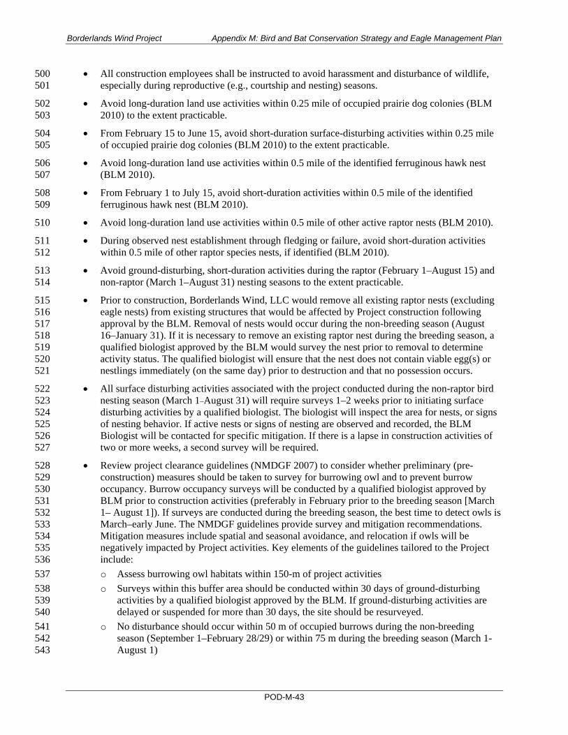
Borderlands Wind Project Appendix M: Bird and Bat Conservation Strategy and Eagle Management Plan
POD-M-43
• All construction employees shall be instructed to avoid harassment and disturbance of wildlife, 500 especially during reproductive (e.g., courtship and nesting) seasons. 501
• Avoid long-duration land use activities within 0.25 mile of occupied prairie dog colonies (BLM 502 2010) to the extent practicable. 503
• From February 15 to June 15, avoid short-duration surface-disturbing activities within 0.25 mile 504 of occupied prairie dog colonies (BLM 2010) to the extent practicable. 505
• Avoid long-duration land use activities within 0.5 mile of the identified ferruginous hawk nest 506 (BLM 2010). 507
• From February 1 to July 15, avoid short-duration activities within 0.5 mile of the identified 508 ferruginous hawk nest (BLM 2010). 509
• Avoid long-duration land use activities within 0.5 mile of other active raptor nests (BLM 2010). 510
• During observed nest establishment through fledging or failure, avoid short-duration activities 511 within 0.5 mile of other raptor species nests, if identified (BLM 2010). 512
• Avoid ground-disturbing, short-duration activities during the raptor (February 1–August 15) and 513 non-raptor (March 1–August 31) nesting seasons to the extent practicable. 514
• Prior to construction, Borderlands Wind, LLC would remove all existing raptor nests (excluding 515 eagle nests) from existing structures that would be affected by Project construction following 516 approval by the BLM. Removal of nests would occur during the non-breeding season (August 517 16–January 31). If it is necessary to remove an existing raptor nest during the breeding season, a 518 qualified biologist approved by the BLM would survey the nest prior to removal to determine 519 activity status. The qualified biologist will ensure that the nest does not contain viable egg(s) or 520 nestlings immediately (on the same day) prior to destruction and that no possession occurs. 521
• All surface disturbing activities associated with the project conducted during the non-raptor bird 522 nesting season (March 1–August 31) will require surveys 1–2 weeks prior to initiating surface 523 disturbing activities by a qualified biologist. The biologist will inspect the area for nests, or signs 524 of nesting behavior. If active nests or signs of nesting are observed and recorded, the BLM 525 Biologist will be contacted for specific mitigation. If there is a lapse in construction activities of 526 two or more weeks, a second survey will be required. 527
• Review project clearance guidelines (NMDGF 2007) to consider whether preliminary (pre-528 construction) measures should be taken to survey for burrowing owl and to prevent burrow 529 occupancy. Burrow occupancy surveys will be conducted by a qualified biologist approved by 530 BLM prior to construction activities (preferably in February prior to the breeding season [March 531 1– August 1]). If surveys are conducted during the breeding season, the best time to detect owls is 532 March–early June. The NMDGF guidelines provide survey and mitigation recommendations. 533 Mitigation measures include spatial and seasonal avoidance, and relocation if owls will be 534 negatively impacted by Project activities. Key elements of the guidelines tailored to the Project 535 include: 536 o Assess burrowing owl habitats within 150-m of project activities 537 o Surveys within this buffer area should be conducted within 30 days of ground-disturbing 538
activities by a qualified biologist approved by the BLM. If ground-disturbing activities are 539 delayed or suspended for more than 30 days, the site should be resurveyed. 540
o No disturbance should occur within 50 m of occupied burrows during the non-breeding 541 season (September 1–February 28/29) or within 75 m during the breeding season (March 1-542 August 1) 543

Borderlands Wind Project Appendix M: Bird and Bat Conservation Strategy and Eagle Management Plan
POD-M-44
o Avoidance requires that a minimum of 6.5 acres of foraging habitats be maintained in 544 undisturbed habitat condition. 545
o Specific preliminary measures—collapsing unoccupied burrows of suitable dimensions and 546 passive exclusion of owls—may be taken during the non-breeding season. Prior to burrow 547 destruction, occupancy will be determined by a qualified biologist approved by BLM. If 548 burrows are destroyed during the non-breeding season, undestroyed burrows should be 549 enhanced, or new burrows created, at a ratio of 2:1 with a minimum of 6.5 acres of foraging 550 habitats maintained. 551
o To ensure compliance with MBTA and New Mexico state laws and regulations, Borderlands 552 Wind will contact the USFWS, NMDGF, and BLM to confirm that any construction activities 553 resulting in destruction of burrows will not result in a taking of burrowing owls. 554
• Encourage landowners/lessees to reduce availability of carrion by practicing responsible animal 555 husbandry (removing carcasses, fencing out cattle, etc.) to avoid attracting golden eagles and 556 other raptors. 557
• Dismantle non-permanent/non-operational MET towers. 558
• Bury power lines to reduce avian collision and electrocution to the extent practicable. 559
• If overhead lines are necessary, follow the Avian Power Line Interaction Committee (APLIC) 560 guidance (APLIC 2006, 2012) on power line construction and design to limit collision and 561 electrocutions: 562 o To reduce collision risk, avoid siting power lines within collision risk areas (i.e., between 563
roosting and feeding areas or nesting sites). If power lines are placed within collision risk 564 areas, install line marking devices (also known as diverters) and design lines without ground 565 wires (APLIC 2019; Loss et al. 2014). 566
o To reduce raptor electrocution risk, cap energized parts and ensure 60 inches of horizontal 567 separation and 40 inches of vertical separation between phases and grounds (APLIC 2006, 568 2019). 569
• To avoid avian electrocution and collisions, place low and medium voltage electric power lines 570 underground (see NMDGF Trenching Guideline) or on the surface as insulated, shielded wire 571 where feasible unless greater adverse impacts to sensitive resources would result. To avoid and 572 minimize bird electrocution or collisions associated with on- or off-site above-ground lines, 573 transformers or conductors, refer to the NMDGF Powerline Guideline, and design and construct 574 structures following the published recommendations of APLIC (APLIC 1994, 2006, 2012). 575
• The use of self-supported MET towers is preferred if feasible. The structures should be painted so 576 that they stand out from the surrounding environment to provide optimum visibility for birds. 577 If guy wires are necessary, bird flight diverters will be used. Avoid placing lines within wetlands, 578 over canyons, or within important avian movement corridors (i.e., between foraging and nesting 579 sites) to the extent practicable. 580
• Employ only red, or dual red and white strobe, strobe-like, or flashing lights, not steady burning 581 lights, to meet Federal Aviation Administration (FAA) requirements for visibility lighting of 582 wind turbines, permanent met towers, and communication towers. Aircraft safety lighting should 583 be the minimum number, minimum intensity, and minimum number of flashes per minute 584 (longest duration between flashes) allowable by the FAA. Only a portion of the turbines within 585 the wind project should be lighted, and all pilot warning lights should fire synchronously. 586
• During construction and operation, measures would be taken to avoid/minimize the impact of 587 light intrusion into adjacent native/undisturbed/sensitive habitats. Night lighting during 588

Borderlands Wind Project Appendix M: Bird and Bat Conservation Strategy and Eagle Management Plan
POD-M-45
construction would not occur to the maximum extent practicable. Any night lighting used during 589 construction and operation would be the lowest illumination allowed for human safety, 590 selectively placed, down shielded, and directed away from all areas of native habitat to the 591 maximum extent practicable. All unnecessary lighting should be turned off at night to limit 592 attracting migratory birds and bats in search of insects. 593
• Except as required to meet the minimum safety and security requirements (e.g., collision markers 594 required by the FAA, or other emergency lighting triggered by alarms), all permanent lighting 595 should use full cutoff luminaires, which are fully shielded (i.e., not emitting direct or indirect 596 light above a horizontal plane passing through the light source), and must meet the Illuminating 597 Engineering Society (IES) glare requirement limiting intensity of light from the luminaire in the 598 region between 80° and 90° from the ground. All fixtures must be mounted properly, at the 599 proper angle. 600
• Lighting for facilities should not exceed the minimum number, intensity, and coverage required 601 for safety and basic security. All area lighting should be divided into separately controlled zones 602 to focus lighting on smaller areas where tasks are being performed and to avoid illuminating 603 unused space. Area lighting should be controlled by timers, sensors, or switches available to 604 facility operators; dusk-to-dawn lighting controlled by photocell alone should not be allowed 605 except where required for safety. The facility operators should identify those 606 components/structures that do not require continuous lighting for safety reasons. Area lights 607 should only be switched on when there is a specific need (e.g., cleaning mirrors and panels at a 608 solar facility, pumping fuel, persons occupying an area, or alarm situation). When not needed, 609 lights should be switched off. Exceptions to switched-off lighting for safety purposes should be 610 articulated in the lighting plan (see BMP 6.5.1). Focused task lighting, portable light towers, or 611 flashlights should be used instead of area lighting, and retro-reflective or luminescent markers 612 should be used in lieu of permanent lighting where feasible. 613
• Keep lighting at both operation and maintenance facilities and substations located within half a 614 mile of the turbines to the minimum required: 615 o Use lights with motion or heat sensors and switches to keep lights off when not required. 616 o Lights should be hooded downward and directed to minimize horizontal and skyward 617
illumination. 618 o Minimize use of high intensity lighting, steady-burning, or bright lights such as sodium 619
vapor, quartz, halogen, or other bright spotlights. 620 o All internal turbine nacelle and tower lighting should be extinguished when unoccupied. 621
• Operators shall determine the presence of active raptor nests (i.e., raptor nests used during the 622 breeding season). Measures to reduce raptor use at a project site (e.g., minimize road cuts, limit 623 tree growth around the turbines) should be implemented. 624
• Informed by avian and bat fatality monitoring results, Borderlands Wind will adaptively identify 625 operations modifications if warranted, in coordination with BLM, USFWS, and NMDGF. 626
• Avoid guy wires on communication towers and permanent met towers. If guy wires are 627 necessary, bird flight diverters or high visibility marking devices should be used at intervals 628 specified and approved by the BLM and USFWS. 629
• All control and mitigation measures established for the project in the POD and the resource-630 specific management plans that are part of the POD shall be maintained and implemented 631 throughout the operational phase, as appropriate. These control and mitigation measures shall be 632 reviewed, revised, and approved by the BLM, as needed, to address changing conditions or 633

Borderlands Wind Project Appendix M: Bird and Bat Conservation Strategy and Eagle Management Plan
POD-M-46
requirements at the site, throughout the operational phase. This adaptive management approach 634 would help ensure that impacts from operations are kept to a minimum. 635
• All management plans, BMPs, and stipulations developed for the construction phase shall be 636 applied to similar activities during the decommissioning phase. 637
3.4 Tier 3 Conclusion 638
The main outcome of the Tier 3 evaluation is that the Project has a low probability of significant adverse 639 impacts. In the context of the WEG, risk refers to the likelihood that adverse impacts will occur to 640 individuals or populations of species of concern as a result of the development and operation of the 641 Project. The “low” finding is supported by the current state of the science around population-level 642 impacts (reviewed in Section 3.2), non-unique habitats in the project area (reviewed in Section 2), low 643 rate of occurrence of species of concern in the project area (reviewed in Section 3.1), and reports from 644 other wind energy facilities that turbine collision fatalities of species of concern are rarely found (Amorim 645 et al. 2012; Arnett et al. 2008; Erickson et al. 2002). 646
Though potentially significant impacts have not been identified, Borderlands Wind has certainty 647 regarding how to develop the site with appropriate risk-reducing design measures. Relevant mitigation 648 measures (see Section 3.3.2), postconstruction fatality studies (see Section 4), and adaptive management 649 procedures (see Section 5) continue to be identified and will be implemented for the Project. 650
There were no additional Tier 3 studies identified at this stage that would be continued in 651 postconstruction. Construction clearance surveys for burrowing owl and MBTA species, and post-652 construction avian and bat fatality surveys have been identified in Sections 3.3.2 and 4.653

Borderlands Wind Project Appendix M: Bird and Bat Conservation Strategy and Eagle Management Plan
POD-M-47
4 TIER 4 – POST-CONSTRUCTION MONITORING 1
This section provides the post-construction avian and bat fatality monitoring plan to include 1) a 2-year 2 consultant-led avian and bat fatality study and 2) life-of-project fatality monitoring conducted by project 3 operations staff. 4
The objective of the consultant-led study will be to assess avian and bat mortality during the study period 5 to effectively address WEG Tier 4a questions: 6
• What are the bird and bat fatality rates for the project? 7
• What are the fatality rates of species of concern? 8
• How do the estimated fatality rates compare to the predicted fatality rates? 9
• Do bird and bat fatalities vary within the project site in relation to site characteristics? 10
• How do the fatality rates compare to the fatality rates from existing projects in similar landscapes 11 with similar species composition and use? 12
• What is the composition of fatalities in relation to migrating and resident birds and bats at the 13 site? 14
• Do fatality data suggest the need for measures to reduce impacts? 15
As described in the WEG, carcass search methods should be adequate to answer these questions at an 16 appropriate level of precision to make general conclusions about the project; they are not intended to 17 provide highly precise measurements of fatality. 18
The objective of the life-of-project monitoring will be to continue to document species composition of 19 fatalities, including species of concern, and potential red flags (e.g., episodic events) that may require 20 additional investigation. 21
This section provides specificity regarding anticipated post-construction monitoring field and analysis 22 techniques and reporting procedures. In this regard, as industry standards are continually developing, it is 23 again noted that this is a living document; as such, industry standards will be reviewed in the context of 24 project-specific conditions prior to implementation and coordinated with BLM, USFWS, and NMDGF. 25
4.1 Standardized Bird and Bat Fatality Monitoring 26
4.1.1 Turbine Searches 27
The surveys will involve systematic searches for dead or injured birds and bats under select turbines and 28 under all permanent meteorological (MET) towers. The searches will be conducted in years 1 and 2 of 29 operation. Eagle-specific fatality monitoring will occur simultaneous to the general bird and bat fatality 30 monitoring and will involve searches at more turbines and within larger search plots. Eagle-specific 31 fatality monitoring methods are described in the Project’s EMP (SWCA 2020a). Imperfect detection by 32 searchers (searcher efficiency) will be quantified in the field using surrogate carcasses. A second source 33 of carcass detection bias, removal by scavengers or other means (carcass persistence) will be quantified 34 (in the field and/or by using literature inputs).14 Raw fatality counts will be adjusted using an industry-35 accepted statistical estimator or estimators which correct for carcass detection biases, search interval, the 36
14 Literature inputs will be used depending on availability of surrogate carcasses that are representative of the fatality group being analyzed (see Section 4.1.4).

Borderlands Wind Project Appendix M: Bird and Bat Conservation Strategy and Eagle Management Plan
POD-M-48
proportion of turbines searched to the total number of turbines at the site, and unsearchable/unsearched 37 areas, as warranted. Specific survey strategy, including search method, season definition, number of 38 turbines searched, survey interval, plot size, and transect spacing, is provided in Table 15. 39
If improved field or analysis techniques become available/acceptable, such as the use of dog searchers, or 40 road and pad versus transect searches become necessary due to vegetation conditions, methods described 41 herein may be altered for the Project in coordination with the BLM, USFWS, and NMDGF. 42
Table 15. Standardized General Avian and Bat Carcass Search Parameters 43
Parameter Detail Comment
Number of turbines searched 30% of turbines (10 of 34) Percentage of searched turbines meets WEG recommendations.
Survey interval Every two weeks Survey intervals will be sufficient to evaluate species composition, temporal and spatial distribution, and adjusted fatality.
Plot size 1x maximum turbine height: • 2.5-MW turbines: 152 × 152-m square • 3.0-MW turbines: 192 × 192-m square Plots will be oriented with the diagonal of the square pointed in the direction of prevailing winds
General avian and bat search plot size meets current industry standards.
Transect spacing 6 m. Searchers will scan out to 3 m with occasional scans out to approximately 10 m.
6-m transects are widely accepted for effective discovery of small-bodied birds and bats; the WEG specifically recommends transects between 3 and 10 m depending on ground cover.
Rate of travel ~45−60 m/minute Slow pace appropriate for vegetation cover and topography to allow for careful visual inspection of each side of transect.
Season definition Summer: June 1–August 31 Fall: September 1–November 30 Winter: December 1–February 28/29 Spring: March 1–May 31
Definition appropriate for temporal comparison of fatalities associated with other sites in the region.
The specific turbines to be surveyed will be selected using a proportional stratified random sampling 44 approach weighted by habitat type (e.g., grassland-shrub and juniper-dominated) area and perceived risk 45 categorization. The design will ensure that an appropriate number of turbines situated in perceived higher 46 risk conditions (e.g., end turbines within a turbine string, and turbines proximal to drainages, playa 47 features, and prairie dog colonies) are selected. 48
4.1.2 Meteorological Tower Searches 49
Searches for dead or birds and bats under the two permanent MET towers will use the same methods and 50 schedule as the turbine searches. If met towers are guyed, search plots will be out to guy wire termination 51 (90 m; (i.e., 180 × 180-m square). If met towers are un-guyed search plots will be out to 50 m (i.e., 100 × 52 100-m square) (Kerns and Kerlinger 2004; Kerlinger et al. 2011). 53
4.1.3 Carcass Search Method 54
The carcass search method is generally outlined in Table 15. For each turbine and MET tower searched 55 per period, searchers will populate a search log including date, turbine/MET tower number, search start 56 and end time, observers conducting the search, and the number of fatalities found, if any. When a carcass 57

Borderlands Wind Project Appendix M: Bird and Bat Conservation Strategy and Eagle Management Plan
POD-M-49
is detected, the searchers will mark the area with a pin flag, record the time, complete the search, and then 58 return to the carcass to record incident-specific data. Incident-specific data fields will be consistent with 59 those listed in the WEG. All fatalities will be appropriately photo documented. 60
Feather piles/spots comprising 10 or more total feathers, or two or more primaries or tail feathers, will be 61 considered a fatality (Young et al. 2003). Fatalities found outside of search plots or while conducting 62 other activities unrelated to searches will be considered incidentals. Incidentals will also include non-63 eagle species fatalities found during eagle-focused searches (see the Project’s EMP [SWCA 2020a]) and 64 fatalities found during WRRS surveys conducted by operations staff. The same incident-specific data 65 fields will be recorded for incidentals; however, they will be excluded from adjusted fatality estimation 66 analyses (they will be accounted for indirectly through estimation of the error estimate in the estimation 67 model). Fatalities definitively not caused by turbine or MET tower collision (e.g., an avian carcass 68 directly under a nest) will also be noted but will also be excluded from the adjusted fatality estimations. 69
4.1.4 Searcher Efficiency Trials 70
Searcher efficiency trial methods specific to the eagle-focused searches are presented in the Project’s 71 EMP (SWCA 2020a). 72
Searcher efficiency will be calculated as the proportion of trial carcasses found by searchers relative to the 73 total number of trial surrogates placed for the trial. Searcher efficiency trials will be completed concurrent 74 with standardized carcass searches. An appropriate number of surrogates,15 representing varying size and 75 type classes, will be placed in varying field conditions within a subset of turbine and MET tower search 76 plots per season to allow for appropriate modeling of categorical covariates that may affect detection 77 biases (e.g., substrates, season, carcass type, observer skill). The specific number of surrogates placed will 78 be based on the site-specific conditions evaluated prior to conducting the surveys. 79
Searchers— “blind” to the specific trial dates and the number and location of placed surrogates—will 80 search for and record surrogate large birds, small birds, and bats within the search plots. For each trial, a 81 trial administrator will place thawed surrogates in random16 locations the morning of the search day. 82 To avoid “over-seeding,” carcass density will not exceed one carcass per 1 acre (0.4 hectare) (i.e., four to 83 five carcasses per turbine search plot). All carcasses will be handled with nitrile gloves to avoid leaving 84 human scent and interfering with scavenging (Arnett et al. 2009). Surrogate carcasses will only be marked 85 with a distinguishing marker (e.g., zip tie) if they may be confused with actual fatalities (i.e., if surrogate 86 bats are used in the trials to represent bats). The locations of surrogates found by searchers will be directly 87 compared with the randomly generated locations. 88
A second search trial per season, conducted on the same sample of placed carcasses, two weeks after the 89 first trial, may be considered if a measure of bleed-through17 is warranted18 (see Section 4.1.4). 90
Carcasses that are not detectable because they are removed (by a scavenger or other means) prior to the 91 search will be excluded from analyses. Carcasses will be deemed as such if they are not present 92 immediately after the search (see Section 4.1.3), as determined by the trial administrator, and are 93 confirmed to be absent on the following day. 94
15 It is anticipated that extra-large chickens, 2-week-old quail, dark extra-large mice, and dark small rats will be used to represent large birds, small birds, small bats, and large bats, respectively, because they are readily available. Other species, particularly raptors and bats, to represent appropriate searcher efficiency (and carcass persistence) for those groups, will be added to the trial samples if they become available and as scientific collection permits allow. 16 Randomization will be generated using a geographic information system (GIS) script or similar. 17 Bleed-through refers to the probability of discovering a carcass in a subsequent search after not being found in an initial search. 18 Whether this measure is warranted will depend on the fatality estimators being considered prior to beginning the surveys.

Borderlands Wind Project Appendix M: Bird and Bat Conservation Strategy and Eagle Management Plan
POD-M-50
4.1.5 Carcass Persistence Trials 95
The length of time (in days) a trial carcass persists at the site will be calculated as the midpoint between 96 the day the carcass is known to be present and the day it is no longer observable. Except for eagle 97 surrogates (see SWCA 2020a), carcasses placed as part of the searcher efficiency trials (see Section 4.1.2) 98 will be revisited on days 1 through 7, 14, 21, and 28, as necessary. Like the searcher efficiency trials, the 99 carcass persistence trials will be conducted during each of the four seasons to account for different 100 conditions that may affect carcass removal. During each visit, a biologist will record presence or absence 101 of each carcass. When a carcass is recorded as absent and no obvious signs of scavenging are apparent 102 (e.g., feathers), it will be revisited the next day to confirm absence. 103
4.1.6 Adjusted Bird and Bat Fatality Estimates 104
Adjusted fatality estimates will be calculated for each year of the study using an industry-accepted 105 statistical estimator or estimators that correct for searcher efficiency, carcass persistence, search interval, 106 the proportion of turbines searched to the total number of turbines at the site, and the proportion of 107 discoverable carcasses within search areas (i.e., search area correction), as warranted. 108
At the time of this writing (February 2020), it is anticipated that the GenEst fatality estimator (Simonis 109 et al. 2018; made available to practitioners in 2019) will be used to calculate adjusted fatality estimates 110 for non-eagle avian species and bats. This estimator was developed to alleviate confusion regarding which 111 estimators to use under variable study design, field conditions, and performance. A collaborative effort 112 among authors of older fatality estimators, this newer estimator is being accepted on a national level as a 113 more accurate, standardized approach. The GenEst estimator allows users to model a decrease in searcher 114 efficiency with repeated searches for the same carcass. In other words, a second searcher efficiency trial 115 per season may be implemented (see Section 4.1.4). 116
Whichever estimator (or estimators) is ultimately selected, model inputs will be tailored as needed to 117 produce unbiased estimates of fatality. For example, when using the Huso estimator (Huso 2011; Huso 118 et al. 2012), which assumes 0% bleed-through, fatalities with an estimated time since death greater than 119 the average search interval will be excluded from the analyses. Fatality data exclusions would also 120 include incidentals or fatalities for which there is clear evidence that the cause of death is not attributed to 121 turbine collision (e.g., an avian carcass directly under a nest). Model inputs should also be representative 122 of actual eagle/large raptors, bat, and other species groups’ searcher efficiency and carcass persistence. 123 For example, from the literature (Smallwood 2007), we know that large raptors and bats tend to persist 124 substantially longer than chickens and mice. As such, to measure carcass persistence for such species 125 groups, appropriate carcasses will be used as surrogates, if available, or appropriate model inputs based 126 on available literature will be considered. 127
Adjusted bird and bat fatality estimates will be reported per MW per year and per turbine per year. 128 Separate adjusted estimates will be calculated for the MET tower searches, if fatalities are discovered. 129
4.2 Wildlife Response and Reporting System 130
During Project operations, Borderlands Wind will follow NextEra’s companywide WRRS for wind 131 energy projects (see Appendix A). Beginning in operations year 1, at turbines that are not being searched 132 as part of the consultant-led searches, operations personnel conducting routine quarterly turbine 133 inspections will search for bird and bat carcasses by walking three concentric circles spaced 30, 90, and 134 150 feet (10, 30, and 45 m) from the turbine mast. Incident-specific WRRS data fields, consistent with 135 those listed in the WEG, are provided in Appendix A. All fatalities will be appropriately photo 136

Borderlands Wind Project Appendix M: Bird and Bat Conservation Strategy and Eagle Management Plan
POD-M-51
documented. Incident-specific data will be recorded by the person who discovered the carcass and 137 reported to appropriate personnel including Borderlands Wind’s consultant (if consultant-led, 138 standardized fatality monitoring [see Section 4.1] is ongoing), and disposition protocols will be followed 139 (see Section 4.3). Fatalities discovered by operations staff will be considered incidentals in the consultant-140 led survey reporting. During all years of operation any wildlife injury or fatality found within the wind 141 plant boundaries (i.e., access roads, substations, O&M building, overhead transmission lines), regardless 142 of cause of death, will be reported immediately to the operations leader who shall complete an incident 143 report, take photographs, and incorporate that information into the WRRS database for the site. 144
4.3 Disposition of Fatalities 145
Handling and disposition procedures will follow relevant salvage permits and/or direction from USFWS 146 Office of Law Enforcement (OLE) and BLM authorized officer. Federally listed species and eagle species 147 carcasses and associated incident-specific data will be reported immediately (no later than 24 hours 148 following discovery) to the USFWS OLE and BLM authorized officer. Federally listed species and eagle 149 species carcasses will not be moved until such notification occurs, after which carcass disposition will be 150 in accordance with permit conditions or USFWS Office of Law Enforcement direction. 151
4.4 Tier 4 Reporting 152
The results of the standardized consultant-led general avian and bat and eagle-focused surveys will be 153 submitted to the USFWS, BLM, and NMDGF. A comprehensive report will be submitted for each year 154 post-construction fatality monitoring is conducted. Each report will include data compilations of the trial 155 results, species composition of fatalities, temporal and spatial distribution of fatalities, relevant adjusted 156 fatality metrics (e.g., per MW/year, per turbine/year by fatality groups), and adaptive management 157 recommendations. Specific fatality groups will include overall birds and bats; other groups (e.g., raptors, 158 seasons) will be considered particularly if they include at least five fatalities. Email summaries 159 containing a list of species being observed during the standardized fatality monitoring will be sent to the 160 BLM, USFWS and NMDGF on a quarterly basis. The annual reporting results will be reviewed by 161 USFWS, BLM, NMDGF, Borderlands Wind, and their consultant via an annual meeting if requested by 162 these agencies. 163
Operations staff-led WRRS incidental fatality documentation and quarterly turbine search results will be 164 provided to BLM annually. 165

Borderlands Wind Project Appendix M: Bird and Bat Conservation Strategy and Eagle Management Plan
POD-M-52
5 TIER 5 – ADAPTIVE MANAGEMENT AND ADDITIONAL 1
POST-CONSTRUCTION SURVEYS 2
3 5.1 Adaptive Management The adaptive management process for the Project is intended to proactively adjust post-construction 4 monitoring protocols and conservation measures when warranted. As described in the WEG, adaptive 5 management is an iterative, flexible decision-making process meant to improve understanding and 6 management over time. The WEG definition gives special emphasis to uncertainty around management 7 effects, iterative learning to reduce uncertainty, and improved management as a result of learning. 8
Developing measurable adaptive management triggers is compromised by lack of basic information 9 regarding population-level consequences of collision fatalities. Potential for cumulative impacts is 10 assumed for threatened and endangered species, but for other taxa, evaluating the necessary level of 11 minimization to maintain populations requires a better understanding of species’ demographic attributes 12 (Allison et al. 2019). For example, the demographic consequences of reducing migratory tree bat fatalities 13 through turbine curtailment when these species are at risk (i.e., low-wind periods in late summer and early 14 fall migration) is unknown because of lack of knowledge regarding population numbers for these species. 15 Further, several authors caution against using aggregated fatality estimates from other projects as a 16 decision benchmark due to validity concerns over widely disparate monitoring designs and analytical 17 methods that introduce varying levels of bias and imprecision (Allison et al. 2019; Loss et al. 2013; 18 Smallwood 2013; Warren-Hicks et al. 2013). As survey and analytical methods are becoming more 19 standardized, and population-level consequences understood (via development of species-specific 20 demographic models), such benchmarks may become valid. 21
To our knowledge, neither federal or state wildlife agencies have set potential impact threshold scenarios 22 (e.g., species group per megawatt collision mortality thresholds) that would qualify as significant adverse 23 impacts to birds and bats in this region of New Mexico. Therefore, Borderlands Wind has identified the 24 following species-specific, temporal, and spatial adaptive management triggers that, if met, would initiate 25 additional coordination with BLM, USFWS, and NMDGF around solutions development: 26
• Injury or mortality of any federal and state listed endangered or threatened species, including 27 species proposed for listing, or bald or golden eagle. In the event that one or more listed species 28 (or eagle) is found dead or injured, Borderlands Wind will notify BLM, USFWS and NMDGF 29 within 24 hours of discovery. Borderlands will continue coordination with these agencies to 30 evaluate potential cause of mortality and discuss actions that may be needed to minimize future 31 injuries/fatalities. 32
• Episodic mass mortalities of multiple or individual species of birds/bats. Relatively speaking 33 mass mortality events at operational wind energy facilities remain rare events (e.g., Arnett et al. 34 2008, Loss et al. 2013). The occurrence of abnormally large mortality events often have been 35 associated with inclement weather conditions and deviations from facility lighting BMPs 36 (Erickson et al. 2001; Johnson et al. 2002; Kerns and Kerlinger 2004). For the Project, a mass 37 mortality event will be defined as the number of fatalities within a single day exceeding three 38 times the daily average of birds/bats found during that season. In the unlikely event of a mass 39 mortality event, Borderlands wind will notify BLM, USFWS and NMDGF within 24 hours of 40 discovery. Borderlands will continue coordination with these agencies to evaluate potential cause 41 of mortality and discuss actions that may be needed to minimize future injuries/mortalities. 42
• Localized injuries or mortalities at potentially problem turbines: Once operational, specific turbine 43 locations may result in larger than expected injuries/mortalities to birds and bats (e.g., those closer 44

Borderlands Wind Project Appendix M: Bird and Bat Conservation Strategy and Eagle Management Plan
POD-M-53
to certain habitats). If the observed number of fatalities at a single turbine exceeds three times the 45 average number found at other turbines during that season or survey year, , Borderlands Wind will 46 coordinate with BLM, USFWS and NMDGF to evaluate options and determine a path forward for 47 the location. 48
In the event these triggers are met, Borderlands Wind will consider the following solutions in 49 coordination with coordinating agencies: 50
• Assessing effectiveness of the BMPs presented in this BBCS and whether improvements can be 51 implemented. 52
• Identification of common causes or risk factors (e.g., problem turbines/spatial clustering of 53 fatalities, problem seasons, presence of prey). 54
• Identifying and implementing additional BMPs. 55
• Implementing additional consultant-led Tier 4 surveys. 56
• Consider evaluation of short-term and reversion triggers (as in Dalthrop et al. 2017), or similar 57 methods to evaluate effectiveness of implemented measures. 58
In addition to the triggers presented herein, Borderlands Wind, in coordination with coordinating 59 agencies, will continually evaluate whether additional triggers may be identified, informed by agency and 60 industry knowledge and project-specific fatality data. Updates to this living document will be made as 61 new industry standards or policies pertinent to adaptive management procedures are developed. 62
5.2 Additional Post-Construction Surveys 63
Eagle-specific post-construction survey techniques, analyses, and interpretation are described in the 64 Project’s EMP. No additional non-eagle species surveys beyond the consultant-led and WRRS surveys set 65 forth above are planned for the Project at this time. Additional surveys may be identified through the 66 adaptive management process if they are deemed necessary. 67
6 PERSONNEL TRAINING 68
Borderlands Wind will implement a training program covering the overall contents and requirements of 69 the Project’s BBCS. The training program will be designed to consistently communicate requirements to 70 every individual working on-site so that both managers and workers understand expectations, the permit 71 requirements, and how to incorporate them into their daily work activities. All construction, operation, 72 and maintenance staff working on the Project will be required to attend a training presentation prior to 73 working on-site. Borderlands Wind will maintain environmental training attendance records on-site. 74
Content of the presentation will include: 75
• BMPs 76
• Overview of WRRS and consultant-led post-construction surveys 77
• Procedures for handling and reporting avian and bat fatalities and injuries 78
• How to identify birds and bats, particularly sensitive species, that could occur at the site 79
• Points of contact at different agencies for reporting along with reporting protocols 80
• Record keeping procedures 81

Borderlands Wind Project Appendix M: Bird and Bat Conservation Strategy and Eagle Management Plan
POD-M-54
7 IMPLEMENTATION OF THE BORDERLANDS BBCS 82
This BBCS was developed to fulfill important requirements for the Borderlands ROW Grant from BLM. 83 As described through the WEG Tier analysis described herein, many aspects of this BBCS have been 84 implemented or are in the process of being implemented. As such, this BBCS is subject to future 85 revisions, as needed, and will be maintained by Borderlands environmental staff. This BBCS will be 86 housed on-site within the Borderlands Wind O&M building. Revisions will include any updates needed 87 to reflect the final construction plans and mitigate impacts to avian/bat species during the construction 88 and operational phases of the project. 89

Borderlands Wind Project Appendix M: Bird and Bat Conservation Strategy and Eagle Management Plan
POD-M-55
8 LITERATURE CITED 1
Allison, T.B., J.E. Diffendorfer, E.F. Baerwald, J.A. Beston, D. Drake, A.M. Hale, C.D. Hein, M.M. 2 Huso, S.R. Loss, J.E. Lovitch, M.D. Strickland, K.A. Williams, V.L. Winder. 2019. Impacts to 3 wildlife of wind energy siting and operation in the United States. Issues in Ecology 21:1–23 4
American Wind Wildlife Institute (AWWI). 2018. Wind Turbine Interactions with Wildlife and Their 5 Habitats: A Summary of Research Results and Priority Questions. Available at: 6 https://awwi.org/wp-content/uploads/2018/05/Turbine-Interactions-Summary-2018.pdf. 7 Accessed April 2019. 8
Amorim, F., H. Rebelo, and L. Rodrigues. 2012. Factors influencing bat activity and mortality at a wind 9 farm in the Mediterranean region. Acta Chiropterologica 14:439–457. 10
11
Arnett, E.B., M. Schirmacher, M.M.P. Huso, and J.P. Hayes. 2009. Effectiveness of Changing Wind 12 Turbine Cut-In Speed to Reduce Bat Fatalities at Wind Facilities. Annual report submitted to the 13 Bats and Wind Energy Cooperative. Austin, Texas: Bat Conservation International. 14
Arnett, E.B., W.K. Brown, W.P. Erickson, J.K. Fiedler, B.L. Hamilton, T.H. Henry, A. Jain, 15 G.D. Johnson, J. Kerns, R.R. Koford, C.P. Nicholson, T.J. O’Connell, M.D. Piorkowski, and 16 R.D. Tankersley, Jr. 2008. Patterns of bat fatalities at wind energy facilities in North America. 17 Journal of Wildlife Management 72:61–78. 18
Audubon. 2019. Important Bird Areas, New Mexico. Available at: http://www.audubon.org/important-19 bird-areas/state/new-mexico/. Accessed June 2019. 20
Avian Power Line Interaction Committee (APLIC). 2005. Avian Protection Plan (APP) Guidelines. 21 APLIC and the US Fish and Wildlife Service. April. Available at: http://www.aplic.org/ 22 uploads/files/2634/APPguidelines_final-draft_Aprl2005.pdf. Accessed February 2020. 23
———. 2006. Suggested Practices for Avian Protection on Power Lines: The State of the Art in 2006. 24 Washington, D.C., and Sacramento, California: Edison Electric Institute, APLIC, and the 25 California Energy Commission. 26
———. 2012. Reducing Avian Collisions with Power Lines: The State of the Art in 2012. Washington, 27 D.C.: Edison Electric Institute and APLIC. 28
———. 2018. APLIC Recommendations for Power Pole Configurations at Wind Energy Projects. 29 Available at: http://www.aplic.org/riser-poles-wind.php. Accessed September 2018. 30
———. 2019. Avian Power Line Interaction Committee website. Available at: http://www.aplic.org/. 31 Accessed June 2019. 32
Baerwald, E.F., and R.M.R. Barclay. 2009. Geographic variation in activity and fatality of migratory bats 33 at wind energy facilities. Journal of Mammalogy 22:318–329. 34
Barclay, R.M.R, E.F. Baerwald, and J.C. Gruver. 2007. Variation in bat and bird fatalities at wind energy 35 facilities: assessing the effects of rotor size and tower height. Canadian Journal of Zoology 36 85:381–387. 37

Borderlands Wind Project Appendix M: Bird and Bat Conservation Strategy and Eagle Management Plan
POD-M-56
Bennett, V.J., and A.M. Hale. 2018. Resource availability may not be a useful predictor of migratory bat 38 fatalities or activity at wind turbines. Diversity 10:44; doi:10.3390/d10020044. 39
Beston, J.A., J.E. Diffendorfer, S.R. Loss, and D.H. Johnson. 2016. Prioritizing avian species for their 40 risk of population-level consequences from wind energy development. Plos One 11:e0150813; 41 doi:10.1371/journal.pone.0150813. 42
Biota Information System of New Mexico (BISON-M). 2018. Biota Information System of New Mexico. 43 Available at: http://www.bison-m.org/. Accessed February 2020. 44
Borderlands Wind. 2020. Borderlands Wind Project Plan of Development. Submitted to Bureau of Land 45 Management Socorro Field Office. February. 46
Bureau of Land Management (BLM). 2010. Socorro Resource Management Plan. Bureau of Land 47 Management, Socorro Field Office. July. Available at: https://eplanning.blm.gov/epl-front-48 office/projects/lup/56599/67448/73390/ RMP_Socorro_2010_08_20.pdf. Accessed June 2019. 49
———. 2011. Revision of guy wire and lighting requirements for tall structures, Instruction 50 memorandum. April 19. Sacramento: Bureau of Land Management, California State Office. 51
———. 2019a. Borderlands Wind Project Draft Environmental Impact Statement and Resource 52 Management Plan Amendment (DOI-BLM-NM-A020-2019-0002-RMP-EIS). Available at: 53 https://eplanning.blm.gov/epl-front-office/projects/lup/116245/20001056/250001211/ 54 190729_July_DEIS_BLWP.pdf. Accessed September 2019. 55
———. 2019b. Revision to the New Mexico Bureau of Land Management Sensitive Animal and Plant 56 Lists. Available at: https://www.blm.gov/policy/nm-ib-2019-002. Accessed February 2020. 57
Carrete, M., J.A. Sanchez-Zapata, J.R. Benitez, M. Lobón, F. Montoya, and J.A. Donázar. 2012. 58 Mortality at wind farms is positively related to large-scale distribution and aggregation in griffon 59 vultures. Biological Conservation 145:102–108. 60
Dahl, E., K. Bevanger, T. Nygard, E. Roskaft, and B.G. Stokke. 2012. Reduced breeding success in 61 white-tailed eagles at Smola windfarm, western Norway, is caused by mortality and 62 displacement. Biological Conservation 145:79–85. 63
Dalthrop, D., M. Huso, and Dail, D. et al. 2017. Evidence of Absence (v2.0) Software User’s Guide. U.S. 64 Geological Survey Data Series 1055. Available at: https://pubs.usgs.gov/ds/1055/ds1055.pdf. 65 Accessed February 2020. 66
de Lucas, M., M. Ferrer, M. Bechard, and M.J. Munoz. 2012. Griffon vulture mortality at wind farms in 67 southern Spain: Distribution of fatalities and active mitigation measures. Biological 68 Conservation 147:184–189. 69
Driscoll, D.E. 2010. Protocol for Golden Eagle Occupancy, Reproduction, and Prey Population 70 Assessment. Apache Junction, Arizona: American Eagle Research Institute. 71
Ellison, L.E. 2012. Bats and Wind Energy—A Literature Synthesis and Annotated Bibliography. Open-72 File Report 2012-1110. U.S. Geological Survey. 73

Borderlands Wind Project Appendix M: Bird and Bat Conservation Strategy and Eagle Management Plan
POD-M-57
Erickson, W.P., G. Johnson, M.D. Strickland, D.P. Young, Jr., K.J. Sernka, and R.E. Good. 2001. Avian 74 Collisions with Wind Turbines: A Summary of Existing Studies and Comparisons to Other 75 Sources of Avian Collision Mortality in the United States. National Wind Coordinating 76 Committee Resource Document. Cheyenne, Wyoming: Western EcoSystems Technology, Inc. 77
Erickson, W.P., M.M. Wolfe, K.J. Bay, D.H. Johnson, and J.L. Gehring. 2014. A comprehensive analysis 78 of small-passerine fatalities from collision with turbines at wind energy facilities. PLoS ONE 79 9:1–18. 80
Ferreira, D., C. Freixo, J.A. Cabral, R. Santos, and M. Santos. 2015. Do habitat characteristics determine 81 mortality risk for bats at wind farms? Modeling susceptible species activity patterns ad 82 anticipating mortality events. Ecological Informatics 28:7–18. 83
Ferrer, M., M. de Lucas, G.F.E. Janss, E. Casado, A.R. Muñoz, M.J. Bechard, and C.P. Calabuig. 2011. 84 Weak relationship between risk assessment studies and recorded mortality in wind farms. 85 Journal of Applied Ecology 49:38–46. 86
Frick, W.F., E.F. Baerwald, J.F. Pollock, R.M.R. Barclay, J.A. Szymanski, T.J. Weller, A.L. Russell, 87 S.C. Loeb, R.A. Medellin, and L.P. McGuire. 2017. Fatalities at wind turbines may threaten 88 population viability of a migratory bat. Biological Conservation 209: 172–177. 89
Gehring, J., P. Kerlinger, and A.M. Manville II. 2011. The role of tower height and guy wires on avian 90 collisions with communication towers. Journal of Wildlife Management 75:848–855. 91
Hayes, M.A. 2013. Bats killed in large numbers at United States wind energy facilities. BioScience 92 63:975–979. 93
Hein, C.D., J. Gruver, and E.B. Arnett. 2013. Relating Pre-Construction Bat Activity and Post-94 Construction Bat Fatality to Predict Risk at Wind Energy Facilities: A Synthesis. Report 95 submitted to the National Renewable Energy Laboratory. Austin, Texas: Bat Conservation 96 International. 97
Hunting, K. 2002. Assessing and mitigation avian mortality from collisions with power lines [abstract 98 only]. Western Section, The Wildlife Society 2002 Annual Conference Paper. Visalia, California. 99
Huso, M. 2011. An estimator of wildlife fatality from observed carcasses. Environmetrics 22:318–329. 100
Huso, M., N. Som, and L. Ladd. 2012. Fatality Estimator User’s Guide. U.S. Geological Survey Data 101 Series 729. 102
Johnson, G.D. 2005. A review of bat mortality at wind-energy developments in the United States. Bat 103 Research News 46:45–49. 104
Johnson, G.D., W.P. Erickson, M.D. Strickland, M.F. Sheperd, D.A. Sheperd, and S.A. Sarappo. 2002. 105 Collision mortality of local and migrant birds at a large-scale wind-power development on 106 Buffalo Ridge, Minnesota. Wildlife Society Bulletin 30:879–887. 107
Jones, M.P., K.E. Pierce, Jr., and D. Ward. 2007. Avian vision: a review of form and function with 108 special consideration to birds of prey. Journal of Exotic Pet Medicine 16:69–87. 109
Katzner, T., D. Brandes, T. Miller, M. Lanzone, C. Maisonneuve, J.A. Tremblay, R. Hulvihill, and G.T. 110 Merovich. 2012. Topography drives migratory flight altitude of golden eagles: implications for 111 on-shore wind energy development. Journal of Applied Ecology 49:1178–1186. 112

Borderlands Wind Project Appendix M: Bird and Bat Conservation Strategy and Eagle Management Plan
POD-M-58
Kerns and Kerlinger 2004. A Study of Bird and Bat Collision Fatalities at the Mountaineer Wind Energy 113 Center, Tucker County, West Virginia: Annual Report for 2003. Prepared for FPL Energy and 114 Mountaineer Wind Energy Center Technical Review Committee. Cape May Point, New Jersey: 115 Curry & Kerlinger, LLC. 116
Kerlinger, P., J. Guarnaccia, A. Hasch, R.C.E. Culver, R.C. Curry, L. Tran, M.J. Stewart, and D. Riser-117 Espinoza. 2011. Avian collision mortality at 50- and 60-m guyed towers in central California. 118 Condor 114:462–469. 119
Kunz, T.H., E.B. Arnett, W.P. Erickson, A.R. Hoar, G.D. Johnson, R.P Larkin, M.D. Strickland, R.W. 120 Thresher, and M.D. Tuttle. 2007. Ecological impacts of wind energy development on bats: 121 questions, research, needs, and hypotheses. Frontiers in Ecology and the Environment 5:315–122 324. 123
Lehman, R.N. 2001. Raptor electrocution on power lines: current issues and outlook. Wildlife Society 124 Bulletin 29:804–813. 125
Lehman, R.N., P.L. Kennedy, J.A. Savidge. 2007. Biological Conservation 136:159–174. 126
Loss, S.R., T. Will, and P.P. Marra. 2013. Estimates of bird collision mortality at wind facilities in the 127 contiguous United States. Biological Conservation 168:201–209. 128
———. 2014. Refining estimates of bird collision and electrocution mortality at power lines in the United 129 States. Plos One 9:1–10. 130
Manville, A.M., II. 2005. Bird strikes and electrocutions at power line, communication towers, and wind 131 turbines: state of the art and state of the science—next steps toward mitigation. U.S. Forest 132 Service General Technical Report PSW-GTR-191, Washington, D.C. 133
Martin, G.R., and J.M Shaw. 2010. Bird collisions with power lines: failing to see the way ahead? 134 Biological Conservation 143:2695–2702. 135
National Academy of Sciences (NAS). 2007. Environmental Impacts of Wind Energy Projects. 136 Washington, D.C.: National Academies Press. 137
New Mexico Department of Game and Fish (NMDGF). 2007. Guidelines and Recommendations for 138 Burrowing Owl Surveys and Mitigation. July. Available at: http://www.wildlife.state.nm.us/ 139 download/conservation/habitat-handbook/project-guidelines/Burrowing-Owl-Surveys-and-140 Mitigation-2007.pdf. Accessed February 2020. 141
———. 2016. Recommendations to Minimize Adverse Impacts of Wind Energy Development on Wildlife 142 2012. Available at: http://www.wildlife.state.nm.us/download/conservation/habitat-143 handbook/project-guidelines/Wind-Energy-Guidelines.pdf. Accessed February 2020. 144
———. 2016. State Wildlife Action Plan for New Mexico. Santa Fe, New Mexico. Available at: 145 http://www.wildlife.state.nm.us/download/conservation/ swap/New-Mexico-State-Wildlife-146 Action-Plan-SWAP-Final-2017.pdf. Accessed May 2018. 147
New Mexico Energy, Minerals and Natural Resources Department. 2019. New Mexico State Parks. 148 Available at: http://www.emnrd.state.nm.us/SPD/FindaPark.html. Accessed June 2019. 149
Piorkowski, M., and T. O’Connell. 2010. Spatial pattern of summer bat mortality from collisions with 150 wind turbines in mixed-grass prairie. American Midland Naturalist 164:260–269. 151

Borderlands Wind Project Appendix M: Bird and Bat Conservation Strategy and Eagle Management Plan
POD-M-59
Postupalsky, S. 1974. Raptor reproductive success: some problems with methods, criteria, and 152 terminology. In Raptor Research Report No. 2. Management of Raptors, edited by F.N. 153 Hamerstrom, Jr., B.E. Harrell, and R.R. Olendorff. pp. 21–31. Vermillion, South Dakota: Raptor 154 Research Foundation. 155
Ramsar. 2014. Ramsar Sites, United States. Available at: https://www.ramsar.org/wetland/united-states-156 of-america. Accessed June 2019. 157
Rioux, S., J.L. Savard, and A.A. Gerick. 2013. Avian mortalities due to transmission line collisions: a 158 review of current estimates and field methods with an emphasis on applications to the Canadian 159 electric network. Plos One 9:1–10. 160
Roemer, C., Y. Bas, T. Disca, and A. Coulon. 2019. Influence of landscape and time of year on bat-wind 161 turbines collision risks. Landscape Ecology 34:2869–2881. 162
Rodewald, P. (ed.). 2015. The Birds of North America Online. Ithaca, New York: Cornell Laboratory of 163 Ornithology. Available at: http://bna.birds.cornell.edu/bna/. Accessed February 2020. 164
Science Applications International Corporation (SAIC). 2000. Avian Collision at Transmission Line 165 associated with the Hells Canyon Complex. Technical Report Appendix E. Boise, Idaho. 166
Simonis, J., D. Dalthrop, M. Huso, J. Mintz, L. Madsen, P. Rabie, and J. Studyvin. 2018. GenEst user 167 guide—Software for a generalized estimator of mortality. U.S. Geological Survey Techniques 168 and Methods 7-C19. Reston, Virginia. 169
Smallwood, K.S. 2007. Estimating wind turbine-caused bird mortality. Journal of Wildlife Management 170 71:2781–2791. 171
———. 2013. Comparing bird and bat fatality-rate estimates among North American wind-energy 172 projects. Wildlife Society Bulletin 37:19–33. 173
Smallwood, K.S., and C.G. Thelander. 2008. Bird mortality in the Altamont Pass wind resource area, 174 California. Journal of Wildlife Management 72:215–223. 175
Steenhof, K., and I. Newton. 2007. Assessing nest success and productivity. In Raptor Research and 176 Management Techniques, edited by D.M. Bird and K.L. Bildstein, pp. 181–191. British 177 Columbia, Canada: Hancock House Publishers, Raptor Research Foundation. 178
Strickland, D., E.B. Arnett, W.P. Erickson, D. Johnson, G. Johnson, M. Morrison, J. Shaffer, and 179 W. Warren-Hicks. 2011. Comprehensive Guide to Studying Wind Energy/Wildlife Interactions. 180 Prepared for the National Wind Coordinating Collaborative, Washington, D.C. 181
SWCA Environmental Consultants (SWCA). 2018a. Site Evaluation and Characterization for the 182 Proposed Borderlands Wind Project. May. Flagstaff, Arizona. 183
———. 2018b. Pre-Construction Wildlife Survey Plan for the Proposed Borderlands Wind Project. 184 September 2017, updated March 2018. Flagstaff, Arizona. 185
———. 2018c. Survey Update: 2017 and 2018 Eagle Nest Occupancy Surveys of the Proposed 186 Borderlands Wind Project. Technical memorandum. May. Flagstaff, Arizona. 187
———. 2018d. Gunnison’s Prairie Dog Occupancy and Colony Delineation, July 2018. Technical 188 memorandum. August. Flagstaff, Arizona. 189

Borderlands Wind Project Appendix M: Bird and Bat Conservation Strategy and Eagle Management Plan
POD-M-60
———. 2020a (in progress). Eagle Management Plan for the Borderlands Wind Project. December 2018, 190 updated June 2019 and March 2020. Flagstaff, Arizona. 191
———. 2020b (in progress). Pre-Construction Avian and Bat Survey Results for the Proposed 192 Borderlands Wind Project, 2017-2019 2-Year Dataset. March. Flagstaff, Arizona. 193
U.S. Fish and Wildlife Service (USFWS). 2003. Interim Guidelines to Avoid and Minimize Wildlife 194 Impacts from Wind Turbines. May. Available at: https://www.fws.gov/habitatconservation/ 195 wind.pdf. Accessed February 2020. 196
———. 2008. Birds of Conservation Concern 2008. December. Available at: https://www.fws.gov/ 197 migratorybirds/pdf/management/BCC2008.pdf. Accessed February 2020. 198
———. 2012. Land-Based Wind Energy Guidelines. March. Available at: 199 https://www.fws.gov/ecological-services/es-library/pdfs/WEG_final.pdf. Accessed June 2019. 200
———. 2013. Eagle Conservation Plan Guidance, Module 1 – Land-based Wind Energy, Version 2. 201 U.S. Fish and Wildlife Service, Division of Migratory Bird Management. Available at: 202 https://www.fws.gov/migratorybirds/pdf/management/eagleconservationplanguidance.pdf. 203 Accessed June 2019. 204
———. 2017. List of threatened and endangered species that may occur in your proposed project 205 location, and/or may be affected by your proposed project. Catron Wind, proposed wind energy. 206 Consultation Code: 02ENNM00-2017-SLI-0714. U.S. Fish and Wildlife Service, New Mexico 207 Ecological Services Field Office. June 15, 2017. 208
———. 2019. Wildlife Refuges, New Mexico. Available at: https://www.fws.gov/refuges/ 209 refugeLocatorMaps/NewMexico.html. Accessed June 2019. 210
Van Doren, B.M, and K.G. Horton. 2018. A continental system for forecasting bird migration. Science 211 361:1115–1118. 212
Warren-Hicks, W., J. Newman, R. Wolpert, B. Karas, and L. Tran. 2013. Improving Methods for 213 Estimating Fatality of Birds at Wind Energy Facilities. Final project report prepared for 214 California Energy Commission. Berkeley, California: California Wind Energy Association. 215
Western Hemisphere Shorebird Reserve Network (WHSRN). 2019. Western Hemisphere Shorebird 216 Reserve Network Sites. Available at: https://whsrn.org/whsrn-sites/map-of-sites/. Accessed June 217 2019. 218
Young, D.P., W.P. Erickson, R.E. Good, M.D. Strickland, and G.D. Johnson. 2003. Avian and Bat 219 Mortality Associated with the Initial Phase of the Foote Creek Rim Windpower Project, Carbon 220 County, Wyoming. November 1998–June 2002. Final report prepared for Pacificorp Inc., 221 Portland, Oregon, and SeaWest Windpower Inc., San Diego, California. Cheyenne, Wyoming: 222 WEST Inc. 223

Borderlands Wind Project Appendix M: Bird and Bat Conservation Strategy and Eagle Management Plan
POD-M-61
APPENDIX A
NextEra Energy WRRS Manual for Wind Energy Centers

Borderlands Wind Project Appendix M: Bird and Bat Conservation Strategy and Eagle Management Plan
POD-M-62
APPENDIX B
Contacts/Resources

Borderlands Wind Project Appendix M: Bird and Bat Conservation Strategy and Eagle Management Plan
POD-M-63
APPENDIX C
Relevant Permits

Borderlands Wind Project Appendix M: Bird and Bat Conservation Strategy and Eagle Management Plan
POD-M-64
EAGLE MANAGEMENT PLAN FOR THE BORDERLANDS WIND PROJECT
WORKING DRAFT
Prepared for
Borderlands Wind, LLC 700 Universe Boulevard
Juno Beach, Florida 33408 Attn: Jennifer Field
(561) 591-7207
Prepared by
SWCA Environmental Consultants 114 North San Francisco Street, Suite 100
Flagstaff, Arizona 86001 (928) 774-5500 www.swca.com
SWCA Project No. 51742
March 2020

Borderlands Wind Project Appendix M: Bird and Bat Conservation Strategy and Eagle Management Plan
POD-M-65
CONTENTS 1 Introduction ......................................................................................................................... POD-M-69
1.1 Document Organization ................................................................................................ POD-M-69 1.2 Project Description and Current Progress ..................................................................... POD-M-72 1.3 Consultation History ..................................................................................................... POD-M-74 1.4 Regulatory Context ....................................................................................................... POD-M-75
1.4.1 Bald and Golden Eagle Protection Act ............................................................... POD-M-76 1.4.2 New Mexico State Threatened and Endangered Species .................................... POD-M-76
1.5 Landscape-Scale Definitions ........................................................................................ POD-M-76
2 Stage 1 – Site Assessment .................................................................................................... POD-M-79 2.1 Stage 1 Methods ........................................................................................................... POD-M-79 2.2 Stage 1 Findings ........................................................................................................... POD-M-79
2.2.1 Environmental Setting ........................................................................................ POD-M-80 2.2.2 Presence of Eagles or Their Habitats ........................................................................... M-80 2.2.3 Habitats Known To Be Valuable or Potentially Valuable to Eagles That
Would Be Destroyed or Degraded ...................................................................... POD-M-81 2.2.4 Important Eagle Use Areas or Migration Concentration Sites ........................... POD-M-82 2.2.5 Presence of Habitat Supporting Abundant Eagle Prey ....................................... POD-M-82
2.3 Stage 1 Risk Categorization ......................................................................................... POD-M-83
3 Stage 2 – Site-Specific Surveys and Assessment ............................................................... POD-M-86 3.1 Stage 2 Methods ........................................................................................................... POD-M-86
3.1.1 Incidental Eagle and Eagle Habitat Observations ............................................... POD-M-86 3.1.2 Eagle Use Surveys .............................................................................................. POD-M-87 3.1.3 Eagle Nest Surveys ............................................................................................. POD-M-90 3.1.4 Gunnison’s Prairie Dog (Cynomys gunnisoni) Surveys ..................................... POD-M-93
3.2 Stage 2 Results .............................................................................................................. POD-M-94 3.2.1 Incidental Wildlife Observations ........................................................................ POD-M-94 3.2.2 Eagle Use Surveys .............................................................................................. POD-M-95 3.2.3 Eagle Nest Surveys ............................................................................................. POD-M-99 3.2.4 Gunnison’s Prairie Dog (Cynomys gunnisoni) Surveys ................................... POD-M-103
3.3 Stage 2 Risk Categorization ....................................................................................... POD-M-105
4 Stage 3 – Predicting Eagle Fatalities ................................................................................ POD-M-106 4.1 Stage 3 Methods ......................................................................................................... POD-M-106
4.1.1 U.S. Fish and Wildlife Service Collision Risk Model ...................................... POD-M-106 4.1.2 Other Fatality Predictions ................................................................................. POD-M-107
4.2 Stage 3 Results ............................................................................................................ POD-M-108 4.2.1 USFWS Collision Risk Model .......................................................................... POD-M-108 4.2.2 Other Fatality Predictions ................................................................................. POD-M-108
4.3 Results Stage 3 Risk Categorization ........................................................................... POD-M-109
5 Stage 4 – Avoidance, Minimization, and Compensatory Mitigation Measures ........... POD-M-111 5.1 Project Macro-siting ................................................................................................... POD-M-111 5.2 Turbine Micro-siting ................................................................................................... POD-M-111
5.2.1 Avoidance Prescriptions Identified in Stages 1 and 2 ....................................... POD-M-111 5.2.2 Micro-siting Field Effort Followed by Project Redesign .................................. POD-M-112 5.2.3 Best Management Practices .............................................................................. POD-M-115

Borderlands Wind Project Appendix M: Bird and Bat Conservation Strategy and Eagle Management Plan
POD-M-66
5.3 Voluntary Compensatory Mitigation .......................................................................... POD-M-118 5.3.1 Resource Equivalency Analysis ........................................................................ POD-M-118 5.3.2 Compensatory Mitigation Commitment ........................................................... POD-M-119
5.4 Stage 4 Risk Categorization ....................................................................................... POD-M-120 5.4.1 Assessing Predicted Mortality and Cumulative Effects Analysis ..................... POD-M-120 5.4.2 Stage 4 Risk Categorization .............................................................................. POD-M-121
6 Stage 5 – Postconstruction Monitoring and Adaptive Management ............................ POD-M-126 6.1 Standardized Eagle Fatality Monitoring ..................................................................... POD-M-126
6.1.1 Turbine Searches ............................................................................................... POD-M-126 6.1.3 Carcass Search Method ..................................................................................... POD-M-127 6.1.4 Searcher Efficiency Trials................................................................................. POD-M-128 6.1.5 Carcass Persistence Trials ................................................................................. POD-M-128 6.1.6 Adjusted Eagle Fatality Estimates .................................................................... POD-M-128
6.2 Wildlife Response and Reporting System .................................................................. POD-M-129 6.3 Disposition of Eagle Carcasses and Injured Eagles .................................................... POD-M-129 6.4 Disturbance Monitoring .............................................................................................. POD-M-129 6.5 Stage 5 Reporting ....................................................................................................... POD-M-129 6.6 Adaptive Management ................................................................................................ POD-M-130
6.6.1 Discovery of an Eagle Fatality Attributable to Turbine Collision .................... POD-M-130
7 Literature Cited ................................................................................................................. POD-M-132
Appendices
Appenidx A. Appendix B. Contacts/Resources Appendix C. Eagle Use Count Survey Raw Data Appendix D. NextEra Energy WRRS Manual for Wind Energy Centers
Figures
Figure 1. Borderlands Wind Project location. ............................................................................... POD-M-70 Figure 2. Alternative 2 Project design. This design was developed after eagle risk-reducing
avoidance considerations (see Section 5). The figure shows landscape scale terms—project area, project footprint, and turbine hazard area—used elsewhere in the document. ................................................................................................................... POD-M-78
Figure 3. Potential eagle attractants identified in Stage 1 within and proximal to the project area (see Section 5). ................................................................................................... POD-M-85
Figure 4. Stage 2 eagle use count locations. Figure illustrates the 1-km buffer associated with the Alternative 2 turbine array design. Survey plots were placed outside of the turbine array design and Alternative 2 project area boundary to account for all potential Project alternatives and perceived eagle risk. ............................................................ POD-M-88
Figure 5. Possible golden eagle nesting habitat delineated within 10-mile-radius survey area and 2017/2018 survey tracks. .................................................................................... POD-M-92

Borderlands Wind Project Appendix M: Bird and Bat Conservation Strategy and Eagle Management Plan
POD-M-67
Figure 6. Eagle flight paths recorded during eagle use counts and incidentally, Year 1 surveys (March 28, 2017–March 3, 2018). Labeled attributes pertain to observations that contributed to eagle-minutes. ..................................................................................... POD-M-97
Figure 7. Eagle flight paths recorded during eagle use counts and incidentally, Year 2 surveys (March 25, 2018–March 5, 2019). Labeled attributes pertain to observations that contributed to eagle-minutes. ..................................................................................... POD-M-98
Figure 8. Occupancy status of eagle nests recorded during 2017 surveys. The figure illustrates the 2017 conservative ½-MIND calculated for the golden eagle project-area nesting population. Arrows indicate measurements used for the calculation (see Table 11). Nest attributes correspond to Table 10. ................................................................... POD-M-101
Figure 9. Occupancy status of eagle nests recorded during 2018 surveys. The figure illustrates the 2018 conservative ½-MIND calculated for the golden eagle project-area nesting population. Arrows indicate measurements used for the calculation (see Table 11). Nest attributes correspond to Table 10. ................................................................... POD-M-102
Figure 10. Luna Tank, CA048 possible eagle nest, March 10, 2017. ......................................... POD-M-103 Figure 11. Occupied prairie dog colonies delineated within the project area, July 2018.
Numbers indicate prairie dogs observed during the July 2018 survey. ................... POD-M-104 Figure 12. Eagle-minute flight paths recorded during eagle use counts, Year 1 and 2 surveys
combined. Use count plots 13‒20 were added in Year 2. Eagle-minutes (and number of surveys) associated with plots 2, 8, and 20 were excluded from the Stage 3 annual eagle fatality estimate pertaining to the 1-km buffer of the Alternative 2 turbine array. ........................................................................................................................ POD-M-110
Figure 13. Possible turbine locations evaluated during the May 2018 field micro-siting effort in relation to bird and bat risk-reducing avoidance constraints identified for the Project. ..................................................................................................................... POD-M-113
Figure 14. Final turbine array design in relation to bird and bat risk-reducing avoidance constraints identified for the Project. ....................................................................... POD-M-114
Figure 15. Eagle use areas identified for the project in relation to the final proposed Project footprint and turbine hazard area ............................................................................. POD-M-123
Figure 16. LAP analysis area used for determining final risk categorization for the Project. .... POD-M-124 Figure 17. Golden eagle local areas of proximate wind energy projects (Hoen et al. 2018;
USGS dataset) that overlap with the Borderlands Wind Project golden eagle local area. .......................................................................................................................... POD-M-125
Tables
Table 1. Report Index, USFWS-Recommended Eagle Management Plan Contents .................... POD-M-71 Table 2. Turbine Specifications of the Alternative 2 Turbine Array Design ................................ POD-M-73 Table 3. Turbine Locations, Alternative 2 Turbine Array Design ................................................ POD-M-74 Table 4. Federal and State Agency Staff Who Have Provided Bird and Bat Technical
Assistance for the Project ........................................................................................... POD-M-75 Table 5. Eagle-Specific Survey Schedule for the Project ............................................................. POD-M-86 Table 6. Coordinates, Month Surveys Began, and Number of Survey Periods Surveyed for
Each Eagle Use Count Point ...................................................................................... POD-M-89 Table 7. Eagle-Minute Observations, By Plot and Survey Year ................................................... POD-M-95 Table 8. Golden Eagle Observations (Recorded Incidentally and During Use Surveys) by
Season ........................................................................................................................ POD-M-96

Borderlands Wind Project Appendix M: Bird and Bat Conservation Strategy and Eagle Management Plan
POD-M-68
Table 9. Bald Eagle Observations (Recorded Incidentally and During Use Surveys) by Season ........................................................................................................................ POD-M-96
Table 10. Nesting Status of Golden Eagle and Possible Golden Eagle Nests within and out to 10 Miles of the Project, 2017 and 2018 ..................................................................... POD-M-99
Table 11. ½-MIND Calculations, 2017 and 2018 ....................................................................... POD-M-100 Table 12. Model Inputs Associated with the Alternative 2 Turbine Array Designs ................... POD-M-108 Table 13. Annual Golden Eagle Fatality Estimate (USFWS 2013 CRM Model), Alternative 2
Turbine Design ........................................................................................................ POD-M-108 Table 14. Annual Golden Eagle Fatality Estimate (WEST Model) Alternative 2 Turbine
Design ...................................................................................................................... POD-M-109 Table 15. Golden Eagle REA Inputs ........................................................................................... POD-M-118 Table 16. Mitigation Owed without Foregone Reproduction for 35-Year Permitted Take of
Golden Eagle, Assuming 35 Years of Avoided Loss from Retrofitted Power Poles ......................................................................................................................... POD-M-119
Table 17. Golden Eagle Density (Golden Eagles per Square Mile) within the Project’s Local Area .......................................................................................................................... POD-M-121
Table 18. Standardized Carcass Search Parameters .................................................................... POD-M-126

Borderlands Wind Project Appendix M: Bird and Bat Conservation Strategy and Eagle Management Plan
POD-M-69
1 INTRODUCTION 1
This Eagle Management Plan (EMP) has been developed for the Borderlands Wind Project (Project) 2 as a living document to guide eagle risk-reducing and offsetting measures over the life of the Project. 3 Revisions to the EMP will be incorporated, as warranted, in coordination with the Bureau of Land 4 Management (BLM), U.S. Fish and Wildlife Service (USFWS), and New Mexico Department of Game 5 and Fish (NMDGF) as the Project design is finalized; postconstruction data for the Project are evaluated; 6 and new postconstruction survey and analysis techniques, industry standards, or policies are developed. 7
The proposed 100-megawatt (MW) nameplate capacity facility will be built and operated by Borderlands 8 Wind, LLC, a wholly owned subsidiary of NextEra Energy Resources, LLC (NextEra). The facility will 9 be developed within a 16,650-acre Project area (also referred to as the “Project boundary”) located 10 primarily on BLM Socorro Field Office–administered lands, but also on state and private lands, in Catron 11 County, New Mexico, approximately 19 miles west-southwest of Quemado, New Mexico, and 20 miles 12 east of Springerville, Arizona (Figure 1Figure 1.; see the Project’s Plan of Development [POD] 13 [Borderlands Wind 2020]). The POD and final environmental impact statement (FEIS) (BLM 2020) 14 describe three action alternatives; however, hereafter, unless specifically noted, this EMP focuses on the 15 Project’s preferred alternative, Alternative 2 (see Section 1.3.1 of the POD; Figure 1). 16
Wind energy developers seeking right-of-way (ROW) permits on BLM-administered lands are not legally 17 required to seek or obtain a USFWS eagle incidental take permit (ETP). For projects that warrant an 18 ETP,1 BLM (2017) has provided guidance for two options: an applicant may choose to apply for an ETP 19 (Option 1) or initially decline to apply for an ETP (Option 2). For both options, BLM requires 20 implementation of risk-reducing (avoidance and minimization) and offsetting (compensatory mitigation) 21 measures to protect eagles according to the level of risk identified for the project. Borderlands Wind has 22 selected Option 2 and has identified appropriate risk-reducing and offsetting measures. If an ETP is 23 sought later, Borderlands Wind will coordinate with BLM and USFWS at that time. 24
The specific objectives of this EMP are twofold: 1) to demonstrate that Borderlands Wind plans to 25 implement all practicable best management practices (BMPs) that are reasonably likely to reduce 26 mortality consistent with the USFWS’s Eagle Rule (USFWS 2016a) preservation standard of 27 “maintaining stable or increasing breeding populations in all eagle management units and the persistence 28 of local populations throughout the geographic range of each species” and 2) to convey the specific 29 information needed if an ETP for the Project is pursued in the future. A separate Bird and Bat 30 Conservation Strategy (BBCS) for the Project (SWCA Environmental Consultants [SWCA] 2020) 31 summarizes measures taken by Borderlands Wind to avoid, minimize, and compensate for potential 32 adverse impacts to birds and bats from construction and operation of the Project. 33
1.1 Document Organization 34
Following the USFWS’s Eagle Conservation Plan Guidance (ECPG) (USFWS 2013), this EMP has been 35 developed in five stages. The iterative five-stage decision-making process informs whether a site will 36 meet standards for issuance of an ETP. The process is used to identify avoidance and minimization 37 measures to reduce eagle disturbance and ongoing mortality to a level at which it is practically 38 unavoidable (USFWS 2016a). 39
1 The USFWS has determined that the Project warrants an ETP because it meets Category 2 criteria as defined by the USFWS’s Eagle Conservation Plan Guidance (USFWS 2013).

Borderlands Wind Project Appendix M: Bird and Bat Conservation Strategy and Eagle Management Plan
POD-M-70
40 Figure 1. Borderlands Wind Project location. 41

Borderlands Wind Project Appendix M: Bird and Bat Conservation Strategy and Eagle Management Plan
POD-M-71
According to ECPG criteria, risk categorization for the Project is evaluated with increasing clarity in 42 Stages 1 through 4 as project-specific information is gathered. 43
The five-stage approach is described in the ECPG as follows: 44
• Stage 1 provides an initial site assessment at broad-landscape and project scales to determine the 45 spatiotemporal extent and type of eagle use of the site and alternative sites considered. This stage 46 combines USFWS’s Land-Based Wind Energy Guidelines (WEG) (USFWS 2012) Tiers 1 and 2. 47
• Stage 2 site-specific surveys provide data used to generate Stage 3 predictions of the mean 48 number of annual eagle fatalities, to identify important eagle use areas or migration concentration 49 sites that could be affected by the project, and to inform the likelihood of disturbance risk. This 50 stage is the first component of WEG Tier 3 surveys. 51
• Stage 2 data are used in Stage 3 to predict the mean number of annual eagle fatalities before 52 implementation of risk-reducing measures. This EMP uses a Stage 3/4 combination approach, 53 whereby, in the interest of providing simplicity to the reader, only one project design alternative, 54 designed to achieve the unavoidable standard, is considered. 55
• In Stage 4, initial predictions of eagle mortality are compared with predictions that consider 56 proposed and potential conservation measures to achieve the unavoidable standard (see Stage 3 57 description for the approach presented herein). An appropriate compensatory mitigation 58 approach, if warranted, is identified at this stage. 59
• Stage 5 includes the postconstruction fatality and disturbance monitoring plan. This stage is 60 equivalent to WEG Tier 4a. 61
Table 1 presents USFWS-recommended (2016a, 2016b) EMP contents covered in this EMP. 62
Table 1. Index of USFWS-Recommended Eagle Management Plan Contents by Document Section 63
Requirement Section
From USFWS 2016a
Coordinates of each eagle use count in decimal degrees. 3.1, Table 6.
The radius and height of each eagle use count plot. 3.1
Dates, times, and weather conditions for each use count survey, to include the time surveys at each sample point began and ended.
Appendix C
Information for each survey on the number of eagles by species observed (both in flight and perched), and the amount of flight time (minutes) that each was in the plot area.
3.2
The number of proposed turbines and their specifications, including brand/model, rotor diameter, hub height, and maximum blade reach (height).
1.2
Coordinates of the proposed turbine locations in decimal degrees. 1.2
From USFWS 2016b
Name and contact information for any USFWS or state wildlife agency employee(s) who has provided technical assistance or worked with you on this project.
1.3
The species and number of eagles that are likely to be taken and the likely form of that take (e.g., disturbance, other take).
4.2, 5.4.1
The dates the activity will start and is projected to end. 1.2
A detailed description of the activity that will likely cause the disturbance or other take of eagles. 1.2, Borderlands Wind (2020)
An explanation of why the disturbance or mortality of eagles is necessary, including what interests will be protected by the project or activity.
1.2

Borderlands Wind Project Appendix M: Bird and Bat Conservation Strategy and Eagle Management Plan
POD-M-72
Requirement Section
Maps, digital photographs, county/city information, and latitude/longitude coordinates of the proposed activity 1
Maps, digital photographs, county/city information, and latitude/longitude coordinates of eagle-use areas in the vicinity of the activity, including nest site(s), roost areas, foraging areas, and known migration paths. Provide the specific distance and locations of nests and other eagle-use area from the project footprint.
2.2, 3.2, 5.2
If the projected take of eagles is in the form of disturbance, 1) will the activity be visible to eagles in the eagle-use areas? and 2) what is the extent and location of existing similar activities in the vicinity?
5.4
A detailed description of all avoidance and minimization measures that you have incorporated into your planning for the activity that you will implement to reduce the likelihood of eagle mortality.
5
1.2 Project Description and Current Progress 64
As of this writing (March 2020), the Project is projected to achieve commercial operation in September 65 2021, with construction beginning in September to October 2020. The Project life is considered to be 66 35 years, with decommissioning planned for 2055; however, a determination may be made to extend the 67 ROW grant through the renewal process, which would extend the term of the ROW. 68
The Alternative 2 Project design (Figure 2) includes 44 permitted wind turbine generators (hereafter, 69 turbines), 34 of which will be built. These 34 turbines will consist of thirty 3.0-MW turbines and four 70 2.5- W turbines. Table 2 presents hub height, top height, and rotor radius specifications of these turbines. 71 Up to two permanent meteorological (MET) towers, no more than 361 feet (110 meters [m]) tall, will be 72 installed; these will be either guyed—wires spanning 300 feet from the tower on four sides—or unguyed. 73 Details regarding other Project infrastructure (e.g., roads, collection lines, substation, operations and 74 maintenance [O&M] building), including extent of temporary and permanent surface disturbance, are 75 provided in the POD and FEIS. 76
The BLM’s purpose and need for the Project is detailed in Section 1.1 of the FEIS, and the proponent’s 77 Project objectives are detailed in Section 1.2 of the FEIS (BLM 2020). 78
The Alternative 2 design incorporates avoidance measures developed to meet the unavoidable standard. 79
In accordance with the Eagle Rule (USFWS 2016a), the number of proposed turbines per turbine 80 type, their specifications, and proposed coordinates are provided in Table 2 and 81 82

Borderlands Wind Project Appendix M: Bird and Bat Conservation Strategy and Eagle Management Plan
POD-M-73
Table 3. 83
Table 2. Turbine Specifications of the Alternative 2 Turbine Array Design 84
Specifications Alternative 2 Turbine Array Design
2.5-MW Turbines 3.0-MW Turbines
Number of turbines 4 30
Hub height (m) 90 98–117
Top height (m) 152 up to 192
Rotor radius (m) 58 70
Rotor diameter (m) 116 140
85 86

Borderlands Wind Project Appendix M: Bird and Bat Conservation Strategy and Eagle Management Plan
POD-M-74
Table 3. Turbine Locations, Alternative 2 Turbine Array Design 87
Turbine Latitude Longitude Turbine Latitude Longitude
2.5-MW turbines
4 34.134767 -108.916836 33 34.161906 -108.887853
10 34.167203 -108.916453 35 34.161336 -108.868225
3.0-MW turbines
1 34.123869 -108.931797 23 34.103925 -108.897269
2 34.127636 -108.923033 24 34.110528 -108.897797
3 34.131236 -108.920175 Alt25 34.1151028 -108.895003
5 34.142286 -108.918572 26 34.1216778 -108.900669
6 34.145933 -108.915311 27 34.1341167 -108.894158
Alt7 34.150250 -108.914325 Alt28 34.1381306 -108.892069
8 34.157433 -108.920586 29 34.1421139 -108.890342
9 34.162872 -108.918583 30 34.1489333 -108.888272
11 34.164703 -108.901281 31 34.153347 -108.887614
12 34.161086 -108.898747 32 34.158142 -108.889775
Alt13 34.150397 -108.901167 34 34.165761 -108.885031
Alt14 34.146094 -108.900692 36 34.157589 -108.869253
Alt15 34.126900 -108.911625 37 34.131403 -108.878856
Alt16 34.117617 -108.915358 Alt38 34.101183 -108.876342
17 34.114078 -108.920311 39 34.096383 -108.877806
18 34.110306 -108.915414 40 34.095808 -108.861397
19 34.106806 -108.910461 41 34.100453 -108.865331
20 34.103078 -108.907775 42 34.109253 -108.857367
21 34.090472 -108.897536 Alt43 34.115756 -108.854522
22 34.094319 -108.896250 Alt44 34.119531 -108.850297
Note: The Eagle Rule recommends providing this table data. Decimal degree coordinates are in datum WGS84. Additionally, turbines beginning with 88 “Alt” are the alternative locations that may be built if other locations are not selected. 89
1.3 Consultation History 90
Borderlands Wind has coordinated with state and federal agencies during Project development through 91 conference calls, in-person meetings, and site visits. This voluntary consultation began in February 2017 92 and has continued through the development of this EMP with BLM, USFWS Region 2, and NMDGF 93 representatives. The names and contact information for agency staff who have provided technical 94 assistance for the Project are provided in Table 4. 95
Agency communication has included the following: 96
• Initial data sharing with NextEra by Bob Murphy, former USFWS Region 2 nongame migratory 97 bird biologist, on February 21, 2017 98
• Ongoing conference calls conducted twice monthly, initiated on January 31, 2018; participants 99 include BLM, NextEra, SWCA, and Logan Simpson personnel. 100
• August 25, 2017, meeting attended by Borderlands Wind, BLM, and USFWS personnel. 101

Borderlands Wind Project Appendix M: Bird and Bat Conservation Strategy and Eagle Management Plan
POD-M-75
• January 25, 2018, site visit attended by BLM, Borderlands Wind, SWCA, and Logan Simpson 102 personnel. 103
• March 7, 2018, conference call; participants included Borderlands Wind, BLM, USFWS, and 104 Logan Simpson personnel. 105
• May 16, 2018, BLM requested Borderlands Wind to conduct Gunnison’s prairie dog (Cynomys 106 gunnisoni) occupancy and colony delineation surveys. 107
• May 29, 2018, Tiers 1 and 2 site characterization and evaluation report, wildlife survey plan, and 108 2018 raptor nest survey technical memorandum for the Project submitted to BLM, USFWS, and 109 NMDGF by SWCA and Borderlands Wind for comment. 110
• May 30, 2018, WEG Tiers 1 through 3 and ECPG Stages 1 through 4 meeting held at USFWS’s 111 Region 2 New Mexico Ecological Services Field Office attended by USFWS, NMDGF, 112 Borderlands Wind, and SWCA personnel. 113
• June 19, 2018, meeting held at BLM’s Socorro Field Office attended by Borderlands Wind, 114 BLM, and USFWS personnel. 115
• July 6, 2018, ECPG Stages 1 through 4 technical memorandum and prairie dog survey plan 116 submitted to BLM, USFWS, and NMDGF by SWCA and Borderlands Wind for comment. 117
• July 17, 2018, site visit attended by Borderlands Wind, SWCA, and NMDGF personnel. 118
• July 18, 2018, ECPG Stages 1 through 4 meeting held at USFWS’s Region 2 Migratory Birds 119 main office attended by BLM, USFWS, NMDGF, Borderlands Wind, SWCA, and Logan 120 Simpson personnel. 121
Table 4. Federal and State Agency Staff Who Have Provided Bird and Bat Technical Assistance for 122 the Project 123
Agency, Employee Contact Information
USFWS Region 2 Migratory Birds Kristin Madden, Corrie Borgman, Kammie Kruse, Kirsten McDonnell, Bob Murphy (former)
Migratory Birds Main Office, 500 Gold SW, Albuquerque, New Mexico 87102 (505) 248-7885
USFWS Region 2 New Mexico Ecological Services Field Office Jennifer Davis
2105 Osuna Road NE, Albuquerque, New Mexico 87113 (505) 346-2525
NMDGF Ecological and Environmental Planning Division and Wildlife Management Ron Kellermueller, Chuck Hayes, Jim Stuart
1 Wildlife Way, Santa Fe, New Mexico 87507 (505) 476-8159, (505) 476-8114, (505) 476-8107
BLM National Project Support Team Jason Sutter (former)
Christine Fletcher
1387 S. Vinnell Way, Boise, Idaho 83709 (208) 373-3903
176 East DL Sargent Drive, Cedar City, Utah 84721 (435) 865-3035
BLM New Mexico State Office Marikay Ramsey
301 Dinosaur Trail, Santa Fe, New Mexico 87508 (505) 954-2000
BLM Socorro Field Office Carlos Madril
901 South Highway 85, Socorro, New Mexico 97801 (575) 835-0412
1.4 Regulatory Context 124
The Project’s BBCS (SWCA 2020) summarizes the regulatory framework protecting birds and bats. 125 The Bald and Golden Eagle Protection Act (Eagle Act) of 1940, as amended, specifically protects bald 126

Borderlands Wind Project Appendix M: Bird and Bat Conservation Strategy and Eagle Management Plan
POD-M-76
eagles (Haliaeetus leucocephalus) and golden eagles (Aquila chrysaetos). The bald eagle is also 127 designated as a New Mexico state threatened species, protected under the New Mexico Wildlife 128 Conservation Act (1978). 129
1.4.1 Bald and Golden Eagle Protection Act 130
The Eagle Act prohibits anyone without a permit from “taking” eagles, their parts, eggs, or nests. Take is 131 defined by the Eagle Act as “to pursue, shoot, shoot at, poison, wound, kill, capture, trap, collect, molest, 132 or disturb.” The Eagle Act’s definition of “take” differs from the definition in the Endangered Species Act 133 in that it does not include habitat destruction or alteration, unless such damage “disturbs” an eagle. 134 Disturb is defined as “to agitate or bother to a degree that causes, or is likely to cause, based on the best 135 scientific information available, (1) injury to an eagle, (2) a decrease in its productivity, by substantially 136 interfering with normal breeding, feeding, or sheltering behavior, or (3) nest abandonment, by 137 substantially interfering with normal breeding, feeding, or sheltering behavior.” 138
In 2009, USFWS promulgated regulations that established two new permit types authorizing 139 1) purposeful take (removal, relocation, or destruction) of eagle nests under limited circumstances and140 2) incidental take. In 2016, the USFWS revised the regulations for ETPs allowing developers to obtain a141 30-year permit subject to mitigation and monitoring, among other requirements. The 2016 Eagle Rule142 also removed the distinction between standard (to address one-time effects from projects) and 143 programmatic (to authorize recurring take from projects) permit types, and it modified the preservation 144 standard definition, whereby any authorized take must be “consistent with the goals of maintaining stable 145 or increasing breeding populations in all eagle management units and the persistence of local populations 146 throughout the geographic range of each species.” 147
1.4.2 New Mexico State Threatened and Endangered Species 148
The New Mexico Wildlife Conservation Act of 1978 (17-2-37 through 17-2-46 New Mexico Statutes 149 Annotated 1978) prohibits take of state-listed species and provides the NMDGF the authority and 150 responsibility to protect, manage, and conserve species of wildlife indigenous to the state. A state 151 threatened species (e.g., bald eagle) is likely to become endangered within the foreseeable future 152 throughout all or a significant portion of its range in the state. A state endangered species is one in 153 jeopardy of extinction or extirpation from the state. 154
A summary of the distribution, current status, threats (existing, past, or future actions that can create 155 uncertainty of species persistence if they are not carried out in a manner that considers wildlife and 156 habitat needs), and recommendations regarding listing status and conservation actions are presented for 157 each species or subspecies on the state’s biennial review (NMDGF 2018). 158
1.5 Landscape-Scale Definitions 159
The ECPG five-stage approach considers potential eagle impacts at different landscape scales defined in 160 this EMP as follows: 161
Project footprint (Figure 2): The area encompassing the turbines and any associated utility 162 infrastructure. ECPG site-risk categorization is determined in part by evaluating presence of important 163 eagle use areas in relation to the project footprint boundary. 164
Area in proximity to turbine hazards (Figure 2): To estimate eagle exposure (eagle-minutes flying in 165 proximity to turbine hazards per hour per square kilometer), the ECPG recommends that at least 30% of 166 the area within 1 kilometer (km) of proposed turbines be sampled by establishing an appropriate number 167

Borderlands Wind Project Appendix M: Bird and Bat Conservation Strategy and Eagle Management Plan
POD-M-77
of 800-m-radius eagle use count plots. This sampling approach ensures close association between 168 sampling sites and turbine arrays considered when evaluating siting options and predictions of annual 169 eagle fatalities (USFWS 2013). 170
Project area (also referred to as “project boundary” or “site”) (Figure 2): The area within the project 171 boundary—the BLM ROW grant application area (delineated along section lines, quarter-quarter section 172 lines, etc.). The ECPG defines the project area in the context of eagle impact considerations as the area 173 that includes the project footprint and contiguous land that shares relevant characteristics. Therefore, to 174 distinguish these terms in this EMP, the ECPG term project area is referred to as the “project-area nesting 175 population area.” 176
Project-area nesting population (Figure 8 and Figure 9): The number of pairs of eagles known to have 177 a nesting attempt within a 10-mile radius of a project area. 178
Local-area population (LAP) (Figure 16 and Figure 17): The eagle population within the species 179 median natal-dispersal distance (109 miles for golden eagle and 86 miles for bald eagle; USFWS 2016a) 180 measured from the 10-mile radius of a project area. The ECPG and Eagle Rule recommend using this area 181 to evaluate potential cumulative impacts to eagles.182

Borderlands Wind Project Appendix M: Bird and Bat Conservation Strategy and Eagle Management Plan
POD-M-78
1 Figure 2. Alternative 2 Project design. This design was developed after eagle risk-reducing avoidance considerations (see Section 5). 2 The figure shows landscape-scale terms—Project area, Project footprint, and turbine hazard area—used elsewhere in the EMP. 3

Borderlands Wind Project Appendix M: Bird and Bat Conservation Strategy and Eagle Management Plan
POD-M-79
2 STAGE 1 – SITE ASSESSMENT 1
2 2.1 Stage 1 Methods Informed by desktop evaluation and repeated site visits over a 1-year period, initiated in March 2017,2 3 Borderlands Wind completed a Stage 1 site assessment for the Project in March 2018 (SWCA 2018a). 4 The Stage 1 objective was to determine whether the Project site is known or is likely to be used by eagles 5 and, if so, to begin to determine the spatiotemporal extent and type of eagle use the site receives or is 6 likely to receive. In Stage 1, an initial site categorization based on mortality risk to eagles can be used to 7 inform whether a project should proceed to Stage 2 site-specific surveys. 8
In accordance with the ECPG, the Stage 1 assessment evaluated the following: 9
• Are eagles or their habitats (including breeding, migration, dispersal, and wintering habitats) 10 present within the geographic region of the Project? 11
• Are there areas of habitat known to be valuable or potentially valuable to eagles that would be 12 destroyed or degraded due to the Project? 13
• Are there important eagle use areas or migration concentration sites documented or thought to 14 occur in the Project-area nesting population area? 15
• Is habitat supporting abundant eagle prey present within the geographic region of the Project? 16
Multiple data sources were consulted: 17
• Ron Kellermueller, NMDGF mining and energy habitat specialist, provided known eagle and 18 other raptor species (e.g., ferruginous hawk [Buteo regalis]) nest locations within 10 miles of the 19 Project. 20
• Natural Heritage New Mexico (2017) provided historical species occurrence data, including 21 Gunnison’s prairie dog locations within 10 miles of the Project. 22
• Gunnison’s prairie dog survey data recorded in the Project vicinity in 2004 and 2006 (Hawks 23 Aloft, Inc., 2006). 24
• Spatial data for a tagged golden eagle, referred to as “Dutch 2,” known to use areas within and 25 proximal to the Project (Bob Murphy, former USFWS Nongame Migratory Bird Biologist, 26 personal communication February 2017). 27
• National Wetlands Inventory (USFWS 2018a) and National Hydrology Dataset (U.S. Geological 28 Survey [USGS] 2017). 29
• Southwest Regional Gap Analysis Project data (USGS 2016). 30
2.2 Stage 1 Findings 31
The following summarizes the SWCA (2018a) Stage 1 findings; updates are provided where relevant. 32
2 The Stage 1 evaluation was conducted during the first of 2 years of Stage 2 and WEG Tier 3 surveys (see eagle site-specific survey schedule; Section 3).

Borderlands Wind Project Appendix M: Bird and Bat Conservation Strategy and Eagle Management Plan
POD-M-80
2.2.1 Environmental Setting 33
The Project area is characterized by hills and rolling plains at elevations between 7,000 and 8,300 feet. 34 Notable landforms/landmarks within the Project vicinity include the southeast-northwest-trending Cow 35 Springs Draw to the west of the Project area (and extending into the western extreme of the Project area), 36 Cerro la Mule to the east, and Cimarron Hill to the northeast. Vegetation cover within the Project area 37 includes sparsely vegetated shortgrass grassland interspersed with rock outcrops and semidesert 38 grassland/shrub steppe/juniper savanna with scattered and locally dense patches of pinyon-juniper 39 woodland. Few low-canopy-cover ponderosa pine (Pinus ponderosa) trees are present in the southern 40 extreme of the Project area. Dominant plant species include blue grama (Bouteloua gracilis), broom 41 snakeweed (Gutierrezia sarothrae), one-seed juniper (Juniperus monosperma), and two-needle pinyon 42 (Pinus edulis). Rubber rabbitbrush (Ericameria nauseosa) is also relatively common throughout the site. 43
Two intermittent drainages, including Cow Springs Draw, are in the western extreme and eastern portions 44 of the Project area. Scattered playa wetlands, containing water seasonally, are in the general vicinity, 45 including within the Project area (i.e., Chihuahua Lake situated in the west-central portion of the Project 46 area). Livestock tanks are scattered within the site. Land uses include cattle ranching/grazing and 47 recreation (primarily hunting). 48
For additional detail on the Project’s environmental setting, see SWCA’s site evaluation report (2018a). 49
2.2.2 Presence of Eagles or Their Habitats 50
2.2.2.1 GOLDEN EAGLE 51
The Project is within the golden eagle’s year-round range and may be broadly characterized as golden 52 eagle foraging habitat (i.e., open grassland and steppe-like vegetation communities; Kochert et al. 2002). 53 Golden eagles breed throughout the region, including within the Project-area population area (see Section 54 3.2.3). Nests are placed in rugged terrain (e.g., cliffs) and, less often, in forested areas (e.g. ponderosa 55 pine, Fremont cottonwood [Populus fremontii]) and on human-made structures (e.g., transmission 56 towers). The Project area contains limited nesting habitats. As described in Section 3.2.3, one possible 57 golden eagle nest (exhibiting characteristics of ferruginous hawk or golden eagle), referred to as “Luna 58 Tank: CA048,” was found 0.4 mile west of the Project area’s northern panhandle, 3.7 miles north of the 59 Project footprint, 0.6 mile west of Bill Knight Gap Road, and 4.7 miles northeast of the nearest proposed 60 turbine (see Section 5, Figure 13 and Figure 14). All other golden eagle and possible golden eagle nests 61 are farther than 4 miles from the Project area. 62
Golden eagles exhibit complex migration and nomadic movement patterns dependent on factors such as 63 nesting status, age, and food availability (Kochert et al 2002). Because individuals from areas north of 64 New Mexico “winter” in the state from September through March (reaching peak numbers December‒65 February),3 more golden eagles may be expected regionally during the fall through early spring seasons 66 (migration/wintering timing reviewed in Kochert et al. 2002). This was confirmed by surveyors 67 conducting Stage 2 site-specific surveys, who observed golden eagles on-site year-round, particularly in 68 in the fall to early spring (September‒March) (see Section 3.2.2). 69
At this stage, the following areas that may attract golden eagles were identified within the Project 70 area/footprint and its vicinity: 71
3 Median fall and spring migration passage dates recorded at long-term hawk watch sites in New Mexico: October 13 and March 9, respectively (Rossman 1999 and Smith 1999, as cited in Kochert et al. 2002).

Borderlands Wind Project Appendix M: Bird and Bat Conservation Strategy and Eagle Management Plan
POD-M-81
• Gunnison’s prairie dog colonies: prairie dogs—one of the primary foods taken by golden eagles 72 (Kochert et al. 2002)—are typically active in the region from March through October 73 (peak activity June–July). 74 o Colonies may provide concentrated (spatially predictable) prey for golden eagles. 75
Comprehensive occupancy and colony delineation surveys were conducted in Stage 2 76 (see Sections 3.2.4 and 5, Figure 13 and Figure 14). 77
• Seasonally wet playas containing waterfowl (wintering waterfowl period: October‒February) 78 o Playas may provide concentrated (spatially predictable) prey for eagles. Qualification around 79
waterfowl use of these playas is further described in Section 2.2.4 and in Stage 2 (Section 80 3.2.1). As part of the Stage 1 assessment, the playas were delineated by evaluating National 81 Hydrology Dataset and National Wetlands Inventory data and multiple years of aerial 82 imagery. Two playas (Chihuahua Lake, 22 acres when full, and an unnamed playa, 6 acres 83 when full) were delineated within the Project area. Other local playas, ranging in size from 84 1 to 220 acres when full, are situated southwest, northwest, and east of the Project area 85 (Figure 3; see Section 5, Figure 13 and Figure 14). 86
• A local rancher’s dead cow disposal location —which contained roughly four to five dead cows 87 in varying decomposition condition—was discovered in the western panhandle of the Project area 88 (Figure 3; see Section 5, Figure 13 and Figure 14). 89
These suitable golden eagle use areas, though not unique regarding the broader regional landscape, 90 informed avoidance and minimization schemes implemented for the Project (see Section 5) to reduce 91 mortality consistent with the USFWS’s Eagle Rule. 92
2.2.2.2 BALD EAGLE 93
The Project is within bald eagle’s nonbreeding and limited breeding ranges. The Project area and vicinity 94 do not contain characteristic nesting, foraging (aquatic), or roosting (trees 15‒60 m in height) habitats 95 (Buehler 2000; Stalmaster 1987). Nests are generally placed in large trees or cliffs less than 2 km from 96 water containing appropriate foraging conditions (e.g., rivers or reservoirs containing fish) (Buehler 97 2000). Wintering/nonbreeding individuals and juveniles are typically associated with breeding habitats; 98 however, they may range widely in search of food. Like golden eagles, because the species’ pattern of 99 migration and nomadic movements are complex, specific seasonal use of the site by single individuals is 100 difficult to predict. Generally, more individuals may be expected regionally from late August until 101 February, when wintering northern birds and returning juveniles are present (Corman and Wise-Gervais 102 2005). Given the lack of nesting, roosting, and foraging habitats within and proximal to the site, use of the 103 site by this species during the life of the Project is expected to be occasional, particularly from late 104 summer through winter when appropriate food items (e.g., large mammal carrion; see Section 2.2.5.2) are 105 present. 106
Three bald eagle observations were documented over the 2-year Stage 2 surveys; these occurred from 107 December through February (see Section 3.2.2). 108
2.2.3 Habitats Known To Be Valuable or Potentially Valuable to 109 Eagles That Would Be Destroyed or Degraded 110
No valuable eagle nesting habitats would be destroyed or degraded because of Project construction or 111 operation. The Luna Tank possible eagle nest and other marginally suitable nesting substrate (i.e., narrow 112 rock outcrops in the northeastern portion of the Project area and the transmission towers along the western 113 edge of the Project area) will be avoided (see Section 5). Far more golden eagle nesting habitat is outside 114

Borderlands Wind Project Appendix M: Bird and Bat Conservation Strategy and Eagle Management Plan
POD-M-82
the Project area within the Project-area nesting population area (e.g., cliffs adjacent to Agua Fria Creek 115 and Cottonwood Canyon, approximately 8–10 miles to the north and northeast; cliffs adjacent to Spur 116 Lake Basin, approximately 6–9 miles to the south; and expansive stands of ponderosa pine trees in the 117 Gila National Forest, approximately 2–10 miles south, southeast, and southwest of the site). 118
Specific avoidance and minimization schemes developed for the Project pertaining to the Luna Tank nest, 119 prairie dog colonies, and seasonally wet playas are described in Stage 4 (see Section 5). 120
2.2.4 Important Eagle Use Areas or Migration Concentration Sites 121
The Project area/footprint (and vicinity) does not contain important eagle migration concentration sites. 122 Such sites are associated with negative barriers, such as large bodies of water, or mountain ridges that 123 offer energy-efficient flight via updrafts. The nearest known raptor migration sites are in the Manzano and 124 Sandia Mountains along the Rocky Mountain migratory flyway approximately 150 miles northeast of the 125 Project area (Hawk Migration Association of America 2018). 126
An important eagle use area is defined by the USFWS (2009) as “an eagle nest, foraging area, or 127 communal roost site that eagles rely on for breeding, sheltering, or feeding, and the landscape features 128 surrounding such nest, foraging area, or roost site that are essential for the continued viability of the site 129 for breeding, feeding, or sheltering eagles.” The term refers to particular areas within a broader landscape 130 where eagles are more likely to be disturbed by an activity because of the higher probability of 131 interference with breeding, feeding, or sheltering behaviors. In practice, important eagle use areas may be 132 defined by 1) buffering occupied eagle nests with an appropriate avoidance setback (half-mean inter-nest 133 distance [½-MIND]; see Section 3.1.3) or 2) documenting concentrated eagle flight paths that overlap 134 with concentrated prey resources. However, USFWS takes a conservative approach when evaluating risk 135 to eagles and have indicated during Project coordination (USFWS 2019) that any prairie dog colony or 136 golden eagle telemetry data would be considered “important.” Telemetry data may generally be viewed as 137 having limited application when assessing potential impacts of wind energy projects because such data 138 only provide insight on site use by a limited number of individuals (USFWS 2013); however, when 139 combined with other site-specific evidence, it can help to inform site-specific eagle risk. USFWS 140 provided spatial data depicting 50% and 95% kernel density estimates (KDEs) for Dutch 2.4 The data 141 illustrate use by this telemetered individual within the northeastern portion of the Project area/footprint, 142 ranging approximately 7 to 8 miles to the east, north, and southeast of the Project area, particularly 143 focused around the Luna Tank possible nest and prairie dog colonies in proximity to the nest (see Figure 144 15). Avoidance and minimization schemes informed by Stage 2 documentation of potential golden eagle 145 use areas within the project area/footprint and project-area nesting population area are further described in 146 Stage 4. 147
With regard to important bald eagle use areas, there are no communal eagle roost sites—generally 148 associated with bald eagles—nesting, or foraging habitats within the Project area/footprint. 149
2.2.5 Presence of Habitat Supporting Abundant Eagle Prey 150
2.2.5.1 GOLDEN EAGLE PREY ITEMS 151
Potential golden eagle main prey items within the Project area may include rabbits (e.g., desert cottontail 152 [Sylvilagus audubonii], black-tailed jackrabbit [Lepus californicus]) and sciurids (e.g., rock squirrel 153 [Otospermophilus variegatus], Gunnison’s prairie dog). Secondary prey items may include waterfowl, 154 quail (e.g., Montezuma quail [Cyrtonyx montezumae]), large mammal carrion (e.g., cattle, elk, pronghorn, 155
4 The KDEs are not presented visually in this EMP due to the sensitive nature of the data.

Borderlands Wind Project Appendix M: Bird and Bat Conservation Strategy and Eagle Management Plan
POD-M-83
mule deer), live ungulates (e.g., pronghorn), cattle, mesocarnivores (e.g., coyote [Canis latrans], 156 American badger [Taxidea taxus], bobcat [Lynx rufus]), other large birds, and offal piles left by hunters 157 (Kochert et al. 2002). 158
Among these prey items, potential concentrations identified in Stage 1 (and in Stage 2) included the 159 prairie dog colonies, a dead cow disposal location, and seasonally wet playas containing waterfowl 160 (see Sections 3 and 5). In qualifying these potential resources, it is unlikely that these small (in size and 161 number of prey observed; see Sections 3.2.1 and 3.2.4) features would provide a reliable source of prey 162 for eagles; however, it is likely that some individuals will be attracted to these areas when foraging. 163
Prairie dogs are active on-site from March through October. Comprehensive colony occupancy and 164 delineation surveys were conducted in July 2018 (see Section 3.2.4). Incidental waterfowl use of the playa 165 wetlands is further described in Section 3.2.1. 166
2.2.5.2 BALD EAGLE PREY ITEMS 167
Potential bald eagle prey items on-site may include large mammal carrion and waterfowl (Buehler 2000). 168 Preferred bald eagle prey items—fish—are not present within or adjacent to the Project area. The nearest 169 major fish-bearing bodies of water and their proximity to the site are described in SWCA’s site evaluation 170 report (2018a). 171
It is anticipated that winter use of the playas would be infrequent because the species tends to prefer 172 traditional waterfowl concentration areas with heightened hunter-induced mortality (Griffin et al. 1982, 173 as cited in Buehler 2000). 174
2.3 Stage 1 Risk Categorization 175
The ECPG defines eagle risk category criteria for a proposed project site as follows: 176
Category 1: High risk to eagles, potential to avoid or mitigate impacts is low 177
• has an important eagle-use area (e.g., ½-MIND from an occupied eagle nest) or migration 178 concentration site within the project footprint; or 179
• has an annual eagle fatality estimate (mean estimate) >5% of the estimated LAP size; or 180
• causes the cumulative mortality for the LAP to exceed 5% of the estimate LAP size. 181
Category 2: High or moderate risk to eagle, opportunity to mitigate impacts 182
• has an important eagle-use area or migration concentration site within the project-area nesting 183 population area but not in the project footprint; or 184
• has an annual eagle fatality estimate between 0.03 eagle per year and 5% of the estimated LAP 185 size; or 186
• causes cumulative annual mortality of the LAP of less than 5% of the estimated LAP size. 187
Category 3: Minimal risk to eagles 188
• has no important eagle-use areas or migration concentration sites within the project-area nesting 189 population area; and 190
• has an annual eagle fatality estimate <0.03; and 191

Borderlands Wind Project Appendix M: Bird and Bat Conservation Strategy and Eagle Management Plan
POD-M-84
• causes cumulative annual mortality of the LAP of less than 5% of the estimated LAP size. 192
Category 1 sites should be avoided or project plans modified (whereby take predictions are reduced) to 193 meet Category 2 criteria. 194
USFWS coordination for this Project included its determination that the site is a Category 2 site, meaning 195 that there is high or moderate risk to eagles with opportunity to mitigate impacts. A summary of the 196 Stages 1 through 3 evidence supporting this conclusion is provide in Section 5.4. 197
The Stage 1 assessment concluded that there were no migration concentration sites within the Project 198 footprint and that potential golden eagle use areas (e.g., the possible eagle Luna Tank nest) could be 199 avoided through Project siting; therefore, predicted take was anticipated to meet Category 2 criteria. 200 The site was considered a minimal risk Category 3 site for bald eagle at this stage because there were no 201 use areas or migration concentration sites identified for the species Project area/footprint or vicinity. 202 Therefore, Borderlands Wind decided to move forward with Stage 2 site-specific surveys. 203

Borderlands Wind Project Appendix M: Bird and Bat Conservation Strategy and Eagle Management Plan
POD-M-85
1 Figure 3. Potential eagle attractants identified in Stage 1 within and proximal to the Project area (see Section 5).2

Borderlands Wind Project Appendix M: Bird and Bat Conservation Strategy and Eagle Management Plan
POD-M-86
3 STAGE 2 – SITE-SPECIFIC SURVEYS AND ASSESSMENT 1
Stage 2 site-specific surveys were conducted from March 2017 to March 2019 (2 full years; Table 5). 2 The objective was to collect quantitative data through scientifically rigorous surveys designed to assess 3 the potential risk of the Project to eagles. Stage 2 data are used to generate predictions of mean annual 4 number of eagle fatalities, to confirm or expand on the Stage 1 effort to identify important eagle use areas 5 or migration concentration sites that could be affected by a project, and to inform the likelihood of 6 disturbance risk. The surveys are designed to evaluate the following: 7
• What is the distribution, relative abundance, behavior, and site use of eagles and to what extent 8 do these factors expose eagles to risk from the Project? 9
• What are the potential risks of adverse impacts of the Project to individual and local populations 10 of eagles and their habitats? 11
• How can the developer avoid, minimize, and mitigate identified adverse impacts? 12
• Are there studies that should be initiated at this stage that would be continued in 13 postconstruction? 14
Table 5. Eagle-Specific Survey Schedule for the Project 15
Survey Type Time Frame
Use surveys March 2017 through March 2019; surveys conducted twice per month
Nest surveys March through April 2017, March through April 2018; two surveys each season
Prairie dog occupancy and colony delineation surveys
July 2018
Incidental eagle and eagle habitat observations Conducted during all WEG Tier 3 and ECPG Stage 2 fieldwork
Note: Year 1 use surveys were conducted from March 28, 2017 to March 3, 2018; Year 2 use surveys were conducted from March 25, 2018 to March 16 5, 2019. Additional WEG Tier 3 (noneagle species focus) surveys included small and large bird use surveys, bat acoustic surveys, and noneagle raptor 17 species nest surveys conducted concurrently with the eagle-specific surveys (SWCA 2020). 18
3.1 Stage 2 Methods 19
3.1.1 Incidental Eagle and Eagle Habitat Observations 20
In Stage 2, surveyors conducting activities unrelated to eagle use counts and prairie dog surveys (e.g., 21 driving/hiking to use count locations, aerial nest surveys, maintaining bat acoustic detectors, micro-siting 22 turbines [see Section 5.2]) recorded incidental data pertinent to eagle use of the Project area. These 23 incidental data contributed to the Stage 1 assessment and general understanding of potential eagle use of 24 the site. Eagle-specific incidental observations included the following: 25
• Eagle flight paths and perch locations5 26
• Active prairie dog locations (incidentals recorded before the July 2018 comprehensive prairie dog 27 surveys [see Section 3.1.4]) 28
• Large mammal carrion (e.g., dead cows, dead elk) 29
• Waterfowl using the seasonally wet playas 30
5 Eagle flight paths were also mapped during the standardized use surveys Section 3.1.2); they are distinguished from those recorded incidentally to account for spatial bias (USFWS 2013).

Borderlands Wind Project Appendix M: Bird and Bat Conservation Strategy and Eagle Management Plan
POD-M-87
3.1.2 Eagle Use Surveys 31
Use surveys were conducted from March 28, 2017 to March 5, 2019. The surveys were designed in 32 accordance with the Eagle Rule (which codified specific minimum standards) and ECPG. Ten 800-m-33 radius plots were initially established (in March 2017) to cover 30% of the area within 1 km of Project 34 turbines proposed at that time. Two additional plots were added in May 2017 and eight additional plots 35 were added in March 2018 to ensure 30% coverage of all possible turbine array alternatives. Among these 36 20 plots, 13 were within or partially within the 1-km buffer of the Alternative 2 turbine array design 37 (Figure 4), and these covered 36% of that area. Survey plots were distributed to represent the site spatially 38 and accounted for varying habitat conditions (i.e., grassland–mixed grassland/pinyon-juniper–dense 39 pinyon-juniper–mixed ponderosa/pinyon-juniper gradient; water features; prairie dog colonies; and 40 topographic features). Within those parameters, survey plots were micro-sited in the field to maximize 41 views of the surrounding airspace. 42
Each plot was surveyed for 1 hour twice per month (Table 6 presents the total number of sampling 43 periods per plot by year).6 Survey start times represented all daylight hours, with each plot assigned a 44 morning (i.e., before 10:00 a.m.) and a late morning/afternoon time slot per month. Surveyors adhered to 45 the schedule as logistics, weather, and safety issues (e.g., lightning, visibility7) allowed. Surveys were 46 exclusive of those for small birds, to avoid overlooking eagles and other large birds (USFWS 2013). 47 Surveyors scanned for eagles and other large birds by alternating use of binoculars and the unaided eye. 48
6 The Eagle Rule calls for each plot to be surveyed at least 1 hour once per month. The ECPG recommends 1 or 2 hours per month, depending on site characterization (expected eagle use). For the Project, each plot was surveyed for 1 hour twice per month to ensure precision when calculating eagle fatality estimates. 7 In accordance with the ECPG, surveys were not conducted when visibility was less than 800 m horizontally and less than 200 m vertically.

Borderlands Wind Project Appendix M: Bird and Bat Conservation Strategy and Eagle Management Plan
POD-M-88
49 Figure 4. Stage 2 eagle use count locations. Figure illustrates the 1-km buffer associated with the Alternative 2 turbine array design. 50 Survey plots were placed outside the turbine array design and Alternative 2 Project area boundary to account for all potential Project 51 alternatives and perceived eagle risk.52

Borderlands Wind Project Appendix M: Bird and Bat Conservation Strategy and Eagle Management Plan
POD-M-89
Table 6. Coordinates, Month Surveys Began, and Number of Survey Periods Surveyed for 1 Each Eagle Use Count Point 2
Point Latitude Longitude Survey Initiated Number of Survey Periods
Year 1* Year 2†
1 34.217640 -108.836751 March 2017 24 24
2 34.197440 -108.840164 March 2017 24 24
3 34.173223 -108.858192 March 2017 24 24
4 34.156480 -108.868062 March 2017 24 24
5 34.136142 -108.869766 March 2017 24 24
6 34.140026 -108.899977 March 2017 24 24
7 34.126354 -108.912490 March 2017 24 24
8 34.081635 -108.922756 March 2017 24 24
9 34.100519 -108.904411 March 2017 24 24
10 34.099322 -108.884573 May 2017 20 24
11 34.120579 -108.881182 March 2017 24 24
12 34.119402 -108.851843 May 2017 20 24
13 34.142896 -108.834787 March 2018 0 24
14 34.102433 -108.864260 March 2018 0 24
15 34.071391 -108.938230 March 2018 0 24
16 34.100975 -108.936092 March 2018 0 24
17 34.121050 -108.933133 March 2018 0 24
18 34.149468 -108.913809 March 2018 0 24
19 34.166931 -108.919041 March 2018 0 24
20 34.182485 -108.900563 March 2018 0 24
Note: Table data provided in accordance with Eagle Rule recommendation. Decimal degree coordinates are in datum WGS84. 3 * March 28, 2017 to March 3, 2018. 4 † March 25, 2018 to March 5, 2019. 5
From the central point of each plot, surveyors recorded the following data corresponding to each bird/bird 6 group seen or heard: 7
• Start and end time (in seconds; HH:MM:SS format) for each bird or group of birds 8 entering/leaving the plot 9
• Species 10
• Number of birds per observation 11
• Distance from the observer to each bird/bird group, estimated to the nearest meter 12
• Flight height, estimated to the nearest meter 13
• Behavior 14
For any eagles observed flying below 200 m in height within the 800-m-radius plot, surveyors recorded 15 distance, height, and behavior data by eagle-minute (i.e., eagle detection data are partitioned into 16

Borderlands Wind Project Appendix M: Bird and Bat Conservation Strategy and Eagle Management Plan
POD-M-90
1-minute intervals8). Perched eagles and those observed outside the 800-m-radius × 200-m-height 17 cylinder were also recorded but were distinguished from eagles flying within the cylinder (USFWS 2013). 18
Surveyors used a 7- to 1,200-m rangefinder; printed topographic maps zoomed to each plot depicting 19 100-, 200-, 400-, 600-, and 800-m concentric circles; and vertical landmarks (e.g., distribution and 20 transmission towers and trees of known height) to estimate horizontal and vertical distances. Specific 21 behavioral activities included soaring flight, unidirectional flapping-gliding, kiting-hovering, 22 stooping/diving at prey, undulating/territorial flight, and perching (USFWS 2013). For each eagle 23 detected, surveyors also recorded the bearing to the bird, its flight direction, and sex and age class 24 (if known) (USFWS 2013). All eagle flight paths and perch locations, in and outside the cylinder, were 25 mapped on the plot-specific topographic maps and, as needed, on larger-scale site overview maps. Flight 26 paths recorded during the use surveys were distinguished from those recorded incidentally (e.g., those 27 recorded while hiking or driving to use counts or while conducting other WEG Tier 3 or ECPG Stage 2 28 surveys; see Section 3.1.1) to account for spatial bias among sampling techniques (USFWS 2013). 29
Surveyors recorded temperature, wind direction and speed, cloud cover, and precipitation during each 30 count (USFWS 2013). 31
3.1.3 Eagle Nest Surveys 32
In accordance with the ECPG, during both the 2017 and 2018 eagle nesting seasons, SWCA conducted 33 two eagle-focused aerial nest surveys (Surveys 1 and 2) within and out to 10 miles of the Project area. 34 The surveys were timed as follows to maximize detection of eagle nest occupancy data: 9 35
• Survey 1 (inventory and early nest occupancy): early March, when early-nesting eagles were 36 expected to have initiated courtship, nest maintenance/ornamentation, and incubation activities 37
• Survey 2 (continued inventory and late nest occupancy): April, when all nesting eagles were 38 expected to have initiated nesting activities 39
Nests categorized as eagle or potential eagle structures in Survey 1 were revisited in Survey 2. During the 40 second eagle nest survey in 2017, SWCA also conducted a Project-proximity-focused search of all raptor 41 nests within 1 mile of the turbine array being considered at that time. The 1-mile and 10-mile nest 42 inventory survey areas were then expanded in 2018 to cover all proposed Project design alternatives that 43 were not surveyed in 2017.10 44
Before conducting the nest survey, possible nesting habitat for both eagle species (bald eagle: large trees, 45 snags, and cliffs less than 2 km [1.2 miles] from fish-bearing waters; golden eagle: ruggedness, rock 46 faces, large trees and snags, and transmission towers) was delineated within the survey buffers. 47
8 Each eagle observed flying within a survey cylinder (risk zone) is summarized in number of minutes, rounded to the next highest integer (e.g., an eagle observed flying within the cylinder for a given minute equals 1 exposure-minute; two eagles in flight in the cylinder in a given minute [or the same eagle in flight continuing into a second 1-minute interval] equals 2 exposure- minutes). 9 The term nest occupancy is defined as a nest in which one or more of the following occur: 1) young are raised; 2) eggs are laid; 3) an adult is observed sitting, presumably in incubation or brooding posture, in the nest; 4) two adults are observed perched on or near the nest; 5) an adult and a bird in immature plumage are observed on or near the nest, if mating behavior was observed (e.g., display flights, copulation); and/or 6) recent repairs (e.g., fresh greenery, sticks with fresh breaks), mute (i.e., whitewash), or feathers are visible at or near the nest (Driscoll 2010; Postupalsky 1974; Steenhof and Newton 2007). 10 The survey buffers in 2017 were based on an initial turbine array design. The 10-mile and 1-mile survey buffers in 2018 were based on the project area boundary and an earlier proposed turbine array design (which was a larger area relative to the Alternative 2 design), respectively.

Borderlands Wind Project Appendix M: Bird and Bat Conservation Strategy and Eagle Management Plan
POD-M-91
An SWCA biologist, qualified as an experienced helicopter eagle nest surveyor (Pagel et al. 2010),11 48 delineated the possible nesting habitat and led the survey effort. 49
The habitat was manually digitized using a combination of aerial imagery (National Agriculture Imagery 50 Program) and USGS topographic maps viewed at 1:12,000 and 1:24,000 scales using geographic 51 information system (GIS) software. 52
A Bell 206L-series LongRanger helicopter was used for the survey effort, which allowed for close 53 approach, relative to fixed-wing aircraft, to determine nest contents accurately (Phillips et al. 1984). 54 To ensure full coverage of the survey area during the nest inventories, surveyors—guided by the desktop 55 delineation layer—identified additional eagle nesting habitat while in the air and, conversely, limited 56 surveys in areas that did not exhibit appropriate characteristics once observed. During all surveys, 57 surveyors thoroughly investigated appropriate nesting substrates in proximity to known nests, as well as 58 nest clusters, to identify any newly built nests or nests that may have been missed during previous 59 surveys. 60
Surveyors focused on locating and recording eagle nests while completing the 10-mile-radius eagle nest 61 inventory surveys; however, other species’ nests were recorded incidentally. Within the 1-mile survey 62 areas, surveyors generally followed north-south transects spaced at 200-m intervals (Figure 5), veering off 63 the transects when certain habitat features (e.g., tall trees, rock outcrops) required further investigation. 64
For each nest found, surveyors recorded the date and time of observation; a nest identification number; 65 nest substrate (i.e., cliff, tree, transmission tower); nest condition and contents; and species, if known. 66 “Undetermined species” nests included any nests that were too deteriorated to confidently identify species 67 or that exhibited qualities characteristic of several species. For these nests, surveyors recorded an 68 informed opinion regarding which species or species group was most likely to use the nest according to 69 nest structure and placement (e.g., “undetermined: resembles Buteo spp. or golden eagle,” or 70 “undetermined: resembles Buteo spp. or common raven”). A species determination for a given nest may 71 change after surveyors observe nest structure, contents, and species activity during repeated visits under 72 different conditions (e.g., lighting). 73
The following nest conditions/contents were recorded: 1) sticks-intact, 2) sticks-deteriorating, 74 3) greenery/ornamentation, 4) adult in incubation/brooding posture, and 5) number of eggs/nestlings. 75 Surveyors photographed nests using a digital single-lens reflex camera with a 100- to 500-mm lens and 76 noted specific nest structure characteristics and proximity of nearby nests. After the surveys, photographs 77 of each nest were thoroughly examined to confirm species determinations and record evidence of 78 occupancy and specific nest contents that may have been overlooked or were unclear during the surveys. 79
Eagle nest data, when paired with eagle use data, may be used to inform micro-siting options and assess 80 potential collision mortality and disturbance risk associated with construction and operation of a project. 81
11 Pagel et al. (2010) recommend that aerial golden eagle nest surveys be conducted by raptor specialists who have at least three field seasons’ experience in helicopter-based raptor surveys around cliff ecosystems.

Borderlands Wind Project Appendix M: Bird and Bat Conservation Strategy and Eagle Management Plan
POD-M-92
82 Figure 5. Possible golden eagle nesting habitat delineated within 10-mile-radius survey area and 83 2017/2018 survey tracks. 84

Borderlands Wind Project Appendix M: Bird and Bat Conservation Strategy and Eagle Management Plan
POD-M-93
To inform project micro-siting (and project eagle risk categorization), USFWS (2013) specifically 85 recommends calculating and mapping the ½-MIND for the project-area nesting population to delineate at-86 risk territories/breeding areas (hereafter, territories).12 This metric, a coarse approximation for the radius 87 of a territory based on the distance between neighboring territories containing occupied nests, was 88 calculated and mapped for each nesting season (i.e., 2017 and 2018). To calculate the ½-MIND, for each 89 occupied nesting territory, the distance from the occupied nest to the nearest neighbor’s occupied nest was 90 measured. The average of these distances was then divided by two. For this exercise, occupied golden 91 eagle nesting territories were distinguished by first identifying simultaneously active nests.13 The 92 remaining nests were assigned to separate territories if they were separated by >1.9 miles (3.1 km).14, 15 93
Among territories containing active nests and other occupied supernumerary nests, the measurement used 94 for calculating the ½-MIND was taken from the active nest. To ensure the calculation was conservative, 95 only those nests definitively identified as golden eagle were included, with one exception: the Luna Tank, 96 CA048 nest (see Section 3.2.3, Figure 10). This nest was included in the calculation because of its 97 proximity to the Project footprint—and thus importance for informing Project siting—and because an 98 eagle was observed proximal to the nest during the March 2017 survey. In the July 18, 2018, agency 99 coordination meeting for the Project, USFWS also recommended that in instances when more than one 100 supernumerary (alternate) nest was occupied in the same territory, and only occupied (not active) nests 101 were recorded in the territory, the distance from the midpoint between the nests to the nearest neighbor’s 102 occupied nest be measured. This scenario did not occur. 103
3.1.4 Gunnison’s Prairie Dog (Cynomys gunnisoni) Surveys 104
Following BLM (Socorro Field Office and National Project Support Team) and NMDGF Project-specific 105 recommendation, SWCA conducted comprehensive prairie dog occupancy surveys and colony mapping 106 within the Project area in July 2018. The objective of the surveys was to refine and expand on incidental 107 and historical data previously recorded within the Project area to inform potential golden eagle use of the 108 site. 109
These surveys included two steps: 110
• Step 1: revisiting all prairie dog locations previously recorded within the Project area 111
• Step 2: within 0.5 mile of proposed Project facilities, surveying for prairie dogs within a selected 112 route containing survey stations spaced 0.25 mile apart 113
For both steps, surveyors delineated occupied colonies by walking the colony perimeters. A burrow was 114 considered to be “occupied” if it contained an active prairie dog or sign (e.g., scat,16 fresh digging 115 attributed to prairie dog use, tracks/prints). For each detected colony, surveyors counted the number of 116 prairie dogs observed by sight and sound by periodically scanning the colony with binoculars and 117 listening for aboveground and subterranean vocalizations. For the Step 2 surveys, 33% (132 stations) of 118
12 A territory or breeding area is an area that contains, or historically contained, one or more nests within the home range of a mated pair: a confined locality where nests are found, usually in successive years, and where no more than one pair is known to have bred at any one time (Steenhof and Newton 2007). Unique eagle territories may be distinguished by observation of simultaneously “active” nests/nest clusters and disparate nests or nest clusters spaced >1.9 miles (3.1 km) apart for golden eagle (Hodges and Robards 1982; Phillips et al. 1984); the number of unique territories in a given area can be refined over multiple years of survey and may vary from year to year. 13 An active nest is one in which an egg or eggs were laid and/or young were raised (Driscoll 2010; Postupalsky 1974). 14 Distance between adjacent occupied golden eagle nests average 1.9 to 5.1 miles (3.1–8.2 km) (Phillips et al. 1984). 15 SWCA did not observe any bald eagle nests—which would have required use of a different nest-spacing method (e.g., minimum-distance buffers prescribed by USFWS [2007])—within the survey area. 16 Surveyors did not distinguish fresh versus old scat; presence of scat (old or fresh) provided conservative evidence of “recent” use.

Borderlands Wind Project Appendix M: Bird and Bat Conservation Strategy and Eagle Management Plan
POD-M-94
400 possible survey stations were selected using a random number script in GIS (see SWCA 2018b for 119 additional detail). An additional 87 survey stations (for a total of 219) were then selected manually so that 120 all stations would be connected (spaced 0.25 mile apart). At each of the 219 survey stations, surveyors 121 visually and aurally surveyed the area around the survey station from the best vantage point for a 5-122 minute period, or less if prairie dogs were detected, while scanning with binoculars and listening for 123 vocalizations. For any survey stations in which active prairie dogs were detected, all adjoining north, 124 south, east, and west survey stations, if not already selected as part of the survey design, were also 125 surveyed. 126
Combined with turbine micro-siting effort (see Section 5.2), and other Stage 2 and Tiers 1 through 3 127 Project activities, these surveys involved full ground coverage of the Project area.17 128
3.2 Stage 2 Results 129
3.2.1 Incidental Wildlife Observations 130
Incidental eagle flight paths and perch locations are presented in Section 3.2.2. Large mammal carrion 131 observed on-site have included the dead cow disposal location, two dead cows, and one dead elk. Some of 132 the incidental golden eagle flight paths recorded in the eastern portion of the Project area appeared to be 133 associated with one of the dead cows (see Section 3.2.2, Table 7.). 134
Incidental active prairie dog locations informed the July 2018 occupancy and colony delineation survey 135 design (see Section 3.2.4). 136
Waterfowl observations recorded at playa wetlands within and proximal to the Project area during 137 preconstruction wildlife surveys included single individuals and small groups: American wigeon (Mareca 138 americana; 6), bufflehead (Bucephala albeola; 1), common merganser (Mergus merganser; 1), greater 139 white-fronted goose (Anser albifrons; 2), green winged-teal (Anas crecca; 7), mallard (Anas 140 platyrhynchos; two separate groups of about 6 and 12), northern shoveler (Spatula clypeata; 1), ruddy 141 duck (Oxyura jamaicensis; 2), and unidentified teal (about six). The majority of these observations were 142 recorded from September 2018 through February 2019 (i.e., the last half of the Year 2 surveys) after these 143 playas were noted to be at full capacity following heavy rainfall in August 2018. Water availability and 144 overall size of the playa wetlands supporting these waterfowl are anticipated to be variable over the 35-145 year Project life, meaning that the relative value of these playas may vary temporally. Playas were at full 146 capacity during the Year 2 fall and winter seasons, when waterfowl are expected in the region (i.e., 147 October–February) (Rodewald 2015). Some of the playa features (e.g., Chihuahua Lake) contained at 148 least some water year-round, and most were dry during a period of months (spring and winter seasons) in 149 Year 1. Variable conditions observed over the 2-year Stage 2 surveys appeared to represent a full range of 150 possible conditions. 151
Project-area playas may concentrate small groups of waterfowl/waterbirds that may provide hunting 152 opportunities for eagles, but given their size, they are not expected to support large concentrations of 153 migrating/wintering waterfowl. Avoidance of the playas built into the Project design is further described 154 in Section 5. 155
17 Incidental observations included full project area ground coverage via turbine micro-siting, prairie dog surveys (see Section 3.2.4), and other Tiers 1 through 3 activities.

Borderlands Wind Project Appendix M: Bird and Bat Conservation Strategy and Eagle Management Plan
POD-M-95
3.2.2 Eagle Use Surveys 156
Use survey data are used mainly to generate predictions in Stage 3 (see Section 4) of the mean annual 157 number of eagle fatalities for a project (USFWS 2013). In this section, use survey results focus on 158 1) summarizing the spatial and temporal distribution of eagle-minutes and 2) continuing the effort 159 initiated in Stage 1 to identify important eagle use areas or migration concentration sites that could be 160 affected by the Project. 161
In accordance with the Eagle Rule, survey dates, start and end times, weather conditions, and eagle-162 minutes per plot are provided in Appendix C. 163
Among all count plots (i.e., regardless of turbine array design being analyzed), surveyors recorded 29 164 golden eagle-minutes (12 in Year 1 and 17 in Year 2) (Table 7, Figure 6, and Figure 7). Two bald eagle-165 minutes were recorded in Year 2. Table 7 presents eagle-minutes recorded by plot and by survey year; 166 Appendix C includes behavior and flight height data associated with these observations. Table 8 presents 167 all golden eagle observations—including those recorded incidentally and during the standardized use 168 counts—by month and by season. 169
Figure 6 and Figure 7 illustrate all eagle flight paths mapped by survey year. 170
Table 7. Eagle-Minute Observations, By Plot and Survey Year 171 Date Plot Number Number and Age of Individuals Observed Eagle-Minutes
Year 1*
Golden Eagle
September 26, 2017 3 Single juvenile 3
October 10, 2017 12 Single adult 1
December 1, 2017 2 Single adult 1
December 2, 2017 8 Single juvenile 2
March 1, 2018 9 Adult and subadult 5
Year 1 Golden Eagle-Minute Total 12
Year 2†
Golden Eagle
June 27, 2018 8 Single adult 2
September 21, 2018 11 Single adult 1
December 12, 2018 19 Single unknown age individual 1
January 23, 2019 19 Single adult 4
February 26, 2019 20 Single juvenile 8
February 26, 2019 19 Single adult 1
Year 2 Golden Eagle-Minute Total 17
Bald Eagle
February 27, 2019 13 Single adult 2
Year 2 Bald Eagle-Minute Total 2
* March 28, 2017 to March 3, 2018 172 † March 25, 2018 to March 5, 2019 173

Borderlands Wind Project Appendix M: Bird and Bat Conservation Strategy and Eagle Management Plan
POD-M-96
Table 8. Golden Eagle Observations (recorded incidentally and during use surveys) by Season 174
Observation Type Spring Summer Fall Winter
Mar April May Jun Jul Aug Sept Oct Nov Dec Jan Feb
Year 1* Use survey 2 – – – – – 1 1, 1‡ – 2 4‡ 5‡
Incidental 4 2 – – – 2 2 – – 1 1 –
Year 1 Total 6 2 0 0 0 2 3 2 0 3 5 5
Year 2†
Use survey 2‡ – – 1 – 1‡ 1 – – 1, 7‡ 1 2, 1‡
Incidental – – – 1 – – – 6 – 2 – –
Year 2 Total 2 – – 2 – 1 1 6 – 10 1 3
Note: When two eagles were observed during the same observation, both were included in the table data. Seasons defined based on postconstruction 175 methods (see Section 6). Dash (–) indicates no observations. 176 * March 28, 2017 to March 3, 2018. 177 † March 25, 2018 to March 5, 2019. 178 ‡ Observation recorded during use count but outside the 800-m-radius × 200-m-height cylinder; did not contribute to eagle-minutes. 179
Table 9. Bald Eagle Observations (recorded incidentally and during use surveys) by Season 180
Observation Type Spring Summer Fall Winter
Mar April May Jun Jul Aug Sept Oct Nov Dec Jan Feb
Year 1* Use survey – – – – – – – – – – 1‡ –
Incidental – – – – – – – – – – – –
Year 1 Total – – – – – – – – – – 1 –
Year 2†
Use survey – – – – – – – – – 1‡ – 1
Incidental – – – – – – – – – – – –
Year 2 Total – – – – – – – – – 1 – 1
Note: Seasons defined based on postconstruction methods (see Section 6). Dash (–) indicates no observations. 181 * March 28, 2017 to March 3, 2018. 182 † March 25, 2018 to March 5, 2019. 183 ‡ Observation recorded during use count but outside the 800-m-radius × 200-m-height cylinder; did not contribute to eagle-minutes. 184
Including incidental observations, golden eagles were observed on-site year-round, across seasons, except 185 in the months of May, July, and November. More use was observed in the fall to early spring 186 (September‒March) than in other seasons. Bald eagles were observed from December through February. 187
Golden eagle flight paths recorded during the 2-year survey campaign (Figure 15; see Figure 6, Figure 7), 188 indicate some relative spatial clustering in the eastern portion, northwestern extreme, and southwestern 189 extreme of the Project area/footprint. Although speculative, the flight paths in the eastern portion of the 190 Project area (near use count plot 13; see Figure 6) were thought to be associated with a dead cow but may 191 also be associated with topographic relief (two steep hills) in that area. These observations were recorded 192 in February and March 2018; the cow was later removed from the area in March 2018 (a bald eagle flight 193 path was also recorded in this general area in February 2019). The flight paths along the northwestern 194 edge of the Project area contour a steep ridge and overlap with a prairie dog colony situated outside the 195 Project area/footprint. The flight paths in the southwestern extreme of the Project area overlapped with 196 some topographic relief (small hills in the area) which may have been used for contour hunting flights.197

Borderlands Wind Project Appendix M: Bird and Bat Conservation Strategy and Eagle Management Plan
POD-M-97
1 Figure 6. Eagle flight paths recorded during eagle use counts and incidentally, Year 1 surveys (March 28, 2017–March 3, 2018). Labeled 2 attributes pertain to observations that contributed to eagle-minutes. 3

Borderlands Wind Project Appendix M: Bird and Bat Conservation Strategy and Eagle Management Plan
POD-M-98
4 Figure 7. Eagle flight paths recorded during eagle use counts and incidentally, Year 2 surveys (March 25, 2018–March 5, 2019). Labeled 5 attributes pertain to observations that contributed to eagle-minutes.6

Borderlands Wind Project Appendix M: Bird and Bat Conservation Strategy and Eagle Management Plan
POD-M-99
3.2.3 Eagle Nest Surveys 1
Within the 10-mile survey area, 47 nest structures were identified as golden eagle or possible golden 2 eagle (27 golden eagle and 20 possible golden eagle). These nests were assigned to nine golden eagle and 3 seven potential golden eagle territories. Table 10 presents the occupancy status for each of these nests, 4 grouped by territory and by season; this is also illustrated in Figure 8 and Figure 9. Figure 10 is a 5 photograph of the Luna Tank CA048 possible eagle nest taken in Year 1. 6
Table 10. Nesting Status of Golden Eagle and Possible Golden Eagle Nests within and out to 7 10 Miles of the Project, 2017 and 2018 8
SWCA Territory Name
Alternate Nest ID
Nest Occupancy/Activity Status 2017 Season
Nest Occupancy/Activity Status 2018 Season
Agua Fria Lake
CA011 CA013 CA015 CA016 CA017 CA024 CA012*
Not occupied Occupied (greenery observed; adult flew from general location) Not occupied Not occupied Not occupied Occupied-active (2-plus nestlings observed) Not occupied
Occupied (greenery observed) Not occupied Occupied-active (1-plus nestlings observed) Not occupied Occupied (new sticks added based on photo comparison) Occupied (greenery observed) Not occupied
Cerro Pomo CA218 – Not occupied
Cottonwood Canyon CA019 Occupied-active (1-plus nestlings observed) Occupied-active (1 nestling observed)
Fox Mountain CA057 Occupied (greenery observed; 3- to 4-year-old bird observed in flight nearby) Occupied (greenery observed)
Indian Tank CA083 Occupied (greenery observed) Occupied (greenery; adult in undulating [territorial] flight landed and then flew from nest)
Karruth Creek CA040 CA077* CA078*
Not occupied Not occupied Not occupied
Not occupied Not occupied Not occupied
Knight Gap
CA073 CA061* CA071* CA072* CA074* CA241*
Not occupied Not occupied Occupied (greenery observed; red-tailed hawk observed nearby) Occupied (greenery observed) Occupied (fresh sticks and greenery observed) –
Not occupied Not occupied Occupied (greenery observed) Not occupied Occupied (greenery observed; red-tailed hawk observed nesting nearby) Occupied-active by red-tailed hawk (in incubation posture)
Luna Tank† CA048* Occupied (greenery; unknown age eagle observed on ledge proximal to nest, individual not linked to nest; prairie dogs [food resource] also observed in this area])
Occupied (material added to nest based on photo comparison)
Red Hill Draw
CA002 CA003 CA004 CA005 CA007 CA239 CA247 CA006*
Occupied-active (1 nestling observed) Not occupied Not occupied Not occupied Not occupied – Not occupied Not occupied
Not occupied Not occupied Not occupied Not occupied Not occupied Not occupied Occupied (faded greenery observed) Not occupied

Borderlands Wind Project Appendix M: Bird and Bat Conservation Strategy and Eagle Management Plan
POD-M-100
SWCA Territory Name
Alternate Nest ID
Nest Occupancy/Activity Status 2017 Season
Nest 2018
Occupancy/Activity Status Season
Water Canyon
CA062 CA063 CA064 CA065 CA066 CA067 CA069 CA131 CA230*
Not occupied Not occupied Occupied-active (adult observed in incubation/brooding posture) Not occupied Not occupied Not occupied Occupied (greenery observed) Not occupied –
Not occupied Occupied-active (greenery and possible golden eagle egg observed) Occupied (greenery observed) Not occupied Not occupied Not occupied Occupied (greenery observed) Not occupied Not occupied
Canouas Spring† CA082* Not occupied Not occupied
Cottonwood Canyon North†
CA101* CA201*
Not occupied –
Not occupied Not occupied
Cow Springs† CA030* Not occupied Not occupied
Loco Knoll† CA085* Not occupied Not occupied
Nelson Reservoir NE†
CA091* CA092* CA093*
Not occupied Not occupied Occupied (greenery observed)
Not occupied Not occupied Occupied (recent nest repair and greenery observed)
The Rincon† CA224* – Not occupied
Note: Six nest/nest areas were known by NMDGF before the 2017 surveys (CA002–005, CA007, CA011, CA015–016, CA019, and CA101). Dash (–) 9 indicates that nest was not visited in 2017 (newly found in 2018). 10 * Nest identified as a potential eagle structure, meaning that the nest is not necessarily an alternate nest within an eagle territory. 11 † Territory does not contain a nest definitively identified as an eagle nest. The Luna Tank nest was included in the ½-MIND calculation because of its 12 proximity to the Project footprint, and an eagle was observed nearby during helicopter surveys. 13
The 2017 and 2018 ½-MINDs were 3.90 and 3.82 miles, respectively (Table 11; see Figure 8 and Figure 14 9). The ½-MIND buffering indicated that the Luna Tank possible eagle nest would be “at risk” (USFWS 15 2013), given the buffer overlapped with the Project area. The 2017 ½-MIND, being the more conservative 16 of the two, was used to assess Project siting options in Stage 4 (see Section 5). 17
Table 11. ½-MIND Calculations, 2017 and 2018 18
SWCA Territory Name
2017 Nesting Season 2018 Nesting Season Nearest Neighbor (Nest ID Nearest Occupied Nesting Territory (Nest ID)
Distance (miles)
Nearest Neighbor (Nest ID Nearest Occupied Nesting Territory (Nest ID)
Distance (miles)
Agua Fria Lake CA024Cottonwood Canyon (CA019)
3.10 CA015 Cottonwood Canyon (CA019)
2.23
Cottonwood Canyon CA019Agua Fria Lake (CA024) 3.10 CA019Agua Fria Lake (CA015) 2.23 Fox Mountain CA057Water Canyon (CA064) 11.17 CA057Water Canyon (CA063) 11.17 Indian Tank CA083Water Canyon (CA064) 16.75 CA083Water Canyon (CA063) 16.75 Luna Tank† CA048*Agua Fria Lake (CA024) 5.62 CA048*Agua Fria Lake (CA015) 6.06 Red Hill Draw CA002Agua Fri Lake (CA024) 3.63 CA247Agua Fria Lake (CA015) 3.93 Water Canyon CA064Fox Mountain (CA057) 11.17 CA063Fox Mountain (CA057) 11.17
Mean Inter-Nest Distance
7.79 7.65
½-MIND 3.90 3.82
Note: Table data include occupied nesting territories (and associated relevant nest structures used for the ½-MIND calculations) within the Project-area 19 golden eagle nesting population; measurements illustrated in Figure 8 and Figure 9. 20 * Territory does not contain a nest definitively identified as an eagle nest. The Luna Tank nest was included in the ½-MIND calculation because of its 21 proximity to the Project footprint, and an eagle was observed nearby during helicopter surveys. 22 † Nest identified as a potential eagle structure, meaning that the nest is not necessarily an alternate nest within an eagle territory. 23

Borderlands Wind Project Appendix M: Bird and Bat Conservation Strategy and Eagle Management Plan
POD-M-101
24 Figure 8. Occupancy status of eagle nests recorded during 2017 surveys. The figure illustrates 25 the 2017 conservative ½-MIND calculated for the golden eagle Project-area nesting population. 26 Arrows indicate measurements used for the calculation (see Table 11). Nest attributes 27 correspond to Table 10. 28

Borderlands Wind Project Appendix M: Bird and Bat Conservation Strategy and Eagle Management Plan
POD-M-102
29 Figure 9. Occupancy status of eagle nests recorded during 2018 surveys. The figure 30 illustrates the 2018 conservative ½-MIND calculated for the golden eagle Project-area nesting 31 population. Arrows indicate measurements used for the calculation (see Table 11). Nest 32 attributes correspond to Table 10. 33

Borderlands Wind Project Appendix M: Bird and Bat Conservation Strategy and Eagle Management Plan
POD-M-103
34 Figure 10. Luna Tank, CA048 possible eagle nest, March 10, 2017. 35
3.2.4 Gunnison’s Prairie Dog (Cynomys gunnisoni) Surveys 36
In total, 260 stations were surveyed (see SWCA 2018b for additional detail). Thirty-one distinct, occupied 37 colonies, containing 0 to 192 observed individuals, were mapped in the field (Figure 11). Of these, 17 38 were entirely outside the Project area boundary, including the largest colonies—by size and number of 39 detected individuals—which were situated northeast, west, and southeast of the Project area (Figure 11). 40

Borderlands Wind Project Appendix M: Bird and Bat Conservation Strategy and Eagle Management Plan
POD-M-104
1 Figure 11. Occupied prairie dog colonies delineated within the Project area, July 2018. Numbers indicate prairie dogs observed during 2 the July 2018 survey.3

Borderlands Wind Project Appendix M: Bird and Bat Conservation Strategy and Eagle Management Plan
POD-M-105
3.3 Stage 2 Risk Categorization 1
As described in Stage 1, USFWS has determined that the site is a Category 2 site (risk categorization 2 pertaining to golden eagle; see Section 5.4). 3
The Luna Tank possible eagle nest and associated ½-MIND, golden eagle flight paths (including 4 anecdotal evidence of relatively concentrated golden eagle use associated with presence of large mammal 5 carrion and ridge edges), and prairie dog colony delineation completed in Stage 2, combined with the 6 spatial data gathered in Stage 1 (i.e., the seasonally wet playas), provided the necessary information to 7 evaluate Project siting options and develop avoidance and minimization schemes in Stage 4. The golden 8 eagle-minute data collected in Stage 2 provide the primary input for generating predictions of the mean 9 annual number of golden eagle collision fatalities and corresponding risk categorization in Stage 3. 10 Likelihood of disturbance risk is presented in Stage 4 (see Section 5.4.1.2). 11
Given that the Project area/footprint and vicinity lack bald eagle roost, nesting, foraging, and migration 12 concentration sites, and Stage 2 observations of the species were few (i.e., no bald eagle-minutes were 13 recorded within the Alternative 2 turbine hazard area), the site was considered a minimal risk Category 3 14 site for the bald eagle. 15

Borderlands Wind Project Appendix M: Bird and Bat Conservation Strategy and Eagle Management Plan
POD-M-106
4 STAGE 3 – PREDICTING EAGLE FATALITIES 1
The objective of the Stage 3 assessment is to calculate a prediction of the annual eagle collision fatality 2 rate for the Project using data generated from the Stage 2 site-specific surveys. The results of this stage 3 can form the basis to alter a project’s size and configuration, thereby reducing the take prediction (Allison 4 et al. 2017). Design changes, such as reducing the number of turbines proposed for a project or moving 5 turbines to avoid disturbance to eagle nests, could convert a site from a Category 1 site to a Category 2 6 site, or a Category 2 site to a Category 3 site by reducing predicted take (Allison et al. 2017). 7
Though several earlier turbine arrays were considered during previous analysis iterations (e.g., SWCA 8 2018c) to evaluate possible take reduction, this section presents the take prediction for the Alternative 2 9 turbine array design only. The Alternative 2 design includes reduced number of turbines relative to earlier 10 designs and implementation of avoidance and minimization to meet the unavoidable standard. Section 5 11 (Stage 4) further describes the specific avoidance measures incorporated into the Project’s design, 12 including avoidance of the Luna Tank possible golden eagle nest and possible eagle foraging areas to the 13 extent practicable. 14
Because the site is considered a minimal risk site (Category 3) for bald eagle, the focus of the Stage 3 15 predicted fatality estimation is on golden eagle. 16
4.1 Stage 3 Methods 17
4.1.1 U.S. Fish and Wildlife Service Collision Risk Model 18
The USFWS uses a Bayesian-framework collision risk model (CRM) to predict the annual number of 19 eagles that may be killed by a project. The model incorporates existing information on eagle exposure rate 20 (λ) and collision probability (C) in the form of prior distributions (priors). The priors are updated with 21 site-specific data on exposure and are used to estimate the expected number of annual eagle collision 22 fatalities given the site-specific hazardous area and operational time (USFWS 2018b). In June 2018, the 23 USFWS (2018b) issued a notice announcing the availability of updated priors; however, because the new 24 priors are not yet publicly available, fatality estimates presented in this section are based on the priors 25 provided in the ECPG (USFWS 2013). The updated priors are not expected to significantly change 26 outcomes for project-site categorization assessments. 27
The Bayesian modeling approach results in probability statements conditioned on the observed data; 28 it allows for the defined priors to be updated according to the data resulting in posterior probability 29 distributions from which inferences are made. Inclusion of site-specific data results in a posterior 30 distribution with reduced uncertainty; that is, the prior distributions have less influence on the model 31 results as more site-specific survey data become available. To determine eagle exposure, the CRM 32 combines existing national data with Stage 2 site-specific data. However, because project-specific fatality 33 data are not available until after the project has operated for several years, conservative collision 34 probability prior and default values are used in the initial collision probability estimate (USFWS 2016a). 35 As site-specific fatality data become available, the collision prior can be updated and the bias in the initial 36 collision-prior-based fatality rates corrected (see the adaptive management process in Section 6.6) 37 (USFWS 2016a). 38
To generate an annual eagle fatality estimates (F), the CRM uses 1) a project-specific estimate of eagle 39 exposure, 2) a project-specific estimate of the amount of hazardous area and time that will be created by 40 the project, and 3) an estimate of the probability that an exposed eagle that enters the hazardous area will 41 be struck and injured or killed by a turbine blade (USFWS 2016a). F is represented by the product of 42

Borderlands Wind Project Appendix M: Bird and Bat Conservation Strategy and Eagle Management Plan
POD-M-107
eagle exposure rate (λ), collision probability (C), and an expansion factor (ε) for scaling the estimate to a 43 given number of daylight hours within a defined hazardous area within the project footprint: 44
F (preconstruction18) = ε • posterior λ • prior C 45
The eagle exposure (λ) posterior distribution is defined as: 46
Posterior λ ~ Gamma (α + ∑ 𝑘𝑘𝑛𝑛𝑖𝑖=1 , β + n) 47
where a Γ(0.97, 2.76) prior is defined for λ (mean: 0.352 eagle-min hr-1 km-2, SD: 0.357),19 k is the 48 number of eagle-minutes counted across all relevant (within the project footprint being analyzed) surveys, 49 and n is the number of trials over a given time and area for which exposure minutes could have been 50 observed. 51
A β(2.31, 396.69) prior is defined for C (mean: 0.0058 eagles eagle-min-1, SD: 0.0038). 52
The expansion factor (ε) is calculated as follows: 53
ε = τ∑ δ𝑛𝑛𝑖𝑖=1 54
where τ is the number of daylight hours in a year (specific to the project location), n is the number of 55 turbines at the facility, and δ is a circular area with a radius equal to the radius of the turbine rotor-swept 56 area. This is calculated as δ = πr2. Separate inputs for both n and r were used in the analysis for the two 57 turbine types proposed for the Alternative 2 turbine array design (i.e., four 2.5-MW: 58-m rotor radius; 58 thirty 3.0-MW: 70-m rotor radius). For each turbine type, annual golden eagle fatality was calculated by 59 running 100,000 simulations using R (version 3.2.3), which produced an 80th credible interval (CRI). 60 The 80th CRI is used to determine the take limit for ETPs, which lowers the chance of underestimating 61 eagle take to 20%. 62
Data collected at the subset of 800-m-radius plots situated within or that overlapped with the 1-km turbine 63 buffer were included in the analysis. Inclusion was based on the idea that the sampling sites located 64 within 1 km of proposed turbines are closely associated with turbine strings within the project footprint 65 (USFWS 2013). 66
4.1.2 Other Fatality Predictions 67
Because USFWS (2013) encourages project developers to evaluate additional candidate models for direct 68 comparison with the baseline USFWS CRM model, the WEST model (Bay et al. 2016) was also 69 evaluated. The WEST model uses a collision probability prior with β(9.28, 3,224.51) parameters defined 70 for C (mean: 0.0029 eagles eagle-min-1, SD: 0.0009). The same number of simulations was run for this 71 analysis. While the USFWS (2018b) considers the USFWS CRM to be more consistent with the 72 USFWS’s risk-averse policy with respect to estimating and managing eagle fatality, the WEST model 73 results are provided here for comparison and to inform voluntary compensatory mitigation. 74
18 Once postconstruction data are available, the posterior collision probability would be used to update the fatality distribution (USFWS 2013). 19 The USFWS (2013) exposure prior is equivalent to the exposure prior provided by New et al. (2015): Γ(0.415, 0.0472) prior is defined for λ (mean: 8.79 eagle-min hr-1 km-3, SD: 13.64); New et al. (2015) updated the prior to a volumetric prior for projects that did not collect standardized (i.e., 0–200 m) exposure data. Because the hazardous height of 0 to 200 m is assumed when calculating the hazardous space-time generated by operating wind turbines, and eagle exposure data collected for the Project used the standardized 0–200 m height range, height cancels out of the equation.

Borderlands Wind Project Appendix M: Bird and Bat Conservation Strategy and Eagle Management Plan
POD-M-108
4.2 Stage 3 Results 75
4.2.1 USFWS Collision Risk Model 76
USFWS (2013) CRM model input variables associated with the Alternative 2 turbine array design are 77 presented in Table 12. Error! Reference source not found. illustrates the number of golden eagle-78 minutes considered for the Alternative 2 array. 79
Table 12. USFWS CRM Model Inputs Associated with the Alternative 2 Turbine Array Designs 80
Model Input Alternative 2 Turbine Array Design
Survey radius (m) 800
Survey height (m) 200
Survey length (hours) 1
Number of surveys 520
Golden eagle-minutes* 16
Number of turbines 30 / 4 (3.0-MW / 2.5-MW)
Hub height (m) 98–117 / 90
Rotor radius (m) 70 / 58
Note: Number of surveys and eagle-minutes depends on turbine layout being evaluated. When evaluating the Alternative 2 turbine array design, 72 81 surveys and 3 eagle-minutes (Year 1 data) and 168 surveys and 10 golden eagle minutes (Year 2 data) associated with counts outside the 1-km buffer 82 of the turbine array were excluded from table data set; see Figure 12. 83 * Year 1 (March 28, 2017−March 3, 2018) and Year 2 (March 25, 2018−March 5, 2019) combined. 84
Table 13 presents the model results for the Alternative 2 turbine array design. 85
Table 13. Annual Golden Eagle Fatality Estimate (USFWS CRM model), Alternative 86 2 Turbine Design 87
Model Output Alternative 2 Turbine Array Design
Mean annual collisions 0.208*
80th CRI annual collisions 0.313*
5-year predicted take 2
* Results per turbine type combined. 88
The results of this analysis indicate that 80% of the time annual golden eagle fatalities would be 0.31 89 eagle or fewer, suggesting that an eagle collision fatality would be predicted to occur every 3 to 4 years. 90 Estimated eagle fatality over the 35-year life of the Project would be 11 eagles (0.31 eagle/year * 35 91 years). Relative to earlier turbine arrays analyzed, the Alternative 2 design resulted in a predicted 92 reduction of 1 to 4 golden eagle fatalities per 5-year period (SWCA 2018c). 93
4.2.2 Other Fatality Predictions 94
Table 14 presents the WEST model results for the Alternative 2 turbine array design. 95

Borderlands Wind Project Appendix M: Bird and Bat Conservation Strategy and Eagle Management Plan
POD-M-109
Table 14. Annual Golden Eagle Fatality Estimate (WEST model) Alternative 2 96 Turbine Design 97
Model Output Alternative 2 Turbine Array Design
Mean annual collisions 0.105*
80th CRI annual collisions 0.141*, ‡
5-year predicted take 1
* Results per turbine type combined. 98 ‡ For comparison, the 80th CRI calculated for the CRM model was 0.313. 99
100
The WEST model indicates that 80% of the time annual golden eagle fatalities would be 0.14 eagles or 101 fewer, suggesting that an eagle collision fatality would be predicted to occur every 7–8 years. 102
4.3 Results Stage 3 Risk Categorization 103
Evidence supporting the USFWS determination that the site is a Category 2 site is summarized in Section 104 5.4. The specific criteria on whether the annual eagle fatality estimate (0.31) is between 0.03 eagle per 105 year and 5% of the estimated LAP size is evaluated in Section 5.4.1.1. 106
The annual golden eagle fatality estimate presented in this section is based on the Alternative 2 turbine 107 array design that includes 44 permitted turbine locations, of which 34 will be built. Annual fatality 108 predictions will again be calculated for the final 34-turbine design (once known), which may result in an 109 additional decrease of the predicted annual fatality estimate. 110

Borderlands Wind Project Appendix M: Bird and Bat Conservation Strategy and Eagle Management Plan
POD-M-110
1 Figure 12. Eagle-minute flight paths recorded during eagle use counts, Years 1 and 2 surveys combined. Use count plots 13 through 2 20 were added in Year 2. Eagle-minutes (and number of surveys) associated with Plots 2, 8, and 20 were excluded from the Stage 3 3 annual eagle fatality estimate pertaining to the 1-km buffer of the Alternative 2 turbine array. 4

Borderlands Wind Project Appendix M: Bird and Bat Conservation Strategy and Eagle Management Plan
POD-M-111
5 STAGE 4 – AVOIDANCE, MINIMIZATION, AND 1
COMPENSATORY MITIGATION MEASURES 2
BLM (2017) and USFWS (2016a) encourage developers who select Option 2 in BLM (2017) Instruction 3 Memorandum 2017-040 to identify appropriate risk-reducing (avoidance and minimization) and offsetting 4 (compensatory mitigation) measures consistent with applicable USFWS permitting policies. Thus, 5 information gathered in Stages 1 through 3 is used in Stage 4 to identify all practicable BMPs to avoid 6 and minimize risk to the maximum degree achievable such that the remaining impacts are unavoidable 7 (USFWS 2013, 2016a). In Stage 4, a cumulative effects analysis area is developed as a basis to determine 8 whether the Project’s impacts—in combination with other permitted take and known factors affecting the 9 LAP and eagle management unit populations—are at a level that exceed established benchmarks. A final 10 eagle risk categorization/assessment and plan for compensatory mitigation is completed at this stage. 11 Adaptive management designed for the Project is presented in Section 6.6. 12
5.1 Project Macro-siting 13
As wind, environmental, and visual resources information were gathered for the Project, Borderlands 14 Wind designed several turbine array iterations from December 2016 to May 2018. During the design 15 process, a 1.7-MW/2.0-MW turbine combination design contemplated very early in the development of 16 the Project has been refined to use a 2.5-MW/3.0-MW turbine combination design. This allows for fewer 17 turbines (34 versus 51) with a greater generating capacity. The cumulative rotor-swept area was reduced 18 by 4% in the final turbine array design. 19
Before micro-siting turbine locations, the Project turbine array was altered substantially to avoid all areas 20 within 2 miles of the possible eagle nest (see Section 5.2). This 2-mile no-build buffer was considered 21 conservative; for example, other state and federal agency buffer recommendations range from 0.5 to 1 22 mile (e.g., BLM 2010, Colorado Parks and Wildlife 2008, USFWS Region 6 recommendation for wind 23 energy projects). Throughout development, the Project footprint and turbine locations continued to be 24 refined and have ultimately resulted in turbines being located 4.7 miles from the nearest potential eagle 25 nest (the 3.9-mile ½-MIND buffer associated with that nest is 0.8 mile from the nearest proposed turbine). 26
5.2 Turbine Micro-siting 27
5.2.1 Avoidance Prescriptions Identified in Stages 1 and 2 28
In addition to the 2-mile setback identified for the Luna Tank possible eagle nest, the following avoidance 29 setbacks relevant to reducing potential Project impacts to eagles were identified before conducting the 30 turbine micro-siting field effort; the prescriptions were informed by BLM (2010) and USFWS Region 2 31 precedent for other wind energy projects in the region. The approach was later vetted with the Project’s 32 coordinating agencies: 33
• 0.25-mile (400-m) setback from occupied Gunnison’s prairie dog towns20 34
20 Avoidance BMP for long-duration and short-duration land use activities recommended in BLM’s resource management plan (2010). BLM (2010) specifically states that long-duration land use activities will not be allowed to occur within the species-specific spatial buffer zone (0.25 mile) of occupied prairie dogs towns. Short-duration activities will be limited to the spatial buffer zone outside the boundary of the occupied prairie dog town and will not occur within the occupied town. At the time of the field micro-siting effort, all active prairie dog locations, recorded incidentally over the course of 13-plus months, were buffered by 0.25 mile (400 m).

Borderlands Wind Project Appendix M: Bird and Bat Conservation Strategy and Eagle Management Plan
POD-M-112
• 0.3-mile (500-m) setback from playa wetlands that may attract waterfowl (and bats)21 35
5.2.2 Micro-siting Field Effort Followed by Project Redesign 36
In May 2018, 107 possible turbine locations were evaluated in the field by a team of biologists, 37 archaeologists, wind resource specialists, engineers, construction specialists, and land surveyors (Figure 38 13). Guided by the avoidance spatial data identified at that time, locations were moved as necessary and if 39 practical (i.e., they were moved up to hundreds of meters if the alternative location met constructability 40 parameters and avoided other environmental resources considerations). Final locations were then scored 41 on a scale from 1 (best) to 6 (worst) to inform the final turbine array design. Specific to potential bird and 42 bat risk considerations, a turbine location received a score of 4 if it overlapped with the playa wetland 43 setback or was within a possible bat movement corridor (i.e., within a drainage corridor leading to a playa 44 wetland), and a score of 5 if it overlapped with the prairie dog, Luna Tank ½-MIND, or ferruginous hawk 45 nest setbacks. 46
Following the micro-siting effort, the Project was redesigned to permit 44 turbines—among the 107 47 evaluated locations—that received a score of 3 or less. Thus, at that time, all bird and bat risk-reducing 48 setbacks were avoided. Relative to the initial 1.7-MW/2.0-MW, elongated northeast-southwest turbine 49 array design, the final Project footprint was condensed to the center of the Project area, resulting in a 13% 50 area reduction (reduced by approximately 2,000 acres). 51
Alternate turbines were incorporated in the design to provide for flexibility for unforeseen constraints 52 during additional preconstruction assessments and construction. 53
The Stage 2 prairie dog occupancy and colony delineation surveys (see Section 3.1.4) (SWCA 2018b) 54 were conducted in July 2018, after turbine locations were micro-sited in the field, scored, and 55 incorporated in the project design. The results of these surveys indicated that, among the 44 permitted 56 turbine locations, five conflicted with the updated prairie dog setback layer; none conflicted with the 57 colonies themselves (Figure 14). Because Gunnison’s prairie dog colonies may expand or contract before 58 Project construction, appropriate turbines among the permitted locations (which includes 10 alternate 59 turbines) will be selected before construction (see BMPs, Section 5.2.3). An updated predicted annual 60 eagle fatality estimate will be calculated for this final design. 61
Figure 13 and Figure 14 illustrate the possible turbine locations evaluated as part of the turbine micro-62 siting field evaluation and the final turbine array design. The spatial avoidance layers depicted in the 63 figures incorporate the July 2018 prairie dog survey data. A 0.5-mile setback associated with an active 64 ferruginous nest is also depicted in the figures;22 this area was evaluated during micro-siting and was 65 avoided in the final proposed design.66
21 Recommended by USFWS for other Region 2 projects with the caveat that this prescription may or may not be adequate depending on the quality/connectivity of playas. 22 Avoidance BMP for long-duration land use activities recommended by BLM (2010).

Borderlands Wind Project Appendix M: Bird and Bat Conservation Strategy and Eagle Management Plan
POD-M-113
67 Figure 13. Possible turbine locations evaluated during the May 2018 field micro-siting effort in relation to bird and bat risk-reducing 68 avoidance constraints identified for the Project. 69

Borderlands Wind Project Appendix M: Bird and Bat Conservation Strategy and Eagle Management Plan
POD-M-114
70 Figure 14. Final turbine array design in relation to bird and bat risk-reducing avoidance constraints identified for the Project. 71

Borderlands Wind Project Appendix M: Bird and Bat Conservation Strategy and Eagle Management Plan
POD-M-115
5.2.3 Best Management Practices 1
In addition to the avoidance prescriptions described in Section 5.2.1, Borderlands Wind will incorporate 2 the following eagle-impact-reducing BMPs during the Project (see the Project’s FEIS for a complete 3 listing of BMPs developed for the Project; BLM 2020). BMPs provided herein are from the Project’s 4 FEIS list of BMPs (BLM 2020) unless otherwise noted. 5
• Informed by eagle use of the site, site turbines back from ridge edges and drainages, as warranted; 6 all proposed turbines have been sited at least 100 m from steep slopes and drainages. 7
• Minimize the area and intensity of disturbances: 8 o Minimize roads, power lines, and other Project infrastructure to the maximum extent feasible, 9
using existing transmission corridors and roads to the extent feasible. 10 o Avoid or minimize the use of structures that are attractive to eagles for perching. 11 o Use the minimum number of permanent MET towers. 12
• “Good housekeeping” procedures shall be developed to ensure that the site would be kept clean 13 of debris, garbage, carrion, fugitive trash or waste, and graffiti; to prohibit scrap heaps and 14 dumps; and to minimize storage yards during operation. 15
• Avoid creating temporary or permanent habitats suitable for rodents, such as rock piles, eroded 16 slopes with openings or overhangs, or stockpiling of construction debris 17
• Avoid creating wildlife enhancements (e.g., water features, guzzlers, brush piles, nest platforms, 18 nest boxes, feeders) that could attract wildlife to the site. 19
• A Comprehensive Fire Safety Plan shall be prepared for construction and operation of the project. 20 The objective of this plan is to eliminate the causes of fire, prevent loss of life and property by 21 fire, and to comply with the Occupational Safety and Health Administration (OSHA) standard on 22 fire prevention, 29 CFR 1926.24. 23
• Operators shall develop a plan for control of noxious weeds and invasive species, which could 24 occur as a result of new surface disturbance activities at the site. 25
• Facilities shall be designed to discourage their use as perching or nesting substrates by birds. 26 For example, power lines and poles shall be configured to minimize raptor electrocutions and 27 discourage raptor and raven nesting and perching. 28
• Avoid impacts to wetlands by using appropriate erosion control measures to limit runoff to 29 nearby water sources. 30
• Instruct Project personnel, including contractors, to drive at low speeds (<25 miles per hour) and 31 be alert for wildlife, especially in low-visibility conditions. 32
• Project personnel would not be allowed to bring firearms or pets to any Project area to minimize 33 harassment or killing of wildlife and to prevent the introduction of destructive animal diseases to 34 native wildlife populations. 35
• All construction employees shall be instructed to avoid harassment and disturbance of wildlife, 36 especially during reproductive (e.g., courtship and nesting) seasons. 37
• Avoid long-duration land use activities within 0.25 mile of occupied prairie dog colonies (BLM 38 2010) to the extent practicable. 39

Borderlands Wind Project Appendix M: Bird and Bat Conservation Strategy and Eagle Management Plan
POD-M-116
• From February 15 to June 15, avoid short-duration surface-disturbing activities within 0.25 mile 40 of occupied prairie dog colonies (BLM 2010) to the extent practicable. 41
• Avoid ground-disturbing, short-duration activities during the raptor (February 1–August 15) and 42 non-raptor (March 1–August 31) nesting seasons to the extent practicable. 43
• Encourage landowners/lessees to reduce availability of carrion by practicing responsible animal 44 husbandry (removing carcasses, fencing out cattle, etc.) to avoid attracting golden eagles and 45 other raptors. 46
• Implement a carcass removal plan to promptly remove large mammal (e.g., cows, elk) carrion 47 from the Project footprint and vicinity when observed (Allison et al. 2017): 48 o Plan will include lessee/landownership agreement involving regular communication 49
regarding known carcasses and relocation/removal of the known dead cow disposal location 50 to an appropriate area outside of the Project footprint; siting of the new area will consider 51 potential flight path connections between eagle use areas and eagle risk. 52
o Instruct Project personnel to identify and investigate corvid (e.g., crow, raven) and turkey 53 vulture (Cathartes aura) concentration areas to inform presence of relevant carcasses. 54
• Dismantle non-permanent/non-operational MET towers. 55
• Bury power lines to reduce avian collision and electrocution to the extent practicable. 56
• If overhead lines are necessary, follow the Avian Power Line Interaction Committee (APLIC) 57 guidance (APLIC 2006, 2012) on power line construction and design to limit collision and 58 electrocutions: 59 o To reduce collision risk, avoid siting power lines within collision risk areas (i.e., between 60
roosting and feeding areas or nesting sites). If power lines are placed within collision risk 61 areas, install line marking devices (also known as diverters) and design lines without ground 62 wires (APLIC 2018; Loss et al. 2014). 63
o To reduce raptor electrocution risk, cap energized parts and ensure 60 inches of horizontal 64 separation and 40 inches of vertical separation between phases and grounds (APLIC 2006, 65 2018). 66
• To avoid avian electrocution and collisions, place low and medium voltage electric power lines 67 underground (see NMDGF Trenching Guideline) or on the surface as insulated, shielded wire 68 where feasible unless greater adverse impacts to sensitive resources would result. To avoid and 69 minimize bird electrocution or collisions associated with on- or off-site above-ground lines, 70 transformers or conductors, refer to the NMDGF Powerline Guideline, and design and construct 71 structures following the published recommendations of APLIC (2006, 2012). 72
• The use of self-supported MET towers is preferred if feasible. The structures should be painted so 73 that they stand out from the surrounding environment to provide optimum visibility for birds. 74 If guy wires are necessary, bird flight diverters will be used. Avoid placing lines within wetlands, 75 over canyons, or within important avian movement corridors (i.e., between foraging and nesting 76 sites) to the extent practicable. 77
• Employ only red, or dual red and white strobe, strobe-like, or flashing lights, not steady burning 78 lights, to meet Federal Aviation Administration (FAA) requirements for visibility lighting of 79 wind turbines, permanent met towers, and communication towers. Aircraft safety lighting should 80 be the minimum number, minimum intensity, and minimum number of flashes per minute 81 (longest duration between flashes) allowable by the FAA. Only a portion of the turbines within 82 the wind project should be lighted, and all pilot warning lights should fire synchronously. 83

Borderlands Wind Project Appendix M: Bird and Bat Conservation Strategy and Eagle Management Plan
POD-M-117
• During construction and operation, measures would be taken to avoid/minimize the impact of 84 light intrusion into adjacent native/undisturbed/sensitive habitats. Night lighting during 85 construction would not occur to the maximum extent practicable. Any night lighting used during 86 construction and operation would be the lowest illumination allowed for human safety, 87 selectively placed, down shielded, and directed away from all areas of native habitat to the 88 maximum extent practicable. All unnecessary lighting should be turned off at night to limit 89 attracting migratory birds and bats in search of insects. 90
• Except as required to meet the minimum safety and security requirements (e.g., collision markers 91 required by the FAA, or other emergency lighting triggered by alarms), all permanent lighting 92 should use full cutoff luminaires, which are fully shielded (i.e., not emitting direct or indirect 93 light above a horizontal plane passing through the light source), and must meet the Illuminating 94 Engineering Society (IES) glare requirement limiting intensity of light from the luminaire in the 95 region between 80° and 90° from the ground. All fixtures must be mounted properly, at the 96 proper angle. 97
• Lighting for facilities should not exceed the minimum number, intensity, and coverage required 98 for safety and basic security. All area lighting should be divided into separately controlled zones 99 to focus lighting on smaller areas where tasks are being performed and to avoid illuminating 100 unused space. Area lighting should be controlled by timers, sensors, or switches available to 101 facility operators; dusk-to-dawn lighting controlled by photocell alone should not be allowed 102 except where required for safety. The facility operators should identify those 103 components/structures that do not require continuous lighting for safety reasons. Area lights 104 should only be switched on when there is a specific need (e.g., cleaning mirrors and panels at a 105 solar facility, pumping fuel, persons occupying an area, or alarm situation). When not needed, 106 lights should be switched off. Exceptions to switched-off lighting for safety purposes should be 107 articulated in the lighting plan (see BMP 6.5.1). Focused task lighting, portable light towers, or 108 flashlights should be used instead of area lighting, and retro-reflective or luminescent markers 109 should be used in lieu of permanent lighting where feasible. 110
• Keep lighting at both O&M facilities and substations located within half a mile of the turbines to 111 the minimum required: 112 o Use lights with motion or heat sensors and switches to keep lights off when not required. 113 o Lights should be hooded downward and directed to minimize horizontal and skyward 114
illumination. 115 o Minimize use of high intensity lighting, steady-burning, or bright lights such as sodium 116
vapor, quartz, halogen, or other bright spotlights. 117 o All internal turbine nacelle and tower lighting should be extinguished when unoccupied. 118
• Operators shall determine the presence of active raptor nests (i.e., raptor nests used during the 119 breeding season). Measures to reduce raptor use at a project site (e.g., minimize road cuts, limit 120 tree growth around the turbines) should be implemented. 121
• Informed by eagle fatality monitoring results, Borderlands Wind will adaptively identify 122 operations modifications if warranted, in coordination with BLM, USFWS, and NMDGF. 123
• Avoid guy wires on communication towers and permanent met towers. If guy wires are 124 necessary, bird flight diverters or high visibility marking devices should be used at intervals 125 specified and approved by the BLM and USFWS. 126
• All control and mitigation measures established for the project in the POD and the resource-127 specific management plans that are part of the POD shall be maintained and implemented 128 throughout the operational phase, as appropriate. These control and mitigation measures shall be 129

Borderlands Wind Project Appendix M: Bird and Bat Conservation Strategy and Eagle Management Plan
POD-M-118
reviewed, revised, and approved by the BLM, as needed, to address changing conditions or 130 requirements at the site, throughout the operational phase. This adaptive management approach 131 would help ensure that impacts from operations are kept to a minimum. 132
• All management plans, BMPs, and stipulations developed for the construction phase shall be 133 applied to similar activities during the decommissioning phase. 134
5.3 Voluntary Compensatory Mitigation 135
To date, for wind developers pursuing an ETP, the only USFWS-approved compensatory mitigation to 136 offset unavoidable golden eagle disturbance and mortality is the retrofitting of power poles (USFWS 137 2013). However, the development of additional mitigation mechanisms—such as roadkill removal and 138 lead abatement programs—is an area of active research and consideration (Allison et al. 2017; Londsdorf 139 et al. 2018). The USFWS (2016a) also encourages use of certain compensatory mitigation strategies such 140 as conservation banking; in-lieu fee programs; other third-party mitigation projects or arrangements; or, in 141 some cases, research and education. However, a credible analysis should support the conclusion that the 142 action or actions taken will achieve the desired beneficial offset in mortality or carrying capacity at a 143 quantifiable and verifiable mitigation ratio of 1.2 to 1 (USFWS 2013, 2016a). 144
5.3.1 Resource Equivalency Analysis 145
To evaluate a voluntary compensatory mitigation commitment for the Project, the Resource Equivalency 146 Analysis (REA) framework example (provided in the ECPG)—for quantifying the number of power pole 147 retrofits needed to offset the Stage 3 predicted mortality—was used. This REA incorporates the current 148 understanding of golden eagle life history, effectiveness of retrofitting high-risk electric power poles, the 149 expected annual mortality, and the start year of both the ETP and implementation of compensatory 150 mitigation (USFWS 2013). The model’s output metric of bird-years can be applied to other compensatory 151 mitigation options (see Sections 5.3.2 and 6.6). For this exercise, the permit, take, and mitigation start 152 year was set to 2021, when the Project is projected to become operational. Table 15 and Table 16 present 153 the REA input parameters and results. The estimated annual fatality from the WEST model was used in 154 this REA analysis because the USFWS CRM is known to produce overestimates of eagle take and 155 corresponding overestimates of compensatory mitigation (Allison et al. 2017). 156
Table 15. Golden Eagle Resource Equivalency Analysis Inputs 157
Parameter REA Input
Debit Inputs
Estimated Annual Fatality 0.141
Start Year of Permit 2021
Start Year of Take 2021
Credit Inputs
Avoided Loss of Birds/Pole/Year 0.0036*
Start Year of Mitigation 2021
Debit and Credit Inputs (parameters common to both)
Start Year for Reproduction 2022
1st Year Survival Rate 0.61*
2nd Year Survival Rate 0.79*
3rd Year Survival Rate 0.79*

Borderlands Wind Project Appendix M: Bird and Bat Conservation Strategy and Eagle Management Plan
POD-M-119
Parameter REA Input
4th Year Survival Rate 0.79*
5th Year Survival Rate 0.91*
On-going Annual Survival Rate 0.91*
Breeding Years 25*
Breeding Number (pair) 0.5*
Female Breeding Rates 80%*
Productivity (fledglings/pair) 0.61*
Base Year for Discounting 2021
Discount factor 1.03*
* USFWS (2017) default values; terms defined by USFWS (2013). 158
Table 16. Mitigation Owed without Foregone Reproduction for 35-Year Permitted Take of Golden 159 Eagle, Assuming 35 Years of Avoided Loss from Retrofitted Power Poles 160
Parameter REA Result
Total Debit (present value bird-years) 18.84
Relative Productivity of Lethal Electric Pole Retrofitting (avoided loss of present value bird-years/pole)*
0.48
35-Year Credit Owed 39.26
*Assuming 35 years of avoided loss from retrofitted poles. 161
5.3.2 Compensatory Mitigation Commitment 162
The results of the REA indicate that 40 power pole retrofits will be needed to offset predicted mortality 163 for the 35-year life of the Project. Using an estimated cost of $2,500 per pole,23 the 35-year compensatory 164 mitigation is estimated to be $120,000 (i.e., the product of $100,000 and 1.2 [1.2 to 1 mitigation ratio; 165 USFWS 2016a]). Borderlands Wind will commit to offsetting the unavoidable mortality by contributing 166 this amount (before initiating commercial operations) to the National Fish and Wildlife Foundation’s 167 Eagle Mitigation Account or to a mitigation banking or in-lieu fee credit program if such programs are 168 available. Borderlands Wind’s intention is that this financial commitment will be used to fund research 169 aimed at developing quantifiable and verifiable compensatory mitigation options pertinent to the relevant 170 eagle management unit so that future wind developers seeking an ETP may have additional mitigation 171 options to choose from. Such options include, but would not be limited to, the following: 172
• Removing roadkill to reduce eagle-vehicle strikes 173
• Managing prey populations to increase eagle productivity 174
• Relocating prey populations from wind energy sites to reduce eagle collision fatalities 175
• Enhancing or restoring habitat for eagle prey to increase eagle productivity 176
• Nest-site enhancement (e.g., providing shading to exposed nests or implementing nest platforms) 177 to increase eagle productivity 178
• Treating eaglets for trichomoniasis (Trichomonas gallinae) to increase eagle productivity 179
23 Conservative estimate provided by utility in New Mexico.

Borderlands Wind Project Appendix M: Bird and Bat Conservation Strategy and Eagle Management Plan
POD-M-120
• Treating eagle nests for Mexican chicken bugs (Haematosiphon inodorus) to increase eagle 180 productivity 181
• Implementing lead abatement programs to reduce eagle fatalities 182
• Eagle rehabilitation 183
5.4 Stage 4 Risk Categorization 184
5.4.1 Assessing Predicted Mortality and Cumulative Effects 185 Analysis 186
5.4.1.1 PREDICTED TURBINE COLLISION MORTALITY 187
On the basis of the 2-year Stage 2 eagle use data set and associated USFWS and WEST CRM analyses, 1 188 to 2 golden eagle collision fatalities are predicted to occur every 5 years, or 7 to 14 fatalities over the 35-189 year life of the Project (see Section 4.2). 190
5.4.1.2 PREDICTED DISTURBANCE TAKE 191
Disturbance risk related to interruption of normal breeding, feeding, or sheltering behavior is not 192 anticipated because the potential golden eagle Luna Tank nest has been avoided in the Alternative 2 193 design, whereby the nearest design element (Bill Knight Gap Road, an existing road which will be 194 improved and provide access to the site) will be 0.64 mile to the east24 and the nearest project turbine will 195 be 4.7 miles to the southwest (Figure 15). The nest, which is positioned inside a crater, is shielded from 196 view of the surrounding landscape, including the Project design elements. Active prairie dog colonies 197 within the ½-MIND of this nest, as well as other prairie dog colonies in the Project area/footprint, will be 198 avoided to the extent practicable (see Sections 5.2.2 and 5.2.3). 199
5.4.1.3 CUMULATIVE EFFECTS 200
At this stage, in revisiting the Stages 1 through 3 risk categorization and cumulative effects associated 201 with the Project (see Section 2.3), the ECPG recommends incorporating benchmarks that can be used to 202 assess the predicted levels of mortality (see Section 4.2) at the LAP scale. The local-area for golden 203 eagles is calculated using the Project-area nesting population area (i.e., a 10-mile radius from the Project 204 area) plus the median golden eagle natal dispersal distance (i.e., 109 miles).25 USFWS (2016b) identified 205 take rates between 1% and 5% of the LAP per year as a concern, with 5% being the upper threshold of 206 what would be appropriate to authorize, or permit annually. Background anthropogenic mortality 207 (ongoing, unpermitted, human-caused mortality) that exceeds 10% of the LAP is also a concern; 208 additional take beyond the 5% and 10% thresholds is considered to be incompatible with the Eagle Rule’s 209 preservation standard. The ECPG and Eagle Rule use an annual 5% LAP take limit to facilitate individual 210 ETP decisions. The 5% benchmark is determined by multiplying 5% by the product of the Project’s local 211 area and the relevant golden eagle management unit density provided in the ECPG.26 212
24 For reference, BLM (2010) recommends no long-duration activities, as well as a seasonal restriction (February 1–July 15) for short-duration activities, within 0.5 mile of active nests. Similarly, Colorado Parks and Wildlife (2008) recommends no surface occupancy with 0.25 mile of active nests and a seasonal restriction to human encroachment within 0.5 mile of active nests from December 15 through July 15. 25 140-mile natal dispersal distance reported by USFWS (2013) was updated to 109 miles (USFWS 2016a). 26 USFWS (2013) recognizes that this method assumes eagle densities are uniform within a given region; as more reliable methods for predicting eagle distributions at finer scales are developed, these approaches will present an opportunity to reevaluate this analysis in future drafts of this EMP.

Borderlands Wind Project Appendix M: Bird and Bat Conservation Strategy and Eagle Management Plan
POD-M-121
Because the Project’s local area includes four eagle management units (Bird Conservation Regions 213 [BCRs] 16 and 33‒35; Table 17, Figure 16), the golden eagle density for the local area was calculated 214 using a weighted average based on the percentage of area of each BCR within the local area (Table 17).27 215
Table 17. Golden Eagle Density (golden eagles per square mile) within the Project’s Local Area 216
BCR BCR Eagle Density† Proportion (%) within Local Area
BCR Eagle Density*Proportion
16 (Southern Rockies and Colorado Plateau) 0.0189 44.6 0.00844
33 (Sonoran and Mojave Desert) 0.0063 0.2 0.00009
34 (Sierra Madre Occidental) 0.0075 46.5 0.00349
35 (Chihuahuan Desert) 0.0099 7.9 0.00079
Golden eagle density weighted average 0.01281
Note: The Project’s local area = 48,942 square miles. 217 † USFWS (2013). 218
The 5% take benchmark for the Project’s LAP is 20 to 31 golden eagles per year.28 The 10% benchmark 219 is 40 to 62 golden eagles per year. Thus, the predicted annual golden eagle fatality estimate of 0.31 eagles 220 per year is well below the 5% and 10% thresholds. 221
In addressing possible cumulative impacts, the ECPG recommends evaluating projects whose local areas 222 overlap (Figure 17) so that the cumulative take on the LAP scale can be considered against population 223 benchmarks. USFWS (2019) indicated that (as of March 2019) it has not issued permits for authorized 224 take of golden eagles for projects whose local areas overlap with the Project’s LAP. The predicted annual 225 fatality estimate for the Project (0.31) is considered to be well within allowable 5% and 10% thresholds 226 under Eagle Rule compensatory mitigation standards and ETP authorization. Sources of unauthorized 227 local take of golden eagles in the project’s LAP include electrocution, poaching, disease, lead and 228 pesticide poisoning, and wind turbine collision. 229
5.4.2 Stage 4 Risk Categorization 230
The following evidence supports USFWS’s (2019) determination that the Project is a Category 2 site. 231
• There are no migration concentration sites within the Project footprint or within the Project-area 232 nesting population area. 233
• The Luna Tank possible eagle nest ½-MIND and adjacent prairie dog colonies (within the ½-234 MIND) that golden eagles would presumably rely on if the nest were to become active were 235 avoided in the final Project design (i.e., those potentially important eagle use areas are not within 236 the Project footprint). 237
• All practicable BMPs (see Section 5.2.3) that are reasonably likely to reduce eagle mortality (e.g., 238 removal of the dead cow disposal location; Figure 15) have been identified and will be 239 implemented in the Project final design, construction, operations, and decommissioning. 240
27 Method recommended by USFWS in the July 18, 2018, Project coordination meeting. 28 The LAP 5% benchmark of 20 golden eagles was provided by USFWS as part of the Project coordination. SWCA calculated the LAP 5% benchmark as follows: 48,942 square miles (local area)*0.01281 (weighted average of golden eagle densities for four management units within the Project’s local area; golden eagles per square miles*5% = 31 golden eagles.

Borderlands Wind Project Appendix M: Bird and Bat Conservation Strategy and Eagle Management Plan
POD-M-122
• All playa wetlands that could support waterfowl have been avoided. Other potential eagle use 241 areas (potential prey concentration areas; Figure 15) will be avoided to the maximum extent 242 practicable. 243
• With an annual predicted take estimate of 0.31 eagle per year, the Project has an eagle fatality 244 estimate between 0.03 eagle per year and 5% of the estimated LAP size (20–31 eagles) per year. 245
• Cumulative annual mortality of the LAP is expected to be <5% of the estimated LAP size. 246
247

Borderlands Wind Project Appendix M: Bird and Bat Conservation Strategy and Eagle Management Plan
POD-M-123
1 Figure 15. Eagle use areas identified for the Project in relation to the final proposed Project footprint and turbine hazard area.2

Borderlands Wind Project Appendix M: Bird and Bat Conservation Strategy and Eagle Management Plan
POD-M-124
1 Figure 16. LAP analysis area used for determining final risk categorization for the Project. 2

Borderlands Wind Project Appendix M: Bird and Bat Conservation Strategy and Eagle Management Plan
POD-M-125
3 Figure 17. Golden eagle local areas of proximate wind energy projects (Hoen et al. 2018; USGS 4 data set) that overlap with the Borderlands Wind Project golden eagle local area. 5

Borderlands Wind Project Appendix M: Bird and Bat Conservation Strategy and Eagle Management Plan
POD-M-126
6 STAGE 5 – POSTCONSTRUCTION MONITORING AND 1
ADAPTIVE MANAGEMENT 2
Consistent with the WEG, ECPG, Eagle Rule, and USFWS (2019) Region 2 recommendation, 3 Borderlands Wind’s consultant will complete standardized general bird and bat fatality monitoring 4 simultaneously with eagle-specific fatality monitoring during the first 2 years of Project operation. The 5 eagle fatality monitoring will then continue for an additional year during every subsequent 5-year period. 6 In accordance with the ECPG (USFWS 2013), eagle-specific objectives associated with these surveys will 7 be to 1) estimate eagle fatality rates for comparison with the model-based predictions developed before 8 construction (see Section 4), 2) assess possible disturbance effects on neighboring nests and communal 9 roosts, and 3) implement adaptive management (see Section 6.6) that will reduce mortality if take rates 10 are higher than expected. 11
6.1 Standardized Eagle Fatality Monitoring 12
6.1.1 Turbine Searches 13
The surveys, also described in the Project’s BBCS (SWCA 2020), will involve systematic searches for 14 dead or injured birds and bats under turbines and under all permanent MET towers. The eagle-specific 15 monitoring will include searches at more turbines (100% versus 30%) and longer search intervals 16 (monthly versus every other week) relative to the general avian and bat searches. Imperfect detection by 17 searchers (searcher efficiency) will be quantified in the field using surrogate carcasses. A second source 18 of carcass detection bias, removal by scavengers or other means (carcass persistence), will be quantified 19 in the field (for general avian and bat searches) or by using literature inputs (eagle-focused searches). 20 Raw fatality counts will be adjusted using an industry-accepted statistical estimator or estimators that 21 correct for carcass detection biases, search interval, the proportion of turbines searched to the total 22 number of turbines at the site, and unsearchable/unsearched areas, as warranted. Specific survey strategy, 23 including search method, season definition, number of turbines searched, survey interval, plot size, and 24 transect spacing, is provided in Table 18. 25
If improved field or analysis techniques become available/acceptable, such as the use of dog searchers, or 26 additional road and pad versus transect searches become necessary due to vegetation conditions, methods 27 described herein may be altered for the Project in coordination with the BLM, USFWS, and NMDGF. 28
Table 18. Standardized Carcass Search Parameters 29
Parameter Detail Comment
Number of Turbines Searched Percentage of searched turbines meets WEG recommendations and, for eagles, increases likelihood of detecting rare events.
General avian and bat search plots 30% of turbines (10 of 34). The same turbines will be searched in Year 1 and in Year 2.
Eagle-focused search plots 50% of turbines (17) searched using transect method; remaining 50% searched using road and pad method. Method employed per turbine will switch each survey year.
Survey Interval Survey intervals will be sufficient to evaluate species composition, temporal and spatial distribution, and adjusted fatality. Eagle-specific survey interval based on the finding that large raptors, such as eagles, tend to persist for more than 50 days.*
General avian and bat search plots Every 2 weeks.
Eagle-focused search plots Those plots in which only eagle-specific surveys are planned will be searched monthly.

Borderlands Wind Project Appendix M: Bird and Bat Conservation Strategy and Eagle Management Plan
POD-M-127
Parameter Detail Comment
Plot Size Plots will be oriented with the diagonal of the square pointed in the direction of prevailing winds.
General avian and bat search plot size meets current industry standards. Because there is some evidence suggesting that eagles can be discovered farther from turbines than other smaller-bodied birds and bats,† the study design has incorporated additional turbine searches (road and pad searches) such that 100% of turbines will be covered, and area corrections may be built into the adjusted fatality estimate analysis as warranted.
1x maximum turbine height: • 2.5-MW turbines: 152 × 152-m square • 3.0-MW turbines: 192 × 192-m square • Plots will be oriented with the diagonal of
the square pointed in the direction of prevailing winds
Transect Spacing 6-m transects are widely accepted for effective discovery of small-bodied birds and bats; the WEG specifically recommends transects between 3 and 10 m depending on ground cover. Where eagle-focused search and general avian and bat surveys overlap, 6-m transects will be used. Where eagle-focused searches are independent of the general avian and bat searches, transects will be spaced 10 m apart.
General avian and bat search plots 6 m. Searchers will scan out to 3 m, with occasional scans out to approximately 10 m.
Eagle-focused search plots 6 or 10 m. Searchers will scan out to 3 to 5 m depending on the transect width.
Rate of Travel Approximately 45 to 60 m per minute Slow pace appropriate for vegetation cover and topography to allow for careful visual inspection.
Season Definition Summer: June 1 to August 31 Fall: September 1to November 30 Winter: December 1to February 28/29 Spring: March 1 to May 31
Definition appropriate for temporal comparison of fatalities associated with other sites in the region.
* Orloff and Flannery (1992); Smallwood (2007) 30 † WEG (USFWS 2012); Joel Pagel, USFWS raptor ecologist, personal communication December 2013 31
The specific turbines to be surveyed using the transect method in Year 1 will be selected using a 32 proportional stratified random sampling approach weighted by habitat type (e.g., grassland-shrub and 33 juniper-dominated) area and perceived risk categorization. The design will ensure that an appropriate 34 number of turbines situated in perceived higher-risk conditions (e.g., end turbines within a turbine string; 35 turbines proximal to drainages, playa features, and prairie dog colonies) are selected. 36
6.1.2 Meteorological Tower Searches 37
Searches for dead or injured birds and bats under the two permanent MET towers will use the same 38 methods and schedule as the general avian and bat turbine searches. If MET towers are guyed, search 39 plots will be out to guy wire termination (90 m; i.e., 180 × 180-m square). If MET towers are unguyed, 40 search plots will be out to 50 m (i.e., 100 × 100-m square) (Kerns and Kerlinger 2004; Kerlinger et al. 41 2011). 42
6.1.3 Carcass Search Method 43
The carcass search method is generally outlined in Table 18. For the 10 selected turbines in which the 44 general search and eagle-focused search efforts overlap, surveyors will follow 6-m transects. Otherwise, 45 surveyors will follow 10-m transects, which have been repeatedly shown to result in eagle surrogate 46 searcher efficiency rates between 98% and 100% (SWCA unpublished data). 47

Borderlands Wind Project Appendix M: Bird and Bat Conservation Strategy and Eagle Management Plan
POD-M-128
For the turbines selected for road and pad searches, searchers will scan for carcasses along the edges of 48 the gravel pads and both sides of the spur and access roads, within the 152/192-m-wide plots, and scan the 49 terrain from the edges out to the maximum search radius (see Hallingstad et al. 2018). 50
Data will be recorded in the same manner as described in the Project’s BBCS (SWCA 2020). Incidental, 51 complete eagle fatalities, found within search plots, will be conservatively included in the adjusted fatality 52 analyses because they are generally known to persist on the landscape and are associated with high 53 searcher efficiency rates. 54
6.1.4 Searcher Efficiency Trials 55
Searcher efficiency trial methods specific to the general avian and bat searches are presented in the 56 Project’s BBCS (SWCA 2020). 57
Searcher efficiency will be calculated as the proportion of trial carcasses found by searchers relative to the 58 total number of trial surrogates placed for the trial. Searcher efficiency trials will be completed concurrent 59 with standardized carcass searches. An appropriate number of eagle surrogates will be placed in varying 60 field conditions within a subset of turbine search plots per search method and per season to allow for 61 appropriate modeling of categorical covariates that may affect detection biases (e.g., substrates, season, 62 observer skill).29 The specific number of surrogates placed will be based on the site-specific conditions 63 evaluated before conducting the surveys. 64
Searchers—“blind” to the specific trial dates and the number and location of placed surrogates—will 65 search for and record surrogates randomly placed by a trial administrator.30 The locations of surrogates 66 found by searchers will be directly compared with the randomly generated locations. 67
6.1.5 Carcass Persistence Trials 68
General avian and bat plot carcass persistence trial methods involving documentation of presence/absence 69 of the same carcasses placed for the searcher efficiency trials over repeated visits are presented in the 70 Project’s BBCS (SWCA 2020). Literature inputs relevant to eagle carcass persistence (e.g., Smallwood 71 2007) will be used to adjust raw counts because carcasses representative of eagle carcass persistence are 72 generally not available. If an appropriate number of raptor carcasses become available, they will be 73 considered for use in the field for both trial types. 74
6.1.6 Adjusted Eagle Fatality Estimates 75
If an eagle or eagles are discovered during the standardized searches, an appropriate statistical estimator 76 will be considered to adjust the raw counts. Statistical estimators correct for searcher efficiency, carcass 77 persistence, search interval, the proportion of turbines searched to the total number of turbines at the site, 78 and the proportion of discoverable carcasses within search areas (i.e., search area correction), as 79 warranted. Adjusted fatality estimates will be presented in the annual postconstruction reporting but will 80 not be used to inform adaptive management (see Section 6.6). 81
29 Burlap sacks painted and filled with straw, or other similarly fabricated surrogate, will be used to emulate golden eagle characteristics (e.g., length ranging from 70 to 84 centimeters [22 to 33 inches], dark brown coloration). 30 Randomization will be generated using a GIS script or similar.

Borderlands Wind Project Appendix M: Bird and Bat Conservation Strategy and Eagle Management Plan
POD-M-129
6.2 Wildlife Response and Reporting System 82
During Project operations, Borderlands Wind will follow NextEra’s companywide Wildlife Response 83 and Reporting System (WRRS) for wind energy projects (see Appendix D). Beginning in operations Year 84 1, at turbines that are not being searched as part of the consultant-led searches, operations personnel 85 conducting routine quarterly turbine inspections will search for eagle carcasses by walking three 86 concentric circles spaced 30, 90, and 150 feet (10, 30, 45 m) from the turbine mast. Incident-specific 87 WRRS data fields, consistent with those listed in the WEG and ECPG, are provided in Appendix D. 88 All fatalities will be appropriately photodocumented. Incident-specific data will be recorded by the person 89 who discovered the carcass and reported to appropriate personnel, including Borderlands Wind’s 90 consultant (if consultant-led standardized fatality monitoring [see Section 6.1] is ongoing), and 91 disposition protocols will be followed (see Section 6.3). Fatalities discovered by operations staff will be 92 considered incidentals in the consultant-led survey reporting. During all years of operation, any eagle 93 injury or fatality found within the wind plant boundaries (i.e., access roads, substations, O&M building, 94 overhead transmission lines), regardless of cause of death, will be reported immediately to the operations 95 leader who shall complete an incident report, take photographs, and incorporate that information into the 96 WRRS database for the site. 97
6.3 Disposition of Eagle Carcasses and Injured Eagles 98
Handling and disposition procedures will follow relevant salvage permits and/or direction from USFWS 99 Office of Law Enforcement (OLE) and the BLM authorized officer. Federally listed species and eagle 100 species carcasses and associated incident-specific data will be reported immediately (no later than 101 24 hours after discovery) to the USFWS OLE and BLM authorized officer. Federally listed species and 102 eagle species carcasses will not be moved until such notification occurs, after which carcass disposition 103 will be in accordance with permit conditions or USFWS OLE direction. 104
6.4 Disturbance Monitoring 105
Because the final proposed turbine array design and associated Project footprint is well outside the 106 Luna Tank nest 2-mile and ½-MIND buffers (see Section 5.2.1), eagle disturbance is not anticipated for 107 the Project. If an eagle nest is newly constructed or other important eagle use area is identified in the 108 project area, disturbance monitoring and additional conservation measures would be implemented through 109 adaptive management considerations (see Section 6.6). 110
6.5 Stage 5 Reporting 111
The results of the standardized consultant-led general avian and bat and eagle-focused surveys will be 112 submitted to the USFWS, BLM, and NMDGF. A comprehensive report will be submitted for each year 113 postconstruction fatality monitoring is conducted. Each report will include data compilations of the trial 114 results, species composition of fatalities, temporal and spatial distribution of fatalities, relevant adjusted 115 fatality metrics (e.g., per MW/year, per turbine/year by fatality groups), and adaptive management 116 recommendations. Specific fatality groups will include overall birds and bats; other groups (e.g., raptors, 117 seasons) will be considered particularly if they include at least five fatalities. Email summaries 118 containing a list of species being observed during the standardized fatality monitoring will be sent to the 119 BLM, USFWS and NMDGF on a quarterly basis. The annual reporting results will be reviewed by 120 USFWS, BLM, NMDGF, Borderlands Wind, and their consultant via an annual meeting if requested by 121 these agencies. 122

Borderlands Wind Project Appendix M: Bird and Bat Conservation Strategy and Eagle Management Plan
POD-M-130
Operations staff-led WRRS incidental fatality documentation and quarterly turbine search results will be 123 provided to BLM annually. 124
6.6 Adaptive Management 125
As part of this EMP, Borderlands Wind is committing 1.2 to 1 compensatory mitigation dollars 126 ($120,000) to compensate for five golden eagle fatalities (or 18.84 bird-years) over the 35-year life of the 127 Project. The postconstruction monitoring data will be used to identify whether additional adaptive 128 management strategies will be needed. Such efforts would be in coordination with the BLM, USFWS, 129 and NMDGF. 130
Establishing project-specific adaptive management benchmarks is challenging because of uncertainty in 131 confirming the accuracy of predicted fatality and providing evidence that fatality thresholds have not been 132 exceeded. Current postconstruction monitoring methods and statistical approaches can provide adequate 133 fatality rate estimates when observed (raw) counts are large (>10 fatalities) but are generally inaccurate or 134 imprecise when fatalities are rare (Watson et al. 2018). While emerging analytical tools (e.g., Dalthrop 135 and Huso 2015; Dalthrop et al. 2014; Huso 2018) and meta-analyses of data (i.e., American Wind 136 Wildlife Information Center) show promise in improving our ability to estimate and appropriately 137 mitigate for eagle fatalities at wind energy projects, the development and application of these tools (and 138 relevant guidance) is ongoing. Therefore, Borderlands Wind will initially implement adaptive 139 management during Project operations using raw fatality counts. As new analytical tools are evaluated 140 and approved, Borderlands Wind may reevaluate the eagle risks through the life of the Project using these 141 new tools and continual coordination with BLM and USFWS. 142
6.6.1 Discovery of an Eagle Fatality Attributable to Turbine 143 Collision 144
For any eagle fatality attributable to turbine collision discovered on-site during Project operations, 145 Borderlands Wind will immediately (within 24 hours) notify the BLM and USFWS and, after 146 consultation, will implement reasonable specific actions to avoid further impacts to eagles. Such actions 147 would be informed by an assessment of cause or risk factor if one can be determined; suggested actions 148 are described below. 149
For any eagle fatality discovered, specific actions taken to avoid further impacts to eagles may include the 150 following: 151
• Assessing effectiveness of the BMPs presented in this EMP and whether improvements can be 152 implemented. For example, if a cause of an eagle fatality can be attributed to proximal presence 153 of a large mammal carcass, evaluate the effectiveness of and identify improvements to the carcass 154 removal plan. If it is determined that an eagle fatality occurred at a turbine where active prairie 155 dogs have moved and are now within the 0.25-mile (400-m) setback, consider updating the prairie 156 dog colony delineation surveys, and removing/relocating prairie dogs as warranted. 157
• Identifying and implementing additional BMPs if relevant. 158
During the life of the Project, if Borderlands Wind starts seeing eagle mortalities greater than the number 159 predicted by the estimate, it will coordinate with the USFWS and BLM to develop a more detailed 160 adaptive management plan designed to reduce eagle mortality to a level where the risk of additional 161 mortality would be discountable. Examples of risk-reducing and offsetting actions to be identified in the 162 adaptive management plan may include the following: 163

Borderlands Wind Project Appendix M: Bird and Bat Conservation Strategy and Eagle Management Plan
POD-M-131
• Implementing another year of standardized consultant fatality monitoring surveys to further 164 document eagle fatalities. If an additional year of surveys is warranted, revisions to the survey 165 methods specific to the Year 2 survey objectives, including limiting the surveys to specific 166 seasons, will be considered and vetted with the USFWS and BLM. 167
• Identifying common causes or risk factors (e.g., problem turbines/spatial clustering, problem 168 seasons, presence of prey) followed by risk-reducing measures such as the following: 169 o Prey management: consider eagle attractant removal (e.g., relocating prairie dogs) as 170
warranted to adhere to avoidance prescriptions (Allison et al. 2017). 171 o Assessment of BMPs: assess effectiveness of the BMPs presented in this EMP and whether 172
improvements can be implemented. Identify and implement additional BMPs if relevant. 173
Borderlands Wind will continue to evaluate the cost-benefit of effectiveness evaluation and 174 implementation of surveys, improvements to BMPs, or implementation of newly identified BMPs in 175 consultation with USFWS and BLM to continue to minimize impacts to eagles over the life of the Project. 176

Borderlands Wind Project Appendix M: Bird and Bat Conservation Strategy and Eagle Management Plan
POD-M-132
7 LITERATURE CITED 177 178 Allison, T.B., J.F. Cochrane, E. Londsdorf, and C. Sanders-Reed. 2017. A review of options for 179
mitigating take of golden eagles at wind energy facilities. Journal of Raptor Research 51:319–180 333. 181
Avian Power Line Interactions (APLIC). 2006. Suggested Practices for Avian Protection on Power Lines: 182 The State of the Art in 2006. Washington, D.C., and Sacramento, California: Edison Electric 183 Institute, APLIC, and the California Energy Commission. 184
———. 2012. Reducing Avian Collisions with Power Lines: The State of the Art in 2012. Washington, 185 D.C.: Edison Electric Institute and APLIC. 186
———. 2018. Avian Power Line Interaction Committee website. Available at: http://www.aplic.org/. 187 Accessed September 2018. 188
Bay, K., K. Nasman, W. Erickson, K. Taylor, and K. Kosciuch. 2016. Predicting eagle fatalities at wind 189 facilities. Journal of Wildlife Management 80:1000–1010. 190
Borderlands Wind. 2020. Borderlands Wind Project Plan of Development. Submitted to Bureau of Land 191 Management Socorro Field Office. February. In preparation. 192
Buehler, D.A. 2000. Bald eagle (Haliaeetus leucocephalus). The Birds of North America Online, edited 193 by P. Rodewald. Cornell Lab of Ornithology, Ithaca, New York, and American Ornithologists 194 Union. Available at: https://doi.org/10.2173/bna.506. Accessed April 2019. 195
Bureau of Land Management (BLM). 2010. Socorro Resource Management Plan. Bureau of Land 196 Management, Socorro Field Office. Available at: 197 http://nmrareplants.unm.edu/rarelist_single.php?SpeciesID=32. Accessed June 2017. 198
———. 2017. Bald and Golden Eagle Protection Act – Eagle Incidental Take Permit Guidance for 199 Renewable Energy Development. Instruction memorandum. IM 2017-040. January 19. Available 200 at: https://www.blm.gov/policy/im-2017-040. Accessed October 2018. 201
———. 2020. Borderlands Wind Project Final Environmental Impact Statement and Resource 202 Management Plan Amendment. 203
Colorado Parks and Wildlife. 2008. Recommended Buffer Zones and Seasonal Restrictions for Colorado 204 Raptors. Available at: https://cpw.state.co.us/Documents/WildlifeSpecies/LivingWithWildlife/ 205 RaptorBufferGuidelines2008.pdf. Accessed November 2019. 206
Corman, T.E., and C. Wise-Gervais. 2005. Arizona Breeding Bird Atlas. Albuquerque: University of 207 New Mexico Press. 208
Dalthrop, D.H., and M.M.P. Huso. 2015. A Framework for Decision Points to Trigger Adaptive 209 Management Actions in Long-term Incidental Take Permits. U.S. Geological Survey Open-File 210 Report 2015-1227. Available at: https://pubs.usgs.gov/of/2015/1227/ofr20151227.pdf. Accessed 211 October 2018. 212
Dalthrop, D.H., M.M.P. Huso, D. Dail, and J. Kenyon. 2014. Evidence of absence software. Corvalis, 213 Oregon: U.S. Geological Survey. Available at: https://pubs.er.usgs.gov/publication/ds881. 214 Accessed October 2018. 215

Borderlands Wind Project Appendix M: Bird and Bat Conservation Strategy and Eagle Management Plan
POD-M-133
Driscoll, D.E. 2010. Protocol for Golden Eagle Occupancy, Reproduction, and Prey Population 216 Assessment. Apache Junction, Arizona: American Eagle Research Institute. 217
Griffin, C.R., T.S. Baskett, and R.D. Sparrowe. 1982. Ecology of bald eagles wintering near a waterfowl 218 concentration. U.S. Fish and Wildlife Service. 219
Hallingstad, E.C., P.A. Rabie, A.C. Telander, J.A. Roppe, and L.R. Nagy. 2018. Developing an efficient 220 protocol for monitoring eagle fatalities at wind energy facilities. Plos One 9:1–10 221
Hawk Migration Association of America. 2018. Hawk watch sites. Available at: https://www.hmana.org/ 222 hawk-watch-sites/. Accessed May 2018. 223
Hawks Aloft, Inc. 2006. 2006 Prairie Dog Monitoring on Bureau of Land Management Land in Northern 224 Catron County, New Mexico. Albuquerque, New Mexico. 225
Hodges, J.I., and F.C. Robards. 1982. Observation of 3,850 bald eagle nests in southeast Alaska. In A 226 Symposium and Workshop on Raptor Management and Biology in Alaska and Western Canada, 227 edited by W.N. Ladd and P.F. Schempf, pp. 37–46. Anchorage, Alaska: U.S. Fish and Wildlife 228 Service. 229
Hoen, B.D., J.E. Diffendorfer, J.T. Rand., L.A. Kramer, C.P. Garrity, and H.E. Hunt. 2018. United States 230 Wind Turbine Database. U.S. Geological Survey, American Wind Energy Association, and 231 Lawrence Berkeley National Laboratory data release: USWTB V1.2 (October). Available at: 232 https://eerscmap.usgs.gov/uswtdb/. Accessed October 2018. 233
Huso, M.M.P. 2018. First Look at a New Generalized Fatality Estimator, GenEst. NWCC/WREN 234 webinar, August 23, 2018. Available at: https://www.nationalwind.org/first-look-at-a-new-235 generalized-fatality-estimator-genest/. Accessed October 2018. 236
Kerlinger, P., J. Guarnaccia, A. Hasch, R.C.E. Culver, R.C. Curry, L. Tran, M.J. Stewart, and D. Riser-237 Espinoza. 2011. Avian collision mortality at 50- and 60-m guyed towers in central California. 238 Condor 114:462–469. 239
Kerns, J., and P. Kerlinger 2004. A Study of Bird and Bat Collision Fatalities at the Mountaineer Wind 240 Energy Center, Tucker County, West Virginia: Annual Report for 2003. Prepared for FPL 241 Energy and Mountaineer Wind Energy Center Technical Review Committee. Cape May Point, 242 New Jersey: Curry and Kerlinger, LLC. 243
Kochert, M.N., K. Steenhof, C.L. Mcintyre, and E.H. Craig. 2002. Golden eagle (Aquila chrysaetos). 244 The Birds of North America Online, edited by P. Rodewald. Cornell Lab of Ornithology, Ithaca, 245 New York, and American Ornithologists Union. Available at: https://doi.org/10.2173/bna.684. 246 Accessed January 2018. 247
Londsdorf, E., C.A. Sanders-Reed, C. Boal, and T.D. Allison. 2018. Modeling golden eagle-vehicle 248 collisions to design mitigation strategies. Journal of Wildlife Management 2(8):1633–1644. 249 Available at: https://doi.org/10.1002/jwmg.21527. 250
Loss, S.R., T. Will, and P.P. Marra. 2014. Refining estimates of bird collision and electrocution mortality 251 at power lines in the United States. Plos One 9:1–10. 252

Borderlands Wind Project Appendix M: Bird and Bat Conservation Strategy and Eagle Management Plan
POD-M-134
Natural Heritage New Mexico. 2017. Sensitive species spatial data provided to SWCA Environmental 253 Consultants by Natural Heritage New Mexico: personal communication with Mitchell East, 254 assistant data manager, June 13, 2017. 255
New, L., E. Bjerre, B. Millsap, M.C. Otto, and M.C. Runge. 2015. A collision risk model to predict avian 256 fatalities at wind facilities: an example using golden eagles, Aquila chrysaetos. Plos One 257 10:e0130978. 258
New Mexico Department of Game and Fish (NMDGF). 2018. Threatened and Endangered Species of 259 New Mexico 2018 Biennial Review. Available at: http://www.wildlife.state.nm.us/download/ 260 conservation/threatened-endangered-species/biennial-reviews/2018-Biennial-Review.pdf. 261 Accessed January 2019. 262
Orloff, S., and A. Flannery. 1992. Wind Turbine Effects on Avian Activity, Habitat Use, and Mortality in 263 Altamont Pass and Solano County Wind Resource Areas, 1989-1991. Final report submitted to 264 Alameda, Costra Costa, and Solano Counties and the California Energy Commission. Tiburon, 265 California: Biosystems Analysis, Inc. 266
Pagel, J.E., D.M. Whittington, and G.T. Allen. 2010. Interim Golden Eagle Inventory and Monitoring 267 Protocols; and Other Recommendations. Carlsbad, California, and Arlington, Virginia: Division 268 of Migratory Bird Management, U.S. Fish and Wildlife Service. 269
Phillips, R.L., T.P. McEneaney, and A.E. Beske. 1984. Population densities of breeding golden eagles in 270 Wyoming. Wildlife Society Bulletin 12:269–273. 271
Postupalsky, S. 1974. Raptor reproductive success: some problems with methods, criteria, and 272 terminology. In Raptor Research Report No. 2. Management of Raptors, edited by F.N. 273 Hamerstrom, Jr., B.E. Harrell, and R.R. Olendorff. pp. 21–31. Vermillion, South Dakota: Raptor 274 Research Foundation. 275
Rodewald, P. (ed.). 2015. The Birds of North America Online. Ithaca, New York: Cornell Laboratory of 276 Ornithology. Available at: http://bna.birds.cornell.edu/bna/. Accessed February 2020. 277
Rossman, D.J. 1999. Fall 1998 Raptor Migration Study in the Manzano Mountains of Central New 278 Mexico. Salt Lake City, Utah: HawkWatch International. 279
Smallwood, K.S. 2007. Estimating wind turbine-caused bird mortality. Journal of Wildlife Management 280 71:2781–2791. 281
Smith, J.P. 1999. Spring 1999 Raptor Migration Study in the Sandia Mountains of Central New Mexico. 282 Salt Lake City, Utah: HawkWatch International. 283
Stalmaster, M.V. 1987. The Bald Eagle. New York, New York: Universe Books. 284
Steenhof, K., and I. Newton. 2007. Assessing nest success and productivity. In Raptor Research and 285 Management Techniques, edited by D.M. Bird and K.L. Bildstein, pp. 181–191. British 286 Columbia, Canada: Hancock House Publishers, Raptor Research Foundation. 287
288

Borderlands Wind Project Appendix M: Bird and Bat Conservation Strategy and Eagle Management Plan
POD-M-135
SWCA Environmental Consultants (SWCA). 2018a. Site Evaluation and Characterization for the 289 Proposed Borderlands Wind Project. May. Flagstaff, Arizona: SWCA Environmental 290 Consultants. 291
———. 2018b. Gunnison’s Prairie Dog Occupancy and Colony Delineation, July 2018. Technical 292 memorandum. August. Flagstaff, Arizona: SWCA Environmental Consultants. 293
———. 2018c. In Preparation for the USFWS July 18, 2018 Meeting: ECPG Stage 1-4 Update, 294 Borderlands Wind Project. Technical memorandum. July. Flagstaff, Arizona: SWCA 295 Environmental Consultants. 296
———. 2020. Bird and Bat Conservation Strategy for the Borderlands Wind Project. June 2019, updated 297 October 2019 and March 2020. Flagstaff, Arizona: SWCA Environmental Consultants. In 298 preparation. 299
U.S. Fish and Wildlife Service (USFWS). 2007. National Bald Eagle Management Guidelines. May. 300 Available at: https://www.fws.gov/northeast/ecologicalservices/pdf/ 301 NationalBaldEagleManagementGuidelines.pdf. Accessed September 2018. 302
———. 2009. Eagle permits; take necessary to protect interests in particular localities; final rules. 303 Federal Register 74:46836–46879. 304
———. 2012. Land-Based Wind Energy Guidelines. March 2012. Available at: 305 https://www.fws.gov/ecological-services/es-library/pdfs/WEG_final.pdf. Accessed August 2018. 306
———. 2013. Eagle Conservation Plan Guidance, Module 1 – Land-based Wind Energy, Version 2. 307 U.S. Fish and Wildlife Service, Division of Migratory Bird Management. Available at: 308 https://www.fws.gov/migratorybirds/pdf/management/eagleconservationplanguidance.pdf. 309 Accessed August 2018. 310
———. 2016a. Eagle permits; revisions to regulations for eagle incidental take and take of eagle nests. 311 Federal Register 81:91494–91554. 312
———. 2016b. Eagle non-purposeful take application; form 3-200-71. Available at: 313 https://www.fws.gov/birds/policies-and-regulations/permits/need-a-permit.php. Accessed October 314 2018. 315
———. 2017. Golden Eagle Resource Equivalency Analysis: A Mitigation Framework for Permitted 316 Take of Golden Eagles by Wind Energy Projects. Available at: https://www.fws.gov/ 317 windenergy. Accessed April 2017. 318
———. 2018a. National Wetlands Inventory. Available at: https://www.fws.gov/wetlands/. Accessed 319 January 2018. 320
———. 2018b. Updated collision risk model priors for estimating eagle fatalities at wind energy 321 facilities, Notice of availability and request for comments. Federal Register 83:28858–28860. 322
———. 2019. Determination of eagle risk for the Borderlands Wind Project. April 1, 2019. Letter 323 communication to Bureau of Land Management, National Project Support Team. Region 2 324 Migratory Birds. 325

Borderlands Wind Project Appendix M: Bird and Bat Conservation Strategy and Eagle Management Plan
POD-M-136
U.S. Geological Survey (USGS). 2016. Southwest Regional Gap Analysis Project. Available at: 326 http://swregap.org/. Accessed January 2018. 327
———. 2017. National Hydrology Dataset. Last modified: August 2017. Available at: 328 https://nhd.usgs.gov/NHD_High_Resolution.html. Accessed January 2018. 329
Watson, R.T., P.S. Kolar, M. Ferrer, T. Nygard, N. Johnston, W. Grainger Hunt, H.A. Smit-Robinson, 330 C.J. Farmer, M. Huso, and T. Katzner. 2018. Raptor interactions with wind energy: Case studies 331 from around the world. Journal of Raptor Research 52:1–18 332

Borderlands Wind Project Appendix M: Bird and Bat Conservation Strategy and Eagle Management Plan
POD-M-137
APPENDIX A1

Borderlands Wind Project Appendix M: Bird and Bat Conservation Strategy and Eagle Management Plan
POD-M-138
1 APPENDIX B
2 Contacts/Resources

Borderlands Wind Project Appendix M: Bird and Bat Conservation Strategy and Eagle Management Plan
POD-M-139
1 APPENDIX C
2 Eagle Use Count Survey Raw Data
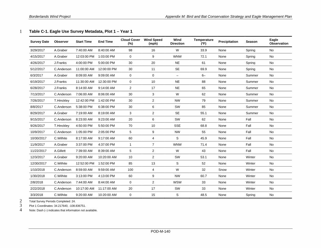
Borderlands Wind Project Appendix M: Bird and Bat Conservation Strategy and Eagle Management Plan
POD-M-140
Table C-1. Eagle Use Survey Metadata, Plot 1 – Year 1 1
Survey Date Observer Start Time End Time Cloud Cover (%)
Wind Speed (mph)
Wind Direction
Temperature (ºF) Precipitation Season Eagle
Observation
3/29/2017 A.Graber 7:40:00 AM 8:40:00 AM 98 16 W 33.9 None Spring No
4/15/2017 A.Graber 12:03:00 PM 1:03:00 PM 0 9 WNW 72.1 None Spring No
4/26/2017 J.Franks 4:00:00 PM 5:00:00 PM 30 20 NE 61 None Spring No
5/12/2017 C.Anderson 11:00:00 AM 12:00:00 PM 30 11 SE 69.9 None Spring No
6/3/2017 A.Graber 8:09:00 AM 9:09:00 AM 0 0 – 6– None Summer No
6/19/2017 J.Franks 11:30:00 AM 12:30:00 PM 0 10 NE 88 None Summer No
6/28/2017 J.Franks 8:14:00 AM 9:14:00 AM 2 17 NE 65 None Summer No
7/13/2017 C.Anderson 7:06:00 AM 8:06:00 AM 30 3 W 62 None Summer No
7/26/2017 T.Hinckley 12:42:00 PM 1:42:00 PM 30 2 NW 79 None Summer No
8/8/2017 C.Anderson 5:38:00 PM 6:38:00 PM 30 6 SW 85 None Summer No
8/29/2017 A.Graber 7:19:00 AM 8:19:00 AM 3 2 SE 55.1 None Summer No
9/15/2017 C.Anderson 8:23:00 AM 9:23:00 AM 20 6 SW 62 None Fall No
9/26/2017 T.Hinckley 4:50:00 PM 5:50:00 PM 70 10 SSE 68.8 None Fall No
10/9/2017 C.Anderson 1:05:00 PM 2:05:00 PM 5 9 NW 55 None Fall No
10/30/2017 C.Wilhite 8:17:00 AM 9:17:00 AM 60 4 S 45.9 None Fall No
11/9/2017 A.Graber 3:37:00 PM 4:37:00 PM 1 7 WNW 71.4 None Fall No
11/22/2017 A.Gillett 7:39:00 AM 8:39:00 AM 5 2 W 43 None Fall No
12/3/2017 A.Graber 9:20:00 AM 10:20:00 AM 10 2 SW 53.1 None Winter No
12/30/2017 C.Wilhite 12:52:00 PM 1:52:00 PM 85 13 S 52 None Winter No
1/10/2018 C.Anderson 8:59:00 AM 9:59:00 AM 100 4 W 32 Snow Winter No
1/30/2018 C.Wilhite 3:13:00 PM 4:13:00 PM 60 9 NW 60.7 None Winter No
2/8/2018 C.Anderson 7:44:00 AM 8:44:00 AM 0 2 WSW 33 None Winter No
2/22/2018 C.Anderson 10:17:00 AM 11:17:00 AM 20 17 SW 33 None Winter No
3/3/2018 C.Wilhite 9:20:00 AM 10:20:00 AM 0 15 S 48.5 None Spring No
Total Survey Periods Completed: 24. 2 Plot 1 Coordinates: 34.217640, -108.836751. 3 Note: Dash (–) indicates that information not available. 4

Borderlands Wind Project Appendix M: Bird and Bat Conservation Strategy and Eagle Management Plan
POD-M-141
Table C-2. Eagle Use Survey Metadata, Plot 1 – Year 2 1
Survey Date Observer Start Time End Time Cloud Cover (%)
Wind Speed (mph)
Wind Direction
Temperature (ºF) Precipitation Season Eagle
Observation 3/4/2019 R.Winton 12:31:00 PM 1:31:00 PM 10 6 NW 55 None Spring No 3/28/2018 C.Anderson 1:07:00 PM 2:07:00 PM 0 12 WNW 51 None Spring No 4/13/2018 C.Wilhite 7:06:00 AM 8:06:00 AM 35 17 W 27.5 None Spring No 4/23/2018 A.Graber 6:30:00 PM 7:30:00 PM 35 11 W 74.5 None Spring No 5/7/2018 T.Loomis 7:25:00 AM 8:25:00 AM 15 4 SW 65.1 None Spring No 5/24/2018 T.Loomis 6:41:00 AM 7:41:00 AM 0 0 – 39.6 None Spring No 6/15/2018 C.Wilhite 10:51:00 AM 11:51:00 AM 100 7 WNW 78.1 None Summer No 6/28/2018 C.Anderson 6:09:00 AM 7:09:00 AM 1 – – 62 None Summer No 7/8/2018 T.Hinckley 6:00:00 PM 7:00:00 PM 20 2 NE 83.7 None Summer No 7/25/2018 C.Wilhite 6:39:00 AM 7:39:00 AM 30 9 SE 65.6 None Summer No 8/13/2018 R.Winton 2:59:00 PM 3:59:00 PM 20 6 W 92.4 None Summer No 8/27/2018 R.Winton 2:34:00 PM 3:34:00 PM 20 10 SW 78 None Summer No 9/10/2018 R.Winton 1:43:00 PM 2:43:00 PM 30 3 W 83 None Fall No 9/30/2018 A.Graber 5:44:00 PM 6:44:00 PM 90 5 SE 78.5 None Fall No 10/4/2018 R.Winton 7:30:00 AM 8:30:00 AM 5 2 SW 59 None Fall No 10/22/2018 C.Anderson 12:07:00 PM 1:07:00 PM 100 8 SSW 61 None Fall No 11/13/2018 C.Anderson 7:20:00 AM 8:20:00 AM 0 1 E 27 None Fall No 11/27/2018 R.Winton 2:47:00 PM 3:47:00 PM 10 4 ENE 55 None Fall No 12/7/2018 T.Hinckley 9:33:00 AM 10:33:00 AM 85 1 ESE 39.7 None Winter No 12/11/2018 C.Anderson 3:43:00 PM 4:43:00 PM 80 7 NNW 51 None Winter No 1/14/2019 R.Winton 11:12:00 AM 12:12:00 PM 70 4 S 41 None Winter No 1/31/2019 C.Anderson 7:17:00 AM 8:17:00 AM 25 3 SSW 34 None Winter No 2/10/2019 J.Tolchin 12:43:00 PM 1:43:00 PM 85 16 SW 48.1 None Winter No 2/26/2019 R.Winton 3:03:00 PM 4:03:00 PM 0 1 SW 49 None Winter No
Total Survey Periods Completed: 24. 2 Plot 1 Coordinates: 34.217640, -108.836751. 3 Note: Dash (–) indicates that information not available. 4

Borderlands Wind Project Appendix M: Bird and Bat Conservation Strategy and Eagle Management Plan
POD-M-142
Table C-3. Eagle Use Survey Metadata, Plot 2 – Year 1 1
Survey Date Observer Start Time End Time Cloud Cover (%)
Wind Speed (mph) Wind Direction Temperature
(ºF) Precipitation Season Eagle Observation
3/30/2017 A.Graber 1:31:00 PM 2:31:00 PM 10 24 WSW 68.3 None Spring No
4/15/2017 A.Graber 7:15:00 AM 8:15:00 AM 0 6 S 39.8 None Spring No
4/26/2017 J.Franks 2:20:00 PM 3:20:00 PM 10 20 NE 61 None Spring No
5/12/2017 C.Anderson 8:58:00 AM 9:58:00 AM 3 7 SSW 65.8 None Spring No
6/3/2017 A.Graber 10:17:00 AM 11:17:00 AM 25 2 N 72.7 None Summer No
6/20/2017 A.Graber 8:35:00 AM 9:35:00 AM 75 1 S 78.3 None Summer No
6/28/2017 J.Franks 10:02:00 AM 11:02:00 AM 0 25 NE 69 None Summer No
7/13/2017 A.Graber 7:05:00 AM 8:05:00 AM 25 4 WSW 61.2 None Summer No
7/26/2017 T.Hinckley 10:10:00 AM 11:10:00 AM 40 4 N 71.5 None Summer No
8/10/2017 C.Anderson 12:06:00 PM 1:06:00 PM 75 3 ESE 80 None Summer No
8/29/2017 A.Graber 9:35:00 AM 10:35:00 AM 1 2 E 71.3 None Summer No
9/15/2017 T.Hinckley 8:53:00 AM 9:53:00 AM 20 14 SW 61.3 None Fall No
9/26/2017 C.Anderson 4:31:00 PM 5:31:00 PM 90 10 SSW 59 None Fall No
10/9/2017 T.Hinckley 12:58:00 PM 1:58:00 PM 0 6 W 48.2 None Fall No
10/30/2017 C.Wilhite 10:01:00 AM 11:01:00 AM 55 2 SSE 61.4 None Fall No
11/10/2017 A.Graber 9:59:00 AM 10:59:00 AM 40 4 SE 64.9 None Fall No
11/22/2017 T.Hinckley 7:02:00 AM 8:02:00 AM 10 1 WSW 43.5 None Fall No
12/1/2017 A.Graber 2:48:00 PM 3:48:00 PM 98 15 WSW 53.5 None Winter Yes; see Table C-33
12/31/2017 C.Anderson 1:51:00 PM 2:51:00 PM 15 9 WNW 54 None Winter No
1/10/2018 C.Wilhite 9:05:00 AM 10:25:00 AM 99 2 W 31.3 Snow Winter No
1/30/2018 C.Wilhite 1:30:00 PM 2:30:00 PM 75 8 NNW 62.6 None Winter No
2/8/2018 C.Anderson 9:47:00 AM 10:47:00 AM 5 1 SW 49 None Winter No
2/22/2018 C.Anderson 12:26:00 PM 1:26:00 PM – – – – None Winter No
3/3/2018 C.Wilhite 7:15:00 AM 8:15:00 AM 0 6 S 36.7 None Spring No
Total Survey Periods Completed: 24. 2 Plot 2 Coordinates: 34.197440, -108.840164. 3 Note: Dash (–) indicates that information not available. 4

Borderlands Wind Project Appendix M: Bird and Bat Conservation Strategy and Eagle Management Plan
POD-M-143
Table C-4. Eagle Use Survey Metadata, Plot 2 – Year 2 1
Survey Date Observer Start Time End Time Cloud Cover (%)
Wind Speed (mph) Wind Direction Temperature
(ºF) Precipitation Season Eagle Observation
3/28/2018 C.Anderson 8:56:00 AM 9:56:00 AM 0 8 W 36 None Spring No
4/13/2018 C.Wilhite 10:37:00 AM 11:37:00 AM 25 30 W 35.2 None Spring No
4/25/2018 A.Graber 3:00:00 PM 4:00:00 PM 10 10 WSW 84.1 None Spring No
5/7/2018 T.Loomis 9:26:00 AM 10:26:00 AM 45 5 SW 74.1 None Spring No
5/24/2018 T.Loomis 10:52:00 AM 11:52:00 AM 10 4 SSE 68.1 None Spring No
6/15/2018 C.Wilhite 8:53:00 AM 9:53:00 AM 100 3 WSW 76.1 None Summer No
6/25/2018 C.Anderson 5:56:00 PM 6:56:00 PM 10 11 NW 89 None Summer No
7/11/2018 T.Hinckley 6:55:00 AM 7:55:00 AM 85 1 SSE 60.9 None Summer No
7/26/2018 C.Anderson 9:16:00 AM 10:16:00 AM 25 3 NW 81 None Summer No
8/13/2018 C.Anderson 3:06:00 PM 4:06:00 PM 30 7 N 85 None Summer No
8/27/2018 R.Winton 4:10:00 PM 5:10:00 PM 15 5 SW 86 None Summer No
9/10/2018 R.Winton 3:25:00 PM 4:25:00 PM 30 1 NW 84 None Fall No
9/26/2018 T.Hinckley 7:29:00 AM 8:29:00 AM 30 2 WSW 55.7 None Fall No
10/11/2018 C.Anderson 1:32:00 PM 2:32:00 PM 95 9 SW 64 None Fall No
10/23/2018 C.Anderson 2:19:00 PM 3:19:00 PM 100 – – – Light drizzle Fall No
11/15/2018 T.Hinckley 7:07:00 AM 8:07:00 AM 0 4 S 29.9 None Fall No
11/27/2018 R.Winton 1:01:00 PM 2:01:00 PM 0 4 N 57 None Fall No
12/7/2018 J.Tolchin 10:48:00 AM 11:48:00 AM 75 2 SSW 51.2 None Winter No
12/12/2018 J.Tolchin 7:34:00 AM 8:34:00 AM 10 2 SE 26 None Winter No
1/14/2019 R.Winton 12:55:00 PM 1:55:00 PM 80 5 S 43 None Winter No
1/31/2019 C.Anderson 9:27:00 AM 10:27:00 AM 3 5 W 45 None Winter No
2/11/2019 J.Tolchin 2:31:00 PM 3:31:00 PM 100 2 S 37 Light drizzle Winter No
2/26/2019 R.Winton 7:00:00 AM 8:00:00 AM 0 1 SW 24 None Winter No
2/28/2019 C.Anderson 3:06:00 PM 4:06:00 PM 30 16 W 56 None Winter No
Total Survey Periods Completed: 24. 2 Plot 2 Coordinates: 34.197440, -108.840164. 3 Note: Dash (–) indicates that information not available. 4

Borderlands Wind Project Appendix M: Bird and Bat Conservation Strategy and Eagle Management Plan
POD-M-144
Table C-5. Eagle Use Survey Metadata, Plot 3 – Year 1 1
Survey Date Observer Start Time End Time Cloud Cover (%)
Wind Speed (mph) Wind Direction Temperature
(ºF) Precipitation Season Eagle Observation
3/28/2017 A.Graber 8:26:00 AM 9:26:00 AM 80 3 NE 37.4 None Spring No
4/12/2017 A.Graber 4:50:00 PM 5:50:00 PM 10 8 NW 75.6 None Spring No
4/26/2017 J.Franks 9:07:00 AM 10:07:00 AM 5 10 NW 44 None Spring No
5/10/2017 C.Anderson 1:05:00 PM 2:05:00 PM 90 8 WNW 55.3 None Spring No
6/2/2017 A.Graber 5:18:00 PM 6:18:00 PM 85 4 SE 82.5 None Summer No
6/20/2017 A.Graber 6:40:00 AM 7:40:00 AM 60 3 WSW 63.5 None Summer No
6/28/2017 J.Franks 11:20:00 AM 12:20:00 PM 0 20 NE 84 None Summer No
7/13/2017 A.Graber 9:04:00 AM 10:04:00 AM 15 2 WNW 69.2 None Summer No
7/26/2017 C.Anderson 1:01:00 PM 2:01:00 PM 40 0 – 81 None Summer No
8/9/2017 C.Anderson 4:41:00 PM 5:41:00 PM 90 7 NW 81 None Summer No
8/29/2017 A.Graber 11:56:00 AM 12:56:00 PM 10 4 N 83 None Summer No
9/14/2017 C.Anderson 10:26:00 AM 11:26:00 AM 50 12 SSW 66 None Fall No
9/26/2017 T.Hinckley 2:30:00 PM 3:30:00 PM 60 10 S 66.2 None Fall Yes; see Table C-33
10/9/2017 C.Anderson 4:48:00 PM 5:48:00 PM 0 8 NW 55 None Fall No
10/30/2017 C.Wilhite 1:59:00 PM 2:59:00 PM 95 6 SW 66.6 None Fall No
11/10/2017 A.Graber 8:12:00 AM 9:12:00 AM 15 3 SE 48 None Fall No
11/22/2017 A.Gillett 9:49:00 AM 10:49:00 AM 5 2 NW 55 None Fall No
12/3/2017 A.Graber 7:29:00 AM 8:29:00 AM 3 4 S 39.8 None Winter No
12/30/2017 C.Wilhite 3:03:00 PM 4:03:00 PM 90 4 S 51.3 None Winter No
1/9/2018 C.Wilhite 2:31:00 PM 3:31:00 PM 75 10 S 58.2 None Winter No
1/31/2018 C.Wilhite 7:29:00 AM 8:29:00 AM 15 4 NW 21.3 None Winter No
2/6/2018 C.Anderson 2:51:00 PM 3:51:00 PM 30 18 WNW 55 None Winter No
2/22/2018 C.Anderson 8:14:00 AM 9:14:00 AM 40 11 SW 30 None Winter No
3/2/2018 C.Wilhite 1:38:00 PM 2:38:00 PM 0 14 WSW 58.9 None Spring No
Total Survey Periods Completed: 24. 2 Plot 3 Coordinates: 34.173223, -108.858192. 3 Note: Dash (–) indicates that information not available. 4

Borderlands Wind Project Appendix M: Bird and Bat Conservation Strategy and Eagle Management Plan
POD-M-145
Table C-6. Eagle Use Survey Metadata, Plot 3 – Year 2 1
Survey Date Observer Start Time End Time Cloud Cover (%)
Wind Speed (mph)
Wind Direction
Temperature (ºF) Precipitation Season Eagle
Observation
3/27/2018 C.Anderson 3:51:00 PM 4:51:00 PM 75 12 W 45 Snow Spring No
4/13/2018 C.Wilhite 8:47:00 AM 9:47:00 AM 10 20 W 29 None Spring No
4/22/2018 A.Graber 5:18:00 PM 6:18:00 PM 90 4 N 73.5 None Spring No
5/7/2018 T.Loomis 11:23:00 AM 12:23:00 PM 70 2 SW 78.1 None Spring No
5/21/2018 T.Loomis 7:31:00 AM 8:31:00 AM 15 2 E 56.9 None Spring No
6/11/2018 T.Hinckley 11:46:00 AM 12:36:00 PM 0 2 NW 84.8 None Summer No
6/26/2018 C.Anderson 6:24:00 AM 7:24:00 AM 0 3 WNW 63 None Summer No
7/10/2018 T.Hinckley 4:36:00 PM 5:36:00 PM 80 8 SE 78.5 None Summer No
7/25/2018 C.Wilhite 10:33:00 AM 11:33:00 AM 20 8 NNW 80.7 None Summer No
8/14/2018 C.Anderson 7:28:00 AM 8:28:00 AM 5 4 N 65 None Summer No
8/28/2018 R.Winton 4:41:00 PM 5:41:00 PM 5 5 W 78 None Summer No
9/13/2018 R.Winton 11:49:00 AM 12:49:00 PM 10 4 SW 79 None Fall No
9/26/2018 T.Hinckley 9:32:00 AM 10:32:00 AM 35 2 NNW 67.2 None Fall No
10/10/2018 C.Anderson 3:52:00 PM 4:52:00 PM 50 5 W 58 None Fall No
10/16/2018 C.Anderson 10:18:00 AM 11:18:00 AM 100 7 S 37 Light drizzle Fall No
11/14/2018 T.Hinckley 7:06:00 AM 8:06:00 AM 30 1 SW 29.5 None Fall No
11/27/2018 R.Winton 11:27:00 AM 12:27:00 PM 0 2 ENE 57 None Fall No
12/5/2018 T.Hinckley 2:59:00 PM 3:59:00 PM 20 10 WSW 53.3 None Winter No
12/12/2018 J.Tolchin 9:21:00 AM 10:21:00 AM 5 3 WSW 40.4 None Winter Yes; see Table C-34
1/8/2019 T.Hinckley 2:06:00 PM 3:06:00 PM 10 1 E 46.6 None Winter No
1/22/2019 J.Tolchin 10:33:00 AM 11:33:00 AM 95 14 W 24.8 None Winter No
2/14/2019 C.Anderson 7:24:00 AM 8:24:00 AM 100 2 S 37 Light drizzle Winter No
2/25/2019 R.Winton 4:09:00 PM 5:09:00 PM 40 3 NW 48 None Winter No
3/1/2019 C.Anderson 7:51:00 AM 8:51:00 AM 50 2 W 42 None Spring No
Total Survey Periods Completed: 24. 2 Plot 3 Coordinates: 34.173223, -108.858192. 3 4

Borderlands Wind Project Appendix M: Bird and Bat Conservation Strategy and Eagle Management Plan
POD-M-146
Table C-7. Eagle Use Survey Metadata, Plot 4 – Year 1 1
Survey Date Observer Start Time End Time Cloud Cover (%)
Wind Speed (mph) Wind Direction Temperature
(ºF) Precipitation Season Eagle Observation
3/28/2017 A.Graber 11:05:00 AM 12:05:00 PM 90 8 SW 44.1 None Spring No
4/15/2017 A.Graber 9:45:00 AM 10:45:00 AM 0 2 SSW 57.2 None Spring No
4/26/2017 J.Franks 10:43:00 AM 11:43:00 AM 15 10 NW 51 None Spring No
5/10/2017 C.Anderson 2:46:00 PM 3:46:00 PM 100 11 W 46.8 Light drizzle Spring No
5/31/2017 A.Graber 7:47:00 AM 8:47:00 AM 99 1 SE 58.4 None Spring No
6/19/2017 A.Graber 12:45:00 PM 1:45:00 PM 10 8 NE 100.4 None Summer No
6/28/2017 C.Anderson 7:30:00 AM 8:30:00 AM 0 6 WSW 68 None Summer No
7/13/2017 C.Anderson 9:11:00 AM 10:11:00 AM 25 0 – 72 None Summer No
7/26/2017 C.Anderson 11:34:00 AM 12:34:00 PM 40 2 – 77 None Summer No
8/8/2017 C.Anderson 3:31:00 PM 4:31:00 PM 40 4 W 84 None Summer No
8/29/2017 A.Graber 2:02:00 PM 3:02:00 PM 40 3 NE 91.3 None Summer No
9/15/2017 C.Anderson 12:06:00 PM 1:06:00 PM 40 9 SW 69 None Fall No
9/26/2017 T.Hinckley 12:38:00 PM 1:38:00 PM 40 4 SW 69.4 None Fall No
10/9/2017 C.Anderson 3:11:00 PM 4:11:00 PM 1 9 W 56 None Fall No
10/30/2017 C.Wilhite 12:14:00 PM 1:14:00 PM 85 1 W 68.7 None Fall No
11/8/2017 A.Graber 8:16:00 AM 9:16:00 AM 45 2 SSW 43.3 None Fall No
11/22/2017 T.Hinckley 10:17:00 AM 11:17:00 AM 15 2 ENE 56 None Fall No
12/1/2017 A.Graber 12:29:00 PM 1:29:00 PM 99 0 – 55.4 Light drizzle Winter No
12/31/2017 C.Anderson 11:43:00 AM 12:43:00 PM 90 10 W 52 None Winter No
1/9/2018 C.Wilhite 7:49:00 AM 8:49:00 AM 98 4 SSE 43 None Winter No
1/30/2018 C.Wilhite 11:13:00 AM 12:13:00 PM 55 1 SE 66.1 None Winter No
2/6/2018 C.Anderson 7:54:00 AM 8:54:00 AM 1 4 WSW 39 None Winter No
2/20/2018 C.Anderson 11:22:00 AM 12:22:00 PM 100 3 – 29 Snow Winter No
3/1/2018 C.Wilhite 7:15:00 AM 8:15:00 AM 2 3 SE 27.9 None Spring No
Total Survey Periods Completed: 24. 2 Plot 4 Coordinates: 34.156480, -108.868062. 3 Note: Dash (–) indicates that information not available. 4

Borderlands Wind Project Appendix M: Bird and Bat Conservation Strategy and Eagle Management Plan
POD-M-147
Table C-8. Eagle Use Survey Metadata, Plot 4 – Year 2 1
Survey Date Observer Start Time End Time Cloud Cover (%)
Wind Speed (mph) Wind Direction Temperature
(ºF) Precipitation Season Eagle Observation
3/28/2018 C.Anderson 11:03:00 AM 12:03:00 PM 0 – – – None Spring No
4/14/2018 C.Wilhite 7:46:00 AM 8:46:00 AM 0 7 W 32.3 None Spring No
4/22/2018 A.Graber 3:08:00 PM 4:08:00 PM 65 5 WNW 87.5 None Spring No
5/7/2018 T.Loomis 1:16:00 PM 2:16:00 PM 80 3 SW 80.7 None Spring No
5/21/2018 T.Loomis 9:36:00 AM 10:36:00 AM 25 7 WSW 66.9 None Spring No
6/14/2018 C.Wilhite 10:04:00 AM 11:04:00 AM 60 2 WSW 81.1 None Summer No
6/27/2018 C.Anderson 6:05:00 PM 7:05:00 PM 30 5 NW 91 None Summer No
7/11/2018 T.Hinckley 9:23:00 AM 10:23:00 AM 75 2 E 69.8 None Summer No
7/27/2018 C.Wilhite 8:37:00 AM 9:37:00 AM 20 2 ESE 69.8 None Summer No
8/14/2018 R.Winton 11:17:00 AM 12:17:00 PM 0 1 W 80.2 None Summer No
8/29/2018 A.Pellegrini 9:45:00 AM 10:45:00 AM 5 0 – 84.2 None Summer No
9/13/2018 R.Winton 6:56:00 AM 7:56:00 AM 0 1 SW 66 None Fall No
9/26/2018 T.Hinckley 11:25:00 AM 12:25:00 PM 25 5 W 69.9 None Fall No
10/10/2018 C.Anderson 2:17:00 PM 3:17:00 PM 40 3 W 64 None Fall No
10/18/2018 C.Anderson 9:18:00 AM 10:18:00 AM 50 7 ESE 48 None Fall No
11/12/2018 T.Hinckley 2:03:00 PM 3:03:00 PM 40 3 NW 37.3 None Fall No
11/28/2018 R.Winton 10:47:00 AM 11:47:00 AM 0 2 NNW 59 None Fall No
12/6/2018 J.Tolchin 8:00:00 AM 9:00:00 AM 75 2 SE 40.3 None Winter No
12/11/2018 C.Anderson 11:18:00 AM 12:18:00 PM 90 2 SE 52 None Winter No
1/14/2019 R.Winton 2:32:00 PM 3:32:00 PM 80 5 S 41 None Winter No
1/23/2019 J.Tolchin 9:14:00 AM 10:14:00 AM 0 4 W 24 None Winter No
2/12/2019 C.Anderson 11:24:00 AM 12:24:00 PM 5 6 SSE 47 None Winter No
2/26/2019 R.Winton 8:30:00 AM 9:30:00 AM 0 2 W 34 None Winter No
2/28/2019 C.Anderson 12:46:00 PM 1:46:00 PM 5 8 WNW 58 None Winter No
Total Survey Periods Completed: 24. 2 Plot 4 Coordinates: 34.156480, -108.868062. 3 Note: Note: Dash (–) indicates that information not available. 4

Borderlands Wind Project Appendix M: Bird and Bat Conservation Strategy and Eagle Management Plan
POD-M-148
Table C-9. Eagle Use Survey Metadata, Plot 5 – Year 1 1
Survey Date Observer Start Time End Time Cloud Cover (%)
Wind Speed (mph) Wind Direction Temperature
(ºF) Precipitation Season Eagle Observation
3/30/2017 A.Graber 11:14:00 AM 12:14:00 PM 2 13 W 59.9 None Spring No
4/14/2017 A.Graber 7:51:00 AM 8:51:00 AM 60 5 SE 47.5 None Spring No
4/26/2017 J.Franks 12:26:00 PM 1:26:00 PM 3 10 NW 61 None Spring No
5/10/2017 C.Anderson 4:14:00 PM 5:14:00 PM 95 14 W 50.5 None Spring No
6/2/2017 A.Graber 8:23:00 AM 9:23:00 AM 75 0 – 60.5 None Summer No
6/19/2017 A.Graber 10:35:00 AM 11:35:00 AM 3 9 NW 89 None Summer No
6/28/2017 C.Anderson 8:58:00 AM 9:58:00 AM 0 9 WSW 75 None Summer No
7/12/2017 C.Anderson 12:55:00 PM 1:55:00 PM 80 8 N 79 None Summer No
7/25/2017 T.Hinckley 7:58:00 AM 8:58:00 AM 40 1 SE 64 None Summer No
8/8/2017 C.Anderson 1:48:00 PM 2:48:00 PM 40 0 – 80 None Summer No
8/30/2017 A.Graber 3:18:00 PM 4:18:00 PM 40 8 SE 90.1 None Summer No
9/14/2017 T.Hinckley 1:19:00 PM 2:19:00 PM 70 5 SE 76.6 None Fall No
9/27/2017 C.Anderson 9:47:00 AM 10:22:00 AM 100 2 SSE 52 Rain Fall No
10/9/2017 T.Hinckley 3:18:00 PM 4:18:00 PM 0 5 NW 50.1 None Fall No
10/29/2017 C.Wilhite 8:49:00 AM 9:49:00 AM 0 0 – 47.4 None Fall No
11/9/2017 A.Graber 7:54:00 AM 8:54:00 AM 85 3 SSW 53.2 None Fall No
11/21/2017 A.Gillett 4:23:00 PM 5:23:00 PM 5 5 W 55 None Fall No
12/1/2017 A.Graber 10:31:00 AM 11:31:00 AM 99 1 S 59 None Winter No
12/31/2017 C.Anderson 10:01:00 AM 11:01:00 AM 75 5 W 48 None Winter No
1/9/2018 C.Wilhite 12:41:00 PM 1:41:00 PM 50 9 S 57.2 None Winter No
1/29/2018 C.Wilhite 7:26:00 AM 8:26:00 AM 0 2 S 16.3 None Winter No
2/6/2018 C.Anderson 1:11:00 PM 2:11:00 PM 3 10 W 55 None Winter Yes; see Table C-33
2/20/2018 C.Anderson 3:51:00 PM 4:51:00 PM 70 7 N 33 None Winter Yes; see Table C-33
3/2/2018 C.Wilhite 7:13:00 AM 8:13:00 AM 0 9 SSW 31.3 None Spring No
Total Survey Periods Completed: 24 2 Plot 5 Coordinates: 34.136142, -108.869766 3 4

Borderlands Wind Project Appendix M: Bird and Bat Conservation Strategy and Eagle Management Plan
POD-M-149
Table C-10. Eagle Use Survey Metadata, Plot 5 – Year 2 1
Survey Date Observer Start Time End Time Cloud Cover (%)
Wind Speed (mph) Wind Direction Temperature
(ºF) Precipitation Season Eagle Observation
3/27/2018 C.Anderson 1:36:00 PM 2:36:00 PM 60 5 W 46 None Spring No
4/14/2018 C.Wilhite 3:05:00 PM 4:05:00 PM 0 10 WNW 53.1 None Spring No
4/22/2018 A.Graber 9:48:00 AM 10:48:00 AM 45 5 N 60.2 None Spring No
5/8/2018 T.Loomis 7:10:00 AM 8:10:00 AM 10 3 SW 53 None Spring No
5/21/2018 T.Loomis 4:22:00 PM 5:22:00 PM 60 10 S 73 None Spring No
6/14/2018 C.Wilhite 8:16:00 AM 9:16:00 AM 50 4 E 70.2 None Summer No
6/26/2018 C.Anderson 4:33:00 PM 5:33:00 PM 30 5 SE 90 None Summer No
7/9/2018 T.Hinckley 6:30:00 AM 7:30:00 AM 50 5 SSE 57.5 None Summer No
7/25/2018 C.Wilhite 1:34:00 PM 2:34:00 PM 35 14 W 82.4 None Summer No
8/14/2018 R.Winton 7:30:00 AM 8:30:00 AM 0 2 W 65 None Summer No
8/30/2018 A.Pellegrini 2:47:00 PM 3:47:00 PM 40 1 W 80 None Summer No
9/12/2018 R.Winton 7:48:00 AM 8:48:00 AM 0 2 SW 67 None Fall No
9/26/2018 T.Hinckley 1:39:00 PM 2:39:00 PM 50 8 NW 76.4 None Fall No
10/10/2018 C.Anderson 12:38:00 PM 1:38:00 PM 50 5 NW 63 None Fall No
10/18/2018 C.Anderson 7:27:00 AM 8:27:00 AM 95 4 SE 43 None Fall No
11/12/2018 T.Hinckley 4:08:00 PM 5:08:00 PM 25 7 N 32.5 None Fall No
11/28/2018 R.Winton 8:10:00 AM 9:10:00 AM 30 2 SW 42 None Fall No
12/6/2018 J.Tolchin 3:28:00 PM 4:28:00 PM 95 8 SW 44.4 None Winter No
12/12/2018 C.Anderson 7:55:00 AM 8:55:00 AM 3 3 W 33 None Winter No
1/14/2019 R.Winton 4:00:00 PM 5:00:00 PM 30 6 S 39 None Winter No
1/31/2019 C.Anderson 11:46:00 AM 12:46:00 PM 20 8 WNW 47 None Winter No
2/12/2019 J.Tolchin 9:40:00 AM 10:40:00 AM 10 3 WSW 36.7 None Winter No
2/26/2019 C.Anderson 2:59:00 PM 3:59:00 PM 10 0 – 50 None Winter No
3/5/2019 R.Winton 1:38:00 PM 2:38:00 PM 0 3 SW 65 None Spring No
Total Survey Periods Completed: 24 2 Plot 5 Coordinates: 34.136142, -108.869766 3 4

Borderlands Wind Project Appendix M: Bird and Bat Conservation Strategy and Eagle Management Plan
POD-M-150
Table C-11. Eagle Use Survey Metadata, Plot 6 – Year 1 1
Survey Date Observer Start Time End Time Cloud Cover (%)
Wind Speed (mph) Wind Direction Temperature
(ºF) Precipitation Season Eagle Observation
3/28/2017 A.Graber 1:13:00 PM 2:13:00 PM 60 10 WSW 50 None Spring No
4/14/2017 A.Graber 9:22:00 AM 10:22:00 AM 20 7 SE 60.1 None Spring No
4/26/2017 C.Anderson 9:43:00 AM 10:43:00 AM 25 6 WNW 50.2 None Spring No
5/11/2017 C.Anderson 3:40:00 PM 4:40:00 PM 25 0 N 66.4 None Spring No
6/2/2017 A.Graber 10:48:00 AM 11:48:00 AM 35 1 – 72.5 None Summer No
6/19/2017 A.Graber 6:07:00 AM 7:07:00 AM 4 11 SSW 61.9 None Summer No
6/27/2017 C.Anderson 5:33:00 PM 6:33:00 PM 30 – SW 85 None Summer No
7/12/2017 A.Graber 12:20:00 PM 1:20:00 PM 75 4 WNW 82.7 None Summer No
7/25/2017 T.Hinckley 9:47:00 AM 10:47:00 AM 20 2 W 70 None Summer No
8/10/2017 C.Anderson 10:01:00 AM 11:01:00 AM 100 4 SE 69 None Summer No
8/29/2017 A.Graber 5:48:00 PM 6:48:00 PM 90 8 SSE 63.6 None Summer No
9/14/2017 T.Hinckley 5:07:00 PM 6:07:00 PM 40 13 SSW 70.8 None Fall No
9/27/2017 C.Anderson 8:20:00 AM 9:20:00 AM 100 9 ESE 52 Rain Fall No
10/9/2017 T.Hinckley 4:53:00 PM 5:53:00 PM 0 5 NNW 49.1 None Fall No
10/29/2017 C.Wilhite 10:23:00 AM 11:23:00 AM 0 3 W 59.2 None Fall No
11/8/2017 A.Graber 9:50:00 AM 10:50:00 AM 25 5 NW 51.3 None Fall No
11/21/2017 A.Gillett 2:48:00 PM 3:48:00 PM 5 4 W 60 None Fall No
12/1/2017 A.Graber 9:02:00 AM 10:02:00 AM 99 0 – 49.5 None Winter No
12/30/2017 C.Anderson 12:50:00 PM 1:50:00 PM 80 8 S 54 None Winter No
1/9/2018 C.Wilhite 9:19:00 AM 10:19:00 AM 90 6 S 50.4 None Winter No
1/29/2018 C.Wilhite 10:31:00 AM 11:31:00 AM 0 4 SW 45.6 None Winter No
2/6/2018 C.Anderson 9:30:00 AM 10:30:00 AM 0 19 W 48 None Winter No
2/20/2018 C.Anderson 12:49:00 PM 1:49:00 PM 100 5 N 30 Snow Winter No
3/1/2018 C.Wilhite 8:53:00 AM 9:53:00 AM 0 8 SE 31.3 None Spring No
Total Survey Periods Completed: 24 2 Plot 6 Coordinates: 34.140026, -108.899977 3 4

Borderlands Wind Project Appendix M: Bird and Bat Conservation Strategy and Eagle Management Plan
POD-M-151
Table C-12. Eagle Use Survey Metadata, Plot 6 – Year 2 1
Survey Date Observer Start Time End Time Cloud Cover (%)
Wind Speed (mph) Wind Direction Temperature
(ºF) Precipitation Season Eagle Observation
3/27/2018 C.Anderson 10:03:00 AM 11:03:00 AM 100 6 WSW 34 None Spring No
4/12/2018 C.Wilhite 11:55:00 AM 12:55:00 PM 80 33 WSW 64.4 None Spring No
4/22/2018 A.Graber 1:25:00 PM 2:25:00 PM 70 6 WSW 82.5 None Spring No
5/6/2018 A.Graber 8:58:00 AM 9:58:00 AM 25 9 S 64.7 None Spring No
5/21/2018 T.Loomis 2:46:00 PM 3:46:00 PM 45 14 SW 75.7 None Spring No
6/12/2018 T.Hinckley 6:09:00 AM 7:09:00 AM 0 0 – 49.4 None Summer No
6/26/2018 C.Anderson 11:12:00 AM 12:12:00 PM 1 5 W 84 None Summer No
7/9/2018 T.Hinckley 8:00:00 AM 9:00:00 AM 10 6 SSW 68 None Summer No
7/24/2018 C.Wilhite 12:39:00 PM 1:39:00 PM 40 5 WSW 81.8 None Summer No
8/14/2018 R.Winton 8:42:00 AM 9:42:00 AM 0 6 W 71 None Summer No
8/29/2018 A.Pellegrini 11:40:00 AM 12:40:00 PM 8 4 NW 71.8 None Summer No
9/12/2018 R.Winton 9:16:00 AM 10:16:00 AM 0 2 SW 71 None Fall No
9/26/2018 T.Hinckley 3:34:00 PM 4:34:00 PM 25 12 N 72.5 None Fall No
10/10/2018 C.Anderson 11:08:00 AM 12:08:00 PM 40 6 WSW 53 None Fall No
10/24/2018 C.Anderson 7:53:00 AM 8:53:00 AM 100 7 WSW 52 Fog Fall No
11/15/2018 T.Hinckley 11:26:00 AM 12:26:00 PM 0 1 ENE 54.4 None Fall No
11/28/2018 R.Winton 9:26:00 AM 10:26:00 AM 40 0 – 55 None Fall No
12/6/2018 J.Tolchin 1:45:00 PM 2:45:00 PM 90 11 S 51.4 None Winter No
12/12/2018 C.Anderson 9:23:00 AM 10:23:00 AM 2 4 W 45 None Winter No
1/9/2019 T.Hinckley 10:09:00 AM 11:09:00 AM 95 1 SSW 37.8 None Winter No
1/22/2019 J.Tolchin 12:04:00 PM 1:04:00 PM 100 10 NNW 26.4 Snow Winter No
2/12/2019 C.Anderson 12:55:00 PM 1:55:00 PM 10 9 S 55 None Winter No
2/27/2019 C.Anderson 7:21:00 AM 8:21:00 AM 100 0 – 40 None Winter No
3/5/2019 R.Winton 9:42:00 AM 10:42:00 AM 0 1 SW 46 None Spring No
Total Survey Periods Completed: 24 2 Plot 6 Coordinates: 34.140026, -108.899977 3 4

Borderlands Wind Project Appendix M: Bird and Bat Conservation Strategy and Eagle Management Plan
POD-M-152
Table C-13. Eagle Use Survey Metadata, Plot 7 – Year 1 1
Survey Date Observer Start Time End Time Cloud Cover (%)
Wind Speed (mph) Wind Direction Temperature
(ºF) Precipitation Season Eagle Observation
3/28/2017 A.Graber 3:29:00 PM 4:29:00 PM 60 11 WSW 49.4 None Spring No
4/14/2017 A.Graber 10:53:00 AM 11:53:00 AM 15 10 SE 68.8 None Spring No
4/26/2017 C.Anderson 11:09:00 AM 12:09:00 PM 60 8 WNW 60 None Spring No
5/11/2017 C.Anderson 2:17:00 PM 3:17:00 PM 50 6 NW 66.6 None Spring No
5/31/2017 A.Graber 10:50:00 AM 11:50:00 AM 100 9 SSE 69.6 None Spring No
6/19/2017 A.Graber 8:45:00 AM 9:45:00 AM 4 4 NNW 78 None Summer No
6/27/2017 J.Franks 1:55:00 PM 2:55:00 PM 40 17 SE 89 None Summer No
7/12/2017 A.Graber 10:50:00 AM 11:50:00 AM 85 3 NW 79.3 None Summer No
7/25/2017 C.Anderson 7:51:00 AM 8:51:00 AM 80 0 – 60 None Summer No
8/10/2017 C.Anderson 8:33:00 AM 9:33:00 AM 99 4 SE 64 None Summer No
8/30/2017 A.Graber 1:31:00 PM 2:31:00 PM 25 5 SSE 84.2 None Summer No
9/14/2017 T.Hinckley 3:28:00 PM 4:28:00 PM 90 6 S 64.9 Light drizzle Fall No
9/28/2017 T.Hinckley 2:12:00 PM 3:12:00 PM 35 8 S 68.6 None Fall No
10/10/2017 C.Anderson 12:23:00 PM 1:23:00 PM 5 10 SSE 58 None Fall No
10/29/2017 C.Wilhite 11:47:00 AM 12:47:00 PM 0 4 WNW 62.9 None Fall No
11/8/2017 A.Graber 11:12:00 AM 12:12:00 PM 8 4 NW 57 None Fall No
11/21/2017 T.Hinckley 2:48:00 PM 3:48:00 PM 10 4 NNW 60.7 None Fall No
12/1/2017 A.Graber 7:35:00 AM 8:35:00 AM 99 0 – 42.1 None Winter No
12/30/2017 C.Anderson 2:24:00 PM 3:24:00 PM 90 14 S 50 None Winter No
1/9/2018 C.Wilhite 11:02:00 AM 12:02:00 PM 80 17 SE 53.8 None Winter No
1/29/2018 C.Wilhite 8:58:00 AM 9:58:00 AM 0 10 S 30.5 None Winter No
2/6/2018 C.Anderson 11:09:00 AM 12:09:00 PM 1 14 W 50 None Winter No
2/20/2018 C.Anderson 2:16:00 PM 3:16:00 PM 100 7 N 30 Snow Winter No
3/1/2018 C.Wilhite 10:58:00 AM 11:58:00 AM 0 15 S 40.6 None Spring No
Total Survey Periods Completed: 24 2 Plot 7 Coordinates: 34.126354, -108.912490 3 4

Borderlands Wind Project Appendix M: Bird and Bat Conservation Strategy and Eagle Management Plan
POD-M-153
Table C-14. Eagle Use Survey Metadata, Plot 7 – Year 2 1
Survey Date Observer Start Time End Time Cloud Cover (%)
Wind Speed (mph) Wind Direction Temperature
(ºF) Precipitation Season Eagle Observation
3/27/2018 C.Anderson 11:43:00 AM 12:43:00 PM 98 5 W 36 None Spring No
4/11/2018 C.Wilhite 12:18:00 PM 1:18:00 PM 40 11 W 74.6 None Spring No
4/22/2018 A.Graber 11:40:00 AM 12:40:00 PM 55 6 SW 75.5 None Spring No
5/6/2018 A.Graber 7:35:00 AM 8:35:00 AM 25 7 S 51.2 None Spring No
5/21/2018 T.Loomis 1:18:00 PM 2:18:00 PM 60 19 SW 71.1 None Spring No
6/12/2018 T.Hinckley 9:29:00 AM 10:29:00 AM 0 5 N 78 None Summer No
6/26/2018 C.Anderson 2:37:00 PM 3:37:00 PM 25 7 WSW 89 None Summer No
7/9/2018 T.Hinckley 9:34:00 AM 10:34:00 AM 15 6 SE 70.1 None Summer No
7/24/2018 C.Wilhite 2:31:00 PM 3:31:00 PM 75 6 NW 86.2 None Summer No
8/15/2018 R.Winton 8:55:00 AM 9:55:00 AM 10 0 – 71.2 None Summer No
8/29/2018 A.Pellegrini 1:30:00 PM 2:30:00 PM 10 2 SSE 82.5 None Summer No
9/12/2018 R.Winton 12:00:00 PM 1:00:00 PM 5 10 SW 74 None Fall No
9/27/2018 T.Hinckley 7:58:00 AM 8:58:00 AM 2 3 W 49.5 None Fall No
10/3/2018 R.Winton 4:05:00 PM 5:05:00 PM 50 1 SW 77 None Fall No
10/23/2018 C.Anderson 10:41:00 AM 11:41:00 AM 100 7 S 54 None Fall No
11/15/2018 T.Hinckley 9:36:00 AM 10:36:00 AM 0 6 SSE 47.3 None Fall No
11/28/2018 T.Hinckley 11:25:00 AM 12:25:00 PM 15 4 WNW 58.4 None Fall No
12/7/2018 J.Tolchin 7:45:00 AM 8:45:00 AM 75 0 E 40 None Winter No
12/12/2018 C.Anderson 10:52:00 AM 11:52:00 AM 5 6 W 48 None Winter No
1/16/2019 R.Winton 8:56:00 AM 9:56:00 AM 0 1 SW 39 None Winter No
1/22/2019 J.Tolchin 3:10:00 PM 4:10:00 PM 90 10 N 26 Snow Winter No
2/13/2019 C.Anderson 11:29:00 AM 12:29:00 PM 100 4 SW 48 None Winter No
2/26/2019 C.Anderson 1:12:00 PM 2:12:00 PM 5 3 NE 49 None Winter No
3/5/2019 R.Winton 12:14:00 PM 1:14:00 PM 0 3 S 60 None Spring No
Total Survey Periods Completed: 24 2 Plot 7 Coordinates: 34.126354, -108.912490 3 4

Borderlands Wind Project Appendix M: Bird and Bat Conservation Strategy and Eagle Management Plan
POD-M-154
Table C-15. Eagle Use Survey Metadata, Plot 8 – Year 1 1
Survey Date Observer Start Time End Time Cloud Cover (%)
Wind Speed (mph) Wind Direction Temperature
(ºF) Precipitation Season Eagle Observation
3/29/2017 A.Graber 4:21:00 PM 5:21:00 PM 45 8 WNW 51.6 None Spring No
4/14/2017 A.Graber 12:55:00 PM 1:55:00 PM 5 14 SSW 77.7 None Spring No
4/26/2017 C.Anderson 12:51:00 PM 1:51:00 PM 20 10 WNW 60.8 None Spring No
5/11/2017 C.Anderson 12:36:00 PM 1:36:00 PM 60 7 NW 58.5 None Spring No
6/1/2017 A.Graber 10:53:00 AM 11:53:00 AM 35 15 S 73.2 None Summer No
6/20/2017 J.Franks 7:15:00 AM 8:15:00 AM 15 10 SW 70 None Summer No
6/27/2017 J.Franks 3:40:00 PM 4:40:00 PM 40 20 SE 89 None Summer No
7/12/2017 C.Anderson 10:46:00 AM 11:46:00 AM 70 4 N 73 None Summer No
7/25/2017 C.Anderson 9:38:00 AM 10:38:00 AM 50 3 E 69 None Summer No
8/9/2017 C.Anderson 11:37:00 AM 12:37:00 PM 50 7 SW 77 None Summer No
8/30/2017 A.Graber 11:05:00 AM 12:05:00 PM 0 10 SE 78.2 None Summer No
9/14/2017 C.Anderson 2:40:00 PM 3:40:00 PM 95 18 S 64 Rain Fall No
9/28/2017 T.Hinckley 11:23:00 AM 12:23:00 PM 25 4 SE 59.7 None Fall No
10/10/2017 C.Anderson 10:34:00 AM 11:34:00 AM 0 7 S 48 None Fall No
10/28/2017 C.Wilhite 11:56:00 AM 12:56:00 PM 10 9 NNW 59.1 None Fall No
11/8/2017 A.Graber 1:55:00 PM 2:55:00 PM 2 6 NW 60.6 None Fall No
11/21/2017 T.Hinckley 7:39:00 AM 8:39:00 AM 10 7 WNW 38.8 None Fall No
12/2/2017 A.Graber 9:09:00 AM 10:09:00 AM 95 8 SSE 44.9 None Winter Yes; see Table C-33
12/31/2017 C.Wilhite 12:18:00 PM 1:18:00 PM 75 12 W 56.6 None Winter No
1/9/2018 C.Anderson 9:18:00 AM 10:18:00 AM 75 11 SE 45 None Winter Yes; see Table C-33
1/29/2018 C.Wilhite 1:11:00 PM 2:11:00 PM 30 12 S 61.2 None Winter No
2/7/2018 C.Anderson 9:23:00 AM 10:23:00 AM 0 2 SSE 34 None Winter No
2/21/2018 C.Anderson 1:05:00 PM 2:05:00 PM 50 17 S 39 None Winter No
3/1/2018 C.Wilhite 12:59:00 PM 1:59:00 PM 0 14 SSW 45.7 None Spring No
Total Survey Periods Completed: 24 2 Plot 8 Coordinates: 34.081635, -108.922756 3 4

Borderlands Wind Project Appendix M: Bird and Bat Conservation Strategy and Eagle Management Plan
POD-M-155
Table C-16. Eagle Use Survey Metadata, Plot 8 – Year 2 1
Survey Date Observer Start Time End Time Cloud Cover (%)
Wind Speed (mph) Wind Direction Temperature
(ºF) Precipitation Season Eagle Observation
3/25/2018 A.Graber 10:20:00 AM 11:20:00 AM 45 14 SSW 51.5 None Spring No
4/11/2018 C.Wilhite 4:29:00 PM 5:29:00 PM 90 15 W 65.3 None Spring No
4/25/2018 A.Graber 10:00:00 AM 11:00:00 AM 1 2 NE 62.6 None Spring No
5/9/2018 T.Loomis 9:24:00 AM 10:24:00 AM 25 4 W 70.6 None Spring No
5/22/2018 T.Loomis 1:52:00 PM 2:52:00 PM 35 19 S 75.5 None Spring No
6/13/2018 C.Wilhite 9:45:00 AM 10:45:00 AM 35 0 – 75.3 None Summer No
6/27/2018 C.Anderson 12:11:00 PM 1:11:00 PM 0 8 NW 86 None Summer Yes; see Table C-34
7/10/2018 T.Hinckley 9:52:00 AM 10:52:00 AM 95 8 S 62.9 None Summer No
7/24/2018 C.Anderson 11:39:00 AM 12:39:00 PM 50 5 SSE 84 None Summer No
8/15/2018 R.Winton 7:16:00 AM 8:16:00 AM 20 0 – 64 None Summer No
8/28/2018 R.Winton 10:25:00 AM 11:25:00 AM 5 1 S 75 None Summer No
9/11/2018 R.Winton 1:45:00 PM 2:45:00 PM 30 4 W 82 None Fall No
9/22/2018 C.Anderson 9:24:00 AM 10:24:00 AM 0 7 SSE 62 None Fall No
10/3/2018 R.Winton 10:23:00 AM 11:23:00 AM 90 7 E 59 Light drizzle Fall No
10/17/2018 C.Anderson 10:35:00 AM 11:35:00 AM 100 10 SE 40 None Fall No
11/13/2018 T.Hinckley 9:17:00 AM 10:17:00 AM 0 6 NE 31.8 None Fall No
11/27/2018 T.Hinckley 11:03:00 AM 12:03:00 PM 0 3 NW 51.2 None Fall No
12/6/2018 T.Hinckley 9:10:00 AM 10:10:00 AM 90 6 SSW 44.4 None Winter No
12/11/2018 J.Tolchin 2:46:00 PM 3:46:00 PM 80 5 SE 51.8 None Winter No
1/15/2019 R.Winton 8:12:00 AM 9:12:00 AM 60 3 SW 32 None Winter No
2/1/2019 R.Winton 8:18:00 AM 9:18:00 AM 70 1 S 30 None Winter No
2/10/2019 J.Tolchin 4:24:00 PM 5:24:00 PM 60 13 SSW 39.5 None Winter No
2/28/2019 C.Anderson 9:10:00 AM 10:10:00 AM 10 2 W 42 None Winter No
3/4/2019 C.Anderson 12:21:00 PM 1:21:00 PM 5 8 W 48 None Spring No
Total Survey Periods Completed: 24 2 Plot 8 Coordinates: 34.081635, -108.922756 3 4

Borderlands Wind Project Appendix M: Bird and Bat Conservation Strategy and Eagle Management Plan
POD-M-156
Table C-17. Eagle Use Survey Metadata, Plot 9 – Year 1 1
Survey Date Observer Start Time End Time Cloud Cover (%)
Wind Speed (mph)
Wind Direction
Temperature (ºF) Precipitation Season Eagle Observation
3/29/2017 A.Graber 12:35:00 PM 1:35:00 PM 35 8 W 51.9 None Spring No
4/14/2017 A.Graber 3:15:00 PM 4:15:00 PM 1 14 SW 77.7 None Spring No
4/26/2017 C.Anderson 2:32:00 PM 3:32:00 PM 50 11 WNW 61.3 None Spring No
5/11/2017 C.Anderson 11:05:00 AM 12:05:00 PM 50 7 NNW 56.6 None Spring No
6/1/2017 A.Graber 10:07:00 AM 11:07:00 AM 20 – – 61.6 None Summer No
6/20/2017 J.Franks 8:30:00 AM 9:30:00 AM 15 10 SW 70 None Summer No
6/27/2017 J.Franks 5:00:00 PM 6:00:00 PM 20 20 SE 88 None Summer No
7/12/2017 A.Graber 8:42:00 AM 9:42:00 AM 50 2 SW 68.4 None Summer No
7/25/2017 C.Anderson 12:49:00 PM 1:49:00 PM 90 3 NNW 72 Light drizzle Summer No
8/9/2017 C.Anderson 10:01:00 AM 11:01:00 AM 15 5 SW 73 None Summer No
8/28/2017 A.Graber 3:35:00 PM 4:35:00 PM 70 4 W 88.9 None Summer No
9/14/2017 C.Anderson 1:18:00 PM 2:18:00 PM 60 12 S None Fall No
9/28/2017 T.Hinckley 9:28:00 AM 10:28:00 AM 20 8 SSE 52.9 None Fall No
10/10/2017 C.Anderson 8:35:00 AM 9:35:00 AM 0 9 S 39 None Fall No
10/28/2017 C.Wilhite 1:46:00 PM 2:46:00 PM 30 4 N 60.6 None Fall No
11/8/2017 A.Graber 3:51:00 PM 4:51:00 PM 3 3 NW 59.4 None Fall No
11/21/2017 A.Gillett 7:35:00 AM 8:35:00 AM 5 10 W 37.5 None Fall No
12/2/2017 A.Graber 11:52:00 AM 12:52:00 PM 96 2 SW 56.5 None Winter No
12/31/2017 C.Wilhite 10:31:00 AM 11:31:00 AM 95 7 NNW 52.8 None Winter No
1/9/2018 C.Anderson 7:37:00 AM 8:37:00 AM 90 12 SSE 42 None Winter No
1/29/2018 C.Wilhite 3:12:00 PM 4:12:00 PM 30 5 S 56.2 None Winter No
2/7/2018 C.Anderson 7:54:00 AM 8:54:00 AM 0 0 – 33 None Winter No
2/21/2018 C.Anderson 10:59:00 AM 11:59:00 AM 50 14 S 35 Snow Winter No
3/1/2018 C.Wilhite 3:02:00 PM 4:02:00 PM 15 18 SSW 45.4 None Spring Yes; see Table C-33
Total Survey Periods Completed: 24 2 Plot 9 Coordinates: 34.100519, -108.904411 3 4

Borderlands Wind Project Appendix M: Bird and Bat Conservation Strategy and Eagle Management Plan
POD-M-157
Table C-18. Eagle Use Survey Metadata, Plot 9 – Year 2 1
Survey Date Observer Start Time End Time Cloud Cover (%)
Wind Speed (mph) Wind Direction Temperature
(ºF) Precipitation Season Eagle Observation
3/27/2018 A.Graber 10:06:00 AM 11:06:00 AM 100 6 SW 40.2 None Spring No
4/12/2018 C.Wilhite 2:37:00 PM 3:37:00 PM 25 45 WSW 61.7 None Spring No
4/23/2018 A.Graber 9:35:00 AM 10:35:00 AM 0 6 SW 57.4 None Spring No
5/9/2018 T.Loomis 10:56:00 AM 11:56:00 AM 25 9 W 74.9 None Spring No
5/22/2018 T.Loomis 3:43:00 PM 4:43:00 PM 20 10 SSW 75.7 None Spring No
6/13/2018 C.Wilhite 6:48:00 AM 7:48:00 AM 40 0 – 48 None Summer No
6/27/2018 C.Anderson 2:24:00 PM 3:24:00 PM 5 3 SE 92 None Summer No
7/10/2018 T.Hinckley 8:16:00 AM 9:16:00 AM 95 12 SSE 58.8 None Summer No
7/24/2018 C.Anderson 1:46:00 PM 2:46:00 PM 60 6 W 90 None Summer No
8/15/2018 C.Anderson 9:06:00 AM 10:06:00 AM 40 3 ENE 74 None Summer No
8/28/2018 R.Winton 11:50:00 AM 12:50:00 PM 5 1 W 78 None Summer No
9/11/2018 R.Winton 11:53:00 AM 12:53:00 PM 5 1 W 77 None Fall No
9/22/2018 C.Anderson 7:57:00 AM 8:58:00 AM 0 9 S 53 None Fall No
10/3/2018 R.Winton 11:43:00 AM 12:43:00 PM 80 8 S 67 None Fall No
10/17/2018 C.Anderson 9:07:00 AM 10:07:00 AM 100 8 SSE 36 None Fall No
11/13/2018 T.Hinckley 1:22:00 PM 2:22:00 PM 0 9 NE 46.1 None Fall No
11/27/2018 T.Hinckley 1:34:00 PM 2:34:00 PM 10 4 NW 52.8 None Fall No
12/6/2018 T.Hinckley 7:36:00 AM 8:36:00 AM 75 8 SW 34.6 None Winter No
12/11/2018 J.Tolchin 1:09:00 PM 2:09:00 PM 90 4 W 53.3 None Winter No
1/15/2019 R.Winton 1:29:00 PM 2:29:00 PM 90 18 SW 30 None Winter No
2/1/2019 R.Winton 7:01:00 AM 8:01:00 AM 75 1 SW 30 None Winter No
2/11/2019 J.Tolchin 10:47:00 AM 11:47:00 AM 10 18 SW 25.6 None Winter No
2/28/2019 C.Anderson 10:36:00 AM 11:36:00 AM 3 2 W 52 None Winter No
3/4/2019 C.Anderson 3:18:00 PM 4:08:00 PM 50 10 W 52 None Spring No
Total Survey Periods Completed: 24 2 Plot 9 Coordinates: 34.100519, -108.904411 3 4

Borderlands Wind Project Appendix M: Bird and Bat Conservation Strategy and Eagle Management Plan
POD-M-158
Table C-19. Eagle Use Survey Metadata, Plot 10 – Year 1 1
Survey Date Observer Start Time End Time Cloud Cover (%)
Wind Speed (mph) Wind Direction Temperature
(ºF) Precipitation Season Eagle Observation
6/1/2017 A.Graber 2:03:00 PM 3:03:00 PM 50 7 SW 88.7 None Summer No
6/19/2017 J.Franks 8:17:00 AM 9:17:00 AM 0 2 NW 75 None Summer No
6/27/2017 J.Franks 6:22:00 PM 7:22:00 PM 20 15 SE 84 None Summer No
7/12/2017 C.Anderson 8:46:00 AM 9:46:00 AM 60 3 NNW 68 None Summer No
7/26/2017 C.Anderson 9:51:00 AM 10:51:00 AM 70 3 N 73 None Summer No
8/9/2017 C.Anderson 8:30:00 AM 9:30:00 AM 5 5 SSE 70 None Summer No
8/28/2017 A.Graber 12:19:00 PM 1:19:00 PM 40 2 W 88.7 None Summer No
9/14/2017 C.Anderson 4:26:00 PM 5:26:00 PM 40 6 WSW 76 None Fall No
9/27/2017 T.Hinckley 8:37:00 AM 9:37:00 AM 98 5 SE 48.1 Light drizzle Fall No
10/10/2017 T.Hinckley 12:30:00 PM 1:30:00 PM 2 5 SSE 62 None Fall No
10/29/2017 C.Wilhite 1:57:00 PM 2:57:00 PM 1 5 NW 64.3 None Fall No
11/9/2017 A.Graber 11:23:00 AM 12:23:00 PM 2 6 SE 71.7 None Fall No
11/21/2017 A.Gillett 10:26:00 AM 11:26:00 AM 10 6 W 52 None Fall No
12/2/2017 A.Graber 7:15:00 AM 8:15:00 AM 97 7 SSW 42.6 None Winter No
12/31/2017 C.Wilhite 2:07:00 PM 3:07:00 PM 15 10 NW 51.2 None Winter No
1/8/2018 C.Anderson 11:20:00 AM 12:20:00 PM 70 12 SSE 51 None Winter Yes; see Table C-33
1/30/2018 C.Wilhite 7:37:00 AM 8:37:00 AM 60 10 S 33.2 None Winter No
2/7/2018 C.Anderson 11:57:00 AM 12:57:00 PM 0 2 SSW 44 None Winter No
2/21/2018 C.Anderson 2:52:00 PM 3:52:00 PM 40 15 S 36 None Winter No
3/2/2018 C.Wilhite 8:57:00 AM 9:57:00 AM 0 11 SSW 34.6 None Spring No
Total Survey Periods Completed: 20 2 Plot 10 Coordinates: 34.099322, -108.884573 3 4

Borderlands Wind Project Appendix M: Bird and Bat Conservation Strategy and Eagle Management Plan
POD-M-159
Table C-20. Eagle Use Survey Metadata, Plot 10 – Year 2 1
Survey Date Observer Start Time End Time Cloud Cover (%)
Wind Speed (mph) Wind Direction Temperature
(ºF) Precipitation Season Eagle Observation
3/27/2018 A.Graber 11:54:00 AM 12:54:00 PM 70 4 SW 41.3 None Spring No
4/12/2018 C.Wilhite 4:11:00 PM 5:11:00 PM 10 33 WSW 59.8 None Spring No
4/23/2018 A.Graber 7:43:00 AM 8:43:00 AM 25 2 S 50.8 None Spring No
5/8/2018 T.Loomis 12:37:00 PM 1:37:00 PM 0 1 W 79.7 None Spring No
5/22/2018 T.Loomis 5:23:00 PM 6:23:00 PM 15 10 SSW 73.4 None Spring No
6/13/2018 T.Hinckley 8:20:00 AM 9:20:00 AM 35 1 ENE 74.5 None Summer No
6/27/2018 C.Anderson 4:06:00 PM 5:06:00 PM 20 5 NW 90 None Summer No
7/10/2018 T.Hinckley 6:37:00 AM 7:37:00 AM 90 1 ESE 58 None Summer No
7/25/2018 C.Anderson 12:18:00 PM 1:18:00 PM 30 5 W 84 None Summer No
8/15/2018 C.Anderson 7:28:00 AM 8:28:00 AM 50 3 NW 62 None Summer No
8/28/2018 R.Winton 1:24:00 PM 2:24:00 PM 5 3 W 78 None Summer No
9/11/2018 R.Winton 10:14:00 AM 11:14:00 AM 0 2 NW 72 None Fall No
9/22/2018 C.Anderson 11:57:00 AM 12:57:00 PM 5 3 E 68 None Fall No
10/11/2018 C.Anderson 8:54:00 AM 9:54:00 AM 90 5 S 50 None Fall No
10/17/2018 C.Anderson 12:24:00 PM 1:24:00 PM 100 13 E 41 None Fall No
11/13/2018 T.Hinckley 3:19:00 PM 4:19:00 PM 0 6 NE 41.8 None Fall No
11/29/2018 T.Hinckley 7:49:00 AM 8:49:00 AM 75 6 SSE 38.3 None Fall No
12/5/2018 J.Tolchin 11:24:00 AM 12:24:00 PM 90 12 SSE 49 None Winter No
12/13/2018 C.Anderson 7:28:00 AM 8:28:00 AM 0 10 W 20 None Winter No
1/16/2019 R.Winton 11:19:00 AM 12:19:00 PM 0 3 SW 43 None Winter No
1/31/2019 R.Winton 5:11:00 PM 6:11:00 PM 90 1 NW 46 None Winter No
2/11/2019 J.Tolchin 9:19:00 AM 10:19:00 AM 95 20 SW 26.3 Snow Winter No
2/27/2019 C.Anderson 12:40:00 PM 1:40:00 PM 100 4 W 49 None Winter No
3/5/2019 R.Winton 8:00:00 AM 9:00:00 AM 0 0 SW 25 None Spring No
Total Survey Periods Completed: 24 2 Plot 10 Coordinates: 34.099322, -108.884573 3 4

Borderlands Wind Project Appendix M: Bird and Bat Conservation Strategy and Eagle Management Plan
POD-M-160
Table C-21. Eagle Use Survey Metadata, Plot 11 – Year 1 1
Survey Date Observer Start Time End Time Cloud Cover (%)
Wind Speed (mph)
Wind Direction
Temperature (ºF) Precipitation Season Eagle
Observation
3/29/2017 A.Graber 10:18:00 AM 11:18:00 AM 25 11 W 59.3 None Spring No
4/14/2017 A.Graber 5:10:00 PM 6:10:00 PM 2 6 SW 71.4 None Spring No
4/26/2017 C.Anderson 4:07:00 PM 5:07:00 PM 70 13 W 62.5 None Spring No
5/11/2017 C.Anderson 9:29:00 AM 10:29:00 AM 70 4 NNW 53.4 None Spring No
6/1/2017 A.Graber 8:13:00 AM 9:13:00 AM 75 9 S 57.1 None Summer No
6/19/2017 J.Franks 9:35:00 AM 10:35:00 AM 5 10 NE 75 None Summer No
6/27/2017 C.Anderson 2:01:00 PM 3:01:00 PM 60 9 SSW 87 None Summer No
7/12/2017 A.Graber 7:06:00 AM 8:06:00 AM 92 0 – 60.2 None Summer No
7/25/2017 C.Anderson 11:13:00 AM 12:13:00 PM 80 7 NW 70 None Summer No
8/9/2017 C.Anderson 1:30:00 PM 2:30:00 PM 70 5 W 85 None Summer No
8/30/2017 A.Graber 9:06:00 AM 10:06:00 AM 1 4 ESE 66.9 None Summer No
9/15/2017 T.Hinckley 1:18:00 PM 2:18:00 PM 40 11 SSW 72.1 None Fall No
9/26/2017 C.Anderson 2:15:00 PM 3:15:00 PM 70 14 SSE 70 None Fall No
10/10/2017 T.Hinckley 10:15:00 AM 11:15:00 AM 0 4 SSE 54.5 None Fall No
10/28/2017 C.Wilhite 10:07:00 AM 11:07:00 AM 25 8 W 54.6 None Fall No
11/9/2017 A.Graber 1:20:00 PM 2:20:00 PM 2 2 S 70.7 None Fall No
11/21/2017 T.Hinckley 10:05:00 AM 11:05:00 AM 10 4 NNW 51.7 None Fall No
12/2/2017 A.Graber 1:50:00 PM 2:50:00 PM 99 3 SW 55.8 None Winter No
12/31/2017 C.Wilhite 8:47:00 AM 9:47:00 AM 100 2 WSW 48 None Winter No
1/9/2018 C.Anderson 1:22:00 PM 2:22:00 PM 50 11 S 58 None Winter No
1/30/2018 C.Wilhite 9:00:00 AM 10:00:00 AM 55 2 SSE 51.7 None Winter No
2/7/2018 C.Anderson 3:16:00 PM 4:16:00 PM 0 6 W 54 None Winter No
2/21/2018 C.Anderson 9:22:00 AM 10:22:00 AM 20 8 S 34 None Winter No
3/2/2018 C.Wilhite 10:39:00 AM 11:39:00 AM 0 7 S 51.8 None Spring No
Total Survey Periods Completed: 24 2 Plot 11 Coordinates: 34.120579, -108.881182 3 4

Borderlands Wind Project Appendix M: Bird and Bat Conservation Strategy and Eagle Management Plan
POD-M-161
Table C-22. Eagle Use Survey Metadata, Plot 11 – Year 2 1
Survey Date Observer Start Time End Time Cloud Cover (%)
Wind Speed (mph)
Wind Direction
Temperature (ºF) Precipitation Season Eagle Observation
3/27/2018 A.Graber 1:35:00 PM 2:35:00 PM 85 4 W 48.7 None Spring No
4/12/2018 C.Wilhite 9:44:00 AM 10:44:00 AM 95 9 WSW 62.1 None Spring No
4/23/2018 A.Graber 2:23:00 PM 3:23:00 PM 45 6 WNW 84.1 None Spring No
5/8/2018 T.Loomis 10:40:00 AM 11:40:00 AM 0 5 W 69 None Spring No
5/22/2018 T.Loomis 7:34:00 AM 8:34:00 AM 0 6 SSW 54.8 None Spring No
6/13/2018 T.Hinckley 10:13:00 AM 11:13:00 AM 30 1 NW 85 None Summer No
6/28/2018 C.Anderson 9:28:00 AM 10:28:00 AM 25 3 WNW 79 None Summer No
7/8/2018 T.Hinckley 1:52:00 PM 2:52:00 PM 60 8 SSE 84.3 None Summer No
7/25/2018 C.Anderson 10:02:00 AM 11:02:00 AM 10 4 SW 80 None Summer No
8/13/2018 R.Winton 6:24:00 AM 7:24:00 AM 60 11 NW 80.2 None Summer No
8/29/2018 R.Winton 8:25:00 AM 9:25:00 AM 5 0 SW 70 None Summer No
9/11/2018 R.Winton 8:43:00 AM 9:43:00 AM 0 0 – 76 None Fall No
9/21/2018 C.Anderson 2:51:00 PM 3:51:00 PM 5 3 NW 77 None Fall Yes; see Table C-34
10/11/2018 C.Anderson 7:18:00 AM 8:18:00 AM 80 1 SW 48 None Fall No
10/16/2018 C.Anderson 1:11:00 PM 2:11:00 PM 100 8 SE 38 Snow Fall No
11/14/2018 T.Hinckley 1:50:00 PM 2:50:00 PM 40 2 NNE 55.4 None Fall No
11/27/2018 T.Hinckley 7:16:00 AM 8:16:00 AM 0 3 NNW 25.6 None Fall No
12/5/2018 J.Tolchin 1:19:00 PM 2:19:00 PM 10 6 S 56.5 None Winter Yes; see Table C-34
12/13/2018 C.Anderson 9:18:00 AM 10:18:00 AM 1 13 W 26 None Winter Yes; see Table C-34
1/16/2019 R.Winton 12:48:00 PM 1:48:00 PM 0 2 SW 45 None Winter No
1/31/2019 C.Anderson 2:37:00 PM 3:37:00 PM 40 7 NW 53 None Winter No
2/11/2019 J.Tolchin 7:39:00 AM 8:39:00 AM 85 14 SW 27.8 Snow Winter No
2/27/2019 C.Anderson 2:26:00 PM 3:26:00 PM 75 7 W 51 None Winter Yes; see Table C-34
3/5/2019 R.Winton 6:30:00 AM 7:30:00 AM 0 1 SW 22 None Spring No
Total Survey Periods Completed: 24 2 Plot 11 Coordinates: 34.120579, -108.881182 3 4

Borderlands Wind Project Appendix M: Bird and Bat Conservation Strategy and Eagle Management Plan
POD-M-162
Table C-23. Eagle Use Survey Metadata, Plot 12 – Year 1 1
Survey Date Observer Start Time End Time Cloud Cover (%)
Wind Speed (mph)
Wind Direction
Temperature (ºF) Precipitation Season Eagle Observation
5/30/2017 A.Graber 11:11:00 AM 12:11:00 PM 30 10 SW 79.3 None Spring No
6/19/2017 J.Franks 6:40:00 AM 7:40:00 AM 20 5 NE 65 None Summer No
6/27/2017 C.Anderson 3:45:00 PM 4:45:00 PM 40 12 W 87 None Summer No
7/12/2017 C.Anderson 7:01:00 AM 8:01:00 AM 99 2 SSW 61 None Summer No
7/25/2017 T.Hinckley 12:12:00 PM 1:12:00 PM 75 2 SW 79.5 None Summer No
8/9/2017 C.Anderson 3:11:00 PM 4:11:00 PM 80 5 W 83 None Summer No
8/30/2017 A.Graber 7:27:00 AM 8:27:00 AM 1 3 S 51.1 None Summer No
9/15/2017 T.Hinckley 11:21:00 AM 12:21:00 PM 30 12 SW 61.4 None Fall No
9/26/2017 C.Anderson 12:26:00 PM 1:26:00 PM 50 15 S 71 None Fall No
10/10/2017 T.Hinckley 8:28:00 AM 9:28:00 AM 0 4 S 39.6 None Fall Yes; see Table C-33
10/29/2017 C.Wilhite 3:40:00 PM 4:40:00 PM 0 5 W 68.9 None Fall Yes; see Table C-33
11/9/2017 A.Graber 9:31:00 AM 10:31:00 AM 35 4 SSE 57.4 None Fall No
11/21/2017 T.Hinckley 12:36:00 PM 1:36:00 PM 5 2 NNW 57.1 None Fall No
12/2/2017 A.Graber 3:46:00 PM 4:46:00 PM 96 4 SSE 54.5 None Winter No
12/31/2017 C.Anderson 8:16:00 AM 9:16:00 AM 100 0 – 50 None Winter No
1/9/2018 C.Anderson 2:59:00 PM 3:59:00 PM 70 15 S 55 None Winter Yes; see Table C-33
1/31/2018 C.Wilhite 9:06:00 AM 10:06:00 AM 10 2 NW 43.8 None Winter No
2/7/2018 C.Anderson 1:43:00 PM 2:43:00 PM 0 0 – 54 None Winter Yes; see Table C-33
2/21/2018 C.Anderson 7:46:00 AM 8:46:00 AM 30 0 – 35 Snow Winter No
3/2/2018 C.Wilhite 12:09:00 PM 1:09:00 PM 0 13 S 58.1 None Spring No
Total Survey Periods Completed: 20 2 Plot 12 Coordinates: 34.119402, -108.851843 3 4

Borderlands Wind Project Appendix M: Bird and Bat Conservation Strategy and Eagle Management Plan
POD-M-163
Table C-24. Eagle Use Survey Metadata, Plot 12 – Year 2 1
Survey Date Observer Start Time End Time Cloud Cover (%)
Wind Speed (mph)
Wind Direction
Temperature (ºF) Precipitation Season Eagle
Observation
3/27/2018 A.Graber 8:21:00 AM 9:21:00 AM 99 1 SSW 39.4 None Spring No
4/12/2018 C.Wilhite 5:36:00 PM 6:36:00 PM 3 28 SW 61.7 None Spring No
4/25/2018 A.Graber 1:00:00 PM 2:00:00 PM – – – 77.6 None Spring No
5/8/2018 T.Loomis 8:58:00 AM 9:58:00 AM 10 7 W 68.2 None Spring No
5/23/2018 T.Loomis 4:09:00 PM 5:09:00 PM 10 15 S 76.7 None Spring No
6/13/2018 T.Hinckley 6:23:00 AM 7:23:00 AM 15 4 SW 53.6 None Summer No
6/26/2018 C.Anderson 12:36:00 PM 1:36:00 PM 40 4 NW 84 None Summer No
7/8/2018 T.Hinckley 12:11:00 PM 1:11:00 PM 30 4 SSE 76.8 None Summer No
7/25/2018 C.Anderson 6:56:00 AM 7:56:00 AM 30 7 S 65 None Summer No
8/13/2018 C.Anderson 6:09:00 PM 7:09:00 PM 70 5 NW 82 None Summer No
8/29/2018 R.Winton 7:10:00 AM 8:10:00 AM 5 1 SW 60 None Summer No
9/12/2018 R.Winton 4:45:00 PM 5:45:00 PM 10 4 SW 86 None Fall No
9/26/2018 T.Hinckley 5:45:00 PM 6:45:00 PM 15 6 WNW 73.9 None Fall No
10/3/2018 R.Winton 7:21:00 AM 8:21:00 AM 100 1 S 58 Fog Fall No
10/16/2018 C.Anderson 11:47:00 AM 12:47:00 PM 100 10 SE 37 Snow Fall No
11/13/2018 T.Hinckley 7:03:00 AM 8:03:00 AM 0 2 WSW 13.1 None Fall No
11/28/2018 T.Hinckley 1:33:00 PM 2:33:00 PM 5 3 WSW 62.1 None Fall No
12/7/2018 T.Hinckley 7:20:00 AM 8:20:00 AM 90 1 SW 34.9 None Winter No
12/11/2018 J.Tolchin 11:11:00 AM 12:11:00 PM 60 2 SSE 53 None Winter No
1/8/2019 R.Winton 1:39:00 PM 2:39:00 PM 0 1 N 56 None Winter No
1/24/2019 J.Tolchin 8:01:00 AM 9:01:00 AM 0 5 W 28.5 None Winter No
2/11/2019 J.Tolchin 12:34:00 PM 1:34:00 PM 5 14 SW 34.5 None Winter No
2/27/2019 R.Winton 8:03:00 AM 9:03:00 AM 90 1 SW 35 None Winter No
3/4/2019 R.Winton 3:28:00 PM 4:28:00 PM 10 7 NW 52 None Spring No
Total Survey Periods Completed: 24 2 Plot 12 Coordinates: 34.119402, -108.851843 3

Borderlands Wind Project Appendix M: Bird and Bat Conservation Strategy and Eagle Management Plan
POD-M-164
Table C-25. Eagle Use Survey Metadata, Plot 13 – Year 2 1
Survey Date Observer Start Time End Time Cloud Cover (%)
Wind Speed (mph)
Wind Direction
Temperature (ºF) Precipitation Season Eagle
Observation
3/26/2018 A.Graber 3:50:00 PM 4:50:00 PM 50 27 S 56.8 None Spring No
4/11/2018 C.Wilhite 7:25:00 AM 8:25:00 AM 0 4 SE 58.7 None Spring No
4/23/2018 A.Graber 4:13:00 PM 5:13:00 PM – – – None Spring No
5/7/2018 T.Loomis 3:03:00 PM 4:03:00 PM 75 5 SW 83.6 None Spring No
5/24/2018 T.Loomis 8:33:00 AM 9:33:00 AM 5 4 SE 63.1 None Spring No
6/14/2018 C.Wilhite 11:41:00 AM 12:41:00 PM 95 5 WNW 78.9 None Summer No
6/28/2018 C.Anderson 7:54:00 AM 8:54:00 AM 0 1 SE 67 None Summer No
7/8/2018 T.Hinckley 3:43:00 PM 4:43:00 PM 65 16 N 83.4 None Summer No
7/25/2018 C.Wilhite 8:31:00 AM 9:31:00 AM 10 9 SSE 74.4 None Summer No
8/13/2018 C.Anderson 4:42:00 PM 5:42:00 PM 50 8 NNW 86 None Summer No
8/29/2018 A.Pellegrini 6:23:00 AM 7:23:00 AM 8 1 E 55 None Summer No
9/10/2018 R.Winton 5:05:00 PM 6:05:00 PM 20 1 W 83 None Fall No
9/30/2018 A.Graber 3:54:00 PM 4:54:00 PM 70 7 SW 84.5 None Fall No
10/4/2018 R.Winton 8:58:00 AM 9:58:00 AM 10 5 SW 61 None Fall No
10/23/2018 C.Anderson 12:32:00 PM 1:32:00 PM 100 12 WNW 50 Light drizzle Fall No
11/15/2018 T.Hinckley 1:17:00 PM 2:17:00 PM 0 1 NNE 54.5 None Fall No
11/28/2018 R.Winton 6:41:00 AM 7:41:00 AM 20 1 SW 35 None Fall No
12/5/2018 T.Hinckley 10:26:00 AM 11:26:00 AM 80 22 SSW 44.1 None Winter No
12/13/2018 J.Tolchin 9:12:00 AM 10:12:00 AM 5 8 W 21.5 None Winter No
1/8/2019 R.Winton 3:14:00 PM 4:14:00 PM 0 1 NW 55 None Winter No
1/23/2019 J.Tolchin 7:34:00 AM 8:34:00 AM 0 3 WNW 14.4 None Winter No
2/12/2019 C.Anderson 2:30:00 PM 3:30:00 PM 15 22 S 53 None Winter No
2/27/2019 R.Winton 6:45:00 AM 7:45:00 AM 100 0 – 33 None Winter Yes; see Table C-34
3/4/2019 R.Winton 4:41:00 PM 5:41:00 PM 30 8 NW 50 None Spring No
Total Survey Periods Completed: 24. 2 Plot 13 Coordinates: 34.142896, -108.834787. 3 Note: Plot 13 was not surveyed during Year 1. 4

Borderlands Wind Project Appendix M: Bird and Bat Conservation Strategy and Eagle Management Plan
POD-M-165
Table C-26. Eagle Use Survey Metadata, Plot 14 – Year 2 1
Survey Date Observer Start Time End Time Cloud Cover (%)
Wind Speed (mph)
Wind Direction
Temperature (ºF) Precipitation Season Eagle
Observation
3/26/2018 A.Graber 5:42:00 PM 6:42:00 PM 80 7 SW 50.3 Snow Spring No
4/12/2018 C.Wilhite 7:28:00 AM 8:28:00 AM 98 10 SW 51.2 None Spring No
4/23/2018 A.Graber 11:47:00 AM 12:47:00 PM 25 6 W 89.2 None Spring No
5/9/2018 T.Loomis 7:07:00 AM 8:07:00 AM 30 5 WSW 69.9 None Spring No
5/23/2018 T.Loomis 2:36:00 PM 3:36:00 PM 5 5 SW 79.1 None Spring No
6/14/2018 C.Wilhite 6:32:00 AM 7:32:00 AM 30 3 E 64.7 None Summer No
6/28/2018 C.Anderson 11:08:00 AM 12:08:00 PM 25 7 WNW 82 None Summer No
7/10/2018 T.Hinckley 2:29:00 PM 3:29:00 PM 65 14 SSE 76.1 None Summer No
7/25/2018 C.Anderson 8:25:00 AM 9:25:00 AM 20 8 S 73 None Summer No
8/13/2018 R.Winton 4:58:00 PM 5:58:00 PM 30 3 NW 89 None Summer No
8/28/2018 R.Winton 2:57:00 PM 3:57:00 PM 5 7 W 76 None Summer No
9/11/2018 R.Winton 7:25:00 AM 8:25:00 AM 0 1 SW 60 None Fall No
9/21/2018 C.Anderson 4:32:00 PM 5:32:00 PM 40 5 ESE 74 None Fall No
10/11/2018 C.Anderson 11:38:00 AM 12:38:00 PM 70 10 S 58 None Fall No
10/17/2018 C.Anderson 7:24:00 AM 8:24:00 AM 100 8 SE 38 None Fall No
11/14/2018 T.Hinckley 3:39:00 PM 4:39:00 PM 25 2 ENE 49.9 None Fall No
11/29/2018 T.Hinckley 9:47:00 AM 10:47:00 AM 90 7 SSW 41.7 None Fall No
12/5/2018 J.Tolchin 3:17:00 PM 4:17:00 PM 10 9 SSW 51.2 None Winter No
12/13/2018 J.Tolchin 7:28:00 AM 8:28:00 AM 0 12 W 14.2 None Winter No
1/15/2019 R.Winton 3:21:00 PM 4:21:00 PM 80 10 SW 39 None Winter No
1/31/2019 R.Winton 3:45:00 PM 4:45:00 PM 80 2 NW 50 None Winter No
2/12/2019 J.Tolchin 7:51:00 AM 8:51:00 AM 10 4 SSW 16.2 None Winter No
2/25/2019 R.Winton 2:35:00 PM 3:35:00 PM 30 3 NW 46 None Winter No
3/4/2019 R.Winton 2:10:00 PM 3:10:00 PM 10 9 NW 59 None Spring No
Total Survey Periods Completed: 24. 2 Plot 14 Coordinates: 34.102433, -108.864260. 3 Note: Plot 14 was not surveyed during Year 1. 4

Borderlands Wind Project Appendix M: Bird and Bat Conservation Strategy and Eagle Management Plan
POD-M-166
Table C-27. Eagle Use Survey Metadata, Plot 15 – Year 2 1
Survey Date Observer Start Time End Time Cloud Cover (%)
Wind Speed (mph)
Wind Direction
Temperature (ºF) Precipitation Season Eagle
Observation
3/25/2018 A.Graber 8:45:00 AM 9:45:00 AM 3 10 SSW 42 None Spring No
4/11/2018 C.Wilhite 3:02:00 PM 4:02:00 PM 95 13 W 71.7 None Spring No
4/25/2018 A.Graber 8:33:00 AM 9:33:00 AM 2 4 NE 55.3 None Spring No
5/9/2018 T.Loomis 1:02:00 PM 2:02:00 PM 30 0 W 82 None Spring No
5/22/2018 T.Loomis 12:24:00 PM 1:24:00 PM 20 12 SSW 72.5 None Spring No
6/13/2018 C.Wilhite 8:25:00 AM 9:25:00 AM 40 0 – 68.9 None Summer No
6/27/2018 C.Anderson 10:29:00 AM 11:29:00 AM 0 4 NW 81 None Summer No
7/10/2018 T.Hinckley 11:43:00 AM 12:43:00 PM 95 9 SSE 64.4 None Summer No
7/24/2018 C.Anderson 10:03:00 AM 11:03:00 AM 30 11 S 79 None Summer No
8/14/2018 C.Anderson 2:15:00 PM 3:15:00 PM 40 2 SW 86 None Summer No
8/28/2018 R.Winton 9:10:00 AM 10:10:00 AM 5 4 S 75 None Summer No
9/11/2018 R.Winton 3:10:00 PM 4:10:00 PM 30 2 SW 83 None Fall No
9/30/2018 A.Graber 10:38:00 AM 11:38:00 AM 85 7 SSE 74.6 None Fall No
10/3/2018 R.Winton 9:07:00 AM 10:07:00 AM 100 2 E 57 Fog Fall No
10/24/2018 C.Anderson 11:11:00 AM 12:11:00 PM 70 7 NW 53 None Fall No
11/13/2018 T.Hinckley 11:00:00 AM 12:00:00 PM 0 4 NE 42.4 None Fall No
11/27/2018 T.Hinckley 9:20:00 AM 10:20:00 AM 0 1 NNW 48 None Fall No
12/6/2018 T.Hinckley 11:23:00 AM 12:23:00 PM 85 7 SSW 47.8 None Winter No
12/12/2018 C.Anderson 2:23:00 PM 3:23:00 PM 60 11 W 51 None Winter Yes; see Table C-34
1/15/2019 R.Winton 9:46:00 AM 10:46:00 AM 90 3 SW 36 None Winter No
1/24/2019 J.Tolchin 11:45:00 AM 12:45:00 PM 0 6 WNW 34.4 None Winter No
2/10/2019 J.Tolchin 3:01:00 PM 4:01:00 PM 70 8 SW 45.2 None Winter No
2/28/2019 C.Anderson 7:41:00 AM 8:41:00 AM 5 4 SSE 26 None Winter No
3/4/2019 C.Anderson 1:47:00 PM 2:47:00 PM 20 10 W 53 None Spring No
Total Survey Periods Completed: 24. 2 Plot 15 Coordinates: 34.071391, -108.938230. 3 Note: Plot 15 was not surveyed during Year 1. 4

Borderlands Wind Project Appendix M: Bird and Bat Conservation Strategy and Eagle Management Plan
POD-M-167
Table C-28. Eagle Use Survey Metadata, Plot 16 – Year 2 1
Survey Date Observer Start Time End Time Cloud Cover (%)
Wind Speed (mph)
Wind Direction Temperature (ºF) Precipitation Season Eagle
Observation
3/26/2018 C.Anderson 5:00:00 PM 6:00:00 PM 90 10 SSW 52 None Spring No
4/11/2018 C.Wilhite 9:07:00 AM 10:07:00 AM 0 12 SW 67.7 None Spring No
4/24/2018 A.Graber 5:22:00 PM 6:22:00 PM 40 12 W 81.8 None Spring No
5/9/2018 T.Loomis 2:45:00 PM 3:45:00 PM 35 6 SW 82.7 None Spring No
5/22/2018 T.Loomis 10:35:00 AM 11:35:00 AM 10 13 SSW 70.1 None Spring No
6/13/2018 C.Wilhite 11:31:00 AM 12:31:00 PM 70 1 W 77.1 None Summer No
6/27/2018 C.Anderson 8:57:00 AM 9:57:00 AM 0 7 W 75 None Summer No
7/9/2018 T.Hinckley 1:18:00 PM 2:18:00 PM 85 16 ENE 70.3 Light drizzle Summer No
7/24/2018 C.Anderson 8:33:00 AM 9:33:00 AM 25 6 ESE 73 None Summer No
8/14/2018 C.Anderson 12:35:00 PM 1:35:00 PM 10 7 NW 82 None Summer No
8/29/2018 A.Pellegrini 5:22:00 PM 6:22:00 PM 15 3 NNE 77.5 None Summer No
9/12/2018 R.Winton 2:56:00 PM 3:56:00 PM 10 8 SW 83 None Fall No
9/30/2018 A.Graber 9:00:00 AM 10:00:00 AM 50 3 SSE 61.2 None Fall No
10/3/2018 R.Winton 1:15:00 PM 2:15:00 PM 70 3 S 68 None Fall No
10/24/2018 C.Anderson 9:31:00 AM 10:31:00 AM 100 4 W 50 None Fall No
11/12/2018 C.Anderson 2:14:00 PM 3:14:00 PM 30 11 N 35 None Fall No
11/28/2018 T.Hinckley 9:26:00 AM 10:26:00 AM 65 2 W 49.4 None Fall No
12/6/2018 T.Hinckley 1:26:00 PM 2:26:00 PM 95 11 SSW 46.9 None Winter Yes; see Table C-34
12/12/2018 C.Anderson 12:46:00 PM 1:46:00 PM 70 6 WSW 52 None Winter Yes; see Table C-34
1/15/2019 R.Winton 11:30:00 AM 12:30:00 PM 90 6 SW 39 None Winter No
1/24/2019 J.Tolchin 10:06:00 AM 11:06:00 AM 0 8 NW 31.7 None Winter No
2/13/2019 C.Anderson 2:32:00 PM 3:32:00 PM 100 12 WSW 51 None Winter No
2/27/2019 C.Anderson 9:01:00 AM 10:01:00 AM 95 1 ESE 44 None Winter No
3/5/2019 C.Anderson 7:56:00 AM 8:56:00 AM 0 2 SSW 37 None Spring No
Total Survey Periods Completed: 24. 2 Plot 16 Coordinates: 34.100975, -108.936092. 3 Note: Plot 16 was not surveyed during Year 1. 4

Borderlands Wind Project Appendix M: Bird and Bat Conservation Strategy and Eagle Management Plan
POD-M-168
Table C-29. Eagle Use Survey Metadata, Plot 17 – Year 2 1
Survey Date Observer Start Time End Time Cloud Cover (%)
Wind Speed (mph)
Wind Direction
Temperature (ºF) Precipitation Season Eagle
Observation
3/26/2018 C.Anderson 3:24:00 PM 4:24:00 PM 60 16 SSW 54 None Spring No
4/11/2018 C.Wilhite 10:51:00 AM 11:51:00 AM 0 12 SW 74.6 None Spring No
4/24/2018 A.Graber 8:29:00 AM 9:29:00 AM 65 4 SW 53.8 None Spring No
5/9/2018 T.Loomis 4:35:00 PM 5:35:00 PM 40 9 SW 84.4 None Spring No
5/21/2018 T.Loomis 12:00:00 PM 1:00:00 PM 50 17 SW 72.9 None Spring No
6/12/2018 T.Hinckley 7:47:00 AM 8:47:00 AM 0 5 NNW 69.9 None Summer No
6/26/2018 C.Anderson 12:53:00 PM 1:53:00 PM 10 5 W 90 None Summer No
7/9/2018 T.Hinckley 11:12:00 AM 12:12:00 PM 60 4 SE 79.9 None Summer No
7/24/2018 C.Anderson 6:52:00 AM 7:52:00 AM 60 3 E 64 None Summer No
8/14/2018 C.Anderson 10:55:00 AM 11:55:00 AM 0 7 WNW 75 None Summer No
8/29/2018 A.Pellegrini 3:23:00 PM 4:23:00 PM 10 3 N 77.1 None Summer No
9/12/2018 R.Winton 1:32:00 PM 2:32:00 PM 10 13 SW 80 None Fall No
9/30/2018 A.Graber 7:18:00 AM 8:18:00 AM 25 0 – 47.5 None Fall No
10/3/2018 R.Winton 2:47:00 PM 3:47:00 PM 70 5 SW 70 None Fall No
10/23/2018 C.Anderson 9:19:00 AM 10:19:00 AM 99 – – – None Fall No
11/12/2018 C.Anderson 12:45:00 PM 1:45:00 PM 50 4 N 32 None Fall No
11/28/2018 T.Hinckley 7:37:00 AM 8:37:00 AM 70 0 – 37.6 None Fall No
12/6/2018 T.Hinckley 3:39:00 PM 4:39:00 PM 95 8 SW 42.4 None Winter No
12/12/2018 J.Tolchin 3:36:00 PM 4:36:00 PM 10 18 W 46.6 None Winter No
1/16/2019 R.Winton 7:36:00 AM 8:36:00 AM 0 0 – 28 Fog Winter No
1/22/2019 J.Tolchin 1:46:00 PM 2:46:00 PM 80 10 NW 25 Snow Winter No
2/13/2019 C.Anderson 1:04:00 PM 2:04:00 PM 100 11 SW 51 None Winter No
2/27/2019 C.Anderson 10:31:00 AM 11:31:00 AM 100 0 – 50 None Winter No
3/5/2019 C.Anderson 9:23:00 AM 10:23:00 AM 0 2 SE 50 None Spring No
Total Survey Periods Completed: 24. 2 Plot 17 Coordinates: 34.121050, -108.933133. 3 Note: Plot 17 was not surveyed during Year 1. 4

Borderlands Wind Project Appendix M: Bird and Bat Conservation Strategy and Eagle Management Plan
POD-M-169
Table C-30. Eagle Use Survey Metadata, Plot 18 – Year 2 1
Survey Date Observer Start Time End Time Cloud Cover (%)
Wind Speed (mph)
Wind Direction
Temperature (ºF) Precipitation Season Eagle
Observation
3/27/2018 C.Anderson 8:36:00 AM 9:36:00 AM 100 4 WSW 32 None Spring No
4/14/2018 C.Wilhite 1:20:00 PM 2:20:00 PM 0 10 NW 51.4 None Spring No
4/24/2018 A.Graber 2:59:00 PM 3:59:00 PM 70 8 SW 94.4 None Spring No
5/10/2018 T.Loomis 11:10:00 AM 12:10:00 PM 0 6 WSW 75.2 None Spring No
5/22/2018 T.Loomis 8:14:00 AM 9:14:00 AM 0 5 E 58.8 None Spring No
6/11/2018 T.Hinckley 3:58:00 PM 4:58:00 PM 0 5 N 84.2 None Summer No
6/26/2018 C.Anderson 9:42:00 AM 10:42:00 AM 0 4 W 76 None Summer No
7/9/2018 T.Hinckley 3:34:00 PM 4:34:00 PM 75 20 SSE 59.4 Rain Summer No
7/24/2018 C.Wilhite 11:10:00 AM 12:10:00 PM 40 3 SSE 80.2 None Summer No
8/14/2018 C.Anderson 9:12:00 AM 10:12:00 AM 0 5 WNW 69 None Summer No
8/30/2018 A.Pellegrini 12:40:00 PM 1:40:00 PM 50 1 NNE 80.2 None Summer No
9/12/2018 R.Winton 10:29:00 AM 11:29:00 AM 0 13 SW 76 None Fall No
9/27/2018 T.Hinckley 9:44:00 AM 10:44:00 AM 0 3 SW 68.2 None Fall No
10/3/2018 R.Winton 5:21:00 PM 6:21:00 PM 60 4 SW 67 Light drizzle Fall No
10/23/2018 C.Anderson 7:47:00 AM 8:47:00 AM 95 4 SE 48 None Fall No
11/12/2018 C.Anderson 11:20:00 AM 12:20:00 PM 25 9 N 32 None Fall No
11/27/2018 R.Winton 7:02:00 AM 8:02:00 AM 0 4 S 25 None Fall No
12/6/2018 J.Tolchin 12:18:00 PM 1:18:00 PM 90 8 SW 49.9 None Winter No
12/12/2018 J.Tolchin 1:31:00 PM 2:31:00 PM 50 13 NW 50.2 None Winter No
1/9/2019 R.Winton 9:48:00 AM 10:48:00 AM 100 10 S 36 None Winter No
1/23/2019 J.Tolchin 10:50:00 AM 11:50:00 AM 5 4 SW 26.5 None Winter No
2/13/2019 C.Anderson 9:45:00 AM 10:45:00 AM 100 5 S 44 None Winter No
2/26/2019 R.Winton 10:14:00 AM 11:14:00 AM 0 1 SW 48 None Winter No
3/5/2019 R.Winton 10:56:00 AM 11:56:00 AM 0 1 SW 50 None Spring No
Total Survey Periods Completed: 24. 2 Plot 18 Coordinates: 34.149468, -108.913809. 3 Note: Plot 18 was not surveyed during Year 1. 4

Borderlands Wind Project Appendix M: Bird and Bat Conservation Strategy and Eagle Management Plan
POD-M-170
Table C-31. Eagle Use Survey Metadata, Plot 19 – Year 2 1
Survey Date Observer Start Time End Time Cloud Cover (%)
Wind Speed (mph)
Wind Direction
Temperature (ºF) Precipitation Season Eagle Observation
3/25/2018 A.Graber 5:02:00 PM 6:02:00 PM 80 8 SW 63.4 None Spring No
4/14/2018 C.Wilhite 11:40:00 AM 12:40:00 PM 0 10 NW 46.7 None Spring No
4/24/2018 A.Graber 10:16:00 AM 11:16:00 AM 70 1 SW 67.8 None Spring No
5/10/2018 T.Loomis 9:14:00 AM 10:14:00 AM 5 5 SW 68.7 None Spring No
5/23/2018 T.Loomis 9:56:00 AM 10:56:00 AM 0 0 E 65.8 None Spring No
6/11/2018 T.Hinckley 1:46:00 PM 2:56:00 PM 0 6 NW 88.6 None Summer No
6/27/2018 C.Anderson 6:53:00 AM 7:53:00 AM 0 3 E 62 None Summer No
7/9/2018 T.Hinckley 5:18:00 PM 6:18:00 PM 60 10 S 72.9 None Summer No
7/24/2018 C.Wilhite 9:21:00 AM 10:21:00 AM 20 4 SW 74.6 None Summer No
8/14/2018 R.Winton 3:01:00 PM 4:01:00 PM 80 1 W 88 None Summer No
8/30/2018 A.Pellegrini 10:27:00 AM 11:27:00 AM 50 3 NW 68.5 None Summer Yes; see Table C-34
9/13/2018 R.Winton 8:38:00 AM 9:38:00 AM 0 2 SW 67 None Fall No
9/27/2018 T.Hinckley 11:51:00 AM 12:51:00 PM 0 8 WNW 69.7 None Fall No
10/10/2018 C.Anderson 9:24:00 AM 10:24:00 AM 15 3 SW 47 None Fall No
10/22/2018 C.Anderson 2:19:00 PM 3:19:00 PM 95 2 SW 60 None Fall No
11/14/2018 T.Hinckley 11:04:00 AM 12:04:00 PM 65 5 SE 48.8 None Fall No
11/27/2018 R.Winton 8:30:00 AM 9:30:00 AM 0 4 S 41 None Fall No
12/6/2018 J.Tolchin 10:39:00 AM 11:09:00 AM 90 5 WSW 47.5 None Winter No
12/12/2018 J.Tolchin 11:39:00 AM 12:39:00 PM 25 7 W 51.6 None Winter Yes; see Table C-34
1/9/2019 T.Hinckley 8:03:00 AM 9:03:00 AM 80 5 SE 34.4 None Winter No
1/23/2019 J.Tolchin 12:25:00 PM 1:25:00 PM 10 6 W 35.6 None Winter Yes; see Table C-34
2/13/2019 C.Anderson 7:58:00 AM 8:58:00 AM 100 5 WSW 38 None Winter No
2/26/2019 R.Winton 11:40:00 AM 12:40:00 PM 0 3 W 49 None Winter Yes; see Table C-34
3/1/2019 C.Anderson 9:31:00 AM 10:31:00 AM 25 9 W 46 None Spring Yes; see Table C-34
Total Survey Periods Completed: 24. 2 Plot 19 Coordinates: 34.166931, -108.919041. 3 Note: Plot 19 was not surveyed during Year 1. 4

Borderlands Wind Project Appendix M: Bird and Bat Conservation Strategy and Eagle Management Plan
POD-M-171
Table C-32. Eagle Use Survey Metadata, Plot 20, Year 2 1
Survey Date Observer Start Time End Time Cloud Cover (%)
Wind Speed (mph)
Wind Direction
Temperature (ºF) Precipitation Season Eagle
Observation
3/26/2018 C.Anderson 1:17:00 PM 2:17:00 PM 60 12 SSW 53 None Spring No
4/14/2018 C.Wilhite 9:31:00 AM 10:31:00 AM 0 10 NW 36.1 None Spring No
4/24/2018 A.Graber 12:28:00 PM 1:28:00 PM 70 3 WNW 79.3 None Spring No
5/10/2018 T.Loomis 7:42:00 AM 8:42:00 AM 10 6 SW 66.7 None Spring No
5/23/2018 T.Loomis 11:38:00 AM 12:38:00 PM 5 8 S 69.8 None Spring No
6/12/2018 T.Hinckley 11:24:00 AM 12:24:00 PM 0 4 NNW 87.6 None Summer No
6/26/2018 C.Anderson 7:57:00 AM 8:57:00 AM 0 4 W 69 None Summer No
7/11/2018 T.Hinckley 11:59:00 AM 12:38:00 PM 98 5 N 73.2 Light drizzle Summer No
7/24/2018 C.Wilhite 7:13:00 AM 8:33:00 AM 60 4 ENE 67.6 None Summer No
8/14/2018 R.Winton 1:32:00 PM 2:32:00 PM 30 5 W 95 None Summer No
8/30/2018 A.Pellegrini 8:24:00 AM 9:24:00 AM 60 0 – 65.9 None Summer No
9/13/2018 R.Winton 10:10:00 AM 11:10:00 AM 0 3 SW 72 None Fall No
9/27/2018 T.Hinckley 2:00:00 PM 3:00:00 PM 0 6 NW 78.6 None Fall No
10/10/2018 C.Anderson 7:35:00 AM 8:35:00 AM 0 7 WSW 36 None Fall No
10/22/2018 C.Anderson 4:11:00 PM 5:11:00 PM 90 7 S 60 None Fall No
11/14/2018 T.Hinckley 9:03:00 AM 10:03:00 AM 60 3 SE 38.7 None Fall No
11/27/2018 R.Winton 9:57:00 AM 10:57:00 AM 0 2 S 54 None Fall No
12/5/2018 T.Hinckley 1:05:00 PM 2:05:00 PM 30 10 WSW 51.4 None Winter No
12/11/2018 C.Anderson 1:20:00 PM 2:20:00 PM 95 3 NNE 54 None Winter No
1/9/2019 R.Winton 7:58:00 AM 8:58:00 AM 40 9 SW 37 None Winter No
1/23/2019 J.Tolchin 2:11:00 PM 3:11:00 PM 15 4 NNW 39.6 None Winter No
2/14/2019 C.Anderson 8:53:00 AM 9:53:00 AM 100 4 SSW 42 Light drizzle Winter No
2/26/2019 R.Winton 1:03:00 PM 2:03:00 PM 0 3 N 49 None Winter Yes; see Table C-34
3/1/2019 C.Anderson 11:18:00 AM 12:18:00 PM 40 9 W 56 None Spring No
Total Survey Periods Completed: 24. 2 Plot 20 Coordinates: 34.182485, -108.900563. 3 Note: Plot 20 was not surveyed during Year 1. 4

Borderlands Wind Project Appendix M: Bird and Bat Conservation Strategy and Eagle Management Plan
POD-M-172
Table C-33. Eagle Use Count Information Raw Data, Year 1 1
Plot (see Table C-1)
Observation Type
Observation Date
Observation Time (Military)
Observation Duration
(seconds) Flight Height (m) Species
Observed Number and Age of Individuals Eagle
Minutes* Species Behavior
2 Eagle Minute 12/1/2017 15:31 12 45 Golden Eagle Adult 1 unidirectional flight
2 Use Count Outside Cylinder
12/1/2017 15:31 39 80‡ Golden Eagle Adult N/A unidirectional flight
3† Eagle Minute 9/26/2017 14:45, 14:48 180 80-150 Golden Eagle Single juvenile 3 unidirectional flight, soaring
3 Use Count Outside Cylinder
9/26/2017 14:47, 14:49 107 240-350 Golden Eagle Single juvenile N/A unidirectional flight, soaring
5 Use Count Outside Cylinder
2/6/2018 Not recorded Not recorded Not recorded‡ Golden Eagle Unknown N/A soaring
5 Use Count Outside Cylinder
2/20/2018 Not recorded Not recorded Not recorded‡ Golden Eagle 2 Unknown Age N/A unidirectional flight
8 Eagle Minute 12/2/2017 9:13, 9:14 69 90-95 Golden Eagle Juvenile 2 unidirectional flight
8 Use Count Outside Cylinder
12/2/2017 9:14 112 120† Golden Eagle Juvenile N/A unidirectional flight
8 Use Count Outside Cylinder
1/9/2018 Not recorded Not recorded Not recorded‡ Golden Eagle Adult N/A soaring, perching
8 Use Count Outside Cylinder
1/9/2018 Not recorded Not recorded Not recorded‡ Golden Eagle Adult N/A soaring, perching
9† Eagle Minute 3/1/2018 15:02 Adult (91), Sub-Adult (132)
30-45 Golden Eagle Adult and sub-adult
5 unidirectional flight, soaring
10 Use Count Outside Cylinder
1/8/2018 Not recorded Not recorded Not recorded‡† Bald Eagle Adult N/A unidirectional flight
12† Eagle Minute 10/10/2017 8:35 31 45 Golden Eagle Single adult 1 unidirectional flight, kiting-hovering
12 Use Count Outside Cylinder
10/29/2017 15:45 147 500 Golden Eagle Adult N/A soaring
12 Use Count Outside Cylinder
1/9/2018 Not recorded Not recorded Not recorded‡ Golden Eagle Unknown N/A unidirectional flight
12 Use Count Outside Cylinder
1/9/2018 Not recorded Not recorded Not recorded‡ Golden Eagle Unknown N/A unidirectional flight
12 Use Count Outside Cylinder
2/7/2018 Not recorded Not recorded Not recorded‡ Golden Eagle 2 Adults N/A unidirectional flight, soaring
* N/A = not applicable 2 † Indicates that this eagle observation was within the 1-km buffer associated with the Alternative 2 turbine array design 3 ‡ Outside of cylinder; eagle observed beyond 800-m horizontal distance 4

Borderlands Wind Project Appendix M: Bird and Bat Conservation Strategy and Eagle Management Plan
POD-M-173
Table C-34. Eagle Use Count Information Raw Data, Year 2 1
Plot (see Table C-3)
Observation Type
Observation Date
Observation Time (Military)
Observation Duration
(seconds) Flight Height (m)
Species Observed
Number and Age of Individuals Eagle
Minutes* Species Behavior
3 Use Count Outside Cylinder
12/12/2018 10:06 603 300-600 Bald Eagle Subadult N/A unidirectional flight, soaring
8 Eagle Minute 6/27/2018 12:52 83 150 Golden Eagle Adult 2 soaring
11† Eagle Minute 9/21/2018 14:53 50 60 Golden Eagle Adult 1 unidirectional flight
11 Use Count Outside Cylinder
9/21/2018 14:53 5 60‡ Golden Eagle Adult N/A unidirectional flight
11 Use Count Outside Cylinder
12/5/2018 13:35 403 300-600 Golden Eagle Subadult N/A soaring
11 Use Count Outside Cylinder
12/13/2018 Not recorded Not recorded Not recorded‡ Golden Eagle Adult N/A unidirectional flight
11 Use Count Outside Cylinder
12/13/2018 Not recorded Not recorded Not recorded‡ Golden Eagle Adult N/A unidirectional flight
11 Use Count Outside Cylinder
2/27/2019 Not recorded Not recorded Not recorded‡ Golden Eagle Unknown N/A soaring
13 Eagle Minute 2/27/2019 7:35 56 (flight), 544 (perch)
0-18 Bald Eagle Unknown 2 perching, unidirectional flight
15 Use Count Outside Cylinder
12/12/2018 Not recorded Not recorded Not recorded‡ Golden Eagle Adult N/A unidirectional flight
15 Use Count Outside Cylinder
12/12/2018 Not recorded Not recorded Not recorded‡ Golden Eagle Adult N/A unidirectional flight
16 Use Count Outside Cylinder
12/6/2018 14:41 223 150-450‡ Golden Eagle Adult N/A unidirectional flight, soaring
16 Use Count Outside Cylinder
12/12/2018 13:45 58 400 Golden Eagle Adult N/A soaring

Borderlands Wind Project Appendix M: Bird and Bat Conservation Strategy and Eagle Management Plan
POD-M-174
Plot (see Table C-3)
Observation Type
Observation Date
Observation Time (Military)
Observation Duration
(seconds) Flight Height (m)
Species Observed
Number and Age of Individuals Eagle
Minutes* Species Behavior
19 Use Count Outside Cylinder
8/30/2018 11:07 91 100‡ Golden Eagle Adult N/A soaring
19† Eagle Minute 12/12/2018 12:11 51 200 Golden Eagle Single unknown age eagle
1 soaring
19 Use Count Outside Cylinder
12/12/2018 12:09, 12:14 271 300-500 Golden Eagle Unknown N/A soaring
19† Eagle Minute 1/23/2019 12:26 203 1-50 Golden Eagle Single adult 4 unidirectional flight, soaring
19 Use Count Outside Cylinder
1/23/2019 12:29 270 200‡ Golden Eagle Single adult N/A soaring
19† Eagle Minute 2/26/2019 11:49 13 6 Golden Eagle Single adult 1 unidirectional flight
19 Use Count Outside Cylinder
3/1/2019 Not recorded Not recorded Not recorded‡ Golden Eagle Unknown N/A soaring
19 Use Count Outside Cylinder
3/1/2019 Not recorded Not recorded Not recorded‡ Golden Eagle Unknown N/A soaring
20 Eagle Minute 2/26/2019 13:50 450 74-100 Golden Eagle Juvenile 8 unidirectional flight, soaring
20 Use Count Outside Cylinder
2/26/2019 13:57 5 100‡ Golden Eagle Juvenile N/A unidirectional flight
* N/A = not applicable 1 † Indicates that this eagle observation was within the 1-km buffer associated with the Alternative 2 turbine array design 2 ‡ Outside of cylinder; eagle observed beyond 800-m horizontal distance 3 4

Borderlands Wind Project Appendix M: Bird and Bat Conservation Strategy and Eagle Management Plan
POD-M-175
APPENDIX D
NextEra Energy Wildlife Response and Reporting System Manual for Wind Energy Centers

APPENDIX N
Cultural Properties Treatment Plan

Borderlands Wind Project Appendix N: Cultural Properties Treatment Plan
POD-N-1
Placeholder for Cultural Properties Treatment Plan
To be included once executed

APPENDIX O
Dust and Emissions Control Plan

BORDERLANDS WIND PROJECT APPENDIX O
DUST AND EMISSIONS CONTROL PLAN
Submitted to
Bureau of Land Management Socorro Field Office
901 South Old U.S. Highway 85 Socorro, New Mexico 87801
Project Case File: NMNM136976
Submitted by
Borderlands Wind, LLC 700 Universe Boulevard (E5E/JB)
Juno Beach, Florida 33408
March 2020

Borderlands Wind Project Appendix O: Dust and Emissions Control Plan
POD-O-i
CONTENTS 1 INTRODUCTION .................................................................................................................. POD-O-1
1.1 Purpose .............................................................................................................................. POD-O-1 1.2 Sources of Dust ................................................................................................................. POD-O-1
2 DUST MONITORING GUIDELINES ................................................................................. POD-O-2
3 RECOMMENDED BEST MANAGEMENT PRACTICES ............................................... POD-O-2 3.1 Water ................................................................................................................................. POD-O-2 3.2 Chemical Dust Suppressant Methods ................................................................................ POD-O-2 3.3 Stabilization ....................................................................................................................... POD-O-3 3.4 Additional Dust Control Measures .................................................................................... POD-O-3
4 LITERATURE CITED .......................................................................................................... POD-O-4

Borderlands Wind Project Appendix O: Dust and Emissions Control Plan
POD-O-1
1 INTRODUCTION Borderlands Wind, LLC (Borderlands Wind), is proposing to develop the Borderlands Wind Project (project or proposed project), a commercial wind energy project in Catron County, New Mexico, on lands managed by the Bureau of Land Management (BLM), the New Mexico State Land Office (NMSLO), and private landowners. The project as initially proposed consisted of 2.5-megawatt (MW) General Electric (GE) wind turbine generators (WTGs) and/or 3.0-MW GE WTGs, depending on the alternative. The project is scheduled to come online in 2021 and as a result, the primary WTG technology available is the 3.0-MW GE WTGs with four 2.5-MW WTGs. The project will deliver up to 100 MW of electricity to the electrical transmission grid in the southwestern United States. The Point of Interconnect would be located adjacent to the existing Tucson Electric Power (TEP) Springerville to Greenlee 345-kilovolt (kV) transmission line that currently traverses the project area.
Borderlands Wind submitted an SF-299 and Plan of Development (POD) for a project of up to 100 MW in May 2017. The BLM assigned the project case file number NMNM136976. This Dust and Emissions Control Plan (herein called the Plan) is a required component of the POD accompanying the commercial ROW grant. Terms and conditions specified in the Plan shall be binding upon the wind farm owner and any of its successors, assignees, or heirs.
1.1 Purpose Operators of a construction site must take reasonable precautions to prevent dust from becoming airborne and from being tracked onto paved public roads. The purpose of this Plan is to outline the dust and emissions control activities that will be implemented as part of the project.
1.2 Sources of Dust Construction sites generate dust from a variety of sources, including the following:
• Vehicle and equipment traffic on paved and unpaved roads
• Earthmoving vehicles and equipment during construction
• Brush clearing
• Movement and transportation of soil
• Site construction
• Blasting (if required)
• Concrete batch plants and storage piles
• Wind erosion from disturbed and exposed soils, including stockpiles
• Materials handling, conveyance, and transport within site boundaries, including the materials source and main access roads outside the project area.
Detailed information on these sources can be found in the Final Programmatic Environmental Impact Statement on Wind Energy Development (PEIS), Section 5.4 (BLM 2005). Please refer to the Mitigation Measures in Appendix H of the project POD for mitigation measures for each of these sources.

Borderlands Wind Project Appendix O: Dust and Emissions Control Plan
POD-O-2
2 DUST MONITORING GUIDELINES Dust abatement procedures are a significant concern on construction projects. Dust-generating operations shall not allow visible fugitive dust emissions to exceed 40% opacity for greater than 10 seconds for all construction vehicles. Visible dust crossing any property line will be considered excessive when it is observed for longer than 30 seconds over a cumulative 6-minute period.
Trained environmental monitors will be on-site daily to monitor dust levels and make recommendations as needed to ensure air quality standards and compliance requirements are met. Should air quality fail to meet compliance requirements and air quality standards, Borderlands Wind will halt construction. All of the environmental monitors’ findings will be reported to the on-site compliance monitor to ensure that the site is in compliance with all of our environmental requirements. If dust control problems are found to be reoccurring throughout construction, trained dust control monitors will be brought on-site to monitor dust levels and make additional recommendations when appropriate.
3 RECOMMENDED BEST MANAGEMENT PRACTICES Borderlands Wind will incorporate a variety of abatement procedures as conditions dictate. Abatement techniques include preventing the creation of fugitive dust, binding dust particles together, and reducing wind speed at ground level. Trucks transporting mineral materials for road construction will be covered with tarps. Dust abatement efforts shall be monitored and recorded by the environmental monitors.
Additional details on dust abatement and mitigation measures are provided in Chapter 5 of the PEIS, and in the Mitigation Measures in Appendix H of the project POD.
3.1 Water During the duration of the project, Borderlands Wind anticipates employing at water trucks for dust suppression and control as needed. This will be one of the primary methods of dust control. Additional water trucks as needed will be employed during peak construction activities when evaporation rates are highest. Water trucks will operate the full length of the shift(s) so that fugitive dust emissions do not interfere or significantly impact the surrounding environment, project construction activities, or adjacent public and private properties. Borderlands Wind will apply water so that the surface is visibly moist on trafficked roads and in the areas where work is taking place. Water use for dust control would be temporary. The expected use of water for dust control would be a part of the required 26 million gallons needed for the construction period, assuming standard dust control mitigation measures.
3.2 Chemical Dust Suppressant Methods Borderlands Wind recognizes that the extreme conditions of the project area could require additional dust control methods. These would only be used in coordination with the BLM. Borderlands Wind will employ the use of a BLM or State of New Mexico–approved dust palliative applied using the admix method and/or to the surface of gravel access roads at the application rate and frequency specified by the manufacturer along constructed roads, where required, particularly on high-traffic and controlled areas. Typically, dust palliative is be applied 100 feet in each direction of a public road intersection and 0.25 mile in each direction of a private driveway and public road, as necessary and in coordination with landowners.

Borderlands Wind Project Appendix O: Dust and Emissions Control Plan
POD-O-3
3.3 Stabilization Borderlands Wind will take preventative measures to limit dust from disturbed soils. Disturbed surface areas will be controlled via construction sequencing and clearing will be kept to a minimum width within the ROWs. Topsoil and spoils will be stockpiled, with low height profiles where possible, according to the various finalized environmental plans, including the Stormwater Pollution Prevention Plan and the Integrated Reclamation Plan. These plans are appendices to the POD. These plans will remain in effect for the duration of the project. In addition to this, construction entrances will be installed to minimize track-out.
3.4 Additional Dust Control Measures Borderlands Wind will implement a project Road Design, Traffic and Transportation Plan, which will enforce speed limits designed to keep dust creation at as low a level as possible. Typically those project site speed limits will be 25 miles per hour (mph) or less on all project access roads. Construction vehicle speed limits are also enforced throughout graveled county and or public roads that run through the project job site, limiting their speed to 25 mph. Controlling the vehicle speed limits throughout the project will reduce dust emissions from loads and dust from the road. Construction activities would be monitored and if dust levels exceed acceptable standards, adaptive management would be employed, which could include watering travel surfaces and/or lowering these speed limits incrementally until dust is reduced. Additionally, earthmoving activity would be minimized and vehicle speeds reduced if sustained winds exceed 22 mph or if gusts exceed 30 mph. Dust monitoring and any adaptive measures to reduce dust levels will be in accordance with the Road Design, Traffic and Transportation Plan and this Plan.

Borderlands Wind Project Appendix O: Dust and Emissions Control Plan
POD-O-4
4 LITERATURE CITED Bureau of Land Management (BLM). 2005. Final Programmatic Environmental Impact Statement on
Wind Energy Development on BLM-Administered Lands in the Western United States. FES-05-11. Washington, D.C.: U.S. Department of the Interior, Bureau of Land Management. Available at: http://www.windeis.anl.gov/documents/fpeis/index.cfm. Accessed May 2018.

APPENDIX P
Environmental Construction and Compliance Monitoring Plan

BORDERLANDS WIND PROJECT APPENDIX P
ENVIRONMENTAL CONSTRUCTION AND COMPLIANCE MONITORING PLAN
Submitted to
Bureau of Land Management Socorro Field Office
901 South Old U.S. Highway 85 Socorro, New Mexico 87801
Project Case File: NMNM136976
Submitted by
Borderlands Wind, LLC 700 Universe Boulevard (E5E/JB)
Juno Beach, Florida 33408
March 2020

Borderlands Wind Project Appendix P: Environmental Construction and Compliance Monitoring Plan
POD-P-i
CONTENTS 1 INTRODUCTION ................................................................................................................... POD-P-1
2 PURPOSE AND OBJECTIVE ............................................................................................... POD-P-1
3 COMPLIANCE TEAMS ROLES AND RESPONSIBILITIES.......................................... POD-P-2 3.1 Agency Authority ............................................................................................................ POD-P-2 3.2 Agency Compliance Team .............................................................................................. POD-P-2
3.2.1 Authorized Agency Officer.................................................................................... POD-P-2 3.2.2 Agency Compliance Manager ................................................................................ POD-P-3 3.2.3 Agency Environmental Monitors ........................................................................... POD-P-3
3.3 Borderlands Wind Construction Compliance Team ........................................................ POD-P-4
4 SITE FAMILIARIZATION AND WORKER ENVIRONMENTAL AWARENESS PROGRAM .............................................................................................................................. POD-P-5 4.1 Equipment ........................................................................................................................ POD-P-5 4.2 Communication ............................................................................................................... POD-P-5 4.3 Electronic Collaborative Workspace ............................................................................... POD-P-6
5 REPORTING AND DOCUMENTATION ........................................................................... POD-P-6 5.1 Meeting Minutes .............................................................................................................. POD-P-6 5.2 Weekly Summary Report ................................................................................................ POD-P-7 5.3 Monthly Summary Report ............................................................................................... POD-P-7
6 VARIANCES ........................................................................................................................... POD-P-7 6.1 Level 1 Variances ............................................................................................................ POD-P-8 6.2 Level 2 Variances ............................................................................................................ POD-P-9 6.3 Level 3 Variances ............................................................................................................ POD-P-9
7 STOP WORK AUTHORITY ............................................................................................... POD-P-10
Attachments
ATTACHMENT 1. CERTIFICATE OF COMPLETION WORKER ENVIRONMENTAL AWARENESS PROGRAM .................................. POD-1-1
ATTACHMENT 2. MONITORING REPORT COVER PAGE ............................................... POD-2-1 ATTACHMENT 3. MONITORING REPORT FORM ............................................................. POD-3-1 ATTACHMENT 4. VARIANCE REQUEST FORM ................................................................. POD-4-1 ATTACHMENT 5. AGENCY COMPLIANCE MONITOR WEEKLY/ MONTHLY
REPORT ...................................................................................................... POD-5-1 ATTACHMENT 6. KEY COMPLIANCE CONTACTS ........................................................... POD-6-1 ATTACHMENT 7. VARIANCE ACREAGE TABLE ............................................................... POD-7-1 ATTACHMENT 8. BORDERLANDS WIND COMPLIANCE PLAN VARIANCE
DETERMINATION MATRIX AND VARIANCE EXAMPLES .......... POD-8-1 ATTACHMENT 9. WILDLIFE TRENCHING PLAN .............................................................. POD-9-1

Borderlands Wind Project Appendix P: Environmental Construction and Compliance Monitoring Plan
POD-P-1
1 INTRODUCTION Borderlands Wind, LLC (Borderlands Wind), is proposing to develop the Borderlands Wind Project (project or proposed project), a commercial wind energy project in Catron County, New Mexico, on lands managed by the Bureau of Land Management (BLM), the New Mexico State Land Office (NMSLO), and private landowners. The project as initially proposed consisted of 2.5-megawatt (MW) General Electric (GE) wind turbine generators (WTGs) and/or 3.0-MW GE WTGs, depending on the alternative. The project is scheduled to come online in 2021 and as a result, the primary WTG technology available is the 3.0-MW GE WTGs with four 2.5-MW WTGs. The project will deliver up to 100 MW of electricity to the electrical transmission grid in the southwestern United States. The Point of Interconnect would be located adjacent to the existing Tucson Electric Power (TEP) Springerville to Greenlee 345-kilovolt (kV) transmission line that currently traverses the project area.
Borderlands Wind submitted an SF-299 and Plan of Development (POD) for a project of up to 100 MW in May 2017. The BLM assigned the project case file number NMNM136976. This Environmental Construction and Compliance Monitoring (ECCM) Plan is a required component of the POD accompanying the commercial ROW grant. Terms and conditions specified in the ECCM Plan shall be binding upon the wind farm owner and any of its successors, assignees, or heirs.
2 PURPOSE AND OBJECTIVE The BLM requires holders of ROW grants to prepare and fund an environmental construction and compliance monitoring program as described in this ECCM Plan. The purpose of the program and associated ECCM Plan is to ensure compliance with the terms, conditions, and stipulations specified in National Environmental Policy Act (NEPA) documentation for the proposed project, e.g., the Final Environmental Impact Statement (FEIS), Record of Decision (ROD), ROW grants, POD, and Notice to Proceed (NTP). TEP’s interests in this ECCM Plan stem from the terms, conditions, and stipulations in the interconnection agreement and ROD.
The intent of this ECCM Plan is to address inspection/monitoring requirements found in the FEIS, ROD, ROW, NTP, and authorizations and their inclusions. The ECCM Plan includes:
• description of the responsibilities of the agency compliance team including the authorized agency officer, agency compliance manager, and agency environmental monitors;
• communication protocol between the agency compliance team, Borderlands Wind project manager, construction site manager, compliance manager, and environmental monitors; and
• the project Wildlife Trenching Plan (Attachment 9). A list of design criteria (proponent constraints and mitigation measures) can be found in Appendix H.
This ECCM Plan also addresses monitoring implementation requirements pertaining to construction that will be appended to the POD or FEIS, which will include:
• Health and Safety Plan (including Emergency Action Plan, Waste and Hazardous Materials Management Plan, and Fire Protection and Prevention Plan)
• Road Design, Traffic and Transportation Plan
• Dust Control and Air Quality Plan
• Blasting Plan
• Bird and Bat Conservation Strategy (including Eagle Management Plan)

Borderlands Wind Project Appendix P: Environmental Construction and Compliance Monitoring Plan
POD-P-2
• Stormwater Pollution Prevention Plan (SWPPP)
• Spill Prevention Control and Countermeasure (SPCC) Plan
• Integrated Reclamation Plan (including Noxious Weed Management)
• Decommissioning Plan
The overall objective of the ECCM Plan is to provide direction for the agency (BLM) and Borderlands Wind construction compliance monitoring teams on conducting inspections, and evaluating and documenting compliance with the project environmental measures and conditions during construction as they relate to the previous list of plans. After project construction and prior to operation, environmental compliance will be addressed in an amendment to this ECCM Plan to focus on the roles and responsibilities of the operations team.
Other objectives of the ECCM Plan are to
• facilitate the timely resolution of compliance-related issues in the field;
• provide information to the agency regarding noncompliance issues and their resolution while informing the Borderlands Wind compliance manager; and
• review, process, and track construction-related changes to the project.
3 COMPLIANCE TEAMS ROLES AND RESPONSIBILITIES
3.1 Agency Authority The construction, maintenance, and long-term operation of the project would be authorized under ROW grants from the BLM and NMSLO. If approved, Borderlands Wind would be granted a BLM ROW for the project pursuant to the Federal Land Policy and Management Act (FLPMA); therefore, the BLM would be the lead agency regarding compliance with NEPA. Under FLPMA Title V (Rights-of-Way), the U.S. Secretary of the Interior is authorized to grant ROWs for the purpose of allowing systems for generation, transmission, and distribution of electric energy.
3.2 Agency Compliance Team The agencies listed above (BLM and NMSLO) may be involved in the construction compliance process depending on the land ownership. To streamline interagency coordination, BLM will assume the lead role as the authorized agency officer (AAO) and agency compliance manager (ACM) similar to the lead agency role BLM will fulfill for the NEPA process. As the lead agency BLM will coordinate with other agencies as appropriate.
Key agency compliance contacts by role will be completed as the project nears construction. Agencies will be responsible for providing the following personnel for the project: Authorized Agency Officer, Agency Compliance Manager, and Agency Environmental Monitor (AEM).
3.2.1 Authorized Agency Officer The BLM AAO will be lead for the project. The BLM AAO lead role includes providing oversight of the agency compliance team through the BLM ACM lead. The lead AAO and lead ACM will coordinate with other compliance team members including the AEMs as needed. Coordination will also take place in

Borderlands Wind Project Appendix P: Environmental Construction and Compliance Monitoring Plan
POD-P-3
resolving uncertainty regarding the appropriate level of variance for a particular request if the ACM lead is unsure. Each land-managing agency will be responsible for decisions under their own jurisdictions.
The AAO lead(s) may elect to designate some or all of their duties to their respective ACM. Additional responsibilities will include providing input on project materials including the Worker Environmental Awareness Program (WEAP) training, leading the preconstruction meeting, and attending a WEAP training before coming on-site.
3.2.2 Agency Compliance Manager The ACM lead for the project (BLM) will oversee management of the AEMs (irrespective of other agency land or facilities), aide in the preparation of project materials, participate in any agency preconstruction meetings, and provide input into the applicant’s WEAP. Specific compliance monitor responsibilities include:
• Report directly to the AAO(s), ACMs, or designated agency compliance contacts, as needed
• Share information with the Borderlands Wind compliance manager
• Participate in the preconstruction meeting
• Participate in the WEAP kick-off meeting at NTP
• Verify the applicant’s compliance with the project environmental requirements and relay information to Borderlands Wind compliance manager
• Supervise the AEMs
• Ensure that all reported noncompliance is tracked for resolution by Borderlands Wind
• Review, approve, and distribute monitoring reports, and correspondence
• Review work progress, schedules, and budgets related to agency compliance monitoring activities
• Confer with the AAO(s) and compliance contacts on a regular basis
• Serve as the contact-point between the Agencies and Borderlands Wind
• Compliance team ACM will meet with Borderlands Wind Compliance Manager about level of monitoring effort, and if more monitors are needed
• The ACM will coordinate a week or more in advance
• Serve as the agencies’ representative to permitting agencies, private landowners, and special interest groups regarding the environmental mitigation efforts on the project
• Coordinate with the agencies and other agencies as necessary, on reviewing and approving variance requests
• Review, and approve (or deny) Level 1 and 2 variance requests for BLM for implementing limited variations from mitigation measures previously agreed to by Borderlands Wind and the agencies through the variance process as detailed in Section 7
3.2.3 Agency Environmental Monitors The AEM may either be staff with their respective agency or contract personnel. During the procurement process for the third-party contractors in particular, resource availability to adjust to increasing demand will specifically be part of the scope required for any responding firms once we have common

Borderlands Wind Project Appendix P: Environmental Construction and Compliance Monitoring Plan
POD-P-4
qualification expectations. The AEMs will monitor construction activities to provide compliance guidance and to monitor environmental compliance, often focused on particular resources (e.g., biological, cultural, or paleontological). The number of AEMs will be determined through consultation between the ACM and the Borderlands Wind Compliance Monitor. Specifically, the need for full-time environmental monitors may be reevaluated throughout the construction phase and a schedule adjusted, as necessary, and as conditions demand. Other AEMs may be required to respond to specific elements of variance requests, due to workload issues, multiple locations of disturbance, act in emergency situations, or other factors that may impede construction if additional personnel are not available. One or more AEMs will be used for general compliance monitoring that is not specifically related to monitoring cultural, biological, or paleontological resources.
The need for AEMs in specific disciplines would be determined after key resource studies are completed and potential resource impacts are established. Project-specific AEMs with responsibilities for key resources (either staff or contact) could include:1
• Cultural Resource Monitors: The cultural resource monitors will provide resource monitoring where required, respond to unanticipated discoveries of cultural resources or human remains, and conduct or request additional surveys as required for variance requests.
• Biological Resource Monitors: The biological resource monitors will provide resource monitoring where required, respond to detections of sensitive species, and conduct or request additional surveys as required for variance requests.
The primary responsibility of the lead AEM (general monitoring) will be to monitor and document Borderlands Wind’s construction compliance, and/or noncompliance with project environmental requirements. The lead AEM (general monitoring) will also review and, with input and/or clearances from other AEMs as necessary, approve (or deny) Level 1 variance requests (in the field where practical) for implementation of limited variations from mitigation measures previously agreed to by the variance process in Section 7. In addition, the AEMs may assist the AAO and/or ACM with completion of their duties as requested. In the event a stop work order is necessary, the involved AEM will work through the AAO lead or ACM lead if delegated by the AAO, to issue that order following the documentation and process outlined in further detail in Section 7.
3.3 Borderlands Wind Construction Compliance Team Borderlands Wind will be responsible for managing its employees, contractors, and subcontractors during the construction of the facility so that the project is in compliance with the ROD, grants and inclusions, POD, and all other applicable permits and laws. Borderlands Wind will employ the following personnel for the project:
• Project Manager (PM): The PM will be responsible for managing the entire construction project for Borderlands Wind and will be coordinating with the construction contractor’s management. The PM will aide in coordinating with the AAO on an as-needed basis, particularly for Level 3 variances.
• Construction Site Manager (CSM): The CSM will be responsible for managing the daily operations during the construction of the wind farm, updating the PM on daily construction activities, and ensuring the compliance team has the resources required to inspect the project as required.
1 Draft Plan note: this is a preliminary list that will be updated as more data are collected over the course of the project.

Borderlands Wind Project Appendix P: Environmental Construction and Compliance Monitoring Plan
POD-P-5
• Compliance Manager (CM): The CM will coordinate with the CSM and will be responsible for implementing compliance with the ROD, grants and inclusions, POD, and all other applicable permits (including mitigating plans and measures) and managing the environmental monitors (EMs). The CM will order requests for additional monitors, when appropriate.
• Environmental Monitor (EM): The EMs will report their daily findings of construction compliance to the CM and will be responsible for conducting environmental inspections alone or in combination with environmental inspections with the AEM.
4 SITE FAMILIARIZATION AND WORKER ENVIRONMENTAL AWARENESS PROGRAM
The agency compliance monitoring team will require site familiarization in order to review drawings, understand site requirements, and help develop comprehensive training program(s) for construction staff. It is anticipated that monitoring staff will be hired 2 to 3 weeks in advance of contractor mobilization to give them reasonable time to familiarize themselves with the site, and to meet agency and Borderlands Wind contacts and staff.
The WEAP will consist of three main components including the preconstruction kick-off meeting, daily Plan of Day meetings, and safety meetings. Prior to the start of construction, a preconstruction kick-off meeting will be held that is led by the agency compliance team including the lead (AAO) and designated ACMs. The purpose will be to provide the agency and Borderlands Wind compliance teams with an overview of agency expectations as described in this ECCM Plan, the FEIS, ROD, POD, ROW grant, and other associated permits and conditions. The agenda will describe the communications protocol, the variance process and reporting and documentation requirements as described in this ECCM Plan. During each subsequent day of construction, the Plan of Day meeting in the morning conducted by the Borderlands Wind CSM will provide another opportunity for any new construction workers, agency or Borderlands Wind compliance team members to complete the WEAP required prior to construction. For each WEAP training completed, the sample log in Attachment 1 of this ECCM Plan will be used to document attendance and be included in the daily summary reports by the AEMs and Borderlands Wind EMs. Finally, additional safety meetings will be conducted prior to the start of construction to go over safety procedures as further described in the project’s Health, Safety, Security, and Environment Plan.
4.1 Equipment Personnel responsible for monitoring and documenting compliance with the measures in the ECCM Plan may require field support equipment such as GPS units, digital cameras, radios, and cellular phones (smart phone). Borderlands Wind will include these specifications in the bidding process, subject to qualification approval by the agency, to ensure contractors have the necessary equipment to complete their job descriptions. Compliance contractors are responsible for providing company vehicles for the monitors.
4.2 Communication Although the agency compliance teams ultimately report to their respective agencies, two-way communication at the EM level between the agency and Borderlands Wind compliance team will optimize opportunities to address potential compliance issues before they become noncompliant.

Borderlands Wind Project Appendix P: Environmental Construction and Compliance Monitoring Plan
POD-P-6
An appropriate agency compliance team member will share all findings with the Borderlands Wind compliance manager for review to ensure that all noncompliance items are documented in the site compliance log and that an appropriate attempt at resolution has been initiated. The ACM will provide the agencies with weekly status updates, monthly monitoring reports, and a final report on the construction and monitoring efforts. These will become part of the agency project file.
4.3 Electronic Collaborative Workspace Borderlands Wind and their construction compliance team including the third-party contractor hired for construction oversight, will establish a non-public, secure, electronic collaborative website for the environmental compliance effort that is available to the appropriate BLM personnel. The website would be login and password protected. Options are:
• Microsoft SharePoint; or
• Other electronic collaborative websites for sharing data that are accessible by involved agencies.
Access to all or selected portions of the website will be established. This website augments traditional methods of communications by providing an electronic collaborative workspace that would include:
• Inventory survey documents (access limited to need to know);
• NTPs;
• Meeting minutes (to include calls, email discussions, and/or in-person guidance or direction);
• Daily, weekly, and monthly summary reports;
• Variance Requests and approvals; and
• Others as needed, such as a collaborative workspace for draft documents.
5 REPORTING AND DOCUMENTATION Reporting and documentation will focus on documenting compliance and potential noncompliance issues through meeting minutes and weekly and monthly summary reports. Potential noncompliance issues will be identified when a compliance team member observes an activity that violates project terms, conditions, and requirements, as described in the FEIS, ROD, POD, ROW grant, and associated permits. Examples include activities that may damage resources without application of proper workspace or other impact reduction, avoidance, or mitigation; or activities that are potentially not in compliance with permit conditions such as failure to install erosion control devices or constraints impacts to the areas to control or reduce impacts to areas identified prior to construction. Section 7 provides further detail on the stop work authority and procedure.
5.1 Meeting Minutes Written minutes will be prepared by the agency compliance team when applicable to document and track meetings or discussions between the agency and Borderlands Wind compliance teams. All meeting minutes will be uploaded to the electronic collaborative workspace and become part of the agency project file.

Borderlands Wind Project Appendix P: Environmental Construction and Compliance Monitoring Plan
POD-P-7
5.2 Weekly Summary Report The lead ACM will compile his/her daily monitoring logs into a weekly update using the monitoring report cover and monitoring report provided in Attachments 2 and 3, respectively. The ACM weekly summary report (Attachment 5) will document the current status and location of construction during the covered time period (i.e., that week), the presence of sensitive species or resource in that area, and include photo documentation of any potential noncompliance issues observed by the compliance team during the week. The agencies and Borderlands Wind CM will receive a copy of all weekly summary reports submitted by the ACM. All summary reports will be uploaded to the electronic collaborative workspace. Monitoring reports will become a part of the agency project records.
5.3 Monthly Summary Report Monthly summary reports will use the same form as the ACM weekly report (see Attachment 5), and will briefly describe construction activities during the reporting period and highlight key findings contained with the associated weekly summary reports during the reporting period and cumulatively for the construction period for that project phase. The monthly summary report will also include a table indicating noncompliance issues observed by the compliance team during the reporting period and the Level 1, 2, and 3 variance requests approved by the agency compliance team using the examples provided in Attachments 2 (Monitoring Report Cover Page Form) and 3 (Monitoring Report Form), respectively. All summary reports will be uploaded to the electronic collaborative workspace and become part of the agency project file.
6 VARIANCES During construction, unforeseen or unavoidable site conditions could result in the need for changes from the approved mitigation measures and construction procedures. Additionally, the need for extra workspace, or changes to previously approved construction work areas, may arise to avoid and minimize impacts or resolve environmental constraint conflicts. If the ACM/AEM acknowledges that a field-fitting change within corridors and preconstruction survey areas does not rise to the level of a variance, the change will be noted on the daily monitoring documentation, and construction may proceed. However, changes to previously approved mitigation measures, construction procedures, and construction work areas will be handled in the form of variance requests to be submitted by Borderlands Wind and reviewed and approved or denied by the agencies with authority for that particular request based on land ownership or project element. The variance process is intended to bracket the extent of decision-making authority (Figure 1 in Attachment 8) and as guided by the Variance Determination Matrix and Variance Examples (Attachment 8) to facilitate rapid resolution at the appropriate level. A system of three variance levels (Levels 1, 2, and 3) will be used to categorize and process variance requests. The three variance levels, the review and distribution process, and the decision-making authority proposed for each level are discussed in the following sections. A Variance Determination Matrix and Variance Examples are located in Attachment 8; a Variance Request Form is provided in Attachment 4. It will be modified if necessary. All variance request forms will be uploaded to the electronic collaborative workspace for review and processing through the agency compliance team. The outcome of the review will also be uploaded to the same location. All variance requests and decisions will become part of the agency project file.
Borderlands Wind Project Appendix P: Environmental Construction and Compliance Monitoring Plan
POD-P-8
6.1 Level 1 Variances Level 1 variances are minor changes to project specifications, construction methods, or mitigation measures that provide equal or better protection to environmental resources or constructability. These minor variance requests can be reviewed (including for survey coverage for specific resources) and either approved or denied by the AEM in the field during a typical construction day. Due to the minor nature of changes for Level 1 variances it is expected that most variances can be processed in a few hours. It is recognized that some circumstances may require more time to process. Level 1 variances must be within the approved FEIS analysis (defined corridors, disturbance levels, etc.), must be within the approved preconstruction survey areas, and must be within the limits of the NTP drawings.
Examples of Level 1 variance requests are guided by the Variance Determination Matrix and Variance Examples (see Attachment 8) and include:
• A change pursuant to any of the below that do not result in unaccounted-for impacts to archaeological sites, biological resources, paleontological resources, jurisdictional habitat or washes, or exceed other previously described environmental impacts or changes to cultural, biological, and paleontological resources.
• Shifts in permanent infrastructure alignments (and associated disturbance area corridors) within the FEIS study corridors and preconstruction surveyed areas and NTP drawings.
• Shifts in turbine locations (and associated temporary work areas), prior to surface disturbance, within turbine corridors, preconstruction survey areas, and NTP drawings.
• Relocation of temporary work areas that are already accounted for within the conditions and stipulations in the FEIS, ROD, POD, ROW grant, or other pertinent documents, or that makes no change to ROW or NTP drawings and may not exceed impacts covered in the FEIS.
Level 1 variances may also be used to document and disseminate agency-directed changes (of variance Level 1 type) to mitigation measures or to other project elements as described within the FEIS and supporting documentation.
To initiate a Level 1 variance request, a Borderlands Wind EM, CM, or other representative will fill out a Variance Request Form using the example in Attachment 4 and submit a completed form with adequate information to the AEM to obtain the appropriate signatures. The Variance Request may include maps, drawings, resource clearance report information, etc. The Borderlands Wind representative will then contact the AEMs to review the proposed change. The Borderlands Wind representative and the AEMs will work together to evaluate the site-specific situation and determine if the variance request is appropriate. The AEM may approve a Level 1 variance request if the results of implementing the change will provide equal or better protection for the resource than the original mitigation measure or if the original mitigation measure is not applicable to that specific site. A Level 1 variance request can be implemented in the field if it is in compliance with the Variance Determination Matrix and Variance Examples (see Attachment 8). It can be implemented in the field as soon as it is approved (in writing) by the ACM lead/AEM, unless additional stipulations would otherwise delay or prohibit.
The AEM will document the variance approval (or denial) in his/her log and will include the variance in the weekly status update and will upload the approved variance request form to the collaborative workspace (refer to Section 5.2, Weekly Summary Report). The variance requests will become part of the agency project files.

Borderlands Wind Project Appendix P: Environmental Construction and Compliance Monitoring Plan
POD-P-9
If the requested variance exceeds the AEM authority level or the appropriate variance level is uncertain, the AEM will work with the ACM lead and/or lead AAO as necessary to determine the appropriate variance level and inform the Borderlands Wind representative.
6.2 Level 2 Variances A Level 2 variance request exceeds the field decision authority of the AEM and requires review or approval by the ACM. Generally, the actions linked to Level 2 variances are connected to permits, mitigation measures, habitat mitigation thresholds, and require oversight for conformance monitoring. Level 2 variance requests generally involve project changes that would affect an area outside the NTP drawings, but within the areas previously surveyed for cultural resources, sensitive species, and biological resources. Level 2 variance requests typically require the review of supplemental documents, correspondence, and records and typically take a day to process, but could require more time to process, based on the complexity of the variance. Level 2 variances will be approved (or denied) in writing by the ACM lead with coordination with WAPA as required. If the requested variance exceeds the lead ACM authority level or the appropriate variance level is uncertain, the ACM will work with the lead AAO as necessary to determine the appropriate variance level and inform the Borderlands Wind representative. Variance Level 2 requests must be within the approved FEIS analysis (defined corridors, disturbance levels, etc.), and must be within the approved preconstruction survey areas, but can be outside of the NTP drawings.
Examples of Level 2 variances, as guided by the Variance Determination Matrix and Variance Examples (see Attachment 8), include:
• Proposed new temporary roads or work areas or use of existing roads within the FEIS analysis and preconstruction surveyed areas, but not previously defined in NTP drawings. Alteration shall not exceed the maximum documented acreage in the ROD, FEIS, or approved NTP drawings.
• A modification to a temporary or permanent disturbance area that results in more local acreage, as long as the total project ground disturbance limits as set forth in the ROD, FEIS, or approved NTP drawings are not exceeded.
• Shifts in turbine locations after surface disturbance, but within the FEIS turbine corridor, preconstruction survey areas, and total acreage documented in the ROD, FEIS, or approved NTP drawings.
• Changes above that may result in a location-specific increase in impact to sensitive species habitat. Modification of NTP drawings or processes approved by the agencies to meet specific mitigation measures.
• Moderate changes to work areas, work processes, and site features as defined by the ACM, or NTP drawing changes that require biological, cultural, agency monitoring based on adopted mitigation measures.
6.3 Level 3 Variances Level 3 variance requests generally involve project changes that would affect an area outside the FEIS corridors and that are outside the areas previously surveyed for cultural or paleontological resources, jurisdictional waters, or sensitive biological resources, or that differ from key elements of the project description as described in the FEIS, ROD, POD, and ROW grants. If a Level 3 variance requires additional NEPA work, one or more ROW amendments may be necessary.

Borderlands Wind Project Appendix P: Environmental Construction and Compliance Monitoring Plan
POD-P-10
Examples of Level 3 variances, as guided by the Variance Determination Matrix and Variance Examples (see Attachment 8) include:
• Proposed activities that were not previously described or analyzed that affect agency permits and/or approved mitigation plans. If this is the case then supplemental NEPA documentation (additional ROW, a supplemental environment impact statement, or a new environmental assessment) may be required as directed by the agency.
• Proposed activities that were previously described and analyzed in the FEIS, but whose quantity of project elements and their associated total impacts are increasing (such as poles per mile for transmission line).
• Changes or modifications to specific mitigation measures in the agency authorizations; or impacts to jurisdictional waters or sensitive vegetation areas that exceed permitting thresholds or habitat mitigation plan thresholds, or what is described in the FEIS or NTP; or
• Major changes to work areas, work processes, and site features as defined by the agency compliance team (an example of this is the transmission line location being adjusted due to unforeseen circumstances).
To initiate a Level 3 variance request, the Borderlands Wind representative will fill out a complete Variance Request Form using the example provided in Attachment 4, prepare the appropriate supporting documentation, including coordinating with the appropriate additional agencies, and submit (by email) to the appropriate AAO(s) for review and coordination and for the required signatures. The ACM will follow-up with the AAO to ensure the request was received and track progress of the request. Once the appropriate agency approvals are obtained, including coordinating with the appropriate additional agencies, the AAO through the lead ACM, will send the approved request form (electronically) to the AEMs, CM, and CSM. In the event an amended ROW is needed, the appropriate agencies involved with the original ROD will need to review for granting approval. The outcome of the Level 3 variance request will be documented by the lead AAO using the Variance Request Form included in Attachment 4. The variance may be implemented in the field as soon as the approved variance is received, unless additional stipulations would otherwise cause a delay or prohibit approval. The lead ACM or designee will document the variance approval in the log and weekly status update (refer to Section 5.2) and post the approved Variance Request Form on the electronic collaborative workspace.
7 STOP WORK AUTHORITY The lead AAO has the authority to stop construction of an activity on land under their jurisdiction if the activity is determined to be noncompliant with the project environmental and cultural resource protection requirements. Authority for BLM personnel to issue a “stop work” (temporary suspension) is 43 Code of Federal Regulations (CFR) 2807.16. Authority for suspension or termination of the ROW is 43 CFR 2807.17. This ECCM Plan section is based on these regulations. This authority may be delegated to the lead ACM as determined appropriate by the BLM. The lead AAO or lead ACM will make immediate contact with the Borderlands Wind CM and describe the stop work request.
A written order providing reasons for the suspension will be provided following a verbal suspension of work. The lead AAO or designated representative involved in issuing the “stop work” needs to release the “stop work” order by issuing a written notice to proceed. Continuous noncompliance that would demonstrate a disregard for stipulations or components that the stipulations were designed to protect may result in suspension or termination of the ROW grant pursuant to 43 CFR 2807.17. This will include the opportunity for a hearing before an Administrative Law Judge pursuant to 43 CFR 4.

Borderlands Wind Project Appendix P: Environmental Construction and Compliance Monitoring Plan
POD-1-1
ATTACHMENT 1. CERTIFICATE OF COMPLETION WORKER ENVIRONMENTAL AWARENESS PROGRAM This is to certify these individuals have completed a mandatory Worker Environmental Awareness Program (WEAP). The WEAP includes pertinent information on cultural and biological resources for all personnel (that is, construction supervisors, crews, and plant operators) working on-site or at related facilities. By signing below, the participant indicates that he/she understands and will abide by the guidelines set forth in the program materials. Include this completed form in the monthly summary report.
No. Employee Name Title/Company Signature
1.
2.
3.
4.
5.
6.
7.
9.
10.
11.
12.
13.
14.
15.
16.
17.
18.

Borderlands Wind Project Appendix P: Environmental Construction and Compliance Monitoring Plan
POD-1-2
No. Employee Name Title/Company Signature
19.
20.
21.

Borderlands Wind Project Appendix P: Environmental Construction and Compliance Monitoring Plan
POD-2-1
ATTACHMENT 2. MONITORING REPORT COVER PAGE PROJECT: BORDERLANDS WIND COMPLIANCE MONITORING PROGRAM
Sample Monitoring Report (Cover Page) The following report is a compilation of the monitoring reports issued by the Environmental Monitors and/or Compliance Manager for activities conducted on [Month] [Day], 20[XX]. Should you have any questions regarding the information contained in this report, please contact MONITOR at (XXX) XXX-XXXX (office) or (XXX) XXX-XXXX (cell phone).
Approved Level 1 Variance
Approved Level 2 Variance
Approved Level 3 Variance

Borderlands Wind Project Appendix P: Environmental Construction and Compliance Monitoring Plan
POD-3-1
ATTACHMENT 3. MONITORING REPORT FORM
ENVIRONMENTAL INSPECTION AND MONITORING PROGRAM Project: Borderlands Wind
Report Number: __________ Date of Report: __________
Location(s): __________
Environmental Monitor: __________
Compliance Monitor: __________
Site Inspection Checklist
Air Quality Yes No
Is dust control being implemented (i.e., access roads watered, haul trucks covered, streets cleaned on a regular basis)?
Do vehicles or equipment appear to be idling unnecessarily?
Biology Yes No
Are appropriate measures in place to protect sensitive habitat (i.e., flagging, signage, exclusion fencing, biological monitor)?
Are all activities being conducted within the approved work limits?
Have impacts occurred to adjacent habitat (sensitive or non-sensitive)?
Cultural Resources Yes No
Are known cultural resources clearly marked for exclusion?
Is a cultural monitor on-site if grading is occurring near known cultural sites?
Hazardous Materials Yes No
Have all spills been cleaned-up in accordance with the project’s SPCC?
Are fuels, oils, lubricants, and other hazardous materials on-site labeled and stored in appropriate containers?
Water Quality Yes No
Have temporary erosion and sediment control measures been installed?
Are best management practices (BMPs) in good condition and functional?
Is mud tracked onto roadways cleaned-up in accordance with the project’s SWPPP?
Description of Observed Activity:

Borderlands Wind Project Appendix P: Environmental Construction and Compliance Monitoring Plan
POD-3-2
Issues Requiring Corrective Action:
Issue Requiring Corrective Action Applicant Notification Corrective Actions Implemented by Applicant

Borderlands Wind Project Appendix P: Environmental Construction and Compliance Monitoring Plan
POD-3-3
Photos:
Completed by :_____________ Distribution: ____________
Name: ____________
Firm: ____________
Date:____________

Borderlands Wind Project Environmental Construction and Compliance Monitoring Plan Working Draft
POD-4-1
ATTACHMENT 4. VARIANCE REQUEST FORM

Borderlands Wind Project Environmental Construction and Compliance Monitoring Plan Working Draft
POD-4-2

Borderlands Wind Project Environmental Construction and Compliance Monitoring Plan Working Draft
POD-4-3
\

Borderlands Wind Project Appendix P: Environmental Construction and Compliance Monitoring Plan
POD-5-1
ATTACHMENT 5. AGENCY COMPLIANCE MONITOR WEEKLY/ MONTHLY REPORT
AGENCY COMPLIANCE MONITOR WEEKLY/MONTHLY REPORT
Address: Phone: Website:
City, State Zip: Fax:
Project: Borderlands Wind
Prepared By:
Reporting Period:
Summary:
Site Inspections/Mitigation Monitoring:
Compliance Issues with Applicable Conditions of Certifications (e.g., areas out of compliance, interpretational disagreements, etc.)
Issues of Concern with or by the Applicant
Construction Activities:
Compliance:
Construction Progress:
Week % Complete (projected) % Complete (updated)
Note: The percentage complete is an estimate only and is not derived directly from the project schedule.

Borderlands Wind Project Appendix P: Environmental Construction and Compliance Monitoring Plan
POD-5-2
Construction Schedule:
Scheduled Activities for Next Week
Potential Delays to the Online Date of the Project
Plan Review Submittal Items
Submittal Type Description
Notice to Proceed
NTP No. Date Issued Project Component Conditions Included (Y/N)
Variance Requests
Variance Request No. Submitted Description Status Approval Date

Borderlands Wind Project Appendix P: Environmental Construction and Compliance Monitoring Plan
POD-5-3
Project Photographs from Week___________:

Borderlands Wind Project Appendix P: Environmental Construction and Compliance Monitoring Plan
POD-6-1
ATTACHMENT 6. KEY COMPLIANCE CONTACTS Role Contact Phone Email Address
BLM
AAO TBD
ACM TBD
Contracted Designee TBD
Socorro Field Office Point of Contact
TBD
Contracted Designee TBD
AEM (Biology) TBD
Biology Contracted Designee TBD
AEM (Cultural) TBD
Cultural Contracted Designee TBD
Socorro Field Office Point of Contact
TBD
Contracted designee TBD
AEM (Paleo) TBD
AEM (Other) TBD
Contracted Designee TBD
Borderlands Wind
PM TBD
CSM TBD
CM TBD
EM TBD

Borderlands Wind Project Appendix P: Environmental Construction and Compliance Monitoring Plan
POD-7-1
ATTACHMENT 7. VARIANCE ACREAGE TABLE
Variance ID Approval Date Description Variance
Level Old Disturbance
Area (acres)
New Disturbance Area
(acres)
Net Difference in Disturbance
(acres)
Total Area Included in FEIS
(Y/N)
Total Area Remaining (acres):

Borderlands Wind Project Appendix P: Environmental Construction and Compliance Monitoring Plan
POD-8-1
ATTACHMENT 8. BORDERLANDS WIND COMPLIANCE PLAN VARIANCE DETERMINATION MATRIX AND VARIANCE EXAMPLES

Borderlands Wind Project Appendix P: Environmental Construction and Compliance Monitoring Plan
POD-8-2
EXAMPLES OF VARIANCE AND LEVELS 1) No variance*
• Relocation of erosion and sediment control measures o Relocation of, or change to, concrete washes
• Realignment, or field fitting, of culvert pipes and associated riprap aprons based on field conditions
• Field fitting of similar infrastructure (slopes, roads, pads, etc.) • Reconfiguration of temporary workspace (crane paths, laydowns, stockpiles, turnarounds, etc.)
prior to surface disturbance. An example of this is changing a 100 × 100–foot stockpile area to a 200 × 50–foot area.
2) Level 1* • Reconfiguration of temporary work areas before surface disturbance has occurred for the area
(such as a turbine pad moving before the pad has been cleared). • Moving a stockpile or turnaround (temporary construction) to a different location. • Move a road, turbine, or permanent infrastructure prior to earth disturbance.* No new
unmitigated impacts are accounted for.
3) Level 2 • A new permanent road, or turbine location, not shown on the preapproved site plans.* • A temporary road* for site access. An example of this is needing a temporary road to access a
hard-to-access location prior to a road being created. • Larger temporary workspace areas,* as long the total project acreage in the ROD and FEIS is not
exceeded. An example of this is larger stockpile areas or crane pads. • Larger permanent gravel areas,* such as wider turn radii in steep areas. • Change of measures in approved plans, such as a seed specification. • Reconfiguration of temporary work areas after surface disturbance has occurred for the area (such
as a turbine pad moving after the pad has been cleared,* as long as additional disturbance does not exceed FEIS analysis and ROD).
• A temporary or permanent road that is within the FEIS corridor, granted ROW but requires additional oversight by agency EMs.
4) Level 3 • New roads or turbines outside the FEIS corridor. • Exceeding the total project acreage as described within the ROD for new temporary or permanent
infrastructure. • Exceeding permitted impacts, such as from a road alteration crossing a wash where the area was
not accounted for in the impacts.
* This is the case as long as all of the area is within the FEIS corridors, granted ROW, NTP drawings, all surveys have been completed, and there are no new impacts (such as a no variance or Level 1 variance).

Borderlands Wind Project Appendix P: Environmental Construction and Compliance Monitoring Plan
POD-9-1
ATTACHMENT 9. WILDLIFE TRENCHING PLAN Borderlands Wind will implement the following wildlife trenching and excavation best management practices during project construction activities:
• The contractor will fill any trenches or holes immediately or cover them at night or provide escape ramps every 147 feet (45 meters) when not in use.
• Escape ramps can be short lateral trenches or wooden planks sloping to the surface at an angle of 45 degrees or less to prevent entrapment of wildlife.
• Trenches that have been left open overnight will be inspected and wildlife removed prior to backfilling.
• Trenches that have been left open after rain events will be inspected and wildlife removed prior to backfilling.