
Appendix 5.5 - SCV History In Pictures.
769
Appendix 5.5 Cultural and Paleontological Resources Appendices
-
Upload
khangminh22 -
Category
Documents
-
view
1 -
download
0
Transcript of Appendix 5.5 - SCV History In Pictures.

Appendix 5.5
Cultural and Paleontological Resources Appendices

Appendix 5.5A
Letter from Native American Heritage Commission regarding the Entrada Project
July 21, 2010


Appendix 5.5B
Intensive Phase 1 Archaeological Survey of VTTM 53925
W & S ConsultantsJanuary 5, 2014


Appendix 5.5C
Phase II Archaeological Test Excavation and Determination of Significance at the Entrada
Project Site (VTTM 53295)W & S Consultants
May 18, 2014


Appendix 5.5D
Ethnographic Overview of theAngeles National ForestNorthwest Economic Associates
February 6, 2004

Ethnographic Overview of the Angeles National Forest Tataviam and San Gabriel Mountain Serrano Ethnohistory

Ethnographic Overview of the Angeles National Forest Tataviam and San Gabriel Mountain Serrano Ethnohistory
Prepared for U.S. Department of Agriculture
Southern California Province Angeles National Forest
Arcadia, CA 91006
By Northwest Economic Associates 12009 N.E. 99th Street, Suite 1410
Vancouver, WA 98682-2497 and
Chester King Topanga Anthropological Consultants
P.O. Box 826 Topanga, CA 90290
February 6, 2004

Northwest Economic Associates i
Table of Contents
Preface 1 Background ............................................................................................................................................ 1 Organization of the Report ..................................................................................................................... 3
Chapter 1 - Introduction 5 Sources ................................................................................................................................................... 7
Chapter 2 - Analysis of Mission Registers 11
Chapter 3 - Pre-Mission Ethnic Affiliation of Settlements in the Vicinity of San Gabriel and San Fernando Missions 15
Recruitment at San Gabriel .................................................................................................................. 20 Population............................................................................................................................................. 33
Chapter 4 - The Tongva/Gabrielino Tribe 39
Chapter 5 - Names and Titles 41 kika Quiqua........................................................................................................................................... 42 paha, Paga, Paja ................................................................................................................................... 44 tcaka, Caca, Eacuc................................................................................................................................ 44 Chari ..................................................................................................................................................... 46 Nu ......................................................................................................................................................... 47 Tamet.................................................................................................................................................... 49 Veat - Wiyot ......................................................................................................................................... 50 Tomear.................................................................................................................................................. 50 Antapa .................................................................................................................................................. 51 Caroni ................................................................................................................................................... 51 Tapi....................................................................................................................................................... 53 Taoc ...................................................................................................................................................... 54 Toco...................................................................................................................................................... 54 Manisar................................................................................................................................................. 54 Tamy and Cupa or Cupe....................................................................................................................... 54
Chapter 6 - San Gabriel Mountains and Antelope Valley - Serrano Settlements 56 Amuscopiabit........................................................................................................................................ 57 Tusicabit ............................................................................................................................................... 58
Ties................................................................................................................................................. 59 Toibipet ................................................................................................................................................ 61 Guinibit................................................................................................................................................. 63 Asùcsabit .............................................................................................................................................. 63
Ties to Small Settlements and Places............................................................................................. 64 Ties to Other Settlements............................................................................................................... 65

Northwest Economic Associates ii
Jaibepet................................................................................................................................................. 67 Ties to Small Settlements and Places............................................................................................. 67 Ties to Other Settlements............................................................................................................... 68
Acurabit ................................................................................................................................................ 68 Topisabit............................................................................................................................................... 70 Mujubit muhú’nga............................................................................................................................... 71 Vijabit wiqánga ................................................................................................................................... 72 Tujubit .................................................................................................................................................. 72 Japchibit (Japchina) .............................................................................................................................. 74
Ties to Small Settlements and Places............................................................................................. 75 Ties to Other Settlements............................................................................................................... 77
Tomijaibit ............................................................................................................................................. 80 Punibit .................................................................................................................................................. 81 Quissaubit ............................................................................................................................................. 82 Jotatbit .................................................................................................................................................. 82 Tameobit............................................................................................................................................... 82 Najayabit .............................................................................................................................................. 84 Najaba................................................................................................................................................... 86 Atongaybit ............................................................................................................................................ 86 Guapiabit .............................................................................................................................................. 86 Cayyubit ............................................................................................................................................... 87 Topipabit .............................................................................................................................................. 89 Giribit ................................................................................................................................................... 90 Tochaburabit = Tobanjbepet ................................................................................................................ 90 Chibubit, Chibuna ................................................................................................................................ 92 Tucsibit, Tuusinga ................................................................................................................................ 93
Chapter 7 - Gabrielino and Fernandeño Settlements Located Immediately South of Serrano Settlements 95
Pomoquin and Yomquin....................................................................................................................... 95 Uchubit ................................................................................................................................................. 96 Ajuibit................................................................................................................................................... 96 Sibapet .................................................................................................................................................. 98 Juyubit (Cuyubit).................................................................................................................................. 99 Tobpet................................................................................................................................................... 99 Yabit ................................................................................................................................................... 101 Jajamobit ............................................................................................................................................ 105 Cabuepet............................................................................................................................................. 106 Siuccabit ............................................................................................................................................. 108
Chapter 8 - Tataviam Settlements 110 Momonga (momónga, Caluschocho) ................................................................................................. 110

Northwest Economic Associates iii
Chechebe (sesébenga) ........................................................................................................................ 112 Passenga (pasiknga) ........................................................................................................................... 112 Pacoinga ............................................................................................................................................. 114 Achoicominga .................................................................................................................................... 114 Tochonanga ........................................................................................................................................ 116 Tobimobit ........................................................................................................................................... 119 Chaguayanga (tsawayung, takuyama’m)............................................................................................ 119 Mapipibit ............................................................................................................................................ 121 Coyobit - Camulus.............................................................................................................................. 121 Piru pi’irukung ................................................................................................................................... 123 Pinga (Piibit)....................................................................................................................................... 127 Pujaubit (Pajauvinga) ......................................................................................................................... 128 Moomga.............................................................................................................................................. 128 Cacuycuyjabit..................................................................................................................................... 128 Ajuavit ................................................................................................................................................ 129 Juubit .................................................................................................................................................. 129 Najabatabit.......................................................................................................................................... 130 Pabutan (Pauvit) ................................................................................................................................. 130 Payuchina ........................................................................................................................................... 131 Tebacbena........................................................................................................................................... 131 Cuinamona.......................................................................................................................................... 131 Siutasegena......................................................................................................................................... 132 Cuecchao [kwitsa’o]........................................................................................................................... 132
Chapter 9 - Ties between Settlements and Differences between Settlements 135 Japchibit and Tomijaibit ..................................................................................................................... 137 Archaeological Sites - Residential, Gathering, and Hunting Areas in the Angeles Forest................. 138 Other Significant Places ..................................................................................................................... 139
Chapter 10 - Outreach to Native American Communities 141 Introduction and Approach................................................................................................................. 141
Objectives .................................................................................................................................... 141 Approach...................................................................................................................................... 142
Cultural Importance of Forest Land ................................................................................................... 143 Family Stories and Cultural Heritage........................................................................................... 143 Religious Connections ................................................................................................................. 143 Traditional Lifestyle .................................................................................................................... 144
Tribal Uses of Forestland ................................................................................................................... 144 Traditional Plant Gathering and Identification ............................................................................ 144 Animal Life and Hunting ............................................................................................................. 146 Haramokngna American Indian Cultural Center ......................................................................... 146 Learning and Teaching ................................................................................................................ 147

Northwest Economic Associates iv
Recreation .................................................................................................................................... 147 Values and Beliefs about Forest Land Management .......................................................................... 147
Respect for Natural Balance ........................................................................................................ 147 Conservation Not Exploitation .................................................................................................... 148 Fire Control.................................................................................................................................. 148
Places of Importance to Modern Day Native Americans ................................................................... 148 Social and Economic Implications of Forest Management ................................................................ 149
Building Respect for Tribes ......................................................................................................... 149 Improving Relationships.............................................................................................................. 149 Tourism, Ecotourism, and Recreation.......................................................................................... 150
Practical Recommendations ............................................................................................................... 150 Shared Problems, Shared Solutions ............................................................................................. 150 Information and Communication ................................................................................................. 151 Native American Archeologists and Rangers .............................................................................. 151
Summary ............................................................................................................................................ 151 Native American Uses of the Forest ............................................................................................ 151 Social and Economic Implications of Forest Management.......................................................... 152 Issues and Areas of Concern........................................................................................................ 152
Bibliography 153
Appendix A: Native American Outreach Materials and Contact List
Index

Northwest Economic Associates v
List of Figures
Figure 1 Angeles National Forest Boundary................................................................................................. 4
Figure 2 Map of Settlements Recruited at San Fernando and San Gabriel Missions in Relation to the Angeles National Forest ..................................................................................................................... 21
Figure 3 Ages of 69 of the First 73 Baptisms (four not plotted are described as children [2] and small children [2])........................................................................................................................................ 25
Figure 4 Recruitment from Ajuibit ............................................................................................................. 26
Figure 5 Recruitment from Sibapet............................................................................................................. 26
Figure 6 Extent of Recruitment at San Gabriel at End of 1776 .................................................................. 27
Figure 7 San Gabriel Recruitment at End of 1785...................................................................................... 29
Figure 8 San Gabriel Recruitment at the End of 1794 ................................................................................ 32
Figure 9 Recruitment of Eastern Gabrielino at San Gabriel Mission ......................................................... 35
Figure 10 Recruitment of Western Gabrielino at San Gabriel Mission ...................................................... 36
Figure 11 Recruitment at San Gabriel Mission from Close Serrano Settlements ....................................... 37
Figure 12 Recruitment at San Gabriel Mission from Mojave Desert Serrano Settlements......................... 38
Figure 13 Map of Kinship Ties between Settlements Recruited from San Gabriel and San Fernando Missions ............................................................................................................................................. 58
List of Tables
Table 1 Number of Recruits from Selected Western Gabrielino Settlements.......................................... 104
Table 2 Village Sites in and Adjacent to the Angeles National Forest ..................................................... 140
Table 3 Some Plants Frequently Gathered in the Forests ......................................................................... 145

Northwest Economic Associates 1
Preface
The purpose of this ethnographic overview is to describe the cultures of the people who inhabited and used the Angeles National Forest (ANF) in the past, and to document some of the uses, places of importance, issues, and concerns identified by current Native American descendents of these historical tribal groups. These data will be useful in updating the Forest Land Management Plans, protecting culturally sensitive areas, and ensuring that tribes have the opportunity to participate in the planning process. The study provides ethnohistoric information not previously available.
Background
This report is being prepared for the Forest Service by a team led by Northwest Economic Associates (NEA) under contract number 53-91U4-2-1B104. The contract came about after NEA responded to a Forest Service request for proposals to produce ethnographic overviews for three forests in Southern California, and the Santa Rosa and San Jacinto Mountains National Monument. This will be the first such document to assess the state of the ethnographic information available for the Angeles National Forest. This information will be useful for planning purposes, and for the ongoing maintenance and operation of the forest.
The report in part determines what places within the Angeles Forest have ethnographic and ethnohistorical significance, in order that the Forest Service be able to comply with the provisions of American Indian Religious Freedom Act (42 USC 1996, P.L. 95-341), and National Forest Management Act (16 USC 16000 et seq.). Insofar as possible this report attempts to determine what groups traditionally used the various parts of the forest; and to determine the attitudes of present-day Native Americans toward possible impacts on the cultural resources of the forest.
Working with NEA, Dr. Chester King developed the primary ethnographic and ethnohistorical information. Dr. King has completed many dozens of studies for the area

Northwest Economic Associates 2
including the Angeles National Forest. He has conducted ethnohistoric studies of many Indian peoples in Central and Southern California, including the Malibu area, and served as City Archaeologist for the City of Malibu. He is the Principal Investigator for cultural resources for the Santa Monica Mountains National Recreation Area and he previously completed an archaeological inventory of the area. Dr. King has analyzed Indian beads recovered from excavations at sites throughout the study area. He has prepared or reviewed the archaeological elements of various EIS and EIR documents and has published extensively in refereed journals and books.
NEA staff members coordinated the effort to contact representatives from Native American communities for input about forest management practices so that this information might be used in current efforts to update Forest Land Management Plan for the ANF. The native people associated with the ANF are located in different places throughout southern California, and none of these groups of people actually continue to live in, or directly near the forest service land. However, modern day Native Americans continue to maintain a cultural affiliation with much of the land, despite the loss of a clear and direct identification with particular locations within the forest. This document, especially Dr. King’s work, is an effort to establish what is known about settlements prior to the establishment of the Spanish Missions, and may assist these groups of people in their efforts to reestablish ties to the land of their ancestors.
NEA staff worked with Geographic Information Systems (GIS) data provided by the Forest Service to assist in the analysis conducted by Dr. King. Because the ethnographic information is not available in sufficient level of detail to be considered sensitive, the ethnographic maps are contained within this document and not presented as a separate GIS coverage or exhibit.
Throughout the process of developing this report, several questions were asked frequently and merited a point of clarification. These questions and clarifications are shown below:
How does the Ethnographic Overview differ from the Forest Archeology?
• Archeology is the study of the material remains of past human life.
• Ethnographers use archeological evidence; as well as other types of evidence to say something about the way people lived.
• Some of the archeological documentation for the forests will also be of ethnographic significance; but cultural places of importance may also have ethnographic significance without having any physical artifacts.

Northwest Economic Associates 3
How does the Ethnographic Overview fit into the Forest Plan Revision?
• Both documents should include information and opinions from Native American communities about issues and concerns regarding forest management.
• Because both documents are being prepared at roughly the same time, information gathered for one purpose may be useful in the other.
How does the Ethnographic Overview differ from the Forest Plan Revision?
• The Ethnographic Overview is a USFS document specifically about past and present Indian uses of the forest.
• The Forest Plan Revision is a process to update the management plan that allows for multiple uses of the forests. The USFS seeks input from all forest user groups including, but not limited to, tribes.
Organization of the Report
The primary contribution to this report is the analysis of the ethnography of settlements based on mission register analysis by Dr. King. This material makes up the first nine chapters of the report. Following these, Chapter Ten outlines the efforts to contact modern day descendents of the Native American groups associated with the forests, and reports the findings of this effort. A map of the general vicinity of the ANF is provided on the following page.

Northwest Economic Associates 4
Figure 1 Angeles National Forest Boundary

Northwest Economic Associates 5
Chapter 1 - Introduction
People who lived in and adjacent to the Angeles National Forest were recruited into Spanish missions between 1770 and 1816. Ethnographers and other historically minded scholars have interviewed descendants of these people. The ethnographers recorded oral tradition and information concerning material, culture, language, and place names. The Spanish mission registers were analyzed in this study to determine the distribution of historic settlements and the kinship ties between settlements.
The body of this study consists of information concerning locations of settlements and the kinship ties between these settlements. The populations and locations of the settlements can sometimes be determined from information in diaries or letters, but most settlements are not described in diaries. The locations of many settlements are described in ethnographic notes or historic sources such as land grant diseños. Information about people recruited at missions includes cases where settlements are consistently located by ethnographic and historic data at a place and where archaeological remains indicate occupation during the period of recruitment at missions. In other cases, however, the only information that indicates the location of a settlement is the time of recruitment, proportion of people recruited at different missions, kin ties to other settlements, and the locations of archaeological sites occupied during the period of mission recruitment. Unfortunately, the latter situation is the case [with a few other historic clues] for all settlements that were located within the Angeles National Forest, the Santa Clara River drainage east of Santa Clarita, and the southern half of the Antelope Valley. Historic and ethnographic information allows identification of the locations of most of the settlements south of the San Gabriel Mountains, settlements near the Mojave River, and the larger Tataviam settlements in the Santa Clarita–Piru area.
Marriage and other kinship ties between settlements reflect native social organization. In areas occupied by Takic people, there are often strong ties between two settlements, but there is often an absence of ties between neighboring settlements. Takic groups differ from Chumash settlements which often have marriage ties to all close villages. Serrano desert settlements were more dispersed and moiety outmarriage excluded marriage partners from many settlements, thereby increasing the average distance of marriage ties. Japchibit and

Northwest Economic Associates 6
Tomijaibit have many ties to chiefly families and many ties to different settlements. There is also evidence for neolocal and matrilocal residence at Japchibit. Japchibit was not a typical Serrano settlement and may have been the political center of Serrano society.
Johnson and Earle have described Tataviam settlements (1990). Johnson has also analyzed the San Fernando Mission records and has created a computerized data file. Earle recently prepared a document concerning Tataviam places in the Angeles Forest (2002). There is no similar analysis of San Gabriel Mountains area settlements. Research conducted to prepare this report and a report concerning the most likely descendants of the Chilao Flat area in the San Gabriel Mountains has concentrated on the analysis of the San Gabriel registers. Steven Hackel has entered data from San Gabriel registers into a database for the Huntington Library and has used the data to assist with the identification of individuals for this report.
The organization and analysis of mission registers is discussed. Groups recruited at San Gabriel Mission and San Fernando Mission are described. This information is relevant to distinguishing different ethnic groups at the mission. It is also important because it provides background on the system of Spanish colonization and the removal of Indians from their lands.
The numbers of baptisms from individual settlements allows comparison of the sizes of settlements in small areas. It does not allow comparison of settlements over larger areas because the histories of recruitment, epidemic, and endemic disease all differ. Mathematical analysis of register data is necessary to discover the pre-conquest populations of large areas of California.
The names of people are often titles and study of these names reveals information concerning pre-conquest political organization. A study of the names in the registers indicates that there were many important hereditary positions in Serrano, Tataviam, and Gabrielino societies.
Ethnohistoric research has determined that boundaries indicated by Kroeber (1925), Heizer (1966), and The Handbook of North American Indians (Heizer 1978) are incorrect for many California groups. In this paper, boundaries are established on the basis of kin ties between settlements documented in mission registers, and historic and ethnographic information concerning boundaries between groups. The most important new development is the movement of the boundary between the Serrano and Gabrielino from the crest of the San Gabriel Mountains to valley floors south of the mountains. There has been a similar movement of the boundaries between the Costanoan and Salinan and the Yokuts from the crest of the mountains on the west side of the San Joaquin Valley east to the edge of the valley floor. An assumption that mountains divided groups was often wrong. It appears that groups often lived at settlements that encircled mountains. In the San Bernardino Mountain area, ethnographic data documented the presence of Serrano settlements on both the north and south sides of the San Bernardino Mountains. There is no similar ethnographic data for

Northwest Economic Associates 7
the San Gabriel Mountains. This paper provides comparable ethnohistoric data for the San Gabriel Mountains.
Most of the permanent settlements sites associated with the San Gabriel Mountains were located outside of the Angeles Forest. It appears that Japchibit, Quissaubit (or perhaps another settlement), and several small settlements associated with Japchibit were located within the forest boundary. In the Tataviam area, the large settlement of Piru was located close to Forest Service lands and several small settlements were probably located on Forest Service lands. No native settlement names can be identified with particular places in the Angeles Forest using only historic data. Most of the archaeological sites that have been identified on Forest Service lands are the remains of camps, yucca ovens, and small settlements.
Other places that are important include the locations of rock paintings and petroglyphs including cupule and grooved rocks, rocks near Tujunga mentioned in traditions as people and animals that were turned to stone, and other rocks, mountain peaks, and caves including Bowers’ Cave. Stone and mineral sources used for artifacts include talc and chlorite schist from Sierra Pelona used for beads, ornaments, pipes, and vessels. Schists may also have been obtained from sources in the San Gabriel Mountains.
This report was produced under contract with Northwest Economic Associates. In addition to information produced under contract with Northwest Economic Associates, the detailed information concerning Japchibit and close neighbors of Japchibit was produced under contract with the Angeles Forest to assist in the identification of people who are the closest related to the people who were buried at Chilao Flat. Steve Hackel, Steve O’Neil, and John Johnson have assisted with the analysis of mission registers and historic documents. Father Biasiol Virgilio and Cress and Dale Olmstead assisted with work at the Santa Barbara Mission Archive Library.
Sources
Information concerning Native American places in the vicinity of the Angeles National Forest is derived from many sources. Mission registers and correspondence during the mission period often included native place names. In Southern California, the baptismal records of recruits to the Spanish missions usually listed native names of settlements. The names and locations of Indian settlements have also been recorded in land title documents, on maps, and as the names of historic settlements or places.
Two educated men who resided in California and were interested in the traditions of California Indians began recording native place names during the middle of the nineteenth century. In 1852, Hugo Reid, who was married to a Western Gabrielino woman from San

Northwest Economic Associates 8
Gabriel mission, had a series of letters concerning the Indians of the Los Angeles Basin published in the Los Angeles Star. In these letters, he listed the names of many Los Angeles Basin settlements and their modern equivalents (Reid 1968). In 1863, Alexander Taylor included information on place names in a series of articles in the California Farmer entitled “The Indianology of California” (1860-63). Both Taylor and Reid used archives as well as information from interviews with native people to prepare their descriptions of native Californian societies.
Alfred Kroeber, who began work at the University of California at Berkeley in 1901, collected information concerning southern California place names. In 1907, he published “Shoshonean Dialects of California.” This article presented information collected by Reid and additional information collected by Kroeber concerning Gabrielino place names. In a supplemental report, Kroeber included additional information (1909). Kroeber summarized information on place names in a paper (1916) and in his Handbook of California Indians (1925).
In 1912, John P. Harrington began collecting information concerning the native languages of southern California for the Bureau of American Ethnography. He used mission registers and records of place names to compile lists of names that he then used while interviewing native consultants. He took trips with consultants for the purpose of obtaining place name information. Harrington’s skillful use of ethnographic techniques allowed him to collect more information than anyone else on native place names. It is necessary to assess the information gathered by Harrington in terms of the context of his questions and consistency of information given by particular consultants. Sometimes Harrington collected native translations of Spanish place names or attempted to obtain pronunciations of names given in historic records. Harrington attempted to record as much information as possible. Validation of the information requires the determination of consistency with information provided by other consultants and historic documents. Harrington made summary lists of the place name information that is scattered throughout his notes. The lists were made for different regions and are organized alphabetically for each region. These lists were relied on for this study and there is information concerning places in Harrington’s notes that is not included. The consultants who provided place name information used in this study included Chumash, Gabrielino/Tongva, and Serrano/Kitanemuk speakers (Harrington n.d.).
Septimo Lopez of Fernandeño descent provided Harrington with information concerning San Fernando Valley place names. José Maria Zalvidea (Z), a Tongva of mixed island and mainland descent, José de los Santos Juncos of Juaneño (Kuhn) ancestry, but reared at San Gabriel (Hudson 1979: 356), and Felicitas Serrano Montaña (F), of mixed island and mainland descent, were Harrington’s San Gabriel area consultants (Hudson and Blackburn 1982:32-33, Harrington 1942:5). Manuel Santos was a Harrington Serrano consultant who provided information on place names. Place names north and east of the San Gabriel Mountains collected by Harrington from Manuel Santos are included in a compilation by Bean, Vane, Lerch and Young (1981: Appendix). Copies of Kitanemuk notes made by Tom

Northwest Economic Associates 9
Blackburn were also consulted. These notes are not referenced according to the microfilm reels produced by the Smithsonian. Harrington consultants that contributed information concerning the California desert north of the San Gabriel Mountains included Eugenia Mendez, Magdalena Olivas, and José Juan Olivas from Tejon, and Manuel Santos from San Manuel Reservation.
Stella Clemence worked for C. Hart Merriam and collected the names of California Indian settlements from registers kept at California missions. Her lists of names and baptism dates from San Fernando and San Gabriel missions provide information concerning the number of people recruited and dates of recruitment from native settlements. The lists are not entirely accurate and in several cases group different settlements with similar names together. The lists were published under the direction of Robert Heizer (Merriam 1968).
Thomas Workman Temple III abstracted information from the registers of California missions for genealogical research. He made useful abstracts of the registers of San Fernando Mission (Temple n.d.).
Bernice Johnston’s book, California’s Gabrielino Indians, contains place name information that was obtained by J.P. Harrington (1962). Unfortunately only some of Harrington’s place name notes were used and mission registers were not used as a source. The book contains errors concerning the locations of some places. Bill McCawley published a book on the Gabrielino (1996). The book contains information from Harrington’s Gabrielino notes and historic sources.
In 1979, Richard Applegate published a list of Chumash place names that includes linguistic transcriptions and translations of most known Chumash place names (1979). The list includes several Tataviam settlements.
In 1981, Jeanne Munoz directed the production of a listing of the baptismal entries of San Gabriel Mission for the years 1771 to 1820. The lists include baptismal number, month and year of baptism, sex, and age of the person being baptized, village affiliation, and other information, including frequent correlation with the death registers. The coding of village names is not entirely accurate. This list is useful for identifying the baptisms from particular villages and was used in this study to abstract information from the registers of San Gabriel Mission. The information for many San Bernardino Mountain and Mojave Desert settlements includes most native marriages.
Bob Edberg has conducted research concerning ethnohistory and place names in both Chumash and Gabrielino areas of the Santa Monica Mountains and San Fernando Valley (1982, n.d.).
John Johnson has conducted ethnohistoric research concerning San Clemente and Santa Catalina Islands. He demonstrated many marriage ties between the islands and the mainland

Northwest Economic Associates 10
village of Guashna in the vicinity of the Ballona wetlands (1988). He has also compiled a summary spreadsheet of the San Fernando Mission registers and he and Sally McLendon prepared a study for the National Park Service concerning descendants from Chumash settlements in the Santa Monica Mountains and on the Channel Islands. The Appendices in Volume 2 contain information relevant to Tataviam ethnohistory (McLendon and Johnson 1999). Johnson has also written papers that provide information concerning the Tataviam (Johnson 1978, 1997a and b, 2000, and Johnson and Earle 1990).
Dr. King has synthesized information from J.P. Harrington notes, ethnohistoric information concerning settlement locations, and archaeological data concerning the distribution of protohistoric settlements. He has prepared a paper concerning native place names in the Santa Monica Mountains (1992). He prepared studies of places in the vicinity of a Pacific Pipeline project that included the Los Angeles River drainage (1993 a and b).

Northwest Economic Associates 11
Chapter 2 - Analysis of Mission Registers
In the course of this study, information has been gathered concerning settlements around and within the San Gabriel Mountains and the Tataviam of the middle Santa Clara River drainage. This has involved the collection of information from baptismal, confirmation, marriage, and burial registers and the 1824 padron of San Gabriel Mission. John Johnson has compiled information from the San Fernando registers into a database that includes baptism, marriage, and death registers. The database was supplemented with information concerning kin ties listed in the register, such as relative, cousin, and uncle, from the Temple copies. Information discovered concerning ties between villages is presented in this paper. Information gathered includes marriage ties, other kinship ties, and shifts in village designation between different registers at San Gabriel Mission. The shifts in designations are usually regular and reflect interaction between settlements that are usually adjacent. John Johnson has discussed problems of working with the San Gabriel registers (1988: 11-13). One of the most serious problems is the absence of pages in the baptism and marriage registers. Many missing entries have been reconstructed by using the padron, death, confirmation, and marriage registers.
Abbreviations that are used to refer to register entries are:
F= San Fernando Mission G= San Gabriel Mission V= San Buenaventura Mission J= San Juan Capistrano Mission b= baptism number c= confirmation number m= marriage number d= burial number p= year padron first prepared
When people were baptized, information was entered concerning their sex and age, their settlement of origin (birth and/or residence), the identity of their parents (especially if mission born), and often relationships with previously baptized people. Before 1800, margin entries of mission born children indicated the settlement of origin of the father or if the father was dead, the settlement of the mother. After 1800 (the change did not occur abruptly), mission

Northwest Economic Associates 12
born children were designated “of the mission.” If people were baptized before November 1794 and they lived to be present during the times when people were confirmed, information concerning them was entered into the record of confirmations. The confirmation records often include information concerning the identity of parents and other relationships not included in the baptismal entry. The confirmations also present relatively standardized spellings and designations for settlements that can be cross-referenced to the baptismal record. If people were married before baptism, their marriages were renewed at the time the last spouse was baptized. (If one spouse is baptized in danger of death but survives and the other spouse is baptized later, the marriage will be renewed after the later baptism.) The renewal is usually recorded in the marriage entry. If the marriage occurs after the people have been baptized, the previous status as singles or widows is stated, and parents are often listed. The marriage register entries usually include information concerning settlement affiliation. Deaths were recorded in a death register. This register usually included information concerning settlement affiliation and ties to a spouse or parents. The baptism, confirmation, marriage, and death registers all include dates of entry.
The surviving 1824 padron was used from January 1, 1824, to the end of 1835. The entries that are not lined out may be a census of the people under the jurisdiction of San Gabriel Mission at the beginning of 1836. The padron was organized with columns that include name, village of origin, age at baptism, date of baptism, and baptism number. The padron begins by listing married couples alphabetically by the husband’s name. The unmarried children are listed below the entry for their parents. The next section of the padron is widowers with children who are listed below their father’s name. The next section is widowers without children, then widows with children followed by widows without children. The last section lists unmarried people without baptized living parents. When the padron was created in 1824 by copying from a previously used padron, the entries of children without parents were neatly made and sometimes placed in order of sequence of baptism. When people died, their entry in the padron was lined out. If they had a surviving spouse, that person’s entry was lined out and moved to the appropriate widow or widower sections. If a woman with a child is widowed, her entry along with her child’s entry is moved to the widows with children section. The child is then designated as having the village of origin of the mother instead of the dead father as it would have been if the father had not died. This change is reflected in entries in the confirmation register and baptism register. If people married, they were moved into the section of married couples. As spouses died and people remarried, or single children of deceased parents married, their entries were moved around the register. Whenever an entry was made in the baptism, marriage, or death register, entries were made in the padron. This rapidly resulted in many lined out entries. After the mission was secularized, there was no longer a need to maintain counts of neophytes or prepare reports concerning the status of the mission and padrons were no longer maintained.

Northwest Economic Associates 13
Strong observed of Serrano clans:
This clan included, therefore, all the males and descendants of males in the group and the wives of these males as well. … A Serrano woman also retained her own lineage name, but on her marriage was incorporated into the clan of her husband. This transfer of women, from ceremonial affiliation with one clan to another on marriage, seems to have been characteristic of all the southern California [Takic] groups [Strong 1972: 15].
The San Gabriel registers often followed native practice and identified wives as of their husband’s clan. This occurred after previously unmarried women were married at the mission as well as when native marriages were renewed. Many of the confirmation entries of married women give the name of the husband’s clan. The practice of designating wives by their husband’s clan names has often obscured information concerning marriage ties between settlements. Often the information has been lost. The death entries and marriage entries of widowed people sometimes give a clue as to the natal clan of married women. The natal clans of women are more often recorded for married women baptized after 1806 than for early baptisms. The registers refer to most married women from Sibapet, Ajuibit, and other clans recruited early at San Gabriel, according to their husband’s clan. It has been most difficult to identify marriage or other kin ties between the clans recruited earliest at San Gabriel Mission.
The registers can be used to build mini life histories for everyone baptized at San Gabriel Mission (except for entries on missing pages that can not be reconstructed using other register entries). Dates of birth, death, marriage, and settlement affiliation, marriage affiliation, and other kinship information are given in the registers. The registers usually include the native names of people baptized after 1810 and occasionally include native names of people baptized before 1810. [It appears that the names of leaders were most apt to be recorded.]
The Jeanie Munoz index of the registers was used to list the baptismal numbers and dates of death of recruits from the villages located in the vicinity of the Angeles National Forest. The baptism register was then used to add the names and relationships of the people. It was also used to correct errors of settlement designation that are present in the Munoz index. After collecting information from the baptism register, information including confirmation number was added from the register of confirmations. Marriage entries were added both during and after gathering the information from the baptism register. Death register entries were also consulted to obtain information including parent names or other relationships and changes in settlement designation. They were also used to add information from missing pages in the baptism register. The 1824 padron was then read through to locate additional information concerning the settlements and to determine which people were alive in 1824. This data was then added to the information previously gathered. The focus of the research was the discovery of relationships between settlements before recruitment into the mission.

Northwest Economic Associates 14
To extract as much information as possible concerning ties between clans baptized earliest at San Gabriel Mission, Dr. King correlated all of the entries in the confirmation register in November 1778 with the baptism and marriage registers. The deaths prior to November 1778 were also correlated with the baptism register. Except for two men confirmed at the beginning of the next group of confirmations, the death and confirmation registers account for all native people baptized before November 1778 (baptism number 438). The identification of parents of children from the confirmation, death, and marriage register resulted in the identification of most kin ties recorded by the missionaries.
Northwest Economic Associates 15
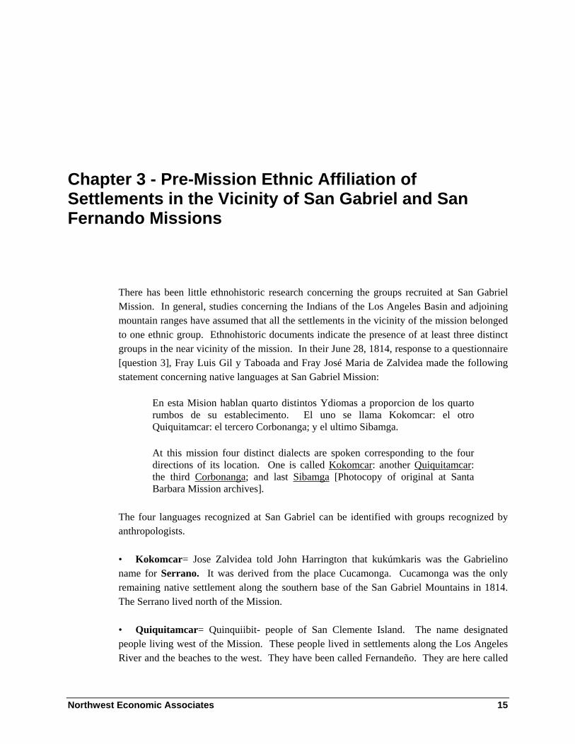
Chapter 3 - Pre-Mission Ethnic Affiliation of Settlements in the Vicinity of San Gabriel and San Fernando Missions
There has been little ethnohistoric research concerning the groups recruited at San Gabriel Mission. In general, studies concerning the Indians of the Los Angeles Basin and adjoining mountain ranges have assumed that all the settlements in the vicinity of the mission belonged to one ethnic group. Ethnohistoric documents indicate the presence of at least three distinct groups in the near vicinity of the mission. In their June 28, 1814, response to a questionnaire [question 3], Fray Luis Gil y Taboada and Fray José Maria de Zalvidea made the following statement concerning native languages at San Gabriel Mission:
En esta Mision hablan quarto distintos Ydiomas a proporcion de los quarto rumbos de su establecimento. El uno se llama Kokomcar: el otro Quiquitamcar: el tercero Corbonanga; y el ultimo Sibamga.
At this mission four distinct dialects are spoken corresponding to the four directions of its location. One is called Kokomcar: another Quiquitamcar: the third Corbonanga; and last Sibamga [Photocopy of original at Santa Barbara Mission archives].
The four languages recognized at San Gabriel can be identified with groups recognized by anthropologists.
• Kokomcar= Jose Zalvidea told John Harrington that kukúmkaris was the Gabrielino name for Serrano. It was derived from the place Cucamonga. Cucamonga was the only remaining native settlement along the southern base of the San Gabriel Mountains in 1814. The Serrano lived north of the Mission.
• Quiquitamcar= Quinquiibit- people of San Clemente Island. The name designated people living west of the Mission. These people lived in settlements along the Los Angeles River and the beaches to the west. They have been called Fernandeño. They are here called

Northwest Economic Associates 16
Western Gabrielino. There are statements in Harrington’s notes concerning the similarity of San Fernando and Island dialects.
Felicitas Montaña: San Pedro and San Gabriel speak differently. San Fernando quite different from Gabrielino and contains many words she doesn’t understand.
Jesus Javaro: Catalina and San Pedro spoke Gabrielino, similar to Fernandeño.
Some to many men from Western Gabrielino settlements have native names similar to Chumash names. These names were most frequently recorded close to the Chumash boundary and the ocean.
In 1966, Jack Forbes made the following observation:
Chumash-speaking groups may have resided further to the east than has usually been supposed. The Simi Valley and Las Virgenes-Triunfo region was inhabited by the Chumash, but in addition, the personal names of Indians converted from El Escorpión, Topanga, Siutcanga [Encino] and Castac are definitely Chumash. ... Tentatively, it would appear that the Chumash inhabited the coast as far as Topanga, and perhaps beyond, and in the El Escorpión section of the San Fernando Valley [1966:138].
Alan Brown also noted that the western San Fernando Valley and Topanga appeared to be Chumash:
Though Malibu is the last Chumash place-name on the shore toward Los Angeles, the few personal names unequivocally reported at Shoshonean-speaking Mission San Fernando from Topanga, just beyond Malibu, are Chumash, and the same is clearly true of the much larger inland village called El Escorpión by the Spaniards, at the northwest end of the San Fernando Valley: the language boundary is drawn accordingly on Map 1. ... In mission records, occasional Chumash personal names occur as far and beyond Encino, where the explorers of 1769 had found a large village or villages showing, as the Spanish writers themselves realized, typical Chumash traits [1967:8].
• Corbonanga= Corbonabit was apparently a Cahuilla village near Saboba. In 1814, Cahuilla speakers had recently arrived at San Gabriel Mission. The Cahuilla lived east of the Mission.
• Sibamga= Sibapet village at the mission. Harrington’s Fernandeño and Kitanemuk consultants called the Gabrielino shivaviatam. The name designated people from south of the Mission. These were the people called Jenegueches by Font in 1776. They lived on the lower San Gabriel and Santa Ana Rivers (and possibly, as indicated by Font, the lower San Jacinto River) and are here called Eastern Gabrielino.

Northwest Economic Associates 17
In 1774, Anza traveled to San Gabriel. At the crossing of the Santa Ana River, below Mt. Rubidoux, on March 20, Anza wrote:
Right here and a little further back were several villages of heathen. They were not disturbed on seeing us, but they were excited when they asked the native Californian, whom they recognized, if he came from the same Peninsula, for when he said “No,” and pointed in the direction from which we had come, they marveled greatly. This native understood their language, which he says is the same as that spoken in the new mission of San Gabriel [Bolton 1930:204].
At the end of March 1774, most of the baptized people were from Ajuibit and Sibapet and a few were from Juyubit and one was from Jutucabit. These villages (clans) were closely related. Anza indicated that people on the Santa Ana River in the southern part of Riverside were related to the people at the mission.
On December 29, 1775, Font observed:
Before we halted [on San Jacinto River 3 miles above San Jacinto] a few Indians who were camped on the banks of the river, armed with their bows and arrows, permitted themselves to be seen at a distance, but they did not wish to come near us although we called them. These Indians are of the Jeniguechi tribe and are very similar in all respects to the Jecuiches of the sierras [Bolton 1930:163].
At San Gabriel Mission, on January 5, 1776, Font observed:
The converted Indians of this mission, who are of the Beñeme [Serrano] tribe and also the Jeniguechi tribe appear to be gentile, friendly, and of good hearts [Bolton 1930:178].
At the beginning of 1776, approximately 112 people had been baptized from Ajuibit, 79 from Sibapet and six others from Pomoquin that are not identified as Sibapet or Ajuibit where the Sibapet and Ajuibit clans apparently lived together. Six people were baptized from Tobpet (most with ties to Sibapet). Eight had been baptized from Juyubit, 20 from Jutucabit, and four from Uchubit (235 Jenegueches [Eastern Gabrielino]). These clans lived on the lower Santa Ana and San Gabriel Rivers and had close ties between them. Three people had been baptized from Asucsabit, three from Jaibepet, three from Topisabit, and two from Acurabit (11 Beñemé [Serrano]). Many of these first Beñeme people had ties to the south. There were no baptized recruits from the west or southwest except for people from Tobpet with ties to Sibapet. It is probable that many of the older people baptized during the following year were living at the mission and undergoing instruction at the time of Font’s visit. They are not included in the above summary of baptized recruits. Their addition would increase the proportion of Beñeme living at the mission.

Northwest Economic Associates 18
Font’s use of the term Jeniguechi appears to apply to the people living at San Jacinto [probably Paimabit], the Santa Ana River, and San Gabriel Mission. His diary indicates he crossed the boundary between the Jecuiche [Cahuilla] and the Jeniguechi between Saboba and San Jacinto.
Francisco Garcés understood that the Jaluchidines used a route that passed through Cahuilla territory to trade with the Jeniqueches. He also recognized that they lived on the Santa Ana River and extended to the Pacific Ocean. On August 6, 7, or 8, 1776, Jaluchidun chiefs told Garcés:
“You could have well come through here, since we also have a way to the Jequiches” –they are the Danzarines- “as well as to the Jenigueches” (who are of the Valley of San José [Garcés San José Valley = San Bernardino Valley, Font’s was San Jacinto Valley] and Santa Anna [Jutucabit]) [Galvin 1965:83].
Garcés also said:
This place [the pools of Tesquien] makes it possible to travel from the land of the Jaluchidunes to that of the Jeniqueches, who are the people of the Santa Anna River [Galvin 1965:31].
Garcés observed:
I assume that these Indians wear clothes because besides growing some cotton, they bring in from Moqui, blankets, sashes, and a coarse wollen cloth, and so have clothing for themselves and for trade with the Jamijabs, Yumas, and Jenigueches [Galvin 1965:83].
The Jalchedunes have always been well disposed … toward the Jequiches and Jenigueches of the sierra who extend to the sea [Coues 1900:451].
Garcés believed that the Jenigueches extended from the land of the Jalchedunes to the Pacific Ocean. Although he never visited the area, he believed the Jenigueches lived in the San Bernardino Mountains southeast of the Mojave River and west of the Jalchedunes. He said:
… it is possible from the nearest Jequiches to proceed by the skirt of the Sierra Nevada to the Jenigueches of the same sierra; and from these in a day’s journey to the Arroyo de los Martires [Mojave River] and thence to San Gabriel [Coues 1900:468].
Garces believed it was possible to follow the northern edge of Cahuilla territory and turn northwest and follow the northern base of the San Bernardino Mountains through Jenigueche territory to Beñeme territory at the headwaters of the Mojave River. Historic and ethnographic data indicate that the San Bernardino Mountains north of the Cahuilla were all

Northwest Economic Associates 19
Serrano territory. The Beñemé settlements Garcés visited on the Mojave River had strong ties to Big Bear Valley and other settlements in the San Bernardino Mountains southeast of the Mojave River. The San Bernardino Mountains were within Beñemé territory which was bounded on its south by the Cahuilla. The occupants of the lower Santa Ana River extending to the coast were Jenigueches. Santa Ana River people from Uchubit and Jutucabit were the only Santa Ana River people living at the Mission in 1776. Historic data indicate that Jenigueche was the name used by Colorado River people for the Gabrielino of the Santa Ana and San Gabriel River Plains.
In the night of October 25, 1785, there was an attempted uprising at San Gabriel Mission. The investigation of the uprising indicated that the Indians of the Mission, three plains settlements, and five mountain settlements were involved. Two mountain settlements are mentioned. Toypurina, a non-Christian woman of Taichivit [Japchivit] was a leader from a mountain village. Another mountain village was Asucsabit where people had gathered in preparation for the attack. One plains settlement, Juyubit is identified. Tomasajaquichi [Temasajaguichi], the chief of Juyubit, and warriors under him had joined the uprising. Aliyivit (Ajillivit) chief of Jajamobit was also apprehended. He claimed observer status and apparently was not accompanied by other men from Jajamobit. Nicolas Joseph [Baptism 87 of Sibapet the first married adult baptized from Sibapet] was a leader in the uprising [Nicolas Joseph continued to have children by two wives after recruitment into the mission]. (AGN Provincias Internas 120: 31-47. Temple 1958.) The distinction of mountain and plains groups corresponds to the distinction between Serrano (Beñemé, Kokomcar, north of Mission) and Gabrielino (Jenigueche, Sibamga, at and south of the Mission).
Earle analyzed information from historic diaries and Harrington notes and concluded that territory of the Serrano speaking clans included the northern slopes of the San Gabriel Mountains, the Mojave River, and the Antelope Valley (Earle 1990, 1991).
Historic data concerning native language groups at San Gabriel Mission, the patterns of recruitment of native groups and grouping of settlements through marriage ties independently indicate that the south as well as the north slopes of the San Gabriel Mountains were owned and occupied by Serrano speakers. Evidence for boundaries indicated by ties between settlements will be further reviewed in the discussion of ties between Japchibit and other settlements. The boundaries indicated in Figure 2 are consistent with ethnohistoric evidence.
At San Fernando Mission, four different ethnic groups were recruited. The first people recruited into San Fernando Mission were Tataviam. The Tataviam lived in the Santa Clara River drainage east of Piru and west of Acton. They also lived in the vicinity of the mission. It appears that San Fernando Mission was founded to recruit Tataviam speakers. Northeast of the mission, Serrano [Beñeme] settlements were recruited. These included settlements also recruited by San Gabriel Mission. South of the Mission along the Los Angeles River and on the southern Channel Islands were the settlements of people, here called the Western Gabrielino, who were recruited at San Fernando Mission. No Eastern Gabrielino people were

Northwest Economic Associates 20
recruited at San Fernando Mission. Generally close Serrano and Los Angeles River settlements were recruited before the Chumash whose settlements were further away. Tataviam and Serrano settlements are in and adjacent to the Angeles National Forest and are further discussed in this study. The Chumash settlement of Matapjajua was adjacent to the northwestern edge of the Angeles Forest and people from this settlement used lands of the Angeles Forest. The Chumas settlement of Castaic was north of the Forest. The Chumash lived on the western edge of the San Fernando Valley and south on the Malibu coast. The boundaries indicated in Figure 2 are used in this study.
Recruitment at San Gabriel
Studies of the records of California missions indicate they first recruited from settlements that were closest. After many people from close settlements were recruited, recruitment increased from the next most distant settlements. This process continues over time and the area recruited from often expands as roughly concentric circles around the mission. Deviations from a pattern of recruitment from equal distances often reflect the presence of boundaries between native groups. The differences in recruitment rates and pattern apparently reflect different strategies of Spanish colonists and different strategies of native groups.
Fáges described the founding of San Gabriel Mission:
The mission was founded on September 8, 1771; the Indians of the nearby village, showing themselves to be very discontented [thereat] from the first formed a confederacy with their neighbors for the purpose of besieging the camp. This they did a few days later, but our men, placed in a state of defense succeeded in killing the leader or chief who commanded the Indians, whereupon the engagement was ended without further activity, the victory remaining with our men, and the Indians taking to flight, having learned a good lesson; they did not suffer themselves to be seen for a long time. Subsequently they have been much more amenable, and many had been baptized by November of ‘73 although no marriages had taken place [Priestley 1972: 18].

Northwest Economic Associates 21
Figure 2 Map of Settlements Recruited at San Fernando
and San Gabriel Missions in Relation to the Angeles National Forest
Pedro Bonito Cambon O.F.M. wrote an account of the founding that provides more details than Fáges’ account. His report was one of many missionary reports that were written to document Fáges’ behavior. He described the founding of the Mission on September 8, 1771, by the Spanish expedition:
They kept moving along in spite of the determined opposition of the Indios, who in full war-paint and brandishing their bows and arrows, with hostile gestures and blood-curdling yells, tried to prevent them from crossing the [San Gabriel] river. Our people finally fought their way to the chosen spot, dangerously pressed by the whole multitude of savages. And having dug themselves into fox-holes behind some bales and packing boxes as best they

Northwest Economic Associates 22
could the padres took out a canvas picture of Our Lady of Sorrows. This they unfurled… [Temple 1960:154].
At the sight of the painting, everyone threw their bows and arrows on the ground and two chiefs took off their necklaces of beads and placed them at the feet of the painting. After this Indians continued to visit the painting and place baskets of seeds at the feet of the painting. The Indians treated the painting as the location of a shrine. After establishment of the shrine, local Indians invited more distant Indians to visit the shrine. They also assisted with the construction of the mission. In the following days, many Indians came to the mission and shrine. Cambon said:
The number of those who came was so large that the soldiers of the guard insisted they had not seen one tenth as many on their first entry into the valley in July of 1769 nor when they traversed it twice in January and April of 1770 … [Temple 1960:156].
According to Cambon the Indians allowed their sons to receive instruction from the priests and allowed them to stay within the mission stockade. He noted that Fáges arrived when there were many Indians and instructed the guard to only allow four or five Indians to enter the mission stockade at a time. He observed that when the order was put into effect it resulted in serious disturbances. He wrote:
Now, resentment and hatred incited them to trample the sentry under foot, elbowing their way into camp and wantonly plundering (something they had not dared to do up to this point). Finally they armed themselves with clubs … and threatened to attack us should we make any show of resistance [Temple 1960:157].
On October 9, infuriated by the rape of a chief’s wife:
A great number of Indians crowded into the mission stockade demanding food for everyone, otherwise they would leave but return in a stronger force. They snatched away all the boys who were under instruction except five who on their own concealed themselves in the cabins of the padres [Temple 1960:157].
The chief leading the Indians said they would return tomorrow and shoot arrows at the Spanish. On October 10:
… at daybreak, a great host of savages led by the Capitan of the Porciuncula (sic) Rancheria fell upon the mission. They began by surrounding the stockade, making offensive gestures and signs of provocation. Our men endured these taunts to the limit until they quieted down and kept their place, they would either have to leave or be punished. Part of the multitude grudgingly dispersed, hurling threats and challenges. The rest of the Indians made a tight knot at the very gates of the stockade.

Northwest Economic Associates 23
Just then, one of the Catachumens (boys under instruction) rushed past the warriors into the stockade. He told us excitedly that in the nearby cañada or gully, the Principal Capitan had assembled a large number of armed Indians to come and shoot arrows at us. Also that his plan was to stampede the horse herd and kill the two soldiers guarding it. With this report, muskets and other weapons were readied. All that remained to do was warn the two with the horses and two other soldiers who were out in the brush looking for some stray cows.
But heaven ordained that one of the latter should return at the very moment that we heard a great uproar in the cañada. We saw five bands of Indios on an adjacent hill, and three of these hid in ambush just a musket shot away from the mission. The other two groups trooped down into the gully to swell the number already there.
At this instant, the soldier who had just come in rushed out of the stockade to warn the two, with the Indios who had remained in camp, fast at his heels in an effort to cut him off. But they were not fast enough and when he got to the spot, he found that they were already discharging arrows at the two who had been guarding the horse herd.
Quickly the soldier yelled at his besieged companions to fire, while he donned his leather jacket. This they did with such telling effect that the Chief fell dead, not twenty paces away. The latter had buried the entire point of his first arrow in the heavy thickness of the bull-hide shield of the soldier who had fired the fatal shot. With the second volley they killed two more Indios [Temple 1960:158].
Corporal Aguilar ordered the slain chief’s head cut off and impaled on the highest pole of the stockade, thus to strike terror into these savages who dared insult and raise a hand against the soldiers of His Majesty, Don Carlos III [Temple 1960:159].
The Spanish founding of San Gabriel Mission changed political relations between native settlements. Cambon observed:
… the Corporal and seven men saddled eight of the horses they had with difficulty retrieved from the hills and galloped off in the direction of the Indian rancheria. … What few straggling Indios had the temerity of coming out of their huts to meet them, begged for peace. This was granted after the soldiers had taken away their bows and arrows and broken them to pieces.
On the following day, October 11, 1771, we awoke to find plumes of smoke signals along the entire horizon. We investigated and learned that this was a general pow-wow of all the surrounding rancherias, convoked to make peace between those of the sierra [Serrano] and those from the coast [Gabrielino], mortal enemies up to this time. That same day two chiefs came from the west [If the chief who was killed was of the Porciuncula Rancheria, he was from Yabit located in present downtown Los Angeles] to the mission to sue
Northwest Economic Associates 24
for peace, offering it on their own behalf. After several parlays and a good lecture which we gave them, along with gifts of beads and ribbons, they left, giving us many promises of their future good conduct [Temple 1960:159].
The treaty with the Indians to the west may explain the delay in recruitment of Western Gabrielino settlements and the apparent lack of military involvement in their recruitment. The founding of the Pueblo of Los Angeles in 1781 also affected recruitment from the area west of the mission because of opportunities for wage labor. Spanish colonists wanted the labor provided by Indians and did not want them recruited by missions.
On October 16, Indians besieged the mission. On October 17, the contingent to found San Buenaventura arrived and the siege was lifted. Cambon wrote:
… they made themselves so scarce that even months later, one hardly saw a single Indio in the entire neighborhood, except occasionally a boy hanging around with an adult of some 20 years, who from the start has become quite attached to us. The local rancheria moved away to another site far away from us [Temple 1960:160].
The first baptism was on November 27, 1771. It was of a two-year old boy Fernando Salvador. The entry is the most elaborate in the register. Part of it said:
… (The father of the child) is popularly known as the Interpreter, for having been the first who began to explain a few words of his language to us. (He) is from the Rancheria which is located to the east of this Mission in a field surrounded by water from all sides(.) It appears that in their language the Indians call this Rancheria Gui-chi [Uchibit], and so that it may be better known I have named the said Rancheria San Francisco Guichi [Munoz 1982:3].
Confirmation number 11 says that Fernando Salvador was of Ajuibit and his parents were Gb 125, Melchor Maria, 28 years old, and Gb 131, 20 years old, both of Ajuibit. Perhaps Melchor Maria was the twenty-year old man mentioned by Cambon.
By November 1773, seventy-three Indians had been baptized. Except for a recently baptized 22 year old, they were less than sixteen years old. They included most of the youths baptized from Sibapet and Ajuibit. The first married native adults were the Capitan of Ajuibit and his wife on June 6, 1774.

Northwest Economic Associates 25
Figure 3 Ages of 69 of the First 73 Baptisms
(four not plotted are described as children [2] and small children [2])
0
2
4
6
8
10
0 1 2 3 4 5 6 7 8 9 10 11 12 13 14 15 16 17 18 19 20 21 22
Age
Freq
uenc
y
Most early baptisms were listed as being from the village of Pomoquin. Later register entries identify most of people as from Sibapet and Ajuibit. Pomoquin was apparently the nearby village mentioned by Fages. It is not clear if the nearby village is the settlement associated with the mission. Fages said:
At a short distance [from the stockade containing the garrison, church, dwellings and offices of colonists] is the village in which the unconverted natives and the new Christians live; the latter attend regularly at Mass and the recital of the doctrine, and some of the former come that the missionary fathers may catechize them [Priestley 1972: 19].
Near November 1774, the mission was moved from the Whitier Narrows to its present location because of its greater agricultural potential through irrigation. In 1773, Fages observed the following concerning the new site:
One league to the westward from the mission [the first site of San Gabriel Mission] there are great forests of oak, from which a supply of Acorns is obtained. A great many Indians live there, hidden in their villages, which are also found on the seashore and on the plain throughout the eight leagues mentioned ... nor are there lacking in the vicinity of the forest to which reference has been made, small streams from which water can be taken for the cultivation of the adjacent fields. [Priestley 1972: 20]
The following graphs illustrate the pattern of recruitment from the Ajuibit and Sibapet Clans at San Gabriel Mission.

Northwest Economic Associates 26
Figure 4 Recruitment from Ajuibit
0
10
20
30
40
50
60
70
1771 1772 1773 1774 1775 1776 1777 1778
msn born18+1 to 170 to 1
Figure 5 Recruitment from Sibapet
0
10
20
30
40
1771 1772 1773 1774 1775 1776 1777 1778

Northwest Economic Associates 27
Recruitment of the Sibapet and Ajuibit clans was completed in 1778. Figure 6 indicates the extent of recruitment in 1776. The percentage (%) indicates the lowest percentage of recruitment within a contour interval.
Figure 6 Extent of Recruitment at San Gabriel at End of 1776
Military actions similar to those conducted during the founding of San Gabriel were conducted in association with the founding of other early California missions. They demonstrated the power of the Spanish government and reminded the Indians of the consequences of protesting Spanish authority. Many priests identified with the Indians as they found themselves overruled by a military force that allowed the rape of Indian women, encouraged prostitution, contracted for native labor, and otherwise related to the native population in a manner contrary to the values and desires of missionaries.

Northwest Economic Associates 28
Reid described a pattern of recruitment from native settlements:
Baptism could not be administered by force to adults, it required a free act; so taking an Indian guide. Part of the soldiers or servants proceeded on expeditions after converts. On one occasion they went as far as present Rancho del Chino, where they tied and whipped every man, woman and child in the lodge, and drove part of them back with them. On the road they did the same with the lodge at San José [there were no groups of young people baptized from Toibipet and Uchubit at the same time. Groups were baptized from Uchubit in May 1781 and February 1787 (probably settlement for the 1785 uprising), and from Toibipet on January 20, 1803]. On arriving home the men were instructed to throw their bows and arrows at the feet of the priest, and make due submission. –The infants were then baptized, as were also all children under eight years of age; the former were left with their mothers, but the latter kept from all communication with the parents. The consequence was, first the women consented to the rite and received it, for the love they bore their offspring; and finally the males gave way for the purpose of enjoying once more the society of wife and family [1852:Letter 17].
The graphs of recruitment from Sibapet and Ajuibt and the history of the founding of San Gabriel Mission reflect a pattern of recruitment similar to that described by Reid (except husbands and wives were usually baptized at the same time after baptism of their children). Military assisted recruitment was most common at settlements whose members are recorded as participating in attempts to end Spanish rule.
After the attempts by people in the vicinity of the mission to end Spanish rule, the next major attempt involved settlements near the southern base of the San Gabriel Mountains and the interior of the mountains and settlements on the plains of the San Gabriel and Santa Ana Rivers and the people recruited into San Gabriel Mission. The aborted uprising of October 1785 was believed by Spanish authorities to have been led by Nicolas José of the Mission and Toypurina of Japchibit. Involvement of native settlements was probably a consequence of increased recruitment from settlements involved in the uprising. In 1785, few people were recruited at San Gabriel Mission before or after the uprising. Figure 7 indicates the extent of recruitment at San Gabriel Mission at the end of 1785.
Plains settlements that were involved were Juyubit, and probably Uchubit and Jaisobit. The Sibapet and Ajuibit Clans were all recruited at the mission and were apparently led by Nicolas José, chief of Sibapet. Jutucabit was almost completely recruited by October 1785. The mountain settlements included Japchibit, Asucsabit and probably Guinibit, Jaibipet and Topisabit.
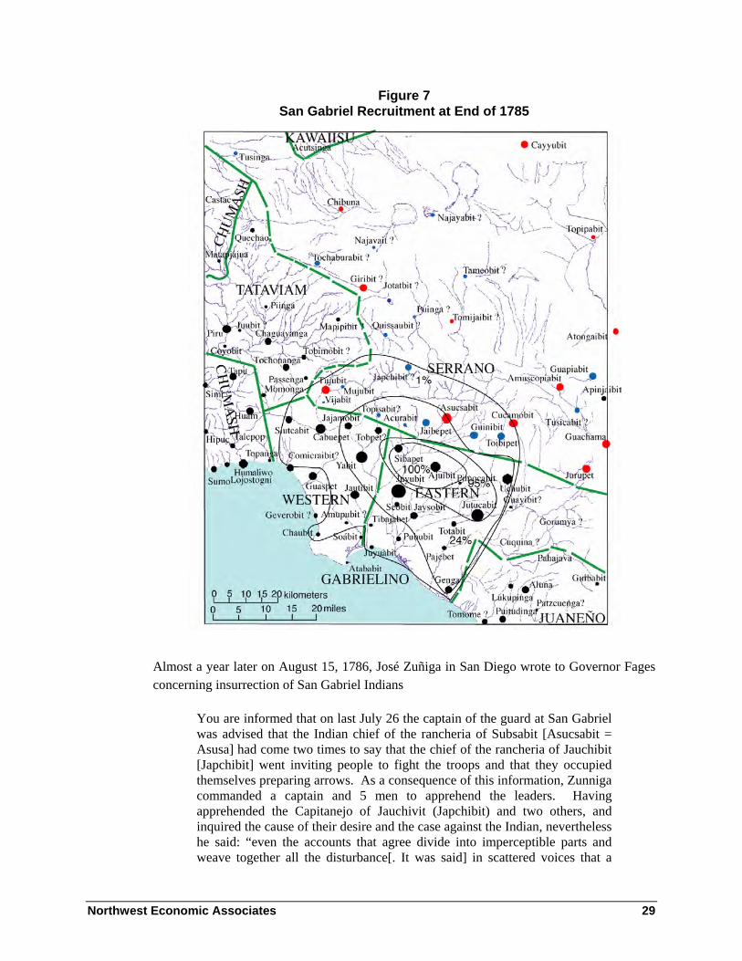
Northwest Economic Associates 29
Figure 7 San Gabriel Recruitment at End of 1785
Almost a year later on August 15, 1786, José Zuñiga in San Diego wrote to Governor Fages concerning insurrection of San Gabriel Indians
You are informed that on last July 26 the captain of the guard at San Gabriel was advised that the Indian chief of the rancheria of Subsabit [Asucsabit = Asusa] had come two times to say that the chief of the rancheria of Jauchibit [Japchibit] went inviting people to fight the troops and that they occupied themselves preparing arrows. As a consequence of this information, Zunniga commanded a captain and 5 men to apprehend the leaders. Having apprehended the Capitanejo of Jauchivit (Japchibit) and two others, and inquired the cause of their desire and the case against the Indian, nevertheless he said: “even the accounts that agree divide into imperceptible parts and weave together all the disturbance[. It was said] in scattered voices that a

Northwest Economic Associates 30
non-Christian told the non-Christians that the Christians had given beads to get them to kill the Indians and chief of Jabchivit, and that this angered them to say they were going to kill Christians and soldiers.”
“The Indian of Jabchivit (Japchibit) affirms that the Indians of the Colorado River had come last month to the Rancheria of Tongallavit (Atongaibit = Hesperia) a day by road from the mission and assured them they would come to fight with the troops and other expressions that the Indian uttered.” He says it has been ordered that the Indians be kept prisoners while evidence is produced to elucidate this matter and that necessary precautions have been taken [Bancroft Library - CA 3: 293-4 from Provincial State Papers Tom VI 1786: 35-36].
On October 27, 1786, in a letter by José Zuñiga of the San Diego Presedio to Governor Fages concerning couriers he stated: “You are informed that Juan Maria Olivera and six men have been ordered to explore Tomigayavit” (Bancroft Library - CA 3: 296 from Provincial State Papers Tom IV).
Much of 1786 was spent investigating the uprising, dealing with continued threats from the Serrano and determining the sentences of participants. There were few baptisms from Serrano settlements in 1786. On May 12, 1786, Toypurina’s two day old infant son Gb 1326 Nero Joaquin was baptized. Fifteen-month old Nero Joaquin died on August 29, 1787 (Gd 514), perhaps after Toypurina was exiled. In early 1787, people from settlements that were involved or probably involved in the attempted uprising were baptized between February 17 and April 14. Many of the people baptized had ties to Asucsabit. People were from Asucsabit, Jaibepet, Guinibit, Topisabit, Uchubit [with ties to Asucsabit and Toibipet], Juyubit, and Jaisobit. Toypurina was the only person baptized at this time from Japchibit
On March 8, 1787, Toypurina (Regina Josepha) was baptized along with a married couple from Asucsabit, Gb 1402 and Gb 1407 (Gm 281). Also on the same day, three adults from Uchubit were baptized: Gb 1403 a 40 year old man husband of Gb 1696 of Asucsabit (Gm 341 and Gc 1216) and father of Gb 702 of Uchubit, Gb 1405 of Uchubit, 23 year old husband of Gb 1504 of Toibipet and Gb 1410 a 40 year old woman of Uchubit who married Gb 1414 a 50 year old man of Uchubit after baptism. Both married men of Uchubit were married to women from Serrano settlements north of Uchubit. It appears that many of the people recruited from Uchibit in early 1787 had ties to the Serrano settlements of Asucsabit and Toibipet.
A group of children between one month and seven years of age were baptized on April 14, 1787. They included three sons and three daughters of the chief of Asucsabit (Gb 1438, 1439, 1440, 1445, 1446, and 1447) and three children baptized as from Jamamcovit and later listed as of Japchibit (Gb 1443, 1444 [Gc 936 brother of 1443] and 1448). They also included three other children of Asucsabit Gb 1441, 1449 and Guinibit Gb 1442. The parents of two of the Jamamcovit baptisms are identified as Gb 2022 of Japchibit and Gb 2035 of

Northwest Economic Associates 31
Asucsabit (Gm 415) [baptized on February 24, 1791 among the next married group of people from Asucsabit after Gb 1673 and 1680 below]. The third, a girl, was probably also their daughter. There are no other baptisms recorded from Jamamcovit Gb 1443 is listed as from Jajamobit in the 1824 padron; his brother Gb 1444 is listed in the 1824 padron as of Guinibit.
The texts of their baptism entries said they were from Asucsabit. Gb 1441(Gc 1334) baptized as Asucsabit was son of Gb 3716 (Gp 1824) (Cesaria) of Asucsabit; his grandmother was Gb 3110 of Asucsabit. His mother, Gb 3716, was baptized on March 3, 1804, along with the last married couple baptized from the settlement. Gb 1442 was baptized in the text as of Asucsabit in the margin he is listed as from Guinibit; his burial entry (Gd 494) listed Guinibit. Gb 1449 of Asucsabit was daughter of Gb 1673 and Gb 1680 of Asucsabit (Gm 338)[they were the next married couple baptized from Asucsabit and were baptized almost two years later on February 23, 1789].
These April 14, 1787, baptisms included children of Serrano leaders involved in the 1785 uprising. Apparently the chief of Asucsabit and other important people from Uchubit and Guinibit were required to give up their children for baptism as part of a peace settlement. In return, they were allowed to remain at their native settlements and maintain their native society. Most of the important leaders of Serrano settlements remained at their settlements until their ultimate recruitment terminated the settlements.
Figure 8 indicates the extent of recruitment at the end of 1794 at San Gabriel Mission. In 1795, recruitment began at more distant Serrano settlements.
In November 1808, Palomares took troops out to the Antelope Valley and the Mojave River to capture fugitives. Earle states:
He finds that inhabitants of five villages in the Antelope Valley and the upper Mojave River (including Maviajik [Mavalla], Atongaibit, Guapiabit and Amutscupiabit) have assembled as a group to gather acorns in the eastern San Gabriel Mountains west of Cajon Pass [in a more recent version, Earle says they were in the San Bernardino Mountains southeast of Guapiabit 1995:7]. He finds the Indian villages abandoned except for the presence of elderly Indian women. Palomares sends an emissary to negotiate with the leaders of the villages at their gathering site. His request that runaway fugitives be returned to him is rejected. The Indian chiefs bitterly recount how they had been promised belts of cloth by the San Gabriel Mission Fathers if they would bring runaway Indians back to the mission. They said that when they did so, they were whipped for nine days for their trouble. They said they were no longer interested in cooperating with the Spanish [Earle 1991:16].

Northwest Economic Associates 32
Figure 8 San Gabriel Recruitment at the End of 1794
In 1809, 1811 and 1812 many people were recruited from Serrano, Cahuilla and Gabrielino settlements south and east of the Santa Ana River and in the Western Mojave Desert. The sudden rise in recruitment was associated with many military expeditions. The recruitment included the last unbaptized people from Serrano settlements near San Gabriel Mission.
McCawley states:
However, in October and November 1810 a massive revolt was staged against Mission San Gabriel. The rebellion included both neophytes and non-Christian Indians, the total number of participants being estimated at

Northwest Economic Associates 33
800. Although the rebels did not reach San Gabriel they came within five miles of the mission and made of with 3,000 sheep which were later recaptured. Indians participated in this revolt from as far as the Cajon and San Gorgonio Passes… The revolt was brought to an end when Gabriel Moraga arrived from Northern California with seven additional soldiers in January 1811. Forays were made against the rancherias involved in the raids, and many Indians were taken prisoner.
By June 1811 the revolt was over. Twenty one neophytes and twelve non-Christian Indians were imprisoned as a result of the affair. They were later sent to the Presidio at Santa Barbara, lashed for nine consecutive days, and forced to labor on the public works [McCawley 1996:199].
The Eastern Gabrielino who lived north of the Santa Ana River and outside the Dominguez and Nietos ranches were recruited before other groups. The Gabrielino settlements within the areas of the Nietos and Dominguez ranches provided relatively few converts to San Gabriel Mission and their occupants often lived their lives as unbaptized employees of the ranchers. Chaubit, Jaisobit, and Seobit are the only ranch area settlements included in the graphs of recruitment.
Figures 9 through 12 indicate the extent of recruitment at selected time periods. They indicate the degree that recruitment varied from the expectations of similar pattern of recruitment from settlements. They indicate that recruitment from Western Gabrielino settlements was less intense than from other areas and more of the reproducing population continued to live in native settlements. The graphs of recruitment from Serrano settlements in Figures 11 and 12 are important in the discussion of the locations of settlements.
There was recruitment at San Gabriel Mission from Tataviam and Serrano settlements in the area north of where San Fernando Mission was to be founded in the late 1780s and early 1790s. Some of these people transferred to San Fernando when it was founded. The recruitment of Tataviam people at San Gabriel was apparently in part preparation for the founding of San Fernando Mission; it was also probably a consequence of military expeditions in Tataviam and Serrano areas in 1785-1787 and 1790.
Population
The numbers of people recruited from settlements is a function of the sizes of the settlements. It is a measure that applies to all settlements not just those along expedition routes where population counts were made. It is not, however, a direct measure of population size at particular time periods that allows for simple comparison of settlement size over large areas. The number of people recruited is a function of historic factors in addition to its pre-conquest population size. Historic factors include: 1) spread of diseases introduced by Spanish

Northwest Economic Associates 34
colonists through native populations and consequent reduction of population sizes [diseases appear to have caused greater reduction in areas of high population density than areas of low density]. 2) The periods during which people were recruited depended on the time when particular missions were established and the distance of settlements from the missions. Settlements that are baptized later are more apt to have been reduced in size by introduced diseases or Spanish military actions. 3) In many cases, mostly children are baptized for many years and the continued birth of children accompanied by the baptism of most old people who are dying can result in a larger number of recruits than lived at a settlement at one time. Settlements in the interior such as Castac were only partly recruited into missions and many people continued living and dying at settlements until after the American conquest.
The registers and other sources provide information that can be used to measure the effects of diseases, military campaigns, and changes over time in the composition of populations. The determination of the actual populations that lived at settlements before the beginning of the Spanish conquest can be determined from the data contained in mission registers. The determination will require the integration of historic data and use of complex mathematical models.

Northwest Economic Associates 35
Figure 9 Recruitment of Eastern Gabrielino at San Gabriel Mission

Northwest Economic Associates 36
Figure 10 Recruitment of Western Gabrielino at San Gabriel Mission

Northwest Economic Associates 37
Figure 11 Recruitment at San Gabriel Mission from Close Serrano Settlements

Northwest Economic Associates 38
Figure 12 Recruitment at San Gabriel Mission from Mojave Desert Serrano Settlements

Northwest Economic Associates 39
Chapter 4 - The Tongva/Gabrielino Tribe
The information in the previous section indicates San Gabriel Mission was located near the boundaries of three different dialects or languages. Cahuilla, the fourth language spoken at the mission in 1814, was from the San Jacinto Mountains which are far from the mission.To the west were people speaking the language spoken on San Clemente, Catalina, and San Nicolas Islands along the Los Angeles River and the area west of the Los Angeles River. To the south and at the mission were the people who lived along the plains adjacent to the lower San Gabriel and Santa Ana Rivers. To the north were people associated with the mountains called Serrano. People from all of these places were recruited into San Gabriel Mission. After 1811, Cahuilla speakers were also recruited into San Gabriel Mission. At the mission, people more often married people from more distant settlements where different languages were spoken than they did before living at the mission. The program of mission recruitment resulted in the formation of the Gabrielino/Tongva tribe that recognizes descent from all people recruited into San Gabriel Mission.
Review of the 1824 padron indicates that the majority of the population at San Gabriel Mission in the 1820s was from Serrano and Cahuilla settlements in the San Bernardino and San Jacinto Mountains and the Mojave Desert. Settlements in this area provided most of the converts baptized after 1805 by which time most of the people from the settlements west of the mission to the ocean, north of the mission to the crest of the San Gabriel Mountains and south of the mission to the Santa Ana River had been recruited.
In the 1820s and early 1830s, the mission maintained a station in San Bernardino and people born there are mentioned in the San Gabriel 1824 padron. Some of these people may be ancestors of the people of the San Manuel Reservation. After secularization, it appears that many of the people baptized from the San Bernardino Mountains and San Jacinto Mountains returned to their homelands. The native population that remained in the vicinity of the mission were probably mostly people recruited or descended from recruits from settlements along the drainages of the lower Santa Ana River, the San Gabriel River, and the Los Angeles River and in and around the San Gabriel Mountains and the Western Mojave Desert. Except for small parcels near San Gabriel Mission, the land in this area was granted to non-native

Northwest Economic Associates 40
people and it was usually not possible to return to native villages except as servants of the Mexican ranchers.
Both San Fernando Mission and San Gabriel Mission recruited from four different native groups. The descendants of San Fernando Mission Indians have different mixtures of Tataviam, Serrano, Western Gabrielino, and Chumash ancestors. Descendants of San Gabriel Mission Indians have different mixtures of Western and Eastern Gabrielino, Serrano, Cahuilla, and Luiseño ancestors. The missions resulted in the creation of new native groups because they removed people from their native settlements and placed them in mission compounds. After the Indians were placed in missions, most of their lands were granted to Mexican citizens and it was not possible to re-establish native settlements after secularization.

Northwest Economic Associates 41
Chapter 5 - Names and Titles
Takic societies were organized on the basis of patrilineal lineages. Women often resided at their husband’s settlements. Among the Serrano and probably their Gabrielino and Tataviam neighbors the lineages were divided into exogamous moieties. Settlements or Clans of opposite moieties were often grouped together through marriage. This is reflected in groups of settlements tied together by many marriages and consequent extensive kin ties between them.
Harrington noted that titles that designated social position were frequently recorded in the registers of San Juan Capistrano Mission as personal names. Analysis of information concerning Serrano and Gabrielino/Tongva names indicate that names designating political position were often recorded in registers as personal names. The following names include terms described by Strong, terms listed by Boscana, several mentioned by Hugo Reid and others whose contexts in the registers and/or similarity to names of deities indicate they are titles.
Boscana noted:
A custom was observed in all their new settlements to appoint as chief or capitan, the oldest of the families, and to him was given the name ‘Nu’ and to the second in power that of ‘Eyacque’. Their wives were named also; the first ‘Coronne,’ and the second ‘Tepi’ [Harrington 1978: 84].
The registers indicate that the use of many titles was not restricted to particular Takic languages. Many of them were used in common by Serrano, Gabrielino, and Tataviam speakers. In at least one case, the name was first recorded in the register in its Gabrielino forms and later in its Serrano form. There was more than one type of political leader. Old European societies recognized Kings, Princes, Dukes, Earles, Bishops, etc. as land owning leaders who inherited their positions. Takic societies apparently also had political leaders with different degrees of power and with different responsibilities based on descent from royal and mythical ancestors.

Northwest Economic Associates 42
The registers indicate that the Serrano in the vicinity of the San Gabriel Mountains recognized (1) Quiqua (kika, kika’y), (2) Caca (tcaka) = Gabrielino Eacuc, (3) Chari, (4) Nuú = (Luiseño nota, Cupeño nuut, Cahuilla net) (5) Tamet, (6) Paja (paha), (7) Caroni, (8) Tapi, and probably (9) Taoc as political titles. The first six were men’s titles and the last three women’s. It is probable that many names for chiefs and their relatives varied according to moiety or other larger group membership (Strong 1972). The ethnographic studies that have been conducted have assumed that most different titles for political and religious leaders are translations of the titles in different languages. For instance, the Serrano term tcaka (Caca) is the equivalent of Gabrielino Eacuc. In most cases this assumption is apparently wrong. The names in the mission registers indicate that titles attributed ethnographically to Gabrielino or Serrano were shared although the relative frequency of use of names and possible moiety affinity was different. There were apparently many different political and religious positions in Gabrielino and Serrano society. The society of their Hopi relatives to the east includes many types of political and religious leaders. Each leader is responsible for regulating different activities including planting, watering, festivals, dances, and warfare. Further study of the registers and linguistic analysis of names listed in the registers will reveal additional political titles used in preconquest Serrano and Gabrielino societies and by their protolanguage ancestors. Linguistic analysis and analysis of the way the names are used in mythology will result in a deeper understanding of the organization and operation of preconquest Takic and other Uto-aztecan societies. Additional historic evidence of the political complexity of preconquest Serrano societies will be presented in the discussion of ties between settlements and the people from Japchibit.
kika Quiqua
Strong identified the Serrano chiefs responsible for providing for Mourning Ceremonies as kika:
Formerly the mâriña clan always had a male kika or clan leader; the office in theory passing from the incumbent to his eldest son. …. The mâriña, aturaviatum and mohîatniyum clans usually went on hunting and food-gathering expeditions together, under the leadership of the mâriña clan’s kika [Strong 1972: 17-18].
Strong observed that the kika was usually associated with Serrano clans of the coyote moiety. The Kitanemuk also called chiefs kika’y (Bean and Blackburn 1978: 567).
Gb 5003 (Sebastian) Riquiqua (Eriququa)(Gp 1824) of Toibipet was husband of Gb 5004 of Cucamobit (Gm 1210). He was also father of Gb 4587 of Toibipet, Gb 4192 of Toibipet, Gb 4136 of Toibipet, Gb 3423 of Japchibit, Gb 3413 (Gd 3827) of Toibipet and 3412 Gb of Toibipet. His mother (Gb 5356) of Toibipet was the last person baptized from Toibipet. He,

Northwest Economic Associates 43
his wife, mother, and three of his children were the only people baptized from Toibipet after April 1807.
Gb 4303 Quiqui Atilano was husband of Gb 4304 both of Guinibit. Gb 3178 was an aunt of Atiliano the Capitan of the settlement. Quiqui and his wife were one of the last two couples baptized from Guinibit on April 1, 1809.
Gb 5366 Rufo Quiquipat of Japchibit (Gp 1824 Tomijaibit) was husband of a Cucamonga woman and father of Amuscopiabit children.
Gb 4295 Miguel Quiquinobit of Amuscopiabit
Fb 98 M 25 Deogracias Puyoquicay of Tochaboronga [Tobanj.
Fb 848 Liquiqunassum [Ajuny] of Tochaboronga
One woman’s name may indicate a relationship to the kika position. The mother of Gb 3606 and Gb 4018 of Tomijaibit was Yanquiquina. The father of Gb 3606 was Apuit. Note the two Gabrielino woman names below.
Tataviam - Fb 1194 Quijay of Piru
Gabrielino/Tongva
Gb 3639 Cornelio Quaquay of Tobpet
Gb 4928 (Gp 1824) Chiriquiqui husband of Gb 4927 Tapiy both of Seobit.
Gb 3796 Quiquiche of Geberobit was husband of Gb 3797 of Pimubit.
Gb 5373 Pancracio Quiquabit of Equinapet alias Cuquina was husband of Gb 4756, Nera Cupasbam, of Corobonabit (Gp 1824 married). Cuquina was a settlement located south of the Santa Ana River.
Gb 5273 [Gp 1824 married] Antonio Quiquicha of Guaspet was husband of Gb 5274, Signogmoguina [g=q?] a widow of Pimubit.
Several women have kika or kiki as parts of their names.
Gb 4931 Apariquiqui of Jujuabit was wife of Gb 4930 of Pimubit
Valeriana Riquiqa of Yitna [possibly not Gabrielino] was the mother of Gb 6897.

Northwest Economic Associates 44
paha, Paga, Paja
Strong described the office of paha:
Almost equal to the kíka in authority and influence was the paha. Of the three clans just mentioned only the mohiatniyum clan had a paha, and he had charge of the sacred matting, muurte, and the sacred feathers, vumte, of both his own and the marina clan. … Likewise the mamaitum clan had the kika but a clan of opposite moiety had the sacred bundle. …
The paha besides being in charge of all ceremonial impediments notified the people when ceremonies were due, carried the shell money between groups, and attended to the division of shell money and food at all ceremonies. The office was passed from father to son in the same male lineage [1972: 18].
Strong observed that the paha was associated with Serrano clans of the wildcat moiety.
Kitanemuk: ceremonial manager= paha’ (Bean and Blackburn 1978: 567).
Gb 5532 Pagayuinat of Cayyubit (Gp 1824 Parobia, Gm 1345 Cayubit) was husband of Gb 5568 of Parobia (Gp 1824 Cayubit, Gm 1345 Cochovipabet).
Gb 4475 Payuneit (Payaunat) of Atongaybit . Gb 5085 of Tameobit was a wife of Pajajay. She was mother of Gb 4454 of Najayabit. Gb 5073 of Tamegobit and Atongai was brother of Gb 4454. His father was Pajajai, and his mother was Monicubibam. Pajajai of Atongai had wives from both Najayabit and Tameobit. His children were recorded as natives of the settlements of their mother’s birth.
tcaka, Caca, Eacuc
Strong described the office of singer:
Another hereditary office was that of tcaka or singer. So far as can be ascertained, this office is only reported for the mâriña clan, but it seems that the office is identical with that of hauinik among the Cahuilla, and that there was at least one for every ceremonial group. This man knew all of the myths of the creation and all the clan songs [1972: 18-19].
Boscana’s description of titles listed: “ the second in power that of ‘Eyacque’” (Harrington 1978: 84, 126)

Northwest Economic Associates 45
The San Gabriel registers provide both the Serrano and Gabrielino spellings of the native name of Gb 4641 of Jaibepet. The baptism entry lists Eacuc; the 1824 padron lists Caca and Aca was listed as the father of Gb 4154. Gb 4641 was the husband of Gb 4642 Taoc of Tujunga. Gb 4154 was the brother of Gb 2427 and Gb 4164 (Gp 1824) and all were sons of Gb 4641. Linguistic analysis may reveal the Cahuilla word hauinik may be linguistically related. The names of the hereditary singers may have had a common ancestral term that diverged with the differentiation of languages over time. A similar linguistic differentiation appears to have occurred with the term Nu, Net, Nota used by various Takic groups to refer to a category of hereditary political leaders.
Gp 1824 [married] Andres Cacu of Guinibit = Gb 1167 Guayibit and Gd 5405
Gb2292 Eacu of Guinibit.
Gb 3613 Cacu of Tusicabit was husband of Gb 3617 of Cucamobit (Gm 817)
Tataviam
Fb 1881 Cacaguama of Cuechao
Fb 106 Cacachama of Piibit
Fb 113 Eeracu was Capitan of Ajuavit
Gabrielino/Tongva - Eacuc
Gb 2127, Gd 4741 Eacu of Jautibit [Watts] four days old at baptism.
Gb 4997 Eacuc of Jujuàbit [Long Beach?] son of Tosauyaguibit.
Gb 5369 Eacu of Chajaibit [San Nicolas Island?] son of Gb 5289 Rioynat of Chajaibit husband of Gb 5290 Nubiquinajaro of Pachechorobit (the chief of Chajaibit was Chanauyososat).
Gb 5001 Manuel Eacuc of Totabit [Santa Ana River].
In addition to the above three hereditary positions in Serrano society described by Strong, the registers indicate many titles also used by the Juaneno and Western and Eastern Gabrielino were also used north into the Mojave Desert.

Northwest Economic Associates 46
Chari
The title Chari designated important Gabrielino, Serrano and Tataviam political leaders and their sons. Many Gabrielino men with the name Chari are said to be chiefs. It appears that the title Chari passed from fathers to sons. The title like nu, the next described, is found at some of the same settlements including Seobit that also have kiki it appears that men with different titles only inherited their father’s title.
Gb 4649 (Gp 1824) Fausto Chary of Cucamobit was husband of Gb 4650 (Gp 1824) of Amuscopiabit (Gm 1113). He was brother of Gb 2060.
The father of Fb 1848 of Topipabit was Taari. Her name was Gigiuco
San Juan Capistrano baptism 583 (1785) was Nazario Manuel Tari of Tosicavit [Tusicabit]
Tataviam Fb 16 Chori of Tochonanga.
Gabrielino
Chari father of Gb 4284 and 4016 of Guaspet [Gp 1824 parents of Gb 4284 of Guaspet were Chari and Ginuiba]. The father may be the same man, Gb 6111, discussed next.
Gb 6611 Manuel Chari of Seobit (Gd 4364)(Amupubit Gp 1824) was father of Gb 5128 (also called Chari Gd 5642 of Amupubit father Jose Maria Chari), 4540, and Gb 4541 (father Gerizchari). His widow [sic. he was baptized after her while ill] was Gd 4300 (7-8-20) Magdalena Caroni [her baptism was apparently on a missing page]. Her death entry says Chari was of Amupubit.
Gb 3697 of Juyubit, was a 6 month old brother of Jose Maria and Calisto Chary.
Fb 2234 [Fd 1680] Chari of Chaubina at the Ensenada of San Pedro was husband of Fb 2235 of Santa Rosa Island
The father of Fb 200 of Caguenga was Fb 277 Echari of Cabuenga. Fb 591 of Cahuenga was a son of Chari. Fb 615 was daughter of Chari Chupin the father was Fb 1370 Chari of Cahuenga. The Capitan of Cahuenga was Fb 1364 Tomimenaguit who was baptized on the same day as Chari. Chari was the next man from Cahuenga baptized after the chief
Fb 233 Chari Capitan of Siutcabit
Fb 358 Chari of Siutcanga

Northwest Economic Associates 47
Fb 961 and Fb 974 of San Vincente father called Chari [he was probably same as one of the men named Chari at Siutcabit].
Nu
Strong gave the equivalence of Cahuilla net, Luiseno nota, nu [and equated the position to kika] (Strong 1972: 340). The term nu was also used as names of Serrano chiefs.
Boscana described Nu as the oldest son of chief (Harrington 1978: 84, 220-221). Among the Serrano baptisms, most are from villages identified in this study as wildcat moiety. At Seobit and some Western Gabrielino settlements there were often three more men’s titles including kiki, nu or canu, Temia- and or Chari used at the same settlement. These settlements were probably ceremonial centers.
Gb 3614 Nuú of Puaitamaibit husband of Gb 3618 of Topipabit [Barstow]
Fb 176 Nu of Tujunga
Fb 923 Nu Capitan of Quisaubit
Gb 5307 was baptized as the wife of Nuri Capitan of Amuscopiabit. Nuuri was Fb 2128 Suniririmobit Capitan of Amuscopiabit (Gb 6207).
Fb 1847 Nuuri child of Atongaibit
Fb 2222 Cunu of Tujunga.
Gb 4947 Nucupapat of Guaaschna [San Bernardino] was husband of Gb 4948 Carony of Jujuàbit. They had a child Gb 4306 at Apiagma.
Gb 4501 Rumalado Pinout of Cayyubit?
Tataviam
Fb 149 Mu of Tochonanga
Fb 151 Nu of Tochonanga
Fb 383 Nuguit of Tochonanga
Fb 687 Genu of Chaguayanga

Northwest Economic Associates 48
Fb 22 Nuchqui of Passenga
Gabrielino
The father of Gb 3999 of Cabuenga was Gb 5541, Vicente Nu of Cabuenga. His mother was Tapi of Jautna [Jautbit].
Fb 440 Nu husband of Fb 479 (Fm 103); no rancheria given.
Fb 196, Nuu, a one year old of Siutcabit
Gp 1824, Gb 1978 (Gc 3953), Ambrosio Nu [also Menamchaneo] of Pububit son of Gb 3953 of Puvuvit.
Gb 5271 (5-13-13) Juan Nuusqui of Jautbit was the father of Gb 4333 in whose entry Juan is called Yupucamo.
Gp 1824, Gb 1825 Jose Antonio Canó of Jautbit one year old (Gp 1824)
Gp 1824, Gb 2071 Jose Maria Canó of Jautbit (Gm 1233).
Gb 1927 Jose Maria Chino of Yabit.
Gp 1824, Gb 1236 Agapito Chaneo of b= Nasin, p= Asiuquibit (A mission born child, Gb 2583, was baptized as of Nahsin. Her death entry says Comicraibit [Gd 6-99]. Perhaps these are Gabrielino names for Lisichi at Arroyo Sequit. The Spanish name is more similar to Asiuqui than the Chumash name).
Gp 1824, Gb 5361 Andres Cuna ? of Chajaibit was husband of Gb 5362, Guizazyabit, of Jautbit (Gm 1283).
Gb 6247 Chianno of Soabit
Gb 2927 Panu of Jautbit husband of Gebit woman Gb 2999
Gb 3905 Jacinto Cano-i-mor of Tobpet
Fb 2608 [August 9, 1825] Pastor Cano husband of Fb 2606 Maria del Carmen Caroni (Fm 751). One daughter was Fb 2029 [July 11, 1812] of heathen parents Cani and Caroni of the Pueblo of Los Angeles. Another daughter was baptized at San Gabriel, Juana daughter of Cano Capitan of Pimubit Ysla (Gp 1824 single women).
Pastor Cano is mentioned by Hugo Reid:

Northwest Economic Associates 49
The last case of bigamy or rather polygamy was one of the Chiefs from Santa Catharina who was ordered by the priest to San Gabriel and there baptized, he had three wives, the first of which was allowed him and the others discarded. .... He is still alive [March 20, 1852] and now resides in San Fernando: his name as known at present is Canou or Canoe: he is still a Capitan and accounted a great wizard.
Cano was also mentioned by Strong:
... Alec’ Arguello, the last survivor of the Cahuilla who lived in San Timoteo pass, said that the mûketem, shell money, was brought to Juan Antonio, the Mountain Cahuilla capitan who brought the Cahuillas to San Bernardino by kãnuk, a very old chief of the San Fernando people, who also brought new songs and ceremonies. This happened before Arguello was born, and he was told of it by his father [Strong 1972: 96].
Tamet
Reid Letter 2: The sun = tamit. See Harrington below, Caroni the mother of Timét ‘Awí’ [‘Awí’=eagle]. This name like Wiyot, Manisar and Caroni were apparently both mythical names and titles of important living people.
Tamet was the father of Gb 6817 of Huahona [the 1824 padron lists as from Guaaschna = San Bernardino]. The mother of Gb 6817 was Caroni. Apparently there was an association of “sun chief” with Guaaschna [Huahona]. He was probably the same Tamet or Tamiot who was father of Gb 6276 of Guaspet [apparently Guaaschna in San Bernardino, Guaspet is most often used to refer to the Guashna near the mouth of Ballona Creek] as listed in the 1824 padron. He was the father of Gb 6053 and Gb 6319 of Guaspet whose parents were Tamet and Bereroninat (Gp 1824). Tamet had apparently not been baptized before the end of use of the 1824 padron.
Gb 5682 Tametoomobit of Guaschna is the only other person with Tamet as part of his name. It appears that Guashna at San Bernardino was a ceremonial center.
Hudson and Blackburn suggest that Tamet, Tobet and Tomear may have had related meanings. They note that Merriam said the title of the chief’s son who performed the eagle dance during the Mourning Ceremony was To-vet. Tobet was a Luiseño synonym for Chinngichnich (Hudson and Blackburn 1978:228).

Northwest Economic Associates 50
Veat - Wiyot
Fb 168 Vueti of Tussinga [Tejon Kitanemuk Rancheria]
Tataviam -Fb 266 Piguoit of Tubimobit = Wiyot – wot?
Tomear
In 1776, Font described the Santa Barbara Channel as of the Quabajay tribe. He observed:
Their language is entirely distinct from the others. The capitan they recognize in the villages they call Temí, just as the Jeniguechis [Gabrielino] and Benyemé [Serrano] call him Tomiár [1930:251].
Earlier while in Cahuilla territory Font had noted:
To the commander, whom they [Jecuiche – Cahuilla] and the Jeniguechis, who are further ahead, call Tomiár they gave as a present a piece of mescal head [1930:146].
Tomear was the eldest son of chief (Reid in Harrington 1978: 156). Kitanemuk notes say Fernandeño Tomiar = capitan. Gabrielino: Chief tumiar (Bean and Smith 1978:544). In the registers, the name appears as the prefix of a compound name. The following six Serrano men’s names began with Tomea-:
Fb 1862 Tomearsaxabia of Najayabit.
Gb 5372 Tomeaiminat of Najayabit
Gb 3279 Tomeiaunit of Tobanjbepet [Tochaburabit at F] was married to a woman from Giribit.
Gb 4470 daughter of Tomeasoguit Capitan of Jajaubabit and relative of Gb 3625 of Topipabit [Barstow]
Gb 5281 Tomeasoguimobit of Cayyubit was husband of Gb 5282 of Paorbia and father of Gb 4501, 4375, 4320 and 5211.
Gb 3883 of Guinibit was wife of Gb 3870 Tomeajogoi of Cucamobit. She was listed in her death entry as of Cucamobit (Gd 4591).

Northwest Economic Associates 51
The following six Gabrielino names begin with Tomea- or a similar prefix:
Gb 3979 Tomeaguich of Guaspet,
Tomeananioy of Gebet
father of Gb 3826 of Yabit was Tomeaunijijionat, ,
Gb 4998 Tamemanaibit text- Jujuabit, margin Jaisobit
Fb 1364 Tomimenaguit capitan of Cahuenga (note that two people designated in registers as chiefs have endings -guit commonly found on Chumash men’s names)
Tomasajaquichi [Temasajaguichi] was the chief of Juyubit in reports of the 1785 uprising.
Antapa
The Chumash word ‘antap referred to initiated dancers who performed at festivals and did police duties under the direction of the chief and paqa. T he last person baptized from Tobpet was a man named Antapa [Gb 4657, Antapa, of Tobpet husband of Gb 4658 Taoc of Japchibit (Gm 1117)]. Tobpet had ties to Eastern Gabrielino settlements, to Jajamobit a Western Gabrielino settlement and to Serrano settlements. The mission records indicate ambiguity between membership in Topisabit and Tobpet and other neighboring settlements. Tobpet was probably in Western Gabrielino territory but its social ties indicate it was a boundary settlement with ties across all boundaries. Merriam stated that To-ve’t [see Tamet above] was the title of the chief’s son who performed the eagle dance during the Mourning Ceremony. Tobet is a Luiseño synonym for Chingichnich (Hudson and Blackburn 1978:228). The name Tobpet is similar to Tobet and may have a related root Tov-. The name Antapa is consistent with the name of a Tobet or Chingichnich dancer. Tobpet’s location, near the vortex of the boundaries between the Eastern and Western Gabrielino and the Serrano, is consistent with expectations for the location of a shrine or ceremonial center. The presence of the name Antapa at this location supports the suggestion of Hudson and Blackburn that there was an integration of the “Northern Complex” the “Chingichnich Religion” and Chumash ritual practice in the Los Angeles Basin.
Caroni
Caroni wife of first chief (Harrington 1978: 84, 212-214; name of a wife of many chiefs at San Juan Capistrano and San Gabriel.

Northwest Economic Associates 52
Gb 4948 Carony of Jujuàbit [Jujuàbit said to mean center, probably Long Beach] was wife of Gb 4947, Nucupapat of Guaaschna [San Bernardino]. They had a child Gb 4306 at Apiagma. Carony had other children: Gb 2817 of Tobpabit [lower Santa Ana River] and Gb 3704 of Pimubit [Catalina Island] from earlier marriages. This Carony although living at a Serrano settlement was born and had lived much of her life at Eastern and Western Gabrielino/Tongva settlements.
After Carony of Jujuàbit was baptized, a non-Christian woman also with the name Caroni had a child at Guaaschna. She was the mother of Gb 6817 of Huahona [the 1824 padron lists as from Guaaschna = San Bernardino] the father was Tamet [see above]. Harrington note concerning spelling of name Coronne in San Juan Capistrano registers and by Boscana: “… might have led one to think the word had phonetics similar to those of Tuvonni, name of the mother of Timét ‘Awí’(which name occurs in a story about eagle gathering [‘Awí’=eagle])” (Harrington 1978:212). The marriage of a Caroni to a Tamet might support this possibility.
The 1824 padron says the non-Christian parents of Gb 2548 of Guinibit were Yoyoba and Caroni.
Evidence has not been found for the use of the name Caroni on the north side of the San Gabriel and San Bernardino Mountains. It is possible that all of the above women named Caroni were married into Serrano settlements from lower Santa Ana and San Gabriel River settlements. Guinibit, Guaaschna, Huahona and Actababit were all a short distance north of the boundary between the Serrano and Gabrielino. Marriages between elite families often crossed ethnic boundaries. If women usually went to live at their husband’s settlements, the presence of four or more Gabrielino/Tongva women named Caroni at Serrano settlements near the boundary would be expected.
Gabrielino
Gb 2890 Caroni = Guadiosa de los Reyes of Chaubit was daughter of Gb 3234 of Comicraibit.
Mother of Gb 7264 of Suanga = Carony wife of Ququina [San Juan Capistrano Viejo] man
Caroni was mother of Gb 4189 Sucuinpa? not clear writing=Gp 1824 Comicrabit a sister of Gb 2491 of Seobit .
Caroni was the heathen mother of Gb 5850 of Atababit; her father was Pomajoyoyunat (Gp 1824).
Fb 2606 Caroni was wife of Fb 2608 Cano of Pimunga.

Northwest Economic Associates 53
Gb 4654 Serafina Caroni of Uchubit (Gd 3166 Jaisobit) was wife of Gb 4653 of Jaisobit (Gm 1115). Gb 4662 Tapiy of Uchubit was baptized on the same day.
Tapi
Tapi was wife of second chief [probably second wife of chief] (Harrington 1978: 84, 221-222). Two women named Tapi were baptized from the most carefully studied Serrano settlements. One from Toibipet was the wife of the Capitan of Cayyubit. The other from Asucsabit was the wife of a man from Tomijaibit [possibly Japchibit].
Gb 5337 Serbiana Tapii of Guapiabit (Gp 1824 Tapiy) was mother of Gb 4446 Zeferina of Cayyubit. The father of Gb 4446 was Ajonijajomobit Capitan of Cayubit. The baptism of Gb 4446 says her mother was of Toibipet. She was sister of Gb 3880 of Toibipet the wife of Gb 3869 of Guapiabit.
Gb 4647 Tobanjaiat (Jobinchayet) of Tomijaibit [baptism of a son (Gb 4050) lists him as of Japchibit] The second to last person identified as baptized from Tomijaibit was husband of Tapi (Topi)=Asaminaba (Gb 4648) of Asucsabit (Gm 1112). She was residing at Tomijaibit when she was baptized. She had a child, Gb 4588, baptized from Tomijaibit. Another child (Gb 4050) was baptized January 11, 1806 as from Japchebit. Gb 4648 was apparently the last native of Asucsabit baptized in March 1811. Gb 4647 was the last married man baptized from Tomijaibit. He had other children Gb 3631 and 3632 [mother of Gb 3631 was Saiot]. They were baptized on January 24, 1804 as from Tomjaibit.
Gabrielino
Mother of Gb 4540, 4540 and 5128 of Seobit = Gb 4927 Tapiy of Seobit [at baptism married to man not father of her children] father of children was Gb 6611 Chari of Seobit.
Parents of Gb 3999 of Cabuenga = father Nu of Cabuenga (Gb 5541) mother Tapi of Jautna [Watts].
Gb 1863 Rufina Tapiy was the mission born daughter of Gb 2 of Sibapet and Gb 184 of Sibapet (Gp 1824).
Gb 4662 Tapiy of Uchubit.
The 1824 padron says the parents of Gb 6339 of Quinquina were non-Christians Noibi and Tapiy.

Northwest Economic Associates 54
Taoc
Gb 4641 Eacuc [Gp 1824 Caca fa of Gb 4154 Aca] of Jaybipet [Santa Anita] husband of Gb 4642 Taoc of Tujunga and father of Gb 4154 of Santa Anita whose mother was Cupe.
Gb 4657, Antapa, [see above Antapa] of Tobpet was husband of Gb 4656 Taoc of Tachicpiat (Japchibit) (Gm 1117).
Toco
Hugo Reid said the Gabrielino word for Woman was tocór (Letter 2). Toco is used as name for women at Tameobit and Momonga neither of which were Gabrielino settlements. The name like many others listed above was probably cognate in all northern Takic languages.
Fb 2278 Toco of Tameobit was wife of Fb 2273 Zaiti of Najayabit. They were parents of Fb 2253, 2254 and 2255 of Najayabit.
The native name of Maria Raymunda, Fb 64 of Momonga, was Toco
Manisar
The mother of Gb 3816 of Suabit was named Manisar. His father was Tocopriquinat (Gp 1824). Hugo Reid wrote that Manisar was the title of the daughter of a chief (Reid in Harrington 1978: 156). Hudson and Blackburn note a connection between Manic or Manit and Manisar. All were associated with a female goddess of datura and the moon [Chumash Momoy] (Hudson and Blackburn 1978:228).
Tamy and Cupa or Cupe
Two other names are associated with the wives of Serrano nobility and are possibly titles.
The 1824 padron lists Gb 4839 Tamiyt of Guaaschna wife of Gb 4838 Soypajasch (Sopujooch) Capitan of Junnoabit.
Gb 4553 and 4313 and 4360 were children of Juyucbra chief of Apiacomobit and Tany of Guaaschna.
Northwest Economic Associates 55
Gb 4916 Tamyt of Atongaibit was wife of Guaopiyuja of Apuimabit.
Gb 5351 Taniy of Tusicabit was wife of Juan de Mata Pagumaiminat of Cochovipabet
Gb 4663 Tamy of Cucamonga
Cupe was the name of the mother of Gb 4154. She was a second wife of Gb 4641 Eacuc [Caca] of Jaibepet (See Taoc and Caca above).
In the desert, many Serrano women have names beginning with Cup-. Some of these are listed here.
Gb 4262 Cupabuiban of Tameomit {Tameobit]
Fb 2211 Cupuseseyba of Najayabit
Gb 5318 Acacia Cupasaibit (Cusasiba) of Topipabit. Father of child Gb 5088 was Joyoyoich of Guapiabit.
Mother of Gb 4693 Cupainibam of Gayaba, Gb 5019 mother Cupasorbam of Gaayuba
Gb 5325 of Najayabit was a widow as non-Christian wife of Soctar of Gaayaba and was mother of Gb 5347 Cupiabam of Cuyubit wife of Aijaraonat of Guapiabit.
Gb 5373 Pancracio Quiquabit of Equinapet alias Cuquina was husband of Gb 4756, Nera Cupasbam, of Corobonabit (Gp 1824 married). Cuquina was a settlement located south of the Santa Ana River and Coronabit was near Saboba and apparently a Cahuilla settlement.
Linguistic and further contextual analysis of names recorded in mission and other historic records will further elucidate the organization of Takic groups recruited at Spanish missions. Information compiled for this study indicates that people described as Capitan [chief] often had two wives at the same time. The native terms indicate that the Spanish term, Capitan, included several different types of leaders.

Northwest Economic Associates 56
Chapter 6 - San Gabriel Mountains and Antelope Valley - Serrano Settlements
In this section, settlements along the south side of the San Gabriel Mountains are discussed in order from the east to the west end of the Mountains. They are followed by settlements in and on the north side of the mountains. The settlement of Tomijaibit is discussed after Japchibit. It was probably located northeast of Japchibit. The settlements adjacent to the San Gabriel Mountains west of the eastern boundary of the Angeles Forest were studied in the most detail. Toibipet is the first settlement along a stream flowing out of the Angeles Forest. Finally settlements in the Antelope Valley and near the Mojave River are discussed.
Most of the permanent settlements sites associated with the San Gabriel Mountains were located outside of the Forest. The locations of settlements in the San Gabriel Mountains that are listed in mission registers but whose locations are not identified have been inferred from:
1) The presence of baptisms at both San Gabriel and San Fernando Missions and their relative frequencies. It appears that settlements mostly recruited at San Fernando Mission were west of Tomijaibit and Japchibit.
2) At San Fernando, the occurrence of baptisms later than baptisms from the earlier settlements recruited at San Fernando including Tujunga, but earlier than from settlements known to be located further away indicate location at intermediate distances. At San Gabriel, recruitment later than closer settlements most of whose locations are known but earlier than more distant desert settlements indicate location at intermediate distances from the mission. Japchibit was recruited earlier than Tomijaibit and both were recruited earlier than Tameobit, Najayabit, Atongaibit, Cayyubit, Amuscopiabit, or Guapiabit.
3) At San Gabriel, cessation of recruitment after establishment of San Fernando or continued recruitment indicates if the settlements are in the area exclusively recruited from at San Fernando or are still in the area being recruited at San Gabriel. Japchibit and Tomajaibit were in the latter category. Few people were baptized at San Gabriel from settlements west of Japchibit or Tomijaibit after 1797.

Northwest Economic Associates 57
4) The locations and sizes of archaeological sites occupied at the time of mission recruitment. The largest sites are expected to match settlements with the largest numbers of recruits.
It appears that Japchibit, Quissaubit (or perhaps another settlement), and several small settlements associated with Japchibit were located within the Angeles Forest boundary. In the Tataviam area, the large settlement of Piru was located close to Forest Service lands and several small settlements were probably located on Forest Service lands. No native settlement or clan names recorded in mission registers can be identified with particular places in the Angeles Forest using only historic data. Most of the archaeological sites that have been identified on Forest Service lands are the remains of camps, yucca ovens, and small settlements not listed in mission registers.
Figure 13 indicates the locations of settlements, ethnic boundaries, and the number of marriage ties between settlements discovered during study of the San Gabriel and San Fernando Mission records. The San Fernando records often do not identify the villages of wives and document fewer ties than the San Gabriel records made at the same time. San Fernando also started recruiting much later than San Gabriel and was recruiting the survivors of epidemics and military actions. There may also have been more settlement endogamy at San Fernando mission settlements.
Amuscopiabit
This village in Cajon Pass lies within and between the San Gabriel and San Bernardino mountains. Historic artifacts found at archaeological site SBr-425/H indicates it is the remains of the settlement of Amuscopiabit. This settlement had many ties to Guapiabit.
On August 13 the 1806 Zalvadea expedition arrived at Moscopiabit. Zalvidea wrote: “We saw 15 to 18 adult heathen and a few children” (Cook 1960:247).
Bean, Vane, Lerch, and Young provide information concerning this settlement (1981:58-59).

Northwest Economic Associates 58
Figure 13 Map of Kinship Ties between Settlements Recruited
from San Gabriel and San Fernando Missions
Tusicabit
The recruitment dates from this settlement indicates it was west of San Bernardino and Riverside and east of Cucamonga.

Northwest Economic Associates 59
Ties
Gb 1249 of Jutucabit is listed in the death register as of Tusicabit (Gd 2039). This was the first person baptized that apparently was a native of Tusicabit.
Gb 3128 a 15-16 year old of Tusicabit was pre-baptism husband of Chipin of Jaiavit.
Gb 3613 Cacu of Tusicabit was husband of Gb 3617 of Cucamobit (Gm 817)
Gb 4545 Naschi of Tusicabit was husband of Gb 4546 of Guaschipet
Gb 4932 Guirarralnobit capitan of Tusicabit was husband of Gb 4933 of Paviana [Pabiabit]
Gb 4942 Machectuba of Tusicabit was mother of Anna Maria baptized at San Juan Capistrano.
Gb 5383 Pagumaiminat of Cochovipabet was husband of Gb 5351 Taniy of Tusicabit
Gb 6282 Ocandedio of Tusicabit was husband of Gb 6282 of Jurupet.
Cucamobit kukúmonga
McCawley noted:
The name of the Gabrielino community of Kuukamonga survives in the modern city name of Cucamonga. Manuel Santos reported to Harrington that the name Kuukamonga meant “I shuffle my feet on the ground” (Harrington 1986:R102 F166). Although José Zalvidea offered no meaning for the name Kuukamonga ... [McCawley 1996:50].
Reid: Cucomong-na = Cucamonga
Kroeber 1907:142 Cucamungabit - Cucamonga
Kokomcar = JPH kukúmkaris - G. name for Serrano (Z). The community of Cucamonga was the closest Serrano community to San Gabriel Mission in 1811.
Bean and Mason noted:
In 1819 Gabriel Moraga stopped at Cucamonga on his way to fight the Mojaves. Apparently the location was a cattle rancho of the San Gabriel Mission and later became part of the Cucamonga Rancho which was granted to Tiburico Tapia [Bean and Mason 1962:99].

Northwest Economic Associates 60
The community of Cucamobit was apparently occupied as late as 1814. Although ties with Cucamonga were not researched as thoroughly as for the settlements to its west, information concerning ties between adults contained in the baptismal and marriage registers was gathered. The following list includes the ties found:
Gb 1299 was daughter of Gb 1463 and a non-Christian father of Toibipet (Gd 672). When baptized Gb 1463 was married to Gb 1460 (Gm 285). Their baptisms said they were both of Cucamobit. The confirmation of Gb 1463 said she was of Toibipet and wife of Gb 1460 (Gc 1205). Her death entry also said Toibipet (Gd 12-19).
Gb 1305 Cucamobit = Gd 1263 Toibipet.
Gb 1538 Toibipet = Gd 827 Cucamobit.
Gb 1663 (Gc 1211) of Guinibit was wife of Gb 1623 of Cucamobit (Gm 324).
Gb 1910 (Gc 1220) of Guinibit was wife of Gb1906 of Cucamobit (Gm 389).
Gb 1927 of Guinibit was husband of Gb 1931 of Cucamobit (Gm 395).
Gb 2170 of Pimucabit [Reid – Pimocagna = Rancho de los Ybaras- near Walnut (McCawley 1996:46-47)] was son of a Pimocabit father (Gb 2119) and a non-Christain mother of Cucamobit. Gb 2171 of Pimocabit was his sister.
Gb 2418 a 70 year old woman of Cucamobit was listed as of Jajabit (see Japchibit for ties to Jajabit, an unlocated place) in the death register (Gd 1118).
The father of Gb 2633 was a non-Christian of Guinibit. The mother was a non-Christian of Cucamobit.
The father of Gb 2640 was a non-Christian of Cucamobit. The mother was a non-Christian of Toibipet.
The father of Gb 2692 was a non-Christian of Cucamobit.. The mother was a non-Christian of Toibipet.
Gb 3199 of Guinibit was mother of Gb 2025 of Cucamonga.
Gb 3207 of Toibipet was the daughter of Jujuiya a non-Christian of Toibipet and his wife Gb 3204 of Cucamobit.
Gb 3433 of Cucamobit was husband of Gb 3441 of Púraaitambit [Apuritaimbit] (Gm 759).

Northwest Economic Associates 61
Gb 3617 of Cucamobit wife of Gb 3613 Cacu of Tusicabit (Gm 817).
Gb 3689 of Toibipet was husband of Gb 3717 of Cucamobit (Gm 856).
Gb 3780 of Cucamobit wife of Gb Gb 3713 of Tameobit (Gm 873).
Gb 3883 of Guinibit was wife of Gb 3870 Tomeajogoi of Cucamobit. She was listed in her death entry as of Cucamobit (Gd 4591).
Gb 4126 of Toibipet was wife of Gb 4198 of Cucamobit (Gm 1007). She was mo of Tomaso Gb 4351 of Cucamonga, Matilde and Augustin & relative of Gb 2025 of Cucamonga.
Gb 4646 of Guinibit was wife of Gb 4645 of Cucamobit (Gm 1111). She was apparently residing at Cucamovit.
Gb 4649 (Gp 1824) Chary of Cucamobit was husband of Gb 4650 (Gp 1824) of Amuscopiabit (Gm 1113).
Gb 4803 of Cucamobit was wife of Gb 4802 of Apuritaimbit (Gm 1154)
Gb 5003 (Sebastian) Riguigua (Erigugua) (Gp 1824) of Toibipet was husband of Gb 5004 of Cucamobit (Gm 1210). He was also father of Gb 4587 of Toibipet, Gb 4192 of Toibipet, Gb 4136 of Toibipet, Gb 3423 of Japchibit, Gb 3413 (Gd 3827) of Toibipet and 3412 Gb of Toibipet. His mother (Gb 5356) of Toibipet was the last person baptized from Toibipet. He, his wife, mother, and three of his children were the only people baptized from Toibipet after April 1807.
Gb 5533 of Cucamobit was husband of Gb 4286 of Junubabit (Gm 1346).
Toibipet
Toibipet was perhaps in the vicinity of the Los Angeles County Fair Grounds near Pomona and Clairmont. Reid: Toybipet = San José. Toibipet = San Jose = Clairmont (Kroeber 1907:142).
McCawley notes:
The community of Tooypinga lay near the base of the San José Hills on land that was once part of Rancho San José (Reid 1852:8; Harrington 1986:R102F294, R103 F88). According to Zalvidea, the name Tooypinga “is derived from tojtsh, the devil woman who is there at El Rincon, near San José.” Harrington added that the “Inf [informant i.e., José Zalvidea] knows

Northwest Economic Associates 62
old San José at Pamona. There was lots of tunas [tuna cactus, Opuntia sp.] there at S. José [McCawley 1996:48].
On December 15, 1823, Estudillo described the place after the native settlement was abandoned:
This place called San José is a little pass which the sierra forms from east to west as an opening of about two leagues, and on the road in the middle of it a swamp which has sufficient water, and a runoff in small quantity for about a quarter of a league. In a year of plentiful rainfall it may be more [Bean and Mason 1962:32].
The following list includes all ties found except those listed under Cucamobit above.
Gb 1403 of Uchubit was husband of Gb 1696 of Asucsabit (Gm 341 and Gc 1216).
Gb 1606 of Uchubit was the wife of Gb 1622 of Toibipet (Gm 321). She was the mother of Gb 1379 and 1382 of Uchubit.
Gb 1504 of Toibipet was wife of Gb 1405 of Uchubit (Gm 293).
Gb 1539 Toibipet = Gd 727 Jaybepet.
Gb 2946 (Gp 1824 and Gd 4958) of Toibipet was pre-baptism wife of Ycaibit a non-Christian of Jajovit.
Gb 3453 of Toibipet was husband of Gb 3457 of Puraytambit (Gm 762).
Gb 3880 of Toibipet was wife of Gb 3869 of Guapiabit (Gm 909).
Gb 4048 of Toibipet was husband of Gb 4045 of Puritamibit (Gp 1824). He was baptized on January 10, 1806. Their children (Gb 3411 and 3414 (Gp 1824) [baptized at the same time as the first three of Gb 5003’s children - below]) were of Toibipet. They were the second to last family baptized from Toibipet.
Three people were baptized as from Toibipet at San Juan Capistrano. One Emilio is listed as a transfer in the San Gabriel 1824 padron and is listed as Jaibepet. He is further discussed under Jaibepet. The other two were:
Jb 523 (1784) Braulio Ocasiquenemovit of Toivepexr a 34 year old man whose father was jarar torquemovix, and Jb 985 (1789) an 18 year old woman Maria de los Santos Quichensajainam of Toijavet. Her father was dead Pamaya? Her mother was Yhuiha? (Steve O’Neil, personal communication, 2003).

Northwest Economic Associates 63
Guinibit
McCawley states:
According to Felicitas Serrano Montanno, the Gabrielino community of Weniinga was located where the modern city of Covina was founded. José Zalvidea reported that the name Weniinga means,” one of the place[s] where metates, etc or anything está tirado [is discarded] as about an Indian camp.” A variant name for Weniinga is “Guinibit“ (Harrington 1986: R102 F323-324)[McCawley 1996:45, Johnston 1962:144].
Gb 4303 Quiqui Atilano was husband of Gb 4304 both of Guinibit. Gb 3178 was an aunt of Atiliano the Capitan of the settlement. Quiqui and his wife were one of the last two couples baptized from Guinibit on April 1, 1809.
The following list includes all ties found except those listed under Cucamobit above and Asucsabit below
Gb 1904 (Gc 1013) of Jaibepet was husband of Gb 1907 (Gc 1199) of Guinibit (Gm 387).
Gb 1940 (12-18-90) Gd 3434 Maria Esperanza 6 or 7 of Guinibit = Gc 1283 Maria Esperanza of Japchibit non-Christain parents. She was a daughter of Gb 2023 of Guinibit and a non-Christain father (Gm 591). The father was probably of Japchivit.
Gb 2373 Josepha del Rosario of Guinibit = Gd 1071 Maria Josepha of Guinibit was mother of Gb 2371; the father was a non-Christian of Tujunga.
Gb 1672–Jacome Francisco of Guinibit Gd 1-01 wife at bapt =Regina Josepha, Gb 1554, Gc 1212 (Gd 1942:12-30-00) of Guinibit (Gm 337).
Gb 3638 (Gd 3614) Paguisar of Guinibit was husband of Gb 3651 of Guoguavit (only mention of this settlement).
Gb 4651 of Jachibit [Japchibit] was husband of Gb 4652 of Guinibit (Gm 1114), the last person found baptized from Guinibit. She may have been living at Japchivit.
Asùcsabit
McCawley notes:

Northwest Economic Associates 64
The community of ‘Ashuukshanga’ lay a short distance south of the mouth of San Gabriel canyon. Manuel Santos reported that the name means poco vuelta [little turn], and that “the real place is by the bend of the canyon” (Harrington 1986:R102 F77). According to José Zalvidea however, the name ‘Ashuukshanga, which survives in the modern city name of Aszusa comes from ‘asúk,’ ‘his grandmother.’ It means ‘su abuela la tierra’ [his grandmother the earth].” Zalvidea suggested that “the grandmother must have turned to stone. There were people everywhere that turned to stone” (Harrington 1988: R102 F75). Kroeber offered yet another translation of this place name suggesting that it may have meant “skunk place” (Kroeber 1925:859) [McCawley 1996:44-46].
Reid equated Azucsag-na with Azuza (1852).
Asucsabit was one of five Serrano villages involved in the 1785 uprising.
A month after the baptism of Toypurina of Japchibit Gb 1408 on March 8, 1787, on April 14, 1787, three sons and three daughters of the chief of Asucsabit (Gb 1438, 1439, 1440, 1445, 1446, and 1447) were baptized along with the three children baptized as from Jamamcovit and three other children of Asucsabit and Guinibit.
Eighty year old Gb 3162 was mother of the Capitan of Asucsabit.
Gb 1438 (Gc 1075) of Asucsabit (the oldest son [7 years at time of baptism] of the chief of Asucsabit baptized on 4-14-87 was married to of Gb 2473 (Gc 1810, Gd 1857) of Toibipet shortly after her baptism (Gm 519).
The last families from Asucsabit were baptized in the winter of 1804.
Ties to Small Settlements and Places
The following include all people discovered as listed from infrequently named places.
Cupsabit
Gb 441 baptized as of Cupsabit was husband of Gb 428 (Gd 282) of Chibanga (Sibapet;) his death entry (Gd 94) said he was from Asucsabit.
Gb 1903 of Asucsabit is listed in her confirmation (Gc 1283) and death records (Gd 1581) as from Cupsabit; the text of the death register says Acupsabit.
The marriage of Gb 627 (Gc 771) of Asucsabit (Gm 609) says he was single and his parents were Gb 2205 and Gb 2206 of Asucsabit. The baptism entry of his mission born child (Gb
Northwest Economic Associates 65
3337) says he was of Cupsabit [His death entry says Yabit (Gd 2117)]. His parents Gb 2205 (Gc 1688) and Gb 2206 (Gc 1701) (Gm 449) are listed in their baptism, confirmation and marriage records as of Cupsabit.
Aoyobit
Gb 1451 text of Aoyobit, margin Aoyobit vel Asucsabit (Gc 1040 of Aoyobit, Gd 1482) mission married husband of Gb 603 of Yabit (Gm 331).
Gb 2685 (Fd 544) Zoa Maria of Aoyobit was wife of Gb 2605 of Pasecubit (near the site of San Fernando Mission). Gb 2590 of Pasecubit was daughter of both (Fm 225). All three transferred to San Fernando when it was founded.
Ajubquebit
Gb 2227 of Asucsabit was baptized while dying in the rancheria of Ajubquebit.
Jamamcovit
This settlement is most closely related to Japchivit and is discussed under Japchibit below. The texts of two of the Jamamcovit (Japchibit) baptism entries said they were from Asucsabit. Their mother Gb 2035 was from Asucsabit. Their father was from Japchibit.
Ties to Other Settlements
The first person baptized from Asucsabit (Gb 113, Gm 11 mission marriage to a Sibapet man) is listed in her death entry (Gd 130) and confirmation (Gc 227) as from Sibapet.
The second person from Asucsabit (Gb 119) was her sister; her baptism and death entries (Gd 68) list her as from Asucsabit.
The third person listed from Asucsabit was Gb 252, a 50 year old woman, her death entry (Gd 136) says she was from Ajuibit.
Gb 349 of Tobpet was husband of Gb 363 of Asucsabit (Gm 73).
Gb 473 of Asucsabit was husband of Gb 482 of Jaibepet (Gm 108).
Gb 608 of Tobpet (text: parents non-Christians of Asucsabit)= Gc 792 of Asucsabit =Gd Acurabit – see below.

Northwest Economic Associates 66
Gb 627 (Gc 589) of Asucsabit is said to be from Jaibepet in the death entry (Gd 2023).
Gb 698 (Gc 390) of Uchubit is said to be from Asucsabit in his death entry (Gd 4472), his father was Gb 3707 of Asucsabit and his mother Gb 2323 of Asucsabit.
Gb 759 baptized as from Asucsabit was a 2 year old son of Gb 425 of Asucsabit (husband of Gb 370 of Asucsabit [Gm 101]) and a non-Christian woman of Guinibit.
Gb 1070 (Gc 1191) of Asucsabit was married to a widower Gb 359 of Topisabit the day after her baptism (Gm 204); his wife at the time of his baptism was Gb 361 of Topisabit.
Gb 1377 (Gc 1383) of Jaibepet was daughter of Gb 1543 of Jaibepet and Gb 1679 (Gc 1197) of Asucsabit (Gc 1383).
A 4-5 month old girl, Gb1586, of Guinibit = Gc 1276 of Asucsabit.
A 6-7 year old girl, Gb1686, of Guinibit = Gc 1354 of Asucsabit.
Gb 1403 of Uchubit was husband of Gb 1696 [b=Uchubit] of Asucsabit (Gm 341 and Gc 1216).
Gb 1973 (Gc 1461) of Asucsabit was wife of Gb 1970 of Guinibit (Gm 400).
Gb 2037 (Gc 1576) of Topisabit was wife of Gb 2020 of Asucsabit (Gm 414).
Gb 2035 (Gc 1574) of Asucsabit was wife of Gb 2022 of Japchibit (Gm 415).
Gb 1982 of and at Jaibepet was husband of Gb 2235 (Gc 1737) of Asucsabit (Gm 450).
Gb 2300 of Asucsabit was daughter of Gb 2790 of Guinibit and his wife Maria de la Pasion of Asucsabit (Gm 595 on 11-8-97).
Gb 3124 of Asucsabit was a brother of Gb 2315 of Cucamobit.
Gb 3212 (Gd 1932) of Jaibepet was mother of Gb 627 of Asucsabit (Gc 584 of Asucsabit, Gd 2023 of Jaibepet).
Gb 3648 of Asucsabit and Gb 3649 of Asucsabit were the parents of Gb 2872 (Gp 1824, Gd 5389) and Gb 2445 (Gc 1804, Gd 7-29) of Jaibepet.
Gb 4647 Tobanjaiat (Jobinchayet) of Tomijaibit [baptism of a son (Gb 4050) lists him as of Japchibit]. The second to last person identified as baptized from Tomijaibit was husband of Tapi (Topi) = Asaminaba (Gb 4648) of Asucsabit (Gm 1112). She was residing at Tomijaibit

Northwest Economic Associates 67
when she was baptized. She had a child, Gb 4588, baptized from Tomijaibit. Another child (Gb 4050) was baptized January 11, 1806 as from Japchebit. Gb 4648 was apparently the last native of Asucsabit baptized in March 1811. Gb 4647 was the last married man baptized from Tomijaibit. He had other children Gb 3631 and 3632 [mother of Gb 3631 was Saiot]. They were baptized on January 24, 1804, as from Tomjaibit.
Jaibepet
The following renderings are present in the San Gabriel registers: Jaibepet, Jaybepet, Jaybenga, Jaibena. The registers indicate that the Spanish name Santa Anita is the equivalent of Jaibepet. Gb 4154 of Santa Anita = Jaybipet (Gp 1824) was son of Gb 4641 Jose Miguel (Gp 1824) of Jaybipet Eacuc (Eacu, Caca, Aca) of Jaibepet, his mother was Gb 4642 of Tujunga. Gb 4154 was the brother of Gb 2427 (Gp 1824 of Jayobit, Jayopit) and all were sons of Gb 4641. Gb 4642, Gb 4641 (baptized on March 21, 1811) and Gb 4154 were the only people baptized from Jaibepet after March 1804.
Estaquio Maria, Gb 468, was a witness in 1800 for Gb 3183. The entry said he was Capitan of Jaybepet and husband of Prisca. Gb 468 was 5 years old when he was baptized in 1779.
Ties to Small Settlements and Places
The following include all people discovered as listed from infrequently named places.
Picubit
Gb 3180 at Picuvit was wife of the capitan of the settlement; her death entry (Gd 1851) said of Jaybepet ó Picubit.
Gb 3173 of Picauvit was a relative of Gb 475 of Jaibepet. He was husband of Gb 3619 of Jaibipet; a son Gb 3183 of Picuvit and a mother Quiquinchuguinam of Tobpet; she was possibly Gb 3619.
Mairobit
Gb 572 non-Christian parents of Mayrobit = Gd 241 Jaibepet.
The other native baptism from Mairobit was Gb 737 (Gc 545) Mairobit = Gp1824 Mairobit = Gm 452 (5-31-92) soltero of Mayrobit.

Northwest Economic Associates 68
Acurabit
See also Acurabit below for ties to Acurabit apparently a satellite settlement close to San Gabriel Mission.
Ties to Other Settlements
See Asucsabit above and Acurabit below for ties to Jaibipet not listed below.
Gb 172 was the first person baptized from Jaybepet; his confirmation record Gc 44 said Jaivepet; when he was married at the mission he was said to be from Topisabit (Gm 332); his death entry Gd 2034 says he was from Tobpet. He had two mission born children listed as Topisabit by a mission married Asucsabit wife: Gb 2496 (Gd 1166) and Gb 2804.
Gb 200 was the second person baptized from Jaibepet; her husband Gb 201 was from Ajuinga (Gm 31).
Gb 610 was baptized from Topisabit; his confirmation Gc 533 listed Jaibepet.
Gb 1867 (Gc 950) of Topisabit = Gd 1908 of Jaibepet; Gb1867 was a brother of Gb 1426 (Gc 949), Gb 1425 and Gb 1424 (Gc 1069) all of Topisabit.
Gb 1904 (Gc 1013) of Jaibepet was husband of Gb 1907 (Gc 1199) of Guinibit (Gm 387).
Gb 2041 (Gc 1543) of Jaibepet was husband of Gb 2037 of Topisabit (Gm 424).
Gb 4642 Cupe, Taoc of Tujubit was wife of Gb 4641 Eacuc of Jaibepet [son Gb 4154 of Santa Anita = Jaybipet Gp 1824 see above discussion of identity of Jaibepet].
Emilio was listed as of Toibipet at San Juan Capistrano. He is listed as a transfer in the San Gabriel 1824 padron and is listed as of Jaibepet. He was baptized Jb 2574 {1805) Emilio Torosomcupimobit of Toibepet; both his parents were dead and he was 15 when baptized (Steve O’Neil personal communications 2003).
Acurabit
McCawley noted:
Reid (1852:7) placed ;Akuuronga near “the presa,” a stone dam built to serve Mission San Gabriel. The dam which is still standing is located

Northwest Economic Associates 69
between present La Presa Street and San Gabriel Boulevard on the north side of Huntington Drive. José Zalvadea reported that “ ‘akurangna , where there is much wood (fire wood)” was the Indian name of La Presa” (Harrington 1986: R102 F63, R104 F42). Indians lived at or near Akuronga until the 1870s or later …[McCawley 1996:42-43].
Acurabit was the closest community north of San Gabriel Mission listed in the registers. If it were further from the mission, it would probably have been grouped under Jaibepet which had close ties to it. The community of Acurabit also had ties to Jajamobit, Tobpet, and Sibapet to its south. The community may not have been occupied throughout the year. The two married couples listed as of Acurabit were recruited at the end of 1778 and the beginning of 1779. This was the earliest date of completion of recruitment at a settlement located north of the mission.
There are two cases where different mission born children have the same father but he is listed as from different settlements in their register entries. These indicate links between Acurabit and the adjacent settlement of Jaibepet.
Gb 474 was baptized as from Jaibepet and his confirmation marriage and death entries all list him as from Jaibepet (Gc 501, Gm 155, Gd 2210). He was married at the mission and his first born child (Gb 1031) was listed as having an Acurabit father. The entry of another child (Gb 2691) said he was from Jaibepet. The children had the same mother.
Gb 651 was baptized as from Jaibepet and his confirmation marriage and death entries all list him as from Jaibepet (Gc 522, Gm 241). An entry for a mission born child (Gb 2252) lists him as from Acurabit, the mother was a native of Jajamobit. Another entry (Gb 1646) says he is from Jaibepet. The children had the same mother.
Gb 180 was baptized as from Sibapet; his marriage entry (Gm 27) says both he and his native wife (Gb 181) were of Sibapet, his confirmation (Gc 140) says Tobpet; and his death entry (Gd 1587) says Acurabit.
Gb 452 (Gc 486 Uvaldo Maria) of Acurabit was husband of Gb 479 (Gc 562) of Jajamobit (Gm 106). The confirmation entry (Gc 562) said Gb 479 was of Acurabit. On January 19, 1779, they were the last married adults recruited from Acurabit. The other married adults from Acurabit were Gb 408 and Gb 412 (Gm 85) baptized October 16, 1778. It appears the community included two resident families.
Gb 3170 of Topisabit was listed in her burial entry (made the same day as her baptism) as of Acuravit (Gd 1806).

Northwest Economic Associates 70
Topisabit
Ties to probable adjacent settlements indicate Topisabet was in the Altadena or La Canada Flintridge area between Jaibepet and Tujubit. As is the case of Tobpet, probably south of Topisabit, this village name has not been specifically identified with a modern place name. The Sheldon Reservoir site in Pasadena may be the site of Topisabit (Walker 1952:70-80).
The first person baptized as from Topisabit was Gb 159; his burial entry Gd 1690 said he was of Tobpet.
The first adult baptized from Topisabit was Gb 359 (Gc 163, Gd 1325) (Estevan Maria). Gb 359 had three before baptism children (Gb 315, 309, 306) by the wife he renewed marriage at the mission Gb 361(Gc 283, Gd 139) (Gm 72) and one child, Gb 381, born of Gb 362 (Gc 319) approximately five months after the parents were baptized. All of the referenced entries indicate the people were from Topisabit. They were the first family baptized from Topisabit. The burial entry for Gb 362 (Gd 845) indicates she was from Ajuibit. At the mission, Gb 359 of Topisabit married Gb 1070 of Asucsabit after his first mission married wife died. The marriage was the day after the baptism of Gb 1070 (Gm 204). They had a mission born son, Gb 1435, baptized as of Topisabit, they also had a daughter whose baptism is missing. Her confirmation entry (Gc 1381) apparently erroneously says Gb 359 was of Guinibit and Gb 1070 was of Topisabit (Gc 1381).
Gb 1671 (Gc 1009, Gd 1503) (Pablo Antonio) of Topisabit was husband of Gb 1678 (Gc 1196) of Tujunga (Gm 336). They were parents of Gb 972 (Gc 902) of Topisabit. On February 23, 1789, they were the last married couple recruited from Topisabit at San Gabriel Mission.
Gb 610 was baptized from Topisabit; his confirmation Gc 533 listed Jaibepet
Gb 1867 (Gc 950) of Topisabit = Gd 1908 of Jaibepet; Gb1867 was a brother of Gb 1426 (Gc 949), Gb 1425 and Gb 1424 (Gc 1069) all of Topisabit.
Gb 2041 (Gc 1543) of Jaibepet was husband of Gb 2037 of Topisabit (Gm 424).
In addition to the adults listed above the other adults baptized from Topisabit at San Gabriel Mission include an 80 year old woman who was ill and soon after died (Gb 1724, Gd 633); Gb 464 the 26 year old mother of Gb 446; Gb 3688 a 40 year old woman and Gb 3892 a 67 year old man baptized in danger of dying.
Fb 1297 of Canabanga was mother of Fb 410 of Topasabit the wife of Fb 391 chief of Tujunga.

Northwest Economic Associates 71
Mujubit muhú’nga
Harrington notes:
Jose Zalvidea: muhú’nga - “name of a village where they shot them with arrows. It is a village about two and one half miles from San Fernando, farther up the Canyon from San Fernando. The people were shot treacherously. There are rocks at muhú’nga which resemble people with head bent foreword as if shot. Only one escaped. That one leaped over when they shot and alighted in the sea or rather at Santa Catalina Island and cried (he imitates the call of the turtle dove) and that was the turtle dove.
The turtle dove jumped from muhu’nga to the sea. All the fish and animals of the sea had been invited to muh’unga to attend a festival and suspected nothing. The fiesteros all of a sudden killed them all and only the turtle dove escaped. He jumped so far that he landed in the sea (or rather in the island of Santa Catalina) and felt so badly that he began to cry and that is why he is crying yet: hu’u ‘u ‘u ‘u ‘u ‘u (Harrington n.d.).
Setimo: muqunga - The great canyon northeast of us [from San Fernando] and having its mouth east [southeast] of Little Tejunga is muqunga [Big Tujunga Canyon]. This is an enormous canyon, the chief canyon of which comes down from the north,...(Harrington n.d. b:2).
A story that corresponds to the Juan Melendrez ra’wiyawi story was told by Hugo Reid it began: “In Muhuvit, which lies behind the hills of San Fernando, a woman married a Capitan of the Verdugas” [Reid 1968].
Kinship ties to other villages indicated in the registers of San Fernando Mission:
Fb 203 Mujunga father of Fb 118 and 162 Tujunga.
Fb 251 Mujunga nephew of Fb 181 Tujunga.
Fb 365 Mujunga father of Fb 123 Tujunga.
Fb 392 chief of Vijabit husband of Fb 411 of Mujubit [Fm 75].
Fb 409 Capitan of Apebit husband of Fb 433 Mujubit [Fm 87].

Northwest Economic Associates 72
Vijabit wiqánga
Wiqánga is probably Vijabit of the San Fernando Mission registers.
Harrington notes: Setimo said wiqánga means “cañada de las espinas” [canyon of the thorns] in Fernandeño, and corresponds to the Canada de las Tunas in Spanish. wiqár means “espina” [thorn] in Fernandeño. Setimo remembers perfectly wiqánga as an old name. “The hills of descanso [tranquility] are between [Setimo’s house and wiqánga?] (Harrington n.d. a:12). La Tuna Canyon is at the west end of Verdugo Hills south of Tujunga.
Kinship ties to other villages indicated in the registers of San Fernando Mission.
Fb 392 Capitan of Vijabit husband of Fb 411 Mujubit and brother of Fb 190 Tujunga, Fb 401 Tuusinga [brother of Fb 1235 and 1356 of Giribit] husband of Fb 430 Vyjabit, Fb 1343 Caguenga mother of Fb 425 Vijabit.
Fb 425 Viajabit wife of Fb 463 Giribit [Fm 101].
Fb 1373 of Cabuepet wife of Fb 1372 Capitan of Vijavit.
Tujubit
Harrington notes:
Jose Zalvidea: tuhúnga “ it is a place this side [east] of San Fernando. It means old woman. tuXu’u, old woman.” Setimo Lopez: Means ‘la vieja’ - tuqú’, old woman. It is called by Americans Little Tejunga Canyon. The old adobe house of tuqunga still stands at the mouth of Little Tujunga Canyon, on the east side of mouth where a tall big eucalyptus tree is.. There was a rock shaped like an old woman in tuhunga canyon hence name. Informant never saw the rock. She was in a sitting position. But informant knows rock like altar there and old Christain gravesite (now road passes over it) near mouth. But informant doesn’t know petrified whale.
McCawley references Martin Feliz a Harrington consultant:
... an old name for Tujunga Canyon was “La Reina,” or “The Queen,” probably in reference to Mary, the mother of Jesus. According to Feliz this name was bestowed upon the canyon because the “the queen came in” the “form of a whale and petrified at the mouth of that canyon, as a red rock 25 ft. long, which can be seen by going to Sunland.” Feliz also reported that an old Indian cemetery was located near the mouth of Tujunga Canyon.

Northwest Economic Associates 73
Edberg:
By Monte Vista there is a round hill on the other [west] side of the river from Monte Vista. That was the site of the Indian village of tohúng’avit. Monte Vista is on the east side of the river. “De los Verdugos entra el camino para Monte Vista. Los Verdugos no tienen nombre.[the Verdugo Hills have no name?].” (Harrington 1944, Johnston 1962).
The ra’wiyawi story which was given to Harrington by Juan Melendrez ended with: “ra’wiyawi [chief of Tujunga] coming to the sierra of Tujunga seating himself and becoming stone. ra’wiyawi and his wife, turned into stone, are still seated there in the sierra, facing the rancheria of Tujunga.” A similar version of apparently the same story recorded by Hugo Reid involved the villages of Mujunga and Jajamonga. The chief of the Melendrez story was said to be of Tujunga.
Jack Forbes wrote an article concerning the ethnohistory of the village of Tujunga (1966).
Kinship ties to other villages indicated in the registers of San Gabriel and San Fernando Missions:
Gb 611 de Jajamobit y Tujubit [Gd 1969 Tujubit, Gc 629 Jajamobit].
Gb 1678 Tujunga spouse Gb 1671 of Topisabit.
Gb 2371 Tujubit son of a Tujubit father and Maria Josefa of Guinibit [Covina].
Gb 4642 Tujubit wife of Gb 4641 = Gp 1824 Jaybipet text of b Jashpet [son Gb 4154 of Santa Anita = Jaybipet Gp 1824].
Fb 61 Acosiubit [Asucsabit ?] husband of Fb 85 Tujunga [Fm 9].
Fb 154 of Ceegena [Tataviam village] husband of Fb 162 of Tujubit.
Fb 184 of Chojobit was cousin of Fb 176 of Tujunga.
Fb 176 Tujunga husband of Fb 177 Caguenga.
Fb 203 Mujunga father of Fb 118 and 162 Tujunga.
Fb 251 Mujunga [son of Fb 396 Capitan of Mujunga] nephew of Fb 181 Tujunga.
Fb 288 Tujunga baptized at Jajamonga was mother of Fb 133 [father of Fb 133 was Fb 277 Caguenga husband of Fb 278 Siutcabit] and 138 Caguenga.

Northwest Economic Associates 74
Fb 295 of Quissaubit in the Rancheria of Tujunga mother of Fb 72 Tujunga [Fb 287 of Quissaubit = daughter of Capitan of Quissaubit (Fb 923) niece of Fb 72].
Fb 307 Siutcabit [sister of Fb 233 Capitan of Siutcanga] wife of Fb 306 Tujubit [son of Fb 391 Capitan of Tujubit].
Fb 318 of Pujavinga cousin of Fb 54 of Tujunga. Only other tie found = Fb 592 of Pajauvinga wife of Fb 612 of Piirubit [Fm 139].
Fb 365 Mujunga father of Fb 123 Tujunga.
Fb 391 Capitan of Tujubit husband of Fb 410 Topusabit.
Fb 392 Capitan of Vijabit husband of Fb 411 Mujubit and brother of Fb 190 Tujunga.
Fb 393 Tujubit husband of Fb 412 Jajamonga.
The village of Tugunga, or at least part of the village, has been identified as LAN-167 (Ruby 1966).
Japchibit (Japchina)
The number of settlements with ties to Japchibit was greater than with any other settlement north and west of the mission. Most other settlements have many ties with two or three settlements. Japchibit had few ties with any settlement except the apparently close Jajaibit and Tomijaibit but had ties to many different settlements. It appears that Japchibit was a political center of the San Gabriel Mountains.
The community of Japchibit appears to be the only large settlement located in the San Gabriel Mountains. People were recruited from Japchibit at both San Gabriel Mission and San Fernando Mission (this indicates the settlement was located between San Fernando Mission and San Gabriel Mission). People were recruited from Japchibit generally later than from settlements along the south slope of the Mountains and earlier than those on the north slope of the Mountains. The settlement of Japchibit was probably centered at the archaeological sites on Alder Creek near Chilao Flat. People from sites such as Chilao Flat may have often been baptized as members of the Japchibit community. There are three places or small communities listed in the San Gabriel registers that are places associated with Japchibit. They are Jamamcovit, Jombit, and Jajaibit. One of these places may be Chilao Flat.
Japchibit was one of the principal communities that participated in the planned October 25, 1785 uprising led by 27 year old Toypurina (Gb 1408 [3-8-87] Regina Josefa) of Japchibit

Northwest Economic Associates 75
and Nicolas Joseph of Sibapet. Japchebit and Asucsabit were the two named of five Serrano communities said to be involved in the uprising.
After the failure of the October 25, 1785, uprising, Japchibit continued to lead local resistance against the Spanish. On August 8, 1786, José Zuñiga wrote to Governor Fages concerning insurrection of San Gabriel Indians.
You are informed that on last July 26 the captain of the guard at San Gabriel was advised that the Indian chief of the rancheria of Subsabit [Asucsabit] had come two times to say that the chief of the rancheria of Jauchibit [Japchibit] went inviting people to fight the troops and that they occupied themselves preparing arrows. As a consequence of this information, Zunniga commanded a captain and 5 men to apprehend the leaders. Having apprehended the Capitanejo of Jauchivit (Japchibit) and two others, and inquired the cause of their desire and the case against the Indian, nevertheless he said: “even the accounts that agree divide into imperceptible parts and weave together all the disturbance. [It was said] in scattered voices that a non-Christian told the non-Christians that the Christians had given beads to get them to kill the Indians and chief of Jabchivit, and that this angered them to say they were going to kill Christians and soldiers.”
“The Indian of Jabchivit (Japchibit) affirms that the Indians of the Colorado River had come last month to the Rancheria of Tongallavit (Atongaibit = Mojave River settlement) a day by road from the mission and assured them they would come to fight with the troops and other expressions that the Indian uttered.”
He says it has been ordered that the Indians be kept prisoners while evidence is produced to elucidate this matter and that necessary precautions have been taken [Bancroft Library - CA 3: 293-4 from Provincial State Papers Tom VI 1786: 35-36].
Ties to Small Settlements and Places
The community of Japchibit appears to be the only large settlement located in the San Gabriel Mountains. People were recruited from Japchibit at both San Gabriel Mission and San Fernando Mission (this indicates the settlement was located between San Fernando Mission and San Gabriel Mission). People were recruited from Japchibit generally later than from settlements along the south slope of the Mountains and earlier than those on the north slope of the Mountains. The settlement of Japchibit was probably centered at the archaeological sites on Alder Creek near Chilao Flat. People from sites such as Chilao Flat may have often been baptized as members of the Japchibit community. There are three places or small communities listed in the San Gabriel registers that are places associated with Japchibit. They are Jamamcovit, Jombit, and Jajaibit. One of these places may be Chilao Flat.
Northwest Economic Associates 76
Jamamcovit
A month after the baptism of Toypurina of Japchibit Gb 1408 on March 8, 1787, on April 14,1787, three sons and three daughters of the chief of Asucsabit (Gb 1438, 1439, 1440, 1445, 1446, and 1447) were baptized along with the three children baptized as from Jamamcovit (Gb 1443, 1444 [Gc 936 brother of 1443] and 1448) all are listed in their confirmations (Gc 935, 936, and 1351) as from Japchibit. Gb 1443 had two mission born children (Gb 3230 and 3344 listed from Japchibit). His marriage, Gm 625, says his parents were Gb 2022 of Japchibit and Gb 2035 of Asucsabit listed below. Gb 1443 is listed as from Jajamobit in the 1824 padron, Gb 1444 is listed in the 1824 padron as of Guinibit and the burial entry of Gb 1448 lists Japchibit (Gd 2119); her marriage entry indicates she was of Japchibit (Gm 564). The texts of two of the Jamamcovit baptism entries said they were from Asucsabit.
Jombit
Gb 2690 of Jombit [the only person listed as from Jombit in the San Gabriel registers] was wife of Gb 2697 of Topipabit (near Barstow) they were listed as a married couple in the 1824 padron. The entry for Gb 2690 says she was of Jombit uel Japchebit. She was the sister of Gb 3489 of Japchibit and the daughter of Gb 3720 of Japchibit.
Jajaibit, Jayabit and Jajobiabit
Gb 3832 Ujubimor (Ujupimor) of Japchibit was husband of Gb 3844 (Gd 3113) of Jajabit (Gm 890).
Gb 3834 (Gd 3717) Jununcmérabit of Japchibit was husband of Gb 3846 of Jajaibit (Gm 892).
Gb 3865 (Gd 2781) Jununsajaibit of Japchibit was husband of Gb 3878 (Gd 4238) of Jajaibit (Gm 905). The marriage entry says both of Jajaibit.
Gb 3773 Conamearmor of Jajaibit was husband of Gb 3779 of Jajamobit (Gm 872).
Gb 3885 was a 40 year old single woman (Gd 4476); she was mother of Gb 672 of Jautbit.
Gb 2418 a 70 year old woman of Cucamobit was listed as of Jajabit in the death register (Gd 1118).
At San Gabriel, Jajabit baptisms of recruits in addition to the above include Gb 2061 (Gc 1545) a 22 year old single man (Gm 437), Gb 2779 a 60 year old man baptized while dying

Northwest Economic Associates 77
in the rancheria of Uchubit, and Gb 2949 a 20 year old man. People were baptized from a village called Jajaibit at San Juan Capistrano Mission. It may be another settlement with a similar or same name. The three marriages of Jajaibit women to Japchibit men indicate Jajaibit was a small settlement located close to Japchibit. The other ties to the Western Gabrielino settlements of Jajamobit and Jautbit and to Cucamonga are similar to Japchibit’s many distant ties.
Gb 2234 was baptized as Jajabit but was listed in the 1824 padron and Gd 5326 as of Jayabit. If Jajabit and Jayabit were the same place, the people baptized as of Jayabit should be added to the list of Jajabit baptisms. Gb 3128 of Tusicabit was the pre-baptism husband of Chipin of Jaiavit. Gb 2427 of Jayabit was apparently the last person baptized as of Jayabit on March 3, 1794 [apparently after this baptism a Jajabit or Jajaibit spelling was used]. Gb 2427 is listed in the 1824 padron as Hemeterio Jara of Jayobit. He was the father of Gb 7146 born on February 16, 1824 and was said to be of Juyabit. The other Jayabit baptisms were Gb 1417 (Gd 2096), a husband and wife Gb 1199 and Gb 1204 (Gm 243), and Gb 2316. The 1824 padron also lists Gb 4154 of Santa Anita (Jaibepet) and Gb 4641 Jose Miguel Caca of Jaibepet as of Jayopit.
Entries for Roberto Miguel indicate Jayabit and Jajobiabit are related. There are three pre-1810 native baptisms from Jajobiabit at San Gabriel. On August 6, 1785, the brothers Mauricio Joseph (28 years old) and Roberto Miguel (8 years old) were baptized as Gb 1234 and Gb 1235. Gb 1234 died in 1800 (Gd 1841). Roberto Miguel married Maria de la Pasion of Yabit (Gm 423). Roberto Miguel was witness to marriage Gm 564 where he is said to be from Jayabit. The other baptism from Jajobiabit was Gb 4470 (1809), Serviana, a daughter of Tomiaseguit chief of Jajaubabit and relative of Serviana of Topipabit.
At San Juan Capistrano, people were baptized from Jajabit [1787(1), 1789(1), 1793(1), 1795(1), and 1805(1)[5], from Jayabit 1805 (7), 1806(2)[9] and from Jajaviabit [Jajobiabit] 1787(1), 1789(3), 1801 (1)[5]. Whether these are the same settlement or settlements recruited at San Gabriel has not been determined. Three people were recruited at both missions during the same time. There are no other settlements except Genga where there were similar numbers of recruits at both missions.
Ties to Other Settlements
Japchibit had ties to seventeen settlements in addition to the above small settlements. All the ties appear to have been important. The ties are listed in clockwise order beginning with Quisaubit. The list includes information concerning ties to Tomijaibit.
Quisaubit – Fb 682 of Japchibit was the wife of Fb 678 Asumpajimasum of Quissaubit. Fb 923 Nu the chief of Quisaubit was the husband of Fb 940 of Tomijaibit sister of Fb 1241 of Tomijaibit wife of Fb 1240 brother of the chief of Puinga.

Northwest Economic Associates 78
Jotatbit - Fb 1475 of Japchibit was the wife of Fb 1440 the chief of Jotativit.
Cayyubit – Gb 2700 of Japchibit was wife of Gb 2835 of Cayyubit the second person baptized from Cayyubit. They were parents of Gb 2711 a ten year old of Japchibit. Gb 3429, a 26 year old woman of Cayyubit, was their daughter. It appears they first resided at Cayyubit and then moved to Japchibit where they had been living for at least 10 years. Gb 3429 was said to be a sister of Gb 4587 of Toibipet a daughter of Gb 5003 Riquiqua of Toibipet and Gb 5004 Nasayocauban (Orcayan) of Cucamonga. See Toibipet below.
Tomijaibit – Gb 2018 (Gc 1297) of Japchibit was husband of Gb 2036 (Gc 1575) of Tomijaibit (Gm 416). Gb 4647 Tebansaiet (Tobanchayet) of Tomijaibit was husband of Gb 4648 Tapi of Asucsabit (Gm 1112). Three of their children, Gb 3631, 3632 and 4588, were baptized as from Tomijaibit and one, Gb 4050, was baptized as from Japchibit (at the mission Gb 2334 was born; her father was Gb 2018 and her mother was Gb 2033 of Guinibit; the father was at the mission for over a year before birth of the child). Gb 3238 of Tomijaibit was the husband of Fb 1503 of Japchibit. Gb 4032 (11-24-05) Ycaibitnusum of Tomijaibit was probably husband of Gb 4033 of Japchibit. Fb 1477 was married to Gb 3238 of Tomijaibit (Fm 401 9-12-05). See also Guinibit below for children from Tomijaibit of Japchibit and Guinibit parents.
Topipabit – Gb 2690 of Jombit (Gp 1824 Japchibit) was sister of Gb 3489 of Japchibit and the wife of Gb 2697 of Topipabit. Gb 2697 was the third person baptized from Topipabit and may have been living at Japchibit.
Atongaibit - Gb 3489 of Japchibit was wife of Gb-Pancracio-- of Atongaibit (Gm 791).
Guapiabit – Gb 2624 (Gd 1386) of Japchibit was the son of non-Christians. His father was of Japchibit and his mother of Guapiabit.
Amuscopiabit – Gb 3683 of Japchibit was wife of Gb 3682 Tobiriguinat of Amuscopiabit (Gb 838). Fb 1460 of Japchibit was the brother of Fb 1450 of Amuscopiabit. Fb 1450 was the sister of Fb 1421 and 1449 of Amuscopiabit and Fb 467 of Sajanga. Fb 467 was the son of Fb 1277 Puussa Capitan of Tameobit and Gb 5007 Pagainat of Tomijaibit. See also following Cucamobit with children of Amuscopiabit.
Cucamobit – Gb 5366 Quinquipat of Japchibit was husband of Gb 5367 of Cucamobit (Gm 1284). He was the father of children from Amuscopiabit, Gb 4444, 4443 and 4547, and possibly Tomijaibit.
Toibipet - Gb 3429 of Cayyubit (see Cayyubit above) was said to be a sister of Gb 4587 of Toibipet a daughter of Gb 5003 (Sebastian) Riquiqua (Eriququa)(Gp 1824) apparently chief of Toibipet and Gb 5004 Nasayocauban (Orcayan) of Cucamonga (Gm 1210). Gb 3423 of Japchibit was also said to be a daughter of Gb 5003. The mother of Gb 5003, Gb 5356, of
Northwest Economic Associates 79
Toibipet was the last person baptized from Toibipet. Gb 5003, his wife, mother, and three of his children were the only people baptized from Toibipet after April 1807. There appear to have been reciprocal ties between the chiefly families of Toibipet and Cayyubit. The chief of Toibipet may have had a wife from Japchibit or he had lived there neo-locally.
Guinibit – Gb 4651 Nonniguimobit (Jicavinanatsun) of Japchibit was husband of Gb 4652 of Guinibit. They were parents of Gb 1985, Gb 3630 (Gp 1824 and Gd 5288 of Japchibit) and Gb 3673 all baptized as of Tomijaibit. Gb 4562 was the last person found as baptized as of Guinibit in 1811. She was perhaps living at Japchibit.
Gb 1940 (12-18-90) Gd 3434 Maria Esperanza 6 or 7 of Guinibit = Gc 1283 Maria Esperanza of Japchivit non-Christain parents. She was a daughter of Gb 2023 of Guinibit and a non-Christain father (Gm 591). The father was probably of Japchivit.
Asucsabit – Gb 2022 (Gc 1298) of Japchibit was husband of Gb 2035 of Asucsabit (Gm 415). Two sons, Gb 1443 and Gb 1444 were baptized as Jamamcovit. They were later listed as of Japchibit and finally as Jajamobit and Guinibit. Their sons and a probable daughter all baptized on the same day as six children of the chief of Asucsabit comprised all the people baptized as from Jamamcovit. See also Tomijaibit – Asucsabit couple above with Japchibit child.
Tobpet - Gb 4656 Taoc of Japchibit was the wife of Gb 4657, Antapa , the last man baptized from Tobpet in 1811 six years after the next to the last recruits from Tobpet (Gm 1117).
Topisabit – Gb 3686 Yainasu of Japchibit was husband of Gb 3687 of Topisabit (Gm 840).
Comicraibit – Gb 3671 of Japchibit was wife of Gb 3661 Vezavan (Niguouit) of Comicraibit (Santa Monica?) (Gm 832). Their children were Gb 3233 and Gb 3418 of Japchibit. In the 1824 padron, Gb 3661 was listed as a widower of Japchibit.
Tusinga – Fb 559 of Japchibit was a son of Gb 4297 and 4298 (Gm 1048) baptized from Japchibit on April 1, 1809. He was a cousin of Fb 274 of Tusinga. Fb 559 transferred to San Gabriel Mission where he was listed in the padron as from Jajamobit (Gp 1824). Gb 2826 of Tomijaibit was a son of non-Christians. His father was of Tomijaibit and his mother was of Tucsibit.
Jajaibit – Gb 3832 Ujubimor of Japchibit was husband of Gb 3844 of Jajaibit (Gm 890). Gb 3834 Jununemárabit of Japchibit was husband of Gb 3846 of Jajaibit (Gm 892). Gb 3865 Jununsajabit of Japchibit was husband of Gb 3878 of Jajaibit (Gm 905).
Cuinamona – Fb 1964 Yaramaguina of Japchibit was the wife of Fb 1878 Guanguariraysu of Cuinamona.

Northwest Economic Associates 80
Gb 2100 of Japchibit was baptized in danger of death at the rancheria of Soàbit.
Tomijaibit
JPH timîXauvit = “estoy callado la boca” = I am keeping my mouth quiet.
10-27-1786 San Diego, José Zuñiga to Governor Fages concerning couriers. “You are informed that Juan Maria Olivera and six men have been ordered to explore Tomigayavit” (Bancroft Library - CA 3: 296 from Provincial State Papers Tom IV).
The presence of baptisms at both San Gabriel and San Fernando Mission and kinship ties to other settlements indicate Tomijaibit was located on the north slope of the San Gabriel Mountains in the vicinity of Big Rock Creek. The frequencies of baptisms at San Fernando indicate that Punibit was west of Tomijaibit. No settlements are indicated in the mission registers or expedition diaries between Tomijaibit and Amuscopiabit. It is possible that Jajaibit was located in the area.
Father José Maria de Zalvidea wrote on August 10, 1806:
After mass, we resumed our journey and went all day through hills adjacent to the San Gabriel Mountains. At noon we saw the remains of a village and a few wells. One league further on we came upon a stream full of water [Big Rock Creek] but without land for cultivation nor much pasturage in its vicinity [Cook 1960:247].
The expedition then traveled 13 leagues east to Atongaibit. The village was probably abandoned because of mission recruitment. Most people from Tomijaibit were baptized before 1806. Three people were baptized at San Gabriel Mission in 1811 as natives of Tomijaibit. They may have not resided at Tomijaibit after 1806. Two of the baptisms were the husband and daughter of a native of Asucsabit.
Ties to Tomijaibit include:
Gb 2826 fa of Tomijaibit mother of Tucsibit (Tuusinga).
Gb 3490 of Punivit = Gm 782 single of Tomijaibit, Gd 3564.
Gb 3521 Jaraguionobit of Apijanvit [only mention of place- possibly Punibit]= Gp1824 of Tomijaibit.
Gb 3630 of Tomijaibit = Gp 1824 and Gd 5288 of Japchebit. Gb 3630 was son of Jicovinanatsun and brother of Gb 1985 (Gc 1748) and Gb 3673 of Tomijaibit

Northwest Economic Associates 81
Gb 4032 Ycaibitnusum of Tomijaibit was probably husband of Gb 4033 of Japchibit.
Gb 5007 Pagainat of Tomijaibit was mother of Fb 467 Juan Ygnacio of Sajanga.
Gb 2018 0f Japsibit Gm 416 husband of Gb 2036 of Tomaijaibit.
Gb 3630 of Tomijaibit= Gd 5288 Japchivit and Gp1824 Japchivit her sister Gb 1985 (Gc 1748) was one of the first three people baptized from Tomijaibit in January 1791. Another sister, Gb 3673, was also of Tomijaibit.
Gb 4443 of Amuscopiabit father Quiquibat of Tomijaibit.
Gb 4647 Tobanchayet, Tobansaiat [or Jobanchayet] of Tomijaibit was husband of Gb 4648 Asuminaba (Tapi) of Asucsabit (Gm 1112). The entry of a son on January 11, 1806, Gb 4050, said Gb 4647 was of Japchibit. The entry of another daughter of Tomijaibit, Gb 4588, said she was also sister of Gb 3631 (Gp 1824) and Gb 3632 of Tomijaibit. Gb 3631 and Gb 3632 were baptized on January 24, 1804 as from Tomijaibit. The entry for Gb 3631 listed his mother as Saiot it also said he was a relative of Domingo. The padron lists Gb 3632 as of Asusabit (Gp1824).
At San Fernando Mission:
Fb 587 Tubanquinaassum of Tumijaibit married Gb 2689 of Tumaijaibit (Fm 131). Gb 2689 was the daughter of Fb 671 of Tumijaibit. Fb 1239 of Tumijaibit was uncle of Fb 587. Fb 1241 of Tumijaibit was daughter of Fb 1239. Fb 1241 was wife of Fb 1240 Jayinat brother of the chief of Punivit.
Punibit
JPH: (see Chibuna below) “The pu’nijam was another nacion. Old Rogerio, captain of San Fernando, was pu’nijam. All three were Jaminot in speech.”
The registers indicate a close association between Tomijaibit and Punibit. There are four baptisms at San Fernando and one at San Gabriel Mission. The higher frequency of baptisms at San Fernando indicates Puinbit was west of Tomijaibit. Two people were baptized in March 1803 and two in March 1804 from Punibit at San Fernando Mission.
Gb 3490 of Punivit = Gm 782 single of Tomijaibit, Gd 3564.
Fb 1241 of Tomijaibit was wife of Fb 1240 of Punivit.

Northwest Economic Associates 82
The links to Tomijaibit and dates of recruitment indicate the site of Puinibit was located near Little Rock Creek. It may have been at Totem Pole Ranch (AVC-187) where historic beads were found or at Barrel Springs (LAn-82) (Earle 1995: 2-8, 2.9, 6-1).
Quissaubit
The baptisms from Quissaubit are earlier than those from Puinibit, Jotatbit, Tomijaibit, and Japchibit at San Fernando. Two people were baptized in 1800, thirteen in 1802 (most Nov-Dec), one in 1803, and one in 1805. The earlier baptisms indicate that Quissaubit was closer to San Fernando than the other settlements. For ties see Tujunga, Giribit, and Japchibit.
Beads used during the historic period have been found at site LAn-902 on NFS lands near Acton. The site may be the settlement of Quissaubit.
Jotatbit
One person was baptized from Jotatbit at San Fernando in 1800, two in 1801, three in 1803, and four in 1805.
Jotativit ties see Japchibit - Gm 403 = Gb 1987 Jotatbit husband of Gb 1955 of Mapitbit.
Protohistoric beads have been found from a site near Ono Lake. There are other midden sites in the vicinity of Ono Lake that could be the remains of Jotatbit.
Tameobit
The pattern of recruitment of Tameobit indicates that it was the closest settlement recruited from the Mojave Desert north of the San Gabriel Mountains at both San Gabriel and San Fernando Missions. Beads used during the Spanish mission period have been found at Lovejoy Butes (Lake Los Angeles). Lovejoy Butes was the closest “oasis” to both San Fernando and San Gabriel Missions. The settlement of Tameobit may have been located at Lovejoy Butes.
The Harrington Serrano notes describe a place that is apparently Lovejoy Butes:
When on the road about five miles from Hesperia toward the Tejon Pass, I got to understand better where apavu’tshiveat is. It is on the big plain

Northwest Economic Associates 83
between the Sierra Madre [San Gabriel Mountain] and the Tehachapi several miles San Francisco ward of Victorville or Hesperia and also several miles out on the plain from Sebastian’s piñon hills. It is a broad cienega [wet place] at a place where there are some small hills on the plain. When Manuel and Thomas went to the Tejon sixty years ago, they took the trail that skirts the inside of the Sierra Madre range to Sebastian’s piñon hills.(which they usually describe as the inland point of jukaits [Mount Baldy]) and then striking off for Tejon they passed apavu’tshiveat way out on the plain. They are sure Americans have a town or ranch there now.
apavu’tshiveat- a place where there are big rocks and meadows in the center of a great plain between Sebastian’s country and the Tehachapi. This is the second place by this name, informant volunteers [Bean, Vane, Lerch and Young 1981: Appendix 20-21].
Harrington collected information on a place called Támipiat along the Mojave River from Manuel Santos:
Although informant for the first time volunteered the name Támipiat this morning (our first morning at Barstow. I understood informant to say clearly that támipiat is a section of the Mojave River Barstow ward of Victorville and not as Barstow ward as mâviat, tonight when I question him at leisure and in a good mood, he says that mâviat is the section of the Mojave River between Victorville and Barstow where so many trees are and that is why Indians from that section were called mâviatam (information worded thus) [Bean, Vane, Lerch and Young 1981: Appendix 176].
He also said that (tamipiat) is where the Americans fought the Payuches (at Rock Springs I had told him that the Americans fought the Payuches and he seemed never to have heard of that fight at all) (evidently referring to Rock Springs) [Bean, Vane, Lerch and Young 1981: Appendix 250].
When I suggest tamini’t., says it is the same as tamipiat, both meaning ‘at the knees’[Bean, Vane, Lerch and Young 1981: Appendix 250].
The Tameobit clan may be named after this section of the river. Perhaps the Tameobit and Najayabit clans owned sections of the Mojave River. Their kinship ties and recruitment at San Fernando as well as San Gabriel indicate that they lived in the desert west of the Mojave River.
Ties to other settlements include:
Gb 3780 of Cucamobit was wife of Gb 3713 of Tameobit (Gm 873).
Gb 4480 Napjaumobit of Tameobit was a relative of Gb 3713 and brother of Gb 5072 Gigneoconat of Atongai [Atongaibit] was son of Agount of Atongay and Gb 5315 Cayucayu of Tameogna.

Northwest Economic Associates 84
Gb 5031 and Gb 4478 of Cayyubit were children of Riquijararmobit of Cayyubit and Gb 5313 Yaguiarimbam (Nararpujibam) of Tameona.
Gb 5073 of Tameobit was brother of Gb 4454 of Najayabit their father was Pajasay of Atongai mother Gb 5085 Momicubibam of Tamegobit [Tamet].
Gb 6819 Momijapit of Atongaibit was husband of Gb 6826 Apacunaguirarbam of Tameobit (Gm 1609 4-6-22).
Gb 4252 (d Atongai) and Gb 4253 of Tamonibit were children of Momisaguainat [of Atongai?] and Gb 4262 Cupabuibam of Tamoemit.
Fb 448 of Tamon was wife of Fb 571 of Jajamobit (Fm 125). They were parents of Fb 437 of Mapibit.
Fb 1933 of Tameobit was mother of Fb 1915 Cubii of Atongai. Fb 1915 was mother of Fb 1837 Ponoguibina of Atongai. The father of Fb 1837 was named Atongayebit.
Fb 2278 Toco of Tameobit was wife of Fb 2273 Zaiti of Najayabit. They were parents of Fb 2253, 2254 and 2255 of Najayabit.
Najayabit
When the 1808 Palomares expedition was at Lake Hughes they were told that fugitives were with Quipagui at Tejon, others were at Muscupian (Amuscopiabit – Cajon) and one at Mavalla both far to the east (Cook 1960: 256). Mavalla or Mavaya was probably Najayabit. Najayabit and Amuscopiabit were not intensively recruited from until after 1808.
In November 1808 Palomares took troops out to the Antelope Valley and the Mojave River to capture fugitives. Earle states:
He finds that inhabitants of five villages in the Antelope Valley and the upper Mojave River (including Maviajik [Mavalla], Atongaibit, Guapiabit and Amutscupiabit) have assembled as a group to gather acorns in the eastern San Gabriel Mountains west of Cajon Pass. He finds the Indian villages abandoned except for the presence of elderly Indian women. Palomares sends an emissary to negotiate with the leaders of the villages at their gathering site [1991:16].
The Harrington notes mention a place on the Mojave River that might be Najayabit: Nákaveat. A place on the Mojave River downstream from huaveat and hitherward from pa’tkaits. Nákaviat is the name of the Mojave River just hitherward of Victorville. It is not

Northwest Economic Associates 85
far this side of pa’tkaits—cerquita. Pa’tkaits. Antes no tiene agua (Bean, Vane, Lerch and Young 1981: Appendix 175).
Earle says in reference to Harrington notes:
Maviajik was said by one informant to have been located near a cinenga and to have had sugar carrizo grass growing there. The inhabitants were said to have spoken a dialect quite similar to tehapachi Kitanemuk but to have been of a different ethnic group [1990: 93].
The times of recruitment, the relatively high proportion of people baptized at San Fernando Mission (especially after 1816) and the above references are consistent with a location of Najayabit near Buckthorn Lake.
Gb 4451(11-1-09) father is Riguoyobit Capitan of Najayabit see Fb 2220 below.
Gb 3684 Ayucbit of Najayabit was husband of Gb 3685 of Cayyuyubit (Cayyubit) (Gm 839).
Gb 4475 Payuneit (Payaunat) of Atongaybit was husband of Fb 1780 of Najayabit (Gp 1824, Gd 5646 2-12-32). She had children Gb 5922 and Gb 7221 by a previous marriage to Sandalia (Gp 1824).
Gb 4692 of Najayabit was a child of Topeapapasmobit of Najayabit and Cupainibam of Gayaba.
Gb 5026 (Gd 3205) of Cayyubit was son of Ajonijajomobit Capitan of Cayubit and his wife Zegnoinat of Najayabit.
Gb 5085 of Tamet was a wife of Pajajay. She was mother of Gb 4454 of Najayabit. Gb 5073 of Tamegobit and Atongai was brother of Gb 4454. His father was Pajajai, and his mother was Monicubibam. Pajajai of Atongai had wives from both Najayabit and Tameobit. His children were born at the settlements of their mother’s birth.
Gb 5325 of Najayabit was a widdow as non-Christian wife of Soctar of Gaayaba and was mother of Gb 5347 of Cayyubit.
Gb 6434 Pusiguinat of Cacaumeat was husband of Gb 6435 Yupiynibam of Najayabit (Gm 1544).
Gb 6723 Caychanuti of Najayabit was husband of Gb 6478 Apeamejuizazbam of Tameobit (Gm 1575). Children included Gb 4452, 6394, and 6395.

Northwest Economic Associates 86
Fb 2220 (9-21-16) Capitan of Najayabit was husband of Gb 2238 ra? Fb 2220 was father of Fb 2223 Chochoni and Fb 2224 of Najayabit.
Fb 2271 Guimatobit of Topipabit was father of Fb 2260 of Najayabit.
Fb 2274 Xaycutiba of Topipabit was husband of Fb 2279 Guachucuba or Coiyoto of Najayabit they were parents of Fb 2256 Zeumariguiguina, Fb 2257 Garurgiyauti and Fb 2258 all of Najayabit.
Fb 2278 Toco of Tameobit was wife of Fb 2273 Zaiti of Najayabit. They were parents of Fb 2253 Puibinanata, 2254 Yantriguiban and 2255 all of Najayabit.
Najaba
Najaba is possibly shorthand for Najayabit. The first two baptisms were in 1811. Fb 1885 Soguemenat of Najaba was husband of Fb 1919 Zanijauba of Atongaina. They were parents of Fb 1927 Yaumi of Nayaba. The father and child account for the first two of the five Najabit baptisms from San Fernando Mission. The other three were adults (baptized in 1814, 1816, and 1817) and were not married at the time of their baptism.
Atongaybit
A village on the Mojave River near present-day Hesperia (Bean, Vane, Lerch and Young 1981:14).
Garces apparently visited this settlement on March 20, 1776. He estimated there were 70 people. He was greeted by two chiefs (Galvin 1965:38).
On August 11, the 1806 Zalvadea expedition arrived at Atongai. Zalvidea wrote: “The village consists of 32 men, 36 women and 15 children” (Cook 1960:247).
Guapiabit
Guapiabit (wá’peat) A village on what was later to be the Las Flores Ranch (Bean, Vane, Lerch and Young 1981:14).

Northwest Economic Associates 87
Garces apparently visited this settlement on March 21, 1776. He estimated there were 80 people (Galvin 1965:38).
On August 11, the 1806 Zalvadea expedition arrived at Guapiabit. On the 12th Zalvidea wrote: “The village has 19 men, 16 women and 11 children” (Cook 1960:247).
Cayyubit
Manuel Santos described a mountain west of Barstow that was home to the Kái’ujam tribe. This clan can be identified as Cayyubit in the San Gabriel Mission registers. Kroeber said Kayuwat was on the Mojave River, and the Amahavit [Mojave] were east of Kayuwat (1925: 618).
Santos Manuel described Kai’uvat as a dark large mountain that runs transversely on the San Bernardino side of pánumunt. The people who ranged thereabouts were Kái’ujam. Harrington made a sketch map showing the location of Kai’uvat. Barstow (tútu’peat) was on the right edge of the map and Tehahapai was on the left edge of the map. Kai’uva’t is indicated west of Barstow approximately a quarter of the way across the map (Bean, Vane, Lerch and Young 1981: Appendix 293). Black Mountain and adjoining mountains appear to be Kai’uvat Mountain.
In his Kitanemuk notes, Harrington says Kajam (note JPH j =y) was a tribe inhabiting the joaKa’j mountains in Antelope Valley. joaKa’j was the Serrano and Gabrielino name of Mount Baldy (Mount San Antonio) (Bean, Vane, Lerch and Young 1981: Appendix 187). Kái’ujam was used as a tribename by Manuel Santos to refer to clans in the vicinity of the Mojave River and the northern San Gabriel-western San Bernardino Mountains. The area between Black mountain (kai’uvat) and Mount Baldy (joaKa’j) was within the area described as the territory of the Kái’ujam. Harrington’s Kitanemuk Antelope Valley place names identify Mount Baldy as juaKa’j.
Eugenia: the easternmost extremity of the sierra that starts beyond Chico Lopez’s place and which you can see from above Dave’s place (up-canyon from here), running out toward the east. The easternmost extremity of this range is blackish looking and is high, like pukang, and in olden times never was free of snow. The snow on it was hard and in big blocks. In recent years snow has been melting off of it, but in ancient times it was perpetually covered with snow.
Manuel Santos described important resources associated with different parts of the Mojave River drainage:

Northwest Economic Associates 88
Up hereabouts (Barstowward) there used to be much mesquite and screw mesquite. People used to be here gathering it in great numbers—the plagues carried them all off. They pounded it in k. (wooden mortars). It was very sweet (mesquite is). Similarly down by pa’tkaîts [Hesperia- Atongaibit]. There was lots of pákats [reeds]. Used to cut it, dry it a little, and hold a branch in one hand up a little from a sheet or some such thing and hit with the other hand and the sugar would fall on the sheet. Used to make into bolas maybe a foot long and a few inches in diameter. (gesturing as to indicate slenderness) and tie with leaves (unwoven) of the Pákats running longitudinally liado with wivits pita.Sic. You could break off and eat only a small piece it was so sweet. Pákats apihi. Similarly at wa’p place (look up correct form of name [wá’peat]) this side of the Cajon pass– used to be flocked with people at harvest times of wa’t. They were of many tribes [Bean, Vane, Lerch and Young 1981: Appendix p. 61].
Manuel Santos observed that once the Serrano were united he said: “Antes people and capitans used to summon from far points, such as Kaîwîem points and the Tejon” (Bean, Vane, Lerch and Young 1981: Appendix p. 285).
At San Fernando Mission, two people can be identified as from Cayyubit. They are Fb 1930 (4-9-1811) Trifona Anocsiguban of Cayuba and Fb 2277 (5-7-1817) Atanasia Huxatubaxubi of Caycupea.
Gb 2700 of Japchibit was wife of Gb 2835 of Caiuiubit (Gm 594). She had a daughter Gb 2711 of Japchibit. Gb 3429 of Cayyubit was another child of Gb 2835 and 2700. Gb 4587 of Toibipet was a daughter of Roquiquse (Gb 5003 Rigusa of Toibipet) and sister of Gb 3429.
Gb 3684 Ayucbit of Najayabit was husband of Gb 3685 of Cayyuyubit (Cayyubit) (Gm 839). She was mother of Gb 5149 of Yrbona.
The mother of Gb 4488 of Cayyubit was Gb 5553 of Cochovipabet (eastern end of present Big Bear Lake [Bean, Vane, Lerch and Young 1981: 62, 67]).
The father of Gb 4498 of Cayyubit was Gb 4802 of Apuritaimbit (Seven Oaks vicinity [Bean, Vane, Lerch and Young 1981: 67]) husband of Gb 4803 of Cucamobit (Gm 1154).
Gb 4693 of Cayyubit was sister of Gb 5088 of Topipabit. Gb 5088 was daughter of Joyoyoich of Guapiabit and Gb 5318 Cupasaibit (Cusasiba) of Topipabit. Gb 4693 was daughter of Riguijavaray of Gaayaba and Cupasiibam of Topipabit.
Gb 5029 of Cayyubit was daughter of Gb 5554 of Cochovipabet.
Gb 5035 of Cayyubit was daughter of Gb 5316 of Amuscopiabit.

Northwest Economic Associates 89
Gb 5233 of Cayyubit was daughter of Gb 3713 of Tameobit and Gb 4199 (Gd-4-25) Paorbia.
Gb 5281 Tomeasoguimobit of Cayyubit was husband of Gb 5282 of Paorbia and father of Gb 4501, 4375, 4320 and 5211.
Gb 5285 Taguipuimobit of Cayyubit was husband of Gb 5286 of Cochovipabet and father of Gb 5182.
Gb 5287 Puich of Cayyubit was husband of Gb 5288 of Apiacobit.
Gb 5291 Cayuicuna of Cayyubit was husband of Gb 5292 of Apiacobit.
Gb 5309 of Cayyubit was wife of Gb 5530 of Guapiabit and mother of Gb 5390, 5020 and 4288 of Guapiabit.
Gb 5334 of Cayyubit was mother of Gb 4499 of Parobia.
Gb 5026 (Gd 3205) of Cayyubit was son of Ajonijajomobit Capitan of Cayubit and his wife Zegnoinat of Najayabit.
Gb 5325 of Najayabit was a widdow as non-Christian wife of Soctar of Gaayaba and was mother of Gb 5347 Cupiabam of Cuyubit wife of Aijaraonat of Guapiabit.
Gb 5031, 5374 and 4478 of Cayyubit were children of Gb 5567 Riguijararmobit of Cayyubit and Gb 5313 Yaguiarimbam (Nararpujibam) of Tameobit.
Gb 5513 was wife of Gb 5512 of Cochovipabet.
Gb 5521 Guijapuoimobit of Cayyubit was husband of Gb 5522 of Parobia.
Gb 5532 Pagayuinat of Cayyubit (Gp 1824 Parobia, Gm 1345 Cayubit) was husband of Gb 5568 of Parobia (Gp 1824 Cayubit, Gm 1345 Cochovipabet).
Gb 5536 Prijajaunat of Cayyubit was father of Gb 6560. The mother was Gb 5981, Oricabaibam of Maromat (Morongo) (Gp 1824).
Topipabit
Topipabit was located along the Mojave River near Barstow. Harrington notes: tútu’peat – beyond máviat at the punta –now Barstow (tútupeat).

Northwest Economic Associates 90
Giribit
Giribit and Tochaburabit were recruited at roughly the same time. There are more recorded ties between Giribit and settlements closer to the San Gabriel Mountains, and Tochaburabit has more ties to the north. Giribit is tentatively placed in the Leona Valley where many settlement sites have been identified and Tochaburabit at Lake Hughes.
Gb 3729 (Gd 2996), Tomeiaunit of Tobanbepet [Tochaburabit see below] was husband of Gb 3730 of Giribit. They had a daughter, Gb 3731 (Gp 1824), of Tobanbepet. Gb 3730 was the only Giribit person baptized at San Gabriel Mission.
Fb 463 Jongait of Giribit was husband of Gb 425 of Vijabit (Fm 101). He was father of Fb 154 of Ceegena husband of Fb 162 of Tujubit.
Fb 906 of Giribit was brother of Fb 931 of Juubit.
Fb 926 of Giribit was father of Miguel Chilé Fb 402 of Tuusinga (Gd 236).
Fb 947 of Giribit was wife of Fb 930 the chief of Tubimobit.
Fb 1009 of Giribit was mother of Fb 679 of Quissaubit.
Fb 1356 of Giribit was husband of Fb 1357 daughter of the Capitan of Juubit.
Fb 1436 of Giribit was husband of Fb 1437 of Jotativit.
Fb 1448 of Quissaubit (adulta tuerta) was mother of Fb 1043 of Giribit wife of Fb 1038 of Giribit.
Tochaburabit = Tobanjbepet
The village of Quaringa was visited on October 30 by an 1808 expedition to Tejon led by Palomares (Cook 1960:256). The JPH notes identify Kwarung with Lake Hughes [Magdalena stated that this is an aguage situated right near Elizabeth Lake. Inf. regards it apparently as the Jaminot name of Elizabeth Lake but Eugenia had previously said that mimijik= Elizabeth Lake. Eugenia says that Kwarung is the name of a small lake located this way from mimijik (Chico Lopez Lake)= Lake Elizabeth. Mimijam = person of the tribe which used to live at Laguna de Chico Lopez.

Northwest Economic Associates 91
Garces visited a settlement at Lake Hughes in 1776. On April 24, after traveling half a league northeast [sic northwest] from a marsh [probably Elizabeth Lake], Garces stated:
I came to a pool and near it a rancheria where there were signs that Captain Pedro Fages had passed that way. The Indians are very mild-mannered, and the women cleaner than the others of this Beñemé nation. In the afternoon two Indians of the north came, of the nation they call the Cubajai (Galvin 1965:44).
Or in Coues:
I went half a league northeast and found a laguna, and near to a rancheria where, according to the signs, had been Señor Capitan Faxes. The Indians were very affable, and the women cleanlier and neater than any I had seen before of this same Beñemé nation. In the evening came two Indians from the north, known to the Jamijabs by the name of Cubajay.
The name Quaringa does not appear in the registers of San Fernando or San Gabriel Mission. When the names of places and the names of Serrano clans associated with places were different the registers use clan names. It also appears that at the time of Palomares 1808 visit, the inhabitants of Quaringa had been recruited into San Fernando Mission and were on leave at their native rancheria for a fiesta.
Most people from Tochaburabit and Giribit were recruited in 1804. By 1806, the people from the northern San Gabriel Mountains had been recruited into missions and the Lake Hughes area was within the Spanish controlled area. Settlements north of Lake Hughes at La Liebre and Willow Springs were intensively recruited after 1811. There was little recruitment between 1806 and 1811 in the area north and west of Lake Hughes. Tochaburabit or Giribit is the probable clan that lived at Quaringa.
The 1824 San Gabriel padron, Gm 1424 (1-14-17), Gd 5413 and Gd 5528 all list Maria Carolata of Tobanpet wife of Gb 1703 Benedicto Francisco of Asucsabit [one year old in 1789; Gd 5413] as a transfer from San Fernando. She was Fb 1060 of Tochaboronga [Tochaburabit]. She was the second person baptized from Tochaburabit at San Fernando. She was a sister of the first person and daughter of the chief. Her father was Fb 1141 Tubiquariguisum Capitan of Tochaburabit. The transfer indicates that the four native Tobanjbepet baptisms at San Gabriel are from the settlement called Tochaburabit [probably the Tataviam name] at San Fernando.
Tochaburabit was apparently an important political center. Two men’s names indicate they were kika.
Fb 98 M 25 Deogracias Puyoquicay of Tochaboronga.

Northwest Economic Associates 92
Fb 848 Liquiqunassum [Ajuny] of Tochaboronga.
At San Gabriel, Gb 3729 of Tobanjbepet was husband of Gb 3730 of Giribit, and they had a daughter (Gb 3731 (Gp 1824)) native of Tobanjbepet. The mother was the only person baptized from Giribit at San Gabriel Mission. The father’s name Tomeiaunit indicates he was a chief of the Tobanjbepet settlement. Tomiaguit was father of Gb 3725 of Tobimobit. The other two San Gabriel baptisms from Tobanjbepet were single young men. A 13 year old boy, Gb 1886 of Tobanjbepet = Gc 1440 single of Tobanjbepet = Gp 1824 Yunepvit of Tobanibepet and Gb 1455 (Gc 1041) a 21 year old single (Gm 333) of Tobangbpet. Gb 1886 was said to be the son of the wife of Gb 3238 of Tomijaibit, stepfather of the chief of Japchibit.
Ties recorded to Tochaburabit at San Fernando were:
Fb 84 Jumus of Chibuna was husband of Fb 17 Guioguiraribam of Tochaburubit (Fm 10).
Fb 1216 Ajuny of Tochaburuna was husband of Fb 1217 Yarartobita of Chibubit (Fb 2449).
Fb 1858 Yaguina of Suitaasegena was husband of Fb 1905 Paginayamina of Tochaburubit. They had a child, Fb 1836 Siusiguaba of Tochaburubit.
Chibubit, Chibuna
JPH. Tsivung. Eugenia Mendez:
There is an aguage called tsivung near Willow Springs. The inhabitants are all extinct. Eugenia: tshihtshavea is a place over beyond Elizabeth Lake. People were called tshihtshajam. The tsivungajam was another nacion. The pu’nijam was another nacion. Old Rogerio, captain of San Fernando, was pu’nijam. All three were Jaminot in speech. Tsivung means amargosa agua (bitter water).
Clyde Price described a survey by the Archaeological Survey Association of Southern California at Willow Springs:
The site consists, in part, of, camps, mortar holes, and cairns. The main campsite is in a cluster of boulders. On the underside of one of these boulders --- which leans at a sixty degree angle, there is a large pictograph representing two impressionistic figures and several symbols. Some of those in our group believed the main figure may represent the Sky Father and Earth Mother --- revered personages in the mythology of the Shoshonean Indians who occupied this region. The pictographs were fashioned in black, red and white.
Northwest Economic Associates 93
There are numerous bedrock mortars in the immediate vicinity of the camp; the grinding holes in some being as much as twelve inches deep [1954].
Ties with Chibubit include:
Fb 84 Jumus of Chibuna was husband of Fb 17 Guioguiraribam of Tochaburubit (Fm 10).
Fb 680 of Chibuna was husband of Fb 685 of Moomga (Fm 155). Fb 680 was son of Fb 1456 of Moomga and his wife Fb 1457 of Chibuna (Fm 391).
Fb 1216 Luquiquinassum, Ajuny of Tochaburubit was husband of Fb 1217 Yarartobita of Chibuna (Fm 274, Fb 2449).
Fb 1852 Yataguopia, the Capitan of Chibuna, was husband of Fb 1912 Coguasu of Topipabit (Fm 510).
Fb 1871 Tacquato of Cuecchao was husband of Fb 1906 Quectalayegua of Chibuna (Fm 518).
Fb 1880 Cucusui of Chibuna was husband of Fb 1897 Tiriunatirigua of Cuecchao (Fm 521).
Fb 1881 Cacaguama of Cuecchao was husband of Fb 1886 Panegue of Chibuna (Fm 513). Their children were Fb 1842 Tegusmogigua and Fb 1855 Pamoya of Chibuna.
Fb 1883 Guangenotuisum of Chibuna was father of Fb 1849 Momingicaiban of Atongaina and husband of Fb 1914 Gecteberenan of Tebacbena (Fm 514). Gb 1883 was brother of Fb 1883 was brother of Fb 1852, Capitan of Chibuna.
Fb 1921 Tebagrchuynasu of Chibuna was son of a dead father, Cololo, and Fb 1936 Sinonoguerarayban of Cuecchao.
Fb 1923 Pagebayam of Chibuna was nephew of Fb 42 of Mapitga.
Tucsibit, Tuusinga
The Kitanemuk of Tejon were apparently the Tucsibit [Tuusinga] clan baptized at San Fernando Mission. Tusinga was probably also called El Monte at San Fernando. At Santa Barbara Mission the Kitanemuk settlement was called Actanamú. Fugitives from missions are often said to be ‘en el monte’- ‘in the forest’. At Tejon, El Monte was the English name of the Kitanemuk rancheria. The Palomares expedition in 1808 went to Quipagues rancheria at Tejon in search of fugitives (Cook 1960:256). The Harrington Kitanemuk notes state that

Northwest Economic Associates 94
tushri’pea is the mountain that juts out into the plain at Tejon called “Sierra del Oso” in Spanish.
Fb 2842 of Tussinga was a daughter of Equipagues (Fb 2826). Fb 2826, 2827, 2828 and 2829 del Monte were children of Fb 2842 and Gb 4741 Basilio of Paimabit [San Jacinto] a fugitive from San Gabriel in 1833. The children ranged from one day to six years old. Fb 2842 had previous children at Tussinga by Fruto (Fb 1441 of Tubimobit?). They were Fb 2869 and Fb 2899 of Tussinga.
Fb 16 Chori of Tochonanga (5 years old at time of baptism) and Fb 2457 of Acutuspeata [Kaiwaissu] were parents of Fb 2803 del Monte.
The father of Gb 2826 was a non-christain of Tomijaibit; the mother was a non-christain of Tucsibit.
Fb 274 of Tuusinga was husband of Fb 271 Tuusinga (Fm 48). Fb 271 was mother of: Fb 100 Guanisibam of Tusip (listed in Fm 12 as of Tupsic) and Fb 168 of Ypsic ó Zpsic, both Fb 274 and Fb 271 were parents of Fb 265 of Tuusinga. Fb 559 of Japsivit was a cousin of Fb 274 of Tuusinga, Fb 559 transfered to San Gabriel Mission where he was listed in the padron as from Jajamobit (Gp 1824).
Fb 401 Chile (?) of Tuusinga was husband of Fb 424 of Vyjabit [Las Tunas Canyon] (Fm 82). Fb 202 of Tujunga was their child. Fb 926 of Giribit was father of Fb 401 (Fd 236).

Northwest Economic Associates 95
Chapter 7 - Gabrielino and Fernandeño Settlements Located Immediately South of Serrano Settlements
South of the villages listed above for the San Gabriel Mountains were settlements that include Uchibit, Ajuibit (Puente Hills), Sibapet (near the site of San Gabriel Mission), Tobpet apparently west of San Gabriel Mission in the vicinity of the Arroyo Seco, Jajamobit (La Zanja near Grifith Park), Caguebit (Cahuenga) and Siutcabit (Encino). These settlements generally had stronger ties to each other and settlements to their south than to settlements to their north. Research was conducted to determine the frequency of ties to settlements to their north. This was done to assist in determination of the presence of the boundary between the Serrano and the Gabrielino.
Pomoquin and Yomquin
Most of the early baptisms at San Gabriel list the settlements of Pomoquim and Yomquim as the place of birth of neophytes. There are sixty-five Pomquin baptisms and five Yomquin baptisms. After these baptisms the village names are no longer used and names that are apparently clan names are used. After 1773, the confirmation, marriage, and death register entries usually use the clan names. The Pomoquin baptisms include 34 people later listed as of Ajuibit (of whom 3 are listed as Sibapet in the death register), 25 as Sibapet, one with a father from Juyubit and mother of Ajuibit and two with Uchubit parents Gb 244 (Gc 157) and Gb 245 (Gc 261). The Yomquin baptisms include four listed as Sibapet and one as Juyubit. These baptisms indicate that the Ajuibit and Sibapet clans often lived together at the settlement of Pomoquin. Descriptions of ties between Sibapet and Ajuibit follow.
Harrington’s Serrano notes indicate that pomókîn means ‘the home’. In reference to the Morongo they say that kirkimkam pomókîn means ‘la casa de los Serrano‘ [the home of the Serrano, kirkimkam=the Serrano that lived beyond San Bernardino] (Bean, Vane, Lerch and Young 1981:170, 232).

Northwest Economic Associates 96
Uchubit
Gb 1: Guiichi “from the Ranchería that is east of this mission in a plain surrounded by water on all sides … Gui-chi” and Gm 27 witness of “Rancheria of Uchubit alias del Rio de Santa Anna”. The confirmation entry for Gb 1 (Gc 11) identifies his parents as Gb 125, Melchor Maria, 28 years old, and Gb 131 20 years old both of Ajuibit. Gb 2794 of Uchubit was baptized at the Pueblo of Los Angeles. In the entry, Uchibit is identified as San Juan Capistrano el Viejo. This is the same location as Jutucabit. It is possible that the Uchubit and Jutucabit clans often lived together as did the Sibapet and Ajuibit clans at the settlement of Pomoquin. The following ties have been identified with Uchubit. Thorough study of the Uchubit records and thorough study of the records for Jutucabit will result in the identification of additional ties.
Gb 72 of Pomoquin (Gc 83 Uchubit) was daughter of Gb 244 and Gb 245 of Uchubit.
Gb 934 was wife of Gb 1093 Yabit or Gebit (Gm 210).
Gb 1403 of Uchubit was husband of Gb 1696 of Asucsabit (Gm 341 and Gc 1216).
Gb 1405 of Uchubit was husband of Gb 1504 of Toibipet (Gm 293).
Gb 1606 of Uchubit was the wife of Gb 1622 of Toibipet (Gm 321). She was the mother of Gb 1379 and 1382 of Uchubit.
Gb 1971 of Tupayam was wife of Antonio Maria of Uchubit (Gm 401).
Gb 4654 Caroni of Uchubit (Gd 3166 Jaisobit) was wife of Gb 4653 of Jaisobit (Gm 1115). Gb 4662 Tapiy of Uchubit was baptized on the same day.
Gb 5277 Gurusayacimobit of Uchubit was husband of Gb 5278 of Quijabipet (Gm 1272).
Ajuibit
McCawley notes:
The community of ‘Ahwiinga was located on Rancho La Puente, a location which was confirmed by both Reid and José Zalvidea. According to Manuel Santos, the name ‘Ahwiinga, means “quemada [burned]” [1996:45].

Northwest Economic Associates 97
The placename ‘Ahwiinga appears in the account of an expedition in 1821 by two missionary priests, fathers Payeras and Sanchez… They passed “Ajuenga” on their way to San Gabriel [1996: 46].
Ties to Ajuibit described in the mission registers include:
Gb 87 (Gc 127), Nicolas Joseph, Capitan of Sibapet, was husband of Gb 88 of Ajuibit (Gm [4]). Gb 87 was the father of Gb 8 (Gc 4) and Gb 78 (Gd 24) of Sibapet. Their mother was Gb 141 (Gc 301) of Sibapet.
Gb 117 (Gc 1 Ajuibit) and Gb 120 of Tobpet were the first two people baptized from Tobpet. They were daughters of Gb 81 Capitan of Ajuibit and Gb 197 of Tobpet. Gb 81 had another wife, Gb 82, of Ajuibit (Gm [2]). Gb 81 and Gb 82 were the parents of Gb 23, Gb 24, and Gb 57 of Ajuibit.
Gb 126 (Gc 338) of Ajuibit was husband of Gb 132 (Gc 230) of Sibapet (Gm 14). Their children Gb 171 and Gb 303 (Gc 14) were baptized as of Ajuibit. Gd 25 of Gb 171 said he was of Sibapet.
Gb 129 (Gc 134) of Sibapet was husband of Gb 135 of Ajuibit (Gc 233 of Sibapet) (Gm 17).
Gb 178 (Gc 340) of Ajuibit was husband of Gb 179 (Gc 241) of Sibapet (Gm 26).
Gb 200 of Jaibepet (Gc 145 Ajuibit) was husband of Gb 201 (Gc 247) of Ajuibit (Gm 31).
Gb 210 of Juyabit (Gc 269 Sibapet) was the mother of Gb 176 Juyubit crossed out and changed to Ajuinga (Gc 36 Juyubit) and Gb 177 margin Ajuibit, text Juyubit.
Gb 217 (Gc 252) Ajuibit was mother of Gb 121 Sibapet (Gc 88 Juyubit).
Gb 232 Bruno Espinoza of Juyubit (Gc 155 Ajuibit, Gd 190 Sibapet) was husband of Gb 233 of Sibapet (Gc 259 of Ajuibit) (Gm 43). Their child was Gb 195 (Gc 209) of Ajuibit. Gb 38 of Pomoquin (Gm 84) was the daughter of Gb 232 and Gb 222 of Ajuibit.
Gb 234 and Gb 235 (Gm 44) were baptized as from Ajuibit, their confirmations (Gc 153, Gc 257) list Juyubit. Their deaths list Sibapet (Gd 190) and Juyubit (Gd 95).
Gb 267 (Gc 159) Ajuibit was husband of Gb 268 (Gc 264) Sibapet (Gm 51). Their child was Gb 38 (Gc 85) Sibapet.
Gb 5 (Gc 112, Gd 1296) of Ajuibit was the son of Gb 214 (Gc 147) of Ajuibit and Gb 111 Ajuibit = Gd 6 Sibapet.

Northwest Economic Associates 98
Gb 118 (Gc 282) of Juyubit was sister of Gb 121 of Sibapet. The mother of Gb 118 was Gb 266 (Gc 263) of Juyubit. The marriage of Gb 118 says she was the daughter of Gb 266 of Ajuibit. Gb 121 was daughter of Gb 217 of Ajuibit and a dead non-Christain father.
Gb 18 (Gc 20) of Ajuibit = Gd (11-89) Sibapet. His brother (Gb 18, Gc 19, Gd 663) and parents Gb 151 (Gc 137) and Gb 150 (Gc 238) (Gm 23) were listed as of Ajuibit.
Gb 54 (Gc 343) of Ajuibit = Gd (1140) Sibapet. His parents Gb 188 (Gc 142) and Gb 191 (Gc 244) (Gm 29) were all listed as of Ajuibit.
Gb 85, (Gm 456) Sibapet = Gc 24 Ajuibit (Gd 2344), was brother of Gb 45 (Gc 207, Gd 203) and son of Gb 204 (Gc 144) and Gb 205 (Gc 246) (Gm 33) all of Ajuibit.
The widower Gb 246 was baptized as Ajuibit, his confirmation, Gc 183 lists Sibapet.
Gb 250 (Gc 270) of Ajuibit = Gd 127 Juyubit was mother of Gb 51 (Gd 35), Gb 52 (Gc 89, Gd 940) and Gb 233 (Gd 47) of Ajuibit.
Gb 73 of Juyubit = Gc 213 Ajuibit = Gd 829 Juyubit.
Gb 123 of Ajuibit = Gd 19 of Juyubit.
Gb 287 of Juyubit = Gc 274 of Ajuibit, Gd 99.
Gb 247 of Jaibepet is listed in his confirmation Gc 184 as of Ajuibit.
Gb 252 of Asucsabit is listed in her confirmation and death entries, Gc 314, Gd 136 as of Ajuibit.
Sibapet
McCawley notes:
According to historical and ethnographic data, Shevaanga was located near the present site of Mission San Gabriel. Reid reported that the community was at San Gabriel. One of Harrington’s consultants, perhaps José Zalvidea, reported “sivápet,” a variant name for Shevaanga, as the name “not of San Gabriel but of a place near San Gabriel -- a barrancoo [ravine] near where the old Los Angeles Road crossed the river.” He also noted that shivápit means ‘piedras [stones], … [and] refers to the whole locality around San Gabriel, or to a place a little beyond the mission.” Another consultant, Manuel Santos, reported that the name means “flint” [1996: 41].

Northwest Economic Associates 99
Sibapet – Ajuibit ties are listed above under Ajuibit, other Sibapet ties are:
Gb 138 (Gc 339) of Sibapet was husband of Gb 146 of Juyubit (Gc 236 of Sibapet) (Gm 20).
Gb 259 (Gc 86) was baptized as of Juyubit. The baptism of her brother Gb 291 (Gc 87) and the confirmations of the entire families list Sibapet. Her parents were Gb 269 (Gc 160) and Gb 270 (Gc 265).
Gb 436 (Gc 359) Juyubit was mother of Gb 255 (Gc 50) and Gb 397 (Gc 121) of Sibapet.
Gb 441 baptized as of Cupsabit was husband of Gb 428 (Gc 321, Gd 282) of Chibanga (Sibapet); his death entry (Gd 94) said he was from Asucsabit.
Juyubit (Cuyubit)
McCawley notes:
Another early placename in this region is Curunga. An historical account of Los Angeles prepared in 1876 notes that “Pico Crossing.” The site of an 1847 battle between the Californian forces under General Flores and the Americans under General Kearny, was “by the Californians always named CURUNGA” [1996: 58].
Curunga was probably derived from Cuyunga or Juyubit. Juyubit was certainly downstream from Sibapet and Ajuibit. The Pico-Rivera area was probably the location of the Juyubit clan settlement. Juyubit may have been the largest Gabrielino clan. It had ties with Sibapet and Ajuibit.
Tobpet
No ethnographic or historical information concerning the location of Tobpet beyond the San Gabriel Mission registers has been found. Perhaps the vocabulary of the Tobikhar Indians of San Gabriel recorded by Oscar Loew in 1875 was from a descendent of Tobpet (McCawley 1996:275). The dates of recruitment and kin ties indicated in the registers indicate the settlement was between Sibapet and Jajamonga. It is placed on the lower part of the Arroyo Seco.
Gb 341 Baltasar was son of the Capitan of Tobpet. His father was Francisco Solano and he had a non-Christain mother of Tobpet (Gm 432 on 7-14-91). Francisco Solano was Gb 450

Northwest Economic Associates 100
(Gc 507 widower). The number of political titles of people baptized from Tobpet in addition to Baltazar and Francisco Solano indicate it was an important political center.
Gb 117 (Gc 1 Ajuibit) and Gb 120 of Tobpet were the first two people baptized from Tobpet. They were daughters of Gb 81 Capitan of Ajuibit and Gb 197 of Tobpet. Gb 81 had another wife, Gb 82, of Ajuibit (Gm [2]). Gb 81 and Gb 82 were the parents of Gb 23, Gb 24, and Gb 57 of Ajuibit.
Gb 180 of Sibapet = Gc 140 of Tobet = Gd 1587 Acurabit was husband of Gb 181 (Gc 242) of Sibapet (Gm 27). Their children were Gb 170 Acurabit (Gc 206 Tobpet) and Gb 184 Sibapet.
The third person baptized from Tobpet was Gb 196; she is listed in her confirmation as a widow from Sibapet (Gc 303).
The fifth person baptized from Tobpet was Gb 198. The baptism margin lists Tobpet and the text says Sibapet. Her confirmation says Sibapet (Gc 249). She is listed in her marriage entry (Gm 35) as having non-christain parents of Sibapet.
Gb 226 (Gc 151) of Tobpet was husband of Gb 227 of Sibapet (Gm 40). Their child Gb 212 was baptized as Sibapet but listed in the death register Gd 55 as of Tobpet.
Gb 608 as Tobpet was said to have non-Christian parents of Asucsabit and was listed in the confirmation register as of Asucsabit (Gc 792).
Gb 3277 of Seobit was grandmother of Gb 1419 of Tobpet.
Gb 1677 of Tobpet was wife of Gb 1694 of Tobpet (Gm 340). She was listed in the death register as from Asucsabit (Gd 12-00).
Gb 1695 (Gc 1019) of Tobpet was husband of Gb 1681 of Jajamobit (Gm 339).
Gb 311, Bonifacio Guivara, of Tobpet was married at the mission to Gb 402 of Juyubit (Gm 98). After his baptism he had a child (Gb 1758) by a non-christain of Jajamobit.
Gb 1888 of Tobpet was son of a dead non-christain father and Gb 2564 [missing] (Gd2076) of Jajamobit (Gd 1323 9-15-96).
Gb 2014 (Gc 1495) of Tobpet was wife of Gb 1993 (Gc 1521) of Nonobit (Gm 418).
Gb 2059 (Gc 1544) was son of Gb 3737 and Gb 3759 of Tobpet. He was husband of Gb 2067 (Gc 1580, Gd 2471) of Jajamobit (Gm 428).

Northwest Economic Associates 101
Gb 4657, Antapa, of Tobpet was husband of Gb 4656 Taoc of Tachicpiat (Japchibit) (Gm 1117).
Yabit
Many sources identify Yabit or Yangna with downtown Los Angeles. Reid 1852 Yang-na = Los Angeles
Harrington notes: José Zalvidea jáng’ar = Los Angeles, people from Los Angeles = jávitam, javit= site of Los Angeles “alkalai, the earth is salty.”
References are present in the San Gabriel registers to the location of Yabit:
Gb 917 de Yabit proxima al Pueblo, Gb 1327 en la Rancheria immediata al Pueblo de la Reyna de los Angeles Porciuncula, Gb 1393 de la Rancheria de Yabit immediata a dicho Pueblo, and many more references to Yabit as the rancheria adjacent to the Pueblo.
Crespi apparently first met people from Yanga on August 2, 1769 when they came to visit the expedition camp.
Sage for refreshment is very plentiful at all three rivers and very good here at the Porciúncula. At once on our reaching here, eight heathens came over from a good sized village encamped at this pleasing spot among some trees. They came bringing two or three large bowls or baskets half full of very good sage with other sorts of grass seeds that they consume; all brought their bows and arrows but with the strings removed from the bows. In his hands the chief bore strings of shell beads of the sort that they use, and on reaching the camp they threw the handfuls of these beads at each of us. Some of the heathens came up smoking on pipes made of baked clay, and they blew three mouthfuls of smoke into the air toward each one of us. The Captain and myself gave them tobacco, and he gave them our own kind of beads, and accepted the sage [gruel] from them and gave us a share of it for refreshment; and very delicious sage it is for that purpose [Brown 2002:339-341].
On August 3, 1769 the expedition reached the village of Yanga. Here Crespi noted:
... we came upon the village belonging to this place, where they came out to meet and see us, and men, women, and children in good numbers, on approaching they commenced howling at us though they had been wolves, just as before back at the spot called San Francisco Solano. We greeted them and they wished to give us seeds. As we had nothing at hand to carry them in, we refused [Brown 2002:343].
Northwest Economic Associates 102
Kinship ties to other villages are indicated in the registers of San Gabriel and San Fernando Missions:
Gb 351 Jajamobit = Gc 318 Yabit was the widowed mother of Gb 327 margin Jajamobit, text Yabit = Gc 55 Yabit = Gd 1875 Jajamobit.
Gb 385 (Gc 172) Yabit was husband Gb 387 (Gc 288) Jajamobit (Gm 77). Their son was Gb 353 (Gc 38) of Yabit.
Gb 421 (Gc 196) of Yabit was husband of Gb 433 of Jautbit.
Gb 533 Yabit was wife of Gb 529 Juyubit.
Gb 599 Yabit granddaughter of Gb 3901 Jautbit.
Gb 410 Yabit father of Gb 556 Yabit - mother of Gb 556 was Gb 567 of Seobit same parents of Gb 752 Yabit = Gd 209 Seobit.
Gb 803 of Tobizcanga [the only person baptized from this place at San Gabriel Mission, Father. Junipero Serra on title page of San Gabriel Book of Confirmations: San Gabriel = Toviscanga] was father of Gb 589 of Yabit.
Gb 634 Yabit husband of Gb 718 Jautbit.
Gb 638 of Yabit husband of Gb 720 of Jautibit.
Gb 1275 Yabit = Gc 1153 Jautbit = Gd 1632 Jautbit = Gm 379 Yabit native wife of Gb 1860 of Juyubit.
Gb 2756 as Yabit = Gp1824 brother of Antonio Maria of Comicraibit.
Gb 3479 Jajamobit husband of Gb 3485 of Encino his father was Gb 3480 Yabit.
Gb 3486 of Jajamobit wife of Gb 3480 Yabit father of Gb 3479 of Jajamobit.
Gb 3660 Comicraibit = Gd 2434 Yabit parents = Gb 3833 and 3845 of Jautbit.
Gb 3678 Yabit husband of Gb 3679 Juyubit [Gm 843].
Gb 3698 of Yabit father Minaxachet = Gb 3836 Minánachet (Minaxachet father of Gb 3728 Comicraibit) Comicrabit.
Gb 3709 Seobit husband of Gb no entry of Yabit [Gm 836].

Northwest Economic Associates 103
Gb 3882 of Yabit was wife of Gb 3868 of Jaabit.
Gb 3890 of Yabit was wife of Gb 3872 of Chauvit.
Gb 4685 Guaspet father = Ryguinachet alias Reyes [possibly Ylivd the father of Gb 4073 of Yabit called Reyes by the Spanish] and mother = Gb 5298 of Suana.
Gb 5289 of Chajainga was husband of Gb 3892 of Yabit apparently another wife Gb 5290 of Pachechorobit was mother of Gb 5369 of Chajainga a son of Gb 5289.
Gb 3896 Yabit parents Gb 3835 and 3847 of Chajaibit.
Fb 1829 Humalibu mother of Gb 3973 Yana.
Gb 5345 of Chajaibit wife of Gb 5360 of Yabit [Gm 1282].
Gb 5460 of Yavit daughter of Apis of Guajaume and mother of Suanga.
Fb 1963 of Guashna husband of Fb 1953 of Yanga.
Gb 5271 Nusqui of Jautbit, father of Gb 4333 [father = Yupucamo] of Chipebit, was a relative of Gb 583 of Yabit.
References are present in the San Gabriel registers to the location of Yabit:
Gb 917 de Yabit proxima al Pueblo, Gb 1327 en la Rancheria immediata al Pueblo de la Reyna de los Angeles Porciuncula, Gb 1393 de la Rancheria de Yabit immediata a dicho Pueblo, and many more references to Yabit as the rancheria adjacent to the Pueblo.
Most people from this large village were baptized at San Gabriel Mission. The following table indicates the number of people baptized at missions who were born at the village of Yanga and the number of people baptized from other western Los Angeles area settlements. It appears that Yanga was the largest Western Gabrielino village.

Northwest Economic Associates 104
Table 1 Number of Recruits from Selected Western Gabrielino Settlements
Settlement San Gabriel San Fernando Total
Yanga 179 1 180
Cabuenga 18 105 123
Jautnga 107 0 107
Guashna 87 8 95
Siutcanga 12 77 89
Jajamonga 42 27 69
Comicranga 63 2? 65
Geveronga 23 0? 28
Chaubinga 26 3 29
Bernice Johnston noted:
.. some characteristic items were unearthed during the building of Union Station in 1939, and considerably more .. when the historic Bella Union Hotel was built [1870] [between Main and Los Angeles Streets north of Commercial] [Johnston 1962: 121].
Joan Brown analyzed the literature concerning archaeological sites in the vicinity of Union Station. She noted archaeological materials characteristic of a protohistoric site in the vicinity of Alameda Street (CA-LAn-7/H), in the area of tracks near Aliso Street and on the east side of the tracks in the vicinity of Union Station (1992: 10,12-14). She concluded:
Previous archaeological studies conducted at and near Union Station indicate that buried intact prehistoric and historic deposits exist in-situ beneath and in the vicinity of Union Station. The extent of the archaeological deposits is unknown at this time. Union Station was constructed on three to twenty feet of fill dirt placed over the original Los Angeles Chinatown. Chinatown, in turn, had been built over the remains of an Indian village, tentatively identified as the village of Yangna [Brown 1992:15]
Recent excavations at the Metropolitan Water District Headquarters LAN-175/H involved excavation in a protohistoric cemetery associated wit Yabit (Applied EarthWorks, Inc.1999). Excavations adjacent to the Plaza Church also recovered beads and other artifacts used during the period of mission recruitment. The area of downtown Los Angeles including Union Station, Oliverra Street and the Plaza Church was apparently the location of a central part of Yabit.

Northwest Economic Associates 105
Jajamobit
Jajamobit was located near Griffith Park. Hahamog-na = Rancho de los Verdugos Reid (1852).
McCawley reports:
José Zalvidea reported the name Hahamongna to mean “walking, they seated themselves” [1996:40].
Gudde noted:
.. one of the oldest land grants in California dated October 20, 1784 , and January 12, 1798. The grant conveyed to José Maria Verdugo was known as Hahaonuput, or Arroyo Hondo, or Zanja, and later as San Rafael”. It is one of two known grants made to Soldiers marrying Indian girls in accordance with a decree of August 12, 1768” (Gudde 1969: 292).
Verdugo did not marry an Indian woman. Gb 1099 Maria Antonia of Jajamobit married a Spaniard Joseph Maximo Rosas of the Pueblo of Los Angeles (Gm 211).
On August 20, 1795, Father Vicente de Santa Maria described Hahamonga in his expedition diary:
The first thing we met in this place [Paraje de la Zanja], which is the rancho of Corporal Verdugo (although we saw not a white person there was a great field of water melons, sugar melons, and beans, with a patch of corn belonging to an old gentile named Requi and to other gentiles of the same class, who live contiguous to the ranch of Verdugo [Engelhardt 1927: 6].
On August 24, Verdugo’s ranch was referred to as being located at the Portezuelo.
“... and reached the Portezuelo where Mariano Verdugo has his ranch, at six in the evening” (Engelhardt 1927: 6).
Kinship ties to other villages indicated in the registers of San Gabriel and San Fernando Missions. Ties to Yabit are listed under Yabit above.
Gm 106 - Gb 479 Jajamobit wife of Gb 452 Acurabit.
Gb 611 de Jajamobit y Tujubit [Gd 1969 Tujubit, Gc 629 Jajamobit].
Gb 1443 margin Jamacovit, text Acussabit = Gp 1824 Jajamobit.

Northwest Economic Associates 106
Gb 1681 of Jajamobit spouse of Gb 1695 of Tobpet [Gm 339].
Gb 1888 of Tobpet was son of a dead non-christain father and Gb 2564 [missing] (Gd 2076) of Jajamobit (Gd 1323 9-15-96).
Gb 3487 Jajamobit wife of Gb 3481 Tujuvit [Gp 1824 of Jajamovit].
Gb 3479 Jajamobit husband of Gb 3485 of Siutcabit his father was Gb 3480 Yabit.
Gb 3483 Tuguvit son of Gb 3481= Gp 1824 Jajamobit.
Fb 263 of Jajamonga wife of Fb 273 of Tochonabit.
Fb 412 of Jajamonga wife of Fb 393 of Tujunga.
Fb 1025 Capitan of Jajamonga husband of Fb 1026 of Chaguaybit.
Fb 1080 of Jajamonga wife of Fb 277 of Cabuenga.
Fb 1435 of Cabuepet was wife of Fb 1434 of Jajamovit.
Fb 1478 Jajamonga was wife of Fb 1370 of Cabuenga.
On the basis of archaeological evidence, Johnston placed the village: north of Griffith Park near the intersection of Forest Lawn and Crystal Spring Drives, 3 leagues from San Gabriel.(1962:145-7).
This village contributed recruits to both San Fernando and San Gabriel Missions and had many kin ties to Yabit, Cabuepet, and Tujubit.
Cabuepet
Cabuepet was located at Universal City near Cahuenga Pass. It contributed recruits to both San Fernando and San Gabriel missions. Reid: Cabueg-na = Cahuenga (1852).
kawenga, José Zalvides said kawe = mountain (McCawley 1996:40).
Ventureño Chumash = kawe’n Jose Juan Olivas.
The San Fernando registers provide information concerning the location of Cahuenga. Fb 88,43 San Joaquin alias Cahuenga. Fb 133 padrino = Josef Ygnacio Rendon soltero residente

Northwest Economic Associates 107
en un Rancho immediato á dha Rancheria. Fb 242 child of Mariano de la Luz Verdugo and his wife neighbors of the Rancho de San Joachin de Cahuenga.
Gb 1500, 1712, 2322, and 2938 of Cabuepet were baptized in the Pueblo of Los Angeles.
Kinship ties to other villages indicated in the registers of San Gabriel and San Fernando Missions. Ties to Jajamobit are listed under Jajamobit.
Gb 3116 margin corrected to Siucavit entry Cabuenga.
Gb 3999 father of Cabuenga mother Jopi heathen of Jautna.
Fb 130 Siutcabit wife of Fb 117 of Cabuenga.
Fb 138 of Cabuepet baptized by Francisco Felix at Maobit.
Fb 176 Tujunga husband of Fb 177 Caguenga.
Fb 278 Siutcabit was wife of Fb 277 of Cabuepet. Fb 1080 of Jajamonga was also wife of Fb 277 of Cabuenga.
Fb 281 Cabuepet father of Fb 61 Acosiubit [mother Fb 321 of Cabuepet] [Fm 9 Fb 61 husband of Fb 85 Tujunga] and Fb 145 Zegueyne.
Fb 307 Siutcabit wife of Fb 306 of Tujubit and sister of Fb 344 at Ra of Cabupet.
Fb 337 of Siutcabit father of Fb 356 mother was Fb 373 daughter of Fb 582 of Cabuepet.
Fb 362 Siutcabit son of Fb 520 of Cabuepet.
Fb 497 of Cabuepet baptized at San Vicente husband of Fb 376 of Siutcanga.
Fb 545 Siutcabit sister of Fb 499 Cabuepet.
Fb 592 Cabupet = father of Fb 2621 entry says father of Guijanay [Guinibit?].
Fb 581 of Cabuepet wife of Fb 580 of Siutcabit.
Fb 995 Siutcabit husband of Fb 998 of San Vicente [Fb 1057 of Apuvit mother of Fb 998] and brother of Fb 400 Cabuenga.
Fb 1044 Siutcabit wife of Fb 1040 Cabuenga.

Northwest Economic Associates 108
Fb 1373 of Cabuepet wife of Fb 1372 Capitan of Vijavit.
Fb 1377 Cabuenga brother of Fb 971 of Mauga.
A prehistoric mortuary site that was probably part of the village of Kawenga (CA-LAN-110) has been identified. The Harrington notes indicate a portion of a mound that was 50 feet long which was the remains of a large adobe house adjacent to Universal City.
Siuccabit
Syutkanga: Harrington notes: Jose Juan Olivas- Ventureño Chumash = siyuhi.
Harrington notes: Setimo sjútkanga = El Encino, sjútka= any encino.
Encino and Syutkanga are correlated on the basis of information in the San Fernando and San Gabriel Mission registers and information given to Harrington by Setimo Lopez and José Juan Olivas.
A provisional grant, Encino was made about 1840 and was regranted to three Indians on July 18, 1845 (Gudde 1969: 102). Granted to Ramon, Francisco and Roque in 1845, one league in size. Vicente da la Ossa was claimant for 4,461 acres, patented January 8, 1873 (Cowan 1977: 34).
Brown notes that the Portolá expedition observed a village at Encino that had multiple chiefs, regularly arraigned grass-roofed dwellings, underground dance houses, beads, and beautifully carved wooden flutes (1967:8).
Kinship ties to villages indicated in the registers of San Gabriel and San Fernando Missions in addition to those listed under Cabuepet above are:
Gb 1231 of Siuccabit at Yabit.
Gb 3485 del Encino wife of Gb 3479 Jajamobit.
Fb 665 of Siutcabit at San Vicente.
Fb 612 of Momonga was wife of Fb 498 of Siutcabit (Fm 140).
Three men’s names were recorded for Siutcabit that have Chumash suffixes: Gb 3842 Amaguináchet, Gb 3897 Najaguit, and the father of Fb 105, Tomapiyunachet.

Northwest Economic Associates 109
CA-LAn-43 in the vicinity of the intersection of Ventura Boulevard and Balboa Boulevard is the archaeological site of Siutcanga. The extent of the site has not been determined. A large area of the site has been destroyed by recent redevelopment work in the area. Part of the site is probably present at Encino State Park.

Northwest Economic Associates 110
Chapter 8 - Tataviam Settlements
Most Tataviam people were recruited into San Fernando Mission and many of their descendants continue to live in the San Fernando area. The Tataviam language was most closely related to Tongva/Gabrieleno, Serrano and other southern California Takic languages that are members of the Uto-Aztecan language family. Archaeological discoveries including the discovery of a cache of ceremonial artifacts at Bower’s Cave, excavations of cemeteries, recording of rock paintings and an area survey to gather data to be used for interpretation of the settlement at Vasquez Rocks County Park have increased our knowledge of pre-mission Tativiam society.
Earle notes:
John Johnson has recently reported to me that Edna Kimbroo has recently found an 1804 letter written by missionaries [Uria] at Mission San Fernando. In the letter it is noted that four languages are spoken at San Fernando. … The only language mentioned by name is that spoken in the vicinity of Camulos … “Tatabian” [2002:4].
In the 1780s and especially in the early 1790s before the founding of Mission San Fernando, Tataviam people were baptized at San Gabriel Mission.
The following listing of probable Tataviam settlements begins at the west end of the San Fernando Valley follows the foothills to Pacoima Canyon. Settlements north of the divide between the Santa Clara and Los Angeles River drainages are discussed in rough order of proximity to the mission. The northern most Tataviam settlements are discussed last.
Momonga (momónga, Caluschocho)
John Johnson has discovered that the Chumash name Caluschocho is used to designate this settlement for two baptisms at San Buenaventura Mission. Many people from the settlement

Northwest Economic Associates 111
of Momonga migrated to the new settlement of Achoicomunga at Reyes’ ranch. Tochonanga was the only settlement that contributed more people to Achoicomunga than Momonga. Momonga is equated with the rancheria de las Piedras. The name refers to the many large rocks in the Chatsworth area where the settlement was located.
Harrington notes: Setimo Lopez- momónga means mareño [marine?].
Thirty four people were baptized from Momonga at San Fernando between 1797 and 1804. Two were baptized at San Buenaventura and two at San Gabriel Mission.
Kinship ties to other villages indicated in the registers of San Fernando Mission.
The mother of Fb 16 of Tochonanga was Tocó she was probably Tóco Fb 64 of Momonga.
Fb 25 of Momonga was husband of Fb 78 of Tubimobit sister of the Capitan of Tubimobit (Fm 8).
Fb 155 Chemeujo of the rancheria de las Piedras was wife of Fb 67 Mayso of Momonga (Fm 25). Children of Fb 67 and Fb 155 included: Fb 1 Coyohuoch of Achoicominga, Fb 4 Setahpan of Achoicominga and Fb 7 Chichuan of Achoicominga.
Fb 8 of Achoicominga was daughter of Fb 476 of Momonga [Fm 497 Fb 8 is native of las Piedras = Momonga].
Fb 612 of Momonga was wife of Fb 498 of Siutcabit (Fm 140).
Fb 465 M40 of Achoycomiabit was brother of Raymunda Fb 64 of Momonga. They were children of Fb 252 and Fb 210 of Momonga. Fb 465 was husband of Fb 544 of Mapipibit (Fm 115).
Fb 173 of El Escorpion was grandmother of Fb 26 Jose Ygnacio see below of Momonga.
Fb 641 of El Escorpion was niece of Fb 547 Remigio of the rancheria de las Piedras,
Fm 7 Josef Ygnacio of the rancheria of Achoicominga = Fb 26 M15 son of non-Christians called Polomono (“and they say Pormom at the rancheria of the mission”) was son of Fb 528. Fb 60 was another son of Fb 528 and Fb 67 was a brother of Fb 528. Fb 60 and 67 were baptized as natives of Momonga. Fb 436 of Piibit was cuyñada [cuidar= to care for, caretaker?] of Fb 60.
At Ventura Mission, Vb1 1808 (7-24-03) (Vm 340, Vd 2355 in 1820) Claudio Jose Sujhau of Caluschocho was husband of Vb1 1816, Suspieulelene of Quimishaq . He was son of Fb

Northwest Economic Associates 112
1153b and Fb 1154 of Momonga (Vm 897). This tie indicates that Chumash Caluschocho = Momonga.
Vb1 2145 (2-6-06). Aluluyenahuan [Chumash woman’s name] of Caluschocho was the wife of Vb1 2140 Sicsancuigele of Ypuc (Vm 452).
At San Gabriel Mission, Gb 3843 Toribio Turi (Gp 1824 vo of Momonbit) and his wife Gb 3855 were baptized as of Momomibit. There is no information concerning their kin ties. The baptisms occurred in 1804 when the last people from Momonga were recruited at San Fernando.
Tochonanga, Chaguayanga [Tacuyaman].Tubimobit, Mapipibit and Piibit ties = five probable Tataviam ties. Ties to El Escorpion (2 distant) Ypuc, Quimishaq, Taapu (2), Simi = seven Chumash ties.
The Chatsworth site, CA-LAN-357, is part of the site of Momonga. This site covers a large area. One area of the Chatsworth site near the railroad is called CA-LAN-901. A mortuary area of this site (CA-LAN-21) is one of Walker’s five sites (Walker 1952).
Chechebe (sesébenga)
Harrington notes: Setimo Lopez- sesébenga means “Los Alisos” [The Sycamores] or “El Alisal” the Sycamore Grove] in Spanish. Harrington reported a big canyon of alisos in present day Northridge. This canyon is called Aliso Canyon on maps.
This is probably the place Chuchbe listed in the San Fernando baptismal register, Fb 46. The father of Fb 46 of Chechebe was Fb 713 of Mapabit. Fb 725 of Chaguayanga was the mother of Fb 46.
Passenga (pasiknga)
Reid 1852 [1966]: Pasecg-na = San Fernando.
Fb 127 in danger of death, “at the site of Passenga a short distance from the mission,” “en el sitio llamada Passenga poco distante de esta mission.”
Harrington notes: pasiknga, means ‘sunombre’ or ‘sanombre’. Jose [Zalvidea] slurred the later word so that it was not intelligible (Harrington n.d.).

Northwest Economic Associates 113
Setimo: “The whole place of the [San Fernando] Mission was called pasiknga.” “The rancheria of S.F. Mission was east of the mission- where the packing house is now.” A person from there would be called pasikjvit. This is the old rancheria - ring of Tunas there where a few old Indians lived. Patskunga is where Rogerio [Rocha] lived.
The village of Passenga was apparently the closest village occupied during the protohistoric period to the San Fernando Mission. The village of Achoicominga was at the Mission site. The statement that the village was where the packing house is now (1920s?) east of the mission needs to be checked out. It is probable that the village was at the Porter Ranch site complex (sites CA-LAN-407 to 412) described by Walker near the site of the origin of the old San Fernando Mission aqueduct (Walker 1952:19). The sites are apparently near the house of Rogerio Rocha who was wrongfully evicted (Rust 1904).
Kinship ties to other villages indicated in the registers of San Fernando and San Gabriel Missions:
Fb 18 of Passenga mother was Fb 264 of Tubimobit.
Fb 20 and 29 and father Fb 289 of Passenga wife and mother Gb 261 of Tubimobit.
Fb 238 of Maptpiga father of Fb 74, 75, 146 and husband of Fb 247 all of Passenga.
Fb 270 of Pacoinga was wife of Fb 253 of Pasenga (Fm 46).
Fb 266 of Tubimobit father of Fb 21, 24, 30 of Passenga and husband of Fb 276 village not given also Fb 239 of Tubimobit brother of Fb 21,24, and 30, Fb 260 of Mapabit wife of Fb 259 of Passenga.
Fb 314 of Mapipibit padrasto of Fb 47 of Passenga.
Fb 464 of Passenga brother of Patricio = Fb 84 of Sibunga (Chibubit).
Fb 532 of Passenga brother of Fb 531 of Tochonabit.
Fb 1254 of Patzanga daughter of Fb 929 of Mapabit.
Gb 2605 of Pasecubit was husband of Gb 2685 (Fd 1260) of Aoyobit. Their child was Gb 2590 of Pasecubit.
At San Fernando, thirty-four baptisms can be identified as from Passenga. Two people were baptized at San Gabriel from Pasecubit. These baptisms are earlier than those from Mapabit (27 baptisms) [Gb 2000 Mapitbit = Fd 136 “trahido enfermo de una de las rancherias de la Sierra”] and Tubimobit (22 baptisms) that generally come in later than Tochonanga and

Northwest Economic Associates 114
Momonga which are important villages that were recruited from at San Fernando Mission immediately after Achoicominga. The villages of Mapabit and Tubimobit have ties to Tochonanga and were probably located north of the mission.
Pacoinga
Harrington notes: Setimo: pakoijnga, means ‘la entrada [the entrance].’
Pacoima Canyon is a narrow canyon with sheer walls that form an entrance into the San Gabriel Mountains. Pacoinga was probably located at the base of the mountain along Pacoima Creek.
Four people have been identified in the registers of San Fernando Mission as natives of Pacoinga:
Fb 44 M6 of Pacoinga the mother’s name was Gepascuabit.
Fb 218 a recent born child of Pacoinga.
Fb 270 of Pacoinga was wife of Fb 253 of Passenga (Fm 46).
Fd 1685 child of Fb 493 Chemenjo of Pacoimebit mother of Fb 1, 4, and 7 of Achoicominga and native wife of Fb 206 of Tochonanga.
It appears that this settlement may have been abandoned at the time of or prior to the founding of Achoicominga. Its name indicates that it was located along Pacoima Creek.
Achoicominga
Historic documents indicate the migration of Indians to a ranching and farming center in the San Fernando Valley during the 1790s. This center became the site of San Fernando Mission in 1797. On August 19, 1795, Father Vicente de Santa Maria described Achoicominga in his expedition diary:
We went to explore the place where the alcalde of the pueblo (Los Angeles), Francisco Reyes, has his rancho. ... We found the place quite suitable for a mission, because it has much water, much humid land, and also limestone; for we came upon a party of gentiles who were finishing a kiln for burning lime which they had already heaped up. ... there is a lack of firewood; for the place has no more than is found in the arroyo, which is about one league

Northwest Economic Associates 115
long. There we found willows, poplars, alders, and a few live oaks, at a distance of a quarter or a half league from the mission, should it be founded there. In this place we came to a rancheria near the dwelling of said Reyes — with enough Indians. They take care of the field of corn, beans, and melons, belonging to said Reyes, which with that of the Indians could be covered with two fanengas of wheat. These Indians are the cowherds, cattlemen, irrigators, bird-catchers, foremen, horsemen etc. To this locality belong and they acknowledge it, the gentiles of other rancherias, such as the Taapa [Tapu], Tacuyama [takuyama’m = tsawayung or Chaguayabit], Tucuenga [Caguenga or Tujunga ?], Juyunga, Mapipinga, and others, who have not affiliated with Mission San Gabriel [Engelhardt 1927: 5].
The cover page of the San Fernando Mission book of baptisms says the Mission was founded at the place called by natives Achois Comihabit.
Kinship ties to other villages indicated in the registers of San Fernando Mission:
Fb 1, 4 and 7 of Achoicominga children of father Fb 206 of Tochonanga and mother of Fb 7 = [Fd 1685] Fb 493 Chemenjo of Pacoimebit, Fb 155 of the rancheria de las Piedras wife of Fb 67 of Momonga and mother of Fb 1 [sic Fb 1 mother name same as given for Fb 493], Fb 2 of Achoicominga child of mother Fb 272 of Tochonanga father =Yamar [possibly Fb 1155 Yamaut of Momonga], Fb 6 and 10 sisters of Achoicominga Fb 1797 of child of Fb 6 says mother is of Tochonanga, Fb 8 of Achoicominga daughter of Fb 476 of Momonga [Fm 497 Fb 8 is native of las Piedras = Momonga], Fb 459 M35 Capitan de Achoycomaibit Fm 94 husband of Fb 468 sister of Fb 383 of Tochonanga, Fb 465 M40 of Achoycomiabit brother of Raymunda Fb 64 of Momonga.
Fm 7 Josef Ygnacio of the rancheria of Achoicominga = Fb 26 M15 son of non-Christians called Polomono (“and they say Pormom at the rancheria of the mission”) was son of Fb 528. Fb 60 was another son of Fb 528 and Fb 67 was a brother of Fb 528. Fb 60 and 67 were baptized as natives of Momonga.
All other baptisms identified as natives of Achoicominga.
Fb 3 fa=Achiango mo = Yahuihicainan.
Fb 5 fa= Cacaiche, mo= Papomihahue [Papumiauna Fb 28 of Tujunga?].
Fb 9 fa= Chaaba, mo= Tebihua.
Fb 255 F90 of Achoisominga, en cuyo sitio esta Fundada la Mision.
It appears that Tochonanga was the most important source of migrants at Reyes’ rancho. It was followed in importance as a source of migrants by Momonga. At least one Chumash

Northwest Economic Associates 116
village is also indicated by the name of the mother of Fb 5 whose name has a -we ending that is present on many Chumash women’s names. The list of villages made by Father Vicente de Santa Maria included Tapu, a Chumash village. The migrants at Reyes’ rancho included Tataviam and Chumash. Most were apparently Tataviam.
Achoicominga is apparently part of site CA-LAN-169/H, the site of San Fernando Mission.
Tochonanga
“The important ranchería of Tochonanga documented in an 1843 land grant diseño (map) appears to have been located to the southeast of [old] Newhall” (Johnson and Earle 1990: 192).
On August 26, 1795, the Fr. Vicente de Maria expedition to locate the site for San Fernando Mission visited a village that was probably Tochonanga. “... a rancheria contiguous to a zanja of very copious water at the foot of a sierra. We followed this ditch to its begining which was about a league distant; and from here it is where the Rio de Santa Clara takes its origin” (Engelhardt 1927: 8).
Tochonanga is also described as located at the headwaters of the Santa Clara River in a description of the area under the jurisdiction of the Santa Barbara Presidio in 1834 (Garcia, Ygnacio Maria 1834).
On August 8, 1769, Crespi described descending into the Santa Clara River drainage from the San Fernando Valley and a visit to the village of Tochonanga:
...the descent being made on foot because of the steepness. Once down we entered a small valley in which there was a village of heathen, who had already sent messengers to us at the valley of Santa Catalina de Bononia to guide us and show us the best pass through the mountains. These poor Indians had many provisions ready to receive us, Seeing that it was our intention to go on in order not to lose the march, they urgently insisted that we should go to their village which was some distance off the road; and we were obliged to consent in order not to displease them. We enjoyed their good will and their presents, which consisted of some baskets of pinole, made of sage and other kinds of grasses, and at the side of these baskets they had others for us to drink from. They gave us also nuts and acorns, and were presented with beads in return [Bolton 1927: 152-153].
Crespi’s first revision included:
One of their chiefs at our arrival was making a long speech. We found about a hundred souls seated there, men, women, and children, having some 23

Northwest Economic Associates 117
quite large baskets set out in front of them for us, prepared with gruel and sage, others with a kind of very small raisins, and others with water – they making signs to gusto take some of this , that they were giving it to us … There were two old women who were making two very large rushwork-wicker-weave baskets like very large hampers, very finely done, made out of some large grasses which they harvest in this country … and so close woven that they fill them with water and not a drop escapes. There was what we understood to be a bride, here at this village: she was seated in their midst, wearing a great deal of paint and very much decked out in their fashion with all different sorts of their usual shell beads [Brown 2001:363].
The Chumash name for Tochonanga may be Tachicoyo. Soxoline from Tasicoo who participated in killing soldiers in 1790 was one of two non-Christians taken captive. On September 28, 1790, eight year old Sebastian Antonio Sumqiyuqui of Tachicoyo was baptized at Ventura Mission (Vb1 537). He was the only person baptized from the settlement. The time of baptism corresponds to the period that the September 1790 expedition to apprehend Indians was conducted, and he was probably baptized during the expedition. No entries for his death or marriage were found at Ventura. Perhaps Sebastian Antonio transferred to another mission. He was baptized on the same day as his sister, the only Tacuyaman baptism at Ventura Vb1 538. They had the same mother from Sespe.
Vb1 538, Japutammegue, of Tacuyaman [the Chumash name for the Tataviam settlement of Chaguayanga in Santa Clarita] was daughter of Vb1 2389 of Castec and Vb1 543, Sicsayeulelene, of Sespe. Vb1 538 was a sister of Vb1 537, Sumgiyuqui, son of a dead father of Tachicoyo; his mother was also Sicsayeulelene of Sespe.
In January 1788, Sargent Pablo Cota led twelve soldiers into the mountains somewhere northwest of San Fernando to recapture Domingo, a refugee. The natives of Tachicoó village were frightened and a battle ensued in which three soldiers and eight Indians were wounded and three Indians killed [Forbes 1966:142].
Tochononga was located in the mountains northwest of San Fernando and may be the same as place as Tachicoyo. When Harrington asked about Tachecoyo, Jose Juan Olivos told him tats’ik’oho was over by Los Alamos somewhere here in the Tejon Ranch.
Native kin ties with Tochonanga recorded in the registers of San Gabriel and San Fernando Missions include:
Fb 1, 4 and 7 of Achoicominga children, father of Fb 7 = Fb 206 of Tochonanga and mother of Fb 7 = [Fd 1685] Fb 493 Chemenjo of Pacoimebit.
Fb 2 of Achoicominga child of mother Fb 272 of Tochonanga father = Yamar [possibly Fb 1155 Yamaut of Momonga].

Northwest Economic Associates 118
Fb 6 and 10 sisters of Achoicominga Fb 1797 of child of Fb 6 says mother is of Tochonanga.
Fb 148 of Tochonanga at Pachanga, mother of Fb 16 of Tochonanga = Tocó possibly Tóco Fb 64 of Momonga.
Fb 246 of Tochonabit mother of Fb 19 of Amunga and sister of Fb 748 of Piru.
Fb 106 of Pütngna husband [Fm 27] of Fb 157 of Tochonanga.
Fb 245 of Tubimobit mother of Fb 57 of Tochonanga.
Fb 459 M35 Capitan de Achoycomaibit Fm 94 husband of Fb 468 sister of Fb 483 of Tochonanga.
Fb 470 of Tochonanga wife of [Fm 100] Fb 497 of Cabuenga.
Fb 532 of Passenga was brother of Fb 531 of Tochonabit.
Fb 543 of Mapipibit was sister of Fb 182 of Tochonanga.
Fb 548 of Ceegena was father of Fb 13 of Tochonanga.
Fb 1026 was wife of Fb 1025 of Jajamovit.
Fb 525 of Chaguayanga was grandmother of Gb 2063 of Tochonabit.
Fb 612 of Piiru had a five year old child, Fb 589 of Siutcabit, by Gb 1988 (Fd 36) of Tochonanga. Fb 589 was a brother of Fb 362 of Encino baptized at Cahuenga.
Fm 7 of Fb 26 M15 of Achoicominga = son of non-Christians called Polomono (“and they say Pormom at the rancheria of the mission”) was son of Fb 528. Fb 60 was another son of Fb 528 and Fb 67 was a brother of Fb 528. Fb 60 and 67 were baptized as natives of Momonga, Fm 7 was renewal of a native marriage with Fb 77 of Tochonanga, Fb 77 of Tochonanga was sister of Fb 519 of Chaguayabit.
Van Valkenberg: “La Salle Ranch. 1/4 mile to highway - Wity? [Wiley] Canyon. Stream runs down canyon - Spring next to foothills. Small canyons running into large flat - Evidence of culture -- manos, metates, basket mortars, pestles. Oak trees in area numerous. Many specimens recovered - Evidences a very large site. Headwater of the Santa Clara. Site may be one mentioned by Crespi. Is within 1 1/4 mile of Newhall.”
This site may be in the vicinity of Wiley Canyon. Recent surveys in the area have failed to relocate the site described by Van Valkenberg, perhaps it is buried.

Northwest Economic Associates 119
Tobimobit
At San Fernando Mission, baptisms from Tubimobit (22 baptisms) generally come in later than Tochonanga and Momonga which are important villages that were recruited from at San Fernando Mission immediately after Achoicominga. The villages of Mapabit and Tubimobit have ties to Tochonanga and Chaguayabit and were probably located north of the mission.
At San Gabriel Mission, nine people were recruited from Tobimobit second only to Tochonanga in number of recruits from a Tataviam settlement. It appears that Tobimobit and Tochonanga were neighboring settlements. Tobimobit is tentatively placed in Placerita Canyon.
Fb 65 of Chaguayanga was wife of Fb 62 of Tobimobit.
Fb 245 of Tubimobit was mother of Fb 57 of Tochonanga.
Fb 947 of Giribit was wife of Fb 930 the chief of Tubimobit.
At San Gabriel, Gb 3729 of Tobanjbepet [Tochaburabit] was husband of Gb 3730 of Giribit, and they had a daughter (Gb 3731 (Gp 1824)) native of Tobanjbepet. The mother was the only person baptized from Giribit at San Gabriel Mission. The father’s name Tomeiaunit indicates he was a chief of the Tobanjbepet settlement. Probably the same man, Tomiaguit, was also father of Gb 3725 of Tobimobit.
Other Tobimobit ties are listed under Passenga.
Chaguayanga (tsawayung, takuyama’m)
“tsawayung at the site of Rancho San Francisquito (Newhall Ranch), near Castaic Junction” (Johnson and Earle 1990: 192).
Chumash - takuyama’m (Applegate 1975:43). Pico-Henshaw 59. San Fransisquito, New Hall = Tacuyamam, Ta’-ku-yu’man.
Harrington notes:
Candelaria Box 747, Folder 15, leaf 6 Berkeley, pp. 35 : takujma’m, Jose Juan Olivas thinks it is over by San Francisquito but does not know and never did know just where. Setimo Lopez (San Fernando Tongva): The old adobe of San Francisquito ranch is on left side of road going from Newhall to

Northwest Economic Associates 120
Camulo, 3 miles from Newhall on a hill. Thinks when I say takujam it must be Rancho de San Francisquito but can’t remember well enough to tell if I say it right or wrong.
On August 8, 1769, the Portola Expedition apparently passed this village. Crespi wrote:
At a knoll close to this grove, we came upon another large village where there seemed to be running water at a nearby lush patch [Brown 2001:365].
Native kin ties with Chaguayanga recorded in the registers of San Buenaventura, San Fernando, and San Gabriel Missions include:
Fb 65 of Chaguayanga wife of Fb 62 of Tobimobit.
Fb 512 of Chaguiana [Fb 1997] son of Fb 480 baptized at the rancheria of Cabuenga [Cahuenga Pass], Fb 519 of Chaguayanga brother of Fb 77 of Tochonanga.
Fb 525 of Chaguayanga grandmother of Gb 2063 of Tochonabit.
Fb 529 of Chaguayanga brother of Fb 145 of Ceenga, Fm 24 to Gb 2306 (Gc 1504) Africano of Tochonabit.
The father of Fb 46 of Chechebe was Fb 713 of Mapabit. Fb 725 of Chaguayanga was the mother of Fb 46.
Fb 1026 wife of Fb 1025 of Jajamovit [La Zanja - Northeast Griffith Park].
Fb 1860 Punnaro of Chaguayanga husband of Fb 1888 Sisana of Payochina (Fm 520).
Vb1 538, Japutammegue, of Tacuyaman [the Chumash name for the Tataviam settlement of Chaguayanga] was daughter of Vb1 2389 of Castec and Vb1 543, Sicsayeulelene, of Sespe. Vb1 538 was a sister of Vb1 537, Sumgiyuqui, son of a dead father of Tachicoyo; his mother was also Sicsayeulelene of Sespe. Possibly Tachicoyo is the Chumash name of a Tataviam rancheria such as Tochonanga whose Chumash name is not known.
Fb 1148 [father of Fb 2132] of Coyabit Capitan of the ra. Father of Fb 757 and Fb 932 both of Coyabet Fm 247 [probably new marriage] to Fb 623 Chaguayanga.
Chauzuayo que es el Rancho de la Mision -1812.
The Chumash name for this settlement is given in both the registers of San Fernando and Ventura Missions: Fb 41 of Tayuam, Fb 647 and 648 of Tacuyam, and Vb 538 Tacuyaman.

Northwest Economic Associates 121
State Landmark 556 south of the Newhall Ranch is identified as the Rancho San Francisco. This is probably at or near the site of the village of tsawayung.
Mapipibit
Mapabit (27 baptisms at San Fernando between 1797 to 1805 and three Mapitbitat baptisms at San Gabriel) [Gb 2000 Mapitbit = Fd 136 “trahido enfermo de una de las rancherias de la Sierra”]. The pattern of recruitment at San Fernando Mission and kinship ties to other settlements indicate the settlement of Mapipibit may have been the settlement at Agua Dulce. The archaeological remains at Agua Dulce indicate a large settlement during the protohistoric period (King 1973). Kin ties indicate Mapipibit was possibly at the place called Ceengenga. Senga was said to be six leagues from San Fernando Mission (Fb 2319).
See many Mapabit ties above under Passenga.
Fb 571 of Jajamobit was husband of Fb 448 of Tameobit (Fm 125). They had a child Fb 437 native of Mapitbit.
The father of Fb 46 of Chechebe was Fb 713 of Mapabit. Fb 725 of Chaguayanga was the mother of Fb 46.
Fb 929 of Mapabit was husband of Fb 946 of Tezurubit (Fm 199). They were parents of Fb 50 of Tezurubit.
Fb 1923 Pagebayam of Chibuna was nephew of Fb 42 of Mapitga.
Gb 1987 (Gc 1490) of Jotatbit was husband of Gb 1995 (Gc 1552) of Mapipbit (Gm 403).
Coyobit - Camulus
kamulus V. ‘the juniper’, village at what is now Camulus (Applegate 1975:31).
Pico-Henshaw 60. Rancho Camulos Ca,mulus, Ka-mu’-lus.
On August 8, 1769, the Portola Expedition apparently camped near this village. Crespi wrote:
At once after camp was made, the whole nearest village belonging to this spot came over, bringing us a good sized present of five or six large packets

Northwest Economic Associates 122
of what at first appeared to be a very sweet sort of crushed honeycomb, but then we all thought instead it must be honeydew they had scraped from reed grasses [panoche – secreted by aphids on reeds and collected for use as sugar]…. Our officers presented them with beads, and they were well pleased. They also made a present of a great many baskets of gruel, sage, and raisins of the sort before mentioned, which are very well flavored; this is a very tiny fruit, yielded by some trees that are very plentiful in this hollow [elderberry, Sambucus mexicana]; many of them I saw were laden with this little fruit, which is like so many grape seeds, very small and turning black when ripe [Brown 2001:367].
On August 9, 1769, the Portola Expedition continued to camp near this village. Crespi wrote:
At morning, noon and evening, just as at the preceding spot, they have brought us large shares of gruels, sage and servings of the aforesaid small raisins while we have been lying by here today; in the afternoon, they brought us teepings made with the same sort of raisins, like nothing so much as a good sort of preserve that had been put to steep with wine. Six large-sized baskets of this they brought for us to refresh ourselves with, which I tasted and it was very good, Upon their heads the chiefs of these villages wear flint knives that are fastened to sticks that are so well worked, so polished and smooth, with such different-colored shell inlays and such fillets and moldings of the same sort that they make a wonderful effect. … We saw a belt among these folk that was about four yards long and three fingers broad, all woven from threads of their tiny many-colored beads so that it made a grand sight and until I had it in my hands I could not be entirely sure that it was made of what they said it was. Some heathens and chiefs came up here who they said were shore dwellers, all arriving very pleased and happy and one of these chiefs recognized Father Gómez and our officers Don Pedro Fages and Don Miguel Costanso, saying he had seen them in the ships… The father and the officers said that they had indeed seen him at the Islands, they believed. In the morning, on seeing we were going, they brought us a great many bowls of sage and gruel, and four or six ones with the aforesaid small raisins… They put a long beadwork around my neck like a rosary and did the same for our chief officers [Brown 2001:369-371].
On June 13, 1824, a man named Alisanaguit was baptized in danger of death at the Rancho of this mission called Camulos Fb 2576. The -wit suffix of the man’s name is characteristic of many male Chumash names. On March 6, 1819, a 28 year old single woman native of Camúlus called Chinutobigua Fb 2346 was baptized. This woman’s name appears to be from a Takic language. Of the other five baptisms from Camulus at San Fernando Mission, four were of two married couples. The remaining baptism was of a woman Fb 948 who was the native wife [Fm 209] of Fb 1027 of Tapu [Fm 661 of Camulus]. The daughter of the chief of Coyabit (Fb932) was married to a man from Piru (Fb915), Fm 185b. Coyabit was a three or more family settlement recruited at same time as Piru. John Johnson suggests that Coyabit is the Tataviam name of Camulus on the basis of a letter by Uria.

Northwest Economic Associates 123
The tie with Tapu (the closest village to the south) and the presence of a male Chumash name associated with the village indicate Chumash affiliation. The presence of one woman’s name and the tie to Piru indicate Tataviam affiliation. Kamulus was near the Tataviam-Chumash boundary.
Harrington interviewed Juventino del Valle at Camulus who told him:
Where a road crosses river 1 mile east of Camulus is where juniper was. Had rancheria there and another 110 feet north of del Valle house here [Martinez Chiquito Canyon] or so. The juniper tree was on side of river opposite del Valle place.
Harrington also interviewed the older Mr. del Valle:
Mr. del Valle says that Camulus is named for a juniper tree that used to be on south side of river one mile east of where he is living (Camulus Ranch house) where the main highway (2 blocks north of where del Valle is now living) crosses the Santa Clara River [747-15].
The del Valle information indicates that the Juniper tree was located near the mouth of the Tapo Canyon which flows into the Santa Clara River.
The diary of the 1824 Pablo de la Portilla expedition contains mention of Camulus:
...place called Camulos, situated on its [Santa Clara River] bank. It is a sheep ranch belonging to Mission San Fernando, and is 15 leagues from San Buenaventura.
June 6. We resumed our march along this river as far as the place called San Xavier [San Francisquito], a ranch of San Fernando, a distance of about 3 leagues (Cook 1962: 154-155).
A rancheria of Camulos is indicated on the 1843 diseño for Rancho San Francisco. It is shown as a jacal situated north of the Santa Clara River across from the Cañada de Camulus which is the equivalent of the northern Tapo Canyon shown on USGS Maps (Johnson and Earle 1990: 194). This rancheria was apparently in the vicinity of the Camulus ranch house.
Piru pi’irukung
“pi-idhuku - It is said that Piru took its name from its own Shoshonean dialect meaning sedge or grass” (Johnston 1962: 9).
kashtu = V. ‘the ear’ village at Piru (Applegate 1975:32).

Northwest Economic Associates 124
Pico Henshaw 61. El piru Cashtu, Kac-tu’.
Johnson and Earle present information concerning settlements on Piru Creek (1990).
Harrington notes: Harrington often spelled Piro. Juventino del Valle: Name of grant is Temescal - named from the Temescal in the Piru Canyon was outside of Temescal Ranch. Piru is Indian name of the Creek. Fustero: Chumash kashtu = Jam. aKavavea, they used to have a sweathouse at aKavavea. Called the place in Spanish - El Temescal. Candelaria Box 747 Folder 15, Leaf 6. Berkeley pp. 44: kashtu = Piro. Box 747 Folder 15, Leaf 6. Berkeley pp. 37: Fustero talks Serrano dialect mas como Tejon. Setimo Lopez (San Fernando Tongva): pi’i’ruk - is a place - esta Camulo par arriva. pi’íruknga - this name means tule in Serrano; it is Serrano informant volunteers.
Eighty-nine people from Piru were baptized at San Fernando Mission. Most were baptized in 1803 and 1804. People from Piru were married to people from other Tataviam, Serrano, and Chumash settlements.
Pajauvinga was a one family settlement recruited before Piru and Camulus. When she was baptized, Fb 612 of Pirubit was married to Fb 572 of Pajauvinga (Fm139) and had a seven7 year old daughter (Fb 510) by Fb 572. She also had a five year old son (Fb 589) by Gb 1988 of Tochonanga who had transferred from San Gabriel to San Fernando Mission (Fd 36). The son was said to be a brother of the witness at his baptism (Fb 362) who was from Siutcabit [Encino].
Tochononga was perhaps the most important Tataviam settlement and was recruited before Piru. One Tochonanga tie is described above. Marriage Fm 161 was between a man, Fb 708 of Chonabit [Tochononga] and a woman, Fb 719 of Piru.
Soon after her baptism, Fb 748 of Piru married Fb 502 (Fm 170) brother of a woman (Fb 293) who was wife of a man (Fb 301) with parents from Passenga.
The daughter of the chief of Coyabit (Fb 932) was married to a man from Piru (Fb 915), Fm 185b. Coyabit was a three or more family settlement recruited at same time as Piru. John Johnson suggests that Coyabit may be the Tataviam name of Camulus.
Fb 1125 Chagieu of Piiru is listed in his second marriage entry as a native of Piybit (Fm 472); his first marriage was a native marriage to Fb 1126 of Piru (Fm 236).
A man of Tochaboronga (Fb1207) was married to a woman from Piru (according to John Johnson compilation) (Fb1224), Fm 269. Tochaboronga was a medium sized settlement recruited at same time as the later recruits from Piru.

Northwest Economic Associates 125
The chief of Pabuttan (Fb1867) was married to a woman from Piru (Fb1890), Fm 511. The wife of a Piru man (Fb914) was from Pauvit (Fb933), Fm 186. Two natives of this possibly one family settlement (it may be the Tataviam name of a known Chumash settlement) were recruited after Piru in 1811. Pabuttan was probably north of Piru.
The daughter (Fb1203) of the chief of Taapu, the Chumash settlement south of Piru, was married to a Piru man (Fb1202), Fm267. A Piru man Fb859 was husband of a woman (Fb 864) from the Chumash village of Quimisac located southwest of Piru.
Small settlements such as Camulus (Coyabit) may have been satellite settlements of the Piru village.
Archaeological and ethnographic data indicate that the Piru settlement recruited into San Fernando Mission was located at La Esperanza, now under Piru Lake. Harrington recorded from Fustero:
pidukung= La Esperanza, place (plain, huerto) three miles below Fustero’s place. This is in the Castec [Tataviam] language. Fustero’s mother’s father talked that dialect which is much like the one that Fustero talks [Johnson and Earle 1990:198].
Van Valkenberg observed:
[Esperanza Ranch] was the site of the main Indian cemetery of the Piru Canyon. The last burial made there was that of Juan Fustero alias Lugo in 1879. A few years later Stephen Bowers, Dr.Guillberson and William Whitcare [sic.] excavated in the same cemetery [Van Valkenberg 1935:site 13].
This is apparently the Santa Felicia Canyon site prospected at by Bowers on May 22, 1879 (Benson 1997:133). Robert Lopez described the site:
..it was located on Rancho Esperanza which was later called Temescal Flats and which now is part of Lake Piru. The village site occupied a small knoll at the northern extent of the Temescal Flats area, and today during periods of low water in Lake Piru people flock to “Indian Island” and hunt for relics, ... The extent of the midden represented indicates the village may very well have dated from a period prior to Spanish contact [1974:50-51].
Casamiro once told Eug that the real pi’iruKung was by point of hill just below where J.J. Fustero lives now. Old cemetery there. Eug remembers distinctly what he told Eug.
Harrington notes: Setimo Lopez (San Fernando Tongva): pi’i’ruk - is a place above Camulo. pi’íruknga - this name means tule in Serrano [Tataviam]; it is Serrano informant volunteers.

Northwest Economic Associates 126
Juan Jose Fustero lived near Piru when he was interviewed by Kroeber and Harrington. Recent genealogical research demonstrates that Serrano speaking Juan Fustero had Tataviam ancestors baptized at San Fernando Mission. His father was a child of parents born at La Liebre, a Tataviam settlement. His mother’s father was born at Piru. His mother’s mother was of Serrano ancestry (Johnson and Earle 1990:198-201).
In 1857, Don Ygnacio del Valle purchased the Rancho Temescal. Smith observed:
But he found most of Piru Canyon’s grasslands occupied by Indians. Determined to run his herds on the virgin grass along Piru Creek, he induced Juan and other “survivors” of smallpox to move upstream. They settled on and near what is now the Lisk Ranch; and when the Jaynes bought some of the area upon the father’s death in 1878, Juan pestered them for several years, claiming they had not paid enough for the land [1969:5].
Smith said that del Valle gave Juan 40 horses to move out of the Temescal grant in 1857 (1969:4).
Harrington notes: Juventino del Valle: Name of grant is Temescal - named from the Temescal in the Piru Canyon was outside of Temescal Ranch. Piru is Indian name of the Creek. Van Valkenberg stated concerning the settlement of Akavavi:
The last Indian occupation was that of the mixed Haminot-San Fernandiño Fusteros, who were bribed by the Del Valles to vacate so that the title might be cleared. The remains of the Temescal can still be seen. This was last used in 1867 [Van Valkenberg 1935:site 11].
Van Valkenberg listed a site near the present town of Piru. He said:
... in the year of 1861 the Indian population of forty persons were made up of Ventureño Chumash, Kitanemuk, Haminot, San Fernandiño, and occasional San Luiseno and Yokuts [Van Valkenberg 1935:site 10].
This is probably the same settlement visited by Stephen Bowers on May 24, 1879.
About one mile above the mouth of the Piru we visited some Indians who are living in houses thatched with grass. Saw some fine metates and mortars [Benson 1997:133].
A list of Chumash settlements made by Juan Esteban Pico and Herbert Henshaw includes a Chumash name for Piru “61. El piru Cashtu, Kac-tu’”. Harrington notes: Fustero: Chumash kashtu = Jam.[Serrano-Jaminot] aKavavea, they used to have a sweathouse at aKavavea. kashtu = Ventureno Chumash. ‘the ear’ (Applegate 1975:32). The Serrano name also means ear. Whether these were the pre-mission names given by Chumash and Kitanemuk Serrano for the Piru village or were names of a later settlement in Piru canyon is not known.

Northwest Economic Associates 127
Settlements west and north of Piru were Chumash settlements. They included the settlements of Sespe, Chumpache, Matapjahua (‘village of the fox’ ha’w according to Harrington consultant Jose Juan Olivas (Jam. paKahung= reed place)), and Suijuijos.
Matapjahua and probably Suijuijos were in the upper Piru drainage.
Pinga (Piibit)
There were sixteen baptisms at San Fernando from Piibit most were between 1801 and 1804.
Harrington notes, Eugenia: pí’ing is a rinconada over toward the east and El Violin is a rinconada tambien, more to the west. pi’ing is the name of the aguage that is in the cañada that runs west of San Francisquito cañada. pí’ing is an aguage over this side of Newhall. Eugenia when a girl passed it on trail to La Liebre.
LAN-324 in Elderberry Canyon is probably the site of pí’ing. The site is under Castaic Lake.
Fb 703 Leyba was the 90 year old Capitan of Piibit. He was father of Fb 704 and brother of Fb 922 all of Piibit.
The mother of Fb 485 of Tececquayahua was Fb 542 of Piibit.
Fb 921 of Piibit was husband of Fb 938 of Moomga (Fm 191). He was the son of Fb 315 of Topanga.
Fb 515 of Piibit. Her baptism says she was mother of Patrico of the same rancheria. Patrico was Fb 864 Jumus of Chibuna.
Fb 1125 Chagieu of Piiru is listed in his second marriage entry as a native of Piybit (Fm 472); his first marriage was a native marriage to Fb 1126 of Piiru (Fm 236).
There are many places listed in the registers of San Fernando Mission where identity is not known. Most of these places were recruited from after 1802. The names are rarely found in the San Gabriel registers and they probably are the names of places generally north of San Fernando Mission. Some are the names of small one or two family Tataviam settlements; others may be small Serrano settlements. Some (especially those only listed once or twice are probably the Tataviam names of Serrano and/or Chumash settlements or the Chumash names of Tataviam settlements and were usually recorded under a different name.

Northwest Economic Associates 128
Pujaubit (Pajauvinga)
Five people were baptized at San Fernando from Pujaubit in 1800 and 1801. The dates of baptism indicate the settlement was slightly closer than Chaguayabit. The baptisms indicate the settlement included a man, his two wives, and their children.
Fb 572 of Pujaubit was husband of Fb 612 of Piiru (Fm 139). They had a seven year old daughter. Fb 572 also had children by Fb 496 of Pujaubit. One child, Fb 318, was a cousin of Fb 54 of Tujunga. The other was Fb 507. Fb 612 of Piiru previously had a child, Fb 589, by Gb 1988 (Fd 36) of Tochonanga. Fb 589 was brother of Fb 362 of Encino baptized at Cahuenga.
Moomga
Five people were baptized from Moomga at San Fernando Mission between 1802 and 1805.
Fb 921 of Piibit was husband of Fb 938 of Moomga (Fm 191).
Fb 680 of Chibuna was husband of Fb 685 of Moomga (Fm 155). Fb 680 was son of Fb 1456 of Moomga and his wife Fb 1457 of Chibuna (Fm 391). Fb 1456 was possibly son of Fb 1081 of Moomga.
Archaeological sites at Oak Flat (LAn-248), below Knapp Ranch (LAn-433 and LAn 434) are probably the remains of Moomga, Cacuycuyjabit, Ajuavit and/or Juubit. These settlements were recruited into San Fernando Mission between 1802 and 1805 and were probably the names of Tataviam settlements that are archaeological sites in the upper Piru, Castaic and San Francisquito Creek drainages. Cacuycuyjabit was apparently the largest of these settlements. One of these names may be the Tataviam name of the Chumach settlement of Matapjajua.
Cacuycuyjabit
Eleven people were baptized from Cacuycuyjabit at San Fernando Mission between 1802 and 1804.
Fb 689 Severo Pira of Papicma was 60 years old when baptized on 12-5-02. He was married to Fb 693 Severa of Cacuycuyjabit (Fm 156). He was the only person baptized from

Northwest Economic Associates 129
Papicma. He was married into Cacuycuyjabit. They had a child Fb 955 of Cacuycuyjabit. No other Cacuycuyjabit ties were discovered.
Ajuavit
Two people ware baptized at San Fernando from Ajauvat in 1804.
Fb 1138 Eeracu was Capitan of Ajuavit his wife was Fb 1139 (Fm 242). Fb 1140 Chipalet of Ajuavat was their son.
Juubit
Eight people were baptized at San Fernando from Juubit between 1803 and 1805. Nine were baptized from Juubit at San Gabriel Mission and one at San Beunaventura Mission [Juyunga]. The one person baptized at Ventura Mission was baptized during the 1795 Santa Maria expedition to find a site for San Fernando Mission. From a camp near Chaguayabit, Father Santa Maria traveled two leagues to the village of Juyunga to baptize a dying child (Engelhardt 1927:8).
Baptism 859 (8-26-95) at Ventura reads “Rancha de Juyunga territorio de la Mission de San Gavriel, distante de ella al rumbo del Les Nordeste como doce leguas” (Rancheria of Juyunga in the territory of San Gabriel. Twelve leagues from it (San Buenaventura) to the east-northeast). Piru is close to twelve leagues ENE from Ventura Mission.
A place called Hujung [Huvung, Huyung] is described in Harrington notes as located in the vicinity of Piru on El Aliso Creek at the Lechler Ranch (Earle 2002:20). The location is approximately two leagues from San Francisquito. Van Valkenberg said:
Huvung was the favorite camp of the Haminot during the acorn season. The site is archaic … The phenomenon of ball lightening occurs here at times, this being witnessed a few times by members of the Lechler family. The Fustero girls who worked for the Lechlers in later days were death afraid of the place [Van Valkenberg 1935:9].
The high proportion of baptisms at San Gabriel and the three identified kin ties to probable Antelope Valley area Serrano settlements indicate the Juubit settlement recruited at San Gabriel and San Fernando Missions was east of San Francisquito and not near Piiru. If Juubit was a Tataviam settlement, it like La Liebre had many ties with its eastern Serrano neighbors.
Fb 931 of Juubit was brother of Fb 906 of Giribit.

Northwest Economic Associates 130
Fb 1357 of Juubit was daughter of Capitan of Juuvit and his wife Fb 1356 of Giribit (Fm 359).
Fb 1227 of Tameobit was father of Fb 1041 of Juubit.
Najabatabit
This was apparently a far away place where at least one Indian took refuge while on flight from San Fernando Mission. Historic documents will probably provide further information concerning the settlement or place. Seven people were baptized from Najabatabit at San Fernando between 1804 and 1816 and one at San Gabriel in 1796.
Fb 1354 of Najabatabit was husband of Fb 1355 of Taapu. They had a child, Fb 1349 a native of Najabatabit.
Fb 106 Cacachena of Piibit was husband of Gb 2210 of Guanapeaata (Fm 631). They had a child, Fb 2205 of Najabatabit. When baptized, Fb 106 was husband of Fb 157 of Tochonanga (Fm 27). His second marriage occurred during an unauthorized leave from the mission. He was apparently residing at Najabatabit when Fb 2205 was born in 1816.
At San Gabriel Mission, Gb 2675 of Najabatabit was baptized in danger of death in 1796.
Pabutan (Pauvit)
There were three baptisms at San Fernando from Pabutan, one in 1804 and two in 1811. This was possibly the same place as pavuhave mentioned in the Harrington notes. Eugenia said it was a place over beyond La Liebre (gesture to the east). It was a place over back of the mountains of San Fernando. There used to be a rancheria of cazadores (hunters) there. The description of pavuhave indicates Pavutan may have been east or southeast of La Liebre, possibly southeast.
Fb 1867 Genunariguittasu Capitan of Pabutan was husband of Fb 1890 Simajpeo of Piru (Fm 511). They had a child Fb 1866 Cucma of Pabutan. Fb 1866 was husband of Fb 1928 Saliyotelen of Cuecchao (Fm 527).

Northwest Economic Associates 131
Payuchina
Five people were baptized from Payuchina in 1811. Earle identifies Cow Spring as Puyuchiwameneg (2002:11). Harrington said both Eugenia and Magdalena equated pujutsiwamin with Ojo de la Vaca and Neenach. Payuchina may have been at Cow Springs.
Fb 1860 of Chaguayabit was husband of Fb 1888 Sisana of Payuchina (Fm 520). Fb 1888 was mother of Fb 1864 of Payuchina.
Fb 1854 Suguepit Capitan of Payuchina was father of Fb 1835 of Payuchina. His mother was Fb 1896 Auchayo (Jauchayu) of Payuchina.
Tebacbena
Three people were baptized from Tebacbena in 1811 at San Fernando Mission.
Fb 1811 Huyi of Matapai was husband of Fb 1909 Alquegue or Viracchuguina of Tebacbena (Fm 552). Matapai appears to be a Chumash placename.
Fb 1883 Guangenotuisum of Chibuna was father of Fb 1849 Momingicaiban of Atongaina and husband of Fb 1914 Gecteberenan of Tebacbena (Fm 514). Gb 1883 was brother of Fb 1852, Capitan of Chibuna.
Cuinamona
Three people were baptized from Cuinamona in 1811.
Fb 1879 Chaamel of Quinnaa was brother of Fb 1875 of Cuecchao; he was husband of Fb 1938 of Cuecchao (Fm 528).
Fb 1964 of Japchibit was wife of Fb 1878 of Cuinamona.
Fb 1971 Paguac was an 80 year old woman of Cuinamona.

Northwest Economic Associates 132
Siutasegena
Five people were baptizd from Siutasegena in April 1811. Eugenia Mendez told Harrington that the Fernandeño name of Cashtec was atsϊnga. Perhaps Siutasegena was the Tataviam name of Cashtec.
Fb 1859 Ajobit of Siutasegena was husband of Fb 887 Sanayaniguina of Cuecchao (Fm 519).
Fb 1858 (Fd 2369 45) Yaguina of Siutasegena was husband of Fb 1905 Paginayamina of Tochaburabit (Fm 524).
Fb 1856 Oyogueninasu of Siutasegena was married to Fb 1901 of Cuecchao when he was baptized (Fm 525). They had a daughter, Fb 1924 (Fd 1323 19) Yaguinatebuigua, of Siutasegena. Fb 2902 and Fb 2904 of Quechao and their sister, Fb 2531, were children of Fb 1856 and Fb 2911 of Acutuspeata (Kawaiisu) (Fm 862).
Cuecchao [kwitsa’o]
Johnson and Earle (1990:201) identified kwitsa’o as the native name of La Liebre. They equated Cuecchao or Quechao with kwitsa’o. This was a historic Tataviam settlement. People were baptized at San Fernando Mission from Cuecchao. Thirty-one were baptized in 1811 and five in 1837. The registers indicate strong ties to the Serrano settlement of Chibuna at Willow Springs. There also appears to be frequent intermarriage across the Tataviam – Serrano boundary further south except at Tujunga. The high frequency of marriages between Quechao and Chibuna may also reflect historic changes caused by recruitment of the other Tataviam people into San Fernando Mission before 1805.
La Liebre was occupied during the Mexican period. On October 10, 1825, Juan Salizar [name spelling?] wrote to Capitan Don José de la Guerra y Noriega.
On the seventh, the Neophyte of this mission, Mayordomo of the Rancho of San Francisquito, Emeterio, told me that here had arrived at the Rancho a non-christain who said that at the place called “la Cueba de la liebre” [the cave of the jackrabbit] a portion of the neophytes of this mission had been reunited [Documentos Para la Historia de California Vol. IV parte 2a pp 311-621].
Eugenia Mendez told Harrington that the Jaminot (Serrano) name for La Liebre Ranch was hwi’t ahovea (hwi’t = jackrabbit, ahovea = cave]. The Spanish name was a translation of a native name. Perhaps the Tataviam name kwitsa’o also means Jackrabbit Cave (Tataviam
Northwest Economic Associates 133
kwit or kwets= Serrano hwi’t and Tataviam sa’o = Serrano ahovea. The name Quissaubit is apparently equated by Earle with kwitsa’o. The names are probably not equivalent. The word sa’o possibly meaning cave may be common to both names). Earle treats the Tataviam and Serrano names as indicating different places. He identifies La Liebre Ranch as hwi’t ahovea and the Knapp Ranch on the south side of Liebre Mountain as kwitsa’o (2002:14-15, 9-10). Eugenia identified kwitsa’o (sometimes she said kwitsa’ong) as a word in the Tataviam language for La Liebre Mountain. Dates of recruitment and documented kin ties indicate that the village of Quechao listed in the registers at San Fernando was at La Liebre Ranch. The reference to Indians from San Fernando regrouping at La Cueva de la Liebre goes on to say that these Indians were planning to attack other Indians. There must have been follow-up military expeditions to suppress the La Liebre Indians. The 1837 baptisms from Quechao may have resulted from military activity. The granting of La Liebre Ranch may have been part of an effort to control the Indians at La Liebre. Further research with historic documents and archaeological research could enable resolution of the location of the main Quechao settlement site. The settlement below the Knapp Ranch was probably one of the unlocated settlements listed above recruited before 1805 (perhaps Cacuycuyjabit).
The 1837 Cuecchao baptisms were children (4 to 7 years old) of three Indians who had been baptized from Cuecchao (2) and Siutasegena (1) in 1811, a Kawaiisu woman (Acutuspeata) Fb 2911 and a woman from Los Pinones (probably Tubatulabal) Fb 2912. A three year old daughter of one of the couples, Fb 2531, was baptized in 1823. Her parents were certainly some of the same people who were congregated at La Liebre in 1825 (see Siutasegena above).
Ties recorded in the registers include four ties to the Serrano settlement of Chibuna at Willow Springs. Four other ties are described in the entries for Pabutan, Cuinamona, and Siutasegena above. The ties to Chibuna were:
Fb 1871 Tacquato of Cuecchao was husband of Fb 1906 Quectalayegua of Chibuna (Fm 518).
Fb 1880 Cucusui of Chibuna was husband of Fb 1897 Tiriunatirigua of Cuecchao (Fm 521).
Fb 1881 Cacaguama of Cuecchao was husband of Fb 1886 Panegue of Chibuna (Fm 513). Their children were Fb 1842 Tegusmogigua and Fb 1855 Pamoya of Chibuna.
Fb 1921 Tebagrchuynasu of Chibuna was son of a dead father, Cololo, and Fb 1936 Sinonoguerarayban of Cuecchao.
In 1888, Bowers described remains of the settlement:
Some distance back of the springs the circular depressions of the Indian wigwams may be plainly seen. Near this spot is a conical hill 150 feet high,

Northwest Economic Associates 134
near the top of which seem to have been one or two Indian habitations, probably outlooks [Benson 1997: 148].

Northwest Economic Associates 135
Chapter 9 - Ties between Settlements and Differences between Settlements
The previous section listed Serrano and Tataviam settlements in the vicinity of the Angeles Forest. Figure 13 indicates the relative sizes of settlements and the number of kin (usually marriage) ties between settlements. The map is an interpretation of the data presented in the previous section. The apparently lower resolution of information concerning ties in the area recruited at San Fernando Mission reflects the poorer quality of data concerning village ties due both to more recruitment from settlements that had suffered major population losses from disease and frequent failure to record the settlement affiliation of both spouses in the baptism or marriage record.
The map indicates that within the area where Takic languages were spoken most marriage partners are from one or two other settlements. In cases where three settlements are joined, there are few ties between two of the settlements and the unlinked settlements have most of their ties to the third settlement. There are some settlements that have many ties with other settlements.
Near the western edge of the map where there were Chumash settlements, it can be seen that most Chumash settlements had ties to most nearby settlements (which were also often closer together) and the mesh of kin ties was finer. There are few cases where most ties were only between two or three settlements. These observations concerning differences between marriage networks are consistent with ethnographic and historic information concerning social organization. The Chumash did not have a lineage organization and most marriage was matrilocal. The Chumash did not have exogamous moieties. It appears that all Takic groups had patrilineal clans. Further research with the mission registers and other historic documents will assist in the discovery of the organization of Tataviam and Gabrielino clans. Because of the research conducted by Strong and Harrington, more is known concerning Serrano social organization. The ties between settlements that are within Serrano territory are generally consistent with expectations. Serrano settlements are coded as red or blue. Those coded red tend to have marriage ties to those coded blue and visa versa. This pattern was expected with exogamous moieties. What appear as exceptions to moiety exogamy may be cases where widows returned to their natal settlements with their children of opposite moiety, cases where missionaries have grouped small satellite settlements with a large settlement of

Northwest Economic Associates 136
opposite moiety, errors, and rare cases of moiety endogamy. Moiety endogamy may have been preferred in rare cases where “royal lineages” were involved. This will be further considered in the next section when Japchibit is discussed.
Strong’s information concerning groups of intermarrying clans of opposite moiety is consistent with the observed marriage patterns of the clans that lived south of the San Gabriel Mountains and in many other areas within Serrano territory. The settlements that are coded red and are on the largest streams were expected to be Coyote Moiety. When the distribution of names that appear to contain the root kika or paha was examined, it was found that men named kika were most often at blue settlements and those named paha were at red settlements. This caused Coyote Moiety to be associated with blue settlements and Wildcat Moiety with red settlements. The blue settlements are often closest to boundaries. The clans of the Coyote Moiety that also had the most important political leaders may have had more military responsibility.
The discovery in Harrington’s notes that Cayyubit was near Black Mountain northwest of Barstow and the discovery of ties to other settlements indicated in the Munoz correlation of marriages during the time people were being recruited enables an understanding of the significance of the “kawiem” Serrano group (Earle 1990 and Bean, Vane, Lerch and Young 1981:59-60). Cayyubit had ties to Najayabit, Tameobit, Japchibit, Toibipet (Pomona-Claremont), Amutscopiabit (Cajon Pass), Guapiabit (Las Flores Ranch), Apiacobit, Cochovipabet (Big Bear Valley) and Parobia (possibly Newberry area). These ties and other ties between settlements in the area included settlements on the north slopes of the San Gabriel Mountains and the north slopes of the San Bernardino Mountains to at least east of Big Bear Lake and the entire desert north of this area including the Mojave River to the Kawaiisu boundary. Further study of ties between Cochovipabet (Big Bear Valley) and other settlements east of the area indicated on the map are necessary to determine the degree of overlap between the “kawiem” (“people with ties to Cayyubit”) and other groups.
Moiety outmarriage excludes partners from half of the neighboring Serrano settlements. In the desert, settlements were more dispersed than settlements on the coastal side of the mountains. This dispersal and moiety exogamy resulted in marriage ties linking together large areas. Many of the settlements with ties to Cayyubit were over 50 miles away. In the Chumash area, marriages between settlements 50 miles apart occurred only between royalty and only two or three cases are documented. Most Chumash marriages were between settlements less than 15 miles apart. Yengoyan observed that in Australia there was a correlation between low population density and restrictions on choice of marriage partners. He observed that subsections occurred in the least densely populated areas, sections in the next more populous areas, moieties in the next more populated areas, and local group exogamy in the most populated areas. He related this correlation to the greater need to integrate large areas in areas of few and undependable food resources (Yengoyan 1968). The ties between Serrano settlements allowed many settlements to share resources.

Northwest Economic Associates 137
Japchibit and Tomijaibit
The degree to which Japchibit is unique can only be assessed after further study of other important Serrano political centers including Tobanjbepet (Tochaburabit), Tusinga at Tejon, Toibipet near Pomona, and Cochovipabet east of Big Bear Lake. Japchibit appears to be unique because it has many ties to chiefly families, some important families apparently established neolocal residence to have children at Japchibit, and there are several cases of matrilocal residence at Japchibit. Possibly the Japchibit clan was a royal clan that had power throughout Serrano territory. The Serrano may have had a level of political integration that disappeared as a result of the recruitment of Japchibit over 100 years before Strong and other ethnographers recorded information concerning Serrano social organization. The discussion in the previous section indicates that Strong’s conclusions concerning the separation and integration of social roles between Serrano moieties and the organization of marriage ties between settlements are strongly supported by the ethnohistoric data. The ethnohistoric data further indicates that Serrano society was integrated by a royal clan.
In 1776, Garces encountered a chief living with two wives a league upstream from his village (Galvin 1965:37-38). If blood feuds were allowed it would not be safe for chiefs to live separate from other people. The presence of chiefs living separate would be possible in a society with centralized leadership over all kin groups and laws that maintained national unity. The presence of a royal clan served to unite Serrano groups into a nation. Japchibit continued to resist the Spanish in 1786 after the failure of the October 1785 uprising despite loss of support from settlements closer to the mission. The virtual extinction of Japchibit before intensive recruitment of additional Serrano clans following 1808 was perhaps the consequence of Spanish effort to destroy the previous unity of Serrano society.
National unity was necessary because of the organization of surrounding groups. To the east on the Colorado River were the Mojave who Garces estimated to number 3000 people. The Mojave and their allies the Yuma (estimated 3000 people),and Chemehuevi took the lands of the Jaluchidunes, estimated 2500 people on the Colorado River (Galvin 1965:89). The Mojave or Jaluchidun would have been capable of conquering many Serrano clans at a time if there was no central political organization of an estimated 2000 to 3000 Serrano speakers at the time of Spanish colonization. The Gabrielino of the plains and the coast were said by Cambon to have been traditional enemies of the Serrano. It was necessary for the Serrano to match the military power of the Gabrielino to their south. David Earle has organized information that indicates Serrano settlements in the desert were terminated partly as the result of intrusion of people from the east (Earle 1995: 2-32 to 2-35). The loss of desert areas was probably the result of termination of allied Serrano settlements closer to the mission and consequent loss of Serrano military power. National unity facilitated the sharing of groves of oaks, mesquite, pinon, juniper, and other sources of food.
Japchibit had ties to eighteen settlements. All the ties appear to have been important. The ties are listed in the discussions of settlements. They include ties to: Quisaubit, Jotatbit,

Northwest Economic Associates 138
Cayyubit, Tomijaibit, Topipabit, Atongaibit, Guapiabit, Amuscopiabit, Cucamobit, Toibipet, Guinibit, Asucsabit, Tobpet, Topisabit, Comicraibit, Tusinga, Jajaibit, and Cuinamona. At the mission, Japchibit survivors continued to marry surviving nobility from Gabrielino and Serrano settlements.
Archaeological Sites - Residential, Gathering, and Hunting Areas in the Angeles Forest
Ethnohistoric research has demonstrated that most of the permanent settlements sites in the San Gabriel Mountains were located outside of the Angeles Forest. In the San Gabriel Mountains, it appears that Japchibit, perhaps Quissaubit, and probably several small settlements associated with Japchibit were located within the forest boundary. In the Tataviam area, the large settlement of Piru is located close to Forest Service lands and several small settlements were probably located on Forest Service lands. Most of the archaeological sites that have been identified on Forest Service lands are the remains of camps, yucca ovens, and small settlements.
Earle states concerning the later 1808 Palomares expedition:
He learned from his interpreter that the inhabitants of five rancherias had gathered at Guapiabit and gone several miles up into the sierra southeast of the ranchería to gather acorns, These villages included Guapiabit, Atongaibit, Maviajik [Mavalla], probably Amutscupiabit, and one other ranchería [Earle 1995:2-7].
In Serrano territory, there were forests where oak, pinon, juniper, and mesquite grew in abundance. These forests were large but relatively few in number. It appears that kinship ties between settlements allowed all Serrano clans to access these forests and other fields where particular food plants were found in abundance. The above reference indicates there may have been several hundred people camping together in different forests at different times of the year. These camps were probably larger in area than any of the constituent settlements. The camps may have included many separate archaeological sites.
The records indicate the presence of several one to five family settlements in both the Tataviam and Serrano areas of the Angeles National Forest.
Sites where cemeteries have been found, including Oak Flat, Rower Flats, and Chilao Flat, are the remains of small settlements. When evidence of late native occupation is present at midden sites, near where burials have been found, it is probable that the site is one of the small unlocated sites listed in this report.

Northwest Economic Associates 139
Other Significant Places
In addition to sites people lived at, other locations are significant in native traditions. These places include sites with rock paintings and petroglyphs including cupule rocks, places such as Bower’s cave where ritual artifacts was stored (Elsasser and Heizer 1963), and places where there is not necessarily physical evidence of human activity. These include rocks that are people and animals turned to stone, caves, and mountaintops that are important in native traditions.
David Earle has summarized information from Harrington’s Kitanemuk notes concerning shrines. The Kitanemuk called mountaintop shrines nahwinic. They were places where people prayed and made offerings of feathers, beads, and seeds. Shrines were described at the point where a trail crossed La Liebre Mountain, near Whitaker Summit in a pass and at Whitaker Ranch (Earle 2002:12, 19, 21).
Also significant are stone and mineral sources. Sierra Pelona in the Angeles National Forest has deposits of talc and chlorite schist that was used to manufacture pipes, bowls, and ornaments.

Northwest Economic Associates 140
Table 2 Village Sites in and Adjacent to the Angeles National Forest
Settlement Name
G Recruits
F Recruits
V Recruits
Total Recruits Years Recruited Archaeological Sites- Location
SERRANO Cucamobit 89 0 0 89 1785-1814 Rancho Cucamonga Toibipet 57 0 0 57 1785-1813 San José - Pomona-Claremount Guinibit 96 0 0 96 1778-1811 Covina Asucsabit 155 1 0 156 1774-1805 Asuza Cupsabit 5 0 0 5 1778-1792 location unknown-near Asucsabit Jaibepet 62 0 0 62 1775-1811 Santa Anita Acurabit 11 0 0 11 1775-1784 La Presa Topisabit 29 1 0 30 1775-1805 LAN- Sheldon Reservoir Mujubit 0 15 0 15 1799-1801 LAN-158? Big Tujunga Wash Vijabit 0 5 0 5 1801-1805 Las Tunas Canyon Tujubit 13 94 0 107 1778-1802 LAN-196 Tujunga Jajaibet 8 0 0 8 1791-1804 LAN-1010 [31] Chilao Flat ? Japchibit 57 15 0 72 1781-1813 LAN-1274 [50] Loomis Ranch Tomijaibit 21 6 0 27 1791-1806 [3-1811] near Big Rock Creek Puibit 1 4 0 5 1803-1804 LAN-82 [Barrel Springs], AVC-187 Jotatbit 4 10 0 14 1782-1805 Ono Lake ? Quissaubit 4 17 0 21 1790-1805 LAN-902 ? Giribit 1 46 0 47 1798-1805 Leona Valley Tochonaburabit 4 24 0 28 1797-1811 Lake Hughes Tucsibit [El Monte] 0 20 20 1798-1837 El Monte Rancheria - Tejon Ranch Chibubit 0 34 0 34 1798-1811 Willow Springs Nayaba ? 0 5 0 5 1811-1817 Lancaster ? Tameobit 10 6 0 16 1796-1817 LAN-192 [Lovejoy Butes ?] Najayabit 14 21 0 35 1795-1817 Buckthorn Lake ? Atongaibit 24 16 0 40 1795-1813 Hesperia Cayyubit 66 2 0 68 1796-1814+ Black Mountain TOTAL 731 342 1073 TATAVIAM Passenga 2 32 0 34 1795-1801 LAN-407-412 Porter Ranch Sites Pacoinga 0 4 0 4 1797-1801 Pacoima Wash?
Momomga* 2 33 2 35 1797-1804 LAN-357, 901, and 21 Chatsworth Sites
Tochonabit* 13 64 0 77 1785-1802 [1811] La Salle Ranch, Van Valkenberg Chaguayabit 2 64 1 66 1793-1804 [1811] Newhall Ranch Pirubit 1 89 0 90 1797-1804 [1811] La Esperanza Ranch Coyobit [Camulus} 0 11 0 11 1803-1804 [1819] Camulus Ranch Piibit 0 16 0 16 1798-1804 LAN-324 Elderberry Canyon Site Tobimobit 9 28 0 37 1780-1804 Placerita Canyon ?
Mapipibit 3 26 0 29 1787-1805 LAN-381 and others Vasquez Rocks Sites
Juubit 9 8 1 17 1791-1805 Ceenga 0 5 0 5 1799-1802 6 leagues from mission Moomga 0 5 0 5 1802-1805 Pajauvinga 0 5 5 Pabussapet ? 0 4 4 1805-1834 Upper Piru - rancheria of Tonoqui Cacuyuyjabit 0 11 0 11 1802-1805 Quechao 0 36 0 36 1811-1837 La Liebre TOTAL 41 441 4 482
*= many ties to Achoicominga.

Northwest Economic Associates 141
Chapter 10 - Outreach to Native American Communities
Introduction and Approach
Part of the ethnographic overview project involves documenting the perspectives of the modern day descendants of the people and cultures who inhabited the Forest Service land in prehistoric times. These modern day groups of people often continue to maintain a strong cultural affiliation with the land of their ancestors. The affiliation typically involves ongoing physical use of the land, an understanding of the ecology of these lands, and a feeling of stewardship. As the previous chapters have shown, the traditional cultures used and revered the natural geography for providing the essential resources needed in for daily life. As such, the natural world also provided a source of spiritual and religious identity and inspiration.
Objectives
The objectives of this section include:
• To identify the current Native American uses of the Angeles National Forest;
• Report the socioeconomic implications of forest uses; and
• To document Native American issues and areas of concern regarding forest management.

Northwest Economic Associates 142
Approach
Over the course of a year, efforts were made to contact and meet with representatives from Native American groups. Initially, representatives were each sent a letter describing the project. A copy of the letter and a list of representatives are included in Appendix A of this report. This letter encouraged participation from the tribal representatives, and provided contact information. Later, a workshop was held with USFS staff and tribal representatives. This workshop provided information on the Forest Service Plan Update process in the morning, and the Ethnographic Overview process in the afternoon. Copies of a list of questions that might elicit the desired information from Native American people were also circulated, accompanied with self-addressed, stamped envelopes, and interviews were conducted in person and by telephone with some of the Native American representatives. During the interviews, representatives were asked if they knew the names of other people who might be interviewed for the project, and these people were also contacted. Finally, several people were interviewed during the 2003 California Indian Conference, held in Watsonville, California on October 10-11.
The people interviewed for the Angeles National Forest outreach effort represent a number of groups of not yet federally recognized Native Americans whose ancestors were part of the Spanish mission system described in the first eight chapters of this document. These people are connected to Indians who were at the San Gabriel and San Fernando missions and are often called Gabrielino/Tongva or Fernandeno/Tataviam. However, as described earlier in the report, it is difficult to know for sure the heritage prior to the time of the missions. The blending of cultures that occurred at the missions further obscures traditional cultural lines. For this reason, many of the groups actively struggle to learn more about their ancestors’ traditional cultures, and may embrace different Indian cultures in their efforts to learn more about their own heritage.
Several themes emerged through the outreach interviews. These themes are summarized below. In most cases, no attempt is made to match comments with individuals or the tribal affiliation of the person who made the comment. This is because many of the interviews were conducted with more than one person at the same time and place; hence, comments were often developed as part of a group discussion. Also, in many cases more than one person interviewed made similar comments. A transcription of notes that were taken by NEA staff during the telephone and face-to-face interviews is included as an appendix to this document (See Appendix A).

Northwest Economic Associates 143
Cultural Importance of Forest Land
Many, though not all, of the tribal representatives contacted identify the forestland as the land of their people. This may or may not stem from the belief that their ancestors necessarily used the exact same land. In some cases the attachment may result from the fact that the forest provides public access to the natural environment their ancestors knew while in other cases history, religion, and cultural traditions are tied to specific places where ancestors lived. Previous chapters of this report have covered the scholarly evidence of cultural connections to the geography, but the ideas below are those expressed by Native American representatives.
Family Stories and Cultural Heritage
The Native American representatives interviewed were in all cases proud of their heritage. Much of the lifestyle for these groups has changed since the time of the grandparents, but there exists both pride and reverence for the knowledge, especially the ecological knowledge, that was part of the day-to-day lives of parents, grandparents, and ancestors when they were young. The stories told by an uncle, an aunt, or a grandmother are cherished and re-told with great pride. During the interviews, such stories mostly concerned land management strategies of previous generations of Indians.
Religious Connections
Because traditional religious stories occurred at locations sometimes within the forest, these places hold special importance for modern day tribal members. Examples of such places are springs, mountain peaks, significant rock formations, rock paintings, or village sites. However, when asked about religious connections with forestland, a frequent response was that all creatures, all plants, and all elements of the landscape are of equal religious importance. Examples of religious activities that were mentioned in interviews or on questionnaires include:
• You need to acknowledge resources in order for them to continue. For example, with water, you need to pray to it, talk to it, sing to it, or these resources will die. Condors, mockingbirds, all are part of the sacred life. They serve as a barometer of OUR lives. As Native peoples, we don’t have the resources to implement much of this, but we are active stewards of the land. It is our social obligation, a cultural responsibility to the institutions (USFS) to educate them.
• Our ancestors are in the rocks, in the trees. You must never mark the trees.

Northwest Economic Associates 144
Traditional Lifestyle
To modern Native Americans, the natural landscape of the forests provides a connection to the traditional cultural lifestyle. At present, there is a resurgence of interest in traditional lifestyles, especially among the younger Indians. Young Native Americans are interested in learning how their ancestors lived in a natural setting, and how their lives were shaped by close contact with the natural environment. Hence, the land provides an important source of education about traditional cultural life. As this trend continues, the importance of the role of the forestland as a source of knowledge about traditional lifestyles is likely to increase.
Tribal Uses of Forestland
Native Americans enjoy and use the forestland for many types of activities. These activities often reflect the unique relationship that exists between Indians and the forestlands. In other cases activities may be the same as those enjoyed by Indians and non-Indians alike.
Traditional Plant Gathering and Identification
One of the most important activities to occur in the ANF is the gathering of traditional plants. Through renewed interest in basket weaving in particular, knowledge of traditional uses of plants is a popular cultural and educational activity. The Southern California Indian Basketweavers Organization (Nex’wetem) currently has 70 voting members, who are descended from Native Americans, and another 75 associate members who are not Indians themselves, but who are practicing Indian basketweavers. Additionally, gathering of plants for medicinal use, for food, for ceremonial use, and for household products is critical to cultural preservation.
Some examples of traditional plants that are regularly gathered in the forest and used for a wide variety of traditional uses are listed in Table 3.
One comment from the interviews demonstrates that limiting the idea of gathering to plants alone does not cover the long list of forest products currently used by the tribal groups:
• Not only the plant life being important (Sage, Anise, Chia, Acorns, Elderberry, Yucca, Mugwart, Basil, Willow, Etc.) but the stone gathered for carving (soapstone). The stone gathered from ant holes for use in making rattles. Not only these things, but animal parts found in the forests (feathers, hides: bear, deer, rabbit, etc.). Why can’t these things be made available to us? We also gather wood, pine pitch and asphaltum.

Northwest Economic Associates 145
Table 3 Some Plants Frequently Gathered in the Forests
Plant Use
Acorns Food
Agave Food, Baskets, Fiber for Clothing, Nets
Beavertail Cactus Medicine, Food
Brittle Bush medicine
Brodiaea Soap, Brushes, Fishing
Bulrush (Tule) Cordage, Food, Baskets
Ceanothus Medicine, Soap
Cedar Bark for Ceremonial Dress, Toys, Games, Housing
Chia (thistle sage) Food, basketry, medicine
Cottonwood Basketry, Firewood, Medicine
Deer-Grass Basketry
Desert Willow Cordage, Sandals, Clothing, Construction, Medicine, Bowmaking
Juncos Basketry
Juniper Cordage, Food, Baskets, Medicine
Laurel Sumac Leaves for Lip Balm
Manzanita Basketry, Food, Firewood, Tools, Pipes
Mule-Fat Hair Rinse, Eyewash, Home Construction
Oaks Dyes, Toys, Baskets, Medicine
Pentsimon Medicinal
Pine (pitch, nuts, wood) Food, firewood, construction, medicine, basketry
Sage (white and purple) Herb, Medicine, food
Soap Plant (Amole) Soap, Brushes, Fishing
Stinking Gourd (Coyote Gourd) Baby Rattles, Bleach
Sumac (rhus trilobota) Basketry, Food, Medicine
Tobacco Ceremony
Watercress Food
Wild Buckwheat Basketry, Food, Medicine
Wild Cucumbers Basketry, Food
Wild Grapes Food
Wild Oats Food
Yerba Santa Food, Medicinal Tea and Liniment
Yucca Food, Basketry

Northwest Economic Associates 146
Several people interviewed also mentioned that the quality of the products gathered from the forest is very important. These products should be uncontaminated and natural:
• Gathering provides medicine, food, artistic supplies, and is a social experience. When you gather, you want it to be as clean and as pure as possible. You never want to gather along a roadside, or near an electrical source, or near any kind of toxic waste
Animal Life and Hunting
Animals of all types were mentioned as important inhabitants of the forests. Some of the species mentioned were bear, tortoise, fox, raven, eagle, hawk, and big-horned sheep. These animals were mentioned in the context of species that were culturally important
Very few people interviewed had hunted in the forest, but when asked, many said that their parents or grandparents used to hunt deer, rabbits, and quail, but that there were no more deer currently left in the forest.
Haramokngna American Indian Cultural Center
The Haramokngna American Indian Cultural Center (Center) is located in the ANF, and provides a place where Native Americans and the general public can gather to share Native American culture, history, and heritage. Haramokngna means “The Place Where People Gather” in the Tongva language. The first people of the area - the Gabrielino/Tongva and the Fernandeno/Tataviam use the center to share their knowledge of the ways given to them to care for the land, honor it, and to keep it renewed for all to experience and enjoy. The location of the center lies along the traditional trading route of the five tribes of the San Gabriels, the Tongva, Tataviam, Serrano, Kitanemuk, and Chumash.
The Harmokngna Center has a special use permit from the Angeles National Forest and Ne’ayuh, a non-profit native organization (Friends, in Tongva), formed to provide programs and events at the Center. Since the center opened in 2000 the non-profit organization has raised over $30,000 through 11 grants supporting the coordination and production of dozens of cultural events each year. Some of the granting institutions who have supported the Center’s activities are: California Council of Humanities, Los Angeles County Arts Endowment, Liberty Hill Foundation, The Fund for Folk Culture, and Rhino Records. Run with Volunteer labor, the center holds workshops on ethnobotony, Native American basketweaving, and Native American youth cultural leadership, story telling, and cosmology.
Haramokngna is a good example of a USFS successful program that responds to interests in Native American heritage. The multi-tribal nature of the Ne’ayuh organization is somewhat

Northwest Economic Associates 147
unique to the groups that use the ANF. The Center is an important facility that demonstrates the ability of the USFS to work in a flexible way with Native American groups and respond to the specific needs of the communities in the local area.
Learning and Teaching
The use of the Forest Service land as a site for cultural activities was also mentioned frequently as a way to help achieve traditional ideals of healthier forests. Several people support the idea of partnering with the Forest Service to educate others about the traditional ways of the Native Americans. In recent history, some Indians have felt that sharing of tribal wisdom about ecology, plants, or locations of culturally important spots has opened up those things to exploitation by the non-Indian public. However, this belief is changing to one where broader education about the traditional culture is seen as a better way to build the respect for nature that this population desires. One comment expresses this view:
• There is a changing consciousness. We have “protected” ourselves to death. We need to reveal some information now to preserve them [culturally important species].
Recreation
All of the Native Americans interviewed enjoyed hiking in the forest. Gathering was also frequently mentioned as a recreational activity along with camping and “cultural camping.”
Values and Beliefs about Forest Land Management
Tribal representatives interviewed expressed enthusiasm for the efforts the Forest Service has made to maintain good relations with Native Americans. Appreciation was expressed about being contacted for information to be used in this project. However, there is still some dissatisfaction with forest management, and these complaints more often than not stem from philosophical differences about land management. The main points expressed by those interviewed are reported below.
Respect for Natural Balance
The most common value expressed is that the Native Americans believe that the natural ecological balance of nature should be respected as a deity, or at least as part of a fundamental force of life for which we (they, and they would like to see the Forest Service) should be thankful and respectful. This balance is often perceived as a metaphor for their own community – with direct connections between the health of the human community and

Northwest Economic Associates 148
the condition of the ecological balance in the forest. If the trees are healthy, then the people will likewise be able to breathe and be strong and healthy. If the insect population is in good health, then small animals will fare well, and in turn the eagles will be strong, and able to be successful and robust.
Perhaps the best way to describe this as a focus on taking care of the ecosystem, and trusting that if this occurs, the ecosystem will provide for the community. This is in some contrast to public land management strategies that focus on balancing the interests of the many public groups who use the forest. Much of this respect manifests itself in a precautionary posture, through which advocates would be very slow to support a plan that would interfere with the natural balance of an ecosystem.
Conservation Not Exploitation
Most troubling in the spectrum of forest management activities that run counter to beliefs of Indian populations are activities that overuse one species or landscape feature for the sake of a passing fancy. Examples of this are over hunting, which has resulted in the loss of populations such as deer and turtles. Another example was how the Barrel Cactus became a popular plant used for landscaping, and then the population became depleted. Meanwhile the needles were needed, and the cactus was also used traditionally for food.
Fire Control
Without exception, the Native American representatives were frustrated with the situation regarding forest fires. The Indian traditional land management included the use of controlled fires to keep down underbrush, and to provide for the species that were important to the tribes, such as deer. The timing and method of safely burning were emphasized.
Places of Importance to Modern Day Native Americans
Representatives interviewed were somewhat reluctant to name specific places of importance for a number of different reasons. One reason is that in many cases the knowledge of important cultural places has been lost in the passing of information from generation to generation, and people are still in the process of trying to recover just such information. Another common reason given is that no one particular place is, or was important to their ancestors, but rather every spot had a name, and every place was respected. Some people interviewed still feel reluctant to share information about the locations of sacred sites, fearing that sharing of such information will lead to increased visitation at the site, and with visitation, eventually desecration of the site. Finally, some people answered that they knew
Northwest Economic Associates 149
that the USFS staff knew best the locations of the important sites for gathering, rock art, burial and village sites, and other important cultural locations.
Some people interviewed did answer the question posed, and below are some of the responses given to the question, “Are there places within the Forests or the Monument that are culturally important to you or your Tribe? Will you share the locations and/or names of these places with the Forest Service for documentation in this project?”
• Haramokngna, as well as the San Gabriel River and the site at Alder Creek – Japchibet? And the trails that connected the villages.
• All areas are important to us, from Frazier Park (Mt. Pinos), Santa Clarita (Leona Valley – La Palomas). The Santa Monica Mts, Anza Borrezo in San Diego. All the ocean areas. I feel there should be no limit to all Park Lands.
Social and Economic Implications of Forest Management
Forest management activities affect Native American people who use the forest, those who have values and beliefs about the forestland, and those who feel a cultural affiliation to the land. Current forest management strategies are often consistent with the views of Native Americans, in that much of the management has reinforced and supported education about the traditional culture of the tribal people. Haramokngna is a good example of such support.
Building Respect for Tribes
By supporting Native cultural activities, as well as educational activities about traditional land use, this helps to bring about respect for the Indian communities in the area. Although some Native Americans have recently come into positions of wealth and standing along with successful economic development activities such as Indian gaming, many of the local groups still suffer from chronic underemployment, high rates of poverty, and negative social stereotyping. Hence, the support that the Forest Service shows for the tribal communities serves to help build respect for the Native American communities among the larger population.
Improving Relationships
During conversations with Native American representatives, appreciation was always expressed for the work of current Forest Service Tribal Liaison and Heritage Resource

Northwest Economic Associates 150
Manager. The only a complaint was that the job is too big for one person. Below are some comments:
• We might be able to have closer contact with our tribal liaison. We seldom see him and he is out of the area for our events, which are on a regular basis. We need to strengthen and expand our cultural/interpretive center – Haramokngna.
• I feel that the forest service doesn’t completely understand the complexity of native cultures. They look at one small area opposed to the whole cultural landscape and make decisions based on their limited cultural understandings.
The importance of developing on-going personal relationships between USFS personnel and the Native Americans who use the forest cannot be understated. As one interviewee stated,
• You can’t really talk about the relationship between an agency and Native Americans. There are only relationships between people working for the Forest Service, and Native Americans. When you are working with Indian people, its always personal.
Tourism, Ecotourism, and Recreation
In the area of tourism, ecotourism, and recreation, Native American groups have an increasing area of overlap with the Forest Service. At present most of the cultural activities appear to have educational goals, but in the future there may be more interest among Native American groups in using tourism in conjunction with education about the ecosystem and traditional culture as a source of economic advancement. In other forests, traditional people are becoming more interested in this possibility.
Practical Recommendations
Shared Problems, Shared Solutions
Because many of the issues that the Forest Service is facing parallel issues that are of concern to Native American groups, there is a good potential to build on the positive relationships that have recently developed, and work together toward solutions that will satisfy both parties. The common spectrum of issues includes invasion of non-native species and loss of native species, fire control, balancing interests of present and future uses of the forests and forest products, developing the resource so that it can provide the most to all people, and determining how to carry out federal regulations regarding heritage resources to the

Northwest Economic Associates 151
satisfaction of descendents of Native Americans. At present, the representatives who were willing to participate in this project are most willing to continue to work with the Forest Service to achieve these common goals.
Information and Communication
Although much progress has been made in the area of communication, some Native American representatives still feel “out of the loop” regarding what is going on within the ANF. The best source of information seems to be through personal interaction with the Forest Service tribal liaisons. As the Haramokngna Center develops, the facility has the potential to serve as an excellent information conduit between Native American groups and USFS personnel. Another suggestion is that a website be kept up focusing on issues of interest to Native Americans.
Native American Archeologists and Rangers
A number of programs exist that introduce young Native Americans to archeology, and encourage them to pursue the education and training needed so that more Native Americans can work in the future with the Forest Service. These programs are extremely well received by the Indian communities, and any and all improvements and/or expansions of such programs will go a long way toward ensuring that the recent advances made in the relationship between the Forest Service and the tribal communities continue to develop. Similarly, if more of the young Native Americans can be trained as Forest Rangers, this will help tribal communities communicate their views, and help Native Americans and the Forest Service move toward their common goals.
Summary
The objectives of this section were to describe current Native American uses of the forest, document the socioeconomic implications of forest management, and to identify issues and areas of concern for modern Native American representatives. The results of outreach efforts in each area are summarized below:
Native American Uses of the Forest
Two activities were frequently noted as Native American uses of the ANF. These are:
♦ The gathering of native plants and forest products for basketweaving and other traditional cultural activities, and

Northwest Economic Associates 152
♦ Participation in educational and cultural programs sponsored through the Haramokngna Center.
Other uses of the forest include general hiking and recreational activities linked to enjoying Native American cultural heritage.
Social and Economic Implications of Forest Management
Continued good communication with the existing multi-tribal groups can serve to help build respect for Native American concerns. As the relationship between the Forest Service and these groups continues to improve, this can help prevent future potential conflicts between different Native American groups, as well as between Native American groups and other forest users. It is particularly appropriate in the ANF to adopt a policy of broad-based communication with Indian groups, because tribal affiliations are less well defined than in areas where there are federally recognized tribes. Finally, there is a possibility that in the near future, more Native Americans may become interested in cooperating with the Forest Service to participate in the growing ecotourism industry.
Issues and Areas of Concern
The issues identified as currently important to Native American group representatives are:
♦ The continued support of the Haramokngna American Indian Center;
♦ Management of the forest to support and protect the ecosystem to allow for ongoing gathering activities within the forest, and
♦ Returning to the use of fire as an ecosystem management tool.
As this report has shown, the Angeles National Forest provides a wealth of cultural heritage for Native Americans. People from the Gabrielino/Tongva, Fernadeno/Tataviam, and other groups are likely to continue to follow with great interest the unfolding story of their past that is held in the ANF landscape.

Northwest Economic Associates 153
Bibliography
Applegate, Richard
1975 An Index of Chumash Place names. Papers on the Chumash. San Luis Obispo County Archaeological Society, Occasional Paper 9:21-46.
Applied EarthWorks, Inc.
1999 Final report, The Metropolitan Water District of Southern California Headquarters Facility Project: The People of Yaanga?: Archaeological Investigations at CA-LAN-1575/H. Submitted on behalf of The Metropolitan Water District of Southern California Environmental Planning Branch, Los Angeles. Metropolitan Report No. 1170.
Bancroft, Hubert Howe
1886 History of California. Volumes 1-5. San Francisco: The History Company.
Bean, Lowell John and William M. Mason
1963 The Romero Expeditions 1823-1826.Diaries and Accounts of the Romero Expeditions in Arizona and California. Palm Springs Desert Museum.
Bean, Lowell John and Charles R. Smith
1978 Gabrielino. In Handbook of North American Indians Volume 8: California, pp. 538-549. Washington, D.C.
Bean, Lowell John; Sylvia Brakke Vane; Michael Lerch and Jackson Young
1981 Native American Places in the San Bernardino National Forest, San Bernardino and Riverside Counties, California. Report submitted by Cultural Systems Research, Inc. to United States Forest Service, South Zone Contracting Office, Arcadia, California. Contract Number 53-9JA9-0-212.

Northwest Economic Associates 154
Blackburn, Thomas C. and Lowell John Bean
1978 Kitanemuk. In Handbook of North American Indians Volume 8: California, pp. 564-569. Washington, D.C.
Bolton, Herbert Eugene (editor and translator)
1926 Historical Memoirs of New California by Fray Francisco Palou, O.F.M. Vols. 2 and 3. University of California, Berkeley.
1930 Anza’s California Expeditions Volume II. Opening a Land Route to California: Diaries of Anza, Díaz, Garcés and Palóu. University of California, Berkeley.
1931a Font’s Complete Diary, Anza’s California Expedition, 1774-1776. University of California, Berkeley.
1931b In the South San Joaquin Ahead of Garcés. California Historical Society Quarterly 10 :211-219
Benson, Arlene
1997 The Noontide Sun: The Field Journals of the Reverend Stephen Bowers, Pioneer California Archaeologist. Ballena Press Anthropological Papers No 44, Series editor Thomas C Blackburn
Brown, Alan K.
1967 The Aboriginal Population of the Santa Barbara Channel. Reports of the University of California Archaeological Survey No. 69. Berkeley.
Brown, Alan K. (editor and translator)
2001 A Description of Distant Roads: Original Journals of the First Expedition into California 1769-1770 by Juan Crespi. San Diego University Press.
Coues, Elliot (editor and translator)
1900 On the Trail of a Spanish Pioneer, The Diary and Itennary of Francisco Garcés (Missionary Priest) In His Travels Through Sonora, Arizona and California, 1775-1776. Francis P. Harper, New York.
Cowan, Robert
1977 Ranchos of California: a List of Spanish Concessions, 1775-1882, and Mexican Grants, 1822-1846. Historical Society of Southern California, Los Angeles.
Cook, S.F.

Northwest Economic Associates 155
1960 Expeditions to the Interior of California, Central Valley, 1800-1820. Anthropological Records 16:6. University of California Press, Berkeley.
Earle, David D.
1990 New Evidence on the Political Geography of the Antelope Valley and Western Mojave Desert at Spanish Contact. In Archaeology and Ethnohistory of Antelope Valley and Vicinity. Antelope Valley Archaeological Society, Occasional Papers No 2:87-116. Lancaster.
1991 Indians of the Upper Mojave River and Victor Valley: The Historic Period. Manuscript Commissioned by the Victor Valley College.
1995 Section 2- Regional Ethnohistoric-Ethnographic Overview. In Cultural Resource Overview of the Little Rock Watershed, Angeles National Forest, California. Prepared by Chambers Group, Inc. under US Forest Service Contract No. 53-91S8-4-FAF-6 Order No. 43-91T5-4-0510.
2002 Native Places and Place Names in the Western Part of Angeles National Forest. Partial Draft [5-15-2002]. Earle and Associates.
Edberg, B.
n.d. Fernandeño Place names. Manuscript on file with author.
Elsasser, Albert, and Robert Heizer
1963 The Archaeology of Bowers Cave, Los Angeles County, California. Reports of the University of California Archaeological Survey No 59. Department of Anthropology, Berkeley,
Englehardt, Fr. Zephyrin
1927 San Fernando Rey, The Mission of the Valley. Chicago: Herald Press.
Forbes, Jack D.
1966 The Tongva of Tujunga to 1801. Archaeological Survey Annual Report 1966: 137-150. University of California, Los Angeles.
Galvin, John (translator and editor)
1965 A Record of Travels in Arizona and California 1775-1776, Fr Francisco Garces. John Howell Books, San Francisco.
Garcia, Ygnacio Maria
1834 “Nota Analytica Sobre Santa Barbara.” Department State Papers, Benicia Military, Tomo 79:87-119. California Archives 20:147-180, Bancroft Library.

Northwest Economic Associates 156
Gudde, Erwin G.
1969 California Place names: The Origin and Etymology of Current Geographical Names. University of California Press, Berkeley.
Harrington, John Peabody
1978 Annotations to the Alfred Robinson Translation of Chinigchinich by Father Geronimo Boscana, Malki Museum Press, Morongo Indian Reservation.
n.d. Fieldnotes and Transcripts at the National Anthropological Archives, Smithsonian Institution. Collections of unpublished papers are also on file at the Santa Barbara Museum of Natural History.
Heizer, Robert F.
1955 (editor) California Indian Linguistic Records: The Mission Indian Vocabularies of H. W. Henshaw. Anthropological Records 15(2): 85-202. University of California Press, Berkeley.
1966 Languages, Territories and Names of California Indian Tribes. University of California Press, Berkeley and Los Angeles.
1978 (editor) Handbook of North American Indians Volume 8: California, pp. 535-537. Washington, D.C.
Horne, Stephen and John Johnson
1978 Hardluck Recreation Project, Archaeological Reconnaissance Report, Mt Pinos Ranger District, Los Padres National Forest.. ARR 05-07-110
Hudson, D. Travis and Thomas C. Blackburn
1978 The Integration of Myth and Ritual in South Central California: The ‘Northern Complex.’ The Journal of California Anthropology 5(2): 225-250. Banning, Malki Museum.
Johnson, J.K.
1978 The Trail to Kashtiq. Journal of California Anthropology 5:188-198. Malki Museum, Banning.
1988a The People of Quinquina: San Clemente Island’s Original Inhabitants as Described by Ethnohistoric Documents. Prepared for Natural Resources Office, Naval Air Station, North Island, San Diego. Submitted by Anthropology Department, Santa Barbara Museum of Natural History.
1988b Chumash Social Organization: An Ethnohistoric Perspective. Unpublished Ph.D. dissertation. University of California, Santa Barbara.

Northwest Economic Associates 157
1997a “Chapter 1: Chumash Indians in Simi Valley.” in Simi Valley: A Journey through Time. eds. Patricia Havens and Bill Appleton, Simi Valley Historical Society and Museum.
1997b The Indians of Mission San Fernando. Southern California Quarterly 69(3):249-290.
2000 Mat’apxwelxwel Ethnohistory. Archaeological Passages a volume in honor of Claude Nelson Warren. Edited by Joan Schneider, Robert Yohe II and Jill Gardner. Western Center for Archaeology and Paleontology, Publications in Archaeology Number 1.
Johnson, John R. and David D. Earle
1990 Tataviam Geography and Ethnohistory. Journal of California and Great Basin Anthropology. Vol. 2, No. 2, pp. 191-214. Malki Museum, Banning.
Johnston, Bernice
1962 California’s Gabrielino Indians. Publications of the Frederick Webb Hodge Anniversary Publication Fund, Volume VIII. Los Angeles, Southwest Museum.
King, Chester
1973 Archaeological Report Related to the Interpretation of Archaeological Resources Present at Vasquez Rocks County Park. On file with the Los Angeles County Parks Department.
1975 The Names and Locations of Historic Chumash Villages (assembled by Thomas Blackburn). The Journal of California Anthropology 2(2):171-179. Banning.
1976 Chumash Inter-village Economic Exchange. InNative Californians: A Theoretical Perspective, edited by L.J. Bean and T.C. Blackburn. Ballena Press, Ramona. (First Published in Indian Historian 4(1).)
1992 Native American Place names in the Vicinity of the Santa Monica Mountains. Prepared for the National Park Service, Santa Monica Mountains National Recreation Area.
1993a Native American Place names in the Vicinity of the Pacific Pipeline. Part 1: The Los Angeles Basin. Submitted to Ann Peak and Associates, Sacramento.
1993b Native American Place names in the Vicinity of the Pacific Pipeline. Part 2: Gaviota to the San Fernando Valley: Draft. Submitted to Ann Peak and Associates, Sacramento.
King, Chester and Thomas Blackburn
1978 “The Tataviam.” In Handbook of North American Indians Volume 8: California, pp. 535-537. Washington, D.C.
Kroeber, A. L.
Northwest Economic Associates 158
1907 Shoshonean Dialects of California. University of California Publications in American Archaeology and Ethnography 4(3):66-165. Berkeley.
1909 Notes on Shoshonean Dialects of Southern California. University of California Publications in American Archaeology and Ethnography 8(5):235-269. Berkeley.
1916 California Place names of Indian Origin. University of California Publications in American Archaeology and Ethnography 12(2):31-69. Berkeley.
1925 Handbook of the Indians of California. Bureau of American Ethnology Bulletin 78. Washington.
LaLone, Mary
1980 Gabrielino Indians of Southern California: An Annotated Ethnohistoric Bibliography. Occasional Paper 6, Institute of Archaeology, University of California, Los Angeles.
Lopez, Robert
1973 The Prehistory of the Lower Portion of the Piru Creek Drainage Basin, Ventura County, California. Masters thesis. California State University, Northridge.
Mason, William
1975 Fages’ Code of Conduct Toward Indians 1787. The Journal of California Anthropology 2(1):90-100.
1986 Alta California During the Mission Period, 1769-1835. The Masterkey 60(2;/3):4-13.
McCawley, William
1996 The First Angelinos, The Gabrielino Indians of Los Angeles. Malki Museum Press/Ballena Press Cooperative Publication.
McLendon, Sally and John R. Johnson
1999 Cultural Affiliation and Lineal Descent of Chumash Peoples in the Channel Islands and the Santa Monica Mountains, 2 volumes. Wsanta Barbara Museum of Natural History, Santa Barbara, and Hunter college, City University of New York. Report submitted to the Archaeology and Ethnography Program, National Park Service, Washington, D.C.
Merriam, C. Hart
1968 Village Names in Twelve California Mission Records. Reports of the University of California Archaeological Survey, No. 74. Berkeley.

Northwest Economic Associates 159
1970 Indian Rancheria names in four Mission Records. In Papers on California Ethnography. Contributions of the University of California Archaeological Research Facility No. 9. Department of Anthropology, Berkeley.
Priestley, Herbert Ingram (translator and editor)
1972 A Historical, Political, and Natural Description of California by Pedro Fages. Ballena, Ramona.
Price, Clyde
1954 Tehachapi Camps and Cairns. The Newsletter of the Archaeological Survey Association of Southern California. Volume 2, No.1. July 1954.
Reid, Hugo
1968 The Indians of Los Angeles County: Hugo Reid’s Letters of 1852, Edited and annoted by Robert F. Heizer. Los Angeles: Southwest Museum Papers 21.
Ruby, Jay
1966 Archaeological Investigations of the Big Tujunga Site (LAn-167). Archaeological Survey Annual Report 1966: 91-122. University of California, Los Angeles.
San Buenaventura Mission Registers
1797-1981 Books of Baptisms, Marriages and Deaths. Copy on file at Santa Barbara Mission Archives.
San Fernando Mission Registers
1771-1834 Books of Baptisms, Marriages and Deaths. Notes by Thomas Workman Temple III on file with Santa Barbara Mission Archives and Los Angeles County Museum of Natural History. Photocopy of the Book of Baptisms on file at Santa Barbara Mission Archives.
San Gabriel Mission Registers
1771-1815 Books of Baptisms, Marriages and Deaths. Copies on file with Santa Barbara Mission Archives.
Smith, Wallace E.
1969 Indian Juan, Last of the Pirus. The Ventura County Historical Society Quarterly Vol XIV, No. 4.pp. 2-10. Ventura.
Strong, William Duncan
1972 Aborginal Society in Southern California. Malki Museum Press, Banning.

Northwest Economic Associates 160
Taylor, Alexander
1860-3 The Indianology of California, First Series and Fourth Series, California Farmer and Journal for Useful Sciences. San Francisco
Temple, Thomas Workman
1958 Toypurina the Witch and the Indian Uprising at San Gabriel. The Masterkey 32:5:136-52. Southwest Museum, Highland Park.
1960 The Founding of Misión San Gabriel Archángel Part 2: Padre Cambon’s Contemporary Report of the Founding. The Masterkey 34 (1):153-161.Southwest Museum, Highland Park.
n.d. Extracts from Mission San Fernando baptismal, marriage and burial registers. The Thomas Workman Temple Collection. Chancery Archives of the Archdiocese of Los Angeles, Mission San Fernando.
Van Valkenburgh, Richard
1933 Ventura County Survey, Notes to Accompany Map. Manuscript on file Los Angeles County Museum.
1935 Notes on the Ethnography and Archaeology of the Ventureño Chumash Indians. Transcribed from Microfilm on file at the Smithsonian Institute, Washington , D.C. (6042- Archaeology of California).
Walker, Edwin F.
1952 Five Prehistoric Archaeological Sites in Los Angeles County, California. Publications of the Frederick Webb Hodge Anniversary Publication Fund, Volume VI. Southwest Museum, Los Angeles.
Yengoyan, Aram A.
1968 Demographic and Ecological Influences on Aboriginal Australian Marriage Sections. In, Man the Hunter edited by Richard Lee and Irven DeVore, pp. 185-199. Aldine Publishing Company, Chicago.

Northwest Economic Associates A-1
Appendix A: Native American Outreach Materials and Contact List
This appendix includes copies of the materials used in the Native American outreach process. The first item is a copy of a letter sent out to a list of Native American contacts for the Angeles National Forest. The second page of the letter was a one-page summary of the project purpose and scope. A list of the contacts that were sent a copy of the letter follows the one-page summary.
After the contact list is a complete transcription of the responses given by Native American representatives to a series of questions (see pp. A-5 through A-11). The responses are either directly transcribed from completed questionnaires that were returned to Northwest Economic Associates, or are based on notes taken by NEA staff members during interviews. Each letter represents a different person answering the question. The responses labeled A.) were all given by the same person, responses labeled B.) represent another person, and so on. The responses for A.) and B.) were taken directly from surveys that were mailed in, and responses labeled C.), D.), E.), and F.) are taken from NEA staff notes based on telephone, and in-person interviews.

Northwest Economic Associates A-2
November XX, 2002
Tribal Contact Tribe or Group address Town, California ZIP
Dear Contact:
The United States Forest Service (USFS) is currently developing an ethnographic overview of three Southern California Forests: the San Bernardino, Angeles, and Los Padres National Forests. We are doing the same for the Santa Rosa and San Jacinto Mountains National Monument. The information in the ethnographic overview will be used as the USFS updates its current Forest Management Plan.
As part of this project, we would like to meet with members of your tribe or organization to discuss several different things. One question is whether or not the information we are preparing is consistent with knowledge you may have about similar topics. A second purpose of the meeting is to collect any additional information you might have to contribute to our efforts. Finally, we would like to discuss current tribal uses of the forest, as well as any issues or concerns you may have about current forest management practices.
The USFS has contracted the work of the ethnographic overview to a firm named Northwest Economic Associates based in Vancouver, Washington. They are coordinating the work in conjunction with several local ethnographic experts. Someone from their office will be calling you soon to discuss arrangements for a possible meeting with them.
Your involvement in this effort will be greatly appreciated. A brief explanation of the project is enclosed for your perusal. If you have any further questions, please call Daniel McCarthy, the Tribal Relations Program Manager for the San Bernardino Forest, at (909) 383-5588, ext. 3112, or Gretchen Greene from Northwest Economic Associates at (360) 883-0191.
Thank you for your consideration in this matter.
Sincerely,
John Doe Regional Forest Supervisor
Northwest Economic Associates A-3
Ethnographic Overview of Three National Forests and the
Santa Rosa and San Jacinto Mountains National Monument
Purpose
The ethnographic overview will include descriptions of the cultures who inhabited and used the forest in the past (where, when, how, etc.), current Native American descendents, these tribes or communities/groups; their legal status (as in federally recognized, organized group, etc.); and their contemporary uses of the forests, places of importance, issues, and areas of concern. These data will be useful in updating the Forest Land Management Plans currently underway, protecting culturally sensitive areas, and ensuring that tribes have the opportunity to participate in the planning process.
Scope
The following tasks will be completed: • Review existing ethnographic files and reports (published and unpublished). • Provide a new or updated discussion on ethnohistoric and ethnographic background and
research for each Forest and the Monument. • Identify contemporary uses of National Forest and Monument lands, places of
importance, issues, and areas of concern. • Identify tribal social and economic issues through interviews with tribal leaders and
elders to assess current concerns regarding Forest Management, Monument Management, and Native American issues.
• Develop a historic context that will provide the basis for evaluating the significance of potential Traditional Cultural Properties.
• Map ethnographic place names and other resources identified during the project. • Prepare a written report addresssing the above points. • Provide updated GIS files for identified place names and areas of cultural sensitivity.
Time Frame
The ethnographic overview will be finished in its entirety by October 16, 2003. The portion of the overview dealing with the Santa Rosa and San Jacinto Mountains National Monument will need to be completed by February 16, 2003. Interviews with tribal contacts should occur between the months of December 2002, and April 2003.

Northwest Economic Associates A-4
Contact List
Barbara Drake
Mark F. Acuna
Kat High
James Castillo
Charlie Cooke
Valena Broussard Dismukes Alliance of Native Americans of Southern California
Robert Dorame
Lori Sisquoc Sherman Indian Museum
Andy & Anthony Morales
Rudy Ortega Jr
Vera Rocha
Julie Tumamait
Mathew Dorame, Secretary Gabrielino Tongva Indians of CA
Delia Dominguez
Cindi Alvitre
Ted A. Garcia
XoXa Hunut
Roxanne Salaza
QUESTIONS for TRIBAL CONTACTS
Northwest Economic Associates A-5
This information is to be used by the U.S. Forest Service in the development of Ethnographic Overviews of the Los Padres, Angeles, and San Bernardino National Forests, and the Santa Rosa and San Jacinto Mountains National Monument.
1. Which of the following areas are important to you or other members of your Tribe or Native American group (please circle the relevant Forests and/or Monument)?
Los Padres National Forest San Bernardino National Forest
Angeles National Forest Santa Rosa and San Jacinto Mountains National Monument
2. Do you or members of your Tribe or group currently use land in the Los Padres, Angeles, or San Bernardino National Forests, or the Santa Rosa and San Jacinto Mountains National Monument? For what purposes do you use the land?
A.) We use the Haramokngna American Indian Cultural Center (former Red Box fire station) in the Angeles
National Forest, as well as local trails and native plant gathering areas
B.) My family members use all areas as some family members reside closer to areas mentioned above. We use it
for ceremony, gathering and recreation.
C.) Goes for gathering, with different people from different people: Pine nuts, acorns, basket materials,
medicines, juncos, sage, white sage, herba sanat, manzanita, yucca, deergrass, wild buckwheat, wild
cucumbers, cianosis (soap for ceremonies), cedar, juniper, ceder, oaks, oak galls, Barbara just taught kids
ages 12 –18 Juice from Oak galls also medicinal, Indian toys, acorn tops, perpetuating culture, willow, all
kinds of willow, cottonwood, for baskets, toys and games, willow bark is medicine also for skirts ceremonial
dances, cactuses nopales or medicine prickly pear or beaver tail cactus, inside good for healing burns and
cuts. Agave edible and fibers from leaves. Cordage, sandals, bulrush, cattails – edible, basketry, cordage.
Bullrush matts, cradle board, tully for matting. Watercress for eating, mulefat for hair rinse, Penstimen, to
make a salve. Sumac, Loos trilabota, for baskets, and berries are edible. Laurel Sumac leaves are medicinal,
and lip balm. Cultural presentations, and hands on presentations. need digging sticks, rodea (bulb, root
edible) soap root (amole) for soap and brushes and also for fishing … makes fish go to sleep and you can catch
them. Stinking goard (coyote gourd) for little rattles. Also for use as bleach. also tobacco, mountain tobacco,
tree tobacco.
D.) Gathering, medicinal, food, artistic, social, when you gather, you want it to be as clean and as pure. Never
want to along a roadside, or electrical sources. Toxic waste
E.) Yes! Small food and fiber materials

QUESTIONS for TRIBAL CONTACTS
Northwest Economic Associates A-6
F.) We use the Haramokngna Heritage Center. We worked with Mike McIntyre to start it up.. it is a multi-tribal
facility. We learn about the people of the desert and the ocean. I am a Tongva. The people used to gather
pine nuts, cedar, acorns. At Harmokgna, we share stories, songs, games. Also, the Village of Jachibit is an
important place. Its on private land near Alder Creek. It is the birthplace of Tony Perina, who led a
revolution against the San Gabrielino fathers. At Haramokgna, we have a demonstration gathering camp.
We teach the importance of respecting the environment.
3. Are there places within the Forests or the Monument that are culturally important to you or your Tribe? Will you share the locations and/or names of these places with the Forest Service for documentation in this project?
A.) Haramokngna, as well as the San Gabriel River and the site at Alder Creek – Japchibet? And the trails that
connected the villages.
B.) All areas are important to us, from Frazier Park (Mt. Pinos), Santa Clarita (Leona Valley – La Palomas).
The Santa Monica Mts, Anza Borrezo in San Diego. All the ocean areas. I feel there should be no limit to all
Park Lands.
C.) Village sites, there are hundreds!! Known village sites of the Gabrielino, Cahuilla, Serano, Palpisa Village
(near Ramona), Bautista Canyon (in San Jacintos), all throughout there. Gathering sites. San Bernardino:
Tahquitz Rock area, but I don’t know the names! Pine Cove, Keen Summit, Hurky Creek area, Idyllwild
(two specific rock art sites). Food processing areas (grinding rock areas), nature center, fern valley site, at
county park site. Near Iddylwild school for music and art?
D.) Sugarloaf, at the top. San Gabriel Mountains, the canyon. Tahunga Angeles
E.) Yes. Grinding rocks, pictography paintings, numerous areas. Artist, feelings calling, documenting, gain,
persistent native call to nature, community, personal knowledge, strength, activist.
F.) The San Gabrielino Mountains are important to the Tongva, and the Hoopa.
4. Are there specific types of plants in the Forests or Monument that you or other members of your tribal group gather for sustenance? Are there plants used for medicinal, cultural, spiritual, production of traditional crafts, or other reasons? Which plants are important?
A.) Oak trees, White Sage, Mugwort, Willow, Yucca, Chia Sage, Pine Nuts, Bay Laurel, Manzanita, Cedar, Holly
Leaf Cherry, Junces, Tule, Elderberry, Milkweek, Soaproot, the list is endless.
B.) Not only the plant life being important (Sage, Anise, Chia, Acorns, Elderberry, Yucca, Mugwart, Basil,
Willow, Etc.) but the stone gathered for carving (soapstone). The stone gathered from ant holes for use in
making rattles. Not only these things, but animal parts found in the forests (feathers, hides: bear, deer,
rabbit, etc.) Why can’t these things be made available to us? We also gather wood, pine pitch and
asphaltum.

QUESTIONS for TRIBAL CONTACTS
Northwest Economic Associates A-7
C.) Pine Pitch. Chia, purple sage, brittle bush (sap powder, for teething), wild grapes, wild oats,
D.) Pine needles, Wood for ceremonial funerals. Healing, basketry, and ceremonial
E.) acorns, pine needles, manzanita berries, juice, juniper, pine nuts, fiddleheads, food, deer, quail
5. Do you feel it is important for the Forest Service to protect the environments near the locations of these plants? Do you have any suggestions about how the Forest Service might better protect these areas?
A.) Yes, set aside gathering and maintenance areas, with native participation in selection, access, maintenance.
Let us be part of the plan.
B.) It is very important. I am not sure other than not letting developers build in these areas.
C.) Yes. Maybe by working more with Tribal stewards of area – not publicizing the areas as gathering sites,
monitoring with Tribal Stewards, etc. Partnerships. I find that ONE person is the only person who knows.
Thus, all people in the Forest Service need to be educated about the importance of culturally sensitive sites.
Some rangers don’t even know that we are allowed to gather. More in the past than lately.
D.) You need to acknowledge resources in order for them to continue. E.G. Water. Need to pray to it, talk to it,
sing to it, they will die. Condors, mockingbirds, all are part of the sacred life. A barometer of OUR lives. As
Native peoples, we don’t have the resources to implement. WE are active stewards of the land, a social
obligation, a cultural responsibility to the institutions (USFS) the education about the access. Progressive
management is to utilize the people who have a relationship to the resources. Involve and use these people in
active management of the resources. Involve educators, youth, and environmental groups, Native Americans.
Must increase your volunteerism. Exchanges for volunteerism
E.) Entire environment! Native mandate creator inside forest. Yes, LISTEN TO US! Low intensity burning,
managing forests. Harvest in helpful ways, special pass, proper harvest passes to gather “nature”. Need
education. Stop spraying, use people for weed abatement. Food for service, animals get food! Use our
mouths as third hands.
6. Have you, or will you share information about the locations of these culturally important plant species with the Forest Service?
A.) You know where they are.
B.) I am more knowledgeable about soapstone locations.
C.) Yes we have, and will continue to because this helps protect the areas.

QUESTIONS for TRIBAL CONTACTS
Northwest Economic Associates A-8
D.) Sure! There is a changing consciousness. We have “protected” ourselves to death. We need to reveal some
information now to preserve them
E.) Have, but I regret it. Want to protect. How protect? Fence? Who has the key? Tribal councils? No one likes
them.
7. Are there any birds, animals, or specific types of habitats that are particularly important to protect? If so, which ones?
A.) eagle, hawk, owl, deer, bear, rabbit, wood rat, cougar
C.) Eagle, birds of prey. All of the indigenous birds, mockingbird, bluejays, there are songs and teachings about
how to live, e.g. the packrat always stores for winter, always has two doors, etc. Too bad the Grizzly bear are
gone. Big Horned Sheep is one of the most sacred – only the highest of shamus can use the rattles from the
hooves of the sheep. These stories are used by all – Cahuilla, Serrano, Luiseno, Cupeno, etc.
D.) REALLY REALLY concerned about the bears, the continued encroachment where development is
happening. Bald Eagle restoration on Catalina, fox population, raven communities The Forests are Islands
E.) Malcolm’s “Life on the Edge” Amphibious. Before the wilderness, Blackburn & Anderson countless
animals.
8. Do you or other members of your tribal group hunt on lands within the Forests or Monument during hunting season? What do you hunt? Are there any suggestions you have about how the Forest Service might manage the land better for hunting?
A.) some do hunt deer
B.) There are some members that hunt. I personally do not hunt. The forest is so huge people poach and kill
animals indiscriminately. I just wish it could be more controlled.
D.) Deer and Rabbits for food, but now its part of the ceremony. There are certain animals created for survival
in the older days, and in the creation stories. Was taken ceremoniously, and used ceremoniously
E.) No, but use the parts that the deer, acorn.. Bones of deer, claws, feathers, Quails. Manage the flora and the
fauna will be ok.
9. Is fire management on land within the Forests or the Monument a concern? If so, how?
A.) Yes, we need to begin again to cleanse and regenerate the under-story, preventing large fires and bringing
back the natural plants that balance the ecology.
B.) No

QUESTIONS for TRIBAL CONTACTS
Northwest Economic Associates A-9
C.) We would like to work more, working with the USFS to manage our basketry plants through fire
management. For example, the deer grass. We would like to do this once the drought is over.
D.) Catalina Island conservancy is against. But now new life
E.) Absolutely necessary to have fire. Good for them. In pre-contamination we were agriculturalists. Burn the
dogbane.
10. Do you or other members of your tribal group participate in any recreational activities within the Forests or Monument? Which recreational activities?
A.) hiking, gathering
B.) Hiking, gathering, camping and socializing
C.) Hiking, gathering, social recreational, get together, nature walks, with plant and animal identification. Not
D.) Hiking
E.) Camping, Hiking, bird-watching, botanizing, night sky resource, cosmology, sand paintings, Forest/Sky/Map,
spiritual matters
11. Are you or your Tribe interested in the tourism aspect of visitors to the public land?
A.) Yes, to Haramokngna
B.) Yes, as I think all people have a right to enjoy our natural areas, beaches, forests, and parks.
C.) No
D.) Education, tourism is V. Important !!! Education not a priority, but IMPORTANT. Astronomy tour
E.) We are struggling so hard for selves. Not now.
12. Do the activities of visitors to the Forests and Monument interfere with the activities of your Tribe or group? How?
A.) We welcome them, parking is often a problem when we have events, and bathroom facilities are a problem at
times.
B.) It does not. If we have an area set aside for ceremonies.

QUESTIONS for TRIBAL CONTACTS
Northwest Economic Associates A-10
C.) Privacy and security issues. White Sage got crazy, desecration of sites. If areas are open to recreation such as
biking or motorcycles, that destroys the land too
D.) They could. If visitors are impacting your gathering, or interferes with the health
E.) YES! Cameras! People obviously praying. Public Education needed. This is our home!
13. Are you satisfied with the Forest Service’s efforts to ensure protection of buried remains or other sensitive sites? Can you recommend any guidelines for how the Forest Service might better protect and identify such areas?
A.) They could share more info with us.
B.) No! I have seen the forestry department go into sensitive areas (burial sites, old village sites, etc) to expand
recreational areas and parking lots.
C.) Daniel McCarthy for governor of California! Looks out for people, is knowledgeable
D.) Upkeep of trails are important. Lack of funds is problematic, and dangerous. Lack of responsibility in
managing resources
E.) Would be nice to have open dialogue
14. Are there programs you would like to see implemented within the Forest Service that might help improve the relationships between Native Americans and the Forest Service? For example, do you feel there is a need for more cultural and interpretive centers within the Forests?
A.) We might be able to have closer contact with our tribal liaison. We seldom see him and he is out of the area
for our events which are on a regular basis. We need to strengthen and expand our cultural/interpretive
center – Haramokngna.
B.) Yes, and Yes I would definitely like to see a cultural center for us in the San Fernando Valley
C.) I was happy to see them work with us on our first gathering. We used some of Forestry land to have a
weekend gathering event
D.) More participation is bringing on Native folks as rangers
E.) Work with CIBA, Nationally recognized. Take account of Native American scholars. Forest Service Fire
Issues Need to educate personnel.
15. Do you have any other comments (please feel free to write more on the back)?

QUESTIONS for TRIBAL CONTACTS
Northwest Economic Associates A-11
B.) This questionnaire limits use of the public lands in the forest. We need the use of all public lands from
Northern CA. to Southern CA, inland, beaches, the Channel Islands, Military lands and any land we are
restricted to visit. I hope you understand that we would like to have access to all plants needed for medicinal
and ceremonial needs. Also, access to soapstone quarries that are privately kept or in a conservancy. We
would like to be able to obtain feathers, hides and in one case a pelican wing bone to finish a ceremonial pipe.
I know the forestry department and the state park people come across things such as these and they are either
destroyed, or packed away in a conservation in Oregon or Washington State. Please give us California
natives a chance to obtain some of these things. Also not all California Natives are federally recognized and
federally recognized natives seem to have more access to these things. Pardon me for I don’t mean to ramble
but one thing leads to another.
C.) I hope the USFS truly uses the input we have given, and not just file it away. Please continue working more
with the tribes, and continue protecting the forest. You know, continue using it, and protecting it
D.) Appreciate being asked
E.) Change from Smokey the Bear to Owl. Tribal folks felt the Administrative Pass should stay out. Bear is good
medicine.
Please include the name of the Tribe or Native American group of your affiliation:
Ne’ayah – the Friends of Haramokngna
Chumash - Tataviam

Northwest Economic Associates Index 12
Index
Achoicominga, 117, 118, 119, 120, 121, 122, 124, 125, 126, 150
Acurabit, 18, 68, 71, 72, 73, 105, 112, 148
Ajuavit, 46, 136
Ajubquebit, 68
Ajuibit, 13, 17, 25, 26, 27, 28, 29, 68, 73, 100, 101, 102, 103, 104, 105
Amuscopiabit, 44, 47, 48, 58, 59, 63, 82, 83, 84, 85, 89, 93, 146
Aoyobit, 67, 68, 120
Asucsabit, 18, 19, 29, 30, 31, 32, 54, 64, 65, 66, 67, 68, 69, 70, 71, 73, 77, 78, 79, 82, 83, 85, 96, 101, 104, 106, 146, 148
Atongaibit, 31, 32, 48, 56, 58, 79, 82, 85, 88, 89, 92, 146, 149
Atongaybit, 45, 90, 91
Cabuenga, 48, 49, 55, 110, 112, 113, 114, 125, 127
Cabuepet, 76, 112, 113, 114, 115
Cacuycuyjabit, 136, 141
Cacuyuyjabit, 149
Caguebit, 100
Cahuilla, 16, 18, 19, 33, 40, 41, 43, 45, 46, 48, 50, 51, 57
Cayyubit, 45, 49, 52, 54, 58, 82, 83, 88, 90, 92, 93, 94, 144, 146, 149
Ceenga, 127, 149
Chaguayabit, 121, 125, 126, 135, 137, 139, 149
Chaguayanga, 49, 118, 124, 125, 126, 127, 128
Chaubinga, 110
Chaubit, 34, 54
Chechebe, 118, 127, 128
Chibubit, 97, 98, 120, 148
Chumash, 5, 8, 9, 10, 16, 20, 41, 49, 52, 56, 113, 114, 115, 117, 118, 122, 123, 124, 126, 127, 128, 129, 130, 131, 132, 134, 135, 139, 143, 144, 156, 163, 166, 167, 168, 170
Comicranga, 110
Corbonabit, 16
Coyobit, 128, 149
Cucamobit, 43, 46, 47, 52, 61, 62, 63, 64, 65, 69, 80, 82, 83, 88, 93, 146, 148
Cucamonga, 15, 44, 56, 60, 61, 62, 63, 81, 82, 83, 148
Cuecchao, 98, 99, 138, 139, 140, 141
Cuinamona, 84, 139, 141, 146
Cupsabit, 67, 104, 148
Cuyubit, 57, 94, 105

Northwest Economic Associates Index 13
Eastern Gabrielino, 17, 20, 41
Fernandeño, 8, 16, 17, 51, 75, 100, 139, 165
Gabrielino, 6, 8, 9, 10, 15, 16, 17, 19, 20, 24, 25, 33, 34, 36, 37, 40, 41, 42, 43, 44, 45, 46, 47, 48, 49, 51, 52, 53, 54, 55, 61, 65, 81, 92, 100, 105, 109, 110, 143, 145, 146, 163, 167, 168, 4
Geveronga, 110
Giribit, 52, 75, 76, 86, 95, 96, 97, 99, 126, 137, 148
Guapiabit, 32, 54, 57, 58, 59, 65, 82, 89, 91, 92, 93, 94, 144, 146
Guashna, 10, 51, 109, 110
Guinibit, 29, 31, 32, 44, 46, 52, 53, 62, 63, 65, 66, 67, 69, 71, 74, 77, 80, 82, 83, 114, 146, 148
Jaibepet, 18, 31, 46, 56, 65, 66, 68, 69, 70, 71, 72, 73, 74, 81, 102, 104, 148
Jaisobit, 29, 31, 34, 52, 54, 101
Jajaibet, 148
Jajaibit, 78, 79, 80, 81, 84, 146
Jajamobit, 19, 32, 52, 72, 73, 77, 80, 81, 83, 84, 89, 99, 100, 106, 108, 111, 112, 113, 115, 128
Jajamonga, 76, 77, 78, 105, 110, 112, 113
Jajobiabit, 80, 81
Jamamcovit, 32, 67, 68, 78, 79, 80, 83
Japchibit, 6, 7, 20, 29, 30, 31, 32, 43, 44, 52, 54, 55, 58, 59, 62, 63, 66, 67, 68, 69, 70, 78, 79, 80, 81, 82, 83, 84, 85, 86, 87, 93, 97, 106, 139, 144, 145, 146, 148
Jautnga, 110
Jayabit, 80, 81
Jombit, 78, 79, 80, 82
Jotatbit, 82, 86, 87, 128, 146, 148
Juubit, 95, 136, 137, 149
Juyubit, 17, 19, 29, 31, 47, 52, 100, 102, 103, 104, 105, 106, 108
kukúmkaris, 15, 61
Luiseño, 41, 43, 51, 53
Mairobit, 71
Mapipibit, 117, 118, 119, 125, 128, 149
Momomga, 149
Momonga, 55, 56, 115, 117, 118, 120, 121, 122, 124, 125
Moomga, 98, 135, 136, 149
Mujubit, 74, 75, 78, 148
Najaba, 91
Najabatabit, 138
Najayabit, 45, 52, 56, 57, 58, 88, 89, 90, 91, 93, 94, 144, 149
Nayaba ?, 149
Pabussapet, 149
Pabutan, 138, 141
Pacoinga, 119, 120, 149
Pajauvinga, 77, 131, 135, 149
Passenga, 49, 119, 120, 125, 126, 128, 132, 149
Payuchina, 138, 139
Picubit, 70
Piibit, 46, 118, 134, 135, 136, 138, 149
Pinga, 134
Piru, 5, 7, 20, 44, 59, 124, 130, 131, 132, 133, 134, 136, 137, 138, 146, 149, 168
Pirubit, 131, 149
Pomoquin, 17, 26, 100, 101, 103
Puibit, 148
Quaringa, 96

Northwest Economic Associates Index 14
Quechao, 140, 141, 149
Quinquiibit, 15
Quisaubit, 48, 81, 82, 146
Quissaubit, 7, 59, 77, 82, 86, 95, 140, 146, 148
Seobit, 34, 44, 47, 48, 54, 55, 106, 108, 109
Serrano, 1, 2, 5, 6, 8, 13, 15, 17, 18, 19, 20, 24, 31, 32, 33, 34, 38, 39, 40, 41, 42, 43, 45, 46, 47, 48, 51, 52, 53, 54, 56, 58, 61, 65, 66, 78, 87, 92, 93, 96, 100, 101, 116, 131, 133, 134, 135, 137, 140, 141, 143, 144, 145, 146, 147, 148, 156
Sibapet, 13, 17, 19, 25, 26, 27, 28, 29, 55, 67, 68, 72, 73, 78, 100, 101, 102, 103, 104, 105, 106
Siuccabit, 114, 115
Siutasegena, 139, 140, 141
Siutcabit, 48, 49, 77, 100, 112, 113, 114, 115, 117, 125, 131
Siutcanga, 16, 48, 77, 110, 114, 115
Takic, 5, 13, 42, 43, 46, 55, 57, 116, 129, 143
Tameobit, 45, 55, 56, 58, 63, 82, 87, 88, 89, 90, 91, 94, 128, 137, 144, 149
Tataviam, 1, 2, 5, 6, 7, 9, 10, 11, 20, 34, 41, 42, 44, 46, 47, 49, 51, 59, 77, 97, 116, 118, 122, 124, 126, 127, 130, 131, 132, 133, 135, 136, 137, 139, 140, 143, 146, 147, 167
TATAVIAM, 149
Tebacbena, 99, 139
Tobimobit, 97, 125, 126, 127, 149
Tobpet, 17, 44, 50, 52, 55, 68, 71, 72, 73, 83, 100, 102, 105, 106, 112, 146
Tochaburabit, 52, 95, 96, 97, 126, 140, 145
Tochonabit, 112, 120, 124, 125, 127, 149
Tochonaburabit, 148
Tochonanga, 47, 49, 99, 117, 118, 120, 121, 122, 123, 124, 125, 126, 127, 131, 135, 138
Toibipet, 29, 31, 43, 54, 58, 62, 63, 64, 65, 67, 72, 82, 83, 93, 101, 144, 145, 146, 148
Tomijaibit, 6, 44, 54, 58, 59, 70, 78, 81, 82, 83, 84, 85, 86, 97, 99, 145, 146, 148
Tongva, 8, 40, 42, 44, 46, 53, 54, 116, 126, 131, 133, 152, 156, 162, 165, 4
Topipabit, 47, 48, 52, 57, 80, 81, 82, 90, 91, 93, 95, 98, 146
Topisabit, 18, 29, 31, 53, 69, 71, 72, 73, 74, 77, 83, 146, 148
Tucsibit, 84, 85, 99, 148
Tujubit, 72, 73, 76, 77, 78, 95, 112, 113, 148
Tusicabit, 46, 47, 56, 60, 61, 63, 81
Tusinga, 84, 99, 145, 146
Uchibit, 25, 31, 100, 101
Uchubit, 17, 19, 29, 31, 32, 54, 55, 64, 69, 80, 100, 101, 102
Vijabit, 75, 78, 95, 148
Yabit, 25, 49, 52, 67, 81, 101, 107, 108, 109, 111, 112, 115
Yanga, 107, 109, 110
Yomquin, 100

Appendix 5.5E
Ethnographic Overview of the Los Padres National Forest
Northwest Economic AssociatesFebruary 26, 2004

Ethnographic Overview of the Los Padres National Forest

Ethnographic Overview of the Los Padres National Forest
Prepared for U.S. Department of Agriculture
Southern California Province Angeles National Forest
Arcadia, CA 91006
By Northwest Economic Associates 12009 N.E. 99th Street, Suite 1410
Vancouver, WA 98682-2497 Gary S. Breschini and Trudy Haversat
Archaeological Consulting, Inc. Salinas, CA
Chester King Topanga Anthropological Consultants
Topanga, CA and
Randall Milliken Davis, CA
February 6, 2004
Northwest Economic Associates i
Table of Contents
Chapter 1 - Introduction 1
Background ............................................................................................................................................ 1 Geographic Information Systems ........................................................................................................... 3 Clarification............................................................................................................................................ 3 Notes and Citations ................................................................................................................................ 4
Chapter 2 – Native American History – by Randall Milliken 6
First Contacts, 1542 – 1769.................................................................................................................... 7 Contacts with Sailing Vessels, 1542-1603....................................................................................... 7 Land Expeditions of 1769-1770 ...................................................................................................... 7
The Path toward Hispanic Vassalage, 1770-1846 .................................................................................. 8 The Spanish Mission Period, 1770-1821 ......................................................................................... 8 The Mexican Mission and Rancho Periods, 1821-1846 ................................................................ 10
Marginalization in North American Society, 1847-1924 ..................................................................... 13 U.S. Rule, Gold Rush, and Land Loss, 1847-1872........................................................................ 13 Surviving Communities and Land Allotments............................................................................... 13 Early Collectors of Ethnographic Information............................................................................... 14 John Peabody Harrington and His Consultants ............................................................................. 16
Twentieth Century Social and Environmental Justice Issues ............................................................... 17 Education and Voting Rights Activities up to 1924 ...................................................................... 17 Legal Actions and Legal Status, 1926-1972 .................................................................................. 18 Environmental and Cultural Heritage Laws Since the 1960s ........................................................ 18 Activities toward Federal Recognition Since 1972........................................................................ 19
Chapter 3 - Ethnography of the Esselen - by Gary S. Breschini and Trudy Haversat 21
Introduction .......................................................................................................................................... 21 The Indians at Mission San Carlos ................................................................................................ 23 The Esselen at Mission San Carlos ................................................................................................ 29 The End of the Mission Era ........................................................................................................... 34 The Esselen in Past Literature........................................................................................................ 34
Early Ethnographies—The Historical Accounts .................................................................................. 35 Pedro Fages, 1769-1774 : .............................................................................................................. 37
Northwest Economic Associates ii
First Esselen baptism, 1775 .......................................................................................................... 37 French Scientific Visit of 1786 : .................................................................................................... 38 Spanish Naval Visit of 1791 .......................................................................................................... 40 Spanish Naval Visit of 1792 ......................................................................................................... 43 Vancouver’s Visit of 1792 ............................................................................................................ 43 Reply to the Questionnaire of 1812 .............................................................................................. 44
The Esselen or Huelel Language.......................................................................................................... 46 Linguistic Relationships................................................................................................................. 47 Sources of Data on the Esselen Language ..................................................................................... 49 The Origins of the Esselen Language ............................................................................................ 51
Populations, Settlement Systems, and Regional Interaction ................................................................ 52 Territory and Geographic Setting .................................................................................................. 52 Past Climates.................................................................................................................................. 56 Vegetation Changes ....................................................................................................................... 57 Population ...................................................................................................................................... 60 Esselen Boundaries ........................................................................................................................ 61 Incised Stones as a Marker of the Esselen/Salinan Boundary ....................................................... 67 Political Geography ....................................................................................................................... 70
Socio-Political Organization ................................................................................................................ 88 Social Organization........................................................................................................................ 88 Inter-group Relations ..................................................................................................................... 89 Regional Marriage Patterns............................................................................................................ 90
World Views and Ritual Practices........................................................................................................ 94 Religious Beliefs and Practices...................................................................................................... 94 Rock Art......................................................................................................................................... 95 Traditional Cultural Properties .................................................................................................... 111
Material Culture ................................................................................................................................. 115 Settlement and Subsistence Patterns ............................................................................................ 115 Trade and Trade Routes ............................................................................................................... 116 Food Resources............................................................................................................................ 118 Dress and Personal Ornamentation .............................................................................................. 128 Manufactured Items ..................................................................................................................... 129
Archaeology and Prehistory ............................................................................................................... 136 Culture History ............................................................................................................................ 138

Northwest Economic Associates iii
Time Depth .................................................................................................................................. 139 Damage to Archaeological sites................................................................................................... 150
Additional Comments......................................................................................................................... 154 Common Errors Regarding the Esselen ....................................................................................... 154 The Esselen Did Not Exist ........................................................................................................... 156 The Village of “Pach-hepas”....................................................................................................... 156 Ensen as a Synonym for Esselen ................................................................................................. 156 Ennesen as a Synonym for Esselen.............................................................................................. 158 Eslen as a Synonym for Ensen..................................................................................................... 158 Echilat as an Esselen Village....................................................................................................... 159 The Most Extensive Vocabulary….............................................................................................. 159
Chapter 4 - Ethnography of the Salinan – by Randall Milliken 161
Introduction ........................................................................................................................................ 161 Early Salinan History ......................................................................................................................... 162 Sources of Information about the Salinan-Speaking People .............................................................. 163 The Salinan Language ........................................................................................................................ 164
Sources on the Salinan Language ................................................................................................ 165 Salinan Language Distribution and Ambiguous Affiliation of Playano ...................................... 165 Studies of Salinan Linguistic Relationships ................................................................................ 167
Salinan Ethnographic Material Culture .............................................................................................. 169 Food Resources............................................................................................................................ 169 Manufactured Items ..................................................................................................................... 170
World View, Ritual, and Aesthetic Life ............................................................................................. 172 World View.................................................................................................................................. 172 Ritual............................................................................................................................................ 173 Rock Art....................................................................................................................................... 174
Political, Settlement, and Land Use Systems ..................................................................................... 175 Probable Tribelet Political Organization...................................................................................... 175 Ethnogeography of the Monterey Ranger District Environs ....................................................... 179 Lima Tribelet Territory and Locations......................................................................................... 184 Quiguil Territory and Place Names ............................................................................................. 188
Regional Population Density.............................................................................................................. 197 Social Networks, Settlements Systems and Regional Resource Flow................................................ 199
Patterns of Regional Intermarriage .............................................................................................. 199

Northwest Economic Associates iv
Tribelet Residential Flexibility .................................................................................................... 201 Resource Flow across Group Boundaries: Trade and Regional Harvests................................... 202
Summary and Recommendations ....................................................................................................... 203 Highlights..................................................................................................................................... 203 Proposed Special Management for “The Indians” Vicinity......................................................... 204
Chapter 5 - Ethnography of the Chumash – by Chester King 206
Overview of Chumash Life ................................................................................................................ 206 Chumash Language...................................................................................................................... 207 Socio-Political Organization........................................................................................................ 208 Material Culture ........................................................................................................................... 210 Populations, Settlement Systems, and Regional Interaction........................................................ 210 Comparative Ethnographic Lifeways........................................................................................... 212 World Views and Ritual Practices [as it helps interpret sites] ..................................................... 212
Ethnographic Locations on the Landscape......................................................................................... 213 Sources......................................................................................................................................... 213 Chumash Settlements near the Los Padres National Forest......................................................... 218 Santa Lucia Ranger District, Southern Portion: Northern Chumash Locations.......................... 223 Santa Lucia Ranger District, Southern Portion: Central Chumash Locations ............................ 237 Mt. Pinos Ranger District: Central Chumash Locations............................................................. 243 Santa Barbara Ranger District: Central Chumash Locations ...................................................... 250 Ojai Ranger District: Central Chumash And Tataviam Locations.............................................. 273
Tataviam Settlements Near the Los Padres National Forest............................................................... 282 Piru pi’irukung............................................................................................................................. 282
Chapter 6 - Outreach to Native American Communities 286
Introduction and Approach................................................................................................................. 286 Objectives .................................................................................................................................... 286 Approach...................................................................................................................................... 287
Tribal Uses of Forest Land ................................................................................................................. 288 Traditional Plant Gathering and Identification ............................................................................ 288 Horseback Riding ........................................................................................................................ 289 Animal Life and Hunting ............................................................................................................. 289 Religious, Cultural, and Educational Activities........................................................................... 292 Recreation .................................................................................................................................... 292

Northwest Economic Associates v
Places of Importance to Modern Day Native Americans ................................................................... 292 Notes on Tribal Workshop March 15, 2003....................................................................................... 295 Forest Service-Native American Partnership ..................................................................................... 299
Collaboration ............................................................................................................................... 299 Tourism, Ecotourism, and Recreation.......................................................................................... 301 Communication............................................................................................................................ 302 Value of Information.................................................................................................................... 302 Fire Control.................................................................................................................................. 304
Recommendations for Further Research ............................................................................................ 304 Analysis of Mission Soledad Records ......................................................................................... 304 Reconcile Archaeological and Historic Records in Interior San Luis Obispo County ................ 304 Conduct Needed Genealogical Research ..................................................................................... 305 Record Rock Art .......................................................................................................................... 305 Perform Archaeological Overview .............................................................................................. 305
Bibliography 306
Appendix A: Ties between Settlements at San Luis Obispo Mission
Appendix B - Diagrams Indicating Ties between Pismu and Other Settlements and Chotcagua and Other Settlements
Appendix C – John Johnson Materials
Appendix D – Materials and Contact List Used in Native American Outreach
Index

Northwest Economic Associates 1
Chapter 1 - Introduction
This ethnographic overview has been prepared at the request of the Los Padres National Forest (LPNF) to assist it in meeting its land use management responsibilities. It documents the life ways of the indigenous people of the LPNF and its environs at Spanish-contact in 1770, the experiences of their descendants throughout the historic period, and the issues of concern to their modern descendents. The report has been prepared for the Forest Service by a team led by Northwest Economic Associates (NEA) under contract number 53-91Ur-2-1B104. It is the first ethnographic overview to be produced for the LPNF.
The ethnographic, historic, and contemporary information in this document provides a context for interpreting the meaning of late prehistoric and contact period archaeological resources of the forest and for identifying traditional cultural properties that may lack a physical archaeological signature. It also illuminates on-going questions, not answered by the ethnographic or historical record, which can be addressed by future studies of archaeological resources on the ground. Thus, the information reported herein will be used by the LPNF in major planning documents, including future Forest Land Management Plan revisions, and in the process of evaluating specific archaeological sites for possible inclusion on the National Register of Historic Places.
Background
The Los Padres Forest covers a large area in central and southern California (see Map 1), and is composed of two disconnected pieces of land. The northern portion of the forest is south of the city of Monterey and includes parts of the California coast, and parts of the Santa Lucia mountain range. This portion comprises the Monterey Ranger District. The southern portion is inland, just north of the city of Santa Barbara, including some of the Sierra Madre Mountains, and running from the Los Angeles County line to the city of San Luis Obispo in the north. The southern portion includes the Santa Lucia, Ojai, and Mt. Pinos, and Santa Barbara Ranger Districts.

Northwest Economic Associates 2
The indigenous people living in the area that is now part of the forest were from at least three known linguistic groupings. The three groups are the Esselen in the North, the Salinan, including the southern portion of the Monterrey District and the Northern portion of the Santa Lucia Ranger District, and the Chumash and a small area attributed to the Tataviam people in the South. (The majority of Tataviam territory is on the Angeles National Forest and consequently this ethnographic group is discussed more thoroughly in that forest’s ethnography.) Because the three groups are each unique, three experts have been retained by NEA to develop the ethnographic overview for the forest. Gary Breschini and Trudy Haversat have written Chapter 3, the Ethnography of the Esselen. Randall Milliken has developed the ethnography for the Salinan people, presented in Chapter 4, and Chester King has written about the Chumash, presented in Chapter 5. NEA staff led the effort to interview representatives from the present day descendents of these indigenous Native American groups, and the results are presented in Chapter 6.
Each of the authors is an expert on the linguistic group about which they write, and each has built upon their own extensive existing body of knowledge and research. Although the authors likely did not strictly adhere to this guideline, it should be remembered that the purpose of this document was not to conduct research anew, and not to prepare an in depth report on the ethnography of the area, but rather to produce an overview of the topic, and adequately describe the current status of ethnographic knowledge. To this end, Breschini and Haversat have produced a detailed discussion of what is known of the history and way of life of the Esselen people in Chapter 3. The authors cover the history, language, population, world view, culture, archeology, and prehistory of the Esselen, punctuating their discussion with over 40 photographs, maps, and figures. Milliken reviews the Salinan history, archaeology, language, worldview, etc. with particular attention to the contextual relevance of the information to the LPNF and forest management and planning activities. Milliken focuses on the locations in the forest as they relate to three tribelet groupings, and has created a map of the general boundaries of the three groups.
King has taken a two-part approach, beginning with an overview of the Chumash people that covers the population, culture, world views, and other features of Chumash life. King then focuses on the ethnogeography of the settlements that are adjacent to, or within the LPNF, and the study is organized around the locations of the settlements by Forest Service Ranger District. The analysis includes detailed maps of settlements and mission recruitment areas.
As an introduction to the common history of the Chumash, Salinan, and Esselen, Randall Milliken has written an overview of the topic in Chapter 2. This chapter covers three important historic themes that influenced the lives and cultures of people from the three groups: the period of missionization, the epidemics that devastated the Native American populations, and the influx of non Native population resulting from the California gold rush. More importantly, this section places the work of key linguists and ethnographers, the source of much of the ethnographic information, within this historical context. This historic context provides a framework for understanding the kind and extent of ethnographic information that

Northwest Economic Associates 3
we have today. The historical review continues through the 20th century and concludes with a discussion of the current efforts of many tribes to gain federal recognition.
Members of the NEA staff conducted an outreach effort with the Native Americans who are currently users of the forest, and/or are descended from the Native Americans who used the forest in the past. The results of the outreach are reported in Chapter 6. The purpose of the outreach effort was to document modern Native American places of importance, uses of the forest, and issues and areas of concern with forest management. This section includes some recommendations for further research.
Geographic Information Systems
NEA staff worked with Geographic Information Systems (GIS) data provided by the Forest Service to facilitate the analysis conducted by Drs. King, Milliken, and Breschini, and Ms. Haversat. Much of the ethnographic information developed for this document is unfortunately not available in sufficient level of detail to be considered sensitive, so most of the ethnographic maps associated with this document are presented within this document and not retained as separate GIS coverages or exhibits. A few detailed topographic quadrangles were developed for Chapter 3, and these coverages and exhibits are submitted separately to protect the confidential location of the sites. Also, through interviews with tribal representatives and USFS personnel, locations of current Native American places of importance have been mapped within the GIS system, and are separately submitted to protect the locations of these areas.
Clarification
Throughout the process of developing this report, several questions were asked frequently and merited a point of clarification. These questions and clarifications are shown below:
How does the Ethnographic Overview differ from the Forest Archaeology?
• Archaeology is the study of the material remains of past human life.
• Ethnographers use archaeological evidence; as well as other types of evidence to say something about the way people lived.
• Some of the archaeological documentation for the forests will also be of ethnographic significance; but cultural places of importance may also have ethnographic significance without having any physical artifacts.

Northwest Economic Associates 4
How does the Ethnographic Overview fit into the Forest Plan Revision?
• Both documents should include information and opinions from Native American communities about issues and concerns regarding forest management.
• Because both documents are being prepared at roughly the same time, information gathered for one purpose may be useful in the other.
How does the Ethnographic Overview differ from the Forest Plan Revision?
• The Forest Plan Revision is a process to update the management plan that allows for multiple uses of the forests. The USFS seeks input from all forest user groups including, but not limited to, tribes.
• Ethnographic Overview is a USFS document that has been commissioned to specifically report past and present Indian meaning and uses of the forest.
Notes and Citations
In order to identify sources of information cited in the text we have included in text references. For example, a particular piece of information may be followed by a citation in the form of “Culleton (1950:205).” In this case, the work cited was written by Culleton, published in 1950, and the information is found on page 205. The reference section lists all authors cited in alphabetical order, and the individual works of each by publication date.
Archaeological sites and other cultural resources which have been formally recorded with the Regional Information Center of the California Archeological Inventory are referenced by trinomial designations. The trinomials take the form “CA-MNT-1601,” where the first two letters designate the state and the next three the county. The numbers are sequential within each county and represent the order in which the site was recorded.
The suffix “H” indicates that the resource is historic in origin, while the suffix “/H” indicates that both historical and prehistoric components are present. This designation may be used when a historic resource such as an adobe or homestead has been located on a prehistoric site.

Northwest Economic Associates 5
Map 1 Los Padres National Forest
with Ethnic Language Boundaries

Northwest Economic Associates 6
Chapter 2 – Native American History – by Randall Milliken
This chapter describes the historic processes that changed the Chumash, Salinan, and Esselen peoples from owners of their own lands in the year 1769 to small ethnic groups within a population of over 30 million people in California in the year 2004. It places the work of key field linguists and ethnographers within this historic context, and thus provides a framework for evaluating the uneven information regarding pre-European lifeways available today. Also, it illustrates why most descendants of the early tribes of the region are not members of federally-recognized Indian tribes.
Three key processes shaped the history of the Chumash, Salinan, and Esselen peoples since the Spanish invasion of California:
First, the Spanish missionization process dramatically changed their cultures during the Mission Period, between 1770 and 1816.
Second, epidemics caused by a series of new diseases brought by the Spaniards and other world travelers caused a dramatic reduction of their populations during the same 1770-1816 period.
Third, just as their populations and cultures were beginning to stabilize during the Mexican Rancho Period, they were completely marginalized by the rapid influx of a North American population in the 1849-1860 period.
Although many Indian-inspired and Indian-led movements for social justice have occurred since the early American period, Indian groups have only a voice in National Forest planning in California since the enactment of the National Environmental Policy Act and the National Historic Preservation Act in the 1970s.
The information in this chapter provides a brief overview of Indian history in the LPNF vicinity. Some of its elements are developed in further detail in King’s chapter regarding the

Northwest Economic Associates 7
Chumash of the Ojai, Mount Pinos, Santa Barbara, and Santa Lucia Ranger Districts, in Milliken’s chapter on the Salinan of the southern Monterey Ranger District, and in Breschini and Haversat’s chapter on the Esselen of the northern portion of the Monterey Ranger District.
First Contacts, 1542 – 1769
Contacts with Sailing Vessels, 1542-1603
The first native groups of western California to meet Europeans were the Chumash speakers of the Channel Islands, some 35 miles south of the Santa Barbara District of the LPNF. They were visited by a Spanish exploratory ship under Juan Rodriguez Cabrillo in 1542. Neither that visit nor the 1602-3 Viscaino naval landings among the Island Chumash and the Costanoan-speaking neighbors of the Esselen on Monterey Bay had any lasting effect upon the local cultures of the California coast. There were no recorded visits to the California coast by Europeans between 1603 and 1769. A currently popular hypothesis, proposed by William Preston (1996), that infers the California population collapsed during this time as a result of continental-wide disease pandemics is yet unsubstantiated; it is one side in a major debate within the historical demography community (cf. Snow and Lamphear 1988).
Land Expeditions of 1769-1770
Spanish missionaries and military personnel arrived in coastal California in 1769 under the leadership of Father Junipero Serra and Gaspar de Portola. The first exploratory land expedition north from San Diego, under Portola, reached a Chumash-speaking village in the present Fillmore vicinity of the Santa Clara River Valley, just south of the Ojai District of the LPNF, on August 11, 1769 (Crespi in Brown 2001:373). The party reached the Pacific Ocean in the present Ventura area, and then continued along ocean table lands below the Santa Barbara Ranger District from August 17 through 24. They passed one large Chumash village after another; villages of people whose hinterlands were in the present LPNF (see Brown 1967).
Rounding Point Concepcion, the Portola party reached the present San Luis Obispo region, just west of the Santa Lucia Ranger District, on September 7. At this time they had entered the lands of Northern Chumash speakers. At Morro Bay, or just to the north in the Estero Point vicinity, they entered the lands of the Playano, whose language is currently in doubt. The explorers entered the Monterey Ranger District on September 17, 1769, in the rugged lands of the San Carpoforo Creek watershed. Crossing the crest of the Santa Lucia, they encountered six mobile bands of Salinan-speaking people harvesting pine nuts together just to

Northwest Economic Associates 8
the east of the Monterey Ranger District. By September 28 they were in the Salinas River Valley, crossing lands of Esselen speakers north of King City. On the 29th they passed into Ohlone-Costanoan territory, still in valleys to the east of the Monterey Ranger District.
The Portola party continued north to discover San Francisco Bay in November of 1769. They then returned south along the path just described, arriving in San Diego on February 11, 1770. A second northward Spanish land expedition passed through the area in April and May, 1770, on its way to found the Monterey Presidio (military garrison) and Mission San Carlos Borromeo (alias Carmel), the first European settlements adjacent to the LPNF. The missions were to become the focal points of culture change for the native Californians, places to which they migrated from their home villages to place themselves under the direction of a new set of chiefs, the Franciscan missionaries from Spain.
The Path toward Hispanic Vassalage, 1770-1846
The Spanish Mission Period, 1770-1821
In 1770 it was the goal of the Spanish government to transform the Indian people of the lands it claimed into agricultural vassals within its vast empire. Tribal people whose lands included portions of the LPNF migrated to ten different Spanish missions between 1775 and 1812 (Table 1). Although Mission Carmel was the first mission established near the eventual LPNF, it was not the first mission to accept people who were actually using LPNF lands. That distinction belongs to Mission San Antonio de Padua, which first baptized people from the tribal regions of Lamaca and Lima, partially within the present Monterey Ranger District, in 1771. Salinan speakers from the Monterey Ranger District environs, continued to be baptized at Mission San Antonio through 1786. By the year 1791, all but a few resisters among the Salinan of the southern Monterey District had joined Mission San Antonio; a few individuals continued to be baptized up to the year 1806.
It was not until 1775 that the first Esselen speaker from the present northern portion of the Monterey Ranger District was baptized at Mission Carmel. No large groups of Esselen-speakers appeared at Mission Carmel until 1783; in the 1770s most of the converts at that mission were Ohlone-Costanoan speakers from the lower Carmel Valley. Esselen speakers left their mountain homes to move to Mission Carmel through the year 1808.

Northwest Economic Associates 9
Table 1 – Franciscan Mission Recruitment from LPNF Vicinities
Franciscan Missions Founding Languages of Groups from Pertinent Time ofadjacent to the LPNF Date LPNF Districts Ranger Districts Migration
San Carlos Borroeo (Carmel) 1770 Esselen Monterey District 1775-1808
San Antonio de Padua 1771 Salinan Monterey District 1771-1806
San Luis Obispo de Tolosa 1772 Chumash Santa Lucia District 1773-1806
San Buenaventura 1782 Chumash Ojai District 1782-1804Chumash Mt. Pinos District 1801-1808
Santa Barbara 1786 Chumash Santa Barbara District 1786-1804Chumash Mt. Pinos District 1801-1808
La Purisima Concepcion 1789 Chumash Santa Barbara District 1793-1800Chumash Santa Lucia District 1801-1804
Nuestra Señora de la Soledad 1791 Esselen Monterey District 1775-1806
San Miguel Arcangel 1797 Salinan (perhaps)1 Santa Lucia District 1801-1804
San Fernando Rey de España 1797 Tatavium2 Ojai District 1801-1812
Santa Ines 1804 Chumash Santa Lucia District 1804-1812
Note: 1 Chester King, writing in this volume, considers all of the groups adjacent to the Santa Lucia District to have been Chumash speakers. However, Milliken and Johnson (2003) suggest that Salinan-speakers utilized that part of Salinas River drainage that includes the east side of Black Mountain in the northeast portion of the Santa Lucia Ranger District; 2 Tatavium-speaking people lived along Piru Creek in a small portion of the Ojai Ranger District that is currently managed by the Angeles National Forest. They are documented by C. King in the most recent ethnographic overview for the Angeles National Forest.
The first Chumash people to join a mission were baptized at Mission San Luis Obispo in 1771. They were Northern Chumash from villages directly adjacent to the mission. The first Chumash people from villages that directly utilized lands further east, now in the northwest portion of the Santa Lucia District, were baptized at the same mission in 1773. No mission was founded adjacent to the large Chumash villages of the Santa Barbara Channel until 1782, when Mission San Buenaventura was established. It was soon absorbing people from villages to the north and northeast that had utilized the lands of the present Ojai Ranger District.
Mission Santa Barbara was founded in 1786, four years after Mission San Buenaventura and 16 years after Mission Carmel. It immediately began baptizing nearby coastal Chumash people, people who harvested resources and maintained religious sites in the uplands of the present southern portion of the Santa Barbara Ranger District (Table 1). When Mission La

Northwest Economic Associates 10
Purisima Concepcion was founded in 1789, Chumash people began moving there from the Gaviota area, the western Cuyama Valley, and Santa Maria River watershed
Mission Soledad was founded in Esselen territory east of the Monterey Ranger District in 1791. It had a ready-made founding population of Esselen-speaking neophytes (new Christians) who had been baptized at missions Carmel and San Antonio during the 1780s. The remaining Esselen-speakers of the rugged northern portion of the Monterey Ranger District moved to missions Carmel and Soledad through the year 1808, at which time Mission Carmel ceased to take in new tribal people and Mission Soledad turned its attention to the people of the inner Coast Ranges to the east.
By the year 1800, most of the coastal Chumash villagers near the present LPNF were at missions San Buenaventura, Santa Barbara, or La Purisima. Inland Chumash people from villages on and near LPNF lands began appearing at those three missions, as well as Mission San Luis Obispo, in the 1790s. The last large groups of Chumash villagers from locations south of the Carrizo Plain were baptized in 1803. Mission Santa Inez, founded in 1804, joined Mission La Purisima in bringing in the last Chumash villagers from the environs of the Santa Lucia Ranger District and Santa Barbara Ranger District. Cohesive tribal life was a thing of the past in the South Coast Ranges and most of the Transverse Ranges by the end of 1808, although remnant villages continued to exist in the mountains north and east of the Mt. Pinos District through 1816.
At the missions, the Native Americans were taught an agrarian lifestyle and Christian ceremonial practices. The mission communes had many attributes of forced labor camps; work life was organized by the missionaries, and people were punished by agents of the missionaries for behaviors that would not have been punished in tribal society (Cook 1976b). Waves of new diseases, brought by Spaniards who were part of a world-wide trading network, killed Indian people living under crowded mission conditions in large numbers (Cook 1976a). Despite the bad conditions, tribal people moved to the missions from greater and greater distances over the decades. The great majority of them were not forced into baptism under direct threat of violence by Spanish soldiers. Instead, they joined the missions when they came to believe that the victory of Spanish material and spiritual power was inevitable. Individuals and groups who changed their minds, who returned to their old practices, were hunted down and forced back to the missions by Spanish soldiers (Johnson 1989; Milliken 1995).
The Mexican Mission and Rancho Periods, 1821-1846
A conservative Mexican government achieved independence from Spain in 1821. Upper California and its military government learned that it was a territory of Mexico in 1822. There was little initial change in daily life. The leader of the Mexican state, Agustín de Iturbide, was driven from power in March 1823, months after declaring himself Emperor of
Northwest Economic Associates 11
Mexico. In 1824 the elected Mexican Congress declared itself a republic, modeling its constitution after that of the United States.
The greatest act of Indian resistance to Hispanic rule in the vicinity of the LPNF occurred in 1824, when Chumash and Tataviam people from missions La Purisima, Santa Ynez, Santa Barbara, and San Fernando revolted against their overseers. The reason for the revolt was ill treatment and forced labor imposed by the soldiers and priests upon neophytes in the area, but the immediate cause was a fight that broke out at the flogging of a La Purisima neophyte at Santa Ynez in February. Mission Indian men partially destroyed Mission Santa Ynez and completely took over Mission La Purisima. Others drove the Santa Barbara Presidio soldiers into their barracks and partially wrecked Mission Santa Barbara before retreating into the interior lands. Mexican troops recaptured Mission La Purisma on March 16 after a lengthy battle. Most of the rebels fled to mission ranch at San Emigdio, just north of the Mount Pinos Ranger District, and to the Yokuts-speaking villages further north on Buenavista Lake, where they negotiated a truce with Mexican soldiers at the end of May, 1824. Criminal prosecutions resulted in the execution of seven leaders of the takeover of Mission La Purisima. Some others served time in prison (see Castillo in Heizer 1978:103-104).
During the late 1820s and early 1830s, moves were afoot in the Mexican Congress to close the California missions and, ostensibly, to return mission lands to the Mission Indians. The Law of Secularization was passed in Mexico City in August of 1833. California’s governor, Jose Figueroa, learned of the new law in the spring of 1834. Figueroa’s Reglamento (Regulation), outlining steps for closing the missions, was passed by the California territorial legislature in August of 1834. By the end of 1834 most missions were in the hands of appointed government administrators and the powers of the missionaries were limited to religious affairs.
The Rancho Period developed between 1834 and 1845, as a succession of California governors granted mission ranch lands to retired Mexican military officers, other Hispanics who were well connected with the government, as well as to a few North American and English immigrants who married into Hispanic families. Large blocks of prime ranch lands in the valleys all around the LPNF came into the hands of the Mexican rancheros. Examples include: Santa Ana and Ojai ranchos just south of the Ojai Ranger District; Los Dos Pueblos and San Marcos ranchos adjacent to the Santa Barbara Ranger District; Cuyama, Sisquoc, and Santa Margarita ranchos near the Santa Lucia Ranger District; and Las Milpitas, El Sur, and Los Tularcitos ranchos along the boundaries of the Monterey Ranger District.
Only a small number of Mission Indians received tiny parcels here and there, despite the fact that the Secularization Act of 1833 called for the Mission Indians to receive one half of each mission’s property (Geary 1934). Two Chumash Indians received large ranches (Rancho Saca and Rancho Alamo Pintado), both in the vicinity of Mission Santa Ynez (McLendon and Johnson 1999:33). It can be argued that half the large ranchos would have been in the

Northwest Economic Associates 12
hands of Mission Indians soon after 1836, had the Indians been well and fairly represented before the Mexican government.
The 1834 Mission Indian population was less than 15 percent of the estimated population in the same lands when the Portola party had come up the California coast 65 years earlier. Epidemic diseases had taken their toll, most dramatically among the infant population. Nearly two-thirds of all children at the missions died in the first five years of life (Cook 1976b). Despite the catastrophic population decline, each mission had a core local Indian population at the end of 1834. Some of them either derived from, or were descended from, villages on or adjacent to the LPNF.
The 1834 Mission Carmel population was 188, of which approximately one-third were Esselen descendants from lands within and near the Monterey Ranger District.
The 1834 Mission San Antonio population was 557, almost all Salinan, but only a small portion from lands in the present Monterey Ranger District.
Perhaps one quarter of the 1834 populations of Missions San Luis Obispo (253 people) and La Purisima (about 400 people) were descended from tribal villages that had once utilized Santa Lucia District lands.
As much as one third of the 1834 Mission Santa Barbara population (556 people) was descended from villages that had utilized Santa Barbara and Santa Lucia District lands.
Perhaps one fifth of the 626 people at Mission San Buenaventura in 1834 derived from villages in the Ojai or Mt. Pinos Ranger districts.
During the Rancho Period, from 1834 to 1846, some of the emancipated Mission Indian people remained in small communities adjacent to their mission and did seasonal work on surrounding ranchos. Others moved onto the ranchos to work as year-round laborers. Still others became house servants in Santa Barbara and Monterey. Of interest, a few score Yokuts-speaking people from the east shore of Tulare Lake were baptized at missions San Luis Obispo and La Purisima in 1835, after secularization. Many of them stayed in the vicinities of these missions and intermarried with the local Chumash people.

Northwest Economic Associates 13
Marginalization in North American Society, 1847-1924
U.S. Rule, Gold Rush, and Land Loss, 1847-1872
The U.S. military invaded California in June of 1846, at the outset of the Mexican-American War. The U.S. took formal possession of the state in 1848, under the Treaty of Guadalupe Hidalgo with Mexico. During the tenure of U.S. military government, from 1846 to 1849, Mission Indians continued to work in towns and on ranches, just as they had during the Mexican Rancho Period. However the Gold Rush of 1849 brought a huge influx of North Americans, many of them virulently biased against Native Americans, into California. During the 1850s, genocidal campaigns by some of the newcomers were being carried out against Indians in northern California and the Sierra Nevada region (Secrest 2003).
Mission Indians, including the Indians in the vicinity of the LPNF, were better protected during the 1850s than were the tribal people to the north and east, by their association with Hispanic citizens. That is to say, they were not subjected to direct hunting expeditions. But they had no rights as citizens, and were not even were allowed to testify in courts of law in California until 1872.
Under American rule, the few Indians who had Mexican land grants or allotments soon lost them. The conditions for those who had found shelter and employment on the large Coast Range ranches also worsened, as one Hispanic family after another lost its rancho to a North American family who did not want to employ Indian people (see McLendon and Johnson 1999:155 regarding the tragedy of the Cieneguita community at Santa Barbara).
Some inland Chumash people from the LPNF vicinity moved onto the first federal reservation in southern California, the Sebastian Reservation established at Tejon in 1853, but that reservation was terminated in 1864. Most continued to work in the homes of Hispanic families or gathered in small communities on the margins of the new North American civilization.
Surviving Communities and Land Allotments
By the 1880s, reservations had been established for Indians in some parts of California, but none existed for the “Hispanized” Mission Indians of the LPNF vicinity. Small groups of mixed Esselen-Costanoan descendants were gathered on land tracts in the Carmel Valley north of the Monterey Ranger District. A group of Salinan descendants lived on and near the present Monterey Ranger District in the upper San Antonio River watershed. Chumash people who were descended from southern LPNF vicinity villagers were living at Zanja de Cota village near Santa Inez, at La Cieneguita near Santa Barbara, at the Indian settlement at

Northwest Economic Associates 14
Ventura, at a Piru Creek settlement near Camulos, as well as at Tejon (McLendon and Johnson 1999: vii).
As the western portion of the United States became more settled, and gentrified, members of the upper and middle classes began to show concern for the poor situation of non-reservation California Indians. This concern was stimulated by publication of Helen Hunt Jackson’s book Century of Dishonor (1881). One result was the General Allotment Act (Dawes Act), passed by Congress in 1887. It directed studies to consider assignment of private tracts to Indian families within communal Indian reservations across the United States. It also allowed non-reservation Indian people to claim unoccupied 160 acre parcels of government land, and to own such parcels if they could continue to be self-sufficient for 25 years. Some Mission Indian descendants claimed allotments on and near the LPNF in the late 1880s and 1890s.. Unfortunately, most of the parcels available by 1887 were on marginal lands. Indian people were often forced to sell their lands or to abandon them because they were unable to eke out a living on them.
Increasing concern for the Indians’ welfare and the desire to assimilate Indians led, in the 1880s, to the development of boarding schools for Indians that attempted to teach them Eurocentric skills and values. School attendance, usually at the distant boarding schools, became compulsory for Indian children in 1891. Few California Mission Indian children attended the boarding schools, because they were Catholics and the boarding schools were run by Protestant denominations.
In 1891 Congress took another turn in its Indian policy for California. It passed the Mission Indians of California Relief Act on January 12, 1891, directing the commission “to select a reservation for each band or village of the Mission Indians residing within said State, which reservation shall include, as far as practicable, the lands and villages which have been in the actual occupation and possession of said Indians, and which shall be sufficient in extent to meet their just requirements.” Under authority of the Act, the Santa Ynez Reservation, approximately 100 acres, was established on December 27, 1901 for the Chumash village near Santa Ynez in the Santa Ynez Valley. Santa Ynez Reservation was, and remains, the only federally-recognized reservation within the entire area neighboring the present LPNF.
Early Collectors of Ethnographic Information
Beginning in the 1880s, a number of linguists and anthropologists worked among Indian people of Ventura, Santa Barbara, San Luis Obispo, and Monterey counties. But ethnographic information was collected more casually from as early as 1775. In that year Pedro Fages wrote a report to the Spanish government entitled A Historical, Political, and Natural Description of California (Priestley 1937). Fages had been an officer on the first Portola expedition and subsequently the reigning military officer in Upper California. He described the people from the LPNF vicinity in three sections of the report, one for the people

Northwest Economic Associates 15
from the Santa Barbara Channel north beyond Mission San Luis Obispo to the Cambria vicinity (some or all of whom were Chumash), one for the “mountaineers” around Mission San Antonio (Salinan), and one for the people in the vicinity of Mission Carmel (Ohlone-Costanoan and Esselen).
Thirty-seven years later, in 1814, the missionaries of each California mission wrote a Respuesta (Responses) to the ethnographic Interrogatorio (Questionnaire) sent out in 1812 from the Spanish Department of Overseas Colonies. The respuestas, containing answers to 36 questions, have been published in translation more than once (Geiger and Meighan 1976). Some of the answers provide valuable information about language distribution, political organization, and tribal world views; however, they are unsophisticated analyses and generally laced with deprecating remarks about tribal culture. In addition, important bits of ethnographic information can also be found in numerous diaries, letters, and reports from missionaries, travelers, and visitors during the Spanish and Mexican periods (Johnson 1988:6-7).
During the late 1850s, Alexander Taylor gathered information on traditional culture, old village locations, and tribal names for much of California. His information came from Indians he met, from non-Indian immigrants, and from the Franciscan mission records. Taylor (1860-1863) published a series of articles in the California Farmer newspaper; they contain information of variable quality about Esselen, Salinan, and Chumash ethnography and history.
The first professional ethnographers to visit the study area were Leon de Cessac and Alphonse Pinart. Sent to the area by a Paris museum in 1878, they collected linguistic information and obtained material culture items that were sent back to France. Soon afterward, in 1884, the newly founded Bureau of Ethnology of the Smithsonian Institution sent H.W. Henshaw to gather linguistic information in the region. He began along the Santa Barbara Channel, and then worked at Santa Ynez, San Luis Obispo, and Jolon. At Ventura, Henshaw worked with Juan Estevan Pico, a highly educated Chumash descendant, who later compiled his own manuscript on the Ventureno Chumash language. Pico also produced a detailed list of the Chumash names, Spanish names, and locations of all the early Mission era villages along the Santa Barbara Channel (McLendon and Johnson 1999: IV 1-8). Henshaw’s own field information provided the basis for the first map showing the Chumashan, Salinan, Esselen, and Costanoan language families, published in the Smithsonian Institution’s Indian Linguistic Families of America North of Mexico (Powell 1891: Plate 1).
Field ethnographer C. Hart Merriam ([1902-1934]) visited portions of the study area in 1902, 1905, 1911, 1930, 1932, and 1933. He gathered linguistic, ethnobotanic, and ethnogeographic information, some from Chumash people, but most from Salinan descendants in the area northwest of Mission San Antonio. He also took photographs of his informants which survive to this day. A.L. Kroeber was another occasional visitor to the

Northwest Economic Associates 16
study area. Although he did very little direct field work in the South Coast Ranges, he strongly influenced the study of Chumash, Salinan, and Esselen ethnogeography through the maps in his early treatises on the linguistic distributions (Dixon and Kroeber 1903, 1913, 1919; Kroeber 1904, 1910) and in chapters in his 1925 Handbook of Indians of California, the latter based on his interpretation of the field work of others. Kroeber’s student, J. Alden Mason (1912, 1918), gathered ethnographic and linguistic information from Salinan people in the Jolon vicinity near Mission San Antonio.
John Peabody Harrington and His Consultants
J.P. Harrington collected the most significant body of linguistic and ethnographic data for the vicinity of the LPNF. The contents of his papers have been described by Elaine Mills (1985: Mills and Brickfield 1986); they are available at many university libraries on microfilm. Harrington first arrived in the region in June of 1912. In that month he made brief contact with Chumash people in Piru, Sespe, Ventura, Santa Barbara, Santa Ynez, and San Luis Obispo, and Migueleño Salinan speakers in San Luis Obispo. In 1913 Harrington carried out extensive linguistic field work with Luisa Ignacio (Barbareño Chumash) and Fernando Librado (Ventureño Chumash), and carried out initial studies with many others, including Rosario Cooper (Northern Chumash). Between 1914 and 1916 he continued work with the same people, as well as with Maria Solares of Santa Ynez (Purisimeño and Ineseño Chumash). Harrington worked with Inland Chumash, Kitanemuck, and Yokuts speakers at Fort Tejon in 1917 and 1918.
Harrington began working in the vicinity of the Monterey Ranger District in 1922. He met a number of Rumsen Ohlone-Costanoan speakers in Monterey in early January. Then, from late January through early April he worked intensively with Salinan speakers Dave Mora and Maria Jesusa Encinales near Mission San Antonio, also taking notes from some of their Salinan neighbors. He left in April to return to Santa Barbara, and did not return to the Mission San Antonio vicinity until 1930.
Harrington spent most of the mid-1920s outside of California. During the winter of 1927-1928, however, he worked in Santa Barbara with Lucrecia Garcia (Barbareño Chumash), a daughter of one of his 1916 consultants. He spent much of 1929 in Carmel and Gilroy working with Rumsen and Mutsun Ohlone-Costanoan speakers. In February of 1930 he returned to the Mission San Antonio vicinity to work with Dave Mora and Maria Jesusa Encinales, at which time he met Maria Jesusa’s sister-in-law, Maria del los Angeles Encinales (neé Baylon). Maria de los Angeles, daughter of a consultant to H.W. Henshaw, became Harrington’s most important Salinan consultant.
In the spring of 1930, Harrington returned to Washington D.C., bringing with him his Barbareño Chumash consultant, Lucrecia Garcia. They returned to California in January of 1931. By March of 1931, Harrington was back in the Mission San Antonio vicinity, where
Northwest Economic Associates 17
he stayed for two months to conduct extensive interviews with María de los Angeles Baylon and Dave Mora, with some input from Tito Encinales, María Jesusa Encinales, and José Baylon, about linguistics and geography. The work included a field trip in and near the Monterey Ranger District. He returned to the area three times in 1932 to undertake field trips with some of his Salinan consultants. After October of 1932, it is believed, he never returned to the Mission San Antonio area.
Harrington spent much of his time from 1933 to 1939 working on the Rumsen Ohlone-Costanoan language with Isabelle Meadows of Monterey. Part of their work was carried out in Washington DC. During the 1940s and early 1950s Harrington worked in other areas. He retired to Santa Barbara in 1954. He died in 1961.
Harrington’s materials provide the backbone for linguistic studies of Chumash, Salinan, and Rumsen Ohlone-Costanoan languages. (Harrington never met or interviewed a native Esselen speaker; he did work through Esselen word lists with some Rumsen speakers.) It is important to stress that his materials do not document ethnogeographic locations or land use patterns for the initial Spanish settlement period of the late 1700s. Only one of Harrington’s informants, Aniceto Pahililiatset (Cruzeño Chumash), had been born in a tribal village before his parents had moved to the missions. The others had all been born and raised at the missions or after the missions had been secularized in 1834. Thus their richest cultural information pertains to the mid- and late-nineteenth century (see McLendon and Johnson 1999:35-39 for a discussion of this issue).
Twentieth Century Social and Environmental Justice Issues
Education and Voting Rights Activities up to 1924
In the early 20th Century Indian groups in many parts of California organized to fight for legal rights and land reparations. Some of these cases were aided by a umbrella groups such as the Mission Indian Federation and the Indian Board of Cooperation, the latter led by a white protestant minister named Frederick G. Collet. One of the Board of Cooperation’s first actions was to press for improved Indian access to education. Major educational improvements occurred between 1915 and 1919. Jack Forbes writes:
In 1915 only 316 Indian pupils were attending public school in California but by 1919 this number had increased to 2,199. In general, this was the result of a campaign carried out by Indians and the Indian Board of Cooperation and a new government policy of integrating Indians in public schools in areas such as California and Nevada where the native population was intermixed with white communities (Forbes 1969:73).

Northwest Economic Associates 18
The Indian Board of Cooperation also aided a Lake County Pomo man, Ethan Anderson, in his court case to obtain the right to vote. Anderson won his case before the California Supreme Court in 1917, thereby essentially winning citizenship rights for all California Indians who did not live on reservations. Thus most Indian people in California first became U.S. citizens in 1917. (Full citizenship was not granted to all Native Americans across the United States by Congress until June of 1924.)
Also in 1917, a federal investigation was undertaken to document the condition of the mixed Chumash, Tataviam, Kitanemuk, and Yokuts Indian community at Tejon Canyon, adjacent to the east of the Mt. Pinos Ranger District. Shortly thereafter, the U.S. Attorney General brought a suit against the owner of the land, a title company, in an attempt to obtain permanent land rights for the Indians. The United States Supreme Court turned down the government’s claim on behalf of the Tejon Indians in 1924 (McLendon and Johnson 1999:174).
Legal Actions and Legal Status, 1926-1972
In 1934, the federal Indian Reorganization Act was signed into law. The purpose of the Act was to assimilate Indians by having them adopt the democratic model of government. It had mixed results, but it was certainly an improvement over other stances by the U.S. government because it helped ensure title to land for Indians (see Forbes 1968:95-98). It allowed tribal groups to act as municipal corporations for business and governmental purposes. The Santa Ynez Reservation currently operates under authority derived from the Indian Reorganization Act.
From the 1920s until 1972 California Indian groups fought a series of legal battles to regain lands or receive compensation for land losses. The complex series of cases led to a small monetary award in 1944 to those Indians whose ancestors had failed to receive reservations under a series of unratified Central Valley area treaties in 1851-1852. A 1946 act of Congress set up the Indians Claims Commission, which allowed other California Indians to press their own claims for reparations. After years of investigation and litigation, the Final Determination or Judgment for payments was issued by the Indian Claims Commission in 1964. It provided for a settlement at approximately 47 cents per acre, but even some of that small award went to pay lawyer fees. The actual distribution occurred in 1972, when 60,000 California Indians received $633 each as compensation. Because the settlement designed to end all land claims, many Indians refused to cash their checks.
Environmental and Cultural Heritage Laws Since the 1960s
A wave of environmental legislation since the mid-1960s has given California Indians tools to protect grave sites and other places important to their heritage. The laws include the

Northwest Economic Associates 19
National Historic Preservation Act of 1966, the National Environmental Policy Act of 1969, the California Environmental Protection Act of 1970, the Native American Graves Protection and Repatriation Act of 1990, and others. The federal laws give members of federally-recognized tribes’ precedence in working to modify federal government activities and activities controlled by federal government permit. They also allow California Indian groups and individuals that are not federally recognized to become involved in resource planning, just as they allow other groups of U.S. citizens such involvement. In addition, State environmental laws provide avenues for all California Indians to have input regarding activities conducted by, or permitted by, the State of California, and local agencies.
With these laws on the books, California Indian individuals and groups have organized in every local area of California to advocate for protection of Native American burial grounds, and traditional sacred sites, and to gain access to gathering areas for traditional craft items (especially basketry materials). The Native American Heritage Commission was established in the Office of the Governor of California in 1976 to help California Indians address these issues. The commission has an executive staff and nine appointed commissioners from throughout the state. It works cooperatively with the California Departments of Transportation, Parks and Recreation, Forestry and Fire Protection, Fish and Game, and Water Resources. It aids these agencies and other agencies in identifying and contacting groups that may be culturally affiliated with particular burial grounds, sacred sites, and museum collections. It also maintains a confidential listing of sacred sites, shared with planners only on a need-to-know basis.
Activities toward Federal Recognition Since 1972
Following closure of the Sebastian Reservation at Tejon in 1864, only one federal reservation was ever granted in the area of Ventura, Santa Barbara, San Luis Obispo, and Monterey counties, California,. That one reservation was Santa Ynez, founded in 1902 and still in existence today. Despite that fact that hundreds of Mission Indian descendants lived in other parts of the four counties, no other reservations were founded for them.
In 1978, the Bureau of Indian Affairs (BIA) established a procedure for recognizing Indian tribes, the Federal Acknowledgement Administrative Procedure (FAP). Federal recognition is desirable for many California Indian groups for a number of reasons. Federal Indian health care programs are ostensibly available only for “recognized” Indians. Recognized tribes have priority in dealing with the federal government regarding their rights as “most likely descendants” relative to archaeological artifacts under federal control. Federally recognized groups are the only ones that can negotiate with the United States government on a government-to-government basis. Only federally-recognized tribes can obtain a federal land base.
Northwest Economic Associates 20
As of the year 2000, 237 non-recognized groups across the United States had petitioned for federally recognition under FAP. They included a Mission Carmel group with members that have evidence that they are of Esselen descent, a Salinan group, and a number of groups that consider themselves to be of Chumash descent. To secure recognition, groups must prove that they have had some sort of tribal government throughout historic times. This has been a very hard criterion for many groups to meet. Of the full list of 237, 15 had been granted recognition, 15 had been denied recognition, 16 cases had been settled through other means, 166 cases had been sent back to the petitioners as “insufficiently documented,” and 25 cases were being studied or awaiting study by the BIA in 2000.

Northwest Economic Associates 21
Chapter 3 - Ethnography of the Esselen - by Gary S. Breschini and Trudy Haversat
Introduction
In Monterey, on June 3, 1770, when the Spanish soldiers established their presidio, or military outpost, and the Franciscan padres founded their mission, the local Indians’ world began to change drastically.
The changes came first to the Rumsen, a subdivision of the Ohlone (or Costanoan) Indians, who lived on the Monterey Peninsula and in the adjacent lower Carmel Valley and Carmel Highlands areas (Figure 1, see also Map 2 located in the back pocket of this report).
By the fall of 1771, Fr. Junípero Serra relocated the mission from Monterey to Carmel, and applied the name which had been selected—Mission San Carlos Borromeo. The presidio (the military fort and administrative center) remained by the harbor at Monterey. There were not enough Indians living in the Monterey area to suit Serra, and he wanted to separate the few that he had attracted from the soldiers stationed at the presidio.
In Carmel, the new mission was situated within a short distance of the Rumsen villages of Achasta and Tucutnut, and the missionaries concentrated on that group first. They were often referred to by the early missionaries as the Monterey Indians, and their language as the language of Monterey. However, as they expanded their proselytizing outward, the padres encountered a different language, that of the Esselen.

Northwest Economic Associates 22
Figure 1. Estimated Esselen boundaries at Spanish contact, based on ongoing research by the authors. The area southwest of Junípero Serra Peak is ambiguous; the dividing line may fall west of Memorial Camp (dashed line) or at the watershed divide between the Arroyo Seco and San Antonio rivers (solid line). The area west of Big Creek is also ambiguous, with an alternative placement suggested by a dashed line (see the section titled Esselen Boundaries in the text). The eastern boundary, west of King City, is little known.

Northwest Economic Associates 23
By 1774 one Esselen group, the “Eslen“ of the Soledad area, had visited the mission twice (Serra had met some individuals from this group on the road to Mission San Antonio in 1771). The first Esselen to be baptized was the chief of Excelen, Pach-hepas, who, being in danger of death was baptized in his home village in 1775. By 1776, the Rumsen and Esselen, previously enemies, were being forced to live together at the mission.
In all, some 900 Esselen were baptized and brought to the missions at Carmel, Soledad, and San Antonio, but the death rate at the missions was high. Births could not keep up with deaths and the population at Mission San Carlos peaked in 1795. With the conversion of most local groups and the establishment of missions at Soledad and San Juan Bautista, access to new converts was restricted and the population of Mission San Carlos began to decline.
The mission system endured until 1834, when the missions were officially secularized by the Mexican government (Mexico revolted against Spain and established its independence and control over Alta California in the early 1820s).
During the Mission Era, under the Spanish and later the Mexican governments, the Indian population of the Monterey area declined by an estimated 90 percent.
There were a variety of causes for this disastrous population decline, including the heavy labor required to build and maintain Mission San Carlos, unhealthy living conditions and inadequate diet provided by the missionaries, and the total domination and demoralization of an entire people (for additional information see, for example, Jackson 1994; Jackson and Castillo 1995; Cook 1943, 1976; Stodder 1986; Costo and Costo 1987; and Walker and Johnson 2003).
These conditions made the effects of introduced diseases, including measles, smallpox, syphilis, for which the Indians had no natural immunity, all the more devastating.
At Mission San Carlos, the Indians’ death rate soared, particularly among newborn infants, and their birth rate fell. By the end of the Mission Era, a large percentage of the Indian population within the coastal section of California where the missions were established had disappeared.
The Indians at Mission San Carlos
When the California missions were established, two worlds came into contact and eventually into conflict.
On one side were the California Indians, with an extremely diversified aggregation of languages and lifestyles. The Indian groups encountered by the missionaries lived along the

Northwest Economic Associates 24
coast and in the adjacent valleys, as had their ancestors going back perhaps 10,000 years or more. Their cultures had been maturing and their populations expanding throughout that immense length of time.
They had developed codes of behavior to govern themselves, and cultural institutions to regulate their lives. As their technology grew more complex they were increasingly able to manipulate their surroundings. Life was often hard, but they had long since learned how to survive and to prosper.
When the Spanish missionaries arrived, they encountered a number of distinct, well-established cultures each with their own world view to explain who they were and to describe their proper place in the universe.
The missionaries too were the product of several thousand years of social and cultural evolution. European culture had grown and expanded, often borrowing from other cultures, until it developed a technology which allowed it to spread throughout much of the world in search of wealth, natural resources, and spiritual conquest. Europeans also had an elaborate code of behavior, embodied in the institutions of the civil government and Church law.
Most of the missionaries who came to California were born in Spain, and in the 79 years from 1769-1848, a total of 142 individuals spent 2,269 man years, or an average of 16 years each, to bring into the Church and introduce to Hispanic civilization nearly 100,000 Indians (Geiger 1969:x).
The missionaries too were products of a well-established culture and a world view which explained who they were and described their proper place in the universe.
The two world views—Indian vs. European—were considerably different, and when they came into contact the Europeans had the technology and good fortune to make their world view prevail. The nature of that contact, and the resulting conflict, has been debated for many years.
There are two major schools of thought dealing with Hispanic/Indian contact. One school centers primarily around the viewpoint of the missions and missionaries. The following quotation illustrates this view, which is expressed throughout Fr. Zephyrin Engelhardt’s works:
They had come from far away to teach them the way to everlasting happiness in heaven [Engelhardt 1934:29].
Under this viewpoint, the missionaries, soldiers of the true cross, brought the first triumphs of religion and civilization to California, struggling against overwhelming odds to save souls

Northwest Economic Associates 25
and to rescue from savagery the childlike Indians, who were scarcely able to take care of themselves in the wild.
The other school of thought is very different. In the 1880s, when Hubert Howe Bancroft published a series of volumes on California history, he discussed the treatment of the Indian and criticized the Franciscans. As an example, he wrote:
It never occurred to [Junípero Serra] to doubt his absolute right to flog his neophytes for any slight negligence in matters of the faith. His holy desires trembled within him like earthquake throbs; in his eyes there was but one object worth living for, the performance of religious duty, and but one way of accomplishing that object, a strict and literal compliance with Franciscan rules; he could never understand that there was anything beyond his narrow field of vision [Bancroft 1886:415].
Since then, a number of other researchers have expressed similar criticisms of the mission system and the Franciscans. More recently Native American scholars have added their own unique perspective to the debate; they are generally even more critical of the mission system, charging genocide, slavery, and a wide range of atrocities (Costo and Costo 1987; Castillo 1978).
The following sections examine the issue of Indian treatment with particular reference to Mission San Carlos.
The Spanish Perspective
Understanding the treatment of Indians at Mission San Carlos requires a step back in time.
Spanish conquest and colonization of California was the result of many factors, including the desire for expansion on the part of the Spanish Crown, fear of expansion by the Russians, English, and Americans, the search for wealth, and the desire to spread the faith.
The means of conquest and colonization were the missions, presidios, and later the civil pueblos. The presidios, of which there were only four in California, were garrisoned forts presiding over military districts, generally situated strategically in “hostile” territory.
Beginning in 1777, shortly after it was founded, the presidio at Monterey became the capitol of Alta California, and the administrative center for the military governor. There was no civil pueblo at Monterey until the 1820s; instead it remained a small isolated outpost and administrative center. It was the mission, founded at Monterey in 1770, but moved to Carmel in 1771, that served as the primary vehicle whereby the Spanish conquered and controlled the native population in the nearby territory.

Northwest Economic Associates 26
Two notes are in order at this point concerning the status of the Indians, both at Mission San Carlos and elsewhere in California. First, as Engelhardt points out:
The missionaries toward their Indian wards by royal orders stood in loco parentis, that is to say, the neophytes were by Spanish law regarded as minors and entrusted to the keeping of the missionaries, who, therefore, possessed all the rights and duties of parents concerning the convert Indians… The governor had no jurisdiction over the Mission Indians save in case any individual among them had committed a capital crime… [Engelhardt 1934:78].
Secondly, in his perceptive introduction to the journal of the La Pérouse scientific expedition, which visited Monterey in 1786, Malcolm Margolin writes:
…the aspect of European civilization they were trying to reproduce was not Spanish village life, which would have been difficult enough. Indeed, the behavior that the monks were demanding of their new subjects—chastity among the unmarried, long hours of prayer, obedience to superiors, etc.—was far in excess of what was expected of European villagers… In short, the handful of soldiers and monks expected the Indians to desert everything they knew about life and to adapt overnight to a most peculiar and highly evolved European institution, the monastery—an institution under which, even at the height of its popularity, only a small number of Europeans themselves ever chose to live [Margolin 1989:15].
With these two statements, and Engelhardt’s (1934:29) statement that “They had come from far away to teach them the way to everlasting happiness in heaven,” we can begin to understand both the treatment of the Indians at Mission San Carlos and its origins. The Indians were considered, officially and legally, to be children, subject to the “parental” discipline of the missionaries, as well as de facto noviciates in a monastic order, subject to the discipline of their religious superiors.
The discipline that the padres demanded of the Indians was not beyond what they practiced themselves—this was the monastic way of life they chose to follow. But the padres attempted to impose, involuntarily, this highly specialized monastic lifestyle, which was followed only by a few even in Europe, on an entire secular population.
The Effects of Missionization
The primary consequence of the missionization process was complete demoralization of the Indian people who were forced to live and work there. This can be seen in the many descriptions of the mission Indians, descriptions in which they are portrayed in very derogatory terms. For example, Louis Choris, an artist with the Otto von Kotzebue expedition which visited San Francisco in 1816, wrote the following:

Northwest Economic Associates 27
The missionaries have characterized the people as lazy, stupid, jealous—gluttons, cowards. I have never seen one laugh. I have never seen one look one in the face. They look as though they were interested in nothing [Choris 1913:11-12].
These and other similar descriptions, and there are many in the early literature, are descriptions of a demoralized and subjugated people, and have no necessary relation to the way the Indians behaved prior to the arrival of the Spanish.
The first part of this subjugation was through superior force of arms—Indian efforts to resist the Spanish militarily were almost entirely unsuccessful.
But there was more; the Indian’s world view led, in part, to their demise. They were first lured to the missions by gifts of food and by their natural curiosity about the wonders brought by the Spanish – iron tools, glass beads, woven cloth, huge sailing ships, firearms, domesticated animals, and much more. To the Indians, the padres must have seemed to be powerful sorcerers and shamans practicing a religion similar to theirs – but more successfully. The padres were in contact with an unknown but obviously powerful god and demonstrated great powers, including the power to control animals and have them to their bidding. It is only natural that the Indians were drawn to the missions; many probably went there only to learn the secrets of the padres’ power. (These and other similar insights were explored by Malcom Margolin in his 1989 work, Life in a California Mission).
At the missions, the Spanish did not share the true secrets of their power. Rather, Indians who accepted baptism were subjugated and their lives were strictly regimented. They arose with the sun, attended prayers and mass for an hour, ate a breakfast of roasted barley mush, worked until noon, ate a lunch of boiled wheat, maize, peas, and beans, worked until late afternoon, attended prayers again for nearly an hour, and then ate an evening meal similar to breakfast. Finally, an hour after dinner, the unmarried women, girls over nine years of age, and women whose husbands were absent were locked up for the night in the monjaría (dormitory) to keep them from having sexual relations with men (cf. Jackson 1994:132-133; Milliken 1995:89). Conditions in the monjaría were described by visitors as extremely bad at some missions (cf. Walker and Johnson 2003:65).
Punishment for even the smallest infractions was severe. As La Pérouse noted in the journal of his 1786 visit to Monterey:
…corporal punishment is administered to Indians of both sexes who fail in their religions duties, and several sins which in Europe are reserved to divine retribution are punished by being placed in irons or in the stocks. Finally, to complete this comparison to religious communities, once a neophyte has been baptized, it is as though he had made eternal vows; should he escape to return to his parents in the independent villages, he receives three summonses to return, and if he refuses, the missionaries call upon the Governor’s authority who sends his soldiers to tear him away and take him to the mission

Northwest Economic Associates 28
where he is sentenced to receive a certain number of lashes [La Pérouse 1994:180].
These factors—the complete subjugation of an entire population through harsh punishment, heavy forced labor, inadequate food, virtual imprisonment for most of the women, the lack of a means of escape for most individuals short of leaving their traditional homes far behind, and the destruction of native culture—these factors all contributed to the disastrous condition described for the Indians living at the missions.
When running away proved unsuccessful, the Indian’s response was generally one of passive resistance. As Margolin notes:
If the Indians were ill-equipped to deal effectively with the Spanish military and cultural dominance, the monks at Carmel were equally ill-equipped to deal with the Indians. The European ways of thinking and acting—so self-evidently superior in the minds of the monks—made no sense at all to the Indians… The holy light that the missionaries tried to shed fell upon an increasingly sullen, miserable people. As years passed and the missionaries had to cope each day with incurable diseases, passive resistance, and a growing sense of their own failure, mission life gradually went from difficult to horrendous… [Margolin 1989:37].
The primary consequence of the treatment of the Indians at Mission San Carlos, summarized above, was a drastic decline in population. The Indians were so weakened by the physical and mental effects of mission life that introduced diseases, to which they had no immunity anyway, were even more devastating than they would otherwise have been (Cook 1976). This was particularly true for children under ten years of age. For example, in 1806 a measles epidemic struck California, bringing the mean child death rate to 335 per thousand (33.5 percent). San Francisco experienced a child death rate of 88 percent in that one year, although Carmel apparently experienced a lower death rate (Culleton 1950:165; Cook 1976:19).
Shortly after Indians were gathered into the mission, their birth rate dropped below normal (probably because of the increasing sex ratios between male and female) and the death rate rose to well above normal. Adolescent and adult female mortality remained particularly high. While the death rate was tending back toward normal levels at the end of the mission era (1834), by then the damage had been done. The Indian population in the missionized part of California had dropped anywhere from 75 to 90 percent.
The neophytes had been dwindling in numbers since the year 1795 when the Indian population had reached its highest point with 444 males and 434 females. At the close of 1819 San Carlos Mission consisted of only 219 males and 178 females, old and young. The Mission was already dying [Engelhardt 1934:148].

Northwest Economic Associates 29
Figure 2 illustrates this death rate for one Esselen extended family, that of Piguane, a man of about 50 years who was baptized in 1789. Piguane lived in the village of Yppimegesan, east of the Tulare (i.e., in the upper Carmel Valley east of Capanay). When baptized, Piguane was described as in danger of death, and he died later the same day.
Piguane had approximately six children who were born in their home villages between about 1754 and 1777, and 21 grandchildren who were born at Mission San Carlos between 1787 and 1818. Only about four of these grandchildren appear to have lived to an age at which they could have borne children of their own. At least one of these individuals, Catalina de Sena (Mission San Carlos baptism number 3077, abbreviated as CA-B 3077) has descendants still living today.
The Esselen at Mission San Carlos
The first Esselen baptism (Carmel baptismal entry number 350), took place on May 9, 1775. On that day, Junípero Serra traveled into the mountains and baptized a 40-year-old man, named Pach-hepas, who was described as the chief of the territory of the Excelen and its rancherias. The baptism took place in the village of Xasáuan, located some 10 leagues (ca. 20-26 miles) southeast of the mission. (The modern name of “Cachagua” for a community in the upper Carmel River drainage is derived from this Esselen village name.)
In the next three years, between 1776 and 1778, an additional 36 Excelen were baptized, including 17 children, (ten years or less in age), but then there was a lull in the baptism rate. Only three individuals were baptized during the following four year period.
To explain this lull, one has to read between the lines; the early records are poor, and leave out a great deal. However, in the instructions he left to his successor in 1782, Governor Filipe de Neve wrote:
The repeated patrols that have been sent out to importune them [runaway Indians] to come back have resulted in deaths among the non-Christian natives, due to the poor supervision of the officers in charge. I have refrained to the greatest extent possible from sending out these patrols, preferring other methods for returning runaways to their missions. In those situations in which it has been unavoidable to send them, it has been done with the most detailed instructions to avoid lamentable consequences. It was as much a danger to the little parties which the Presidios were able to send into the mountains where the natives took refuge. There was little that our troops could do in that rugged, rocky country, which obliged the soldiers to dismount and enter villages on foot. The non-Christian natives are coming to understand our small number and weakness faster and more frequently [Neve 1782:82 in Milliken 1990:56; emphasis added].

Northwest Economic Associates 30
Insert Figure 2 page.

Northwest Economic Associates 31
From this passage, it is clear that deaths occurred among the Esselen in 1782 or earlier because of Spanish attempts to return runaway Indians to the missions. It is also likely that these deaths could have been at least partially responsible for the sharp drop in Excelen baptisms between 1779 and 1782 (from 36 baptisms between 1776 and 1778 to only 3 baptisms between 1779 and 1782). The Excelen were clearly trying to avoid the Spanish.
In his 1775 report, Pedro Fages noted that the Sierra Indians (i.e., the Esselen) could not be easily punished since when they were pursued, they went further into the mountains (Geiger 1959: I: 394).
Within a dozen years after the Spanish arrived, it had become dangerous to send the small parties of soldiers “into the mountains where the natives took refuge” because the soldiers could not make full use of their horses “in that rugged, rocky country.”
Another clue to the possible cause for the drop in the number of baptisms comes from a previously unpublished portion of the Galiano manuscript, which notes that at Mission San Carlos, Indians speaking the Rumsen and Esselen languages were brought together, and that the two groups were so hostile to one another that reconciling them cost endless labor. It further noted that the strong dislike was mutual (Beeler 1978:16). This may have helped to discourage Esselen baptisms for a time.
After the lull between 1779 and 1782, baptisms picked up again, with the greatest number of baptisms, 54, occurring in 1783. Clues to a possible cause for the resumption of baptisms come from Culleton:
Only forty-seven Excelen Indians had been baptized during the first missionary period. These seem to have been reluctant to yield their Christian children for instruction and even the adults may not have been attracted to the idea of dwelling with their despised enemies, the Rumsen… There was a fracas between some men of the mountains and the soldiers. In it a few of the former lost their lives. This seems to have been early in ‘83 [Culleton 1950:104].
While Governor de Neve’s account specifically mentions runaways, there is another possible source of friction between the Spanish and Excelen. Most of the Esselen baptized during 1776, and a few of those baptized during the following years, were children. After baptism, children were permitted to live with their parents in their native villages until they reached the age of reason, after having completed their eighth year (Tibesar 1956:II:461; Geiger 1959:II:121). It is possible that the “fracas” mentioned by Culleton resulted when the missionaries tried to force about a dozen baptized children to the mission. Not knowing which child was which, the soldiers probably just rounded up all of the children of the appropriate age from the villages they visited. If this was indeed the case, then the large number of Esselen being baptized during the following months would be understandable -

Northwest Economic Associates 32
they had been shown that they could not stand up to the weapons of the Spanish, and they simply wanted to be reunited with their children.
Following this “fracas,” a full 40 percent of the Excelen accepted baptism during the period 1783-1785. Xasáuan and Excelen were not abandoned immediately after the baptisms of 1783–1785, although during these three years over half of the remaining Excelen were baptized.
CA-B 1940, on April 25, 1794, was for José María, interpreter of the Esselen language, who was baptized “in the village of Uphahuan [Xasáuan]” (Milliken 1990:52). Three individuals were baptized at Mission Soledad in the early 1790s from Jachaguan [Xasáuan] (Milliken 1990:28, 33), and CA-B 1952 shows that the district still had enough people to have a headman. However, by 1798 the majority (89 percent) of Excelen baptisms had occurred, and it is likely that only a few dozen individuals were left in the mountains. Only 26 additional baptisms came from Excelen after 1798.
There is evidence that Excelen and the other Esselen districts were not abandoned even after 1798. Only one Excelen baptism occurred during the period between 1799 and 1804, but there was a sudden rise in baptisms between 1805 and 1808 due to the energy of a new priest, Father Amorós, who arrived in September, 1804. In all, 25 individuals from Excelen were baptized during these final four years. In other words, nearly 10 percent of the total Excelen population which eventually accepted baptism held out for 33 years after proselytizing began in their district. Proselytizing was halted in 1808, and after that year only infants associated with the mission, presidio, or related outposts were baptized.
The last five Esselen to be baptized, in 1808, were mostly elderly individuals. They were: a man whose age was listed as 45 years, two men of 60 years, and two women of 60 and 80 years. It is likely that their children had joined the mission earlier, and they had no families to support them in their old age, but it is also possible that some of their children were seeking refuge in the more distant interior mountains and these elderly individuals were unwilling or unable to accompany them.
Two of the individuals were married the same day they were baptized. They are the only two for whom a child is known; a daughter, aged six, who was baptized in 1790 and died the following year.
Based on the above information, it appears unlikely that all residents of this mountainous territory went to live at the missions and accepted baptism. But how many individuals managed to avoid the missions? And what eventually became of them?
We know from archaeological evidence that one individual, a girl of about six years of age, was buried in Isabella Meadows Cave (archaeological site CA-MNT-250) in the area west of Tassajara (see Figure 1). Based on shell and glass beads, the date attributed to this burial was

Northwest Economic Associates 33
approximately A.D. 1825. This individual was raised, and then buried, by someone else. In a small cave nearby, another individual was found who reportedly had not been buried at all. We do not yet know all the details of this find, but the cranium was reportedly examined by a forensic anthropologist who determined that the individual died approximately 150 years ago (Tom “Little Bear” Nason, personal communication 1992).
Another clue is provided by Professor Clement Meighan, who noted that “wild” Indians are reported to have occupied the general region until 1850 or later (Meighan 1955:21). Meighan does not provide the source of his statement, but anthropologist Arnold Pilling heard the same story when he worked in the area in the late 1940s (Arnold Pilling, personal communication 1992). Growing up in the area, the senior author also heard a persistent rumor of a group of Indians still hiding in the hills; it usually took the form, “I never saw them myself, but my cousin saw them once and swore never to tell where they live.” This rumor, echoing down the years, may reflect back to the time a hundred years earlier when there actually were Indians hiding in these mountains.
Recent investigations which we conducted for the Los Padres Dam project on the upper Carmel River provided additional evidence for occupation of the upper Carmel River during the late Mission Period and perhaps afterward. A change in bedrock mortar usage patterns (i.e., a local increase in BRMs exhibiting small size, shallow depth, and limited volume, suggesting use for only a limited time) supports the theory of a short-lived increase in the population in the upper Carmel River drainage; a temporarily larger population would have needed to create new BRMs which would have been used for only a short time, which as a result would have been smaller and shallower (Breschini et al. 1994). Additionally, four radiocarbon dates from the upper component of site CA-MNT-1601 average approximately A.D. 1815 (Breschini and Haversat 1993a, 1995).
With clear evidence for Indian occupation of the mountainous portions of Esselen territory at least into the mid-1820s, it becomes possible that a few individuals survived long enough to bypass the mission system entirely. Their numbers may have been supplemented by mission runaways.
By the 1820s, Tularcitos Lake was used to water mission cattle, and the area was granted to Rafael Gomez in 1834 (Fink 1972). The 1835 diseño for Rancho Tularcitos (the prehistoric village or district of Capanay) shows a temescal (Indian sweathouse) near the lake.
As the missions were disbanded in 1834, and in fact had been nearly powerless for years before that date, it would have been possible for Indians to have moved directly from the remote mountains to the newly settled ranchos, where they could have found employment as vaqueros (cowboys) or servants and lived with relatives who were by then free from the missions. It is also possible that individuals released by the missions returned to their original homelands. However, because of the growing settlement of the upper Carmel Valley, it is doubtful that any unbaptized Indian population survived even in the remotest

Northwest Economic Associates 34
mountains after the 1850s, although perhaps a few individuals could have held out a little longer.
The End of the Mission Era
The year 1795 marked the greatest neophyte population, about 876 individuals, and the numbers were in decline from that date on. This decline was spurred, in part, by a series of epidemics which struck the missions. For example, in 1802-1803, 225 Indians died, many because of a plague with symptoms resembling pneumonia. As the normal death rate was about 45 per year, up to 20 percent of the total neophyte population succumbed to disease in this short period alone (Culleton 1950:164-165).
By the 1820s, Mission San Carlos was in serious decline, and in 1834 its demise was made official.
In the late 1820s, the Indians were able to leave the missions and seek employment elsewhere, and many, especially the young, did so. The support which the missions had received from the government had long since disappeared. The mission lands, which under the Spanish government were to have been held in trust for the Indians, were reclaimed by the Mexican government and distributed in the form of land grants to retired soldiers and the politically connected. Virtually none of the land ended up in the Indians’ hands.
With the loss of most of their labor supply, their financial support, and virtually all of their lands, the missions were doomed. Within a few years the buildings were in ruins.
By the time the Mission Era ended, there were few Indians left. The local populations had dropped by an estimated 90 percent, leaving a relatively small Esselen population remaining. They were poor and landless, living on the edges of Hispanic society. They were in many ways trapped between two cultures.
The Esselen in Past Literature
There has never been much information available on the Esselen. As the quotes below document, even anthropologists a hundred and more years ago had trouble finding Esselen speakers:
By 1833, Sixty-four years after the arrival of the whites, we learn—from Father Arroyo [de la Cuesta]—that there were already few Esselen left [Beeler 1977:40].
In delving among the rarer books and manuscripts which relate to the early history of America, the student not infrequently comes across mention of

Northwest Economic Associates 35
tribes which have vanished and have left their names as the sole record of their existence. …while the people in question have been lost sight of for a hundred years or more, it is possible that a few survivors yet remain… The people I refer to are a tribe known by the name Esselen… [Henshaw 1890:45-46].
The Esselen people and language [have] become extinct… [Kroeber 1904:49].
Esselenian Family. A small linguistic stock in w. California, first positively established by Henshaw [1890]. At the time of the Spanish settlement, this family, which has become extinct, consisted of a single group, the Esselen [Hodge 1907:438].
…The Esselen were one of the least populous groups in California, exceedingly restricted in territory, the first to become entirely extinct, and in consequence are now as good as unknown, so far as specific information goes—a name rather than a people of whom anything can be said [Kroeber 1925:544].
This small tribe inhabiting the coast range below Monterey has completely disappeared [Cook 1943:186].
The Esselen constituted a small group of only a few hundred individuals, and they became extinct almost immediately after contact with the Spanish Missions [Meighan 1955:1].
Esselen was the first known California aboriginal language to become extinct. This extinction effectively occurred about the beginning of the twentieth century… [Beeler 1978:3].
Sometime in the early decades of the nineteenth century, the Esselen became culturally extinct, the first of the California Indians to so vanish [Hester 1978:497].
Early Ethnographies—The Historical Accounts
The earliest references to the Esselen are, contained in the diaries, letters, and official documents of the early explorers, missionaries, and settlers.
These are valuable, if sometimes flawed, records. But by the time anthropologists and other researchers arrived on the scene, after years of disruption to the local cultural systems, they no longer had the luxury of examining an intact, functioning system. Rather researchers were forced to glean tidbits from the historical records and the memories of descendants.

Northwest Economic Associates 36
The earliest explorers in the Monterey Bay region, the Vizcaíno expedition of 1602 and the Portolá land expeditions of 1769-1770, encountered the Rumsen, but most likely did not encounter the Esselen.
The first references we have found are to the Esselen subgroup known as the Eslen (Eslenajan). Junípero Serra’s letter of August 24, 1774 notes “…there are some who come from Eslen, called La Soledad, a place about halfway on the road between this mission and that of San Antonio, about twelve leagues distant from both” (Tibesar 1956:II:141). Serra had met individuals from this group in late July, 1771, on the way back from founding Mission San Antonio, and in his 1774 letter he notes that by then they had visited Mission San Carlos on two occasions.
This account brings up one of the primary problems we have in dealing with the Esselen—the multiplicity of names in the historical literature. The Esselen and their primary subgroups were called many different names as different explorers, missionaries, and anthropologists, speaking Spanish, French, English, and other languages, with greater or lesser degrees of familiarity with linguistic notation, attempted to record unfamiliar sounds. It is likely that all of these refer to subgroups. Interestingly, the term Esselen, which we use today for the overall group, does not appear among the early names. The first use of this spelling we have found in the published literature is in Henshaw’s (1890) language study, although Arroyo de la Cuesta’s manuscripts “Idiomas Californias,” written in 1821, and “Lecciones de Indios,” written in 1833 both appear to use that spelling (Harrington n.d.; reel 81, frames 237, 468, 470).
The variations include at least the following:
Aspasniaja Ekklemaches Excelaux Aspasniajan Escelem Excelemac Aspasniaques Escelen Excelen Ecclemachs Escellen Excerem Ecgea Eselen Excsalen Ecgeagan Esexen Exelen Ecgeajan Eskalen Exellen Ecgeasa Esleajan Exenen Egeac Eslen Imunajan Egeach Eslenajan Ymmunacam Egeajan Eslenaxan Ymmunajan Eggeaja Eslenes Ymunajan Ejeajan Essexen Yumanagan
Visitors to the Monterey area over the years recorded a number of details concerning the Indians at Mission San Carlos. Sometimes we cannot determine whether this information pertains to the Ohlone or the Esselen, or both, but sometimes the customs of each group are

Northwest Economic Associates 37
described separately. In many cases, this information was obtained from the missionaries, rather than being observed first hand.
Even though this information was recorded in the first decades after the Spanish conquest began, the data reflect rapidly changing patterns of behavior. For example, as is noted elsewhere, one of the ways in which the Indians responded to forced attendance at the missions was a form of passive resistance. We believe this was the reason they were often described as slow-witted and stupid, neither laughing nor crying, etc. This behavior was in direct reaction to their virtual captivity. We believe that the behavior of the Indians, who could no longer run away, was in few respects typical of their former lifestyle, and this is supported by the earliest ethnographic accounts. Because of this, we have left most of the “slow-witted and stupid” accounts out of the following passages.
The following sections describe, to the extent we can in the space available, the basic customs of the Carmel Indians and the Esselen as reported in these early accounts. We feel that this information is important to include in its original form, even though it is subject to errors of both observation and interpretation. References to the complete accounts are provided.
Pedro Fages, 1769-1774 (Priestley 1937:64-66):
The hill Indians also of the Sierra de Santa Lucía, who live between this mission and that of San Antonio de los Robles [i.e., the Eslenajan] persecute indiscriminately the new Christians and the unconverted Indians of this region whenever they enter the range to search for acorns, which the hill Indians guard and desire to keep for themselves alone.
The situation was the same before the foundation of the Presidio de San Carlos, according to their confession, they were continually at war.
The natives of Monterey should be considered as divided into two parts for the purpose of dealing with their natural and political history, because the Indians of the port and its environs are not the same as the more remote ones, as for instance the hill tribes of Santa Lucía and other more distant villages.
First Esselen baptism, 1775 (Serra) (Geiger 1959:I:447):
CA #350—On May 9, 1775, in the ranchería of Xasáuan in the sierra about ten leagues [26 miles] from this Mission of San Carlos of Monterey, toward the east, I baptized privately an adult about 90 [actually 40] years old in danger of death, married, and who is captain of the Excelen territory and its rancherias, called Pach-hepas, and I gave him the name Miguel Gregorio. The greater parts of the natives of both sexes of that ranchería were present at the baptism and they gave signs of happiness on seeing their chief now a

Northwest Economic Associates 38
Christian and offered good hope of imitating him. I sign, giving testimony thereto, Fray Junípero Serra. [See Figure 3.]
The chief lingered on a while but died before the end of the year and was buried at his rancheria [Culleton 1950:72].
The modern community name “Cachagua” is almost certainly derived from this Esselen village name. However, for many years, Pach-hepas was listed in the literature as a village name. Because there are so many errors of this type in the literature on the Esselen, we have included a separate section dealing with some of them.
Figure 3. The original text of Mission San Carlos baptism number 350, that of Pach-hepas, the first Esselen to be baptized.
French Scientific Visit of 1786 (La Pérouse) (Margolin 1989:58-106; La Pérouse 1994:169-200):
…several have a beard, others, according to the missionary fathers, have never had one, and it is a question which has not even been resolved in the district. The Governor, who has traveled extensively into the interior and who has lived among the natives for 15 years, assured us that those who are beardless have pulled it out with the shell of a bivalve they use like tweezers; the head of the missions [Fermín Lasuén], who has been equally as long in California, maintained the opposite in our presence; it was difficult for travelers to decide between them. Our duty being to report only what we saw, we must say that we saw only half the adults with a beard; in some cases it is quite bushy, and would have been regarded as impressive in Turkey or around Moscow.
On our way to the church we had crossed a square in which Indians of both sexes were lined up, their faces displaying no surprise, making it unlikely that we would form any part of their conversations for the rest of the day.
The Indian village stands on the right, consisting of about fifty huts which serve for seven hundred and forty persons of both sexes, including their children…

Northwest Economic Associates 39
The huts are the most wretched anywhere. They are round and about six feet in diameter and four in height [this seems like an exceedingly small size; perhaps the time of year, September, played a role in this; see also Margolin’s (1989:80) footnote].
The Indians say that they love the open air, and that it is convenient to set fire to their house when the fleas become troublesome, and that they can build another in less than two hours.
There is no example of theft among them, though the door of their hut consists mainly of a bundle of straw…
…the entire skill in this new cuisine consists in roasting the grain before crushing it; since the Indians have no earthen or metal containers for this operation, they carry it out in baskets made of bark with small burning coals; turning these baskets rapidly and with great skill they succeed in causing the grain to swell and burst without setting fire to the container which is so combustible, and we can guarantee roasted coffee does not attain the level of torrefaction which these Indians can achieve with their grain…
The men in these missions have made greater sacrifices to Christianity than the women, because, before its introduction, they were accustomed to polygamy, and were even in the habit of espousing all the sisters of the same family [but see the contrary observation in the following section].
The converted Indians have retained all their ancient customs that their new religion does not prohibit; same huts, same games, same clothes—the richest of these is an otter skin cloak covering the back down to the groin; the laziest have only a length of cloth supplied by the mission to hide their nakedness and a small rabbit skin coat covering their shoulders down to the waist: it is tied under the chin with a string, the rest of the body is completely naked, as is the head; some however have very skillfully plaited hats.
They are likewise in the habit of painting their bodies red in general, and when they are in mourning, in black. The missionaries have forbidden the first of these paintings, but they are obliged to tolerate the other because these people are so strongly attached to their friends. When they are called to their remembrance they shed tears, though they may have lost them for a considerable period; and if their name be mentioned by anyone, even though inadvertence, they consider it an offense.
The old men of the rancherias, who are no longer able to hunt, are supported at the expense of their whole village, and are in general well respected.
They have two kinds of games, in which they employ their whole leisure. The first, to which they give the name of takersia, consists of throwing a small hoop of three inches in diameter causing it to roll in a space of twenty feet square, cleared of grass and surrounded with stakes. …

Northwest Economic Associates 40
The other game, named toussi, is more tranquil. It is played by four persons, two on each side. Each in turn conceals in one of his hands a piece of wood, while his partner makes a thousand gestures to occupy the attention of the adversaries. It is curious enough to a bystander to see them squatted down opposite each other, keeping the most profound silence, observing the traits of the countenance and the most minute circumstances, which may assist their guessing the hand which conceals the piece of wood.
The boats at Monterey are only made of reeds.
Beads are the only money of the Indians.
Monterey and its dependency, San Carlos Mission, is the country of the Achastla and the Eccelemachs; the languages of these two people, who are partly brought together in the same mission, might perhaps create a third if the Christian Indians stopped communicating with those of the rancherias from which they come. The language of the Achastlians is proportionate to the feeble development of their intelligence; since they have few abstract ideas, they have few words to describe them; they did not appear to have distinctive names for all the various species of animals; they have the same word ouakeche for toads and frogs; nor do they make any greater distinction between vegetables they put to a similar use. …
The Ecclemachs live E. of Monterey, and their territory extends for twenty leagues; their language is totally different from all those of their neighbors, and even has more links with our European tongues than those of America; this grammatical phenomenon, the strangest yet seen on this continent, may interest savants who endeavor to trace the history of the transplantation of peoples by a comparison of languages. … this dialect is moreover richer than those of other Californian people, although it cannot be compared with the languages of civilised nations.
La Pérouse’s description of hunting practices is provided in the section titled “Food Resources,” below.
Spanish Naval Visit of 1791 (Malaspína) (Cutter 1960):
The primary contributions of this expedition were the drawings produced by José Cardero, several of which are reproduced in this report (Figures 4, 5, and 6). The ethnographic observations were generally disparaging, as the expedition had visited the Nootka area on their way to Monterey and the explorers were very impressed by the people they met there The explorers were not similarly impressed by the missionized people they met in Carmel, and their comments were largely negative. They are not reiterated here.
Malaspína’s description of hunting practices is provided in the section titled “Food Resources,” below.

Northwest Economic Associates 41
Figure 4. Indians of Monterey, 1791. Drawn by José Cardero of the Malaspína expedition. Source: Cutter (1960).

Northwest Economic Associates 42
Figure 5. Indians fighting a mounted Spanish soldier armed with a lance. Drawn by José Cardero of the Malaspína expedition, 1791. Note the domed reed or thatch house on the right and the dress of the natives. Source: Cutter (1960).
Figure 6. Indians of Monterey, attributed to José Cardero of the Malaspína expedition, 1791. Note also the conical huts in the background. Compare these with Figures 5 and 7. Source: Cutter (1960).

Northwest Economic Associates 43
Spanish Naval Visit of 1792 (Navarrete) (Jane 1930:133-134)
Among the Runseines and Eslenes, no man is allowed to have more than one wife. … Among the Eslenes divorce was common, but it was their custom to make them go, or rather to hand them over, to their new lovers; these were obliged to compensate the former husbands for the expense to which they would be put in securing a new wife.
The custom of purchasing wives was common to both tribes, although among the Runseines the contract was rendered far more solemn by the fact that the relatives of the parties took part in it, those of the husband contributing a share of the cost, which was divided among the relatives of the bride at the time when she was handed over.
The women of both tribes show praiseworthy tenderness in their care for their children, for whose sake they undergo the greatest dangers and labours.
Theft is a crime almost unknown among these two tribes. Among the Runsienes homicide is regarded with indifference, but this is not so among the Eslenes, who punish murder with death. The funeral ceremonies of these two nations, on the death of a chief, were not the same but appeared to be so. The whole tribe gathered to make lamentations round the corpse; they tore their hair and cast ashes on their heads. This ceremony, which lasted sometimes for four days, was followed by the burial, the dead man being interred with some clothes and ornaments. The Runsienes ultimately divided among the relatives of the deceased the few possessions which he may have left; the Eslenes, on the contrary, did not distribute anything, but all the friends and subjects of the dead chief were compelled to contribute some ornaments, which were buried with the corpse.
Navarrete’s description of hunting practices is provided in the section titled “Food Resources,” below.
Vancouver’s Visit of 1792 (Wilbur 1954:64-65)
An Indian village is also in the neighborhood [of Mission San Carlos; see Figure 7]; it appeared to us but small, yet the number of its inhabitants under the immediate direction of this mission was said to amount to eight hundred…
Vancouver’s description of hunting practices is provided in the section titled “Food Resources,” below.

Northwest Economic Associates 44
Figure 7. Indian houses in the rancheria at Mission San Carlos as shown in the background of a drawing by John Sykes, November 1794. (Inset drawing by Anna L. Runnings.)
Reply to the Questionnaire of 1812 (1814) (Geiger 1950:477-485)
Seven Indian tribes live at this mission. They are the Excelen and Egeac, Rumsen, SargentaRuc, Sarconenos, Guachirron, and CalendaRuc. The first two are from the interior and have the same language or speech, which is totally distinct from the other five, who also speak a common language. At the beginning of the conquest, the missionaries experienced great difficulty in getting them to assemble for religious services, for agricultural pursuits, or for any duty whatsoever. Today they have succeeded in making them

Northwest Economic Associates 45
associate. This exclusiveness and meager fraternal spirit resulted from the fact that in their pagan state, they ordinarily lived in a state of war.
These seven tribes speak two languages: the one is Rumsen, the other Excelen; they differ entirely.
While pagan conditions held sway, unfaithfulness on the part of the women led to many wars and killings…
The moral virtues they practice are: charitableness, a readiness to give food to anyone, and sympathy for those in distress.
The natives practiced the following type of idolatry: at times they blew smoke to the sun, moon and to some beings who they fancied lived in the dwelling of the sky. … This custom, however, they retain from the past: they prefer to live in the open rather than in community. Wherefore we give them permission for three weeks each year to rove about whithersoever they desire, and this appears to be somewhat advantageous to them in regard to health. At the close of their seed-harvest, the chiefs of each tribe customarily give a feast, at which they eat, sing, and dance.
They had never made use of the hot springs, for they said that these springs would kill the people, for they had seen at a distance birds, wolves, bears and other animals die from contact with the water.
Calendars were not used by these people. They speak only of the years as from “acorn to acorn,” from “seed to seed”; so that when it was yet four months until the harvest, they would say: “There are still four moons until the acorns,” etc.
They eat rats, squirrels, moles, shellfish, and all living things except frogs, toads, owls, which are the only animals they are afraid of.
As pagans, their method of burial was to dig a large hole in which they placed the corpse; and if it happened to be a mother with a very young child, as yet unweaned, it was buried with its dead mother, in case the father or relatives were not able to look after the child. All the relatives threw beads and seeds upon the dead in token of their love for the deceased. As Christians, they are buried according to the ritual of the church. Nevertheless, in secret they cling to their pagan practices. As a sign of mourning, the father, mother, child, husband and wife, brothers or sisters cut off their hair; if scissors are lacking, they burn it bit by bit. Moreover, they strew ashes over their entire bodies, weep bitterly, abstain from food, and the old women smear their faces with pitch.
Contracts have been kept faithfully among them at all times…
The old men maintain that duplicity or lies were not so current among them…

Northwest Economic Associates 46
The prominent Indians are the captains or kings. There is one for each tribe. … The office is hereditary… This chief alone among the pagans could retain or desert a number of unmarried women… He led the van in battle, supplied the bows and arrows, and encouraged his people. He was, as a rule, a very good archer. … The chiefs are always recognized as elders and teachers of their tribes, even in the event that old age forces them to give the chieftainship over to a successor. They wear no distinctive mark of any kind. In the days of paganism, a cloak made of rabbit skins usually distinguished them.
Brotherly love as a rule prevails among these natives.
Musical instruments of native design are very crude. They consist of a hollow tube from an alder tree; this tube is a copy of the dulcet flute… They also use a split stick, like a distaff.
They possessed a confused idea of eternity. It was their belief that after death they went to the place where the sun sets; where there was a man who received the dead; at times these returned to their relatives and visited them in their dreams…
The Esselen or Huelel Language
We do not know what the Esselen called themselves in their own language. The term Esselen is modified from Excelen, the subgroup in the upper Carmel Valley area. Other Esselen subgroups are also known by the names of various villages or tribelets (see below).
C. Hart Merriam (1968:III:386) applied the term “we-lel” (meaning tongue, language, or word) for the Esselen group in the Soledad area.
I have information that the Esselen should be spelled Eselen, and that they were Indians of the Tassajara Hot Springs, Agua Zarca, the Arroyo Seco, and the region north of Santa Lucia Peak. Work among the Ensenes [i.e., Salinan] at Jolon confirmed this, although the informants (Tito Encinales and Maria Encinales) have no knowledge of tribe names to the north, but knew that a different language prevailed straight north of them and that it was not Carmeleno.
We-lel was Eselen and Soledad.
This term apparently originated from a linguistic sample obtained by Felipe Arroyo de la Cuesta at Mission Soledad in 1833 (although Hodge 1907:438 says it was obtained in 1821). An individual named Eusebio told Arroyo de la Cuesta that Huelel was the name of his language (Hodge 1907:438; Shaul 1998:131). Shaul (1995a, 1998) has recently adopted a variant of that, Huelel, for the language itself.

Northwest Economic Associates 47
Linguistic Relationships
The Esselen language was originally classified provisionally (along with a number of other languages or language families) as a member of the hypothesized Hokan stock (Dixon and Kroeber 1919:54; Kroeber 1925:544; Hester 1978:496). In the “consensus classification of 1964” linguists suggested that Esselen may be an isolate within the Hokan Phylum (Goddard 1996a:319). Shipley (1978:81), however, noted the possibility that Esselen is the single remnant of a language family that has long since vanished.
Foster (1996:84) notes that “Hokan is a loose collection of more than a dozen geographically dispersed families and isolates falling mainly within California but spilling over into Nevada, Arizona, and northwestern Mexico…” Within the South Coast Range area, other members of the hypothesized Hokan group included the Salinan language and the Chumashan language family (Shipley 1978:81).
The Costanoan and Yokuts, two other groups within the South Coast Range area, were members of the hypothesized Penutian stock (see Figure 8). Foster (1996:88) notes
…the idea that Penutians came from Oregon or the northern Great Basin has served as a cornerstone of Penutian origin hypotheses ever since Sapir extended the stock outside California. The assumption underlying earlier hypotheses was that the Proto-Penutians migrated as a single speech community to central California, whence they diversified and spread out in several directions: up and down the Central Valley, and east and west into the Coast Ranges and Sierra Nevada foothills.
More recent analyses support a multiple-entry hypothesis for Penutian (Foster 1996:89).
Recent analyses (cited in Goddard 1996a:319-320) also suggest that neither the Esselen nor the Chumash should be included within Hokan, but rather should be considered isolates. Goddard cites Jacobsen (1979:570), who notes “The Hokan languages are extremely distantly related to each other, and the proof is really lacking that they are mutually more closely related than some might be to some other languages outside of the conventionally-recognized group.”

Northwest Economic Associates 48
Figure 8. Linguistic families of the California Culture Province (after Goddard 1996b).
There is a considerable body of data suggesting the Esselen or an Esselen-like language was once spoken as far north as the San Francisco Bay area, and that gradually that area was lost to expanding Penutian-speakers (Breschini 1983; Moratto 1984; Shaul 1998:130).
A recent study of vigesimal systems (counting by twenty) in California Indian languages has been completed by Farris (1990). The Esselen are mentioned as possibly practicing this form
Northwest Economic Associates 49
of counting. However, Farris cites Beeler (1978:33), who noted the Esselen used “a basically quinary system that has been overlaid, in prehistoric time, by a quaternary and, later by a decimal system.” Farris (1990:181) notes that quinary systems are often linked with vigesimal systems.
Sources of Data on the Esselen Language
Beeler (1978:3) observed that the Esselen language was the first known California aboriginal language to become extinct. There are only about a dozen primary sources of information (cited below).
Early anthropologists conducting research in the Monterey area often could not locate Esselen informants, so much of the information was obtained from Costanoan speakers who had also learned Esselen or only just heard Esselen spoken many years earlier. For example, Alfred Kroeber could find only six Esselen words on his trip to Monterey in 1902, and C. Hart Merriam in 1906 found nine words and short expressions (Beeler 1977, 1978).
However, these two anthropologists both missed Isabella Meadows, descended from both Rumsen and Ensen (as well as European) ancestors, who had learned some Esselen as a girl. She was interviewed extensively by John P. Harrington in the 1930s. Although quite elderly, she provided a significant amount of Esselen material (Harrington n.d.).
Shaul (1995a:193) notes that, “After 1888, investigators encountered only people who could remember having heard Esselen, not people who had actually spoken it in their daily lives.”
The primary sources of information on the Esselen language are as follows (cf. Beeler 1977, 1978; Shaul 1998):
1) In 1786, the French scientific expedition under the Comte de la Pérouse spent a short time at Monterey (see Margolin, ed. 1989). Only 20 or 22 Esselen words were recorded, including the first ten numerals, but no sentences or phrases.
2) In 1792, a Spanish naval expedition exploring the Strait of Juan de Fuca between Washington and Vancouver Island stopped at Monterey on its return trip. The resulting manuscript is often called the Galiano manuscript, after the name of one of the two ship captains. The published report contained 31 words from the Esselen language, including, again, the first ten numerals. (See also Cutter 1990 and Jane 1930.)
In 1972, Madison Beeler was contacted by Harry Lawton, who had discovered additional material from the Galiano manuscript in the Naval Museum in Madrid. Much more extensive than the published version, the original field notes

Northwest Economic Associates 50
contained 105 lexical items, as well as nine short sentences. This data was examined by Shaul (1995a, 1998).
This manuscript contains additional words in both Esselen and Rumsen, the catechism, along with a few brief notes on Esselen culture. One of these notes states “it is quite remarkable that among peoples who are neighbors and without fixed boundaries there should be so great a difference in speech; from this can be inferred a difference in the origin of their establishment in these lands” (Beeler 1978:10). Beeler also notes that further communication or personal examination of the original manuscript in Madrid should produce additional information (Madison Beeler, personal communication).
3) The third source of information is the reply of the Mission San Carlos padres to the Interrogatorio, or questionnaire, sent by the Spanish government to all of the missions in 1812. The response from Carmel illustrated the distinctness of the two Indian groups at the mission by providing the translation of the sentence “Men who shoot well the arrow are highly thought of and much loved” in both Rumsen and Esselen. (See Kroeber 1908.)
4) A manuscript written by Father Felipe Arroyo de la Cuesta on May 18, 1833, at Mission Soledad [Harrington n.d.; reel 81, says in several places it was March 16, 1833]. This contains 70 words from the eastern portion of Esselen territory, around the Arroyo Seco River.
5) The fifth source is a list of the first ten Esselen numerals collected at “Mision del Carmelo” by Eugene Duflot de Mofras, in the late 1830s.
6) The next source is one of the longest, about 140 items. It was collected at Monterey on July 27, 1878 by Alphonse Pinart. The informant was a woman named Omesia who was born at Guacaron, near the present site of Castroville. She is said to have been married to an Esselen man. (See Heizer 1952 and Shaul 1995a.)
7) In 1888, H.W. Henshaw, who was working for the Bureau of American Ethnology, gathered some 110 words and 68 phrases of Esselen from informants in Monterey and the Salinas Valley. His primary informant was Eulalia, a Rumsen speaker whose mother had been Esselen. Much of this data was corroborated by Pacific Belisano, another Rumsen speaker who knew Esselen. (See Heizer 1955 and Shaul 1995a.)
8) Alfred Kroeber obtained six additional Esselen words from “an old Costanoan woman” in 1902, and in 1908 added a sentence he found in a Spanish document (Hester 1978:496).

Northwest Economic Associates 51
9) C. Hart Merriam obtained nine expressions from “the Kah-koon woman” in 1906.
10) One of the last sources of information is John P. Harrington. He was meticulous in gathering information from previous researchers and having his informants “rehear” the words and phrases. His primary Esselen information came from an elderly Rumsen/Ensen woman named Isabel (or Isabella) Meadows. He interviewed her between 1932 and 1937. She reportedly had heard the language as a child, possibly from Pinart’s informant Omesia (Shaul 1995b:246). His field notes are gathered in three reels of microfilm (Harrington n.d.).
11) Shaul (1995a, 1995b) notes additional minor data, including the “Sarria fragment” which was found used as a bookmark in a book in the Mission San Carlos library.
The Origins of the Esselen Language
The distinctness and individuality of the Esselen language has been noted as being unusual, given the small size of the group. Beginning as early as the 1920s, Kroeber (1923, 1925:544-545) theorized, largely based on linguistic patterns, that Esselen speakers had once occupied a much larger territory, and may have extended as far north as the San Francisco Bay area. Sherburne Cook (1974a, 1974b:1), writing much more recently, has also concluded that the Esselen once inhabited a much larger territory, probably to the north.
This idea is also supported by the presence of words borrowed from Esselen into the Ohlone or Costanoan languages. Beeler (1978:35-36) notes that this is particularly true of the northernmost Costanoan language, Karkin (in the Carquinez Straight portion of the San Francisco Bay area), suggesting that the territories of the Esselen and northern Costanoan were once contiguous. Shaul (1988b; personal communication 2003) also notes the borrowing of “sea” oriented words from Esselen into Costanoan; Esselen words containing suffixes were borrowed directly into Costanoan languages, where new suffixes were added, leaving a trail easily followed by linguists.
Shaul (1983a, 1988a:47-55) also notes the northern connection, but sees an additional connection to the south and east. He identified linguistic contacts between Esselen and Uto-Aztecan and Chumashan, two language families not closely related to Esselen. Based on this, he too suggested that Esselen was once spoken over a wider territory, extending perhaps both northward and eastward into the Central Valley of California.
Additional suggestions along these lines come from DNA research. For example, Eshleman (2002:37) determined that progenitors of Takic (a northern Uto-Aztecan group) speakers had

Northwest Economic Associates 52
been neighbors of Hokan populations in California, accounting for mtDNA gene flow between the two groups.
The idea that the Esselen had a much larger ancestral homeland was noted by linguists, but was not widely explored by archaeologists for nearly half a century. Then, in the late 1970s, two independent, but very closely related theoretical models were developed which place Esselen speaking peoples (or their direct ancestors) in the San Francisco Bay area, and explore the mechanism by which they lost that territory to expanding Penutian-speaking groups (cf. Breschini 1983; Moratto 1984).
The recent evaluation of linguistic hypotheses in the Smithsonian’s Handbook of North American Indians, Vol. 17, supports these conjectures on Esselen origins. Foster (1996:89) notes:
Around 2000 B.C. some of the Proto-Utians began moving westward toward the San Francisco Bay, presumably occupied by Yukian groups to the north and pre-Esselen (Hokan) groups to the south. …Over the next two millennia Utians fully occupied the area around San Francisco Bay and as far south as Monterey Bay.
North of Carquinez Strait, Proto-Western Miwok speakers spread into Marin County at the expense of Yukians…
Developments south of Carquinez Strait involve the rise of the Costanoan branch of Utian, which spread southward from the San Francisco Bay to a point somewhat below Monterey (Moratto 1984:279). It has been suggested that much of this region was once under Esselen control (Beeler 1977:44).
Populations, Settlement Systems, and Regional Interaction
The Esselen Indians are thought to have been the first inhabitants of the coast and mountains of the Big Sur country. Much of Esselen territory now lies within the Ventana Wilderness area of the Los Padres National Forest, in central Monterey County, California.
Territory and Geographic Setting
In order to understand the Esselen it is first necessary to place them within the context of their geographic setting.
When they were encountered by the Spanish over 200 years ago, the Esselen lived in the upper Carmel Valley and in the rugged and densely-forested Santa Lucia Mountains, now a part of the Los Padres National Forest. They also occupied a stretch of the coast in the Big

Northwest Economic Associates 53
Sur area, and an unknown area of the Salinas Valley around Soledad. The heartland of the Esselen appears to have been the upper Carmel River and adjacent areas, including the drainages of Cachagua and Tularcitos Creeks and the adjacent areas of the lower Arroyo Seco River drainage. Much of Esselen territory is now included within the Ventana Wilderness Area.
The Santa Lucia Mountains are extremely rugged, and are characterized by jagged peaks and steep canyons. The portion of the coast controlled by the Esselen generally lacks wave-cut terraces; it consists largely of high steep cliffs which are cut by small coastal creeks. The only exception to this is the broad valley traversed by the lower portions of the Big Sur River.
Because of the steep canyons, traveling north and south along the coast would have been extremely difficult. It is most likely that any major journey to the north or south involved traveling inland to the crest of the coast ridge, and then following that ridge north or south.
In studying the Esselen, the nature of the terrain must constantly be kept in mind. The rugged terrain in which they lived contributed to the way of life of the Esselen. Other than the obvious restrictions which the terrain would impose upon their settlement patterns and subsistence strategies, it would have also affected trade and communication with their neighbors, and influenced their lives in a multitude of more subtle ways. For example, the partial isolation of the Esselen probably contributed to the degree of linguistic distinctness noted by Kroeber, as well as the distinctness of Esselen culture.
The Mountains
The Spanish soldiers were daunted by the ruggedness of Esselen territory, both in the interior mountains and along the coast. In the mountains the trails were made for people traveling on foot, not heavily armed soldiers riding horses. When the trails were bad, as they often were, the soldiers had to dismount and walk. With their heavy leather coats and boots, which also served as armor, walking for any great distance was difficult. The soldiers were more effective on the gentle coastline of the Monterey Peninsula and in the Carmel Valley, near to where the presidio and mission were founded in 1770. That was Rumsen territory. Because of their proximity to the mission, and advantages the soldiers enjoyed on the gentler terrain, the Rumsen were virtually all conquered and moved to the mission by about 1780.
But steep and rugged as they were to the Spanish, to the Esselen these mountains were home. Archaeological excavations show occupation of the Big Sur coast for at least 6,000 years (or possibly 6,500 years), and the interior mountains for nearly as long.
Several of the peaks and ridgelines reach 5,000 feet or more in elevation. The highest point in Monterey County is Junípero Serra Peak (formerly known as Santa Lucia Peak), located on

Northwest Economic Associates 54
the southeastern boundary of Esselen territory (Figure 1). It extends to over 5,800 feet in elevation.
During winters today, the snow level often drops below 3,000 feet, and much of Esselen territory is blanketed in white. Only the low-lying areas and the coast remain free of snow. During the “Little Ice Age” (see below) conditions appear to have been considerably colder.
When we think about these majestic mountains, and imagine how they might have been when the Esselen lived there, it is easy to make two fundamental mistakes.
First, we tend to project the climate we know back into the past, but archaeological and other studies have shown that the climate has not always been as favorable as it is today. And even today, fierce winter storms rage through the mountains.
Secondly, most of the vegetation we see around us, including California’s famous golden hillsides, resulted from species introduced by Europeans, replacing native species, and by the cessation of the annual burning practices of the Esselen and other California groups.
William H. Brewer visited the Chews Ridge area in May of 1861, and noted that Esselen territory to the south was “…a wilderness of mountains, rugged, covered with chaparral, forbidding, and desolate. They are nearly inaccessible, and a large region in there has never been explored by white men” (Brewer 1966:110).
The Coast
The Esselen occupied about 25 miles of the Big Sur coastline (Figure 1). We believe that their northern boundary on the coast was around the Little Sur River, probably north of the river in the Hurricane Point area. Just south of the Little Sur River, on the coastal plain between the Little and Big Sur rivers, is the most favorable portion of the Esselen coastline. There are a number of archaeological sites in this area, some of which extend well over 4,000 years in age.
With the exception of this small area around the Big Sur River, the Esselen coastline was steep and rocky, with very few locations suitable as sites for large villages (Figure 9). Normally, in this part of California, major villages are located where there are most of the following favorable traits: flat land, some degree of shelter from the elements, morning sun, nearby water, and a variety of resources, with firewood being one of the most important (King 1993).
But the Esselen were different, and it was because of the land they occupied. In spite of the steep, rugged terrain, campsites or small villages have been found on both the north and south banks of virtually every creek that enters the ocean in Esselen territory. Sometimes these

Northwest Economic Associates 55
sites are situated well back from the ocean, on the first reasonably flat spot of land, but small campsites are occasionally found clinging to a slope where you wouldn’t think anyone could possibly live. In fact, most of the other Indian groups in central California did not live on slopes as steep as the Esselen.
Figure 9. Much of the coastal portion of Esselen territory is steep, with few convenient places for large villages.
The ocean was rich in resources, including fish and shellfish, salt and birds eggs, seaweed, seals and sea lions and tar, to name just a few. The Esselen had learned the skills necessary to exploit these resources.
Another frequent characteristic of coastal Esselen sites is their small size. This also follows the demands and limitations of the terrain. The Esselen regularly used portions of the coast that were steeper than those used by almost any other group in central California.

Northwest Economic Associates 56
Past Climates
Since the most recent glacial episode, which ended some 10,000 to 12,000 years ago, some periods have been significantly colder or significantly warmer than it is today. The Altithermal was a lengthy period of warming and drying which extended from about 8,000 to 5,000 years ago (depending on the location). It was followed by the Medithermal, between about 5,000 and 3,500 years ago, which was characterized by cooler, moister conditions (Moratto 1984:153).
The “Medieval Warm Period” (formerly known as the Medieval Climatic Optimum) occurred between approximately A.D. 800 and 1200 (Fagan 2000). This period was characterized by warmer sea temperatures, decreased precipitation, and warmer summer temperatures (Jones 1995:217). Temperatures may have averaged about 1° C higher. For comparison, during this climatic episode the temperatures in Greenland were so much warmer than normal that the Vikings were able to establish farms there.
In California, the “Medieval Warm Period” caused severe environmental problems, including drought, and led to a decrease in population and significant changes in the Indians’ settlement and subsistence strategies. It is likely that during this period people shifted some of their subsistence focus from the coast to the interior, which explains the increased terrestrial focus for subsistence on the Big Sur coast noted by Terry Jones (1995:220). See also Wohlgemuth et al. (2002).
The Spanish explored and settled California near the end of a lengthy and worldwide climatic episode known as the “Little Ice Age” (Fagan 2000). This was a period of colder sea and air temperatures, and generally more moist conditions. During the time of Spanish exploration and settlement the ocean and air temperature may have averaged as much as 3.0° C (5.4° F) lower than today. The diaries and letters of the explorers and later missionaries frequently describe conditions of snow and freezing such as we rarely see today.
The main portions of the “Little Ice Age” lasted from about A.D. 1300 to 1850. Recent investigations suggest that we may still be experiencing some residual effects of the “Little Ice Age” even today (Figure 10).
This abrupt change from the Medieval Warm Period to the Little Ice Age is certain to have affected the local populations in a number of ways.

Northwest Economic Associates 57
Figure 10. The interior mountains receive heavy snows during the winter; the winter villages most likely were in the sheltered lower valleys.
Vegetation Changes
Two highly significant events changed the vegetation patterns from what they had been prior to the arrival of the first humans. First, the Indians, over time, developed annual burning practices. Then, after the Indians had practiced burning, perhaps for thousands of years, the Spanish settlers arrived. They brought cattle, horses, and other domesticated animals whose grazing stressed many of the Indians’ traditional sources of food. The Spanish also brought with them many new species of plants, which, with overgrazing and the end of annual burning practices, were able to out-compete the local species. Hundreds of native species became extinct within a short time. Many of the native species which relied on these plants also suffered.

Northwest Economic Associates 58
By the 1790s, the Spanish outlawed the Indians’ traditional burning practices, as they needed the grasses the Indians burned in the fall to feed their cattle, horses, and other livestock.
Changes in Flora and Fauna
Peter Raven (1977:127-129) notes that during the Spanish, Mexican and early American periods (prior to 1860), at least 134 alien species were established in California. The total today stands at 654 or higher.
As new species were introduced and flourished, many of the older species, those used by the Esselen and other Indian groups, have been restricted in area or have disappeared entirely. Even the grasses which comprise California’s characteristic “golden grasslands” are introduced.
As with the plant species, so too have animal species disappeared. The demise of the grizzly bear began when the Spaniards, with their firearms, began to kill bears as a supplemental food source, which they preferred over deer, elk, or antelope. The grizzly was also hunted and poisoned because it preyed on mission and rancho livestock, which provide the bears with an abundant and docile food supply. In the year 1805 alone, grizzlies killed an estimated 400 head of livestock on the Rancho del Rey near present-day Salinas. The last grizzly bear was reportedly seen in Monterey County in 1886 (Anderson 2000:2-3), although we have heard a report that Sam Trotter saw Big Sur’s last grizzly on a ridge just south of Partington Creek in 1900 (Jeff Norman, personal communication 2003).
Black bears are still seen occasionally. Actually, most of these bears are not even seen in the National Forest, as they make their way down to the nearest town in search of food. A few years ago one bear, with obviously more refined tastes than his brothers and sisters, ended up at the Starbucks in Sand City; other less fortunate bears have had to make due with the Salinas River bottom or the flagpole at Monterey’s City Hall.
Another animal that was once plentiful is the tule elk. The tule elk inhabited the marshy areas, plains, and foothills of the lower Salinas Valley. They probably extended into the upper Carmel Valley as well. The last elk in Monterey County disappeared shortly after the Gold Rush. Bones of the tule elk are occasionally found in archaeological sites.
Antelope once roamed the grasslands, but they too disappeared shortly after the Gold Rush when market hunting decimated their numbers and the drastic increase in farming reduced their habitat.

Northwest Economic Associates 59
The Use of Fire
Indian have no medicine to put on all places where bug and worm are, so he burn; every year Indian burn. …Fire burn up old acorn that fall on ground. Old acorn on ground have lots worm; no burn old acorn, no burn old bark, old leaves, bugs and worms come more every year. …Indian burn every year just same, so keep all ground clean, no bark, no dead leaf, no old wood on ground, no old wood on brush, so no bug can stay to eat leaf and no worm can stay to eat berry and acorn. Not much on ground to make hot fire so never hurt big trees where fire burn.
Klamath River Jack, Letter to California Fish and Game Commission, 1916
Today, fire is generally thought of as harmful, as the enemy, to be extinguished at all costs. But the Indians managed their landscape using fire as one of their primary tools.
Fire, used as a regular management tool, retarded the spread of brush and enhanced the spread of grasslands. It eliminated the old, dried brush and fallen timber, and promoted the growth of young, tender shoots favored by deer and other wildlife. It also promoted the growth of a variety of herbs (for information on the use of fire by Native Americans, see Lewis 1973 and Blackburn and Anderson 1993).
The Esselen and other Indian groups recognized fire’s role in nature. The Indians used burning as a regular management tool to cleanse the environment, to burn downed or unhealthy trees, and clear old, dry brush so that new, lush growth could flourish. With a cleaner environment, the periodic wildfires started by lightning or the Indians themselves probably caused much less damage than fires today.
Summer in the high mountains is hot and dry and today the grasses turn golden in the heat. When the Esselen inhabited the mountains the grass species were different. There were more bunchgrasses, and the burrs and stickers which plague us today were much less common.
These extremely hot and dry conditions, especially when combined with strong winds, are what permit wildfires today to burn vast areas of the wilderness. The annual burning practiced by the Esselen and other Indians throughout California reduced the destructive potential of wildfires by reducing the available fuel—dense buildups of dry brush and downed timber. Without this fuel buildup, wildfires usually can’t generate enough heat to ignite the healthy trees. But unhealthy trees, diseased, riddled with insects or with dead bark or branches, will be cleaned out by the fire, improving the viability of the wilderness as a whole.

Northwest Economic Associates 60
Population
Alfred Kroeber, in his Handbook of the Indians of California, estimated that the population of the Esselen was between 500 and 1,000, but probably closer to 500 than 1,000 (1925:545). Sherburne Cook initially placed the Esselen population at 750, with a territory of approximately 580 square miles (1943:186). He subsequently revised his estimate to over 1,300 (1974a:11). Cook’s estimate of at least 1,300 was based partially on the assumption that the Esselen occupied a territory of about 625 square miles, and had a population density of 2.1 individuals per square mile (although he accepted a figure of 1 per square mile in his 1943 work).
Cook’s mission record research identified approximately 790 Esselen baptisms (463 from San Carlos, 263 from Soledad, and 64 from San Antonio). Using a multiplication factor of about 1.5 to account for the difference between the actual population and the number of baptized individuals, Cook arrived at an aboriginal population of 1,185. While some of the individuals who were not baptized may have escaped to the east and joined other groups, it is more likely that death in aboriginal villages due to introduced diseases was the primary reason fewer individuals than expected were baptized (cf. Walker and Johnson 2003:58).
However, Cook was not completely sure that he should exclude Sargentaruc from his Esselen totals, so he figured the population both ways. Including Sargentaruc adds an additional 161 individuals, for a total of 951 (1974a:10). Multiplying by 1.5 brings the total to over 1,425. Because he was not sure whether to include or exclude Sargentaruc, Cook (1974a:11) averaged these two different figures to arrive at his intermediate population of about 1,300 (1974a:11).
Randall Milliken calculates this combined figure at 1,015, slightly higher than Cook’s 951 (1990:75). However, Milliken (1987:65) based on mission record analyses, has concluded that Sargentaruc should not be included within Esselen territory, and we agree with this conclusion. Accordingly, Cook’s population estimate of 1,185, rather than his averaged figure of 1,300, is more likely.
Milliken’s baptism estimates for the five Esselen districts include 856 individuals (1990:28), slightly higher than Cook’s 790. If, as Cook suggests, a multiplication factor of about 1.5 is applied, Milliken’s figures provide a population estimate of about 1,285 for the Esselen. This is in reasonably close agreement with Cook’s estimate of 1,185.
Estimates for the size of Esselen territory vary widely. Cook estimated their territory at 580 (1943:186) and 625 square miles (1974a:11), but his map (1974a) included considerably less territory. Milliken estimated Esselen and Sargentaruc territory together at about 750 square miles (1990:75).

Northwest Economic Associates 61
Our own research suggests that the Esselen controlled an area closer to 775 square miles in size (excluding Sargentaruc) (see Figure 1). The main areas where our boundary estimates differ from Kroeber (1925), Cook (1974a), and Hester (1978) are 1) along the Salinas River in the Soledad area, 2) the lower Arroyo Seco River area, and 3) Reliz Canyon. This figure is slightly lower than our previous research (Breschini and Haversat 1994) because of adjustments of the estimated boundary in the Mt. Carmel and Big Creek drainage areas based on new data (see the section titled Esselen Boundaries, below). However, there is considerable uncertainty in the Thompson Canyon area; Milliken (this volume) suggests that the Esselen/Salinan boundary should be farther north than we have drawn. This would reduce our estimate of the number of square miles occupied by the Esselen still farther.
Using a population estimate of 1,285, the estimate of about 775 square miles provides a population density of about 1.6 or 1.7 individuals per square mile. Given the rugged nature of the Esselen territory, this may be a more accurate figure than 2.1 individuals per square mile used by Cook (1974a:11).
To summarize, the actual number of Esselen baptized (excluding the Sargentaruc area) was in the range of 790 (Cook 1974a:11) to 856 (Milliken 1990:28). Population estimates based on these numbers range from 1,185 to 1,285.
An unknown number of additional individuals may also have been Esselen. First, there are about 22 individuals listed as being affiliated with both Sargentaruc and Jojopan or Sargentaruc and Ecgeajan (Jojopan and Ecgeajan were Esselen political entities). Secondly, some 16 individuals were baptized as being from Sargentaruc in the 1806 to 1808 time period. As noted elsewhere, there may have been considerable intermixture in this area. It is thus likely that some unknown number of these 38 individuals were actually of Esselen descent.
Esselen Boundaries
We will likely never know the exact Esselen boundaries at the time of Spanish contact. Indeed, those boundaries may not even have been exact—it is likely that some of the areas between groups were either sparsely inhabited, or uninhabited, and used jointly. Junípero Serra Peak is probably one such area.
An additional complication is that the prehistoric boundaries changed a great deal through time, and may even have changed during the short time between Spanish contact and the last Mission San Carlos baptisms in 1808.
Because of these problems, we are providing our current estimates of the Esselen boundaries at the time of Spanish contact as well as the reasoning behind our selections.

Northwest Economic Associates 62
Little Sur River to San Clemente Reservoir
Beginning at the coast on the northern end of Esselen territory we immediately encounter a problem. As explained elsewhere, we believe that some members of the Sargentaruc group moved south into Esselen territory following the main conquest of that district in the mid-1780s. Indeed, at least nine mission deserters fled to this area as well, as their death records note that they were buried in Sargentaruc (Breschini and Haversat 1994). This increased presence of Ohlone in the Big Sur area, which had been entirely Esselen, led Culleton and Cook to conclude that the Big Sur area may have been bilingual and bicultural (Culleton 1950:207, 271-272; Cook 1974a:8).
But where was the original boundary when the Spanish arrived?
We have two primary clues; one comes from archaeology and the other comes from the ethnographic literature.
First, most of the archaeological sites thought to be occupation sites in Ohlone territory between the Monterey Peninsula and Palo Colorado share certain characteristics: they show the intense, specialized approach to subsistence associated with collectors, which included storage and greater intersite variability (after Binford 1980). Esselen sites to the south exhibit more of the characteristics of foragers, smaller groups who typically gathered foods on a daily encounter basis. These differences are manifested in a number of ways, including the cubic volume of the sites and the sheer quantities of material left behind. On the coast, this is particularly manifested in the quantities of shellfish remains—occupation sites to the north of the Little Sur River are generally larger and exhibit considerably more shell than sites to the south of the Little Sur River, even though many aspects of the coastal environment are similar. However, care must be taken with this type of comparison: significant changes occurred through time, it is necessary to compare sites of the same general age and type. Artifact styles, however, particularly those related to subsistence activities, often show relatively little difference between the two groups.
A second clue comes from a short phrase recorded in Monterey by Alphonse Pinart on July 27, 1878. It was provided by an Indian woman named Omesia, who reported that she was formerly married to a man from “Ex’xien“ or “the rock” (Heizer 1952:2, 81). Milliken suggests that this may refer to the 4,031 foot Marble Peak (1990:58) or the Ventana Cones (1987:68), an extremely rugged and distinctive group of peaks between the upper Carmel River and the Big Sur watersheds (Figure 1).
We feel it is more likely, however, that Omesia’s use of “Ex’xien“ or “the rock” refers to Point Sur, or “Moro Rock” as it often called by old-timers in the Big Sur area (Figure 11). This distinctive landmark is visible for miles both up and down the coast—indeed in clear weather it can be seen from the Monterey Peninsula to Pacific Valley.

Northwest Economic Associates 63
Figure 11. Point Sur, originally called Moro Rock. We believe this is the landmark an Indian woman named Omesia referred to when she said she was formerly married to a man from “Ex’xien“ or “the rock.”
Milliken’s suggested boundary in the Post Creek/Pfeiffer Pt. area south of the Big Sur River (1990:58) would place Point Sur (possibly “the rock”) within the Ohlone district of Sargentaruc, north of Esselen territory. Our boundary estimate at or north of the Little Sur River places this feature within Esselen territory. (Both of our boundary estimates place the Ventana Cones within Esselen territory).
It is possible that some of our differences come from interpretation of the mission records, which may in turn reflect a boundary which was shifting through time. There is clear evidence from both the mission records and archaeological research documenting intermixing in the Big Sur area. It is entirely possible that this boundary shifted from its original location north of the Little Sur River to the location Milliken favors south of Posts due to the influence of the missions. There is, in fact, archaeological data to support this theory.
If the contact era boundary was in fact at or north of the Little Sur River, it is likely that 1) it began on the coast in the area of Hurricane Point and followed Sierra Hill to the southeast, and 2) it included the watershed of the North Fork of the Little Sur River. If these

Northwest Economic Associates 64
assumptions are correct, the boundary could have originated at Hurricane Point, followed the Sierra Hill ridgeline to the southeast, then east, then northeast to Bixby Mountain at 2,920 foot elevation. From that point, following the ridgeline east leads to Bottchers Gap, then northeast to Devils Peak at 4,158 feet and north to Mount Carmel at 4,417 feet.
From Mount Carmel the boundary most likely went northeast, following either Ponciano Ridge or Black Rock Ridge; given the terrain, we favor the latter. The boundary probably crossed the Carmel River at what is now the San Clemente Reservoir, most likely somewhere south of San Clemente Creek. The reasoning for this is threefold. First, San Clemente Creek was probably one of several travel routes for the Rumsen between the Carmel River and the village of Echilat, in the Rancho San Carlos area. Secondly, there is a major archaeological site (CA-MNT-33) just to the north of the reservoir which has all of the characteristics of a Rumsen winter village during the Middle Period (including very limited exploitation of shellfish and heavy use of acorn processing tools). Finally, the Carmel River east of what is now the San Clemente Reservoir is extremely rugged.
San Clemente Reservoir to Soledad
From the San Clemente Reservoir area the boundary appears to have continued northeast then east in the area of Buckeye Ridge, east of Chupines Creek. The reasoning behind this is two large archaeological sites (CA-MNT-580 and CA-MNT-581) in Chupines Creek which appear to have the characteristics of Rumsen sites, that is, numerous artifacts, and moderate quantities of shell. At this distance from the coast the amount of shell is decreasing in all sites, but the Esselen/Rumsen boundary exhibits a significantly sharper drop in the amount of shell as the Esselen did not have unrestricted access down the Carmel Valley to the ocean.
About 2-3 miles east of Chupines Creek is the Marble or Tularcitos Ranch, the original location for the Esselen village of Capanay (which translates as “tule” in the Esselen language). This area was clearly Esselen territory.
From Buckeye Ridge the boundary probably turned northeast, following the ridge between Chupines and Rana creeks to the top of the Sierra de Salinas somewhere east of Mt. Toro. From there it traveled northeast or east and entered the Salinas Valley. The boundary is most likely south of Chualar, as that area was the area of the Zanjones land grant which clearly was within Ensen territory. The boundary probably passes near, but south of Gonzales, trending east and southeast, then passes perhaps north of the town of Soledad.
The boundary in this area is little known. We know that Mission Soledad was in Esselen territory, and that Ohlone groups occupied the lands to the north and northeast, but the exact boundary is not certain. Alexander Taylor (1860) referred to the “Ecselenes of the Plains,” further corroborating the presence of the Esselen in the Salinas Valley, but failed to provide any additional detail.

Northwest Economic Associates 65
Soledad to Junípero Serra Peak
In the Salinas Valley, the Esselen boundary may have included both Soledad and Greenfield, and a portion of their territory appears to have been northeast of the Salinas River.
The data show that the Esselen did not control the area where King City is presently situated, and in fact the boundary appears to have been somewhere west of King City and north of Pine Canyon. We have evidence that much of Reliz Canyon was Esselen, but no good evidence either way for most of Thompson Canyon. Additionally, somewhere in the Aspasniajan district is the large community of Tesmaymanil or “El Pino,” and the middle reaches of Reliz Canyon makes an ideal location.
From somewhere near the head of Thompson Canyon the boundary extended west toward Junípero Serra Peak. We believe it generally followed the ridgeline, and that the Arroyo Seco River watershed to the north was largely Esselen, while the San Antonio River watershed to the south was Salinan. Mason’s study of Salinan ethnography is of little help, as he writes, “Nothing is known concerning the Esselen-Salinan boundary” (1912:103).
There is some additional information on this boundary which may be pertinent. There are three rock art sites in this area. Two of these sites are on the north side of the ridgeline, one high on the ridge at the head of Thompson Canyon (CA-MNT-305), and the other a bit lower, in the upper reaches of Reliz Canyon (CA-MNT-176). The third site (La Cueva Pintada or CA-MNT-256) is very large and actually crosses the ridge, but is mostly located on the south side, in the Oat Hills area. This site is unquestionably Salinan; it is the “Cave of the Idols” shown to the padres at Mission San Antonio shortly after it was founded and mentioned in Junípero Serra’s letter of May 21, 1773 (Tibesar 1955:I:355).
The two rock art sites on the north side of the ridge appear to have a different style than does the large Salinan site. This opinion is based on a detailed study we conducted at CA-MNT-256 (Breschini and Haversat 1980) and cursory examinations of the other two sites. The two sites north of the ridge contain figures largely in white (one example is shown in Figure 35), while much of La Cueva Pintada is in red. However, the styles of these two small caves do not appear to match the other Esselen rock art, in which the handprint is the dominant figure. Based on this information, our estimate would be to place the Esselen/Salinan boundary near the top of the ridge where Reliz, Thompson, and Pine canyons come together.
There is a convenient ridgeline running generally west from this area to Junípero Serra Peak. This ridgeline includes Bear Mountain, and in fact is the southern boundary of the Ventana Wilderness Area. Given the lack of more specific information, this may be the best guess we have at this time.

Northwest Economic Associates 66
Junípero Serra Peak to Big Creek
We have included the entire Big Creek drainage within Salinan territory (following Rivers and Jones 1993:162-163, 171). This is based on their placement of the Salinan campsite of tr’akhten in the area of Lower Bee Camp, an abandoned Forest Service camp on the north fork of Big Creek.
Based on Brandoff-Kerr (1982:77) and Rivers and Jones (1993), as well as our own research, we believe the inland portion of Esselen territory included the Lost Valley area and the area around Escondido Camp. Harrington’s Salinan informants had no names for the Los Valley area. Escondido Camp was associated with the Salinan place name snonlax, but Rivers and Jones (1993:167) note that this name does not appear in the Mission San Antonio baptism records and that it may represent a post-mission refuge for the Salinan. Indeed, the name Escondido means “hidden” in Spanish.
The southern boundary, on the coast, was probably just north of Big Creek. This placement is considerably farther north than the earlier Kroeber (1925:548) and Hester (1978:496) boundaries, as well as our 1983 estimate (Breschini and Haversat 1983:307). This boundary change is based on Jones’ investigations in the Big Creek area (Jones 1988, 1993, 1995; Jones and Haney 1992; Jones et al. 1989), as well as a reevaluation of Howard’s (1973a) data from CA-MNT-480.
Given the above information, the boundary probably runs southwest from Junípero Serra Peak. If the Arroyo Seco and San Antonio river watersheds are separated by this boundary, then it would be located about halfway between the Indians Ranch and Santa Lucia Memorial Camp. However, there is not a very significant terrain change in this area, so it is possible that the boundary may have been just west of Santa Lucia Memorial Camp. This area becomes very steep and rugged, and could have made a good boundary.
From the general vicinity of Santa Lucia Memorial Camp (either a bit to the northwest or to the southeast) the boundary probably continued southwest for a while then turned west to northwest, following the Santa Lucia Range and skirting around the northern edge of the Big Creek drainage. From the area just north of Bee Camp the boundary probably ran nearly south to the coast in the area of Square Black Rock or Dolan Rock. (See the following section for an alternate possibility).
Several archaeological sites in this area have been studied by Jones (CA-MNT-1223, etc.) but the exact ethnographic boundary in this area in unclear. However, given the age of the sites, extending from several hundred years old to greater than 6,500 years old, the dividing line is sure to have changed considerably through time. In many cases, boundaries are probably more dynamic and not as rigidly placed as we would prefer for mapping purposes.

Northwest Economic Associates 67
Incised Stones as a Marker of the Esselen/Salinan Boundary
There is one artifact which may be unique to the western half of Salinan territory, and its presence may serve as an indicator of the Esselen/Salinan boundary
This artifact is the incised stone, described by Baldwin as being:
…from about 11/2 to 3 inches in length, about ¾ to 1 ¾ inches in width, and from 1/16 to about 3/8 inch thickness. They repeat a single design element with little variation, a chevron of 4 or 5 stripes with 8 to 14 straight lines running the length of the stone from the edge of the chevron [1971:51].
Georgia Lee does not describe this type of incised stone as being characteristic of Chumash territory (Lee 1981), although she does describe several types of larger incised stones, such as the comal, which do appear characteristic of the Chumash. The incised stones most common in Chumash territory are about three times the size of the Salinan specimens, and are often made of steatite. The Salinan incised stones are generally small, and made from siltstone or slate.
Incised stones have been reported from several sites along the coast in Salinan territory, including 21 specimens from CA-MNT-281 (but none from the lower component, designated CA-MNT-282) and an unknown number from the Gorda and Pacific Valley areas (Baldwin 1971:51; Pohorecky 1964, 1976; Cook 1974b). A significant number of incised stones were looted from a Forest Service site (CA-MNT-471) in the Pacific Valley area (Schuster and Carpenter 1986-1988, 1996). There are also a number of incised stones known or reported to be in private collections. The largest was reportedly the collection of Harrydick Ross, who lived on Partington Ridge, but since his death we do not know what has become of the specimens.
One incised stone has been reported from CA-MNT-369, a coastal site near the southern edge of Esselen territory. As discussed in the previous section, the boundary in this area is not precisely known. Based on the location of an incised stone at CA-MNT-369, it is possible that the Esselen/Salinan boundary in the area just north of Bee Camp, at the north end of the Big Creek drainage, ran more westerly than southerly. This is depicted as an alternative boundary placement (dashed line) in our Figure 1.
On the interior, incised stones have been reported from the following sites, all within the western districts of the Salinan (i.e., west of Mission San Antonio):
• CA-MNT-480/H, originally thought to be within Esselen territory but currently believed to be within northern Salinan territory on the coast ridge (Howard 1973);
• Probably unrecorded site overlooking Prewitt Creek;

Northwest Economic Associates 68
• CA-MNT-323, in the Stony Valley area of Hunter Liggett (three specimens; see Howard 1977:46; Zahniser and Roberts 1979; Swernoff 1981); and
• CA-MNT-541, about a mile south of Stony Valley in Hunter Liggett (recorded by the authors).
There may also be a single specimen now from northern Chumash territory (Baldwin 1971:51), and Jones (2003:166) notes that these artifacts have been reported from the Vandenberg coast. However, Jones does not provide a citation, so it is possible that the stones to which he is referring are the larger ones which Georgia Lee (1981) described as characteristic of the Chumash area.
The designs on incised stones are not always simple. Figure 12 illustrates several different patterns, or at least major variations of the same pattern. A number of different design elements were identified by Pohorecky (1964:468, 1976:266).
Patterns which are very similar to those on the incised stones are found in the rock art of southern Monterey County, particularly at CA-MNT-44 and CA-MNT-45, in Esselen territory (see Figures 28, 31, and 34). In Salinan territory, these figures are found with Stony Valley, in the Indians area west of Hunter Liggett, and at CA-MNT-256 (see Figure 13). These patterns are almost always the result of a dry application of pigment, such as a charcoal line drawing, rather than a wet application, such as an actual painting.
Figure 12. Incised stones from western Salinan territory. Coastal sites: a, c. CA-MNT-281. b. Near Gorda. e. CA-MNT-466, Pacific Valley. Inland sites: d. CA-MNT-323, Stony Valley. f. CA-MNT-541, south of Stony Valley. Approximately actual size.

Northwest Economic Associates 69
Figure 13. Rock art patterns similar to those on incised stones. Esselen territory: a. CA-MNT-45. b-d, f. CA-MNT-44. Salinan territory: e, h. CA-MNT-256. g. Stony Valley. Not to scale.
Northwest Economic Associates 70
Political Geography
According to Randall Milliken (1990:59) there were five Esselen districts: Excelen, Eslenajan, Imunajan, Ecgeajan, and Aspasniajan (Figure 1). We believe that each of these districts occupied a fairly specific territory with generally-recognized boundaries, and most likely had a reasonably stable resident population. This is supported both by our recent study of aboriginal marriage patterns at Mission San Carlos and the 1795 comments of Fr. Lasuén (see the section on Regional Marriage Patterns, below).
Within each district there were a number of villages which were sequentially occupied on a seasonal basis depending on the availability of resources. Food, water, and shelter from the elements were the most critical resources, but anyone who has camped in the wilderness can attest that the availability of firewood also would have been a significant factor in village selection.
Of these five districts, the boundaries of the Excelen district are probably the best known. The least known boundaries are in the mountainous areas between Excelen, Imunajan, and Ecgeajan.
Each of the five districts, along with their known villages and likely boundaries, is treated separately in the following sections.
Excelen
The district of Excelen was situated in the upper Carmel Valley and the adjacent mountains (Figure 14). Because of its proximity, it was the first Esselen district exploited by the padres from Mission San Carlos. Villages identified by Milliken (1990:33-36) for this district are Xasáuan, Aculatcan, Capanay, and Yppimegesan.
The name Xasáuan appears only once in the records of Mission San Carlos, in CA-B 350. The record details the baptism of Pach-hepas, “headman of the Excelen and its rancherias” on May 9, 1775. (See the section on Early Ethnographies, above, for a translation of the record.) Interestingly, the suffix “ehepa-s” translates as “rabbit skin coat” (Kroeber 1904:54; Turner and Shaul 1981:120). A rabbit skin robe was the badge of honor of the chief, suggesting that the name Pach-hepas may have included an honorific or title (i.e., Chief or Mayor Pach). This has also been noted by Culleton (1950:222).
While there are no other references to Xasáuan, the village of Jashaguan appears in CA-B 1328, and according to Milliken (1990:33), there are three references to Jachaguan “in the mountains” in the Mission Soledad records (Mission Soledad baptism numbers, abbreviated as SO-B 758, 764, and 853).

Northwest Economic Associates 71
Figure 14. The Excelen subgroup of the Esselen occupied the upper Carmel River watershed.
In 1906, C. Hart Merriam learned nine words or phrases from an elderly woman at Monterey. She translated the Esselen word hash’-show’-win as “scratching, also name of place” (Harrington n.d. reel 81, frame 651; see also Shaul 1995a:217, n.d.). The same Harrington reference also states:
Es’-se-len (rancheria and people) at Hash-show’-wen—a side valley (apparently) SE of Monterey over the hills (and near Salinas Valley ?) this side of Tassajara.
The name “Cachagua” is derived from this Esselen village name. Our best estimate would place the village in the vicinity of the Carmel River just below (north of) the area now occupied by the Los Padres Dam. Archaeological site CA-MNT-34 may be the primary locus of this village.
The village of Capanay is somewhat easier to locate, as the Esselen word Ka-pa’-na is given by Kroeber (1904:55) as “tule.” Further, Milliken (1990:34) states that Capanay was the nearest Excelen district to Mission San Carlos. These two clues clearly place Capanay in the Tularcitos Creek area in association with tules.

Northwest Economic Associates 72
Milliken places this village at the mouth of Chupines Creek, but archaeological and historical evidence clearly suggests that Capanay was actually about two to three miles farther to the east. This is the area of the Marble Ranch and the ruins of the Los Tularcitos adobe, the original ranch house associated with the Los Tularcitos grant, which was given in 1834. This area was referred to as “tulares” in the early records, and “Tularcitos” in the later records. “Tularcitos” is Spanish for “little tules” (Clark 1991:454-455).
Another interesting point: the ridge to the south of the Marble Ranch, now called Tularcitos Ridge, is referred to as “mountains of Jassahaguan” and “Sierra de Tasshhaguan” in the land grant patent of 1866 (Clark 1991:61, 454). The location we believe most likely for the village of Xasáuan or Jashaguan is less than four miles away, on the opposite side of this ridge.
The village of Aculatcan was reportedly situated 24 miles (Milliken 1990:34) or 11 leagues (Culleton 1950:145) from Mission San Carlos (CA-B 1952). This would place this village anywhere between two miles nearer or three miles farther from the mission than Xasáuan, which 20 years earlier had been reported as 10 leagues (26 miles) from the mission. Distances in the mission records are estimates made by different people, possessing more or less familiarity with the area, and at different times. Lacking other clues, the best we can do for the location of Aculatcan is place it somewhere near Xasáuan or Capanay.
The village of Yppimegesan is described in the Carmel baptism records only in CA-B 1422. It is described as being about three leagues or eight miles distant from the “tulares.” This would probably place it east of Cachagua Creek, along Finch Creek, generally in the area of Jamesburg and the Hastings Natural History Reservation. This location has also been suggested by Howard (1977:31).
The eastern boundary of the Excelen was probably located only a few miles east of Yppimegesan. There is a divide between two major watersheds in this area. To the west of the divide drainage is through the Carmel River, while to the east it is through the Arroyo Seco River. This would have been a natural dividing line between the two groups.
Eslenajan
Mission Soledad was situated within Esselen territory, within the district of Eslenajan, or as it was often called, Eslen. Early researchers all placed Mission Soledad within Costanoan territory, but recent studies (Levy 1973, Gibson 1983, and Breschini et al. 1983) have corrected the boundary in this area. In fact, the mission was founded at the Esselen village of Chuttesgilis.
It appears that Soledad was selected as the name for this mission based on the name of an Esselen woman the padres met there. Maria Balbanera (CA-B 1625) is reported to have the

Northwest Economic Associates 73
Indian name “Soletaces” or “Soledases” (see CA-B 1172 and 1345). Serra camped in this spot on the way back from founding Mission San Antonio in late July of 1771, and the local residents asked if they could introduce two women to the padres. The story is told in Junípero Serra’s letter of August 24, 1774) as follows:
On my arrival there, in the evening, some gentiles approached us bringing presents of seeds ready to eat. I accepted them, gave them some glass beads, and was engaged in making friends with them when they asked me, by signs, if I would allow some women, who were close by, to be presented. After obtaining permission, two came forward; and never, either before or since, have I seen any others like them.
In dress they were like gentile women, but in other respects no. And of the one who came forward with a present, I asked her name, as I knew that expression in their language. She answered me, as I understood: “Soledad.” I was astonished, and turning to my companions said: “Here, gentlemen, you have María de la Soledad!” And, without more ado, the name stuck to the place [Tibesar 1956:II:141].
Unfortunately, Serra does not magnify on his comment that “never, either before or since, have I seen any others like them.”
Several individuals were baptized from an area named Chelenajan (CA-B 1342, 1852, 1827, and 1828). This is almost certainly another name for Eslenajan. (See also the information from Junípero Serra’s letter of August 24, 1774 quoted above, under “Early Ethnographies.”)
According to Milliken, the missionaries at Soledad did not specify direction or distance for most of the villages in their district. Principal villages identified by Milliken (1990:36-42) for the Eslenajan district are Chuttesgilis (at the site of Mission Soledad), Chuculunchis, Ecgeyno, Macalachopos, Majayolo, Muvasno, and Pinonai.
It is likely that Eslenajan extended at least partially up the slopes of the Sierra de Salinas toward Palo Escrito Peak; they certainly would have controlled the area around Paraiso Hot Springs. However, this group’s southern boundary, somewhere along the Arroyo Seco River, is uncertain. It is known that the district of Aspasniajan, to the south, controlled the lower portions of the Arroyo Seco River. However, the mouth of the Arroyo Seco River extends north to within about one mile of Mission Soledad. It is most likely that this area was within the Eslenajan district, and that the Aspasniajan boundary was several miles to the south, closer to the openings of Reliz and Arroyo Seco canyons.
Aspasniajan
According to Kroeber (1904:54) the word Aspasniajan translates as “dry creek” (see also Turner and Shaul 1981:107).

Northwest Economic Associates 74
The Aspasniajan district included the lower Arroyo Seco (Arroyo Seco is Spanish for “dry stream”) watershed downstream from Sycamore Flat, Vaqueros and Reliz creeks, and the plains on the west side of the Salinas River south of Greenfield (Milliken 1990:43). Milliken suggests it also included the area to the east, toward King City, and that it may have extended as far as Pine Canyon. The only previous study to place the Esselen in this area was Breschini et al. (1983). Gibson’s (1983) study placed the Esselen at least partially within this area, but his maps are imprecise. Previous studies placed this area within Salinan or Costanoan territory.
Within Aspasniajan there were very few specific village names recorded. The primary ones were Tesmaymanil (later referred to as “El Pino”), and Cheya or Zeya.
The southern boundary of Aspasniajan was probably somewhere within the mountain range separating the Arroyo Seco River watershed on the north from the San Antonio River watershed on the south. One possible location for the boundary would be running along the ridgelines generally eastward from Junípero Serra Peak (formerly called Santa Lucia Peak) to the upper Pine Canyon/Oat Hills area. Just to the east of this point is Quinado Canyon, firmly established as Salinan territory. Rivers and Jones (1993:147), however place the boundary farther north, including the headwaters of Santa Lucia Creek and most of Reliz Canyon within Salinan territory.
Imunajan
According to Milliken (1990:47-51), the district of Imunajan took in the Arroyo Seco watershed upstream from Sycamore Flat. The southern boundary was probably somewhere along the mountain range separating the Arroyo Seco River watershed from the San Antonio River watershed, probably just east of Memorial Camp, at the divide between the Arroyo Seco and San Antonio river drainages.
On the west, the area around Tassajara Hot Springs and Paloma Creek would have been within Imunajan. While this district was called Imunajan (or Ymunajan) at Carmel, it was called Emonzama at San Antonio and both Ymun and Ymuniajan at Soledad (Milliken 1990:47).
Villages within Imunajan were Cuchunu and Enhuu-kilku, somewhere on the Arroyo Seco, and Ginon, Guayaguayasno, and Mayayolo (or Matzáayolay), at unspecified locations.
Ecgeajan
We believe that the Ecgeajan district contained the Big Sur River and the coastal terrace stretching north to Point Sur (see Esselen Boundaries, above). With the exception of the

Northwest Economic Associates 75
segment in the Salinas Valley, this was the largest area of moderate terrain within Esselen territory. Along the coast, the southern boundary was probably just north of Big Creek.
Ecgeajan was the coastal Esselen district, and was the last district to send converts to the three surrounding missions (Milliken 1990:52). Milliken (1990:58) suggests that in 1770, when the Spanish arrived, Ecgeajan’s border with Sargentaruc on the north could have been in the vicinity of Post Creek, or at Pfeiffer Ridge, just to the north of Post Creek. However, we believe the boundary was more likely just north of the Little Sur River, and our map reflects that location. The exact inland boundary with Imunajan is unknown.
Milliken (1990:51-58) provides a few village names for Ecgeajan. These include Ecgeajan (with various spellings), Zmaal, Chipicatan, Gessine, and Majjanichui. The locations of these villages are generally given as “La Sierra” or “La Playa” (the mountains or the beach). Milliken also places Etsmal (=Zmaal?) within Ecgeajan, although Bob Gibson (in Breschini and Haversat 1988) places this village in Salinan territory, within Camp Roberts.
Finally, the large Esselen village of Jojopan (Jojopam, Jojoban, Ojoba) can be placed in the immediate vicinity of the Big Sur River. There has been some confusion over the location of this village, but the mission records clearly differentiate “the great river Jojopan” from Sargentaruc “in a little canyon of redwoods.”
The Sargentaruc Question
The Big Sur area was attributed to the Esselen in virtually all the early ethnographic research.
More recently Culleton (1950:207, 271-272) and Cook (1974:8) suggested that the Big Sur area may have been bilingual and bicultural (some sort of amalgamation between the Esselen and Rumsen).
In the last few years, interpretations based on Milliken’s detailed mission record research suggested that the Esselen/Rumsen boundary should be placed farther south, at or even south of the Big Sur River. Milliken also makes a case for bilingualism in that area (1990:27-33, 73).
Milliken’s arguments are based on two assumptions: first, that the Sargentaruc area was Ohlone (i.e., Rumsen or a closely related group), and second, that Sargentaruc was located in the Big Sur area.
Milliken has made a compelling argument that the Sargentaruc area was Ohlone (i.e., Rumsen) and concludes, “There appears to be no basis to question the assignment of Sargentaruc to the Ohlonean language group (Milliken 1987:65).

Northwest Economic Associates 76
The results of more intensive mission record analyses (using Milliken’s database) as well as archaeological research in this area (particularly sites CA-MNT-88, CA-MNT-63, and CA-MNT-73), provide additional details on the nature and location of the Esselen/Rumsen boundary in the area of the Big Sur River.
Locational data for Sargentaruc are provided in several Mission San Carlos baptismal and death records (see Table 2).
The records are unanimous that Sargentaruc lies to the southeast of Mission San Carlos, along the coast. A few records refer to the “Sierra de Santa Lucia,” but as the coast is extremely steep and mountainous these references are not inconsistent.
There is, however, inconsistency in the use of village and district names. There were apparently two primary villages on the coast south of Mission San Carlos, Pis (also called Pichi, Pichis, Picho, Piis, and Pys) and Jojopan (also called Jojoban, Jojopam, Ojoba, etc.). There is also one reference to the village of “Schascharranta en Sargenta Rucca” (CA-D 0670). All of these villages are grouped within the district of Sargentaruc, and in fact, the district name rather than a specific village name is used in most baptisms.
Origin of the Name Sargentaruc - The name Sargentaruc is clearly Rumsen. The suffix “ruc” means house in that language, and with a locational prefix refers to a cluster of houses, i.e., a village.
Milliken (1990:31) cites Kroeber, whose two Carmel informants equated Sargentaruc with Sirkhintaruk or Sirkhinta (also called Kakonta or Kah-koon; see below), and placed it at Point Sur. The word “sirh” means eagle, and “kakon” means chicken hawk (Heizer 1955:166). There is a simpler explanation, however. Henshaw’s Rumsen vocabulary translates “sir-hin-ti” as meaning south and his Soledad vocabulary translates “kakun” also as meaning south (Heizer 1955:168). Thus it appears that both Sargentaruc and Kakonta (the name of a late village at Point Sur or the Big Sur River) are Ohlonean names suggesting a southerly direction. [Directional terms were commonly used as group names; Merriam gives Hoo-mont-wash as “westerners” (1968:III:389), and rum-sen-ta as “in the north” (1968:III:394)].

Northwest Economic Associates 77
Table 2 Selected Mission Record References for Sarhentaruc’s Location
Record Date Translation
CA-B 412 06/23/76 The rancheria named Sargenta-Ruc distant about seven leagues [14-18 miles] toward the southeast from this mission and she is the first Christian from this populous rancheria.
CA-B 416 08/15/76 Rancheria Pitchi in the place named Sargenta Ruc.
CA-B 498 08/09/77 The rancheria of Piis in the Santa Lucia mountains.
CA-B 688 08/02/82 Sargentaruc in the mountains.
CA-B 760 11/20/82 In the rancheria of Sargenta-ruc on a rivulet with redwoods and bay trees about seven leagues [14-18 miles] from this mission along the beach to the southeast.
CA-D 310 11/21/82 In the fields and mountains of Sargenta-Ruc.
CA-B 1038 12/24/84 In the rancheria Sargenta-Ruc about six leagues [12-16 miles] following the coast to the southeast in a small canyon of redwoods.
CA-D 394 12/27/84 About six or seven leagues from here in a canyon of redwoods.
CA-B 1264 02/05/87 On the coast named Sargentaruc to the south of this mission…in that site called Ojoba near a large stream.
CA-D 590 06/04/88 Rancheria of Picho (in the margin: Sargentaruc).
CA-B 1393 02/09/89 In the rancheria named Sargentaruc, located on the near side of the great river Jojopam, and distant from this mission about eleven leagues [22-29 miles] toward the south-southeast.
CA-D 649 06/20/89 In the rancheria named Jojopan in Sargenta Ruca towards the south.
CA-B 1428 07/25/89 Originally of the rancheria or Achasta or San Carlos and…living in the rancheria named Jojopan or Sargenta Rucca.
CA-D 670 11/15/89 In the place named Schascharranta in Sargenta Rucca toward the south…native of Jojopan in Sargentaruc.
CA-D 671 11/16/89 In the rancheria of Sarg.ruc in the place named Jojopam.
CA-B 1486 05/09/90 In the place named Pis in Sargenta Rucca toward the south.
CA-D 741 05/15/90 In the place named Pis in Sargenta Rucca.
CA-B—Carmel mission baptism record CA-D—Carmel mission death record
Northwest Economic Associates 78
Still another line of evidence comes courtesy of Linda Yamane (personal communication, 2000). In her research with the John P. Harrington notes (n.d., reel 67, frame 164), she found the following:
Sirhin-ta-ruk
Isabel April 35
Heard only of going to get xoppowta and sirxinta where they went to get these 2 kinds of acorns en el Palo Corona. So places Taylor’s sirxintay rukk there.
This information was obtained during an interview with Isabella Meadows, one of Harrington’s Rumsen informants, in April of 1935.
Yamane (personal communication, 2000) notes that xoppow is Rumsen for tanoak, sirxin is Rumsen for black oak, xoppowta means tanoak place, and sirxinta means black oak place.
Harrington’s informant thus places Sargentaruc considerably north of the Big Sur area—the Palo Corona area is north of Palo Colorado Canyon, and only a few miles south of Mission San Carlos (see Figure 1).
There is a recently discovered archaeological site near Palo Corona Peak (CA-MNT-1928) which, based on the presence of a Desert Side-Notched point, could have been occupied during the mission era. It is not yet known if this site was a part of Sargentaruc, as Harrington’s informant suggested, but the lack of specificity in the location of Pis, Piis, or Pitchi (i.e., no mileage estimates from the mission) makes it possible that this village could have been closer and farther inland than previously thought. One baptism (CA-B 498) places Piis in the Santa Lucia Mountains, while references to Sargentaruc mention just “mountains.” This site offers tantalizing possibilities, but more work is clearly needed.
Another, more recent name for the rancheria in the Big Sur area is Kah-koon tah-rook’ (Merriam 1968:III:374), and this area was associated with the Kah’-koon group. Based on all of the data, this group was virtually identical with the Rumsen of the Monterey area. It is likely that they were individuals from the Sargentaruc or Carmel areas who had moved south during historic times to avoid the Spanish. They may be associated with the recent archaeological features at CA-MNT-63 and CA-MNT-798.
Henshaw’s Soledad vocabulary lists “ka-kun” as meaning “south” (Heizer 1955:168). Likewise, Pinart’s Rumsen vocabulary gives “ka koniterx” and “kak kom terx” as the words for south (Heizer 1952:16). Merriam (1968:III:392) includes “Kah-koon“ as part of a word referring to southerners. That all of these Ohlone languages had specific words for south, which was incorporated with the Ohlone suffix “ruc” meaning “house,” is further evidence that the rancheria of Kah-koon tah-rook’ was Rumsen or Sargentaruc in origin.

Northwest Economic Associates 79
Sargentaruc‘s Boundaries - The next question concerns Sargentaruc‘s boundaries. The information from the early baptisms (1776-1784) places Sargentaruc on the stretch of coast south of Carmel but north of the Big Sur River. The distance from the mission for these initial Sargentaruc baptisms is given as six or seven leagues, or 15.6 to 18.2 miles if the league used measures a full 2.6 miles. However, in rugged terrain, the league was often shorter than 2.6 miles, reflecting the reality of travel. In this area, a league of 2.0 miles or less would be appropriate.
Using the full league, and measuring along Highway 1 from Mission San Carlos, 15.6 miles reaches the Little Sur River, while 18.2 reaches the plain north of the Big Sur River. However, if a shorter league is used because of the rugged terrain, the location is much more consistent with the Palo Colorado area (Figure 15). Indeed CA-B 760 and 1038 and CA-D 394 each mention a canyon of redwoods or a little rivulet with redwoods., but do not mention a large river. This is more consistent with Palo Colorado Canyon’s small creek than the much more distinctive Big Sur River.
Figure 15. The Sargentaruc area, in and around Palo Colorado Canyon, south of Mission San Carlos.
From all of this information, we can infer that the earliest Sargentaruc baptisms came from the area around Palo Colorado Canyon and Rocky Creek, or perhaps as far north as Palo Corona Peak, all of which are north of Hurricane Point and the Little Sur River.

Northwest Economic Associates 80
In fact, it is likely that the vast majority of the Sargentaruc individuals baptized between 1782 and 1785 came from this area. Both the distance and the descriptions match that location far more closely than the Big Sur area.
Turning to another line of evidence, there is also a large archaeological site at the mouth of Palo Colorado Canyon (CA-MNT-186/189) which appears very similar to Rumsen sites in the Carmel and Carmel Highlands areas; there are no such sites known from the Big Sur River area.
Considerable evidence thus suggests that, as Milliken determined, the initial people baptized from Sargentaruc (about 82 percent of the total) were from the general Palo Colorado area.
After 1785, many of the remaining baptisms attributed to Sargentaruc appear to have come from farther south. For example, a 1787 baptism (CA-B 1264; see Table 2) mentions “that site called Ojoba near a large stream.” In 1789 a baptism (CA-B 1393) places Sargentaruc on the side of “del grande rio Jojopam“ at a distance of 11 leagues (22-29 miles) from the mission. The individual baptized at this location was Maria Felicidad, a 60 year old woman:
En la Rancheria llamada Sargentaruc, situada a la misma orilla del grande rio Jojopam, y distante de esta Mision como unas onze leguas rumbo al sur-sueste, buatize privad.te…originaria de la Rancheria de Ecgeajan de la Nacion de Escelen, domiciliada en esta de muchas anos por tenia una hija casada en ella.
Even using a shortened league because of the difficult terrain, this “grande rio” (large river) clearly must be the Big Sur River, some 20 to 25 miles south of Mission San Carlos. This in turn would seem to place Sargentaruc—or rather, people originally from Sargentaruc—at the large river Jojopan or Jojopam. But here we differ with Milliken and doubt that the Big Sur River was originally a part of Sargentaruc. This is based on several lines of evidence.
First, there is clear evidence that the name Jojopan/Jojopam itself is of Esselen origin. CA-B 1381 reads:
En la Rancheria llamada Escelem rumbo acia el oriente bautice privadamente a un adulto…llamado Jojjoban y capitan actual de la dha Rancheria… [emphasis added].
A second line of evidence concerning the now largely depopulated district of Sargentaruc concerns mission runaways.
Death records show that at least nine individuals (eight adults and one child) were baptized at Mission San Carlos but subsequently died and were buried as runaways in Sargentaruc. One individual was an Ensen, and not even from Sargentaruc originally. This is direct evidence of the use of Sargentaruc as a refuge from the Spanish.

Northwest Economic Associates 81
The actual area being used as a refuge was most likely around the Big Sur River rather than Palo Colorado Canyon. Because of the more moderate terrain, the Palo Colorado Canyon area was easy for the Spanish to reach—indeed, that area had been largely depopulated during the major spiritual conquest of 1782-1785.
Between 1786 and 1791, 16 Esselen, 8 Rumsen (Pis or Sargentaruc), and 4 whose origin was somewhat unclear (e.g., “Jojopan or Sargentaruc”) were baptized. We believe that these individuals came from the general area of the Big Sur River. This figure probably includes Rumsen who had moved south of the Palo Colorado Canyon area a few years earlier to avoid the Spanish. The Esselen were variously identified as being from Ecgeajan, Excelemac, Excelaux, Ecgeas, Egeac, Egeach, etc.
After 1792, there was a gap of 12 years with no Mission San Carlos baptisms from this area at all (although Milliken lists four baptisms from Jaboban and “numerous” baptisms from Ecgeajan at Mission Soledad between 1796 and 1806). This is due in large part to the departure in 1795 of Fr. Señán, who had been chiefly responsible for the spiritual conquest.
The arrival of Fr. Amorós in 1804 led to a renewal of activity. Between 1805 and 1808 the last 45 individuals to come to Mission San Carlos from the Big Sur area were baptized. This group included 25 Esselen, 16 identified as Sargentaruc, and 4 identified with both locations (Breschini et al. 1999).
This mixture suggests that Esselen and Rumsen were living together and intermixing in some fashion in the Big Sur River area by the mid to late 1780s, and perhaps intermarrying. This would also explain the bilingual and bicultural area noted by Culleton, Cook, and Milliken in this area.
Another example of the intermixing in the Big Sur area comes from the last baptisms, in the 1805-1808 period, which included three individuals whose native name was either Mucjay or Mucjas. Two of the individuals with this distinctive name (CA-B 2643 and 2657) were identified as from Sargentaruc and the third was from Egeach (Ecgeajan) (CA-B 2662). However, according to linguist David Shaul (personal communication, 2002):
there is no root /muk/ recorded for Esselen. However, the combination of /k/ and /x/ (the ch in German ich) as /kx/ is very Esselen and is what would be represented by the written combination <cj> or <gj>. This would give a root /mukxa/, where the /kx/ is a single consonant, which distinguishes Esselen from surrounding languages. Further, the ending -s is a common one on Esselen nouns, and is one that is found on attested Esselen names.
So, we are left with a name/word /mukxa-s/ which is very Esselen looking, but for which we have no sure translation. The ending -s and the unusual consonant /kx/ attest that this is an Esselen name, even though a translation is not possible.

Northwest Economic Associates 82
One last line of reasoning suggests that the Big Sur area was Esselen. One informant referred to this area as “Ex’xien“ or “the rock.” As noted elsewhere, we believe that this refers to the massive rock at Point Sur (Figure 11).
Archaeological Evidence - Finally, archaeological evidence also casts doubt on the theory that the Big Sur area was inhabited by Rumsen prior to Spanish contact.
There is a clear dividing line in archaeological site types at about the Little Sur River. To the north of this point there are sites rich in shellfish remains, as well as large, rich middens. These characteristics are associated with Rumsen sites, such as CA-MNT-834 in Pebble Beach and CA-MNT-156 in the Carmel Highlands (all Late Period sites) or CA-MNT-12, primarily a Middle Period site, and probably the largest deposit in the Monterey Bay area. South of the Little Sur River, in the vicinity of the Big Sur River, we find sites which contain smaller quantities of shellfish remains, and, while not necessarily smaller in area, are generally smaller in volume and contain relatively fewer cultural materials. These can be identified with the Esselen.
We do not believe that these changes are primarily related to changes in the natural environment, as both areas share a generally similar setting characterized by Küchler’s (1977) Coastal Sagebrush community on the coast and Mixed Hardwood and Redwood Forest community in the interior.
A recent excavation at the mouth of the Big Sur River (CA-MNT-63) revealed a clearly prehistoric site with a much smaller, recent feature in its upper levels. The prehistoric site dated from several hundred to nearly 2,000 years into the past (Table 3), while the small feature dated to approximately A.D. 1800-1816 (Jones 1994:42). This could represent evidence of the Esselen (the older site) with the recent intrusion of the people from Sargentaruc to the north superimposed.
Another coastal archaeological site about two miles south of the Big Sur River (CA-MNT-798) also contained a mixture of mission era glass beads and very late radiocarbon dates (Table 3), suggesting use by people from Sargentaruc (Edwards et al. 2000).
Summary - From this pattern of baptisms we believe that Pis/Pichi was on the coast south of Carmel in the Palo Colorado Canyon area (or possibly in the Palo Corona Peak area), and that Jojopan was farther south, at the Big Sur River. The term Sargentaruc was used initially for the populous village at Palo Colorado Canyon and later for the surrounding district as well. When some of those individuals moved south, and runaways from the mission joined them, the name came to be applied to the Big Sur area. This late village in the Big Sur area also appears to have been named Kah-koon tah-rook’ and the people the Kah-koon (Merriam 1968:III:374). This is also the group we refer to as late Sargentaruc, as their baptisms came between 1805 and 1808, at the end of the conquest of the Carmel area.

Northwest Economic Associates 83
Based on information from the Harrington notes (cited above), a recently discovered archaeological site (CA-MNT-1928) in the Palo Corona Peak area (Figure 1) could potentially be affiliated with Sargentaruc. Whether or not this a village associated with one of the ethnographic names is currently unknown. A Desert Side-notched point found on the surface suggests the site was occupied until perhaps 1780 or later (see the discussion in Breschini and Haversat 1995: Appendix 2), while a radiocarbon we obtained in August of 2003 suggests the site was in use nearly 4,000 years ago.
There is now evidence from two separate areas of Esselen territory which clearly shows its use as a refuge from the Spanish during the Mission era. In both the Excelen and Sargentaruc/Ecgeajan districts the pattern is similar: large numbers of baptisms some years after initial contact, followed by a significant reduction in baptisms, then a last group which accepted baptism between 1805 and 1808. In the Excelen district we have archaeological evidence of occupation beyond 1808, when baptisms of new converts ended. We also have limited evidence from the Sargentaruc/Ecgeajan district in an archaeological feature dated to A.D. 1800-1816.

Northwest Economic Associates 84
Table 3 Radiocarbon Dates from Esselen Territory1
Site, Age/Range Calib. Age2 Lab. No. Material Provenience MNT-34 720 ± 40 AD 1318 (1432) 1511 Beta-172583 Shell-Mytilus c. (1 pc) Surface, near BRM 5 MNT-44 250 ± 60 AD 1471 (1652) 1950 Beta-151128 Charcoal (1 pc) Unit B-3, 38 cm 3390 ± 95 BC 1942 (1687) 1436 GAK-4947 Bone and shell Unit B-3, 214 cm MNT-63 0 ± 0 modern WSU-4054 Charcoal Unit 3, 33 cm (Fea. 1) 440 ± 80 AD 1470 (1663) 1950 WSU-4053 Shell-Haliotis (1 pc) Unit 3, 33 cm (Fea. 1) 1130 ± 80 AD 877 (1048) 1273 WSU-4052 Shell-Haliotis (1 pc) Unit 3, 100-110 cm 1630 ± 90 AD 182 (421) 640 WSU-4051 Charcoal Unit 3, 133 cm MNT-73 3680 ± 100 BC 2196 (1888) 1608 Beta-69667 Shell-Haliotis (1 pc) Unit 2, 130-140 cm 3800 ± 110 BC 2269 (1916) 1610 Beta-69664 Shell-Cryptochiton (1 pc) Unit 1, 60-70 cm 3820 ± 80 BC 2381 (2107) 1853 Beta-69666 Shell-Haliotis (1 pc) Unit 2, 70-80 cm 3900 ± 60 BC 2446 (2198) 1974 Beta-46054 Shell-Haliotis (1 pc) Unit 4, 80-90 cm 4030 ± 90 BC 2669 (2419) 2118 Beta-46055 Shell-Haliotis (1 pc) Unit 1, 110-120 cm 4110 ± 80 BC 2772 (2473) 2213 Beta-69663 Shell-Cryptochiton (1 pc) Unit 1, 30-40 cm 4170 ± 100 BC 2872 (2563) 2271 Beta-69665 Shell-Cryptochiton (1 pc) Unit 1, 150-160 MNT-88 3190 ± 100 BC 1539 (1307) 987 GAK-4710 Shell-mixed Above Burial 3 3610 ± 105 BC 2123 (1779) 1502 GAK-5335 Shell? Below Burial 3 MNT-254 4630 ± 110 BC 3502 (3183) 2867 WSU-2523 Shell-Haliotis r. (1 pc) About 244 cm MNT-85
220 ± 30 AD 1466 (1638) 1796 Beta-143374 Bone (mult.pcs) Unit 7, level 5 370 ± 30 AD 1407 (1442) 1621 Beta-143364 Bone (mult. pcs) Unit 8, levels 8-10 2400 ± 50 BC 802 (mult) 402 Beta-143373 Bone (mult.pcs) Unit 2, levels 8-15

Northwest Economic Associates 85
Table 3 (continued) Radiocarbon Dates from Esselen Territory1
Site, Age/Range Calib. Age2 Lab. No. Material Provenience
MNT-266 820 ± 80 AD 1224 (mult) 1491 Beta-180943 Shell-Mytilus c. (1 pc) Surface 890 ± 60 AD 1162 (1297) 1422 Beta-73697 Shell-Haliotis r. (1 pc) Unit 1, 60-70 cm 2360 ± 60 BC 404 (254) 46 Beta-73700 Shell-mixed Unit 2, 80-90 cm 2450 ± 60 BC 657 (383) 193 Beta-73699 Shell-Haliotis c. (1 pc) Unit 2, 50-60 cm 2670 ± 70 BC 836 (738) 396 Beta-73698 Shell-mixed Unit 1, 120-130 cm MNT-376 1490 ± 90 AD 362 (598) 757 WSU-4055 Charcoal Unit 4, 50-60 cm 1530 ± 85 AD 447 (667) 869 WSU-4057 Shell-Haliotis (1 pc) Unit 4, 20-30 cm 1900 ± 90 AD 24 (258) 511 WSU-4056 Shell-Haliotis (1 pc) Unit 2, 20-30 cm MNT-478 2020 ± 90 BC 134 (AD 123) AD 382 WSU-4058 Shell-Haliotis (1 pc) Unit A1, 15-30 cm 3870 ± 95 BC 2461 (2161) 1873 WSU-3581 Shell-Haliotis (1 pc) Unit 2, 20-30 cm MNT-619 1010 ± 85 AD 1007 (1216) 1359 WSU-2569 Shell-mixed Roadcut, 75 cm MNT-798 190 ± 60 AD 1521 (mult) 1953 Beta-82143 Charcoal South face, 134-144 cm 310 ± 60 AD 1661 (1834) 1950 Beta-82141 Shell-Mytilus c. Unit A: 60-70 cm 330 ± 50 AD 1658 (1816) 1950 Beta-82142 Shell-Mytilus c. Unit A: 100-110 cm 440 ± 60 AD 1511 (1676) 1950 Beta-82140 Shell-Mytilus c. Unit A: 40-50 cm MNT-838
4310 ± 225 BC 3630 (2906) 2297 UGA-1380 Charcoal 360 cm

Northwest Economic Associates 86
Table 3 (continued) Radiocarbon Dates from Esselen Territory1
Site, Age/Range Calib. Age2 Lab. No. Material Provenience
MNT-1223 460 ± 60 AD 1481 (1655) 1823 Beta-46060 Shell-Haliotis (1 pc) Unit 9, 30-40 cm 590 ± 70 AD 1393 (1490) 1670 Beta-46059 Shell-Haliotis (1 pc) Unit 10, 20-30 cm 610 ± 60 AD 1412 (1503) 1671 Beta-80722 Shell-Mytilus c. (1 pc) Unit 7, 40-50 cm 770 ± 80 AD 1269 (1413) 1528 WSU-3580 Shell-Mytilus c. (1 pc) Unit 7, 40-50 cm 920 ± 75 AD 1067 (1283) 1418 WSU-3579 Shell-Haliotis (1 pc) Unit 9, 50-60 cm 1110 ± 50 AD 952 (1063) 1251 WSU-3578 Shell-Haliotis (1 pc) Unit 3. 20-30 cm MNT-1227 470 ± 60 AD 1488 (1661) 1836 Beta-72490 Shell-Mytilus c. (1 pc) Unit 4, 30-40 cm 610 ± 80 AD 1394 (1503) 1686 Beta-80721 Shell-Mytilus c. (1 pc) Unit 6, 20-30 cm 620 ± 50 AD 1414 (1496) 1659 Beta-72489 Shell-Mytilus c. (1 pc) Unit 2, 20-30 cm 660 ± 60 AD 1225 (mult) 1420 Beta-43107 Charcoal Unit 5, 90-100 cm 870 ± 90 AD 1160 (1317) 1470 Beta-43108 Shell-Mytilus c. (1 pc) Unit 6, 60-70 cm MNT-1228 4530 ± 80 BC 3317 (2989) 2826 Beta-43110 Shell-Mytilus c. (1 pc) Unit 2, 40-50 cm 4850 ± 90 BC 3661 (3488) 3252 Beta-43109 Shell-Haliotis (1 pc) Unit 1, 60-70 cm 5260 ± 70 BC 4037 (3898) 3657 Beta-43111 Shell-Mytilus c. (1 pc) Unit 10, 20-30 cm MNT-1232/H 3380 ± 60 BC 1729 (1517) 1369 Beta-46062 Shell-Haliotis (1 pc) Unit 3, 120-130 cm 3600 ± 60 BC 2019 (1809) 1608 Beta-46056 Shell-Haliotis (1 pc) Unit 5, 50-60 cm 4790 ± 70 BC 3618 (3368) 3127 Beta-46061 Shell-Haliotis (1 pc) Unit 3, 130-140 cm 5390 ± 80 BC 4236 (3984) 3782 Beta-43112 Shell-Mytilus c. (1 pc) Unit 3, 270-280 cm 5620 ± 80 BC 4453 (4282) 4031 Beta-43113 Shell-Mytilus c. (1 pc) Unit 3, 210-220 cm 5650 ± 90 BC 4500 (4314) 4038 Beta-43115 Shell-Mytilus c. (1 pc) Unit 5, 70-80 cm 5830 ± 80 BC 4700 (4464) 4305 Beta-43114 Shell-Mytilus c. (1 pc) Unit 4, 230-240 cm

Northwest Economic Associates 87
Table 3 (continued) Radiocarbon Dates from Esselen Territory1
Site, Age/Range Calib. Age2 Lab. No. Material Provenience
MNT-1601 60 ± 70 AD 1665 (1952) 1955 Beta-57567 Charcoal Unit C, 0-10 cm 90 ± 60 AD 1657 (mult) 1955 Beta-74278 Misc. charcoal Unit 2, 40-50 cm 180 ± 70 AD 1518 (mult) 1954 Beta-74277 Misc. charcoal Unit 2, 10-20 cm 210 ± 50 AD 1638 (mult) 1953 Beta-57568 Charcoal Unit G, 30-40 cm 230 ± 50 AD 1490 (1659) 1950 Beta-74280 Carbonized acorns Unit 2, 70-80 cm 230 ± 70 AD 1474 (1659) 1952 Beta-74281 Carbonized acorns Unit 2, 90-100 cm 260 ± 70 AD 1447 (1648) 1950 Beta-74276 Misc. charcoal Unit 1, 100 cm-sterile 300 ± 50 AD 1444 (1637) 1946 Beta-74279 Misc. charcoal Unit 2, 50-60 cm 300 ± 60 AD 1441 (1637) 1947 Beta-74274 Misc. charcoal Unit 1, 20-40 cm 390 ± 60 AD 1410 (1476) 1654 Beta-74275 Misc. charcoal Unit 1, 90-127 cm (Fea. 1) 1 The sites included in this table are based on the boundaries shown in Figure 1. CA-MNT-33 and CA-MNT-480, which some have placed within Esselen territory, have been omitted as current research places them clearly outside of ethnographic Esselen territory. Sites CA-MNT-1227, CA-MNT-1228 and CA-MNT-1232/H are included but problematical, as the ethnographic Esselen/Salinan boundary is uncertain in this area. Further, the boundary would have shifted through time. 2 All dates have been recalibrated using the University of Washington Quaternary Isotope Laboratory Radiocarbon Calibration Program, Rev. 4.3. Delta-R = 225 ± 35. If not measured, 13C/12C ratios were estimated as follows: mussel = 0.5; abalone = 2.1; mixed shell = 1.3; charcoal = -25.0 o/oo.
Jones (1995) favors a Delta-R = 325 ± 35 for the Big Sur coast. This would make all shell dates about 100 or so years more recent.

Northwest Economic Associates 88
Socio-Political Organization
In spite of many years of work by researchers, the Esselen still remain one of the least known groups in California. Many aspects of Esselen culture and prehistory are simply unknown.
While at the missions, Indians were discouraged from speaking their own languages and forbidden to practice their traditional religions or to pass down many of their traditional practices. This, along with the high death rate, led to the rapid loss of much of the language and culture.
Social Organization
Like their neighbors, it appears that the Esselen had a tribelet-based political organization. Several villages were probably grouped under the loose leadership of a single individual, although each village probably had its own leaders as well. Again, no research has been conducted specifically for the Esselen, and information is inferred from neighboring groups.
Almost nothing is known of the social organization of the Esselen. Levy, in a partial reconstruction of Central California kinship systems states that:
The kinship systems of the isolates [Yuki, Wappo, Achomawi, Atsugewi, Giamina, Tübatulabal, Salinan, and Esselen] were dominantly Hawaiian in ethnographic times. While we cannot reconstruct systems ancestral to these, it seems highly likely that the Hawaiian systems of the ethnographic present are continuations of ancestral Hawaiian forms [Levy 1979:13].
The isolates, with their single village tribelets and Hawaiian kinship systems practiced symmetric exchange of women. In fact, simple demographic factors, such as the availability of suitable spouses in areas with low population densities, probably precluded asymmetric exchange systems [Levy 1979:14].
Levy contrasts the isolates with their Hawaiian kinship systems with those groups which expanded their territories during the last three millennia. The isolates, which presumably are isolates because they have failed to expand or even to maintain contact with previous neighbors, are characterized by Hawaiian kinship systems, while those groups which did expand are generally characterized by Omaha kinship systems. The Omaha kinship system is generally associated with the following social practices: complex political organization in which the authority of the chief extends over several settlements; larger tribelets than is general in California, with many groups exceeding 500 persons per tribelet; patrilineal kinship systems with lineages as the primary land-holding unit; relatively high frequency of

Northwest Economic Associates 89
extended family households; incipient social stratification; and greater population density (Levy 1979:14).
Levy goes on to note that:
Omaha systems are associated with generally favorable ecological conditions (foothills and valley floor) in ethnographic times…we can hypothesize a connection between certain vegetational types and the presence of Omaha cousin terminologies. Changes in climate which produced changes in distribution of vegetation could have contributed to population movements and concomitant linguistic expansions. In periods where carrying capacity of a given biotic zone increased we would expect societies with Omaha systems to expand into the newly enriched area [Levy 1979:14].
Levy’s correlation of the Hawaiian kinship system with certain social practices (which he did not clearly specify, but which were contrasted with those of the Omaha system cited above) provides a possible explanation for the relative isolation of the Esselen in their mountainous territory. The Esselen’s original territory to the north, which Kroeber hypothesized as early as 1923, was lost to other groups because the Esselen’s kinship system and social organization was not well suited to territorial expansion, while those groups which expanded into this territory (characterized by non-Hawaiian systems) apparently were organized in a manner which contributed to their ability for territorial expansion.
Inter-group Relations
The early accounts from the Monterey area contain many references to the mutual dislike of the local Indian groups for one another. A more careful reading of some of these accounts, however, suggests that some of the problems may relate to the protection of a groups’ natural resources.
For example, in his 1775 report, Pedro Fages noted that:
The hill Indians also of the Sierra de Santa Lucía, who live between this mission and that of San Antonio de los Robles [i.e., the Esselen], persecute indiscriminately the new Christians and the unconverted Indians of this region [i.e., Carmel] whenever they enter the range to search for acorns…
These unhappy people [i.e., the Carmel Indians] encounter the same resistance when they go along the beach above Monterey on the same quest, so that they are prevented from going far from this district [Priestley 1937:64].
…the kind of life [the Carmel Indians] lead, always fearful and unable to retire or make excursions more than four or five leagues from the port of the

Northwest Economic Associates 90
Punta de Pinos, lest they come into conflict with their opponents who resist and persecute them on all sides [Priestley 1937:66].
The previously unpublished portion of the Galiano manuscript, based on observations from 1792, states:
The Carmel mission is where Indians speaking the Rumsen and Esselen languages have been brought together; these two nations are so hostile to one another that reconciling them costs endless labor. Their strong dislike is mutual [Beeler 1978:16].
Junípero Serra also noted in a report dated July 1, 1784 that the Sanjones (Ensen) people were “old and powerful enemies of the natives of this territory” (i.e., the Rumsen) (Tibesar 1966:IV:267).
We have also found uncited statements to the effect that the Salinan and Esselen were enemies (e.g., Shaul 1982b:1), but we have not been able to locate their original source. We have located, however, a statement in Mason’s Salinan ethnography that:
The Indians afterwards gathered into Soledad Mission are said to have been the greatest enemies of the Salinans; probably this refers to one of the southern Costanoan groups [1912:108].
However, based on our placement of the Esselen at Mission Soledad, it is quite possible that Mason was wrong in his assumption that “the greatest enemies of the Salinas” were the southern Costanoan—they may instead have been the Esselen.
From the above information it is clear that the various tribal groups were wary of one another, if not outright enemies, and that competition for resources may have played a role.
It is also possible that, in their aboriginal state, the various groups seldom came into such direct contact, and that the forced contact at Mission San Carlos exacerbated their otherwise stable relationships.
Regional Marriage Patterns
In an attempt to approximate aboriginal regional marriage patterns we undertook an analysis of the Mission San Carlos database created by Randall Milliken.
The first step was to complete the association of individuals in the marriage records with their corresponding baptism records, which Milliken had only partially completed. Any marriage involving a non-Indian or a non-local Indian was, of course, eliminated from the sample, as were marriages in which one individual was either born at the mission or baptized when less

Northwest Economic Associates 91
than five years of age. The assumption here is that individuals exposed only to the teachings at the mission would be less likely to reflect aboriginal marriage patterns.
This resulted in a database of 498 marriages in which both individuals were affiliated with a regional group. Because the dates of the baptisms and the marriage were known, the time between baptism and marriage could be calculated. This allowed us to rank the database by the time elapsed between baptism and marriage.
The assumption underlying this approach is that marriages which occurred immediately after baptism will most closely reflect aboriginal marriage patterns, because, to a large degree, they will be reconfirming aboriginal marriages. This certainly will not apply to 100 percent of the marriages because, as Milliken (personal communication, 2003) notes, there are still problems with the data, particularly with village or group association.
Marriages which occurred at greater times since baptism should reflect the erosion of the aboriginal pattern due to the influence of the missionaries on traditional cultural practices.
The database contains 115 marriages which were performed within two weeks of baptism for both partners. There were 28 marriages which were performed during the rest of both individuals’ first year, 30 in years 2-3, 38 in years 4-10, and 53 in the 11th or greater years. The total for these five ranges is 264 marriages, as the balance of the database represents marriages in which one partner was in one age range while the second partner was in a different age range. The choice of ranges was arbitrary; the prime criterion was to have a reasonable sample in each group.
One additional assumption was made: as is explained in the section dealing with Sargentaruc, above, we believe that the late baptisms (i.e., 1805-1808) from this district included: 1) individuals who fled to the south to avoid the Spanish and probably intermarried with the Ecgeajan, and 2) some individuals who actually were Ecgeajan. As such, we have considered late Sargentaruc as a separate group affiliated with Ecgeajan in these calculations. This assumption involves only two marriages (CA-M 691 and 692) used in our sample.
The results of the study suggest that the regional aboriginal tendency was very strongly oriented toward marriage within the local group (see Table 4). Of the 115 marriages performed within two weeks of the baptisms of both partners, only two (1.7 percent) crossed the Ohlone/Esselen language boundary, and only five more (4.3 percent) crossed even the local district boundary. In other words, the vast majority (about 94 percent) married within their local group.

Northwest Economic Associates 92
Table 4 Regional Marriage Patterns*
Within Esselen, same district Excelen-Excelen 8 Ecgeajan-Ecgeajan 1 Sargentaruc late-Ecgeajan 2 Sargentaruc late-Sargentaruc late** 1 Imunajan-Imunajan 1
13 Within Esselen, different district
Eslenajan-Excelen 1 Ecgeajan-Imunajan 1 2
Within Ohlone, same district Achasta-Achasta 6 Tucutnut-Tucutnut 12 Echilat-Echilat 16 Ichxenta-Ichxenta 4 Socorronda-Socorronda 5 Sargenraruc-Sargentaruc 11 Ensen-Ensen 25 Kalendaruc area-Kalendaruc area 13 Mutsun-Mutsun 1 Pagchin-Pagchin 2 95
Within Ohlone, different district Ichxenta-Socorronda 1 Tucutnut-Socorronda 1 Ensen-Ichxenta 1 3
Crossing Esselen/Ohlone boundary Ichxenta-Eslenajan 1 Kalendaruc area-Eslenajan 1 2
Summary Ohlone-Ohlone (98 of 100) 98.0% Esselen-Esselen (15 of 17) 88.2% Ohlone-Esselen (2 of 115) 1.7%
* These figures are derived from 115 marriages which were performed within 2 weeks (≤0.04 years) of the baptism of both individuals, presumably reflecting, to a large degree, aboriginal marriages being reconfirmed by the padres.
** As discussed in the text, the Sargentaruc late group (baptized 1805-1808) is assumed to have significant relationships to Ecgeajan, as opposed to the bulk of the Sargentaruc population baptized earlier (≤1792).

Northwest Economic Associates 93
As can be expected, the traditional patterns gradually break down over time. In the initial sample only two individuals crossed the Ohlone/Esselen language boundary (1.7 percent). During the remainder of the first year this figure rose to 3.6 percent, in years 2-3 it rose to 6.7 percent, in years 4-10 it rose to 7.9 percent and in years 11+ it rose to 15.1 percent. This still shows a strong tendency toward marriage within the language group on the part of both Ohlone and Esselen even years after they were brought to the mission.
We have already cited the Galiano manuscript from 1792, above, noting the mutual dislike between the Rumsen and Esselen groups (Beeler 1978:16). Another piece of information from about the same time reinforces that statement. On April 25, 1795, Fermín Lasuén, who had succeeded Serra as President of the missions nearly 11 years earlier, and who spent most of his time at Mission San Carlos, wrote of the California Indians:
Among the nations that have been discovered here, I do not know even one that would keep the peace with its neighbor.
Those living adjacent to one another are accustomed at times to be in communication and to preserve some sort of harmony. But when one of them enters the territory of another, they invariably take up arms, because among them to speak a different dialect and to be an enemy are one and the same thing [Kenneally 1965:II:17].
At the missions, traditional marriage patterns came under intense pressure from a number of sources:
• To promote stability, the missionaries encouraged the soldiers at the missions to marry native spouses.
• To help prevent “unchastity,” which was often considered the dominant vice at the missions (Geiger and Meighan 1976:105-106), the missionaries encouraged marriages between single individuals regardless of traditional group affiliation.
• Over time, the number of new baptisms from the aboriginal villages slowed and then stopped, while many of the neophytes who had originated in these villages died. All the while, the number of individuals born at the missions increased as a percentage of the overall population. Increasingly, the mission population would have been less exposed to traditional practices and more exposed to the teachings of the missionaries.
As a result, the rates of marriage across traditional boundaries gradually, then rapidly, increased over time.

Northwest Economic Associates 94
World Views and Ritual Practices
The comments made above under “Socio-political Organization” concerning the lack of data on the Esselen pertains even more so to religious beliefs and practices.
Religious Beliefs and Practices
There is no way in which the religious beliefs of the Esselen can be determined. At best, all that survives are bits and pieces of what was undoubtedly an extensive religious tradition. The following section will cite a few of the surviving fragments. Additional comments are found in “Early Ethnographies,” above.
The Spanish navel expedition of 1792 noted that the Esselen “believe that after death they are all transformed into tecolotes, owls—birds which they hold in marked veneration (Jane 1930:133).
Navarrete states that at the funeral of an Esselen chief the friends and relatives added to the individual’s possessions and that all were buried with the body (Jane 1930:134).
The hut of the dead person was always destroyed (Hester 1978:498).
Although there is no early data specific to the Esselen, within the general area the dead were thought to go to where the sun sets (to a western island of the dead?) (Geiger 1950:485).
In a recent conversation with Tom “Little Bear” Nason (personal communication, 1993), a documented Esselen descendant, he affirmed that the tradition of a western island of the dead was present, and described the Ventana area as the “window.” Indeed, “Ventana” is the Spanish word for “window.” See Traditional Cultural Properties, below.
It may be possible to link the Esselen with the toloache ceremony, which prevailed throughout portions of Central California. It has been theorized (but certainly not proven) that rock paintings were created during puberty rites in which the hallucinogenic toloache, derived from datura, was ingested. If this connection can be established, then the presence of rock art among the Esselen may indicate such a ceremony. (See also Blackburn 1977.)
Hester (1978:498) cites Pilling (1948:96) as providing information from informant Isabella Meadows concerning disposal of the dead. Isabella stated that the body of a person with no friends was unceremoniously placed in the woods and forgotten. When the deceased had a few friends the body was buried. A very popular individual was cremated. It is not certain that these practices apply to the Esselen, as Isabella Meadows was descended from Rumsen and Ensen ancestry. To date, there has been no archaeological evidence of cremations from

Northwest Economic Associates 95
within Esselen or Rumsen territory, so it is difficult to evaluate this information. There are also archaeological reports of seated burials, as well as burials in crevices.
During a 1774 expedition from Monterey to the vicinity of San Francisco, Palóu discussed meeting a group in the area south of Lake Merced (on the San Francisco Peninsula):
They began to smoke, and I noticed in them the same ceremony [that he had reported between San Diego and Monterey] of blowing the smoke upwards, repeating some words with each puff. I understood one, esmen, which means sun. I observed that they followed the same custom of the principal man smoking first, then giving the pipe to another and so on to others [Bolton 1926:III:278].
This appears to be the same practice reported in Mission San Carlos’ response to the Questionnaire of 1812 (Geiger 1950).
…at times they blew smoke to the sun, moon and to some beings who they fancied lived in the dwelling of the sky.
Rock Art
The rock art of the Esselen is very poorly represented in the anthropological literature. Even the comprehensive overviews of California rock art provide little information. At most, they include a few words, accompanied by simple drawings or a photograph of the handprints at CA-MNT-44 (see, for example, Steward 1929:107-109, Plate 56b or Heizer and Clewlow 1973:105-107, Plate 10b). Whitley’s recent book, The Art of the Shaman: Rock Art of California (2000) omits the Esselen entirely. This may be, in large part, because it is very difficult to reach most Esselen rock art sites. They are located in the rugged mountains, and access generally requires many hours of hiking.
The most unique feature of Esselen rock art is undoubtedly the handprints, most of which adorn the walls of two rockshelters: CA-MNT-44 and CA-MNT-45 (see Figures 16 and 17).
The Handprints
While almost every culture that practiced rock art used the hand as a motif, the handprints left by the Esselen in a few remote rockshelters deep in the Ventana Wilderness of the Los Padres National Forest appear to be unique.

Northwest Economic Associates 96
Figure 16. Handprints on the ceiling of the “gallery” at CA-MNT-44, along with curved rows of dots which we believe were made with the fingertips. Behind the handprints, a number of other figures in red and black can also be faintly seen. The only handprint in the rockshelter which appears to have been fashioned by smearing the hand with paint and pressing it on the wall is in the upper center.
The Esselen handprints are known only from northern Esselen territory, and presumably were made by the Excelen subgroup. The largest cluster of the handprints of which we are aware—about 250—is situated in a single rockshelter (CA-MNT-44) located a few miles west of Tassajara. Several other caves or rockshelters containing smaller numbers of handprints are found in the same valley (including CA-MNT-45 and CA-MNT-1061), and the next valley to the west contains the weathered remains of about three or four more (CA-MNT-47).

Northwest Economic Associates 97
Figure 17. Close view of one of the main panels of handprints at CA-MNT-44. This shows a variety of handprint styles, along with several other motifs. Note the curved rows of four dots, which we believe represent fingertips. The far left side of the photograph shows three areas of vandalism, which unfortunately occurs at almost all rock art sites.
Two or three similar figures are found in the Salinan rockshelter known as La Cueva Pintada (CA-MNT-256), about 20 miles to the east. They are slightly different, and may have been made by a Salinan who had somehow seen the Esselen handprints. A very few additional figures which may closely resemble the Esselen handprints have been reported in Chumash territory to the south.
The Esselen handprints are approximately life size. Most people who view them assume that they were created by dipping the hand in paint and pressing it against the wall.
When you examine the handprints closely, it becomes apparent that, with the one exception shown in Figure 16, they were not created this way, nor are they crudely-drawn finger

Northwest Economic Associates 98
paintings. Rather, they were carefully painted using a brush—the unique signatures of the individuals who created them.
The pigment itself was probably made by powdering limestone, dolomite, or one of the other white minerals. Reportedly a binder of heated bear fat or other materials was made to carry the pigment. That organic component has long since disappeared, leaving only the pigment.
The method by which the handprints were made appears to have been complex. Many of the figures have slightly blurred fingertips. It is possible that a small amount of white pigment was applied to the fingertips and transferred to the rockshelter wall as a rough gauge of the dimensions of the hand. (Indeed, there are many figures consisting of curved rows of four dots, which we believe represent fingertips.) The rest of the lines were then individually painted using a brush. In other handprints, however, it appears that some or even most of the blurring at the fingertips could represent the swish of the brush changing from an upward to a downward stroke.
On closer examination one also notices that the prints are not all right hands; a sizable number, perhaps 10 to 15 percent of them represent the left hand.
There is also individual variation in the way the hands were painted. The most common style, shown in the accompanying photograph, consists of approximately eight to ten individual white lines, with line pairs often joined at the fingertips. In most hands the lines are slightly curved. However, a few hands are fashioned from straight lines, while others include jagged lines.
At least one handprint has a swirl of lines which converge in the palm! This variation is illustrated in more detail in a subsequent section.
We don’t know why these handprints were placed on the walls of the rockshelter, or why they were associated primarily with this one portion of Esselen territory. And it is very likely that we will never know the answers to these questions.
But while we don’t know the actual details, we can speculate about some of the possibilities.
The first point on which we can speculate is the purpose of the handprints. It is possible that they were a clan symbol, or they may have been related to tribal initiation rituals, either of the Excelen as a whole or of the people who most often used this one valley.
If the handprints were created during initiation ceremonies, it is easy to picture several individuals undergoing the ritual each year. At some point during the ceremony, each person would carefully add his or her own handprint to the wall of the rockshelter, and by doing so became adults and full members of the tribe.

Northwest Economic Associates 99
If the handprints were not employed in some way as part of an initiation ceremony, they may have been associated with some other ritual event. However, reflections along these lines grow increasingly speculative.
Close examination of the handprints shows that some are more faded, and thereby possibly older, than others. However, the handprints do not look like they were painted two or three at a time over thousands of years. In fact, many of the handprints occur in extensive panels containing several dozen separate paintings which appear to have been created at approximately the same time. Perhaps the use of the handprint in initiation ceremonies or other rituals is a relatively recent innovation. It is possible that handprints were created during the few hundred years leading up to the arrival of the Spanish.
This is supported by the nature of the rockshelter in which the paintings are found. An amateur excavation in 1972 (Breschini 1973) found that the upper component, representing the Late Period extended from the surface to a depth of 61 to 91 cm (about 2-3 feet). A lower component dating to the Early Period extended from about 137 cm to 213 cm (about 4.5-7 feet). Radiocarbon dates on these two components confirm the age estimates (see the chapter on Archaeology and Prehistory).
Based on these depths, at the beginning of each of these periods, the floor of the rockshelter was as much as 2-3 feet or 4.5-7 feet lower than at present. Early Period rock paintings, if there were any, would have been painted at a convenient height, and would have been covered gradually by the rising floor level. Late Period paintings, created during the last few hundred years, would have survived the rising floor level if they were at least waist high.
The natural forces of wind and rain, freezing and thawing, are gradually destroying the handprints and the other figures which cover the walls of the rockshelters. We have visited and photographed CA-MNT-47, an Esselen site in the next valley to the west of the main rockshelters. This site was first recorded in the late 1930s (Massey 1938). At that time, one of the panels included a nine-pointed star, formed by charcoal lines, and three white handprints. Over half of the figure is now gone, sloughed away by natural erosion. Only four of the points of the star and two of the handprints remain, and they are now very badly faded (see Figure 23).
The implacable forces of time will eventually destroy all of these handprints, just as they are slowly destroying most of the other rock painting sites throughout the United States. We have conducted detailed photography in the main rockshelter, CA-MNT-44, and several of the smaller rockshelter nearby, so that even after the figures themselves are gone their images will be preserved. These images are being converted to digital form, as even the best films deteriorate over time.

Northwest Economic Associates 100
Individual Variation in the Handprints – A careful comparison of the handprints in these photographs shows that they are not all alike. While there was clearly a “style” or “mental template” which was being followed, there was also a great deal of individual variation.
The most common form of handprint, which for convenience we will call the basic form, is shown in Figures 18, 22, and throughout most of Figures 16 and 17. In these examples, the lines forming the digits are either straight to moderately curved, or angled. Two parallel lines generally form each finger and the thumb. The lines are usually joined at the top. Variation often occurs in the amount of curvature or angling of the parallel lines and in the type of connection between the two lines at the top.
The basic form has two characteristic methods for joining the lines at the fingertips. In one, the lines are generally parallel or converge simply at the top (see Figure 22 and the lower left section of Figure 16).
In the second form of joining the lines the fingertip areas are blurred (see Figure 18 and some of the upper handprints in Figure 16). This blurring may have been caused by two different steps during manufacture. First, in fashioning some of the handprints, the fingertips and thumb may have been dipped in white pigment and pressed on the wall to establish the basic dimensions of the hand (there are many examples of curved rows of four dots, which appear to represent the fingertips). In other cases, when the lines were painted it is likely that the brush stroke started at the bottom and proceeded to the top, and then turned the corner in a motion that caused the brush to spread, producing some blurring at the fingertips.
A significant variation on the basic form employs much greater curvature or angling of the lines making up the palm of the hand. This is illustrated in Figure 20, and in one of the handprints to the left of center in Figure 17. An extreme example of this is one handprint in which the lines making up the palm form a spiral.
There are also a number of handprints which vary considerably from the basic form. For example, a small rockshelter, recorded as CA-MNT-1061, lies about three miles up the canyon from the main rockshelter, and contains a series of handprints which are about half to two-thirds normal size. Whether these were painted by children imitating their parents or by a shaman or some other individual or group of individuals is unknown.
Individual handprints in Figure 17 (one of which is shown in close-up in Figure 20) also vary from the standard “template.”

Northwest Economic Associates 101
Figure 18. Note the smears at the fingertips. The white paint appears to cover some areas of red, and in several areas covers black lines as well. Other areas may have black lines crossing the white. Note the converging lines in the right palm area.
Figure 19. These figures show the brush strokes at the tops clearly; there does not appear to be a previous impression of fingertips.

Northwest Economic Associates 102
Figure 20. A variation of the basic handprint with “zig-zag” lines in the palm. Note the small crack forming along the left side of the hand.
Figure 21. This is one of the clearer examples. Note the light scratched lines to the right of the hand, as well as over the bottom third. This is from vandalism. Note also the severe crack forming along the left side of the hand.

Northwest Economic Associates 103
Figure 22. Two of the cleanest of the handprints, these figures show that the basic style involved parallel lines for each digit, beginning at the bottom and turning the corner at the top.
Figure 23. When first recorded by Massey in 1938, the circle in the upper right quadrant was complete, with several handprints superimposed on a nine-pointed star figure (CA-MNT-47). This photograph, taken in May of 1993, shows the erosion which has occurred over the years.
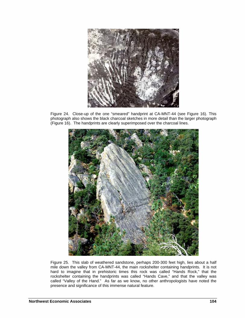
Northwest Economic Associates 104
Figure 24. Close-up of the one “smeared” handprint at CA-MNT-44 (see Figure 16). This photograph also shows the black charcoal sketches in more detail than the larger photograph (Figure 16). The handprints are clearly superimposed over the charcoal lines.
Figure 25. This slab of weathered sandstone, perhaps 200-300 feet high, lies about a half mile down the valley from CA-MNT-44, the main rockshelter containing handprints. It is not hard to imagine that in prehistoric times this rock was called “Hands Rock,” that the rockshelter containing the handprints was called “Hands Cave,” and that the valley was called “Valley of the Hand.” As far as we know, no other anthropologists have noted the presence and significance of this immense natural feature.

Northwest Economic Associates 105
Figure 26. Small handprints (about half to two-thirds normal size) at CA-MNT-1061, a rockshelter about two miles west of the main rock art complex.
Figure 27. The main panel in CA-MNT-45, a rockshelter located adjacent to CA-MNT-44. The amount of erosion and other natural deterioration in this rockshelter is high. The light colored surfaces are all younger than the old, dark surfaces, but even some of them have drawings. In this photograph, note the multiple layers of painting, with dozens of black lines superimposed on the major red, white and black vertical stripes. Many of these figures made of black lines may represent counting devices. It is known that the Chumash Indians in the Santa Barbara area to the south employed astronomical observations and some form of counting device to accurately record equinox and solstice events, so it is possible that the Esselen also practiced astronomy and employed such counting devices.

Northwest Economic Associates 106
Figure 28. This panel at CA-MNT-45, contains a small number of handprints as well as numerous figures painted in black. These drawings, thought to have been painted using charcoal as a pigment, are found throughout inland Esselen territory (no rock paintings have been authenticated on the coast). While we do not know the meaning of these charcoal drawings, many appear to be counting devices. Note the black “footprints” near the top (see also Figure 29).
Other Rock Art Styles
While the handprints are the most intriguing feature of Esselen rock art, there are other painted figures throughout much of inland Esselen territory.
The main rockshelter, CA-MNT-44, contains most of the known Esselen handprints, but that site and the area contain a large number of other figures as well. On the west side of the adjacent rockshelter, CA-MNT-45, are a series of erosion pockets, most of which contain numerous charcoal drawings.
There are also other, smaller, rock art sites in Esselen territory. Some contain a single faded charcoal drawing, while others contain a few faded figures in red or black.

Northwest Economic Associates 107
No verified rock art sites are known from the coast portion of Esselen territory, although a small, rocky cave overlooking the ocean is frequently reported to contain paintings. These appear to be modern.
Vandalism and Deterioration
The Esselen rock paintings, like most others in the United States, are slowly disappearing. The forces of nature and time alone will be enough to erase all traces of these paintings in the next fifty, hundred, or two hundred years. These figures will never again be as good as they are today, and what we see today is a mere shadow of what once adorned the cave walls.
But in addition to natural weathering, there is also vandalism, even in the remote mountains inhabited by the Esselen. As these photographs show, vandalism has occurred on a sizable percentage of the rock art panels illustrated in this chapter.
While the carved initials and names may be apparent, what might not be as evident at first glance is the large number of pits or chips caused by people over a hundred or more years throwing rocks at the cave walls! These small pits, which may be mistaken for white dots in the photographs, break the old, dense weathered surface and allow moisture to creep in. Then the freezing and thawing of the long winters can gradually peel more and more of the old surface away—and it is the old surface which contains the majority of the paintings.
Examples of deliberate vandalism are shown in these photographs:
Figure 16 Scratching and small pits from stone throwing
Figure 17 Several sets of initials and a heart; some scratching
Figures 21, 22, 27, and 31 Lines scratched with some type of sharp object
Figure 29 Pits from stone throwing Figure 33 At least three names, along with
numerous scratched lines
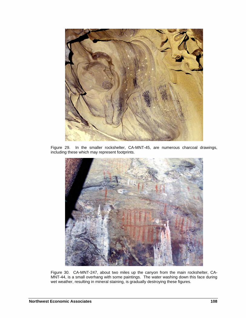
Northwest Economic Associates 108
Figure 29. In the smaller rockshelter, CA-MNT-45, are numerous charcoal drawings, including these which may represent footprints.
Figure 30. CA-MNT-247, about two miles up the canyon from the main rockshelter, CA-MNT-44, is a small overhang with some paintings. The water washing down this face during wet weather, resulting in mineral staining, is gradually destroying these figures.

Northwest Economic Associates 109
Figure 31. Charcoal sketching, with an elaborate line pattern at CA-MNT-44. This may represent a counting device. Note also the scratching which has been done more recently.
Figure 32. One of the most common paintings in California, this figure is generally interpreted to represent “rain” (CA-MNT-45).

Northwest Economic Associates 110
Figure 33. A complex panel at CA-MNT-44, with a variety of charcoal sketches. Note the modern vandalism; in addition to the three names, many lines have been scratched over the figures.
Figure 34. Some of the charcoal sketches and additional “counting devices” at CA-MNT-44. This area has been damaged by seeping moisture.

Northwest Economic Associates 111
Figure 35. In the southeastern portion of Esselen territory, in the area occupied by the Aspasniajan, a small series of rockshelters contains additional examples of Esselen rock paintings (CA-MNT-176). These are nearly 18 miles southeast of the main rock art concentrations in central Esselen territory, and are distinctly different.
Traditional Cultural Properties
Some traditional cultural properties have been identified in Esselen territory during recent cultural resources investigations.
Traditional cultural properties are those properties which possess values in reference to:
…beliefs, customs, and practices of a living community of people that have been passed down through the generations, usually orally or through practice. The traditional cultural significance of a historic property, then, is significance derived from the role the property plays in a community’s historically rooted beliefs, customs, and practices. Examples of properties possessing such significance include:
• a location associated with the traditional beliefs of a Native American group about its origins, its cultural history, or the nature of the world; …
• a location where Native American religious practitioners have historically gone, and are known or thought to go today, to

Northwest Economic Associates 112
perform ceremonial activities in accordance with traditional cultural rules of practice; …
Traditional cultural properties are often hard to recognize. A traditional ceremonial location may look like merely a mountaintop, a lake, or a stretch of river… [Parker and King 1990].
As an example of the types of traditional cultural properties which may be present, we have included details from studies made during the recent New Los Padres Dam and Reservoir Project. Esselen descendants, in addition to identifying general areas of concern (for example, concerns for traditional hunting, fishing, and gathering locations and practices) identified 15 specific traditional cultural properties and two historic themes within the general project area (in the vicinity and south of the Los Padres Dam; see Figure 1). These were as follows (after McCarthy 1999:37-47; Breschini and Haversat 1993a, 1995):
1) Xasáuan. This is the area of archaeological site CA-MNT-34, in Cachagua, which we believe was the village in which Pach-hepas became the first Esselen to be baptized, on May 9, 1775, by Junípero Serra. This is also the site in which Pach-hepas was buried (Culleton 1950:72). This site is “thus a symbol of the precontact Esselen life and culture as well as a symbol of the initial act of contact and baptism of Esselen people… (McCarthy 1999:37).
2) Birthing Rock. Associated with archaeological site CA-MNT-1594, this is a large, distinctive rock outcrop which stands out singularly from the rest of the terrace on which it is located. According to the Nasons, this location was used as a place for women to give birth. As noted below, this area produced a glass bead and a piece of obsidian from an unknown source with a hydration rind of 3.0 microns on one side and no rind on the other. This suggests breakage probably within the last several decades (Breschini and Haversat 1993a).
3) Baby Burial Ritual Area. Associated with archaeological site CA-MNT-1604, this consists of a semi-circle wall of rock with the open portion facing the area of the Birthing Rock. It is identified by the Nasons as a location of graves of stillborn Esselen babies, and may also be a grave site for a local settler family in the early 1900s.
4) Fishing Altar. Associated with archaeological site CA-MNT-37. This is a distinctive granite outcrop above the Carmel River where the Nasons report traditional offerings are made for success in immediate fishing efforts as well as thanks to the fish for giving themselves to the people.
5) Fishing Location. Downstream from CA-MNT-1601, which is considered by some Esselen descendants to be a refuge site. The Nasons report this is a location where traditional fishing with spears has always been practiced.
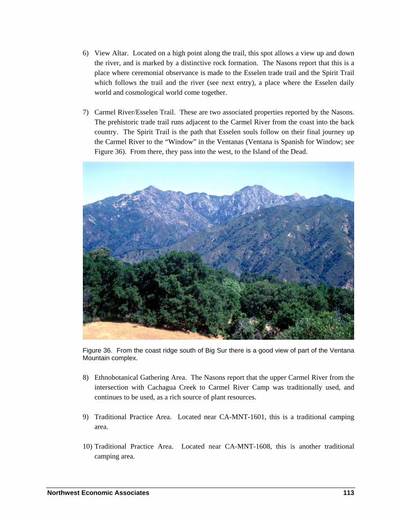
Northwest Economic Associates 113
6) View Altar. Located on a high point along the trail, this spot allows a view up and down the river, and is marked by a distinctive rock formation. The Nasons report that this is a place where ceremonial observance is made to the Esselen trade trail and the Spirit Trail which follows the trail and the river (see next entry), a place where the Esselen daily world and cosmological world come together.
7) Carmel River/Esselen Trail. These are two associated properties reported by the Nasons. The prehistoric trade trail runs adjacent to the Carmel River from the coast into the back country. The Spirit Trail is the path that Esselen souls follow on their final journey up the Carmel River to the “Window” in the Ventanas (Ventana is Spanish for Window; see Figure 36). From there, they pass into the west, to the Island of the Dead.
Figure 36. From the coast ridge south of Big Sur there is a good view of part of the Ventana Mountain complex.
8) Ethnobotanical Gathering Area. The Nasons report that the upper Carmel River from the intersection with Cachagua Creek to Carmel River Camp was traditionally used, and continues to be used, as a rich source of plant resources.
9) Traditional Practice Area. Located near CA-MNT-1601, this is a traditional camping area.
10) Traditional Practice Area. Located near CA-MNT-1608, this is another traditional camping area.

Northwest Economic Associates 114
11) Traditional Practice Area. Located just upstream from CA-MNT-1608, this is another traditional camping area.
12) Traditional Practice Area. Located between CA-MNT-481 and CA-MNT-482, this is another traditional camping area.
13) Prayer Site. Located between CA-MNT-1602 and CA-MNT-1606, this small cave or overhang is used as a prayer site.
14) Fishing Location. Located at CA-MNT-1597, the Nasons report that they used to cache fishing spears at this location.
15) Vieja Muayor. An old eucalyptus tree located at CA-MNT-1603/H reported by Rudy Rosales to be where women went to pray for the sick and old people. (CA-MNT-1603/H consists of the remains of a 1930s fishing resort.)
Theme 1) Grazing and cattle ranching. During historic times, particularly since the turn of the century, Esselen descendants have engaged in cattle grazing and ranching, and this has “continued to be a major lifeway and economic practice for many years” (McCarthy 1999:44). [It continues to this day.]
Theme 2) “Packing/Outfitting has also been an important lifeway” (McCarthy 1999:44) associated with Esselen descendants. [This practice also continues to this day.]
McCarthy has also completed an additional study for the Chews Ridge area in conjunction with an application for expansion of the MIRA Observatory, and additional details appear in that document. However, Chews Ridge was determined to be a traditional cultural property.
We have heard a number of people, including Esselen descendants, using the name pimkola’m to refer to Santa Lucía or Junípero Serra peak. Steve Chambers (personal communication 2003) notes that this comes from Mason’s (1912:108) Salinan ethnography. Mason does not specifically indicate his source for the term pimkola’m, but he does note that he was told by an informant that the peak was also called ti’at’aula, from the name of a plant that grows there (1912:108).
Kroeber (1925:472) surmises that Pico Blanco was a mountain sacred to the Costanoan, but does not provide any documentation for this statement.
Howard (1974a:68; 1979b:27) also claimed Pico Blanco was a sacred mountain. Concerning this claim, Brandoff (1980) writes: “Howard’s argument for the sacred status of Pico Blanco is not based on a scholarly analysis of the ethnographic evidence,” and concludes “It is clear that Pico Blanco did not have Sacred significance to the Rumsen Costanoan.”
Northwest Economic Associates 115
Merriam was told in 1906 that:
The Kah’-koon (and Room’-se-en) used for money in old (i.e., pre-Spanish) times white stones “with blue patches or reflections,” found at Pico Blanco. The stone was called pach-kah-lah-che-pil [Merriam 1968:III:373].
No such stones have been identified in the archaeological investigations from this area, and no other ethnographic accounts mention anything similar.
In more recent times there have been claims that Pico Blanco was sacred to the Esselen, but we are unaware of any ethnographic data to support this claim either (see also Brandoff 1980).
Material Culture
The ethnographic research dealing with the Esselen has generally been conducted in the Monterey and Carmel areas, and often applies more to Rumsen groups than to the Esselen. As a result, the ethnographic descriptions which follow have been supplemented, where possible, with the results of recent archaeological research, even though that too is rather limited.
Settlement and Subsistence Patterns
Only limited attempts have been made to ascertain settlement patterns among the Esselen. Brandoff-Kerr noted:
Archaeologically it is apparent that the settlement pattern differs between the interior and the coast. The coastal zone exhibits primarily occupation sites within a mile of the intertidal zone. The interior has mostly vegetal processing sites; however, occupation sites occur about one-quarter of the time and rock art somewhat less often. Sites on the coast indicate primarily exploitation of marine resources while those in the interior represent mostly gathering activities [Brandoff-Kerr 1982:112].
The results [of this study - ed.] suggest that social factors may have taken precedence over environmental factors in the selection of habitation sites in at least the Late Period. The results also indicate pressure on the resident population to expand the food collecting arena at this time which may have resulted in a change in adaptive strategy [Brandoff-Kerr 1982:vi].
To date, this and Proctor’s (1978) work are the only studies to attempt reconstruction of settlement patterns. Unfortunately, there is almost nothing available for the surrounding

Northwest Economic Associates 116
areas against which these may be compared. In this area, there has been almost no in-depth research on settlement, subsistence, or material culture, although on the Monterey Peninsula and the lower Carmel Valley, just to the west, some useful studies have taken place (cf. Dietz and Jackson 1981; Breschini and Haversat 1992).
It is unknown to what degree Esselen settlement and subsistence depended upon cultural factors such as burning practices. Although there has been some research on this topic, little specific information is available for the Esselen.
Trade and Trade Routes
Davis (1961) does not include any information on Esselen trade, and no real data survives in the historical accounts. Archaeological research has provided some additional data. For example, the obsidian sourced from Esselen territory has come from Napa Glass Mountain to the north of the San Francisco Bay area and from trans-Sierran sources in the Owens Valley area or on the California-Nevada border. Shell is found in most Esselen living sites, showing trade or direct communication with the coast (the quantities of shell, however, are not as high as at Rumsen sites on the Monterey Peninsula and in the lower Carmel Valley).
From this we know that trade routes existed, and that some materials were transferred over long distances. This implies that there was a formalized method for groups to meet and trade with one another, and perhaps also to cross another group’s territory.
Some clues to this are found in the diaries of the Portolá expedition. For example, in the footnotes accompanying his extensive new translation of the Crespí journals, Brown (2001:796) quotes a letter written by Crespí describing events which occurred in Monterey in May of 1770:
On May 24th … we reached this harbor with all good fortune. … On that very day, before dismounting … we decided to view a cross that they had set up when we returned last December. … Commander Don Gaspar de Portolá, Lieutenant Don Pedro Fages and I went to view it … We found the cross all surrounded with arrows and little staffs having feathers on them, driven into the ground, one little staff having a string on it of sardines still partly fresh and another little staff with a slice of meat hanging on it, and a little heap of mussels at the foot of the cross; all of this set there by the heathens in token of peace. (Wherever we had camped before along the whole way [i.e., between San Diego and Monterey] we found a great many little staffs with feathers on them, driven into the ground, and this time they would all come out weaponless [to meet us] as soon as they descried us, as though they had dealt with all their lives.)
Brown (2001:796) quotes another letter which gives essentially the same account as above, but which also includes Crespí’s interpretation of the event:

Northwest Economic Associates 117
And on reaching it … they noticed the holy cross to be all surrounded with arrows and little staffs having feathers on them, fixed in the ground: one of the little staffs having a string of sardines on it that were still rather fresh, and another having a piece of meat, and a little heap of mussels at the foot of the cross; the sight of which quite melted our hearts seeing that the heathens were in some fashion paying some kind of worship to the sacred wood …. [emphasis added]
Another pertinent account comes from the second Portolá expedition, which reached the shores south of Carmel on May 25, 1770:
Not until four days after we reached this other point of pines upon the Carmelo River side did we see a single heathen appear. Four days after reaching here we saw a large parade of heathens standing upon the height of a knoll next to us, entirely without weapons, gazing and not saying anything. … forty-some heathens immediately came dropping down, bearing two or three large rushwork-wickerweave baskets made of rushes, full of gruel, and many of the heathens were carrying small staffs with feathers on them in their hands—to our understanding, a sign of peace, since we have been finding small staffs with feathers on them at all of the places where we made camp during the first voyage [Brown 2001:735].
As noted in these accounts, the practice of placing arrows and feathered staffs into the ground as a sign of peace was universal between San Diego and Monterey. We know today that the Indians were not “paying some kind of worship to the sacred wood”—rather, they were responding to a peace offering made in their traditional manner.
Another interesting note appears in Palóu’s account of a sailing expedition to the Northwest Coast. Describing a visit to the Haida, Palóu writes (Bolton 1926:III:163):
We saw the smoke of many fires made by the inhabitants of the point, and that the land was well covered with trees resembling pines. With that point the land formed a good bay, and we noticed that from a roadstead in the land a canoe was coming out and being rowed toward the frigate. While they were still some distance from the bark we heard them singing, and by the tone we knew them to be heathen, for they sing the same song as those from San Diego to Monterey.
Although there is little to go on, it is possible that this practice represents a somewhat standardized method for greeting strangers and documenting peaceful intentions. Perhaps the message was more specific: we want to trade, not make war.
Based on archaeological data, it appears that the Esselen utilized ridgelines for travel, avoiding most of the steep and narrow coastal canyons. This is particularly true of the Coast Ridge south of Big Sur. There are a number of archaeological sites within the lower canyons

Northwest Economic Associates 118
and along the open upper ridges (for example, Partington Ridge). Once on the Coast Ridge, travel to the north or south, or to the interior, was possible.
The quantities of shellfish at most Esselen sites in the upper Carmel Valley are considerably less than at Rumsen sites in the lower Carmel Valley. There are two probable reasons for this other than the obvious greater distance from the ocean for the Esselen groups. First, the Esselen appear to have practiced more of a foraging economic mode than the Rumsen Costanoan, who practiced more economic specialization. Secondly, the Esselen coast is very rugged, and does not favor easy travel or resource exploitation, nor are there many suitable sites for large villages. In a response to these conditions, the Esselen appear to have utilized the ridgelines for travel, avoiding most of the narrow and steep coastal canyons, and there appears to have been a reduced reliance on shellfish. Trade with the Rumsen Costanoan probably did not supply large quantities of shellfish, as the two groups are generally reported to have been bitter enemies. Preliminary indications from archaeological research support this hypothesis (cf. Edwards et al. 1974; Breschini et al. 1992).
Food Resources
Early explorers noted that the Indians at Mission San Carlos ate “all living things except frogs, toads, owls, which are the only animals they are afraid of.” However, the Salinan and most likely all other groups avoided the skunk.
Hunting Practices
As James Culleton noted in Indians and Pioneers of Old Monterey:
The men were fine hunters. Dressed in the skin of a doe or antelope and imitating the call and actions of the animal, the Indian on all fours would go right up to the herd. When close enough he would quietly squat and send two or three arrows into the unsuspecting beast [Culleton 1950:219].
This probably originated in the accounts provided by the French, Spanish and English expeditions of September 1786, late October of 1792, and early December of 1792.
[September 1786] These Indians are very skillful with the bow; they killed some tiny birds in our presence; it must be said that their patience as they creep toward them is hard to describe [La Pérouse 1994: 169].
Their industry in hunting larger animals is still more admirable. We saw and Indian with a stag’s head fastened on his own, walking on all fours and pretending to graze. He played this pantomime with such fidelity, that our hunters, when within thirty paces, would have fired at him if they had not

Northwest Economic Associates 119
been forewarned. In this manner they approach a herd of deer within a short distance, and kill them with their arrows [Margolin 1989:59-60].
[September 1791] …there is an abundance of deer. To kill the latter the Indians put on the stuffed head of an already killed deer; and hiding their bodies in the grass, the imitate the stance, appearance and look of the deer with such propriety that many are deceived until attracted to within range [Cutter 1960:53].
[October 1792] Their method of hunting is extremely ingenious. They keep with great care the horns and some part of the head of a deer and fill it with dried grass, thus giving it the shape of the living animal. When they go hunting they carry these images on their heads, and having reached some suitable spot, go along on three feet, using their left hands to support them, while in their right hand they have a bow and arrow ready. As soon as they see one of these animals and know of which sex it is, they imitate the motions of the animal of the opposite sex with such perfection that the thoughtless beast is attracted within range; they then discharge their arrows with great accuracy [Jane 1930:127].
[December 1792] On our return to the convent [mission], we found a most excellent repast served with great neatness, in a pleasant bower constructed for that purpose in the garden of the mission. After dinner we were entertained with the methods practiced by the Indians in taking deer, and other animals, by imitating them. They equip themselves in a dress consisting of the head and hide of the creature they mean to take; with this, when properly put on and adjusted, they resort to the place where the game is expected, and there walk about on their hands and feet, counterfeiting all the actions of the animal they are in quest of; these they perform remarkably well, particularly in the watchfulness and the manner in which deer feed. By this means they can, nearly to a certainty, get within two or three yards of the deer, when they take an opportunity of its attention being directed to some other object, and discharge their arrows from their secreted bow, which is done in a very stooping attitude; and the first or second seldom fails to be fatal [Wilbur 1954:67-68].
It is clear, from the Vancouver account at least, that his information on hunting practices comes from an after-dinner performance put on by the Indians in the mission garden. This hunting exhibition was probably performed for many important visitors around that same time, although the earlier La Pérouse account appears to include field observations.
Some estimates of the hunting practices can be gained from examination of small bone fragments remaining in archaeological sites. The faunal remains recovered at CA-MNT-44, a large two component rockshelter site in the Tassajara area, included 27 types of mammals, birds, and reptiles, as well as five species of fish (Breschini 1973:7). The fish included species from the ocean as well as freshwater sources. The primary land mammal species represented was the deer, and the types of bone present suggest that the carcass was butchered in the field, with only portions being transported to this particular site.

Northwest Economic Associates 120
In addition to deer, some of the most frequently captured species (depending on location) included brush rabbit and jackrabbit, gray fox, badger, weasel, skunk, raccoon, chipmunk, bobcat, turtle, etc. Other species may have been captured, but could have occupied the sites on their own. These include pocket gopher, ground squirrel, vole, wood rat, and a variety of mice. Elk and antelope, widely reported in the early explorers accounts of the Salinas Valley, have not been found in the sites excavated to date in Esselen territory (although two fragmentary tule elk rib heads were found at CA-MNT-1233, located inland from the coast in the Big Creek area, just south of Esselen territory). Black bear, grizzly bear, and mountain lion are not uncommon in the deposits.
Marine Resources
Marine mammals included sea otter, river otter, harbor seal, California and stellar sea lion, northern and southern fur seal, and dolphin. Whale bones are often found in coastal sites, but they would have been obtained from beached whales.
A wide variety of birds were exploited, including pelican, duck, goose, loon, seagull, murre, cormorant, hawk, owl, pigeon, eagle, magpie, and quail. Birds were important food sources, and the feathers of some species, such as quail and woodpecker, were also used for decorating baskets and other items. The wing bones were used for whistles or flutes in some areas, although this has not yet been reported for Esselen territory.
Fish species included shark, ray, sardine or herring, anchovy, steelhead/rainbow trout, Pacific hake, topsmelt or jacksmelt, surfperch, monkeyface and rock prickleback, a variety of rockfish, lingcod, and cabezon.
In addition, a variety of reptiles and amphibians have also been found, but their specific uses, if any, are not clear.
Plant Resources
They have no medical men graduated in Universities, but they have their healers, more desired (and at the same time more feared) than with us the doctors. Said healers apply herbs, bark, leaves, roots, for in these simple things the land abounds, and to know the plants, their names and properties a Botanico would be necessary. It is certain that they cure many infirmities, and for all they have remedies, and many sufficiently efficacious ones, for which reason not a few prefer their herbs and roots to our ointments and balsams [Engelhardt 1929:34].
Plants provided a wide variety of foods and medicines, as well as raw materials for houses, baskets, clothing, weapons, and tools. What could not be used for one of the above was probably used as firewood!

Northwest Economic Associates 121
As perishable materials such as plant remains are rarely preserved in local archaeological sites, and little information was provided by the mission and other explorers’ records, some of the uses may never be known. However, small plant remains which have been charred will often last for hundreds of years, and can be identified through microscopic examination. The section on archaeology notes some species recovered from an archaeological site, CA-MNT-1601, in the upper Carmel River area.
While little information on Esselen ethnobotanical resources exists in the published literature, an environmental impact statement for proposed expansion of the Los Padres Dam contains a brief ethnobotanical list obtained from Esselen descendants (McCarthy 1999). At this point a word of caution must be included. There is no way to tell to what degree this information represents aboriginal knowledge being passed down, as opposed to recently acquired knowledge.
McCarthy’s ethnobotanical list is included, with substantial modifications and corrections, below. It has been supplemented with additional references to plant usage from a variety of sources, including Edward K. Balls’ Early Uses of California Plants, Walter Ebeling’s Handbook of Indian Foods and Fibers of Arid America, and a variety of other sources. Of particular significance to Esselen territory is A Flora of Tassajara: The Vascular Plants of the Tassajara Region, Ventana Wilderness, Santa Lucia Mountains, Monterey County, California, by David Rogers. We appreciate also comments and suggestions by Mark Stromberg and Jeff Norman (personal communication, 2002-2003).
Quercus chrysolepis—Known locally as Valpariaso oak; also known as golden cup oak, canyon live oak, and maul oak. This is the most widely distributed oak in California. The acorns were dried and stored, then pounded, leached, and made into a mush, thin soup, or bread.
Quercus agrifolia—The coast live oak grows throughout much of Central California, and was one of the most widely used oaks. Its acorns were an important staple food for the Chumash (Ebeling 1986:306-307) and other California groups.
Quercus lobata—Valley oak, California white oak. The acorns from the valley oak were one of the most important food sources for the Chumash (Ebeling 1986:306-307) and other California groups.
Quercus kelloggii—California black oak. Unlike the two oaks described above, the black oak is deciduous tree and loses its leaves during the winter. Pavlik (et al. 2000:13) state that the acorns of the black oak were considered the best tasting by Indian peoples throughout California.
Lithocarpus densiflora—Tan or tanbark oak. While not a true oak, it does bear acorns which were widely used.

Northwest Economic Associates 122
Concerning the oak resources in Esselen territory, McCarthy writes:
Acorns from all of these species were used in the production of the staple food of California Indian peoples, including the Esselen. They were collected in the fall and dried and stored in large quantities, for both immediate and future use. The acorns are pounded into a fine flour which is leached and cooked. The collection of acorns and management of their storage was essential to Esselen survival, and a focus of Esselen ceremony to thank the Creator for the gift of acorns/food and to encourage the continuing well being of the crop. Thus these resources, the living trees, are central to Esselen heritage. In addition to the use of acorns as food, Esselen made necklaces of the acorns, sometimes alternating acorns and manzanita berries on a string [McCarthy 1998:2].
While there is no specific information available for the Esselen, it has been reported that among the neighboring Salinan the acorns of the live-oak were preferred for mush, while those of the deciduous oaks for bread (Mason 1912:118).
Bay (laurel)—Umbellularia californica. McCarthy notes that fruits and kernels, gathered in the fall, were prepared for food. The aromatic leaves were used as medicine.
Buckeye—Aesculus californica. McCarthy notes that the buckeye bears a large fruit, gathered in the fall, which can be made edible by lengthy leaching and processing. Buckeyes were used as an emergency food in case the acorn crop failed. Pounded bulbs were also used as a fish poison to incapacitate the fish so they could be caught.
Madrone—Arbutus menziesii. McCarthy notes that madrone berries were occasionally eaten by the Esselen. Also, the dry, curly bark was crumbled and mixed with black sage and hummingbird sage to make a tobacco which was smoked. Manzanita (see below) may have been used similarly. Other groups used the bark to make a tea to cure stomachache, and the bark and leaves to make a lotion to bathe sores and cuts (Balls 1962:69).
Santa Lucia Fir—Abies bracteata. McCarthy only notes the Esselen‘s use of this scarce tree as a source of firewood, as it contains lots of sap. This distinctive tree is extremely rare, and currently is found only in the Santa Lucia Mountains.
Willow—Salix spp. McCarthy notes that the willow’s most important contribution was as a construction material. It was also used for basketry. The use of willow for pain relief is also common.
Blackberries—Rubus ursinus. McCarthy notes that blackberries were eaten raw by the Esselen.

Northwest Economic Associates 123
Chamise—Adenostoma fasciculatum. McCarthy notes that the aromatic leaves of chamise or greasewood was used as a medicinal tea.
Coffee berry—Rhamnus californica. McCarthy notes that coffee berry, also known as buckthorn or cascara, was used as a cathartic emetic. We find little support in the local literature for its use as an emetic; it was generally used as a cathartic in this general area (cf. Merriam 1968:III:374).
Elderberry—Sambucus spp. McCarthy notes that elderberries were eaten raw or dried for later use. The Chumash used elderberry as a food, as well as for crafts and tools (Ebeling 1986:308). The split stick musical instrument was usually made from elderberry.
Holly leaved cherry—Prunus ilicifolia. McCarthy notes that the Esselen used the fruit of the Holly leaved cherry, also known as islay. They ate the pulps of the fruit and processed the kernels into a powder which was used to flavor other roods and to make a soup.
Toyon—Heteromeles arbutifolia. McCarthy was unable to document the use of the Toyon or Christmas berries, although the Mutsun and Rumsen ate the fruits. Merriam reports the Ohlone used an infusion of the leaves for suppression of menses or irregular menses of girls (1968:III:373).
Wild or western raspberries—Rubus leucodermis. McCarthy notes that wild raspberries are found in similar environments to the blackberry, and that they were eaten raw. However, our research suggests that this species is not found within Esselen territory (Rogers 1998; Jeff Norman personal communication, 2003).
Horsetail—Equisetum laevigatum. McCarthy notes that a decoction of its stems was used for various internal disorders, including kidney and bladder problems.
Milkweed—Asclepias spp. McCarthy notes that the fibers were used to make string and decoctions of the leaves and stems may have been used medicinally.
Moss—McCarthy notes that mosses were used as a poultice on wounds.
Mugwort—Artemisia douglasiana. McCarthy notes that mugwort, also known as wormwood, leaves were boiled and the tea consumed to prevent poison oak. The leaves are also used as a poultice on the poison oak rash. It was probably used traditionally for other disorders as well.
Ceanothus—The flowers of Ceanothus tryrsiflorus are currently used by Esselen descendants to produce a soap.

Northwest Economic Associates 124
Stinging Nettle—Urtica dioica. McCarthy notes that a decoction of the nettle leaves was used for several disorders. It also was used in cordage.
Tule/Rushes—Scirpus californicus. McCarthy notes that the roots are used in basketry and stems also used in construction of mats and thatch. As with surrounding groups, tule was probably of major importance to the Esselen. To some degree this is confirmed by the following. One of the Esselen villages whose name has survived was Capanay. This village was always described as being located in an area with abundant tules, an area which to this day is still called Tularcitos. And indeed, in the Esselen language, the word “Capanay” translates as “tule” (Kroeber 1904:55).
Sage (mint family)—Salvia spp. McCarthy notes that sages are generally used for medicines and for ceremony. Hummingbird sage is used medicinally as well as part of a mixture with madrone bark and black sage in tobacco to be smoked ceremonially. Black sage is used for a number of medicinal and ceremonial purposes. A species known as “silver sage” is also found in some areas of Esselen territory.
Sedge—Carex spp. McCarthy notes that the long, strong roots were used in basketry.
Yerba Buena—Satureja chamissonis. McCarthy notes that this plant was used medicinally for a number of purposes, and that some Esselen people carry it with them for regular use. This species thrives after a fire.
Yerba Santa—Eriodictyon californicum (Figure 37). Grandpa Fred Nason consistently points out this plant on the ride in to Pine Valley. McCarthy notes that it is a valued herb and some Esselen carry it with them for regular use, especially for colds. Among the uses Balls (1962:63-64) notes are that the leaves, either fresh or dried, were boiled to make a bitter tea, taken to cure colds, sore throat, asthma, tuberculosis and rheumatism. In a weaker tea it was taken frequently as a blood purifier. A liniment was used as a wash to reduce fever. It is occasionally mixed with Yerba Buena by old-timers in the Santa Lucia Mountains to produce a distinctive tea.
Yucca—Yucca whipplei. McCarthy notes that yucca was a valuable plant, as the strong fibers in the leaves were used for a number of purposes, the fluid in the stalk was drunk, and the stalk was roasted for eating. Yucca fiber was also used for a variety or purposes around California, including sandals and basketry. The tip of the leaf can be snapped off and the attached fibers can be used as a needle and thread.

Northwest Economic Associates 125
Figure 37. Yerba Santa was an important medicinal plant.
Yerba Pasma (or Pasmo)—Golden fleece, Ericameria arborescens. Grandpa Fred Nason indicates that this is one of the most important plants among the Esselen. In the Santa Lucia Mountains, yerba pasma also thrives after a fire. This name appears to be applied to a number of different plants. For example, among the Diegueño a slightly different plant (E. brachylepis or boundary goldenbush) was called by the same name (Hinton 1975:219; Hickman 1993:252). Hinton notes that the name “pasmo” comes from the Spanish; a malady with chills as the main symptom was called the pasmo (1975:219-220).
Manzanita—Arctostaphylos spp. McCarthy notes that manzanita berries were occasionally eaten by the Esselen. Merriam notes that the berries were used to make cider (1968:III:373).
Poison oak—Toxicodendrom diversalobum. While we tend to avoid poison oak today, most Indians apparently were not bothered by the skin rashes and itching we associate with the plant. Some groups reportedly had their children eat or chew the leaves early in life to produce an immunity. Repeated exposure can also result in immunity, and some adults eat a

Northwest Economic Associates 126
small amount each spring to keep their immunity strong. No specific information is available for the Esselen, but in many areas of California the slender stems were used in basketry, and the juice from the stems, leaves, and roots turns black quickly and made an excellent dye for basket materials (Ebeling 1986:242), and may also have been used as a cure for warts (Balls 1962:59-60). Poison oak leaves are also said to have been wrapped around acorn bread throughout California (Keator et al. 1995:51).
Although reviled by most people, poison oak becomes extremely beautiful in the fall. Its leaves change from their normal green and take on the full range of fall colors.
Seasonal Round
Almost nothing is known specifically about the seasonal round for most of Esselen territory. Information can be extrapolated from the Rumsen Costanoan‘s seasonal round, and from their settlement patterns. However, there will be significant differences because the Rumsen had convenient access to the ocean, and most Esselen did not.
Terry Jones has obtained data from several archaeological sites on the south coast. These sites include both Esselen and Salinan, but it is likely that the occupational patterns were generally similar.
Jones (1995:192-193) notes that coastal flank of the Santa Lucias was occupied during the fall and winter, but that many of the sites were abandoned during the spring and early summer. This could be related, in part, to the lean state of game in the spring. Emphasis could have shifted to marine mammals (with occupation of sites along the water) or plant foods (which may have been more plentiful in the interior) during this time of the year.
During the fall when grass and acorns were plentiful, and deer were fat, hunting would have been more productive. At this time too, families gathered and stored large quantities of acorns for use during the winter.
The extremes, the cold of winter and the heat of summer, dictated the seasonal round which the Esselen followed.
During the coldest months of winter, people would have been gathered in winter villages in the most sheltered areas available to them. Most winter villages were probably in low lying river valleys, where they would have been protected from the heaviest snows. However, during the several hundred years prior to the arrival of the Spanish, the “Little Ice Age” probably resulted in considerably colder winters than we know today.
Firewood was a primary concern both during the winter and throughout the year. Campsites were probably moved as much for lack of readily available firewood as any other resource—

Northwest Economic Associates 127
it was easier to move the camp once in a while than to carry firewood long distances on a daily basis.
In the spring, the early vegetation drew the people into the mountains again, to the creeks and upland meadows. The heat of the summer brought other resources, but also required good sources of water. The Carmel and Arroyo Seco rivers on the interior and the Big Sur River on the coast would have been ideal during the summer.
Along the coast the heat of the summer was tempered by the cooling fog. The ocean’s many resources would have been available throughout most of the year. However, during the winter months or when major storms battered the coast, the ocean would have been extremely cold and dangerous and was probably avoided.
Microclimates would have played an important role in site selection and resource utilization. In every terrain there are some places which, because of a combination of favorable conditions, are just more comfortable or more productive than average.
With the fall came the annual acorn harvest. Once the secret of leaching away the bitter tannic acid was discovered, several thousand years ago, the acorn became a staple food for many California Indian groups.
But acorns had to be gathered in large quantities each fall, and stored in cool, dry granaries where the insects and rains could not reach them. Many California groups relied on acorns as a staple food for the entire winter. The accounts of the Portolá expedition, which passed through Salinan territory just to the south in the fall of 1769, attest to the importance of pine nuts at that time of year.
Throughout the year, in all but the coldest seasons, the Esselen hunted deer, elk, antelope, and other large game. Smaller animals were used also—squirrels, rabbits, and birds.
Salmon and steelhead runs came periodically with the changing river conditions, but trout were available all year long.
The Esselen knew their territory intimately. It was not a large territory, measuring perhaps 25 by 40 miles at the most, and shared among five separate, although closely related, groups. But each person spent his or her lifetime within the boundaries of the tribe. In time they knew every trail, every rock and every tree. They knew each herd of deer, and the individual animals in that herd. When they hunted it was not at random as when we hunt today. After the proper preparation rituals, the Esselen hunters would most likely pursue a particular herd and perhaps one or more individual deer. They knew where they could be found at any given time of the day or season of the year, and they knew their habits. As the quotations in the “Early Ethnographies” section, above, documents, the hunters knew how to imitate the movements of a deer perfectly, and how to get within easy spear or arrow range.

Northwest Economic Associates 128
The Esselen were shaped by the lands in which they lived, and by everything in those lands.
Dress and Personal Ornamentation
In an early account (prior to 1775), the dress of the Indians in and around Monterey and Carmel was described by Pedro Fages as follows:
Nearly all of them go naked, except a few who cover themselves with a small cloak of rabbit or hare skin, which does not fall below the waist. The women wear a short apron of red and white cords twisted and worked as closely as possible, which extends to the knee. Others use the green and dry tule interwoven, and complete their outfit with a deerskin half tanned or entirely untanned, to make wretched underskirts which scarcely serve to indicate the distinction of sex, or to cover their nakedness with sufficient modesty [Priestley 1937:66].
This account may also apply directly to the Esselen, as at least one Esselen subgroup (the Eslen) had visited Mission San Carlos twice by 1774.
Additional information comes from early drawings; particularly those of José Cardero, made in 1791 (see Figures 4, 5, and 6).
Regarding body painting, an early account comes from the second Portolá expedition, which reached the shores south of Carmel on May 25, 1770:
It was only their chief, who came in front of them, who was wearing paint, a very shiny black that we thought must have been mineral pitch [Brown 2001:735].
In another pertinent account, based on Crespí’s early travels between San Diego and Monterey, Palóu cites Crespí, who noted that:
…among the heathen found from San Diego to Monterey we have observed that when they go to visit another village they paint themselves in several colors… [Bolton 1926:III:172].
The La Pérouse scientific expedition of 1786 noted that at Mission San Carlos:
They are likewise in the habit of painting their bodies red in general, and when they are in mourning, in black [Margolin 1989:93].
Other forms of decoration would most likely have included ornamentation such as feathers, shell beads, abalone pendants, basketry hats, etc. Unfortunately little information on Esselen practices has survived.

Northwest Economic Associates 129
An abalone pendant from CA-MNT-44 closely resembles a modern fishing lure, and could have been used for something other than decoration.
Rose’s attribution of a specific tattoo pattern to the Esselen (1979:5, 26, 34, 70) is erroneous. That information actually pertains to the Salinan. The mistake derives from Merriam’s use of the term “En-ne-sen” to describe the Salinan group around Mission San Antonio, which fooled the editors of Merriam’s posthumous Studies of California Indians (1955).
Manufactured Items
Some information concerning manufactured items comes from ethnographic accounts, and this is supplemented by archaeological data.
Structures
No specific information on Esselen structures has survived. We do have some information from drawings and descriptions at Mission San Carlos, as well as some additional information from archaeological research.
The living structures built by Indians living at Mission San Carlos were mostly located on the slope to the north of the church and quadrangle. A close-up drawing of these appears in Figure 7, and clearly shows hemispherical domed structures. These are similar to the one shown in the right side of Figure 5, a depiction of Monterey Indians fighting a mounted Spanish soldier. However, Figure 6, a sketch of Indians at Mission San Carlos, shows conical structures in the background. John P. Harrington’s Culture Element Distribution volume on the Central California coast indicates that the Ohlone used circular dwellings, and that they were both domed and conical (1942:10). The 1792 Spanish expedition described the dwellings as circular, but failed to note whether they were conical or domed. They did note that the Indians “preferred to live in the open country” (Jane 1930:128).
La Pérouse described them as:
…round, 6 feet in diameter by 4 in height; a few stakes the thickness of an arm stuck into the ground and joined to form a vault at the top make up their frame; eight or ten bundles of straw roughly arranged on these stakes more or less protect the inhabitants from rain or wind, and more than half this hut remains open when the weather is fine; their only precaution is to keep two or three bundles of hay in reserve near their huts [La Pérouse 1994:179].
This description was made in September, a time of year when the weather is usually quite moderate and the structures were probably in their “summer” condition. Otherwise, the

Northwest Economic Associates 130
approximately 50 huts they counted, if actually the size they described, could scarcely have housed the approximately 740 individuals then associated with the mission.
It is likely that Esselen and Ohlone structures were similar in overall form, although there probably would have been some measures of individuality within each group.
The general house form was a low domed or conical structure. It was made by burying the thick ends of branches in the ground and drawing the ends together at the top. The structure would have been braced and strengthened with additional branches. When intertwined, the framework can be made without the use of cordage.
The covering would have been bundles or mats of tules or grasses. The rectangular door was reportedly sealed with another bundle of grasses, but a leather hanging could also have been used.
The Spanish expedition of 1792 noted use of the sweat lodge:
The natives who are attached to the mission of San Carlos have an unusual custom. They dig a circular ditch in the earth and then cover it with a kind of bell-shaped erection, leaving a very narrow entrance rather like an oven door. On one side of this ditch they pile up wood which they eventually light. When the men come back from work, they go to this oven, where the fire has already burnt up sufficiently, and as many as can enter it, those who have to wait meanwhile amusing themselves with various games. Those who are within suffer as extreme heat as if they had been in a stove, and come out sweating copiously; they them proceed to bathe in the river, afterwards stretching themselves out on the sand and turning over and over many times [Jane 1930:128].
In central Esselen territory, west of Tassajara, there is an archaeological site consisting of approximately 12 or 13 “circular cultural depressions” extending along a creek (CA-MNT-179). As they have not been tested, it is not known whether these represent pit houses, sweat houses, or some other form of structure. We do not know of any other location in Monterey County with a similar grouping of structural remains.
The depressions are all about the same dimensions, and average some three to four meters in circumference. The edges are somewhat built up with rock, and the centers are depressed as much as 50-70 cm. The soil is dark, ashy, and contains a number of midden constituents. While we feel that these cultural depressions are probably the remains of pit houses, confirmation must await archaeological testing. [Any archaeological testing should be conducted with an absolute minimum of disturbance and maximum of data analysis. Remote sensing, with ground penetrating radar and other such non-invasive techniques should be extensively employed. This resource is unique and much too valuable to waste!]
Northwest Economic Associates 131
One additional such site, consisting of a single “circular cultural depression” has been discovered within about two miles (unrecorded). Its location suggests a dwelling rather than a sweat house, but again, no excavations have been conducted. Archaeological site records mention other similar depressions, but none have yet been investigated.
Howard (1974a:30-31; 1976:58) mentions that a house floor was encountered at CA-MNT-478, in the Partington Canyon area, but no technical report was prepared for this dig, so no details are available.
Additional structures probably included fenced dance areas and acorn granaries. The latter were probably elevated structures with tule or grass roofs to protect the acorns from rain.
The “Esselen“ house depicted in Merriam (1955:105, 128, Plate 35a) is actually Salinan. The confusion comes from Merriam’s use of the name “En-ne-sen” for the Salinan group around Mission San Antonio.
Tools and Weapons
The Esselen manufactured and used a wide variety of artifacts. However, the data on material culture is better represented in archaeological collections than in the ethnographic literature.
The artifacts found at CA-MNT-44, in the Tassajara area, for example, included bone awls, antler flakers, projectile points (including Desert-side notched points), scrapers, etc. A small sandstone mortar was also found in the deposit (Breschini 1973). Hopper mortars, that is, small mortars with a ring of asphaltum or tar around the depression for the purpose of securing a bottomless basket to the stone, are well-represented in Esselen territory. CA-MNT-1601, a small site on the Carmel River, produced projectile points (again including Desert-side notched points), a variety of cores and modified flakes, bone awls, a bone tube, a bone gaming piece, manos and pestles, etc. (Breschini and Haversat 1995). Portable and bedrock (or earthbound) mortars would have been used in conjunction with the pestles, and metates (either portable or earthbound) would have been used in conjunction with the manos. Few metates, however, have been found in Esselen territory.
These archaeological assemblages are generally comparable with other Esselen and Rumsen Costanoan collections from the same time period.
The excavation at CA-MNT-250, a cave with a dry deposit located about three-quarters of a mile west of CA-MNT-44, provided information on items of material culture generally not found in other Esselen sites. The dry deposit allowed the preservation of wood, cordage, fiber, and basketry fragments (Meighan 1955), which made up over 90 percent of the recovered artifacts at that site.

Northwest Economic Associates 132
Included in this collection were nine hardwood foreshafts and five possible shaft fragments. Most foreshafts were sharpened on both ends, one end serving as the point and the other end for insertion in the cane arrow shaft. One foreshaft was actually found bound to a fragment of cane shaft with sinew. The use of wooden points instead of stone points led Meighan to suggest that “it seems likely that the Esselen did not use stone points at all” (Meighan 1955:16-17). This comment, in turn, was among the data which led Pohorecky (1964, 1976) to conclude that the Esselen did not exist (see below). Other wood items included fire drills, a wooden awl, fire pokers, etc. (Meighan 1955:17-18).
The Indians in the Monterey area used the bow and arrow when the Spanish arrived (and reportedly were using it in 1602-1603 when Vizcaíno visited Monterey), but it is not certain at what date the Desert-side notched points first came into common usage in this area. These is some evidence that the main use of these points was quite late, or even during the early Mission Era, in some parts of the Monterey area (Breschini and Haversat 1995).
As noted, tule was an important plant, and used for a variety of different functions. It was also used in the manufacture of boats, which the Indians along the coast both north and south of Esselen territory are reported to have used. We are aware of no specific mention of tule reed boats among the Esselen, but they did have a word for boat or canoe (Heizer 1952:76).
Basketry and Cordage
Basketry fragments have been found archaeologically at three sites in Esselen territory: CA-MNT-85, CA-MNT-250, and CA-MNT-838. Additionally, a number of small fragments or impressions of fragments have been reported from the asphaltum rings of hopper mortars, but we are not aware of any analyses on these fragments.
There are no known Esselen baskets, but the fragments found archaeologically suggest striking similarities between Esselen and southern Costanoan baskets.
For example, in 1957, after examining a Costanoan winnowing tray at the Southwest Museum, Larry Dawson wrote to Alfred Kroeber commenting on the similarities between that tray and two other known examples, and remarking on the subtleties he had observed in the twined decoration. Dawson was particularly impressed that the black designs showed identically on both sides, and that very subtle red patterns in dyed material were worked in an ingenious way to produce independent and totally distinct designs on either side of the basket. These patterns lasted even after the dyed materials had faded. On checking the archaeological collection from CA-MNT-250 (cf. Figure 38C), Dawson found the same techniques there as well, with interesting variations. He concluded that the keynote of Costanoan-Esselen basketry was subtlety, manipulating the weaves rather than using bold colors to produce designs. He was aware of no examples of this technique in other parts of

Northwest Economic Associates 133
the state (letter dated August 21, 1957, to A.L. Kroeber; courtesy of the Bancroft Library; call number BANC MSS 95/21C).
By 1973, Dawson had had time to consider the implications of the distinctive traits shared by the Esselen and southern Costanoan. In a 1973 manuscript, he noted:
…many non-Penutian tribes marginal to Central California conserve what appear to be ancient twined basketry traditions emphasizing twined culinary forms. Some of these tribes such as the Pomo, Yana, and Southern Californians have partially assimilated coiling, but not to the extent of complete replacement of their native twining traditions. These twining traditions (at least four different ones) are so distinct that they suggest a significant degree of diversity in California basketry even before the Middle Horizon and the immigration of the Penutian groups [1973:2-1].
The basketry of Isabella Meadows Cave [CA-MNT-250] is an interesting case in point. The cave is in Esselen territory in the mountains of Monterey County and the deposits, which are of late prehistoric and early historic times, have yielded a large sample of fragments of culinary baskets in a unique kind of twining with highly specialized decorative elements not known anywhere else in America. (The Penutian Costanoan who apparently intruded into Esselen territory and pushed them southward may have assimilated at least part of Esselen basketry in the process.) [Dawson 1973:1-2].
This observation on the culture history of the Esselen parallels information available through archaeology, linguistics, and other specialized analyses (see Breschini 1983).
At CA-MNT-250, 160 pieces of cordage were recovered. This figure includes 42 pieces of untwisted fiber, 3 pieces of twisted animal skin, and 4 pieces of twisted bark, which are not actually cordage. Of the true cordage, the majority, 106 pieces, were simple 2 ply right (“S”) twist cordage. One piece was three-strand braid, and 7 fragments were 2 ply left (“Z”) twist cordage. The cordage was made of grass, yucca fiber (probably Yucca whipplei), a silky apocynum-like fiber, and human hair (Meighan 1955:14).
The “knotted fiber” that was recovered was determined to be portions of rude nets, with mesh sizes of 3 to 9 cm (Figure 38A). The nets appear to have been relatively small, hastily made and readily discarded, probably used to transport some types of food resource (Meighan 1955:16).
An additional piece of “apocynum” (Indian hemp) cordage tapered in thickness, with the thinner end terminating in a loop formed by a slip knot (Figure 38B). This could have been part of a snare (Meighan 1955:16).

Northwest Economic Associates 134
Figure 38. Basketry and cordage from Isabella Meadows Cave, CA-MNT-250. A: Fragment of a net made from “apocynum” fiber. Net has a 4 cm mesh, extended length 78 cm. B: Tapered “apocynum” cordage, possibly part of a snare. C: Twined basketry fragment, length 13 cm. From Meighan (1955).
Archaeological site CA-MNT-85, in the Arroyo Seco drainage, has also produced fragments of basketry. Some recovered during the Hill excavation of the late 1920s was described by Pilling (1948:29, 32):
Although only a few fragments of the basket remain, considerable data may be gleaned from them. The basket was twined in a clockwise direction, looking at the outside of the basket, or counterclockwise looking into the basket. There were eight uprights and 14 interlacers per inch. The material is not a spun fiber, but is probably a bark or root segment twisted for use in basketry weaving.

Northwest Economic Associates 135
The fragments of basketry are small but some fragments of design-bearing basketry remain. … The nature of this weave yields decoration only on one side of the basket; in this case on the interior.
In general when baskets are decorated on the inside, they are flat and tray-like in shape. The flat shape of the burial bundle and the lack of basketry fragments adhering to any but the bottom area of it, would tend to confirm this guess.
A minute seed was found to be clinging to cracks on the interior of the basketry fragments.
In the spring of 2003, we learned from Joan Brandoff-Kerr, Forest Archaeologist for the Los Padres National Forest, that additional fiber and cordage materials along with a number of other artifacts from CA-MNT-85 had been donated to the Forest Service from a pot-hunter’s collection. This material is currently being analyzed.
Don Howard’s dig at CA-MNT-838, in the Reliz Canyon area encountered a fragment of twined basketry, which he submitted to Larry Dawson for analysis. Dawson’s comments, dated 1 August 1977, are as follows (courtesy of Michelle Jason):
Fragment of twined basketry found in a rockshelter site in Reliz Canyon, Monterey Co. on Elmer Gould’s ranch (Gould Rockshelter #1). Found on surface about 10 ft. south of Don Howard’s Unit A-2.
Dimensions of fragment 3.2 cm. by 2.5 cm.
It corresponds in every way to a single particular kind of basket, a shovel-shaped winnower called hualajin (Spanish spelling) in Mutsum, variously recorded by others as walahin, wahleen, etc. Such winnowers appear to have been common to both the Esselen and southern Costanoan, and a few whole ones have survived around missions San Juan Bautista and Carmel. Many archaeological fragments of this kind of basket are also known from the rockshelter site MNT-250 in what was once Esselen territory.
The weave is twill (diagonal twining) over two warp sticks at a time. The slant of turns alternates in each tow, the alternation resulting from the change in work direction as the weaver worked from edge to edge across the width of the basket always holding the same face (the convex side) toward her. In each row woven rightward the slant of turns is up to the right, a convention also seen in fragments of conical baskets from MNT-250. Another convention is that the round face of the split root weft strands is kept toward the weaver on the work face of the basket (in this case what was originally the convex side). On the upper left edge a part of a splice is visible: the fag end of a new strand is trimmed close on the work face, then the strand winds back over one warp and ahead over the usual two warps. This splice is the only kind found on the archaeological and ethnographic twined basketry of Monterey Co. The features of splice orientation and side on which the round

Northwest Economic Associates 136
face of strands is up together indicate the orientation of the fragment with respect to its original position on the basket as held by the weaver. In ortho-position it is: [small sketch in the original] in outline.
The materials appear to be whole peeled shoots for warp sticks and split (sedge?) roots for weft strands. There are 13 warps per inch and 12 weft rows per inch giving 78 weft turns per square inch.
These basketry materials are important because of what they tell us about the daily life of the Esselen.
Archaeology and Prehistory
The traditional view of the peopling of North America has been of a limited number of migrations from northeastern Asia via the Bering Straits and then through an “ice-free corridor” linking Alaska with the rest of the Americas (cf. Willey 1966).
However, there is now accumulating evidence that there was also a coastal migration, and that it probably occurred earlier than the “ice-free corridor” migration. Summarizing the evidence, Stanford and Bradley (2002:256-257) note that the corridor was not ice free, or was most likely devoid of vegetation, during the critical time 22,000 to 12,000 years ago (see also Erlandson 2002). Yet, there is now very good evidence, in the form of a human burial dating to 13,400 years ago, for occupation of the California coast—and that occupation was on Santa Rosa Island (Johnson and Morris 2003).
Linguistic data also lend support to this theory:
To summarize, the settlement of the Americas involved three main trajectories. Immigrants from Siberia spread southward, chiefly along the coast; from time to time, a language spread eastward into the interior; and, since the end of the glaciation there has been northward and eastward movement into interior North America [Nichols 2002:285].
Local support for the early coastal migration theory comes from an archaeological site near San Luis Obispo (Jones et al. 2002; but see also Turner 2003) as well as some initial results from mitochondrial DNA:
While the pattern of mtDNA variation suggests that regional continuity and gene flow between populations has contributed much to the genetic landscape of western North America, some evidence supports the existence of both the Hokan and Penutian phyla. Additionally, a comparison between coastal and inland populations along the west coast of North America also suggests an ancient coastal migration to the New World [Eshleman 2002:26].

Northwest Economic Associates 137
Haplogroup A, the most common haplogroup in North America (Lorenz and Smith, 1996) was found in high frequency among the Bella Coola, Chumash, Haida and Nuu-Chah-Nulth [on Vancouver Island], populations located along the coastal margin of the continent. Elsewhere haplogroup A was rare or absent, though the lone Esselen sequence examined was also a member of haplogroup A and haplogroup A has also been identified in reasonably high frequencies in the Salinan (Lorenz and Smith, 1996) [Eshleman 2002:32].
…inland neighbors of the Chumash possess little or no haplogroup A. Haplogroup A is rare or absent among both modern and ancient samples from the Southwest (Carlyle et al., 2000), the Great Basin (Kaestle and Smith, 2001), and California’s Central Valley [Eshleman 2001, 2002]. In contrast, haplogroup A is found in high frequencies among the Salinan and Esselen along the coast to the north of the Chumash (Lorenz and Smith, 1996) and in 3 of 3 ancient skeletal samples from Monterey County… While this does not support affinities between either the Esselen and Salinan and any other Hokan groups (Sapir, 1929), it is consistent with a coastal source of haplogroup A [Eshleman 2002:40-41].
This study also provides compelling evidence of an early coastal migration into the New World. Mounting archaeological evidence of a pre-Clovis occupation of the New World, combined with climatological evidence, further support a coastal route for the first human migrations into the New World. Evidence of genetic similarities between the northwest and coastal California presented in this study provide further support for the conclusion that the first inhabitants of the continent arrived via the coast, spread along the western edge of North America and remained in place without substantial female gene flow from any interior populations who likely arrived later [Eshleman 2002:44].
An early coastal migration would most likely also have included the Coast Yuki who, like the Esselen, appear to be a remnant of an ancient group which formerly occupied a much larger territory (Thomsen and Heizer 1964; Moratto 1984:545).
Subsequent population movements peopled the interior of California as well, but not all parts of the state were necessarily used equally. The small, mobile groups would have selected places most suitable for their needs and ignored much of the rest. Early settlement tended to be around the shores of the ancient lakes which occupied areas that today are desert. The shallow lakes and marshes provided abundant resources.
Over time populations increased and more of the land was used, but the climate played a role as well. For example, during a period of warmer and drier conditions, called the Altithermal, we believe that much of California’s Central Valley was sparsely populated.
Some 5,000 years ago another group expanded into Central California. They spoke different languages, now grouped under the name “Penutian,” and they appear to have originated in

Northwest Economic Associates 138
eastern Oregon, eastern Washington, and adjacent regions. Linguists now favor a multiple-entry hypothesis for this group.
By about 2,500 years ago the Penutian-speakers occupied most of Central California and had gradually differentiated into the five groups, Miwok, Maidu, Wintun, Yokuts, and Costanoan or Ohlone who occupied much of central California when the Spanish arrived in the late 1700s. In the process, the earlier inhabitants of California were isolated from one another.
In Central California, the expansion of the Penutian-speakers followed a pattern. They were able to expand mainly where there were oak grasslands or woodlands in close proximity to marsh or ocean resources (cf. Breschini 1973). Part of the reason for the expansion may have been the differing social structure of the two groups. The Penutian-speakers appear to have had a more tightly integrated social organization than the earlier groups, as well as a higher population. These factors, in turn, allowed them to exploit the favorable environments more efficiently, and to out-compete the earlier, more loosely organized, and small populations. Because of these advantages, they were able to absorb previous groups in some areas including, we believe, the area between the San Francisco Bay and the Monterey Peninsula. Over a period of 1,000 or 1,500 years, this area, which was attributed to the ancestors of the Esselen in a number of different theoretical works (see below), was taken over by the incoming Penutian.
Where the Penutian speakers encountered high, rugged mountains, which lacked the combination of resources which supported their expansion, it slowed or stopped. One of these mountainous areas is south and east of Monterey—the Big Sur coast and the Ventana Wilderness area. Here the Esselen who were living in those mountains remained, unaffected by the Penutian expansion, which was halted just short of their territory.
Culture History
As early as 1923, researchers noted that speakers of Hokan languages were grouped around the peripheries of California, while other groups occupied large areas in between (Figure 8). From this pattern of language distribution, they suggested that the Hokan speakers were once contiguous throughout much of California. They theorized that subsequently, speakers of other languages entered California and expanded, absorbing or otherwise occupying their territory, leaving the Hokan groups as widely separated remnant populations. Early theoretical models dealing with this expansion were presented by Kroeber (1923) and Klimek (1935). More recent models have been presented by Breschini (1983) and Moratto (1984).
If these models are correct, then the Esselen‘s lands when the Spanish arrived were only a small remnant of those they once had held. It is likely that the Esselen (or their ancient ancestors) once occupied lands as far north as the San Francisco Bay, as well as other parts of Central California.

Northwest Economic Associates 139
If this theorized population movement occurred, with older Hokan-speaking groups throughout Central California prior to about 4,000 years ago with incoming Penutian-speaking groups occupying the same areas after that date, we should be able to find evidence of this change through archaeology. On the Monterey Peninsula, archaeological sites older than about 2,500-2,800 years should associate with the Esselen and/or their ancestors, while younger sites should associate with the Rumsen subdivision of the Ohlone.
Another important implication is the degree of cultural mixing that most likely occurred between the two groups. As the expansion of Penutian-speakers from north to south was gradual (covering the approximately 150 miles from the eastern San Francisco Bay to the Little Sur River in about 1,500 years) there was ample opportunity for cultural influence of each group on the other. Given the higher populations and the more rigorously organized kinship and social structure of the incoming Penutian speakers, the cultural influences were unequal; this is the reason the boundary gradually shifted toward the south. However, it can be expected that the southern Ohlone groups absorbed far more traits from the Esselen than did northern Ohlone groups, as they were in direct contact longer. This is particularly evident in basketry styles and Esselen loan words in southern Ohlone languages, but should apply to other areas of their culture as well.
Because the Penutian expansion most likely occurred in areas where there was a particular mix of resources—oak grasslands in proximity to the ocean or marshes—it would have been uneven. The Santa Cruz Mountains lack that particular combination of resources, so the initial Penutian expansion should have gone around the mountains, leaving a temporary Hokan isolate. Archaeological data suggests that this is exactly what happened (cf. Hylkema 1991).
Time Depth
The temporal span documented for occupation of Esselen territory as shown in Figure 1 is over 6,000 years on the coast, and nearly as old in the interior. It is very likely that older dates will be found as additional archaeological research is conducted.
However, based on the theory that the Esselen and their ancestors occupied lands to the north and perhaps to east during previous times, they would have a documented time depth in the Monterey Bay area of up to 10,000 years. This is based on radiocarbon dates in the Moss Landing area of about 8,500 years ago and in Scotts Valley, north of Santa Cruz, of about 10,000 years ago.
Within the territory held by the Esselen when the Spanish arrived, we now have 67 radiocarbon dates from 18 archaeological sites. These dates are listed in Table 3.

Northwest Economic Associates 140
The following section provides information on the primary archaeological investigations which have occurred in Esselen territory.
Archaeological Investigations
A number of archaeological sites within Esselen territory have now been tested or dated. The following section includes a brief overview of each significant archaeological excavation or dating project which has been conducted. They are arranged by site number (trinomial) rather than chronologically.
Overviews of the archaeology of the general Big Sur area, including both Esselen and Salinan territory, have been prepared by Terry Jones (1993, 1995, 1996, 2003).
CA-MNT-34.—This site is the most likely candidate for Xasáuan, where Pach-hepas, the first Esselen to be baptized was the chief (it is located just north of Los Padres Reservoir on Figure 1). Very minor excavations were conducted in 1974 as a part of the initial San Clemente Dam project (Edwards et al. 1974). They consisted of two-meter diameter surface scrapes.
More recently, the Cachagua Day Care Center was constructed near the site. Because of the proximity to the midden, an archaeological monitor was present. During trenching, a single burial was encountered. It was determined to be an approximately 40 year old female with a light build; the teeth were worn, as is normal for prehistoric populations in this area, but the degree of wear was more consistent with a “generalist” diet than a diet heavily reliant on acorns. The burial was not excavated beyond what was necessary for the Coroner to make a determination that it was likely Native American (Doane 2002).
As mitigation, a single shell sample from the main part of the site (from a gopher burrow) was submitted for radiocarbon dating (see Table 3). The sample, a piece of mussel shell (Mytilus c.) weighing 1.5 grams, returned a measured age of 720 ± 40 (Beta-172582) and a calibrated date of about A.D. 1430.
CA-MNT-44.—CA-MNT-44 is a rockshelter located in the Tassajara area. It contains the largest collection of handprints, and indeed, the most rock art of any known site in Esselen territory. A small test excavation was conducted at this rockshelter in 1972 (Breschini 1973, 1980) which produced a much different picture of Esselen prehistory than had the earlier excavation at Isabella Meadows Cave (CA-MNT-250), located just under a mile away.
At CA-MNT-44, a deep two-component midden was identified. The upper component, extending from the surface to a depth of 61 to 91 cm, included Desert Side-notched points, abalone pendants, bone awls, shell beads, and other materials thought to be associated with the Late Period. Based upon artifact similarities, it appears that this component represents the

Northwest Economic Associates 141
same temporal period identified by Meighan at CA-MNT-250. However, because Meighan sampled a dry deposit he recovered a wealth of perishable artifacts not present at CA-MNT-44.
A radiocarbon date we obtained recently from this component returned a measured age of 250 ± 60 (Beta-151128; 2 sigma calibrations were A.D. 1490-1690, 1730-1810, and 1920-1950, and the intercept was A.D. 1650).
Between the upper and lower components at CA-MNT-44 there was an area containing virtually no cultural materials. The lower component, beginning at about 137 cm, and extending at least to a depth of 213 cm, was radiocarbon dated to 3390 ± 95 B.P. (GAK-4947; 2 sigma calibration was 1942-1436 B.C., and the intercept was 1687 B.C.); this, however, did not represent the deepest portion of the site. The radiocarbon sample was taken from a unit near the back wall of the cave, which encountered the steeply-sloping bedrock floor only in the rearmost corner. In the other units, as Meighan had found at CA-MNT-250, the bottom of the deposit was not encountered.
The evidence from these two components indicates a long early period of occupation, beginning more than 3,500 years ago, and gradually diminishing through time, only to reappear as a rich and more recent upper component. This dates to the last thousand or so years, and probably represents what is called the Late Period in other parts of the Monterey Bay area.
Nineteen beads and other shell artifacts from this site are currently being analyzed by Robert O. Gibson.
CA-MNT-55.—Don Howard and the Monterey County Archaeological Society conducted a small dig at this site, located at the Hastings Natural History Preserve, in 1973. No report is available, but Howard (1977:31) illustrates a bone awl and three projectile points, including two Desert Side-notched points, from this deposit. Two additional points from an adjacent site, CA-MNT-54, are also illustrated. The collection is stored at the Preserve.
CA-MNT-63.—This site, located at the mouth of the Big Sur River was sampled by Jones in 1989. It contained two components, one dating to the late Middle Period and the other to the Historic Period. Of particular interest is the historic component, which post-dates A.D. 1800. Two Olivella shell beads, one a type H1b and the other an H2, date to the Late Mission (A.D. 1800-1816) and Terminal Mission (A.D. 1816-1834) periods (Jones 1995: 127-128; Bennyhoff and Hughes 1987:135). A Desert Side-notched point fashioned from yellowish green bottle glass and glass beads also were present. Two additional Desert Side-notched points were fashioned from chert. The faunal collection included a high percentage of sea otter bones, probably reflecting the historic trade in otter pelts.

Northwest Economic Associates 142
Jones (1995:172-173) noted that the material from this feature is consistent with use of the area by a small refugee group fleeing the mission. He suggests that Chilichon (CA-B 1072), who fled the mission in 1786 with a small group to return to his native lands (Sargentaruc), could have been responsible for this feature. Chilichon, however, died early in 1788, and most of his followers appear to have been dead by 1790. Thus, it is more likely that the historic feature at CA-MNT-63, and probably the upper component at CA-MNT-798, associate with a different group of refugees—the mixed Sargentaruc and Esselen group which was baptized between 1805 and 1808. This last group of 45 individuals included 16 who were identified as being from Sargentaruc and 25 from Egeac, Ecgeas, or Egeach, etc. Four individuals were listed as “Sargentaruc or Egeac” (Breschini et al. 1999).
CA-MNT-73.—This site, located at the mouth of the Big Sur River but on the side opposite CA-MNT-63, was tested in 1990. It dated to a narrow period during the Early Period (ca. 2300-1700 B.C.). The site contained considerable quantities of obsidian from a variety of sources, as well as large quantities of locally-available Franciscan cherts. It appears to have represented a combined residential base and quarry/workshop (Jones 1995:118-119).
CA-MNT-85.—At least four separate archaeological excavations have taken place in this rockshelter, located on U.S. Forest Service property in the mid-Arroyo Seco Valley area.
The first excavation was conducted in approximately 1929 by W.W. Hill and other researchers from U.C. Berkeley. However, Horne (1999) notes that this excavation has not conclusively been linked to CA-MNT-85.
According to Brandoff-Kerr (1982:41):
Hill found the mummified remains of an infant or small child along with perishable and stone artifacts. The child had been wrapped in buckskin and was laid inside of a twined basketry tray. Found with the burial were a bundle of fibers, a mussel shell fragment, and some pieces of chipped stone. Three entire black abalone shells were found in the deposit as well as a stick charred at both ends and a couple of fragments of deer bone; one considered to be an awl fragment (Pilling 1948:26). Artifacts were found to a depth of 40 inches but most materials appear to have come from the two to three foot level. Pilling reports that a considerable ash deposit was found near the burial…
The second excavation was conducted in 1957 by Gary Vescelius, a student at U.C. Berkeley. He reportedly found a number of perishable and nonperishable objects. The materials from these two excavations are curated at the University of California’s Phoebe Hearst Museum.
The third excavation was conducted in 1974-1976 by Benjamin Ananian. The materials from this excavation were housed at California State University, Hayward, but seem to have been
Northwest Economic Associates 143
misplaced. While no archaeological report was prepared, an excellent soils analysis is available for the site (Dean 1979).
Following the 1974 excavations, this site was nominated to the National Register of Historic Places, and has since been included in the register. The extensive midden and rock paintings were major contributing elements for the nomination.
The U.S. Forest Service conducted an excavation in this site in May of 1999, and the results of their research have been summarized in a draft report (Flenniken and Trautman 2001). The initial results appear similar to those from CA-MNT-44, with both Early and Late period components present.
Finally, as noted elsewhere, some fiber and cordage materials from CA-MNT-85, along with wood, flaked stone, shell beads, and feather artifacts, have recently been obtained from a pot-hunter’s collection. Analysis should be completed within the year, and most likely will constitute an important addition to our knowledge of the Esselen.
CA-MNT-88.—This large Esselen site was dug by Don Howard and the Monterey County Archaeological Society between 1972 and 1974. It is located at an elevation of ca. 1,000 feet on a ridge south of the Big Sur River and Pfeiffer Point. Unfortunately, no excavation report has been published, but we do have a partial set of photographs of the collection.
The information which has become available from this site indicates that it was a large occupation site, and that acorns played at least some part in the economy of the area as early as 3,300 years ago. This is based upon a radiocarbon date from within an overturned bowl mortar directly associated with an intrusive burial. A second radiocarbon date, from below the intrusive burial, placed the lower portions of the site at approximately 3,700 years ago. The site deposit contained numerous artifacts of a variety of types, suggesting that it was one of the primary local residential bases. The presence of twelve burials supports this likelihood.
Because of its proximity to the ocean, more shellfish remains were located than, for example, at CA-MNT-44, but the site was by no means a shellmound as was found in Middle and Late period sites among Rumsen groups to the north. In fact, this site contains less shell than other sites in the Big Sur area. This may be either because of its distance from the coast, or because of its temporal position. For example, this site may not have been occupied into the Late Period.
There are some short articles (Cole 1973; Howard 1974b, etc.) and brief mentions in books (Howard 1974a, 1976, 1979a, etc.) pertaining to this site, but there is only one substantive contribution, an analysis of the bird and mammal bones (Morejohn et al. 1976).
Northwest Economic Associates 144
CA-MNT-250.—The first excavation within Esselen territory for which we have a published report was conducted by Clement Meighan in 1952 at Isabella Meadows Cave (CA-MNT-250) (Meighan 1955). The upper 91 cm of this deposit was found to be dry, and Meighan was able to recover basketry fragments, cordage, arrow shaft fragments, and other normally perishable materials, but recovered only 12 non-perishable items (Meighan 1955:11). Because of the emphasis on recovering materials from the dry upper levels of the site, only one unit was excavated into the damp lower levels. This extended to a depth of 259 cm, but the bottom of the deposit was not reached.
Meighan estimated that CA-MNT-250 had been occupied for more than a thousand years (Meighan 1955:24), but in the early 1950s radiocarbon dating was not routinely performed, and there was little firm evidence upon which to base this estimate. One radiocarbon sample was recovered from the 90-100 inch (229-254 cm) level of the site, but it was never submitted for dating and Meighan (personal communication, 1992) was unaware of its disposition. It appears that the sample was discarded, as a search of the Phoebe Hearst Museum’s catalogue by the authors in the mid-1980s failed to locate it. Since then, however, the availability of AMS (Accelerator Mass Spectrometry) dating has greatly expanded the range of materials which can be dated. Extremely small items, which were not even considered to be radiocarbon samples in the 1950s, can now produce reliable dates.
Meighan’s excavation recovered a number of recent or historic materials, including a burial. Meighan notes that this was a child:
…not more than a few years old, interred wearing a shell-decorated string apron, a head band of leather and possibly a cordage hair-net, and a string of beads including small shell discs, glass trade beads, and beetle legs. The child was buried in a prepared grave, lined with grass and bark, but was not covered with baskets or matting. Since boys of this age probably went naked, one may infer that this child was a girl. As a reasonable inferential dating, the child was probably buried about 1825, possibly earlier but not likely very much later [Meighan 1955:11].
Another find dated to the historic era was a cache of three deer skins and a sheep skin. Meighan wrote:
The sheep skin, of course, dates the cache to the historic period. From the other dating evidence in the cave, it seems most likely that the cache dates from the Mission period in California…
In the dusty debris filling the cache pit, several aboriginal artifacts were found, including a fire-drill, a wooden arrow foreshaft, an antler flaker, a chunk of shaped steatite, and several basketry fragments. The scattered nature of these objects argues against their intentional burial and suggests that they were fortuitous inclusions in the midden used to fill the pit.

Northwest Economic Associates 145
The cache-pit itself was four feet in diameter and about two feet deep. The base of the pit was at 31,” indicating that only a few inches of rock detritus lay over the upper edges of the pit. Most of this was sloughed material from the walls, and the pit may be confidently assigned to the latest phases of aboriginal occupation. The pit was lined with twigs and further protected by an inner layer of sycamore leaves three to four inches thick. The lining extended on three sides of the pit, the fourth (south) side being formed by the surface of a large buried slab of sandstone which had fallen from the roof many years previously.
In the center of the pit lay the heap of skins, the sheep-skin resting on top. They were not folded or arranged in any special order, but rather crumpled and wadded into place. All the deer skins bore peripheral holes where they had been staked out while being scraped [Meighan 1955:11].
The presence of this burial documents an Indian presence in central Esselen territory significantly after the main period of mission proselytizing. Because no radiocarbon dating was performed on the lower, probably older, portions of the site, little evidence resulted from the excavation to indicate that the Esselen had any appreciable prehistory at all. This, in part, led Pohorecky (1964, 1976) to conclude (incorrectly) that the Esselen did not exist as a separate and distinct cultural entity. This is discussed in a separate section, below.
CA-MNT-254.—No formal excavations have been conducted at this large coastal village situated at the Esalen Institute. However, a single piece of red abalone shell (Haliotis r.) was collected by Lars Larson, a resident, when the laundry was excavated in 1977. The piece reportedly was recovered from a depth of about eight feet. We helped him obtain a radiocarbon date from this sample in the early 1980s, and recently recalibrated the date to over 5,100 years ago (WSU-2523).
Lars Larson also amassed a large collection of artifacts, mostly from the garden area and various construction projects such as the laundry. He has since donated them to the Esselen Tribe of Monterey County. We have a fairly complete set of photographs of the collection.
Ten pieces of obsidian have been sourced from this site; six originated at Coso Hot Springs, two at Casa Diablo, and two at Napa Glass Mountain. One of the Coso specimens had a hydration reading of 2.6 microns.
CA-MNT--266.—Minor excavations have been conducted at this site, also situated at the Esalen Institute, in conjunction with improvement projects.
Five radiocarbon dates have been obtained from CA-MNT-266 (Table 3). They indicate occupation during both the Middle and Late periods.
Seventeen beads or other shell artifacts from this site are currently being analyzed by Robert O. Gibson.

Northwest Economic Associates 146
About 13 pieces of obsidian have been sourced from this site; 11 originated at Casa Diablo, 1 at Coso Hot Springs, and 1 at Napa Glass Mountain. Eight of the Casa Diablo specimens were submitted for obsidian hydration analysis; the range was 2.4 to 4.7 microns, with the average at 3.35 microns. Using the formula provided by Dietz (1987:312) this corresponds to an approximate age of 660 to 2260 years ago. The single specimen from Coso Hot Springs had a hydration reading of 3.5 microns. These hydration readings are consistent with the radiocarbon dates.
CA-MNT-376.—This site, on the coast a number of miles south of Big Sur, was tested in 1989 and 1990. Radiocarbon and obsidian hydration dates place the deposit in the Middle Period, but shell beads and Desert-Side-notched points suggest a Late Period occupation as well (Jones 1995:85-88). Fish were a primary dietary item, which is not surprising given the location of this site on the coastal bluff overlooking the ocean.
CA-MNT-478.—This site is located in Partington Canyon at an elevation of about 1,120 feet. It was excavated by Don Howard and the Monterey County Archaeological Society in 1973 and by Jones in 1986. The span of occupation based on two radiocarbon dates and obsidian hydration dating is ca. 2000 B.C. to A.D. 300, and a single type H1a Olivella bead suggests early historic occupation. Terrestrial game, particularly deer, were important in the subsistence strategy (Jones 1995:120-123). (See also Bard et al. 1978.)
CA-MNT-480.—Howard’s (1973a) excavation at this site, located at the Gamboa homestead, was originally thought to be within Esselen territory. Recent boundary shifts (cf. Jones et al. 1989) place this site within Salinan territory instead.
CA-MNT-486.—This site was investigated with augers (Busby and Heizer 1986) and a single test pit (Bard et al. 1978) but no dating was conducted and no useful information resulted.
CA-MNT-619.—Howard (1976:61) reportedly recovered approximately eight burials from this site in about 1963, apparently in association with bulldozing of a road. However, the only data available are that they were in association with mortars, pestles, and an awl (Howard 1973a:4). We subsequently obtained an abalone shell from the same roadcut; it radiocarbon dated to about A.D. 1200 (WSU-2569).
CA-MNT-798.—This site was tested during the summer of 1994 by the Cabrillo College Archaeological Field School, under the direction of Rob Edwards, and with the support of the U.S. Forest Service. The discovery of a single glass bead (approximately 20 cm below a Desert-Side-notched point) suggests an historic component for at least a portion of the deposit. Radiocarbon dates agree with this, and suggest a Late Period occupation as well. It is very possible that this late occupation corresponds to the feature identified by Jones at CA-MNT-63, and to the 1805-1808 baptisms from the Sargentaruc area (Edwards and Simpson 1994; Edwards et al. 2000).

Northwest Economic Associates 147
Howard (1979a:63) notes a projectile point of window pane glass from this same area. He does not identify the style, but it most likely was a Desert-Side-notched point. This find also suggests a very late use of this area.
CA-MNT-838.—In 1976, Don Howard conducted some excavations at this site, a small rockshelter not far from CA-MNT-176 (which is discussed elsewhere in this report). Virtually no information is available from Howard’s work. However we have heard that a radiocarbon date on charcoal dates the lower portions of the deposit (ca. 360 cm) to about 2900 B.C. (UGA-1380). This is the oldest date so far from the interior of Esselen territory. Also, a fragment of twined basketry was sent to Larry Dawson at the Lowie (now Phoebe Hearst) Museum. His comments are in the section on “Basketry, Wood, and Fibers,” above.
CA-MNT-1215.—Breschini et al. (1984a, 1984b) conducted research within the quarry area of this site, and subsequently contracted with Michael Rondeau to reanalyze the lithic materials. Rondeau (1993:23) noted:
The focus of lithic activities at CA-MNT-1215 was centered on the manufacture of flakes. This focus, in combination with substantial evidence of heat treatment, and limited evidence of activities involving other kinds of flaked stone artifacts, appears to fit well with the findings of research currently in progress on several other sites in the general area (Terry Jones, personal communication, 1993). Both the level of heat treatment found here and the evidence that some cobbles were probably flaked by bipolar percussion support findings made by Hylkema (1991) farther north along the coast in Santa Cruz County.
CA-MNT-1223.—This site, in the Big Creek area, was tested in 1986. It is a small deposit, and was occupied from about A.D. 1250 to 1700. The flaked stone assemblage suggests an arrow point reduction sequence, and the site may also have been used to produce pendants and Olivella shell beads. Occupation may have been during the fall and winter months. There was a heavy emphasis on terrestrial mammals, and little use of fish or shellfish (Jones 1995:149-156).
CA-MNT-1227.—This site, also in the Big Creek area, was probably occupied from about A.D. 1250 to 1750. Debitage suggests an arrow point industry similar to CA-MNT-1223. A poorly-defined house floor was discovered, along with hearth/fire pits. Dietary remains show a slight emphasis on fish, with more extensive use of shellfish. Occupation may have been nearly year-round (Jones 1995:156-162).
CA-MNT-1228.—This small site is in the Big Creek area, and appears to have been occupied from about 3700 to 2900 B.C. The artifact assemblage included materials often seen in Early Period deposits in the Monterey Bay area (Square- and Contracting-stemmed points, Olivella B3 and L2 beads, bone fish gorges, etc.). The faunal assemblage suggested a terrestrial

Northwest Economic Associates 148
focus, with minimal use of shellfish and almost no use of fish. Occupation may have been from late summer to fall (Jones 1995:104-110).
CA-MNT-1232/H.—This is a complex, multi-component site in the Big Creek area. Jones considers the occupational sequence longer and more complex than any of the other sites in the Big Sur area. Radiocarbon dates range from about 4500 to 1500 B.C., but a Desert Side-notched point suggests a Late Period occupation as well. Faunal remains suggest a very generalized diet, with an overall marine focus. Nearly equal use of terrestrial game, marine mammals, and shellfish is evident. The analysis was hampered by a relatively small sample and excavation of the units on a steeply sloping face onto which site material from a road had been deposited (Jones 1995:94-103).
CA-MNT-1594.—This site was tested as a part of the Los Padres Dam study (Breschini and Haversat 1993a). It was found to have been utilized for two different functions. First, the area was used as a seasonal residential base, either prehistorically or possibly during the early Historic Period (about 1780 to perhaps 1830). Activities included food processing, tool manufacture and maintenance, cooking, and other related activities. No temporally diagnostic artifacts or materials suitable for radiocarbon dating were recovered, so the temporal period represented could not be accurately ascertained.
The relatively low density of midden constituents suggested use of this site by a small population for brief periods of time. The usage of the site was sufficient, however, to develop the “midden-type” soil characteristic of residential occupation. This could be attributable to either late prehistoric or early historic (i.e., ethnohistoric) occupation.
Second, there is evidence of activity around the “Birthing Rock,” a large rock promontory nearby, which is reported to be associated with ethnohistoric Native American usage (and was identified as a Traditional Cultural Property). The range of this activity cannot be determined from the materials recovered, but may extend nearly to the present. This interpretation is based on two items:
1) A single glass bead, which could date to almost any time during the last 150 years or so; and
2) A single piece of obsidian, from an unknown source, with a hydration rind of 3.0 microns on one side and no rind on the other. This lack of a rind on one side suggests a relatively recent break, as readings of 0.9 to 1.0 microns are the minimum normally found in aboriginal contexts, and are thought to represent the early to mid-1800s. The lack of a hydration reading suggests breakage probably within the last several decades.
CA-MNT-1601.—CA-MNT-1601, also tested as a part of the Los Padres Dam project, appears to have functioned as a seasonal or short-duration residential base. Based on the radiocarbon dating (Table 3), it contains components dating to the late prehistoric and historic

Northwest Economic Associates 149
periods. Occupation during the historic period is consistent with the use of the Carmel River canyon as a refuge area by the Esselen. The lack of historical artifacts in the midden is understandable if the site was occupied by individuals who had little or no contact with the missions. Also, this site is a considerable distance up the Carmel River, in an area the Spanish soldiers would have had trouble reaching.
Activities probably included food processing, cooking, tool manufacture and maintenance, and other related activities. No temporally diagnostic artifacts were recovered, so the radiocarbon dates provide the best indication of the time period represented.
Charred acorn shell fragments were the most abundant non-woody macrofossils identified at CA-MNT-1601, followed by baynut shell. Other plant species identified in an ash sample included: hairgrass, clover seeds, elderberry, manzanita, fescue, bedstraw, miner’s lettuce, small lotus, deerweed, farewell-to-spring, buckeye, monocot fibers, and monocot root fragments. Live oak was the most common charcoal type (30 percent), followed by buckthorn family (24 percent), willow (16 percent), alder (10 percent), sycamore (10 percent), and trace amounts of baynut, manzanita, and pine (Breschini and Haversat 1995). The charred seed assemblage suggests that the site was occupied predominantly in the fall and early spring with a less intensive usage from late spring through the summer (there are few good winter indicators).
As was the case with CA-MNT-1594, the relatively low density of midden constituents suggests use of the site by a small population for brief periods of time. The use of the site was sufficient, however, to develop the dark, greasy “midden-type” soil characteristic of residential occupation.
CA-MNT-1611.—CA-MNT-1611 was tested as a part of the Los Padres Dam project (Breschini and Haversat 1993a:77-85). The discovery of a single glass bead in a crevice led to more intensive investigations, which revealed several more beads, a projectile point, and a smooth stone beneath overhanging boulders. A shallow BRM with an associated pestle was found nearby.
This site is unusual in that it is situated within a jumbled boulder field that appears to be breaking down from a granite cliff. It is likely that additional breakdown results from each major earthquake. Some of the boulders to the north of the largest boulder have no lichen growth, and probably came down during the Loma Prieta earthquake of 1989. The lack of large trees or even large bushes within this boulder field suggests that it is probably fairly active. It is not a “favorable” location for a site even within Esselen territory, which is known for its unusual site locations.
When the overhang was excavated, additional beads were found, all on or within a centimeter of the surface. However, the only midden constituents recovered during the excavations were

Northwest Economic Associates 150
two chert pressure flakes (both Monterey chert), and a few small scraps of bird and mammal bone.
A description of 17 glass beads was provided by Lester A. Ross, a bead expert then with the San Bernardino County Museum. He noted that they are:
…undecorated, cylindrical, opaque, white monochrome drawn beads with a hot tumbled finish. They are crudely manufactured, evidenced by the numerous air bubbles and irregularly chopped and hot tumbled ends.… Collectors reference them as “necklace” beads. They may represent a pre-mid 19th-century variety, possibly acquired from Spanish sources… [Breschini and Haversat 1993a].
Dr. Roderick Sprague, of the Laboratory of Anthropology at the University of Idaho, also an expert in the analysis of glass beads, expressed the opinion that the white beads:
…are fairly early for the West Coast. In the Northwest they would date between 1835 and 1850 with perhaps a five (or ten) year earlier date for California [Breschini and Haversat 1993a].
Based on these opinions, it seems clear that these beads were manufactured and distributed during the first decades of the 19th century. This time period is compatible with the ethnohistoric period during which Esselen Indians are thought to have moved farther, and more intensively, into the upper Carmel River watershed to avoid the Spanish missionaries and soldiers.
Taking all of the evidence into account, it is possible that this site represents limited use by Indians fleeing the Spanish during the early 1800s. However, the beads could also have been deposited at a more recent date.
Damage to Archaeological sites
Damage to archaeological sites is an ongoing problem throughout Esselen territory, including those portions of Esselen territory managed by the Forest Service. Because of their locations, most Esselen rock art sites fall within the National Forest, and damage is occurring to those sites as well.
We have observed a number of examples of damage, deliberate or accidental, over the years. Two recent examples are as follows:
• On a visit to archaeological site CA-MNT-247 on November 30, 2002 we discovered that a “New Age” altar (Figure 39) had been placed against the back wall of the rockshelter. The contents of this “altar” included parts of three or four abalone shells, a clam shell, crystals, a

Northwest Economic Associates 151
jade or jadeite cobble, along with other small stones, and an obviously recent bundle of sage (Figure 40). All of these materials could, and probably will, eventually contaminate the midden.
It was also evident from smoke stains that a fire had been built against the back wall of the rockshelter (Figure 41). A recent black “mandala” figure (shown being photographed in Figure 41), as well as a low rock wall surrounding the rockshelter (bottom left of Figure 41) also were noted. Figure 42 shows a close-up of the “mandala” as well as another drawing which we believe also may be recent.
This site, which we believe is significant and most likely eligible for inclusion in the National Register of Historic Places, is clearly being used on a regular basis by campers and other visitors.
• On November 30, 2002, we encountered three young campers spending the weekend in a rockshelter which, some twenty years ago, we recorded as CA-MNT-1061 (Figure 43). This rockshelter contains some unique pictographs, including three handprints about half to two-thirds the normal size (Figure 24). The campers had had a fire the night before, but luckily it was not in close proximity to any of the paintings. It appears that this spot, at the western edge of the rockshelter, has been used for numerous campfires. We noted a number of items cached on various ledges, including shell bead necklaces, candle stubs, etc. The campers we met claimed that those items were there when they arrived. This site is obviously being used on a regular basis as a campsite.
When we first examined this site in 1980 we found an “archaeological” type of screen cached nearby. It appears likely that at least some illegal excavation has taken place in this immediate area. The sand floor of this rockshelter does not appear to contain any midden, but there are some bedrock mortars in the sandstone around the edges. It is likely that this site, too, is eligible for inclusion in the National Register of Historic Places.
We have also observed damage in the past in a number of locations, including in and around Forest Service campgrounds such as Carmel River Camp (CA-MNT-482) and Bluff Camp (CA-MNT-1600), as well as at a number of rock art sites in the general Pine Valley to Tassajara area. Fortunately, the intentional damage to the rock art sites appears to be relatively light, although one of the Pine Valley sites we visit periodically was deliberately defaced just a few years ago. For the most part, however, erosion, water damage, and other natural causes are resulting in far greater damage than deliberate vandalism.
The Forest Service is in the process of developing some protection measures, including Public Education measures, aimed at reducing unintentional damage to archaeological sites.
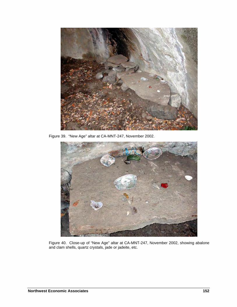
Northwest Economic Associates 152
Figure 39. “New Age” altar at CA-MNT-247, November 2002.
Figure 40. Close-up of “New Age” altar at CA-MNT-247, November 2002, showing abalone and clam shells, quartz crystals, jade or jadeite, etc.

Northwest Economic Associates 153
Figure 41. Documenting recent damage at CA-MNT-247, November 2002. Note the smoke stain left by a fire to the left of the “altar” and a portion of a low rock wall in the bottom left corner of the photograph (this rock wall and a rock-lined “entry” completely surround the area shown).
Figure 42. Recent damage at CA-MNT-247, November 2002.
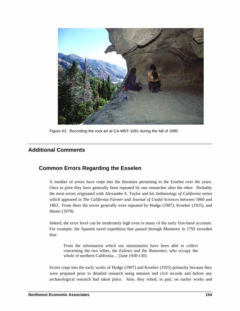
Northwest Economic Associates 154
Figure 43. Recording the rock art at CA-MNT-1061 during the fall of 1980.
Additional Comments
Common Errors Regarding the Esselen
A number of errors have crept into the literature pertaining to the Esselen over the years. Once in print they have generally been repeated by one researcher after the other. Probably the most errors originated with Alexander S. Taylor and his Indianology of California series which appeared in The California Farmer and Journal of Useful Sciences between 1860 and 1863. From there the errors generally were repeated by Hodge (1907), Kroeber (1925), and Hester (1978).
Indeed, the error level can be moderately high even in many of the early first-hand accounts. For example, the Spanish navel expedition that passed through Monterey in 1792 recorded that:
From the information which our missionaries have been able to collect concerning the two tribes, the Eslenes and the Runseines, who occupy the whole of northern California… [Jane 1930:130].
Errors crept into the early works of Hodge (1907) and Kroeber (1925) primarily because they were prepared prior to detailed research using mission and civil records and before any archaeological research had taken place. Also, they relied, in part, on earlier works and

Northwest Economic Associates 155
manuscripts by Taylor and others. Many of these early works have been found to contain significant errors, but this is somewhat understandable, given the limited amount of information which was available at the time. Kroeber, writing in his 1925 Handbook (actually completed about 1918), was fully aware of the potential for errors from these early manuscripts, and cautioned his readers.
More recently, Hester (1978) prepared the Esselen section for the California volume of the Handbook of North American Indians. Unfortunately, Hester uncritically perpetuated many of the errors that had occurred in previous works. As this is one of the most common research works appearing in libraries around the United States, many subsequent works have been spreading these errors even farther.
However, some recent publications dealing with the Esselen introduce new errors. For example a recent children’s book on Mission San Carlos populates the mission entirely with Esselen, omitting the Rumsen and numerous other groups. This book also pictures the Esselen as hunting buffalo from horseback and collecting grass in clay bowls (Edgar and Edgar 2000:9-10). A second children’s book, entirely on the Esselen, also contains numerous errors, both of fact and omission, but its chief fault it is so general it could be describing almost any group (Williams 2003).
Another problem frequently found in Esselen research is uncritical or careless scholarship. This stems in part from the lack of data on the Esselen and in part from the many errors already in the literature. Because of this, we have tried to trace statements back to their original sources and to provide specific references.
We have also been forced to omit a number of subjects which normally would be included in an ethnographic study—these data simply are not available for the Esselen. For example, there are occasional references to Esselen mythology or oral traditions in the literature, but we know of none which have survived. We have also been told that some Esselen songs were recorded by A.L. Kroeber in about 1902 (possibly in the Rumsen language) and that they may be stored at U.C. Berkeley. We can only hope that an archive somewhere has additional Esselen materials which have to date gone unrecognized.
To summarize, any publication dealing with the Esselen should be used with extreme caution, and virtually every statement should be cross-checked against other, more reliable, sources, particularly Culleton (1950), Cook (1974a, 1974b), and Milliken (1987, 1990), as well as the present volume.
The following sections include some of the more common errors, in no particular order.
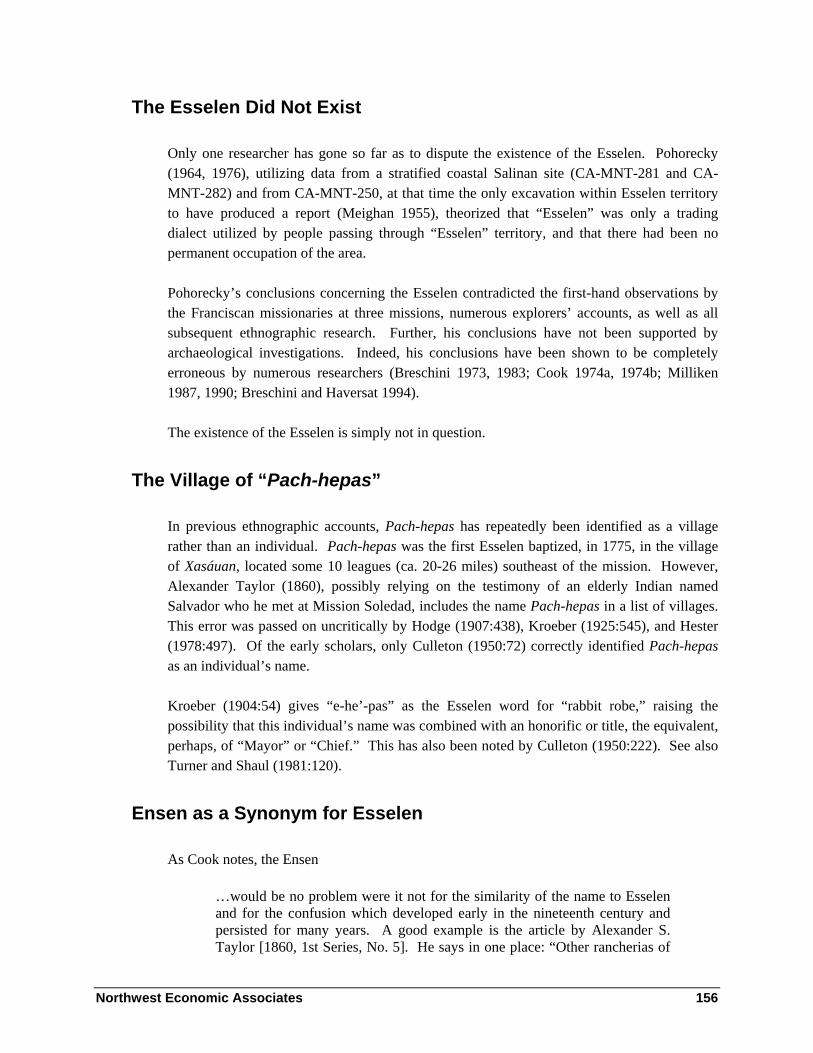
Northwest Economic Associates 156
The Esselen Did Not Exist
Only one researcher has gone so far as to dispute the existence of the Esselen. Pohorecky (1964, 1976), utilizing data from a stratified coastal Salinan site (CA-MNT-281 and CA-MNT-282) and from CA-MNT-250, at that time the only excavation within Esselen territory to have produced a report (Meighan 1955), theorized that “Esselen” was only a trading dialect utilized by people passing through “Esselen” territory, and that there had been no permanent occupation of the area.
Pohorecky’s conclusions concerning the Esselen contradicted the first-hand observations by the Franciscan missionaries at three missions, numerous explorers’ accounts, as well as all subsequent ethnographic research. Further, his conclusions have not been supported by archaeological investigations. Indeed, his conclusions have been shown to be completely erroneous by numerous researchers (Breschini 1973, 1983; Cook 1974a, 1974b; Milliken 1987, 1990; Breschini and Haversat 1994).
The existence of the Esselen is simply not in question.
The Village of “Pach-hepas”
In previous ethnographic accounts, Pach-hepas has repeatedly been identified as a village rather than an individual. Pach-hepas was the first Esselen baptized, in 1775, in the village of Xasáuan, located some 10 leagues (ca. 20-26 miles) southeast of the mission. However, Alexander Taylor (1860), possibly relying on the testimony of an elderly Indian named Salvador who he met at Mission Soledad, includes the name Pach-hepas in a list of villages. This error was passed on uncritically by Hodge (1907:438), Kroeber (1925:545), and Hester (1978:497). Of the early scholars, only Culleton (1950:72) correctly identified Pach-hepas as an individual’s name.
Kroeber (1904:54) gives “e-he’-pas” as the Esselen word for “rabbit robe,” raising the possibility that this individual’s name was combined with an honorific or title, the equivalent, perhaps, of “Mayor” or “Chief.” This has also been noted by Culleton (1950:222). See also Turner and Shaul (1981:120).
Ensen as a Synonym for Esselen
As Cook notes, the Ensen
…would be no problem were it not for the similarity of the name to Esselen and for the confusion which developed early in the nineteenth century and persisted for many years. A good example is the article by Alexander S. Taylor [1860, 1st Series, No. 5]. He says in one place: “Other rancherias of

Northwest Economic Associates 157
the Escelenes or Ensenes were Soccorondo, Tebityilat, Xumis, Chachat and Sepponet…” (These were all Costanoan in the lower Carmel Valley.) He also says: “The word Ensenes may be a short word for the Indians of the Encinal, or Oak-grove of Monterey town, to distinguish them from the Escelenes” [1974a:3].
In addition to attributing Rumsen villages to “Escelenes or Ensenes” (wrong in either case), Taylor’s errors in this passage include equating Escelenes and Ensenes and interpreting the name Ensenes to refer to the Encinal area of Monterey. The Escelenes (Esselen) and Ensenes (Ensen) are distinctly different groups in all of the early literature. Unfortunately, this early literature was not available to Taylor in the analyzed and published form which we enjoy today.
Harrington (n.d. reel 81, frame 651) cites Merriam’s ethnographic field research (with data apparently obtained in Monterey, in 1906, from informants Beviana Torres and Jacinto Gonzales) as follows:
Es’-se-len lived farther away from Carmel and Monterey than did the Room-se-en.
Es’-se-len very different tribe from En’-sen of Salinas. The Es’-se-len wore aprons of tule and were neat.
C. Hart Merriam further notes that “‘en-sen, tribe name, means blackberrying place” (Merriam 1968:III:381).
Ensen is a distinct district, a subdivision of the Ohlone, and is consistently equated with Los Sanjones or Zanjones (the ditches), Buenavista, and Salinas. These locations are all between Missions San Carlos and Soledad, along El Camino Real. The Buena Vista area is associated with two land grants, both southeast of Salinas. The Zanjones land grant is just south of Chualar.
The Ensen group was well-known to the Spanish, as they lived along the main travel route between Monterey and San Diego. They were virtually the only rancheria in the Monterey area that caused the Spanish any trouble (Culleton 1950:82; Geiger 1959:I:311, 394). It was this group that threatened pack trains, and even the mission itself. On at least one occasion, some members of this group were killed by the soldiers. Whether or not this was related, fully two-thirds of the Ensen group avoided baptism until after 1790. As such, they were one of the last Monterey area groups to be brought into the missions.
Milliken (1987:63) notes that the Ensen group was called the Guachirron at Mission Soledad and Guachurron de la Sierra at Mission San Juan Bautista, and that between 1777 and 1808, 328 individuals were baptized.

Northwest Economic Associates 158
Ennesen as a Synonym for Esselen
Another source of confusion is Merriam’s use of the term “En-ne-sen” for the Salinan group around Mission San Antonio. For example, the editors of Merriam’s Studies of California Indians included a photograph of a structure in the Milpitas Valley area, which is clearly Salinan territory, with the caption:
Pole and brush shelter. En-ne-sen (Esselen) tribe. Milpitas Valley at western base of Santa Lucia Peak, Monterey County, August, 1902 [Merriam 1955:129, Plate 35A].
Based on this erroneous attribution, Rose (1979:5, 26, 34, 70) described the tattoo pattern shown in the photograph as Esselen rather than Salinan in her work Aboriginal Tattooing in California.
Eslen as a Synonym for Ensen
When Junípero Serra founded Mission San Antonio in July of 1771, he apparently did not use the same route that Portolá had used in his three trips through the Salinas Valley, which was north of the Salinas River. Rather, Serra followed what is now River Road, south of the Salinas River. Possibly on the way south, but certainly on the return trip, in late July of 1771, Serra encountered a group he called the Eslen, who were the Soledad (Eslenajan) subdivision of the Esselen. The story of how Mission Soledad received its name from an Indian at that location whose name sounded to Serra like “Soledad” is related above, as is Serra’s letter noting that the Eslen had visited Mission San Carlos twice by 1774.
The term Eslen is in the early literature in a number of places, including the writings of Junípero Serra (Tibesar 1955-1966; Geiger 1959) and Fermín Lasuén (Kenneally 1965), as well as a description and word list obtained by the Spanish naval expedition of 1792 (Jane 1930:127-134)—the words in that list are clearly Esselen. So too are the Ensen in the early literature, often by the names Zanjones and several of its derivatives (see the previous entry).
The early literature is clear that the Eslen are a distinctly different group than the Ensen or Zanjones. It is probably the similarity of the names which has led to the confusion between Eslen and Ensen (as evidenced, for example, by Kroeber 1925:545). Much of this confusion actually originated with Alexander Taylor, who included a significant number of errors in his 1860 article in The California Farmer.
Rather than a synonym for Ensen, an Ohlone subgroup, Eslen is clearly a synonym for Eslenajan.

Northwest Economic Associates 159
Echilat as an Esselen Village
In a number of publications, Echilat is listed as an Esselen village (Kroeber 1925:545; Levy 1973; Hester 1978:496). This is clearly wrong. Cook (1974a:2) notes:
Question arises with respect to Echilat, a village which is mentioned very early (Baptism No. 39) as being in the Sierra de Santa Lucia, and which is allocated to the Esselen by Levy (1973). It is true that since the Sierra was occupied by the Esselen the notation in the baptism book might be assumed to indicate that Echilat was affiliated with that tribe. The missionaries gave Echilat the Christian name of San Francisco, a name which has been preserved in the land grant San Francisquito, the center of which lies in the hills at the head of San Jose Creek about nine airline miles east of Mission San Carlos. That Echilat, in spite of its location, was not Esselen is proved by one undoubted fact, a fact which may be adduced also with respect to the identity of Achasta and Tucutnut. Echilat contributed converts heavily for three or four years prior to the baptism of the first Esselen.
As further documentation, Merriam’s “Montereyano Vocabulary” (1968:III:401) gives “E-chi-lat” as the word for San Francisquito.
The Most Extensive Vocabulary…
Culleton (1950:205), without giving the source of his information, states that the Esselen language “had an extensive vocabulary, probably more extensive than any other North American tongue…although its words were derived from relatively few roots.”
This statement may have had its origin in Taylor’s Indianology of California or Ludewig’s The Literature of American Aboriginal Languages.
Taylor, in discussing the information obtained by the La Pérouse expedition in 1786, stated:
The idiom of this nation is richer than those of the other tribes of California [October 17, 1862].
Hermann Ludewig, writing just before Taylor, noted that:
Eskelen, Eslenes. Californian Indians, east of Monterey. The Ekklemaches are said to be a tribe of the Eskalen, and to speak the richest idiom of all the California Indians [Ludewig 1858:68-69].
However, the original source of this information is most likely Jean-Honoré-Robert de Paul Lamanon, the linguist on the La Pérouse expedition of 1786, who wrote the following:

Northwest Economic Associates 160
The Ecclemachs live E. of Monterey, and their territory extends for twenty leagues; their language is totally different from all those of their neighbors, and even has more links with our European tongues than those of America; this grammatical phenomenon [is] the strangest seen on this continent…
…this dialect is moreover richer than those of other Californian people, although it cannot be compared with the languages of civilised nations [La Pérouse 1994:199-200].
Culleton’s claim that the Esselen vocabulary was “probably more extensive than any other North American tongue” has not been confirmed by linguists, and unless additional supporting information can be located it will have to be discounted.

Northwest Economic Associates 161
Chapter 4 - Ethnography of the Salinan – by Randall Milliken
Introduction
This chapter discusses the ethnographic Salinan. At the time of the Spanish entry into California, the Salinan people shared a language but were not a self-conscious political group with a single unified leadership. Approximately 4,200 Salinan lived in numerous small independent political groups across portions of present Monterey, San Luis Obispo, San Benito, Fresno, Kings, and Kern counties (Map 2— Regional Map By NEA located in report back pocket).
About 600 ethnographic period Salinan lived within or adjacent to the southern portion of the Monterey Ranger District, in villages of the Quiguil, Lamaca, and Lima multi-village districts; they moved to Mission San Antonio between 1773 and 1806. Another 100 or so Salinan of the Pel band may have utilized the very northeastern portion of the San Lucia Ranger District in the Black Mountain area; they moved to Mission San Miguel between 1798 and 1804 (Milliken and Johnson 2003); (cf.Chester King, this volume). At the missions, those who survived high death rates caused by unsanitary conditions and introduced diseases became skilled in the farming and ranching pursuits of rural Hispanic America.
When the missions were closed during the 1834-1840 period, Salinan lands came under the ownership of members of the Mexican elite. Some Salinan families were able to secure land, through purchase or homestead, in the late nineteenth century. Most, however, worked as laborers and house servants on lands owned by others. Some Salinan still spoke the language in the early twentieth century. There are many Salinan descendants still living in Monterey and San Luis Obispo counties.

Northwest Economic Associates 162
This chapter examines the Salinan language, material culture, and social organization. It focuses most strongly, however, on the ethnographic Salinan geographic landscape, information directly pertinent to the interpretation and management of the present landscape of the Los Padres National Forest. The last section of the chapter, save the conclusion, compares and summarizes two very different types of specific Salinan ethnogeographic information:
• General locations of key villages and multi-village regions, inclusive of the southern Monterey Ranger District. Information is imprecise, but geographically systematic. It derives from the Mission San Antonio registers of the 1773-1806 period.
• Specific locations of historic Salinan home sites, ethnographic villages, gathering areas, and landscape features within the southern Monterey Ranger District. Information is precise, but systematic only for a five-mile stretch of the upper San Antonio River. It derives from the twentieth century notes of J. P. Harrington.
The chapter concludes with a descriptive model of ethnographic Salinan land use and regional interaction within and adjacent to the Monterey Ranger District, based upon population and political information inferred from the Mission San Antonio registers.
Early Salinan History
The first known contact between Salinan speakers and Spanish explorers occurred in September of 1769, when Salinan lands were entered by a party of 62 men under Gaspar de Portolá. The Portolá party was heading north from newly-founded San Diego in search of Monterey Bay. They met Playano people in the Cambria vicinity on September 10. The language affinity of the Playano was never documented; they may have been Salinan speakers, Chumash speakers, or speakers of a completely separate language isolate (cf. Gibson 1983, Kroeber 1925, Milliken and Johnson 2003). The first definite Salinan encountered by the Portolá party were living on the coast just south of the present Monterey-San Luis Obispo county line. The Spanish explorers camped near them in the vicinity of Los Chinos Creek on the night of September 13, 1769.
First contact within the Monterey District of the Los Padres National Forest took place on September 17, 1769. Proceeding inland up the canyon of San Carpoforo Creek, the Spaniards encountered a temporary camp of some 60-80 people in the vicinity of the present San Carpoforo campground. After resting two days in the little valley, the Portolá party then crossed the Santa Lucia range within the District to camp that evening with a very large group of Salinan, some 600 individuals who had come together temporarily in either the Los

Northwest Economic Associates 163
Burros or Little Salmon Creek drainage (in what is now Fort Hunter-Liggett land) to gather pine nuts. “Some they say are shore dwellers, others mountaineers belonging to this range, and still others from a river that they say is near by,” wrote diarist Juan Crespí (in Brown 2001:515).
The independent local Salinan groups that held the lands of the southern portion of the Monterey District moved to Mission San Antonio de Padua between 1773 and 1805. There they were joined by other Salinan people from the San Antonio Valley and from lands as far east as the edge of the San Joaquin Valley. At the mission the people were trained in Christian doctrine and in the agricultural skills of the rural Hispanic world. The Mission San Antonio population reached 1,296 at the end of 1805, but death rates were high, so that the population was down to 557 when it was closed as an agricultural commune at the end of 1834. During the Rancho Era (1835-1846), Salinan descendants spread out to work on Mexican cattle ranches throughout the South Coast Range portion of California.
Sources of Information about the Salinan-Speaking People
Two Spanish period treatises contain some important material regarding tribal Salinan culture. The earliest is A Historical, Political, and Natural Description of California, a commentary by Pedro Fages ([1775] in Priestley 1937) that lacks depth in insight but retains some value for contrasting native life in various portions of south-central California. The other early treatise on culture is the set of “respuestas (responses)” written in 1813 and 1814 to the 1812 Interrogatorio sent out by the Spanish Crown to the missionaries of missions San Antonio, San Miguel, and the other California missions (Geiger and Meighan 1976). Like Fages’s material, the respuestas are brief and short in insight. But also like the Fages material, they provide some indications of differences in tribal culture from one mission to the next and some information about language differences at the missions.
Only one scholarly monograph on Salinan ethnography was ever formally published. It is “The Ethnology of the Salinan Indians” published by J. Alden Mason (1912) after he analyzed field notes of earlier scholars and spent a few months with Salinan speakers in 1910. Short overviews on the Salinan people are found in A.L. Kroeber’s 1925 Handbook of the Indians of California (pps. 546-549) and in Thomas Hester’s chapter in the 1978 Handbook of North American Indians: Volume 8-California (1978:500-504). Kroeber’s (1925) chapter contains very little information, and some of the mapped place names in the chapter have since proven to be misplaced. Hester’s (1978) chapter contains an excellent summary of Salinan basketry that is not repeated elsewhere, but its map portrays a Salinan-Esselen language boundary for the north in the Salinas Valley different than any available evidence would suggest. Some interesting information about late nineteenth and early twentieth century Salinan in the Mission San Antonio vicinity is found in Padres and People of Old Mission San Antonio (Casey 1957).

Northwest Economic Associates 164
Two field ethnographers, C. Hart Merriam and J. P. Harrington, spent a large amount of time with Salinan people but did not ever write up formal ethnographies. Merriam visited members of the Encinales family at “The Indians” in 1902 and again in the 1930s. He gathered linguistic information, ethnobotanical information, and took photographs of Salinan people during those visits (Merriam ([1902-34], [1902], [1932-33], [1934]).
J.P. Harrington was the most thorough note taker among the ethnographers who worked with Salinan people. He visited the Mission San Antonio vicinity for the first time in 1922, then returned in 1930 and again in 1932 (Jones et al. 2000; Mills 1985; Rivers and Jones 1993). In 1922, he met Dave Mora, Mason’s consultant of a few years earlier, and Dave’s wife María Jesusa, a member of the Encinales family. Harrington met another important Salinan consultant, María de los Angeles Baylon, when he returned to the Mission San Antonio area in 1930. Harrington and his consultants took important trips in the present Monterey Ranger District, during which numerous Salinan place names and areas of historic land use were documented. His field notes relevant to the Monterey Ranger District, now available at many libraries on microfilm (1985), have been analyzed by Jones et al. (2000) and Rivers and Jones (1993).
Since 1980 two important analyses of Salinan ethnogeography have appeared in limited distribution publications. Robert Gibson’s The Ethnogeography of the Salinan People: A Systems Approach, was produced as a 1983 masters thesis in anthropology. Most recently, Randall Milliken and John R. Johnson have completed Salinan and Northern Chumash Communities of the Early Mission Period, a limited distribution technical paper produced for the California Department of Transportation (2003). Gibson (1983) was the first researcher to combine direct clues from the Franciscan mission registers with indirect clues from family network pattern analysis, concentric circle outreach analysis, and field notes from J.P. Harrington to develop a tentative ethnogeography of local Salinan and Northern Chumash community locations around missions San Antonio, San Miguel, and San Luis Obispo. Milliken and Johnson (2003) reanalyzed all the information that Gibson had studied; they agreed with Gibson’s placements for many communities, but suggested alternative placements for many others.
The Salinan Language
The Salinan language was once spoken in a restricted area of the south coast Ranges of California (map 2). It is part of the Hokan Language Stock (or Phylum) of western North America and Mexico. Other California languages and language families within the stock include: Karol, Shasta, Chimerical, Palaihnihan (Achumawi/Atsugewi), Yana, Pomoan, Yuman, and perhaps Esselen. There are also Mexican members of the stock are Jicaque, Seri, Tlapanecan, and Tequistlatecan (Chontal) (Voegelin and Voegelin 1965 as cited by Goddard 1996b:319). Arguments for Hokan membership in higher-order groupings, such as Sapir’s

Northwest Economic Associates 165
(1929) postulated Hokan-Siouan and Greenberg’s (1987) postulated Amerind, have not been accepted by specialists (Goddard 1996b:313, 317).
Sources on the Salinan Language
The Salinan language was first written by Father Buenaventura Sitjar during his residence at Mission San Antonio between 1771 and 1808. Sitjar produced an Antoniano Salinan vocabulary which was published in 1861 as part of the Shea’s Library of American Linguistics. He also wrote a Catholic confessional in Antoniano and Spanish, which has not been published (Sitjar 1771-1808). Additionally, he began a manuscript volume of grammatical notes regarding Salinan that was augmented extensively by subsequent missionaries at San Antonio (Cabot, Dumetz, and Sitjar 1771-1830). Another Spanish missionary, Felipe Arroyo de la Cuesta, took short Antoniano and Migueleno Salinan vocabularies in his remarkable 1821-1837 notebook of mission-vicinity California languages.
Salinan vocabularies were collected in the early American period by Alphonse Pinart (in Heizer 1952) and Henry W. Henshaw (in Heizer 1955). At the beginning of the twentieth century, C. Hart Merriam (1902-1934) and A.L. Kroeber (1901) gathered Salinan linguistic material among families living northwest of Mission San Antonio, in and near lands currently within the Monterey District. The first intensive study of the Salinan language was undertaken by J. Alden Mason between 1910 and 1916, also with people living northwest of Mission San Antonio (Mason 1918).
J.P. Harrington worked with many Salinan speakers, first in the San Luis Obispo vicinity and later in the Mission San Antonio vicinity, between 1912 and 1932 (Harrington 1985; Mills 1985). The last person to collect linguistic information among Salinan speakers was William H. Jacobsen (1979) who did his field work during 1948-1954. Katherine Turner has published the most recent linguistic work on Salinan, using archival material (1980, 1987).
Salinan Language Distribution and Ambiguous Affiliation of Playano
Kroeber (1925:548) assigned the small coastal watersheds within the Monterey Ranger District, and south of Lucia, to the poorly-documented Salinan dialect or language called Playano.
Mission register evidence, not examined closely by Kroeber, shows that the only people called Playano by the missionaries at San Antonio were people from south of Ragged Point, the present Monterey County line. This was first noted by Gibson in 1983. He also proposed in 1983 that Playano was a Northern Chumash dialect. I agree with Gibson that Playano was

Northwest Economic Associates 166
spoken only to the south of the Monterey Ranger District. I find, however, that the evidence regarding its linguistic affiliation is ambiguous and contradictory.
The concept of the Playano dialect derives from the 1813 responses by the missionary priests at missions San Antonio and San Miguel to the Spanish Interrogatorio of 1812. They wrote:
The neophytes of this Mission speak four idioms or languages: 1) that of San Antonio which is considered the principal one; 2) that of the seacoast which is spoken by those who came from that area; 3) the Tulareño spoken in the Tulares region; 4) by Indians dwelling south of here (Martín and Cabot [1813] in Geiger and Meighan 1976:2).
All scholars agree that the first language mentioned by the San Miguel priests was Salinan, the third was Yokuts, and the fourth was Northern Chumash. However, there has been ongoing doubt regarding the affiliations of the second language, that of the sea coast.
At Mission San Antonio, Fathers Juan Bautista Sancho and Pedro Cabot distinguished a dominant core area language from a nearly extinct coastal language in their Interrogatorio responses:
We know that these Indians speak two distinct languages. The principal one is that of the mission’s own area and is understood to the east, south, north, and the surrounding area of the west. The Indians called Playano or shore dwellers because they came from the sea-coast, speak the less important of the two. These, however, are now few in number, and they not only understand the principal one but also speak it perfectly [Sancho and Cabot in Geiger and Meighan 1976:20].
The dominant language at Mission San Antonio was clearly Salinan. The linguistic affiliation of the Playano language, however, is not so easy to identify. All scholars who have investigated the matter have considered it to be the same language as the “sea coast” language at Mission San Miguel.
The Playano area was mapped by Kroeber (1925:548) all along the coast from Vicente Creek (just north of Lopez Point) on the north to Cayucos on the south. In identifying it as Salinan, he followed the conclusion of his student, Mason, who noted the great similarity between Antoniano and Migueleño dialects and inferred that Playano was a distinct language of the Salinan language family (Mason 1912:105). Whatever the affiliation of Playano, Kroeber lacked any evidence for mapping it along the entire coast of Salinan territory or for using the crest of the Santa Lucia Range as its eastern boundary. The eighteenth century mission San Antonio records show that the people from the coast of Monterey County west of the mission were said to be from the areas of “Quiguil” and “Lamaca”; some of them were said to be from the “mar [sea],” but they were never called Playano in the mission records. The people called Playanos in the Mission San Antonio registers were baptized a few years after the Lamaca and Quiguil people had moved to Mission San Antonio. Some Playano were

Northwest Economic Associates 167
associated by kinship with groups labeled Esmerileua and Chaal, probably from the Piedras Blanca/San Simeon vicinity. But most of them were associated by kinship with the groups labeled Stjahuayo and Tsetacol, groups that moved north to Mission San Antonio from the Cambria and Estero Point vicinities between 1803 and 1805.
For want of any extant Playano vocabularies, I conclude that the affiliations of the long-extinct language are unknowable at this time. It was probably a Salinan language, but it may have been a Chumash language or an entirely separate language isolate. Whatever the linguistic affiliation of Playano, it was not spoken by the Lamaca or Quiguil people of the Monterey Ranger District. They spoke the standard Antoniano dialect of the Salinan language and some of their members also spoke the neighboring Esselen language of the Arroyo Seco drainage to the north.
Studies of Salinan Linguistic Relationships
Robert Gordon Latham (1860) made the first attempt to classify native Californian languages, including Salinan. Latham was a London-based scholar who used manuscript linguistic data from around the world to propose typological relations among languages and develop a broad evolutionary hypothesis. Latham identified Mariposa (Yokuts), Moquelumne (Miwok and some Costanoan), Costano (San Francisco Peninsula Costanoan) Santa Barbara (Chumash), and Salinas linguistic groups in south-central California. His Salinas group included materials now known to include Rumsen Costanoan, Esselen, San Antonio Salinan, and San Miguel Salinan (Goddard 1996b:296, 297).
The next important attempt to classify Salinan was made by Albert S. Gatchet, a linguist employed by the United States Geographical Survey. In his early work, Gatchet did not make a sharp distinction between Esselen, Salinan, and the southern Costanoan languages (1877:157-158). He lumped Salinan into Chumashan, suggesting a “pretty close relationship” between Obispeño Chumash and Antoniano Salinan (Gatchet 1876 as cited by Goddard 1996b:296).
Studies of native North American languages were carried out from 1879 forward by the Bureau of Ethnology of the Smithsonian Institution, founded in that year by John Wesley Powell. The Bureau sent Henry Henshaw to California in 1884 and again in 1888 to get samples of Chumash, Salinan, Esselen, and Costanoan languages, in order to clear up the typological problems recognized at the time (Goddard 1996b:297). In 1885 Powell put Henshaw in charge of a project to classify and map all of the native languages of North America, and to name them on the basis of “principles of priority derived from systematic biology” (Goddard 1996b:299).
Powell’s (1891) Indian Linguistic Families of America North of Mexico immediately became the definitive work regarding native North American linguistic classification. Based upon
Northwest Economic Associates 168
Henshaw’s work and Powell’s final decisions, the 1891 publication recognized 28 language families with numerous members, 26 language isolates, and four language families consisting of only two closely-related languages. Esselen (his Esselenian) was one of the isolates, while Salinan was one of the four language families that included only two languages. Chumashan was recognized as one of the major language families, and was clearly separated from Salinan (cf. Goddard 1996b:301).
Dixon and Kroeber initiated the first of an important series of papers on the relationships among California Indian languages in 1903. That first paper examined the distribution of grammatical attributes among the many native California languages and reached the conclusion that Esselen had morphological similarities with Costanoan, while Salinan shared morphological characteristics with Chumashan (Dixon and Kroeber 1903, Figure 4). By 1913, however Dixon and Kroeber switched to a genetic approach to the study of California Indian language classification, that is to say, to arguments for classifications based upon paradigms of inferred historical divergences among them. They proposed four new language families, Ritwan, Penutian, Hokan, and Iskoman, each of which lumped together some of Powell’s earlier families. Hokan included Shasta, Palaihnihan, Pomo, Karok, Yana, Yuma, and Esselen, while Iskoman included Chumashan and Salinan (Dixon and Kroeber 1913).
Edward Sapir (1917) soon presented convincing evidence for expanding the Hokan language family to include Dixon and Kroeber’s “Iskoman“ languages (Chumashan and Salinan). Then Sapir published a major modification of Powell’s classification scheme in a 1929 contribution to the Encyclopedia Britannica; it “served as the framework for general discussions of the linguistic history of North America” until 1964 (Goddard 1996b:312). In the work, Sapir lumped together all North American language families into six major linguistic phyla or super-stocks. He included Esselen, Salinan, and Chumash in the Hokan family of the Hokan-Coahuiltecan stock of the Hokan-Siouan phylum. Sapir’s Hokan-Siouan phylum was formally rejected by specialists in North American linguistics in 1964.
In 1964, most conferees at the North American language Classification Conference in Bloomington, Indiana rejected Sapir’s Hokan-Siouan Phylum, while supporting many of his other language phyla. Participants recognized Hokan as a phylum containing 17 language families and language isolates, including Salinan, Chumash, and tentatively, Esselen. The 1964 conference did not recognize any sub-clusters of especially close affinity among any of the 17 language families within the Hokan Phylum (Goddard 1996b:317-318). A still more conservative approach to the language relationships within the Hokan Phylum was taken by Campbell and Mithun (1979), in their summary of the results of a significant historical linguistic conference held in 1976 in Oswego, New York. Their conservative conclusions regarding Salinan and the Hokan phylum as a whole are abstracted in Table 5.
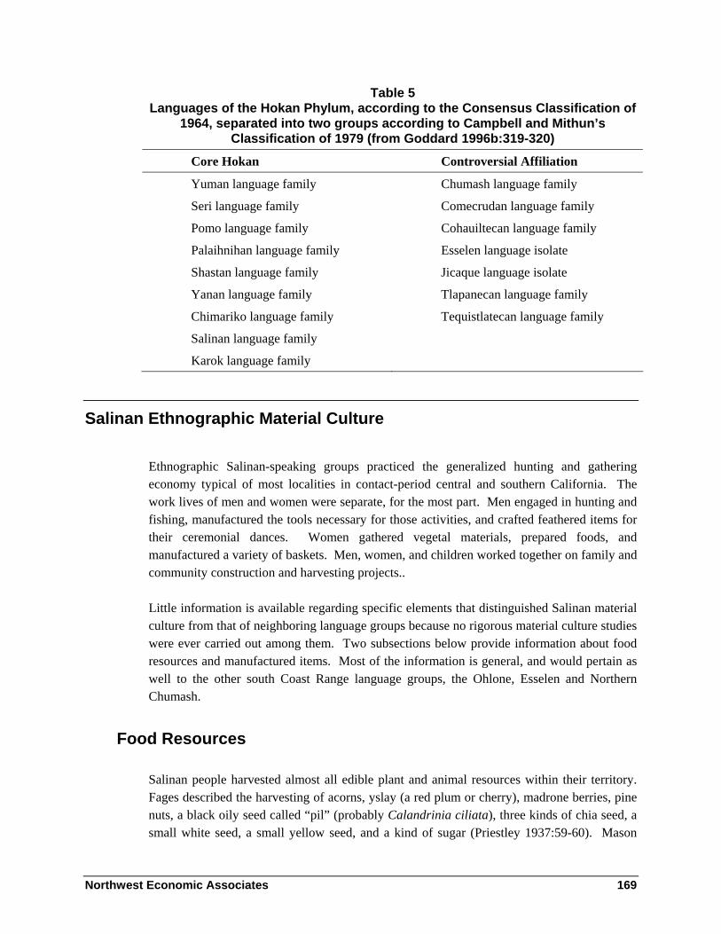
Northwest Economic Associates 169
Table 5 Languages of the Hokan Phylum, according to the Consensus Classification of
1964, separated into two groups according to Campbell and Mithun’s Classification of 1979 (from Goddard 1996b:319-320)
Core Hokan Controversial Affiliation
Yuman language family Chumash language family
Seri language family Comecrudan language family
Pomo language family Cohauiltecan language family
Palaihnihan language family Esselen language isolate
Shastan language family Jicaque language isolate
Yanan language family Tlapanecan language family
Chimariko language family Tequistlatecan language family
Salinan language family
Karok language family
Salinan Ethnographic Material Culture
Ethnographic Salinan-speaking groups practiced the generalized hunting and gathering economy typical of most localities in contact-period central and southern California. The work lives of men and women were separate, for the most part. Men engaged in hunting and fishing, manufactured the tools necessary for those activities, and crafted feathered items for their ceremonial dances. Women gathered vegetal materials, prepared foods, and manufactured a variety of baskets. Men, women, and children worked together on family and community construction and harvesting projects..
Little information is available regarding specific elements that distinguished Salinan material culture from that of neighboring language groups because no rigorous material culture studies were ever carried out among them. Two subsections below provide information about food resources and manufactured items. Most of the information is general, and would pertain as well to the other south Coast Range language groups, the Ohlone, Esselen and Northern Chumash.
Food Resources
Salinan people harvested almost all edible plant and animal resources within their territory. Fages described the harvesting of acorns, yslay (a red plum or cherry), madrone berries, pine nuts, a black oily seed called “pil” (probably Calandrinia ciliata), three kinds of chia seed, a small white seed, a small yellow seed, and a kind of sugar (Priestley 1937:59-60). Mason

Northwest Economic Associates 170
(1912:120-122) adds that mescal root was harvested and cooked for two days in an earth oven prior to eating, that three species of clover were “relished” and eaten without preparation, and that seaweed was heated over a fire and eaten with mush or bread.
Among the animals that were eaten, Fages listed bears, deer, antelope, wild sheep, hares, conies [probably rabbits], and squirrels (Priestley 1937:60). Mason (1912:121-122) says all birds, bird’s eggs, snakes, and yellowjacket larvae were eaten. Also according to Mason, “bullheads and sp’ta´L, an unidentified fish, were procured from the ocean, besides red and blue abalones, clams and sk!en’, an unidentified shell-fish” (1912:122). Fages (in Priestley 1937:60) wrote, “In the fresh water there are large trout, and a kind of fish called machuro.”
Acorns from three kinds of oaks were utilized for food in the area, according to Fages (Priestley 1937:59). Mason (1912:118) wrote, “At least six of these species were distinguished by Salinan natives, who valued them for different purposes and in varying degrees … it seems that acorns from live-oaks were preferred for mush, those of deciduous oaks for bread.” Five tree-sized oaks are common in and near the Salinan portion of the Monterey Ranger District: coast live oak (Quercus agrifolia), canyon live oak (Q. chrysolepis), interior live oak (Q. Wizlizenii), blue oak (Q. douglasii), and valley oak (Q. lobata). More than 125 years after Fages, C. Hart Merriam obtained information from Perfecta Encinales regarding acorn preferences of the Mission San Antonio Indian people who were living in “The Indians” vicinity:
The old squaw, Encinales mother told Goldman that acorns of Quercus agrifolia are bitter & used only for mush (after leaching), while the other two, which do not require leaching, are used for acorn bread. Q. lobata used both for mush & bread & that douglasii makes best bread of all (Merriam 1902:140).
This is one of very few ethnographic references to the importance of blue oak (Quercus douglasii), so common in the interior South Coast Ranges, as a preferred food source.
Manufactured Items
Structures
No early ethnographic descriptions of Salinan family houses are available. Typical family houses elsewhere in the Coast Ranges of California were domed pole frameworks thatched with tule or rye grass, which is typical of Coast Range California. Men built small semi-subterranean sweathouses. It is not clear if women’s menstrual houses typical of California were constructed. Communal dances houses were reported, but their type of construction was not described (Hester 1978:501). Granaries were used to store acorns and seeds. They were “large basket-like receptacles made of white willow twigs, built on the ground adjacent to the houses, without any stone foundation and lined and covered with grass” (Mason 1912:119);

Northwest Economic Associates 171
they were reportedly shaped as truncated cones, similar to the granaries of the Cahuilla and Diegueño of southern California (Mason 1912:145).
Clothing
No contact period writers describe ethnographic Salinan clothing or ornamentation. The very lack of comment suggests that they were typical of Coast Range California. Men wore no clothing at all on everyday occasions, while women wore either one-piece plant-fiber skirts or two piece skirts of animal skins and plant fiber. Cloaks of rabbit or otter skin were worn in cold weather. According to Mason (1912:127-128), women wore basket caps. Ethnographic Salinan dance regalia were not well-documented. “No yellowhammer head-bands, feather cloaks or aprons, or other feather ornaments such as are typical of California are remembered by the surviving Salinan natives … the sole mentions of feather ornaments by native informants are that feathers were attached to the shaman’s sticks, and that head-dresses of feathers reaching to the shoulder, with single eagle feathers extending from the forehead forward, were used by dancers at the Kuksui dance,” wrote Mason (1912:128-129).
Hunting Tools and Weapons
Information regarding Salinan tools for hunting and warfare is sparse. Mason wrote, “Hunting bows were of “pine” backed by sinew and with a sinew string. They were not long, about three feet, but is said that it took a strong man to bend one. The fist-spear was made with a rigid, non-detachable point” (1912:142). General California ethnography suggests that juniper or cedar, rather than pine, furnished the wood portions of sinew-backed bows.
Basketry
Mason wrote that fewer than 26 Salinan baskets were known to be in existence in 1910 and that all but one had been manufactured by Perfecta Ensinales and her daughters; they included both coiled and twined baskets (1912:143-150). The traditional coiled baskets included mush-boilers, flat trays, hats, winnowers, and hopper mortars; they were reportedly made with Cladium Mariscus sewing material on a Muhlenbergia rigens bundle foundation (Elsasser 1978:63). The twined baskets include large carrying baskets, winnowers, small globular work baskets, and asphaltum-sealed water bottles; both warp and weft of the open carrying baskets were willow fiber, while all other twined baskets were close-twined with tule warp and weft (Mason 1912:150-152). Larry Dawson (in Elsasser 1978:630) noted that the extant Salinan basketry resembles Yokuts basketry. Since Perfecta Ensinales was Yokuts by birth, it is possible that her baskets do not completely reflect aboriginal Salinan manufacturing techniques.

Northwest Economic Associates 172
World View, Ritual, and Aesthetic Life
No unbiased written record exists that provides an insightful description of the world view and religious life of the Salinan speaking people at the time of Spanish conquest. Therefore, this short section interprets traditional Salinan religion within the greater context of ethnographic California Indian religion and world view.
World View
Central California Indian people shared with native peoples throughout North and South America many basic beliefs about power, sickness, and healing. The traditional universe was filled with unseen animate power that could cause damage if provoked. Thus, all aspects of life were circumscribed with ritual behaviors that modern people would label superstitious. Pedro Fages reflects such an attitude in his 1775 description of Salinan religion:
Idolatry is greater and more insolent here than in the preceding [southern California] localities … on account of the variety and number of gods who are worshiped: they are the sun, the waters, acorns, and some kinds of seeds. Not content with this, they have raised to the dignity of gods certain old men of their villages in whom they make it manifest that they have placed the utmost confidence, for, while they offer them worship and various gifts, they pray to them for rain, for sunshine, good crops, and so forth (Fages [1775] in Priestley 1937:59).
The behavioral rules emphasized an ethic of community responsibility and placed power in the hands of elders. Men and women who lived to become elders had proven their knowledge of the rules of appropriate behavior and their ability to interact with the unseen. Heizer wrote a summary statement regarding Pomo attitudes toward the workings of the universe that probably fits the ethnographic Salinan, as well:
Pomo world view seems to inhibit goal-oriented behavior through having strong anxieties deriving from living in a world full of potential dangers coming either from other individuals or supernatural powers. Taboos were common and were strictly observed as a means of protecting persons from interference from supernatural powers. Observing taboos could prevent illness or death, but they did not improve one’s lot; this neutralized the threat of supernatural action and was therefore an anxiety-reducing device. There was always the possibility of unwittingly breaking a taboo, and if so punishment was automatic but not necessarily immediate. Therefore, bad luck, illness, or death of a child, for example, was taken as a sign that a taboo was broken (Heizer 1978:651).
Throughout California, people believed that animals and birds lived as people before the time of humans. The corpus of Salinan cosmological mythology shares themes with Monterey

Northwest Economic Associates 173
Bay Costanoan, except that shrike and kingfisher replace hummingbird and prairie-falcon among the key creatures of the Salinan stories (Kroeber 1907:190, Mason 1912:186-187). In Salinan stories collected by Henshaw and Mason, the world was created by a trinity of animals, Coyote, Eagle, and Kingfisher, afloat in a primordial sea. After they set up the world, they made people out of sticks and separated them into various linguistic groups (Mason 1912:185-192). Mason (1912:183) concluded that traditional Salinan-speakers believed in an after-life on an island in the western ocean, citing information from all surrounding language groups and a myth fragment in Henshaw’s notes.
Ritual
“Practically every occasion of social gathering in California is attended by some variety of dance,” Mason (1912:177) pointed out. Dances, performed correctly, were thought by ethnographic Californias to stave off unfortunate occurrences. They provided entertainment. And their conduct offered limited roles that reflected and bolstered the organization of social status among people of a given region.
Only fragmentary knowledge of the old dance cycles was available to Mason (1912:158).
“At least one of the old men of the stock, José Cruz, remembers some of the native songs which were used in myths, dances, and games, but it was unfortunately impossible to obtain a record of any of these” (Mason 1912:159). Cruz told Mason about the Owl, Deer, Coyote, and Bear dances as well. “These were individual dances … each had its own songs, some of which are still remembered” (Mason 1912:178). The most popular dance in the region was said to be the “kuksu’i.” That name Kuksu is associated with cosmology and ritual among the Pomo, Patwin, Maidu, and Miwok of central California. Among some groups it refers only to a mythic power being, in other areas to a personage of a specific dance, and in still other areas to a certain dance ceremony. The precise nature of the Salinan kuksu’i, and the degree of its historical association with any of the Kuksu traditions further north, is unknown.
Many aspects of life, other than communal dances, involved ritual behavior. Shamans used ritual methods, involving special physical instruments, to cure disease and to relate to supernatural powers for the good of the people. Wrote Mason:
A shaman’s stick with powerful magical properties was used by him in his incantations, as well as charms and other material objects. His pipe was similar in size and shape to those used by the other natives, but it was decorated with paint, and doubtless most of his other possessions were differentiated from those of ordinary persons (Mason 1912:183).
According to a consultant of Henshaw, Mission San Miguel people obtained charms during dreams, after sweating and fasting for four days (Mason 1912:185).

Northwest Economic Associates 174
Women conducted ritual activities in relation to their reproductive lives at specific sites on the landscape. Maria de los Angeles Bailon showed J. P. Harrington an area of “childbirth rocks” and a “sterility mortar” at Tranat near the San Antonio River, just outside of the Monterey Ranger District a few miles downstream from “The Indians” (Jones et al 2000:7).
Rock Art
Rock art sites in isolated sections of Monterey, San Luis Obispo, and northern Santa Barbara counties share a style that has been called the “South Coast Range Painted Style.” The South Coast Range Painted Rock style consists of angular designs, with some human and animal figures. The style is differentiated from the nearby Santa Barbara Painted Style by its lack of “Circle and Dot” elements (Clewlow 1978:620-623).
No famous rock art sites lie within historic Salinan territory in the southern portion of the Monterey Ranger District. The Wagon Rock Cave site (CA-Mnt-307) on the District two miles southeast of “The Indians” is said to have some obliterated rock paintings. According to Breschini (personal communication, 2003), a number of charcoal scratchings exist on rocks on the Hunter-Ligget Military Reservation and in adjacent portions of the Monterey Ranger District.
One famous rock art site exists at the head of Mission Creek, just to the east of the Monterey Ranger District on Military Reservation land and private land. The site is La Cueva Pintada, called “Cave of the Idols” by Junipero Serra during a 1773 visit (Tibesar 1955:355). This 35 acre site was briefly described by J. Alden Mason in 1912:
Pictographs are not typical of Californian culture and very few of them are known. … In the mission area, the coast region in the neighborhood of Monterey and to the south, a few typical Californian pictographs are found. These are always painted in several different materials, probably the same colors as those used for body-painting. … In the Salinan area but one collection of pictographs is known, a cave known as “la cueva pintada” near the top of the hills forming the eastern wall of the valley of the San Antonio River and about five miles above San Antonio Mission….
The figures themselves are in many cases truly pictographic, the human figure, turtle, and sun being among those recognized, while others are unidentifiable, and some must be either devoid of meaning or else ideographic (Mason 1912:153-155).
Four colors of pigment were used at “la cueva pintada,” black, blue, red, and yellow-white (Mason 1912:129, 153). The site, CA-Mnt-256, was well-documented by Breschini and Haversat (1980).

Northwest Economic Associates 175
No ethnographic accounts describe the reasons for creation of rock art in the South Coast ranges. Mason offered the following explanation:
The great paucity of pictographs in the country, together with their abundance in a few isolated places, point to a ceremonial explanation. … The probable explanation for these pictographs in the region south of Monterey is that they were made in some esoteric ceremony, probably that of puberty. No explanation for them is offered by the living Indians (Mason 1912:152).
Rock art scholar Campbell Grant also surmised that California pictographs were painted in conjunction with ceremonial activity, but he suggested that it had something to do with shaman training (Clewlow 1978:623).
Incised stones are found in much of the Salinan territory. Their designs mimic those on some local rock art. Breschini in Chapter 3 has suggested that their distribution matches that of the Salinan language (See Breschini, p. 71). His argument seems good in this case, but I caution the reader that archaeological assemblage distributions do not necessarily correlate to language distribution (Hughes 1992).
Political, Settlement, and Land Use Systems
The Salinan people in the Monterey District environs were probably organized into small regional multi-village tribes with formal political leaders. On the other hand, they may have been organized into small bands with fluid membership. The ethnographic evidence regarding this question, scant and ambiguous as it is, will be addressed in the first subsection of this section. The second subsection documents the ethnogeography of villages and regional communities in and near the Monterey District. A third subsection discusses the contact period population density of the vicinity, a key factor in determining the spatial reach of family networks, be those families members of fluid bands or formal tribes. The fourth subsection addresses indirect evidence from mission records for nuclear family movement between villages and between adjoining regional territories from year to year. The final subsection uses a small number of ethnographic accounts to infer some population movement among microhabitats both within and between regional territories for purposes of intensive resource harvest.
Probable Tribelet Political Organization
Few clues are available today regarding contact-period Salinan political organization and settlement systems. The clues suggest that the people controlled their landscape and resources in accordance with one of the two following models, probably the latter:

Northwest Economic Associates 176
1. A “local community/regional community” model, within which each casually-named region supported multiple semi-sedentary bands, band leadership was provided by extended family elders, and families often switched membership from band to band and from region to region—analogous to the band-level society of Service (1962:112-114).
2. A “regional tribelet” model, within which each clearly-demarcated tribelet region encompassed numerous semi-permanent villages and temporary camps, each tribelet region had one or a few formal headmen, families often moved among villages within the tribelet region, but movement between neighboring tribelets was usually limited to newly married individuals—analogous to the tribe-level society of Service (1962:112-114).
Because these two political/settlement systems are similar, I present here examples of each below, before going on to look at the evidence regarding the Salinan political/land use system in the Monterey Ranger District area.
The Local Community/Regional Community Model
Among the Washoe, daily life and the yearly life cycle revolved around two levels of self-aware local groups, the local community, and the regional community (D’Azevedo (1986:485). The local community, the basic unit of social organization, was a cluster of closely related households that shared the same winter camp and identified with a single local leader. It generally consisted of a cluster of 2-10 winter houses. The Washoe referred to this group level as “the bunch.” Membership in local “bunches” was fluid, as individuals and families often shifted residence temporarily or permanently “to the households of other relatives in the same or a distant community” (D’Azevedo 1986:483). The local community was the cooperative unit for communal hunts, defense, and group ceremonial expression.
The Washoe regional community, on the other hand, included all the local communities within a region that was 10-15 miles in diameter. For instance, four local communities of the Woodfords-Markleeville area of Alpine County, California, formed a regional community known as the “dwellers in the corner where rivers flow away out” (D’Azevedo 1986:468). Constituent local communities united into regional communities “by identification with place and by loose ties of kinship and constituted a population of hundreds of persons with whom there was some degree of familiarity and mutual trust” (D’Azevedo 1986:484). The regional community, as a cluster of local communities, had a number of headmen, but it seldom acted as a single political unit.

Northwest Economic Associates 177
The Regional Tribelet Model
The Pomo-speaking people of northern California were divided into approximately 70 small independent tribes, which Kroeber (1933) called “tribelets.” Kroeber’s own words best describe the make-up of the unit:
Each of these seemed to possess a small territory usually definable in terms of drainage; a principal town or settlement, often with a chief recognized by the whole group; normally, minor settlements which might or might not be occupied permanently; and sometimes a specific name, but more often none other than the designation of the principal town. Each group acted as a homogeneous unit in matters of land ownership, trespass, war, major ceremonies, and the entertainment entailed by them (Kroeber 1932:257).
Bakamtati in the Stoneyford area in Colusa County, California was a typical Pomo tribelet. It derived its name from its major village, Bakamtati, the permanent winter residence of a large number of families. That major village served as the organizational and ceremonial center of the group. There were also eight subsidiary villages within the territory which served as winter residences for smaller groups of people. In the Bakamtati hinterlands were at least 18 seasonal camps which served as residential bases for summer and fall gathering activities (Barrett 1908).
The Two Models in Relation to the Salinan
The independent Pomo tribes or “tribelets” were equivalent in scale to the “regional communities” of the Washoe, that is to say they were of equivalent geographic size and equivalent population, about 200 to 400 people living in a number of winter villages. Among both Pomo and Washoe, village residence shifted in a fluid way from one year to the next. At the level of political self-awareness, however, the Pomo and Washoe regional groups were markedly different. The Pomo regional tribelet had well-demarcated territorial boundaries and formal political leadership, while the Washoe regional community was unbounded and informal.
The Salinan who moved to early Mission San Antonio were clearly aware of two levels of social aggregation. The baptismal records list people from rancherías (communities, usually villages) associated with larger regions, such as “Expinit en Lima [Expinit in Lima]” (SAN-B 142), “Zateltecha en Lima [Zateltecha in Lima]” (SAN-B 296), “Onet en Lamaca [Onet in Lamaca]” (SAN-B 464), and “Chitazama de Quiguilit [Chitazama of Quiguilit]” (SAN-B 911). Other entries do not supply specific village names, but make it clear that the baptized person derives from one village in a multi-village territory. For instance, an older woman was from “una de las rancherias de Papuco [one of the rancherías of Papuco]” (SAN-B 695)

Northwest Economic Associates 178
and another was from “una de las rancherias de Lima [one of the rancherías of Lima]” (SAN-B 877).1
Early evidence that the Salinan regional groups were tribelets comes from Fages, writing in 1775. In his chapter about the vicinity of Mission San Antonio, he wrote that the people governed themselves “as will be told in the chapter on San Francisco” (Fages 1937:58). In that later chapter, entitled Plain and Grand River of San Francisco, dedicated to a description of the San Joaquin Valley, Fages clearly described San Joaquin Valley Yokuts tribal political organization (cf. (Gayton 1930, 1945; Latta 1949). Fages wrote:
Besides their chiefs of villages, they have in every district another one who commands four or five villages together, the village chiefs being his subordinates. Each of them collects every day in his village the tributes which the Indians pay him in seeds, fruits, game, and fish…
Everything that is collected as the daily contribution of the villages is turned over to the commanding captain of the district, who goes forth every week or two to visit his territory. The villages receive him ceremoniously, make gifts to him of the best and most valuable things they have, and they assign certain ones to be his followers and accompany him to the place where he resides (Fages [1775] in Priestley 1937:73-74).
Did Fages err in citing this section as representative of Mission San Antonio vicinity political organization? Other evidence suggests that he did not. Mission San Antonio baptismal registers identify only one headman for each of the multi-village regions of Lamaca, Lima, and Quinau. The early Spaniards were under the impression that the Mission San Antonio Salinan had a tribelet form of regional political organization.
On the basis of the early mission register entries and Fages’s statement of 1775, I conclude that the Salinan people of the present southern Monterey District environs had some variety of a tribelet political organization. It was probably more similar to the tribelet system of the Pomo, with limited authority of headmen, than to the stratified tribelet system of the Yokuts, where powerful leaders were always chosen from a single specialized totemic lineage. The precise mechanisms of group decision-making and social control in the contact-period Salinan villages, however, was never documented.
1 The Salinan ranchería names listed in Mission San Antonio registers were abstracted for C. Hart Merriam by Stella Clemence prior to 1920, and were published in 1968 (Merriam 1968:63-77).

Northwest Economic Associates 179
Ethnogeography of the Monterey Ranger District Environs
The following ethnogeography of Lamaca, Lima, and Quiquil is based primarily on mission register information. Gibson (1983) first analyzed the Mission San Antonio registers in detail for the purpose of locating districts and villages. He inferred the locations of many villages and regions around Mission San Antonio on the basis of “concentric-circle” studies and family-network analyses. Concentric-circle analysis presumes that villages which appear early in the registers were closer to the mission than villages recorded at later dates. Family-network analysis looks at the home villages of couples, their parents, and their children for evidence of closely inter-married groups. It presumes that groups which inter-marry lived close to one another, while groups that did not inter-marry lived farther apart.
Milliken and Johnson (2003) re-examined Gibson’s conclusions regarding village and region locations around Mission San Antonio, using the same concentric-circle and family-network analysis techniques, including development of scores of new extended family kinship charts from the Mission San Antonio registers. They have concluded that the three Salinan-speaking districts of Lima, Lamaca, and Quiguil, all probably tribelet territories, took in portions of the Monterey Ranger District. The precise boundaries between these three tribelet territories cannot be determined. However, general boundaries are suggested below by a study of the probable locations of the key villages of each group in relation to one another.
The following ethnographic discussion also integrates information about locations documented by J.P. Harrington. Harrington recorded eleven place names in “The Indians” area of Quiquil territory, and another 18 elsewhere in and adjacent to the Monterey Ranger District (Harrington 1985, Jones et al. 2000, Rivers and Jones 1993). Although the number of place names provides more detail for “The Indians” than is available for any other area south of Clear Lake, west of the Sierra Nevada, and north of the San Bernardino Mountains, it is still far short of probably hundreds of place names that would have been known in the southern Monterey Ranger District in ethnographic times.
Lamaca Tribelet Territory and Locations
Lamaca was a tribelet territory that included part of the Monterey County coast and the upper Nacimiento River drainage up to 10 miles inland. Approximately two-thirds of Lamaca territory is presently within the Monterey Ranger District. Between 1773 and 1795, 77 people were listed in the Mission San Antonio baptismal register from “Lamaca” without further locational data. During that time, a 60 year old woman and a 30 year old man were baptized at “una de los rancherías de Lamaca [one of the rancherías of Lamaca]” (SAN-B 274, 1435). However, two people were baptized in 1785 from “la rancheria de Lamaca [the ranchería of Lamaca]” (SAN-B 1203-1204).

Northwest Economic Associates 180
Individuals identified in the Mission San Antonio records as being from Lamaca were members of nuclear and extended family groups that also included people stated to be from a number of specific villages. Most commonly listed among the villages are Chuquilim, Onet, Zatepquex, and Mosjuelet. Other members of the same families hailed from “las orillas del Mar de Lamaca [the shore of the sea of Lamaca]” and the “costa del mar de Lamaca [ocean coast of Lamaca]” (SAN-B 1374, 1544, 2115.
The specific borders of Lamaca territory cannot be determined, but its borders are suggested by contextual study of probable Lamaca village locations relative to those of surrounding tribelets. Lamaca land probably included the coastal watersheds of Prewitt, Willow, and San Carpoforo creeks, as well as the upland Nacimiento River watershed from the vicinities of the Chalk Peak, Sycamore Springs, and old San Miguelito land grant south to the El Piojo land grant (Milliken and Johnson 2003). The land is a mix of small coastal valleys, rugged mountains, and upland flats.
Interior Lamaca Habitation Sites - Mission San Antonio registers document two important interior Lamaca villages in the watershed of the upper Nacimiento River, Chuquilim and Onet. Additionally, the ranch of Salinan Dave Mora, a Harrington consultant, was in the inland portion of Lamaca. Those three interior places are discussed in detail below:
Chuquilim – Chuquilim seems to have been about five miles southwest of Mission San Antonio, on present Hunter-Liggett Military Reservation lands. The probable area is 4-5 miles east and southeast of Monterey Ranger District lands. Mission register entries mention “Chuquilim, alias de S.n Alexos, situado como dos leguas de la Mission en el valle de San Alexos, rumbo el Sueste [Chuquilim, alias San Alexos, situated about two leagues (five miles) from the mission in the valley of San Alexos, toward the southwest]” (SAN-M 2), “Chuquilim al poniente [Chuquilim to the west]” (SAN-B 2949), and “Ranchería llamada Chuquilim encima del Rancho acia el Poniente [ranchería called Chuquilim above “The Ranch” toward the west]” (SAN-B 2233). One mission register entry explicitly ties Chuquilim to Lamaca; an older woman was baptized “en la ranchería de Chuquil en Lamaca… natural de Quiguilit [in the ranchería of Chuquilim in Lamaca… a native of Quiguil]” (SAN-B 500). Many other extended family kinship networks include some individuals said to be from Chuquilim, others from Lamaca, and others not linked to any place. The general area within which Chuquilim may have been located is marked on the Los Padres National Forest ethnographic cultural resources GIS layer with a Possible Location Circular Polygon.
Onet – The other large inland village was Onet, probably in the Piojo land grant vicinity. Mission San Antonio baptismal entries refer to “Monet en Lamaca“ (SAN-B 358), “Onet en Lamaca” (SAN-B 464), “del rancho de esta Mission de la ranchería llamada Onét [of the ranch of this mission of the ranchería called Onet]” (SAN-B 2413), and “el rancho del ganado de la ranchería llamada Onet [the livestock ranch of the ranchería called Onet]” (SAN-B 2501). Mission San Miguel was the site, in 1811, of the last Onet baptism, a woman from
Northwest Economic Associates 181
“Monet” who was married to a man from the east Coast Range ranchería of Sulaltap (SMI-B 1554, SMI-M 435). The general area within which Onet may have been located is marked on the Los Padres National Forest ethnographic cultural resources GIS layer with a Possible Location Circular Polygon.
Historic Dave Mora ranch site – Dave Mora, a consultant to J. P. Harrington, lived during the 1920s on a ranch on the north side of the Nacimiento River about one mile downstream from the Monterey Ranger District boundary. The site has been recorded as site CA-Mnt-956H-816H. (Rivers and Jones 1993:154; Jones et al. 2000:4-5). It is not known to have been an ethnographic village site. The vicinity, on the Alder Peak quadrangle, is marked on the Los Padres National Forest ethnographic cultural resources GIS mapping layer with a Specific Vicinity Polygon. The polygon was located from a poor map in Jones et al. (1993); it should be re-established on the basis of Los Padres National Forest records.
Coastal Lamaca Habitation Sites - Lamaca‘s coastal villages were not noted nearly as often in the Mission San Antonio registers as were inland Chuquilim and Onet. But the registers do show that many Lamaca people came from the coast. One person was baptized from the “Mar del Lamaca [coast of Lamaca]” (SAN-B 576), another from the “Mar en Lamaca [coast in Lamaca]” (SAN-B 1396). Some individuals from the “ranchería del Mar” (1060), “las orillas del Mar [the shore of the sea]” (SAN-B 615, 629, 740), “la Playa [the beach]” (SAN-B 1287), and “la costa del Mar [the sea coast]” (SAN-B 1789) were members of nuclear families otherwise identified with Lamaca. Of named coastal villages, the two important seem to have been Zatepquex and Mosjuelat. Information about them is limited to the following:
Zatepquex – The earlier named of the two frequently mentioned Lamaca coastal villages, Zatepquex is associated with Chuquilim on some family kinship charts. Baptismal entries refer to “Zatepquex cerca del Mar [Zatepquex near the sea shore]” (SAN-B 286), “Zetepquex cerca de la playa [Zetepquex near the beach]” (SAN-B 463), and “Zatepquex en la Playa [Zatepquex at the beach]” (SAN-B 3036). We infer that Zatepquex was west of Chuquilim, probably on lower Prewitt Creek, Plaskett Creek, or Willow Creek. The general area within which Zatepquex may have been located is marked on the Los Padres National Forest ethnographic cultural resources GIS layer with a Possible Location Circular Polygon.
Mosjuelet – Mosjuelet, also frequently mentioned in the baptismal register, is associated with Onet on family kinship charts. Mosjuelet’s people were said to be from “Moxjuelit en la orilla del mar [Moxjuelit at the sea shore]” (SAN-B 442), “de la playa de la Ranchería llamada Mosjuelet [of the beach of the ranchería called Mosjuelet]” (SAN-B 2334), “Mosjuelet rumbo del sudoeste [Mosjuelet in a southwesterly direction]” (SAN-B 2577), “Moslijuélet asia la playa [Mosjuélet near the beach]” (SAN-B 2581), and “Moslijuêlit en la cercanía del Mar [Mosjuêlit in the vicinity of the beach]” (SAN-B 2585). Mosjuelet was probably south of Zatepquex, perhaps in the Salmon Creek vicinity near the present Monterey-San Luis Obispo County border. The general area within which Mosjuelet may

Northwest Economic Associates 182
have been located is marked on the Los Padres National Forest ethnographic cultural resources GIS layer with a Possible Location Circular Polygon.
Zimoupáco Mozzuál -- Three people in Lamaca kinship groups came from “la rancheria llamada Zimoupáco Mozzuál asia la playa [the ranchería called Zimoupáco Mozzuál near the beach]” in October of 1776 (SAN-B 474-476). Among them was Lamaca headman Zauy, whose parents were from Onet (SAN-B 474). Zauy’s reconstructed family chart shows that he had three co-wives and seven baptized children. One child’s baptismal entry read “hija de PP.s [padres] gentiles, cuyo Padre es conocido por el Nombre de Zauy, y por otro nombre el Capitan Coxo, es natural dicha muchacha de la rancheria llamada Chuquilim [daughter of non-Christian parents, whose father is known by the name Zauy, and by the other name of Captain Coxo (Cripple); this girl is a native of the ranchería called Chuquilim]” (SAN-B 180). The location of this coastal place cannot even be generally suggested. This coastal village has not been, and cannot be, mapped on the Los Padres National Forest ethnographic cultural resources GIS layer.
Unlocatable Lamaca Habitation Sites
Six Lamaca villages or temporary camps mentioned in the San Antonio registers cannot be even generally attributed to coast or upland vicinities:
Islay and Lechamtinil – Rancherías called Islay and Lechamtinil were both mentioned only once in mission registers. On May 1, 1773 Margarita de Cortona, a young mother of two, was baptized by Father Pieras, who did not note her home ranchería. Her mother and grandmother were baptized two weeks later, at which time they were said to be from “Islay, alias San Juan Bautista.” At her marriage to Spanish soldier Juan Maria Ruiz, Margarita de Cortona was said to be from “Lechamtinil, alias de San Francisco Solano cituada en las riberas del Mar, por el camino de Lamaca [… situated on the streams of the coast, on the Lamaca road]” (SAN-M 7). Since all lands west of Mission San Antonio were within Lamaca, Lechamtinil on the “Lamaca road” was certainly within the district. But it is impossible to locate either Lechamtinil or Islay specifically.2 These rancherías are not, and cannot be, mapped on the Los Padres National Forest ethnographic cultural resources GIS layer.
Maliti, Quixtauay, Silacomap, and Zichuacho Col – A woman from “Maliti” had one daughter from “Silacomap” (also spelled “Tsila comap”), another daughter from “Qui xtauay
2 Islay is the Salinan word for the fruit of the holly-leaf cherry [Prunus ilicifolia Nutt.]. The term was incorporated into California Spanish before 1775 (see Fages 1937:59). It has subsequently been applied to landmarks through much of the plant’s range. For instance, it appears as “Islay Creek” and “Islay Hill” in the San Luis Obispo vicinity.

Northwest Economic Associates 183
en Lamaca,” a son from the inland Quinau district, and another son from Tetachoya in the inland Lima district. That woman was said to have died at “Zichulacho Col en el rio de Chuquilim en Lamaca [Zichulacho Col on the river of Chuquilim in Lamaca]” (SAN-D 91). She had been baptized together with an older woman from Maliti who later died “en el Mar” (SAN-B 137, SAN-D 187). The first-cited woman’s husband was baptized “en Lamaca” and both her parents died “en Lamaca” (SAN-B 248, SAN-D 69, 91). These rancherías are not, and cannot be, mapped on the Los Padres National Forest ethnographic cultural resources GIS layer.
None of the Lamaca village names were specifically identified on the ground by consultants to later anthropologists.
Gathering Areas in Lamaca
The notes of J. P. Harrington document only one non-village element of the cultural landscape in Lamaca.
Ke’e’ -- Dave Mora told Harrington that “Ke’e’” was a word for sugar pine, and that it was the Salinan name for the territory of the El Piojo Land Grant on and near the Nacimiento River to the south of Jolon. El Piojo grant is now part of the Hunter-Liggett Military Reservation. Rivers and Jones (1993:165) infer that Ke’e’ refers to a specific site with number of bedrock mortar sites along El Piojo Creek, within the grant but east of the Nacimiento River. That location is one of the possible locations of Onet, a major Lamaca village discussed above. When the first Spanish expedition passed through this general area, they encountered 600 people gathered to harvest pine nuts in the mountains west of El Piojo land grant. The Spaniards called their camp Real de los Piñones (Brown 2001:515). Some yellow pine forest does exist today along the crest of the Santa Lucia mountains west of El Piojo grant, but it includes very little sugar pine. The k’e’ vicinity is not documented well enough to be mapped on the Los Padres National Forest ethnographic cultural resources GIS layer.
Summary Regarding Lamaca
I estimate that the pre-mission population of Lamaca, adults and children, was about 320 people, although only 271 Lamaca people were baptized at Mission San Antonio (Milliken and Johnson 2003:86). Most Lamaca baptisms occurred between 1779 and 1786; half of the adults were baptized by early 1781. Lamaca descendants baptized at Mission San Antonio carried the surnames Aguilar, Candelario, Cifre, Cota, Focos, Gali, Mora, Moreno, Noceres, Ramirez, Senra, Vadiola, Venezuela and others (San Antonio Mission Registers).

Northwest Economic Associates 184
The only ethnographic data regarding Lamaca village names, sizes, and locations is found in the Mission San Antonio registers. The Harrington notes provide no information on villages in the area, and mention only one landscape name.
Lima Tribelet Territory and Locations
Lima villages seem to have been at Mission San Antonio, and to its north. I infer its general boundaries by circumscription. Lamaca held the upper Nacimiento River drainage to the southwest. Quiguil had inland villages to the west in the upper San Antonio River drainage. To the north was Aspasniajan, an Esselen-speaking territory centered on the lower Arroyo Seco and the plain of the Salinas River in the Greenfield area. To the east, the Quinau group held Quinado Canyon and the Salinas River just south of King City. Finally, Papuco was directly south of Lima in the Jolon and Los Ojitos regions of the San Antonio Valley. Lima was an upland territory, with camps and villages both to the north and to the south of the ridge line that separates the San Antonio River watershed from the Arroyo Seco watershed.
The word Lima, like Lamaca and Quiguil, was in reference both to the territory of a multi-village group and the people of that territory. One person was baptized at Mission San Antonio from “una de las rancherias de Lima [one of the rancherías of Lima]” (SAN-B 877) while others were said to belong to “la rancheria de Lima [the ranchería of Lima]” (SAN-B 1449). One person was baptized in 1775 from “Lema chama” (SAN-B 299) while another person was baptized in 1793 from “Lima Záma” (SAN-B 1987). Zama, as written by the Spaniards, probably indicates the Salinan word trám, or “houses” (cf. Turner in Rivers and Jones 1993:166).
Generally Located Lima Villages or Camps
Ecjcita – This village was mentioned only once, as the home of one of the first people to join Mission San Antonio. At his wedding, the young man was said to be from “Ejcita, alias de S.n Josef situada como tres leguas de la mission, rumbo Norte [Ejcita, alias San Jose, situated about three leagues (7.6 miles) from the mission to the north]” (SAN-M 6 on May 1, 1773); his baptismal entry gave no indication of his home group at all (SAN-B 66). This location may have been in the heart of Lima territory, on upper Mission Creek. Due to lack of specific information, and the fact that it is almost certainly outside the forest, this place is not mapped on the Los Padres National Forest ethnographic cultural resources GIS layer. It would be possible, however, to tentatively map it with a Possible Location Circular Polygon.
Tilacuzama -- A young man was baptized in 1773 without evidence of his home group, then at his marriage he was said to be from “Tilacuzama, alias de San Miguel cituada como dos leguas de la Mision rumbo nornorrueste [Tilacuzama, alias of San Miguel, situated about two legues (5.1 miles) north-northwest” (SAN-M 76 on May 16, 1773). At the time of this

Northwest Economic Associates 185
marriage, the mission was in the process of being moved north to its present location from a point about a mile to the south. Thus, this location was about 4 miles northwest of the present Mission San Antonio location. This may be the same place as Traxumec, discussed below. This site has not been mapped on the Los Padres National Forest ethnographic cultural resources GIS layer.
Traxumec -- Mission San Antonio baptismal entries in 1773 and 1780 list individuals from a village of “Chacoméx” (SAN-B 120, 618). Salinan consultants to Harrington identified the “beautiful plain” of Traxumec 6.3 miles north of Mission San Antonio via “Club Road” and noted that this was the site of a historic “Casa de piedras” (Jones et al. 2000:7). The distance places it just east of the San Antonio River about four miles northwest of Mission San Antonio. Merriam (1968:80) reprints a note from Henshaw regarding “Tes-so-spek, 4 miles NW of Mission.” Jones et al. (2000:7) place this village at the site of a midden and bedrock mortar complex adjacent to the remains of the historic Casa de Piedras, recorded as archaeological site CA-Mnt-860/H. The location is just over three miles outside the Los Padres National Forest boundary within the Hunter-Liggett Military Reservation. This site has not been mapped on the Los Padres National Forest ethnographic cultural resources GIS layer, although it could be.
San Antonio -- Two people from the “rancheria de esta mission [village of this mission]” were from families with Lima members (SAN-B 187, 323). Five Mission San Antonio baptismal register entries mention “Lima, alias San Antonio” (SAN-B 90, 97, 104, 115). Maria Yldefonsa Bergas, who married soldier Rafael Villa in 1773, hailed from “Lima, alias San Antonio” according to their marriage entry (SAN-M 12). The present location of Mission San Antonio was probably a small Lima camp or village site. This site has not been mapped on the Los Padres National Forest ethnographic cultural resources GIS layer.
Completely Unlocated Lima Villages or Camps
Expinic – The village of “Expinic en Lima“ is mentioned in one Mission San Antonio baptismal entry (SAN-B 38). Due to lack of specific information, this place is not mapped on the Los Padres National Forest ethnographic cultural resources GIS layer.
Quecau (Quelec) – This site is only mentioned in two mission register entries. A man was baptized at Mission San Antonio in 1775 from “Lima en la R[anchería] Quecaxaú” (SAN-B 309). One child died at Quelec, possibly the same place, in 1775 (SAN-D 85). Due to lack of specific information, this place is not mapped on the Los Padres National Forest ethnographic cultural resources GIS layer.
Zzatil techa – This village is mentioned as the home of two baptized individuals. Noted as “Zzatil techa en Lima,” it is mentioned in one San Antonio baptismal entry in 1775 (SAN-B 296) and in the death register entry of the same young girl in the same year (SAN-Difunto

Northwest Economic Associates 186
83). In 1783 a sick 50 year old woman was conditionally baptized at “Satiltecha” (SAN-B970). Due to lack of specific information, this place is not mapped on the Los Padres National Forest ethnographic cultural resources GIS layer.
Zikiinílo – This unlocated place “in Lima“ is mentioned in only one Mission San Antonio registers. It was the home of a young man baptized in 1776 (SAN-B 426). Due to lack of specific information, this place is not mapped on the Los Padres National Forest ethnographic cultural resources GIS layer.
Reliz Canyon Villages -- Evidence suggesting that Lima people ranged north of the San Antonio River watershed is found in two Mission San Antonio entries. A woman was baptized who came from “Lima asia Monte=Rey [Lima toward Monterey]” (SAN-B 459). Another woman was said to be from “Lima asia la parte de Monte=Rey [Lima toward the section of Monterey]” (SAN-B 460). Due to lack of specific information, no Reliz Canyon villages are mapped on the Los Padres National Forest ethnographic cultural resources GIS layer.
Gathering Areas Inferred to be within Lima Territory
Harrington (see Rivers and Jones 1993) obtained the names of two gathering areas or landscape features along the San Antonio River in the area I infer to have been the western portion of Lima. One of them is Soxol, which I will discuss in a subsection below as part of the Quiguil area, because it was on the probable Lima-Quiguil boundary. The other Lima gathering area noted by Harrington was Lotcem.
Lotcem -- a flat just west of the confluence of Bear Canyon and the San Antonio River on Hunter-Liggett Military Reservation land about two miles south of the Los Padres National Forest. Harrington’s consultants called Lotcem “Potrero del cacha (Pasture of [cacha]). An archaeological site with two midden areas and a bedrock mortar rock outcrop, CA-Mnt-1858, lies along the San Antonio River in the identified Lotcem vicinity (Jones et al. 2000:7; Rivers and Jones 1993:159). This site is marked on the Los Padres National Forest ethnographic cultural resources GIS mapping layer with a Specific Vicinity Polygon.
Lima Territory Natural Features
Hoy (rock outcrop) – The Hoy is a ledge of rock about 1.5 miles east of the Los Padres National Forest, and just north of Hunter-Liggett Military Reservation, at the very upper end of the Mission Creek watershed. Mason (1918:92-93) recorded the mythological associations of the Hoy rock, a monster who was “the murder of the people … used to kill them by throwing them over the hill where some little back birds would et them.” . Harrington was taken to the Hoy Rock by Tito Encinales in 1931 (1985:Reel 88, frame 462-463). Jones et al. (2000:9) note that the site has recently been identified and documented as State Historic

Northwest Economic Associates 187
Resources Survey location P-27-002176. The site vicinity is mapped on the Los Padres National Forrest ethnographic cultural resources GIS mapping layer as a Specific Vicinity Polygon.
Tatra atrhay (stream or canyon) – Dave Mora gave Harrington the Salinan name for Bear Canyon (Jones et al. 2000:7). The canyon extends from the San Antonio River in Hunter-Liggett Military Reservation land northward to Junipero Serra Peak in the Los Padres National Forest. It is mapped on the Bear Canyon, Reliz Canyon, and Junipero Serra Peak quadrangles, in areas I infer to be the western portion of ethnographic Lima territory. The entire stream route is marked on the Los Padres National Forest ethnographic cultural resources GIS mapping layer by an overlay line, although Dave Mora may not have meant to indicate that the name Tatra atrhay pertain to the entire length.
Summary Discussion of Lima Territory
I argue that the Salinan speakers of Lima held both sides of the high ridge separating the Arroyo Seco and San Antonio River watersheds, including south-flowing Mission Creek and portions of the north-flowing Reliz Canyon, Thompson Canyon, and Pine Canyon watersheds. Such Lima territorial boundaries contradict the existing literature regarding the Salinan-Esselen boundary. In 1925, Kroeber placed the Salinan-Esselen boundary along the ridge separating the San Antonio River watershed from the Arroyo Seco watershed. He had no factual evidence for the placement, but assumed that California groups used watersheds and ridges to define their territories. Breschini, writing in this volume, has accepted Kroeber’s boundary, and marshals evidence for changes in rock art from one side of the ridge to the other.
The nature of landscape suggests that it would have been much more convenient for Salinan people from the Mission Creek area to hunt, gather, and hold religious activities in the high lands on both sides of the ridge than it would have been for the Esselen speakers of Aspasniajan, centered far below on the lower course of Arroyo Seco. Furthermore, outreach of Aspasniajan south to the edge of the San Antonio River drainage limits Lima to a very small territory and gives Aspasniajan an inordinately large territory. Finally, Mission San Antonio register entries indicate that part of Lima was “toward Monterey,” presumably outside of the San Antonio Valley to the north.
My inferred northern Lima boundary places almost 30 sections of Monterey Ranger District land in Salinan speaking territory. The area under question is southeast of Junipero Serra Peak, including the upper Bear Canyon, Coleman Creek, and Reliz Creek drainages. The entire portion of Lima within the Los Padres National Forest may have been utilized for short term hunting and gathering, although a small village may have existed somewhere in upper Reliz Canyon. If my portrayal of Lima territory is correct, then the famous Cueva Pintada rock art site near Oat Hill was centrally located in Lima territory.

Northwest Economic Associates 188
I estimate the pre-mission population of Lima to have been approximately 200 people. I identify 180 people from Lima in the Mission San Antonio registers. Only 61 of them were stated to be from Lima or one of its villages in Mission San Antonio register entries. The other 120 people are inferred to have been from Lima, despite the fact that their baptismal entries included no home ranchería information whatsoever. Of those 120, 60 were members of Lima family groups. The other 60 people were not related to any people who belonged to any documented group. They were baptized in the same years as the documented Lima people, and during years in which the missionaries were recording home groups from people from distant areas. Thus it is presumed that missionaries of record, Father Pieras and Father Sitjar, were not marking the homeland of people from the immediate mission vicinity.
Most Lima baptisms occurred between 1773 and 1783; half of the adults were baptized by early 1782. The last Lima convert was not baptized until 1803, however (SAN-B 2892). Lima descendants baptized at Mission San Antonio carried the surnames Brondo, Clavel, Espinosa, Garcia, Hermoso, Mesquida, Peralta, Villa, and others (San Antonio Mission Registers).
Quiguil Territory and Place Names
The borders of the Quiguil tribelet territory cannot be precisely determined from evidence available today. I suggest that Quiguil lands took in the Monterey County coast from the Big Creek drainage south at least to Kirk Creek and Mill Creek, and probably included Wild Cattle Creek, just 2.5 miles north of Pacific Valley. Quiguil’s inland area was centered in the upper San Antonio River watershed in the vicinity of “The Indians” and the old Merle Ranch. The district probably extended further east up to the top of Junipero Serra Peak, then southeast along the east side of the Pinal Creek watershed, to cross the San Antonio River about two miles east of the Monterey Ranger District boundary. From that point it continued south, then southwest to Chalk Peak (overlooking the Mill Creek drainage) and down to the coast south of Wild Creek.
An alternative boundary between northern Salinan and Esselen-speaking groups is proposed by Gary Breschini, in the Esselen chapter in this volume. Breschini assigns all southern tributaries of Arroyo Seco to the Esselen, on the basis of his presumption that native Californian groups held complete watersheds, such as the Arroyo Seco, to the ridge tops. Thus, he gives both the Escondido Campground area and the Santa Lucia Memorial Park vicinity to the Ecgeajan Esselen, while I give those areas to the Quiguil Salinan. The area of scholarly dispute is approximately 15 square miles. I base my reasoning on the fact that the Escondido Campground area lies at an important geographic break between the relatively open and flat upland valleys southwest of Junipero Serra Peak, and the deeply incised gorge of the Arroyo Seco to the north. It was an easy walk from the core inland Quiguil villages at “The Indians” to Escondido Campground, while it was a difficult treck to that location from definite Ecgeajan Esselen areas to the north, such as Indian Valley and Tassajara Hot Springs.

Northwest Economic Associates 189
Coastal Quiguil Villages
Some references explicitly mentioned villages on the sea shore, such as the “Mar por la parte de Quiguil [the portion of the sea shore in Quiguil]” (SAN-B 305), “Mar de Quiguil [the sea shore of Quiguil]” (SAN-B 575), and “Ranchería del Mar de Quiguil [the village of the sea shore of Quiguil]” (SAN-B 1087). Specific coastal villages of the Quiguil group include the following:
Matalcé’ – This is a midden deposit, with protohistoric clam shell disk beads and desert side-notched projectile points, at the old Santos Boronda Homestead on a bench above the coast. It lies 3.8 km west of the forest boundary. It was identified to J. P. Harrington by Tito and Felipe Encinales. No equivalent name appears in the San Antonio mission registers. This is site CA-Mnt-1277/H (Rivers and Jones 1993:148,163, 170). ). This site is marked on the Los Padres National Forest ethnographic cultural resources GIS mapping layer with a Specific Vicinity Polygon.
Tejacalem – One Quiguil family member came from “Tejacalem acia la playa [Tejacalem near the beach]” (SAN-B 466). Its specific location is unknown. This site cannot be mapped on the Los Padres National Forest ethnographic cultural resources GIS layer.
Ts’alák’ak’a’ – This midden deposit at the old Gamboa Ranch on a bench on the coastal face of the Santa Lucia Range, 2.5 km west of the forest boundary, was identified to J. P. Harrington by Tito and Felipe Encinales in 1932; they did not designate its use. This site, designated CA-Mnt-0480/H, was excavated by Donald Howard in 1973 (Rivers and Jones 1993:148, 163, 170). This site is marked on the Los Padres National Forest ethnographic cultural resources GIS mapping with a Specific Vicinity Polygon.
Ts’ápale’kwél’ -- This place along the coastal face of the Santa Lucia mountains was described to Harrington by Tito and Felipe Encinales as a place where deer meat was cut and jerked. Its location cannot be determined, due to the vagueness of Harrington’s notes (Rivers and Jones 170). The site may or may not be in the Los Padres National Forest. It cannot be mapped on the Los Padres National Forest ethnographic cultural resources GIS layer.
Tr’akhten -- This site is a shell midden at a confluence of two tributaries of Big Creek, approximately 4 miles inland from the coast. It lies within the Monterey Ranger District. The site is designated CA-Mnt-0480/H in the State of California system. The place name was said by Dave Mora to mean “redwoods.” Tito and Felipe Encinales called it a hunting camp (Rivers and Jones 1993:148, 162, 169). This site is marked on the Los Padres National Forest ethnographic cultural resources GIS mapping layer with a Specific Vicinity Polygon.
Zmaal (Etsmal) – We do not know the specific location of this important coastal village. Zmaal, also commonly spelled Etsmal, was listed 19 times in the Mission San Antonio registers. It was probably the largest Quiguil town. References include “Esmal, alias de Sn

Northwest Economic Associates 190
Buenaventura, situada en La Playa por el rumbo NorNorueste [Esmal, alias San Buenaventura, situated on the beach on a course to the north-northwest]” (SAN-M 3), “Etsmáal en el Mar [Etsmáal at the sea shore]” (SAN-B 377), “Zeamal asia la Playa [Zeamal near the beach]” (SAN-B 472), “Etzmal asia la playa [Etzmal near the beach]” (SAN-B 1974), “Zmaal al rumbo del Noroeste [Zmaal on a course to the northwest]” (SAN-B 2246), “de la rancheria Zmal, en la Plaia, hacia el norte [the village of Zmal, at the beach, toward the north]” (SAN-B 2443), “de la playa rumbo del carmelo de la ranchería Zmal [of the beach on a course for Carmel, of the village of Zmal]” (SAN-B 2483), “en la rancheria de Stmal [at the village of Stmal]” (SAN-B 2617), “Etsmal a la playa del noroeste [Etsmal at the beach of the northwest]” (SAN-B 2822), and others. These clues indicate only that Zmaal was a coastal town north-northwest of Mission San Antonio. It might have been on a beach in proximity to lower Big Creek, the largest watercourse in the Lopez Point region. Alternatively, it may have been in the vicinity of the modern town of Lucia or further southeast at Limekiln or Kirk Creek.3The general area within which this site may have been located is marked on the Los Padres National Forest ethnographic cultural resources GIS layer with a Possible Location Circular Polygon.
Inland Quiguil Villages
San Antonio mission registers identify two substantial inland Quiguil villages, Scama and Squem. The registers provide some evidence for their distance from Mission San Antonio and some indication, at least to an order of magnitude, of their relative size. Consultants showed J. P. Harrington the locations of many other named villages and campsites, but did not rank their importance at the time of Spanish settlement. The inland locations, and their GIS mapping statuses, are discussed individually below:
Cogy – Cogy was listed once in the San Antonio baptismal register, as the home ranchería of a member of the Marnes family (SAN-B 342). The only other member of the Marnes family for which homeland information was given was said to be from “el Mar [the sea shore]” (SAN-B 637). Cogy may be equivalent to khoye, a rock formation just up hill to the east of the present Santa Lucia Memorial Park vicinity, reported by consultants to Harrington (Jones et al. 2000:8-9). The possible village of Cogy cannot be mapped because evidence is inadequate to associate it with the Khoye rock. The Khoye rock vicinity, on the other hand, has been mapped on the Los Padres National Forrest ethnographic cultural resources GIS mapping layer as a Specific Vicinity Polygon (see discussion in the Natural Landforms subsection below).
3 Zmaal or Etsmal on the Pacific coast is not to be confused with a completely different village of Etsmal, which sent people to Mission San Miguel from the Estrella Creek vicinity. Kinship pattern analysis makes it absolutely clear that the two villages were separate places.

Northwest Economic Associates 191
Khatsáy’tràm -- Harrington consultants applied this name to the area of the east bank of Santa Lucia Creek about one mile southeast of “The Indians.” A small midden, some bed rock mortars, and foundation remains of an adobe have been identified here. According to Jones et al. (2000:7), “khat saj means Milpitas in Salinan and tram means house.” They suggest that structural remains recently found here represent “Rafael’s adobe,” shown on an 1873 survey map of Rancho Milpitas (Jones et al. 2000:7-8 supercedes Rivers and Jones 1993:152, 166). A number of archaeological sites have been recorded in this vicinity, including CA-Mnt-757, 766, 769/H, 1045, and 1046. The site cluster is within the forest. It will be discussed again in a subsequent section as part of a recommended “Quiguil Intensive Use Area Cultural Landscape.” The vicinity, on the Cone Peak quadrangle, is marked on the Los Padres National Forest ethnographic cultural resources GIS mapping layer with a Specific Vicinity Polygon.
Hollóm -- One of Harrington’s consultants, Maria Jesusa (born Encinales), placed the village of Hollóm at an old ranch home for the Milpitas Grant “over where the Indian Club is” in the Los Padres National Forest (Rivers and Jones 1993:165). Rivers and Jones (1993:165) tentatively place it just south of “The Indians” at a midden site they identify as CA-Mnt-645, but which they map at the location shown by the California Historic Resources Survey map as CA-Mnt-651. Irrespective of the site number near “The Indians,” other information suggests that Maria Jesusa was incorrect, that no village of Hollóm existed within Quiguil territory. The San Antonio Mission baptismal registers list people from one or two villages called “Jol al oriente de los Ojitos” (SAN-B 2356, 2361, etc.), Zocolóm (SAN-B 106, 145, etc.), “Zzocolom camino de Monterey” (SAN-B 479), and Zojól (SAN-B 365, 366). The people identified with these places are otherwise parts of nuclear families associated with the tribelet of Papuco, which probably held Jolon Valley, the Jolon vicinity, and the Los Ojitos Rancho vicinity. Harrington consultants Dave Mora and Felipe Encinales both took it for granted that Hollóm was the Salinan name for a village that was actually in the Jolon vicinity, 10 miles east of the Los Padres National Forest (Rivers and Jones 1993:165-166). The Hollóm location suggested by Rivers and Jones (1993:152) is probably incorrect. It is not marked on the Los Padres National Forest ethnographic cultural resources GIS mapping layer.
Eusebio Encinales Adobe / The Indians -- This vicinity is a complex of sites that includes some bedrock mortars, the location of the historic Eusebio Encinales Adobe, an historic Salinan cemetery, a short-lived 1920s hunting and fishing club, and a 1976-1979 Youth Conservation Corps camp (Fleming 1976; Rivers and Jones 1993:166. The complex has recently been assigned the state site number CA-Mnt-788/H, subsuming CA-Mnt-650 and 657, and replacing CA-Mnt-817H. The vicinity, on the Cone Peak quadrangle, is marked on the Los Padres National Forest ethnographic cultural resources GIS mapping layer with a Specific Vicinity Polygon.
Lásom/Avila Ranch -- This is the location of a hill, plain, or village (perhaps all three) at the Avila Ranch, a private in-holding along Salsipuedes Creek in the Monterey Ranger District.

Northwest Economic Associates 192
Harrington consultant Maria Jesusa Encinales said that it was a hill where Cipriano Avila lived, while Dave Mora and Maria de los Angeles Bailon called it lásom trám and indicated that it was the plain at the Avila Ranch (Rivers and Jones 1993:169). Note, however, that “tram” indicates houses in Salinan (Turner in Rivers and Jones 1993:166). This place is not mentioned in San Antonio mission records. The vicinity, on the Cone Peak quadrangle, is marked on the Los Padres National Forest ethnographic cultural resources GIS mapping layer with a Specific Vicinity Polygon.
Scamá – Two people were baptized at Mission San Antonio who were said to be from a place called Scamá. The first, Maria Clara, was not identified with any group in her May 1, 1773 baptismal record (SAN-B 68), but was said to be from “Scama, alias de Maria Santisima, que es cituada en las orillas del rio que pasa por esa cañada rumbo nornorueste [Scama, alias María Santisima, which is situated on the banks of the river that passes through that canyon to the north-northwest]” in the record of her marriage on the same day (SAN-M 5). The second, Marta Sembrano, was said to be from “Escamá” at her baptism as an infant on June 4, 1773 (SAN-B 110); her parents were part of the Quinau group further east (SAN-B 314, 728). The entry for Maria Clara indicates that Scamá was probably a Quiguil camp. It may be the same place as Tcamák, a gathering area near “The Indians” or it may have been at Khatsaytram in the same vicinity. Alternatively, it might have been the same place as Thram a little to the east at Wagon Cave Rock. Because Scamá cannot be equated with any definitely located place, it has not been marked on the Los Padres National Forest ethnographic cultural resources GIS mapping layer.
Sk’éyem (Squem) – The major inland Quiguil village seems to have been Sk’éyem or Squem. It was listed in the Mission San Antonio records in a variety of spellings. It was located by all four of Harrington’s consultants for the area. It was listed as the home of three people in baptismal records: “Easquxem” (SAN-B 386), “la Ranchería Sque-m” (SAN-B 2184), and “Ezquen” (SAN-B 2619). At the end of December of 1775 three people were listed in the San Antonio Death register as having died “por el mes de Septiembre en la ranchería llamada Squexm como 4 leguas de esta mision, por la parte de Quiguil, que es acia el norte [the village called Squexm about four leagues (10 miles) from this mission by that part of Quiguil that lies to the north]” (SAN-D 94). The place is almost certainly equivalent to Sk’éyem, identified as the Hidalgo Ranch location by Maria Jesusa Encinales, Tito Encinales, Dave Mora, and Maria de los Angeles Bailon. Jones et al. (2000:6) equate the location with the place currently mapped as the Merle Ranch, at the confluence of the main and North Fork of the San Antonio River. The vicinity, on the Cone Peak quadrangle, is marked on the Los Padres National Forest ethnographic cultural resources GIS mapping layer with a Specific Vicinity Polygon.
Snonlax -- Felipe and Tito Encinales called the Escondido campground vicinity el llano perdido (Lost Flat), according to Harrington’s notes. “Cno nlax is a flat only ¼ mile north of Arroyo Seco, bare and big flat, and there was a good, deep pozo [hole] of water in Arroyo Seco opposite it where Felipe and the Indians fished (Rivers and Jones 1993: 167).

Northwest Economic Associates 193
Archaeological site CA-Mnt-408, an area of ashy midden with possible house depressions, has been recorded here. Rivers and Jones (1993:167) speculate that it may have been a post-mission refuge. The vicinity, on the Junipero Serra Peak quadrangle, is marked on the Los Padres National Forest ethnographic cultural resources GIS mapping layer with a Specific Vicinity Polygon
Trh’ama – Trh’ama was at Wagon Cave, between Rattlesnake Creek and the North Fork of the San Antonio River, according to all of Harrington’s consultants for the upper San Antonio River vicinity. Maria Jesusa Encinales stated that it was “the big rock where they keep the wagons” (Rivers and Jones 1993:168). The specific location of Wagon Cave, on the Cone Peak quadrangle, is a midden with a rockshelter and bedrock mortars that has been recorded as state site CA-Mnt-0307. The vicinity, both upstream and downstream, is covered with a series of midden sites and bedrock mortars. Note that trám merely means houses, according to linguist Katherine Turner (in Rivers and Jones 1993:166). Harrington’s consonant “Trh” may or may not indicate some other word. I suggest, however, that this entire area was probably part of the Sk’éyem ranchería, as the name was used during the 1770-1780 period. The vicinity, on the Cone Peak quadrangle, is marked on the Los Padres National Forest ethnographic cultural resources GIS mapping layer with a Specific Vicinity Polygon.
Historic Pedro Encinales Homestead -- Pedro Damian Encinales, a consultant to J. Alden Mason and J. P. Harrington, had a homestead on the slopes below Junipero Serra Peak about one mile north of The Indians. This place has been recorded as site CA-Mnt-816H (Rivers and Jones 1993:167; Jones et al. 2000:5). It is not known to have been an ethnographic village site. The vicinity, on the Cone Peak quadrangle, is marked on the Los Padres National Forest ethnographic cultural resources GIS mapping layer with a Specific Vicinity Polygon. The polygon was located from a poor map in Jones et al (1993); it should be re-established on the basis of Los Padres National Forest records.
Gathering Areas near “The Indians”
The notes of J. P. Harrington document the locations of some gathering areas that do not seem to have been associated with ethnographic village locations. Harrington recorded seven such gathering areas within Quiguil territory, all in the inland valleys within a few miles of “The Indians” adobe location. Two of them were also locations of homesites of members of the Encinales family during the American Period.
Pelém-’ô/Tito Encinales and Maria Bailon Ranch – Key Harrington consultants Tito Encinales and his wife Maria de los Angeles, née Bailon, lived on “what is now a private inholding (the Chase Ranch) within the Los Padres National Forest, just north of the former boundary of the Milpitas Rancho” during the early 1930s (Jones et al. 2000:5). Maria Jesusa Encinales remembered its Salinan name, pelém-’ô, but not the meaning of the name. The Encinales family had harvested agave there during her youth (Rivers and Jones 1993:167).

Northwest Economic Associates 194
The vicinity, on the Cone Peak quadrangle, is marked on the Los Padres National Forest ethnographic cultural resources GIS mapping layer with a Specific Vicinity Polygon. The location needs double-checking, however, as it was placed from maps in Jones et al. (2000), without checking the true location of the Chase Ranch parcel.
Soxol – Harrington consultants provided the name soxol (also soqol) for a series of pools of standing water on the San Antonio River in a narrow canyon separating the valley in which “The Indians” was located from the next open valley to the east. Archaeological site CA-Mnt-1747, a midden and some bedrock mortar outcrops, lies on the north side of the San Antonio River within this vicinity (Jones et al. 2000:7). I infer that this narrows marked the Quiguil-Lima tribelet boundary. The vicinity is shown on the Cone Peak quadrangle. It is on the Hunter-Ligget Military Reservation, 2.5 km east of the Los Padres National Forest. The vicinity is marked on the Los Padres National Forest ethnographic cultural resources GIS mapping layer with a Specific Vicinity.
Šwal’e-ko/Early Tito Encinales Homestead – This seems to be the Salinan name for a general landscape, the area at and just east of the Santa Lucia Memorial Park. Dave Mora and Tito Encinales visited the area with Harrington and told him that Tito had once had a homestead here. Dave Mora also said that an old man named Pedro had once cultivated in the area (Rivers and Jones 1993:168; Jones et al. 2000:8). The possibility should be entertained that the old man was Pedro Encinales, grandfather of Tito Encinales, who had been born in 1783 and was still alive at least as late as 1829 (SAN-B 1761, 4340). Jones et al. (2000:8) note that the site is recorded as archaeological site CA-Mnt-772H. The vicinity, on the Cone Peak quadrangle, is tentatively marked on the Los Padres National Forest ethnographic cultural resources GIS mapping layer with a Specific Vicinity Polygon. This polygon location should be adjusted on the basis of specific site location information on file at the Monterey Ranger District office.
Tcamakám – This is a large flat formed by the confluence of the North Fork of the San Antonio River with Santa Lucia Creek. It is well-documented by Harrington’s consultants for the local vicinity. Dave Mora stated that it was named after a cane or reed which grew there, called Canutillo (Jones et al. 2000:8, information supercedes Rivers and Jones 1993:168). The vicinity, on the Cone Peak quadrangle, is marked on the Los Padres National Forest ethnographic cultural resources GIS mapping layer with a Specific Vicinity Polygon.
Tc’áhal – Maria Jesusa Encinales and Tito Encinales said this was the name of a place on the trail to the coast, “this side of Cone Peak” but about three miles beyond Lásom, and that it means “carrizo de panocha [sugar of sweet grass]” (Harrington 1985:Reel 87, frames 710, 711). The Fresno Flats vicinity on a trail east of Cone Peak is a likely location. Rivers and Jones (1993:169) incorrectly map the site near the confluence of Carrizo Creek and the San Antonio River. The vicinity has not been marked on the Los Padres National Forest ethnographic cultural resources GIS mapping layer with a Specific Vicinity Polygon.

Northwest Economic Associates 195
Tranat – This is a large flat on the north side of the San Antonio River just east of Rattlesnake Creek, partially in the Los Padres National Forest and partially on the Hunter-Liggett Military Reservation. According to Harrington’s consultants, it is named after some plant with a yellow flower, the seeds of which provided pinole. There is a childbirth rock in the vicinity (Jones et al. 2000:7). The vicinity, which straddles the Cone Peak and Bear Canyon quadrangles, is marked on the Los Padres National Forest ethnographic cultural resources GIS mapping layer with a Specific Vicinity Polygon.
Treta’co’ tamkam – This place was identified as a “green patch” about a half mile south of the buildings at “The Indians” by Tito and Maria Jesusa Encinales in 1932 (Harrington 1985:Reel 88, frame 580; Jones et al. 2000:8). The vicinity, on the Cone Peak quadrangle, is marked on the Los Padres National Forest ethnographic cultural resources GIS mapping layer with a Specific Vicinity Polygon.
Quiguil Territory Natural Features
Khoye (rock outcrop) – Just a short distance up hill to the east of Santa Lucia Memorial Park is a distinctive rock outcrop, called Echo Rock by Tito and Maria Jesusa Encinales. It is within the Los Padres National Forest and is noted as site P-27-001862 by the California Historic Resources Survey (Jones et al. 2000:8-9, Rivers and Jones 1993:152, 167). Khoye rock may or may not be associated with a village mentioned in the Mission San Antonio registers, called Cogy, which was discussed in the “Quiguil Inland Villages” subsection earlier in this chapter. The Khoye rock vicinity, on the Cone Peak quadrangle, is mapped on the Los Padres National Forrest ethnographic cultural resources GIS mapping layer as a Specific Vicinity Polygon.
Mislepap (stream) – Mislepap is shown in the area of Rattlesnake Creek on one of J.P. Harrington’s field trip maps (1985:Reel 88, frame 431). Jones et al. (2000:9) indicate that mislepap means rattlesnake in Salinan and that the Harrington’s mislepap refers to the drainage itself. Thus, Rattlesnake Creek, on the Bear Canyon quadrangle, is marked on the Los Padres National Forest ethnographic cultural resources GIS mapping layer by an overlay line.
Stáyok’ale (mountain) – This is the name given to Harrington by Maria Bailon for Junipero Serra Peak, which was called Santa Lucia Peak during the 1930s (Rivers and Jones 1993:152, 166). It is mapped on the Junipero Serra Peak quadrangle. An arbitrary portion of Junipero Serra Peak, including its higher shoulders, is mapped on the Los Padres National Forrest ethnographic cultural resources GIS mapping layer as a Specific Vicinity Polygon.
Tsá tteltc’á (stream) – Harrington obtained the Salinan name for one of the branches of Big Creek from Tito and Pedro Encinales. It is “called in Spanish Arroyo Hondo. It flows southwest, and Devil’s Canyon (=el arroyo que viene del rancho de Arvez) joins it from the

Northwest Economic Associates 196
north, 1 mile from the ocean” (Harrington 1985:Reel 88, frame 639, cited by Rivers and Jones 1993:169-170). The portion of Big Creek mapped as Tsátteltc’á by Rivers and Jones (1993:163), on the Lopez Point quadrangle, is marked on the Los Padres National Forest ethnographic cultural resources GIS mapping layer by an overlay line. More research and field work is needed to verify that the proper branch of Big Creek has been identified..
Ts’owém (mountain) – Dave Mora told Harrington that a peak he called Pico Blanco was called Ts’owém in Salinan. “Pico Blanco, west of here. Americans call it Cone Peak. Near coast, near here” (Harrington 1985:Reel 87, frame 721 in Rivers and Jones 1993:169) . An arbitrary portion of the Cone Peak landform, including its higher shoulders along the Santa Lucia Range ridge line, is mapped on the Los Padres National Forrest ethnographic cultural resources GIS mapping layer as a Specific Vicinity Polygon.
Summary Regarding Quiguil
I estimate the pre-mission population of Quiguil, adults and children, to have been about 180-200 people, of whom 133 were baptized at Mission San Antonio (2003:77). Most Quiguil baptisms at Mission San Antonio occurred between 1779 and 1786; half of the adults were baptized by December of 1783. In the mid-1790s, a small number of their relatives were baptized at Mission Soledad (less than ten people). Quiguil descendants baptized at Mission San Antonio carried the surnames Llopis, Marnes, Mugartegui, Nacre, Pastor, Peralta, Pittaya, Sal, Sembrano, Uzon, and Velarde, among others (San Antonio Mission Registers).
To summarize the placename data, the Harrington notes and the Mission San Antonio registers provide information regarding a number of ethnographic village sites and historic Salinan Indian home sites. Eleven of these sites are locatable on the ground and have been mapped as Specific Vicinity Polygons on the Los Padres National Forest ethnographic cultural resources GIS mapping layer. All of the polygons should eventually be adjusted by Los Padres National Forest personnel, on the basis of the latest field information.
The Harrington notes also provide information regarding seven ethnographic gathering areas, two of which were also the vicinities of historic Salinan Indian home sites. All seven of these sites are locatable on the ground and have been mapped as Specific Vicinity Polygons on the Los Padres National Forest ethnographic cultural resources GIS mapping layer. All of the polygons should eventually be adjusted by Los Padres National Forest personnel, on the basis of the latest field information.
Some Quiguil area land form names will be discussed with other Salinan land form names below.

Northwest Economic Associates 197
Regional Population Density
This section documents recent work by Milliken and Johnson (2003) regarding the population density of relevant portions of Salinan territory at the time of initial Spanish settlement. The first systematic attempt to reconstruct the ethnographic South Coast Range population density was undertaken by Sherburne Cook (1940, 1957, 1976). Cook used Franciscan mission register tallies of newly-baptized tribal people to reconstruct regional populations for the South Coast Ranges. He recognized that the number of baptized individuals did not reflect the original population size because of the effect of introduced foreign diseases in non-baptized village populations. He thus developed an empirical equation for approximating the pre-mission tribal populations, finding that a ratio of 1.5 tribal persons per one baptized person worked well when compared with numbers observed by early explorers (1976:25-27). Cook arrived at an average contact period tribal population density of 2.4 people per square mile for the South Coast Range area (1976:37).
Milliken and Johnson (2003) argue that Cook’s correction ratio overstates the number of people living directly adjacent to the earliest missions, while it understates the numbers of some groups that came in late from great distances. For groups that lived very near to a mission, the number of baptized individuals should be multiplied only by 1.1 to represent the pre-mission population. There are two reasons for this:
• The Franciscans missed very few deaths of adults from villages directly adjacent to the missions, because they aggressively monitored the health of nearby adults and went out to villages to conditionally baptize sick adults.
• The infant population at any one point in time is actually over-estimated by mission baptismal counts, because many tribal women from near the missions brought a series of new-born children for baptism over a period of years. Thus, many more children were baptized for some families than would have been alive at any single “moment in time.”
For villages far from the missions, different factors were at work to distort the ratio of baptized population to pre-Spanish tribal population. Over time, a series of introduced diseases spread out into tribal populations ahead of the mission frontier. By the time the missionaries arrived to bring people in from very distant villages, those over 30 miles from the missions, the detrimental effects of disease were so great that a ratio of 1.5 underestimates the devastation of their populations. Instead, I suggest that a ratio of 1.9 tribal persons per every one baptized person should be used to estimate tribal populations far from the missions.
The 1.1 ratio is probably appropriate for the Lamaca district people, who lived directly adjacent to Mission San Antonio. Most Lamaca baptisms occurred very early, between 1773 and 1786. A total of 274 Lamaca people can be identified—152 directly stated to be
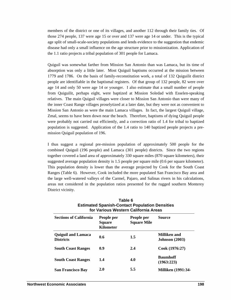
Northwest Economic Associates 198
members of the district or one of its villages, and another 112 through their family ties. Of those 274 people, 137 were age 15 or over and 137 were age 14 or under. This is the typical age split of small-scale-society populations and lends evidence to the suggestion that endemic disease had only a small influence on the age structure prior to missionization. Application of the 1.1 ratio projects a tribal population of 301 people for Lamaca.
Quiguil was somewhat farther from Mission San Antonio than was Lamaca, but its time of absorption was only a little later. Most Quiguil baptisms occurred at the mission between 1779 and 1786. On the basis of family-reconstitution work, a total of 132 Quiguilit district people are identifiable in the baptismal registers. Of that group of 132 people, 82 were over age 14 and only 50 were age 14 or younger. I also estimate that a small number of people from Quiguilit, perhaps eight, were baptized at Mission Soledad with Esselen-speaking relatives. The main Quiguil villages were closer to Mission San Antonio than were many of the inner Coast Range villages proselytized at a later date, but they were not as convenient to Mission San Antonio as were the main Lamaca villages. In fact, the largest Quiguil village, Zmal, seems to have been down near the beach. Therefore, baptisms of dying Quiguil people were probably not carried out efficiently, and a correction ratio of 1.4 for tribal to baptized population is suggested. Application of the 1.4 ratio to 140 baptized people projects a pre-mission Quiguil population of 196.
I thus suggest a regional pre-mission population of approximately 500 people for the combined Quiguil (196 people) and Lamaca (301 people) districts. Since the two regions together covered a land area of approximately 330 square miles (870 square kilometers), their suggested average population density is 1.5 people per square mile (0.6 per square kilometer). This population density is lower than the average projected by Cook for the South Coast Ranges (Table 6). However, Cook included the more populated San Francisco Bay area and the large well-watered valleys of the Carmel, Pajaro, and Salinas rivers in his calculations, areas not considered in the population ratios presented for the rugged southern Monterey District vicinity.
Table 6 Estimated Spanish-Contact Population Densities
for Various Western California Areas
Sections of California People per Square Kilometer
People per Square Mile
Source
Quiguil and Lamaca Districts 0.6 1.5 Milliken and
Johnson (2003)
South Coast Ranges 0.9 2.4 Cook (1976:27)
South Coast Ranges 1.4 4.0 Baumhoff (1963:223)
San Francisco Bay 2.0 5.5 Milliken (1991:34-

Northwest Economic Associates 199
Shore 36)
Malibu to Point Arguello 2.9 8.0 Brown (1967:79)
Malibu to Point Arguello 3.6 10.0 Cook (1976)
Social Networks, Settlements Systems and Regional Resource Flow
The Lima, Lamaca, and Quiguil districts seem to have been distinct tribelet territories, each inhabited by a number of inter-married families, and each with a number of village locations. Specific villages are mentioned too infrequently and haphazardly in the mission registers to provide mission register-based counts of their sizes. However, I suggest that small Salinan villages probably contained about 40 people, while large villages contained no more than 200 people, on the following basis:
• Northern Salinan tribelet populations were in the range of 200-300 persons
• Spanish explorers reported village sizes of 40-200 people in west-central California
• Mission registers suggest three or four important villages for both Quiguil and Lamaca. Lima villages are seldom mentioned more than twice in the mission registers suggesting that its inhabitants were dispersed among a number of tiny hamlets seasonal camps.
I surmise that the population of any specific Northern Salinan village location may itself have changed dramatically from one season to another, as members of the tribelet community moved to take advantage of local resource harvesting peaks.
Patterns of Regional Intermarriage
Unfortunately, the evidence in the mission registers for inter-village and inter-tribelet marriage patterns is not systematic in the Mission San Antonio records. Some individuals from specific villages can be shown to have married individuals from other villages, but many more people are identified in the mission registers only by their tribelet of origin, and some are not identified to any home location. The inconsistent records preclude good quantitative counts of inter-village marriage patterns.
The incomplete patterns of inter-group marriage that do emerge meet the theoretical expectations of world-wide studies of regional intermarriage patterns conducted by John

Northwest Economic Associates 200
Adams and Alice Kasakoff (1976). Their field work and literature review led them to conclude that small human groups are never isolated. Families have always participated in local or regional groups of at least 500 persons, so that their young people will be able to find spouses from beyond their immediate families. According to the principal of the 500-person group, the small villages of Quiguil, Lamaca, and Lima had to be exogamous. Even the 200 people of Quiguilit and the 300 people of Lamaca should have had to inter-marry with neighboring groups.
High levels of regional inter-marriage are, in fact, suggested by the existing data for the Mission San Antonio area tribelets. Each tribelet was involved in marriage with its immediate neighbor, irrespective of language similiarities or differences. Thus Esselen speakers from tribelets further north were living in Quiguil and Lima. Presumably, a few native Salinan speakers were living in the adjacent Esselen tribelet territories of Ecjeajan, Imunajan, and Aspasniajan at the time of Spanish contact.
Quiguil Outmarriages
Quiguil extended family kinship charts document numerous outmarriages with families from Lamaca, Lima, Quinau, and Esselen-speaking groups to the north. This is not unexpected, since I believe that the overall Quiguil population was approximately 200. According to the results of Adams and Kasakoff (1976), that small population would necessitate outmarriage and make it probable that almost half of the adults in Quiguil villages derived from neighboring regions. Because Quiguil was on the Esselen-Salinan boundary, marriages to Esselen families to the north was just as convenient as marriage to other Salinan families. The missionaries noted the results of such marriages. One person was baptized at San Antonio “de Quiguil, y de distinta nación (from Quiguil and from a distinct nation)(SAN-B 837) and another person “de Quiguil de la nación Tesmaymanil (from Quiguil, of the Tesmaymanil nation)” (SAN-B 1324). The missionaries were using the term “nation” to define a distinct language group. Tesmaymanil was a Mission San Antonio designation for the Esselen-speaking tribelet of “El Pino” (Aspasniajan at Mission San Carlos) and more generally for speakers of the Esselen language.
Lamaca Outmarriages
The Lamaca population was probably around 300. Perhaps 35 percent percent of the Lamaca adults were born in other tribelet districts. Most Lamaca district out-marriages were to people from neighboring Quiguil, Quinau, and Lima districts. However, toward the end of the period of Salinan mission migration, a Lamaca woman came to the mission who had been living with a husband in Sulaltap, at least 60 miles further inland near the edge of the San Joaquin Valley.

Northwest Economic Associates 201
Lima Outmarriages
I have not studied the patterns of Lima outmarriages. The group probably numbered no more than 200 people. Such a small group would have been highly intermarried with its neighbors. I am aware of one marriage between Lima and Quiguil families, and one marriage between Lima and Quinau families. As Lima was bordered by Esselen-speaking “El Pino” (Aspasniajan) to the north, it is expected that some Lima adults were first language Esselen speakers. (Kinship charts show two Esselen spouses among the Quinar tribelet of Salinans of the San Lucas vicitiny further east.).
Tribelet Residential Flexibility
The degree of residential stability at specific village locations within the Salinan tribelet territories is unknown. In some of the less densely populated areas of California, villages directly on the sea shore were the seasonal camps of groups that had more permanent towns one, two, or three miles inland. This was the case for the Rumsen Costanoans of the Carmel River Valley (Milliken 1987), the Costanoan groups along the San Mateo County coast (Milliken 1995), and the Kashaya Pomo of coastal Sonoma County (Kniffen 1939). None of those groups, however, lived on landscapes with the severe geographic break between the seashore and inland valleys that is presented by the face of the Santa Lucia Mountains within the Monterey Ranger District.
Coastal and interior villages of the Quiguil and Lamaca tribelets were actually 8 to 10 miles apart, as will be documented in the following section of this chapter. The difficulty of movement between them leads me to suggest that both the coastal and inland villages had fairly permanent populations, each village group spending most of the year harvesting a variety of resources within its local environment. Within each local village area, however, the specific location of the cluster of houses probably changed from year to year. Also, segments of village populations may have been constantly moving out to temporary camp sites and over the mountain to visit relatives at villages in the other environmental zones.
To illustrate the pattern of land use that I envision, I take the liberty to introduce documentation of seasonal residence flexibility elsewhere in California. For the Ipai/Tipai, to the south of Salinan lands, Luomala wrote:
Many villages were only campsites that a band occupied in its territory during a year … By a “permanent rancheria” nineteenth-century observers apparently meant that more band members gathered there for more months than at their other campsites…. A campsite was selected for access to water, drainage, boulder outcrops or other natural protection from weather and ambush, and abundant flora and fauna of that ecological niche (Luomala 1978:597).

Northwest Economic Associates 202
To the north of Salinan lands, a missionary described the seasonally-flexible residence among the Ssalson, a Costanoan-speaking multi-village tribelet of the bay shore of the San Francisco Peninsula:
I baptized… a girl of about six months age… Her father… and mother… are native of the village of Olestura, who, like all the aforesaid [baptized on this day], live without partiality, now along the tributaries of the San Mateo River, again at the aforesaid village, as well as at Sycca, and they come as far as Guriguri and San Burno [Noriega, entry 178 in the Mission San Francisco Asis Register of Baptisms in 1778].
I infer that the contact-period Lamaca and Quiguilit people had some fairly permanent villages and some that were merely seasonal sites. Families lived a semi-nomadic existence among a small number of coastal and inland villages, with strongest roots in a particular village, but with those roots easily changed over time.
Resource Flow across Group Boundaries: Trade and Regional Harvests
Early reports suggests that people from multiple villages and tribelets occassionally gathered together from distances as great as 40 miles apart for regional harvests.
The Portolá expedition of 1769 documented an aggregation of 600 people gathering pine nuts near the Santa Lucia Range crest on September 20, 1769. Diarist Juan Crespí reported:
Having reached here we were visited by five big villages of very tractable friendly heathens that they said had their villages in the immediate vicinity. (The 6 or 7 villages [corrected from five] we guessed to be at least about 600 souls; they presented us with a great many pine nuts.) Some, they say, are shore dwellers, others mountaineers belonging to this range, and still others from a river that they say is near by, with a harbor, and that we guess to be the Carmelo River [Crespí in Brown 2001:515].
The pine-nut gathering location was along either Los Burros Creek or Little Salmon Creek at the very southern edge of the Monterey Ranger District. It was in southern Lamaca, in the mountains west of the permanent Lamaca village of Onet. It is likely that most people from the coastal and inland Lamaca villages were gathered here, along with friends and relatives from villages in the Janulo and Papuco districts farther east. Of note, it is not clear what pine nut was being gathered in the area. Pinyon pine (Pinus monophylla) is absent from the Santa Lucia Range, and sugar pine (P.lambertiana) is now quite rare in the specific area. Grey pine (P.sabiniana) is common in the area, but is also common over a much wider region. Ponderosa (P.ponderosa) and coulter pines (P.coulteri) are common in the immediate vicinity, but they are not known as a food sources in the ethnographic literature.

Northwest Economic Associates 203
Also, marine resources may have been gathered intensively by groups that did not normally live on the coast. Although no ethnographic details are available for such a subsistence strategy west of Mission San Antonio valley, clear evidence is available that inland people crossed through the territories of their western neighbors to secure coastal strip resources at the mouth of Carmel Bay to the north. In the quote below, Father Serra at Mission San Carlos Borromeo (Carmel) described the arrival of people at Carmel Bay from as far inland as Soledad in July of 1775:
From rancherias very far distant, and lost in the folds of the mountains, they arrive every day. At the present time there are some from Eslen, called La Soledad, a place halfway on the road between this mission and that of San Antonio…
Great schools of sardines appeared near the beach, close to the mission. After two weeks of fish eating, on the Sunday following, leaving the sardines in peace, they went hunting for the nests of sea birds that live in rocks and feed on fish. They caught a lot of young birds which were, generally speaking, as big as good sized chickens. And so they passed Sunday, camping on the Carmel beach, divided into countless groups, each with its fire, roasting and eating what they had caught [Serra 1956:140-142].
Such occasional intensive use of Carmel Bay and the Monterey Peninsula probably contributed to the development of midden accumulations that suggest far greater populations than were actually the case. Similar patterns may have pertained during historic-contact times in Salinan lands along the Pacific Coast adjacent to the Monterey Ranger District.
Summary and Recommendations
This summary section lists four highlights of the chapter that may be useful in Forest planning. Additionally, the importance of “The Indians” vicinity as a cultural landscape is stressed. Documentation of the values and viewpoints of contemporary Salinan is found in the concluding chapter of this volume.
Highlights
The following points represent highlights regarding the ethnographic Salinan people of the Monterey Ranger District and vicinity.
• Three contiguous Salinan-speaking groups, Lima, Lamaca, and Quiguil, held portions of the southern Monterey Ranger District. Each group had a number of seasonal and semi-permanent villages and camps and each was closely inter-married with its neighbors.

Northwest Economic Associates 204
• The people of Lima, Lamaca, and Quiguil joined Mission San Antonio between 1771 and 1806. Despite a drastic reduction in population due to introduced diseases, many descendants survived. Salinan people continue to live in the region today.
• The precise Salinan-Esselen language boundary within the Monterey Ranger District is a continuing question of debate. In this chapter, I have proposed that small upland portions of the Arroyo Seco watershed west and east of Junipero Serra Peak were within Salinan territory, Quiguil territory on the west side of the mountain and Lima territory on the east side. (Breschini’s work on incised stone [see Chapter 3, p 71] illustrates the value of the archaeological perspective on this issue).
• None of the three Monterey District Salinan groups should be considered Playanos, a separate Salinan or possible Chumash dialect group of the northern San Luis Obispo county coast that was incorrectly mapped in Monterey County by A.L. Kroeber in 1925.
Proposed Special Management for “The Indians” Vicinity
Beyond standard protections of cultural resources, one area of the Monterey Ranger District clearly deserves special management protection and possible future public interpretation. It is a five-square mile area in “The Indians” vicinity. The area is important for the following reasons:
• It contains eleven named Salinan village and/or gathering locations, identified by early twentieth century Salinan consultants to J. P. Harrington
• No other small valley in west-central California between Clear Lake on the north and Tejon Pass on the south contains nearly as many named ethnographic locations
• It contains two homesites of early twentieth century Salinan families
• It contains one or two locations of early nineteenth century Mission San Antonio outstations
• It contains one or two Spanish-contact period Quiguil village sites that were named in Mission San Antonio records
• It contains over sixty recorded discrete archaeological midden and/or bedrock mortar outcrops

Northwest Economic Associates 205
The minimal area for the proposed special management is marked on the Los Padres National Forest ethnographic cultural resources GIS mapping layer with a Specific Vicinity Polygon. The polygon overlaps the Los Padres National Forest and the Hunter-Liggett Military Reservation. This area is important enough to merit consideration for mutual land management or land exchange between the two federal agencies4.
In conclusion, this chapter has presented an analysis of archival and published ethnographic information. Complete documentation of ethnographic values on the southern portion of the Monterey Ranger District must also consider the values and viewpoints of contemporary Salinan people.
4 Unbeknownst to the author, the Forest Service has already proposed this area as a Special Interest Area, with boundaries generally matching those suggested by the author. Based on the high cultural values, the area will be subject to special management (Heritage Resources Manager for the Los Padres National Forest, Joan Brandoff-Kerr, personal communication, February 3, 2004).

Northwest Economic Associates 206
Chapter 5 - Ethnography of the Chumash – by Chester King
Overview of Chumash Life
Chumash territory includes most of San Luis Obispo, all of Santa Barbara, most of Ventura, southwestern Kern, and western Los Angeles Counties. The Spanish responsible for the conquest of California considered the Chumash to be the most advanced native society in California. Spanish explorers observed that the Chumash differed from surrounding nationalities in their emphasis on manufacturing and trade. Trade was facilitated by a bead money economy. The Spanish admired the Chumash for their skill as craftsmen and traders and their work ethic. The Spanish also observed that the Chumash were unique in their development of maritime fishing. They noted that the Central Chumash population was greater than the populations of other areas of California. Because of the large number of men who could be organized for warfare, the Spanish feared the Chumash more than any other group encountered during the establishment of Spanish rule.
At the time of initial European colonization, the area inhabited by the Chumash measured approximately 200 by 70 miles. In size, this compares to the smallest states of the eastern United States. The Chumash population included between 15,000-20,000 people. Chumash population estimates are based on counts of the numbers of people observed at settlements during the 1769 Portola expedition which traveled along the densely populated coast, numbers of baptisms from settlements at Spanish missions, comparison of the ratios between 1769 expedition counts and baptisms, data concerning population from later expeditions to the interior and the sizes of archaeological sites. It is possible to conduct a thorough analysis of mission register data using sophisticated models to determine the probable size of the population in 1770. The analysis remains to be conducted. The Chumash did not have standing armies or full time police. However, despite its small size, Chumash society developed institutions that maintained regional political and administrative organizations, a market economic system, and a complex belief system. Chumash society was similar in scale

Northwest Economic Associates 207
to other societies that occupied the more densely populated areas of western North America before European colonization. Research with mission registers indicates Chumash (in common with people in many societies studied by anthropologists) could identify kinship ties with almost all of the people with whom they would normally interact. Kinship relationships integrated the families of political leaders throughout the Chumash national area.
At the time of the Spanish missions, the native name chumash referred to inhabitants of Santa Cruz Island. In 1891, Powell referred to languages related to the Santa Cruz Island language as Chumash (1891). The name Chumash is now accepted as an ethnic designation by anthropologists and descendants of people baptized at the Spanish missions in Chumash territory.
A succinct discussion of old Chumash culture and society is presented by Blackburn (1975). The term Tataviam refers to the Uto-aztecan peaking eastern neighbors of the Chumash who lived along the Santa Clara River drainage east of Piru, in the lower Piru Creek drainage and at La Liebre.
Chumash Language
Linguistic Relationships
When the Spanish colonized California, the Los Padres Forest south of Paso Robles included territories of people who spoke two distinct languages, Chumashan languages and Tataviam. Tataviam is a member of the Uto-Aztecan language family. The Chumashan languages included an Island Chumash language, a Central Chumash language group that included many relatively closely related languages and a Northern Chumash language group at San Luis Obispo Mission. It appears that there may have been two Northern Chumash languages at San Luis Obispo (Klar, Whistler and McLedon 1999:20-27).
At San Luis Obispo Mission it appears that the people who lived near the coast north of Morro Bay were most different from the other recruits in terms of marriage ties and recruitment pattern. Late Middle period burial practices at Pico and Little Pico Creeks are very similar to the Arroyo Grande area south of San Luis Obispo. Burial practices reflect the religious and social organization of societies. Highly similar burial practices indicate membership in common social groups. Differences in burial practice are highly correlated with differences in language. Most names recorded from Chotcagua at Morro Bay and Sepjala at Cayucos are apparently Chumash. Relatively few marriages occurred between Chotcagua and Sepjala and Interior settlements. The second northern Chumash language may have been spoken in this area.

Northwest Economic Associates 208
Known and Contentious Boundaries
Most boundaries are well documented. Many of these are different from those indicated on maps in Handbook of California Indians (Heizer 1978). The northern boundary of the Chumash in San Luis Obispo County is not well documented. Linguistic analysis of names in the registers and other historic studies will help resolve contentious boundaries. The people who lived in the vicinity of the Los Padres Forest in San Luis Obispo County before European colonization were apparently all Chumash.
Socio-Political Organization
Present knowledge of Chumash social organization before Spanish colonization comes through the synthesis of documents produced during the Spanish conquest, ethnographic notes collected by John Harrington and others, and archaeological data. The historic documents include mission registers and diaries. As historic research progresses, ethnographic notes, and archaeological data (including material in museum collections) are studied further, and theories explaining differences in social organization are developed, knowledge of Chumash society before Spanish colonization will become more refined. Fernando Librado provided an oral history of the Lulapin confederation which included the Channel coast from Mugu to Point Concepcion and the Santa Ynez and Ojai Valleys (Figure 44). Other information includes long distance marriage ties between members of the most important chiefly families. In 1542, Cabrillo described the presence of a woman chief at Santa Barbara said to have power over other coastal villages. At the beginning of Spanish colonization with the construction of the Santa Barbara Presidio Yanolit the chief at Santa Barbara was said to have control of thirteen villages. The scale, duration, and importance of multiple village political organization is a subject of dispute among Chumash ethnohistorians. Most scholars recognize that villages had political systems that controlled the use of the land used by members of villages.
The hereditary chief (wot) was the central authority of the political system. There was sometimes more than one chief at a village. In Chumash folklore, the primary village chief was Eagle (Slo’w), the second chief was his nephew Falcon (Xelex), and the third chief was Raven (Qaq). Chiefs are described as having great prestige and moral authority. They were wealthy and capable of buying costly items, providing hospitality to guests, sponsoring fiestas, and rewarding those who had helped them. The most important duty of chiefs was the management of stores containing food and wealth. These were used to maintain the chief and his family, to feed visitors, to aid the needy, and to give fiestas. Stores were filled by donations from families that could afford them. Additionally, chiefs managed the territories under the control of their villages and decided if trespassing should be punished by war. Chiefs sometimes instigated wars by taking wives of other chiefs, acts reminiscent of the cause of the Trojan War. Chiefs had two messengers (ksen) who relayed messages to other villages concerning ceremonies and other matters. Regional political organizations were

Northwest Economic Associates 209
frequently solidified through marriage relationships occurring between people from villages over 50 miles apart.
Another individual important in the Chumash village was the paxa. He was the official responsible for training and initiating members of the secret men’s ‘antap society. It was his duty to organize ceremonies at the request of his chief. It was also his responsibility to choose new chiefs from legitimate candidates when necessary. ‘Antap membership was based on relationship to a sponsor who paid a large sum of money to the society, or membership could be obtained by abstaining from eating deer meat and following other restrictions while a youth. Chiefs and their assistants were initiates of the ‘antap society. The ‘antap helped the paxa and the chief sponsor fiestas. They were also the dancers and musicians at fiestas. They collected contributions for the chief and pointed out those who did not make adequate contributions. Events such as fiestas involved and integrated all the major institutions of Chumash society. Fiestas usually celebrated events that were important in the belief system, such as solstices, and brought people together for economic activity (Hudson, Blackburn, Curletti and Timbrook 1977, Blackburn 1974, Johnson 1988:231, see Appendix C). The ‘antap could kill people by poisoning only if they had the permission of the chiefs. The chief, paxa, ‘antap and messengers constituted the basic village administrative unit. It appears that these individuals, with the possible exception of the messengers, were from high-ranking families.
Astrologers and diviners (‘alshuqlash and ‘alaxalapsh) were apart from the ‘antap society. These individuals did not seem to have a particular village affiliation and could travel freely. It was their duty to name children, counsel them concerning their future, administer Datura (Jimson Weed potion was drunk to alter the state of mind of initiates during initiation ceremonies. Momoy, Datura, was an old woman teacher in legends), forecast rain, and heal the sick. These people were usually old men or women who attained their positions by seeking knowledge.
Households varied in size. On the coast between Ventura and Golta Slough households averaged around fifteen people. In most other areas households averaged between five or six people. The typical household was organized around a nuclear family. At smaller settlements people often married partners who were natives of other settlements. After marriage, men regularly went to live at their wife’s village. Sometimes, wives went to live at their husband’s native village, and occasionally, both partners moved to another village. Some chiefs had more than one wife. Second wives often lived at their native villages and were visited by their husbands who usually continued to live in their own native villages. In cases, more than one wife might live in the same household with the chief. Chiefs’ houses were often larger than those of other families.
In addition to residential houses, sweat lodges and menstrual lodges were present at most villages. Sweat lodges were not only used by men for sweating rituals, but also as a place to

Northwest Economic Associates 210
sleep. Sweat lodges additionally served as a place for giving instruction prior to initiation into the ‘antap society.
At the time of Spanish colonization, the Chumash maintained the most complex bead money system documented anywhere in the world. Documentation includes historic accounts, ethnographic notes, and beads from archaeological sites.
Material Culture
The Chumash of the Channel coast fished with nets, hooks, and harpoons. They fished from shore and from boats. The boats were made of planks sewn together with yucca cordage and caulked with asphaltum. The maneuverability and speed of these boats impressed Spanish explorers (Hudson, Timbrook, and Rempe 1977). The boats were also used for trade with people living on the Channel Islands.
The Mainland Chumash hunted deer, rabbits, and ground squirrels. They gathered many types of small seeds, acorns, wild cherry pits, yucca, bulbs and corms and many types of berries and herbs. They used baskets to transport foods, to store food and to process food by boiling. The Chumash made many types of baskets. The Chumash had domed hemispherical shaped houses made of willow branches and thatching. Because of the importance of manufacture for trade the Chumash were recognized as expert craftsmen. The five volume study of Chumash material culture by Hudson and Blackburn document Chumash and Tataviam material culture (1982, 1983, 1985, 1986, and 1987).
Because many protohistoric period Chumash specialized in manufacturing there are often differences in the type of manufacturing debris and manufacturing tools found at different settlement and quarry sites. Extensive trade resulted in the distribution of artifacts from many particular sources throughout the area and artifacts such as mortars, pestles, arrows, beads, ornaments, and baskets were essentially the same throughout the area where Chumash languages were spoken. The largest portion of the Los Padres Forest in the Chumash area is in the interior. The people who lived in interior areas of the forest traded seeds, other plan and animal foods and materials including serpentine, jadite, Franciscan, and Temblor Range charts to other Chumash. They obtained fish, sea mammal meat, and other ocean products from coastal people.
Populations, Settlement Systems, and Regional Interaction
The coast of the Santa Barbara Channel trends east to west as do the Channel Islands that form the southern edge of the Channel. This resulted in the formation of many places well suited to boat launching and to conditions of upwelling which provided a rich marine environment. These conditions contributed to a high density of population along the coast.

Northwest Economic Associates 211
Figure 44 indicates the number of people recruited from different settlements. Observation of the map and the descriptions of Spanish explorers indicate that the largest population concentrations were in the middle of the Channel. The size differences of Coastal settlements were not due to the local availability of resources, but rather their location in trade networks. Likewise the high concentration of population in the immediate interior was made possible by trade. Trade encouraged interior people to harvest more plant foods than they could consume. Trade enabled Chumash people to pool their resources (King 1976).
Chumash settlements, except in the far interior and the northern coast, were permanently occupied and their members often chose marriage partners from neighboring settlements. People at Chumash settlements obtained plants and animals from territories controlled by the settlements.
Chumash territory included many different resources that varied over short distances. The Chumash of the islands depended largely on fishing and manufacturing for trade. They traded with the mainland Chumash for many resources that were not available or were available in low quantities on the islands. The Chumash of the mainland coast traded plant foods, raw material and baskets and arrows to the islanders. They traded fish and manufactured products to people in the interior. People in the interior traded plant foods and raw materials including serpentine to coastal people. The linking of different areas by an economic system encouraged specialization in the procurement of resources and manufacturing. People in the interior gathered more plant foods than they would have if there were no markets. In return, they obtained fish and sea products not available locally. People were able to obtain food from neighbors when it was not available locally by trading stored wealth (King 1976). Studies of marriage ties that existed prior to recruitment at missions indicate that in the area where Central Chumash languages were spoken, men most often went to live at their wife’s villages. Johnson concluded from a study of Chumash kinship terminology and ethnohistoric data concerning pre-recruitment ties between Santa Barbara County settlements: The Chumash economic system linked together villages in different ecological zones, making them interdependent on one another. Not every village held the same function, economically or politically, in this network. By considering the system as a regional whole, geographic variables were discovered that correlated with ethnohistorically observed patterns of political affiliation and importance. Economic behavior influenced settlement patterns, which in turn determined political centrality. Two types of economic exchange, intraregional, based on redistribution, and interregional based on long distance trade, resulted in two different types of network centrality, one based on accessibility and the other based on betweenness. Political importance of settlements in Chumash society was dependent on the extent that a village’s geographic position resulted in central roles in both intraregional and interregional economics [Johnson 1988:297, see Appendix C].
Northwest Economic Associates 212
Comparative Ethnographic Lifeways
At the time of European contact, the Chumash had an elaborate oral literature, knowledge of astronomy, an elaborate material culture, and thorough knowledge of their natural world. The Chumash assisted with propagating plants and animals and collected them for food. Protohistoric Chumash society was one of the most complex non-agricultural societies documented anywhere in the world. The study of the development of Chumash society is relevant to understanding the evolution of complex societies. A succinct discussion of old Chumash culture and society is presented by Blackburn (1975).
World Views and Ritual Practices [as it helps interpret sites]
Harrington gathered a great deal of information concerning oral tradition and ritual practices of the Central Chumash. Much of this information has been published. Blackburn published folk tales gathered by Harrington (1975). Hudson, Blackburn, Curletti, and Timbrook published parts of a traditional history of the Central Chumash and information concerning Chumash dances and ritual practices (1977). Hudson and Underhay studied information related to Chumash astrology. They studied information from the Harrington notes and made observations of solstice events at sites with Chumash paintings (1978). Other students of Chumash paintings have also related some of the sites with paintings to Chumash cosmology. Some Chumash paintings are apparently depictions of dancers. Paintings of dancers may be related to instruction concerning the performance of dances at ceremonies.
Chumash oral tradition held that at the time of the winter solstice a peon game (guessing game with hand held counters) was played in the sky between sky coyote (the north star who is always watching over us and is dependable because he is always in the same place) heading one team and the sun heading the other team. If coyote’s team won there would be a good year, if the sun won he would take his winnings as people’s lives and it would be a bad year. Chumash astrologers studied the sky to gain insight to the outcome of this game (Blackburn 1975). The main panel at Painted Rock in the Carizo Plains has been interpreted as representing the peon game in the sky (Schupp-Wessel 1982).
In addition to places where rock paintings have been found, Chumash oral tradition indicates that hilltops, mountaintops, springs, and caves are often important places. The places include Mount Pinos, the tallest mountain in Chumash territory. It is probable that many important places are not listed in the Harrington notes. The notes are most thorough in the Santa Barbara-Goleta area and along the lower Ventura River and other places close to Ventura Mission where many Chumash lived after mission secularization.

Northwest Economic Associates 213
Ethnographic Locations on the Landscape
Sources
The Native American place names listed in this paper are words of Chumash and Tataviam languages. The place name list begins south of Paso Robles and ends at Piru. The Chumash place names used on Figure 44 and as headings of the listing of settlements are transcribed as they are frequently transcribed in mission registers. Pronunciation and orthography for Chumash names collected by Harrington generally follows Applegate (1974, 1975), Blackburn (1975), and Hudson and Blackburn (1982). The place names include names of native settlements, shrines, mountaintops, and ridges. Many hills and mountains were the locations of shrines. Many Chumash place names do not contain locative prefixes or suffixes. Descriptive prefixes such as s’ap- = “house of” or ka- = place, are used in some Chumash place names. Information concerning native settlements and place names is not of the same quality in all areas.
Information concerning Native American place names in the vicinity of the Los Padres National Forest is derived from many sources. In 1542, Cabrillo was the first European explorer in the area. He made lists of Chumash village names along the coastline between Point Mugu and Point Concepcion (King 1975). After Cabrillo, there is no known evidence of anyone recording native place names until the founding of missions in California. Mission registers and correspondence during the mission period often included native place names. In Southern California, the baptismal records of recruits to the Spanish missions usually listed native names of settlements. The names and locations of Indian settlements have often been recorded in land title documents, on maps, and as modern place names.
Alexander Taylor resided in California and was interested in the traditions of California Indians he began recording native place names during the middle of the nineteenth century. In 1863, Alexander Taylor included information on place names in a series of articles in the California Farmer entitled “The Indianology of California” (1860-63). Taylor used archives as well as information from interviews with native people to prepare his descriptions of native Californian societies.
Taylor was followed by ethnographers employed by various institutions. Herbert Henshaw, an ethnographer from the Bureau of American Ethnography, worked with Indians in the Ventura area. He collected several lists of Chumash place names. The most extensive list contains 106 place names and was prepared by Juan Esteban Pico in consultation with elders. The list includes four columns. The first column contains a sequence of numbers from 1 to 106, the second column Pico’s transcription of the Spanish name for the place, the third column Pico’s transcription of the Chumash place name using Spanish orthography, and the fourth Henshaw’s phonetic transcription of the names. Henshaw also added marginal notes.

Northwest Economic Associates 214
The place name list was prepared by Juan Esteban Pico and Herbert Henshaw in 1884. The original was discovered in the ethnographic notes of John P. Harrington. It is included as Appendix IV in McLendon and Johnson 1999.
Alfred Kroeber, who began work at the University of California at Berkeley in 1901, collected information concerning southern California place names. Kroeber summarized information on place names in a paper (1916) and in his Handbook of California Indians (1925).
In 1912, John P. Harrington began collecting information concerning the native languages of southern California. He was employed by the Bureau of American Ethnography. He used mission registers and lists of place names to compile lists of names that he used while interviewing native consultants. He took trips with consultants for the purpose of obtaining place name information. Harrington’s skillful use of ethnographic techniques allowed him to collect more information on native place names than anyone else. It is necessary to assess the information gathered by Harrington in terms of the context of his questions and consistency of information given by particular consultants with other sources. Sometimes Harrington collected native translations of Spanish place names or attempted to obtain pronunciations of names given in historic records. In conducting his research, Harrington attempted to record as much information as possible. Validation of the information requires the determination of consistency with information provided by other consultants and historic documents. Harrington made summary lists of the place name information that is scattered through his notes. The lists were made for different regions and are organized alphabetically for each region.
In the Central Chumash region, Harrington worked with Fernando Librado Kitsepawit (1839-1915). He provided Harrington with much detailed ethnographic and linguistic information and was Harrington’s most important coastal Chumash consultant for place names in both the Santa Barbara and Ventura areas (Blackburn 1975:18, Johnson 1982, Hudson 1979:146), Juan de Jesus Justo (Blackburn 1975:20).and Luisa Ygnacio (Blackburn 1975: 19) provided much information concerning Santa Barbara coast place names. Juliana Ygnacio, daughter of Luisa Ygnacio, was also interviewed along with her mother.
Harrington worked with three Chumash consultants on place names in the Ventureño region. Fernando Librado Kitsepawit and Simplicio Pico Pamashkimait (1839-1918) provided much information concerning Ventura area place names (Hudson 1979: 152). Fernando and Simplicio both spent their childhood at Ventura Mission and were personally familiar with settlements that were present in the region in the late 1840s and early 1850s. José Juan Olivos, a speaker of the Castac dialect of Ventureño Chumash was interviewed in 1917-1918 (Hudson and Blackburn 1982: 32). He apparently was the husband of Candelaria Valenzuela (Hudson 1979: 150). He was familiar with place names in the Santa Clara River. Candelaria Valenzuela was said to have born at Sespe. She provided information concerning the Santa Clara River area to Henley and Binzell (Blackburn 1963:139) and Harrington (Craig 1966:

Northwest Economic Associates 215
202-203,; Hudson 1979:156-157). Maria Solares provided information concerning Santa Ynez area place names. Harrington obtained information concerning San Luis Obispo area place names from Rosario Cooper (Klar 1977).
Eugenia Mendez was an elderly full blooded Kitanemuk from the Tejon Reservation (Hudson and Blackburn 1982:32). She provided Jaminot [Kitanemuk language] names of places in the Santa Clara River area.
Richard Van Valkenburgh was employed by the Los Angeles County Museum between 1930 and 1935 under the sponsorship of the State Emergency Relief Act. His main emphasis was archaeology. He obtained ethnographic information concerning archaeological sites. He interviewed Native American consultants concerning places in Ventura and northern Los Angeles Counties. He also consulted with J.P. Harrington concerning native place names. Van Valkenburgh compiled lists of archaeological sites that included native names (1933, 1935). Documentation of his sources for many names has not been found.
Thomas Workman Temple III abstracted information from the registers of California missions for genealogical research. He made useful abstracts of the registers of San Fernando mission (Temple n.d.). These abstracts were used to obtain information on Tataviam and eastern Chumash villages.
Alan Brown has translated the original full versions of the diaries of the Portolá expedition kept by Friar Juan Crespi (2001). He conducted research to annotate the diaries that involved the use of mission registers and analysis of place name information. A product of this research was a study of the size of the native population of the Santa Barbara Channel (1967). His research demonstrated the potential of using historic data to map the distribution and sizes of native villages in California. It also indicated the potential of discovering kin relationships between people in different settlements and the locations of linguistic boundaries. Brown’s 1967 map and discovery of Harrington place name information, that allowed refinement of the map, resulted in efforts to synthesize the ethnographic and historic information.
Richard Applegate wrote an article concerning Chumash place names that made significant observations concerning the types of names used and their linguistic structure. (1974). Applegate used Harrington’s notes and his own knowledge of Chumash languages to produce the article. In 1975, he published a list of Chumash place names that includes linguistic transcriptions and translations of most known Chumash place names (1975).
In 1975, Chester King prepared a map indicating the distribution of Chumash settlements at and before European colonization (1975). He correlated names and information in Harrington notes with historic documents and archaeological data to make the map.

Northwest Economic Associates 216
In 1977, Kathryn Klar published an article that presented data on San Luis Obispo Chumash place names not included in Applegate’s list. The place names were taken from Harrington notes of interviews with Rosario Cooper.
In 1978 John Johnson published an article concerning the location of the Chumash village of Cashtec mentioned in historic and ethnographic sources. Many anthropologists and linguists had mistakenly identified Cashtec with the modern place of Castaic in Tataviam territory (1978).
Robert Edberg conducted research concerning ethnohistory and place names in the Santa Paula - Santa Clara River area using ethnographic and ethnohistoric information he discovered kin ties between the settlements he studied (1981). In 1982 Johnson, Warren, and Warren prepared an ethnohistoric study of settlements in the vicinity of Goleta Slough (1982)
In 1983 Robert Gibson completed a study of the ethnogeography of the Salinan for his masters’ thesis. The study relied on analysis of registers of San Miguel and San Antonio Missions and included preliminary analysis of information concerning people recruited at San Luis Obispo Mission (1983). The study proposed boundary changes from those shown by Kroeber and others. Some of the changes have been substantiated by further research and others are debated (Milliken and Johnson 2003).
In 1984, Chester King produced an ethnogeographical study of settlements on and in the vicinity of Vandenberg Air Force Base. The study involved the use of registers of San Luis Obispo and La Purisima Missions to discover ties between the settlements that were studied. The study synthesized historic information concerning Chumash society in the Vandenberg area. Research with the San Luis Obispo registers involved correlating confirmation register entries with baptism, death, and marriage entries. The study of the confirmation registers was necessary because many people were baptized at the beginning of the mission without information concerning rancheria of origin. The confirmation register consistently provided information on village of origin. This was the first study of Chumash ethnohistory that attempted to diagram all the recorded kinship relations from a group of settlements. The study emphasized study of political relationships (King 1984). In 1988 King produced another ethnohistory for Vandenberg AFB. The study emphasized the use of plant and animal resources. The study included information from ethnohistoric documents concerning temporary settlements. The kinship ties and changes in names of settlements recorded for individuals in different registers were thoroughly studied for the settlements of Pismu and Chotcagua to discover differences between permanent and temporary settlements. Charts were made that illustrated the relationships of all people baptized and or confirmed at San Luis Obispo from Pismu and Chotcagua (King 1988). The information concerning temporary settlements in the San Luis Obispo area was also included as background concerning temporary or short-term settlements in a study of the Santa Monica Mountains (King 1994).

Northwest Economic Associates 217
Between 1984 and 1987, John Johnson produced ethnohistoric studies of a number of villages in Santa Barbara County (1984a, 1984b, 1985, 1986, 1987). These were all produced while Johnson was preparing his dissertation that included a study of ties between settlements on the Santa Barbara mainland coast and the Santa Ynez Valley. The study involved diagramming all relationships described in mission registers for forty settlements. In 1988, Johnson completed his dissertation (1988, see Appendix C).
In 1989, Chester King completed a study of place names along the lower Ventura River. The study was conducted to assist in the assessment of impacts that would be caused by a landfill in Weldon Canyon (King, Johnson and Gamble 1989). The study involved locating many places in the Harrington notes and lists made by Henshaw.
In 1993, Chester King completed an ethnohistoric study of places in the vicinity of the Pacific Pipeline. The pipeline route followed railroad tracks along the coast from Gaviota to Ventura. It then followed the Santa Clara River to Newhall. King used Harrington notes and mission registers. Plat maps, diseños, and USGS quadrangle sheets were consulted for place name information. The plat maps provided important information concerning the location of adobes associated with post mission native settlements. An historic atlas of Ventura County that includes parcel maps for every school district in the county as of 1912, when Harrington began his fieldwork, proved useful for locating properties mentioned in Harrington’s notes (Alexander 1912).
In 1994, Betty Rivers and Glenn Farris completed a study of the El Morro village site. They synthesized information from Spanish period documents, extracts of Harrington notes and the registers of San Luis Obispo Mission (Rivers and Farris 1994).
Beginning in 1993 and ending in 1999, John Johnson compiled a summary spreadsheet of the San Fernando Mission baptism, marriage and death registers, and he and Sally McLendon prepared a study for the National Park Service concerning descendants from Chumash settlements in the Santa Monica Mountains and on the Channel Islands. The Appendixes in Volume 2 contain information relevant to virtually all Chumash and some Tataviam settlements (McLendon and Johnson 1999). Johnson has recently completed a study of the settlement of Mat’apxwelxwel at the mouth of Las Uvas (Grapevine Canyon) in the northeastern Chumash area. The study involved the use of mission registers, Harrington notes and American period historic documents (2000).
In 2000, Farris published clues that he has retrieved from land grant case records regarding the locations of Cholame, “Tisaizues” (Tisagues), Camate, “L’huegue” (Lehuege), Sataoyo, Stemectatimi, and Lospe rancherías listed in mission registers (Farris 2000:131-140). The information concerning Satahoyo resulted in differentiation of Satahoyo from a similar name for San Simeon and the placement of the settlement on the Salinan River

Northwest Economic Associates 218
Milliken and Johnson have recently completed a study of Salinan and Northern Chumash ethnogeography. They incorporate the results of most previous research in their synthesis of information. They conclude further research is necessary to document the Chumash – Salinan boundary. Their study is most detailed along the coast (2003).
In addition to studies of Chumash ethnohistory, Johnson and Earle have also conducted studies of Tataviam ethnohistory (Johnson 1978, 1997a and b, 2000, and Johnson and Earle 1990).
The study of Chumash ethnohistory has progressed since the publication of Alan Brown’ 1967 study of Chumash villages. Milliken and Johnson have entered information from all missions in and near Chumash territory into computerized data files. Research has resulted in matching many places with historic archaeological sites. Documentation has been discovered in historic and ethnographic sources concerning the locations of most villages. Small interior villages in the northwestern part of Chumash territory have not been located.
Chumash Settlements near the Los Padres National Forest
Settlements listed here are adjacent to the Los Padres National Forest or within the forest. Most are adjacent to the forest and are on drainages that originate in the forest. The listing is intended to include the settlements that most used the forest. The occupants of the settlements recruited into the Spanish Missions were the closest relatives of people buried at the settlements and the closest relatives of the people that most intensively used the lands. The modern descendants of occupants of the settlements are their ancestors’ representatives and are considered most likely descendants. This study concentrates on the identification of settlements. It does not contain all the information contained in Harrington’s place name notes and other sources concerning places other than settlements in the forest.
Figure 44 indicates the distribution of Chumash and Tataviam settlements in the vicinity of the Los Padres National Forest. Table 7 indicates the numbers of people recruited from studied settlements.
Figure 45 indicates the areas recruited at the different missions in the Chumash area. This map indicates that the missions recruited from defined areas that had a small amount of overlap. The map indicates the missions where descendants of people recruited were most apt to be living when the missions were secularized in the 1830s.

Northwest Economic Associates 219
Figure 44 Map of Distribution of Chumash and Tataviam Settlements in Relation to the
Los Padres National Forest
The listing of settlements is organized according to ranger districts. It begins in the north and tends to the east and the south. It begins in the Santa Lucia Ranger District. Northern Chumash locations are given first and then Central Chumash locations. It is followed by the Mount Pinos Ranger District, which includes northeastern Central Chumash settlements. Settlements in the Mount Pinos Ranger District are listed roughly from west to east. The Mount Pinos District is followed by the Santa Barbara Ranger District. Here settlements in the interior are followed by settlements along the Santa Barbara Coast. The last district is the Ojai Ranger District. Settlements include the coastal settlement of Rincon at Rincon Creek and interior settlements of the Santa Clara and Ventura River drainage. They are listed roughly from west to east. The easternmost settlement in the Ojai District is Piru, a Tataviam settlement.

Northwest Economic Associates 220
Table 7 Chumash and Tataviam Settlements near the Los Padres National Forest
List
Set
tlem
ent
F R
ecru
its
V R
ecru
its
B R
ecru
its
I Rec
ruits
P R
ecru
its
L R
ecru
its
M R
ecru
its
Tota
lD
iarie
s
Site
s
CHUMASH1 Chmimu-Szajuc 46 3 492 Sepjala 28 28 1769 Portola- Crespi Cayucos ?3 Chotcagua 36 36 1769 Portola- Crespi Morro Rock area4 Chano 53 535 Petpatsu 19 196 Tsquieu 1 53 54 Pecho Creek7 Sepjato 94 94 Avila Beach8 Pismu 27 27 1769 Portola- Crespi Pismu Creek9 Satahoyo 38 38 Salinas River
10 Sceele 17 17 Assencion11 Tipexpa 11 1112 Chetpu 1 47 48 Santa Margarita13 Chotnegle 14 14 Santa Margarita14 Gmosmu 54 5415 Guejetmimu 6 616 Chmonimo 23 1 2417 Tipu 21 2118 Tez 29 2919 Chena 11 1120 Chajuale 1 31 2 3421 Gmimu-Sicpats 26 16 4222 Chulucucunach 9 923 Ttequie 14 2 1624 Chmoli 33 33 Arroyo Grande25 Chiliquin 2 41 0 43 Arroyo Grande26 Guasna 1 1 24 33 59 Guasna Creek27 Guenejel 87 1 1 89 Tapis 179728 Sjuahuilimu 1 10 66 3 1 81 1806 Zalvidea29 Lisahuato 8 3 1 12 1806 Zalvidea30 Siguicon 28 11 1806 Zalvidea31 Sishuuohyo 5 5 Tapis 179732 Lonsococ 2 2 1806 Zalvidea33 Geguep 1 23 9 1 34 1806 Zalvidea34 Ahuam 7 20 7 2 3635 Siuhuil 0 2 6 836 Cuyam 5 25 11 41 1806 Zalvidea SBA-55637 Achiliguo 2 238 Sgene 4 4 1806 Zalvidea39 Malapuan 6 3 9 1806 Zalvidea40 Tashlipun 5 10 2 1 18 1806 Zalvidea41 Tacoya, Tacui 1* 1* 1806 Zalvidea42 Matapjuelejuel 1 2 3 Johnson 2000 KER-446543 Cashtec 3 16 1 20 1790: 39 wariors1806 Moraga KER-30744 Suijuiyojos 19 2 21 1806 Moraga ?45 Matapjajua 5 546 Tachicoyo, Tasicoo 1 1 possibly Tataviam settlement

Northwest Economic Associates 221
Table 7 (continued) Chumash and Tataviam Settlements near the Los Padres National Forest
47 Jonjonata 1 16 80 1 98 Tapis 1797 SBA-23548 Sotonocmu 15 121 57 193 Tapis 1797 SBA-167 and SBA-56449 Aquitsmu 1 44 46 7 98 Tapis 1797 SBA-80950 Stucu 102 9 111 Tapis 1797 SBA-1645?51 Huililic 50 2 52 Tapis 1797 SBA-871?52 Sajcaya 37 37 SBA-1283?53 Najue 2 14 6 84 106 SBA-1183?54 Calahuasa 61 86 35 182 NOTE Calasaugi in 1811 at F SBA-51655 Tegueps 1 169 10 0 180 Tapis 1797 SBA-47756 Huelecmen 5 557 Elijman 17 0 0 17 Tapis 1797 SBA-48558 Huisap 55 1 0 56 SBA-865?59 Miasap 25 0 0 25 SBA-842?60 Siguicon 28 11 3961 Siguaya 35 35 SBA-180062 Snihuaj 83 83 SBA-823?63 Snojoso 31 31 SBA-123?64 Snajalayegua 22 84 106 SBA-130965 Nomigo 19 2 163 2 186 1769 Portola- Crespi SBA-9766 Achi 158 6 42 206 SBA-9167 Casil 92 21 2 115 SBA-8768 Miquiqui 2 315 2 5 324 1769 Portola- Crespi SBA-7869 Cuyamu 27 0 0 27 1769 Portola- Crespi SBA-7770 Geliec 102 102 SBA-47, 48 and 1695?71 Gelo 2 150 152 1769 Portola- Crespi SBA-4672 Sajpilil 1 319 0 4 324 1769 Portola- Crespi SBA-6073 Mismatac 2 2 1769 Portola- Crespi? SBA-3574 Alcas 1 77 78 SBA-42 and 1696?75 Janayan 37 37 SBA-2276 Siujtu 201 201 1769 Portola- Crespi SBA-27, 28 and 2977 Saluhaj 11 76 87 SBA-19?78 Coloc 6 42 48 SBA-12 or 1379 Misopsno 64 71 135 1769 Portola- Crespi SBA-780 Sucu 118 13 131 1769 Portola- Crespi VEN-6281 Somes 211 5 216 VEN-5 or 142?82 Matilaja 225 225 VEN-139?83 Ajuai 60 60 VEN-132?84 Sisa 1 73 74 VEN-40485 Mupu 100 10086 Alalehue 2 20 2287 Sespe 7 56 63 1769 Portola- Crespi88 Chumpache 5 11 16 VEN-74 Squaw Flat
TATAVIAM89 Pirubit 1 89 90 La Esperanza Ranch
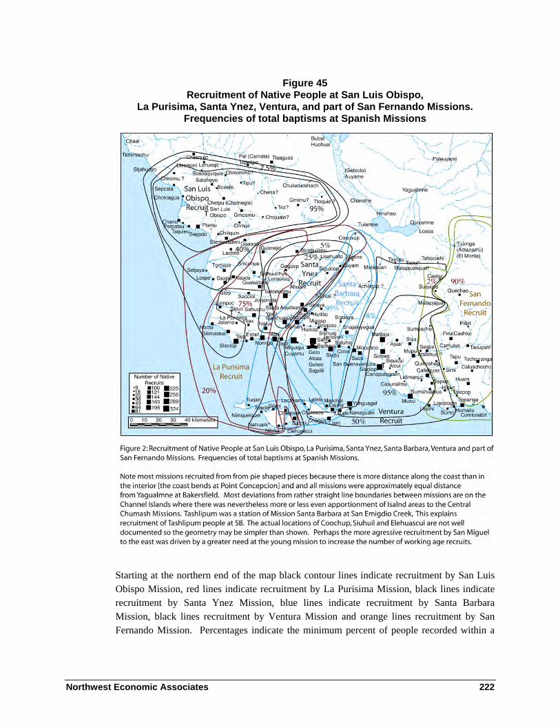
Northwest Economic Associates 222
Figure 45 Recruitment of Native People at San Luis Obispo,
La Purisima, Santa Ynez, Ventura, and part of San Fernando Missions. Frequencies of total baptisms at Spanish Missions
Starting at the northern end of the map black contour lines indicate recruitment by San Luis Obispo Mission, red lines indicate recruitment by La Purisima Mission, black lines indicate recruitment by Santa Ynez Mission, blue lines indicate recruitment by Santa Barbara Mission, black lines recruitment by Ventura Mission and orange lines recruitment by San Fernando Mission. Percentages indicate the minimum percent of people recorded within a

Northwest Economic Associates 223
contour interval at the mission indicated by the contours. The map indicates areas of significant overlap in recruitment by adjacent missions.
Santa Lucia Ranger District, Southern Portion: Northern Chumash Locations
The locations of Northern Chumash settlements in the interior of San Luis Obispo County are the poorest documented of all Chumash settlement locations. Excepting the interior San Luis Obispo County settlements the locations of most historic Chumash settlements are well documented with archaeological, ethnographic, and historic evidence. Because the interior of San Luis Obispo settlement locations are poorly documented, I will present available information concerning ties between northern Chumash settlements located in the area. In 1769, Miguel Costanso observed:
From the Santa Barbara Channel on, the country is not so thickly populated, nor are the Indians so industrious, but they are equally affable and gentle [Hemert-Engert and Teggart 1909:141].
The number of people in the Northern Chumash area was less than in the center of the Central Chumash area. Figure 46 presents information concerning the dates of recruitment from Northern Chumash settlements. The first grouping is settlements located near the shore in the vicinity of San Luis Obispo. The second grouping is settlements located along the Salinas River south of Paso Robles. The third is settlements located on Arroyo Grande and its vicinity to the south and east. The last listed settlements are poorly located with historic data. Most are apparently east of the Salinas River. They all had ties to Salinas River settlements. After 1780 and before the foundation of La Purisima Mission in 1788, there was little recruitment from settlements in the San Luis Obispo area and most recruitment was from settlements that would later be recruited at La Purisima Mission. This was probably part of a strategy to gain control over the Central Chumash from San Buenaventura in the east and San Luis Obispo in the west. Recruitment at the most distant settlements including Tteguie, Chuluculanash, Chmonimo, Llecmoni, Lososkiquihe, and Ljueque did not begin until after 1788. For settlements whose locations are known, there is a rough correlation between distance from the mission and times of recruitment. The pattern of recruitment at Chiliquin, Chmoli, Stemectatimi and Guasna was similar and recruitment at these villages was later than other San Luis Obispo area settlements located a similar distance from the mission. Many people were recruited at La Purisima Mission from Guasna. I interpret the later recruitment and the patterns of marriages at these villages as indicating the presence of a boundary separating these Central Chumash settlements from northern Chumash settlements.
Table 8 presents information concerning ties between settlements in the interior of San Luis Obispo County. The data used to construct the table is included in Appendix 1. This data includes ties between settlements taken from charts I made indicating the kin ties described in

Northwest Economic Associates 224
the San Luis Obispo Mission records. Data concerning kin ties along with data concerning pattern of recruitment is used to estimate the locations of settlements whose locations are otherwise unknown.
Figure 46 Recruitment from Northern Chumash Villages

Northwest Economic Associates 225
Table 8 Ties between Interior San Luis Obispo Settlements and Other Settlements.
Sat
ah
oyo
Sce
ele
Ch
etp
u
Gm
oxm
u
Ch
oju
ale
Ch
mon
imo
Ch
mim
u
Tip
u
Ch
ena
Tez
Gm
imu
Tte
qu
ie
Satahoyo x 1 3.5 1 1 2 1 1 2Sceele 1 x 3Chetpu 3.5 3 x 5 2.5 2 1 4.5 1Gmoxmu 5 x 1 1 3 2 1 1Chojuale 1 2.5 x 2 3.5 1 2Chmonimo 1 x 2 1 1Chmimu 1 2 x 1 3?Tipu 2 2 1 2 x 3 1 1Chena 1 1 3 3.5 x 1Tez 1 4,5 2 1 1 1 3 1 x 1 5Gmimu 1 1 3? 1 1 x 1Ttequie 2 1 2 1 1 4.5 1 xTsquieu 2 5 4 1 1 1Sepjato 1 2 7.5 2 3Chano 1 4 1Petpatsu 1 2?Chotcagua 3 1Sepjala 4 1Lososquiquihe 1 1 1 2Lhueque 2 2Llecmoni 2 1Chesquio 1 1 1 1Chmoli 1 1 1 1 1Chiliquin 1 2 1Guasna 1 1 1Stemectatimi 1 1 1Guasalique 1 1 1Lquichechs 1 1 1Chulucucunash 1 1 2Elmismey 1 1Tamaltaya 1 1
Satahoyo- Xsocia, Lualato, Topocolo, Chano-n,Chetpu- Sacciol, Laxito, Sjuahuilimu, Guenejel, Choquino.Gmoxmu - Quejetmimu (3), -Tipexpa (Temacoco), and LtipeChojuale- TachiaChmonimo- Tgmaps, Xoxtepax ?Chmimu- Chotquacilul, Txpalala en la Playa, Tecoco,Tipu- TstapotoChena- Estatjoto

Northwest Economic Associates 226
Table 9 presents the same data as presented in Table 6 but is ordered to demonstrate that the groups did not freely intermarry. The villages are divided into two groups that rarely married within themselves and usually selected spouses from the opposite group. This indicates the presence of moieties in interior San Luis Obispo County. When moieties are present, marriage ties do not directly indicate proximity. Often two villages are close together and have no marriage ties. The San Luis Obispo registers often give the same native names for the children as their father or other male relative. Perhaps the Northern Chumash, at least in the interior, had clans and moieties like their eastern Yokuts neighbors and differed from the Central Chumash who lacked unilineal descent groups and practiced simple village exogamy. Further analysis of names in the registers and the patters of marriage and residence at San Luis Obispo and San Miguel Missions should elucidate protohistoric social organization in the area.
Table 9 Evidence for Moieties among Interior San Luis Obispo Settlements
Tte
qu
ie
Tip
u
Ch
etp
u
Ch
ena
Ch
mim
u
Tez
Gm
imu
Ch
oju
ale
Sa
tah
oyo
Ch
mo
nim
o
Gm
oxm
u
Sce
ele
Ttequie x 1 4.5 1 2 2 1 1 16Tipu 1 x 2 3 1 2 2 1 21Chetpu 2 x 1 4.5 1 2.5 3.5 5 3 48Chena 1 x 1 3.5 1 3 11Chmimu x 1 3? 2 1 49Tez 4.5 3 4,5 1 1 x 1 1 1 1 2 29Gmimu 1 1 1 3? 1 x 1 28Chojuale 2 2.5 3.5 2 1 x 1 34Satahoyo 2 2 3.5 1 1 1 1 x 1 39Chmonimo 1 2 1 x 1 25Gmoxmu 1 1 5 3 2 1 1 x 54Sceele 3 1 x 17Tsquieu 1 1 2 1 4 5Sepjato 2 3 2 1 7.5Chano 1 1 4Petpatsu 1 2?Chotcagua 1 3Sepjala 1 4Lososquiquihe 1 2 1 1Lhueque 2 2Llecmoni 1 2Chesquio 1 1 1 1
The list of Northern Chumash settlements begins on the coast near Cayucos. It continues south to San Luis Bay and Pismo Creek. It then lists the Chumash settlements known to be on the Salinas River and they are followed by a list of settlements east of the Salinas River.

Northwest Economic Associates 227
The lists follow from north to south. The listing of settlements in Appendix 1 follows the same order.
Chmimu
Milliken and Johnson observed:
Approximately 44 people from Chmimu were baptized at Mission San Luis Obispo, most between 1802 and 1805 (Appendix E, Figures E-33-37). The first Chmimu convert, however, was Doroteo Estrada, who renewed his marriage to Rosa of Chotcagua on the day he was baptized in 1773 (Appendix E, Figures E-35). The ranchería “Szajuc,” listed in the San Miguel Baptismal Register in 1803 as the home of the father and brothers of Graciono Sucumusu of Chmimu, could conceivably be a synonym for Chmimu. … we suggest that it may have been in the Toro Creek watershed at the north end of the region. Surprisingly, 21 individuals baptized at Mission San Antonio, from places identified as the Ranchería del Mar de San Luis, Zatzama, and Zoacáu Zey seem to have come from the Morro Bay region [2003: 100-101].
Chmimu had close ties to Chotcagua and Setjala and it appears that the people from these settlements often lived together at each others settlements. (See Appendix 2 Figures 5-9). Chmimu had more ties to interior settlements on the Salinas River than Sepjala and Chotcagua. It is mapped near the headwaters of a coastal drainage in the vicinity of Cayucos.
Sepjala
Milliken and Johnson concluded:
We suggest that the place name Setjala at San Luis Obispo is equivalent to Tsetacol at missions San Antonio and San Miguel. Time of baptism for the 33 people from Setjala at Mission San Luis Obispo was split, with some baptisms in the 1773-1779 period, the preponderance in the 1803-1805 period (Appendix E, Figures E-33-37). An important Mission San Luis Obispo Death Register entry places Setjala about 20 miles up the coast from the mission; “en la rancheria llamada Chedcala como ocho leguas distante de la mission murio una Christiana llamada Candida… y en la rancheria llamada Chotcagua la enteraron [in the ranchería named Chedcala some eight leagues from the mission a Christian named Candida died… and in the ranchería called Chotcagua they buried her]” (SLO-D 176; Appendix E, E-34). The general distance of eight leagues (20 miles) north of San Luis Obispo would place Setjala on Cayucos Creek. Setjala had numerous family ties with Chano, Chotcagua, and Chmimu. Setjala family connections have been documented to El Pinal up the coast, to Lehuege further inland, to Tsquieu in the Point Buchon region, and to all of the Morro Bay region rancherías (Appendix E, Figures 33-37) [2003: 98].

Northwest Economic Associates 228
The San Luis Obispo baptisms and confirmations indicate the villages of Chotcagua and Chmimu were closely tied to Sepjala. It appears that many of the same people lived seasonally at all of the settlements.
ci tqala’ = red ants’cave (JPH translation ‘cave of the big red ants) = Avila Ranch [sic] (Klar 1977:52)
On December 25, 1769 the Portola expedition found people near Cayucos. The settlement was not mentioned in the northward diary entries. Crespi observed:
we came to a stream and small-sized village belonging to the ensenada del Morro. … We made camp close to this stream and village of very friendly heathens, who at once on our arriving came to the camp to present us some fish [Brown 2001:641].
The expedition found the Morro Bay village empty. Apparently Crespi recognized the Morro Bay villagers he had seen earlier as the people living near Cayucos. This is consistent with data from the mission registers that demonstrate the close ties between Chotcagua and Sepjala.
Chotcagua
Crespí first described the village of San Adriano on September 8, 1769: “At this spot there is a good-sized village of very poor heathens who possess no more than a single underground house” (Brown 2001:489).
Portola noted concerning the same village: “We halted in a canyon near the seashore where there was much pasture and water, and in which there was a village of about sixty inhabitants” (Smith and Teggart 1909).
December 26, 1769, on their return march after visiting a settlement near Cayucos of Morro Bay people, Crespí noted that the San Adriano Village was empty (Crespí in Brown 2001:643).
On May 13, 1770, Crespí observed:
This time we did not see any of the great many people belonging to the village here whom we saw on the way going and returning during the other voyage; all that we saw was three or four empty houses; they must be in the fields gathering their seeds [Brown 2001: 719-721].
The second Portolá party observed a battle between men from Buchón’s village and some men from the Cambria vicinity as they continued north on May 14, 1770. That morning at

Northwest Economic Associates 229
Morro Rock they were joined by a group of men from the Cambria area, twenty miles to the north:
At about sunrise today, before we set out, eight or ten heathens came to the camp, heavily painted, wearing their feather headdresses, and all of them heavily laden with their usual good-sized quivers full of arrows and their bows. Seemingly, they had news of us and had come to greet us…[Brown 2001:721].
The San Adriano village can be identified as the village of Chotcagua = El Morro in the registers of San Luis Obispo Mission. The registers indicate that Chotcagua was a more village like settlement than Pismu. There were however many baptisms from this village of people who were later confirmed as from other settlements. There were also people baptized as from other villages listed in the confirmation registers as natives of Chotcagua. There were relationships between and ambiguities concerning nativity at Chotcagua and the villages of Sepjala, Chmimu, and Tsquieu, neighboring villages located to the north and the south.
Chi tqawi = dog’s cave (Klar 1977:52).
Milliken and Johnson noted:
Chotcagua sent 36 people (21 adults) to Mission San Luis Obispo, over half between 1775 and 1786, the remainder through 1803. It is one of the few rancherías well located in the Mission San Luis Obispo registers. In 1778 a girl from “El Morro” was baptized (SLO-B 290); she was identified with “Chotcagua” at her confirmation (Appendix E, E-36). In 1801 a boy was baptized “en la ranchería del Morro, llamado Chotcagua [in the ranchería of El Morro called Chotcagua]” (SLO-B 1643; Appendix E, Figure E-37)[2003:100].
Ties between Chotcagua and other settlements are shown in Appendix 2 Figures 5 through 9.
Chano
The registers indicate the presence of two settlements named Chano, one near Islay Creek on the coast and one near San Simeon near the northern boundary of the Chumash, both of which supplied recruits to San Luis Obispo. The village was apparently abandoned early as a consequence of mission recruitment possibly as a result of its chief being chief at the mission. Later baptisms from this Chano are of people married into adjacent settlements.
Milliken and Johnson observed:
Chano was the first major village to send a significant number of people to Mission San Luis Obispo; by the end of 1776, 29 of its eventual 57 converts (35 adults) had moved to that mission (Appendix E, Figures E-34, 35, 38-

Northwest Economic Associates 230
40). Miguel Robles (SLO-B 25) of Chano was identified as a godparent and “Capitán de la Ranchería de dicha mission” in a 1775 baptism (SLO-B 120; Appendix E, Figure E-38). These bits of evidence suggest that it was the closest major village to the mission. However, in 1792 Fr. Giribet baptized a young man “natural de la Ranch.a de Chano, sita cerca de la Ranch.a de Scahuayo [native of the ranchería of Chano, located near the ranchería of Scahuayo]” (SLO-B 1098; Appendix E, Figure E-40), providing what would appear to be convincing evidence that Chano was up the coast from Mission San Luis Obispo, probably in the Estero Point region. Later Mission-period references mention that the “Campamento de Chano” was the principal landing for ships that traded with Mission San Luis Obispo (Luis Martínez 1815-1825).27 Of 12 identified pre-mission Chano out-marriages, three were to other Morro Bay region rancherías, two each were to Gmosmu in the inland Garcia Mountain region, two were to Sepjato in the San Luis Obispo Bay region, two were to Tsquieu in the Point Buchon region, and one each were to Chliquin in the San Luis Obispo Bay region and the southern rancherías of Ajuaps and Stemectatimi. After discussing all of this evidence, the two authors of this report disagree regarding the probable specific location of Chano. Johnson considers it probably that it was at Cayucos in the southern part of our Estero Point region, citing Giribet’s baptismal register entry and historical evidence that an important port for San Luis Obispo was once located in the Cayucos area (Angel 1883:341; Hoover et al. 1948:304). Milliken, on the other hand, believes that the original Chano ranchería was an interior Morro Bay region village on Chorro Creek or in the Los Osos Valley. Milliken explains later references to Chano further north as an indication that the village name eventually came to be used as a cover term for Estero Bay and the shoreline as far as Estero Point [2003:99].
King (1984:1-3a) located Chano just west of Avila Beach. Gibson (1992) and McLendon and Johnson (1999) placed it on the outer coast, south of Point Buchón and west of Pecho Creek. All three authorities based their locations upon Rosario Cooper’s general statement in the early twentieth century to the effect that a place called “Chhanu” was at a canyon west of See Canyon (Klar 1977:52; see also “Tshanu - arroyo between Avila and J. M. Soto ranch” in Greenwood 1972:83) [2003:99-100 footnote 28].
My latest maps indicate Chano was located near Pecho Creek on the basis of a study conducted by Larry Wilcoxon that John Johnson told me about. I am working on locating the source.
The following Chano baptisms are associated with a Chano located near Satahoyo which was on the Salinas River north of Santa Margarita. These people have ties to Llecmoni, Lhueque, and Tuaya located near the northern edge of Chumash territory and north of the area adjacent to the Los Padres National Forest. It is possible that some earlier baptisms (especially those of people married into Chotcagua and Sepcala) may be from the northern Chano. This Chano was apparently north of the areas adjacent to Forest Service lands.
Northwest Economic Associates 231
Lb 1098, Lipsus, of Chano located near Satahoyo (Lc 931 of Chano) brother of Lb 1503 of Chano. Lb 1098 and Lb 1503 were sons of Lb 1661 mother of Lb 1554 of Llecmoni. Their father was Sucucuu also father of Lb 1375 of Llecmoni. Lb 1538 of Lhueque who transferred to San Miguel (Ld 2161) was a blind nephew of Lb 1098.
Lb 1065 of Chano was brother of Lb 1063 (Lc 949) of Topocolo. They were sons of Lb 1073 (Lc 939) of Llecmoni. Lb 1073 was also father of Lb 1147 (Lc 948) of Topocolo.
Lb 1146 (Lc 932) of Chano was father of Lb 1064 of Llecmoni. The mother of Lb 1064 was Lb 1089 (Lc 959) of Tuaya sited on the Nacimto River.
Lb 2016 of Chano was the wife of Lb 1974, of Ltue (Lm 549).
Petpatsu
Petpatsu had strong ties to Chano and Sepjato. Kinship ties indicate Petpatsu was a coastal settlement located between Sepjato and Chano.
Milliken and Johnson observed:
Petpatsu was a small hamlet that supplied 11 adults to Mission San Luis Obispo. Its temporal pattern of baptisms was similar to Chano; more than half its converts were baptized by the end of 1776. Three people recorded from Chano at baptism were identified with Petpatsu in their confirmation records. Mission register evidence points to numerous family ties to Chano, as well as family ties to Sepjato, Chliquin, and the interior ranchería of Gmosmu. Although mission registers give no clues regarding Petpatsu’s location, it has been mapped on the coast between Avila Beach and Shell Beach by King (1984) and Gibson (1992), and on the coast further northwest at the mouth of Islay Creek by McLendon and Johnson (1999). A clue to the location of Petpatsu may be found in the name of the Mexican Period ranch Pecho y Islay which lay along the coast just south of Morro Bay. Klar (1993) notes that “pete´” is the Northern Chumash word for “abalone.” The rancho’s coast, from Islay Creek to Point Buchon, includes good abalone habitat. The Spanish name Pecho may have been derived from its perceived similarity to the Northern Chumash name pete ….Petpatsu is thought to have been a coastal hamlet in the Islay Creek vicinity [2003:100].
Tsquieu
The village of Tsquieu was located at the beach and was probably in the vicinity of Pecho Rock and Pecho Creek between Sepjato at San Luis Bay and the village of Chano at Islay Creek. Pecho Creek was apparently named after Pecho Rock. The breast shaped rock was apparently also inspiration for the Chumash place name.

Northwest Economic Associates 232
ctyiwi = chest, breast = Rancho del Pecho (Klar 1977:52).
Milliken and Johnson observed:
We have identified 37 baptized adults from … the ranchería of Tsquieu. Fr. Tapis baptized a woman from “Tsquieu, situada en la Playa [Tsquieu, located at the beach]” in 1791 (SLO-B 931). Rosario Cooper remembered, “Tsts cw c, rancho del Pecho” [Harrington 1986, Reel 1, Frame 399). On the basis of these clues, the village may have been at the mouth of Pecho Creek, five miles west of Avila Beach. Tsquieu sent people to Mission San Luis Obispo from 1781 to 1803; half the adults were baptized by October of 1788. One Tsquieu person was baptized at Mission La Purísima in 1803
… We agree with King (1984:1-3) and McLendon and Johnson (1999:31) in their placement of Tsquieu [2003:102].
Sepjato
Buchon was chief of the San Luis Obispo area in 1769-1770. He died before baptism. His principal wife was Lb 1170 (Lc 989) of Chiliquin. Her children were Lb 246 of Sepjato (Lc 57 Chiliquin, Lb 318 (Lc 159 of Chiliquin and Lb 341 (Lc 343) of Chiliquin. Lb 82 was a ‘concubine’. Her son, Lb 8, was taken to Mexico by Anza (Bolton 1930: 453-4). Lb 82 had a vested right to Santa Margarita (Kenneally 1965: 205). Buchon apparently lived at Sepjato. In a 1772 letter, Palou called San Luis Obispo Bay the ‘Bay of El Buchón’ (Bolton 1926: IV: 22). The Avila Beach site was occupied during the historic period and is probably the location of Sepjato.
Chitpqatu, Chitpqata – “whale’s cave”(Klar 1977:52).
Lb 2150 Sepjato at the beach.
The village of Sepjato appears to have had its strongest kin ties with nearby coastal villages and the relatively large villages located to its east. Perhaps the lack of overlap between charts of people from Pismu and Chotcagua is the result of the basically northern emphasis in affiliation of the natives of Chotcagua and a southern and eastern emphasis at Sepjato.
Palou observed that “… the mission of San Luis, which was to be founded in the valley of Los Osos, territory of Chief Buchón, was delayed because of the lack of Soldiers” (Bolton 1926a: 359). This indicates that people from Sepjato probably camped in Los Osos Valley.
Johnson and Milliken concluded:
Klar (1977:52) has suggested that Sepjato is equivalent to the term “Tsipxatu = ‘whale’s cove [sic.]’,” documented by Harrington as a Northern Chumash

Northwest Economic Associates 233
ranchería near Avila Beach. On the basis of these clues, we place Sepjato at Avila Beach, as did King (1984), Gibson (1992), and McLendon and Johnson (1999) [2003:103].
Pismu
During his first visit to Pismu on September 4, 1769, Portola noted: “We observed that the villages have a small number of inhabitants, and that these do not live in regular houses as [do the Indians] on the channel, but they are more docile (Smith and Teggart 1909: 61).”
At this time, Crespí observed: “…we found at the creek a village of some very poor heathens without a single house among them; they must have amounted to forty-some souls. They greeted us with a row of reed mats placed on the ground…(Brown n.d. : 24).
On their return on December 29, 1769, the Portola expedition camped at Pismu and was visited by the people of Buchón’s village who provided the expedition with a feast (Brown n.d. : 29).
On May 10, 1770, the second Portola expedition stayed in the vicinity of Pismu and were brought food by the people of Buchón’s village (Brown n.d. : 51).
The village name Pismu is listed in the early registers of San Luis Obispo mission.
Perhaps both Pismu = del Buchón (pismu= San Luis Chumash, tar ) and Chotcagua = El Morro (cagua= San Luis Chumash, dog. chot=San Luis Chumash, hole ?- perhaps referring to Morro rock as having a dog house like shape) became more important during the mission period because of their location near the road used by the Spaniards.
In the registers of San Luis Obispo mission after about 1780, Pismu was apparently equated with Sepjato, a large village located at Avila Beach, and may have been abandoned. Most people baptized as from Pismu are later listed in their confirmation entries as from Sepjato. The registers indicate that Pismu was a satellite of Sepjato and substantiate the association between Buchón and both Pismu and Sepjato. At least three men baptized as from families of Pismu natives became accolades at the mission. Other people baptized from Pismu were from important families as indicated by the positions of their members and their marriage ties. Pismu was between the village of Sepjato and the village of Chiliquin where Buchón’s principal wife resided (King 1984:41, A62). I have interpreted the tie between Buchon and his Chiliquin wife as indicating the presence of an alliance between two groups. Milliken and Johnson interpret it as a marriage tie uniting a single group.
Ties between Pismu and other settlements are shown in Appendix 2 Figures 1 through 4.
Northwest Economic Associates 234
Satahoyo
Satahoyo was located near the Salinas River north of Santa Margarita. It is the first settlement near the Salinas River in this list. The settlements that follow are listed roughly from north to south. Milliken and Johnson discussed the location of Satahoyo:
By examining early maps, Farris (2000) discovered that the Salinas River just north of Santa Margarita was once called the “Arroyo de Satagollo.” However, this fact does not necessarily imply that the ranchería of Sataoyo was located as far south as our Santa Margarita Region, so we have adjusted its position northward from that shown on the McLendon and Johnson map (cf. Figures 8 and 11) [2003:123].
Sceele
The mother of Lb 1734 of Sceele was Mb 504 of La Assuncion. Sceele is identified with the place of La Assuncion. Sceele had ties north to Santa Ysabel (Lososquiquihe) and ties south to Chetpu and Chotnegle at Santa Margarita. It also had a north or south tie to Satahuyo. La Assuncion was located on the Salinas River.
Lb 2054 death entry of Lb 1990 of Lososquiquihe: “had been devoured by bears at the willow thicket of the place of la Assuncion” (Ld 1085). Lb 1677 lists Lososquiquihe as an equivalent of La Assumpcion. At San Luis Obispo, baptisms Lb 1694 and Lb 2194 equate Lososquiquihe with Santa Ysabel. Lososquiquihe was apparently the next settlement north of or Sceele on the Salinas River and Lehueqe was to its north
Lb 1833 was baptized at La Assuncion. She was grandmother of brothers Lb 1760 and Lb 1838 of Lhueque [San Miguel Mission”de Lluejge rumbo de las Gallinas” Martín on January 28, 1800 [SMI-B 295].[Milliken and Johnson 2003:62].
Chetpu
Two references in registers indicate that Chetpu was located at Santa Margarita: “place of gchetpu, vulgo Santa Margarita” (Ld 238) and “Sitpu (alias Santa Margarita)”(Pb 2284). The places of Chotnegle and Topomo were also equated with Santa Margarita. Close ties between Chetpu, Chotnegle, and Topomo indicate that people born at the different places often lived together. Baptism of Chetpu people at Chotnegle may indicate Chotnegle was more often occupied during the period of mission recruitment.
Lb 82 was the mother of Pedro, Lb 8 (Lm 147). Font said “Pedro son of the famous Capitan Buchon and an Indian woman, his concubine” (Bolton 1930:453-4). Kennaelly says Lb 82

Northwest Economic Associates 235
had a vested right to Santa Margarita (1965:205). This information indicates an important tie between Chetpu and Sepjato.
Topomo
Topomo had ties to Lososquiquihe. Tejami, Chetpu and Gmoxmu. It was apparently in the vicinity of Chetpu. It was equated with Santa Margarita : Lb 147 Topomo alias Santa Margarita.
Chotnegle
Chotnegle was closely tied to Chetpu and was apparently in the vicinity of Chetpu. Lb 1627 was baptized at Santa Margarita alias Chotnegle. She was mother of Lb 409, Sua, of Sepizali (Lc 361 of Chiliquin and Lb 413, Chul, (Lc 356) of Chiliquin.
Lb 1034 at Chotnegle of Chetpu (Lc 954 Chetpu).
Gmoxmu
The village of Gmoxmu was close to the Mission. Its pattern of recruitment was similar to Chano, Tsquieu and Sepjato and it was probably located at a similar distance from the mission. Gmoxmu had ties to the villages of Sepjato (7 or 8), Tsquieu (5), and Chetpu – Chotnegle (5), Chano (4), Quejetmimu (3), Chena (3), Tex (2), Chiliquin (2), and Petpatsu (2?). One tie has been identified between Gmoxmu and Tipexpa (Temacoco), Tipu, Teguie, Stemectatimi, Chulucucunax, and Ltipe. Milliken and Johnson placed it near the headwaters of the Salinas River (2003).
Guejetmimu
Guejetmimu was closely tied to Gmoxmu. It also had ties to the coastal settlements of Chano and Sepjato. Perhaps it was a campsite near the mission. Ties to other settlements are listed in Appendix A.
Chmonimo
The dates of recruitment from Chmonimo indicate it was distant from San Luis Obispo. Its ties indicate it was located in the interior east of the Salinas River. It was possibly north of the forest boundary

Northwest Economic Associates 236
Chena, Chojuale, Tipu, and Tez
The patterns of recruitment from these four settlements indicate they were located east of the villages listed along the Salinas River. At least some of these settlements were adjacent to or were in the eastern part of the Los Padres Forest in San Luis Obispo County.
One child was baptized at Carmel as of the Rancheria of Chojuen pertaining to the conquest of San Luis Obispo. She was Carmel baptism 2475 on May 20, 1804. Her father was Chojuis. The father’s name is similar to the settlement name.
Gmimu
Gmimu, Cmimu, Tamimu, Squimimu, and Stamimu in the registers of San Luis Obispo Mission are possibly the same place.
Milliken and Johnson observed:
The terms “Sicpats” and “Gmimu” may be references to the Carrizo Plain in Salinan and Northern Chumash, respectively. Klar (1993) glossed Gmimu as “‘t-qmimu’ ‘carrizo’,” probably on the basis of Harrington’s Obispeño notes. Harrington elicited “Sepk’áts’ (carrizo, willow)” from Salinan María de los Angeles (Harrington [1980]: Box 3, file 1). Sicpats, said at Mission San Miguel to have been “al oriente alla de Pel [to the east beyond Pel]” (SMI-B 337), was probably in the northern portion of the region and may be an alias for the Tez group of Mission San Luis Obispo (see the Garcia Mountain section above for a discussion of the Tez ranchería). All groups of this region probably spent the dry months in the blue oak woodlands along San Rafael Creek in the southwest portion of the region [2003:123].
Ttequie and Chulucucunash
The late baptism of people from Ttequie and Chulucucunash indicate they were far from the mission. Chulucucunash was possibly located on the west side of the San Joaquin Valley. In May of 1816, Father Martínez of Mission San Luis Obispo traveled eastward, with an escort of soldiers and Indian auxiliaries, to proselytize among the Yokuts villages. He first went to Lucluc, 28 leagues distant from the mission, at the edge of the plain; from there he went to Thuohuala [Wowol at Tulare Lake], about 9 leagues (Martínez in Cook 1960:271).
Milliken and Johnson observed:
At the village of Lucluc on the west side of the valley, Martínez encountered “about fifty Indians with their women and children.” (The village name Lucluc appears in no other historic records; it may have been the
Northwest Economic Associates 237
westernmost Wowol village or it may have been the eastern Coast Range village called Chulucucunach at Mission San Luis Obispo.)[2003:30].
I have found no data that indicates the location of Ttequie other than its exclusively late recruitment and its ties to other settlements. Milliken and Johnson chose to group Ttequie and Tez together.
Santa Lucia Ranger District, Southern Portion: Central Chumash Locations
The boundary between the Central and Northern Chumash is not well documented. I have included the Arroyo Grande watershed, Guasna Creek and other settlements on the Santa Maria River drainage and the area between them as the northern most Central Chumash settlements. This is based on frequencies of ties between settlements, the pattern of recruitment at San Luis Obispo and recruitment from the area by La Purisima Mission where the languages were Central Chumash. Twenty four people were baptized from Guasna and ten were baptized from Nipomo at La Purisima Mission. When the distance from La Purisima and San Luis Obispo Missions is compared and the rates of baptism from interior settlements is compared it appears that San Luis Obispo recruited later in the area than would be expected if they were part of the same group as villages to their north.
Chmoli
San Luis Obispo baptism 2070 identifies Chmoli as located at Arroyo Grande. Baptisms from Chiliquin also at Arroyo Grande tend to come in before those from Chmoli. Chmoli was probably away from the road and upstream from Chiliquin.
Milliken and Johnson observed:
The pattern of Chmoli baptisms was like that of Chliquin and Stemectatimi. People joined Mission San Luis Obispo over the long period from 1773 to 1803, with fewer than half of them baptized by 1794. The last Mission San Luis Obispo Baptismal Register entry for the group, in 1804, is for a person “de la Ranchería Etsmoli en el Arroyo Grande [of Etsmol: Ranchería on the Arroyo Grande]” (SLO-B 2070). The ranchería had only five identifiable pre-mission marriages, two to Stemectatimi, one to Sepjato, one to Ajuaps to the south, and to one to Elmismey far inland to the northeast. Additional nuclear family links are indicated to Stemectatimi and Chano. King (1984) located Chmoli 19 miles east of Pismo Beach at Pozo. Gibson (1992) located it 7 miles east of Pismo Beach, in the headwaters of Arroyo Grande. McLendon and Johnson (1999) located Chmoli, with a question mark, along the middle course of Arroyo Grande about four miles from the beach. Because Chmoli is closely associated through family ties with Stemectatimi

Northwest Economic Associates 238
on Los Berros Creek we suggest that it was in the Lopez Lake vicinity on Arroyo Grande Creek [2003:103].
Chiliquin
San Luis Obispo death 642 says Sclegin was next to the Arroyo Grande.
Milliken and Johnson observed:
The ranchería of Chliquin sent some people to Mission San Luis Obispo during the 1773-1781 period, but its neophyte conversions did not reach the half-way point until more than a decade later in 1793. This pattern of baptisms over time is similar to Chmoli, also in the San Luis Obispo Bay region, and Stemectatimi on Berros Creek just to the south. Chliquin’s seven permission outmarriages include two ties to Gmosmu further east and one each to Chano, Sepjato, and the more southerly towns of Stemectatimi, Guasna, and Nauco.
King (1984) and Gibson (1992) placed Chliquin on Arroyo Grande about five miles inland from the beach. McLendon and Johnson placed it, with a question mark, 10 miles inland, on the headwater area of Arroyo Grande where Lopez Lake now lies. If Chliquin was Chief Buchón’s village, it was probably on lower Arroyo Grande Creek [2003:103].
Guasna
Guasna was probably located on the Huasna land grant on Huasna Creek.
Maria Solares told two stories that placed the road to the sky near Huasna. In the story of Anucwa, two sisters traveled to sun’s house in the sky. When they left home they first “left for Huasna, for somewhere in that region is the path that climbs up to the sky” In another story Coyote and Momoy’s grandson traveled north to Huasna where he and Coyote found the road that leads to the sky (Blackburn 1975:235, 130). Apparently Guasna was perceived by the Central Chumash at Santa Ynez as being near the edge of the world,
Guenejel
Guenejel was described by Tapis as being 12 leagues from the site of Santa Ynez Mission and having 50 houses in 1798 (Englehardt 1932). Eighty seven people were baptized at La Purisima from Guenejel and one each at San Luis Obispo and San Miguel Missions. The large historic village site on the lower Cuyama River called Wâ-lê-khe by Schumacher was probably the site of Guenejel (Schumacher 1875:343).

Northwest Economic Associates 239
At La Purisima, Guenejel had marriage ties to Snicehue (4), Ajuaps (5), Stemectatimi, Naucu, Guasna, Sjuahuilimu, and Asaju.
The La Purisima 1814 padron was organized by village names. The index to the padron is a list of settlements in the order they are contained in the padron. In places where settlement locations are known the names follow in order in groups. The list starts at Gaviota and follows the coast to the west and the north including nearby interior settlements. After listing villages in the Casmalia –Los Alamos area it continues with : Nipomo, Silegini.[Chiliquin], Esqueue [Tsquieu], Xujuale [Chujuale], Esgeliulimu [Sjuahulimu], Laxauato [Lisahuato]. Coouxup, Ejpe [Geguep], Uasna [Guasna], Uenejel, [Guenejel] Esniceue [Snicehue], Sisuou, Cuiam, Guaslaic, Aguam and Jonjonata. The list continues with other Santa Ynez Valley settlements, settlements on the coast east of Gaviota and concludes with villages on Santa Rosa and San Miguel Islands. The order of the list provides information concerning the locations of otherwise unlocated settlements.
Sishuuohyo
siswow P. in the thick tule (Applegate 1975:42).
Fernando Librado provided information to Harrington concerning Sishuuohyo:
After telling about Old Santa Maria, Fernando gave the following information. ‘asoskwa is the Purisemeño name of a village that was at the mouth of a canyon where one goes into San Emigido Canyon. There is a new church built there, but the village was on the other side of the church.
There used to be an abundance of wild horses up there, and they would get into ‘asoskwa canyon and run up until they got into Canada la Larga [Tepesquet Canyon]. When would start drive from Guadalupe to Avantar, once in a time all the vaqueros in the country would get together and build long lines of fences and commence at the head of the Canada la Larga and the men would string out and drive everything in sight before them. … ‘asoskwa means in the Purisemeño language, Spanish “paraje,” English “stopping place.” This is the same name which is still used in the form of Sisquoc. The canyon was long, and it comes far from the east and passed the Julian Foxen Ranch, and a little lower down passed the church and the old village site [pre indexed Harrington notes].
Harrington also gave the transcription siswa’
The 1798 Goycochean and Tapis list included Sishuohuo and said it had eight houses and was nine leagues from the site of SantaYnez Mission (Englehardt 1932). Five people were baptized at La Purisima Mission from Sishuuohyo. It was possibly not a permanent settlement..

Northwest Economic Associates 240
Lonsococ
On July 20, 1806 Zalvidea wrote:
… we came upon another [village] called Olomosong [Olomosoug], consisting of three houses. In this village there are living 2 old women and 4 young women with the chief. Here I baptized 2 old women one of eighty years, the other of seventy [Cook 1960:245].
Only two people were baptized at Santa Ynez Mission from Lonsococ. The Zalvidea diary does not provide information concerning the specific location of the site. It was near the Sisquoc River.
Ahuam
Twenty baptisms at Santa Ynez Mission, seven at Santa Barbara, seven at La Purisima and two at San Luis Obispo. Johnson and King have both placed this village that has no specific location information in the Sisquoc River drainage. The presence of historic sites within the Los Padres Forest indicate it was within the forest.
Merriam lists: “Me-wah’-wan, at the base of a big white mountain in the San Rafael Mountains, about twelve or thirteen miles north of Santa Ynez” (Merriam 1967:252). This is probably the same place as Ahuam
The La Purisima 1814 padron was organized by village names. The index to the padron is a list of settlements in the order they are contained in the padron. In places where settlement locations are known the names follow in order in groups. The list starts at Gaviota and follows the coast to the west and the north including nearby interior settlements. After listing villages in the Casmalia –Los Alamos area it continues with: Nipomo [Lachito?], Silegini.[Chiliquin], Esqueue [Tsquieu], Xujuale [Chujuale], Esgeliulimu [Sjuahulimu], Laxauato [Lisahuato]. Coouxup, Ejpe [Geguep], Uasna [Guasna], Uenejel, [Guenejel] Esniceue [Snicehue], Sisuou [Sishuuohyo], Cuiam, Guaslaic, Aguam and Jonjonata. The list continues with other Santa Ynez Valley settlements, settlements on the coast east of Gaviota and concludes with villages on Santa Rosa and San Miguel Islands. The order of the list provides clues concerning the locations of otherwise unlocated settlements.
Siuhuil
McLendon and Johnson place Siwl in the interior mountains in the upper Sisquoc River drainage (1999: Vol 2 Appendix V111-5).
There were two baptisms at Santa Ynez Mission, and six at La Purisima Mission.

Northwest Economic Associates 241
Gequep
There were twenty three baptisms form Geguep at Santa Ynez Mission, one at Santa Barbara, nine at La Purisima and possibly one at San Luis Obispo.
On July 21, 1806 Zalvidea wrote:
… we came to a village of five houses inhabited by 4 men and 7 women. In this village called Gecp, I baptized 2 old women of eighty to ninety years [Cook 1960:245].
Harrington unindexed notes concerning heKèp: “heKèp – back of Santa Maria in Mountains towards the Cuyama – formerly ‘ap’anish [village] muy grande, but almost everyone was a hechicero [sorcerer].”
Taylor California Farmer August 21, 1863: Near Santa Inez were … Geguep …
Johnson places this settlement on the Sisquoc River where I indicate Ahuam. I place it according to my reading of Cook’s translation of Zalvidea’s diary and the above information from the Harrington notes.
Sjuahuilimu
Sjuahuilimu is the first Cuyama Valley settlement listed here. The list continues east across the Cuyama Valley into the Mount Pinos District and ends at the eastern edge of the Mount Pinos District.
On July 22, 1806 Zalvidea wrote:
… we reached the village of Talihuilimit [Jalihuilimu] where I baptized 3 old women the first of sixty years one of whose leg was paralyzed… This woman has a son at Santa Ynez. The second may have been sixty-five years old and had been bitten in the hip by a bear. She has a Christian son at La Purisima. The third whom I baptized might have been over one hundred years old… This village may contain 25 heathen Indians. I baptized 3 old women of seventy to eighty years old and one old man of the same age [Cook 1960:245].
J.P. Harrington unindexed notes: sqaliwilimu’ = up La Paleta way.
Lisahuato
On July 22, 1806 Zalvidea wrote:

Northwest Economic Associates 242
This village [Lisahua] consists of 28 heathens of whom I baptized 5: 4 extremely old women and one old man. … Near this village flows a stream of water like that at Mission San Fernando. The land is arid and saline. There is no grass or timber [Cook 1960:245].
Lb 1819 of Secto transferred to La Purisma where he was listed as of Lisahuato. He was the only person baptized at San Luis Obispo from Secto.
Siguicon
On July 23, 1806 Zalvidea wrote:
Four leagues south of this village [Cuia] is the village of Siguecin [Siguicon]. The later has 10 men, 19 women, and a few children. I baptized here 2 old women, one of more than one hundred, the other of seventy, years of age. In these two last villages there are two little wells. The country is arid and alkaline and there are no trees in the neighborhood [Cook 1960:245].
J.P. Harrington, Fernando Librado [unindexed]: tsiwiko’n: A place over by Tejon or La Paleta.
Coouxup
This is possibly the same place described by Kroeber as Hoschiu a Yokuts village on Bitterwater Creek. Alternatively it may be in the vicinity of Painted Rock or the Washburn Ranch in the Carrizo Plains.
The La Purisima 1814 padron was organized by village names. The index to the padron is a list of settlements in the order they are contained in the padron. In places where settlement locations are known the names follow in order in groups. The list starts at Gaviota and follows the coast to the west and the north including nearby interior settlements. After listing villages in the Casmalia –Los Alamos area it continues with : Nipomo, Silegini.[Chiliquin], Esqueue [Tsquieu], Xujuale [Chujuale], Esgeliulimu [Sjuahulimu], Laxauato [Lisahuato]. Coouxup, Ejpe [Geguep], Uasna [Guasna], Uenejel, [Guenejel] Esniceue, Sisuou, Cuiam, Guaslaic, Aguam and Jonjonata. The list continues with other Santa Ynez Valley settlements, settlements on the coast east of Gaviota and concludes with villages on Santa Rosa and San Miguel Islands. The order of the list provides information concerning the locations of otherwise unlocated settlements.

Northwest Economic Associates 243
Mt. Pinos Ranger District: Central Chumash Locations
Cuyam
JPH unindexed: kujam – on ranch of Don Alexandro Godóy near ranch of Gaspar Oreña.
On July 23, 1806 Zalvidea wrote:
… we found a village called Cuia, with nine houses and 14 men, 19 women , 8 children, all heathen. I baptized here 5 old women and 2 old men. … Near the village are three small springs which are of little consequence. The land is arid, saline, and without any timber in the vicinity [Cook 1960:245].
Later in the day, Zalvidea noted at Siguicon that there were wells at Cuyam and Siguicon (Cook 1960:245).
Strong excavated at the historic site of Cuyam SBA-556 on the Cuyama Ranch (Strong 1935:
Achiliguo
In 1805, Tapis wrote:
… in April 1801 a certain Lihuiasu came with six others from Atsililihu and Sihuicon to set fire at night to Eljman, where they killed five persons and wounded two, because the heathens there were relatives or friends of Temiacucat chief of the Cuyamu rancheria belonging to Dos Pueblos, whom they thought to be the author of the epidemic of the dolor de costado [Engelhardt 1932:7]
Two people were baptized at Santa Barbara Mission from Achiliguo. It may be one of the sites excavated in by Strong east of Cuyama (1935), an historic site in the upper Sisquoc River drainage or an undiscovered site.
Sgene
Spanish La Paleta means shoulder blade. Fernando told Harrington that Ventureno call back mitolko’j or lijek’ sip’que’n (=en medio de las paletas). Apparently the Spanish name La Paleta is a translation of the Chumash word for shoulder blade. Fernando said sqenen = La Paleta on the way to Tejon. Kroeber 1925 gave the Yokuts name Gapisiau for La Paleta. Juan José Olivas told Harrington that kaseqenen was the name for La Pateta.
On July 24, 1806 Zalvidea wrote:

Northwest Economic Associates 244
… we reached the village of Sgene. This village consists of 7 men, 16 women and 3 children. I baptized 3 old women of seventy to eighty years old and one old man of the same age [Cook 1960:245].
Malapuán
On July 24, 1806, Zalvidea wrote:
… we encountered the village called Malapoa, which has 29 men, 22 women, and 8 children. I baptized at this village an old woman of eighty years … The territory covered today is arid without herbage or trees. In the afternoon of this day I went out with the Lieutenant and a few soldiers to a little settlement of Indians belonging to the village of Napolea, the settlement being three leagues from the village. There is a small spring a league from the village of Napolea and on the way from Napolea to the little settlement there are lands good for sowing crops. One can see mountains which have a few pine trees and in the near-by hills there is some pasturage. In the little ranch mentioned I baptized five old women and one old man. … A league away from this settlement one sees a range of mountains on which pine forests are growing [Cook 1960:245].
Malapuan was probably on Santiago Creek.
Tashlipun
Harrington place name notes: tashlipum – San Emigdio. Jam. [Kitanemuk] kukawpea. Both José Juan Olivas and Juan Lozada knew Alejandro Godoy.
On August 4, 1806, Zalvidea wrote:
… we entered a canyon where some years ago the Indians killed two soldiers. At the entrance of this canyon a stream of water flows out carrying a quantity equal to the San Gabriel River. Soon we came to a village of five houses called Taslupi, but at present there are no Indians living on it [Cook 1960:247].
Merriam recorded: Tash’-le-poom. Chumash tribe at San Emigdio. Closely related to Santa Barbara Chumash (Merriam 1967:436).
Luisa told Harrington:
Luisa Ignacia volunteers that the San Emigdio Indians were brought in great numbers to Ventura. They talked the dialect resembling but not identical with Ventureño – different. But Luisa understands most words. It was not Tulareño but a dialect of Chumashan.

Northwest Economic Associates 245
Santa Barbara Mission maintained a station at San Emigdio. An 1824 account by Pablo de la Portilla mentions the station:
…, we went toward the place called San Emigdio, a ranch of Santa Barbara Mission, … San Emigdio is 9 leagues from the exit of Grapevine Canyon 5 or 6 from the lake [Buenavista Lake] [Cook 1962:155].
The 1851 Tejon Treaty chief of San Imirio was Jose Maria. An 1856 census of the Tejon reserve indicates that there were 7 boys, 16 men, 9 girls and 12 women = 43 people from or at Jose’s San Emigdio settlement.
Tacoya, Tacui
Tacui was located on Tacoya Creek one league west from Grapevine Canyon
On July 29, 1806, Zalvidea wrote:
… the village of Tacui lies in a valley. It consists of twenty-three souls. There I baptized two old men [Cook 1960:246].
Johnson discussed the one Ventura baptism from Tacui. He was baptized by Zalvidea during his 1806 visit (2000:25).
Matapjuelejuel
John Johnson has summarized information concerning this settlement that was located at the mouth of Grapevine Canyon. He notes that two baptisms from the settlement indicate it was occupied in 1759 and 1788. The 1806 Zalvadea and Moraga expeditions apparently observed no settlement at the location. A baptism at San Fernando Mission indicates the settlement was occupied in 1827. The community was occupied between 1840-1860 according to historic records (Johnson 2000).
Archaeological site KER-4465 is the remains of the settlement.
The 1851 Tejon Treaty chief of Uvas was Antonio. An 1856 census of the Tejon reserve indicates that there were 15 boys, 28 men, 14 girls and 22 women = 79 people living at Las Uvas.
Cashtec
On August 29, 1790, two soldiers who were part of an expedition to capture a runaway neophyte named Domingo were killed by Indians. On September 17, 1790, an expedition

Northwest Economic Associates 246
was sent out to apprehend the guilty Indians. Thirteen days later the expedition returned with two non-Christian captives, Soxollne of the rancheria of Tasicoo and Samala little chief of the rancheria called Siza. Later Domingo surrendered himself. Interrogation of the three captives provides information concerning the Cashtec area prior to recruitment at Spanish missions.
Indians of the rancheria of Najalayegua had killed two Indian men and one woman and their kinsmen organized a group to take vengeance. Fifty-eight Indians comprised the war party. Thirty-nine were from the village of Cashtec. Loasi (at Kern Lake) a Yokuts village with 28 houses in 1806 contributed a chief who led the expedition and seven other warriors.
The composition of the group indicates close connections between the interior “Ventureño” Chumash settlements Cashtec, Tashlipun, Matapuan, Sespe and Sisa. It also indicates ties between the Chumash and the Yokuts people of Kern [Loasi] and Buenavista [Mitunami] Lakes. The Chumash names Mismisaq and Tasicoo are of settlements in the Cashtec Chumash or Tataviam area. One or both, may be the Chumash names of Tataviam settlements.
Tashlipu with five houses in 1806 contributed four men. The soldiers were killed in the near vicinity of Tashlipum. If Cashtec participated to the same degree as Taslipum, the thirty-nine warriors from Cashtec indicate that the village of Cashtec had forty-nine houses and a population of over 240 people.
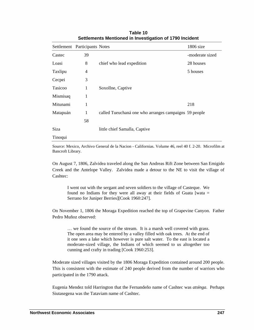
Northwest Economic Associates 247
Table 10 Settlements Mentioned in Investigation of 1790 Incident
Settlement Participants Notes 1806 size
Castec 39 -moderate sized
Loasi 8 chief who lead expedition 28 houses
Taxlipu 4 5 houses
Cecpei 3
Tasicoo 1 Soxollne, Captive
Mismisaq 1
Mitunami 1 218
Matapuán 1 called Tueuchaná one who arranges campaigns 59 people
58
Siza little chief Samalla, Captive
Tinoqui
Source: Mexico, Archivo General de la Nacion - Californias. Volume 46, reel 40 f. 2-20. Microfilm at Bancroft Library.
On August 7, 1806, Zalvidea traveled along the San Andreas Rift Zone between San Emigido Creek and the Antelope Valley. Zalvidea made a detour to the NE to visit the village of Cashtec:
I went out with the sergant and seven soldiers to the village of Casteque. We found no Indians for they were all away at their fields of Guata [wata = Serrano for Juniper Berries][Cook 1960:247].
On November 1, 1806 the Moraga Expedition reached the top of Grapevine Canyon. Father Pedro Muñoz observed:
… we found the source of the stream. It is a marsh well covered with grass. The open area may be entered by a valley filled with oak trees. At the end of it one sees a lake which however is pure salt water. To the east is located a moderate-sized village, the Indians of which seemed to us altogether too cunning and crafty in trading [Cook 1960:253].
Moderate sized villages visited by the 1806 Moraga Expedition contained around 200 people. This is consistent with the estimate of 240 people derived from the number of warriors who participated in the 1790 attack.
Eugenia Mendez told Harrington that the Fernandeño name of Cashtec was atsïnga. Perhaps Siutasegena was the Tataviam name of Cashtec.

Northwest Economic Associates 248
According to the 1851 Tejon Treaty, Rafael was the chief of Castake. Johnson has identified Raphael as a Tataviam man (1997:263).
John Johnson wrote an article discussing the location of Cashtec and its relevance to understanding ethnographic and linguistic data (1978).
Archaeological site KER-307 contained many historic period artifacts and is the remains of the village of Cashtec (Jennings 1976).
Suijuiyojos
Suijuiyojos was probably in the upper Piru drainage. In 1806, people of Cashtec led the Moraga Expedition to a village on the trail to San Fernando.
… we came to another of the same size but hidden among ravines and badlands. The number of inhabitants could not be determined because they were absent at a fiesta in another village nearby [Cook 1960:253].
Most Suijuijos baptisms were at San Fernando Mission and most Cashtec baptisms were at San Buenaventura Mission. Sujuijos had ties to Cashtec. The three Cashtac baptisms at San Fernando include two sisters baptized in 1837 whose parents were from Suijuijos. Johnson notes that Raphael and “Chico”were co-chiefs of the “Surillo” or “Cartaka” [sic] tribe in 1862. He notes this referred to the Suijuijos and Cashtec settlements (Johnson 1997:264, 286). Possibly Cashtec and Suijuijos were seasonal settlements of the same people.
Tachicoyo
Soxoline from Tasicoo who participated in killing soldiers in 1790 was one of two non–Christians taken captive. On September 28, 1790, 8 year old Sebastian Antonio Sumqiyuqui of Tachicoyo was baptized at Ventura Mission (Vb1 537). He was the only person baptized from the settlement. The time of baptism corresponds to the period that the September 1790 expedition to apprehend Indians was conducted, and he was probably baptized during the expedition. No entries for his death or marriage were found at Ventura. Perhaps Sebastian Antonio transferred to another mission. He was baptized on the same day as his sister, the only Tacuyaman baptism at Ventura Vb1 538.
Vb 538, Japutammegue, of Tacuyaman [the Chumash name for the Tataviam settlement of Chaguayanga in Santa Clarita] was daughter of a Cashtec father and sister of Vb 537, Sumgiyuqui, son of a dead father of Tachicoyo; his mother was Sicsayeulelene of Sespe. Possibly Tachicoyo is the Chumash name of a Tataviam rancheria such as Tochonanga whose Chumash name is not known.

Northwest Economic Associates 249
In January 1788, Sargent Pablo Cota led twelve soldiers into the mountains somewhere northwest of San Fernando to recapture Domingo, a refugee. The natives of Tachicoó village were frightened and a battle ensued in which three soldiers and eight Indians were wounded and three Indians killed [Forbes 1966:142].
Tochononga was located in the mountains northwest of San Fernando and may be the same as place as Tachicoyo. When Harrington asked about Tachecoyo, Jose Juan Olivos told him tats’ik’oho was over by Los Alamos somewhere here in the Tejon Ranch. It is therefore included in the list here.
Tshipowhi
José Juan Olivos told Harrington that tshipowhi was at La Pastoria. It was a village at the mouth of Pastoria Creek inhabited by Castequeño and other Indians in Spanish times.
Mismisaq
Mismisaq- mentioned in 1790 list of participants in attack on Spaniards near Tashlipun.[note Elmismey at San Luis Obispo]. The location of this possible Tejon area settlement is not known.
Matapjahua
Vb Matapjahua. This place was known to Harrington’s Tejon consultants. The location was apparently not visited by Spanish expeditions.
Matapjahua means place of the fox ha’w according to Harrington consultant Jose Juan Olivas (Jam. paKahung= reed place). Mat’apqa’w – up Piru Creek in an area of a large Cienega. Most of Harrington’s information concerning this place came from Eugenia. Fernando did not know the place.
Eug locates it clearly on the same arroyo as the Piro. You go down the arroyo from mat’apqaw and without passing any ridge at all you reach Piro. It is over west of La Liebre. Mat’apqa’w is a great cienega that extends far up and down the creek. An American whose name Eug does not know, has lived there for many years, raising potatoes. In former times when the arroyo at mat’apqa’w was high, one could not cross it. A great volume of water ran down to El Piro, thence to Saticoy and to the sea.
I asked Eugenia if she knows the name of the big mountain immediately back of el Piru. Eugenia says that mountain is called KihKitKing. The trail that led from the Piro to mat’ap qaw ascended that mountain going straight up. The trail was all hidden with chamiso. It was steep , muy feo. It is a big

Northwest Economic Associates 250
mountain. When I ask whether it was this side or the other of El Piro Creek, Eug says it was this [Tejon?] side. Es nombre de ellos, a V. name.
John Johnson has identified the location indicated on the map on the basis of historic and ethnographic information.
Santa Barbara Ranger District: Central Chumash Locations
Santa Ynez Valley
The following table lists sixteen Santa Ynez Valley settlements that are on or near the Los Padres Santa Barbara Ranger District. The information is taken from Johnson (1988:98, 99) and McLendon and Johnson (1999 A VIII-7). The table lists villages from west to east on the northern side of the Santa Ynez Valley. It then lists the villages on the south side and on the Santa Ynez River from west to east.
Table 11 Santa Ynez Valley Chumash Settlements in and adjacent
to the Los Padres National Forest
Settlement Chumash name
Translation of Name Site # of Bapt 1797 Houses
Jonjonata xonxon’ata tall oak SBA-235 98 16 Sotonocmu soxtonokmu
’ ? SBA-167 &
564 193 50
Aquitsumu ‘aqitsu’m sign, landmark, boundary
SBA-809 98 20
Stucu stuk wooden bowl SBA-1645? 111 25 Huililic wililik’ Baccharis plummerae SBA-871? 52 8 Sajcaya saq’ka’ya ? SBA-1283? 37 - Najue naxuwi meadow SBA-1183? 106 20 Calahuasa kalawashaq’ turtle shell (?) SBA-516 182 30 Tegueps teqepsh seed-beater SBA-477 180 25 Elijman he’lxman the chaparral mallow SBA-485 22 10 Huisap wishap yerba santa SBA-865? 56 - Miasapa mi’asap? antlers place (?) SBA-842? 25 - Snojoso shnoxsh its nose, point of land SBA-123? 31 - Snihuaj shniwax crossroad SBA-823? 83 - Siguaya siwaya suwa’ja = to hang,
earrings? SBA-1800 35 -
Snajalayegua shnaxalyiwi ? SBA-1309 106 -

Northwest Economic Associates 251
Johnson’s detailed ethnohistoric studies of settlements in the area and his dissertation provide information concerning Santa Ynez Valley area settlements. Details concerning the settlements listed above can be found in Johnson (1984, 1987 and 1988).
Santa Barbara Coast
The following are places along the Santa Barbara Coast. The list begins at Gaviota and continues east to Carpinteria. This listing of coastal places includes places that are not listed in mission registers. Some are places were listed by Cabrillo and others are places mentioned by consultants as settlements to Alexander Taylor and John Harrington. Alan Brown’s study of the population of coastal Chumash villages contains additional information concerning settlements occupied during the period of the Portola expeditions and the period of mission recruitment (Brown 1967). The original Crespi diaries also contain important information not included in the following summaries (Brown 2001).
Nomigo - Harrington from Fernando - ‘onomyo. Pico-Henshaw 5 La gaviota Onomio
O-no’-mu-o. - The Spanish name gaviota means seagull. Crespi notes that the soldiers call the place Gaviota because they had killed a seagull there (Brown 2001:651). The Chumash word for seagull is listed by Pinart as – Inzeño – aneso, Ventureño – anesô, Barbareño - aniso and Purisimeño – côlo [Island Chumash].
Fernando Librado told Harrington he: “knew an Indian named ‘onot’ (Torivino) for La Gaviota. Harrington listed Santa Barbara register entries Onosyot and Anosio for ‘onomjo’. The La Purisima registers list Nomigo and the San Luis Obispo registers list Lomio [Lb 561, 566]. The names may all mean seagull in Chumash languages spoken at the different missions. Alternatively, and probably, Johnson has suggested that nomyo might mean canyon (1988:93).
Archaeological site SBa-97 is part of the historic settlement of Nomigo.
In 1769 Crespi described a political leader El Loco from Nomigo who traveled with the Portola expedition to and from the Pismo area and arranged for the expedition to be fed (King 1984: I-38 and Brown 2001).
Lehpew - lehpew = P. ‘the white one’, village at Canada del Cemetario (Applegate 1975:34)
SBa-95 and 2038 are sites that may be the remains of Lehpew.
Uctc’ymatc’mu - uctc’ymatc’mu - ‘cemetery’
Northwest Economic Associates 252
Harrington notes: Fernando Librado: There was an Indian village at Alcatraz, just east of Gaviota where oil works are now. That village was called uctc’ymatc’mu that means cemetery. The Indians named that village after the cemetery there, but why, Fernando does not know.
In 1776, Font observed an abandoned village “which had nothing but the cemetery” between La Quemada and Gaviota (Bolton 1931:262). This cemetery may have been part of the remains of the village of uctc’ymatc’mu or Tuqmu. The next canyon west of Alcatraz is called Cañada del Cementario (Cemetery Canyon in Spanish).
Archaeological sites in area include SBA-94, 1870 and 2189 ?. Stephen Bowers excavated extensively at Cemetery Canyon in 1876-1878 (Benson 1982:68, 76, 176-177).
Hyp’i mehweneec - Fernando in Harrington unindexed notes: There was a small Indian village at Piedras de Molar Canyon. Which means in Spanish grindstone or sharpening stone canyon. The Indian name is qyp’i meqweneec which means the same as the Spanish name. This Indian name is in the Santa Barbara language. Both Santa Barbara and Cruzeno were talked at this village. This was possibly a post-secularization settlement
Tucumu - tuhmu’. village at Arroyo Hondo (Applegate 1975:45). Pico-Henshaw 7 Arroyo ondo Tujmu, Tu’k’-mu
Alexander Taylor reported in the California Farmer (April 17, 1863) : “Tucumu or playa of Arroyo Hondo.”
One of the mainland coast Chumash town names listed in the narrative of the 1542 A.D. Cabrillo expedition was Tucumu (Wagner 1929: 86).
Harrington notes: Fernando Librado: Tuqmu was Arroyo Hondo; it means “as long as there is anyone living there, I have a right to harvest whatever there is.” Fernando also identified Tuqmu with the “rancho de piedra (Pedro) Ortega.” He said both Cruzeno and Santa Barbara dialects were talked there. Juan Justo also identified Tuqmu with Arroyo Hondo.
Tuhmu and some of the other villages that can be identified with names in the Cabrillo lists were apparently abandoned prior to the 1769 Portola land expedition (King 1975: 172). Tuhmu is not listed in the registers of any of the missions that recruited from the coastal villages of Nomgio at Gaviota and Sisuchi at Quemada located respectively west and east of Arroyo Hondo and was therefore probably abandoned before the period when the missions recruited from villages in the area.
Silverio Konoyo apparently spent the last years of his life at Tuhmu. Described as being very old in 1855, Silverio was a Santa Rosa Island Indian, a fishing partner of José Venadero (Hudson, Timbrook , and Rempe, 1978:178), and a member of the Brotherhood of the Canoe.

Northwest Economic Associates 253
Silverio was also one of the men who took part in the disastrous voyage from Cojo to San Miguel Island around 1815. He was in one of two boats that returned. Konoyo means “always green” (Hudson, Timbrook , and Rempe, 1978:149). In 1855, Silverio, Aniceto (a Santa Barbara Indian), Pedro Ortega (Anacito’s brother-in-law), and Jose Manuel constructed a dugout at Arroyo Hondo (Hudson, Timbrook , and Rempe, 1978:170). In 1857, Silverio was said to be living in a hut on the lower end of Arroyo Hondo (McGowan 1857:77).
Villages such as Tuhmu that were named in the Cabrillo logs but were not occupied in or after 1769 are of particular interest because of their early abandonment. It is possible that SBa-1151, 1982 or another other site near the mouth of Arroyo Hondo is the remains of Tuqmu.
Sisuchi, Achi - shushutshi shishuch’i’ = B. ‘den of the woodrat’, village at Arroyo Quemada (Applegate 1975:41). Pico-Henshaw 8 La quemada Shushuch,y, Cú-cu-tcí. Henshaw list C. 8. Su-su-tei (Heizer 1955:199).
Taylor California Farmer 13,22: The following of these rancherias we had located by an old Indian Martin, now sixty years old --- Sisichii, in Dos Pueblos, Sauchu or the Quemada, Sisuchi, Situchi, Sisichi.
At La Purisima Mission the village was called Achi and at San Luis Obispo Mission confirmation 492 lists Vache.
Sisuchi is listed in the Cabrillo narrative as Susuquei (Wagner 1929:86).
Sisuchi was a Mission Period village located at Arroyo Quemado (Brown 1967:22-23).
Harrington notes: Juan Justo shishutsh’i’i and shushutsh’i’ = La Quemada. Fernando Librado: cuqkujni means “burned.” The B. word ashushto means ‘burned’. The B. Indians called Pot rests ashushto. They used three. The I. shushushtoj, meaning burned. ‘ashushto in I. means a stone with a hole in it used for cooking acorn mush. The V. call this kind of stone shushto’. This name is applied to the Rancho de Don Pedro Barron a Frenchman. Cañada de la Quemada old Indian name. Shushítshi = La Quemada, between Arroyo Hondo and Tajiguas.
During the protohistoric period, it appears that many small settlements were abandoned at the same that time large centers were growing. During many prehistoric time periods populations were more dispersed among small settlements than after 1769. Along the coast, the distance between most settlements was probably less than four miles. People would usually travel only a mile and a half and at most four miles to reach the boundary with the next village area. Given these conditions there was little need for camps other than day use areas along the coastal terrace.

Northwest Economic Associates 254
Table 12 lists villages between Arroyo Hondo and Refugio and the times that historic documents indicate they were occupied.
Table 12 Protohistoric and Historic Settlements
References to Villages in Historic Sources
Village Location 1542 1769-70 1776 Missions 1796 Census
Tuqmu Arroyo Hondo Yes - - - -
Sisuchi Arroyo Quemado Yes - small Yes 250 people
Tajiguas Tajiguas Creek - 400 people abandoned - -
Casil Cañada del Refugio Yes abandoned new Yes 142 people
Historic and ethnographic information document the founding of new villages and the abandonment of others as a result of wars with powerful neighbors. This information indicates that, although villages were occupied throughout the year, villages did change location as the result of warfare and other causes.
The villages of Casil and Sisuchi were recorded as the birthplaces of many Indians baptized at Santa Barbara, La Purisima and Santa Ynez missions. The villages of Sisuchi and Casil apparently grew as a result of immigration during the Spanish conquest of the region. This growth occurred while other coastal villages were decreasing in size largely as a result of increased mortality from disease and recruitment into Spanish missions. Sisuchi and Casil were apparently occupied in 1542 since their names appear in lists of Chumash village names made by Cabrillo (King 1975). At the time of the Portola expedition in 1769-1770, the villages were not occupied. At Refugio Creek, Crespi noted there was “an old abandoned village, and it seemed a better place to me than this one (Tajiguas), and more extensive” (Brown 1967 24).
In 1776, the Anza expedition observed a new village (Nueva) at Refugio, an abandoned village at Tajiguas, and a small village that was probably Quemada. In 1782, Pantoja y Arriaga plotted a large village that appears to be located at Quemada. His journal described “a large village on the height of the bluff and very close to shore, with the trees nearby.” In 1796, Goycoechea reported a population of 250 people at the town of Quemada that by then was the highest population of any Channel town. He recorded 142 at Nueva. In 1798, Fr. Tapis mentioned “Casil or Nueva, and Sisuchui or Quemada, where many mountain Indians (people from the Santa Ynez Valley region) are living” (Brown, 1967: 22-23). The Spanish name Quemada means burnt and may refer to an early destruction of the village by fire.

Northwest Economic Associates 255
Stephen Bowers excavated on both the east and west sides of Quemada Canyon in 1876 and 1877 (Benson 1982:68, 135). CA-SBa-91 is part or all of the remains of the historic village of Sisuchui.
Tajuigas - Tahiwah - I. ‘to leak’, Tajuigas Creek (Applegate 1975:43)
Tajuigas was a protohistoric village located at Tajiguas Creek (Brown 1967:23-24). It is not mentioned in mission registers.
Harrington notes: Fernando: Tajiguas is the next canyon beyond del Corral Canyon. There is a fine lemon orchard there. Tajiguas is an Indian name. There is a fine beach, a fine little cove. There is quite a bit of back country. That is the old Ortega place. The Ortegas were swindled out of it. The Indian name for Tajiguas was taqiwaq, a word in the Cr. language that means “there passed one or some,” meaning that one or some passed thru there.
The protohistoric village of tahiwah was abandoned prior to the Mission Period. It was called San Guido by the 1769 Portola expedition. At the time of the Portola Expeditions in 1769-1770 Tajiguas was estimated to contain 400 people. The settlement was described as containing clusters of 42 and 37 houses on opposite sides of the creek. (Brown 1967:23-24).
On December 29, 1775, Rivera, the military governor of California, mentioned the destruction of what was probably the village of tahiwah during a recent war.
I pity the people of a rancheria (settlement) where at another time the houses were counted and they exceeded 90; this time besides finding them in a different place, there are fewer than 35 (houses). It (the village) was destroyed by the unconverted of San Pedro and San Pablo (Dos Pueblos) who are the neighbors to the east (Burrus, 1967: 223).
In 1776, the Anza expedition members also found tahiwah abandoned and Font observed that its people had gone to Rancheria Nueva (Casil or Refugio) because of a war with their enemies (Brown 1967:23-24).
SBa-90 was considered by David Rogers to be a companion village to SBa-89 on the opposite side of Tajiguas Creek (Rogers 1929: 247). The frequencies of artifacts recorded from the surface of the site indicate that the site was probably occupied during the Early Period. Perhaps the historic village was located at a lower elevation as indicated by Crespi’s statement that the village was on the very edge of the sea with the creek separating the two areas (Brown 1967: 23). Site SBa-1988 may represent a portion of the east half of the historic village at tahiwah along the edge of Tajiguas Creek.

Northwest Economic Associates 256
Casil - qasil = ‘beautiful’? in Dos Pueblos dialect, village at Canada del Refugio (Applegate 1975:38). Pico-Henshaw 9. El Rufugio Kasil, Ka-síl. Henshaw list C. 9. Ortega’s Ranch (Heizer 1955:199).
Taylor in Farmer, 13,22: Casalic, at the Refugio playa and Canada; Cascili, in the Refugio playa.
Casalic in Cabrillo narrative between Aguin (Las Llagas) and Tucumu (Arroyo Hondo) (Wagner 1929)
Casil was a Mission Period village located at Refugio Beach (Brown 1967:24).
Harrington notes: Juan Justo: kasil, Refugio Arroyo. Luisa Ygnacio = kásil. Fernando Librado: kasil, next canyon east of Tajuigas apparently = Refugio. The old rancheria was at the west side of its mouth. The Indian village at Refugio was called kasil, a word of the Cr. language. Informant says that kásil means in Spanish “una extension de belleza ó hermosura.” It is so called because it is a very pretty place. In Santa Inez, the principal dialects heard were those of soxotonok’mu [Almo Pintado] and kasíl. Refugio was a big village, was a center for it was a port of the tshumash [Santa Cruz Islanders] and trail led to Santa Ynez and [there was] much trade in bellotas [acorns], islay [wild cherry] etc. from Santa Inez when the Islanders came.
Fernando Librado discussed the protohistoric colonization of the village of shawa on Santa Cruz Island by people from qasil and the failure of the colony. He said that the colonists were not well received when they returned to qasil and most moved to the Santa Ynez Valley where they founded a colony at soqtonk’mu (Harrington 1912-1917).
qasil was apparently an important trade center. In 1913, Fernando told Harrington about trade between the islands and the interior.
There was commerce between inland and island Indians at Casil; they exchanged otter skins. …. Refugio was a big village, a center, for it was a port of the Santa Cruz Island Indians; a trail led to Santa Ynez, and there was much trade in acorns, islay, etc. from Santa Ynez when the islanders came.
In December 1804 after the termination of native coastal villages, Governor Arrillaga wrote the following note to the commander of the Santa Barbara Presidio. “It shouldn’t be your duty to transfer the mountaineers who solicit at the Arroyo of El Capitan and at the Arroyo of Casil” (King 1976: 294).
Johnson has identified several descendants from the family of Juan de Jesus Justo, a Harrington consultant, whose parents, Juan and Cecilia, were from qasil. These descendants

Northwest Economic Associates 257
now live in Santa Barbara, Ventura, and at the Santa Ynez Indian Reservation (John Johnson, personal communication 1987).
CA-SBa-87 is probably the location of the historic village of qasil or Nueva at Refugio. CA-SBa-87 contains a known cemetery, a temescal, earth ovens, and other significant Chumash remains (SLC, 1986: 3-109). SBa-87 is composed of several areas that were not all occupied at the same time. A cemetery at the site that was excavated by David Rogers was used during Middle Period Phase 4 (ca. A.D. 700-900) and the higher ground that was excavated prior to widening of Highway 101 in 1969 also contained artifacts and features characteristic of Middle Period occupations. In 1969, a bulldozer was used to remove overburden at the site and a shell midden was found on the floodplain on the west side of Cañada del Refugio Creek. Shovel test pit excavations also discovered midden deposits on the east side of Cañada del Refugio Creek (Neff and Rudolph 1986, Vol. II: CE-001-5). The site areas adjacent to the creek may be the remains of part of the historic village of Casil.
Ajuawilashmu - ‘ahwawilashmu = B. ‘dancing place’?, village at El Capitan (Applegate 1975:25)
Pico-Henshaw 11. Punta capitan Ajuawilashmu, A-wha’-whi-lac-mu a star indicates that this village was a capitol or more populous and important town where festivals, feasts and perhaps councils were held.
Alan Brown noted:
In May 1770 a “small sized Village” was encountered at what appears to have been Capitan Creek (or a bare possibility, Corral Canyon) and named Santísima Cruz by Crespi (1967:24-25)
The settlement was apparently temporary or abandoned before recruitment to missions and is not mentioned in later documents.
Harrington notes: Fernando: Thought this might be for apanishmu. ‘aqwawilashmu would mean merely Spanish “bailadero,” “dancing place.”
Stephen Bowers excavated at El Capitan Canyon in 1877 (Benson 1982:76). SBa-64 and 131 are near the mouth of Cañada del Capitan.
Aguin - ‘ahwin - village at mouth of Las Llagas Canyon (Applegate 1975:25)
Taylor in Farmer, 13, 22 (April 17, 1863): Aguin at the beach of Los Llagos Canada.
Aguin in Cabrillo narrative in order after Susuquei [shushítshi, Quemada], Quanmu [kuya’mu, Dos Pueblos], Gua [quwa’, Mescalitan Island in Goleta Slough], and Asimu

Northwest Economic Associates 258
[unidentified] and precedes Casilic [qasil, Refugio] and Tucumu [tuhmu’, Arroyo Hondo] (Wagner 1929:86). This listing is clearly not in order, although the identified places are in the same general area of the coast between Arroyo Hondo and Dos Pueblos.
Harrington notes: Fernando Librado: First comes the Canada de las Llagas - Buell’s ranch used to be there. Then comes the Canada de la Aguillilla, “Canyon of the Little Eagle,” then comes Naples Canyon. ‘ahwin = The “estiladero” (means in Spanish “where the water seeps through from estilar, to seep through). The place is now generally known as El Estiladero. Two hundred yards west of Las Llagas Canyon there used to be some little pools there. Sort of spring on beach-- a short distance up from base of cliff. Traveling people used to stop to drink. Las Llagas is now the Buell ranch but was formerly part of the Dos Pueblos ranch and owned by Mr. Nicholas Den. El Estiladero is called in Indian ‘aqwín. The name is connected with ‘aqwí, covija. This name means “covered rock” = piedra covijada (por agua). Means that water seeps out all over the rock, runs all over it, covers it. That is the way it used to be -- it must be the same way now. Ortega: All vicinity of Las Llagas was under mikiw -- but had provisional or temporary rancheria thereabouts. Informant knows no name for whole. seqpewejòl was the name of capitan of mikiw rancheria. He had a son named Francisco Solano, also called seqpewejòl (junior). He was capitan of whole territory between the baranco west of Las Llagas canyon as far west as Cañada Corral.
Artifacts recovered by David Rogers from archaeological site CA-SBa-82 indicate it was occupied during early Phase 2 of the Late period. CA-SBa-82 was probably the settlement of ‘ahwin at the time of Cabrillo’s voyage.
Dos Pueblos - It is believed that SBA-78 on top of the mesa on the west side of Dos Pueblos canyon was the settlement of Miquigui and that the smaller settlement in the canyon was Cuyamu.
On August 22, 1769, Crespi observed:
… close to two large villages, of which one is on a tableland at the edge of a hollow with a good sized stream of running water, while the other is in the hollow itself at the very edge of the stream. They are well populated villages with a great many houses in them, and a great many heathen folk of all sorts who must number no less than six hundred souls [Brown 2001: 429-431].
Miquigui - Mikiw = ‘on the other side’? in Dos Pueblos dialect of B. (Applegate 1975:36)
Pico-Henshaw: 12. Los dos pueblos Migiw, Mi-gi-w. A star indicates that this village was a capitol or more populous and important town where festivals, feasts and perhaps councils were held. Henshaw list C. 12. Mi-ki-wi (Heizer 1955:199).

Northwest Economic Associates 259
Taylor in California Farmer 13, 22, July 24, 1860: The following of these rancherias we had located by an old Indian Martin, now sixty years old --- Miguiqui, on the Dos Pueblos. Mekewe. Farmer 13, 11, May 4, 1860: Los Dos Pueblos Mickiwee -- about 18 miles from Santa Barbara Mission. Mekewe.
Johnson has suggested that mikiw may mean place of mussels (1988:93).
This village may be listed in the Cabrillo narrative as Maquinonoa or Micoma (Wagner 1929:88). It is possible that like the other largest Santa Barbara (and largest in Southern California) villages of sahpilil and helo, the historic town of mikiw was not founded in 1542. Most of the beads and other artifacts found at these sites are consistent with foundation after Cabrillo and before the 1769 Spanish land expedition.
Miquigui ò Los Dos Pueblos was a Mission Period village located at Dos Pueblos Canyon. Crespi estimated that the village on the west side of Dos Pueblos Canyon had a hundred houses and 800 people (Brown 1967:25-28).
Harrington notes: Juan Justo: mikiw, Dos Pueblos. Old rancheria site of mikiw is south of adobe house and north of railroad track, in canyon. Mission used to have a garden there. The other village was on the hill west [sic.?] of mikiw. Luisa Ygnacio: Dos Pueblos Canyon is next after Eagle Canyon. Called Dos Pueblos canyon mikiw. Fernando Librado: [discussion with Harrington- The Pico-Henshaw list order indicates] It is therefore perhaps likely that Mi-gi-u refers to the village on the west side of the creek. Informant corrects: mikiw, which applies to the whole arroyo. There was a pueblo at the east side of the mouth of Dos Pueblos canyon, and one at the west side. Informant does not know any place name there except that one of the two villages was called mikiw. Simplicio Pico: mikiw = one of the Dos Pueblos - may have heard. Never heard of two pueblos there. But knows name is Dos Pueblos. Does not know how to say lindero, boundary of land in Ventureño. Fernando Cardinas: Juan Maria Olivas was an old Spanish soldier who came along with Fr. Junipero told informant that dos Pueblos was so called because there was a rancheria at each side of creek. The rancherias were on mesas. Indians went down for water. The rancheria was on mesa a little further back than the ranchhouse of Nicolas Den. Old road used to pass between Den’s house and the rancheria. Were also Indians living by mouth of creek. Was permanent water at mouth of canyon. Informant has heard nothing about these rancherias being enemies.
Mikiw was apparently the larger of the two protohistoric-historic towns “Dos Pueblos” at the mouth of Dos Pueblos Canyon. It has been tentatively identified with CA-SBa- 78. The historic cemetery at this site was excavated in by several archaeological expeditions in the later part of the 19th century. In 1875 Yarrow and Rothrock who were part of the U.S. Geographical Survey Expedition for Exploration West of the 100th Meridian conducted excavations in the historic cemetery at CA-SBa-78 (Yarrow 1879:40-42). They were followed in the same year by Paul Schumacher. He described the settlement:

Northwest Economic Associates 260
“One town was very prominently located on the mesa land, on the right side of the stream, near the shore; the other one, below on the sloping left bank of the same creek. It is said that the creek had been the boundary-line between two tribes, distinct in language as well as in customs” (Schumacher 1877:52).
Harrison excavated at CA-SBa-78 in 1958. He excavated an historic period sweatlodge, parts of several Early period cemeteries and in midden that contained Middle period artifacts (Harrison 1964: 203-234, 1965).
In 1979, a thorough surface survey was conducted on the mesa on the west side of Dos Pueblos Canton of both CA-SBa-78 and CA-SBa-79. One of the conclusions of the study was:
William Harrison used the road to the Dos Pueblos orchid farm to define the northern boundary of SBa-78. In our survey, we found artifacts and other evidence of prehistoric human activity from the orchid farm road to the Pacific Coast Highway. We have therefore decided to arbitrarily use the orchid farm road as a division between SBa-78 and 79 [King and Gamble 1979:11-12].
The CA-SB-78 and 79 site area appears to consist of many overlapping villages that were occupied during the last 8000 years. Similar concentrations of large village sites have been documented at Rincon (King 1980b) and in other areas of the Santa Barbara Channel where large historic settlements were located (King 1990:90-91). It appears that the historic part of the site complex is concentrated on both sides of the railroad tracks near the mouth of the canyon.
Cuyamu - kuya’mu (Applegate 1975:34). Pico-Henshaw: 13. Los dos pueblos Cuyamu, Ku-i-yámu. A star indicates that this village was a capitol or more populous and important town where festivals, feasts and perhaps councils were held. Henshaw list C. 13. Kui-a-mu (Heizer 1955:199).
Taylor in California Farmer 13, 22: The following of these rancherias we had located by an old Indian Martin, now sixty years old --- Cuyamu, on the Dos Pueblos. Kuyam or Cuyama.
Johnson has suggested that kuya’mu may mean place to rest (1988:93).
Cuyamu was listed in the Cabrillo narrative as Quanmu and Quiman (Wagner 1929:86, 88).
Cuyuamu was a Mission Period village located at Dos Pueblos Canyon. The members of the Portola expedition apparently did not give a count of the number of people at this town separate from that of mikiw. Brown estimates that the populations of both settlements totaled approximately 1100 people. It appears that between 300 and 500 people lived at this town (Brown 1967:28).

Northwest Economic Associates 261
Harrington notes: Luisa Ygnacio: The two rancherias at Dos Pueblos were mikiw and kujá’mù but Luisa does not know their relative location. For this reason the place was called Dos Pueblos. Luisa does not know of any “last woman of Dos Pueblos” who used to work for and talk with Doña Rosa (Den). Luisa knows of Doña Rosa well. Luisa verifies that she does not know which rancheria was to the west and which was to the east of the two at Dos Pueblos.
The reference to Doña Rosa apparently relates to the following statement by Yarrow:
We were informed by Mrs. Welch that she had heard from an aged Indian woman that two separate tribes, speaking different dialects, lived on opposite sides of the creek, which constituted the boundary line between them, and that the tribes were not permitted to cross this creek without first obtaining each other’s consent. This old crone for many years continued to visit this spot annually to mourn the departed greatness of her people [1879:41].
This is the smaller of the two protohistoric-historic towns “Dos Pueblos” at the mouth of Dos Pueblos Canyon. It has been identified with CA-SBa-77. The name of this town is mentioned in the Cabrillo log and it may have been founded before the historic settlement of Mikiw.
Helapoonuch –
hel’apunitse - B. ‘the guitarra fish’, village at mouth of Tecolote canyon (Applegate 1975:29)
Taylor: El Tecolote--Helapoonuch-- about 15 miles from Santa Barbara Mission (California Farmer 13,11, May 4, 1860).
SBa-73 at the mouth of Tecolote was occupied during early Phase 2 of the Late period and may have been occupied at the time of Cabrillo’s voyage. It is perhaps the location of one of the unidentified village names in Cabrillo’s log. Sites in the Tecolote canyon area are apparently the remains of settlements occupied during the last 8000 years (King 1980a).
Goleta Slough Towns - The records of the Spanish missions and the Pico Henshaw list record four settlement names in the Goleta Slough area. A 1782 map (Figure 47) indicates that presence of seven house clusters. Some of the house clusters have not been identified as archaeological sites. (Johnston, Warren and Warren have summarized information concerning Goleta Slough ethnohistory (1982: 28).
Crespi described the Goleta Slough in 1769:
Of all of the spots upon the entire Channel, this one has the greatest number of heathen folk. There are five villages, three quite large ones which we all

Northwest Economic Associates 262
saw, while the other two were reported of by the scouts who had seen them in the surroundings of the place. One of these three lies islanded upon a knoll that must be a quarter league in length, next to the sea, and isolated upon the inland side by a good sized inlet that has one mouth at either end of the said knoll’s length, through which the tide comes in with the sea lying upon the other side, the inlets width must be half of a quarter league. The village lying thus islanded is an extremely big one in its heathen population: so far as we could tell from the distance we were viewing it , there must be over a hundred very large round, very well roffed houses, and we guess there can only be less than eight hundred souls in this village alone. They have both water and wood there, or so we understood from the heathens themselves who all came to the camp; and there are sixteen canoes which they use in fishing in the aforesaid inlet and in trading when they come to shore [Brown 2001:421].
Geliec - heliyik B. ‘the middle’, village in Goleta Slough (Applegate 1975:29). Henshaw list C. 16. Near ocean near Moore’s Island (Heizer 1955:200). Pico-Henshaw 16 San Miguel, La Patera, four towns inhabited by the indigenous tribes Heliyec, Hel-i-uik A star indicates that this village was a capitol or more populous and important town where festivals, feasts and perhaps councils were held.
Archaeological site SBA-47, 48 and possibly SBA-1695 are the remains of Geliec (Johnson 1988:94).
Anacbuc [Cabrillo period settlement] Taylor in Farmer 13,22: Anacbuk or Anacarck , near the islet of La Patera, near the seashore. This settlement was probably near the historic settlement of Geliec.
Gelo - helo’ = B. ‘the water’, village on Mescaltitan Island (Applegate 1975:29). Pico-Henshaw 15 San Miguel, La Patera, four towns inhabited by the indigenous tribes Heloh, Hel-ó. Henshaw list C. 15. At Moore’s Island (Heizer 1955:200).
Archaeological sites SBA-45 and SBA-46 contain the archaeological remains of the site of Gelo. Gamble has studied the historic midden at SBA-46 and discovered house remains at the site (Gamble 1990 and 1991). The area of the site that was occupied reduced greatly around 1782. This was possibly the result of migration to other slough towns.
quwa’ [Cabrillo period settlement Gua= probably Qua] Mescalitan Island (Applegate 1975:39)
(Johnston, Warren and Warren 1982: 28). This settlement was probably the part of SBA-46 that is on the south edge of Mescalitan Island. The historic residential area of Gelo was on the east edge of the island.

Northwest Economic Associates 263
Figure 47 Pantoja map of 1782 of the Goleta Slough area. The large village (cluster of house circles) on the north edge of
the slough is the historic village of S’ahpilil (Whitehead 1982:131).

Northwest Economic Associates 264
Alcas - ‘alkash = B. ‘one that sits’? Village on E side of Goleta Slough (Applegate 1975:25)
(Johnston, Warren and Warren 1982: 28)
Pico-Henshaw 17 San Miguel, La Patera, four towns inhabited by the indigenous tribes Alcaash, Al-ká-ác’
Henshaw list C. 17. Al-ka’c, Near Moore’s house (Heizer 1955:200).
Archaeological site SBA-42 and possibly SBA-1696 is the remains of Alcas (Johnson 1988:94).
paltuqaq - [Cabrillo period settlement] = cemetery site in Santa Barbara (Applegate 1975:38). This site was probably on Moore Mesa near the historic village of Alcas.
Saspilil - The village of s’ahpilil was adjacent to San José Creek. s’ahpilil ‘B. ‘root’, village on Goleta Slough (Applegate 1975:39). Pico-Henshaw 14 San Miguel, La Patera, four towns inhabited by the indigenous tribes S.ajpilil, S’pi’lil. Henshaw list C. 14. Sa-pi’-li’ ,road to island, large village (Heizer 1955:199).
Taylor in Farmer 13,15 May 4, 1860: The district of La Patera was known among them as Mescalitan with four rancherias called Salpalil, Helo or the islet, Alcas and Oksbullow. [This information was apparently obtained by Taylor from his father-in-law Daniel Hill who wrote the same in 1859 (Woodward 1934:120)]. Farmer 13,22 April 28, 1863: Salpilil, on the Patera. 6 miles from Santa Barbara Mission; Cajpilili. Sacspili.
This village is not listed in the Cabrillo narrative. It is possible that like the other large Santa Barbara villages of mikiw and helo, s’ahpilil had not been founded.
Saspilil was a Mission Period village located on the north edge of the Goleta Slough. Santa Barbara and San Buenaventura Missions baptized people from this village. The Goleta Slough towns were the most populous in all of Southern California in 1769 and were estimated to have 1500 people in 1769 (Brown 1967:29-32). A map made by Pantoja in 1782 (Figure 47) shows this village as the largest in the Goleta Slough area (Whitehead 1982:130-131). In 1776, Font described this as the largest of the Goleta Slough towns (Bolton 1931). It appears that Saspilil did not lose population as rapidly as other slough towns. It is possible that people from other settlements such as Helo’ may have migrated during the early historic period to Saspilil (Gamble 1991:31-33, 445).
Harrington notes: Luisa Ygnacio: s’aqpilil rancheria where the town of Goleta (not Patera) now stands. A store there burnt down and has been rebuilt and serves to identify La Goleta. Juan Justo: saqpilil is a little arroyo just east of La Patera. We passed it without seeing it.

Northwest Economic Associates 265
Opposite mouth of estero evidently. Fernando: saqpilil means “el nervio” [nerve, tendon rib etc. apparently in Chumash also refers to roots of a tree or bowstring] in the dialect of Dos Pueblos. Why the name was given, informant does not know.
Stephen Bowers excavated burials at this site (Benson 1982:75). Historic and late protohistoric artifacts have been found at CA-SBa-60 (Rootenberg 1960). In 1968 many protohistoric and historic burials were excavated from this site; they are curated at UCSB. CA-SBa-60 corresponds in location with the historic village of s’ahpilil. S’ahpilil was the largest Chumash village in the Goleta Slough and probably anywhere in southern California in 1782 when the Pantoja map was drafted.
Kaswa’ - kaswa’ = B. ‘the tule’, village at what is now La Cineguita (Applegate 1975:33)
SBa-38 and 39.
Kroeber: Hope Ranch, Cieneguitas -- kaswá?
Taylor in California Farmer 13, 11, May 4, 1860: La Sinaguita -- Cashwah -- about 3 miles from Santa Barbara Mission. Quoted from Father Timeno (1856).
Harrington notes: Juan Justo: kaswa’ = La Cieneguitas. Between Modoc road and Goleta road where there are tunas, old adobe houses and a chapel. Luisa Ygnacio: kaswa’. Much tule; hence name. swa’ tule. Luisa and Juliana Ygnacio: swa’à = tule esquiando. Much tule at kaswa’à hence name. When Indians left mission they went to Cieneguitas. Fernando Librado: kaswa’ = Las Cieneguitas
A study was conducted by Gregory Schaaf of the history of occupation and alienation of the Chumash from their lands at Cieneguitas by racist American settlers (1981). This village was apparently terminated in 1887. Schaaf reports several versions of the termination. One from Miss Pearl Chase follows:
… after the death of Thomas Hope and the purchase of his holdings by the Pacific Improvement Company, the eleven remaining Indians in the rancheria were subjected to a brutal reign of terror designed to oust them from their centuries-old home by the cienega. One adobe hut after another was mysteriously burned to the ground until only three were left. Then came an eviction notice served by the officers of the law [1981:61].
John Johnson has noted that this was one of the most important post-mission Chumash settlements (1990).
CA-SBA-39, was identified by Rogers as the site of Kaswa’. The placement of this site on maps at the UCSB Archaeological Information Center and maps by Rogers appears to be

Northwest Economic Associates 266
slightly east of the location indicated by historic maps (Ruhge 1991:170-176). Figure 48 is a map of Kaswa’ by David Banks Rogers.
Mismatac - mismatuk’ ‘expanse’? in Dos Pueblos dialect of B., village in Arroyo Burro (Applegate 1975:37). Henshaw list C. Mis-ma’-tuk, Near mts., Arroyo Burro (Heizer 1955:200).
Johnson notes:
Mismatac was probably the village mentioned by Crespi’s diary to have been in ruins near Arroyo Burro (Brown n.d [2001:417]). In 1769 it had been recently burned by raiders from the mountains along with several others in the Santa Barbara vicinity (Brown 1967:75). The mission register evidence would suggest it was never reestablished, because only two old women gave Mismatac as their birthplace when they were baptized (1988:92 footnote 2).
Archaeological site SBA-35 has been identified as the site of Mismatac.
Jayanam - huna’yan = village in Mission Canyon (Applegate 1975:28). Henshaw list C. Ha-na-ya, In Mission Cañon (Heizer 1955:200).
qana’jam: Pinart, B. vocab p 22: Capitan de Santa Barbara - uot siutqon ò uot sx’anaiam imediato. Fernando: Told inf. the wot de sjuqtun was wot of district from Dos Pueblos to mishopshno.
John Johnson has summarized information concerning Jayanam (1986). He says the name means ‘rocky’ (1988:93). He tentatively identified SBA-22 with Jayanam.

Northwest Economic Associates 267
Figure 48 Map of Kaswa’ by David Banks Rogers.

Northwest Economic Associates 268
Siujtu - syuhtun - B. ‘it forks’, village near Santa Barbara harbor (Applegate 1975:43)
Pico-Henshaw 20 El puerto de Santa Barbara Siujtun, Si-uk’-tún Three stars indicates that this village was a capitol or more populous and important town where festivals, feasts and perhaps councils were held. Henshaw list C. 20. Si-u’k-tun (Heizer 1955:200).
Taylor in California Farmer 13, 11, May 4, 1860: Seyuktoon. Near Santa Barbara were two rancherias called Ciyuktun and Masewuk
Pinart, B. vocab p 22: Capitan de Santa Barbara - uot Siutqon ò uot sx’anaiam [huna’yan = village in Mission Canyon (Applegate 1975:28)] imediato (Heizer 1952:39).
Cabrillo apparently listed this town many times. This is the town called Puerto de las Sardinas from which a woman who was chief of many of the Channel towns visited Cabrillo. It was an important port during Cabrillo’s winter in the Santa Barbara Channel (Wagner 1929:88). Cabrillo: “Xuco, Bis, Sopono, Alloc, Xabaagua, Xocotoc …” [shuku, mishopshno, q’oloq’, shalawa, syuhtun … in order] (Wagner 1929: 86). “This town at the Puerto de las Sardinas is called Çiacut.” … “Çiucut, … Ytum …” (Wagner 1929:88). Harrington conducted a detailed study of manuscripts related to the Cabrillo voyage as part of his Burton Mound study (Harrington 1928)
Siujtu was a Mission Period village located in the vicinity of the Santa Barbara wharf. In 1769 there were apparently between 600-700 people at this town living in over 40 houses (Brown 1967:35-36).
In 1769 Crespi described this town:
… we came to another very large village with a vast many large houses like previous ones, lying at the sea’s edge close to a point of land that reaches a long way out to sea, the town here lying upon a very calm clear shore [Brown 2001:413].
Menzies of the Vancouver Expedition mentioned this village in 1793:
There was a Village of Indians close to the place where we daily landed from the Vessels to whose industrious inhabitants we were greatly indebted for a regular supply of fish; they were always seen out by the dawn of day examining their fish post in the bay or fishing in the middle of the Channel where they never failed to catch a plentiful supply of fish of different kinds particularly Boneto and a kind of Herring with a yellow tail, and in the forenoon they always came along side of the Vessels and for a few beads supplied each with whatever quantity was wanted for all hands.

Northwest Economic Associates 269
I devoted the 16th to a solitary botanical excursion and landed early in the morning at the Indian village near which I observed a number of long poles stuck in the ground and on examining the spot I found it to be their burying ground, where the principal graves were pointed out [Eastwood 1924:320].
John Sykes of the Vancouver expedition made a sketch of the Santa Barbara area that included the village of syuhtun (Brown 1967: facing page 1). This is the only illustration of a pre-mission Chumash settlement of which has been found.
This village is frequently mentioned in mission documents and a chief of the village Yanonali was said to have control over 13 rancherias. Other information indicates the 13 settlements included the Goleta Slough towns and villages east as far as Carpinteria (Johnson 1986:21-30).
Harrington notes: Juan Justo: sjuqtun is where the bathhouse is. shjuqtun = el Castillo. Informant insists that sjuqtun was on top of cliffs back of Castle Rock and bathhouse, but before informant’s time there were cannons there. Place by the beach. ‘alapsjuqtun = Santa Barbara people of this village. Luisa Ygnacio: sjuKtun in B. means the road splits. But the word has a K [q] while the rancheria name a q [h]. There were two wagon roads here. One went west to Goleta through this part of town. (Sloyd School) and the other went by Mission Creek. Hence name ?? Fernando Librado: siuqtun, rancheria at old Burton Place at Santa Barbara. Means promontorio. This is a Y. name. The name was given by informant’s grandfather’s sister who came from Santa Cruz Island and took up residence there, so Ramon Monato, informant’s uncle told informant. síuqtun was Burton Mound. The village there at the mound. No hesitation. The wot de sjuqtun was wot of district from Dos Pueblos to mishopshno [Carpinteria]. Simplicio Pico: sjuqtun is a place near Castle Rock Point -- never knew if up on point or by beach below. Maria Solares an important Ynezeño consultant said: sjuqtun means that the road divides, one branch going in one direction and the other in the other. Juan Justo does not know this derivation.
The remains of this settlement have been recorded as archaeological sites CA-SBa-27, 28 and 29.

Northwest Economic Associates 270
Figure 49 Pantoja’s map of 1782 of the Santa Barbara area (Whitehead 1982:133). The western village marked with an A is the village of Syuhtun. The map also indicates the Salinas [swetete] to the east and east of this is the village of
Shalawa, also indicated with an A. The map also indicates the location of the Santa Barbara Presidio [‘alpinche’].

Northwest Economic Associates 271
Saluhaj - shalawa village at Montecito (Applegate 1975:40)
‘alawah - B. ‘one that spreads over’, mouth of Sycamore Canyon (Applegate 1975:25), Pico-Henshaw 23. La matanza Sh,halwaj, Cal’-a-wa A star indicates that this village was a capitol or more populous and important town where festivals, feasts and perhaps councils were held. Henshaw list C. 23. Ca-lau-a (Heizer 1955:200).
Taylor in California Farmer 13, 11, May 4, 1860: Shhalwaj.
Cabrillo: Xuco, Bis,Sopono, Alloc, Xabaagua, Xocotoc … [shuku, mishopshno, q’oloq’, shalawa, syuhtun … in order]. Also Xagua follows in the same list and may be a transcription of the place name (Wagner 1929: 86).
Saluhaj was a Mission Period village located in the vicinity of Montecito. It like q’oloq’ was abandoned and in ruins in 1769. In 1769, it was said to be the remains of a large village. It was reoccupied in 1776 when Font on the Anza expedition described it. Vb 11 la Rancha. de Saluhaj, alias del Montecito distante del Presidio de Sta. Barb[ara] como una legua camiando para esta Misn. (Brown 1967:36-37).
Crespi on August 18, 1769:
To the scouts the heathens had reported that mountain heathens not long ago had destroyed two big villages, killing everyone, young and old, and afterward burning their houses as well. … About two and a half leagues from setting out we came upon the second village they had destroyed and burnt. Both had been at the shore’s very edge, and are supplied with good running water, and this last one must plainly have been a very large village, as they gave us to understand was indeed the case [Brown 2001:411-413].
Harrington notes: Luisa Ygnacio: commentary on Henshaw corrects ‘mouth of Sycamore Canyon. Fernando on Henshaw: corrects shala’wala wobawa. Can this be correct? Informant says that shalwaq would mean in Spanish “salidero,” English “exit.” The first slaughter-house was on the ranch of the Ortega family above Summerland. That was the only place that had enough water for a matanza [slaughter-house] general. Informant feels this must be the place. V. ‘alwanish = B. shalawa. Means where they killed some person or animal. Informant does not seem to know name as applied to a place at vicinity of Sycamore Canyon. Juan Justo: Call Montecito people ‘alapqe’lel. When a man of Montecito came they spoke of him thus. ‘elqe’lel or helqelel, the hot springs of Montecito. There are flat rocks there hence name. Luisa Ygnacio agreed with Justo concerning Montecito Hot Springs.
It appears that because the name shalawa can be translated as slaughter-house. It was identified by Juan Esteban Pico with the slaughter house at San Ysidro Creek (Rogers

Northwest Economic Associates 272
1929:77). Historic documents clearly locate the village at the mouth of Montecito Creek. Johnson conducted a study to identify descendants of people from Shaiawa (1985).
This village is indicated on the 1782 Pantoja map shown in Figure 49. The Pantoja map indicates that shalawa was at the mouth of Montecito Creek. Archaeological site CA-SBa-19 probably contains the remains of this settlement.
Coloc - q’oloq’ village at mouth of Carpinteria Estuary (Applegate 1975:39)
Pico-Henshaw 24 El muelle de la carpinteria Kolok, K’a’-lak
Taylor in California Farmer 13, 11 May 4, 1860: Kolok. California Farmer 13, 22: Coloc, near Carpinteria beach. The following of these rancherias we had located by an old Indian Martin, now sixty years old -- Coloc at the Rincon.
Cabrillo: Xuco, Bis,Sopono, Alloc, Xabaagua, Xocotoc … [shuku, mishopshno, q’oloq’, shalawa, syuhtun … in order]. Also Coloc follows in the same list (Wagner 1929: 86).
Coloc was a Mission Period village located in the vicinity of Paredon. Santa Barbara and Ventura Mission baptisms from Colóc. Vb 24 “Coloc alias el paderon” [note reference to Ortega Hill in Summerland as Paredon alto], Vd 93 rancheria del Paredon ô Culoc. Goycochea 1796 El Paredon, chief Atasuit, population 31. (Brown 1967: 37)
Crespi on August 18, 1769:
To the scouts the heathens had reported that mountain heathens not long ago had destroyed two big villages, killing everyone, young and old, and afterward burning their houses as well. As we pursued our way, on going about a league we passed through the midst of the first village just mentioned, lying at the very edge of the shore, and from what we viewed of the ruins and ashes it must have happened two or three months ago [Brown 2001:411-413].
Harrington notes: K’oloK’ Fernando = whole Carpinteria estero. The place at the “remate” or the estero of La Carpinteria. The entrance of water of the sea into the estero of Carpinteria. Felipe explained to informant in 1864 -- And then he said K’oloK’ is dangerous [for navigation] -- water which enters the estero -- that is el K’oloK’.
This village may have been located in the vicinity of Toro Canyon at or near SBa-13. Arroyo Paredon has its mouth near SBa-12. SBa- 12 or 13 may be the site of the historic village of q’oloq’.
Cup - shup

Northwest Economic Associates 273
Henshaw list C. Cu’p A town just north of Shu-ku’ (Heizer 1955:200).
Harrington notes: Jose Juan Olivas appears to know and says kashup is the little hill at Montecito that is back from the coast well up towards the mountain range.
Mishopshnow - mishopshno - B. ‘correspondence’? village at Carpinteria (Applegate 1975:36)
Pico-Henshaw 25 Arroyo de la carpinteria Mishhoshnow, Mic-hah’-sno A star indicates that this village was a capitol or more populous and important town where festivals, feasts and perhaps councils were held.
On August 17, 1789, Crespi observed:
We saw at the very edge of the sea a large village or very regular town that lies here at this point, appearing from a distance as though it were a shipyard, because at the moment they were building a canoe that still had its last topmost plank lacking from it. (and this spot was dubbed by the soldiers La Carpinteria, the Carpenter Shop). We saw before reaching here, at a small ravine about a dozen paces from the sea, springs of pitch that had become solidified, half smoking. We came then to the aforesaid village here where we saw the canoe they were building that I spoke of. We counted 38 very large grass-roofed houses [Brown 2001:407].
Bruce Bryan described excavations at a protohistoric cemetery at Mishopshnow (1931).
Archaeological site SBA-7 is the remains of Mishopshnow.
Ojai Ranger District: Central Chumash And Tataviam Locations
Sucu
shuku - village on Rincon Creek (Applegate 1975:41). Pico-Henshaw 26 El rincon Shucuw Shu-ku’ A star indicates that this village was a capitol or more populous and important town where festivals, feasts and perhaps councils were held. Henshaw list C. 23. Su’-ku (Heizer 1955:200).
Taylor in California Farmer 13, 11 May 4, 1860: Shukku, California Farmer 13, 22, April 17, 1863: Xucu or Shucu, on the Ortega farm, near Rincon Point.
Cabrillo: Xuco, Bis,Sopono, Alloc, Xabaagua, Xocotoc … [shuku, mishopshno, q’oloq’, shalawa, syuhtun … in order].

Northwest Economic Associates 274
All these towns are from the Pueblo de las Canoas which is called Xucu to here [the Pueblo de de las Canoas was apparently Muwu] (Wagner 1929: 86).
Sucu was a Mission Period village located in the vicinity of Rincon Point. In 1769, over 300 people were estimated to live at this town and about 60 houses were counted. Vb 3 Rancheria de Succu, alias San Matheo, Vb 56 Rancheria de Sucu alias San Matheo (text) del Rincon (margin) (Brown 1967:38-39).
Harrington notes: Fernando Librado: shuku means in Spanish “rinconada” and is a descriptive name. shuku was founded by matipuyawt’, brother of the woman who founded siuqtun. shuku village was at south side of mouth of shuku creek. Simplicio Pico: shukuw is the name of El Rincon. The w is distinct and o.k. just as Juan Esteban Pico wrote it. shuhu is not right at all. The word for encino is ku’w’ -- I am not quite sure of the glottal stop but think and have thought many times that the word has one. Luisa Ygnacio: Rincon = shuku’w. Juan José Olivas: shukuw = El Rincon. Barbareño dialect.
Fernando Librado told Harrington: Mineral tar comes out of the earth at low tide, at El Rincon and has no sand in it. We must get it there, for making our canoe, Fernando says. The tar is born in the water. At Cuku on the Carpinteria side of Rincon Creek is where it comes out. The beach itself washes out balls of tar, and the Indians got them before much sand is washes into the balls and while the sand could be scraped off. There is no poso or hole there where the tar is born. Where it is born is west of the mouth of Rincon arroyo, having washed there. At this time of year (in June) the tar washes out a good deal.
Archaeological sites at the mouth of Rincon Creek have been investigated by many archaeological expeditions. Stephen Bowers excavated at Rincon in 1875, 1876 and 1878. He excavated in at least four different cemeteries (Benson 1982:68, 172-174). Bowers observed:
Where this creek [Rincon Creek] flows into the ocean at least a hundred acres are covered with shells, bones, fish scales, and other kitchen debris of the Indians who have lived here from time immemorial (1884:373).
A history of archaeological investigations at Rincon and conclusions concerning the sites is given in King 1980b. VEN-62 is the site of Sucu
Ventura River Region North of Ventura Mission
Between 1782 and 1804, three villages located in the region drained by the Ventura River were frequently listed as villages of nativity in the registers of San Buenaventura Mission. They were the villages of Matilija, Aujai, and Somes. No other villages were regularly recorded as places of nativity although several place names, were recorded once or twice refer to places in the area.

Northwest Economic Associates 275
During the later Mission Period(1816-1834) and continuing into the early American Period (1850-1870), many of the Indians who had been baptized at the San Buenaventura Mission lived near the river and were concentrated in the area between Oak View and Ventura. For the year 1828, Father Francis Xavier Uria described four sheep ranches maintained by the mission up the Ventura River drainage. One league up river from the mission, was a ranch with six married couples. Three quarters of a league further was a ranch with nine adults and five children. Three leagues from the preceding and therefore four and three quarter leagues from the mission was a sheep camp with fourteen old and young neophytes living at it. Between the last two mentioned camps was an area described as the best piece of land where oxen, a few tame horses, and four flocks were pastured (Engelhardt 1930: 66).
kaspat kaqwa - kaspat kaqwa Simplicio Pico : Means “nido de la garza”(heron’s nest). Fernando Librado: A place west of Matiliha creek and north of the Llano de Santa Ana (present site of Lake Casitas), the name of the picacho of Fernando’s notes. Or. (JPH abbreviation, person not identified) says the Sturgis ranch is there now. Crisogno Ayala and Cosome Venegas had a wheat and barley field where is now known as the Robinson ranch (Dick Robinson and his brother own it), between Matilija river and Santa Ana schoolhouse. Woqótsh was a sheep herder for Crisogeno Ayala. Wóqótsh’s wife was Juana Joaquina. The son of the two was nicknamed Chacho (Spanish muchacho, Calif. Sp slang). Wóqótsh means in V. “something which is old but will last forever, has no end.” Fernando said the sheep shearers at the Santa Ana ranch included Melton. Sketch map shows the Crisogeno Ayala adobe on west side of river and west of the rocky summit (picacho de piedras). Fernando described the use of bear suits and described a trip using one in which Ustoquio bumped against the sharp hill called kasap kaxwa (Hudson 1979: 124).
Henshaw list B 24 Kas-pat’-ka-wha E of Santa Ana Ranch
kaspat kahwa V. ‘nest of the heron’ (Applegate 1975: 33).
salnaqalkaj siku’w - salnaqalkaj siku’w Means el encino que está recargado. José Juan Olivos straightened out word perfectly, and says that Santa Ana plain is called El Llano Verde in Spanish.
Pico-Henshaw 74, Pico Sal najalcai-si cuw, Henshaw Sal-na-ha-kai-sì-ku, El llano de Santa Ana.
kalnahalkay kaku’w V. ‘offset oak’ (Applegate 1975: 31).
Ventura baptisms [one]: Sulucucay, José Juan Olivas thinks the form must be sulukukaj.
Matilija - mat’ilha ‘division’? in Ojai dialect of V. (Applegate 1975: 36). Pico-Henshaw 73 Matilija Pico: Mat,ilaha Henshaw: *Mat’-i-la-ha. * The stars indicate the capitals or more

Northwest Economic Associates 276
populous and important towns where festivals, fiestas and perhaps councils were held]. Henshaw list B 19 Mat’kila-ha Matiliha Ranch.
Fernando Librado and Simplicio Pico give mat’ilha, but JEP gives “mat,ilaha” and José Juan Olivos gives mat’ilaha. Libro Bautismos of San Buenaventura Mission regularly gives Matilja.
Candalaria Valuenzuella told Henley “The Matilija Indians spoke the same dialect as those of Ventura and Sespe” (Blackburn 1963: 142).
A map with Expediente number 152 titulo 68 Plat Map 387 for the Rincon or Matilija Ranch indicates the Rancheria of Matilija was adjacent to and on the east side of the Ventura River.
Somes - s’omis V. ‘scrub-oak spring’? (Applegate 1975: 42).
Somes occurs many times in the Libro Bautismos of San Buenaventura Mission. Simplicio Pico said s’omis is at the broad place in San Antonio Canyon. The canyon is narrow above and below there. Simplicio Pico saw a vinna (vineyard) there, but there were no houses in his day. Another time Simplicio Pico said it is on a hillside.
Pico-Henshaw 75 Rancho No.1 al norte Pico: S,ohmes Henshaw: S’o-mu’sc.
Henshaw list B 20 So-mürs’ In-so-ma Ranch.
Aujai - ‘awha’y V. moon (Applegate 1975: 27). Pico-Henshaw 71 Pico Auhay Rancho Viejo Henshaw Au-hai’. Henshaw list B 17 Au-hai Ojai Ranch.
Simplicio Pico: Springs in upper Ojai, cross hill in going to that place from Nordhoff. Candalaria ‘aXwai.
Aujai is archaeological site VEN-132 in the Upper Ojai Valley.
Santa Paula Creek area
Sisa - sis’a = V. ‘the eyelash’ village on what is now Sisar Creek, E of Ojai (Applegate 1975: 41).
Pico-Henshaw 70 Pico Sisah Canyon de Santa Paula. Given as one of the larger rancherias.
Candelaria Valuenzuela? told Harrington “Out this way [Ventura?] is a paredon alto grande blanco [large high white cliff] que se llama sis’a ka = my eyelash [Box 747 Folder 15, Leaf 6

Northwest Economic Associates 277
Berkeley pp 37]. Mr. Sheridan told Harrington that Sizar mountain is horizontally striated and can be seen from railroad bridge at mouth of Ventura River.
The site of Sisa is near the junction of Sisar and Santa Paula Creek. The Ferndale Ranch site VEN-404 was excavated in by Bowers in 1878 where he found a burial with plank boat fragments with asphaltum plugs and glass beads. Ancient Enterprises excavated in the site in 1978.
Mupu - Mupu = village on Santa Paula Creek (Applegate 1975:37). Pico Henshaw 65. Santa Paula Mupu, Mu-pu’
Henshaw list B. 13. Mu-pu, Santa Paula (Heizer 1955:198).
Candelaria in Henley and Binzel:
An Indian rancheria was located in Santa Paula at a place between Blanchard’s packing-house and the railroad depot on the north side of the track at a large sycamore tree. There was the only dwelling where now stands Santa Paula. An old Indian family lived there and numerous Indians would come and visit. On the death of the old Indian head of the house the widow was left with four sons, two of whom were hung for horse-stealing (Salisto and Chino). The hanging was done by Spaniards from Ventura. The two remaining boys harvested a crop of grain which had been grown, also beans, chili, acorns etc., placed it in the house, sold off all the stock and left, never to return. The old squaw after the departure of her boys, began packing the crop to a cave located in the high hills south of Santa Paula and across the Santa Clara [woho’os]. She used the regular Indian Basket or cora, with a rawhide strap placed over her forehead. After the job was completed she sealed up the entrance to the cave with stones and leaves. This supply lasted her two years, and when came the time when she suffered for food as she was in danger of starving, Indians from Saticoy came after her and built a hut for her at that place and looked after her wants [Blackburn 1963:143].
Harrington notes: Candelaria : Box 747, Folder 15, Leaf 6. Berkeley p 37 - mupw place where the houses of Santa Paula stand.. José Juan Olivas said: maq’a’w (sic) = Filmore. One comes first to maq’a’w, then to seKp’e, then maqaqal, then mupu, then katsh’antuk, then satik’oj, then kam’oq, then kamaqakmu, then mitsKanaKan. The old rancheria was this side of cañadita in the border of the present town. Old adobe houses there still, now ruins.
On August 12, 1769 Crespi observed:
… we stopped in this same hollow not very far from the trees along the river, where we met with a good sized heathen village encamped within the woods close to the river, where there was very good green grass.

Northwest Economic Associates 278
I named this village San Pedro Moliano, Saint Peter [of] Mogliano, belonging to Santa Clara Town. … Once camp was set up, the whole village full of men, women and children came over, very fine well-behaved friendly heathens, with twelve bowls full of gruel and sage, which our officers accepted and made them a present of beads with which the poor souls were well pleased [Brown 2001:383].
On August 28, 1795, Fr. Vicente de Santa Maria’s described his journey back to Ventura from San Francisquito to Ventura Mission:
On the twenty-eighth (twenty-seventh) we set out from this valley [Newhall] at six in the morning. Going all day along the Rio de Santa Clara, we arrived at a quarter past six in the evening at the Rancheria de Mupu, distant from this Mission about six leagues. Here we rested for the night.
On the twenty-ninth (twenty-eighth) we left said place at six in the morning and arrived at this Mission at ten without any incident [Engelhardt 1927: 9].
In 1804 Señan observed:
Furthermore we assure you that the Sisa River has to be crossed near the rancheria of Mupu. Although this river carries very little water during the dry season, it becomes impassable for 3 or 4 days after a heavy rain [Simpson 1962: 12].
Edberg noted the following concerning people baptized from Mupu:
Of the 103 people baptized from Mupu at Mission San Buenaventura, 39 nuclear family pairs have tentatively been identified where the village of origin of at least one of the spouses is listed. There were fourteen sets of parents with both parents from Mupu and sixteen sets with one parent from Mupu and the other unknown (five Mupu fathers, eleven Mupu mothers). Two individuals had fathers from Aujai, another individuals father was from Tashlipun [San Emigdio], and four other individuals had mothers from Matilija, Sisa, Alalehue and Sisolop. One individual had neither parent from Mupu: the father was from Tashlipum (San Emigido) and the mother from Cayegues (northeast of Camarillo) [1981: 50].
A map by Van Valkenburgh indicates the presence of an historic Chumash settlement in an area consistent with Candelaria’s description.
Plat Map No. 395 of the Rancho Santa Paula y Saticoy indicates an “Old Adobe House” in the vicinity of the railroad tracks in the town of Santa Paula (Los Californianos: Expediente No 204). This is possibly the structure referred to by Candelaria.
Alalehue - alalhew

Northwest Economic Associates 279
Fernando thinks Alalahue must be for alalhew.
In a letter by Señan in 1804 he referred to villages in order going from Ventura up the Santa Clara River as Mupu, Alalehue, and Secpe (Simpson 1962: 14).
Edberg presented information concerning Alalehue (1981: 59-60)
The native marriages recorded at San Buenaventura Mission indicate that families residing at Alalehue included a father from Mupu [Vb 2016], a father from Secpe [Vb 2478], a father from Chumpache and mother from Chujguiyujush [Vb 1567] [other baptisms from this village F Sujuijos- ties to Castech, father of chief of rancheria from Calasaugui apparently Calahuasa in the Santa Ynez Valley. Sujuijos was possibly located in the Canada de los Alamos area southwest of Gorman], a father from Mupu and mother from Chumpache [Vb 1776], Vb 2590 text of Chumpache margin Alalehue, Fb 1690 of Alajleu husband of Fb 1691 of Tapu sister of Fb 1027 of Tapu and Fb 1201 of Piru [1981:60].
The site of alalhew has not been identified. It was apparently situated along the road between Mupu and Sespe on the north side of the Santa Clara River.
Sespe Creek Area
Majajal - Mahahal - V. ‘new village’ (Applegate 1975:35)
Pico Henshaw 64. San Cayetano Majajal, Ma-ha-hal
Henshaw list B. 14. Ma ha-’ha’he, San Kaietano rancheria (Heizer 1955:198).
Taylor: “The rancherias near the Mission of San Buenaventure were … Immahal, not far from Mahow.
Harrington notes: maqaqal San Cayetano, according to all informants. Old Leopoldo told Fernando it means “villa nueva.” Candelaria? Box 747, Folder 15 leaf 6 pp 37 MaXaXal = San Cayetano- was a rancheria there. The big hill of maXaXal (the big sierra) was called waha’as. Juventino del Valle: San Cayetano is west of Filmore was originally the San Cayetano Ranch. Both sides of Santa Clara River. Jose Juan Olivas said maq’a’w (sic) = Filmore. One comes first to maq’a’w, then to seKp’e, then maqaqal, then mupu, then katsh’antuk, then satik’oj, then kam’oq, then kamaqakmu, then mitsKanaKan.
Jaminot place name list: maqaqalpea, San Cayetano. The adobe houses there were just above the confluence of the water which came from seqpe’ng and the Santa Clara River. They were on kind of a knoll and overlooked the waters of Sespe Creek. Eugenia Mendez supposes that seqpe’ng must have been a place up-creek from there.

Northwest Economic Associates 280
The Plat Map No. 397 of the Sespe or San Calletano Rancho indicates an “Old Adobe House” on the east side of the confluence of the creek which parallels Halls Road and the Santa Clara River (Los Californianos: Expediente No 100).
Sespe - Vb Secpe. s’eqp’e = V. ‘kneekap’, village on what is now Sespe Creek (Applegate 1975:40)
Pico Henshaw 63. Sespe Se ekpe, Se-ek’-pe
Henshaw list B. 15. Sek’-pe Cespe Ranch (Heizer 1955:198).
Harrington notes: Box 747, Folder 15, Leaf 6 Berkeley pp. 37, Candelaria: Candalaria was born in the canyon called seKpe. Eugenia Mendez had heard of there being fish up there. Said by Fernando and others to mean knee-pan. Jose Juan Olivas said maq’a’w (sic) = Filmore. One comes first to maq’a’w, then to seKp’e, then maqaqal, then mupu, then katsh’antuk, then satik’oj, then kam’oq, then kamaqakmu, then mitsKanaKan.
On August 11, 1769, Crespi observed a people at a ramada and an adjacent village in the vicinity of Sespe Creek where two creeks joined the Santa Clara River:
… and made camp close to a very sizable, big village of very fine, well-behaved tractable heathens, who on our reaching here were camped within a large pen having only one passage for an entrance (and so this began to be referred to, among the soldiers, as the Rancheria del Corral, Pen Village). On our arriving here, they put around my own and our officers’ necks a sort of rosary necklace made of their beads, a very handsome one that I am keeping; and we must have met at least five hundred souls here, what with men, women, and children. While we were standing so. we noticed about eight heathen men coming up behind some trees, carrying bows and arrows, and evidently returning from hunting in the mountains; as soon as these others were seen close by, by those belonging to the Pen here, three or four of them went running out and took away their bows, and having loosened the bowstrings and tying up together bows, arrows and all, in this way they brought the others in. Meanwhile we took our leave and withdrew a way to where we set up our camp. The village lay close to where we had found them encamped, with a great many very large round houses well roofed with grass. We saw some underground ones as well, with their vaulted dirt roofs, so that only the vault is visible, rising out of the ground like an oven. These houses have chimney-holes on top, making a sort of a doorways through which they go in and out by means of ladders. Inside they are quite large, forming a sort of porticoes in which it appears they build their fires. They must go inside them during very cold seasons.
The entire village here, as soon as we had set up our camp, came over with a vast number of very large, very finely made baskets with very delicious well-flavored gruel and a vast amount of sage for refreshment, which same servings of seeds they have been repeating at every meal time while we have

Northwest Economic Associates 281
happened to be here. The gruel was passed out among the soldiers and among the neophytes who are with us, and over a double hundredweights worth of left-over sage alone was packed up when we left here. They brought us very large well-flavored pine nuts and a sort of boiled almonds which I tasted, and they said there was a great deal of both kinds in back of the mountains that we had before us, the things that seemed like almonds were bitter, no telling what it may have been. We have seen some round wooden bowls so well carved and smooth, so even in thickness from top to bottom, that I doubt whether even the best woodworker with all his measurements and tools could do as well. They have spent the whole time with us, very friendly and happy, and totally fearless as though they had been dealing with us forever. While all of the heathen men were at the camp, our Governor went over to the village with Don Pedro Fajes, where they counted of women and children alone more than three hundred souls’; and according to what we have understood from themselves, there are ten villages throughout this district. … While a great many heathens were sitting with us, I happened to take out my snuff box in order to take a pinch, and they all began asking me for some, explaining to me by signs that it was good for the headache; and I had to pass out two good boxes full as every one of them came up with his own little piece of cane for me to put it in, with each cutting off an ell’s length of their beads to hand to me, and though I let them know that the tobacco would be a gift, and there was no need to give me beads, there was no help for it but that everyone must give me his own piece—all of which afterward I ordered joined together, and so ended with a few yards’ worth which I am still keeping. They are made of white shells, with some of the beads red like coral, but are so exceedingly small and fine that one cannot tell how they manage to pierce and string them. The women at this place all wear two very fine good-sized deer skins, some worn in front and others in back, which they close up well at the sides, making them into as many good-sized skirts reaching to their ankles [Brown 2001:375-381].
On April 27, 1804 Senan wrote:
We assure you, from positive knowledge and experience, that the Santa Clara River has to be crossed a very short distance above [east of] the rancheria of Secpey, where the least difficult ford is to be found [Simpson 1962:12].
On May 5, 1824 Fr. Antonio Ripoll wrote to Vicente de Sarria concerning the mission revolt:
… to the alcalde of this mission [San Buenaventura] who should at once come with the families who are with him at the fields of Sejpe, belonging to this mission [C-C 3: 97].
Edberg presented information concerning Secpe (1981: 61-65). He noted:
… 56 people were baptized into Mission San Buenaventura between 1790 and 1820, and seven Secpe people were baptized into Mission San Fernando between 1808 and 1819 [1981: 63]..

Northwest Economic Associates 282
From the mission registers 15 nuclear family pairs living at Secpe have been identified. … In six of these family pairs, both parents were originally from Secpe, and resided there after marriage. In seven families, one parent was from Secpe and the other was from another village; and in two instances both parents were from villages other than Secpe. Of the fathers, one was from Sapue, one from Mupu, one from Tashlipum, one from Matilija, one from Alalehue, and the rest from Secpe. Of the mothers, one was from Lisicchi [Arroyo Sequit], one from Sisa, one from Mupu, one from Cashtec, one from Quimishaq, two from Alalehue, and the rest from Secpe [1981:64]..
The Crespi description indicates that the village of s’eqp’e was in the vicinity of the confluence of Sespe and Boulder Creeks with the Santa Clara River in the vicinity of Sespe and Oak Villages.
Chumpache - Vb Chumpache. This place was not known to Harrington consultants, was not visited by Spanish expeditions, and the name has not been identified on maps or in other sources. There is, however, a Chumash settlement site occupied during the historic period that fits the location indicated by overlap between San Buenaventura and San Fernando Missions and kinship ties to other settlements.
A cemetery used during the historic period at Squaw Flat (VEN-74, 55-08) indicates the presence of a native settlement north of Sespe and east of Sespe Creek. This was probably the settlement of Chumpache.
Tataviam Settlements Near the Los Padres National Forest.
Most Tataviam settlements are in the vicinity of the Angeles Forest and all are discussed in a study of the Angeles Forest (King 2003). Tataviam places most closely associated with the Los Padres Forest are in the eastern part of the Ojai Ranger District.
Piru pi’irukung
“pi-idhuku - It is said that Piru took its name from its own Shoshonean dialect meaning sedge or grass” (Johnston 1962: 9). A list of Chumash settlements made by Juan Esteban Pico and Herbert Henshaw includes a Chumash name for Piru “61. El piru Cashtu, Kac-tu’” . Harrington notes: Fustero: Chumash kashtu = Jam.[Serrano-Jaminot] aKavavea, they used to have a sweathouse at aKavavea. kashtu = Ventureno Chumash. ‘the ear’ (Applegate 1975:32). The Serrano name also means ear. Whether these were the pre-mission names given by Chumash and Kitanemuk Serrano for the Piru village or were names of a later settlement in Piru canyon is not known.

Northwest Economic Associates 283
Harrington notes: [Harrington often spelled Piru as Piro.]. Juventino del Valle: Name of grant is Temescal - named from the Temescal in the Piru Canyon was outside of Temescal Ranch. Piru is Indian name of the Creek. Fustero: Chumash kashtu = Jam. aKavavea, they used to have a sweathouse at aKavavea. Called the place in Spanish - El Temescal. Candelaria Box 747 Folder 15, Leaf 6. Berkeley pp. 44: kashtu = Piro. Box 747 Folder 15, Leaf 6. Berkeley pp. 37: Fustero talks Serrano dialect mas como Tejon. Setimo Lopez (San Fernando Tongva): pi’i’ruk - is a place - esta Camulo par arriva. pi’íruknga - this name means tule in Serrano; it is Serrano informant volunteers.
Eighty-nine people from Piru were baptized at San Fernando Mission. Most were baptized in 1803 and 1804. People from Piru were married to people from other Tataviam, Serrano and Chumash settlements.
Pajauvinga was a one family settlement recruited before Piru and Camulus. When she was baptized, Fb 612 of Pirubit was married to Fb 572 of Pajauvinga (Fm139) and had a 7 year old daughter (Fb 510) by Fb 572. She also had a 5 year old son (Fb 589) by Gb 1988 of Tochonanga who had transferred from San Gabriel to San Fernando Mission (Fd 36). The son was said to be a brother of the witness at his baptism (Fb 362) who was from Siutcabit [Encino].
Tochononga was perhaps the most important Tataviam settlement and was recruited before Piru. One Tochonanga tie is described above. Marriage Fm 161 was between a man, Fb 708 of Chonabit [Tochononga] and a woman, Fb 719 of Piru.
Soon after her baptism, Fb 748 of Piru married Fb 502 (Fm 170) brother of a woman (Fb 293) who was wife of a man (Fb 301) with parents from Passenga.
The daughter of the chief of Coyabit (Fb 932) was married to a man from Piru (Fb 915), Fm 185b. Coyabit was a three or more family settlement recruited at same time as Piru. John Johnson suggests that Coyabit may be the Tataviam name of Camulus
Fb 1125 Chagieu of Piiru is listed in his second marriage entry as a native of Piybit (Fm 472); his first marriage was a native marriage to Fb 1126 of Piru (Fm 236)
A man of Tochaboronga (Fb1207) was married to a woman from Piru (according to John Johnson compilation) (Fb1224), Fm 269. Tochaboronga was a medium sized settlement recruited at same time as the later recruits from Piru.
The chief of Pabuttan (Fb1867) was married to a woman from Piru (Fb1890), Fm 511. The wife of a Piru man (Fb914) was from Pauvit (Fb933), Fm 186. Two natives of this possibly one family settlement (it may be the Tataviam name of a known Chumash settlement) were recruited after Piru in 1811. Pabuttan was probably north of Piru

Northwest Economic Associates 284
The daughter (Fb1203) of the chief of Taapu, the Chumash settlement south of Piru, was married to a Piru man (Fb1202), Fm267. A Piru man Fb859 was husband of a woman (Fb 864) from the Chumash village of Quimisac located southwest of Piru.
Small settlements such as Camulus (Coyabit) may have been satellite settlements of the Piru village.
Archaeological and ethnographic data indicate that the Piru settlement recruited into San Fernando Mission was located at La Esperanza, now under Piru Lake. Harrington recorded from Fustero:
pidukung= La Esperanza, place (plain, huerto) three miles below Fustero’s place. This is in the Castec [Tataviam] language. Fustero’s mother’s father talked that dialect which is much like the one that Fustero talks [Johnson and Earle 1990:198].
Van Valkenburgh observed:
[Esperanza Ranch] was the site of the main Indian cemetery of the Piru Canyon. The last burial made there was that of Juan Fustero alias Lugo in 1879. A few years later Stephen Bowers, Dr. Guillberson and William Whitcare [sic.] excavated in the same cemetery [Van Valkenburgh 1935:site 13].
This is apparently the Santa Felicia Canyon site prospected at by Bowers on May 22, 1879 (Benson 1997:133). Robert Lopez described the site:
..it was located on Rancho Esperanza which was later called Temescal Flats and which now is part of Lake Piru. The village site occupied a small knoll at the northern extent of the Temescal Flats area, and today during periods of low water in Lake Piru people flock to “Indian Island” and hunt for relics, … The extent of the midden represented indicates the village may very well have dated from a period prior to Spanish contact [1974:50-51].
Harrington notes: Casamiro once told Eugenia. that the real pi’iruKung was by point of hill just below where J.J. Fustero lives now. Old cemetery there. Eugenia remembers distinctly what he told Eugenia.
Harrington notes: Setimo Lopez (San Fernando Tongva): pi’i’ruk - is a place above Camulo. pi’íruknga - this name means tule in Serrano [Tataviam]; it is Serrano informant volunteers.
Juan Jose Fustero lived near Piru when he was interviewed by Kroeber and Harrington. Recent genealogical research demonstrates that Serrano speaking Juan Fustero had Tataviam ancestors baptized at San Fernando Mission. His father was a child of parents born at La

Northwest Economic Associates 285
Liebre, a Tataviam settlement. His mother’s father was born at Piru. His mother’s mother was of Serrano ancestry (Johnson and Earle 1990:198-201).
In 1857, Don Ygnacio del Valle purchased the Rancho Temescal. Smith observed:
But he found most of Piru Canyon’s grasslands occupied by Indians. Determined to run his herds on the virgin grass along Piru Creek, he induced Juan and other “survivors” of smallpox to move upstream. They settled on and near what is now the Lisk Ranch; and when the Jaynes bought some of the area upon the father’s death in 1878, Juan pestered them for several years, claiming they had not paid enough for the land [1969:5].
Smith said that del Valle gave Juan 40 horses to move out of the Temescal grant in 1857 (1969:4).
Harrington notes: Juventino del Valle: Name of grant is Temescal - named from the Temescal in the Piru Canyon was outside of Temescal Ranch. Piru is Indian name of the Creek. Van Valkenburgh stated concerning the settlement of Akavavi:
The last Indian occupation was that of the mixed Haminot-San Fernandiño Fusteros, who were bribed by the Del Valles to vacate so that the title might be cleared.. The remains of the Temescal can still be seen. This was last used in 1867 [Van Valkenburgh 1935:site 11].
Van Valkenburgh listed a site near the present town of Piru. He said:
… in the year of 1861 the Indian population of forty persons were made up of Ventureño Chumash, Kitanemuk, Haminot, San Fernandiño, and occasional San Luiseno and Yokuts [Van Valkenburgh 1935:site 10]..
This is probably the same settlement visited by Stephen Bowers on May 24, 1879.
About one mile above the mouth of the Piru we visited some Indians who are living in houses thatched with grass. Saw some fine metates and mortars [Benson 1997:133].
Settlements west and north of Piru were Chumash settlements. They included the settlements of Sespe, Chumpache, Matapjahua and Suijuijos. Matapjahua and probably Suijuijos were in the upper Piru Creek drainage.

Northwest Economic Associates 286
Chapter 6 - Outreach to Native American Communities
Introduction and Approach
Part of the ethnographic overview project involves documenting the perspectives of the modern day descendants of the people and cultures who inhabited the Forest Service land in prehistoric times. As described in the previous chapters, the Indians have a strong cultural affiliation with the land of their ancestors. The present day affiliation typically involves ongoing physical use of the land, an understanding of the ecology of these lands, and a feeling of stewardship. Traditional cultures used and revered the natural geography as a source of the essential resources for daily life, and as a source of spiritual and religious identity and inspiration.
Some of the material in this chapter echoes information presented in earlier chapters. However, the material presented earlier has been developed by the separate ethnographic experts over long years of working with Native American people in each area of expertise. The intent of this chapter instead is to report the results of the Native American outreach efforts conducted by NEA staff members between October 2002, and October 2003, specifically for the purpose of this ethnographic overview.
Objectives
The objectives of this section include:
• To identify the current Native American uses of the Los Padres Forest;
• To report the socioeconomic implications of forest uses; and
Northwest Economic Associates 287
• To document Native American issues and areas of concern regarding forest management.
Approach
Over the course of a year, efforts were made to contact and meet with representatives from Native American groups. Initially, representatives were each sent a letter describing the project. A copy of the letter and a list of representatives are included in Appendix D of this report. This letter encouraged participation from the tribal representatives, and provided contact information. Copies of a list of questions that might elicit the desired information from Native American people were also circulated, accompanied with self-addressed, stamped envelopes (see Appendix D). A workshop was held with USFS staff and tribal representatives. This workshop provided information on the Forest Service Plan Update process in the morning, and the Ethnographic Overview process in the afternoon. Notes from this workshop have been compiled here.
In addition to information provided during the workshop, interviews were conducted in person or by telephone with 15 different people representing at least eight different tribal groups. Several of these interviews were conducted during the California Indian Conference, held in October 2003 in Watsonville, California. Notes from the interviews, and the complete text of responses from the questionnaires that were completed are also presented in Appendix C. Excerpts from these are used selectively throughout this chapter. Information for this section was also collected through interviews with USFS staff.
The people interviewed for the outreach effort represent both current members of federally recognized Indian tribes, and representatives from groups of not yet federally recognized Native Americans. There is currently just one federally recognized Chumash Tribe that has a reservation near the LPNF, and one tribe that has been recently recognized and as yet has no reservation. The former is the Santa Ynez Band of Chumash Indians, and the latter is the Tehone Band of Chumash Indians. However, many modern-day Indians had ancestors who went into the Spanish mission system and the blending of cultures that occurred at the missions often obscures traditional cultural lines. For this reason, many of the groups are actively struggling to learn more about their ancestors’ traditional cultures. Some of the groups or organizations that identify with the Native Americans who lived in the forest in the past are included in Table 13.
Several themes emerged through the outreach interviews. These themes are summarized below. In most cases, no attempt is made to match comments with people, or tribal affiliation of the person who made the comment. This is because many of the interviews were conducted with more than one person at the same time and place; hence comments were often developed as part of a group discussion. Also, in many cases the same comment was made by more than one person interviewed. Finally, the interviews were conducted in keeping with

Northwest Economic Associates 288
an agreement of confidentiality. This was done to inspire candid responses during the interviews.
Table 13 Some Native American Groups with
Ties to the Los Padres National Forest
Name of Group or Organization Location
Esselen Nation Carmel Valley
Coastal Band Buellton
Salinan Nation Woodland
Redwind Atascadero
Bakersfield Chumash Council Bakersfield
Tejon Indians Wasco
Ohlone/Costanoan-Esselan Nation Monterey
Salinan Nation Oakwood
Central Coastal Basket weavers Ventura
Tribal Uses of Forest Land
Native Americans enjoy and use the forestland for many types of activities. These activities often reflect the unique relationship that exists between Indians and the forestlands, and many, such as hiking and fishing, are the same as those enjoyed by Indians and non-Indians alike.
Traditional Plant Gathering and Identification
One of the most important activities to occur on the forestland is the gathering of traditional plants. Through renewed interest in basket weaving in particular, knowledge of traditional uses of plants is a popular cultural and educational activity. The Central California Coastal Basket Weavers Association boasts approximately 25 members. The Southern California Indian Basket Weavers (Nex’wetem), which also uses the LPNF for gathering, currently has 70 voting members, who are descended from Native Americans, and another 75 associate members who are not Indian themselves, but who are practicing Indian basket weavers.
Gathering of plants for medicinal use, for food, for ceremonial use, and for household products, is critical to cultural preservation. Some examples of traditional plants that are regularly gathered in the forest and used for a wide variety of traditional uses include those

Northwest Economic Associates 289
listed in Table 14. Several people mentioned that the quality of the products gathered from the forest is very important. These products should be uncontaminated and natural:
“Gathering provides medicine, food, artistic supplies, and is a social experience. When you gather, you want it to be as clean and as pure as possible. You never want to gather along a roadside, or near an electrical source, or near any kind of toxic waste.”
Another comment demonstrates that limiting the idea of gathering to plants does not cover the long list of forest products currently used by the tribal groups:
“Not only is plant life important (such as Sage, Anise, Chia, Acorns, Elderberry, Yucca, Mugwort, Basil, Willow, Etc.) but also stones are gathered for carving (soapstone). And the stone gathered from ant holes for use in making rattles. Not only these things, but animal parts found in the forests (feathers, hides: bear, deer, rabbit, etc.). Why can’t these things be made available to us? We also gather wood, pine pitch, and asphaltum.”
Horseback Riding
Horseback riding is used as a means of transportation, recreation, and livestock management. The riding is an activity that helps maintain the traditional connections to the landscape and the ecology of the forest. Because tribal families have long been familiar with horse trails, and horseback riding in the LPNF, (see Traditional Cultural Properties, Chapter 3) some Native people are currently leading pack trips into the area as an educational and commercial tool to help others become familiar with traditional, cultural ways. Because of the economic and cultural importance of horseback riding, trail maintenance ranked a high priority among some Native American representatives.
Animal Life and Hunting
Animals of all types were mentioned as important inhabitants of the forests. Some of the species mentioned were bear, tortoise, fox, raven, eagle, hawk, and big-horned sheep. These animals were mentioned in the context of species that were culturally important. The following two differing responses to a question about hunting demonstrate a lack of unified opinion among Native Americans about hunting:
“Yes, we hunt deer, quail, pigeons, etc. We need to control burns for good feed areas. Small areas of the right kind of brush, black brush or chaparral, scrub oak, produce good feed.”
“Hunters shoot at and destroy cultural sites, hunters with dogs particularly offensive shooting everything. If you need meat, go to Safeway.”

Northwest Economic Associates 290
Table 14 Some Plants Frequently Gathered in the Forest
Plant Use
Acorns Food
Agave Food, Baskets, Fiber for Clothing, Nets
Beavertail Cactus Medicine, Food
Brittle Bush Medicine
Brodiaea Soap, Brushes, Fishing
Bulrush (Tule) Cordage, Food, Baskets
Ceanothus Medicine, Soap
Cedar Bark for Ceremonial Dress, Toys, Games, Housing
Chia (thistle sage) Food, Basketry, Medicine
Cottonwood Basketry, Firewood, Medicine
Deer-Grass Basketry
Desert Willow Cordage, Sandals, Clothing, Construction, Medicine, Bowmaking
Juncos Basketry
Juniper Cordage, Food, Baskets, Medicine
Laurel Sumac Leaves for Lip Balm
Manzanita Basketry, Food, Firewood, Tools, Pipes
Mule-Fat Hair Rinse, Eyewash, Home Construction
Oaks Dyes, Toys, Baskets, Medicine
Pentsimon Medicinal
Pine (pitch, nuts, wood) Food, Firewood, Construction, Medicine, Basketry
Sage (white and purple) Herb, Medicine, Food
Soap Plant (Amole) Soap, Brushes, Fishing
Stinking Gourd (Coyote Gourd) Baby Rattles, Bleach
Sumac (rhus trilobota) Basketry, Food, Medicine
Tobacco Ceremony
Watercress Food
Wild Buckwheat Basketry, Food, Medicine
Wild Cucumbers Basketry, Food
Wild Grapes Food
Wild Oats Food
Yerba Santa Food, Medicinal Tea and Liniment

Northwest Economic Associates 291
Yucca Food, Basketry

Northwest Economic Associates 292
Religious, Cultural, and Educational Activities
The forest land provides a setting for cultural activities. These activities often serve to educate Native Americans and non-Indians about traditional tribal culture. This type of activity is increasing, with more and more people involved, and more and more people interested in learning. Young tribal people have a growing interest in this area, and the trend suggests there may be more interest in the future. For example, a member of the Santa Ynez Tribe is planning a new Chumash cultural museum in Guadelupe.
The use of the Forest Service land as a site for cultural activities was also mentioned frequently as a way to help achieve the tribal ideals of healthier forests. Several people support the idea of partnering with the Forest Service to educate visitors to the forest about the traditional ways of the Native Americans. In recent history, many Indians feel that sharing of tribal wisdom about ecology, or plants, or locations of culturally important spots, has opened up those things to the exploitation of the non-Indian public. However, this belief is changing toward one where broader education about the traditional culture is seen as a better way to build the respect for nature that this population desires. Here is one comment expressing this view:
“There is a changing consciousness. We have “protected” ourselves to death. We need to reveal some information now to preserve them [culturally important species].”
Recreation
All of the Native Americans interviewed enjoyed hiking in the forest. Gathering was mentioned as a close second for recreational activities along with camping and “cultural camping.”
Places of Importance to Modern Day Native Americans
Representatives interviewed were somewhat reluctant to name specific places of importance for a number of different reasons. One reason is that in many cases the knowledge of important cultural places has been lost in the passing of information from generation to generation, and people are still in the process of trying to recover just such information. Another common reason given was again that no one particular place is, or was important to their ancestors, but rather every spot had a name, and every place was respected. Others interviewed still felt reluctant to share information about the locations of sacred sites, fearing

Northwest Economic Associates 293
that sharing of such information will lead to increased visitation at the site, and with visitation, eventually desecration of the site.
In some cases, specific places were named during the interviews. For example,
♦ Husankiw-Wind Coves located in what is now Winchester Canyon, CA – SBA 509 and canyon where located; and, Sierra Madre Ridge
♦ The U.S. Forest Service has this information. Caves Ranch, Pine Valley, to name a few
More than one person responded that they knew that the USFS staff knew best the locations of the important sites for gathering, rock art, burial and village sites, and other important cultural locations. In the Geographic Information Systems (GIS) environment, NEA electronically mapped the important places that were named by Native American representatives and Forest Service staff. Due to the sensitive nature of this information, the mapping of these sites was not done using precise location information. Instead, general areas have been mapped that include the named place, without revealing the exact location of the site. The goal of this approach is to provide documentation of current places of importance to Native Americans without advertising the location of the site to the general public. In this way, the Forest Service may take this information into consideration when carrying out on-going maintenance and development of the forest. Table 15 below lists the sites that are culturally important to tribes. The list is not inclusive, and there are more places, but these are not at present known to the USFS.
Although the Native American representatives in many cases do not know the locations of places that were important to the cultures of their ancestors, it is clear that interest in this topic is growing rapidly. Recognition that the Forest Service does know some of these locations, and does know and pursue information on the history and ethnography of the land attracts Native Americans interested in their culture and heritage to the Forest Service as one of a few sources of this type of information.

Northwest Economic Associates 294
Table 15 Some Native American Places of Importance in the Los Padres National Forest
Name of Property Associated Values Name of Property Associated Values All Recorded Sites Prehistoric Lost Valley (Potrero
Cyn) Rock Art Condor/ Pool Rock
All Rock Art Sites Assoc/ Features/ Landscape
Matilaja Hot springs Ceremonies
Anderson Peak Sacred Peak Mesa Springs Plants/ Ceremonies Antap Valley (Cuddy Valley)
Sacred Area (spiritual) Mismatuk (Arroyo Burro) Prehistoric Site
Apache Cyn Prehistoric (sites) Mono Shrine (campground)
Shrine Eroded Rock
Aquitsum (his-prehis) N/ A Monitored/ Burial Site
Mono/ Alamar Trails Trade routes/ Sacred Sites
Big Caliente (hot springs)
Sacred Water/ Ceremonies
Mt. Abel Sacred Mountain/ Rock Art
Big Pine (sacred mt.) Prehistoric Site/ Rock Art
Mt. Frazer Sacred Mountain
Black Mountain Sacred Mountain Mt. Pinos Sacred Mountain Broadcast Peak Sacred Site Muhu Tasen N/ A Community Branch Mt. (sacred site)
Sacred Mountain Mutu Flats (bear clan) Prehistoric Sites/ Rock Art
Cemetary (Indian Ranch)
Sacred ground Nineteen Oaks (prehistoric site)
Rock Quarry Franciscan
Chews Ridge Ceremonial Area Ranger Peak (SLRD) Prehistoric Sites Condor Sanctuary Sacred Site Red Wind N/ A Community Cone Peak Sacred Site Rose Valley Piedra Blanca/ Rock
Art Deer Grass Spring Basketweaving
Gathering Santa Ynez (campground)
Prehistoric Site/ Sweat House
Figueroa Mountain Traditional Gathering Site
Santa Ynez Peak Sacred Site
Fork Madrone Peak Sacred Site Santa Ynez River Plants/ Fishing/ Hunting
Gibraltar area (dam) Quarries/ Collecting Serra Peak Sacred Site Goat Rock Quarry/ Sacred Rock Sulpher peak Sacred Site Grandmother Rock Ceremonial Gathering Tassajara Hot Springs Ceremonial Gathering Hurricane Deck Prehistoric/ Rock Art Topa-Topa Sacred Peak Indian Adobe Ceremonial Gatherings Ts,ismuhu (Chismahoo) Sacred Mountain Kalwashaq (village) Santa Ynez Rez
Connection Wagon Cave Rock Art/ Acorn
Milling La Cumbre Peak Ceremonial Area White Acre Peak Sacred Site Lion Cyn Prehistoric Sites/ Rock
Art White Grass Mt. Sacred Mt./
Soxtunokmu Little Caliente (hot springs)
Sacred Values/ Ceremonies
White Ledge Peak Sacred Site
Northwest Economic Associates 295
Notes on Tribal Workshop March 15, 2003
The Forest Service sponsored a workshop was held in Buellton, California, on March 15, 2003, for all interested Native American representatives to come and discuss the Ethnographic Overview project, and to learn about the procedures for updating the new Forest Plan for the Los Padres National Forest. NEA staff took notes at the meeting and these notes are provided below. These notes do not provide anything approaching a transcript of the meeting, and may even exclude some important points. However, they do provide insight into some of the many issues and areas forest management that are important to Native Americans interested in the LPNF:
The Program began with greetings, introductions, and an invocation, or prayer. Welcomes were expressed by Jeanine Derby, Forest Supervisor; Joan Brandoff Kerr, Forest Service Heritage Resources Manager; Pete Zavalla, Forest Service Tribal Liaison, and Adelina Padilla, from the Santa Ynez Band. Ernie Peters from Redwind also spoke. Ron Pugh then presented an overview of the Forest Service Forest Management Plan Update process.
Tribal representatives asked questions and provided many comments throughout the presentation. Notes on some of these comments are provided below:
Some concern was raised about the ongoing maintenance of archaeological sites (that might have become overgrown, for example).
After forest fires, have Native Americans been used to conduct archaeological survey? If not, concern was raised about potential theft of artifacts. Forest Service staff answered that in fact Native Americans were used in post–burn archaeological surveys, and were encouraged to continue to do so in the future.
Are there sufficient stations or programs within the forest to teach the public about the traditional cultures that thrived on the land?
A suggestion was made to provide of some kind of retreat for Indian Elders within the forest (perhaps in conjunction with the cultural stations or programs).
A suggestion was made about providing a Native American plant garden within the forest. Forest Service staff answered that such a project has indeed been initiated at the Los Prietos compound of the Santa Barbara Ranger District.
It was suggested that the Forest Service work with Indian communities to help secure grants, or other types of funding so that the Indian communities (and, in particular the Native American youth) would be able to participate in the

Northwest Economic Associates 296
development of more programs that preserve and promote the connection between forestland and tribal cultures.
More training of Native American archaeologists is needed.
Indian participation in fire and trail crews was mentioned as a good and useful program. It was recommended that these programs be expanded.
Concern was raised regarding a meeting that was held two years back. The complaint was that the tribal people had not heard any follow-up after the meeting.
Questions were asked about the special wilderness designation. What exactly does it mean? Are educational and interpretive centers allowed inside wilderness designations?
Are mountain bikes allowed inside wilderness designations? Are they allowed to ride wherever they want to, including off the trails? The Forest Service staff stated that cyclists are supposed to stay on trails outside of the wilderness designated areas.
If motorized vehicles are operating within a wilderness area (such as dirt bikes) are people allowed to, or encouraged to make citizen arrests? The Forest Service staff discouraged the idea of a member of the public attempting to make an arrest on the grounds that it might endanger the person attempting to make the arrest.
Are there any Native American partnerships currently operating between the Forest Service and any tribal groups?
Is there the potential to develop a partnership between the Forest Service and a non-federally recognized tribe as well as a federally recognized group? Forest Service staff answered that it might be possible.
Concern was raised about people gathering and selling sacred plants. Forest Service staff said that people were supposed to get a permit to gather sacred plants.
Concern was raised not just about gathering leaves or fruit, but also about people digging up entire plants and selling them. This has occurred to the extent that more and more Indians are beginning to cultivate the plants.

Northwest Economic Associates 297
The question was raised as to whether it was legal or not to sell sacred plants. After some discussion by several people in the group, it was determined that it was not illegal to sell sacred plants, and that some people might be growing and selling sacred plants. However, if a species is listed under the Endangered Species Act, as either threatened or endangered, it is not legal to sell the species.
Questions were raised about the new, “Adventure Pass,” and whether or not Native Americans needed to pay for access. Native Americans do not have to pay.
Questions were raised about the expiration dates on previously distributed access passes. Forest Service staff stated that the new Native American passes did not have expiration dates on them.
Do Indians need to apply for a pass to use Forest Service land for religious purposes? For example, for sweat lodge use? Forest Service staff answered that permits had been granted so that tribal people could hold sweats inside the forest.
A comment was made to inform the Forest Service people that in the past accidents have been caused by the use of chemically treated tarps in sweat lodges.
One commenter stated that no drilling for oil, no oil and gas concessions, no timber production, and no roads should be allowed within the forest. Several agreed.
A question was raised about whether or not oil and gas leases had recently been approved in the Ojai area.
A suggestion was put forth for the Forest Service to consider approving a repeated access type of lease for tribes who wish to repeatedly use forestland for ceremonies. The suggestion was made after a longer discussion about oil and gas leases.
A question was asked about whether an oil or gas lessee has the right to knock down a 300-year-old oak tree.
Several comments were made about the tribal people feeling removed from the decision-making process.
Several comments were made that the Tribal Liaison, Pete Zavalla has a big job, and that the Forest Service should consider hiring an assistant for Pete.

Northwest Economic Associates 298
One person had traveled several hours to the meeting and asked whether there was a way to make information or meetings of this type more accessible to those who live far away. This began a discussion of the greater role that local rangers might play in facilitating tribal relations. Forest Service staff also stated that they had attempted to hold the meeting mid-way between the Salinaan, Esselen, Tejon, and Chumash tribal areas.
After lunch, Gretchen Greene and Paula Kent from NEA provided a brief presentation of the Ethnographic Overview project. Many questions were raised about the type of involvement that Indian communities might provide for the project. One person expressed concern about the fact that the ethnographic overview would be written largely by non-Indian ethnographers. The concern stemmed in part from the limited perspective that is available to a non-native ethnohistorian; if they must depend on written documents, then the Mission system records are the primary source available. Meanwhile, the Native Americans might have oral traditions that are passed on from generation to generation, and such histories might be more accurate than those that were recorded by the Spanish Priests.
Questionnaires were handed out, and some were later returned. On April 14, 2003, NEA staff followed up with telephone calls to participants, encouraging those who completed questionnaires to return them to NEA.
A partial list of those people in attendance is provided below:
Kathy Montes Morgan Beverly Folkes
Fred Montes James Folkes
Ernie Garcia Alan Salazar
Alfred Romero Julio Carrillo
Julio Corrillo Ernie Peters
Anthony Salazar Art Lopez
Jesse Mendoza Gretchen Greene
David Diaz Jeanine Derby
Pat Tumamait Pete Zavalla
Adelina Alva-Padilla Joan Brandoff-Kerr
Paula Kent Kathleen Phelps
Kathy Good Marcus Lopez
Gloria Silva Jim Turner
These notes, and the attendance at this workshop, demonstrate two things clearly. First, there is a great deal of interest in the management of the LPNF among Native American groups. Second, the members of these groups use the forest for a wide variety of activities.

Northwest Economic Associates 299
Forest Service-Native American Partnership
Current forest management strategies are often consistent with the views of Native Americans, in that much of the management has reinforced and supported education about the traditional culture of the tribal people. Examples are support for activities such as the Native American fire crews, and youth programs. The Native American representatives praised the efforts of the LPNF Heritage Resources Manager, and Tribal Liaison officer. Without exception these employees received commendation for the work they are doing, with only a complaint that the job was too big for one person.
The importance of the commendations for the Forest Service staff by members from Native Americans interviewed signifies more to some of those interviewed than mere appreciation. Some of those interviewed explained that the personal relationships between Forest Service staff and tribal representatives are often as much as or more critical than USFS policy. As one person interviewed noted:
“When you are working with Native Americans, the issues are ALWAYS personal!”
“I have never encountered anyone for the Forest Service, who has ever denied me access to the forest. Forest Service has been very good to me in this area. They try hard.”
Others still remind the Forest Service that there is plenty of room for improvement. Below are some comments:
“I feel that the Forest Service doesn’t completely understand the complexity of native cultures. They look at one small area opposed to the whole cultural landscape and make decisions based on their limited cultural understandings.”
“I find that ONE person is the only person who knows. Thus, all people in the Forest Service need to be educated about the importance of culturally sensitive sites. Some rangers don’t even know that we are allowed to gather. More in the past than lately.”
Collaboration
Cases of successful cooperation in resolving issues of common concern to the Forest Service and Native American people were mentioned during some interviews. One case in particular provides a concrete example of how the USFS can work together with interested parties including Native Americans to reach a solution satisfactory to different interest groups. A

Northwest Economic Associates 300
description of what occurred in this case is provided below. The description was written and provided by Brenda Reed, the Forest Service Archaeologist for the North Zone, LPNF:
Heritage Resource Site Stewards Jim Hill and Joyce Johns, who have contributed many hours of volunteer time to help protect Heritage sites on the Monterey District, contacted the Forest Service and Salinan tribal members regarding a large (potentially 150 or more people) group gathering at a campground during Easter, near an area that is extremely sensitive culturally and archaeologically. The activity had apparently been going on for the past few years, with the size of the group gradually increasing. The Forest Service had not been aware of the gathering because the group had never requested a permit, but both the size of the group and the associated number of vehicles involved in this type of gathering raised concern.
Members of the Salinan tribe, the Friends of the Historic San Antonio Mission, and Heritage Resource staff members identified two major areas of concern. First, the dispersed camping area in question had not yet been formally inventoried for archaeological sites, and thus, the event would have a relatively high potential to impact any unidentified sites that might be present. Second, the known cultural and archaeological sites near the campground might experience inadvertent damage from so many people simply “milling around” near their campsites. Also, there was concern that if the large group of people convened at these known sites damages might occur.
Discussion between the Heritage staff member responsible for the area and Monterey District Ranger John Bradford resulted in a scheduled field visit to allow Forest Service employees to discuss concerns regarding the general area, with a specific focus on the Easter gathering. Members of the Salinan tribe were invited, but were unfortunately unable to participate due to work commitments. Tribal members thus expressed their concerns via e-mail, and Salinan tribal member Gregg Castro took time from work to participate in a conference call. During this conference call, the group engaged in brainstorming about possible actions to be taken, given the limited timeframe, and the fact that the Forest Service staff did not know the name of the group that was planning the event, nor had any contact information for the group.
Ultimately the group in question voluntarily made contact with the Forest Service. The group agreed to work with the Forest Service and to address the concerns through the permit process and public education. The archaeologist also completed some inventory at the proposed camping location, identifying one archaeological site. The campers were asked to stay out of the site in the interests of resource protection. To avoid unauthorized collection, the nature of the resource was not specified. Other measures included permit stipulations such as limiting the number of people that could visit the highly sensitive area at one time.

Northwest Economic Associates 301
The public education portion of the approach involved an entry point sign and corresponding handout developed specifically for the gathering. The handout was jointly designed by the recreation officer and the archaeologist, and was also circulated to members of the Salinan Tribe for comments. The message in the sign and handout encouraged group members to respect the area, noting the cultural importance of the area to the Salinan Tribe. Both handout and sign requested that people not engage in specific activities that might result in inadvertent damage.
Finally, Forest Service personnel completed monitoring during the gathering, and follow-up afterward, to assess whether the measures had adequately addressed concerns. In essence, the conclusion was that the group had cooperated well with the Forest Service. They are seeking a permit again this year, and we anticipate a similar approach to resource protection, pending additional discussion with Salinan tribal members.
This case demonstrates effective cooperation between the Forest Service and local tribal groups. Several points stand out:
• The site stewardship program was critical to early identification of a potential threat to the resource.
• Upon hearing about the concerns, the Forest Service moved quickly and communicated quickly with the interested parties to develop solutions.
• The solution involved education about the cultural importance of the site, and asked that the group visiting the site be respectful.
• The Forest Service team monitored the activity and followed up afterward to assess the effectiveness of the measures.
Tourism, Ecotourism, and Recreation
In the area of tourism, ecotourism, and recreation, Native American groups have an increasing area of overlap with the Forest Service. Some tribal groups are currently involved with tourism in conjunction with education about the ecosystem, and traditional culture. One example of this is pack trips run by a predominantly Esselen company in the Monterey District.
While tribal groups see the economic activities associated with recreation and tourism partially as a desired goal, many often have pointed to the negative elements of recreational visitors to the areas. For example, a number of people expressed a fear of going to certain parts of the forest because they were afraid that tourists — especially those carrying guns — pose a threat to safety. Others complained that illegal marijuana is grown in more remote

Northwest Economic Associates 302
areas of the forest. Several also were concerned with a lack of the ability of the Forest Service to enforce the regulations of the forests. Specifically, several representatives interviewed were concerned about use of the forest by the Winchester Canyon Gun Club, and in particular that the gun club activities are disruptive to those who would visit rock art sites at the “wind caves.” Although Forest Service staff members are working with the Santa Ynez Band of Chumash Indians on this issue, other groups of Native Americans who are not federally recognized are nonetheless concerned and would like to be included in the process of resolving any potential conflicts.
Communication
Although much progress has been made in the area of communication, many tribal representatives felt “out of the loop” on what was going on within the forests. Some felt that, although Native Americans were consulted on matters, there has been little follow through at times in the past. Apparently the best source of information seemed to be through personal interaction with the Forest Service tribal liaisons, and many Native Americans expressed that more such tribal liaisons be hired, since the LPNF covers such a vast area.
Examples of frustrations experienced by tribal representatives are shown below in response to the question, “Are you satisfied with the Forest Service’s efforts to ensure protection of buried remains or other sensitive sites?” “Can you recommend any guidelines for how the Forest Service might better protect and identify such areas?”
“Forest Service needs to follow its own laws: consult with all concerned parties; properly manage and protect sights; avoid conflict of interests; complete required EA and other reports; and thoroughly research and understand these sites and native cultures.”
“They could share more info with us.”
“CEQA and NAGPRA should be better enforced; we provide input and no action is taken; we provide input, and there is still no enforcement.”
Some suggested a website be kept up that focused on issues of interest to Native Americans. Other suggestions include training for Native American Forest Rangers. Yet the Forest Service is also making an effort to collect and disseminate information, so it is not clear whether the problem is mostly perceived, or genuine.
Value of Information
There are several features of the relationship between the USFS and the many different Native American groups who are interested in the forest that pose some interesting challenges

Northwest Economic Associates 303
to efforts to manage the forest’s heritage resources. Throughout the U.S., interest in traditional culture and Native American heritage is increasing at an impressive rate. Yet for many of the Native Americans in this area of California, there is little information available on the topic because the Spanish mission history did so much to erode the indigenous culture. Hence what information there is has become highly valued, and highly controversial.
Some of the controversy surrounds the fact that most of the information available comes from non-Indian academic researchers. Many Indians interviewed expressed frustration with this fact, and stressed that other types of information, such as oral information passed from generation to generation among Native American families may provide different kinds of information than that which had been documented by non-native ethnographers, historians, and Spanish Priests.
Other groups expressed preferences for certain researchers over others. For example, the Ohlone/Costanoan-Esselen Nation (OCEN) wrote a letter to NEA expressing the Tribe’s views on several ethnographic issues (see excerpts, Appendix C). One such issue was that the Tribe recommended the Forest Service work with researchers that are experts on the OCEN group in heritage resource matters pertinent to the Northern area of the forest.
Further complicating the Native American frustration with sources of ethnographic information is the struggle that many Native Americans face with attaining federal recognition for their tribal groups. On this frontier, the same issues regarding limited sources of information are frustrating both to those who can trace their heritage back to documented sources and to those who can not. Those groups who can, wish to validate their heritage using the existing mission records and other academically accepted standards even though it is provided by sources external to their people. Those who can not document their heritage but who are in fact still Native American may prefer to discredit such information on the grounds that it may exclude them.
These controversies intensify the significance of actions that the USFS takes to work with tribal groups, and magnify the importance of USFS documents on ethnography. Care was taken in the contracting of this document to ensure that both federally recognized, and non-federally recognized tribal groups were included in the efforts to conduct outreach. Furthermore, the Forest Service has generally done an impressive job to include all Native Americans in efforts to communicate throughout their heritage resource work. Still, the challenges faced in particular by the LPNF are worth noting, and bear acknowledgement throughout planning processes.
Because this document is the first ethnographic overview developed for the LPNF, it is recommended that this document be circulated widely among the different Native American groups. Where differences in opinions can be stated, these groups may then register their disagreements with information presented in this volume. Most importantly, this document will provide an excellent overview of the state of the scholarly ethnographic work to date.

Northwest Economic Associates 304
Fire Control
Without exception, the Native American representatives were frustrated with the situation regarding forest fires. The Indian traditional land management included the use of controlled fires to keep down underbrush, and to provide for the species that were important to the tribes such as deer to hunt. The timing and method of safely burning was emphasized. Below is one comment made about fire management:
• We would like to and we have begun to work with the USFS to manage our basketry plants through fire management. For example, the deer grass. We would like to do this once the drought is over.
Recommendations for Further Research
The interests of the Native American community will be well-served by addressing some of the needs for further ethnographic research in the Los Padres National Forest. Several such topics of further research are listed below. These topics were identified by authors Chester King, Gary Breschini, Trudy Haversat, and Randy Milliken.
Analysis of Mission Soledad Records
A thorough analysis of the Mission records from Mission Soledad could help shed light on language boundary questions between Esselen and Salinan in the northern part of the forest. It has been suggested that there may have been considerable intermarriage between people from the different language groups at the Mission. Further analysis of these records could explore the intermarriage hypothesis and in doing so assist the Forest Service in the identification of the Most Likely Descendants in cases of the discovery of buried remains.
Reconcile Archaeological and Historic Records in Interior San Luis Obispo County
A portion of the LPNF falls within the territory that as yet is not known to have been clearly Chumash or Salinan at the time of the arrival of the Spanish. Similiarly, many of the archaeological sites associated with the historic settlements have not been identified. Additional archaeological research in this area could be acquired and compared with existing historic information to pursue clarification on this point. Additional ethnohistoric information should also be collected and could aid in the clarification of group boundaries.

Northwest Economic Associates 305
Conduct Needed Genealogical Research
Genealogical research has developed considerably as a discipline in the past 15 years. At present, much of the information that may be collected from Mission records has already been analyzed. While this information can describe the original territories of the people who were brought into the mission system, less is known of the whereabouts of the descendents from those Native Americans. In order to attain more information on the connection between Mission Indians and modern day Native Americans, genealogical research has been and is likely to continue to prove an effective way to explore these connections.
Record Rock Art
As shown by these overview, the rock art within the LPNF constitutes a valuable resource, but one which, unfortunately, is being destroyed by natural forces as well as vandalism. A detailed identification and recording project should be conducted to preserve a record of these resources before they are lost completely.
Perform Archaeological Overview
The existing archaeological data from the LPNF has the potential to address several important regional research questions. However, the data were produced over many years, and are scattered among numerous reports and repositories. At this point in time it would be useful to prepare a detailed archaelogical overview, establishing the current state of the knowledge, and suggesting productive directions for subsequent field investigations.

Northwest Economic Associates 306
Bibliography
Adams, John W., and Alice B. Kasakoff 1976 Factors Underlying Endogamous Group Size. In Regional Analysis: Social Systems, edited by Carol Smith, pp. 149-173. Academic Press, San Francisco.
Anderson, Burton 2000 The Salinas Valley: A History of America’s Salad Bowl. Monterey County Historical Society, Salinas.
Applegate, Richard 1974 “Chumash Place names.” Journal of California Anthropology, 1(2):187-205. 1975 An Index of Chumash Place names. Papers on the Chumash. San Luis Obispo County Archaeological Society, Occasional Paper 9:21-46. Paso Robles
Arroyo de la Cuesta, Felipe 1833 Lecciones de Indios. Ms. Bancroft Library, University of California, Berkeley. C-C 63b.
Baldwin, M.A. 1971 “Archaeological Evidence of Cultural Continuity from Chumash to Salinan Indians in California.” Occassional Papers of the San Luis Obispo County Archaeological Society 6.
Balls, Edward K. 1962 Early Uses of California Plants. University of California Press, Berkeley.
Bancroft, Hubert Howe 1886 History of California. Volumes 1-5. San Francisco: The History Company.

Northwest Economic Associates 307
Bard, J.C., C.I. Busby, and R.F. Heizer 1978 An Archaeological Assessment of CA-Mnt-478 and 486, Monterey County, California. Ms. on file (E-321 MNT), Regional Information Center of the California Archaeological Inventory, Sonoma State University, Rohnert Park, California.
Barrett, Samuel A. 1908 “The Ethnogeography of the Pomo and Neighboring Indians.” University of California Publications in American Archaelogy and Ethnology 6(1):1-332. Berkeley.
Baumhoff, Martin A. 1963 Ecological Determinants of Aboriginal California Populations. University of California Publications in American Anthropology and Ethnology 49(2):155-236. Berkeley.
Bean, Lowell John 1978 “Social Organization.” In: California, edited by R.F. Heizer, pp. 673-682. Handbook of North American Indians, vol. 8, William G. Sturtevant, general editor. Smithsonian Institution, Washington, D.C.
Beeler, M.S. 1961 “Northern Costanoan.” International Journal of American Linguistics 27(3). 1977 “The Sources for Esselen: A Critical Review.” Proceedings of the Third Annual Meeting of the Berkeley Linguistics Society, pp. 37-45. 1978 “Esselen.” The Journal of California Anthropology Papers in Linguistics 1:3-37. Malki Museum, Banning. 1980 Esselen Numerals. Ms.
Belcher, E. 1834 Narrative of a Voyage Round the World, Performed in Her Majesty’s Ship Sulphur, During the Years 1836-1842. Henry Coburn, London.
Bennyhoff, J.A., and R.E. Hughes 1987 “Shell Bead and Ornament Exchange Networks Between California and the Western Great Basin.” Anthropological Papers of the American Museum of Natural History 64(2). New York.
Benson, Arlene S. 1982 “The Noontide Sun: The Field Notes and Unpublished Manuscripts of the Reverend Stephen Bowers.” Masters thesis, California State University, Northridge.
Binford, L. R. 1980 “Willow Smoke and Dogs’ Tails: Hunter Gatherer Settlement Systems and Archaeological Site Formation.” American Antiquity 45(1):4-20.

Northwest Economic Associates 308
Blackburn, Thomas C. (editor) 1963 A Manuscript Account of the Ventureño Chumash. Archaeological Survey Annual Report 1963 : 139-158. University of California, Los Angeles. 1974 Ceremonial Integration and Social Interaction in Aboriginal California. In ‘Antap: California Indian Political and Economic Organization, edited by Lowell J. Bean and Thomas F. King, pp.93-110. Ballena Press Anthropological Papers 2. Ballena Press, Ramona. 1975 December’s Child: A Book of Chumash Oral Narratives. University of California, Berkeley.
Blackburn, Thomas C. 1977 “Biopsychological Aspects of Chumash Rock Art.” Journal of California Anthropology 4(1):88-94.
Blackburn, Thomas C. and Kat Anderson 1993 “Before the Wilderness: Environmental Management by Native Americans.” Ballena Press, Menlo Park.
Bolton, Herbert Eugene, editor 1926 Historical Memoirs of New California by Fray Francisco Palou, O.F.M. Vols. 2 and 3. University of California, Berkeley. 1927 Fray Juan Crespí. Missionary Explorer on the Pacific Coast 1769-1774. University of California Press, Berkeley. 1931 Font’s Complete Diary, Anza’s California Expedition, 1774-1776 . University of California, Berkeley.
Bowers, Stephen 1897 The Santa Barbara Indians. Unpublished Manuscript on file with the Southwest Museum. 1963 Aboriginal Fishhooks The West American Scientist, Vol. III, Whole No. 32, pp. 243-245, San Diego, 1887. Reprinted in : Reprints of Early Notes on Santa Barbara Archaeology, Reports of the University of California Archaeological Survey, No 59. Berkeley.
Brandoff, J. E. 1980 Appendix B: Archaeological Survey of Pico Blanco, A.S.R. #05-07-187A. Ms. in the possession of the authors.
Brandoff-Kerr, J. E. 1982 Prehistoric Land Use in the Santa Lucia Mountains: An Overview of the Esselen and their Settlement Strategy. Master’s thesis, Department of Anthropology, University of California, Santa Barbara.
Breschini, Gary S. and Trudy Haversat 1980 Four Volumes. Coyote Press, Salinas.
Breschini, Gary S. and Trudy Haversat 1982 Monterey Bay Prehistory. Paper presented at the Annual Meeting of the Society for California Archaeology, Sacramento.

Northwest Economic Associates 309
1985a Radiocarbon Dates and Cultural Models in the Monterey Bay Area, California. Paper presented at the Annual Northern California Data Sharing Meeting of the Society for California Archaeology, Aptos. 1985b Linguistic Prehistory of South-Central California. Paper presented to the Symposium on Central California Prehistory, San Jose State University, San Jose. 1988 Cultural Resources Overview of the Camp Roberts Area, San Luis Obispo and Monterey Counties, California. Submitted to U.S. Army Corps of Engineers, Sacramento. 1992 “Baseline Archaeological Studies at Rancho San Carlos, Carmel Valley, Monterey County, California.” Coyote Press Archives of California Prehistory 36. Coyote Press, Salinas. 1993a Phase II Cultural Resources Investigations for the New Los Padres Dam and Reservoir Project, Carmel Valley, Monterey County, California. Submitted to Monterey Peninsula Water Management District, Monterey. 1993b “The Esselen Indians of Monterey County.” Monterey County Historical Society Newsletter, April-May 1993. Monterey County Historical Society, Salinas. 1994 An Overview of the Esselen Indians of Central Monterey County, California. Coyote Press, Salinas. 1995 Additional Archaeological Investigations Prepared as a Supplement to Phase II Cultural Resources Investigations for the New Los Padres Dam and Reservoir Project, Carmel Valley, Monterey County, California. Submitted to Monterey Peninsula Water Management District, Monterey. 1997 “Linguistics and Prehistory: A Case Study from the Monterey Bay Area.” Coyote Press Archives of California Prehistory 44:127-141. 2002 “The Esselen Refuge Response to Spanish Intrusion.” In: A Gathering of Voices: Native Peoples of the Central California Coast. Santa Cruz History Journal 5. Museum of Art and History, Santa Cruz. n.d. The Esselen Indians of the Big Sur Country: The Land and the People. In Preparation. Coyote Press, Salinas. 2003a Rock Art of the Esselen. Paper presented at the 18th Annual California Indian Conference, Cabrillo College, October 10, 2003. 2003b Marriage Patterns at Mission San Carlos. Paper presented at the 18th Annual California Indian Conference, Cabrillo College, October 10, 2003.
Breschini, Gary S. 1972 The Indians of Monterey County. Monterey County Archaeological Society, Carmel. 1973 “Excavations at the Church Creek Rockshelter.” MNT-44. Monterey County Archaeological Society Quarterly 2(4). 1976 “Area Indian Cultures are 9,000 Years Old.” Salinas Californian, July 5, 1976. 1980 Esselen Prehistory. Paper presented at the Annual Meeting of the Society for California Archaeology, Redding. 1981 Models of Central California Prehistory. Paper presented at the Annual Meeting of the Society for California Archaeology, Bakersfield. 1983 Models of Population Movements in Central California Prehistory. Ph.D. dissertation, Department of Anthropology, Washington State University.
Breschini, Gary S., A.L. Runnings and Trudy Haversat 1992 Cultural Resources Reconnaissance of the New Los Padres Dam and

Northwest Economic Associates 310
Reservoir Project, Carmel Valley, Monterey County, California. Submitted to Monterey Peninsula Water Management District, Monterey. 1994 Documentation of Bedrock Mortars Within the New Los Padres Dam and Reservoir Project, Carmel Valley, Monterey County, California. Submitted to Monterey Peninsula Water Management District, Monterey.
Breschini, Gary S., Trudy Haversat and R. Paul Hampson 1983 A Cultural Resources Overview of the Coast and Coast-Valley Study Areas [California]. Submitted to Bureau of Land Management, Bakersfield.
Breschini, Gary S., Trudy Haversat and Tom “Little Bear” Nason 1999 Esselen, Rumsen and the Sarhentaruc Problem. Paper Presented at the 14th Annual California Indian Conference, Cuesta College, October 15, 1999.
Breschini, Gary S., Trudy Haversat, and J. Erlandson 1996 California Radiocarbon Dates. Eighth Edition. Coyote Press, Salinas.
Breschini, Gary S., Trudy Haversat, and R. Edwards 1984 Secondary (Subsurface) Archaeological Reconnaissance at Site CA-MNT-1215, Located on the El Sur Ranch, Big Sur, Monterey County, California. Ms. on file, Archaeological Consulting, Salinas.
Breschini, Gary S., Trudy Haversat, J. Flenniken, and R. Edwards 1984 Archaeological Investigations at CA-MNT-1215, an Esselen Quarry Site on the Big Sur Coast. Ms. on file, Archaeological Consulting, Salinas.
Brewer, William H. 1966 Up and Down California in 1860-1864: The Journal of William H. Brewer. A New Edition, edited by Francis P. Farquhar. University of California Press, Berkeley.
Broadbent, S.M. 1972 The Rumsen of Monterey, An Ethnography from Historical Sources. Contributions of the University of California Archaeological Research Facility 14:45-93.
1974 “Conflict at Monterey: Indian Horse Raiding, 1820-1850.” Journal of California Anthropology 1(1):86-101.
Brown, Alan K. (editor) 2001 A Description of Distant Roads: Original Journals of the First Expedition into California, 1769-1770 by Juan Crespi, edited and translated by Alan K. Brown. San Diego State University Press, San Diego, California.
Brown, Alan K. 1967 The Aboriginal Population of the Santa Barbara Channel. Reports of the University of California Archaeological Survey No. 69. Berkeley.
Northwest Economic Associates 311
Bryan, Bruce 1931 “Excavations at Mishopshnow.” Art and Archaeology 31(3):176-185.
Burrus, Ernest J. (editor) 1967 Diario del Capitán Comandante Fernando de Rivera y Moncada- Con un Appendice Documental, Volumes 1 and 2. Collection Chimalistac de Libros y Documentos Acerca de la Nueva Espana, Volumes 24 and 25. Madrid: Ediciones Jose Turanzas.
Busby, C. and R.F. Heizer 1976 A Supplementary Archaeological Assessment of CA-MNT-486 for Mr. John S. Cluett, Big Sur, California. Ms. on file, Regional Information Center of the California Archaeological Inventory, Sonoma State University, Rohnert Park, California.
Cabot, Pedro, Francisco Dumetz, and Buenaventura Sitjar 1996 Salinan Grammatical Notes and Religious Translations. Manuscript, 45 leaves, with notes from Alexander Taylor, Archives of Boston Athenaeum, Boston.
Carlyle, S.W., R.L. Parr, M.G. Hayes, and D.H. O’Rourke 2000 “Context of Maternal Lineages in the Greater Southwest.” American Journal of Physical Anthropology 113:85-101.
Casey, Beatrice 1957 Padres and People of Old Mission San Antonio. Rustler-Herald Publishing, King City, California.
Castillo, Edward D. 1978 The Impact of Euro-American Exploration and Settlement. In: California, edited by R.F. Heizer, pp. 99-127. Handbook of North American Indians, Vol. 8, William G. Sturtevant, general editor. Smithsonian Institution, Washington, D.C.
Choris, Louis 1913 San Francisco One Hundred Years Ago. Translated from the French by Porter Garnett. A.M. Robinson, San Francisco.
Clark, Donald T. 1991 Monterey County Place Names: A Geographical Dictionary. Kestrel Press, Carmel Valley.
Clewlow, C. William 1978 Prehistoric Rock Art. In: California, edited by R.F. Heizer, pp. 619-625. Handbook of North American Indians, vol. 8, William G. Sturtevant, general editor. Smithsonian Institution, Washington, D.C.
Cole, David 1973 “Ancient Secrets of Indian Life Unlocked in Big Sur Dig.” The Herald

Northwest Economic Associates 312
Weekend Magazine, November 4:10-13. Reprinted in Smoke Signals (Newsletter of the Pacific Coast Archaeological Society) 12(12):2-4.
Cook, S.F. 1960 Expeditions to the Interior of California, Central Valley, 1800-1820. Anthropological Records 16:6. University of California Press, Berkeley. 1962 Expeditions to the Interior of California, Central Valley, 1820-1840. Anthropological Records 20:5. University of California Press, Berkeley.
Cook, Sherburne F. 1940 Population Trends among the California Mission Indians. Ibero-America 17:1-48. (Reprinted in 1976 in The Conflict between the California Indian and White Civilization. Berkeley and Los Angeles: University of California Press.) 1943 “The Conflict Between the California Indian and White Civilization.” Ibero-Americana 21-24. (Reprinted in 1976 by University of California Press, Berkeley.) 1955 The Epidemic of 1830-1833 in California and Oregon. University of California Publications in American Anthropology and Ethnology 43(3). Berkeley. 1957 The Aboriginal Population of Alameda and Contra Costa Counties, California. University of California Anthropological Records 16(4):131-156. Berkeley. 1960 Colonial Expeditions to the Interior of California: Central Valley, 1800-1820. University of California Anthropological Records 16(6):239-292. Berkeley. 1974a “The Esselen: Territory, Villages, and Population.” Monterey County Archaeological Society Quarterly 3(2). 1974b “The Esselen: Language and Culture.” Monterey County Archaeological Society Quarterly 3(3). 1976b The Population of the California Indians, 1769-1970. University of California Press, Berkeley
Cook, Sherburne F. and Woodrow Borah 1979 Essays in Population History, Vol. 3: Mexico and California. University of California Press, Berkeley.
Costo, Rupert and Jeannette Henry Costo, eds. 1987 The Missions of California: A Legacy of Genocide. San Francisco: Indian Historian Press.
Culleton, James 1950 Indians and Pioneers of Old Monterey. Academy of California Church History, Fresno.
Cutter, Donald C. 1960 Malaspína in California. San Francisco: John Howell Books. 1990 California in 1792: A Spanish Naval Visit. Norman: University of Oklahoma Press.
D’Azevedo, Warren L. 1986 “Washoe.” In: Great Basin, edited by Warren L. D’Azevedo, pp. 466-

Northwest Economic Associates 313
498. Handbook of North American Indians, Vol. 11, William G. Sturtevant, general editor. Smithsonian Institution, Washington, D.C.
Dawson, L.E. 1973 Hypotheses toward a Historical Interpretation of California and Great Basin Basketry. Ms. on file, Archaeological Consulting, Salinas. 1981 Costanoan Basketry. Paper presented at the Annual Meeting of the Southwestern Anthropological Association, Santa Barbara.
Dean, S.A. 1979 Physical and Chemical Analysis of Sediments from 4-MNT-85, Monterey County, CA. Master’s Thesis, California State University, Hayward.
Dietz, S.A. and T.L. Jackson 1981 Report of Archaeological Excavations at Nineteen Archaeological Sites for the Stage 1 Pacific Grove-Monterey Consolidation Project Regional Sewerage System. Four volumes. Submitted to State Water Resources Control Board, Sacramento.
Dietz, S.A. 1987 Archaeological Test Excavations: CA-MNT-101, CA-MNT-298, CA-MNT-929, and El Castillo at the Presidio and City of Monterey, Monterey County, California. Submitted to Jones & Stokes Associates, Sacramento.
Dixon, Roland.B. and A.L. Kroeber 1903 The Native Languages of California. American Anthropologist 5(1):1-26 1913 “New Linguistic Families of California.” American Anthropologist 15(4):647-655 1919 “Linguistic Families in California.” University of California Publications in American Archaeology and Ethnology 16(3).
Doane, Mary 2002 Letter report dated September 23, 2002 summarizing methods and findings for the Cachagua Day Care Center. Ms. on file, Northwest Regional Information Center of the California Archaeological Inventory, Rohnert Park.
Ebeling, Walter 1986 Handbook of Indian Foods and Fibers of Arid America. University of California Press, Berkeley.
Eberhardt, Hal and Agnes Babcock 1963 An Archaeological Survey of Mutau Flat, Ventura County, California. Contributions to California Archaeology, Number 5. Archaeological Research Associates
Edberg, B. 1981 Ethnohistoric Background. In Santa Paula Creek Cultural Resource Project, Ventura County, California : 36-120. Report submitted to the U.S. Army

Northwest Economic Associates 314
Corps of Engineers, Los Angeles District. Northridge Archaeological Research Center, Northridge. 1982 Chapter 4: Ethnohistoric and Historic Overview of Talepop and the Rancho Las Virgenes. In Archaeological Investigations at Talepop (LAn-229) by Chester King et al. Report submitted to the California Department of Parks and Recreation by the Office of Public Archaeology, University of California, Santa Barbara.
Edgar, K.J. and S.E. Edgar 2003 Mission San Carlos Borromeo del Río Carmel. PowerKids Press, New York.
Edwards, Robert L. and Charr Simpson-Smith 1994 Preliminary Report: Site Evaluation for CA-MNT-798, -799, -800 for Pfeiffer Beach Rehabilitation Project. Submitted to Los Padres National Forest, King City.
Edwards, Robert L., Gary S. Breschini, Trudy Haversat, and Charr Simpson-Smith 2000 Archaeological Evaluation of Sites CA-MNT-798, CA-MNT-799 and CA-MNT-800, in the Pfeiffer Beach Day Use Area, Big Sur, Monterey County, California. Coyote Press Archives of California Prehistory 48.
Edwards, Robert L., P.P. Hickman and Gary S. Breschini 1974 Assessment of the Impact on the Cultural Resources of the Proposed San Clemente Dam, Upper Carmel Valley, Monterey County, California. Ms. on file (E-217), Northwest Regional Information Center of the California Archaeological Inventory, Rohnert Park.
Elsasser, Albert B. 1978 Basketry. In: California, edited by Robert F. Heizer, pp. 626-641. Handbook of North American Indians, volume 8, W.C. Sturtevant, general editor, Smithsonian Institution, Washington, DC.
Engelhardt, Fr. Zephyrin 1929 San Antonio de Padua: The Mission in the Sierras. Mission Santa Barbara, Santa Barbara, California. (Reprinted in 1972 by Ballena Press, Ramona, California.) 1934 Mission San Carlos Borromeo (Carmelo): The Father of the Missions. Mission Santa Barbara, Santa Barbara, California. (Reprinted in 1973 by Ballena Press, Ramona, California.)
Englehardt, Fr. Zephyrin 1927 San Fernando Rey, The Mission of the Valley. Chicago: Herald Press. 1930 San Buenaventura: The Mission by the Sea. Santa Barbara Mission, Santa Barbara. 1932 Mission Santa Inez, virgen y martir and its Ecclesiastical Seminary. Santa Barbara Mission, Santa Barbara.

Northwest Economic Associates 315
Erlandson, Jon M. 2002 Anatomically Modern Humans, Maritime Voyaging, and the Pleistocene Colonization of the Americas. In: The First Americans: The Pleistocene Colonization of the New World, pp. 59-92, N.G. Jablonski, ed. Memoirs of the California Academy of Sciences 27.
Eshleman, Jason A. 2001 “The Genetic Prehistory of California’s Central Valley.” American Journal of Physical Anthropology, Supplement 63. 2002 Mitochondrial DNA and Prehistoric Population Movements in Western North America. Doctoral dissertation, University of California, Davis.
Fagan, Brian 2000 The Little Ice Age: How Climate Made History, 1300–1850. Basic Books, New York.
Farris, G.J. 1990 “Vigesimal Systems Found in California Indian Languages.” Journal of California and Great Basin Anthropology 12(2): 173-190.
Farris, Glenn 2000 Salinan and Northern Chumash Ethnogeography in San Luis Obispo and Northern Santa Barbara Counties Elicited from Mexican Land Grant Records. Addendum to A Line Through the Past: Historical and Ethnographic Background for the Branch Canal by Betty Rivers, pp. 131-146. California Coastal Branch Series Paper Number 1, San Luis Obispo County Archaeological Society, San Luis Obispo.
Fink, A. 1972 Monterey: The Presence of the Past. Chronicle Books, San Francisco.
Fleming, John 1976 History of Indians Ranch. Nomination to the Historical Society. Report on file at the Monterey Ranger District office, Los Padres National Forest, King City, California.
Flenniken, J. Jeffrey and Pam Trautman 2001 [Draft] Results of Archaeological Excavations at the Arroyo Seco Site, CA-MNT-85, Los Padres National Forest, California. Ms. on file, U.S. Forest Service, King City.
Follett, W.I. 1973 “Fish Remains of the Church Rockshelter, Mnt-44, Monterey County, California.” Monterey County Archaeological Society Quarterly 2(4):10-11.
Foster, Michael K. 1996 “Language and the Culture History of North America.” In: Handbook of North American Indians, Vol. 17, Languages, pp. 64-110.

Northwest Economic Associates 316
Gamble, Lynn H. 1983 “The Organization of Artifacts, Features, and Activities at Pitas Point: A Coastal Chumash Village.” Journal of California and Great Basin Anthropology. Vol. 5, Nos. 1 and 2. 1990 Archaeological Investigations at Helo’ on Mescalitan Island. Department of Anthropology University of California Santa Barbara. Ms. submitted to County of Santa Barbara. 1991 Organization of Activities at the Historic Settlement of Helo’: A Chumash Political, Economic and Religious Center. PhD Dissertation, UCSB Department of Anthropology.
Garcia, Ygnacio Maria 1834 “Nota Analytica Sobre Santa Barbara.” Department State Papers, Benicia Military, Tomo 79:87-119. California Archives 20:147-180, Bancroft Library.
Gatschet, Albert S. 1877 Indian Languages of the Pacific States and Territories. Magazine of American History with Notes and Queries 1(3):145-171. New York.
Gayton, Anna H. 1948 Yokuts and Western Mono-Ethnography. University of California Anthropological Records 5(1,2):l-302. Berkeley.
Gayton, Anna 1930 Yokuts-Mono Chiefs and Shamans. University of California Publications in American Anthropology and Ethnology 24(8):361-420. Berkeley. 1945 Yokuts and Western Mono Social Organization. American Anthropologist 47(3):a409-426.
Geiger, M. 1950 Reply of Mission San Carlos Borromeo to the Questionnaire of the Spanish Government in 1812 Concerning the Native Culture of the California Mission Indians. The Americas 6(4):467-486. 1959 The Life and Times of Fray Junípero Serra, O.F.M.: or, The Man Who Never Turned Back (1713-1784). Two volumes. Academy of American Franciscan History, Washington, D.C. 1969 Franciscan Missionaries in Hispanic California, 1769-1848: A Biographical Dictionary. San Marino, The Huntington Library.
Geiger, Maynard and Clement W. Meighan 1976 As the Padres Saw Them: California Indian Life and Customs as Reported by the Franciscan Missionaries, 1813-1815. Santa Barbara Mission Archive Library, Santa Barbara.
Gerow, B. A. (with R. B. Force) 1968 An Analysis of the University Village Complex with a Reappraisal of Central California Archaeology. Stanford University Press, Stanford.

Northwest Economic Associates 317
Gibson, Robert O. 1983 Ethnogeography of the Salinan People: A Systems Approach. Masters thesis submitted to California State University, Hayward.
Goddard, Ives 1996a “The Classification of the Native Languages of North America.” In: Handbook of North American Indians, Vol. 17, Languages, pp. 290-324. 1996b End pocket Map: Native Languages and Language Families of North America. In: Handbook of North American Indians, Vol. 17, Languages.
Greenberg, Joseph H. 1987 Language in the Americas. Stanford University Press, Stanford.
Greenwood, Roberta S., and R. O. Browne 1963 “Preliminary Survey of the Cañada Larga, Ventura County, California.” Archaeological Survey Annual Report 1963 : 463-504. University of California, Los Angeles. 1968 “The Chapel of Santa Gertrudis.” Pacific Coast Archaeological Society Quarterly 4 [4]: 1-59.
Gudde, Erwin G. 1969 California Place names: The Origin and Etymology of Current Geographical Names. University of California Press, Berkeley.
Harrington, John P. 1985 Salinan. The Papers of John Peabody Harrington in the Smithsonian Institution, volume 2, Northern and Central California, reels 84-88, edited by Elaine L. Mills (citations by reel and page number). Kraus International Publications microfilm edition of papers on file at the National Anthropological Archives, Smithsonian Institution, Washington, DC.
Harrington, John Peabody 1913 Notes on Esselen. Paper presented at the Meeting of the San Francisco Society of the Archaeological Institute at Berkeley, Nov. 1913. (Also presented at the joint session of the San Francisco Society of the Archaeological Institute of America and the Anthropological Section of the Pacific Division of the American Association for the Advancement of Science, Dec. 2, 1916. Original in the National Anthropological Archives, Smithsonian Institution, Washington, D.C. 1942 Culture Element Distributions, XIX: Central California Coast. University of California Anthropological Records 7(1):1-46. n.d. Esselen Field Notes. John P. Harrington Papers, National Anthropological Archives, Smithsonian Institution. Reels 81-83 deal with the Esselen.
Harrington, John Peabody n.d. Field notes and Transcripts at the National Anthropological Archives, Smithsonian Institution. Collections of unpublished papers are also on file at the Santa Barbara Museum of Natural History. 1912-1917. “Chumash Place names.” Harrington Papers, National Anthropological Archives, Smithsonian Institution, Washington, D.C.

Northwest Economic Associates 318
1928 “Exploration of the Burton Mound at Santa Barbara, California.” Forty-fourth Annual Report of the Bureau of American Ethnology :23-168. Washington, D.C.: United States Government Printing Office.
Haversat, Trudy and Gary S. Breschini 1984 New Interpretations in South Coast Ranges Prehistory. Paper presented at the Annual Northern Data Sharing Meeting of the Society for California Archaeology, Aptos.
Heizer, Robert F. (not as editor) 1978 Natural Forces and Native World View. In: California, edited by Robert F. Heizer, pp. 649-653. Handbook of North American Indians, volume 8, W.C. Sturtevant, general editor, Smithsonian Institution, Washington, DC.
Heizer, Robert F. editor 1952 “California Indian Linguistic Records: The Mission Indian Vocabularies of Alphonse Pinart.” Anthropological Records 15(1): 1-84. University of California Press, Berkeley. 1955 “California Indian Linguistic Records: The Mission Indian Vocabularies of H. W. Henshaw.” Anthropological Records 15(2): 85-202. University of California Press, Berkeley. 1978 California. Handbook of North American Indians, volume 8, W.C. Sturtevant, general editor, Smithsonian Institution, Washington, DC.
Heizer, Robert F. and C.W. Clewlow, Jr. 1973 Prehistoric Rock Art of California. Two volumes. Ballena Press, Ramona.
Henshaw, H.W. 1890 “A New Linguistic Family in California.” American Anthropologist 3:45-49.
Hester, T.R. 1978 Esselen. In: California, edited by R.F. Heizer, pp. 496-499. Handbook of North American Indians, Vol. 8, William G. Sturtevant, general editor. Smithsonian Institution, Washington, D.C.
Hickman, James C., ed. 1993 The Jepson Manual: Higher Plants of California. Third printing with corrections, 1996. University of California Press.
Hildebrand, W.R. and D.A. Jones 1997 Archaeological Investigations at CA-MNT-1892: A Late Period Occupation Site at the Mouth of Limekiln Creek, Monterey County, California. Submitted to California Department of Transportation, San Luis Obispo.
Hill, W.W. 1929 Monterey County Sites. Manuscript No. 379, University of California Archaeological Research Facility, Berkeley.

Northwest Economic Associates 319
Hinton, Leanne 1975 Notes on La Huerta Diegueño Ethnobotany. The Journal of California Anthropology 2(2):214-222.
Hodge, F.W., ed. 1907-1910 Handbook of American Indians North of Mexico. 2 vols. Bureau of American Ethnology Bulletin 30. Washington, D.C.
Horne, Steven P. 1999 Research Design for Evaluation of Archeological Site CA-MNT-85, Los Padres National Forest, Monterey County, California. Ms. on file.
Howard, D.M. 1969 Archaeological Investigations: Monterey-Big Sur Area. The Indian Historian 2(3):41-48). 1971a The Rancho Los Tularcitos Adobe. Noticias del Puerto de Monterey 16(1). Monterey History and Art Association, Monterey. 1971b Archaeological Investigations, Monterey-Big Sur Area. The Indian Historian 2(3):41-48. 1973a The Gamboa Site (MNT-480)—”An Esselen Village, with a Review of Esselen Ethnography.” Monterey County Archaeological Society Quarterly 3(1). 1973b History of the Carmel Valley. Part XV of “Archaeology of the Carmel Area.” Carmel Pine Cone, April 1973. 1974a Archaeology in Paradise. Antiquities Research Publications, Carmel. 1974b “Big Sur Archeology at 4-MNT-88.” Popular Archaeology 3(3):9-10, 31-37. 1976 Big Sur Archaeology: A Guide. Antiquities Research Publications, Carmel. 1977 Vanished Villages of Monterey County. Antiquities Research Publications, Carmel. 1979a Prehistoric Sites Handbook: Monterey and San Luis Obispo Counties. Antiquities Research Publications, Carmel. 1979b Big Sur’s Lost Tribe: The Esselen. Antiquities Research Publications, Carmel.
Hudson, D. Travis 1978 The Wind Sycamore: Some J.P. Harrington Notes on a Ventureño Chumash Shrine. The Ventura County Historical Society Quarterly 24[1]:2-15. 1979 Breath of the Sun: Life in Early California as Told by a Chumash Indian, Fernando Librado, to John P. Harrington. Malki Museum Press, Banning.
Hudson, D. Travis and Ernest Underhay 1978 Crystals in the Sky: An Intellectual Odyssey Involving Chumash Astronomy. Cosmology and Rock Art. Anthropological Papers 10, edited by Lowell J. Bean and Thomas C. Blackburn. Ballena Press, Socorro.
Hudson, D. Travis and Thomas C. Blackburn 1982 Food Procurement and Transportation. In The Material Culture of the Chumash Interaction Sphere, vol. I. Anthropological Papers No. 25, editor Thomas

Northwest Economic Associates 320
C. Blackburn. Ballena Press, Menlo Park. 1983 Food Preparation and Shelter. In The Material Culture of the Chumash Interaction Sphere, vol. II. Anthropological Papers No. 27, editor Thomas C. Blackburn. Ballena Press, Menlo Park. 1985 Clothing, Ornamentation, and Grooming. In The Material Culture of the Chumash Interaction Sphere, vol. III. Anthropological Papers No. 28, editor Thomas C. Blackburn. Ballena Press, Menlo Park. 1986 Ceremonial Paraphernalia, Games and Amusements. In The Material Culture of the Chumash Interaction Sphere, vol. IV. Anthropological Papers No. 30, editor Thomas C. Blackburn. Ballena Press, Menlo Park. 1987 Manufacturing Processes, Metrology, and Trade. In The Material Culture of the Chumash Interaction Sphere, vol. V. Anthropological Papers No. 31, editor Thomas C. Blackburn. Ballena Press, Menlo Park.
Hudson, D. Travis, Thomas Blackburn, Rosario Curletti and Janice Timbrook 1977 The Eye of the Flute: Chumash Traditional History and Ritual as Told by Fernando Librado Kitsepawit to John P. Harrington, illustrated by Campbell Grant. Santa Barbara Museum of Natural History, Santa Barbara.
Hudson, D. Travis, Janice Timbrook, and Melissa Rempe (editors) 1978 Tomol: Chumash Watercraft as Described in the Ethnographic Notes of John P. Harrington. A Ballena Press/Santa Barbara Museum of Natural History Cooperative Publication.
Hughes, Richard B. 1992 “California Archaeology and Linguistic Pre-History.” Journal of Anthropological Research, Vol. 48, pp. 317-336.
Hylkema, Mark G. 1991 Prehistoric Native American Adaptations along the Central California Coast of San Mateo and Santa Cruz Counties. Masters Thesis, San Jose State University.
Jackson, Robert H. and Edward Castillo 1995 Indians, Franciscans, and Spanish Colonization: The Impact of the Mission System on California Indians. Albuquerque: University of New Mexico Press.
Jackson, Robert H. 1994 Indian Population Decline: The Missions of Northwestern New Spain, 1687-1840. Albuquerque: University of New Mexico Press.
Jacobsen, William H., Jr. 1979 Hokan Inter-Branch Comparisons. In: The Languages of Native America: Historical and Comparative Assessment, pp. 545-591. Lyle Campbell and Marianne Mithun, eds. University of Texas Press.

Northwest Economic Associates 321
Jane, Cecil (trans.) 1930 A Spanish Voyage to Vancouver and the North-West Coast of America, Being the Narrative of the Voyage made in the Year 1792 by the Schooners Sutil and Mexicana to Explore the Strait of Fuca. The Argonaut Press, London.
Johnson, John and David Earle 1990 Tataviam Geography and Ethnohistory. Journal of California and Great Basin Anthropology 12 (2):191-214. Malki Museum, Banning.
Johnson, John R. and Don Morris 2003 Interdisciplinary Research at Arlington Springs. Paper presented at the Annual Meeting of the Society for California Archaeology, Sacramento, March 28, 2003.
Johnson, John R. 1978 “The Trail to Kashtiq.” Journal of California Anthropology 5:188-198. Malki Museum, Banning. 1982 “The Trail to Fernando.” Journal of California and Great Basin Anthropology 4:132-138. Malki Museum, Banning. 1984a Los Alamos Ethnohistory, Appendix A of Cultural Resource Assessment of the Wastewater Facility Project, Los Alamos, California by Craig Woodman. 1984b Indian History in the Santa Barbara Back Country. Los Padres Notes Vol. 31-25. Los Padres Interpretive Association. 1985 Chumash Descendants from Shaiawa, the Original Montecito. Report Prepared for Mutual Savings and Loan Association. Copy on File Santa Barbara Museum of Natural History. 1986 The Chumash history of Mission Creek. Noticias 32 (2):20-37.. Santa Barbara Historical Society, Santa Barbara. 1987 Ethnohistory and Archaeological History of the Gibraltar Reservoir Vicinity, Santa Barbara County. Prepared for Environmental Impact Planning, San Francisco. 1988 Chumash Social Organization: An Ethnohistoric Perspective. Unpublished Ph.D. dissertation, Department of Anthropology, University of California, Santa Barbara. 1990 The Chumash Indians After Secularization. Paper presented at National Park Service Symposium: The Spanish Missionary Heritage of the United States, The Mission Community in Transition, San Antonio Texas, November 9, 1990. 1991 Ethnohistoric Reflections of Cruzeño Society, Draft. Paper presented at 1991 annual meeting of the Society for California Archaeology. 1997 “The Indians of Mission San Fernando.” Southern California Quarterly 69(3):249-290. 2000 Mat’apxwelxwel Ethnohistory. Archaeological Passages a volume in honor of Claude Nelson Warren. Edited by Joan Schneider, Robert Yohe II and Jill Gardner. Western Center for Archaeology and Paleontology, Publications in Archaeology Number 1. 2000 Chapter 11 Social Responses to Climate Change Among the Chumash Indins of South-Central California. In The Way the Wind Blows: Climate, History, and Human Action. Edited by Roderick McIntosh, Joseph Tainter and Susan McIntosh. Columbia University Press, New York

Northwest Economic Associates 322
Johnson, John R., C.N. Warren, and S.E. Warren 1982 Chapter 3C: Ethnohistoric Overview of Native American Culture. In, Final Report Intensive Cultural Resources Survey for the Goleta Flood Protection Program, Santa Barbara County, California.
Jones, T.L. and D.J. Kennett 1999 “Late Holocene Sea Temperatures along the Central California Coast.” Quaternary Research 51:74-82.
Jones, Terry L. and G. Waugh 1995 Central California Coastal Prehistory: A View from Little Pico Creek. Institute of Archaeology, University of California, Los Angeles, Perspectives in California Archaeology 3.
Jones, Terry L. and J. Haney 1992 Excavation and conservation of Six Archaeological Sites at Landels-Hill Big Creek Reserve, Monterey County, California. Submitted to the Nature Conservancy, San Francisco.
Jones, Terry L. and M. Hylkema 1988 “Two Proposed Projectile Point Types for the Monterey Bay Area: Año Nuevo Long-stemmed and Rossi Square-stemmed.” Journal of California and Great Basin Anthropology 10(2):163-186.
Jones, Terry L. R.T. Fitzgerald, D.J. Kennett, C.H. Miksicek, J.L. Fagan, J. Sharp and J. Erlandson 2002 “The Cross Creek Site (CA-SLO-1797) and its Implications for New World Colonization.” American Antiquity 67(2):213-230.
Jones, Terry L. 1984 The Big Creek Reserve Survey: Settlement Pattern Trends on the Big Sur Coast. Paper presented at the Annual Meeting of the Society for California Archaeology, Salinas. 1988 “A Shell Projectile Point from the Big Sur Coast.” Journal of California and Great Basin Anthropology 10(1):100-103. 1993 “Big Sur: A Keystone in Central California Culture History.” Pacific Coast Archaeological Society Quarterly 29(1). 1994 Archaeological Testing and Salvage at CA-MNT-63, CA-MNT-73, and CA-MNT-376, on the Big Sur Coast, Monterey County, California. Ms. on file, California Department of Parks and Recreation, Monterey. 1995 Transitions in Prehistoric Diet, Mobility, Exchange, and Social Organization along California’s Big Sur Coast. Ph.D. dissertation, University of California, Davis. 1996 “Mortars, Pestles, and Division of Labor in Prehistoric California: A View from Big Sur.” American Antiquity 61(2):243-264. 2003. “Prehistoric Human Ecology of the Big Sur Coast.” University of California Archaeological Research Facility Publication 61.

Northwest Economic Associates 323
Jones, Terry L., Betty Rivers, Andrea M. Maliarik, Terry L. Joslin, and Douglas Alger 2000 An Addendum to Harrington’s Northern Salinan Place Names. Journal of California and Great Basin Anthropology 22(1):3-11.
Jones, Terry L., ed. 1992 “Essays on the Prehistory of Maritime California.” Center for Archaeological Research at Davis Publication 10.
Jones, Terry L., S. Anderson, M. Brown, A. Garsia, K. Hildebrand and A. York 1989 “Surface Archaeology at Landels-Hill Big Creek Reserve and the Gamboa Point Properties, Monterey County, California.” Environmental Field Program Publication 18. University of California, Santa Cruz.
Kaestle, F.A. and D.G. Smith 2001 “Ancient Mitochondrial DNA Evidence for Prehistoric Population Movement: The Numic Expansion.” American Journal of Physical Anthropology 115:1-12.
Keator, Glen, Linda Yamane and Ann Lewis 1995 In Full View: Three Ways of Seeing California Plants. Heyday Books, Berkeley.
Kenneally, Finbar (Translator and Editor) 1965 Writings of Fermin Francisco de Lasuen. Academy of American Franciscan History. Washington, D.C.
King, Chester 1975 “The Names and Locations of Historic Chumash Villages.” (assembled by Thomas Blackburn). The Journal of California Anthropology 2(2):171-179. Banning. 1976 “Chumash Intervillage Economic Exchange.” In Native Californians: A Theoretical Retrospective. Edited by Lowell J. Bean and Thomas C. Blackburn, Ballena Press.1980a “Chapter 3: Prehistoric Background.” In Cultural Resources Technical Report: Proposed Embarcadero Residential Development. Prepared by Social Process Research Institute, Office of Public Archaeology, University of California, Santa Barbara. 1980b “Chapter 3: Prehistoric Background.” In Cultural Resources Technical Report: Rincon Tract No. 12932. Prepared by Social Process Research Institute, Office of Public Archaeology, University of California, Santa Barbara. 1984 “Appendix 1: Ethnohistoric Background.” Archaeological Investigations on the San Antonio Terrace, Vandenberg Air Force Base, California, in Connection with MX Facilities Construction, Volume 4, by Chambers Consultants and Planners. Prepared for the Department of the Army, Corps of Engineers, Los Angeles District, in partial fulfillment of Contract No. DACA 09-81-C-0048. 1988 Chapter 5: Ethnohistoric Resource Use. In Draft, Prehistoric Resource Use and Settlement in the Santa Ynez River Basin, Vol. I: Analysis and Synthesis.

Northwest Economic Associates 324
Prepared for Unocal Corporation by URS Consultants, Inc., Santa Barbara. 1992 Native American Place names in the Vicinity of the Santa Monica Mountains. Prepared for the National Park Service, Santa Monica Mountains National Recreation Area. 1993 Native American Place names in the Vicinity of the Pacific Pipeline. Part 2: Gaviota to the San Fernando Valley: Draft. Submitted to Ann Peak and Associates, Sacramento. 1993 Fuel Use and Resource Management: Implications for the Study of Land Management in Prehistoric California and Recommendations for A Research Program. Pages 279-298 in Before the Wilderness Environmental Management by Native Americans, edited by Thomas C. Blackburn and Kat Anderson. Ballena Press, Menlo Park. 1994 Prehistoric Native American Cultural Sites in the Santa Monica Mountains, report prepared by Topanga Anthropological Consultants for Santa Monica Mountains and Seashore Foundation and National Park Service Santa Monica Mountains National Recreational Area Cooperative Agreement No. 8000-2-9008.
King, Chester, John Johnson and Lynn Gamble 1989 Native American Concerns Related to the Proposed Weldon Canyon Sanitary Landfill, Ventura County, California. Prepared for Greenwood and Associates, Pacific Palisades.
Klamath River Jack 1916 Letter of May 27, 1916 to California Fish and Game Commission. California Fish and Game 2(4):194-195.
Klar, Kathryn 1977 An Addendum to Applegate’s Chumash Place Names. San Luis Obispo County Archaeological Society Occasional Paper No. 11: 52-53. San Luis Obispo.
Klimek, S. 1935 “Culture Element Distributions, I: The Structure of California Indian Culture.” University of California Publications in American Archaeology and Ethnology 37(1):1-70.
Kniffen, Fred B. 1939 Pomo Geography. In University of California Publications in American Archaeology and Ethnology 36(6):353-400.
Kroeber, A.L. 1901 Notebook 24 [Chumash and Salinan Field Notes]. A.L. Kroeber Papers, BANC FILM 2049, Reel 96. The Bancroft Library, University of California, Berkeley. 1904 The Languages of the Coast of California South of San Francisco. University of California Publications in American Archaeology and Ethnology 2(2).

Northwest Economic Associates 325
1907 Indian Myths of South Central California. Univeristy of California Publications in American Archaeology and Ethnology 4(4):167-250. 1908 A Mission Record of the California Indians. University of California Publications in American Archaeology and Ethnology 8(1):1-27. 1916 “California Place names of Indian Origin.” University of California Publications in American Archaeology and Ethnography 12(2):31-69. Berkeley 1923 The History of Native Culture in California. University of California Publications in American Archaeology and Ethnology 20(8). 1925 “Handbook of the Indians of California.” Bureau of American Ethnology Bulletin 78. 1932 “The Patwin and their Neighbors.” University of California Publications in American Archaeology and Ethnology 29(4):L243-423. Berkeley.
Küchler, A.W. 1977 Natural Vegetation of California. Map in: Terrestrial Vegetation of California, M.G. Barbour and J. Major, eds. John Wiley & Sons, New York.
La Pérouse, Jean-François de Galaup de 1994 The Journal of Jean-François de Galaup de La Pérouse, 1785-1788. Edited by John Dunmore. The Hakluyt Society, London.
Latham, Robert G. 1860 Opuscula: Essays Chiefly Philological and Ethnological. Williams and Norgate, London.
Lathrap, D.W. and R.C. Troike 1988 “Californian Historical Linguistics and Archaeology.” In: Archaeology and Linguistics, A.M. Mester and C. McEwan, eds. Journal of the Steward Anthropological Society 15(1&2):99-157.
Latta, Frank F. 1949 Handbook of Yokuts Indians. Kern County Museum, Bakersfield, California.
Lee, G. 1981 The Portable Cosmos: Effigies, Ornaments, and Incised Stone from the Chumash Area. Ballena Press Anthropological Papers 21.
Levy, R. 1973 Notes on Salinan and Esselen. Manuscript No. 450, University of California Archaeological Research Facility. 1979 A Linguistic Prehistory of Central California: Historical Linguistics and Culture Process. Ms. on file, Archaeological Consulting, Salinas. 1997 “The Linguistic Prehistory of Central California: Historical Linguistics and Culture Process.” Coyote Press Archives of California Prehistory 44:95-126.
Lewis, H.T. Patterns of Indian Burning in California: Ecology and Ethnohistory. Ballena Press Anthropological Papers 1-101.

Northwest Economic Associates 326
Lorenz, J.G. and D.G. Smith 1996 “Distribution of Four Founding mtDNA Haplogroups among Native North Americans.” American Journal of Physical Anthropology 101:307-323.
Ludewig, Hermann E. 1858 The Literature of American Aboriginal Languages. Trubner and Co., London. Reprinted by Kraus Reprint, 1971.
Margolin, M., ed. 1989 Life in a California Mission—Monterey in 1786: The Journals of Jean François de La Pérouse. Heyday Books, Berkeley.
Mason, J. A. 1912 The Ethnology of the Salinan Indians. University of California Publications in American Archaeology and Ethnology 10(4):97-240. 1918 The Language of the Salinan Indians. University of California Publications in American Archaeology and Ethnology 14(1). Berkeley.
Massey, W.C. 1938 Details on Petroglyphs at site CA-MNT-86. Manuscript No. 51, University of California Archaeological Research Facility, Berkeley.
Mathewson, Margaret 1990 Costanoan Basketry in Relation to Neighboring Bay Area Groups. Ms. in possession of Helen McCarthy.
McCarthy, Daniel 1981 “Rock Art Dating at Travertine Point, Imperial County, California.” American Indian Rock Art 6:107-117, edited by Frank G. Bock. El Toro, California.
McCarthy, Daniel F. and Leslie J. Mouriquand 2003 Inventory, Analysis and National Register Evaluation of Two Rock Art Sites at Coral Mountain (CA-RIV 193 & CA-RIV 1715), La Quinta Riverside County, California. Report prepared for Bureau of Reclamation, Lower Colorado Regional Office, Boulder City, NV. Report on file at the Eastern Information Center, Archaeological Research Unit, University of California, Riverside.
McCarthy, Helen 1999 Final Identification and Evaluation of Traditional Cultural Properties, for the New Los Padres (Carmel River) Dam and Reservoir Project. Submitted to Monterey Peninsula Water Management District, Monterey.
McGowan, Edward 1946 McGowan vs. California Vigilantes. Reprint of original 1857 edition of The Narrative of Edward McGowan. Oakland: Biobooks.
McLendon, Sally and John R. Johnson 1999 Cultural Affiliation and Lineal Descent of Chumash Peoples in the Channel Islands and the Santa Monica Mountains, 2 volumes. Santa Barbara

Northwest Economic Associates 327
Museum of Natural History, Santa Barbara, and Hunter College, City University of New York. Report submitted to the Archaeology and Ethnography Program, National Park Service, Washington, D.C.
Meighan, C.W. 1955 Excavation of Isabella Meadows Cave, Monterey County, California. Reports of the University of California Archaeological Survey 29.
Merriam, C. Hart [1902-34] The C. Hart Merriam Papers. The Bancroft Library, University of California at Berkeley. Manuscripts available on microfilm as BANC FILM 1022. [1902] The California Journals of C. Hart Merriam. Journal II for 1902. Manuscript Division, Library of Congress. Photocopies on file with the C. Hart Merriam Collection, Department of Anthropology, University of California, Davis. [1932-33] The California Journals of C. Hart Merriam: Journal for 1932-1933. Manuscript Division, Library of Congress. Photocopies on file with the C. Hart Merriam Collection, Department of Anthropology, University of California, Davis. [1934] The California Journals of C. Hart Merriam. Journal for 1934. Manuscript Division, Library of Congress. Photocopies on file with the C. Hart Merriam Collection, Department of Anthropology, University of California, Davis. 1955 California Mission Baptismal Records. In Studies in California Indians, pp. 188-225. University of California Press, Berkeley and Los Angeles. 1955 Studies of California Indians. University of California Press, Berkeley. 1968 Ethnographic Notes on California Indian Tribes. Compiled and edited by Robert F. Heizer. Reports of the University of California Archaeological Survey 68 (in three parts). 1968 Village Names in Twelve California Mission Records. Compiled and edited by Robert F. Heizer. Reports of the University of California Archaeological Survey 70.
Milliken, R. 1981 Ethnohistory of the Rumsen: The Mission Period. In: Report of Archaeological Excavations at Nineteen Archaeological Sites for the Stage 1 Pacific Grove-Monterey Consolidation Project Regional Sewerage System, S.A. Dietz and T.L. Jackson, eds. Four volumes. Submitted to State Water Resources Control Board, Sacramento. 1987 “Ethnohistory of the Rumsen.” Papers in Northern California Anthropology 2. Northern California Anthropological Group, Berkeley. 1990 Ethnogeography and Ethnohistory of the Big Sur District, California State Park System, During the 1770-1810 Time Period. Submitted to Department of Parks and Recreation, Sacramento. 1991 An Ethnohistory of the Indian People of the San Francisco Bay Area from 1770 to 1810. Ph.D. dissertation, University of California, Berkeley. 1992 Ethnographic and Ethnohistoric Background for the San Francisquito Flat Vicinity, Carmel Valley, Monterey County, California. Appendix 2 in Baseline Archaeological Studies at Rancho San Carlos, Carmel Valley, Monterey County, California. Coyote Press Archives of California Prehistory 36:144-173. Coyote Press, Salinas. 1995 A Time of Little Choice: The Disintegration of Tribal Culture in the San Francisco Bay Area, 1769-1810. Ballena Press, Menlo Park.

Northwest Economic Associates 328
Milliken, Randall and John S. Johnson 2003 Salinan and Northern Chumash Communities of the Early Mission Period. Limited distribution technical document produced for the California Department of Transportation, District 5 by Far Western Anthropological Research Group, Inc., Davis, California.
Moorhead, Max L. 1975 The Presidio: Bastion of the Spanish Borderlands. Norman: University of Oklahoma Press.
Moratto, M.J. 1984 California Archaeology. Academic Press, Orlando.
Morejohn, G.V., S.G. Korngold, and D.G. Matthiesen 1976 An Analysis of Osseous Remains of Birds and Mammals from the Post Site (Mnt-88). In: Big Sur Archaeology: A Guide, by D.M. Howard, pp. 75-93. Antiquities Research Publications, Carmel.
Nichols, Johanna 2002 “The First American Languages. In: The First Americans: The Pleistocene Colonization of the New World.” pp. 273-293, N.G. Jablonski, ed. Memoirs of the California Academy of Sciences 27.
Parker, Patricia L. and Thomas F. King 1990 “Guidelines for Evaluating and Documenting Traditional Cultural Properties.” Revised 1998. National Register Bulletin 38. U.S. Department of the Interior, National Park Service. Available on-line at http://www.cr.nps.gov/nr/publications/bulletins/nrb38/.
Pavlik, B.M., P.C. Muick, S.G. Johnson and M. Popper 2000 Oaks of California (4th printing, with revisions). Cachuma Press, Los Olivos.
Pilling, A.R. 1948 Archaeological Survey of Northern Monterey County. Manuscript No. 106, University of California Archaeological Research Facility, Berkeley. 1955 “Relationships of Prehistoric Cultures of Coastal Monterey County, California.” Kroeber Anthropological Society Papers 12:70-87. University of California, Berkeley.
Pohorecky, Z.S. 1964 Archaeology of the South Coast Ranges of California. Ph.D. dissertation, Department of Anthropology, University of California, Berkeley. 1976 “Archaeology of the South Coast Ranges of California.” Contributions of the University of California Archaeological Research Facility 34.
Powell, J.W. 1891 “Indian Linguistic Families of America North of Mexico.” Smithsonian Institution, Bureau of American Ethnology Annual Reports 7:1-142.

Northwest Economic Associates 329
Priestley, H.I. 1937 A Historical, Political and Natural Description of California by Pedro Fages. University of California Press, Berkeley. (Reprinted in 1972 by Ballena Press, Ramona.)
Proctor, M. 1978 A Settlement Pattern Subsistence Base Model for the Monterey District, Los Padres National Forest. Master’s Thesis, University of California, Davis.
Raven, Peter H. 1977 The California Flora. Chapter 4 in Terrestrial Vegetation of California, M.G. Barbour and J. Major, eds. John Wiley & Sons, New York.
Rivers, Betty and Glenn Farris 1994, Pages 10-28 In, Jones, Terry L., Kathleen Davis, Glenn Farris, Steven D. Grantham, Teresa W. Fung, and Betty Rivers: Toward a Prehistory of Morro Bay: Phase II Archaeological Investigations for the Highway 41 Widening Project, San Luis Obispo County, California. Limited distribution document prepared by the Environmental Branch, California Department of Transportation District 5, San Luis Obispo, California.
Rivers, Betty, and Terry L. Jones 1993 “Walking Along Deer Trails: A Contribution to Salinan Ethnogeography Based on the Field Notes of John Peabody Harrington.” Journal of California and Great Basin Anthropology 15(2):146-175.
Rogers, David 1998 A Flora of Tassajara: The Vascular Plants of the Tassajara Region, Ventana Wilderness, Santa Lucia Mountains, Monterey County, California. Unpublished ms. in the possession of the authors.
Rondeau, Michael F. and Vicki L. Rondeau 1993 Analysis of the Flaked Stone Assemblage Recovered from CA-MNT-1215, Monterey County, California. Ms. on file, Archaeological Consulting, Salinas.
Rose, Wendy 1979 “Aboriginal Tattooing in California.” Miscellaneous Publications of the University of California Archaeologial Research Facility.
San Buenaventura Mission Registers 1797-1981 Books of Baptisms, Marriages and deaths and the 1825 padrón. Copy of file at Santa Barbara Mission Archives.
San Fernando Mission Registers 1771-1834 Books of baptisms, marriages and deaths. Notes by Thomas Workman Temple III on file with Santa Barbara Mission Archives and Los Angeles County Museum of Natural History. Photocopy of the Book of Baptisms on file at Santa Barbara Mission Archives.

Northwest Economic Associates 330
San Gabriel Mission Registers 1771-1815 Books of baptisms, confirmations, marriages and deaths. Copy of file with Santa Barbara Mission Archives.
SAN-B Mission San Antonio de Padua Libro Primero de Bautismos (1771-1882). Chancery Office, Catholic Diocese of Monterey, Monterey, California. Microfilm available for reading at Latter-day Saints [LDS] Family History Centers. (Citations by unique register entry number.)
SAN-C Mission San Antonio de Padua Libro Primero de Confirmaciones (1778-1844). Chancery Office, Catholic Diocese of Monterey, Monterey, California. Microfilm available for reading at Latter-day Saints [LDS] Family History Centers. (Citations by unique register entry number.)
SAN-D Mission San Antonio de Padua Libro Primero de Difuntos (1771-1862). Chancery Office, Catholic Diocese of Monterey, Monterey, California. Microfilm available for reading at Latter-day Saints [LDS] Family History Centers. (Citations by unique register entry number.)
SAN-M Mission San Antonio de Padua Libro Primero de Matrimonios (1773-1846, with occasional entries up to 1872). Chancery Office, Catholic Diocese of Monterey, Monterey, California. Microfilm available for reading at Latter-day Saints [LDS] Family History Centers. (Citations by unique register entry number.)
Sapir, Edward 1917 The Position of Yana in the Hokan Stock. University of California Publications in American Anthropology and Ethnology 13(1):1-34. Berkeley. 1929 Central and North American Indian Languages. Encyclopedia Britannica, 14th Edition, Vol. 5.
Schaaf, Gregory 1981 Kaswa’a at Cieneguitas (Little Marsh): The Chumash Village at Hope Ranch. Unpublished MS prepared for the Santa Barbara Indian Center.
Schumacher, Paul 1875 Ancient Graves and Shell-heaps of California. Smithsonian Institution Annual Report for 1974 pages 335-350. Washington DC.
Schupp-Wessel, Leslie 1982 A Place Where They Only Play Peon: Seeing the World through Chumash Rock Art. M.A. thesis, California State University, Northridge.
Schuster, Carl and Edmund Carpenter 1986-1988 Materials for the Study of Social Symbolism in Ancient & Tribal Art: A Record of Tradtition and Continuity. Rock Foundation, New York. 1996 Patterns that Connect: Social Symbolism in Ancient & Tribal Art. Harry N. Abrams, Inc., New York.

Northwest Economic Associates 331
Shaul, D.L. 1982a A Phonemic Analysis of Esselen. In: Proceedings of the Hokan Languages Workshop and Penutian Languages Conference, J.E. Redden, ed. Southern Illinois University Occasional Papers in Linguistics 10:1-10. 1982b Esselen Structural Prehistory. Proceedings of the Berkeley Linguistics Society 8:205-218. 1983a Esselen Linguistic Prehistory. Paper presented at the 1983 Hokan-Penutian Conference, University of California, Berkeley. 1983b Esselen Noun Thematic Classes. In: Proceedings of the 1982 Conference on Far Western American Indian Languages, J.E. Redden, ed. Southern Illinois University Occasional Papers in Linguistics 11. 1988a “Esselen Linguistic Prehistory.” In: Archaeology and Linguistics, A.M. Mester and C. McEwan, eds. Journal of the Steward Anthropological Society 15(1&2):47-58. 1988b Esselen: Utian Onomastics. In: In Honor of Mary Haas: From the Haas Festival Conference on Native American Linguistics, William Shipley, ed. Berlin: Mouton de Gruyter. 1995a “The Huelel (Esselen) Language.” International Journal of American Linguistics 61(2):191-239. 1995b “The Last Words of Esselen.” International Journal of American Linguistics 61(2):245-249. 1998 “The Huelel (Esselen) Language.” In: Studies in American Indian Languages: Description and Theory, L. Hinton and P. Munro, eds. University of California Publications in Linguistics 131:130-139. n.d. Esselen-English and English-Esselen Dictionary. Ms. in the possession of the authors.
Shaul, D.L., K. Turner and J. Collins n.d. Esselen Linguistic Materials. Ms. on file, Archaeological Consulting, Salinas.
Shipley, W.F. 1978 “Native Languages of California.” In: California, edited by R.F. Heizer, pp. 80-90. Handbook of North American Indians, Vol. 8, William G. Sturtevant, general editor. Smithsonian Institution, Washington, D.C.
Simpson, Lesley B. (translator and editor) 1939 California in 1792: The Expedition of Longinos Martinez. Huntington Library, San Marino, California. 1962 The Letters of José Señán, O.F.M. Mission San Buenaventura 1796-1823, P. D. Nathan (translator). Ventura County Historical Society and John Howell Books, San Francisco.
Sitjar, Buenaventura 1771-1808 [Confessional in Antoniano Salinan.] Manuscript in Special Collections, Georgetown University Library, Washington, D.C.

Northwest Economic Associates 332
Smith, D. E., and F. J. Teggart (editors) 1909 Diary of Gaspar de Portolá. Publications of the Academy of Pacific Coast History Vol. 1, No. 3, pp 31-51.
Stanford, Dennis and Bruce Bradley 2002 “Ocean Trails and Prairie Paths? Thoughts about Clovis Origins.” In: The First Americans: The Pleistocene Colonization of the New World, pp. 255-271, N.G. Jablonski, ed. Memoirs of the California Academy of Sciences 27.
Steward, Julian H. 1929 “Petroglyphs of California and Adjoining States.” University of California Publications in American Archaeology and Ethnology 24(2).
Stodder, Ann Lucy Wiener 1986 Mechanisms and Trends in the Decline of the Costanoan India Population of Central California: Health and Nutrition in Pre-contact and Mission Period Environments. Coyote Press Archives of California Prehistory 4. Coyote Press, Salinas.
Strong, William D. 1929 “Aboriginal Society in Southern California.” In University of California Publications in American Archaeology and Ethnology 26(1):1-358. 1935 “Archaeological Exploration in the Country of the Eastern Chumash.” Smithsonian Institution, Reports of Exploration and Field Work 1934: 69-72. Washington DC.
Swernoff, M. 1981 Intensive Cultural Resources Survey, Upper Stony Valley and El Piojo Valley, Fort Hunter Liggett, California. Submitted to U.S. Army Corps of Engineers, Sacramento.
Taylor, Alexander S. 1860-1863 “Indianology of California.” California Farmer and Journal of Useful Sciences, Vols. 13-20.
Temple, Thomas Workman n.d. Extracts from Mission San Fernando baptismal, marriage and burial registers. The Thomas Workman Temple Collection. Chancery Archives of the Archdiocese of Los Angeles, Mission San Fernando.
Thomsen, Harriette H. and Robert F. Heizer 1964 “The Archaeological Potential of the Coast Yuki.” Reports of the University of California Archaeological Survey 63.
Tibesar, Antonine, O.F.M. (ed.) 1955-1966 Writings of Junípero Serra. Four volumes. Academy of American Franciscan History, Washington, D.C.

Northwest Economic Associates 333
Turner, C.G. II 2003 “Three Ounces of Sea Shells and One Fish Bone Do Not a Coastal Migration Make.” American Antiquity 68(2).
Turner, K. and D.L. Shaul 1981 J.P. Harrington’s Esselen Data and “The Excelen Language.” Journal of California and Great Basin Papers in Linguistics 3:95-124.
Van Valkenburgh, Richard 1933 Ventura County Survey, Notes to Accompany Map. Manuscript on file Los Angeles County Museum. 1935 Notes on the Ethnography and Archaeology of the Ventureño Chumash Indians. Transcribed from Microfilm on file at the Smithsonian Institute, Washington , D.C. (6042- Archaeology of California).
Walker, Phillip L. and John R. Johnson 2003 “For Everything There Is a Season: Chumash Indian Births, Marriages, and Deaths at the Alta California Missions.” In: Human Biologists in the Archives: Demography, Health, Nutrition and Genetics in Historical Populations, pp. 53-77. D.A. Herring and A.C. Swedlund, eds. Cambridge University Press.
Walker, Phillip L., and Travis Hudson n.d. Chumash Healing: Changing Health and Medical Practices in an American Indian Society. Malki Museum Press, Banning.
Warren, Claude N. 1977 “The Many Wives of Pedro Yanonali.” Journal of California Anthropology 4:242-248.
Waterman, T.T. 1920 Yurok Geography. University of California Publications in American Archaeology and Ethnology 16(5):177-314.
Webb, N.M. 1980 “Esselen-Hokan Relationships.” In: Proceedings of the 1979 Hokan Languages Workshop, J.E. Redden, ed. Southern Illinois University Occasional Papers in Linguistics 7.
Whitley, David S. 2000 The Art of the Shaman: Rock Art of California. University of Utah Press, Salt Lake City.
Wilbur, Marguerite E., ed. 1954 Vancouver in California, 1792-1794: The Original Account of George Vancouver. Glen Dawson, Los Angeles.
Willey, Gordon R. 1966 An Introduction to American Archaeology, Vol. 1: North and Middle America. Prentice-Hall, Inc., New Jersey.

Northwest Economic Associates 334
Williams, J.S. 2003 The Esselen of California. PowerKids Press, New York.
Window to the West n.d. Esselen Language Lessons. Ms. on file, Archaeological Consulting, Salinas.
Wohlgemuth, E., W.R. Hildebrandt and K. Ballantyne 2002 Data Recovery for Unanticipated Discovery at CA-MNT-1942, Big Creek Bridge. Submitted to California Department of Transportation, San Luis Obispo.
Wolleson, Olive 1972 The Aboriginal Salinan Indians. Privately printed, Lockwood, California.
Zahniser, J.L. and L.J. Roberts 1979 Cultural Resources Reconnaissance, Survey, and Overview, Fort Hunter Liggett, Fort Ord, and Presidio of Monterey. Submitted to U.S. Army Corps of Engineers, Sacramento.

Northwest Economic Associates
Appendix A: Ties between Settlements at San Luis Obispo Mission
The following list of ties between settlements follows in the same sequence as the discussion of settlements. The settlements along the coast south of Morro Bay are not included and the emphasis of the list is on interior settlements.
Chmimu
Lb 14, Chanqui of Chmimu, Chotcagua X out (Lc 59 Sepjato) was a son of Lb 188 (Lc 176 Sepjato who was wife of Lb 186, Guamsala of Chotcagua (Lc 229 Stipa) (Lm 41). They were parents of Lb 116 (Lc 114) of Chotcagua.
Gb 49 of Chmimu (Lc 91 Chotcagua) was the daughter of Lb 700 (Lc 625 of Chotcagua).
Lb 35 (Lc 206 of Chmimu) was husband of Lb 36 (Lc 150 of Chotcagua) (Lm 7). They were parents of Lb 16 of Thue (Lc 6 Chmimu), Lb 37, Lamaisu (Lc 235 of Sepjala, Lc son fa of Chotcagua, Lc 275 son fa of Tasineca) and Lb 43 (Lc 130) of Sepjala. Lb 1903 of Tpitecoco was a relative of Lb 43.
Lb 348 (Lc 388) of Chano was husband of Lb 351 (Lc 372) of Chmimu (Lm 77).
Lb 1228, Cheg, of Tez ? [Texa] was husband of Lb 1236 of Chmimu (Lm 286).
Lb 1250, Sulpucpu of Chmimu was brother on the father’s side of Lb 331 (Lc 354), Suculu, of Tsquieu. Their father was Lgcina who was also father of Lb 930 (Lc 818) of Sepjato and Lb 244 of Pismu. He was probably from Sepjato.

Northwest Economic Associates
Lb 1669 baptized at Chmimu was the wife of Lb 2064 Chichuquit son of Lb 2063 Zneuioli del Pinal. Their daughter was Lb 907 of Chmimu.
Lb 1679 of Chmimu was a wife of Lb 1674, Scopopo baptized at Sepjala. They were parents of Lb 1093 of Lhueque (Lc 921 of Chmimu), Lb 1094 of Chotquacilul (Lc 929 of Chmimu), Lb 1148 (Lc 922 of Chmimu). Scopopo was also father of Lb 316 of Chotcagua (Lc 970 of Stalu (Md 273).
Lb 1704, Mayalis, of Chmimu was husband of Lb 1705 of Tsquieu (Lm 450). They were parents of Lb 1386 and Lb 1637 of Chmimu. Lb 1961 of Chmimu was a relative of Lb 1704 and Lb 1742. Lb 1742, Lgeleteueusgui, of Chmimu was husband of Lb 1743 of Lhueque (Lm 469). They were parents of Lb 1571 of Lhueque.
Lb 1808 of Chmimu was grandmother of Lb 1747, Chuaimu, husband of Lb 1759 of Chulucucunash (Lm 475). They were parents of Lb 1749 of Chulucucunach. Lb 1747 was uncle of Lb 1829 and Lb 1831 of Chojuale. They were children of Lb 2039 of Chojuale and Lb 1841 of Ttequie.
Lb 1826 of Chmimu was wife of Lb 1812, Elquiluluiata, of Tsquieu (Lm 491). They were parents of Lb 1823 of Chmimu. Lb 1812 was a brother of Lb 1812, Equiluluiata of Tsquieu. Lb 1812 was the brother of Lb 1502, Lagiue of Ltipe.
Lb 1861 and 1862 were sisters from Tsquieu. Lb 1863 was wife of Lb 1862 of Chmimu. Lb 1861 was wife of Lb 1860 of Tsquieu (Lm 497). Their son was Lb 1849 of Chotcagua. Lb 1860 was a relative of Lb 284 of Chotcagua.
Lb 1874 of Chmimu was wife of Lb 1873 of Chmimu (Lm 502). Lb 1873 was father of Lb 2051 whose mother was Lb 2052 of Satahoyo. Lb 2150 of Sepjato was grandmother of Lb 1873. Lb 1877 of Chmimu was a brother of Lb 1873. He was husband of Lb 1878 of Chotcagua whose name was Chepese. Lb 1971, Chepese of Chojuale was husband of Lb 1972 of Chmimu daughter of Lb 1928 of Sepjala, husband of Lb 1929 of Chmimu.
Lb 1889, Choloco, of Chmimu was a son of Lb 2095 of Txpalala en la Playa.
Lb 1926, Lhuoni, of Sepjala was husband of Lb 1927, Stalpu, of Chmimu (Lm 515).
Lb 1967, Smani, of Chmimu was husband of Lb 1868, Snaja (Lm 525. He was probably father of Lb 15 of Tecoco whose father was named Tsmani.
Lb 2016, Lkacka, of Chano was the husband of Lb 1974, of Ltue (Lm 549). Their children were Lb 1851 of Chmimu and Lb 1943 of Sepjala. Lb 2016 also had a child by Lb 1425 of Tipexpa. The child was Lb 1426 of Chmimu. Lb 1075 of Chien (Lc 892 of Chmimu) was another child of Lb 2016.

Northwest Economic Associates
Lb 2083, Zauhu, of Chmimu was husband of Lb 2084, Tazana, daughter of Lb 2096 of Las Gallinas- Chesquio (Ld 1933) and sister of Lb 2017, Chahuanes, of Santa Ysabel [Lososquiquihe].
Sepjala
Lb 35 (Lc 206 of Chmimu) was husband of Lb 36 (Lc 150 of Chotcagua) (Lm 7). They were parents of Lb 16 of Thue (Lc 6 Chmimu), Lb 37, Lamaisu (Lc 235 of Sepjala, Lc son fa of Chotcagua, Lc 275 son fa of Tasineca) and Lb 43 (Lc 130) of Sepjala. Lb 1903 of Tpitecoco was a relative of Lb 43.
Lb 59, Guitte (Lc 203 of Sepjato) was husband of Lb 60 (Lc 178 of Sepjala) (Lm 10). They were parents of Lb 22 of Sepjato (Lc 109 Chotcagua). Lb 203 of Chotcagua (Lc 261 of Sepjala was also mother of Lb 38 of Chmoli (Lc 59 of Chotcagua) and Lb 55 (Lc 108) of Chotcagua
Lb 224 of Chotcagua (Lc 230 Sepjala, Lc 314 da fa of Chotcagua) was husband of Lb 225 (Lc 239 of Chano). They had a son Lb 19 of Sepjala (Lc 19 Chotcagua). Lb 224 was also husband of Lb 337 of Sepjala and they had a daughter Lb 366 (Lc 318 of Chotcagua).
Lb 223 of Sepjala = Lc 482 Chotcagua.
Lb 1679 of Chmimu was a wife of Lb 1674, Scopopo baptized at Sepjala. They were parents of Lb 1093 of Lhueque (Lc 921 of Chmimu), Lb 1094 of Chotquacilul (Lc 929 of Chmimu), Lb 1148 (Lc 922 of Chmimu). Scopopo was also father of Lb 316 of Chotcagua (Lc 970 of Stalu) (Md 273).
Chano
My interpretation of the San Luis Obispo registers is that there were two settlements named Chano recruited to San Luis Obispo one near Islay Creek on the coast and one near San Simeon near the northern boundary of the Chumash. The southern Chano was close to the mission. Its chief was chief at the mission and the village was apparently terminated early. Later baptisms from this Chano are of people married into adjacent settlements.
The following Chano baptisms are associated with a Chano located near San Simeon. These people have ties to Llecmoni, Lhueque, and Tuaya located near the northern edge of Chumash territory and north of the area adjacent to the Los Padres National Forest. It is possible that some earlier baptisms (especially those of people married into Chotcagua and

Northwest Economic Associates
Sepcala may be from the northern Chano. This Chano is north of the area adjacent to Forest lands.
Lb 1098, Lipsus, of Chano located near Satahoyo (Lc 931 of Chano) brother of Lb 1503 of Chano. Lb 1098 and Lb 1503 were sons of Lb 1661 mother of Lb 1554 of Llecmoni. Their father was Sucucuu also father of Lb 1375 of Llecmoni. Lb 1538 of Lhueque who transferred to San Miguel (Ld 2161) was a blind nephew of Lb 1098.
Lb 1065 of Chano was brother of Lb 1063 (Lc 949) of Topocolo. They were sons of Lb 1073 (Lc 939) of Llecmoni. Lb 1073 was also father of Lb 1147 (Lc 948) of Topocolo.
Lb 1146 (Lc 932) of Chano was father of Lb 1064 of Llecmoni. The mother of Lb 1064 was Lb 1089 (Lc 959) of Tuaya sited on the Nacimto River.
Lb 2016, Lkacka, of Chano was the husband of Lb 1974, of Ltue (Lm 549). Their children were Lb 1851 of Chmimu and Lb 1943 of Sepjala. Lb 2016 also had a child by Lb 1425 of Tipexpa. The child was Lb 1426 of Chmimu. Lb 1075 of Chien (Lc 892 of Chmimu) was another child of Lb 2016.
Petpatsu
Lb 141 (Lc 155 of Gmoxmu) was mother of L 6, Lb 10 (Lc 63 of Petpatsu) and Lb 13 (Lc 107 of Petpatsu). Their father was dead.
Lb 54 Petpatsu (Lc 97 Gmoxmu) was a daughter of Lb 298 Gagatmimu (Lc 245 Gmoxmu) and Lb 1636, Lcuyu of Chetpu.
Lb 124 (Lc 40), Zuhluazania of Petpatsu was husband of Lb 129 (Lc 179) of Petpatsu (Lm 30).
Lb 142 (Lc 166 of Petpatsu) was widow of a dead brother of Lb 25 chief of Chano and the mission. Lb 41 Chano (Lc 90 of Petpatsu) was their daughter. Lb 142 also had a child Lb 53 (Lc 70) of Chano.
Lb 472, Macay of Chano (Lc 476 Petpatsu) was husband of Lb 475 (Lc 502) of Tsquieu (Lm 104). After their baptism they had a child Lb 1469 born at Petpatsu. Lb 1276, Octio of Petpatsu was the father of Lb 472. The mother of Lb 472 was Lb 924 baptized at Petpatsu. Lb 924 was also mother of Lb 474 of Chano (Lc 501 of Sepjato) wife of Lb 471 (Lc 475) of Chano. Lb 1276 also had a child by Lb 179 (Lc 256) of Sepjato, Lb 131 of Pismu (Lc 47 of Sepjato). Lb 1276 had other children, Lb 336 (Lc 403) of Petpatsu, Lb 343 (Lc 365) of Petpatsu and Lb 454 (Lc 309) of Petpatsu.

Northwest Economic Associates
Lb 176, Constatino Cohuia (Alcalde in 1799) (Lc 202 of Chiliquin) was husband of Lb 157 (Lc 162 of Petpatsu) (Lm 37). They were parents of Lb 39 (Lc 13), Masta (Alcalde in 1804) and Lb 40 (Lc 106) of Chiliquin.
Lb 583 was baptized at Petpatsu (Lc 429 of Sepjato) was husband of Lb 601 (Lc 448) of Chano (Lm 136).
Lb 1344 of Petpatsu was mother of Lb 350 (Lc 379) of Sepjato and Lb 473 (Lc 490) of Sepjato. Lb 473 was wife of Lb 470 Lc 474, Camani, of Chano (Lm 102). They had children Lb 458 (Lc 311) of Chano and Lb 81, Scayame, (Lc 131 of Chano, Lc 341 child father of Petpatsu and Lc 10 child father of Chano).
Lb 1356 native of Tez, baptized at Petpatsu, was mother of Lb 1323, Guamsala, of Chojuale and Lb 1358 of Gelecto - Goose Lake.
Lb 1414 Calasuit of Petpatsu was a daughter of Lb 1689, Ltelehuit, of Atajes. Lb 1689 had other children including Lb 1750 of Ajuaps son of Lb 1789 of Ajuaps and Lb 1901 of Chano daughter of Lb 1714, wife of Lb 1689 (Lm 463).
Lb 263 Chano (Lc 218 Peppacho
Satahoyo
Lb 99, Haapihi (Lc 228 Chetpu) was husband of Lb 100 (Lc 250 Chetpu). They were parents of Lb 52 of Satahoyo (Lc 54 Chotnegle, and Lc 399 wife of Lb 52 of Chetpu).
Lb 385, Sayhlutma, baptized at Chojuale (Lc 471 of Chetpu) was husband of Lb 396 (Lc 494) of Satahoyo (Lm 89). Lb 385 was brother of Lb 645 baptized at Chetpu.
Lb 851 (Lc 718) of Satahoyo was a relative of Lb 33 (Lc 1), Chassa, of Chena.
Lb 576 baptized at Satahoyo (wounded by a bear) (Lc 636 of Chetpu) was a son of Lb 1318, Teche of Satahoyo who was also wounded by a bear. Lb 1318 was husband of Lb 1405 of Xsocia (Lm 346). Lb 576 was a grandson of Lb 1464 baptized at Chotnegle. Lb 1388 was baptized without witness because of his wounds. When he recuperated, the priest at San Luis Obispo sent an expedition of Christian Indians to get his wife. On their return with the wife, the expedition was attacked and a Christian Indian of Chojuale (Lb 1301) was killed. Two expeditions were sent out to capture the Indians that killed the Christian Indian (Cook 1960: 247). Lb 1318 was also father of Lb 1151 (Lc 895), Ltaligia, of Tipu, Lb 1924 of Satahoyo and Lb 1391, Escoloti, baptized at Lualato. Lb 1318 and Lb 1405 were parents of Lb 1401 of Satahoyo and Lb 1404 of Xsocia.

Northwest Economic Associates
Lb 1073, Ltatajo (Lc 939) of Llecmoni had the same name as Lb 1853, Tataju of Satahoyo (Ld 1903). The father of Lb 1853 was Ltaluma. A sister of Lb 1853, Lb 1882, Ltaluma of Satahoyo, was wife of Lb 1881, Sihuilo of Chesquio (Lm 506). Lb 1882 was mother of Lb 1063 (Lc 833) Taluma of Topocolo (Lm 685). Her baptism and confirmation listed Lb 1063 as the daughter of Lb 1073 and Lb 1090 of Llecmoni. The names indicate that the different parents were related.
Lb 1450 of Tez was mother of Lb 1322. The father of Lb 1322 was Lb 1227, Chahuistac of Satahoyo. Lb 2015 of Tez was an aunt of Lb 1322. Lb 2015 was wife of Lb 2014 of Chmonimo. Lb 1227 was husband of Lb 1235 of Stemectatimi (Lm 285).
Lb 1716 of Ttequie was a relative of Lb 1313 of Satahoyo.
Lb 1675, Lcochou of Chmoli, was husband of Lb 1676 of Satahoyo (Lm442). They were parents of Lb 1680 and Lb 1684 of Satahoyo.
Lb 1695 of Satahoyo was father of Lb 1734 of Sceele. Mb 504 of La Assuncion was mother of Lb 1734. Mb 504 was also mother of Mb 207 also of La Assuncion.
Lb 901 (Lc 814) of Tez son of Cheja. Lb 1958 was a woman of Ttequie named Seya. She was wife of Lb 1910, Ltactasteme of Satahoyo (Lm 510).
Lb 1874 of Chmimu was wife of Lb 1873 of Chmimu (Lm 502). Lb 1873 was father of Lb 2051 whose mother was Lb 2052 of Satahoyo. Lb 2150 of Sepjato was grandmother of Lb 1873.
Lb 1981, Sunucuu of Satahoyo was a girl. The father of Lb 1503 of Chano [north] was Sunucuu. Sunucuu was also apparently the father of Lb 1375 of Llecmoni.
Lb 1985, Sajaguite, of Satahoyo was husband of Lb 1986 Ltepeja of Tipu (Lm 535).
Lb 2040, Ljounce, of Chojuale was brother of Lb 2039 and Lb 2140 of Santa Margarita and son of Lb 2149 of Santa Margarita. Lb 2040 was husband of Lb 2042 of Satahoyo (Lm 560).
Lb 595 was baptized at the rancheria of Chetpu of the rancheria of Satahoyo.
Sceele
The mother of Lb 1734 of Sceele was Mb 504 of La Assuncion. Sceele is identified with the place of La Assuncion. It had ties north to Santa Ysabel (Lososquiquihe) and ties south to

Northwest Economic Associates
Chetpu and Chotnegle at Santa Margarita. It also had a north or south to Satahuyo. La Assuncion was located on the Salinas River.
Lb 2054 death entry of Lb 1990 of Lososquiquihe: “had been devoured by bears at the willow thicket of the place of la Assuncion” (Ld 1085). Lb 1677 lists Lososquiquihe as an equivalent of La Assumpcion. At San Luis Obispo, baptisms Lb1694 and Lb 2194 equate Lososquiquihe with Santa Ysabel. Lososquiquihe was apparently the next settlement north of Satahoyo on the Salinas River and Lehueqe was to its north
Lb 1833 was baptized at La Assuncion. She was grandmother of brothers Lb 1760 and Lb 1838 of Lhueque [San Miguel Mission”de Lluejge rumbo de las Gallinas” Martín on January 28, 1800 [SMI-B 295].Milliken and Johnson 2003:62].
Lb 460 (Lc 386) of Sceele was husband of Lb 439 (Lc 385) of Chetpu (Lm 96). Their son was Lb 437 of Chetpu.
Lb 1278 of Chotnegle was grandmother of Lb 1040, Tpoue of Sceele (Lc 947 Sesasquich). Lb 1366 of Sceele was the mother of Lb 1040. She was also mother of Lb 1036, Checheta, of Sceele (Lc 886 of Scsouich). She was the wife of Lb 1364, Chiuato, of Sceele.
Lb 1326, Tsmititu (Lc 469) of Chetpu was a brother of Lb 377 (Lc 380) of Chetpu, and Lb 170 of Tejami [other Tejami Lb 164 = Lc 248 Topono] (Lc 180 of Chetpu). Lb 170 was mother of Lb 160 (Lc 49) of Chetpu. Lb 1326, 377 and 170 were sibs of Lb 289 (Lc 99 of Chetpu). Lb 273 (Lc 265) of Chetpu was the mother of Lb 1326 and his sibs. Their father was Lb 1035 Tschaia alias Tsuqueque of Scsceel. Lb 1035 was also father of Lb 1047 (Lc 964) of Lehueqe and Lb 1055 (Lc 918) of Lehueqe and Lb 1033, Luipsoco of Sceele (Lc 889 of Lehueqe).
Lb 1695 of Satahoyo was father of Lb 1734 of Sceele. Mb 504 of La Assuncion was mother of Lb 1734. Mb 504 was also mother of Mb 207 also of La Assuncion.
Lb 1733, Espejatpomo, of Sceele was son of Lb 1765 of Lososquiquihe.
Chetpu
Lb 82 was the mother of Pedro, Lb 8 (Lm 147). Font said “Pedro son of the famous Capitan Buchon and an Indian woman, his concubine” (Bolton 1930:453-4). Kennaelly says Lb 82 had a vested right to Santa Margarita (1965:205). This information indicates an important tie between Chetpu and Sepjato.
Northwest Economic Associates
Lb 99, Haapihi (Lc 228 Chetpu) was husband of Lb 100 (Lc 250 Chetpu). They were parents of Lb 52 of Satahoyo (Lc 54 Chotnele, and Lc 399 wife of Lb 52 of Chetpu).
Lb 101 Lcama (Lc 197 of Chetpu) was husband of Lb 102 (Lc 171 of Gmoxmu) (Lm 9). Lb 102 was mother of Lb 3 (Lc 30) and Lb 4 (Lc 101) of Tsquieu.
Lb 98 of Chetpu was a daughter of Lb 103 (Lc 199 of Topono) and Lb 104 (Lc 157 Gmoxmu) (Lm 13). Lb 1136 of Gmoxmu was a relative of Lb 104.
Lb 180 (Lc 163 Moxmu) was wife of Lb 177 (Lc 198 Chetpu [Lc 72 father of Chotnel]) (Lm 38). They were parents of Lb 175 (Lc 40 Chotnel).
Lb 201 of Chetpu (Lc 78 Gmoxmu) was the brother of Lb 236 of Chetpú (Lc 71 Gmoxmu). Their mother was Lb 264 (Lc 244 of Chetpu). Their uncle was Lb 59 Guitte (Lc 203 of Sepjato).
Lb 34 of Chenna (Lc 28 Suacamimu) was the daughter of Lb 298 Gagatmimu (Lc 245 Gmoxmu). Lb 54 Petpatsu (Lc 97 Gmoxmu) was a daughter of Lb 298 and Lb 1636, Lcuyu of Chetpu.
Lb 241 of Chetpu (Lc 133 of Tipu) was wife of Lb 227, Sulmalanit, of Tsquieu. Lb 238 (Lc 44 of Tsquieu) was their daughter.
Lb 303, Guanatza, (Lc 64) of Chetpu was son of Lb 1729 of Chiliquin.
Lb 385, Sayhlutma, baptized at Chojuale (Lc 471 of Chetpu) was husband of Lb 396 (Lc 494) of Satahoyo (Lm 89). Lb 385 was brother of Lb 645 baptized at Chetpu.
Lb 460 (Lc 386) of Sceele was husband of Lb 439 (Lc 385) of Chetpu (Lm 96). Their son was Lb 437 of Chetpu.
Lb 1019 (Lc 769), Ltchotchio, of Chena was husband of Lb 1020 (Lc 781) of Chojuale (Lm 232). Lb 927, Lb 928 and Lb 929 were their children baptized as from Chena. Lb 590 of Chetpu (Lc 637 of Chojuale) is shown as a son in the Lp 1794 padron. Lb 591 of Chetpu (Lc 699 of Chojuale) was brother of Lb 590.
Lb 1034, Ljuotsjale, baptized at Chotnegle of Chetpu (Lc 954 of Chetpu) was father of Lb 200 (Lc 184 of Chano),
Lb 644 (Lc 677), baptized at Chetpu, of Chetpu was husband of Lb 675 (Lc 622) of Tez (Lm 155).
Northwest Economic Associates
Lb 920 (Lc 734) of Tez and Lb 1883, Luipipala of Chetpu were children of Lb 1868, Chamasca, of Lquicheexe (the other two baptisms from Lquicheexe were a wife and daughter of Jumjue of Chetpu – see below). Their father was Lquipipala or Glutu who was also the father of Lb 295 of Chetpu (Lc 51 Guasna) whose mother was Lb 300 (Lc 186 of Guasna). Lb 1868 was wife of Lb 1867 of Chojuale (Lm 500). They were parents of Lb 1852 of Chojuale.
Lb 1167 of Tez at Chotnegle was the mother of Lb 327 (Lc383) of Chetpu.
Lb 327 was wife of Lb 1326, Tsmititu (Lc 469) of Chetpu brother of Lb 377 (Lc 380) of Chetpu.
Lb 1326, Tsmititu (Lc 469) of Chetpu was a brother of Lb 377 (Lc 380) of Chetpu, and Lb 170 of Tejami [other Tejami Lb 164 = Lc 248 Topono] (Lc 180 of Chetpu). Lb 170 was mother of Lb 160 (Lc 49) of Chetpu. Lb 1726, Setelmemeche, of Chotnegle was a relative of Lb 160. Lb 1326, 377 and 170 were sibs of Lb 289 (Lc 99 of Chetpu). Lb 273 (Lc 265) of Chetpu was the mother of Lb 1326 and his sibs. Their father was Lb 1035 Tschaia alias Tsuqueque of Sceele. Lb 1035 was also father of Lb 1047 (Lc 964) of Ljueque and Lb 1055 (Lc 918) of Ljueque and Lb 1033, Luipsoco of Sceele (Lc 889 of Lleheque). Lb 953 was grandmother of Lb 326. She was baptized at Chotnegle after being bit by a rabid coyote.
Lb 576 baptized at Satahoyo (Lc 636 of Chetpu) was a son of Lb 1318, Teche of Satahoyo. Lb 576 was wounded by a bear. He was a grandson of Lb 1464 baptized at Chotnegle.
Lb 1103 Tachayaquim baptized at Chetpu of Tez was mother of Lb 1458 of Chetpu. Lb 1103 was wife of Lb 804 Lchouin of Chetpu. They were parents of Lb 317 (Lc 721) and Lb 919 (Lc 728) both baptized as from Tez (also see Lc 74) and confirmed as from Chetpu.
Lb 1263 of Chetpu was husband of Lb 1277 of Sacciol (Lm 294). Lm 1277 was mother of Lb 378 (Lc 504) of Chiliquin and Lb 379 (Lc 480) of Chiliquin.
Lb 1707 of Chetpu was wife of Lb 1697, Xpetpet of Lososquiquihe (Lm 454). Their child was Lb 1703.
Lb 1936 Lcquicululu or EspejaLpono of Chetpu was husband of Lb 1937,Ljasi, of Chojuale (Lm 518). Lb 1888 Lcquicululu of Chojuale was their daughter.
Pb 2284, Jumjue of Chetpu was husband of Lb 1000 (Lc 782) of Laxicto. They were parents of Lb 762 (Lc 611) of Laxicto. He was also husband of Lb 1795 of Lquicheexe. They were parents of Lb 926, Francà de los Reyes of Lquicheexe, Lb 925, Maria de los Reyes, of Sjalihuilimu and Lb 1701 of Chetpu wife of Lb 1692, Sumya of Tsquieu. Pb 2284 was also father of Pb 2167 of Guenejel and Pb 208, Choima of Guasalique (Pp 1799 and 1814 Jonjonata).

Northwest Economic Associates
Lb 494 Chetpu, (Lc 384 Chogino). The other Choquino baptism was Lb 355 (Lc 374) wife of Lb 354 (Lc 348) of Guasna (Lm 80).
Lb 595 baptized at the rancheria of Chetpu of the rancheria of Satahoyo.
Topomo
Lb 147 Topomo alias Santa Margarita.
Lb 91 Culpe (Lc 223 of Topomo) was uncle of Lb 923, Lteoyohue of Santa Ysabel daughter of Lb 1660, Yslostele of Lososquiquihe.
Lb 98 of Chetpu was a daughter of Lb 103 (Lc 199 of Topomo) and Lb 104 (Lc 157 Gmoxmu) (Lm 13). Lb 1136 of Gmoxmu was a relative of Lb 104.
Lb 164, Ltuchacclnoote, of Tejami (Lc 248 of Topomo) was an aunt of Lb 90 (Lc 140 Topomo). See other Tejami baptism Lb 170 (Lc 180 of Chetpu) above.
Chotnegle
Lb 1627 baptized at Santa Margarita alias Chotnegle was mother of Lb 409, Sua, of Sepizali (Lc 361 of Chiliquin and Lb 413, Chul, (Lc 356) of Chiliquin.
Lb 1034 at Chotnegle of Chetpu (Lc 954 Chetpu) - see under Chetpu above.
Lb 1131 of Chotnegle (Lc 985 of Tipu) was grandmother of Lb 465 of Tipu. Lb 1727, Jasma, of Chotnegle was a relative of Lb 465. Lb 1727 was husband of Lb 1728 of Chotnegle.
Lb 1273, Salutay, baptized at Chotmnelj of Gmosmu was the father of Lb 1380 baptized at Chena.
Lb 1278 of Chotnegle was grandmother of Lb 1040, Tpoue of Sceele (Lc 947 Sesasquich). Lb 1366 of Sceele was the mother of Lb 1040. She was also mother of Lb 1036, Checheta, of Sceele (Lc 886 of Scsouich). She was the wife of Lb 1364, Chiuato, of Sceele.

Northwest Economic Associates
Gmoxmu
Lb 25 Chochove chief of Chano was husband of Lb 26 (Lc 29 Gmoxmu). They had a child, Lb 45 of Guegetmimu (Lc 4 Chano). Lb 937 (Lc 785) of Chmonimo was a relative of Lb 26
Lb 101 Lcama (Lc 197 of Chetpu) was husband of Lb 102 (Lc 171 of Gmoxmu) (Lm 9). Lb 102 was mother of Lb 3 (Lc 30) and Lb 4 (Lc 101) of Tsquieu.
Lb 98 of Chetpu was a daughter of Lb 103 (Lc 199 of Topono) and Lb 104 (Lc 157 Gmoxmu) (Lm 13). Lb 98 of Chetpu was their daughter. Lb 1136 of Gmoxmu was a relative of Lb 104.
Lb 23, Pablo Tecum (Stajuamo), (Lc 205 of Tsquieu) was husband of Lb 24 (Lc 154 of Gmoxmu) (Lm 5). They were parents of Lb 20 of Chotcagua (Lc 95 Tsquieu), Lb 32 Tsquieu, Lb 84 mission born father of Tsquieu (Lc 205) and Lb 227 of Tsquieu
Lb 87, Sguixsi (Lc 192 Chano) was husband of Lb 88 (Lc 170 Gmoxmu) (Lm 15). They were parents of Lb 50 of Quejetmimu (Lc 93 Chugamimu), Lb 71 (Lc 76 Chano), Lb 72 (Lc 123 Chano), and Lb 73.
Lb 166 (Lc 257) of Gmoxmu was mother of Lb 17 of Tipexpa (Lc 22 Temacoco), Lb 18 of Tipexpa (Lc 23 Temacoco), Lb 21 of Tipexpa and Lb 31 of Tipexpa (Lc 146 Gmoxmu). Lb 31 was husband of Lb 29 of Chano (Lc 134 Cagua).
Lb 97 of Gmoxmu (Lc 24 Sepcato) was brother of Lb 94 (Lc 48 Sepjato) and Lb 107 Lc 148 of Sepjato. Their mother was Lb 168 (Lc 259) of Sepjato.
Lb 108 Elchojo of Gmoxmu (Lc 69 Sepcato) was a son of Lb163 Tzaiam of Gmoxmu (Lc 231 Chano). Lb 167 (Lc 251) of Sepjato was wife of Lb 167 (Lm 35). She was also mother of Lb 76 (Lc 183 of Sepjato)
Lb 141 (Lc 155 of Gmoxmu) was mother of L 6, Lb 10 (Lc 63 of Petpatsu) and Lb 13 (Lc 107 of Petpatsu). Their father was dead.
Lb 180 (Lc 163 Gmoxmu) was wife of Lb 177 (Lc 198 Chetpu [Lc 72 father of Chotnel]) (Lm 38). They were parents of Lb 175 (Lc 40 Chotnel).
Lb 33 (Lc 1), Chassa (Joaquin Morillo interpreter), of Chenna was husband of Lb 34 of Chenna (Lc 28 Suacamimu) (Lm 14). Lb 34 was the daughter of Lb 298 Gagatmimu (Lc 245 Gmoxmu). Lb 54 Petpatsu (Lc 97 Gmoxmu) was a daughter of Lb 298 and Lb 1636, Lcuyu of Chetpu.

Northwest Economic Associates
Lb 642 (Lc 700 Gmoxmu) was mother of Lb 127 of Tene (Lc 193 Tsquieu), and Lb 226, Supo, of Tsquieu (Lc 217 Gmoxmu).
Lb 201 of Setpu (Lc 78 Gmoxmu) was the brother of Lb 236 of Chetpu (Lc 71 Gmoxmu). Their mother was Lb 264 (Lc 244 of Chetpu). Their uncle was Lb 59 Guitte (Lc 203 of Sepjato).
Lb 240 Lyussa of Gmoxmu (Lc 234 Sepcato) was the husband of Lb 232 (Lc 255 of Sepjato) (Lm 57).
Lb 286 of Gmoxmu (Lc 102) Chano was a niece of Lb 1045 (Lc 979) of Gmoxmu.
Lb 308 (Lc 98) of Gmoxmu was the brother of Lb 319 (Lc 368 of Gmoxmu) the mother of Lb 296 of Sepjato (Lc 73 of Gmoxmu).
Lb 445 (Lc 472) of Sepjato was husband of Lb 446 (Lc 500) of Gmoxmu (Lm 95). Lb 443 of Nucsuni was their son.
Lb 677 (Lc 681), Lisahuit, of Sepjato was husband of Lb 678 (Lc 703 of Gmoxmu).
Lb 1115 at Lhuequetimimu of Gmosmu was mother of Lb 66 (Lc 158 Gmoxmu). Lb 66 was wife of Lb 65 Guamiti (Lc 200 of Tex) (Lm 18). They had a child Lb 56 of Tipu (Lc 38 Tepie).
Lb 305 [Alupquin Lp1833] (Lc 83 of Gmoxmu) was brother of Lb 1615 of Teguie.
Lb 1205 of and at Gmoxmu wife of Lb 1220 Chaman of Gmoxmu was the sister of Lb 64 (Lc142 Chuegetamimu). Lb 1272 of Gmoxmu was an aunt of Lb 64
Lb 1249, Lauiliet of Gmoxmu was husband of Lb 1251 of Chiliquin (Lm 282). They had a son Lb 1080, Nijayauichet of Chiliquin. Lb 1024 of Gmoxmu was a daughter of Lb 1249. Lb 950 (Lc 821) of Stemectatimi was a son of Lb 1249 and Lb 1804 of Chulucucunax. Lb 1531 of Gmoxmu was a sister of Lb 1249. She was mother of Lb 487, Chuco, baptized at the place of San Miguel native of Gmoxmu. His father was Lb 1368 Lpejai of Sepjato.
Lb 1273, Salutay, baptized at Chotmnelj of Gmosmu was the father of Lb 1380 baptized at Chena.
Lb 1764 of Gmosmu was the mother of Lb 1502, Laguie of Ltipe. Lb 1812, Elquiluluiata, of Tsquieu was a brother of Lb 1502. Lb 1692 Sumuya of Tsquieu was a nephew of Lb 1502.
Lb 1793 of Gmoxmu was mother of Lb 598 (Lc 477) of Tsquieu (Lp 1833). The father of Lb 598 was Lb 534, Sucay, of Tsquieu

Northwest Economic Associates
Lb 1884, Luxge of Chiliquin was husband of Lb 1885a, Lpauxuinata, of Gmoxmu.
Lb 1944, Lgoni of Gmoxmu was husband of Lb 1945, Ltayocho of Gmimu (Lm 521)
Lb 220 Exmonimo (Lc 114 Gmoxmu).
Lb 1037 at Cepjato of Gmoxmu (Lc 955 Sepjato).
Guejetmimu
Lb 25 Chochove chief of Chano was husband of Lb 26 (Lc 29 Gmoxmu). They had a child, Lb 45 of Guejetmimu (Lc 4 Chano).
Lb 87, Sguixsi (Lc 192 Chano) was husband of Lb 88 (Lc 170 Gmoxmu) (Lm 15). They were parents of Lb 50 (Lc 93) of Guejetmimu, Lb 71 (Lc 76 Chano), Lb 72 (Lc 123 Chano), and Lb 73.
Lb 33 (Lc 1), Chassa (Joaquin Morillo interpreter), of Chenna was husband of Lb 34 of Chenna (Lc 28 Suacamimu) (Lm 14). Lb 34 was the daughter of Lb 298 Guejetmimu (Lc 245 Gmoxmu). Lb 54 Petpatsu (Lc 97 Gmoxmu) was a daughter of Lb 298 and Lb 1636, Lcuyu of Chetpu.
Lb 744 baptized at Guejetmimu was aunt of Lb 350 (Lc 379) of Sepjato daughter of Lb 1344 of Petpatsu.
Lb 1205 of and at Gmoxmu wife of Lb 1220 Chaman of Gmoxmu was the sister of Lb 64 (Lc142 Guejetmimu). Lb 1272 of Gmoxmu was an aunt of Lb 64
Lb 1115 at Lhuequetimimu of Gmosmu was mother of Lb 66 (Lc 158 Gmoxmu). Lb 66 was wife of Lb 65 Guamiti (Lc 200 of Tex) (Lm 18). They had a child Lb 56 of Tipu (Lc 38 Tepie).
Chmonimo
Lb 25 Chochove chief of Chano was husband of Lb 26 (Lc 29 Gmoxmu). They had a child, Lb 45 of Guegetmimu (Lc 4 Chano). Lb 937 (Lc 785) of Chmonimo was a relative of Lb 26.
Lb 1058 of Chmonimo was husband of Lb 1060 of Tgmaps [Ajuaps].

Northwest Economic Associates
Lb 1230, Ponichi (Ponitsi), of Chmonimo had the same name as Lb 1226, Ponitci, of Xoxtepax [baptized at same time as person of Spaxche].
Lb 1239 of Tez was wife of Lb 1231, Talicha, of Tipu (Lm 289). Lb 1231 was also father of Lb 1449 of Chmonimo, whose mother was Lb 1730 of Chmonimo.
Lb 1456 of Chmonimo (Md 97) was wife of Lb 1468 of Chesquio [Las Gallinas]. They were parents of Lb 1301 (Ld 603), Lb 1302 (Md 65), Lb 1319 (Md 123) and Lb 1320 (Md 151 all of Chesquio. [This family includes five of the seven Chesquio baptisms at San Luis Obispo. Their deaths indicate they transferred to San Miguel Mission – reference Milliken and Johnson 2003].
Lb 1740 Chayus of Tipu was husband of Lb 1741 of Chmonimo. They were parents of Lb 1528 of Tipu, Lb 1460, Nesichaius, of Tipu, Lb 1461 of Tipu and Lb 1735.
Lb 1450 of Tez was mother of Lb 1322. The father of Lb 1322 was Lb 1227, Chahuistac of Satahoyo. Lb 2015 of Tez was an aunt of Lb 1322. Lb 2015 was wife of Lb 2014 of Chmonimo.
Lb 1920, Salijuya of Ttequie was wife of Lb 1954, Chscono of Chmonimo. They were parents of Lb 980 (Lc 779) of Chmonimo. Lb 1960 of Ttequie was named Chocono.
Chena
Lb 33 (Lc 1), Chassa (Joaquin Morillo interpreter), of Chenna was husband of Lb 34 of Chenna (Lc 28 Suacamimu) (Lm 14). Lb 34 was the daughter of Lb 298 Gagatmimu (Lc 245 Gmoxmu).
Lb 642 (Lc 700 Gmoxmu) was mother of Lb 127, Chihuise of Chena (Lc 193 Tsquieu), and Lb 226, Supo, of Tsquieu (Lc 217 Gmoxmu). Lb 127 was husband of Lb 144 (Lc 177 Chena (Lm 33 mission?). She was daughter of Lb 204 of Chojuale (Lc 243 Chena). Lb 204 was also mother of Lb 172, Chayussosso, (Lc 82 of Tachia=Tez?).
Lb 301 of Chojuale (Lc 764 Chojuale, Lc of children father of Chena) was husband of Lb 312 of Chmoli (Lm 66).
Lb 1019 (Lc 769), Ltchotchio, of Chena was husband of Lb 1020 (Lc 781) of Chojuale (Lm 232). Lb 927, Lb 928 and Lb 929 were their children baptized as from Chena. Lb 590 of Chetpu (Lc 637 of Chojuale) is shown as a son in the Lp 1794 padron. Lb 591 of Chetpu (Lc 699 of Chojuale) was his brother.

Northwest Economic Associates
Lb 1273, Salutay, baptized at Chotnegle of Gmosmu was the father of Lb 1380 baptized at Chena.
Lb 1341, Sutipe of Chena was brother of Lb 1663, Lcachahua, of Chena. Lb 1341 was husband of Lb 1342 of Estatjoto (Lm 329). Lb 1342 had a child Lb 1176 (Lc 898) Samama of Sepjala. Lb 1341 had a child Lb 182 (Lc 926 of Sepjala). Lb 1659, Necsutenene, baptized at Chena was ‘primo hermano’ of Lb 1341 and was son of Lb 1698, Ltulu, of Lososkiquihe and Lb 1665 baptized at Chena and sister of Lb 1694 and 1697 of Lososkiquihe.
Lb 1706 of Chena was wife of Lb 1693, Lculuya of Chotcagua (Lm 451)
Lb 1660 Yslostele of Lososquiquihe was baptized at Chena. He was father of Lb 923, Ltocchue of Santa Ysabel.
Lb 302 Chojuale (Lc 224 Chena)
Chojuale
Lb 614, Suenga, was baptized by Joaquin Morillo at Chequele [Chojuale] ‘despedazdo de un oso’. He was married to Lb 674 of Chul [Chaal?] (Lm 158).
Lb 642 (Lc 700 Gmoxmu) was mother of Lb 127, Chihuise of Chena (Lc 193 Tsquieu), and Lb 226, Supo, of Tsquieu (Lc 217 Gmoxmu). Lb 127 was husband of Lb 144 (Lc 177 Chena (Lm 33 mission?). Lb 144 was daughter of Lb 204 of Chojuale (Lc 243 Chena). Lb 204 was also mother of Lb 172, Chayussosso, (Lc 82 of Tachia).
Lb 301 of Chojuale (Lc 764 Chojuale, Lc of children father of Chena) was husband of Lb 312 of Chmoli (Lm 66). Lb 301 was killed while returning from an expedition with other Christian Indians to get the non-Christian wife of a Satahoyo man (Ld 334 [12-31-96], Cook 1960: 241, 1797 correspondence).
Lb 385, Sayhlutma, baptized at Chojuale (Lc 471 of Chetpu) was husband of Lb 396 (Lc494) of Satahoyo (Lm 89). Lb 385 was brother of Lb 645 baptized at Chetpu.
Lb 394 of Chojuale was husband of Lb 395 (Lc 493) of Sepjato (Lm 90).
Lb 920 (Lc 734) of Tez and Lb 1883, Luipipala, of Chetpu were children of Lb 1868, Chamasca, of Lquicheexe (the other two baptisms from Lquicheexe were a wife and daughter of Jumjue of Chetpu. It was possibly an abandoned rancheria in the Santa Maria River drainage or a village recruited under a different name at La Purisima and Santa Ynez Missions). Their father was Lquipipala or Glutu who was also the father of Lb 295 of Chetpu

Northwest Economic Associates
(Lc 51 Guasna) whose mother was Lb 300 (Lc 186 of Guasna). Lb 1868 was wife of Lb 1867 of Chojuale (Lm 500). They were parents of Lb 1852 of Chojuale.
Lb 1019 (Lc 769), Ltchotchio, of Chena was husband of Lb 1020 (Lc 781) of Chojuale (Lm 232). Lb 927, Lb 928 and Lb 929 were their children baptized as from Chena. Lb 590 of Chetpu (Lc 637 of Chojuale) is shown as a son in the Lp 1794 padron. Lb 591 of Chetpu (Lc 699 of Chojuale) was brother of Lb 590.
Lb 1356 native of Tez, baptized at Petpatsu, was mother of Lb 1323, Guamsala, of Chojuale and Lb 1358 of Gelecto - Goose Lake.
Lb 1876, Gilcuite, of Chojuale was wife of Lb 1875, Xaulu of Sepjato (Lm 503).
Lb 1912, Salioli. of Chojuale was husband of Lb 1925, Xaulunat of Guasalique (Lm 511).
Lb 1936 Lcquicululu or EspejaLpono of Chetpu was husband of Lb 1937,Ljasi, of Chojuale (Lm 518). Lb 1888 Lcquicululu of Chojuale was their daughter.
Lb 1971 Chepase of Chojuale was husband of Lb 1972 of Chmimu (Lm 528).
Lb 1988, Ltaklu of Tez was wife of Lb 1987, Lchayo of Tipu (Lm 536). They were parents of Lb 1805 of Tipu. Lb 1987 was father of Lb 1387, Sluyo of Tamaltaya. Lb 1820 of Chojuale was mother of Lb 1387 and Lb 1904 of Chojuale sister of Lb 2028 wife of Lb 2027 of Guasna (Lm 552).
Lb 2039, Ltumaguit of Chojuale was husband of Lb 2041 of Ttequie (Lm 559). Lb 2039 and Lb 1841 of Ttequie were parents of Lb 1829, Lb 1830 and Lb 1831 of Chojuale.
Lb 2040, Ljounce, of Chojuale was brother of Lb 2039 and Lb 2140 of Santa Margarita and son of Lb 2149 of Santa Margarita. Lb 2040 was husband of Lb 2042 of Satahoyo (Lm 560).
Lb 149 Chojuale (Lc 111 Sepjato)
Lb 283 Sepjato (Lc 110 Chojuale)
Lb 302 Chojuale (Lc 224 Chena)
San Carlos Mission registers: Chojuen perteneciente a la conquista de la Mision de San Luis Obispo (Merriam 1968: 29).

Northwest Economic Associates
Tipu
Lb 66 (Lc 158 Gmoxmu) was wife of Lb 65 Guamiti (Lc 200 of Tex) (Lm 18). They had a child Lb 56 (Lc 38) of Tipu. Lb 65 was son of Lb 1103 Tachayaquim baptized at Chetpu of Tez. Lb 1103 was also mother of Lb 1458 of Chetpu.
Lb 241 of Chetpu (Lc 133 of Tipu) was wife of Lb 227, Sulmalanit, of Tsquieu. Lb 238 (Lc 44 of Tsquieu) was their daughter.
Lb 1131 of Chotnegle (Lc 985 of Tipu) was grandmother of Lb 465 of Tipu. Lb 1727, Jasma, of Chotnegle was a relative of Lb 465. Lb 1727 was husband of Lb 1728 of Chotnegle.
Lb 1151 (Lc 895), Ltaliguia of Tipu was the son of Lb 1318, Lteche, of Satahoyo who was wounded by a bear. Lb 1151 was a cousin of Lb 1164 (Lc 841) of Llecmoni.
Lb 1239 of Tez was wife of Lb 1231, Talicha, of Tipu (Lm 289). Lb 1231 was also father of Lb 1449 of Chmonio, whose mother was Lb 1730 of Chmonimo.
Lb 1350 of Gmimu was daughter of Lb 1441 of Tipu and a dead father, Tsnulcuu. Lb 1441 was a daughter of Lb 1229 of Tipu and Lb 1237 of Tipu (Lm 287).
Lb 1696, Spigisulaje, of Chesquio [Las Gallinas] was husband of Lb 1708 of Tipu (Lm 453).
Lb 1740 Chayus of Tipu was husband of Lb 1741 of Chmonimo. They were parents of Lb 1528 of Tipu, Lb 1460, Nesichaius, of Tipu, Lb 1461 of Tipu and Lb 1735.
Lb 1988, Ltaklu of Tez was wife of Lb 1987, Lchayo of Tipu (Lm 536). They were parents of Lb 1805 of Tipu. Lb 1987 was father of Lb 1387, Sluyo of Tamaltaya [The father of Lb 1992 of Tache was also named Lchayo]. Lb 1820 of Chojuale was mother of Lb 1387 and Lb 1904 of Chojuale sister of Lb 2028 wife of Lb 2027 of Guasna (Lm 552).
Lb 1985, Sajaguite, of Satahoyo was husband of Lb 1986 Ltepeja of Tipu (Lm 535).
Lb 653 Tipu (Lc 702 Tstapoto)
Tez
Lb 305 [Alupquin Lp1833] (Lc 83 of Gmoxmu) was brother of Lb 1615 of Ttequie. Lb 1615 was wife of Sajcahuauit. Their children were Lb 952, Sulnahueguit (Lc 899 of Tez), Lb

Northwest Economic Associates
1189 (Lc 1000), Sajàlahuit, of Tez, Lb 1190, Lb 1370 baptized at Santa Margarita and Lb 1595. Their grandmother was Lb 1613 baptized at Chojuale.
Lb 644 (Lc 677) of Chetpu was husband of Lb 675 (Lc 622) of Tez (Lm 155).
Lb 901 (Lc 814) of Tez son of Cheja. Lb 1958 was a woman of Ttequie named Seya.
Lb 920 (Lc 734) of Tez and Lb 1883, Luipipala of Chetpu were children of Lb 1868, Chamasca, of Lquichechs. Their father was Lquipipala or Glutu who was also the father of Lb 295 of Chetpu (Lc 51 Guasna) whose mother was Lb 300 (Lc 186 of Guasna). Lb 1868 was wife of Lb 1867 of Chojuale (Lm 500). They were parents of Lb 1852 of Chojuale.
Lb 1115 at Lhuequetimimu of Gmosmu was mother of Lb 66 (Lc 158 Gmoxmu). Lb 66 was wife of Lb 65 Guamiti (Lc 200 of Tex) (Lm 18). They had a child Lb 56 (Lc 38) of Tipu. Lb 65 was son of Lb 1103 Tachayaquim baptized at Chetpu of Tez. Lb 1103 was also mother of Lb 1458 of Chetpu. Lb 1458 was wife of Lb 804 Lchouin of Chetpu. They were parents of Lb 317 (Lc 721) and Lb 919 (Lc 728) both baptized as from Tez (also see Lc 74) and confirmed as from Chetpu. Lb 1902, Chcono, of Ttequie was a relative of Lb 65.
Lb 1167 of Tez at Chotnegle was the mother of Lb 327 (Lc 383) of Chetpu.
Lb 1228, Cheg, of Tez was husband of Lb 1236 of Chmimu (Lm 286).
Lb 1239 of Tez was wife of Lb 1231, Talicha, of Tipu (Lm 289). Lb 1231 was also father of Lb 1449 of Chmonio, whose mother was Lb 1730 of Chmonimo.
Lb 1356 native of Tez, baptized at Petpatsu, was mother of Lb 1323, Guamsala, of Chojuale and Lb 1358 of Gelecto - Goose Lake.
Lb 1450 of Tez was mother of Lb 1322. The father of Lb 1322 was Lb 1227, Chahuistac of Satahoyo. Lb 2015 of Tez was an aunt of Lb 1322. Lb 2015 was wife of Lb 2014 of Chmmimo.
Lb 1797, Eljasjas of Elmismey and Lb 1780 of Tteguie were parents of Lb 1453 of Tez, Lb 1454 of Tez and Lb 1664.
Lb 1942, Sapimaya of Gmimu was wife of Lb 1941 of Ttequie (Lm 520). They were parents of Lb 1906 of Gmimu. Lb 1941 was also father of Lb 891 (Lc 813) and Lb 892 (Lc 590) of Tez
Lb 1983, Lmusiaguiuna, of Gmimu was husband of Lb 1984, Chosono of Tez.
Northwest Economic Associates
Lb 1988, Ltaklu of Tez was wife of Lb 1987, Lchayo of Tipu (Lm 536). Lb 1987 was father of Lb 1387, Sluyo of Tamaltaya. Lb 1820 of Chojuale was mother of Lb 1387.
Ttequie
Lb 305 [Alupquin Lp1833] (Lc 83 of Gmoxmu) was brother of Lb 1615 of Ttequie. Lb 1615 was wife of Sajcahuauit. Their children were Lb 952, Sulnahueguit (Lc 899 of Tez), Lb 1189 (Lc 1000), Sajàlahuit, of Tez, Lb 1190, Lb 1370 baptized at Santa Margarita and Lb 1595. Their grandmother was Lb 1613 baptized at Chojuale.
Lb 1716 of Ttequie was a relative of Lb 1313 of Satahoyo.
Lb 1797, Eljasjas, of Elmismey and Lb 1780 of Ttequie were parents of Lb 1453 of Tez, Lb 1454 of Tez and Lb 1664.
Lb 1806 of Ttequie was aunt of Lb 1805 of Tipu, Lb 1988, Ltaklu, of Tez was wife of Lb 1987, Lchayo, of Tipu (Lm 536). They were parents of Lb 1805.
Lb 66 was wife of Lb 65 Guamiti (Lc 200 of Tez) (Lm 18). They had a child Lb 56 (Lc 38) of Tipu. Lb 65 was son of Lb 1103 Tachayaquim baptized at Chetpu of Tez. Lb 1103 was also mother of Lb 1458 of Chetpu. Lb 1902, Chcono, of Ttequie was a relative of Lb 65.
Lb 1920, Salijuya of Ttequie was wife of Lb 1954, Chscono of Chmonimo. Lb 1960 of Ttequie was named Chocono.
Lb 1942, Sapimaya, of Gmimu was wife of Lb 1941 of Ttequie (Lm 520). They were parents of Lb 1906 of Gmimu. Lb 1941 was also father of Lb 891 (Lc 813) and Lb 892 (Lc 590) of Tez.
Lb 1953, Lcquialahuit of Ttequie (Lp Guasna) was husband of Lb 1656 baptized at Stemectatimi. They were parents of Lb 1006, Pialachet (Lc 771) of Chmoli.
Lb 1969, Xehuete, of Ttequie (Md 569) was father of Lb 773 of Teycha [Tez?] and son of Lb 1989, Ssepese, of Tsquieu who was husband of Lb 1957, Cnahi, of Stemectatimi.
Lb 901 (Lc 814) of Tez son of Cheja. Lb 1958 was a woman of Ttequie named Seya. She was wife of Lb 1910, Ltactasteme of Satahoyo (Lm 510). Lb 1958 was mother of Lb 2041 of Ttequie. Lb 2039, Ltumaguit, of Chojuale was husband of Lb 2041 of Ttequie (Lm 559). Lb 2039 and Lb 1841 of Ttequie were parents of Lb 1829, Lb 1830 and Lb 1831 of Chojuale.

Northwest Economic Associates
Gmimu
Lb 833 (Lc 631) of Gmimu was mother of Lb 374 (Lc 672) Chismo of Gmimu. Lb 374 was husband of Lb 386 (Lc 498) of Chetpu (Lm 86). Lb 384 (Lc 344 of Gmimu) was their daughter. Lb 1813, Tuianat of Texmimu was a relative of Lb 374.
Lb 1138, Chotapule (Jaliquet) (Lc 941) of Gmimu was husband of Lb 362 (Lc 499) of Guasna. They were parents of Lb 324 father of Stamimu mother of Guasna (Ld 289).
Lb 1350 of Gmimu was daughter of Lb 1441 of Tipu and a dead father, Tsnulcuu.
Lb 1521, Tesquecun, at Chiliquin of Gmimu was husband of Lb 1540 sister of Lb 1582 of Chiliquin. Lb 592, Saltayeguit of Chmoli (Lc 436 Esmimu) was a relative of Lb 1521. He was son of Lb 816 (Lc 620) of Chmoli.
Lb 1942, Sapimaya of Gmimu was wife of Lb 1941 of Ttequie (Lm 520). They were parents of Lb 1906 of Gmimu. Lb 1941 was also father of Lb 891 (Lc 813) and Lb 892 (Lc 590) of Tez.
Lb 1785 of Gmimu was the daughter of Lb 1815, Lcayanunat, of Texmimu. Her mother was Lb 1798 of Chulucucanach. Lb 1798 was also mother of Lb 1784 of Gmimu or Gphe.
Lb 1787, Tamaco, of Gmimu was husband of Lb 1804 of Chulucucanach (Lm 485). Lb 1804 also had a child Lb 950 of Stemectatimi by Lb 1249 of Gmoxmu.
Lb 1862, Snalpuni – see Chotcagua A [38]
Lb 1887, Ltatni, of Gmimu was wife of Lb 1886 of Stemectatimi (Lm 508).
Lb 1925, Xaulunat, of Guasalique was mother of Lb 951 (Lc 822) of Gmimu.
Lb 1944, Lgoni of Gmoxmu was husband of Lb 1945, Ltayocho of Gmimu (Lm 521).
Lb 1935, Ltoyocho of Gmimu was husband of Lb 2094 of Etsmimo (Lm 576).
Lb 1983, Lmusiaguiuna, of Gmimu was husband of Lb 1984, Chosono of Tez.

Northwest Economic Associates
Appendix B - Diagrams Indicating Ties between Pismu and Other Settlements and Chotcagua and Other Settlements
These diagrams were part of a Burton Mesa Ethnohistory study. They are included here because they are difficult to find.

Northwest Economic Associates
Figure B-1 Kinship Ties to Pismu (1 of 4)

Northwest Economic Associates
Figure B-2 Kinship Ties to Pismu (2 of 4)

Northwest Economic Associates
Figure B-3 Kinship Ties to Pismu (3 of 4)

Northwest Economic Associates
Figure B-4 Kinship Ties to Pismu (4 of 4)

Northwest Economic Associates
Figure B-5 Kinship Ties to Chotcagua

Northwest Economic Associates
Appendix C – John Johnson Materials

Northwest Economic Associates
“Indian History in the Santa Barbara Back Country,” by John R. Johnson, published in Los Padres Notes, Volume 3, Spring 1984.
Northwest Economic Associates
Chumash Social Organization: An Ethnographic Perspective
Excerpts of the dissertation by John R. Johnson, December 1988

Northwest Economic Associates
Appendix D – Materials and Contact List Used in Native American Outreach

Northwest Economic Associates
November XX, 2002
Tribal Contact Tribe or Group address Town, California ZIP
Dear Contact:
The United States Forest Service (USFS) is currently developing an ethnographic overview of three Southern California Forests: the San Bernardino, Angeles, and Los Padres National Forests. We are doing the same for the Santa Rosa and San Jacinto Mountains National Monument. The information in the ethnographic overview will be used as the USFS updates its current Forest Management Plan.
As part of this project, we would like to meet with members of your tribe or organization to discuss several different things. One question is whether or not the information we are preparing is consistent with knowledge you may have about similar topics. A second purpose of the meeting is to collect any additional information you might have to contribute to our efforts. Finally, we would like to discuss current tribal uses of the forest, as well as any issues or concerns you may have about current forest management practices.
The USFS has contracted the work of the ethnographic overview to a firm named Northwest Economic Associates based in Vancouver, Washington. They are coordinating the work in conjunction with several local ethnographic experts. Someone from their office will be calling you soon to discuss arrangements for a possible meeting with them.
Your involvement in this effort will be greatly appreciated. A brief explanation of the project is enclosed for your perusal. If you have any further questions, please call Daniel McCarthy, the Tribal Relations Program Manager for the San Bernardino Forest, at (909) 383-5588, ext. 3112, or Gretchen Greene from Northwest Economic Associates at (360) 883-0191.
Thank you for your consideration in this matter.
Sincerely,
John Doe Regional Forest Supervisor

Northwest Economic Associates
Ethnographic Overview of Three National Forests and the
Santa Rosa and San Jacinto Mountains National Monument
Purpose
The ethnographic overview will include descriptions of the cultures who inhabited and used the forest in the past (where, when, how, etc.), current Native American descendents, these tribes or communities/groups; their legal status (as in federally recognized, organized group, etc.); and their contemporary uses of the forests, places of importance, issues, and areas of concern. These data will be useful in updating the Forest Land Management Plans currently underway, protecting culturally sensitive areas, and ensuring that tribes have the opportunity to participate in the planning process.
Scope
The following tasks will be completed:
• Review existing ethnographic files and reports (published and unpublished).
• Provide a new or updated discussion on ethnohistoric and ethnographic background and research for each Forest and the Monument.
• Identify contemporary uses of National Forest and Monument lands, places of importance, issues, and areas of concern.
• Identify tribal social and economic issues through interviews with tribal leaders and elders to assess current concerns regarding Forest Management, Monument Management, and Native American issues.
• Develop a historic context that will provide the basis for evaluating the significance of potential Traditional Cultural Properties.
• Map ethnographic place names and other resources identified during the project.
• Prepare a written report addresssing the above points.
• Provide updated GIS files for identified place names and areas of cultural sensitivity.

Northwest Economic Associates
Time Frame
The ethnographic overview will be finished in its entirety by October 16, 2003. The portion of the overview dealing with the Santa Rosa and San Jacinto Mountains National Monument will need to be completed by February 16, 2003. Interviews with tribal contacts should occur between the months of December 2002, and April 2003.
Contact List for Los Padres
Doug Alger
Salinan Nation
American Indian Health Services
Mark and Ronda Vigil
Bakersfield Chumash Council
Joseph Ballesteros
Richard Angulo
Elmer Castro
Greg Castro
Faith Cavalier
Don Burch
Bobby Cano
Patty Casso
Warrior Women/Longwalker
Willy Wyatt
Elders Council
Ernestine Ignacio Desoto
Dee Dominguez
Bob and Irene Duckworth
Robert Duckworth
Arlene Gonzales
Judith Bomar Grindstaff
Turtle Hawk
Muhu Tasen
Kathy Morgan
Adelina Padilla
Rudy Rosales
Santa Ynez Band of Mission Indians
Dolly Soule
Joe and Margie Talaugon
Julie Tumamait
Joe Freeman
Lei Lynn Odom
Tom Nason
Pahlula Khus
Stephnie Hershey
Shane Goldman
Joe Freemen

Northwest Economic Associates
Notes from Interviews, and Completed Questionnaires
After the contact list is a complete transcription of the responses given by Native American representatives to a series of questions (see pp. A-5 through A-11). The responses are either directly transcribed from completed questionnaires that were returned to Northwest Economic Associates, or are based on notes taken by NEA staff members during interviews. Each letter represents a different person answering the question. The responses labeled A.) were all given by the same person, responses labeled B.) represent another person, and so on. The responses for A.), B.), C.), D.), E.), were taken directly from surveys that were mailed in, and responses labeled G.), H.), and I.) are taken from NEA staff notes based on telephone, and in-person interviews.

QUESTIONS for TRIBAL CONTACTS
Northwest Economic Associates
This information is to be used by the U.S. Forest Service in the development of Ethnographic Overviews of the Los Padres, Angeles, and San Bernardino National Forests, and the Santa Rosa and San Jacinto Mountains National Monument.
1. Which of the following areas are important to you or other members of your Tribe or Native American group (please circle the relevant Forests and/or Monument)?
Los Padres National Forest San Bernardino National Forest
Angeles National Forest Santa Rosa and San Jacinto Mountains National Monument
2. Do you or members of your Tribe or group currently use land in the Los Padres, Angeles, or San Bernardino National Forests, or the Santa Rosa and San Jacinto Mountains National Monument? For what purposes do you use the land?
A. yes, gathering (food and materials), solstice, ceremonial, hiking, cultural and environmental education.
B. My family members use all areas as some family members reside closer to areas mentioned above. We use it for ceremony, gathering and recreation.
C.
D. We use the Northern area of Ventura Wilderness. This is Esselen Territory. Our Esselen family, under use permit, entertain small groups on trail rides and pack trips, people are interested in the culture. Also a cattle grazing permit (Miller Cyn allotment) in use for 90 years (family). Our grazing permits are under pressure for management out of the office, plus the red legged frog activate losing blocks of feed because of frog sign in a mud hole in one end of pasture cattle have been using these areas and not doing any damage for 100 years.
E. Yes, ceremony, gathering, camping fishing, events for the promotion of culture revitalization.
F. We through Esselen, stayed in Los Padres Indian Camp. Prayer lodge, dancing.
G. Yes, praying, collecting roots, herbs.
H. Yes. I hunt deer, fish, and visit sacred sites.

QUESTIONS for TRIBAL CONTACTS
Northwest Economic Associates
I. Yes. Camping, site protection, contemplation. I go to an ancient/historic cemetery, like to visit Sara Peak, and ancient place with cosmologic importance, Indian Ranch, and the Wagon Cave area.
3. Are there places within the Forests or the Monument that are culturally important to you or your Tribe? Will you share the locations and/or names of these places with the Forest Service for documentation in this project?
A. yes, 1. Husankiw-Wind Coves located in what is now Winchester Canyon, CA – SBA 509 and canyon where located; 2. Sierre Madre Ridge
B. Not at this time. I feel better knowing that any sites that are disclosed are confidential. This is a very important issue to me.
C. All areas are important to us, from Frazier Park (Mt. Pinos), Santa Clarita (Leona Valley – La Palomas). The Santa Monica Mts, Anza Borrezo in San Diego. All the ocean areas. I feel there should be no limit to all Park Lands.
D. The U.S. Forest Service has this information. Caves Ranch, Pine Valley, to name a few.
E. Yes, would have to consult with a larger community to discuss what info is appropriate to share. On-going consultation (case by case).
F. Yes, but don’t have full access to. Dance culture sites (mom went at age 7) Sarbo Barnabe went with Milliken, Gary, etc. Chalk stair case opening, clapper sticks, bone whistles, body ornaments, deer skins.
G. Yes, but not at this time. Casa Blanco de los Indios gathering place.
H. The place of the Rattlesnake… burial sites, you can contact me about these.
I. The Quiquil cultural use area. There is tension between the boundary of this area and the Hunter Ligget Military Reserve. I don’t think vehicles should be allowed near this area.
4. Are there specific types of plants in the Forests or Monument that you or other members of your tribal group gather for sustenance? Are there plants used for medicinal, cultural, spiritual, production of traditional crafts, or other reasons? Which plants are important?
A. yes, manzanite forest, yucca, pine nut (food and crafts)
B. Yes, too many to name. Part B of question: Juncus, Sage, Bear Grass, Red Bud, Oak, Pinons, Cottonwood, Willows, Oak Trees, Acorns.

QUESTIONS for TRIBAL CONTACTS
Northwest Economic Associates
C. Not only the plant life being important (Sage, Anise, Chia, Acorns, Elderberry, Yucca, Mugwart, Basil, Willow, Etc.) but the stone gathered for carving (soapstone). The stone gathered from ant holes for use in making rattles. Not only these things, but animal parts found in the forests (feathers, hides: bear, deer, rabbit, etc) Why can’t these things be made available to us? We also gather wood, pine pitch and asphaltum.
D. Yes, the family and Esselen people have used these for generations. Mug wort, herb parlastanta, Herba Buena, Herb pausma. Many more still in use.
E. Yes, more than I can list here. All indigenous plants are important to the natural ecosystem.
F. Yes, Yerba Buena getting scarce. Yerba Santa don’t go extinct. Gathering pass. Need one.
G. Wild onions, wild mint, roots, wild red berries, lots of pine nuts, acorns, poison oak.
H. Many. But the trash that is there in the Forest, and the Marijuana growing causes problems. Fire should be used to clear out some of this.
I. I am studying the use of Dogbane
5. Do you feel it is important for the Forest Service to protect the environments near the locations of these plants? Do you have any suggestions about how the Forest Service might better protect these areas?
A. Yes, 1. close down gun club and hire permanent manager for area to give tours and monitor area; 2. cease grazing allotment.
B. Yes, since plants are handled and injested it is upmost importance they remain natural and not contaminated.
C. It is very important. I am not sure other than not letting developers build in these areas.
D. These plants thrive after a fire, along with everything else. Need to be addressed for any trail work or maintenance.
E. Yes, but it’s important that the Forest Service protect all of the environments within its jurisdiction. Suggestion – consult with a greater Chumash community on an on-going basis. There are medicine people, botanists, and knowledgeable people who continue to be out of the loop of consultation.
F. Under redwood trees. River beds.

QUESTIONS for TRIBAL CONTACTS
Northwest Economic Associates
6. Have you, or will you share information about the locations of these culturally important plant species with the Forest Service?
A. Yes.
B. I am more knowledgeable about soapstone locations.
C.
D. The answer is yes. Like in #5.
E. Elders and medicine people will if you consult with them. This needs to be addressed in consultation. Also, if really depends on what this information will be used for., i.e. publications, etc.
F.
G.
7. Are there any birds, animals, or specific types of habitats that are particularly important to protect? If so, which ones?
A. Most are gone due to gun fire. I’ve seen bear poop though.
B. All habitats should be protected in all areas.
C.
D. Are tree or grey squirrel. Fish and game has too long of a season Sept. to Jan. 1st. The wild band tail pigeon.
E. This is a silly question. All are important.
F.
G. Hawks, eagles, turkey buzzards.
8. Do you or other members of your tribal group hunt on lands within the Forests or Monument during hunting season? What do you hunt? Are there any suggestions you have about how the Forest Service might manage the land better for hunting?
A. I’m sure game would return if shooting stopped and cows removed.

QUESTIONS for TRIBAL CONTACTS
Northwest Economic Associates
B. I personally do not. But I have family who hunt. Refer to Ernie Garcia’s Reply
C. There are some members that hunt. I personally do not hunt. The forest is so huge people poach and kill animals indiscriminately. I just wish it could be more controlled.
D. Yes, we hunt deer, quail, pigeons, etc. We need to control burns for good feed areas. Small areas of the right kind of brush, black brush or chappell, scrub oak, produce good feed.
E. I don’t know enough about this to comment.
F.
G. Hunters shoot at and destroy cultural sites, hunters with dogs particularly offensive shooting everything. If you need meat, go to Safeway.
H.
I. Yes, deer. Also eagle, coyote, kingfishers are all important animals. The Forest Service should burn the ground so there are tender shoots to attract the deer.
9. Is fire management on land within the Forests or the Monument a concern? If so, how?
A. Probably needs a controlled burn, under supervision of an expert.
B. Fire management is a good way to bring back native plants and it’s possible to locate areas of cultural resources that have not been documented
C. No
D. Fire has damaged, has taken its toll in caves and bedrock, mortars. It is cause from over growth and died fall, and getting too hot, would be hard to manage.
E. Yes, indigenous people have fire management practices that have been ignored since colonization. A reintegration of these practices (working with Chumash and other native Californians) would benefit all culturally, environmentally, spiritually.
F.
G. Controlled burnings of vegetation. Indians used to burn at Fort Ord to help out. Should burn more at campsites.
H.

QUESTIONS for TRIBAL CONTACTS
Northwest Economic Associates
I. Yes fire should be used.
10. Do you or other members of your tribal group participate in any recreational activities within the Forests or Monument? Which recreational activities?
A. Yes, hiking, camping, gathering
B. ceremony, gathering, walks, cultural camping. Mostly gathering
C. Hiking, gathering, camping and socializing
D. The pack trips, sweat lodges, and Vernon quilters. May not recreational, its pretty serious business.
E. Yes, camping, fishing, gathering, cultural events.
F.
G. Hiking, Big Sur, Malare State beach. Love to hike. Take kids, the view.
H.
I. Yes. Camping, cultural camping.
11. Are you or your Tribe interested in the tourism aspect of visitors to the public land?
A. Yes guided tours in areas like these
B. Yes, as I think all people have a right to enjoy our natural areas, beaches, forests, and parks.
C.
D. Only through use permit.
E. Yes, in regards to interpretative, educational facilities and signage. The better educated people (tourists) are the better protected these places will be. The indigenous story should be told by native people. The Forest Service should work closely with native people to create appropriate interpretative materials. Also, Indian people ought to be kept informed as to traffic at sacred sites, etc. Again, on-going consultation is vital.
F.
G. Are interested!

QUESTIONS for TRIBAL CONTACTS
Northwest Economic Associates
H.
I. Some in my group feel that tourism is a way to protect the land.
12. Do the activities of visitors to the Forests and Monument interfere with the activities of your Tribe or group? How?
A. Yes, visitors need to be limited for cultural, ceremonial events.
B. It does not. If we have an area set aside for ceremonies.
C.
D. The public does not bother our activities. Except the number are getting more all the time. Some time a few join us.
E. In some cases, e.g. Winchester Canyon Gun Club.
F.
G. Not now. Usually is o.k. but can interrupt religious activities.
H.
I. There was a group who was visiting the wagon caves, which is an important spot for religious and spiritual activities. We designed a handout, and made some stipulations about the activities.
13. Are you satisfied with the Forest Service’s efforts to ensure protection of buried remains or other sensitive sites? Can you recommend any guidelines for how the Forest Service might better protect and identify such areas?
A. No, Forest Service needs to follow its own laws: consult with all concerned parties; properly manage and protect sights; avoid conflict of interests; complete required EA and other reports; and thoroughly research and understand these sites and native cultures
B. No! I have seen the forestry department go into sensitive areas (burial sites, old village sites, etc) to expand recreational areas and parking lots.
C.

QUESTIONS for TRIBAL CONTACTS
Northwest Economic Associates
D. We are satisfied they do their job in some areas. Bulldozers on fire lines have done some damage. Not handled right to start with. People and visitors need to camp in USFS camping areas. Not in caves, etc.
E. No, consultation with a greater representative community.
F.
G. Yes, doing a good job.
H.
I. The Forest Service should handle these cases on a SITE SPECIFIC BASIS. Each solution is specific to the site.
14. Are there programs you would like to see implemented within the Forest Service that might help improve the relationships between Native Americans and the Forest Service? For example, do you feel there is a need for more cultural and interpretive centers within the Forests?
A. Yes, and involve all concerned native and non-native parties
B. Yes, and Yes I would definitely like to see a cultural center for us in the San Fernando Valley.
C.
D. The relations manager for Los Padres is Pete Zavalla or Pete Crow heart handles our relationship very well. I don’t think we need a culture center here. It would attract attention to these sensitive areas. People can get information from U.S. Forest offices.
E. Yes, absolutely. The Forest Service should attempt to consult with off-reservation peoples. Through comprehensive consultation the Forest Service can determine what sites are appropriate for interpretative centers and where cultural centers are needed for preservation of our cultures.
F. More public information about rights. Native American use rights.
G. Yes, get botanists to teach classes to native American kids, work with elders. Work on education. Place to have traditional cultural activities. Flint blanching, obsidian , churt Monterey, crafts making, jewelry.
H.

QUESTIONS for TRIBAL CONTACTS
Northwest Economic Associates
I. The site –stewardship program is really good. A web-site would be OK.
15. Do you have any other comments (please feel free to write more on the back)?
A. I feel that the Forest Service doesn’t completely understand the complexity of native cultures. They look at one small area opposed to the whole cultural landscape and make decisions based on their limited cultural understandings.
B. I have never encountered anyone for the Forest Service, who have ever denied me access to the Forest. Forest Service has been very good to me in this area. They try hard.
C. This questionnaire limits use of the public lands in the forest. We need the use of all public lands from Northern CA. to Southern CA, inland, beaches, the Channel Islands, Military lands and any land we are restricted to visit. I hope you understand that we would like to have access to all plants needed for medicinal and ceremonial needs. Also, access to soapstone quarries that are privately kept or in a conservancy. We would like to be able to obtain feathers, hides and in one case a pelican wing bone to finish a ceremonial pipe. I know the forestry department and the state park people come across things such as these and they are either destroyed, or packed away in a conservation in Oregon or Washington State. Please give us California natives a chance to obtain some of these things. Also not all California Natives are federally recognized and federally recognized natives seem to have more access to these things. Pardon me for I don’t mean to ramble but one thing leads to another.
D. We would like to see some control burning in our area. Our deer herd is on a slow increase after the last fire. We need some lion control. Train maintenance is very important in this district. There is none, except for local input and use. We need to change equipment laws for chain saw use. Work can not get done every year especially after a fire. Trees fall for years after.
E. Please consider supporting an urban Chumash committee as a prototype preservation advisory council. This proposal (sent to Los Padres National Forest in October) for consultation could potentially address many of these concerns. On-going communication is key and no plan will provide a way around this fact.
F.
G.
H.
I. The rotation of people in the Forest Service is troubling. I have been working pretty closely with the Forest Service for ten years. You have to remember, when you are

QUESTIONS for TRIBAL CONTACTS
Northwest Economic Associates
working with Native Americans, the issues are ALWAYS personal! So many times what matters most of all is who is working with the Forest Service, rather than any particular policies.
Please include the name of the Tribe or Native American group of your affiliation:
Thank you for your time. Please return this questionnaire to the address below using the enclosed stamped envelope. If you have any questions about the project, feel free to call Gretchen Greene at (360) 883-0191, Pete Zavalla at (805) 961-5720, or Daniel McCarthy at (909) 383-5588 ext. 3112.
Northwest Economic Associates 12009 N.E. 99th Street, Suite 1410 Vancouver, WA, 98682 Tel: (360) 883-0191

Northwest Economic Associates
Excerpts from a letter dated October 20, 2003, from Rudy Rosales, Chair of the Ohlone/Costanoan-Esselen Nation to Gretchen Greene, Northwest Economic Associates
Thank you for the time you spent with me, other members of our tribe, and some of our consulting administrative staff, during the California Indian Conference on October 10 and 11, 2003. In response to the request for input on the intended policy publication for the Los Padres National Forest that the U.S. Forest Service is compiling, we offer you this letter in the way of recommendations for future policy in respect to our ancestral (Ohlone/Cosanoan Esselen Nation, [OCEN]) territory located in the Los Padres National Forest.
Repatriation Rights
As the documented historic and previously federally tribe of this region, OCEN reserves the right to make recommendations regarding any Native American cultural properties, e.g. burials, remains, grave goods, or artifacts that may be found in the Los Padres National Forest, including, but not limited to, rock art. This right is based upon the fact that many of our direct tribal ancestors are indigenous to this area and, as their direct descendants, it is OCEN’s inherent right and obligation to manage, preserve, and protect our heritage in every way possible.
The legal steps for repatriation, for the State of California (Public Resource code, 5097), are as follows:
1. Any time that potential human remains are discovered, the responsible agency (builder, developer, forest ranger, property owner, etc.) is stop all work and contact the county coroner.
2. The coroner will first determine if the bones are human or animal. If the determination is that the bones are human, the coroner will then determine if the remains are recent (possible homicide) or if they are Native American burial/remains.
3. If the remains are determined to be of a Native American burial, the coroner will then contact the Native American Heritage Commission (NAHC) within 24 hours.
4. It is then the duty of the NAHC to select a Most Likely Descendant to make recommendations regarding the remains.

Northwest Economic Associates
5. The duty of the MLD is to make recommendations regarding the remains within 24 hours of notification.
6. If there is a conflict in this process, the NAHC’s duty is to mitigate.
The OCEN tribal chair is designated as the Most Likely Descendant (MLD) with the Native American Heritage Commission. In the event that the tribal chair is unable to meet the obligations of an MLD, an alternative may be selected. In either case, the MLD represents the entire tribal body.
If the remains or artifacts found are in a location outside of our tribal territory, we will defer this process to the three Salinan tribes whom border to the south of our territory.
Rights to Access
It is the desire of the OCEN tribe to have access to the Los Padres National Forest for cultural purposes. The tribe agrees to work with the U.S. Forest Service regarding any council approved cultural activities that we wish to conduct in the Los Padres National Forest, and to respect the laws of preservation of the forest. Further, the tribe agrees to notify the U.S. Forest Service of any such intent and to seek all relative guidelines for any cultural activity.
Limitation of Access
The membership of Ohlone/Costonoan Esselen Nation (OCEN) currently numbers over 500 persons. Each of these persons has demonstrated with legal genealogical evidence that they are direct descendants of our nation’s ancestral villages and multi-village communities. And, as such they possess the inherited rights of their Indian ancestry. If any of our tribal members wish to petition for use of the Los Padres National Forest, we recommend that a process be established to ensure that the petitioner is a tribal member and that specific agreements with the U.S. Forest Service are reached regarding the use of the land.
Further, there are individuals who may possess this inherited right but are not formal members enrolled in our tribe. It is not the desire of the OCEN Tribal Council to actively prevent these individuals from exercising their rights to access ancestral lands. However, if these individual approaches the U.S. Forest Service for use of the Los Padres National Forest, we recommend that you set up a process by which these individuals must demonstrate their cultural affiliation through verifable genealogical documentation in order to support their right to do so. Similarly, we recommend that specific agreements be reached with those individuals regarding the use of the land.

Northwest Economic Associates
Preference of Archaeologist
We have our own tribal archeologist, Ms. Suran Morley (teaching at CSUMB), who is willing to work with the U.S. Forest Service in whatever capacity her services may be needed. Our tribal anthropologist/ethnohistorian, Mr. Philip Laverty (also teaching at CSUMB), is willing to provide services for this project as well. We acknowledge that the U.S. Forest Service has already employed Dr. Breschini in developing this policy. However, we recommend that this effort also incorporate the efforts of our own tribal consultants and experts whenever possible in the future.
It is our hope that through these recommendations we can establish a relationship with the U.S. Forest Service that will keep the door open for mutually beneficial exchange and interactions for both the good of the tribe and the Los Padres National Forest.
Please note that the OCEN Tribal administration will provide to the U.S. Forest Service all requested historic and legal documentation in order to verify our tribe’s claims.

Northwest Economic Associates
Index
Achasta, 21, 77, 92, 159
Achastla, 40
Achomawi, 88
Aculatcan,, 70
Antoniano, 165, 166, 167, 331
Aspasniaja, 36
Aspasniajan, 36, 65, 70, 73, 74, 111, 184, 187, 200, 201
Aspasniaques, 36
Atsugewi, 88, 164
CalendaRuc, 44
Capanay, 29, 33, 64, 70, 71, 72, 124
Chachat, 157
Chimariko, 164, 169
Chipicatan, 75
Chuculunchis, 73
Chumash, 2, 6, 7, 9, 10, 11, 12, 13, 14, 15, 16, 17, 18, 20, 47, 67, 68, 97, 105, 121, 123, 137, 162, 164, 165, 166, 167, 168, 169, 204, 206, 207, 208, 209, 210, 211, 212, 213, 214, 215, 216, 217, 218, 219, 220, 221, 223, 224, 226, 229, 230, 231, 232, 233, 236, 237, 238, 243,
244, 245, 246, 248, 250, 251, 252, 254, 257, 265, 269, 273, 278, 282, 283, 284, 285, 305, 307, 314, 315, 317, 319, 320, 323, 324, 325, 326, 327, 330, 332, 333, 337, 4
Chuquilim, 180, 181, 182, 183
Chuttesgilis, 72, 73
Cogy, 190, 195
Costanoan, 7, 8, 13, 15, 16, 17, 21, 49, 50, 51, 52, 72, 74, 90, 114, 126, 131, 132, 138, 157, 167, 168, 173, 201, 202, 306, 312, 326, 332
Costanoans, 47, 114, 118, 133, 135, 201
Cuchunu, 74
Eccelemachs, 40
Ecclemachs, 36, 40, 160
Ecgea, 36
Ecgeagan, 36
Ecgeajan, 36, 61, 70, 74, 75, 80, 81, 83, 91, 92, 188
Ecgeasa, 36
Ecgeyno, 73
Ecjcita, 184
Ecjeajan, 200

Northwest Economic Associates
Egeac, 36, 44, 81, 142
Egeach, 36, 81, 142
Egeajan, 36
Eggeaja, 36
Ejeajan, 36
Ekklemaches, 36, 159
Emonzama, 74
Encinales, 46, 164, 170, 186, 189, 191, 192, 193, 194, 195, 196
Enhuu-kilku, 74
Escelem, 36, 80
Escellen, 36
Eselen, 36, 46
Esexen, 36
Eskalen, 36, 159
Esleajan, 36
Eslen, 23, 36, 72, 128, 158, 203
Eslenajan, 36, 37, 70, 72, 73, 92, 158
Eslenaxan, 36
Eslenes, 36, 43, 154, 159
Esselen, 2, 6, 7, 8, 10, 12, 13, 15, 16, 17, 20, 21, 22, 23, 29, 31, 32, 33, 34, 35, 36, 37, 38, 46, 47, 48, 49, 50, 51, 52, 53, 54, 55, 58, 59, 60, 61, 62, 63, 64, 65, 66, 67, 68, 69, 70, 71, 72, 74, 75, 76, 80, 81, 82, 83, 84, 85, 86, 87, 88, 89, 90, 91, 92, 93, 94, 95, 96, 97, 98, 99, 105, 106, 107, 111, 112, 113, 114, 115, 116, 117, 118, 120, 121, 122, 123, 124, 125, 126, 127, 128, 129, 130, 131, 132, 133, 135, 136, 137, 138, 139, 140, 142, 143, 144, 145, 146, 147, 149, 150, 154, 155, 156, 157, 158, 159, 160,
163, 164, 167, 168, 169, 184, 187, 188, 198, 200, 201, 204, 306, 307, 308, 309, 311, 317, 318, 325, 330, 331, 332, 333
Essexen, 36
Eusebio, 47, 191
Ex’xien, 62, 63, 82
Excelaux, 36, 81
Excelemac, 36, 81
Excelen, 23, 29, 31, 32, 36, 37, 44, 45, 46, 70, 71, 72, 83, 92, 96, 98, 332
Excerem, 36
Excsalen, 36
Exelen, 36
Exellen, 36
Exenen, 36
Expinic, 185
Gessine, 75
Giamina, 88
Ginon, 74
Guacaron, 50
Guachirron, 44, 157
Guayaguayasno, 74
Hokan, 47, 52, 136, 137, 138, 139, 164, 168, 169, 320, 330, 333
Hollóm, 191
Hoy, 186
Imunajan, 36, 70, 74, 75, 92, 200
Iskoman, 168

Northwest Economic Associates
Islay, 182, 229, 231, 232, 337
Jaboban, 81
Jashaguan, 70, 72
Jojoban, 75, 76
Jojopam, 75, 76, 77, 80
Jojopan, 61, 75, 76, 77, 80, 81, 82
Kah-koon, 51, 76, 78, 82
Kakonta, 76
Karok, 164, 168, 169
Ke’e’, 183
Khatsáy’tràm, 191
Khoye, 191, 195
Kitanemuck, 16
Kitanemuk, 18, 215, 244, 283, 285
Lamaca, 161, 166, 167, 177, 178, 179, 180, 181, 182, 183, 184, 198, 199, 200, 201, 202, 203, 204
Lásom, 192, 195
Lechamtinil, 182
Lima, 161, 177, 178, 179, 183, 184, 185, 186, 187, 188, 194, 204
Lotcem, 186
Macalachopos, 73
Maidu, 138, 173
Majayolo, 73
Majjanichui., 75
Maliti, 183
Matalcé’, 189
Mayayolo, 74
Migueleño, 166
Mislepap, 195
Miwok, 52, 138, 167, 173
Moquelumne, 167
Mosjuelet, 180, 181
Muvasno, 73
Ohlone, 8, 15, 16, 17, 21, 36, 51, 62, 63, 64, 75, 78, 91, 92, 93, 123, 130, 138, 139, 157, 158, 169
Ojoba, 75, 76, 77, 80
Onet, 177, 180, 181, 182, 183
Palaihnihan, 164, 168, 169
Penutian, 47, 48, 52, 133, 136, 138, 139, 168, 330
Pichi, 76, 82
Pichis, 76
Picho, 76, 77
Piis, 76, 77, 78
pimkola’m, 114
Pinonai, 73
Pis, 76, 77, 78, 81, 82
Playano, 162, 165, 166, 167
Pomo, 133, 168, 169, 172, 173, 201, 324
Pomoan, 164
Pys, 76
Quecau, 185

Northwest Economic Associates
Quiguil, 161, 166, 167, 179, 180, 184, 186, 188, 189, 190, 191, 192, 193, 194, 195, 196, 197, 198, 199, 200, 201, 204, 205
Quinar, 201
Quiquil, 179
Quixtauay, 183
Reliz Canyon, 61, 65, 74, 135, 186, 187, 188
Ritwan, 168
Rumsen, 16, 17, 21, 23, 31, 36, 44, 45, 49, 50, 51, 53, 64, 75, 76, 78, 80, 81, 82, 90, 93, 94, 114, 115, 116, 118, 123, 126, 131, 139, 143, 155, 157, 167, 201, 309, 327
Runseines, 43, 154
Salinan, 2, 6, 7, 8, 12, 13, 15, 16, 17, 20, 46, 47, 61, 65, 66, 67, 68, 69, 74, 75, 87, 88, 90, 97, 114, 118, 122, 126, 127, 129, 131, 137, 140, 146, 156, 158, 161, 162, 163, 164, 165, 166, 167, 168, 169, 170, 171, 172, 173, 174, 175, 176, 177, 178, 179, 180, 182, 183, 184, 185, 187, 188, 191, 192, 194, 195, 196, 197, 199, 200, 201, 202, 203, 204, 205, 216, 217, 218, 236, 305, 310, 314, 316, 322, 324, 325, 327, 329, 331, 334, 4
San Antonio, 22, 23, 36, 37, 60, 65, 66, 67, 73, 74, 89, 129, 131, 158, 161, 162, 163, 164, 165, 166, 167, 170, 174, 177, 178, 179, 180, 181, 182, 183, 184, 185, 186, 187, 188, 189, 190, 191, 192, 193, 194, 195, 196, 204, 205, 216, 227, 276, 310, 313, 321, 323, 329, 330
Sarconenos, 44
Sargentaruc, 60, 61, 62, 63, 75, 76, 77, 78, 79, 80, 81, 82, 83, 91, 92, 142, 147
SargentaRuc, 44
Scamá, 192
Sepponet, 157
Shasta, 164, 168
Silacomap, 183
Sirkhinta, 76
Sirkhintaruk, 76
Sk’éyem, 192, 193
Snonlax, 193
Soccorondo, 157
Soxol, 186, 194
Stáyok’ale, 196
Stjahuayo, 167
Takic, 51
Tassajara, 32, 46, 71, 74, 96, 119, 121, 130, 131, 140, 151, 189, 329
Tataviam, 2, 11, 18, 207, 210, 213, 215, 216, 217, 218, 219, 220, 221, 246, 247, 248, 273, 282, 283, 284, 285, 320
Tatra atrhay, 187
Tc’áhal, 195
Tcamakám, 194
Tebityilat, 157
Tejacalem, 189
Tesmaymanil, 65, 74, 201
ti’at’aula, 114
Tilacuzama, 184
tr’akhten, 66
Tr’akhten, 189
Tranat, 174, 195

Northwest Economic Associates
Traxumec, 185
Treta’co’ tamkam, 195
Trh’ama, 193
Ts’alák’ak’a’, 189
Ts’ápale’kwél’, 189
Ts’owém, 196
Tsá tteltc’á, 196
Tsetacol, 167, 227
Tübatulabal, 88
Tucutnut, 21, 92, 159
Utian, 52, 331
Wappo, 88
Washoe, 176, 177
Wintun, 138
Xasáuan, 29, 32, 37, 70, 72, 112, 140, 156
Xumis, 157
Yana, 133, 164, 168, 330
Ymmunacam, 36
Ymmunajan, 36
Ymun, 74
Ymunajan, 36, 74
Ymuniajan, 74
Yokuts, 11, 12, 16, 18, 47, 138, 166, 167, 171, 178, 226, 236, 242, 244, 246, 285, 315, 325
Yppimegesan, 29, 70, 72
Yppimegesan,, 29
Yuki, 88, 137, 332
Yuma, 168
Yuman, 164, 169
Yumanagan, 36
Zatepquex, 180, 181
Zichuacho Col, 183
Zikiinílo, 186
Zimoupáco Mozzuál, 182
Zmaal, 75, 190
Zzatil techa, 185

Appendix 5.5F
Paleontological Resources AssessmentEntrada South Project
John Minch and Associates, Inc.December 2013

PALEONTOLOGICAL RESOURCES ASSESSMENT ENTRADA SOUTH PROJECT
UNICORPORATED NORTHERN LOS ANGELES COUNTY, CALIFORNIA
By
John A. Minch, Ph.D., PG #3269 Richard Guttenberg
John Minch and Associates, Inc. 26623 Sierra Vista
Mission Viejo, California 92692-3337 [email protected]
(949) 367-1000
Prepared for
Sam Rojas
Newhall Land 25124 Springfield Court, 3rd Floor Valencia, California 91355-1088
December 2013

TABLE OF CONTENTS PAGE EXECUTIVE SUMMARY i INTRODUCTION 1 METHODOLOGY OF LITERATURE AND RECORDS SEARCH 3 RESULTS OF LITERATURE AND RECORDS SEARCH 3 RESULTS OF WALKOVER SURVEY 4 GEOLOGY/BIOSTRATIGRAPHY 4 GEOLOGIC UNITS ON SITE 5
Saugus Formation 5 Quaternary Terrace Deposits 7 Quaternary (Recent) Alluvium 7
PALEONTOLOGIC RESOURCES ON THE PROJECT SITE 7 REGIONAL PALEONTOLOGICAL RESOURCES OF SITE UNITS 8
Saugus Formation 8 Quaternary Terrace Deposits 9 Quaternary (Recent) Alluvium 10
PURPOSE OF PALEONTOLOGICAL RESOURCE MITIGATION 10 The Value Of Fossils And Their Usefulness In
Determining Ancient Environments 11 PALEONTOLOGIC SENSITIVITIES, SIGNIFICANCE AND IMPACTS 11
Saugus Formation 12 Quaternary Terrace Deposits 12 Quaternary (Recent) Alluvium 12
IMPACTS TO POTENTIAL PALEONTOLOGICAL RESOURCES. 13 CONCLUSIONS AND RECOMMENDATIONS
FOR MITIGATION MEASURES 14 PERTINENT REFERENCES 17 FIGURES
Figure 1. Regional Location Map. 2 Figure 2. Geologic Map of study area. (Dibblee, 2008). 6
TABLE
Table 1 - Paleontologic Sensitivity of Geologic Units. 11
Table 2 – Composite list of vertebrate fossils from the Saugus Formation, Northern Los Angeles County, California 19
APPENDIX
Appendix A - Paleontological Resources Mitigation Monitoring Implementation Plan - Entrada South Project, unincorporated northern Los Angeles County, California

i JMA
EXECUTIVE SUMMARY This Paleontological Resources Survey Report documents the findings of a
Paleontological Resource Assessment conducted by John Minch and Associates, Inc.
for the Entrada South Project (the "Project"), located immediately west of the City of
Santa Clarita and Interstate 5 and immediately south of the Magic Mountain theme park,
in unincorporated northern Los Angeles County (the "County"), California. The 501.4+/-
acre Project Site, which includes proposed Vesting Tentative Tract Map 53295 (the
"VTTM") and areas where off-map improvements would occur (the "External Map
Improvements") is depicted on the United States Geologic Survey ("USGS") Newhall
7.5' Topographic Quadrangle.
The investigation study included: a Project Site walkover, literature review, records
search at the Los Angeles County Museum ("LACM") and databases from the
University of California Berkeley Museum of Paleontology ("UCMP"), and this report,
which were completed using currently accepted paleontologic methods that satisfy
mitigation requirements for paleontological resources. This survey investigation was
performed in order to: 1) evaluate existing paleontological resources, 2) determine the
impact to identified and/or anticipated paleontological resources resulting from the
proposed project, and 3) to determine appropriate mitigation measures necessary to
minimize anticipated adverse impacts, if any, to paleontological resources resulting from
construction of the Project.
The Project Site is underlain by Pleistocene non-marine fluvial sediments mapped as
Saugus Formation, Quaternary Terrace Deposits and Quaternary (Recent) Alluvium.
The detailed Project Site walkover determined that the sediments are properly assigned
to the Saugus Formation with a thin covering of the Quaternary Terrace sediments.
Quaternary (Recent) Alluvium fills some of the drainages. No recorded fossil localities
are known from the Project Site. All of the geologic formations underlying the Project
Site, have a high potential to contain significant paleontological resources.

1 JMA
INTRODUCTION
At the request of Sam Rojas of Newhall Land, John Minch and Associates, Inc. [JMA]
has undertaken a Paleontological Resources Survey Assessment for the proposed
Project. As shown in Figure 1, the Project Site is located in unincorporated northern Los
Angeles County, immediately west of the City of Santa Clarita, west of Interstate 5, and
south of and adjacent to the Magic Mountain amusement park ("Magic Mountain").
The purpose of this Study is to identify the potential paleontological resource impacts
associated with the Project. This study has been prepared in conformance with the
California Environmental Quality Act ("CEQA") Guidelines (the "Guidelines") that
implement CEQA and the County’s implementation procedures for CEQA. The survey
was performed in order to: (1) evaluate existing paleontological resources of the Project
Site and surrounding area, (2) determine if the proposed Project poses any significant
adverse impact to existing paleontological resources, and (3) to outline appropriate
mitigation measures (if any) in order to minimize adverse impacts to the paleontological
resources that may be present on or beneath the Project Site.
The Project Site includes approximately 501.4 acres (the Project Site), of which 382.3
acres are located within proposed Vesting Tentative Tract Map No. 53295 (VTTM
53295) and 119.1 acres are proposed for External Map Improvements that include
grading, utility, roadway, drainage, and other infrastructure improvements. The Project
Site occupies the northeastern part of the dissected hills that are west of Interstate 5 at
Magic Mountain Parkway. Specifically, VTTM 53925 is generally bounded on the north
by Magic Mountain and Magic Mountain Parkway, to the east by The Old Road, to the
south by a housing project and golf course and to the west by the undeveloped land of
the Mission Village Project. The External Map Improvements include land to the west of
VTTM 53925, a strip of land to the west of Magic Mountain and a strip of land to the
north of VTTM 53925. The Project Site is located on the Newhall, California (1952
edition, photorevised 1988) 7.5' USGS topographic quadrangle map (Figure 1).

2 JMA
Figure 1 - Regional Topographic Location Map with Project Area

3 JMA
METHODOLOGY OF LITERATURE AND RECORDS SEARCH
• Review of available geologic and paleontologic literature pertinent to the Project
Site, including existing lists of fossils and fossil localities.
• Review of available environmental impact and/or geotechnical reports pertinent to
development of the Project Site.
• Review of records searches at the LACM and UCMP.
• A walkover survey of the Project Site.
RESULTS OF LITERATURE AND RECORDS SEARCH
The purpose of the literature search was to determine: (1) pertinent geologic and
paleontologic site information, and (2) the paleontologic sensitivity of identified and/or
anticipated geologic units underlying the Project Site.
The literature search included a review of all available data pertinent to the Project Site,
including environmental reports, professional geological publications, paleontological
consultant reports, and other unpublished documents related to regional and/or detailed
geologic studies. The review also included the location of geologic maps delineating
the geology of the rock formations underlying the Project Site (Winterer and Durham,
1962; Yerkes and Campbell, 1995; Dibblee, 2008; others).
Records searches at the LACM, (which includes the California Institute of Technology
and the UCMP locality data) and review of online databases from the UCMP provided
additional data and insured that the JMA review of the literature and records was
complete. Pertinent sections of the LACM records review report are included in this
document. For security purposes the specific locations of the fossil localities are not
included in this report.
No recorded fossil localities were located within the boundaries of the Project Site
during the review of the LACM and UCMP records, fossil lists, published and
unpublished literature. The 1994 RMW walkover of the Newhall Ranch Specific Plan
4 JMA
included the Entrada project site and the Entrada areas of external improvements.
RMW did not specifically note any paleontological resources in the Project Site.
However, RMW indicated that they found identifiable vertebrate remains in the transition
zone between the Pico and Saugus formations and near the top of the Saugus
Formation. They screen washed samples from a number of beds within the Saugus
Formation. As a result of this screen washing, they found micro-vertebrate (bones and
teeth) fossils in nine locations in the Saugus. They plotted four of these localities in the
Saugus on their map. All are to the west of the Project Site. These localities are not in
the LACM database. No available record of these localities exists in any database.
RESULTS OF WALKOVER SURVEY A walkover survey of the Project Site was conducted by Dr. John Minch and Mr. Richard
Guttenberg in September 2013. No paleontological resources were encountered on the
Project Site during the walkover survey.
GEOLOGY/BIOSTRATIGRAPHY
The Project Site is underlain by Plio-Pleistocene non-marine rock units. (Winterer and
Durham, 1962; Yerkes and Campbell, 1995; Dibblee, 2008; others) (Figure 2).
On the Newhall 7.5’ geologic map (Dibblee, 2008) delineated the Project Site as being
underlain by the Saugus Formation and Quaternary Terrace gravels. This was based on
a general lack of outcrops and more subdued topography. In a personal communication
with John Minch, editor of the Dibblee (2008) Newhall 7.5’ geologic map, Dibblee
described the Project Site as most likely underlain by the Saugus Formation and only
thinly mantled by gravels (Dibblee, Personal Communication, 2008). The JMA detailed
Project Site walkover (September, 2013) determined that the sediments are properly
assigned to the Saugus Formation with a thin mantle of Quaternary Terrace gravels.
All of the Pliocene-Pleistocene sediments in the Project Site and surroundings were
deposited in a fluvatile environment. They are distinguished by their degree of
deformation, stratigraphic position, and infrequently by their fossil content.
5 JMA
GEOLOGIC UNITS ON SITE The geologic units, in ascending order, are the non-marine Pliocene-Pleistocene upper
Saugus Formation, non-marine Quaternary Terrace Deposits, Quaternary (Recent)
Alluvium, Landslides, Surficial Slope Failures, Artificial Fill, and Stockpile. Landslides,
Surficial Slope Failures, Artificial Fill, and Stockpile are not discussed further in this
report. The marine part of the Saugus Formation is not exposed in the Project Site.
Saugus Formation - (QTs) The late Pliocene to Pleistocene (2 mya to 200,000 years) Saugus Formation is
exposed over a wide area in the Santa Clarita – Newhall area where development has
created numerous exposures of this unit. The Saugus Formation most likely underlies
the majority of the Project Site at shallow depths. Oil field and power line access roads
and the easily eroded nature of the Saugus sediments have created extensive
exposures that have allowed for the examination of this unit on the Project Site. Within
the Project Site, the Saugus Formation appears to consist entirely of non-marine
continental-floodplain deposits.
The lithology of the Saugus Formation consists of lenticular beds of light colored,
loosely consolidated, massive-to-well bedded, poorly-sorted conglomerate,
conglomeratic sandstone, and sandstone alternating with beds of greenish-gray
siltstone, silty sandstone, and light-brown to moderately reddish-brown sandy siltstone
and claystone. The proportion of reddish-brown beds is greater in the upper part of the
formation. The clasts in the conglomerates are generally granite, gneiss, metavolcanic,
quartzite, gabbro and anothosite detritus; deposited by westward flowing streams. The
lithology varies considerably depending on the stratigraphic location and distance from
the source areas.
The Saugus Formation records the last withdrawal of the sea from the Santa Clarita
valley two million years ago. The age of the Saugus Formation is in question due to the
lack of age diagnostic fossils, especially in the upper portion of the formation.

6 JMA
Figure 2 - Geologic Map of Project Site. (Dibblee, 1996, 2008) (Project Geologic Map Units)
QTs - Saugus Formation - Light gray to light reddish brown pebble-cobble conglomerate, sandstone and minor siltstone; conglomerate composed of granitic, gneissic, metavolcanic, quartzitic, gabbroic and anothositic detritus in friable sandy matrix, bedded; deposited by westward flowing streams; mostly of Pleistocene age Qog - Quaternary Terrace Deposits - Thin remnants of gravel and sand mostly derived from underlying Saugus Qa - Quaternary (Recent) Alluvium - Alluvial gravel, sand and clay of valley areas

7 JMA
Quaternary Terrace Deposits - (Qog) Often included with and referred to as “Pleistocene Older Dissected Surficial Sediments.
In the Santa Clarita area some authors have restricted the Saugus Formation and
assigned the upper sand and gravel as Quaternary Terrace Deposits (Qog). The
bedrock generally consists of light yellowish brown to yellowish brown, silty, fine-to-
coarse-grained sandstone with gravel. Locally, the sandstone is interbedded with clayey
siltstone to sandy claystone.
Quaternary (Recent) Alluvium - (Qa) The surficial gravel, sand, and clay sediments (alluvium) covering the broad valley
floors, in the active streams and in the secondary canyon floors, is frequently mapped
(lumped) as Quaternary Alluvium. Detailed geologic mapping in other areas has shown
that only the Alluvium in the active streams is of Recent age. Therefore, the flat surfaces
of the older valley fills that are now (often only slightly) elevated above the current
streams should be considered as possibly Pleistocene Older Alluvium (Qoa).
PALEONTOLOGIC RESOURCES ON THE PROJECT SITE
The review of the LACM and UCMP records, fossil lists, published and unpublished
literature indicated that no known paleontologic resource localities are recorded from
the Project Site.
JMA conducted a field survey of the Project Site during September 2013. No
paleontological resources were encountered in any of the geologic units on the Project
Site during the walkover survey.
The 1994 RMW walkover of the Newhall Ranch and the Entrada Project Site area did
not note any paleontological resources in the Entrada Project Site. However, RMW
indicated that they found fossils in nine locations. They plotted four localities (on their
map) in the Saugus to the west of the Project Site. The other 5 localities that contained
fossils were not plotted and may or may not be within the Project Site, as they reported:
“Our screen washing efforts produced bones and teeth at 9 horizons scattered

8 JMA
throughout the formation.” There is no accession record or description of the localities or
contained fossils at LACM. The RMW report indicated that no fossils were observed
within the Quaternary terrace deposits or other alluvial deposits during their survey.
REGIONAL PALEONTOLOGICAL RESOURCES OF SITE UNITS The review of the LACM and UCMP records, fossil lists, published and unpublished
literature indicated that a number of paleontologic resource localities are recorded from
the region.
Saugus Formation Marine invertebrates are well known from these deposits in the Moorpark and Simi
Valley areas. A diverse assemblage of marine and non-marine vertebrates, including
extinct horses, large cats, dogs, elephants, turtles, peccaries, deer, and sharks, are
known from exposures of the Saugus Formation in Simi Valley. Other fossil remains that
have been recovered from this formation include rodents, rabbits, and lizards. The
Saugus Formation is assigned a high paleontological potential.
Grading at the Valencia Commerce Center, northeast of the study area, produced the
remains of an extinct relative of the zebra and micro-vertebrates including rodents,
rabbits, and lizards (Landers 1991). Fossil horse teeth were reported from the Saugus
Formation near the Del Valle oil field north of the area (Winterer and Durham 1962).
The search of the LACM Saugus Formation locality records yielded:
“Our closest vertebrate fossil locality from the Saugus Formation is LACM 6063, up the small canyon on the west side of Castaic Creek between Hasley Canyon and the Saugus -Ventura Road (Highway 126), that produced a fossil specimen of horse, Equus. Slightly farther north in Hasley Canyon our Saugus Formation locality LACM 6062 produced fossil specimens of alligator lizard, Gerrhonotus, rabbit, Leporidae, pocket mouse, Perognathus, and pocket gopher, Thomomys. Just to the east of the northern portion of the proposed project area, in Saugus just southeast of the junction of Bouquet Canyon Road and Soledad Canyon Road, our vertebrate fossil localities LACM 68036804 produced fossil specimens of camel, Camelidae, and horse, Equus. Just west of due south of the western-most portion of the proposed project area, between Tapo Canyon and Gillibrand

9 JMA
Canyon, we have a series of Saugus Formation localities, LACM 6236-6240, 6283, and 6285, that produced a suite of fossil marine vertebrates including specimens of sturgeon, Acipenser, mackerel, Scombridae, sand bass, Paralabrax, cabezon, Scorpaenichlhys marmorallis, sea snake, Hydrophiidae, tortoise, Testudinidae, scoter, Melanilla, flightless auk, Mancalla milleri, cormorant, Phalacrocorax, albatross, Diomedea, shearwater, Puffinus kanakofii, sea lion, Otariidae right whale, Balaenidae, and rorqual whale, Balaenopteridae.” (McCloud, Written communication 2013)
During the RMW field survey identifiable vertebrate remains were located at four
horizons. Rodent teeth, a shell plate from a turtle, a possible bird bone fragment, a
fragment of a tooth of a small carnivore, and several unidentifiable bone fragments were
found within three horizons (localities 13, 13A, and 14) in the non-marine part of the
formation and a fragment of a marine mammal skull (based on its size and curvature)
was found within one horizon (locality 25) in the marine- non-marine transition zone
between the Saugus and Pico formations. Their screen washing efforts produced bones
and teeth at 9 horizons scattered throughout the formation. Four occurrences (localities
13, 13A, 14, and 25) represent significant fossil occurrences, because of the presence
of abundant identifiable remains in small samples.
Quaternary terrace deposits North of the Project Site, a tooth of a Bison was collected from the undifferentiated
terrace deposits/Saugus Formation. Bison are considered age diagnostic, as they first
appear in the fossil record of North America no more than 500,000 years ago and
probably less than 200,000 years ago. This specimen was identified as a late form of
Bison strongly suggesting that it came from the terrace deposits and not the Saugus
Formation. (RMW, 1994)
Older Quaternary (Pleistocene) alluvial sediments, mapped as Qa, Qog and Qoa,
elsewhere in California (principally in southern California) have been reported to yield
significant fossils of extinct animals from the Ice Age (Jefferson, 1991; Reynolds and
Reynolds, 1991; Woodburne, 1991; Springer and Scott, 1994; Scott, 1997; Springer and
others, 1998, 2007). Fossils vertebrates recovered from these Pleistocene sediments

10 JMA
represent extinct taxa including mammoths, mastodons, ground sloths, dire wolves,
short-faced bears, saber-toothed cats, large and small horses, large and small camels,
and bison (Jefferson, 1991; Reynolds and Reynolds, 1991; Woodburne, 1991; Springer
and Scott, 1994; Scott, 1997; Springer and others, 1998, 2007).
Pleistocene glaciation lowered sea level by as much as 600’. This resulting “lowering of
base level” allowed coastal rivers and streams to cut deeply into their valleys.
Pleistocene age animals including mammoths and mastodons died in these small lush
valleys. The subsequent raising of sea level caused the rivers and streams to again fill
the valleys preserving these fossils.
Quaternary (Recent) Alluvium The Recent (10,000 years or less) Alluvium, at or near the surface, is too young
geologically to contain significant fossils. However, the Recent Alluvium frequently
overlies and is confused (mapped) with older alluvium, which is known to contain
significant fossils in many places in southern California.
PURPOSE OF PALEONTOLOGICAL RESOURCE MITIGATION Excavation in conjunction with development of the proposed Project Site will have a
high potential to adversely impact significant nonrenewable paleontologic resources
present within its boundaries.
The primary purpose of paleontological monitoring is to insure that if paleontological
resources are encountered during earthmoving operations that a qualified paleontologist
has the opportunity to recover and determine the importance of the find(s). Generally,
monitoring begins in the surface layers and continues when in sensitive geologic units
likely to produce fossil resources.
Paleontological resource investigations focus on geologic units that have the potential
to contain significant and scientifically valuable fossils. Most often, only a few teeth or
bones exist to identify a specific animal. Projects such as this Project often provide us

11 JMA
with new taxa (animals), as well as previously undiscovered bones and teeth of known
taxa. Fossils from the Saugus Formation rock unit underlying the Project Site have the
potential to fill in significant gaps in the paleontological record in this area.
The Value Of Fossils And Their Usefulness In Determining Ancient Environments
The presence of different fossil species in a deposit can all help reveal details of the
paleoenvironments under which particular rock units were deposited. In addition to
simply revealing which species of animals were present, the fossil record can also give
indications of previous climates and paleo-temperatures, topography, geography,
rainfall, and proximity to water bodies. Thus, rather than merely supplementing an
existing body of knowledge, some fossils can provide important new information.
PALEONTOLOGIC SENSITIVITIES, SIGNIFICANCE AND IMPACTS This survey serves to determine the potential impacts the Project will have on the local
and regional paleontological resources.
Potential impacts on paleontological resources are directly related to the potential for
the discovery of fossils in a rock unit in the following ways: 1) rock units with a known
record of discovery of fossils have a higher likelihood to yield additional fossil resources
during excavations in that rock unit; and 2) rock units with environments of deposition
that typically produce fossils have a higher likelihood to yield additional fossil resources
during excavations in that rock unit. In assessing potential impacts it is important to
consider the amount of existing development on the affected rock unit.
Geologic Unit Paleontologic Sensitivity Rating Saugus Formation High Quaternary Terrace Deposits Moderate to High Quaternary (Recent) Alluvium Low to High
Table 1 - Paleontologic Sensitivity of Geologic Units.

12 JMA
Saugus Formation - High paleontologic sensitivity The Pleistocene Saugus Formation underlies (at shallow depths) the majority of the
area covered by the Project. The Saugus Formation sediments of the area are known to
regionally and locally contain significant fossils, therefore, there is a high potential for
significant paleontological resources on the portion of the Project Site underlain by the
Saugus Formation Thus, the Saugus Formation is considered to have a high
paleontologic sensitivity.
Quaternary Terrace Deposits - Moderate to high paleontologic sensitivity Quaternary Terrace Deposits that have a record of fossil production in the region are
exposed at elevations along the Santa Clara River. Therefore, there is a moderate to
high potential for significant paleontological resources on the portion of the site
underlain by the Quaternary Terrace Deposits. This unit is often thin and is underlain by
older fossiliferous sediments that have a high potential to contain significant fossils.
Quaternary (Recent) Alluvium - Low to high paleontologic sensitivity Younger Alluvium has typically been considered to have a low potential to contain
significant nonrenewable paleontologic resources, and is typically assigned low
paleontologic sensitivity. However, as it is difficult to distinguish Younger (Recent-Qa)
Alluvium from Older (Pleistocene-Qoa) Alluvium when deposition was continuous and
areas mapped as Qa in the Project area may really be Qoa. Therefore, there is a
moderate to high potential for significant paleontological resources on the portion of the
site underlain by Alluvium, therefore the Alluvium is assigned low to high paleontologic
sensitivity depending on depth and position.

13 JMA
Dr. Sam McCloud of the LACM (Written Communication, 2013) included the following in
his report on the paleontological resources of the Project Site.
“The younger Quaternary alluvial deposits found in all the drainages in the proposed project area typically do not contain significant vertebrate fossils, at least in the uppermost layers, and we have no fossil vertebrate localities anywhere nearby from such deposits, but they may well contain significant vertebrate fossil remains at depth in older deposits. Our closest vertebrate fossil locality from similar older Quaternary deposits is LACM 7594, almost due south of the western-most portion of the proposed project area near the mouth of Chivo Canyon, that produced a fossil specimen of mastodon, Mammut.” “Shallow excavations in the younger Quaternary Alluvium sand and gravels exposed in the Santa Clara River Valley and all drainages throughout the proposed project area, as well as in the older Quaternary gravels exposed in the eastern portion of the proposed project area, are unlikely to encounter any significant vertebrate fossils. Deeper excavations in those areas that extend down into older sedimentary deposits, or any excavations in the Saugus Formation, exposed in the proposed project area, however, may well uncover significant fossil vertebrate specimens. Any substantial excavations in the proposed project area, therefore, should be monitored closely to quickly and professionally recover any fossil remains while not impeding development.”
IMPACTS TO POTENTIAL PALEONTOLOGICAL RESOURCES As rock units underlying the Project Site include formations with moderate to high
paleontological sensitivity, grading and excavation in conjunction with development
would have high potential to adversely impact significant nonrenewable paleontologic
resources that may be present within the boundaries of the Project Site. These
operations potentially would result in significant and adverse impacts to fossil resources
unless proper mitigation measures are implemented.

14 JMA
CONCLUSIONS AND RECOMMENDATIONS FOR MITIGATION MEASURES
The following mitigation measures are suggested to reduce adverse impacts of
development on paleontological resources to a less-than-significant level. The mitigation
measures are derived from the Los Angeles County guidelines for paleontological
resources and CEQA guidelines for the protection of scientific resources. Both
documents require that reasonable efforts be made to reduce significant impacts on
paleontological resources to levels that are less than significant. These documents
provide generalized mitigation measures to meet this goal and serve as the framework
for the following measures. The specificity in the measures is based on professional
standards established by the Society of Vertebrate Paleontology. These standards are
accepted as adequate to meet the requirements of Los Angeles County and CEQA.
These measures have been used successfully elsewhere in southern California to help
protect paleontological resources for future scientific study and public education, while
allowing the timely completion of projects.
A Paleontologic Resource Mitigation Monitoring Implementation Plan (PRMMIP)
(appended) has been developed by a qualified vertebrate paleontologist with a
Doctorate degree to aid in the mitigation of impacts and to guide, in more detail, the
recovery of any significant nonrenewable paleontologic resources. This PRMMIP is
consistent with the provisions of CEQA (Scott and Springer, 2003), as well as with
regulations currently implemented by the County and the proposed guidelines of the
Society of Vertebrate Paleontology.
The following measures are designed to help to meet these guidelines and standards
and to address the specific conditions within Newhall Ranch.
• A qualified vertebrate paleontologist (Project Paleontologist) with a Masters or higher
degree in geology shall be retained to direct full-time paleontologic monitoring, by
qualified experienced paleontologic monitors, during excavations in areas underlain

15 JMA
by geologic units identified as having a moderate or high paleontologic sensitivity
and likely to contain paleontologic resources. Areas of high concern include all
previously undisturbed paleontologic sensitive sediments of the fossiliferous Plio-
Pleistocene Saugus Formation, Quaternary Terrace Deposits, and Quaternary
Alluvium. Monitoring shall consist of visually inspecting fresh exposures of rock for
fossil remains large enough to be seen and, where appropriate, collecting and
processing rock samples or excavated spoils to allow for the recovery of smaller
fossil remains that are too small to be seen in the field.
• The Project Paleontologist will implement the PRMMIP as a guide to the mitigation
of the impact to the paleontologic resources of the Entrada project area.
• Paleontologic monitors shall be equipped to salvage fossils as unearthed, to avoid
construction delays, and to remove samples of sediments likely to contain the
remains of small fossil invertebrates and vertebrates. Monitors shall be empowered
to temporarily halt or divert equipment to allow removal of abundant or large
specimens.
• Micro-vertebrates are known to exist in the Saugus Formation in areas adjacent to
the Project Site. Samples of the Saugus Formation rock units shall be collected as
directed by the Project paleontologist. These samples can be stockpiled to avoid
delays in grading activities. The collected rock samples will be screen washed to
recover small vertebrates. Based on the results of initial evaluations, the number of
collection samples in subsequent grading phases may be increased or decreased as
deemed appropriate by the Project paleontologist.
• Excess matrix will be removed from recovered specimens and they will be prepared
to a point of identification. Significant and scientifically valuable specimens shall be
permanently preserved. Stabilization and preservation of all fossils identified as
significant and scientifically valuable are essential in order to fully mitigate adverse
impacts to the resources, by ensuring their availability for future study.
• Preliminary Identification of specimens, cataloging, curation, and accessioning of
significant fossil remains recovered in the field into the fossil collections of the

16 JMA
Natural History Museum of Los Angeles County. Accompanying specimen and site
data, notes, maps, and photographs also shall be archived at the repository. These
procedures are essential steps in effective paleontologic mitigation and CEQA
compliance.
• The Project Paleontologist shall comply with the in place written repository
accession agreement with LACM. Mitigation of adverse impacts to significant
paleontologic resources is not complete until such curation into an established
museum repository has been fully completed and documented. Locations of
recorded fossil localities shall remain confidential and shall be disclosed only on a
"need to know" basis.
• Significant and scientifically valuable specimens shall be donated to a public, non-
profit educational repository, such as the Los Angeles County Museum of Natural
History (LACM). LACM requires, as conditions for accepting fossils, that significant
fossils be prepared, identified to a reasonable level, and cataloged before donation.
LACM requires an accessioning and storage fee, which the developer shall pay.
• In compliance with Los Angeles County guidelines and CEQA, the Project
Paleontologist shall prepare a final report summarizing the results of the mitigation
work. The report shall include; 1) an itemized inventory of the fossils, 2) pertinent
geologic and stratigraphic data, 3) field notes of the collectors, and 4) identification
of the repository for each fossil curated. The report and inventory, when submitted to
the Lead Agency, along with confirmation of the curation of recovered specimens
into an established, accredited museum repository, shall signify completion of the
program to mitigate impacts to paleontologic resources.

17 JMA
PERTINENT REFERENCES Clark, F.E., 1983, Benthonic Foraminifera assemblages, basal Modelo Formation. Big Mountain, northern Simi Valley California, in: Squires, RL. and Filewicz, M.V. (eds), Cenozoic geology of the Simi Valley area, southern California, S.E.P.M. Pacific Sec. Vol. and Guidebook, p. 203-206.
Dibblee, T.W., Jr., 1993 & 2008, Geologic Map of the Val Verde Quadrangle, Los Angeles and Ventura Counties, California: ed. Helmut E. Ehrenspeck, 1993, ed. John A. Minch, 2008, Santa Barbara Museum of Natural History, Map DF-50, map scale 1:24,000, colored
Dibblee, T.W., Jr., 1996 & 2008, Geologic map of the Newhall quadrangle, Los Angeles County, California: ed. Helmut E. Ehrenspeck, 1996, ed. John A. Minch, 2008, Santa Barbara Museum of Natural History, Map DF-56, map scale 1:24,000, colored
Dibblee, T.W., Jr., 2008, SBNHM, Personal Communication
Durham, J.W., Jahns, R.H., and Savage, D.E., 1954, Marine-nonmarine relationships in the Cenozoic section of California: California Division of Mines Bulletin 170, chapter 3, contribution 7, p. 59-72
Jefferson, G.T., 1991, A catalogue of late Quaternary vertebrates from California: Part Two, mammals. Natural History Museum of Los Angeles County Tech. Report, No. 7.
Jennings, C.W. and Strand, G.R. 1969, Geologic map of California, Olaf P. Jenkins Edition, Los Angeles Sheet: California Div. Mines and Geology.
Kew, W.S.W., 1924, Geology and oil resources of a part of Los Angeles and Ventura Counties, California, U.S. Geol. Surv. Bull. 753, 202 p.
Lander, E.B., 1988, Paleontologic resource technical report, area of proposed major modification conditional use permit 1367, City of Simi Valley, California, consulting Rept. prepared for John W. Newton and Assoc., Inc., Moorpark, California, 93021
McCloud, S., 2013, LACM, Written Communication.
Reynolds, S.F.B. and R.L. Reynolds, 1991, The Pleistocene beneath our feet: near-surface Pleistocene fossils in inland southern California basins, in Inland Southern California: the last 70 million years, M.O. Woodburne, S.F.B. Reynolds, and D.P. Whistler, eds. Redlands, San Bernardino County Museum Special Publication 38(3&4), p. 41-43.
Scott, E. and K. Springer, 2003, CEQA and fossil preservation in southern California. The Environmental Monitor, Fall 2003, p. 4-10, 17.

18 JMA
Scott, E., K. Springer and J.C. Sagebiel, 2004, Vertebrate paleontology in the Mojave Desert: the continuing importance of “follow-through” in preserving paleontologic resources. In M.W. Allen and J. Reed (eds.) The human journey and ancient life in California’s deserts: Proceedings from the 2001 Millennium Conference. Ridgecrest: Maturango Museum Publication No. 15, p. 65-70.
Springer, K., E. Scott, J.C. Sagebiel, and L.K. Murray, 2007, The Diamond Valley Lake Local Fauna: late Pleistocene vertebrates from inland southern California. Journal of Vertebrate Paleontology 27(3): 151A.
Squires R.L., 2012, Late Pliocene Megafossils of the Pico Formation, Newhall Area, Los Angeles County, southern California, Natural History Museum of Los Angeles County, Contributions in Science, no. 520, 73-92 pp.
Squires R.L., L.T. Groves, and J.T. Smith, 2006, New Information on the molluscan paleontology and Depositional environments on the upper Plioene Pico Formation, Valencia area, Los Angeles County, southern California, Natural History Museum of Los Angeles County, Contributions in Science, no. 551, 24pp.
SVP (Society of Vertebrate Paleontology), 1995, Assessment and mitigation of adverse impacts to nonrenewable paleontological resources: standard guidelines: Society of Vertebrate Paleontology New Bulletin, No. 163. pp. 22-27.
SVP (Society of Vertebrate Paleontology), 1996, Conditions of receivership for paleontological salvage collections: Society of Vertebrate Paleontology News Bulletin, No. 166, pp. 31-32.
UCMP Database, 2013, on line
White, D.R., 1983, Shoreface to lagoonal facies of the marine Pliocene lower Saugus Formation, northern Simi Valley, California. in Squires R.L. and Filewicz, M.V., eds. Cenozoic Geology of the Simi Valley area, southern California Pacific Section Society of Economic Paleontologists and Mineralogists.
Winterer, E.L. and Durham, D.L., 1962, Geology of the southeastern Ventura Basin Los Angeles County California. U.S. Geological Survey Professional Paper 334-H, p. 275-366, map scale 1:24,000
Yerkes, R.F., and Campbell, R., 1995, Preliminary geologic map of the Newhall Quadrangle, Southern California: U.S. Geological Survey, Open File Report OFR 95-503, compiled, map scale 1:24,000, in color [includes data of exploratory oil wells drilled for oil or gas in quadrangle]

19 JMA
Table 2 - Composite list of vertebrate fossils from the Saugus Formation, Northern Los Angeles County, California SAUGUS FORMATION Non-marine Saugus Formation – Regional Santa Clarita area (RMW) Zebras extinct horses large cats dogs elephants turtles peccaries deer rodents rabbits lizards Non-marine Saugus Formation - Regional Santa Clarita area (LACM) horse, Equus camel, Camelidae alligator lizard, Gerrhonotus rabbit, Leporidae pocket mouse, Perognathus pocket gopher, Thomomys Saugus Formation – In Newhall planning area – not in Entrada Phase (RMW) rodent teeth turtle plate bird bone fragment small carnivore tooth Marine Saugus Formation - Regional Simi (LACM) sturgeon, Acipenser mackerel, Scombridae sand bass, Paralabrax, cabezon, Scorpaenichthys marmoratus sea snake, Hydrophiidae tortoise, Testudinidae scoter, Melanitta flightless auk Mancalla milleri cormorant, Phalacrocorax albatross, Diomedea shearwater, Puffinus kanakoffi sea lion, Otariidae right whale, Balaenidae rorqual whale, Balaenopteridae.

JMA
Appendix A PALEONTOLOGICAL RESOURCES MITIGATION MONITORING IMPLIMATION PLAN ENTRADA SOUTH PROJECT UNICORPORATED NORTHERN LOS ANGELES COUNTY, CALIFORNIA

JMA
PALEONTOLOGICAL RESOURCES MITIGATION MONITORING IMPLEMENATION PLAN
ENTRADA SOUTH PROJECT UNICORPORATED NORTHERN LOS ANGELES COUNTY, CALIFORNIA
by
John A. Minch, Ph.D., PG #3269 Richard Guttenberg
John Minch and Associates, Inc. 26623 Sierra Vista
Mission Viejo, CA 92692 [email protected] Tel: (949) 367-1000
Prepared for
Newhall Land 25124 Springfield Court, 3rd Floor Valencia, California 91355-1088
December 2013
1 JMA
INTRODUCTION At the request of Sam Rojas of Newhall Land, John Minch and Associates, Inc. [JMA] has assembled this Paleontological Resources Mitigation Monitoring Implementation Plan (PRMMIP) for the proposed Entrada South Project, Unincorporated Northern Los Angeles County, California.
The Entrada South Project site is located in Unincorporated northern Los Angeles County, west of the City of Santa Clarita, west of Interstate Route 15 and south of and adjacent to the Santa Clara River. Magic Mountain Park abuts the project to the north. The Entrada South Project area is depicted on the Newhall USGS 7.5' Topographic Quadrangle.
The Entrada South Project site is underlain by Pleistocene non-marine fluvial sediments variously mapped as Saugus Formation, Quaternary Terrace Deposits and Quaternary Alluvium. The Saugus Formation consists of moderately dense sandstone and conglomerate, sandy siltstone, and mudstone. The Quaternary Terrace Deposits consist of moderately- to well-consolidated sandstone and conglomerate with interbedded layers of siltstone and silty sandstone. The Quaternary Alluvium present in tributary canyons consists of poorly- to moderately-consolidated silt and silty pebbly sand, depending on the types of source rock present in the canyon.
Significant vertebrate fossils (RMW, 1994) were previously recovered from Saugus paleosols within the area of the Newhall Ranch, however, no fossils were recovered from the Saugus Formation, Quaternary Terrace Deposits nor Quaternary Alluvium within the Entrada South Project area.
This plan was developed, in compliance with CEQA and SVP in order to provide guidelines and procedures, and to outline appropriate mitigation measures in order to minimize adverse impacts to the paleontological resources that may be impacted by the construction of the Entrada South Project area. Grading and excavation operations may result in disturbance of potential paleontological resources associated with the underlying Saugus Formation.
These operations could result in the disturbance or destruction of fossils unless proper mitigation measures are implemented. The disturbance or destruction of fossils from the Saugus Formation, Quaternary Terrace Deposits or Quaternary Alluvium would result in the loss of valuable scientific information regarding vertebrate fossils including large and small land mammals, reptiles, and rodents. Mammals, birds, rodents, and reptiles have been found in the Saugus Formation. Mastodons, mammoths and other Ice Age animals are found in the Quaternary Terrace Deposits and Quaternary Alluvium in many parts of southern California.

2 JMA
WHY PALEONTOLOGICAL RESOURCE MITIGATION Excavation in conjunction with development of the proposed Entrada South Project site will have a high potential to adversely impact significant nonrenewable paleontologic resources present within its boundaries.
The primary purpose of paleontological monitoring is to insure that if paleontological resources are encountered during earthmoving operations that a qualified paleontologist has the opportunity to recover and determine the importance of the find(s). Generally, monitoring begins in the surface layers and continues when in sensitive geologic units likely to produce fossil resources.
The physical act of monitoring comprises in part, watching the ground disturbing operations for any signs of paleontological material. Monitoring includes attendance at tailgate safety meetings. Safety is always a concern when working around heavy equipment and it is mandatory that the monitor(s) are familiar with excavation protocols and safety guidelines. JMA has a Safety Officer and a Code of Safe Practices. Monitors are required to attend contractor safety meetings.
In paleontological resource investigations we are generally dealing with a geologic unit(s) that has the potential to contain significant and scientifically valuable fossils. The bones of vertebrate animals are most often disarticulated and scattered. Most often we have a few teeth or bones to identify the specific animal. Projects such as the Entrada South Project often provide us with new Taxa (animals) and bones and teeth of known Taxa While we have some idea as to what fossils might be encountered during excavations every specimen provides new data. This project has the potential to fill in significant gaps in the paleontological record in this area. The specifics of any proposed research cannot be delineated until the fossils are collected.
Fossils As A Non-Renewable Resource Vertebrate fossils are considered by the Society of Vertebrate Paleontology (1990), the international professional society representing the discipline in North America, to be a non-renewable resource. Therefore, the fossils from the subject site must be considered a non-renewable resource. They represent once-living organisms, and each specimen only has one chance to be preserved as a fossil, and only one chance to be collected and analyzed. Each fossil deposit was created at a particular time, and is a unique example of life and the environment at that particular time. As such, it is a fragile record, and one that is in jeopardy of being destroyed by the elements or by human activities.
The Value Of Fossils And Their Usefulness In Determining Ancient Environments Fossils considered scientifically significant include the remains of large to small vertebrates, plants and invertebrates, or assemblages of plants and animals which are

3 JMA
unique, rare, diagnostic or stratigraphically important, especially those which add to existing scientific knowledge of geology, taxonomy, or evolutionary biology. Particularly important are fossils that can provide scientific information critical to the interpretation of geology and paleoclimatology or the relationships of extinct to living organisms.
The presence of different fossil species in a deposit, their relative abundance, the nature of their preservation (abraded versus fresh, scattered versus articulated) and correlation with the living habits and anatomy of their closest living counterparts can all help reveal details of paleoenvironments, the environments under which particular rock units were deposited. In addition to simply revealing which species of animals were present, the fossil record can also give indications of previous climates and paleo-temperatures, topography, geography, rainfall, and proximity to water bodies.
MITIGATION PROCEDURES
Monitoring Levels Paleontological resources are known from the Saugus Formation, Quaternary Terrace Deposits, and Quaternary Alluvium. The Saugus Formation has a high potential, the Quaternary Terrace Deposits have a moderate to high potential, and the Quaternary Alluvium has a low to high potential depending on the thickness and age. These rock units on the site have a high potential to yield paleontological resources and will require continuous monitoring during all grading activities. This may require use of multiple paleontological monitors working on the site at the same time if simultaneous ground disturbing activities are occurring over an extensive area to assure all areas of excavation are being fully monitored for the presence of paleontological resources.
Personnel with authority and responsibility to halt or divert grading equipment. If large, concentrated, or significant fossils and/or fossil assemblages are uncovered during grading operations the paleontological resource monitor will have the authority temporarily halt or divert grading equipment. The project paleontologist will then determine the significance of the encountered paleontological resource and will have the authority to determine if the fossils are to be recovered.
Recovery methods If fossils are encountered during construction grading activities JMA’s paleontological monitor will have the authority to temporarily stop or redirect grading and/or construction in that area until an assessment of the paleontological significance of the find can be assessed by JMA’s paleontologist. If the significance, or the lack thereof, cannot be determined by cursory examination alone, a recovery program designed to achieve that goal may need to be implemented. The procedure for dealing appropriately with resources encountered during construction will include but not be limited to the following:

4 JMA
• During soil excavation, a trained paleontological monitor will be present during ground- disturbing activities. The monitor will be empowered to temporarily halt or redirect construction activities to ensure avoidance of adverse impacts to paleontological resources. The monitor will be equipped to rapidly remove any large fossil specimens encountered during excavation. During monitoring, samples will be collected and processed to recover microvertebrate fossils. Processing will include wet screen washing and microscopic examination of the residual materials to identify small vertebrate remains.
• The extent of the area to be temporarily avoided by the contractor will be explained to the contractor's on-site representative and as appropriate, flagged off by JMA’s on-site field staff person.
• JMA’s paleontologist, will determine the significance of encountered resources in a timely, cost efficient manner so as to minimize interference with others and minimize disruption or delay to construction activities and project deliverable schedules.
• If encountered fossils are determined to be significant, JMA’s paleontologist will determine appropriate mitigation actions that ensure proper exploration and/or salvage pursuant to the JMA contract/Scope of Work. The Actions to be taken in the event that fossils are discovered during construction are discussed in detail below. If on-site representative is unavailable and immediate action is necessary, JMA staff will take action as appropriate and notify on-site representative when available.
• As appropriate, mitigation actions required for exploration and/or recovery of encountered resources deemed significant may include temporary or long term redirecting or halting of construction activities and/or screen washing of sediment samples. These procedures are briefly outlined below.
Paleontological salvaging Minor salvage (individual fossil items easily removed by the monitor) will normally be included in the monitoring time. If large, concentrated, or very significant fossil assemblages are uncovered during grading operations, the paleontologist or grading monitor will be authorized to temporarily stop or divert the grading operations to enable the paleontologist to determine the significance of the fossils.
The paleontologist will have the materials available to remove the specimens in a timely manner and will coordinate with the grading supervisor to minimize any impact on the grading operations. The speed of any salvage operation will depend on the size of the locality, condition of the fossils, and the flexibility of the schedule of the contractor in that area. Salvage specimens are excavated using picks, shovels, portable electric jackhammers, and other appropriate field equipment. As necessary, large specimens are stabilized in plaster jackets for transportation to JMA’s Paleontological Laboratory.

5 JMA
Upon encountering a large deposit of bone, salvage of all bone in the area will be conducted with additional field staff and in accordance with modern paleontological techniques.
Temporary halting or redirecting construction activities JMA field personnel will be able to "recover" lesser quantities of significant paleontological resources during normal monitoring time. "Recovery" during normal monitoring time will be completed in a timely manner in an effort to minimize disruption of construction activities and reduce impacts to construction schedules. Procedures allowing the monitors to either directly or indirectly temporarily divert equipment to inspect fossil finds will be worked out beforehand with the construction foreman.
Under normal circumstances it will not be necessary to halt construction activities during recovery of fossils. However, JMA’s paleontologist may require the on-site grading contractor to temporarily divert grading equipment away from the immediate area of the recovery operations.
The extent of the area to be temporarily avoided by the contractor will be explained to the contractor's on-site representative and flagged off by JMA field personnel (e.g., JMA’s paleontologist, Project Manager, Field Director, on-site mitigation monitor, etc.).
Encountered fossil materials determined to be of significance will be "recovered". The recovery of fossils may be as simple as removing fossil(s) by hand or may involve more labor intensive, time consuming operations requiring mechanical equipment for excavation, and the plaster jacketing of delicate and/or larger fossils.
Long-term halting or redirecting of construction activities If major paleontological resources (large specimens and/or major concentrations of fossils) are discovered, which require long-term (more than 72 hours) halting or temporary redirecting of grading, JMA’s paleontologist shall report such findings to on-site representative or their designated representative. JMA’s paleontologist will determine appropriate mitigation actions, in cooperation with on-site representative or their designated representative, which ensure proper exploration and/or recovery of significant resources.
Excavation methods vary with the type of fossil species and the nature of the matrix. Large specimen recovery (e.g.. large vertebrates such as mammals and some large invertebrates) may require exposure in situ and plaster jacketing prior to removal. Medium and small specimen recovery (e.g., small mammals, most invertebrates, and plants) are usually quarried, sometimes jacketed, and separated from their matrix away from the excavation site.
6 JMA
SCREEN WASHING
Sampling of sediments that are likely to contain the remains of small fossil invertebrates and vertebrates. Some of the fossiliferous sediments will need to be washed and screened for small vertebrates. If screening for smaller fossil specimens is deemed necessary, JMA will collect the standard required bulk sample (6000 lbs. is considered necessary) and remove it to a designated wash area. This will enable the contractor to resume work.
Protocol varies. Generally 250 pound test samples are washed through 10, 20, and 30-mesh box screens. If sufficient concentrations of specimens are recovered from the screens, larger, up to 6000 pound samples are washed.
The >10-mesh concentrate is visibly examined for fossil specimens which are hand picked. Part of the bulk 20 to 30 mesh sample is picked for fossil specimens by staff and part is processed by heavy liquid separation. The heavy liquid concentrate is visibly examined and hand picked for fossil specimens.
Washing process A test sample of 250 pounds is washed to determine if sufficient specimens can be recovered from the sediment. The full bulk sample is washed if sufficient specimens are recovered.
The sample is dried and then placed in 5 gallon buckets and allowed to soak. As the sediment disaggregates it is washed through screens (usually ¼, 1/8, 20 mesh, and 35 mesh).
Each fraction is set out to dry and then rewashed until the desired level of disaggregation is reached. (This drying and rewashing breaks down the clumps of particles).
Each fraction is examined for the presence of fossils. A representative sample of the concentrate is processed by floatation to recover the fossils.
The microfossils are then picked, identified, and curated. Wet screening requires 5 gallon buckets, screens, and hoses. If wet screening is done on site, JMA will need to construct a small holding basin for the water and fine sediments. This basin will prevent the introduction of turbid water into any sensitive areas.
7 JMA
PROTOCOL FOR COLLECTING AND PROCESSING SAMPLES AND SPECIMENS. 1) Qualified Staff paleontological field monitors will conduct on-site monitoring under
the supervision of JMA's Certified Vertebrate Paleontologist (Dr. John A. Minch, PG #3269).
2) The project paleontologist will attend the pre-construction meeting to explain the provisions of the PRMMIP and orient grading personnel to the methods that will be employed by the paleontological monitor during the grading phase of development.
3) Earth-disturbing construction activities (i.e. locations of spreads of equipment) are monitored by a supervised staff paleontologist (field monitor).
4) All brushed or graded areas are examined during the monitoring to ensure that no paleontological material is overlooked.
5) Relatively small, isolated, and loosened fossils are collected by paleontologists during earth disturbing construction activities.
6) Salvage/quarry operations are conducted during grading if necessary to recover relatively large embedded fossils and/or concentrations of fossils that field monitors are unable to recover through normal mitigation monitoring.
7) Staff paleontologists establish fossil localities in order to document the occurrence of fossil specimens. Where appropriate, fossil localities are delineated in the field by erecting temporary borders around the resource with orange safety fencing or with stakes and flagging tape. This serves to protect the resource and personnel by diverting equipment around the area.
8) Where salvage/recovery operations are necessary to remove a specimen, a salvage/survey crew is organized and dispatched to the area to expedite this process by JMA. Such response minimizes delays in the grading schedule and allows construction to continue in a timely manner.
9) Salvage specimens are excavated using picks, shovels, portable electric jackhammers, and other appropriate field equipment. As necessary, large specimens are stabilized in plaster jackets for transportation to JMA’s Paleontological Laboratory.
10) When fossils are encountered the staff paleontologist assigns a locality number and notes the formation, lithology, stratigraphic position if available, and mode of occurrence of the fossil on a fossil locality data sheet. He/she then records the elevation and location with reference to the station numbers, provides a brief description of the nature of the fossil and any important notes. If the fossil is of a

8 JMA
nature that it cannot be removed quickly, a salvage operation is initiated. In the laboratory, additional information about the locality is documented (i.e. USGS quad, UTM coordinates, disposition, and other pertinent data).
11) Stratigraphic mapping of fossil locations for placement into the geologic column.
12) The paleontological monitor(s) will keep daily logs during the course of the project. At the completion of the project, a detailed report will be compiled. The report will be prepared by the Project Paleontologist and will be based on information gathered by the field monitors. The report will discuss the excavation program and its results, any finds, and recommendations if necessary.
FOSSIL IDENTIFICATION AND CURATION PROCEDURES TO BE EMPLOYED. Laboratory staff curate fossil specimens to the point of identification only (not museum display). Curation involves examination, cleaning, stabilization, matrix reduction to reduce bulk and recovery of visible fossil specimens from all collected rock samples by removal of excess matrix to better expose the fossil. Laboratory personnel issue preliminary identification numbers to each specimen for cataloging and accession purposes. Preliminary identification and cataloging includes preparation of an Accession List.
The PRMMIP implementation will be completed with an itemized inventory of fossils in the compliance report. The report will be presented for review, and a copy will accompany the fossils to the curation repository.
Specimens shall be identified, curated and deposited into an established, accredited museum repository with permanent retrievable paleontologic storage. Mitigation of impacts to paleontologic resources is not complete until such curation into an established museum repository has been fully completed and documented.
JMA references pertinent taxonomic literature during preliminary identification of the fossils. Where appropriate, JMA compares the fossil specimens collected on the site with paleontological reference collections available at San Bernardino County Museum (SBCM) and/or Los Angeles County Museum (LACM). As necessary, JMA consults various paleontologic specialists to confirm and/or aid in the identification of selected fossils. Fossils collected will be stored by JMA, while awaiting accession to the designated paleontologic resources repository.
All fossils collected during the project will be prepared to a reasonable point of identification. Excess sediment or matrix will be removed from the specimens to reduce the bulk and cost of storage. Itemized catalogs of all material collected and identified will be provided to the museum repository along with the specimens. A specimen repository agreement will be arranged in writing with the accredited Los Angeles County Museum,

9 JMA
prior to the initiation of construction excavation. The Los Angeles County Museum (LACM) has agreed to accept the fossils from the Pleistocene sediments of the Entrada South area.
Fossil Identification Procedures Each fossil specimen collected was assigned to a taxon, and when possible, a genus and species. Because extensive research required in assigning some of the fossils to a genus and species is beyond the scope of work for this project and report, identifications are general or tentative. Future researchers working with the fossil collection may identify additional taxa and reassign some specimens to other taxa.
Reporting format and content. JMA follows a careful and systematic procedure for the curation, identification, and accession of collected fossil resources.
When fossils are encountered the staff paleontologist assigns a locality number and notes the formation and lithology, stratigraphic position if available, and mode of occurrence of the fossil, records the elevation and location with reference to known station numbers, provides a brief description of the nature of the fossil and any important notes on a fossil locality data sheet. In the laboratory, additional information about the locality is documented (i.e. USGS quad, GPS coordinates, disposition, and other pertinent data).
When fossils are brought into the laboratory (or in the field) the paleontologist examines the fossil and makes a decision as to the possible significance of the specimen. If the fossil is potentially significant, matrix is removed from the specimen to reduce bulk and facilitate identification. At this point a temporary accession number is placed on a spot of paint on the fossil and a locality data card is placed with the specimen. By this point in the sequence the specimen is tentatively identified and ready to be accessioned into the repository.
Any encountered fossil materials determined to be of significance will be "recovered". The recovery of fossils may be as simple as removing fossil(s) by hand or may involve more labor intensive, time consuming operations requiring mechanical equipment for excavation, and the plaster jacketing of delicate and/or larger fossils.
There is no specific criteria for the discard of specific fossil specimens. It is a judgment call that depends on the experience of the professional Paleontologist. This call is often confirmed by the Paleontologist at the accessioning institution.
Because the cost of curation is usually dictated by volume, all excess matrix should, to the greatest extent possible, be removed from the fossil during analysis or precuration preparation. A curation agreement with the LACM is in place.

10 JMA
PROCEDURES FOR REPORTING OF FINDINGS. A final paleontological monitoring report that documents the results of the monitoring and salvage activities and the significance evaluation of the recovered fossils will be prepared by the paleontologist. The submission of this final monitoring report, along with a copy of a specimen repository agreement, if applicable, to Newhall Land will signify the completion of the program to mitigate impacts to paleontological resources for the proposed project. Without an adequate final report much of the significance and value of fossil specimens would be lost. A final report will be completed by a qualified, county certified, paleontologist and will include at least the following:
PALEONTOLOGICAL FINAL REPORT The paleontological final report should include the following: Introduction
Documentation that the monitoring was completed under the direct field supervision of a county certified paleontologist with an advanced degree in geology. Location of the site Description of the site
Methodology What was included in the field and laboratory investigations. Salvage procedures for all fossil localities
Biostratigraphy Paleontology
A description and inventory of the fossils found on the site and in each locality Fossil localities discovered and established on the site Mitigation of fossil localities discovered on the site Disposition of fossil material discovered on the site Significance of fossil localities discovered on the site
Analysis of the recovered paleontological resource materials Disposition of paleontological resources discovered on the site
A recognized museum locality # for A transcribed copy of significant field notes A map showing the location of paleontological resources encountered
Statement that project impacts to paleontological resources have been mitigated

Appendix 5.5G
Native American Consultation and Responses2014
March 17,2014
Ron Andrade Director
Los Angeles County Department of Regional Planning
Planning for the Challenges Ahead
L.A. City/County Native American Indian Commission 3175 W. Sixth Street, Room 403 Los Angeles, CA 90020-1708
Richard J. Bruckner Director of Plarming
Subject: Senate Bill (SB) 18 Consultation (Government Code §65352.3): Entrada South Project in Unincorporated Los Angeles County
Dear Ron Andrade:
This letter is intended as an initial notification and an invitation to Native American tribes with traditional lands or cultural places located within the proposed project boundary to undertake formal government-to-government consultation with the County of Los Angeles on the proposed Entrada South Project (the Project). The Project is subject to the statutory requirements of Senate Bill 18 Tribal Consultation Guidelines (Government Code Section 65352.3 and Section 65562.5) that are initiated with this notification. Government Code Sections 65352.3 and 65562.5 require local governments to consult with local Native American Tribes identified by the Native American Heritage Commission (NAHC) for the purpose of protecting and/or mitigating impacts to cultural places.
As shown in the attached Project Vicinity Map, the Project Site is located west of 1-5 and The Old Road and predominantly south of Six Flags Magic Mountain Theme Park in unincorporated Los Angeles County, and more specifically in the Santa Clarita Valley Planning Area. The Project Site consists of 501.4 acres, of which 382.3 acres are located within the boundaries of Vesting Tentative Tract Map No. 53295 (VTTM 53295), with the remaining 119.1 acres providing for External Map Improvements that would support the development of and uses within VTTM 53295.
320 West Temple Street· Los Angeles,CA 90012· 213-974·64ll • Fax: 213-626-0434· TDD: 213-617-2292

Page 2 of 3
The Project Site is depicted on the U.S. Geological Survey (USGS) Newhall, CA 7.5-minute topographic quadrangle map at Township 4 North, Range 16 West. Refer to the attached Project USGS Topographic Map.
As shown in the attached Project Planning Areas and Proposed Land Uses figure, the Project is proposed as a mixed-use master-planned community. Specifically, development proposed to occur within VTTM 53295 includes 339 single-family residences, 1,235 multi-family residences, and 730,000 square feet of commercial uses anticipated to be comprised of approximately 435,000 square feet of office uses and approximately 295,000 square feet of retail commercial development. VTTM 53295 also includes a 9.4-acre elementary school site, a 27.2-acre Spineflower Preserve, a 5.6-acre public neighborhood park site , two recreational centers totaling 2.9 acres, and 106.8 acres of open space areas. The External Map Improvements would support the uses within VTTM 53295 and consist of roadway improvements, including improvements to portions of Magic Mountain Parkway, Media Center Drive, and Commerce Center Drive, as well as the extension of Westridge Parkway to B Drive. Other External Map Improvements include: a water quality basin; debris basins; storm drain/flood control improvements and associated access roads; a potable water system, including a new water tank and an expanded booster station; wastewater and recycled water systems; relocation of a gas line with the extension of Westridge Parkway; and a grading borrow site to the west of VTTM 53295 within the approved Mission Village community located within the Newhall Ranch Specific Plan area.
Project grading would require the removal and recompaction of approximately 7.8 million cubic yards of earth material, including an approximately 400,000-cubic yard borrow site within the External Map area, resulting in a balanced cut and fill operation. While it is likely that the Project Site would be mass graded all at one time to allow for construction of secondary access and utilities, overall Project-related grading may occur in several phases, including partial grading within VTTM 53295.
The Project would require an Oak Tree Permit for the removal of 67 of the 106 oak trees located on-site and encroachment on 12 oak trees. (Included in these numbers are 15 removals and 1 encroachment that are also covered by Oak Tree Permit No. 200500032 for the approved Mission Village community within the Newhall Ranch Specific Plan area to the west of the Project Site. If the Mission Village project is constructed first, then the Entrada South Project would require 52 removals and 11 encroachments.)
An archival records search was completed by the Archaeological Information Center at California State University, Fullerton as part of the EIR process to determine whether any prehistoric or historical sites are known on the Project Site and/or whether all or portions of the Project Site have been previously systematically surveyed by archaeologists. An intensive Phase I survey was also conducted, and the Project Site was found to have a nonexistent to very-low density of archaeological remains. No prehistoric archaeological sites were identified
320 West Temple Street· Los Angeles, CA 90012' 2l3-974-6411 • Fax: 213-626-0434' TOO: 2l3-617-2292

Page 3 of 3
on or within 0.125 mile of the Project Site. One historic archaeological site was identified on-site, and a second was identified within a 0.125-mile radius of the Project Site , both of which are included in California Historical Landmark No. 556, Rancho San Francisco.
A Sacred Lands File Search conducted by the NAHC did not find the presence of Native American cultural resources sites within the area of potential effect (APE) identified for the Project. However, there are Native American cultural resources in close proximity to the APE. The NAHC has also provided the Los Angeles County Department of Regional Planning with a list of Native American Tribes that may have knowledge of the religious and cultural significance of the historic properties in the Project area (e.g ., the APE) . This letter is being sent to each of the listed tribes.
Your participation in this local planning process is important. If you have any additional knowledge of Native American Sacred Lands or other cultural resources on or near the study area or would like to comment on the Project, please contact Kim Szalay at the County of Los Angeles at your earliest convenience with reference to the Entrada South Project. The County would welcome a response at your earliest possible convenience, but no later than 90 days after receiving this letter.
County Address: 320 West Temple Street, Room 1362, Los Angeles, CA 90012.
Kim K. Szalay, MPL, AICP Principal Planner Special Projects Section Department of Regional Planning
Enclosures: Project Vicinity Map Project USGS Topographic Map Project Planning Areas and Proposed Land Uses
320 West Temple Street· Los Angeles, CA 90012·213-974-6411 • Fax: 213-626-0434· TDD: 213-617-2292

March 17, 2014
William Gonzales Chairperson
Los Angeles County Department of Regional Planning
Planning for the Challenges Ahead
Fernandeno Tataviam Band of Mission Indians 601 S. Brand Boulevard, Suite 102 San Fernando, CA 91340-4941
Richard J. Bruckner Director of Planning
Subject: Senate Bill (SB) 18 Consultation (Government Code §65352.3): Entrada South Project in Unincorporated Los Angeles County
Dear William Gonzales:
This letter is intended as an initial notification and an invitation to Native American tribes with traditional lands or cultural places located within the proposed project boundary to undertake formal government-to-government consultation with the County of Los Angeles on the proposed Entrada South Project (the Project). The Project is subject to the statutory requirements of Senate Bill 18 Tribal Consultation Guidelines (Government Code Section 65352.3 and Section 65562.5) that are initiated with this notification. Government Code Sections 65352.3 and 65562.5 require local governments to consult with local Native American Tribes identified by the Native American Heritage Commission (NAHC) for the purpose of protecting and/or mitigating impacts to cultural places.
As shown in the attached Project Vicinity Map, the Project Site is located west of 1-5 and The Old Road and predominantly south of Six Flags Magic Mountain Theme Park in unincorporated Los Angeles County, and more specifically in the Santa Clarita Valley Planning Area. The Project Site consists of 501.4 acres, of which 382.3 acres are located within the boundaries of Vesting Tentative Tract Map No. 53295 (VTTM 53295), with the remaining 119.1 acres providing for External Map Improvements that would support the development of and uses within VTTM 53295.
320 West Temple Street· Los Angeles, CA 90012·213-974-6411 • Fax: 213-626-0434· TDD: 213-617-2292

Page 2 of 3
The Project Site is depicted on the U.S. Geological Survey (USGS) Newhall , CA 7.5-minute topographic quadrangle map at Township 4 North, Range 16 West. Refer to the attached Project USGS Topographic Map.
As shown in the attached Project Planning Areas and Proposed Land Uses figure, the Project is proposed as a mixed-use master-planned community. Specifically, development proposed to occur within VTTM 53295 includes 339 single-family residences, 1,235 multi-family residences, and 730,000 square feet of commercial uses anticipated to be comprised of approximately 435,000 square feet of office uses and approximately 295,000 square feet of retail commercial development. VTTM 53295 also includes a 9.4-acre elementary school site, a 27.2-acre Spineflower Preserve, a 5.6-acre public neighborhood park site, two recreational centers totaling 2.9 acres, and 106.8 acres of open space areas. The External Map Improvements would support the uses within VTTM 53295 and consist of roadway improvements, including improvements to portions of Magic Mountain Parkway, Media Center Drive, and Commerce Center Drive, as well as the extension of Westridge Parkway to B Drive. Other External Map Improvements include: a water quality basin; debris basins; storm drain/flood control improvements and associated access roads; a potable water system, including a new water tank and an expanded booster station; wastewater and recycled water systems; relocation of a gas line with the extension of Westridge Parkway; and a grading borrow site to the west of VTTM 53295 within the approved Mission Village community located within the Newhall Ranch Specific Plan area.
Project grading would require the removal and recompaction of approximately 7.8 million cubic yards of earth material, including an approximately 400,000-cubic yard borrow site within the External Map area, resulting in a balanced cut and fill operation. While it is likely that the Project Site would be mass graded all at one time to allow for construction of secondary access and utilities, overall Project-related grading may occur in several phases, including partial grading within VTTM 53295.
The Project would require an Oak Tree Permit for the removal of 67 of the 106 oak trees located on-site and encroachment on 12 oak trees. (Included in these numbers are 15 removals and 1 encroachment that are also covered by Oak Tree Permit No. 200500032 for the approved Mission Village community within the Newhall Ranch Specific Plan area to the west of the Project Site. If the Mission Village project is constructed first, then the Entrada South Project would require 52 removals and 11 encroachments.)
An archival records search was completed by the Archaeological Information Center at California State University, Fullerton as part of the EIR process to determine whether any prehistoric or historical sites are known on the Project Site and/or whether all or portions of the Project Site have been previously systematically surveyed by archaeologists. An intensive Phase I survey was also conducted, and the Project Site was found to have a nonexistent to very-low density of archaeological remains. No prehistoric archaeological sites were identified
320 West Temple Street· Los Angeles, CA 90012· 213-974-6411 • Fax: 213-626-0434' TDD: 213-617-2292

Page 3 of 3
on or within 0.125 mile of the Project Site. One historic archaeological site was identified on-site, and a second was identified within a 0.125-mile radius of the Project Site , both of which are included in California Historical Landmark No. 556, Rancho San Francisco.
A Sacred Lands File Search conducted by the NAHC did not find the presence of Native American cultural resources sites within the area of potential effect (APE) identified for the Project. However, there are Native American cultural resources in close proximity to the APE. The NAHC has also provided the Los Angeles County Department of Regional Planning with a list of Native American Tribes that may have knowledge of the religious and cultural significance of the historic properties in the Project area (e.g ., the APE). This letter is being sent to each of the listed tribes.
Your participation in this local planning process is important. If you have any additional knowledge of Native American Sacred Lands or other cultural resources on or near the study area or would like to comment on the Project, please contact Kim Szalay at the County of Los Angeles at your earliest convenience with reference to the Entrada South Project. The County would welcome a response at your earliest possible convenience, but no later than 90 days after receiving this letter.
County Address: 320 West Temple Street, Room 1362, Los Angeles, CA 90012.
Sincerely,
E~~-r Principal Planner Special Projects Section Department of Regional Planning
Enclosures: Project Vicinity Map Project USGS Topographic Map Project Planning Areas and Proposed Land Uses
320 West Temple Street· Los Angeles, CA 90012·213-974-6411 • Fax: 213-626-0434· TDD: 213-617-2292

March 17, 2014
Randy Guzman-Folkes Tribal Monitor
Los Angeles County Department of Regional Planning
Planning for the Challenges Ahead
Fernandeno Tataviam Band of Mission Indians 655 Los Angeles Avenue, Unit E Moorpark, CA 93021
Richard J. Bruckner Director of Planning
Subject: Senate Bill (58) 18 Consultation (Government Code §65352.3): Entrada South Project in Unincorporated Los Angeles County
Dear Randy Guzman-Folkes:
This letter is intended as an initial notification and an invitation to Native American tribes with traditional lands or cultural places located within the proposed project boundary to undertake formal government-to-government consultation with the County of Los Angeles on the proposed Entrada South Project (the Project). The Project is subject to the statutory requirements of Senate Bill 18 Tribal Consultation Guidelines (Government Code Section 65352.3 and Section 65562.5) that are initiated with this notification. Government Code Sections 65352.3 and 65562 .5 require local governments to consult with local Native American Tribes identified by the Native American Heritage Commission (NAHC) for the purpose of protecting and/or mitigating impacts to cultural places.
As shown in the attached Project Vicinity Map, the Project Site is located west of 1-5 and The Old Road and predominantly south of Six Flags Magic Mountain Theme Park in unincorporated Los Angeles County, and more specifically in the Santa Clarita Valley Planning Area . The Project Site consists of 501.4 acres, of which 382.3 acres are located within the boundaries of Vesting Tentative Tract Map No. 53295 (VTTM 53295), with the remaining 119.1 acres providing for External Map Improvements that would support the development of and uses within VTTM 53295.
320 West Temple Street· Los Angeles, CA 90012·213-974-6411 • Fax: 213-626-0434, TDD: 213-617-2292

Page 2 of 3
The Project Site is depicted on the U.S. Geologi cal Survey (USGS) Newhall , CA 7.5-minute topographic quadrangle map at Township 4 North, Range 16 West. Refer to the attached Project USGS Topographic Map.
As shown in the attached Project Planning Areas and Proposed Land Uses figure , the Project is proposed as a mixed-use master-planned community. Specifically, development proposed to occur within VTTM 53295 includes 339 single-family residences, 1,235 multi-family residences, and 730,000 square feet of commercial uses anticipated to be comprised of approximately 435,000 square feet of office uses and approximately 295,000 square feet of retail commercial development. VTTM 53295 also includes a 9.4-acre elementary school site , a 27.2-acre Spinefiower Preserve, a 5.6-acre public neighborhood park site, two recreational centers totaling 2.9 acres, and 106.8 acres of open space areas. The External Map Improvements would support the uses within VTTM 53295 and consist of roadway improvements , including improvements to portions of Magic Mountain Parkway, Media Center Drive, and Commerce Center Drive, as well as the extension of Westridge Parkway to B Drive. Other External Map Improvements include: a water quality basin; debris basins; storm drain/fiood control improvements and associated access roads; a potable water system, including a new water tank and an expanded booster station; wastewater and recycled water systems; relocation of a gas line with the extension of Westridge Parkway; and a grading borrow site to the west of VTTM 53295 within the approved Mission Village community located within the Newhall Ranch Specific Plan area.
Project grading would require the removal and recompaction of approximately 7.8 million cubic yards of earth material, including an approximately 400,OOO-cubic yard borrow site within the External Map area, resulting in a balanced cut and fill operation . While it is likely that the Project Site would be mass graded all at one time to allow for construction of secondary access and utilities, overall Project-related grading may occur in several phases, including partial grading within VTTM 53295.
The Project would require an Oak Tree Permit for the removal of 67 of the 106 oak trees located on-site and encroachment on 12 oak trees. (Included in these numbers are 15 removals and 1 encroachment that are also covered by Oak Tree Permit No. 200500032 for the approved Mission Village community within the Newhall Ranch Specific Plan area to the west of the Project Site. If the Mission Village project is constructed first, then the Entrada South Project would require 52 removals and 11 encroachments.)
An archival records search was completed by the Archaeological Information Center at California State University, Fullerton as part of the EIR process to determine whether any prehistoric or historical sites are known on the Project Site and/or whether all or portions of the Project Site have been previously systematically surveyed by archaeologists. An intensive Phase I survey was also conducted , and the Project Site was found to have a nonexistent to very-low density of archaeological remains. No prehistoric archaeological sites were identified
320 West Temple Street· Los Angeles, CA 900 12·213-974-6411 • Fax: 213-626-0434· TDD: 213-617-2292

Page 3 of 3
on or within 0.125 mile of the Project Site. One historic archaeological site was identified on-site, and a second was identified within a 0.125-mile radius of the Project Site, both of which are included in California Historical Landmark No. 556, Rancho San Francisco.
A Sacred Lands File Search conducted by the NAHC did not find the presence of Native American cultural resources sites within the area of potential effect (APE) identified for the Project. However, there are Native American cultural resources in close proximity to the APE. The NAHC has also provided the Los Angeles County Department of Regional Planning with a list of Native American Tribes that may have knowledge of the religious and cultural significance of the historic properties in the Project area (e.g., the APE). This letter is being sent to each of the listed tribes.
Your participation in this local planning process is important. If you have any additional knowledge of Native American Sacred Lands or other cultural resources on or near the study area or would like to comment on the Project, please contact Kim Szalay at the County of Los Angeles at your earliest convenience with reference to the Entrada South Project. The County would welcome a response at your earliest possible convenience, but no later than 90 days after receiving this letter.
County Address: 320 West Temple Street, Room 1362, Los Angeles, CA 90012.
Sincerely,
Kim K. Szalay, MPL, AICP Principal Planner Special Projects Section Department of Regional Planning
Enclosures: Project Vicinity Map Project USGS Topographic Map Project Planning Areas and Proposed Land Uses
320 West Temple Street· Los Angeles, CA 90012· 213-974-6411 • Fax: 213-626-0434· TDD: 213-617-2292

March 17,2014
Rudy Ortega Jr.
Los Angeles County Department of Regional Planning
Planning for the Challenges Ahead
Fernandeno Tataviam Band of Mission Indians 601 S. Brand Boulevard, Suite 102 San Fernando, CA 91340-4941
Richard 1. Bruckner Director of Planning
Subject: Senate Bill (SB) 18 Consultation (Government Code §65352.3): Entrada South Project in Unincorporated Los Angeles County
Dear Rudy Ortega Jr.:
This letter is intended as an initial notification and an invitation to Native American tribes with traditional lands or cultural places located within the proposed project boundary to undertake formal government-to-government consultation with the County of Los Angeles on the proposed Entrada South Project (the Project). The Project is subject to the statutory requirements of Senate Bill 18 Tribal Consultation Guidelines (Government Code Section 65352.3 and Section 65562.5) that are initiated with this notification. Government Code Sections 65352.3 and 65562.5 require local governments to consult with local Native American Tribes identified by the Native American Heritage Commission (NAHC) for the purpose of protecting and/or mitigating impacts to cultural places.
As shown in the attached Project Vicinity Map, the Project Site is located west of 1-5 and The Old Road and predominantly south of Six Flags Magic Mountain Theme Park in unincorporated Los Angeles County, and more specifically in the Santa Clarita Valley Planning Area. The Project Site consists of 501.4 acres, of which 382.3 acres are located within the boundaries of Vesting Tentative Tract Map No. 53295 (VTTM 53295), with the remaining 119.1 acres providing for External Map Improvements that would support the development of and uses within VTTM 53295.
The Project Site is depicted on the U.S. Geological Survey (USGS) Newhall, CA 7.5-minute topographic quadrangle map at Township 4 North, Range 16 West. Refer to the attached Project USGS Topographic Map.
320 West Temple Street· Los Angeles, CA 90012·213-974-6411 • Fax: 213-626-0434· TDD: 213-617-2292

Page 2 of 3
As shown in the attached Project Planning Areas and Proposed Land Uses figure, the Project is proposed as a mixed-use master-planned community. Specifically, development proposed to occur within VTTM 53295 includes 339 single-family residences, 1,235 multi-family residences, and 730,000 square feet of commercial uses anticipated to be comprised of approximately 435,000 square feet of office uses and approximately 295,000 square feet of retail commercial development. VTTM 53295 also includes a 9.4-acre elementary school site, a 27.2-acre Spineflower Preserve, a 5.6-acre public neighborhood park site, two recreational centers totaling 2.9 acres, and 106.8 acres of open space areas. The External Map Improvements would support the uses within VTTM 53295 and consist of roadway improvements, including improvements to portions of Magic Mountain Parkway, Media Center Drive, and Commerce Center Drive, as well as the extension of Westridge Parkway to B Drive. Other External Map Improvements include: a water quality basin; debris basins; storm drain/flood control improvements and associated access roads; a potable water system, including a new water tank and an expanded booster station; wastewater and recycled water systems; relocation of a gas line with the extension of Westridge Parkway; and a grading borrow site to the west of VTTM 53295 within the approved Mission Village community located within the Newhall Ranch Specific Plan area.
Project grading would require the removal and recompaction of approximately 7.8 million cubic yards of earth material, including an approximately 400,000-cubic yard borrow site within the External Map area, resulting in a balanced cut and fill operation. While it is likely that the Project Site would be mass graded all at one time to allow for construction of secondary access and utilities, overall Project-related grading may occur in several phases, including partial grading within VTTM 53295.
The Project would require an Oak Tree Permit for the removal of 67 of the 106 oak trees located on-site and encroachment on 12 oak trees. (Included in these numbers are 15 removals and 1 encroachment that are also covered by Oak Tree Permit No. 200500032 for the approved Mission Village community within the Newhall Ranch Specific Plan area to the west of the Project Site. If the Mission Village project is constructed first, then the Entrada South Project would require 52 removals and 11 encroachments.)
An archival records search was completed by the Archaeological Information Center at California State University, Fullerton as part of the EIR process to determine whether any prehistoric or historical sites are known on the Project Site and/or whether all or portions of the Project Site have been previously systematically surveyed by archaeologists. An intensive Phase I survey was also conducted, and the Project Site was found to have a nonexistent to very-low density of archaeological remains. No prehistoric archaeological sites were identified on or within 0.125 mile of the Project Site. One historic archaeological site was identified on-site, and a second was identified within a 0.125-mile radius of the Project Site, both of which are included in California Historical Landmark No. 556, Rancho San Francisco.
320 West Temple Street· Los Angeles, CA 90012· 2l3-974-64ll • Fax: 213-626-0434' TDD: 213-6l7-2292

Page 3 of 3
A Sacred Lands File Search conducted by the NAHC did not find the presence of Native American cultural resources sites within the area of potential effect (APE) identified for the Project. However, there are Native American cultural resources in close proximity to the APE. The NAHC has also provided the Los Angeles County Department of Regional Planning with a list of Native American Tribes that may have knowledge of the religious and cultural significance of the historic properties in the Project area (e.g. , the APE). This letter is being sent to each of the listed tribes.
Your participation in this local planning process is important. If you have any additional knowledge of Native American Sacred Lands or other cultural resources on or near the study area or would like to comment on the Project, please contact Kim Szalay at the County of Los Angeles at your earliest convenience with reference to the Entrada South Project. The County would welcome a response at your earliest possible convenience, but no later than 90 days after receiving this letter.
County Address: 320 West Temple Street, Room 1362, Los Angeles, CA 90012.
Kim K. Szalay, MPL, AICP Principal Planner Special Projects Section Department of Regional Planning
Enclosures: Project Vicinity Map Project USGS Topographic Map Project Planning Areas and Proposed Land Uses
320 West Temple Street· Los Angeles, CA 90012· 213-974-6411 • Fax: 213-626-0434· TDD: 213-617-2292

March 17, 2014
Delia Dominguez
Los Angeles County Department of Regional Planning
Planning for the Challenges Ahead
Kitanemuk & Yowlumne Tejon Indians 981 N. Virginia Avenue Covina, CA 91722-2951
Richard J. Bruckner Director of Planning
Subject: Senate Bill (SB) 18 Consultation (Government Code §65352.3): Entrada South Project in Unincorporated Los Angeles County
Dear Delia Dominguez:
This letter is intended as an initial notification and an invitation to Native American tribes with traditional lands or cultural places located within the proposed project boundary to undertake formal government-to-government consultation with the County of Los Angeles on the proposed Entrada South Project (the Project). The Project is subject to the statutory requirements of Senate Bill 18 Tribal Consultation Guidelines (Government Code Section 65352.3 and Section 65562.5) that are initiated with this notification. Government Code Sections 65352.3 and 65562.5 require local governments to consult with local Native American Tribes identified by the Native American Heritage Commission (NAHC) for the purpose of protecting and/or mitigating impacts to cultural places.
As shown in the attached Project Vicinity Map, the Project Site is located west of 1-5 and The Old Road and predominantly south of Six Flags Magic Mountain Theme Park in unincorporated Los Angeles County, and more specifically in the Santa Clarita Valley Planning Area. The Project Site consists of 501.4 acres, of which 382.3 acres are located within the boundaries of Vesting Tentative Tract Map No. 53295 (VTTM 53295), with the remaining 119.1 acres providing for External Map Improvements that would support the development of and uses within VTTM 53295.
The Project Site is depicted on the U.S. Geological Survey (USGS) Newhall , CA 7.5-minute topographic quadrangle map at Township 4 North, Range 16 West. Refer to the attached Project USGS Topographic Map.
320 West Temple Street· Los A.ngeles, CA 90012·213-974-6411 • Fax: 213-626-0434' TDD: 213-6l7-2292

Page 2 of 3
As shown in the attached Project Planning Areas and Proposed Land Uses figure, the Project is proposed as a mixed-use master-planned community. Specifically, development proposed to occur within VTTM 53295 includes 339 single-family residences, 1,235 multi-family residences, and 730,000 square feet of commercial uses anticipated to be comprised of approximately 435,000 square feet of office uses and approximately 295,000 square feet of retail commercial development. VTTM 53295 also includes a 9.4-acre elementary school site, a 27.2-acre Spineflower Preserve, a 5.6-acre public neighborhood park site, two recreational centers totaling 2.9 acres, and 106.8 acres of open space areas. The External Map Improvements would support the uses within VTTM 53295 and consist of roadway improvements, including improvements to portions of Magic Mountain Parkway, Media Center Drive, and Commerce Center Drive, as well as the extension of Westridge Parkway to B Drive. Other External Map Improvements include: a water quality basin; debris basins; storm drain/flood control improvements and associated access roads; a potable water system, including a new water tank and an expanded booster station; wastewater and recycled water systems; relocation of a gas line with the extension of Westridge Parkway; and a grading borrow site to the west of VTTM 53295 within the approved Mission Village community located within the Newhall Ranch Specific Plan area.
Project grading would require the removal and recompaction of approximately 7.8 million cubic yards of earth material, including an approximately 400,000-cubic yard borrow site within the External Map area, resulting in a balanced cut and fill operation. While it is likely that the Project Site would be mass graded all at one time to allow for construction of secondary access and utilities, overall Project-related grading may occur in several phases, including partial grading within VTTM 53295.
The Project would require an Oak Tree Permit for the removal of 67 of the 106 oak trees located on-site and encroachment on 12 oak trees. (Included in these numbers are 15 removals and 1 encroachment that are also covered by Oak Tree Permit No. 200500032 for the approved Mission Village community within the Newhall Ranch Specific Plan area to the west of the Project Site. If the Mission Village project is constructed first, then the Entrada South Project would require 52 removals and 11 encroachments.)
An archival records search was completed by the Archaeological Information Center at California State University, Fullerton as part of the EIR process to determine whether any prehistoric or historical sites are known on the Project Site and/or whether all or portions of the Project Site have been previously systematically surveyed by archaeologists. An intensive Phase I survey was also conducted , and the Project Site was found to have a nonexistent to very-low density of archaeological remains. No prehistoric archaeological sites were identified on or within 0.125 mile of the Project Site. One historic archaeological site was identified on-site, and a second was identified within a 0.125-mile radius of the Project Site, both of which are included in California Historical Landmark No. 556, Rancho San Francisco.
320 West Temple Street· Los Angeles, CA 90012·213-974-6411 • Fax: 213-626-0434· TDD: 213-617-2292

Page 3 of 3
A Sacred Lands File Search conducted by the NAHC did not find the presence of Native American cultural resources sites within the area of potential effect (APE) identified for the Project. However, there are Native American cultural resources in close proximity to the APE. The NAHC has also provided the Los Angeles County Department of Regional Planning with a list of Native American Tribes that may have knowledge of the religious and cultural significance of the historic properties in the Project area (e.g ., the APE). This letter is being sent to each of the listed tribes.
Your participation in this local planning process is important. If you have any additional knowledge of Native American Sacred Lands or other cultural resources on or near the study area or would like to comment on the Project, please contact Kim Szalay at the County of Los Angeles at your earliest convenience with reference to the Entrada South Project. The County would welcome a response at your earliest possible convenience, but no later than 90 days after receiving this letter.
County Address: 320 West Temple Street, Room 1362, Los Angeles, CA 90012.
S;~t1!~ Kim K. Szalay, MPL, AICP Principal Planner Special Projects Section Department of Regional Planning
Enclosures: Project Vicinity Map Project USGS Topographic Map Project Planning Areas and Proposed Land Uses
320 West Temple Street · Los Angeles, CA 90012· 213-974-6411 • Fax: 213-626-0434' TDD: 213-617-2292

March 17, 2014
John Valenzuela Chairperson
Los Angeles County Department of Regional Planning
Planning for the Challenges Ahead
San Fernando Band of Mission Indians P.O. Box 221838 Newhall, CA 91322-1838
Richard J. Bruckner Director of P lanning
Subject: Senate Bill (SB) 18 Consultation (Government Code §65352.3): Entrada South Project in Unincorporated Los Angeles County
Dear John Valenzuela:
This letter is intended as an initial notification and an invitation to Native American tribes with traditional lands or cultural places located within the proposed project boundary to undertake formal government-to-government consultation with the County of Los Angeles on the proposed Entrada South Project (the Project). The Project is subject to the statutory requirements of Senate Bill 18 Tribal Consultation Guidelines (Government Code Section 65352.3 and Section 65562.5) that are initiated with this notification. Government Code Sections 65352.3 and 65562.5 require local governments to consult with local Native American Tribes identified by the Native American Heritage Commission (NAHC) for the purpose of protecting and/or mitigating impacts to cultural places.
As shown in the attached Project Vicinity Map, the Project Site is located west of 1-5 and The Old Road and predominantly south of Six Flags Magic Mountain Theme Park in unincorporated Los Angeles County, and more specifically in the Santa Clarita Valley Planning Area. The Project Site consists of 501.4 acres, of which 382.3 acres are located within the boundaries of Vesting Tentative Tract Map No. 53295 (VTTM 53295), with the remaining 119.1 acres providing for External Map Improvements that would support the development of and uses within VTTM 53295.
320 West Temple Street· Los Angeles, CA 90012· 213-974-6411 • Fax: 213-626-0434' TDD: 213-617-2292
Page 2 of 3
The Project Site is depicted on the U.S. Geological Survey (USGS) Newhall , CA 7.5-minute topographic quadrangle map at Township 4 North, Range 16 West. Refer to the attached Project USGS Topographic Map.
As shown in the attached Project Planning Areas and Proposed Land Uses figure , the Project is proposed as a mixed-use master-planned community. Specifically, development proposed to occur within VTTM 53295 includes 339 single-family residences, 1,235 multi-family residences, and 730,000 square feet of commercial uses anticipated to be comprised of approximately 435,000 square feet of office uses and approximately 295,000 square feet of retail commercial development. VTTM 53295 also includes a 9.4-acre elementary school site, a 27.2-acre Spinefiower Preserve, a 5.6-acre public neighborhood park site, two recreational centers totaling 2.9 acres, and 106.8 acres of open space areas. The External Map Improvements would support the uses within VTTM 53295 and consist of roadway improvements, including improvements to portions of Magic Mountain Parkway, Media Center Drive, and Commerce Center Drive, as well as the extension of Westridge Parkway to B Drive. Other External Map Improvements include: a water quality basin ; debris basins; storm drainlflood control improvements and associated access roads; a potable water system, including a new water tank and an expanded booster station; wastewater and recycled water systems; relocation of a gas line with the extension of Westridge Parkway; and a grading borrow site to the west of VTTM 53295 within the approved Mission Village community located within the Newhall Ranch Specific Plan area.
Project grading would require the removal and recompaction of approximately 7.8 million cubic yards of earth material, including an approximately 400,OOO-cubic yard borrow site within the External Map area, resulting in a balanced cut and fill operation. While it is likely that the Project Site would be mass graded all at one time to allow for construction of secondary access and utilities, overall Project-related grading may occur in several phases, including partial grading within VTTM 53295.
The Project would require an Oak Tree Permit for the removal of 67 of the 106 oak trees located on-site and encroachment on 12 oak trees. (Included in these numbers are 15 removals and 1 encroachment that are also covered by Oak Tree Permit No. 200500032 for the approved Mission Village community within the Newhall Ranch Specific Plan area to the west of the Project Site. If the Mission Village project is constructed first, then the Entrada South Project would require 52 removals and 11 encroachments.)
An archival records search was completed by the Archaeological Information Center at California State University, Fullerton as part of the EIR process to determine whether any prehistoric or historical sites are known on the Project Site and/or whether all or portions of the Project Site have been previously systematically surveyed by archaeologists. An intensive Phase I survey was also conducted , and the Project Site was found to have a nonexistent to very-low density of archaeological remains. No prehistoric archaeological sites were identified
320 West Temple Street· Los Angeles, CA 90012' 213-974-6411 • Fax: 21 3-626-0434 ' TDD: 213-617-2292

Page 3 of 3
on or within 0.125 mile of the Project Site. One historic archaeological site was identified on-site , and a second was identified within a 0.125-mile radius of the Project Site, both of which are included in California Historical Landmark No. 556, Rancho San Francisco.
A Sacred Lands File Search conducted by the NAHC did not find the presence of Native American cultural resources sites within the area of potential effect (APE) identified for the Project. However, there are Native American cultural resources in close proximity to the APE. The NAHC has also provided the Los Angeles County Department of Regional Planning with a list of Native American Tribes that may have knowledge of the religious and cultural significance of the historic properties in the Project area (e.g. , the APE). This letter is being sent to each of the listed tribes.
Your participation in this local planning process is important. If you have any additional knowledge of Native American Sacred Lands or other cultural resources on or near the study area or would like to comment on the Project, please contact Kim Szalay at the County of Los Angeles at your earliest convenience with reference to the Entrada South Project. The County would welcome a response at your earliest possible convenience, but no later than 90 days after receiving this letter.
County Address: 320 West Temple Street, Room 1362, Los Angeles, CA 90012.
Sincerely,
;t:/ Kim K. Szalay, MPL, AICP Principal Planner Special Projects Section Department of Regional Planning
Enclosures: Project Vicinity Map Project USGS Topographic Map Project Planning Areas and Proposed Land Uses
320 West Temple Street · Los Angeles, CA 90012· 213-974-64ll • Fax: 213-626-0434· TOO: 213-617-2292

March 17,2014
Ann Brierty
Los Angeles County Department of Regional Planning
Planning for the Challenges Ahead
Policy/Cultural Resources Department San Manuel Band of Mission Indians 26569 Community Center Drive Highland, CA 92346-6712
Richard l Bruckner Director of Planning
Subject: Senate Bill (SB) 18 Consultation (Government Code §65352.3): Entrada South Project in Unincorporated Los Angeles County
Dear Ann Brierty:
This letter is intended as an initial notification and an invitation to Native American tribes with traditional lands or cultural places located within the proposed project boundary to undertake formal government-to-government consultation with the County of Los Angeles on the proposed Entrada South Project (the Project). The Project is subject to the statutory requirements of Senate Bill 18 Tribal Consultation Guidelines (Government Code Section 65352.3 and Section 65562.5) that are initiated with this notification. Government Code Sections 65352.3 and 65562.5 require local governments to consult with local Native American Tribes identified by the Native American Heritage Commission (NAHC) for the purpose of protecting and/or mitigating impacts to cultural places.
As shown in the attached Project Vicinity Map, the Project Site is located west of 1-5 and The Old Road and predominantly south of Six Flags Magic Mountain Theme Park in unincorporated Los Angeles County, and more specifically in the Santa Clarita Valley Planning Area. The Project Site consists of 501.4 acres, of which 382.3 acres are located within the boundaries of Vesting Tentative Tract Map No. 53295 (VTTM 53295), with the remaining 119.1 acres providing for External Map Improvements that would support the development of and uses within VTTM 53295.
320 West Temple Street· Los Angeles, CA 90012 ·213-974-6411 • Fax: 213-626-0434 · TDD: 213-617-2292

Page 2 of 3
The Project Site is depicted on the U.S. Geological Survey (USGS) Newhall , CA 7.5-minute topographic quadrangle map at Township 4 North, Range 16 West. Refer to the attached Project USGS Topographic Map.
As shown in the attached Project Planning Areas and Proposed Land Uses figure, the Project is proposed as a mixed-use master-planned community. Specifically, development proposed to occur within VTTM 53295 includes 339 single-family residences, 1,235 multi-family residences, and 730,000 square feet of commercial uses anticipated to be comprised of approximately 435,000 square feet of office uses and approximately 295,000 square feet of retail commercial development. VTTM 53295 also includes a 9.4-acre elementary school site, a 27.2-acre Spineflower Preserve, a 5.6-acre public neighborhood park site, two recreational centers totaling 2.9 acres, and 106.8 acres of open space areas. The External Map Improvements would support the uses within VTTM 53295 and consist of roadway improvements, including improvements to portions of Magic Mountain Parkway, Media Center Drive, and Commerce Center Drive, as well as the extension of Westridge Parkway to B Drive. Other External Map Improvements include: a water quality basin; debris basins; storm drain/flood control improvements and associated access roads; a potable water system, including a new water tank and an expanded booster station ; wastewater and recycled water systems; relocation of a gas line with the extension of Westridge Parkway; and a grading borrow site to the west of VTTM 53295 within the approved Mission Village community located within the Newhall Ranch Specific Plan area.
Project grading would require the removal and recompaction of approximately 7.8 million cubic yards of earth material , including an approximately 400,000-cubic yard borrow site within the External Map area, resulting in a balanced cut and fill operation. While it is likely that the Project Site would be mass graded all at one time to allow for construction of secondary access and utilities, overall Project-related grading may occur in several phases, including partial grading within VTTM 53295.
The Project would require an Oak Tree Permit for the removal of 67 of the 106 oak trees located on-site and encroachment on 12 oak trees. (Included in these numbers are 15 removals and 1 encroachment that are also covered by Oak Tree Permit No. 200500032 for the approved Mission Village community within the Newhall Ranch Specific Plan area to the west of the Project Site. If the Mission Village project is constructed first, then the Entrada South Project would require 52 removals and 11 encroachments.)
An archival records search was completed by the Archaeological Information Center at California State University, Fullerton as part of the EIR process to determine whether any prehistoric or historical sites are known on the Project Site and/or whether all or portions of the Project Site have been previously systematically surveyed by archaeologists . An intensive Phase I survey was also conducted, and the Project Site was found to have a nonexistent to very-low density of archaeological remains. No prehistoric archaeological sites were identified
320 West Temple Street· Los A . .llgeles, CA 90012· 213-974-6411 • Fax: 213-626-0434· TOO: 213-617-2292

Page 3 of3
on or within 0.125 mile of the Project Site. One historic archaeological site was identified on-site, and a second was identified within a 0.125-mile radius of the Project Site, both of which are included in California Historical Landmark No. 556, Rancho San Francisco.
A Sacred Lands File Search conducted by the NAHC did not find the presence of Native American cultural resources sites within the area of potential effect (APE) identified for the Project. However, there are Native American cultural resources in close proximity to the APE. The NAHC has also provided the Los Angeles County Department of Regional Planning with a list of Native American Tribes that may have knowledge of the religious and cultural significance of the historic properties in the Project area (e.g., the APE). This letter is being sent to each of the listed tribes.
Your participation in this local planning process is important. If you have any additional knowledge of Native American Sacred Lands or other cultural resources on or near the study area or would like to comment on the Project, please contact Kim Szalay at the County of Los Angeles at your earliest convenience with reference to the Entrada South Project. The County would welcome a response at your earliest possible convenience, but no later than 90 days after receiving this letter.
County Address: 320 West Temple Street, Room 1362, Los Angeles, CA 90012.
Sincerely,
im K. Szalay, MPL, AICP Principal Planner Special Projects Section Department of Regional Planning
Enclosures: Project Vicinity Map Project USGS Topographic Map Project Planning Areas and Proposed Land Uses
320 West Temple Street· Los Angeles, CA 90012·213-974-6411 • Fax: 213-626-0434· TDD: 213-617-2292
March 17, 2014
Beverly Salazar Folkes
Los Angeles County Department of Regional Planning
Planning for the Challenges A head
1931 Shadybrook Drive Thousand Oaks, CA 91362-1337
Richard 1. Bruckner Director of P lanning
Subject: Senate Bill (SB) 18 Consultation (Government Code §65352.3): Entrada South Project in Unincorporated Los Angeles County
Dear Beverly Salazar Folkes:
This letter is intended as an initial notification and an invitation to Native American tribes with traditional lands or cultural places located within the proposed project boundary to undertake formal government-to-government consultation with the County of Los Angeles on the proposed Entrada South Project (the Project). The Project is subject to the statutory requirements of Senate Bill 18 Tribal Consultation Guidelines (Government Code Section 65352.3 and Section 65562.5) that are initiated with this notification. Government Code Sections 65352.3 and 65562.5 require local governments to consult with local Native American Tribes identified by the Native American Heritage Commission (NAHC) for the purpose of protecting and/or mitigating impacts to cultural places.
As shown in the attached Project Vicinity Map, the Project Site is located west of 1-5 and The Old Road and predominantly south of Six Flags Magic Mountain Theme Park in unincorporated Los Angeles County, and more specifically in the Santa Clarita Valley Planning Area. The Project Site consists of 501.4 acres, of which 382.3 acres are located within the boundaries of Vesting Tentative Tract Map No. 53295 (VTTM 53295), with the remaining 119.1 acres providing for External Map Improvements that would support the development of and uses within VTTM 53295.
The Project Site is depicted on the U.S. Geological Survey (USGS) Newhall, CA 7.5-minute topographic quadrangle map at Township 4 North, Range 16 West. Refer to the attached Project USGS Topographic Map.
320 West Temple Street· Los Angeles, CA 90012·213-974-6411 • Fax: 213-626-0434· TDD: 213-617-2292

Page 2 of 3
As shown in the attached Project Planning Areas and Proposed Land Uses figure , the Project is proposed as a mixed-use master-planned community. Specifically, development proposed to occur within VTTM 53295 includes 339 single-family residences, 1,235 multi-family residences, and 730,000 square feet of commercial uses anticipated to be comprised of approximately 435,000 square feet of office uses and approximately 295,000 square feet of retail commercial development. VTTM 53295 also includes a 9.4-acre elementary school site, a 27.2-acre Spineflower Preserve, a 5.6-acre public neighborhood park site, two recreational centers totaling 2.9 acres, and 106.8 acres of open space areas. The External Map Improvements would support the uses within VTIM 53295 and consist of roadway improvements, including improvements to portions of Magic Mountain Parkway, Media Center Drive, and Commerce Center Drive, as well as the extension of Westridge Parkway to B Drive. Other External Map Improvements include: a water quality basin; debris basins; storm drain/flood control improvements and associated access roads; a potable water system, including a new water tank and an expanded booster station; wastewater and recycled water systems; relocation of a gas line with the extension of Westridge Parkway; and a grading borrow site to the west of VTTM 53295 within the approved Mission Village community located within the Newhall Ranch Specific Plan area.
Project grading would require the removal and recompaction of approximately 7.8 million cubic yards of earth material, including an approximately 400,000-cubic yard borrow site within the External Map area, resulting in a balanced cut and fill operation . While it is likely that the Project Site would be mass graded all at one time to allow for construction of secondary access and utilities, overall Project-related grading may occur in several phases, including partial grading within VTTM 53295.
The Project would require an Oak Tree Permit for the removal of 67 of the 106 oak trees located on-site and encroachment on 12 oak trees. (Included in these numbers are 15 removals and 1 encroachment that are also covered by Oak Tree Permit No. 200500032 for the approved Mission Village community within the Newhall Ranch Specific Plan area to the west of the Project Site. If the Mission Village project is constructed first, then the Entrada South Project would require 52 removals and 11 encroachments.)
An archival records search was completed by the Archaeological Information Center at California State University, Fullerton as part of the EIR process to determine whether any prehistoric or historical sites are known on the Project Site and/or whether all or portions of the Project Site have been previously systematically surveyed by archaeologists. An intensive Phase I survey was also conducted , and the Project Site was found to have a nonexistent to very-low density of archaeological remains. No prehistoric archaeological sites were identified on or within 0.125 mile of the Project Site . One historic archaeological site was identified on-site, and a second was identified within a 0.125-mile radius of the Project Site, both of which are included in California Historical Landmark No. 556, Rancho San Francisco.
320 West Temple Street· Los Angeles, CA 9001 2· 213-974-6411 • Fax: 213-626-0434· TDD: 213-617-2292

Page 3 of 3
A Sacred Lands File Search conducted by the NAHC did not find the presence of Native American cultural resources sites within the area of potential effect (APE) identified for the Project. However, there are Native American cultural resources in close proximity to the APE. The NAHC has also provided the Los Angeles County Department of Regional Planning with a list of Native American Tribes that may have knowledge of the religious and cultural significance of the historic properties in the Project area (e.g., the APE). This letter is being sent to each of the listed tribes.
Your participation in this local planning process is important. If you have any additional knowledge of Native American Sacred Lands or other cultural resources on or near the study area or would like to comment on the Project, please contact Kim Szalay at the County of Los Angeles at your earliest convenience with reference to the Entrada South Project. The County would welcome a response at your earliest possible convenience, but no later than 90 days after receiving this letter.
County Address: 320 West Temple Street, Room 1362, Los Angeles, CA 90012.
-;l:/¥7 Kim K. Szalay, MPL, AICP Principal Planner Special Projects Section Department of Regional Planning
Enclosures: Project Vicinity Map Project USGS Topographic Map Project Planning Areas and Proposed Land Uses
320 West Temple Street· Los Angeles, CA 90012·213-974-6411 • Fax: 213-626-0434· TOO: 213-617-2292

March 17, 2014
Ron Wermuth P.O. Box 168
Los Angeles County Department of Regional Planning
P Janning for the Challenges Ahead
Kernville, CA 93238-0168
llichard J. Bruckner Director of Planning
Subject: Senate Bill (sB) 18 Consultation (Government Code §65352.3): Entrada South Project in Unincorporated Los Angeles County
Dear Ron Wermuth:
This letter is intended as an initial notification and an invitation to Native American tribes with traditional lands or cultural places located within the proposed project boundary to undertake formal government-to-government consultation with the County of Los Angeles on the proposed Entrada South Project (the Project). The Project is subject to the statutory requirements of Senate Bill 18 Tribal Consultation Guidelines (Government Code Section 65352.3 and Section 65562.5) that are initiated with this notification. Government Code Sections 65352.3 and 65562.5 require local governments to consult with local Native American Tribes identified by the Native American Heritage Commission (NAHC) for the purpose of protecting and/or mitigating impacts to cultural places.
As shown in the attached Project Vicinity Map, the Project Site is located west of 1-5 and The Old Road and predominantly south of Six Flags Magic Mountain Theme Park in unincorporated Los Angeles County, and more specifically in the Santa Clarita Valley Planning Area. The Project Site consists of 501.4 acres, of which 382.3 acres are located within the boundaries of Vesting Tentative Tract Map No. 53295 (VTTM 53295), with the remaining 119.1 acres providing for External Map Improvements that would support the development of and uses within VTTM 53295.
The Project Site is depicted on the U.S. Geological Survey (USGS) Newhall , CA 7.5-minute topographic quadrangle map at Township 4 North, Range 16 West. Refer to the attached Project USGS Topographic Map.
320 West Temple Street· Los Angeles, CA 90012 ·213-974-6411 • Fax: 213-626-0434· TDD: 213-617-2292

Page 2 of 3
As shown in the attached Project Planning Areas and Proposed Land Uses figure, the Project is proposed as a mixed-use master-planned community. Specifically, development proposed to occur within VTTM 53295 includes 339 single-family residences, 1,235 multi-family residences, and 730,000 square feet of commercial uses anticipated to be comprised of approximately 435,000 square feet of office uses and approximately 295,000 square feet of retail commercial development. VTTM 53295 also includes a 9.4-acre elementary school site, a 27.2-acre Spineflower Preserve, a 5.6-acre public neighborhood park site , two recreational centers totaling 2.9 acres, and 106.8 acres of open space areas. The External Map Improvements would support the uses within VTTM 53295 and consist of roadway improvements, including improvements to portions of Magic Mountain Parkway, Media Center Drive, and Commerce Center Drive, as well as the extension of Westridge Parkway to B Drive. Other External Map Improvements include: a water quality basin; debris basins; storm drain/flood control improvements and associated access roads; a potable water system, including a new water tank and an expanded booster station; wastewater and recycled water systems; relocation of a gas line with the extension of Westridge Parkway; and a grading borrow site to the west of VTTM 53295 within the approved Mission Village community located within the Newhall Ranch Specific Plan area.
Project grading would require the removal and recompaction of approximately 7.8 million cubic yards of earth material , including an approximately 400,000-cubic yard borrow site within the External Map area, resulting in a balanced cut and fill operation. While it is likely that the Project Site would be mass graded all at one time to allow for construction of secondary access and util ities, overall Project-related grading may occur in several phases, including partial grading within VTTM 53295.
The Project would require an Oak Tree Permit for the removal of 67 of the 106 oak trees located on-site and encroachment on 12 oak trees. (Included in these numbers are 15 removals and 1 encroachment that are also covered by Oak Tree Permit No. 200500032 for the approved Mission Village community within the Newhall Ranch Specific Plan area to the west of the Project Site. If the Mission Village project is constructed first, then the Entrada South Project would require 52 removals and 11 encroachments.)
An archival records search was completed by the Archaeological Information Center at California State University, Fullerton as part of the EIR process to determine whether any prehistoric or historical sites are known on the Project Site and/or whether all or portions of the Project Site have been previously systematically surveyed by archaeologists. An intensive Phase I survey was also conducted, and the Project Site was found to have a nonexistent to very-low density of archaeological remains. No prehistoric archaeological sites were identified on or within 0.125 mile of the Project Site. One historic archaeological site was identified on-site, and a second was identified within a 0.125-mile radius of the Project Site, both of which are included in California Historical Landmark No. 556, Rancho San Francisco.
320 West Temple Street· Los Angeles, CA 90012·213-974-6411 • Fa.x: 213-626-0434· TOO: 213-617-2292

Page 3 of 3
A Sacred Lands File Search conducted by the NAHC did not find the presence of Native American cultural resources sites within the area of potential effect (APE) identified for the Project. However, there are Native American cultural resources in close proximity to the APE. The NAHC has also provided the Los Angeles County Department of Regional Planning with a list of Native American Tribes that may have knowledge of the religious and cultural significance of the historic properties in the Project area (e.g. , the APE). This letter is being sent to each of the listed tribes.
Your participation in this local planning process is important. If you have any additional knowledge of Native American Sacred Lands or other cultural resources on or near the study area or would like to comment on the Project, please contact Kim Szalay at the County of Los Angeles at your earliest convenience with reference to the Entrada South Project. The County would welcome a response at your earliest possible convenience, but no later than 90 days after receiving this letter.
County Address: 320 West Temple Street, Room 1362, Los Angeles, CA 90012.
Principal Planner Special Projects Section Department of Regional Planning
Enclosures: Project Vicinity Map Project USGS Topographic Map Project Planning Areas and Proposed Land Uses
320 West Temple Street· Los Angeles, CA 90012·213-974-6411 • Fax: 213-626-0434· TOO: 213-617-2292

matrix environmental
June 27, 2014
John Valenzuela Chairperson San Fernando Band of Mission Indians P.O. Box 402597 Hesperia, CA 92340
Re: New P.O. Box
Dear Mr. Valenzuela:
Attached please find the letter that was sent to the P.O. Box previously provided to us. Please call me at 424.207.5333 should you have any questions.
Sincerely,
Stephanie Eyestone-Jones President
6701 Center Drive West, Suite 900, Los Angeles, California 90045 Phone. (424) 207·5333 Fax: (424) 207-5349

March 17, 2014
John Valenzuela Chairperson
Los Angeles County Department of Regional Planning
Planning for the Challenges Ahead
San Fernando Band of Mission Indians P.O. Box 221838 Newhall, CA 91322-1838
Richard 1. Bruckner Director o[Planning
Subject: Senate Bill (SB) 18 Consultation (Government Code §65352.3): Entrada South Project in Unincorporated Los Angeles County
Dear John Valenzuela:
This letter is intended as an initial notification and an invitation to Native American tribes with traditional lands or cultural places located within the proposed project boundary to undertake formal government-to-government consultation with the County of Los Angeles on the proposed Entrada South Project (the Project). The Project is subject to the statutory requirements of Senate Bill 18 Tribal Consultation Guidelines (Government Code Section 65352.3 and Section 65562.5) that are initiated with this notification. Government Code Sections 65352.3 and 65562.5 require local governments to consult with local Native American Tribes identified by the Native American Heritage Commission (NAHC) for the purpose of protecting and/or mitigating impacts to cultural places.
As shown in the attached Project Vicinity Map, the Project Site is located west of 1-5 and The Old Road and predominantly south of Six Flags Magic Mountain Theme Park in unincorporated Los Angeles County, and more specifically in the Santa Clarita Valley Planning Area. The Project Site consists of 501.4 acres, of which 382.3 acres are located within the boundaries of Vesting Tentative Tract Map No. 53295 (VTTM 53295), with the remaining 119.1 acres providing for External Map Improvements that would support the development of and uses within VTTM 53295.
320 West Temple Street· Los A.ngeles, CA 900 12·213-974-64 11 • Fax: 213-626-0434· TDD: 213-617-2292

Page 2 of 3
The Project Site is depicted on the U.S. Geological Survey (USGS) Newhall, CA 7.5-minute topographic quadrangle map at Township 4 North, Range 16 West. Refer to the attached Project USGS Topographic Map.
As shown in the attached Project Planning Areas and Proposed Land Uses figure, the Project is proposed as a mixed-use master-planned community. Specifically, development proposed to occur within VTTM 53295 includes 339 single-family residences, 1,235 multi-family residences, and 730,000 square feet of commercial uses anticipated to be comprised of approximately 435,000 square feet of office uses and approximately 295,000 square feet of retail commercial development. VTTM 53295 also includes a 9.4-acre elementary school site, a 27.2-acre Spineflower Preserve, a 5.6-acre public neighborhood park site, two recreational centers totaling 2.9 acres, and 106.8 acres of open space areas. The External Map Improvements would support the uses within VTTM 53295 and consist of roadway improvements, including improvements to portions of Magic Mountain Parkway, Media Center Drive, and Commerce Center Drive, as well as the extension of Westridge Parkway to B Drive. Other External Map Improvements include: a water quality basin; debris basins; storm drain/flood control improvements and associated access roads; a potable water system, including a new water tank and an expanded booster station; wastewater and recycled water systems; relocation of a gas line with the extension of Westridge Parkway; and a grading borrow site to the west of VTTM 53295 within the approved Mission Village community located within the Newhall Ranch Specific Plan area.
Project grading would require the removal and recompaction of approximately 7.8 million cubic yards of earth material, including an approximately 400,OOO-cubic yard borrow site within the External Map area, resulting in a balanced cut and fill operation . While it is likely that the Project Site would be mass graded all at one time to allow for construction of secondary access and utilities, overall Project-related grading may occur in several phases, including partial grading within VTTM 53295.
The Project would require an Oak Tree Permit for the removal of 67 of the 106 oak trees located on-site and encroachment on 12 oak trees. (Included in these numbers are 15 removals and 1 encroachment that are also covered by Oak Tree Permit No. 200500032 for the approved Mission Village community within the Newhall Ranch Specific Plan area to the west of the Project Site. If the Mission Village project is constructed first, then the Entrada South Project would require 52 removals and 11 encroachments.)
An archival records search was completed by the Archaeological Information Center at California State University, Fullerton as part of the EIR process to determine whether any prehistoric or historical sites are known on the Project Site and/or whether all or portions of the Project Site have been previously systematically surveyed by archaeologists. An intensive Phase I survey was also conducted, and the Project Site was found to have a nonexistent to very-low density of archaeological remains. No prehistoric archaeological sites were identified
320 West Temple Street· Los Angeles, CA 90012' 21 3-974-6411' Fax: 213-626-0434' TDD: 213-617-2292

Page 3 of 3
on or within 0.125 mile of the Project Site. One historic archaeological site was identified on-site, and a second was identified within a O.125-mile radius of the Project Site, both of which are included in California Historical Landmark No. 556, Rancho San Francisco.
A Sacred Lands File Search conducted by the NAHC did not find the presence of Native American cultural resources sites within the area of potential effect (APE) identified for the Project. However, there are Native American cultural resources in close proximity to the APE. The NAHC has also provided the Los Angeles County Department of Regional Planning with a list of Native American Tribes that may have knowledge of the religious and cultural significance of the historic properties in the Project area (e.g., the APE). This letter is being sent to each of the listed tribes.
Your participation in this local planning process is important. If you have any additional knowledge of Native American Sacred Lands or other cultural resources on or near the study area or would like to comment on the Project, please contact Kim Szalay at the County of Los Angeles at your earliest convenience with reference to the Entrada South Project. The County would welcome a response at your earliest possible convenience , but no later than 90 days after receiving this letter.
County Address: 320 West Temple Street, Room 1362, Los Angeles, CA 90012.
Sincerely,
~;: Kim K. Szalay, MPL, AICP Principal Planner Special Projects Section Department of Regional Planning
Enclosures: Project Vicinity Map Project USGS Topographic Map Project Planning Areas and Proposed Land Uses
320 West Temple Street · Los An geles, CA 90012· 213-974-6411 • Fax: 213-626-0434' TDD: 213-617-2292


Larry J. Ortega Sr. Tribal President
Fernandeno Tataviam Band of Mission Indians Tribal Historic & Cultural . . . . Preservation Committee
Tnbal Hlstonc & Cultural PreservatlOn Steve Ortega
March 19,20 14
Kim K. Szalay Principle Planner 320 West Temple Street, Room 1362 LA, CA 900 12
Chairman Berta Pleitez
Re: Senate Bill (SB) 18 Consultation: Entrada South Project in Unincorporated Los Angeles County
Dear Ms. Szalay,
The Fernandeiio Tataviam Band of Mission Indians thanks you for the request of consultation for your proposed project. Your project has been identified as breaking ground in traditional Tataviam tribal lands and may di sturb culturally sensitive deposits.
In accordance with the National Historic Preservation Act of 1966, consultation with the tribe is legally mandated. Failure to comply with the minimum consultation requirement will result in the notification of such to applicable lead agencies. Moreover, it is required that federal agencies consult with tribal authorities before permitting archaeological excavations on tribal lands (16 U.S .c. §§ 470aa--470mm). Additionall y, it is necessary to protect and preserve the access to all , if any, sites the tribe believes sacred (42 U.S.c. § 1996). As expressed in 14. Cal.Code Regs § 15064.5, if significant Native American artifacts that meet the definition of a "historical resource" are fo und, work shall not resume until the archaeologist has recovered them for the tribal monitor.
Please contact our offices so we can begin consultation. The Tataviam charge standard fees to fund the necessary and extensive research required to fulfill your needs. Attached is information regarding our consultation rates.
Regular updates in regards to your project wou ld be greatly appreciated. We are looking forward to working with you on this matter to the sati sfaction of all those involved.
Sincerely,
Kimia Fatehi Tribal Historic and Cultural Preservation [email protected]
ECEIVE MAR 24 2014
BY: ______ _
1019 Second St reet, Suile I 1 San Fernando 1 Cali rornia, 91 340 1 (818) 837-07941 Fax (8 18) 837 -0796


TRIBAL CULTURAL RESOURCES SERVICES
The Fernandeno Tataviarn Band of Mission Indians (Tribe) has the necessary qualifications, experience and abilities to provide Native Monitoring for scared lands and burial sites to the Client. Also the Tribe is prepared to work with the Client to provide any and all documentation needed to facilitate permit process. The Tribe is agreeable to provide Native Consulting and Monitoring on the terms and conditions as set out in this Agreement.
SUMMARY OF GENERAL TERMS & CONDITIONS
1. Native Monitoring and ConSUlting The Tribe would provide the services consisting of Tribal Consulting and Monitoring (the "Services"), and the Tribe would also provide the services if agree upon duration the solid disturbance of the project.
2. Compensation For the Services provided by the Tribe, the Client agrees to pay in accordance to the Fee Structure. Compensation will be set upon terms agree by both interested parties as there Services are render.
3. Fee Structure Time spent on the project by professional, monitor, and clerical personnel will be billed hourly. The following ranges of hourly rates for various categories of personnel are currently in effect:
Hourly Rate $75 $55 $35
Category Consultation Monitoring Clerical
Hourly rates will be adjusted semi-annually to reflect changes in the cost-of-living index as published. If overtime for nonprofessional personnel is required, the premium differential figured at time and one-half of their regular hourly rates are charged at direct cost to the project. Unless otherwise stated, any cost estimate presented in a proposal is for budgetary purposes only, and is not a fixed price.
4. Capacity jlndependent Contractor It is expressly agreed that the Tribe would be acting as an independent contractor and not as an employee in providing the Services hereunder.

Larry J. Ortega Sr. Tribal President
Fernandeno Tataviam Band of Mission Indians
Tribal Historic & Cultural Preservation
Tribal HislOric & Cll/fllral Preservation COl1/l1/il1ee
Steve Ortega Chairmall
March 24, 2014
Kim Szalay Department of Regional Planning 320 West Temple Street Los Angeles, CA 90012
Re: Entrada South Project
Dear Kim Szalay,
Berta Plei tez
MAR 26 2014
By: ______ _
The Fernandeiio Tataviam Band of Mission Indians thanks you for the request of consultation for your proposed project. Your project has been identified as breaking ground in traditional Tataviam tribal lands and may disturb culturally sensitive deposits.
In accordance with the National Historic Preservation Act of 1966, consultation with the tribe is legally mandated. Failure to comply with the minimum consultation requirement will result in the notification of such to applicable lead agencies. Moreover, it is required that federal agencies consult with tribal authorities before permitting archaeological excavations on tribal lands (16 U.S.c. §§ 470aa-470mm). Additionally, it is necessary to protect and preserve the access to all, if any, sites the tribe believes sacred (42 U.S.c. § 1996). As expressed in 14. Cal.Code Regs §15064.5 , if significant Native American artifacts that meet the definition of a "historical resource" are found, work shall not resume until the archaeologist has recovered them for the tribal monitor.
The California Environmental Quality Act, Public Resources Code, §21000, et seq. ("CEQA"), provides that when studies indicate the existence of, or probable likelihood of, Native American human remains within the area of a proposed project, the lead agency is to work with the Native Americans identified by the Native American Heritage Commission ("NAHC") and, subsequently, consult with and request comments from the NAHC when Native American resources are affected by the project.
Please contact our offices so we can begin consultation. The Tataviam charge standard fees to fund the necessary and extensive research required to fulfill your needs. Attached is information regarding our consultation rates.
Regular updates in regards to your project would be greatly appreciated. We are looking forward to working with you on this matter to the satisfaction of all those involved.
1019 Second Street, Suite I I San Fernando 1 Californ ia, 91340 1 (818) 837-07941 Fax (8 18) 837-0796

Sincerely.
Caitlin B. Gulley Tribal Historic and Cultural Preservation [email protected]
Attachments enclosed
10 19 Second Street, Suite I [San Fernando [ California, 91340 [ (818) 837-0794 [ Fax (818) 837-0796

TRIBAL CULTURAL RESOURCES SERVICES
The Fernandefio Tataviam Band of Mission Indians (Tribe) has the necessary qualifications, experience and abilities to provide Native Monitoring for scared lands and burial sites to the Client. Also the Tribe is prepared to work with the Client to provide any and all documentation needed to facilitate permit process. The Tribe is agreeable to provide Native Monitoring and Consulting on the terms and conditions as set out in this Agreement.
SUMMARY OF GENERAL TERMS & CONDITIONS
1. Native Monitoring and Consulting The Tribe would provide the services consisting of Tribal Consulting and Monitoring (the "Services"), and the Tribe would also provide the services if agree upon duration the solid disturbance of the project.
2. Compensation For the Services provided by the Tribe will pay to the Tribe in accordance to the Fee Structure. Compensation will bE) set upon terms agree by both interested parties as the Selvices are render.
3. Fee Structure Time spent on the project by professional, monitor, and clerical personnel will be billed hourly. The following ranges of hourly rates for various categories of personnel are currently in effect:
Hourly Rate $75 $55 $35
Category Consultation Monitoring Clerica!
Hourly rates will be adjusted semi-annually to reflect changes in the cost-of-living index as published. If overtime for nonprofessional personnel is required, the premium differential figured at time and one-half of their regular hourly rates are charged at direct cost to the project. Unless otherwise stated, any cost estimate presented in a proposal is for budgetary purposes only, and is not a fixed price.
4. Capacity/Independent Contractor It is expressly agreed that the Tribe would be acting as an independent contractor and not as an employee in providing the Services hereunder.

Appendix 5.5H
The Newhall Land and Farming Company and Fernandeno Tataviam Band of Mission Indians
Memorandum of Agreement2007

The Newhall Land And Farming Company and Fernandeño Tataviam Band of Mission Indians, "Memorandum of Agreement" (2007)
MEMORANDUM OF AGREEMENT
This Memorandum of Agreement ("MOA") summarizes the terms and conditions of the Agreement for Cultural Emiclunent Programs ("Agreement"), effective _, 2007, entered into by and between THE NE\VHALL LAND. AND FARMING COMPANY, Inc., a California limited partnership ("Newhall"), and the FERJ\JANDENO TATAVIAl\l.[ BAND OF MISSION INDIANS ("Tataviam").
RECITALS
A. Newhall is the owner and developer of certain real property located in the unincorporated northern portion of Los Angeles County in the Santa Clara River Valley, situated west of the Golden State Freeway/Interstate 5, and south and north of State Route 126. Newhall projects to be developed within this area include, but arc not limited to, Newhall Ranch, Entrada, Legacy Village, and the build-out of the Valencia Commerce Center (collectively, "Newhall Projects").
B. The Tataviam is an historic Native American tribe of northern Los Angelcs County. The Tataviam includes more than 700 members, the majority of whom live within the Tataviam's traditional homelands of the San Fernando Valley and Santa Clarita Valley described in Exhibit A. Newhall recognizes that the Tataviam is a Native American entity which is aboriginal to the lands described in Exhibit A and whose people have comprised a distinct community from historical times to the present. Newhall also acknowledges that the government of the Tataviam has exercised political authority over the Tataviam people from historical times to the present. The Tataviam is governed by an executive and the Tribal Senate, a nine-member legislative branch. The Tataviam is not presently included on the list of federally recognized tribes, but the Tataviam represents that it previously was recognized by the United States, and such recognition has not been lawfully terminated. For many years the Tataviam has taken an active role in enviromnental protection, and has registered sacred sites with the National Register of Historic Places in order to prevent destruction of culturally significant sites.
C. The Tataviam desires to further its existing working relationship with Newhall by contracting with Newhall for cultural resource management needs, including tribal monitoring, associated with development of the Newhall Projects. Based upon its experience, its ability to exert influence over tribal members to support Newhall Projects and to mobilize tribal members to serve as Native American consultants/monitors, and the fact that the Newhall Projects lie within the aboriginal territory of the Tataviam, the Tataviam is the most appropriate entity to provide such services for Newhall Projects located within the ancestral boundaries of the Tataviam people. The Native American Heritage Commission recognizes that the Tataviam is an organized Native American tribe, and includes the Tataviam on its Tribal Consultation list compiled pursuant to Government Code section 65352.3.
Under the Agreement, Newhall and the Tataviam have agreed as follows:
1. The recitals set forth above are true in all respects.

2. Newhall will provide funding to the Tatavialll for use in the development of cultural enrichment programs associated with the Tataviam.
3. Newhall will convey to the Tataviam ownership of one-acre of land located within the proposed Newhall Ranch Homestead Central Neighborhood Park described in Exhibit B, or an alternative site, for use as a fllture Native American interpretive/cultural center.
4. Newhall will retain the Tataviam for all monitoring activities associated with grading and development ofNewhall Projects.
5. The Tatavialll will expend the funding provided by Newhall for cultural emichment programs, including cultural research, professional consulting, and grant matching related to efforts by the Tatavialll to become a federally recognized Native American tribe.
6. The Tataviam will utilize the land convcyed by Newhall to construct .an interpretive/cultural center to enhance the activities of the Tataviam, educate the surrounding non-Native community, and allow the Tataviam an opportunity to preserve its rich heritage and culture for future generations.
7. The Tataviam, in its role as Newhall Projects monitor, will provide monitoring and consulting serviccs and will supplement the more general knowledge of scientific experts with its special expertise relating to matters of Native American heritage and interest, and act as a liaison between the Native American community, archaeologists, developers, contractors, and public agencies.
8. The Tataviam will continue to support Newhall, and Newhall will continue to work with the Tataviam, to the maximum extent feasible as Newhall continues to build out the Newhall Projects.
9. In the event of a conflict between tlllS MOA and the Agreement for Cultural Emichment Programs ("Agreement"), the Agreement shall prevail.
THE NEWHALL LAND AND FARMING COMPANY (a California limited partnership)
By: NWI-IL GP LLC Its: General Partner
By~r Name: S1e-~ . 2.,~ Its: G-,o-e.c '0P

By: --"="~~=-------
c-'l~ .-
Name: b-Q9drv\"t-dU
lts: \1P
THE FERNANDENO TATAVIAM BAND OF MISSION INDIANS
BY~ Nal11e:~~ $K.