Appendices - Colorado Department of Transportation
369
SH 66 Access Control Plan | Final Report Appendices
-
Upload
khangminh22 -
Category
Documents
-
view
1 -
download
0
Transcript of Appendices - Colorado Department of Transportation

SH 66 Access Control Plan | Final Report
Appendices


SH 66 Access Control Plan | Final Report
Appendix A. US 36 / SH 66 Inter-
Governmental Agreement


INTERGOVERNMENTAL AGREEMENT AMONG
THE TOWN OF LYONS, THE CITY OF LONGMONT, THE TOWN OF MEAD, THE TOWN OF FIRESTONE,
THE COUNTY OF BOULDER, THE COUNTY OF WELD, AND
THE STATE OF COLORADO DEPARTMENT OF TRANSPORTATION
THIS AGREEMENT (hereinafter referred to as the "Agreement") is entered into effective as of the date defined below by and among the Cities/Towns of Lyons, Longmont, Mead, and Firestone and the Counties of Boulder and Weld (hereinafter referred to collectively as the "Cities and Counties"), and the State of Colorado, Department of Transportation (hereinafter referred to as the "Department"), said parties being referred to collectively herein as the "Agencies."
RECITALS: WHEREAS, The Agencies are authorized by the provisions of Article XIV, Section 18(2)(a), Colorado Constitution, and Sections 29-1-201, et. seq., C.R.S., to enter into contracts with each other for the performance of functions that they are authorized by law to perform on their own; and WHEREAS, Each Agency is authorized by Section 43-2-147(1)(a), C.R.S., to regulate access to public highways within its jurisdiction; and WHEREAS, The coordinated regulation of vehicular access to public highways is necessary to maintain the efficient and smooth flow of traffic without compromising pedestrian and alternative modes of transportation circulation, to reduce the potential for traffic accidents, to protect the functional level and optimize the traffic capacity, to provide an efficient spacing of traffic signals, and to protect the public health, safety and welfare; and WHEREAS, The Agencies desire to provide for the coordinated regulation of vehicular access for the section of United States Highway 36 between McConnell Drive (M.P 21.00) and Highland Drive (M.P. 21.764), and the section of Colorado State Highway 66 between Highland Drive (M.P. 28.693) and Weld County Road 19 (M.P. 47.912) (hereinafter referred to as the "Segment"), which is within the jurisdiction of the Agencies; and WHEREAS, The Agencies desire to collaborate to assure all transportation modes including pedestrian, bicycle, vehicle, and mass transit are given sufficient consideration and adequate funding support with each transportation improvement project that affects access within the identified project limits; and WHEREAS, The Agencies are authorized pursuant to Section 2.12 of the 2002 State Highway Access Code, 2 C.C.R. 601-1 (the “Access Code”) to achieve such objective by written agreement among themselves adopting and implementing a comprehensive and mutually acceptable highway access control plan for the Segment for the purposes recited above; and WHEREAS, The development of this Access Control Plan adheres to the requirements of the Access Code, Section 2.12.

NOW THEREFORE, for and in consideration of the mutual promises and undertakings herein contained, the Agencies agree as follows: 1. The Access Control Plan dated March 2020 for the Segment (hereinafter referred to as the “Access
Control Plan”) is attached hereto as Exhibit A and incorporated herein. 2. The Agencies shall regulate access to the Segment in compliance with the Access Control Plan, the
Highway Access Law, section 43-2-147, C.R.S., (the “Access Law”) and the applicable sections of the Access Code. Vehicular access to the Segment shall be permitted when such access is in compliance with the Access Control Plan, the Access Law and the applicable sections of the Access Code.
3. Accesses that were in existence in compliance with the Access Law prior to the effective date of this
Agreement may continue in existence until such time as a change in the access is required by the Access Control Plan or in the course of highway reconstruction. When closure, modification, or relocation of access is necessary or required, the Agency(ies) having jurisdiction shall utilize appropriate legal process to affect such action.
4. Actions taken by any Agency with regard to transportation planning and traffic operations within the
areas described in the Access Control Plan shall be in conformity with this Agreement. Per Section 2.12 (3) of the Access Code, design waivers may be approved if agreed upon by the Agencies having jurisdiction.
5. Parcels of real property created after the effective date of this Agreement that adjoin the Segment
shall not be provided with direct access to the Segment unless the location, use and design thereof conform to the provisions of this Agreement.
6. This Agreement supersedes and controls all prior written, oral agreements, and representations of the
Agencies and constitutes the whole agreement between them with respect to regulating vehicular access to the Segment. No additional or different oral representation, promise or agreement shall be binding on either Agency. This agreement may be amended or terminated only in writing executed by the Agencies with express authorization from their respective governing bodies or legally designated officials. Upon thirty-day notice, any party to this Agreement may withdraw from the Agreement in writing, without consent of the other party. To the extent the Access Control Plan, attached as Exhibit A to this Agreement, is modified by a change, closure, relocation, consolidation or addition of an access, the Agencies may amend the attached Exhibit A so long as the amendment to the Access Control Plan is executed in writing and amended in accord with the Access Law and Access Code. The Access Control Plan Amendment Process has been included in Exhibit B. This Agreement is based upon and is intended to be consistent with the Access Law and the Access Code as now or hereafter constituted. An amendment to either the Access Law or the Access Code that becomes effective after the effective date of this Agreement and that conflicts irreconcilably with an express provision of this Agreement may be grounds for revision of this Agreement.
7. This Agreement does not create any current financial obligation for any Agency. Any future financial
obligation of any Agency shall be subject to the execution of an appropriate encumbrance document, where required. Agencies involved in or affected by any particular or site-specific undertaking provided for herein will cooperate with each other to agree upon a fair and equitable allocation of the costs associated therewith, however, notwithstanding any provision of this Agreement, no Agency shall be required to expend its public funds for such undertaking without the express prior approval of its governing body, director, and if required, state controller. All financial obligations of the

Agencies hereunder shall be contingent upon sufficient funds therefore being appropriated, budgeted, and otherwise made available as provided by law.
8. Should any one or more sections or provisions of this Agreement be judicially determined to be
invalid or unenforceable, such judgment shall not affect, impair or invalidate the remaining provisions of this Agreement, the intention being that the various provisions hereof are severable.
9. By signing this Agreement, the Agencies acknowledge and represent to one another that all
procedures necessary to validly contract and execute this Agreement have been performed, and that the persons signing for each Agency have been duly authorized by such Agency to do so.
10. No portion of this Agreement shall be deemed to constitute a waiver, express or implied, of any of
the immunities, rights, benefits, protections or other provisions of the Colorado Governmental Immunity Act, C.R.S. Section 24-10-101, et. seq. Nor shall any portion of this Agreement be deemed to have created a duty of care that did not previously exist with respect to any person not a party to this Agreement.
11. It is expressly understood and agreed that the enforcement of the terms and conditions of this
Agreement, and all rights of action relating to such enforcement, shall be strictly reserved to the undersigned parties and nothing in this Agreement shall give or allow any claim or right of action whatsoever by any other person not included in this Agreement. It is the express intention of the undersigned parties that any entity other than the undersigned parties receiving services or benefits under this Agreement shall be an incidental beneficiary only.
12. This Agreement may be executed in counterparts, each of which shall be deemed an original and all
of which together shall constitute one original Agreement. Facsimile signature shall be as effective as an original signature.
13. Effective Date. The Effective Date of this Agreement shall be the date of the last party to sign.
IN WITNESS WHEREOF, the Agencies have executed this Agreement effective as of the day and year last above written. Town of Lyons, Colorado ATTEST: ____________________________________ __________________________________ Mayor, Town of Lyons Town Clerk APPROVED AS TO FORM: ____________________________________ Town Attorney Date City of Longmont, Colorado ATTEST: ____________________________________ __________________________________ Mayor, City of Longmont City Clerk APPROVED AS TO FORM: ____________________________________ City Attorney Date Town of Mead, Colorado ATTEST: ____________________________________ __________________________________ Mayor, Town of Mead Town Clerk APPROVED AS TO FORM: ____________________________________ Town Attorney Date
Town of Firestone, Colorado ATTEST: ____________________________________ __________________________________ Mayor, Town of Firestone City Clerk APPROVED AS TO FORM: ____________________________________ Town Attorney Date County of Boulder, Colorado ATTEST: ____________________________________ __________________________________ Commissioner, County of Boulder County Clerk Date APPROVED AS TO FORM: _________________________________________ County Attorney Date County of Weld, Colorado ATTEST: ____________________________________ __________________________________ Commissioner, County of Weld County Clerk Date APPROVED AS TO FORM: _________________________________________ County Attorney Date State of Colorado Department of Transportation CONCUR: ________________________________________ ____________________________________ Region 4 Regional Transportation Date Statewide Access Program Date Director Administrator

“EXHIBIT – A” UNITED STATES HIGHWAY 36 AND COLORADO STATE HIGHWAY 66
(US 36 MP 21.00-MP 21.764 AND CO 66 MP 28.693-MP 47.912) ACCESS CONTROL PLAN
March 2020
Town of Lyons, City of Longmont, Town of Mead, Town of Firestone, Boulder County, Weld County, and the State of Colorado Department of Transportation
I. PURPOSE The purpose of this Access Control Plan (ACP) is to provide the Agencies with a comprehensive roadway access control plan for the pertinent segment of United States Highway 36 between McConnell Drive (M.P 21.00) and Highland Drive (M.P. 21.764), as well as the section of Colorado State Highway 66 between Highland Drive (M.P. 28.693) and Weld County Road 19 (M.P. 47.912). II. AUTHORITY The development of this Access Control Plan was completed pursuant to the requirements of the Access Code, Section 2.12, and adopted by the attached Agreement. III. RESPONSIBILITIES It is the responsibility of each of the Agencies to this Agreement to ensure that vehicular access to the Segment shall only be in conformance with this Agreement. The cost of access improvements, closures and modifications shall be determined pursuant to section 43-2-147(6) C.R.S., the Agreement, and this Access Control Plan. All access construction shall be consistent with the design criteria and specifications of the Access Code. IV. EXISTING AND FUTURE ACCESS
A. The attached table provides a listing of each existing and future access point in the Segment. For each access point the following information is provided: location, description of the current access status, the future configuration (Access Plan), and the condition(s) for change. All access points along United States Highway 36 and Colorado State Highway 66 are defined by the approximate Department reference point (in hundredths of a mile) based on CDOT Highway Segment Description Mileposts. All access points are located at the approximate centerline of the access (+/- 50 feet) unless otherwise noted in the Access Control Plan and associated tables. Exhibits graphically illustrating the Access Plan are attached for reference. In case of discrepancy, the Access Control Plan Table takes precedence.
B. All highway design and construction will be based on the assumption that the Segment will have
a sufficient cross section to accommodate all travel lanes and sufficient right-of-way to accommodate longitudinal installation of utilities.
V. ACCESS MODIFICATION Any proposed access modification including but not limited to an addition must be in compliance with this Agreement and the current Access Code design standards unless the Agency or Agencies having jurisdiction approves a design waiver under the waiver subsection of the Code. Any access described in this section, which requires changes or closure as part of this Agreement or if significant public safety concerns develop, including but not limited to, when traffic operations have deteriorated, a documented accident history pattern has occurred, or when consistent complaints are received, may be closed, relocated, or consolidated, or turning movements may be restricted, or the access may be brought into conformance with this Access Control Plan, when a formal written request

Exhibit A United States Highway 36 and Colorado State Highway 66 Access Control Plan documenting reasons for the change is presented by the Agency(ies) having jurisdiction, with Department concurrence, or in the opinion of the Department, with the appropriate jurisdictional agency’s concurrence, any of the following conditions occur:
a. The access is determined to be detrimental to the public’s health, safety and welfare; b. the access has developed an accident history that in the opinion of the Agency(ies) having
jurisdiction or the Department is correctable by restricting the access; c. the access restrictions are necessitated by a change in road or traffic conditions; d. there is an approved (by the Agency(ies) having jurisdiction) change in the use of the
property that would result in a change in the type of access operation as defined by the Access Code;
e. a highway reconstruction project provides the opportunity to make highway and access improvements in support of this Access Control Plan; or
f. the existing development does not allow for the proposed street and road network. Access construction shall be consistent with the design and specifications of the current State Highway Access Code.

“EXHIBIT - B” UNITED STATES HIGHWAY 36 AND COLORADO STATE HIGHWAY 66
(US 36 MP 21.00-MP 21.764 AND CO 66 MP 28.693-MP 47.912) ACCESS CONTROL PLAN AMENDMENT PROCESS
1. A request for an amendment of the Access Control Plan must be initiated by one of the Agencies.
The initiating Agency will be responsible for the costs associated with completing and documenting the Amendment.
2. Amendment requests must be submitted to and agreed upon by the affected jurisdictions: Department staff, City staff and/or County staff of the Intergovernmental Agreement, depending on the property location. The property or properties that are directly affected by the proposed amendment must be located within a jurisdiction’s boundaries or within the boundaries of a legally recognized planning area, such as a Growth Management Area, for the jurisdiction to be considered an affected jurisdiction.
3. An amendment request shall include hard copy and electronic files of the following:
a) Description of changes to the Access Control Plan requested b) Justification for the Amendment c) Traffic Impact Study or analysis, depending upon the magnitude of the change requested.
Any affected jurisdiction of the Intergovernmental Agreement can request this supporting documentation.
d) Amended Access Control Plan Table e) Amended Access Control Plan Exhibit(s)/Map(s)
4. The Agencies shall review the submittal concurrently for completeness and for consistency with
the access objectives, principles, and strategies described in the Colorado State Highway 66 Access Control Plan (March 2020) executive summary and Appendix for this corridor and with the design criteria and permit process of the State Highway Access Code.
5. Prior to approval of an amendment, all property owners directly affected by the amendment must be notified in writing and be given thirty (30) calendar days to state any objections. If an objection is lodged, approval of the amendment must be referred to the Agencies respective governing bodies. Depending on the magnitude of the change requested, a public meeting may be required. Any affected jurisdiction of the Intergovernmental Agreement can request a public meeting. The Agency initiating the amendment request shall be responsible for all public notification and public process, unless otherwise agreed to by the Agencies.
6. Amendments must be approved in writing by the following authorized designated officials: Regional Transportation Director for the Department, the City Manager and/or County Manager. At the authorized designated official’s discretion, approval may be referred to their respective governing bodies: Chief Engineer for the Department and local elected officials for the City and County.
7. A written amendment must include the following:
a) Declarations page defining the parties, effective date, and details of the amendment. Refer to sample amendment attached to this Exhibit as Exhibit C.

Exhibit B United States Highway 36 and Colorado State Highway 66 Access Control Plan Amendment Process
b) Signatures page for authorized designated officials. Refer to Exhibit C. c) Amended Access Control Plan table and exhibits. Table and exhibits should be replaced
in their entirety. A signed amendment must be attached to the original Intergovernmental Agreement.
8. If a minimum of 66% (aka, five) of the affected jurisdictions of the Intergovernmental Agreement do not come to agreement on a proposed amendment, the content of the original Access Control Plan remains intact.

“EXHIBIT – C” SAMPLE AMENDMENT TO
INTERGOVERNMENTAL AGREEMENT AMONG THE TOWN OF LYONS, THE CITY OF LONGMONT,
THE TOWN OF MEAD, THE TOWN OF FIRESTONE, THE COUNTY OF BOULDER, THE COUNTY OF WELD,
AND THE STATE OF COLORADO DEPARTMENT OF TRANSPORTATION
DATED WHEREAS: The Town of Lyons, the City of Longmont, the Town of Mead, the Town of Firestone, the County of
Boulder, and the County of Weld (hereinafter referred to collectively as the “Cities and Counties”) and the State of Colorado, Department of Transportation (hereinafter referred to as the “Department”), said parties
being referred to collectively herein as the “Agencies”, entered into an Agreement on , 2020 to adopt an Access Control Plan dated March, 2020 for the section of United States Highway 36 between McConnell Drive (M.P 21.00) and Highland Drive (M.P. 21.764), and the section of Colorado
State Highway 66 between Highland Drive (M.P. 28.693) and Weld County Road 19 (M.P. 47.912) (hereinafter referred to as the "Segment").
The Agencies desire to amend this Agreement in accordance with the attached table for the Segment. NOW, THEREFORE, the Agencies do hereby agree: The Agreement and the terms and conditions therein shall remain unchanged other than those
sections and exhibits listed below:
The attached table and exhibits for United States Highway 36 and Colorado State Highway 66 in Exhibit A shall be replaced with the table attached to this Amendment.
IN WITNESS WHEREOF, the parties hereto have executed this Amendment as of the day and year written above: Town of Lyons, Colorado __________________________________________ Town Administrator Date City of Longmont, Colorado __________________________________________ City Manager Date Town of Mead, Colorado __________________________________________ Town Manager Date

Town of Firestone, Colorado __________________________________________ Town Manager Date County of Boulder, Colorado _________________________________________ County Manager Date County of Weld, Colorado __________________________________________ County Manager Date State of Colorado, Department of Transportation __________________________________________________ Region 4 Regional Transportation Director Date

SH 66 Access Control Plan | Final Report
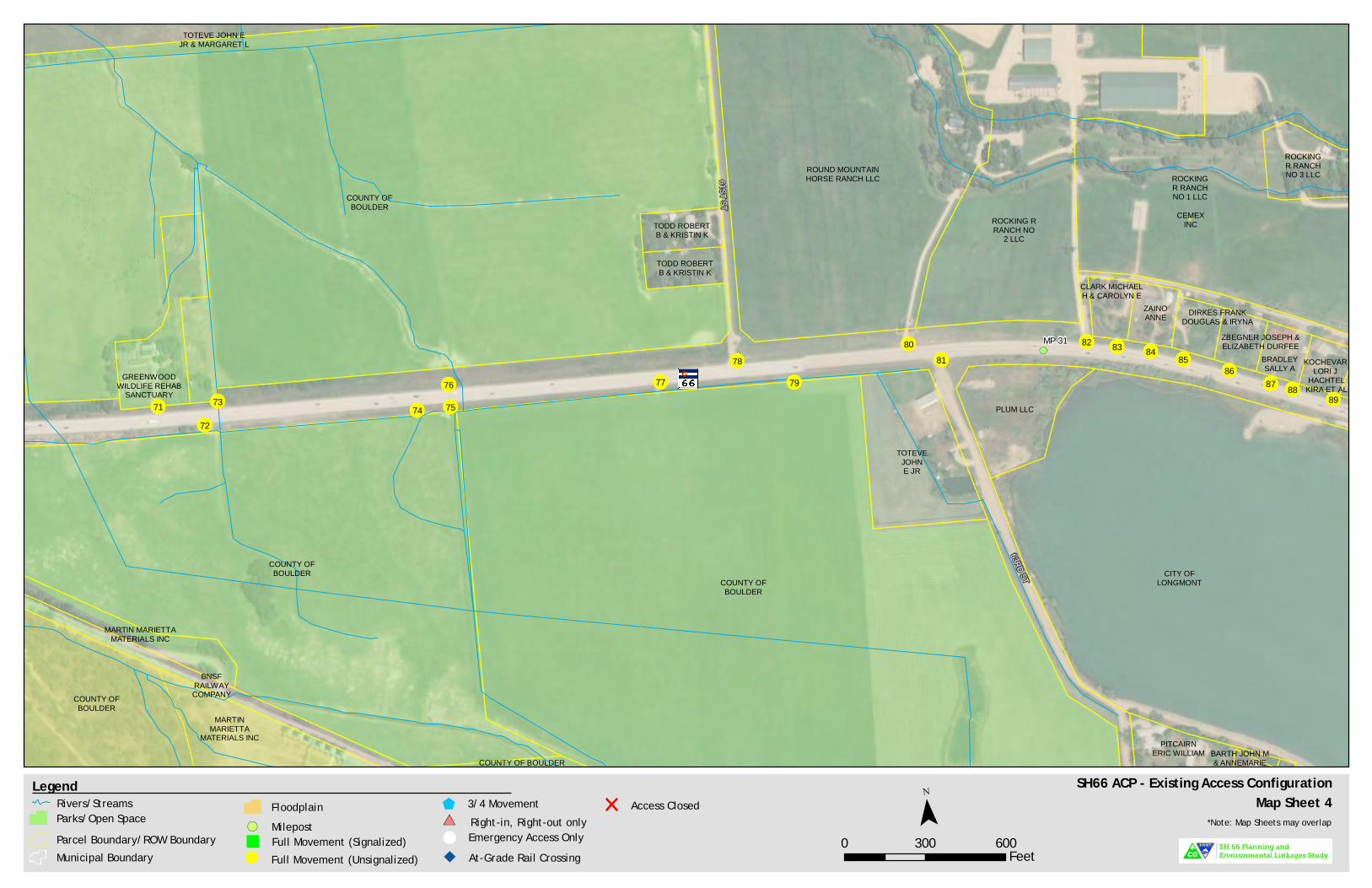
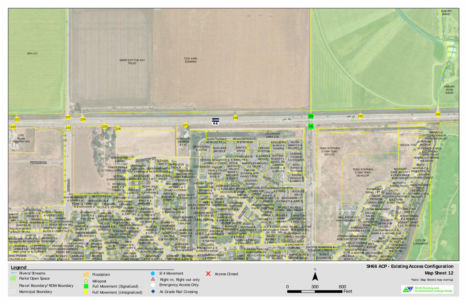
Appendix B. Existing Access Maps


!(
!(
!(
!(
!(
#
#
#
## #
#
(/36
(/36RAILROADAV
CARTER DR
NOLAN CT
PUBLIC
WORKS WY
RAYMOND CT
PUBLIC WORKS WY
ESTES CTWELCH DR
NOLAN DR
MCCONNELL SOUTH DR
MCCO
NNEL
L DR
2ND AV
RUSSELLDEBORAH ANN
TRUSTHEHN
THEODORE J
REED CHRISTOPHERT & CAROLYN J WISE
CARLOUGH-MELINEJANE C & CHRIS
D MELINE
STONE CANYONCOMMUNITY
ASSOCIATION INC
MALITO JASON& KIMBERLY A
WILLIAMSPAUL S &CATHRYN
BRUDEREDWARD
D JR
BEAR BLAKELYR & JOCELYN E
TOWN OF LYONSDANDURAN
DENNIS J
KIER TIM D
SHEPARDCANDACE
TRUST
LUNDELLDAWN M
FRYSIG PAUL W
TREECE JOAN L
CEMEX INC
JOHANNJOHN B &LYNNE E
COOKHENRY D JR
109 PARKSTREET LLC
DOUGHERTYJR WILLIAM
CARLINBYAN E &MICKEY J
QUITTER KIRKJ & AUBREY A
CORWIN
CORPORATION OFTHE PRESIDING
BISHOP
BUSHEKJOSEPH P &AMANDA A
ZALZALPETER M &KATHRYN S
ETHERTONTODD B & BETH A TOWN OF
LYONS
113 PARKST HOLDING
CO LLC
EYSTERBRIAN J
& CONSTANCE H T
TOWN OFLYONS
TOWN OFLYONS
TOWN OFLYONS
GILLMORWILEY G
& LINDA G
LACROSSEJONATHAN D &
YOKAIRA
BIESIADAMATTHEWD & ERIN J
WRATTENJAY RYAN &
JOSEPHINE KAY
TOWN OFLYONS
DAY STEVEN B
DUMBAULD PATRICKL & GWENDA JEAN
LAMPEJOSEPH J
& JILL
NAGY PETERA & LARA L
WRIGHT SARAH& NEIL PAQUE
HUFF FLOYD D &MELINDA B & RACHEL
DIANA CHANDLER
4196 UTEHIGHWAY LLC
RUSSELLTYSON E B &AMBER N B
SMITHKOBY Z &RAEANN S
WILLIAMS DAVIDJ & RUTH H
ROGERSROBBIN
TOWN OF LYONS
LYONSVALLEY
PARK INC
WHIPPMICHAEL A
UNITEDSTATES OFAMERICA
DUHL BEN& LILLIAN
STONE CANYONCOMMUNITY
ASSOCIATION INC
HOYT ERIC S
SCHROEDERBARBARA B
CERVANTESRENE & MARIADEL ROSARIO
SHARMAN GEORGEF IV & ROBYN
FAIKE
BERREMANDAVID W &MONICA B
HYMESJACQUELINE G
BANTAMANAGEMENT
LYONS LLC
MCCONNELLHERB R
ROMAINE THOMASE & MARIA M
BARBER TRACEY& FRISO
SCHLOTTAU
ADAIR JULIEE & SCOTT A
SPITLER ADAIR
PEDIGO SUSANNAHL & CHERYL
WINCH
ZIEGLER STEPHENDUNCAN & MEGAN
SUZANNE FOREMAN
SAUCIER AMY E
TOWNOF LYONS
TOWN OFLYONS
KEAN CLAUDIA D& EDWARD G JR
GRACEMICHAEL B
NORTHERNCOLORADO WATERCONSERVANCY DIST
SUPPLY IRRIGATINGDITCH COMPANY THE
CLARKBROTHERS
LLC LOUKONENFAMILY LLC
ABERNATHYJOHN M
& JENNY LGRECHKA ANNAV & JONATHAN
D MULLEN
CLARKBROTHERS
LLC
TOWN OF LYONSROUSSIL
THEODORE KEITH& LINDSEY ERIN
DMRR LLC
DUSELCLAYTON &
EMILY
NORTHERNCOLORADO WATERCONSERVANCY DIST
WECHSLERENTERPRISES
LLC
HIGHLAND DITCHCOMPANY
INC
CERVANTESRENE & MARIADEL ROSARIO
BOEHNERRUTH M
DOWSEJOHN D & DAWN
M WELLER
KUBIS MATTHEWR & JENIFER A
BRAVARDMICHAEL
T & JANE C
MIKONIJOSEPH J &
ANNE MARIE T
BELFORDMARK L
MALCOM TROY &TRACEY
MOLYNEUX
SMITHSTEPHEN& VASSI
WHIPPMICHAEL A
NORTHERNCOLORADO WATERCONSERVANCY DIST
HIGHLANDDITCH
COMPANY
TOWN OF LYONS
CEMEX CONSTRUCTIONMATERIALSSOUTH LLC
CSTMETRO
LLC
FARR REED W& SUZANNE T
VASQUEZLUIS MANUEL
SCHILLERROBIN &
GREGORY J
RUSSELL AMBER NB & TYSON E B DZEKCIORIUS
LINA
CRAVEN KELLIE
VASEL SARAH L& BRIAN A
TUSKIND ERICC & JING C
WALKERWENDELL T
HAMMES MICHAEL JPAMELA S JOINT
REV TRST
179B LLC
MCLAUGHLIN SALEM& KELLY & JON
LYONS VALLEYVILLAGE LLC
SHIPLEY SCOTTR & HELLAPANNEWIG
TOWN OF LYONS
TOWN OF LYONS
QUINN CHRISTOPHERS ET AL
KUTTLAWRENCE M
SCHWEIGER MIKE& IRENE SHERRI
TOWN OF LYONS
BEVANS JOHN
TOWN OF LYONS
ANDERSONTODD F &LAURIE P
WITKOWSKIJEFFREY M
SCHOOCAROLINE
SCOTTJOHN W &
DEBORAH B
STUERMANROBERT E &JEANNE M
MOORE ANDREW L& CAITLIN M FLOOD
LYONS VALLEYPARK HOMEOWNERS
ASSOC
LYONSVALLEY
PARK INC
TOWN OF LYONS
HUNTERJOHN & SARAH
DELKER THOMAS& CRYSTAL M L
HICARSCOTT M &KRISTINA M
CLARKHILARY
MCGUIREKEITH W
PERKINS JOHN& LAURIE
HERRMANNSTEVEN W
& ANN
LYONS VALLEYPARKINC
LENTFAMILYTRUST
TRAXLER DALEF & CYNTHIA
DURHAM
LYONSVALLEY
PARK INC
GRIFFINWALTER J &
PEGGY E
LYONSVALLEY PARK INC
KRAMER THOMASS & MICHELLE L
LYONSVALLEY
PARK INCGIBSON
GERALYN
LYONS VALLEYPARK INC
FISHER CYNTHIA G& STEVEN C GOOD
CORPORATIONOF THE PRESIDING
BISHOP
REGNERYROSLYNN
GAIA HVERONIKA
LYONSVALLEY
PARK INC
KELLYALLISON B
SCHWERINMICHELLE
SUPPLYIRRIGATING DITCH
COMPANY THE
TOWN OF LYONS
TOWN OFLYONS
SUPPLYIRRIGATION CO
HIGH 5 LLC
JOHNSONAMY L LOWELL
GREGORY J& DONNA J
COUNTY OFBOULDER
LYONSVALLEY
PARK INC
HIGHLANDDITCH CO
LOUKONENFAMILY
LLC
LYONS VALLEYPARK INC
LYONSVALLEY PARK
INC
TOWN OF LYONS
LYONS VALLEYPARK INC
LYONSVALLEY PARK
INC
COUNTY OFBOULDER
LYONSVALLEY PARK INC
TOWN OF LYONS
LYONSVALLEY
PARK INC
COLORADODEPARTMENT OF
TRANSPORTATION
WHIPPPROPERTIES
LLC
LOUKONENFAMILY LLC
PEERLESSTYRE CO
DUDASNICHOLAS A
ET AL
CAVENDERFAMILY TRUST
KRAUSE MICHAEL
HAWKINS DAVIDG & KRISTY L
SUPPLY IRRIGATINGDITCH COMPANY THE
MP 21 2524232219 2018
16
15
13
1210
14
1198
7
54
1
2 213
6 17
SH66 ACP - Existing Access ConfigurationMap Sheet 1
0 300 600Feet
¯Legend
Parcel Boundary/ROW BoundaryMunicipal Boundary Full Movement (Unsignalized)!
Full Movement (Signalized)"
3/4 Movement$Right-in, Right-out only#*
& Emergency Access OnlyAt-Grade Rail Crossing
Access Closed*Note: Map Sheets may overlap
Rivers/StreamsParks/Open Space
FloodplainMilepost!(

!(
!(
!(
!(
!(
!(
!(
# ### #
# #
(/36
(/36
51ST ST
HIGHLAND DR
COUNTY OFBOULDER
CEMEX INC
BLUEMOUNTAIN
INC
BLUEMOUNTAIN
INC
COUNTY OFBOULDER
COUNTY OFBOULDER
COUNTY OFBOULDER
COUNTY OFBOULDER
GRACEBROSLTD
EATON JONATHANB & TRACEY JONES
MARYCOLLEEN
COUNTY OFBOULDER
BRALY HENRY
CEMEXINC
BRALY KEVIN
LOUKONENFAMILY LLC
SINCLAIR WALTLEE & TRACIE L
SINCLAIR WALTLEE & TRACIE L
DMRR LLC
DIRKESFRED DAVID &
DOROTHY BETH
COUNTY OFBOULDER
COUNTY OFBOULDER
JONES JAMESR JR TRUST FUND B
JONES JAMESR JR TRUST
FUND B
COUNTY OFBOULDER
PDKINVESTMENTS
LLC
DIRKESFRED DAVID &
DOROTHY BETH
CEMEX INC
CEMEX INC
TOWN OF LYONS
HIGH 5 LLC
VANN DIANAJEWELL L ET AL
VANNDIANA JEWELL L
ET AL
JACOB JILL
BNSFRAILWAYCOMPANY
COUNTY OFBOULDER
LOUKONENFAMILY LLC
COUNTYOF BOULDER
COUNTYOF BOULDER
CITY OFLONGMONT
GRAHAM ROBERT &CONNIE FAMILY
TRUST ET AL
AERINVESTMENTS
LLC
PEACOCKFARM LLC
MP 29
32
31
33 3435 37
3638
39
40
41
42
4344
454746
50
49
48
2926
25
2728 30
SH66 ACP - Existing Access ConfigurationMap Sheet 2
0 300 600Feet
¯Legend
Parcel Boundary/ROW BoundaryMunicipal Boundary Full Movement (Unsignalized)!
Full Movement (Signalized)"
3/4 Movement$Right-in, Right-out only#*
& Emergency Access OnlyAt-Grade Rail Crossing
Access Closed*Note: Map Sheets may overlap
Rivers/StreamsParks/Open Space
FloodplainMilepost!(

!(
!(
!(
!(
!(
51ST ST
53RD ST
MARTIN MARIETTAMATERIALS INC
CITY OFLONGMONT
CEMEX INC
COLORADOSTATE BOARD OF
AGRICULTURE
DOBBSKENNETH W
& MARY L
MONTGOMERYDONALD EESTATE OF
DOBBSKENNETH W
& MARY L
COUNTY OFBOULDER
ELLIS GEORGEW & DARCY
M ELLIS
CEMEX INC
NEUSCHAEFERJOHN & KANDY
TIGERMAN
CEMEX INC
CEMEX INC
WESTONMICHAEL L
COUNTY OFBOULDER
CITY OFLONGMONT
CITY OFLONGMONT
COUNTY OFBOULDER
WHITE JOHN J
MCCAIN GENEEDWARD &
LYNN MARIE
HICKMANLOIS FAMILYFARM TRUST
ROSENBERGELLEN
STRATTON GARYL & SHARRON S
MARTIN MARIETTAMATERIALS INC
TOWN OF LYONS
CEMEX INC
CEMEX INC
BRENNER GARYR & SHIRLEY
E H (JT)
STONEBRIDGETRUST
GODDARDPHILIP A III& EMMA B
GREENWOODWILDLIFE REHAB
SANCTUARY
GREENWOODWILDLIFE REHAB
SANCTUARY
COUNTY OFBOULDER
COUNTY OFBOULDER
BNSF RAILWAYCOMPANY
FOX THOMASM & VICKY L
BNSFRAILWAYCOMPANY MARTIN MARIETTA
MATERIALS INC
KASS CARRIEL & WALTERL BONER JR
SMITHSTRATTON& KRISTEN
SMITH STRATTON& KRISTEN
G &S PROPERTIES
3 LLC ET AL
G &S PROPERTIES
3 LLC ET AL
MP 30
51 52
5354
5556
5758
5961 63 64 65 66 67
68 69 7060 62
SH66 ACP - Existing Access ConfigurationMap Sheet 3
0 300 600Feet
¯Legend
Parcel Boundary/ROW BoundaryMunicipal Boundary Full Movement (Unsignalized)!
Full Movement (Signalized)"
3/4 Movement$Right-in, Right-out only#*
& Emergency Access OnlyAt-Grade Rail Crossing
Access Closed*Note: Map Sheets may overlap
Rivers/StreamsParks/Open Space
FloodplainMilepost!(
!(
!(
!(
!(
!(
!(
61ST ST
63RD STKOCHEVAR
LORI J
TODD ROBERTB & KRISTIN K
TODD ROBERTB & KRISTIN K
ROCKINGR RANCHNO 3 LLC
CEMEXINC
COUNTY OFBOULDER
ZBEGNER JOSEPH &ELIZABETH DURFEE
BRADLEYSALLY A
CLARK MICHAELH & CAROLYN E
DIRKES FRANKDOUGLAS & IRYNA
COUNTY OF BOULDER
COUNTY OFBOULDER
ZAINOANNE
BARTH JOHN M& ANNEMARIE
HACHTELKIRA ET AL
PITCAIRNERIC WILLIAM
TOTEVE JOHN EJR & MARGARET L
GREENWOODWILDLIFE REHAB
SANCTUARY
CITY OFLONGMONT
COUNTY OFBOULDER
PLUM LLC
TOTEVEJOHNE JR
COUNTY OFBOULDER
BNSFRAILWAYCOMPANY
MARTIN MARIETTAMATERIALS INC
MARTINMARIETTA
MATERIALS INC
ROCKINGR RANCHNO 1 LLC
ROCKING RRANCH NO
2 LLC
ROUND MOUNTAINHORSE RANCH LLC
MP 31
7271 73
74
76
75
7778
8081
82 83 84 8586
87 8889
79
SH66 ACP - Existing Access ConfigurationMap Sheet 4
0 300 600Feet
¯Legend
Parcel Boundary/ROW BoundaryMunicipal Boundary Full Movement (Unsignalized)!
Full Movement (Signalized)"
3/4 Movement$Right-in, Right-out only#*
& Emergency Access OnlyAt-Grade Rail Crossing
Access Closed*Note: Map Sheets may overlap
Rivers/StreamsParks/Open Space
FloodplainMilepost!(

!(
!(
!(
!(
!(
!(
66TH ST
MCCALL DR
LAKE DR
FAHLSTROMJOHN M & JULIA
E LAZARTIC
KOCHEVARLORI J
PERDUE SHARON
LUBBERSJ MARK &
LYNDELLE G
DE PRIESTJAMES DUANE& CAROL ANNE
ROCKING RRANCH NO 3 LLC
THE WILLIAMSOUTFIT LLC
CALARESOJAMES D& KAREN
HOFFMANSHIRLEY
PALMARINIGILLES M
& KAREN G
CITY OFLONGMONT
WALSTADGARRETT
CONWAYJOHN W JR& JULIE K
MASTERSCHRISTINE F
NAJERA ANTONIOMARIANO &
GEORGIA MARIE
MACKROBERTBENSON
LOWE MELISSAHALLMAN& MARK C
BRADLEYSALLY A
RANDLEMANEVERETT
TODD ET AL
ELWOODFARRENF ET AL
LAFOLLETTEROBERT D
& VIRGINIA S
JOHNSONDENNIS R
KINLUND NATW & DIANE L
YOUNG JAMES &SARAH
FAMILY TRUST
WEBSTERTRUDIE
NEUGEBAUERMANFRED H &
VICKIE J
BARTH JOHN M& ANNEMARIE
OLSONKELLY J &WENDY
MILLERJAMES E
LIVING TRUST
JARRETTMARY & GARYDUCHATEAU
PLASTER TIMOTHY &LAURIE ZIMMERMAN
ASCHENBRENNERSCOTT W & AMY K
WILLIAMSMARILYN R
HACHTELKIRA ET AL
PITCAIRNERIC
WILLIAM
CIOCCHETTIWILLIAM & KAREN
LOVING TRUST
BRICKMANDONALD R
& MARJORY A
LUBELLBRIAN ROBERT& KAREN LYNN
GUTHERIESUZANNE
KAY
YARBROUGHSCOTT A &ANGELA A
ASAWEST HYGIENE
LLLP
CITY OFLONGMONT
CANDEEDANIEL E &
KATIE A
HAMBLINLAKE V LLCPOLLOCK JAMES
SULLIVANMARTHA M
WESTCHRISTOPHER J& GERALDINE B
CASSIDYKATHLEEN M
SHIMBOROBERT A &
FARA M
MULRY MARY C
FESENMEYERHADEN
HAMBLINLAKE II LLC
HAMBLIN LAKEI LLC
LAMB RAYMONDL & KIMBERLY L
LICHTERLAURA
HAMBLINLAKE II
LLC ET AL
LICHTER LAURA
CONCHIEBARRY &
NICOLA JOYCECONCHIE BARRY& NICOLA JOYCE
OLIGARCHYIRRIGATION CO
OLIGARCHYIRRIGATION CO
NAZZAROMARY G
WELCHPATRICK J &
KELLI L
ROCKING RRANCH NO 1 LLC
ROCKINGR RANCHNO 1 LLC
MP 32
8990 91
9293
94 95 96 98
97100 103
102 104105
106 107 108
110111
113
115116
117
99 101
109112
114
SH66 ACP - Existing Access ConfigurationMap Sheet 5
0 300 600Feet
¯Legend
Parcel Boundary/ROW BoundaryMunicipal Boundary Full Movement (Unsignalized)!
Full Movement (Signalized)"
3/4 Movement$Right-in, Right-out only#*
& Emergency Access OnlyAt-Grade Rail Crossing
Access Closed*Note: Map Sheets may overlap
Rivers/StreamsParks/Open Space
FloodplainMilepost!(

!(
!(
!(
!(
!(
!(#
##
#
& ###
PEARCEMARC L
CALARESOJAMES D& KAREN
CITY OFLONGMONT
FREEBORNJOHN H
ROTHAUGEFRED A &MARCIA A
DUNN DENISE
WALKER MATTHEWV & LEE ANGUSSUTHERLAND
EISELE TANYAK & JOHN W
RANDLEMANEVERETT
TODD ET AL
COOKMELBA JEAN
WALZ ANDREW& KRISTENCOLLINS
COUNTYOF BOULDER
STONEMELBOURNE E
& CONNIE M
STACEY JANET MLIVING TRUST
NAPP THADDEUSJ & AMY L H
VON RIVENBURGHGARY W &RACHEL S
DUNNRICHARD C
NOWLIN BYRONK & JUDITH A
FARM TRUSTDEVELOPMENT
GROUP LLC
SMETANAPARTNERSHIP
LLP
ASA WESTHYGIENE LLLP
ASA EASTHYGIENE LLLP
WHITEKENNETH A
KOLLARJULIE A
RICHARDSONEDWARD J
WHITEFARM LLC
MCCULLICKMARK
STACEYJANET M
LIVING TRUST
ZIMBELMANJAMES D & DONNA
M ZIMBELMAN
MILLETTWILLIAM DJR TRUST
STRINGFELLOWMARTIN B
OLIGARCHYIRRIGATION CO
OLIGARCHYIRRIGATION CO MAYFIELD
KACHINATRUST
115 116117
118119 120 121
122
124
125 126
127
129
128
130132131
133 134 135 136137 138
123
SH66 ACP - Existing Access ConfigurationMap Sheet 6
0 300 600Feet
¯Legend
Parcel Boundary/ROW BoundaryMunicipal Boundary Full Movement (Unsignalized)!
Full Movement (Signalized)"
3/4 Movement$Right-in, Right-out only#*
& Emergency Access OnlyAt-Grade Rail Crossing
Access Closed*Note: Map Sheets may overlap
Rivers/StreamsParks/Open Space
FloodplainMilepost!(

!(
!(
!(
!(!(
!(
FARM TRUSTDEVELOPMENT
GROUP LLC
COUNTY OFBOULDER
MCMANIGALDUANE R& NICCI R
ROTHAUGEFRED A &MARCIA A
WALZ ANDREW& KRISTENCOLLINS
PHILLIPSFRANCES A
COUNTY OFBOULDER
OCONNORKEVIN D & MARYKIMERA MOONEY
FARM TRUSTDEVELOPMENT
GROUP LLC
GEORGESCOTT ALLEN &
JANET LEE
WALSTADJOAN M
KOENIGSBERGRACHEL M
WALSTAD JOAN& CRAIG &
RAHNE RANDY R& BEVERLYJ HUGHES
SYMNS MARKT & HOLLY I
COUNTY OFBOULDER
MYERSDOLORES
M & LEWIS OKREITMANROBERTY TRUST
PRESCOTT HALM & WANDA
THOMPSONRANDY W
COUNTY OFBOULDER
ROUGH &READY
LLC
COUNTY OFBOULDER
COUNTY OFBOULDER
COUNTY OFBOULDER
RICHARDSONEDWARD J
MARTYMAUREEN A
FIRST INT OFDENVER NAHILL FOUND
GROVER MATT & GENAHAZARD GROVER &GENEVIEVE HAZARD
COUNTY OFBOULDER
WHITEFARM LLC
MP 33138140 141 142
143144 145
146 147148 150
151152
153 154155
156157
139
149
SH66 ACP - Existing Access ConfigurationMap Sheet 7
0 300 600Feet
¯Legend
Parcel Boundary/ROW BoundaryMunicipal Boundary Full Movement (Unsignalized)!
Full Movement (Signalized)"
3/4 Movement$Right-in, Right-out only#*
& Emergency Access OnlyAt-Grade Rail Crossing
Access Closed*Note: Map Sheets may overlap
Rivers/StreamsParks/Open Space
FloodplainMilepost!(

!(
!(!(
!(
87TH
ST
ALMERIA WY
SPINNAKER DR
SHER
MAND
I AVFLEETWOOD AV
MADISON AV
HARV
ARD
ST
JOTIPA DR
ANHA
WA ST
SPINNAKER CI
LAKEPARK WY
COUNTY OFBOULDER
COUNTY OFBOULDER
RAI VHIM &KAMALA GHIMIRE
HOWARDRONALD D
& JUANITA RDRISCOLL MARY
BETH FAMILYTRUST ET AL
SIMMONSDANIEL J &KAREN J
HOMAN JR L& NORMA C
GARLANDJERRY DON
PEARSON ANTONYC & ANN C MARTIN
JOHNSON BLAISEREVOCABLE TRUST
HEUMANLORENA KMYERS
DOLORES M &LEWIS O
SKRINEFAMILYTRUST
WILSONBRIAN M &
JAN L
DIRKS FAMILYTRUST
ELLISSUSAN B &WILLIAM E
SHORESLTDTHE
SHORESLTDTHE
ROACH SUSANI & MARY E
FAINI
HUTSONBARBARA& TERRY
COUNTY OFBOULDER
REGELEDWARD C& KATHY L
RAI VHIM& KAMALAGHIMIRE
RILEYKEIG LLC
DIRKS RAYMOND A& MARSHA JANE
AL-RAYESJANET
MOLL JEFFREYS & MARIDEE L
MASOTTIMARC A
COUNTYOF BOULDER
SHORESASSOCIATION INC
SHORES ASSOCIATION INC
TOWN OF LYONS
WOLSTEIN BARBARARICHMAN
LIVING TRUSTINCORVIA
FAMILYTRUST
COUNTY OFBOULDER
GLITZNER ALBERTAM LIVING TRUST
FOOSEDAVID B
& PATRICIA M
THOMPSONKAREN T
MCCLUNG BRANT &LAURA HOCHMAN
MCGEEJOLEEN M
HEEDER RICHARDA JR & SUSANDELL ORSODAVIS
DONALD L& DIANNE E
JACKSONDOUGLAS P & NANCY
EVANS JACKSON
CLARKPATRICIA A
CURCISAMUEL
FOSTERMARYANN
NICHOLASJOHNC III
BETHUNE HAROLDE & ELIZABETH M
HONN RONALD G
PRECHT DENNISG & DEBORAH D
KIRKPATRICK ALLISON
BERGGRENRENETTE
BAUMANNWAYNE & NICOLE
LIVING TRUSTWILSON
SANFORDHUNTINGTON
PONESSEBARBARA A
ASBURY JOHN D
RICHARDSONWILLIAM S
& RHONDA L
GHIGLIADANIEL C &
AMBER L
HERNANDEZ CESARMARQUINA &
BELINDA MARQUINA
NITZ ELIZABETH &CATHERINE HORNING
GEORGEMICHAEL J &
JOANNE L
FELDMANLEON H
BLACKKENNETH M& LEIGH ANN
CHAIDEZMARIA G& IVAN F
LONGHURSTJERRY M &
ELISSA LORELEIHICKS LAURA E
CHINOLLAJONATAN
DITTRICHGERALD PAUL& EVELYN M
DIRKS RAYMOND A& MARSHA JANE
& ALBERT HDAVIES
STANLEY VJR & CLAIRE E
LONG SCOTT A &AMELIA E E
PECORA MICHAELJ & LETA G
HOPMANLARRY J &DENISE M
GRACEEVANGELICALFREE CHURCH
PERDUE CROBERT & LYN
BERGESONLANNY L &
LINDA L
BRODHEAD STEPHAN A& DIANE S CURRIE
MOFFITTJIM &LISA
KIMMELLANNE
RENNIE
NELSONKATHERINE A
ADVENIR@WILDWOODLLC
MOIN NATHAN
ERICKSONTHOMAS J &
TONI DKVIEREGGMARYANN
CITY OF LONGMONT
MUELLER MICHELLE M& BROOKA FRANZ
DILLONMICHAEL J &
JODY LRAMRHINO
REVOCABLETRUST
BEANFAMILYTRUST
LEHMANDEAN G
& ANNE C
MAYHEWLAURELM ET AL
BLOCK MARTIN LEROY& KATHLEEN LESTER
KAMMER THOMASE & JULIE ANN
ANDRISTFAMILY
LIVING TRUST
KENNEYRICHARD
W & GAIL C
NELSON MARY J
GILMAN SCOTTE & MICHELE A
KAPELL JEREMY S &ELIZABETH KATELYN
SMITHLAURIE L
WISSONARTHUR &DORIS F
WEBSTER RONALD W& PATRICIA
LOUISE
KNAPP CRYSTALL ET AL
BURTONCRAIG M &
TRACY J ALLENOLSON MICHAEL
H &NIKOL A
BAKER COREY& CLAUDIA W
O GUIN
NOTARIOJOSE D &TRACEY A
HYNESROBERT G& JACKIE L ADLER
ART V JR
DONALDSONADELLA A& JOHN J
POULSON KENNETH& HEATHER FAM
REV LIV TRST
STEWARTNEIL J &
DEBORAH S
GRISSOMLIVING TRUST
JENSEN DEVONAMAE
BLUME C ROBERTREVOCABLE TRUST
NAGYPATRICIA J
WILSON GEOFFREY& DIANA MARY
IWASAKI FUSAKO
RAMIREZROLANDO
ET AL
FINNEGANPATRICK A& SUSAN A
MOTHERALTERESA A &
JULIAN B
DE HAASSTEVEN &KELLY L
JACKSONGENE W &JULIANNE
MICHAEL JOHNE III &
ALISON J
TOCKO MATHEW
HERMANSONWILLIAM C
SCHMIDT CARYA & SUSAN M
SOCHIAWILLIAM R &
CATHERINE M
VELARDERONALD G& CONNIE L
MILLERMICHAEL G& EMELIN A
SHORESASSOCIATION
INC THE
KINGCHERLINAARCOSEBA
KISER PAUL R
PONDER HENRYD & MICHELLE R
JOHANN ANDREWR & SCHWANDA Y
INMANCLYDE
DEPAGNIER DAVIDM & VERONICAM SUMMERS
KESLERSHARLENE F
HOSTETTERHEIDI
STILLER STEVEN W& GAYLE J TAYLOR
CALHOUN JEFFREYA & MARY P
SMITH WAYNELEE & GAIL
MARIE
GOLDFARBANDREW J
& TOREY A TAYLORNICHOLSON
JAMES C& JUDITH A
MARSCHKEALAN & AMY
MCBRAIR
FELL JAY B &REBECCA S
HOVICKANN M
DEHONJOANN
HARRISJANE E
BRYAN LISAM & MARK W
KNABENBAUERRICHARD E
RUSSELL ANN M
CLARK DAVIDB &
DEBORAH MTOWNE
JEFFREYFALLONLIVINGTRUST
HUELSKAMPC VINCENT &KATHERINE V
CRILLRIKK &ALDA
RITIO DAVID &VICKIE
LIVING TRUST
TURNERNELSON C III& JENNIFER L
WHILDINRONALD J
KOLANDA JANICER & ROBERT J
CULJAKPHAEDRA
HAMMONDDARRELL R& CHERYL L
REMPLETIMOTHY
K & RUTH A
CARLSONCHARLES E II& ANNETTE H
COOLEY NATHANS & JULIA R
SHYKULAJEFFREY THOMAS
& LISA CLAIRE
MICHELSMARK N
VICK REGENA
BROTHERTON WILLIAMJ & BETH A
JUDSON STACY L
HUTCHINGSDEBRA E
GIBSONGERALYN
KLISHJANICE
MARIE D
WAYMANKEITH M &PAMELA L
DAMICOJOHN-PETER BSEIDMAN
BENJAMIN& JANICE L
FUNKBRADFORD P &
SHELLIE A CHRISMANDAVID LEE &
LAUREL GRAF
BANOLA MEGAN
DALEY JOHN A& KATHERINE M
GOSPODINOFFVICTORIA &
DYLAN MIRAGLIABERGER BLAINE
H & SUSAN MBEJCEK J MITCHEL
& ROCHELLE
KINYON JASON
WARDLEGREG
& OLENA
JENNINGSFAMILY
LLC
MOUSAVIASGHAR
ET AL FRYMONTE &
HEIDI
AUSTIN PAUL STEVEN& CAROL ANNE
ALMERIAWAY LLC
SCHULTETHERESAMARIE &
HERBERTTERRY A &NANCY AWACKER
HOLLY H
MOLLER GREGORYP & SUSAN J
EDMONDS MARK
COURTNEY TIMOTHYJOHN & KELLIE LYNN
MUNROEEDWARD E
& SANDRA L
BLISSROCKIE L
BATEMANWILLIAM A CIII & JULIA L
MEYERDUANE J
& SANDRA L
GRIFFINJOHN C
& JANIS L
HANSEN TIMOTHYPAUL & MARYJANE RUTH
NIELSENTHERESA
HENRY CHAD F
YOHO SCOTT E& REBECCA M
PAUL JENCY M& KENNETH W
LEHMAN ERIN M& TODD MVENRICK
WARD JOHNM & GAIL M
PORTER R CARL
JACQUESSTEVEN L &JEANETTE M
PFLASTERERROBERT L& LYNN J
BYINGTONDONALD S& LINDA A
FAAS LINDA S &STEVE C
UPDEGRAFFDONALD
R & JAIME N
MP 34159160 161
162
163 164
165
166 167 168 169 170171
172 173 174 175158
SH66 ACP - Existing Access ConfigurationMap Sheet 8
0 300 600Feet
¯Legend
Parcel Boundary/ROW BoundaryMunicipal Boundary Full Movement (Unsignalized)!
Full Movement (Signalized)"
3/4 Movement$Right-in, Right-out only#*
& Emergency Access OnlyAt-Grade Rail Crossing
Access Closed*Note: Map Sheets may overlap
Rivers/StreamsParks/Open Space
FloodplainMilepost!(

!(
!(
!(
!(!(
!(
MADISONAV
LAKEPARKWY
24TH AV23RD AV
MAPLEWOOD CI
JOTIPA DR
LINDE
N ST
TULIP ST
24TH AV
MAPLETON CI
LONG
FORD
SUNSET DR
BABCOCKLAND CORP
DICKENSJACK W JR
TRUST ET AL
DICKENSJACK W JR
TRUST ET AL
NEWELL JOHN A &ANNE T TRUST ET AL
DICKENSJACK W JR
TRUST ET AL
DICKENSJACK W JR
TRUST ET AL
DICKENSJACK W JR
TRUST ET AL
DICKENSJACK W JR
TRUST ET AL
DICKENSJACK W JR
TRUST ET ALCADDIS
PROPERTIESLLC
BOETTCHER CHRISTOPHERR & DEANNE M
DICKENSJACK W JR
TRUST ET AL
DICKENS JACK WJR TRUST ET AL
MONTE CIELOHOMEOWNERS
ASSOC
CITY OFLONGMONT
PUMA 66INVESTORS
LLLP
FAITH COMMUNITYLUTHERAN
CHURCH ECLA
RIBBINGCARL A III& MARY A
HEYDANDREW R
SIEGRIST NEIL L& DALE L
HERMANADAM &KEALY
HEEDER RICHARDA JR & SUSANDELL ORSO
FOSTERMARYANN
PUBLIC SERVICECO OF COLORADO
- XCEL
BERGGRENRENETTE
WILSONSANFORD
HUNTINGTON
PONESSEBARBARA A
GONDER WAYNE &CELESTEVAUGHN
VILLAGRANA MARIO
ROSSTIFFANY A
JOHNSONGARY W
ARMSTRONGJACK II
EVERETT GERALDJ & BRENDA
D LIVING TRUST
REZACJAROSLAV
DIXON ROBERTERICH &
ROBERT EUGENE
HUFF DONALD RBOGNERBARBARA
BHUSHANSANDEEP
SASSON JOHN H JR& CAROLYN USHER
LI YU AN &HUI I CHUNG
COCHRANLINDA S
BALL JAMESK & KARON O
EHRHARDT-MARTINEZKAREN L
SHAKYA SAGARRAJ & REETA
ANDERSON KEITHH & LOU ANNE
ROHN AUDRA A& SCOTT A
GRACEEVANGELICALFREE CHURCH
TOTH THOMAS G JR &STEPHANIE M PAGE
KINGSLEYKRISTIN
BUTLERCHRISTOPHER A
IOPPOLO ALBERTDOMENICK JR
RHOADESBOBBI JOLIEN ELLA M
LIEBINGSTEVEN D
BUTCHERDENNIS WILSON
BRANDLISA E &DAVID
BRYANKELLY R
COHENJOSEF BTRUST
BUNNELLSARAH F
BEAN DOUGLASD & TAMI
HEISER MICHAELL & MITZE J
BROWN TIMOTHY M& TAMMY M DRAKE
VASQUEZRAMONA
STRATMAN STEVE& LAURIE
FOSTER STEPHENJ & BARBARA J
TRUJILLO EDDIE
MCCALLVERNER
W JRMOSQUEDA
JESSICA ET AL
TOLLEFSON WENDELL M& MARSHA M TRUSTEES
ZILLYROBERT K
SCHMIDT BARRYL & STEPHANIE
MOCK KEVIN& MICHELLE
GARRETTTRACEY D
CONWAY GREGORYBRIAN & DANICA A
SCHIFFERNSDEBRA
WITTRAMON P &
KAREN E
HALVERSONMATTHEW
SCHOENBECKRUSSELL J& RENEE H
STONEDAVID ALAN
SCHMITT DAVIDB & HEATHER E
LEAL THEODOREF & JOANNE
M CLARK
LEHMANDEAN G
& ANNE C
CULJATNICHOLAS D
JR & DONNA M
ZHANG JI LIANG& LI JUAN ZHANG
FLORESRUBEN
SCHLAKELINDA R
& DENNIS L
KING JESSICA &CHARLES LIEF
TAKSAVOEUN
MORTENSENCRAIG &KRISTA A
HAGANDIANE E
LEWISCURT S &
LISA J
JOHNSONJOEL N
& SUSANA A
FORAKERISAAC
WAYNE
WISCHROPP ADAMWADE & HEATHER LYNN
CAMPBELL ROSEMARYJIMENEZMARIBEL
ET AL
KENNEDYMARK A
ESQUIVELERNESTO
& BEATRIZ SUASTED
DESMONDSTEPHEN P
& JENNIFER L
JESSEE DIANEOLDROYDJONI &EVAN
LONGS PEAK LLC
GONZALEZCARLOS O &
CHARLA J
PHILLIPSMICHELE
PIESKE DAVIDA & MARY E
PARISMATTHEW L
KESSELMARK S &
ANN M
HOLLEYCRYSTAL L
AHRENSDAVID F
SMITHWHEELER LLC
BOX JESSE JOE
KIDWELL JAMESD & CYNTHIA A
GUST DANIELL & KAREN L
REESEDANIEL A
& ABIGAIL F
STEELE2343 LLC
CURTIS ROBERTD & DENIECE M
MOHEDANO-MIRON GABRIEL
EDWARDS DONALDSCOTT &
LAATTDEAN
RICHARD ET AL
DEINESMARK N &
KORI F
LUONGVAN
KOZLOWSKIZYGMUNT ET AL
SIMPSONVERTA B
RELLER MARIA R
RYANPATRICK M
& MICHELLE K
STRAUSSGEORGE E &
ROSALIE J
REHAGE DAVIDA & JOYCE M
VAN BUSKIRKJEFFREY P &KATHLEEN M
SAMPSONJAMES W &
TRACY A
ALLEN MICHAELS & ANDRIA
J ALLEN
GROSKIN COURTNEY
PETERSEN MARKB & PAULINE E
MEWHORTER-PETERSEN
COX TIM D
DAMONCAMERON
STEWARTNEIL J &
DEBORAH S
KARKI RAMESH& ASHI PEGA KARKI
ERVIN BREE& ZACH
LEGAN NICHOLASF & KRISTEN
MILLER KIMM & GALEN J
BYRNELEA ANNGLIVA MICHAEL
& SHARYLLIVING TRUST
HOHZACHARYT & AMY
MONTE CIELOHOMEOWNERSASSOCIATION
BELILEDANIEL TRUST
HILL ALAN R
COTTLEMICHAEL J
& NICHOLE M
EPSTEIN HARVEYP & JESSICA M
CANNON
REGER THOMASW & TERI L
HAGEMAN JEREMYL & BROOKE M
STOLL JAY F& PATRICIA A
BARBOSANICHOLAS III &VERONICA M
SPINUZZIANGELO M& SUSAN K
JOHNSONKOLT D
MONTGOMERYLORI A
HERMAN LARRY M &TERRY L HERMAN
HOSHIKO LANCET & REBECCA K
SCHMIDTSYLVIA J
IMBRIANI JOSEPHF & CLAUDIA A
BRACKEN-IMBRIANISCHREIBER ERICC JR & BARBARA
J CILETTI
ADAMSTHOMAS G &NANETTE JO
FRAYRESAUL
BOZELLAVINCENT A& RALPH P
RHODESJOHN H JR& ANITA J HOLT SARAH
& PATRICK
PETERSONDOUGLAS
G & MARY M
RUTHERFORDSHANNON M
MANNINGROBERT W& KAREN M
HILL JERRY M& NICOLE M
KASSNERRONALD R &
LINDA J SPIRES THERESAM & TIMOTHY P
FAIRCHILDDIANE
MUNNWILLIAM N
KLAUBEBRIGITTE G
FITZGERALDDEBRA J &SCOTT L
KANNANPARIVALLAL
BILLOWAMANDA& SEAN
BLESSING SHAYC & ERIN E DWORAK
EDWARD E &KATHLEEN
RAMIREZ TOMMY& DEBORAH L
KING DENNIS M& MILA LIM
SHERPA LAKPA& MEENA
KALISZEWSKIPAUL F
FINLEYKATHLEEN R
BRUNELLECLARK C
TRUST ET AL
STANLEYSHAWN
& BRENDA
MURPHYMICHAEL W
KEATLEYKENDY L
RIOS JOSE ANGELARRITOLA & VANESSA
MICHELLE ESCARCEGA
LANE ROBBIEK & LYNN M
FLYNNKEVIN &CONNIE
THORSONLESLIE
ANN & JON
MILLER SCOTTW & EMILY
A HOLT
CLARK DAVID B& DEBORAH M
WOLF CHRISTIANJ & DEBORA A
EISEMANERIC &
ANN NOBLE
HARRIS RYAN &ELISABETH
BERG
CAREYMICHAEL W
ROWE BRADLEY D& CHARLENE J
COLLIERDENNIS P & JUDY L
LARSON CHERYLS & JEFFREY D
WARREN RAYC & KAREN J
STOVERALICIA C &
THOMAS A CAIN
SANTAMARIAVICTOR & VICKI C
KRISS TED CARL JR& CHRISTINE LEE
GRANGERROBERT
ISHMAEL ET AL
IVERSON MARIEROSE EVELYN
WHISENHUNTBOBBY R &
YVONNE E M
PLASTERARDIS A
SHEKERNOAH M
& ELLEN LSCRIVEN
GEORGIA H
ESPINOROGELIO & ORALIA
PEREZ
GROOM JAY L
GOLDSBERRYRALPH C III
& THERESE L
MILLER ROBERTD &
SUE ANN
COOPERHEATHE H& PAUL J
RIOS JOSEJAIME &
PASCUALA E2113 24TH
AVENUE LLC
COOK DAVID M& KATHERINE A
HOLSAPPLECRAIG S &
FRANCES M
RICHARDS CHARLESE & OKSON
SELLARS DONALD
SANDVIGDANNY L & MARY M
HESS ERICH& ANN
RIGOTTIMICHAEL
S & LORI C
YEAROUSDALE A &KAREN S
MEILSTRUPJON & KELLY
SCHULTZ MARK
KELTNERJOHN M
SEGUINMARGARET M& KENNETH J
LYTTON JAMES& ELYN
HIPSHER TIMOTHYF &
SHARON K
HOOLEY LEEE & KAREN K
DAVISROBERT E &
CAROL M
BURGERHOFFGILBERT ALAN
DAKER CHASELYNN & SARA E
FLOWERS DANIELWARREN & KAREN
MARIE
KLISHDANIEL E SECOR
CATHLEEN
DUFFY LOIS J
HARVEYMICHAELWAYNE
CHRISMANDAVID LEE &
LAUREL GRAF
SMITH JOHN MATTINGLY& CHERYLJ VESTAL
LOUGH THOMASM & J KATHLEEN
KOLMAN ROBERTS & FRANCES A
DERONDEROBERT S& LINDA S
KEGEL THOMASM & LEE ANNE
RIEDELKENNETH E& MARCIA N
HEDGPETHCHRISTIE & CHAD
WAIT JAMESMELVIN
HILLIARDDONALD C
TAYLORLISA MAE& DAVID J
BAUER DAVIDA & PEGGY J
PONDER CECILIA G
IRWIN PEGGY L &JEFFREY A SCHMIDT
HAEKER TRUST
BRAKHAGE KRISTAM & PHILIPGOERNER
JONES WENDY
SMITHANGANNETTEM & DUSTIN
SAYNEJASON R
HUGHES NANCY J
BACHMEIERANITA A
VAN NESSBRIAN J
ANDERSON RICKA DEBRA KAY
RICKARD DONALDA & LORINA A
JOHNSON STEVENBRYAN & CAROL
DACKERT
BALSLEY PETERTOBIT & UTE RENATEHART
THOMAS E &DEBRA
KUBIERLARRY A
& LOUISE E
ARNETTCLINTON D& DIANE A
NELSONJAMES A& DIAN L
LUND MARSHA
ARRINGTON STEVENL & DIANNA R
MERKLE THOMASL & LYNN M
RULONSTEVEN L& LAURA B
OTOOLE JOHNR &
JANE S
BARBERANTHONY S &
MEGHAN E
DANZL JONATHANJAMES & SARAH
ELIZABETHBISCHOFFTODD &
CHERYL J K
MCKULKA CHRISTOPHERMICHAEL & KAREN
ELIZABETH
SCHMIDTBRANDON
& MICHELLE
BRAUNMATTHEW &
AMY
SHEPHERDPAULA
WOROSYLOJONATHAN& SARAH D
FIRTH JOHNIV & BRENDA
KUBINSKIRYAN M &HALEY J
MEYERDUANE J &SANDRA L
BRENINGDALE E
2405SUNSET LLC
BEAULIEUJOANNA
L & MARK R
JACOBSENMERNA
GALLARDOSANTIAGO &
NARCISO RAMON
PIEKJOSEPHJ ET AL
NORRSTEPHEN
ST VRAINVALLEY SCHOOLDISTRICT RE-1J
WHITE MDOROTHEA
BROSEKEVIN
& LORETTA
HOLCOMB DENNISA & REBECCA S
RAMOS SHARONT & SAMUEL N
NEWTONPARTRICK C ET AL
REITINGERANNETTE L
STEPHENMARY D
MORROW ROBERTL & REBECCA
A CONCES
ADVENIR@WYNDHAMLLC
MANNING SHARONBARBARA &
RUSSELL TODD
PEEK GREGORYJ & IRENE M
MP 35177176178
179 180 181182
183184 186
185
187 188
SH66 ACP - Existing Access ConfigurationMap Sheet 9
0 300 600Feet
¯Legend
Parcel Boundary/ROW BoundaryMunicipal Boundary Full Movement (Unsignalized)!
Full Movement (Signalized)"
3/4 Movement$Right-in, Right-out only#*
& Emergency Access OnlyAt-Grade Rail Crossing
Access Closed*Note: Map Sheets may overlap
Rivers/StreamsParks/Open Space
FloodplainMilepost!(

!(
!(
!(
!(!(
#
# #
PARK RIDGE AV
TIFFANY PL
SUNR
ISE D
R
LINCOLN ST
JUDS
ON ST
24TH AV
WOOD
LAND
DR
23RD AV
PRAT
T ST
COLUMBINE AV
FLEMING DR
CRISMAN DR
HILLCREST DR
TEBOSTEPHEN D
HIGHWAY 119HOLDINGS LLC
TERRACECENTER LLC
CRISMANAPARTMENTS
LLC
TEBOSTEPHEN D
TERRACECENTER
LLC
FIRST NATIONALBANK OF OMAHA
TERRACECENTER LLC
LAUBMONT LLC
3D EVOLUTIONSINC
TEBOSTEPHEN D
PUMA 66INVESTORS
LLLP
THE TERRACECENTER LLC
F12PRODUCTIONS
LLC
LIFEBRIDGECHRISTIANCHURCH
WAL-MARTSTORES
INC
WAL-MARTSTORES INC
HORIZON PARKPARTNERS LLC
HORIZON PARKPARTNERS LLC
LAUKKACARLA P
SEGERTIMOTHY J &
AMY M WALLISSTEVEN
DANCYLAWRENCE
ET AL
CERINIKENNETH J
TRUJILLOSABRINA LYNN
STUMBLESJONATHAN M W
WILLIAMSMARY LOU
LAMBOURNE PATSY
SOROSKYJOSEPH JSHURLEYMICHAEL
BENSONSABRINA
KAY
RODDENWILLIAM E
& PAMELA J
CHAPMANWILLIAM J &PATRICIA L
PERRAS PHILLIPCHRISTOPHER JOHN
CASTILLEJAAPOLONIO& NANCY L
HEINESETHDAVID
COLE MARKROLLAND &
JUDY WIEDENHEFT
TAYLORFAMILYTRUST
BRUNSONROBERTR ET AL
CASEY WILLIAMP JR ET AL
SILBAUGH DARWIN& SHARON
850 MOHAWKDRIVE LLC
WHITEHEADPATRICK& BRIANA
SAMPLEDEANNA S
LIVING TRUST
GREEN ANNA S
TRI TOWNPROPERTIES LLC
LUDLAMBRIAN S &CONNIE L
CHOPP ROGER& LESLIE
LIVING TRUST
BOURGEOISNANCY
DANIELSONDAVID M & BETTY J
REED RIAN M& JENNA W
EHRLICHJANELLE
CINNAMONDIANA
LEINWEBER RONALDL & JUDITH A
CARBAUGHKAREY L
LEVY LEONARDR & LESLIE J
COHENJOSEF BTRUST
MALSAMGREGORY E
SFL LLC
SCHOENMAN ARTHURLESLIE & SHERI L
NUZZO-SCHOENMAN
TACO BELLCORPORATION
BROWNCLIFFORD
E & ROBIN M
SATTERLEE MICHAELA
WETHERALLF SPENCER
YAGER JULIA E ANTHONYTHOMAS R
SCHAAFTIMOTHYE ET AL
TAYLORDARREL L& JOYCE A HENSLEY
BENITA A
MCCONNELLTRACY LEE
& LAURA ANN
VYNCKIERSHARI L
MCFARLANDMICHAEL C& SANDRA J
CRAUNLIVINGTRUST
CAIN ANGELICAELIZABETH & DARINDOUGLAS HARBERT
KOEHLER JOHNE & PATRICIA S
REV TRUST
SANDERSONCAROL & CHADLIVING TRUST
MILLERCHARLES D
HILL RAYMONDA &
BONNIE M
BLICK WILLIAM R& DEBORAH K
LIBERATOREROBERT A& ANNA M
GIFFORDPROPERTIES
LLC
GUARANTYBANK & TRUST
TRUSTEE
KIER TIMD ET AL
ZAMBRANOJEAN MARIE
BAKER CLIFFORDA & CHRISTINA M GARFINKEL BARRI
HARTLEYARTHUR B& MARY E
COLBY DEAN& KARLA
M GUARDADO
AVILES JUAN
LONGMONTMEDICAL
INVESTORS LLC
FLETCHERFRIDA E R
WEAVERJOANNE
CLAYTONROBERT A& ARLENE L
HUNTSAUNDRAARLENE
KACHNICJOSEPH M
ASPENHOMES
LLC
SIFUENTES OSCAR &JOSE ISMAELSIFUENTES
SLINGER DAVIDE & DORIS M
TORNOWCHRISTOPHERH & LORRY R
KLOTZ DARREN D &ELAINE KLOTZ
MCREYNOLDSRICHARD SCOTT
GREEVER MICHAELD & DEBRA S
NEWMANJENNIFER E
TANNER HUGHA & ROBERTA R
JALBERTNORMAN C
MUNROFAMILYTRUST
STEELEJERRY L &BRENDA L WHERRY
SHARONLIVING TRUST
GREEN HERONPROPERTY LLC
PUTNEYTHOMAS A &BARBARA J BESSOL ANTHONY
L & DARLENE J
OWENS JOHN P& JUDITH A
BLACKMERROSS E &TERESA A
STAFFORDSARAH E ET AL
HAMILTONMYRA J
OLIVERBRIAN C
& KRISTEN M
WOLINMICHAEL P& MARY E
ORTIZ CHRISTOPHERJOHN & AMY JO MENDEZ
RICE JANET M
ABERNATHYDONALD E
WATSON FERN M
RILEY JOSHUA &KIMBERLYK RINARD
OCONNORJOCELYN DEANNE
WALKERSTACY L
BASART JACK K& MIRIAM
JACKSONLYLE ALLEN
ET AL JOHNSRUDDARRELL& PENNY
MCDONALDMARY GAYLE
HEPPGAYLE G
GRAYLYNDA L
RAYBURN CORNELIA& RAY A
TUMBLESONJAMES R
REMSIKMARIA TRUST
PARSONSTRUST
MEYERHENRY C
& RETTA M
BUSCHCHERILYN K
OSCEOLAPROPERTIES
LLC
PETERSONRONALD D
DUFF LARRYG & JANET P
SENGGLENN A
MADERACRISTOBAL
MARTINEZDANIEL & JANET
MARTIN CONNIEG & JERRY
MARTIN
BABONCATHERINE
HOLCOMBMATTHEW B& MICHELE D
HEWITT DOUGLASG &
LORI F
MILLER MICHAELJON & TAMI R
THOMPSONKYLE W &JESSICA A
BLANCAS EDUARDO MARTINEZ& SANDRA GUTIERREZ
MINICHRANDALL R
STEVENS SHANON
WB4ROJ LIVINGREVOCABLE
TRUST
LAW MICHAELR & LINDA G
STOUTCYNTHIA J
MIRANDA EVA M
HUNNEL GENEW & CARLA S
WILLARD NATALIE &LINDON K GOODRICH
HALBERGMARK B
TAYLOR GARY &NETTIE FAMILY
HAVENSANDRA L
EGELAND RICKY ALAN &PATRICIA BITTENCOURT
THOMPSON SUSANALICE & DEE
LANCE LEWALLEN
DREXLERINGRID A
MORA MARIO& MARIA M
GARDNERBRETT COLTON
LEALTHEODORE F &
JOANNE M CLARK
NISTON WAYNE &LYNNE
WALTERJANEIL L
VALENTINERMICHAEL &
CHERYL
MORA OTILIA
GARCZYNSKIEARL J
& SHERI L
948 KELLYPLACE LLC
STEVENSONJOHN D &LYNN E
MCDONALD RAEANNE & STEVENSCOTT ODELL
TAK SAVOEUN
ABBASIABBAS
SANCHEZEDDIE D
ROARKJAMES B
ZUELKESHANNONK & GARY L
SMITH WHEELERLLC
JOHNSONMICHAEL L
WOOLLEYRICHARD L
RUSCITTIFABIO R &MARSHA K
LAMB JORDANFORBESREESE
ROBIN L
CHAVEZHELEN &
STEPHANIE
CLEMENTS JAMESJ III & ANGELA D
FITZGERALDLANCE N &BRITTANY
SPATH BARRY& DIANE
LIVING TRUSTDAVID ASTEEL
PIDCOCKSHIRLEY M
MANIACI JOSEPHMATTHEWOFFUTT JOHN
DEBARTH& JEAN W
REHDER ROBERT EDWARD& JAIME BERTRANDHARWOOD
DOUGLAS R& ANNE C
PATTERSONKEITH M &
PATRICIA ALICE
PETERMANCHELSEA
MEDINADONALEE LHAAG
JACOB
VANNOY NATALI
BYNUMJENNIFER
SANCHEZELLEN J
BUCKLEY CRAIG D &PAMELA R REYNOLDS
REICH MICHELLEA & BENJAMIN R
YANGSEAN LIM &NOM PEN
HOMESTEAD LANDCOMPANY LLC
HEINS JAMES N &CHARLENE REVOCABLE
LIVING TRUST
WILSON JC &ETT LIVING
TRUST
TATE CHRIS L& PAULA K
WARDEN TRACY L& CHRISTOPHER S MARINO
MILLER KRISTINL & MARK G
RENFRO R NEAL& JUDITH A
MASTIE SCOTT& LYNN
TRUSTEES
DUNN MELVINP & FRANCIS
DUNN
GREVEMARGARET C
MILLERDENNIS
& DIANE MARYLAWYERMARILYN
MILLER SHAWN J& ANGELA SHADIX
WILLIAMSKARI L
SCHMIDTGARY T &
DEBORAH L PATRICKNANCY J
RODRIGUEZ SERGIOMONTES & VERONICA
LOPEZ DE TORRES
EPSTEIN HARVEY P &JESSICA M CANNON
LEVONAS JOSEPHP & DENISE G
BOWENLONGMONT
LLCSHERMANJODI & CAROL
KUHNJOHN A
ESTATE OFKANSAKARDIPAK BIRSINGH &
LEWIS JOHN W
RENFROEJUDITH A& R NEAL
FAR HORIZONPARKER LLC
SHEPHERDBRENDA KAY
GUTIERREZ LUISMONTES ET AL
SAY KYLE S
NIX DARLENE S
BLANCOLUZELSY &
JOSHUA SAUCEDOPREMERBRENT ALLEN &
CASTRANOVAKAREN MLEHMAN MAX E
JR & JANIS L
PARSONS LINDSAY& BRENDEN
NEVILLEMCCULLAR
CASEY& HANNAH
CALVARY BAPTISTCHURCH OFLONGMONT
DAWSONDRAKE A &TESSA C
927 TIFFANYPLACE LLC
LONGMONTASSISTED LIVINGINVESTORS LLC
SPIDEL JAYR & NANCY L
BRODERICKWILLIAM L
REMPEMOLLY & GARY
PHILIP
BOOKLESSJERALD B
SEKICHDONNA L
BROWN CARLT & JULIA S
WELLS SHELLEYR & COLLEEN
VASQUEZ
UPCHURCH DAVIDA & SUSANNE R
PARKINSONAMY
TOLLEFSONNICHOLE &
CHRISTOPHER
CUNNINGHAMJASON R & LINDA P
SILVAADAM
& ELISE
NEILY JOHNT & KIMBERLY L
GRAY BRANDI &MARK CAMERON
BUESCHEN ALICIA
TAYLOR MARY L
CABELLERO DAWNM & HECTOR
DEETERRONALD E &ROGENA S
DWORAKEDWARD E
& KATHLEEN
FITZGERALD ROGER& JOYCE JOINTREVOC TRUST
MENEFEE AMYJ & SERGEY
SHEMIGONOV
LOHR BRANDONC & CASEY J
GRILL ROBERTC & PENNIE A
VELA DANIEL E
SALDIVARRUBEN P &REBECCA
KRAGERUDRYAN &ANDREA
LLAMAS JORGEIVAN CERVANTES
GOSSELIN THOMASP & ELIZABETH M
ZIMMER PETER BREVOCABLE TRUST
POTTS SARAH ALHUNGAYSONAM T
SMITHKENNETH
B & TWYLA JGEITHMAN AMY
& DARLENE
COLENATHAN
HENDERSONKEITH A &LINDA T
FRIASDAVID
GOLDSBERRYRALPH C III
& THERESE L
HERNANDEZMARTHA
KNOLL JOHN F
SZERDYBRIAN &
JENNIFER
LESSERAMBER
VARELACHERYL &
LEON S
MCNEILLMARTIN RNEHF
NORMA& PAUL W
PACE BONNIE R& ALFRED C JR
RAFFERTY TRUST
OCCHIUTODAVID
RAMIREZARTURO &VERONICA
GOLDSMITHJIM D
TANK SHAWN& AMBER
ANDERSONBETH C
ADAMSPAMELA A
DERRICOROXANNE
KAY
R I CPROPERTIES
LTD
LITTLE ANNAMARIA
LIVING TRUST
CHAVEZ ADAM J
FERRIS LINDA G
WATTS ROBERTGREBE
BONNIE JHERRINGKEVIN P
HICE K LANE &MICHAEL P SWIM &
WINKLER KELLYB & ANNA MAE
RAMIREZMIGUEL &
GUADALUPE
POHLY DAVIDK & KAREN A
DE HAASROBERT& JADE L
LINNAUSTIN
LEELESLIE J
LTC K1 INC
DUVALLMICHELLE L& JASON U
WWMM
ERPSFAMILYTRUST
FRYBERGERJOSEPH A
& ROSANN K
DELLINGERH WAYNE RUHR RONALD J
VANDERSCHAAFLAURA
LIEBERMANRICHARD B &MICHELE K
CAMPBELL JOHNK & RHONDA K
HERNANDEZVERONICA M
BONILLA JULIO &KARLA
JIMENEZ
MURPHYCOLLEEN M
ATKINSONJOSH
WRAY MARKDOUGLAS
UNGERROBERT &
HELENA
ST VRAIN VALLEYSCHOOL DISTRICT
RE-1J
CABALLERO DAWNMARIE &HECTOR
MOFFETTMELANIE
MYERS MARYC & JOHN W
INSELMAN SCOTTD & BARBARA A
OSBORNEJOHN D &TAUNYA L
NEWTONJOANNE &
LOWE ROBERT E
MCKINNYJACQUELINE C
STEMLER RUTHANN TRUST
PARRINELLORACHEL A& PHILIP K
MP 36189 191
190
192 193 195
196
197198
199 200
201 202 203
204
194
SH66 ACP - Existing Access ConfigurationMap Sheet 10
0 300 600Feet
¯Legend
Parcel Boundary/ROW BoundaryMunicipal Boundary Full Movement (Unsignalized)!
Full Movement (Signalized)"
3/4 Movement$Right-in, Right-out only#*
& Emergency Access OnlyAt-Grade Rail Crossing
Access Closed*Note: Map Sheets may overlap
Rivers/StreamsParks/Open Space
FloodplainMilepost!(

!(
!(
!(
!(
!(
!(
#
&
#
Burlin
gton
Nor
thern
Rail
road
PARK RIDGE AV
EMERY PL
PEPPLER DR
MUMFORD PL
STEPPE DR
WINDING DR
OLYMPIA AV
WINDMI
LL DR
23RD AV
ERFE
RT ST
ATWOOD ST
JEWELL ST
COLLYER ST
MUMFORD AV
STANBARRETT
INC BNSFRAILWAYCOMPANY
CFTDEVELOPMENTS
LLC
UTECOTTONWOODS
IVP LLC
WAL-MARTREAL ESTATE
BUSINESS TRUST
TERRACECENTER
LLC
HARMANMANAGEMENTCORPORATION
TERRACECENTER
LLC
BNSF RAILWAYCOMPANYJLA
ENTERPRISESLLC
TERRACECENTER
LLC
LAUBMONT LLC
CLARK C HSTANBARRETT
INC
WAL-MARTSTORES INC
JPMORGANCHASE BANK
JDA LLC
WAL-MARTSTORES
INC
LAWRENCEELIZABETH
ANN
CONNORSPATRICK L
DUNNIGANSHAWN & LISA
JAFFELISA M &PETER B SULLIVAN
LAURA A
FELDMAN GREGORY
HUIYINGCHEN TRUST
KLUGHERZJOHN P
SMITHLEONARD F& DONNA J
WOLF TRENT N
BEGLINREVOCABLE
LIVING TRUST
BAIRDJANET LEE
BEASONMARY &ROBERT
COWLEY JOHN W
DAO ROMY TRAMTHIEN &
THANG KIM LUU
ADAMS DAVID BET AL
SOULE GARYG & MICHELE LFAMILY TRUST
NORMAN JESSIEL & CAROL A
PRIMEAU MICHAELA & JOAN R
KRECKERJON F & PAMELA
M VALLONE
POPEPATRICIA A
MARTINJAMES J
HYDE JESSICATAYLOR RAE &
CHRISTINE BASGALL
BENDER WILLIAM& JANET LIVING
TRUST
HOWERZYLJAMES J &EILEEN J
PEREZJOSE F &
JENNIFER M
EMERY2308LLC
CLARK JEFF& JEFFRUETZ WATHEN CHRIS
& AMY SKESSLERJEFFREY
R & JANA C
PENA JUAN& ADRIAN
HERNANDEZ SILVA
LARGENT JOSEPHEDWARD ET AL
UTE ROADPROPERTIES
RUTHERFORDLOU V &
SHANE A VIGIL
THOMPSON MICHAELDAVID & ANNEMACKENZIE
NEWELLJAMES P& LISA M
HOLTZJAMES D &KRISTIN N
WARRENRICHARD A& JUDITH L
BOB & BARBARARIDNOUR LIVING
TRUST
LUTZ DENNIS T& FARIDEH T
PINKHAMGREGORY
A & PEARL P
MATA GEORGE R
JUVONENARNE W
BABCOCKDAVID &
JEANETTE J
11 13MARTINEZPLACE LLC
APPEL DANIEL K &CHERYL E SMITH
ALLINGTON GAIL R &ANITA S MILLER
WIDLACK TIMOTHY DOUGLAS& KASSANDRA DAWN BIALY
ROWINSKIPAULA J BATEY FAMILY
TRUST
CAMPBELL GLEN D &MARY JANE CAMPBELL
SFL LLC
HAYWOOD JONATHAN
SICKLERMARVIN C& DORA M
WMWPROPERTYVENTURE NAVARRETE ARMANDO
& ARMANDO JRTACO BELLCORPORATION
REAMERSHARON E
DIDDE DANA LYNN& MARK FRANCIS
DIDDE TRUST
RODRIGUEZ JOSE LUISORTIZ & FLORENTINA
ALVAREZ NAVA
DIPAOLONICOLA R &
GARRISON JAMESH & CHERRY A
CHAVEZ
ZAVALAROGELIO
BLANCARTE
SAVIDGEJASON R &THERESA P
JIVERY EDWINA
GOSSETTJUDY LEE
WATSONREX D & KAY M
LORENZETTI ARUTH &
MICHAEL J
PEPPLER VERNON& CAROL
LOVING TRUST
BURGESS MATTHEWS & ELIZABETH K
KRAMERANDREW H &
MADLYN G
HINDSJEREMY A &CRYSTAL L
SPRING CREEKAPARTMENTS
LLLP
TURNBULL THOMAS R& SERIFEH WAN JOBLI
MARTIN JUDY MHAHN JAMESF &
CAROL S
SHRESTHA MOHANKAJI & RESHU
KUTSKO MEGHANC ET AL
KERRCAROLYN L
ALTFELTISKARLA D& PAUL M
2401ATWOOD
LLC
LINESRUTHANN J
PERRY DONALD AJR & ELAINE M
DILLSHANE
FIRST NATIONSDEVELOPMENT
INSTITUTE
SHELTONKEVAN W
SIMS DENNIS L& BETH E SIMS
DICKERICHARD P &
TRACI M
PANTOJARAFAEL &
LEONARDO CHAVEZ
SALOMON LUIS ESTEBAN& LORENATENA DIAZ
BARRY DAVIDALEXANDER III YOST MARIA
R & TATE A
RUCKMAN SUSAN GALLO NINO &NORMA FUENTES
ELWOOD VICTORIA
WATTERSMICHAEL F &DOROTHY L
BOLTONDANIEL R& LAURA J
BARBERJUSTIN
O & ERIN M
HART LORIN& SHARON RICE PAMELA
JO TRUST
RANDEL BRENDAMCLEOD ROBERTA L &WILLIAM H TENORE
RILEY SEAN C& CAROLYN M
MYERSARLAN R
POTTEBAUMBRIAN M
BELL MICHAELP & CARRIE ANN
H GILMORE
GOBLECHRISTINE
L & GEORGE G
SCHULZE CHARLESF & SHIRLEY A
ANDERSONROBERT B &
SUSAN J
IMHOF HARVEY JREVOCABLE TRUST
MELTONDAVID & BETHANY
KELLEYBONNIE J
MADRID TRACEE
STEWART KATHLEEN
KANKIEWICZTHOMAS G& DEBRA L
CACKASTEVEN C
COTTEN CARLC & AMBER D
WAWRONORMA J
GOMEZ RAYMONDPAUL &
YANINA M
RAGIN HOWARD& SALLY LYONS
ERNSTDEANNA H& LARRY M WALLACE
MICHAELJ ET AL
STAMELOSMICHAEL A
CAMPAGNOLONICOLE K
& JAMES M BUCCI
BATES AGNES D
CAMPBELL-MILLERLORI E
TRIMM JOSHUA& HAILEYPARSONS
TREVARTONJANICE E
JENNETT MATTHEWJ & VALERIE K
SUGDEN WESLEYD & SANDI F
KEUTER MICHALE& KONNI M
SMITHNORMAN W& LINDA L
POMPONI EDWARDA LIVING TRUST
BLANDO GARRYR & BARBARA J
CURFMAN CHARLES
SCHMIDTJOHN R &CAROL I
HORN ELAINE V
JONESKYLE
VEDVIK KRISTIANNA
2430 MAIN LLC
ROTHKENNETH L
BELILE MARK& SHERYLE
GKC VENTURESLLC ET AL
JENNER DOUGLAS A& AMANDA J
BESHOARBARRON B &
WANDA S
SALAZARJANICE RUTH
MEADOW 32446 LLC
POWERSLADY CAT
HOPPES RAYMONDC & LAURAL J
BECKERSTEVEN C
MITCHELLERIN L &JESSICA
PURKISS ALEXANDER& MICHELLE
MCLEES JEFFREYM & JANCIE A
NICHOLS
MCFADDENPAMELA
A M
MOUNTAIN GATEINVESTMENTS
LLC
ESTRELLAFRANCISCO G &
MARISELA QUEZADA
CABRALROBER E& MARY J
RUGH JULIE A
STROMMENROSELYN
TORA
GUTIERREZCLAUDIA
HARVESTLONGMONT RETIREMENT
RES LLC
GALARNEAUSALLY M
ET AL
ERNST HARVEY H& SHIRLEY M
ERICKSENRAYMOND D& LORETTA H
WENZEL ANNE M
BLANCHARDLARRY D
& TERRY L
CRIMICOLE
BRAKELJOHN E &KAREN K
BARRONROSA
LORENA ET AL
RPMPROPERTIES
HUMPHREYCHRISTOPHER
WEYLIN JEROMEWEISE CHAD
ASHLEY DARETK & CHERYL H
HALLERMARVIN L &
MARGARET R
MATHEWSBRIAN R
COOKCOLLYER
LLC
BRICKMANMARJORY A
SMITHTHOMAS A
PLATTNERSUNYA
CLAUSS RANDY A
HAYES DAVIDL & MARCIA S
MILLER ROBERTAL & DONALD C
LUX THOMAS T
CLETCHERJOHN LAUN
HICKS LORI L
300MUMFORD
AVE LLC
SPRINGERDAVID M
SPAEGELE SHARON
RUGGIERO JOSEPHP & RUTHJ TRUST
GROVECATHY A &DANIEL R
SCHIPPERJOEL D &
REBECCA J
PORTER JOHNH & JERRI D
WOODSCHRISTOPHER B
COZAD LAWRENCE& NANCY
LIVING TRUST
KEIMDOUG
W II
LIANGLIVING REVOCLIVING TRUST
BERTOLINREBECCA S
DRIETHABRAHAM
& DELORES A
MONTIJO ANA& CANDIDO
WILKINSONSTEVEN D& DONA R
KINZLEDONALD RICHARD
& PAMELA KAYWALTER JERRY
L & KARLA M
DECKER JASON FENGERT DANIEL& MARY K REV
TRUST
TONGE FRANKJ & DEBRA JMESSENGER
WALLACE RANDYK & EVELYN J
NETHERTONRUSSELL L
COLVINJOEL E &CLAIRE A
RECENMEREDITH
ET ALWAGONER MICHAELC & KAREN M
MCKINNEYFLORENCE &
FRANCISTUN
ALICIA
PAPENFUSPROPERTIES
LLC
DELK MICHAEL J& DARLENE J
PRAIRIE VILLAGEOWNERS
ASSOCIATION INC
MCMULLEN MAURAE BRADY & SEAN H
BUCK MICHAEL C &JENNIFER M BUCK
TERRONO LLC
OELKEFRED
GARCIAROSEMARIE
VALDOVINOS VENTURABAUERMARYRUTH
YANOSKICHARLES J &CAROLYN S
GOLREA 68 LLC
MYERSDOYLE L &MARCELLA
CASTLE WAYNEW & LUCY B
GREENWOODDONALD LEE &
JENNIFER L
HUGHES LOU J
LEPORESHARON A
FOREITJEAN A
AKER TRAVISL & REBECCA J
PRIEBEAARON
BECHARDMICHAEL L
ALEXANDERGEORGE W & THOMAS
JENNIFERMARIE
SPONG ESTATEREVOCABLE TRUST
2320 MAINLONGMONT LLC
WWMMBALDWINKAREN H
BAKERNATALIE C
AGUILAR JUANANGEL
MARES PABLOB & GABRIEL
MARES ARREDONDO
COLLENDERDANIEL C
CROSSMANCRISTINAPULIDOEHNESCLINT
FULLER BRADLEYC & PAMELA LFRANKLIN LARRY
D & LAURA G
FALL RIVERAPARTMENTS LLLP
CITY OFLONGMONT
BOOTHPATRICIA
ET AL
GRECOBRIAN A
ET AL
WEAKLANDJOYCE
M & CARL L
EMERYSTREET LLC
BERGLANDEARL R
KEYSER JASON R& KATE E
PORTERSUSAN K
REVOCABLETRUST OF KIRK
SANBORN WEILEPP HALL DOUGLASL & NEVA J
CRAFTNICHOLAS J &STEPHANIE Y
DIONIGI RUDOLPHP & VIRGINIA I
HAUGLANDKENNETH
MCGARVEY MEGANM & CHARLES M
WARNERCASEY
KRISTIN L
DHIC PRAIRIEVILLAGE LLC
HYREVANESSA
GOSNELLJAMES E &
SHELLENE M
MP 37
203
204 205
206 208211
210
209
217215 216214 218
220
221212 213
219
371372207
SH66 ACP - Existing Access ConfigurationMap Sheet 11
0 300 600Feet
¯Legend
Parcel Boundary/ROW BoundaryMunicipal Boundary Full Movement (Unsignalized)!
Full Movement (Signalized)"
3/4 Movement$Right-in, Right-out only#*
& Emergency Access OnlyAt-Grade Rail Crossing
Access Closed*Note: Map Sheets may overlap
Rivers/StreamsParks/Open Space
FloodplainMilepost!(
!(
!(
!(
!(
!(
SANTA FE DR
DILLO
N WY
WINDING DR
ALPI
NE ST
FLAGSTAFF DR
CALA
IS DR
ASBURYJOHNDAVID
CITY OFLONGMONT
WARD EDYTHE KAYTRUST
ASBURYDAVID
TICE KARLEDWARD
JDA LLC
TARRANTJEANINE M FELPER BRUCE
& NANCYFREDERICK
ERICKSONARON &JESSICA
KENNEDYJOHN G &NANCY L
BROHM MICHAELM & KRISTEN A
KHALING BIJAY& SANTAMAYA
GURUNG
HUSEBYREYNOLD J& JUDITH L
UHLES JENNIFERE & DAVID B
SCHWARTZ MICHAELBRANDON & AMY N
DREISBACHCAROLYNV & FRANK
CHILDERSFREDERICK K III
& ANDREA MARIE
GRIGGJORDAN A
& AMANDA G
SIDASJOSE SR &
MARY AWILSON
CONSTANCE K &STEVEN F
NEWELL JUSTINW & KRISTIN L
MELENDEZGREG A & TALLA M
PRAST EVAN &TARA LIVING TRUST
CROSSLANDAARON
GILMORE ROBERTS & JANE E
ACOSTAALFONSO &
JOSEPHINE T
KISSNER HANS J& MURIELLE C
REIDJOHN &
SAMANTHA GREENINGRICHARD
MULLET MARKA & DIANE
BURROWMARK A &JANET R
ALLISONKEVIN D& LORI A
MITCHELLMARY M
MICHELSMARK
NORBERT
MADRIGALJOSE & ADELA
LINDGRENLEONARD S
& SUSAN M S
SWIFTMICHAEL R
HARRIS TIMOTHYD & ELIZABETH M
GARRETTFREDERICKE & JANET S
DAVID TRICIA A
CLARK RANDAL
DERN BRITTANY A& DYLAN HMCDONALD
PLEASANT VALLEYHOMEOWNERSASSOCIATION
SHARPSUSAN
KAY
HENDERSONJOSEPH F &
PEGGY E
ROAM JOHNE JR &
CATHERINE L
THOMPSON DANIELH & ELISE M
MOSEYLLC
LOWEJEAN M &
GREGORY ESIGG
HAROLD M &VERNA L
PRAIRIEVILLAGE OWNERSASSOCIATION INC
AGUILERACYNTHIA &
WILSON & BRIAN
OLE & LENA LIVINGREVOCABLE TRUST
KHORAMMIALI &
HOSEY
HILL TERESA A
BONSANTEDAVID A &HAK S KIM
UTEROAD
PROPERTIESALVARADOGEORGE
ET AL
LOWRY KENNETHD & HILDE K
LASSEN TODD
HILLGREGORY R
MCNULTYRYAN M
BUNKERNICOLE & JEFFREY
SEGHIERI GARYMICHAEL &
PAMELA CONNIE
TORGESONELIZABETH L
PALMERKATHERINE L &
ADAM
JOHNSTONJEFFREY M& KRISTA L
SHATTUCKDAVID S
& VALERIE RJONES
JEFFREYS & AMY L
AGA MEHERZAD F& SANAEA M
MARION GARYN & KAREN J
CARPENTERTROY A
BAPPE ADAM &NAOMI SEGEL
MEFFLEY WILLIAMJACOB & LORETTA L
JOHNSON MICHELLEL & BRENT L
POWELL KENNETHA & ROXANNE E
SPANOHELENE
WALKER JAMES D& MARILYNJ WALKERGERTON DONALD
M & GINA M
ORTONCHRISTOPHER D
ANSONDARRIN W
& TAMI J
GIDLEYLARRY E
LACERTLESLIE J
QUAN MARY& YOUNG
ST ONGERENE F &TAMMY K
ROSINSKINICHOLAS
& MICHELLE
REED KELLYC & NOELLE C
REA LIVINGTRUST
ECHOHAWKFRED B &
BARBARA L
LEGRANDDAVID R SR& SHERRY A
THERIAULT ERICM & MICHELLE M
PHAN HOANG V &HONG T NGUYEN
LEONEVONNIE L
RAGIN HOWARD& SALLY LYONS
WALLERKENNETH R
& AMY B
SULLIVANTIMOTHY E
LIVING TRUST
IPRENBURGALISON
KRIDEL TIMOTHYC & KATHLEEN M
OUDET PAULE A
HOGANBRIAN &AMANDA
SEALESANDRA M
MCKINNONKRYNN M
SOLARGERALD W
& LOIS JLAUTENSCHLAGER
MARK A & MICHELLE M
KALLASKALEVALLAN
SCHUSTERMARILYN GBARRAILLER
DARLENE A ET AL
BURNSELIZABETH J
HACKER ROBERT H &ELEANOR J TRUST
LONG BENNY C &JULIA G
LYNCHSHERYL A
BUCKLESWILLA
BILLINGSJEAN S
SYROID MICHAELINE AAGREEMENT OF TRUST
WELLS THOMAS& BARBARA
WINGO MITCHELLR & MARY M
HOUGLANDGAIL L
SMITHPATRICIA
ROBB MARGARET
COLORADOOAKS LLC
NICKELS ALLAN &DORIS LIVING TRUST
BERLINGERTHOMAS P & JUNE S
LARSENRUSSELL R
& JOANN
DICKCASSANDRA M
MELSHEIMERLINDA L
WITTJEREMY
BROOKSDANIELBOONE
MORRIS SHANNON
PLEASANTVALLEY MASTERASSOCIATION INC
COSGROVEDAVID C &
SHANNON S
LARA MARGARITA& SILVIA L CHAVEZ
SCHEERAMY J
PODHAJSKYBRIAN J ET AL
JACKSON LAWRENCEE & LAURA
E REV TRUST
LACOVERIC ET AL
ROSENBLATTCHARLENE
TRUST
SUFFIANROBERT LREVOC TR
BENDORFCARL JEFFREY& LINDA MARIE
HORVATHFAMILY TRUST
BHAT NISHEETHCOOPERSUSAN I
BARNSLEY MICHAELJ & JACKIE L MOLL
KAREN &RICHARDFARRAR
SUSAN & JEFFFAMILY TRUST
BIRKEYMELVIN D& NANCY
2370-BSANTA FE
TRUST
PRAIRIE VILLAGESOUTH HOMEOWNERS
ASSOC INC
HUBNERTHOMAS
A & KAREN A
HAUGLANDKENNETH
CAMPBELLRICHARD G& JEANNE A
YOUNG RODNEYRICHARD & GELIA A
DHIC PRAIRIEVILLAGE LLC
EIDELBERGALAN H &SANDRA
GARCIAJUAN C &
MICHAELENA
DREHERCYNTHIA
RUFENACH CAROL& CLIFFORD
LIVING TRUST
HOWELLJEFFREY T &DEBORAH L
HOOG THOMASW TRUST ET AL
BASILIEREMICHELE
PINNACLECONDOMINIUM
ASSOCIATION INC
JACKSON HARVEY W& MARILYN K
DANTESGAYLE
DESOUSA MANUELR & TERESA
BOYSENRICHARD A
ORTEZ GREG& JOYCE
PETERS KENNETH E &CONNIE L TYLER
KRUISEDONALD D& CAROL S
ANDERSONTED L &
VANESSA RLAUER GERALD
M & DIANE
SHOOK TOM
MOORE CATHERINEH & DAN M
ADLERFAMILY TRUSTKRUEGER
DIXIE R
HALL PROPERTYMANAGEMENT LLC
TEBO STEPHEND DBA TEBO
DEV CO
REINERT JANETL J & GEORGE A
SMITHMARTHA F &
FREDERICK WTEBO STEPHEND DBA TEBO
DEVELOP
DAIGNAULT DAVID W& LYNN G
EASTMANANGELA
UTZ SANDRA S
NELSON FAMILYTRUST
KENNEDYRICHARD J JR &
ANNETTE E
SMELSERJANET L
STAMEYFAMILY TRUST
ALSOP DANIELP & ROBYN J
BUCHHOLZRUTH E
GOSNELLJAMES E &
SHELLENE M
ALLENJAMES D &MILDRED L
MP 38
220
221 222
223
224225 227
228 229
230
231 232
226
SH66 ACP - Existing Access ConfigurationMap Sheet 12
0 300 600Feet
¯Legend
Parcel Boundary/ROW BoundaryMunicipal Boundary Full Movement (Unsignalized)!
Full Movement (Signalized)"
3/4 Movement$Right-in, Right-out only#*
& Emergency Access OnlyAt-Grade Rail Crossing
Access Closed*Note: Map Sheets may overlap
Rivers/StreamsParks/Open Space
FloodplainMilepost!(

!(
!(
!(
!(
!(
$
Bould
er Co
unty
Weld
Coun
ty
LINDA
VIST
A DR
SUND
ANCE
DR
TYRRHENIAN CT
LINDA VISTA DR
MYERSBRADFORD
COUNTY OFBOULDER
MARTINEZMIRIAM
FISH ROCKIRREVOCABLE
TRUST
TIRPAK LYDIARANDOLPH &
DOUGLAS RANDOLPH
ASBURYJOHNDAVID
MEZAJUAN M
& JOSE B
HARDIN TIMOTHYE & KELLY LYNN
RODRIGUEZ JOSEL O & FLORINTINE
ALAREZ
HILL JOSEPHD ET AL
HERSEETIM &
CHARLENE K
PICHARDO ROLANDO &SANDRA Y SIFUENTES
STEVENSONMATTHEW J& NICOLE A
ASBURY DAVID
COUNTY OFBOULDER
BOLDT GERALDD & LAURA D
SWEETSUSAN M
DAVIS PATSY R
SPINDLERWALTER J
GREENLEONARD J &
TRINA M
STEWARTGRETCHN M
REVOCABLE TRUST
CHRISTIANPROMISE
FELLOWSHIP
KING DDARLENE TRUST
ROACH SELMANJOHN &
PATRICIA HOUCK
LENNARCOLORADO
LLC
KREKOSCONSTANTINE
MARTIN
MARSHALLPATRICIA JEAN
ROOT MAJEL J
GONZALES CLAYD & TERRI L
LANDERSBENJAMIN
CORY & TRACY A
WUERTZ RICHARDD & LORI
BUSHAW KENNETHA & FREDDIE S
LINDHOLM TIA S
SLOAN BRETT &LYNN SIVERTS
BECHARD ROBERT L JR &LINDA MARIE KINDER
PAPE FAMILYTRUST
THOMPSONJEFFREY LEE &
CHARLOTTE LOUISE
TURLEY CARL EUGENE& SERGENE EVELYN
PROVENANCEHOMEOWNERS ASSOC
MAGEE KATHERINE R& JEROME A SIMONIS
KEENER ROBERTB & TAMARA K
HALL-TAYLOR LINDAKLIBBE JAMES A
& NANETTE A
LOWDER MICHAELT & SUZANNE T
HARRISON JARRODB &
SHARON G
CHAUDHRY IRFANK & FATIMA
HRENCHIR KRISTIN RAE &PAUL RAPHAEL HRENCHIR
TAYLOR LAURA J &JOSEPH LOUGHLIN
BROWNARTHUR B &DEBORAH A
EZZAT AHMADSAIR & HELAI
WICKS SCOTTB &
CAROL D
DURANDEBORAH S
DAVISMICHAEL
MOORE ROBERT E JR& JOYCE A OSBORN
CHAVEZALIDA MARIA
CALDERAZZOMICHAEL V
GASCARAMON
P & MARY FFLETCHER JOHNF & FRIDA E
PERRY MICHAELA &
TANYA M
SMITH TERIMARIE LOE
MAIER MARKSTEFAN &
LISA RENEE
RUNDELLMARGARET A &
CHARLES LKEISER ELAINE
GARDUNOLINDSEY N& DAVID M
CITY OFLONGMONT
HEDDERMAN KEVINC & KATHRYN A
WESTONMARK
& JANAE
CASTILLO EZRA& KARLA
BARKOWKEVIN J
& KRISTIN L
JOHNSON DAYNA R& KEVIN G HENRY
HERRERA ERNESTO& CLAUDIA
MILLETT NEAL GRIFFIS &REBECCA ENGSTROM ET AL
KELLYKEVIN E &NANCY E
ENGELSPAMELA K
NELSONSTEPHANIE LYNN
DEBIETHOMAS &KELLY ANN
CARLISLEJONATHAN &
LINDSAY
SPRING VALLEYGOLF ESTATES
III HOA INC
MILLER LARRYS & LYNNETTA J
FARNSWORTHBRITTA & MATTHEW
MAGUIRE JASON& PAULA
NOBLE ROBINE & KAROLYN
A GAZELLAKULAGA
CHRISTOPHERMARK ET AL
PAHL BESSIEWEAVER& DALE E
KAPP JOSEPH &MARY ANN
RUFENACH CAROL& CLIFFORD
LIVING TRUSTBENNETTKIMBERLY
& DOUGLAS
KOOB ROBERTL & NANCY A
ABEL DANR & PEGGY E
CLARK DANAC &
KARLA D
BARRONCAROLINA
SMITH MICHAEL& BARBARA S HAVERSTICK
STEVENWILLIAM ET AL
SPRAGUEMICHAEL & JENNA
COLLINS KATHLEEN A
JRS INVESTORSLLC
LUCERODEBRA L
& ALFRED J
HARDEN RANDYL & KERRIE A
ZISCHDEBORAH
ANNE BOYDWELD COUNTYZISCH
DEBORAHANNE BOYD
ZISCHDEBORAH
ANNE BOYD
NEWBERRYFRANK
SCHAALCARL
WELDCOUNTY
SCHAAL CARL
BOGATINWAYNE C
OLSON KEVIN R
ZISCHDEBORAH
ANNE BOYD
PRATHERD WILLIAM
MC COLLUMPRESTON C
DAMERONLYNN M
HUCALSTEPHEN K
KLUG ROBERT D
NESS DEANCHARLES
COOK BRETT A
PAXSONFAMILYTRUST
COLI
RD
MP 39233
235
234 237 238
239
240
241
242
243
244
245236
SH66 ACP - Existing Access ConfigurationMap Sheet 13
0 300 600Feet
¯Legend
Parcel Boundary/ROW BoundaryMunicipal Boundary Full Movement (Unsignalized)!
Full Movement (Signalized)"
3/4 Movement$Right-in, Right-out only#*
& Emergency Access OnlyAt-Grade Rail Crossing
Access Closed*Note: Map Sheets may overlap
Rivers/StreamsParks/Open Space
FloodplainMilepost!(
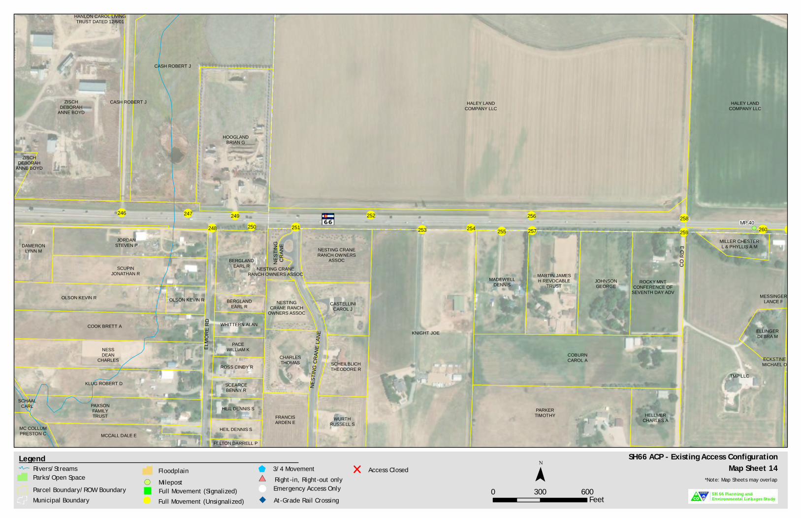
!(
!(
!(
!(
!(
!(
ZISCHDEBORAH
ANNE BOYD
HOOGLANDBRIAN G
HANLON CAROL LIVINGTRUST DATED 12/6/01
HALEY LANDCOMPANY LLC
CASH ROBERT J
CASH ROBERT JZISCHDEBORAH
ANNE BOYDHALEY LAND
COMPANY LLC
MILLER CHESTERL & PHYLLIS A M
MESSINGERLANCE F
ECKSTINEMICHAEL O
ELLINGERDEBRA M
TMP LLC
ROCKY MNTCONFERENCE OF
SEVENTH DAY ADV
MADEWELLDENNIS
COBURNCAROL A
JOHNSONGEORGE
MARTIN JAMESH REVOCABLE
TRUST
KNIGHT JOE
HELLMERCHARLES A
PARKERTIMOTHY
CASTELLINICAROL J
SCHEILBLICHTHEODORE R
WURTHRUSSELL S
FRANCISARDEN E
CHARLESTHOMAS
NESTING CRANERANCH OWNERS
ASSOCNESTING CRANE
RANCH OWNERS ASSOC
NESTINGCRANE RANCH
OWNERS ASSOC
PACEWILLIAM K
ROSS CINDY R
SCEARCEBENNY R
HEIL DENNIS S
HEIL DENNIS S
FELTON DARRELL P
SCHAALCARL
OLSON KEVIN R
MC COLLUMPRESTON C
DAMERONLYNN M
WHITTERN ALAN
BERGLANDEARL R
BERGLANDEARL R
OLSON KEVIN R
KLUG ROBERT D
NESSDEAN
CHARLES
COOK BRETT A
PAXSONFAMILYTRUST
MCCALL DALE E
JORDANSTEVEN P
SCUPINJONATHAN R
NEST
ING
CRAN
E
CO R
D 3
ELMO
RE R
D
NEST
ING
CRAN
E LAN
E
MP 40246
248249
250 251 253
247
254 255
256
257
258
259 260
252
SH66 ACP - Existing Access ConfigurationMap Sheet 14
0 300 600Feet
¯Legend
Parcel Boundary/ROW BoundaryMunicipal Boundary Full Movement (Unsignalized)!
Full Movement (Signalized)"
3/4 Movement$Right-in, Right-out only#*
& Emergency Access OnlyAt-Grade Rail Crossing
Access Closed*Note: Map Sheets may overlap
Rivers/StreamsParks/Open Space
FloodplainMilepost!(

!(
!(
!(
!(
RYMANMICHAELRONALD
WRONSKIKENNETH M
HAYSWILLIAM
HALEY LANDCOMPANY LLC
HALEY LANDCOMPANY LLC
HALEY LANDCOMPANY LLC
KITELEYFARMSLLLP
CAINCHRIS A
TRIPLE JFARMS LLC
HEILJACOBSCOTT
WOOD DAVID AMILLER
CHESTER L &PHYLLIS A M
OLANDERPROPERTY
LLC
OLANDERPROPERTY LLC
BOSSLEYMICHAEL W
GWIN PHIL A
STEPHENSBONNIE R
BEATTIE FAMILYREVOCABLE TRUST BOND
DOUGLAS W& KRISTEN K
LONGMONTCITY OF
SPERRYKORY
ROBERTSONJOSHUA E
MESSINGERLANCE F
ECKSTINEMICHAEL O
BALDWIN FAMILYREVOCABLE
LIVING TRUST
ELLINGERDEBRA M
TMP LLC
TMP LLC
ECKSTINEMICHAEL O
CR 5
260 261262
263 264 265266
267
268 270
269
271 273 276 278
277272
274
275
SH66 ACP - Existing Access ConfigurationMap Sheet 15
0 300 600Feet
¯Legend
Parcel Boundary/ROW BoundaryMunicipal Boundary Full Movement (Unsignalized)!
Full Movement (Signalized)"
3/4 Movement$Right-in, Right-out only#*
& Emergency Access OnlyAt-Grade Rail Crossing
Access Closed*Note: Map Sheets may overlap
Rivers/StreamsParks/Open Space
FloodplainMilepost!(

!(!(
!(
!(
!(
!(
RYMANMICHAELRONALD
WRONSKIKENNETH M
HAYSWILLIAM
HALEY LANDCOMPANY LLC
LIBERTY HALLGRANGE INC
No. 459
CENTRALGARDEN & PET
COMPANY
KITELEYFARMSLLLP
CAIN CHRIS A
JMB REAL ESTATE LLC
EQUINOXMEADLLC
EQUINOXMEADLLC
EQUINOXMEAD LLC
MAC DOWELLJAMES L JR& KARIN C
SILENGO MYRA
NORTONSTEVEN DPRICE ANGEL N
QUEDENFELDJON R
CHADBOURNEJOELGALLAGHER
MANDY JSEVERSON JANELLE
ADLER SHANEMICHAELCIRILO
LUISUNALGURSEL C(HEIRS OF)
LUNDQUISTADAM WAYNE
MEYERSSCOTT A
MARTINMARVIN L
AYERS KENNETHWILLIAM
UNALMERYEM
DERINBORREGO
GWENDOLYN CFEINGLASS
DAVID AGREENCHRISTOPHER R FOOTE
JERRY(BN)
HAYDEN CALLIE
GRABA WESLEY J
PEMBERTONCYNTHIA
BOCKELMANROYCE
GODINO-SOLISANA LIZ
REEDERBRYAN J
HOLCOMBMATTHEW D
RUTLANDGARY C
MILLERMATTHEW S
SIDIQYAR KAWKIE
VANSPARRENTAKANDREW
BEANJANET
HOLBERG
KARELEMILY
LORSONSOUTH LAND
CORP
LIBERTYRANCH HOMEOWNER
ASSOCIATION INC
LIBERTY RANCHHOMEOWNER
ASSOCIATION INC
ST VRAINVALLEY SCHOOLDISTRICT RE1J
LIBERTY RANCHHOMEOWNER
ASSOCIATION INC
LIBERTYRANCH HOMEOWNER
ASSOCIATION INC
LIBERTY RANCH HOMEOWNERASSOCIATION INC
LR INVESTMENTS LLC
SMALLWOODBRIAN KELLEY
JESSE W
MILLERWESTON
BLAZERODRIGUEZ
CHRISTOPHER J
YOUNGNICHOLAS R
BURCHJOSHUASCOTT
WRIGHTCHRISTOPHERNAZZARO
ANTHONY P
REGELSAMANTHA J
SCOTTMARCQUIS B
OGDENDENNIS STELLEY
THOMAS R
LR INVESTMENTSLLC
MEAD TOWN OF
MEAD TOWN OFDOCHEFFJOSEPH JTRIPLE J
FARMS LLC
HEILJACOBSCOTT
OLANDERPROPERTY
LLC
OLANDERPROPERTY
LLC
SADD
LE D
R
CO R
D 5.5
WRAN
GLER
WY
BRIDLE DR
CAVA
LRY D
R
LIBERTY DR
BRIDAL DR
STAGECOACH DR
CR 5
MP 41279278
277 282
281 283
284
285286 287380
381280
SH66 ACP - Existing Access ConfigurationMap Sheet 16
0 300 600Feet
¯Legend
Parcel Boundary/ROW BoundaryMunicipal Boundary Full Movement (Unsignalized)!
Full Movement (Signalized)"
3/4 Movement$Right-in, Right-out only#*
& Emergency Access OnlyAt-Grade Rail Crossing
Access Closed*Note: Map Sheets may overlap
Rivers/StreamsParks/Open Space
FloodplainMilepost!(
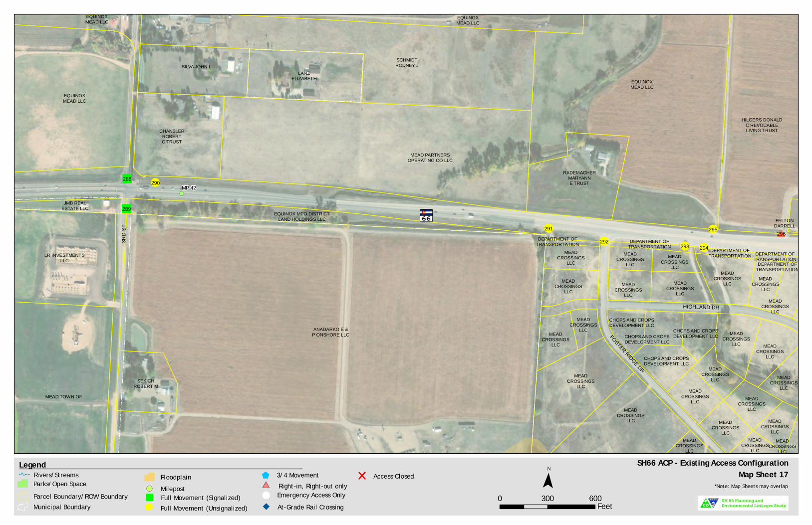
!(
!(
!(
!(
!(
!(
#
JMB REALESTATE LLC
EQUINOXMEAD LLC
EQUINOXMEAD LLC
SCHMIDTRODNEY J
LANZELIZABETH
SILVA JOHN L
MEAD PARTNERSOPERATING CO LLC
CHANSLERROBERTC TRUST
RADEMACHERMARYANNE TRUST
EQUINOXMEAD LLC
EQUINOXMEAD LLC
EQUINOX MPO DISTRICTLAND HOLDINGS LLC FELTON
DARRELL
HILGERS DONALDC REVOCABLELIVING TRUST
MEADCROSSINGS
LLC
MEADCROSSINGS
LLC
MEADCROSSINGS
LLC
MEADCROSSINGS
LLC
MEADCROSSINGS
LLC
MEADCROSSINGS
LLC
MEADCROSSINGS
LLC
MEADCROSSINGS
LLC
CHOPS AND CROPSDEVELOPMENT LLC
CHOPS AND CROPSDEVELOPMENT LLC
CHOPS AND CROPSDEVELOPMENT LLC
CHOPS AND CROPSDEVELOPMENT LLC
MEADCROSSINGS
LLC
MEADCROSSINGS
LLC
MEADCROSSINGS
LLC
MEADCROSSINGS
LLCMEAD
CROSSINGSLLC
MEADCROSSINGS
LLCMEAD
CROSSINGSLLC
MEADCROSSINGS
LLC MEADCROSSINGS
LLC
MEADCROSSINGS
LLC
DEPARTMENT OFTRANSPORTATION
MEADCROSSINGS
LLC DEPARTMENT OFTRANSPORTATION
MEADCROSSINGS
LLC
DEPARTMENT OFTRANSPORTATION
MEADCROSSINGS
LLC
DEPARTMENT OFTRANSPORTATION
MEADCROSSINGS
LLC
MEADCROSSINGS
LLC
DEPARTMENT OFTRANSPORTATION
MEADCROSSINGS
LLC
SEKICHROBERT M
ANADARKO E &P ONSHORE LLC
LR INVESTMENTSLLC
MEAD TOWN OF
HIGHLAND DR
FOSTER RIDGE DR
3RD
ST
MP 42
289
288
291
292 293 294
295 296
290
SH66 ACP - Existing Access ConfigurationMap Sheet 17
0 300 600Feet
¯Legend
Parcel Boundary/ROW BoundaryMunicipal Boundary Full Movement (Unsignalized)!
Full Movement (Signalized)"
3/4 Movement$Right-in, Right-out only#*
& Emergency Access OnlyAt-Grade Rail Crossing
Access Closed*Note: Map Sheets may overlap
Rivers/StreamsParks/Open Space
FloodplainMilepost!(
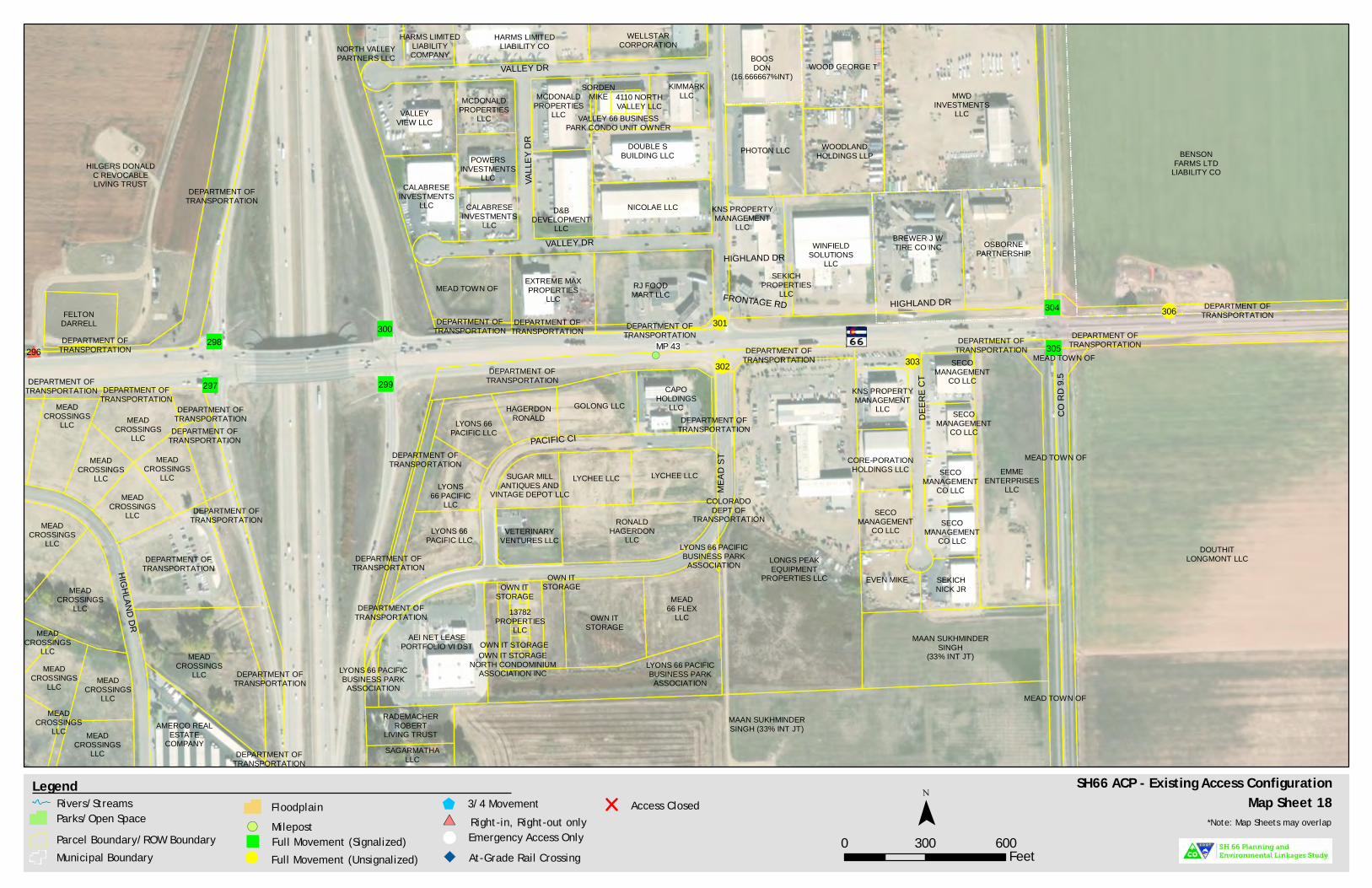
!(
!(
!(
!(#DEPARTMENT OF
TRANSPORTATION
FELTONDARRELL
DEPARTMENT OFTRANSPORTATION
HILGERS DONALDC REVOCABLELIVING TRUST
KNS PROPERTYMANAGEMENT
LLCOSBORNE
PARTNERSHIP
BOOSDON
(16.666667%INT)
BREWER J WTIRE CO INC
PHOTON LLC
WOOD GEORGE T
WOODLANDHOLDINGS LLP
SEKICHPROPERTIES
LLC
WINFIELDSOLUTIONS
LLC
MWDINVESTMENTS
LLC
WELLSTARCORPORATION
KIMMARKLLC
DOUBLE SBUILDING LLC
NICOLAE LLCD&BDEVELOPMENT
LLC
MCDONALDPROPERTIES
LLC
CALABRESEINVESTMENTS
LLC
CALABRESEINVESTMENTS
LLC
POWERSINVESTMENTS
LLC
MCDONALDPROPERTIES
LLCVALLEYVIEW LLC
NORTH VALLEYPARTNERS LLC
HARMS LIMITEDLIABILITYCOMPANY
HARMS LIMITEDLIABILITY CO
DEPARTMENT OFTRANSPORTATION
EXTREME MAXPROPERTIES
LLC
DEPARTMENT OFTRANSPORTATION
MEAD TOWN OF
DEPARTMENT OFTRANSPORTATION
SORDENMIKE 4110 NORTH
VALLEY LLCVALLEY 66 BUSINESS
PARK CONDO UNIT OWNER
RJ FOODMART LLC
DEPARTMENT OFTRANSPORTATION
BENSONFARMS LTD
LIABILITY CO
RADEMACHERROBERT
LIVING TRUSTSAGARMATHA
LLC
DEPARTMENT OFTRANSPORTATION
MEAD TOWN OF
DOUTHITLONGMONT LLC
DEPARTMENT OFTRANSPORTATIONDEPARTMENT OF
TRANSPORTATION
MEAD TOWN OFEMME
ENTERPRISESLLC
MEAD TOWN OF
MAAN SUKHMINDERSINGH
(33% INT JT)
MAAN SUKHMINDERSINGH (33% INT JT)
COLORADODEPT OF
TRANSPORTATION
LONGS PEAKEQUIPMENT
PROPERTIES LLC
KNS PROPERTYMANAGEMENT
LLC
CORE-PORATIONHOLDINGS LLC
SECOMANAGEMENT
CO LLC
EVEN MIKE SEKICHNICK JR
SECOMANAGEMENT
CO LLC
SECOMANAGEMENT
CO LLC
SECOMANAGEMENT
CO LLC
SECOMANAGEMENT
CO LLCCAPO
HOLDINGSLLCGOLONG LLCHAGERDON
RONALDLYONS 66PACIFIC LLC
LYONS66 PACIFIC
LLC
SUGAR MILLANTIQUES AND
VINTAGE DEPOT LLCLYCHEE LLC LYCHEE LLC
LYONS 66PACIFIC LLC
VETERINARYVENTURES LLC
RONALDHAGERDON
LLC
AEI NET LEASEPORTFOLIO VI DST
OWN ITSTORAGE
MEAD66 FLEX
LLC
LYONS 66 PACIFICBUSINESS PARK
ASSOCIATIONLYONS 66 PACIFICBUSINESS PARK
ASSOCIATION
DEPARTMENT OFTRANSPORTATION
LYONS 66 PACIFICBUSINESS PARK
ASSOCIATION
DEPARTMENT OFTRANSPORTATION
DEPARTMENT OFTRANSPORTATION
DEPARTMENT OFTRANSPORTATION
DEPARTMENT OFTRANSPORTATION
OWN ITSTORAGE
OWN IT STORAGENORTH CONDOMINIUM
ASSOCIATION INC
OWN ITSTORAGE
13782PROPERTIES
LLCOWN IT STORAGE
MEADCROSSINGS
LLC
MEADCROSSINGS
LLC
MEADCROSSINGS
LLC
MEADCROSSINGS
LLC
MEADCROSSINGS
LLC MEADCROSSINGS
LLC
MEADCROSSINGS
LLC
MEADCROSSINGS
LLC
MEADCROSSINGS
LLC
DEPARTMENT OFTRANSPORTATION
AMERCO REALESTATE
COMPANY
DEPARTMENT OFTRANSPORTATION
MEADCROSSINGS
LLC
DEPARTMENT OFTRANSPORTATION
DEPARTMENT OFTRANSPORTATION
DEPARTMENT OFTRANSPORTATION
MEADCROSSINGS
LLC
DEPARTMENT OFTRANSPORTATION
DEPARTMENT OFTRANSPORTATION
MEADCROSSINGS
LLC
MEADCROSSINGS
LLC
DEPARTMENT OFTRANSPORTATION
FRONTAGE RD
HIGHLAND DR
VALL
EY D
R
DEER
E CT
HIGHLAND DR
VALLEY DR
CO R
D 9.5
MEAD
ST
HIGHLAND DR
VALLEY DR
PACIFIC CI
MP 43296298
297
300
299
301
302 303
304
305
306
SH66 ACP - Existing Access ConfigurationMap Sheet 18
0 300 600Feet
¯Legend
Parcel Boundary/ROW BoundaryMunicipal Boundary Full Movement (Unsignalized)!
Full Movement (Signalized)"
3/4 Movement$Right-in, Right-out only#*
& Emergency Access OnlyAt-Grade Rail Crossing
Access Closed*Note: Map Sheets may overlap
Rivers/StreamsParks/Open Space
FloodplainMilepost!(

!(
!(
!(
!(
!(
!(
BENSON FARMS LTDLIABILITY CO
SNYDER JOHN T
BENSON FARMSLIMITED
LIABILITY CO FARMLANDRESERVE INC
BODASHERRILYN S
BAREFOOT LLC
BAREFOOT LLC
BAREFOOT LLC
BAREFOOT LLC
BAREFOOT LLC
DEPARTMENT OFTRANSPORTATION
DOUTHITLONGMONT
LLC
CO R
D 11
MP 44308 309 311
310 312313 317314
316315
318
319
307 396
SH66 ACP - Existing Access ConfigurationMap Sheet 19
0 300 600Feet
¯Legend
Parcel Boundary/ROW BoundaryMunicipal Boundary Full Movement (Unsignalized)!
Full Movement (Signalized)"
3/4 Movement$Right-in, Right-out only#*
& Emergency Access OnlyAt-Grade Rail Crossing
Access Closed*Note: Map Sheets may overlap
Rivers/StreamsParks/Open Space
FloodplainMilepost!(
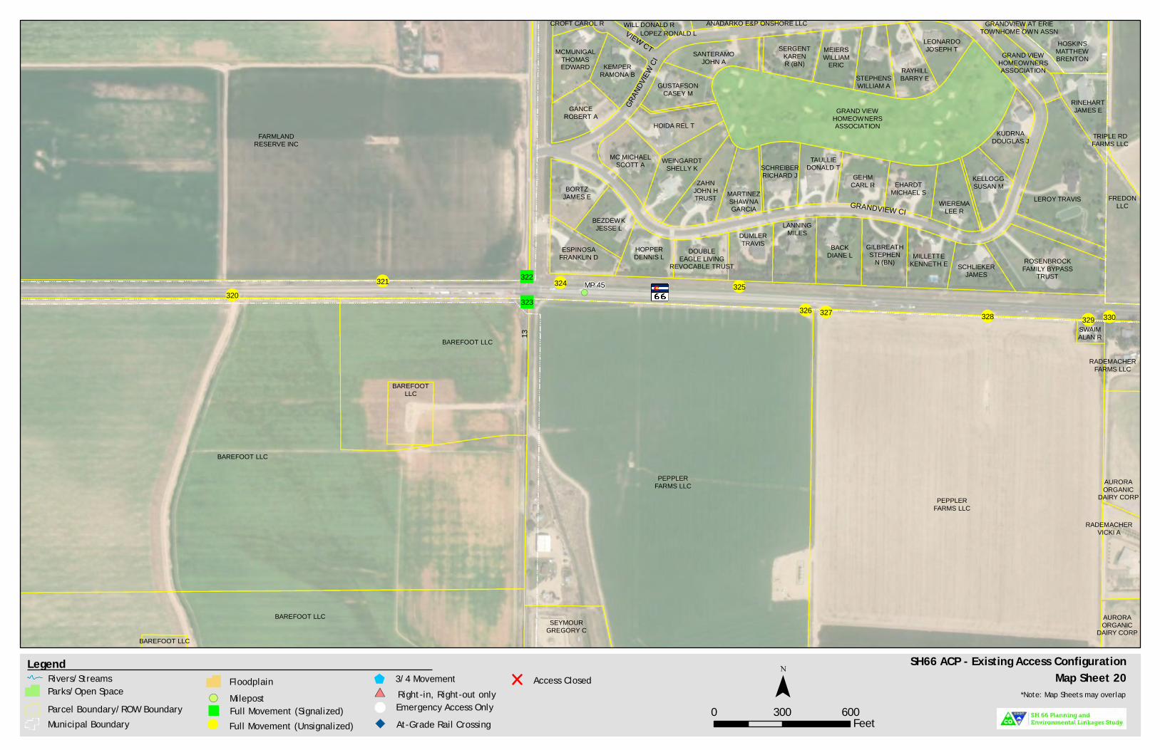
!(
!(
!( !(!(
FARMLANDRESERVE INC
BAREFOOT LLC
BAREFOOTLLC
BAREFOOT LLC
BAREFOOT LLC
BAREFOOT LLC
HOSKINSMATTHEWBRENTON
GRANDVIEW AT ERIETOWNHOME OWN ASSN
GRAND VIEWHOMEOWNERSASSOCIATION
GRAND VIEWHOMEOWNERSASSOCIATION
ESPINOSAFRANKLIN D
BORTZJAMES E
BEZDEWKJESSE L
HOPPERDENNIS L DOUBLE
EAGLE LIVINGREVOCABLE TRUST
DUMLERTRAVIS
LANNINGMILES
BACKDIANE L
GILBREATHSTEPHEN
N (BN) MILLETTEKENNETH E
RINEHARTJAMES E
KUDRNADOUGLAS J
KELLOGGSUSAN M
WIEREMALEE R
EHARDTMICHAEL S
GEHMCARL R
TAULLIEDONALD TSCHREIBER
RICHARD J
MARTINEZSHAWNAGARCIA
ZAHNJOHN HTRUST
WEINGARDTSHELLY K
MC MICHAELSCOTT A
HOIDA REL T
GUSTAFSONCASEY M
SANTERAMOJOHN A
SERGENTKARENR (BN)
MEIERSWILLIAM
ERICSTEPHENSWILLIAM A
RAYHILLBARRY E
LEONARDOJOSEPH T
LOPEZ RONALD LWILL DONALD RCROFT CAROL R
MCMUNIGALTHOMASEDWARD KEMPER
RAMONA B
GANCEROBERT A
ANADARKO E&P ONSHORE LLC
SCHLIEKERJAMES
ROSENBROCKFAMILY BYPASS
TRUST
LEROY TRAVIS FREDONLLC
TRIPLE RDFARMS LLC
SWAIMALAN R
PEPPLERFARMS LLC
PEPPLERFARMS LLC
SEYMOURGREGORY C
RADEMACHERVICKI A
RADEMACHERFARMS LLC
AURORAORGANIC
DAIRY CORP
AURORAORGANIC
DAIRY CORP
VIEW CT
GRAN
DVIEW
CI
GRANDVIEW CI
13
MP 45320
322
323326 327 328 329 330
321 324 325
SH66 ACP - Existing Access ConfigurationMap Sheet 20
0 300 600Feet
¯Legend
Parcel Boundary/ROW BoundaryMunicipal Boundary Full Movement (Unsignalized)!
Full Movement (Signalized)"
3/4 Movement$Right-in, Right-out only#*
& Emergency Access OnlyAt-Grade Rail Crossing
Access Closed*Note: Map Sheets may overlap
Rivers/StreamsParks/Open Space
FloodplainMilepost!(
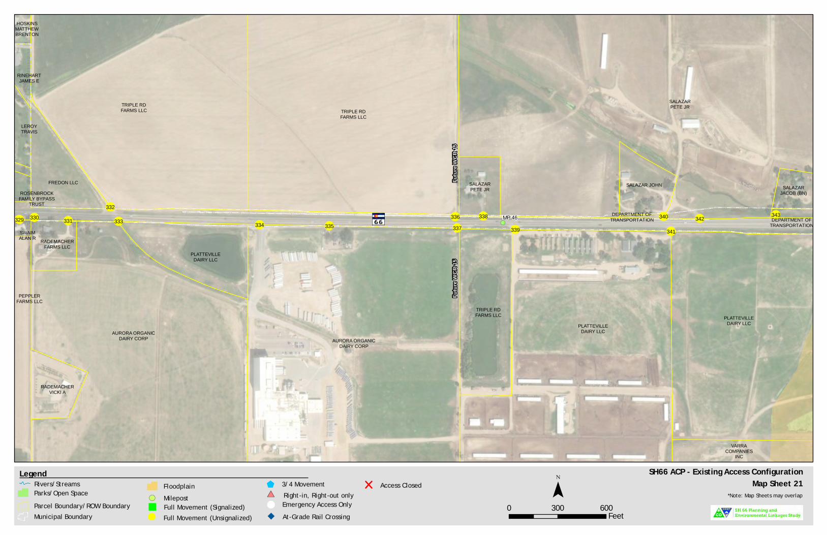
!(
!(!(
!(
!(
!(
Futu
re W
CR 15
Futu
re W
CR 15
HOSKINSMATTHEWBRENTON
RINEHARTJAMES E
ROSENBROCKFAMILY BYPASS
TRUST
LEROYTRAVIS
TRIPLE RDFARMS LLC
FREDON LLC
TRIPLE RDFARMS LLC
SALAZARPETE JR
SALAZARPETE JR SALAZAR
JACOB (BN)
DEPARTMENT OFTRANSPORTATION
SALAZAR JOHN
DEPARTMENT OFTRANSPORTATION
VARRACOMPANIES
INC
TRIPLE RDFARMS LLC
PLATTEVILLEDAIRY LLC
PLATTEVILLEDAIRY LLC
SWAIMALAN R
PEPPLERFARMS LLC
PLATTEVILLEDAIRY LLC
RADEMACHERVICKI A
RADEMACHERFARMS LLC
AURORA ORGANICDAIRY CORP
AURORA ORGANICDAIRY CORP
MP 46329 330 331
332
333 334 335336 338
339337340
341342 343
SH66 ACP - Existing Access ConfigurationMap Sheet 21
0 300 600Feet
¯Legend
Parcel Boundary/ROW BoundaryMunicipal Boundary Full Movement (Unsignalized)!
Full Movement (Signalized)"
3/4 Movement$Right-in, Right-out only#*
& Emergency Access OnlyAt-Grade Rail Crossing
Access Closed*Note: Map Sheets may overlap
Rivers/StreamsParks/Open Space
FloodplainMilepost!(

!(
!(
!(
!(
!(
DIXIEWATER LLCSALAZAR
PETE JR
DEPARTMENT OFTRANSPORTATION
SALAZARJACOB (BN)
DEPARTMENT OFTRANSPORTATION
SALAZARPETE
DEPARTMENT OFTRANSPORTATION
DIXIEWATER LLC
DIXIEWATER
LLC
DIXIEWATER
LLC
DAVISDAKOTA
COLT
DIXIEWATER LLC
DIXIEWATER LLC
DEPARTMENT OFTRANSPORTATION
FIRESTONETOWN OF
DEPARTMENT OFTRANSPORTATION
DIXIEWATER LLC
WHITAKERBRIAN J
VARRACOMPANIES
INC
VARRACOMPANIES
INC
VARRACOMPANIES
INC
DEPARTMENT OFTRANSPORTATION
FIRESTONETOWN OF
VARRACOMPANIES
INC
PLATTEVILLEDAIRY LLC
VARRACOMPANIES
INCVARRA
COMPANIESINC
PLATTEVILLEDAIRY LLC
CO RD 17
17
MP 47344
345 346
347348
349
350
352 353351
SH66 ACP - Existing Access ConfigurationMap Sheet 22
0 300 600Feet
¯Legend
Parcel Boundary/ROW BoundaryMunicipal Boundary Full Movement (Unsignalized)!
Full Movement (Signalized)"
3/4 Movement$Right-in, Right-out only#*
& Emergency Access OnlyAt-Grade Rail Crossing
Access Closed*Note: Map Sheets may overlap
Rivers/StreamsParks/Open Space
FloodplainMilepost!(
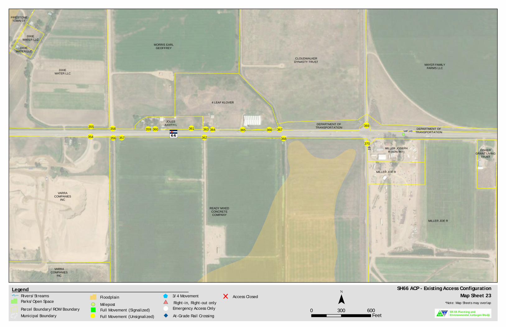
!(
!(
!(
!(
DIXIEWATER LLC
DIXIEWATER LLC
JOLESJUDITH L
DIXIEWATER LLC
FIRESTONETOWN OF
4 LEAF KLOVER
DEPARTMENT OFTRANSPORTATION
CLOUDWALKERDYNASTY TRUST
MORRIS EARLGEOFFREY
DEPARTMENT OFTRANSPORTATION
MAYER FAMILYFARMS LLC
FISHERGRANT LIVING
TRUST
MILLER JOSEPHR (60% INT)
MILLER JOE R
MILLER JOE R
VARRACOMPANIES
INC
VARRACOMPANIES
INC
READY MIXEDCONCRETECOMPANY
19
MP 48355
354
358
356
359 360 361
362
363 364 365 367
368
369
370357
366
SH66 ACP - Existing Access ConfigurationMap Sheet 23
0 300 600Feet
¯Legend
Parcel Boundary/ROW BoundaryMunicipal Boundary Full Movement (Unsignalized)!
Full Movement (Signalized)"
3/4 Movement$Right-in, Right-out only#*
& Emergency Access OnlyAt-Grade Rail Crossing
Access Closed*Note: Map Sheets may overlap
Rivers/StreamsParks/Open Space
FloodplainMilepost!(


SH 66 Access Control Plan | Final Report
Appendix C. Public Involvement
Material
C.1. Open House 1 Postcard Notification


SH
66
Pla
nn
ing
an
dE
nv
iro
nm
enta
l Lin
ka
ges
Stu
dy
7�H�&ROR�DGR��HSD�WPH�W�R��7�D��SR�WDWLR���&�27��
L���R�WL���W�R�S�EOLF�PHHWL�����R��W�H�6�����3OD��L���
��(�YL�R�PH�WDO��L��D�H���3(����W�G��D�G��&3���RP�
��R���WR�:
HOG�&R��W��5RDG�����7�H�H�P
HHWL����D�H�
D�FR�WL��DWLR��R��W�H��W�G��W�DW�EH�D��L���������R��
�HFHLYHG�W�L���RWLFH�EHFD��H��R���DGG�H���L���LW�L��
��P
LOH�R��W�H�S�RMHFW�FR��LGR����R�HYH����H��D�W�
L�S�W���RP�W�H���HDWH��FRPP��LW����R�S�������������
��������������������������������
� �R���P
���L�����L���S�R�L���������P���R������
1����6��S���
������S�L������������������S��������������&��
�R��S���L��L�S���
Summer�2019
�-�Share��nal�PEL�&�ACP��
�R�S���L��
7���������S����������������������������S��
��:HOG�&R��W��6R�W��H�W�6H�YLFH��&RPSOH�
�����&R��W��5RDG�����
�R��P
R�W��&2������
7����������S����������������������������S��
� ��R�� ��3HD��0LGGOH�6F�RRO
�������W���YH��H
�R��P
R�W��&2������
3OHD�H�YL�LW����WR�OHD���DER�W�W�H��W�G���S�RYLGH��HHGEDF��R��
W�D��SR�WDWLR��DOWH��DWLYH��D�G�OHD���DER�W�&�27����L���D�G��H�LOLH�F��
D��H��PH�W��:
H��LOO�DO�R�L�W�RG�FH�W�H��FFH���&R�W�RO�3OD����&3�����LF��
�LOO�PD�H��HFRPPH�GDWLR����R����W��H�F�D��H��WR�W�H�ORFDWLR��D�G�GH�L���
R��G�LYH�D���D�G�L�WH��HFWLR���
���
&�27�DO�R��LOO�EH�DFFHSWL���S�EOLF��HHGEDF��W��R����D��R�OL�H�
T�H�WLR��DL�H�D�G��HEPDS��)R��L��R�P
DWLR��D�G�WR�OHD���P
R�H�DER�W�W�H�
S�RMHFW��YL�LW�����S����������������������������������������S��
����������R���RPP��L���LR�����L�������R������R���������RPPR���LR����R���S��L���
�������������P
��������R�����L�������S�R�����S�LR���R�����P
���L�������������������

&ROR�DGR��HSD�WPH�W�R��7�D��SR�WDWLR�
�������G�6W�HHW
��HHOH���&2�������
Presorted�STD
U.S.�Postage
PAID
Permit�#4033
Denver,�CO
SH
66
Pla
nn
ing
an
d
En
viro
nm
enta
l Lin
kag
es S
tud
y

SH 66 Access Control Plan | Final Report
C.2. Open House 2 Postcard Notification and Boards


��H�&ROR�DGR��HSD�WPH�W�R����D��SR�WDWLR���&�2���L���R�WL�J�D��2
SH���R��H�WR�S�H�H�W�W�H���D�W�6������FF
H���&R�W�RO�3OD����&3�����L��SOD��
L���HODWHG�E�W��HSD�DWH���RP�W�H�R�H
�DOO�6�����3OD��L�J�D�G�(��L�R�PH�WDO�/L��DJH��6W�G����RP�/�R���WR�:
HOG�&R��W��5RDG�������H��&3�L��
D��H��L�J�DOO�H�L�WL�J�D�G�S�RSR�HG�L�WH��HFWLR���D�G�G�L�H
�D�
��DOR�J�W�H��LJ��D������H��&3��
LOO�L�FO�GH��HFR
PPH�GDWLR����R��F�
D�JH
��WR�W�H�
ORFDWLR��D�G�GH�LJ��R��DF
FH���SRL�W��WR�LPS�R�H
��D�HW��D�G�W�H�P
R�HPH�W�R��DOO��R�P
��R��W�D��SR�WDWLR�����H��HFR
PPH�GDWLR���R��W�H�SOD��
�LOO�EH�J�DG�DOO��LP
SOHPH�WHG�R�H
��WLPH�D�����GL�J�EHFR
PH��D�D
LODEOH��D���HGH�HORSPH�W�RFF�����D�G�D���D�HW���HHG��D�L�H��
:��W�F���JH��W���FFH���F��O��W�H��O�����FO��H�
��&
R��ROLGDWH��FOR�H��D�G�R��PR�H
�DFFH���SRL�W�
��5
H�W�LFW�FH�WDL��P
R�H
PH�W��
��3�R�LGH�DFFH�����L�J�DOWH��DWL�H
��R�WH����F�
�D����R�WDJH
��RDG�
��R
eco
mmend�potential�loca
tions�for�traf�c�signals,�roundabouts,�or�interchanges
����F���,�JHW���Y�OYH��W���HO���HYHO�������FFH��I�O��FFH������W��O�3O����
���
WWH�G�W�H�2SH���R��H�R��-�O����W�
��Learn�about�the�m
ethods�and�bene�ts�of�access�m
anagement�
��)
LOO�R�W�D�FRPPH�W��R�P
�DW�W�H�2SH���R��H�R��R��W�H�S�R�HFW����
HE�LWH���WWS��������FRGRW�JR��OLE�D����W�GLH��FR
����SHO�
,���W��HFH�YH���W�W�H�2�H������H�����I��P�W�H��H���WH���OO��H���H��W���HYHO���W�H�����O��FFH������W��O�3O����F�H��OH��W���H�����WH��
���I�OO��������
������WWH����FH���������W���H��HH�H��SH
66
Pla
nn
ing
an
d
En
vir
on
men
tal L
ink
ag
es S
tud
y

&ROR�DGR��HSD�WPH�W�R����D��SR�WDWLR�
������:
����W��6W�HHW
��HHOH���&2������
YO
U’R
E I
NV
ITE
Dto
an
Op
en H
ou
se f
or
the
SH
66
Acc
ess
Co
ntr
ol P
lan
7�����������O������������������W�PH�I��P������W���������P
/R�JP
R�W�6H
�LR��&H�WH���5RRP����
�(����/R�J��3HD����H
/R�JP
R�W��&2������
�H��H��
���R
���R
��
����
���R���
������
��H
�R���H
��R
���OH
����
R�
�R����R����R
��
��H��
�O��HH�����
���
H��
��H��
���R
���
����
����H��
�R�H
����
��R���R
���H�2
�H���
R��H
����
�����
����
����
SH
66
Pla
nn
ing
an
d
En
vir
on
men
tal L
ink
ag
es S
tud
y

Welcome
Open HouseJ u l y 2 5 , 2 0 1 9
to the
SH 66Access Control Plan
Thank you for attending!
Purpose of tonight's meeting:• Present the Access Control Plan's purpose, goals, and
study process
• Present the draft Access Control Plan
• Gather your comments regarding the proposed recommendations

15-255 07.25.2019
What Is an Access Control Plan?
Any intersection or driveway along a roadway is called an access point
At access points there is a potential for conflicts between all modes of transportation (vehicle, pedestrian, and bicycle) compromising the overall safety for travelers
Vehicles turning into and out of access points can cause other vehicles to slow down, resulting in delay, congestion, or crashes
An Access Control Plan:
Determines what access points will be allowed
Establishes where accesses will be located
Determines what kind of traffic movements will be allowed at each access
Identifies alternative access routes and circulation as necessary
Ensures each abutting property has access directly to SH 66 or to local roadways
Is a long-range vision for the corridor
Will not determine the future number of lanes or design features of SH 66
Implementation of the SH 66 Access Control Plan will occur in phases or incrementally over time based on:
Safety needs
The development and redevelopment process
Available funding
Traffic needs
There are no planned projects or identified funding that would change existing access
SH 66 Access Control Plan

15-255 07.25.2019
Overview
Identify improvements to the local transportation network that promote safety for all modes of transportation
Blend the corridor vision from the PEL with the requirements of the CDOT State Highway Access Code
Assist future development and redevelopment along SH 66 by identifying the locations and type of access
To provide efficient movement for all modes of transportation along SH 66
What are the goals of this Access Control Plan?
SH 66 has 373 existing access points (driveways and intersections) within the study area limits from Lyons (McConnell Dr) to WCR 19, which is an average of nearly 19 accesses per mile
Controlling the number of access points on SH 66:
Reduces conflict points where a crash may occur on the highway. This is applicable not only for vehicles, but also for pedestrians and bicycles having to cross multiple driveways on the corridor
Creates fewer locations for vehicles to brake or turn onto or off the highway resulting in more efficient travel for through traffic
Makes the corridor more visually appealing to drivers and visitors by reducing the number of driveways
Why does SH 66 need an Access Control Plan?
SH 66 Access Control Plan

15-2
55 0
7.2
5.2
019
BNSF
Rai
lroa
d
BNSF Railroad
Great Western Railway
SECTION
1A
SECTIO
N1B
SECTIO
N1C
SECTIO
N2
SECTIO
N3
SECTIO
N4
SECTION
5A
SECTIO
N5B
S 21s
t Ave
75th St
87th St
95th St Hover St
Spencer St
Francis St
Gay St
115th St
Pace St
Sundance Rd
66th St
Pratt St
County Line Rd
CR 3
CR 5
3rd St
CR 9.5
CR 11
CR 13
CR 17
CR 19
Elmore Rd
N 51st St
Ston
e Ca
nyon
Dr
McConnell Dr
Mead St.
Exi
stin
g C
on
dit
ion
s
McConnell D
r to
87th
St
87th
St
to C
ounty
Lin
e R
oad
County
Lin
e R
oad t
o W
eld
County
Rd 7
Weld
County
Rd 7
to W
eld
County
Rd 1
1
Weld
County
Rd 1
1 t
o W
eld
County
Rd 1
9
Tota
ls
33 23 11 14 23 104
0 2 0 1 0 3
0 2 2 0 0 4
112
51 34 7 38 242
12 5 0 0 0 20
160
83
47
22
61
373
5.8
4.8
2.8
1.8
3.9
19.2
28 17 17 12 15 18
Exi
s ti n
g A
cces
s S
um
ma
ry
St u
dy
Li m
its
SH
66
Ro
ad
way
Seg
men
t
Nu
mb
er o
f A
cces
ses
Pu
bli
cP
riv
ate
Seg
men
tL
eng
th(m
iles
)
Acc
ess
Den
sity
(#/m
ile)
FM
PM
FM
PM
Oth
erT
ota
l
NOTE:P
ublic
acce
sses
are
nam
ed r
oads
or
right
of
ways
main
tain
ed b
y CD
OT,
County
, or
Tow
n/Cit
yPr
ivate
acc
ess
es
inclu
de b
usi
ness
and r
esi
denti
al dri
vew
ays
.FM
= f
ull
move
ment
PM
= p
art
ial m
ove
ment
Oth
er
= r
ailro
ad c
ross
ing
36
287
25
SH
66
Acc
ess
Co
ntr
ol P
lan

15-255 07.25.2019
Current & Future Tra�c Volumes
Greater number of crashes involving vehicles, pedestrians, or bicyclists
Increased traffic congestion, resulting in higher levels of pollution and more delays
A loss of visual appeal along the roadway, which may result in a loss of visitor stops and economic impacts for business owners
Without an access control plan visitors, residents, property owners, and businesses along the SH 66 corridor could experience:
McConnell Dr to 87th St
87th St to County Line Road
County Line Road to Weld County Rd 7
Weld County Rd 7 to Weld County Rd 11
Weld County Rd 11 to Weld County Rd 19
14,000
27,000
23,350
23,600
11,900
16,000
38,950
30,000
33,200
15,000
14%
44%
28%
41%
26%
SH 66 Roadway Segment Increase
Existing Average Daily
Tra�c Volumes
2040 Projected Average Daily
Tra�c Volumes
SH 66 Access Control Plan

15-255 07.25.2019
Access Relocation
Access Realignment
Access Consolidation
Parallel Access Route
Access Conversion withMedian Treatment
Methods ofAccess Control
Access to local properties through secondary roads
Reduce the number of access locations where vehicles may enter or exit the highway
Reduce the number of conflict points
Align opposite approaches
Create a more traditional intersection design
Consolidate adjacent access points into one location
The number of conflict points are reduced
Provide access to properties via a new access road (such as a frontage road)
Reduces the number of access points along the highway
Restrict some or all turning movements
Reduce the number of conflicts between left turning vehicles and through vehicles on the highway
Before After
Before After
Before After
Before After
Before After
SH 66 Access Control Plan
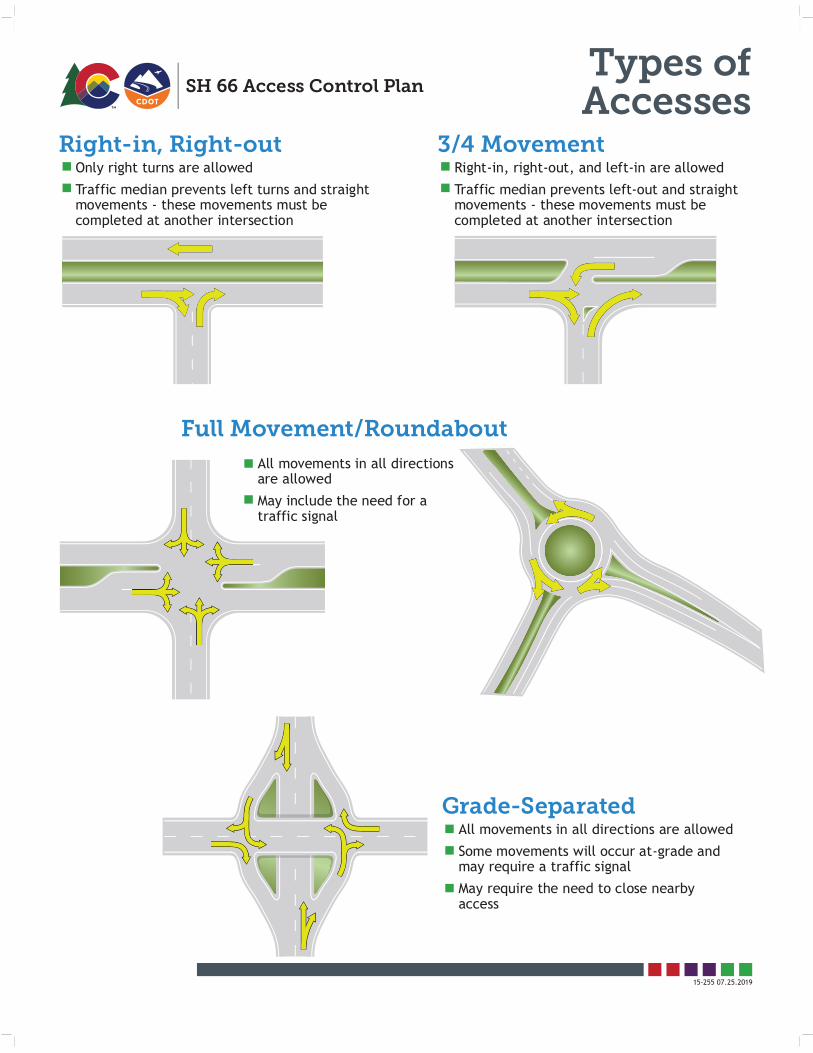
15-255 07.25.2019
Right-in, Right-out 3/4 Movement
Full Movement/Roundabout
Grade-Separated
Types ofAccesses
Only right turns are allowed
Traffic median prevents left turns and straight movements - these movements must be completed at another intersection
Right-in, right-out, and left-in are allowed
Traffic median prevents left-out and straight movements - these movements must be completed at another intersection
All movements in all directions are allowed
May include the need for a traffic signal
All movements in all directions are allowed
Some movements will occur at-grade and may require a traffic signal
May require the need to close nearby access
SH 66 Access Control Plan

15-255 07.25.2019
Access Control Plan Process
SH 66 Access Control Plan
Accept the final plan
Specify how elements of the plan can be changed in the future
Prepare, sign, and adopt an Intergovernmental Agreement between Town of Lyons, City of Longmont, Town of Mead, Town
of Firestone, Boulder County, Weld County, and CDOT
Report outcomes to the Colorado Transportation Commission and get approval from the CDOT
State Access Manager so the plan becomes law
Continuing coordination between Town of Lyons, City of Longmont, Town of Mead, Town of Firestone, Boulder County, Weld County, and CDOT to ensure proper implementation of
the plan in the future
Develop Draft ACP based on PEL recommendations, input from local agencies, and CDOT
Revise Access Control Plan based on input from local agencies, the public, and final PEL recommendations
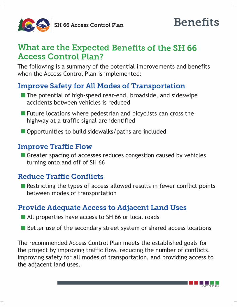
15-255 07.25.2019
Benefits
The following is a summary of the potential improvements and benefits when the Access Control Plan is implemented:
What are the Expected Benefits of the SH 66Access Control Plan?
Greater spacing of accesses reduces congestion caused by vehicles turning onto and off of SH 66
Restricting the types of access allowed results in fewer conflict points between modes of transportation
Improve Tra�c Flow
Reduce Tra�c Conflicts
The potential of high-speed rear-end, broadside, and sideswipe accidents between vehicles is reduced
Future locations where pedestrian and bicyclists can cross the highway at a traffic signal are identified
Opportunities to build sidewalks/paths are included
Improve Safety for All Modes of Transportation
All properties have access to SH 66 or local roads
Better use of the secondary street system or shared access locations
Provide Adequate Access to Adjacent Land Uses
The recommended Access Control Plan meets the established goals for the project by improving traffic flow, reducing the number of conflicts, improving safety for all modes of transportation, and providing access to the adjacent land uses.
SH 66 Access Control Plan

15-2
55 0
7.2
5.2
019
Pro
po
sed
Acc
ess
Su
mm
ary
McC
onnell D
r to
87th
St
87th
St
to C
ounty
Lin
e R
oad
County
Lin
e R
oad t
o W
eld
County
Rd 7
Weld
County
Rd 7
to W
eld
County
Rd 1
1
Weld
County
Rd 1
1 t
o W
eld
County
Rd 1
9
Tota
ls
9 9 6 7 12 43
160
83
47
22
61
373
7 13 3 4 2 29
0 2 2 0 2 6
1 2 0 1 4 8
19 3 7 1 3 33
36 29 18 13 23 119
5.8
4.8
2.8
1.8
3.9
19.2
6 6 6 7 6 6
SH
66
Ro
ad
way
Seg
men
t
Nu
mb
er o
f A
cces
ses
wit
hA
CP
Im
ple
men
ted
Pu
bli
cP
riv
ate
Seg
men
tL
eng
th(m
iles
)
Acc
ess
Den
sity
(#/m
ile)
FM
PM
FM
PM
Oth
erT
ota
l
NOTE:
Public
acce
sses
are
nam
ed r
oads
or
right
of
ways
main
tain
ed b
y CD
OT,
County
, or
Tow
n/Cit
yPr
ivate
acc
ess
es
inclu
de b
usi
ness
and r
esi
denti
al dri
vew
ays
.FM
= f
ull
move
ment
PM
= p
art
ial m
ove
ment
Oth
er
= r
ailro
ad c
ross
ing
To
tal
Exi
stin
g
SH
66
Acc
ess
Co
ntr
ol P
lan

15-255 07.25.2019
Conflict PointsSH 66 Access Control Plan
Crossing TurningMerge/DivergePedestrianTotal
41288
32
Crossing TurningMerge/DivergePedestrianTotal
0284
14
Crossing TurningMerge/DivergePedestrianTotal
00448
Crossing TurningMerge/DivergePedestrianTotal
40
168
28
FULL ACCESS 3/4 ACCESS
RIGHT-IN/RIGHT-OUT ACCESS
SINGLE-LANEROUNDABOUT ACCESS

SH 66 Access Control Plan | Final Report
C.3. Open House 3 Postcard Notification and Boards


������O��D������D������������D������D������������
is�hosting�a��nal�set�of�public�meetings�for�the�SH�66�
Planning�&
�Environmental�Linkages�(PEL)�study�and�
Acce
ss�Control�Plan�(ACP)�from�Lyons�to�W
eld�County�
Road�19.�These�m
eetings�w
ill�be�the��nal�chance�to�
review�planning�documents�and�provide�feedback�
before�the�PEL�and�ACP�are��nalize
d�in�late�2019.�
You�rece
ived�this�notice
�beca
use�your�address�is�
within�½
�mile�of�the�project�corridor.�However,�w
e�
want�input�from�the�greater�co
mmunity,�so�S
�����
�
����W���
���
�����
������
��
����W���
��
����
�
� �R����
���������������R���������������R������
:������
���
�6�SW�
�����
����������
����W���
����S
����
Weld�County�Southwest�Service�Complex
4209�County�Road�24�½
Longm
ont,�CO�80504
7����
����
�6�SW�
�����
����������
����W���
����S
��� �
Long s�Peak�M
iddle�Sch
ool
1500�14th�Ave
nue
Longm
ont,�CO�80501
Attendees�will�be�able�to�view�and�provide�feedback
�on:
��T
he�RECOMMENDED�projects�along�the�entire�project�corridor
��T
he�potential�environmental�im
pacts�associated�w
ith�each
�reco
mmendation
��List�of�future�acce
ss�changes
���
CDOT�w
ill�also�be�acc
epting�public�feedback�through
�an�online�
questionnaire.�For�more�inform
ation�and�to�learn�about�the�project,�visit:�
�WW
S��
���
����
���W�
�������
����
��W�
���
����
����S
��
����������R���R���������R�������������R������R���������R��R����R����R����������
��������������
�������������������������������R���R������
�������
SH
66
Pla
nn
ing
an
dE
nv
iro
nm
enta
l Lin
ka
ges
Stu
dy

��O��D������D������������D������D����
1420�2nd�Street
Greeley,�CO��80631
Presorted�STD
U.S.�Postage
PAID
Permit�#4033
Denver,�CO
SH
66
Pla
nn
ing
an
d
En
viro
nm
enta
l Lin
kag
es S
tud
y

Welcome
Public MeetingS E P T E M B E R 2 5 & 2 6 , 2 0 1 9
to the
SH 66Planning and Environmental Linkages Study
and Access Control Plan
Thank you for attending! We are pleased you are here to hear more about the SH 66 Corridor! We are eager to share with you
the future vision for the corridor!
How to get the most out of this meeting:
• View the displays and talk with our project team members to learn more and share your ideas• Participate in the interactive activities• Fill out a project comment card and drop it in the box

15-255 07.25.2019
What Is an Access Control Plan?
Any intersection or driveway along a roadway is called an access point
At access points there is a potential for conflicts between all modes of transportation (vehicle, pedestrian, and bicycle) compromising the overall safety for travelers
Vehicles turning into and out of access points can cause other vehicles to slow down, resulting in delay, congestion, or crashes
An Access Control Plan:
Determines what access points will be allowed
Establishes where accesses will be located
Determines what kind of traffic movements will be allowed at each access
Identifies alternative access routes and circulation as necessary
Ensures each abutting property has access directly to SH 66 or to local roadways
Is a long-range vision for the corridor
Will not determine the future number of lanes or design features of SH 66
Implementation of the SH 66 Access Control Plan will occur in phases or incrementally over time based on:
Safety needs
The development and redevelopment process
Available funding
Traffic needs
There are no planned projects or identified funding that would change existing access
SH 66 Access Control Plan

15-255 07.25.2019
Access Relocation
Access Realignment
Access Consolidation
Parallel Access Route
Access Conversion withMedian Treatment
Methods ofAccess Control
Access to local properties through secondary roads
Reduce the number of access locations where vehicles may enter or exit the highway
Reduce the number of conflict points
Align opposite approaches
Create a more traditional intersection design
Consolidate adjacent access points into one location
The number of conflict points are reduced
Provide access to properties via a new access road (such as a frontage road)
Reduces the number of access points along the highway
Restrict some or all turning movements
Reduce the number of conflicts between left turning vehicles and through vehicles on the highway
Before After
Before After
Before After
Before After
Before After
SH 66 Access Control Plan

15-255 07.25.2019
Right-in, Right-out 3/4 Movement
Full Movement/Roundabout
Grade-Separated
Types ofAccesses
Only right turns are allowed
Traffic median prevents left turns and straight movements - these movements must be completed at another intersection
Right-in, right-out, and left-in are allowed
Traffic median prevents left-out and straight movements - these movements must be completed at another intersection
All movements in all directions are allowed
May include the need for a traffic signal
All movements in all directions are allowed
Some movements will occur at-grade and may require a traffic signal
May require the need to close nearby access
SH 66 Access Control Plan

15-255 07.25.2019
Access Control Plan Process
SH 66 Access Control Plan
Accept the final plan
Specify how elements of the plan can be changed in the future
Prepare, sign, and adopt an Intergovernmental Agreement between Town of Lyons, City of Longmont, Town of Mead, Town
of Firestone, Boulder County, Weld County, and CDOT
Report outcomes to the Colorado Transportation Commission and get approval from the CDOT
State Access Manager so the plan becomes law
Continuing coordination between Town of Lyons, City of Longmont, Town of Mead, Town of Firestone, Boulder County, Weld County, and CDOT to ensure proper implementation of
the plan in the future
Develop Draft ACP based on PEL recommendations, input from local agencies, and CDOT
Revise Access Control Plan based on input from local agencies, the public, and final PEL recommendations

15-255 07.25.2019
Benefits
The following is a summary of the potential improvements and benefits when the Access Control Plan is implemented:
What are the Expected Benefits of the SH 66Access Control Plan?
Greater spacing of accesses reduces congestion caused by vehicles turning onto and off of SH 66
Restricting the types of access allowed results in fewer conflict points between modes of transportation
Improve Tra�c Flow
Reduce Tra�c Conflicts
The potential of high-speed rear-end, broadside, and sideswipe accidents between vehicles is reduced
Future locations where pedestrian and bicyclists can cross the highway at a traffic signal are identified
Opportunities to build sidewalks/paths are included
Improve Safety for All Modes of Transportation
All properties have access to SH 66 or local roads
Better use of the secondary street system or shared access locations
Provide Adequate Access to Adjacent Land Uses
The recommended Access Control Plan meets the established goals for the project by improving traffic flow, reducing the number of conflicts, improving safety for all modes of transportation, and providing access to the adjacent land uses.
SH 66 Access Control Plan

15-255 07.25.2019
Conflict PointsSH 66 Access Control Plan
Crossing TurningMerge/DivergePedestrianTotal
41288
32
Crossing TurningMerge/DivergePedestrianTotal
0284
14
Crossing TurningMerge/DivergePedestrianTotal
00448
Crossing TurningMerge/DivergePedestrianTotal
40
168
28
FULL ACCESS 3/4 ACCESS
RIGHT-IN/RIGHT-OUT ACCESS
SINGLE-LANEROUNDABOUT ACCESS

15-2
55 0
9.2
4.2
019
Exi
s tin
g &
Pro
po
sed
Acc
ess
Su
mm
ary
McC
onnell D
r to
87th
St
87th
St
to C
ounty
Lin
e R
oad
County
Lin
e R
oad t
o W
CR 7
WC
R 7
to W
CR 1
1
WC
R 1
1 t
o W
CR 1
9
Tota
ls
33 23 11 14 23 104
0 2 0 1 0 3
0 2 2 0 0 4
112
51 34 7 38 242
15 5 0 0 0 20
160
83 47 22 61 373
5.8
4.8
2.8
1.8
3.9
19.2
28
17
17
12
15
18
SH
66
Ro
ad
way
Seg
men
t
Nu
mb
er o
f E
xis
tin
g A
cce
sses
Pu
bli
cP
riv
ate
Seg
men
tL
eng
th(m
iles
)
Acc
ess
Den
sity
(#/m
ile)
FM
PM
FM
PM
Oth
erT
ota
l
9 13 6 9 14 51
7 9 3 2 0 21
0 2 2 0 0 4
1 2 0 1 4 8
17 4 7 1 5 34
34 30 18 13 23 118
6 6 6 7 6 6
Nu
mb
er o
f A
cces
ses
wit
hA
CP
Im
ple
me
nte
d
Pu
bli
cP
riv
ate
Acc
ess
Den
sity
(#/m
ile)
FM
PM
FM
PM
Oth
erT
ota
l
SH
66
Acc
ess
Co
ntr
ol P
lan

SH 66 Access Control Plan | Final Report
C.4. SH 66 Coalition Presentation 1

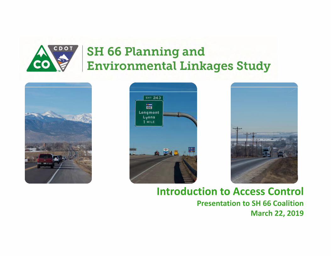
Introduction to Access ControlPresentation to SH 66 Coalition
March 22, 2019
• Blend of the agencies’ vision for the corridor, the requirements of the State Highway Access Code, and the PEL recommendations
• Determines how to provide property owners reasonable access to the highway
• Identifies improvements to the local transportation network to support vehicle movement and property access
• Determines where accesses will ultimately be located to better assist in the development/redevelopment process
What is an Access Control Plan?

• SH 66 has approximately 370 access points (driveways and intersections) from Lyons (McConnell Dr) to WCR 19
• A reduction in the number of accesses improves safety for all modes of transportation, reduces driveway clutter, and improves traffic flow
• Provide CDOT and agencies with a document to assist future development with the site planning process and to streamline access permitting
• To support the functional classification recommendations being developed in the PEL
• The ACP will provide the corridor with a framework for future development that accommodates regional, intra-city, and inter-city travel needs
Why develop an Access Control Plan on SH 66?
• Optimizes the number and location of access points on the corridor
• Recommends where accesses may be consolidated, relocated, or restricted
• Identifies the type of allowed traffic movements and traffic control at each access point
• Identifies conditions for when access changes will occur
• In some instances an interim access condition may be identified
• Ensures legal access to all properties
• Blends the corridor vision established as part of the PEL study with a legally binding document for access on the corridor
What an Access Control Plan Does
• Determine the number of future lanes on the corridor
• Design the future roadway layout
• Identify funding for improvements
• Require immediate changes to properties
• “Take away access”
• The ACP Recommendations is a long-term planning document that will be implemented over time, primarily as development and redevelopment occur
What an Access Control Plan Does NOT Do
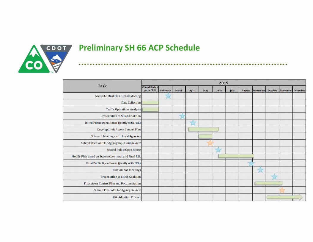
Preliminary SH 66 ACP Schedule

• Study, propose, and accept final Access Control Plan configuration based on agency and public input
• Prepare an Intergovernmental Agreement (IGA) between the local agencies (Boulder County, Town of Lyons, City of Longmont, Weld County, Town of Mead, Town of Firestone) and CDOT
• Specify the process for modifying the ACP in the IGA
• Adopt ACP through signing of the IGA
• Provide a summary to the Colorado Transportation Commission and obtain approval from CDOT Chief Engineer
• Continued coordination between CDOT and agencies to ensure proper implementation of the plan
Steps to Adopt/Implement an Access Control Plan
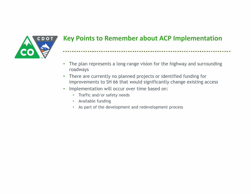
• The plan represents a long-range vision for the highway and surrounding roadways
• There are currently no planned projects or identified funding for improvements to SH 66 that would significantly change existing access
• Implementation will occur over time based on:
• Traffic and/or safety needs
• Available funding
• As part of the development and redevelopment process
Key Points to Remember about ACP Implementation

SH 66 Access Control Plan | Final Report
C.5. SH 66 Coalition Presentation 2


1
Update to Access Control PlanPresentation to SH 66 Coalition
June 28, 2019
• Optimizes the number and location of access points on the corridor
• Recommends where accesses may be consolidated, relocated, or restricted
• Identifies the type of allowed traffic movements and traffic control at each access point
• Identifies conditions for when access changes will occur
• In some instances an interim access condition may be identified
• Blends the corridor vision established as part of the PEL study with a legally binding document for access on the corridor
Recap: Role of an Access Control Plan
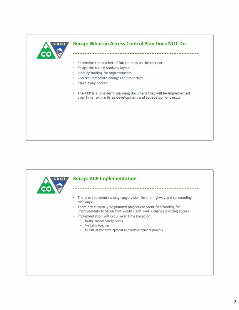
2
• Determine the number of future lanes on the corridor
• Design the future roadway layout
• Identify funding for improvements
• Require immediate changes to properties
• “Take away access”
• The ACP is a long-term planning document that will be implemented over time, primarily as development and redevelopment occur
Recap: What an Access Control Plan Does NOT Do
• The plan represents a long-range vision for the highway and surrounding roadways
• There are currently no planned projects or identified funding for improvements to SH 66 that would significantly change existing access
• Implementation will occur over time based on:
• Traffic and/or safety needs
• Available funding
• As part of the development and redevelopment process
Recap: ACP Implementation

3
• Hold additional agency meetings with planners/engineering staff
• Develop and circulate draft IGA text and Appendices
• ACP Open House
• Present Draft ACP to Public
• Thursday July 25 4:30-7:00pm
• Longmont Senior Center
• Refine ACP based on agency and public’s input
• Present final ACP at joint Open House with SH 66 PEL in the fall
• Tentatively mid-September
• Circulate IGA, Appendices, final Access Table, and final Access maps for signatures
• Fall 2019 (Tentatively beginning in September)
ACP Schedule Update
Draft Access Control Plan
• Some closures dependent on:
• Future road or shared path construction
• Future cross-access agreement
• Future development
Existing and Proposed Access Summary
Segment
Existing AccessesProposed Accesses with ACP Fully
Implemented
Total Public and Private Accesses
Average Access Spacing (per mile)
Total Public and Private Accesses
Average Access Spacing (per mile)
Lyons to WCR 19 375 19 122 6

4
Draft Access Control Plan
Draft Access Control Plan
BN
SF R
ailr
oad

SH 66 Access Control Plan | Final Report
Appendix D. Proposed Access
Maps


SH 66 ACP - Recommended Access Control PlanMap Sheet 1
0 300 600Feet
¯Legend
Parcel Boundary/ROW BoundaryMunicipal Boundary
Full Movement (Signalized)"3/4 Movement$
& Emergency Access OnlyRivers/StreamsParks/Open Space
Floodplain
Milepost!(
Access to be closed
*Note: Map Sheets may overlapRight-in, Right-out only#*Right-out only#*
Access closure contingent oncontiguous property ownershipor access to adjacent propertyvia shared agreement
Proposed Future 10' Bike and Pedestrian PathProposed Future 16' Access Road with Advisory Shoulder
Proposed Future ConnectionProposed Future Frontage Road
Obtain Access via Alternate Road
Proposed cross access for shared access
Existing shared ownership/Cross Access
Grade Separatedat Railroad
March 2020Grade Separated

SH 66 ACP - Recommended Access Control PlanMap Sheet 2
0 300 600Feet
¯Legend
Parcel Boundary/ROW BoundaryMunicipal Boundary
Full Movement (Signalized)"3/4 Movement$
& Emergency Access OnlyRivers/StreamsParks/Open Space
Floodplain
Milepost!(
Access to be closed
*Note: Map Sheets may overlapRight-in, Right-out only#*Right-out only#*
Access closure contingent oncontiguous property ownershipor access to adjacent propertyvia shared agreement
Proposed Future 10' Bike and Pedestrian PathProposed Future 16' Access Road with Advisory Shoulder
Proposed Future ConnectionProposed Future Frontage Road
Obtain Access via Alternate Road
Proposed cross access for shared access
Existing shared ownership/Cross Access
Grade Separatedat Railroad
March 2020Grade Separated

SH 66 ACP - Recommended Access Control PlanMap Sheet 3
0 300 600Feet
¯Legend
Parcel Boundary/ROW BoundaryMunicipal Boundary
Full Movement (Signalized)"3/4 Movement$
& Emergency Access OnlyRivers/StreamsParks/Open Space
Floodplain
Milepost!(
Access to be closed
*Note: Map Sheets may overlapRight-in, Right-out only#*Right-out only#*
Access closure contingent oncontiguous property ownershipor access to adjacent propertyvia shared agreement
Proposed Future 10' Bike and Pedestrian PathProposed Future 16' Access Road with Advisory Shoulder
Proposed Future ConnectionProposed Future Frontage Road
Obtain Access via Alternate Road
Proposed cross access for shared access
Existing shared ownership/Cross Access
Grade Separatedat Railroad
March 2020Grade Separated

SH 66 ACP - Recommended Access Control PlanMap Sheet 4
0 300 600Feet
¯Legend
Parcel Boundary/ROW BoundaryMunicipal Boundary
Full Movement (Signalized)"3/4 Movement$
& Emergency Access OnlyRivers/StreamsParks/Open Space
Floodplain
Milepost!(
Access to be closed
*Note: Map Sheets may overlapRight-in, Right-out only#*Right-out only#*
Access closure contingent oncontiguous property ownershipor access to adjacent propertyvia shared agreement
Proposed Future 10' Bike and Pedestrian PathProposed Future 16' Access Road with Advisory Shoulder
Proposed Future ConnectionProposed Future Frontage Road
Obtain Access via Alternate Road
Proposed cross access for shared access
Existing shared ownership/Cross Access
Grade Separatedat Railroad
March 2020Grade Separated
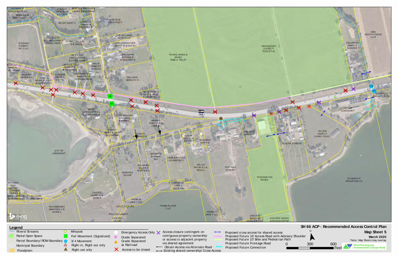
SH 66 ACP - Recommended Access Control PlanMap Sheet 5
0 300 600Feet
¯Legend
Parcel Boundary/ROW BoundaryMunicipal Boundary
Full Movement (Signalized)"3/4 Movement$
& Emergency Access OnlyRivers/StreamsParks/Open Space
Floodplain
Milepost!(
Access to be closed
*Note: Map Sheets may overlapRight-in, Right-out only#*Right-out only#*
Access closure contingent oncontiguous property ownershipor access to adjacent propertyvia shared agreement
Proposed Future 10' Bike and Pedestrian PathProposed Future 16' Access Road with Advisory Shoulder
Proposed Future ConnectionProposed Future Frontage Road
Obtain Access via Alternate Road
Proposed cross access for shared access
Existing shared ownership/Cross Access
Grade Separatedat Railroad
March 2020Grade Separated
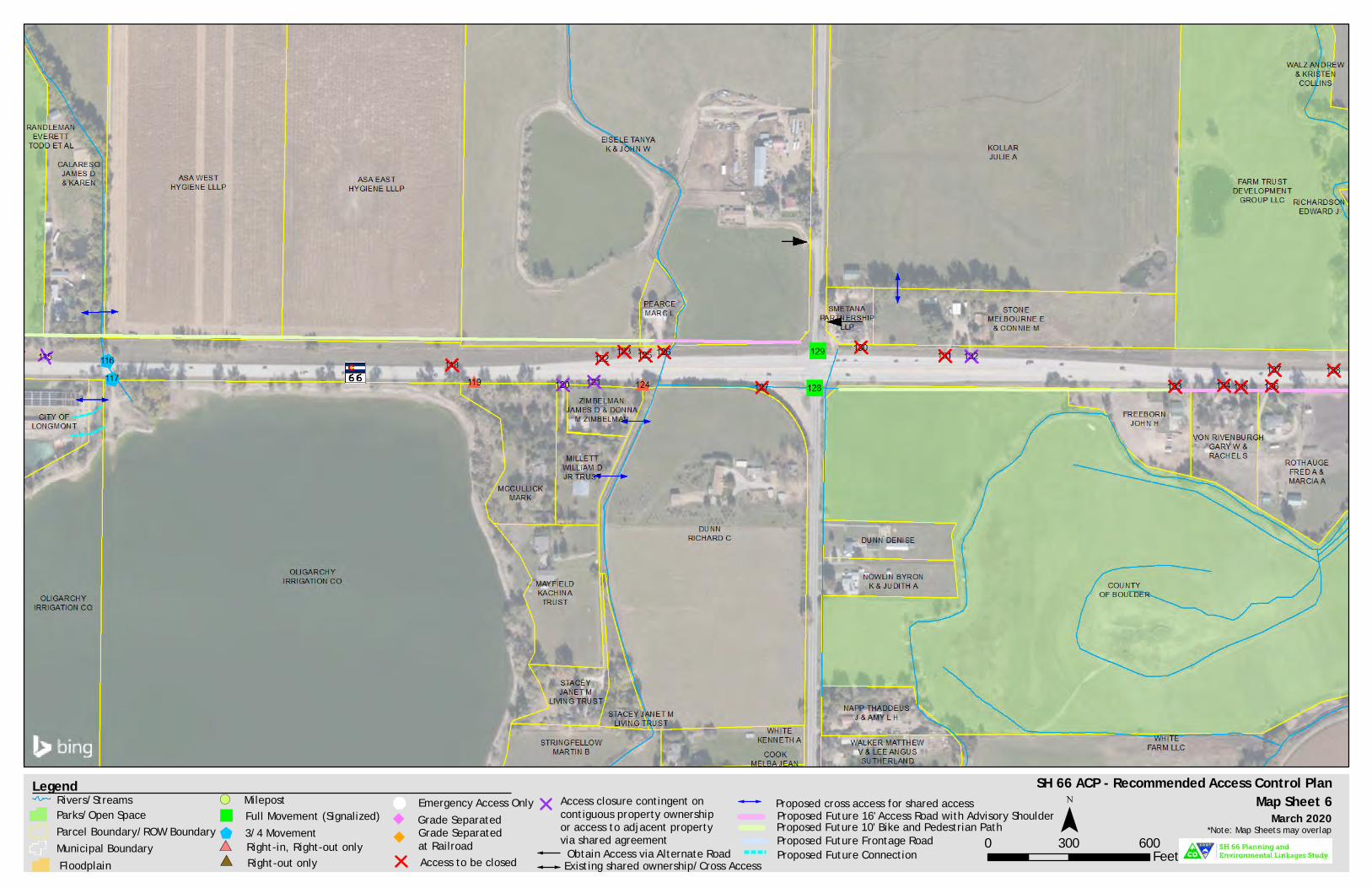
SH 66 ACP - Recommended Access Control PlanMap Sheet 6
0 300 600Feet
¯Legend
Parcel Boundary/ROW BoundaryMunicipal Boundary
Full Movement (Signalized)"3/4 Movement$
& Emergency Access OnlyRivers/StreamsParks/Open Space
Floodplain
Milepost!(
Access to be closed
*Note: Map Sheets may overlapRight-in, Right-out only#*Right-out only#*
Access closure contingent oncontiguous property ownershipor access to adjacent propertyvia shared agreement
Proposed Future 10' Bike and Pedestrian PathProposed Future 16' Access Road with Advisory Shoulder
Proposed Future ConnectionProposed Future Frontage Road
Obtain Access via Alternate Road
Proposed cross access for shared access
Existing shared ownership/Cross Access
Grade Separatedat Railroad
March 2020Grade Separated

SH 66 ACP - Recommended Access Control PlanMap Sheet 7
0 300 600Feet
¯Legend
Parcel Boundary/ROW BoundaryMunicipal Boundary
Full Movement (Signalized)"3/4 Movement$
& Emergency Access OnlyRivers/StreamsParks/Open Space
Floodplain
Milepost!(
Access to be closed
*Note: Map Sheets may overlapRight-in, Right-out only#*Right-out only#*
Access closure contingent oncontiguous property ownershipor access to adjacent propertyvia shared agreement
Proposed Future 10' Bike and Pedestrian PathProposed Future 16' Access Road with Advisory Shoulder
Proposed Future ConnectionProposed Future Frontage Road
Obtain Access via Alternate Road
Proposed cross access for shared access
Existing shared ownership/Cross Access
Grade Separatedat Railroad
March 2020Grade Separated

SH 66 ACP - Recommended Access Control PlanMap Sheet 8
0 300 600Feet
¯Legend
Parcel Boundary/ROW BoundaryMunicipal Boundary
Full Movement (Signalized)"3/4 Movement$
& Emergency Access OnlyRivers/StreamsParks/Open Space
Floodplain
Milepost!(
Access to be closed
*Note: Map Sheets may overlapRight-in, Right-out only#*Right-out only#*
Access closure contingent oncontiguous property ownershipor access to adjacent propertyvia shared agreement
Proposed Future 10' Bike and Pedestrian PathProposed Future 16' Access Road with Advisory Shoulder
Proposed Future ConnectionProposed Future Frontage Road
Obtain Access via Alternate Road
Proposed cross access for shared access
Existing shared ownership/Cross Access
Grade Separatedat Railroad
March 2020Grade Separated

SH 66 ACP - Recommended Access Control PlanMap Sheet 9
0 300 600Feet
¯Legend
Parcel Boundary/ROW BoundaryMunicipal Boundary
Full Movement (Signalized)"3/4 Movement$
& Emergency Access OnlyRivers/StreamsParks/Open Space
Floodplain
Milepost!(
Access to be closed
*Note: Map Sheets may overlapRight-in, Right-out only#*Right-out only#*
Access closure contingent oncontiguous property ownershipor access to adjacent propertyvia shared agreement
Proposed Future 10' Bike and Pedestrian PathProposed Future 16' Access Road with Advisory Shoulder
Proposed Future ConnectionProposed Future Frontage Road
Obtain Access via Alternate Road
Proposed cross access for shared access
Existing shared ownership/Cross Access
Grade Separatedat Railroad
March 2020Grade Separated

SH 66 ACP - Recommended Access Control PlanMap Sheet 10
0 300 600Feet
¯Legend
Parcel Boundary/ROW BoundaryMunicipal Boundary
Full Movement (Signalized)"3/4 Movement$
& Emergency Access OnlyRivers/StreamsParks/Open Space
Floodplain
Milepost!(
Access to be closed
*Note: Map Sheets may overlapRight-in, Right-out only#*Right-out only#*
Access closure contingent oncontiguous property ownershipor access to adjacent propertyvia shared agreement
Proposed Future 10' Bike and Pedestrian PathProposed Future 16' Access Road with Advisory Shoulder
Proposed Future ConnectionProposed Future Frontage Road
Obtain Access via Alternate Road
Proposed cross access for shared access
Existing shared ownership/Cross Access
Grade Separatedat Railroad
March 2020Grade Separated

SH 66 ACP - Recommended Access Control PlanMap Sheet 11
0 300 600Feet
¯Legend
Parcel Boundary/ROW BoundaryMunicipal Boundary
Full Movement (Signalized)"3/4 Movement$
& Emergency Access OnlyRivers/StreamsParks/Open Space
Floodplain
Milepost!(
Access to be closed
*Note: Map Sheets may overlapRight-in, Right-out only#*Right-out only#*
Access closure contingent oncontiguous property ownershipor access to adjacent propertyvia shared agreement
Proposed Future 10' Bike and Pedestrian PathProposed Future 16' Access Road with Advisory Shoulder
Proposed Future ConnectionProposed Future Frontage Road
Obtain Access via Alternate Road
Proposed cross access for shared access
Existing shared ownership/Cross Access
Grade Separatedat Railroad
March 2020Grade Separated
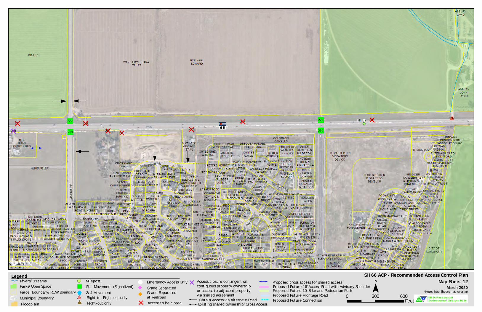
SH 66 ACP - Recommended Access Control PlanMap Sheet 12
0 300 600Feet
¯Legend
Parcel Boundary/ROW BoundaryMunicipal Boundary
Full Movement (Signalized)"3/4 Movement$
& Emergency Access OnlyRivers/StreamsParks/Open Space
Floodplain
Milepost!(
Access to be closed
*Note: Map Sheets may overlapRight-in, Right-out only#*Right-out only#*
Access closure contingent oncontiguous property ownershipor access to adjacent propertyvia shared agreement
Proposed Future 10' Bike and Pedestrian PathProposed Future 16' Access Road with Advisory Shoulder
Proposed Future ConnectionProposed Future Frontage Road
Obtain Access via Alternate Road
Proposed cross access for shared access
Existing shared ownership/Cross Access
Grade Separatedat Railroad
March 2020Grade Separated

SH 66 ACP - Recommended Access Control PlanMap Sheet 13
0 300 600Feet
¯Legend
Parcel Boundary/ROW BoundaryMunicipal Boundary
Full Movement (Signalized)"3/4 Movement$
& Emergency Access OnlyRivers/StreamsParks/Open Space
Floodplain
Milepost!(
Access to be closed
*Note: Map Sheets may overlapRight-in, Right-out only#*Right-out only#*
Access closure contingent oncontiguous property ownershipor access to adjacent propertyvia shared agreement
Proposed Future 10' Bike and Pedestrian PathProposed Future 16' Access Road with Advisory Shoulder
Proposed Future ConnectionProposed Future Frontage Road
Obtain Access via Alternate Road
Proposed cross access for shared access
Existing shared ownership/Cross Access
Grade Separatedat Railroad
March 2020Grade Separated

SH 66 ACP - Recommended Access Control PlanMap Sheet 14
0 300 600Feet
¯Legend
Parcel Boundary/ROW BoundaryMunicipal Boundary
Full Movement (Signalized)"3/4 Movement$
& Emergency Access OnlyRivers/StreamsParks/Open Space
Floodplain
Milepost!(
Access to be closed
*Note: Map Sheets may overlapRight-in, Right-out only#*Right-out only#*
Access closure contingent oncontiguous property ownershipor access to adjacent propertyvia shared agreement
Proposed Future 10' Bike and Pedestrian PathProposed Future 16' Access Road with Advisory Shoulder
Proposed Future ConnectionProposed Future Frontage Road
Obtain Access via Alternate Road
Proposed cross access for shared access
Existing shared ownership/Cross Access
Grade Separatedat Railroad
March 2020Grade Separated

SH 66 ACP - Recommended Access Control PlanMap Sheet 15
0 300 600Feet
¯Legend
Parcel Boundary/ROW BoundaryMunicipal Boundary
Full Movement (Signalized)"3/4 Movement$
& Emergency Access OnlyRivers/StreamsParks/Open Space
Floodplain
Milepost!(
Access to be closed
*Note: Map Sheets may overlapRight-in, Right-out only#*Right-out only#*
Access closure contingent oncontiguous property ownershipor access to adjacent propertyvia shared agreement
Proposed Future 10' Bike and Pedestrian PathProposed Future 16' Access Road with Advisory Shoulder
Proposed Future ConnectionProposed Future Frontage Road
Obtain Access via Alternate Road
Proposed cross access for shared access
Existing shared ownership/Cross Access
Grade Separatedat Railroad
March 2020Grade Separated
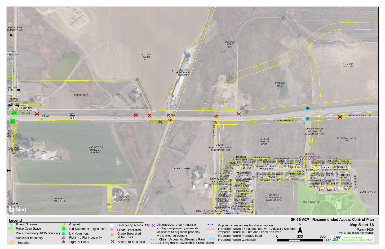
SH 66 ACP - Recommended Access Control PlanMap Sheet 16
0 300 600Feet
¯Legend
Parcel Boundary/ROW BoundaryMunicipal Boundary
Full Movement (Signalized)"3/4 Movement$
& Emergency Access OnlyRivers/StreamsParks/Open Space
Floodplain
Milepost!(
Access to be closed
*Note: Map Sheets may overlapRight-in, Right-out only#*Right-out only#*
Access closure contingent oncontiguous property ownershipor access to adjacent propertyvia shared agreement
Proposed Future 10' Bike and Pedestrian PathProposed Future 16' Access Road with Advisory Shoulder
Proposed Future ConnectionProposed Future Frontage Road
Obtain Access via Alternate Road
Proposed cross access for shared access
Existing shared ownership/Cross Access
Grade Separatedat Railroad
March 2020Grade Separated

SH 66 ACP - Recommended Access Control PlanMap Sheet 17
0 300 600Feet
¯Legend
Parcel Boundary/ROW BoundaryMunicipal Boundary
Full Movement (Signalized)"3/4 Movement$
& Emergency Access OnlyRivers/StreamsParks/Open Space
Floodplain
Milepost!(
Access to be closed
*Note: Map Sheets may overlapRight-in, Right-out only#*Right-out only#*
Access closure contingent oncontiguous property ownershipor access to adjacent propertyvia shared agreement
Proposed Future 10' Bike and Pedestrian PathProposed Future 16' Access Road with Advisory Shoulder
Proposed Future ConnectionProposed Future Frontage Road
Obtain Access via Alternate Road
Proposed cross access for shared access
Existing shared ownership/Cross Access
Grade Separatedat Railroad
March 2020Grade Separated

SH 66 ACP - Recommended Access Control PlanMap Sheet 18
0 300 600Feet
¯Legend
Parcel Boundary/ROW BoundaryMunicipal Boundary
Full Movement (Signalized)"3/4 Movement$
& Emergency Access OnlyRivers/StreamsParks/Open Space
Floodplain
Milepost!(
Access to be closed
*Note: Map Sheets may overlapRight-in, Right-out only#*Right-out only#*
Access closure contingent oncontiguous property ownershipor access to adjacent propertyvia shared agreement
Proposed Future 10' Bike and Pedestrian PathProposed Future 16' Access Road with Advisory Shoulder
Proposed Future ConnectionProposed Future Frontage Road
Obtain Access via Alternate Road
Proposed cross access for shared access
Existing shared ownership/Cross Access
Grade Separatedat Railroad
March 2020Grade Separated

SH 66 ACP - Recommended Access Control PlanMap Sheet 19
0 300 600Feet
¯Legend
Parcel Boundary/ROW BoundaryMunicipal Boundary
Full Movement (Signalized)"3/4 Movement$
& Emergency Access OnlyRivers/StreamsParks/Open Space
Floodplain
Milepost!(
Access to be closed
*Note: Map Sheets may overlapRight-in, Right-out only#*Right-out only#*
Access closure contingent oncontiguous property ownershipor access to adjacent propertyvia shared agreement
Proposed Future 10' Bike and Pedestrian PathProposed Future 16' Access Road with Advisory Shoulder
Proposed Future ConnectionProposed Future Frontage Road
Obtain Access via Alternate Road
Proposed cross access for shared access
Existing shared ownership/Cross Access
Grade Separatedat Railroad
March 2020Grade Separated

SH 66 ACP - Recommended Access Control PlanMap Sheet 20
0 300 600Feet
¯Legend
Parcel Boundary/ROW BoundaryMunicipal Boundary
Full Movement (Signalized)"3/4 Movement$
& Emergency Access OnlyRivers/StreamsParks/Open Space
Floodplain
Milepost!(
Access to be closed
*Note: Map Sheets may overlapRight-in, Right-out only#*Right-out only#*
Access closure contingent oncontiguous property ownershipor access to adjacent propertyvia shared agreement
Proposed Future 10' Bike and Pedestrian PathProposed Future 16' Access Road with Advisory Shoulder
Proposed Future ConnectionProposed Future Frontage Road
Obtain Access via Alternate Road
Proposed cross access for shared access
Existing shared ownership/Cross Access
Grade Separatedat Railroad
March 2020Grade Separated

SH 66 ACP - Recommended Access Control PlanMap Sheet 21
0 300 600Feet
¯Legend
Parcel Boundary/ROW BoundaryMunicipal Boundary
Full Movement (Signalized)"3/4 Movement$
& Emergency Access OnlyRivers/StreamsParks/Open Space
Floodplain
Milepost!(
Access to be closed
*Note: Map Sheets may overlapRight-in, Right-out only#*Right-out only#*
Access closure contingent oncontiguous property ownershipor access to adjacent propertyvia shared agreement
Proposed Future 10' Bike and Pedestrian PathProposed Future 16' Access Road with Advisory Shoulder
Proposed Future ConnectionProposed Future Frontage Road
Obtain Access via Alternate Road
Proposed cross access for shared access
Existing shared ownership/Cross Access
Grade Separatedat Railroad
March 2020Grade Separated

SH 66 ACP - Recommended Access Control PlanMap Sheet 22
0 300 600Feet
¯Legend
Parcel Boundary/ROW BoundaryMunicipal Boundary
Full Movement (Signalized)"3/4 Movement$
& Emergency Access OnlyRivers/StreamsParks/Open Space
Floodplain
Milepost!(
Access to be closed
*Note: Map Sheets may overlapRight-in, Right-out only#*Right-out only#*
Access closure contingent oncontiguous property ownershipor access to adjacent propertyvia shared agreement
Proposed Future 10' Bike and Pedestrian PathProposed Future 16' Access Road with Advisory Shoulder
Proposed Future ConnectionProposed Future Frontage Road
Obtain Access via Alternate Road
Proposed cross access for shared access
Existing shared ownership/Cross Access
Grade Separatedat Railroad
March 2020Grade Separated

SH 66 ACP - Recommended Access Control PlanMap Sheet 23
0 300 600Feet
¯Legend
Parcel Boundary/ROW BoundaryMunicipal Boundary
Full Movement (Signalized)"3/4 Movement$
& Emergency Access OnlyRivers/StreamsParks/Open Space
Floodplain
Milepost!(
Access to be closed
*Note: Map Sheets may overlapRight-in, Right-out only#*Right-out only#*
Access closure contingent oncontiguous property ownershipor access to adjacent propertyvia shared agreement
Proposed Future 10' Bike and Pedestrian PathProposed Future 16' Access Road with Advisory Shoulder
Proposed Future ConnectionProposed Future Frontage Road
Obtain Access via Alternate Road
Proposed cross access for shared access
Existing shared ownership/Cross Access
Grade Separatedat Railroad
March 2020Grade Separated


SH 66 Access Control Plan | Final Report
Appendix E. SH 66 Access Table


Access Control Plan 1,2 US 36 (MP 21.000 – 21.764) / SH 66 (MP 28.693 – 47.912) March 2020
1. The current State Highway Access Code shall govern any unresolved discrepancies regarding access decisions. 2. All access points are subject to consolidation upon the combining or subdividing of any lots under a single ownership or controlling interest. 3. All access locations +/- 50 feet (0.01 mile) unless otherwise noted. 4. The type, number, and storage length of lanes may be determined by a separate traffic study to be done at the time of the actual design and implementation of the access plan and to ensure that the design does not create operational and/or safety issues. 5. A ¾ movement configuration means that vehicles can turn right into the access, turn right out of the access, and turn left into the access. 6. Full movement access with potential to become/remain signalized.
Page 1 of 99
Milepost 3
(CO 66 / *US 36)
Access Number
Side of Highway
Access Description
Existing Conditions
Ultimate Access Control Plan
Configuration Conditions for Change 4
21.000* 1 South McConnell
Dr Full Movement
(Signalized) Full Movement 6
(Signalized)
The ultimate access design will be based on the results of a traffic study to
ensure the intersection does not create operational and/or safety issues.
Access will remain as-is (signalized full movement).
21.000* 2 North Stone
Canyon Dr
Full Movement
(Signalized)
Full Movement 6
(Signalized)
The ultimate access design will be based on the results of a traffic study to
ensure the intersection does not create operational and/or safety issues.
Access will remain as-is (signalized full movement).
21.020* 3 North Private
Drive
Full Movement
(Unsignalized) Access to be closed
Access will be closed or restricted to less than full movement if a raised
median is added to US 36 as part of a roadway improvement project, if the
property redevelops, or if operational and/or safety issues are identified
through the completion of a traffic study.
Access will be obtained from Stone Canyon Dr.
21.028* 4 North Private
Drive
Full Movement
(Unsignalized) Access to be closed
Access will be closed or restricted to less than full movement if a raised
median is added to US 36 as part of a roadway improvement project, if the
property redevelops, or if operational and/or safety issues are identified
through the completion of a traffic study.
Access will be obtained from Access 2 (Stone Canyon Dr).
21.050* 5 North Private
Drive
Full Movement
(Unsignalized) Access to be closed
Access will be closed or restricted to less than full movement if a raised
median is added to US 36 as part of a roadway improvement project, if the
property redevelops, or if operational and/or safety issues are identified
through the completion of a traffic study.
Access will be obtained from Access 2 (Stone Canyon Dr).

Access Control Plan 1,2 US 36 (MP 21.000 – 21.764) / SH 66 (MP 28.693 – 47.912) March 2020
1. The current State Highway Access Code shall govern any unresolved discrepancies regarding access decisions. 2. All access points are subject to consolidation upon the combining or subdividing of any lots under a single ownership or controlling interest. 3. All access locations +/- 50 feet (0.01 mile) unless otherwise noted. 4. The type, number, and storage length of lanes may be determined by a separate traffic study to be done at the time of the actual design and implementation of the access plan and to ensure that the design does not create operational and/or safety issues. 5. A ¾ movement configuration means that vehicles can turn right into the access, turn right out of the access, and turn left into the access. 6. Full movement access with potential to become/remain signalized.
Page 2 of 99
Milepost 3
(CO 66 / *US 36)
Access Number
Side of Highway
Access Description
Existing Conditions
Ultimate Access Control Plan
Configuration Conditions for Change 4
21.056* 7 South Private
Drive
Full Movement
(Unsignalized) Access to be closed
Access will be restricted to less than full movement if a raised median is
added to US 36 as part of a roadway improvement project, if the property
redevelops, or if operational and/or safety issues are identified through
the completion of a traffic study.
Property should seek to obtain cross access with adjacent property to the
east to obtain access to Access 10. If cross access can be obtained, access
will ultimately be closed.
21.064* 6 North Private
Drive
Full Movement
(Unsignalized) Access to be closed
Access will be closed or restricted to less than full movement if a raised
median is added to US 36 as part of a roadway improvement project, if the
property redevelops, or if operational and/or safety issues are identified
through the completion of a traffic study.
Property should seek to obtain cross access with adjacent property to the
west or east to obtain access to Access 2 (Stone Canyon Dr) or Access 16
(Nolan Dr). If cross access can be obtained, access will ultimately be
closed.
21.093* 10 South Private
Drive
Full Movement
(Unsignalized) Right-In, Right-Out
Access will be restricted to less than full movement if a raised median is
added to US 36 as part of a roadway improvement project or if operational
and/or safety issues are identified through the completion of a traffic
study. Access 10 will provide shared highway access to adjacent
properties.
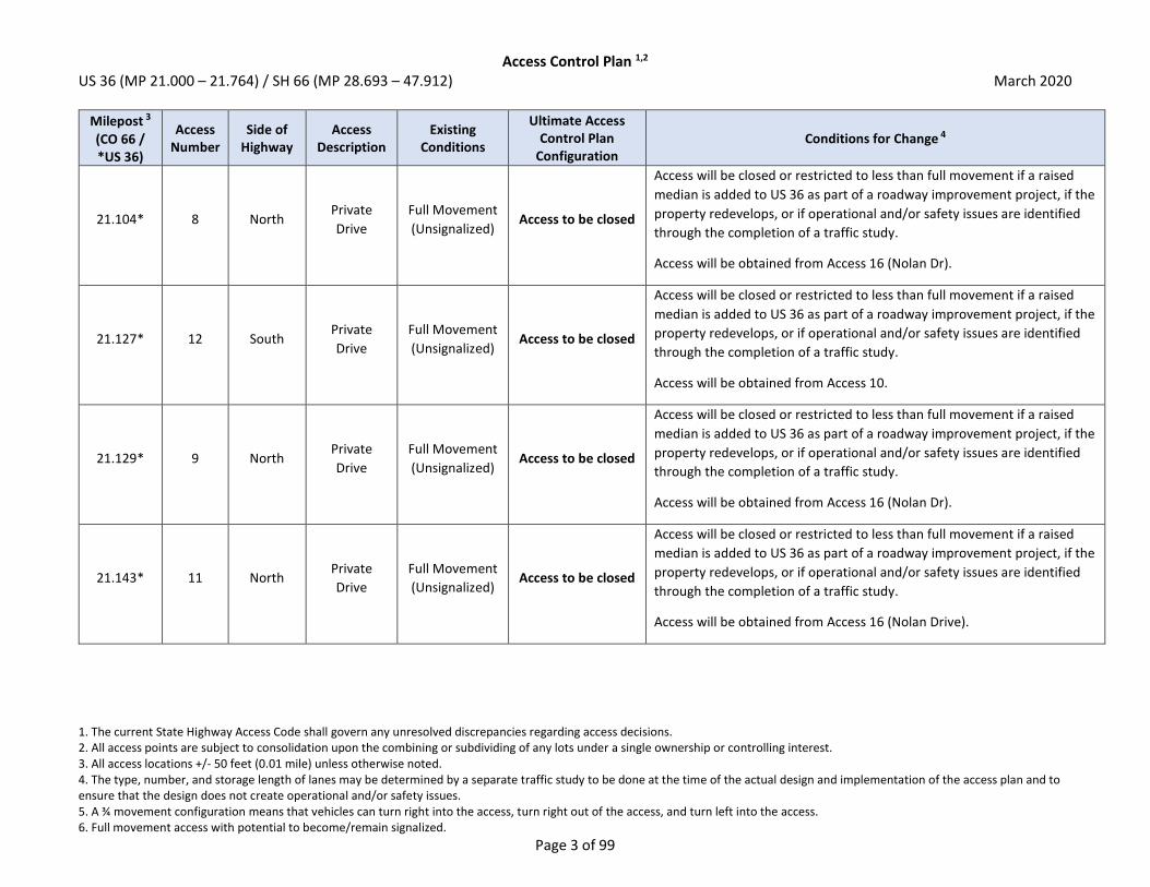
Access Control Plan 1,2 US 36 (MP 21.000 – 21.764) / SH 66 (MP 28.693 – 47.912) March 2020
1. The current State Highway Access Code shall govern any unresolved discrepancies regarding access decisions. 2. All access points are subject to consolidation upon the combining or subdividing of any lots under a single ownership or controlling interest. 3. All access locations +/- 50 feet (0.01 mile) unless otherwise noted. 4. The type, number, and storage length of lanes may be determined by a separate traffic study to be done at the time of the actual design and implementation of the access plan and to ensure that the design does not create operational and/or safety issues. 5. A ¾ movement configuration means that vehicles can turn right into the access, turn right out of the access, and turn left into the access. 6. Full movement access with potential to become/remain signalized.
Page 3 of 99
Milepost 3
(CO 66 / *US 36)
Access Number
Side of Highway
Access Description
Existing Conditions
Ultimate Access Control Plan
Configuration Conditions for Change 4
21.104* 8 North Private
Drive
Full Movement
(Unsignalized) Access to be closed
Access will be closed or restricted to less than full movement if a raised
median is added to US 36 as part of a roadway improvement project, if the
property redevelops, or if operational and/or safety issues are identified
through the completion of a traffic study.
Access will be obtained from Access 16 (Nolan Dr).
21.127* 12 South Private
Drive
Full Movement
(Unsignalized) Access to be closed
Access will be closed or restricted to less than full movement if a raised
median is added to US 36 as part of a roadway improvement project, if the
property redevelops, or if operational and/or safety issues are identified
through the completion of a traffic study.
Access will be obtained from Access 10.
21.129* 9 North Private
Drive
Full Movement
(Unsignalized) Access to be closed
Access will be closed or restricted to less than full movement if a raised
median is added to US 36 as part of a roadway improvement project, if the
property redevelops, or if operational and/or safety issues are identified
through the completion of a traffic study.
Access will be obtained from Access 16 (Nolan Dr).
21.143* 11 North Private
Drive
Full Movement
(Unsignalized) Access to be closed
Access will be closed or restricted to less than full movement if a raised
median is added to US 36 as part of a roadway improvement project, if the
property redevelops, or if operational and/or safety issues are identified
through the completion of a traffic study.
Access will be obtained from Access 16 (Nolan Drive).
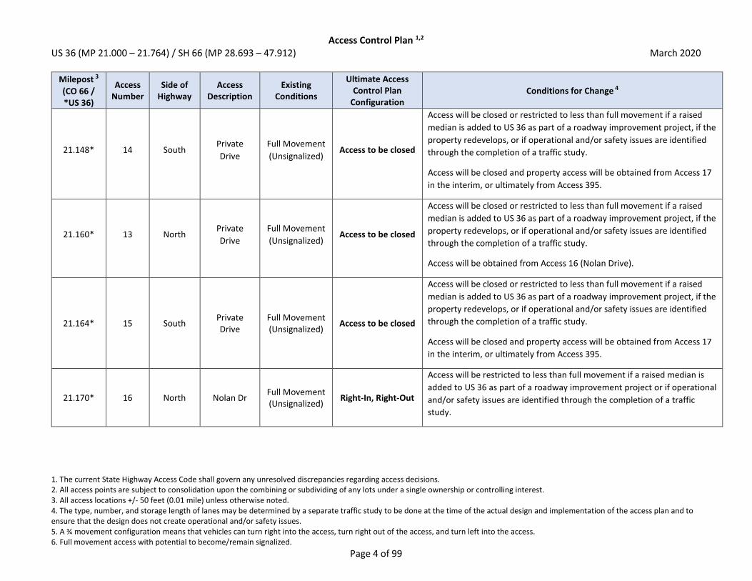
Access Control Plan 1,2 US 36 (MP 21.000 – 21.764) / SH 66 (MP 28.693 – 47.912) March 2020
1. The current State Highway Access Code shall govern any unresolved discrepancies regarding access decisions. 2. All access points are subject to consolidation upon the combining or subdividing of any lots under a single ownership or controlling interest. 3. All access locations +/- 50 feet (0.01 mile) unless otherwise noted. 4. The type, number, and storage length of lanes may be determined by a separate traffic study to be done at the time of the actual design and implementation of the access plan and to ensure that the design does not create operational and/or safety issues. 5. A ¾ movement configuration means that vehicles can turn right into the access, turn right out of the access, and turn left into the access. 6. Full movement access with potential to become/remain signalized.
Page 4 of 99
Milepost 3
(CO 66 / *US 36)
Access Number
Side of Highway
Access Description
Existing Conditions
Ultimate Access Control Plan
Configuration Conditions for Change 4
21.148* 14 South Private
Drive
Full Movement
(Unsignalized) Access to be closed
Access will be closed or restricted to less than full movement if a raised
median is added to US 36 as part of a roadway improvement project, if the
property redevelops, or if operational and/or safety issues are identified
through the completion of a traffic study.
Access will be closed and property access will be obtained from Access 17
in the interim, or ultimately from Access 395.
21.160* 13 North Private
Drive
Full Movement
(Unsignalized) Access to be closed
Access will be closed or restricted to less than full movement if a raised
median is added to US 36 as part of a roadway improvement project, if the
property redevelops, or if operational and/or safety issues are identified
through the completion of a traffic study.
Access will be obtained from Access 16 (Nolan Drive).
21.164* 15 South Private Drive
Full Movement (Unsignalized)
Access to be closed
Access will be closed or restricted to less than full movement if a raised
median is added to US 36 as part of a roadway improvement project, if the
property redevelops, or if operational and/or safety issues are identified
through the completion of a traffic study.
Access will be closed and property access will be obtained from Access 17
in the interim, or ultimately from Access 395.
21.170* 16 North Nolan Dr Full Movement (Unsignalized)
Right-In, Right-Out
Access will be restricted to less than full movement if a raised median is
added to US 36 as part of a roadway improvement project or if operational
and/or safety issues are identified through the completion of a traffic
study.

Access Control Plan 1,2 US 36 (MP 21.000 – 21.764) / SH 66 (MP 28.693 – 47.912) March 2020
1. The current State Highway Access Code shall govern any unresolved discrepancies regarding access decisions. 2. All access points are subject to consolidation upon the combining or subdividing of any lots under a single ownership or controlling interest. 3. All access locations +/- 50 feet (0.01 mile) unless otherwise noted. 4. The type, number, and storage length of lanes may be determined by a separate traffic study to be done at the time of the actual design and implementation of the access plan and to ensure that the design does not create operational and/or safety issues. 5. A ¾ movement configuration means that vehicles can turn right into the access, turn right out of the access, and turn left into the access. 6. Full movement access with potential to become/remain signalized.
Page 5 of 99
Milepost 3
(CO 66 / *US 36)
Access Number
Side of Highway
Access Description
Existing Conditions
Ultimate Access Control Plan
Configuration Conditions for Change 4
21.180* 17 South Private Drive
Full Movement (Unsignalized)
Access to be closed
Access will be restricted to less than full movement if a raised median is
added to US 36 as part of a roadway improvement project, if the property
redevelops, or if operational and/or safety issues are identified through
the completion of a traffic study.
If cross-access can be obtained with property to the east, access will
ultimately be closed and property access will be obtained from Access 395.
21.190* 395 South Private Drive
N/A Right-In, Right-Out
Access will be a newly constructed right-in, right-out access on the
property line to consolidate the existing accesses. The ultimate access
design will be based on the results of a traffic study to ensure the
intersection does not create operational and/or safety issues.
21.210* 18 South Private Drive
Full Movement (Unsignalized)
Access to be closed
Access will be restricted to less than full movement if a raised median is
added to US 36 as part of a roadway improvement project, if the property
redevelops, or if operational and/or safety issues are identified through
the completion of a traffic study.
If cross-access can be obtained with property to the west, access will be
closed and property access will be obtained from Access 395.
21.230* 19 South Private Drive
Full Movement (Unsignalized)
Access to be closed
Access will be closed or restricted to less than full movement if a raised
median is added to US 36 as part of a roadway improvement project, if the
property redevelops, or if operational and/or safety issues are identified
through the completion of a traffic study.
Access will be closed and property access will be obtained from Access 18
in the interim, or ultimately from Access 395.

Access Control Plan 1,2 US 36 (MP 21.000 – 21.764) / SH 66 (MP 28.693 – 47.912) March 2020
1. The current State Highway Access Code shall govern any unresolved discrepancies regarding access decisions. 2. All access points are subject to consolidation upon the combining or subdividing of any lots under a single ownership or controlling interest. 3. All access locations +/- 50 feet (0.01 mile) unless otherwise noted. 4. The type, number, and storage length of lanes may be determined by a separate traffic study to be done at the time of the actual design and implementation of the access plan and to ensure that the design does not create operational and/or safety issues. 5. A ¾ movement configuration means that vehicles can turn right into the access, turn right out of the access, and turn left into the access. 6. Full movement access with potential to become/remain signalized.
Page 6 of 99
Milepost 3
(CO 66 / *US 36)
Access Number
Side of Highway
Access Description
Existing Conditions
Ultimate Access Control Plan
Configuration Conditions for Change 4
21.271* 20 South Private Drive
Full Movement (Unsignalized)
3/4 Movement 5
Access is currently an open curb cut along the majority of the highway
frontage. Access will be formalized on the property and may be restricted
to less than full movement when a raised median is added to US 36 as part
of a roadway improvement project, if the property redevelops, or if
operational and/or safety issues are identified through the completion of a
traffic study.
21.300* 21 South Private Drive
Full Movement (Unsignalized)
Access to be closed
Access will be closed or restricted to less than full movement if a raised
median is added to US 36 as part of a roadway improvement project, if the
property redevelops, or if operational and/or safety issues are identified
through the completion of a traffic study. Access will be obtained from
Access 22.
21.318* 22 South Private Drive
Full Movement (Unsignalized)
Right-In, Right-Out
Access will be restricted to less than full movement if a raised median is
added to US 36 as part of a roadway improvement project, if the property
redevelops, or if operational and/or safety issues are identified through
the completion of a traffic study.
21.350* 23 South Private Drive
Full Movement (Unsignalized)
Access to be closed
Access will be closed or restricted to less than full movement if a raised
median is added to US 36 as part of a roadway improvement project, if the
property redevelops, or if operational and/or safety issues are identified
through the completion of a traffic study. Access will be obtained from
Access 24.
21.384* 24 South Private Drive
Full Movement (Unsignalized)
Right-In, Right-Out
Access will be restricted to less than full movement if a raised median is
added to US 36 as part of a roadway improvement project, if the property
redevelops, or if operational and/or safety issues are identified through
the completion of a traffic study.

Access Control Plan 1,2 US 36 (MP 21.000 – 21.764) / SH 66 (MP 28.693 – 47.912) March 2020
1. The current State Highway Access Code shall govern any unresolved discrepancies regarding access decisions. 2. All access points are subject to consolidation upon the combining or subdividing of any lots under a single ownership or controlling interest. 3. All access locations +/- 50 feet (0.01 mile) unless otherwise noted. 4. The type, number, and storage length of lanes may be determined by a separate traffic study to be done at the time of the actual design and implementation of the access plan and to ensure that the design does not create operational and/or safety issues. 5. A ¾ movement configuration means that vehicles can turn right into the access, turn right out of the access, and turn left into the access. 6. Full movement access with potential to become/remain signalized.
Page 7 of 99
Milepost 3
(CO 66 / *US 36)
Access Number
Side of Highway
Access Description
Existing Conditions
Ultimate Access Control Plan
Configuration Conditions for Change 4
21.530* 25 South Private Drive
Full Movement (Unsignalized)
3/4 Movement 5
Access will be restricted to less than full movement if a raised median is
added to US 36 as part of a roadway improvement project, if the property
redevelops, or if operational and/or safety issues are identified through
the completion of a traffic study.
21.636* 26 North Private Drive
Right-In, Right-Out
Access to be closed
Access will be closed or restricted to less than full movement if a raised
median is added to US 36 as part of a roadway improvement project, if the
property redevelops, or if operational and/or safety issues are identified
through the completion of a traffic study. Access will be obtained from
Access 32 (Highland Dr).
21.653* 27 North Private Drive
Right-In, Right-Out
Access to be closed
Access will be closed or restricted to less than full movement if a raised
median is added to US 36 as part of a roadway improvement project, if the
property redevelops, or if operational and/or safety issues are identified
through the completion of a traffic study. Access will be obtained from
Access 32 (Highland Dr).
21.670* 28 North Private Drive
Right-In, Right-Out
Access to be closed
Access will be closed or restricted to less than full movement if a raised
median is added to US 36 as part of a roadway improvement project, if the
property redevelops, or if operational and/or safety issues are identified
through the completion of a traffic study. Access will be obtained from
Access 32 (Highland Dr).
21.680* 29 North Private Drive
Right-In, Right-Out
Access to be closed
Access will be closed or restricted to less than full movement if a raised
median is added to US 36 as part of a roadway improvement project, if the
property redevelops, or if operational and/or safety issues are identified
through the completion of a traffic study. Access will be obtained from
Access 32 (Highland Dr).

Access Control Plan 1,2 US 36 (MP 21.000 – 21.764) / SH 66 (MP 28.693 – 47.912) March 2020
1. The current State Highway Access Code shall govern any unresolved discrepancies regarding access decisions. 2. All access points are subject to consolidation upon the combining or subdividing of any lots under a single ownership or controlling interest. 3. All access locations +/- 50 feet (0.01 mile) unless otherwise noted. 4. The type, number, and storage length of lanes may be determined by a separate traffic study to be done at the time of the actual design and implementation of the access plan and to ensure that the design does not create operational and/or safety issues. 5. A ¾ movement configuration means that vehicles can turn right into the access, turn right out of the access, and turn left into the access. 6. Full movement access with potential to become/remain signalized.
Page 8 of 99
Milepost 3
(CO 66 / *US 36)
Access Number
Side of Highway
Access Description
Existing Conditions
Ultimate Access Control Plan
Configuration Conditions for Change 4
21.700* 30 North Private Drive
Right-In, Right-Out
Access to be closed
Access will be closed or restricted to less than full movement if a raised
median is added to US 36 as part of a roadway improvement project, if the
property redevelops, or if operational and/or safety issues are identified
through the completion of a traffic study. Access will be obtained from
Access 32 (Highland Dr).
28.693 31 South US 36 Full Movement
(Signalized) Full Movement 6
(Signalized)
The ultimate access design will be based on the results of a traffic study to
ensure the intersection does not create operational and/or safety issues.
Access will remain as-is (signalized full movement).
28.700 32 North Highland Dr Full Movement
(Signalized) Full Movement 6
(Signalized)
The ultimate access design will be based on the results of a traffic study to
ensure the intersection does not create operational and/or safety issues.
Access will remain as-is (signalized full movement).
28.728 33 North Private Drive
Right-In, Right-Out
Access to be closed
Access will be closed or restricted to less than full movement if a raised
median is added to SH 66 as part of a roadway improvement project, if the
property redevelops, or if operational and/or safety issues are identified
through the completion of a traffic study. Access will be obtained from
Access 32 (Highland Dr).
28.758 34 North Private Drive
Right-In, Right-Out
Access to be closed
Access will be closed or restricted to less than full movement if a raised
median is added to SH 66 as part of a roadway improvement project, if the
property redevelops, or if operational and/or safety issues are identified
through the completion of a traffic study. Access will be obtained from
Access 32 (Highland Dr).

Access Control Plan 1,2 US 36 (MP 21.000 – 21.764) / SH 66 (MP 28.693 – 47.912) March 2020
1. The current State Highway Access Code shall govern any unresolved discrepancies regarding access decisions. 2. All access points are subject to consolidation upon the combining or subdividing of any lots under a single ownership or controlling interest. 3. All access locations +/- 50 feet (0.01 mile) unless otherwise noted. 4. The type, number, and storage length of lanes may be determined by a separate traffic study to be done at the time of the actual design and implementation of the access plan and to ensure that the design does not create operational and/or safety issues. 5. A ¾ movement configuration means that vehicles can turn right into the access, turn right out of the access, and turn left into the access. 6. Full movement access with potential to become/remain signalized.
Page 9 of 99
Milepost 3
(CO 66 / *US 36)
Access Number
Side of Highway
Access Description
Existing Conditions
Ultimate Access Control Plan
Configuration Conditions for Change 4
28.814 35 South Private Drive
Full Movement (Unsignalized)
Right-In, Right-Out
Access will be restricted to less than full movement if a raised median is
added to SH 66 as part of a roadway improvement project, if the property
redevelops, or if operational and/or safety issues are identified through
the completion of a traffic study.
28.819 36 North Private Drive
Full Movement (Unsignalized)
Access to be closed
Access will be restricted to less than full movement or closed if a raised
median is added to SH 66 as part of a roadway improvement project, if the
property redevelops, or if operational and/or safety issues are identified
through the completion of a traffic study.
Property should seek to obtain cross access with adjacent property to the
west to obtain access to Access 32 (Highland Dr). Access to the property
will be obtained via Access 39.
28.842 37 South Private Drive
Full Movement (Unsignalized)
Access to be closed
Access will be restricted to less than full movement or closed if a raised
median is added to SH 66 as part of a roadway improvement project, if the
property redevelops, or if operational and/or safety issues are identified
through the completion of a traffic study.
Access to the property will be obtained via Access 40.
28.878 38 South Private Drive
Full Movement (Unsignalized)
Access to be closed
Access will be restricted to less than full movement or closed if a raised
median is added to SH 66 as part of a roadway improvement project, if the
property redevelops, or if operational and/or safety issues are identified
through the completion of a traffic study.
Access to the property will be obtained via Access 40.

Access Control Plan 1,2 US 36 (MP 21.000 – 21.764) / SH 66 (MP 28.693 – 47.912) March 2020
1. The current State Highway Access Code shall govern any unresolved discrepancies regarding access decisions. 2. All access points are subject to consolidation upon the combining or subdividing of any lots under a single ownership or controlling interest. 3. All access locations +/- 50 feet (0.01 mile) unless otherwise noted. 4. The type, number, and storage length of lanes may be determined by a separate traffic study to be done at the time of the actual design and implementation of the access plan and to ensure that the design does not create operational and/or safety issues. 5. A ¾ movement configuration means that vehicles can turn right into the access, turn right out of the access, and turn left into the access. 6. Full movement access with potential to become/remain signalized.
Page 10 of 99
Milepost 3
(CO 66 / *US 36)
Access Number
Side of Highway
Access Description
Existing Conditions
Ultimate Access Control Plan
Configuration Conditions for Change 4
28.906 39 North Private Drive
Full Movement (Unsignalized)
3/4 Movement 5
Access will be restricted to less than full movement if a raised median is
added to SH 66 as part of a roadway improvement project, if the property
redevelops, or if operational and/or safety issues are identified through
the completion of a traffic study.
28.908 40 South Private Drive
Full Movement (Unsignalized)
3/4 Movement 5
Access will be restricted to less than full movement if a raised median is
added to SH 66 as part of a roadway improvement project, if the property
redevelops, or if operational and/or safety issues are identified through
the completion of a traffic study.
28.924 41 North Private Drive
Full Movement (Unsignalized)
Access to be closed
Access will be restricted to less than full movement or closed if a raised
median is added to SH 66 as part of a roadway improvement project, if the
property redevelops, or if operational and/or safety issues are identified
through the completion of a traffic study.
Property should seek to obtain cross access with adjacent property to the
west or the east to obtain access to Access 39 and/or 390. If cross access
can be obtained, access will ultimately be closed.
28.950 42 South Private Drive
Full Movement (Unsignalized)
Access to be closed
Access will be restricted to less than full movement or closed if a raised
median is added to SH 66 as part of a roadway improvement project, if the
property redevelops, or if operational and/or safety issues are identified
through the completion of a traffic study.
Access to the property will be obtained via Access 44.

Access Control Plan 1,2 US 36 (MP 21.000 – 21.764) / SH 66 (MP 28.693 – 47.912) March 2020
1. The current State Highway Access Code shall govern any unresolved discrepancies regarding access decisions. 2. All access points are subject to consolidation upon the combining or subdividing of any lots under a single ownership or controlling interest. 3. All access locations +/- 50 feet (0.01 mile) unless otherwise noted. 4. The type, number, and storage length of lanes may be determined by a separate traffic study to be done at the time of the actual design and implementation of the access plan and to ensure that the design does not create operational and/or safety issues. 5. A ¾ movement configuration means that vehicles can turn right into the access, turn right out of the access, and turn left into the access. 6. Full movement access with potential to become/remain signalized.
Page 11 of 99
Milepost 3
(CO 66 / *US 36)
Access Number
Side of Highway
Access Description
Existing Conditions
Ultimate Access Control Plan
Configuration Conditions for Change 4
29.026 43 North Private Drive
Full Movement (Unsignalized)
Access to be closed
Access will be restricted to less than full movement or closed if a raised
median is added to SH 66 as part of a roadway improvement project, if the
property redevelops, or if operational and/or safety issues are identified
through the completion of a traffic study.
Access to the property will be obtained via a new property access, Access
390, located across from Access 44.
29.051 390 North Future Drive N/A Right-In, Right-Out
Access will be a newly constructed right-in, right-out access to the
property to consolidate the existing accesses. The ultimate access design
will be based on the results of a traffic study to ensure the intersection
does not create operational and/or safety issues.
Access will be located across SH 66 from Access 44.
29.056 44 South Private Drive
Full Movement (Unsignalized)
Right-In, Right-Out
Access will be restricted to less than full movement if a raised median is
added to SH 66 as part of a roadway improvement project, if the property
redevelops, or if operational and/or safety issues are identified through
the completion of a traffic study.
29.102 45 North Private Drive
Full Movement (Unsignalized)
Access to be closed
Access will be restricted to less than full movement or closed if a raised
median is added to SH 66 as part of a roadway improvement project, if the
property redevelops, or if operational and/or safety issues are identified
through the completion of a traffic study.
Access to the property will be obtained via a new property access, Access
390, located across from Access 44.
29.196 46 South 51st St Full Movement (Unsignalized)
Access to be closed
Access to properties south of SH 66 has been relocated to Access 49. This
access will be formally closed and access will be obtained from existing
Access 44 or Access 49.

Access Control Plan 1,2 US 36 (MP 21.000 – 21.764) / SH 66 (MP 28.693 – 47.912) March 2020
1. The current State Highway Access Code shall govern any unresolved discrepancies regarding access decisions. 2. All access points are subject to consolidation upon the combining or subdividing of any lots under a single ownership or controlling interest. 3. All access locations +/- 50 feet (0.01 mile) unless otherwise noted. 4. The type, number, and storage length of lanes may be determined by a separate traffic study to be done at the time of the actual design and implementation of the access plan and to ensure that the design does not create operational and/or safety issues. 5. A ¾ movement configuration means that vehicles can turn right into the access, turn right out of the access, and turn left into the access. 6. Full movement access with potential to become/remain signalized.
Page 12 of 99
Milepost 3
(CO 66 / *US 36)
Access Number
Side of Highway
Access Description
Existing Conditions
Ultimate Access Control Plan
Configuration Conditions for Change 4
29.196 47 North E Highland
Drive Full Movement (Unsignalized)
Full Movement 6
(May be Signalized)
The ultimate access design will be based on the results of a traffic study to
ensure it does not create operational and/or safety issues.
Access may be signalized if warrants are met.
29.344 48 North Private Drive
Full Movement (Unsignalized)
Access to be closed
Access will be restricted to less than full movement or closed if a raised
median is added to SH 66 as part of a roadway improvement project, if the
property redevelops, or if operational and/or safety issues are identified
through the completion of a traffic study.
Access to the property will be obtained via Access 47.
29.376 49 South Private Drive
Full Movement (Unsignalized)
3/4 Movement 5
Access will be restricted to less than full movement if a raised median is
added to SH 66 as part of a roadway improvement project, if the property
redevelops, or if operational and/or safety issues are identified through
the completion of a traffic study.
29.380 50 North Private Drive
Full Movement (Unsignalized)
Access to be closed
Access will be restricted to less than full movement or closed if a raised
median is added to SH 66 as part of a roadway improvement project, with
the cessation of operations under the current land use, or if operational
and/or safety issues are identified through the completion of a traffic
study.
Access to the property will be obtained from Access 58 (53rd Street).
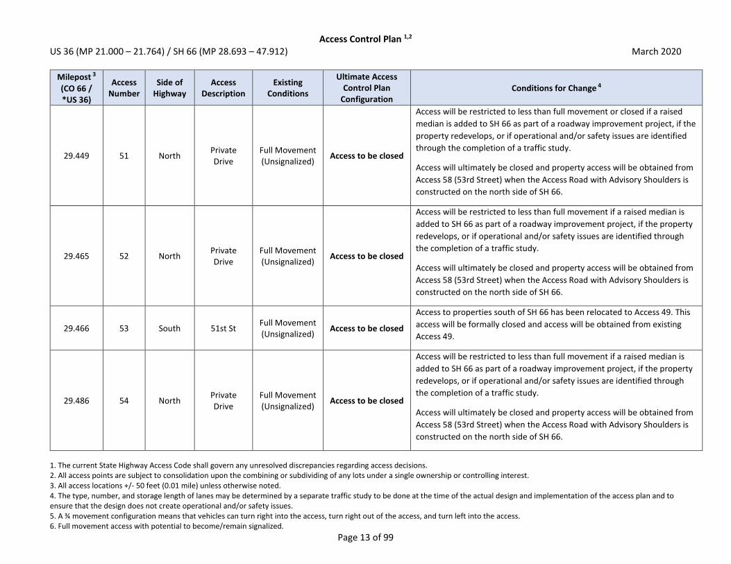
Access Control Plan 1,2 US 36 (MP 21.000 – 21.764) / SH 66 (MP 28.693 – 47.912) March 2020
1. The current State Highway Access Code shall govern any unresolved discrepancies regarding access decisions. 2. All access points are subject to consolidation upon the combining or subdividing of any lots under a single ownership or controlling interest. 3. All access locations +/- 50 feet (0.01 mile) unless otherwise noted. 4. The type, number, and storage length of lanes may be determined by a separate traffic study to be done at the time of the actual design and implementation of the access plan and to ensure that the design does not create operational and/or safety issues. 5. A ¾ movement configuration means that vehicles can turn right into the access, turn right out of the access, and turn left into the access. 6. Full movement access with potential to become/remain signalized.
Page 13 of 99
Milepost 3
(CO 66 / *US 36)
Access Number
Side of Highway
Access Description
Existing Conditions
Ultimate Access Control Plan
Configuration Conditions for Change 4
29.449 51 North Private Drive
Full Movement (Unsignalized)
Access to be closed
Access will be restricted to less than full movement or closed if a raised
median is added to SH 66 as part of a roadway improvement project, if the
property redevelops, or if operational and/or safety issues are identified
through the completion of a traffic study.
Access will ultimately be closed and property access will be obtained from
Access 58 (53rd Street) when the Access Road with Advisory Shoulders is
constructed on the north side of SH 66.
29.465 52 North Private Drive
Full Movement (Unsignalized)
Access to be closed
Access will be restricted to less than full movement if a raised median is
added to SH 66 as part of a roadway improvement project, if the property
redevelops, or if operational and/or safety issues are identified through
the completion of a traffic study.
Access will ultimately be closed and property access will be obtained from
Access 58 (53rd Street) when the Access Road with Advisory Shoulders is
constructed on the north side of SH 66.
29.466 53 South 51st St Full Movement (Unsignalized)
Access to be closed
Access to properties south of SH 66 has been relocated to Access 49. This
access will be formally closed and access will be obtained from existing
Access 49.
29.486 54 North Private Drive
Full Movement (Unsignalized)
Access to be closed
Access will be restricted to less than full movement if a raised median is
added to SH 66 as part of a roadway improvement project, if the property
redevelops, or if operational and/or safety issues are identified through
the completion of a traffic study.
Access will ultimately be closed and property access will be obtained from
Access 58 (53rd Street) when the Access Road with Advisory Shoulders is
constructed on the north side of SH 66.
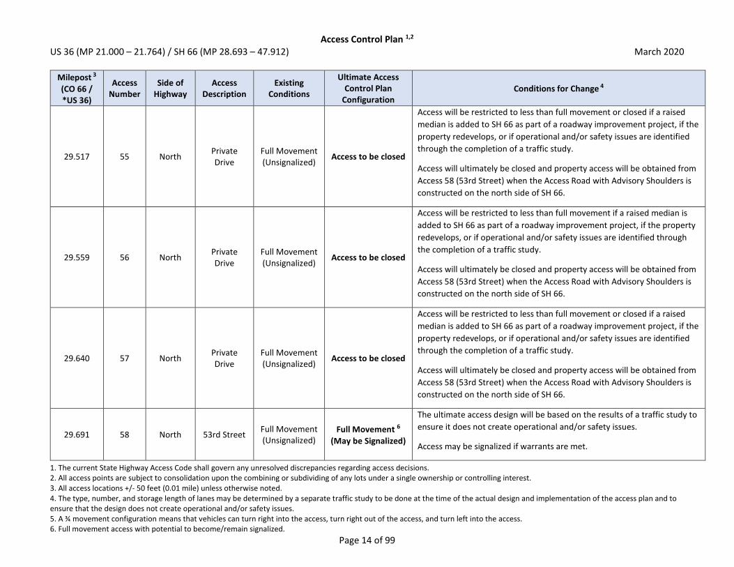
Access Control Plan 1,2 US 36 (MP 21.000 – 21.764) / SH 66 (MP 28.693 – 47.912) March 2020
1. The current State Highway Access Code shall govern any unresolved discrepancies regarding access decisions. 2. All access points are subject to consolidation upon the combining or subdividing of any lots under a single ownership or controlling interest. 3. All access locations +/- 50 feet (0.01 mile) unless otherwise noted. 4. The type, number, and storage length of lanes may be determined by a separate traffic study to be done at the time of the actual design and implementation of the access plan and to ensure that the design does not create operational and/or safety issues. 5. A ¾ movement configuration means that vehicles can turn right into the access, turn right out of the access, and turn left into the access. 6. Full movement access with potential to become/remain signalized.
Page 14 of 99
Milepost 3
(CO 66 / *US 36)
Access Number
Side of Highway
Access Description
Existing Conditions
Ultimate Access Control Plan
Configuration Conditions for Change 4
29.517 55 North Private Drive
Full Movement (Unsignalized)
Access to be closed
Access will be restricted to less than full movement or closed if a raised
median is added to SH 66 as part of a roadway improvement project, if the
property redevelops, or if operational and/or safety issues are identified
through the completion of a traffic study.
Access will ultimately be closed and property access will be obtained from
Access 58 (53rd Street) when the Access Road with Advisory Shoulders is
constructed on the north side of SH 66.
29.559 56 North Private Drive
Full Movement (Unsignalized)
Access to be closed
Access will be restricted to less than full movement if a raised median is
added to SH 66 as part of a roadway improvement project, if the property
redevelops, or if operational and/or safety issues are identified through
the completion of a traffic study.
Access will ultimately be closed and property access will be obtained from
Access 58 (53rd Street) when the Access Road with Advisory Shoulders is
constructed on the north side of SH 66.
29.640 57 North Private Drive
Full Movement (Unsignalized)
Access to be closed
Access will be restricted to less than full movement or closed if a raised
median is added to SH 66 as part of a roadway improvement project, if the
property redevelops, or if operational and/or safety issues are identified
through the completion of a traffic study.
Access will ultimately be closed and property access will be obtained from
Access 58 (53rd Street) when the Access Road with Advisory Shoulders is
constructed on the north side of SH 66.
29.691 58 North 53rd Street Full Movement (Unsignalized)
Full Movement 6
(May be Signalized)
The ultimate access design will be based on the results of a traffic study to
ensure it does not create operational and/or safety issues.
Access may be signalized if warrants are met.

Access Control Plan 1,2 US 36 (MP 21.000 – 21.764) / SH 66 (MP 28.693 – 47.912) March 2020
1. The current State Highway Access Code shall govern any unresolved discrepancies regarding access decisions. 2. All access points are subject to consolidation upon the combining or subdividing of any lots under a single ownership or controlling interest. 3. All access locations +/- 50 feet (0.01 mile) unless otherwise noted. 4. The type, number, and storage length of lanes may be determined by a separate traffic study to be done at the time of the actual design and implementation of the access plan and to ensure that the design does not create operational and/or safety issues. 5. A ¾ movement configuration means that vehicles can turn right into the access, turn right out of the access, and turn left into the access. 6. Full movement access with potential to become/remain signalized.
Page 15 of 99
Milepost 3
(CO 66 / *US 36)
Access Number
Side of Highway
Access Description
Existing Conditions
Ultimate Access Control Plan
Configuration Conditions for Change 4
29.775 59 North Private Drive
Full Movement (Unsignalized)
Access to be closed
Access will be restricted to less than full movement if a raised median is
added to SH 66 as part of a roadway improvement project, if the property
redevelops, or if operational and/or safety issues are identified through
the completion of a traffic study.
Access will ultimately be closed and property access will be obtained from
Access 58 (53rd Street) when the Access Road with Advisory Shoulders is
constructed on the north side of SH 66.
29.800 60 North Private Drive
Full Movement (Unsignalized)
Access to be closed
Access will be restricted to less than full movement or closed if a raised
median is added to SH 66 as part of a roadway improvement project, if the
property redevelops, or if operational and/or safety issues are identified
through the completion of a traffic study.
Access will ultimately be closed and property access will be obtained from
Access 58 (53rd Street) when the Access Road with Advisory Shoulders is
constructed on the north side of SH 66.
29.827 61 North Private Drive
Full Movement (Unsignalized)
Access to be closed
Access will be restricted to less than full movement if a raised median is
added to SH 66 as part of a roadway improvement project, if the property
redevelops, or if operational and/or safety issues are identified through
the completion of a traffic study.
Access will ultimately be closed and property access will be obtained from
Access 58 (53rd Street) when the Access Road with Advisory Shoulders is
constructed on the north side of SH 66.

Access Control Plan 1,2 US 36 (MP 21.000 – 21.764) / SH 66 (MP 28.693 – 47.912) March 2020
1. The current State Highway Access Code shall govern any unresolved discrepancies regarding access decisions. 2. All access points are subject to consolidation upon the combining or subdividing of any lots under a single ownership or controlling interest. 3. All access locations +/- 50 feet (0.01 mile) unless otherwise noted. 4. The type, number, and storage length of lanes may be determined by a separate traffic study to be done at the time of the actual design and implementation of the access plan and to ensure that the design does not create operational and/or safety issues. 5. A ¾ movement configuration means that vehicles can turn right into the access, turn right out of the access, and turn left into the access. 6. Full movement access with potential to become/remain signalized.
Page 16 of 99
Milepost 3
(CO 66 / *US 36)
Access Number
Side of Highway
Access Description
Existing Conditions
Ultimate Access Control Plan
Configuration Conditions for Change 4
29.858 62 North Private Drive
Full Movement (Unsignalized)
Access to be closed
Access will be restricted to less than full movement or closed if a raised
median is added to SH 66 as part of a roadway improvement project, if the
property redevelops, or if operational and/or safety issues are identified
through the completion of a traffic study.
Access will ultimately be closed and property access will be obtained from
Access 58 (53rd Street) when the Access Road with Advisory Shoulders is
constructed on the north side of SH 66.
29.873 63 North Private Drive
Full Movement (Unsignalized)
Access to be closed
Access will be restricted to less than full movement or closed if a raised
median is added to SH 66 as part of a roadway improvement project, if the
property redevelops, or if operational and/or safety issues are identified
through the completion of a traffic study.
Access will ultimately be closed and property access will be obtained from
Access 58 (53rd Street) when the Access Road with Advisory Shoulders is
constructed on the north side of SH 66.
29.916 64 North Private Drive
Full Movement (Unsignalized)
Access to be closed
Access will be restricted to less than full movement if a raised median is
added to SH 66 as part of a roadway improvement project, if the property
redevelops, or if operational and/or safety issues are identified through
the completion of a traffic study.
Access will ultimately be closed and property access will be obtained from
Access 67 or the newly constructed Access 389 when the Access Road with
Advisory Shoulders is constructed on the north side of SH 66.

Access Control Plan 1,2 US 36 (MP 21.000 – 21.764) / SH 66 (MP 28.693 – 47.912) March 2020
1. The current State Highway Access Code shall govern any unresolved discrepancies regarding access decisions. 2. All access points are subject to consolidation upon the combining or subdividing of any lots under a single ownership or controlling interest. 3. All access locations +/- 50 feet (0.01 mile) unless otherwise noted. 4. The type, number, and storage length of lanes may be determined by a separate traffic study to be done at the time of the actual design and implementation of the access plan and to ensure that the design does not create operational and/or safety issues. 5. A ¾ movement configuration means that vehicles can turn right into the access, turn right out of the access, and turn left into the access. 6. Full movement access with potential to become/remain signalized.
Page 17 of 99
Milepost 3
(CO 66 / *US 36)
Access Number
Side of Highway
Access Description
Existing Conditions
Ultimate Access Control Plan
Configuration Conditions for Change 4
29.964 65 North Private Drive
Full Movement (Unsignalized)
Access to be closed
Access will be restricted to less than full movement or closed if a raised
median is added to SH 66 as part of a roadway improvement project, if the
property redevelops, or if operational and/or safety issues are identified
through the completion of a traffic study.
Property access can be obtained via Access 67 (Forest Service Road).
Access will ultimately be closed and property access will be obtained from
Access 67 or the newly constructed Access 389 when the Access Road with
Advisory Shoulders is constructed on the north side of SH 66.
30.034 66 North Private Drive
Full Movement (Unsignalized)
Access to be closed
Access will be restricted to less than full movement or closed if a raised
median is added to SH 66 as part of a roadway improvement project, if the
property redevelops, or if operational and/or safety issues are identified
through the completion of a traffic study.
Property access can be obtained via Access 67 (Forest Service Road).
Access will ultimately be closed and property access will be obtained from
Access 67 or the newly constructed Access 389 when the Access Road with
Advisory Shoulders is constructed on the north side of SH 66.
30.071 67 North Forest
Service Rd Full Movement (Unsignalized)
Access to be closed
Access may be restricted to less than full movement if a raised median is
added to SH 66 as part of a roadway improvement project, if the property
redevelops, or if operational and/or safety issues are identified through
the completion of a traffic study.
Access will ultimately be closed if Access 389 is constructed and access can
be obtained via the Access Road with Advisory Shoulders on the north side
of SH 66.

Access Control Plan 1,2 US 36 (MP 21.000 – 21.764) / SH 66 (MP 28.693 – 47.912) March 2020
1. The current State Highway Access Code shall govern any unresolved discrepancies regarding access decisions. 2. All access points are subject to consolidation upon the combining or subdividing of any lots under a single ownership or controlling interest. 3. All access locations +/- 50 feet (0.01 mile) unless otherwise noted. 4. The type, number, and storage length of lanes may be determined by a separate traffic study to be done at the time of the actual design and implementation of the access plan and to ensure that the design does not create operational and/or safety issues. 5. A ¾ movement configuration means that vehicles can turn right into the access, turn right out of the access, and turn left into the access. 6. Full movement access with potential to become/remain signalized.
Page 18 of 99
Milepost 3
(CO 66 / *US 36)
Access Number
Side of Highway
Access Description
Existing Conditions
Ultimate Access Control Plan
Configuration Conditions for Change 4
30.092 68 South Private Drive
Full Movement (Unsignalized)
Access to be closed
Access will be restricted to less than full movement if a raised median is
added to SH 66 as part of a roadway improvement project, if the property
redevelops, or if operational and/or safety issues are identified through
the completion of a traffic study.
Property should seek to obtain cross access with adjacent property to the
east to obtain access to Access 70. If cross access can be obtained, access
will ultimately be closed.
30.111 69 South Private Drive
Full Movement (Unsignalized)
Access to be closed
Access will be restricted to less than full movement or closed if a raised
median is added to SH 66 as part of a roadway improvement project, if the
property redevelops, or if operational and/or safety issues are identified
through the completion of a traffic study.
Property should seek to obtain cross access with adjacent property to the
east to obtain access to Access 70. If cross access can be obtained, access
will ultimately be closed.
30.145 389 North Future Drive N/A 3/4 Movement 5
Access will be a newly constructed ¾ movement access to the property
aligned with Access 70 on the south side of SH 66. The ultimate access
design will be based on the results of a traffic study to ensure the access
does not create operational and/or safety issues.
30.146 70 South Private Drive
Full Movement (Unsignalized)
3/4 Movement 5
Access will be restricted to less than full movement if a raised median is
added to SH 66 as part of a roadway improvement project, if the property
redevelops, or if operational and/or safety issues are identified through
the completion of a traffic study.

Access Control Plan 1,2 US 36 (MP 21.000 – 21.764) / SH 66 (MP 28.693 – 47.912) March 2020
1. The current State Highway Access Code shall govern any unresolved discrepancies regarding access decisions. 2. All access points are subject to consolidation upon the combining or subdividing of any lots under a single ownership or controlling interest. 3. All access locations +/- 50 feet (0.01 mile) unless otherwise noted. 4. The type, number, and storage length of lanes may be determined by a separate traffic study to be done at the time of the actual design and implementation of the access plan and to ensure that the design does not create operational and/or safety issues. 5. A ¾ movement configuration means that vehicles can turn right into the access, turn right out of the access, and turn left into the access. 6. Full movement access with potential to become/remain signalized.
Page 19 of 99
Milepost 3
(CO 66 / *US 36)
Access Number
Side of Highway
Access Description
Existing Conditions
Ultimate Access Control Plan
Configuration Conditions for Change 4
30.289 71 North Private Drive
Full Movement (Unsignalized)
Access to be closed
Access will be restricted to less than full movement if a raised median is
added to SH 66 as part of a roadway improvement project, if the property
redevelops, or if operational and/or safety issues are identified through
the completion of a traffic study.
Access will ultimately be closed and property access will be obtained from
Access 67 or the newly constructed Access 389 when the Access Road
with Advisory Shoulders is constructed on the north side of SH 66.
30.320 72 South County of Boulder
Full Movement (Unsignalized)
Access to be closed
Access will be restricted to less than full movement or closed if a raised
median is added to SH 66 as part of a roadway improvement project, if the
property redevelops, or if operational and/or safety issues are identified
through the completion of a traffic study.
Property should seek to obtain cross access with adjacent property to the
west to obtain access to Access 70. If cross access can be obtained, access
will ultimately be closed.
30.331 73 North County of Boulder
Full Movement (Unsignalized)
Access to be closed
Access will be restricted to less than full movement or closed if a raised
median is added to SH 66 as part of a roadway improvement project, if the
property redevelops, or if operational and/or safety issues are identified
through the completion of a traffic study.
Access will ultimately be closed and property access will be obtained from
Access 67 or the newly constructed Access 389 when the Access Road with
Advisory Shoulders is constructed on the north side of SH 66.
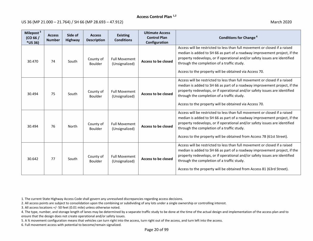
Access Control Plan 1,2 US 36 (MP 21.000 – 21.764) / SH 66 (MP 28.693 – 47.912) March 2020
1. The current State Highway Access Code shall govern any unresolved discrepancies regarding access decisions. 2. All access points are subject to consolidation upon the combining or subdividing of any lots under a single ownership or controlling interest. 3. All access locations +/- 50 feet (0.01 mile) unless otherwise noted. 4. The type, number, and storage length of lanes may be determined by a separate traffic study to be done at the time of the actual design and implementation of the access plan and to ensure that the design does not create operational and/or safety issues. 5. A ¾ movement configuration means that vehicles can turn right into the access, turn right out of the access, and turn left into the access. 6. Full movement access with potential to become/remain signalized.
Page 20 of 99
Milepost 3
(CO 66 / *US 36)
Access Number
Side of Highway
Access Description
Existing Conditions
Ultimate Access Control Plan
Configuration Conditions for Change 4
30.470 74 South County of Boulder
Full Movement (Unsignalized)
Access to be closed
Access will be restricted to less than full movement or closed if a raised
median is added to SH 66 as part of a roadway improvement project, if the
property redevelops, or if operational and/or safety issues are identified
through the completion of a traffic study.
Access to the property will be obtained via Access 70.
30.494 75 South County of Boulder
Full Movement (Unsignalized)
Access to be closed
Access will be restricted to less than full movement or closed if a raised
median is added to SH 66 as part of a roadway improvement project, if the
property redevelops, or if operational and/or safety issues are identified
through the completion of a traffic study.
Access to the property will be obtained via Access 70.
30.494 76 North County of Boulder
Full Movement (Unsignalized)
Access to be closed
Access will be restricted to less than full movement or closed if a raised
median is added to SH 66 as part of a roadway improvement project, if the
property redevelops, or if operational and/or safety issues are identified
through the completion of a traffic study.
Access to the property will be obtained from Access 78 (61st Street).
30.642 77 South County of Boulder
Full Movement (Unsignalized)
Access to be closed
Access will be restricted to less than full movement or closed if a raised
median is added to SH 66 as part of a roadway improvement project, if the
property redevelops, or if operational and/or safety issues are identified
through the completion of a traffic study.
Access to the property will be obtained from Access 81 (63rd Street).
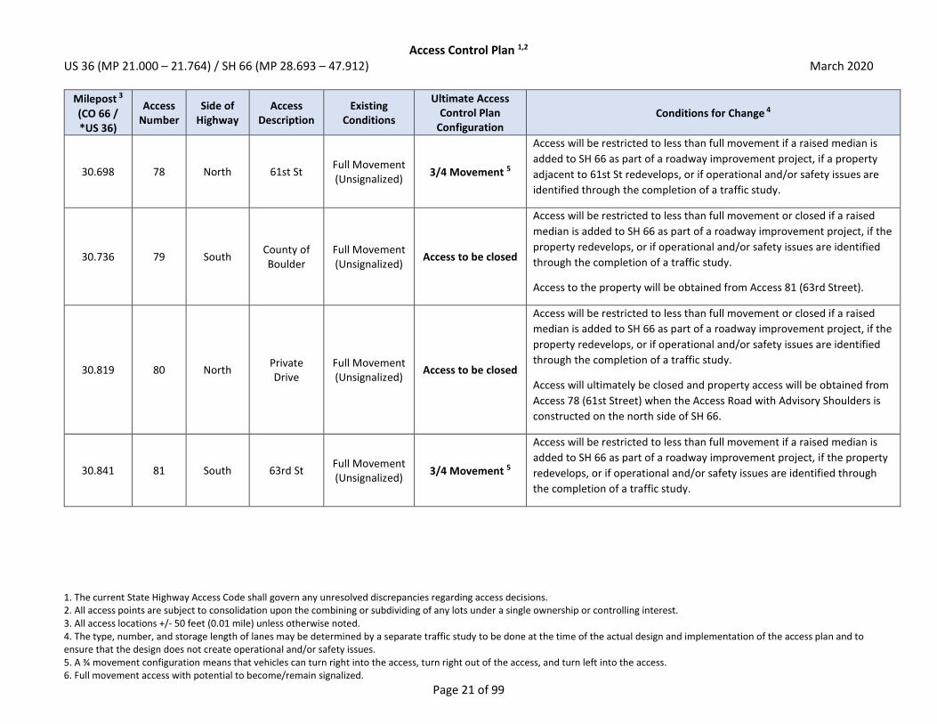
Access Control Plan 1,2 US 36 (MP 21.000 – 21.764) / SH 66 (MP 28.693 – 47.912) March 2020
1. The current State Highway Access Code shall govern any unresolved discrepancies regarding access decisions. 2. All access points are subject to consolidation upon the combining or subdividing of any lots under a single ownership or controlling interest. 3. All access locations +/- 50 feet (0.01 mile) unless otherwise noted. 4. The type, number, and storage length of lanes may be determined by a separate traffic study to be done at the time of the actual design and implementation of the access plan and to ensure that the design does not create operational and/or safety issues. 5. A ¾ movement configuration means that vehicles can turn right into the access, turn right out of the access, and turn left into the access. 6. Full movement access with potential to become/remain signalized.
Page 21 of 99
Milepost 3
(CO 66 / *US 36)
Access Number
Side of Highway
Access Description
Existing Conditions
Ultimate Access Control Plan
Configuration Conditions for Change 4
30.698 78 North 61st St Full Movement (Unsignalized)
3/4 Movement 5
Access will be restricted to less than full movement if a raised median is
added to SH 66 as part of a roadway improvement project, if a property
adjacent to 61st St redevelops, or if operational and/or safety issues are
identified through the completion of a traffic study.
30.736 79 South County of Boulder
Full Movement (Unsignalized)
Access to be closed
Access will be restricted to less than full movement or closed if a raised
median is added to SH 66 as part of a roadway improvement project, if the
property redevelops, or if operational and/or safety issues are identified
through the completion of a traffic study.
Access to the property will be obtained from Access 81 (63rd Street).
30.819 80 North Private Drive
Full Movement (Unsignalized)
Access to be closed
Access will be restricted to less than full movement or closed if a raised
median is added to SH 66 as part of a roadway improvement project, if the
property redevelops, or if operational and/or safety issues are identified
through the completion of a traffic study.
Access will ultimately be closed and property access will be obtained from
Access 78 (61st Street) when the Access Road with Advisory Shoulders is
constructed on the north side of SH 66.
30.841 81 South 63rd St Full Movement (Unsignalized)
3/4 Movement 5
Access will be restricted to less than full movement if a raised median is
added to SH 66 as part of a roadway improvement project, if the property
redevelops, or if operational and/or safety issues are identified through
the completion of a traffic study.

Access Control Plan 1,2 US 36 (MP 21.000 – 21.764) / SH 66 (MP 28.693 – 47.912) March 2020
1. The current State Highway Access Code shall govern any unresolved discrepancies regarding access decisions. 2. All access points are subject to consolidation upon the combining or subdividing of any lots under a single ownership or controlling interest. 3. All access locations +/- 50 feet (0.01 mile) unless otherwise noted. 4. The type, number, and storage length of lanes may be determined by a separate traffic study to be done at the time of the actual design and implementation of the access plan and to ensure that the design does not create operational and/or safety issues. 5. A ¾ movement configuration means that vehicles can turn right into the access, turn right out of the access, and turn left into the access. 6. Full movement access with potential to become/remain signalized.
Page 22 of 99
Milepost 3
(CO 66 / *US 36)
Access Number
Side of Highway
Access Description
Existing Conditions
Ultimate Access Control Plan
Configuration Conditions for Change 4
30.944 82 North Private Drive
Full Movement (Unsignalized)
Access to be closed
Access will be restricted to less than full movement or closed if a raised
median is added to SH 66 as part of a roadway improvement project, if the
property redevelops, or if operational and/or safety issues are identified
through the completion of a traffic study.
Access will ultimately be closed and property access will be obtained from
Access 98 (66th Street) when the Access Road with Advisory Shoulders is
constructed on the north side of SH 66.
30.965 83 North Private Drive
Full Movement (Unsignalized)
Access to be closed
Access will be restricted to less than full movement or closed if a raised
median is added to SH 66 as part of a roadway improvement project, if the
property redevelops, or if operational and/or safety issues are identified
through the completion of a traffic study.
Access will ultimately be closed and property access will be obtained from
Access 98 (66th Street) when the Access Road with Advisory Shoulders is
constructed on the north side of SH 66.
30.988 84 North Private Drive
Full Movement (Unsignalized)
Access to be closed
Access will be restricted to less than full movement or closed if a raised
median is added to SH 66 as part of a roadway improvement project, if the
property redevelops, or if operational and/or safety issues are identified
through the completion of a traffic study.
Access will ultimately be closed and property access will be obtained from
Access 98 (66th Street) when the Access Road with Advisory Shoulders is
constructed on the north side of SH 66.

Access Control Plan 1,2 US 36 (MP 21.000 – 21.764) / SH 66 (MP 28.693 – 47.912) March 2020
1. The current State Highway Access Code shall govern any unresolved discrepancies regarding access decisions. 2. All access points are subject to consolidation upon the combining or subdividing of any lots under a single ownership or controlling interest. 3. All access locations +/- 50 feet (0.01 mile) unless otherwise noted. 4. The type, number, and storage length of lanes may be determined by a separate traffic study to be done at the time of the actual design and implementation of the access plan and to ensure that the design does not create operational and/or safety issues. 5. A ¾ movement configuration means that vehicles can turn right into the access, turn right out of the access, and turn left into the access. 6. Full movement access with potential to become/remain signalized.
Page 23 of 99
Milepost 3
(CO 66 / *US 36)
Access Number
Side of Highway
Access Description
Existing Conditions
Ultimate Access Control Plan
Configuration Conditions for Change 4
31.010 85 North Private Drive
Full Movement (Unsignalized)
Access to be closed
Access will be restricted to less than full movement or closed if a raised
median is added to SH 66 as part of a roadway improvement project, if the
property redevelops, or if operational and/or safety issues are identified
through the completion of a traffic study.
Access will ultimately be closed and property access will be obtained from
Access 98 (66th Street) when the Access Road with Advisory Shoulders is
constructed on the north side of SH 66.
31.042 86 North Private Drive
Full Movement (Unsignalized)
Access to be closed
Access will be restricted to less than full movement or closed if a raised
median is added to SH 66 as part of a roadway improvement project, if the
property redevelops, or if operational and/or safety issues are identified
through the completion of a traffic study.
Access will ultimately be closed and property access will be obtained from
Access 98 (66th Street) when the Access Road with Advisory Shoulders is
constructed on the north side of SH 66.
31.070 87 North Private Drive
Full Movement (Unsignalized)
Access to be closed
Access will be restricted to less than full movement or closed if a raised
median is added to SH 66 as part of a roadway improvement project, if the
property redevelops, or if operational and/or safety issues are identified
through the completion of a traffic study.
Access will ultimately be closed and property access will be obtained from
Access 98 (66th Street) when the Access Road with Advisory Shoulders is
constructed on the north side of SH 66.

Access Control Plan 1,2 US 36 (MP 21.000 – 21.764) / SH 66 (MP 28.693 – 47.912) March 2020
1. The current State Highway Access Code shall govern any unresolved discrepancies regarding access decisions. 2. All access points are subject to consolidation upon the combining or subdividing of any lots under a single ownership or controlling interest. 3. All access locations +/- 50 feet (0.01 mile) unless otherwise noted. 4. The type, number, and storage length of lanes may be determined by a separate traffic study to be done at the time of the actual design and implementation of the access plan and to ensure that the design does not create operational and/or safety issues. 5. A ¾ movement configuration means that vehicles can turn right into the access, turn right out of the access, and turn left into the access. 6. Full movement access with potential to become/remain signalized.
Page 24 of 99
Milepost 3
(CO 66 / *US 36)
Access Number
Side of Highway
Access Description
Existing Conditions
Ultimate Access Control Plan
Configuration Conditions for Change 4
31.085 88 North Private Drive
Full Movement (Unsignalized)
Access to be closed
Access will be restricted to less than full movement or closed if a raised
median is added to SH 66 as part of a roadway improvement project, if the
property redevelops, or if operational and/or safety issues are identified
through the completion of a traffic study.
Access will ultimately be closed and property access will be obtained from
Access 98 (66th Street) when the Access Road with Advisory Shoulders is
constructed on the north side of SH 66.
31.113 89 North Private Drive
Full Movement (Unsignalized)
Access to be closed
Access will be restricted to less than full movement or closed if a raised
median is added to SH 66 as part of a roadway improvement project, if the
property redevelops, or if operational and/or safety issues are identified
through the completion of a traffic study.
Access will ultimately be closed and property access will be obtained from
Access 98 (66th Street) when the Access Road with Advisory Shoulders is
constructed on the north side of SH 66.
31.175 90 North Private Drive
Full Movement (Unsignalized)
Access to be closed
Access will be restricted to less than full movement or closed if a raised
median is added to SH 66 as part of a roadway improvement project, if the
property redevelops, or if operational and/or safety issues are identified
through the completion of a traffic study.
Access will ultimately be closed and property access will be obtained from
Access 98 (66th Street) when the Access Road with Advisory Shoulders is
constructed on the north side of SH 66.

Access Control Plan 1,2 US 36 (MP 21.000 – 21.764) / SH 66 (MP 28.693 – 47.912) March 2020
1. The current State Highway Access Code shall govern any unresolved discrepancies regarding access decisions. 2. All access points are subject to consolidation upon the combining or subdividing of any lots under a single ownership or controlling interest. 3. All access locations +/- 50 feet (0.01 mile) unless otherwise noted. 4. The type, number, and storage length of lanes may be determined by a separate traffic study to be done at the time of the actual design and implementation of the access plan and to ensure that the design does not create operational and/or safety issues. 5. A ¾ movement configuration means that vehicles can turn right into the access, turn right out of the access, and turn left into the access. 6. Full movement access with potential to become/remain signalized.
Page 25 of 99
Milepost 3
(CO 66 / *US 36)
Access Number
Side of Highway
Access Description
Existing Conditions
Ultimate Access Control Plan
Configuration Conditions for Change 4
31.193 91 North Private Drive
Full Movement (Unsignalized)
Access to be closed
Access will be restricted to less than full movement or closed if a raised
median is added to SH 66 as part of a roadway improvement project, if the
property redevelops, or if operational and/or safety issues are identified
through the completion of a traffic study.
Access will ultimately be closed and property access will be obtained from
Access 98 (66th Street) when the Access Road with Advisory Shoulders is
constructed on the north side of SH 66.
31.195 92 South McCall Dr Full Movement (Unsignalized)
Access to be closed
Access will be restricted to less than full movement or closed if a raised
median is added to SH 66 as part of a roadway improvement project, if the
property redevelops, or if operational and/or safety issues are identified
through the completion of a traffic study.
Access to the property will be obtained via Access 97 (66th Street).
31.206 93 North Private Drive
Full Movement (Unsignalized)
Access to be closed
Access will be restricted to less than full movement or closed if a raised
median is added to SH 66 as part of a roadway improvement project, if the
property redevelops, or if operational and/or safety issues are identified
through the completion of a traffic study.
Access will ultimately be closed and property access will be obtained from
Access 98 (66th Street) when the Access Road with Advisory Shoulders is
constructed on the north side of SH 66.

Access Control Plan 1,2 US 36 (MP 21.000 – 21.764) / SH 66 (MP 28.693 – 47.912) March 2020
1. The current State Highway Access Code shall govern any unresolved discrepancies regarding access decisions. 2. All access points are subject to consolidation upon the combining or subdividing of any lots under a single ownership or controlling interest. 3. All access locations +/- 50 feet (0.01 mile) unless otherwise noted. 4. The type, number, and storage length of lanes may be determined by a separate traffic study to be done at the time of the actual design and implementation of the access plan and to ensure that the design does not create operational and/or safety issues. 5. A ¾ movement configuration means that vehicles can turn right into the access, turn right out of the access, and turn left into the access. 6. Full movement access with potential to become/remain signalized.
Page 26 of 99
Milepost 3
(CO 66 / *US 36)
Access Number
Side of Highway
Access Description
Existing Conditions
Ultimate Access Control Plan
Configuration Conditions for Change 4
31.248 94 North Private Drive
Full Movement (Unsignalized)
Access to be closed
Access will be restricted to less than full movement if a raised median is
added to SH 66 as part of a roadway improvement project, if the property
redevelops, or if operational and/or safety issues are identified through
the completion of a traffic study.
Access will ultimately be closed and property access will be obtained from
Access 98 (66th Street) when the Access Road with Advisory Shoulders is
constructed on the north side of SH 66.
31.267 95 North Private Drive
Full Movement (Unsignalized)
Access to be closed
Access will be restricted to less than full movement if a raised median is
added to SH 66 as part of a roadway improvement project, if the property
redevelops, or if operational and/or safety issues are identified through
the completion of a traffic study.
Access will ultimately be closed and property access will be obtained from
Access 98 (66th Street) when the Access Road with Advisory Shoulders is
constructed on the north side of SH 66.
31.290 96 North Private Drive
Full Movement (Unsignalized)
Access to be closed
Access will be restricted to less than full movement or closed if a raised
median is added to SH 66 as part of a roadway improvement project, if the
property redevelops, or if operational and/or safety issues are identified
through the completion of a traffic study.
Access will ultimately be closed and property access will be obtained from
Access 98 (66th Street) when the Access Road with Advisory Shoulders is
constructed on the north side of SH 66.
31.330 97 South 66th St Full Movement (Unsignalized)
Full Movement 6
(May be Signalized)
The ultimate access design will be based on the results of a traffic study to
ensure it does not create operational and/or safety issues.
Access may be signalized if warrants are met.
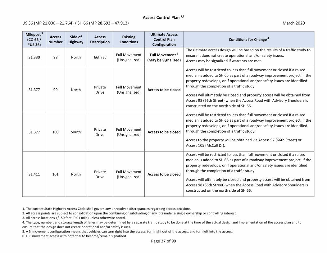
Access Control Plan 1,2 US 36 (MP 21.000 – 21.764) / SH 66 (MP 28.693 – 47.912) March 2020
1. The current State Highway Access Code shall govern any unresolved discrepancies regarding access decisions. 2. All access points are subject to consolidation upon the combining or subdividing of any lots under a single ownership or controlling interest. 3. All access locations +/- 50 feet (0.01 mile) unless otherwise noted. 4. The type, number, and storage length of lanes may be determined by a separate traffic study to be done at the time of the actual design and implementation of the access plan and to ensure that the design does not create operational and/or safety issues. 5. A ¾ movement configuration means that vehicles can turn right into the access, turn right out of the access, and turn left into the access. 6. Full movement access with potential to become/remain signalized.
Page 27 of 99
Milepost 3
(CO 66 / *US 36)
Access Number
Side of Highway
Access Description
Existing Conditions
Ultimate Access Control Plan
Configuration Conditions for Change 4
31.330 98 North 66th St Full Movement (Unsignalized)
Full Movement 6
(May be Signalized)
The ultimate access design will be based on the results of a traffic study to
ensure it does not create operational and/or safety issues.
Access may be signalized if warrants are met.
31.377 99 North Private Drive
Full Movement (Unsignalized)
Access to be closed
Access will be restricted to less than full movement or closed if a raised
median is added to SH 66 as part of a roadway improvement project, if the
property redevelops, or if operational and/or safety issues are identified
through the completion of a traffic study.
Access will ultimately be closed and property access will be obtained from
Access 98 (66th Street) when the Access Road with Advisory Shoulders is
constructed on the north side of SH 66.
31.377 100 South Private Drive
Full Movement (Unsignalized)
Access to be closed
Access will be restricted to less than full movement or closed if a raised
median is added to SH 66 as part of a roadway improvement project, if the
property redevelops, or if operational and/or safety issues are identified
through the completion of a traffic study.
Access to the property will be obtained via Access 97 (66th Street) or
Access 105 (McCall Dr).
31.411 101 North Private Drive
Full Movement (Unsignalized)
Access to be closed
Access will be restricted to less than full movement or closed if a raised
median is added to SH 66 as part of a roadway improvement project, if the
property redevelops, or if operational and/or safety issues are identified
through the completion of a traffic study.
Access will ultimately be closed and property access will be obtained from
Access 98 (66th Street) when the Access Road with Advisory Shoulders is
constructed on the north side of SH 66.

Access Control Plan 1,2 US 36 (MP 21.000 – 21.764) / SH 66 (MP 28.693 – 47.912) March 2020
1. The current State Highway Access Code shall govern any unresolved discrepancies regarding access decisions. 2. All access points are subject to consolidation upon the combining or subdividing of any lots under a single ownership or controlling interest. 3. All access locations +/- 50 feet (0.01 mile) unless otherwise noted. 4. The type, number, and storage length of lanes may be determined by a separate traffic study to be done at the time of the actual design and implementation of the access plan and to ensure that the design does not create operational and/or safety issues. 5. A ¾ movement configuration means that vehicles can turn right into the access, turn right out of the access, and turn left into the access. 6. Full movement access with potential to become/remain signalized.
Page 28 of 99
Milepost 3
(CO 66 / *US 36)
Access Number
Side of Highway
Access Description
Existing Conditions
Ultimate Access Control Plan
Configuration Conditions for Change 4
31.434 102 South Private Drive
Full Movement (Unsignalized)
Access to be closed
Access will be restricted to less than full movement or closed if a raised
median is added to SH 66 as part of a roadway improvement project, if the
property redevelops, or if operational and/or safety issues are identified
through the completion of a traffic study.
Access to the property will be obtained via Access 97 (66th Street) and
Access 105 (McCall Drive).
31.435 103 North Private Drive
Full Movement (Unsignalized)
Access to be closed
Access will be restricted to less than full movement if a raised median is
added to SH 66 as part of a roadway improvement project, if the property
redevelops, or if operational and/or safety issues are identified through
the completion of a traffic study.
Access will ultimately be closed and property access will be obtained from
Access 98 (66th Street) when the Access Road with Advisory Shoulders is
constructed on the north side of SH 66.
31.570 104 North Private Drive
Full Movement (Unsignalized)
Access to be closed
Access will be restricted to less than full movement if a raised median is
added to SH 66 as part of a roadway improvement project, if the property
redevelops, or if operational and/or safety issues are identified through
the completion of a traffic study.
Access will ultimately be closed and property access will be obtained from
Access 98 (66th Street) when the Access Road with Advisory Shoulders is
constructed on the north side of SH 66.
31.581 105 South McCall Dr Full Movement (Unsignalized)
Right-Out only
Access will be restricted to less than full movement if a raised median is
added to SH 66 as part of a roadway improvement project, if the property
redevelops, or if operational and/or safety issues are identified through
the completion of a traffic study.

Access Control Plan 1,2 US 36 (MP 21.000 – 21.764) / SH 66 (MP 28.693 – 47.912) March 2020
1. The current State Highway Access Code shall govern any unresolved discrepancies regarding access decisions. 2. All access points are subject to consolidation upon the combining or subdividing of any lots under a single ownership or controlling interest. 3. All access locations +/- 50 feet (0.01 mile) unless otherwise noted. 4. The type, number, and storage length of lanes may be determined by a separate traffic study to be done at the time of the actual design and implementation of the access plan and to ensure that the design does not create operational and/or safety issues. 5. A ¾ movement configuration means that vehicles can turn right into the access, turn right out of the access, and turn left into the access. 6. Full movement access with potential to become/remain signalized.
Page 29 of 99
Milepost 3
(CO 66 / *US 36)
Access Number
Side of Highway
Access Description
Existing Conditions
Ultimate Access Control Plan
Configuration Conditions for Change 4
31.660 106 South Private Drive
Full Movement (Unsignalized)
Access to be closed
Access will be restricted to less than full movement if a raised median is
added to SH 66 as part of a roadway improvement project, if the property
redevelops, or if operational and/or safety issues are identified through
the completion of a traffic study.
Property should seek to obtain cross access to the west to obtain access to
Access 105 (McCall Dr). If cross access can be obtained, access will
ultimately be closed.
31.703 107 South Private Drive
Full Movement (Unsignalized)
Right-In, Right-Out
Access will be restricted to less than full movement if a raised median is
added to SH 66 as part of a roadway improvement project, if the property
redevelops, or if operational and/or safety issues are identified through
the completion of a traffic study.
31.722 108 South Private Drive
Full Movement (Unsignalized)
Access to be closed
Access will be restricted to less than full movement if a raised median is
added to SH 66 as part of a roadway improvement project, if the property
redevelops, or if operational and/or safety issues are identified through
the completion of a traffic study.
Property should seek to obtain cross access with adjacent property to the
west to obtain access to Access 107. If cross access can be obtained,
access will ultimately be closed.
31.739 109 South Private Drive
Full Movement (Unsignalized)
Access to be closed
Access will be restricted to less than full movement or closed if a raised
median is added to SH 66 as part of a roadway improvement project, if the
property redevelops, or if operational and/or safety issues are identified
through the completion of a traffic study.
Access to the property will be obtained via Access 108 or Access 107.

Access Control Plan 1,2 US 36 (MP 21.000 – 21.764) / SH 66 (MP 28.693 – 47.912) March 2020
1. The current State Highway Access Code shall govern any unresolved discrepancies regarding access decisions. 2. All access points are subject to consolidation upon the combining or subdividing of any lots under a single ownership or controlling interest. 3. All access locations +/- 50 feet (0.01 mile) unless otherwise noted. 4. The type, number, and storage length of lanes may be determined by a separate traffic study to be done at the time of the actual design and implementation of the access plan and to ensure that the design does not create operational and/or safety issues. 5. A ¾ movement configuration means that vehicles can turn right into the access, turn right out of the access, and turn left into the access. 6. Full movement access with potential to become/remain signalized.
Page 30 of 99
Milepost 3
(CO 66 / *US 36)
Access Number
Side of Highway
Access Description
Existing Conditions
Ultimate Access Control Plan
Configuration Conditions for Change 4
31.759 110 North Private Drive
Full Movement (Unsignalized)
Access to be closed
Access will be restricted to less than full movement if a raised median is
added to SH 66 as part of a roadway improvement project, if the property
redevelops, or if operational and/or safety issues are identified through
the completion of a traffic study.
Access will ultimately be closed and property access will be obtained from
Access 98 (66th Street) when the Access Road with Advisory Shoulders is
constructed on the north side of SH 66.
31.771 111 South Private Drive
Full Movement (Unsignalized)
Access to be closed
Access will be restricted to less than full movement or closed if a raised
median is added to SH 66 as part of a roadway improvement project, if the
property redevelops, or if operational and/or safety issues are identified
through the completion of a traffic study.
Access to the property will be obtained via Access 112.
31.796 112 South Private Drive
Full Movement (Unsignalized)
Right-In, Right-Out
Access will be restricted to less than full movement if a raised median is
added to SH 66 as part of a roadway improvement project, if the property
redevelops, or if operational and/or safety issues are identified through
the completion of a traffic study.
31.821 113 South City of
Longmont Drive
Full Movement (Unsignalized)
Access to be closed
Access will be restricted to less than full movement if a raised median is
added to SH 66 as part of a roadway improvement project, if the property
redevelops, or if operational and/or safety issues are identified through
the completion of a traffic study.
Property should seek to obtain cross access with adjacent property to the
east or west to obtain access to Access 112 or Access 117. If cross access
can be obtained, access will ultimately be closed.
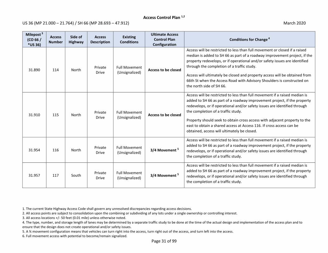
Access Control Plan 1,2 US 36 (MP 21.000 – 21.764) / SH 66 (MP 28.693 – 47.912) March 2020
1. The current State Highway Access Code shall govern any unresolved discrepancies regarding access decisions. 2. All access points are subject to consolidation upon the combining or subdividing of any lots under a single ownership or controlling interest. 3. All access locations +/- 50 feet (0.01 mile) unless otherwise noted. 4. The type, number, and storage length of lanes may be determined by a separate traffic study to be done at the time of the actual design and implementation of the access plan and to ensure that the design does not create operational and/or safety issues. 5. A ¾ movement configuration means that vehicles can turn right into the access, turn right out of the access, and turn left into the access. 6. Full movement access with potential to become/remain signalized.
Page 31 of 99
Milepost 3
(CO 66 / *US 36)
Access Number
Side of Highway
Access Description
Existing Conditions
Ultimate Access Control Plan
Configuration Conditions for Change 4
31.890 114 North Private Drive
Full Movement (Unsignalized)
Access to be closed
Access will be restricted to less than full movement or closed if a raised
median is added to SH 66 as part of a roadway improvement project, if the
property redevelops, or if operational and/or safety issues are identified
through the completion of a traffic study.
Access will ultimately be closed and property access will be obtained from
66th St when the Access Road with Advisory Shoulders is constructed on
the north side of SH 66.
31.910 115 North Private Drive
Full Movement (Unsignalized)
Access to be closed
Access will be restricted to less than full movement if a raised median is
added to SH 66 as part of a roadway improvement project, if the property
redevelops, or if operational and/or safety issues are identified through
the completion of a traffic study.
Property should seek to obtain cross access with adjacent property to the
east to obtain a shared access at Access 116. If cross access can be
obtained, access will ultimately be closed.
31.954 116 North Private Drive
Full Movement (Unsignalized)
3/4 Movement 5
Access will be restricted to less than full movement if a raised median is
added to SH 66 as part of a roadway improvement project, if the property
redevelops, or if operational and/or safety issues are identified through
the completion of a traffic study.
31.957 117 South Private Drive
Full Movement (Unsignalized)
3/4 Movement 5
Access will be restricted to less than full movement if a raised median is
added to SH 66 as part of a roadway improvement project, if the property
redevelops, or if operational and/or safety issues are identified through
the completion of a traffic study.
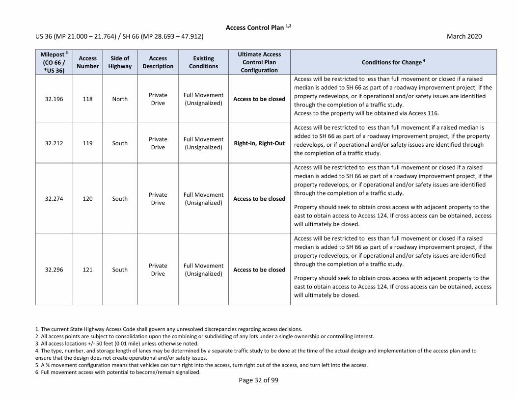
Access Control Plan 1,2 US 36 (MP 21.000 – 21.764) / SH 66 (MP 28.693 – 47.912) March 2020
1. The current State Highway Access Code shall govern any unresolved discrepancies regarding access decisions. 2. All access points are subject to consolidation upon the combining or subdividing of any lots under a single ownership or controlling interest. 3. All access locations +/- 50 feet (0.01 mile) unless otherwise noted. 4. The type, number, and storage length of lanes may be determined by a separate traffic study to be done at the time of the actual design and implementation of the access plan and to ensure that the design does not create operational and/or safety issues. 5. A ¾ movement configuration means that vehicles can turn right into the access, turn right out of the access, and turn left into the access. 6. Full movement access with potential to become/remain signalized.
Page 32 of 99
Milepost 3
(CO 66 / *US 36)
Access Number
Side of Highway
Access Description
Existing Conditions
Ultimate Access Control Plan
Configuration Conditions for Change 4
32.196 118 North Private Drive
Full Movement (Unsignalized)
Access to be closed
Access will be restricted to less than full movement or closed if a raised
median is added to SH 66 as part of a roadway improvement project, if the
property redevelops, or if operational and/or safety issues are identified
through the completion of a traffic study.
Access to the property will be obtained via Access 116.
32.212 119 South Private Drive
Full Movement (Unsignalized)
Right-In, Right-Out
Access will be restricted to less than full movement if a raised median is
added to SH 66 as part of a roadway improvement project, if the property
redevelops, or if operational and/or safety issues are identified through
the completion of a traffic study.
32.274 120 South Private Drive
Full Movement (Unsignalized)
Access to be closed
Access will be restricted to less than full movement or closed if a raised
median is added to SH 66 as part of a roadway improvement project, if the
property redevelops, or if operational and/or safety issues are identified
through the completion of a traffic study.
Property should seek to obtain cross access with adjacent property to the
east to obtain access to Access 124. If cross access can be obtained, access
will ultimately be closed.
32.296 121 South Private Drive
Full Movement (Unsignalized)
Access to be closed
Access will be restricted to less than full movement or closed if a raised
median is added to SH 66 as part of a roadway improvement project, if the
property redevelops, or if operational and/or safety issues are identified
through the completion of a traffic study.
Property should seek to obtain cross access with adjacent property to the
east to obtain access to Access 124. If cross access can be obtained, access
will ultimately be closed.

Access Control Plan 1,2 US 36 (MP 21.000 – 21.764) / SH 66 (MP 28.693 – 47.912) March 2020
1. The current State Highway Access Code shall govern any unresolved discrepancies regarding access decisions. 2. All access points are subject to consolidation upon the combining or subdividing of any lots under a single ownership or controlling interest. 3. All access locations +/- 50 feet (0.01 mile) unless otherwise noted. 4. The type, number, and storage length of lanes may be determined by a separate traffic study to be done at the time of the actual design and implementation of the access plan and to ensure that the design does not create operational and/or safety issues. 5. A ¾ movement configuration means that vehicles can turn right into the access, turn right out of the access, and turn left into the access. 6. Full movement access with potential to become/remain signalized.
Page 33 of 99
Milepost 3
(CO 66 / *US 36)
Access Number
Side of Highway
Access Description
Existing Conditions
Ultimate Access Control Plan
Configuration Conditions for Change 4
32.302 122 North Private Drive
Full Movement (Unsignalized)
Access to be closed
Access will be restricted to less than full movement or closed if a raised
median is added to SH 66 as part of a roadway improvement project, if the
property redevelops, or if operational and/or safety issues are identified
through the completion of a traffic study.
Access to the property will be obtained from Access 129 (75th Street).
32.317 123 North Private Drive
Right-In, Right-Out
Access to be closed
Access will be restricted to less than full movement or closed if a raised
median is added to SH 66 as part of a roadway improvement project, if the
property redevelops, or if operational and/or safety issues are identified
through the completion of a traffic study.
Access to the property will be obtained from Access 129 (75th Street).
32.331 124 South Private Drive
Right-In, Right-Out
Right-In, Right-Out
The ultimate access design will be based on the results of a traffic study to
ensure the intersection does not create operational and/or safety issues.
Access will remain as-is (right-in, right-out).
32.332 125 North Private Drive
Right-In, Right-Out
Access to be closed
Access will be restricted to less than full movement or closed if a raised
median is added to SH 66 as part of a roadway improvement project, if the
property redevelops, or if operational and/or safety issues are identified
through the completion of a traffic study.
Access will ultimately be closed and property access will be obtained from
Access 129 (75th Street) when the Access Road with Advisory Shoulders is
constructed on the north side of SH 66.

Access Control Plan 1,2 US 36 (MP 21.000 – 21.764) / SH 66 (MP 28.693 – 47.912) March 2020
1. The current State Highway Access Code shall govern any unresolved discrepancies regarding access decisions. 2. All access points are subject to consolidation upon the combining or subdividing of any lots under a single ownership or controlling interest. 3. All access locations +/- 50 feet (0.01 mile) unless otherwise noted. 4. The type, number, and storage length of lanes may be determined by a separate traffic study to be done at the time of the actual design and implementation of the access plan and to ensure that the design does not create operational and/or safety issues. 5. A ¾ movement configuration means that vehicles can turn right into the access, turn right out of the access, and turn left into the access. 6. Full movement access with potential to become/remain signalized.
Page 34 of 99
Milepost 3
(CO 66 / *US 36)
Access Number
Side of Highway
Access Description
Existing Conditions
Ultimate Access Control Plan
Configuration Conditions for Change 4
32.345 126 North Private Drive
Right-In, Right-Out
Access to be closed
Access will be restricted to less than full movement if a raised median is
added to SH 66 as part of a roadway improvement project, if the property
redevelops, or if operational and/or safety issues are identified through
the completion of a traffic study.
Access will ultimately be closed and property access will be obtained from
Access 129 (75th Street) when the Access Road with Advisory Shoulders is
constructed on the north side of SH 66.
32.415 127 South Private Drive
Right-In, Right-Out
Access to be closed
Access will be closed if the property redevelops or if operational and/or
safety issues are identified through the completion of a traffic study.
Access to the property will be obtained from Access 128 (75th Street).
32.452 128 South 75th St Full Movement
(Signalized) Full Movement 6
(Signalized)
The ultimate access design will be based on the results of a traffic study to
ensure the intersection does not create operational and/or safety issues.
Access will remain as-is (signalized full movement).
32.454 129 North 75th St Full Movement
(Signalized) Full Movement 6
(Signalized)
The ultimate access design will be based on the results of a traffic study to
ensure the intersection does not create operational and/or safety issues.
Access will remain as-is (signalized full movement).
32.484 130 North Private Drive
Emergency Access Only
Access to be closed
Access will be restricted to less than full movement or closed if a raised
median is added to SH 66 as part of a roadway improvement project, if the
property redevelops, or if operational and/or safety issues are identified
through the completion of a traffic study.
Access to the property will be obtained from Access 129 (75th Street).

Access Control Plan 1,2 US 36 (MP 21.000 – 21.764) / SH 66 (MP 28.693 – 47.912) March 2020
1. The current State Highway Access Code shall govern any unresolved discrepancies regarding access decisions. 2. All access points are subject to consolidation upon the combining or subdividing of any lots under a single ownership or controlling interest. 3. All access locations +/- 50 feet (0.01 mile) unless otherwise noted. 4. The type, number, and storage length of lanes may be determined by a separate traffic study to be done at the time of the actual design and implementation of the access plan and to ensure that the design does not create operational and/or safety issues. 5. A ¾ movement configuration means that vehicles can turn right into the access, turn right out of the access, and turn left into the access. 6. Full movement access with potential to become/remain signalized.
Page 35 of 99
Milepost 3
(CO 66 / *US 36)
Access Number
Side of Highway
Access Description
Existing Conditions
Ultimate Access Control Plan
Configuration Conditions for Change 4
32.543 131 North Private Drive
Right-In, Right-Out
Access to be closed
Access will be restricted to less than full movement or closed if a raised
median is added to SH 66 as part of a roadway improvement project, if the
property redevelops, or if operational and/or safety issues are identified
through the completion of a traffic study.
Access to the property will be obtained from Access 132 or Access 129
(75th Street).
32.562 132 North Private Drive
Right-In, Right-Out
Access to be closed
Access will be restricted to less than full movement if a raised median is
added to SH 66 as part of a roadway improvement project, if the property
redevelops, or if operational and/or safety issues are identified through
the completion of a traffic study.
Property should seek to obtain cross access with adjacent property to the
north or west to obtain access to Access 129 (75th Street). If cross access
can be obtained, access will ultimately be closed.
32.705 133 South Private Drive
Full Movement (Unsignalized)
Access to be closed
Access will be restricted to less than full movement if a raised median is
added to SH 66 as part of a roadway improvement project, if the property
redevelops, or if operational and/or safety issues are identified through
the completion of a traffic study.
Access will ultimately be closed and property access will be obtained from
Access 145 when the Access Road with Advisory Shoulders is constructed
on the south side of SH 66.

Access Control Plan 1,2 US 36 (MP 21.000 – 21.764) / SH 66 (MP 28.693 – 47.912) March 2020
1. The current State Highway Access Code shall govern any unresolved discrepancies regarding access decisions. 2. All access points are subject to consolidation upon the combining or subdividing of any lots under a single ownership or controlling interest. 3. All access locations +/- 50 feet (0.01 mile) unless otherwise noted. 4. The type, number, and storage length of lanes may be determined by a separate traffic study to be done at the time of the actual design and implementation of the access plan and to ensure that the design does not create operational and/or safety issues. 5. A ¾ movement configuration means that vehicles can turn right into the access, turn right out of the access, and turn left into the access. 6. Full movement access with potential to become/remain signalized.
Page 36 of 99
Milepost 3
(CO 66 / *US 36)
Access Number
Side of Highway
Access Description
Existing Conditions
Ultimate Access Control Plan
Configuration Conditions for Change 4
32.739 134 South Private Drive
Full Movement (Unsignalized)
Access to be closed
Access will be restricted to less than full movement if a raised median is
added to SH 66 as part of a roadway improvement project, if the property
redevelops, or if operational and/or safety issues are identified through
the completion of a traffic study.
Access will ultimately be closed and property access will be obtained from
Access 145 when the Access Road with Advisory Shoulders is constructed
on the south side of SH 66.
32.752 135 South Private Drive
Full Movement (Unsignalized)
Access to be closed
Access will be restricted to less than full movement or closed if a raised
median is added to SH 66 as part of a roadway improvement project, if the
property redevelops, or if operational and/or safety issues are identified
through the completion of a traffic study.
Access will ultimately be closed and property access will be obtained from
Access 145 when the Access Road with Advisory Shoulders is constructed
on the south side of SH 66.
32.773 136 South Private Drive
Full Movement (Unsignalized)
Access to be closed
Access will be restricted to less than full movement if a raised median is
added to SH 66 as part of a roadway improvement project, if the property
redevelops, or if operational and/or safety issues are identified through
the completion of a traffic study.
Access will ultimately be closed and property access will be obtained from
Access 145 when the Access Road with Advisory Shoulders is constructed
on the south side of SH 66.

Access Control Plan 1,2 US 36 (MP 21.000 – 21.764) / SH 66 (MP 28.693 – 47.912) March 2020
1. The current State Highway Access Code shall govern any unresolved discrepancies regarding access decisions. 2. All access points are subject to consolidation upon the combining or subdividing of any lots under a single ownership or controlling interest. 3. All access locations +/- 50 feet (0.01 mile) unless otherwise noted. 4. The type, number, and storage length of lanes may be determined by a separate traffic study to be done at the time of the actual design and implementation of the access plan and to ensure that the design does not create operational and/or safety issues. 5. A ¾ movement configuration means that vehicles can turn right into the access, turn right out of the access, and turn left into the access. 6. Full movement access with potential to become/remain signalized.
Page 37 of 99
Milepost 3
(CO 66 / *US 36)
Access Number
Side of Highway
Access Description
Existing Conditions
Ultimate Access Control Plan
Configuration Conditions for Change 4
32.775 137 North Private Drive
Full Movement (Unsignalized)
Access to be closed
Access will be restricted to less than full movement or closed if a raised
median is added to SH 66 as part of a roadway improvement project, if the
property redevelops, or if operational and/or safety issues are identified
through the completion of a traffic study.
Access to the property will be obtained from Access 146 (Unnamed Road).
32.817 138 North Private Drive
Full Movement (Unsignalized)
Access to be closed
Access will be restricted to less than full movement or closed if a raised
median is added to SH 66 as part of a roadway improvement project, if the
property redevelops, or if operational and/or safety issues are identified
through the completion of a traffic study.
Access to the property will be obtained from Access 146 (Unnamed Road).
32.839 139 North Private Drive
Full Movement (Unsignalized)
Access to be closed
Access will be restricted to less than full movement or closed if a raised
median is added to SH 66 as part of a roadway improvement project, if the
property redevelops, or if operational and/or safety issues are identified
through the completion of a traffic study.
Access to the property will be obtained from Access 146 (Unnamed Road).
32.865 140 South Private Drive
Full Movement (Unsignalized)
Access to be closed
Access will be restricted to less than full movement if a raised median is
added to SH 66 as part of a roadway improvement project, if the property
redevelops, or if operational and/or safety issues are identified through
the completion of a traffic study.
Access will ultimately be closed and property access will be obtained from
Access 145 when the Access Road with Advisory Shoulders is constructed
on the south side of SH 66.

Access Control Plan 1,2 US 36 (MP 21.000 – 21.764) / SH 66 (MP 28.693 – 47.912) March 2020
1. The current State Highway Access Code shall govern any unresolved discrepancies regarding access decisions. 2. All access points are subject to consolidation upon the combining or subdividing of any lots under a single ownership or controlling interest. 3. All access locations +/- 50 feet (0.01 mile) unless otherwise noted. 4. The type, number, and storage length of lanes may be determined by a separate traffic study to be done at the time of the actual design and implementation of the access plan and to ensure that the design does not create operational and/or safety issues. 5. A ¾ movement configuration means that vehicles can turn right into the access, turn right out of the access, and turn left into the access. 6. Full movement access with potential to become/remain signalized.
Page 38 of 99
Milepost 3
(CO 66 / *US 36)
Access Number
Side of Highway
Access Description
Existing Conditions
Ultimate Access Control Plan
Configuration Conditions for Change 4
32.879 141 South Private Drive
Full Movement (Unsignalized)
Access to be closed
Access will be restricted to less than full movement or closed if a raised
median is added to SH 66 as part of a roadway improvement project, if the
property redevelops, or if operational and/or safety issues are identified
through the completion of a traffic study.
Access will ultimately be closed and property access will be obtained from
Access 145 when the Access Road with Advisory Shoulders is constructed
on the south side of SH 66.
32.892 142 South Private Drive
Full Movement (Unsignalized)
Access to be closed
Access will be restricted to less than full movement if a raised median is
added to SH 66 as part of a roadway improvement project, if the property
redevelops, or if operational and/or safety issues are identified through
the completion of a traffic study.
Access will ultimately be closed and property access will be obtained from
Access 145 when the Access Road with Advisory Shoulders is constructed
on the south side of SH 66.
32.907 143 North Private Drive
Full Movement (Unsignalized)
Access to be closed
Access will be restricted to less than full movement or closed if a raised
median is added to SH 66 as part of a roadway improvement project, if the
property redevelops, or if operational and/or safety issues are identified
through the completion of a traffic study.
Access to the property will be obtained from Access 146 (Unnamed Road).

Access Control Plan 1,2 US 36 (MP 21.000 – 21.764) / SH 66 (MP 28.693 – 47.912) March 2020
1. The current State Highway Access Code shall govern any unresolved discrepancies regarding access decisions. 2. All access points are subject to consolidation upon the combining or subdividing of any lots under a single ownership or controlling interest. 3. All access locations +/- 50 feet (0.01 mile) unless otherwise noted. 4. The type, number, and storage length of lanes may be determined by a separate traffic study to be done at the time of the actual design and implementation of the access plan and to ensure that the design does not create operational and/or safety issues. 5. A ¾ movement configuration means that vehicles can turn right into the access, turn right out of the access, and turn left into the access. 6. Full movement access with potential to become/remain signalized.
Page 39 of 99
Milepost 3
(CO 66 / *US 36)
Access Number
Side of Highway
Access Description
Existing Conditions
Ultimate Access Control Plan
Configuration Conditions for Change 4
32.916 144 South Private Drive
Full Movement (Unsignalized)
Access to be closed
Access will be restricted to less than full movement if a raised median is
added to SH 66 as part of a roadway improvement project, if the property
redevelops, or if operational and/or safety issues are identified through
the completion of a traffic study.
Access will ultimately be closed and property access will be obtained from
Access 145 when the Access Road with Advisory Shoulders is constructed
on the south side of SH 66.
32.950 145 South Private Drive
Full Movement (Unsignalized)
3/4 Movement 5
Access will be restricted to less than full movement if a raised median is
added to SH 66 as part of a roadway improvement project, if the property
redevelops, or if operational and/or safety issues are identified through
the completion of a traffic study.
Access will ultimately provide highway access to the Access Road with
Advisory Shoulders on the south side of SH 66.
32.958 146 North Unnamed
Rd Full Movement (Unsignalized)
3/4 Movement 5
Access will be restricted to less than full movement if a raised median is
added to SH 66 as part of a roadway improvement project, if the property
redevelops, or if operational and/or safety issues are identified through
the completion of a traffic study.
33.017 147 North Private Drive
Full Movement (Unsignalized)
Access to be closed
Access will be restricted to less than full movement or closed if a raised
median is added to SH 66 as part of a roadway improvement project, if the
property redevelops, or if operational and/or safety issues are identified
through the completion of a traffic study.
Access to the property will be obtained from Access 146 (Unnamed Road).
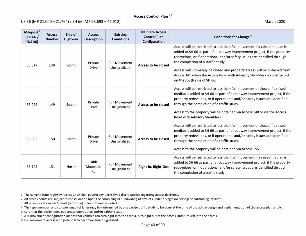
Access Control Plan 1,2 US 36 (MP 21.000 – 21.764) / SH 66 (MP 28.693 – 47.912) March 2020
1. The current State Highway Access Code shall govern any unresolved discrepancies regarding access decisions. 2. All access points are subject to consolidation upon the combining or subdividing of any lots under a single ownership or controlling interest. 3. All access locations +/- 50 feet (0.01 mile) unless otherwise noted. 4. The type, number, and storage length of lanes may be determined by a separate traffic study to be done at the time of the actual design and implementation of the access plan and to ensure that the design does not create operational and/or safety issues. 5. A ¾ movement configuration means that vehicles can turn right into the access, turn right out of the access, and turn left into the access. 6. Full movement access with potential to become/remain signalized.
Page 40 of 99
Milepost 3
(CO 66 / *US 36)
Access Number
Side of Highway
Access Description
Existing Conditions
Ultimate Access Control Plan
Configuration Conditions for Change 4
33.017 148 South Private Drive
Full Movement (Unsignalized)
Access to be closed
Access will be restricted to less than full movement if a raised median is
added to SH 66 as part of a roadway improvement project, if the property
redevelops, or if operational and/or safety issues are identified through
the completion of a traffic study.
Access will ultimately be closed and property access will be obtained from
Access 145 when the Access Road with Advisory Shoulders is constructed
on the south side of SH 66.
33.065 149 South Private Drive
Full Movement (Unsignalized)
Access to be closed
Access will be restricted to less than full movement or closed if a raised
median is added to SH 66 as part of a roadway improvement project, if the
property redevelops, or if operational and/or safety issues are identified
through the completion of a traffic study.
Access to the property will be obtained via Access 148 or via the Access
Road with Advisory Shoulders.
33.092 150 South Private Drive
Full Movement (Unsignalized)
Access to be closed
Access will be restricted to less than full movement or closed if a raised
median is added to SH 66 as part of a roadway improvement project, if the
property redevelops, or if operational and/or safety issues are identified
through the completion of a traffic study.
Access to the property will be obtained via Access 155.
33.195 151 North Table
Mountain Rd
Full Movement (Unsignalized)
Right-In, Right-Out
Access will be restricted to less than full movement if a raised median is
added to SH 66 as part of a roadway improvement project, if the property
redevelops, or if operational and/or safety issues are identified through
the completion of a traffic study.

Access Control Plan 1,2 US 36 (MP 21.000 – 21.764) / SH 66 (MP 28.693 – 47.912) March 2020
1. The current State Highway Access Code shall govern any unresolved discrepancies regarding access decisions. 2. All access points are subject to consolidation upon the combining or subdividing of any lots under a single ownership or controlling interest. 3. All access locations +/- 50 feet (0.01 mile) unless otherwise noted. 4. The type, number, and storage length of lanes may be determined by a separate traffic study to be done at the time of the actual design and implementation of the access plan and to ensure that the design does not create operational and/or safety issues. 5. A ¾ movement configuration means that vehicles can turn right into the access, turn right out of the access, and turn left into the access. 6. Full movement access with potential to become/remain signalized.
Page 41 of 99
Milepost 3
(CO 66 / *US 36)
Access Number
Side of Highway
Access Description
Existing Conditions
Ultimate Access Control Plan
Configuration Conditions for Change 4
33.394 152 South County of Boulder
Full Movement (Unsignalized)
Access to be closed
Access will be restricted to less than full movement or closed if a raised
median is added to SH 66 as part of a roadway improvement project, if the
property redevelops, or if operational and/or safety issues are identified
through the completion of a traffic study.
Access to the property will be obtained via Access 155.
33.428 153 North Private Drive
Full Movement (Unsignalized)
3/4 Movement 5
Access will be restricted to less than full movement if a raised median is
added to SH 66 as part of a roadway improvement project, if the property
redevelops, or if operational and/or safety issues are identified through
the completion of a traffic study.
33.469 154 North Private Drive
Full Movement (Unsignalized)
Access to be closed
Access will be restricted to less than full movement or closed if a raised
median is added to SH 66 as part of a roadway improvement project, if the
property redevelops, or if operational and/or safety issues are identified
through the completion of a traffic study.
Property should seek to obtain cross access with adjacent property to the
west to obtain access to Access 153. If cross access can be obtained,
access will ultimately be closed.
33.531 155 South County of Boulder
Full Movement (Unsignalized)
3/4 Movement 5
Access will be restricted to less than full movement if a raised median is
added to SH 66 as part of a roadway improvement project, if the property
redevelops, or if operational and/or safety issues are identified through
the completion of a traffic study.

Access Control Plan 1,2 US 36 (MP 21.000 – 21.764) / SH 66 (MP 28.693 – 47.912) March 2020
1. The current State Highway Access Code shall govern any unresolved discrepancies regarding access decisions. 2. All access points are subject to consolidation upon the combining or subdividing of any lots under a single ownership or controlling interest. 3. All access locations +/- 50 feet (0.01 mile) unless otherwise noted. 4. The type, number, and storage length of lanes may be determined by a separate traffic study to be done at the time of the actual design and implementation of the access plan and to ensure that the design does not create operational and/or safety issues. 5. A ¾ movement configuration means that vehicles can turn right into the access, turn right out of the access, and turn left into the access. 6. Full movement access with potential to become/remain signalized.
Page 42 of 99
Milepost 3
(CO 66 / *US 36)
Access Number
Side of Highway
Access Description
Existing Conditions
Ultimate Access Control Plan
Configuration Conditions for Change 4
33.683 156 North County of Boulder
Full Movement (Unsignalized)
Access to be closed
Access will be restricted to less than full movement or closed if a raised
median is added to SH 66 as part of a roadway improvement project, if the
property redevelops, or if operational and/or safety issues are identified
through the completion of a traffic study.
Access to the property will be obtained from Access 161 (87th Street).
33.684 157 South County of Boulder
Full Movement (Unsignalized)
Access to be closed
Access will be restricted to less than full movement or closed if a raised
median is added to SH 66 as part of a roadway improvement project, if the
property redevelops, or if operational and/or safety issues are identified
through the completion of a traffic study.
Access to the property will be obtained via Access 155 or Access 162
(Airport Rd).
33.860 158 South County of Boulder
Full Movement (Unsignalized)
Access to be closed
Access will be restricted to less than full movement or closed if a raised
median is added to SH 66 as part of a roadway improvement project, if the
property redevelops, or if operational and/or safety issues are identified
through the completion of a traffic study.
Access to the property will be obtained via Access 155 or Access 162
(Airport Rd).
33.887 159 South Private Drive
Full Movement (Unsignalized)
Access to be closed
Access will be restricted to less than full movement or closed if a raised
median is added to SH 66 as part of a roadway improvement project, if the
property redevelops, or if operational and/or safety issues are identified
through the completion of a traffic study.
Access to the property will be obtained via Access 162 (Airport Rd).

Access Control Plan 1,2 US 36 (MP 21.000 – 21.764) / SH 66 (MP 28.693 – 47.912) March 2020
1. The current State Highway Access Code shall govern any unresolved discrepancies regarding access decisions. 2. All access points are subject to consolidation upon the combining or subdividing of any lots under a single ownership or controlling interest. 3. All access locations +/- 50 feet (0.01 mile) unless otherwise noted. 4. The type, number, and storage length of lanes may be determined by a separate traffic study to be done at the time of the actual design and implementation of the access plan and to ensure that the design does not create operational and/or safety issues. 5. A ¾ movement configuration means that vehicles can turn right into the access, turn right out of the access, and turn left into the access. 6. Full movement access with potential to become/remain signalized.
Page 43 of 99
Milepost 3
(CO 66 / *US 36)
Access Number
Side of Highway
Access Description
Existing Conditions
Ultimate Access Control Plan
Configuration Conditions for Change 4
33.888 160 North Private Drive
Full Movement (Unsignalized)
Access to be closed
Access will be restricted to less than full movement or closed if a raised
median is added to SH 66 as part of a roadway improvement project, if the
property redevelops, or if operational and/or safety issues are identified
through the completion of a traffic study.
Access to the property will be obtained from Access 161 (87th Street).
33.933 161 North 87th St Full Movement (Unsignalized)
Full Movement 6
(May be Signalized)
The ultimate access design will be based on the results of a traffic study to
ensure it does not create operational and/or safety issues.
Access may be signalized if warrants are met.
33.936 162 South Airport Rd Full Movement (Unsignalized)
Full Movement 6
(May be Signalized)
The ultimate access design will be based on the results of a traffic study to
ensure it does not create operational and/or safety issues.
Access may be signalized if warrants are met.
33.982 163 North Private Drive
Full Movement (Unsignalized)
Access to be closed
Access will be restricted to less than full movement or closed if a raised
median is added to SH 66 as part of a roadway improvement project, if the
property redevelops, or if operational and/or safety issues are identified
through the completion of a traffic study.
Access to the property will be obtained from Access 161 (87th Street).
34.122 164 North Private Drive
Full Movement (Unsignalized)
Access to be closed
Access will be restricted to less than full movement or closed if a raised
median is added to SH 66 as part of a roadway improvement project, if the
property redevelops, or if operational and/or safety issues are identified
through the completion of a traffic study.
Access to the property will be obtained from Access 161 (87th Street).
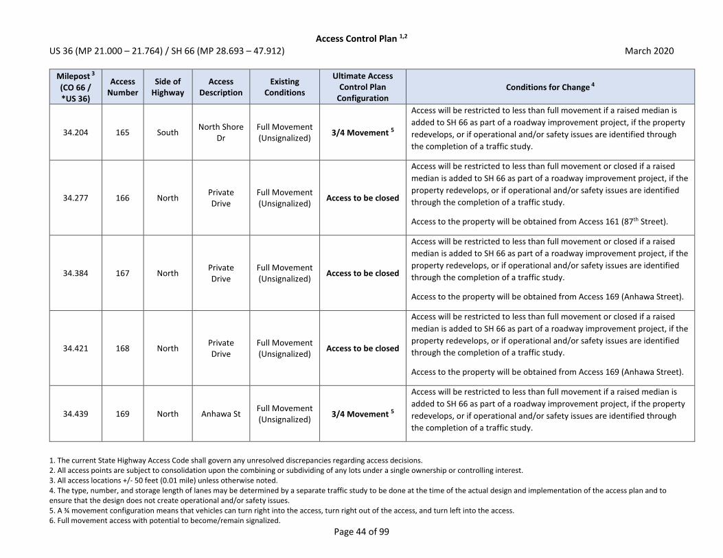
Access Control Plan 1,2 US 36 (MP 21.000 – 21.764) / SH 66 (MP 28.693 – 47.912) March 2020
1. The current State Highway Access Code shall govern any unresolved discrepancies regarding access decisions. 2. All access points are subject to consolidation upon the combining or subdividing of any lots under a single ownership or controlling interest. 3. All access locations +/- 50 feet (0.01 mile) unless otherwise noted. 4. The type, number, and storage length of lanes may be determined by a separate traffic study to be done at the time of the actual design and implementation of the access plan and to ensure that the design does not create operational and/or safety issues. 5. A ¾ movement configuration means that vehicles can turn right into the access, turn right out of the access, and turn left into the access. 6. Full movement access with potential to become/remain signalized.
Page 44 of 99
Milepost 3
(CO 66 / *US 36)
Access Number
Side of Highway
Access Description
Existing Conditions
Ultimate Access Control Plan
Configuration Conditions for Change 4
34.204 165 South North Shore
Dr Full Movement (Unsignalized)
3/4 Movement 5
Access will be restricted to less than full movement if a raised median is
added to SH 66 as part of a roadway improvement project, if the property
redevelops, or if operational and/or safety issues are identified through
the completion of a traffic study.
34.277 166 North Private Drive
Full Movement (Unsignalized)
Access to be closed
Access will be restricted to less than full movement or closed if a raised
median is added to SH 66 as part of a roadway improvement project, if the
property redevelops, or if operational and/or safety issues are identified
through the completion of a traffic study.
Access to the property will be obtained from Access 161 (87th Street).
34.384 167 North Private Drive
Full Movement (Unsignalized)
Access to be closed
Access will be restricted to less than full movement or closed if a raised
median is added to SH 66 as part of a roadway improvement project, if the
property redevelops, or if operational and/or safety issues are identified
through the completion of a traffic study.
Access to the property will be obtained from Access 169 (Anhawa Street).
34.421 168 North Private Drive
Full Movement (Unsignalized)
Access to be closed
Access will be restricted to less than full movement or closed if a raised
median is added to SH 66 as part of a roadway improvement project, if the
property redevelops, or if operational and/or safety issues are identified
through the completion of a traffic study.
Access to the property will be obtained from Access 169 (Anhawa Street).
34.439 169 North Anhawa St Full Movement (Unsignalized)
3/4 Movement 5
Access will be restricted to less than full movement if a raised median is
added to SH 66 as part of a roadway improvement project, if the property
redevelops, or if operational and/or safety issues are identified through
the completion of a traffic study.
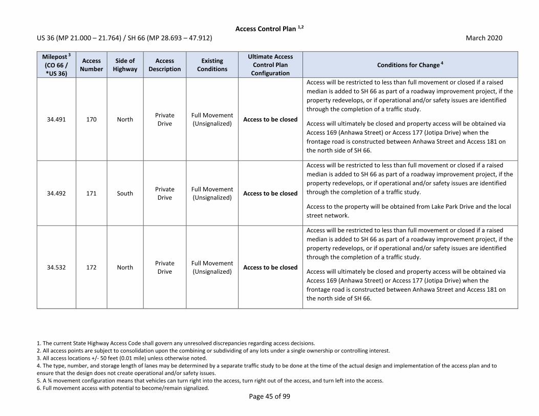
Access Control Plan 1,2 US 36 (MP 21.000 – 21.764) / SH 66 (MP 28.693 – 47.912) March 2020
1. The current State Highway Access Code shall govern any unresolved discrepancies regarding access decisions. 2. All access points are subject to consolidation upon the combining or subdividing of any lots under a single ownership or controlling interest. 3. All access locations +/- 50 feet (0.01 mile) unless otherwise noted. 4. The type, number, and storage length of lanes may be determined by a separate traffic study to be done at the time of the actual design and implementation of the access plan and to ensure that the design does not create operational and/or safety issues. 5. A ¾ movement configuration means that vehicles can turn right into the access, turn right out of the access, and turn left into the access. 6. Full movement access with potential to become/remain signalized.
Page 45 of 99
Milepost 3
(CO 66 / *US 36)
Access Number
Side of Highway
Access Description
Existing Conditions
Ultimate Access Control Plan
Configuration Conditions for Change 4
34.491 170 North Private Drive
Full Movement (Unsignalized)
Access to be closed
Access will be restricted to less than full movement or closed if a raised
median is added to SH 66 as part of a roadway improvement project, if the
property redevelops, or if operational and/or safety issues are identified
through the completion of a traffic study.
Access will ultimately be closed and property access will be obtained via
Access 169 (Anhawa Street) or Access 177 (Jotipa Drive) when the
frontage road is constructed between Anhawa Street and Access 181 on
the north side of SH 66.
34.492 171 South Private Drive
Full Movement (Unsignalized)
Access to be closed
Access will be restricted to less than full movement or closed if a raised
median is added to SH 66 as part of a roadway improvement project, if the
property redevelops, or if operational and/or safety issues are identified
through the completion of a traffic study.
Access to the property will be obtained from Lake Park Drive and the local
street network.
34.532 172 North Private Drive
Full Movement (Unsignalized)
Access to be closed
Access will be restricted to less than full movement or closed if a raised
median is added to SH 66 as part of a roadway improvement project, if the
property redevelops, or if operational and/or safety issues are identified
through the completion of a traffic study.
Access will ultimately be closed and property access will be obtained via
Access 169 (Anhawa Street) or Access 177 (Jotipa Drive) when the
frontage road is constructed between Anhawa Street and Access 181 on
the north side of SH 66.

Access Control Plan 1,2 US 36 (MP 21.000 – 21.764) / SH 66 (MP 28.693 – 47.912) March 2020
1. The current State Highway Access Code shall govern any unresolved discrepancies regarding access decisions. 2. All access points are subject to consolidation upon the combining or subdividing of any lots under a single ownership or controlling interest. 3. All access locations +/- 50 feet (0.01 mile) unless otherwise noted. 4. The type, number, and storage length of lanes may be determined by a separate traffic study to be done at the time of the actual design and implementation of the access plan and to ensure that the design does not create operational and/or safety issues. 5. A ¾ movement configuration means that vehicles can turn right into the access, turn right out of the access, and turn left into the access. 6. Full movement access with potential to become/remain signalized.
Page 46 of 99
Milepost 3
(CO 66 / *US 36)
Access Number
Side of Highway
Access Description
Existing Conditions
Ultimate Access Control Plan
Configuration Conditions for Change 4
34.559 173 North Private Drive
Full Movement (Unsignalized)
Access to be closed
Access will be restricted to less than full movement or closed if a raised
median is added to SH 66 as part of a roadway improvement project, if the
property redevelops, or if operational and/or safety issues are identified
through the completion of a traffic study.
Access will ultimately be closed and property access will be obtained via
Access 169 (Anhawa Street) or Access 177 (Jotipa Drive) when the
frontage road is constructed between Anhawa Street and Access 181 on
the north side of SH 66.
34.595 174 North Private Drive
Full Movement (Unsignalized)
Access to be closed
Access will be restricted to less than full movement or closed if a raised
median is added to SH 66 as part of a roadway improvement project, if the
property redevelops, or if operational and/or safety issues are identified
through the completion of a traffic study.
Access will ultimately be closed and property access will be obtained via
Access 169 (Anhawa Street) or Access 177 (Jotipa Drive) when the
frontage road is constructed between Anhawa Street and Access 181 on
the north side of SH 66.
34.609 175 North Private Drive
Full Movement (Unsignalized)
Access to be closed
Access will be restricted to less than full movement or closed if a raised
median is added to SH 66 as part of a roadway improvement project, if the
property redevelops, or if operational and/or safety issues are identified
through the completion of a traffic study.
Access will ultimately be closed and property access will be obtained via
Access 169 (Anhawa Street) or Access 177 (Jotipa Drive) when the
frontage road is constructed between Anhawa Street and Access 181 on
the north side of SH 66.

Access Control Plan 1,2 US 36 (MP 21.000 – 21.764) / SH 66 (MP 28.693 – 47.912) March 2020
1. The current State Highway Access Code shall govern any unresolved discrepancies regarding access decisions. 2. All access points are subject to consolidation upon the combining or subdividing of any lots under a single ownership or controlling interest. 3. All access locations +/- 50 feet (0.01 mile) unless otherwise noted. 4. The type, number, and storage length of lanes may be determined by a separate traffic study to be done at the time of the actual design and implementation of the access plan and to ensure that the design does not create operational and/or safety issues. 5. A ¾ movement configuration means that vehicles can turn right into the access, turn right out of the access, and turn left into the access. 6. Full movement access with potential to become/remain signalized.
Page 47 of 99
Milepost 3
(CO 66 / *US 36)
Access Number
Side of Highway
Access Description
Existing Conditions
Ultimate Access Control Plan
Configuration Conditions for Change 4
34.653 176 North Private Drive
Full Movement (Unsignalized)
Access to be closed
Access will be restricted to less than full movement or closed if a raised
median is added to SH 66 as part of a roadway improvement project, if the
property redevelops, or if operational and/or safety issues are identified
through the completion of a traffic study.
Access will ultimately be closed and property access will be obtained via
Access 169 (Anhawa Street) or Access 177 (Jotipa Drive) when the
frontage road is constructed between Anhawa Street and Access 181 on
the north side of SH 66.
34.695 177 North Jotipa Dr Full Movement (Unsignalized)
Right-In, Right-Out
Access will be restricted to less than full movement if a raised median is
added to SH 66 as part of a roadway improvement project, if the property
redevelops, or if operational and/or safety issues are identified through
the completion of a traffic study.
34.696 178 South Lake Park Dr Full Movement (Unsignalized)
3/4 Movement 5
Access will be restricted to less than full movement if a raised median is
added to SH 66 as part of a roadway improvement project, if the property
redevelops, or if operational and/or safety issues are identified through
the completion of a traffic study.
34.738 179 North Private Drive
Full Movement (Unsignalized)
Access to be closed
Access will be restricted to less than full movement or closed if a raised
median is added to SH 66 as part of a roadway improvement project, if the
property redevelops, or if operational and/or safety issues are identified
through the completion of a traffic study.
Access will ultimately be closed and property access will be obtained via
Access 169 (Anhawa Street) or Access 177 (Jotipa Drive) when the
frontage road is constructed between Anhawa Street and Access 181 on
the north side of SH 66.

Access Control Plan 1,2 US 36 (MP 21.000 – 21.764) / SH 66 (MP 28.693 – 47.912) March 2020
1. The current State Highway Access Code shall govern any unresolved discrepancies regarding access decisions. 2. All access points are subject to consolidation upon the combining or subdividing of any lots under a single ownership or controlling interest. 3. All access locations +/- 50 feet (0.01 mile) unless otherwise noted. 4. The type, number, and storage length of lanes may be determined by a separate traffic study to be done at the time of the actual design and implementation of the access plan and to ensure that the design does not create operational and/or safety issues. 5. A ¾ movement configuration means that vehicles can turn right into the access, turn right out of the access, and turn left into the access. 6. Full movement access with potential to become/remain signalized.
Page 48 of 99
Milepost 3
(CO 66 / *US 36)
Access Number
Side of Highway
Access Description
Existing Conditions
Ultimate Access Control Plan
Configuration Conditions for Change 4
34.772 180 North Private Drive
Full Movement (Unsignalized)
Access to be closed
Access will be restricted to less than full movement or closed if a raised
median is added to SH 66 as part of a roadway improvement project, if the
property redevelops, or if operational and/or safety issues are identified
through the completion of a traffic study.
Access will ultimately be closed and property access will be obtained via
Access 169 (Anhawa Street) or Access 177 (Jotipa Drive) when the
frontage road is constructed between Anhawa Street and Access 181 on
the north side of SH 66.
34.818 181 North Private Drive
Full Movement (Unsignalized)
Access to be closed
Access will be restricted to less than full movement or closed if a raised
median is added to SH 66 as part of a roadway improvement project, if the
property redevelops, or if operational and/or safety issues are identified
through the completion of a traffic study.
Access will ultimately be closed and property access will be obtained via
Access 169 (Anhawa Street) or Access 177 (Jotipa Drive) when the
frontage road is constructed between Anhawa Street and Access 181 on
the north side of SH 66.
34.933 182 North Hover St Full Movement
(Signalized) Full Movement 6
(Signalized)
The ultimate access design will be based on the results of a traffic study to
ensure the intersection does not create operational and/or safety issues.
Access will remain as-is (signalized full movement).
34.933 183 South Hover St Full Movement
(Signalized) Full Movement 6
(Signalized)
The ultimate access design will be based on the results of a traffic study to
ensure the intersection does not create operational and/or safety issues.
Access will remain as-is (signalized full movement).

Access Control Plan 1,2 US 36 (MP 21.000 – 21.764) / SH 66 (MP 28.693 – 47.912) March 2020
1. The current State Highway Access Code shall govern any unresolved discrepancies regarding access decisions. 2. All access points are subject to consolidation upon the combining or subdividing of any lots under a single ownership or controlling interest. 3. All access locations +/- 50 feet (0.01 mile) unless otherwise noted. 4. The type, number, and storage length of lanes may be determined by a separate traffic study to be done at the time of the actual design and implementation of the access plan and to ensure that the design does not create operational and/or safety issues. 5. A ¾ movement configuration means that vehicles can turn right into the access, turn right out of the access, and turn left into the access. 6. Full movement access with potential to become/remain signalized.
Page 49 of 99
Milepost 3
(CO 66 / *US 36)
Access Number
Side of Highway
Access Description
Existing Conditions
Ultimate Access Control Plan
Configuration Conditions for Change 4
35.217 184 North Private Drive
Full Movement (Unsignalized)
Access to be closed
Access will be restricted to less than full movement or closed if a raised
median is added to SH 66 as part of a roadway improvement project, if the
property redevelops, or if operational and/or safety issues are identified
through the completion of a traffic study.
Property should seek to obtain cross access with adjacent property to the
east to obtain access to Access 186. If cross access can be obtained, access
will ultimately be closed.
35.264 185 South Spencer St Full Movement (Unsignalized)
Right-In, Right-Out
Access will be restricted to less than full movement if a raised median is
added to SH 66 as part of a roadway improvement project, if the property
redevelops, or if operational and/or safety issues are identified through
the completion of a traffic study.
Access may remain ¾ movement unless safety issues arise or major
reconstruction of Access 182/183 (Hover Street) requires limiting turn
movements to obtain an acceptable geometric design.
35.265 186 North Private Drive
Full Movement (Unsignalized)
Right-In, Right-Out
Access will be restricted to less than full movement if a raised median is
added to SH 66 as part of a roadway improvement project, if the property
redevelops, or if operational and/or safety issues are identified through
the completion of a traffic study.
Access may remain ¾ movement unless safety issues arise or major
reconstruction of Access 182/183 (Hover Street) requires limiting turn
movements to obtain an acceptable geometric design.
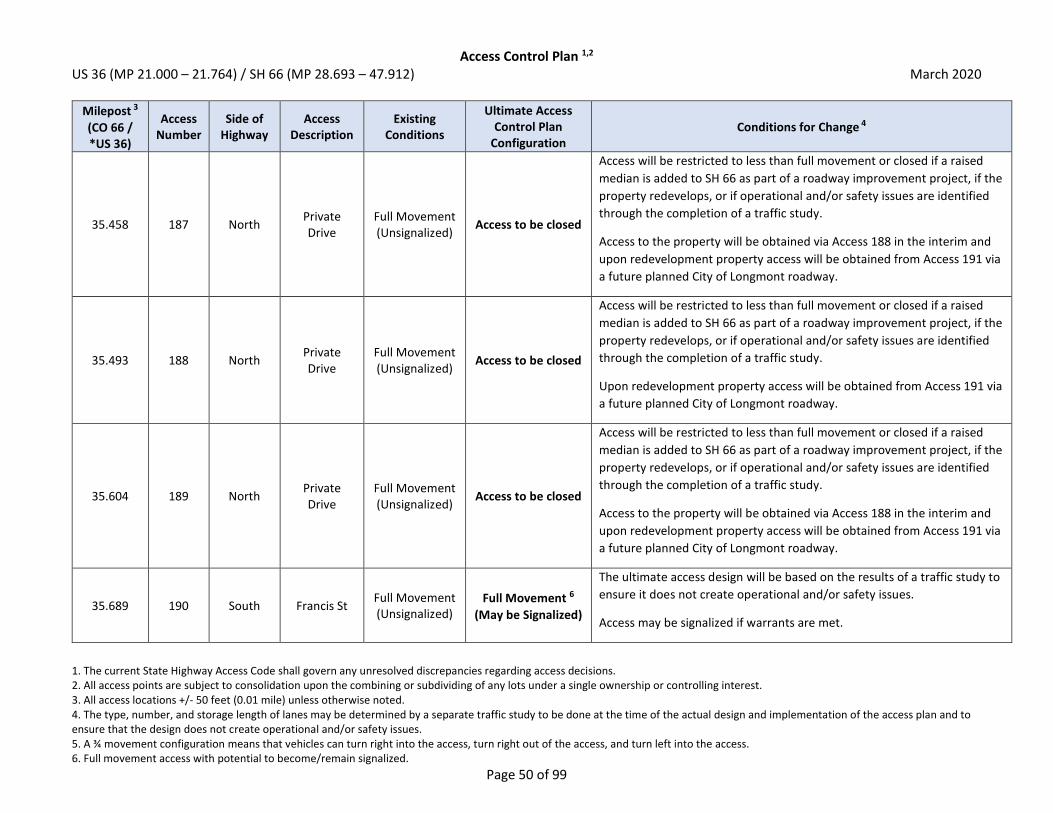
Access Control Plan 1,2 US 36 (MP 21.000 – 21.764) / SH 66 (MP 28.693 – 47.912) March 2020
1. The current State Highway Access Code shall govern any unresolved discrepancies regarding access decisions. 2. All access points are subject to consolidation upon the combining or subdividing of any lots under a single ownership or controlling interest. 3. All access locations +/- 50 feet (0.01 mile) unless otherwise noted. 4. The type, number, and storage length of lanes may be determined by a separate traffic study to be done at the time of the actual design and implementation of the access plan and to ensure that the design does not create operational and/or safety issues. 5. A ¾ movement configuration means that vehicles can turn right into the access, turn right out of the access, and turn left into the access. 6. Full movement access with potential to become/remain signalized.
Page 50 of 99
Milepost 3
(CO 66 / *US 36)
Access Number
Side of Highway
Access Description
Existing Conditions
Ultimate Access Control Plan
Configuration Conditions for Change 4
35.458 187 North Private Drive
Full Movement (Unsignalized)
Access to be closed
Access will be restricted to less than full movement or closed if a raised
median is added to SH 66 as part of a roadway improvement project, if the
property redevelops, or if operational and/or safety issues are identified
through the completion of a traffic study.
Access to the property will be obtained via Access 188 in the interim and
upon redevelopment property access will be obtained from Access 191 via
a future planned City of Longmont roadway.
35.493 188 North Private Drive
Full Movement (Unsignalized)
Access to be closed
Access will be restricted to less than full movement or closed if a raised
median is added to SH 66 as part of a roadway improvement project, if the
property redevelops, or if operational and/or safety issues are identified
through the completion of a traffic study.
Upon redevelopment property access will be obtained from Access 191 via
a future planned City of Longmont roadway.
35.604 189 North Private Drive
Full Movement (Unsignalized)
Access to be closed
Access will be restricted to less than full movement or closed if a raised
median is added to SH 66 as part of a roadway improvement project, if the
property redevelops, or if operational and/or safety issues are identified
through the completion of a traffic study.
Access to the property will be obtained via Access 188 in the interim and
upon redevelopment property access will be obtained from Access 191 via
a future planned City of Longmont roadway.
35.689 190 South Francis St Full Movement (Unsignalized)
Full Movement 6
(May be Signalized)
The ultimate access design will be based on the results of a traffic study to
ensure it does not create operational and/or safety issues.
Access may be signalized if warrants are met.

Access Control Plan 1,2 US 36 (MP 21.000 – 21.764) / SH 66 (MP 28.693 – 47.912) March 2020
1. The current State Highway Access Code shall govern any unresolved discrepancies regarding access decisions. 2. All access points are subject to consolidation upon the combining or subdividing of any lots under a single ownership or controlling interest. 3. All access locations +/- 50 feet (0.01 mile) unless otherwise noted. 4. The type, number, and storage length of lanes may be determined by a separate traffic study to be done at the time of the actual design and implementation of the access plan and to ensure that the design does not create operational and/or safety issues. 5. A ¾ movement configuration means that vehicles can turn right into the access, turn right out of the access, and turn left into the access. 6. Full movement access with potential to become/remain signalized.
Page 51 of 99
Milepost 3
(CO 66 / *US 36)
Access Number
Side of Highway
Access Description
Existing Conditions
Ultimate Access Control Plan
Configuration Conditions for Change 4
35.689 191 North Private Drive
Full Movement (Unsignalized)
Full Movement 6
(May be Signalized)
The ultimate access design will be based on the results of a traffic study to
ensure it does not create operational and/or safety issues.
Access may be signalized if warrants are met.
35.784 192 North Private Drive
Full Movement (Unsignalized)
Access to be closed
Access will be restricted to less than full movement or closed if a raised
median is added to SH 66 as part of a roadway improvement project, if the
property redevelops, or if operational and/or safety issues are identified
through the completion of a traffic study.
If cross access can be obtained, access will ultimately be closed. Upon
redevelopment property access will be obtained from Access 191 or
Access 195 via future planned City of Longmont roadways.
35.814 193 North Private Drive
Full Movement (Unsignalized)
Access to be closed
Access will be restricted to less than full movement or closed if a raised
median is added to SH 66 as part of a roadway improvement project, if the
property redevelops, or if operational and/or safety issues are identified
through the completion of a traffic study.
If cross access can be obtained, access will ultimately be closed. Access to
the property will be obtained via Access 192 in the interim and upon
redevelopment property access will be obtained from Access 191 or
Access 195 via future planned City of Longmont roadways.

Access Control Plan 1,2 US 36 (MP 21.000 – 21.764) / SH 66 (MP 28.693 – 47.912) March 2020
1. The current State Highway Access Code shall govern any unresolved discrepancies regarding access decisions. 2. All access points are subject to consolidation upon the combining or subdividing of any lots under a single ownership or controlling interest. 3. All access locations +/- 50 feet (0.01 mile) unless otherwise noted. 4. The type, number, and storage length of lanes may be determined by a separate traffic study to be done at the time of the actual design and implementation of the access plan and to ensure that the design does not create operational and/or safety issues. 5. A ¾ movement configuration means that vehicles can turn right into the access, turn right out of the access, and turn left into the access. 6. Full movement access with potential to become/remain signalized.
Page 52 of 99
Milepost 3
(CO 66 / *US 36)
Access Number
Side of Highway
Access Description
Existing Conditions
Ultimate Access Control Plan
Configuration Conditions for Change 4
35.941 194 North Private Drive
Full Movement (Unsignalized)
Access to be closed
Access will be restricted to less than full movement or closed if a raised
median is added to SH 66 as part of a roadway improvement project, if the
property redevelops, or if operational and/or safety issues are identified
through the completion of a traffic study.
If cross access can be obtained, access will ultimately be closed. Access to
the property will be obtained via Access 192 in the interim and upon
redevelopment property access will be obtained from Access 191 or
Access 195 via future planned City of Longmont roadways.
36.021 195 North Private Drive
Full Movement (Unsignalized)
3/4 Movement 5
Access will be restricted to less than full movement if a raised median is
added to SH 66 as part of a roadway improvement project, if the property
redevelops, or if operational and/or safety issues are identified through
the completion of a traffic study.
36.024 196 South Gay St Full Movement (Unsignalized)
3/4 Movement 5
Access will be restricted to less than full movement if a raised median is
added to SH 66 as part of a roadway improvement project, if the property
redevelops, or if operational and/or safety issues are identified through
the completion of a traffic study.
36.168 197 North Private Drive
Full Movement (Unsignalized)
Access to be closed
Access will be restricted to less than full movement or closed if a raised
median is added to SH 66 as part of a roadway improvement project, if the
property redevelops, or if operational and/or safety issues are identified
through the completion of a traffic study.
Property should seek to obtain cross access with adjacent property to the
west to obtain access to Access 195. If cross access can be obtained,
access will ultimately be closed.
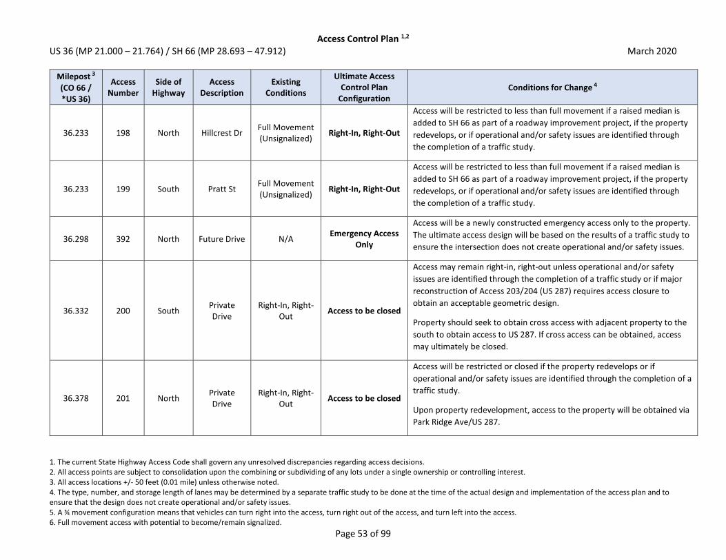
Access Control Plan 1,2 US 36 (MP 21.000 – 21.764) / SH 66 (MP 28.693 – 47.912) March 2020
1. The current State Highway Access Code shall govern any unresolved discrepancies regarding access decisions. 2. All access points are subject to consolidation upon the combining or subdividing of any lots under a single ownership or controlling interest. 3. All access locations +/- 50 feet (0.01 mile) unless otherwise noted. 4. The type, number, and storage length of lanes may be determined by a separate traffic study to be done at the time of the actual design and implementation of the access plan and to ensure that the design does not create operational and/or safety issues. 5. A ¾ movement configuration means that vehicles can turn right into the access, turn right out of the access, and turn left into the access. 6. Full movement access with potential to become/remain signalized.
Page 53 of 99
Milepost 3
(CO 66 / *US 36)
Access Number
Side of Highway
Access Description
Existing Conditions
Ultimate Access Control Plan
Configuration Conditions for Change 4
36.233 198 North Hillcrest Dr Full Movement (Unsignalized)
Right-In, Right-Out
Access will be restricted to less than full movement if a raised median is
added to SH 66 as part of a roadway improvement project, if the property
redevelops, or if operational and/or safety issues are identified through
the completion of a traffic study.
36.233 199 South Pratt St Full Movement (Unsignalized)
Right-In, Right-Out
Access will be restricted to less than full movement if a raised median is
added to SH 66 as part of a roadway improvement project, if the property
redevelops, or if operational and/or safety issues are identified through
the completion of a traffic study.
36.298 392 North Future Drive N/A Emergency Access
Only
Access will be a newly constructed emergency access only to the property.
The ultimate access design will be based on the results of a traffic study to
ensure the intersection does not create operational and/or safety issues.
36.332 200 South Private Drive
Right-In, Right-Out
Access to be closed
Access may remain right-in, right-out unless operational and/or safety
issues are identified through the completion of a traffic study or if major
reconstruction of Access 203/204 (US 287) requires access closure to
obtain an acceptable geometric design.
Property should seek to obtain cross access with adjacent property to the
south to obtain access to US 287. If cross access can be obtained, access
may ultimately be closed.
36.378 201 North Private Drive
Right-In, Right-Out
Access to be closed
Access will be restricted or closed if the property redevelops or if
operational and/or safety issues are identified through the completion of a
traffic study.
Upon property redevelopment, access to the property will be obtained via
Park Ridge Ave/US 287.
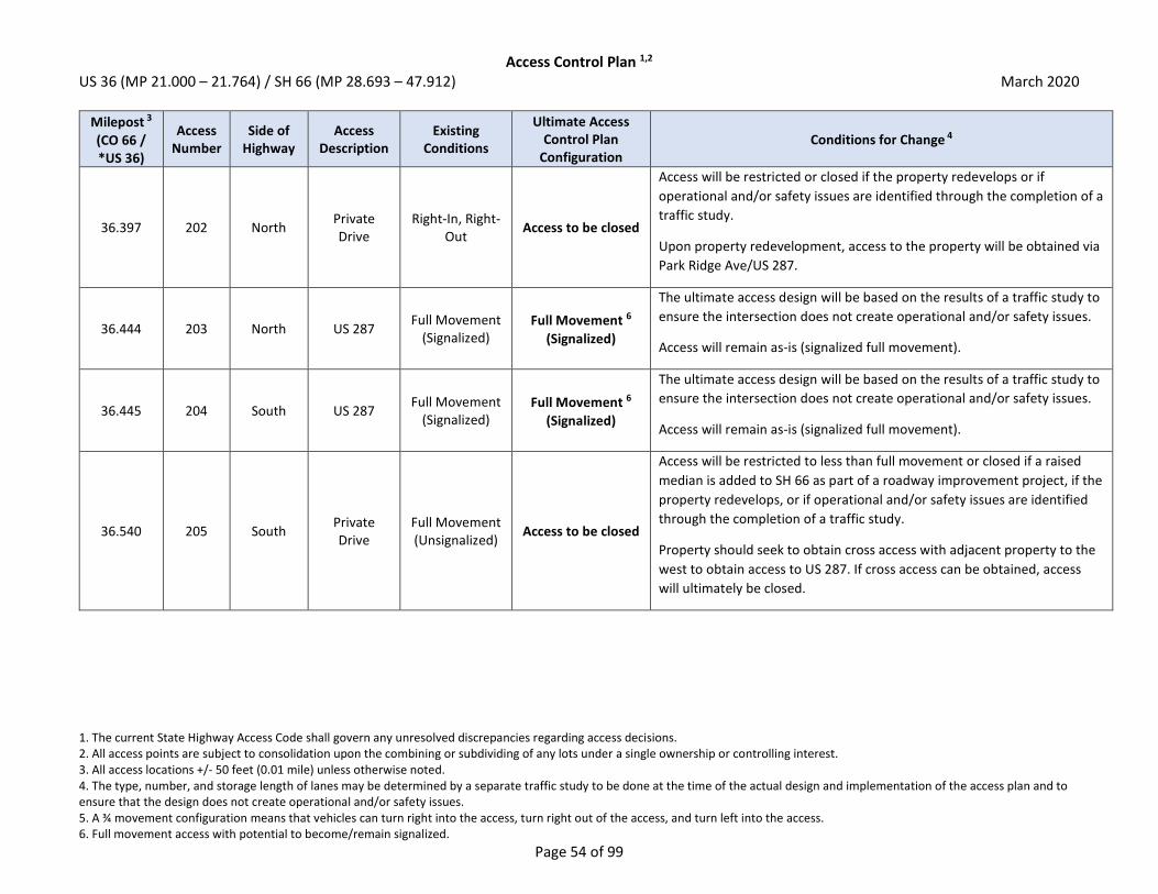
Access Control Plan 1,2 US 36 (MP 21.000 – 21.764) / SH 66 (MP 28.693 – 47.912) March 2020
1. The current State Highway Access Code shall govern any unresolved discrepancies regarding access decisions. 2. All access points are subject to consolidation upon the combining or subdividing of any lots under a single ownership or controlling interest. 3. All access locations +/- 50 feet (0.01 mile) unless otherwise noted. 4. The type, number, and storage length of lanes may be determined by a separate traffic study to be done at the time of the actual design and implementation of the access plan and to ensure that the design does not create operational and/or safety issues. 5. A ¾ movement configuration means that vehicles can turn right into the access, turn right out of the access, and turn left into the access. 6. Full movement access with potential to become/remain signalized.
Page 54 of 99
Milepost 3
(CO 66 / *US 36)
Access Number
Side of Highway
Access Description
Existing Conditions
Ultimate Access Control Plan
Configuration Conditions for Change 4
36.397 202 North Private Drive
Right-In, Right-Out
Access to be closed
Access will be restricted or closed if the property redevelops or if
operational and/or safety issues are identified through the completion of a
traffic study.
Upon property redevelopment, access to the property will be obtained via
Park Ridge Ave/US 287.
36.444 203 North US 287 Full Movement
(Signalized) Full Movement 6
(Signalized)
The ultimate access design will be based on the results of a traffic study to
ensure the intersection does not create operational and/or safety issues.
Access will remain as-is (signalized full movement).
36.445 204 South US 287 Full Movement
(Signalized) Full Movement 6
(Signalized)
The ultimate access design will be based on the results of a traffic study to
ensure the intersection does not create operational and/or safety issues.
Access will remain as-is (signalized full movement).
36.540 205 South Private Drive
Full Movement (Unsignalized)
Access to be closed
Access will be restricted to less than full movement or closed if a raised
median is added to SH 66 as part of a roadway improvement project, if the
property redevelops, or if operational and/or safety issues are identified
through the completion of a traffic study.
Property should seek to obtain cross access with adjacent property to the
west to obtain access to US 287. If cross access can be obtained, access
will ultimately be closed.
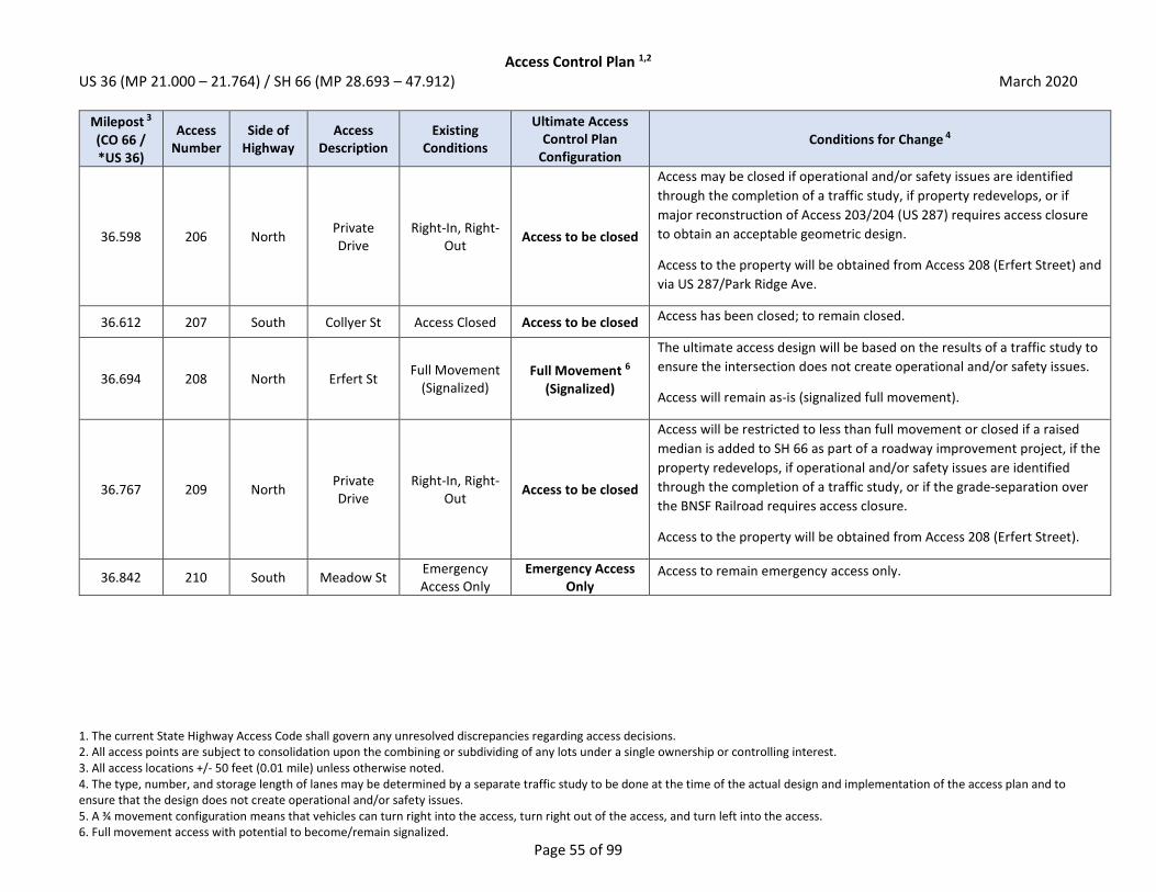
Access Control Plan 1,2 US 36 (MP 21.000 – 21.764) / SH 66 (MP 28.693 – 47.912) March 2020
1. The current State Highway Access Code shall govern any unresolved discrepancies regarding access decisions. 2. All access points are subject to consolidation upon the combining or subdividing of any lots under a single ownership or controlling interest. 3. All access locations +/- 50 feet (0.01 mile) unless otherwise noted. 4. The type, number, and storage length of lanes may be determined by a separate traffic study to be done at the time of the actual design and implementation of the access plan and to ensure that the design does not create operational and/or safety issues. 5. A ¾ movement configuration means that vehicles can turn right into the access, turn right out of the access, and turn left into the access. 6. Full movement access with potential to become/remain signalized.
Page 55 of 99
Milepost 3
(CO 66 / *US 36)
Access Number
Side of Highway
Access Description
Existing Conditions
Ultimate Access Control Plan
Configuration Conditions for Change 4
36.598 206 North Private Drive
Right-In, Right-Out
Access to be closed
Access may be closed if operational and/or safety issues are identified
through the completion of a traffic study, if property redevelops, or if
major reconstruction of Access 203/204 (US 287) requires access closure
to obtain an acceptable geometric design.
Access to the property will be obtained from Access 208 (Erfert Street) and
via US 287/Park Ridge Ave.
36.612 207 South Collyer St Access Closed Access to be closed Access has been closed; to remain closed.
36.694 208 North Erfert St Full Movement
(Signalized) Full Movement 6
(Signalized)
The ultimate access design will be based on the results of a traffic study to
ensure the intersection does not create operational and/or safety issues.
Access will remain as-is (signalized full movement).
36.767 209 North Private Drive
Right-In, Right-Out
Access to be closed
Access will be restricted to less than full movement or closed if a raised
median is added to SH 66 as part of a roadway improvement project, if the
property redevelops, if operational and/or safety issues are identified
through the completion of a traffic study, or if the grade-separation over
the BNSF Railroad requires access closure.
Access to the property will be obtained from Access 208 (Erfert Street).
36.842 210 South Meadow St Emergency Access Only
Emergency Access Only
Access to remain emergency access only.

Access Control Plan 1,2 US 36 (MP 21.000 – 21.764) / SH 66 (MP 28.693 – 47.912) March 2020
1. The current State Highway Access Code shall govern any unresolved discrepancies regarding access decisions. 2. All access points are subject to consolidation upon the combining or subdividing of any lots under a single ownership or controlling interest. 3. All access locations +/- 50 feet (0.01 mile) unless otherwise noted. 4. The type, number, and storage length of lanes may be determined by a separate traffic study to be done at the time of the actual design and implementation of the access plan and to ensure that the design does not create operational and/or safety issues. 5. A ¾ movement configuration means that vehicles can turn right into the access, turn right out of the access, and turn left into the access. 6. Full movement access with potential to become/remain signalized.
Page 56 of 99
Milepost 3
(CO 66 / *US 36)
Access Number
Side of Highway
Access Description
Existing Conditions
Ultimate Access Control Plan
Configuration Conditions for Change 4
36.865 211 North Private Drive
Full Movement (Unsignalized)
Access to be closed
Access will be restricted to less than full movement or closed if a raised
median is added to SH 66 as part of a roadway improvement project, if the
property redevelops, if operational and/or safety issues are identified
through the completion of a traffic study, or if the grade-separation over
the BNSF Railroad requires access closure.
Property should seek to obtain cross access with adjacent property to the
west to obtain access to Access 208 (Erfert Street). If cross access can be
obtained, access will ultimately be closed.
36.929 212 North Private Drive
Full Movement (Unsignalized)
Access to be closed
Access will be restricted to less than full movement or closed if a raised
median is added to SH 66 as part of a roadway improvement project, if the
property redevelops, if operational and/or safety issues are identified
through the completion of a traffic study, or if the grade-separation over
the BNSF Railroad requires access closure.
Property access will be via Access 211 or via Access 208 (Erfert Street) if
cross access can be obtained.
36.943 371 North BNSF
Railway Co At-grade rail
crossing Grade Separated at
Railroad Access at the BNSF Railroad crossing will be grade separated.
36.945 372 South BNSF
Railway Co At-grade rail
crossing Grade Separated at
Railroad Access at the BNSF Railroad crossing will be grade separated.
36.975 213 North Private Drive
Full Movement (Unsignalized)
Access to be closed
Access will be restricted to less than full movement or closed if a raised
median is added to SH 66 as part of a roadway improvement project, if the
property redevelops, if operational and/or safety issues are identified
through the completion of a traffic study, or if the grade-separation over
the BNSF Railroad requires access closure.
Property access will be via Access 222 (115th Street).

Access Control Plan 1,2 US 36 (MP 21.000 – 21.764) / SH 66 (MP 28.693 – 47.912) March 2020
1. The current State Highway Access Code shall govern any unresolved discrepancies regarding access decisions. 2. All access points are subject to consolidation upon the combining or subdividing of any lots under a single ownership or controlling interest. 3. All access locations +/- 50 feet (0.01 mile) unless otherwise noted. 4. The type, number, and storage length of lanes may be determined by a separate traffic study to be done at the time of the actual design and implementation of the access plan and to ensure that the design does not create operational and/or safety issues. 5. A ¾ movement configuration means that vehicles can turn right into the access, turn right out of the access, and turn left into the access. 6. Full movement access with potential to become/remain signalized.
Page 57 of 99
Milepost 3
(CO 66 / *US 36)
Access Number
Side of Highway
Access Description
Existing Conditions
Ultimate Access Control Plan
Configuration Conditions for Change 4
36.991 214 North Private Drive
Full Movement (Unsignalized)
Access to be closed
Access will be restricted to less than full movement or closed if a raised
median is added to SH 66 as part of a roadway improvement project, if the
property redevelops, if operational and/or safety issues are identified
through the completion of a traffic study, or if the grade-separation over
the BNSF Railroad requires access closure.
Property access will be via Access 222 (115th Street).
37.028 215 South Private Drive
Full Movement (Unsignalized)
Access to be closed
Access will be restricted to less than full movement or closed if a raised
median is added to SH 66 as part of a roadway improvement project, if the
property redevelops, if operational and/or safety issues are identified
through the completion of a traffic study, or if the grade-separation over
the BNSF Railroad requires access closure.
Access to the property will be obtained from Peppler Dr and local
roadways.
37.053 216 South Private Drive
Full Movement (Unsignalized)
Access to be closed
Access will be restricted to less than full movement or closed if a raised
median is added to SH 66 as part of a roadway improvement project, if the
property redevelops, if operational and/or safety issues are identified
through the completion of a traffic study, or if the grade-separation over
the BNSF Railroad requires access closure.
Access to the property will be obtained from Peppler Dr and local
roadways.

Access Control Plan 1,2 US 36 (MP 21.000 – 21.764) / SH 66 (MP 28.693 – 47.912) March 2020
1. The current State Highway Access Code shall govern any unresolved discrepancies regarding access decisions. 2. All access points are subject to consolidation upon the combining or subdividing of any lots under a single ownership or controlling interest. 3. All access locations +/- 50 feet (0.01 mile) unless otherwise noted. 4. The type, number, and storage length of lanes may be determined by a separate traffic study to be done at the time of the actual design and implementation of the access plan and to ensure that the design does not create operational and/or safety issues. 5. A ¾ movement configuration means that vehicles can turn right into the access, turn right out of the access, and turn left into the access. 6. Full movement access with potential to become/remain signalized.
Page 58 of 99
Milepost 3
(CO 66 / *US 36)
Access Number
Side of Highway
Access Description
Existing Conditions
Ultimate Access Control Plan
Configuration Conditions for Change 4
37.074 217 South Private Drive
Full Movement (Unsignalized)
Access to be closed
Access will be restricted to less than full movement or closed if a raised
median is added to SH 66 as part of a roadway improvement project, if the
property redevelops, if operational and/or safety issues are identified
through the completion of a traffic study, or if the grade-separation over
the BNSF Railroad requires access closure.
Access to the property will be obtained from Peppler Dr and local
roadways.
37.223 218 North Private Drive
Full Movement (Unsignalized)
Access to be closed
Access will be restricted to less than full movement or closed if a raised
median is added to SH 66 as part of a roadway improvement project, if the
property redevelops, if operational and/or safety issues are identified
through the completion of a traffic study, or if the grade-separation over
the BNSF Railroad requires access closure.
Property access will be via Access 222 (115th Street).
37.301 219 South Private Drive
Full Movement (Unsignalized)
Access to be closed
Access will be restricted to less than full movement or closed if a raised
median is added to SH 66 as part of a roadway improvement project, if the
property redevelops, or if operational and/or safety issues are identified
through the completion of a traffic study.
Access to the property will be obtained from Access 223 (Alpine Street)
and local roadways.

Access Control Plan 1,2 US 36 (MP 21.000 – 21.764) / SH 66 (MP 28.693 – 47.912) March 2020
1. The current State Highway Access Code shall govern any unresolved discrepancies regarding access decisions. 2. All access points are subject to consolidation upon the combining or subdividing of any lots under a single ownership or controlling interest. 3. All access locations +/- 50 feet (0.01 mile) unless otherwise noted. 4. The type, number, and storage length of lanes may be determined by a separate traffic study to be done at the time of the actual design and implementation of the access plan and to ensure that the design does not create operational and/or safety issues. 5. A ¾ movement configuration means that vehicles can turn right into the access, turn right out of the access, and turn left into the access. 6. Full movement access with potential to become/remain signalized.
Page 59 of 99
Milepost 3
(CO 66 / *US 36)
Access Number
Side of Highway
Access Description
Existing Conditions
Ultimate Access Control Plan
Configuration Conditions for Change 4
37.331 220 South Private Drive
Full Movement (Unsignalized)
Access to be closed
Access will be restricted to less than full movement if a raised median is
added to SH 66 as part of a roadway improvement project, if the property
redevelops, or if operational and/or safety issues are identified through
the completion of a traffic study.
Property should seek to obtain cross access with adjacent property to the
east to obtain access to Access 223 (Alpine Street). If cross access can be
obtained, access will ultimately be closed.
37.339 221 North Private Drive
Full Movement (Unsignalized)
Access to be closed
Access will be restricted to less than full movement or closed if a raised
median is added to SH 66 as part of a roadway improvement project, if the
property redevelops, or if operational and/or safety issues are identified
through the completion of a traffic study.
Property access will be via Access 222 (115th Street).
37.444 222 North 115th St Full Movement (Unsignalized)
Full Movement 6
(May be Signalized)
The ultimate access design will be based on the results of a traffic study to
ensure it does not create operational and/or safety issues.
Access may be signalized if warrants are met.
37.445 223 South Alpine St Full Movement (Unsignalized)
Full Movement 6
(May be Signalized)
The ultimate access design will be based on the results of a traffic study to
ensure it does not create operational and/or safety issues.
Access may be signalized if warrants are met.

Access Control Plan 1,2 US 36 (MP 21.000 – 21.764) / SH 66 (MP 28.693 – 47.912) March 2020
1. The current State Highway Access Code shall govern any unresolved discrepancies regarding access decisions. 2. All access points are subject to consolidation upon the combining or subdividing of any lots under a single ownership or controlling interest. 3. All access locations +/- 50 feet (0.01 mile) unless otherwise noted. 4. The type, number, and storage length of lanes may be determined by a separate traffic study to be done at the time of the actual design and implementation of the access plan and to ensure that the design does not create operational and/or safety issues. 5. A ¾ movement configuration means that vehicles can turn right into the access, turn right out of the access, and turn left into the access. 6. Full movement access with potential to become/remain signalized.
Page 60 of 99
Milepost 3
(CO 66 / *US 36)
Access Number
Side of Highway
Access Description
Existing Conditions
Ultimate Access Control Plan
Configuration Conditions for Change 4
37.475 224 North Private Drive
Full Movement (Unsignalized)
Access to be closed
Access will be restricted to less than full movement or closed if a raised
median is added to SH 66 as part of a roadway improvement project, if the
property redevelops, or if operational and/or safety issues are identified
through the completion of a traffic study.
Access to the property will be obtained from Access 222 (115th Street).
37.520 225 South Private Drive
Full Movement (Unsignalized)
Access to be closed
Access will be restricted to less than full movement or closed if a raised
median is added to SH 66 as part of a roadway improvement project, if the
property redevelops, or if operational and/or safety issues are identified
through the completion of a traffic study.
Access to the property will be obtained from Access 223 (Alpine Street).
37.548 226 South Private Drive
Full Movement (Unsignalized)
Access to be closed
Access will be restricted to less than full movement or closed if a raised
median is added to SH 66 as part of a roadway improvement project, if the
property redevelops, or if operational and/or safety issues are identified
through the completion of a traffic study.
Access to the property will be obtained from Flagstaff Dr.
37.687 227 South Private Drive
Full Movement (Unsignalized)
Access to be closed
Access will be restricted to less than full movement or closed if a raised
median is added to SH 66 as part of a roadway improvement project, if the
property redevelops, or if operational and/or safety issues are identified
through the completion of a traffic study.
Access to the property will be obtained from Flagstaff Dr.
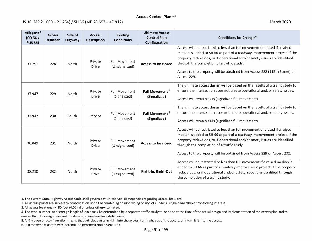
Access Control Plan 1,2 US 36 (MP 21.000 – 21.764) / SH 66 (MP 28.693 – 47.912) March 2020
1. The current State Highway Access Code shall govern any unresolved discrepancies regarding access decisions. 2. All access points are subject to consolidation upon the combining or subdividing of any lots under a single ownership or controlling interest. 3. All access locations +/- 50 feet (0.01 mile) unless otherwise noted. 4. The type, number, and storage length of lanes may be determined by a separate traffic study to be done at the time of the actual design and implementation of the access plan and to ensure that the design does not create operational and/or safety issues. 5. A ¾ movement configuration means that vehicles can turn right into the access, turn right out of the access, and turn left into the access. 6. Full movement access with potential to become/remain signalized.
Page 61 of 99
Milepost 3
(CO 66 / *US 36)
Access Number
Side of Highway
Access Description
Existing Conditions
Ultimate Access Control Plan
Configuration Conditions for Change 4
37.791 228 North Private Drive
Full Movement (Unsignalized)
Access to be closed
Access will be restricted to less than full movement or closed if a raised
median is added to SH 66 as part of a roadway improvement project, if the
property redevelops, or if operational and/or safety issues are identified
through the completion of a traffic study.
Access to the property will be obtained from Access 222 (115th Street) or
Access 229.
37.947 229 North Private Drive
Full Movement (Signalized)
Full Movement 6
(Signalized)
The ultimate access design will be based on the results of a traffic study to
ensure the intersection does not create operational and/or safety issues.
Access will remain as-is (signalized full movement).
37.947 230 South Pace St Full Movement
(Signalized) Full Movement 6
(Signalized)
The ultimate access design will be based on the results of a traffic study to
ensure the intersection does not create operational and/or safety issues.
Access will remain as-is (signalized full movement).
38.049 231 North Private Drive
Full Movement (Unsignalized)
Access to be closed
Access will be restricted to less than full movement or closed if a raised
median is added to SH 66 as part of a roadway improvement project, if the
property redevelops, or if operational and/or safety issues are identified
through the completion of a traffic study.
Access to the property will be obtained from Access 229 or Access 232.
38.210 232 North Private Drive
Full Movement (Unsignalized)
Right-In, Right-Out
Access will be restricted to less than full movement if a raised median is
added to SH 66 as part of a roadway improvement project, if the property
redevelops, or if operational and/or safety issues are identified through
the completion of a traffic study.

Access Control Plan 1,2 US 36 (MP 21.000 – 21.764) / SH 66 (MP 28.693 – 47.912) March 2020
1. The current State Highway Access Code shall govern any unresolved discrepancies regarding access decisions. 2. All access points are subject to consolidation upon the combining or subdividing of any lots under a single ownership or controlling interest. 3. All access locations +/- 50 feet (0.01 mile) unless otherwise noted. 4. The type, number, and storage length of lanes may be determined by a separate traffic study to be done at the time of the actual design and implementation of the access plan and to ensure that the design does not create operational and/or safety issues. 5. A ¾ movement configuration means that vehicles can turn right into the access, turn right out of the access, and turn left into the access. 6. Full movement access with potential to become/remain signalized.
Page 62 of 99
Milepost 3
(CO 66 / *US 36)
Access Number
Side of Highway
Access Description
Existing Conditions
Ultimate Access Control Plan
Configuration Conditions for Change 4
38.332 233 South Private Drive
Full Movement (Unsignalized)
Access to be closed
Access will be restricted to less than full movement or closed if a raised
median is added to SH 66 as part of a roadway improvement project, if the
property redevelops, or if operational and/or safety issues are identified
through the completion of a traffic study.
Property should seek to obtain cross access with adjacent property to the
east to obtain access to Access 234 (Sundance Drive). If cross access can
be obtained, access will ultimately be closed.
38.440 234 South Sundance
Dr Full Movement (Unsignalized)
Full Movement 6
(May be Signalized)
The ultimate access design will be based on the results of a traffic study to
ensure it does not create operational and/or safety issues.
Access may be signalized if warrants are met.
38.443 235 North Rock Ln Full Movement (Unsignalized)
Full Movement 6
(May be Signalized)
The ultimate access design will be based on the results of a traffic study to
ensure it does not create operational and/or safety issues.
Access may be signalized if warrants are met.
38.559 236 North Linda Vista
Dr 3/4 Movement Access to be closed
Access will be restricted to less than full movement or closed if a raised
median is added to SH 66 as part of a roadway improvement project, if the
property redevelops, or if operational and/or safety issues are identified
through the completion of a traffic study.
Access to the property will be obtained from Access 235 (Rock Lane).

Access Control Plan 1,2 US 36 (MP 21.000 – 21.764) / SH 66 (MP 28.693 – 47.912) March 2020
1. The current State Highway Access Code shall govern any unresolved discrepancies regarding access decisions. 2. All access points are subject to consolidation upon the combining or subdividing of any lots under a single ownership or controlling interest. 3. All access locations +/- 50 feet (0.01 mile) unless otherwise noted. 4. The type, number, and storage length of lanes may be determined by a separate traffic study to be done at the time of the actual design and implementation of the access plan and to ensure that the design does not create operational and/or safety issues. 5. A ¾ movement configuration means that vehicles can turn right into the access, turn right out of the access, and turn left into the access. 6. Full movement access with potential to become/remain signalized.
Page 63 of 99
Milepost 3
(CO 66 / *US 36)
Access Number
Side of Highway
Access Description
Existing Conditions
Ultimate Access Control Plan
Configuration Conditions for Change 4
38.674 237 South Private Drive
Full Movement (Unsignalized)
Access to be closed
Access will be restricted to less than full movement if a raised median is
added to SH 66 as part of a roadway improvement project, if the property
redevelops, or if operational and/or safety issues are identified through
the completion of a traffic study.
Property should seek to obtain cross access with adjacent property to the
west or east to obtain alternate access. If cross access can be obtained,
access will ultimately be closed.
38.690 238 South Private Drive
Full Movement (Unsignalized)
Access to be closed
Access will be restricted to less than full movement or closed if a raised
median is added to SH 66 as part of a roadway improvement project, if the
property redevelops, or if operational and/or safety issues are identified
through the completion of a traffic study.
Access to the property will be obtained from Access 237 or alternate local
streets.
38.720 239 North Rock Ln Full Movement (Unsignalized)
Access to be closed
Access will be restricted to less than full movement or closed if a raised
median is added to SH 66 as part of a roadway improvement project, if the
property redevelops, or if operational and/or safety issues are identified
through the completion of a traffic study.
Access to the property will be obtained from Access 235 (Rock Lane).

Access Control Plan 1,2 US 36 (MP 21.000 – 21.764) / SH 66 (MP 28.693 – 47.912) March 2020
1. The current State Highway Access Code shall govern any unresolved discrepancies regarding access decisions. 2. All access points are subject to consolidation upon the combining or subdividing of any lots under a single ownership or controlling interest. 3. All access locations +/- 50 feet (0.01 mile) unless otherwise noted. 4. The type, number, and storage length of lanes may be determined by a separate traffic study to be done at the time of the actual design and implementation of the access plan and to ensure that the design does not create operational and/or safety issues. 5. A ¾ movement configuration means that vehicles can turn right into the access, turn right out of the access, and turn left into the access. 6. Full movement access with potential to become/remain signalized.
Page 64 of 99
Milepost 3
(CO 66 / *US 36)
Access Number
Side of Highway
Access Description
Existing Conditions
Ultimate Access Control Plan
Configuration Conditions for Change 4
38.738 240 South Private Drive
Full Movement (Unsignalized)
Access to be closed
Access will be restricted to less than full movement or closed if a raised
median is added to SH 66 as part of a roadway improvement project, if the
property redevelops, or if operational and/or safety issues are identified
through the completion of a traffic study.
Property should seek to obtain cross access with adjacent property to the
east to obtain access to Access 244 (County Line Road). If cross access can
be obtained, access will ultimately be closed.
38.767 241 North Private Drive
Full Movement (Unsignalized)
Access to be closed
Access will be restricted to less than full movement or closed if a raised
median is added to SH 66 as part of a roadway improvement project, if the
property redevelops, or if operational and/or safety issues are identified
through the completion of a traffic study.
Access to the property will be obtained from Access 235 (Rock Lane) or
Access 243 (County Line Road).
38.772 242 South Private Drive
Full Movement (Unsignalized)
Access to be closed
Access will be restricted to less than full movement or closed if a raised
median is added to SH 66 as part of a roadway improvement project, if the
property redevelops, or if operational and/or safety issues are identified
through the completion of a traffic study.
38.946 243 North County Line
Rd Full Movement
(Signalized) Full Movement 6
(Signalized)
The ultimate access design will be based on the results of a traffic study to
ensure the intersection does not create operational and/or safety issues.
Access will remain as-is (signalized full movement).
38.949 244 South County Line
Rd Full Movement
(Signalized) Full Movement 6
(Signalized)
The ultimate access design will be based on the results of a traffic study to
ensure the intersection does not create operational and/or safety issues.
Access will remain as-is (signalized full movement).

Access Control Plan 1,2 US 36 (MP 21.000 – 21.764) / SH 66 (MP 28.693 – 47.912) March 2020
1. The current State Highway Access Code shall govern any unresolved discrepancies regarding access decisions. 2. All access points are subject to consolidation upon the combining or subdividing of any lots under a single ownership or controlling interest. 3. All access locations +/- 50 feet (0.01 mile) unless otherwise noted. 4. The type, number, and storage length of lanes may be determined by a separate traffic study to be done at the time of the actual design and implementation of the access plan and to ensure that the design does not create operational and/or safety issues. 5. A ¾ movement configuration means that vehicles can turn right into the access, turn right out of the access, and turn left into the access. 6. Full movement access with potential to become/remain signalized.
Page 65 of 99
Milepost 3
(CO 66 / *US 36)
Access Number
Side of Highway
Access Description
Existing Conditions
Ultimate Access Control Plan
Configuration Conditions for Change 4
39.099 245 North Private Drive
Full Movement (Unsignalized)
Access to be closed
Access will be restricted to less than full movement or closed if a raised
median is added to SH 66 as part of a roadway improvement project, if the
property redevelops, or if operational and/or safety issues are identified
through the completion of a traffic study.
Access to the property will be obtained from Access 243 (County Line
Road).
39.263 246 North Private Drive
Full Movement (Unsignalized)
Access to be closed
Access will be restricted to less than full movement if a raised median is
added to SH 66 as part of a roadway improvement project, if the property
redevelops, or if operational and/or safety issues are identified through
the completion of a traffic study.
Property should seek to obtain cross access with adjacent property to the
east to obtain access to Access 379. If cross access can be obtained, access
will ultimately be closed.
39.343 247 North Private Drive
Full Movement (Unsignalized)
Access to be closed
Access will be restricted to less than full movement or closed if a raised
median is added to SH 66 as part of a roadway improvement project, if the
property redevelops, or if operational and/or safety issues are identified
through the completion of a traffic study.
Access to the property will be obtained from Access 246 or from Access
379 if cross access can be obtained.

Access Control Plan 1,2 US 36 (MP 21.000 – 21.764) / SH 66 (MP 28.693 – 47.912) March 2020
1. The current State Highway Access Code shall govern any unresolved discrepancies regarding access decisions. 2. All access points are subject to consolidation upon the combining or subdividing of any lots under a single ownership or controlling interest. 3. All access locations +/- 50 feet (0.01 mile) unless otherwise noted. 4. The type, number, and storage length of lanes may be determined by a separate traffic study to be done at the time of the actual design and implementation of the access plan and to ensure that the design does not create operational and/or safety issues. 5. A ¾ movement configuration means that vehicles can turn right into the access, turn right out of the access, and turn left into the access. 6. Full movement access with potential to become/remain signalized.
Page 66 of 99
Milepost 3
(CO 66 / *US 36)
Access Number
Side of Highway
Access Description
Existing Conditions
Ultimate Access Control Plan
Configuration Conditions for Change 4
39.372 248 South Elmore Rd Full Movement (Unsignalized)
Emergency Access Only
Access will be restricted to less than full movement if a raised median is
added to SH 66 as part of a roadway improvement project, if
redevelopment occurs, or if operational and/or safety issues are identified
through the completion of a traffic study. The access will be converted to
emergency access only if alternate access can be provided via a connection
to Nesting Crane Lane or a future roadway connection ½ mile south of SH
66 at the southern edge of Elmore Road.
Access to the property will be obtained from Nesting Crane Lane or via a
future roadway connection to the south.
39.399 249 North Private Drive
Full Movement (Unsignalized)
Access to be closed
Access will be restricted to less than full movement if a raised median is
added to SH 66 as part of a roadway improvement project, if the property
redevelops, or if operational and/or safety issues are identified through
the completion of a traffic study.
Property should seek to obtain cross access with adjacent property to the
east to obtain access to Access 379. If cross access can be obtained, access
will ultimately be closed.
39.420 250 South Private Drive
Full Movement (Unsignalized)
Access to be closed
Access will be restricted to less than full movement or closed if a raised
median is added to SH 66 as part of a roadway improvement project, if the
property redevelops, or if operational and/or safety issues are identified
through the completion of a traffic study.
Access to the property will be obtained from Access 248 in the interim or
ultimately from Access 251 (Nesting Crane Lane).

Access Control Plan 1,2 US 36 (MP 21.000 – 21.764) / SH 66 (MP 28.693 – 47.912) March 2020
1. The current State Highway Access Code shall govern any unresolved discrepancies regarding access decisions. 2. All access points are subject to consolidation upon the combining or subdividing of any lots under a single ownership or controlling interest. 3. All access locations +/- 50 feet (0.01 mile) unless otherwise noted. 4. The type, number, and storage length of lanes may be determined by a separate traffic study to be done at the time of the actual design and implementation of the access plan and to ensure that the design does not create operational and/or safety issues. 5. A ¾ movement configuration means that vehicles can turn right into the access, turn right out of the access, and turn left into the access. 6. Full movement access with potential to become/remain signalized.
Page 67 of 99
Milepost 3
(CO 66 / *US 36)
Access Number
Side of Highway
Access Description
Existing Conditions
Ultimate Access Control Plan
Configuration Conditions for Change 4
39.473 251 South Nesting
Crane Ln Full Movement (Unsignalized)
3/4 Movement 5
Access will be restricted to less than full movement if a raised median is
added to SH 66 as part of a roadway improvement project, if
redevelopment occurs, or if operational and/or safety issues are identified
through the completion of a traffic study.
39.475 379 North Future Drive N/A 3/4 Movement 5
Access will be a newly constructed ¾ movement access to the property.
The ultimate access design will be based on the results of a traffic study to
ensure the intersection does not create operational and/or safety issues.
Access will be located across SH 66 from Access 251.
39.563 252 North Private Drive
Full Movement (Unsignalized)
Access to be closed
Access will be restricted to less than full movement or closed if a raised
median is added to SH 66 as part of a roadway improvement project, if the
property redevelops, or if operational and/or safety issues are identified
through the completion of a traffic study.
Access to the property will be obtained from Access 379 or Access 258
(Weld County Rd 3).
39.625 253 South Private Drive
Full Movement (Unsignalized)
Access to be closed
Access will be restricted to less than full movement if a raised median is
added to SH 66 as part of a roadway improvement project, if the property
redevelops, or if operational and/or safety issues are identified through
the completion of a traffic study.
Property should seek to obtain cross access with properties to the east to
obtain access to Access 259 (Weld County Rd 3), or to obtain access to a
future roadway connection at the southern edge of the property (½ mile
south of SH 66). If cross access can be obtained, access will ultimately be
closed.

Access Control Plan 1,2 US 36 (MP 21.000 – 21.764) / SH 66 (MP 28.693 – 47.912) March 2020
1. The current State Highway Access Code shall govern any unresolved discrepancies regarding access decisions. 2. All access points are subject to consolidation upon the combining or subdividing of any lots under a single ownership or controlling interest. 3. All access locations +/- 50 feet (0.01 mile) unless otherwise noted. 4. The type, number, and storage length of lanes may be determined by a separate traffic study to be done at the time of the actual design and implementation of the access plan and to ensure that the design does not create operational and/or safety issues. 5. A ¾ movement configuration means that vehicles can turn right into the access, turn right out of the access, and turn left into the access. 6. Full movement access with potential to become/remain signalized.
Page 68 of 99
Milepost 3
(CO 66 / *US 36)
Access Number
Side of Highway
Access Description
Existing Conditions
Ultimate Access Control Plan
Configuration Conditions for Change 4
39.684 254 South Private Drive
Full Movement (Unsignalized)
Access to be closed
Access will be restricted to less than full movement or closed if a raised
median is added to SH 66 as part of a roadway improvement project, if the
property redevelops, or if operational and/or safety issues are identified
through the completion of a traffic study.
Access to the property will be obtained from Access 253 or from Access
259 (Weld County Rd 3) if cross-access can be obtained.
39.721 255 South Private Drive
Full Movement (Unsignalized)
Access to be closed
Access will be restricted to less than full movement if a raised median is
added to SH 66 as part of a roadway improvement project, if the property
redevelops, or if operational and/or safety issues are identified through
the completion of a traffic study.
Property should seek to obtain cross access with adjacent properties to
the east and/or south to obtain access to Access 259 (Weld County Rd 3).
If cross access can be obtained, access will ultimately be closed.
39.756 256 North Private Drive
Full Movement (Unsignalized)
Access to be closed
Access will be restricted to less than full movement or closed if a raised
median is added to SH 66 as part of a roadway improvement project, if the
property redevelops, or if operational and/or safety issues are identified
through the completion of a traffic study.
Access to the property will be obtained from Access 379 or Access 258
(Weld County Rd 3).

Access Control Plan 1,2 US 36 (MP 21.000 – 21.764) / SH 66 (MP 28.693 – 47.912) March 2020
1. The current State Highway Access Code shall govern any unresolved discrepancies regarding access decisions. 2. All access points are subject to consolidation upon the combining or subdividing of any lots under a single ownership or controlling interest. 3. All access locations +/- 50 feet (0.01 mile) unless otherwise noted. 4. The type, number, and storage length of lanes may be determined by a separate traffic study to be done at the time of the actual design and implementation of the access plan and to ensure that the design does not create operational and/or safety issues. 5. A ¾ movement configuration means that vehicles can turn right into the access, turn right out of the access, and turn left into the access. 6. Full movement access with potential to become/remain signalized.
Page 69 of 99
Milepost 3
(CO 66 / *US 36)
Access Number
Side of Highway
Access Description
Existing Conditions
Ultimate Access Control Plan
Configuration Conditions for Change 4
39.758 257 South Private Drive
Full Movement (Unsignalized)
Access to be closed
Access will be restricted to less than full movement if a raised median is
added to SH 66 as part of a roadway improvement project, if the property
redevelops, or if operational and/or safety issues are identified through
the completion of a traffic study.
Property should seek to obtain cross access with adjacent properties to
the east and/or south to obtain access to Access 259 (Weld County Rd 3).
If cross access can be obtained, access will ultimately be closed.
39.940 258 North Weld
County Rd 3 Full Movement (Unsignalized)
Full Movement 6
(May be Signalized)
The ultimate access design will be based on the results of a traffic study to
ensure it does not create operational and/or safety issues.
Access may be signalized if warrants are met.
39.941 259 South Weld
County Rd 3 Full Movement (Unsignalized)
Full Movement 6
(May be Signalized)
The ultimate access design will be based on the results of a traffic study to
ensure it does not create operational and/or safety issues.
Access may be signalized if warrants are met.
40.036 260 South Private Drive
Full Movement (Unsignalized)
Access to be closed
Access will be restricted to less than full movement if a raised median is
added to SH 66 as part of a roadway improvement project, if the property
redevelops, or if operational and/or safety issues are identified through
the completion of a traffic study.
Property should seek to obtain cross access with adjacent property to the
west to obtain access to Access 259 (Weld County Rd 3). If cross access can
be obtained, access will ultimately be closed.

Access Control Plan 1,2 US 36 (MP 21.000 – 21.764) / SH 66 (MP 28.693 – 47.912) March 2020
1. The current State Highway Access Code shall govern any unresolved discrepancies regarding access decisions. 2. All access points are subject to consolidation upon the combining or subdividing of any lots under a single ownership or controlling interest. 3. All access locations +/- 50 feet (0.01 mile) unless otherwise noted. 4. The type, number, and storage length of lanes may be determined by a separate traffic study to be done at the time of the actual design and implementation of the access plan and to ensure that the design does not create operational and/or safety issues. 5. A ¾ movement configuration means that vehicles can turn right into the access, turn right out of the access, and turn left into the access. 6. Full movement access with potential to become/remain signalized.
Page 70 of 99
Milepost 3
(CO 66 / *US 36)
Access Number
Side of Highway
Access Description
Existing Conditions
Ultimate Access Control Plan
Configuration Conditions for Change 4
40.067 261 South Private Drive
Full Movement (Unsignalized)
Access to be closed
Access will be restricted to less than full movement if a raised median is
added to SH 66 as part of a roadway improvement project, if the property
redevelops, or if operational and/or safety issues are identified through
the completion of a traffic study.
Property should seek to obtain cross access with adjacent property to the
east for a shared access on the property line (Access 391). If cross access
can be obtained, access will ultimately be closed.
40.077 262 North Private Drive
Full Movement (Unsignalized)
Access to be closed
Access will be restricted to less than full movement or closed if a raised
median is added to SH 66 as part of a roadway improvement project, if the
property redevelops, or if operational and/or safety issues are identified
through the completion of a traffic study.
Access to the property will be obtained from Access 258 (Weld County Rd
3) and Access 373.
40.126 391 South Future Drive N/A Right-In, Right-Out Access will be a newly constructed right-in, right-out access on the
property line to consolidate Access 261 and Access 263.
40.141 263 South Private Drive
Full Movement (Unsignalized)
Access to be closed
Access will be restricted to less than full movement if a raised median is
added to SH 66 as part of a roadway improvement project, if the property
redevelops, or if operational and/or safety issues are identified through
the completion of a traffic study.
Property should seek to obtain cross access with adjacent property to the
west for a shared access on the property line (Access 391). If cross access
can be obtained, access will ultimately be closed.

Access Control Plan 1,2 US 36 (MP 21.000 – 21.764) / SH 66 (MP 28.693 – 47.912) March 2020
1. The current State Highway Access Code shall govern any unresolved discrepancies regarding access decisions. 2. All access points are subject to consolidation upon the combining or subdividing of any lots under a single ownership or controlling interest. 3. All access locations +/- 50 feet (0.01 mile) unless otherwise noted. 4. The type, number, and storage length of lanes may be determined by a separate traffic study to be done at the time of the actual design and implementation of the access plan and to ensure that the design does not create operational and/or safety issues. 5. A ¾ movement configuration means that vehicles can turn right into the access, turn right out of the access, and turn left into the access. 6. Full movement access with potential to become/remain signalized.
Page 71 of 99
Milepost 3
(CO 66 / *US 36)
Access Number
Side of Highway
Access Description
Existing Conditions
Ultimate Access Control Plan
Configuration Conditions for Change 4
40.198 264 South Private Drive
Full Movement (Unsignalized)
Access to be closed
Access will be restricted to less than full movement or closed if a raised
median is added to SH 66 as part of a roadway improvement project, if the
property redevelops, or if operational and/or safety issues are identified
through the completion of a traffic study.
Access to the property will be obtained via Access 265 or from Access 386
if cross access can be obtained.
40.236 265 South Private Drive
Full Movement (Unsignalized)
Access to be closed
Access will be restricted to less than full movement if a raised median is
added to SH 66 as part of a roadway improvement project, if
redevelopment occurs, or if operational and/or safety issues are identified
through the completion of a traffic study.
Properties should seek to obtain cross access with adjacent property to
the south/east to obtain access to Access 386 via a new future roadway. If
cross access can be obtained, access will ultimately be closed.
40.276 266 North Private Drive
Full Movement (Unsignalized)
Access to be closed
Access will be restricted to less than full movement or closed if a raised
median is added to SH 66 as part of a roadway improvement project, if the
property redevelops, or if operational and/or safety issues are identified
through the completion of a traffic study.
Access to the property will be obtained from Access 258 (Weld County Rd
3) and Access 373.
40.366 267 South Private Drive
Full Movement (Unsignalized)
Access to be closed
Access will be restricted to less than full movement or closed if a raised
median is added to SH 66 as part of a roadway improvement project, if the
property redevelops, or if operational and/or safety issues are identified
through the completion of a traffic study.
Access to the property will be obtained via Access 386.

Access Control Plan 1,2 US 36 (MP 21.000 – 21.764) / SH 66 (MP 28.693 – 47.912) March 2020
1. The current State Highway Access Code shall govern any unresolved discrepancies regarding access decisions. 2. All access points are subject to consolidation upon the combining or subdividing of any lots under a single ownership or controlling interest. 3. All access locations +/- 50 feet (0.01 mile) unless otherwise noted. 4. The type, number, and storage length of lanes may be determined by a separate traffic study to be done at the time of the actual design and implementation of the access plan and to ensure that the design does not create operational and/or safety issues. 5. A ¾ movement configuration means that vehicles can turn right into the access, turn right out of the access, and turn left into the access. 6. Full movement access with potential to become/remain signalized.
Page 72 of 99
Milepost 3
(CO 66 / *US 36)
Access Number
Side of Highway
Access Description
Existing Conditions
Ultimate Access Control Plan
Configuration Conditions for Change 4
40.447 373 North Future Drive N/A 3/4 Movement 5
Access will be a newly constructed ¾ movement access to the property.
The ultimate access design will be based on the results of a traffic study to
ensure the intersection does not create operational and/or safety issues.
Access will be located across SH 66 from Access 386.
40.447 386 South Future Drive N/A 3/4 Movement 5
Access will be a newly constructed ¾ movement access to the property.
The ultimate access design will be based on the results of a traffic study to
ensure the intersection does not create operational and/or safety issues.
Access will be located across SH 66 from Access 373.
40.459 268 North Private Drive
Full Movement (Unsignalized)
Access to be closed
Access will be restricted to less than full movement or closed if a raised
median is added to SH 66 as part of a roadway improvement project, if the
property redevelops, or if operational and/or safety issues are identified
through the completion of a traffic study.
Access to the property will be obtained via Access 373 and Access 278
(Weld County Rd 5).
40.540 269 South Private Drive
Full Movement (Unsignalized)
Access to be closed
Access will be restricted to less than full movement or closed if a raised
median is added to SH 66 as part of a roadway improvement project, if the
property redevelops, or if operational and/or safety issues are identified
through the completion of a traffic study.
Access to the property will be obtained via Access 386 and Access 277
(Weld County Rd 5).

Access Control Plan 1,2 US 36 (MP 21.000 – 21.764) / SH 66 (MP 28.693 – 47.912) March 2020
1. The current State Highway Access Code shall govern any unresolved discrepancies regarding access decisions. 2. All access points are subject to consolidation upon the combining or subdividing of any lots under a single ownership or controlling interest. 3. All access locations +/- 50 feet (0.01 mile) unless otherwise noted. 4. The type, number, and storage length of lanes may be determined by a separate traffic study to be done at the time of the actual design and implementation of the access plan and to ensure that the design does not create operational and/or safety issues. 5. A ¾ movement configuration means that vehicles can turn right into the access, turn right out of the access, and turn left into the access. 6. Full movement access with potential to become/remain signalized.
Page 73 of 99
Milepost 3
(CO 66 / *US 36)
Access Number
Side of Highway
Access Description
Existing Conditions
Ultimate Access Control Plan
Configuration Conditions for Change 4
40.540 270 North Private Drive
Full Movement (Unsignalized)
Access to be closed
Access will be restricted to less than full movement or closed if a raised
median is added to SH 66 as part of a roadway improvement project, if the
property redevelops, or if operational and/or safety issues are identified
through the completion of a traffic study.
Access to the property will be obtained via Access 373 and Access 278
(Weld County Rd 5).
40.561 271 North Private Drive
Full Movement (Unsignalized)
Access to be closed
Access will be restricted to less than full movement or closed if a raised
median is added to SH 66 as part of a roadway improvement project, if the
property redevelops, or if operational and/or safety issues are identified
through the completion of a traffic study.
Access to the property will be obtained via Access 373 and Access 278
(Weld County Rd 5).
40.745 272 South Private Drive
Full Movement (Unsignalized)
Access to be closed
Access will be restricted to less than full movement or closed if a raised
median is added to SH 66 as part of a roadway improvement project, if the
property redevelops, or if operational and/or safety issues are identified
through the completion of a traffic study.
Access to the property will be obtained via Access 386 and Access 277
(Weld County Rd 5).
40.810 273 North Private Drive
Full Movement (Unsignalized)
Access to be closed
Access will be restricted to less than full movement or closed if a raised
median is added to SH 66 as part of a roadway improvement project, if the
property redevelops, or if operational and/or safety issues are identified
through the completion of a traffic study.
Access to the property will be obtained via Access 373 and Access 278
(Weld County Rd 5).

Access Control Plan 1,2 US 36 (MP 21.000 – 21.764) / SH 66 (MP 28.693 – 47.912) March 2020
1. The current State Highway Access Code shall govern any unresolved discrepancies regarding access decisions. 2. All access points are subject to consolidation upon the combining or subdividing of any lots under a single ownership or controlling interest. 3. All access locations +/- 50 feet (0.01 mile) unless otherwise noted. 4. The type, number, and storage length of lanes may be determined by a separate traffic study to be done at the time of the actual design and implementation of the access plan and to ensure that the design does not create operational and/or safety issues. 5. A ¾ movement configuration means that vehicles can turn right into the access, turn right out of the access, and turn left into the access. 6. Full movement access with potential to become/remain signalized.
Page 74 of 99
Milepost 3
(CO 66 / *US 36)
Access Number
Side of Highway
Access Description
Existing Conditions
Ultimate Access Control Plan
Configuration Conditions for Change 4
40.905 274 North Private Drive
Full Movement (Unsignalized)
Access to be closed
Access will be restricted to less than full movement or closed if a raised
median is added to SH 66 as part of a roadway improvement project, if the
property redevelops, or if operational and/or safety issues are identified
through the completion of a traffic study.
Access to the property will be obtained via Access 373 and Access 278
(Weld County Rd 5).
40.912 275 South Private Drive
Full Movement (Unsignalized)
Access to be closed
Access will be restricted to less than full movement or closed if a raised
median is added to SH 66 as part of a roadway improvement project, if the
property redevelops, or if operational and/or safety issues are identified
through the completion of a traffic study.
Access to the property will be obtained via Access 386 and Access 277
(Weld County Rd 5).
40.928 276 North Private Drive
Full Movement (Unsignalized)
Access to be closed
Access will be restricted to less than full movement or closed if a raised
median is added to SH 66 as part of a roadway improvement project, if the
property redevelops, or if operational and/or safety issues are identified
through the completion of a traffic study.
Access to the property will be obtained from Access 278 (Weld County Rd
5).
40.947 277 South Weld
County Rd 5 Full Movement (Unsignalized)
Full Movement 6
(May be Signalized)
The ultimate access design will be based on the results of a traffic study to
ensure it does not create operational and/or safety issues.
Access may be signalized if warrants are met.

Access Control Plan 1,2 US 36 (MP 21.000 – 21.764) / SH 66 (MP 28.693 – 47.912) March 2020
1. The current State Highway Access Code shall govern any unresolved discrepancies regarding access decisions. 2. All access points are subject to consolidation upon the combining or subdividing of any lots under a single ownership or controlling interest. 3. All access locations +/- 50 feet (0.01 mile) unless otherwise noted. 4. The type, number, and storage length of lanes may be determined by a separate traffic study to be done at the time of the actual design and implementation of the access plan and to ensure that the design does not create operational and/or safety issues. 5. A ¾ movement configuration means that vehicles can turn right into the access, turn right out of the access, and turn left into the access. 6. Full movement access with potential to become/remain signalized.
Page 75 of 99
Milepost 3
(CO 66 / *US 36)
Access Number
Side of Highway
Access Description
Existing Conditions
Ultimate Access Control Plan
Configuration Conditions for Change 4
40.950 278 North Weld
County Rd 5 Full Movement (Unsignalized)
Full Movement 6
(May be Signalized)
The ultimate access design will be based on the results of a traffic study to
ensure it does not create operational and/or safety issues.
Access may be signalized if warrants are met.
41.008 279 North Private Drive
Full Movement (Unsignalized)
Access to be closed
Access will be restricted to less than full movement or closed if a raised
median is added to SH 66 as part of a roadway improvement project, if the
property redevelops, or if operational and/or safety issues are identified
through the completion of a traffic study.
Access to the property will be obtained from Access 278 (Weld County Rd
5).
41.255 280 North Private Drive
Full Movement (Unsignalized)
Access to be closed
Access will be restricted to less than full movement or closed if a raised
median is added to SH 66 as part of a roadway improvement project, if the
property redevelops, if operational and/or safety issues are identified
through the completion of a traffic study, or if grade-separation occurs
over the Great Western Railroad.
Access to the property will be obtained from Access 278 (Weld County Rd
5).
41.290 281 North Private Drive
Full Movement (Unsignalized)
Access to be closed
Access will be restricted to less than full movement or closed if a raised
median is added to SH 66 as part of a roadway improvement project, if the
property redevelops, if operational and/or safety issues are identified
through the completion of a traffic study, or if grade-separation occurs
over the Great Western Railroad.
Access to the property will be obtained from Access 278 (Weld County Rd
5).

Access Control Plan 1,2 US 36 (MP 21.000 – 21.764) / SH 66 (MP 28.693 – 47.912) March 2020
1. The current State Highway Access Code shall govern any unresolved discrepancies regarding access decisions. 2. All access points are subject to consolidation upon the combining or subdividing of any lots under a single ownership or controlling interest. 3. All access locations +/- 50 feet (0.01 mile) unless otherwise noted. 4. The type, number, and storage length of lanes may be determined by a separate traffic study to be done at the time of the actual design and implementation of the access plan and to ensure that the design does not create operational and/or safety issues. 5. A ¾ movement configuration means that vehicles can turn right into the access, turn right out of the access, and turn left into the access. 6. Full movement access with potential to become/remain signalized.
Page 76 of 99
Milepost 3
(CO 66 / *US 36)
Access Number
Side of Highway
Access Description
Existing Conditions
Ultimate Access Control Plan
Configuration Conditions for Change 4
41.317 282 South Private Drive
Full Movement (Unsignalized)
Access to be closed
Access will be restricted to less than full movement or closed if a raised
median is added to SH 66 as part of a roadway improvement project, if the
property redevelops, if operational and/or safety issues are identified
through the completion of a traffic study, or if grade-separation occurs
over the Great Western Railroad.
Access to the property will be obtained from Access 277 (Weld County Rd
5).
41.337 283 North Private Drive
Full Movement (Unsignalized)
Access to be closed
Access will be restricted to less than full movement or closed if a raised
median is added to SH 66 as part of a roadway improvement project, if the
property redevelops, if operational and/or safety issues are identified
through the completion of a traffic study, or if grade-separation occurs
over the Great Western Railroad.
Property should seek to obtain cross access with adjacent property to the
west to obtain access to Access 278 (Weld County Rd 5). If cross access can
be obtained, access will ultimately be closed.
41.342 380 North Railroad Crossing
At-grade rail crossing
Grade Separated at Railroad
Access will be grade separated.
41.348 381 South Railroad Crossing
At-grade rail crossing
Grade Separated at Railroad
Access will be grade separated.

Access Control Plan 1,2 US 36 (MP 21.000 – 21.764) / SH 66 (MP 28.693 – 47.912) March 2020
1. The current State Highway Access Code shall govern any unresolved discrepancies regarding access decisions. 2. All access points are subject to consolidation upon the combining or subdividing of any lots under a single ownership or controlling interest. 3. All access locations +/- 50 feet (0.01 mile) unless otherwise noted. 4. The type, number, and storage length of lanes may be determined by a separate traffic study to be done at the time of the actual design and implementation of the access plan and to ensure that the design does not create operational and/or safety issues. 5. A ¾ movement configuration means that vehicles can turn right into the access, turn right out of the access, and turn left into the access. 6. Full movement access with potential to become/remain signalized.
Page 77 of 99
Milepost 3
(CO 66 / *US 36)
Access Number
Side of Highway
Access Description
Existing Conditions
Ultimate Access Control Plan
Configuration Conditions for Change 4
41.455 374 North Future Drive N/A Right-In, Right-Out
Access will be a newly constructed access to the property. Under interim
conditions, the access may be signalized if warrants are met. If Accesses
380 and 381 are grade-separated, Access 374 will be restricted to right-in,
right-out. The ultimate access design will be based on the results of a
traffic study to ensure the intersection does not create operational and/or
safety issues.
Access will be located across SH 66 from Access 284.
41.457 284 South Weld
County Rd 5.5
Full Movement (Unsignalized)
Right-In, Right-Out
Under interim conditions, the access may be signalized if warrants are
met. If Accesses 380 and 381 are grade-separated, Access 374 will be
restricted to right-in, right-out. The ultimate access design will be based on
the results of a traffic study to ensure the intersection does not create
operational and/or safety issues.
Access will be located across SH 66 from Access 374.
41.515 285 North Private Drive
Full Movement (Unsignalized)
Access to be closed
Access will be restricted to less than full movement or closed if a raised
median is added to SH 66 as part of a roadway improvement project, if the
property redevelops, or if operational and/or safety issues are identified
through the completion of a traffic study.
Access to the property will be obtained via Access 374 and Access 376.
41.686 286 South Stage Coach
Dr Full Movement (Unsignalized)
3/4 Movement 5
Access will be restricted to less than full movement if a raised median is
added to SH 66 as part of a roadway improvement project, if
redevelopment occurs, or if operational and/or safety issues are identified
through the completion of a traffic study.

Access Control Plan 1,2 US 36 (MP 21.000 – 21.764) / SH 66 (MP 28.693 – 47.912) March 2020
1. The current State Highway Access Code shall govern any unresolved discrepancies regarding access decisions. 2. All access points are subject to consolidation upon the combining or subdividing of any lots under a single ownership or controlling interest. 3. All access locations +/- 50 feet (0.01 mile) unless otherwise noted. 4. The type, number, and storage length of lanes may be determined by a separate traffic study to be done at the time of the actual design and implementation of the access plan and to ensure that the design does not create operational and/or safety issues. 5. A ¾ movement configuration means that vehicles can turn right into the access, turn right out of the access, and turn left into the access. 6. Full movement access with potential to become/remain signalized.
Page 78 of 99
Milepost 3
(CO 66 / *US 36)
Access Number
Side of Highway
Access Description
Existing Conditions
Ultimate Access Control Plan
Configuration Conditions for Change 4
41.686 376 North Future Drive N/A 3/4 Movement 5
Access will be a newly constructed ¾ movement access to the property.
The ultimate access design will be based on the results of a traffic study to
ensure the intersection does not create operational and/or safety issues.
Access will be located across SH 66 from Access 286.
41.768 287 South Private Drive
Full Movement (Unsignalized)
Access to be closed
Access will be restricted to less than full movement or closed if a raised
median is added to SH 66 as part of a roadway improvement project, if the
property redevelops, or if operational and/or safety issues are identified
through the completion of a traffic study.
Access to the property will be obtained via Access 286 (Stage Coach Dr)
and Access 289 (Weld County Rd 7).
41.951 288 North Weld
County Rd 7 Full Movement
(Signalized) Full Movement 6
(Signalized)
The ultimate access design will be based on the results of a traffic study to
ensure the intersection does not create operational and/or safety issues.
Access will remain as-is (signalized full movement).
41.952 289 South Weld
County Rd 7 Full Movement
(Signalized) Full Movement 6
(Signalized)
The ultimate access design will be based on the results of a traffic study to
ensure the intersection does not create operational and/or safety issues.
Access will remain as-is (signalized full movement).
41.985 290 North Private Drive
Full Movement (Unsignalized)
Access to be closed
Access will be restricted to less than full movement or closed if a raised
median is added to SH 66 as part of a roadway improvement project, if the
property redevelops, or if operational and/or safety issues are identified
through the completion of a traffic study.
Access to the property will be obtained from Access 288 (Weld County Rd
7).

Access Control Plan 1,2 US 36 (MP 21.000 – 21.764) / SH 66 (MP 28.693 – 47.912) March 2020
1. The current State Highway Access Code shall govern any unresolved discrepancies regarding access decisions. 2. All access points are subject to consolidation upon the combining or subdividing of any lots under a single ownership or controlling interest. 3. All access locations +/- 50 feet (0.01 mile) unless otherwise noted. 4. The type, number, and storage length of lanes may be determined by a separate traffic study to be done at the time of the actual design and implementation of the access plan and to ensure that the design does not create operational and/or safety issues. 5. A ¾ movement configuration means that vehicles can turn right into the access, turn right out of the access, and turn left into the access. 6. Full movement access with potential to become/remain signalized.
Page 79 of 99
Milepost 3
(CO 66 / *US 36)
Access Number
Side of Highway
Access Description
Existing Conditions
Ultimate Access Control Plan
Configuration Conditions for Change 4
42.455 291 South Private Drive
Full Movement (Unsignalized)
Access to be closed
Access will be restricted to less than full movement or closed if a raised
median is added to SH 66 as part of a roadway improvement project, if the
property redevelops, or if operational and/or safety issues are identified
through the completion of a traffic study.
Access to the property will be obtained from Access 292 (Foster Ridge
Drive).
42.521 292 South Foster Ridge
Dr Full Movement (Unsignalized)
Full Movement 6
(May be Signalized)
The ultimate access design will be based on the results of a traffic study to
ensure it does not create operational and/or safety issues.
Access may be signalized if warrants are met.
42.521 377 North Future Drive N/A Full Movement 6
(May be Signalized)
Access will be a newly constructed full movement access to the property.
The ultimate access design will be based on the results of a traffic study to
ensure the intersection does not create operational and/or safety issues.
Access will be located across SH 66 from Access 292. Access may be
signalized if warrants are met.
42.618 293 South Private Drive
Full Movement (Unsignalized)
Access to be closed
Access will be restricted to less than full movement or closed if a raised
median is added to SH 66 as part of a roadway improvement project, if the
property redevelops, or if operational and/or safety issues are identified
through the completion of a traffic study.
Access to the property will be obtained from Access 292 (Foster Ridge
Drive).
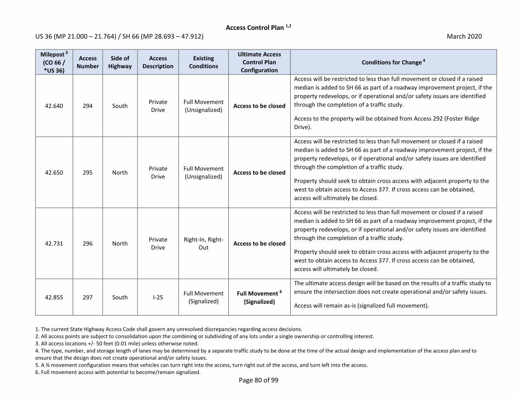
Access Control Plan 1,2 US 36 (MP 21.000 – 21.764) / SH 66 (MP 28.693 – 47.912) March 2020
1. The current State Highway Access Code shall govern any unresolved discrepancies regarding access decisions. 2. All access points are subject to consolidation upon the combining or subdividing of any lots under a single ownership or controlling interest. 3. All access locations +/- 50 feet (0.01 mile) unless otherwise noted. 4. The type, number, and storage length of lanes may be determined by a separate traffic study to be done at the time of the actual design and implementation of the access plan and to ensure that the design does not create operational and/or safety issues. 5. A ¾ movement configuration means that vehicles can turn right into the access, turn right out of the access, and turn left into the access. 6. Full movement access with potential to become/remain signalized.
Page 80 of 99
Milepost 3
(CO 66 / *US 36)
Access Number
Side of Highway
Access Description
Existing Conditions
Ultimate Access Control Plan
Configuration Conditions for Change 4
42.640 294 South Private Drive
Full Movement (Unsignalized)
Access to be closed
Access will be restricted to less than full movement or closed if a raised
median is added to SH 66 as part of a roadway improvement project, if the
property redevelops, or if operational and/or safety issues are identified
through the completion of a traffic study.
Access to the property will be obtained from Access 292 (Foster Ridge
Drive).
42.650 295 North Private Drive
Full Movement (Unsignalized)
Access to be closed
Access will be restricted to less than full movement or closed if a raised
median is added to SH 66 as part of a roadway improvement project, if the
property redevelops, or if operational and/or safety issues are identified
through the completion of a traffic study.
Property should seek to obtain cross access with adjacent property to the
west to obtain access to Access 377. If cross access can be obtained,
access will ultimately be closed.
42.731 296 North Private Drive
Right-In, Right-Out
Access to be closed
Access will be restricted to less than full movement or closed if a raised
median is added to SH 66 as part of a roadway improvement project, if the
property redevelops, or if operational and/or safety issues are identified
through the completion of a traffic study.
Property should seek to obtain cross access with adjacent property to the
west to obtain access to Access 377. If cross access can be obtained,
access will ultimately be closed.
42.855 297 South I-25 Full Movement
(Signalized) Full Movement 6
(Signalized)
The ultimate access design will be based on the results of a traffic study to
ensure the intersection does not create operational and/or safety issues.
Access will remain as-is (signalized full movement).
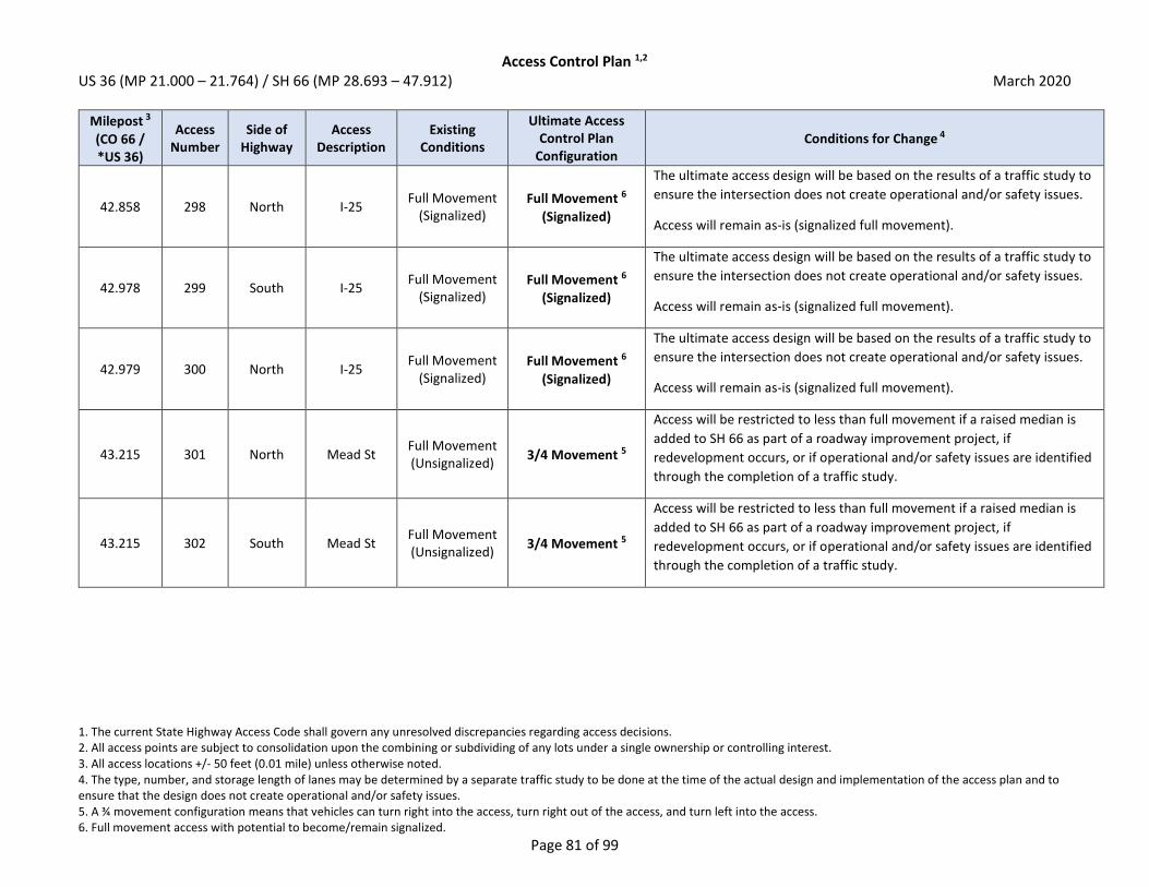
Access Control Plan 1,2 US 36 (MP 21.000 – 21.764) / SH 66 (MP 28.693 – 47.912) March 2020
1. The current State Highway Access Code shall govern any unresolved discrepancies regarding access decisions. 2. All access points are subject to consolidation upon the combining or subdividing of any lots under a single ownership or controlling interest. 3. All access locations +/- 50 feet (0.01 mile) unless otherwise noted. 4. The type, number, and storage length of lanes may be determined by a separate traffic study to be done at the time of the actual design and implementation of the access plan and to ensure that the design does not create operational and/or safety issues. 5. A ¾ movement configuration means that vehicles can turn right into the access, turn right out of the access, and turn left into the access. 6. Full movement access with potential to become/remain signalized.
Page 81 of 99
Milepost 3
(CO 66 / *US 36)
Access Number
Side of Highway
Access Description
Existing Conditions
Ultimate Access Control Plan
Configuration Conditions for Change 4
42.858 298 North I-25 Full Movement
(Signalized) Full Movement 6
(Signalized)
The ultimate access design will be based on the results of a traffic study to
ensure the intersection does not create operational and/or safety issues.
Access will remain as-is (signalized full movement).
42.978 299 South I-25 Full Movement
(Signalized) Full Movement 6
(Signalized)
The ultimate access design will be based on the results of a traffic study to
ensure the intersection does not create operational and/or safety issues.
Access will remain as-is (signalized full movement).
42.979 300 North I-25 Full Movement
(Signalized) Full Movement 6
(Signalized)
The ultimate access design will be based on the results of a traffic study to
ensure the intersection does not create operational and/or safety issues.
Access will remain as-is (signalized full movement).
43.215 301 North Mead St Full Movement (Unsignalized)
3/4 Movement 5
Access will be restricted to less than full movement if a raised median is
added to SH 66 as part of a roadway improvement project, if
redevelopment occurs, or if operational and/or safety issues are identified
through the completion of a traffic study.
43.215 302 South Mead St Full Movement (Unsignalized)
3/4 Movement 5
Access will be restricted to less than full movement if a raised median is
added to SH 66 as part of a roadway improvement project, if
redevelopment occurs, or if operational and/or safety issues are identified
through the completion of a traffic study.

Access Control Plan 1,2 US 36 (MP 21.000 – 21.764) / SH 66 (MP 28.693 – 47.912) March 2020
1. The current State Highway Access Code shall govern any unresolved discrepancies regarding access decisions. 2. All access points are subject to consolidation upon the combining or subdividing of any lots under a single ownership or controlling interest. 3. All access locations +/- 50 feet (0.01 mile) unless otherwise noted. 4. The type, number, and storage length of lanes may be determined by a separate traffic study to be done at the time of the actual design and implementation of the access plan and to ensure that the design does not create operational and/or safety issues. 5. A ¾ movement configuration means that vehicles can turn right into the access, turn right out of the access, and turn left into the access. 6. Full movement access with potential to become/remain signalized.
Page 82 of 99
Milepost 3
(CO 66 / *US 36)
Access Number
Side of Highway
Access Description
Existing Conditions
Ultimate Access Control Plan
Configuration Conditions for Change 4
43.349 303 South Private Drive
Full Movement (Unsignalized)
Access to be closed
Access will be restricted to less than full movement or closed if a raised
median is added to SH 66 as part of a roadway improvement project, if
redevelopment occurs, or if operational and/or safety issues are identified
through the completion of a traffic study.
Access to the property will be obtained via a future roadway connection to
Access 302 (Mead Street) or Access 305 (Weld County Rd 9.5).
43.448 304 North Weld
County Rd 9.5
Full Movement (Signalized)
Grade Separated
Access may be grade separated in the future. The ultimate access design
will be based on the results of a traffic study to ensure it does not create
operational and/or safety issues.
43.449 305 South Weld
County Rd 9.5
Full Movement (Signalized)
Grade Separated
Access may be grade separated in the future. The ultimate access design
will be based on the results of a traffic study to ensure it does not create
operational and/or safety issues.
43.531 306 North Private Drive
Full Movement (Unsignalized)
Access to be closed
Access will be restricted to less than full movement or closed if a raised
median is added to SH 66 as part of a roadway improvement project, if the
property redevelops, or if operational and/or safety issues are identified
through the completion of a traffic study.
Access to the property will be obtained from Access 304 (Weld County Rd
9.5) or Access 382.
43.661 307 North Private Drive
Full Movement (Unsignalized)
Access to be closed
Access will be restricted to less than full movement or closed if a raised
median is added to SH 66 as part of a roadway improvement project, if the
property redevelops, or if operational and/or safety issues are identified
through the completion of a traffic study.
Access to the property will be obtained from Access 304 (Weld County Rd
9.5) or Access 382.
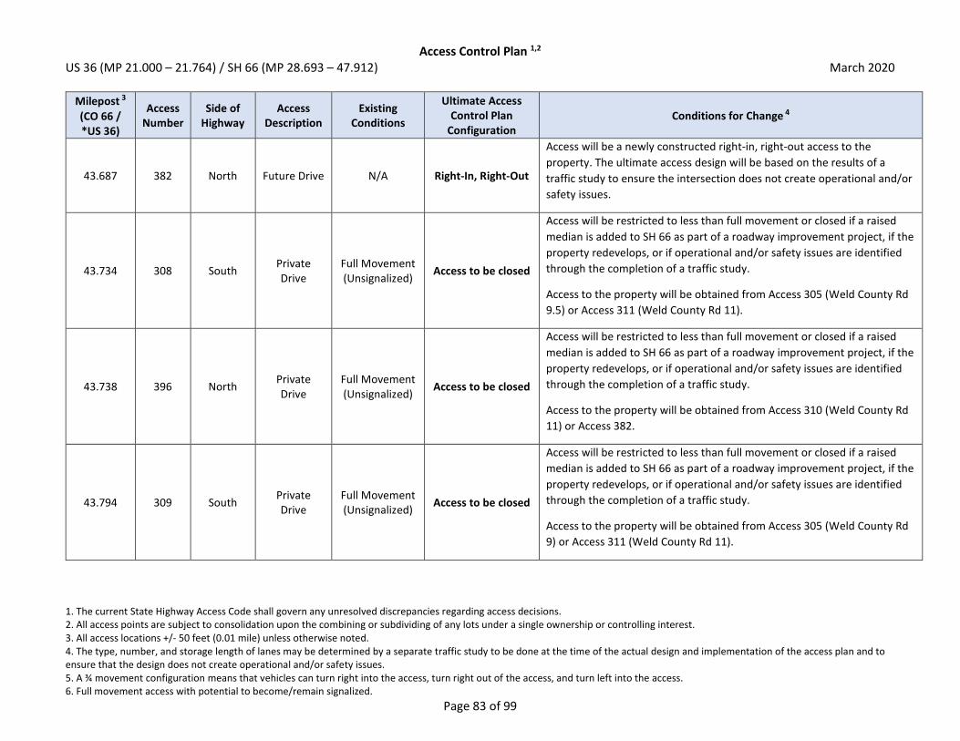
Access Control Plan 1,2 US 36 (MP 21.000 – 21.764) / SH 66 (MP 28.693 – 47.912) March 2020
1. The current State Highway Access Code shall govern any unresolved discrepancies regarding access decisions. 2. All access points are subject to consolidation upon the combining or subdividing of any lots under a single ownership or controlling interest. 3. All access locations +/- 50 feet (0.01 mile) unless otherwise noted. 4. The type, number, and storage length of lanes may be determined by a separate traffic study to be done at the time of the actual design and implementation of the access plan and to ensure that the design does not create operational and/or safety issues. 5. A ¾ movement configuration means that vehicles can turn right into the access, turn right out of the access, and turn left into the access. 6. Full movement access with potential to become/remain signalized.
Page 83 of 99
Milepost 3
(CO 66 / *US 36)
Access Number
Side of Highway
Access Description
Existing Conditions
Ultimate Access Control Plan
Configuration Conditions for Change 4
43.687 382 North Future Drive N/A Right-In, Right-Out
Access will be a newly constructed right-in, right-out access to the
property. The ultimate access design will be based on the results of a
traffic study to ensure the intersection does not create operational and/or
safety issues.
43.734 308 South Private Drive
Full Movement (Unsignalized)
Access to be closed
Access will be restricted to less than full movement or closed if a raised
median is added to SH 66 as part of a roadway improvement project, if the
property redevelops, or if operational and/or safety issues are identified
through the completion of a traffic study.
Access to the property will be obtained from Access 305 (Weld County Rd
9.5) or Access 311 (Weld County Rd 11).
43.738 396 North Private Drive
Full Movement (Unsignalized)
Access to be closed
Access will be restricted to less than full movement or closed if a raised
median is added to SH 66 as part of a roadway improvement project, if the
property redevelops, or if operational and/or safety issues are identified
through the completion of a traffic study.
Access to the property will be obtained from Access 310 (Weld County Rd
11) or Access 382.
43.794 309 South Private Drive
Full Movement (Unsignalized)
Access to be closed
Access will be restricted to less than full movement or closed if a raised
median is added to SH 66 as part of a roadway improvement project, if the
property redevelops, or if operational and/or safety issues are identified
through the completion of a traffic study.
Access to the property will be obtained from Access 305 (Weld County Rd
9) or Access 311 (Weld County Rd 11).

Access Control Plan 1,2 US 36 (MP 21.000 – 21.764) / SH 66 (MP 28.693 – 47.912) March 2020
1. The current State Highway Access Code shall govern any unresolved discrepancies regarding access decisions. 2. All access points are subject to consolidation upon the combining or subdividing of any lots under a single ownership or controlling interest. 3. All access locations +/- 50 feet (0.01 mile) unless otherwise noted. 4. The type, number, and storage length of lanes may be determined by a separate traffic study to be done at the time of the actual design and implementation of the access plan and to ensure that the design does not create operational and/or safety issues. 5. A ¾ movement configuration means that vehicles can turn right into the access, turn right out of the access, and turn left into the access. 6. Full movement access with potential to become/remain signalized.
Page 84 of 99
Milepost 3
(CO 66 / *US 36)
Access Number
Side of Highway
Access Description
Existing Conditions
Ultimate Access Control Plan
Configuration Conditions for Change 4
43.951 310 North Weld
County Rd 11
Full Movement (Unsignalized)
Full Movement 6
(May be Signalized)
The ultimate access design will be based on the results of a traffic study to
ensure it does not create operational and/or safety issues.
Access may be signalized if warrants are met.
43.952 311 South Weld
County Rd 11
Full Movement (Unsignalized)
Full Movement 6
(May be Signalized)
The ultimate access design will be based on the results of a traffic study to
ensure it does not create operational and/or safety issues.
Access may be signalized if warrants are met.
44.069 312 North Private Drive
Full Movement (Unsignalized)
Access to be closed
Access will be restricted to less than full movement or closed if a raised
median is added to SH 66 as part of a roadway improvement project, if the
property redevelops, or if operational and/or safety issues are identified
through the completion of a traffic study.
Access to the property will be obtained from Access 310 (Weld County Rd
11) or Access 383.
44.191 383 North Future Drive N/A Right-In, Right-Out
Access will be a newly constructed right-in, right-out access to the
property. The ultimate access design will be based on the results of a
traffic study to ensure the intersection does not create operational and/or
safety issues.
Access will be located across SH 66 from Access 384.
44.193 384 South Future Drive N/A Right-In, Right-Out
Access will be a newly constructed right-in, right-out access to the
property. The ultimate access design will be based on the results of a
traffic study to ensure the intersection does not create operational and/or
safety issues.
Access will be located across SH 66 from Access 383.

Access Control Plan 1,2 US 36 (MP 21.000 – 21.764) / SH 66 (MP 28.693 – 47.912) March 2020
1. The current State Highway Access Code shall govern any unresolved discrepancies regarding access decisions. 2. All access points are subject to consolidation upon the combining or subdividing of any lots under a single ownership or controlling interest. 3. All access locations +/- 50 feet (0.01 mile) unless otherwise noted. 4. The type, number, and storage length of lanes may be determined by a separate traffic study to be done at the time of the actual design and implementation of the access plan and to ensure that the design does not create operational and/or safety issues. 5. A ¾ movement configuration means that vehicles can turn right into the access, turn right out of the access, and turn left into the access. 6. Full movement access with potential to become/remain signalized.
Page 85 of 99
Milepost 3
(CO 66 / *US 36)
Access Number
Side of Highway
Access Description
Existing Conditions
Ultimate Access Control Plan
Configuration Conditions for Change 4
44.233 313 South Private Drive
Full Movement (Unsignalized)
Access to be closed
Access will be restricted to less than full movement or closed if a raised
median is added to SH 66 as part of a roadway improvement project, if the
property redevelops, or if operational and/or safety issues are identified
through the completion of a traffic study.
Access to the property will be obtained via Access 384 or Access 319
(Future Weld County Rd 11.5).
44.270 314 South Private Drive
Full Movement (Unsignalized)
Access to be closed
Access will be restricted to less than full movement or closed if a raised
median is added to SH 66 as part of a roadway improvement project, if the
property redevelops, or if operational and/or safety issues are identified
through the completion of a traffic study.
Access to the property will be obtained via Access 384 or Access 319
(Future Weld County Rd 11.5).
44.284 315 South Private Drive
Full Movement (Unsignalized)
Access to be closed
Access will be restricted to less than full movement or closed if a raised
median is added to SH 66 as part of a roadway improvement project, if the
property redevelops, or if operational and/or safety issues are identified
through the completion of a traffic study.
Access to the property will be obtained via Access 384 or Access 319
(Future Weld County Rd 11.5).
44.285 316 North Private Drive
Full Movement (Unsignalized)
Access to be closed
Access will be restricted to less than full movement or closed if a raised
median is added to SH 66 as part of a roadway improvement project, if the
property redevelops, or if operational and/or safety issues are identified
through the completion of a traffic study.
Access to the property will be obtained via Access 383 or Access 318
(Future Weld County Rd 11.5).
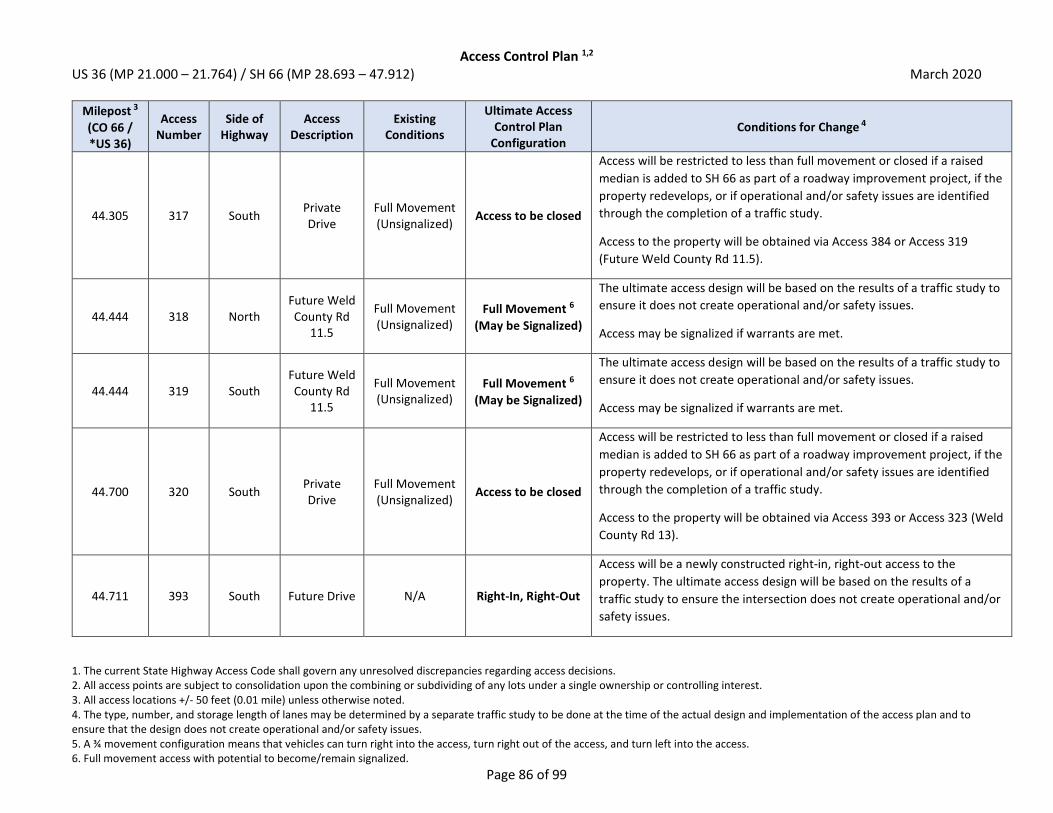
Access Control Plan 1,2 US 36 (MP 21.000 – 21.764) / SH 66 (MP 28.693 – 47.912) March 2020
1. The current State Highway Access Code shall govern any unresolved discrepancies regarding access decisions. 2. All access points are subject to consolidation upon the combining or subdividing of any lots under a single ownership or controlling interest. 3. All access locations +/- 50 feet (0.01 mile) unless otherwise noted. 4. The type, number, and storage length of lanes may be determined by a separate traffic study to be done at the time of the actual design and implementation of the access plan and to ensure that the design does not create operational and/or safety issues. 5. A ¾ movement configuration means that vehicles can turn right into the access, turn right out of the access, and turn left into the access. 6. Full movement access with potential to become/remain signalized.
Page 86 of 99
Milepost 3
(CO 66 / *US 36)
Access Number
Side of Highway
Access Description
Existing Conditions
Ultimate Access Control Plan
Configuration Conditions for Change 4
44.305 317 South Private Drive
Full Movement (Unsignalized)
Access to be closed
Access will be restricted to less than full movement or closed if a raised
median is added to SH 66 as part of a roadway improvement project, if the
property redevelops, or if operational and/or safety issues are identified
through the completion of a traffic study.
Access to the property will be obtained via Access 384 or Access 319
(Future Weld County Rd 11.5).
44.444 318 North Future Weld County Rd
11.5
Full Movement (Unsignalized)
Full Movement 6
(May be Signalized)
The ultimate access design will be based on the results of a traffic study to
ensure it does not create operational and/or safety issues.
Access may be signalized if warrants are met.
44.444 319 South Future Weld County Rd
11.5
Full Movement (Unsignalized)
Full Movement 6
(May be Signalized)
The ultimate access design will be based on the results of a traffic study to
ensure it does not create operational and/or safety issues.
Access may be signalized if warrants are met.
44.700 320 South Private Drive
Full Movement (Unsignalized)
Access to be closed
Access will be restricted to less than full movement or closed if a raised
median is added to SH 66 as part of a roadway improvement project, if the
property redevelops, or if operational and/or safety issues are identified
through the completion of a traffic study.
Access to the property will be obtained via Access 393 or Access 323 (Weld
County Rd 13).
44.711 393 South Future Drive N/A Right-In, Right-Out
Access will be a newly constructed right-in, right-out access to the
property. The ultimate access design will be based on the results of a
traffic study to ensure the intersection does not create operational and/or
safety issues.

Access Control Plan 1,2 US 36 (MP 21.000 – 21.764) / SH 66 (MP 28.693 – 47.912) March 2020
1. The current State Highway Access Code shall govern any unresolved discrepancies regarding access decisions. 2. All access points are subject to consolidation upon the combining or subdividing of any lots under a single ownership or controlling interest. 3. All access locations +/- 50 feet (0.01 mile) unless otherwise noted. 4. The type, number, and storage length of lanes may be determined by a separate traffic study to be done at the time of the actual design and implementation of the access plan and to ensure that the design does not create operational and/or safety issues. 5. A ¾ movement configuration means that vehicles can turn right into the access, turn right out of the access, and turn left into the access. 6. Full movement access with potential to become/remain signalized.
Page 87 of 99
Milepost 3
(CO 66 / *US 36)
Access Number
Side of Highway
Access Description
Existing Conditions
Ultimate Access Control Plan
Configuration Conditions for Change 4
44.825 321 North Private Drive
Full Movement (Unsignalized)
Access to be closed
Access will be restricted to less than full movement or closed if a raised
median is added to SH 66 as part of a roadway improvement project, if the
property redevelops, or if operational and/or safety issues are identified
through the completion of a traffic study.
Access to the property will be obtained from Access 322 (Weld County Rd
13).
44.944 322 North Weld
County Rd 13
Full Movement (Signalized)
Grade Separated
Access may be grade separated in the future. The ultimate access design
will be based on the results of a traffic study to ensure it does not create
operational and/or safety issues.
44.945 323 South Weld
County Rd 13
Full Movement (Signalized)
Grade Separated
Access may be grade separated in the future. The ultimate access design
will be based on the results of a traffic study to ensure it does not create
operational and/or safety issues.
44.973 324 North Private Drive
Full Movement (Unsignalized)
Access to be closed
Access will be restricted to less than full movement or closed if a raised
median is added to SH 66 as part of a roadway improvement project, if the
property redevelops, or if operational and/or safety issues are identified
through the completion of a traffic study.
Access to the property will be obtained from Access 322 (Weld County Rd
13).
45.121 325 North Private Drive
Full Movement (Unsignalized)
Access to be closed
Access will be restricted to less than full movement or closed if a raised
median is added to SH 66 as part of a roadway improvement project, if the
property redevelops, or if operational and/or safety issues are identified
through the completion of a traffic study.
Access to the property can be obtained via local roadways.

Access Control Plan 1,2 US 36 (MP 21.000 – 21.764) / SH 66 (MP 28.693 – 47.912) March 2020
1. The current State Highway Access Code shall govern any unresolved discrepancies regarding access decisions. 2. All access points are subject to consolidation upon the combining or subdividing of any lots under a single ownership or controlling interest. 3. All access locations +/- 50 feet (0.01 mile) unless otherwise noted. 4. The type, number, and storage length of lanes may be determined by a separate traffic study to be done at the time of the actual design and implementation of the access plan and to ensure that the design does not create operational and/or safety issues. 5. A ¾ movement configuration means that vehicles can turn right into the access, turn right out of the access, and turn left into the access. 6. Full movement access with potential to become/remain signalized.
Page 88 of 99
Milepost 3
(CO 66 / *US 36)
Access Number
Side of Highway
Access Description
Existing Conditions
Ultimate Access Control Plan
Configuration Conditions for Change 4
45.177 326 South Private Drive
Full Movement (Unsignalized)
Access to be closed
Access will be restricted to less than full movement or closed if a raised
median is added to SH 66 as part of a roadway improvement project, if the
property redevelops, or if operational and/or safety issues are identified
through the completion of a traffic study.
Access to the property will be obtained from Access 323 (Weld County Rd
13) or Access 330.
45.194 327 South Private Drive
Full Movement (Unsignalized)
Access to be closed
Access will be restricted to less than full movement or closed if a raised
median is added to SH 66 as part of a roadway improvement project, if the
property redevelops, or if operational and/or safety issues are identified
through the completion of a traffic study.
Access to the property will be obtained from Access 323 (Weld County Rd
13) or Access 330.
45.328 328 South Private Drive
Full Movement (Unsignalized)
Access to be closed
Access will be restricted to less than full movement or closed if a raised
median is added to SH 66 as part of a roadway improvement project, if the
property redevelops, or if operational and/or safety issues are identified
through the completion of a traffic study.
Access to the property will be obtained from Access 323 (Weld County Rd
13) or Access 330.
45.412 329 South Private Drive
Full Movement (Unsignalized)
Access to be closed
Access will be restricted to less than full movement or closed if a raised
median is added to SH 66 as part of a roadway improvement project, if the
property redevelops, or if operational and/or safety issues are identified
through the completion of a traffic study.
Access to the property will be obtained from Access 323 (Weld County Rd
13) or Access 330.

Access Control Plan 1,2 US 36 (MP 21.000 – 21.764) / SH 66 (MP 28.693 – 47.912) March 2020
1. The current State Highway Access Code shall govern any unresolved discrepancies regarding access decisions. 2. All access points are subject to consolidation upon the combining or subdividing of any lots under a single ownership or controlling interest. 3. All access locations +/- 50 feet (0.01 mile) unless otherwise noted. 4. The type, number, and storage length of lanes may be determined by a separate traffic study to be done at the time of the actual design and implementation of the access plan and to ensure that the design does not create operational and/or safety issues. 5. A ¾ movement configuration means that vehicles can turn right into the access, turn right out of the access, and turn left into the access. 6. Full movement access with potential to become/remain signalized.
Page 89 of 99
Milepost 3
(CO 66 / *US 36)
Access Number
Side of Highway
Access Description
Existing Conditions
Ultimate Access Control Plan
Configuration Conditions for Change 4
45.427 330 South Private Drive
Full Movement (Unsignalized)
Full Movement 6
(May be Signalized)
The ultimate access design will be based on the results of a traffic study to
ensure it does not create operational and/or safety issues.
Access may be signalized if warrants are met.
45.430 378 North Future Drive N/A Full Movement 6
(May be Signalized)
Access will be a newly constructed full movement access. The ultimate
access design will be based on the results of a traffic study to ensure the
intersection does not create operational and/or safety issues.
Access will be located across SH 66 from Access 330.
45.469 331 South Private Drive
Full Movement (Unsignalized)
Access to be closed
Access will be restricted to less than full movement or closed if a raised
median is added to SH 66 as part of a roadway improvement project, if the
property redevelops, or if operational and/or safety issues are identified
through the completion of a traffic study.
Access to the property will be obtained via Access 330.
45.518 332 North N Service Rd Full Movement (Unsignalized)
Access to be closed
Access will be restricted to less than full movement or closed if a raised
median is added to SH 66 as part of a roadway improvement project, if the
property redevelops, or if operational and/or safety issues are identified
through the completion of a traffic study.
Access to the property will be obtained via Access 378.
45.528 333 South Private Drive
Full Movement (Unsignalized)
Access to be closed
Access will be restricted to less than full movement or closed if a raised
median is added to SH 66 as part of a roadway improvement project, if the
property redevelops, or if operational and/or safety issues are identified
through the completion of a traffic study.
Access to the property will be obtained via Access 330.
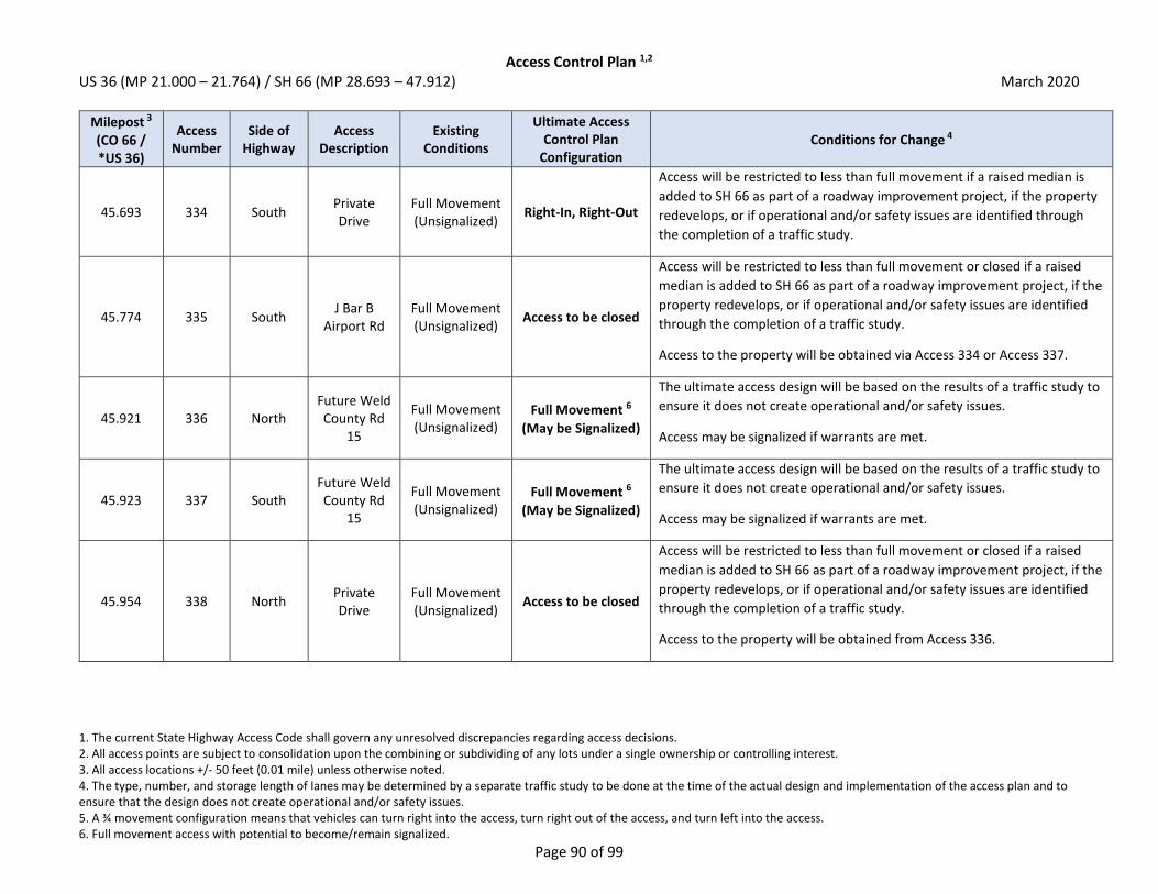
Access Control Plan 1,2 US 36 (MP 21.000 – 21.764) / SH 66 (MP 28.693 – 47.912) March 2020
1. The current State Highway Access Code shall govern any unresolved discrepancies regarding access decisions. 2. All access points are subject to consolidation upon the combining or subdividing of any lots under a single ownership or controlling interest. 3. All access locations +/- 50 feet (0.01 mile) unless otherwise noted. 4. The type, number, and storage length of lanes may be determined by a separate traffic study to be done at the time of the actual design and implementation of the access plan and to ensure that the design does not create operational and/or safety issues. 5. A ¾ movement configuration means that vehicles can turn right into the access, turn right out of the access, and turn left into the access. 6. Full movement access with potential to become/remain signalized.
Page 90 of 99
Milepost 3
(CO 66 / *US 36)
Access Number
Side of Highway
Access Description
Existing Conditions
Ultimate Access Control Plan
Configuration Conditions for Change 4
45.693 334 South Private Drive
Full Movement (Unsignalized)
Right-In, Right-Out
Access will be restricted to less than full movement if a raised median is
added to SH 66 as part of a roadway improvement project, if the property
redevelops, or if operational and/or safety issues are identified through
the completion of a traffic study.
45.774 335 South J Bar B
Airport Rd Full Movement (Unsignalized)
Access to be closed
Access will be restricted to less than full movement or closed if a raised
median is added to SH 66 as part of a roadway improvement project, if the
property redevelops, or if operational and/or safety issues are identified
through the completion of a traffic study.
Access to the property will be obtained via Access 334 or Access 337.
45.921 336 North Future Weld County Rd
15
Full Movement (Unsignalized)
Full Movement 6
(May be Signalized)
The ultimate access design will be based on the results of a traffic study to
ensure it does not create operational and/or safety issues.
Access may be signalized if warrants are met.
45.923 337 South Future Weld County Rd
15
Full Movement (Unsignalized)
Full Movement 6
(May be Signalized)
The ultimate access design will be based on the results of a traffic study to
ensure it does not create operational and/or safety issues.
Access may be signalized if warrants are met.
45.954 338 North Private Drive
Full Movement (Unsignalized)
Access to be closed
Access will be restricted to less than full movement or closed if a raised
median is added to SH 66 as part of a roadway improvement project, if the
property redevelops, or if operational and/or safety issues are identified
through the completion of a traffic study.
Access to the property will be obtained from Access 336.

Access Control Plan 1,2 US 36 (MP 21.000 – 21.764) / SH 66 (MP 28.693 – 47.912) March 2020
1. The current State Highway Access Code shall govern any unresolved discrepancies regarding access decisions. 2. All access points are subject to consolidation upon the combining or subdividing of any lots under a single ownership or controlling interest. 3. All access locations +/- 50 feet (0.01 mile) unless otherwise noted. 4. The type, number, and storage length of lanes may be determined by a separate traffic study to be done at the time of the actual design and implementation of the access plan and to ensure that the design does not create operational and/or safety issues. 5. A ¾ movement configuration means that vehicles can turn right into the access, turn right out of the access, and turn left into the access. 6. Full movement access with potential to become/remain signalized.
Page 91 of 99
Milepost 3
(CO 66 / *US 36)
Access Number
Side of Highway
Access Description
Existing Conditions
Ultimate Access Control Plan
Configuration Conditions for Change 4
45.991 339 South J Bar B Rd Full Movement (Unsignalized)
Access to be closed
Access will be restricted to less than full movement or closed if a raised
median is added to SH 66 as part of a roadway improvement project, if the
property redevelops, or if operational and/or safety issues are identified
through the completion of a traffic study.
Access to the property will be obtained from Access 337.
46.164 340 North Private Drive
Full Movement (Unsignalized)
Access to be closed
Access will be restricted to less than full movement or closed if a raised
median is added to SH 66 as part of a roadway improvement project, if the
property redevelops, or if operational and/or safety issues are identified
through the completion of a traffic study.
Property should seek to obtain cross access with adjacent property to the
west to obtain access to Access 336 or Access 345. If cross access can be
obtained, access will ultimately be closed.
46.173 341 South J Bar B Rd Full Movement (Unsignalized)
Access to be closed
Access will be restricted to less than full movement or closed if a raised
median is added to SH 66 as part of a roadway improvement project, if the
property redevelops, or if operational and/or safety issues are identified
through the completion of a traffic study.
Access to the property will be obtained from Access 337.
46.206 342 North Private Drive
Full Movement (Unsignalized)
Access to be closed
Access will be restricted to less than full movement or closed if a raised
median is added to SH 66 as part of a roadway improvement project, if the
property redevelops, or if operational and/or safety issues are identified
through the completion of a traffic study.
Access to the property will be obtained from Access 336.

Access Control Plan 1,2 US 36 (MP 21.000 – 21.764) / SH 66 (MP 28.693 – 47.912) March 2020
1. The current State Highway Access Code shall govern any unresolved discrepancies regarding access decisions. 2. All access points are subject to consolidation upon the combining or subdividing of any lots under a single ownership or controlling interest. 3. All access locations +/- 50 feet (0.01 mile) unless otherwise noted. 4. The type, number, and storage length of lanes may be determined by a separate traffic study to be done at the time of the actual design and implementation of the access plan and to ensure that the design does not create operational and/or safety issues. 5. A ¾ movement configuration means that vehicles can turn right into the access, turn right out of the access, and turn left into the access. 6. Full movement access with potential to become/remain signalized.
Page 92 of 99
Milepost 3
(CO 66 / *US 36)
Access Number
Side of Highway
Access Description
Existing Conditions
Ultimate Access Control Plan
Configuration Conditions for Change 4
46.295 343 North Private Drive
Full Movement (Unsignalized)
Access to be closed
Access will be restricted to less than full movement or closed if a raised
median is added to SH 66 as part of a roadway improvement project, if the
property redevelops, or if operational and/or safety issues are identified
through the completion of a traffic study.
Property should seek to obtain cross access with adjacent property to the
west to obtain access to Access 336 or Access 345. If cross access can be
obtained, access will ultimately be closed.
46.348 344 South Private Drive
Full Movement (Unsignalized)
Access to be closed
Access will be restricted to less than full movement or closed if a raised
median is added to SH 66 as part of a roadway improvement project, if the
property redevelops, or if operational and/or safety issues are identified
through the completion of a traffic study.
Access to the property will be obtained from Access 337.
46.447 345 North Weld
County Rd 17 North
Full Movement (Unsignalized)
Full Movement 6
(May be Signalized)
The ultimate access design will be based on the results of a traffic study to
ensure it does not create operational and/or safety issues.
Access may be signalized if warrants are met.
46.594 346 North Private Drive
Full Movement (Unsignalized)
Access to be closed
Access will be restricted to less than full movement or closed if a raised
median is added to SH 66 as part of a roadway improvement project, if the
property redevelops, or if operational and/or safety issues are identified
through the completion of a traffic study.
Access to the property will be obtained from Access 345 (Weld County Rd
17 N).

Access Control Plan 1,2 US 36 (MP 21.000 – 21.764) / SH 66 (MP 28.693 – 47.912) March 2020
1. The current State Highway Access Code shall govern any unresolved discrepancies regarding access decisions. 2. All access points are subject to consolidation upon the combining or subdividing of any lots under a single ownership or controlling interest. 3. All access locations +/- 50 feet (0.01 mile) unless otherwise noted. 4. The type, number, and storage length of lanes may be determined by a separate traffic study to be done at the time of the actual design and implementation of the access plan and to ensure that the design does not create operational and/or safety issues. 5. A ¾ movement configuration means that vehicles can turn right into the access, turn right out of the access, and turn left into the access. 6. Full movement access with potential to become/remain signalized.
Page 93 of 99
Milepost 3
(CO 66 / *US 36)
Access Number
Side of Highway
Access Description
Existing Conditions
Ultimate Access Control Plan
Configuration Conditions for Change 4
46.595 347 South Private Drive
Full Movement (Unsignalized)
Access to be closed
Access will be restricted to less than full movement or closed if a raised
median is added to SH 66 as part of a roadway improvement project, if the
property redevelops, or if operational and/or safety issues are identified
through the completion of a traffic study.
Access to the property will be obtained from Access 337 or Access 350
(Weld County Rd 17 S).
46.785 348 South Private Drive
Full Movement (Unsignalized)
Access to be closed
Access will be restricted to less than full movement or closed if a raised
median is added to SH 66 as part of a roadway improvement project, if the
property redevelops, or if operational and/or safety issues are identified
through the completion of a traffic study.
Access to the property will be obtained from Access 337 or Access 350
(Weld County Rd 17 S).
46.871 349 North Private Drive
Full Movement (Unsignalized)
Access to be closed
Access will be restricted to less than full movement or closed if a raised
median is added to SH 66 as part of a roadway improvement project, if the
property redevelops, or if operational and/or safety issues are identified
through the completion of a traffic study.
Access to the property will be obtained from Access 345 (Weld County Rd
17 N) or Access 358.
46.907 350 South Weld
County Rd 17 South
Full Movement (Unsignalized)
Full Movement 6
(May be Signalized)
The ultimate access design will be based on the results of a traffic study to
ensure it does not create operational and/or safety issues.
Access may be signalized if warrants are met.

Access Control Plan 1,2 US 36 (MP 21.000 – 21.764) / SH 66 (MP 28.693 – 47.912) March 2020
1. The current State Highway Access Code shall govern any unresolved discrepancies regarding access decisions. 2. All access points are subject to consolidation upon the combining or subdividing of any lots under a single ownership or controlling interest. 3. All access locations +/- 50 feet (0.01 mile) unless otherwise noted. 4. The type, number, and storage length of lanes may be determined by a separate traffic study to be done at the time of the actual design and implementation of the access plan and to ensure that the design does not create operational and/or safety issues. 5. A ¾ movement configuration means that vehicles can turn right into the access, turn right out of the access, and turn left into the access. 6. Full movement access with potential to become/remain signalized.
Page 94 of 99
Milepost 3
(CO 66 / *US 36)
Access Number
Side of Highway
Access Description
Existing Conditions
Ultimate Access Control Plan
Configuration Conditions for Change 4
46.949 351 North Private Drive
Full Movement (Unsignalized)
Access to be closed
Access will be restricted to less than full movement or closed if a raised
median is added to SH 66 as part of a roadway improvement project, if the
property redevelops, or if operational and/or safety issues are identified
through the completion of a traffic study.
Access to the property will be obtained from Access 345 (Weld County Rd
17 N) or Access 358.
47.093 387 South Future path
crossing N/A Grade Separated Access will be a grade separated multi-modal path.
47.116 388 North Future path
crossing N/A Grade Separated Access will be a grade separated multi-modal path.
47.128 352 North Private Drive
Full Movement (Unsignalized)
Access to be closed
Access will be restricted to less than full movement or closed if a raised
median is added to SH 66 as part of a roadway improvement project, if the
property redevelops, or if operational and/or safety issues are identified
through the completion of a traffic study.
Access to the property will be obtained via Access 358.
47.157 353 North Private Drive
Full Movement (Unsignalized)
Access to be closed
Access will be restricted to less than full movement or closed if a raised
median is added to SH 66 as part of a roadway improvement project, if the
property redevelops, or if operational and/or safety issues are identified
through the completion of a traffic study.
Property should seek to obtain cross access with adjacent property to the
east to obtain access to Access 358. If cross access can be obtained, access
will ultimately be closed.

Access Control Plan 1,2 US 36 (MP 21.000 – 21.764) / SH 66 (MP 28.693 – 47.912) March 2020
1. The current State Highway Access Code shall govern any unresolved discrepancies regarding access decisions. 2. All access points are subject to consolidation upon the combining or subdividing of any lots under a single ownership or controlling interest. 3. All access locations +/- 50 feet (0.01 mile) unless otherwise noted. 4. The type, number, and storage length of lanes may be determined by a separate traffic study to be done at the time of the actual design and implementation of the access plan and to ensure that the design does not create operational and/or safety issues. 5. A ¾ movement configuration means that vehicles can turn right into the access, turn right out of the access, and turn left into the access. 6. Full movement access with potential to become/remain signalized.
Page 95 of 99
Milepost 3
(CO 66 / *US 36)
Access Number
Side of Highway
Access Description
Existing Conditions
Ultimate Access Control Plan
Configuration Conditions for Change 4
47.373 354 South Private Drive
Full Movement (Unsignalized)
Access to be closed
Access will be restricted to less than full movement or closed if a raised
median is added to SH 66 as part of a roadway improvement project, if the
property redevelops, or if operational and/or safety issues are identified
through the completion of a traffic study.
Access to the property will be obtained via Access 356.
47.374 355 North Private Drive
Full Movement (Unsignalized)
Access to be closed
Access will be restricted to less than full movement or closed if a raised
median is added to SH 66 as part of a roadway improvement project, if the
property redevelops, or if operational and/or safety issues are identified
through the completion of a traffic study.
Access to the property will be obtained via Access 358.
47.416 356 South Private Drive
Full Movement (Unsignalized)
Full Movement 6
(May be Signalized)
The ultimate access design will be based on the results of a traffic study to
ensure it does not create operational and/or safety issues.
Access may be signalized if warrants are met.
47.416 358 North Private Drive
Full Movement (Unsignalized)
Full Movement 6
(May be Signalized)
The ultimate access design will be based on the results of a traffic study to
ensure it does not create operational and/or safety issues.
Access may be signalized if warrants are met.
47.432 357 South Private Drive
Full Movement (Unsignalized)
Access to be closed
Access will be restricted to less than full movement or closed if a raised
median is added to SH 66 as part of a roadway improvement project, if the
property redevelops, or if operational and/or safety issues are identified
through the completion of a traffic study.
Access to the property will be obtained via Access 356 or Access 370 (Weld
County Rd 19).

Access Control Plan 1,2 US 36 (MP 21.000 – 21.764) / SH 66 (MP 28.693 – 47.912) March 2020
1. The current State Highway Access Code shall govern any unresolved discrepancies regarding access decisions. 2. All access points are subject to consolidation upon the combining or subdividing of any lots under a single ownership or controlling interest. 3. All access locations +/- 50 feet (0.01 mile) unless otherwise noted. 4. The type, number, and storage length of lanes may be determined by a separate traffic study to be done at the time of the actual design and implementation of the access plan and to ensure that the design does not create operational and/or safety issues. 5. A ¾ movement configuration means that vehicles can turn right into the access, turn right out of the access, and turn left into the access. 6. Full movement access with potential to become/remain signalized.
Page 96 of 99
Milepost 3
(CO 66 / *US 36)
Access Number
Side of Highway
Access Description
Existing Conditions
Ultimate Access Control Plan
Configuration Conditions for Change 4
47.483 359 North Private Drive
Full Movement (Unsignalized)
Access to be closed
Access will be restricted to less than full movement if a raised median is
added to SH 66 as part of a roadway improvement project, if the property
redevelops, or if operational and/or safety issues are identified through
the completion of a traffic study.
Property should seek to obtain cross access with adjacent property to the
west to obtain access to Access 358. If cross access can be obtained,
access will ultimately be closed.
47.496 360 North Private Drive
Full Movement (Unsignalized)
Access to be closed
Access will be restricted to less than full movement or closed if a raised
median is added to SH 66 as part of a roadway improvement project, if the
property redevelops, or if operational and/or safety issues are identified
through the completion of a traffic study.
Access to the property will be obtained via Access 359 or from Access 358
if cross-access can be obtained.
47.565 361 North Private Drive
Full Movement (Unsignalized)
Access to be closed
Access will be restricted to less than full movement or closed if a raised
median is added to SH 66 as part of a roadway improvement project, if the
property redevelops, or if operational and/or safety issues are identified
through the completion of a traffic study.
Access to the property will be obtained via Access 359 or from Access 358
if cross-access can be obtained.

Access Control Plan 1,2 US 36 (MP 21.000 – 21.764) / SH 66 (MP 28.693 – 47.912) March 2020
1. The current State Highway Access Code shall govern any unresolved discrepancies regarding access decisions. 2. All access points are subject to consolidation upon the combining or subdividing of any lots under a single ownership or controlling interest. 3. All access locations +/- 50 feet (0.01 mile) unless otherwise noted. 4. The type, number, and storage length of lanes may be determined by a separate traffic study to be done at the time of the actual design and implementation of the access plan and to ensure that the design does not create operational and/or safety issues. 5. A ¾ movement configuration means that vehicles can turn right into the access, turn right out of the access, and turn left into the access. 6. Full movement access with potential to become/remain signalized.
Page 97 of 99
Milepost 3
(CO 66 / *US 36)
Access Number
Side of Highway
Access Description
Existing Conditions
Ultimate Access Control Plan
Configuration Conditions for Change 4
47.590 362 South Private Drive
Full Movement (Unsignalized)
Access to be closed
Access will be restricted to less than full movement or closed if a raised
median is added to SH 66 as part of a roadway improvement project, if the
property redevelops, or if operational and/or safety issues are identified
through the completion of a traffic study.
Access to the property will be obtained via Access 356 or Access 370 (Weld
County Rd 19).
47.593 363 North Private Drive
Full Movement (Unsignalized)
Access to be closed
Access will be restricted to less than full movement or closed if a raised
median is added to SH 66 as part of a roadway improvement project, if the
property redevelops, or if operational and/or safety issues are identified
through the completion of a traffic study.
Access to the property will be obtained via Access 364 or from Access 369
if cross-access can be obtained.
47.606 364 North Private Drive
Full Movement (Unsignalized)
Access to be closed
Access will be restricted to less than full movement if a raised median is
added to SH 66 as part of a roadway improvement project, if the property
redevelops, or if operational and/or safety issues are identified through
the completion of a traffic study.
Property should seek to obtain cross access with adjacent property to the
west to obtain access to Access 358. If cross access can be obtained,
access will ultimately be closed.

Access Control Plan 1,2 US 36 (MP 21.000 – 21.764) / SH 66 (MP 28.693 – 47.912) March 2020
1. The current State Highway Access Code shall govern any unresolved discrepancies regarding access decisions. 2. All access points are subject to consolidation upon the combining or subdividing of any lots under a single ownership or controlling interest. 3. All access locations +/- 50 feet (0.01 mile) unless otherwise noted. 4. The type, number, and storage length of lanes may be determined by a separate traffic study to be done at the time of the actual design and implementation of the access plan and to ensure that the design does not create operational and/or safety issues. 5. A ¾ movement configuration means that vehicles can turn right into the access, turn right out of the access, and turn left into the access. 6. Full movement access with potential to become/remain signalized.
Page 98 of 99
Milepost 3
(CO 66 / *US 36)
Access Number
Side of Highway
Access Description
Existing Conditions
Ultimate Access Control Plan
Configuration Conditions for Change 4
47.663 365 North Private Drive
Full Movement (Unsignalized)
Access to be closed
Access will be restricted to less than full movement or closed if a raised
median is added to SH 66 as part of a roadway improvement project, if the
property redevelops, or if operational and/or safety issues are identified
through the completion of a traffic study.
Access to the property will be obtained via Access 364 or from Access 369
if cross-access can be obtained.
47.663 394 South Future Drive N/A Right-In, Right-Out
Access will be a newly constructed right-in, right-out access to the
property. The ultimate access design will be based on the results of a
traffic study to ensure the intersection does not create operational and/or
safety issues.
47.714 366 North Private Drive
Full Movement (Unsignalized)
Access to be closed
Access will be restricted to less than full movement or closed if a raised
median is added to SH 66 as part of a roadway improvement project, if the
property redevelops, or if operational and/or safety issues are identified
through the completion of a traffic study.
Access to the property will be obtained via Access 364 or from Access 369
if cross-access can be obtained.
47.734 367 North Private Drive
Full Movement (Unsignalized)
Access to be closed
Access will be restricted to less than full movement or closed if a raised
median is added to SH 66 as part of a roadway improvement project, if the
property redevelops, or if operational and/or safety issues are identified
through the completion of a traffic study.
Access to the property will be obtained via Access 364 or from Access 369
if cross-access can be obtained.
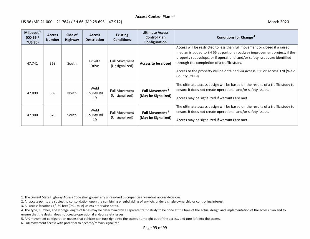
Access Control Plan 1,2 US 36 (MP 21.000 – 21.764) / SH 66 (MP 28.693 – 47.912) March 2020
1. The current State Highway Access Code shall govern any unresolved discrepancies regarding access decisions. 2. All access points are subject to consolidation upon the combining or subdividing of any lots under a single ownership or controlling interest. 3. All access locations +/- 50 feet (0.01 mile) unless otherwise noted. 4. The type, number, and storage length of lanes may be determined by a separate traffic study to be done at the time of the actual design and implementation of the access plan and to ensure that the design does not create operational and/or safety issues. 5. A ¾ movement configuration means that vehicles can turn right into the access, turn right out of the access, and turn left into the access. 6. Full movement access with potential to become/remain signalized.
Page 99 of 99
Milepost 3
(CO 66 / *US 36)
Access Number
Side of Highway
Access Description
Existing Conditions
Ultimate Access Control Plan
Configuration Conditions for Change 4
47.741 368 South Private Drive
Full Movement (Unsignalized)
Access to be closed
Access will be restricted to less than full movement or closed if a raised
median is added to SH 66 as part of a roadway improvement project, if the
property redevelops, or if operational and/or safety issues are identified
through the completion of a traffic study.
Access to the property will be obtained via Access 356 or Access 370 (Weld
County Rd 19).
47.899 369 North Weld
County Rd 19
Full Movement (Unsignalized)
Full Movement 6
(May be Signalized)
The ultimate access design will be based on the results of a traffic study to
ensure it does not create operational and/or safety issues.
Access may be signalized if warrants are met.
47.900 370 South Weld
County Rd 19
Full Movement (Unsignalized)
Full Movement 6
(May be Signalized)
The ultimate access design will be based on the results of a traffic study to
ensure it does not create operational and/or safety issues.
Access may be signalized if warrants are met.

SH 66 Access Control Plan | Final Report
Appendix F. 2040 Synchro
Analysis
F.1. 2040 AM No Action


HCM 6th Signalized Intersection Summary1: McConnell Dr/Stone Canyon Dr & SH 66 10/07/2019
SH 66 AM No Action Synchro 9 ReportTiming Plan: AM
Movement SEL SET SER NWL NWT NWR NEL NET NER SWL SWT SWR
Lane ConfigurationsTraffic Volume (veh/h) 15 740 65 195 460 15 65 15 235 40 35 40Future Volume (veh/h) 15 740 65 195 460 15 65 15 235 40 35 40Initial Q (Qb), veh 0 0 0 0 0 0 0 0 0 0 0 0Ped-Bike Adj(A_pbT) 1.00 1.00 1.00 1.00 1.00 1.00 1.00 1.00Parking Bus, Adj 1.00 1.00 1.00 1.00 1.00 1.00 1.00 1.00 1.00 1.00 1.00 1.00Work Zone On Approach No No No NoAdj Sat Flow, veh/h/ln 1870 1826 1870 1870 1826 1870 1870 1870 1870 1870 1870 1870Adj Flow Rate, veh/h 16 804 71 212 500 16 71 16 255 43 38 43Peak Hour Factor 0.92 0.92 0.92 0.92 0.92 0.92 0.92 0.92 0.92 0.92 0.92 0.92Percent Heavy Veh, % 2 5 2 2 5 2 2 2 2 2 2 2Cap, veh/h 396 924 422 505 1927 880 340 17 268 171 142 161Arrive On Green 0.27 0.27 0.27 0.18 0.56 0.56 0.18 0.18 0.18 0.18 0.18 0.18Sat Flow, veh/h 885 3469 1585 1781 3469 1585 1317 94 1505 1108 801 906
Grp Volume(v), veh/h 16 804 71 212 500 16 71 0 271 43 0 81Grp Sat Flow(s),veh/h/ln 885 1735 1585 1781 1735 1585 1317 0 1599 1108 0 1707Q Serve(g_s), s 0.6 10.0 1.5 3.1 3.4 0.2 2.2 0.0 7.5 0.5 0.0 1.8Cycle Q Clear(g_c), s 0.6 10.0 1.5 3.1 3.4 0.2 4.1 0.0 7.5 8.0 0.0 1.8Prop In Lane 1.00 1.00 1.00 1.00 1.00 0.94 1.00 0.53Lane Grp Cap(c), veh/h 396 924 422 505 1927 880 340 0 284 171 0 304V/C Ratio(X) 0.04 0.87 0.17 0.42 0.26 0.02 0.21 0.00 0.95 0.25 0.00 0.27Avail Cap(c_a), veh/h 396 925 423 505 1928 881 340 0 284 171 0 304HCM Platoon Ratio 1.00 1.00 1.00 1.00 1.00 1.00 1.00 1.00 1.00 1.00 1.00 1.00Upstream Filter(I) 1.00 1.00 1.00 1.00 1.00 1.00 1.00 0.00 1.00 1.00 0.00 1.00Uniform Delay (d), s/veh 12.3 15.8 12.7 8.7 5.2 4.5 17.7 0.0 18.3 22.4 0.0 16.0Incr Delay (d2), s/veh 0.1 9.2 0.3 0.6 0.1 0.0 0.4 0.0 40.8 1.1 0.0 0.7Initial Q Delay(d3),s/veh 0.0 0.0 0.0 0.0 0.0 0.0 0.0 0.0 0.0 0.0 0.0 0.0%ile BackOfQ(50%),veh/ln 0.1 4.0 0.4 0.7 0.5 0.0 0.6 0.0 5.7 0.5 0.0 0.7Unsig. Movement Delay, s/vehLnGrp Delay(d),s/veh 12.4 25.0 12.9 9.3 5.3 4.5 18.1 0.0 59.1 23.5 0.0 16.6LnGrp LOS B C B A A A B A E C A B
Approach Vol, veh/h 891 728 342 124Approach Delay, s/veh 23.8 6.4 50.6 19.0Approach LOS C A D B
Timer - Assigned Phs 1 2 4 6 8
Phs Duration (G+Y+Rc), s 13.0 18.0 14.0 31.0 14.0Change Period (Y+Rc), s 5.0 6.0 6.0 6.0 6.0Max Green Setting (Gmax), s 8.0 12.0 8.0 25.0 8.0Max Q Clear Time (g_c+I1), s 5.1 12.0 10.0 5.4 9.5Green Ext Time (p_c), s 0.2 0.0 0.0 4.0 0.0
Intersection Summary
HCM 6th Ctrl Delay 21.8HCM 6th LOS C
Notes
User approved pedestrian interval to be less than phase max green.

HCM Signalized Intersection Capacity Analysis2: US 36 & SH 66 10/07/2019
SH 66 AM No Action Synchro 9 ReportTiming Plan: AM
Movement EBL EBT EBR WBL WBT WBR NBL NBT NBR SBL SBT SBR
Lane ConfigurationsTraffic Volume (vph) 25 480 520 370 510 35 135 40 35 25 25 25Future Volume (vph) 25 480 520 370 510 35 135 40 35 25 25 25Ideal Flow (vphpl) 1900 1900 1900 1900 1900 1900 1900 1900 1900 1900 1900 1900Total Lost time (s) 6.0 6.0 6.0 6.0 6.0 6.0 6.0 6.0 6.0Lane Util. Factor 1.00 0.95 1.00 1.00 0.95 0.95 0.95 1.00 1.00Frt 1.00 1.00 0.85 1.00 0.99 1.00 1.00 0.85 0.95Flt Protected 0.95 1.00 1.00 0.95 1.00 0.95 0.97 1.00 0.98Satd. Flow (prot) 1624 3185 1425 1593 3102 1442 1522 1358 1606Flt Permitted 0.42 1.00 1.00 0.46 1.00 0.95 0.97 1.00 0.98Satd. Flow (perm) 722 3185 1425 769 3102 1442 1522 1358 1606
Peak-hour factor, PHF 0.92 0.92 0.92 0.92 0.92 0.92 0.92 0.92 0.92 0.92 0.92 0.92Adj. Flow (vph) 27 522 565 402 554 38 147 43 38 27 27 27RTOR Reduction (vph) 0 0 221 0 6 0 0 0 34 0 20 0Lane Group Flow (vph) 27 522 344 402 586 0 94 96 4 0 61 0Heavy Vehicles (%) 0% 2% 2% 2% 4% 0% 7% 0% 7% 0% 0% 0%
Turn Type Perm NA Perm Perm NA Split NA Perm Split NAProtected Phases 2 6 4 4 8 8Permitted Phases 2 2 6 4Actuated Green, G (s) 50.0 50.0 50.0 50.0 50.0 8.2 8.2 8.2 6.0Effective Green, g (s) 50.0 50.0 50.0 50.0 50.0 8.2 8.2 8.2 6.0Actuated g/C Ratio 0.61 0.61 0.61 0.61 0.61 0.10 0.10 0.10 0.07Clearance Time (s) 6.0 6.0 6.0 6.0 6.0 6.0 6.0 6.0 6.0Vehicle Extension (s) 4.0 4.0 4.0 4.0 4.0 4.0 4.0 4.0 4.0
Lane Grp Cap (vph) 439 1937 866 467 1886 143 151 135 117v/s Ratio Prot 0.16 0.19 c0.07 0.06 c0.04v/s Ratio Perm 0.04 0.24 c0.52 0.00v/c Ratio 0.06 0.27 0.40 0.86 0.31 0.66 0.64 0.03 0.52Uniform Delay, d1 6.6 7.5 8.3 13.2 7.8 35.6 35.6 33.4 36.7Progression Factor 1.00 1.00 1.00 1.00 1.00 1.00 1.00 1.00 1.00Incremental Delay, d2 0.1 0.1 0.4 15.4 0.1 11.5 9.5 0.1 5.1Delay (s) 6.6 7.6 8.7 28.6 7.9 47.1 45.0 33.5 41.8Level of Service A A A C A D D C DApproach Delay (s) 8.2 16.3 44.0 41.8Approach LOS A B D D
Intersection Summary
HCM 2000 Control Delay 16.0 HCM 2000 Level of Service BHCM 2000 Volume to Capacity ratio 0.80Actuated Cycle Length (s) 82.2 Sum of lost time (s) 18.0Intersection Capacity Utilization 80.2% ICU Level of Service DAnalysis Period (min) 15c Critical Lane Group

HCM 6th Signalized Intersection Summary4: N 75th St & SH 66 10/07/2019
SH 66 AM No Action Synchro 9 ReportTiming Plan: AM
Movement EBL EBT EBR WBL WBT WBR NBL NBT NBR SBL SBT SBR
Lane ConfigurationsTraffic Volume (veh/h) 10 380 145 270 765 5 85 10 40 5 195 75Future Volume (veh/h) 10 380 145 270 765 5 85 10 40 5 195 75Initial Q (Qb), veh 0 0 0 0 0 0 0 0 0 0 0 0Ped-Bike Adj(A_pbT) 1.00 1.00 1.00 1.00 1.00 1.00 1.00 1.00Parking Bus, Adj 1.00 1.00 1.00 1.00 1.00 1.00 1.00 1.00 1.00 1.00 1.00 1.00Work Zone On Approach No No No NoAdj Sat Flow, veh/h/ln 1737 1856 1900 1870 1826 1900 1900 1900 1900 1900 1900 1900Adj Flow Rate, veh/h 11 413 158 293 832 5 92 11 0 5 212 0Peak Hour Factor 0.92 0.92 0.92 0.92 0.92 0.92 0.92 0.92 0.92 0.92 0.92 0.92Percent Heavy Veh, % 11 3 0 2 5 0 0 0 0 0 0 0Cap, veh/h 245 799 693 569 975 859 287 28 67 299Arrive On Green 0.02 0.43 0.43 0.12 0.53 0.53 0.16 0.16 0.00 0.16 0.16 0.00Sat Flow, veh/h 1654 1856 1610 1781 1826 1610 1055 176 0 16 1878 0
Grp Volume(v), veh/h 11 413 158 293 832 5 103 0 0 217 0 0Grp Sat Flow(s),veh/h/ln 1654 1856 1610 1781 1826 1610 1231 0 0 1895 0 0Q Serve(g_s), s 0.2 9.4 3.6 4.7 22.4 0.1 0.0 0.0 0.0 0.6 0.0 0.0Cycle Q Clear(g_c), s 0.2 9.4 3.6 4.7 22.4 0.1 4.4 0.0 0.0 6.2 0.0 0.0Prop In Lane 1.00 1.00 1.00 1.00 0.89 0.00 0.02 0.00Lane Grp Cap(c), veh/h 245 799 693 569 975 859 315 0 366 0V/C Ratio(X) 0.04 0.52 0.23 0.51 0.85 0.01 0.33 0.00 0.59 0.00Avail Cap(c_a), veh/h 415 1717 1490 766 1893 1669 700 0 953 0HCM Platoon Ratio 1.00 1.00 1.00 1.00 1.00 1.00 1.00 1.00 1.00 1.00 1.00 1.00Upstream Filter(I) 1.00 1.00 1.00 1.00 1.00 1.00 1.00 0.00 0.00 1.00 0.00 0.00Uniform Delay (d), s/veh 11.1 12.0 10.3 7.5 11.5 6.3 22.1 0.0 0.0 22.9 0.0 0.0Incr Delay (d2), s/veh 0.1 0.5 0.2 0.7 2.3 0.0 0.6 0.0 0.0 1.5 0.0 0.0Initial Q Delay(d3),s/veh 0.0 0.0 0.0 0.0 0.0 0.0 0.0 0.0 0.0 0.0 0.0 0.0%ile BackOfQ(50%),veh/ln 0.1 2.9 1.0 1.1 6.2 0.0 1.2 0.0 0.0 2.6 0.0 0.0Unsig. Movement Delay, s/vehLnGrp Delay(d),s/veh 11.2 12.5 10.5 8.3 13.7 6.3 22.7 0.0 0.0 24.4 0.0 0.0LnGrp LOS B B B A B A C A C A
Approach Vol, veh/h 582 1130 103 A 217 AApproach Delay, s/veh 11.9 12.3 22.7 24.4Approach LOS B B C C
Timer - Assigned Phs 1 2 4 5 6 8
Phs Duration (G+Y+Rc), s 11.6 31.7 14.1 5.6 37.6 14.1Change Period (Y+Rc), s 4.5 7.0 5.0 4.5 7.0 5.0Max Green Setting (Gmax), s 13.4 53.1 27.0 7.0 59.5 27.0Max Q Clear Time (g_c+I1), s 6.7 11.4 8.2 2.2 24.4 6.4Green Ext Time (p_c), s 0.5 2.9 1.0 0.0 6.2 0.5
Intersection Summary
HCM 6th Ctrl Delay 14.0HCM 6th LOS B
Notes
Unsignalized Delay for [NBR, SBR] is excluded from calculations of the approach delay and intersection delay.

HCM 6th TWSC5: Airport Rd/87th St & SH 66 10/07/2019
SH 66 AM No Action Synchro 9 ReportTiming Plan: AM
Intersection
Int Delay, s/veh 6.7
Movement EBL EBT EBR WBL WBT WBR NBL NBT NBR SBL SBT SBR
Lane ConfigurationsTraffic Vol, veh/h 5 415 5 5 975 25 20 5 30 50 5 25Future Vol, veh/h 5 415 5 5 975 25 20 5 30 50 5 25Conflicting Peds, #/hr 0 0 0 0 0 0 0 0 0 0 0 0Sign Control Free Free Free Free Free Free Stop Stop Stop Stop Stop StopRT Channelized - - None - - None - - Stop - - StopStorage Length 475 - 475 325 - 325 - - - - - -Veh in Median Storage, # - 0 - - 0 - - 0 - - 0 -Grade, % - 0 - - 0 - - 0 - - 0 -Peak Hour Factor 92 92 92 92 92 92 92 92 92 92 92 92Heavy Vehicles, % 0 4 0 0 4 0 0 0 4 0 0 0Mvmt Flow 5 451 5 5 1060 27 22 5 33 54 5 27
Major/Minor Major1 Major2 Minor1 Minor2
Conflicting Flow All 1087 0 0 456 0 0 1547 1558 451 1536 1536 1060 Stage 1 - - - - - - 461 461 - 1070 1070 - Stage 2 - - - - - - 1086 1097 - 466 466 -Critical Hdwy 4.1 - - 4.1 - - 7.1 6.5 6.24 7.1 6.5 6.2Critical Hdwy Stg 1 - - - - - - 6.1 5.5 - 6.1 5.5 -Critical Hdwy Stg 2 - - - - - - 6.1 5.5 - 6.1 5.5 -Follow-up Hdwy 2.2 - - 2.2 - - 3.5 4 3.336 3.5 4 3.3Pot Cap-1 Maneuver 649 - - 1115 - - 94 114 604 96 117 275 Stage 1 - - - - - - 584 569 - 270 300 - Stage 2 - - - - - - 264 291 - 581 566 -Platoon blocked, % - - - -Mov Cap-1 Maneuver 649 - - 1115 - - 81 113 604 87 116 275Mov Cap-2 Maneuver - - - - - - 81 113 - 87 116 - Stage 1 - - - - - - 579 564 - 268 299 - Stage 2 - - - - - - 233 290 - 540 561 -
Approach EB WB NB SB
HCM Control Delay, s 0.1 0 40 102.1HCM LOS E F
Minor Lane/Major Mvmt NBLn1 EBL EBT EBR WBL WBT WBR SBLn1
Capacity (veh/h) 161 649 - - 1115 - - 113HCM Lane V/C Ratio 0.371 0.008 - - 0.005 - - 0.77HCM Control Delay (s) 40 10.6 - - 8.2 - - 102.1HCM Lane LOS E B - - A - - FHCM 95th %tile Q(veh) 1.6 0 - - 0 - - 4.3

HCM 6th TWSC6: Shore Dr & SH 66 10/07/2019
SH 66 AM No Action Synchro 9 ReportTiming Plan: AM
Intersection
Int Delay, s/veh 0.9
Movement EBT EBR WBL WBT NBL NBR
Lane ConfigurationsTraffic Vol, veh/h 490 5 25 980 25 55Future Vol, veh/h 490 5 25 980 25 55Conflicting Peds, #/hr 0 0 0 0 0 0Sign Control Free Free Free Free Stop StopRT Channelized - None - None - StopStorage Length - 0 575 - 150 0Veh in Median Storage, # 0 - - 0 0 -Grade, % 0 - - 0 0 -Peak Hour Factor 92 92 92 92 92 92Heavy Vehicles, % 2 2 2 2 2 2Mvmt Flow 533 5 27 1065 27 60
Major/Minor Major1 Major2 Minor1
Conflicting Flow All 0 0 538 0 1652 533 Stage 1 - - - - 533 - Stage 2 - - - - 1119 -Critical Hdwy - - 4.12 - 6.42 6.22Critical Hdwy Stg 1 - - - - 5.42 -Critical Hdwy Stg 2 - - - - 5.42 -Follow-up Hdwy - - 2.218 - 3.518 3.318Pot Cap-1 Maneuver - - 1030 - 108 547 Stage 1 - - - - 588 - Stage 2 - - - - 312 -Platoon blocked, % - - -Mov Cap-1 Maneuver - - 1030 - 105 547Mov Cap-2 Maneuver - - - - 215 - Stage 1 - - - - 573 - Stage 2 - - - - 312 -
Approach EB WB NB
HCM Control Delay, s 0 0.2 16.1HCM LOS C
Minor Lane/Major Mvmt NBLn1 NBLn2 EBT EBR WBL WBT
Capacity (veh/h) 215 547 - - 1030 -HCM Lane V/C Ratio 0.126 0.109 - - 0.026 -HCM Control Delay (s) 24.2 12.4 - - 8.6 -HCM Lane LOS C B - - A -HCM 95th %tile Q(veh) 0.4 0.4 - - 0.1 -

HCM 6th TWSC7: SH 66 & Anhawa Ave 10/07/2019
SH 66 AM No Action Synchro 9 ReportTiming Plan: AM
Intersection
Int Delay, s/veh 0.6
Movement EBL EBT WBT WBR SBL SBR
Lane ConfigurationsTraffic Vol, veh/h 5 540 1000 15 15 5Future Vol, veh/h 5 540 1000 15 15 5Conflicting Peds, #/hr 0 0 0 0 0 0Sign Control Free Free Free Free Stop StopRT Channelized - None - None - NoneStorage Length 200 - - - 0 -Veh in Median Storage, # - 0 0 - 0 -Grade, % - 0 0 - 0 -Peak Hour Factor 92 92 92 92 92 92Heavy Vehicles, % 0 3 4 25 25 0Mvmt Flow 5 587 1087 16 16 5
Major/Minor Major1 Major2 Minor2
Conflicting Flow All 1103 0 - 0 1692 1095 Stage 1 - - - - 1095 - Stage 2 - - - - 597 -Critical Hdwy 4.1 - - - 6.65 6.2Critical Hdwy Stg 1 - - - - 5.65 -Critical Hdwy Stg 2 - - - - 5.65 -Follow-up Hdwy 2.2 - - - 3.725 3.3Pot Cap-1 Maneuver 640 - - - 90 262 Stage 1 - - - - 290 - Stage 2 - - - - 508 -Platoon blocked, % - - -Mov Cap-1 Maneuver 640 - - - 89 262Mov Cap-2 Maneuver - - - - 89 - Stage 1 - - - - 288 - Stage 2 - - - - 508 -
Approach EB WB SB
HCM Control Delay, s 0.1 0 47HCM LOS E
Minor Lane/Major Mvmt EBL EBT WBT WBR SBLn1
Capacity (veh/h) 640 - - - 107HCM Lane V/C Ratio 0.008 - - - 0.203HCM Control Delay (s) 10.7 - - - 47HCM Lane LOS B - - - EHCM 95th %tile Q(veh) 0 - - - 0.7

HCM 6th TWSC8: Jotipa Dr/Lake Park Dr & SH 66 10/07/2019
SH 66 AM No Action Synchro 9 ReportTiming Plan: AM
Intersection
Int Delay, s/veh 3.7
Movement EBL EBT EBR WBL WBT WBR NBL NBT NBR SBL SBT SBR
Lane ConfigurationsTraffic Vol, veh/h 5 555 5 30 1000 25 10 5 15 20 10 5Future Vol, veh/h 5 555 5 30 1000 25 10 5 15 20 10 5Conflicting Peds, #/hr 0 0 0 0 0 0 0 0 0 0 0 0Sign Control Free Free Free Free Free Free Stop Stop Stop Stop Stop StopRT Channelized - - None - - None - - None - - NoneStorage Length - - - - - - - - - - - -Veh in Median Storage, # - 0 - - 0 - - 0 - - 0 -Grade, % - 0 - - 0 - - 0 - - 0 -Peak Hour Factor 92 92 92 92 92 92 92 92 92 92 92 92Heavy Vehicles, % 2 2 2 2 2 2 2 2 2 2 2 2Mvmt Flow 5 603 5 33 1087 27 11 5 16 22 11 5
Major/Minor Major1 Major2 Minor1 Minor2
Conflicting Flow All 1114 0 0 608 0 0 1791 1796 606 1793 1785 1101 Stage 1 - - - - - - 616 616 - 1167 1167 - Stage 2 - - - - - - 1175 1180 - 626 618 -Critical Hdwy 4.12 - - 4.12 - - 7.12 6.52 6.22 7.12 6.52 6.22Critical Hdwy Stg 1 - - - - - - 6.12 5.52 - 6.12 5.52 -Critical Hdwy Stg 2 - - - - - - 6.12 5.52 - 6.12 5.52 -Follow-up Hdwy 2.218 - - 2.218 - - 3.518 4.018 3.318 3.518 4.018 3.318Pot Cap-1 Maneuver 627 - - 970 - - 63 80 497 63 82 258 Stage 1 - - - - - - 478 482 - 236 268 - Stage 2 - - - - - - 233 264 - 472 481 -Platoon blocked, % - - - -Mov Cap-1 Maneuver 627 - - 970 - - 51 72 497 53 74 258Mov Cap-2 Maneuver - - - - - - 51 72 - 53 74 - Stage 1 - - - - - - 472 476 - 233 244 - Stage 2 - - - - - - 198 240 - 446 475 -
Approach EB WB NB SB
HCM Control Delay, s 0.1 0.3 56.8 116.7HCM LOS F F
Minor Lane/Major Mvmt NBLn1 EBL EBT EBR WBL WBT WBR SBLn1
Capacity (veh/h) 101 627 - - 970 - - 66HCM Lane V/C Ratio 0.323 0.009 - - 0.034 - - 0.576HCM Control Delay (s) 56.8 10.8 0 - 8.8 0 - 116.7HCM Lane LOS F B A - A A - FHCM 95th %tile Q(veh) 1.2 0 - - 0.1 - - 2.4

HCM Signalized Intersection Capacity Analysis9: 95th St/Hover Rd & SH 66 10/07/2019
SH 66 AM No Action Synchro 9 ReportTiming Plan: AM
Movement EBL EBT EBR WBL WBT WBR NBL NBT NBR SBL SBT SBR
Lane ConfigurationsTraffic Volume (vph) 5 335 250 1350 595 50 410 90 695 20 280 50Future Volume (vph) 5 335 250 1350 595 50 410 90 695 20 280 50Ideal Flow (vphpl) 1900 1900 1900 1800 1900 1900 1900 1900 1900 1900 1900 1900Total Lost time (s) 6.6 6.4 6.4 6.5 6.4 6.4 5.7 5.7 5.7 5.8 5.7Lane Util. Factor 1.00 1.00 1.00 0.97 1.00 1.00 1.00 1.00 1.00 1.00 1.00Frt 1.00 1.00 0.85 1.00 1.00 0.85 1.00 1.00 0.85 1.00 0.98Flt Protected 0.95 1.00 1.00 0.95 1.00 1.00 0.95 1.00 1.00 0.95 1.00Satd. Flow (prot) 1805 1827 1599 3252 1792 1615 1752 1863 1553 1805 1851Flt Permitted 0.42 1.00 1.00 0.95 1.00 1.00 0.12 1.00 1.00 0.69 1.00Satd. Flow (perm) 796 1827 1599 3252 1792 1615 228 1863 1553 1318 1851
Peak-hour factor, PHF 0.92 0.92 0.92 0.92 0.92 0.92 0.92 0.92 0.92 0.92 0.92 0.92Adj. Flow (vph) 5 364 272 1467 647 54 446 98 755 22 304 54RTOR Reduction (vph) 0 0 198 0 0 26 0 0 489 0 4 0Lane Group Flow (vph) 5 364 74 1467 647 28 446 98 266 22 354 0Heavy Vehicles (%) 0% 4% 1% 2% 6% 0% 3% 2% 4% 0% 0% 2%
Turn Type pm+pt NA Perm Prot NA Perm pm+pt NA Perm pm+pt NAProtected Phases 7 4 3 8 5 2 1 6Permitted Phases 4 4 8 2 2 6Actuated Green, G (s) 34.7 33.9 33.9 49.5 82.5 82.5 55.6 47.4 47.4 29.0 26.6Effective Green, g (s) 34.7 33.9 33.9 49.5 82.5 82.5 55.6 47.4 47.4 29.0 26.6Actuated g/C Ratio 0.22 0.22 0.22 0.31 0.52 0.52 0.35 0.30 0.30 0.18 0.17Clearance Time (s) 6.6 6.4 6.4 6.5 6.4 6.4 5.7 5.7 5.7 5.8 5.7Vehicle Extension (s) 2.0 4.0 4.0 3.0 4.0 4.0 3.0 3.0 3.0 3.0 3.0
Lane Grp Cap (vph) 180 392 343 1021 938 845 305 560 467 249 312v/s Ratio Prot 0.00 c0.20 c0.45 0.36 c0.22 0.05 0.00 0.19v/s Ratio Perm 0.01 0.05 0.02 c0.30 0.17 0.01v/c Ratio 0.03 0.93 0.22 1.44 0.69 0.03 1.46 0.17 0.57 0.09 1.13Uniform Delay, d1 48.1 60.7 50.9 54.0 28.0 18.2 49.4 40.7 46.5 53.1 65.5Progression Factor 1.00 1.00 1.00 1.00 1.00 1.00 1.00 1.00 1.00 1.00 1.00Incremental Delay, d2 0.0 28.2 0.4 202.2 2.3 0.0 225.3 0.1 1.6 0.2 92.3Delay (s) 48.1 88.9 51.3 256.3 30.3 18.2 274.6 40.8 48.1 53.3 157.8Level of Service D F D F C B F D D D FApproach Delay (s) 72.6 182.9 125.3 151.7Approach LOS E F F F
Intersection Summary
HCM 2000 Control Delay 147.8 HCM 2000 Level of Service FHCM 2000 Volume to Capacity ratio 1.35Actuated Cycle Length (s) 157.6 Sum of lost time (s) 24.5Intersection Capacity Utilization 118.9% ICU Level of Service HAnalysis Period (min) 15c Critical Lane Group
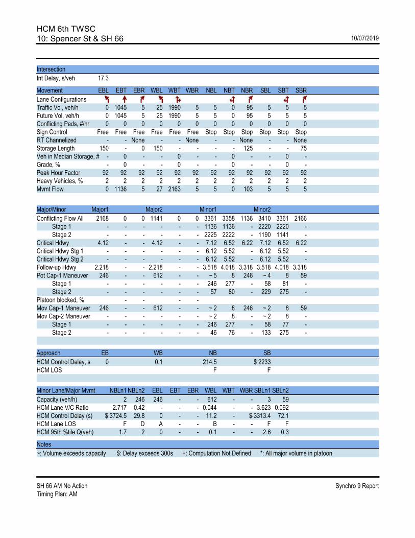
HCM 6th TWSC10: Spencer St & SH 66 10/07/2019
SH 66 AM No Action Synchro 9 ReportTiming Plan: AM
Intersection
Int Delay, s/veh 17.3
Movement EBL EBT EBR WBL WBT WBR NBL NBT NBR SBL SBT SBR
Lane ConfigurationsTraffic Vol, veh/h 0 1045 5 25 1990 5 5 0 95 5 5 5Future Vol, veh/h 0 1045 5 25 1990 5 5 0 95 5 5 5Conflicting Peds, #/hr 0 0 0 0 0 0 0 0 0 0 0 0Sign Control Free Free Free Free Free Free Stop Stop Stop Stop Stop StopRT Channelized - - None - - None - - None - - NoneStorage Length 150 - 0 150 - - - - 125 - - 75Veh in Median Storage, # - 0 - - 0 - - 0 - - 0 -Grade, % - 0 - - 0 - - 0 - - 0 -Peak Hour Factor 92 92 92 92 92 92 92 92 92 92 92 92Heavy Vehicles, % 2 2 2 2 2 2 2 2 2 2 2 2Mvmt Flow 0 1136 5 27 2163 5 5 0 103 5 5 5
Major/Minor Major1 Major2 Minor1 Minor2
Conflicting Flow All 2168 0 0 1141 0 0 3361 3358 1136 3410 3361 2166 Stage 1 - - - - - - 1136 1136 - 2220 2220 - Stage 2 - - - - - - 2225 2222 - 1190 1141 -Critical Hdwy 4.12 - - 4.12 - - 7.12 6.52 6.22 7.12 6.52 6.22Critical Hdwy Stg 1 - - - - - - 6.12 5.52 - 6.12 5.52 -Critical Hdwy Stg 2 - - - - - - 6.12 5.52 - 6.12 5.52 -Follow-up Hdwy 2.218 - - 2.218 - - 3.518 4.018 3.318 3.518 4.018 3.318Pot Cap-1 Maneuver 246 - - 612 - - ~ 5 8 246 ~ 4 8 59 Stage 1 - - - - - - 246 277 - 58 81 - Stage 2 - - - - - - 57 80 - 229 275 -Platoon blocked, % - - - -Mov Cap-1 Maneuver 246 - - 612 - - ~ 2 8 246 ~ 2 8 59Mov Cap-2 Maneuver - - - - - - ~ 2 8 - ~ 2 8 - Stage 1 - - - - - - 246 277 - 58 77 - Stage 2 - - - - - - 46 76 - 133 275 -
Approach EB WB NB SB
HCM Control Delay, s 0 0.1 214.5 $ 2233HCM LOS F F
Minor Lane/Major Mvmt NBLn1 NBLn2 EBL EBT EBR WBL WBT WBR SBLn1 SBLn2
Capacity (veh/h) 2 246 246 - - 612 - - 3 59HCM Lane V/C Ratio 2.717 0.42 - - - 0.044 - - 3.623 0.092HCM Control Delay (s) $ 3724.5 29.8 0 - - 11.2 - -$ 3313.4 72.1HCM Lane LOS F D A - - B - - F FHCM 95th %tile Q(veh) 1.7 2 0 - - 0.1 - - 2.6 0.3
Notes
~: Volume exceeds capacity $: Delay exceeds 300s +: Computation Not Defined *: All major volume in platoon

HCM 6th TWSC11: Francis St & SH 66 10/07/2019
SH 66 AM No Action Synchro 9 ReportTiming Plan: AM
Intersection
Int Delay, s/veh 1534.7
Movement EBT EBR WBL WBT NBL NBR
Lane ConfigurationsTraffic Vol, veh/h 1080 60 200 1945 70 170Future Vol, veh/h 1080 60 200 1945 70 170Conflicting Peds, #/hr 0 0 0 0 0 0Sign Control Free Free Free Free Stop StopRT Channelized - None - None - NoneStorage Length - 250 300 - 275 0Veh in Median Storage, # 0 - - 0 0 -Grade, % 0 - - 0 0 -Peak Hour Factor 88 56 63 91 63 80Heavy Vehicles, % 3 0 1 3 0 1Mvmt Flow 1227 107 317 2137 111 213
Major/Minor Major1 Major2 Minor1
Conflicting Flow All 0 0 1334 0 3998 1227 Stage 1 - - - - 1227 - Stage 2 - - - - 2771 -Critical Hdwy - - 4.11 - 6.4 6.21Critical Hdwy Stg 1 - - - - 5.4 -Critical Hdwy Stg 2 - - - - 5.4 -Follow-up Hdwy - - 2.209 - 3.5 3.309Pot Cap-1 Maneuver - - 520 - ~ 3 219 Stage 1 - - - - 280 - Stage 2 - - - - ~ 47 -Platoon blocked, % - - -Mov Cap-1 Maneuver - - 520 - ~ 1 219Mov Cap-2 Maneuver - - - - ~ 1 - Stage 1 - - - - ~ 109 - Stage 2 - - - - ~ 47 -
Approach EB WB NB
HCM Control Delay, s 0 2.9 $ 19483.3HCM LOS F
Minor Lane/Major Mvmt NBLn1 NBLn2 EBT EBR WBL WBT
Capacity (veh/h) 1 219 - - 520 -HCM Lane V/C Ratio 111.111 0.97 - - 0.611 -HCM Control Delay (s) $ 56554.5 99.7 - - 22.2 -HCM Lane LOS F F - - C -HCM 95th %tile Q(veh) 16.3 8.5 - - 4.1 -
Notes
~: Volume exceeds capacity $: Delay exceeds 300s +: Computation Not Defined *: All major volume in platoon

HCM 6th TWSC12: Gay St & SH 66 10/07/2019
SH 66 AM No Action Synchro 9 ReportTiming Plan: AM
Intersection
Int Delay, s/veh 0.9
Movement EBL EBT EBR WBL WBT WBR NBL NBT NBR SBL SBT SBR
Lane ConfigurationsTraffic Vol, veh/h 20 1185 45 185 2055 35 25 5 140 25 10 65Future Vol, veh/h 20 1185 45 185 2055 35 25 5 140 25 10 65Conflicting Peds, #/hr 0 0 0 0 0 0 0 0 0 0 0 0Sign Control Free Free Free Free Free Free Stop Stop Stop Stop Stop StopRT Channelized - - None - - None - - Stop - - NoneStorage Length 300 - 300 325 - 0 - - 125 - - 0Veh in Median Storage, # - 0 - - 0 - - 0 - - 0 -Grade, % - 0 - - 0 - - 0 - - 0 -Peak Hour Factor 92 92 92 92 92 92 92 92 92 92 92 92Heavy Vehicles, % 2 2 2 2 2 2 2 2 2 2 2 2Mvmt Flow 22 1288 49 201 2234 38 27 5 152 27 11 71
Major/Minor Major1 Major2 Minor1 Minor2
Conflicting Flow All 2272 0 0 1337 0 0 4028 4006 1288 3995 4017 2234 Stage 1 - - - - - - 1332 1332 - 2636 2636 - Stage 2 - - - - - - 2696 2674 - 1359 1381 -Critical Hdwy 4.12 - - 4.12 - - 7.12 6.52 6.22 7.12 6.52 6.22Critical Hdwy Stg 1 - - - - - - 6.12 5.52 - 6.12 5.52 -Critical Hdwy Stg 2 - - - - - - 6.12 5.52 - 6.12 5.52 -Follow-up Hdwy 2.218 - - 2.218 - - 3.518 4.018 3.318 3.518 4.018 3.318Pot Cap-1 Maneuver 224 - - 516 - - ~ 1 ~ 3 200 ~ 2 ~ 3 ~ 54 Stage 1 - - - - - - 190 223 - 32 49 - Stage 2 - - - - - - 30 47 - 183 211 -Platoon blocked, % - - - -Mov Cap-1 Maneuver 224 - - 516 - - - ~ 2 200 - ~ 2 ~ 54Mov Cap-2 Maneuver - - - - - - - ~ 2 - - ~ 2 - Stage 1 - - - - - - 171 201 - 29 30 - Stage 2 - - - - - - - 29 - 38 190 -
Approach EB WB NB SB
HCM Control Delay, s 0.4 1.3HCM LOS - -
Minor Lane/Major Mvmt NBLn1 NBLn2 EBL EBT EBR WBL WBT WBR SBLn1 SBLn2
Capacity (veh/h) - 200 224 - - 516 - - - 54HCM Lane V/C Ratio - 0.761 0.097 - - 0.39 - - - 1.308HCM Control Delay (s) - 64.4 22.8 - - 16.4 - - - $ 351HCM Lane LOS - F C - - C - - - FHCM 95th %tile Q(veh) - 5.1 0.3 - - 1.8 - - - 6.3
Notes
~: Volume exceeds capacity $: Delay exceeds 300s +: Computation Not Defined *: All major volume in platoon

HCM 6th Signalized Intersection Summary13: US 287 & SH 66 10/07/2019
SH 66 AM No Action Synchro 9 ReportTiming Plan: AM
Movement EBL EBT EBR WBL WBT WBR NBL NBT NBR SBL SBT SBR
Lane ConfigurationsTraffic Volume (veh/h) 580 535 235 325 800 135 335 400 220 185 900 1140Future Volume (veh/h) 580 535 235 325 800 135 335 400 220 185 900 1140Initial Q (Qb), veh 0 0 0 0 0 0 0 0 0 0 0 0Ped-Bike Adj(A_pbT) 1.00 1.00 1.00 1.00 1.00 1.00 1.00 1.00Parking Bus, Adj 1.00 1.00 1.00 1.00 1.00 1.00 1.00 1.00 1.00 1.00 1.00 1.00Work Zone On Approach No No No NoAdj Sat Flow, veh/h/ln 1595 1657 1643 1569 1643 1643 1657 1630 1670 1670 1697 1683Adj Flow Rate, veh/h 630 582 0 353 870 0 364 435 0 201 978 0Peak Hour Factor 0.92 0.92 0.92 0.92 0.92 0.92 0.92 0.92 0.92 0.92 0.92 0.92Percent Heavy Veh, % 2 4 5 4 5 5 4 6 3 3 1 2Cap, veh/h 562 875 505 816 280 916 371 821Arrive On Green 0.19 0.28 0.00 0.17 0.26 0.00 0.15 0.30 0.00 0.11 0.25 0.00Sat Flow, veh/h 2946 3148 1393 2900 3122 1393 1578 3097 1415 1590 3224 1427
Grp Volume(v), veh/h 630 582 0 353 870 0 364 435 0 201 978 0Grp Sat Flow(s),veh/h/ln 1473 1574 1393 1450 1561 1393 1578 1548 1415 1590 1612 1427Q Serve(g_s), s 28.6 24.6 0.0 17.2 39.2 0.0 22.1 17.3 0.0 13.9 38.2 0.0Cycle Q Clear(g_c), s 28.6 24.6 0.0 17.2 39.2 0.0 22.1 17.3 0.0 13.9 38.2 0.0Prop In Lane 1.00 1.00 1.00 1.00 1.00 1.00 1.00 1.00Lane Grp Cap(c), veh/h 562 875 505 816 280 916 371 821V/C Ratio(X) 1.12 0.67 0.70 1.07 1.30 0.48 0.54 1.19Avail Cap(c_a), veh/h 562 875 505 816 280 916 405 821HCM Platoon Ratio 1.00 1.00 1.00 1.00 1.00 1.00 1.00 1.00 1.00 1.00 1.00 1.00Upstream Filter(I) 1.00 1.00 0.00 1.00 1.00 0.00 1.00 1.00 0.00 1.00 1.00 0.00Uniform Delay (d), s/veh 60.7 48.0 0.0 58.3 55.4 0.0 47.0 43.3 0.0 35.6 55.9 0.0Incr Delay (d2), s/veh 75.9 4.0 0.0 3.6 50.7 0.0 157.8 0.4 0.0 0.5 98.1 0.0Initial Q Delay(d3),s/veh 0.0 0.0 0.0 0.0 0.0 0.0 0.0 0.0 0.0 0.0 0.0 0.0%ile BackOfQ(50%),veh/ln 16.2 9.8 0.0 6.4 20.5 0.0 19.4 6.6 0.0 5.3 26.3 0.0Unsig. Movement Delay, s/vehLnGrp Delay(d),s/veh 136.6 51.9 0.0 61.9 106.1 0.0 204.9 43.7 0.0 36.1 154.0 0.0LnGrp LOS F D E F F D D F
Approach Vol, veh/h 1212 A 1223 A 799 A 1179 AApproach Delay, s/veh 96.0 93.3 117.1 133.9Approach LOS F F F F
Timer - Assigned Phs 1 2 3 4 5 6 7 8
Phs Duration (G+Y+Rc), s 21.8 50.2 33.0 48.5 28.0 44.0 35.5 46.0Change Period (Y+Rc), s 5.9 * 5.8 * 6.8 * 6.8 5.9 * 5.8 * 6.8 * 6.8Max Green Setting (Gmax), s 19.2 * 41 * 23 * 42 22.1 * 38 * 25 * 39Max Q Clear Time (g_c+I1), s 15.9 19.3 19.2 26.6 24.1 40.2 30.6 41.2Green Ext Time (p_c), s 0.1 2.5 0.2 1.9 0.0 0.0 0.0 0.0
Intersection Summary
HCM 6th Ctrl Delay 109.2HCM 6th LOS F
Notes
* HCM 6th computational engine requires equal clearance times for the phases crossing the barrier.Unsignalized Delay for [NBR, EBR, WBR, SBR] is excluded from calculations of the approach delay and intersection delay.

HCM 6th Signalized Intersection Summary14: SH 66 & Erfert St 10/07/2019
SH 66 AM No Action Synchro 9 ReportTiming Plan: AM
Movement EBL EBT WBT WBR SBL SBR
Lane ConfigurationsTraffic Volume (veh/h) 20 920 1250 35 15 10Future Volume (veh/h) 20 920 1250 35 15 10Initial Q (Qb), veh 0 0 0 0 0 0Ped-Bike Adj(A_pbT) 1.00 1.00 1.00 1.00Parking Bus, Adj 1.00 1.00 1.00 1.00 1.00 1.00Work Zone On Approach No No NoAdj Sat Flow, veh/h/ln 1870 1870 1870 1870 1870 1870Adj Flow Rate, veh/h 22 1000 1359 38 16 11Peak Hour Factor 0.92 0.92 0.92 0.92 0.92 0.92Percent Heavy Veh, % 2 2 2 2 2 2Cap, veh/h 369 3215 3023 1348 32 29Arrive On Green 0.02 0.90 0.85 0.85 0.02 0.02Sat Flow, veh/h 1781 3647 3647 1585 1781 1585
Grp Volume(v), veh/h 22 1000 1359 38 16 11Grp Sat Flow(s),veh/h/ln 1781 1777 1777 1585 1781 1585Q Serve(g_s), s 0.2 5.6 13.9 0.6 1.3 1.0Cycle Q Clear(g_c), s 0.2 5.6 13.9 0.6 1.3 1.0Prop In Lane 1.00 1.00 1.00 1.00Lane Grp Cap(c), veh/h 369 3215 3023 1348 32 29V/C Ratio(X) 0.06 0.31 0.45 0.03 0.50 0.39Avail Cap(c_a), veh/h 416 3215 3023 1348 306 273HCM Platoon Ratio 1.00 1.00 1.00 1.00 1.00 1.00Upstream Filter(I) 1.00 1.00 1.00 1.00 1.00 1.00Uniform Delay (d), s/veh 2.0 0.9 2.7 1.7 73.0 72.8Incr Delay (d2), s/veh 0.1 0.3 0.5 0.0 8.6 6.2Initial Q Delay(d3),s/veh 0.0 0.0 0.0 0.0 0.0 0.0%ile BackOfQ(50%),veh/ln 0.0 0.1 2.7 0.1 0.7 1.0Unsig. Movement Delay, s/vehLnGrp Delay(d),s/veh 2.1 1.2 3.2 1.8 81.6 79.0LnGrp LOS A A A A F E
Approach Vol, veh/h 1022 1397 27Approach Delay, s/veh 1.2 3.2 80.6Approach LOS A A F
Timer - Assigned Phs 4 6 7 8
Phs Duration (G+Y+Rc), s 142.1 7.9 8.1 134.0Change Period (Y+Rc), s 6.4 5.2 5.7 6.4Max Green Setting (Gmax), s 112.6 25.8 6.3 100.6Max Q Clear Time (g_c+I1), s 7.6 3.3 2.2 15.9Green Ext Time (p_c), s 4.3 0.0 0.0 6.8
Intersection Summary
HCM 6th Ctrl Delay 3.2HCM 6th LOS A

HCM 6th TWSC15: Alpine St/115th St & SH 66 10/07/2019
SH 66 AM No Action Synchro 9 ReportTiming Plan: AM
Intersection
Int Delay, s/veh 78.1
Movement EBL EBT EBR WBL WBT WBR NBL NBT NBR SBL SBT SBR
Lane ConfigurationsTraffic Vol, veh/h 10 910 15 65 1230 25 20 5 65 55 5 35Future Vol, veh/h 10 910 15 65 1230 25 20 5 65 55 5 35Conflicting Peds, #/hr 0 0 0 0 0 0 0 0 0 0 0 0Sign Control Free Free Free Free Free Free Stop Stop Stop Stop Stop StopRT Channelized - - None - - None - - None - - NoneStorage Length 325 - 275 675 - 400 150 - 0 - - 50Veh in Median Storage, # - 0 - - 0 - - 0 - - 0 -Grade, % - 0 - - 0 - - 0 - - 0 -Peak Hour Factor 92 92 92 92 92 92 92 92 92 92 92 92Heavy Vehicles, % 0 3 17 9 5 0 0 0 0 0 0 0Mvmt Flow 11 989 16 71 1337 27 22 5 71 60 5 38
Major/Minor Major1 Major2 Minor1 Minor2
Conflicting Flow All 1364 0 0 1005 0 0 2525 2517 989 2536 2506 1337 Stage 1 - - - - - - 1011 1011 - 1479 1479 - Stage 2 - - - - - - 1514 1506 - 1057 1027 -Critical Hdwy 4.1 - - 4.19 - - 7.1 6.5 6.2 7.1 6.5 6.2Critical Hdwy Stg 1 - - - - - - 6.1 5.5 - 6.1 5.5 -Critical Hdwy Stg 2 - - - - - - 6.1 5.5 - 6.1 5.5 -Follow-up Hdwy 2.2 - - 2.281 - - 3.5 4 3.3 3.5 4 3.3Pot Cap-1 Maneuver 510 - - 662 - - ~ 19 28 302 ~ 19 29 189 Stage 1 - - - - - - 291 320 - 158 191 - Stage 2 - - - - - - 151 186 - 275 314 -Platoon blocked, % - - - -Mov Cap-1 Maneuver 510 - - 662 - - ~ 11 24 302 ~ 11 25 189Mov Cap-2 Maneuver - - - - - - ~ 11 24 - ~ 11 25 - Stage 1 - - - - - - 285 313 - 155 171 - Stage 2 - - - - - - 104 166 - 203 307 -
Approach EB WB NB SB
HCM Control Delay, s 0.1 0.5 $ 351.3 $ 1664HCM LOS F F
Minor Lane/Major Mvmt NBLn1 NBLn2 EBL EBT EBR WBL WBT WBR SBLn1 SBLn2
Capacity (veh/h) 12 302 510 - - 662 - - 12 189HCM Lane V/C Ratio 2.264 0.234 0.021 - - 0.107 - - 5.435 0.201HCM Control Delay (s) $ 1211.3 20.5 12.2 - - 11.1 - -$ 2617.9 28.8HCM Lane LOS F C B - - B - - F DHCM 95th %tile Q(veh) 4.3 0.9 0.1 - - 0.4 - - 9.3 0.7
Notes
~: Volume exceeds capacity $: Delay exceeds 300s +: Computation Not Defined *: All major volume in platoon

HCM Signalized Intersection Capacity Analysis16: Pace St & SH 66 10/07/2019
SH 66 AM No Action Synchro 9 ReportTiming Plan: AM
Movement EBL EBT EBR WBL WBT WBR NBL NBT NBR SBL SBT SBR
Lane ConfigurationsTraffic Volume (vph) 5 800 230 270 1075 5 245 5 305 5 5 5Future Volume (vph) 5 800 230 270 1075 5 245 5 305 5 5 5Ideal Flow (vphpl) 1900 1900 1900 1900 1900 1900 1900 1900 1900 1900 1900 1900Total Lost time (s) 6.8 6.8 6.8 6.8 6.8 5.7 5.7 4.5Lane Util. Factor 1.00 1.00 1.00 1.00 1.00 1.00 1.00 1.00Frt 1.00 1.00 0.85 1.00 1.00 1.00 0.85 0.95Flt Protected 0.95 1.00 1.00 0.95 1.00 0.95 1.00 0.98Satd. Flow (prot) 1770 1845 1599 1752 1792 1770 1603 1750Flt Permitted 0.06 1.00 1.00 0.06 1.00 0.95 1.00 0.89Satd. Flow (perm) 110 1845 1599 116 1792 1770 1603 1581
Peak-hour factor, PHF 0.92 0.89 0.78 0.90 0.90 0.92 0.81 0.92 0.86 0.92 0.92 0.92Adj. Flow (vph) 5 899 295 300 1194 5 302 5 355 5 5 5RTOR Reduction (vph) 0 0 136 0 0 0 0 294 0 0 5 0Lane Group Flow (vph) 5 899 159 300 1199 0 302 66 0 0 10 0Heavy Vehicles (%) 2% 3% 1% 3% 6% 2% 2% 2% 1% 2% 2% 2%
Turn Type Perm NA Perm pm+pt NA Split NA Perm NAProtected Phases 4 3 8 2 2 6Permitted Phases 4 4 8 6Actuated Green, G (s) 67.8 67.8 67.8 91.9 91.9 23.3 23.3 3.0Effective Green, g (s) 67.8 67.8 67.8 91.9 91.9 23.3 23.3 3.0Actuated g/C Ratio 0.50 0.50 0.50 0.68 0.68 0.17 0.17 0.02Clearance Time (s) 6.8 6.8 6.8 6.8 6.8 5.7 5.7 4.5Vehicle Extension (s) 2.0 2.0 2.0 2.0 2.0 2.5 2.5 3.0
Lane Grp Cap (vph) 55 925 801 288 1218 305 276 35v/s Ratio Prot 0.49 0.13 c0.67 c0.17 0.04v/s Ratio Perm 0.05 0.10 c0.57 c0.01v/c Ratio 0.09 0.97 0.20 1.04 0.98 0.99 0.24 0.29Uniform Delay, d1 17.6 32.8 18.7 50.9 21.0 55.8 48.3 65.1Progression Factor 1.00 1.00 1.00 1.00 1.00 1.00 1.00 1.00Incremental Delay, d2 3.2 23.5 0.6 64.3 22.3 48.7 0.3 4.5Delay (s) 20.8 56.3 19.2 115.2 43.3 104.5 48.6 69.6Level of Service C E B F D F D EApproach Delay (s) 47.0 57.7 74.1 69.6Approach LOS D E E E
Intersection Summary
HCM 2000 Control Delay 57.2 HCM 2000 Level of Service EHCM 2000 Volume to Capacity ratio 1.06Actuated Cycle Length (s) 135.2 Sum of lost time (s) 23.8Intersection Capacity Utilization 109.9% ICU Level of Service HAnalysis Period (min) 15c Critical Lane Group

HCM Signalized Intersection Capacity Analysis18: County Line Rd/CR 1 & SH 66 10/07/2019
SH 66 AM No Action Synchro 9 ReportTiming Plan: AM
Movement EBL EBT EBR WBL WBT WBR NBL NBT NBR SBL SBT SBR
Lane ConfigurationsTraffic Volume (vph) 85 520 500 720 760 20 405 80 590 55 275 175Future Volume (vph) 85 520 500 720 760 20 405 80 590 55 275 175Ideal Flow (vphpl) 1900 1900 1900 1800 1900 1900 1900 1900 1900 1900 1900 1900Total Lost time (s) 4.5 7.0 7.0 4.5 7.0 5.0 5.0 4.0 5.0 5.0 4.0Lane Util. Factor 1.00 1.00 1.00 1.00 1.00 1.00 1.00 1.00 1.00 1.00 1.00Frt 1.00 1.00 0.85 1.00 1.00 1.00 1.00 0.85 1.00 1.00 0.85Flt Protected 0.95 1.00 1.00 0.95 1.00 0.95 1.00 1.00 0.95 1.00 1.00Satd. Flow (prot) 1770 1845 1583 1660 1769 1504 1863 1583 1671 1863 1615Flt Permitted 0.17 1.00 1.00 0.14 1.00 0.44 1.00 1.00 0.70 1.00 1.00Satd. Flow (perm) 312 1845 1583 246 1769 690 1863 1583 1232 1863 1615
Peak-hour factor, PHF 0.92 0.92 0.92 0.92 0.92 0.92 0.92 0.92 0.92 0.92 0.92 0.92Adj. Flow (vph) 92 565 543 783 826 22 440 87 641 60 299 190RTOR Reduction (vph) 0 0 157 0 1 0 0 0 0 0 0 0Lane Group Flow (vph) 92 565 386 783 847 0 440 87 641 60 299 190Heavy Vehicles (%) 2% 3% 2% 3% 6% 43% 20% 2% 2% 8% 2% 0%
Turn Type pm+pt NA Perm pm+pt NA Perm NA Free Perm NA FreeProtected Phases 5 2 1 6 8 4Permitted Phases 2 2 6 8 Free 4 FreeActuated Green, G (s) 29.5 23.9 23.9 43.9 33.8 25.0 25.0 80.9 25.0 25.0 80.9Effective Green, g (s) 29.5 23.9 23.9 43.9 33.8 25.0 25.0 80.9 25.0 25.0 80.9Actuated g/C Ratio 0.36 0.30 0.30 0.54 0.42 0.31 0.31 1.00 0.31 0.31 1.00Clearance Time (s) 4.5 7.0 7.0 4.5 7.0 5.0 5.0 5.0 5.0Vehicle Extension (s) 2.5 5.0 5.0 2.5 5.0 3.0 3.0 3.0 3.0
Lane Grp Cap (vph) 214 545 467 404 739 213 575 1583 380 575 1615v/s Ratio Prot 0.03 0.31 c0.37 0.48 0.05 0.16v/s Ratio Perm 0.13 0.24 c0.68 c0.64 0.40 0.05 0.12v/c Ratio 0.43 1.04 0.83 1.94 1.15 2.07 0.15 0.40 0.16 0.52 0.12Uniform Delay, d1 19.8 28.5 26.6 22.6 23.6 28.0 20.3 0.0 20.3 23.0 0.0Progression Factor 1.00 1.00 1.00 1.00 1.00 1.00 1.00 1.00 1.00 1.00 1.00Incremental Delay, d2 1.0 48.4 12.7 431.2 81.1 495.4 0.1 0.8 0.2 0.9 0.1Delay (s) 20.8 76.9 39.2 453.8 104.7 523.4 20.4 0.8 20.5 23.9 0.1Level of Service C E D F F F C A C C AApproach Delay (s) 55.5 272.3 199.1 15.3Approach LOS E F F B
Intersection Summary
HCM 2000 Control Delay 165.3 HCM 2000 Level of Service FHCM 2000 Volume to Capacity ratio 2.07Actuated Cycle Length (s) 80.9 Sum of lost time (s) 16.5Intersection Capacity Utilization 124.3% ICU Level of Service HAnalysis Period (min) 15c Critical Lane Group

HCM 6th TWSC19: Elmore Rd & SH 66 10/07/2019
SH 66 AM No Action Synchro 9 ReportTiming Plan: AM
Intersection
Int Delay, s/veh 0.7
Movement EBT EBR WBL WBT NBL NBR
Lane ConfigurationsTraffic Vol, veh/h 1160 5 5 1500 5 5Future Vol, veh/h 1160 5 5 1500 5 5Conflicting Peds, #/hr 0 0 0 0 0 0Sign Control Free Free Free Free Stop StopRT Channelized - None - None - NoneStorage Length - - - - 0 -Veh in Median Storage, # 0 - - 0 0 -Grade, % 0 - - 0 0 -Peak Hour Factor 92 92 92 92 92 92Heavy Vehicles, % 2 2 2 2 2 2Mvmt Flow 1261 5 5 1630 5 5
Major/Minor Major1 Major2 Minor1
Conflicting Flow All 0 0 1266 0 2904 1264 Stage 1 - - - - 1264 - Stage 2 - - - - 1640 -Critical Hdwy - - 4.12 - 6.42 6.22Critical Hdwy Stg 1 - - - - 5.42 -Critical Hdwy Stg 2 - - - - 5.42 -Follow-up Hdwy - - 2.218 - 3.518 3.318Pot Cap-1 Maneuver - - 549 - 17 207 Stage 1 - - - - 266 - Stage 2 - - - - 174 -Platoon blocked, % - - -Mov Cap-1 Maneuver - - 549 - 15 207Mov Cap-2 Maneuver - - - - 15 - Stage 1 - - - - 240 - Stage 2 - - - - 174 -
Approach EB WB NB
HCM Control Delay, s 0 0 199.4HCM LOS F
Minor Lane/Major Mvmt NBLn1 EBT EBR WBL WBT
Capacity (veh/h) 28 - - 549 -HCM Lane V/C Ratio 0.388 - - 0.01 -HCM Control Delay (s) 199.4 - - 11.6 0HCM Lane LOS F - - B AHCM 95th %tile Q(veh) 1.2 - - 0 -

HCM 6th TWSC20: CR 3 & SH 66 10/07/2019
SH 66 AM No Action Synchro 9 ReportTiming Plan: AM
Intersection
Int Delay, s/veh 2359.5
Movement EBL EBT EBR WBL WBT WBR NBL NBT NBR SBL SBT SBR
Lane ConfigurationsTraffic Vol, veh/h 140 1020 5 10 1410 85 20 10 5 65 25 70Future Vol, veh/h 140 1020 5 10 1410 85 20 10 5 65 25 70Conflicting Peds, #/hr 0 0 0 0 0 0 0 0 0 0 0 0Sign Control Free Free Free Free Free Free Stop Stop Stop Stop Stop StopRT Channelized - - None - - None - - None - - NoneStorage Length - - - - - - - - - - - -Veh in Median Storage, # - 0 - - 0 - - 0 - - 0 -Grade, % - 0 - - 0 - - 0 - - 0 -Peak Hour Factor 92 92 92 92 92 92 92 92 92 92 92 92Heavy Vehicles, % 0 3 0 0 5 0 0 0 0 0 0 0Mvmt Flow 152 1109 5 11 1533 92 22 11 5 71 27 76
Major/Minor Major1 Major2 Minor1 Minor2
Conflicting Flow All 1625 0 0 1114 0 0 3069 3063 1112 3025 3019 1579 Stage 1 - - - - - - 1416 1416 - 1601 1601 - Stage 2 - - - - - - 1653 1647 - 1424 1418 -Critical Hdwy 4.1 - - 4.1 - - 7.1 6.5 6.2 7.1 6.5 6.2Critical Hdwy Stg 1 - - - - - - 6.1 5.5 - 6.1 5.5 -Critical Hdwy Stg 2 - - - - - - 6.1 5.5 - 6.1 5.5 -Follow-up Hdwy 2.2 - - 2.2 - - 3.5 4 3.3 3.5 4 3.3Pot Cap-1 Maneuver 406 - - 634 - - ~ 8 13 256 ~ 8 ~ 13 136 Stage 1 - - - - - - 172 205 - 135 167 - Stage 2 - - - - - - 126 158 - 170 205 -Platoon blocked, % - - - -Mov Cap-1 Maneuver 406 - - 634 - - 0 0 256 ~ 1 0 136Mov Cap-2 Maneuver - - - - - - 0 0 - ~ 1 0 - Stage 1 - - - - - - ~ 3 ~ 3 - ~ 2 134 - Stage 2 - - - - - - 35 126 - - ~ 3 -
Approach EB WB NB SB
HCM Control Delay, s 2.3 0.1 21.5 $ 42227.9HCM LOS C F
Minor Lane/Major Mvmt NBLn1 EBL EBT EBR WBL WBT WBR SBLn1
Capacity (veh/h) 256 406 - - 634 - - 2HCM Lane V/C Ratio 0.149 0.375 - - 0.017 - - 86.957HCM Control Delay (s) 21.5 19.1 0 - 10.8 0 -$ 42227.9HCM Lane LOS C C A - B A - FHCM 95th %tile Q(veh) 0.5 1.7 - - 0.1 - - 24.2
Notes
~: Volume exceeds capacity $: Delay exceeds 300s +: Computation Not Defined *: All major volume in platoon

HCM 6th TWSC21: CR 5 & SH 66 10/07/2019
SH 66 AM No Action Synchro 9 ReportTiming Plan: AM
Intersection
Int Delay, s/veh 0.4
Movement EBL EBT EBR WBL WBT WBR NBL NBT NBR SBL SBT SBR
Lane ConfigurationsTraffic Vol, veh/h 65 980 45 30 1300 65 70 100 30 150 100 135Future Vol, veh/h 65 980 45 30 1300 65 70 100 30 150 100 135Conflicting Peds, #/hr 0 0 0 0 0 0 0 0 0 0 0 0Sign Control Free Free Free Free Free Free Stop Stop Stop Stop Stop StopRT Channelized - - None - - None - - None - - NoneStorage Length 430 - - 350 - - - - - - - -Veh in Median Storage, # - 0 - - 0 - - 0 - - 0 -Grade, % - 0 - - 0 - - 0 - - 0 -Peak Hour Factor 92 92 92 92 92 92 92 92 92 92 92 92Heavy Vehicles, % 6 3 0 0 5 14 0 0 60 17 0 3Mvmt Flow 71 1065 49 33 1413 71 76 109 33 163 109 147
Major/Minor Major1 Major2 Minor1 Minor2
Conflicting Flow All 1484 0 0 1114 0 0 2875 2782 1090 2818 2771 1449 Stage 1 - - - - - - 1232 1232 - 1515 1515 - Stage 2 - - - - - - 1643 1550 - 1303 1256 -Critical Hdwy 4.16 - - 4.1 - - 7.1 6.5 6.8 7.27 6.5 6.23Critical Hdwy Stg 1 - - - - - - 6.1 5.5 - 6.27 5.5 -Critical Hdwy Stg 2 - - - - - - 6.1 5.5 - 6.27 5.5 -Follow-up Hdwy 2.254 - - 2.2 - - 3.5 4 3.84 3.653 4 3.327Pot Cap-1 Maneuver 441 - - 634 - - ~ 11 ~ 19 202 ~ 10 ~ 20 160 Stage 1 - - - - - - 219 252 - ~ 138 184 - Stage 2 - - - - - - 127 177 - 184 245 -Platoon blocked, % - - - -Mov Cap-1 Maneuver 441 - - 634 - - - ~ 15 202 - ~ 16 160Mov Cap-2 Maneuver - - - - - - - ~ 15 - - ~ 16 - Stage 1 - - - - - - 184 211 - ~ 116 174 - Stage 2 - - - - - - ~ 4 168 - ~ 63 206 -
Approach EB WB NB SB
HCM Control Delay, s 0.9 0.2HCM LOS - -
Minor Lane/Major Mvmt NBLn1 EBL EBT EBR WBL WBT WBR SBLn1
Capacity (veh/h) - 441 - - 634 - - -HCM Lane V/C Ratio - 0.16 - - 0.051 - - -HCM Control Delay (s) - 14.7 - - 11 - - -HCM Lane LOS - B - - B - - -HCM 95th %tile Q(veh) - 0.6 - - 0.2 - - -
Notes
~: Volume exceeds capacity $: Delay exceeds 300s +: Computation Not Defined *: All major volume in platoon

HCM Signalized Intersection Capacity Analysis22: CR 7 & SH 66 10/07/2019
SH 66 AM No Action Synchro 9 ReportTiming Plan: AM
Movement EBL EBT EBR WBL WBT WBR NBL NBT NBR SBL SBT SBR
Lane ConfigurationsTraffic Volume (vph) 85 960 115 270 990 200 255 190 480 160 315 150Future Volume (vph) 85 960 115 270 990 200 255 190 480 160 315 150Ideal Flow (vphpl) 1900 1900 1900 1900 1900 1900 1900 1900 1900 1900 1900 1900Total Lost time (s) 5.0 7.0 7.0 5.0 7.0 5.0 5.0 5.0Lane Util. Factor 1.00 1.00 1.00 1.00 1.00 1.00 1.00 1.00Frt 1.00 1.00 0.85 1.00 0.97 0.93 1.00 0.85Flt Protected 0.95 1.00 1.00 0.95 1.00 0.99 0.98 1.00Satd. Flow (prot) 1719 1845 1615 1805 1734 1662 1868 1599Flt Permitted 0.07 1.00 1.00 0.07 1.00 0.43 0.53 1.00Satd. Flow (perm) 134 1845 1615 133 1734 725 998 1599
Peak-hour factor, PHF 0.92 0.92 0.92 0.92 0.92 0.92 0.92 0.92 0.92 0.92 0.92 0.92Adj. Flow (vph) 92 1043 125 293 1076 217 277 207 522 174 342 163RTOR Reduction (vph) 0 0 33 0 5 0 0 26 0 0 0 36Lane Group Flow (vph) 92 1043 92 293 1288 0 0 980 0 0 516 127Heavy Vehicles (%) 5% 3% 0% 0% 6% 11% 6% 3% 5% 0% 0% 1%
Turn Type pm+pt NA Perm pm+pt NA Perm NA Perm NA PermProtected Phases 5 2 1 6 8 4Permitted Phases 2 2 6 8 4 4Actuated Green, G (s) 62.0 54.0 54.0 68.0 57.0 68.0 68.0 68.0Effective Green, g (s) 62.0 54.0 54.0 68.0 57.0 68.0 68.0 68.0Actuated g/C Ratio 0.41 0.36 0.36 0.45 0.38 0.45 0.45 0.45Clearance Time (s) 5.0 7.0 7.0 5.0 7.0 5.0 5.0 5.0Vehicle Extension (s) 3.0 5.0 5.0 3.0 5.0 3.0 3.0 3.0
Lane Grp Cap (vph) 139 664 581 182 658 328 452 724v/s Ratio Prot 0.04 0.57 c0.12 c0.74v/s Ratio Perm 0.24 0.06 0.61 c1.35 0.52 0.08v/c Ratio 0.66 1.57 0.16 1.61 1.96 2.99 1.14 0.18Uniform Delay, d1 36.1 48.0 32.6 44.6 46.5 41.0 41.0 24.4Progression Factor 1.00 1.00 1.00 1.00 1.00 1.00 1.00 1.00Incremental Delay, d2 11.2 264.1 0.3 298.5 436.4 903.1 87.2 0.1Delay (s) 47.3 312.1 32.9 343.0 482.9 944.1 128.2 24.5Level of Service D F C F F F F CApproach Delay (s) 265.1 457.1 944.1 103.3Approach LOS F F F F
Intersection Summary
HCM 2000 Control Delay 458.8 HCM 2000 Level of Service FHCM 2000 Volume to Capacity ratio 2.49Actuated Cycle Length (s) 150.0 Sum of lost time (s) 17.0Intersection Capacity Utilization 168.2% ICU Level of Service HAnalysis Period (min) 15c Critical Lane Group

HCM Signalized Intersection Capacity Analysis24: I-25 SB On Ramp/I-25 SB Off Ramp & SH 66 10/07/2019
SH 66 AM No Action Synchro 9 ReportTiming Plan: AM
Movement EBL EBT EBR WBL WBT WBR NBL NBT NBR SBL SBT SBR
Lane ConfigurationsTraffic Volume (vph) 0 995 605 535 1105 0 0 0 0 215 10 355Future Volume (vph) 0 995 605 535 1105 0 0 0 0 215 10 355Ideal Flow (vphpl) 1900 1900 1900 1800 1900 1900 1900 1900 1900 1900 1900 1900Total Lost time (s) 7.0 7.0 7.0 7.0 6.0 6.0 4.0Lane Util. Factor 0.91 1.00 0.97 0.95 0.95 0.95 1.00Frt 1.00 0.85 1.00 1.00 1.00 1.00 0.85Flt Protected 1.00 1.00 0.95 1.00 0.95 0.96 1.00Satd. Flow (prot) 5036 1568 3072 3374 1545 1528 1568Flt Permitted 1.00 1.00 0.95 1.00 0.95 0.96 1.00Satd. Flow (perm) 5036 1568 3072 3374 1545 1528 1568
Peak-hour factor, PHF 0.92 0.92 0.92 0.92 0.92 0.92 0.92 0.92 0.92 0.92 0.92 0.92Adj. Flow (vph) 0 1082 658 582 1201 0 0 0 0 234 11 386RTOR Reduction (vph) 0 0 292 0 0 0 0 0 0 0 0 0Lane Group Flow (vph) 0 1082 366 582 1201 0 0 0 0 122 123 386Heavy Vehicles (%) 2% 3% 3% 8% 7% 2% 2% 2% 2% 11% 33% 3%
Turn Type NA Perm Prot NA Perm NA FreeProtected Phases 2 1 6 4Permitted Phases 2 4 FreeActuated Green, G (s) 36.4 36.4 21.0 64.4 12.6 12.6 90.0Effective Green, g (s) 36.4 36.4 21.0 64.4 12.6 12.6 90.0Actuated g/C Ratio 0.40 0.40 0.23 0.72 0.14 0.14 1.00Clearance Time (s) 7.0 7.0 7.0 7.0 6.0 6.0Vehicle Extension (s) 3.0 3.0 3.0 3.0 3.0 3.0
Lane Grp Cap (vph) 2036 634 716 2414 216 213 1568v/s Ratio Prot 0.21 c0.19 0.36v/s Ratio Perm c0.23 0.08 0.08 0.25v/c Ratio 0.53 0.58 0.81 0.50 0.56 0.58 0.25Uniform Delay, d1 20.3 20.8 32.6 5.7 36.1 36.2 0.0Progression Factor 1.00 1.00 0.80 0.17 1.00 1.00 1.00Incremental Delay, d2 1.0 3.8 6.0 0.6 3.4 3.8 0.4Delay (s) 21.3 24.6 32.3 1.6 39.5 40.0 0.4Level of Service C C C A D D AApproach Delay (s) 22.6 11.6 0.0 15.7Approach LOS C B A B
Intersection Summary
HCM 2000 Control Delay 16.8 HCM 2000 Level of Service BHCM 2000 Volume to Capacity ratio 0.65Actuated Cycle Length (s) 90.0 Sum of lost time (s) 20.0Intersection Capacity Utilization 76.9% ICU Level of Service DAnalysis Period (min) 15c Critical Lane Group

HCM Signalized Intersection Capacity Analysis25: I-25 NB Off Ramp/I-25 NB On Ramp & SH 66 10/07/2019
SH 66 AM No Action Synchro 9 ReportTiming Plan: AM
Movement EBL EBT EBR WBL WBT WBR NBL NBT NBR SBL SBT SBR
Lane ConfigurationsTraffic Volume (vph) 205 1005 0 0 1325 305 315 5 520 0 0 0Future Volume (vph) 205 1005 0 0 1325 305 315 5 520 0 0 0Ideal Flow (vphpl) 1800 1900 1900 1900 1900 1900 1800 1900 1900 1900 1900 1900Total Lost time (s) 5.0 7.0 7.0 7.0 6.0 6.0 4.0Lane Util. Factor 0.97 0.95 0.91 1.00 0.95 0.95 1.00Frt 1.00 1.00 1.00 0.85 1.00 1.00 0.85Flt Protected 0.95 1.00 1.00 1.00 0.95 0.95 1.00Satd. Flow (prot) 3221 3438 4803 1417 1533 1627 1455Flt Permitted 0.95 1.00 1.00 1.00 0.95 0.95 1.00Satd. Flow (perm) 3221 3438 4803 1417 1533 1627 1455
Peak-hour factor, PHF 0.92 0.92 0.92 0.92 0.92 0.92 0.92 0.92 0.92 0.92 0.92 0.92Adj. Flow (vph) 223 1092 0 0 1440 332 342 5 565 0 0 0RTOR Reduction (vph) 0 0 0 0 0 169 0 0 0 0 0 0Lane Group Flow (vph) 223 1092 0 0 1440 163 174 173 565 0 0 0Heavy Vehicles (%) 3% 5% 2% 2% 8% 14% 6% 0% 11% 2% 2% 2%
Turn Type Prot NA NA Perm Perm NA FreeProtected Phases 5 2 6 8Permitted Phases 6 8 FreeActuated Green, G (s) 11.8 61.0 44.2 44.2 16.0 16.0 90.0Effective Green, g (s) 11.8 61.0 44.2 44.2 16.0 16.0 90.0Actuated g/C Ratio 0.13 0.68 0.49 0.49 0.18 0.18 1.00Clearance Time (s) 5.0 7.0 7.0 7.0 6.0 6.0Vehicle Extension (s) 3.0 3.0 3.0 3.0 3.0 3.0
Lane Grp Cap (vph) 422 2330 2358 695 272 289 1455v/s Ratio Prot 0.07 c0.32 c0.30v/s Ratio Perm 0.12 c0.11 0.11 0.39v/c Ratio 0.53 0.47 0.61 0.23 0.64 0.60 0.39Uniform Delay, d1 36.5 6.8 16.6 13.2 34.3 34.0 0.0Progression Factor 1.40 0.32 1.00 1.00 1.00 1.00 1.00Incremental Delay, d2 1.0 0.6 1.2 0.8 4.9 3.3 0.8Delay (s) 52.3 2.8 17.8 14.0 39.2 37.4 0.8Level of Service D A B B D D AApproach Delay (s) 11.2 17.1 15.1 0.0Approach LOS B B B A
Intersection Summary
HCM 2000 Control Delay 14.7 HCM 2000 Level of Service BHCM 2000 Volume to Capacity ratio 0.61Actuated Cycle Length (s) 90.0 Sum of lost time (s) 18.0Intersection Capacity Utilization 76.9% ICU Level of Service DAnalysis Period (min) 15c Critical Lane Group

HCM 6th TWSC26: Mead St & SH 66 10/07/2019
SH 66 AM No Action Synchro 9 ReportTiming Plan: AM
Intersection
Int Delay, s/veh 2.1
Movement EBL EBT EBR WBL WBT WBR NBL NBT NBR SBL SBT SBR
Lane ConfigurationsTraffic Vol, veh/h 245 1170 110 40 1330 70 90 5 30 20 5 210Future Vol, veh/h 245 1170 110 40 1330 70 90 5 30 20 5 210Conflicting Peds, #/hr 0 0 0 0 0 0 0 0 0 0 0 0Sign Control Free Free Free Free Free Free Stop Stop Stop Stop Stop StopRT Channelized - - None - - None - - None - - NoneStorage Length 275 - 0 225 - - 0 - - - - -Veh in Median Storage, # - 0 - - 0 - - 0 - - 0 -Grade, % - 0 - - 0 - - 0 - - 0 -Peak Hour Factor 92 92 92 92 92 92 92 92 92 92 92 92Heavy Vehicles, % 2 10 7 3 8 2 7 2 3 2 2 2Mvmt Flow 266 1272 120 43 1446 76 98 5 33 22 5 228
Major/Minor Major1 Major2 Minor1 Minor2
Conflicting Flow All 1522 0 0 1392 0 0 2616 3412 636 2741 3494 761 Stage 1 - - - - - - 1804 1804 - 1570 1570 - Stage 2 - - - - - - 812 1608 - 1171 1924 -Critical Hdwy 4.14 - - 4.16 - - 7.64 6.54 6.96 7.54 6.54 6.94Critical Hdwy Stg 1 - - - - - - 6.64 5.54 - 6.54 5.54 -Critical Hdwy Stg 2 - - - - - - 6.64 5.54 - 6.54 5.54 -Follow-up Hdwy 2.22 - - 2.23 - - 3.57 4.02 3.33 3.52 4.02 3.32Pot Cap-1 Maneuver 434 - - 482 - - ~ 11 7 418 ~ 9 6 348 Stage 1 - - - - - - ~ 78 130 - 116 170 - Stage 2 - - - - - - 328 162 - 205 113 -Platoon blocked, % - - - -Mov Cap-1 Maneuver 434 - - 482 - - - ~ 2 418 - ~ 2 348Mov Cap-2 Maneuver - - - - - - - ~ 2 - - ~ 2 - Stage 1 - - - - - - ~ 30 50 - 45 155 - Stage 2 - - - - - - 99 148 - 65 44 -
Approach EB WB NB SB
HCM Control Delay, s 4.1 0.4HCM LOS - -
Minor Lane/Major Mvmt NBLn1 NBLn2 EBL EBT EBR WBL WBT WBR SBLn1
Capacity (veh/h) - 14 434 - - 482 - - -HCM Lane V/C Ratio - 2.717 0.614 - - 0.09 - - -HCM Control Delay (s) -$ 1329.6 25.6 - - 13.2 - - -HCM Lane LOS - F D - - B - - -HCM 95th %tile Q(veh) - 5.6 4 - - 0.3 - - -
Notes
~: Volume exceeds capacity $: Delay exceeds 300s +: Computation Not Defined *: All major volume in platoon

HCM 6th Signalized Intersection Summary27: CR 9 1/2 & SH 66 10/07/2019
SH 66 AM No Action Synchro 9 ReportTiming Plan: AM
Movement EBL EBT EBR WBL WBT WBR NBL NBT NBR SBL SBT SBR
Lane ConfigurationsTraffic Volume (veh/h) 300 480 420 400 835 90 450 300 115 50 210 245Future Volume (veh/h) 300 480 420 400 835 90 450 300 115 50 210 245Initial Q (Qb), veh 0 0 0 0 0 0 0 0 0 0 0 0Ped-Bike Adj(A_pbT) 1.00 1.00 1.00 1.00 1.00 1.00 1.00 1.00Parking Bus, Adj 1.00 1.00 1.00 1.00 1.00 1.00 1.00 1.00 1.00 1.00 1.00 1.00Work Zone On Approach No No No NoAdj Sat Flow, veh/h/ln 1633 1781 1870 1781 1796 1796 1633 1826 1826 1841 1841 1841Adj Flow Rate, veh/h 326 522 457 435 908 98 489 326 125 54 228 266Peak Hour Factor 0.92 0.92 0.92 0.92 0.92 0.92 0.92 0.92 0.92 0.92 0.92 0.92Percent Heavy Veh, % 18 8 2 8 7 7 18 5 5 4 4 4Cap, veh/h 223 562 500 321 564 61 371 522 200 57 149 165Arrive On Green 0.11 0.32 0.32 0.15 0.35 0.35 0.16 0.42 0.42 0.22 0.22 0.22Sat Flow, veh/h 1555 1781 1585 1697 1593 172 1555 1257 482 123 691 767
Grp Volume(v), veh/h 326 522 457 435 0 1006 489 0 451 548 0 0Grp Sat Flow(s),veh/h/ln 1555 1781 1585 1697 0 1765 1555 0 1739 1581 0 0Q Serve(g_s), s 14.0 36.9 36.1 19.0 0.0 46.0 21.0 0.0 26.6 22.4 0.0 0.0Cycle Q Clear(g_c), s 14.0 36.9 36.1 19.0 0.0 46.0 21.0 0.0 26.6 28.0 0.0 0.0Prop In Lane 1.00 1.00 1.00 0.10 1.00 0.28 0.10 0.49Lane Grp Cap(c), veh/h 223 562 500 321 0 625 371 0 722 371 0 0V/C Ratio(X) 1.46 0.93 0.91 1.36 0.00 1.61 1.32 0.00 0.62 1.48 0.00 0.00Avail Cap(c_a), veh/h 223 562 500 321 0 625 371 0 722 371 0 0HCM Platoon Ratio 1.00 1.00 1.00 1.00 1.00 1.00 1.00 1.00 1.00 1.00 1.00 1.00Upstream Filter(I) 1.00 1.00 1.00 1.00 0.00 1.00 1.00 0.00 1.00 1.00 0.00 0.00Uniform Delay (d), s/veh 37.6 43.1 42.8 37.8 0.0 42.0 35.0 0.0 30.0 52.0 0.0 0.0Incr Delay (d2), s/veh 231.1 22.3 21.7 179.5 0.0 282.1 161.3 0.0 2.4 228.9 0.0 0.0Initial Q Delay(d3),s/veh 0.0 0.0 0.0 0.0 0.0 0.0 0.0 0.0 0.0 0.0 0.0 0.0%ile BackOfQ(50%),veh/ln 18.7 18.8 16.3 21.9 0.0 67.6 25.3 0.0 10.9 35.4 0.0 0.0Unsig. Movement Delay, s/vehLnGrp Delay(d),s/veh 268.8 65.4 64.5 217.4 0.0 324.1 196.2 0.0 32.4 280.8 0.0 0.0LnGrp LOS F E E F A F F A C F A A
Approach Vol, veh/h 1305 1441 940 548Approach Delay, s/veh 115.9 291.9 117.6 280.8Approach LOS F F F F
Timer - Assigned Phs 1 2 3 4 5 6 8
Phs Duration (G+Y+Rc), s 24.0 47.0 26.0 33.0 19.0 52.0 59.0Change Period (Y+Rc), s 5.0 6.0 5.0 5.0 5.0 6.0 5.0Max Green Setting (Gmax), s 19.0 41.0 21.0 28.0 14.0 46.0 54.0Max Q Clear Time (g_c+I1), s 21.0 38.9 23.0 30.0 16.0 48.0 28.6Green Ext Time (p_c), s 0.0 1.3 0.0 0.0 0.0 0.0 5.1
Intersection Summary
HCM 6th Ctrl Delay 197.5HCM 6th LOS F

HCM 6th TWSC28: CR 11 & SH 66 10/07/2019
SH 66 AM No Action Synchro 9 ReportTiming Plan: AM
Intersection
Int Delay, s/veh 3953.3
Movement EBL EBT EBR WBL WBT WBR NBL NBT NBR SBL SBT SBR
Lane ConfigurationsTraffic Vol, veh/h 75 485 85 150 1090 20 135 10 105 125 10 100Future Vol, veh/h 75 485 85 150 1090 20 135 10 105 125 10 100Conflicting Peds, #/hr 0 0 0 0 0 0 0 0 0 0 0 0Sign Control Free Free Free Free Free Free Stop Stop Stop Stop Stop StopRT Channelized - - None - - None - - None - - NoneStorage Length - - - - - - - - - - - -Veh in Median Storage, # - 0 - - 0 - - 0 - - 0 -Grade, % - 0 - - 0 - - 0 - - 0 -Peak Hour Factor 92 92 92 92 92 92 92 92 92 92 92 92Heavy Vehicles, % 0 11 25 0 8 0 0 0 0 0 0 0Mvmt Flow 82 527 92 163 1185 22 147 11 114 136 11 109
Major/Minor Major1 Major2 Minor1 Minor2
Conflicting Flow All 1207 0 0 619 0 0 2319 2270 573 2322 2305 1196 Stage 1 - - - - - - 737 737 - 1522 1522 - Stage 2 - - - - - - 1582 1533 - 800 783 -Critical Hdwy 4.1 - - 4.1 - - 7.1 6.5 6.2 7.1 6.5 6.2Critical Hdwy Stg 1 - - - - - - 6.1 5.5 - 6.1 5.5 -Critical Hdwy Stg 2 - - - - - - 6.1 5.5 - 6.1 5.5 -Follow-up Hdwy 2.2 - - 2.2 - - 3.5 4 3.3 3.5 4 3.3Pot Cap-1 Maneuver 585 - - 971 - - ~ 27 41 523 ~ 27 39 229 Stage 1 - - - - - - 413 428 - 149 182 - Stage 2 - - - - - - ~ 138 180 - 382 407 -Platoon blocked, % - - - -Mov Cap-1 Maneuver 585 - - 971 - - ~ 3 16 523 ~ 5 15 229Mov Cap-2 Maneuver - - - - - - ~ 3 16 - ~ 5 15 - Stage 1 - - - - - - 323 335 - ~ 117 89 - Stage 2 - - - - - - ~ 31 88 - 226 319 -
Approach EB WB NB SB
HCM Control Delay, s 1.4 1.1 $ 25443.9 $ 13128.3HCM LOS F F
Minor Lane/Major Mvmt NBLn1 EBL EBT EBR WBL WBT WBR SBLn1
Capacity (veh/h) 5 585 - - 971 - - 9HCM Lane V/C Ratio 54.348 0.139 - - 0.168 - - 28.382HCM Control Delay (s) $ 25443.9 12.1 0 - 9.5 0 -$ 13128.3HCM Lane LOS F B A - A A - FHCM 95th %tile Q(veh) 36.2 0.5 - - 0.6 - - 33.7
Notes
~: Volume exceeds capacity $: Delay exceeds 300s +: Computation Not Defined *: All major volume in platoon
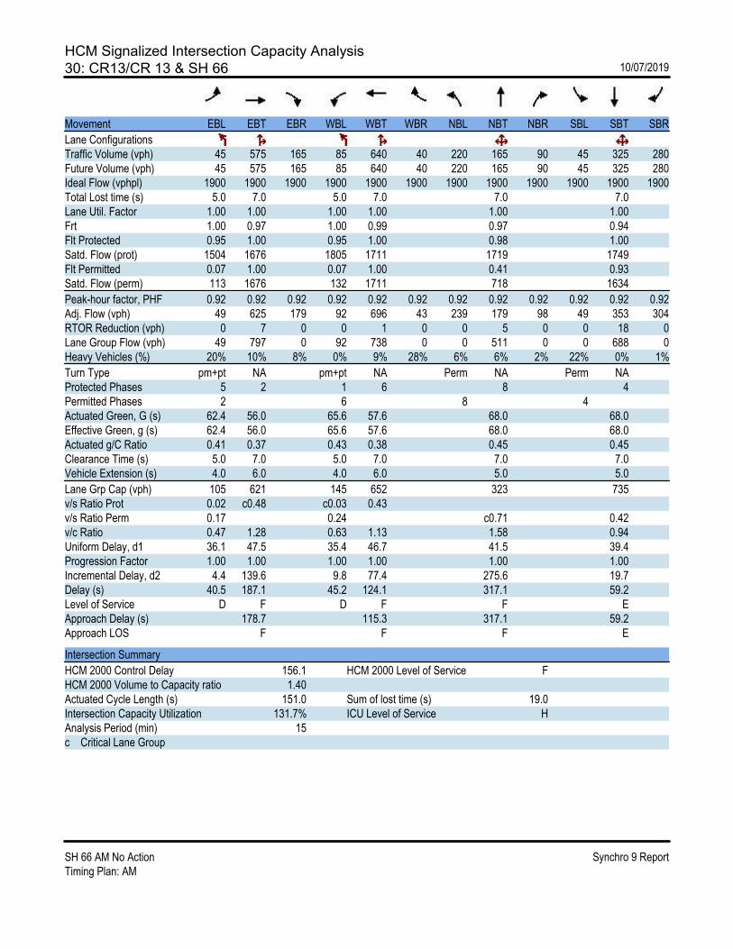
HCM Signalized Intersection Capacity Analysis30: CR13/CR 13 & SH 66 10/07/2019
SH 66 AM No Action Synchro 9 ReportTiming Plan: AM
Movement EBL EBT EBR WBL WBT WBR NBL NBT NBR SBL SBT SBR
Lane ConfigurationsTraffic Volume (vph) 45 575 165 85 640 40 220 165 90 45 325 280Future Volume (vph) 45 575 165 85 640 40 220 165 90 45 325 280Ideal Flow (vphpl) 1900 1900 1900 1900 1900 1900 1900 1900 1900 1900 1900 1900Total Lost time (s) 5.0 7.0 5.0 7.0 7.0 7.0Lane Util. Factor 1.00 1.00 1.00 1.00 1.00 1.00Frt 1.00 0.97 1.00 0.99 0.97 0.94Flt Protected 0.95 1.00 0.95 1.00 0.98 1.00Satd. Flow (prot) 1504 1676 1805 1711 1719 1749Flt Permitted 0.07 1.00 0.07 1.00 0.41 0.93Satd. Flow (perm) 113 1676 132 1711 718 1634
Peak-hour factor, PHF 0.92 0.92 0.92 0.92 0.92 0.92 0.92 0.92 0.92 0.92 0.92 0.92Adj. Flow (vph) 49 625 179 92 696 43 239 179 98 49 353 304RTOR Reduction (vph) 0 7 0 0 1 0 0 5 0 0 18 0Lane Group Flow (vph) 49 797 0 92 738 0 0 511 0 0 688 0Heavy Vehicles (%) 20% 10% 8% 0% 9% 28% 6% 6% 2% 22% 0% 1%
Turn Type pm+pt NA pm+pt NA Perm NA Perm NAProtected Phases 5 2 1 6 8 4Permitted Phases 2 6 8 4Actuated Green, G (s) 62.4 56.0 65.6 57.6 68.0 68.0Effective Green, g (s) 62.4 56.0 65.6 57.6 68.0 68.0Actuated g/C Ratio 0.41 0.37 0.43 0.38 0.45 0.45Clearance Time (s) 5.0 7.0 5.0 7.0 7.0 7.0Vehicle Extension (s) 4.0 6.0 4.0 6.0 5.0 5.0
Lane Grp Cap (vph) 105 621 145 652 323 735v/s Ratio Prot 0.02 c0.48 c0.03 0.43v/s Ratio Perm 0.17 0.24 c0.71 0.42v/c Ratio 0.47 1.28 0.63 1.13 1.58 0.94Uniform Delay, d1 36.1 47.5 35.4 46.7 41.5 39.4Progression Factor 1.00 1.00 1.00 1.00 1.00 1.00Incremental Delay, d2 4.4 139.6 9.8 77.4 275.6 19.7Delay (s) 40.5 187.1 45.2 124.1 317.1 59.2Level of Service D F D F F EApproach Delay (s) 178.7 115.3 317.1 59.2Approach LOS F F F E
Intersection Summary
HCM 2000 Control Delay 156.1 HCM 2000 Level of Service FHCM 2000 Volume to Capacity ratio 1.40Actuated Cycle Length (s) 151.0 Sum of lost time (s) 19.0Intersection Capacity Utilization 131.7% ICU Level of Service HAnalysis Period (min) 15c Critical Lane Group

HCM 6th TWSC31: SH 66 & CR 17 (North Fork) 10/07/2019
SH 66 AM No Action Synchro 9 ReportTiming Plan: AM
Intersection
Int Delay, s/veh 3.5
Movement EBL EBT WBT WBR SBL SBR
Lane ConfigurationsTraffic Vol, veh/h 50 660 605 20 20 160Future Vol, veh/h 50 660 605 20 20 160Conflicting Peds, #/hr 0 0 0 0 0 0Sign Control Free Free Free Free Stop StopRT Channelized - None - None - NoneStorage Length 525 - - 550 0 -Veh in Median Storage, # - 0 0 - 0 -Grade, % - 0 0 - 0 -Peak Hour Factor 92 92 92 92 92 92Heavy Vehicles, % 0 10 11 46 13 0Mvmt Flow 54 717 658 22 22 174
Major/Minor Major1 Major2 Minor2
Conflicting Flow All 680 0 - 0 1483 658 Stage 1 - - - - 658 - Stage 2 - - - - 825 -Critical Hdwy 4.1 - - - 6.53 6.2Critical Hdwy Stg 1 - - - - 5.53 -Critical Hdwy Stg 2 - - - - 5.53 -Follow-up Hdwy 2.2 - - - 3.617 3.3Pot Cap-1 Maneuver 922 - - - 130 468 Stage 1 - - - - 495 - Stage 2 - - - - 412 -Platoon blocked, % - - -Mov Cap-1 Maneuver 922 - - - 122 468Mov Cap-2 Maneuver - - - - 122 - Stage 1 - - - - 466 - Stage 2 - - - - 412 -
Approach EB WB SB
HCM Control Delay, s 0.6 0 26.8HCM LOS D
Minor Lane/Major Mvmt EBL EBT WBT WBR SBLn1
Capacity (veh/h) 922 - - - 356HCM Lane V/C Ratio 0.059 - - - 0.55HCM Control Delay (s) 9.1 - - - 26.8HCM Lane LOS A - - - DHCM 95th %tile Q(veh) 0.2 - - - 3.2

HCM 6th TWSC32: CR 17 & SH 66 10/07/2019
SH 66 AM No Action Synchro 9 ReportTiming Plan: AM
Intersection
Int Delay, s/veh 2.7
Movement EBT EBR WBL WBT NBL NBR
Lane ConfigurationsTraffic Vol, veh/h 655 25 5 550 75 5Future Vol, veh/h 655 25 5 550 75 5Conflicting Peds, #/hr 0 0 0 0 0 0Sign Control Free Free Free Free Stop StopRT Channelized - None - None - NoneStorage Length - - - - 0 -Veh in Median Storage, # 0 - - 0 0 -Grade, % 0 - - 0 0 -Peak Hour Factor 92 92 92 92 92 92Heavy Vehicles, % 10 0 0 14 0 0Mvmt Flow 712 27 5 598 82 5
Major/Minor Major1 Major2 Minor1
Conflicting Flow All 0 0 739 0 1334 726 Stage 1 - - - - 726 - Stage 2 - - - - 608 -Critical Hdwy - - 4.1 - 6.4 6.2Critical Hdwy Stg 1 - - - - 5.4 -Critical Hdwy Stg 2 - - - - 5.4 -Follow-up Hdwy - - 2.2 - 3.5 3.3Pot Cap-1 Maneuver - - 876 - 171 428 Stage 1 - - - - 483 - Stage 2 - - - - 547 -Platoon blocked, % - - -Mov Cap-1 Maneuver - - 876 - 169 428Mov Cap-2 Maneuver - - - - 169 - Stage 1 - - - - 479 - Stage 2 - - - - 547 -
Approach EB WB NB
HCM Control Delay, s 0 0.1 43.9HCM LOS E
Minor Lane/Major Mvmt NBLn1 EBT EBR WBL WBT
Capacity (veh/h) 176 - - 876 -HCM Lane V/C Ratio 0.494 - - 0.006 -HCM Control Delay (s) 43.9 - - 9.1 0HCM Lane LOS E - - A AHCM 95th %tile Q(veh) 2.4 - - 0 -
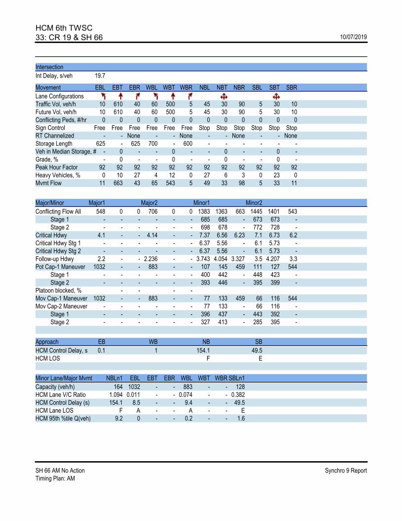
HCM 6th TWSC33: CR 19 & SH 66 10/07/2019
SH 66 AM No Action Synchro 9 ReportTiming Plan: AM
Intersection
Int Delay, s/veh 19.7
Movement EBL EBT EBR WBL WBT WBR NBL NBT NBR SBL SBT SBR
Lane ConfigurationsTraffic Vol, veh/h 10 610 40 60 500 5 45 30 90 5 30 10Future Vol, veh/h 10 610 40 60 500 5 45 30 90 5 30 10Conflicting Peds, #/hr 0 0 0 0 0 0 0 0 0 0 0 0Sign Control Free Free Free Free Free Free Stop Stop Stop Stop Stop StopRT Channelized - - None - - None - - None - - NoneStorage Length 625 - 625 700 - 600 - - - - - -Veh in Median Storage, # - 0 - - 0 - - 0 - - 0 -Grade, % - 0 - - 0 - - 0 - - 0 -Peak Hour Factor 92 92 92 92 92 92 92 92 92 92 92 92Heavy Vehicles, % 0 10 27 4 12 0 27 6 3 0 23 0Mvmt Flow 11 663 43 65 543 5 49 33 98 5 33 11
Major/Minor Major1 Major2 Minor1 Minor2
Conflicting Flow All 548 0 0 706 0 0 1383 1363 663 1445 1401 543 Stage 1 - - - - - - 685 685 - 673 673 - Stage 2 - - - - - - 698 678 - 772 728 -Critical Hdwy 4.1 - - 4.14 - - 7.37 6.56 6.23 7.1 6.73 6.2Critical Hdwy Stg 1 - - - - - - 6.37 5.56 - 6.1 5.73 -Critical Hdwy Stg 2 - - - - - - 6.37 5.56 - 6.1 5.73 -Follow-up Hdwy 2.2 - - 2.236 - - 3.743 4.054 3.327 3.5 4.207 3.3Pot Cap-1 Maneuver 1032 - - 883 - - 107 145 459 111 127 544 Stage 1 - - - - - - 400 442 - 448 423 - Stage 2 - - - - - - 393 446 - 395 399 -Platoon blocked, % - - - -Mov Cap-1 Maneuver 1032 - - 883 - - 77 133 459 66 116 544Mov Cap-2 Maneuver - - - - - - 77 133 - 66 116 - Stage 1 - - - - - - 396 437 - 443 392 - Stage 2 - - - - - - 327 413 - 285 395 -
Approach EB WB NB SB
HCM Control Delay, s 0.1 1 154.1 49.5HCM LOS F E
Minor Lane/Major Mvmt NBLn1 EBL EBT EBR WBL WBT WBR SBLn1
Capacity (veh/h) 164 1032 - - 883 - - 128HCM Lane V/C Ratio 1.094 0.011 - - 0.074 - - 0.382HCM Control Delay (s) 154.1 8.5 - - 9.4 - - 49.5HCM Lane LOS F A - - A - - EHCM 95th %tile Q(veh) 9.2 0 - - 0.2 - - 1.6

SH 66 Access Control Plan | Final Report
F.2. 2040 PM No Action


HCM 6th Signalized Intersection Summary1: McConnell Dr/Stone Canyon Dr & SH 66 10/07/2019
SH 66 PM No Action Synchro 9 ReportTiming Plan: PM
Movement SEL SET SER NWL NWT NWR NEL NET NER SWL SWT SWR
Lane ConfigurationsTraffic Volume (veh/h) 30 990 15 110 885 40 15 10 95 30 10 30Future Volume (veh/h) 30 990 15 110 885 40 15 10 95 30 10 30Initial Q (Qb), veh 0 0 0 0 0 0 0 0 0 0 0 0Ped-Bike Adj(A_pbT) 1.00 1.00 1.00 1.00 1.00 1.00 1.00 1.00Parking Bus, Adj 1.00 1.00 1.00 1.00 1.00 1.00 1.00 1.00 1.00 1.00 1.00 1.00Work Zone On Approach No No No NoAdj Sat Flow, veh/h/ln 1870 1826 1870 1870 1826 1870 1870 1870 1870 1870 1870 1870Adj Flow Rate, veh/h 33 1076 16 120 962 43 16 11 103 33 11 33Peak Hour Factor 0.92 0.92 0.92 0.92 0.92 0.92 0.92 0.92 0.92 0.92 0.92 0.92Percent Heavy Veh, % 2 5 2 2 5 2 2 2 2 2 2 2Cap, veh/h 314 938 429 483 1954 893 358 26 242 293 68 205Arrive On Green 0.27 0.27 0.27 0.18 0.56 0.56 0.17 0.17 0.17 0.17 0.17 0.17Sat Flow, veh/h 561 3469 1585 1781 3469 1585 1362 155 1454 1279 412 1236
Grp Volume(v), veh/h 33 1076 16 120 962 43 16 0 114 33 0 44Grp Sat Flow(s),veh/h/ln 561 1735 1585 1781 1735 1585 1362 0 1609 1279 0 1648Q Serve(g_s), s 2.0 12.0 0.3 1.6 7.4 0.5 0.5 0.0 2.8 1.1 0.0 1.0Cycle Q Clear(g_c), s 2.0 12.0 0.3 1.6 7.4 0.5 1.5 0.0 2.8 3.9 0.0 1.0Prop In Lane 1.00 1.00 1.00 1.00 1.00 0.90 1.00 0.75Lane Grp Cap(c), veh/h 314 938 429 483 1954 893 358 0 267 293 0 274V/C Ratio(X) 0.11 1.15 0.04 0.25 0.49 0.05 0.04 0.00 0.43 0.11 0.00 0.16Avail Cap(c_a), veh/h 314 938 429 483 1954 893 377 0 290 311 0 297HCM Platoon Ratio 1.00 1.00 1.00 1.00 1.00 1.00 1.00 1.00 1.00 1.00 1.00 1.00Upstream Filter(I) 1.00 1.00 1.00 1.00 1.00 1.00 1.00 0.00 1.00 1.00 0.00 1.00Uniform Delay (d), s/veh 12.5 16.2 11.9 8.3 5.9 4.3 16.5 0.0 16.6 18.3 0.0 15.8Incr Delay (d2), s/veh 0.2 78.7 0.1 0.3 0.3 0.0 0.1 0.0 1.5 0.2 0.0 0.4Initial Q Delay(d3),s/veh 0.0 0.0 0.0 0.0 0.0 0.0 0.0 0.0 0.0 0.0 0.0 0.0%ile BackOfQ(50%),veh/ln 0.2 13.6 0.1 0.3 1.1 0.1 0.1 0.0 1.0 0.3 0.0 0.4Unsig. Movement Delay, s/vehLnGrp Delay(d),s/veh 12.8 94.9 12.0 8.5 6.1 4.4 16.5 0.0 18.1 18.6 0.0 16.2LnGrp LOS B F B A A A B A B B A B
Approach Vol, veh/h 1125 1125 130 77Approach Delay, s/veh 91.3 6.3 17.9 17.2Approach LOS F A B B
Timer - Assigned Phs 1 2 4 6 8
Phs Duration (G+Y+Rc), s 13.0 18.0 13.4 31.0 13.4Change Period (Y+Rc), s 5.0 6.0 6.0 6.0 6.0Max Green Setting (Gmax), s 8.0 12.0 8.0 25.0 8.0Max Q Clear Time (g_c+I1), s 3.6 14.0 5.9 9.4 4.8Green Ext Time (p_c), s 0.1 0.0 0.1 7.4 0.2
Intersection Summary
HCM 6th Ctrl Delay 46.2HCM 6th LOS D
Notes
User approved pedestrian interval to be less than phase max green.

HCM Signalized Intersection Capacity Analysis2: US 36 & SH 66 10/07/2019
SH 66 PM No Action Synchro 9 ReportTiming Plan: PM
Movement EBL EBT EBR WBL WBT WBR NBL NBT NBR SBL SBT SBR
Lane ConfigurationsTraffic Volume (vph) 25 340 360 60 490 30 490 35 365 40 50 60Future Volume (vph) 25 340 360 60 490 30 490 35 365 40 50 60Ideal Flow (vphpl) 1900 1900 1900 1900 1900 1900 1900 1900 1900 1900 1900 1900Total Lost time (s) 6.0 6.0 6.0 6.0 6.0 6.0 6.0 6.0 6.0Lane Util. Factor 1.00 0.95 1.00 1.00 0.95 0.95 0.95 1.00 1.00Frt 1.00 1.00 0.85 1.00 0.99 1.00 1.00 0.85 0.95Flt Protected 0.95 1.00 1.00 0.95 1.00 0.95 0.96 1.00 0.99Satd. Flow (prot) 1624 3185 1425 1593 3104 1442 1468 1358 1596Flt Permitted 0.34 1.00 1.00 0.52 1.00 0.95 0.96 1.00 0.99Satd. Flow (perm) 589 3185 1425 874 3104 1442 1468 1358 1596
Peak-hour factor, PHF 0.92 0.92 0.92 0.92 0.92 0.92 0.92 0.92 0.92 0.92 0.92 0.92Adj. Flow (vph) 27 370 391 65 533 33 533 38 397 43 54 65RTOR Reduction (vph) 0 0 281 0 5 0 0 0 224 0 27 0Lane Group Flow (vph) 27 370 110 65 561 0 282 289 173 0 135 0Heavy Vehicles (%) 0% 2% 2% 2% 4% 0% 7% 0% 7% 0% 0% 0%
Turn Type Perm NA Perm Perm NA Split NA Perm Split NAProtected Phases 2 6 4 4 8 8Permitted Phases 2 2 6 4Actuated Green, G (s) 20.6 20.6 20.6 20.6 20.6 22.6 22.6 22.6 12.1Effective Green, g (s) 20.6 20.6 20.6 20.6 20.6 22.6 22.6 22.6 12.1Actuated g/C Ratio 0.28 0.28 0.28 0.28 0.28 0.31 0.31 0.31 0.17Clearance Time (s) 6.0 6.0 6.0 6.0 6.0 6.0 6.0 6.0 6.0Vehicle Extension (s) 4.0 4.0 4.0 4.0 4.0 4.0 4.0 4.0 4.0
Lane Grp Cap (vph) 165 895 400 245 872 444 452 418 263v/s Ratio Prot 0.12 c0.18 0.20 c0.20 c0.08v/s Ratio Perm 0.05 0.08 0.07 0.13v/c Ratio 0.16 0.41 0.27 0.27 0.64 0.64 0.64 0.41 0.51Uniform Delay, d1 19.9 21.4 20.5 20.5 23.1 21.8 21.8 20.1 27.9Progression Factor 1.00 1.00 1.00 1.00 1.00 1.00 1.00 1.00 1.00Incremental Delay, d2 0.6 0.4 0.5 0.8 1.8 3.3 3.3 0.9 2.3Delay (s) 20.5 21.9 21.0 21.3 25.0 25.1 25.2 21.0 30.2Level of Service C C C C C C C C CApproach Delay (s) 21.4 24.6 23.5 30.2Approach LOS C C C C
Intersection Summary
HCM 2000 Control Delay 23.5 HCM 2000 Level of Service CHCM 2000 Volume to Capacity ratio 0.61Actuated Cycle Length (s) 73.3 Sum of lost time (s) 18.0Intersection Capacity Utilization 62.2% ICU Level of Service BAnalysis Period (min) 15c Critical Lane Group
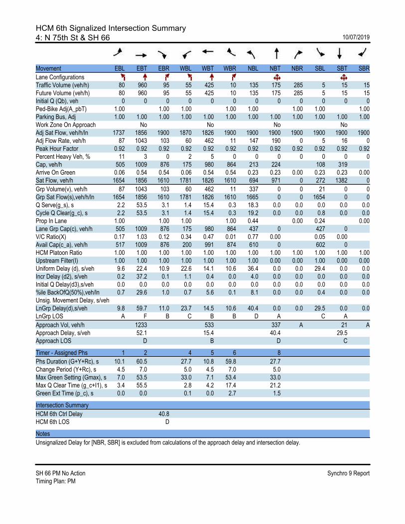
HCM 6th Signalized Intersection Summary4: N 75th St & SH 66 10/07/2019
SH 66 PM No Action Synchro 9 ReportTiming Plan: PM
Movement EBL EBT EBR WBL WBT WBR NBL NBT NBR SBL SBT SBR
Lane ConfigurationsTraffic Volume (veh/h) 80 960 95 55 425 10 135 175 285 5 15 15Future Volume (veh/h) 80 960 95 55 425 10 135 175 285 5 15 15Initial Q (Qb), veh 0 0 0 0 0 0 0 0 0 0 0 0Ped-Bike Adj(A_pbT) 1.00 1.00 1.00 1.00 1.00 1.00 1.00 1.00Parking Bus, Adj 1.00 1.00 1.00 1.00 1.00 1.00 1.00 1.00 1.00 1.00 1.00 1.00Work Zone On Approach No No No NoAdj Sat Flow, veh/h/ln 1737 1856 1900 1870 1826 1900 1900 1900 1900 1900 1900 1900Adj Flow Rate, veh/h 87 1043 103 60 462 11 147 190 0 5 16 0Peak Hour Factor 0.92 0.92 0.92 0.92 0.92 0.92 0.92 0.92 0.92 0.92 0.92 0.92Percent Heavy Veh, % 11 3 0 2 5 0 0 0 0 0 0 0Cap, veh/h 505 1009 876 175 980 864 213 224 108 319Arrive On Green 0.06 0.54 0.54 0.06 0.54 0.54 0.23 0.23 0.00 0.23 0.23 0.00Sat Flow, veh/h 1654 1856 1610 1781 1826 1610 694 971 0 272 1382 0
Grp Volume(v), veh/h 87 1043 103 60 462 11 337 0 0 21 0 0Grp Sat Flow(s),veh/h/ln 1654 1856 1610 1781 1826 1610 1665 0 0 1654 0 0Q Serve(g_s), s 2.2 53.5 3.1 1.4 15.4 0.3 18.3 0.0 0.0 0.0 0.0 0.0Cycle Q Clear(g_c), s 2.2 53.5 3.1 1.4 15.4 0.3 19.2 0.0 0.0 0.8 0.0 0.0Prop In Lane 1.00 1.00 1.00 1.00 0.44 0.00 0.24 0.00Lane Grp Cap(c), veh/h 505 1009 876 175 980 864 437 0 427 0V/C Ratio(X) 0.17 1.03 0.12 0.34 0.47 0.01 0.77 0.00 0.05 0.00Avail Cap(c_a), veh/h 517 1009 876 200 991 874 610 0 602 0HCM Platoon Ratio 1.00 1.00 1.00 1.00 1.00 1.00 1.00 1.00 1.00 1.00 1.00 1.00Upstream Filter(I) 1.00 1.00 1.00 1.00 1.00 1.00 1.00 0.00 0.00 1.00 0.00 0.00Uniform Delay (d), s/veh 9.6 22.4 10.9 22.6 14.1 10.6 36.4 0.0 0.0 29.4 0.0 0.0Incr Delay (d2), s/veh 0.2 37.2 0.1 1.1 0.4 0.0 4.0 0.0 0.0 0.0 0.0 0.0Initial Q Delay(d3),s/veh 0.0 0.0 0.0 0.0 0.0 0.0 0.0 0.0 0.0 0.0 0.0 0.0%ile BackOfQ(50%),veh/ln 0.7 29.6 1.0 0.7 5.6 0.1 8.1 0.0 0.0 0.4 0.0 0.0Unsig. Movement Delay, s/vehLnGrp Delay(d),s/veh 9.8 59.7 11.0 23.7 14.5 10.6 40.4 0.0 0.0 29.5 0.0 0.0LnGrp LOS A F B C B B D A C A
Approach Vol, veh/h 1233 533 337 A 21 AApproach Delay, s/veh 52.1 15.4 40.4 29.5Approach LOS D B D C
Timer - Assigned Phs 1 2 4 5 6 8
Phs Duration (G+Y+Rc), s 10.1 60.5 27.7 10.8 59.8 27.7Change Period (Y+Rc), s 4.5 7.0 5.0 4.5 7.0 5.0Max Green Setting (Gmax), s 7.0 53.5 33.0 7.1 53.4 33.0Max Q Clear Time (g_c+I1), s 3.4 55.5 2.8 4.2 17.4 21.2Green Ext Time (p_c), s 0.0 0.0 0.1 0.0 2.7 1.5
Intersection Summary
HCM 6th Ctrl Delay 40.8HCM 6th LOS D
Notes
Unsignalized Delay for [NBR, SBR] is excluded from calculations of the approach delay and intersection delay.
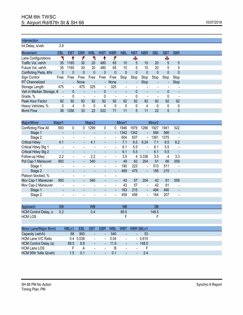
HCM 6th TWSC5: Airport Rd/87th St & SH 66 10/07/2019
SH 66 PM No Action Synchro 9 ReportTiming Plan: PM
Intersection
Int Delay, s/veh 3.9
Movement EBL EBT EBR WBL WBT WBR NBL NBT NBR SBL SBT SBR
Lane ConfigurationsTraffic Vol, veh/h 35 1165 30 20 480 65 10 5 10 20 5 5Future Vol, veh/h 35 1165 30 20 480 65 10 5 10 20 5 5Conflicting Peds, #/hr 0 0 0 0 0 0 0 0 0 0 0 0Sign Control Free Free Free Free Free Free Stop Stop Stop Stop Stop StopRT Channelized - - None - - None - - Stop - - StopStorage Length 475 - 475 325 - 325 - - - - - -Veh in Median Storage, # - 0 - - 0 - - 0 - - 0 -Grade, % - 0 - - 0 - - 0 - - 0 -Peak Hour Factor 92 92 92 92 92 92 92 92 92 92 92 92Heavy Vehicles, % 0 4 0 0 4 0 0 0 4 0 0 0Mvmt Flow 38 1266 33 22 522 71 11 5 11 22 5 5
Major/Minor Major1 Major2 Minor1 Minor2
Conflicting Flow All 593 0 0 1299 0 0 1946 1979 1266 1927 1941 522 Stage 1 - - - - - - 1342 1342 - 566 566 - Stage 2 - - - - - - 604 637 - 1361 1375 -Critical Hdwy 4.1 - - 4.1 - - 7.1 6.5 6.24 7.1 6.5 6.2Critical Hdwy Stg 1 - - - - - - 6.1 5.5 - 6.1 5.5 -Critical Hdwy Stg 2 - - - - - - 6.1 5.5 - 6.1 5.5 -Follow-up Hdwy 2.2 - - 2.2 - - 3.5 4 3.336 3.5 4 3.3Pot Cap-1 Maneuver 993 - - 540 - - 49 62 204 51 66 559 Stage 1 - - - - - - 190 223 - 513 511 - Stage 2 - - - - - - 489 475 - 185 215 -Platoon blocked, % - - - -Mov Cap-1 Maneuver 993 - - 540 - - 43 57 204 42 61 559Mov Cap-2 Maneuver - - - - - - 43 57 - 42 61 - Stage 1 - - - - - - 183 215 - 494 490 - Stage 2 - - - - - - 459 456 - 164 207 -
Approach EB WB NB SB
HCM Control Delay, s 0.2 0.4 89.5 148.5HCM LOS F F
Minor Lane/Major Mvmt NBLn1 EBL EBT EBR WBL WBT WBR SBLn1
Capacity (veh/h) 68 993 - - 540 - - 53HCM Lane V/C Ratio 0.4 0.038 - - 0.04 - - 0.615HCM Control Delay (s) 89.5 8.8 - - 11.9 - - 148.5HCM Lane LOS F A - - B - - FHCM 95th %tile Q(veh) 1.5 0.1 - - 0.1 - - 2.4
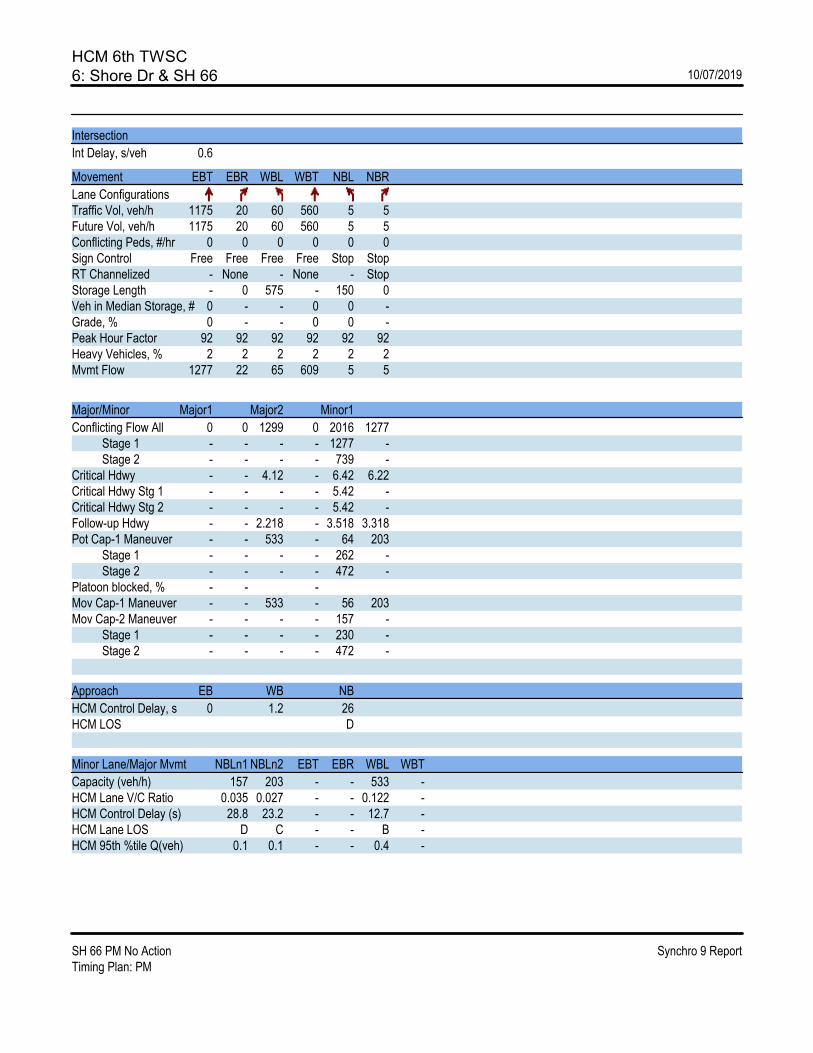
HCM 6th TWSC6: Shore Dr & SH 66 10/07/2019
SH 66 PM No Action Synchro 9 ReportTiming Plan: PM
Intersection
Int Delay, s/veh 0.6
Movement EBT EBR WBL WBT NBL NBR
Lane ConfigurationsTraffic Vol, veh/h 1175 20 60 560 5 5Future Vol, veh/h 1175 20 60 560 5 5Conflicting Peds, #/hr 0 0 0 0 0 0Sign Control Free Free Free Free Stop StopRT Channelized - None - None - StopStorage Length - 0 575 - 150 0Veh in Median Storage, # 0 - - 0 0 -Grade, % 0 - - 0 0 -Peak Hour Factor 92 92 92 92 92 92Heavy Vehicles, % 2 2 2 2 2 2Mvmt Flow 1277 22 65 609 5 5
Major/Minor Major1 Major2 Minor1
Conflicting Flow All 0 0 1299 0 2016 1277 Stage 1 - - - - 1277 - Stage 2 - - - - 739 -Critical Hdwy - - 4.12 - 6.42 6.22Critical Hdwy Stg 1 - - - - 5.42 -Critical Hdwy Stg 2 - - - - 5.42 -Follow-up Hdwy - - 2.218 - 3.518 3.318Pot Cap-1 Maneuver - - 533 - 64 203 Stage 1 - - - - 262 - Stage 2 - - - - 472 -Platoon blocked, % - - -Mov Cap-1 Maneuver - - 533 - 56 203Mov Cap-2 Maneuver - - - - 157 - Stage 1 - - - - 230 - Stage 2 - - - - 472 -
Approach EB WB NB
HCM Control Delay, s 0 1.2 26HCM LOS D
Minor Lane/Major Mvmt NBLn1 NBLn2 EBT EBR WBL WBT
Capacity (veh/h) 157 203 - - 533 -HCM Lane V/C Ratio 0.035 0.027 - - 0.122 -HCM Control Delay (s) 28.8 23.2 - - 12.7 -HCM Lane LOS D C - - B -HCM 95th %tile Q(veh) 0.1 0.1 - - 0.4 -

HCM 6th TWSC7: SH 66 & Anhawa Ave 10/07/2019
SH 66 PM No Action Synchro 9 ReportTiming Plan: PM
Intersection
Int Delay, s/veh 0.8
Movement EBL EBT WBT WBR SBL SBR
Lane ConfigurationsTraffic Vol, veh/h 5 1195 615 30 15 5Future Vol, veh/h 5 1195 615 30 15 5Conflicting Peds, #/hr 0 0 0 0 0 0Sign Control Free Free Free Free Stop StopRT Channelized - None - None - NoneStorage Length 200 - - - 0 -Veh in Median Storage, # - 0 0 - 0 -Grade, % - 0 0 - 0 -Peak Hour Factor 92 92 92 92 92 92Heavy Vehicles, % 0 3 4 25 25 0Mvmt Flow 5 1299 668 33 16 5
Major/Minor Major1 Major2 Minor2
Conflicting Flow All 701 0 - 0 1994 685 Stage 1 - - - - 685 - Stage 2 - - - - 1309 -Critical Hdwy 4.1 - - - 6.65 6.2Critical Hdwy Stg 1 - - - - 5.65 -Critical Hdwy Stg 2 - - - - 5.65 -Follow-up Hdwy 2.2 - - - 3.725 3.3Pot Cap-1 Maneuver 905 - - - 57 452 Stage 1 - - - - 460 - Stage 2 - - - - 226 -Platoon blocked, % - - -Mov Cap-1 Maneuver 905 - - - 57 452Mov Cap-2 Maneuver - - - - 57 - Stage 1 - - - - 457 - Stage 2 - - - - 226 -
Approach EB WB SB
HCM Control Delay, s 0 0 74HCM LOS F
Minor Lane/Major Mvmt EBL EBT WBT WBR SBLn1
Capacity (veh/h) 905 - - - 73HCM Lane V/C Ratio 0.006 - - - 0.298HCM Control Delay (s) 9 - - - 74HCM Lane LOS A - - - FHCM 95th %tile Q(veh) 0 - - - 1.1
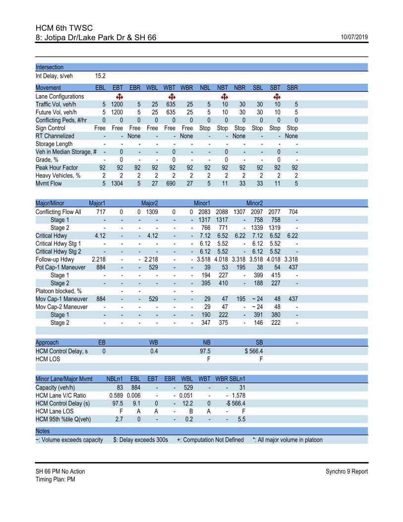
HCM 6th TWSC8: Jotipa Dr/Lake Park Dr & SH 66 10/07/2019
SH 66 PM No Action Synchro 9 ReportTiming Plan: PM
Intersection
Int Delay, s/veh 15.2
Movement EBL EBT EBR WBL WBT WBR NBL NBT NBR SBL SBT SBR
Lane ConfigurationsTraffic Vol, veh/h 5 1200 5 25 635 25 5 10 30 30 10 5Future Vol, veh/h 5 1200 5 25 635 25 5 10 30 30 10 5Conflicting Peds, #/hr 0 0 0 0 0 0 0 0 0 0 0 0Sign Control Free Free Free Free Free Free Stop Stop Stop Stop Stop StopRT Channelized - - None - - None - - None - - NoneStorage Length - - - - - - - - - - - -Veh in Median Storage, # - 0 - - 0 - - 0 - - 0 -Grade, % - 0 - - 0 - - 0 - - 0 -Peak Hour Factor 92 92 92 92 92 92 92 92 92 92 92 92Heavy Vehicles, % 2 2 2 2 2 2 2 2 2 2 2 2Mvmt Flow 5 1304 5 27 690 27 5 11 33 33 11 5
Major/Minor Major1 Major2 Minor1 Minor2
Conflicting Flow All 717 0 0 1309 0 0 2083 2088 1307 2097 2077 704 Stage 1 - - - - - - 1317 1317 - 758 758 - Stage 2 - - - - - - 766 771 - 1339 1319 -Critical Hdwy 4.12 - - 4.12 - - 7.12 6.52 6.22 7.12 6.52 6.22Critical Hdwy Stg 1 - - - - - - 6.12 5.52 - 6.12 5.52 -Critical Hdwy Stg 2 - - - - - - 6.12 5.52 - 6.12 5.52 -Follow-up Hdwy 2.218 - - 2.218 - - 3.518 4.018 3.318 3.518 4.018 3.318Pot Cap-1 Maneuver 884 - - 529 - - 39 53 195 38 54 437 Stage 1 - - - - - - 194 227 - 399 415 - Stage 2 - - - - - - 395 410 - 188 227 -Platoon blocked, % - - - -Mov Cap-1 Maneuver 884 - - 529 - - 29 47 195 ~ 24 48 437Mov Cap-2 Maneuver - - - - - - 29 47 - ~ 24 48 - Stage 1 - - - - - - 190 222 - 391 380 - Stage 2 - - - - - - 347 375 - 146 222 -
Approach EB WB NB SB
HCM Control Delay, s 0 0.4 97.5 $ 566.4HCM LOS F F
Minor Lane/Major Mvmt NBLn1 EBL EBT EBR WBL WBT WBR SBLn1
Capacity (veh/h) 83 884 - - 529 - - 31HCM Lane V/C Ratio 0.589 0.006 - - 0.051 - - 1.578HCM Control Delay (s) 97.5 9.1 0 - 12.2 0 -$ 566.4HCM Lane LOS F A A - B A - FHCM 95th %tile Q(veh) 2.7 0 - - 0.2 - - 5.5
Notes
~: Volume exceeds capacity $: Delay exceeds 300s +: Computation Not Defined *: All major volume in platoon
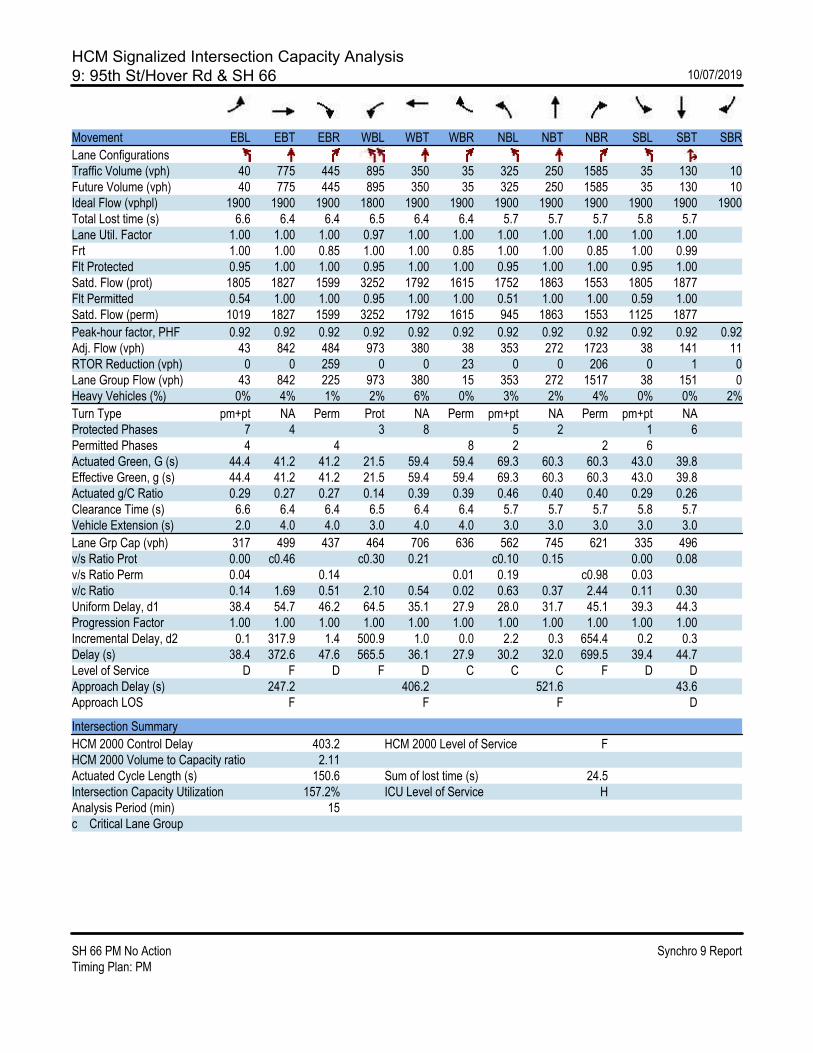
HCM Signalized Intersection Capacity Analysis9: 95th St/Hover Rd & SH 66 10/07/2019
SH 66 PM No Action Synchro 9 ReportTiming Plan: PM
Movement EBL EBT EBR WBL WBT WBR NBL NBT NBR SBL SBT SBR
Lane ConfigurationsTraffic Volume (vph) 40 775 445 895 350 35 325 250 1585 35 130 10Future Volume (vph) 40 775 445 895 350 35 325 250 1585 35 130 10Ideal Flow (vphpl) 1900 1900 1900 1800 1900 1900 1900 1900 1900 1900 1900 1900Total Lost time (s) 6.6 6.4 6.4 6.5 6.4 6.4 5.7 5.7 5.7 5.8 5.7Lane Util. Factor 1.00 1.00 1.00 0.97 1.00 1.00 1.00 1.00 1.00 1.00 1.00Frt 1.00 1.00 0.85 1.00 1.00 0.85 1.00 1.00 0.85 1.00 0.99Flt Protected 0.95 1.00 1.00 0.95 1.00 1.00 0.95 1.00 1.00 0.95 1.00Satd. Flow (prot) 1805 1827 1599 3252 1792 1615 1752 1863 1553 1805 1877Flt Permitted 0.54 1.00 1.00 0.95 1.00 1.00 0.51 1.00 1.00 0.59 1.00Satd. Flow (perm) 1019 1827 1599 3252 1792 1615 945 1863 1553 1125 1877
Peak-hour factor, PHF 0.92 0.92 0.92 0.92 0.92 0.92 0.92 0.92 0.92 0.92 0.92 0.92Adj. Flow (vph) 43 842 484 973 380 38 353 272 1723 38 141 11RTOR Reduction (vph) 0 0 259 0 0 23 0 0 206 0 1 0Lane Group Flow (vph) 43 842 225 973 380 15 353 272 1517 38 151 0Heavy Vehicles (%) 0% 4% 1% 2% 6% 0% 3% 2% 4% 0% 0% 2%
Turn Type pm+pt NA Perm Prot NA Perm pm+pt NA Perm pm+pt NAProtected Phases 7 4 3 8 5 2 1 6Permitted Phases 4 4 8 2 2 6Actuated Green, G (s) 44.4 41.2 41.2 21.5 59.4 59.4 69.3 60.3 60.3 43.0 39.8Effective Green, g (s) 44.4 41.2 41.2 21.5 59.4 59.4 69.3 60.3 60.3 43.0 39.8Actuated g/C Ratio 0.29 0.27 0.27 0.14 0.39 0.39 0.46 0.40 0.40 0.29 0.26Clearance Time (s) 6.6 6.4 6.4 6.5 6.4 6.4 5.7 5.7 5.7 5.8 5.7Vehicle Extension (s) 2.0 4.0 4.0 3.0 4.0 4.0 3.0 3.0 3.0 3.0 3.0
Lane Grp Cap (vph) 317 499 437 464 706 636 562 745 621 335 496v/s Ratio Prot 0.00 c0.46 c0.30 0.21 c0.10 0.15 0.00 0.08v/s Ratio Perm 0.04 0.14 0.01 0.19 c0.98 0.03v/c Ratio 0.14 1.69 0.51 2.10 0.54 0.02 0.63 0.37 2.44 0.11 0.30Uniform Delay, d1 38.4 54.7 46.2 64.5 35.1 27.9 28.0 31.7 45.1 39.3 44.3Progression Factor 1.00 1.00 1.00 1.00 1.00 1.00 1.00 1.00 1.00 1.00 1.00Incremental Delay, d2 0.1 317.9 1.4 500.9 1.0 0.0 2.2 0.3 654.4 0.2 0.3Delay (s) 38.4 372.6 47.6 565.5 36.1 27.9 30.2 32.0 699.5 39.4 44.7Level of Service D F D F D C C C F D DApproach Delay (s) 247.2 406.2 521.6 43.6Approach LOS F F F D
Intersection Summary
HCM 2000 Control Delay 403.2 HCM 2000 Level of Service FHCM 2000 Volume to Capacity ratio 2.11Actuated Cycle Length (s) 150.6 Sum of lost time (s) 24.5Intersection Capacity Utilization 157.2% ICU Level of Service HAnalysis Period (min) 15c Critical Lane Group

HCM 6th TWSC10: Spencer St & SH 66 10/07/2019
SH 66 PM No Action Synchro 9 ReportTiming Plan: PM
Intersection
Int Delay, s/veh 1.9
Movement EBL EBT EBR WBL WBT WBR NBL NBT NBR SBL SBT SBR
Lane ConfigurationsTraffic Vol, veh/h 5 2390 5 110 1275 5 5 0 45 5 0 5Future Vol, veh/h 5 2390 5 110 1275 5 5 0 45 5 0 5Conflicting Peds, #/hr 0 0 0 0 0 0 0 0 0 0 0 0Sign Control Free Free Free Free Free Free Stop Stop Stop Stop Stop StopRT Channelized - - None - - None - - None - - NoneStorage Length 150 - 0 150 - - - - 125 - - 75Veh in Median Storage, # - 0 - - 0 - - 0 - - 0 -Grade, % - 0 - - 0 - - 0 - - 0 -Peak Hour Factor 92 92 92 92 92 92 92 92 92 92 92 92Heavy Vehicles, % 2 2 2 2 2 2 2 2 2 2 2 2Mvmt Flow 5 2598 5 120 1386 5 5 0 49 5 0 5
Major/Minor Major1 Major2 Minor1 Minor2
Conflicting Flow All 1391 0 0 2603 0 0 4239 4239 2598 4264 4242 1389 Stage 1 - - - - - - 2608 2608 - 1629 1629 - Stage 2 - - - - - - 1631 1631 - 2635 2613 -Critical Hdwy 4.12 - - 4.12 - - 7.12 6.52 6.22 7.12 6.52 6.22Critical Hdwy Stg 1 - - - - - - 6.12 5.52 - 6.12 5.52 -Critical Hdwy Stg 2 - - - - - - 6.12 5.52 - 6.12 5.52 -Follow-up Hdwy 2.218 - - 2.218 - - 3.518 4.018 3.318 3.518 4.018 3.318Pot Cap-1 Maneuver 492 - - 166 - - ~ 1 2 ~ 32 ~ 1 2 175 Stage 1 - - - - - - 34 51 - 128 160 - Stage 2 - - - - - - 128 160 - 32 50 -Platoon blocked, % - - - -Mov Cap-1 Maneuver 492 - - 166 - - 0 1 ~ 32 - 1 175Mov Cap-2 Maneuver - - - - - - 0 1 - - 1 - Stage 1 - - - - - - 34 50 - 127 44 - Stage 2 - - - - - - 34 44 - - 50 -
Approach EB WB NB SB
HCM Control Delay, s 0 5.4HCM LOS - -
Minor Lane/Major Mvmt NBLn1 NBLn2 EBL EBT EBR WBL WBT WBR SBLn1 SBLn2
Capacity (veh/h) - 32 492 - - 166 - - - 175HCM Lane V/C Ratio - 1.529 0.011 - - 0.72 - - - 0.031HCM Control Delay (s) -$ 538.9 12.4 - - 68.6 - - - 26.2HCM Lane LOS - F B - - F - - - DHCM 95th %tile Q(veh) - 5.5 0 - - 4.4 - - - 0.1
Notes
~: Volume exceeds capacity $: Delay exceeds 300s +: Computation Not Defined *: All major volume in platoon
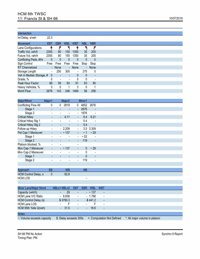
HCM 6th TWSC11: Francis St & SH 66 10/07/2019
SH 66 PM No Action Synchro 9 ReportTiming Plan: PM
Intersection
Int Delay, s/veh 22.3
Movement EBT EBR WBL WBT NBL NBR
Lane ConfigurationsTraffic Vol, veh/h 2355 80 155 1350 35 205Future Vol, veh/h 2355 80 155 1350 35 205Conflicting Peds, #/hr 0 0 0 0 0 0Sign Control Free Free Free Free Stop StopRT Channelized - None - None - NoneStorage Length - 250 300 - 275 0Veh in Median Storage, # 0 - - 0 0 -Grade, % 0 - - 0 0 -Peak Hour Factor 88 56 63 91 63 80Heavy Vehicles, % 3 0 1 3 0 1Mvmt Flow 2676 143 246 1484 56 256
Major/Minor Major1 Major2 Minor1
Conflicting Flow All 0 0 2819 0 4652 2676 Stage 1 - - - - 2676 - Stage 2 - - - - 1976 -Critical Hdwy - - 4.11 - 6.4 6.21Critical Hdwy Stg 1 - - - - 5.4 -Critical Hdwy Stg 2 - - - - 5.4 -Follow-up Hdwy - - 2.209 - 3.5 3.309Pot Cap-1 Maneuver - - ~ 137 - ~ 1 ~ 29 Stage 1 - - - - ~ 52 - Stage 2 - - - - 119 -Platoon blocked, % - - -Mov Cap-1 Maneuver - - ~ 137 - 0 ~ 29Mov Cap-2 Maneuver - - - - 0 - Stage 1 - - - - 0 - Stage 2 - - - - 119 -
Approach EB WB NB
HCM Control Delay, s 0 62.8HCM LOS -
Minor Lane/Major Mvmt NBLn1 NBLn2 EBT EBR WBL WBT
Capacity (veh/h) - 29 - - ~ 137 -HCM Lane V/C Ratio - 8.836 - - 1.796 -HCM Control Delay (s) -$ 3790.3 - -$ 441.2 -HCM Lane LOS - F - - F -HCM 95th %tile Q(veh) - 31.5 - - 18.6 -
Notes
~: Volume exceeds capacity $: Delay exceeds 300s +: Computation Not Defined *: All major volume in platoon
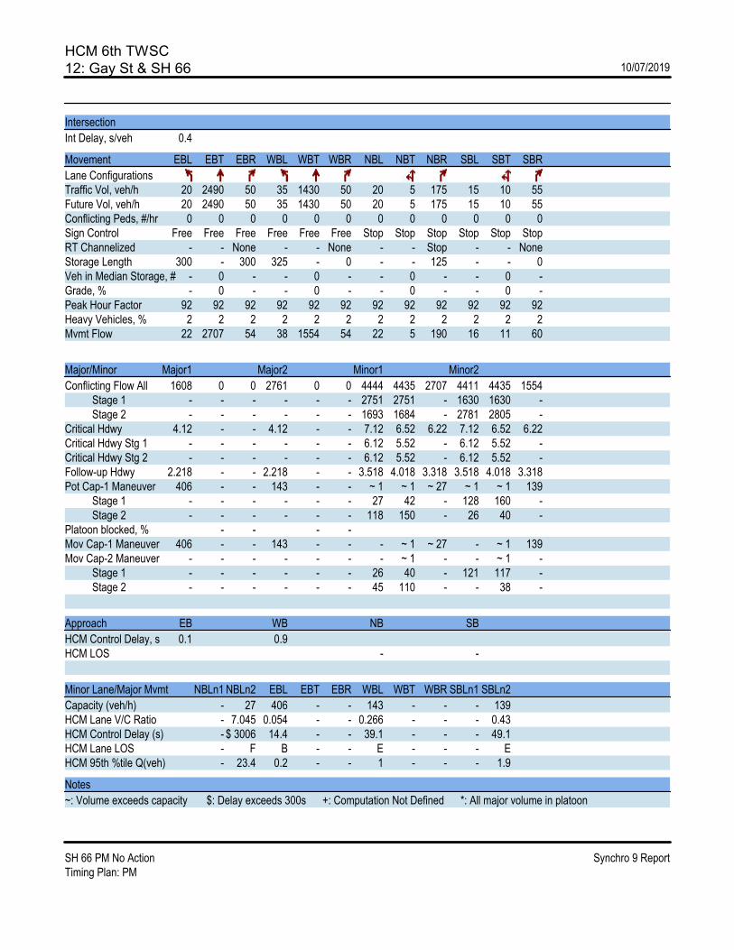
HCM 6th TWSC12: Gay St & SH 66 10/07/2019
SH 66 PM No Action Synchro 9 ReportTiming Plan: PM
Intersection
Int Delay, s/veh 0.4
Movement EBL EBT EBR WBL WBT WBR NBL NBT NBR SBL SBT SBR
Lane ConfigurationsTraffic Vol, veh/h 20 2490 50 35 1430 50 20 5 175 15 10 55Future Vol, veh/h 20 2490 50 35 1430 50 20 5 175 15 10 55Conflicting Peds, #/hr 0 0 0 0 0 0 0 0 0 0 0 0Sign Control Free Free Free Free Free Free Stop Stop Stop Stop Stop StopRT Channelized - - None - - None - - Stop - - NoneStorage Length 300 - 300 325 - 0 - - 125 - - 0Veh in Median Storage, # - 0 - - 0 - - 0 - - 0 -Grade, % - 0 - - 0 - - 0 - - 0 -Peak Hour Factor 92 92 92 92 92 92 92 92 92 92 92 92Heavy Vehicles, % 2 2 2 2 2 2 2 2 2 2 2 2Mvmt Flow 22 2707 54 38 1554 54 22 5 190 16 11 60
Major/Minor Major1 Major2 Minor1 Minor2
Conflicting Flow All 1608 0 0 2761 0 0 4444 4435 2707 4411 4435 1554 Stage 1 - - - - - - 2751 2751 - 1630 1630 - Stage 2 - - - - - - 1693 1684 - 2781 2805 -Critical Hdwy 4.12 - - 4.12 - - 7.12 6.52 6.22 7.12 6.52 6.22Critical Hdwy Stg 1 - - - - - - 6.12 5.52 - 6.12 5.52 -Critical Hdwy Stg 2 - - - - - - 6.12 5.52 - 6.12 5.52 -Follow-up Hdwy 2.218 - - 2.218 - - 3.518 4.018 3.318 3.518 4.018 3.318Pot Cap-1 Maneuver 406 - - 143 - - ~ 1 ~ 1 ~ 27 ~ 1 ~ 1 139 Stage 1 - - - - - - 27 42 - 128 160 - Stage 2 - - - - - - 118 150 - 26 40 -Platoon blocked, % - - - -Mov Cap-1 Maneuver 406 - - 143 - - - ~ 1 ~ 27 - ~ 1 139Mov Cap-2 Maneuver - - - - - - - ~ 1 - - ~ 1 - Stage 1 - - - - - - 26 40 - 121 117 - Stage 2 - - - - - - 45 110 - - 38 -
Approach EB WB NB SB
HCM Control Delay, s 0.1 0.9HCM LOS - -
Minor Lane/Major Mvmt NBLn1 NBLn2 EBL EBT EBR WBL WBT WBR SBLn1 SBLn2
Capacity (veh/h) - 27 406 - - 143 - - - 139HCM Lane V/C Ratio - 7.045 0.054 - - 0.266 - - - 0.43HCM Control Delay (s) - $ 3006 14.4 - - 39.1 - - - 49.1HCM Lane LOS - F B - - E - - - EHCM 95th %tile Q(veh) - 23.4 0.2 - - 1 - - - 1.9
Notes
~: Volume exceeds capacity $: Delay exceeds 300s +: Computation Not Defined *: All major volume in platoon

HCM 6th Signalized Intersection Summary13: US 287 & SH 66 10/07/2019
SH 66 PM No Action Synchro 9 ReportTiming Plan: PM
Movement EBL EBT EBR WBL WBT WBR NBL NBT NBR SBL SBT SBR
Lane ConfigurationsTraffic Volume (veh/h) 1265 1015 400 370 500 260 415 1100 380 185 750 600Future Volume (veh/h) 1265 1015 400 370 500 260 415 1100 380 185 750 600Initial Q (Qb), veh 0 0 0 0 0 0 0 0 0 0 0 0Ped-Bike Adj(A_pbT) 1.00 1.00 1.00 1.00 1.00 1.00 1.00 1.00Parking Bus, Adj 1.00 1.00 1.00 1.00 1.00 1.00 1.00 1.00 1.00 1.00 1.00 1.00Work Zone On Approach No No No NoAdj Sat Flow, veh/h/ln 1595 1657 1643 1569 1643 1643 1657 1630 1670 1670 1697 1683Adj Flow Rate, veh/h 1375 1103 0 402 543 0 451 1196 0 201 815 0Peak Hour Factor 0.92 0.92 0.92 0.92 0.92 0.92 0.92 0.92 0.92 0.92 0.92 0.92Percent Heavy Veh, % 2 4 5 4 5 5 4 6 3 3 1 2Cap, veh/h 987 1110 424 511 302 933 145 649Arrive On Green 0.33 0.35 0.00 0.15 0.16 0.00 0.16 0.30 0.00 0.06 0.20 0.00Sat Flow, veh/h 2946 3148 1393 2900 3122 1393 1578 3097 1415 1590 3224 1427
Grp Volume(v), veh/h 1375 1103 0 402 543 0 451 1196 0 201 815 0Grp Sat Flow(s),veh/h/ln 1473 1574 1393 1450 1561 1393 1578 1548 1415 1590 1612 1427Q Serve(g_s), s 53.6 55.9 0.0 22.0 26.2 0.0 26.1 48.2 0.0 10.1 32.2 0.0Cycle Q Clear(g_c), s 53.6 55.9 0.0 22.0 26.2 0.0 26.1 48.2 0.0 10.1 32.2 0.0Prop In Lane 1.00 1.00 1.00 1.00 1.00 1.00 1.00 1.00Lane Grp Cap(c), veh/h 987 1110 424 511 302 933 145 649V/C Ratio(X) 1.39 0.99 0.95 1.06 1.49 1.28 1.38 1.26Avail Cap(c_a), veh/h 987 1110 424 511 302 933 145 649HCM Platoon Ratio 1.00 1.00 1.00 1.00 1.00 1.00 1.00 1.00 1.00 1.00 1.00 1.00Upstream Filter(I) 1.00 1.00 0.00 1.00 1.00 0.00 1.00 1.00 0.00 1.00 1.00 0.00Uniform Delay (d), s/veh 53.2 51.6 0.0 67.7 66.9 0.0 50.2 55.9 0.0 54.3 63.9 0.0Incr Delay (d2), s/veh 183.1 25.6 0.0 30.4 57.3 0.0 238.0 135.1 0.0 208.9 127.6 0.0Initial Q Delay(d3),s/veh 0.0 0.0 0.0 0.0 0.0 0.0 0.0 0.0 0.0 0.0 0.0 0.0%ile BackOfQ(50%),veh/ln 44.1 25.0 0.0 9.7 14.2 0.0 29.0 35.9 0.0 9.9 24.5 0.0Unsig. Movement Delay, s/vehLnGrp Delay(d),s/veh 236.3 77.3 0.0 98.1 124.2 0.0 288.2 191.0 0.0 263.2 191.5 0.0LnGrp LOS F E F F F F F F
Approach Vol, veh/h 2478 A 945 A 1647 A 1016 AApproach Delay, s/veh 165.5 113.1 217.6 205.7Approach LOS F F F F
Timer - Assigned Phs 1 2 3 4 5 6 7 8
Phs Duration (G+Y+Rc), s 16.0 54.0 30.3 63.2 32.0 38.0 60.5 33.0Change Period (Y+Rc), s 5.9 * 5.8 * 6.8 * 6.8 5.9 * 5.8 * 6.8 * 6.8Max Green Setting (Gmax), s 10.1 * 48 * 20 * 56 26.1 * 32 * 50 * 26Max Q Clear Time (g_c+I1), s 12.1 50.2 24.0 57.9 28.1 34.2 55.6 28.2Green Ext Time (p_c), s 0.0 0.0 0.0 0.0 0.0 0.0 0.0 0.0
Intersection Summary
HCM 6th Ctrl Delay 178.2HCM 6th LOS F
Notes
* HCM 6th computational engine requires equal clearance times for the phases crossing the barrier.Unsignalized Delay for [NBR, EBR, WBR, SBR] is excluded from calculations of the approach delay and intersection delay.

HCM 6th Signalized Intersection Summary14: SH 66 & Erfert St 10/07/2019
SH 66 PM No Action Synchro 9 ReportTiming Plan: PM
Movement EBL EBT WBT WBR SBL SBR
Lane ConfigurationsTraffic Volume (veh/h) 125 1455 1090 80 190 40Future Volume (veh/h) 125 1455 1090 80 190 40Initial Q (Qb), veh 0 0 0 0 0 0Ped-Bike Adj(A_pbT) 1.00 1.00 1.00 1.00Parking Bus, Adj 1.00 1.00 1.00 1.00 1.00 1.00Work Zone On Approach No No NoAdj Sat Flow, veh/h/ln 1870 1870 1870 1870 1870 1870Adj Flow Rate, veh/h 136 1582 1185 87 207 43Peak Hour Factor 0.92 0.92 0.92 0.92 0.92 0.92Percent Heavy Veh, % 2 2 2 2 2 2Cap, veh/h 348 2531 2098 936 254 226Arrive On Green 0.05 0.71 0.59 0.59 0.14 0.14Sat Flow, veh/h 1781 3647 3647 1585 1781 1585
Grp Volume(v), veh/h 136 1582 1185 87 207 43Grp Sat Flow(s),veh/h/ln 1781 1777 1777 1585 1781 1585Q Serve(g_s), s 2.2 18.5 16.4 1.9 9.0 1.9Cycle Q Clear(g_c), s 2.2 18.5 16.4 1.9 9.0 1.9Prop In Lane 1.00 1.00 1.00 1.00Lane Grp Cap(c), veh/h 348 2531 2098 936 254 226V/C Ratio(X) 0.39 0.63 0.56 0.09 0.81 0.19Avail Cap(c_a), veh/h 398 2531 2098 936 557 495HCM Platoon Ratio 1.00 1.00 1.00 1.00 1.00 1.00Upstream Filter(I) 1.00 1.00 1.00 1.00 1.00 1.00Uniform Delay (d), s/veh 7.9 6.0 10.1 7.1 33.3 30.2Incr Delay (d2), s/veh 0.7 1.2 1.1 0.2 4.7 0.3Initial Q Delay(d3),s/veh 0.0 0.0 0.0 0.0 0.0 0.0%ile BackOfQ(50%),veh/ln 0.6 3.8 4.9 0.5 4.1 1.8Unsig. Movement Delay, s/vehLnGrp Delay(d),s/veh 8.6 7.1 11.2 7.3 38.0 30.5LnGrp LOS A A B A D C
Approach Vol, veh/h 1718 1272 250Approach Delay, s/veh 7.3 10.9 36.7Approach LOS A B D
Timer - Assigned Phs 4 6 7 8
Phs Duration (G+Y+Rc), s 63.4 16.6 9.8 53.6Change Period (Y+Rc), s 6.4 5.2 5.7 6.4Max Green Setting (Gmax), s 43.4 25.0 6.3 31.4Max Q Clear Time (g_c+I1), s 20.5 11.0 4.2 18.4Green Ext Time (p_c), s 7.5 0.4 0.1 4.3
Intersection Summary
HCM 6th Ctrl Delay 11.0HCM 6th LOS B

HCM 6th TWSC15: Alpine St/115th St & SH 66 10/07/2019
SH 66 PM No Action Synchro 9 ReportTiming Plan: PM
Intersection
Int Delay, s/veh 435.6
Movement EBL EBT EBR WBL WBT WBR NBL NBT NBR SBL SBT SBR
Lane ConfigurationsTraffic Vol, veh/h 25 1565 55 90 1145 60 5 5 45 40 5 20Future Vol, veh/h 25 1565 55 90 1145 60 5 5 45 40 5 20Conflicting Peds, #/hr 0 0 0 0 0 0 0 0 0 0 0 0Sign Control Free Free Free Free Free Free Stop Stop Stop Stop Stop StopRT Channelized - - None - - None - - None - - NoneStorage Length 325 - 275 675 - 400 150 - 0 - - 50Veh in Median Storage, # - 0 - - 0 - - 0 - - 0 -Grade, % - 0 - - 0 - - 0 - - 0 -Peak Hour Factor 92 92 92 92 92 92 92 92 92 92 92 92Heavy Vehicles, % 0 3 17 9 5 0 0 0 0 0 0 0Mvmt Flow 27 1701 60 98 1245 65 5 5 49 43 5 22
Major/Minor Major1 Major2 Minor1 Minor2
Conflicting Flow All 1310 0 0 1761 0 0 3242 3261 1701 3253 3256 1245 Stage 1 - - - - - - 1755 1755 - 1441 1441 - Stage 2 - - - - - - 1487 1506 - 1812 1815 -Critical Hdwy 4.1 - - 4.19 - - 7.1 6.5 6.2 7.1 6.5 6.2Critical Hdwy Stg 1 - - - - - - 6.1 5.5 - 6.1 5.5 -Critical Hdwy Stg 2 - - - - - - 6.1 5.5 - 6.1 5.5 -Follow-up Hdwy 2.2 - - 2.281 - - 3.5 4 3.3 3.5 4 3.3Pot Cap-1 Maneuver 535 - - 337 - - 6 9 115 ~ 6 9 214 Stage 1 - - - - - - 110 140 - 166 200 - Stage 2 - - - - - - 157 186 - 102 131 -Platoon blocked, % - - - -Mov Cap-1 Maneuver 535 - - 337 - - ~ 1 6 115 ~ 1 6 214Mov Cap-2 Maneuver - - - - - - ~ 1 6 - ~ 1 6 - Stage 1 - - - - - - 105 133 - 158 142 - Stage 2 - - - - - - 96 132 - 53 124 -
Approach EB WB NB SB
HCM Control Delay, s 0.2 1.4 $ 979.2 $ 19645.3HCM LOS F F
Minor Lane/Major Mvmt NBLn1 NBLn2 EBL EBT EBR WBL WBT WBR SBLn1 SBLn2
Capacity (veh/h) 2 115 535 - - 337 - - 1 214HCM Lane V/C Ratio 5.435 0.425 0.051 - - 0.29 - - 48.913 0.102HCM Control Delay (s) $ 5126.1 57.7 12.1 - - 20 - -$ 28366 23.7HCM Lane LOS F F B - - C - - F CHCM 95th %tile Q(veh) 2.6 1.8 0.2 - - 1.2 - - 8.2 0.3
Notes
~: Volume exceeds capacity $: Delay exceeds 300s +: Computation Not Defined *: All major volume in platoon

HCM Signalized Intersection Capacity Analysis16: Pace St & SH 66 10/07/2019
SH 66 PM No Action Synchro 9 ReportTiming Plan: PM
Movement EBL EBT EBR WBL WBT WBR NBL NBT NBR SBL SBT SBR
Lane ConfigurationsTraffic Volume (vph) 5 1395 255 320 1045 5 250 5 290 5 5 5Future Volume (vph) 5 1395 255 320 1045 5 250 5 290 5 5 5Ideal Flow (vphpl) 1900 1900 1900 1900 1900 1900 1900 1900 1900 1900 1900 1900Total Lost time (s) 6.8 6.8 6.8 6.8 6.8 5.7 5.7 4.5Lane Util. Factor 1.00 1.00 1.00 1.00 1.00 1.00 1.00 1.00Frt 1.00 1.00 0.85 1.00 1.00 1.00 0.85 0.95Flt Protected 0.95 1.00 1.00 0.95 1.00 0.95 1.00 0.98Satd. Flow (prot) 1770 1845 1599 1752 1792 1770 1603 1750Flt Permitted 0.05 1.00 1.00 0.05 1.00 0.95 1.00 0.89Satd. Flow (perm) 101 1845 1599 91 1792 1770 1603 1581
Peak-hour factor, PHF 0.92 0.89 0.78 0.90 0.90 0.92 0.81 0.92 0.86 0.92 0.92 0.92Adj. Flow (vph) 5 1567 327 356 1161 5 309 5 337 5 5 5RTOR Reduction (vph) 0 0 85 0 0 0 0 265 0 0 5 0Lane Group Flow (vph) 5 1567 242 356 1166 0 309 77 0 0 10 0Heavy Vehicles (%) 2% 3% 1% 3% 6% 2% 2% 2% 1% 2% 2% 2%
Turn Type Perm NA Perm pm+pt NA Split NA Perm NAProtected Phases 4 3 8 2 2 6Permitted Phases 4 4 8 6Actuated Green, G (s) 73.9 73.9 73.9 92.9 92.9 22.3 22.3 3.0Effective Green, g (s) 73.9 73.9 73.9 92.9 92.9 22.3 22.3 3.0Actuated g/C Ratio 0.55 0.55 0.55 0.69 0.69 0.16 0.16 0.02Clearance Time (s) 6.8 6.8 6.8 6.8 6.8 5.7 5.7 4.5Vehicle Extension (s) 2.0 2.0 2.0 2.0 2.0 2.5 2.5 3.0
Lane Grp Cap (vph) 55 1008 874 212 1231 291 264 35v/s Ratio Prot 0.85 c0.15 0.65 c0.17 0.05v/s Ratio Perm 0.05 0.15 c1.00 c0.01v/c Ratio 0.09 1.55 0.28 1.68 0.95 1.06 0.29 0.29Uniform Delay, d1 14.6 30.6 16.4 56.8 19.0 56.4 49.5 65.1Progression Factor 1.00 1.00 1.00 1.00 1.00 1.00 1.00 1.00Incremental Delay, d2 3.2 254.5 0.8 325.4 15.8 70.0 0.5 4.5Delay (s) 17.9 285.1 17.2 382.2 34.7 126.5 50.0 69.6Level of Service B F B F C F D EApproach Delay (s) 238.3 116.0 86.3 69.6Approach LOS F F F E
Intersection Summary
HCM 2000 Control Delay 167.9 HCM 2000 Level of Service FHCM 2000 Volume to Capacity ratio 1.58Actuated Cycle Length (s) 135.2 Sum of lost time (s) 23.8Intersection Capacity Utilization 127.7% ICU Level of Service HAnalysis Period (min) 15c Critical Lane Group

HCM Signalized Intersection Capacity Analysis18: County Line Rd/CR 1 & SH 66 10/07/2019
SH 66 PM No Action Synchro 9 ReportTiming Plan: PM
Movement EBL EBT EBR WBL WBT WBR NBL NBT NBR SBL SBT SBR
Lane ConfigurationsTraffic Volume (vph) 205 950 480 560 850 35 440 260 795 30 120 80Future Volume (vph) 205 950 480 560 850 35 440 260 795 30 120 80Ideal Flow (vphpl) 1900 1900 1900 1800 1900 1900 1900 1900 1900 1900 1900 1900Total Lost time (s) 4.5 7.0 7.0 4.5 7.0 5.0 5.0 4.0 5.0 5.0 4.0Lane Util. Factor 1.00 1.00 1.00 1.00 1.00 1.00 1.00 1.00 1.00 1.00 1.00Frt 1.00 1.00 0.85 1.00 0.99 1.00 1.00 0.85 1.00 1.00 0.85Flt Protected 0.95 1.00 1.00 0.95 1.00 0.95 1.00 1.00 0.95 1.00 1.00Satd. Flow (prot) 1770 1845 1583 1660 1758 1504 1863 1583 1671 1863 1615Flt Permitted 0.12 1.00 1.00 0.11 1.00 0.67 1.00 1.00 0.39 1.00 1.00Satd. Flow (perm) 233 1845 1583 192 1758 1067 1863 1583 685 1863 1615
Peak-hour factor, PHF 0.92 0.92 0.92 0.92 0.92 0.92 0.92 0.92 0.92 0.92 0.92 0.92Adj. Flow (vph) 223 1033 522 609 924 38 478 283 864 33 130 87RTOR Reduction (vph) 0 0 232 0 2 0 0 0 0 0 0 0Lane Group Flow (vph) 223 1033 290 609 960 0 478 283 864 33 130 87Heavy Vehicles (%) 2% 3% 2% 3% 6% 43% 20% 2% 2% 8% 2% 0%
Turn Type pm+pt NA Perm pm+pt NA Perm NA Free Perm NA FreeProtected Phases 5 2 1 6 8 4Permitted Phases 2 2 6 8 Free 4 FreeActuated Green, G (s) 39.0 32.0 32.0 49.0 37.5 19.0 19.0 80.0 19.0 19.0 80.0Effective Green, g (s) 39.0 32.0 32.0 49.0 37.5 19.0 19.0 80.0 19.0 19.0 80.0Actuated g/C Ratio 0.49 0.40 0.40 0.61 0.47 0.24 0.24 1.00 0.24 0.24 1.00Clearance Time (s) 4.5 7.0 7.0 4.5 7.0 5.0 5.0 5.0 5.0Vehicle Extension (s) 2.5 5.0 5.0 2.5 5.0 3.0 3.0 3.0 3.0
Lane Grp Cap (vph) 248 738 633 346 824 253 442 1583 162 442 1615v/s Ratio Prot 0.08 0.56 c0.27 0.55 0.15 0.07v/s Ratio Perm 0.36 0.18 c0.80 c0.45 0.55 0.05 0.05v/c Ratio 0.90 1.40 0.46 1.76 1.17 1.89 0.64 0.55 0.20 0.29 0.05Uniform Delay, d1 17.6 24.0 17.6 23.8 21.2 30.5 27.4 0.0 24.4 25.0 0.0Progression Factor 1.00 1.00 1.00 1.00 1.00 1.00 1.00 1.00 1.00 1.00 1.00Incremental Delay, d2 31.4 188.0 1.1 353.7 87.6 414.8 3.2 1.4 0.6 0.4 0.1Delay (s) 49.0 212.0 18.7 377.5 108.8 445.3 30.6 1.4 25.1 25.4 0.1Level of Service D F B F F F C A C C AApproach Delay (s) 134.8 213.0 137.0 16.5Approach LOS F F F B
Intersection Summary
HCM 2000 Control Delay 153.4 HCM 2000 Level of Service FHCM 2000 Volume to Capacity ratio 1.87Actuated Cycle Length (s) 80.0 Sum of lost time (s) 16.5Intersection Capacity Utilization 127.5% ICU Level of Service HAnalysis Period (min) 15c Critical Lane Group

HCM 6th TWSC19: Elmore Rd & SH 66 10/07/2019
SH 66 PM No Action Synchro 9 ReportTiming Plan: PM
Intersection
Int Delay, s/veh 2.2
Movement EBT EBR WBL WBT NBL NBR
Lane ConfigurationsTraffic Vol, veh/h 1765 10 5 1440 5 5Future Vol, veh/h 1765 10 5 1440 5 5Conflicting Peds, #/hr 0 0 0 0 0 0Sign Control Free Free Free Free Stop StopRT Channelized - None - None - NoneStorage Length - - - - 0 -Veh in Median Storage, # 0 - - 0 0 -Grade, % 0 - - 0 0 -Peak Hour Factor 92 92 92 92 92 92Heavy Vehicles, % 2 2 2 2 2 2Mvmt Flow 1918 11 5 1565 5 5
Major/Minor Major1 Major2 Minor1
Conflicting Flow All 0 0 1929 0 3499 1924 Stage 1 - - - - 1924 - Stage 2 - - - - 1575 -Critical Hdwy - - 4.12 - 6.42 6.22Critical Hdwy Stg 1 - - - - 5.42 -Critical Hdwy Stg 2 - - - - 5.42 -Follow-up Hdwy - - 2.218 - 3.518 3.318Pot Cap-1 Maneuver - - 305 - 7 83 Stage 1 - - - - 125 - Stage 2 - - - - 187 -Platoon blocked, % - - -Mov Cap-1 Maneuver - - 305 - 6 83Mov Cap-2 Maneuver - - - - 6 - Stage 1 - - - - 109 - Stage 2 - - - - 187 -
Approach EB WB NB
HCM Control Delay, s 0 0.1 $ 711.1HCM LOS F
Minor Lane/Major Mvmt NBLn1 EBT EBR WBL WBT
Capacity (veh/h) 11 - - 305 -HCM Lane V/C Ratio 0.988 - - 0.018 -HCM Control Delay (s) $ 711.1 - - 17 0HCM Lane LOS F - - C AHCM 95th %tile Q(veh) 2 - - 0.1 -
Notes
~: Volume exceeds capacity $: Delay exceeds 300s +: Computation Not Defined *: All major volume in platoon

HCM 6th TWSC20: CR 3 & SH 66 10/07/2019
SH 66 PM No Action Synchro 9 ReportTiming Plan: PM
Intersection
Int Delay, s/veh 1.1
Movement EBL EBT EBR WBL WBT WBR NBL NBT NBR SBL SBT SBR
Lane ConfigurationsTraffic Vol, veh/h 185 1565 20 5 1320 85 10 15 10 150 5 115Future Vol, veh/h 185 1565 20 5 1320 85 10 15 10 150 5 115Conflicting Peds, #/hr 0 0 0 0 0 0 0 0 0 0 0 0Sign Control Free Free Free Free Free Free Stop Stop Stop Stop Stop StopRT Channelized - - None - - None - - None - - NoneStorage Length - - - - - - - - - - - -Veh in Median Storage, # - 0 - - 0 - - 0 - - 0 -Grade, % - 0 - - 0 - - 0 - - 0 -Peak Hour Factor 92 92 92 92 92 92 92 92 92 92 92 92Heavy Vehicles, % 0 3 0 0 5 0 0 0 0 0 0 0Mvmt Flow 201 1701 22 5 1435 92 11 16 11 163 5 125
Major/Minor Major1 Major2 Minor1 Minor2
Conflicting Flow All 1527 0 0 1723 0 0 3670 3651 1712 3619 3616 1481 Stage 1 - - - - - - 2114 2114 - 1491 1491 - Stage 2 - - - - - - 1556 1537 - 2128 2125 -Critical Hdwy 4.1 - - 4.1 - - 7.1 6.5 6.2 7.1 6.5 6.2Critical Hdwy Stg 1 - - - - - - 6.1 5.5 - 6.1 5.5 -Critical Hdwy Stg 2 - - - - - - 6.1 5.5 - 6.1 5.5 -Follow-up Hdwy 2.2 - - 2.2 - - 3.5 4 3.3 3.5 4 3.3Pot Cap-1 Maneuver 442 - - 372 - - ~ 3 ~ 5 113 ~ 3 ~ 5 156 Stage 1 - - - - - - 67 92 - ~ 156 189 - Stage 2 - - - - - - 143 179 - ~ 66 91 -Platoon blocked, % - - - -Mov Cap-1 Maneuver 442 - - 372 - - - 0 113 - 0 156Mov Cap-2 Maneuver - - - - - - - 0 - - 0 - Stage 1 - - - - - - 67 0 - ~ 156 171 - Stage 2 - - - - - - 25 162 - - 0 -
Approach EB WB NB SB
HCM Control Delay, s 2.1 0.1HCM LOS - -
Minor Lane/Major Mvmt NBLn1 EBL EBT EBR WBL WBT WBR SBLn1
Capacity (veh/h) - 442 - - 372 - - -HCM Lane V/C Ratio - 0.455 - - 0.015 - - -HCM Control Delay (s) - 19.8 0 - 14.8 0 - -HCM Lane LOS - C A - B A - -HCM 95th %tile Q(veh) - 2.3 - - 0 - - -
Notes
~: Volume exceeds capacity $: Delay exceeds 300s +: Computation Not Defined *: All major volume in platoon
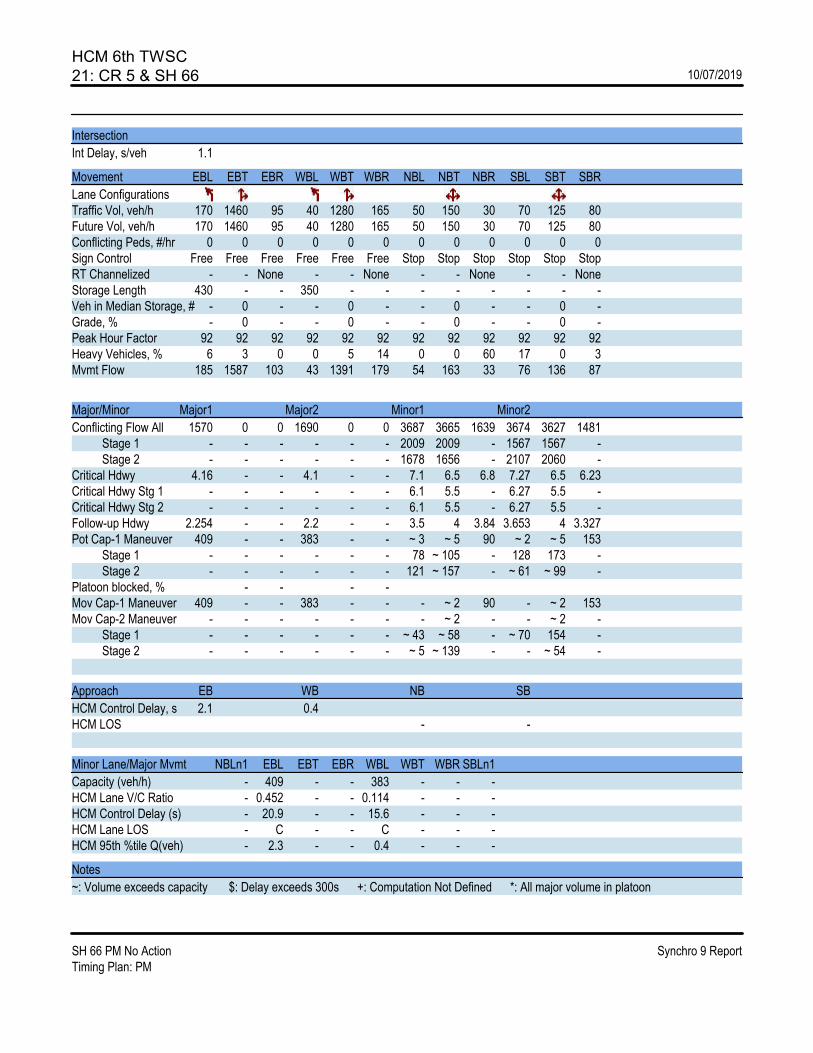
HCM 6th TWSC21: CR 5 & SH 66 10/07/2019
SH 66 PM No Action Synchro 9 ReportTiming Plan: PM
Intersection
Int Delay, s/veh 1.1
Movement EBL EBT EBR WBL WBT WBR NBL NBT NBR SBL SBT SBR
Lane ConfigurationsTraffic Vol, veh/h 170 1460 95 40 1280 165 50 150 30 70 125 80Future Vol, veh/h 170 1460 95 40 1280 165 50 150 30 70 125 80Conflicting Peds, #/hr 0 0 0 0 0 0 0 0 0 0 0 0Sign Control Free Free Free Free Free Free Stop Stop Stop Stop Stop StopRT Channelized - - None - - None - - None - - NoneStorage Length 430 - - 350 - - - - - - - -Veh in Median Storage, # - 0 - - 0 - - 0 - - 0 -Grade, % - 0 - - 0 - - 0 - - 0 -Peak Hour Factor 92 92 92 92 92 92 92 92 92 92 92 92Heavy Vehicles, % 6 3 0 0 5 14 0 0 60 17 0 3Mvmt Flow 185 1587 103 43 1391 179 54 163 33 76 136 87
Major/Minor Major1 Major2 Minor1 Minor2
Conflicting Flow All 1570 0 0 1690 0 0 3687 3665 1639 3674 3627 1481 Stage 1 - - - - - - 2009 2009 - 1567 1567 - Stage 2 - - - - - - 1678 1656 - 2107 2060 -Critical Hdwy 4.16 - - 4.1 - - 7.1 6.5 6.8 7.27 6.5 6.23Critical Hdwy Stg 1 - - - - - - 6.1 5.5 - 6.27 5.5 -Critical Hdwy Stg 2 - - - - - - 6.1 5.5 - 6.27 5.5 -Follow-up Hdwy 2.254 - - 2.2 - - 3.5 4 3.84 3.653 4 3.327Pot Cap-1 Maneuver 409 - - 383 - - ~ 3 ~ 5 90 ~ 2 ~ 5 153 Stage 1 - - - - - - 78 ~ 105 - 128 173 - Stage 2 - - - - - - 121 ~ 157 - ~ 61 ~ 99 -Platoon blocked, % - - - -Mov Cap-1 Maneuver 409 - - 383 - - - ~ 2 90 - ~ 2 153Mov Cap-2 Maneuver - - - - - - - ~ 2 - - ~ 2 - Stage 1 - - - - - - ~ 43 ~ 58 - ~ 70 154 - Stage 2 - - - - - - ~ 5 ~ 139 - - ~ 54 -
Approach EB WB NB SB
HCM Control Delay, s 2.1 0.4HCM LOS - -
Minor Lane/Major Mvmt NBLn1 EBL EBT EBR WBL WBT WBR SBLn1
Capacity (veh/h) - 409 - - 383 - - -HCM Lane V/C Ratio - 0.452 - - 0.114 - - -HCM Control Delay (s) - 20.9 - - 15.6 - - -HCM Lane LOS - C - - C - - -HCM 95th %tile Q(veh) - 2.3 - - 0.4 - - -
Notes
~: Volume exceeds capacity $: Delay exceeds 300s +: Computation Not Defined *: All major volume in platoon
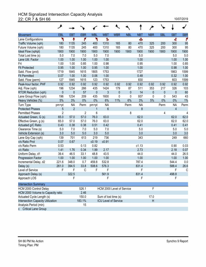
HCM Signalized Intersection Capacity Analysis22: CR 7 & SH 66 10/07/2019
SH 66 PM No Action Synchro 9 ReportTiming Plan: PM
Movement EBL EBT EBR WBL WBT WBR NBL NBT NBR SBL SBT SBR
Lane ConfigurationsTraffic Volume (vph) 180 1135 245 400 1310 165 80 470 325 200 300 95Future Volume (vph) 180 1135 245 400 1310 165 80 470 325 200 300 95Ideal Flow (vphpl) 1900 1900 1900 1900 1900 1900 1900 1900 1900 1900 1900 1900Total Lost time (s) 5.0 7.0 7.0 5.0 7.0 5.0 5.0 5.0Lane Util. Factor 1.00 1.00 1.00 1.00 1.00 1.00 1.00 1.00Frt 1.00 1.00 0.85 1.00 0.98 0.95 1.00 0.85Flt Protected 0.95 1.00 1.00 0.95 1.00 1.00 0.98 1.00Satd. Flow (prot) 1719 1845 1615 1805 1753 1727 1863 1599Flt Permitted 0.07 1.00 1.00 0.06 1.00 0.48 0.32 1.00Satd. Flow (perm) 127 1845 1615 123 1753 830 603 1599
Peak-hour factor, PHF 0.92 0.92 0.92 0.92 0.92 0.92 0.92 0.92 0.92 0.92 0.92 0.92Adj. Flow (vph) 196 1234 266 435 1424 179 87 511 353 217 326 103RTOR Reduction (vph) 0 0 57 0 3 0 0 14 0 0 0 60Lane Group Flow (vph) 196 1234 209 435 1600 0 0 937 0 0 543 43Heavy Vehicles (%) 5% 3% 0% 0% 6% 11% 6% 3% 5% 0% 0% 1%
Turn Type pm+pt NA Perm pm+pt NA Perm NA Perm NA PermProtected Phases 5 2 1 6 8 4Permitted Phases 2 2 6 8 4 4Actuated Green, G (s) 65.0 57.0 57.0 76.0 63.0 62.0 62.0 62.0Effective Green, g (s) 65.0 57.0 57.0 76.0 63.0 62.0 62.0 62.0Actuated g/C Ratio 0.43 0.38 0.38 0.51 0.42 0.41 0.41 0.41Clearance Time (s) 5.0 7.0 7.0 5.0 7.0 5.0 5.0 5.0Vehicle Extension (s) 3.0 5.0 5.0 3.0 5.0 3.0 3.0 3.0
Lane Grp Cap (vph) 139 701 613 219 736 343 249 660v/s Ratio Prot 0.07 0.67 c0.19 c0.91v/s Ratio Perm 0.53 0.13 0.82 c1.13 0.90 0.03v/c Ratio 1.41 1.76 0.34 1.99 2.17 2.73 2.18 0.07Uniform Delay, d1 39.4 46.5 33.1 48.8 43.5 44.0 44.0 26.5Progression Factor 1.00 1.00 1.00 1.00 1.00 1.00 1.00 1.00Incremental Delay, d2 221.6 348.0 0.7 459.8 532.8 787.4 544.4 0.0Delay (s) 261.0 394.5 33.8 508.6 576.3 831.4 588.4 26.6Level of Service F F C F F F F CApproach Delay (s) 322.5 561.9 831.4 498.8Approach LOS F F F F
Intersection Summary
HCM 2000 Control Delay 526.1 HCM 2000 Level of Service FHCM 2000 Volume to Capacity ratio 2.46Actuated Cycle Length (s) 150.0 Sum of lost time (s) 17.0Intersection Capacity Utilization 183.1% ICU Level of Service HAnalysis Period (min) 15c Critical Lane Group

HCM Signalized Intersection Capacity Analysis24: I-25 SB On Ramp/I-25 SB Off Ramp & SH 66 10/07/2019
SH 66 PM No Action Synchro 9 ReportTiming Plan: PM
Movement EBL EBT EBR WBL WBT WBR NBL NBT NBR SBL SBT SBR
Lane ConfigurationsTraffic Volume (vph) 0 1170 490 565 1545 0 0 0 0 220 10 330Future Volume (vph) 0 1170 490 565 1545 0 0 0 0 220 10 330Ideal Flow (vphpl) 1900 1900 1900 1800 1900 1900 1900 1900 1900 1900 1900 1900Total Lost time (s) 7.0 7.0 7.0 7.0 6.0 6.0 4.0Lane Util. Factor 0.91 1.00 0.97 0.95 0.95 0.95 1.00Frt 1.00 0.85 1.00 1.00 1.00 1.00 0.85Flt Protected 1.00 1.00 0.95 1.00 0.95 0.96 1.00Satd. Flow (prot) 5036 1568 3072 3374 1545 1529 1568Flt Permitted 1.00 1.00 0.95 1.00 0.95 0.96 1.00Satd. Flow (perm) 5036 1568 3072 3374 1545 1529 1568
Peak-hour factor, PHF 0.92 0.92 0.92 0.92 0.92 0.92 0.92 0.92 0.92 0.92 0.92 0.92Adj. Flow (vph) 0 1272 533 614 1679 0 0 0 0 239 11 359RTOR Reduction (vph) 0 0 264 0 0 0 0 0 0 0 0 0Lane Group Flow (vph) 0 1272 269 614 1679 0 0 0 0 124 126 359Heavy Vehicles (%) 2% 3% 3% 8% 7% 2% 2% 2% 2% 11% 33% 3%
Turn Type NA Perm Prot NA Perm NA FreeProtected Phases 2 1 6 4Permitted Phases 2 4 FreeActuated Green, G (s) 38.7 38.7 28.0 73.7 13.3 13.3 100.0Effective Green, g (s) 38.7 38.7 28.0 73.7 13.3 13.3 100.0Actuated g/C Ratio 0.39 0.39 0.28 0.74 0.13 0.13 1.00Clearance Time (s) 7.0 7.0 7.0 7.0 6.0 6.0Vehicle Extension (s) 3.0 3.0 3.0 3.0 3.0 3.0
Lane Grp Cap (vph) 1948 606 860 2486 205 203 1568v/s Ratio Prot 0.25 0.20 c0.50v/s Ratio Perm 0.17 0.08 0.08 0.23v/c Ratio 0.65 0.44 0.71 0.68 0.60 0.62 0.23Uniform Delay, d1 25.1 22.7 32.4 6.9 40.9 41.0 0.0Progression Factor 1.00 1.00 0.73 0.33 1.00 1.00 1.00Incremental Delay, d2 1.7 2.4 1.8 1.0 5.0 5.8 0.3Delay (s) 26.9 25.0 25.6 3.2 45.8 46.7 0.3Level of Service C C C A D D AApproach Delay (s) 26.3 9.2 0.0 19.2Approach LOS C A A B
Intersection Summary
HCM 2000 Control Delay 17.1 HCM 2000 Level of Service BHCM 2000 Volume to Capacity ratio 0.73Actuated Cycle Length (s) 100.0 Sum of lost time (s) 20.0Intersection Capacity Utilization 70.7% ICU Level of Service CAnalysis Period (min) 15c Critical Lane Group

HCM Signalized Intersection Capacity Analysis25: I-25 NB Off Ramp/I-25 NB On Ramp & SH 66 10/07/2019
SH 66 PM No Action Synchro 9 ReportTiming Plan: PM
Movement EBL EBT EBR WBL WBT WBR NBL NBT NBR SBL SBT SBR
Lane ConfigurationsTraffic Volume (vph) 275 1115 0 0 1620 310 490 0 685 0 0 0Future Volume (vph) 275 1115 0 0 1620 310 490 0 685 0 0 0Ideal Flow (vphpl) 1800 1900 1900 1900 1900 1900 1800 1900 1900 1900 1900 1900Total Lost time (s) 5.0 7.0 7.0 7.0 6.0 6.0 4.0Lane Util. Factor 0.97 0.95 0.91 1.00 0.95 0.95 1.00Frt 1.00 1.00 1.00 0.85 1.00 1.00 0.85Flt Protected 0.95 1.00 1.00 1.00 0.95 0.95 1.00Satd. Flow (prot) 3221 3438 4803 1417 1533 1618 1455Flt Permitted 0.95 1.00 1.00 1.00 0.95 0.95 1.00Satd. Flow (perm) 3221 3438 4803 1417 1533 1618 1455
Peak-hour factor, PHF 0.92 0.92 0.92 0.92 0.92 0.92 0.92 0.92 0.92 0.92 0.92 0.92Adj. Flow (vph) 299 1212 0 0 1761 337 533 0 745 0 0 0RTOR Reduction (vph) 0 0 0 0 0 183 0 0 0 0 0 0Lane Group Flow (vph) 299 1212 0 0 1761 154 266 267 745 0 0 0Heavy Vehicles (%) 3% 5% 2% 2% 8% 14% 6% 0% 11% 2% 2% 2%
Turn Type Prot NA NA Perm Perm NA FreeProtected Phases 5 2 6 8Permitted Phases 6 8 FreeActuated Green, G (s) 14.5 63.8 44.3 44.3 23.2 23.2 100.0Effective Green, g (s) 14.5 63.8 44.3 44.3 23.2 23.2 100.0Actuated g/C Ratio 0.14 0.64 0.44 0.44 0.23 0.23 1.00Clearance Time (s) 5.0 7.0 7.0 7.0 6.0 6.0Vehicle Extension (s) 3.0 3.0 3.0 3.0 3.0 3.0
Lane Grp Cap (vph) 467 2193 2127 627 355 375 1455v/s Ratio Prot 0.09 0.35 c0.37v/s Ratio Perm 0.11 c0.17 0.17 c0.51v/c Ratio 0.64 0.55 0.83 0.25 0.75 0.71 0.51Uniform Delay, d1 40.3 10.1 24.5 17.4 35.7 35.3 0.0Progression Factor 1.41 0.28 1.00 1.00 1.00 1.00 1.00Incremental Delay, d2 2.4 0.8 3.9 0.9 8.4 6.3 1.3Delay (s) 59.0 3.6 28.4 18.3 44.1 41.6 1.3Level of Service E A C B D D AApproach Delay (s) 14.6 26.8 18.6 0.0Approach LOS B C B A
Intersection Summary
HCM 2000 Control Delay 20.9 HCM 2000 Level of Service CHCM 2000 Volume to Capacity ratio 0.78Actuated Cycle Length (s) 100.0 Sum of lost time (s) 18.0Intersection Capacity Utilization 70.7% ICU Level of Service CAnalysis Period (min) 15c Critical Lane Group

HCM 6th TWSC26: Mead St & SH 66 10/07/2019
SH 66 PM No Action Synchro 9 ReportTiming Plan: PM
Intersection
Int Delay, s/veh 1621.2
Movement EBL EBT EBR WBL WBT WBR NBL NBT NBR SBL SBT SBR
Lane ConfigurationsTraffic Vol, veh/h 225 1465 110 20 1430 20 125 0 60 75 5 375Future Vol, veh/h 225 1465 110 20 1430 20 125 0 60 75 5 375Conflicting Peds, #/hr 0 0 0 0 0 0 0 0 0 0 0 0Sign Control Free Free Free Free Free Free Stop Stop Stop Stop Stop StopRT Channelized - - None - - None - - None - - NoneStorage Length 275 - 0 225 - - 0 - - - - -Veh in Median Storage, # - 0 - - 0 - - 0 - - 0 -Grade, % - 0 - - 0 - - 0 - - 0 -Peak Hour Factor 92 92 92 92 92 92 92 92 92 92 92 92Heavy Vehicles, % 2 10 7 3 8 2 7 2 3 2 2 2Mvmt Flow 245 1592 120 22 1554 22 136 0 65 82 5 408
Major/Minor Major1 Major2 Minor1 Minor2
Conflicting Flow All 1576 0 0 1712 0 0 2906 3702 796 2895 3811 788 Stage 1 - - - - - - 2082 2082 - 1609 1609 - Stage 2 - - - - - - 824 1620 - 1286 2202 -Critical Hdwy 4.14 - - 4.16 - - 7.64 6.54 6.96 7.54 6.54 6.94Critical Hdwy Stg 1 - - - - - - 6.64 5.54 - 6.54 5.54 -Critical Hdwy Stg 2 - - - - - - 6.64 5.54 - 6.54 5.54 -Follow-up Hdwy 2.22 - - 2.23 - - 3.57 4.02 3.33 3.52 4.02 3.32Pot Cap-1 Maneuver 414 - - 362 - - ~ 6 5 328 ~ 7 ~ 4 ~ 334 Stage 1 - - - - - - ~ 51 94 - 109 162 - Stage 2 - - - - - - 323 160 - 174 81 -Platoon blocked, % - - - -Mov Cap-1 Maneuver 414 - - 362 - - - 2 328 ~ 3 ~ 2 ~ 334Mov Cap-2 Maneuver - - - - - - - 2 - ~ 3 ~ 2 - Stage 1 - - - - - - ~ 21 38 - ~ 44 152 - Stage 2 - - - - - - - 150 - ~ 57 33 -
Approach EB WB NB SB
HCM Control Delay, s 3.2 0.2 $ 13918.3HCM LOS - F
Minor Lane/Major Mvmt NBLn1 NBLn2 EBL EBT EBR WBL WBT WBR SBLn1
Capacity (veh/h) - 328 414 - - 362 - - 16HCM Lane V/C Ratio - 0.199 0.591 - - 0.06 - - 30.91HCM Control Delay (s) - 18.7 25.5 - - 15.6 - -$ 13918.3HCM Lane LOS - C D - - C - - FHCM 95th %tile Q(veh) - 0.7 3.7 - - 0.2 - - 62.8
Notes
~: Volume exceeds capacity $: Delay exceeds 300s +: Computation Not Defined *: All major volume in platoon

HCM 6th Signalized Intersection Summary27: CR 9 1/2 & SH 66 10/07/2019
SH 66 PM No Action Synchro 9 ReportTiming Plan: PM
Movement EBL EBT EBR WBL WBT WBR NBL NBT NBR SBL SBT SBR
Lane ConfigurationsTraffic Volume (veh/h) 290 910 400 130 580 45 455 290 475 100 355 435Future Volume (veh/h) 290 910 400 130 580 45 455 290 475 100 355 435Initial Q (Qb), veh 0 0 0 0 0 0 0 0 0 0 0 0Ped-Bike Adj(A_pbT) 1.00 1.00 1.00 1.00 1.00 1.00 1.00 1.00Parking Bus, Adj 1.00 1.00 1.00 1.00 1.00 1.00 1.00 1.00 1.00 1.00 1.00 1.00Work Zone On Approach No No No NoAdj Sat Flow, veh/h/ln 1633 1781 1870 1781 1796 1796 1633 1826 1826 1841 1841 1841Adj Flow Rate, veh/h 315 989 435 141 630 49 495 315 516 109 386 473Peak Hour Factor 0.92 0.92 0.92 0.92 0.92 0.92 0.92 0.92 0.92 0.92 0.92 0.92Percent Heavy Veh, % 18 8 2 8 7 7 18 5 5 4 4 4Cap, veh/h 185 484 430 148 400 31 289 347 568 45 90 102Arrive On Green 0.09 0.27 0.27 0.06 0.24 0.24 0.09 0.56 0.56 0.43 0.43 0.43Sat Flow, veh/h 1555 1781 1585 1697 1645 128 1555 623 1020 39 211 238
Grp Volume(v), veh/h 315 989 435 141 0 679 495 0 831 968 0 0Grp Sat Flow(s),veh/h/ln 1555 1781 1585 1697 0 1773 1555 0 1642 488 0 0Q Serve(g_s), s 12.0 38.0 38.0 8.0 0.0 34.0 13.0 0.0 63.5 14.5 0.0 0.0Cycle Q Clear(g_c), s 12.0 38.0 38.0 8.0 0.0 34.0 13.0 0.0 63.5 60.0 0.0 0.0Prop In Lane 1.00 1.00 1.00 0.07 1.00 0.62 0.11 0.49Lane Grp Cap(c), veh/h 185 484 430 148 0 431 289 0 915 238 0 0V/C Ratio(X) 1.70 2.05 1.01 0.95 0.00 1.58 1.71 0.00 0.91 4.07 0.00 0.00Avail Cap(c_a), veh/h 185 484 430 148 0 431 289 0 915 238 0 0HCM Platoon Ratio 1.00 1.00 1.00 1.00 1.00 1.00 1.00 1.00 1.00 1.00 1.00 1.00Upstream Filter(I) 1.00 1.00 1.00 1.00 0.00 1.00 1.00 0.00 1.00 1.00 0.00 0.00Uniform Delay (d), s/veh 40.4 51.0 51.0 43.9 0.0 53.0 25.8 0.0 27.8 50.6 0.0 0.0Incr Delay (d2), s/veh 339.3 477.6 46.2 59.2 0.0 270.5 334.4 0.0 13.3 1393.3 0.0 0.0Initial Q Delay(d3),s/veh 0.0 0.0 0.0 0.0 0.0 0.0 0.0 0.0 0.0 0.0 0.0 0.0%ile BackOfQ(50%),veh/ln 22.0 80.3 19.9 6.0 0.0 46.8 31.8 0.0 25.6 100.2 0.0 0.0Unsig. Movement Delay, s/vehLnGrp Delay(d),s/veh 379.7 528.6 97.2 103.1 0.0 323.5 360.2 0.0 41.1 1443.9 0.0 0.0LnGrp LOS F F F F A F F A D F A A
Approach Vol, veh/h 1739 820 1326 968Approach Delay, s/veh 393.7 285.6 160.2 1443.9Approach LOS F F F F
Timer - Assigned Phs 1 2 3 4 5 6 8
Phs Duration (G+Y+Rc), s 13.0 44.0 18.0 65.0 17.0 40.0 83.0Change Period (Y+Rc), s 5.0 6.0 5.0 5.0 5.0 6.0 5.0Max Green Setting (Gmax), s 8.0 38.0 13.0 60.0 12.0 34.0 78.0Max Q Clear Time (g_c+I1), s 10.0 40.0 15.0 62.0 14.0 36.0 65.5Green Ext Time (p_c), s 0.0 0.0 0.0 0.0 0.0 0.0 7.3
Intersection Summary
HCM 6th Ctrl Delay 521.1HCM 6th LOS F

HCM 6th TWSC28: CR 11 & SH 66 10/07/2019
SH 66 PM No Action Synchro 9 ReportTiming Plan: PM
Intersection
Int Delay, s/veh 1.2
Movement EBL EBT EBR WBL WBT WBR NBL NBT NBR SBL SBT SBR
Lane ConfigurationsTraffic Vol, veh/h 110 1205 170 140 585 75 105 15 170 80 15 65Future Vol, veh/h 110 1205 170 140 585 75 105 15 170 80 15 65Conflicting Peds, #/hr 0 0 0 0 0 0 0 0 0 0 0 0Sign Control Free Free Free Free Free Free Stop Stop Stop Stop Stop StopRT Channelized - - None - - None - - None - - NoneStorage Length - - - - - - - - - - - -Veh in Median Storage, # - 0 - - 0 - - 0 - - 0 -Grade, % - 0 - - 0 - - 0 - - 0 -Peak Hour Factor 92 92 92 92 92 92 92 92 92 92 92 92Heavy Vehicles, % 0 11 25 0 8 0 0 0 0 0 0 0Mvmt Flow 120 1310 185 152 636 82 114 16 185 87 16 71
Major/Minor Major1 Major2 Minor1 Minor2
Conflicting Flow All 718 0 0 1495 0 0 2668 2665 1403 2724 2716 677 Stage 1 - - - - - - 1643 1643 - 981 981 - Stage 2 - - - - - - 1025 1022 - 1743 1735 -Critical Hdwy 4.1 - - 4.1 - - 7.1 6.5 6.2 7.1 6.5 6.2Critical Hdwy Stg 1 - - - - - - 6.1 5.5 - 6.1 5.5 -Critical Hdwy Stg 2 - - - - - - 6.1 5.5 - 6.1 5.5 -Follow-up Hdwy 2.2 - - 2.2 - - 3.5 4 3.3 3.5 4 3.3Pot Cap-1 Maneuver 892 - - 455 - - ~ 15 23 ~ 173 ~ 14 21 456 Stage 1 - - - - - - 127 159 - 303 330 - Stage 2 - - - - - - 286 316 - 111 143 -Platoon blocked, % - - - -Mov Cap-1 Maneuver 892 - - 455 - - - ~ 1 ~ 173 - ~ 1 456Mov Cap-2 Maneuver - - - - - - - ~ 1 - - ~ 1 - Stage 1 - - - - - - ~ 12 ~ 16 - ~ 30 144 - Stage 2 - - - - - - ~ 93 138 - 0 ~ 14 -
Approach EB WB NB SB
HCM Control Delay, s 0.7 2.9HCM LOS - -
Minor Lane/Major Mvmt NBLn1 EBL EBT EBR WBL WBT WBR SBLn1
Capacity (veh/h) - 892 - - 455 - - -HCM Lane V/C Ratio - 0.134 - - 0.334 - - -HCM Control Delay (s) - 9.7 0 - 16.8 0 - -HCM Lane LOS - A A - C A - -HCM 95th %tile Q(veh) - 0.5 - - 1.5 - - -
Notes
~: Volume exceeds capacity $: Delay exceeds 300s +: Computation Not Defined *: All major volume in platoon

HCM Signalized Intersection Capacity Analysis30: CR13/CR 13 & SH 66 10/07/2019
SH 66 PM No Action Synchro 9 ReportTiming Plan: PM
Movement EBL EBT EBR WBL WBT WBR NBL NBT NBR SBL SBT SBR
Lane ConfigurationsTraffic Volume (vph) 130 950 215 90 685 25 140 325 120 20 210 25Future Volume (vph) 130 950 215 90 685 25 140 325 120 20 210 25Ideal Flow (vphpl) 1900 1900 1900 1900 1900 1900 1900 1900 1900 1900 1900 1900Total Lost time (s) 5.0 7.0 5.0 7.0 7.0 7.0Lane Util. Factor 1.00 1.00 1.00 1.00 1.00 1.00Frt 1.00 0.97 1.00 0.99 0.97 0.99Flt Protected 0.95 1.00 0.95 1.00 0.99 1.00Satd. Flow (prot) 1504 1685 1805 1723 1736 1834Flt Permitted 0.13 1.00 0.05 1.00 0.72 0.89Satd. Flow (perm) 213 1685 100 1723 1270 1638
Peak-hour factor, PHF 0.92 0.92 0.92 0.92 0.92 0.92 0.92 0.92 0.92 0.92 0.92 0.92Adj. Flow (vph) 141 1033 234 98 745 27 152 353 130 22 228 27RTOR Reduction (vph) 0 5 0 0 1 0 0 6 0 0 3 0Lane Group Flow (vph) 141 1262 0 98 771 0 0 629 0 0 274 0Heavy Vehicles (%) 20% 10% 8% 0% 9% 28% 6% 6% 2% 22% 0% 1%
Turn Type pm+pt NA pm+pt NA Perm NA Perm NAProtected Phases 5 2 1 6 8 4Permitted Phases 2 6 8 4Actuated Green, G (s) 84.0 76.0 84.0 76.0 47.0 47.0Effective Green, g (s) 84.0 76.0 84.0 76.0 47.0 47.0Actuated g/C Ratio 0.56 0.51 0.56 0.51 0.31 0.31Clearance Time (s) 5.0 7.0 5.0 7.0 7.0 7.0Vehicle Extension (s) 4.0 6.0 4.0 6.0 5.0 5.0
Lane Grp Cap (vph) 188 853 146 872 397 513v/s Ratio Prot c0.04 c0.75 0.04 0.45v/s Ratio Perm 0.38 0.34 c0.50 0.17v/c Ratio 0.75 1.48 0.67 0.88 1.58 0.53Uniform Delay, d1 26.4 37.0 33.6 33.1 51.5 42.5Progression Factor 1.00 1.00 1.00 1.00 1.00 1.00Incremental Delay, d2 16.3 221.9 12.5 11.8 274.5 2.0Delay (s) 42.7 258.9 46.1 44.8 326.0 44.4Level of Service D F D D F DApproach Delay (s) 237.2 45.0 326.0 44.4Approach LOS F D F D
Intersection Summary
HCM 2000 Control Delay 185.7 HCM 2000 Level of Service FHCM 2000 Volume to Capacity ratio 1.47Actuated Cycle Length (s) 150.0 Sum of lost time (s) 19.0Intersection Capacity Utilization 137.2% ICU Level of Service HAnalysis Period (min) 15c Critical Lane Group
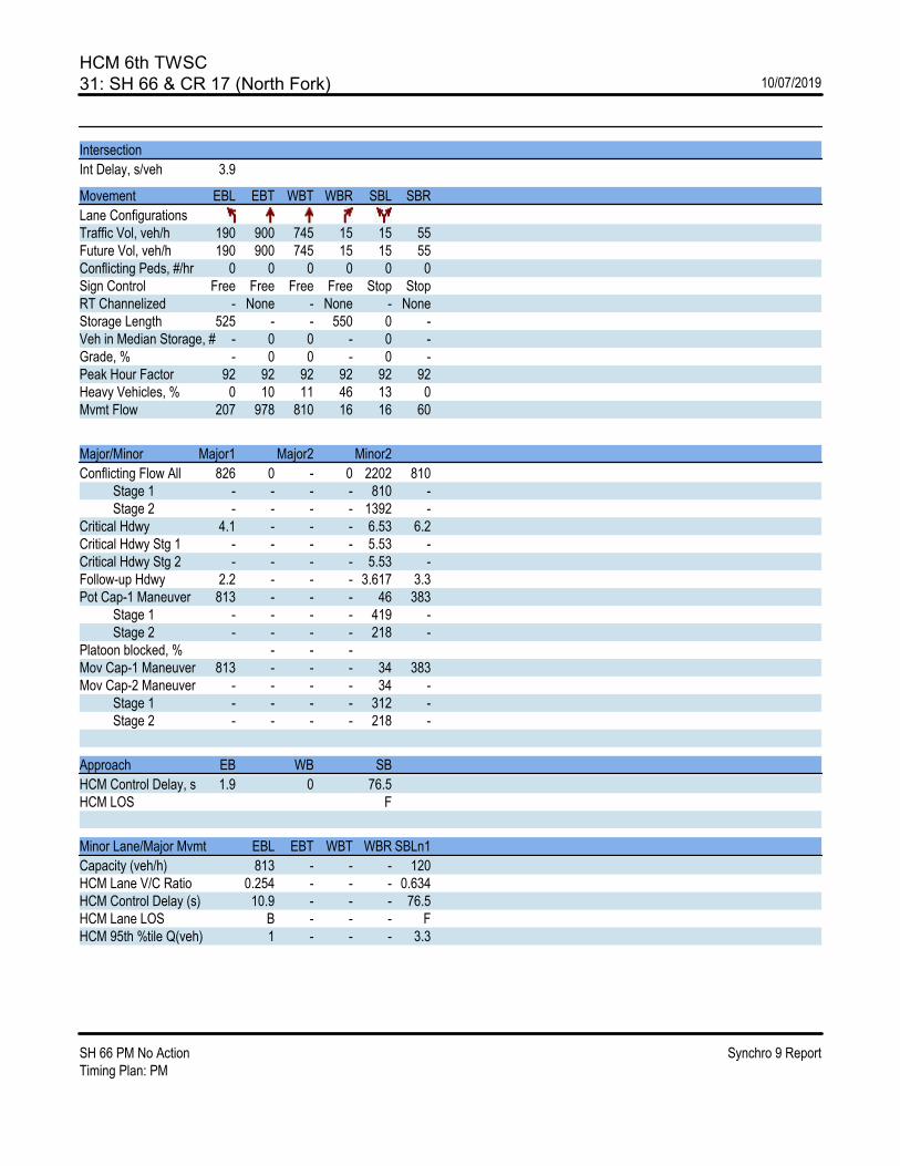
HCM 6th TWSC31: SH 66 & CR 17 (North Fork) 10/07/2019
SH 66 PM No Action Synchro 9 ReportTiming Plan: PM
Intersection
Int Delay, s/veh 3.9
Movement EBL EBT WBT WBR SBL SBR
Lane ConfigurationsTraffic Vol, veh/h 190 900 745 15 15 55Future Vol, veh/h 190 900 745 15 15 55Conflicting Peds, #/hr 0 0 0 0 0 0Sign Control Free Free Free Free Stop StopRT Channelized - None - None - NoneStorage Length 525 - - 550 0 -Veh in Median Storage, # - 0 0 - 0 -Grade, % - 0 0 - 0 -Peak Hour Factor 92 92 92 92 92 92Heavy Vehicles, % 0 10 11 46 13 0Mvmt Flow 207 978 810 16 16 60
Major/Minor Major1 Major2 Minor2
Conflicting Flow All 826 0 - 0 2202 810 Stage 1 - - - - 810 - Stage 2 - - - - 1392 -Critical Hdwy 4.1 - - - 6.53 6.2Critical Hdwy Stg 1 - - - - 5.53 -Critical Hdwy Stg 2 - - - - 5.53 -Follow-up Hdwy 2.2 - - - 3.617 3.3Pot Cap-1 Maneuver 813 - - - 46 383 Stage 1 - - - - 419 - Stage 2 - - - - 218 -Platoon blocked, % - - -Mov Cap-1 Maneuver 813 - - - 34 383Mov Cap-2 Maneuver - - - - 34 - Stage 1 - - - - 312 - Stage 2 - - - - 218 -
Approach EB WB SB
HCM Control Delay, s 1.9 0 76.5HCM LOS F
Minor Lane/Major Mvmt EBL EBT WBT WBR SBLn1
Capacity (veh/h) 813 - - - 120HCM Lane V/C Ratio 0.254 - - - 0.634HCM Control Delay (s) 10.9 - - - 76.5HCM Lane LOS B - - - FHCM 95th %tile Q(veh) 1 - - - 3.3

HCM 6th TWSC32: CR 17 & SH 66 10/07/2019
SH 66 PM No Action Synchro 9 ReportTiming Plan: PM
Intersection
Int Delay, s/veh 3.6
Movement EBT EBR WBL WBT NBL NBR
Lane ConfigurationsTraffic Vol, veh/h 825 90 5 700 60 5Future Vol, veh/h 825 90 5 700 60 5Conflicting Peds, #/hr 0 0 0 0 0 0Sign Control Free Free Free Free Stop StopRT Channelized - None - None - NoneStorage Length - - - - 0 -Veh in Median Storage, # 0 - - 0 0 -Grade, % 0 - - 0 0 -Peak Hour Factor 92 92 92 92 92 92Heavy Vehicles, % 10 0 0 14 0 0Mvmt Flow 897 98 5 761 65 5
Major/Minor Major1 Major2 Minor1
Conflicting Flow All 0 0 995 0 1717 946 Stage 1 - - - - 946 - Stage 2 - - - - 771 -Critical Hdwy - - 4.1 - 6.4 6.2Critical Hdwy Stg 1 - - - - 5.4 -Critical Hdwy Stg 2 - - - - 5.4 -Follow-up Hdwy - - 2.2 - 3.5 3.3Pot Cap-1 Maneuver - - 703 - 100 320 Stage 1 - - - - 381 - Stage 2 - - - - 460 -Platoon blocked, % - - -Mov Cap-1 Maneuver - - 703 - 99 320Mov Cap-2 Maneuver - - - - 99 - Stage 1 - - - - 376 - Stage 2 - - - - 460 -
Approach EB WB NB
HCM Control Delay, s 0 0.1 91.4HCM LOS F
Minor Lane/Major Mvmt NBLn1 EBT EBR WBL WBT
Capacity (veh/h) 105 - - 703 -HCM Lane V/C Ratio 0.673 - - 0.008 -HCM Control Delay (s) 91.4 - - 10.2 0HCM Lane LOS F - - B AHCM 95th %tile Q(veh) 3.4 - - 0 -
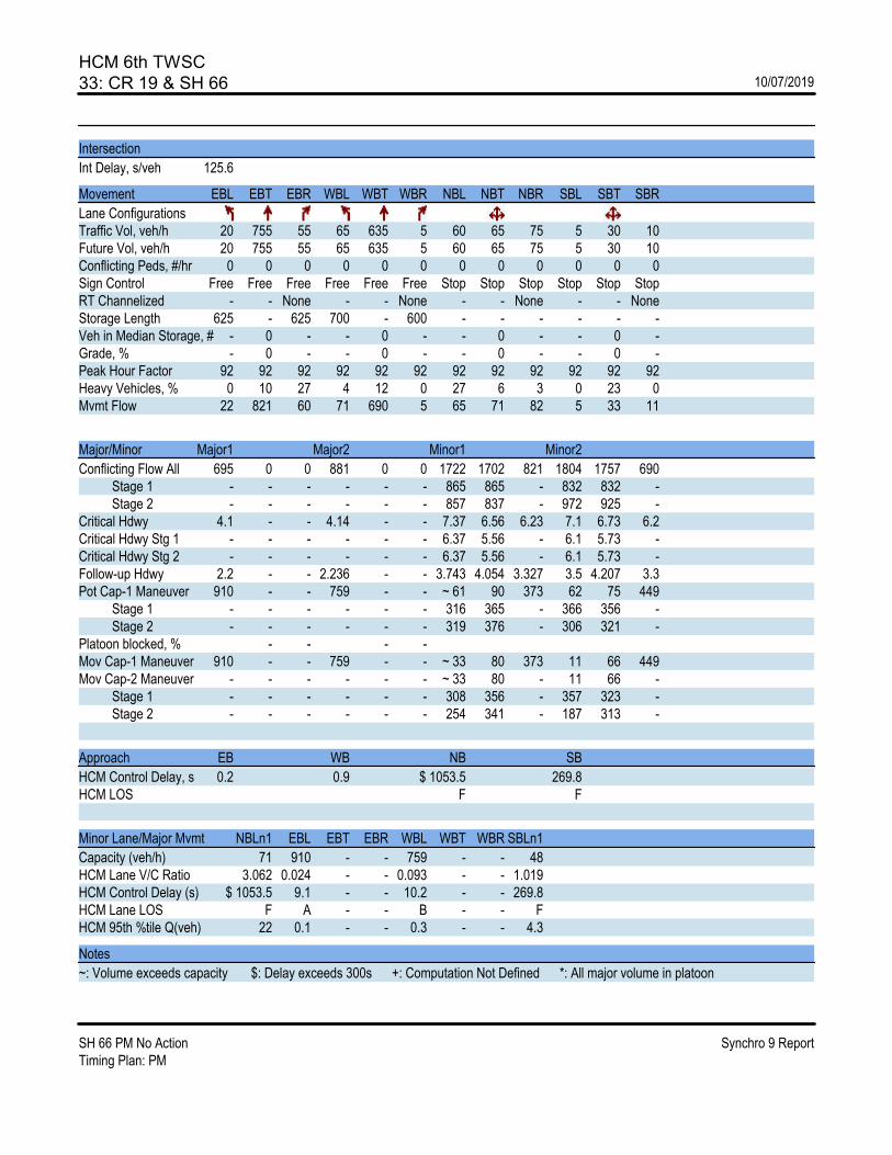
HCM 6th TWSC33: CR 19 & SH 66 10/07/2019
SH 66 PM No Action Synchro 9 ReportTiming Plan: PM
Intersection
Int Delay, s/veh 125.6
Movement EBL EBT EBR WBL WBT WBR NBL NBT NBR SBL SBT SBR
Lane ConfigurationsTraffic Vol, veh/h 20 755 55 65 635 5 60 65 75 5 30 10Future Vol, veh/h 20 755 55 65 635 5 60 65 75 5 30 10Conflicting Peds, #/hr 0 0 0 0 0 0 0 0 0 0 0 0Sign Control Free Free Free Free Free Free Stop Stop Stop Stop Stop StopRT Channelized - - None - - None - - None - - NoneStorage Length 625 - 625 700 - 600 - - - - - -Veh in Median Storage, # - 0 - - 0 - - 0 - - 0 -Grade, % - 0 - - 0 - - 0 - - 0 -Peak Hour Factor 92 92 92 92 92 92 92 92 92 92 92 92Heavy Vehicles, % 0 10 27 4 12 0 27 6 3 0 23 0Mvmt Flow 22 821 60 71 690 5 65 71 82 5 33 11
Major/Minor Major1 Major2 Minor1 Minor2
Conflicting Flow All 695 0 0 881 0 0 1722 1702 821 1804 1757 690 Stage 1 - - - - - - 865 865 - 832 832 - Stage 2 - - - - - - 857 837 - 972 925 -Critical Hdwy 4.1 - - 4.14 - - 7.37 6.56 6.23 7.1 6.73 6.2Critical Hdwy Stg 1 - - - - - - 6.37 5.56 - 6.1 5.73 -Critical Hdwy Stg 2 - - - - - - 6.37 5.56 - 6.1 5.73 -Follow-up Hdwy 2.2 - - 2.236 - - 3.743 4.054 3.327 3.5 4.207 3.3Pot Cap-1 Maneuver 910 - - 759 - - ~ 61 90 373 62 75 449 Stage 1 - - - - - - 316 365 - 366 356 - Stage 2 - - - - - - 319 376 - 306 321 -Platoon blocked, % - - - -Mov Cap-1 Maneuver 910 - - 759 - - ~ 33 80 373 11 66 449Mov Cap-2 Maneuver - - - - - - ~ 33 80 - 11 66 - Stage 1 - - - - - - 308 356 - 357 323 - Stage 2 - - - - - - 254 341 - 187 313 -
Approach EB WB NB SB
HCM Control Delay, s 0.2 0.9 $ 1053.5 269.8HCM LOS F F
Minor Lane/Major Mvmt NBLn1 EBL EBT EBR WBL WBT WBR SBLn1
Capacity (veh/h) 71 910 - - 759 - - 48HCM Lane V/C Ratio 3.062 0.024 - - 0.093 - - 1.019HCM Control Delay (s) $ 1053.5 9.1 - - 10.2 - - 269.8HCM Lane LOS F A - - B - - FHCM 95th %tile Q(veh) 22 0.1 - - 0.3 - - 4.3
Notes
~: Volume exceeds capacity $: Delay exceeds 300s +: Computation Not Defined *: All major volume in platoon

SH 66 Access Control Plan | Final Report
F.3. 2040 AM with Recommended PEL Laneage and ACP Implemented

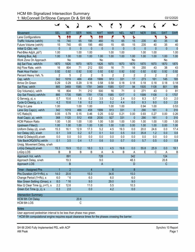
HCM 6th Signalized Intersection Summary1: McConnell Dr/Stone Canyon Dr & SH 66 03/12/2020
SH 66 2040 Fully Implemented PEL with ACP Synchro 10 ReportAM Peak Page 1
Movement SEL SET SER NWL NWT NWR NEL NET NER SWL SWT SWR
Lane ConfigurationsTraffic Volume (veh/h) 15 740 65 195 460 15 65 15 235 40 35 40Future Volume (veh/h) 15 740 65 195 460 15 65 15 235 40 35 40Initial Q (Qb), veh 0 0 0 0 0 0 0 0 0 0 0 0Ped-Bike Adj(A_pbT) 1.00 1.00 1.00 1.00 1.00 1.00 1.00 1.00Parking Bus, Adj 1.00 1.00 1.00 1.00 1.00 1.00 1.00 1.00 1.00 1.00 1.00 1.00Work Zone On Approach No No No NoAdj Sat Flow, veh/h/ln 1870 1826 1870 1870 1826 1870 1870 1870 1870 1870 1870 1870Adj Flow Rate, veh/h 16 804 71 212 500 16 71 16 255 43 38 43Peak Hour Factor 0.92 0.92 0.92 0.92 0.92 0.92 0.92 0.92 0.92 0.92 0.92 0.92Percent Heavy Veh, % 2 5 2 2 5 2 2 2 2 2 2 2Cap, veh/h 342 1019 466 458 1999 913 331 17 273 161 145 165Arrive On Green 0.29 0.29 0.29 0.16 0.58 0.58 0.18 0.18 0.18 0.18 0.18 0.18Sat Flow, veh/h 885 3469 1585 1781 3469 1585 1317 94 1505 1108 801 906
Grp Volume(v), veh/h 16 804 71 212 500 16 71 0 271 43 0 81Grp Sat Flow(s),veh/h/ln 885 1735 1585 1781 1735 1585 1317 0 1599 1108 0 1707Q Serve(g_s), s 0.7 10.6 1.6 0.2 3.5 0.2 2.4 0.0 8.3 0.7 0.0 2.0Cycle Q Clear(g_c), s 4.2 10.6 1.6 0.2 3.5 0.2 4.4 0.0 8.3 9.0 0.0 2.0Prop In Lane 1.00 1.00 1.00 1.00 1.00 0.94 1.00 0.53Lane Grp Cap(c), veh/h 342 1019 466 458 1999 913 331 0 290 161 0 310V/C Ratio(X) 0.05 0.79 0.15 0.46 0.25 0.02 0.21 0.00 0.93 0.27 0.00 0.26Avail Cap(c_a), veh/h 368 1120 512 458 2030 927 331 0 290 161 0 310HCM Platoon Ratio 1.00 1.00 1.00 1.00 1.00 1.00 1.00 1.00 1.00 1.00 1.00 1.00Upstream Filter(I) 1.00 1.00 1.00 1.00 1.00 1.00 1.00 0.00 1.00 1.00 0.00 1.00Uniform Delay (d), s/veh 15.3 16.1 12.9 17.3 5.2 4.5 19.3 0.0 20.0 24.6 0.0 17.4Incr Delay (d2), s/veh 0.1 3.9 0.2 0.7 0.1 0.0 0.5 0.0 35.8 1.2 0.0 0.6Initial Q Delay(d3),s/veh 0.0 0.0 0.0 0.0 0.0 0.0 0.0 0.0 0.0 0.0 0.0 0.0%ile BackOfQ(50%),veh/ln 0.1 3.5 0.4 1.7 0.6 0.0 0.7 0.0 5.7 0.5 0.0 0.8Unsig. Movement Delay, s/vehLnGrp Delay(d),s/veh 15.3 19.9 13.2 18.0 5.3 4.5 19.8 0.0 55.8 25.9 0.0 18.1LnGrp LOS B B B B A A B A E C A B
Approach Vol, veh/h 891 728 342 124Approach Delay, s/veh 19.3 9.0 48.3 20.8Approach LOS B A D C
Timer - Assigned Phs 1 2 4 6 8
Phs Duration (G+Y+Rc), s 14.0 20.6 15.0 34.6 15.0Change Period (Y+Rc), s 6.0 * 6 6.0 6.0 6.0Max Green Setting (Gmax), s 8.0 * 16 9.0 29.0 9.0Max Q Clear Time (g_c+I1), s 2.2 12.6 11.0 5.5 10.3Green Ext Time (p_c), s 0.3 2.0 0.0 4.2 0.0
Intersection Summary
HCM 6th Ctrl Delay 20.6HCM 6th LOS C
Notes
User approved pedestrian interval to be less than phase max green.* HCM 6th computational engine requires equal clearance times for the phases crossing the barrier.
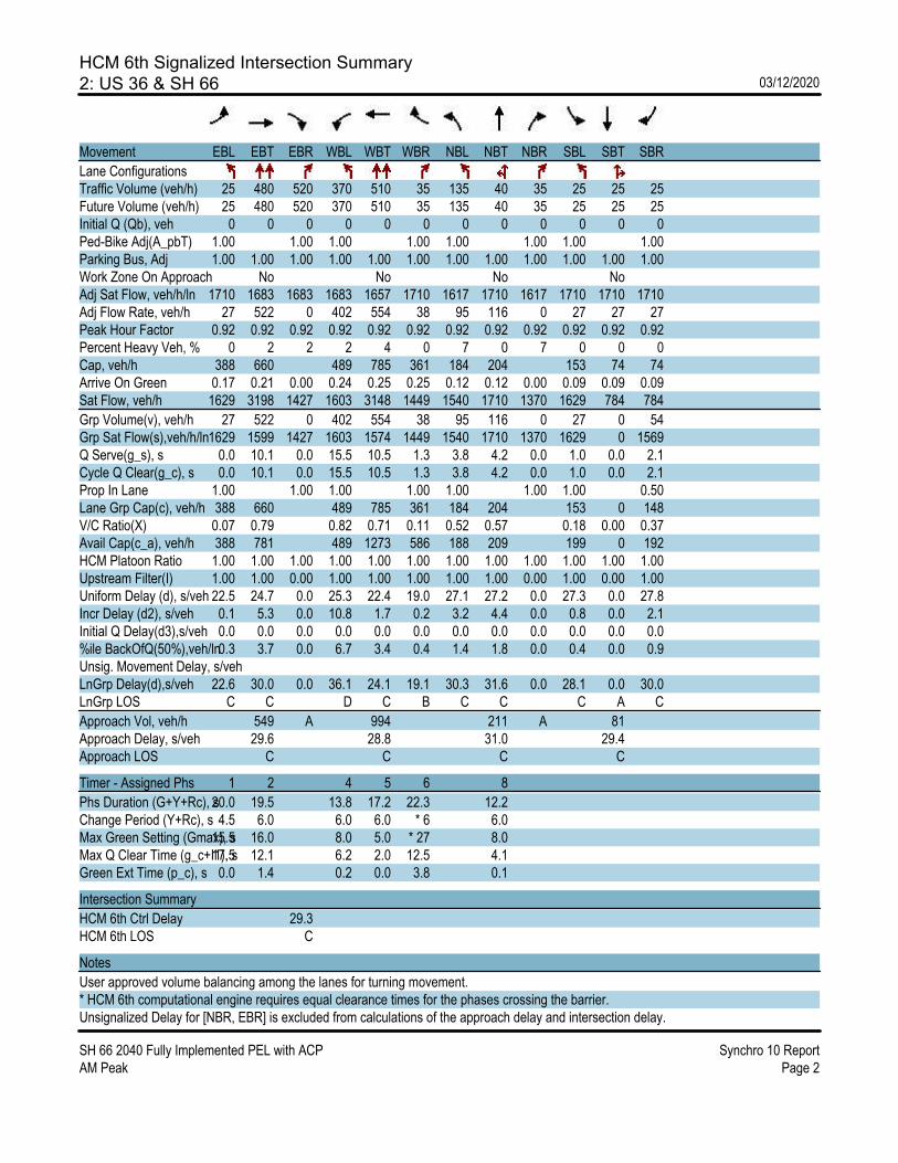
HCM 6th Signalized Intersection Summary2: US 36 & SH 66 03/12/2020
SH 66 2040 Fully Implemented PEL with ACP Synchro 10 ReportAM Peak Page 2
Movement EBL EBT EBR WBL WBT WBR NBL NBT NBR SBL SBT SBR
Lane ConfigurationsTraffic Volume (veh/h) 25 480 520 370 510 35 135 40 35 25 25 25Future Volume (veh/h) 25 480 520 370 510 35 135 40 35 25 25 25Initial Q (Qb), veh 0 0 0 0 0 0 0 0 0 0 0 0Ped-Bike Adj(A_pbT) 1.00 1.00 1.00 1.00 1.00 1.00 1.00 1.00Parking Bus, Adj 1.00 1.00 1.00 1.00 1.00 1.00 1.00 1.00 1.00 1.00 1.00 1.00Work Zone On Approach No No No NoAdj Sat Flow, veh/h/ln 1710 1683 1683 1683 1657 1710 1617 1710 1617 1710 1710 1710Adj Flow Rate, veh/h 27 522 0 402 554 38 95 116 0 27 27 27Peak Hour Factor 0.92 0.92 0.92 0.92 0.92 0.92 0.92 0.92 0.92 0.92 0.92 0.92Percent Heavy Veh, % 0 2 2 2 4 0 7 0 7 0 0 0Cap, veh/h 388 660 489 785 361 184 204 153 74 74Arrive On Green 0.17 0.21 0.00 0.24 0.25 0.25 0.12 0.12 0.00 0.09 0.09 0.09Sat Flow, veh/h 1629 3198 1427 1603 3148 1449 1540 1710 1370 1629 784 784
Grp Volume(v), veh/h 27 522 0 402 554 38 95 116 0 27 0 54Grp Sat Flow(s),veh/h/ln1629 1599 1427 1603 1574 1449 1540 1710 1370 1629 0 1569Q Serve(g_s), s 0.0 10.1 0.0 15.5 10.5 1.3 3.8 4.2 0.0 1.0 0.0 2.1Cycle Q Clear(g_c), s 0.0 10.1 0.0 15.5 10.5 1.3 3.8 4.2 0.0 1.0 0.0 2.1Prop In Lane 1.00 1.00 1.00 1.00 1.00 1.00 1.00 0.50Lane Grp Cap(c), veh/h 388 660 489 785 361 184 204 153 0 148V/C Ratio(X) 0.07 0.79 0.82 0.71 0.11 0.52 0.57 0.18 0.00 0.37Avail Cap(c_a), veh/h 388 781 489 1273 586 188 209 199 0 192HCM Platoon Ratio 1.00 1.00 1.00 1.00 1.00 1.00 1.00 1.00 1.00 1.00 1.00 1.00Upstream Filter(I) 1.00 1.00 0.00 1.00 1.00 1.00 1.00 1.00 0.00 1.00 0.00 1.00Uniform Delay (d), s/veh 22.5 24.7 0.0 25.3 22.4 19.0 27.1 27.2 0.0 27.3 0.0 27.8Incr Delay (d2), s/veh 0.1 5.3 0.0 10.8 1.7 0.2 3.2 4.4 0.0 0.8 0.0 2.1Initial Q Delay(d3),s/veh 0.0 0.0 0.0 0.0 0.0 0.0 0.0 0.0 0.0 0.0 0.0 0.0%ile BackOfQ(50%),veh/ln0.3 3.7 0.0 6.7 3.4 0.4 1.4 1.8 0.0 0.4 0.0 0.9Unsig. Movement Delay, s/vehLnGrp Delay(d),s/veh 22.6 30.0 0.0 36.1 24.1 19.1 30.3 31.6 0.0 28.1 0.0 30.0LnGrp LOS C C D C B C C C A C
Approach Vol, veh/h 549 A 994 211 A 81Approach Delay, s/veh 29.6 28.8 31.0 29.4Approach LOS C C C C
Timer - Assigned Phs 1 2 4 5 6 8
Phs Duration (G+Y+Rc), s20.0 19.5 13.8 17.2 22.3 12.2Change Period (Y+Rc), s 4.5 6.0 6.0 6.0 * 6 6.0Max Green Setting (Gmax), s15.5 16.0 8.0 5.0 * 27 8.0Max Q Clear Time (g_c+I1), s17.5 12.1 6.2 2.0 12.5 4.1Green Ext Time (p_c), s 0.0 1.4 0.2 0.0 3.8 0.1
Intersection Summary
HCM 6th Ctrl Delay 29.3HCM 6th LOS C
Notes
User approved volume balancing among the lanes for turning movement.* HCM 6th computational engine requires equal clearance times for the phases crossing the barrier.Unsignalized Delay for [NBR, EBR] is excluded from calculations of the approach delay and intersection delay.
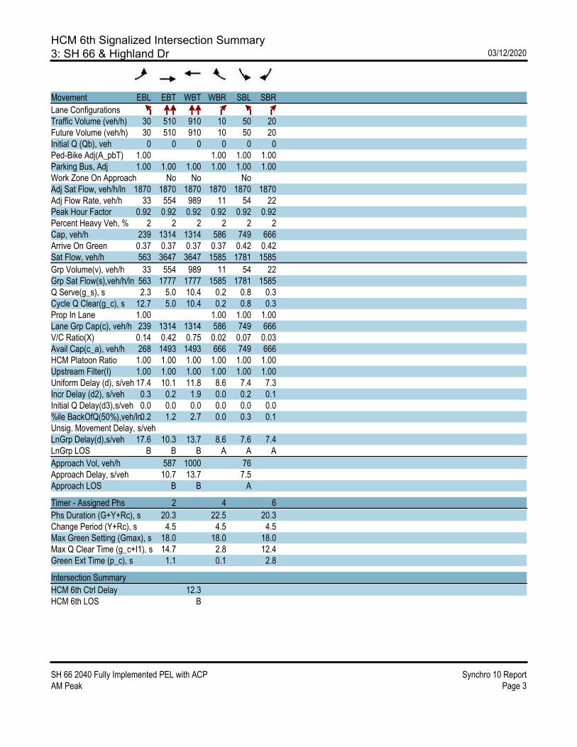
HCM 6th Signalized Intersection Summary3: SH 66 & Highland Dr 03/12/2020
SH 66 2040 Fully Implemented PEL with ACP Synchro 10 ReportAM Peak Page 3
Movement EBL EBT WBT WBR SBL SBR
Lane ConfigurationsTraffic Volume (veh/h) 30 510 910 10 50 20Future Volume (veh/h) 30 510 910 10 50 20Initial Q (Qb), veh 0 0 0 0 0 0Ped-Bike Adj(A_pbT) 1.00 1.00 1.00 1.00Parking Bus, Adj 1.00 1.00 1.00 1.00 1.00 1.00Work Zone On Approach No No NoAdj Sat Flow, veh/h/ln 1870 1870 1870 1870 1870 1870Adj Flow Rate, veh/h 33 554 989 11 54 22Peak Hour Factor 0.92 0.92 0.92 0.92 0.92 0.92Percent Heavy Veh, % 2 2 2 2 2 2Cap, veh/h 239 1314 1314 586 749 666Arrive On Green 0.37 0.37 0.37 0.37 0.42 0.42Sat Flow, veh/h 563 3647 3647 1585 1781 1585
Grp Volume(v), veh/h 33 554 989 11 54 22Grp Sat Flow(s),veh/h/ln 563 1777 1777 1585 1781 1585Q Serve(g_s), s 2.3 5.0 10.4 0.2 0.8 0.3Cycle Q Clear(g_c), s 12.7 5.0 10.4 0.2 0.8 0.3Prop In Lane 1.00 1.00 1.00 1.00Lane Grp Cap(c), veh/h 239 1314 1314 586 749 666V/C Ratio(X) 0.14 0.42 0.75 0.02 0.07 0.03Avail Cap(c_a), veh/h 268 1493 1493 666 749 666HCM Platoon Ratio 1.00 1.00 1.00 1.00 1.00 1.00Upstream Filter(I) 1.00 1.00 1.00 1.00 1.00 1.00Uniform Delay (d), s/veh 17.4 10.1 11.8 8.6 7.4 7.3Incr Delay (d2), s/veh 0.3 0.2 1.9 0.0 0.2 0.1Initial Q Delay(d3),s/veh 0.0 0.0 0.0 0.0 0.0 0.0%ile BackOfQ(50%),veh/ln0.2 1.2 2.7 0.0 0.3 0.1Unsig. Movement Delay, s/vehLnGrp Delay(d),s/veh 17.6 10.3 13.7 8.6 7.6 7.4LnGrp LOS B B B A A A
Approach Vol, veh/h 587 1000 76Approach Delay, s/veh 10.7 13.7 7.5Approach LOS B B A
Timer - Assigned Phs 2 4 6
Phs Duration (G+Y+Rc), s 20.3 22.5 20.3Change Period (Y+Rc), s 4.5 4.5 4.5Max Green Setting (Gmax), s 18.0 18.0 18.0Max Q Clear Time (g_c+I1), s 14.7 2.8 12.4Green Ext Time (p_c), s 1.1 0.1 2.8
Intersection Summary
HCM 6th Ctrl Delay 12.3HCM 6th LOS B
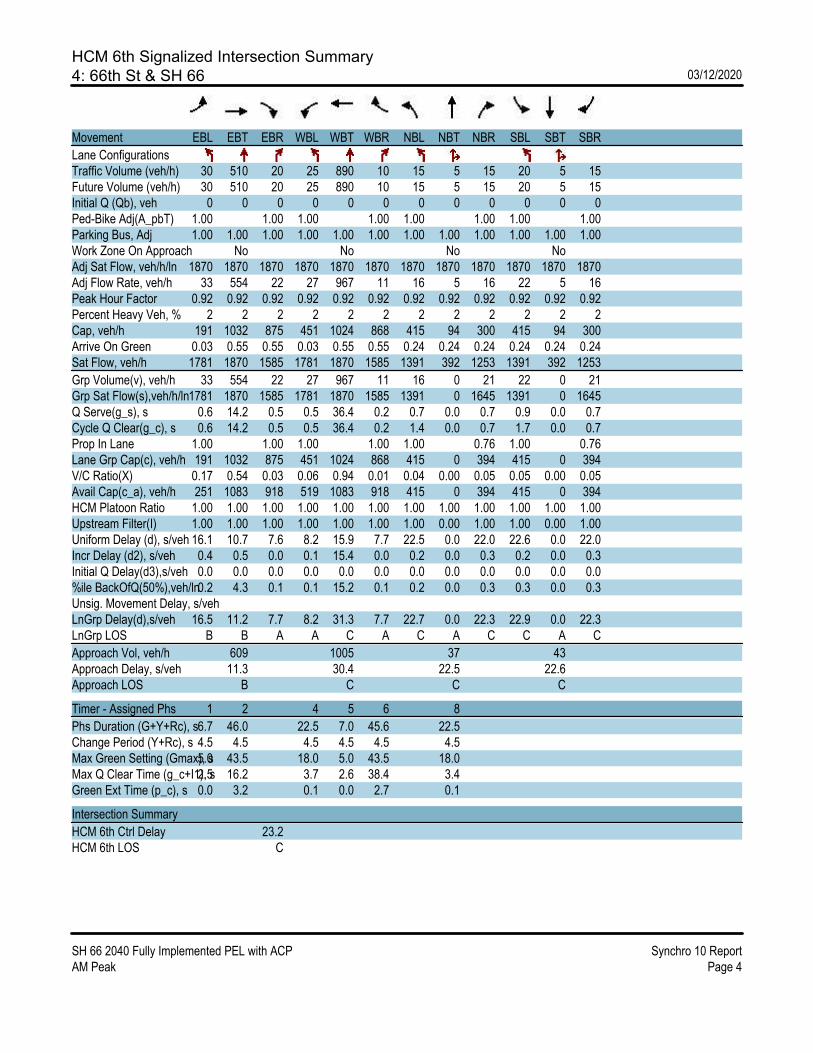
HCM 6th Signalized Intersection Summary4: 66th St & SH 66 03/12/2020
SH 66 2040 Fully Implemented PEL with ACP Synchro 10 ReportAM Peak Page 4
Movement EBL EBT EBR WBL WBT WBR NBL NBT NBR SBL SBT SBR
Lane ConfigurationsTraffic Volume (veh/h) 30 510 20 25 890 10 15 5 15 20 5 15Future Volume (veh/h) 30 510 20 25 890 10 15 5 15 20 5 15Initial Q (Qb), veh 0 0 0 0 0 0 0 0 0 0 0 0Ped-Bike Adj(A_pbT) 1.00 1.00 1.00 1.00 1.00 1.00 1.00 1.00Parking Bus, Adj 1.00 1.00 1.00 1.00 1.00 1.00 1.00 1.00 1.00 1.00 1.00 1.00Work Zone On Approach No No No NoAdj Sat Flow, veh/h/ln 1870 1870 1870 1870 1870 1870 1870 1870 1870 1870 1870 1870Adj Flow Rate, veh/h 33 554 22 27 967 11 16 5 16 22 5 16Peak Hour Factor 0.92 0.92 0.92 0.92 0.92 0.92 0.92 0.92 0.92 0.92 0.92 0.92Percent Heavy Veh, % 2 2 2 2 2 2 2 2 2 2 2 2Cap, veh/h 191 1032 875 451 1024 868 415 94 300 415 94 300Arrive On Green 0.03 0.55 0.55 0.03 0.55 0.55 0.24 0.24 0.24 0.24 0.24 0.24Sat Flow, veh/h 1781 1870 1585 1781 1870 1585 1391 392 1253 1391 392 1253
Grp Volume(v), veh/h 33 554 22 27 967 11 16 0 21 22 0 21Grp Sat Flow(s),veh/h/ln1781 1870 1585 1781 1870 1585 1391 0 1645 1391 0 1645Q Serve(g_s), s 0.6 14.2 0.5 0.5 36.4 0.2 0.7 0.0 0.7 0.9 0.0 0.7Cycle Q Clear(g_c), s 0.6 14.2 0.5 0.5 36.4 0.2 1.4 0.0 0.7 1.7 0.0 0.7Prop In Lane 1.00 1.00 1.00 1.00 1.00 0.76 1.00 0.76Lane Grp Cap(c), veh/h 191 1032 875 451 1024 868 415 0 394 415 0 394V/C Ratio(X) 0.17 0.54 0.03 0.06 0.94 0.01 0.04 0.00 0.05 0.05 0.00 0.05Avail Cap(c_a), veh/h 251 1083 918 519 1083 918 415 0 394 415 0 394HCM Platoon Ratio 1.00 1.00 1.00 1.00 1.00 1.00 1.00 1.00 1.00 1.00 1.00 1.00Upstream Filter(I) 1.00 1.00 1.00 1.00 1.00 1.00 1.00 0.00 1.00 1.00 0.00 1.00Uniform Delay (d), s/veh 16.1 10.7 7.6 8.2 15.9 7.7 22.5 0.0 22.0 22.6 0.0 22.0Incr Delay (d2), s/veh 0.4 0.5 0.0 0.1 15.4 0.0 0.2 0.0 0.3 0.2 0.0 0.3Initial Q Delay(d3),s/veh 0.0 0.0 0.0 0.0 0.0 0.0 0.0 0.0 0.0 0.0 0.0 0.0%ile BackOfQ(50%),veh/ln0.2 4.3 0.1 0.1 15.2 0.1 0.2 0.0 0.3 0.3 0.0 0.3Unsig. Movement Delay, s/vehLnGrp Delay(d),s/veh 16.5 11.2 7.7 8.2 31.3 7.7 22.7 0.0 22.3 22.9 0.0 22.3LnGrp LOS B B A A C A C A C C A C
Approach Vol, veh/h 609 1005 37 43Approach Delay, s/veh 11.3 30.4 22.5 22.6Approach LOS B C C C
Timer - Assigned Phs 1 2 4 5 6 8
Phs Duration (G+Y+Rc), s6.7 46.0 22.5 7.0 45.6 22.5Change Period (Y+Rc), s 4.5 4.5 4.5 4.5 4.5 4.5Max Green Setting (Gmax), s5.0 43.5 18.0 5.0 43.5 18.0Max Q Clear Time (g_c+I1), s2.5 16.2 3.7 2.6 38.4 3.4Green Ext Time (p_c), s 0.0 3.2 0.1 0.0 2.7 0.1
Intersection Summary
HCM 6th Ctrl Delay 23.2HCM 6th LOS C

HCM 6th Signalized Intersection Summary5: N 75th St & SH 66 03/12/2020
SH 66 2040 Fully Implemented PEL with ACP Synchro 10 ReportAM Peak Page 5
Movement EBL EBT EBR WBL WBT WBR NBL NBT NBR SBL SBT SBR
Lane ConfigurationsTraffic Volume (veh/h) 10 380 145 270 765 5 85 10 40 5 195 75Future Volume (veh/h) 10 380 145 270 765 5 85 10 40 5 195 75Initial Q (Qb), veh 0 0 0 0 0 0 0 0 0 0 0 0Ped-Bike Adj(A_pbT) 1.00 1.00 1.00 1.00 1.00 1.00 1.00 1.00Parking Bus, Adj 1.00 1.00 1.00 1.00 1.00 1.00 1.00 1.00 1.00 1.00 1.00 1.00Work Zone On Approach No No No NoAdj Sat Flow, veh/h/ln 1900 1841 1900 1900 1841 1900 1900 1900 1841 1900 1900 1900Adj Flow Rate, veh/h 11 413 158 293 832 5 92 11 43 5 212 82Peak Hour Factor 0.92 0.92 0.92 0.92 0.92 0.92 0.92 0.92 0.92 0.92 0.92 0.92Percent Heavy Veh, % 0 4 0 0 4 0 0 0 4 0 0 0Cap, veh/h 190 736 644 506 920 804 236 360 481 298 261 221Arrive On Green 0.02 0.40 0.40 0.12 0.50 0.50 0.06 0.19 0.19 0.01 0.14 0.14Sat Flow, veh/h 1810 1841 1610 1810 1841 1610 1810 1900 1560 1810 1900 1610
Grp Volume(v), veh/h 11 413 158 293 832 5 92 11 43 5 212 82Grp Sat Flow(s),veh/h/ln1810 1841 1610 1810 1841 1610 1810 1900 1560 1810 1900 1610Q Serve(g_s), s 0.3 12.8 4.8 6.5 30.4 0.1 3.1 0.3 1.4 0.2 8.0 3.4Cycle Q Clear(g_c), s 0.3 12.8 4.8 6.5 30.4 0.1 3.1 0.3 1.4 0.2 8.0 3.4Prop In Lane 1.00 1.00 1.00 1.00 1.00 1.00 1.00 1.00Lane Grp Cap(c), veh/h 190 736 644 506 920 804 236 360 481 298 261 221V/C Ratio(X) 0.06 0.56 0.25 0.58 0.90 0.01 0.39 0.03 0.09 0.02 0.81 0.37Avail Cap(c_a), veh/h 328 1008 881 603 1150 1006 253 360 481 409 284 241HCM Platoon Ratio 1.00 1.00 1.00 1.00 1.00 1.00 1.00 1.00 1.00 1.00 1.00 1.00Upstream Filter(I) 1.00 1.00 1.00 1.00 1.00 1.00 1.00 1.00 1.00 1.00 1.00 1.00Uniform Delay (d), s/veh 16.2 17.1 14.7 11.3 16.8 9.2 24.6 24.3 18.1 27.1 30.8 28.9Incr Delay (d2), s/veh 0.1 0.7 0.2 1.0 8.7 0.0 1.0 0.0 0.1 0.0 15.3 1.0Initial Q Delay(d3),s/veh 0.0 0.0 0.0 0.0 0.0 0.0 0.0 0.0 0.0 0.0 0.0 0.0%ile BackOfQ(50%),veh/ln0.1 4.5 1.7 2.0 11.7 0.0 1.3 0.2 0.5 0.1 4.5 1.3Unsig. Movement Delay, s/vehLnGrp Delay(d),s/veh 16.3 17.8 14.9 12.4 25.6 9.2 25.6 24.4 18.2 27.1 46.1 29.9LnGrp LOS B B B B C A C C B C D C
Approach Vol, veh/h 582 1130 146 299Approach Delay, s/veh 17.0 22.1 23.3 41.3Approach LOS B C C D
Timer - Assigned Phs 1 2 3 4 5 6 7 8
Phs Duration (G+Y+Rc), s13.3 36.4 8.8 15.1 5.9 43.8 5.0 18.9Change Period (Y+Rc), s 4.5 7.0 4.5 5.0 4.5 7.0 4.5 5.0Max Green Setting (Gmax), s12.7 40.3 5.0 11.0 7.0 46.0 5.0 11.0Max Q Clear Time (g_c+I1), s8.5 14.8 5.1 10.0 2.3 32.4 2.2 3.4Green Ext Time (p_c), s 0.3 2.7 0.0 0.1 0.0 4.4 0.0 0.1
Intersection Summary
HCM 6th Ctrl Delay 23.5HCM 6th LOS C
Notes
User approved pedestrian interval to be less than phase max green.

HCM 6th Signalized Intersection Summary6: Airport Rd/87th St & SH 66 03/12/2020
SH 66 2040 Fully Implemented PEL with ACP Synchro 10 ReportAM Peak Page 6
Movement EBL EBT EBR WBL WBT WBR NBL NBT NBR SBL SBT SBR
Lane ConfigurationsTraffic Volume (veh/h) 5 415 5 30 975 25 20 5 30 50 5 25Future Volume (veh/h) 5 415 5 30 975 25 20 5 30 50 5 25Initial Q (Qb), veh 0 0 0 0 0 0 0 0 0 0 0 0Ped-Bike Adj(A_pbT) 1.00 1.00 1.00 1.00 1.00 1.00 1.00 1.00Parking Bus, Adj 1.00 1.00 1.00 1.00 1.00 1.00 1.00 1.00 1.00 1.00 1.00 1.00Work Zone On Approach No No No NoAdj Sat Flow, veh/h/ln 1900 1841 1900 1900 1841 1900 1900 1900 1900 1900 1900 1900Adj Flow Rate, veh/h 5 451 5 33 1060 27 22 5 33 54 5 27Peak Hour Factor 0.92 0.92 0.92 0.92 0.92 0.92 0.92 0.92 0.92 0.92 0.92 0.92Percent Heavy Veh, % 0 4 0 0 4 0 0 0 0 0 0 0Cap, veh/h 239 2191 1009 736 1207 1056 239 21 139 234 25 135Arrive On Green 0.01 0.63 0.63 0.04 0.66 0.66 0.10 0.10 0.10 0.10 0.10 0.10Sat Flow, veh/h 1810 3497 1610 1810 1841 1610 1399 216 1427 1391 258 1392
Grp Volume(v), veh/h 5 451 5 33 1060 27 22 0 38 54 0 32Grp Sat Flow(s),veh/h/ln1810 1749 1610 1810 1841 1610 1399 0 1643 1391 0 1649Q Serve(g_s), s 0.1 3.1 0.1 0.4 26.3 0.3 0.8 0.0 1.2 2.1 0.0 1.0Cycle Q Clear(g_c), s 0.1 3.1 0.1 0.4 26.3 0.3 1.8 0.0 1.2 3.3 0.0 1.0Prop In Lane 1.00 1.00 1.00 1.00 1.00 0.87 1.00 0.84Lane Grp Cap(c), veh/h 239 2191 1009 736 1207 1056 239 0 160 234 0 161V/C Ratio(X) 0.02 0.21 0.00 0.04 0.88 0.03 0.09 0.00 0.24 0.23 0.00 0.20Avail Cap(c_a), veh/h 388 3332 1534 832 1754 1534 552 0 527 544 0 529HCM Platoon Ratio 1.00 1.00 1.00 1.00 1.00 1.00 1.00 1.00 1.00 1.00 1.00 1.00Upstream Filter(I) 1.00 1.00 1.00 1.00 1.00 1.00 1.00 0.00 1.00 1.00 0.00 1.00Uniform Delay (d), s/veh 9.2 4.5 3.9 3.4 7.9 3.4 24.2 0.0 23.4 24.9 0.0 23.3Incr Delay (d2), s/veh 0.0 0.0 0.0 0.0 3.8 0.0 0.2 0.0 0.8 0.5 0.0 0.6Initial Q Delay(d3),s/veh 0.0 0.0 0.0 0.0 0.0 0.0 0.0 0.0 0.0 0.0 0.0 0.0%ile BackOfQ(50%),veh/ln0.0 0.5 0.0 0.0 4.7 0.0 0.3 0.0 0.5 0.6 0.0 0.4Unsig. Movement Delay, s/vehLnGrp Delay(d),s/veh 9.3 4.5 3.9 3.4 11.7 3.4 24.3 0.0 24.2 25.4 0.0 23.9LnGrp LOS A A A A B A C A C C A C
Approach Vol, veh/h 461 1120 60 86Approach Delay, s/veh 4.6 11.2 24.2 24.9Approach LOS A B C C
Timer - Assigned Phs 2 3 4 6 7 8
Phs Duration (G+Y+Rc), s 10.0 6.5 39.7 10.0 4.9 41.3Change Period (Y+Rc), s 4.5 4.5 4.5 4.5 4.5 4.5Max Green Setting (Gmax), s 18.0 5.0 53.5 18.0 5.0 53.5Max Q Clear Time (g_c+I1), s 3.8 2.4 5.1 5.3 2.1 28.3Green Ext Time (p_c), s 0.1 0.0 2.8 0.2 0.0 8.6
Intersection Summary
HCM 6th Ctrl Delay 10.6HCM 6th LOS B
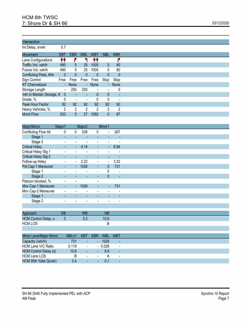
HCM 6th TWSC7: Shore Dr & SH 66 03/12/2020
SH 66 2040 Fully Implemented PEL with ACP Synchro 10 ReportAM Peak Page 7
Intersection
Int Delay, s/veh 0.7
Movement EBT EBR WBL WBT NBL NBR
Lane ConfigurationsTraffic Vol, veh/h 490 5 25 1005 0 80Future Vol, veh/h 490 5 25 1005 0 80Conflicting Peds, #/hr 0 0 0 0 0 0Sign Control Free Free Free Free Stop StopRT Channelized - None - None - NoneStorage Length - 250 250 - - 0Veh in Median Storage, # 0 - - 0 0 -Grade, % 0 - - 0 0 -Peak Hour Factor 92 92 92 92 92 92Heavy Vehicles, % 2 2 2 2 2 2Mvmt Flow 533 5 27 1092 0 87
Major/Minor Major1 Major2 Minor1
Conflicting Flow All 0 0 538 0 - 267 Stage 1 - - - - - - Stage 2 - - - - - -Critical Hdwy - - 4.14 - - 6.94Critical Hdwy Stg 1 - - - - - -Critical Hdwy Stg 2 - - - - - -Follow-up Hdwy - - 2.22 - - 3.32Pot Cap-1 Maneuver - - 1026 - 0 731 Stage 1 - - - - 0 - Stage 2 - - - - 0 -Platoon blocked, % - - -Mov Cap-1 Maneuver - - 1026 - - 731Mov Cap-2 Maneuver - - - - - - Stage 1 - - - - - - Stage 2 - - - - - -
Approach EB WB NB
HCM Control Delay, s 0 0.2 10.6HCM LOS B
Minor Lane/Major Mvmt NBLn1 EBT EBR WBL WBT
Capacity (veh/h) 731 - - 1026 -HCM Lane V/C Ratio 0.119 - - 0.026 -HCM Control Delay (s) 10.6 - - 8.6 -HCM Lane LOS B - - A -HCM 95th %tile Q(veh) 0.4 - - 0.1 -

HCM 6th TWSC8: SH 66 & Anhawa Ave 03/12/2020
SH 66 2040 Fully Implemented PEL with ACP Synchro 10 ReportAM Peak Page 8
Intersection
Int Delay, s/veh 0.2
Movement EBL EBT WBT WBR SBL SBR
Lane ConfigurationsTraffic Vol, veh/h 10 625 1060 15 0 15Future Vol, veh/h 10 625 1060 15 0 15Conflicting Peds, #/hr 0 0 0 0 0 0Sign Control Free Free Free Free Stop StopRT Channelized - None - None - NoneStorage Length 100 - - - - 0Veh in Median Storage, # - 0 0 - 0 -Grade, % - 0 0 - 0 -Peak Hour Factor 92 92 92 92 92 92Heavy Vehicles, % 0 3 4 25 25 0Mvmt Flow 11 679 1152 16 0 16
Major/Minor Major1 Major2 Minor2
Conflicting Flow All 1168 0 - 0 - 584 Stage 1 - - - - - - Stage 2 - - - - - -Critical Hdwy 4.1 - - - - 6.9Critical Hdwy Stg 1 - - - - - -Critical Hdwy Stg 2 - - - - - -Follow-up Hdwy 2.2 - - - - 3.3Pot Cap-1 Maneuver 605 - - - 0 460 Stage 1 - - - - 0 - Stage 2 - - - - 0 -Platoon blocked, % - - -Mov Cap-1 Maneuver 605 - - - - 460Mov Cap-2 Maneuver - - - - - - Stage 1 - - - - - - Stage 2 - - - - - -
Approach EB WB SB
HCM Control Delay, s 0.2 0 13.1HCM LOS B
Minor Lane/Major Mvmt EBL EBT WBT WBR SBLn1
Capacity (veh/h) 605 - - - 460HCM Lane V/C Ratio 0.018 - - - 0.035HCM Control Delay (s) 11.1 - - - 13.1HCM Lane LOS B - - - BHCM 95th %tile Q(veh) 0.1 - - - 0.1

HCM 6th TWSC9: Lake Park Dr & SH 66 03/12/2020
SH 66 2040 Fully Implemented PEL with ACP Synchro 10 ReportAM Peak Page 9
Intersection
Int Delay, s/veh 0.5
Movement EBL EBT EBR WBL WBT WBR NBL NBT NBR SBL SBT SBR
Lane ConfigurationsTraffic Vol, veh/h 0 580 45 30 1030 25 0 0 15 0 0 35Future Vol, veh/h 0 580 45 30 1030 25 0 0 15 0 0 35Conflicting Peds, #/hr 10 0 5 0 0 0 0 0 0 0 0 0Sign Control Free Free Free Free Free Free Stop Stop Stop Stop Stop StopRT Channelized - - None - - None - - None - - NoneStorage Length - - 250 250 - 250 - - 0 - - 0Veh in Median Storage, # - 0 - - 0 - - 0 - - 0 -Grade, % - 0 - - 0 - - 0 - - 0 -Peak Hour Factor 92 92 92 92 92 92 92 92 92 92 92 92Heavy Vehicles, % 0 4 1 2 6 0 3 2 4 0 0 2Mvmt Flow 0 630 49 33 1120 27 0 0 16 0 0 38
Major/Minor Major1 Major2 Minor1 Minor2
Conflicting Flow All - 0 0 684 0 0 - - 320 - - 560 Stage 1 - - - - - - - - - - - - Stage 2 - - - - - - - - - - - -Critical Hdwy - - - 4.14 - - - - 6.98 - - 6.94Critical Hdwy Stg 1 - - - - - - - - - - - -Critical Hdwy Stg 2 - - - - - - - - - - - -Follow-up Hdwy - - - 2.22 - - - - 3.34 - - 3.32Pot Cap-1 Maneuver 0 - - 905 - - 0 0 670 0 0 472 Stage 1 0 - - - - - 0 0 - 0 0 - Stage 2 0 - - - - - 0 0 - 0 0 -Platoon blocked, % - - - -Mov Cap-1 Maneuver - - - 901 - - - - 667 - - 472Mov Cap-2 Maneuver - - - - - - - - - - - - Stage 1 - - - - - - - - - - - - Stage 2 - - - - - - - - - - - -
Approach EB WB NB SB
HCM Control Delay, s 0 0.3 10.5 13.3HCM LOS B B
Minor Lane/Major Mvmt NBLn1 EBT EBR WBL WBT WBR SBLn1
Capacity (veh/h) 667 - - 901 - - 472HCM Lane V/C Ratio 0.024 - - 0.036 - - 0.081HCM Control Delay (s) 10.5 - - 9.1 - - 13.3HCM Lane LOS B - - A - - BHCM 95th %tile Q(veh) 0.1 - - 0.1 - - 0.3
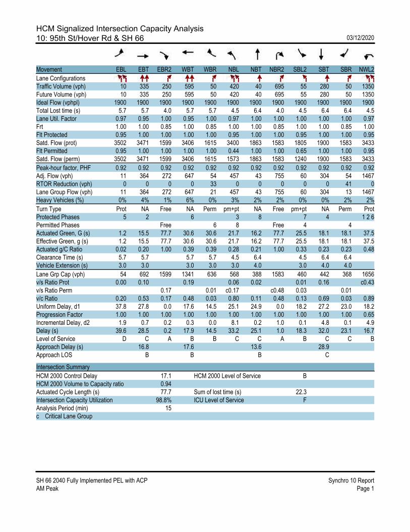
HCM Signalized Intersection Capacity Analysis10: 95th St/Hover Rd & SH 66 03/12/2020
SH 66 2040 Fully Implemented PEL with ACP Synchro 10 ReportAM Peak Page 1
Movement EBL EBT EBR2 WBT WBR NBL NBT NBR2 SBL2 SBT SBR NWL2
Lane ConfigurationsTraffic Volume (vph) 10 335 250 595 50 420 40 695 55 280 50 1350Future Volume (vph) 10 335 250 595 50 420 40 695 55 280 50 1350Ideal Flow (vphpl) 1900 1900 1900 1900 1900 1900 1900 1900 1900 1900 1900 1900Total Lost time (s) 5.7 5.7 4.0 5.7 5.7 4.5 6.4 4.0 4.5 6.4 6.4 4.5Lane Util. Factor 0.97 0.95 1.00 0.95 1.00 0.97 1.00 1.00 1.00 1.00 1.00 0.97Frt 1.00 1.00 0.85 1.00 0.85 1.00 1.00 0.85 1.00 1.00 0.85 1.00Flt Protected 0.95 1.00 1.00 1.00 1.00 0.95 1.00 1.00 0.95 1.00 1.00 0.95Satd. Flow (prot) 3502 3471 1599 3406 1615 3400 1863 1583 1805 1900 1583 3433Flt Permitted 0.95 1.00 1.00 1.00 1.00 0.44 1.00 1.00 0.65 1.00 1.00 0.95Satd. Flow (perm) 3502 3471 1599 3406 1615 1573 1863 1583 1240 1900 1583 3433
Peak-hour factor, PHF 0.92 0.92 0.92 0.92 0.92 0.92 0.92 0.92 0.92 0.92 0.92 0.92Adj. Flow (vph) 11 364 272 647 54 457 43 755 60 304 54 1467RTOR Reduction (vph) 0 0 0 0 33 0 0 0 0 0 41 0Lane Group Flow (vph) 11 364 272 647 21 457 43 755 60 304 13 1467Heavy Vehicles (%) 0% 4% 1% 6% 0% 3% 2% 2% 0% 0% 2% 2%
Turn Type Prot NA Free NA Perm pm+pt NA Free pm+pt NA Perm ProtProtected Phases 5 2 6 3 8 7 4 1 2 6Permitted Phases Free 6 8 Free 4 4Actuated Green, G (s) 1.2 15.5 77.7 30.6 30.6 21.7 16.2 77.7 25.5 18.1 18.1 37.5Effective Green, g (s) 1.2 15.5 77.7 30.6 30.6 21.7 16.2 77.7 25.5 18.1 18.1 37.5Actuated g/C Ratio 0.02 0.20 1.00 0.39 0.39 0.28 0.21 1.00 0.33 0.23 0.23 0.48Clearance Time (s) 5.7 5.7 5.7 5.7 4.5 6.4 4.5 6.4 6.4Vehicle Extension (s) 3.0 3.0 3.0 3.0 3.0 4.0 3.0 4.0 4.0
Lane Grp Cap (vph) 54 692 1599 1341 636 568 388 1583 460 442 368 1656v/s Ratio Prot 0.00 0.10 0.19 0.06 0.02 0.01 0.16 c0.43v/s Ratio Perm 0.17 0.01 c0.17 c0.48 0.03 0.01v/c Ratio 0.20 0.53 0.17 0.48 0.03 0.80 0.11 0.48 0.13 0.69 0.03 0.89Uniform Delay, d1 37.8 27.8 0.0 17.6 14.5 25.1 24.9 0.0 18.2 27.2 23.0 18.2Progression Factor 1.00 1.00 1.00 1.00 1.00 1.00 1.00 1.00 1.00 1.00 1.00 0.65Incremental Delay, d2 1.9 0.7 0.2 0.3 0.0 8.1 0.2 1.0 0.1 4.8 0.1 4.9Delay (s) 39.6 28.5 0.2 17.9 14.5 33.2 25.1 1.0 18.3 32.0 23.1 16.7Level of Service D C A B B C C A B C C BApproach Delay (s) 16.8 17.6 13.6 28.9Approach LOS B B B C
Intersection Summary
HCM 2000 Control Delay 17.1 HCM 2000 Level of Service BHCM 2000 Volume to Capacity ratio 0.94Actuated Cycle Length (s) 77.7 Sum of lost time (s) 22.3Intersection Capacity Utilization 98.8% ICU Level of Service FAnalysis Period (min) 15c Critical Lane Group

HCM Signalized Intersection Capacity Analysis11: Hover DLT & SH 66 03/12/2020
SH 66 2040 Fully Implemented PEL with ACP Synchro 10 ReportAM Peak Page 1
Movement EBT EBR WBL WBT NEL NER
Lane ConfigurationsTraffic Volume (vph) 355 0 1350 645 0 695Future Volume (vph) 355 0 1350 645 0 695Ideal Flow (vphpl) 1900 1900 1900 1900 1900 1900Total Lost time (s) 5.7 4.5 4.0 4.0Lane Util. Factor 0.95 0.97 0.95 1.00Frt 1.00 1.00 1.00 0.86Flt Protected 1.00 0.95 1.00 1.00Satd. Flow (prot) 3539 3433 3539 1611Flt Permitted 1.00 0.95 1.00 1.00Satd. Flow (perm) 3539 3433 3539 1611
Peak-hour factor, PHF 0.92 0.92 0.92 0.92 0.92 0.92Adj. Flow (vph) 386 0 1467 701 0 755RTOR Reduction (vph) 0 0 0 0 0 0Lane Group Flow (vph) 386 0 1467 701 0 755
Turn Type NA Prot NA FreeProtected Phases 2 1 3 4 FreePermitted Phases FreeActuated Green, G (s) 15.5 52.0 77.7 77.7Effective Green, g (s) 15.5 45.6 77.7 77.7Actuated g/C Ratio 0.20 0.59 1.00 1.00Clearance Time (s) 5.7Vehicle Extension (s) 3.0
Lane Grp Cap (vph) 705 2014 3539 1611v/s Ratio Prot 0.11 c0.43 0.20v/s Ratio Perm c0.47v/c Ratio 0.55 0.73 0.20 0.47Uniform Delay, d1 27.9 11.6 0.0 0.0Progression Factor 1.53 1.00 1.00 1.00Incremental Delay, d2 0.7 1.3 0.1 0.9Delay (s) 43.4 12.9 0.1 0.9Level of Service D B A AApproach Delay (s) 43.4 8.8 0.9Approach LOS D A A
Intersection Summary
HCM 2000 Control Delay 11.0 HCM 2000 Level of Service BHCM 2000 Volume to Capacity ratio 0.78Actuated Cycle Length (s) 77.7 Sum of lost time (s) 22.3Intersection Capacity Utilization 56.4% ICU Level of Service BAnalysis Period (min) 15c Critical Lane Group

HCM 6th TWSC12: SH 66 & Spencer St 03/12/2020
SH 66 2040 Fully Implemented PEL with ACP Synchro 10 ReportAM Peak Page 12
Intersection
Int Delay, s/veh 0.5
Movement EBL EBT EBR WBL WBT WBR NBL NBT NBR SBL SBT SBR
Lane ConfigurationsTraffic Vol, veh/h 0 1045 30 0 2020 10 0 0 95 0 0 10Future Vol, veh/h 0 1045 30 0 2020 10 0 0 95 0 0 10Conflicting Peds, #/hr 0 0 0 0 0 0 0 0 0 0 0 0Sign Control Free Free Free Free Free Free Stop Stop Stop Stop Stop StopRT Channelized - - None - - None - - None - - NoneStorage Length - - 0 - - 250 - - 0 - - 0Veh in Median Storage, # - 0 - - 0 - - 0 - - 0 -Grade, % - 0 - - 0 - - 0 - - 0 -Peak Hour Factor 92 92 92 92 92 92 92 92 92 92 92 92Heavy Vehicles, % 0 3 17 9 5 0 0 0 0 0 0 0Mvmt Flow 0 1136 33 0 2196 11 0 0 103 0 0 11
Major/Minor Major1 Major2 Minor1 Minor2
Conflicting Flow All - 0 0 - - 0 - - 568 - - 1098 Stage 1 - - - - - - - - - - - - Stage 2 - - - - - - - - - - - -Critical Hdwy - - - - - - - - 6.9 - - 6.9Critical Hdwy Stg 1 - - - - - - - - - - - -Critical Hdwy Stg 2 - - - - - - - - - - - -Follow-up Hdwy - - - - - - - - 3.3 - - 3.3Pot Cap-1 Maneuver 0 - - 0 - - 0 0 471 0 0 211 Stage 1 0 - - 0 - - 0 0 - 0 0 - Stage 2 0 - - 0 - - 0 0 - 0 0 -Platoon blocked, % - - - -Mov Cap-1 Maneuver - - - - - - - - 471 - - 211Mov Cap-2 Maneuver - - - - - - - - - - - - Stage 1 - - - - - - - - - - - - Stage 2 - - - - - - - - - - - -
Approach EB WB NB SB
HCM Control Delay, s 0 0 14.8 23HCM LOS B C
Minor Lane/Major Mvmt NBLn1 EBT EBR WBT WBR SBLn1
Capacity (veh/h) 471 - - - - 211HCM Lane V/C Ratio 0.219 - - - - 0.052HCM Control Delay (s) 14.8 - - - - 23HCM Lane LOS B - - - - CHCM 95th %tile Q(veh) 0.8 - - - - 0.2

HCM 6th Signalized Intersection Summary13: Francis St & SH 66 03/12/2020
SH 66 2040 Fully Implemented PEL with ACP Synchro 10 ReportAM Peak Page 13
Movement EBL EBT EBR WBL WBT WBR NBL NBT NBR SBL SBT SBR
Lane ConfigurationsTraffic Volume (veh/h) 5 1080 60 200 1945 10 95 10 170 10 10 10Future Volume (veh/h) 5 1080 60 200 1945 10 95 10 170 10 10 10Initial Q (Qb), veh 0 0 0 0 0 0 0 0 0 0 0 0Ped-Bike Adj(A_pbT) 1.00 1.00 1.00 1.00 1.00 1.00 1.00 1.00Parking Bus, Adj 1.00 1.00 1.00 1.00 1.00 1.00 1.00 1.00 1.00 1.00 1.00 1.00Work Zone On Approach No No No NoAdj Sat Flow, veh/h/ln 1870 1856 1900 1885 1856 1870 1900 1870 1885 1870 1870 1870Adj Flow Rate, veh/h 5 1174 65 217 2114 11 103 11 0 11 11 11Peak Hour Factor 0.92 0.92 0.92 0.92 0.92 0.92 0.92 0.92 0.92 0.92 0.92 0.92Percent Heavy Veh, % 2 3 0 1 3 2 0 2 1 2 2 2Cap, veh/h 127 2207 1008 699 2385 1072 178 181 107 107 91Arrive On Green 0.01 0.63 0.63 0.06 0.68 0.68 0.05 0.10 0.00 0.01 0.06 0.06Sat Flow, veh/h 1781 3526 1610 3483 3526 1585 1810 1870 1598 1781 1870 1585
Grp Volume(v), veh/h 5 1174 65 217 2114 11 103 11 0 11 11 11Grp Sat Flow(s),veh/h/ln 1781 1763 1610 1742 1763 1585 1810 1870 1598 1781 1870 1585Q Serve(g_s), s 0.0 16.3 0.8 2.0 42.2 0.1 0.8 0.5 0.0 0.5 0.5 0.6Cycle Q Clear(g_c), s 0.0 16.3 0.8 2.0 42.2 0.1 0.8 0.5 0.0 0.5 0.5 0.6Prop In Lane 1.00 1.00 1.00 1.00 1.00 1.00 1.00 1.00Lane Grp Cap(c), veh/h 127 2207 1008 699 2385 1072 178 181 107 107 91V/C Ratio(X) 0.04 0.53 0.06 0.31 0.89 0.01 0.58 0.06 0.10 0.10 0.12Avail Cap(c_a), veh/h 217 2507 1145 784 2592 1165 187 387 185 387 328HCM Platoon Ratio 1.00 1.00 1.00 1.00 1.00 1.00 1.00 1.00 1.00 1.00 1.00 1.00Upstream Filter(I) 1.00 1.00 1.00 1.00 1.00 1.00 1.00 1.00 0.00 1.00 1.00 1.00Uniform Delay (d), s/veh 30.4 9.1 2.2 8.3 11.4 1.9 39.1 35.7 0.0 41.3 38.9 38.9Incr Delay (d2), s/veh 0.1 0.2 0.0 0.3 3.9 0.0 4.0 0.1 0.0 0.4 0.4 0.6Initial Q Delay(d3),s/veh 0.0 0.0 0.0 0.0 0.0 0.0 0.0 0.0 0.0 0.0 0.0 0.0%ile BackOfQ(50%),veh/ln 0.1 4.5 0.3 0.5 11.4 0.0 2.2 0.2 0.0 0.2 0.2 0.2Unsig. Movement Delay, s/vehLnGrp Delay(d),s/veh 30.5 9.3 2.2 8.5 15.3 1.9 43.2 35.9 0.0 41.7 39.3 39.5LnGrp LOS C A A A B A D D D D D
Approach Vol, veh/h 1244 2342 114 A 33Approach Delay, s/veh 9.0 14.6 42.4 40.2Approach LOS A B D D
Timer - Assigned Phs 1 2 3 4 5 6 7 8
Phs Duration (G+Y+Rc), s 5.7 12.9 9.5 59.0 9.1 9.5 5.1 63.4Change Period (Y+Rc), s 4.5 4.5 4.5 4.5 4.5 4.5 4.5 4.5Max Green Setting (Gmax), s 5.0 18.0 7.1 61.9 5.0 18.0 5.0 64.0Max Q Clear Time (g_c+I1), s 2.5 2.5 4.0 18.3 2.8 2.6 2.0 44.2Green Ext Time (p_c), s 0.0 0.0 0.2 9.6 0.0 0.0 0.0 14.7
Intersection Summary
HCM 6th Ctrl Delay 13.8HCM 6th LOS B
Notes
Unsignalized Delay for [NBR] is excluded from calculations of the approach delay and intersection delay.
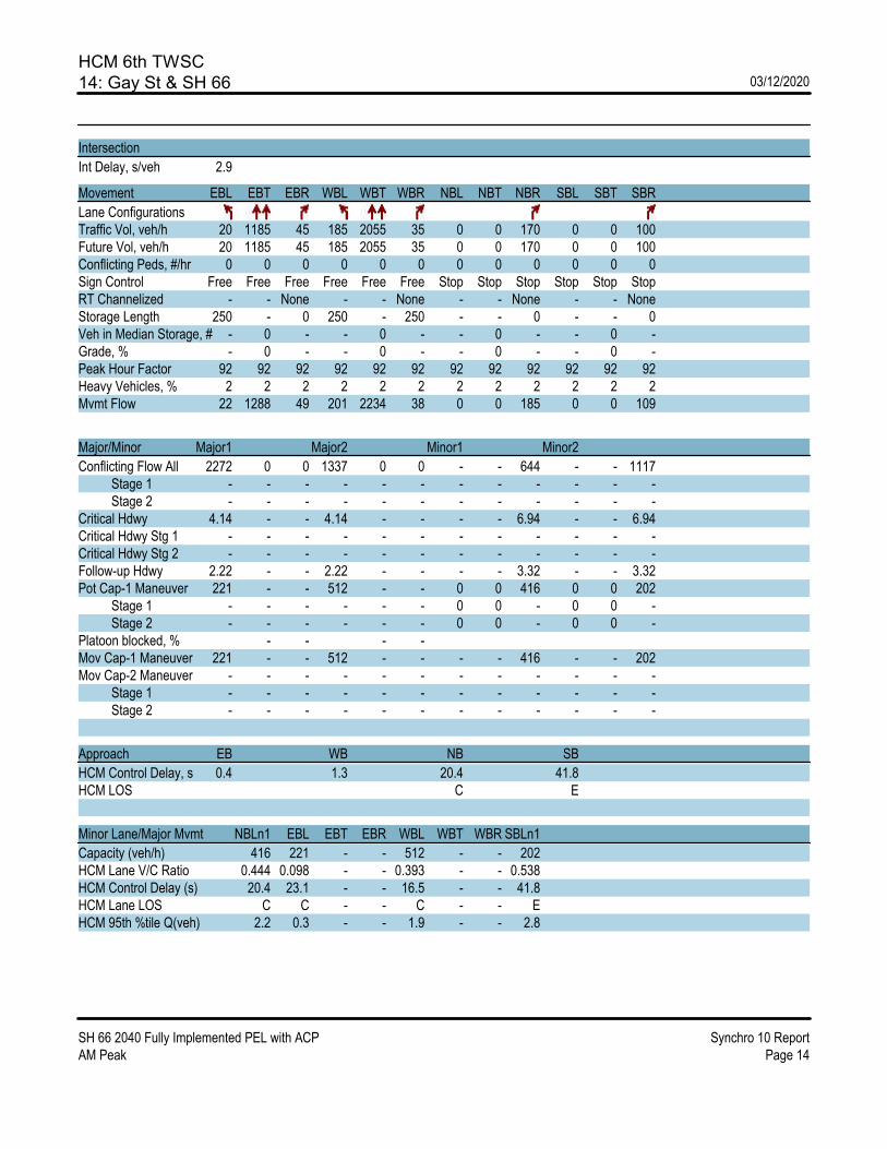
HCM 6th TWSC14: Gay St & SH 66 03/12/2020
SH 66 2040 Fully Implemented PEL with ACP Synchro 10 ReportAM Peak Page 14
Intersection
Int Delay, s/veh 2.9
Movement EBL EBT EBR WBL WBT WBR NBL NBT NBR SBL SBT SBR
Lane ConfigurationsTraffic Vol, veh/h 20 1185 45 185 2055 35 0 0 170 0 0 100Future Vol, veh/h 20 1185 45 185 2055 35 0 0 170 0 0 100Conflicting Peds, #/hr 0 0 0 0 0 0 0 0 0 0 0 0Sign Control Free Free Free Free Free Free Stop Stop Stop Stop Stop StopRT Channelized - - None - - None - - None - - NoneStorage Length 250 - 0 250 - 250 - - 0 - - 0Veh in Median Storage, # - 0 - - 0 - - 0 - - 0 -Grade, % - 0 - - 0 - - 0 - - 0 -Peak Hour Factor 92 92 92 92 92 92 92 92 92 92 92 92Heavy Vehicles, % 2 2 2 2 2 2 2 2 2 2 2 2Mvmt Flow 22 1288 49 201 2234 38 0 0 185 0 0 109
Major/Minor Major1 Major2 Minor1 Minor2
Conflicting Flow All 2272 0 0 1337 0 0 - - 644 - - 1117 Stage 1 - - - - - - - - - - - - Stage 2 - - - - - - - - - - - -Critical Hdwy 4.14 - - 4.14 - - - - 6.94 - - 6.94Critical Hdwy Stg 1 - - - - - - - - - - - -Critical Hdwy Stg 2 - - - - - - - - - - - -Follow-up Hdwy 2.22 - - 2.22 - - - - 3.32 - - 3.32Pot Cap-1 Maneuver 221 - - 512 - - 0 0 416 0 0 202 Stage 1 - - - - - - 0 0 - 0 0 - Stage 2 - - - - - - 0 0 - 0 0 -Platoon blocked, % - - - -Mov Cap-1 Maneuver 221 - - 512 - - - - 416 - - 202Mov Cap-2 Maneuver - - - - - - - - - - - - Stage 1 - - - - - - - - - - - - Stage 2 - - - - - - - - - - - -
Approach EB WB NB SB
HCM Control Delay, s 0.4 1.3 20.4 41.8HCM LOS C E
Minor Lane/Major Mvmt NBLn1 EBL EBT EBR WBL WBT WBR SBLn1
Capacity (veh/h) 416 221 - - 512 - - 202HCM Lane V/C Ratio 0.444 0.098 - - 0.393 - - 0.538HCM Control Delay (s) 20.4 23.1 - - 16.5 - - 41.8HCM Lane LOS C C - - C - - EHCM 95th %tile Q(veh) 2.2 0.3 - - 1.9 - - 2.8


HCM Signalized Intersection Capacity Analysis16: SH 66 03/12/2020
SH 66 2040 Fully Implemented PEL with ACP Synchro 10 ReportAM Peak Page 1
Movement EBT EBR WBL WBT NBL NBR
Lane ConfigurationsTraffic Volume (vph) 535 235 0 800 335 0Future Volume (vph) 535 235 0 800 335 0Ideal Flow (vphpl) 1900 1900 1900 1900 1900 1900Total Lost time (s) 4.0 4.0 4.0 4.0Lane Util. Factor 0.95 1.00 0.95 0.97Frt 1.00 0.85 1.00 1.00Flt Protected 1.00 1.00 1.00 0.95Satd. Flow (prot) 3539 1583 3539 3433Flt Permitted 1.00 1.00 1.00 0.95Satd. Flow (perm) 3539 1583 3539 3433
Peak-hour factor, PHF 0.92 0.92 0.92 0.92 0.92 0.92Adj. Flow (vph) 582 255 0 870 364 0RTOR Reduction (vph) 0 0 0 0 0 0Lane Group Flow (vph) 582 255 0 870 364 0
Turn Type NA Free NA ProtProtected Phases 1 2 Free! 4!Permitted Phases FreeActuated Green, G (s) 31.0 70.0 70.0 16.0Effective Green, g (s) 31.0 70.0 70.0 16.0Actuated g/C Ratio 0.44 1.00 1.00 0.23Clearance Time (s) 4.0Vehicle Extension (s) 3.0
Lane Grp Cap (vph) 1567 1583 3539 784v/s Ratio Prot c0.16 0.25 c0.11v/s Ratio Perm 0.16v/c Ratio 0.37 0.16 0.25 0.46Uniform Delay, d1 13.0 0.0 0.0 23.3Progression Factor 1.00 1.00 1.00 0.00Incremental Delay, d2 0.1 0.2 0.1 0.3Delay (s) 13.1 0.2 0.1 0.4Level of Service B A A AApproach Delay (s) 9.2 0.1 0.4Approach LOS A A A
Intersection Summary
HCM 2000 Control Delay 3.8 HCM 2000 Level of Service AHCM 2000 Volume to Capacity ratio 0.42Actuated Cycle Length (s) 70.0 Sum of lost time (s) 16.0Intersection Capacity Utilization 38.3% ICU Level of Service AAnalysis Period (min) 15! Phase conflict between lane groups.c Critical Lane Group

HCM Signalized Intersection Capacity Analysis17: SH 66 03/12/2020
SH 66 2040 Fully Implemented PEL with ACP Synchro 10 ReportAM Peak Page 2
Movement EBL EBT WBT WBR SBL SBR
Lane ConfigurationsTraffic Volume (vph) 0 535 800 135 185 0Future Volume (vph) 0 535 800 135 185 0Ideal Flow (vphpl) 1900 1900 1900 1900 1900 1900Total Lost time (s) 4.0 4.0 4.0 4.0Lane Util. Factor 0.95 0.95 1.00 0.97Frt 1.00 1.00 0.85 1.00Flt Protected 1.00 1.00 1.00 0.95Satd. Flow (prot) 3282 3252 996 3099Flt Permitted 1.00 1.00 1.00 0.95Satd. Flow (perm) 3282 3252 996 3099
Peak-hour factor, PHF 0.92 0.92 0.92 0.92 0.92 0.92Adj. Flow (vph) 0 582 870 147 201 0RTOR Reduction (vph) 0 0 0 0 0 0Lane Group Flow (vph) 0 582 870 147 201 0Heavy Vehicles (%) 0% 10% 11% 46% 13% 0%Parking (#/hr) 0
Turn Type NA NA Free ProtProtected Phases Free! 1 2 4!Permitted Phases FreeActuated Green, G (s) 70.0 31.0 70.0 16.0Effective Green, g (s) 70.0 31.0 70.0 16.0Actuated g/C Ratio 1.00 0.44 1.00 0.23Clearance Time (s) 4.0Vehicle Extension (s) 3.0
Lane Grp Cap (vph) 3282 1440 996 708v/s Ratio Prot 0.18 c0.27 c0.06v/s Ratio Perm 0.15v/c Ratio 0.18 0.60 0.15 0.28Uniform Delay, d1 0.0 14.8 0.0 22.3Progression Factor 1.00 0.61 1.00 0.01Incremental Delay, d2 0.1 0.7 0.3 0.2Delay (s) 0.1 9.7 0.3 0.5Level of Service A A A AApproach Delay (s) 0.1 8.3 0.5Approach LOS A A A
Intersection Summary
HCM 2000 Control Delay 4.8 HCM 2000 Level of Service AHCM 2000 Volume to Capacity ratio 0.48Actuated Cycle Length (s) 70.0 Sum of lost time (s) 16.0Intersection Capacity Utilization 34.1% ICU Level of Service AAnalysis Period (min) 15! Phase conflict between lane groups.c Critical Lane Group

HCM Signalized Intersection Capacity Analysis18: 03/12/2020
SH 66 2040 Fully Implemented PEL with ACP Synchro 10 ReportAM Peak Page 3
Movement EBL EBR NBL NBT SBT SBR
Lane ConfigurationsTraffic Volume (vph) 580 0 0 400 900 1140Future Volume (vph) 580 0 0 400 900 1140Ideal Flow (vphpl) 1900 1900 1900 1900 1900 1900Total Lost time (s) 4.0 4.0 4.0 4.0Lane Util. Factor 0.97 0.95 0.95 1.00Frt 1.00 1.00 1.00 0.85Flt Protected 0.95 1.00 1.00 1.00Satd. Flow (prot) 3433 3539 3539 1583Flt Permitted 0.95 1.00 1.00 1.00Satd. Flow (perm) 3433 3539 3539 1583
Peak-hour factor, PHF 0.92 0.92 0.92 0.92 0.92 0.92Adj. Flow (vph) 630 0 0 435 978 1239RTOR Reduction (vph) 0 0 0 0 0 0Lane Group Flow (vph) 630 0 0 435 978 1239
Turn Type Prot NA NA FreeProtected Phases 1 2! Free! 3 4Permitted Phases FreeActuated Green, G (s) 31.0 70.0 31.0 70.0Effective Green, g (s) 31.0 70.0 31.0 70.0Actuated g/C Ratio 0.44 1.00 0.44 1.00Clearance Time (s)Vehicle Extension (s)
Lane Grp Cap (vph) 1520 3539 1567 1583v/s Ratio Prot 0.18 0.12 0.28v/s Ratio Perm c0.78v/c Ratio 0.41 0.12 0.62 0.78Uniform Delay, d1 13.3 0.0 15.0 0.0Progression Factor 0.54 1.00 1.00 1.00Incremental Delay, d2 0.2 0.1 0.6 3.1Delay (s) 7.4 0.1 15.6 3.1Level of Service A A B AApproach Delay (s) 7.4 0.1 8.6Approach LOS A A A
Intersection Summary
HCM 2000 Control Delay 7.2 HCM 2000 Level of Service AHCM 2000 Volume to Capacity ratio 1.01Actuated Cycle Length (s) 70.0 Sum of lost time (s) 16.0Intersection Capacity Utilization 48.1% ICU Level of Service AAnalysis Period (min) 15! Phase conflict between lane groups.c Critical Lane Group
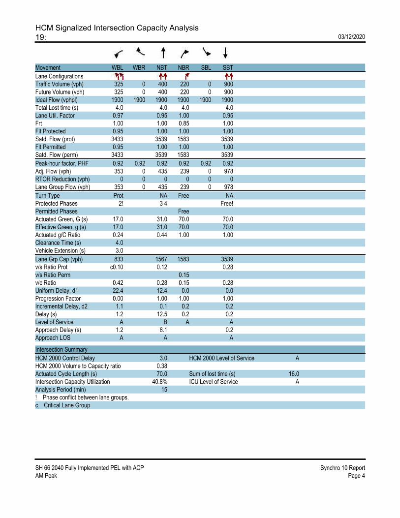
HCM Signalized Intersection Capacity Analysis19: 03/12/2020
SH 66 2040 Fully Implemented PEL with ACP Synchro 10 ReportAM Peak Page 4
Movement WBL WBR NBT NBR SBL SBT
Lane ConfigurationsTraffic Volume (vph) 325 0 400 220 0 900Future Volume (vph) 325 0 400 220 0 900Ideal Flow (vphpl) 1900 1900 1900 1900 1900 1900Total Lost time (s) 4.0 4.0 4.0 4.0Lane Util. Factor 0.97 0.95 1.00 0.95Frt 1.00 1.00 0.85 1.00Flt Protected 0.95 1.00 1.00 1.00Satd. Flow (prot) 3433 3539 1583 3539Flt Permitted 0.95 1.00 1.00 1.00Satd. Flow (perm) 3433 3539 1583 3539
Peak-hour factor, PHF 0.92 0.92 0.92 0.92 0.92 0.92Adj. Flow (vph) 353 0 435 239 0 978RTOR Reduction (vph) 0 0 0 0 0 0Lane Group Flow (vph) 353 0 435 239 0 978
Turn Type Prot NA Free NAProtected Phases 2! 3 4 Free!Permitted Phases FreeActuated Green, G (s) 17.0 31.0 70.0 70.0Effective Green, g (s) 17.0 31.0 70.0 70.0Actuated g/C Ratio 0.24 0.44 1.00 1.00Clearance Time (s) 4.0Vehicle Extension (s) 3.0
Lane Grp Cap (vph) 833 1567 1583 3539v/s Ratio Prot c0.10 0.12 0.28v/s Ratio Perm 0.15v/c Ratio 0.42 0.28 0.15 0.28Uniform Delay, d1 22.4 12.4 0.0 0.0Progression Factor 0.00 1.00 1.00 1.00Incremental Delay, d2 1.1 0.1 0.2 0.2Delay (s) 1.2 12.5 0.2 0.2Level of Service A B A AApproach Delay (s) 1.2 8.1 0.2Approach LOS A A A
Intersection Summary
HCM 2000 Control Delay 3.0 HCM 2000 Level of Service AHCM 2000 Volume to Capacity ratio 0.38Actuated Cycle Length (s) 70.0 Sum of lost time (s) 16.0Intersection Capacity Utilization 40.8% ICU Level of Service AAnalysis Period (min) 15! Phase conflict between lane groups.c Critical Lane Group

HCM Signalized Intersection Capacity Analysis20: SH 66 03/12/2020
SH 66 2040 Fully Implemented PEL with ACP Synchro 10 ReportAM Peak Page 5
Movement EBL EBT WBT WBR SBL SBR
Lane ConfigurationsTraffic Volume (vph) 580 770 1135 0 0 1140Future Volume (vph) 580 770 1135 0 0 1140Ideal Flow (vphpl) 1900 1900 1900 1900 1900 1900Total Lost time (s) 4.0 4.0 4.0 4.0Lane Util. Factor 0.97 0.95 0.95 1.00Frt 1.00 1.00 1.00 0.86Flt Protected 0.95 1.00 1.00 1.00Satd. Flow (prot) 3433 3539 3539 1611Flt Permitted 0.95 1.00 1.00 1.00Satd. Flow (perm) 3433 3539 3539 1611
Peak-hour factor, PHF 0.92 0.92 0.92 0.92 0.92 0.92Adj. Flow (vph) 630 837 1234 0 0 1239RTOR Reduction (vph) 0 0 0 0 0 0Lane Group Flow (vph) 630 837 1234 0 0 1239
Turn Type Prot NA NA FreeProtected Phases 1 2 Free 3 4Permitted Phases FreeActuated Green, G (s) 31.0 70.0 31.0 70.0Effective Green, g (s) 31.0 70.0 31.0 70.0Actuated g/C Ratio 0.44 1.00 0.44 1.00Clearance Time (s)Vehicle Extension (s)
Lane Grp Cap (vph) 1520 3539 1567 1611v/s Ratio Prot 0.18 0.24 0.35v/s Ratio Perm c0.77v/c Ratio 0.41 0.24 0.79 0.77Uniform Delay, d1 13.3 0.0 16.7 0.0Progression Factor 1.00 1.00 0.95 1.00Incremental Delay, d2 0.2 0.2 2.6 2.2Delay (s) 13.5 0.2 18.5 2.2Level of Service B A B AApproach Delay (s) 5.9 18.5 2.2Approach LOS A B A
Intersection Summary
HCM 2000 Control Delay 8.7 HCM 2000 Level of Service AHCM 2000 Volume to Capacity ratio 1.00Actuated Cycle Length (s) 70.0 Sum of lost time (s) 16.0Intersection Capacity Utilization 54.6% ICU Level of Service AAnalysis Period (min) 15c Critical Lane Group

HCM Signalized Intersection Capacity Analysis21: SH 66 03/12/2020
SH 66 2040 Fully Implemented PEL with ACP Synchro 10 ReportAM Peak Page 6
Movement EBT EBR WBL WBT NEL NER
Lane ConfigurationsTraffic Volume (vph) 720 0 325 935 0 220Future Volume (vph) 720 0 325 935 0 220Ideal Flow (vphpl) 1900 1900 1900 1900 1900 1900Total Lost time (s) 4.0 4.0 4.0 4.0Lane Util. Factor 0.95 0.97 0.95 1.00Frt 1.00 1.00 1.00 0.86Flt Protected 1.00 0.95 1.00 1.00Satd. Flow (prot) 3539 3433 3539 1611Flt Permitted 1.00 0.95 1.00 1.00Satd. Flow (perm) 3539 3433 3539 1611
Peak-hour factor, PHF 0.92 0.92 0.92 0.92 0.92 0.92Adj. Flow (vph) 783 0 353 1016 0 239RTOR Reduction (vph) 0 0 0 0 0 0Lane Group Flow (vph) 783 0 353 1016 0 239
Turn Type NA Prot NA pm+ovProtected Phases 2 3 4 1 Free 1Permitted Phases 2 3 4Actuated Green, G (s) 52.0 10.0 70.0 62.0Effective Green, g (s) 52.0 10.0 70.0 62.0Actuated g/C Ratio 0.74 0.14 1.00 0.89Clearance Time (s) 4.0 4.0Vehicle Extension (s) 3.0 3.0
Lane Grp Cap (vph) 2628 490 3539 1611v/s Ratio Prot c0.22 c0.10 0.29 0.02v/s Ratio Perm 0.13v/c Ratio 0.30 0.72 0.29 0.15Uniform Delay, d1 3.0 28.7 0.0 0.5Progression Factor 0.65 1.11 1.00 1.00Incremental Delay, d2 0.1 4.5 0.2 0.0Delay (s) 2.0 36.2 0.2 0.6Level of Service A D A AApproach Delay (s) 2.0 9.5 0.6Approach LOS A A A
Intersection Summary
HCM 2000 Control Delay 6.1 HCM 2000 Level of Service AHCM 2000 Volume to Capacity ratio 0.43Actuated Cycle Length (s) 70.0 Sum of lost time (s) 16.0Intersection Capacity Utilization 40.2% ICU Level of Service AAnalysis Period (min) 15c Critical Lane Group

HCM Signalized Intersection Capacity Analysis22: 03/12/2020
SH 66 2040 Fully Implemented PEL with ACP Synchro 10 ReportAM Peak Page 7
Movement WBL WBR NBT NBR SBL SBT
Lane ConfigurationsTraffic Volume (vph) 0 135 980 0 185 2040Future Volume (vph) 0 135 980 0 185 2040Ideal Flow (vphpl) 1900 1900 1900 1900 1900 1900Total Lost time (s) 4.0 4.0 4.0 4.0Lane Util. Factor 1.00 0.95 0.97 0.95Frt 0.86 1.00 1.00 1.00Flt Protected 1.00 1.00 0.95 1.00Satd. Flow (prot) 1611 3539 3433 3539Flt Permitted 1.00 1.00 0.95 1.00Satd. Flow (perm) 1611 3539 3433 3539
Peak-hour factor, PHF 0.92 0.92 0.92 0.92 0.92 0.92Adj. Flow (vph) 0 147 1065 0 201 2217RTOR Reduction (vph) 0 0 0 0 0 0Lane Group Flow (vph) 0 147 1065 0 201 2217
Turn Type pm+ov NA Prot NAProtected Phases 3 1 2 4 3 FreePermitted Phases 1 2 4Actuated Green, G (s) 62.0 51.0 11.0 70.0Effective Green, g (s) 62.0 51.0 11.0 70.0Actuated g/C Ratio 0.89 0.73 0.16 1.00Clearance Time (s) 4.0 4.0Vehicle Extension (s) 3.0 3.0
Lane Grp Cap (vph) 1611 2578 539 3539v/s Ratio Prot 0.01 0.30 0.06 0.63v/s Ratio Perm 0.08v/c Ratio 0.09 0.41 0.37 0.63Uniform Delay, d1 0.5 3.7 26.4 0.0Progression Factor 1.00 0.89 1.00 1.00Incremental Delay, d2 0.0 0.1 0.4 0.8Delay (s) 0.5 3.4 26.8 0.8Level of Service A A C AApproach Delay (s) 0.5 3.4 3.0Approach LOS A A A
Intersection Summary
HCM 2000 Control Delay 3.0 HCM 2000 Level of Service AHCM 2000 Volume to Capacity ratio 0.81Actuated Cycle Length (s) 70.0 Sum of lost time (s) 16.0Intersection Capacity Utilization 59.7% ICU Level of Service BAnalysis Period (min) 15c Critical Lane Group

HCM Signalized Intersection Capacity Analysis23: 03/12/2020
SH 66 2040 Fully Implemented PEL with ACP Synchro 10 ReportAM Peak Page 8
Movement NBL NBT SBT SBR SEL SER
Lane ConfigurationsTraffic Volume (vph) 335 620 1225 0 0 235Future Volume (vph) 335 620 1225 0 0 235Ideal Flow (vphpl) 1900 1900 1900 1900 1900 1900Total Lost time (s) 4.0 4.0 4.0 4.0Lane Util. Factor 0.97 0.95 0.95 1.00Frt 1.00 1.00 1.00 0.86Flt Protected 0.95 1.00 1.00 1.00Satd. Flow (prot) 3433 3539 3539 1611Flt Permitted 0.95 1.00 1.00 1.00Satd. Flow (perm) 3433 3539 3539 1611
Peak-hour factor, PHF 0.92 0.92 0.92 0.92 0.92 0.92Adj. Flow (vph) 364 674 1332 0 0 255RTOR Reduction (vph) 0 0 0 0 0 0Lane Group Flow (vph) 364 674 1332 0 0 255
Turn Type Prot NA NA pm+ovProtected Phases 3 Free 1 2 4 3Permitted Phases 1 2 4Actuated Green, G (s) 11.0 70.0 51.0 62.0Effective Green, g (s) 11.0 70.0 51.0 62.0Actuated g/C Ratio 0.16 1.00 0.73 0.89Clearance Time (s) 4.0 4.0Vehicle Extension (s) 3.0 3.0
Lane Grp Cap (vph) 539 3539 2578 1611v/s Ratio Prot c0.11 0.19 c0.38 0.02v/s Ratio Perm 0.13v/c Ratio 0.68 0.19 0.52 0.16Uniform Delay, d1 27.8 0.0 4.1 0.5Progression Factor 1.00 1.00 0.35 1.00Incremental Delay, d2 3.3 0.1 0.2 0.0Delay (s) 31.2 0.1 1.6 0.6Level of Service C A A AApproach Delay (s) 11.0 1.6 0.6Approach LOS B A A
Intersection Summary
HCM 2000 Control Delay 5.2 HCM 2000 Level of Service AHCM 2000 Volume to Capacity ratio 0.63Actuated Cycle Length (s) 70.0 Sum of lost time (s) 16.0Intersection Capacity Utilization 55.1% ICU Level of Service BAnalysis Period (min) 15c Critical Lane Group

HCM 6th Signalized Intersection Summary24: SH 66 & Erfert St 03/12/2020
SH 66 2040 Fully Implemented PEL with ACP Synchro 10 ReportAM Peak Page 23
Movement EBL EBT WBT WBR SBL SBR
Lane ConfigurationsTraffic Volume (veh/h) 20 920 1250 35 15 10Future Volume (veh/h) 20 920 1250 35 15 10Initial Q (Qb), veh 0 0 0 0 0 0Ped-Bike Adj(A_pbT) 1.00 1.00 1.00 1.00Parking Bus, Adj 1.00 1.00 1.00 1.00 1.00 1.00Work Zone On Approach No No NoAdj Sat Flow, veh/h/ln 1870 1870 1870 1870 1870 1870Adj Flow Rate, veh/h 22 1000 1359 38 16 11Peak Hour Factor 0.92 0.92 0.92 0.92 0.92 0.92Percent Heavy Veh, % 2 2 2 2 2 2Cap, veh/h 342 4030 2500 1115 261 232Arrive On Green 0.02 0.26 0.70 0.70 0.15 0.15Sat Flow, veh/h 1781 5274 3647 1585 1781 1585
Grp Volume(v), veh/h 22 1000 1359 38 16 11Grp Sat Flow(s),veh/h/ln1781 1702 1777 1585 1781 1585Q Serve(g_s), s 0.0 21.7 25.7 1.0 1.1 0.8Cycle Q Clear(g_c), s 0.0 21.7 25.7 1.0 1.1 0.8Prop In Lane 1.00 1.00 1.00 1.00Lane Grp Cap(c), veh/h 342 4030 2500 1115 261 232V/C Ratio(X) 0.06 0.25 0.54 0.03 0.06 0.05Avail Cap(c_a), veh/h 342 4030 2500 1115 261 232HCM Platoon Ratio 0.33 0.33 1.00 1.00 1.00 1.00Upstream Filter(I) 0.97 0.97 1.00 1.00 1.00 1.00Uniform Delay (d), s/veh 15.0 18.9 10.0 6.3 51.5 51.4Incr Delay (d2), s/veh 0.1 0.1 0.9 0.1 0.5 0.4Initial Q Delay(d3),s/veh 0.0 0.0 0.0 0.0 0.0 0.0%ile BackOfQ(50%),veh/ln0.3 9.8 8.6 0.3 0.5 0.8Unsig. Movement Delay, s/vehLnGrp Delay(d),s/veh 15.1 19.1 10.8 6.4 51.9 51.7LnGrp LOS B B B A D D
Approach Vol, veh/h 1022 1397 27Approach Delay, s/veh 19.0 10.7 51.8Approach LOS B B D
Timer - Assigned Phs 4 6 7 8
Phs Duration (G+Y+Rc), s 115.0 25.0 12.0 103.0Change Period (Y+Rc), s 4.5 4.5 4.5 4.5Max Green Setting (Gmax), s 110.5 20.5 7.5 98.5Max Q Clear Time (g_c+I1), s 23.7 3.1 2.0 27.7Green Ext Time (p_c), s 7.4 0.0 0.0 12.6
Intersection Summary
HCM 6th Ctrl Delay 14.6HCM 6th LOS B

HCM 6th Signalized Intersection Summary25: Alpine St/115th St & SH 66 03/12/2020
SH 66 2040 Fully Implemented PEL with ACP Synchro 10 ReportAM Peak Page 24
Movement EBL EBT EBR WBL WBT WBR NBL NBT NBR SBL SBT SBR
Lane ConfigurationsTraffic Volume (veh/h) 10 910 15 65 1230 25 20 5 65 55 5 35Future Volume (veh/h) 10 910 15 65 1230 25 20 5 65 55 5 35Initial Q (Qb), veh 0 0 0 0 0 0 0 0 0 0 0 0Ped-Bike Adj(A_pbT) 1.00 1.00 1.00 1.00 1.00 1.00 1.00 1.00Parking Bus, Adj 1.00 1.00 1.00 1.00 1.00 1.00 1.00 1.00 1.00 1.00 1.00 1.00Work Zone On Approach No No No NoAdj Sat Flow, veh/h/ln 1900 1856 1900 1900 1826 1900 1900 1900 1900 1900 1900 1900Adj Flow Rate, veh/h 11 989 16 71 1337 27 22 5 71 60 5 38Peak Hour Factor 0.92 0.92 0.92 0.92 0.92 0.92 0.92 0.92 0.92 0.92 0.92 0.92Percent Heavy Veh, % 0 3 0 0 5 0 0 0 0 0 0 0Cap, veh/h 195 1377 629 429 1737 806 311 9 127 291 17 129Arrive On Green 0.01 0.39 0.39 0.12 0.50 0.50 0.05 0.08 0.08 0.06 0.09 0.09Sat Flow, veh/h 1810 3526 1610 1810 3469 1610 1810 107 1519 1810 191 1449
Grp Volume(v), veh/h 11 989 16 71 1337 27 22 0 76 60 0 43Grp Sat Flow(s),veh/h/ln1810 1763 1610 1810 1735 1610 1810 0 1626 1810 0 1639Q Serve(g_s), s 0.0 12.4 0.3 0.0 16.3 0.4 0.0 0.0 2.3 0.0 0.0 1.3Cycle Q Clear(g_c), s 0.0 12.4 0.3 0.0 16.3 0.4 0.0 0.0 2.3 0.0 0.0 1.3Prop In Lane 1.00 1.00 1.00 1.00 1.00 0.93 1.00 0.88Lane Grp Cap(c), veh/h 195 1377 629 429 1737 806 311 0 136 291 0 146V/C Ratio(X) 0.06 0.72 0.03 0.17 0.77 0.03 0.07 0.00 0.56 0.21 0.00 0.30Avail Cap(c_a), veh/h 344 2255 1030 429 2266 1052 394 0 562 364 0 567HCM Platoon Ratio 1.00 1.00 1.00 1.00 1.00 1.00 1.00 1.00 1.00 1.00 1.00 1.00Upstream Filter(I) 1.00 1.00 1.00 1.00 1.00 1.00 1.00 0.00 1.00 1.00 0.00 1.00Uniform Delay (d), s/veh 22.1 13.4 9.8 17.2 10.6 6.6 21.0 0.0 22.9 22.3 0.0 22.2Incr Delay (d2), s/veh 0.1 0.7 0.0 0.2 1.2 0.0 0.1 0.0 3.6 0.3 0.0 1.1Initial Q Delay(d3),s/veh 0.0 0.0 0.0 0.0 0.0 0.0 0.0 0.0 0.0 0.0 0.0 0.0%ile BackOfQ(50%),veh/ln0.1 3.4 0.1 0.6 3.8 0.1 0.2 0.0 0.9 0.6 0.0 0.5Unsig. Movement Delay, s/vehLnGrp Delay(d),s/veh 22.2 14.1 9.8 17.4 11.8 6.6 21.1 0.0 26.5 22.7 0.0 23.3LnGrp LOS C B A B B A C A C C A C
Approach Vol, veh/h 1016 1435 98 103Approach Delay, s/veh 14.2 12.0 25.3 22.9Approach LOS B B C C
Timer - Assigned Phs 1 2 3 4 5 6 7 8
Phs Duration (G+Y+Rc), s11.0 24.8 7.1 9.1 5.2 30.6 7.4 8.8Change Period (Y+Rc), s 4.5 4.5 4.5 4.5 4.5 4.5 4.5 4.5Max Green Setting (Gmax), s5.7 33.3 5.0 18.0 5.0 34.0 5.0 18.0Max Q Clear Time (g_c+I1), s2.0 14.4 2.0 3.3 2.0 18.3 2.0 4.3Green Ext Time (p_c), s 0.0 6.0 0.0 0.1 0.0 7.8 0.0 0.2
Intersection Summary
HCM 6th Ctrl Delay 13.7HCM 6th LOS B

HCM 6th Signalized Intersection Summary26: Pace St & SH 66 03/12/2020
SH 66 2040 Fully Implemented PEL with ACP Synchro 10 ReportAM Peak Page 25
Movement EBT EBR WBL WBT NBL NBR
Lane ConfigurationsTraffic Volume (veh/h) 800 230 270 1075 245 305Future Volume (veh/h) 800 230 270 1075 245 305Initial Q (Qb), veh 0 0 0 0 0 0Ped-Bike Adj(A_pbT) 1.00 1.00 1.00 1.00Parking Bus, Adj 1.00 1.00 1.00 1.00 1.00 1.00Work Zone On Approach No No NoAdj Sat Flow, veh/h/ln 1856 1885 1856 1811 1870 1885Adj Flow Rate, veh/h 870 250 293 1168 266 332Peak Hour Factor 0.92 0.92 0.92 0.92 0.92 0.92Percent Heavy Veh, % 3 1 3 6 2 1Cap, veh/h 1208 548 439 1936 463 416Arrive On Green 0.34 0.34 0.14 0.56 0.26 0.26Sat Flow, veh/h 3618 1598 1767 3532 1781 1598
Grp Volume(v), veh/h 870 250 293 1168 266 332Grp Sat Flow(s),veh/h/ln1763 1598 1767 1721 1781 1598Q Serve(g_s), s 12.4 7.0 5.5 12.9 7.5 11.2Cycle Q Clear(g_c), s 12.4 7.0 5.5 12.9 7.5 11.2Prop In Lane 1.00 1.00 1.00 1.00Lane Grp Cap(c), veh/h 1208 548 439 1936 463 416V/C Ratio(X) 0.72 0.46 0.67 0.60 0.57 0.80Avail Cap(c_a), veh/h 2960 1341 972 4755 975 875HCM Platoon Ratio 1.00 1.00 1.00 1.00 1.00 1.00Upstream Filter(I) 1.00 1.00 1.00 1.00 1.00 1.00Uniform Delay (d), s/veh 16.5 14.7 11.3 8.3 18.5 19.9Incr Delay (d2), s/veh 0.6 0.4 1.8 0.3 1.1 3.6Initial Q Delay(d3),s/veh 0.0 0.0 0.0 0.0 0.0 0.0%ile BackOfQ(50%),veh/ln3.8 2.1 1.5 2.7 2.7 3.9Unsig. Movement Delay, s/vehLnGrp Delay(d),s/veh 17.1 15.2 13.0 8.6 19.6 23.5LnGrp LOS B B B A B C
Approach Vol, veh/h 1120 1461 598Approach Delay, s/veh 16.7 9.5 21.8Approach LOS B A C
Timer - Assigned Phs 1 2 6 8
Phs Duration (G+Y+Rc), s12.7 25.4 38.1 19.5Change Period (Y+Rc), s 4.5 5.7 * 5.7 4.5Max Green Setting (Gmax), s25.5 48.3 * 80 31.5Max Q Clear Time (g_c+I1), s7.5 14.4 14.9 13.2Green Ext Time (p_c), s 0.7 5.3 9.6 1.8
Intersection Summary
HCM 6th Ctrl Delay 14.3HCM 6th LOS B
Notes
* HCM 6th computational engine requires equal clearance times for the phases crossing the barrier.
HCM 6th Signalized Intersection Summary27: Sundance Dr & SH 66 03/12/2020
SH 66 2040 Fully Implemented PEL with ACP Synchro 10 ReportAM Peak Page 26
Movement EBL EBT EBR WBL WBT WBR NBL NBT NBR SBL SBT SBR
Lane ConfigurationsTraffic Volume (veh/h) 5 1045 55 55 1255 25 75 20 55 5 20 15Future Volume (veh/h) 5 1045 55 55 1255 25 75 20 55 5 20 15Initial Q (Qb), veh 0 0 0 0 0 0 0 0 0 0 0 0Ped-Bike Adj(A_pbT) 1.00 1.00 1.00 1.00 1.00 1.00 1.00 1.00Parking Bus, Adj 1.00 1.00 1.00 1.00 1.00 1.00 1.00 1.00 1.00 1.00 1.00 1.00Work Zone On Approach No No No NoAdj Sat Flow, veh/h/ln 1870 1752 1796 1856 1781 1870 1796 1870 1856 1870 1870 1870Adj Flow Rate, veh/h 5 1136 60 60 1364 27 82 22 60 5 22 16Peak Hour Factor 0.92 0.92 0.92 0.92 0.92 0.92 0.92 0.92 0.92 0.92 0.92 0.92Percent Heavy Veh, % 2 10 7 3 8 2 7 2 3 2 2 2Cap, veh/h 206 1590 727 367 1821 853 329 239 201 329 239 202Arrive On Green 0.01 0.48 0.48 0.07 0.54 0.54 0.13 0.13 0.13 0.13 0.13 0.13Sat Flow, veh/h 1781 3328 1522 1767 3385 1585 1315 1870 1572 1316 1870 1585
Grp Volume(v), veh/h 5 1136 60 60 1364 27 82 22 60 5 22 16Grp Sat Flow(s),veh/h/ln1781 1664 1522 1767 1692 1585 1315 1870 1572 1316 1870 1585Q Serve(g_s), s 0.1 11.1 0.9 0.0 12.8 0.3 2.4 0.4 1.4 0.1 0.4 0.4Cycle Q Clear(g_c), s 0.1 11.1 0.9 0.0 12.8 0.3 2.8 0.4 1.4 0.6 0.4 0.4Prop In Lane 1.00 1.00 1.00 1.00 1.00 1.00 1.00 1.00Lane Grp Cap(c), veh/h 206 1590 727 367 1821 853 329 239 201 329 239 202V/C Ratio(X) 0.02 0.71 0.08 0.16 0.75 0.03 0.25 0.09 0.30 0.02 0.09 0.08Avail Cap(c_a), veh/h 410 2303 1053 463 2342 1097 736 817 687 736 817 693HCM Platoon Ratio 1.00 1.00 1.00 1.00 1.00 1.00 1.00 1.00 1.00 1.00 1.00 1.00Upstream Filter(I) 1.00 1.00 1.00 1.00 1.00 1.00 1.00 1.00 1.00 1.00 1.00 1.00Uniform Delay (d), s/veh 9.7 8.5 5.8 14.2 7.4 4.5 17.1 15.9 16.3 16.1 15.9 15.8Incr Delay (d2), s/veh 0.0 0.6 0.0 0.2 1.0 0.0 0.4 0.2 0.8 0.0 0.2 0.2Initial Q Delay(d3),s/veh 0.0 0.0 0.0 0.0 0.0 0.0 0.0 0.0 0.0 0.0 0.0 0.0%ile BackOfQ(50%),veh/ln0.0 1.9 0.1 0.4 1.7 0.0 0.7 0.2 0.5 0.0 0.2 0.1Unsig. Movement Delay, s/vehLnGrp Delay(d),s/veh 9.8 9.1 5.9 14.4 8.4 4.5 17.5 16.0 17.1 16.1 16.0 16.0LnGrp LOS A A A B A A B B B B B B
Approach Vol, veh/h 1201 1451 164 43Approach Delay, s/veh 9.0 8.6 17.2 16.0Approach LOS A A B B
Timer - Assigned Phs 1 2 4 5 6 8
Phs Duration (G+Y+Rc), s7.3 24.2 9.8 4.8 26.7 9.8Change Period (Y+Rc), s 4.5 4.5 4.5 4.5 4.5 4.5Max Green Setting (Gmax), s5.0 28.5 18.0 5.0 28.5 18.0Max Q Clear Time (g_c+I1), s2.0 13.1 2.6 2.1 14.8 4.8Green Ext Time (p_c), s 0.0 6.5 0.1 0.0 7.3 0.4
Intersection Summary
HCM 6th Ctrl Delay 9.3HCM 6th LOS A

HCM 6th Signalized Intersection Summary28: County Line Rd/CR 1 & SH 66 03/12/2020
SH 66 2040 Fully Implemented PEL with ACP Synchro 10 ReportAM Peak Page 27
Movement EBL EBT EBR WBL WBT WBR NBL NBT NBR SBL SBT SBR
Lane ConfigurationsTraffic Volume (veh/h) 85 520 500 725 760 20 400 80 590 55 275 175Future Volume (veh/h) 85 520 500 725 760 20 400 80 590 55 275 175Initial Q (Qb), veh 0 0 0 0 0 0 0 0 0 0 0 0Ped-Bike Adj(A_pbT) 1.00 1.00 1.00 1.00 1.00 1.00 1.00 1.00Parking Bus, Adj 1.00 1.00 1.00 1.00 1.00 1.00 1.00 1.00 1.00 1.00 1.00 1.00Work Zone On Approach No No No NoAdj Sat Flow, veh/h/ln 1633 1781 1870 1688 1796 1633 1633 1826 1663 1307 1841 1663Adj Flow Rate, veh/h 92 565 0 788 826 0 435 87 0 60 299 0Peak Hour Factor 0.92 0.92 0.92 0.92 0.92 0.92 0.92 0.92 0.92 0.92 0.92 0.92Percent Heavy Veh, % 18 8 2 8 7 18 18 5 16 40 4 16Cap, veh/h 199 696 849 1494 492 798 244 410Arrive On Green 0.07 0.21 0.00 0.27 0.44 0.00 0.16 0.23 0.00 0.05 0.12 0.00Sat Flow, veh/h 3018 3385 1585 3118 3413 1384 3018 3469 1409 1245 3497 1409
Grp Volume(v), veh/h 92 565 0 788 826 0 435 87 0 60 299 0Grp Sat Flow(s),veh/h/ln1509 1692 1585 1559 1706 1384 1509 1735 1409 1245 1749 1409Q Serve(g_s), s 2.9 15.5 0.0 23.9 17.5 0.0 13.7 1.9 0.0 4.1 8.0 0.0Cycle Q Clear(g_c), s 2.9 15.5 0.0 23.9 17.5 0.0 13.7 1.9 0.0 4.1 8.0 0.0Prop In Lane 1.00 1.00 1.00 1.00 1.00 1.00 1.00 1.00Lane Grp Cap(c), veh/h 199 696 849 1494 492 798 244 410V/C Ratio(X) 0.46 0.81 0.93 0.55 0.88 0.11 0.25 0.73Avail Cap(c_a), veh/h 239 720 891 1494 512 1227 260 863HCM Platoon Ratio 1.00 1.00 1.00 1.00 1.00 1.00 1.00 1.00 1.00 1.00 1.00 1.00Upstream Filter(I) 1.00 1.00 0.00 1.00 1.00 0.00 1.00 1.00 0.00 1.00 1.00 0.00Uniform Delay (d), s/veh 43.8 36.8 0.0 34.5 20.3 0.0 39.8 29.6 0.0 35.4 41.4 0.0Incr Delay (d2), s/veh 1.2 7.8 0.0 15.0 0.8 0.0 16.2 0.1 0.0 0.5 2.5 0.0Initial Q Delay(d3),s/veh 0.0 0.0 0.0 0.0 0.0 0.0 0.0 0.0 0.0 0.0 0.0 0.0%ile BackOfQ(50%),veh/ln1.0 6.7 0.0 10.0 6.2 0.0 5.9 0.8 0.0 1.2 3.5 0.0Unsig. Movement Delay, s/vehLnGrp Delay(d),s/veh 45.0 44.7 0.0 49.5 21.1 0.0 56.0 29.6 0.0 35.9 43.9 0.0LnGrp LOS D D D C E C D D
Approach Vol, veh/h 657 A 1614 A 522 A 359 AApproach Delay, s/veh 44.7 34.9 51.6 42.6Approach LOS D C D D
Timer - Assigned Phs 1 2 3 4 5 6 7 8
Phs Duration (G+Y+Rc), s33.5 27.0 20.4 16.4 10.9 49.6 9.4 27.4Change Period (Y+Rc), s 7.0 * 7 4.5 5.0 4.5 7.0 4.5 5.0Max Green Setting (Gmax), s27.8 * 21 16.5 24.0 7.7 40.8 6.1 34.4Max Q Clear Time (g_c+I1), s25.9 17.5 15.7 10.0 4.9 19.5 6.1 3.9Green Ext Time (p_c), s 0.5 1.5 0.2 1.4 0.0 9.1 0.0 0.4
Intersection Summary
HCM 6th Ctrl Delay 40.6HCM 6th LOS D
Notes
User approved pedestrian interval to be less than phase max green.* HCM 6th computational engine requires equal clearance times for the phases crossing the barrier.Unsignalized Delay for [NBR, EBR, WBR, SBR] is excluded from calculations of the approach delay and intersection delay.

HCM 6th TWSC29: Elmore Rd & SH 66 03/12/2020
SH 66 2040 Fully Implemented PEL with ACP Synchro 10 ReportAM Peak Page 28
Intersection
Int Delay, s/veh 0.1
Movement EBT EBR WBL WBT NBL NBR
Lane ConfigurationsTraffic Vol, veh/h 1160 10 0 1500 0 10Future Vol, veh/h 1160 10 0 1500 0 10Conflicting Peds, #/hr 0 0 0 0 0 0Sign Control Free Free Free Free Stop StopRT Channelized - None - None - NoneStorage Length - - - - - 0Veh in Median Storage, # 0 - - 0 0 -Grade, % 0 - - 0 0 -Peak Hour Factor 92 92 92 92 92 92Heavy Vehicles, % 2 2 2 2 2 2Mvmt Flow 1261 11 0 1630 0 11
Major/Minor Major1 Major2 Minor1
Conflicting Flow All 0 0 - - - 636 Stage 1 - - - - - - Stage 2 - - - - - -Critical Hdwy - - - - - 6.94Critical Hdwy Stg 1 - - - - - -Critical Hdwy Stg 2 - - - - - -Follow-up Hdwy - - - - - 3.32Pot Cap-1 Maneuver - - 0 - 0 421 Stage 1 - - 0 - 0 - Stage 2 - - 0 - 0 -Platoon blocked, % - - -Mov Cap-1 Maneuver - - - - - 421Mov Cap-2 Maneuver - - - - - - Stage 1 - - - - - - Stage 2 - - - - - -
Approach EB WB NB
HCM Control Delay, s 0 0 13.8HCM LOS B
Minor Lane/Major Mvmt NBLn1 EBT EBR WBT
Capacity (veh/h) 421 - - -HCM Lane V/C Ratio 0.026 - - -HCM Control Delay (s) 13.8 - - -HCM Lane LOS B - - -HCM 95th %tile Q(veh) 0.1 - - -
HCM 6th Signalized Intersection Summary30: CR 3 & SH 66 03/12/2020
SH 66 2040 Fully Implemented PEL with ACP Synchro 10 ReportAM Peak Page 29
Movement EBL EBT EBR WBL WBT WBR NBL NBT NBR SBL SBT SBR
Lane ConfigurationsTraffic Volume (veh/h) 140 1020 5 10 1410 85 20 10 5 65 25 70Future Volume (veh/h) 140 1020 5 10 1410 85 20 10 5 65 25 70Initial Q (Qb), veh 0 0 0 0 0 0 0 0 0 0 0 0Ped-Bike Adj(A_pbT) 1.00 1.00 1.00 1.00 1.00 1.00 1.00 1.00Parking Bus, Adj 1.00 1.00 1.00 1.00 1.00 1.00 1.00 1.00 1.00 1.00 1.00 1.00Work Zone On Approach No No No NoAdj Sat Flow, veh/h/ln 1870 1870 1870 1870 1870 1870 1870 1870 1870 1870 1870 1870Adj Flow Rate, veh/h 152 1109 5 11 1533 92 22 11 5 71 27 76Peak Hour Factor 0.92 0.92 0.92 0.92 0.92 0.92 0.92 0.92 0.92 0.92 0.92 0.92Percent Heavy Veh, % 2 2 2 2 2 2 2 2 2 2 2 2Cap, veh/h 287 2092 933 335 1892 844 248 139 118 301 195 165Arrive On Green 0.07 0.59 0.59 0.01 0.53 0.53 0.03 0.07 0.07 0.05 0.10 0.10Sat Flow, veh/h 1781 3554 1585 1781 3554 1585 1781 1870 1585 1781 1870 1585
Grp Volume(v), veh/h 152 1109 5 11 1533 92 22 11 5 71 27 76Grp Sat Flow(s),veh/h/ln 1781 1777 1585 1781 1777 1585 1781 1870 1585 1781 1870 1585Q Serve(g_s), s 2.4 12.5 0.1 0.2 23.8 1.9 0.8 0.4 0.2 2.4 0.9 3.0Cycle Q Clear(g_c), s 2.4 12.5 0.1 0.2 23.8 1.9 0.8 0.4 0.2 2.4 0.9 3.0Prop In Lane 1.00 1.00 1.00 1.00 1.00 1.00 1.00 1.00Lane Grp Cap(c), veh/h 287 2092 933 335 1892 844 248 139 118 301 195 165V/C Ratio(X) 0.53 0.53 0.01 0.03 0.81 0.11 0.09 0.08 0.04 0.24 0.14 0.46Avail Cap(c_a), veh/h 308 2331 1040 443 2305 1028 336 502 425 337 502 425HCM Platoon Ratio 1.00 1.00 1.00 1.00 1.00 1.00 1.00 1.00 1.00 1.00 1.00 1.00Upstream Filter(I) 1.00 1.00 1.00 1.00 1.00 1.00 1.00 1.00 1.00 1.00 1.00 1.00Uniform Delay (d), s/veh 13.3 8.3 5.7 7.5 12.9 7.8 27.5 28.9 28.8 26.5 27.3 28.3Incr Delay (d2), s/veh 1.5 0.2 0.0 0.0 1.9 0.1 0.2 0.2 0.1 0.4 0.3 2.0Initial Q Delay(d3),s/veh 0.0 0.0 0.0 0.0 0.0 0.0 0.0 0.0 0.0 0.0 0.0 0.0%ile BackOfQ(50%),veh/ln 1.0 3.0 0.0 0.1 6.8 0.5 0.3 0.2 0.1 1.0 0.4 1.1Unsig. Movement Delay, s/vehLnGrp Delay(d),s/veh 14.8 8.5 5.7 7.6 14.8 7.8 27.7 29.1 29.0 26.9 27.6 30.3LnGrp LOS B A A A B A C C C C C C
Approach Vol, veh/h 1266 1636 38 174Approach Delay, s/veh 9.2 14.4 28.3 28.5Approach LOS A B C C
Timer - Assigned Phs 1 2 3 4 5 6 7 8
Phs Duration (G+Y+Rc), s 5.4 44.0 6.2 11.5 9.2 40.2 8.2 9.5Change Period (Y+Rc), s 4.5 4.5 4.5 4.5 4.5 4.5 4.5 4.5Max Green Setting (Gmax), s 5.0 44.0 5.0 18.0 5.5 43.5 5.0 18.0Max Q Clear Time (g_c+I1), s 2.2 14.5 2.8 5.0 4.4 25.8 4.4 2.4Green Ext Time (p_c), s 0.0 7.9 0.0 0.2 0.0 9.9 0.0 0.0
Intersection Summary
HCM 6th Ctrl Delay 13.2HCM 6th LOS B

HCM 6th Signalized Intersection Summary31: CR 5 & SH 66 03/12/2020
SH 66 2040 Fully Implemented PEL with ACP Synchro 10 ReportAM Peak Page 30
Movement EBL EBT EBR WBL WBT WBR NBL NBT NBR SBL SBT SBR
Lane ConfigurationsTraffic Volume (veh/h) 65 980 45 30 1300 65 70 100 30 150 100 135Future Volume (veh/h) 65 980 45 30 1300 65 70 100 30 150 100 135Initial Q (Qb), veh 0 0 0 0 0 0 0 0 0 0 0 0Ped-Bike Adj(A_pbT) 1.00 1.00 1.00 1.00 1.00 1.00 1.00 1.00Parking Bus, Adj 1.00 1.00 1.00 1.00 1.00 1.00 1.00 1.00 1.00 1.00 1.00 1.00Work Zone On Approach No No No NoAdj Sat Flow, veh/h/ln 1604 1752 1781 1900 1767 1485 1811 1811 1870 1574 1900 1885Adj Flow Rate, veh/h 71 1065 49 33 1413 71 76 109 33 163 109 147Peak Hour Factor 0.92 0.92 0.92 0.92 0.92 0.92 0.92 0.92 0.92 0.92 0.92 0.92Percent Heavy Veh, % 20 10 8 0 9 28 6 6 2 22 0 1Cap, veh/h 227 1674 759 311 1618 606 292 196 172 281 246 207Arrive On Green 0.06 0.50 0.50 0.03 0.48 0.48 0.06 0.11 0.11 0.08 0.13 0.13Sat Flow, veh/h 1527 3328 1510 1810 3357 1259 1725 1811 1585 1499 1900 1598
Grp Volume(v), veh/h 71 1065 49 33 1413 71 76 109 33 163 109 147Grp Sat Flow(s),veh/h/ln1527 1664 1510 1810 1678 1259 1725 1811 1585 1499 1900 1598Q Serve(g_s), s 1.5 15.3 1.1 0.6 24.6 2.0 2.5 3.7 1.2 5.1 3.5 5.8Cycle Q Clear(g_c), s 1.5 15.3 1.1 0.6 24.6 2.0 2.5 3.7 1.2 5.1 3.5 5.8Prop In Lane 1.00 1.00 1.00 1.00 1.00 1.00 1.00 1.00Lane Grp Cap(c), veh/h 227 1674 759 311 1618 606 292 196 172 281 246 207V/C Ratio(X) 0.31 0.64 0.06 0.11 0.87 0.12 0.26 0.56 0.19 0.58 0.44 0.71Avail Cap(c_a), veh/h 260 1730 785 387 1745 654 326 500 437 281 527 443HCM Platoon Ratio 1.00 1.00 1.00 1.00 1.00 1.00 1.00 1.00 1.00 1.00 1.00 1.00Upstream Filter(I) 1.00 1.00 1.00 1.00 1.00 1.00 1.00 1.00 1.00 1.00 1.00 1.00Uniform Delay (d), s/veh 13.3 11.9 8.3 9.3 15.1 9.3 23.8 27.6 26.5 25.2 26.2 27.2Incr Delay (d2), s/veh 0.8 0.7 0.0 0.1 5.0 0.1 0.5 2.4 0.5 2.9 1.3 4.5Initial Q Delay(d3),s/veh 0.0 0.0 0.0 0.0 0.0 0.0 0.0 0.0 0.0 0.0 0.0 0.0%ile BackOfQ(50%),veh/ln0.4 4.1 0.3 0.2 7.7 0.5 1.0 1.6 0.4 2.3 1.5 2.2Unsig. Movement Delay, s/vehLnGrp Delay(d),s/veh 14.1 12.6 8.4 9.5 20.1 9.4 24.2 30.0 27.0 28.1 27.5 31.7LnGrp LOS B B A A C A C C C C C C
Approach Vol, veh/h 1185 1517 218 419Approach Delay, s/veh 12.5 19.3 27.6 29.2Approach LOS B B C C
Timer - Assigned Phs 1 2 3 4 5 6 7 8
Phs Duration (G+Y+Rc), s6.8 37.3 8.2 12.9 8.1 35.9 9.6 11.6Change Period (Y+Rc), s 4.5 4.5 4.5 4.5 4.5 4.5 4.5 4.5Max Green Setting (Gmax), s5.0 33.9 5.0 18.1 5.0 33.9 5.1 18.0Max Q Clear Time (g_c+I1), s2.6 17.3 4.5 7.8 3.5 26.6 7.1 5.7Green Ext Time (p_c), s 0.0 6.3 0.0 0.7 0.0 4.9 0.0 0.4
Intersection Summary
HCM 6th Ctrl Delay 18.7HCM 6th LOS B

HCM 6th Signalized Intersection Summary32: CR 7 & SH 66 03/12/2020
SH 66 2040 Fully Implemented PEL with ACP Synchro 10 ReportAM Peak Page 31
Movement EBL EBT EBR WBL WBT WBR NBL NBT NBR SBL SBT SBR
Lane ConfigurationsTraffic Volume (veh/h) 85 960 115 270 990 200 255 190 480 160 315 150Future Volume (veh/h) 85 960 115 270 990 200 255 190 480 160 315 150Initial Q (Qb), veh 0 0 0 0 0 0 0 0 0 0 0 0Ped-Bike Adj(A_pbT) 1.00 1.00 1.00 1.00 1.00 1.00 1.00 1.00Parking Bus, Adj 1.00 1.00 1.00 1.00 1.00 1.00 1.00 1.00 1.00 1.00 1.00 1.00Work Zone On Approach No No No NoAdj Sat Flow, veh/h/ln 1826 1856 1900 1900 1811 1737 1811 1856 1826 1900 1900 1885Adj Flow Rate, veh/h 92 1043 125 293 1076 217 277 207 0 174 342 163Peak Hour Factor 0.92 0.92 0.92 0.92 0.92 0.92 0.92 0.92 0.92 0.92 0.92 0.92Percent Heavy Veh, % 5 3 0 0 6 11 6 3 5 0 0 1Cap, veh/h 522 1270 580 590 1277 546 441 262 676 398 335Arrive On Green 0.08 0.36 0.36 0.09 0.37 0.37 0.08 0.14 0.00 0.14 0.21 0.21Sat Flow, veh/h 3374 3526 1610 3510 3441 1472 3346 1856 1547 3510 1900 1598
Grp Volume(v), veh/h 92 1043 125 293 1076 217 277 207 0 174 342 163Grp Sat Flow(s),veh/h/ln1687 1763 1610 1755 1721 1472 1673 1856 1547 1755 1900 1598Q Serve(g_s), s 1.3 22.7 4.5 4.2 24.1 5.0 6.8 9.1 0.0 0.0 14.6 7.6Cycle Q Clear(g_c), s 1.3 22.7 4.5 4.2 24.1 5.0 6.8 9.1 0.0 0.0 14.6 7.6Prop In Lane 1.00 1.00 1.00 1.00 1.00 1.00 1.00 1.00Lane Grp Cap(c), veh/h 522 1270 580 590 1277 546 441 262 676 398 335V/C Ratio(X) 0.18 0.82 0.22 0.50 0.84 0.40 0.63 0.79 0.26 0.86 0.49Avail Cap(c_a), veh/h 560 1359 621 590 1326 567 441 506 676 478 402HCM Platoon Ratio 1.00 1.00 1.00 1.00 1.00 1.00 1.00 1.00 1.00 1.00 1.00 1.00Upstream Filter(I) 1.00 1.00 1.00 1.00 1.00 1.00 1.00 1.00 0.00 1.00 1.00 1.00Uniform Delay (d), s/veh 17.0 24.5 18.7 18.0 24.3 5.8 36.3 35.0 0.0 31.0 32.1 29.4Incr Delay (d2), s/veh 0.2 4.6 0.4 0.6 5.6 1.0 2.8 5.3 0.0 0.2 12.8 1.1Initial Q Delay(d3),s/veh 0.0 0.0 0.0 0.0 0.0 0.0 0.0 0.0 0.0 0.0 0.0 0.0%ile BackOfQ(50%),veh/ln0.4 8.9 1.7 1.4 9.4 2.8 2.8 4.3 0.0 1.5 7.6 2.9Unsig. Movement Delay, s/vehLnGrp Delay(d),s/veh 17.2 29.1 19.1 18.6 29.8 6.8 39.2 40.4 0.0 31.2 44.9 30.5LnGrp LOS B C B B C A D D C D C
Approach Vol, veh/h 1260 1586 484 A 679Approach Delay, s/veh 27.3 24.6 39.7 37.9Approach LOS C C D D
Timer - Assigned Phs 1 2 3 4 5 6 7 8
Phs Duration (G+Y+Rc), s13.0 37.4 11.3 22.7 12.1 38.3 17.1 16.9Change Period (Y+Rc), s 5.0 7.0 4.5 5.0 5.0 7.0 5.0 * 5Max Green Setting (Gmax), s8.0 32.5 6.8 21.2 8.0 32.5 5.0 * 23Max Q Clear Time (g_c+I1), s6.2 24.7 8.8 16.6 3.3 26.1 2.0 11.1Green Ext Time (p_c), s 0.2 5.7 0.0 1.0 0.1 5.0 0.1 0.8
Intersection Summary
HCM 6th Ctrl Delay 29.5HCM 6th LOS C
Notes
User approved pedestrian interval to be less than phase max green.* HCM 6th computational engine requires equal clearance times for the phases crossing the barrier.Unsignalized Delay for [NBR] is excluded from calculations of the approach delay and intersection delay.

HCM 6th Signalized Intersection Summary33: Foster Ridge Dr & SH 66 03/12/2020
SH 66 2040 Fully Implemented PEL with ACP Synchro 10 ReportAM Peak Page 32
Movement EBL EBT EBR WBL WBT WBR NBL NBT NBR SBL SBT SBR
Lane ConfigurationsTraffic Volume (veh/h) 15 1615 30 60 1830 15 30 10 30 15 20 15Future Volume (veh/h) 15 1615 30 60 1830 15 30 10 30 15 20 15Initial Q (Qb), veh 0 0 0 0 0 0 0 0 0 0 0 0Ped-Bike Adj(A_pbT) 1.00 1.00 1.00 1.00 1.00 1.00 1.00 1.00Parking Bus, Adj 1.00 1.00 1.00 1.00 1.00 1.00 1.00 1.00 1.00 1.00 1.00 1.00Work Zone On Approach No No No NoAdj Sat Flow, veh/h/ln 1870 1870 1870 1870 1870 1870 1870 1870 1870 1870 1870 1870Adj Flow Rate, veh/h 16 1755 33 65 1989 16 33 11 33 16 22 16Peak Hour Factor 0.92 0.92 0.92 0.92 0.92 0.92 0.92 0.92 0.92 0.92 0.92 0.92Percent Heavy Veh, % 2 2 2 2 2 2 2 2 2 2 2 2Cap, veh/h 191 2877 54 159 2913 23 456 109 327 421 234 170Arrive On Green 0.56 0.56 0.56 1.00 1.00 1.00 0.05 0.26 0.26 0.02 0.23 0.23Sat Flow, veh/h 214 5160 97 265 5225 42 1781 412 1236 1781 1007 732
Grp Volume(v), veh/h 16 1158 630 65 1296 709 33 0 44 16 0 38Grp Sat Flow(s),veh/h/ln 214 1702 1853 265 1702 1863 1781 0 1648 1781 0 1739Q Serve(g_s), s 3.6 22.8 22.8 17.9 0.0 0.0 1.4 0.0 2.0 0.7 0.0 1.7Cycle Q Clear(g_c), s 3.6 22.8 22.8 40.8 0.0 0.0 1.4 0.0 2.0 0.7 0.0 1.7Prop In Lane 1.00 0.05 1.00 0.02 1.00 0.75 1.00 0.42Lane Grp Cap(c), veh/h 191 1898 1033 159 1898 1038 456 0 436 421 0 404V/C Ratio(X) 0.08 0.61 0.61 0.41 0.68 0.68 0.07 0.00 0.10 0.04 0.00 0.09Avail Cap(c_a), veh/h 203 2076 1130 173 2076 1136 456 0 436 478 0 404HCM Platoon Ratio 1.00 1.00 1.00 2.00 2.00 2.00 1.00 1.00 1.00 1.00 1.00 1.00Upstream Filter(I) 0.49 0.49 0.49 0.91 0.91 0.91 1.00 0.00 1.00 1.00 0.00 1.00Uniform Delay (d), s/veh 10.6 14.8 14.8 8.3 0.0 0.0 26.1 0.0 27.8 28.3 0.0 30.1Incr Delay (d2), s/veh 0.1 0.2 0.4 1.5 0.8 1.4 0.3 0.0 0.5 0.0 0.0 0.5Initial Q Delay(d3),s/veh 0.0 0.0 0.0 0.0 0.0 0.0 0.0 0.0 0.0 0.0 0.0 0.0%ile BackOfQ(50%),veh/ln0.1 7.3 8.0 0.6 0.2 0.4 0.6 0.0 0.8 0.3 0.0 0.8Unsig. Movement Delay, s/vehLnGrp Delay(d),s/veh 10.7 15.1 15.2 9.9 0.8 1.4 26.4 0.0 28.2 28.4 0.0 30.6LnGrp LOS B B B A A A C A C C A C
Approach Vol, veh/h 1804 2070 77 54Approach Delay, s/veh 15.1 1.3 27.5 29.9Approach LOS B A C C
Timer - Assigned Phs 2 3 4 6 7 8
Phs Duration (G+Y+Rc), s 61.7 10.0 28.3 61.7 6.8 31.5Change Period (Y+Rc), s 6.0 5.0 5.0 6.0 5.0 5.0Max Green Setting (Gmax), s 61.0 5.0 18.0 61.0 5.0 18.0Max Q Clear Time (g_c+I1), s 24.8 3.4 3.7 42.8 2.7 4.0Green Ext Time (p_c), s 15.8 0.0 0.1 13.0 0.0 0.1
Intersection Summary
HCM 6th Ctrl Delay 8.4HCM 6th LOS A
HCM 6th Signalized Intersection Summary34: I-25 SB On Ramp/I-25 SB Off Ramp & SH 66 03/12/2020
SH 66 2040 Fully Implemented PEL with ACP Synchro 10 ReportAM Peak Page 33
Movement EBL EBT EBR WBL WBT WBR NBL NBT NBR SBL SBT SBR
Lane ConfigurationsTraffic Volume (veh/h) 0 995 605 535 1105 0 0 0 0 215 10 355Future Volume (veh/h) 0 995 605 535 1105 0 0 0 0 215 10 355Initial Q (Qb), veh 0 0 0 0 0 0 0 0 0Ped-Bike Adj(A_pbT) 1.00 1.00 1.00 1.00 1.00 1.00Parking Bus, Adj 1.00 1.00 1.00 1.00 1.00 1.00 1.00 1.00 1.00Work Zone On Approach No No NoAdj Sat Flow, veh/h/ln 0 1856 1856 1688 1796 0 1737 1411 1856Adj Flow Rate, veh/h 0 1082 0 582 1201 0 242 0 0Peak Hour Factor 0.92 0.92 0.92 0.92 0.92 0.92 0.92 0.92 0.92Percent Heavy Veh, % 0 3 3 8 7 0 11 33 3Cap, veh/h 0 1925 1009 2641 0 319 0Arrive On Green 0.00 0.76 0.00 0.65 1.00 0.00 0.10 0.00 0.00Sat Flow, veh/h 0 5233 1572 3118 3503 0 3309 0 1572
Grp Volume(v), veh/h 0 1082 0 582 1201 0 242 0 0Grp Sat Flow(s),veh/h/ln 0 1689 1572 1559 1706 0 1654 0 1572Q Serve(g_s), s 0.0 8.9 0.0 10.5 0.0 0.0 7.1 0.0 0.0Cycle Q Clear(g_c), s 0.0 8.9 0.0 10.5 0.0 0.0 7.1 0.0 0.0Prop In Lane 0.00 1.00 1.00 0.00 1.00 1.00Lane Grp Cap(c), veh/h 0 1925 1009 2641 0 319 0V/C Ratio(X) 0.00 0.56 0.58 0.45 0.00 0.76 0.00Avail Cap(c_a), veh/h 0 1925 1009 2641 0 596 0HCM Platoon Ratio 1.00 2.00 2.00 2.00 2.00 1.00 1.00 1.00 1.00Upstream Filter(I) 0.00 0.75 0.00 0.53 0.53 0.00 1.00 0.00 0.00Uniform Delay (d), s/veh 0.0 8.5 0.0 13.8 0.0 0.0 44.1 0.0 0.0Incr Delay (d2), s/veh 0.0 0.9 0.0 0.4 0.3 0.0 3.7 0.0 0.0Initial Q Delay(d3),s/veh 0.0 0.0 0.0 0.0 0.0 0.0 0.0 0.0 0.0%ile BackOfQ(50%),veh/ln0.0 2.2 0.0 2.5 0.1 0.0 3.0 0.0 0.0Unsig. Movement Delay, s/vehLnGrp Delay(d),s/veh 0.0 9.4 0.0 14.2 0.3 0.0 47.8 0.0 0.0LnGrp LOS A A B A A D A
Approach Vol, veh/h 1082 A 1783 242 AApproach Delay, s/veh 9.4 4.8 47.8Approach LOS A A D
Timer - Assigned Phs 1 2 4 6
Phs Duration (G+Y+Rc), s39.4 45.0 15.6 84.4Change Period (Y+Rc), s 7.0 7.0 6.0 7.0Max Green Setting (Gmax), s24.0 38.0 18.0 69.0Max Q Clear Time (g_c+I1), s12.5 10.9 9.1 2.0Green Ext Time (p_c), s 1.6 7.3 0.5 10.1
Intersection Summary
HCM 6th Ctrl Delay 9.8HCM 6th LOS A
Notes
User approved volume balancing among the lanes for turning movement.Unsignalized Delay for [EBR, SBR] is excluded from calculations of the approach delay and intersection delay.

HCM 6th Signalized Intersection Summary35: I-25 NB Off Ramp/I-25 NB On Ramp & SH 66 03/12/2020
SH 66 2040 Fully Implemented PEL with ACP Synchro 10 ReportAM Peak Page 34
Movement EBL EBT EBR WBL WBT WBR NBL NBT NBR SBL SBT SBR
Lane ConfigurationsTraffic Volume (veh/h) 205 1005 0 0 1325 305 815 5 520 0 0 0Future Volume (veh/h) 205 1005 0 0 1325 305 815 5 520 0 0 0Initial Q (Qb), veh 0 0 0 0 0 0 0 0 0Ped-Bike Adj(A_pbT) 1.00 1.00 1.00 1.00 1.00 1.00Parking Bus, Adj 1.00 1.00 1.00 1.00 1.00 1.00 1.00 1.00 1.00Work Zone On Approach No No NoAdj Sat Flow, veh/h/ln 1758 1826 0 0 1781 1693 1716 1900 1737Adj Flow Rate, veh/h 223 1092 0 0 1440 0 890 0 0Peak Hour Factor 0.92 0.92 0.92 0.92 0.92 0.92 0.92 0.92 0.92Percent Heavy Veh, % 3 5 0 0 8 14 6 0 11Cap, veh/h 439 1961 0 0 1751 996 0Arrive On Green 0.27 1.00 0.00 0.00 0.36 0.00 0.30 0.00 0.00Sat Flow, veh/h 3248 3561 0 0 5024 1434 3268 0 1472
Grp Volume(v), veh/h 223 1092 0 0 1440 0 890 0 0Grp Sat Flow(s),veh/h/ln1624 1735 0 0 1621 1434 1634 0 1472Q Serve(g_s), s 5.8 0.0 0.0 0.0 26.9 0.0 26.0 0.0 0.0Cycle Q Clear(g_c), s 5.8 0.0 0.0 0.0 26.9 0.0 26.0 0.0 0.0Prop In Lane 1.00 0.00 0.00 1.00 1.00 1.00Lane Grp Cap(c), veh/h 439 1961 0 0 1751 996 0V/C Ratio(X) 0.51 0.56 0.00 0.00 0.82 0.89 0.00Avail Cap(c_a), veh/h 439 1961 0 0 1751 1209 0HCM Platoon Ratio 2.00 2.00 1.00 1.00 1.00 1.00 1.00 1.00 1.00Upstream Filter(I) 0.85 0.85 0.00 0.00 1.00 0.00 1.00 0.00 0.00Uniform Delay (d), s/veh 33.7 0.0 0.0 0.0 29.1 0.0 33.2 0.0 0.0Incr Delay (d2), s/veh 0.8 1.0 0.0 0.0 4.5 0.0 7.7 0.0 0.0Initial Q Delay(d3),s/veh 0.0 0.0 0.0 0.0 0.0 0.0 0.0 0.0 0.0%ile BackOfQ(50%),veh/ln2.0 0.3 0.0 0.0 10.1 0.0 10.7 0.0 0.0Unsig. Movement Delay, s/vehLnGrp Delay(d),s/veh 34.5 1.0 0.0 0.0 33.6 0.0 40.9 0.0 0.0LnGrp LOS C A A A C D A
Approach Vol, veh/h 1315 1440 A 890 AApproach Delay, s/veh 6.7 33.6 40.9Approach LOS A C D
Timer - Assigned Phs 2 5 6 8
Phs Duration (G+Y+Rc), s 63.5 20.5 43.0 36.5Change Period (Y+Rc), s 7.0 7.0 * 7 6.0Max Green Setting (Gmax), s 50.0 9.0 * 36 37.0Max Q Clear Time (g_c+I1), s 2.0 7.8 28.9 28.0Green Ext Time (p_c), s 8.4 0.1 4.6 2.5
Intersection Summary
HCM 6th Ctrl Delay 25.7HCM 6th LOS C
Notes
User approved volume balancing among the lanes for turning movement.* HCM 6th computational engine requires equal clearance times for the phases crossing the barrier.Unsignalized Delay for [NBR, WBR] is excluded from calculations of the approach delay and intersection delay.

HCM 6th TWSC36: Mead St & SH 66 03/12/2020
SH 66 2040 Fully Implemented PEL with ACP Synchro 10 ReportAM Peak Page 35
Intersection
Int Delay, s/veh 24.1
Movement EBL EBT EBR WBL WBT WBR NBL NBT NBR SBL SBT SBR
Lane ConfigurationsTraffic Vol, veh/h 245 1170 110 40 1420 75 0 0 125 0 0 235Future Vol, veh/h 245 1170 110 40 1420 75 0 0 125 0 0 235Conflicting Peds, #/hr 0 0 0 0 0 0 0 0 0 0 0 0Sign Control Free Free Free Free Free Free Stop Stop Stop Stop Stop StopRT Channelized - - None - - None - - None - - NoneStorage Length 275 - - 225 - - - - 0 - - 0Veh in Median Storage, # - 0 - - 0 - - 0 - - 0 -Grade, % - 0 - - 0 - - 0 - - 0 -Peak Hour Factor 92 92 92 92 92 92 92 92 92 92 92 92Heavy Vehicles, % 2 10 7 3 8 2 7 2 3 2 2 2Mvmt Flow 266 1272 120 43 1543 82 0 0 136 0 0 255
Major/Minor Major1 Major2 Minor1 Minor2
Conflicting Flow All 1625 0 0 1392 0 0 - - 696 - - 813 Stage 1 - - - - - - - - - - - - Stage 2 - - - - - - - - - - - -Critical Hdwy 5.34 - - 5.36 - - - - 7.16 - - 7.14Critical Hdwy Stg 1 - - - - - - - - - - - -Critical Hdwy Stg 2 - - - - - - - - - - - -Follow-up Hdwy 3.12 - - 3.13 - - - - 3.93 - - 3.92Pot Cap-1 Maneuver ~ 193 - - 250 - - 0 0 328 0 0 276 Stage 1 - - - - - - 0 0 - 0 0 - Stage 2 - - - - - - 0 0 - 0 0 -Platoon blocked, % - - - -Mov Cap-1 Maneuver ~ 193 - - 250 - - - - 328 - - 276Mov Cap-2 Maneuver - - - - - - - - - - - - Stage 1 - - - - - - - - - - - - Stage 2 - - - - - - - - - - - -
Approach EB WB NB SB
HCM Control Delay, s 39.6 0.6 23.5 76.9HCM LOS C F
Minor Lane/Major Mvmt NBLn1 EBL EBT EBR WBL WBT WBR SBLn1
Capacity (veh/h) 328 ~ 193 - - 250 - - 276HCM Lane V/C Ratio 0.414 1.38 - - 0.174 - - 0.925HCM Control Delay (s) 23.5 246.5 - - 22.4 - - 76.9HCM Lane LOS C F - - C - - FHCM 95th %tile Q(veh) 2 15.6 - - 0.6 - - 8.6
Notes
~: Volume exceeds capacity $: Delay exceeds 300s +: Computation Not Defined *: All major volume in platoon

HCM Signalized Intersection Capacity Analysis37: CR 9 1/2 & SH 66 EB off-ramp 03/12/2020
SH 66 2040 Fully Implemented PEL with ACP Synchro 10 ReportAM Peak Page 1
Movement EBL EBT EBR WBL WBT WBR NBL NBT NBR SBL SBT SBR
Lane ConfigurationsTraffic Volume (vph) 395 0 420 0 0 0 0 660 115 30 610 0Future Volume (vph) 395 0 420 0 0 0 0 660 115 30 610 0Ideal Flow (vphpl) 1900 1900 1900 1900 1900 1900 1900 1900 1900 1900 1900 1900Total Lost time (s) 4.5 4.5 4.5 4.5 4.5 4.5Lane Util. Factor 0.97 1.00 0.95 1.00 1.00 0.95Frt 1.00 0.85 1.00 0.85 1.00 1.00Flt Protected 0.95 1.00 1.00 1.00 0.95 1.00Satd. Flow (prot) 3433 1583 3539 1583 1770 3539Flt Permitted 0.95 1.00 1.00 1.00 0.17 1.00Satd. Flow (perm) 3433 1583 3539 1583 312 3539
Peak-hour factor, PHF 0.92 0.92 0.92 0.92 0.92 0.92 0.92 0.92 0.92 0.92 0.92 0.92Adj. Flow (vph) 429 0 457 0 0 0 0 717 125 33 663 0RTOR Reduction (vph) 0 0 77 0 0 0 0 0 90 0 0 0Lane Group Flow (vph) 429 0 380 0 0 0 0 717 35 33 663 0
Turn Type Perm Perm NA Perm pm+pt NAProtected Phases 8 7 4Permitted Phases 2 2 8 4Actuated Green, G (s) 35.1 35.1 19.4 19.4 25.9 25.9Effective Green, g (s) 35.1 35.1 19.4 19.4 25.9 25.9Actuated g/C Ratio 0.50 0.50 0.28 0.28 0.37 0.37Clearance Time (s) 4.5 4.5 4.5 4.5 4.5 4.5Vehicle Extension (s) 3.0 3.0 3.0 3.0 3.0 3.0
Lane Grp Cap (vph) 1721 793 980 438 157 1309v/s Ratio Prot c0.20 0.01 c0.19v/s Ratio Perm 0.12 c0.24 0.02 0.07v/c Ratio 0.25 0.48 0.73 0.08 0.21 0.51Uniform Delay, d1 9.9 11.4 22.9 18.7 15.5 17.1Progression Factor 1.00 1.00 1.00 1.00 0.36 0.59Incremental Delay, d2 0.3 2.1 2.8 0.1 0.6 0.3Delay (s) 10.3 13.5 25.8 18.8 6.2 10.3Level of Service B B C B A BApproach Delay (s) 12.0 0.0 24.7 10.1Approach LOS B A C B
Intersection Summary
HCM 2000 Control Delay 15.9 HCM 2000 Level of Service BHCM 2000 Volume to Capacity ratio 0.58Actuated Cycle Length (s) 70.0 Sum of lost time (s) 13.5Intersection Capacity Utilization 91.4% ICU Level of Service FAnalysis Period (min) 15c Critical Lane Group

HCM 6th Signalized Intersection Summary38: CR 9 1/2 & SH 66 03/12/2020
SH 66 2040 Fully Implemented PEL with ACP Synchro 10 ReportAM Peak Page 37
Movement EBL EBT EBR WBL WBT WBR NBL NBT NBR SBL SBT SBR
Lane ConfigurationsTraffic Volume (veh/h) 0 0 0 400 835 90 455 600 0 0 240 245Future Volume (veh/h) 0 0 0 400 835 90 455 600 0 0 240 245Initial Q (Qb), veh 0 0 0 0 0 0 0 0 0Ped-Bike Adj(A_pbT) 1.00 1.00 1.00 1.00 1.00 1.00Parking Bus, Adj 1.00 1.00 1.00 1.00 1.00 1.00 1.00 1.00 1.00Work Zone On Approach No No NoAdj Sat Flow, veh/h/ln 1870 1870 1870 1870 1870 0 0 1870 1870Adj Flow Rate, veh/h 435 908 98 495 652 0 0 261 266Peak Hour Factor 0.92 0.92 0.92 0.92 0.92 0.92 0.92 0.92 0.92Percent Heavy Veh, % 2 2 2 2 2 0 0 2 2Cap, veh/h 765 2011 216 600 1570 0 0 725 323Arrive On Green 0.86 0.86 0.86 0.12 0.30 0.00 0.00 0.20 0.20Sat Flow, veh/h 1781 4680 503 3456 3647 0 0 3647 1585
Grp Volume(v), veh/h 435 660 346 495 652 0 0 261 266Grp Sat Flow(s),veh/h/ln 1781 1702 1780 1728 1777 0 0 1777 1585Q Serve(g_s), s 4.7 3.1 3.1 9.8 10.3 0.0 0.0 4.4 11.2Cycle Q Clear(g_c), s 4.7 3.1 3.1 9.8 10.3 0.0 0.0 4.4 11.2Prop In Lane 1.00 0.28 1.00 0.00 0.00 1.00Lane Grp Cap(c), veh/h 765 1463 765 600 1570 0 0 725 323V/C Ratio(X) 0.57 0.45 0.45 0.83 0.42 0.00 0.00 0.36 0.82Avail Cap(c_a), veh/h 765 1463 765 666 1828 0 0 914 408HCM Platoon Ratio 2.00 2.00 2.00 0.67 0.67 1.00 1.00 1.00 1.00Upstream Filter(I) 1.00 1.00 1.00 0.82 0.82 0.00 0.00 1.00 1.00Uniform Delay (d), s/veh 3.1 3.0 3.0 29.9 17.4 0.0 0.0 23.9 26.7Incr Delay (d2), s/veh 3.0 1.0 1.9 6.4 0.1 0.0 0.0 0.3 10.4Initial Q Delay(d3),s/veh 0.0 0.0 0.0 0.0 0.0 0.0 0.0 0.0 0.0%ile BackOfQ(50%),veh/ln 1.5 0.8 1.0 4.3 3.7 0.0 0.0 1.6 4.6Unsig. Movement Delay, s/vehLnGrp Delay(d),s/veh 6.2 4.0 5.0 36.3 17.5 0.0 0.0 24.2 37.1LnGrp LOS A A A D B A A C D
Approach Vol, veh/h 1441 1147 527Approach Delay, s/veh 4.9 25.6 30.7Approach LOS A C C
Timer - Assigned Phs 3 4 6 8
Phs Duration (G+Y+Rc), s 16.6 18.8 34.6 35.4Change Period (Y+Rc), s 4.5 4.5 4.5 4.5Max Green Setting (Gmax), s 13.5 18.0 25.0 36.0Max Q Clear Time (g_c+I1), s 11.8 13.2 6.7 12.3Green Ext Time (p_c), s 0.3 1.0 6.9 3.8
Intersection Summary
HCM 6th Ctrl Delay 16.9HCM 6th LOS B

HCM 6th Signalized Intersection Summary39: CR 11 & SH 66 03/12/2020
SH 66 2040 Fully Implemented PEL with ACP Synchro 10 ReportAM Peak Page 38
Movement EBL EBT EBR WBL WBT WBR NBL NBT NBR SBL SBT SBR
Lane ConfigurationsTraffic Volume (veh/h) 75 485 85 150 1090 20 135 10 105 125 10 100Future Volume (veh/h) 75 485 85 150 1090 20 135 10 105 125 10 100Initial Q (Qb), veh 0 0 0 0 0 0 0 0 0 0 0 0Ped-Bike Adj(A_pbT) 1.00 1.00 1.00 1.00 1.00 1.00 1.00 1.00Parking Bus, Adj 1.00 1.00 1.00 1.00 1.00 1.00 1.00 1.00 1.00 1.00 1.00 1.00Work Zone On Approach No No No NoAdj Sat Flow, veh/h/ln 1900 1737 1530 1900 1781 1900 1900 1900 1900 1900 1900 1900Adj Flow Rate, veh/h 82 527 92 163 1185 22 147 11 114 136 11 0Peak Hour Factor 0.92 0.92 0.92 0.92 0.92 0.92 0.92 0.92 0.92 0.92 0.92 0.92Percent Heavy Veh, % 0 11 25 0 8 0 0 0 0 0 0 0Cap, veh/h 206 981 385 310 1136 541 624 530 449 585 530Arrive On Green 0.06 0.30 0.30 0.03 0.11 0.11 0.07 0.28 0.28 0.07 0.28 0.00Sat Flow, veh/h 1810 3300 1296 1810 3385 1610 1810 1900 1610 1810 1900 1610
Grp Volume(v), veh/h 82 527 92 163 1185 22 147 11 114 136 11 0Grp Sat Flow(s),veh/h/ln1810 1650 1296 1810 1692 1610 1810 1900 1610 1810 1900 1610Q Serve(g_s), s 0.0 9.3 3.8 4.9 23.5 0.6 4.0 0.3 3.8 3.7 0.3 0.0Cycle Q Clear(g_c), s 0.0 9.3 3.8 4.9 23.5 0.6 4.0 0.3 3.8 3.7 0.3 0.0Prop In Lane 1.00 1.00 1.00 1.00 1.00 1.00 1.00 1.00Lane Grp Cap(c), veh/h 206 981 385 310 1136 541 624 530 449 585 530V/C Ratio(X) 0.40 0.54 0.24 0.53 1.04 0.04 0.24 0.02 0.25 0.23 0.02Avail Cap(c_a), veh/h 232 981 385 388 1136 541 624 530 449 585 530HCM Platoon Ratio 1.00 1.00 1.00 0.33 0.33 0.33 1.00 1.00 1.00 1.00 1.00 1.00Upstream Filter(I) 1.00 1.00 1.00 0.72 0.72 0.72 1.00 1.00 1.00 1.00 1.00 0.00Uniform Delay (d), s/veh 31.1 20.6 18.6 21.4 31.1 10.3 16.1 18.3 19.6 16.0 18.3 0.0Incr Delay (d2), s/veh 1.2 0.6 0.3 1.0 34.7 0.0 0.2 0.1 1.4 0.2 0.1 0.0Initial Q Delay(d3),s/veh 0.0 0.0 0.0 0.0 0.0 0.0 0.0 0.0 0.0 0.0 0.0 0.0%ile BackOfQ(50%),veh/ln1.2 3.1 1.1 1.9 15.7 0.3 1.6 0.1 1.5 1.5 0.1 0.0Unsig. Movement Delay, s/vehLnGrp Delay(d),s/veh 32.4 21.2 18.9 22.4 65.8 10.3 16.3 18.4 21.0 16.2 18.4 0.0LnGrp LOS C C B C F B B B C B B
Approach Vol, veh/h 701 1370 272 147 AApproach Delay, s/veh 22.2 59.8 18.3 16.3Approach LOS C E B B
Timer - Assigned Phs 1 2 3 4 5 6 7 8
Phs Duration (G+Y+Rc), s11.2 25.3 9.5 24.0 8.5 28.0 9.5 24.0Change Period (Y+Rc), s 4.5 4.5 4.5 4.5 4.5 4.5 4.5 4.5Max Green Setting (Gmax), s9.7 18.8 5.0 18.5 5.0 23.5 5.0 18.5Max Q Clear Time (g_c+I1), s6.9 11.3 6.0 2.3 2.0 25.5 5.7 5.8Green Ext Time (p_c), s 0.1 2.0 0.0 0.0 0.0 0.0 0.0 0.3
Intersection Summary
HCM 6th Ctrl Delay 42.1HCM 6th LOS D
Notes
Unsignalized Delay for [SBR] is excluded from calculations of the approach delay and intersection delay.
HCM 6th Signalized Intersection Summary40: CR 11.5 & SH 66 03/12/2020
SH 66 2040 Fully Implemented PEL with ACP Synchro 10 ReportAM Peak Page 39
Movement EBL EBT EBR WBL WBT WBR NBL NBT NBR SBL SBT SBR
Lane ConfigurationsTraffic Volume (veh/h) 50 510 155 125 960 55 280 5 255 20 5 20Future Volume (veh/h) 50 510 155 125 960 55 280 5 255 20 5 20Initial Q (Qb), veh 0 0 0 0 0 0 0 0 0 0 0 0Ped-Bike Adj(A_pbT) 1.00 1.00 1.00 1.00 1.00 1.00 1.00 1.00Parking Bus, Adj 1.00 1.00 1.00 1.00 1.00 1.00 1.00 1.00 1.00 1.00 1.00 1.00Work Zone On Approach No No No NoAdj Sat Flow, veh/h/ln 1870 1870 1870 1870 1870 1870 1870 1870 1870 1870 1870 1870Adj Flow Rate, veh/h 54 554 168 136 1043 60 304 5 277 22 5 22Peak Hour Factor 0.92 0.92 0.92 0.92 0.92 0.92 0.92 0.92 0.92 0.92 0.92 0.92Percent Heavy Veh, % 2 2 2 2 2 2 2 2 2 2 2 2Cap, veh/h 186 1132 505 404 1307 583 1109 9 474 316 78 342Arrive On Green 0.09 0.64 0.64 0.03 0.12 0.12 0.07 0.30 0.30 0.02 0.26 0.26Sat Flow, veh/h 1781 3554 1585 1781 3554 1585 3456 28 1561 1781 302 1329
Grp Volume(v), veh/h 54 554 168 136 1043 60 304 0 282 22 0 27Grp Sat Flow(s),veh/h/ln1781 1777 1585 1781 1777 1585 1728 0 1589 1781 0 1631Q Serve(g_s), s 1.5 5.8 2.4 0.0 20.0 2.4 4.5 0.0 10.5 0.6 0.0 0.9Cycle Q Clear(g_c), s 1.5 5.8 2.4 0.0 20.0 2.4 4.5 0.0 10.5 0.6 0.0 0.9Prop In Lane 1.00 1.00 1.00 1.00 1.00 0.98 1.00 0.81Lane Grp Cap(c), veh/h 186 1132 505 404 1307 583 1109 0 483 316 0 419V/C Ratio(X) 0.29 0.49 0.33 0.34 0.80 0.10 0.27 0.00 0.58 0.07 0.00 0.06Avail Cap(c_a), veh/h 230 1132 505 404 1307 583 1109 0 483 399 0 419HCM Platoon Ratio 2.00 2.00 2.00 0.33 0.33 0.33 1.00 1.00 1.00 1.00 1.00 1.00Upstream Filter(I) 0.94 0.94 0.94 0.83 0.83 0.83 1.00 0.00 1.00 1.00 0.00 1.00Uniform Delay (d), s/veh 19.5 9.7 4.6 24.6 28.2 20.5 16.8 0.0 20.6 18.7 0.0 19.6Incr Delay (d2), s/veh 0.8 1.4 1.7 0.4 4.3 0.3 0.1 0.0 5.1 0.1 0.0 0.3Initial Q Delay(d3),s/veh 0.0 0.0 0.0 0.0 0.0 0.0 0.0 0.0 0.0 0.0 0.0 0.0%ile BackOfQ(50%),veh/ln0.6 1.7 1.2 1.9 9.9 0.9 1.7 0.0 4.3 0.3 0.0 0.4Unsig. Movement Delay, s/vehLnGrp Delay(d),s/veh 20.3 11.1 6.3 25.0 32.5 20.8 16.9 0.0 25.7 18.7 0.0 19.9LnGrp LOS C B A C C C B A C B A B
Approach Vol, veh/h 776 1239 586 49Approach Delay, s/veh 10.7 31.1 21.1 19.4Approach LOS B C C B
Timer - Assigned Phs 1 2 3 4 5 6 7 8
Phs Duration (G+Y+Rc), s11.2 26.8 9.5 22.5 7.8 30.2 6.2 25.8Change Period (Y+Rc), s 4.5 4.5 4.5 4.5 4.5 4.5 4.5 4.5Max Green Setting (Gmax), s6.7 22.3 5.0 18.0 5.0 24.0 5.0 18.0Max Q Clear Time (g_c+I1), s2.0 7.8 6.5 2.9 3.5 22.0 2.6 12.5Green Ext Time (p_c), s 0.1 3.2 0.0 0.1 0.0 1.2 0.0 0.8
Intersection Summary
HCM 6th Ctrl Delay 22.7HCM 6th LOS C

HCM 6th Signalized Intersection Summary41: CR 13 & SH 66 03/12/2020
SH 66 2040 Fully Implemented PEL with ACP Synchro 10 ReportAM Peak Page 40
Movement EBL EBT EBR WBL WBT WBR NBL NBT NBR SBL SBT SBR
Lane ConfigurationsTraffic Volume (veh/h) 45 575 165 85 640 40 220 165 90 45 325 280Future Volume (veh/h) 45 575 165 85 640 40 220 165 90 45 325 280Initial Q (Qb), veh 0 0 0 0 0 0 0 0 0 0 0 0Ped-Bike Adj(A_pbT) 1.00 1.00 1.00 1.00 1.00 1.00 1.00 1.00Parking Bus, Adj 1.00 1.00 1.00 1.00 1.00 1.00 1.00 1.00 1.00 1.00 1.00 1.00Work Zone On Approach No No No NoAdj Sat Flow, veh/h/ln 1870 1870 1870 1870 1870 1870 1870 1870 1870 1870 1870 1870Adj Flow Rate, veh/h 49 625 179 92 696 43 239 179 98 49 353 304Peak Hour Factor 0.92 0.92 0.92 0.92 0.92 0.92 0.92 0.92 0.92 0.92 0.92 0.92Percent Heavy Veh, % 2 2 2 2 2 2 2 2 2 2 2 2Cap, veh/h 300 1090 486 252 1041 464 452 1183 528 464 914 408Arrive On Green 0.15 0.61 0.61 0.06 0.29 0.29 0.12 0.33 0.33 0.04 0.26 0.26Sat Flow, veh/h 1781 3554 1585 1781 3554 1585 1781 3554 1585 1781 3554 1585
Grp Volume(v), veh/h 49 625 179 92 696 43 239 179 98 49 353 304Grp Sat Flow(s),veh/h/ln1781 1777 1585 1781 1777 1585 1781 1777 1585 1781 1777 1585Q Serve(g_s), s 0.0 7.3 3.9 2.8 12.1 1.0 6.5 2.5 3.1 1.4 5.7 9.0Cycle Q Clear(g_c), s 0.0 7.3 3.9 2.8 12.1 1.0 6.5 2.5 3.1 1.4 5.7 9.0Prop In Lane 1.00 1.00 1.00 1.00 1.00 1.00 1.00 1.00Lane Grp Cap(c), veh/h 300 1090 486 252 1041 464 452 1183 528 464 914 408V/C Ratio(X) 0.16 0.57 0.37 0.36 0.67 0.09 0.53 0.15 0.19 0.11 0.39 0.75Avail Cap(c_a), veh/h 300 1090 486 286 1041 464 455 1183 528 514 914 408HCM Platoon Ratio 2.00 2.00 2.00 1.00 1.00 1.00 1.00 1.00 1.00 1.00 1.00 1.00Upstream Filter(I) 0.90 0.90 0.90 1.00 1.00 1.00 1.00 1.00 1.00 1.00 1.00 1.00Uniform Delay (d), s/veh 24.0 10.8 10.2 21.1 21.8 10.3 14.9 16.4 16.6 17.6 21.4 12.7Incr Delay (d2), s/veh 0.2 2.0 1.9 0.9 3.4 0.4 1.1 0.3 0.8 0.1 1.2 11.8Initial Q Delay(d3),s/veh 0.0 0.0 0.0 0.0 0.0 0.0 0.0 0.0 0.0 0.0 0.0 0.0%ile BackOfQ(50%),veh/ln0.6 2.1 1.4 1.1 4.7 0.5 2.5 1.0 1.2 0.6 2.4 4.2Unsig. Movement Delay, s/vehLnGrp Delay(d),s/veh 24.2 12.8 12.1 22.0 25.2 10.7 16.0 16.7 17.4 17.7 22.7 24.4LnGrp LOS C B B C C B B B B B C C
Approach Vol, veh/h 853 831 516 706Approach Delay, s/veh 13.3 24.1 16.5 23.1Approach LOS B C B C
Timer - Assigned Phs 1 2 3 4 5 6 7 8
Phs Duration (G+Y+Rc), s8.7 26.0 12.9 22.5 9.6 25.0 7.6 27.8Change Period (Y+Rc), s 4.5 4.5 4.5 4.5 4.5 4.5 4.5 4.5Max Green Setting (Gmax), s5.5 20.0 8.5 18.0 5.0 20.5 5.0 21.5Max Q Clear Time (g_c+I1), s4.8 9.3 8.5 11.0 2.0 14.1 3.4 5.1Green Ext Time (p_c), s 0.0 3.1 0.0 2.0 0.0 2.3 0.0 1.2
Intersection Summary
HCM 6th Ctrl Delay 19.3HCM 6th LOS B

HCM 6th Signalized Intersection Summary42: SH 66 & CR 17 (North Fork) 03/12/2020
SH 66 2040 Fully Implemented PEL with ACP Synchro 10 ReportAM Peak Page 41
Movement EBL EBT WBT WBR SBL SBR
Lane ConfigurationsTraffic Volume (veh/h) 50 660 605 20 20 160Future Volume (veh/h) 50 660 605 20 20 160Initial Q (Qb), veh 0 0 0 0 0 0Ped-Bike Adj(A_pbT) 1.00 1.00 1.00 1.00Parking Bus, Adj 1.00 1.00 1.00 0.90 1.00 1.00Work Zone On Approach No No NoAdj Sat Flow, veh/h/ln 1900 1752 1737 1218 1707 1900Adj Flow Rate, veh/h 54 717 658 22 22 174Peak Hour Factor 0.92 0.92 0.92 0.92 0.92 0.92Percent Heavy Veh, % 0 10 11 46 13 0Cap, veh/h 469 1800 1124 316 289 286Arrive On Green 0.06 0.54 0.34 0.34 0.18 0.18Sat Flow, veh/h 1810 3416 3387 929 1626 1610
Grp Volume(v), veh/h 54 717 658 22 22 174Grp Sat Flow(s),veh/h/ln1810 1664 1650 929 1626 1610Q Serve(g_s), s 0.5 4.0 5.3 0.5 0.4 3.2Cycle Q Clear(g_c), s 0.5 4.0 5.3 0.5 0.4 3.2Prop In Lane 1.00 1.00 1.00 1.00Lane Grp Cap(c), veh/h 469 1800 1124 316 289 286V/C Ratio(X) 0.12 0.40 0.59 0.07 0.08 0.61Avail Cap(c_a), veh/h 673 3591 2528 712 1093 1083HCM Platoon Ratio 1.00 1.00 1.00 1.00 1.00 1.00Upstream Filter(I) 1.00 1.00 1.00 1.00 1.00 1.00Uniform Delay (d), s/veh 5.6 4.3 8.7 7.1 11.0 12.1Incr Delay (d2), s/veh 0.1 0.1 0.5 0.1 0.1 2.1Initial Q Delay(d3),s/veh 0.0 0.0 0.0 0.0 0.0 0.0%ile BackOfQ(50%),veh/ln0.1 0.1 0.8 0.0 0.1 3.0Unsig. Movement Delay, s/vehLnGrp Delay(d),s/veh 5.8 4.4 9.2 7.2 11.1 14.2LnGrp LOS A A A A B B
Approach Vol, veh/h 771 680 196Approach Delay, s/veh 4.5 9.1 13.9Approach LOS A A B
Timer - Assigned Phs 2 4 5 6
Phs Duration (G+Y+Rc), s 21.8 10.2 6.4 15.4Change Period (Y+Rc), s 4.5 4.5 4.5 4.5Max Green Setting (Gmax), s 34.5 21.5 5.5 24.5Max Q Clear Time (g_c+I1), s 6.0 5.2 2.5 7.3Green Ext Time (p_c), s 4.5 0.5 0.0 3.6
Intersection Summary
HCM 6th Ctrl Delay 7.5HCM 6th LOS A
Notes
User approved pedestrian interval to be less than phase max green.
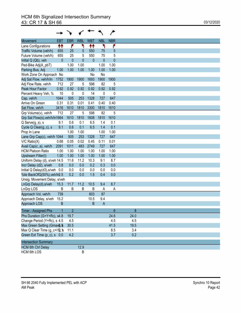
HCM 6th Signalized Intersection Summary43: CR 17 & SH 66 03/12/2020
SH 66 2040 Fully Implemented PEL with ACP Synchro 10 ReportAM Peak Page 42
Movement EBT EBR WBL WBT NBL NBR
Lane ConfigurationsTraffic Volume (veh/h) 655 25 5 550 75 5Future Volume (veh/h) 655 25 5 550 75 5Initial Q (Qb), veh 0 0 0 0 0 0Ped-Bike Adj(A_pbT) 1.00 1.00 1.00 1.00Parking Bus, Adj 1.00 1.00 1.00 1.00 1.00 1.00Work Zone On Approach No No NoAdj Sat Flow, veh/h/ln 1752 1900 1900 1693 1900 1900Adj Flow Rate, veh/h 712 27 5 598 82 5Peak Hour Factor 0.92 0.92 0.92 0.92 0.92 0.92Percent Heavy Veh, % 10 0 0 14 0 0Cap, veh/h 1044 505 253 1328 727 647Arrive On Green 0.31 0.31 0.01 0.41 0.40 0.40Sat Flow, veh/h 3416 1610 1810 3300 1810 1610
Grp Volume(v), veh/h 712 27 5 598 82 5Grp Sat Flow(s),veh/h/ln1664 1610 1810 1608 1810 1610Q Serve(g_s), s 9.1 0.6 0.1 6.5 1.4 0.1Cycle Q Clear(g_c), s 9.1 0.6 0.1 6.5 1.4 0.1Prop In Lane 1.00 1.00 1.00 1.00Lane Grp Cap(c), veh/h 1044 505 253 1328 727 647V/C Ratio(X) 0.68 0.05 0.02 0.45 0.11 0.01Avail Cap(c_a), veh/h 2091 1011 483 2749 727 647HCM Platoon Ratio 1.00 1.00 1.00 1.00 1.00 1.00Upstream Filter(I) 1.00 1.00 1.00 1.00 1.00 1.00Uniform Delay (d), s/veh 14.5 11.6 11.2 10.3 9.1 8.7Incr Delay (d2), s/veh 0.8 0.0 0.0 0.2 0.3 0.0Initial Q Delay(d3),s/veh 0.0 0.0 0.0 0.0 0.0 0.0%ile BackOfQ(50%),veh/ln2.5 0.2 0.0 1.5 0.4 0.0Unsig. Movement Delay, s/vehLnGrp Delay(d),s/veh 15.3 11.7 11.2 10.5 9.4 8.7LnGrp LOS B B B B A A
Approach Vol, veh/h 739 603 87Approach Delay, s/veh 15.2 10.5 9.4Approach LOS B B A
Timer - Assigned Phs 1 2 6 8
Phs Duration (G+Y+Rc), s4.8 19.7 24.6 24.0Change Period (Y+Rc), s 4.5 4.5 4.5 4.5Max Green Setting (Gmax), s6.5 30.5 41.5 19.5Max Q Clear Time (g_c+I1), s2.1 11.1 8.5 3.4Green Ext Time (p_c), s 0.0 4.2 3.7 0.2
Intersection Summary
HCM 6th Ctrl Delay 12.9HCM 6th LOS B
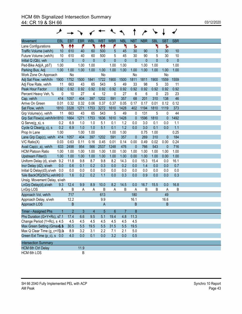
HCM 6th Signalized Intersection Summary44: CR 19 & SH 66 03/12/2020
SH 66 2040 Fully Implemented PEL with ACP Synchro 10 ReportAM Peak Page 43
Movement EBL EBT EBR WBL WBT WBR NBL NBT NBR SBL SBT SBR
Lane ConfigurationsTraffic Volume (veh/h) 10 610 40 60 500 5 45 30 90 5 30 10Future Volume (veh/h) 10 610 40 60 500 5 45 30 90 5 30 10Initial Q (Qb), veh 0 0 0 0 0 0 0 0 0 0 0 0Ped-Bike Adj(A_pbT) 1.00 1.00 1.00 1.00 1.00 1.00 1.00 1.00Parking Bus, Adj 1.00 1.00 1.00 1.00 1.00 1.00 1.00 1.00 1.00 1.00 1.00 1.00Work Zone On Approach No No No NoAdj Sat Flow, veh/h/ln 1900 1752 1500 1841 1722 1900 1500 1811 1811 1900 1559 1559Adj Flow Rate, veh/h 11 663 43 65 543 5 49 33 98 5 33 11Peak Hour Factor 0.92 0.92 0.92 0.92 0.92 0.92 0.92 0.92 0.92 0.92 0.92 0.92Percent Heavy Veh, % 0 10 27 4 12 0 27 6 6 0 23 23Cap, veh/h 414 1057 404 397 1202 591 357 68 201 310 138 46Arrive On Green 0.01 0.32 0.32 0.06 0.37 0.37 0.05 0.17 0.17 0.01 0.12 0.12Sat Flow, veh/h 1810 3328 1271 1753 3272 1610 1428 402 1194 1810 1119 373
Grp Volume(v), veh/h 11 663 43 65 543 5 49 0 131 5 0 44Grp Sat Flow(s),veh/h/ln1810 1664 1271 1753 1636 1610 1428 0 1596 1810 0 1492Q Serve(g_s), s 0.2 6.9 1.0 1.0 5.1 0.1 1.2 0.0 3.0 0.1 0.0 1.1Cycle Q Clear(g_c), s 0.2 6.9 1.0 1.0 5.1 0.1 1.2 0.0 3.0 0.1 0.0 1.1Prop In Lane 1.00 1.00 1.00 1.00 1.00 0.75 1.00 0.25Lane Grp Cap(c), veh/h 414 1057 404 397 1202 591 357 0 269 310 0 184V/C Ratio(X) 0.03 0.63 0.11 0.16 0.45 0.01 0.14 0.00 0.49 0.02 0.00 0.24Avail Cap(c_a), veh/h 633 2498 954 566 2537 1248 476 0 766 543 0 716HCM Platoon Ratio 1.00 1.00 1.00 1.00 1.00 1.00 1.00 1.00 1.00 1.00 1.00 1.00Upstream Filter(I) 1.00 1.00 1.00 1.00 1.00 1.00 1.00 0.00 1.00 1.00 0.00 1.00Uniform Delay (d), s/veh 9.2 11.8 9.8 8.7 9.8 8.2 14.3 0.0 15.3 15.4 0.0 16.1Incr Delay (d2), s/veh 0.0 0.6 0.1 0.2 0.3 0.0 0.2 0.0 1.4 0.0 0.0 0.7Initial Q Delay(d3),s/veh 0.0 0.0 0.0 0.0 0.0 0.0 0.0 0.0 0.0 0.0 0.0 0.0%ile BackOfQ(50%),veh/ln0.0 1.6 0.2 0.2 1.1 0.0 0.3 0.0 0.9 0.0 0.0 0.3Unsig. Movement Delay, s/vehLnGrp Delay(d),s/veh 9.3 12.4 9.9 8.9 10.0 8.2 14.5 0.0 16.7 15.5 0.0 16.8LnGrp LOS A B A A B A B A B B A B
Approach Vol, veh/h 717 613 180 49Approach Delay, s/veh 12.2 9.9 16.1 16.6Approach LOS B A B B
Timer - Assigned Phs 1 2 3 4 5 6 7 8
Phs Duration (G+Y+Rc), s7.1 17.4 6.6 9.5 5.1 19.4 4.8 11.3Change Period (Y+Rc), s 4.5 4.5 4.5 4.5 4.5 4.5 4.5 4.5Max Green Setting (Gmax), s6.5 30.5 5.5 19.5 5.5 31.5 5.5 19.5Max Q Clear Time (g_c+I1), s3.0 8.9 3.2 3.1 2.2 7.1 2.1 5.0Green Ext Time (p_c), s 0.0 4.0 0.0 0.1 0.0 3.2 0.0 0.5
Intersection Summary
HCM 6th Ctrl Delay 11.9HCM 6th LOS B

SH 66 Access Control Plan | Final Report
F.4. 2040 PM with Recommended PEL Laneage and ACP Implemented


HCM 6th Signalized Intersection Summary1: McConnell Dr/Stone Canyon Dr & SH 66 03/12/2020
SH 66 2040 Fully Implemented PEL with ACP Synchro 10 ReportPM Peak Page 1
Movement SEL SET SER NWL NWT NWR NEL NET NER SWL SWT SWR
Lane ConfigurationsTraffic Volume (veh/h) 30 990 15 110 885 40 15 10 95 30 10 30Future Volume (veh/h) 30 990 15 110 885 40 15 10 95 30 10 30Initial Q (Qb), veh 0 0 0 0 0 0 0 0 0 0 0 0Ped-Bike Adj(A_pbT) 1.00 1.00 1.00 1.00 1.00 1.00 1.00 1.00Parking Bus, Adj 1.00 1.00 1.00 1.00 1.00 1.00 1.00 1.00 1.00 1.00 1.00 1.00Work Zone On Approach No No No NoAdj Sat Flow, veh/h/ln 1870 1826 1870 1870 1826 1870 1870 1870 1870 1870 1870 1870Adj Flow Rate, veh/h 33 1076 16 120 962 43 16 11 103 33 11 33Peak Hour Factor 0.92 0.92 0.92 0.92 0.92 0.92 0.92 0.92 0.92 0.92 0.92 0.92Percent Heavy Veh, % 2 5 2 2 5 2 2 2 2 2 2 2Cap, veh/h 267 1313 600 428 2210 1010 293 22 205 230 58 175Arrive On Green 0.38 0.38 0.38 0.15 0.64 0.64 0.14 0.14 0.14 0.14 0.14 0.14Sat Flow, veh/h 561 3469 1585 1781 3469 1585 1362 155 1454 1279 412 1236
Grp Volume(v), veh/h 33 1076 16 120 962 43 16 0 114 33 0 44Grp Sat Flow(s),veh/h/ln 561 1735 1585 1781 1735 1585 1362 0 1609 1279 0 1648Q Serve(g_s), s 2.6 15.1 0.3 0.0 7.5 0.5 0.6 0.0 3.5 1.3 0.0 1.3Cycle Q Clear(g_c), s 10.1 15.1 0.3 0.0 7.5 0.5 1.8 0.0 3.5 4.9 0.0 1.3Prop In Lane 1.00 1.00 1.00 1.00 1.00 0.90 1.00 0.75Lane Grp Cap(c), veh/h 267 1313 600 428 2210 1010 293 0 227 230 0 233V/C Ratio(X) 0.12 0.82 0.03 0.28 0.44 0.04 0.05 0.00 0.50 0.14 0.00 0.19Avail Cap(c_a), veh/h 283 1410 644 428 2244 1025 302 0 238 238 0 244HCM Platoon Ratio 1.00 1.00 1.00 1.00 1.00 1.00 1.00 1.00 1.00 1.00 1.00 1.00Upstream Filter(I) 1.00 1.00 1.00 1.00 1.00 1.00 1.00 0.00 1.00 1.00 0.00 1.00Uniform Delay (d), s/veh 16.6 15.2 10.6 19.2 4.9 3.7 21.3 0.0 21.5 23.7 0.0 20.5Incr Delay (d2), s/veh 0.3 4.0 0.0 0.4 0.2 0.0 0.1 0.0 2.4 0.4 0.0 0.6Initial Q Delay(d3),s/veh 0.0 0.0 0.0 0.0 0.0 0.0 0.0 0.0 0.0 0.0 0.0 0.0%ile BackOfQ(50%),veh/ln 0.3 4.9 0.1 1.1 1.0 0.1 0.2 0.0 1.4 0.4 0.0 0.5Unsig. Movement Delay, s/vehLnGrp Delay(d),s/veh 16.9 19.2 10.6 19.6 5.1 3.7 21.4 0.0 23.9 24.1 0.0 21.1LnGrp LOS B B B B A A C A C C A C
Approach Vol, veh/h 1125 1125 130 77Approach Delay, s/veh 19.0 6.6 23.6 22.4Approach LOS B A C C
Timer - Assigned Phs 1 2 4 6 8
Phs Duration (G+Y+Rc), s 14.0 26.5 13.6 40.5 13.6Change Period (Y+Rc), s 6.0 * 6 6.0 6.0 6.0Max Green Setting (Gmax), s 8.0 * 22 8.0 35.0 8.0Max Q Clear Time (g_c+I1), s 2.0 17.1 6.9 9.5 5.5Green Ext Time (p_c), s 0.1 3.3 0.0 9.3 0.2
Intersection Summary
HCM 6th Ctrl Delay 13.7HCM 6th LOS B
Notes
User approved pedestrian interval to be less than phase max green.* HCM 6th computational engine requires equal clearance times for the phases crossing the barrier.

HCM 6th Signalized Intersection Summary2: US 36 & SH 66 03/12/2020
SH 66 2040 Fully Implemented PEL with ACP Synchro 10 ReportPM Peak Page 2
Movement EBL EBT EBR WBL WBT WBR NBL NBT NBR SBL SBT SBR
Lane ConfigurationsTraffic Volume (veh/h) 25 340 360 60 490 30 490 35 365 40 50 60Future Volume (veh/h) 25 340 360 60 490 30 490 35 365 40 50 60Initial Q (Qb), veh 0 0 0 0 0 0 0 0 0 0 0 0Ped-Bike Adj(A_pbT) 1.00 1.00 1.00 1.00 1.00 1.00 1.00 1.00Parking Bus, Adj 1.00 1.00 1.00 1.00 1.00 1.00 1.00 1.00 1.00 1.00 1.00 1.00Work Zone On Approach No No No NoAdj Sat Flow, veh/h/ln 1710 1683 1683 1683 1657 1710 1617 1710 1617 1710 1710 1710Adj Flow Rate, veh/h 27 370 0 65 533 33 560 0 0 43 54 65Peak Hour Factor 0.92 0.92 0.92 0.92 0.92 0.92 0.92 0.92 0.92 0.92 0.92 0.92Percent Heavy Veh, % 0 2 2 2 4 0 7 0 7 0 0 0Cap, veh/h 178 642 217 630 290 666 0 212 92 111Arrive On Green 0.03 0.20 0.00 0.06 0.20 0.20 0.22 0.00 0.00 0.13 0.13 0.13Sat Flow, veh/h 1629 3198 1427 1603 3148 1449 3079 0 1370 1629 707 850
Grp Volume(v), veh/h 27 370 0 65 533 33 560 0 0 43 0 119Grp Sat Flow(s),veh/h/ln1629 1599 1427 1603 1574 1449 1540 0 1370 1629 0 1557Q Serve(g_s), s 0.0 5.9 0.0 2.0 9.2 1.1 9.9 0.0 0.0 1.3 0.0 4.1Cycle Q Clear(g_c), s 0.0 5.9 0.0 2.0 9.2 1.1 9.9 0.0 0.0 1.3 0.0 4.1Prop In Lane 1.00 1.00 1.00 1.00 1.00 1.00 1.00 0.55Lane Grp Cap(c), veh/h 178 642 217 630 290 666 0 212 0 202V/C Ratio(X) 0.15 0.58 0.30 0.85 0.11 0.84 0.00 0.20 0.00 0.59Avail Cap(c_a), veh/h 272 648 268 638 294 706 0 230 0 220HCM Platoon Ratio 1.00 1.00 1.00 1.00 1.00 1.00 1.00 1.00 1.00 1.00 1.00 1.00Upstream Filter(I) 1.00 1.00 0.00 1.00 1.00 1.00 1.00 0.00 0.00 1.00 0.00 1.00Uniform Delay (d), s/veh 26.7 20.5 0.0 21.3 21.8 18.6 21.3 0.0 0.0 22.1 0.0 23.2Incr Delay (d2), s/veh 0.4 1.5 0.0 0.8 10.5 0.2 9.1 0.0 0.0 0.7 0.0 4.5Initial Q Delay(d3),s/veh 0.0 0.0 0.0 0.0 0.0 0.0 0.0 0.0 0.0 0.0 0.0 0.0%ile BackOfQ(50%),veh/ln0.3 1.9 0.0 0.7 3.7 0.3 3.8 0.0 0.0 0.5 0.0 1.7Unsig. Movement Delay, s/vehLnGrp Delay(d),s/veh 27.0 22.0 0.0 22.1 32.3 18.8 30.4 0.0 0.0 22.7 0.0 27.8LnGrp LOS C C C C B C A C A C
Approach Vol, veh/h 397 A 631 560 A 162Approach Delay, s/veh 22.4 30.6 30.4 26.4Approach LOS C C C C
Timer - Assigned Phs 1 2 4 5 6 8
Phs Duration (G+Y+Rc), s7.7 17.4 18.3 7.7 17.4 13.4Change Period (Y+Rc), s 4.5 6.0 6.0 6.0 * 6 6.0Max Green Setting (Gmax), s5.0 11.5 13.0 5.0 * 12 8.0Max Q Clear Time (g_c+I1), s4.0 7.9 11.9 2.0 11.2 6.1Green Ext Time (p_c), s 0.0 0.9 0.4 0.0 0.1 0.2
Intersection Summary
HCM 6th Ctrl Delay 28.3HCM 6th LOS C
Notes
User approved volume balancing among the lanes for turning movement.* HCM 6th computational engine requires equal clearance times for the phases crossing the barrier.Unsignalized Delay for [NBR, EBR] is excluded from calculations of the approach delay and intersection delay.

HCM 6th Signalized Intersection Summary3: SH 66 & Highland Dr 03/12/2020
SH 66 2040 Fully Implemented PEL with ACP Synchro 10 ReportPM Peak Page 3
Movement EBL EBT WBT WBR SBL SBR
Lane ConfigurationsTraffic Volume (veh/h) 30 715 570 10 50 20Future Volume (veh/h) 30 715 570 10 50 20Initial Q (Qb), veh 0 0 0 0 0 0Ped-Bike Adj(A_pbT) 1.00 1.00 1.00 1.00Parking Bus, Adj 1.00 1.00 1.00 1.00 1.00 1.00Work Zone On Approach No No NoAdj Sat Flow, veh/h/ln 1870 1870 1870 1870 1870 1870Adj Flow Rate, veh/h 33 777 620 11 54 22Peak Hour Factor 0.92 0.92 0.92 0.92 0.92 0.92Percent Heavy Veh, % 2 2 2 2 2 2Cap, veh/h 321 1132 1132 505 809 720Arrive On Green 0.32 0.32 0.32 0.32 0.45 0.45Sat Flow, veh/h 796 3647 3647 1585 1781 1585
Grp Volume(v), veh/h 33 777 620 11 54 22Grp Sat Flow(s),veh/h/ln 796 1777 1777 1585 1781 1585Q Serve(g_s), s 1.4 7.6 5.7 0.2 0.7 0.3Cycle Q Clear(g_c), s 7.1 7.6 5.7 0.2 0.7 0.3Prop In Lane 1.00 1.00 1.00 1.00Lane Grp Cap(c), veh/h 321 1132 1132 505 809 720V/C Ratio(X) 0.10 0.69 0.55 0.02 0.07 0.03Avail Cap(c_a), veh/h 429 1614 1614 720 809 720HCM Platoon Ratio 1.00 1.00 1.00 1.00 1.00 1.00Upstream Filter(I) 1.00 1.00 1.00 1.00 1.00 1.00Uniform Delay (d), s/veh 14.1 11.8 11.1 9.3 6.1 6.0Incr Delay (d2), s/veh 0.1 0.7 0.4 0.0 0.2 0.1Initial Q Delay(d3),s/veh 0.0 0.0 0.0 0.0 0.0 0.0%ile BackOfQ(50%),veh/ln0.2 1.8 1.4 0.0 0.2 0.1Unsig. Movement Delay, s/vehLnGrp Delay(d),s/veh 14.2 12.5 11.6 9.3 6.2 6.1LnGrp LOS B B B A A A
Approach Vol, veh/h 810 631 76Approach Delay, s/veh 12.6 11.5 6.2Approach LOS B B A
Timer - Assigned Phs 2 4 6
Phs Duration (G+Y+Rc), s 17.1 22.5 17.1Change Period (Y+Rc), s 4.5 4.5 4.5Max Green Setting (Gmax), s 18.0 18.0 18.0Max Q Clear Time (g_c+I1), s 9.6 2.7 7.7Green Ext Time (p_c), s 3.1 0.1 2.6
Intersection Summary
HCM 6th Ctrl Delay 11.8HCM 6th LOS B
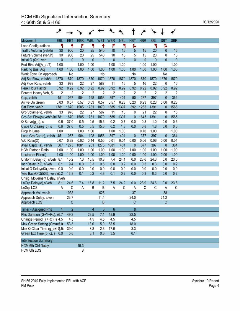
HCM 6th Signalized Intersection Summary4: 66th St & SH 66 03/12/2020
SH 66 2040 Fully Implemented PEL with ACP Synchro 10 ReportPM Peak Page 4
Movement EBL EBT EBR WBL WBT WBR NBL NBT NBR SBL SBT SBR
Lane ConfigurationsTraffic Volume (veh/h) 30 900 20 25 540 10 15 5 15 20 0 15Future Volume (veh/h) 30 900 20 25 540 10 15 5 15 20 0 15Initial Q (Qb), veh 0 0 0 0 0 0 0 0 0 0 0 0Ped-Bike Adj(A_pbT) 1.00 1.00 1.00 1.00 1.00 1.00 1.00 1.00Parking Bus, Adj 1.00 1.00 1.00 1.00 1.00 1.00 1.00 1.00 1.00 1.00 1.00 1.00Work Zone On Approach No No No NoAdj Sat Flow, veh/h/ln 1870 1870 1870 1870 1870 1870 1870 1870 1870 1870 1870 1870Adj Flow Rate, veh/h 33 978 22 27 587 11 16 5 16 22 0 16Peak Hour Factor 0.92 0.92 0.92 0.92 0.92 0.92 0.92 0.92 0.92 0.92 0.92 0.92Percent Heavy Veh, % 2 2 2 2 2 2 2 2 2 2 2 2Cap, veh/h 451 1067 904 198 1058 897 401 90 287 397 0 364Arrive On Green 0.03 0.57 0.57 0.03 0.57 0.57 0.23 0.23 0.23 0.23 0.00 0.23Sat Flow, veh/h 1781 1870 1585 1781 1870 1585 1397 392 1253 1391 0 1585
Grp Volume(v), veh/h 33 978 22 27 587 11 16 0 21 22 0 16Grp Sat Flow(s),veh/h/ln1781 1870 1585 1781 1870 1585 1397 0 1645 1391 0 1585Q Serve(g_s), s 0.6 37.0 0.5 0.5 15.6 0.2 0.7 0.0 0.8 1.0 0.0 0.6Cycle Q Clear(g_c), s 0.6 37.0 0.5 0.5 15.6 0.2 1.3 0.0 0.8 1.8 0.0 0.6Prop In Lane 1.00 1.00 1.00 1.00 1.00 0.76 1.00 1.00Lane Grp Cap(c), veh/h 451 1067 904 198 1058 897 401 0 377 397 0 364V/C Ratio(X) 0.07 0.92 0.02 0.14 0.55 0.01 0.04 0.00 0.06 0.06 0.00 0.04Avail Cap(c_a), veh/h 507 1275 1081 261 1275 1081 401 0 377 397 0 364HCM Platoon Ratio 1.00 1.00 1.00 1.00 1.00 1.00 1.00 1.00 1.00 1.00 1.00 1.00Upstream Filter(I) 1.00 1.00 1.00 1.00 1.00 1.00 1.00 0.00 1.00 1.00 0.00 1.00Uniform Delay (d), s/veh 8.1 15.2 7.3 15.5 10.8 7.4 24.1 0.0 23.6 24.3 0.0 23.5Incr Delay (d2), s/veh 0.1 9.4 0.0 0.3 0.5 0.0 0.2 0.0 0.3 0.3 0.0 0.2Initial Q Delay(d3),s/veh 0.0 0.0 0.0 0.0 0.0 0.0 0.0 0.0 0.0 0.0 0.0 0.0%ile BackOfQ(50%),veh/ln0.2 13.8 0.1 0.2 4.8 0.1 0.2 0.0 0.3 0.3 0.0 0.2Unsig. Movement Delay, s/vehLnGrp Delay(d),s/veh 8.1 24.6 7.4 15.8 11.2 7.5 24.2 0.0 23.9 24.6 0.0 23.8LnGrp LOS A C A B B A C A C C A C
Approach Vol, veh/h 1033 625 37 38Approach Delay, s/veh 23.7 11.4 24.0 24.2Approach LOS C B C C
Timer - Assigned Phs 1 2 4 5 6 8
Phs Duration (G+Y+Rc), s6.7 49.2 22.5 7.1 48.9 22.5Change Period (Y+Rc), s 4.5 4.5 4.5 4.5 4.5 4.5Max Green Setting (Gmax), s5.0 53.5 18.0 5.0 53.5 18.0Max Q Clear Time (g_c+I1), s2.5 39.0 3.8 2.6 17.6 3.3Green Ext Time (p_c), s 0.0 5.8 0.1 0.0 3.5 0.1
Intersection Summary
HCM 6th Ctrl Delay 19.3HCM 6th LOS B

HCM 6th Signalized Intersection Summary5: N 75th St & SH 66 03/12/2020
SH 66 2040 Fully Implemented PEL with ACP Synchro 10 ReportPM Peak Page 5
Movement EBL EBT EBR WBL WBT WBR NBL NBT NBR SBL SBT SBR
Lane ConfigurationsTraffic Volume (veh/h) 80 960 95 55 425 10 135 175 285 5 15 15Future Volume (veh/h) 80 960 95 55 425 10 135 175 285 5 15 15Initial Q (Qb), veh 0 0 0 0 0 0 0 0 0 0 0 0Ped-Bike Adj(A_pbT) 1.00 1.00 1.00 1.00 1.00 1.00 1.00 1.00Parking Bus, Adj 1.00 1.00 1.00 1.00 1.00 1.00 1.00 1.00 1.00 1.00 1.00 1.00Work Zone On Approach No No No NoAdj Sat Flow, veh/h/ln 1737 1856 1900 1870 1826 1900 1900 1900 1811 1693 1900 1900Adj Flow Rate, veh/h 87 1043 103 60 462 11 147 190 310 5 16 16Peak Hour Factor 0.92 0.92 0.92 0.92 0.92 0.92 0.92 0.92 0.92 0.92 0.92 0.92Percent Heavy Veh, % 11 3 0 2 5 0 0 0 6 14 0 0Cap, veh/h 529 1021 886 192 988 871 311 268 311 130 131 111Arrive On Green 0.07 0.55 0.55 0.06 0.54 0.54 0.08 0.14 0.14 0.01 0.07 0.07Sat Flow, veh/h 1654 1856 1610 1781 1826 1610 1810 1900 1535 1612 1900 1610
Grp Volume(v), veh/h 87 1043 103 60 462 11 147 190 310 5 16 16Grp Sat Flow(s),veh/h/ln1654 1856 1610 1781 1826 1610 1810 1900 1535 1612 1900 1610Q Serve(g_s), s 1.9 48.0 2.7 1.2 13.6 0.3 6.4 8.3 12.3 0.3 0.7 0.8Cycle Q Clear(g_c), s 1.9 48.0 2.7 1.2 13.6 0.3 6.4 8.3 12.3 0.3 0.7 0.8Prop In Lane 1.00 1.00 1.00 1.00 1.00 1.00 1.00 1.00Lane Grp Cap(c), veh/h 529 1021 886 192 988 871 311 268 311 130 131 111V/C Ratio(X) 0.16 1.02 0.12 0.31 0.47 0.01 0.47 0.71 1.00 0.04 0.12 0.14Avail Cap(c_a), veh/h 545 1021 886 225 1004 886 311 268 311 212 155 131HCM Platoon Ratio 1.00 1.00 1.00 1.00 1.00 1.00 1.00 1.00 1.00 1.00 1.00 1.00Upstream Filter(I) 1.00 1.00 1.00 1.00 1.00 1.00 1.00 1.00 1.00 1.00 1.00 1.00Uniform Delay (d), s/veh 8.1 19.6 9.4 19.9 12.3 9.3 32.7 35.7 34.8 37.4 38.2 38.2Incr Delay (d2), s/veh 0.1 33.8 0.1 0.9 0.3 0.0 1.1 8.3 49.9 0.1 0.4 0.6Initial Q Delay(d3),s/veh 0.0 0.0 0.0 0.0 0.0 0.0 0.0 0.0 0.0 0.0 0.0 0.0%ile BackOfQ(50%),veh/ln0.5 25.2 0.9 0.6 4.5 0.1 2.8 4.4 10.7 0.1 0.3 0.3Unsig. Movement Delay, s/vehLnGrp Delay(d),s/veh 8.3 53.5 9.5 20.8 12.6 9.3 33.8 44.0 84.6 37.6 38.6 38.8LnGrp LOS A F A C B A C D F D D D
Approach Vol, veh/h 1233 533 647 37Approach Delay, s/veh 46.6 13.5 61.2 38.5Approach LOS D B E D
Timer - Assigned Phs 1 2 3 4 5 6 7 8
Phs Duration (G+Y+Rc), s9.9 55.0 11.4 11.0 10.7 54.2 5.1 17.3Change Period (Y+Rc), s 4.5 7.0 4.5 5.0 4.5 7.0 4.5 5.0Max Green Setting (Gmax), s7.0 48.0 6.9 7.1 7.0 48.0 5.0 9.0Max Q Clear Time (g_c+I1), s3.2 50.0 8.4 2.8 3.9 15.6 2.3 14.3Green Ext Time (p_c), s 0.0 0.0 0.0 0.0 0.0 2.6 0.0 0.0
Intersection Summary
HCM 6th Ctrl Delay 43.1HCM 6th LOS D
Notes
User approved pedestrian interval to be less than phase max green.
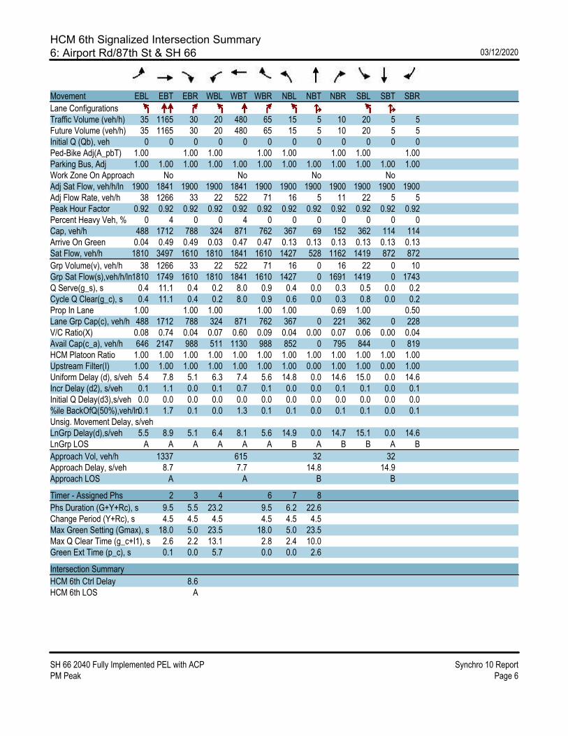
HCM 6th Signalized Intersection Summary6: Airport Rd/87th St & SH 66 03/12/2020
SH 66 2040 Fully Implemented PEL with ACP Synchro 10 ReportPM Peak Page 6
Movement EBL EBT EBR WBL WBT WBR NBL NBT NBR SBL SBT SBR
Lane ConfigurationsTraffic Volume (veh/h) 35 1165 30 20 480 65 15 5 10 20 5 5Future Volume (veh/h) 35 1165 30 20 480 65 15 5 10 20 5 5Initial Q (Qb), veh 0 0 0 0 0 0 0 0 0 0 0 0Ped-Bike Adj(A_pbT) 1.00 1.00 1.00 1.00 1.00 1.00 1.00 1.00Parking Bus, Adj 1.00 1.00 1.00 1.00 1.00 1.00 1.00 1.00 1.00 1.00 1.00 1.00Work Zone On Approach No No No NoAdj Sat Flow, veh/h/ln 1900 1841 1900 1900 1841 1900 1900 1900 1900 1900 1900 1900Adj Flow Rate, veh/h 38 1266 33 22 522 71 16 5 11 22 5 5Peak Hour Factor 0.92 0.92 0.92 0.92 0.92 0.92 0.92 0.92 0.92 0.92 0.92 0.92Percent Heavy Veh, % 0 4 0 0 4 0 0 0 0 0 0 0Cap, veh/h 488 1712 788 324 871 762 367 69 152 362 114 114Arrive On Green 0.04 0.49 0.49 0.03 0.47 0.47 0.13 0.13 0.13 0.13 0.13 0.13Sat Flow, veh/h 1810 3497 1610 1810 1841 1610 1427 528 1162 1419 872 872
Grp Volume(v), veh/h 38 1266 33 22 522 71 16 0 16 22 0 10Grp Sat Flow(s),veh/h/ln1810 1749 1610 1810 1841 1610 1427 0 1691 1419 0 1743Q Serve(g_s), s 0.4 11.1 0.4 0.2 8.0 0.9 0.4 0.0 0.3 0.5 0.0 0.2Cycle Q Clear(g_c), s 0.4 11.1 0.4 0.2 8.0 0.9 0.6 0.0 0.3 0.8 0.0 0.2Prop In Lane 1.00 1.00 1.00 1.00 1.00 0.69 1.00 0.50Lane Grp Cap(c), veh/h 488 1712 788 324 871 762 367 0 221 362 0 228V/C Ratio(X) 0.08 0.74 0.04 0.07 0.60 0.09 0.04 0.00 0.07 0.06 0.00 0.04Avail Cap(c_a), veh/h 646 2147 988 511 1130 988 852 0 795 844 0 819HCM Platoon Ratio 1.00 1.00 1.00 1.00 1.00 1.00 1.00 1.00 1.00 1.00 1.00 1.00Upstream Filter(I) 1.00 1.00 1.00 1.00 1.00 1.00 1.00 0.00 1.00 1.00 0.00 1.00Uniform Delay (d), s/veh 5.4 7.8 5.1 6.3 7.4 5.6 14.8 0.0 14.6 15.0 0.0 14.6Incr Delay (d2), s/veh 0.1 1.1 0.0 0.1 0.7 0.1 0.0 0.0 0.1 0.1 0.0 0.1Initial Q Delay(d3),s/veh 0.0 0.0 0.0 0.0 0.0 0.0 0.0 0.0 0.0 0.0 0.0 0.0%ile BackOfQ(50%),veh/ln0.1 1.7 0.1 0.0 1.3 0.1 0.1 0.0 0.1 0.1 0.0 0.1Unsig. Movement Delay, s/vehLnGrp Delay(d),s/veh 5.5 8.9 5.1 6.4 8.1 5.6 14.9 0.0 14.7 15.1 0.0 14.6LnGrp LOS A A A A A A B A B B A B
Approach Vol, veh/h 1337 615 32 32Approach Delay, s/veh 8.7 7.7 14.8 14.9Approach LOS A A B B
Timer - Assigned Phs 2 3 4 6 7 8
Phs Duration (G+Y+Rc), s 9.5 5.5 23.2 9.5 6.2 22.6Change Period (Y+Rc), s 4.5 4.5 4.5 4.5 4.5 4.5Max Green Setting (Gmax), s 18.0 5.0 23.5 18.0 5.0 23.5Max Q Clear Time (g_c+I1), s 2.6 2.2 13.1 2.8 2.4 10.0Green Ext Time (p_c), s 0.1 0.0 5.7 0.0 0.0 2.6
Intersection Summary
HCM 6th Ctrl Delay 8.6HCM 6th LOS A

HCM 6th TWSC7: Shore Dr & SH 66 03/12/2020
SH 66 2040 Fully Implemented PEL with ACP Synchro 10 ReportPM Peak Page 7
Intersection
Int Delay, s/veh 0.6
Movement EBT EBR WBL WBT NBL NBR
Lane ConfigurationsTraffic Vol, veh/h 1175 20 60 565 0 30Future Vol, veh/h 1175 20 60 565 0 30Conflicting Peds, #/hr 0 0 0 0 0 0Sign Control Free Free Free Free Stop StopRT Channelized - None - None - NoneStorage Length - 250 250 - - 0Veh in Median Storage, # 0 - - 0 0 -Grade, % 0 - - 0 0 -Peak Hour Factor 92 92 92 92 92 92Heavy Vehicles, % 2 2 2 2 2 2Mvmt Flow 1277 22 65 614 0 33
Major/Minor Major1 Major2 Minor1
Conflicting Flow All 0 0 1299 0 - 639 Stage 1 - - - - - - Stage 2 - - - - - -Critical Hdwy - - 4.14 - - 6.94Critical Hdwy Stg 1 - - - - - -Critical Hdwy Stg 2 - - - - - -Follow-up Hdwy - - 2.22 - - 3.32Pot Cap-1 Maneuver - - 529 - 0 419 Stage 1 - - - - 0 - Stage 2 - - - - 0 -Platoon blocked, % - - -Mov Cap-1 Maneuver - - 529 - - 419Mov Cap-2 Maneuver - - - - - - Stage 1 - - - - - - Stage 2 - - - - - -
Approach EB WB NB
HCM Control Delay, s 0 1.2 14.3HCM LOS B
Minor Lane/Major Mvmt NBLn1 EBT EBR WBL WBT
Capacity (veh/h) 419 - - 529 -HCM Lane V/C Ratio 0.078 - - 0.123 -HCM Control Delay (s) 14.3 - - 12.8 -HCM Lane LOS B - - B -HCM 95th %tile Q(veh) 0.3 - - 0.4 -

HCM 6th TWSC8: SH 66 & Anhawa Ave 03/12/2020
SH 66 2040 Fully Implemented PEL with ACP Synchro 10 ReportPM Peak Page 8
Intersection
Int Delay, s/veh 0.1
Movement EBL EBT WBT WBR SBL SBR
Lane ConfigurationsTraffic Vol, veh/h 10 1275 650 30 0 10Future Vol, veh/h 10 1275 650 30 0 10Conflicting Peds, #/hr 0 0 0 0 0 0Sign Control Free Free Free Free Stop StopRT Channelized - None - None - NoneStorage Length 100 - - - - 0Veh in Median Storage, # - 0 0 - 0 -Grade, % - 0 0 - 0 -Peak Hour Factor 92 92 92 92 92 92Heavy Vehicles, % 0 3 4 25 25 0Mvmt Flow 11 1386 707 33 0 11
Major/Minor Major1 Major2 Minor2
Conflicting Flow All 740 0 - 0 - 370 Stage 1 - - - - - - Stage 2 - - - - - -Critical Hdwy 4.1 - - - - 6.9Critical Hdwy Stg 1 - - - - - -Critical Hdwy Stg 2 - - - - - -Follow-up Hdwy 2.2 - - - - 3.3Pot Cap-1 Maneuver 876 - - - 0 633 Stage 1 - - - - 0 - Stage 2 - - - - 0 -Platoon blocked, % - - -Mov Cap-1 Maneuver 876 - - - - 633Mov Cap-2 Maneuver - - - - - - Stage 1 - - - - - - Stage 2 - - - - - -
Approach EB WB SB
HCM Control Delay, s 0.1 0 10.8HCM LOS B
Minor Lane/Major Mvmt EBL EBT WBT WBR SBLn1
Capacity (veh/h) 876 - - - 633HCM Lane V/C Ratio 0.012 - - - 0.017HCM Control Delay (s) 9.2 - - - 10.8HCM Lane LOS A - - - BHCM 95th %tile Q(veh) 0 - - - 0.1

HCM 6th TWSC9: Lake Park Dr & SH 66 03/12/2020
SH 66 2040 Fully Implemented PEL with ACP Synchro 10 ReportPM Peak Page 9
Intersection
Int Delay, s/veh 0.5
Movement EBL EBT EBR WBL WBT WBR NBL NBT NBR SBL SBT SBR
Lane ConfigurationsTraffic Vol, veh/h 0 1235 35 25 660 30 0 0 30 0 0 35Future Vol, veh/h 0 1235 35 25 660 30 0 0 30 0 0 35Conflicting Peds, #/hr 0 0 0 0 0 0 0 0 0 0 0 0Sign Control Free Free Free Free Free Free Stop Stop Stop Stop Stop StopRT Channelized - - None - - None - - None - - NoneStorage Length - - 250 250 - 250 - - 0 - - 0Veh in Median Storage, # - 0 - - 0 - - 0 - - 0 -Grade, % - 0 - - 0 - - 0 - - 0 -Peak Hour Factor 92 92 92 92 92 92 92 92 92 92 92 92Heavy Vehicles, % 2 2 2 2 2 2 2 2 2 2 2 2Mvmt Flow 0 1342 38 27 717 33 0 0 33 0 0 38
Major/Minor Major1 Major2 Minor1 Minor2
Conflicting Flow All - 0 0 1380 0 0 - - 671 - - 359 Stage 1 - - - - - - - - - - - - Stage 2 - - - - - - - - - - - -Critical Hdwy - - - 4.14 - - - - 6.94 - - 6.94Critical Hdwy Stg 1 - - - - - - - - - - - -Critical Hdwy Stg 2 - - - - - - - - - - - -Follow-up Hdwy - - - 2.22 - - - - 3.32 - - 3.32Pot Cap-1 Maneuver 0 - - 493 - - 0 0 399 0 0 638 Stage 1 0 - - - - - 0 0 - 0 0 - Stage 2 0 - - - - - 0 0 - 0 0 -Platoon blocked, % - - - -Mov Cap-1 Maneuver - - - 493 - - - - 399 - - 638Mov Cap-2 Maneuver - - - - - - - - - - - - Stage 1 - - - - - - - - - - - - Stage 2 - - - - - - - - - - - -
Approach EB WB NB SB
HCM Control Delay, s 0 0.4 14.8 11HCM LOS B B
Minor Lane/Major Mvmt NBLn1 EBT EBR WBL WBT WBR SBLn1
Capacity (veh/h) 399 - - 493 - - 638HCM Lane V/C Ratio 0.082 - - 0.055 - - 0.06HCM Control Delay (s) 14.8 - - 12.7 - - 11HCM Lane LOS B - - B - - BHCM 95th %tile Q(veh) 0.3 - - 0.2 - - 0.2

HCM Signalized Intersection Capacity Analysis10: 95th St/Hover Rd & SH 66 03/12/2020
SH 66 2040 Fully Implemented PEL with ACP Synchro 10 ReportPM Peak Page 1
Movement EBL EBT EBR2 WBT WBR NBL NBT NBR2 SBL2 SBT SBR NWL2
Lane ConfigurationsTraffic Volume (vph) 40 775 445 350 35 330 250 1585 75 130 10 920Future Volume (vph) 40 775 445 350 35 330 250 1585 75 130 10 920Ideal Flow (vphpl) 1900 1900 1900 1900 1900 1900 1900 1900 1900 1900 1900 1900Total Lost time (s) 5.7 5.7 5.7 5.7 5.7 4.5 6.4 4.0 4.5 6.4 6.4 4.5Lane Util. Factor 0.97 0.95 1.00 0.95 1.00 0.97 1.00 1.00 1.00 1.00 1.00 0.97Frt 1.00 1.00 0.85 1.00 0.85 1.00 1.00 0.85 1.00 1.00 0.85 1.00Flt Protected 0.95 1.00 1.00 1.00 1.00 0.95 1.00 1.00 0.95 1.00 1.00 0.95Satd. Flow (prot) 3502 3471 1599 3406 1615 3400 1863 1583 1805 1900 1583 3433Flt Permitted 0.95 1.00 1.00 1.00 1.00 0.61 1.00 1.00 0.47 1.00 1.00 0.95Satd. Flow (perm) 3502 3471 1599 3406 1615 2167 1863 1583 895 1900 1583 3433
Peak-hour factor, PHF 0.92 0.92 0.92 0.92 0.92 0.92 0.92 0.92 0.92 0.92 0.92 0.92Adj. Flow (vph) 43 842 484 380 38 359 272 1723 82 141 11 1000RTOR Reduction (vph) 0 0 280 0 22 0 0 0 0 0 9 0Lane Group Flow (vph) 43 842 204 380 16 359 272 1723 82 141 2 1000Heavy Vehicles (%) 0% 4% 1% 6% 0% 3% 2% 2% 0% 0% 2% 2%
Turn Type Prot NA Perm NA Perm pm+pt NA Free pm+pt NA Perm ProtProtected Phases 5 2 6 3 8 7 4 1 2 6Permitted Phases 2 6 8 Free 4 4Actuated Green, G (s) 4.3 31.1 31.1 34.1 34.1 24.1 18.4 83.1 20.7 16.7 16.7 44.1Effective Green, g (s) 4.3 31.1 31.1 34.1 34.1 24.1 18.4 83.1 20.7 16.7 16.7 44.1Actuated g/C Ratio 0.05 0.37 0.37 0.41 0.41 0.29 0.22 1.00 0.25 0.20 0.20 0.53Clearance Time (s) 5.7 5.7 5.7 5.7 5.7 4.5 6.4 4.5 6.4 6.4Vehicle Extension (s) 3.0 3.0 3.0 3.0 3.0 3.0 4.0 3.0 4.0 4.0
Lane Grp Cap (vph) 181 1299 598 1397 662 713 412 1583 266 381 318 1821v/s Ratio Prot 0.01 0.24 0.11 0.03 0.15 0.01 0.07 0.29v/s Ratio Perm 0.13 0.01 0.11 c1.09 0.06 0.00v/c Ratio 0.24 0.65 0.34 0.27 0.02 0.50 0.66 1.09 0.31 0.37 0.01 0.55Uniform Delay, d1 37.8 21.5 18.6 16.3 14.6 23.7 29.5 41.5 24.6 28.7 26.6 12.9Progression Factor 1.00 1.00 1.00 1.00 1.00 1.00 1.00 1.00 1.00 1.00 1.00 0.99Incremental Delay, d2 0.7 1.1 0.3 0.1 0.0 0.6 4.3 50.8 0.7 0.8 0.0 0.3Delay (s) 38.5 22.6 19.0 16.4 14.6 24.3 33.8 92.3 25.3 29.5 26.6 13.1Level of Service D C B B B C C F C C C BApproach Delay (s) 21.8 16.2 75.2 27.9Approach LOS C B E C
Intersection Summary
HCM 2000 Control Delay 43.4 HCM 2000 Level of Service DHCM 2000 Volume to Capacity ratio 1.49Actuated Cycle Length (s) 83.1 Sum of lost time (s) 22.3Intersection Capacity Utilization 86.7% ICU Level of Service EAnalysis Period (min) 15c Critical Lane Group
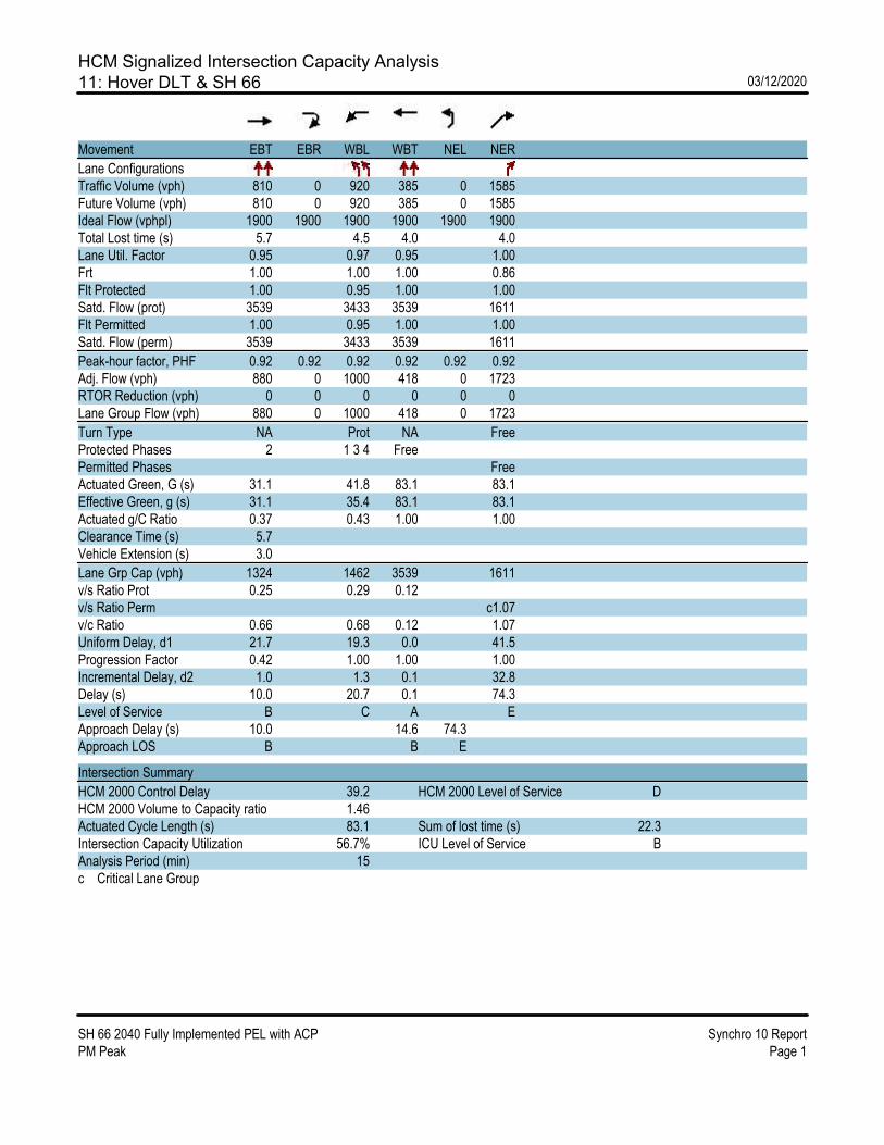
HCM Signalized Intersection Capacity Analysis11: Hover DLT & SH 66 03/12/2020
SH 66 2040 Fully Implemented PEL with ACP Synchro 10 ReportPM Peak Page 1
Movement EBT EBR WBL WBT NEL NER
Lane ConfigurationsTraffic Volume (vph) 810 0 920 385 0 1585Future Volume (vph) 810 0 920 385 0 1585Ideal Flow (vphpl) 1900 1900 1900 1900 1900 1900Total Lost time (s) 5.7 4.5 4.0 4.0Lane Util. Factor 0.95 0.97 0.95 1.00Frt 1.00 1.00 1.00 0.86Flt Protected 1.00 0.95 1.00 1.00Satd. Flow (prot) 3539 3433 3539 1611Flt Permitted 1.00 0.95 1.00 1.00Satd. Flow (perm) 3539 3433 3539 1611
Peak-hour factor, PHF 0.92 0.92 0.92 0.92 0.92 0.92Adj. Flow (vph) 880 0 1000 418 0 1723RTOR Reduction (vph) 0 0 0 0 0 0Lane Group Flow (vph) 880 0 1000 418 0 1723
Turn Type NA Prot NA FreeProtected Phases 2 1 3 4 FreePermitted Phases FreeActuated Green, G (s) 31.1 41.8 83.1 83.1Effective Green, g (s) 31.1 35.4 83.1 83.1Actuated g/C Ratio 0.37 0.43 1.00 1.00Clearance Time (s) 5.7Vehicle Extension (s) 3.0
Lane Grp Cap (vph) 1324 1462 3539 1611v/s Ratio Prot 0.25 0.29 0.12v/s Ratio Perm c1.07v/c Ratio 0.66 0.68 0.12 1.07Uniform Delay, d1 21.7 19.3 0.0 41.5Progression Factor 0.42 1.00 1.00 1.00Incremental Delay, d2 1.0 1.3 0.1 32.8Delay (s) 10.0 20.7 0.1 74.3Level of Service B C A EApproach Delay (s) 10.0 14.6 74.3Approach LOS B B E
Intersection Summary
HCM 2000 Control Delay 39.2 HCM 2000 Level of Service DHCM 2000 Volume to Capacity ratio 1.46Actuated Cycle Length (s) 83.1 Sum of lost time (s) 22.3Intersection Capacity Utilization 56.7% ICU Level of Service BAnalysis Period (min) 15c Critical Lane Group

HCM 6th TWSC12: SH 66 & Spencer St 03/12/2020
SH 66 2040 Fully Implemented PEL with ACP Synchro 10 ReportPM Peak Page 12
Intersection
Int Delay, s/veh 0.5
Movement EBL EBT EBR WBL WBT WBR NBL NBT NBR SBL SBT SBR
Lane ConfigurationsTraffic Vol, veh/h 0 2390 115 0 1385 5 0 0 50 0 0 5Future Vol, veh/h 0 2390 115 0 1385 5 0 0 50 0 0 5Conflicting Peds, #/hr 0 0 0 0 0 0 0 0 0 0 0 0Sign Control Free Free Free Free Free Free Stop Stop Stop Stop Stop StopRT Channelized - - None - - None - - None - - NoneStorage Length - - 0 - - 250 - - 0 - - 0Veh in Median Storage, # - 0 - - 0 - - 0 - - 0 -Grade, % - 0 - - 0 - - 0 - - 0 -Peak Hour Factor 92 92 92 92 92 92 92 92 92 92 92 92Heavy Vehicles, % 2 2 2 2 2 2 2 2 2 2 2 2Mvmt Flow 0 2598 125 0 1505 5 0 0 54 0 0 5
Major/Minor Major1 Major2 Minor1 Minor2
Conflicting Flow All - 0 0 - - 0 - - 1299 - - 753 Stage 1 - - - - - - - - - - - - Stage 2 - - - - - - - - - - - -Critical Hdwy - - - - - - - - 6.94 - - 6.94Critical Hdwy Stg 1 - - - - - - - - - - - -Critical Hdwy Stg 2 - - - - - - - - - - - -Follow-up Hdwy - - - - - - - - 3.32 - - 3.32Pot Cap-1 Maneuver 0 - - 0 - - 0 0 152 0 0 352 Stage 1 0 - - 0 - - 0 0 - 0 0 - Stage 2 0 - - 0 - - 0 0 - 0 0 -Platoon blocked, % - - - -Mov Cap-1 Maneuver - - - - - - - - 152 - - 352Mov Cap-2 Maneuver - - - - - - - - - - - - Stage 1 - - - - - - - - - - - - Stage 2 - - - - - - - - - - - -
Approach EB WB NB SB
HCM Control Delay, s 0 0 41.3 15.4HCM LOS E C
Minor Lane/Major Mvmt NBLn1 EBT EBR WBT WBR SBLn1
Capacity (veh/h) 152 - - - - 352HCM Lane V/C Ratio 0.358 - - - - 0.015HCM Control Delay (s) 41.3 - - - - 15.4HCM Lane LOS E - - - - CHCM 95th %tile Q(veh) 1.5 - - - - 0

HCM 6th Signalized Intersection Summary13: Francis St & SH 66 03/12/2020
SH 66 2040 Fully Implemented PEL with ACP Synchro 10 ReportPM Peak Page 13
Movement EBL EBT EBR WBL WBT WBR NBL NBT NBR SBL SBT SBR
Lane ConfigurationsTraffic Volume (veh/h) 5 2355 80 255 1350 15 55 15 205 25 20 10Future Volume (veh/h) 5 2355 80 255 1350 15 55 15 205 25 20 10Initial Q (Qb), veh 0 0 0 0 0 0 0 0 0 0 0 0Ped-Bike Adj(A_pbT) 1.00 1.00 1.00 1.00 1.00 1.00 1.00 1.00Parking Bus, Adj 1.00 1.00 1.00 1.00 1.00 1.00 1.00 1.00 1.00 1.00 1.00 1.00Work Zone On Approach No No No NoAdj Sat Flow, veh/h/ln 1870 1856 1900 1885 1856 1870 1900 1870 1885 1870 1870 1870Adj Flow Rate, veh/h 5 2560 87 277 1467 16 60 16 0 27 22 11Peak Hour Factor 0.92 0.92 0.92 0.92 0.92 0.92 0.92 0.92 0.92 0.92 0.92 0.92Percent Heavy Veh, % 2 3 0 1 3 2 0 2 1 2 2 2Cap, veh/h 650 2613 1193 301 1696 763 157 100 139 65 55Arrive On Green 0.32 0.74 0.74 0.06 0.48 0.48 0.04 0.05 0.00 0.02 0.03 0.03Sat Flow, veh/h 1781 3526 1610 3483 3526 1585 1810 1870 1598 1781 1870 1585
Grp Volume(v), veh/h 5 2560 87 277 1467 16 60 16 0 27 22 11Grp Sat Flow(s),veh/h/ln 1781 1763 1610 1742 1763 1585 1810 1870 1598 1781 1870 1585Q Serve(g_s), s 0.0 98.8 2.1 7.2 53.2 0.6 4.6 1.2 0.0 2.1 1.7 0.6Cycle Q Clear(g_c), s 0.0 98.8 2.1 7.2 53.2 0.6 4.6 1.2 0.0 2.1 1.7 0.6Prop In Lane 1.00 1.00 1.00 1.00 1.00 1.00 1.00 1.00Lane Grp Cap(c), veh/h 650 2613 1193 301 1696 763 157 100 139 65 55V/C Ratio(X) 0.01 0.98 0.07 0.92 0.86 0.02 0.38 0.16 0.19 0.34 0.20Avail Cap(c_a), veh/h 650 2621 1197 301 2702 1215 163 152 160 134 113HCM Platoon Ratio 1.00 1.00 1.00 1.00 1.00 1.00 1.00 1.00 1.00 1.00 1.00 1.00Upstream Filter(I) 1.00 1.00 1.00 1.00 1.00 1.00 1.00 1.00 0.00 1.00 1.00 1.00Uniform Delay (d), s/veh 25.0 17.6 5.1 38.1 33.2 13.6 63.4 65.1 0.0 64.9 67.8 24.8Incr Delay (d2), s/veh 0.0 13.2 0.0 32.0 1.9 0.0 1.5 0.7 0.0 0.7 3.0 1.8Initial Q Delay(d3),s/veh 0.0 0.0 0.0 0.0 0.0 0.0 0.0 0.0 0.0 0.0 0.0 0.0%ile BackOfQ(50%),veh/ln 0.1 34.5 0.6 4.2 21.4 0.3 2.2 0.6 0.0 1.0 0.8 0.4Unsig. Movement Delay, s/vehLnGrp Delay(d),s/veh 25.0 30.8 5.1 70.1 35.0 13.7 64.9 65.8 0.0 65.5 70.9 26.6LnGrp LOS C C A E D B E E E E C
Approach Vol, veh/h 2652 1760 76 A 60Approach Delay, s/veh 29.9 40.4 65.1 60.3Approach LOS C D E E
Timer - Assigned Phs 1 2 3 4 5 6 7 8
Phs Duration (G+Y+Rc), s 7.8 12.2 12.8 111.1 10.5 9.5 50.2 73.7Change Period (Y+Rc), s 4.5 4.5 4.5 4.5 4.5 4.5 4.5 4.5Max Green Setting (Gmax), s 5.0 11.7 8.3 107.0 6.4 10.3 5.0 110.3Max Q Clear Time (g_c+I1), s 4.1 3.2 9.2 100.8 6.6 3.7 2.0 55.2Green Ext Time (p_c), s 0.0 0.0 0.0 5.9 0.0 0.0 0.0 14.0
Intersection Summary
HCM 6th Ctrl Delay 34.9HCM 6th LOS C
Notes
Unsignalized Delay for [NBR] is excluded from calculations of the approach delay and intersection delay.

HCM 6th TWSC14: Gay St & SH 66 03/12/2020
SH 66 2040 Fully Implemented PEL with ACP Synchro 10 ReportPM Peak Page 14
Intersection
Int Delay, s/veh 16.5
Movement EBL EBT EBR WBL WBT WBR NBL NBT NBR SBL SBT SBR
Lane ConfigurationsTraffic Vol, veh/h 20 2505 60 35 1450 55 0 0 200 0 0 80Future Vol, veh/h 20 2505 60 35 1450 55 0 0 200 0 0 80Conflicting Peds, #/hr 0 0 0 0 0 0 0 0 0 0 0 0Sign Control Free Free Free Free Free Free Stop Stop Stop Stop Stop StopRT Channelized - - None - - None - - None - - NoneStorage Length 250 - 0 250 - 250 - - 0 - - 0Veh in Median Storage, # - 0 - - 0 - - 0 - - 0 -Grade, % - 0 - - 0 - - 0 - - 0 -Peak Hour Factor 92 92 92 92 92 92 92 92 92 92 92 92Heavy Vehicles, % 2 2 2 2 2 2 2 2 2 2 2 2Mvmt Flow 22 2723 65 38 1576 60 0 0 217 0 0 87
Major/Minor Major1 Major2 Minor1 Minor2
Conflicting Flow All 1636 0 0 2788 0 0 - - 1362 - - 788 Stage 1 - - - - - - - - - - - - Stage 2 - - - - - - - - - - - -Critical Hdwy 4.14 - - 4.14 - - - - 6.94 - - 6.94Critical Hdwy Stg 1 - - - - - - - - - - - -Critical Hdwy Stg 2 - - - - - - - - - - - -Follow-up Hdwy 2.22 - - 2.22 - - - - 3.32 - - 3.32Pot Cap-1 Maneuver 392 - - 138 - - 0 0 ~ 138 0 0 334 Stage 1 - - - - - - 0 0 - 0 0 - Stage 2 - - - - - - 0 0 - 0 0 -Platoon blocked, % - - - -Mov Cap-1 Maneuver 392 - - 138 - - - - ~ 138 - - 334Mov Cap-2 Maneuver - - - - - - - - - - - - Stage 1 - - - - - - - - - - - - Stage 2 - - - - - - - - - - - -
Approach EB WB NB SB
HCM Control Delay, s 0.1 0.9 $ 348.3 19.5HCM LOS F C
Minor Lane/Major Mvmt NBLn1 EBL EBT EBR WBL WBT WBR SBLn1
Capacity (veh/h) 138 392 - - 138 - - 334HCM Lane V/C Ratio 1.575 0.055 - - 0.276 - - 0.26HCM Control Delay (s) $ 348.3 14.7 - - 40.7 - - 19.5HCM Lane LOS F B - - E - - CHCM 95th %tile Q(veh) 15.3 0.2 - - 1.1 - - 1
Notes
~: Volume exceeds capacity $: Delay exceeds 300s +: Computation Not Defined *: All major volume in platoon
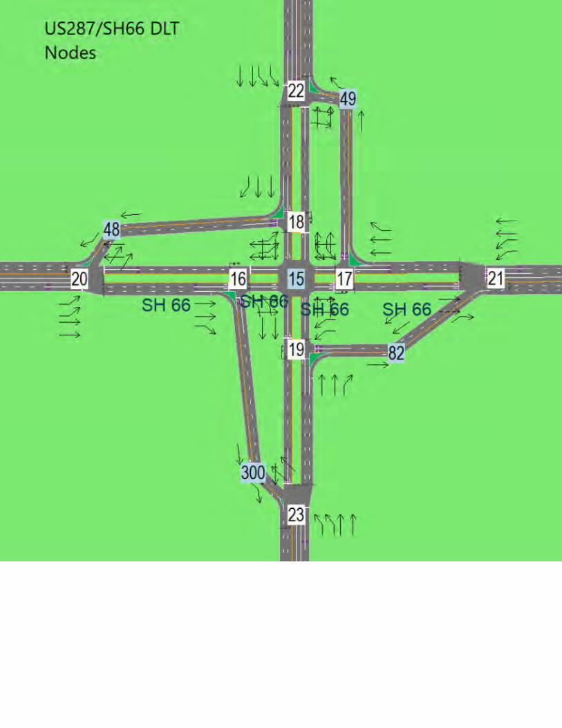
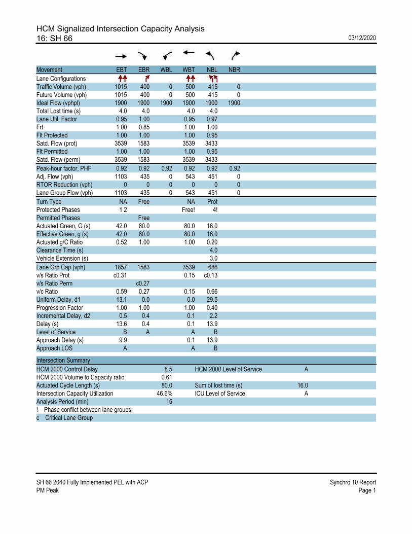
HCM Signalized Intersection Capacity Analysis16: SH 66 03/12/2020
SH 66 2040 Fully Implemented PEL with ACP Synchro 10 ReportPM Peak Page 1
Movement EBT EBR WBL WBT NBL NBR
Lane ConfigurationsTraffic Volume (vph) 1015 400 0 500 415 0Future Volume (vph) 1015 400 0 500 415 0Ideal Flow (vphpl) 1900 1900 1900 1900 1900 1900Total Lost time (s) 4.0 4.0 4.0 4.0Lane Util. Factor 0.95 1.00 0.95 0.97Frt 1.00 0.85 1.00 1.00Flt Protected 1.00 1.00 1.00 0.95Satd. Flow (prot) 3539 1583 3539 3433Flt Permitted 1.00 1.00 1.00 0.95Satd. Flow (perm) 3539 1583 3539 3433
Peak-hour factor, PHF 0.92 0.92 0.92 0.92 0.92 0.92Adj. Flow (vph) 1103 435 0 543 451 0RTOR Reduction (vph) 0 0 0 0 0 0Lane Group Flow (vph) 1103 435 0 543 451 0
Turn Type NA Free NA ProtProtected Phases 1 2 Free! 4!Permitted Phases FreeActuated Green, G (s) 42.0 80.0 80.0 16.0Effective Green, g (s) 42.0 80.0 80.0 16.0Actuated g/C Ratio 0.52 1.00 1.00 0.20Clearance Time (s) 4.0Vehicle Extension (s) 3.0
Lane Grp Cap (vph) 1857 1583 3539 686v/s Ratio Prot c0.31 0.15 c0.13v/s Ratio Perm c0.27v/c Ratio 0.59 0.27 0.15 0.66Uniform Delay, d1 13.1 0.0 0.0 29.5Progression Factor 1.00 1.00 1.00 0.40Incremental Delay, d2 0.5 0.4 0.1 2.2Delay (s) 13.6 0.4 0.1 13.9Level of Service B A A BApproach Delay (s) 9.9 0.1 13.9Approach LOS A A B
Intersection Summary
HCM 2000 Control Delay 8.5 HCM 2000 Level of Service AHCM 2000 Volume to Capacity ratio 0.61Actuated Cycle Length (s) 80.0 Sum of lost time (s) 16.0Intersection Capacity Utilization 46.6% ICU Level of Service AAnalysis Period (min) 15! Phase conflict between lane groups.c Critical Lane Group

HCM Signalized Intersection Capacity Analysis17: SH 66 03/12/2020
SH 66 2040 Fully Implemented PEL with ACP Synchro 10 ReportPM Peak Page 2
Movement EBL EBT WBT WBR SBL SBR
Lane ConfigurationsTraffic Volume (vph) 0 1015 500 260 185 0Future Volume (vph) 0 1015 500 260 185 0Ideal Flow (vphpl) 1900 1900 1900 1900 1900 1900Total Lost time (s) 4.0 4.0 4.0 4.0Lane Util. Factor 0.95 0.95 1.00 0.97Frt 1.00 1.00 0.85 1.00Flt Protected 1.00 1.00 1.00 0.95Satd. Flow (prot) 3539 3539 1583 3433Flt Permitted 1.00 1.00 1.00 0.95Satd. Flow (perm) 3539 3539 1583 3433
Peak-hour factor, PHF 0.92 0.92 0.92 0.92 0.92 0.92Adj. Flow (vph) 0 1103 543 283 201 0RTOR Reduction (vph) 0 0 0 0 0 0Lane Group Flow (vph) 0 1103 543 283 201 0
Turn Type NA NA Free ProtProtected Phases Free! 1 2 4!Permitted Phases FreeActuated Green, G (s) 80.0 42.0 80.0 16.0Effective Green, g (s) 80.0 42.0 80.0 16.0Actuated g/C Ratio 1.00 0.52 1.00 0.20Clearance Time (s) 4.0Vehicle Extension (s) 3.0
Lane Grp Cap (vph) 3539 1857 1583 686v/s Ratio Prot 0.31 0.15 0.06v/s Ratio Perm 0.18v/c Ratio 0.31 0.29 0.18 0.29Uniform Delay, d1 0.0 10.7 0.0 27.2Progression Factor 1.00 0.32 1.00 0.00Incremental Delay, d2 0.2 0.1 0.2 0.2Delay (s) 0.2 3.5 0.2 0.2Level of Service A A A AApproach Delay (s) 0.2 2.4 0.2Approach LOS A A A
Intersection Summary
HCM 2000 Control Delay 1.0 HCM 2000 Level of Service AHCM 2000 Volume to Capacity ratio 0.39Actuated Cycle Length (s) 80.0 Sum of lost time (s) 16.0Intersection Capacity Utilization 40.0% ICU Level of Service AAnalysis Period (min) 15! Phase conflict between lane groups.c Critical Lane Group
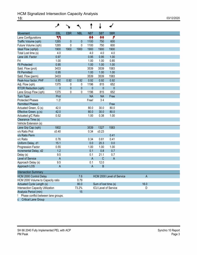
HCM Signalized Intersection Capacity Analysis18: 03/12/2020
SH 66 2040 Fully Implemented PEL with ACP Synchro 10 ReportPM Peak Page 3
Movement EBL EBR NBL NBT SBT SBR
Lane ConfigurationsTraffic Volume (vph) 1265 0 0 1100 750 600Future Volume (vph) 1265 0 0 1100 750 600Ideal Flow (vphpl) 1900 1900 1900 1900 1900 1900Total Lost time (s) 4.0 4.0 4.0 4.0Lane Util. Factor 0.97 0.95 0.95 1.00Frt 1.00 1.00 1.00 0.85Flt Protected 0.95 1.00 1.00 1.00Satd. Flow (prot) 3433 3539 3539 1583Flt Permitted 0.95 1.00 1.00 1.00Satd. Flow (perm) 3433 3539 3539 1583
Peak-hour factor, PHF 0.92 0.92 0.92 0.92 0.92 0.92Adj. Flow (vph) 1375 0 0 1196 815 652RTOR Reduction (vph) 0 0 0 0 0 0Lane Group Flow (vph) 1375 0 0 1196 815 652
Turn Type Prot NA NA FreeProtected Phases 1 2! Free! 3 4Permitted Phases FreeActuated Green, G (s) 42.0 80.0 30.0 80.0Effective Green, g (s) 42.0 80.0 30.0 80.0Actuated g/C Ratio 0.52 1.00 0.38 1.00Clearance Time (s)Vehicle Extension (s)
Lane Grp Cap (vph) 1802 3539 1327 1583v/s Ratio Prot c0.40 0.34 c0.23v/s Ratio Perm 0.41v/c Ratio 0.76 0.34 0.61 0.41Uniform Delay, d1 15.1 0.0 20.3 0.0Progression Factor 0.55 1.00 1.00 1.00Incremental Delay, d2 1.2 0.1 0.8 0.7Delay (s) 9.5 0.1 21.1 0.7Level of Service A A C AApproach Delay (s) 9.5 0.1 12.0Approach LOS A A B
Intersection Summary
HCM 2000 Control Delay 7.6 HCM 2000 Level of Service AHCM 2000 Volume to Capacity ratio 0.79Actuated Cycle Length (s) 80.0 Sum of lost time (s) 16.0Intersection Capacity Utilization 73.2% ICU Level of Service DAnalysis Period (min) 15! Phase conflict between lane groups.c Critical Lane Group
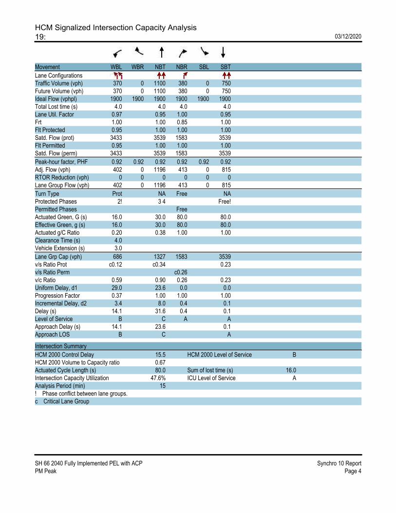
HCM Signalized Intersection Capacity Analysis19: 03/12/2020
SH 66 2040 Fully Implemented PEL with ACP Synchro 10 ReportPM Peak Page 4
Movement WBL WBR NBT NBR SBL SBT
Lane ConfigurationsTraffic Volume (vph) 370 0 1100 380 0 750Future Volume (vph) 370 0 1100 380 0 750Ideal Flow (vphpl) 1900 1900 1900 1900 1900 1900Total Lost time (s) 4.0 4.0 4.0 4.0Lane Util. Factor 0.97 0.95 1.00 0.95Frt 1.00 1.00 0.85 1.00Flt Protected 0.95 1.00 1.00 1.00Satd. Flow (prot) 3433 3539 1583 3539Flt Permitted 0.95 1.00 1.00 1.00Satd. Flow (perm) 3433 3539 1583 3539
Peak-hour factor, PHF 0.92 0.92 0.92 0.92 0.92 0.92Adj. Flow (vph) 402 0 1196 413 0 815RTOR Reduction (vph) 0 0 0 0 0 0Lane Group Flow (vph) 402 0 1196 413 0 815
Turn Type Prot NA Free NAProtected Phases 2! 3 4 Free!Permitted Phases FreeActuated Green, G (s) 16.0 30.0 80.0 80.0Effective Green, g (s) 16.0 30.0 80.0 80.0Actuated g/C Ratio 0.20 0.38 1.00 1.00Clearance Time (s) 4.0Vehicle Extension (s) 3.0
Lane Grp Cap (vph) 686 1327 1583 3539v/s Ratio Prot c0.12 c0.34 0.23v/s Ratio Perm c0.26v/c Ratio 0.59 0.90 0.26 0.23Uniform Delay, d1 29.0 23.6 0.0 0.0Progression Factor 0.37 1.00 1.00 1.00Incremental Delay, d2 3.4 8.0 0.4 0.1Delay (s) 14.1 31.6 0.4 0.1Level of Service B C A AApproach Delay (s) 14.1 23.6 0.1Approach LOS B C A
Intersection Summary
HCM 2000 Control Delay 15.5 HCM 2000 Level of Service BHCM 2000 Volume to Capacity ratio 0.67Actuated Cycle Length (s) 80.0 Sum of lost time (s) 16.0Intersection Capacity Utilization 47.6% ICU Level of Service AAnalysis Period (min) 15! Phase conflict between lane groups.c Critical Lane Group

HCM Signalized Intersection Capacity Analysis20: SH 66 03/12/2020
SH 66 2040 Fully Implemented PEL with ACP Synchro 10 ReportPM Peak Page 5
Movement EBL EBT WBT WBR SBL SBR
Lane ConfigurationsTraffic Volume (vph) 1265 1415 915 0 0 600Future Volume (vph) 1265 1415 915 0 0 600Ideal Flow (vphpl) 1900 1900 1900 1900 1900 1900Total Lost time (s) 4.0 4.0 4.0 4.0Lane Util. Factor 0.97 0.95 0.95 1.00Frt 1.00 1.00 1.00 0.86Flt Protected 0.95 1.00 1.00 1.00Satd. Flow (prot) 3433 3539 3539 1611Flt Permitted 0.95 1.00 1.00 1.00Satd. Flow (perm) 3433 3539 3539 1611
Peak-hour factor, PHF 0.92 0.92 0.92 0.92 0.92 0.92Adj. Flow (vph) 1375 1538 995 0 0 652RTOR Reduction (vph) 0 0 0 0 0 0Lane Group Flow (vph) 1375 1538 995 0 0 652
Turn Type Prot NA NA FreeProtected Phases 1 2 Free 3 4Permitted Phases FreeActuated Green, G (s) 42.0 80.0 30.0 80.0Effective Green, g (s) 42.0 80.0 30.0 80.0Actuated g/C Ratio 0.52 1.00 0.38 1.00Clearance Time (s)Vehicle Extension (s)
Lane Grp Cap (vph) 1802 3539 1327 1611v/s Ratio Prot c0.40 0.43 c0.28v/s Ratio Perm 0.40v/c Ratio 0.76 0.43 0.75 0.40Uniform Delay, d1 15.1 0.0 21.7 0.0Progression Factor 1.00 1.00 1.27 1.00Incremental Delay, d2 2.0 0.4 2.2 0.7Delay (s) 17.0 0.4 29.9 0.7Level of Service B A C AApproach Delay (s) 8.2 29.9 0.7Approach LOS A C A
Intersection Summary
HCM 2000 Control Delay 11.9 HCM 2000 Level of Service BHCM 2000 Volume to Capacity ratio 0.85Actuated Cycle Length (s) 80.0 Sum of lost time (s) 16.0Intersection Capacity Utilization 68.0% ICU Level of Service CAnalysis Period (min) 15c Critical Lane Group

HCM Signalized Intersection Capacity Analysis21: SH 66 03/12/2020
SH 66 2040 Fully Implemented PEL with ACP Synchro 10 ReportPM Peak Page 6
Movement EBT EBR WBL WBT NEL NER
Lane ConfigurationsTraffic Volume (vph) 1200 0 370 760 0 380Future Volume (vph) 1200 0 370 760 0 380Ideal Flow (vphpl) 1900 1900 1900 1900 1900 1900Total Lost time (s) 4.0 4.0 4.0 4.0Lane Util. Factor 0.95 0.97 0.95 1.00Frt 1.00 1.00 1.00 0.86Flt Protected 1.00 0.95 1.00 1.00Satd. Flow (prot) 3539 3433 3539 1611Flt Permitted 1.00 0.95 1.00 1.00Satd. Flow (perm) 3539 3433 3539 1611
Peak-hour factor, PHF 0.92 0.92 0.92 0.92 0.92 0.92Adj. Flow (vph) 1304 0 402 826 0 413RTOR Reduction (vph) 0 0 0 0 0 0Lane Group Flow (vph) 1304 0 402 826 0 413
Turn Type NA Prot NA pm+ovProtected Phases 2 3 4 1 Free 1Permitted Phases 2 3 4Actuated Green, G (s) 50.0 22.0 80.0 72.0Effective Green, g (s) 50.0 22.0 80.0 72.0Actuated g/C Ratio 0.62 0.28 1.00 0.90Clearance Time (s) 4.0 4.0Vehicle Extension (s) 3.0 3.0
Lane Grp Cap (vph) 2211 944 3539 1611v/s Ratio Prot c0.37 c0.12 0.23 0.07v/s Ratio Perm 0.19v/c Ratio 0.59 0.43 0.23 0.26Uniform Delay, d1 8.9 23.8 0.0 0.5Progression Factor 0.80 0.44 1.00 1.00Incremental Delay, d2 0.4 0.2 0.1 0.1Delay (s) 7.5 10.7 0.1 0.6Level of Service A B A AApproach Delay (s) 7.5 3.6 0.6Approach LOS A A A
Intersection Summary
HCM 2000 Control Delay 4.9 HCM 2000 Level of Service AHCM 2000 Volume to Capacity ratio 0.61Actuated Cycle Length (s) 80.0 Sum of lost time (s) 16.0Intersection Capacity Utilization 63.4% ICU Level of Service BAnalysis Period (min) 15c Critical Lane Group

HCM Signalized Intersection Capacity Analysis22: 03/12/2020
SH 66 2040 Fully Implemented PEL with ACP Synchro 10 ReportPM Peak Page 7
Movement WBL WBR NBT NBR SBL SBT
Lane ConfigurationsTraffic Volume (vph) 0 260 2365 0 185 1350Future Volume (vph) 0 260 2365 0 185 1350Ideal Flow (vphpl) 1900 1900 1900 1900 1900 1900Total Lost time (s) 4.0 4.0 4.0 4.0Lane Util. Factor 1.00 0.95 0.97 0.95Frt 0.86 1.00 1.00 1.00Flt Protected 1.00 1.00 0.95 1.00Satd. Flow (prot) 1611 3539 3433 3539Flt Permitted 1.00 1.00 0.95 1.00Satd. Flow (perm) 1611 3539 3433 3539
Peak-hour factor, PHF 0.92 0.92 0.92 0.92 0.92 0.92Adj. Flow (vph) 0 283 2571 0 201 1467RTOR Reduction (vph) 0 0 0 0 0 0Lane Group Flow (vph) 0 283 2571 0 201 1467
Turn Type pm+ov NA Prot NAProtected Phases 3 1 2 4 3 FreePermitted Phases 1 2 4Actuated Green, G (s) 72.0 62.0 10.0 80.0Effective Green, g (s) 72.0 62.0 10.0 80.0Actuated g/C Ratio 0.90 0.78 0.12 1.00Clearance Time (s) 4.0 4.0Vehicle Extension (s) 3.0 3.0
Lane Grp Cap (vph) 1611 2742 429 3539v/s Ratio Prot 0.02 c0.73 0.06 0.41v/s Ratio Perm 0.15v/c Ratio 0.18 0.94 0.47 0.41Uniform Delay, d1 0.5 7.4 32.5 0.0Progression Factor 1.00 0.56 1.00 1.00Incremental Delay, d2 0.1 6.0 0.8 0.4Delay (s) 0.5 10.2 33.3 0.4Level of Service A B C AApproach Delay (s) 0.5 10.2 4.3Approach LOS A B A
Intersection Summary
HCM 2000 Control Delay 7.4 HCM 2000 Level of Service AHCM 2000 Volume to Capacity ratio 1.00Actuated Cycle Length (s) 80.0 Sum of lost time (s) 16.0Intersection Capacity Utilization 88.1% ICU Level of Service EAnalysis Period (min) 15c Critical Lane Group

HCM Signalized Intersection Capacity Analysis23: 03/12/2020
SH 66 2040 Fully Implemented PEL with ACP Synchro 10 ReportPM Peak Page 8
Movement NBL NBT SBT SBR SEL SER
Lane ConfigurationsTraffic Volume (vph) 415 1480 1120 0 0 400Future Volume (vph) 415 1480 1120 0 0 400Ideal Flow (vphpl) 1900 1900 1900 1900 1900 1900Total Lost time (s) 4.0 4.0 4.0 4.0Lane Util. Factor 0.97 0.95 0.95 1.00Frt 1.00 1.00 1.00 0.86Flt Protected 0.95 1.00 1.00 1.00Satd. Flow (prot) 3433 3539 3539 1611Flt Permitted 0.95 1.00 1.00 1.00Satd. Flow (perm) 3433 3539 3539 1611
Peak-hour factor, PHF 0.92 0.92 0.92 0.92 0.92 0.92Adj. Flow (vph) 451 1609 1217 0 0 435RTOR Reduction (vph) 0 0 0 0 0 0Lane Group Flow (vph) 451 1609 1217 0 0 435
Turn Type Prot NA NA pm+ovProtected Phases 3 4 Free 1 2 3Permitted Phases 1 2 4Actuated Green, G (s) 30.0 80.0 42.0 72.0Effective Green, g (s) 30.0 80.0 42.0 72.0Actuated g/C Ratio 0.38 1.00 0.52 0.90Clearance Time (s) 4.0Vehicle Extension (s) 3.0
Lane Grp Cap (vph) 1287 3539 1857 1611v/s Ratio Prot 0.13 0.45 c0.34 0.03v/s Ratio Perm 0.24v/c Ratio 0.35 0.45 0.66 0.27Uniform Delay, d1 18.0 0.0 13.8 0.5Progression Factor 1.00 1.00 1.27 1.00Incremental Delay, d2 0.2 0.4 0.8 0.1Delay (s) 18.2 0.4 18.2 0.6Level of Service B A B AApproach Delay (s) 4.3 18.2 0.6Approach LOS A B A
Intersection Summary
HCM 2000 Control Delay 8.4 HCM 2000 Level of Service AHCM 2000 Volume to Capacity ratio 0.67Actuated Cycle Length (s) 80.0 Sum of lost time (s) 16.0Intersection Capacity Utilization 62.4% ICU Level of Service BAnalysis Period (min) 15c Critical Lane Group
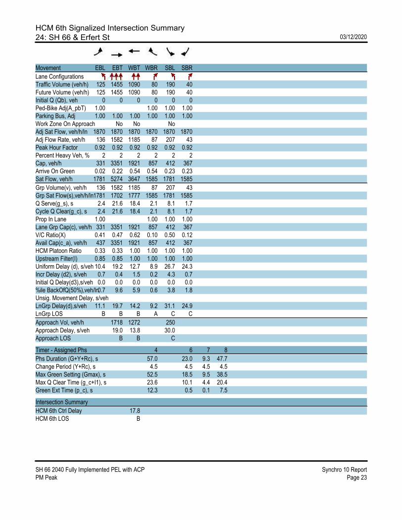
HCM 6th Signalized Intersection Summary24: SH 66 & Erfert St 03/12/2020
SH 66 2040 Fully Implemented PEL with ACP Synchro 10 ReportPM Peak Page 23
Movement EBL EBT WBT WBR SBL SBR
Lane ConfigurationsTraffic Volume (veh/h) 125 1455 1090 80 190 40Future Volume (veh/h) 125 1455 1090 80 190 40Initial Q (Qb), veh 0 0 0 0 0 0Ped-Bike Adj(A_pbT) 1.00 1.00 1.00 1.00Parking Bus, Adj 1.00 1.00 1.00 1.00 1.00 1.00Work Zone On Approach No No NoAdj Sat Flow, veh/h/ln 1870 1870 1870 1870 1870 1870Adj Flow Rate, veh/h 136 1582 1185 87 207 43Peak Hour Factor 0.92 0.92 0.92 0.92 0.92 0.92Percent Heavy Veh, % 2 2 2 2 2 2Cap, veh/h 331 3351 1921 857 412 367Arrive On Green 0.02 0.22 0.54 0.54 0.23 0.23Sat Flow, veh/h 1781 5274 3647 1585 1781 1585
Grp Volume(v), veh/h 136 1582 1185 87 207 43Grp Sat Flow(s),veh/h/ln1781 1702 1777 1585 1781 1585Q Serve(g_s), s 2.4 21.6 18.4 2.1 8.1 1.7Cycle Q Clear(g_c), s 2.4 21.6 18.4 2.1 8.1 1.7Prop In Lane 1.00 1.00 1.00 1.00Lane Grp Cap(c), veh/h 331 3351 1921 857 412 367V/C Ratio(X) 0.41 0.47 0.62 0.10 0.50 0.12Avail Cap(c_a), veh/h 437 3351 1921 857 412 367HCM Platoon Ratio 0.33 0.33 1.00 1.00 1.00 1.00Upstream Filter(I) 0.85 0.85 1.00 1.00 1.00 1.00Uniform Delay (d), s/veh 10.4 19.2 12.7 8.9 26.7 24.3Incr Delay (d2), s/veh 0.7 0.4 1.5 0.2 4.3 0.7Initial Q Delay(d3),s/veh 0.0 0.0 0.0 0.0 0.0 0.0%ile BackOfQ(50%),veh/ln0.7 9.6 5.9 0.6 3.8 1.8Unsig. Movement Delay, s/vehLnGrp Delay(d),s/veh 11.1 19.7 14.2 9.2 31.1 24.9LnGrp LOS B B B A C C
Approach Vol, veh/h 1718 1272 250Approach Delay, s/veh 19.0 13.8 30.0Approach LOS B B C
Timer - Assigned Phs 4 6 7 8
Phs Duration (G+Y+Rc), s 57.0 23.0 9.3 47.7Change Period (Y+Rc), s 4.5 4.5 4.5 4.5Max Green Setting (Gmax), s 52.5 18.5 9.5 38.5Max Q Clear Time (g_c+I1), s 23.6 10.1 4.4 20.4Green Ext Time (p_c), s 12.3 0.5 0.1 7.5
Intersection Summary
HCM 6th Ctrl Delay 17.8HCM 6th LOS B
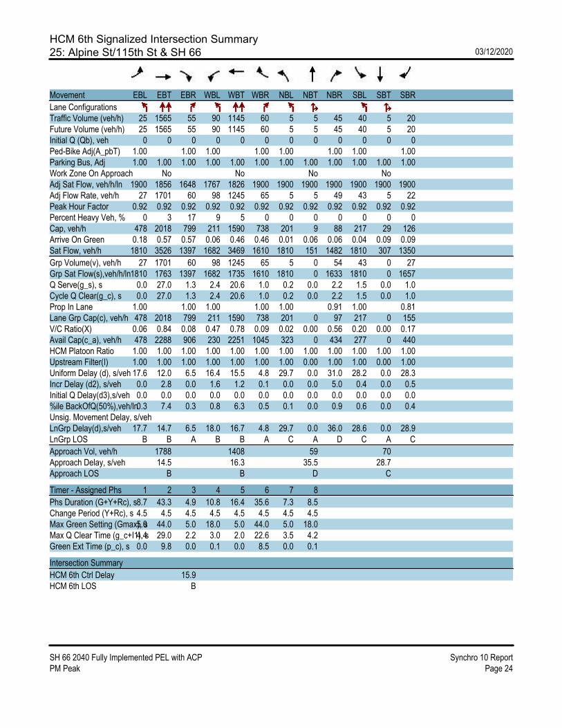
HCM 6th Signalized Intersection Summary25: Alpine St/115th St & SH 66 03/12/2020
SH 66 2040 Fully Implemented PEL with ACP Synchro 10 ReportPM Peak Page 24
Movement EBL EBT EBR WBL WBT WBR NBL NBT NBR SBL SBT SBR
Lane ConfigurationsTraffic Volume (veh/h) 25 1565 55 90 1145 60 5 5 45 40 5 20Future Volume (veh/h) 25 1565 55 90 1145 60 5 5 45 40 5 20Initial Q (Qb), veh 0 0 0 0 0 0 0 0 0 0 0 0Ped-Bike Adj(A_pbT) 1.00 1.00 1.00 1.00 1.00 1.00 1.00 1.00Parking Bus, Adj 1.00 1.00 1.00 1.00 1.00 1.00 1.00 1.00 1.00 1.00 1.00 1.00Work Zone On Approach No No No NoAdj Sat Flow, veh/h/ln 1900 1856 1648 1767 1826 1900 1900 1900 1900 1900 1900 1900Adj Flow Rate, veh/h 27 1701 60 98 1245 65 5 5 49 43 5 22Peak Hour Factor 0.92 0.92 0.92 0.92 0.92 0.92 0.92 0.92 0.92 0.92 0.92 0.92Percent Heavy Veh, % 0 3 17 9 5 0 0 0 0 0 0 0Cap, veh/h 478 2018 799 211 1590 738 201 9 88 217 29 126Arrive On Green 0.18 0.57 0.57 0.06 0.46 0.46 0.01 0.06 0.06 0.04 0.09 0.09Sat Flow, veh/h 1810 3526 1397 1682 3469 1610 1810 151 1482 1810 307 1350
Grp Volume(v), veh/h 27 1701 60 98 1245 65 5 0 54 43 0 27Grp Sat Flow(s),veh/h/ln1810 1763 1397 1682 1735 1610 1810 0 1633 1810 0 1657Q Serve(g_s), s 0.0 27.0 1.3 2.4 20.6 1.0 0.2 0.0 2.2 1.5 0.0 1.0Cycle Q Clear(g_c), s 0.0 27.0 1.3 2.4 20.6 1.0 0.2 0.0 2.2 1.5 0.0 1.0Prop In Lane 1.00 1.00 1.00 1.00 1.00 0.91 1.00 0.81Lane Grp Cap(c), veh/h 478 2018 799 211 1590 738 201 0 97 217 0 155V/C Ratio(X) 0.06 0.84 0.08 0.47 0.78 0.09 0.02 0.00 0.56 0.20 0.00 0.17Avail Cap(c_a), veh/h 478 2288 906 230 2251 1045 323 0 434 277 0 440HCM Platoon Ratio 1.00 1.00 1.00 1.00 1.00 1.00 1.00 1.00 1.00 1.00 1.00 1.00Upstream Filter(I) 1.00 1.00 1.00 1.00 1.00 1.00 1.00 0.00 1.00 1.00 0.00 1.00Uniform Delay (d), s/veh 17.6 12.0 6.5 16.4 15.5 4.8 29.7 0.0 31.0 28.2 0.0 28.3Incr Delay (d2), s/veh 0.0 2.8 0.0 1.6 1.2 0.1 0.0 0.0 5.0 0.4 0.0 0.5Initial Q Delay(d3),s/veh 0.0 0.0 0.0 0.0 0.0 0.0 0.0 0.0 0.0 0.0 0.0 0.0%ile BackOfQ(50%),veh/ln0.3 7.4 0.3 0.8 6.3 0.5 0.1 0.0 0.9 0.6 0.0 0.4Unsig. Movement Delay, s/vehLnGrp Delay(d),s/veh 17.7 14.7 6.5 18.0 16.7 4.8 29.7 0.0 36.0 28.6 0.0 28.9LnGrp LOS B B A B B A C A D C A C
Approach Vol, veh/h 1788 1408 59 70Approach Delay, s/veh 14.5 16.3 35.5 28.7Approach LOS B B D C
Timer - Assigned Phs 1 2 3 4 5 6 7 8
Phs Duration (G+Y+Rc), s8.7 43.3 4.9 10.8 16.4 35.6 7.3 8.5Change Period (Y+Rc), s 4.5 4.5 4.5 4.5 4.5 4.5 4.5 4.5Max Green Setting (Gmax), s5.0 44.0 5.0 18.0 5.0 44.0 5.0 18.0Max Q Clear Time (g_c+I1), s4.4 29.0 2.2 3.0 2.0 22.6 3.5 4.2Green Ext Time (p_c), s 0.0 9.8 0.0 0.1 0.0 8.5 0.0 0.1
Intersection Summary
HCM 6th Ctrl Delay 15.9HCM 6th LOS B

HCM 6th Signalized Intersection Summary26: Pace St & SH 66 03/12/2020
SH 66 2040 Fully Implemented PEL with ACP Synchro 10 ReportPM Peak Page 25
Movement EBT EBR WBL WBT NBL NBR
Lane ConfigurationsTraffic Volume (veh/h) 1395 255 320 1045 250 290Future Volume (veh/h) 1395 255 320 1045 250 290Initial Q (Qb), veh 0 0 0 0 0 0Ped-Bike Adj(A_pbT) 1.00 1.00 1.00 1.00Parking Bus, Adj 1.00 1.00 1.00 1.00 1.00 1.00Work Zone On Approach No No NoAdj Sat Flow, veh/h/ln 1856 1885 1856 1811 1870 1885Adj Flow Rate, veh/h 1516 277 348 1136 272 315Peak Hour Factor 0.92 0.92 0.92 0.92 0.92 0.92Percent Heavy Veh, % 3 1 3 6 2 1Cap, veh/h 1604 727 364 2328 393 352Arrive On Green 0.46 0.46 0.16 0.68 0.22 0.22Sat Flow, veh/h 3618 1598 1767 3532 1781 1598
Grp Volume(v), veh/h 1516 277 348 1136 272 315Grp Sat Flow(s),veh/h/ln1763 1598 1767 1721 1781 1598Q Serve(g_s), s 36.0 3.8 12.7 14.0 12.3 16.8Cycle Q Clear(g_c), s 36.0 3.8 12.7 14.0 12.3 16.8Prop In Lane 1.00 1.00 1.00 1.00Lane Grp Cap(c), veh/h 1604 727 364 2328 393 352V/C Ratio(X) 0.95 0.38 0.96 0.49 0.69 0.89Avail Cap(c_a), veh/h 1627 737 364 2351 431 387HCM Platoon Ratio 1.00 1.00 1.00 1.00 1.00 1.00Upstream Filter(I) 1.00 1.00 1.00 1.00 1.00 1.00Uniform Delay (d), s/veh 22.8 2.3 34.9 6.8 31.4 33.1Incr Delay (d2), s/veh 11.6 0.2 35.5 0.2 4.2 21.1Initial Q Delay(d3),s/veh 0.0 0.0 0.0 0.0 0.0 0.0%ile BackOfQ(50%),veh/ln14.9 2.8 10.2 3.3 5.4 8.1Unsig. Movement Delay, s/vehLnGrp Delay(d),s/veh 34.4 2.5 70.4 7.0 35.6 54.3LnGrp LOS C A E A D D
Approach Vol, veh/h 1793 1484 587Approach Delay, s/veh 29.5 21.9 45.6Approach LOS C C D
Timer - Assigned Phs 1 2 6 8
Phs Duration (G+Y+Rc), s18.2 45.5 63.7 23.8Change Period (Y+Rc), s 4.5 5.7 4.5 4.5Max Green Setting (Gmax), s13.7 40.4 59.8 21.2Max Q Clear Time (g_c+I1), s14.7 38.0 16.0 18.8Green Ext Time (p_c), s 0.0 1.8 8.9 0.6
Intersection Summary
HCM 6th Ctrl Delay 29.0HCM 6th LOS C

HCM 6th Signalized Intersection Summary27: Sundance Dr & SH 66 03/12/2020
SH 66 2040 Fully Implemented PEL with ACP Synchro 10 ReportPM Peak Page 26
Movement EBL EBT EBR WBL WBT WBR NBL NBT NBR SBL SBT SBR
Lane ConfigurationsTraffic Volume (veh/h) 40 1545 100 40 1320 5 40 20 85 5 20 5Future Volume (veh/h) 40 1545 100 40 1320 5 40 20 85 5 20 5Initial Q (Qb), veh 0 0 0 0 0 0 0 0 0 0 0 0Ped-Bike Adj(A_pbT) 1.00 1.00 1.00 1.00 1.00 1.00 1.00 1.00Parking Bus, Adj 1.00 1.00 1.00 1.00 1.00 1.00 1.00 1.00 1.00 1.00 1.00 1.00Work Zone On Approach No No No NoAdj Sat Flow, veh/h/ln 1870 1870 1870 1870 1870 1870 1870 1870 1870 1870 1870 1870Adj Flow Rate, veh/h 43 1679 109 43 1435 5 43 22 92 5 22 5Peak Hour Factor 0.92 0.92 0.92 0.92 0.92 0.92 0.92 0.92 0.92 0.92 0.92 0.92Percent Heavy Veh, % 2 2 2 2 2 2 2 2 2 2 2 2Cap, veh/h 289 2135 952 269 2135 952 260 188 159 250 188 159Arrive On Green 0.04 0.60 0.60 0.04 0.60 0.60 0.10 0.10 0.10 0.10 0.10 0.10Sat Flow, veh/h 1781 3554 1585 1781 3554 1585 1383 1870 1585 1279 1870 1585
Grp Volume(v), veh/h 43 1679 109 43 1435 5 43 22 92 5 22 5Grp Sat Flow(s),veh/h/ln1781 1777 1585 1781 1777 1585 1383 1870 1585 1279 1870 1585Q Serve(g_s), s 0.6 19.0 1.6 0.0 14.3 0.1 1.5 0.6 2.9 0.2 0.6 0.2Cycle Q Clear(g_c), s 0.6 19.0 1.6 0.0 14.3 0.1 2.1 0.6 2.9 0.8 0.6 0.2Prop In Lane 1.00 1.00 1.00 1.00 1.00 1.00 1.00 1.00Lane Grp Cap(c), veh/h 289 2135 952 269 2135 952 260 188 159 250 188 159V/C Ratio(X) 0.15 0.79 0.11 0.16 0.67 0.01 0.17 0.12 0.58 0.02 0.12 0.03Avail Cap(c_a), veh/h 378 2580 1151 358 2580 1151 590 635 538 556 635 538HCM Platoon Ratio 1.00 1.00 1.00 1.00 1.00 1.00 1.00 1.00 1.00 1.00 1.00 1.00Upstream Filter(I) 1.00 1.00 1.00 1.00 1.00 1.00 1.00 1.00 1.00 1.00 1.00 1.00Uniform Delay (d), s/veh 8.3 8.0 4.5 17.8 7.1 4.2 22.7 21.7 22.8 22.1 21.7 21.5Incr Delay (d2), s/veh 0.2 1.4 0.1 0.3 0.5 0.0 0.3 0.3 3.3 0.0 0.3 0.1Initial Q Delay(d3),s/veh 0.0 0.0 0.0 0.0 0.0 0.0 0.0 0.0 0.0 0.0 0.0 0.0%ile BackOfQ(50%),veh/ln0.1 3.4 0.2 0.4 2.4 0.0 0.5 0.3 1.2 0.1 0.2 0.1Unsig. Movement Delay, s/vehLnGrp Delay(d),s/veh 8.5 9.4 4.6 18.1 7.6 4.2 23.0 22.0 26.1 22.1 22.0 21.6LnGrp LOS A A A B A A C C C C C C
Approach Vol, veh/h 1831 1483 157 32Approach Delay, s/veh 9.1 7.9 24.7 21.9Approach LOS A A C C
Timer - Assigned Phs 1 2 4 5 6 8
Phs Duration (G+Y+Rc), s6.8 36.4 9.8 6.8 36.4 9.8Change Period (Y+Rc), s 4.5 4.5 4.5 4.5 4.5 4.5Max Green Setting (Gmax), s5.0 38.5 18.0 5.0 38.5 18.0Max Q Clear Time (g_c+I1), s2.0 21.0 2.8 2.6 16.3 4.9Green Ext Time (p_c), s 0.0 10.9 0.1 0.0 10.1 0.4
Intersection Summary
HCM 6th Ctrl Delay 9.4HCM 6th LOS A

HCM 6th Signalized Intersection Summary28: County Line Rd/CR 1 & SH 66 03/12/2020
SH 66 2040 Fully Implemented PEL with ACP Synchro 10 ReportPM Peak Page 27
Movement EBL EBT EBR WBL WBT WBR NBL NBT NBR SBL SBT SBR
Lane ConfigurationsTraffic Volume (veh/h) 205 950 480 560 850 35 435 260 795 30 120 80Future Volume (veh/h) 205 950 480 560 850 35 435 260 795 30 120 80Initial Q (Qb), veh 0 0 0 0 0 0 0 0 0 0 0 0Ped-Bike Adj(A_pbT) 1.00 1.00 1.00 1.00 1.00 1.00 1.00 1.00Parking Bus, Adj 1.00 1.00 1.00 1.00 1.00 1.00 1.00 1.00 1.00 1.00 1.00 1.00Work Zone On Approach No No No NoAdj Sat Flow, veh/h/ln 1870 1856 1870 1758 1811 1263 1604 1870 1870 1781 1870 1900Adj Flow Rate, veh/h 223 1033 0 609 924 0 473 283 0 33 130 0Peak Hour Factor 0.92 0.92 0.92 0.92 0.92 0.92 0.92 0.92 0.92 0.92 0.92 0.92Percent Heavy Veh, % 2 3 2 3 6 43 20 2 2 8 2 0Cap, veh/h 297 1044 632 1486 500 390 315 307Arrive On Green 0.09 0.30 0.00 0.19 0.43 0.00 0.17 0.11 0.00 0.14 0.09 0.00Sat Flow, veh/h 3456 3526 1585 3248 3441 1070 2963 3554 1585 1697 3554 1610
Grp Volume(v), veh/h 223 1033 0 609 924 0 473 283 0 33 130 0Grp Sat Flow(s),veh/h/ln1728 1763 1585 1624 1721 1070 1481 1777 1585 1697 1777 1610Q Serve(g_s), s 5.8 27.0 0.0 17.2 19.3 0.0 14.6 7.1 0.0 0.0 3.2 0.0Cycle Q Clear(g_c), s 5.8 27.0 0.0 17.2 19.3 0.0 14.6 7.1 0.0 0.0 3.2 0.0Prop In Lane 1.00 1.00 1.00 1.00 1.00 1.00 1.00 1.00Lane Grp Cap(c), veh/h 297 1044 632 1486 500 390 315 307V/C Ratio(X) 0.75 0.99 0.96 0.62 0.95 0.72 0.10 0.42Avail Cap(c_a), veh/h 407 1044 632 1486 500 715 315 307HCM Platoon Ratio 1.00 1.00 1.00 1.00 1.00 1.00 1.00 1.00 1.00 1.00 1.00 1.00Upstream Filter(I) 1.00 1.00 0.00 1.00 1.00 0.00 1.00 1.00 0.00 1.00 1.00 0.00Uniform Delay (d), s/veh 41.3 32.4 0.0 36.9 20.4 0.0 38.0 39.8 0.0 34.2 40.1 0.0Incr Delay (d2), s/veh 4.2 25.2 0.0 26.8 1.2 0.0 27.4 2.6 0.0 0.1 0.9 0.0Initial Q Delay(d3),s/veh 0.0 0.0 0.0 0.0 0.0 0.0 0.0 0.0 0.0 0.0 0.0 0.0%ile BackOfQ(50%),veh/ln2.5 13.9 0.0 8.6 6.9 0.0 6.9 3.1 0.0 0.6 1.4 0.0Unsig. Movement Delay, s/vehLnGrp Delay(d),s/veh 45.5 57.6 0.0 63.8 21.6 0.0 65.4 42.4 0.0 34.4 41.0 0.0LnGrp LOS D E E C E D C D
Approach Vol, veh/h 1256 A 1533 A 756 A 163 AApproach Delay, s/veh 55.5 38.3 56.8 39.6Approach LOS E D E D
Timer - Assigned Phs 1 2 3 4 5 6 7 8
Phs Duration (G+Y+Rc), s25.0 34.4 20.1 13.0 12.5 46.9 17.9 15.2Change Period (Y+Rc), s 7.0 * 7 4.5 5.0 4.5 7.0 5.0 * 5Max Green Setting (Gmax), s18.0 * 27 15.6 8.0 10.9 34.5 5.0 * 19Max Q Clear Time (g_c+I1), s19.2 29.0 16.6 5.2 7.8 21.3 2.0 9.1Green Ext Time (p_c), s 0.0 0.0 0.0 0.1 0.2 7.5 0.0 1.0
Intersection Summary
HCM 6th Ctrl Delay 48.0HCM 6th LOS D
Notes
User approved pedestrian interval to be less than phase max green.* HCM 6th computational engine requires equal clearance times for the phases crossing the barrier.Unsignalized Delay for [NBR, EBR, WBR, SBR] is excluded from calculations of the approach delay and intersection delay.
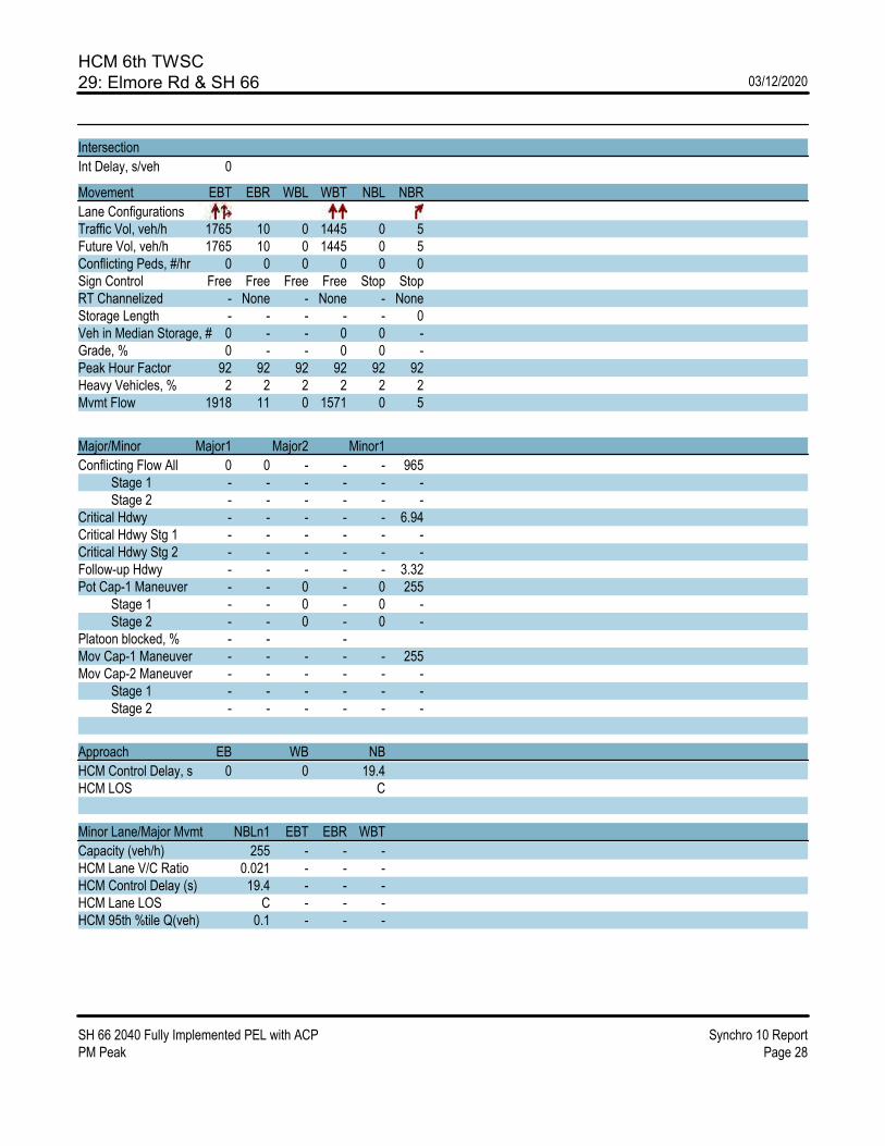
HCM 6th TWSC29: Elmore Rd & SH 66 03/12/2020
SH 66 2040 Fully Implemented PEL with ACP Synchro 10 ReportPM Peak Page 28
Intersection
Int Delay, s/veh 0
Movement EBT EBR WBL WBT NBL NBR
Lane ConfigurationsTraffic Vol, veh/h 1765 10 0 1445 0 5Future Vol, veh/h 1765 10 0 1445 0 5Conflicting Peds, #/hr 0 0 0 0 0 0Sign Control Free Free Free Free Stop StopRT Channelized - None - None - NoneStorage Length - - - - - 0Veh in Median Storage, # 0 - - 0 0 -Grade, % 0 - - 0 0 -Peak Hour Factor 92 92 92 92 92 92Heavy Vehicles, % 2 2 2 2 2 2Mvmt Flow 1918 11 0 1571 0 5
Major/Minor Major1 Major2 Minor1
Conflicting Flow All 0 0 - - - 965 Stage 1 - - - - - - Stage 2 - - - - - -Critical Hdwy - - - - - 6.94Critical Hdwy Stg 1 - - - - - -Critical Hdwy Stg 2 - - - - - -Follow-up Hdwy - - - - - 3.32Pot Cap-1 Maneuver - - 0 - 0 255 Stage 1 - - 0 - 0 - Stage 2 - - 0 - 0 -Platoon blocked, % - - -Mov Cap-1 Maneuver - - - - - 255Mov Cap-2 Maneuver - - - - - - Stage 1 - - - - - - Stage 2 - - - - - -
Approach EB WB NB
HCM Control Delay, s 0 0 19.4HCM LOS C
Minor Lane/Major Mvmt NBLn1 EBT EBR WBT
Capacity (veh/h) 255 - - -HCM Lane V/C Ratio 0.021 - - -HCM Control Delay (s) 19.4 - - -HCM Lane LOS C - - -HCM 95th %tile Q(veh) 0.1 - - -
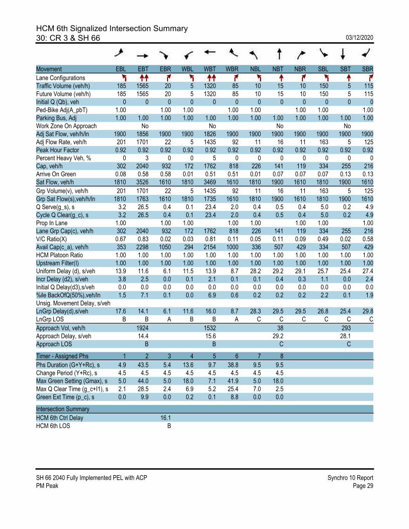
HCM 6th Signalized Intersection Summary30: CR 3 & SH 66 03/12/2020
SH 66 2040 Fully Implemented PEL with ACP Synchro 10 ReportPM Peak Page 29
Movement EBL EBT EBR WBL WBT WBR NBL NBT NBR SBL SBT SBR
Lane ConfigurationsTraffic Volume (veh/h) 185 1565 20 5 1320 85 10 15 10 150 5 115Future Volume (veh/h) 185 1565 20 5 1320 85 10 15 10 150 5 115Initial Q (Qb), veh 0 0 0 0 0 0 0 0 0 0 0 0Ped-Bike Adj(A_pbT) 1.00 1.00 1.00 1.00 1.00 1.00 1.00 1.00Parking Bus, Adj 1.00 1.00 1.00 1.00 1.00 1.00 1.00 1.00 1.00 1.00 1.00 1.00Work Zone On Approach No No No NoAdj Sat Flow, veh/h/ln 1900 1856 1900 1900 1826 1900 1900 1900 1900 1900 1900 1900Adj Flow Rate, veh/h 201 1701 22 5 1435 92 11 16 11 163 5 125Peak Hour Factor 0.92 0.92 0.92 0.92 0.92 0.92 0.92 0.92 0.92 0.92 0.92 0.92Percent Heavy Veh, % 0 3 0 0 5 0 0 0 0 0 0 0Cap, veh/h 302 2040 932 172 1762 818 226 141 119 334 255 216Arrive On Green 0.08 0.58 0.58 0.01 0.51 0.51 0.01 0.07 0.07 0.07 0.13 0.13Sat Flow, veh/h 1810 3526 1610 1810 3469 1610 1810 1900 1610 1810 1900 1610
Grp Volume(v), veh/h 201 1701 22 5 1435 92 11 16 11 163 5 125Grp Sat Flow(s),veh/h/ln 1810 1763 1610 1810 1735 1610 1810 1900 1610 1810 1900 1610Q Serve(g_s), s 3.2 26.5 0.4 0.1 23.4 2.0 0.4 0.5 0.4 5.0 0.2 4.9Cycle Q Clear(g_c), s 3.2 26.5 0.4 0.1 23.4 2.0 0.4 0.5 0.4 5.0 0.2 4.9Prop In Lane 1.00 1.00 1.00 1.00 1.00 1.00 1.00 1.00Lane Grp Cap(c), veh/h 302 2040 932 172 1762 818 226 141 119 334 255 216V/C Ratio(X) 0.67 0.83 0.02 0.03 0.81 0.11 0.05 0.11 0.09 0.49 0.02 0.58Avail Cap(c_a), veh/h 353 2298 1050 294 2154 1000 336 507 429 334 507 429HCM Platoon Ratio 1.00 1.00 1.00 1.00 1.00 1.00 1.00 1.00 1.00 1.00 1.00 1.00Upstream Filter(I) 1.00 1.00 1.00 1.00 1.00 1.00 1.00 1.00 1.00 1.00 1.00 1.00Uniform Delay (d), s/veh 13.9 11.6 6.1 11.5 13.9 8.7 28.2 29.2 29.1 25.7 25.4 27.4Incr Delay (d2), s/veh 3.8 2.5 0.0 0.1 2.1 0.1 0.1 0.4 0.3 1.1 0.0 2.4Initial Q Delay(d3),s/veh 0.0 0.0 0.0 0.0 0.0 0.0 0.0 0.0 0.0 0.0 0.0 0.0%ile BackOfQ(50%),veh/ln 1.5 7.1 0.1 0.0 6.9 0.6 0.2 0.2 0.2 2.2 0.1 1.9Unsig. Movement Delay, s/vehLnGrp Delay(d),s/veh 17.6 14.1 6.1 11.6 16.0 8.7 28.3 29.5 29.5 26.8 25.4 29.8LnGrp LOS B B A B B A C C C C C C
Approach Vol, veh/h 1924 1532 38 293Approach Delay, s/veh 14.4 15.6 29.2 28.1Approach LOS B B C C
Timer - Assigned Phs 1 2 3 4 5 6 7 8
Phs Duration (G+Y+Rc), s 4.9 43.5 5.4 13.6 9.7 38.8 9.5 9.5Change Period (Y+Rc), s 4.5 4.5 4.5 4.5 4.5 4.5 4.5 4.5Max Green Setting (Gmax), s 5.0 44.0 5.0 18.0 7.1 41.9 5.0 18.0Max Q Clear Time (g_c+I1), s 2.1 28.5 2.4 6.9 5.2 25.4 7.0 2.5Green Ext Time (p_c), s 0.0 9.9 0.0 0.2 0.1 8.8 0.0 0.0
Intersection Summary
HCM 6th Ctrl Delay 16.1HCM 6th LOS B

HCM 6th Signalized Intersection Summary31: CR 5 & SH 66 03/12/2020
SH 66 2040 Fully Implemented PEL with ACP Synchro 10 ReportPM Peak Page 30
Movement EBL EBT EBR WBL WBT WBR NBL NBT NBR SBL SBT SBR
Lane ConfigurationsTraffic Volume (veh/h) 170 1460 95 40 1280 165 50 150 30 70 125 80Future Volume (veh/h) 170 1460 95 40 1280 165 50 150 30 70 125 80Initial Q (Qb), veh 0 0 0 0 0 0 0 0 0 0 0 0Ped-Bike Adj(A_pbT) 1.00 1.00 1.00 1.00 1.00 1.00 1.00 1.00Parking Bus, Adj 1.00 1.00 1.00 1.00 1.00 1.00 1.00 1.00 1.00 1.00 1.00 1.00Work Zone On Approach No No No NoAdj Sat Flow, veh/h/ln 1811 1856 1900 1900 1826 1693 1900 1900 1011 1648 1900 1856Adj Flow Rate, veh/h 185 1587 103 43 1391 179 54 163 33 76 136 87Peak Hour Factor 0.92 0.92 0.92 0.92 0.92 0.92 0.92 0.92 0.92 0.92 0.92 0.92Percent Heavy Veh, % 6 3 0 0 5 14 0 0 60 17 0 3Cap, veh/h 286 1888 862 219 1728 714 254 225 102 224 242 200Arrive On Green 0.08 0.54 0.54 0.04 0.50 0.50 0.05 0.12 0.12 0.05 0.13 0.13Sat Flow, veh/h 1725 3526 1610 1810 3469 1434 1810 1900 857 1570 1900 1572
Grp Volume(v), veh/h 185 1587 103 43 1391 179 54 163 33 76 136 87Grp Sat Flow(s),veh/h/ln1725 1763 1610 1810 1735 1434 1810 1900 857 1570 1900 1572Q Serve(g_s), s 3.6 27.3 2.3 0.8 24.1 5.1 1.8 5.9 2.5 3.0 4.8 3.7Cycle Q Clear(g_c), s 3.6 27.3 2.3 0.8 24.1 5.1 1.8 5.9 2.5 3.0 4.8 3.7Prop In Lane 1.00 1.00 1.00 1.00 1.00 1.00 1.00 1.00Lane Grp Cap(c), veh/h 286 1888 862 219 1728 714 254 225 102 224 242 200V/C Ratio(X) 0.65 0.84 0.12 0.20 0.81 0.25 0.21 0.72 0.32 0.34 0.56 0.43Avail Cap(c_a), veh/h 332 2164 988 273 2008 830 297 477 215 247 477 395HCM Platoon Ratio 1.00 1.00 1.00 1.00 1.00 1.00 1.00 1.00 1.00 1.00 1.00 1.00Upstream Filter(I) 1.00 1.00 1.00 1.00 1.00 1.00 1.00 1.00 1.00 1.00 1.00 1.00Uniform Delay (d), s/veh 14.5 14.1 8.3 12.8 15.1 10.3 25.9 30.5 29.0 26.0 29.4 28.9Incr Delay (d2), s/veh 3.5 2.8 0.1 0.4 2.2 0.2 0.4 4.4 1.8 0.9 2.0 1.5Initial Q Delay(d3),s/veh 0.0 0.0 0.0 0.0 0.0 0.0 0.0 0.0 0.0 0.0 0.0 0.0%ile BackOfQ(50%),veh/ln1.4 8.3 0.6 0.3 7.5 1.4 0.8 2.8 0.5 1.1 2.2 1.4Unsig. Movement Delay, s/vehLnGrp Delay(d),s/veh 18.0 16.9 8.3 13.2 17.3 10.5 26.3 34.8 30.8 26.9 31.5 30.4LnGrp LOS B B A B B B C C C C C C
Approach Vol, veh/h 1875 1613 250 299Approach Delay, s/veh 16.5 16.4 32.5 30.0Approach LOS B B C C
Timer - Assigned Phs 1 2 3 4 5 6 7 8
Phs Duration (G+Y+Rc), s7.4 42.9 7.8 13.6 10.1 40.2 8.4 13.0Change Period (Y+Rc), s 4.5 4.5 4.5 4.5 4.5 4.5 4.5 4.5Max Green Setting (Gmax), s5.0 44.0 5.0 18.0 7.5 41.5 5.0 18.0Max Q Clear Time (g_c+I1), s2.8 29.3 3.8 6.8 5.6 26.1 5.0 7.9Green Ext Time (p_c), s 0.0 9.1 0.0 0.6 0.1 8.5 0.0 0.6
Intersection Summary
HCM 6th Ctrl Delay 18.4HCM 6th LOS B
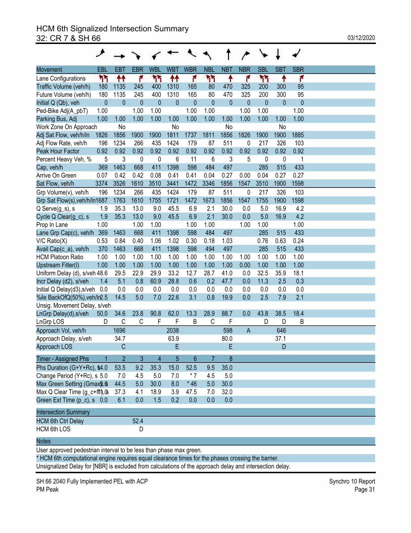
HCM 6th Signalized Intersection Summary32: CR 7 & SH 66 03/12/2020
SH 66 2040 Fully Implemented PEL with ACP Synchro 10 ReportPM Peak Page 31
Movement EBL EBT EBR WBL WBT WBR NBL NBT NBR SBL SBT SBR
Lane ConfigurationsTraffic Volume (veh/h) 180 1135 245 400 1310 165 80 470 325 200 300 95Future Volume (veh/h) 180 1135 245 400 1310 165 80 470 325 200 300 95Initial Q (Qb), veh 0 0 0 0 0 0 0 0 0 0 0 0Ped-Bike Adj(A_pbT) 1.00 1.00 1.00 1.00 1.00 1.00 1.00 1.00Parking Bus, Adj 1.00 1.00 1.00 1.00 1.00 1.00 1.00 1.00 1.00 1.00 1.00 1.00Work Zone On Approach No No No NoAdj Sat Flow, veh/h/ln 1826 1856 1900 1900 1811 1737 1811 1856 1826 1900 1900 1885Adj Flow Rate, veh/h 196 1234 266 435 1424 179 87 511 0 217 326 103Peak Hour Factor 0.92 0.92 0.92 0.92 0.92 0.92 0.92 0.92 0.92 0.92 0.92 0.92Percent Heavy Veh, % 5 3 0 0 6 11 6 3 5 0 0 1Cap, veh/h 369 1463 668 411 1398 598 484 497 285 515 433Arrive On Green 0.07 0.42 0.42 0.08 0.41 0.41 0.04 0.27 0.00 0.04 0.27 0.27Sat Flow, veh/h 3374 3526 1610 3510 3441 1472 3346 1856 1547 3510 1900 1598
Grp Volume(v), veh/h 196 1234 266 435 1424 179 87 511 0 217 326 103Grp Sat Flow(s),veh/h/ln1687 1763 1610 1755 1721 1472 1673 1856 1547 1755 1900 1598Q Serve(g_s), s 1.9 35.3 13.0 9.0 45.5 6.9 2.1 30.0 0.0 5.0 16.9 4.2Cycle Q Clear(g_c), s 1.9 35.3 13.0 9.0 45.5 6.9 2.1 30.0 0.0 5.0 16.9 4.2Prop In Lane 1.00 1.00 1.00 1.00 1.00 1.00 1.00 1.00Lane Grp Cap(c), veh/h 369 1463 668 411 1398 598 484 497 285 515 433V/C Ratio(X) 0.53 0.84 0.40 1.06 1.02 0.30 0.18 1.03 0.76 0.63 0.24Avail Cap(c_a), veh/h 370 1463 668 411 1398 598 494 497 285 515 433HCM Platoon Ratio 1.00 1.00 1.00 1.00 1.00 1.00 1.00 1.00 1.00 1.00 1.00 1.00Upstream Filter(I) 1.00 1.00 1.00 1.00 1.00 1.00 1.00 1.00 0.00 1.00 1.00 1.00Uniform Delay (d), s/veh 48.6 29.5 22.9 29.9 33.2 12.7 28.7 41.0 0.0 32.5 35.9 18.1Incr Delay (d2), s/veh 1.4 5.1 0.8 60.9 28.8 0.6 0.2 47.7 0.0 11.3 2.5 0.3Initial Q Delay(d3),s/veh 0.0 0.0 0.0 0.0 0.0 0.0 0.0 0.0 0.0 0.0 0.0 0.0%ile BackOfQ(50%),veh/ln2.5 14.5 5.0 7.0 22.6 3.1 0.8 19.9 0.0 2.5 7.9 2.1Unsig. Movement Delay, s/vehLnGrp Delay(d),s/veh 50.0 34.6 23.8 90.8 62.0 13.3 28.9 88.7 0.0 43.8 38.5 18.4LnGrp LOS D C C F F B C F D D B
Approach Vol, veh/h 1696 2038 598 A 646Approach Delay, s/veh 34.7 63.9 80.0 37.1Approach LOS C E E D
Timer - Assigned Phs 1 2 3 4 5 6 7 8
Phs Duration (G+Y+Rc), s14.0 53.5 9.2 35.3 15.0 52.5 9.5 35.0Change Period (Y+Rc), s 5.0 7.0 4.5 5.0 7.0 * 7 4.5 5.0Max Green Setting (Gmax), s9.0 44.5 5.0 30.0 8.0 * 46 5.0 30.0Max Q Clear Time (g_c+I1), s11.0 37.3 4.1 18.9 3.9 47.5 7.0 32.0Green Ext Time (p_c), s 0.0 6.1 0.0 1.5 0.2 0.0 0.0 0.0
Intersection Summary
HCM 6th Ctrl Delay 52.4HCM 6th LOS D
Notes
User approved pedestrian interval to be less than phase max green.* HCM 6th computational engine requires equal clearance times for the phases crossing the barrier.Unsignalized Delay for [NBR] is excluded from calculations of the approach delay and intersection delay.

HCM 6th Signalized Intersection Summary33: Foster Ridge Dr & SH 66 03/12/2020
SH 66 2040 Fully Implemented PEL with ACP Synchro 10 ReportPM Peak Page 32
Movement EBL EBT EBR WBL WBT WBR NBL NBT NBR SBL SBT SBR
Lane ConfigurationsTraffic Volume (veh/h) 15 1615 30 30 1830 15 30 10 30 15 20 15Future Volume (veh/h) 15 1615 30 30 1830 15 30 10 30 15 20 15Initial Q (Qb), veh 0 0 0 0 0 0 0 0 0 0 0 0Ped-Bike Adj(A_pbT) 1.00 1.00 1.00 1.00 1.00 1.00 1.00 1.00Parking Bus, Adj 1.00 1.00 1.00 1.00 1.00 1.00 1.00 1.00 1.00 1.00 1.00 1.00Work Zone On Approach No No No NoAdj Sat Flow, veh/h/ln 1870 1870 1870 1870 1870 1870 1870 1870 1870 1870 1870 1870Adj Flow Rate, veh/h 16 1755 33 33 1989 16 33 11 33 16 22 16Peak Hour Factor 0.92 0.92 0.92 0.92 0.92 0.92 0.92 0.92 0.92 0.92 0.92 0.92Percent Heavy Veh, % 2 2 2 2 2 2 2 2 2 2 2 2Cap, veh/h 145 2906 55 171 2942 24 431 98 294 386 201 146Arrive On Green 0.56 0.56 0.56 0.56 0.56 0.56 0.06 0.24 0.24 0.02 0.20 0.20Sat Flow, veh/h 214 5160 97 265 5225 42 1781 412 1236 1781 1007 732
Grp Volume(v), veh/h 16 1158 630 33 1296 709 33 0 44 16 0 38Grp Sat Flow(s),veh/h/ln 214 1702 1853 265 1702 1863 1781 0 1648 1781 0 1739Q Serve(g_s), s 5.0 19.9 19.9 8.3 23.7 23.8 1.2 0.0 1.8 0.6 0.0 1.6Cycle Q Clear(g_c), s 28.8 19.9 19.9 28.3 23.7 23.8 1.2 0.0 1.8 0.6 0.0 1.6Prop In Lane 1.00 0.05 1.00 0.02 1.00 0.75 1.00 0.42Lane Grp Cap(c), veh/h 145 1917 1043 171 1917 1049 431 0 391 386 0 347V/C Ratio(X) 0.11 0.60 0.60 0.19 0.68 0.68 0.08 0.00 0.11 0.04 0.00 0.11Avail Cap(c_a), veh/h 189 2618 1425 225 2618 1433 431 0 391 454 0 413HCM Platoon Ratio 1.00 1.00 1.00 1.00 1.00 1.00 1.00 1.00 1.00 1.00 1.00 1.00Upstream Filter(I) 1.00 1.00 1.00 1.00 1.00 1.00 1.00 0.00 1.00 1.00 0.00 1.00Uniform Delay (d), s/veh 23.8 12.8 12.8 22.1 13.6 13.6 24.7 0.0 26.4 27.3 0.0 29.0Incr Delay (d2), s/veh 0.3 0.3 0.6 0.5 0.4 0.8 0.3 0.0 0.6 0.0 0.0 0.1Initial Q Delay(d3),s/veh 0.0 0.0 0.0 0.0 0.0 0.0 0.0 0.0 0.0 0.0 0.0 0.0%ile BackOfQ(50%),veh/ln0.2 6.0 6.6 0.5 7.1 7.9 0.6 0.0 0.8 0.3 0.0 0.7Unsig. Movement Delay, s/vehLnGrp Delay(d),s/veh 24.1 13.1 13.4 22.7 14.0 14.4 25.0 0.0 27.0 27.3 0.0 29.1LnGrp LOS C B B C B B C A C C A C
Approach Vol, veh/h 1804 2038 77 54Approach Delay, s/veh 13.3 14.3 26.1 28.6Approach LOS B B C C
Timer - Assigned Phs 2 3 4 6 7 8
Phs Duration (G+Y+Rc), s 55.8 10.0 22.6 55.8 6.6 26.0Change Period (Y+Rc), s 6.0 5.0 5.0 6.0 5.0 5.0Max Green Setting (Gmax), s 68.0 5.0 21.0 68.0 5.0 21.0Max Q Clear Time (g_c+I1), s 30.8 3.2 3.6 30.3 2.6 3.8Green Ext Time (p_c), s 15.9 0.0 0.1 19.5 0.0 0.1
Intersection Summary
HCM 6th Ctrl Delay 14.3HCM 6th LOS B

HCM 6th Signalized Intersection Summary34: I-25 SB On Ramp/I-25 SB Off Ramp & SH 66 03/12/2020
SH 66 2040 Fully Implemented PEL with ACP Synchro 10 ReportPM Peak Page 33
Movement EBL EBT EBR WBL WBT WBR NBL NBT NBR SBL SBT SBR
Lane ConfigurationsTraffic Volume (veh/h) 0 1250 490 565 1625 0 0 0 0 220 10 330Future Volume (veh/h) 0 1250 490 565 1625 0 0 0 0 220 10 330Initial Q (Qb), veh 0 0 0 0 0 0 0 0 0Ped-Bike Adj(A_pbT) 1.00 1.00 1.00 1.00 1.00 1.00Parking Bus, Adj 1.00 1.00 1.00 1.00 1.00 1.00 1.00 1.00 1.00Work Zone On Approach No No NoAdj Sat Flow, veh/h/ln 0 1856 1856 1688 1796 0 1737 1411 1856Adj Flow Rate, veh/h 0 1359 0 614 1766 0 247 0 0Peak Hour Factor 0.92 0.92 0.92 0.92 0.92 0.92 0.92 0.92 0.92Percent Heavy Veh, % 0 3 3 8 7 0 11 33 3Cap, veh/h 0 1520 1079 2503 0 344 0Arrive On Green 0.00 0.30 0.00 0.69 1.00 0.00 0.10 0.00 0.00Sat Flow, veh/h 0 5233 1572 3118 3503 0 3309 0 1572
Grp Volume(v), veh/h 0 1359 0 614 1766 0 247 0 0Grp Sat Flow(s),veh/h/ln 0 1689 1572 1559 1706 0 1654 0 1572Q Serve(g_s), s 0.0 20.5 0.0 8.0 0.0 0.0 5.8 0.0 0.0Cycle Q Clear(g_c), s 0.0 20.5 0.0 8.0 0.0 0.0 5.8 0.0 0.0Prop In Lane 0.00 1.00 1.00 0.00 1.00 1.00Lane Grp Cap(c), veh/h 0 1520 1079 2503 0 344 0V/C Ratio(X) 0.00 0.89 0.57 0.71 0.00 0.72 0.00Avail Cap(c_a), veh/h 0 1520 1079 2503 0 744 0HCM Platoon Ratio 1.00 1.00 1.00 2.00 2.00 1.00 1.00 1.00 1.00Upstream Filter(I) 0.00 0.73 0.00 0.38 0.38 0.00 1.00 0.00 0.00Uniform Delay (d), s/veh 0.0 26.8 0.0 9.3 0.0 0.0 34.7 0.0 0.0Incr Delay (d2), s/veh 0.0 6.4 0.0 0.3 0.7 0.0 2.8 0.0 0.0Initial Q Delay(d3),s/veh 0.0 0.0 0.0 0.0 0.0 0.0 0.0 0.0 0.0%ile BackOfQ(50%),veh/ln0.0 8.1 0.0 1.7 0.2 0.0 2.3 0.0 0.0Unsig. Movement Delay, s/vehLnGrp Delay(d),s/veh 0.0 33.2 0.0 9.6 0.7 0.0 37.5 0.0 0.0LnGrp LOS A C A A A D A
Approach Vol, veh/h 1359 A 2380 247 AApproach Delay, s/veh 33.2 2.9 37.5Approach LOS C A D
Timer - Assigned Phs 1 2 4 6
Phs Duration (G+Y+Rc), s34.7 31.0 14.3 65.7Change Period (Y+Rc), s 7.0 7.0 6.0 7.0Max Green Setting (Gmax), s18.0 24.0 18.0 49.0Max Q Clear Time (g_c+I1), s10.0 22.5 7.8 2.0Green Ext Time (p_c), s 1.5 1.1 0.6 19.0
Intersection Summary
HCM 6th Ctrl Delay 15.4HCM 6th LOS B
Notes
User approved volume balancing among the lanes for turning movement.Unsignalized Delay for [EBR, SBR] is excluded from calculations of the approach delay and intersection delay.

HCM 6th Signalized Intersection Summary35: I-25 NB Off Ramp/I-25 NB On Ramp & SH 66 03/12/2020
SH 66 2040 Fully Implemented PEL with ACP Synchro 10 ReportPM Peak Page 34
Movement EBL EBT EBR WBL WBT WBR NBL NBT NBR SBL SBT SBR
Lane ConfigurationsTraffic Volume (veh/h) 275 1195 0 0 1700 310 490 0 685 0 0 0Future Volume (veh/h) 275 1195 0 0 1700 310 490 0 685 0 0 0Initial Q (Qb), veh 0 0 0 0 0 0 0 0 0Ped-Bike Adj(A_pbT) 1.00 1.00 1.00 1.00 1.00 1.00Parking Bus, Adj 1.00 1.00 1.00 1.00 1.00 1.00 1.00 1.00 1.00Work Zone On Approach No No NoAdj Sat Flow, veh/h/ln 1758 1826 0 0 1781 1693 1716 1900 1737Adj Flow Rate, veh/h 299 1299 0 0 1848 0 533 0 0Peak Hour Factor 0.92 0.92 0.92 0.92 0.92 0.92 0.92 0.92 0.92Percent Heavy Veh, % 3 5 0 0 8 14 6 0 11Cap, veh/h 434 2242 0 0 2067 625 0Arrive On Green 0.27 1.00 0.00 0.00 0.43 0.00 0.19 0.00 0.00Sat Flow, veh/h 3248 3561 0 0 5024 1434 3268 0 1472
Grp Volume(v), veh/h 299 1299 0 0 1848 0 533 0 0Grp Sat Flow(s),veh/h/ln1624 1735 0 0 1621 1434 1634 0 1472Q Serve(g_s), s 6.6 0.0 0.0 0.0 28.2 0.0 12.6 0.0 0.0Cycle Q Clear(g_c), s 6.6 0.0 0.0 0.0 28.2 0.0 12.6 0.0 0.0Prop In Lane 1.00 0.00 0.00 1.00 1.00 1.00Lane Grp Cap(c), veh/h 434 2242 0 0 2067 625 0V/C Ratio(X) 0.69 0.58 0.00 0.00 0.89 0.85 0.00Avail Cap(c_a), veh/h 434 2242 0 0 2067 735 0HCM Platoon Ratio 2.00 2.00 1.00 1.00 1.00 1.00 1.00 1.00 1.00Upstream Filter(I) 0.64 0.64 0.00 0.00 1.00 0.00 1.00 0.00 0.00Uniform Delay (d), s/veh 27.8 0.0 0.0 0.0 21.3 0.0 31.3 0.0 0.0Incr Delay (d2), s/veh 2.9 0.7 0.0 0.0 6.5 0.0 8.4 0.0 0.0Initial Q Delay(d3),s/veh 0.0 0.0 0.0 0.0 0.0 0.0 0.0 0.0 0.0%ile BackOfQ(50%),veh/ln2.3 0.2 0.0 0.0 9.9 0.0 5.3 0.0 0.0Unsig. Movement Delay, s/vehLnGrp Delay(d),s/veh 30.8 0.7 0.0 0.0 27.8 0.0 39.6 0.0 0.0LnGrp LOS C A A A C D A
Approach Vol, veh/h 1598 1848 A 533 AApproach Delay, s/veh 6.3 27.8 39.6Approach LOS A C D
Timer - Assigned Phs 2 5 6 8
Phs Duration (G+Y+Rc), s 58.7 17.7 41.0 21.3Change Period (Y+Rc), s 7.0 7.0 * 7 6.0Max Green Setting (Gmax), s 49.0 10.0 * 34 18.0Max Q Clear Time (g_c+I1), s 2.0 8.6 30.2 14.6Green Ext Time (p_c), s 11.1 0.1 3.1 0.7
Intersection Summary
HCM 6th Ctrl Delay 20.8HCM 6th LOS C
Notes
User approved volume balancing among the lanes for turning movement.* HCM 6th computational engine requires equal clearance times for the phases crossing the barrier.Unsignalized Delay for [NBR, WBR] is excluded from calculations of the approach delay and intersection delay.

HCM 6th TWSC36: Mead St & SH 66 03/12/2020
SH 66 2040 Fully Implemented PEL with ACP Synchro 10 ReportPM Peak Page 35
Intersection
Int Delay, s/veh 67.7
Movement EBL EBT EBR WBL WBT WBR NBL NBT NBR SBL SBT SBR
Lane ConfigurationsTraffic Vol, veh/h 225 1540 115 20 1555 20 0 0 185 0 0 455Future Vol, veh/h 225 1540 115 20 1555 20 0 0 185 0 0 455Conflicting Peds, #/hr 0 0 0 0 0 0 0 0 0 0 0 0Sign Control Free Free Free Free Free Free Stop Stop Stop Stop Stop StopRT Channelized - - None - - None - - None - - NoneStorage Length 275 - - 225 - - - - 0 - - 0Veh in Median Storage, # - 0 - - 0 - - 0 - - 0 -Grade, % - 0 - - 0 - - 0 - - 0 -Peak Hour Factor 92 92 92 92 92 92 92 92 92 92 92 92Heavy Vehicles, % 2 10 7 3 8 2 7 2 3 2 2 2Mvmt Flow 245 1674 125 22 1690 22 0 0 201 0 0 495
Major/Minor Major1 Major2 Minor1 Minor2
Conflicting Flow All 1712 0 0 1799 0 0 - - 900 - - 856 Stage 1 - - - - - - - - - - - - Stage 2 - - - - - - - - - - - -Critical Hdwy 5.34 - - 5.36 - - - - 7.16 - - 7.14Critical Hdwy Stg 1 - - - - - - - - - - - -Critical Hdwy Stg 2 - - - - - - - - - - - -Follow-up Hdwy 3.12 - - 3.13 - - - - 3.93 - - 3.92Pot Cap-1 Maneuver ~ 175 - - 156 - - 0 0 240 0 0 ~ 259 Stage 1 - - - - - - 0 0 - 0 0 - Stage 2 - - - - - - 0 0 - 0 0 -Platoon blocked, % - - - -Mov Cap-1 Maneuver ~ 175 - - 156 - - - - 240 - - ~ 259Mov Cap-2 Maneuver - - - - - - - - - - - - Stage 1 - - - - - - - - - - - - Stage 2 - - - - - - - - - - - -
Approach EB WB NB SB
HCM Control Delay, s 31.1 0.4 67.1 $ 455.5HCM LOS F F
Minor Lane/Major Mvmt NBLn1 EBL EBT EBR WBL WBT WBR SBLn1
Capacity (veh/h) 240 ~ 175 - - 156 - - 259HCM Lane V/C Ratio 0.838 1.398 - - 0.139 - - 1.91HCM Control Delay (s) 67.1 259.7 - - 31.8 - -$ 455.5HCM Lane LOS F F - - D - - FHCM 95th %tile Q(veh) 6.6 14.9 - - 0.5 - - 34.8
Notes
~: Volume exceeds capacity $: Delay exceeds 300s +: Computation Not Defined *: All major volume in platoon
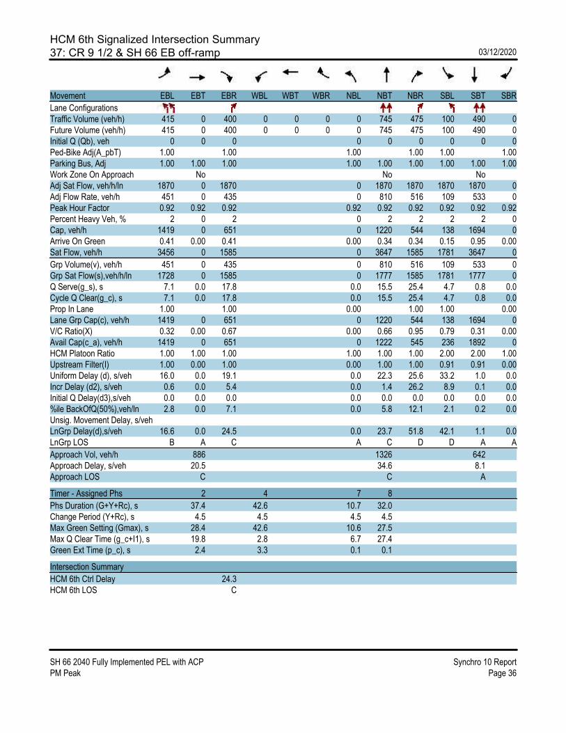
HCM 6th Signalized Intersection Summary37: CR 9 1/2 & SH 66 EB off-ramp 03/12/2020
SH 66 2040 Fully Implemented PEL with ACP Synchro 10 ReportPM Peak Page 36
Movement EBL EBT EBR WBL WBT WBR NBL NBT NBR SBL SBT SBR
Lane ConfigurationsTraffic Volume (veh/h) 415 0 400 0 0 0 0 745 475 100 490 0Future Volume (veh/h) 415 0 400 0 0 0 0 745 475 100 490 0Initial Q (Qb), veh 0 0 0 0 0 0 0 0 0Ped-Bike Adj(A_pbT) 1.00 1.00 1.00 1.00 1.00 1.00Parking Bus, Adj 1.00 1.00 1.00 1.00 1.00 1.00 1.00 1.00 1.00Work Zone On Approach No No NoAdj Sat Flow, veh/h/ln 1870 0 1870 0 1870 1870 1870 1870 0Adj Flow Rate, veh/h 451 0 435 0 810 516 109 533 0Peak Hour Factor 0.92 0.92 0.92 0.92 0.92 0.92 0.92 0.92 0.92Percent Heavy Veh, % 2 0 2 0 2 2 2 2 0Cap, veh/h 1419 0 651 0 1220 544 138 1694 0Arrive On Green 0.41 0.00 0.41 0.00 0.34 0.34 0.15 0.95 0.00Sat Flow, veh/h 3456 0 1585 0 3647 1585 1781 3647 0
Grp Volume(v), veh/h 451 0 435 0 810 516 109 533 0Grp Sat Flow(s),veh/h/ln 1728 0 1585 0 1777 1585 1781 1777 0Q Serve(g_s), s 7.1 0.0 17.8 0.0 15.5 25.4 4.7 0.8 0.0Cycle Q Clear(g_c), s 7.1 0.0 17.8 0.0 15.5 25.4 4.7 0.8 0.0Prop In Lane 1.00 1.00 0.00 1.00 1.00 0.00Lane Grp Cap(c), veh/h 1419 0 651 0 1220 544 138 1694 0V/C Ratio(X) 0.32 0.00 0.67 0.00 0.66 0.95 0.79 0.31 0.00Avail Cap(c_a), veh/h 1419 0 651 0 1222 545 236 1892 0HCM Platoon Ratio 1.00 1.00 1.00 1.00 1.00 1.00 2.00 2.00 1.00Upstream Filter(I) 1.00 0.00 1.00 0.00 1.00 1.00 0.91 0.91 0.00Uniform Delay (d), s/veh 16.0 0.0 19.1 0.0 22.3 25.6 33.2 1.0 0.0Incr Delay (d2), s/veh 0.6 0.0 5.4 0.0 1.4 26.2 8.9 0.1 0.0Initial Q Delay(d3),s/veh 0.0 0.0 0.0 0.0 0.0 0.0 0.0 0.0 0.0%ile BackOfQ(50%),veh/ln 2.8 0.0 7.1 0.0 5.8 12.1 2.1 0.2 0.0Unsig. Movement Delay, s/vehLnGrp Delay(d),s/veh 16.6 0.0 24.5 0.0 23.7 51.8 42.1 1.1 0.0LnGrp LOS B A C A C D D A A
Approach Vol, veh/h 886 1326 642Approach Delay, s/veh 20.5 34.6 8.1Approach LOS C C A
Timer - Assigned Phs 2 4 7 8
Phs Duration (G+Y+Rc), s 37.4 42.6 10.7 32.0Change Period (Y+Rc), s 4.5 4.5 4.5 4.5Max Green Setting (Gmax), s 28.4 42.6 10.6 27.5Max Q Clear Time (g_c+I1), s 19.8 2.8 6.7 27.4Green Ext Time (p_c), s 2.4 3.3 0.1 0.1
Intersection Summary
HCM 6th Ctrl Delay 24.3HCM 6th LOS C

HCM 6th Signalized Intersection Summary38: CR 9 1/2 & SH 66 03/12/2020
SH 66 2040 Fully Implemented PEL with ACP Synchro 10 ReportPM Peak Page 37
Movement EBL EBT EBR WBL WBT WBR NBL NBT NBR SBL SBT SBR
Lane ConfigurationsTraffic Volume (veh/h) 0 0 0 130 580 45 580 580 0 0 460 435Future Volume (veh/h) 0 0 0 130 580 45 580 580 0 0 460 435Initial Q (Qb), veh 0 0 0 0 0 0 0 0 0Ped-Bike Adj(A_pbT) 1.00 1.00 1.00 1.00 1.00 1.00Parking Bus, Adj 1.00 1.00 1.00 1.00 1.00 1.00 1.00 1.00 1.00Work Zone On Approach No No NoAdj Sat Flow, veh/h/ln 1870 1870 1870 1870 1870 0 0 1870 1870Adj Flow Rate, veh/h 141 630 49 630 630 0 0 500 473Peak Hour Factor 0.92 0.92 0.92 0.92 0.92 0.92 0.92 0.92 0.92Percent Heavy Veh, % 2 2 2 2 2 0 0 2 2Cap, veh/h 528 1433 111 719 2100 0 0 1161 518Arrive On Green 0.50 0.50 0.50 0.28 0.79 0.00 0.00 0.33 0.33Sat Flow, veh/h 1781 4834 373 3456 3647 0 0 3647 1585
Grp Volume(v), veh/h 141 442 237 630 630 0 0 500 473Grp Sat Flow(s),veh/h/ln 1781 1702 1803 1728 1777 0 0 1777 1585Q Serve(g_s), s 3.7 6.7 6.8 13.9 4.0 0.0 0.0 8.8 22.9Cycle Q Clear(g_c), s 3.7 6.7 6.8 13.9 4.0 0.0 0.0 8.8 22.9Prop In Lane 1.00 0.21 1.00 0.00 0.00 1.00Lane Grp Cap(c), veh/h 528 1009 535 719 2100 0 0 1161 518V/C Ratio(X) 0.27 0.44 0.44 0.88 0.30 0.00 0.00 0.43 0.91Avail Cap(c_a), veh/h 528 1009 535 808 2252 0 0 1222 545HCM Platoon Ratio 1.67 1.67 1.67 1.33 1.33 1.00 1.00 1.00 1.00Upstream Filter(I) 1.00 1.00 1.00 0.79 0.79 0.00 0.00 1.00 1.00Uniform Delay (d), s/veh 15.1 15.9 15.9 28.0 3.9 0.0 0.0 21.1 25.8Incr Delay (d2), s/veh 1.2 1.4 2.6 8.0 0.1 0.0 0.0 0.3 19.4Initial Q Delay(d3),s/veh 0.0 0.0 0.0 0.0 0.0 0.0 0.0 0.0 0.0%ile BackOfQ(50%),veh/ln 1.4 2.2 2.6 5.5 0.9 0.0 0.0 3.2 10.2Unsig. Movement Delay, s/vehLnGrp Delay(d),s/veh 16.4 17.3 18.6 36.0 4.0 0.0 0.0 21.4 45.2LnGrp LOS B B B D A A A C D
Approach Vol, veh/h 820 1260 973Approach Delay, s/veh 17.5 20.0 33.0Approach LOS B B C
Timer - Assigned Phs 3 4 6 8
Phs Duration (G+Y+Rc), s 21.1 30.6 28.2 51.8Change Period (Y+Rc), s 4.5 4.5 4.5 4.5Max Green Setting (Gmax), s 18.7 27.5 20.3 50.7Max Q Clear Time (g_c+I1), s 15.9 24.9 8.8 6.0Green Ext Time (p_c), s 0.7 1.2 3.2 4.0
Intersection Summary
HCM 6th Ctrl Delay 23.5HCM 6th LOS C

HCM 6th Signalized Intersection Summary39: CR 11 & SH 66 03/12/2020
SH 66 2040 Fully Implemented PEL with ACP Synchro 10 ReportPM Peak Page 38
Movement EBL EBT EBR WBL WBT WBR NBL NBT NBR SBL SBT SBR
Lane ConfigurationsTraffic Volume (veh/h) 110 1205 170 140 585 75 105 15 170 80 15 65Future Volume (veh/h) 110 1205 170 140 585 75 105 15 170 80 15 65Initial Q (Qb), veh 0 0 0 0 0 0 0 0 0 0 0 0Ped-Bike Adj(A_pbT) 1.00 1.00 1.00 1.00 1.00 1.00 1.00 1.00Parking Bus, Adj 1.00 1.00 1.00 1.00 1.00 1.00 1.00 1.00 1.00 1.00 1.00 1.00Work Zone On Approach No No No NoAdj Sat Flow, veh/h/ln 1900 1737 1530 1900 1781 1900 1900 1900 1900 1900 1900 1900Adj Flow Rate, veh/h 120 1310 185 152 636 82 114 16 185 87 16 0Peak Hour Factor 0.92 0.92 0.92 0.92 0.92 0.92 0.92 0.92 0.92 0.92 0.92 0.92Percent Heavy Veh, % 0 11 25 0 8 0 0 0 0 0 0 0Cap, veh/h 298 1375 540 202 1397 665 528 465 394 469 447Arrive On Green 0.06 0.42 0.42 0.02 0.14 0.14 0.06 0.24 0.24 0.05 0.24 0.00Sat Flow, veh/h 1810 3300 1296 1810 3385 1610 1810 1900 1610 1810 1900 1610
Grp Volume(v), veh/h 120 1310 185 152 636 82 114 16 185 87 16 0Grp Sat Flow(s),veh/h/ln1810 1650 1296 1810 1692 1610 1810 1900 1610 1810 1900 1610Q Serve(g_s), s 3.5 30.7 5.4 2.6 13.8 3.6 3.8 0.5 6.1 2.9 0.5 0.0Cycle Q Clear(g_c), s 3.5 30.7 5.4 2.6 13.8 3.6 3.8 0.5 6.1 2.9 0.5 0.0Prop In Lane 1.00 1.00 1.00 1.00 1.00 1.00 1.00 1.00Lane Grp Cap(c), veh/h 298 1375 540 202 1397 665 528 465 394 469 447V/C Ratio(X) 0.40 0.95 0.34 0.75 0.46 0.12 0.22 0.03 0.47 0.19 0.04Avail Cap(c_a), veh/h 338 1382 543 206 1397 665 528 465 394 486 447HCM Platoon Ratio 1.00 1.00 1.00 0.33 0.33 0.33 1.00 1.00 1.00 1.00 1.00 1.00Upstream Filter(I) 1.00 1.00 1.00 0.96 0.96 0.96 1.00 1.00 1.00 1.00 1.00 0.00Uniform Delay (d), s/veh 18.1 22.6 7.8 37.3 26.3 21.8 21.0 23.0 15.3 21.2 23.6 0.0Incr Delay (d2), s/veh 0.9 14.4 0.4 13.7 0.2 0.1 0.2 0.1 4.0 0.2 0.1 0.0Initial Q Delay(d3),s/veh 0.0 0.0 0.0 0.0 0.0 0.0 0.0 0.0 0.0 0.0 0.0 0.0%ile BackOfQ(50%),veh/ln1.3 12.5 2.1 3.5 5.9 1.3 1.6 0.2 3.2 1.2 0.2 0.0Unsig. Movement Delay, s/vehLnGrp Delay(d),s/veh 18.9 37.0 8.2 51.0 26.5 21.9 21.2 23.2 19.3 21.4 23.7 0.0LnGrp LOS B D A D C C C C B C C
Approach Vol, veh/h 1615 870 315 103 AApproach Delay, s/veh 32.4 30.3 20.2 21.8Approach LOS C C C C
Timer - Assigned Phs 1 2 3 4 5 6 7 8
Phs Duration (G+Y+Rc), s9.3 37.8 9.5 23.3 9.6 37.5 8.8 24.1Change Period (Y+Rc), s 4.5 4.5 4.5 4.5 4.5 4.5 4.5 4.5Max Green Setting (Gmax), s5.0 33.5 5.0 18.5 6.9 31.6 5.0 18.5Max Q Clear Time (g_c+I1), s4.6 32.7 5.8 2.5 5.5 15.8 4.9 8.1Green Ext Time (p_c), s 0.0 0.6 0.0 0.0 0.0 3.5 0.0 0.5
Intersection Summary
HCM 6th Ctrl Delay 30.1HCM 6th LOS C
Notes
Unsignalized Delay for [SBR] is excluded from calculations of the approach delay and intersection delay.

HCM 6th Signalized Intersection Summary40: CR 11.5 & SH 66 03/12/2020
SH 66 2040 Fully Implemented PEL with ACP Synchro 10 ReportPM Peak Page 39
Movement EBL EBT EBR WBL WBT WBR NBL NBT NBR SBL SBT SBR
Lane ConfigurationsTraffic Volume (veh/h) 30 1050 375 280 540 30 210 10 185 60 10 50Future Volume (veh/h) 30 1050 375 280 540 30 210 10 185 60 10 50Initial Q (Qb), veh 0 0 0 0 0 0 0 0 0 0 0 0Ped-Bike Adj(A_pbT) 1.00 1.00 1.00 1.00 1.00 1.00 1.00 1.00Parking Bus, Adj 1.00 1.00 1.00 1.00 1.00 1.00 1.00 1.00 1.00 1.00 1.00 1.00Work Zone On Approach No No No NoAdj Sat Flow, veh/h/ln 1870 1870 1870 1870 1870 1870 1870 1870 1870 1870 1870 1870Adj Flow Rate, veh/h 33 1141 408 304 587 33 228 11 201 65 11 54Peak Hour Factor 0.92 0.92 0.92 0.92 0.92 0.92 0.92 0.92 0.92 0.92 0.92 0.92Percent Heavy Veh, % 2 2 2 2 2 2 2 2 2 2 2 2Cap, veh/h 241 1253 559 352 1618 722 894 19 341 325 62 304Arrive On Green 0.06 0.71 0.71 0.04 0.15 0.15 0.06 0.22 0.22 0.06 0.22 0.22Sat Flow, veh/h 1781 3554 1585 1781 3554 1585 3456 83 1515 1781 275 1352
Grp Volume(v), veh/h 33 1141 408 304 587 33 228 0 212 65 0 65Grp Sat Flow(s),veh/h/ln1781 1777 1585 1781 1777 1585 1728 0 1598 1781 0 1627Q Serve(g_s), s 1.0 21.2 12.5 8.5 11.9 1.0 0.0 0.0 9.5 0.0 0.0 2.6Cycle Q Clear(g_c), s 1.0 21.2 12.5 8.5 11.9 1.0 0.0 0.0 9.5 0.0 0.0 2.6Prop In Lane 1.00 1.00 1.00 1.00 1.00 0.95 1.00 0.83Lane Grp Cap(c), veh/h 241 1253 559 352 1618 722 894 0 359 325 0 366V/C Ratio(X) 0.14 0.91 0.73 0.86 0.36 0.05 0.25 0.00 0.59 0.20 0.00 0.18Avail Cap(c_a), veh/h 294 1253 559 352 1618 722 896 0 359 326 0 366HCM Platoon Ratio 2.00 2.00 2.00 0.33 0.33 0.33 1.00 1.00 1.00 1.00 1.00 1.00Upstream Filter(I) 0.60 0.60 0.60 0.88 0.88 0.88 1.00 0.00 1.00 1.00 0.00 1.00Uniform Delay (d), s/veh 19.4 10.8 9.5 35.4 23.6 8.8 24.4 0.0 27.7 29.3 0.0 25.0Incr Delay (d2), s/veh 0.2 7.4 5.0 17.4 0.6 0.1 0.1 0.0 6.9 0.3 0.0 1.1Initial Q Delay(d3),s/veh 0.0 0.0 0.0 0.0 0.0 0.0 0.0 0.0 0.0 0.0 0.0 0.0%ile BackOfQ(50%),veh/ln0.4 4.4 3.2 7.4 5.1 0.5 1.7 0.0 4.2 1.1 0.0 1.1Unsig. Movement Delay, s/vehLnGrp Delay(d),s/veh 19.5 18.2 14.5 52.8 24.1 8.9 24.5 0.0 34.6 29.6 0.0 26.1LnGrp LOS B B B D C A C A C C A C
Approach Vol, veh/h 1582 924 440 130Approach Delay, s/veh 17.3 33.0 29.4 27.8Approach LOS B C C C
Timer - Assigned Phs 1 2 3 4 5 6 7 8
Phs Duration (G+Y+Rc), s15.3 32.7 9.5 22.5 7.1 40.9 9.5 22.5Change Period (Y+Rc), s 4.5 4.5 4.5 4.5 4.5 4.5 4.5 4.5Max Green Setting (Gmax), s10.8 28.2 5.0 18.0 5.0 34.0 5.0 18.0Max Q Clear Time (g_c+I1), s10.5 23.2 2.0 4.6 3.0 13.9 2.0 11.5Green Ext Time (p_c), s 0.0 3.4 0.2 0.2 0.0 3.4 0.0 0.6
Intersection Summary
HCM 6th Ctrl Delay 24.2HCM 6th LOS C

HCM 6th Signalized Intersection Summary41: CR 13 & SH 66 03/12/2020
SH 66 2040 Fully Implemented PEL with ACP Synchro 10 ReportPM Peak Page 40
Movement EBL EBT EBR WBL WBT WBR NBL NBT NBR SBL SBT SBR
Lane ConfigurationsTraffic Volume (veh/h) 130 950 215 90 685 25 140 325 120 20 210 25Future Volume (veh/h) 130 950 215 90 685 25 140 325 120 20 210 25Initial Q (Qb), veh 0 0 0 0 0 0 0 0 0 0 0 0Ped-Bike Adj(A_pbT) 1.00 1.00 1.00 1.00 1.00 1.00 1.00 1.00Parking Bus, Adj 1.00 1.00 1.00 1.00 1.00 1.00 1.00 1.00 1.00 1.00 1.00 1.00Work Zone On Approach No No No NoAdj Sat Flow, veh/h/ln 1870 1870 1870 1870 1870 1870 1870 1870 1870 1870 1870 1870Adj Flow Rate, veh/h 141 1033 234 98 745 27 152 353 130 22 228 27Peak Hour Factor 0.92 0.92 0.92 0.92 0.92 0.92 0.92 0.92 0.92 0.92 0.92 0.92Percent Heavy Veh, % 2 2 2 2 2 2 2 2 2 2 2 2Cap, veh/h 252 1174 524 315 1270 567 254 509 227 178 351 156Arrive On Green 0.16 0.66 0.66 0.11 0.36 0.36 0.07 0.14 0.14 0.02 0.10 0.10Sat Flow, veh/h 1781 3554 1585 1781 3554 1585 1781 3554 1585 1781 3554 1585
Grp Volume(v), veh/h 141 1033 234 98 745 27 152 353 130 22 228 27Grp Sat Flow(s),veh/h/ln1781 1777 1585 1781 1777 1585 1781 1777 1585 1781 1777 1585Q Serve(g_s), s 4.8 18.8 2.7 0.0 13.6 0.9 5.5 7.6 3.3 0.9 4.9 1.2Cycle Q Clear(g_c), s 4.8 18.8 2.7 0.0 13.6 0.9 5.5 7.6 3.3 0.9 4.9 1.2Prop In Lane 1.00 1.00 1.00 1.00 1.00 1.00 1.00 1.00Lane Grp Cap(c), veh/h 252 1174 524 315 1270 567 254 509 227 178 351 156V/C Ratio(X) 0.56 0.88 0.45 0.31 0.59 0.05 0.60 0.69 0.57 0.12 0.65 0.17Avail Cap(c_a), veh/h 325 1466 654 315 1270 567 254 822 367 246 800 357HCM Platoon Ratio 2.00 2.00 2.00 1.00 1.00 1.00 1.00 1.00 1.00 1.00 1.00 1.00Upstream Filter(I) 0.36 0.36 0.36 1.00 1.00 1.00 1.00 1.00 1.00 1.00 1.00 1.00Uniform Delay (d), s/veh 21.0 12.3 2.3 30.9 20.9 16.8 30.2 32.6 9.5 31.3 34.7 33.1Incr Delay (d2), s/veh 0.7 2.1 0.2 0.6 2.0 0.2 3.8 1.7 2.3 0.3 2.0 0.5Initial Q Delay(d3),s/veh 0.0 0.0 0.0 0.0 0.0 0.0 0.0 0.0 0.0 0.0 0.0 0.0%ile BackOfQ(50%),veh/ln1.6 3.7 1.5 1.6 5.2 0.3 2.8 3.3 2.3 0.4 2.1 0.5Unsig. Movement Delay, s/vehLnGrp Delay(d),s/veh 21.7 14.4 2.5 31.4 22.9 17.0 34.0 34.3 11.8 31.6 36.8 33.6LnGrp LOS C B A C C B C C B C D C
Approach Vol, veh/h 1408 870 635 277Approach Delay, s/veh 13.1 23.7 29.6 36.0Approach LOS B C C D
Timer - Assigned Phs 1 2 3 4 5 6 7 8
Phs Duration (G+Y+Rc), s13.2 30.9 10.0 12.4 11.1 33.1 6.4 16.0Change Period (Y+Rc), s 4.5 4.5 4.5 4.5 4.5 4.5 4.5 4.5Max Green Setting (Gmax), s5.5 33.0 5.5 18.0 9.9 28.6 5.0 18.5Max Q Clear Time (g_c+I1), s2.0 20.8 7.5 6.9 6.8 15.6 2.9 9.6Green Ext Time (p_c), s 0.1 5.6 0.0 1.0 0.1 3.7 0.0 1.8
Intersection Summary
HCM 6th Ctrl Delay 21.3HCM 6th LOS C
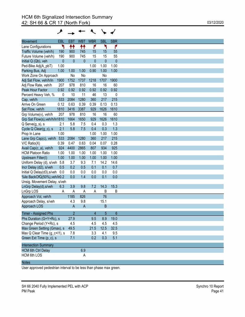
HCM 6th Signalized Intersection Summary42: SH 66 & CR 17 (North Fork) 03/12/2020
SH 66 2040 Fully Implemented PEL with ACP Synchro 10 ReportPM Peak Page 41
Movement EBL EBT WBT WBR SBL SBR
Lane ConfigurationsTraffic Volume (veh/h) 190 900 745 15 15 55Future Volume (veh/h) 190 900 745 15 15 55Initial Q (Qb), veh 0 0 0 0 0 0Ped-Bike Adj(A_pbT) 1.00 1.00 1.00 1.00Parking Bus, Adj 1.00 1.00 1.00 0.90 1.00 1.00Work Zone On Approach No No NoAdj Sat Flow, veh/h/ln 1900 1752 1737 1218 1707 1900Adj Flow Rate, veh/h 207 978 810 16 16 60Peak Hour Factor 0.92 0.92 0.92 0.92 0.92 0.92Percent Heavy Veh, % 0 10 11 46 13 0Cap, veh/h 533 2084 1280 360 217 215Arrive On Green 0.12 0.63 0.39 0.39 0.13 0.13Sat Flow, veh/h 1810 3416 3387 929 1626 1610
Grp Volume(v), veh/h 207 978 810 16 16 60Grp Sat Flow(s),veh/h/ln1810 1664 1650 929 1626 1610Q Serve(g_s), s 2.1 5.8 7.5 0.4 0.3 1.3Cycle Q Clear(g_c), s 2.1 5.8 7.5 0.4 0.3 1.3Prop In Lane 1.00 1.00 1.00 1.00Lane Grp Cap(c), veh/h 533 2084 1280 360 217 215V/C Ratio(X) 0.39 0.47 0.63 0.04 0.07 0.28Avail Cap(c_a), veh/h 924 4400 2865 807 934 925HCM Platoon Ratio 1.00 1.00 1.00 1.00 1.00 1.00Upstream Filter(I) 1.00 1.00 1.00 1.00 1.00 1.00Uniform Delay (d), s/veh 5.8 3.7 9.3 7.1 14.2 14.6Incr Delay (d2), s/veh 0.5 0.2 0.5 0.1 0.1 0.7Initial Q Delay(d3),s/veh 0.0 0.0 0.0 0.0 0.0 0.0%ile BackOfQ(50%),veh/ln0.2 0.0 1.4 0.0 0.1 0.0Unsig. Movement Delay, s/vehLnGrp Delay(d),s/veh 6.3 3.9 9.8 7.2 14.3 15.3LnGrp LOS A A A A B B
Approach Vol, veh/h 1185 826 76Approach Delay, s/veh 4.3 9.8 15.1Approach LOS A A B
Timer - Assigned Phs 2 4 5 6
Phs Duration (G+Y+Rc), s 27.9 9.5 8.9 19.0Change Period (Y+Rc), s 4.5 4.5 4.5 4.5Max Green Setting (Gmax), s 49.5 21.5 12.5 32.5Max Q Clear Time (g_c+I1), s 7.8 3.3 4.1 9.5Green Ext Time (p_c), s 7.1 0.2 0.3 5.1
Intersection Summary
HCM 6th Ctrl Delay 6.9HCM 6th LOS A
Notes
User approved pedestrian interval to be less than phase max green.

HCM 6th Signalized Intersection Summary43: CR 17 & SH 66 03/12/2020
SH 66 2040 Fully Implemented PEL with ACP Synchro 10 ReportPM Peak Page 42
Movement EBT EBR WBL WBT NBL NBR
Lane ConfigurationsTraffic Volume (veh/h) 825 90 5 700 60 5Future Volume (veh/h) 825 90 5 700 60 5Initial Q (Qb), veh 0 0 0 0 0 0Ped-Bike Adj(A_pbT) 1.00 1.00 1.00 1.00Parking Bus, Adj 1.00 1.00 1.00 1.00 1.00 1.00Work Zone On Approach No No NoAdj Sat Flow, veh/h/ln 1752 1900 1900 1693 1900 1900Adj Flow Rate, veh/h 897 98 5 761 65 5Peak Hour Factor 0.92 0.92 0.92 0.92 0.92 0.92Percent Heavy Veh, % 10 0 0 14 0 0Cap, veh/h 1268 614 212 1515 655 583Arrive On Green 0.38 0.38 0.01 0.47 0.36 0.36Sat Flow, veh/h 3416 1610 1810 3300 1810 1610
Grp Volume(v), veh/h 897 98 5 761 65 5Grp Sat Flow(s),veh/h/ln1664 1610 1810 1608 1810 1610Q Serve(g_s), s 12.3 2.2 0.0 8.8 1.3 0.1Cycle Q Clear(g_c), s 12.3 2.2 0.0 8.8 1.3 0.1Prop In Lane 1.00 1.00 1.00 1.00Lane Grp Cap(c), veh/h 1268 614 212 1515 655 583V/C Ratio(X) 0.71 0.16 0.02 0.50 0.10 0.01Avail Cap(c_a), veh/h 2501 1210 418 3073 655 583HCM Platoon Ratio 1.00 1.00 1.00 1.00 1.00 1.00Upstream Filter(I) 1.00 1.00 1.00 1.00 1.00 1.00Uniform Delay (d), s/veh 14.1 11.0 20.9 9.9 11.4 11.0Incr Delay (d2), s/veh 0.7 0.1 0.0 0.3 0.3 0.0Initial Q Delay(d3),s/veh 0.0 0.0 0.0 0.0 0.0 0.0%ile BackOfQ(50%),veh/ln3.4 0.6 0.0 2.0 0.5 0.0Unsig. Movement Delay, s/vehLnGrp Delay(d),s/veh 14.9 11.1 21.0 10.1 11.7 11.0LnGrp LOS B B C B B B
Approach Vol, veh/h 995 766 70Approach Delay, s/veh 14.5 10.2 11.6Approach LOS B B B
Timer - Assigned Phs 1 2 6 8
Phs Duration (G+Y+Rc), s4.9 25.0 29.9 24.0Change Period (Y+Rc), s 4.5 4.5 4.5 4.5Max Green Setting (Gmax), s6.5 40.5 51.5 19.5Max Q Clear Time (g_c+I1), s2.0 14.3 10.8 3.3Green Ext Time (p_c), s 0.0 6.2 5.1 0.1
Intersection Summary
HCM 6th Ctrl Delay 12.6HCM 6th LOS B

HCM 6th Signalized Intersection Summary44: CR 19 & SH 66 03/12/2020
SH 66 2040 Fully Implemented PEL with ACP Synchro 10 ReportPM Peak Page 43
Movement EBL EBT EBR WBL WBT WBR NBL NBT NBR SBL SBT SBR
Lane ConfigurationsTraffic Volume (veh/h) 20 755 55 65 635 5 60 65 75 5 30 10Future Volume (veh/h) 20 755 55 65 635 5 60 65 75 5 30 10Initial Q (Qb), veh 0 0 0 0 0 0 0 0 0 0 0 0Ped-Bike Adj(A_pbT) 1.00 1.00 1.00 1.00 1.00 1.00 1.00 1.00Parking Bus, Adj 1.00 1.00 1.00 1.00 1.00 1.00 1.00 1.00 1.00 1.00 1.00 1.00Work Zone On Approach No No No NoAdj Sat Flow, veh/h/ln 1900 1752 1500 1841 1722 1900 1500 1811 1811 1900 1559 1559Adj Flow Rate, veh/h 22 821 60 71 690 5 65 71 82 5 33 11Peak Hour Factor 0.92 0.92 0.92 0.92 0.92 0.92 0.92 0.92 0.92 0.92 0.92 0.92Percent Heavy Veh, % 0 10 27 4 12 0 27 6 6 0 23 23Cap, veh/h 397 1235 472 374 1340 659 335 126 145 268 122 41Arrive On Green 0.03 0.37 0.37 0.06 0.41 0.41 0.06 0.16 0.16 0.01 0.11 0.11Sat Flow, veh/h 1810 3328 1271 1753 3272 1610 1428 766 885 1810 1119 373
Grp Volume(v), veh/h 22 821 60 71 690 5 65 0 153 5 0 44Grp Sat Flow(s),veh/h/ln1810 1664 1271 1753 1636 1610 1428 0 1652 1810 0 1492Q Serve(g_s), s 0.3 9.4 1.4 1.1 7.2 0.1 1.8 0.0 3.9 0.1 0.0 1.2Cycle Q Clear(g_c), s 0.3 9.4 1.4 1.1 7.2 0.1 1.8 0.0 3.9 0.1 0.0 1.2Prop In Lane 1.00 1.00 1.00 1.00 1.00 0.54 1.00 0.25Lane Grp Cap(c), veh/h 397 1235 472 374 1340 659 335 0 271 268 0 163V/C Ratio(X) 0.06 0.66 0.13 0.19 0.52 0.01 0.19 0.00 0.57 0.02 0.00 0.27Avail Cap(c_a), veh/h 566 2872 1097 509 2895 1425 481 0 740 473 0 603HCM Platoon Ratio 1.00 1.00 1.00 1.00 1.00 1.00 1.00 1.00 1.00 1.00 1.00 1.00Upstream Filter(I) 1.00 1.00 1.00 1.00 1.00 1.00 1.00 0.00 1.00 1.00 0.00 1.00Uniform Delay (d), s/veh 8.7 12.0 9.5 8.7 10.1 8.0 16.5 0.0 17.6 18.0 0.0 18.7Incr Delay (d2), s/veh 0.1 0.6 0.1 0.2 0.3 0.0 0.3 0.0 1.8 0.0 0.0 0.9Initial Q Delay(d3),s/veh 0.0 0.0 0.0 0.0 0.0 0.0 0.0 0.0 0.0 0.0 0.0 0.0%ile BackOfQ(50%),veh/ln0.1 2.3 0.3 0.3 1.6 0.0 0.5 0.0 1.3 0.0 0.0 0.4Unsig. Movement Delay, s/vehLnGrp Delay(d),s/veh 8.8 12.6 9.6 8.9 10.4 8.0 16.8 0.0 19.5 18.0 0.0 19.6LnGrp LOS A B A A B A B A B B A B
Approach Vol, veh/h 903 766 218 49Approach Delay, s/veh 12.3 10.3 18.7 19.4Approach LOS B B B B
Timer - Assigned Phs 1 2 3 4 5 6 7 8
Phs Duration (G+Y+Rc), s7.5 21.5 7.3 9.5 5.7 23.2 4.8 12.0Change Period (Y+Rc), s 4.5 4.5 4.5 4.5 4.5 4.5 4.5 4.5Max Green Setting (Gmax), s6.5 39.5 7.5 18.5 5.5 40.5 5.5 20.5Max Q Clear Time (g_c+I1), s3.1 11.4 3.8 3.2 2.3 9.2 2.1 5.9Green Ext Time (p_c), s 0.0 5.6 0.0 0.1 0.0 4.4 0.0 0.6
Intersection Summary
HCM 6th Ctrl Delay 12.4HCM 6th LOS B