An approach to validate soil moisture derived from passive microwave sensors using SAR as an...
24
This article was downloaded by: [Indian Institute of Technology Roorkee] On: 28 May 2015, At: 21:37 Publisher: Taylor & Francis Informa Ltd Registered in England and Wales Registered Number: 1072954 Registered office: Mortimer House, 37-41 Mortimer Street, London W1T 3JH, UK Click for updates International Journal of Remote Sensing Publication details, including instructions for authors and subscription information: http://www.tandfonline.com/loi/tres20 An approach to validate soil moisture derived from passive microwave sensors using SAR as an interface Parul Patel a & Hari Shanker Srivastava b a Space Applications Centre (SAC), Indian Space Research Organization (ISRO), Ahmedabad, Gujarat, India b Indian Institute of Remote Sensing (IIRS), Indian Space Research Organization (ISRO), Dehradun, Uttarakhand, India Published online: 27 Apr 2015. To cite this article: Parul Patel & Hari Shanker Srivastava (2015) An approach to validate soil moisture derived from passive microwave sensors using SAR as an interface, International Journal of Remote Sensing, 36:9, 2353-2374, DOI: 10.1080/01431161.2015.1034889 To link to this article: http://dx.doi.org/10.1080/01431161.2015.1034889 PLEASE SCROLL DOWN FOR ARTICLE Taylor & Francis makes every effort to ensure the accuracy of all the information (the “Content”) contained in the publications on our platform. However, Taylor & Francis, our agents, and our licensors make no representations or warranties whatsoever as to the accuracy, completeness, or suitability for any purpose of the Content. Any opinions and views expressed in this publication are the opinions and views of the authors, and are not the views of or endorsed by Taylor & Francis. The accuracy of the Content should not be relied upon and should be independently verified with primary sources of information. Taylor and Francis shall not be liable for any losses, actions, claims, proceedings, demands, costs, expenses, damages, and other liabilities whatsoever or howsoever caused arising directly or indirectly in connection with, in relation to or arising out of the use of the Content. This article may be used for research, teaching, and private study purposes. Any substantial or systematic reproduction, redistribution, reselling, loan, sub-licensing, systematic supply, or distribution in any form to anyone is expressly forbidden. Terms & Not for commercial use Only for personal reading and reference purpose
Transcript of An approach to validate soil moisture derived from passive microwave sensors using SAR as an...

This article was downloaded by: [Indian Institute of Technology Roorkee]On: 28 May 2015, At: 21:37Publisher: Taylor & FrancisInforma Ltd Registered in England and Wales Registered Number: 1072954 Registeredoffice: Mortimer House, 37-41 Mortimer Street, London W1T 3JH, UK
Click for updates
International Journal of RemoteSensingPublication details, including instructions for authors andsubscription information:http://www.tandfonline.com/loi/tres20
An approach to validate soil moisturederived from passive microwavesensors using SAR as an interfaceParul Patela & Hari Shanker Srivastavab
a Space Applications Centre (SAC), Indian Space ResearchOrganization (ISRO), Ahmedabad, Gujarat, Indiab Indian Institute of Remote Sensing (IIRS), Indian Space ResearchOrganization (ISRO), Dehradun, Uttarakhand, IndiaPublished online: 27 Apr 2015.
To cite this article: Parul Patel & Hari Shanker Srivastava (2015) An approach to validate soilmoisture derived from passive microwave sensors using SAR as an interface, International Journalof Remote Sensing, 36:9, 2353-2374, DOI: 10.1080/01431161.2015.1034889
To link to this article: http://dx.doi.org/10.1080/01431161.2015.1034889
PLEASE SCROLL DOWN FOR ARTICLE
Taylor & Francis makes every effort to ensure the accuracy of all the information (the“Content”) contained in the publications on our platform. However, Taylor & Francis,our agents, and our licensors make no representations or warranties whatsoever as tothe accuracy, completeness, or suitability for any purpose of the Content. Any opinionsand views expressed in this publication are the opinions and views of the authors,and are not the views of or endorsed by Taylor & Francis. The accuracy of the Contentshould not be relied upon and should be independently verified with primary sourcesof information. Taylor and Francis shall not be liable for any losses, actions, claims,proceedings, demands, costs, expenses, damages, and other liabilities whatsoever orhowsoever caused arising directly or indirectly in connection with, in relation to or arisingout of the use of the Content.
This article may be used for research, teaching, and private study purposes. Anysubstantial or systematic reproduction, redistribution, reselling, loan, sub-licensing,systematic supply, or distribution in any form to anyone is expressly forbidden. Terms &
Not for
commerc
ial us
e
Only fo
r pers
onal
readin
g and
refer
ence
purpo
se

Conditions of access and use can be found at http://www.tandfonline.com/page/terms-and-conditions
Dow
nloa
ded
by [
Indi
an I
nstit
ute
of T
echn
olog
y R
oork
ee]
at 2
1:37
28
May
201
5
Not for
commerc
ial us
e
Only fo
r pers
onal
readin
g and
refer
ence
purpo
se

An approach to validate soil moisture derived from passive microwavesensors using SAR as an interface
Parul Patela* and Hari Shanker Srivastavab
aSpace Applications Centre (SAC), Indian Space Research Organization (ISRO), Ahmedabad,Gujarat, India; bIndian Institute of Remote Sensing (IIRS), Indian Space Research Organization
(ISRO), Dehradun, Uttarakhand, India
(Received 6 November 2012; accepted 30 January 2015)
Validation of soil moisture derived from space-borne passive microwave sensorsremains a challenging task owing to the large variability in soil moisture within thecoarse-resolution cell offered by passive sensors. In this article, nine spatial/temporalsynthetic aperture radar (SAR) data sets from Radar Satellite-1 (Radarsat-1) andEnvironmental Satellite-1 (Envisat-1) Advanced Synthetic Aperture Radar (ASAR)were used as an interface to upscale the field-level soil moisture to soil moisture at a25 km × 25 km grid, the scale at which the Advanced Microwave ScanningRadiometer for the EOS (Earth Observing System) (AMSR-E) level-3 soil moistureproduct is available, leading to a total of 68 such grids where there is a pair of SAR-derived and corresponding AMSR-E-derived values. Out of the these 68 grid cells,each of size 25 km × 25 km, pair data from nine dates, data corresponding to 51 gridcell pairs (from six dates) were used for the development of the approach and datacorresponding to 17 grid cell pairs (from three dates) were used for validating theapproach. It is observed that while the spatial variation in SAR- and AMSR-E-derivedsoil moisture is broadly similar, there exists a bias in the difference between AMSR-E-and SAR-derived soil moisture. The root mean square (RMS) difference betweenAMSR-E soil moisture and SAR-derived soil moisture at 25 km over the modeldevelopment sample of 51 grid cells, each of 25 km × 25 km, was observed to be4.2 (%g cm–3). The study shows that the bias is significantly affected by the AMSR-Evegetation/roughness parameter, g, which is an indicator of the prevailing vegetation/surface roughness conditions. This dependence of the bias on g was exploited to arriveat modified soil moisture estimates at 25 km. The RMS difference between themodified AMSR-E soil moisture at 25 km and the SAR-derived soil moisture wasobserved to be 2.13 (%g cm–3) over a validation sample of 17 grid cells each of size25 km × 25 km, comprising extreme, dry and wet, and soil moisture conditions. Thisdemonstrative study provides the feasibility of calibrating and improving the soilmoisture product from coarse-resolution space-borne passive sensors with the help ofsoil moisture derived using SAR. The approach is demonstrated for validating passiveradiometer-derived soil moisture over bare/crop-covered conditions through an experi-ment involving 68 25 km × 25 km grid cells spread over nine temporal/spatial Radarsatand Envisat-1 satellite SAR data sets and synchronous ground soil moisture measure-ments over farmers’ fields, covering a large range of soil/crop conditions prevailingduring the nine months of SAR data acquisition. Hence the results reported in thismanuscript are encouraging.
*Corresponding author. Email: [email protected]
International Journal of Remote Sensing, 2015Vol. 36, No. 9, 2353–2374, http://dx.doi.org/10.1080/01431161.2015.1034889
© 2015 Taylor & Francis
Dow
nloa
ded
by [
Indi
an I
nstit
ute
of T
echn
olog
y R
oork
ee]
at 2
1:37
28
May
201
5
Not for
commerc
ial us
e
Only fo
r pers
onal
readin
g and
refer
ence
purpo
se

1. Introduction
Soil moisture is variable both spatially and temporally. Although point measurements ofsoil moisture using ground-based instruments give almost a true value of soil moisture,they are too sparse to represent the surrounding area and hence it is difficult to extrapolatethe point measurements to a large area due to the highly dynamic nature of soil moistureboth temporally and spatially. Thus they are inadequate for applications at a global orregional level (Robock et al. 2000). However, since in situ observations provide nearly atrue value of soil moisture, they are indispensible for validation of any soil moistureproduct (Miralles, Crow, and Cosh 2010). In such a scenario, remote sensing of soilmoisture is advantageous due to its spatial and temporal coverage, thereby reducing thenumber of required ground measurements of soil moisture. At microwave frequencies, thedielectric properties of soil are a strong function of its moisture content (Ulaby, Moore,and Fung 1982a; Wagner et al. 2008). It has been demonstrated that microwave remotesensing is one of the most efficient tools for soil moisture estimation at varying spatialscales. Active microwave remote sensing using synthetic aperture radar (SAR) providesimagery at a very fine spatial resolution, whereas passive microwave radiometers andactive microwave scatterometers (e.g. European Remote Sensing Satellite (ERS)-1/2,Meteorological Operational Satellite (METOP)-A/B) provide imagery at a spatial resolu-tion of the order of tens of kilometres. Many space-borne SAR sensors, such as theEnvironmental Satellite (Envisat)-1 Advanced Synthetic Aperture Radar (ASAR), RadarSatellite (Radarsat)-1/2 SAR, and TerraSAR-X, are now successfully used for soil moist-ure estimation studies (Alvarez-Mozos et al. 2006; Baghdadi et al. 2008, 2012; Holahet al. 2005; Mattia et al. 2006; Patel et al. 2001; Patel, Panigrahy, and Chakraborty 2002;Patel and Srivastava 2013a; Srivastava et al. 2002, 2003; Srivastava, Patel, and Navalgund2006a; Wagner et al. 2008; Zribi et al. 2005). More recently the use of polarimetricparameters has been explored for soil moisture retrieval by Baghdadi et al. (2012) andJagdhuber et al. (2013). The usefulness of the passive microwave remote-sensing systemfor soil moisture is now well established (Jackson and Schmugge 1989). Jackson et al.(1993, 2002) demonstrated the usefulness of passive microwaves for soil moistureestimation using Electronically Steered Thinned Array Radiometer (ESTAR) microwaveradiometer data and C-band polarimetric scanning radiometer data. Similarly, Palosciaet al. (2001) have developed a multi-frequency algorithm for the retrieval of soil moistureon a large scale using microwave data from the Scanning Multifrequency MicrowaveRadiometer (SMMR) and Special Sensor Microwave Imager (SSM/I) satellite sensors.Paloscia and Santi (2003) have also developed a semi-empirical algorithm for estimatingsoil moisture from dual-frequency microwave AMSR data. Kerr (2007) has given anexcellent status review of the capability of passive microwave radiometers to estimate soilmoisture. The impact of vegetation on attenuation of passive microwave emission fromsoil has also been studied by a number of researchers (Paloscia and Pampaloni 1988).Paloscia, Macelloni, and Santi (2006) have developed an algorithm for retrieving soilmoisture that uses both the brightness temperature at the C-band in horizontal polarizationand the polarization index at the X-band for correcting the effects of vegetation.
The usefulness of both the active microwave SAR and the passive microwave sensorhas been adequately proven and both have their own advantages and disadvantages. Forexample, the active SAR sensor provides higher spatial resolution data with a higher orsimilar quality as compared with the passive microwave sensor, whereas the latterprovides advanced radiometric accuracy, higher temporal resolution, and higher coverageas compared with the former. The Soil Moisture and Ocean Salinity Mission (SMOS),
2354 P. Patel and H.S. Srivastava
Dow
nloa
ded
by [
Indi
an I
nstit
ute
of T
echn
olog
y R
oork
ee]
at 2
1:37
28
May
201
5
Not for
commerc
ial us
e
Only fo
r pers
onal
readin
g and
refer
ence
purpo
se
launched in 2009, provides 25 km gridded soil moisture at global scales (Kerr et al. 2001,2012). Since the launch of SMOS, a number of researchers have carried out validation ofSMOS-derived soil moisture (Al Bitar et al. 2012; Dall’amico et al. 2012; Gherboudj et al.2012; Jackson et al. 2012; Lacava et al. 2012; Merlin et al. 2012; Rowlandson et al. 2012;Schwank et al. 2012; Sanchez et al. 2012).
While attempts have been made to disaggregate passive microwave-derived coarse-resolution soil moisture using prior information on spatially persistent soil moisture fields(Loew and Mauser 2008), it is necessary to validate such a coarse-resolution soil moistureproduct provided by passive microwave sensors. Thus an approach needs to be developedto obtain a soil moisture value that has very high spatial representativeness of the near-trueaverage value of soil moisture over the resolution cell, as poor representativeness mayartificially inflate the measured mean-square differences (MSDs) comparisons abovemission accuracy goals (Cosh et al. 2006, 2008; Famiglietti et al. 2008; Miralles, Crow,and Cosh 2010). Dunne, Entekhabi, and Njoku (2007) have studied the impact of multi-resolution active and passive measurements on soil moisture estimation. While studyingaveraged results, they observed that the passive (36 km) observations updated each of theestimation cells towards an average value across the 36 km cell, whereas the active (3 km)observations could capture fine-scale spatial distribution of the soil moisture. In thisarticle, a two-stage upscaling approach for deriving soil moisture at a 25 km grid fromfield-level soil moisture using SAR as an interface is demonstrated. The approachinvolves soil sample collection in synchrony with SAR satellite overpasses. The optimumincidence angle range for soil moisture sensitivity (Ulaby, Moore, and Fung 1982b) hasbeen reported to be around 10–17°. For the current study, Radarsat-1 Extended Low-1beam mode data in the incidence angle range 10–16° and Envisat-1 ASAR standard beammode S1 were chosen because for Envisat-1 ASAR, the S1 beam mode with incidenceangle range 19–21° is nearest to the optimum. The difference between the soil moisturethus derived and from AMSR-E is studied. Extended low-beam mode Radarsat-1 SAR,Envisat-1 ASAR standard beam mode S1, and AMSR-E level-3 soil moisture are used todemonstrate the same. The analysis also provides improved soil moisture at 25 km usingthe AMSR-E soil moisture and vegetation/surface roughness parameter, g.
In this study, nine spatial/temporal SAR data sets from Radarsat-1 and Envisat-1ASAR were used as an interface to upscale the field-level soil moisture to soil moistureat the 25 km × 25 km grid, the scale at which the AMSR-E level-3 soil moisture product isavailable, leading to a total of 68 such grid cells, each of size 25 km × 25 km, where a pairof SAR-derived and corresponding AMSR-E-derived values were used. The spatial andtemporal spread of the 68 grid cells, each of size 25 km × 25 km, ensured coverage of awide soil moisture variability that was expected on the ground.
It should be noted that while the spatial and temporal spread of the 68 grid cells, each of25 km × 25 km, was used to demonstrate the approach over varied ground conditionsprevailing during the nine months of SAR data acquisition, leading to the coverage of a widevariability expected on the ground, enhanced validation of the approach. By conductingexperiments involving a greater number of low-incidence angle SAR data acquisitions, alongwith synchronous measured soil moisture conditions from farmers’ fields and correspondingAMSR-E data, further strengthened the usefulness of the approach.
2. Data set and study area
Extended low-beam mode Radarsat-1 SAR data acquired on five dates in the period2003–2004, and Envisat-1 ASAR data on four dates during the year 2010 along with the
International Journal of Remote Sensing 2355
Dow
nloa
ded
by [
Indi
an I
nstit
ute
of T
echn
olog
y R
oork
ee]
at 2
1:37
28
May
201
5
Not for
commerc
ial us
e
Only fo
r pers
onal
readin
g and
refer
ence
purpo
se
AMSR-E derived level-3 soil moisture product from the same dates, were used for thestudy. Both SAR and AMSR-E data were acquired over four study areas. Four pairs ofSAR and AMSR-E data sets were acquired over the first study area, which covers parts ofBatala, India; one pair of AMSR-E and Radarsat-1 SAR data sets and one pair of AMSR-E and Envisat-1 ASAR data sets were acquired over the second study area, which coversparts Agra, Mathura, India; two pairs of AMSR-E and Envisat-1 ASAR data sets wereacquired over the third study area that covers parts of the Kutchh district of India; and onepair of AMSR-E and Envisat-1 ASAR data sets were acquired over the fourth study areathat covers parts of the Jodhpur district of India.
The geographic coordinates of the Batala site area are 75° 00ʹ E to 75° 30ʹ E and 31°30ʹ N to 32° 00ʹ N; those of of the Agra, Mathura, and Bharatpur study area are 77° 25ʹ Eto 77° 55ʹ E and 27° 36ʹ 45‘ N to 28° 03ʹ 45’ N; those of the Kutchh site area are 70° E to71° E and 22° 40ʹ N to 23° 40ʹ N; and those of the Jodhpur study area are 72° 00ʹ E to 73°00ʹ E and 25° 40ʹ N to 26° 40ʹ N. While the first and second study areas are dominated byagricultural land, the third and fourth have sparse vegetation. A major portion of the soilin the first study area is sandy loam and for the second it is older alluvial soil. For the thirdand fourth study areas it is sandy soil.
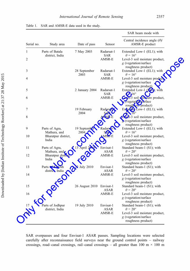
Radarsat-1 is a C-band (5.3 GHz) SAR sensor with HH polarization. All five scenes ofRadarsat-1 SAR were acquired at a lower incidence angle (beam mode: extended low-1,incidence angle: 10–23°). The nominal spatial resolution of the extended low-beam modedata of Radarsat-1 SAR is 35 m. Details of the Radarsat-1 SAR beam mode characteristicsare given in RSI (2000). The Envisat-1 is a C-band (5.3 GHz) SAR sensor with single/dual polarization capability. Four scenes of Envisat-1 ASAR were acquired at a lowerincidence angle (beam mode: standard beam mode-1, incidence angle: 19–23°). Thenominal spatial resolution of the standard beam mode-1 S1 of Envisat-1 ASAR is30 m. Details of the Envisat-1 SAR beam mode characteristics are available at http://envisat.esa.int/dataproducts. AMSR-E was launched in May 2002 on NASA’s Aquasatellite. The AMSR-E instrument characteristics are given in http://nsidc.org/data.These provide an observation of several geophysical parameters in regard to hydrology,ecology, and climate (Kawanishi et al. 2003). Details of SAR data acquisition and AMSR-E level-3 soil moisture data, and the vegetation/roughness parameter, g, downloaded fromhttp://nsidc.org/data, are given in Table 1. Geographic positioning system (GPS) and 1:50000 scale Survey of India (SOI) topographic maps were used to locate the ground truthsites on the ground as well as on Radarsat-1 SAR images.
For the first study area, Batala, data acquisition was in both summer and winter. InMay 2003 the fields were mostly dry fallow with varying surface roughness. In September2003, the major crop cover was that of mature paddy fields under high soil moisture andan equal number of fallow fields under varying surface roughness. From January toFebruary 2004 the Batala area was dominated by wheat crops, with a small proportionof fallow fields. Data were collected during the months of September 2004 and April 2010for the Agra, Mathura and Bharatpur site. In September 2004, the major agricultural covercomprised pearl millet, sorghum, and fodder crops, while some fields were being preparedfor winter crops and hence had bare soil conditions. During April 2010 most fields on thisstudy site consisted of mature wheat crops or fallow fields. At the third site (Kutchh) theEnvisat-1 ASAR and AMSR-E data were acquired during July and August 2010, whensome of the area was covered with pearl millet and sorghum crops while the rest wasbarren. Data for Jodhpur district were acquired in July 2010, when most of the area wasunder barren conditions with very few fields having pearl millet or sorghum crop cover. Aground truth survey was conducted for all four sites in synchrony with five Radarsat-1
2356 P. Patel and H.S. Srivastava
Dow
nloa
ded
by [
Indi
an I
nstit
ute
of T
echn
olog
y R
oork
ee]
at 2
1:37
28
May
201
5
Not for
commerc
ial us
e
Only fo
r pers
onal
readin
g and
refer
ence
purpo
se
SAR overpasses and four Envisat-1 ASAR passes. Sampling locations were selectedcarefully after reconnaissance field surveys near the ground control points – railwaycrossings, road–canal crossings, rail–canal crossings – all greater than 100 m × 100 m
Table 1. SAR and AMSR-E data used in the study.
Serial no. Study area Date of pass Sensor
SAR beam mode with
Central incidence angle (θ)/AMSR-E product
1 Parts of Bataladistrict, India
7 May 2003 Radarsat-1SAR
Extended Low-1 (EL1); withθ = 16°
2 AMSR-E Level-3 soil moisture product,g (vegetation/surfaceroughness product)
3 28 September2003
Radarsat-1SAR
Extended Low-1 (EL1); withθ = 16°
4 AMSR-E Level-3 soil moisture product,g (vegetation/surfaceroughness product)
5 2 January 2004 Radarsat-1SAR
Extended Low-1 (EL1); withθ = 16°
6 AMSR-E Level-3 soil moisture product,g (vegetation/surfaceroughness product)
7 19 February2004
Radarsat-1SAR
Extended Low-1 (EL1); withθ = 16°
8 AMSR-E Level-3 soil moisture product,g (vegetation/surfaceroughness product)
9 Parts of Agra,Mathura, andBharatpur district,India
19 September2004
Radarsat-1SAR
Extended Low-1 (EL1); withθ = 16°
10 AMSR-E Level-3 soil moisture product,g (vegetation/surfaceroughness product)
11 Parts of Agra,Mathura, andBharatpur district,India
13 April 2010 Envisat-1ASAR
Standard beam-1 (S1); withθ = 20°
12 AMSR-E Level-3 soil moisture product,g (vegetation/surfaceroughness product)
13 Parts of Kutchhdistrict, India
22 July 2010 Envisat-1ASAR
Standard beam-1 (S1); withθ = 20°
14 AMSR-E Level-3 soil moisture product,g (vegetation/surfaceroughness product)
15 26 August 2010 Envisat-1ASAR
Standard beam-1 (S1); withθ = 20°
16 AMSR-E Level-3 soil moisture product,g (vegetation/surfaceroughness product)
17 Parts of Jodhpurdistrict, India
19 July 2010 Envisat-1ASAR
Standard beam-1 (S1); withθ = 20°
18 AMSR-E Level-3 soil moisture product,g (vegetation/surfaceroughness product)
International Journal of Remote Sensing 2357
Dow
nloa
ded
by [
Indi
an I
nstit
ute
of T
echn
olog
y R
oork
ee]
at 2
1:37
28
May
201
5
Not for
commerc
ial us
e
Only fo
r pers
onal
readin
g and
refer
ence
purpo
se

according to the statistical considerations as suggested by Patel and Srivastava(2013b). While selecting the sampling locations, we selected only those fields thatdid not have within-field variation in terms of soil moisture, crop cover, and surfaceroughness. Soil samples from 257 sampling fields were collected synchronously withthe five Radarsat-1 SAR overpasses, whereas soil samples from 110 sampling fieldswere collected synchronously with the four Envisat-1 ASAR overpasses. Five sampleswere collected from each of the sampling fields and of these, four were taken from thefour corners (approximately 20 m within the field boundary) and the fifth was takenfrom the centre of the sampling fields. Soil samples were collected using a coresampler at a depth of 0–5 cm. All the soil samples were oven-dried for 24 h at105°C. With the use of fresh and dry weights, gravimetric soil moisture for allsamples was calculated and converted to volumetric soil moisture by multiplying bythe respective bulk densities (Srivastava, Patel, and Navalgund 2006b). Surface rough-ness has also been recorded for all sampling fields and was measured using a griddedplate; a digital photograph of the plate was then taken after projecting the soil surfaceonto it. The soil profile was then digitized to obtain surface roughness measurements(Srivastava, Patel, Navalgund, et al. 2008, 2009a).
3. Methodology
The overall approach was to measure field-level soil moisture using in situ observation bymeans of ground surveys in synchronization with SAR data acquisition, followed by SARdata analysis to obtain the spatial distribution of soil moisture from the field-level soilmoisture measurements. In the next step, the soil moisture thus obtained was upscaled to25 km × 25 km by applying the mask of forest/habitation/water. These 25 km × 25 kmgrid soil moisture values were compared to the AMSR-E level-3 product to understand theissues involved in the validation of a passive microwave sensor-derived product having aspatial grid size of the order of 25 km × 25 km.
3.1. SAR data preprocessing
Extended low-beam mode Radarsat-1 SAR digital number (DN) images and Envisat-1ASAR DN images were converted to SAR backscatter followed by speckle suppressionusing the Enhanced Lee-filtering algorithm with a kernel size of 3 × 3 pixels (Lee1986). Radarsat-1 images acquired on 7 May 2003 over parts of Batala, India, and on19 September 2004 over parts of Bharatpur, Rajasthan, and Envisat-1 ASAR imagesacquired on 22 July 2010 over parts of Kutchh district and on 19 July 2010 over partsof Jodhpur district were geo-referenced using ground control points (GCPs) from the1:50,000 scale survey of India (SOI) topographic maps and GPS measurements. Theremaining three images of the Radarsat-1 extended low-beam mode data for the Batalasite were then co-registered to the geo-referenced image of 7 May 2003 using thenearest-neighbourhood method of resampling (Duggin and Robinove 1990). The SARbackscatter from each of the sampling fields was extracted for further analysis.
3.2. Retrieving spatial soil moisture information using SAR
Radar backscatter is a function of radar configuration (frequency, polarization, andincidence angle), dielectric constant, and roughness parameters. Many experimentalstudies carried out under controlled conditions suggested that for the C-band, an incidence
2358 P. Patel and H.S. Srivastava
Dow
nloa
ded
by [
Indi
an I
nstit
ute
of T
echn
olog
y R
oork
ee]
at 2
1:37
28
May
201
5
Not for
commerc
ial us
e
Only fo
r pers
onal
readin
g and
refer
ence
purpo
se
angle of 7–17° minimizes the influence of these parameters (Ulaby and Batlivala 1976;Ulaby, Batlivala, and Dobson 1978; Ulaby, Bradley, and Dobson 1979). The same hasbeen confirmed by a number of researchers (Patel et al. 2001; Beaudoin, Le Toan, andGwyn 1990; Dobson and Ulaby 1981; Srivastava, patel, Prasad, et al. 2008). Palosciaet al. (2008) also reported that the sensitivity of Envisat-1 ASAR data acquired at 23° tosoil moisture is greater than that of data acquired at 35°. Thus, if SAR data are acquired inthe low-incidence angle range of SAR backscatter, they are sensitive to the moisturecontent of the soil. SAR backscatter acquired in the low-incidence angle range is knownto be relatively less affected by crops due to the reduced path that the microwaves musttravel within the crop, as well as the surface roughness in the case of bare soil (Patel,Srivastava, and Navalgund 2006; Patel et al. 2000b; Srivastava et al. 2009b, 2011). Soilmoisture can be estimated using linear regression analysis between low-incidence angleSAR backscatter averaged over the sampling field and corresponding soil moisture.
3.3. AMSR-E level-3 soil moisture and vegetation/roughness product
Soil moisture data, as well as the vegetation/surface roughness parameter, g, were down-loaded from the website http://nsidc.org/data. The AMSR-E soil moisture level-3 productretrieval algorithm uses polarization ratios (PRs), which are sometimes called normalizedpolarization differences (i.e. the differences between the vertical and horizontal brightnesstemperatures at a given frequency, divided by their sum), of the AMSR-E channelbrightness temperatures at the X-band (10.27 GHz) (Njoku et al. [1996] 2003). Njokuet al. ([1996] 2003) pointed out that C-band brightness temperatures are prone tocontamination by the communication channels, hence the operational soil moisture pro-duct is derived using X-band polarization ratios. Soil moisture and g retrieval wereupdated daily (Njoku 2003). Corresponding to the area of the SAR sub-image, Level-3daily AMSR-E soil moisture and g at the 25 km grid were downloaded from the websitehttp://nsidc.org/data for all nine dates covering the four study areas, as shown in Table 1.Hence in all 68 grids of AMSR-E-derived soil moisture and vegetation/surface roughnessparameter, g, data were available for further analysis.
3.4. Deriving modified AMSR-E soil moisture
Bias between the AMSR-E soil moisture product and soil moisture, which is obtainedusing the average of SAR-derived spatial soil moisture at 25 km grid SAR, can be studied.In case of any deviation between the two, the bias can be studied for any linkage with g ofAMSR-E. An attempt can be made to modify AMSR-E-derived soil moisture using g ofAMSR-E.
4. Results and discussion
Soil moisture derived from Radarsat-1 SAR and Envisat-1 ASAR was upscaled to25 km × 25 km at which the AMSR-E soil moisture product is available, as describedin Section 3.2. The upscaled SAR-derived soil moisture is first compared to AMSR-E-derived soil moisture, followed by investigation of the differences between the two.Exploration of possible causes due to which such differences might arise provided aninsight into deriving improved soil moisture from AMSR-E. The following subsectionsdescribe these differences, their potential causes, and improvement in soil moisture inregard to AMSR-E.
International Journal of Remote Sensing 2359
Dow
nloa
ded
by [
Indi
an I
nstit
ute
of T
echn
olog
y R
oork
ee]
at 2
1:37
28
May
201
5
Not for
commerc
ial us
e
Only fo
r pers
onal
readin
g and
refer
ence
purpo
se
4.1. Retrieving spatial soil moisture information using SAR
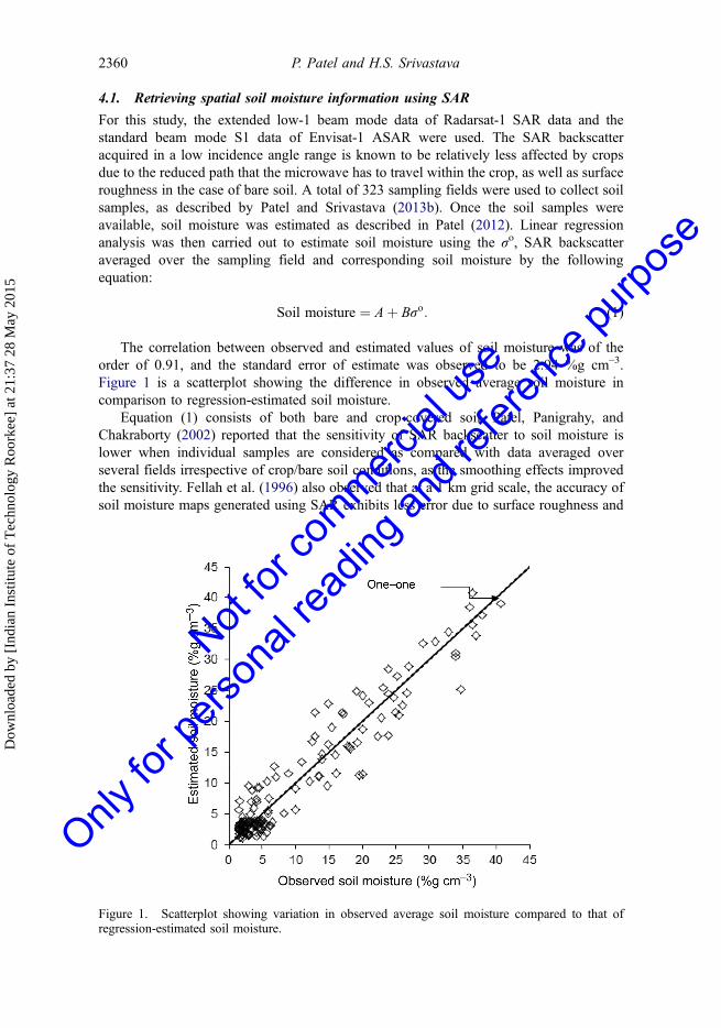
For this study, the extended low-1 beam mode data of Radarsat-1 SAR data and thestandard beam mode S1 data of Envisat-1 ASAR were used. The SAR backscatteracquired in a low incidence angle range is known to be relatively less affected by cropsdue to the reduced path that the microwave has to travel within the crop, as well as surfaceroughness in the case of bare soil. A total of 323 sampling fields were used to collect soilsamples, as described by Patel and Srivastava (2013b). Once the soil samples wereavailable, soil moisture was estimated as described in Patel (2012). Linear regressionanalysis was then carried out to estimate soil moisture using the σo, SAR backscatteraveraged over the sampling field and corresponding soil moisture by the followingequation:
Soil moisture ¼ Aþ Bσo: (1)
The correlation between observed and estimated values of soil moisture was of theorder of 0.91, and the standard error of estimate was observed to be 2.94 %g cm–3.Figure 1 is a scatterplot showing the difference in observed average soil moisture incomparison to regression-estimated soil moisture.
Equation (1) consists of both bare and crop-covered soil. Patel, Panigrahy, andChakraborty (2002) reported that the sensitivity of SAR backscatter to soil moisture islower when individual samples are considered as compared with data averaged overseveral fields irrespective of crop/bare soil conditions, as the smoothing effects improvedthe sensitivity. Fellah et al. (1996) also observed that at a 1 km grid scale, the accuracy ofsoil moisture maps generated using SAR exhibits less error due to surface roughness and
Figure 1. Scatterplot showing variation in observed average soil moisture compared to that ofregression-estimated soil moisture.
2360 P. Patel and H.S. Srivastava
Dow
nloa
ded
by [
Indi
an I
nstit
ute
of T
echn
olog
y R
oork
ee]
at 2
1:37
28
May
201
5
Not for
commerc
ial us
e
Only fo
r pers
onal
readin
g and
refer
ence
purpo
se
crop cover. In the present study, the same approach was followed by averaging the SARimages to a pixel size of 100 m. The field level soil moisture values were upscaled to aspatial distribution of soil moisture information with the help of the empirical model givenby Equation (1) for all nine SAR images by applying masks of forest, human settlement,and water classes. The averaged SAR backscatter at each pixel (of 100 m) position wassubjected to Equation (1) (i.e. the backscatter was multiplied by the coefficient B followedby addition of the coefficient A). This converted the SAR backscatter image to a soilmoisture image at 100 m pixel spacing. In this manner, using SAR backscatter as aninterface, upscaling to spatial soil moisture information at 100 m pixel spacing wasachieved from the point soil moisture measurements in the field.
In the next step, the soil moisture values were upscaled to 25 km × 25 km byaveraging, which yields a near true value of soil moisture status. To arrive at 25 km × 25 km,the SAR-derived soil moisture map at 100 m pixel spacing was subdivided into grids of25 km × 25 km. This was followed by averaging 250 × 250 soil moisture pixels at 100 mspatial resolution in each of these grids in order to obtain the soil moisture at the25 km × 25 km grid. However, for each grid, pixels under forest/habitation and waterwere masked (i.e. estimated soil moisture for those masked pixels was not considered foraggregating the soil moisture to 25 km × 25 km). This led to a total of average soilmoisture values for 68 grid cells corresponding to the nine SAR scenes.
Out of these 68 grid cells, each of size 25 km × 25 km, pair data from nine dates, datacorresponding to 51 grid cells pair (from six dates) were used for the development of theapproach, and data corresponding 17 grid cell pairs (from three dates) were used forvalidating the approach. The periods chosen for validating the methodology were Mayand September 2003 over Batala and July 2010 over Kutchh. May is a summer month,with most of the area under dry bare soil conditions. July and September are monsoon(rainy) months, which is towards the end of a rainy season and hence considerableresidual moisture is expected during these months. These three months were thus selectedfor validating the methodology covering the two extreme conditions of soil moisture.
It should be noted that the soil moisture derived from Equation (1) using a regressionestimator was first subjected to averaging over 250 × 250 values to obtain an equivalentvalue corresponding to the AMSR-E grid of 25 km × 25 km. Besides, for the case ofsimple random sampling to arrive at the average, mean of regression estimator is anunbiased estimator of population mean with a variance of the order of 1/Nth of thevariance of the estimator of the population mean. For the experiment considered in thearticle, N = 250 × 250 = 62,500, making 1/N negligible, i.e. very low variance for theregression estimator. Hence when soil moisture values obtained using Equation (1) usingthe regression estimator are averaged over the 25 km × 25 km area, they are very close tothe near true average soil moisture value for that 25 km × 25 km grid.
4.2. Comparison of SAR- and AMSR-E-derived soil moisture
A set of SAR and AMSR-E-derived soil moisture values were prepared on a 25 km grid,yielding a total of 68 pairs of 25 km × 25 km grids. A grid-wise comparison between thetwo soil moisture values for 51 grids corresponding to the model development data setwas carried out. Figure 2 shows the grid-wise variation in soil moisture derived usingSAR and AMSR-E. It will be observed that both SAR- and AMSR-E-derived soilmoisture values follow a similar pattern. However, the absolute values differ significantly(Figure 3). Similar observations can be made by studying the data reported by Sahoo et al.(2006) showing a temporal variation in AMSR-E-derived soil moisture with the ground
International Journal of Remote Sensing 2361
Dow
nloa
ded
by [
Indi
an I
nstit
ute
of T
echn
olog
y R
oork
ee]
at 2
1:37
28
May
201
5
Not for
commerc
ial us
e
Only fo
r pers
onal
readin
g and
refer
ence
purpo
se

observations made during soil moisture experiments (SMEX) conducted for validation ofAMSR-E; SMEX02 in 2002, SMEX03 in 2003 and SMEX04 in 2004 (over sites in Iowa,Georgia, and Arizona, USA). The comparisons made by Sahoo et al. (2006) reveal thatwhile the pattern of temporal variation of AMSR-E-derived soil moisture is similar to thatof the ground observation, there is a difference in the absolute values of the former.
So
il m
ois
ture
(%
g c
m–3
)SAR-derived soil moisture
25
20
15
10
5
0
AMSR-E soil moistureJa
nuar
y 20
04 B
tala
11
Janu
ary
2004
Bta
la 1
2Ja
nuar
y 20
04 B
tala
21
Janu
ary
2004
Bta
la 2
2Fe
brua
ry 2
004
Bta
la 1
1Fe
brua
ry 2
004
Bta
la 1
2Fe
brua
ry 2
004
Bta
la 2
1Fe
brua
ry 2
004
Bta
la 2
2
Sep
tem
ber
2004
Bpu
r 11
Sep
tem
ber
2004
Bpu
r 12
Sep
tem
ber
2004
Bpu
r 21
Sep
tem
ber
2004
Bpu
r 22
Apr
il 20
10 B
pur
11A
pril
2010
Bpu
r 12
Apr
il 20
10 B
pur
13A
pril
2010
Bpu
r 14
Apr
il 20
10 B
pur
21A
pril
2010
Bpu
r 22
Apr
il 20
10 B
pur
23A
pril
2010
Bpu
r 24
Apr
il 20
10 B
pur
31A
pril
2010
Bpu
r 32
Apr
il 20
10 B
pur
33A
pril
2010
Bpu
r 34
July
201
0 Jp
ur 1
1Ju
ly 2
010
Jpur
12
July
201
0 Jp
ur 1
3Ju
ly 2
010
Jpur
21
July
201
0 Jp
ur 2
2Ju
ly 2
010
Jpur
23
July
201
0 Jp
ur 3
1Ju
ly 2
010
Jpur
32
July
201
0 Jp
ur 3
3A
ugus
t 201
0 K
tch
11A
ugus
t 201
0 K
tch
12A
ugus
t 201
0 K
tch
13A
ugus
t 201
0 K
tch
14A
ugus
t 201
0 K
tch
15A
ugus
t 201
0 K
tch
16A
ugus
t 201
0 K
tch
21A
ugus
t 201
0 K
tch
22A
ugus
t 201
0 K
tch
23A
ugus
t 201
0 K
tch
24A
ugus
t 201
0 K
tch
25A
ugus
t 201
0 K
tch
26A
ugus
t 201
0 K
tch
31A
ugus
t 201
0 K
tch
32A
ugus
t 201
0 K
tch
33A
ugus
t 201
0 K
tch
34A
ugus
t 201
0 K
tch
35A
ugus
t 201
0 K
tch
36
Figure 2. Spatial variation of SAR-derived soil moisture and AMSR-E-derived soil moisture forthe model development set (11, 12, … refers to grid cells of 25 km × 25 km).
00
5
10
15
20
AM
SR
-E s
oil
mo
istu
re (
%g
cm
–3)
25 One–one line
5 10
SAR-derived soil moisture (%g cm–3)
RMSE = 4.2 (%g cm–3)
15 20 25
Figure 3. SAR-derived soil moisture versus AMSR-E-derived soil moisture (model developmentset).
2362 P. Patel and H.S. Srivastava
Dow
nloa
ded
by [
Indi
an I
nstit
ute
of T
echn
olog
y R
oork
ee]
at 2
1:37
28
May
201
5
Not for
commerc
ial us
e
Only fo
r pers
onal
readin
g and
refer
ence
purpo
se
The scatterplot between SAR- and AMSR-E-derived soil moisture values, given inFigure 3, was studied. It indicated that there was very little consistency between theabsolute values of SAR- and AMSR-E-derived soil moisture. In spite of the strikingsimilarity in the grid-wise soil moisture variation pattern (Figure 2), the poor correlationbetween SAR- and AMSR-E-derived soil moisture values was compelling. The impact ofsurface roughness and vegetation was investigated. Njoku and Chan (2006) reported thatthe vegetation/roughness parameter, g, available as a data product from AMSR-E, ade-quately represents the surface roughness/vegetation water content prevailing during thedata acquisition. This parameter is of particular interest as it could lead to insights into thepossible deviation of AMSR-E-derived and SAR-derived soil moisture values. Hence, theAMSR-E-derived vegetation/roughness parameter, g, was also downloaded from theNational Aeronautics and Space Administration (NASA) site http://nsidc.org/data. Oncethe vegetation/roughness parameter, g, for each of the grids corresponding to the nineSAR images was extracted, the grid-wise variation of the AMSR-E- and SAR-derived soilmoisture was once again plotted along with the vegetation/roughness parameter, g, foreach of the grid for the six dates (Figure 4). A study of Figure 4 shows that there is adefinite relationship between the vegetation/roughness parameter, g, and the bias, inAMSR-E-derived soil moisture as compared to that of SAR-derived soil moisture. Thebias can be written as
Bias ¼ μ SAR-derived soil moistureð Þ � μ AMSR-E-derived soil moistureð Þ; (2)
where µ represents the mean value.Crow et al. (2005) and O’Neill et al. (2004) reported the dependence of soil
moisture bias on vegetation water content (VWC). O’Neill et al. (2004) also reportedthat soil moisture retrieval bias at 36 km increased linearly with vegetation watercontent, with the bias reaching 3 %g cm–3 for a VWC to be around 2.5 kg m–2
when a multi-pol algorithm, which is adopted for AMSR-E soil moisture retrieval, wasused. Using a copula-based probability distribution, Gao et al. (2007) evaluated theusefulness of satellite data for assimilation on a seasonal basis. They also reported thedependence of retrieval errors on vegetation and seasonal variations in soil moistureprofile and dynamics. Gao et al. (2007) used a conditional copula simulation togenerate soil moisture differences conditioned on satellite-retrieved soil moisture,leading to modelled soil moisture. In the present article, the study of Figure 4 leadsto an interesting observation that in general, when the vegetation/roughness parameter,g, is more than around 2.5, AMSR-E-derived soil moisture underestimates the soilmoisture, and when the vegetation/roughness parameter, g, is less than around 2.5, theAMSR-E overestimates the soil moisture. This interesting observation gives an insightinto the dependence of the bias in soil moisture as estimated by AMSR-E. The AMSR-E soil moisture retrieval algorithm can lead to the functional form by which this biascould be related to the vegetation/surface roughness parameter.
The AMSR-E soil moisture retrieval is based on simplified radiative transfer theory.Soil moisture is derived using the 10.7 GHz polarization ratio (Njoku 2003). The bright-ness temperature polarization ratio is given as
ζ ¼ Tbv � Tbhð Þ= Tbv þ Tbhð Þ; (3)
where Tbv and Tbh are the brightness temperatures observed at vertical and horizontalpolarization, respectively. This ratio is insensitive to surface temperature, and to first order
International Journal of Remote Sensing 2363
Dow
nloa
ded
by [
Indi
an I
nstit
ute
of T
echn
olog
y R
oork
ee]
at 2
1:37
28
May
201
5
Not for
commerc
ial us
e
Only fo
r pers
onal
readin
g and
refer
ence
purpo
se

has separable dependencies on soil moisture and surface roughness/vegetation watercontent. A simplified form of the polarization ratio that is used for AMSR-E soil moistureretrieval is given by (Njoku 2003):
ζ mv; gð Þ ¼ A mvð Þ 1� 2Qð Þe�βαg; (4)
where mv is the volumetric soil moisture, Q is a fixed roughness calibration parameterfor AMSR-E, β is the best-fit coefficient, g is a parameter representing the combinedeffect of surface roughness and vegetation, and α is a frequency-dependent parameter.This exponential dependence of the vegetation/roughness parameter, g, on the polar-ization ratio, used for AMSR-E soil moisture retrieval, can be exploited to develop anempirical model. The empirical model relating the bias to the vegetation/roughnessparameter, g, was established using regression analysis as given by
Bias ¼ Aþ B� eg: (5)
The coefficients A and B were derived using regression analysis for estimating biasfrom the model development data set of 51 grid cells of 25 km × 25 km each:
Estimated bias ¼ �7:4376 þ 0:5023� eg: (6)
The correlation between the observed and estimated values of bias was 0.75, and thestandard error of estimate was observed to be 2.11.
4.3. Deriving modified AMSR-E soil moisture
In order to arrive at the modified soil moisture on a 25 km grid, estimated bias wasobtained by applying the empirical model given by (6) to the VWC product value, g, ofthe 51 grids of 25 km × 25 km. Next, modified AMSR-E soil moisture values were
SAR-derived soil moisture25 4.0
3.5
3.0
2.5
2.0
1.5
1.0
0.5
0.0
20
15
10
5
0
Janu
ary
2004
Bta
la 1
1
Janu
ary
2004
Bta
la 1
2
Janu
ary
2004
Bta
la 2
1
Janu
ary
2004
Bta
la 2
2
Febr
uary
200
4 B
tala
11
Febr
uary
200
4 B
tala
12
Febr
uary
200
4 B
tala
21
Febr
uary
200
4 B
tala
22
Sep
tem
ber 2
004
Bpu
r 11
Sep
tem
ber 2
004
Bpu
r 12
Sep
tem
ber 2
004
Bpu
r 21
Sep
tem
ber 2
004
Bpu
r 22
Apr
il 20
10 B
pur 1
1A
pril
2010
Bpu
r 12
Aug
ust 2
010
Ktc
h 11
Aug
ust 2
010
Ktc
h 15
Aug
ust 2
010
Ktc
h 24
Aug
ust 2
010
Ktc
h 26
Aug
ust 2
010
Ktc
h 31
Aug
ust 2
010
Ktc
h 32
Aug
ust 2
010
Ktc
h 33
Aug
ust 2
010
Ktc
h 34
Aug
ust 2
010
Ktc
h 35
Aug
ust 2
010
Ktc
h 36
Aug
ust 2
010
Ktc
h 25
Aug
ust 2
010
Ktc
h 23
Aug
ust 2
010
Ktc
h 22
Aug
ust 2
010
Ktc
h 21
Aug
ust 2
010
Ktc
h 16
Aug
ust 2
010
Ktc
h 14
Aug
ust 2
010
Ktc
h 13
Aug
ust 2
010
Ktc
h 12
July
201
0 Jp
ur 3
3
July
201
0 Jp
ur 3
2
July
201
0 Jp
ur 3
1
July
201
0 Jp
ur 2
3
July
201
0 Jp
ur 2
2
July
201
0 Jp
ur 2
1
July
201
0 Jp
ur 1
3
July
201
0 Jp
ur 1
2
July
201
0 Jp
ur 1
1
Apr
il 20
10 B
pur 3
4
Apr
il 20
10 B
pur 3
3
Apr
il 20
10 B
pur 3
2
Apr
il 20
10 B
pur 3
1
Apr
il 20
10 B
pur 2
4
Apr
il 20
10 B
pur 2
3
Apr
il 20
10 B
pur 2
2
Apr
il 20
10 B
pur 2
1
Apr
il 20
10 B
pur 1
4
Apr
il 20
10 B
pur 1
3
So
il m
ois
ture
(%
g c
m–3
)
g (
kg m
–2)
AMSR-E soil moisture AMSR-E g
Figure 4. Spatial variation of SAR-derived soil moisture, AMSR-E-derived soil moisture, andAMSR-E-derived vegetation/roughness parameter, g (model development set).
2364 P. Patel and H.S. Srivastava
Dow
nloa
ded
by [
Indi
an I
nstit
ute
of T
echn
olog
y R
oork
ee]
at 2
1:37
28
May
201
5
Not for
commerc
ial us
e
Only fo
r pers
onal
readin
g and
refer
ence
purpo
se
obtained by adding the estimated bias obtained using Equation (6) to the AMSR-Ederived soil moisture:
Modified AMSR-E soil moisture ¼ AMSR-E soil moistureð Þ� 7:4376þ 0:5023� eg:
(7)
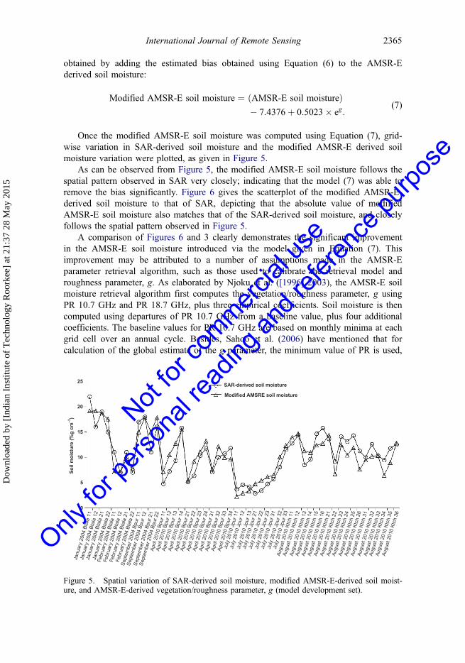
Once the modified AMSR-E soil moisture was computed using Equation (7), grid-wise variation in SAR-derived soil moisture and the modified AMSR-E derived soilmoisture variation were plotted, as given in Figure 5.
As can be observed from Figure 5, the modified AMSR-E soil moisture follows thespatial pattern observed in SAR very closely; indicating that the model (7) was able toremove the bias significantly. Figure 6 gives the scatterplot of the modified AMSR-E-derived soil moisture to that of SAR, depicting that the absolute value of modifiedAMSR-E soil moisture also matches that of the SAR-derived soil moisture, and closelyfollows the spatial pattern observed in Figure 5.
A comparison of Figures 6 and 3 clearly demonstrates the significant improvementin the AMSR-E soil moisture introduced via the model given in Equation (7). Thisimprovement may be attributed to a number of assumptions made in the AMSR-Eparameter retrieval algorithm, such as those used to calibrate the retrieval model androughness parameter, g. As elaborated by Njoku et al. ([1996] 2003), the AMSR-E soilmoisture retrieval algorithm first computes the vegetation/roughness parameter, g usingPR 10.7 GHz and PR 18.7 GHz, plus three empirical coefficients. Soil moisture is thencomputed using departures of PR 10.7 GHz from a baseline value, plus four additionalcoefficients. The baseline values for PR 10.7 GHz are based on monthly minima at eachgrid cell over an annual cycle. Besides, Sahoo et al. (2006) have mentioned that forcalculation of the global estimate of the g parameter, the minimum value of PR is used,
SAR-derived soil moisture25
20
15
10
5
0
Janu
ary
2004
Bta
la 1
1
Janu
ary
2004
Bta
la 1
2
Janu
ary
2004
Bta
la 2
1
Janu
ary
2004
Bta
la 2
2
Febr
uary
200
4 B
tala
11
Febr
uary
200
4 B
tala
12
Febr
uary
200
4 B
tala
21
Febr
uary
200
4 B
tala
22
Sep
tem
ber 2
004
Bpu
r 11
Sep
tem
ber 2
004
Bpu
r 12
Sep
tem
ber 2
004
Bpu
r 21
Sep
tem
ber 2
004
Bpu
r 22
Apr
il 20
10 B
pur 1
1A
pril
2010
Bpu
r 12
Aug
ust 2
010
Ktc
h 11
Aug
ust 2
010
Ktc
h 15
Aug
ust 2
010
Ktc
h 24
Aug
ust 2
010
Ktc
h 26
Aug
ust 2
010
Ktc
h 31
Aug
ust 2
010
Ktc
h 32
Aug
ust 2
010
Ktc
h 33
Aug
ust 2
010
Ktc
h 34
Aug
ust 2
010
Ktc
h 35
Aug
ust 2
010
Ktc
h 36
Aug
ust 2
010
Ktc
h 25
Aug
ust 2
010
Ktc
h 23
Aug
ust 2
010
Ktc
h 22
Aug
ust 2
010
Ktc
h 21
Aug
ust 2
010
Ktc
h 16
Aug
ust 2
010
Ktc
h 14
Aug
ust 2
010
Ktc
h 13
Aug
ust 2
010
Ktc
h 12
July
201
0 Jp
ur 3
3
July
201
0 Jp
ur 3
2
July
201
0 Jp
ur 3
1
July
201
0 Jp
ur 2
3
July
201
0 Jp
ur 2
2
July
201
0 Jp
ur 2
1
July
201
0 Jp
ur 1
3
July
201
0 Jp
ur 1
2
July
201
0 Jp
ur 1
1
Apr
il 20
10 B
pur 3
4
Apr
il 20
10 B
pur 3
3
Apr
il 20
10 B
pur 3
2
Apr
il 20
10 B
pur 3
1
Apr
il 20
10 B
pur 2
4
Apr
il 20
10 B
pur 2
3
Apr
il 20
10 B
pur 2
2
Apr
il 20
10 B
pur 2
1
Apr
il 20
10 B
pur 1
4
Apr
il 20
10 B
pur 1
3
So
il m
ois
ture
(%
g c
m–3
)
Modified AMSRE soil moisture
Figure 5. Spatial variation of SAR-derived soil moisture, modified AMSR-E-derived soil moist-ure, and AMSR-E-derived vegetation/roughness parameter, g (model development set).
International Journal of Remote Sensing 2365
Dow
nloa
ded
by [
Indi
an I
nstit
ute
of T
echn
olog
y R
oork
ee]
at 2
1:37
28
May
201
5
Not for
commerc
ial us
e
Only fo
r pers
onal
readin
g and
refer
ence
purpo
se

which leads to a residue annual minimum soil moisture in the vegetation/surfaceroughness parameter.
4.4. Comparison of SAR and modified AMSR-E soil moisture for the validation set
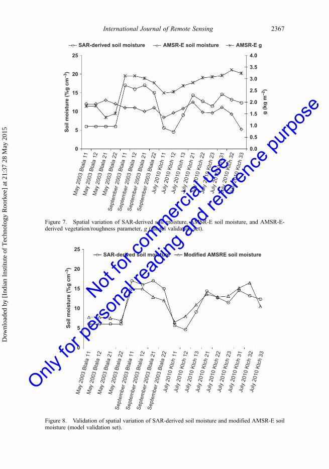
Once the empirical model used to determine the modified AMSR-E soil moisture isestablished, the validation data set consisting of 17 grids from the three dates kept asidefor validating the methodology is analysed. The variation between the SAR-derived andAMSR-E-derived soil moisture for the validation set, given in Figure 7, indicates thatwhile the AMSR-E-derived soil moisture is overestimated for the Batala site for May2003, when the soil is devoid of vegetation and is dry due to the hot summer season, it isunderestimated for September 2003 for this site and for July 2010 for the Kutchh site,when there are moist soil conditions due to the monsoon season. This gives an impressionthat there is no impact of varying soil moisture on AMSR-E data. Zhan et al. (2006) havealso reported similar observations that AMSR-E soil moisture retrievals are generally toowet for dry surfaces and too dry for wet surfaces. In Figure 7, when the bias for both themonths is studied in light of the AMSR-E vegetation/roughness parameter, g, one canclearly see the dependence of bias on the vegetation/roughness parameter, g, similar towhat was observed for the model development data set.
An empirical model given by (7) is then applied to determine modified soil moisturevalues at 25 km grid for the 17 validation grids. The grid-wise variation in SAR and themodified AMSR-E-derived soil moisture variation were plotted as shown in Figure 8 forthe validation set. As can be observed from Figure 8, the modified AMSR-E soil moisturefollows the spatial pattern observed in SAR very closely, indicating that the empiricalmodel given in (6) was able to remove the bias significantly, even for this validation set,
25 One–one line
20
Mo
dif
ied
AM
SR
-E s
oil
mo
istu
re (
%g
cm
–3)
15
10
5
00 5 10 15 20 25
SAR-derived soil moisture (%g cm–3)
RMSE = 2.09 (%g cm–3)
Figure 6. SAR-derived soil moisture versus modified AMSR-E-derived soil moisture (modeldevelopment set).
2366 P. Patel and H.S. Srivastava
Dow
nloa
ded
by [
Indi
an I
nstit
ute
of T
echn
olog
y R
oork
ee]
at 2
1:37
28
May
201
5
Not for
commerc
ial us
e
Only fo
r pers
onal
readin
g and
refer
ence
purpo
se
25 4.0
SAR-derived soil moisture AMSR-E soil moisture AMSR-E g
3.5
3.0
2.5
2.0
1.5
1.0
0.5
0.0
g (
kg m
–2)
20
15
10
5
0
So
il m
ois
ture
(%
g c
m–3
)
May
200
3 B
tala
11
May
200
3 B
tala
12
May
200
3 B
tala
21
May
200
3 B
tala
22
Sep
tem
ber
2003
Bta
la 1
1S
epte
mbe
r 20
03 B
tala
12
Sep
tem
ber
2003
Bta
la 2
1S
epte
mbe
r 20
03 B
tala
22
July
201
0 K
tch
11Ju
ly 2
010
Ktc
h 12
July
201
0 K
tch
13Ju
ly 2
010
Ktc
h 21
July
201
0 K
tch
22Ju
ly 2
010
Ktc
h 23
July
201
0 K
tch
31Ju
ly 2
010
Ktc
h 32
July
201
0 K
tch
33
Figure 7. Spatial variation of SAR-derived soil moisture, AMSR-E soil moisture, and AMSR-E-derived vegetation/roughness parameter, g (model validation set).
25SAR-derived soil moisture Modified AMSRE soil moisture
20
15
10
5
0
May
200
3 B
tala
11
May
200
3 B
tala
12
May
200
3 B
tala
21
May
200
3 B
tala
22
Sep
tem
ber
2003
Bta
la 1
1S
epte
mbe
r 20
03 B
tala
12
Sep
tem
ber
2003
Bta
la 2
1S
epte
mbe
r 20
03 B
tala
22
July
201
0 K
tch
11Ju
ly 2
010
Ktc
h 12
July
201
0 K
tch
13Ju
ly 2
010
Ktc
h 21
July
201
0 K
tch
22Ju
ly 2
010
Ktc
h 23
July
201
0 K
tch
31Ju
ly 2
010
Ktc
h 32
July
201
0 K
tch
33
So
il m
ois
ture
(%
g c
m–3
)
Figure 8. Validation of spatial variation of SAR-derived soil moisture and modified AMSR-E soilmoisture (model validation set).
International Journal of Remote Sensing 2367
Dow
nloa
ded
by [
Indi
an I
nstit
ute
of T
echn
olog
y R
oork
ee]
at 2
1:37
28
May
201
5
Not for
commerc
ial us
e
Only fo
r pers
onal
readin
g and
refer
ence
purpo
se
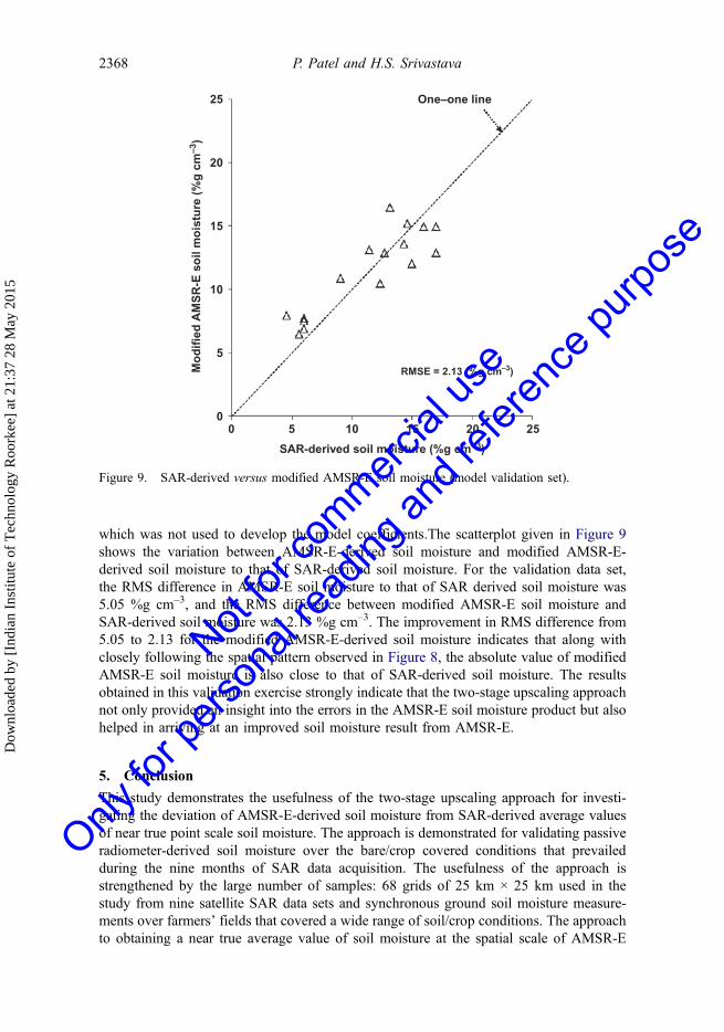
which was not used to develop the model coefficients.The scatterplot given in Figure 9shows the variation between AMSR-E-derived soil moisture and modified AMSR-E-derived soil moisture to that of SAR-derived soil moisture. For the validation data set,the RMS difference in AMSR-E soil moisture to that of SAR derived soil moisture was5.05 %g cm–3, and the RMS difference between modified AMSR-E soil moisture andSAR-derived soil moisture was 2.13 %g cm–3. The improvement in RMS difference from5.05 to 2.13 for the modified AMSR-E-derived soil moisture indicates that along withclosely following the spatial pattern observed in Figure 8, the absolute value of modifiedAMSR-E soil moisture is also close to that of SAR-derived soil moisture. The resultsobtained in this validation exercise strongly indicate that the two-stage upscaling approachnot only provided an insight into the errors in the AMSR-E soil moisture product but alsohelped in arriving at an improved soil moisture result from AMSR-E.
5. Conclusion
This study demonstrates the usefulness of the two-stage upscaling approach for investi-gating the deviation of AMSR-E-derived soil moisture from SAR-derived average valuesof near true point scale soil moisture. The approach is demonstrated for validating passiveradiometer-derived soil moisture over the bare/crop covered conditions that prevailedduring the nine months of SAR data acquisition. The usefulness of the approach isstrengthened by the large number of samples: 68 grids of 25 km × 25 km used in thestudy from nine satellite SAR data sets and synchronous ground soil moisture measure-ments over farmers’ fields that covered a wide range of soil/crop conditions. The approachto obtaining a near true average value of soil moisture at the spatial scale of AMSR-E
25
20
Mo
dif
ied
AM
SR
-E s
oil
mo
istu
re (
%g
cm
–3)
15
10
5
00 5 10 15 20 25
SAR-derived soil moisture (%g cm–3)
RMSE = 2.13 (%g cm–3)
One–one line
Figure 9. SAR-derived versus modified AMSR-E soil moisture (model validation set).
2368 P. Patel and H.S. Srivastava
Dow
nloa
ded
by [
Indi
an I
nstit
ute
of T
echn
olog
y R
oork
ee]
at 2
1:37
28
May
201
5
Not for
commerc
ial us
e
Only fo
r pers
onal
readin
g and
refer
ence
purpo
se
from the field-level soil moisture by using SAR as an interface has been demonstrated byusing extended low-beam mode Radarsat-1 SAR and the S1 beam mode of Envisat ASARdata. The study of variation in AMSR-E and SAR-derived near true average value of soilmoisture at 25 km grid led to an interesting observation on the dependence of the bias inAMSR-E-derived soil moisture on the vegetation/roughness parameter, g, which is avail-able as an AMSR-E geophysical parameter. An empirical model to modify the AMSR-E-derived soil moisture by exploiting the exponential dependence of the bias on thevegetation/roughness parameter, g, was developed and validated using a validation setof 17 grid cells 25 km × 25 km, which was not used for developing the modelcoefficients. The validation data set contained two extreme weather conditions: that ofthe summer month, May, which had dry soil conditions, and rainy season months,September and July, with moist soil conditions. While the AMSR-E soil moisture productdid not vary in accordance with the moisture conditions of the soil, the averaged SAR-derived soil moisture and the modified AMSR-E-derived soil moisture proposed in thisarticle varied in accordance with the dry soil conditions of the summer month and the wetsoil conditions of the rainy months. This encouraging result demonstrates the usefulnessof the approach of using SAR as an interface to validate the soil moisture product of thespace-borne passive sensor.
AcknowledgementsThe authors are extremely grateful to Shri A. S Kiran Kumar, Chairman, ISRO and Shri TapanMisra, Director, Space Applications Centre for their encouragement. They wish to express sinceregratitude to Dr Y.V.N. Krishnamurthy, Scientific Secretary, ISRO and Dr A. Senthil Kumar,Director, Indian Institute of Remote Sensing, for their keen interest and support. They thankfullyacknowledge Dr B.S. Gohil, Group Director, ADVG, for his guidance and support. Envisat-1 ASARdata were provided by the European Space Agency under the framework of SMOS-A.O. project3284. They also wish to acknowledge anonymous reviewers and the editors for improving thequality of this article.
Disclosure statementNo potential conflict of interest was reported by the authors.
ReferencesAl Bitar, A., D. Leroux, Y. H. Kerr, O. Merlin, P. Richaume, A. Sahoo, and E. F. Wood. 2012.
“Evaluation of SMOS Soil Moisture Products over Continental U.S. Using the SCAN/SNOTELNetwork.” IEEE Transactions on Geoscience and Remote Sensing 50: 1572–1586. doi:10.1109/TGRS.2012.2186581.
Alvarez-Mozos, J., J. Casali, M. Gonzalez-Audicana, and N. E. C. Verhoest. 2006. “Assessment ofthe Operational Applicability of RADARSAT-1 Data for Surface Soil Moisture Estimation.”IEEE Transactions on Geoscience and Remote Sensing 44: 913–924. doi:10.1109/TGRS.2005.862248.
Baghdadi, N., R. Cresson, E. Pottier, M. Aubert, M. Zribi, A. Jacome, and S. Benabdallah. 2012. “APotential Use for the C-Band Polarimetric SAR Parameters to Characterize the Soil Surface overBare Agriculture Fields.” IEEE Transactions on Geoscience and Remote Sensing 50 (10):3844–3858.
Baghdadi, N., M. Zribi, C. Loumagne, P. Ansart, and T. P. Anguela. 2008. “Analysis of Terrasar-XData and Their Sensitivity to Soil Surface Parameters over Bare Agricultural Fields.” RemoteSensing of Environment 112: 4370–4379. doi:10.1016/j.rse.2008.08.004.
International Journal of Remote Sensing 2369
Dow
nloa
ded
by [
Indi
an I
nstit
ute
of T
echn
olog
y R
oork
ee]
at 2
1:37
28
May
201
5
Not for
commerc
ial us
e
Only fo
r pers
onal
readin
g and
refer
ence
purpo
se
Beaudoin, A., T. Le Toan, and Q. H. Gwyn. 1990. “SAR Observations and Modeling of the C-BandBackscatter Variability Due to Multiscale Geometry and Soil Moisture.” IEEE Transactions onGeoscience and Remote Sensing 28: 886–895. doi:10.1109/36.58978.
Cosh, M. H., T. J. Jackson, S. Moran, and R. Bindlish. 2008. “Temporal Persistence and Stability ofSurface Soil Moisture in a Semi-Arid Watershed.” Remote Sensing of Environment 112:304–313. doi:10.1016/j.rse.2007.07.001.
Cosh, M. H., T. J. Jacksona, P. Starksb, and G. Heathmanc. 2006. “Temporal Stability of SurfaceSoil Moisture in the Little Washita River Watershed and Its Applications in Satellite SoilMoisture Product Validation.” Journal of Hydrology 323: 168–177. doi:10.1016/j.jhydrol.2005.08.020.
Crow, W. T., S. T. K. Chan, D. Entekhabi, P. R. Houser, A. Y. Hsu, T. J. Jackson, E. G. Njoku, P. E.O’Neill, J. Shi, and X. Zhan. 2005. “An Observing System Simulation Experiment for HydrosRadiometer-Only Soil Moisture Products.” IEEE Transactions on Geoscience and RemoteSensing 43: 1289–1303. doi:10.1109/TGRS.2005.845645.
Dall’amico, J. T., F. Schlenz, A. Loew, and W. Mauser. 2012. “First Results of SMOS Soil MoistureValidation in the Upper Danube Catchment.” IEEE Transactions on Geoscience and RemoteSensing 50: 1507–1516. doi:10.1109/TGRS.2011.2171496.
Dobson, M. C., and F. T. Ulaby. 1981. “Microwave Backscatter Dependence on Surface Roughness,Soil Moisture, and Soil Texture: Part III-Soil Tension.” IEEE Transactions on Geoscience andRemote Sensing GE-19: 51–61. doi:10.1109/TGRS.1981.350328.
Duggin, M. J., and C. J. Robinove. 1990. “Assumptions Implicit in Remote Sensing DataAcquisition and Analysis.” International Journal of Remote Sensing 11: 1669–1694.doi:10.1080/01431169008955124.
Dunne, S. C., D. Entekhabi, and E. G. Njoku. 2007. “Impact of Multiresolution Active and PassiveMicrowave Measurements on Soil Moisture Estimation Using the Ensemble Kalman Smoother.”IEEE Transactions on Geoscience and Remote Sensing 45: 1016–1028. doi:10.1109/TGRS.2006.890561.
Famiglietti, J. S., D. Ryu, A. A. Berg, M. Rodell, and T. J. Jackson. 2008. “Reply to Comment by H.Vereecken et al. on ‘Field Observations of Soil Moisture Variability across Scales’.” WaterResources Research 44: W01423. doi:10.1029/2008WR007323.
Fellah, K., Y. Besnus, S. Clandillon, C. Meyer, N. Tholey, and P. De Fraipont. 1996. “Multi-Temporal ERS SAR Data in Hydrological and Agro-Environmental Applications – Case Study:The Alsace Plain.” In Proceedings of Second ERS Applications Workshop, edited by T.-D.Guyenne, December 6–8, 1995. London: European Space Agency, ESA-SP-383.
Gao, H. E., F. Wood, M. Drusch, and F. McCabe. 2007. “Copula-Derived Observation Operators forAssimilating TMI and AMSR-E Retrieved Soil Moisture into Land Surface Models Using aMicrowave Emission Model to Estimate Soil Moisture from ESTAR Observations duringSGP99.” Journal of Hydrometeorology 8: 413–429. doi:10.1175/JHM570.1.
Gherboudj, I., R. Magagi, K. Goita, A. A. Berg, B. Toth, and A. Walker. 2012. “Validation of SMOSData over Agricultural and Boreal Forest Areas in Canada.” IEEE Transactions on Geoscienceand Remote Sensing 50: 1623–1635. doi:10.1109/TGRS.2012.2188532.
Holah, N., N. Baghdadi, M. Zribi, A. Bruand, and C. King. 2005. “Potential of ASAR/ENVISAT forthe Characterization of Soil Surface Parameters over Bare Agricultural Fields.” Remote Sensingof Environment 96: 78–86. doi:10.1016/j.rse.2005.01.008.
Jackson, T. J., R. Bindlish, M. H. Cosh, T. Zhao, P. J. Starks, D. D. Bosch, M. Seyfried, M. S.Moran, D. C. Goodrich, Y. H. Kerr, and D. Leroux. 2012. “Validation of Soil Moisture andOcean Salinity (SMOS) Soil Moisture over Watershed Networks in the U.S.” IEEETransactions on Geoscience and Remote Sensing 50: 1530–1543. doi:10.1109/TGRS.2011.2168533.
Jackson, T. J., A. J. Gasiewski, A. Oldak, M. Klein, E. G. Njoku, A. Yevgrafov, S. Christiani, and R.Bindlish. 2002. “Soil Moisture Retrieval Using the C-Band Polarimetric Scanning Radiometerduring the Southern Great Plains 1999 Experiment.” IEEE Transactions on Geoscience andRemote Sensing 40: 2151–2161. doi:10.1109/TGRS.2002.802480.
Jackson, T. J., D. M. Le Vine, A. J. Griffis, D. C. Goodrich, T. J. Schmugge, C. T. Swift, and P. E.O’Neill. 1993. “Soil Moisture and Rainfall Estimation over a Semiarid Environment with theESTAR Microwave Radiometer.” IEEE Transactions on Geoscience and Remote Sensing 31:836–841. doi:10.1109/36.239906.
2370 P. Patel and H.S. Srivastava
Dow
nloa
ded
by [
Indi
an I
nstit
ute
of T
echn
olog
y R
oork
ee]
at 2
1:37
28
May
201
5
Not for
commerc
ial us
e
Only fo
r pers
onal
readin
g and
refer
ence
purpo
se

Jackson, T. J., and T. J. Schmugge. 1989. “Passive Microwave Remote Sensing System for SoilMoisture: Some Supporting Research.” IEEE Transactions on Geoscience and Remote Sensing27: 225–235. doi:10.1109/36.20301.
Jagdhuber, T., I. Hajnsek, A. Bronstert, and K. P. Papathanassion. 2013. “Soil Moisture EstimationUnder Low Vegetation Cover Using a Multi-Angular Polarimetric Decomposition.” IEEETransactions on Geoscience and Remote Sensing 51 (4): 2201–2215.
Kawanishi, T., T. Sezai, Y. Ito, K. Imaoka, T. Takeshima, Y. Ishido, A. Shibata, M. Miura, H.Inahata, and R. W. Spencer. 2003. “The Advanced Microwave Scanning Radiometer for theEarth Observing System (AMSR-E), Nasda’s Contribution to the EOS for Global Energy andWater Cycle Studies.” IEEE Transactions on Geoscience and Remote Sensing 41: 184–194.doi:10.1109/TGRS.2002.808331.
Kerr, Y. H. 2007. “Soil Moisture from Space: Where Are We?” Hydrogeology Journal 15: 117–120.doi:10.1007/s10040-006-0095-3.
Kerr, Y. H., P. Waldteufel, P. Richaume, J. P. Wigneron, P. Ferrazzoli, A. Mahmoodi, A. Al Bitar, F.Cabot, C. Gruhier, S. E. Juglea, D. Leroux, A. Mialon, and S. Delwart. 2012. “The SMOS SoilMoisture Retrieval Algorithm.” IEEE Transactions on Geoscience and Remote Sensing 50:1384–1403. doi:10.1109/TGRS.2012.2184548.
Kerr, Y. H., P. Waldteufel, J.-P. Wigneron, J. Martinuzzi, J. Font, and M. Berger. 2001. “SoilMoisture Retrieval from Space: The Soil Moisture and Ocean Salinity (SMOS) Mission.” IEEETransactions on Geoscience and Remote Sensing 39: 1729–1735. doi:10.1109/36.942551.
Lacava, T., P. Matgen, L. Brocca, M. Bittelli, N. Pergola, T. Moramarco, and V. Tramutoli. 2012. “AFirst Assessment of the SMOS Soil Moisture Product with In Situ and Modeled Data in Italyand Luxembourg.” IEEE Transactions on Geoscience and Remote Sensing 50: 1612–1622.doi:10.1109/TGRS.2012.2186819.
Lee, J. S. 1986. “Speckle Suppression and Analysis for Synthetic Aperture Radar Images.” OpticalEngineering 25: 636–643.
Loew, A., and W. Mauser. 2008. “On the Disaggregation of Passive Microwave Soil Moisture DataUsing a Priori Knowledge of Temporally Persistent Soil Moisture Fields.” IEEE Transactionson Geoscience and Remote Sensing 46: 819–834. doi:10.1109/TGRS.2007.914800.
Mattia, F., G. Satalino, L. Dente, and G. Pasquariello. 2006. “Using a Priori Information to ImproveSoil Moisture Retrieval from ENVISAT ASAR AP Data in Semiarid Regions.” IEEETransactions on Geoscience and Remote Sensing 44: 900–912. doi:10.1109/TGRS.2005.863483.
Merlin, O., C. Rudiger, Al, A. Bitar, P. Richaume, J. P. Walker, and Y. H. Kerr. 2012.“Disaggregation of SMOS Soil Moisture in Southeastern Australia.” IEEE Transactions onGeoscience and Remote Sensing 50: 1556–1571. doi:10.1109/TGRS.2011.2175000.
Miralles, D. G., W. T. Crow, and M. H. Cosh. 2010. “Estimating Spatial Sampling Errors in Coarse-Scale Soil Moisture Estimates Derived from Point-Scale Observations.” Journal ofHydrometeorology 11 (6): 1423–1429. doi:10.1175/2010JHM1285.1.
Njoku, E. G. 2003. Updated Daily, Amsr-E/Aqua L2B Surface Soil Moisture, Ancillary Parms, &QC Ease-Grids, May 2003 to September 2004. Boulder, CO: USA at National Snow and IceData Center. Digital media.
Njoku, E. G., and T. K. Chan. 2006. “Vegetation and Surface Roughness Effects on AMSR-E LandObservations.” Remote Sensing of Environment 100: 190–199. doi:10.1016/j.rse.2005.10.017.
Njoku, E. G., T. J. Jackson, V. Lakshmi, T. Chan, and S. V. Nghiem. [1996] 2003. “Soil MoistureRetrieval from AMSR-E.” IEEE Transactions on Geoscience and Remote Sensing 41 :215–229. doi:10.1109/TGRS.2002.808243
O’Neill, P., E. Njoku, T. Chan, W. Crow, A. Hsu, and J. C. Shi. 2004. “Comparison of SoilMoisture Retrieval Algorithms Using Simulated HYDROS Brightness Temperatures.”Proceedings of International Geoscience and Remote Sensing Symposium, IGARSS 2004,Anchorage, AK, September 20–24, 339.
Paloscia, S., G. Macelloni, and E. Santi. 2006. “Soil Moisture Estimates from AMSR-E BrightnessTemperatures by Using a Dual-Frequency Algorithm.” IEEE Transactions on Geoscience andRemote Sensing 44: 3135–3144. doi:10.1109/TGRS.2006.881714.
Paloscia, S., G. Macelloni, E. Santi, and T. Koike. 2001. “A Multifrequency Algorithm for theRetrieval of Soil Moisture on a Large Scale using Microwave Data from SMMR and SSM/ISatellites.” IEEE Transactions on Geoscience and Remote Sensing 39: 1655–1661. doi:10.1109/36.942543.
International Journal of Remote Sensing 2371
Dow
nloa
ded
by [
Indi
an I
nstit
ute
of T
echn
olog
y R
oork
ee]
at 2
1:37
28
May
201
5
Not for
commerc
ial us
e
Only fo
r pers
onal
readin
g and
refer
ence
purpo
se

Paloscia, S., and P. Pampaloni. 1988. “Microwave Polarization Index for Monitoring VegetationGrowth.” IEEE Transactions on Geoscience and Remote Sensing 26: 617–621. doi:10.1109/36.7687.
Paloscia, S., P. Pampaloni, S. Pettinato, and E. Santi. 2008. “A Comparison of Algorithms forRetrieving Soil Moisture from ENVISAT/ASAR Images.” IEEE Transactions on Geoscienceand Remote Sensing 46: 3274–3284. doi:10.1109/TGRS.2008.920370.
Paloscia, S., and E. Santi. 2003. “A Semi-Empirical Algorithm for Estimating Soil Moisture fromDual-Frequency Microwave AMSR Data.” Proceedings of International Geoscience andRemote Sensing Symposium, (IGARSS 2003), Toulouse, July 21–25, vol. I, 677–679.
Patel, P. 2012. “Target Parameter Retrieval Using SAR Polarimetry.” PhD thesis, Nirma University,Ahmedabad, 93–99. Available online at The Shodhganga@INFLIBNET PhD Thesis openaccess centre. http://shodhganga.inflibnet.ac.in/handle/10603/17867
Patel, P., S. Mohan, S. Sharma, A. K. Sutrodhar, B. K. Khawas, and D. K. Das. 2001. “Evaluation ofMulti-Incidence Angle RADARSAT SAR Data for Soil Moisture Estimation.” In PhysicalMethods of Soil Characterization, edited by J. Behari, 133–140. New Delhi: NarosaPublishing House.
Patel, P., S. Panigrahy, and M. Chakraborty. 2002. “Performance of RADARSAT-1 Extended LowBeam Mode SAR Data for Soil Moisture Retrieval.” Asian Journal of Geoinformatics 2: 85–91.
Patel, P., and H. S. Srivastava. 2013a. RADARSAT-2 Announcement of Opportunity Project on SoilMoisture, Surface Roughness and Vegetation Parameters Retrieval Using SAR Polarimetry, 1–81, SAC/EPSA/MPSG/CVD/TDP R&D/01/13, SOAR International Closing and Reporting –2013. Final Report Submitted to Canadian Space Agency(CSA) through MDA, Canada, IndianSpace Research Organisation (ISRO), India, January. http://www.openthesis.org/documents/Radarsat-2-announcement-opportunity-project-601570.html
Patel, P., and H. S. Srivastava. 2013b. “Ground Truth Planning for Synthetic Aperture Radar (SAR):Addressing Various Challenges Using Statistical Approach.” International Journal ofAdvancement in Remote Sensing, GIS and Geography 1 (2): 1–17. http://www.irosss.org/ojs/index.php/IJARSGG/article/view/162
Patel, P., H. S. Srivastava, and R. R. Navalgund. 2006a. “Estimating Wheat Yield: An Approach forEstimating Number of Grains Using Cross-Polarised ENVISAT-1 ASAR Data.” Proceedings of5th International Symposium on Asia-Pacific Remote Sensing – 2006, edited by T. Misra, Goa,November 13–17, 6410, Paper Number: 641009, 01-12. Organised by International Society foroptical Engineering (SPIE), SPIE Digital Library. http://spie.org/Publications/Proceedings/Paper/10.1117/12.693930
Patel, P., H. S. Srivastava, S. Panigrahy, and J. S. Parihar. 2006b. “Comparative Evaluation of theSensitivity of Multi-Polarized Multi-Frequency SAR Backscatter to Plant Density.”International Journal of Remote Sensing 27 (2): 293–305. doi:10.1080/01431160500214050.
Robock, A., K. Y. Vinnikov, G. Srinivasan, J. K. Entin, S. E. Hollinger, N. A. Speranskaya, S. Liu,and A. Namkhai. 2000. “The Global Soil Moisture Data Bank.” Bulletin of the AmericanMeteorological Society 81: 1281–1299. doi:10.1175/1520-0477(2000)081<1281:TGSMDB>2.3.CO;2.
Rowlandson, T. L., B. K. Hornbuckle, L. M. Bramer, J. C. Patton, and S. D. Logsdon. 2012.“Comparisons of Evening and Morning SMOS Passes over the Midwest United States.” IEEETransactions on Geoscience and Remote Sensing 50: 1544–1555. doi:10.1109/TGRS.2011.2178158.
RSI. 2000. “RADARSAT Illuminated.” In Your Guide to Products and Services. Rich Mound:RADARSAT International, Client Services. http://www.geoweb.dnv.org/Education/ whitepa-pers/Radarsat.pdf
Sahoo, A. K., X. Zhan, K. Arsenault, and M. Kafatos. 2006. “Cross-Validation of Soil MoistureData From AMSR-E Using Field Observations and NASA’s Land Data Assimilation SystemSimulations.” https://ams.confex.com/ams/Annual2006/techprogram/paper_102114.htm
Sanchez, N., J. Martinez-Fernandez, A. Scaini, and C. Perez-Gutierrez. 2012. “Validation of theSMOS L2 Soil Moisture Data in the REMEDHUS Network (Spain).” IEEE Transactions onGeoscience and Remote Sensing 50: 1602–1611. doi:10.1109/TGRS.2012.2186971.
Schwank, M., J. P. Wigneron, E. Lopez-Baeza, I. Volksch, C. Matzler, and Y. H. Kerr. 2012.“L-Band Radiative Properties of Vine Vegetation at the MELBEX III SMOS Cal/Val Site.”IEEE Transactions on Geoscience and Remote Sensing 50: 1587–1601. doi:10.1109/TGRS.2012.2184126.
2372 P. Patel and H.S. Srivastava
Dow
nloa
ded
by [
Indi
an I
nstit
ute
of T
echn
olog
y R
oork
ee]
at 2
1:37
28
May
201
5
Not for
commerc
ial us
e
Only fo
r pers
onal
readin
g and
refer
ence
purpo
se
Srivastava, H. S., P. Patel, M. L. Manchanda, and S. Adiga. 2002. “An Attempt to Incorporate theEffect of Crop Cover in Soil Moisture Estimation Using Multi-Incidence Angle RADARSAT-1SAR Data.” Asian Journal of Geoinformatics (SAR Special Issue: SAR Applications in TropicalEnvironment) 2 (1): 33–40. http://www.academia.edu/11596321/An_attempt_to_incorporate_the_effect_of_crop_cover_in_soil_moisture_estimation_using_multi-incidence_angle_RADARSAT-1_SAR_data
Srivastava, H. S., P. Patel, M. L. Manchanda, and S. Adiga. 2003. “Use of Multi-Incidence AngleRADARSAT-1 SAR Data to Incorporate the Effect of Surface Roughness in Soil MoistureEstimation.” IEEE Transactions on Geoscience and Remote Sensing 41 (7): 1638–1640.doi:10.1109/TGRS.2003.813356.
Srivastava, H. S., P. Patel, and R. R. Navalgund. 2006a. “How Far SAR Has Fulfilled ItsExpectation for Soil Moisture Retrieval?” Proceedings of 5th International Symposium onAsia-Pacific Remote Sensing – 2006, Goa, November 13–17, 6410, Paper Number: 641001,01-12. Organised by International society for optical Engineering (SPIE), SPIE Digital Library.http://proceedings.spiedigitallibrary.org/proceeding.aspx?articleid=1295327
Srivastava, H. S., P. Patel, and R. R. Navalgund. 2006b. “Incorporating Soil Texture in SoilMoisture Estimation from Extended Low-1 Beam Mode RADARSAT-1 SAR Data.”International Journal of Remote Sensing 27 (12): 2587–2598. doi:10.1080/01431160500497838.
Srivastava, H. S., P. Patel, R. R. Navalgund, and Y. Sharma. 2008. “Retrieval of Surface RoughnessUsing Multi-Polarized ENVISAT-1 ASAR Data.” Geocarto International 23 (1): 67–77.doi:10.1080/10106040701538157.
Srivastava, H. S., P. Patel, S. N. Prasad, Y. Sharma, B. A. Khan, B. Praveen, K. C. A. Prasad, S.Sharma, L. Vijayan, and V. S. Vijayan. 2008. “Potential Applications of Multi-ParametricSynthetic Aperture Radar (Sar) Data in Wetland Inventory: A Case Study of KeoladeoNational Park (A World Heritage and Ramsar Site).” Proceedings of Taal 2007: The 12thWorld Lake Conference, Bharatpur, 1862–1879. http://www.moef.nic.in/sites/default/files/nlcp/IndianCaseStudies/Q-13.pdf
Srivastava, H. S., P. Patel, K. P. Sharma, Y. V. N. Krishnamurthy, and V. K. Dadhwal. 2011. “ASemi-Empirical Modeling Approach to Calculate Two-Way Attenuation in Radar Backscatterfrom Soil Due to Crop Cover.” Current Science 100 (12): 1871–1874. http://www.curren-tscience.ac.in/Volumes/100/12/1871.pdf
Srivastava, H. S., P. Patel, Y. Sharma, and R. R. Navalgund. 2009a. “Large-Area Soil MoistureEstimation Using Multi-Incidence-Angle RADARSAT-1 SAR Data.” IEEE Transactions onGeoscience and Remote Sensing 47 (8): 2528–2535. doi:10.1109/TGRS.2009.2018448.
Srivastava, H. S., P. Patel, Y. Sharma, and R. R. Navalgund. 2009b. “Multi-Frequency and Multi-Polarized SAR Response to Thin Vegetation and Scattered Trees.” Current Science 97 (03):425–429. http://www.currentscience.ac.in/cs/Downloads/article_id_097_03_0425_0429_0.pdf
Ulaby, F. T., and P. P. Batlivala. 1976. “Optimum Radar Parameters for Mapping Soil Moisture.”IEEE Transactions on Geoscience Electronics 14: 81–89. doi:10.1109/TGE.1976.294414.
Ulaby, F. T., P. P. Batlivala, and M. C. Dobson. 1978. “Microwave Backscatter Dependence onSurface Roughness, Soil Moisture, and Soil Texture: Part I-Bare Soil.” IEEE Transactions onGeoscience Electronics 16: 286–295. doi:10.1109/TGE.1978.294586.
Ulaby, F. T., G. A. Bradley, and M. C. Dobson. 1979. “Microwave Backscatter Dependence onSurface Roughness, Soil Moisture and Soil Texture: Part II Vegetation-Covered Soil.” IEEETransactions on Geoscience Electronics 17: 33–40. doi:10.1109/TGE.1979.294626.
Ulaby, F. T., R. K. Moore, and A. K. Fung. 1982a. Microwave Remote Sensing: Active and Passive.Volume 3: From Theory to Applications. Norwood, MA: Artech House.
Ulaby, F. T., R. K. Moore, and A. K. Fung. 1982b. Microwave Remote Sensing: Active and Passive.Volume 2: Radar Remote Sensing and Surface Scattering and Emission Theory. Norwood, MA:Artech House.
Wagner, W., C. Pathe, M. Doubkova, D. Sabel, A. Bartsch, S. Hasenauer, G. Blöschl, and K. Scipal.2008. “José Martínez-Fernández and Alexander Löw, Temporal Stability of Soil Moisture andRadar Backscatter Observed by the Advanced Synthetic Aperture Radar (ASAR).” Sensors 8:1174–1197. doi:10.3390/s8021174.
Zhan, X., T. Jackson, K. Arsenault, and P. Houser. 2006. “An Investigation of the Differencesbetween AMSR-E Soil Moisture Retrievals, LDAS Model Simulations and SMEX Field
International Journal of Remote Sensing 2373
Dow
nloa
ded
by [
Indi
an I
nstit
ute
of T
echn
olog
y R
oork
ee]
at 2
1:37
28
May
201
5
Not for
commerc
ial us
e
Only fo
r pers
onal
readin
g and
refer
ence
purpo
se

Measurements.” EOS Transactions AGU 87. Jt. Assem. Suppl.: 1–23. http://prhouser.com/houser_files/AGU_AMSRE.pdf
Zribi, M., N. Baghdadi, N. Holah, and O. Fafin. 2005. “New Methodology for Soil Surface MoistureEstimation and Its Application to ENVISAT-ASAR Multi-Incidence Data Inversion.” RemoteSensing of Environment 96: 485–496. doi:10.1016/j.rse.2005.04.005.
2374 P. Patel and H.S. Srivastava
Dow
nloa
ded
by [
Indi
an I
nstit
ute
of T
echn
olog
y R
oork
ee]
at 2
1:37
28
May
201
5
Not for
commerc
ial us
e
Only fo
r pers
onal
readin
g and
refer
ence
purpo
se


![Colombia - Loan 2611 - P006794 - Staff Appraisal Report [SAR]](https://static.fdokumen.com/doc/165x107/6328219a6d480576770d9dea/colombia-loan-2611-p006794-staff-appraisal-report-sar.jpg)