An analysis of small-scale rainfall variability in different climatic regimes
12
Hydrological Sciences–Journal–des Sciences Hydrologiques, 48(2) April 2003 Open for discussion until 1 October 2003 151 An analysis of small-scale rainfall variability in different climatic regimes WITOLD F. KRAJEWSKI, GRZEGORZ J. CIACH IIHR-Hydroscience & Engineering, The University of Iowa, Iowa City, Iowa 52242, USA [email protected] EMAD HABIB Civil and Environmental Engineering, Tennessee Technological University, Cookeville, Tennessee 38505, USA Abstract Statistical characteristics of spatial variability in rain fields at the scales below 5 km 2 are discussed based on experimental data from five locations worldwide. The work is motivated by the practical needs of remote sensing applications using radar and satellite technologies, and by the scientific needs of rainfall modelling. Two types of rain-field characteristics are described: spatial correlations and conditional probabilities of occurrence. The accumulation intervals range from 5 min to 1 h. The analysed data samples were collected in Brazil, Florida, Iowa, Oklahoma, and on Guam. Key words rainfall; small scale; variability; remote sensing Analyse de la variabilité de la pluie a petite échelle dans différents contextes climatiques Résumé Cet article s’intéresse à la variabilité de la pluie à des échelles d’espace inférieures à 5 km 2 , en s’appuyant sur des données expérimentales de différentes régions du monde. La motivation de ce travail est à la fois pratique, en vue de l’utilisation de la télédétection avec les technologies radar et satellitaires, et scientifique, au regard des besoins en modélisation de la pluie. Deux types de descripteurs de la pluie sont utilisés: la corrélation spatiale et la probabilité conditionnelle d’occurrence. Les périodes de cumul utilisées vont de 5 min à 1 h. Les échantillons de données proviennent du Brésil, de Floride, d’Iowa, d’Oklahoma et de l’île de Guam. Mots clefs pluie; petite échelle; variabilité; télédétection INTRODUCTION Extreme spatiotemporal variability causes major difficulties in estimating rainfall whether using in situ instruments or remote sensing methods. In the last two decades, broad availability of modern remote sensing products and vigorous development of new powerful analysis methods have brought a tremendous increase in knowledge of the spatial structure of rainfall at scales between about 1 and 1000 km (e.g. Foufoula- Georgiou & Krajewski, 1995; Lovejoy & Schertzer, 1995). Yet, due to the lack of relevant measurement techniques, knowledge of the rainfall structure at very small scales, those between a few metres and a few kilometres, is still fairly poor. Several past efforts, motivated by the needs of communication system design and cloud seeding research, concerned small-scale rainfall variability (Byers & Braham, 1949; Sims & Jones, 1975; Huff, 1969, 1970; Huff & Shipp, 1969; Freeny & Gabbe, 1969; Zawadzki, 1973; Drufuca & Zawadzki, 1975). To the best of the authors’
-
Upload
independent -
Category
Documents
-
view
3 -
download
0
Transcript of An analysis of small-scale rainfall variability in different climatic regimes

Hydrological Sciences–Journal–des Sciences Hydrologiques, 48(2) April 2003
Open for discussion until 1 October 2003
151
An analysis of small-scale rainfall variability in different climatic regimes WITOLD F. KRAJEWSKI, GRZEGORZ J. CIACH IIHR-Hydroscience & Engineering, The University of Iowa, Iowa City, Iowa 52242, USA [email protected] EMAD HABIB Civil and Environmental Engineering, Tennessee Technological University, Cookeville, Tennessee 38505, USA
Abstract Statistical characteristics of spatial variability in rain fields at the scales below 5 km2 are discussed based on experimental data from five locations worldwide. The work is motivated by the practical needs of remote sensing applications using radar and satellite technologies, and by the scientific needs of rainfall modelling. Two types of rain-field characteristics are described: spatial correlations and conditional probabilities of occurrence. The accumulation intervals range from 5 min to 1 h. The analysed data samples were collected in Brazil, Florida, Iowa, Oklahoma, and on Guam. Key words rainfall; small scale; variability; remote sensing
Analyse de la variabilité de la pluie a petite échelle dans différents contextes climatiques Résumé Cet article s’intéresse à la variabilité de la pluie à des échelles d’espace inférieures à 5 km2, en s’appuyant sur des données expérimentales de différentes régions du monde. La motivation de ce travail est à la fois pratique, en vue de l’utilisation de la télédétection avec les technologies radar et satellitaires, et scientifique, au regard des besoins en modélisation de la pluie. Deux types de descripteurs de la pluie sont utilisés: la corrélation spatiale et la probabilité conditionnelle d’occurrence. Les périodes de cumul utilisées vont de 5 min à 1 h. Les échantillons de données proviennent du Brésil, de Floride, d’Iowa, d’Oklahoma et de l’île de Guam. Mots clefs pluie; petite échelle; variabilité; télédétection
INTRODUCTION Extreme spatiotemporal variability causes major difficulties in estimating rainfall whether using in situ instruments or remote sensing methods. In the last two decades, broad availability of modern remote sensing products and vigorous development of new powerful analysis methods have brought a tremendous increase in knowledge of the spatial structure of rainfall at scales between about 1 and 1000 km (e.g. Foufoula-Georgiou & Krajewski, 1995; Lovejoy & Schertzer, 1995). Yet, due to the lack of relevant measurement techniques, knowledge of the rainfall structure at very small scales, those between a few metres and a few kilometres, is still fairly poor. Several past efforts, motivated by the needs of communication system design and cloud seeding research, concerned small-scale rainfall variability (Byers & Braham, 1949; Sims & Jones, 1975; Huff, 1969, 1970; Huff & Shipp, 1969; Freeny & Gabbe, 1969; Zawadzki, 1973; Drufuca & Zawadzki, 1975). To the best of the authors’
Witold F. Krajewski et al.
152
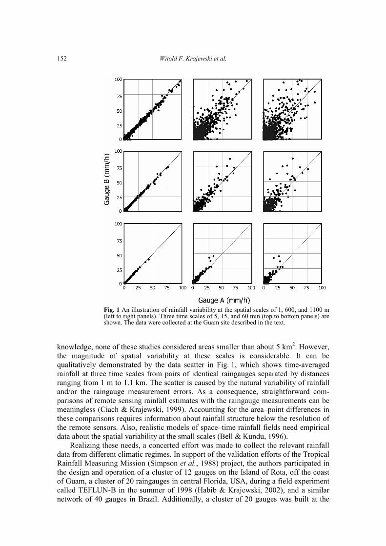
Fig. 1 An illustration of rainfall variability at the spatial scales of 1, 600, and 1100 m (left to right panels). Three time scales of 5, 15, and 60 min (top to bottom panels) are shown. The data were collected at the Guam site described in the text.
knowledge, none of these studies considered areas smaller than about 5 km2. However, the magnitude of spatial variability at these scales is considerable. It can be qualitatively demonstrated by the data scatter in Fig. 1, which shows time-averaged rainfall at three time scales from pairs of identical raingauges separated by distances ranging from 1 m to 1.1 km. The scatter is caused by the natural variability of rainfall and/or the raingauge measurement errors. As a consequence, straightforward com-parisons of remote sensing rainfall estimates with the raingauge measurements can be meaningless (Ciach & Krajewski, 1999). Accounting for the area–point differences in these comparisons requires information about rainfall structure below the resolution of the remote sensors. Also, realistic models of space–time rainfall fields need empirical data about the spatial variability at the small scales (Bell & Kundu, 1996). Realizing these needs, a concerted effort was made to collect the relevant rainfall data from different climatic regimes. In support of the validation efforts of the Tropical Rainfall Measuring Mission (Simpson et al., 1988) project, the authors participated in the design and operation of a cluster of 12 gauges on the Island of Rota, off the coast of Guam, a cluster of 20 raingauges in central Florida, USA, during a field experiment called TEFLUN-B in the summer of 1998 (Habib & Krajewski, 2002), and a similar network of 40 gauges in Brazil. Additionally, a cluster of 20 gauges was built at the

An analysis of small-scale rainfall variability in different climatic regimes
153
Iowa City Municipal Airport in eastern Iowa, USA, and the so-called Piconet of 15 raingauges deployed in the Little Washita basin in Oklahoma, USA. Details of these networks are provided in subsequent sections of the paper. Using the data samples from the five raingauge clusters, estimates of two spatial statistics were obtained: correlation function, and conditional probability of detection. Both statistics are of relevance to remote sensing and rainfall modelling problems. Correlation is a commonly used non-dimensional measure of statistical dependence, whereas the conditional probability of detection conveys information about the rainfall intermittence. The correlation was chosen, rather than the often-used co-variance or semi-variogram, because it is normalized. The non-normalized statistics are strongly affected by the sample-average rainfall intensities that vary between the samples used in this study. The correlations, being less sensitive to this effect, allow focusing on the spatial dependences in small-scale rainfall in different climatic regimes. RAINGAUGE NETWORKS Data were used from five high-density clusters of raingauges that have the same key characteristics. They are all equipped with good quality tipping-bucket raingauges and modern data loggers. In all the gauges the volume of the bucket is equivalent to 0.254 mm (0.01") of rainfall depth. The instruments were carefully calibrated prior to being deployed in the field, and were carefully maintained during the data collection. The basic details about each site are presented below. Iowa: the Iowa City Municipal Airport This site features 10 stations (see Fig. 2(a) for a schematic layout of the cluster), each with two identical tipping-bucket gauges that share a common data logger (but use different channels). The two gauges are separated by about 1 m. This double-sensor design (see Ciach & Krajewski, 1999; Krajewski et al., 1998) allows efficient quality control and fault detection. The data loggers count the bucket tips that occur in 5-s intervals and save the time series of these tip numbers. The rainfall intensities were calculated using the interpolation procedure discussed by Habib et al. (2001a). Because the Iowa site is an airport with three runways (for small aircraft only) and active farming practice on much of the premises, it is limited in terms of possible network configurations. The design includes two equilateral triangles with sides of 10 m and 100 m. The longest distance covered by the network is 1.2 km. This study uses measurements collected between April 1999 and August 2000 (excluding winter months). Florida: the NASA TEFLUN-B experimental site In August and September 1998, NASA conducted a field experiment in central Florida called Texas and Florida Under Flight - B (TEFLUN-B). The main objective of the experiment was to collect data in support of the validation effort of the Tropical Rainfall Measuring Mission (TRMM) (Simpson et al., 1988; Kummerow et al., 2000). As part of the experiment, a high-density network of raingauges called DRGN was

Witold F. Krajewski et al.
154
Fig. 2 Layout of the five raingauge clusters used in this study: (a) Iowa City Municipal Airport, Iowa; (b) Triple N Ranch near Holopaw, Florida; (c) TRMM-LBA in Rondonia, Brazil; (d) Island of Rota near Guam, Western Pacific; and (e) Oklahoma Piconet in the Little Washita basin, Oklahoma.
established (Fig. 2(b)). It was operated by NASA personnel and other participants of the experiment. The network included a triangle of double-gauge stations that covered distances of 10 and 100 m, an equilateral triangle with a 500 m side and two equilateral triangles with approximately 800 m sides. The longest inter-gauge distance covered by the network was 7.8 km. Brazil: the NASA TRMM-LBA experiment site From November 1998 to February 1999, NASA conducted another field experiment, known as TRMM-LBA, in Amazonia, Brazil. One of its many objectives was data collection for ground validation of TRMM rainfall estimates. In addition to two weather radars and other instruments, four clusters of raingauges were established at separate sites in the surroundings of the city of Ji Paraná, Rondonia (Fig. 2(c)). Inter-gauge distances in this region ranged from a few metres to about 130 km. Here, only pairs of gauges, separated by no more than a few kilometres, were used. Guam: NASA TRMM ground validation site Guam is one of the TRMM ground validation sites. It includes a WSR-88D radar providing ground rainfall estimates to evaluate the TRMM-based rainfall products. To

An analysis of small-scale rainfall variability in different climatic regimes
155
properly calibrate the radar algorithms, a cluster of six double-gauge stations was established on the island of Rota, about 70 km northeast of the coast of Guam (Fig. 2(d)). The cluster is located on the grounds of a golf resort and its configuration is forced by the topography and land use of the resort. The covered scales include 10 m and 100 m, and the longest distance is 1.1 km. Measurements collected from May 1998 until June 1999 are used in this study. Oklahoma: the Piconet in Little Washita basin The Oklahoma Piconet was established by the Environmental Verification and Analysis Center of the Oklahoma University, in cooperation with The University of Iowa. It was first deployed in December 1998 at a farmer’s field in a regular network of 3 × 5 gauges with the grid-step of 200 m (Fig. 2(e)). The field was located near Chickasha, Oklahoma, within the Little Washita watershed. The raingauges in the Piconet are the same as those used in the Oklahoma Mesonet (Brock et al., 1995). The small event-counting data loggers record the tip times with an accuracy of 0.5 s. Several improvements, as well as static and dynamic calibrations of each raingauge, were performed with the help of the Oklahoma Climatological Survey. The field deployment of the Piconet was carried out with the help of the US Department of Agriculture Agricultural Research Service. The data used in this study were collected during a period from 29 January to 14 May 1999. DATA QUALITY CONTROL Despite the relatively frequent maintenance visits to the gauges (weekly during the field experiments, and monthly at the permanent sites), there are still many practical problems that can corrupt the quality of the collected rainfall data. Debris can collect in the gauge orifice and clog or slow down the flow from the funnel into the tipping bucket. The covers of the data loggers sometimes crack in the sun heat and condensation can cause short-circuits; the result can be unpredictable, including “false tips” that, if undetected, could be taken for real rainfall. Spiders find their way into the raingauges and their webs can obstruct the tipping mechanism. Fine particles of clay carried by wind can collect in the gauge buckets decreasing their effective volume. Most of these problems cause systematic or occasional underestimation of the measured rainfall, but some can cause overestimation, or even less predictable effects. Detection of such problems in the data stream of a single gauge is either impossible, or difficult and inconclusive. It becomes simple, however, if each station is equipped with more than one raingauge. As an example, Fig. 3 shows the time series of rainfall accumulations collected at one double-gauge platform of the Guam cluster. This figure demonstrates that no errors would have been detected based on the data from one gauge alone (as they are both believable). However, their side-by-side comparison clearly signals technical problems and the need for service. Furthermore, detection of the differences between the two gauges and careful scrutiny of such cases enable efficient identification of questionable data in the collected sample. Since simultaneous failures of both gauges almost never happen, the redundancy of the double-gauge design results in practically gap-free sets of accurate rainfall data.

Witold F. Krajewski et al.
156
Fig. 3 An example of collocated rainfall accumulation measurements recorded by a double-gauge platform in Guam. The two gauges are identical, separated by a distance of about 1 m and connected to the same data logger.
Prior to estimating the rainfall variability statistics, considerable effort was spent scrutinizing the collected archives. All the questionable or missing data points are flagged and are omitted in the subsequent analyses. However, detailed description of the data quality control is beyond the scope of this study. BASIC CHARACTERISTICS OF THE DATA SAMPLES Table 1 presents a few general characteristics of the samples collected at the five different geographic locations. Total accumulations show that all the networks recorded substantial amounts of rainfall during the considered periods of observation. The largest accumulations are at the Guam and Iowa sites that have the longest operational periods. Among the five sites, the rainfall in Florida has the highest level of general variability as quantified by the standard deviations of 5-min rainfall rates. The Oklahoma and Iowa samples indicate the smallest values of the standard deviation. These standard deviations were computed only for the intervals with rain-rate intensities above the threshold of 0.5 mm h-1. Table 1 presents also the fraction of rainy time for each site, defined as the percentage of the 5-min intervals for which the 5-min rain rates exceed 0.5 mm h-1. The Brazil data sample shows the highest fraction Table 1 Basic characteristics of the data samples from the five raingauge clusters. Total rainfall depths are averaged over all the gauges in each network. The means and standard deviations of the rain rates, and the percentages of rainy time are computed at the 5-min time scale. The means and standard deviations are conditioned on the 5-min rain rates greater than 0.5 mm h-1. The same threshold is assumed for the classification of rainy and non-rainy 5-min intervals in the last statistic.
Location Guam Brazil Florida Oklahoma Iowa Sample size (days) 418 93 57 105 515 Total rainfall (mm) 1574 635 317 343 1107 Mean rain rate (mm h-1) 7.8 6.2 8.9 5.4 4.5 Standard dev. (mm h-1) 12.2 12.0 16.1 7.7 9.8 Rainy time fraction (%) 2.6 5.4 2.8 2.4 2.7

An analysis of small-scale rainfall variability in different climatic regimes
157
of rainy periods while all the other sites have much lower values. Regarding these differences, one should keep in mind that, apart from the fact that the sites were located in various climatic regimes, the duration of their operation periods shown in Table 1 are also considerably different. SPATIAL CORRELATIONS First, a quantitative illustration is given of how important it might be to know the behaviour of spatial correlations at small scales. Assume that the correlation function is parameterized by the following model that is also exploited later in this analysis:
00 )-0 e)(
S(d/dd ⋅ρ=ρ (1)
where d is the distance between any two points, d0 is the correlation distance (or decorrelation scale), ρ0 is the local decorrelation caused by random instrumental errors (Ciach, in press), and s0 can be called the shape parameter. Consider a situation where the correlation function of rainfall accumulations at some temporal scale T is known only beyond a certain distance and unknown for smaller distances. Assume, for simplicity, that ρ0 = 1, the correlation is fixed at some normalized distance L, and the correlation function can have different shapes below L. Figure 4(a) depicts this situation for two different values of the shape parameter s0. It is interesting to know what is the impact of such differences on the estimates of the area–point variances, which is a common application of the spatial correlations. The point–area difference variance divided by the point rainfall variance can be called the variance ratio (VR), and can be expressed based on the spatial correlation function (Rodriguez-Iturbe & Mejia, 1974):
� � �ρ+ρ−=A A A
g ddA
dA
VR 21212 ),( 1),( 21 uuuuuuu (2)
Fig. 4 Effect of the shape parameter of the correlation function model (equation (1)) on the variance ratio (VR) of area–point difference and point rainfall: (a) correlation functions with different shape parameter values, (b) VR in function of the shape parameter for two gauge locations within a square pixel.

Witold F. Krajewski et al.
158
where A is the area of a square with side L, u = (x,y) is the position vector and ug = (xg,yg) is the location of a gauge (point) within the square. Consider two possibilities: one with the gauge in the middle of the domain (xg/L = yg/L = 0.5), and the other with the gauge close to a corner of the domain (xg/L = yg/L = 0.1). Figure 4(b) shows the variance ratio, VR, as a function of the shape parameter s0 for these two scenarios. The VR is strongly dependent on the shape of the correlation function below d = L, although the correlation at the distance of L remains unchanged. Thus, without knowing the correlations at the distances smaller than the size of the domain, it is impossible to obtain correct estimates of the area–point error statistics. Figure 5 presents the main results of this study. The two columns of plots in the left and in the middle of Fig. 5 show the correlation functions for the five networks and for three time scales: 5 min, 15 min and 1 h. These two columns correspond to two different estimators of the correlation coefficient. The first is based on the classical Pearson’s formula:
))((),(
2222 YYXX
YXXYYXr−−
−= (3)
which can be found in most textbooks on statistics. The bars in equation (3) indicate averaging over the sample of N synchronized observations given by the data pairs (X,Y). The Pearson’s sample correlation r is a commonly used estimator of the general population correlation ρ(X,Y). However, if the variables are non-normally distributed, the Pearson’s estimator can be highly biased and inefficient (see Habib et al., 2001b, and references therein). This bias can be corrected using the logarithmic trans-formation procedure documented in Habib et al. (2001b). The uncorrected correlation estimates based on equation (3) are shown in the left column of plots in Fig. 5, whereas the bias-corrected results are in the middle column. For clarity, only the fitted functional approximations (equation (1)) to the estimated correlation points are shown. The fitting was done by minimizing the sum of squares of the differences between the inter-gauge correlation estimates and the model (equation (1)). The plots in Fig. 5 show that the small-scale correlation function at small distances depends strongly on the climatic regime. For Guam, Florida and Brazil, the drop-off is quite fast and apparently similar to the exponential model. For Oklahoma and Iowa, the correlograms are nearly flat at distances below 0.5 km. The character of the correlation function near the origin seems also to be affected by the temporal scale. At the shorter accumulation times the rainfall exhibits exponential, or even faster (s0 < 1.0), drop-off of the correlations. Longer accumulations are characterized by a flat region in the correlation function (with s0 > 1.0). However, the level of estimation uncertainties in our data is too high to pursue this time-scale dependence in a more systematic and quantitative way. Another interesting feature in Fig. 5 is the value of the correlation coefficient at near-zero separation distances represented in the model (equation (1)) by the parameter ρ0. The immediate decorrelation, 1 – ρ0, can reflect the microscale variability in the rain fields, or can be due to the random measurement errors of the raingauges (Habib et al., 2001a; Ciach, in press). For time scales of 15 min or larger, the estimated ρ0 attains a level of about 0.95–0.97. These values are much higher than those obtained by Ciach & Krajewski (1999) and applied to estimate the area–point difference

An analysis of small-scale rainfall variability in different climatic regimes
159
Fig. 5 Fitted correlation functions (left and middle panels) and conditional proba-bilities of detection (right panels) for the five analysed sites. The three lines (from bottom to top) in each panel correspond to time scales of 5, 15 min, and 1 h. The two correlation results are for the classical Pearson’s estimator (left panels) and for the logarithmic transformation estimator (middle panels).
variances for the radar rainfall verification. This difference in the obtained ρ0 values confirms the opinion stated in Ciach & Krajewski (1999) that spatial correlation estimates based on five single raingauges separated by 2–5 km cannot be reliable, and that cluster gauge designs can provide much better data. Also, Young et al. (2000) and Anagnostou et al. (1999) point out that determining accurate values of ρ0 is important for reliable evaluation of uncertainty levels of radar rainfall estimates. However, its estimation from the operational raingauge data based on the traditional single-gauge setups is practically impossible. It is evident that the tropical sites Guam, Florida, and Brazil clusters are characterized with the lowest correlation levels. This extreme spatial variability is due

Witold F. Krajewski et al.
160
to the dominance of localized, short-lived, and intensive convective cells. In Iowa and Oklahoma, widespread stratiform and mixed systems prevail and result in higher values of the small-scale spatial correlations. CONDITIONAL PROBABILITIES OF DETECTION Intermittence is an important feature of the rainfall fields. In particular, the existence of both rain and no-rain areas within the same radar pixel causes difficulties in inter-preting accuracy of radar-based estimates. To shed some light on this problem, the probability of concurrent occurrence of rainfall at two points separated by a given distance was examined. The conditional probability of detection (CPD) is defined as the probability of rainfall at one point given that it rains at another point during the same interval. Rainfall occurrence at a given time scale is defined as the average rain rate over an interval exceeding an assumed threshold, R0. This threshold is necessary to reduce the effects of large instrumental errors at small rainfall intensities (Habib et al., 2001a; Ciach, in press). Checking the sensitivity of the CPD estimates to the threshold selection, it was established that there is an instability region for small R0 values, a relative plateau between 0.3 and 0.6 mm h-1, and a systematic change of the statistics for larger R0 values. Consequently, the threshold was set at R0 = 0.5 mm h-1 for all the analyses. Similarly to the spatial correlations, the CPD estimates were obtained at each of the five geographic locations for three time scales of 5 min, 15 min, and 1 h. At a given time scale, the sample CPD values were computed for each pair of raingauges. Next, the functional model (equation (1)) was fitted to the inter-gauge results to obtain estimates of CPD as a function of distance between the observation points. These fits are shown in Fig. 5 (the right column of plots) for the five raingauge clusters. It is clear that the conditional probability of detection is less sensitive to the considered time scale compared to the correlation coefficient; however, the plots show features similar to the overall behaviour of the correlation functions. The Guam cluster demonstrates the highest levels of intermittence followed by Florida and Brazil. Consider, for example, the time scale of 15 min. Given that it rained at a fixed location, the rainfall was observed for no more than 80% of 15-min intervals at another location about 1 km apart. Even for the hourly time scale, the CPD does not exceed 85–90%. Frequent widespread systems in Iowa and Oklahoma resulted in higher values of the computed probabilities compared to the tropical sites. The somewhat inconsistent behaviour of the curves (convergence or divergence with distance) can be a symptom of statistical instability due to relatively small samples. CONCLUSIONS AND DIRECTIONS Simple statistical characteristics of small-scale spatial rainfall variability in five geo-graphic locations are presented. The estimates of the spatial correlation functions indicate that not only the correlation distance, but also the shape of the functions at small distances can be highly dependent on the rainfall regime and temporal scale. This means that the commonly used exponential model is inadequate in many situa-tions. The modified exponential function (equation (1)) that was applied here allows
An analysis of small-scale rainfall variability in different climatic regimes
161
for significantly more flexible adjustment of the correlogram shapes. Another con-clusion from these results is that the immediate spatial decorrelation is much smaller than it was assumed in previous research (Ciach & Krajewski, 1999). This parameter is strongly affected by the instrumental errors and can be much larger, if the estimates are based on less carefully treated raingauges. However, reliable estimation of the imme-diate decorrelation parameter from the single-gauge networks is practically impossible. Despite a fairly comprehensive effort to collect data on small-scale rainfall varia-bility, including several experiments around the world, the results presented here should be interpreted with a degree of caution, mainly because they are based on small samples. The best way to obtain more accurate spatial characteristics of rainfall is through collecting data from high-quality experimental raingauge clusters that could operate for longer periods of time. Long-term commitment to maintain the clusters is even more important, if one wants to condition the analyses on different situations. Stratification of the whole data sample can be done regarding season, time of day, rainfall regime (stratiform vs convective, for example), rainfall intensity, etc. However, any such conditioning reduces the effective sample size, and thus, requires larger databases. The preliminary results presented here demonstrate that rainfall exhibits suffic-iently high variability at the small distances to warrant its more thorough investigation. Large samples of good quality data from different small-scale setups would allow one to approach the analyses in a more detailed manner. For example, a more adequate correlogram model describing all the critical regions in different situations is clearly an unsolved question. Also, extending the mathematical description beyond the correla-tion functions is necessary to extract more quantitative information on the spatial rainfall structure from the raingauge data. The results on the conditional probability of detection (CPD) are promising and can be extended to a more general model of the two-point rainfall distribution. Since the modern multiscaling spatial analysis based on point measurements from 10–40 stations only is impossible, statistical analysis seems to be the best way to obtain useful information from such data. The authors also believe that these results can provide a reality check for the modern spatial rainfall modelling studies. In particular, the numerous multi-scaling analyses, as a rule, are based on indirect and highly inaccurate remote sensing observations and can yield spurious effects (Krajewski et al., 1996; Harris et al., 1997). Finally, this study indicates that new designs of the raingauge networks should be considered. In the process of the data collection and quality control, considerable evidence was encountered that the traditional networks based on single gauges cannot deliver reliable rainfall data. Due to the extreme rainfall variability, most of the problems would not be detected in a single-gauge time series until the complete breakdown of the system. Low reliability of the existing operational raingauge networks hinders the progress in the remote sensing rainfall estimation and validation methodologies (see Steiner et al., 1999, for other examples of the severity of the problem). The authors believe that multiple sensor designs, based on 2–4 identical and independent measurements at each station, are necessary to improve on this situation. Acknowledgements The authors are thankful to the NASA, the US Army Research Office, IIHR-Hydroscience & Engineering of the University of Iowa, and EVAC of the University of Oklahoma for their financial support which included the following

Witold F. Krajewski et al.
162
grants: NASA NAG5-4755, NASA NAG5-9664, Oklahoma NASA EPSCoR NCC 5-171, and ARO DAAG55-97-1-0074. Many people facilitated the data collection campaigns. Special thanks are due to colleagues Anton Kruger, Charles “Chip” Guard, Paul Kucera, Brad Fisher, Radoslaw Goska, Brian Nelson, Mark Morrissey, John Ensworth and the Oklahoma Climatological Survey staff for their contributions to many aspects of this study. REFERENCES Anagnostou, E. N., Krajewski, W. F. & Smith, J. A. (1999) Uncertainty quantification of mean-areal radar-rainfall
estimates. J. Atmos. Ocean. Technol. 16, 206–215. Bell, T. L. & Kundu, P. K., (1996) A study of the sampling error in satellite rainfall estimates using optimal averaging of
data and a stochastic model. J. Climate 9, 1251–1268. Brock, F. V., Crawford, K. C., Elliott, R. L., Cuperus, G. W., Stadler, S. J., Johnson, H. L. & Eilts, M. D. (1995) The
Oklahoma Mesonet: a technical overview. J. Atmos. Ocean. Technol. 12(1), 5–19. Byers, H. R. & Braham, R. R. (1949) The Thunderstorm: Final Report of the Thunderstorm Project. US Govt Printing
Office, Washington, DC, USA. Ciach, G. J. (in press) Local random errors in tipping-bucket rain gauge measurements. J. Atmos. Ocean. Technol. Ciach, G. J. & Krajewski, W. F. (1999) On the estimation of radar rainfall error variance. Adv. Water Resour. 22(6), 585–
595. Drufuca, G. & Zawadzki, I. (1975) Statistics of raingage data. J. Appl. Met. 14(12), 1419–1429. Foufoula-Georgiou, E. & Krajewski, W. F. (1995) Recent advances in rainfall modeling, estimation, and forecasting. In:
Reviews of Geophysics, 1125-1137. US National Report to Int. Union of Geodesy and Geophysics 1991–1994. Freeny, A. E. & Gabbe, J. D. (1969) A statistical description of intense rainfall. The Bell System Tech. J. 1789–1851. Habib, E. & Krajewski, W. F. (2002) Uncertainty analysis of the TRMM ground-validation radar-rainfall products:
application to the TEFLUN-B field campaign. J. Appl. Met. 41(5), 558–572. Habib, E., Krajewski, W. F. & Kruger, A. (2001a) Sampling errors of tipping-bucket rain gauge measurements. J. Hydrol.
Engng 6(2), 159–166. Habib, E., Krajewski, W. F. & Ciach, G. J. (2001b) Estimation of rainfall interstation correlation. J. Hydromet. 2(6),
621–629. Harris, D., Seed, A., Menabde, M. & Austin, G. (1997) Factors affecting multiscaling analysis of rainfall time series.
Nonlinear Process. Geophys. 4, 137–155. Huff, F. A. (1969) Climatological assessment of natural precipitation characteristics for use in weather modification.
J. Appl. Met. 8(6), 401–410. Huff, F. A. (1970) Spatial distribution of rainfall rates. Water Resour. Res. 6(1), 254–259. Huff, F. A. & Shipp, W. L. (1969) Spatial correlations of storm, monthly and seasonal precipitation. J. Appl. Met. 8(8),
542–550. Krajewski, W. F., Anagnostou, E. N. & Ciach, G. J. (1996) Effects of the radar observation process on inferred rainfall
statistics. J. Geophys. Res. 101, 493–502. Krajewski, W. F., Kruger, A. & Nešpor, V. (1998) Experimental and numerical studies of small-scale rainfall
measurements and variability. Water Sci. Technol. 37(11), 131–138. Kummerow, C., Simpson, J., Thiele, O., Barnes, W., Chang, A. T. C., Stocker, E., Adler, R. F., Hou, A., Kakar, R.,
Wentz, F., Ashcroft, P., Kozu, T., Hong, Y., Okamoto, K., Iguchi, T., Kuroiwa, H., Im, E., Haddad, Z., Huffman, G., Ferrier, B., Olson, W. S., Zipser, E., Smith, E. A., Wilheit, T. T., North, G., Krishnamurti, T. & Nakamura, K. (2000) The status of the Tropical Rainfall Measuring Mission (TRMM) after two years in orbit. J. Appl. Met. 39, 1965–1982.
Lovejoy, S., & Schertzer, D. (1995) Multifractals and rain. In: New Uncertainty Concepts in Hydrology and Water Resources (ed. by Z. W. Kundzewicz), 62–103. Cambridge University Press, Cambridge, UK.
Rodriguez-Iturbe, I. & Mejia, J. M. (1974) The design of rainfall networks in time and space. Water Resour. Res. 10, 713–728.
Simpson, J. S., Adler, R. F. & North, G. R. (1988) A proposed Tropical Rainfall Measuring Mission (TRMM) satellite. Bull. Am. Met. Soc. 69, 278–295.
Sims, A. L. & Jones, D. M. A. (1975) Frequencies of short-period rainfall rates along lines. J. Appl. Met. 14(3), 170–174. Steiner, M., Smith, J. A., Burges, S. J., Alonso, C. V. & Darden, R. W. (1999) Effect of bias adjustment and rain gauge
data quality control on radar rainfall estimation. Water Resour. Res. 35, 2487–2503. Young, B., Bradley, A. A., Krajewski, W. F. & Kruger, A. (2000) An evaluation study of NEXRAD multisensor
precipitation estimates for operational hydrologic forecasting. J. Hydromet. 1(3), 241–254. Zawadzki, I. (1973) Errors and fluctuations of raingage estimates of areal rainfall. J. Hydrol. 18, 243–255. Received 17 July 2002; accepted 6 December 2002