Aluminum in Bottom Sediments of the Lower Silesian Rivers ...
22
International Journal of Environmental Research and Public Health Article Aluminum in Bottom Sediments of the Lower Silesian Rivers Supplying Dam Reservoirs vs. Selected Chemical Parameters Magdalena Senze 1, *, Monika Kowalska-Góralska 1 , Katarzyna Czy ˙ z 2 , Anna Wondolowska-Grabowska 3 and Joanna Luczy ´ nska 4 Citation: Senze, M.; Kowalska-Góralska, M.; Czy ˙ z, K.; Wondolowska-Grabowska, A.; Luczy ´ nska, J. Aluminum in Bottom Sediments of the Lower Silesian Rivers Supplying Dam Reservoirs vs. Selected Chemical Parameters. Int. J. Environ. Res. Public Health 2021, 18, 13170. https://doi.org/10.3390/ ijerph182413170 Academic Editor: Paul B. Tchounwou Received: 19 November 2021 Accepted: 10 December 2021 Published: 14 December 2021 Publisher’s Note: MDPI stays neutral with regard to jurisdictional claims in published maps and institutional affil- iations. Copyright: © 2021 by the authors. Licensee MDPI, Basel, Switzerland. This article is an open access article distributed under the terms and conditions of the Creative Commons Attribution (CC BY) license (https:// creativecommons.org/licenses/by/ 4.0/). 1 Department of Limnology and Fishery, Institute of Animal Breeding, Wroclaw University of Environmental and Life Sciences, Poland, ul. Chelmo ´ nskiego 38c, 51-630 Wroclaw, Poland; [email protected] 2 Department of Sheep and Fur Animals Breeding, Institute of Animal Breeding, Wroclaw University of Environmental and Life Sciences, ul. Ko ˙ zuchowska 5A, 51-631 Wroclaw, Poland; [email protected] 3 Institute of Agroecology and Plant Production, Wroclaw University of Environmental and Life Sciences, Grunwaldzki Sq. 24A, 50-363 Wroclaw, Poland; [email protected] 4 Faculty of Food Sciences, University of Warmia and Mazury in Olsztyn, ul. Plac Cieszy´ nski 1, 10-726 Olsztyn, Poland; [email protected] * Correspondence: [email protected]; Tel.: +48-71-3205-870 Abstract: The study was carried out on sediments collected from three rivers: Nysa Szalona, Strze- gomka and Bystrzyca flowing in southwestern Poland. The content of Al in sediments and in bottom water was determined in relation to chemical conditions. The study was carried out in a four-year cycle, during spring and autumn. The aim of the study was to determine the level and accumulation of aluminum in sediments of rivers supplying dam reservoirs storing water for consumption. The sediments studied were mineral in nature, with neutral pH and moderate sulfate content. The level of Al and heavy metals in the sediments was the highest in the Nysa Szalona River and the lowest in the Strzegomka River, which was also evident in the concentration factor (CF). In terms of season, higher Al contents were recorded in sediments in autumn than in spring, which was also reflected in the concentration factor (CF). Along the course of the river, a gradual decrease in Al levels was observed in successive tributaries in the Nysa Szalona and Strzegomka Rivers, while there was no apparent regularity for the Bystrzyca. Against this background, a comparison of extreme sites below the springs and at the reservoir outlet shows that values were higher in the Nysa Szalona below the springs, and lower in the Strzegomka and Bystrzyca below the reservoir outlet. The general picture of Al and heavy metal loading of the studied sediments shows the lowest loading for the Strzegomka, only the enrichment factor (EF) was the lowest for the Nysa Szalona: metal pollution index (MPI)—S < B < NS, contamination factor (C f )—S < B < NS, degree of contamination (DC)—S < NS < B, EF—NS < B < S, geoaccumulation index (I geo )—S < B < NS, CF—S < NS < B. There was no effect of catchment size and river length on Al levels in sediments. Keywords: bottom sediments; aluminum; rivers; water; indicators: MPI; I geo ;C f ; DC; CF 1. Introduction Surface water bodies act as filters by retaining pollutants flowing into them from catchment areas. Accumulation of pollutants takes place in the tissues of living organisms and in bottom sediments, which under stable conditions are accumulated and do not pose a threat to the aquatic environment. However, they can be released into the water during floods, volcanic eruptions, earthquakes, or human construction work in the catchment area or in the riverbed itself. In flowing waters of mountainous sections, sediment deposition takes place to a rather small extent. Too fast water current does not allow to capture organic and mineral matter. The accumulation of its scanty amount in the mountainous section of the river in summer and autumn together with spring thaws is washed out when large Int. J. Environ. Res. Public Health 2021, 18, 13170. https://doi.org/10.3390/ijerph182413170 https://www.mdpi.com/journal/ijerph
-
Upload
khangminh22 -
Category
Documents
-
view
0 -
download
0
Transcript of Aluminum in Bottom Sediments of the Lower Silesian Rivers ...

International Journal of
Environmental Research
and Public Health
Article
Aluminum in Bottom Sediments of the Lower Silesian RiversSupplying Dam Reservoirs vs. Selected Chemical Parameters
Magdalena Senze 1,*, Monika Kowalska-Góralska 1 , Katarzyna Czyz 2 , Anna Wondołowska-Grabowska 3
and Joanna Łuczynska 4
�����������������
Citation: Senze, M.;
Kowalska-Góralska, M.; Czyz, K.;
Wondołowska-Grabowska, A.;
Łuczynska, J. Aluminum in Bottom
Sediments of the Lower Silesian
Rivers Supplying Dam Reservoirs vs.
Selected Chemical Parameters. Int. J.
Environ. Res. Public Health 2021, 18,
13170. https://doi.org/10.3390/
ijerph182413170
Academic Editor: Paul B. Tchounwou
Received: 19 November 2021
Accepted: 10 December 2021
Published: 14 December 2021
Publisher’s Note: MDPI stays neutral
with regard to jurisdictional claims in
published maps and institutional affil-
iations.
Copyright: © 2021 by the authors.
Licensee MDPI, Basel, Switzerland.
This article is an open access article
distributed under the terms and
conditions of the Creative Commons
Attribution (CC BY) license (https://
creativecommons.org/licenses/by/
4.0/).
1 Department of Limnology and Fishery, Institute of Animal Breeding, Wrocław University of Environmentaland Life Sciences, Poland, ul. Chełmonskiego 38c, 51-630 Wrocław, Poland;[email protected]
2 Department of Sheep and Fur Animals Breeding, Institute of Animal Breeding, Wrocław University ofEnvironmental and Life Sciences, ul. Kozuchowska 5A, 51-631 Wrocław, Poland; [email protected]
3 Institute of Agroecology and Plant Production, Wrocław University of Environmental and Life Sciences,Grunwaldzki Sq. 24A, 50-363 Wrocław, Poland; [email protected]
4 Faculty of Food Sciences, University of Warmia and Mazury in Olsztyn, ul. Plac Cieszynski 1,10-726 Olsztyn, Poland; [email protected]
* Correspondence: [email protected]; Tel.: +48-71-3205-870
Abstract: The study was carried out on sediments collected from three rivers: Nysa Szalona, Strze-gomka and Bystrzyca flowing in southwestern Poland. The content of Al in sediments and in bottomwater was determined in relation to chemical conditions. The study was carried out in a four-yearcycle, during spring and autumn. The aim of the study was to determine the level and accumulationof aluminum in sediments of rivers supplying dam reservoirs storing water for consumption. Thesediments studied were mineral in nature, with neutral pH and moderate sulfate content. The levelof Al and heavy metals in the sediments was the highest in the Nysa Szalona River and the lowest inthe Strzegomka River, which was also evident in the concentration factor (CF). In terms of season,higher Al contents were recorded in sediments in autumn than in spring, which was also reflectedin the concentration factor (CF). Along the course of the river, a gradual decrease in Al levels wasobserved in successive tributaries in the Nysa Szalona and Strzegomka Rivers, while there was noapparent regularity for the Bystrzyca. Against this background, a comparison of extreme sites belowthe springs and at the reservoir outlet shows that values were higher in the Nysa Szalona below thesprings, and lower in the Strzegomka and Bystrzyca below the reservoir outlet. The general pictureof Al and heavy metal loading of the studied sediments shows the lowest loading for the Strzegomka,only the enrichment factor (EF) was the lowest for the Nysa Szalona: metal pollution index (MPI)—S< B < NS, contamination factor (Cf)—S < B < NS, degree of contamination (DC)—S < NS < B, EF—NS< B < S, geoaccumulation index (Igeo)—S < B < NS, CF—S < NS < B. There was no effect of catchmentsize and river length on Al levels in sediments.
Keywords: bottom sediments; aluminum; rivers; water; indicators: MPI; Igeo; Cf; DC; CF
1. Introduction
Surface water bodies act as filters by retaining pollutants flowing into them fromcatchment areas. Accumulation of pollutants takes place in the tissues of living organismsand in bottom sediments, which under stable conditions are accumulated and do not posea threat to the aquatic environment. However, they can be released into the water duringfloods, volcanic eruptions, earthquakes, or human construction work in the catchment areaor in the riverbed itself. In flowing waters of mountainous sections, sediment depositiontakes place to a rather small extent. Too fast water current does not allow to capture organicand mineral matter. The accumulation of its scanty amount in the mountainous sectionof the river in summer and autumn together with spring thaws is washed out when large
Int. J. Environ. Res. Public Health 2021, 18, 13170. https://doi.org/10.3390/ijerph182413170 https://www.mdpi.com/journal/ijerph
Int. J. Environ. Res. Public Health 2021, 18, 13170 2 of 22
masses of water flow down the river often with great force. The formation and maintenanceof sediment is possible only in the lowland section, when the water current becomes slowerand the sedimentation process is visible. The bottom sediment that accumulates in the riverbed acts as a kind of pollution store. It contains dead plant and animal remains, but alsochemical compounds flowing with the water. River beds are subject to modifications, mostoften carried out in sub-mountain areas and in towns. Regulation covers not only the riverbed, but also the banks. Rivers are excessively straightened, water flows fast, which doesnot favor the accumulation of bottom sediments. Similar hydrotechnical modifications wereapplied to the studied rivers of Lower Silesia: Nysa Szalona, Strzegomka and Bystrzycaand their tributaries, which are the main source of supply for dam reservoirs. These riversare particularly important because water from them is obtained for the Lower Silesianurban agglomerations. These rivers differ, among others, in their length and catchmentstructure [1–4].
The presence of organic and mineral compounds in the bottom sediments in differentproportions is usually recorded. The level of mineral compounds in water reservoirsdepends on their content in the catchment but can also be the result of their release frombottom sediments. Aluminum compounds occupy a considerable amount in the sediments,which under natural conditions do not have a negative impact on the life in the reservoirand on the quality of the water obtained from it [5–7]. Aluminum, along with oxygen andsilicon, is one of the main building blocks of the earth’s crust, accounting for 7.91% of themass of the lithosphere, and its presence is recorded in all rocks. This element is containedin 250 minerals, 40% of which are aluminosilicates: orthoclase, albite, anorthite, muscovite,kaolinite. Depending on the type of rock, the content of aluminum is variable. The greatestamount occurs in magmatic and sedimentary rocks, in which the average level is about7.50–8.00%, including: ultramafic magmatic rocks (0.45%), alkaline (8.76%), intermediate(8.85%), acidic (7.70%), and in sedimentary rocks: clay (8.00%), sands (2.50%) and limestone(0.42%). Aluminum occurs mostly in the form of Al+3 cation and shows affinity to oxygenbonds [8–12].
Aluminum is an amphoteric element, meaning it has both an acidic and a basiccharacter. The pH is of decisive importance for the release of aluminum from soil andwater. Therefore, in surface waters with extreme values of pH, it can occur in elevatedconcentrations. This condition may be due to natural causes or as a result of anthropogenicactivities [8,11–13]. The presence of aluminum in water is not indispensable, and it used tobe considered a completely harmless element for aquatic organisms. However, at the turnof the 20th century, the first reports of its toxicity appeared [14]. In the 1950s, it was provedthat aluminum from acidified soil solutions penetrates surface water. It may thereforebe present in drinking water especially when it is collected in areas of acidic rocks andsoils [10,11,15,16].
In addition, water can be enriched with aluminum as a result of water pipes contami-nation. Aluminum is also used as a water conditioner for drinking water and in wastewatertreatment processes [11]. Aluminum levels in the ambient air reflect the natural dustinessthat increases in urbanized areas (coal burning, metallurgical industries) [10,16].
Because aluminum occurs in bottom sediments as complexes of organic compounds,fluorides, and sulfates, it is present in water at low concentrations—less than 1.0 mg·dm−3.Aluminum is readily absorbed by bottom sediments in the form of metastable compounds.As water acidity increases, it can become activated. Only a change in pH caused by, amongothers, acid precipitation can dissolve minerals and release aluminum into the water. Whenthe pH is acidic, elevated concentrations of aluminum are recorded, reaching up to 5mg·dm−3 [6,8,10,16,17].
The natural level of aluminum in water has increased significantly in many cases withthe development of civilization. Aluminum is also to a higher degree available to livingorganisms and perceived as a natural components is treated as pollution [7,9,18–20].

Int. J. Environ. Res. Public Health 2021, 18, 13170 3 of 22
The aim of the study was to determine the level and accumulation of aluminum inthe bottom sediments of rivers supplying dam reservoirs that store water for drinkingpurposes against the background of chemical conditions.
2. Material and Methods2.1. Research Area
The study covered the following areas in south-west Poland: N 50◦38′10.1652′′–N51◦4′31.7745′′ and E 16◦3′54.4715′′–E 16◦25′1.4097′′ (Figure 1). The study included threeLower Silesian rivers belonging to the Oder basin—the Nysa Szalona, the Bystrzyca andthe Strzegomka and their tributaries.
Int. J. Environ. Res. Public Health 2021, 18, x FOR PEER REVIEW 3 of 23
living organisms and perceived as a natural components is treated as pollution [7,9,18–20].
The aim of the study was to determine the level and accumulation of aluminum in the bottom sediments of rivers supplying dam reservoirs that store water for drinking purposes against the background of chemical conditions.
2. Material and Methods 2.1. Research Area
The study covered the following areas in south-west Poland: N 50°38′10.1652″–N 51°4′31.7745″ and E 16°3′54.4715″–E 16°25′1.4097″ (Figure 1). The study included three Lower Silesian rivers belonging to the Oder basin—the Nysa Szalona, the Bystrzyca and the Strzegomka and their tributaries.
Figure 1. Location of the study area, I—Słup Reservoir—research sites on the Nysa Szalona River and its tributaries, II—Dobromierz Reservoir—research sites on the Strzegomka River and its tributaries, III—Lubachów Reservoir—research sites on the Bystrzyca River and its tributaries.
Nysa Szalona—third-order river, right-bank tributary of the Kaczawa River, length 51.00 m, catchment area 443.10 km2, springs at 628 m above sea level (Pustelnik Mountain). The dam reservoir Słup was built in 1984 on the river in 8.20 km—its function is retention
Figure 1. Location of the study area, I—Słup Reservoir—research sites on the Nysa Szalona River and its tributaries,II—Dobromierz Reservoir—research sites on the Strzegomka River and its tributaries, III—Lubachów Reservoir—researchsites on the Bystrzyca River and its tributaries.

Int. J. Environ. Res. Public Health 2021, 18, 13170 4 of 22
Nysa Szalona—third-order river, right-bank tributary of the Kaczawa River, length51.00 m, catchment area 443.10 km2, springs at 628 m above sea level (Pustelnik Mountain).The dam reservoir Słup was built in 1984 on the river in 8.20 km—its function is retention(flood wave reduction) and municipal water supply for the Legnica region, it is a lowlandreservoir (165–257 m asl). The size of the catchment above the reservoir—374.81 km2.The catchment area of the river—agricultural and forest areas, grasslands, sewage treat-ment plants (Wolbromek, Jawor), aggregate mine, expressways, bigger towns Bolków,Jawor. Right-bank tributaries above the reservoir—Ochodnik, Sadówka, Czysciel, Parowa,Kocik; left-bank tributaries—Ochodnik, Sadówka, Czysciel, Parowa, Kocik. Soils in thecatchment—podzolic, brown podzolic, alluvial soils [2–4,21].
Strzegomka—second-order river, left-bank tributary of the Bystrzyca River, length74.70 km, catchment area of 555.00 km2, springs at 692.00 m above sea level (Trójgarb Peak).The dam reservoir Dobromierz was built in 1988 on the river in 62.00 km—its function isretention (reduction of flood waves) and municipal water supply for region of Swiebodzice,it is a lowland-highland reservoir (300–423 m asl). The catchment area above the reservoiris 70.32 km2. The catchment area is agricultural land, grasslands, loose rural buildings,unorganized sewage collection, Stare Bogaczowice is a major town. Right-bank tributariesabove the reservoir—Polska Woda, Czyzynka; left-bank tributary—Sikorka. Soils in thecatchment—podzolic, brown, alkaline, acidic soils [1,4,21].
Bystrzyca—second-order river, left-bank tributary of the Oder River, length 95.20 km,catchment area 1767.80 km2, springs at an altitude of 618.00 m above sea level (Sucheand Sowie Mountains). The dam reservoir Lubachów was built in 1918 on the river in78.00 km—its function is retention (flood wave reduction), energy, water supply andmunicipal for Dzierzoniów region, it is an upland reservoir (400–500 m asl). The size ofthe catchment area above the reservoir—130.69 km2. The river catchment—agriculturaland forest areas, grasslands, a sewage treatment plant and a waste dump (Jugowice),larger towns: Głuszyca, Jugowice, Zagórze Slaskie. Right-bank tributaries above thereservoir—Złoty Potok, Kłobia, Potok Marcowy Duzy, Jaworzynik, Walimianka; left-banktributaries—Otłuczyna, Złota Woda, Rybna. Soils in the drainage basin—podzolic, brown,leached soils, deluvial deposits [4,21].
2.2. Material
The research material consisted of bottom sediments and water collected from thesame sites from the rivers: Nysa Szalona, Strzegomka and Bystrzyca and their tributaries(50 m before their confluence with the main rivers) (Figure 1). Samples from the mainrivers were collected below the sources of each river and at their mouths in dam reservoirs(Nysa Szalona–Słup Reservoir, Strzegomka–Dobromierz Reservoir, Bystrzyca–LubachówReservoir). The study was conducted over a four-year period (2015–2018). Material wascollected in spring (April/May) to capture the impact of winter melt, and in autumn(September/October) mainly the impact of agricultural management on water quality.
I —Research sites—Nysa Szalona River [4]:
1. Nysa Szalona below the springs in Domanów (N 50◦51′38.8261′′; E 16◦3′54.4715′′)—upland silicate stream with coarse-grained substrate—western, type 4, SWB *status—natural
2. Kocik (N 50◦52′15.4891′′; E 16◦4′5.9042′′)3. Ochodnik (N 50◦53′37.1718′′; E 16◦5′59.7672′′)4. Sadówka (N 50◦55′58.609′′; E 16◦10′11.3627′′)5. Czysciel (N 50◦57′49.4252′′; E 16◦13′57.6982′′)6. Radynia (N 50◦58′56.648′′; E 16◦14′13.9202′′)7. Nysa Mała (N 51◦0′10.455′′; E 16◦12′26.0825′′)—Upland carbonate stream with
coarse-grained substrate, type 7, SWB* status—natural8. Puszówka (N 51◦2′30.3945′′; E 16◦11′39.425′′)9. Jawornik (N 51◦2′57.6884′′; E 16◦10′52.4584′′)10. Ksieginka (N 51◦3′17.4033′′; E 16◦10′11.2082′′)

Int. J. Environ. Res. Public Health 2021, 18, 13170 5 of 22
11. Starucha (N 51◦4′31.7745′′; E 16◦9′17.7528′′)—Upland silicate stream with fine-grained substrate—western, type 5, SWB* status—natural
12. Rowiec (N 51◦4′22.844′′; E 16◦8′27.5419′′)13. Mecinka (N 51◦4′29.2507′′; E 16◦7′28.5247′′)14. Nysa Szalona mouth to the Słup Reservoir (N 51◦4′29.2507′′; E 16◦7′28.5247′′)—
Small upland silicate river—western, type 8, SWB* status—artificial.
* SWB—surface water body
II —Research sites—Strzegomka River [4]:
1. Strzegomka below the springs in Nowe Bogaczowice (N 50◦50′14.5978′′; E16◦7′49.845′′)—Upland silicate stream with coarse-grained substrate—western,type 4, SWB * status—artificial
2. Polska Woda (N 50◦52′48.0601′′; E 16◦11′56.4194′′)3. Sikorka (N 50◦51′47.2613′′; E 16◦13′21.3918′′)4. Czyzynka (N 50◦52′15.8303′′; E 16◦14′29.8332”)5. Strzegomka mouth to the Dobromierz Reservoir (N 50◦53′11.1994′′; E 16◦13′58.4707′′)—
Upland silicate stream with coarse-grained substrate—western, type 4, SWB*status—artificial
* SWB—surface water body
III —Research sites—Bystrzyca River [4]:
1. Bystrzyca river below the springs in Wrzesnik (N 50◦38′10.1652′′; E 16◦24′5.7915′′)—Upland silicate stream with coarse-grained substrate—western, type 4, SWB *status—artificial
2. Złoty Potok (N 50◦38′29.3697′′; E 16◦24′41.0163′′)3. Kłobia (N 50◦40′9.374′′; E 16◦23′27.0131′′)4. Otłuczyna (N 50◦40′36.2015′′; E 16◦22′46.8444′′)5. Potok Marcowy Duzy (N 50◦41′5.2762”; E 16◦22′32.3218′′)6. Złota Woda (N 50◦41′4.2973′′; E 16◦22′11.0015′′)7. Rybna (N 50◦41′49.8085′′; E 16◦21′58.1784′′)8. Jaworzynik (N 50◦43′25.8799′′; E 16◦23′56.5218′′)9. Walimianka (N 50◦43′49.9381′′; E 16◦24′15.0612′′)10. Bystrzyca mouth to the Lubachów Reservoir (N 50◦45′5.8065”; E 16◦25′1.4097”)—
Upland silicate stream with coarse-grained substrate—western, type 4, SWB*status—artificial
* SWB—surface water body
2.3. Analytical Methods
The surface layer of bottom sediments (to a depth of 10 cm) was collected with anEkman sampler (size 15 cm × 15 cm) (HydroBios, Germany) directly into cloth bags, driedat room temperature to air-dryness, crushed in a mortar and sieved through a sieve with amesh diameter of 2 mm [22].
A 2 g air-dry and homogenized sample was weighed in an HP-500 Teflon dish (CEMCorporation, Matthews, NC, USA). After adding 10 cm3 HNO3:HClO4 (3:1) (Sigma-Aldrich,Poznan, Poland), the samples were left at room temperature for 24 h. They were thenplaced in a Mars 5 microwave digestion oven (CEM Corporation, Matthews, NC, USA) andsubjected to a 3-stage mineralization. After cooling to room temperature, the mineralizateswere transferred to test tubes and diluted with distilled water to 25 cm3 [23]. Aluminumand heavy metal levels were determined using a Spectra AA-110/220 (Varian, Melbourne,Australia) [24–26].
Basic chemical properties were determined:
• pH of sediments (for sediments in potassium chloride) by potentiometric methodusing pH-meter PH-207 (Slandi, Michałowice, Poland) [27]
• mineral and organic compounds in sediments by weight [28]

Int. J. Environ. Res. Public Health 2021, 18, 13170 6 of 22
• sulfates in sediments by nephelometry [29]• total aluminum in sediments by electrothermal atomic absorption spectrometry (ETAAS)
(Varian, Melbourne, Australia) [30]• lead, copper, nickel, zinc, cadmium, iron, manganese in sediments by flame atomic
absorption spectrometry (FAAS) (Varian, Melbourne, Australia) [31]
A total of 232 bottom sediment samples were collected. Results are given in mg·kg−1
for bottom sediments with respect to dry weight. The results of the study were verifiedusing certified reference materials LKSD-2—Canadian Certified Reference Materials Project(CANMET).
2.4. Analysis of the Results
Analysis of results was performed using Microsoft Office Excel 2019 and Statistica13.0. software (StatSoft Poland, Krakow, Poland).
The assessment of the state of sediments contamination with aluminum and heavymetals was carried out using several indices. An average value of 0.65 was adopted forAl, 20,000.00 for Fe and 500.00 for Mn for water sediments as reported for Wałbrzychand its surroundings [32]. For metals, the following values were taken as the sedimentgeochemical background according to Bojakowska and Sokołowska [33]: Cd: 0.50, Cu: 6.00,Ni: 5.00, Pb: 10.00, Zn: 48.00.
The results for water used in this paper have been published by Senze et al. [34].
• aluminum concentration factor (CF) in sediments (Equation (1)) [35]
CF = CO/CW (1)
CO—aluminum content in bottom sediment, CW—aluminum concentration in water
• metal pollution index (MPI) for aluminum and heavy metals in relation to the degreeof contamination (Equation (2)) [36] (Table 1).
Table 1. MPI value with respect to contamination degree [36].
MPI Value Contamination Degree
MPI > 2 No influence2 < MPI < 5 Very low5 < MPI <10 Low
10 < MPI < 20 Medium20 < MPI < 50 High50 < MPI <100 Very high
MPI > 100 The highest
MPI = (Cf1 x Cf2 . . . Cfn)1/n (2)
Cf1, Cf2 . . . Cfn—metal concentration in subsequent samples.
• contamination factor by aluminum and heavy metals (Cf) in relation to the level ofcontamination (Equation (3)) [37] (Table 2)
Table 2. Contamination factor (Cf) and degree of contamination (DF) with respect to contaminationlevel [37,38].
Contamination Factor/Degree Cf and DC Contamination Level
Cf or DC < 1 Low1 ≤ Cf or DC < 3 Medium3 ≤ Cf or DC < 6 Significant
Cf or DC ≥ 6 Very high

Int. J. Environ. Res. Public Health 2021, 18, 13170 7 of 22
Cf = C/Co (3)
C—mean concentration of aluminum in sediment, Co—geochemical background.
• degree of contamination (DC) with aluminum and heavy metals in relation to the levelof contamination (Equation (4)) [37] (Table 2)
DC = Σ Cf (4)
Cf—contamination factor
• metal enrichment factor (EF) (Equation (5)) [38] (Table 3)
Table 3. Enrichment factor (EF) [38].
Enrichment Factor (EF)
EF < 2 No or minimum2 ≤ EF < 5 Moderate
5 ≤ EF < 20 Significant20 ≤ EF < 40 Very high
EF > 40 Extremely high
EF = (Me/Al)sample /(Me/Al)background (5)
Me—particular metals, Al—aluminum.
• geoaccumulation index (Igeo) and standard of geochemical purity classes of bottomsediments (Equation (6)) [33,38] (Table 4)
Table 4. Geoaccumulation index (Igeo) in relation to the level of bottom sediments contamination[33,38].
Range of Igeo Values Degree Level of Bottom Sediments Contamination
<0 0 Uncontaminated0–1 1 Uncontaminated to moderately contaminated1–2 2 Moderately contaminated2–3 3 Moderately to heavily contaminated3–4 4 Heavily contaminated4–5 5 Heavily to very heavily contaminated<5 6 Very heavily contaminated
(Igeo) = log2 [Mo/(1.5·Mt)] (6)
Mo—concentration of metal in sediment, Mt—geochemical background of metal.
2.5. Statistical Analysis of the Results
Analysis of the results was performed using Microsoft Office Excel 2019 and Statistica13.0. Calculations were performed using R version 3.6.0. Shapiro-Wilk text was performedto verify normality of the distribution. Spearman correlations were used due to thedistribution of samples. Spearman correlation was calculated in Statistica software. Allstatistically significant differences were calculated at p < 0.05. Due to the data being definedas having a non-normal distribution, the Kruskal–Wallis test with post-hoc analysis wasused. An attempt was made to determine the value allowing the data to be divided intotwo groups differing in a statistically significant manner.
The PCA test using r-statistics was applied in order to visualize the differences betweenthe groups (RStudio Version 1.1.442—©2009–2018, RStudio, Inc., Boston, MA, USA). Itwas performed on the basis of all data and presented: differences in the parameters ofthe examined rivers depending on season of research, years or section of rivers. Principal

Int. J. Environ. Res. Public Health 2021, 18, 13170 8 of 22
component analysis (PCA) is a technique for reducing the dimensionality of such datasets,increasing interpretability but at the same time minimizing information loss [39]. PCCAwas performed using Statistica 13.0 software (StatSoft Poland, Krakow, Poland). PCCA(phylogenetic canonical correlation analysis) is a new program for canonical correlationanalysis of multivariate continuous data from biological species [40].
3. Results and Discussion
Table 5 shows chemical properties of the bottom sediments and water. The sedimentshad a pH ranging from slightly acidic to slightly alkaline (pH 6.07–8.66), and the overallimage for all rivers was close to neutral. The pH of the water was more alkaline than thatof the sediments [34].
Table 5. Chemical properties of bottom sediments and water of studied rivers [34].
Parameter Unit MaterialNysa Szalona Bystrzyca Strzegomka
Min–Maxx ± SD
Reaction pHB 6.20–8.52
7.18 ± 0.296.07–8.54
7.07 ± 0.417.01–8.66
7.49 ± 0.41
W 7.14–8.898.12 ± 0.34
7.12–8.687.90 ± 0.41
8.01–8.858.37 ± 0.22
Mineral compounds % B 13.50–99.9893.64 ± 12.03
24.60–99.9091.94 ± 13.27
81.00–98.8095.63 ± 2.92
Organic compounds % B 0.02–86.506.35 ± 12.03
0.20–75.408.05 ± 13.40
1.20–12.304.28 ± 2.64
SulfatesmgSO4·kg−1 B 3.76–73.16
20.15 ± 13.381.42–50.36
11.61 ± 10.602.40–62.42
12.17 ± 15.70
mgSO4·dm−3 W 7.52–55.6835.14 ± 11.83
6.28–51.7428.67 ± 12.35
10.24–50.1331.49 ± 11.31
CumgCu·kg−1 B 6.32–470.96
88.94 ± 123.623.28–544.85
62.77 ± 124.236.95–17.42
10.98 ± 2.86
mgCu·dm−3 W 0.0024–0.63100.0348 ± 0.0454
0.0011–0.27920.0246 ± 0.04
0.0020–0.25000.0255 ± 0.0383
NimgNi·kg−1 B 12.31–1061.55
140.65 ± 212.066.37–392.57
54.94 ± 94.1118.25–26.2521.20 ± 1.85
mgNi·dm−3 W 0.0001–0.15900.0556 ± 0.0584
0.0004–0.32440.0329 ± 0.06
0.0024–0.23970.0704 ± 0.0691
CdmgCd·kg−1 B 0.03–10.55
1.79 ± 1.780.19–4.98
1.17 ± 0.980.45–1.06
0.76 ± 0.16
mgCd·dm−3 W 0.0001–0.04610.0102 ± 0.0160
0.0001–0.00140.0004 ± 0.0003
0.0001–0.04750.0100 ± 0.0167
PbmgPb·kg−1 B 6.01–569.74
90.72 ± 128.688.01–560.36
69.37 ± 112.7911.02–26.5217.92 ± 3.67
mgPb·dm−3 W 0.0003–0.37600.0779 ± 0.1236
0.0001–0.00980.0021 ± 0.0017
0.0005–0.34990.0656 ± 0.1153
ZnmgZn·kg−1 B 28.10–2896.41
412.78 ± 646.5127.22–2782.30
347.75 ± 690.1731.00–100.2167.12 ± 18.55
mgZn·dm−3 W 0.0060–1.16570.1078 ± 0.1603
0.0015–0.68540.0731 ± 0.1240
0.0010–0.69440.0927 ± 0.1469
FemgFe·kg−1 B 20.41–215,644.90
19,458.21 ± 21,538.0788.55–18,244.70
9299.19 ± 4400.21230.14–19,632.41
10,289.74 ± 5994.02
mgFe·dm−3 W 0.0862–4.76230.8505 ± 0.6901
0.0765–2.63591.0391 ± 0.5000
0.2312–1.73880.6195 ± 0.3401
MnmgMn·kg−1 B 96.23–876.91
174.85 ± 86.734.34–597.43
105.85 ± 92.937.74–212.63
116.41 ± 62.85
mgMn·dm−3 W 0.0112–0.97860.2081 ± 0.2013
0.0536–0.96750.2893 ± 0.2008
0.0123–0.96520.2617 ± 0.2002
Sediments—B, Water—W; Min—minimum value, max—maximum value, x—average value, SD—standard deviation.

Int. J. Environ. Res. Public Health 2021, 18, 13170 9 of 22
The sediments were dominated by mineral material (13.50–99.98%), with the highestaverage recorded in the Strzegomka River and the lowest in the Bystrzyca River. Occasion-ally, larger amounts of organic matter were found, which may have been the result of asingle runoff from the catchment.
Sulfate levels in sediments ranged from 1.42 mgSO4·kg−1 to 73.16 mgSO4·kg−1. Meansulfate content in the Nysa Szalona River was nearly twice as high as in the Bystrzycaand Strzegomka Rivers. Most probably higher sulfate level was related to higher (thoughsporadic) amounts of organic matter present in the river. In water, the level reached 55.68mgSO4·dm−3, and the mean concentration was more even among the three rivers [34].
Heavy metal contents in water and sediments were the highest in the Nysa SzalonaRiver and the lowest in the Strzegomka River [34]. In the Strzegomka River, for both waterand sediments, the series of increasing values was as follows: Cd < Cu < Pb < Ni < Zn < Mn< Fe. For the Nysa Szalona and Bystrzyca Rivers, the inner part of the series was variable,with the lowest amount for cadmium and the highest for iron in both components.
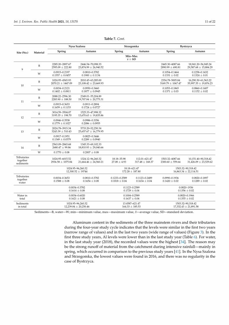
The range of aluminum content in bottom sediments varied from 13.46 mgAl·kg−1 to96,260.32 mgAl·kg−1, with the range for water being 0.0034–0.6020 mgAl·dm−3 (Table 6) [34].The lowest amounts of aluminum were found in the sediments of the Strzegomka Riverand its tributaries (mean 164.33 mgAl·kg−1). Higher amounts were found in the NysaSzalona River (12,239.84 mgAl·kg−1), and the highest averaged 17,332.30 mgAl·kg−1 in theBystrzyca River and its tributaries (Table 7, Figure 2). The opposite was true for aluminumconcentrations in water [34]. A similar relationship was found for sediments collected onlyfrom the tributaries.
Table 6. Aluminum content in bottom sediments (mgAl·kg−1) and water (mgAl·dm−3) depending on the year [34].
Site/Material2015 2016 2017 2018
Min–Maxx ± SD
Min–Maxx ± SD
Min–Maxx ± SD
Min–Maxx ± SD
Nysa Szalona
below springs B 3841.20–5623.114732.86 ± 889.62
1562.36–4290.032926.24 ± 1363.52
3970.90–4453.224211.88 ± 240.68
4018.47–76,287.6940152.61 ±36,133.81
W 0.1382 ± 0.03 0.1311 ± 0.03 0.1940 ± 0.02 0.0767 ± 0.02
tributariesB 1024.95–32,345.21
7121.49 ± 7757.601425.04–34,465.117422.01 ± 8206.89
1412.78–5743.782994.52 ± 1042.82
1264.96–96,260.3231,664.04 ±
30,309.50
W 0.1717 ± 0.06 0.1388 ± 0.04 0.2508 ± 0.07 0.0871 ± 0.01
reservoir outletB 1896.05–2696.30
2290.47 ± 394.221345.33–2638.501991.57 ± 646.07
2832.10–2900.772868.26 ± 32.32
2563.09–69,102.3335,832.50 ±
33,269.07
W 0.2004 ± 0.01 0.1565 ± 0.04 0.3093 ± 0.01 0.0906 ± 0.01
Strzegomka
below springs B 14.24–147.5280.79 ± 66.49
13.46–125.4869.50 ± 55.97
15.38–256.32135.93 ± 120.31
15.03–468.98241.96 ± 226.62
W 0.1544 ± 0.02 0.1106 ± 0.01 0.1643 ± 0.02 0.1067 ± 0.01
tributariesB 25.52–256.36
132.10 ± 105.5318.18–196.2889.47 ± 70.81
18.33–369.54159.67 ± 145.44
28.05–621.47307.89 ± 277.05
W 0.1711 ± 0.02 0.1416 ± 0.02 0.1814 ± 0.02 0.1963 ± 0.06
reservoir outletB 15.32–159.74
87.47 ± 72.0816.85–123.4570.14 ± 53.25
15.43–456.33235.86 ± 220.36
25.34–569.88297.51 ± 272.04
W 0.1651 ± 0.01 0.1391 ± 0.02 0.1700 ± 0.01 0.1891 ± 0.01

Int. J. Environ. Res. Public Health 2021, 18, 13170 10 of 22
Table 6. Cont.
Site/Material2015 2016 2017 2018
Min–Maxx ± SD
Min–Maxx ± SD
Min–Maxx ± SD
Min–Maxx ± SD
Bystrzyca
below springs B2861.41–26,479.32
14,670.23 ±11,808.46
2636.43–25,064.1113,850.35 ±
11,213.26
2103.52–24,863.0113,483.12 ±
11,379.58
2706.07–63,958.4533,332.34 ±
30,625.58
W 0.1744 ± 0.01 0.1724 ± 0.01 0.1951 ± 0.01 0.1166 ± 0.02
tributariesB 1701.22–21,202.67
9070.44 ± 7653.74
1632.65–85,370.3214,139.50 ±
20,118.86
1503.32–21,631.4410,759.78 ±
8501.23
2445.3–90,318.4233,483.67 ±
32,232.75
W 0.1315 ± 0.03 0.1429 ± 0.02 0.1489 ± 0.02 0.1185 ± 0.01
reservoir outletB 2706.07–16,292.22
9499.29 ± 6791.952610.5–16,925.32
9768.32 ± 7156.79
5004.64–49,210.1327,107.64 ±
22,102.44
2354.78–61,563.2231,959.04 ±
29,603.92
W 0.1038 ± 0.02 0.1296 ± 0.01 0.1647 ± 0.02 0.1087 ± 0.01
Sediments—B, water—W; Min—minimum value, max—maximum value, x—average value, SD—standard deviation.
Table 7. Aluminum content in bottom sediments (mgAl·kg−1) and water (mgAl·dm−3) of rivers in spring and autumn [34].
Site (No.) Material
Nysa Szalona Strzegomka Bystrzyca
Spring Autumn Spring Autumn Spring Autumn
Min–Maxx ± SD
1B 3841.20–4453.22
4151.09 ± 235.791562.36–76,287.69
21,860.71 ± 31,455.8513.46–15.7814.70 ± 0.85
125.47–468.98249.39 ± 135.90
2103.52–2862.112577.29 ± 285.35
24,862.40–63,958.4535,090.73 ± 16,678.11
W 0.0601–0.60200.1789 ± 0.1391
0.0930–0.17380.1351 ± 0.03
0.1122–0.18630.1468 ± 0.03
0.1004–0.14330.1200 ± 0.02
0.1365–0.19660.1736 ± 0.02
0.0978–0.19450.1564 ± 0.04
2B 2501.71–2698.12
2637.29 ± 79.752596.44–65,325.00
33,705.72 ± 22,192.6525.36–32.3329.61 ± 2.47
112.01–621.47339.34 ± 186.60
2046.30–3025.442339.43 ± 399.03
20,144.56–45,628.1226,780.34 ± 10,889.51
W 0.0801–0.23670.1570 ± 0.0735
0.0850–0.15380.1294 ± 0.0266
0.1233–0.19870.1538 ± 0.0302
0.1123–0.15550.1326 ± 0.0177
0.1244–0.18560.1594 ± 0.03
0.0990–0.18970.1499 ± 0.03
3B 5501.25–6015.52
5684.26 ± 206.862325.41–96,260.32
26,022.62 ± 40,551.8125.09–35.9828.03 ± 4.48
196.25–533.74327.80 ± 127.20
2054.11–3055.182441.35 ± 372.00
10,151.40–73,024.1027,969.10 ± 26,174.40
W 0.0902–0.21370.1483 ± 0.0555
0.0920–0.14510.1246 ± 0.0199
0.1625–0.22470.1966 ± 0.0240
0.1585–0.21540.1890 ± 0.0202
0.1152–0.16340.1443 ± 0.02
0.1201–0.17460.1382 ± 0.02
4B 2036.55–2411.26
2244.95 ± 138.142481.72–44,026.21
19,070.39 ± 15271.8618.18–29.3623.61 ± 5.23
159.23–596.54285.31 ± 180.07
1750.16–2641.962041.01 ± 351.11
18,551.34–50,457.4027,511.12 ± 13,290.93
W 0.0874–0.22430.1532 ± 0.0623
0.0908–0.17450.1310 ± 0.0316
0.1452–0.25890.1951 ± 0.04
0.1422–0.24890.1702 ± 0.04
0.1235–0.15910.1429 ± 0.01
0.1100–0.16070.1279 ± 0.02
5B 3574.10–4013.52
3738.31 ± 176.291324.12–54,226.12
14,935.27 ± 22,688.5015.32–25.6318.31 ± 4.18
123.32–569.88327.18 ± 190.41
1845.20–2853.902176.09 ± 407.22
12,569.50–53,622.0026,604.49 ± 15,886.33
W 0.0813–0.29020.1659 ± 0.0875
0.0820–0.17970.1365 ± 0.0371
0.1527–0.19540.1751 ± 0.01
0.1232–0.18630.1575 ± 0.02
0.1236–0.15980.1362 ± 0.01
0.0933–0.15250.1227 ± 0.03
6B 1815.53–2212.73
1992.29 ± 145.441412.78–53,935.90
18,623.67 ± 20,660.001780.49–3288.342270.24 ± 594.31
18,225.21–85,370.3247,384.77 ± 29,693.91
W 0.0130–0.30550.1745 ± 0.0963
0.0861–0.16870.1405 ± 0.0336
0.1342–0.16470.1447 ± 0.01
0.0820–0.13230.1088 ± 0.02
7B 2872.21–3200.36
3010.70 ± 130.071526.33–69,514.68
187,17.97 ± 29,328.481875.67–2910.452402.17 ± 501.63
10,634.50–90,318.4232,853.50 ± 33,361.22
W 0.0824–0.26410.1774 ± 0.0752
0.0933–0.25440.1501 ± 0.0635
0.1253–0.19360.1512 ± 0.03
0.1159–0.13350.1242 ± 0.01
8B 2455.01–2636.90
2543.19 ± 75.772623.67–53,346.65
22,878.27 ± 18,648.051503.32–2534.661843.50 ± 404.87
16,330.00–75,632.8832,717.70 ± 24,810.44
W 0.0917–0.24510.1389 ± 0.0621
0.0914–0.36910.1846 ± 0.1087
0.1026–0.14560.1270 ± 0.02
0.1125–0.13780.1263 ± 0.10
Int. J. Environ. Res. Public Health 2021, 18, 13170 11 of 22
Table 7. Cont.
Site (No.) Material
Nysa Szalona Strzegomka Bystrzyca
Spring Autumn Spring Autumn Spring Autumn
Min–Maxx ± SD
9B 2285.20–2897.67
2595.09 ± 222.802446.54–70,098.33
23,874.99 ± 26,940.522445.30–4087.662890.99 ± 690.81
18,941.20–56,945.2429,587.68 ± 15,884.29
W 0.0915–0.21970.1557 ± 0.0457
0.0810–0.37820.1900 ± 0.1134
0.1054–0.14640.1331 ± 0.02
0.1258–0.14320.1324 ± 0.01
10B 1024.95–4565.93
2070.21 ± 1447.092010.45–63,285.00
23,108.42 ± 23,669.932354.78–5005.84
3169.79 ± 1067.4716,290.30–61,563.22
35,997.35 ± 19,876.23
W 0.0034–0.21210.1402 ± 0.0811
0.0950–0.34600.1877 ± 0.0945
0.1053–0.18650.1371 ± 0.03
0.0860–0.14070.1152 ± 0.02
11B 2088.22–2596.30
2283.90 ± 188.502349.01–55,204.89
19,707.84 ± 20,775.31
W 0.0915–0.36530.1659 ± 0.1153
0.0911–0.28940.1724 ± 0.0727
12B 3014.59–3504.07
3195.35 ± 198.701525.33–47,998.32
13,670.63 ± 19,835.86
W 0.0946–0.35380.1779 ± 0.1027
0.0986–0.33560.2086 ± 0.0955
13B 2024.78–3915.34
3243.39 ± 510.435733.20–52,250.34
25,657.67 ± 16,779.95
W 0.0917–0.19510.1349 ± 0.0379
0.0825–0.34460.2289 ± 0.0940
14B 2563.09–2843.68
2680.47 ± 99.861345.33–69,102.33
18,810.93 ± 29,040.66
W 0.1770 ± 0.08 0.2007 ± 0.08
Tributariestogether
sediments
1024.95–6015.522936.58 ± 1075.84
1324.12–96,260.3221,664.46 ± 24,560.21
18.18–35.9827.08 ± 4.93
112.01–621.47317.48 ± 168.37
1503.32–4087.662300.60 ± 559.64
10,151.40–90,318,4231,426.09 ± 23,529.62
1024.95–96,260.3212,300.52 ± 19744
18.18–621.47172.28 ± 187.80
1503.32–90,318.4216,863.34 ± 22,114.51
Tributariestogether
water
0.0034–0.36530.1588 ± 0.08
0.0810–0.37820.1654 ± 0.08
0.1233–0.25890.1818 ± 0.04
0.1123–0.24890.1634 ± 0.04
0.0990–0.19360.1420 ± 0.02
0.0820–0.18970.1289 ± 0.02
0.0034–0.37820.1614 ± 0.08
0.1123–0.25890.1729 ± 0.04
0.0820–19360.1356 ± 0.02
Water intotal
0.0034–0.60200.1621 ± 0.08
0.1004–0.25890.1637 ± 0.04
0.0820–0.19660.1355 ± 0.02
Sedimentsin total
1024.95–96,260.3212,239.84 ± 20,250.46
13.4587–621.47164.33 ± 185.53
1503.32–90,318.4217,332.43 ± 21,891.58
Sediments—B, water—W; min—minimum value, max—maximum value, x—average value, SD—standard deviation.
Aluminum content in the sediments of the three mainstem rivers and their tributariesduring the four-year study cycle indicates that the levels were similar in the first two years(narrow range of values) and in the last two years (wide range of values) (Figure 3). In thefirst three study years, Al levels were lower than in the last study year (Table 6). For water,in the last study year (2018), the recorded values were the highest [34]. The reason maybe the strong runoff of material from the catchment during intensive rainfall—mainly inspring, which occurred in comparison to the previous study years [41]. In the Nysa Szalonaand Strzegomka, the lowest values were found in 2016, and there was no regularity in thecase of Bystrzyca.

Int. J. Environ. Res. Public Health 2021, 18, 13170 12 of 22
Int. J. Environ. Res. Public Health 2021, 18, x FOR PEER REVIEW 12 of 23
W 0.1770 ± 0.08 0.2007 ± 0.08 Tribu-taries
together sedi-
ments
1024.95–6015.52
2936.58 ± 1075.84
1324.12–96,260.32
21,664.46 ± 24,560.21
18.18–35.98 27.08 ± 4.93
112.01–621.47 317.48 ± 168.37
1503.32–4087.66 2300.60 ± 559.64
10,151.40–90,318,42
31,426.09 ± 23,529.62
1024.95–96,260.32 12,300.52 ± 19744
18.18–621.47 172.28 ± 187.80
1503.32–90,318.42 16,863.34 ± 22,114.51
Tribu-taries
together water
0.0034–0.3653 0.1588 ± 0.08
0.0810–0.3782 0.1654 ± 0.08
0.1233–0.2589 0.1818 ± 0.04
0.1123–0.2489 0.1634 ± 0.04
0.0990–0.1936 0.1420 ± 0.02
0.0820–0.1897 0.1289 ± 0.02
0.0034–0.3782 0.1614 ± 0.08
0.1123–0.2589 0.1729 ± 0.04
0.0820–1936 0.1356 ± 0.02
Water in total
0.0034–0.6020 0.1621 ± 0.08
0.1004–0.2589 0.1637 ± 0.04
0.0820–0.1966 0.1355 ± 0.02
Sedi-ments in total
1024.95–96,260.32 12,239.84 ± 20,250.46
13.4587–621.47 164.33 ± 185.53
1503.32–90,318.42 17,332.43 ± 21,891.58
Sediments—B, water—W; min—minimum value, max—maximum value, ��—average value, SD—standard deviation.
Figure 2. PCA plot 2D showing clustering of rivers across 29 sites and 3 features (1—Bystrzyca, 2—Nysa Szalona, 3—Strzegomka).
Aluminum content in the sediments of the three mainstem rivers and their tributaries during the four-year study cycle indicates that the levels were similar in the first two years (narrow range of values) and in the last two years (wide range of values) (Figure 3). In the
Figure 2. PCA plot 2D showing clustering of rivers across 29 sites and 3 features (1—Bystrzyca, 2—Nysa Szalona, 3—Strzegomka).
Int. J. Environ. Res. Public Health 2021, 18, x FOR PEER REVIEW 13 of 23
first three study years, Al levels were lower than in the last study year (Table 6). For water, in the last study year (2018), the recorded values were the highest [34]. The reason may be the strong runoff of material from the catchment during intensive rainfall—mainly in spring, which occurred in comparison to the previous study years [41]. In the Nysa Sza-lona and Strzegomka, the lowest values were found in 2016, and there was no regularity in the case of Bystrzyca.
Figure 3. PCA plot 2D showing clustering of years across 29 sites and 3 features (1—2015, 2—2016, 3—2017, 4—2018).
Along the course of the Nysa Szalona and Strzegomka Rivers, among the successive tributaries, initially high aluminum values decreased in subsequent rivers (Table 7). Ad-ditionally, within the Strzegomka River, the content of aluminum in sediments decreased with the direction of water flow, with the highest values recorded in the first tributary, Polska Woda, and the lowest in the last one, Czyżynka. On the other hand, in the sedi-ments of the Bystrzyca tributaries it can be seen that in the first four tributaries the level of aluminum in the sediments is lower than in the subsequent ones. All this situation is characteristic for particular rivers and results from the specificity of the catchment. The general picture of the rivers when divided into their initial, middle and lower (estuary to the reservoir) sections, allows to define this level as quite similar, which can also be seen when all parameters are compared (Figure 4). The narrowest range was found for the in-itial section and the widest for the lower section (Figure 5) [34]. This can also be seen in the overall analysis of all the studied parameters for water and bottom sediments. This allows to conclude that water of varied composition flows into the reservoirs over the entire research cycle, but only a dozen or so years of research could confirm that such a trend is constant [41].
Figure 3. PCA plot 2D showing clustering of years across 29 sites and 3 features (1—2015, 2—2016, 3—2017, 4—2018).

Int. J. Environ. Res. Public Health 2021, 18, 13170 13 of 22
Along the course of the Nysa Szalona and Strzegomka Rivers, among the successivetributaries, initially high aluminum values decreased in subsequent rivers (Table 7). Addi-tionally, within the Strzegomka River, the content of aluminum in sediments decreasedwith the direction of water flow, with the highest values recorded in the first tributary,Polska Woda, and the lowest in the last one, Czyzynka. On the other hand, in the sedi-ments of the Bystrzyca tributaries it can be seen that in the first four tributaries the levelof aluminum in the sediments is lower than in the subsequent ones. All this situation ischaracteristic for particular rivers and results from the specificity of the catchment. Thegeneral picture of the rivers when divided into their initial, middle and lower (estuaryto the reservoir) sections, allows to define this level as quite similar, which can also beseen when all parameters are compared (Figure 4). The narrowest range was found forthe initial section and the widest for the lower section (Figure 5) [34]. This can also beseen in the overall analysis of all the studied parameters for water and bottom sediments.This allows to conclude that water of varied composition flows into the reservoirs over theentire research cycle, but only a dozen or so years of research could confirm that such atrend is constant [41].
Int. J. Environ. Res. Public Health 2021, 18, x FOR PEER REVIEW 14 of 23
Figure 4. PCA plot 2D showing clustering of rivers across 29 sites and 29 features (1—Bystrzyca, 2—Nysa Szalona, 3—Strzegomka).
PCA analysis of all parameters in sediments in all rivers depending on initial, middle and lower (estuary to the reservoir) sections of the reservoir.
Figure 5. PCA plot 2D showing clustering of section of river across 29 sites and 29 features (1—initial 2—middle, 3—lower section of rivers).
The variability of the seasons was reflected in the levels of aluminum found in the sediments. In all rivers and their tributaries, autumn values were significantly higher than spring levels, indicating that aluminum was retained in the sediments during the summer (Figure 6). In water, on the other hand, the opposite was true, but here it is probably the result of abundant precipitation and aluminum leaching from the catchment [34]. When all water and sediment parameters were analyzed, autumn values had a wider range of
Figure 4. PCA plot 2D showing clustering of rivers across 29 sites and 29 features (1—Bystrzyca, 2—Nysa Szalona,3—Strzegomka).
The variability of the seasons was reflected in the levels of aluminum found in thesediments. In all rivers and their tributaries, autumn values were significantly higher thanspring levels, indicating that aluminum was retained in the sediments during the summer(Figure 6). In water, on the other hand, the opposite was true, but here it is probably theresult of abundant precipitation and aluminum leaching from the catchment [34]. Whenall water and sediment parameters were analyzed, autumn values had a wider range ofvalues than spring values (Figure 7) [34]. This may have been influenced by the varyinglevels of precipitation [41].

Int. J. Environ. Res. Public Health 2021, 18, 13170 14 of 22
Int. J. Environ. Res. Public Health 2021, 18, x FOR PEER REVIEW 14 of 23
Figure 4. PCA plot 2D showing clustering of rivers across 29 sites and 29 features (1—Bystrzyca, 2—Nysa Szalona, 3—Strzegomka).
PCA analysis of all parameters in sediments in all rivers depending on initial, middle and lower (estuary to the reservoir) sections of the reservoir.
Figure 5. PCA plot 2D showing clustering of section of river across 29 sites and 29 features (1—initial 2—middle, 3—lower section of rivers).
The variability of the seasons was reflected in the levels of aluminum found in the sediments. In all rivers and their tributaries, autumn values were significantly higher than spring levels, indicating that aluminum was retained in the sediments during the summer (Figure 6). In water, on the other hand, the opposite was true, but here it is probably the result of abundant precipitation and aluminum leaching from the catchment [34]. When all water and sediment parameters were analyzed, autumn values had a wider range of
Figure 5. PCA plot 2D showing clustering of section of river across 29 sites and 29 features (1—initial 2—middle, 3—lowersection of rivers).
PCA analysis of all parameters in sediments in all rivers depending on initial, middleand lower (estuary to the reservoir) sections of the reservoir.
Int. J. Environ. Res. Public Health 2021, 18, x FOR PEER REVIEW 15 of 23
values than spring values (Figure 7) [34]. This may have been influenced by the varying levels of precipitation [41].
Figure 6. PCA plot 2D showing clustering of season across 29 sites and 3 features (1—spring, 2—autumn).
Figure 7. PCA plot 2D showing clustering of season across 29 sites and 29 features (1—spring, 2—autumn).
Figure 6. PCA plot 2D showing clustering of season across 29 sites and 3 features (1—spring, 2—autumn).

Int. J. Environ. Res. Public Health 2021, 18, 13170 15 of 22
Int. J. Environ. Res. Public Health 2021, 18, x FOR PEER REVIEW 15 of 23
values than spring values (Figure 7) [34]. This may have been influenced by the varying levels of precipitation [41].
Figure 6. PCA plot 2D showing clustering of season across 29 sites and 3 features (1—spring, 2—autumn).
Figure 7. PCA plot 2D showing clustering of season across 29 sites and 29 features (1—spring, 2—autumn). Figure 7. PCA plot 2D showing clustering of season across 29 sites and 29 features (1—spring, 2—autumn).
A comparison of aluminum contents at two extreme sites, i.e., spring and estuary, onthe Nysa Szalona, Bystrzyca and Strzegomka Rivers was made against the backgroundof the seasons of the year (Table 7). It was found that in the Nysa Szalona River in springand autumn at the sites downstream of the springs the aluminum level was higher thanat the estuary to the Słup Reservoir. Such a situation persisted throughout the four-yearstudy period. In the Strzegomka and Bystrzyca Rivers, higher values were recorded inboth seasons at the river mouth than below the springs. Against the background of thefour-year study period, these two extreme sites showed much higher aluminum contentsin the last year of the study, with lower aluminum concentrations in water compared to theremaining years.
Among the tributaries of the Nysa Szalona River, in spring and autumn the highestamounts of aluminum were recorded in the sediments of the first two tributaries (Table 7).No regularity was found for the minimum values. In the Bystrzyca River, the highestamounts of aluminum in spring, in all the years of the study, were found in the sedimenttaken from Walimianka—the last tributary before the Lubachów Reservoir. In other rivers,lower and similar amounts of aluminum were found. In autumn, the lowest values wererecorded in the first four tributaries, while below the level of aluminum was already higher.Within the Strzegomka tributaries, in both seasons of the year, throughout the four-yearcycle of the study, in successive tributaries, the content of aluminum decreased, while itsconcentration in water increased.
A correlation was found between the level of aluminum in the sediment and thesediment pH, the water pH, the content of mineral compounds and the concentrationof metals (Zn, Pb, Cu, Cd) in water, and the concentration of aluminum and sulfates inwater (Figure 8) [34]. No correlation was found between aluminum content in water andsediments (Figure 8), which means that the aluminum level in sediments is not dependenton the concentration in water, and therefore it is mainly influenced by the pH and externalconditions in the catchment.

Int. J. Environ. Res. Public Health 2021, 18, 13170 16 of 22Int. J. Environ. Res. Public Health 2021, 18, x FOR PEER REVIEW 17 of 23
Figure 8. Ordination of the 29 study sites by PCCA based on concentrations of elements in water and sediments in all investigated rivers.
In this study, special attention was paid to aluminum compounds deposited in the bottom sediment, classified in the group of substances particularly harmful to the aquatic environment (specific synthetic and non-synthetic pollutants) [42,43]. The accumulation of aluminum and other studied metals in sediments was determined using the concentra-tion factor (CF) [35]. For all metals studied, the lowest values were found in the Strze-gomka River, except for Fe and Mn, for which the minimum was in the Bystrzyca River (Table 8). The highest values were found mostly in the Bystrzyca River (Al, Cd, Pb, Zn). In the sediments of the Nysa Szalona River, a higher value was found only for nickel, and cadmium both in Bystrzyca and Nysa was accumulated at a very similar level. In all three main rivers studied, the values recorded in autumn were much higher than in spring (Ta-ble 9). In the Strzegomka and Nysa Szalona Rivers, aluminum accumulation at each sea-son was higher at the spring than at the reservoir mouth, and in the Bystrzyca it was the opposite. The same picture was found during the analysis of aluminum content in sedi-ments, which has the main influence on the level of the concentration factor. A comparison of the tributaries against the seasons shows a regularity that is present in all the tributar-ies—higher values of aluminum concentration factor occurred in autumn.
Figure 8. Ordination of the 29 study sites by PCCA based on concentrations of elements in water and sediments in allinvestigated rivers.
The summary of aluminum content on the background of the length of individualrivers does not show any relationship between them. The Strzegomka and Bystrzyca Riversare of similar length (ca. 20 km) up to their mouths in the reservoirs. The Nysa Szalona,though twice as long, does not contain as much aluminum as the Strzegomka. The sizeof the catchment area of the river above the reservoir is the largest for the Nysa Szalona,yet it is not reflected in the amount of aluminum carried in the water. In turn, the size ofthe Strzegomka catchment is the smallest, and the amount of aluminum carried with thewaters is the largest. As can be seen, neither the size of the catchment nor the river lengthfor these three rivers have any influence on the level of aluminum in bottom sediments.
In this study, special attention was paid to aluminum compounds deposited in thebottom sediment, classified in the group of substances particularly harmful to the aquaticenvironment (specific synthetic and non-synthetic pollutants) [42,43]. The accumulation ofaluminum and other studied metals in sediments was determined using the concentrationfactor (CF) [35]. For all metals studied, the lowest values were found in the StrzegomkaRiver, except for Fe and Mn, for which the minimum was in the Bystrzyca River (Table 8).

Int. J. Environ. Res. Public Health 2021, 18, 13170 17 of 22
The highest values were found mostly in the Bystrzyca River (Al, Cd, Pb, Zn). In thesediments of the Nysa Szalona River, a higher value was found only for nickel, andcadmium both in Bystrzyca and Nysa was accumulated at a very similar level. In all threemain rivers studied, the values recorded in autumn were much higher than in spring(Table 9). In the Strzegomka and Nysa Szalona Rivers, aluminum accumulation at eachseason was higher at the spring than at the reservoir mouth, and in the Bystrzyca it wasthe opposite. The same picture was found during the analysis of aluminum contentin sediments, which has the main influence on the level of the concentration factor. Acomparison of the tributaries against the seasons shows a regularity that is present in allthe tributaries—higher values of aluminum concentration factor occurred in autumn.
Table 8. Concentration factor (CF) of aluminum and heavy metals in bottom sediments.
Nysa Szalona Bystrzyca Strzegomka
Al. 75,045.00 125,962.40 1003.83Cu 2555.72 2551.48 430.47Ni 2529.75 1669.80 301.12Cd 175.50 2930.00 76.33Pb 1164.56 32,898.90 273.19Zn 3829.10 4757.10 724.08Mn 840.21 365.88 444.82Fe 22,878.55 8949.27 16,610.75
Table 9. Concentration factor (CF) of aluminum in bottom sediments depending on the season.
Season Nysa Szalona Bystrzyca Strzegomka
In totalspring 29,761.74 134.59 17,091.9
autumn 210,152.61 2002.42 266,764.5
Tributariesspring 30,334.33 154.57 16,622.68
autumn 211,273.76 1952.51 260,853
Below springs spring 33,861.22 102.12 15,235.28autumn 225,544.67 2193.72 272,468.6
Reservoir outletspring 18,791.21 104.14 22,702.22
autumn 308,809.04 1960.86 308,352.3
In order to compare the content of all metals (Al, Cu, Ni, Cd, Pb, Zn, Fe, Mn) in thesamples of the three studied rivers and their tributaries, the metal pollution index (MPI)was used [36]. High levels of metal contamination were found for the sediments of theStrzegomka River (Table 10). The highest degree of contamination was observed for theNysa Szalona and Bystrzyca Rivers. The series of increasing values for sediments withinaluminum and heavy metals and metals alone were as follows: Strzegomka < Bystrzyca <Nysa Szalona.
Table 10. Metal pollution index (MPI), contamination factor (Cf), degree of contamination (DC) and enrichment factor (EF)of bottom sediments with metals.
Nysa Szalona Bystrzyca Strzegomka
MPI Cf DC EF MPI Cf DC EF MPI Cf DC EF
Al
277.26
18,830.53
18,896.06
-
189.41
26,665.28
26,703.91
-
50.46
252.81
264.35
-Cd 3.58 0.0002 2.34 0.0001 1.53 0.0060Cu 14.82 0.0001 10.46 0.0004 1.83 0.0072Ni 28.14 0.0015 10.99 0.0004 4.24 0.0168Pb 9.07 0.0005 6.91 0.0003 1.79 0.0071Zn 8.59 0.0005 7.24 0.0003 1.40 0.0055Mn 0.35 0.0001 0.46 0.00001 0.23 0.0017Fe 0.97 0.0217 0.21 0.2812 0.51 0.0040

Int. J. Environ. Res. Public Health 2021, 18, 13170 18 of 22
The contamination factor (Cf) was also determined and its lowest values for heavymetals were found in the Strzegomka River (Table 10) [37]. For most metals (Cd, Cu, Pb,Zn) the contamination factor was moderate and for nickel it was significant. For the NysaSzalona and Bystrzyca, the factor reached a significant level only for cadmium, and forall other metals it was very high. Against the background of heavy metal levels, the levelof aluminum was much higher and always described as very high. However, it reachedthe lowest level in the Strzegomka River, a higher one in the Nysa Szalona River, and thehighest one in the Bystrzyca River.
The degree of contamination (DC) was the highest in the Bystrzyca River (26,703.20),lower in the Nysa Szalona River (18,894.73) and lowest in the Strzegomka River (263.60) [37](Table 10).
The enrichment factor (EF) indicates the influence of anthropogenic pollution on themetal content in the bottom sediments. According to the scale proposed by Sutherland [44],the observed influence of anthropogenic pollution within all the studied sediments wasminimal, with a following series of increasing values: Nysa Szalona < Bystrzyca < Strze-gomka (Table 10).
The geoaccumulation index (Igeo) was also calculated, which showed that the sedi-ments from the Strzegomka River were the cleanest (class I) [33,38] (Table 11). Against thisbackground, sediments from the Bystrzyca River were more heavily loaded with metals,and those from the Nysa Szalona River were the most polluted.
Table 11. Geoaccumulation index (Igeo) and purity class of bottom sediments.
Nysa Szalona Bystrzyca Strzegomka
Igeo Class Igeo Class Igeo Class
Cu 3 III 2 II 0 INi 4 III 2 II 1 IICd 1 II 0 I 0 IPb 2 II 2 II 0 IZn 2 II 3 III 0 IMn 0 I 0 I 0 IFe 0 I 0 I 0 I
Taking into account all the indicators of accumulation and contamination of bottomsediments, a clear picture emerges, showing the lowest level for the Strzegomka River (S)and higher levels for the Nysa Szalona River (NS) and the Bystrzyca River (B), respectively(Table 12). On the other hand, the highest level of enrichment factor (EF) indicates soil andcatchment effect as the most influential factors on metal levels in the Strzegomka sediment,and the lowest for the Nysa Szalona. The combined picture of all studied parameters in thethree main rivers and their tributaries indicates that they are not that far apart, and onlytheir extreme values differentiate them.
Table 12. Comparison of contamination indices.
MPI S < B < NSCf S < B < NSDC S < NS < BEF NS < B < SIgeo S < B < NSCF S < NS < B
Analyses of aluminum in environmental samples against the values quoted for flowingwaters in Poland and worldwide show that the type of catchment, the inflow of pollutantsand whether the discharged used water undergoes a treatment process are of greatestimportance. In the catchments of the studied Lower Silesian rivers, which feed reservoirsserving as drinking water reservoirs, no particularly strong hot spots threatening water

Int. J. Environ. Res. Public Health 2021, 18, 13170 19 of 22
quality are recorded. The catchments are typically mountainous, upland and lowland,mainly agricultural but with a prevalence of small farm buildings and small towns. Whenlooking at the variable values in this study, it appears that lower values were found inPoland in samples collected from rivers in north-western Poland, where the range ofvalues was 6.74–47.06 mgAl·kg−1 for the Czerwona River and 3.97–26.15 mgAl·kg−1 forthe Grabowa River [45]. The aluminum accumulation coefficients recorded there were alsolower in sediments relative to water and amounted for the Czerwona River to 66–23492and for the Grabowa River to CF = 14–2763. Additionally, in the Insko and Wisola lakes inthis region of Poland, the aluminum level in sediments was low [46]. Low values were alsorecorded in southern Poland in Dzieckowice reservoir and in flowing and standing watersin western Poland [47–49].
Samecka-Cymerman et al. [50] also studied aluminum content in bottom sedimentsfrom the Nysa Szalona and Strzegomka Rivers and their tributaries. The level found wassimilar to the present study (2200–6060 mgAl·kg−1). Additionally, in the catchment ofthe Kamienna River in the Karkonosze region, in an area considered to be unpolluted,the level of aluminum in sediments was similar (3700–5400 mgAl·kg−1) [51]. It is alsoworth mentioning the rivers flowing in Lower Silesia north of Wroclaw, as well as the lakesof the Legnica and Zielona Góra region, which despite the differentiation of catchmentarea in terms of pollution load (from low to high) had similar aluminum levels as in thisstudy [52–54]. A similar range was also found in Dobromierz Reservoir, into which theStrzegomka River flows, in Piaseczno Reservoir, in the lakes of the Wielkopolski NationalPark and in Goczałkowicki Lake [55–58].
Against this background, it is similar in Europe, where the level of aluminum loadingof bottom sediments of flowing and standing water bodies varies greatly. A similar range(15,300–54,100 mgAl·kg−1) as in the present study in Poland was found in the DanubeRiver, in highly anthropogenic rivers in Sicily (21,600–26,220 mgAl·kg−1) and in France inthe Seine River (1800–5900 mgAl·kg−1) [59–61]. Outside the European continent, valuessimilar to those recorded in the present study were also found (India, Cameroon, Nigeria,United States) [62–65]. Additionally, in industrially treated areas in China, Iran, Egypt,Chile and Mexico, aluminum levels were similar to the present study [66–71].
High values for European reservoirs with municipal and commercial catchments thatare heavily burdened by heavy industry and mining were recorded in Hungary, Turkey,Russia, Japan, China and Brazil [72–78].
4. Conclusions
The general picture of bottom sediments of the three Lower Silesian rivers shows thatthey were typically mineral, with neutral pH and moderate sulfate content. The level ofaluminum and heavy metals was the highest in the Nysa Szalona and the lowest in theStrzegomka, which was also visible in the concentration factor (CF).
In terms of seasons, higher aluminum contents were recorded in autumn than inspring, which is also reflected in the concentration factor (CF).
Along the course of the river, in the Nysa Szalona and Strzegomka, a gradual decreasein the level of aluminum was observed in successive tributaries, while for the Bystrzycathere was no apparent regularity. Against this background, a comparison of extremesites below the springs and at the reservoir outlet shows that values were higher in theNysa Szalona below the springs, and lower in the Strzegomka and Bystrzyca against thebackground of the reservoir outlet.
The general picture of aluminum and heavy metal loading of the studied sedimentsshows the lowest loading for the Strzegomka River, only the enrichment factor was thelowest for the Nysa Szalona River: MPI—S < B < NS, Cf—S < B < NS, DC—S < NS < B,EF—NS < B < S, Igeo—S < B < NS, CF—S < NS < B.
No influence of catchment size and river length on sediment aluminum levels wasfound. Attention needs to be focused rather on the sources of pollution present in thecatchment, the presence and quality of precipitation, the geological structure, and the

Int. J. Environ. Res. Public Health 2021, 18, 13170 20 of 22
modernization works carried out in the riverbed. During them the bank structure isdisturbed, new material is introduced and old material is removed. All these works arecarried out over quite a long period of time and often cover only fragments of the riverbedbut have an impact on water quality and bottom sediments composition.
Author Contributions: Conceptualization, M.S.; formal analysis, M.K.-G.; investigation, M.S. and J.Ł;software, A.W.-G.; visualization, M.K.-G.; writing—original draft preparation, M.S.; writing—reviewand editing, M.K.-G. and K.C. All authors have read and agreed to the published version of themanuscript.
Funding: This research received no external funding.
Institutional Review Board Statement: Not applicable.
Informed Consent Statement: Not applicable.
Data Availability Statement: Not applicable.
Conflicts of Interest: The authors declare no conflict of interest.
References and Notes1. Kowal, A. Treatment of water from the Dobromierz dam reservoir. Ochr. Srod. 1991, 1, 35–38.2. Czamara, W.; Krezel, J.; Łomotowski, J. Influence of reservoir retention on surface water quality in the Nysa Szalona catchment
area. Sci. J. Agric. Acad. Wrocław Conf. III 1994, 2, 246.3. Bros, K. Operating Manual for the Słup Reservoir on the Nysa Szalona R; ODGW: Wrocław, Poland, 1995.4. GIOS. Chief Inspectorate of Environmental Protection. In Report on the State of the Environment; GIOS: Warsaw, Poland, 2018.5. Abdullah, M.P.; Baba, I.; Sarmani, S. Erdawati. Distribution of aluminium from alum sludge in water and sediment. Mar. Freshw.
Res. 1995, 46, 159–165. [CrossRef]6. Wetzel, R.G. Limnology. In Lake and River Ecosystems; Academic Press: London, UK, 2001.7. Cánovas, C.R.; Olias, M.; Vazquez-Suñé, E.; Ayora, C.; Nieto, J.M. Influence of releases from a fresh water reservoir on the
hydrochemistry of the Tinto River (SW Spain). Sci. Total Environ. 2012, 416, 418–428. [CrossRef]8. Wood, J.M. Effects of Acidification on the Mobility of Metals and Metalloids: An Overview. Environ. Health Persp. 1985, 63,
115–119. [CrossRef] [PubMed]9. Kotowski, M.; Saczuk, M. Aluminium in water and soil environment. Ekoinzynieria 1997, 2, 22–29.10. Barabasz, W.; Albinska, D.; Jaskowska, M.; Lipiec, J. Ecotoxicology of Aluminium. Pol. J. Environ. Stud. 2002, 11, 199–203.11. Gworek, B. Aluminium in the natural environment and its toxicity. Ochr. Srod. Zas. Nat. 2006, 29, 27–38.12. Walton, J.R. Bioavailable Aluminium: Its Metabolism and Effects on the Environment. Reference Module in Earth Systems and
Environmental Sciences. Encycl. Environ. Health 2011, 343–352. [CrossRef]13. Bravo, S.; Amorós, J.A.; Pérez-de-los-Reyes, C.; García, F.J.; Moreno, M.M.; Sánchez-Ormeño, M.; Higueras, P. Influence of the soil
pH in the uptake and bioaccumulation of heavy metals (Fe, Zn, Cu, Pb and Mn) and other elements (Ca, K, Al, Sr and Ba) in vineleaves, Castilla-La Mancha (Spain). J. Geochem. Explor. 2017, 174, 79–83. [CrossRef]
14. Hartwell, B.L.; Pember, F.R. The presence of aluminium as a reason for the difference in the effect of so-called acid soil on barleyand rye. Soil Sci. 1918, 6, 259–279. [CrossRef]
15. Srinivasan, P.T.; Viraraghavan, T. Characterisation and concentration profile of aluminium during drinking-water treatment.Water 2002, 28, 99–106. [CrossRef]
16. Kabata-Pendias, A. Trace Elements in Soils and Plants; CRC Press: Boca Raton, FL, USA, 2010.17. Kalff, J. Limnology; Prentice Hall Ltd.: Upple Saddle River, NJ, USA, 2002.18. Miller, T.E.; Iqbal, N.; Reader, S.M.; Mahmood, A.; Cant, K.A.; King, I.P. A cytogenetic approach to the improvement of aluminium
tolerance in wheat. New Phytol. 1997, 137, 93–98. [CrossRef]19. Dixon, E.; Gardner, M. Reactive aluminium in UK surface waters. Chem. Spec. Bioavail. 1998, 10, 11–17. [CrossRef]20. Guibaud, G.; Gauthier, C. Study of aluminium concentration and speciation of surface water in four catchments in the Limousin
region (France). J. Inorg. Biochem. 2003, 97, 16–25. [CrossRef]21. Soil and Agricultural Map; Provincial Centre for Geodetic and Cartographic Documentation: Wrocław, Poland, 2019.22. PN-EN ISO 5667-15:2009-Water quality-Sampling-Guidelines for the fixation and handling of sewage sludge and bottom sediment
samples.23. PB10/I–1998. Varian analytical methods. Heavy metals test procedure.24. PN-ISO 5667-6:2003P-Water quality. Sampling. Guidelines for sampling of rivers and streams.25. PN-ISO 5667-14:2004P-Water quality. Sampling. Guidelines for quality assurance in environmental water sampling and handling.26. PN-EN ISO 5667-3:2005-Guidelines for the fixation and handling of samples. PN-ISO 11048:2002-Determination of sulfates in
sediments by nephelometry.27. PN-90/C-04540.01-Determination of pH of water. Range: (2–12), potentiometric method.

Int. J. Environ. Res. Public Health 2021, 18, 13170 21 of 22
28. PN-75/C-04616.01-Determination of mineral and organic compounds in sediments by weight method.29. PN79/C-04566.10-Determination of sulfates in water by turbidimetric method.30. PN-EN ISO 12020:2002-Water quality-Determination of aluminum by atomic absorption spectrometry.31. PN-ISO 8288:2002-Water quality-Determination of cobalt, nickel, copper, zinc, cadmium and lead by flame atomic absorption
spectrometry.32. Pasieczna, A.; Siemiatkowski, J.; Lis, J. Geochemical Atlas of Walbrzych and Surroundings; Cartographic Publishing House of the
Polish Ecological Agency S.A.: Warsaw, Poland, 1996.33. Bojakowska, I.; Sokołowska, G. Geochemical purity classes of bottom sediments. Prz. Geol. 1998, 46, 49–54.34. Senze, M.; Kowalska-Góralska, M.; Czyz, K. Availability of aluminum in river water supplying dam reservoirs in Lower Silesia
considering the hydrochemical conditions. Environ Nanotechnol Monit Manag. 2021, 16, 100535. [CrossRef]35. Jezierska, B.; Witeska, M. Metal Toxicity to Fish, Wyd; Akademia Podlaska: Siedlce, Poland, 2001.36. Usero, J.; Gonzales-Regalado, E.; Garcia, I. Trace metals in bivalve molluscs Ruditapes decussatus and Ruditapes philippinarum
from the Atlantic Coast of southern Spain. Environ. Int. 1997, 23, 291–298. [CrossRef]37. Håkanson, L. An ecological risk index aquatic pollution control. A sedimentological approach. Water Res. 1980, 14, 975–1001.
[CrossRef]38. Müller, G. Schwermetalle in den sediments des Rheins-Veranderungenseitt 1971. Umschau 1979, 79, 778–783.39. Jolliffe, I.T.; Cadima, J. Principal component analysis: A review and recent developments. Phil. Trans. R. Soc. A 2016, 13374,
20150202. [CrossRef] [PubMed]40. Revell, L.J.; Harrison, A.S. PCCA: A program for phylogenetic canonical correlation analysis. Bioinformatics 2008, 24, 1018–1020.
[CrossRef] [PubMed]41. IMGW. Institute of Meteorology and Water Management National Research Institute. 2021. Available online: http://imgw.pl
(accessed on 25 June 2021).42. Water Law. Official Journal of the Laws of 20 July 2017, Item 1566. 2017.43. Regulation of the Minister of Maritime Affairs and Inland Navigation of 11 October 2019 on the classification of ecological
status, ecological potential and chemical status and the method of classification of the status of surface water bodies, as well asenvironmental quality standards for priority substances. OJ. 2019 item 2149. 2019.
44. Sutherland, R.A. Bed Sediment-Associated Trace Metals in an Urban Stream, Oahu, Hawaii. Environ. Geol. 2000, 39, 611–627.[CrossRef]
45. Senze, M.; Kowalska-Góralska, M.; Białowas, H. Evaluation of the aluminium load in the aquatic environment of two small riversin the Baltic Sea catchment area. J. Elementol. 2015, 20, 987–998. [CrossRef]
46. Rajkowska, M.; Protasowicki, M. Distribution of selected metals in bottom sediments of lake Insko and Wisola (Poland). Ecol.Chem. Eng. A 2011, 18, 805–812.
47. Biel, A.; Piaseczna, A. Geochemistry of sediments and water of the Dzieckowice artificial reservoir (Imielinskie Lake), South.Poland Biul. PIG 2012, 450, 1–8. [CrossRef]
48. Labus, M.; Mrowiec, A. Bottom sediments of Skróda river and their role in the metals circulation in the environment. Zesz.Naukowe. Inzynieria Uniw. Zielonogórski 2010, 139, 67–80.
49. Skoczynska-Gajda, S.; Labus, M. Metal speciation in river bed sediments within the Polish part of Muskau Arch Geopark). Arch.Environ. Prot. 2011, 37, 87–99.
50. Samecka–Cymerman, A.; Kolon, K.; Kempers, A.J. A comparison of native and transplanted Frontinalis antipyretica Hedw. asbiomonitors of water polluted with heavy metals. Sci. Total Environ. 2005, 341, 97–107. [CrossRef]
51. Samecka-Cymerman, A.; Kempers, A.J. Bioindication of heavy metals by Mimulus guttatus from the Czeska Struga Stream in theKarkonosze Mountains, Poland. Bull Environ. Contam. Toxicol. 1999, 63, 65–72. [CrossRef]
52. Samecka-Cymerman, A.; Kempers, A.J. Concentrations of heavy metals and plant nutrients in water, sediments and aquaticmacrophytes of anthropogenic lakes (former open cut brown coal mines) differing in stage of acidifification. Sci. Total Environ.2001, 281, 87–98. [CrossRef]
53. Samecka-Cymerman, A.; Kempers, A.J. Biomonitoring of water pollution with Elodea canadensis. A case study of three smallPolish rivers with different levels of pollution. Water Air Soil Poll. 2003, 145, 139–153. [CrossRef]
54. Samecka-Cymerman, A.; Kempers, A.J. Toxic metals in aquatic plants surviving in surface water polluted by copper miningindustry. Ecotox. Environ. Safe 2004, 59, 64–69. [CrossRef]
55. Dabrowska, J.; Lejcus, K. Characteristics of bottom sediments of the Dobromierz reservoir. Infrastrukt. I Ekol. Teren. Wiej. 2012, 3,89–98.
56. Szarek-Gwiazda, E.; Galas, J.; Wróbel, A.; Ollik, M. Surface sediment composition in an inundated opencast sulphur mine(Piaseczno reservoir, Southern Poland). Aquat. Ecol. 2006, 40, 155–164. [CrossRef]
57. Sobczynski, T.; Joniak, T. Vertical Changeability of Physical-Chemical Features of Bottom Sediments in Three Lakes, in AspectType of Water Mixis and Intensity of Human Impact. Pol. J. Environ. Stud. 2009, 18, 1093–1099.
58. Szalinska, E.; Koperczak, A.; Czaplicka-Kotas, A. Heavy metals in the bottom sediments of Lake Goczalkowickie tributaries. Ochr.Srod. 2010, 32, 21–25.
59. Carpentier, S.; Moilleron, R.; Beltran, C.; Hervé, D.; Thévenot, D. Quality of dredged material in the river Seine basin (France). II.Micropollutants. Sci. Total Environ. 2002, 299, 57–72. [CrossRef]

Int. J. Environ. Res. Public Health 2021, 18, 13170 22 of 22
60. Woike, P.; Wellmitz, J.; Helm, D.; Kube, P.; Lepom, P.; Litheraty, P. Analysis and assessment of heavy metal pollution in suspendedsolids and sediments of the river Danube. Chemosphere 2003, 51, 633–642. [CrossRef]
61. Bonanno, G. Arundo donax as a potential biomonitor of trace element contamination in water and sediment. Ecotox. Environ. Safe2012, 80, 20–27. [CrossRef]
62. Sprenger, M.; McIntosh, A. Relationship between concentration of aluminium, cadmium, lead, and zinc in water, sediments, andaquatic macrophytes in six acidic lakes. Arch. Environ. Contam. Toxicol. 1989, 18, 225–231. [CrossRef]
63. Baruah, N.K.; Kotoky, P.; Bhattacharyya, K.G.; Borah, G.C. Metal speciation in Jhanji River sediments. Sci. Total Environ. 1996, 193,1–12. [CrossRef]
64. Ekengele, N.L.; Myung, C.J.; Ombolo, A.; Ngounou, N.; Ekodeck, G.; Mbome, L. Metals pollution in freshly deposited sedimentsfrom river Mingoa, main tributary to the Municipal lake of Yaounde, Cameroon. Geosci. J. 2008, 12, 337–347. [CrossRef]
65. Taiwo, A.M.; Awomeso, J.A. Assessment of trace metal concentration and health risk of artisanal gold mining activities inIjeshaland, Osun State Nigeria— Part 1. J. Geochem. Explor. 2017, 177, 1–10. [CrossRef]
66. Villaescusa-Celaya, J.A.; Gutiérrez-Galindo, E.A.; Flores-Muñoz, G. Heavy metals in the fine fraction of coastal sediments fromBaja California (Mexico) and California (USA). Environ. Poll. 2000, 108, 453–462. [CrossRef]
67. Sin, S.N.; Chua, H.; Lo, W.; Ng, L.M. Assessment of heavy metal cations in sediments of Shing Mun River, Hong Kong. Environ.Int. 2001, 26, 297–301. [CrossRef]
68. Taher, A.G. Geochemistry of recent marine sediments in the Bardawil lagoon, northern Sinai, Egypt. Hydrobiologia 2001, 457, 5–16.[CrossRef]
69. Karbassi, A.R.; Monavari, S.M.; Nabi Bidhendi, G.R.; Nouri, J.; Nematpour, K. Metal pollution assessment of sediment and waterin the Shur River. Environ. Monit. Assess. 2008, 147, 107–116. [CrossRef] [PubMed]
70. Lin, C.; He, M.; Zhou, Y.; Guo, W.; Yang, Z. Distribution and contamination assessment of heavy metals in sediment of the SecondSonghua River, China. Environ. Monit. Assess. 2008, 137, 329–342. [CrossRef]
71. Sáez, C.A.; Lobos, M.G.; Macaya, E.C.; Oliva, D.; Quiroz, W. Variation in Patterns of Metal Accumulation in Thallus Parts ofLessonia trabeculata (Laminariales; Phaeophyceae): Implications for Biomonitoring. PLoS ONE 2012, 7, e50170. [CrossRef]
72. Jordão, C.P.; Pereira, M.G.; Pereira, J.L. Metal contamination of river waters and sediments from effluents of kaolin processing inBrasil. Water Air Soil Poll. 2002, 140, 119–138. [CrossRef]
73. Kraft, C.; Von Tuempling, W., Jr.; Zachmann, D.W. The effects of mining in Northern Romania on the heavy metal distribution insediments of the rivers Szamos and Tisza (Hungary). Acta Hydroch. Hydrob. 2006, 34, 257–264. [CrossRef]
74. Yalcin, M.G.; Narin, I.; Soylak, M. Heavy Metal Contents of the Karasu Creek Sediments, Nigde, Turkey. Environ. Monit. Assess.2007, 128, 351–357. [CrossRef]
75. Akbulut, N.E.; Tuncer, A.M. Accumulation of heavy metals with water quality parameters in Kızılırmak River Basin (DeliceRiver) in Turkey. Environ. Monit. Assess. 2011, 173, 387–395. [CrossRef] [PubMed]
76. Jagus, A.; Khak, V.; Rzetała, M.; Rzetała, M. Chemical composition of bottom sediments of Irkutsk reservoir. Proc. Ecopole 2012, 6,219–223.
77. Mohiuddin, K.M.; Otomo, K.; Ogawa, Y.; Shikazono, N. Seasonal and spatial distribution of trace elements in the water andsediments of the Tsurumi River in Japan. Environ. Monit. Assess. 2012, 184, 265–279. [CrossRef]
78. Xing, W.; Wu, H.; Hao, B.; Liu, G. Metal accumulation by submerged macrophytes in eutrophic lakes at the watershed scale.Environ. Monit. Assess. 2013, 20, 6999–7008. [CrossRef]