Agricultural Transformation and the Politics of Hydrology in Northern Thailand
24
Agricultural Transformation and the Politics of Hydrology in Northern Thailand Andrew Walker ABSTRACT Tensions over water resources in upland areas of northern Thailand are often attributed to reductions in water supply caused by forest clearing. This article argues that the hydrological evidence for such reductions in supply is very weak and that, rather, the key hydrological issue in upland catchments is a significant increase in water demand, especially during the dry season. The arguments are illustrated with a detailed examination of the Mae Uam catchment, located in Chiang Mai province, where the development of dry- season soybean cultivation appears to have tested the hydrological limit of the catchment, and even exceeded this limit in drier years. The author argues that a shift in focus from water supply to water demand has fundamentally important political implications. As long as the focus of public debate is on water supply, the regulatory focus will be on those resident in the forested upland areas that are seen as being crucial in securing downstream flows. But if the water management focus is shifted to water demand, then regulatory attention must shift to the diverse sources of demand that exist throughout the hydrological system. INTRODUCTION The recent history of development in the mountainous upland areas of mainland Southeast Asia has been one of increasing resource tension. Population growth, migration, commercialization and infrastructure con- struction have generated unprecedented pressure on upland resources at the same time that official systems of land regulation have sought to meet both development and conservation objectives. Agricultural transformation and the intensification of linkages between rural and urban sectors have posed new challenges that existing institutional structures are often poorly equipped to meet. In many mountainous upland areas, resource tensions are compounded as they find local and national expression in various forms of ethnic manoeuvre, which seek to define some groups as less legitimate users of highly valued natural resources. Responses to these denials of legitimacy are often framed in similarly ethnic terms as they promote trad- itions of indigenous resource management as a basis for local identification and political mobilization. Development and Change 34(5): 941–964 (2003). # Institute of Social Studies 2003. Published by Blackwell Publishing, 9600 Garsington Road, Oxford OX4 2DQ, UK and 350 Main St., Malden, MA 02148, USA
-
Upload
independent -
Category
Documents
-
view
3 -
download
0
Transcript of Agricultural Transformation and the Politics of Hydrology in Northern Thailand
Agricultural Transformation and the Politics of
Hydrology in Northern Thailand
Andrew Walker
ABSTRACT
Tensions over water resources in upland areas of northern Thailand are often
attributed to reductions in water supply caused by forest clearing. This article
argues that the hydrological evidence for such reductions in supply is very
weak and that, rather, the key hydrological issue in upland catchments is a
significant increase in water demand, especially during the dry season. The
arguments are illustrated with a detailed examination of the Mae Uam
catchment, located in Chiang Mai province, where the development of dry-
season soybean cultivation appears to have tested the hydrological limit of the
catchment, and even exceeded this limit in drier years. The author argues that
a shift in focus from water supply to water demand has fundamentally
important political implications. As long as the focus of public debate is on
water supply, the regulatory focus will be on those resident in the forested
upland areas that are seen as being crucial in securing downstream flows. But
if the water management focus is shifted to water demand, then regulatory
attention must shift to the diverse sources of demand that exist throughout
the hydrological system.
INTRODUCTION
The recent history of development in the mountainous upland areas ofmainland Southeast Asia has been one of increasing resource tension.Population growth, migration, commercialization and infrastructure con-struction have generated unprecedented pressure on upland resources at thesame time that official systems of land regulation have sought to meet bothdevelopment and conservation objectives. Agricultural transformation andthe intensification of linkages between rural and urban sectors have posednew challenges that existing institutional structures are often poorlyequipped to meet. In many mountainous upland areas, resource tensionsare compounded as they find local and national expression in various formsof ethnic manoeuvre, which seek to define some groups as less legitimateusers of highly valued natural resources. Responses to these denials oflegitimacy are often framed in similarly ethnic terms as they promote trad-itions of indigenous resource management as a basis for local identificationand political mobilization.
Development and Change 34(5): 941–964 (2003).# Institute of Social Studies 2003. Publishedby Blackwell Publishing, 9600 Garsington Road, Oxford OX4 2DQ, UK and 350 Main St.,Malden, MA 02148, USA
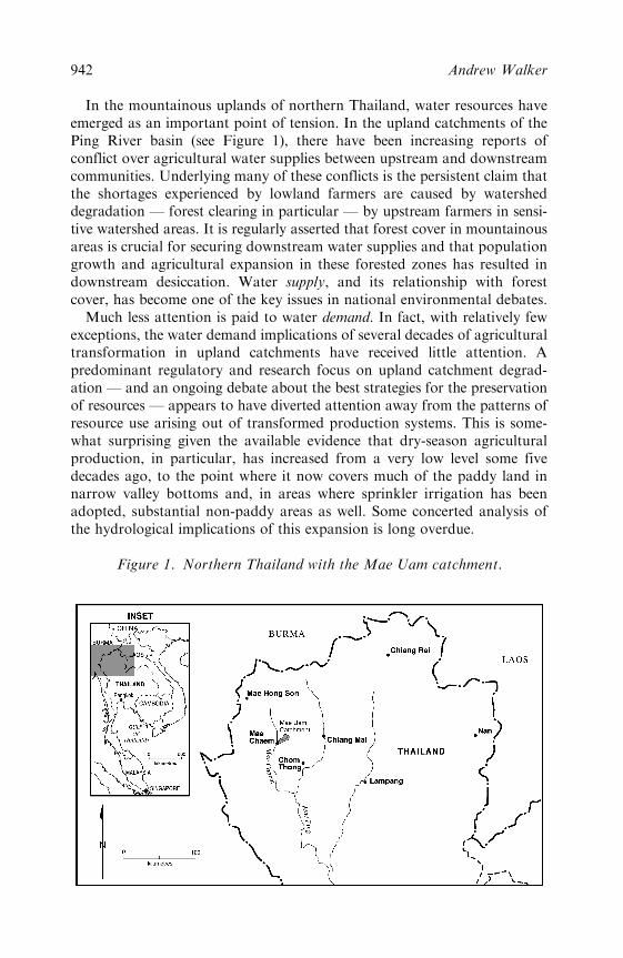
In the mountainous uplands of northern Thailand, water resources haveemerged as an important point of tension. In the upland catchments of thePing River basin (see Figure 1), there have been increasing reports ofconflict over agricultural water supplies between upstream and downstreamcommunities. Underlying many of these conflicts is the persistent claim thatthe shortages experienced by lowland farmers are caused by watersheddegradation — forest clearing in particular — by upstream farmers in sensi-tive watershed areas. It is regularly asserted that forest cover in mountainousareas is crucial for securing downstream water supplies and that populationgrowth and agricultural expansion in these forested zones has resulted indownstream desiccation. Water supply, and its relationship with forestcover, has become one of the key issues in national environmental debates.
Much less attention is paid to water demand. In fact, with relatively fewexceptions, the water demand implications of several decades of agriculturaltransformation in upland catchments have received little attention. Apredominant regulatory and research focus on upland catchment degrad-ation — and an ongoing debate about the best strategies for the preservationof resources — appears to have diverted attention away from the patterns ofresource use arising out of transformed production systems. This is some-what surprising given the available evidence that dry-season agriculturalproduction, in particular, has increased from a very low level some fivedecades ago, to the point where it now covers much of the paddy land innarrow valley bottoms and, in areas where sprinkler irrigation has beenadopted, substantial non-paddy areas as well. Some concerted analysis ofthe hydrological implications of this expansion is long overdue.
Figure 1. Northern Thailand with the Mae Uam catchment.
942 Andrew Walker
This article draws insights from anthropology, economics, agronomy andenvironmental science to examine these hydrological issues in northernThailand. It critically assesses the impact of recent agricultural developmenton both sides of the water management equation — water supply and waterdemand. It is based on a detailed case study of the Mae Uam catchment inMae Chaem district of Chiang Mai province, a catchment in which somewater resource tensions appear to be emerging. These recent tensions areplaced in the context of two decades of agricultural transformation andland-use change. In relation to water supply, I examine the widely-heldclaim that local and regional forest clearing has disrupted the hydrologicalcycle, resulting in reduced rainfall and dry-season water shortage. I arguethat there is very little evidence to support such claims, despite their wide-spread currency. I then turn to water demand, and examine the hydrologicaland sociological dimensions of the very substantial increase in dry-seasonirrigated agriculture in the Mae Uam catchment. My conclusion is that themost likely cause of increased water resource tension in Mae Uam, and else-where, is a dramatic and unprecedented increase in the level of demand forwater in the dry season in both upstream and downstream areas. This conclu-sion is not only significant for agronomic and hydrological reasons but it hasimportant implications for the contemporary politics of hydrology in northernThailand. These political issues are the focus of the following section.
THE POLITICS OF HYDROLOGY
Forest is the source of water for all people who live on Thai soil . . . it provides for under-
ground water storage, making the ground moist as a benefit for all people. (Suan Pa Sirikit,
n.d.; my translation)
Water resource management in northern Thailand has become highlycontentious. State agencies, conservation groups and associations oflowland irrigators vigorously, and sometimes violently, argue that forestclearing undertaken by upland farmers causes water shortages (Pinkaew,2000). This draws on a long tradition of blame in which upland cultivation,especially shifting cultivation, is portrayed as one of the primary causes ofnorthern Thailand’s deforestation and environmental degradation. The factthat many of these upland farmers are members of ethnic minority groups— some of whom are relatively recent arrivals in northern Thailand —provides fertile material for the combination of ethnic prejudice and envir-onmental blame (Lohmann, 1999). These ‘others within’ (Thongchai, 2000)are all too easily portrayed as undermining the ecological basis of irrigatedagriculture, one of the stereotypically core elements of Thai nationalculture. As such, there is widespread support for an array of watershedregulatory measures put forward by government agencies that seek topreserve and restore forest cover in upland catchments and restrict, oreven relocate, the agricultural activities of upland groups. An official system
Politics of Hydrology in Northern Thailand 943
of conservation-based watershed classification has declared vast areas ofsloping upland as inappropriate for agricultural activity despite the long-standing presence of farming communities (Pinkaew, 2000).
The responses to the charges of forest destruction and water sourcedepletion have been vigorous. In northern Thailand, as in many other partsof the world, activist academics and NGOs argue that upland minoritycommunities have well-established traditions of forest management andsustainable land use that provide a basis for sustainable community pres-ence in forested watershed areas. Attention is drawn to forest-friendlycultivation techniques; ritual forms and belief systems that prioritize forestprotection; indigenous systems of watershed protection; and local know-ledge systems that reflect local understanding of the crucial links betweenupper-catchment forest cover and healthy stream flow (Walker, 2001). Tochallenge negative stereotypes of the impact of upland cultivation on hydro-logical health, NGOs have worked with upland villagers to form ‘watershednetworks’ that promote the capabilities of local institutions in protectingforest cover and maintaining water supply (for example, Northern Devel-opment Foundation, 2000). As one report notes, ‘the lowland people receivewater because their brothers and sisters in the upland areas work togetherfor conservation’ (Saengdaaw, 2000: 67, my translation).
Despite the contention of this debate there is an underlying agreement thatforests are the key to sustainable water resource management. The debate isabout the appropriate way of protecting forest cover — essentially, the inter-nationally familiar debate between state regulation and local management —but it is not a debate about the relationship between forest cover and watersupply. There is a widely-shared consensus that forest cover maintains watersupply and that deforestation causes water shortage. In the large and conten-tious literature on environmental management in northern Thailand this per-sistent focus on forest protection and water supply has drawn attention awayfrom the important issue of water demand. Very little attention is given to thegreatly increased quantities of water that new agricultural systems consume.Water shortages are regularly and consistently attributed to a reduction insupply caused by deforestation and the debate is framed by a preoccupationwith water resource preservation (which is seen as equating with forest protec-tion) rather than focusing on contemporary patterns of water resource use.
This ongoing focus on water supply has important political implications.As long as the focus of public debate is on maintaining and protecting watersupply, the regulatory focus will be on those resident in the forested upstreamareas that are seen as crucial in securing downstream flows. Accordingly,upland hill-slope cultivation has come to be the key site of claim, counter-claim, regulatory intervention and institutional mobilization. If the watermanagement focus is shifted to water demand, however, then attentionmust shift to the diverse sources of demand that exist throughout the hydro-logical system. Suddenly upper-catchment farmers are not the only focus, butlowland irrigators are also brought into the picture along with industrialists,
944 Andrew Walker
tourist resort operators and urban water consumers. This broader regulatoryfocus may well be unwelcome and it should come as no surprise if supply-basedarguments continue to be mounted in order to maintain the geographically andsocially restricted focus on upstream forested catchment areas.
A shift in emphasis to water demand should also prompt some rethinkingof the current strategies used to defend the rights of upland farmers. Atpresent, this defence is framed largely in terms of their ability to protectforests and maintain water supply. This defence has been mounted in veryparticular terms with considerable emphasis placed on subsistence-oriented,low-input forms of forest-friendly cultivation (Walker, 2001). But, as thecase-study below demonstrates, many of these upland minority farmers arenow becoming heavily engaged in commercially-oriented production, espe-cially in the dry season where the use of irrigation water is essential. There isa real danger that images of subsistence-oriented, forest-friendly and low-resource-use agriculture will be used by lowland farmers to undermine theresource claims of their upstream rivals. It would, after all, be in theinterests of downstream water users if upstream farmers were pressured toexercise ecological restraint and to adhere to agricultural practices thatmake minimal claims on catchment resources. In short, in presentingupstream farmers as guardians of catchment resources and as protectorsof water supply, the legitimacy of their position as consumers of resources— as water users — is potentially undermined.
THE MAE UAM: A MOUNTAINOUS CATCHMENT IN NORTHERN
THAILAND
TheMaeUamhas its sources on the western slopes ofDoi Inthanon, the highestmountain in Thailand. From this high mountain source, it runs in a south-westerly direction to its junction with the Mae Chaem, dropping about 2000metres in the process (see Figure 2). The total area of theMaeUam catchment is43km2 with elevation ranging from a low point of 480 metres (near the districtcentre of Mae Chaem) to a high point of almost 2,400 metres (near the peak ofDoi Inthanon). The average slope is 18 degrees and flat land suitable forintensive irrigated agriculture is confined to narrow strips along the valley floor.
The population of the Mae Uam catchment is approximately 3500, dis-tributed among seven villages. In the two most upstream villages (PhaThung and Mae Ming in Figure 2), almost 85 per cent of household headssurveyed identify themselves as Karen. The Karen are the largest ‘hill-tribe’group in northern Thailand who, in response to official charges of hill-tribenatural resource degradation, have developed a reputation in academicand activist literature for their conservationist, forest-friendly and non-commercial orientation (Walker, 2001). In the other five villages of theMae Uam catchment almost all households identify themselves as northernThai, the majority lowland population in Chiang Mai province.
Politics of Hydrology in Northern Thailand 945
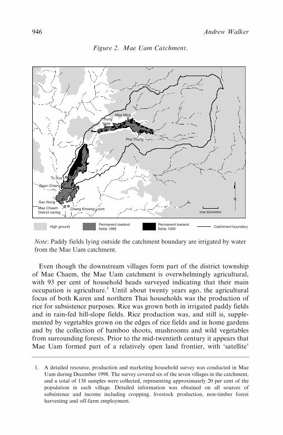
Even though the downstream villages form part of the district townshipof Mae Chaem, the Mae Uam catchment is overwhelmingly agricultural,with 93 per cent of household heads surveyed indicating that their mainoccupation is agriculture.1 Until about twenty years ago, the agriculturalfocus of both Karen and northern Thai households was the production ofrice for subsistence purposes. Rice was grown both in irrigated paddy fieldsand in rain-fed hill-slope fields. Rice production was, and still is, supple-mented by vegetables grown on the edges of rice fields and in home gardensand by the collection of bamboo shoots, mushrooms and wild vegetablesfrom surrounding forests. Prior to the mid-twentieth century it appears thatMae Uam formed part of a relatively open land frontier, with ‘satellite’
Permanent lowlandfields 1985
Chang Khoeng Loum
San Nong
Baan Chiang
To Rua
ThungYaaw
Mae Ming
Pha Thung
Mae ChaemDistrict centre
Permanent lowlandfields 1995
High ground Catchment boundary
one kilometre
N
Note: Paddy fields lying outside the catchment boundary are irrigated by waterfrom the Mae Uam catchment.
Figure 2. Mae Uam Catchment.
1. A detailed resource, production and marketing household survey was conducted in Mae
Uam during December 1998. The survey covered six of the seven villages in the catchment,
and a total of 138 samples were collected, representing approximately 20 per cent of the
population in each village. Detailed information was obtained on all sources of
subsistence and income including cropping, livestock production, non-timber forest
harvesting and off-farm employment.
946 Andrew Walker
communities experiencing little difficulty in opening up new areas ofagricultural land. In some cases, villages were established in degraded forestareas that had been opened up by logging operations. Based on experiencein other districts of northern Thailand, it seems likely that populationgrowth in the past was accompanied by the gradual expansion of paddyland and the shortening of fallow cycles on upland fields (Walker, 2001).With the incorporation of the upper reaches of the catchment in DoiInthanon National Park in the late 1970s, shifting cultivation systems inthe upstream Karen villages came under increasing pressure.
Over the past twenty years there has been substantial agricultural change inthe Mae Uam catchment, in part as a result of the activities of agriculturaldevelopment agencies. During the 1980s,Mae Chaem district was a priority areafor development given its relative isolation, poverty and reputation for opiumproduction and communist insurgency. Government and non-governmentdevelopment activities in the Karen and northern Thai villages along theMae Uam included infrastructure support (roads, irrigation systems and fishponds); promotion of new crops and farming techniques; construction ofterraced paddy fields; marketing initiatives; and distribution of fruit-treeseedlings (Hufschmidt, 1991; Ministry of Agriculture and Co-operatives,1984). Irrigation development was a priority activity and, in the upperreaches of the catchment, a series of concrete weirs were constructed fromthe late 1970s onward, while in the lower reaches two major irrigation weirswere built in the late 1980s. An aqueduct which draws supplementary — butexpensive, given the need for pumping — irrigation water from the mainstream of theMae Chaemwas also constructed to service farmers in the lowerreaches of the catchment in the mid-1980s. Agricultural development wasgreatly facilitated by the construction of a road linking Mae Chaem with themajor northern Thai marketing centres during the 1970s and by the gradualimprovement of the road along the Mae Uam catchment itself in the 1980sand 1990s. These development initiatives appear to have contributed to asignificant increase in the production of cash crops, especially soybeans.
Land-cover data for the Mae Uam catchment from the period 1985 to1995 provide some interesting perspectives on this recent period of agricul-tural transformation.2 First, these data suggest that — contrary to popular
2. The land-cover data were derived from Landsat satellite imagery acquired in 1985
(August), 1990 (February) and 1995 (February) (NRCT, 1997: 43). The National
Research Council of Thailand study (NRCT, 1997: 45–6) classified land-cover into five
main categories: forest, agriculture, urban, bareland/openland and grass/regrowth. The
forest category includes permanent natural forest and reforestation. The agricultural
category is said to include ‘permanent or temporary agricultural areas that are
mostly . . . in flat plain or lowland’. From analysis of the spatial distribution of this
category, and limited ground truthing, it is clear that in the majority of cases this refers
to paddy fields and some permanently cultivated fields on the fringes of paddy. Bareland/
openland is defined in the study as ‘the area of new cleared area or prepared highland
agricultural area’. In this article, I refer to this category as ‘rain-fed hill-slope fields’.
Politics of Hydrology in Northern Thailand 947
images of rampant hill-slope expansion, and associated deforestation, innorthern Thailand — there has been a modest decline in rain-fed hill-slopecultivation over this period, from 425 ha in 1985 to 393 ha in 1995. Import-antly, these data suggest that most rain-fed hill-slope fields are now perman-ently cropped, rather than being left fallow or abandoned. Of the 393 hacultivated in 1995, over 336 ha had also been cultivated in 1990 and almost240 ha had been cultivated in both 1985 and 1990. Discussions with villageleaders and household surveys have indicated that all upland fields are nowpermanently cropped, even in Karen villages where, from recent literature(see, for example, Waraalak, 1998), one may expect significant levels ofrotational shifting cultivation. There is an ongoing debate in northern Thailandabout the impacts of shifting cultivation on the environment of upland catch-ments, but in the Mae Uam catchment this now appears to be a non-issue.
The second, and most important, trend in land-use in the Mae Uamcatchment is the expansion in permanent agricultural fields in the relativelylow slope and low elevation areas along the valley floor. This expansion hastaken the form both of irrigated paddy fields (assisted by improvements inirrigation infrastructure) and the establishment of orchards and permanentgardens on the sloping land immediately adjacent to paddy fields. As can beseen in Figure 2, this expansion has been most significant in the downstreamzone of the catchment, though there is also evidence of paddy field con-solidation in the upstream agricultural zone. Land-cover data indicate thatin 1985 these areas of permanent valley bottom cultivation covered 203 ha(4.4 per cent of the catchment area). By 1990 this had increased to 256 ha(5.6 per cent) and by 1995 had reached 350 ha (7.6 per cent). This expansionhas been facilitated by the construction of irrigation infrastructure and theconstruction of paddy fields as part of local development initiatives.
Water Resources
The climatic pattern in Mae Chaem district is typical of that in northernThailand, with a distinct wet season from about May to September. Outsidethe wet season, rainfall is limited and in some years no rain falls for threemonths or more. According to data collected by the Royal IrrigationDepartment for the town of Mae Chaem, average annual rainfall duringthe 1980s was 910mm. During this period the driest month was January(average of zero) and the wettest month was September (average of155mm). Rainfall is much higher in the more elevated parts of the catchment:the peak of Doi Inthanon has an average annual rainfall of about 2200mm.3
As can be expected from the seasonal pattern of rainfall, stream flow inthe Mae Uam peaks during July and August and declines steadily from
3. Rainfall data were obtained from the website of the Royal Irrigation Department at
www.rid.go.th.
948 Andrew Walker
October to April. Total stream flow during the dry-season months is onlyabout 20 per cent of annual stream flow (Walker, 2002: 7), although this lowflow is a crucial source of irrigation water for dry-season cropping. Dry-season stream flow is ‘harvested’ by an extensive network of irrigation weirsand canals. There are approximately forty wooden and ten concrete weirsdistributed between the two Karen and five northern Thai settlements andnumerous village-based institutions exist to maintain the irrigation infra-structure and to manage the distribution of water to farmers’ fields.
During field surveys undertaken by the author and collaborators inDecember 1998, farmers in the downstream northern Thai villagesexpressed concerns about dry-season water shortages and the high cost ofpumping supplementary water supplies from the main stream of the MaeChaem River. These concerns are typical of those expressed by downstreamfarmers in mountain catchments in many areas of northern Thailand. In theMae Uam catchment, water resource concerns are encouraged somewhat bya high profile forest protection and reafforestation project that continuallyemphasizes the link between upper-watershed forest degradation and watershortages: ‘the result of cutting forest is the destruction of the water sourceof the Thai people’ (Suan Pa Sirikit, n.d.; my translation). Concerns aboutdry-season water supply have even prompted locally contentious proposalsfor dams in the middle and upper reaches of the Mae Uam to store ‘surplus’wet season flow. In the early 1990s, activists in the upstream Karen villagescampaigned vigorously, and successfully, against a proposed reservoir thatwould have inundated some of their valuable paddy fields. By the late 1990smore modest plans were being developed, with army engineering teamsreportedly planning the construction of a number of small ‘check-dams’on minor sub-tributaries within the catchment. In nearby areas of MaeChaem district, upstream Karen farmers are said to fear relocation due tocomplaints of lowland farmers about the impact of water shortages onagricultural production (Ukrit, 2001: 18), and in the neighbouring districtof Chom Thong there have been violent protests against upland Hmongvillagers who are accused of forest clearing and destruction of water sources(Pinkaew, 2000; Renard, 1994). These well-publicized events contribute to aclimate of uncertainty in minority communities in upland areas.
FOREST LOSS AND WATER SUPPLY4
The first hydrological issue I will address is whether or not there is anyevidence to support the widely expressed claim that forest loss has reducedwater supply. There is no doubt that there has been a reduction in forestcover in Mae Uam and in many other mountainous catchments of northernThailand. Land-cover data indicate that in 1985 approximately 78 per cent
4. This section is a brief summary of relevant sections of Walker (2002).
Politics of Hydrology in Northern Thailand 949
of the Mae Uam catchment was covered with forest but by 1995 this haddeclined to 72 per cent, a loss of over 250 ha. There is also some evidence ofconsiderable forest degradation, especially in areas of the catchment outsidethe national park. This local reduction in forest cover is one small part of amuch more significant regional trend that has seen the level of forest coverin northern Thailand decline from, presumably, close to 100 per cent in theearly 1900s to about 44 per cent in the mid-1990s (Walker, 2002: 11).
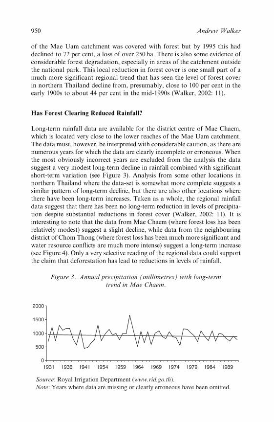
Has Forest Clearing Reduced Rainfall?
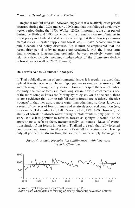
Long-term rainfall data are available for the district centre of Mae Chaem,which is located very close to the lower reaches of the Mae Uam catchment.The data must, however, be interpreted with considerable caution, as there arenumerous years for which the data are clearly incomplete or erroneous. Whenthe most obviously incorrect years are excluded from the analysis the datasuggest a very modest long-term decline in rainfall combined with significantshort-term variation (see Figure 3). Analysis from some other locations innorthern Thailand where the data-set is somewhat more complete suggests asimilar pattern of long-term decline, but there are also other locations wherethere have been long-term increases. Taken as a whole, the regional rainfalldata suggest that there has been no long-term reduction in levels of precipita-tion despite substantial reductions in forest cover (Walker, 2002: 11). It isinteresting to note that the data from Mae Chaem (where forest loss has beenrelatively modest) suggest a slight decline, while data from the neighbouringdistrict of Chom Thong (where forest loss has been much more significant andwater resource conflicts are much more intense) suggest a long-term increase(see Figure 4). Only a very selective reading of the regional data could supportthe claim that deforestation has lead to reductions in levels of rainfall.
0
500
1000
1500
2000
1931 1936 1954 1964 19741941 1959 1969 1979 1984 1989
Source: Royal Irrigation Department (www.rid.go.th). Note: Years where data are missing or clearly erroneous have been omitted.
Figure 3. Annual precipitation (millimetres) with long-termtrend in Mae Chaem.
950 Andrew Walker
Regional rainfall data do, however, suggest that a relatively drier periodoccurred during the 1980s and early 1990s and that this followed a relativelywetter period during the 1970s (Walker, 2002). Importantly, the drier periodduring the 1980s and 1990s coincided with a dramatic increase of interest inforest policy in Thailand and it is not surprising that these two key environ-mental issues — water supply and forest loss — have become linked inpublic debate and policy discourse. But it must be emphasized that therecent drier period is by no means unprecedented, with the longer-termdata showing a long-standing oscillation between relatively wetter andrelatively drier periods, seemingly independent of the progressive declinein forest cover (Walker, 2002: Figure 8).
Do Forests Act as Catchment ‘Sponges’?
In Thai public discussion of environmental issues it is regularly argued thatupland forests serve as catchment ‘sponges’ — storing wet season rainfalland releasing it during the dry season. However, despite the level of publiccertainty, the role of forests in modifying stream flow in catchments is oneof the more complex issues confronting hydrologists. On the one hand, thereis some evidence that during rainfall events forests are relatively effective‘sponges’ in that they absorb more water than other land-surfaces, largely asa result of the layer of forest humus and relatively good soil condition (see,for example, Takahashi et al., 1983; Vincent et al., 1995: 8–9). However, theability of forests to absorb water during rainfall events is only part of thestory. While it is popular to refer to forests as sponges it would also beappropriate to refer to them, metaphorically, as ‘pumps’. Rates of evapo-transpiration from forests in northern Thailand are such that fully-forestedlandscapes can return up to 80 per cent of rainfall to the atmosphere leavingonly 20 per cent as stream flow, the source of water supply for irrigators
0
500
1000
1500
1922 1932 1942 1961 1971 1981 1991
Source: Royal Irrigation Department (www.rid.go.th). Note: Years where data are missing or clearly erroneous have been omitted.
Figure 4. Annual precipitation (millimetres) with long-termtrend in Chomtong.
Politics of Hydrology in Northern Thailand 951

(Walker, 2002: 13–14). It is this high water use of forest that leads Alford(1992: 267) to conclude that ‘the mountain catchments of northern Thailandare among the most ‘‘arid’’ on earth’.
The fact that forests are relatively high water users means that clearingforests typically increases annual stream flow and this increase can be verysignificant. However, with some loss of the ‘sponge effect’ there may be anincrease in the proportion of annual flow that takes place in the wet seasonshortly after rainfall events. Will this mean that there is less water for thedry season? A careful and detailed answer to this question has been pro-vided by Bruijnzeel (1989) who, after reviewing numerous internationalcatchment studies, argues that if a reasonable amount of care is taken tomaintain the infiltration capacities of cleared land, the effect of reducedforest water use will outweigh the effect of reduced infiltration, resulting inan increase in dry-season base flow.
So, what conclusions can be drawn from the hydrological evidence inrelation to Mae Uam? Overall, it seems clear that a modest reduction inforest cover is unlikely to have had a substantial impact on stream flow and,if anything, the impact on dry-season stream flow may have been marginallypositive. It is relevant to note that almost half of the forest loss in the MaeUam catchment between 1985 and 1995 has resulted in the development ofpermanent agricultural fields in the lower-lying and lower-slope areas of thecatchment. The substantial presence of terraced paddy in these areas —which slows and filters the passage of water through the landscape — meansthat opportunities for soil infiltration are relatively abundant (Hamilton,1987: 257). In other words, the negative impact of forest loss on the so-called‘sponge’ effect in these areas is likely to be very modest. It is also important toremember that any minor (positive or negative) effects of human-inducedland-cover change on water supply are likely to be relatively insignificantwhen compared to the naturally occurring short-term variation in rainfall.
AGRICULTURAL INTENSIFICATION AND WATER DEMAND
Dry-season water resource constraints are emerging in the Mae Uam catch-ment in an environment of modest reductions in forest cover, relativelystable hill-slope cultivation but significant increase in the area of paddyand paddy-fringe cultivation in the low-slope areas of the catchment. Thetrend away from land-extensive shifting cultivation to land-intensive paddyproduction has been documented in a number of studies of agriculturalsystems in northern Thailand (Cooper, 1984; Kanok and Benjavan, 1994;Michaud, 1997) but has not been given much serious consideration in recentdiscussions of water resource management in mountainous upland catch-ments. Instead, public discussion of water resource management has beendominated by the politics of blame whereby water shortages are all tooreadily attributed to a reduction in supply caused by the forest clearing
952 Andrew Walker
undertaken by minority groups in upland areas. In the following sectionsI will argue that water resource tensions are much more likely to haveemerged as a result of substantial increases in water demand. While myfocus is on dry-season agricultural activity, it is informative to compare thiswith trends in wet-season cultivation.
Wet-Season Agricultural Change
Agricultural modernization has had a relatively limited impact on wet-season agricultural activity in the Mae Uam catchment. In both Karenand northern Thai villages, the predominant agricultural activity duringthe wet season is the production of rice in irrigated rice fields for subsistencepurposes. During the wet season in 1997, rice was grown on 83 per cent ofthe cultivated paddy area. The balance was made up of soybeans and maize(about 5 per cent each) and small plots of shallots and turnips. Over 80 percent of these non-rice crops were grown on rain-fed paddy fields withirrigated paddy devoted almost exclusively to rice production. It is clearthat subsistence-oriented production is by far the highest priority on therelatively high-yielding irrigated fields (over 3000 kg of rice per ha). Duringthe wet season there is also some cultivation of hill-slope rain-fed fields,which in 1997 amounted to about 45 per cent of the area of paddy cultiva-tion. During 1997 these fields were cropped with upland rice (71 per cent),soybeans (19 per cent) and maize (10 per cent). Upland rice features prom-inently — despite relatively low productivity (around 1200 kg per ha) —largely because there is a significant group (about 17 per cent of farmers)who are entirely dependent on hill-slope, rain-fed fields for their agriculturallivelihoods.
Dry-Season Agricultural Change
By contrast, there have been very important changes in the patterns of dry-season cultivation. While further ethno-historical research is needed, itappears that until about twenty years ago dry-season cropping in thesmall upland catchments surrounding Mae Chaem was limited to smallareas of vegetable gardens on the banks of streams. The absence of dry-season cropping does not appear to have been a reflection of rice-based self-sufficiency — given local reports of regular rice deficiency — but reflectedthe dry-season economic focus on off-farm labour and trading activities as asupplement to under-producing rice production systems. Local accountssuggest that cattle trading was an important feature of these economicsystems, with dry-season paddy fields used as a staging point for cattle inthe trade between upland villagers, and perhaps even villages across theborder in Burma, and the larger trading centres close to Chiang Mai. Giventhe rudimentary state of transport connections, farmers working as
Politics of Hydrology in Northern Thailand 953
dry-season ox-traders also played an important part in the basic commoditytrade (Congmu, 1997: 152; cf. Chusit, 1989; Moerman, 1975).
While non-agricultural pursuits are still an important component of dry-season activity, the widespread adoption of soybean cultivation representsa very substantial change. Data from the household survey in Mae Uamindicate that soybeans were cultivated on almost 70 per cent of the irrigatedpaddy area during 1997–98. Soybeans have been widely promoted in north-ern Thailand, largely as an import substitution initiative, and they nowconstitute, by area, one of the main non-rice crops in the region (Abamo,1992: 15, 26). In the Mae Uam catchment, local varieties have been grownfor local consumption over a long period but commercial production ofsoybeans was only introduced in about 1984 when demonstration plots ofimproved varieties were established in numerous villages in the district aspart of the Mae Chaem Watershed Development Project (Ministry ofAgriculture and Co-operatives, 1984: 21). Good yields were recorded and,despite the fact that limited input support was offered to farmers, adoptionwas rapid, perhaps due to uncharacteristically high prices in the latter halfof the 1980s (TDRI, 1994: 74). Soybeans remain attractive given relativelystable prices, low input costs and relatively modest labour requirements. Ofcourse, adoption has not been completely unproblematic with low yields insome areas — possibly associated with declining soil fertility — promptingadoption of other dry-season crops. Maize, which can be readily sold inMae Chaem, is a popular alternative, though its relatively high water con-sumption is a major disadvantage in dry years. Other farmers have experi-mented with higher value vegetable crops such as sweet corn, carrots,potatoes and shallots, but none of these alternatives have become aspopular as soybeans.
The Hydrology of Dry-Season Cultivation
How hydrologically significant may this increase in dry-season agriculturebe? Some relatively simple calculations suggest that it may be very signifi-cant indeed. First, it is necessary to provide some data on dry-season watersupply. Given that there is no stream gauge in Mae Uam I have estimatedsupply by taking eleven years of stream flow data from a nearby catchmentwith roughly similar aspect, elevation and morphology and scaling the dataaccording to the specific characteristics of the Mae Uam.5 My intention ismerely to provide an indication of the likely magnitude of water supply inMae Uam. Figure 5 provides one of the key results of these calculations: thetop dotted line represents total stream flow during the month of February
5. These data are then scaled by two factors: catchment size and average elevation. The source
catchment has minimal agricultural activity, so the stream flow (supply) data are not
affected by irrigation extractions (demand).
954 Andrew Walker
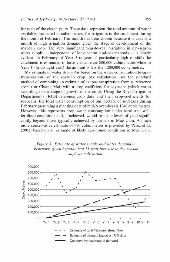
for each of the eleven years. These data represent the total amount of wateravailable, measured in cubic metres, for irrigators in the catchment duringthe month of February. This month has been chosen because it is usually amonth of high irrigation demand given the stage of development of thesoybean crop. The very significant year-to-year variation in dry-seasonwater supply — independent of longer-term land-cover trends — is clearlyevident. In February of Year 5 (a year of particularly high rainfall) thecatchment is estimated to have yielded over 800,000 cubic metres while inYear 10 (a drought year) the amount is less than 200,000 cubic metres.
My estimate of water demand is based on the water consumption (evapo-transpiration) of the soybean crop. My calculation uses the standardmethod of combining an estimate of evapo-transpiration from a ‘referencecrop’ (for Chiang Mai) with a crop coefficient for soybeans (which variesaccording to the stage of growth of the crop). Using the Royal IrrigationDepartment’s (RID) reference crop data and their crop-coefficients forsoybeans, the total water consumption of one hectare of soybeans duringFebruary (assuming a planting date of mid-November) is 1340 cubic metres.However, this represents crop water consumption under ideal and well-fertilized conditions and, if achieved, would result in levels of yield signifi-cantly beyond those typically achieved by farmers in Mae Uam. A muchmore conservative estimate of 670 cubic metres is provided by Perez et al.(2002) based on an estimate of likely agronomic conditions in Mae Uam.
0
100,000
200,000
300,000
400,000
500,000
600,000
700,000
800,000
900,000
Yr. 1 Yr. 2 Yr. 3 Yr. 4 Yr. 5 Yr. 6 Yr. 7 Yr. 8 Yr. 9 Yr. 10 Yr. 11
Cub
ic M
etre
s
Estimate of total February streamflow
Estimate of demand based on RID data
Conservative estimate of demand
Figure 5. Estimate of water supply and water demand inFebruary, given hypothetical 11-year increase in dry-season
soybean cultivation.
Politics of Hydrology in Northern Thailand 955
Given the significant difference, I have used both estimates of water con-sumption — the RID estimate and the Perez et al. ‘conservative’ estimate.These estimates of water demand for the month of February have beenadded to Figure 5. In Year 1, I have assumed that none of the paddy area iscropped with soybeans, with the percentage steadily increasing to 80 percent in Year 11.6 I am not suggesting that this is an accurate reflection of thehistory of soybean cultivation in Mae Uam. Rather, my intention is toprovide a broad indication of the hydrological magnitude of past, andpossible future, dry-season agricultural trends within the catchment. (Inthe survey year, 1997–98, approximately 70 per cent of the paddy areawas cropped with soybeans.)
At the higher levels of soybean cultivation the potential for water deficitin dry years is clearly evident, even if the more modest levels of crop evapo-transpiration are used. Furthermore, there are a number of additionalfactors that highlight just how critical this water constraint may havebecome. First, given irrigation inefficiencies, significantly more water hasto be extracted from the stream to meet crop evapo-transpiration. Consid-erable amounts of water are ‘lost’ through canal seepage and evaporation,deep-percolation and drainage back into the stream (Molle, 2001). Whilemuch of this additional water can be re-used within the catchment, therelative inefficiency of conveyance and delivery systems compounds timingand co-ordination problems. Second, technological constraints place limitson the percentage of water that can be extracted from the stream — someestimates I have heard are as low as 50 per cent — given that pumps are notused to extract water from streams or canals during low flow periods.Moreover, irrigation weirs have no capacity to store water to meet waterdemand in peak periods. For all these reasons it is very likely that substan-tial water resource constraints and tensions are likely to emerge well beforethe supply and demand lines intersect. The complaints of downstreamsoybean cultivators about water shortages in drier years are certainlyunsurprising.
My aim in presenting this brief hydrological analysis is to demonstratethat the potential exists for the hydrological limits of catchments to bereached — and exceeded in drier years — as a result of relatively unremark-able processes of agricultural intensification and in cases where the irrigatedland comprises a modest percentage of the total catchment area. It is simplynot necessary to explain water resource tensions in terms of the dubiouseffects of forest cover reduction on water supply. The data suggest thatwater demand needs to be targeted as the key driver of resource tensions inupland catchment systems. Accordingly, a deeper understanding of thenature and distribution of this demand is required.
6. The total area of irrigated paddy is estimated on the basis of land-cover data, village
mapping and household survey data.
956 Andrew Walker

THE SOCIOLOGY OF DRY-SEASON AGRICULTURE
Dry-season cultivation of soybeans is a widespread phenomenon in bothupstream and downstream areas of the Mae Uam catchment, and in bothKaren and northern Thai villages. Among all the households surveyed in theMae Uam catchment almost 60 per cent cultivated soybeans in the previousdry season devoting, on average, almost 80 per cent of their householdpaddy fields to this pursuit. What are the key sociological dimensions ofthis very substantial agricultural change?
Access to Irrigated Paddy Land
In the debates about forest cover and water supply it has become very easyfor government officials and lowland irrigators to point the finger of envir-onmental blame at upland cultivation. However, if the focus of the debate isshifted to water demand, it becomes evident that irrigated paddy fields are,in fact, the key driver of resource tension. In the Mae Uam catchment, alldry-season soybean cultivation takes place on irrigated paddy fields.Upland fields simply lack the irrigation infrastructure that is essential forany dry-season cultivation. Within the Mae Uam catchment, developmentproject support for irrigated agriculture has contributed to a high level ofpaddy ownership, with about 80 per cent of households in the catchmentowning irrigated paddy fields. Among dry-season soybean cultivators, theaverage size of irrigated fields owned is about 0.7 ha. The fact that all dry-season soybean cultivators are irrigated paddy owners may seem obvious,but it is a point worth reinforcing given the ongoing preoccupation with hill-slope farmers as the key agents of catchment transformation.
A few simple statistics illustrate the key role of irrigated fields in support-ing agricultural intensification. Irrigated fields result in higher and morestable yields during the main rice-growing season. Survey data indicate thatthose who cultivate soybeans in the dry-season are relatively successful wet-season rice cultivators with average production of about 2200 kg of rice perhousehold. This generously covers subsistence requirements and permits thesale of about 15 per cent of irrigated rice production. Revenue from wet-season rice sales facilitates investment in dry-season agricultural inputs and,in turn, fertilizer residue and nitrogen benefits7 from dry-season cultivationhave a beneficial effect on wet-season rice yields. For some farmers (about15 per cent of dry-season soybean cultivators) cash incomes and investmentpotential are further supplemented by the ownership of rain-fed, hill-slopefields on which they can grow wet-season cash crops (soybeans and maize)given the subsistence security afforded by their irrigated paddy fields.
7. Soybeans are nitrogen fixing.
Politics of Hydrology in Northern Thailand 957

The contrast with the 17 per cent of households totally dependent on rain-fed hill-slope fields is striking. Contrary to widely-held stereotypes, this isnot just an upper-catchment ‘hill-tribe’ phenomenon. The Karen village ofMae Ming does have the highest incidence of complete dependence onupland fields (44 per cent of households) but the second highest incidenceoccurs in the downstream northern Thai village of Ban Chiang (24 per cent).In the highest elevation Karen village of Pha Thung, the incidence isrelatively low (only 14 per cent). These households, of course, have noimpact at all on dry-season irrigation demand and none indicated thatthey had been able to rent irrigated paddy fields during the dry season(unsurprisingly, given their high level of use). A brief consideration of thecomparatively precarious position of these households casts important lighton their relative inability to benefit from processes of agricultural intensifi-cation within the catchment. During the wet season they farm, on average,0.6 hectares of hill-slope fields on which cultivation of rain-fed rice is thepredominant activity (almost 90 per cent of the cultivated area). This is astrongly subsistence-oriented system with all households indicating that theyconsume (or keep for seed) all the rice they produce. Given that average riceproduction is only about 650 kg per household — and average householdsize is five — it is not surprising that 75 per cent of these households cannotmeet their subsistence needs from rice production and an estimated 40 percent have difficulty meeting their subsistence needs even when income fromnon-agricultural sources is taken into consideration.8 By a range of otherindicators these households emerge as the most disadvantaged: they have byfar the lowest level of spending on agricultural inputs; the lowest householdlabour input; the lowest use of hired labour and the lowest ownership ofconsumer durables. Given the precarious position of many households inthis category, their inability to invest in hill-slope irrigation systems (such assprinklers) is unsurprising and it seems unlikely that many will be in aposition to purchase or construct more productive irrigated paddy fields.
Ethnicity, Catchment Location and Soybean Cultivation
What can the data tell us about the relationship between ethnicity and dry-season cash crop cultivation? Overall, the data from the Mae Uam catch-ment do not support any clear distinction between commercially-orientedlowland villagers and subsistence-oriented uplanders. While it has becomepopular to portray Karen communities in other-worldly and forest-focusedterms (Walker, 2001) in this case it is clear that Karen farmers are activelyengaged in commodity production. In Mae Ming almost 80 per cent ofKaren households that own paddy fields grew soybeans in the dry season. In
8. Tanabe (1994: 66) estimates annual per capita consumption of rice in northern Thailand at
300 kg.
958 Andrew Walker
the other Karen village, Pha Thung, the percentage is lower, but still verysignificant, at 53 per cent. Indeed, the lowest rate of soybean cultivation (38per cent of households surveyed) was not found in the more isolated Karenvillages but in the downstream northern Thai village of Chang KhoengLoum (see Figure 2) that is, in many other respects, the most commercial-ized village in the catchment.
However, while it is important to acknowledge that the upstream Karenfarmers are heavily involved in soybean cultivation, it is also important toemphasize that there are a number of factors that facilitate even higherlevels of soybean cultivation in some of the northern Thai downstreamvillages. First, some of the downstream villages have particularly highrates of irrigated paddy ownership, which, as noted above, is the key todry-season soybean cultivation. In the northern Thai village of To Rua (seeFigure 2), for example, 94 per cent of farmers own irrigated paddy land (andalmost all of them grow soybeans). This is substantially higher than the rateof paddy ownership in the Karen village of Mae Ming (56 per cent). Second,the soil in the downstream areas, particularly near the village of To Rua, issaid to be particularly suitable for soybean cultivation, requiring minimalfertilizer input. During the survey, farmers in other villages often spokeenviously about the quality of the soil in the lower reaches of the catchment.Third, it appears that as a result of good planning or topological goodfortune, the two weirs built in the lower reaches of the catchment in the1980s have provided the opportunity for a substantial increase in permanentcultivation around the northern Thai villages of To Rua and Ban Jiang.Analysis of the land-cover data indicates that the largest area of expansionof permanent lowland cultivation in the catchment occurred on the northernfringes of these villages’ paddy fields (see Figure 2). Fourth, the downstreamvillages have very good access to marketing infrastructure in the town ofMae Chaem. The upstream Karen villages are not particularly inaccessible,but fewer regular visits by traders and higher transport costs mean that‘farm-gate’ soybean prices in these villages are about 10 per cent lower.Finally, downstream farmers appear to have more secure tenure than theirupstream counterparts. In To Rua, for example, only 20 per cent of agri-cultural plots have no formal title while in the Karen village of Pha Thung72 per cent of plots fall into this category. Although there is no unambig-uous relationship between tenure security and agricultural strategy, it islikely that more secure tenure gives the downstream farmers access tocheaper, formal sources of agricultural credit.
In brief, it appears that the superior resource endowments of some of thenorthern Thai villages mean that they can achieve particularly high rates ofdry-season soybean cultivation. Their complaints about the (in)adequacy ofdry-season water need to be placed alongside the fact that they are thehighest water users in the catchment. This is not to suggest that the wateruse by the upstream Karen farmers is hydrologically insignificant: they arealso growing substantial areas of soybeans and there is no doubt that if they
Politics of Hydrology in Northern Thailand 959

were not using this water the situation for the downstream farmers would bemuch alleviated. But the Karen farmers would see little reason why theyshould forgo their water-use for the benefit of more favourably locatedfarmers living in downstream villages.
CONCLUSION
Analysis of secondary literature suggests that the dry-season trends in MaeUam are broadly typical of those occurring in other mountain catchmentsespecially in some of the areas where the most intense water resourceconflicts have emerged (Pinkaew, 2000; Renard, 1994: 663; Ukrit, 2001;Ukrit and Isager, 2001). This unprecedented increase in demand for watershould prompt some reassessment of the widespread preoccupation withwater supply and its relationship with forest cover. Too often, it seems,catchment conflicts have been reduced to unproductive debates about theappropriate strategies for protecting the forest cover that is said to ensureadequate water supplies. Lowland farmers, uniting under the environmentalbanner of ‘watershed protection’, advocate relocation of upstream ‘forestdestroyers’ while the defenders of these upstream farmers point to long-standing traditions of sustainable forest management in sensitive watersupply areas. Despite the vigour of the debate,9 there is little questioningof the role of forest cover in maintaining water supply. Two vital aspects areignored in this debate: firstly, the growing body of hydrological evidencethat forest clearing has had no significant impact on long-term rainfalltrends and a very modest impact, if any, on stream flow in the dry season;and secondly, the fact that there is very substantial natural short-termvariation in water supply, and that this variation is unrelated to medium-term or long-term changes in forest cover.
The ongoing focus on water supply and forest protection frames catch-ment management debates in partial and highly selective terms. In particular,it contributes to the maintenance of a regulatory focus on farmers located inareas where the level of forest cover is still significant, precisely the farmerswho, by various measures, are often the most socio-economically disadvan-taged. The inequity of this regulatory focus on forest is evident at variousspatial scales. At a local level — within villages — the impacts of forestprotection measures fall most heavily on farmers who are completely depen-dent on the cultivation of rain-fed, hill-slope fields. The material from MaeUam demonstrates that these farmers are the most disadvantaged andvulnerable and — underlining the injustice — these are the farmers whoseagricultural activities have the least hydrological impact. There is increasinganecdotal evidence from other areas suggesting that these farmers are
9. For one of the most recent contributions to this ongoing debate see Delang (2002).
960 Andrew Walker
particularly vulnerable when local forestry initiatives aimed at demonstrat-ing conservationist credentials are put in place. On a broader scale, thematerial from Mae Uam demonstrates that hydrological pressures in termsof water demand are emerging from agricultural activities throughout thecatchment and that, in fact, the demand pressures are likely to be mostintense in downstream lowland areas. This study suggests that there is noreason at all for regulatory mechanisms targeting hydrological issues to befocused on relatively forested upstream areas. This selective application ofthe principles of catchment management — a point highlighted by Pinkaew(2000) — clearly serves the interests of the relatively more developed andsocio-politically influential communities in downstream areas.
Socially and environmentally sustainable initiatives in catchment manage-ment must surely involve attention to the water demands of upstream anddownstream farmers. In some recent cases of water resource conflict, defend-ers of upstream communities have drawn attention to the increasingdemands for water by lowland farmers (Pinkaew, 2000). This is importantbut not sufficient. The material from Mae Uam shows that sharp dichot-omies between high-water-using downstream farmers and subsistence-oriented upstream farmers are simply not tenable and they are even lesstenable in some areas where highland intensification has been more marked.Some may consider it politically risky to draw attention to increasing wateruse by upstream farmers, especially when these farmers are members ofminority ethnic groups who tend to be denied a legitimate presence innorthern Thai landscapes. But, as I have suggested throughout this paper,it is important to assert the rights of these relatively marginal farmers aslegitimate users of catchment resources not just as guardians of resourcesfor those in downstream areas. In future processes of water resource nego-tiation it would be unfortunate indeed if upstream irrigators found theirresource claims constrained or even undermined by normative images ofcatchment guardianship, forest protection and subsistence orientation. It issurely relevant to note that those most virulently targeted in recent catch-ment disputes are upland farmers whose intensively commercial practicesare inconsistent with official and alternative images of appropriate uplandlivelihoods (Pinkaew, 2000; Renard, 1994). A defence of their rights maybest be framed in terms of their legitimate claim to a fair share of scarce andvaluable resources, a claim that needs to be liberated from the normativeimagery of the hydrological importance of upland forest guardianship.
ACKNOWLEDGEMENTS
The research reported on in this article has been made possible by thecollaboration and co-operation of numerous individuals and agencies. Theresearch took place as part of a major project on Integrated Water Resource
Politics of Hydrology in Northern Thailand 961
Assessment and Management funded by the Australian Centre for Inter-national Agricultural Research and undertaken by The Australian NationalUniversity and the Royal Project Foundation in Thailand. Thanks areextended to research collaborators in the Integrated Catchment Assessmentand Management (ICAM) Centre at the ANU, particularly MichelleScoccimarro who worked tirelessly on the household survey, and PascalPerez who taught me a great deal about hydrology and agronomy. Thehousehold survey was undertaken by a large team of staff and students fromMae Jo University (Chiang Mai) and Kasetsart University (Bangkok).Particular thanks are extended to Varaporn Punyawadee, Penporn Jane-karnkij, Chakrit Potchanasin and Sairung Saopan. The project manager ofthe IWRAM project in Thailand, Nootsuporn Krisdatarn, also played acrucially important role in facilitating and managing the field research. I amalso greatly indebted to the International Centre for Research in Agro-Forestry (ICRAF) in Chiang Mai for assistance in the preparation andprovision of GIS data. Liz Petersen and two anonymous referees alsoprovided very useful comments on previous drafts of the paper.
REFERENCES
Abamo, Antonio Pajo (1992) ‘Credit Utilization and its Impact on Farm Productivity in
Chiang Mai Province’. Masters dissertation, Chiang Mai University.
Alford, D. (1992) ‘Streamflow and Sediment Transport from Mountain Watersheds of the
Chao Phraya Basin, Northern Thailand: A Reconnaissance Study’, Mountain Research and
Development 12(3): 237–68.
Bruijnzeel, L. A. (1989) ‘(De)forestation and Dry Season Flow in the Tropics: A Closer Look’,
Journal of Tropical Forest Science 1(3): 229–43.
Chusit Chuchart (1989) ‘From Peasant to Rural Trader: The Ox-Train Traders of Northern
Thailand, 1855–1955’, Thai-Yunnan Project Newsletter 7: 2–8.
Congmu Carupa (1997) ‘Mae Jaem: Hope for the Future’ (in Thai), in S. Sutchaya (ed.) Chiang
Mai, pp. 146–73. Bangkok: Sarakadee Press.
Cooper, Robert (1984) Resource Scarcity and the Hmong Response: Patterns of Settlement and
Economy in Transition. Singapore: Singapore University Press.
Delang, Claudio O. (2002) ‘Deforestation in Northern Thailand: The Result of Hmong Farm-
ing Practices or Thai Development Strategies?’, Society and Natural Resources 15: 483–501.
Hamilton, L. S. (1987) ‘What are the Impacts of Deforestation in the Himalayas on the Ganges-
Brahmaputra Lowlands and Delta? Relations Between Assumptions and Facts’, Mountain
Research and Development 7: 256–63.
Hufschmidt, Maynard M. (1991) ‘A Conceptual Framework for Watershed Management’, in
K. W. Easter, J. A. Dixon and M. M. Hufschmidt (eds) Watershed Resources Management:
Studies from Asia and the Pacific, pp. 17–31. Singapore: Institute of Southeast Asian
Studies; Honolulu: East-West Center.
Kanok Rerkasem and Benjavan Rerkasem (1994) Shifting Cultivation in Thailand: Its Current
Situation and Dynamics in the Context of Highland Development. London: International
Institute for Environment and Development.
Lohmann, Larry (1999) ‘Forest Cleansing: Racial Oppression in Scientific Nature Conserva-
tion’. Dorset: The Corner House. Available online at: http://cornerhouse.icaap.org/
briefings/13.html
962 Andrew Walker
Michaud, Jean (1997) ‘Economic Transformation in a Hmong Village of Thailand’, Human
Organisation 56(2): 222–32.
Ministry of Agriculture and Co-operatives (1984) Mae Chaem Watershed Development Project:
Annual Report 1984. Bangkok: Ministry of Agriculture and Co-operatives.
Moerman, Michael (1975) ‘Chiangkham’s Trade in the ‘‘Old Days’’’, in G. W. Skinner and
A. T. Kirsch (eds) Change and Persistence in Thai Society: Essays in Honor of Lauriston
Sharp, pp. 151–71. Ithaca, NY: Cornell University Press.
Molle, Francois (2001) ‘Economic Tools for Water Demand Management in Thailand: Con-
ventional Wisdom and the Real World’, in D. Brennan (ed.) Water Policy and Reform:
Lessons from Asia and Australia, pp. 209–23. Canberra: Australian Centre for International
Agricultural Research.
National Research Council of Thailand (NRCT) (1997) ‘Thailand Landuse and Land Cover
Change Case Study’. Bangkok: National Research Council of Thailand.
Northern Development Foundation (2000) ‘Villagers’ Network: Community-based Manage-
ment of Watershed Resources through Involving the People’ (in Thai). Chiang Mai: North-
ern Development Foundation.
Perez, P., N. Ardlie, P. Kuneepong, C. Dietrich and W. S. Merritt (2002) ‘CATCHCROP:
Modelling Crop Yield and Water Demand for Integrated Catchment Assessment in North-
ern Thailand’, Environmental Modelling and Software 17: 251–9.
Pinkaew Laungaramsri (2000) ‘The Ambiguity of ‘‘Watershed’’: The Politics of People and
Conservation in Northern Thailand’, Sojourn 15(1): 52–75.
Renard, Ronald D. (1994) ‘The Monk, the Hmong, the Forest, the Cabbage, Fire and Water:
Incongruities in Northern Thailand Opium Replacement’, Law and Society Review 28(3):
657–64.
Saengdaaw Srattaman (2000) ‘The ‘‘luu pakaa’’ Ceremony . . . Remembering Punu Dokjimu’ (in
Thai), in Saengdaaw Srattaman, Mala Khamjan and Paithun Phromvijit (eds) Journey to
the Water Source (in Thai), pp. 61–79. Chiang Mai: Source of Water–Source of Life Project.
Suan Pa Sirikit (n.d.) ‘People Living with Forests: By Helping Each Other’ (in Thai). Chiang
Mai: Royal Forest Department.
Takahashi, Tsuyoshi, Kinzo Nagahori, Charat Mongkolsawat and Manas Losirikul (1983)
‘Run-Off and Soil Loss’, in K. Kyuma and C. Pairintra (eds) Shifting Cultivation: An
Experiment at Nam Phrom, Northeast Thailand, and its Implications for Upland Farming in
the Monsoon Tropics, pp. 84–109. Bangkok: Ministry of Science, Technology and Energy.
Tanabe, Shigeharu (1994) Ecology and Practical Technology: Peasant Farming Systems in
Thailand. Bangkok: White Lotus.
Thailand Development Research Institute (TDRI) (1994) Assessment of Sustainable Highland
Agricultural Systems. Bangkok: TDRI.
Thongchai, Winichakul (2000) ‘The Others Within: Travel and Ethno-Spatial Differentiation of
Siamese Subjects 1885–1910’, in A. Turton (ed.) Civility and Savagery: Social Identity in Tai
States, pp. 38–62. Richmond, Surrey: Curzon.
Ukrit Aparasit (2001) ‘A Case Study of Doi Inthanon National Park Area: Socio-Economic
Characteristics of the Case Study Villages’. Project report, Research Centre on Forest and
People in Thailand, University of Aarhus, Denmark.
Ukrit Uparasit and Lotte Isager (2001) ‘Survey Report of Mae Chaem/Doi Inthanon including
a Presentation of Selected Villages for Further Studies’. Project report, Research Centre on
Forest and People in Thailand, University of Aarhus, Denmark.
Vincent, Jeffrey R., Mingsarn Kaosa-ard, Laxmi Worachai, Eric Y. Azumi, Nipon Tangtham
and Arnel B. Rala (1995) The Economics of Watershed Management: A Case Study of Mae
Taeng. Bangkok: Natural Resources and Environmental Program, Thailand Development
Research Institute and Harvard Institute for International Development.
Walker, Andrew (2001) ‘The ‘‘Karen Consensus’’, Ethnic Politics and Resource-Use Legitimacy
in Northern Thailand’, Asian Ethnicity 2(2): 145–62.
Politics of Hydrology in Northern Thailand 963

Walker, Andrew (2002) ‘Forests and Water in Northern Thailand’. RMAP Working Paper no
37. Canberra: Resource Management in Asia Pacific Programme, The Australian National
University. Available online at: http://rspas.anu.edu.au/rmap/Wpapers/rmap_wp37.pdf
Waraalak Ithiphonorlan (1998) Rotational Shifting Cultivation: Mother of Plant Varieties (in
Thai). Chiang Mai: Project for the Development of Northern Watersheds by Community
Organisations.
Andrew Walker is a Research Fellow in the Resource Management in AsiaPacific Programme, Research School of Pacific and Asian Studies, TheAustralian National University, Canberra, ACT, 0200, Australia. He iscurrently undertaking research on the role of indigenous hydrologicalknowledge in dry-season cultivation in northern Thailand.
964 Andrew Walker