Agricultural soil redistribution and landscape complexity
15
Landscape Ecology 14: 197–211, 1999. © 1999 Kluwer Academic Publishers. Printed in the Netherlands. 197 Agricultural soil redistribution and landscape complexity Jonathan D. Phillips 1* , Paul A. Gares 2 and Michael C. Slattery 3 1 Department of Geography, College of Geosciences, Texas A&M University, College Station, TX 77843, USA; 2 Department of Geography, East Carolina University, Greenville, NC 27858, USA; 3 Department of Geology, Texas Christian University, Fort Worth, TX 76129, USA; * (Corresponding author) Received 28 October 1997; Revised 12 June 1998; Accepted 14 July 1998 Key words: soil landscape, soil redistribution, soil transformations, landscape complexity, entropy, scale Abstract A number of hypotheses and conceptual models, particularly those emphasizing nonlinear dynamics and self- organization, postulate increases or decreases in complexity in the evolution of drainage basins, topography, soils, ecosystems, and other earth surface systems. Accordingly, it is important to determine under what circumstances and at what scales either trend might occur. This paper is concerned with changes in soil landscape complexity due to redistribution of sediment by fluvial, aeolian, and tillage processes at historical time scales in an agricultural field system near Grifton, North Carolina. Soil mapping and soil stratigraphic investigations were used to identify and map soil changes associated with erosion and deposition by water, wind, and tillage; reconstruct the pre- agricultural soil pattern; and identify transformations between soil types. The Kolmogorov entropy of the pre- and post-agricultural landscapes was then compared. The soil transformations associated with erosion and deposition created four distinct new soils and made possible new transformations among soil series, increasing the number of soil types from seven to 11 and the number of possible transformations from 14 to 22. However, the entropy and complexity of the soil landscape decreased, with associated increases in information and redundancy. The mass redistributions created a lower-entropy landscape by concentrating particular soils and soil transformations in specific landscape settings. This result is contrary to studies showing a trend toward increasing pedological complexity at comparable spatial scales, but over much longer time scales. These results point to the importance of temporal scale, and to the fact that environmental complexity is influenced by factors other than the number of different landscape units present. Introduction Do landscapes tend to become more or less complex as they evolve? Increasingly, evidence suggests that the answer is yes: Diversity and complexity may increase or decrease over time, depending on the dominant processes or environmental controls, spatial and tem- poral scales, and historical contingency (including the point or stage in a cycle, or the influences of specific events or environmental changes). Soils, for example, may undergo either or both of progressive pedogen- esis, whereby soil heterogeneity increases over time, or regressive pedogenesis, with soil homogenization (Johnson and Watson-Stegner 1987; Johnson et al. 1990). Likewise, topographic development has been shown to involve either increases or decreases in re- lief, and thus topographic complexity, over time under various circumstances (Phillips, 1995a). Ecosystems may also evolve toward either increasing or decreasing complexity (Kay 1991). Given that complexity and diversity might increase or decrease over time, it is important to determine un- der what circumstances and at what scales either trend might occur. This is critical on at least two general lev- els. First, there are crucial implications for understand- ing the evolution of earth surface systems. The extent to which landscape complexity increases or decreases over time is relevant not only for prediction of spatial patterns of landscape phenomena, but has implica- tions with respect to energy dissipation and whether
Transcript of Agricultural soil redistribution and landscape complexity

Landscape Ecology 14: 197–211, 1999.© 1999 Kluwer Academic Publishers. Printed in the Netherlands. 197
Agricultural soil redistribution and landscape complexity
Jonathan D. Phillips1!, Paul A. Gares2 and Michael C. Slattery31Department of Geography, College of Geosciences, Texas A&M University, College Station, TX 77843, USA;2Department of Geography, East Carolina University, Greenville, NC 27858, USA;3Department of Geology, Texas Christian University, Fort Worth, TX 76129, USA; !(Corresponding author)
Received 28 October 1997; Revised 12 June 1998; Accepted 14 July 1998
Key words: soil landscape, soil redistribution, soil transformations, landscape complexity, entropy, scale
Abstract
A number of hypotheses and conceptual models, particularly those emphasizing nonlinear dynamics and self-organization, postulate increases or decreases in complexity in the evolution of drainage basins, topography, soils,ecosystems, and other earth surface systems. Accordingly, it is important to determine under what circumstancesand at what scales either trend might occur. This paper is concerned with changes in soil landscape complexitydue to redistribution of sediment by fluvial, aeolian, and tillage processes at historical time scales in an agriculturalfield system near Grifton, North Carolina. Soil mapping and soil stratigraphic investigations were used to identifyand map soil changes associated with erosion and deposition by water, wind, and tillage; reconstruct the pre-agricultural soil pattern; and identify transformations between soil types. The Kolmogorov entropy of the pre- andpost-agricultural landscapes was then compared. The soil transformations associated with erosion and depositioncreated four distinct new soils and made possible new transformations among soil series, increasing the numberof soil types from seven to 11 and the number of possible transformations from 14 to 22. However, the entropyand complexity of the soil landscape decreased, with associated increases in information and redundancy. Themass redistributions created a lower-entropy landscape by concentrating particular soils and soil transformationsin specific landscape settings. This result is contrary to studies showing a trend toward increasing pedologicalcomplexity at comparable spatial scales, but over much longer time scales. These results point to the importanceof temporal scale, and to the fact that environmental complexity is influenced by factors other than the number ofdifferent landscape units present.
Introduction
Do landscapes tend to becomemore or less complex asthey evolve? Increasingly, evidence suggests that theanswer is yes: Diversity and complexity may increaseor decrease over time, depending on the dominantprocesses or environmental controls, spatial and tem-poral scales, and historical contingency (including thepoint or stage in a cycle, or the influences of specificevents or environmental changes). Soils, for example,may undergo either or both of progressive pedogen-esis, whereby soil heterogeneity increases over time,or regressive pedogenesis, with soil homogenization(Johnson and Watson-Stegner 1987; Johnson et al.1990). Likewise, topographic development has been
shown to involve either increases or decreases in re-lief, and thus topographic complexity, over time undervarious circumstances (Phillips, 1995a). Ecosystemsmay also evolve toward either increasing or decreasingcomplexity (Kay 1991).Given that complexity and diversity might increase
or decrease over time, it is important to determine un-der what circumstances and at what scales either trendmight occur. This is critical on at least two general lev-els. First, there are crucial implications for understand-ing the evolution of earth surface systems. The extentto which landscape complexity increases or decreasesover time is relevant not only for prediction of spatialpatterns of landscape phenomena, but has implica-tions with respect to energy dissipation and whether
198
or not disturbances or perturbations are likely to per-sist (Ulanowicz 1980; Huggett 1995; Phillips 1995b;1996). Second, the question of whether, or the ex-tent to which, disturbances are preserved in landscapeshas, in turn, connotations as to what sort of changesand events may be preserved in paleoenvironmentalrecords. The circumstances under which landscapesexhibit increasing complexity are also germane to hy-potheses regarding self-organization in landform andlandscape evolution (Hallet 1990; Carter and Orford1991; Rigon et al. 1994), soil and soilscape develop-ment (Culling 1988; Ibánez et al. 1990; Ibánez 1994;Nahon 1991), community and ecosystem development(Ulanowicz 1980; Kay 1991), and biological evolution(Brooks and Wiley 1988; Kauffman 1993).Changes in landscape complexity may be associ-
ated with a number of environmental controls and ex-ternal forcings. However, such changesmay also occurdue to the complex relationships within the landscapesystem, independently of any external controls. In thelatter case, increases in landscape complexity are as-sociated with the persistence and growth of changesand perturbations, chaotic divergence from similar ini-tial conditions or in response to small perturbations,self-organization, and an increase in Kolmogorov (K-)entropy. Decreasing landscape complexity is associ-ated with stability, convergence toward increasinglysimilar states, increased uniformity, and a decrease inK-entropy. The relationships between stability, chaos,self-organization, and entropy are discussed in thecontext of ecology, geomorphology, and pedology byCulling (1988), Huggett (1995), Ibánez (1994; Ibánezet al. 1990), Pahl-Wostl (1995), and Phillips (1995b;1996).This paper contributes to the study of self-
organization and complexity in earth surface systemsby examining changes in soil landscape complexityat historical time scales in an agricultural field sys-tem. The focus is on changes in soils associatedwith erosion, deposition, and tillage as expressed inthe entropy and complexity of the gross soil profilemorphology, as opposed to changes in specific soilproperties.There are several different (though closely related)
definitions of entropy which have been applied in theenvironmental sciences. Here we employ the Kol-morogov (K-) entropy, a measure of the complexityof a dynamical system. Like other entropy measures,the K-entropy can be adapted to a wide variety of dataor information, and has the added advantage of beingrigorously linked to dynamical system theory (Pahl-
Wostl 1995; Li and Vitányi 1997). K-entropy haspreviously been used to explore or measure changesin the complexity of soils (Culling 1988; Ibánez et al.1990; Ibánez 1994; Phillips 1994) and ecosystems(Ulanowicz 1980; Pahl-Wostl 1995), as well as inentropy changes associated with biological evolution(Brooks and Wiley 1988; Kauffman 1993). Ibánezet al. (1995) also use entropy as a measure of pedo-diversity, but emphasize that it is one of only severalmeasures.Mass redistributions associated with agriculture
can result in significant pedologic changes in relativelyshort times. These may change soil profile morphol-ogy and the taxonomic classification of the soils, inaddition to more subtle changes in soil physical andchemical properties (King et al. 1983; Kreznor et al.1989; Fullen and Brandsma 1995;Mokma et al. 1996).Reviews of the effects of geomorphic processes andagriculture on soil properties are available in the ref-erences cited above. Our work is focussed on soilmorphology as expressed primarily in the type, thick-ness, and sequence of soil horizons. Five generalclasses of direct morphological changes in soil due tosoil removal or additions have been identified in ourstudy area. These are (1) truncation, constituting soilthinning and surface lowering, but not complete re-moval of surficial horizons; (2) horizon destruction viathe complete removal of one or more surficial horizonsby erosion; (3) upbuilding, defined as surface accre-tion which creates overthickened surface horizons anda cumulic or cumulative soil; (4) burial, characterizedby accretionary deposits thick enough to allow sec-ondary pedogenic features to form; and (5) secondarypedogenic features, which arise directly from erosionor deposition. Examples are Bw horizons formed inthick deposits over buried soils, or coarse lag surfacesdue to erosional winnowing.It is not immediately clear whether such mass re-
distributions would tend to increase or decrease soillandscape complexity. While new or modified soiltypes might be created, previously-existing soils mightbe destroyed. Further, erosion and deposition mayfunction as regressive pedogenetic processes whichsimplify soils (Johnson and Watson-Stegner 1987;Johnson et al. 1990). While Johnson and colleagueswere concerned primarily with soil pedons, progres-sive or regressive trends in pedon development wouldbe expected to have repercussions at the polypedonand landscape scales. Additionally, as Ibánez et al.(1995) point out, the number or richness of soil typesis only one aspect of pedodiversity and complexity,

199
Table 1. Proportion of the study area occupied and taxonomy of soils in the Littlefield study area,1997.
Series or complex Subgroup and higher % of study area
Bayboro Umbric Paleaquults 9.6Bayboro Thapto-umbric Paleaquults 1.3(buried)Goldsboro Aquic Paleudults !
Goldsboro/ Aquic Paleudults, Arenic Paleudults, Arenic Paleaquults 10.5WagramLynchburg Aeric Paleaquults !!
Norfolk Typic Paleudults 8.5Rains Typic Paleaquults 8.6Rains Cumulic Paleaquults 0.5(buried)Rains/ Aeric and Typic Paleaquults 2.2LynchburgWagram Loamy, siliceous, thermic Arenic Paleudults 18.8– Arenic and Grossarenic Paleaquults 38.1– Spodic Paleudults 1.4– Compound podzolized Ultisols
(Ultic Alorthods or Haplorthods) 0.5
!Found only as part of the Goldsboro/Wagram complex. See text.!!Found only as part of the Rains/Lynchburg complex.
other major aspects being the distribution and relativeabundance of taxa in a soilscape.Convergence of pedogenesis toward a few charac-
teristic soil types clearly does occur, and is indeed thebackbone of the zonal soil concept. However, environ-mental heterogeneity and irregular forcings of climate,tectonic, and other external factors can create quitecomplex spatial patterns of soil (Campbell 1979; Bur-rough 1983; McBratney 1992). Further, it has recentlybeen shown that in some cases unstable, chaotic, andself-organizing behavior in pedogenesis can lead to in-creasing spatial complexity of the soil cover over time,even in the absence of (or independently of) environ-mental heterogeneity or stochastic forcings (Phillips1993; Phillips et al. 1996). This increasing complexityis scale-dependent, however, as deterministic chaos atthe field scale must lead to broader-scale order andregularities (Phillips 1997a).In summary, the complexity of the soil cover may
increase or decrease over time, and may do so with orwithout significant variation in environmental controlsor influences. Therefore, it is important to determinethe effects of particular pedogenetic processes (in thiscase redistribution of surficial material) at specificscales (here a 71 ha area over about a century).
Methods
Study area
The 71 ha Littlefield site is near the Pitt County, NorthCarolina town of Grifton (Figure 1), on the PleistoceneWicomico marine terrace of the coastal plain. Par-ent material is loamy to coarse-loamy unconsolidatedsediments. The climate is humid subtropical. A gently-rolling upland portion of the site, about 36 ha, is inmixed pine and hardwood forest, with the remainderin row crop agriculture; the latter having existed forat least a century at Littlefield. Primary crops are to-bacco and cotton, but corn and soybeans have alsobeen cultivated there.The site does not conform to the flat stereotype
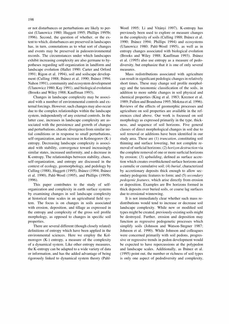
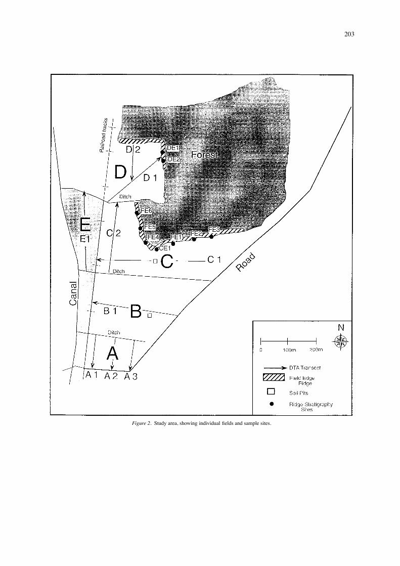
of the coastal plain, but slopes are not steep, and themaximum relief is 8 m. Maximum elevation is only20 m above mean sea level, and slopes are gener-ally less than two percent. A network of field ditcheslowers water tables to increase surface trafficabilityand optimize soil moisture conditions. These ditches,roadways, and a railroad track divide the site intofields (labelled A through E) as shown in Figure 2.Soils are mainly acidic Paleudults and Paleaquults
in the U.S. soil taxonomic system (Soil Survey Divi-sion Staff 1993). Some series mapped at the site are

200
Table 2. Summary of soil transformations at the Littlefield site. See text and Figure 5.
Transformation Mechanism Observed?
Norfolk-to-Wagram, Deposition or thickening due to Observed atWagram-to-Troup, Rains to fluvial, aeolian, or tillage the field siteArenic Paleaquults, Arenic to processes (Bayboro transitionsGrossarenic Paleaquults, Bayboro due to fluvial deposition).to Buried Bayboro
Troup-to-Wagram, Erosion or thinning due to fluvial, Observed atWagram-to-Norfolk, Grossarenic aeolian, or tillage processes the field siteto Arenic Paleaquults, ArenicPaleaquuIts; to Rains
Udults (Norfolk, Wagram , Troup) Drainage impedance or rise in Inferred,to Aquults (including Rains) water table based on
observedcatenaryrelationships
Aquults (including Rains) to Fall in water table or more rapid Inferred,Udults (Norfolk, Wagram, Troup) drainage based on
observedcatenaryrelationships
Udults and Aquults to Spodic Burial by aeolian deposition and Observed atPaleudults subsequent formation of spodic the field site
features in deposited material
Udults, Aquults and Spodic Burial by aeolian deposition and Observed atPaleudults to compound podzolized subsequent formation E–B (Bh, the field siteUltisols Bs, or Bw) horizon sequences in
deposited material
formally classified as Kandiudults, but Ultisols on thelower coastal plain of N.C. rarely meet the kandic cri-teria (Kleiss 1994). Most of the soils have loamy sandA and E horizons overlying sandy clay loam argillic(Bt) horizons. Valley bottom soils are derived from al-luvial deposits, and are darker and finer than the slopeand upland soils.
Methods
The approach has three major components. First, fieldmapping and soil stratigraphic investigations wereconducted to map soils, identify soil transformations,and allow comparisons of relatively undisturbed soilsin the forested area with soils of the cultivated portionof the site. Second, the relative proportion of soil typesand the possible transformations between them are de-termined for the contemporary period and estimated
for the pre-agricultural conditions. Third, entropy-based quantitative measures are used to compare pre-and post-agricultural landscape complexity.
Soil geography and stratigraphySoils were mapped at a scale of 1:6000, based on twosoil pits, ditch-wall exposures, and numerous auger-ings and borings. Field-mapping procedures were gen-erally similar to those described by McRae (1988).Visible erosion and deposition features were alsomapped, and topography was surveyed using a totalstation and prism. Soil profile descriptions are ac-cording to standard U.S. Department of Agricultureprocedures (Soil Survey Division Staff 1993). Sitesof apparent erosion or deposition were excavated ortrenched using shovels, entrenching tools, augers, orsoil probes. These sites include the nine field-edgeridge data collection sites and additional reconnais-

201
Table 3. Soil stratigraphy of field-edge ridges.
Site Bh horizons Bw Mixed Bt horizon Horizonhorizons horizons sequence
FE1 none none Bh&Bw&E not found, A–E–44,19 >150 Bh&Bw&E–Bh&Bw&Eg Bh&Bw&Eg–63, 31 Egb
FE2 none none Bh&Bw Bt1 A–E–53, 18 71 Bh&Bw–
Bt2 Bt1–Bt2127
FE3 none Bw none Bt A–E–Bw51, 38 103 –Eb–Btb
FE4 Bh none none not found A–Bh–Eg"
23, 38 > 123 –Bh"–EgbBh" –Ab80, 13
FE5 Bh none none Bt A–Bh–Bt23, 12 35 –Btg
Btg104
FE6 none none Bh&E Bt A–AE–60, 6 72 Bh&E–Eb
–Btb
CE1 Bh none none Bt A–E–Bh124, 11 100 –E"–Bh"–Bh" Eb–Btb41, 12
DE1 none Bw none Bt A–E–Bw44, 60 145 –Eb–EBb
–Btb
DE2 none Bw none Bt A–E–Bw44, 55 138 –Eb–Btb
For Bh, Bw, and mixed horizons the horizon designation is shown, followed by thedepth to the top of the horizon, and the horizon thickness, in cm. Mixed horizons referto those involving mixtures of Bh and/or E horizon material. For Bt horizons only thedepth is given.
sance digging along the ridges; the lower portions offields A, B, and C; the northern and western portionsof field D; slope convexities in fields A and E; and aridge along the ditch separating fields B and C, for atotal of 33 excavations.Depth to the top of the argillic (Bt) horizon (DTA)
was measured at 10 m intervals along nine linearcross-field transects, so that spatial variability in sur-face horizon thickness could be observed and, ifpossible, related to topography and surface features.
Another 60 DTA measurements were taken within theforested area. Identification of the argillic horizon isstraightforward, as it is associated with a transitionfrom sandy loam or coarser to sandy clay loam orfiner textures, and from granular to subangular blockystructures. DTA measurements in the fields were madewith Oakfield soil probes, with an estimated accuracyof ±1 cm to a depth of 0.5 m, ±3 cm to a depthof 1.5 m. Probes were ineffective in portions of theforested area due to poor recovery where water tables

202
Figure 1. The study site at Littlefield, North Carolina. Topographic contours for three of the fields are shown.
Table 4. Estimated relative proportion of soiltypes in the pre-agricultural landscape.
Soil type % of area
Arenic Paleaquults 20.2Bayboro 10.9Grossarenic Paleaquults 24.4Norfolk 8.9Rains 11.0Troup (Grossarenic Paleudults) 13.4Wagram 11.2
are high. In these instances a dutch mud auger wasused with an estimated accuracy of ±7 cm to a depthof 1.5 m.
Pre- and post-agricultural conditionsThe area occupied by each soil type (Table 1) wasdetermined from a digitized version of the soil map(Figure 3), with the exception of the small, localizedareas of cumulic Paleaquults (buried Rains), SpodicPaleudults, and compound podzolized Ultisols, whichwere field-surveyed using a total station and prism.The relative proportion of different soil types
which existed before agriculturally induced redistribu-tion was estimated based on the following assumptionsand considerations:(1) Soil types associated with surficial sediment
redistribution did not exist before the initiation of in-tensive agriculture (see Figure 4a). This assumption isbased on a body of literature (summarized in Phillips1997b) suggesting that accelerated soil erosion andsedimentation in the N.C. coastal plain was rare, lo-calized, and short-lived before European land-clearingand the development of intensive agriculture.
203
Figure 2. Study area, showing individual fields and sample sites.

204
Figure 3. Contemporary (post-agriculture) soil map.
(2) The area of Bayboro and transformed Bayborosoils in the valley bottom has not changed; i.e., thiswas all Bayboro in the pre-agriculture period. Becausethe Bayboro soils are derived from alluvial terrace par-ent material distinct from the other soils at the studysite, there is no basis for believing there has beenany change in the total area of Bayboro and buriedBayboro soils.(3) The relative proportion of soils in typic, arenic,
and grossarenic subgroups (i.e., DTA of <50, 50 to100, or >100 cm) in the minimally-disturbed forestedportion of the site reflects the relative proportion ofsoils in these groups pre-agriculture. These are 26.7,33.3, and 40%, respectively. In general this assump-tion is justified by the fact that while much of thecultivated portion of the site has steeper slopes thanthe forested area, the slopes are still too gentle to haveresulted in thinner surficial soil horizons when the areawas fully forested. This is supported by work in ma-ture forests in the N.C. coastal plain which shows thatthicker surface horizons occur on slopes as well as flatuplands (Phillips 1997b).
(4) The relative proportion of the study areawhich is well- or excessively-drained, poorly or verypoorly drained, or intermediately (moderately well orsomewhat poorly) drained reflects the pre-agriculturedrainage conditions; i.e., the relative proportion ofdrainage classes has not changed. These are 33.5, 61.1,and 0.14%, respectively, for the well- or execessively-,poorly- or very-poorly, and moderately well- or some-what poorly-drained groupings. This premise is basedon the lack of field evidence for long-term change indrainage status or water table elevations over historcialtime scales.The possible transformations among the soils were
identified in two ways. First, transformations associ-ated with erosion and deposition were identified frommeasured or inferred transformations observed in thefield (discussed below). Second, transformations dueto changes in the soil drainage status are hypothesizedto be possible due to observed catenary relationshipsin the field. We surmise, for example, that Paleudultscould be transformed to Paleaquults by a rise in thewater table, or vice-versa. Thus, while we assume

205
Figure 4. Soil transformations at Littlefield, indicated by the arrows connecting soil types. The direction and nature of the changes are indicatedby erosion and deposition (horizontal axis) and water table changes (vertical axis). The potential soil transformations in the pre-agricultureperiod (A) are associated with thinning or thickening of surficial horizons and drainage changes. In the post-agriculture period (B), any of thesesoils could also be transformed to new soil types associated with burial and secondary pedogenesis. The transformation possibilities commonto both pre- and post-agriculture and shown in a box in (B).

206
Table 5. Results of entropy analysis (I/H = information/entropy ratio).
Entropy Information redundancy I/H
Relative abundance of soils and soil transformations
Pre-agriculture 0.543 9.004 0.939 16.58Post-agriculture 0.434 9.565 0.953 22.04
Relative abundance of soils only
Pre-agriculture 1.881 5.027 0.728 2.67Post-agriculture 1.817 5.091 0.737 2.80
that the current proportion of soils in various drainageclasses is the same as at the initiation of intensive agri-culture, we recognize that drainage-related transfor-mations are possible. Accordingly, while the estimatesof the relative proportions of soil types in the pre- andpost-agricultural landscape, and of possible transfor-mations associated with erosion and deposition, arebased on observed changes, the possible transforma-tions based on water table and drainage changes arehypothetical. They are included because we believesuch changes are clearly possible. Water table andsoil drainage changes could be attributable to down-cutting or aggradation in the local fluvial system overannual to decadal time scales; and to base-level changeand climate changes over longer time scales. Becausethese types of transformations cannot actually be ob-served at the time scale of our study, and to account forthe mixture of observational and hypothetical originsfor the estimates of possible soil transformations, wehave calculated entropies (1) considering both the pre-and post-agriculture distribution of soil types and pos-sible soil transformations, (2) using the distribution ofsoil types alone.
Changes in complexityThe pre- and post-agricultural soil landscapes can bepresented as box-and-arrow diagrams. Each ‘box’ is asoil type. Arrows connecting the boxes correspond toobserved or inferred soil transformations.The entropy, representing the diversity and com-
plexity of the soil landscape, can be calculated by
H = #![(xini)/(xn)] log[(xini)/(xn)], (1)
where n is the total number of soil units, and ni isthe number associated with the ith soil type. The totalnumber of connections (transformations) is x, with xi
representing the number of links originating from the
ith soil. In other words, each ni is a box and each xi isan arrow.The information associated with the soil distribu-
tion and network of transformations is related to theentropy by
I = log(xn) # H. (2)
The entropy of the soils only, considering the numberand probability of occurrence of the soil types, withoutreference to the transformations, is
H = #![(ni/n) log(ni/n)]. (3)
The composition disorder (evenness) is
E = (#!ni logni)/ logn, (4)
and the composition order is 1# E. Disorder is high-est where the relative proportion of soil types is mostevenly distributed, and lowest where fewer soils aredominant.Equations (1)–(4) are standard in entropy theory,
and are discussed in more detail elsewhere (Brooksand Wiley 1988; Pahl-Wostl 1995). The calculationsfor K-entropy are, in this case, identical to that ofinformation theoretic (Shannon) entropy. The Kol-mogorov entropy formulation is, in essence, a rigorousgeneralization of the Shannon entropy to a broaderclass of dynamical systems (Culling 1988; Li andVitáyi 1997).In general, then, entropy will be highest when all
soil types are equally abundant (an equal probability offinding all soils in a given sample), and when all soilshave an equal number of possible transformations. En-tropy will be lower and information higher when oneor a few soils are dominant, and one or a few soils areinvolved in transformations.

207
Results
Soil distribution, taxonomy, and transformations
Taxonomy of soils mapped at the study area is givenin Table 1 and the soil map in Figure 3. The Norfolk,Wagram, and Troup series differ only with respect tothe thickness of the A and E horizons (20 to 50, 50 to100, and >100 cm, respectively). Taxonomically, thisresults in their assignment to different textural fami-lies and to typic, arenic, and grossarenic subgroups,respectively. The Norfolk, Goldsboro, Lynchburg andRains series are formed in similar parent material, andare the well, moderately well, somewhat poorly, andpoorly-drained members, respectively, of a drainagecatena. The differences among them are all associ-ated with features related to drainage and water tabledepth. The poorly-drainedBayboro series of the valleybottom is formed from different parent material. TheBayboro is darker, finer, and has an umbric epipedonto distinguish it from the poorly-drained Rains.Three of the mapped soils do not correspond with
recognized series. One is similar to the Wagram (50 to100 cm depth to the top of the Bt horizons), but has ahigher water table and is somewhat poorly drained. Itis also similar to the Goldsboro series, but has thickersurficial horizons. As this soil is found in a com-plex with Goldsboro and Wagram soils per se, thecomplex is referred to and mapped simply as Golds-boro/Wagram. Two other soils are poorly or somewhatpoorly drained and generally similar to the Rains andLynchburg series, but have much thicker A and Ehorizons. These soils could be considered somewhat-poorly or poorly-drained catenary relatives of Wa-gram or Troup soils. These thick-surface, high-water-table Udults are referred to as Arenic or GrossarenicPaleaquults, according to whether the A and E thick-ness is 50 to 100 or >100 cm. The soil geographyand morphology is described in more detail elsewhere(Phillips et al. 1998).Because the Norfolk, Wagram, and Troup, and the
Rains and Arenic and Grossarenic Paleaquults differfrom each other only with respect to the thickness ofthe A- and E-horizons, erosion and deposition canresult in transformations along these pathways. TheUdults and Aquults differ only with respect to featuresrelated to drainage status, so changes in drainage orwater table elevation could result in transformationsbetween Paleudults and Paleaquults within the typic,arenic, and grossarenic subgroups. These changes,as indicated in Figure 4, could occur pre- or post-
agriculture, although it is likely that pre-agricultureerosion and deposition was rare and localized.In the post-agricultural landscape, several addi-
tional transformations are possible, based on fieldobservations. Burial of Bayboro soils by rill fan de-posits at the lower end of fields A and B has createdcumulic Aquic Paleudults (buried Bayboro). Alongfield edges, deposition of sandy aeolian material hasburied the pre-existing Ultisols, and created SpodicPaleudults and compound podzolized Ultisols. Theformer are characterized by spodic development (suchas humic or sesquioxide concretions) within thickenedA and E horizons; the latter by the development offully compound soil profiles. This typically consists ofA, E, and Bs, Bh, or Bw horizons overlying the buriedA or E and Bt horizons.The pedologic transformations associated with
agricultural soil redistribution, and the stratigraphyand pedology of the transformed soils is describedin some detail elsewhere (Phillips et al. 1998) andsummarized in Table 2.
Depositional soils
Three general types of soils modified by depositionwere found. First, two delineations of buried Rainssoils were observed in local depressions. In these soilsdark loamy sand and sandy loam horizons (Ab and Eb)are overlain by 20 to 35 cm of lighter loamy sand. Thedepressions containing the buried Rains have limitedlocal drainage area and exhibit no evidence of fluvialor aeolian deposition. Both are adjacent to slope con-vexities with lower DTA values, indicating net erosionon the convexities and deposition in the depressionsassociated with tillage processes.Second, buried Bayboro soils are found in toeslope
areas of field B and the northwest portion of field A.The soils in the areas mapped as buried Bayboro typi-cally exhibited up to 19 cm of sand in February 1997,deposited during the course of winter 1997 fieldwork.These deposits were subsequently plowed into the A-horizon. The dark loamy sand cumulic A-horizonsextended to a depth ranging from 19 to 28 cm, belowwhich the typical Bayboro horizon sequence began.All the cumulic A-horizons had lenses and mottlesof light sand. Rills were mapped on the lower por-tions of field B, and extending downslope along thelower edges of fields B and A. The rill termini featuredsandy fan deposits, many with ripple marks evident.The typical soil stratigraphy in February 1997, beforeplowing, was about 5 cm of newly-deposited light yel-

208
low sand, over about 20 cm of dark loamy sand withlenses and discontinuous layers of light sand. From 25to about 72 cm is a dark loam, and from 72 to 125 cmthere are several layers of brown to black loamy sandand sandy loam. At a typical depth of about 125 cmin a representative sequence there is a gray sandy clayloam. The horizon sequence below 25 cm is virtuallyidentical to that found in the adjacent Bayboro soils.The U.S. Soil Taxonomic system (Soil Survey Di-
vision Staff 1993) requires at least 50 cm of burialto formally qualify for a buried horizon designation,but the buried Bayboro and Rains sequences clearlyrepresent material from the Norfolk and Wagram soilsupslope deposited on the Bayboro or Rains soils at theslope base or in minor depressions.The third general type of depositional soils are ae-
olian ridges along the forested field boundaries. Smallbut obvious ridges are evident along themajority of thesouth- and west-facing treelines (Figure 2). The ridgesare five to 10 m in width, and the crest elevations rel-ative to the adjacent field and forest areas are 0.2 to0.6 m. They are interpreted as aeolian deposits, on thebasis of a strict correspondence with vegetated fieldborders, the lack of any observation or evidence of de-position by tillage, upslope locations, and an absenceof ridges from wind-sheltered or fetch-limited bordersof fields D and C. The soils on the ridges also havepedogenic features typical of sandy aeolian accumula-tions, such as illuvial concentrations of sesquioxidesand/or humate.Trenches show that the depth to the top of the
argillic horizon increases systematically toward theridge crest. Near the crest, the A-E-Bt horizon se-quence is interrupted by one or more podzolized B-horizons. General horizonation of the ridge crests issummarized in Table 3. Most show compound hori-zonation, with multiple E-B sequences; the uppermostcharacterized by Bh or Bw horizons associated withsecondary podzolization.The northeast portion of field D, exposed to pre-
vailing southwesterly winds, showed evidence of aeo-lian deposition in the cultivated area in addition to theforest-edge ridges. A strip about 40 m wide had largerDTA values (51 to 147 cm), and secondary pedogene-sis, with a horizon sequence of A – E – Bw – Eb – Btb.In a few pedons dark Bh horizons were present insteadof Bw horizons. The B horizons were generally 34 to50 cm below the surface.
Soil transformations
Four additional soil types can be added to those iden-tified in Table 1. These are the buried Rains andBayboro, and Spodic Paleudults and compound pod-zolized Ultisols associated with aeolian depositionnear field edges. Spodic Paleudults feature some spod-icdevelopment, such as humic or iron oxide concre-tions, or Bw horizons interpreted to be incipient Bh,Bs, or Bhs layers, within or mixed with the A and Ehorizons. Compound podzolized Ultisols exist wheresecondary pedogenesis has created full E–B horizonsequences within the deposited materials. These aretermed ‘compound’ because in U.S. Soil Taxonomy,‘bisequal’ implies that the sequa formed contempora-neously, which is not the case here. Some, but not all,these compound soils would meet the 50 cm criterionfor buried soils.The deposition evident in several locations, along
with the material carried out of the basin (as indicatedby suspended sediment monitoring), indicates erosionand surface truncation might be occurring. Comparingthe surface elevations and DTA values of the cultivatedfields and a permanently-vegetated cemetery in field Csuggests average erosional truncation of the cultivatedsoils of 20 to 33 cm, even after differences in bulk den-sity and the effects of interment in the cemetery havebeen accounted for. The mean DTA in the forestedportion of the site exceeds that of the cultivated areaby about 50 cm, with no more than about 25% of thatdifference attributable to the lower bulk density in theuncompacted forest soils. Thus, truncation on the or-der of a few tens of centimeters has apparently beencommon, over a time frame of about a century (theoldest readable tombstone on the cemetery dates from1909; others have weathered to illegibility).Soil transformations are summarized in Figure 4.
Because differences between the grossarenic, arenic,and typic subgroups are based on thickness of the Aand E horizons, truncation and accretion on the orderof tens of centimeters has resulted in transformationsbetween soils of these groups. More generally, erosionand compaction associated with cultivation has appar-ently transformed the thicker-surface soil types foundonly in the forest (Troup, Grossarenic and ArenicPaleaquults) into the thinner Goldsboro/Wagram, Nor-folk, and Rains soils found in the cultivated fields.Fluvial deposition has transformed Bayboro soils
into the cumulic Aquic Paleudults mapped asburied Bayboro. Tillage deposition has changed thepoorly-drained Rains into the somewhat-poorly or

209
moderately-well drained variants mapped as buriedRains. Aeolian deposition of dominantly quartz sand,and subsequent secondary podzolization, has modifiedPaleudults and Paleaquults into Spodic Paleudults andcompound podzolized Ultisols.The pre-agriculture soils are shown in Table 4.
The estimated areal percentages are based on the as-sumptions described earlier: None of the transformedsoils (buried Bayboro or Rains; Spodic Paleudults orcompound podzolized Ultisols) existed; the relativeproportion of typic, arenic, and grossarenic soils forthe entire area was the same as now exists in theforested area; and the relative proportion of drainageclasses has not changed.
Entropy
Results of the entropy analysis of are given in Ta-ble 5. The entropy or complexity of the soil landscapedecreased, and the information increased, as a con-sequence of the soil transformations from pre- topost-agricultural conditions. This may seem counter-intuitive, because the soil transformations diversifiedthe Littlefield site in the sense that four new soils wereadded to the seven pre-existing series. However, thetransformations also resulted in a more uneven distri-bution of soils; i.e., a situation whereby the probabilityof finding a particular soil in a randomly-chosen loca-tion varies widely. The added transformation links inthe post-agriculture soil landscape are also generallymore specific, and thus provide more information andless uncertainty than those links that existed in the pre-as well as the post-cultivation situation.The redundancy values of >0.9 are near the max-
imum of 1 (R ranges from 0, where observed en-tropy equals the maximum entropy, log[xn] to unity).Information-to-entropy ratios of 17 to 22 indicate thehigh, and increasing, level of organization in the soillandscape.Considering just the number and proportional ex-
tent of the soils, a decline in entropy and increasein information is clearly indicated. However, Table 5makes it clear that the decreasing complexity is con-siderably lower for the soil cover alone as comparedto a consideration of the soil types and the possibletransformations among them.
Discussion
The redistribution of surface mass at Littlefield re-sulted in significant pedological changes over a rel-
atively short time scale. The number of morphologi-cally distinct soil types, and the number of possibletransformations among soil types, increased by 57%.However, the increasing variety in the soil cover didnot result in an increase in soil landscape complexity.The pre-agricultural soil landscape featured a rela-tively uniform distribution among the seven soil typesidentified – the most abundant series occuped about24% of the surface area, and the least abundant aboutnine percent. The post-agricultural soil map was farmore differentiated – the most abundant soils occupiedabout 38% of the area, and the least abundant 0.5%.The more uneven relative abundance results in moreinformation, and thus lower entropy.A similar trend is evident with regard to the trans-
formations. In the pre-agricultural condition, five ofthe seven soil types could undergo two transitions –generally one associated with erosion/deposition, andone with water table change. In the contemporary soillandscape the possible transformations are more con-centrated, principally due to the creation of the fournew soil types as a direct result of redistributions.Other things being equal – in this case, if the
relative abundance of soil types and/or transforma-tions remains constant – an increase in the variety anddiversity of system components will result in an in-crease in the K-entropy. At Littlefield, however, theincreasing information or negentropy associated withthe more uneven abundances overshadowed the effectsof a larger number of soils.Scale is critical. In an earlier study of soil land-
scape evolution in the North Carolina Coastal Plain,Phillips (1993) found that the soil cover becamemore diverse over time in the absence of any vari-ation in soil-forming factors by comparing a two-part chronosequence on surfaces of about 77 Ka and212 Ka. Those data imply that over that time period,entropy increased from 0 to 1.744. This increasingentropy is consistent with the work of Ibánez et al.(1990, 1994) on the Iberian peninsula over Quater-nary time scales. Thus the contrasting results of thisstudy as opposed to those cited above may well beassociated with the different temporal scales. Spa-tial scale can be equally critical. Again using datafrom the N.C. coastal plain, Phillips (1997a) showedthat complex spatial variability at the field-scale isresolved into regularity and order at much broaderspatial scales. The complexity of the soils at the Lit-tlefield site might, therefore, show different trendsif examined in substantially smaller or larger spatialunits.

210
Over time, pedogenesis can result in the conver-gence of diverse soils toward a simpler soilscape, orin the divergence of similar soils toward a more com-plex soilscape. The outcome depends not only onwhere and when, but on how much (spatial scale)and how long (temporal scale). Further, the impli-cations regarding self-organization and complexity assoil landscapes evolve are that landscape complexityis strongly influenced by factors other than increasesor decreases in soil variety or richness – specifically,the relative abundance of soil types.This project has focussed on a single group of
processes associated with surface material redistribu-tions, and a specific spatial and temporal scale. Theresults suggest that attempts to generalize about thetrends in complexity or self-organization as soil land-scapes evolve over time are not likely to be fruitful dueto scale-dependence. Results of this or similar studiesare meaningful only within their spatial and temporalscale contexts (as well as their locational and environ-mental contexts). It is only by the accumulation andsynthesis of such results that we can begin to better un-derstand the changes in complexity associated with thedevelopment of soils–and, by extension, of landforms,ecosystems, and landscapes in general.
Conclusions
Fluvial, aeolian, and tillage processes have all resultedin the redistribution of soil at Littlefield, North Car-olina. Soil stratigraphy and morphology reflect the soiltransformations, which have increased the number ofmorphologically distinct soils from seven to 11 sinceintensive cultivation began. The Kolmogorov entropyof the pre- and post-agricultural landscapes shows thatthe entropy and complexity of the soil landscape de-creased, with associated increases in information andredundancy. The mass redistributions created a lower-entropy landscape by concentrating particular soilsand soil transformations in specific landscape settings.This result is contrary to studies showing a trend to-ward increasing pedological complexity at comparablespatial scales, but over much longer time scales. Theseresults point to the importance of temporal scale, andto the fact that environmental complexity is influencedby factors other than the number of different landscapeunits present.
Acknowledgements
This study would not have been possible without theassistance and cooperation of a number of gradu-ate students at East Carolina University, includingHeather Golden, Karen Capiella, Brian Andrews, LeePadrick, Tammie Middleton, David Downer, and De-onna Kelli. Fieldwork at the Littlefield site is fundedby U.S. Department of Agriculture grant number 95–37107–2180.
References
Brooks, D.R. and Wiley, E.O. 1988. Evolution as Entropy. 2ndEdition. University of Chicago Press, Chicago.
Burrough, P.A. 1983. Multiscale sources of spatial variation in soils.J Soil Sci 34: 577–620.
Campbell, J.B. 1979. Spatial variability of soils. Ann. Assoc AmGeog 69: 544–556.
Carter, R.W.G. and Orford, J. 1991. The sedimentary organisationand behavior of drift-aligned barriers. In Coastal Sediments ’91.pp. 934–948. American Society of Civil Engineers, New York.
Culling, W.E.H. 1988. Dimension and entropy in the soil-coveredlandscape. Earth Surface Proc Landforms 13: 619–648.
Fullen, M.A. & Brandsma, R.T. 1995. Property changes by erosionof loamy sand soils in East Shropshire, U.K. Soil Technol 8: 1–15.
Hallet, B. 1990. Spatial self-organization in geomorphology: Fromperiodic bedforms and patterned ground to scale-invariant topog-raphy. Earth-Science Rev 29: 57–75.
Huggett, R.J. 1995. Geoecology: An Evolutionary Approach. Rout-ledge, London.
Ibánez, J.J. 1994. Evolution of fluvial dissection landscapes inmediterranean environments: quantitative estimates and geomor-phic, pedologic, and phytocenotic repercussions. Z Geomorp 38:105–119.
Ibánez, J.J., Ballexta, R.J. and Alvarez, A.G. 1990. Soil landscapesand drainage basins in mediterranean mountain areas. Catena 17:573–583.
Ibánez, J.J., De-Alba, S., Bermudez, F.-F., and Garcia-Alvarez, A.1995. Pedodiversity: concepts and measures. Catena 24: 215–232.
Johnson, D.L., Keller, E.A. and Rockwell, T.K. 1990. Dynamic pe-dogenesis: New views on some key soil concepts, and a modelfor interpreting Quaternary soils. Quat Res 33: 306–319.
Johnson, D.L. and Watson-Stegner, D. 1987. Evolution model ofpedogenesis. Soil Sci 143, 349–366.
Kauffman, S.A. 1993. The Origins of Order. Self-Organization andSelection in Evolution. Oxford University Press, Oxford.
Kay, J.J. 1991. A nonequilibrium thermodynamic framework fordiscussing ecosystem integrity. Env Manage 15: 483–495.
King, G.J., Acton, D.F. and St. Arnaud, R.J. 1983. Soil-landscapeanalysis in relation to soil distribution and mapping at a sitewithin the Weyburn Association. Can. J Soil Sci 63: 657–670.
Kleiss, H.J. 1994. Relationships between geomorphic surfaces andlow activity clay on the North Carolina Coastal Plain. Soil Sci157: 373–378.
Kreznor, W.R., Olson, K.R., Banwart, W.L. & Johnson, D.L. 1989.Soil, landscape, and erosion relationships in a northwest Illinoiswatershed. Soil Sci Soc Am J 53: 1763–1771.

211
Li, M. & Vitányi, P. 1997. An Introduction to Kolmogorov Com-plexity and its Applications. Springer-Verlag, Berlin.
McBratney, A.B. 1992. On variation, uncertainty, and informaticsin environmental soil management. Austr J of Soil Res 30: 913–936.
McRae, S.G. 1988. Practical Pedology. Halsted, London.Mokma, D.L., Fenton, T.E. & Olson, K.R. 1996. Effect of erosionon morphology and classification of soils in the north centralUnited States. J Soil Water Cons 51: 171–175.
Nahon, D.B. 1991. Self-organization in chemical lateritic weather-ing. Geoderma 51: 5–13.
Pahl-Wostl, C. 1995. The Dynamic Nature of Ecosystems. Chaosand Order Entwined. John Wiley, Chichester, U.K.
Phillips, J.D. 1993. Chaotic evolution of some coastal plain soils.Phys Geog 14: 566–580.
Phillips, J.D. 1994. Deterministic uncertainty in landscapes. EarthSurface Proc Landforms 19: 389–401.
Phillips, J.D. 1995a. Nonlinear dynamics and the evolution of relief.Geomorphology 14: 57–64.
Phillips, J.D. 1995b. Self-organization and landscape evolution.Prog Phys Geog 19: 309–21.
Phillips, J.D. 1996. Deterministic complexity, explanation, andpredictability in geomorphic systems. In The Scientific Nature of
Geomorphology, Proceedings of the 27th Binghamton Geomor-phology Symposium. pp. 315–336. Edited by B. Rhoads and C.Thorn. John Wiley, New York.
Phillips, J.D. 1997a. Simplexity and the reinvention of equifinality.Geog Analysis 29: 1–15.
Phillips, J.D. 1997b. A short history of a flat place: Three centuriesof geomorphic change in the Croatan. Ann Assoc Am Geograph87: 197–216.
Phillips, J.D., Golden, H., Cappiella, K., Andrews, B., Middleton,T., Downer, D., Kelli, D. and Padrick, L. 1988. Soil redistributionand pedologic transformations in coastal plain croplands. EarthSurface Proc Landforms 23: 481–492.
Phillips, J.D., Perry, D., Carey, K., Garbee, A.R., Stein, D., Morde,M.B. & Sheehy, J. 1996. Deterministic uncertainty and complexpedogenesis in some Pleistocene dune soils. Geoderma 73: 147–164.
Rigon, R., Rinaldo, A., and Rodriguez-Iturbe, I. 1994. On landscapeself-organization. J Geophys Res 99B: 11971–11993.
Soil Survey Division Staff. 1993. Soil survey manual. U.S. Depart-ment of Agriculture, Washington.
Ulanowicz, R.E. 1980. An hypothesis on the development of naturalcommunities. J Theor Biol 85: 223–45.